Review of Environmental Factors - Roads and Maritime Services
465
Sydney City Centre Capacity Improvement Plan Review of Environmental Factors Volume 2 – Appendices NOVEMBER 2014 RMS 14.526 ISBN: 978-1-925217-60-5
-
Upload
khangminh22 -
Category
Documents
-
view
0 -
download
0
Transcript of Review of Environmental Factors - Roads and Maritime Services
Sydney City Centre Capacity Improvement PlanReview of Environmental Factors Volume 2 – AppendicesNOVEMBER 2014
RMS 14.526ISBN: 978-1-925217-60-5
Prepared by Parsons Brinckerhoff ABN: 80 078 004 798 Level 27, Ernst & Young Centre 680 George Street Sydney NSW 2000 Australia Tel: +61 2 9272 5100 Fax: +61 2 9272 5101 www.pbworld.com
Roads and Maritime
Sydney City Centre Capacity ImprovementPlan - Volume 2
Review of environmental factors
November, 2014
Appendices (Volume 2)
Appendix A Consideration of clause 228(2) factors and matters of national environmental significance
Appendix B Consultation material
Appendix C Traffic and transport specialist study
Appendix D Noise and vibration specialist study
Appendix E Non-Aboriginal heritage specialist study
Appendix F Kerbside use restrictions during construction and operation
Appendix G Outdoor seating and dining impacts
Appendix H Public amenity impacts
Appendix I Landscape character and visual impacts
Appendix J Biodiversity detailed search results
Appendix K Aboriginal heritage information management system search results
Appendix L Air quality data
Sydney City Centre Capacity ImprovementReview of Environmental Factors

Sydney City Centre Capacity Improvement Plan Appendix AReview of Environmental Factors
Appendix AConsideration of clause 228(2) factors andmatters of national environmentalsignificance
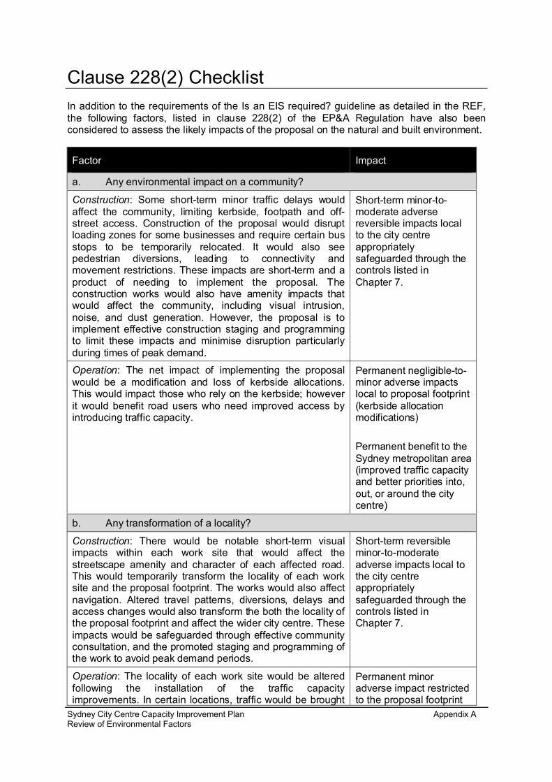
Clause 228(2) ChecklistIn addition to the requirements of the Is an EIS required? guideline as detailed in the REF,the following factors, listed in clause 228(2) of the EP&A Regulation have also beenconsidered to assess the likely impacts of the proposal on the natural and built environment.
Factor Impact
a. Any environmental impact on a community?
Construction: Some short-term minor traffic delays wouldaffect the community, limiting kerbside, footpath and off-street access. Construction of the proposal would disruptloading zones for some businesses and require certain busstops to be temporarily relocated. It would also seepedestrian diversions, leading to connectivity andmovement restrictions. These impacts are short-term and aproduct of needing to implement the proposal. Theconstruction works would also have amenity impacts thatwould affect the community, including visual intrusion,noise, and dust generation. However, the proposal is toimplement effective construction staging and programmingto limit these impacts and minimise disruption particularlyduring times of peak demand.
Short-term minor-to-moderate adversereversible impacts localto the city centreappropriatelysafeguarded through thecontrols listed inChapter 7.
Operation: The net impact of implementing the proposalwould be a modification and loss of kerbside allocations.This would impact those who rely on the kerbside; howeverit would benefit road users who need improved access byintroducing traffic capacity.
Permanent negligible-to-minor adverse impactslocal to proposal footprint(kerbside allocationmodifications)
Permanent benefit to theSydney metropolitan area(improved traffic capacityand better priorities into,out, or around the citycentre)
b. Any transformation of a locality?
Construction: There would be notable short-term visualimpacts within each work site that would affect thestreetscape amenity and character of each affected road.This would temporarily transform the locality of each worksite and the proposal footprint. The works would also affectnavigation. Altered travel patterns, diversions, delays andaccess changes would also transform the both the locality ofthe proposal footprint and affect the wider city centre. Theseimpacts would be safeguarded through effective communityconsultation, and the promoted staging and programming ofthe work to avoid peak demand periods.
Short-term reversibleminor-to-moderateadverse impacts local tothe city centreappropriatelysafeguarded through thecontrols listed inChapter 7.
Operation: The locality of each work site would be alteredfollowing the installation of the traffic capacityimprovements. In certain locations, traffic would be brought
Permanent minoradverse impact restrictedto the proposal footprint
Sydney City Centre Capacity Improvement Plan Appendix AReview of Environmental Factors

Factor Impact
closer to building façades. Accordingly, the road trafficwould become a more dominant component of thestreetscape. However, in implementing the proposal, itwould enable transformation across the city centre byaltering traffic priorities, removing conflict, improving publictransport circulation and providing better user navigation.The other change would be the proposed removal of anumber of trees within the streetscape. They form animportant part of the landscape and streetscape character;however the affected trees are not significant, nor do theyform a dominant component of the character of the affectedstreets.
due to the ‘intensification’of traffic within the roadcorridor and removal oftrees.Permanent benefit to theSydney metropolitan areadue to improvedcirculation, navigation,road-priority setting andremoved conflict.
c. Any environmental impact on the ecosystems of the locality?
There would be some limited tree pruning and removalacross the city centre. The impacted trees are landscape-planted and do not form part of an ecosystem. They mayprovide foraging habitat for a number of mobile species;however they do not contribute to a valuable or importantecosystem in the locality.
Permanent negligibleadverse impact restrictedto the proposal footprint.
d. Any reduction of the aesthetic, recreational, scientific or other environmentalquality or value of a locality?
Construction: There would be short-term constructiondisruption impacts that would affect the visual amenity andaesthetics of each affected road (work site). The visual‘clutter’ introduced around each work site would have animpact on road users, pedestrians, cyclists and roadsideproperties. The local environmental quality would also beaffected in the short-term due to construction noise, dustgeneration and general construction activities. This wouldextend to temporary traffic delays and access restrictionsthat would occur within and beyond the proposal footprint;including the potential for cumulative effects across the citycentre. The works would also have an effect on adjacentrecreational amenity during construction. Again, thepromoted staging and programming of the work to avoidpeak demand periods would be used to manage theseimpacts.
Short-term reversibleminor-to-moderateadverse impacts affectingthe city centreappropriatelysafeguarded through thecontrols listed inChapter 7.
Operation: Once the proposal is operational there should beimproved navigation and traffic priorities in the city centre.This should improve amenity overall, especially as theproposal supports and enables the wider Access Strategy.However, local to each work site, the implemented trafficcapacity improvements would reduce the streetscape’samenity value due to the ‘intensification’ of traffic within theroad corridor in certain locations, including the few locationswhere trees would be removed. Environmental and scientificvalues would be largely unaffected by the operationalproposal other than a marginal increase in noise impacts.
Permanent minoradverse impact restrictedto proposal footprint dueto the ‘intensification’ oftraffic within the roadcorridor.Permanent benefit to theSydney metropolitan areadue to improvedcirculation, navigation,road-priority setting andremoved conflict.
Sydney City Centre Capacity Improvement Plan Appendix AReview of Environmental Factors
Factor Impact
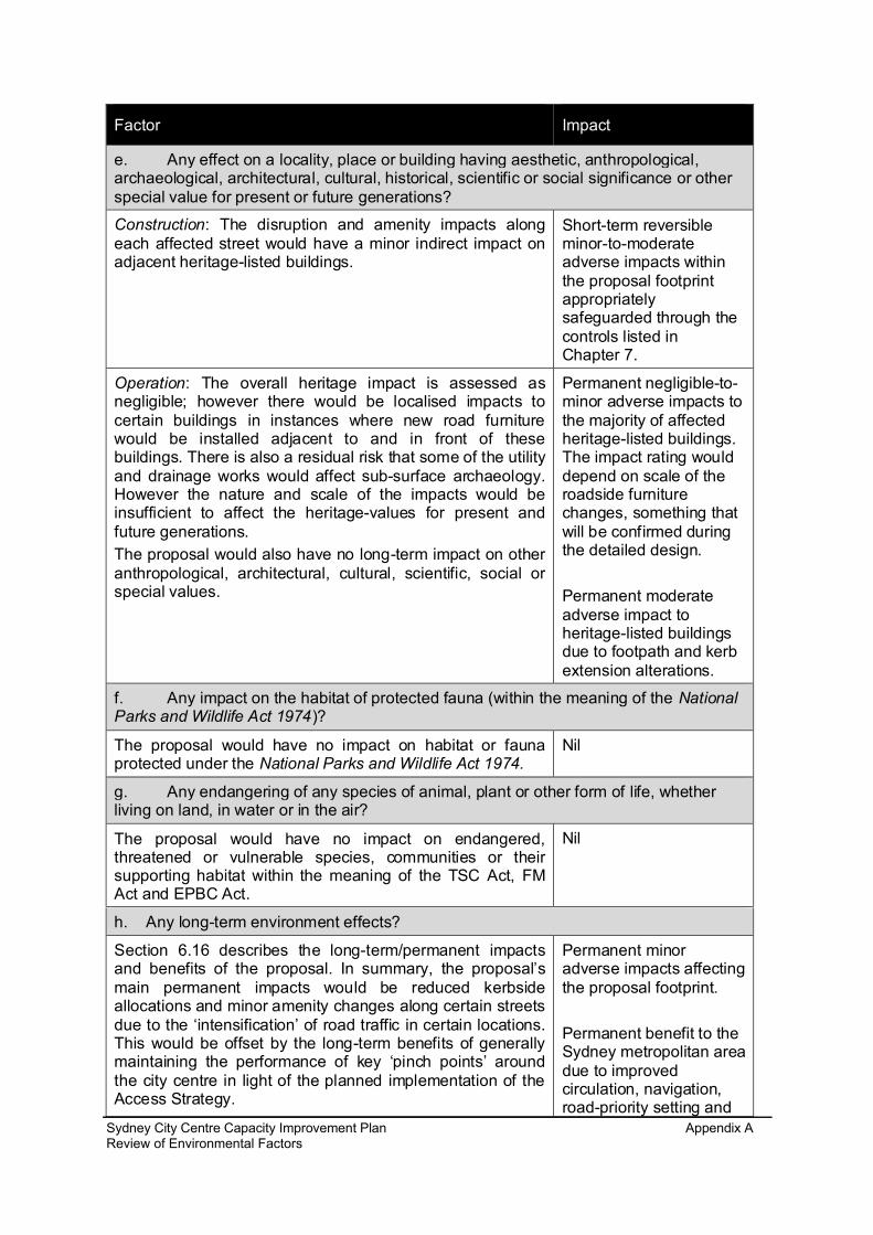
e. Any effect on a locality, place or building having aesthetic, anthropological,archaeological, architectural, cultural, historical, scientific or social significance or otherspecial value for present or future generations?
Construction: The disruption and amenity impacts alongeach affected street would have a minor indirect impact onadjacent heritage-listed buildings.
Short-term reversibleminor-to-moderateadverse impacts withinthe proposal footprintappropriatelysafeguarded through thecontrols listed inChapter 7.
Operation: The overall heritage impact is assessed asnegligible; however there would be localised impacts tocertain buildings in instances where new road furniturewould be installed adjacent to and in front of thesebuildings. There is also a residual risk that some of the utilityand drainage works would affect sub-surface archaeology.However the nature and scale of the impacts would beinsufficient to affect the heritage-values for present andfuture generations.The proposal would also have no long-term impact on otheranthropological, architectural, cultural, scientific, social orspecial values.
Permanent negligible-to-minor adverse impacts tothe majority of affectedheritage-listed buildings.The impact rating woulddepend on scale of theroadside furniturechanges, something thatwill be confirmed duringthe detailed design.
Permanent moderateadverse impact toheritage-listed buildingsdue to footpath and kerbextension alterations.
f. Any impact on the habitat of protected fauna (within the meaning of the NationalParks and Wildlife Act 1974)?
The proposal would have no impact on habitat or faunaprotected under the National Parks and Wildlife Act 1974.
Nil
g. Any endangering of any species of animal, plant or other form of life, whetherliving on land, in water or in the air?
The proposal would have no impact on endangered,threatened or vulnerable species, communities or theirsupporting habitat within the meaning of the TSC Act, FMAct and EPBC Act.
Nil
h. Any long-term environment effects?
Section 6.16 describes the long-term/permanent impactsand benefits of the proposal. In summary, the proposal’smain permanent impacts would be reduced kerbsideallocations and minor amenity changes along certain streetsdue to the ‘intensification’ of road traffic in certain locations.This would be offset by the long-term benefits of generallymaintaining the performance of key ‘pinch points’ aroundthe city centre in light of the planned implementation of theAccess Strategy.
Permanent minoradverse impacts affectingthe proposal footprint.
Permanent benefit to theSydney metropolitan areadue to improvedcirculation, navigation,road-priority setting and
Sydney City Centre Capacity Improvement Plan Appendix AReview of Environmental Factors

Factor Impact
removed conflict.
i. Any degradation of the quality of the environment?
Construction: There would be a short-term degradation inenvironmental quality due to the amenity impact of theconstruction work, the creation of construction noise, dustgeneration and the imposed traffic and access restrictions.The ability for people to move around the city would also berestricted due to the implemented traffic managementcontrols and footpath restrictions. These would affect thequality of the city centre’s environment.
Short-term reversibleminor-to-moderateadverse impacts affectingthe proposal footprint andwider city centreappropriatelysafeguarded through thecontrols listed inChapter 7.
Operation: There would be no overall change to the city’senvironmental quality
Nil
j. Any risk to the safety of the environment?
Construction: There is a residual risk of pollution occurringduring construction through unforseen, unplanned oraccidental emissions and discharges. The likelihood of suchimpacts would be reduced through careful management andadditional controls that would be implemented to handle andmanage any incidents.Pedestrian, cyclist and road user safety issues are also aconsideration during construction due to the proposal’slocation in a heavily populated urbanised area. Again, thelikelihood of the impact would be greatly reduced throughcareful management.
Short-term reversiblenegligible impactsaffecting the proposalfootprint appropriatelysafeguarded through thecontrols listed inChapter 7.
Operation: The proposal has been designed underapproved standards (refer to section 3.2.2). Thesestandards ensure operational environmental and communitysafety in design. Also the proposal comprises the upgradeof an existing road where there would be no materialchange in environmental safety.
Nil.
k. Any reduction in the range of beneficial uses of the environment?
Construction: The proposal footprint is an established roadcorridor that includes a number of existing kerbsideallocations and adjacent buildings. The proposal wouldtemporarily restrict access to roadside public amenities,kerbside allocations and adjacent buildings. It would alsoaffect the amenity of the road corridor.
Short-term reversibleminor adverse impactsaffecting the proposalfootprint appropriatelysafeguarded through thecontrols listed inChapter 7.
Operation: The net and cumulative impact of the proposalwould be the loss of kerbside allocations. These losseswould be a trade-off against improving traffic capacity atcertain congested and critical points within the city centre.Whether the kerbside allocations are deemed a beneficialenvironmental use is subjective. However, throughsupporting and enabling the Access Strategy, the proposalwould improve public transport access and circulation in the
Permanent benefit to theSydney metropolitan area
Sydney City Centre Capacity Improvement Plan Appendix AReview of Environmental Factors

Factor Impact
city centre, including closure of part of George Street totraffic. These are considered beneficial uses of the urbanenvironment in preference to prioritising private vehicle use.This stance is generally reflected in national and stateplanning policy (refer to Chapter 2).
l. Any pollution of the environment?
Construction: The proposal would result in both noisepollution and dust generation during construction. Bothimpacts would be managed; however there would beresidual construction noise impacts. There would also becumulative noise effects across the city centre.
Short-term reversibleminor-to-moderateadverse impacts affectingthe proposal footprint andwider city centreappropriatelysafeguarded through thecontrols listed inChapter 7.
Operation: There would be no long-term pollution. Themarginal increase in noise would be insufficient to causepollution under the criteria listed in section 6.2.
Nil.
m. Any environmental problems associated with the disposal of waste?
The proposal would take place in areas that have anassociated contamination potential. It would also generatesmall quantities of hazardous waste (refer to table 6-57). Allwaste would be classified, handled and stored inaccordance with the NSW Waste Classification Guidelines2009: Part 1 Classifying Waste (DECCW) and Storing andHandling liquids, Environmental Protection (DECC, 2007). Itwould therefore be appropriately segregated, transport anddisposed of to the relevant licenced facilities. Any materialsthat would be recycled would be done so in accordance withthe testing and recovery exemption.
Nil
n. Any increased demands on resources (natural or otherwise) that are, or arelikely to become, in short supply?
The provisional resource requirements demonstrate that theproposal could be largely constructed from recycledmaterials. This is consistent with Roads and Maritime’srequirement for its contractors to propose the use ofrecycled materials where they are cost and performancecompetitive and comparable in environmental performance.In addition, the contractor(s) would be able to propose theuse of low embodied-energy alternatives (eg materials thatrequire less energy to produce) for items such as concreteand paint, where they are cost and performance competitiveand comparable in environmental performance.The required construction materials are commonly used andcan be supplied locally.
Nil
o. Any cumulative environmental effect with other existing or likely future activities?
Construction: There is potential for a number of cumulative Minor adverse impactsSydney City Centre Capacity Improvement Plan Appendix AReview of Environmental Factors
Factor Impact
effects and benefits to occur as a result of the proposal’sconstruction at the same time as a number of other citycentre projects. The key effects would include cumulativetravel delays, access restrictions, public transport disruption,amenity effects and visual impacts during construction.
affecting the city centre.The impacts would bemanaged across widerstrategy safeguards andmanagement measuresdescribed in Chapter 7
Operation: There would be a number of cumulativebenefits, including improved traffic allocations andprioritisations of traffic, buses, pedestrians and cyclistsacross the city centre under the proposal. This would beoffset against the cumulative loss in kerbside allocationsneeded to implement the Access Strategy and the minorcumulative changes in streetscape character along anumber of roads.
Cumulative benefitsachieved at the expenseof changing theallocations and layout ofcertain streets within thecity centre.
p. Any impact on coastal processes and coastal hazards, including those underprojected climate change conditions?
The proposal would have no impact on coastal hazards. Itwould however be designed to account for climate changeforecast projections relating to increased flooding, increasedtemperatures and increased solar gain.
Nil.
Sydney City Centre Capacity Improvement Plan Appendix AReview of Environmental Factors

Matters of National Environmental SignificanceUnder the environmental assessment provisions of the EPBC Act, the following matters ofnational environmental significance and impacts on Commonwealth land are required to beconsidered to assist in determining whether the proposal should be referred to the AustralianGovernment’s Department of Environment.
Factor Impact
a. Any impact on a World Heritage property?
The proposal footprint includes the buffer zones of the Hyde ParkBarracks and Sydney Opera House. However the proposal’s scale,magnitude and nature would be insufficient to affect the ‘universalvalue’ of these assets or their buffer zones (refer to section 6.3.3).
Nil
b. Any impact on a National Heritage place?
As above Nil
c. Any impact on a wetland of international importance?
The proposal would have no impact on a wetland of internationalimportance.
Nil
d. Any impact on a listed threatened species or communities?
The proposal would have no impact on a listed threatened species orcommunity.
Nil
e. Any impacts on listed migratory species?
The proposal would have no impact on a listed migratory species. Nil
d. Any impact on a Commonwealth marine area?
The proposal would have no impact on a Commonwealth marine area. Nil
g. Does the proposal involve a nuclear action (including uranium mining)?
The proposal does not involve a nuclear action. Nil
h. Additionally, any impact (direct or indirect) on Commonwealth land?
There are 10 notices of Commonwealth land within the study area. Theproposal would have no direct or indirect impact on this land.
Nil
Sydney City Centre Capacity Improvement Plan Appendix AReview of Environmental Factors
Sydney City Centre Capacity Improvement Plan Appendix BReview of Environmental Factors
Appendix BConsultation material
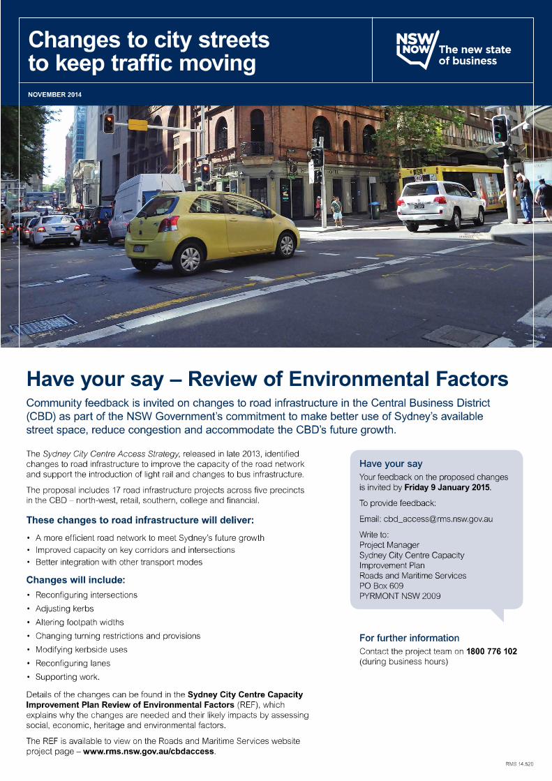
Have your say – Sydney City Centre Capacity Improvement PlanThe NSW Government is planning to improve road infrastructure in the city to keep traffic moving into, from and through the CBD to support the introduction of light rail and changes to bus infrastructure. Roads and Maritime Services is seeking community and stakeholder feedback until 9 January 2015 on a Review of Environmental Factors, which comprises 17 road, intersection and footpath improvements, enabling light rail construction.
Benefits of the projectThe Sydney City Centre Capacity Improvement Plan will enable light rail and aims to make better use of Sydney’s available street space over the coming years to reduce congestion and accommodate the CBD’s future growth.
Changes to road infrastructure would:
• Support the growing demand for access by improving the capacity of key corridors and intersections
• Improve road efficiency and allow for integrated public transport services
• Improve the customer experience by improving the safety, amenity and efficiency of the road network
• Accommodate Sydney’s future growth demand
• Minimise environmental and socio-economic impacts on the Sydney city centre and on current business operations, including for freight and taxi movements.
Review of Environmental Factors – Have your sayThe Review of Environmental Factors for the Sydney City Centre Capacity Improvement Plan is on display until 9 January 2015 and can be viewed at www.rms.gov.au/cbdaccess.
Written comments are invited until 9 January 2015 and should be sent to:
Project Manager Sydney City Centre Capacity Improvement Plan Roads and Maritime Services PO Box 609 Pyrmont NSW 2009
Or email your comments to: [email protected]
Details of display locations are on the back page of this update.
Community UpdateNOVEMBER 2014

Traffic capacity improvement Description of work*
1 Reconfigure intersections • Modify layout, signage and line marking at the intersection approaches and departures
• Alter lane priority leading into/from intersections
• Change turning priority at intersections
• Change the size of the intersection
2 Adjust kerbs • Extend the kerb line to prevent traffic from turning left or right at intersections or to reduce the number of lanes at intersections
• Modify or remove sections of kerb line, either at intersections or mid-block
• Remove kerb extensions at intersections to allow traffic to turn left or right or to increase the number of lanes on the approach to or exit from intersections
3 Alter footpath widths • Increase or decrease footpath widths between intersections to improve the traffic flow on the approach to, exit from, or through an intersection; or to alter the existing lane arrangements
4 Change turning restrictions and provisions
• Introduce left turn, right turn and through lane restrictions at intersections through line marking, signage and/or traffic signal changes
5 Modify kerbside uses • Reduce, remove, relocate or place time restrictions on kerbside allocations
6 Reconfigure lanes • Alter lane arrangements between intersections
7 Supporting work Other alterations may include:
• Major equipment relocation (e.g. telephone boxes, parking meters, post boxes)
• Tree pruning or removal
• Bus lane marking alteration or instalment
• Bus shelter relocation
• Road regrading and resurfacing
• Traffic signal and lighting pole work
• Utility work
• Surface drainage modification and relocation
• Bicycle rack relocation
*The work for each project site will vary
Sydney City Centre Capacity Improvement Plan
1 2 5
6 7
5 6
1 52 5 751 76
2
5 7
31
6
1 4
5 7
2
721
71
5
2 5
7
1
6
52 7
2 6 72 3
6
1
5 7
3 5
7
2
6
5 6
Central Station
BelmorePark
SYDNEY
SURRYHILLS
DARLINGHURST
HAYMARKET
ULTIMO
The Domain
Sydney Cove
Barangaroo
Hyde Park Hyde Park
Harris Street
Wattle Street
Abercrombie Street
Mountain Street
George StreetMar
ket S
tree
t
Park
Str
eet
Elizabeth Street
Pitt Street
Gou
lbur
n St
reet
Live
rpoo
l Str
eet
Macquarie Street
Hun
ter S
tree
t
Pitt Street
Pitt Street
Castlereagh Street
College Street
Wentworth Avenue
Bridge Street
Eddy
Stre
et
George Street
Kin
g St
reet
Kent Street
Clarence Street
York Street
York Street
Sussex Street
Sussex Street
RETAIL
COLLEGE ST
FINANCIAL
NORTH-WEST
SOUTH
Precinct Project
Precinct 1: north-westKent Street between Margaret Street and King StreetKing Street between Sussex Street and Castlereagh Street
Precinct 2: retail
Park Street at the Pitt Street intersectionMarket Street between Kent Street and Castlereagh StreetSussex Street between King Street and Druitt StreetClarence Street between Jamison Street and Druitt StreetYork Street between King Street and Druitt Street
Precinct 3: southern
Sussex Street between Bathurst Street and Goulburn StreetGoulburn Street at the George Street intersectionPitt Street between Liverpool Street and Rawson PlaceUltimo Road at the Harris Street intersectionBroadway between Mountain Street and Abercrombie StreetPitt Street at the Lee Street and George Street intersection
Precinct 4: collegeWentworth Avenue between Oxford Street and Campbell StreetCollege Street between Macquarie Street and Oxford Street
Precinct 5: financialMacquarie Street between Bent Street and Bridge StreetMacquarie Street at the Hunter Street intersection

BackgroundIn late 2013, the NSW Government released the Sydney City Centre Access Strategy to improve access to the CBD by putting the right transport modes, in the right places in the city centre – reducing congestion and supporting a globally competitive Sydney.
The Access Strategy provides a clear direction for how all the different transport modes – delivery vehicles, light rail, buses, trains, ferries, cars, taxis, pedestrians and cyclists – will work together in the city centre.
The Sydney City Centre Capacity Improvement Plan is part of the Access Strategy and supports the introduction of other Access Strategy initiatives, such as light rail and a new bus network. It does so by prioritising vehicle movements along particular corridors and at identified intersections so that traffic can be better managed, especially at peak times.
To learn more about the Sydney City Centre Access Strategy, visit: www.transport.nsw.gov.au
Road infrastructure changesThe proposal includes 17 road infrastructure projects across five precincts in the CBD – north-west, retail, southern, college and financial.
The changes to road infrastructure include:
1. Reconfiguring intersections
2. Adjusting kerbs
3. Altering footpath widths
4. Changing turning restrictions and provisions
5. Modifying kerbside uses
6. Reconfiguring lanes
7. Supporting work.
What happens next?All comments received will be considered in finalising the project design. If there are further changes to the design the community will be informed.
REVIEW OF ENVIRONMENTAL FACTORS DISPLAYED FOR COMMUNITY COMMENT
REVIEW OF ENVIRONMENTAL FACTORS DECISION AND ROADS AND MARITIME
RESPONSE TO SUBMISSIONS
APPROVAL TO PROCEED
SITE PREPARATION AND DETAILED DESIGN
CONSTRUCTION
Construction would commence in early 2015 and take about one year to complete, weather permitting.
WE ARE
HERE
© Roads and Maritime Services
Privacy: Roads and Maritime Services (“RMS”) is subject to the Privacy and Personal Information Protection Act 1998 (“PPIP Act”) which requires that we comply with the Information Privacy Principles set out in the PPIP Act.
All information in correspondence is collected for the sole purpose of assisting in the assessment of this proposal. The information received, including names and addresses of respondents, may be published in subsequent documents unless a clear indication is given in the correspondence that all or part of that information is not to be published. Otherwise RMS will only disclose your personal information, without your consent, if authorised by the law. Your personal information will be held by RMS at 27 Argyle Street, Parramatta NSW 2150. You have the right to access and correct the information if you believe that it is incorrect.
RMS 14.519
Have your sayTo provide feedback on the proposed changes to city streets write to:
Project Manager Sydney City Centre Capacity Improvement Plan Roads and Maritime Services PO Box 609 Pyrmont NSW 2009 or email your comments to: [email protected]
All submissions should be received by 9 January 2015.
Any queries or submissions made during the Christmas/New Year period will be responded to in the week commencing Monday 5 January 2015.
How to receive a copy of the review of environmental factorsThis REF can be downloaded, at no cost, from the Roads and Maritime website at www.rms.nsw.gov.au/cbdaccess.
You can request a CD copy by contacting the project team on 1800 776 102 or email [email protected].
Display locationsThe REF can be viewed at the following display locations until 9 January 2015.
City of Sydney Neighbourhood Service Centres
CBD One Stop Shop Level 3 Town Hall House 456 Kent Street SYDNEY NSW 2000 Monday – Friday 8am – 6pm
Glebe 186 Glebe Point Road GLEBE NSW 2037 Monday – Friday 9am – 5pm
Kings Cross 50-52 Darlinghurst Road KINGS CROSS NSW 2011 Monday – Friday 9am – 5pm Saturday 9am – 12pm
Redfern 158 Redfern Street REDFERN NSW 2016 Monday – Friday 9am – 5pm Saturday 9am – 12pm
Green Square 100 Joynton Avenue ZETLAND NSW 2017 Monday – Friday 9am – 6pm
Transport Information Centre Cnr George and King Streets 388 George Street, SYDNEY NSW 2000 Monday – Friday 9am – 5pm
Customs House 31 Alfred Street CIRCULAR QUAY NSW 2000 Monday – Friday 10am – 7pm Saturday – Sunday 11am – 4pm
This document contains important information about road projects in your area. If you require the
services of an interpreter, please contact the Translating and Interpreting Service on 131 450 and ask them to call the project team on 1800 776 102. The interpreter will then assist you with translation.

Sydney City Centre Capacity Improvement Plan Appendix CReview of Environmental Factors
Appendix CTraffic and access specialist study
NSW Roads and Maritime Services
Sydney City Centre Capacity Improvement Plan
Traffic and transport assessment19 November 2014

Parsons Brinckerhoff | 2196763A-ITP-RPT-3754-RevA i
NSW Roads and Maritime Services Sydney City Centre Capacity Improvement Plan - Traffic and transport assessment
ContentsPage number
1. Introduction 1
1.1 Proposal context 1
1.2 Proposal study area and work sites 2
1.3 Report purpose and structure 3
2. Existing conditions 5
2.1 Travel modes 5
2.2 Existing road network 6
2.2.1 Overview 62.2.2 Kerbside use 82.2.3 Property access and off-street parking 8
2.3 Public transport 9
2.4 Walking 11
2.5 Cycling 12
2.6 Traffic conditions 12
2.6.1 North-west precinct 132.6.2 Retail precinct 152.6.3 Southern precinct 182.6.4 College Street precinct 222.6.5 Financial precinct 24
3. Traffic forecasting and modelling process 29
3.1 Overview 29
3.2 Proposal work site models 30
3.3 Sydney CBD AIMSUN network model 32
3.4 Model outputs 33
4. Future conditions without the proposal 35
4.1 Sydney City Centre Access Strategy 35
4.2 Travel modes 37
4.3 Future road network 37
4.3.1 Overview 374.3.2 Kerbside use 384.3.3 Property access and off-street parking 40
4.4 Public transport 41
ii 2196763A-ITP-RPT-3754-RevA | Parsons Brinckerhoff
NSW Roads and Maritime Services Sydney City Centre Capacity Improvement Plan - Traffic and transport assessment
Contents (Continued)
Page number
4.5 Taxis 43
4.6 Walking 45
4.7 Cycling 45
4.8 Traffic conditions 47
5. The proposal 51
5.1 Proposal context 51
5.2 Proposal objectives 52
5.3 The Sydney City Centre Capacity Improvement Plan 52
6. Future conditions with the proposal 57
6.1 Construction of proposal 57
6.1.1 Travel modes 576.1.2 Road network 586.1.3 Public transport 606.1.4 Taxis 606.1.5 Walking 616.1.6 Cycling 616.1.7 Traffic conditions 62
6.2 Operation with proposal 63
6.2.1 Travel modes 636.2.2 Future road network 646.2.3 Public transport 666.2.4 Taxis 666.2.5 Walking 676.2.6 Cycling 676.2.7 Traffic conditions 68
7. Mitigation and management strategy 99
7.1 Construction of proposal 100
7.2 Operation with proposal 106
8. Next steps (Future AIMSUN Modelling) 111

Parsons Brinckerhoff | 2196763A-ITP-RPT-3754-RevA iii
NSW Roads and Maritime Services Sydney City Centre Capacity Improvement Plan - Traffic and transport assessment
List of tablesPage number
Table 2.1 Sydney city centre transport gateway entry travel modes (2013 AM peak) 5Table 2.2 City centre road reserve land uses 8Table 2.3 City centre public transport summary 9Table 2.4 North-west precinct road network performance (Existing conditions, 2014) 14Table 2.5 Retail precinct road network performance (Existing conditions, 2014) 17Table 2.6 Southern precinct road network performance (Existing conditions, 2014) 21Table 2.7 College Street precinct road network performance (Existing conditions, 2014) 23Table 2.8 Financial precinct road network performance (Existing conditions, 2014) 25Table 3.1 Modelled scenarios 30Table 3.2 Key intersection performance statistics 31Table 3.3 Key network performance statistics 33Table 3.4 Model outputs summary 33Table 4.1 Key features of road network strategy 38Table 4.2 Key features of kerbside use strategy 38Table 4.3 Key features of property access and off-street parking strategy 40Table 4.4 Key features of public transport network strategy 41Table 4.5 Key features of the taxi network strategy 43Table 4.6 Key features of pedestrian network strategy 45Table 4.7 Key features of cycling network strategy 45Table 4.8 Traffic capacity impacts of public and active transport projects 48Table 5.1 Proposal precincts and work sites 53Table 6.1 Road network construction impacts 58Table 6.2 Kerbside use construction impacts 59Table 6.3 Property access and off-street parking construction impacts 59Table 6.4 Public transport construction impacts 60Table 6.5 Taxi construction impacts 61Table 6.6 Pedestrian construction impacts 61Table 6.7 Cycling construction impacts 62Table 6.8 Construction traffic overview 62Table 6.9 Kerbside use operation impacts 65Table 6.10 Property access and off-street parking operation impacts 66Table 6.11 Public transport operation impacts 66Table 6.12 Taxi operation impacts 67Table 6.13 Pedestrian operation impacts 67Table 6.14 Cycling operation impacts 67Table 6.15 North-west precinct work site summary 70Table 6.16 Key intersection demand and performance – North-west precinct (Future
conditions) 71Table 6.17 North-west precinct intersection and worksite capacity improvements 72Table 6.18 Retail precinct work site summary 73Table 6.19 Key intersection performance – Retail precinct (Future conditions) 78Table 6.20 Retail precinct intersection and worksite capacity improvements 79Table 6.21 Southern precinct work site summary 81Table 6.22 Key intersection performance – Southern precinct (Future conditions) 84Table 6.23 Southern precinct intersection and worksite capacity improvements 85Table 6.24 College Street precinct work site summary 87Table 6.25 Key intersection performance – College Street precinct (Future conditions) 89Table 6.26 College Street precinct intersection and worksite capacity improvements 89Table 6.27 Financial precinct work site summary 92Table 6.28 Key intersection performance – Financial precinct (Future conditions) 92
iv 2196763A-ITP-RPT-3754-RevA | Parsons Brinckerhoff
NSW Roads and Maritime Services Sydney City Centre Capacity Improvement Plan - Traffic and transport assessment
Table 6.29 Financial precinct intersection and worksite capacity improvements 93Table 6.30 Traffic benefits and impacts summary 94Table 7.1 Key traffic and transport safeguards and responsibilities 99Table 7.2 Summary of construction impacts and mitigation measures 101Table 7.3 Summary of operation impacts and mitigation measures 107
List of figuresPage number
Figure 1.1 Study area and precinct boundaries 2Figure 2.1 Study area and precinct boundaries 7Figure 2.2 Existing public transport hubs and major bus corridors 10Figure 2.3 City Centre pedestrian demand profile (2014) 11Figure 2.4 North-west precinct modelled network conditions overview (AM/PM peak, 2014) 15Figure 2.5 Retail precinct modelled network conditions overview (AM/PM peak, 2014) 18Figure 2.6 Southern precinct modelled network conditions overview (AM/PM peak, 2014) 22Figure 2.7 College Street precinct modelled network conditions overview (AM/PM peak, 2014) 24Figure 2.8 Financial precinct modelled network conditions overview (AM/PM peak, 2014) 26Figure 2.9 City centre network conditions overview (Minimum Level of Service, 2014) 28Figure 4.1 Proposed Sydney City Centre Access Strategy transport network 36Figure 4.2 Proposed city centre road network 39Figure 4.3 Proposed city centre public transport networks 42Figure 4.4 Proposed city centre taxi ranks 44Figure 4.5 Proposed city centre pedestrian and cycling key network elements 46Figure 4.6 Traffic capacity impacts of public and active transport projects 47Figure 4.7 Indicative traffic pattern impacts of public and active transport projects 49Figure 5.1 North-west precinct work sites 54Figure 5.2 Retail precinct work sites 55Figure 5.3 Southern precinct work sites 55Figure 5.4 College Street precinct work sites 56Figure 5.5 Financial precinct work sites 56Figure 6.1 North-west precinct capacity improvement summary 72Figure 6.2 Retail precinct capacity improvement summary 77Figure 6.3 Southern precinct capacity improvement summary 86Figure 6.4 College Street precinct capacity improvement summary 90Figure 6.5 Financial precinct capacity improvement summary 93Figure 6.6 Sydney City Centre Capacity Improvement Plan – intersection and worksite
capacity improvement summary 96Figure 6.7 Sydney City Centre Capacity Improvement Plan – existing performance and work
site capacity improvement summary 97
List of appendicesAppendix A Proposed intersection layouts
Parsons Brinckerhoff | 2196763A-ITP-RPT-3754-RevA 1
NSW Roads and Maritime Services Sydney City Centre Capacity Improvement Plan - Traffic and transport assessment
1. Introduction1.1 Proposal contextThe Sydney City Centre Access Strategy (the Access Strategy, Transport for NSW, 2013) is ‘the State’s firstdetailed plan showing how people will enter, exit and move in and around the central business district (CBD)over the next 20 years’. This will be realised by delivering a number of key projects to provide a ‘fullyintegrated public transport network’ whilst also ‘making better use of the available street space’ in the citycentre. The key projects of the Access Strategy comprise:
The CBD to South East Light Rail project (CSELR).
The Sydney City Centre Bus Infrastructure project.
The Sydney City Centre Cycleways projects.
Although driving trips to and from the city centre have plateaued in recent years, the implementation ofAccess Strategy projects would reduce the traffic capacity of the already congested road network. Theproposed pedestrianisation of George Street and light rail construction would be a key catalyst for this,restricting traffic to local property access movements only between Bathurst Street and Hunter Street.Consequently there is a need to prioritise and reallocate available street space to maintain the function of theroad network during and following the construction of these projects, to ensure the efficient operation of thenetwork to support bus, taxi, service vehicle, delivery vehicle, and general traffic movements.
To mitigate the impacts to the traffic capacity of the city centre road network created by Access Strategyprojects, NSW Roads and Maritime Services (Roads and Maritime) in conjunction with Transport for NSW(TfNSW) have developed the Sydney City Centre Capacity Improvement Plan (the proposal).
The overall objective of the proposal is to support the growing demand for access into the Sydney city centreand to improve road network functionality over the coming years, including during construction and operationof a number of projects proposed under the Access Strategy. The proposal would improve the capacity andconsequent performance of some of the city’s most congested roads and constrained intersections, andimprove the ability of the network to accommodate the anticipated changes to traffic conditions as a result ofthe partial pedestrianisation of George Street, the introduction of bus and cycle improvements, and theintroduction of a number of major city-centre developments. Supporting proposal objectives are to:
Support the reallocated demand through improved key corridor and intersection capacity
Support more efficient road usage to accommodate Sydney’s future growth demand
Improve road efficiency and allow quality integrated public transport services to meet future demand
Improve the customer experience by improving the safety, amenity and efficiency of the road network
Minimise environmental and socio-economic impacts on the Sydney city centre and on current businessoperations.
Although the proposal would increase the capacity and efficiency of traffic movements within the city centre,traffic demand travelling to, from, and within the city centre is not expected to grow significantly.Consequently, the capacity improvements that form ‘the proposal’ focus on demand management strategiesto facilitate the effective and efficient operation of the city centre road network, rather than the creation ofhigh capacity road infrastructure.

2 2196763A-ITP-RPT-3754-RevA | Parsons Brinckerhoff
NSW Roads and Maritime Services Sydney City Centre Capacity Improvement Plan - Traffic and transport assessment
The proposal focusses on areas of the city centre road network which are not subject to modificationsthrough other planned or proposed projects. Other projects, for example the Sydney City Centre BusInfrastructure project as part of the Access Strategy, also propose upgrades to other roads and intersectionswhich would improve overall traffic capacity. The traffic capacity improvements proposed as part of theSydney City Centre Capacity Improvement Plan have therefore been developed to integrate with andcomplement other traffic capacity improvements already planned or proposed across the city centre.
1.2 Proposal study area and work sitesThe study area is a densely developed urban environment, comprising busy road corridors and a mix ofresidential, commercial, retail, tourism and transport-related land uses. As well as an employment hub, thecity centre services both residents and visitors. As such, its population increases significantly during theworking week, with peak transport demand occurring during weekday morning and evening peak periods.
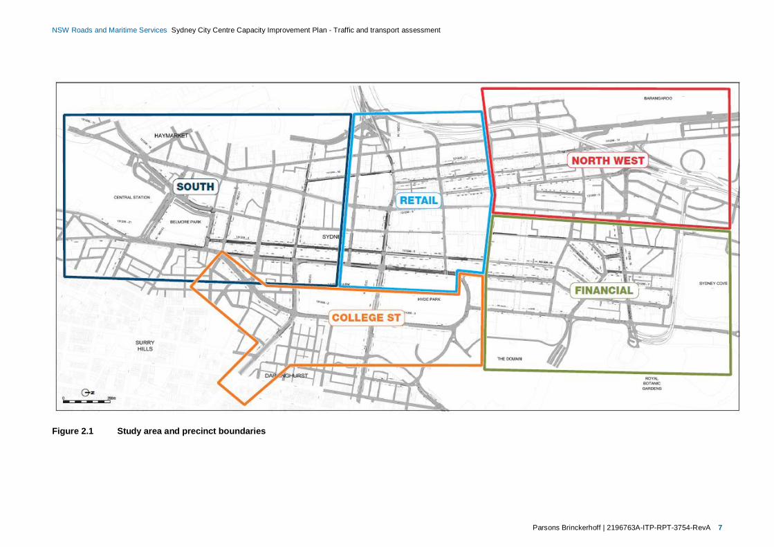
The Sydney City Centre Capacity Improvement Plan Review of Environmental Factors (the REF) which thistraffic and transport assessment informs disaggregates the study area into the five precincts illustrated inFigure 1.1:
North-west
Retail
Southern
College Street
Financial.
Figure 1.1 Study area and precinct boundaries
Recognising the constraints of the study area, Roads and Maritime has limited the proposal to focus onsections of road (work sites) where improvements are most needed. The proposal work sites focus on ‘pinchpoints’; areas of the road network where traffic demand exceeds capacity, resulting in delays, queuing, andcongestion. These areas have been identified as either unable to cope with existing volumes of traffic, oranticipated as critical components to maintain the overall traffic function of the road network in the future.

Parsons Brinckerhoff | 2196763A-ITP-RPT-3754-RevA 3
NSW Roads and Maritime Services Sydney City Centre Capacity Improvement Plan - Traffic and transport assessment
A summary of proposal work sites is provided in Chapter 5. Specific features and details of the proposal areprovided in Chapter 6 of this report, Chapter 3 of the REF document, and in the Concept Design document.
1.3 Report purpose and structureParsons Brinckerhoff has prepared this traffic and transport assessment as a key component of the SydneyCity Centre Capacity Improvement Plan REF for Roads and Maritime (Sydney Region) on behalf of TfNSW.The key objectives of this assessment are:
Provide a detailed overview of the existing and future traffic and transport environment in the studyarea.
Inform the development of strategic concept design options for the proposal.
Determine the effects and assess the traffic and transport benefits and impacts of the proposal.
This report is structured as follows:
Section 2: Existing traffic and transport environment in the study area, including existing transportnetworks, traffic volumes and road network performance, and public and active transport infrastructureand operations.
Section 3: Traffic forecasting and modelling process used for the assessment.
Section 4: Future traffic and transport environment in the study area, considering the impacts ofapproved Access Strategy projects, but excluding the proposal.
Section 5: The proposed Sydney City Centre Capacity Improvement Plan (the proposal).
Section 6: Future traffic and transport environment in the study area, considering the effects, benefitsand impacts of the proposal during construction and operation.
Section 7: Proposed strategies and actions to mitigate and manage the impacts of the proposal duringconstruction and operation.

Parsons Brinckerhoff | 2196763A-ITP-RPT-3754-RevA 5
NSW Roads and Maritime Services Sydney City Centre Capacity Improvement Plan - Traffic and transport assessment
2. Existing conditions2.1 Travel modesThe city centre’s population increases during the day, with over 600,000 people traveling into the city centreeach day to work or use its various amenities, and a further 1.27 million trips made within the centre. Themajority of trips which enter the study area use one of 15 key transport ‘gateways’. Table 2.1 provides asummary of gateway entries by travel mode.
Table 2.1 Sydney city centre transport gateway entry travel modes (2013 AM peak)
Gateway Rail Bus Car Ferry
Sydney Harbour Bridge 16,250 14,500 11,500 -
Circular Quay - - - 4,000
Sydney Harbour Tunnel - - 5,550 -
Eastern Distributor - 3,100 6,400 -
Eastern Suburbs Rail Line 7,400 - - -
William Street/Cross City Tunnel - 1,200 4,250 -
Oxford Street - 3,550 2,000 -
Albion Street and Foveaux Street - 2,100 1,900 -
Elizabeth Street and Chalmers Street - 3,050 1,450 -
Redfern Rail Line 65,600 - - -
Airport Rail Line 7,950 - - -
Regent Street - - 1,700 -
Broadway - 5,400 2,450 -
Wentworth Park/Bridge Road 450 - 1,500 -
Anzac Bridge - 2,800 8,700 -
TOTAL97,650 35,700 47,400 4,000
53% 19% 26% 2%
Source: Sydney City Centre Access Strategy, TfNSW December 2013
In addition to commuter movements high volumes of taxis and commercial vehicles also compete for thelimited street space. The timely movement of commercial traffic is critical to supporting the city centre’seconomy, with large volumes of service and delivery vehicles travelling to, from, and within the city centreroad network throughout the day. Light commercial vehicles represent 95 per cent of weekday commercialvehicles, with approximately 29 per cent of commercial light traffic movements occurring during the morningand afternoon peak periods1.
1 Sydney City Centre Access Strategy, TfNSW, December 2013

6 2196763A-ITP-RPT-3754-RevA | Parsons Brinckerhoff
NSW Roads and Maritime Services Sydney City Centre Capacity Improvement Plan - Traffic and transport assessment
During weekday peak periods (7.00–10 am; 3–7 pm) the majority of trips into the city centre use publictransport. Traffic flows on the city centre road network are generally highest during these times, as it isaccessible by all modes of traffic including buses, cars, and light and heavy commercial vehicles. The modalsplit within the city centre varies depending on the time, day, and season. More than 60 per cent of total tripsto or from the city centre use public transport, and around 25 per cent (14 per cent during morning peakhours) travel by car2.
Over the past ten years, the number of people entering the city centre in cars during morning peak hours hasplateaued at around 47,000. During the same period the number of people arriving by public transport hasincreased from 105,000 to 145,000 passengers (TfNSW, 2013).
Within the city centre pedestrians, cyclists, buses and other vehicles compete to use the limited space on theroad network. Cars are the largest users of traffic space across the city centre throughout the day. Duringweekday morning peak hours, cars and taxis typically comprise 87 per cent of traffic movements at citycentre intersections, buses eight per cent, and the remaining five per cent consists of trucks and cyclists.
2.2 Existing road network
2.2.1 Overview
The study area for the proposal includes all roads within the city centre and City of Sydney LGA, illustrated inFigure 2.1. The road network in this area is managed by Roads and Maritime (Sydney Branch) and City ofSydney Council.
The city centre is an urban environment set out along a grid of north-south and west-east streets, fronted bymedium-high density development interspersed by several parks and open spaces. In the south of the studyarea the grid pattern is slightly uneven; in the north, the streets form a grid alignment orientated towardsCircular Quay. There are no general restrictions to traffic travelling within the city centre, although trafficcontrols and restrictions apply in certain areas and during certain times. These include bus lanes, buspriorities, one-way circulation, turning/access restrictions, parking restrictions, and cycleways.
The posted speed limit throughout the study area is 50 kilometres per hour (km/h) or lower. On the 3 October2014 Roads and Maritime introduced a 40 km/h speed limit across a large portion of the study area, boundedby Castlereagh Street to the east, Kent Street to the west, and Hay Street to the south in response toanother initiative of the Access Strategy.
2 Sydney City Centre Access Strategy, TfNSW, December 2013
Parsons Brinckerhoff | 2196763A-ITP-RPT-3754-RevA 7
NSW Roads and Maritime Services Sydney City Centre Capacity Improvement Plan - Traffic and transport assessment
Figure 2.1 Study area and precinct boundaries
8 2196763A-ITP-RPT-3754-RevA | Parsons Brinckerhoff
NSW Roads and Maritime Services Sydney City Centre Capacity Improvement Plan - Traffic and transport assessment
2.2.2 Kerbside use
Within the city centre the road reserve generally adjoins adjacent property boundaries. It also contains roadfurniture (e.g. lights, signage), street furniture (e.g. bus stops, benches, bicycle racks), and privately ownedproperty (e.g. telephone boxes, mail boxes). There are three principal land uses within the road reserve,described in Table 2.2.
Table 2.2 City centre road reserve land uses
Land use Description
Road space Generally used by all modes of traffic, with use restricted in certain locations for certain vehicles(e.g. buses and cyclists).
Footpaths Principally used by pedestrians, however other uses include outdoor seating, outdoor dining,bicycle parking, and bus stops.
Kerbsides Principally used for loading zones, mail zones, bus layovers, disabled parking, on-street parkingand taxi bays.
Kerbside use refers to the allocation of the kerbside traffic lane. Kerbside uses are located throughout thecity centre, many of which are contained within the limits of the proposal footprint. The major kerbside usesin the study area comprise:
Bus stops
Bus layovers
Coach stops/layovers
On-street parking (unrestricted, mobility, and motorcycle)
Loading zones
Taxi zones
Mail zones.
The composition of kerbside uses throughout the study area varies by location and time of day. Generallykerbside use is restricted during peak traffic periods, where the speed and efficiency of the road network isprioritised.
2.2.3 Property access and off-street parking
The city centre is a high-density urban environment. Consequently there are a high number of propertyaccesses for both pedestrians and vehicles throughout the study area.
All properties in the city centre provide pedestrian access to and from footpaths within the city centre roadreserves. In addition a large proportion of commercial buildings in the city centre include private vehicleloading and parking areas, typically accessed by crossing the footpath between the road space and theproperty access point.
A large volume of off-street public parking is also available within the city centre. It is estimated that the citycentre that contains approximately 70,000 off-street car parking spaces, which are currently underutilised byapproximately 10 to 30 per cent during the daytime (TfNSW, 2013). Due to the relatively high level of trafficgenerated by public parking lots, vehicular access to and from the road network is typically affected bydiscontinuing footpaths and providing signalised pedestrian crossings.
Parsons Brinckerhoff | 2196763A-ITP-RPT-3754-RevA 9
NSW Roads and Maritime Services Sydney City Centre Capacity Improvement Plan - Traffic and transport assessment
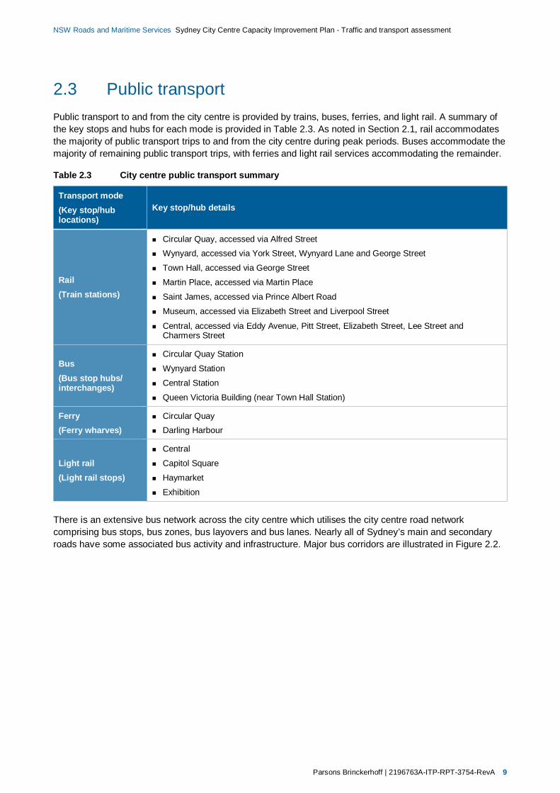
2.3 Public transportPublic transport to and from the city centre is provided by trains, buses, ferries, and light rail. A summary ofthe key stops and hubs for each mode is provided in Table 2.3. As noted in Section 2.1, rail accommodatesthe majority of public transport trips to and from the city centre during peak periods. Buses accommodate themajority of remaining public transport trips, with ferries and light rail services accommodating the remainder.
Table 2.3 City centre public transport summary
Transport mode(Key stop/hublocations)
Key stop/hub details
Rail(Train stations)
Circular Quay, accessed via Alfred StreetWynyard, accessed via York Street, Wynyard Lane and George Street
Town Hall, accessed via George Street
Martin Place, accessed via Martin Place
Saint James, accessed via Prince Albert Road
Museum, accessed via Elizabeth Street and Liverpool Street
Central, accessed via Eddy Avenue, Pitt Street, Elizabeth Street, Lee Street andCharmers Street
Bus(Bus stop hubs/interchanges)
Circular Quay Station
Wynyard Station
Central Station
Queen Victoria Building (near Town Hall Station)
Ferry(Ferry wharves)
Circular QuayDarling Harbour
Light rail(Light rail stops)
Central
Capitol Square
Haymarket
Exhibition
There is an extensive bus network across the city centre which utilises the city centre road networkcomprising bus stops, bus zones, bus layovers and bus lanes. Nearly all of Sydney’s main and secondaryroads have some associated bus activity and infrastructure. Major bus corridors are illustrated in Figure 2.2.

10 2196763A-ITP-RPT-3754-RevA | Parsons Brinckerhoff
NSW Roads and Maritime Services Sydney City Centre Capacity Improvement Plan - Traffic and transport assessment
Figure 2.2 Existing public transport hubs and major bus corridors
Parsons Brinckerhoff | 2196763A-ITP-RPT-3754-RevA 11
NSW Roads and Maritime Services Sydney City Centre Capacity Improvement Plan - Traffic and transport assessment
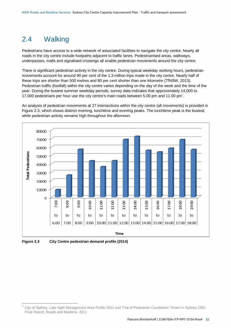
2.4 WalkingPedestrians have access to a wide network of associated facilities to navigate the city centre. Nearly allroads in the city centre include footpaths adjacent to traffic lanes. Pedestrianised areas, walkways,underpasses, malls and signalised crossings all enable pedestrian movements around the city centre.
There is significant pedestrian activity in the city centre. During typical weekday working hours, pedestrianmovements account for around 90 per cent of the 1.3 million trips made in the city centre. Nearly half ofthese trips are shorter than 500 metres and 80 per cent shorter than one kilometre (TfNSW, 2013).Pedestrian traffic (footfall) within the city centre varies depending on the day of the week and the time of theyear. During the busiest summer weekday periods, survey data indicates that approximately 14,000 to17,000 pedestrians per hour use the city centre’s main roads between 5.00 pm and 11.00 pm3.
An analysis of pedestrian movements at 27 intersections within the city centre (all movements) is provided inFigure 2.3, which shows distinct morning, lunchtime and evening peaks. The lunchtime peak is the busiest,while pedestrian activity remains high throughout the afternoon.
Figure 2.3 City Centre pedestrian demand profile (2014)
3 City of Sydney, Late night Management Area Profile 2012 and Trial of Pedestrian Countdown Timers in Sydney CBD,Final Report, Roads and Maritime, 2011
12 2196763A-ITP-RPT-3754-RevA | Parsons Brinckerhoff
NSW Roads and Maritime Services Sydney City Centre Capacity Improvement Plan - Traffic and transport assessment
Pedestrians are the dominant proportion of road users at many of the intersections in the city centre. Despitethis, pedestrians often experience relatively long delays at signal controlled intersections when compared toroad traffic as a result of timing and phasing allocations4. Pedestrian safety remains a priority throughout thecity centre; between 2007 and 2011 there were 904 pedestrian casualties in the city centre. In October 2014Roads and Maritime introduced a 40km/h speed limit across a large proportion of the study area to improvepedestrian safety5. Other initiatives including the use of Pedestrian Countdown Timers have also beentrialled to improve pedestrian safety and amenity6.
2.5 CyclingDedicated cycling infrastructure in the city centre includes dedicated cycleways on Kent Street (which hasbeen recently extended), King Street, and College Street, as well as shared use paths. Cyclists also usegeneral traffic lanes and bus lanes on the city centre road network.
The recent high growth in cycling activity within the city centre is expected to continue to grow. In 2012around 11,000 cycling trips were made into the city during morning peak periods, with 50,000 cycling trips onaverage each day within the city centre, 50 per cent higher than just two years previously.
2.6 Traffic conditionsVehicles travelling through the city centre during morning and evening peak periods do so in a highlyinterrupted flow, low-speed environment. Much of the road network within the city centre is congested, withmany intersections operating at or over capacity. Traffic delays are particularly long at the CastlereaghStreet/Park Street, Druitt Street/Park Street/George Street, and the George Street/Grosvenor Street/BridgeStreet intersections (TfNSW, 2013).
During both the AM and PM peak periods a similar overall volume of traffic uses the city centre road network.Previous network modelling undertaken for other Access Strategy projects indicates that traffic travels at anaverage of 20 km/h during the peak periods. In addition to delays caused by the high volume of trafficdemand, high bus volumes, pedestrian movements, and kerbside activity further reduce road networkcapacity and efficiency.
Key pinch points and priority work sites within the defined precincts have been identified in developing theproposal, as described in section 5. The following sections summarise existing traffic conditions and networkperformance within these work sites.
The methodology adopted to assess the network performance benefits and impacts of the proposal is basedprimarily on the use of SIDRA intersection modelling and first-principles assumptions. A summary of themethodology applied in this assessment is described in section 3. This modelling provides detailedintersection performance indicators which have been used to provide an overview of existing conditions.However, it is important to note that it is limited to providing detailed analysis of individual, isolatedintersection performance. The Degree of Saturation, Average Delay, and ultimately queue lengths assumerelatively unconstrained traffic conditions on the approaches to and exits from intersection.
4 Sydney City Centre Access Strategy, TfNSW, December 20135 http://www.rms.nsw.gov.au/about/news-events/news/ministerial/2014/140915-40kmh-in-cbd-to-improve-pedestrian-
safety.pdf6 http://roadsafety.transport.nsw.gov.au/downloads/trial_ped_countdown_timers_sydney_cbd.pdf
Parsons Brinckerhoff | 2196763A-ITP-RPT-3754-RevA 13
NSW Roads and Maritime Services Sydney City Centre Capacity Improvement Plan - Traffic and transport assessment
In reality the effects of queuing in the city centre context are particularly problematic, with the proximity ofadjacent intersections providing limited vehicle storage capacity. At many intersections throughout the studyarea vehicle queues extend to and through adjacent intersections, dramatically reducing capacity andefficiency at these locations, and overall network efficiency as a result of further cascading impacts. Existingmid-block kerbside activity also further reduces the capacity and efficiency of the city centre road network.
Considering the above, the intersection performance indicators presented in the following sections provide:
An overview of unconstrained performance for individual intersections within each precinct.
Details of existing pinch points where delays and queuing have major impacts on the capacity andefficiency of adjacent intersections and the wider city centre road network.
Various pinch points within the city centre constrain traffic which would otherwise impact the performance ofdownstream intersections. While existing conditions appear to indicate satisfactory operation in many cases,this often occurs as a result of demand being unable to travel through the network. Consequently theperformance indicators presented in the following sections should be considered in the context of the abovefeatures of city centre traffic conditions.
This traffic and transport assessment focusses on the analysis of localised performance improvements atselected locations across the city centre road network. Section 3.2 discusses the use of AIMSUN networkmodelling to supplement the localised modelling undertaken for the proposal. This modelling would beundertaken as part of an ongoing process to analyse the cumulative effects and integration of transport andland use developments including the proposal throughout the city centre.
2.6.1 North-west precinct
2.6.1.1 Overview
Kent Street between Margaret Street and King Street
Kent Street is currently one-way northbound between Liverpool Street and Erskine Street after which traffic ispermitted in both directions. This traffic arrangement, in combination with the provision of a dedicatedseparated two-way cycleway adjacent to the eastern kerb, results in the availability of only one northboundlane north of Erskine Street. This arrangement results in extensive queuing on the southern approach toErskine Street particularly during the afternoon peak. The development of the Barangaroo site will increasenorthbound traffic on Kent Street.
King Street between Sussex Street and Pitt Street
King Street is a major corridor in the city centre with traffic movements operating in a one-way easterlydirection between Sussex Street and Elizabeth Street. The lane configuration varies with three trafficablelanes during peak periods between Sussex Street and York Street, four lanes between York Street andGeorge Street, three lanes east of George Street and four lanes from just west of Castlereagh Street throughto Elizabeth Street. A dedicated separated two-way cycleway has been constructed adjacent to the northernkerb between Sussex Street and Clarence Street. The Access Strategy indicates that the cycleway willultimately be extended to Castlereagh Street. The capacity of the corridor is impacted by the existence ofshared through and left/right turning lanes.

14 2196763A-ITP-RPT-3754-RevA | Parsons Brinckerhoff
NSW Roads and Maritime Services Sydney City Centre Capacity Improvement Plan - Traffic and transport assessment
2.6.1.2 Traffic volumes and network performance
Table 2.4 provides a summary of existing traffic demand and performance at key intersections within theprecinct. Schematic diagrams of the intersection layouts assessed are provided in Appendix A.
Figure 2.4 provides an overview of existing AM and PM peak LoS, and highlights queue lengths which arelikely to impact the performance of adjacent intersections and overall network efficiency as a result of furthercascading impacts:
All intersections are estimated to operate at LoS C or better during peak periods when considered inisolation.
The following approach queue lengths are likely to extend to and impact the operation of adjacentintersections:
Eastbound traffic on King Street from George Street to York Street, estimated as 150–200 m
Eastbound traffic on King Street from York Street to Clarence Street, estimated as 100–155 m.
Table 2.4 North-west precinct road network performance (Existing conditions, 2014)
Intersection
AM peak hour PM peak hour
Dem
and
(tota
lveh
icle
s)
Deg
ree
ofSa
tura
tion
(Vol
ume/
Cap
acity
)
Ave
rage
Del
ay(S
econ
ds/
vehi
cle)
/Lev
elof
Serv
ice
Max
imum
queu
ele
ngth
(95th
perc
entil
e,m
)
Dem
and
(tota
lveh
icle
s)
Deg
ree
ofSa
tura
tion
(Vol
ume/
Cap
acity
)
Ave
rage
Del
ay(S
econ
ds/
vehi
cle)
/Lev
elof
Serv
ice
Max
imum
queu
ele
ngth
(95th
perc
entil
e,m
)
NW1: Kent Street between Margaret Street and King Street
Kent Street/Erskine Street 1,350 0.69 36/C 145 1,350 0.70 36/C 140
Kent Street/King Street 2,050 0.61 15/B 85 1,450 0.58 20/ 85
NW2: King Street between Sussex Street and Castlereagh Street
King Street/Sussex Street 3,200 0.98 34/C 275 2,250 1.06 38/C 185
King Street/Kent Street 2,050 0.61 15/B 85 1,450 0.58 20/B 85
King Street/Clarence Street 2,050 0.59 16/B 85 1,750 0.44 19/B 85
King Street/York Street 2,100 0.59 24/B 155 1,650 0.44 24/B 100
King Street/George Street 2,450 0.81 30/C 200 2,200 0.75 27/B 150
King Street/Pitt Street 1,600 0.55 25/B 120 1,550 0.57 29/C 100
King Street/CastlereaghStreet 1,850 0.55 18/B 95 2,150 0.57 18/B 100
In summary, the results indicate that:
In isolation, intersection performance would be an acceptable LoS C or better throughout the precinct.
Traffic queues originating on the eastbound approach of the York Street/George Street intersection, andpropagating along the York Street corridor currently reduce the performance of upstream intersections.

Parsons Brinckerhoff | 2196763A-ITP-RPT-3754-RevA 15
NSW Roads and Maritime Services Sydney City Centre Capacity Improvement Plan - Traffic and transport assessment
Figure 2.4 North-west precinct modelled network conditions overview (AM/PM peak, 2014)
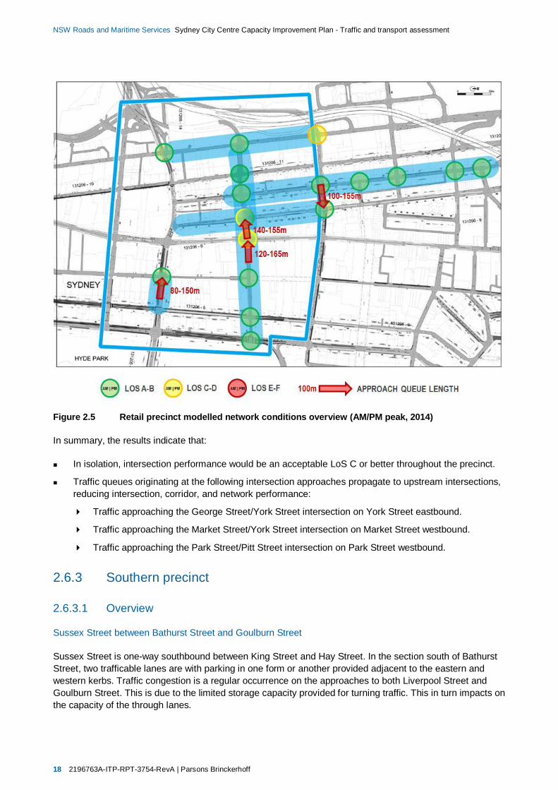
2.6.2 Retail precinct
2.6.2.1 Overview
Park Street at the Pitt Street Intersection
Park Street is a major cross city corridor which connects between William Street in the east and Druitt Streetin the west. Although the street functions as a two-way street, eastbound movements between George Streetand Pitt Street are restricted to buses, taxis, hire cars and cyclists. Bus lanes are provided in both directionsbetween College Street and Pitt Street and eastbound between George Street and Pitt Street.
Under the Access Strategy, the significance of Park Street as a major bus corridor will increase withwestbound traffic reduced to essentially a single lane between College Street and George Street. Park Streetcurrently carries approximately 640 and 520 westbound movements in the morning and evening peakperiods respectively whilst right turn movements into Pitt Street are in the order of 100 movements per hourduring the morning peak period and 40 during the evening peak period.
Market Street between Kent Street and Castlereagh Street
Market Street extends between Elizabeth Street and Sussex Street. It operates as a one-way Street east ofYork Street and a two-way street west of York Street. Westbound traffic experiences significant congestionand delay during the afternoon peak period and quite frequently during weekday business hours. Much ofthis delay occurs east of York Street. The road is generally configured to provide two through westboundlanes with additional lane capacity for turning movements provided at Castlereagh Street, George Street,York Street and Clarence Street. There is limited parking permitted on the corridor. The eastbound section ofroad has a public transport and local access function, facilitating bus services and access to Clarence Street,Kent Street and the QVB car park.

16 2196763A-ITP-RPT-3754-RevA | Parsons Brinckerhoff
NSW Roads and Maritime Services Sydney City Centre Capacity Improvement Plan - Traffic and transport assessment
Sussex Street between King Street and Druitt Street
Sussex Street extends between Erskine Street at Hay Street and functions as a one-way southbound streetsouth of King Street. Sussex Street provides direct access to the Western Distributor (at Market Street andDruitt Street) and the Cross City Tunnel (via Liverpool Street) from the north-west and western areas of thecity centre. Sussex Street is also the only southbound street west of George Street which connects thenorthern and southern areas of the city centre. The development of the Barangaroo site together with thepedestrianisation of George Street under the CSELR will inevitably result in Sussex Street becoming anincreasingly important traffic corridor. Currently, there are two dedicated southbound lanes in Sussex Streeton the approach to Market Street and three lanes on the departure side. The alignment of these lanes,together with the parking provisions adjacent to the eastern and western kerbs, effectively reduce the road’scapacity by creating a bottleneck at this point along Sussex Street.
Clarence Street between Jamison Street and Druitt Street
Clarence Street is a major bus corridor. It is used by both private and Government-owned buses servingSydney’s north and north-west. The number of buses using Clarence Street has led to designation of muchof the western kerb as a bus zone. It carries approximately 720 vehicles and 280 buses per hour during peakperiods. Split stops have been used as a mechanism for managing boarding passenger and minimising busstop dwell times. A dedicated bus lane operates along the western kerb between 6.00 am and 8.00 pm onweekdays north of Market Street. However, the effectiveness of the bus lane is significantly impacted by thesplit stop arrangements. Buses move out of the bus lane and mix with general traffic in order to passstationary buses. Parking is generally permitted at all times of the day adjacent to the eastern kerb.
York Street between King Street and Druitt Street
York Street is a major bus corridor, accommodating services which cross the Sydney Harbour Bridge fromthe north shore, Pittwater and north-west areas of Sydney. Bus volumes have risen continually over the past10 years with the latest data indicating in the order of 380 buses crossing the bridge in the every hour duringthe morning peak period. Of this number, almost half continue beyond Wynyard to the QVB and/or RailwaySquare. The historical construction of localised footway widenings in the section of York Street between KingStreet and Market Street, now creates squeeze points and impediments to the flow of buses and generaltraffic.
2.6.2.2 Traffic volumes and network performance
Table 2.5 provides a summary of existing traffic demand and performance at key intersections within theprecinct. Schematic diagrams of the intersection layouts assessed are provided in Appendix A.
Figure 2.5 provides an overview of existing AM and PM peak LoS, and highlights queue lengths which arelikely to impact the performance of adjacent intersections and overall network efficiency as a result of furthercascading impacts:
All intersections are estimated to operate at LoS C or better during peak periods when considered inisolation.
The following approach queue lengths are likely to extend to and impact the operation of adjacentintersections:
Eastbound traffic on King Street from York Street to Clarence Street, estimated as 100–155 m.
Westbound traffic on Market Street from York Street to George Street, estimated as 140–155 m.
Westbound traffic on Market Street from York Street to George Street, estimated as 120–165 m.
Parsons Brinckerhoff | 2196763A-ITP-RPT-3754-RevA 17
NSW Roads and Maritime Services Sydney City Centre Capacity Improvement Plan - Traffic and transport assessment
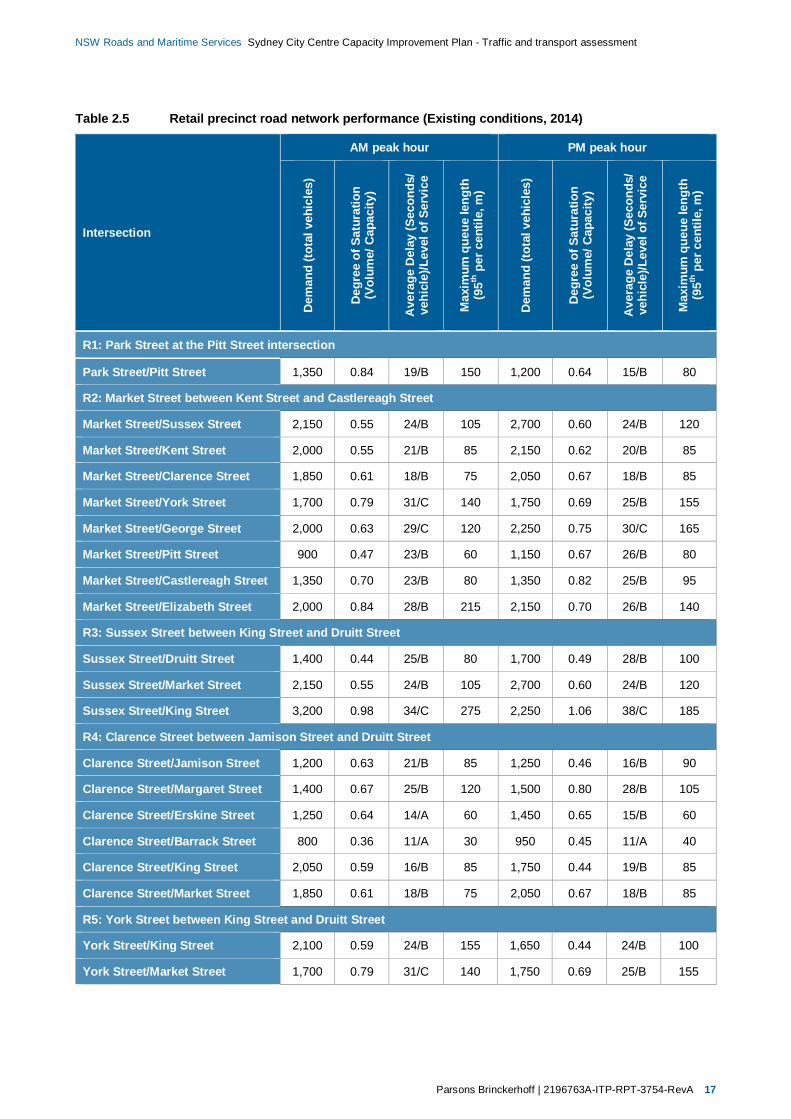
Table 2.5 Retail precinct road network performance (Existing conditions, 2014)
Intersection
AM peak hour PM peak hour
Dem
and
(tota
lveh
icle
s)
Deg
ree
ofSa
tura
tion
(Vol
ume/
Cap
acity
)
Ave
rage
Del
ay(S
econ
ds/
vehi
cle)
/Lev
elof
Serv
ice
Max
imum
queu
ele
ngth
(95th
perc
entil
e,m
)
Dem
and
(tota
lveh
icle
s)
Deg
ree
ofSa
tura
tion
(Vol
ume/
Cap
acity
)
Ave
rage
Del
ay(S
econ
ds/
vehi
cle)
/Lev
elof
Serv
ice
Max
imum
queu
ele
ngth
(95th
perc
entil
e,m
)
R1: Park Street at the Pitt Street intersection
Park Street/Pitt Street 1,350 0.84 19/B 150 1,200 0.64 15/B 80
R2: Market Street between Kent Street and Castlereagh Street
Market Street/Sussex Street 2,150 0.55 24/B 105 2,700 0.60 24/B 120
Market Street/Kent Street 2,000 0.55 21/B 85 2,150 0.62 20/B 85
Market Street/Clarence Street 1,850 0.61 18/B 75 2,050 0.67 18/B 85
Market Street/York Street 1,700 0.79 31/C 140 1,750 0.69 25/B 155
Market Street/George Street 2,000 0.63 29/C 120 2,250 0.75 30/C 165
Market Street/Pitt Street 900 0.47 23/B 60 1,150 0.67 26/B 80
Market Street/Castlereagh Street 1,350 0.70 23/B 80 1,350 0.82 25/B 95
Market Street/Elizabeth Street 2,000 0.84 28/B 215 2,150 0.70 26/B 140
R3: Sussex Street between King Street and Druitt Street
Sussex Street/Druitt Street 1,400 0.44 25/B 80 1,700 0.49 28/B 100
Sussex Street/Market Street 2,150 0.55 24/B 105 2,700 0.60 24/B 120
Sussex Street/King Street 3,200 0.98 34/C 275 2,250 1.06 38/C 185
R4: Clarence Street between Jamison Street and Druitt Street
Clarence Street/Jamison Street 1,200 0.63 21/B 85 1,250 0.46 16/B 90
Clarence Street/Margaret Street 1,400 0.67 25/B 120 1,500 0.80 28/B 105
Clarence Street/Erskine Street 1,250 0.64 14/A 60 1,450 0.65 15/B 60
Clarence Street/Barrack Street 800 0.36 11/A 30 950 0.45 11/A 40
Clarence Street/King Street 2,050 0.59 16/B 85 1,750 0.44 19/B 85
Clarence Street/Market Street 1,850 0.61 18/B 75 2,050 0.67 18/B 85
R5: York Street between King Street and Druitt Street
York Street/King Street 2,100 0.59 24/B 155 1,650 0.44 24/B 100
York Street/Market Street 1,700 0.79 31/C 140 1,750 0.69 25/B 155
18 2196763A-ITP-RPT-3754-RevA | Parsons Brinckerhoff
NSW Roads and Maritime Services Sydney City Centre Capacity Improvement Plan - Traffic and transport assessment
Figure 2.5 Retail precinct modelled network conditions overview (AM/PM peak, 2014)
In summary, the results indicate that:
In isolation, intersection performance would be an acceptable LoS C or better throughout the precinct.
Traffic queues originating at the following intersection approaches propagate to upstream intersections,reducing intersection, corridor, and network performance:
Traffic approaching the George Street/York Street intersection on York Street eastbound.
Traffic approaching the Market Street/York Street intersection on Market Street westbound.
Traffic approaching the Park Street/Pitt Street intersection on Park Street westbound.
2.6.3 Southern precinct
2.6.3.1 Overview
Sussex Street between Bathurst Street and Goulburn Street
Sussex Street is one-way southbound between King Street and Hay Street. In the section south of BathurstStreet, two trafficable lanes are with parking in one form or another provided adjacent to the eastern andwestern kerbs. Traffic congestion is a regular occurrence on the approaches to both Liverpool Street andGoulburn Street. This is due to the limited storage capacity provided for turning traffic. This in turn impacts onthe capacity of the through lanes.
Parsons Brinckerhoff | 2196763A-ITP-RPT-3754-RevA 19
NSW Roads and Maritime Services Sydney City Centre Capacity Improvement Plan - Traffic and transport assessment
Goulburn Street at the George Street intersection
Currently, a kerb extension on the south-east corner of George Street and Goulburn Street extends almost3 m beyond the southern kerb alignment of Goulburn Street. As a consequence, only two and half lanes areprovided on the approach to George Street. This lane arrangement results in the through westboundmovements being impeded by queued vehicles waiting to turn left onto George Street which are impacted bythe volume of pedestrians crossing George Street.
Pitt Street between Rawson Place and Liverpool Street
Pitt Street is identified as a major traffic corridor between George Street and Liverpool Street in the AccessStrategy. Between Rawson Place and Campbell Street, Pitt Street is configured to provide two northboundlanes (with adjacent kerbside parking), and two trafficable southbound lanes (also with kerbside parking)south of Hay Street. Between Campbell Street and Goulburn Street, the carriageway narrows and withkerbside parking permitted on either side of the street, restricts both north and southbound traffic to a singlelane. To the north of Goulburn Street, Pitt Street functions as a one-way northbound street. The provision ofparking adjacent to the eastern kerb and the existence of a car park access ramp adjacent to the westernkerb, results in northbound traffic being restricted to a single lane at this point.
Ultimo Road and Harris Street at the Harris Street intersection
Currently, two right-turn lanes and a single left-turn lane are provided on Ultimo Road on the approach toHarris Street. As a consequence of this lane configuration, extensive queuing occurs in the left-turn lane onthe approach to Harris Street. This is particularly prevalent during the afternoon peak period. The transportinitiatives outlined in the Access Strategy are expected to result in Ultimo Road being a desirable connectionto Broadway, City Road and Regent Street by motorists exiting the city centre.
Broadway between Mountain Street and Abercrombie Street
Broadway is a major bus corridor and arterial road that connects George Street and Pitt Street withParramatta Road and City Road. At Wattle Street, Broadway is configured with four lanes in each directionand a right-turn bay for buses travelling west to north on Wattle Street. The kerbside lanes in each directionare designated as bus lanes which operate during the morning and evening peak period. Motorists wantingto turn left into Wattle Street from Broadway use an unconventional wide slip lane that intersects with WattleStreet approximately 30–40 metres north of Broadway. Because of the high number of vehicles turning intoWattle Street (600 vehicles per hour in the morning peak period and 500 vehicles per hour in the eveningpeak period) surveys have shown that the majority of bus operators avoid the bus lane and travel in theadjacent lane before re-entering the bus lane east of Wattle Street.
Pitt Street at the Lee Street and George Street intersection
The intersection of Pitt Street, George Street, Lee Street and Quay Street functions as a gateway to the citycentre for traffic movements and public transport services approaching from the west and inner south westareas. Numerous bus routes converge on the intersection with high bus volumes on Pitt Street, GeorgeStreet and Lee Street. The Railway Square bus interchange generates high levels of pedestrian activity andis a vital node in the public transport network providing convenient connection to rail services operating vianearby Central Station.
The road geometry of the intersection is such that traffic approaching form the west on Broadway areprovided with two lanes for access onto Pitt Street and two designated lanes for those wishing to continuenorth on George Street. There are three lanes on the Lee Street approach to the intersection, of which one isdesignated as a right-turn lane, one is a shared through and right-turn lane, and the kerbside lane is athrough (into George Street) and left-turn lane (into Quay Street). Four lanes are provided on the Pitt Streetapproach to the intersection of which the kerbside lane is designated as a left-turn lane into Lee Street. QuayStreet is one way westbound.
20 2196763A-ITP-RPT-3754-RevA | Parsons Brinckerhoff
NSW Roads and Maritime Services Sydney City Centre Capacity Improvement Plan - Traffic and transport assessment
Despite the relative complexity, and unusual geometry of the intersection, all pedestrian and vehicularmovements are controlled by a relatively simple three phase signal operation. The other notable feature ofthis intersection is the wide paved area between Pitt Street and Lee Street, behind which is an access roadto the Central Station railway concourse.
2.6.3.2 Traffic volumes and network performance
Table 2.6 provides a summary of existing traffic demand and performance at key intersections within theprecinct. Schematic diagrams of the intersection layouts assessed are provided in Appendix A.
Figure 2.6 provides an overview of existing AM and PM peak LoS, and highlights queue lengths which arelikely to impact the performance of adjacent intersections and overall network efficiency as a result of furthercascading impacts:
The Pitt Street /Hay Street intersection is operating at LoS D during PM peak periods, with demandclose to capacity.
The Pitt Street/Goulburn Street intersection is operating at LoS E during AM peak periods, with demandexceeding capacity.
The Broadway/Abercrombie Street intersection is operating at LoS D during AM and PM peak periods,with demand close to capacity.
The following approach queue lengths are likely to extend to and impact the operation of adjacentintersections:
Eastbound traffic on Goulburn Street from George Street to Sussex Street, estimated as 110–205 m.
Westbound traffic on Goulburn Street from George Street to Pitt Street, estimated as 230–360 m.
Northbound traffic on Pitt Street from Goulburn Street to Campbell Street, estimated as 140–240 m.
In summary, the results indicate that:
Demand exceeds capacity at the Pitt Street/Goulburn Street intersection, and is close to capacity at thePitt Street/Hay Street and Broadway/Abercrombie Street intersections.
Traffic queues originating at the following intersection approaches propagate to upstream intersections,reducing intersection, corridor, and network performance:
Traffic approaching the George Street/Goulburn Street intersection on Goulburn Street eastboundand westbound.
Traffic approaching the Goulburn Street/Pitt Street intersection on Pitt Street northbound.

Parsons Brinckerhoff | 2196763A-ITP-RPT-3754-RevA 21
NSW Roads and Maritime Services Sydney City Centre Capacity Improvement Plan - Traffic and transport assessment
Table 2.6 Southern precinct road network performance (Existing conditions, 2014)
Intersection
AM peak hour PM peak hour
Dem
and
(tota
lveh
icle
s)
Deg
ree
ofSa
tura
tion
(Vol
ume/
Cap
acity
)
Ave
rage
Del
ay(S
econ
ds/
vehi
cle)
/Lev
elof
Serv
ice
Max
imum
queu
ele
ngth
(95th
perc
entil
e,m
)
Dem
and
(tota
lveh
icle
s)
Deg
ree
ofSa
tura
tion
(Vol
ume/
Cap
acity
)
Ave
rage
Del
ay(S
econ
ds/
vehi
cle)
/Lev
elof
Serv
ice
Max
imum
queu
ele
ngth
(95th
perc
entil
e,m
)
S1: Sussex Street between Bathurst Street and Goulburn Street
Sussex Street/Liverpool Street 700 0.47 17/B 35 1,150 0.57 25/B 80
Sussex Street/Goulburn Street 2,450 0.95 11/A 110 2,600 0.91 12/A 65
S2: Goulburn Street between at the George Street intersection
George Street/Goulburn Street 4,000 0.93 32/C 360 3,300 0.81 26/B 230
S3: Pitt Street between Liverpool Street and Rawson Place
Pitt Street/Liverpool Street 1,400 0.47 13/A 60 1,400 0.44 15/B 60
Pitt Street/Goulburn Street 2,550 1.58 65/E 240 2,650 1.29 34/C 140
Pitt Street/Campbell Street 800 0.39 21/B 85 850 0.34 22/B 70
Pitt Street/Hay Street 900 0.69 38/C 80 1,000 0.92 46/D 150
Pitt Street/Rawson Place 2,900 0.84 31/C 195 3,250 0.86 32/C 190
S4: Ultimo Road at the Harris Street intersection
Ultimo Road/Harris Street 2,350 0.49 12/A 115 2,750 0.85 21/B 170
S5: Broadway between Mountain Street and Abercrombie Street
Broadway/Abercrombie Street 5,150 0.94 48/D 335 5,200 0.95 48/D 310
S6: Pitt Street, George Street, Lee Street, Quay Street intersection
Pitt Street/George Street/Lee Street/Quay Street 3,700 0.81 36/D 180 3,950 0.74 36/D 145
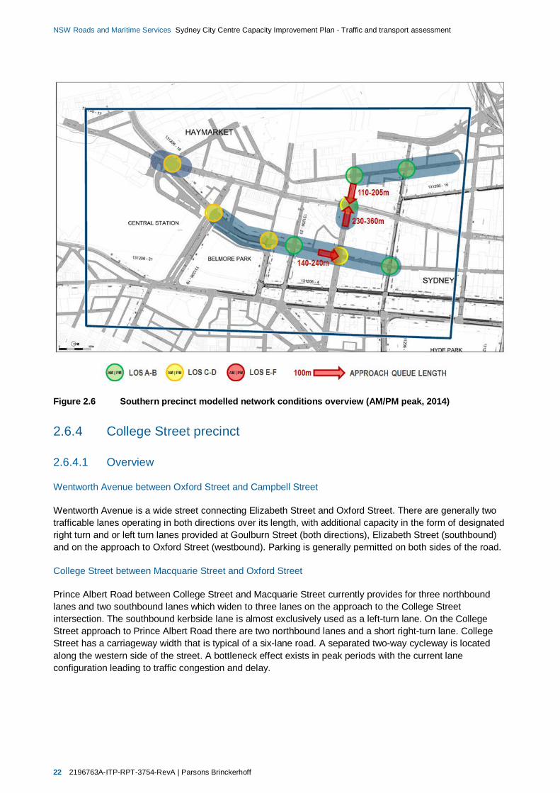
22 2196763A-ITP-RPT-3754-RevA | Parsons Brinckerhoff
NSW Roads and Maritime Services Sydney City Centre Capacity Improvement Plan - Traffic and transport assessment
Figure 2.6 Southern precinct modelled network conditions overview (AM/PM peak, 2014)
2.6.4 College Street precinct
2.6.4.1 Overview
Wentworth Avenue between Oxford Street and Campbell Street
Wentworth Avenue is a wide street connecting Elizabeth Street and Oxford Street. There are generally twotrafficable lanes operating in both directions over its length, with additional capacity in the form of designatedright turn and or left turn lanes provided at Goulburn Street (both directions), Elizabeth Street (southbound)and on the approach to Oxford Street (westbound). Parking is generally permitted on both sides of the road.
College Street between Macquarie Street and Oxford Street
Prince Albert Road between College Street and Macquarie Street currently provides for three northboundlanes and two southbound lanes which widen to three lanes on the approach to the College Streetintersection. The southbound kerbside lane is almost exclusively used as a left-turn lane. On the CollegeStreet approach to Prince Albert Road there are two northbound lanes and a short right-turn lane. CollegeStreet has a carriageway width that is typical of a six-lane road. A separated two-way cycleway is locatedalong the western side of the street. A bottleneck effect exists in peak periods with the current laneconfiguration leading to traffic congestion and delay.
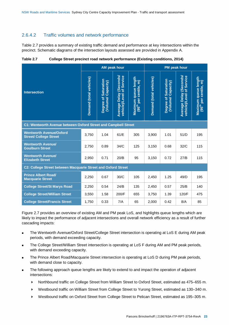
Parsons Brinckerhoff | 2196763A-ITP-RPT-3754-RevA 23
NSW Roads and Maritime Services Sydney City Centre Capacity Improvement Plan - Traffic and transport assessment
2.6.4.2 Traffic volumes and network performance
Table 2.7 provides a summary of existing traffic demand and performance at key intersections within theprecinct. Schematic diagrams of the intersection layouts assessed are provided in Appendix A.
Table 2.7 College Street precinct road network performance (Existing conditions, 2014)
Intersection
AM peak hour PM peak hour
Dem
and
(tota
lveh
icle
s)
Deg
ree
ofSa
tura
tion
(Vol
ume/
Cap
acity
)
Ave
rage
Del
ay(S
econ
ds/
vehi
cle)
/Lev
elof
Serv
ice
Max
imum
queu
ele
ngth
(95th
perc
entil
e,m
)
Dem
and
(tota
lveh
icle
s)
Deg
ree
ofSa
tura
tion
(Vol
ume/
Cap
acity
)
Ave
rage
Del
ay(S
econ
ds/
vehi
cle)
/Lev
elof
Serv
ice
Max
imum
queu
ele
ngth
(95th
perc
entil
e,m
)
C1: Wentworth Avenue between Oxford Street and Campbell Street
Wentworth Avenue/OxfordStreet/ College Street 3,750 1.04 61/E 305 3,900 1.01 51/D 195
Wentworth Avenue/Goulburn Street 2,750 0.89 34/C 125 3,150 0.68 32/C 115
Wentworth Avenue/Elizabeth Street 2,950 0.71 20/B 95 3,150 0.72 27/B 115
C2: College Street between Macquarie Street and Oxford Street
Prince Albert Road/Macquarie Street 2,250 0.67 30/C 105 2,450 1.25 49/D 195
College Street/St Marys Road 2,250 0.54 24/B 135 2,450 0.57 25/B 140
College Street/William Street 3,550 1.58 200/F 655 3,750 1.39 120/F 475
College Street/Francis Street 1,750 0.33 7/A 65 2,000 0.42 8/A 85
Figure 2.7 provides an overview of existing AM and PM peak LoS, and highlights queue lengths which arelikely to impact the performance of adjacent intersections and overall network efficiency as a result of furthercascading impacts:
The Wentworth Avenue/Oxford Street/College Street intersection is operating at LoS E during AM peakperiods, with demand exceeding capacity.
The College Street/William Street intersection is operating at LoS F during AM and PM peak periods,with demand exceeding capacity.
The Prince Albert Road/Macquarie Street intersection is operating at LoS D during PM peak periods,with demand close to capacity.
The following approach queue lengths are likely to extend to and impact the operation of adjacentintersections:
Northbound traffic on College Street from William Street to Oxford Street, estimated as 475–655 m.
Westbound traffic on William Street from College Street to Yurong Street, estimated as 130–340 m.
Westbound traffic on Oxford Street from College Street to Pelican Street, estimated as 195–305 m.

24 2196763A-ITP-RPT-3754-RevA | Parsons Brinckerhoff
NSW Roads and Maritime Services Sydney City Centre Capacity Improvement Plan - Traffic and transport assessment
Figure 2.7 College Street precinct modelled network conditions overview (AM/PM peak, 2014)
In summary, the results indicate that:
Demand exceeds capacity at the College Street/William Street intersection and at the WentworthAvenue/Oxford Street/College Street during AM peak periods.
Demand is close to capacity at the Wentworth Avenue/Oxford Street/College Street (during PM peakperiods) and Prince Albert Road/Macquarie Street intersections.
Traffic queues originating at the following intersection approaches propagate to upstream intersections,reducing intersection, corridor, and network performance:
Traffic approaching the College Street/William Street intersection on College Street northboundand William Street westbound.
Traffic approaching the Wentworth Avenue/Oxford Street/College Street intersection on OxfordStreet westbound.
2.6.5 Financial precinct
2.6.5.1 Overview
Macquarie Street between Bent Street and Bridge Street
The southern approach on Macquarie Street at Bridge Street is designated with a single right, a singlethrough and a single left-turn lane. Both the through and right lanes extend back to Bent Street, whilst a shortlength (40 metre) of designated left-turn lane is provided between Phillip Lane and Bridge Street. During themorning and afternoon peak periods, left-turning vehicles often queue well beyond the left-turn lane, leadingto congestion and delays to northbound through traffic. This affects the overall efficiency of the intersection.

Parsons Brinckerhoff | 2196763A-ITP-RPT-3754-RevA 25
NSW Roads and Maritime Services Sydney City Centre Capacity Improvement Plan - Traffic and transport assessment
Macquarie Street at the Hunter Street intersection
Hunter Street intersects with Macquarie Street to form a T-intersection. The geometry of the signal controlledintersection includes two north and two southbound lanes in Macquarie Street; single designated left turnonly and right-turn only lanes in Hunter Street; and short designated right and left-turn lanes in MacquarieStreet. Significant congestion and delays, particularly in the afternoon peak period occur in Hunter Streetbetween Phillip Street and Macquarie Street and on Macquarie Street as traffic exiting the north-eastquadrant of the city attempts to access the Eastern Distributor via Shakespeare Place and the CahillExpressway via Bridge Street.
2.6.5.2 Traffic volumes and network performance
Table 2.8 provides a summary of existing traffic demand and performance at key intersections within theprecinct. Schematic diagrams of the intersection layouts assessed are provided in Appendix A.
Table 2.8 Financial precinct road network performance (Existing conditions, 2014)
Intersection
AM peak hour PM peak hour
Dem
and
(tota
lveh
icle
s)
Deg
ree
ofSa
tura
tion
(Vol
ume/
Cap
acity
)
Ave
rage
Del
ay(S
econ
ds/
vehi
cle)
/Lev
elof
Serv
ice
Max
imum
queu
ele
ngth
(95th
perc
entil
e,m
)
Dem
and
(tota
lveh
icle
s)
Deg
ree
ofSa
tura
tion
(Vol
ume/
Cap
acity
)
Ave
rage
Del
ay(S
econ
ds/
vehi
cle)
/Lev
elof
Serv
ice
Max
imum
queu
ele
ngth
(95th
perc
entil
e,m
)
F1: Macquarie Street between Bent Street and Bridge Street
Macquarie Street/Bridge Street 2,750 0.79 30/C 110 2,200 0.77 31/C 105
Macquarie Street/Bent Street 4,000 0.88 38/C 200 4,150 1.03 43/D 325
F2: Macquarie Street at the Hunter Street intersection
Macquarie Street/Hunter Street 2,400 0.61 12/A 65 2,350 0.49 13/A 80
Figure 2.8 provides an overview of existing AM and PM peak LoS, and highlights queue lengths which arelikely to impact the performance of adjacent intersections and overall network efficiency as a result of furthercascading impacts:
The Macquarie Street/Bent Street intersection is operating at LoS D during PM peak periods, withdemand close to capacity.
The following approach queue lengths are likely to extend to and impact the operation of adjacentintersections:
Northbound traffic on Macquarie Street from Bent Street to Hunter Street, estimated as 55–95 m.
Eastbound traffic on Bent Street from Macquarie Street to Phillip Street, estimated as 70–180 m.
Southbound traffic on Macquarie Street from Bent Street to Bridge Street, estimated as 200–325 m.
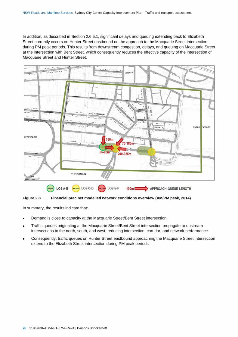
26 2196763A-ITP-RPT-3754-RevA | Parsons Brinckerhoff
NSW Roads and Maritime Services Sydney City Centre Capacity Improvement Plan - Traffic and transport assessment
In addition, as described in Section 2.6.5.1, significant delays and queuing extending back to ElizabethStreet currently occurs on Hunter Street eastbound on the approach to the Macquarie Street intersectionduring PM peak periods. This results from downstream congestion, delays, and queuing on Macquarie Streetat the intersection with Bent Street, which consequently reduces the effective capacity of the intersection ofMacquarie Street and Hunter Street.
Figure 2.8 Financial precinct modelled network conditions overview (AM/PM peak, 2014)
In summary, the results indicate that:
Demand is close to capacity at the Macquarie Street/Bent Street intersection.
Traffic queues originating at the Macquarie Street/Bent Street intersection propagate to upstreamintersections to the north, south, and west, reducing intersection, corridor, and network performance.
Consequently, traffic queues on Hunter Street eastbound approaching the Macquarie Street intersectionextend to the Elizabeth Street intersection during PM peak periods.
Parsons Brinckerhoff | 2196763A-ITP-RPT-3754-RevA 27
NSW Roads and Maritime Services Sydney City Centre Capacity Improvement Plan - Traffic and transport assessment
2.6.5.3 Traffic conditions summary
Figure 2.9 provides an overview of existing network performance at key intersections across the city centreroad network. In summary:
Demand exceeds capacity during peak periods at the following intersections, resulting in anunacceptable Level of Service E or F:
Wentworth Avenue/Oxford Street/College Street
College Street/William Street
Goulburn Street/Pitt Street.
Demand is close to capacity at the following intersections, resulting in Level of Service D:
Pitt Street/Hay Street
Broadway/Abercrombie Street
Prince Albert Road/Macquarie Street
Macquarie Street/Bent Street.
Traffic queue lengths on the following corridors are likely to impact intersection capacity and furtherreduce performance:
King Street West of George Street
Market Street east of York Street
Park Street east of Pitt Street
Goulburn Street east and west of George Street
Pitt Street south of Goulburn Street
College Street south of William Street
Oxford Street east of College Street
William Street east of College Street
Macquarie Street north and south of Bent Street
Bent Street west of Macquarie Street
Hunter Street west of Macquarie Street.

28 2196763A-ITP-RPT-3754-RevA | Parsons Brinckerhoff
NSW Roads and Maritime Services Sydney City Centre Capacity Improvement Plan - Traffic and transport assessment
Figure 2.9 City centre network conditions overview (Minimum Level of Service, 2014)
Parsons Brinckerhoff | 2196763A-ITP-RPT-3754-RevA 29
NSW Roads and Maritime Services Sydney City Centre Capacity Improvement Plan - Traffic and transport assessment
3. Traffic forecasting andmodelling process
3.1 OverviewThis traffic and transport assessment focusses on the analysis of localised performance improvements atselected locations across the city centre road network. It is also proposed that AIMSUN modelling would beundertaken as part of an ongoing process to analyse the cumulative effects of transport and land usedevelopments including the proposal and other Access Strategy projects across the city centre.
Traffic forecasting and modelling is a critical input enabling the evaluation of the proposal’s impacts. Theimpacts of the proposal have been assessed as required by relevant Roads and Maritime, Austroads, andother applicable agency guidelines and criteria, specifically including:
Roads and Maritime Services Traffic Modelling Guidelines (Roads and Maritime, February 2013)
Roads and Traffic Authority Guide to Traffic Generating Developments (Roads and Traffic Authority,October 2002)
Austroads Guide to Traffic Management (Austroads, June 2014).
Roads and Maritime own and maintain an existing Sydney CBD network models built in the AIMSUN trafficsimulation software platform. This model has limitations in its ability to provide micro-level traffic forecastssensitive enough for the localised assessment of the relatively minor road network adjustments proposed.Consequently, the methodology adopted to assess the network performance benefits and impacts of theproposal is based primarily on the use of SIDRA intersection modelling and first-principles assumptions, andwill ultimately be supplemented by the use of Roads and Maritime’s AIMSUN network model of SydneyCentral Business District (CBD):
SIDRA intersection modelling and first-principles assumptions have been used to develop and refinemicro-level corridor based traffic forecasts, used to assess localised intersection and corridorperformance and develop traffic management solutions for proposal work sites.
The Roads and Maritime AISMUN Sydney CBD network model was used initially to provide a high-levelindication of congested areas, and will be used as part on an ongoing process to estimate cumulativenetwork benefits of the proposal and other projects across the city centre.
The scenarios which have been assessed are summarised in Table 3.1. The traffic modelling undertaken forthis assessment has been developed according to Roads and Maritime Services Traffic Modelling Guidelinesand other relevant guidelines and standards. Data which has been used to develop, calibrate, and validatethe traffic models used for the assessment is presented in relevant sections of this report, which includes:
Road network layout plans (Lane configuration, vehicle/turn restrictions)
Bus infrastructure and operations
Kerbside uses (bus operations, taxi operations, parking, loading)
Classified mid-block vehicle surveys
Classified intersection turn counts
Intersection approach queue length surveys
Traffic signal phasing and timing data

30 2196763A-ITP-RPT-3754-RevA | Parsons Brinckerhoff
NSW Roads and Maritime Services Sydney City Centre Capacity Improvement Plan - Traffic and transport assessment
Observed traffic conditions (driver behaviour, lane utilisation, pedestrian behaviour).
Table 3.1 Modelled scenarios
Scenario Impact measured Network descriptionModelled year
2014 Futureconditions
Do nothingAccess Strategy projectsexcluding proposalimpacts.
Existing road network plusmodifications resulting from theprojects under the AccessStrategy excluding the proposal.
(Section 2) (Section 4)
Dosomething
Access Strategy projectsincluding proposalimpacts.
Existing road network plusmodifications resulting from theprojects under the AccessStrategy including the proposal.
-(Section 6)
3.2 Proposal work site modelsFollowing the identification of proposal work sites at critical areas within the city centre, micro-level work sitemodels have been implemented to develop and refine corridor based traffic forecasts. These models havebeen developed using SIDRA intersection modelling software, which have been used as a tool to determinelocalised capacity and performance improvements to develop and refine traffic management solutions forproposal work sites.
SIDRA modelling provides detailed intersection performance indicators which have been used to develop,test, and refine the traffic management schemes proposed. Key intersection performance statistics aresummarised in Table 3.2.
The key benefits of the proposal are improvements to traffic capacity and consequently intersectionperformance, while the main traffic impacts would result from changes to traffic volumes and patterns. Themethodology applied to assess these effects is summarised as follows:
SIDRA intersection models for each worksite have been developed based on the existing road networkand traffic volumes and patterns. These models indicate existing performance for each location(Existing conditions).
Future conditions (Do something) models have subsequently been created based on proposed roadnetwork modifications included in the proposal.
A comparison of the outputs of the Existing conditions and Do something models has been used todemonstrate the changes to local network capacity, based on existing traffic volumes and patterns,including Access Strategy projects and the proposal.
To assess future ‘worst-case’ scenarios, it has been assumed that traffic volumes would increase by thesame proportion as the increase in local network capacity. For example, if capacity is increased by 10%as a result of the proposal, it has been assumed that future traffic volumes would be 10% higher thanexisting in a ‘worst-case’ scenario.
For worksites which include intersection improvements at multiple locations within a corridor, the cumulativeeffects for all intersection improvements was used to estimate the overall improvement in corridor capacity.The combined effects have been estimated by:
1. Determining the improvements to intersection capacity (reduction in DoS) for individual intersectionswithin worksites.
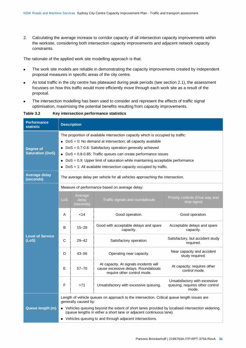
Parsons Brinckerhoff | 2196763A-ITP-RPT-3754-RevA 31
NSW Roads and Maritime Services Sydney City Centre Capacity Improvement Plan - Traffic and transport assessment
2. Calculating the average increase to corridor capacity of all intersection capacity improvements withinthe worksite, considering both intersection capacity improvements and adjacent network capacityconstraints.
The rationale of the applied work site modelling approach is that:
The work site models are reliable in demonstrating the capacity improvements created by independentproposal measures in specific areas of the city centre.
As total traffic in the city centre has plateaued during peak periods (see section 2.1), the assessmentfocusses on how this traffic would more efficiently move through each work site as a result of theproposal.
The intersection modelling has been used to consider and represent the effects of traffic signaloptimisation, maximising the potential benefits resulting from capacity improvements.
Table 3.2 Key intersection performance statistics
Performancestatistic Description
Degree ofSaturation (DoS)
The proportion of available intersection capacity which is occupied by traffic:DoS = 0: No demand at intersection; all capacity available
DoS = 0.7-0.8: Satisfactory operation generally achieved
DoS = 0.8-0.85: Traffic queues can create performance issues
DoS = 0.9: Upper limit of saturation while maintaining acceptable performance
DoS = 1: All available intersection capacity occupied by traffic.
Average delay(seconds) The average delay per vehicle for all vehicles approaching the intersection.
Level of Service(LoS)
Measure of performance based on average delay:
LoSAverage
delay(seconds)
Traffic signals and roundabouts Priority controls (Give way andstop signs)
A <14 Good operation. Good operation.
B 15–28 Good with acceptable delays and sparecapacity.
Acceptable delays and sparecapacity.
C 29–42 Satisfactory operation. Satisfactory, but accident studyrequired.
D 43–56 Operating near capacity. Near capacity and accidentstudy required.
E 57–70At capacity. At signals incidents will
cause excessive delays. Roundaboutsrequire other control mode.
At capacity; requires othercontrol mode.
F >71 Unsatisfactory with excessive queuing.Unsatisfactory with excessivequeuing; requires other control
mode.
Queue length (m)
Length of vehicle queues on approach to the intersection. Critical queue length issues aregenerally caused by:
Vehicles queuing beyond the extent of short lanes provided by localised intersection widening(queue lengths in either a short lane or adjacent continuous lane).
Vehicles queuing to and through adjacent intersections.
32 2196763A-ITP-RPT-3754-RevA | Parsons Brinckerhoff
NSW Roads and Maritime Services Sydney City Centre Capacity Improvement Plan - Traffic and transport assessment
SIDRA modelling provides detailed intersection performance indicators, however it is important to note that itis limited to providing detailed analysis of individual, isolated intersection performance. The Degree ofSaturation, Average Delay, and ultimately queue lengths assume relatively unconstrained traffic conditionson the approaches to and exits from intersection.
In reality the effects of queuing in the city centre context are particularly problematic, with the proximity ofadjacent intersections providing limited vehicle storage capacity. At many intersections throughout the studyarea vehicle queues extend to and through adjacent intersections, dramatically reducing capacity andefficiency at these locations, and overall network efficiency as a result of further cascading impacts. Existingmid-block kerbside activity also further reduces the capacity and efficiency of the city centre road network.
Considering the above, the intersection performance indicators presented provide:
An overview of unconstrained performance for individual intersections within each precinct.
Details of existing pinch points where delays and queuing have major impacts on the capacity andefficiency of adjacent intersections and the wider city centre road network.
Various pinch points within the city centre constrain traffic which would otherwise impact the performance ofdownstream intersections. While existing conditions appear to indicate satisfactory operation in many cases,this often occurs as a result of demand being unable to travel through the network. Consequently theperformance indicators presented should be considered in the context of the above features of city centretraffic conditions.
3.3 Sydney CBD AIMSUN network modelRoads and Maritime provided initial outputs from their existing AIMSUN Sydney CBD network model for thepurpose of this assessment to enable a high-level indication of congested areas of the Sydney CBD roadnetwork.
It is proposed that further AIMSUN modelling would be undertaken as part of an ongoing process todetermine the cumulative impacts of the proposal across the city centre road network. This modelling wouldalso able to consider regional growth factors including other major committed and approved traffic generatingdevelopments in the city centre.
The AIMSUN traffic model would be used to estimate existing and future traffic distribution and assess theoverall performance of the Sydney City Centre traffic network for the modelled scenarios shown in Table 3.1.Importantly this modelling would be used to forecast the cumulative impacts of Access Strategy projectsimpacts, including:
CBD to South East Light Rail project (CSELR)
Sydney City Centre Bus Infrastructure project
The Sydney City Centre Cycleways projects
The Sydney City Centre Capacity Improvement Plan (the proposal).
The AIMSUN traffic model provides local area performance indicators (e.g. traffic density plots) which wereinitially used to identify proposal work sites. In the future, the model would be used to estimate the keyperformance statistics for the city centre road network summarised in Table 3.3.

Parsons Brinckerhoff | 2196763A-ITP-RPT-3754-RevA 33
NSW Roads and Maritime Services Sydney City Centre Capacity Improvement Plan - Traffic and transport assessment
Table 3.3 Key network performance statistics
Performance statistic Description
Vehicle Hours Travelled (VHT) Total travel time of all vehicles travelling on the road network during themodelled period.
Vehicle Kilometres Travelled (VKT) Total travel distance of all vehicles travelling on the road network duringthe modelled period.
Network speed (km/h) The average speed of all vehicles travelling on the road network duringthe modelled period.
The comparison of these performance statistics for alternative network option scenarios would ultimatelyprovide an indication of the anticipated cumulative benefits and/or impacts across the city centre roadnetwork. AIMSUN modelled traffic volumes of elements of the road network impacted by the proposal wouldalso be used to sense-check the outputs of proposal work site traffic models.
3.4 Model outputsThe outputs of the work site and network models described above and summarised in Table 3.4 arepresented and discussed in relevant sections of this report.
Table 3.4 Model outputs summary
Source Model outputs
SIDRA intersection modelling and first-principles assumptions Micro-level corridor forecast traffic volumes.
SIDRA intersection modelling
Existing and future intersection performance: Degree of Saturation (Volume/capacity).
Average Delay (Seconds/vehicle).
Level of Service (LoS).
AIMSUN network modelling
High-level indication of congested areas of the city centre roadnetwork.
Existing and future network performance statistics:
Vehicle Hours Travelled (VHT).
Vehicle Kilometres Travelled (VKT).
Network speed (km/h).
Parsons Brinckerhoff | 2196763A-ITP-RPT-3754-RevA 35
NSW Roads and Maritime Services Sydney City Centre Capacity Improvement Plan - Traffic and transport assessment
4. Future conditions without theproposal
4.1 Sydney City Centre Access StrategyThe Sydney City Centre Access Strategy (Access Strategy) (NSW Government, 2013) is ‘the State’s firstdetailed plan showing how people will enter, exit and move in and around the central business district (CBD)over the next 20 years’. The Access Strategy demonstrates how light rail, buses, trains, ferries, cars, taxis,pedestrians and cyclists will interact in the heart of Sydney. The Access Strategy also provides a cleardirection for how all the different transport modes will work together in the city centre to:
Reduce congestion
Provide for future growth
Improve the customer experience.
The Access Strategy estimates that over 630,000 trips are made to the city centre each day, with much ofthe city centre’s road network congested during peak periods (see Section 2.3). By 2031, the number of tripsinto the city centre is estimated to grow to approximately 775,000 due to a variety of factors, including thedevelopment of Barangaroo and Darling Harbour and anticipated city centre job growth over this period(TfNSW, 2013). Without mitigation, increased traffic demand would further diminish road networkperformance for all road users.
The Access Strategy proposes an integrated transport network, with the intention that the anticipated growthin travel demand to, from, and within the city centre would be accommodated primarily by public and activetransport modes. This would be realised by the delivery of the following key projects to provide a ‘fullyintegrated public transport network” whilst also “making better use of the available street space’ in the citycentre:
The CBD and South East Light Rail project (CSELR), which includes the pedestrianisation of GeorgeStreet, restricting traffic to local property access movements only between Bathurst Street and HunterStreet
The Sydney City Centre Bus Infrastructure project
The Sydney City Centre Cycleways projects.
The construction of these projects is proposed over the next five years. It is intended that their delivery wouldresult in a shift in travel behaviours and patterns within the city centre, effectively eliminating or minimisingfuture growth in traffic demand.
An overview of the city centre’s proposed transport network following the implementation of the AccessStrategy is illustrated in Figure 4.1. Detailed assessments of the traffic and transport impacts and benefits ofAccess Strategy projects are available in:
Various sections of the CSELR Environmental Impact Statement (EIS) (TfNSW, November 2013)
Section 6.1 of the Sydney City Centre Bus Plan Infrastructure REF (Roads and Maritime, 2014)
Section 6.1 of the Sydney City Centre Integrated Cycleway Network REF (Roads and Maritime, 2014).
The following sections provide a summary of future conditions including the forecast impacts of approvedAccess Strategy projects, but excluding the Sydney City Centre Capacity Improvement Plan (the proposal).
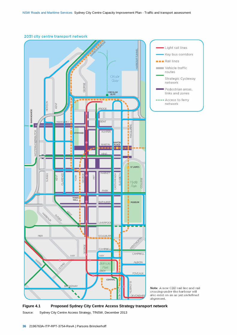
36 2196763A-ITP-RPT-3754-RevA | Parsons Brinckerhoff
NSW Roads and Maritime Services Sydney City Centre Capacity Improvement Plan - Traffic and transport assessment
Figure 4.1 Proposed Sydney City Centre Access Strategy transport networkSource: Sydney City Centre Access Strategy, TfNSW, December 2013
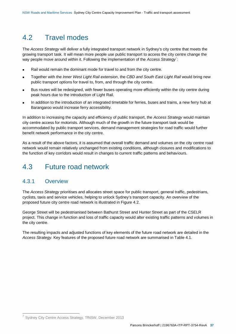
Parsons Brinckerhoff | 2196763A-ITP-RPT-3754-RevA 37
NSW Roads and Maritime Services Sydney City Centre Capacity Improvement Plan - Traffic and transport assessment
4.2 Travel modesThe Access Strategy will deliver a fully integrated transport network in Sydney’s city centre that meets thegrowing transport task. It will mean more people use public transport to access the city centre change theway people move around within it. Following the implementation of the Access Strategy7:
Rail would remain the dominant mode for travel to and from the city centre.
Together with the Inner West Light Rail extension, the CBD and South East Light Rail would bring newpublic transport options for travel to, from, and through the city centre.
Bus routes will be redesigned, with fewer buses operating more efficiently within the city centre duringpeak hours due to the introduction of Light Rail.
In addition to the introduction of an integrated timetable for ferries, buses and trains, a new ferry hub atBarangaroo would increase ferry accessibility.
In addition to increasing the capacity and efficiency of public transport, the Access Strategy would maintaincity centre access for motorists. Although much of the growth in the future transport task would beaccommodated by public transport services, demand management strategies for road traffic would furtherbenefit network performance in the city centre.
As a result of the above factors, it is assumed that overall traffic demand and volumes on the city centre roadnetwork would remain relatively unchanged from existing conditions, although closures and modifications tothe function of key corridors would result in changes to current traffic patterns and behaviours.
4.3 Future road network
4.3.1 Overview
The Access Strategy prioritises and allocates street space for public transport, general traffic, pedestrians,cyclists, taxis and service vehicles, helping to unlock Sydney’s transport capacity. An overview of theproposed future city centre road network is illustrated in Figure 4.2.
George Street will be pedestrianised between Bathurst Street and Hunter Street as part of the CSELRproject. This change in function and loss of traffic capacity would alter existing traffic patterns and volumes inthe city centre.
The resulting impacts and adjusted functions of key elements of the future road network are detailed in theAccess Strategy. Key features of the proposed future road network are summarised in Table 4.1.
7 Sydney City Centre Access Strategy, TfNSW, December 2013
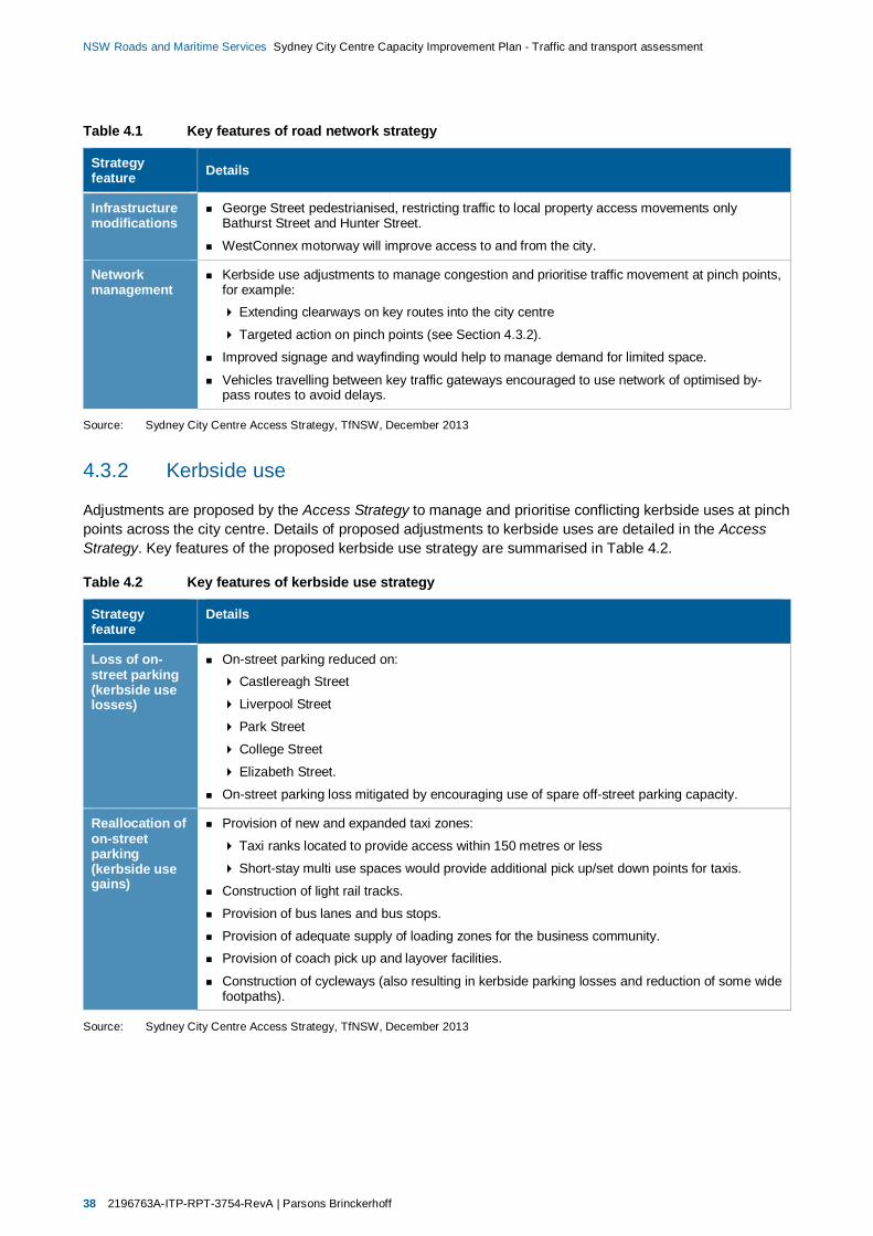
38 2196763A-ITP-RPT-3754-RevA | Parsons Brinckerhoff
NSW Roads and Maritime Services Sydney City Centre Capacity Improvement Plan - Traffic and transport assessment
Table 4.1 Key features of road network strategy
Strategyfeature Details
Infrastructuremodifications
George Street pedestrianised, restricting traffic to local property access movements onlyBathurst Street and Hunter Street.
WestConnex motorway will improve access to and from the city.
Networkmanagement
Kerbside use adjustments to manage congestion and prioritise traffic movement at pinch points,for example:
Extending clearways on key routes into the city centre
Targeted action on pinch points (see Section 4.3.2).
Improved signage and wayfinding would help to manage demand for limited space.
Vehicles travelling between key traffic gateways encouraged to use network of optimised by-pass routes to avoid delays.
Source: Sydney City Centre Access Strategy, TfNSW, December 2013
4.3.2 Kerbside use
Adjustments are proposed by the Access Strategy to manage and prioritise conflicting kerbside uses at pinchpoints across the city centre. Details of proposed adjustments to kerbside uses are detailed in the AccessStrategy. Key features of the proposed kerbside use strategy are summarised in Table 4.2.
Table 4.2 Key features of kerbside use strategy
Strategyfeature
Details
Loss of on-street parking(kerbside uselosses)
On-street parking reduced on: Castlereagh Street
Liverpool Street
Park Street
College Street
Elizabeth Street.
On-street parking loss mitigated by encouraging use of spare off-street parking capacity.
Reallocation ofon-streetparking(kerbside usegains)
Provision of new and expanded taxi zones:
Taxi ranks located to provide access within 150 metres or less
Short-stay multi use spaces would provide additional pick up/set down points for taxis.
Construction of light rail tracks.
Provision of bus lanes and bus stops.
Provision of adequate supply of loading zones for the business community.Provision of coach pick up and layover facilities.
Construction of cycleways (also resulting in kerbside parking losses and reduction of some widefootpaths).
Source: Sydney City Centre Access Strategy, TfNSW, December 2013
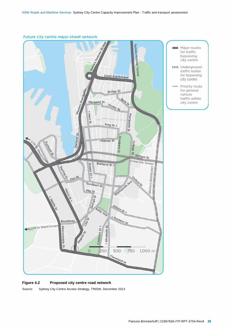
Parsons Brinckerhoff | 2196763A-ITP-RPT-3754-RevA 39
NSW Roads and Maritime Services Sydney City Centre Capacity Improvement Plan - Traffic and transport assessment
Figure 4.2 Proposed city centre road networkSource: Sydney City Centre Access Strategy, TfNSW, December 2013
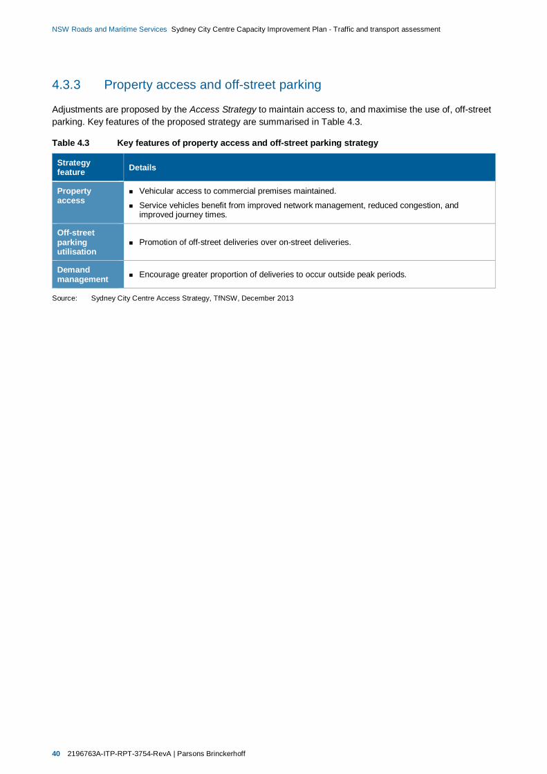
40 2196763A-ITP-RPT-3754-RevA | Parsons Brinckerhoff
NSW Roads and Maritime Services Sydney City Centre Capacity Improvement Plan - Traffic and transport assessment
4.3.3 Property access and off-street parking
Adjustments are proposed by the Access Strategy to maintain access to, and maximise the use of, off-streetparking. Key features of the proposed strategy are summarised in Table 4.3.
Table 4.3 Key features of property access and off-street parking strategy
Strategyfeature Details
Propertyaccess
Vehicular access to commercial premises maintained.
Service vehicles benefit from improved network management, reduced congestion, andimproved journey times.
Off-streetparkingutilisation
Promotion of off-street deliveries over on-street deliveries.
Demandmanagement Encourage greater proportion of deliveries to occur outside peak periods.
Source: Sydney City Centre Access Strategy, TfNSW, December 2013

Parsons Brinckerhoff | 2196763A-ITP-RPT-3754-RevA 41
NSW Roads and Maritime Services Sydney City Centre Capacity Improvement Plan - Traffic and transport assessment
4.4 Public transportThe Access Strategy proposes the delivery of key projects to provide a ‘fully integrated public transportnetwork’. An overview of the city centre’s proposed transport network following the implementation of theAccess Strategy is illustrated in Figure 4.1.
New and adjusted elements of the future public transport network are detailed in the Access Strategy. Keyfeatures of the proposed public transport network are summarised in Table 4.4.
Table 4.4 Key features of public transport network strategy
Strategyfeature Details
Light rail CBD and South East Light Rail (CSELR) will provide a new transport mode between CircularQuay, Central Station, and Sydney’s south eastern suburbs, including stops at:
Governor Street
Wynyard
Queen Victoria Building
Town Hall World Square
Chinatown
Rawson Place
Central Station
New interchanges will enhance multi-modal trip connectivity.
Figure 4.3 illustrates the proposed city centre light rail network.
Bus The Sydney City Centre Bus Infrastructure project would reconfigure bus operations andinfrastructure to support implementation of the Access Strategy.
Bus routes, priorities, and associated infrastructure redesigned to improve reliability, legibility,and integration with connecting transport modes.
Bus networks in the city centre would be modified prior to commencing construction of theCSELR.
Bus volumes in the city centre would be reduced following the construction of the CSELR andmajor rail projects.
Figure 4.3 illustrates the proposed city centre bus network.
Rail North-West Rail Link and South West Rail Link will improve capacity and accessibility to andfrom city centre.
Second Harbour Crossing will extend rapid transit network delivered by North-west Rail Link,providing new capacity and connections to the city centre.
Upgrades to existing stations in the city centre.
Upgrades to existing lines servicing the city centre.
Ferry In October 2013 ferry operations were enhanced by:
Providing additional ferry routes and service frequencies
Enhancing stopping patterns
Operating for longer hours Developing integrated timetabling with trains and buses.
A new ferry hub at Barangaroo will provide a new point of access to and from the city centre,supplemented by a high-quality pedestrian connection provided by Wynyard Walk.

42 2196763A-ITP-RPT-3754-RevA | Parsons Brinckerhoff
NSW Roads and Maritime Services Sydney City Centre Capacity Improvement Plan - Traffic and transport assessment
Figure 4.3 Proposed city centre public transport networksSource: Sydney City Centre Access Strategy, TfNSW, December 2013

Parsons Brinckerhoff | 2196763A-ITP-RPT-3754-RevA 43
NSW Roads and Maritime Services Sydney City Centre Capacity Improvement Plan - Traffic and transport assessment
4.5 TaxisThe Access Strategy would provide new and expanded taxi zones around the city centre with taxi ranksevery 150 m. It would also establish short-stay multi-use spaces in the CBD to provide additional pick up/setdown points for taxis. Proposed improvements to existing taxi operations are detailed in the Access Strategy,with key features summarised in Table 4.5.
Table 4.5 Key features of the taxi network strategy
Strategyfeature Details
Taxi pick-upand set down
Provide taxi ranks in locations that are easy to access, well signposted and safe for customersand taxi drivers.Provide a network of taxi ranks within 150 m of one another.
Provide more wheelchair accessible taxi ranks within the city centre.
Investigate other ways to make better use of kerb space in the city centre, including shared useof mail zones for taxi pick-up/set down.
Investigate ways for taxis to access late night activity precincts including the George Streetpedestrian zone.

44 2196763A-ITP-RPT-3754-RevA | Parsons Brinckerhoff
NSW Roads and Maritime Services Sydney City Centre Capacity Improvement Plan - Traffic and transport assessment
Figure 4.4 Proposed city centre taxi ranksSource: Sydney City Centre Access Strategy, TfNSW, December 2013
Parsons Brinckerhoff | 2196763A-ITP-RPT-3754-RevA 45
NSW Roads and Maritime Services Sydney City Centre Capacity Improvement Plan - Traffic and transport assessment
4.6 WalkingWalking would continue to be the primary transport mode for short-distance trips within the city centre. Newand adjusted elements of the future pedestrian network are detailed in the Access Strategy, with key featuressummarised in Table 4.6.
Table 4.6 Key features of pedestrian network strategy
Strategyfeature Details
Walking George Street will be pedestrianised between Hunter Street and Bathurst Street as part of theCSELR project.Wynyard Walk will provide a high-quality pedestrian link between Barangaroo and Wynyard.
Reduced pedestrian waiting times at intersections.
Decluttering and improvement of footpaths at priority locations.
Improved amenity and safety of key walking links.
Enhanced pedestrian information and signage.
40km/h speed limit across a large portion8 of the study area introduced in October 2014 toimprove pedestrian and cyclist safety.
4.7 CyclingThe Access Strategy indicates that cycling is expected to continue to perform a major role in facilitating travelto, from, and within the city centre. New and adjusted elements of the future cycling network are detailed inthe Access Strategy, with key features summarised in Table 4.7.
Table 4.7 Key features of cycling network strategy
Strategyfeature Details
Cycling New sections of cycleway will be constructed to extend the existing network on city centre roadsunder the Sydney City Centre Cycleways projects, including new infrastructure along:
Campbell Street
King Street
Castlereagh Street
Liverpool Street
Park Street.
Separated cycleways reduce conflicts with other road users and pedestrians, encouraging theirutilisation by providing safe, direct access.
College Street cycleway will be removed after key links of the expanded cycleway network arecompleted.
8 Area bounded by Castlereagh Street to the east, Kent Street to the west, and Hay Street to the South

46 2196763A-ITP-RPT-3754-RevA | Parsons Brinckerhoff
NSW Roads and Maritime Services Sydney City Centre Capacity Improvement Plan - Traffic and transport assessment
Figure 4.5 Proposed city centre pedestrian and cycling key network elementsSource: Sydney City Centre Access Strategy, TfNSW, December 2013

Parsons Brinckerhoff | 2196763A-ITP-RPT-3754-RevA 47
NSW Roads and Maritime Services Sydney City Centre Capacity Improvement Plan - Traffic and transport assessment
4.8 Traffic conditionsIn the future traffic patterns and resulting conditions would change, with the traffic capacity of the existingroad network impacted by public and active transport projects proposed under the Access Strategy.Figure 4.6 illustrates areas of the existing road network where traffic conditions would potentially be impactedby a reduction in traffic capacity. Details of the road network impacts of Access Strategy projects by precinctare provided in Table 4.8.
Figure 4.6 Traffic capacity impacts of public and active transport projectsSource: (Based on) Sydney City Centre Access Strategy, TfNSW, December 2013
One of the fundamental effects of implementing the Access Strategy would be the displacement of north-south traffic travelling through the city centre to bypass routes around its perimeter, as illustrated inFigure 4.7. This would occur as a result of:
Increased priority for public and active transport movements within the city centre, and consequentincrease in public and active transport movements, reducing traffic capacity within the city centre.
Increased priority for general traffic movements on routes surrounding the city centre, and the promotionof their use by general traffic.
The Access Strategy promotes the use of bypass routes by general traffic to reduce demand on the citycentre road network; however a large proportion of existing traffic would still require access to and from thecity centre. In addition, major developments including Barangaroo would introduce new sources of trafficgeneration both locally and across the wider network. As a result, although the displacement of generaltraffic would remove some demand from the city centre, the reconfigured network would still be required tosafely and efficiently accommodate a large volume of general traffic as well as buses, service vehicles, andtaxis.
While the implementation of the Access Strategy would reduce overall traffic capacity within the city centre,in some areas projects could result in improvements to localised traffic conditions. Specifically, with GeorgeStreet pedestrianised, restricting traffic to local property access movements only between Bathurst Streetand Hunter Street, intersection operations would be simplified, and conflicting north-south road traffic wouldbe removed within this corridor. This could improve the capacity for and efficiency of east-west movements

48 2196763A-ITP-RPT-3754-RevA | Parsons Brinckerhoff
NSW Roads and Maritime Services Sydney City Centre Capacity Improvement Plan - Traffic and transport assessment
along Market Street, King Street, and York Street, providing some mitigation for the loss of capacity for north-south traffic movements.
Table 4.8 Traffic capacity impacts of public and active transport projects
Precinct Impact
North-west Construction of CSELR and pedestrianisation would remove traffic capacity on George Streetbetween Bathurst Street and Hunter Street.
Construction of CSELR would reduce traffic capacity on George Street between Hunter Streetand Circular Quay.
New bus routes would service Barangaroo and Walsh Bay.
Extension of King Street cycleway between Clarence Street and Castlereagh Street.
Retail Construction of CSELR and pedestrianisation would remove traffic capacity on George Streetbetween Bathurst Street and Hunter Street.
Bus priority improvements on Elizabeth Street, Castlereagh Street, Park Street, and Druitt Street.
Modification to numerous bus routes operating to, from and through Central Sydney (currentlyunder development by Transport for NSW).
Construction of Castlereagh Street cycleway between Hay Street and King Street.
Southern Construction of CSELR would reduce traffic capacity on George Street between Bathurst Streetand Rawson Place, and remove traffic capacity on Rawson Place.Bus priority improvements on Elizabeth Street and Castlereagh Street.
Modification to numerous bus routes operating to, from and through Central Sydney (currentlyunder development by Transport for NSW).Extension of existing separated Kent Street cycleway from Bathurst Street to Liverpool Street.
Construction of Liverpool Street cycleway between Darling Harbour and Castlereagh Street.
Construction of Castlereagh Street cycleway between Hay Street and King Street.
CollegeStreet
Bus priority improvements on Elizabeth Street.
Modification to numerous bus routes in Central Sydney (currently under development byTransport for NSW)
Financial Bus priority improvements on Elizabeth Street and Castlereagh Street.
Modification to numerous bus routes in Central Sydney (currently under development byTransport for NSW)
Construction of Pitt Street cycleway between King Street and Circular Quay.
Source: (Based on) Sydney City Centre Access Strategy, TfNSW, December 2013
In summary, the combination of reduced overall traffic capacity within the city centre and the consequentdisplacement of traffic to bypass routes is anticipated to result in the following impacts to traffic conditionsand network performance if left unmitigated:
Large volumes of general traffic, buses, commercial vehicles and taxis would continue to require accessto and from the city centre despite the displacement of some general traffic to bypass routes.
The reduction in demand within the city centre would be negated by the reduction in capacity. As aresult many intersections would continue to operate at or over capacity, resulting in delays andcongestion.
General traffic displaced from the city centre would increase demand on and consequently reduce theperformance of the proposed bypass routes.
Most critically the closure of George Street is anticipated to increase traffic on the Wentworth Avenue-College Street-Macquarie Street corridor, resulting in reduced network performance.
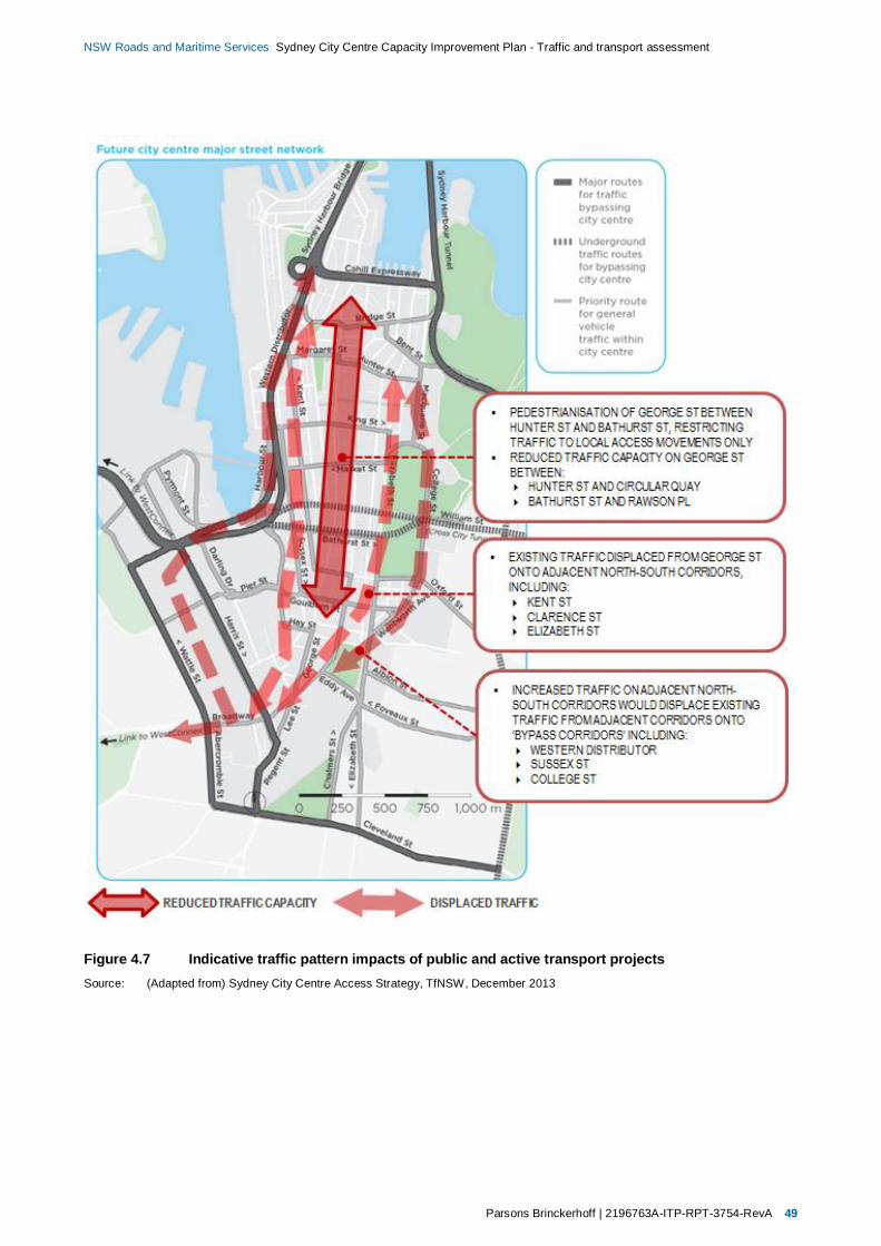
Parsons Brinckerhoff | 2196763A-ITP-RPT-3754-RevA 49
NSW Roads and Maritime Services Sydney City Centre Capacity Improvement Plan - Traffic and transport assessment
Figure 4.7 Indicative traffic pattern impacts of public and active transport projectsSource: (Adapted from) Sydney City Centre Access Strategy, TfNSW, December 2013
Parsons Brinckerhoff | 2196763A-ITP-RPT-3754-RevA 51
NSW Roads and Maritime Services Sydney City Centre Capacity Improvement Plan - Traffic and transport assessment
5. The proposal5.1 Proposal contextSection 4 provides an overview of the future transport context within the city centre following theimplementation of the Access Strategy. The introduction of the CBD and South East Light Rail (CSELR),modifications to bus operations and infrastructure, and walking and cycling initiatives would result in majorchanges to the city centre’s road network operations and infrastructure.
While public and active transport projects and initiatives would improve patronage and operations for thesemodes, they would also impact general traffic capacity, patterns, and conditions, and consequently roadnetwork performance.
Some Access Strategy projects, for example the Sydney City Centre Bus Infrastructure project, also proposeupgrades to other roads and intersections which would improve overall traffic capacity. However despitethese mitigation measures the overall traffic capacity of the city centre road network would be reducedfollowing their implementation. Consequently the traffic capacity improvements proposed as part of theSydney City Centre Capacity Improvement Plan (the proposal) have therefore been developed to integratewith and complement other traffic capacity improvements already planned or proposed across the citycentre.
Section 4.8 describes future traffic conditions following implementation of the Access Strategy; the reducedoverall traffic capacity within the city centre and the displacement of traffic to bypass routes is anticipated toresult in the following impacts to traffic conditions and network performance:
Large volumes of general traffic, buses, commercial vehicles and taxis would continue to require accessto and from the city centre.
The reduction in traffic demand within the city centre would be negated by the reduction in capacity ofthe road network. As a result many intersections would continue to operate at or over capacity, resultingin delays and congestion.
General traffic displaced from the city centre would increase demand on and consequently reduce theperformance of the proposed bypass routes.
Most critically the pedestrianisation of George Street would restrict traffic to local property accessmovements only. This is anticipated to increase traffic on the Wentworth Avenue-College Street-Macquarie Street corridor, resulting in reduced network performance.
To anticipate the fundamental changes to traffic patterns and conditions following implementation of theAccess Strategy, TfNSW developed a multi-modal traffic model covering the city centre and surroundingregional road network. One of the key outcomes of the modelling process was the identification of ‘pinchpoints’; areas of the road network where traffic demand exceeds capacity, resulting in delays, queuing, andcongestion.
Consequently, the Sydney City Centre Capacity Improvement Plan (the proposal) builds upon this analysis,involving the development and assessment of schemes which target traffic pinch points within the city centre,proposed to:
Address existing network deficiencies.
Mitigate the potential road network performance impacts of public and active transport projects, whilemaintaining public and active transport performance.
Maintain effective traffic operations on the city centre’s road network.
52 2196763A-ITP-RPT-3754-RevA | Parsons Brinckerhoff
NSW Roads and Maritime Services Sydney City Centre Capacity Improvement Plan - Traffic and transport assessment
The development of the proposal included a variety of locations and scheme options. Details of theidentification and preferred option selection process are provided in section 2.5.3 of the REF document. Thepreferred option for the proposal is presented in section 5.3, and assessed in section 6.
5.2 Proposal objectivesThe Sydney City Centre Capacity Improvement Plan is proposed to help to mitigate the traffic impacts ofpublic and active transport projects proposed by the Access Strategy.
The overall objective of the proposal is to support the growing demand for access into the Sydney city centreand to improve road network functionality over the coming years, including during construction and operationof a number of projects proposed under the Access Strategy. The proposal would improve the capacity andconsequent performance of some of the city’s most congested roads and constrained intersections, andimprove the ability of the network to accommodate the anticipated changes to traffic conditions. Supportingproposal objectives are to:
Support the growing demand for access through improved key corridor and intersection capacity
Support more efficient road usage to accommodate Sydney’s future growth in demand for bus, taxi, andservice and delivery vehicle movements
Improve road efficiency and allow quality integrated public transport services to meet future demand
Improve the customer experience by improving the safety, amenity and efficiency of the road network
Minimise environmental and socio-economic impacts on the Sydney city centre and on current businessoperations.
5.3 The Sydney City Centre Capacity Improvement PlanThe proposal focusses on sections of road (work sites) where improvements are most critical. The proposalwork sites focus on the identified pinch points, which are either unable to cope with existing volumes oftraffic, or would provide an essential function in enabling the Access Strategy.
Although the proposal would increase the capacity and efficiency of traffic movements within the city centre,traffic demand travelling to, from, and within the city centre is not expected to grow significantly.Consequently, the capacity improvements that form ‘the proposal’ focus on opportunities to provide demandmanagement strategies to facilitate the effective and efficient operation of the city centre road network, ratherthan the creation of high-capacity road infrastructure as part of a ‘predict and provide’ strategy.
The proposal has been developed in parallel with the Sydney City Centre Bus Plan Infrastructure projectdetailed design to ensure compatibility. This integrated approach has resulted in a number of proposedmodifications to improve the overall design of the Sydney City Centre Bus Plan Infrastructure project.
One of the major impacts of the Access Strategy is the loss of north-south traffic capacity through the citycentre. With George Street pedestrianised traffic would be restricted to local property access movementsonly between Bathurst Street and Hunter Street. The proposal provides mitigation to reduce the effects ofthis impact by providing additional traffic capacity at critical locations.
In addition to schemes which directly improve capacity on north-south corridors such as College Street andClarence Street, the proposal also includes improvements to the capacity of east-west routes including KingStreet and Market Street. In the context of the city centre’s grid-like system of roads connected by signalisedintersections, improvements to any approach would improve overall intersection (and ultimately network)capacity:
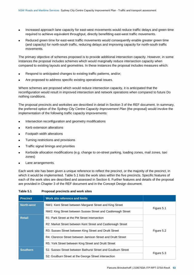
Parsons Brinckerhoff | 2196763A-ITP-RPT-3754-RevA 53
NSW Roads and Maritime Services Sydney City Centre Capacity Improvement Plan - Traffic and transport assessment
Increased approach lane capacity for east-west movements would reduce traffic delays and green timerequired to achieve equivalent throughput, directly benefitting east-west traffic movements.
Reduced green time for east-west traffic movements would consequently enable greater green time(and capacity) for north-south traffic, reducing delays and improving capacity for north-south trafficmovements.
The primary objective of schemes proposed is to provide additional intersection capacity. However, in someinstances the proposal includes schemes which would marginally reduce intersection capacity whencompared to existing layouts and geometries. In these instances the proposal includes measures which:
Respond to anticipated changes to existing traffic patterns, and/or;
Are proposed to address specific existing operational issues.
Where schemes are proposed which would reduce intersection capacity, it is anticipated that thereconfiguration would result in improved intersection and network operations when compared to future Donothing conditions.
The proposal precincts and worksites are described in detail in Section 3 of the REF document. In summary,the preferred option of the Sydney City Centre Capacity Improvement Plan (the proposal) would involve theimplementation of the following traffic capacity improvements:
Intersection reconfiguration and geometry modifications
Kerb extension alterations
Footpath width alterations
Turning restrictions and provisions
Traffic signal timings and priorities
Kerbside allocation modifications (e.g. change to on-street parking, loading zones, mail zones, taxizones)
Lane arrangements.
Each work site has been given a unique reference to reflect the precinct, or the majority of the precinct, inwhich it would be implemented. Table 5.1 lists the work sites within the five precincts. Specific features ofeach of the work sites are described and assessed in Section 6. Further features and details of the proposalare provided in Chapter 3 of the REF document and in the Concept Design document.
Table 5.1 Proposal precincts and work sites
Precinct Work site reference and limits
North-west NW1: Kent Street between Margaret Street and King StreetFigure 5.1
NW2: King Street between Sussex Street and Castlereagh Street
Retail R1: Park Street at the Pitt Street intersection
Figure 5.2
R2: Market Street between Kent Street and Castlereagh Street
R3: Sussex Street between King Street and Druitt Street
R4: Clarence Street between Jamison Street and Druitt Street
R5: York Street between King Street and Druitt Street
Southern S1: Sussex Street between Bathurst Street and Goulburn StreetFigure 5.3
S2: Goulburn Street at the George Street intersection
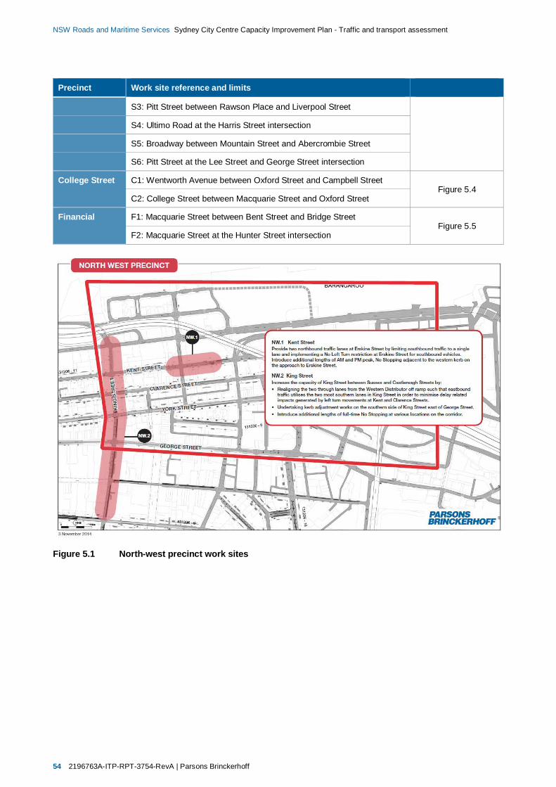
54 2196763A-ITP-RPT-3754-RevA | Parsons Brinckerhoff
NSW Roads and Maritime Services Sydney City Centre Capacity Improvement Plan - Traffic and transport assessment
Precinct Work site reference and limits
S3: Pitt Street between Rawson Place and Liverpool Street
S4: Ultimo Road at the Harris Street intersection
S5: Broadway between Mountain Street and Abercrombie Street
S6: Pitt Street at the Lee Street and George Street intersection
College Street C1: Wentworth Avenue between Oxford Street and Campbell StreetFigure 5.4
C2: College Street between Macquarie Street and Oxford Street
Financial F1: Macquarie Street between Bent Street and Bridge StreetFigure 5.5
F2: Macquarie Street at the Hunter Street intersection
Figure 5.1 North-west precinct work sites

Parsons Brinckerhoff | 2196763A-ITP-RPT-3754-RevA 55
NSW Roads and Maritime Services Sydney City Centre Capacity Improvement Plan - Traffic and transport assessment
Figure 5.2 Retail precinct work sites
Figure 5.3 Southern precinct work sites
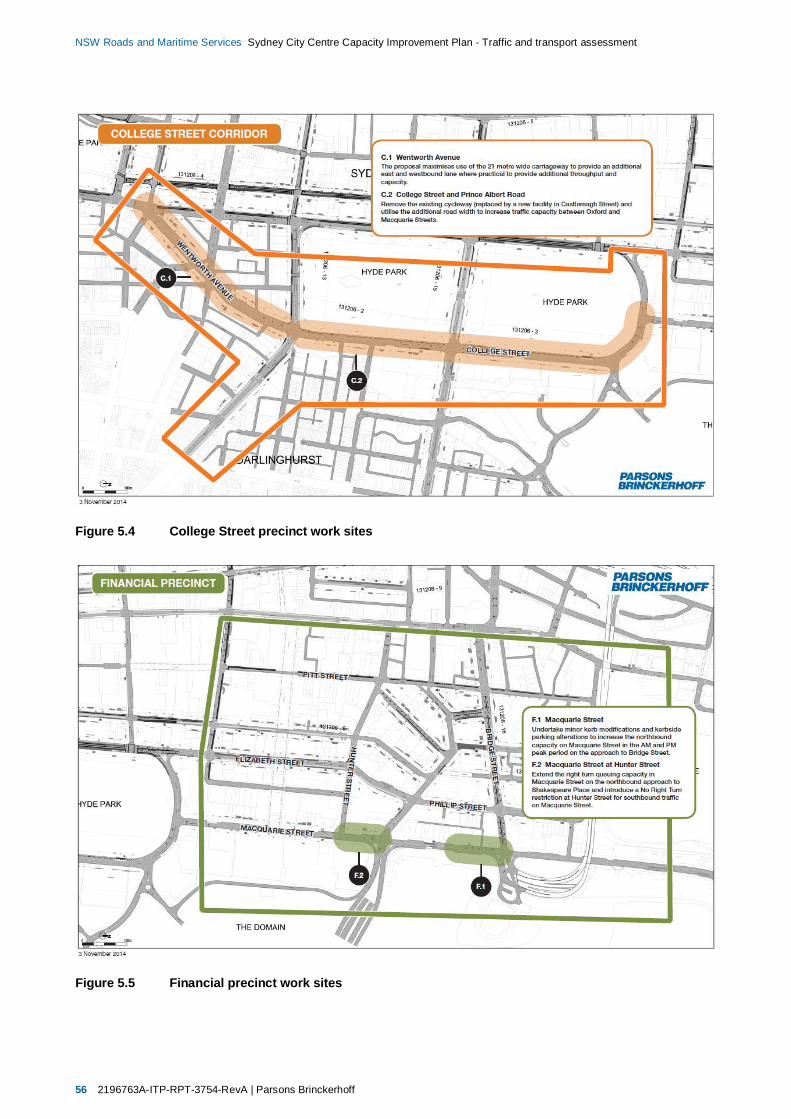
56 2196763A-ITP-RPT-3754-RevA | Parsons Brinckerhoff
NSW Roads and Maritime Services Sydney City Centre Capacity Improvement Plan - Traffic and transport assessment
Figure 5.4 College Street precinct work sites
Figure 5.5 Financial precinct work sites

Parsons Brinckerhoff | 2196763A-ITP-RPT-3754-RevA 57
NSW Roads and Maritime Services Sydney City Centre Capacity Improvement Plan - Traffic and transport assessment
6. Future conditions with theproposal
6.1 Construction of proposalConstruction of the proposal is anticipated to start in early 2015, with the works expected to be completedwithin four months. The proposed construction methodology and anticipated impacts during construction ofthe proposal are described in Section 3.3 of the REF document. The overall objective would be to constructthe proposal in a timely and efficient manner, considering the need to:
Maintain access for all travel modes to, from, and through the city centre.
Minimise the impacts to the performance of the city centre road network, particularly during peakperiods.
Ensure construction of the proposal does not conflict with or compound the impacts of trafficmanagement controls and other measures to be implemented by the Access Strategy or other majordevelopment projects (refer to Section 3.1.4 of the REF document).
Ensure the proposal’s impacts would be managed in accordance with the safeguards and managementmeasures identified in section 7 to minimise the environmental and social impacts.
As the proposal would require modifications to some of the busiest roads within Sydney’s city centre, workswould be required at night, during weekends, and potentially during public holidays. This would achieve themost efficient and shortest construction program, and it is also anticipated to be the only feasible way toconstruct the proposal. In the city centre context, many cafes and other ground floor retail businesses do notoperate outside of typical weekday business hours, and therefore would be relatively unaffected by workundertaken at night or on weekends.
The indicative construction plan and method for the proposal allows for multiple work sites to be constructedsimultaneously. It also considers compatibility with the concurrent Access Strategy projects, andconsequently the construction staging required to maintain traffic flows around the city centre.
The following sections provide a summary of the anticipated impacts during the construction of the proposal.The extent, duration, and timing of construction would be confirmed and finalised during the detailed designas part of the construction staging.
6.1.1 Travel modes
During construction of the proposal travel modes within the city centre would be relatively unchanged fromexisting conditions, as described in section 2.1:
Public transport would continue to accommodate the majority of trips to and from the city centre,including high bus volumes.
Car movements would still comprise around 87 per cent of traffic movements at city centreintersections, buses eight per cent, and the remaining five per cent trucks and cyclists.
Pedestrian movements would continue as the primary travel mode (and the dominant proportion of roadusers at many intersections) within the city centre.
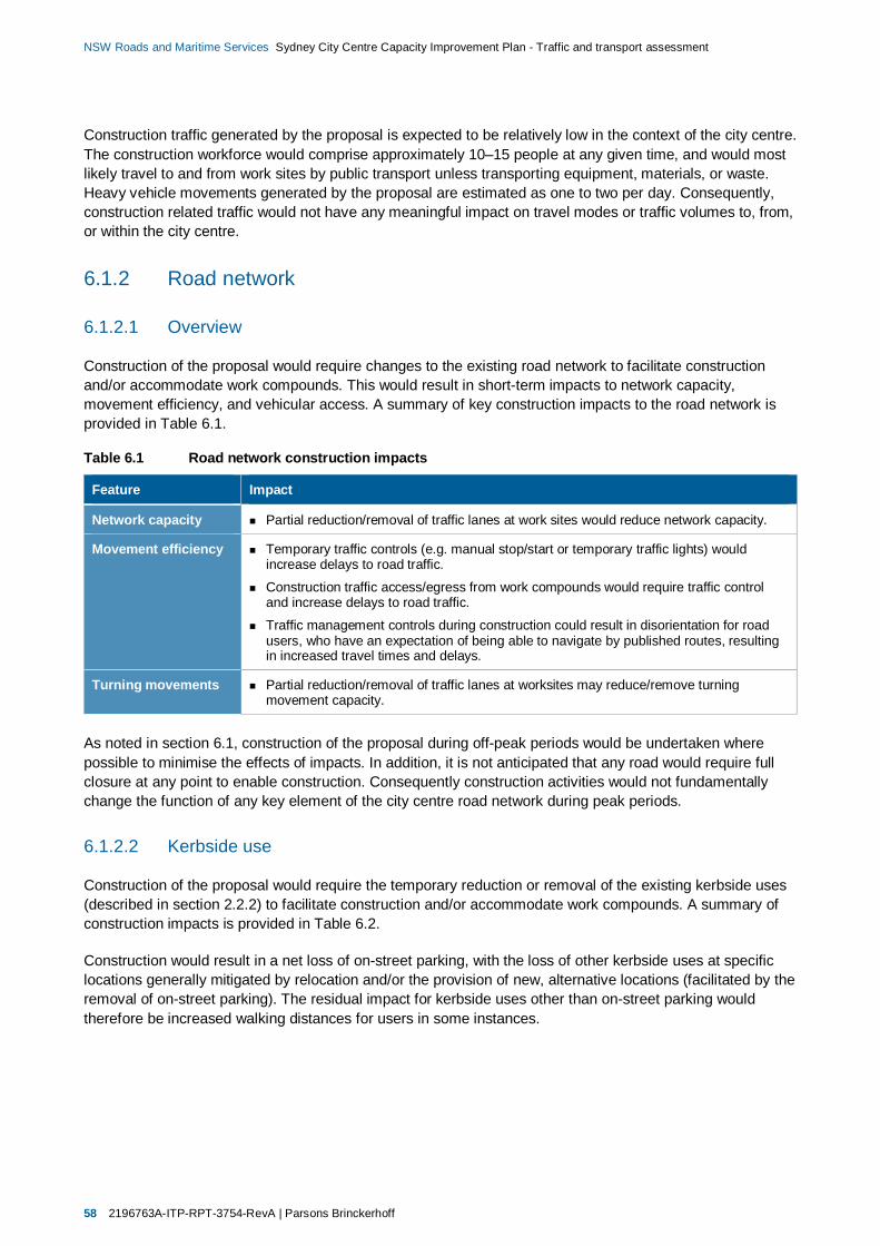
58 2196763A-ITP-RPT-3754-RevA | Parsons Brinckerhoff
NSW Roads and Maritime Services Sydney City Centre Capacity Improvement Plan - Traffic and transport assessment
Construction traffic generated by the proposal is expected to be relatively low in the context of the city centre.The construction workforce would comprise approximately 10–15 people at any given time, and would mostlikely travel to and from work sites by public transport unless transporting equipment, materials, or waste.Heavy vehicle movements generated by the proposal are estimated as one to two per day. Consequently,construction related traffic would not have any meaningful impact on travel modes or traffic volumes to, from,or within the city centre.
6.1.2 Road network
6.1.2.1 Overview
Construction of the proposal would require changes to the existing road network to facilitate constructionand/or accommodate work compounds. This would result in short-term impacts to network capacity,movement efficiency, and vehicular access. A summary of key construction impacts to the road network isprovided in Table 6.1.
Table 6.1 Road network construction impacts
Feature Impact
Network capacity Partial reduction/removal of traffic lanes at work sites would reduce network capacity.
Movement efficiency Temporary traffic controls (e.g. manual stop/start or temporary traffic lights) wouldincrease delays to road traffic.
Construction traffic access/egress from work compounds would require traffic controland increase delays to road traffic.
Traffic management controls during construction could result in disorientation for roadusers, who have an expectation of being able to navigate by published routes, resultingin increased travel times and delays.
Turning movements Partial reduction/removal of traffic lanes at worksites may reduce/remove turningmovement capacity.
As noted in section 6.1, construction of the proposal during off-peak periods would be undertaken wherepossible to minimise the effects of impacts. In addition, it is not anticipated that any road would require fullclosure at any point to enable construction. Consequently construction activities would not fundamentallychange the function of any key element of the city centre road network during peak periods.
6.1.2.2 Kerbside use
Construction of the proposal would require the temporary reduction or removal of the existing kerbside uses(described in section 2.2.2) to facilitate construction and/or accommodate work compounds. A summary ofconstruction impacts is provided in Table 6.2.
Construction would result in a net loss of on-street parking, with the loss of other kerbside uses at specificlocations generally mitigated by relocation and/or the provision of new, alternative locations (facilitated by theremoval of on-street parking). The residual impact for kerbside uses other than on-street parking wouldtherefore be increased walking distances for users in some instances.
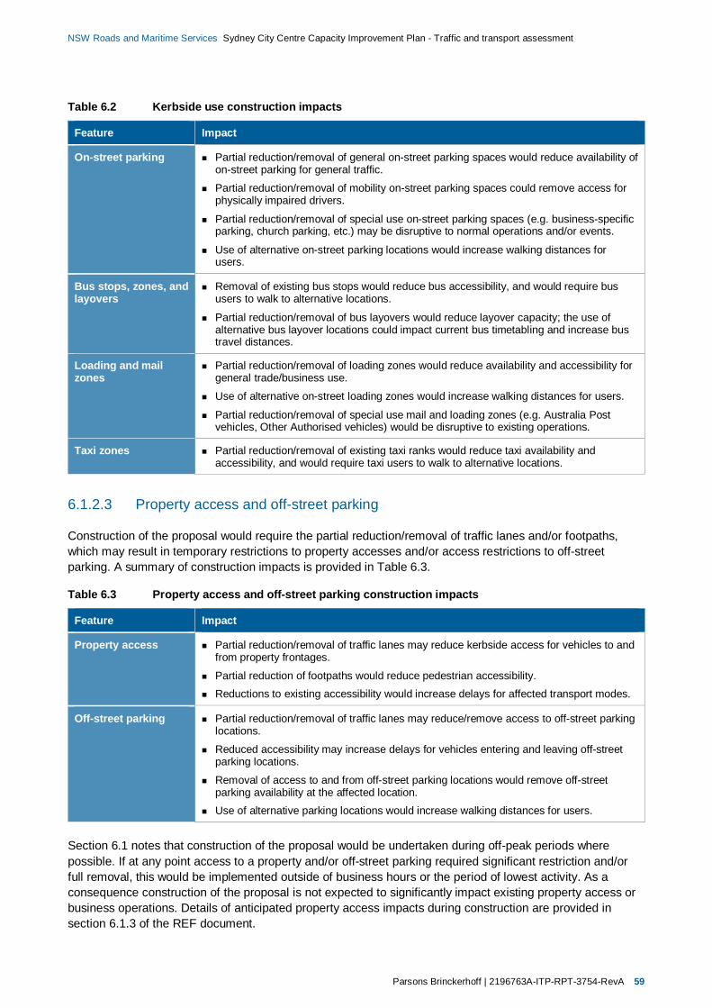
Parsons Brinckerhoff | 2196763A-ITP-RPT-3754-RevA 59
NSW Roads and Maritime Services Sydney City Centre Capacity Improvement Plan - Traffic and transport assessment
Table 6.2 Kerbside use construction impacts
Feature Impact
On-street parking Partial reduction/removal of general on-street parking spaces would reduce availability ofon-street parking for general traffic.
Partial reduction/removal of mobility on-street parking spaces could remove access forphysically impaired drivers.
Partial reduction/removal of special use on-street parking spaces (e.g. business-specificparking, church parking, etc.) may be disruptive to normal operations and/or events.
Use of alternative on-street parking locations would increase walking distances forusers.
Bus stops, zones, andlayovers
Removal of existing bus stops would reduce bus accessibility, and would require bususers to walk to alternative locations.
Partial reduction/removal of bus layovers would reduce layover capacity; the use ofalternative bus layover locations could impact current bus timetabling and increase bustravel distances.
Loading and mailzones
Partial reduction/removal of loading zones would reduce availability and accessibility forgeneral trade/business use.
Use of alternative on-street loading zones would increase walking distances for users.
Partial reduction/removal of special use mail and loading zones (e.g. Australia Postvehicles, Other Authorised vehicles) would be disruptive to existing operations.
Taxi zones Partial reduction/removal of existing taxi ranks would reduce taxi availability andaccessibility, and would require taxi users to walk to alternative locations.
6.1.2.3 Property access and off-street parking
Construction of the proposal would require the partial reduction/removal of traffic lanes and/or footpaths,which may result in temporary restrictions to property accesses and/or access restrictions to off-streetparking. A summary of construction impacts is provided in Table 6.3.
Table 6.3 Property access and off-street parking construction impacts
Feature Impact
Property access Partial reduction/removal of traffic lanes may reduce kerbside access for vehicles to andfrom property frontages.
Partial reduction of footpaths would reduce pedestrian accessibility.Reductions to existing accessibility would increase delays for affected transport modes.
Off-street parking Partial reduction/removal of traffic lanes may reduce/remove access to off-street parkinglocations.
Reduced accessibility may increase delays for vehicles entering and leaving off-streetparking locations.
Removal of access to and from off-street parking locations would remove off-streetparking availability at the affected location.Use of alternative parking locations would increase walking distances for users.
Section 6.1 notes that construction of the proposal would be undertaken during off-peak periods wherepossible. If at any point access to a property and/or off-street parking required significant restriction and/orfull removal, this would be implemented outside of business hours or the period of lowest activity. As aconsequence construction of the proposal is not expected to significantly impact existing property access orbusiness operations. Details of anticipated property access impacts during construction are provided insection 6.1.3 of the REF document.

60 2196763A-ITP-RPT-3754-RevA | Parsons Brinckerhoff
NSW Roads and Maritime Services Sydney City Centre Capacity Improvement Plan - Traffic and transport assessment
6.1.3 Public transport
The reduction and/or removal of bus infrastructure required to facilitate construction and/or accommodatework compounds would impact existing bus operations. In addition, modifications to footpaths duringconstruction would reduce capacity and accessibility for pedestrian movements to and from public transportstops, stations, and interchanges. A summary of construction impacts is provided in Table 6.4.
Table 6.4 Public transport construction impacts
Feature Impact
Bus Reduced road network capacity and additional traffic delays at and surrounding work siteswould increase bus travel times.
Removal of existing bus stops would reduce bus accessibility, and would require bus users towalk to alternative locations.
Partial reduction/removal of footpaths would reduce capacity and accessibility for pedestrianmovements to and from bus stops.
Relocation of bus stops and/or lane closures, if required, could result in existing bus routesbeing re-routed, increasing bus route lengths and travel times.
Partial reduction/removal of bus zones would reduce kerbside capacity for pickups and setdowns, which may impact the overall capacity and/or performance of existing bus services.
Partial reduction/removal of bus layovers would reduce layover capacity; the use of alternativebus layover locations could impact current bus timetabling and increase bus travel distances.
Light rail/Rail/Ferry
Partial reduction/removal of footpaths would reduce capacity and accessibility for pedestrianmovements to and from light rail, rail, and ferry services.
During construction road network capacity would be reduced and additional traffic delays encountered at andsurrounding work sites, which would increase bus travel times. If unmitigated, the short-term impacts wouldbe significant along key bus corridors during peak periods (e.g. York Street during morning peak andClarence Street during afternoon peak periods).
The closure of traffic lanes may require temporary diversions to bus routes during construction. The impactsof diversions are expected to relatively minor, as the city centre road network provides a large number of buscapable routes and corridors for diverted services.
Public transport access would be maintained throughout construction, although there may be a requirementto install temporary bus stops at nearby locations. The residual impact would be relatively minor, with buspassengers required to walk to alternative stop locations.
6.1.4 Taxis
The temporary reduction or removal of taxi kerbside uses and footpaths required to facilitate constructionand/or accommodate work compounds would impact existing taxi operations. In addition, changes to theexisting road network to facilitate construction and/or accommodate work compounds would result in short-term impacts to network capacity, movement efficiency, and vehicular access, which would increase delaysfor taxis. A summary of construction impacts is provided in Table 6.5.

Parsons Brinckerhoff | 2196763A-ITP-RPT-3754-RevA 61
NSW Roads and Maritime Services Sydney City Centre Capacity Improvement Plan - Traffic and transport assessment
Table 6.5 Taxi construction impacts
Feature Impact
Road network Refer to Table 6.1 – Road Network construction impacts.
Kerbside use Partial reduction/removal of existing taxi ranks would reduce taxi availability and accessibility,and would require taxi users to walk to alternative locations.
Footpaths Partial reduction of footpaths would reduce capacity and accessibility for pedestrian movementsto and from taxi ranks.
6.1.5 Walking
The reduction or removal of footpaths required to facilitate construction and/or accommodate workcompounds would impact pedestrians. Modifications to existing infrastructure would reduce capacity andaccessibility for pedestrian movements in the proximity of work sites. A summary of construction impacts isprovided in Table 6.6.
The reduction in capacity or removal of pedestrian infrastructure may require temporary diversions duringconstruction. This would result in minor residual short term delays and increased travel distances in someinstances.
Table 6.6 Pedestrian construction impacts
Feature Impact
Walking Partial reduction/removal of footpaths would reduce capacity and accessibility for pedestrianmovements in the city centre.
Construction traffic access/egress from work compounds would require traffic control andincrease delays to pedestrians.
Temporary traffic controls (e.g. traffic management staff controlling pedestrian access onfootpaths in proximity of worksites) would increase delays to pedestrians.
Closure of footpaths would require diversions to alternative routes, increasing pedestrian delaysand travel distances.
Partial reduction/removal of existing pedestrian crossing facilities (e.g. signal controls,pedestrian islands) would reduce amenity and accessibility, and potentially require diversions,increase delays and travel times for pedestrian movements.
6.1.6 Cycling
A reduction or removal of cycleways would be required in some instances to facilitate construction and/oraccommodate work compounds. Modifications to existing infrastructure would reduce capacity andaccessibility for cyclists in the proximity of work sites. A summary of construction impacts is provided inTable 6.7.
The restriction of cycling infrastructure may require temporary diversions during construction. The impacts ofdiversions are expected to relatively minor as cyclists would use alternative routes or be directed to dismountand use footpaths. This would result in minor residual short term delays and increased travel distances insome instances.
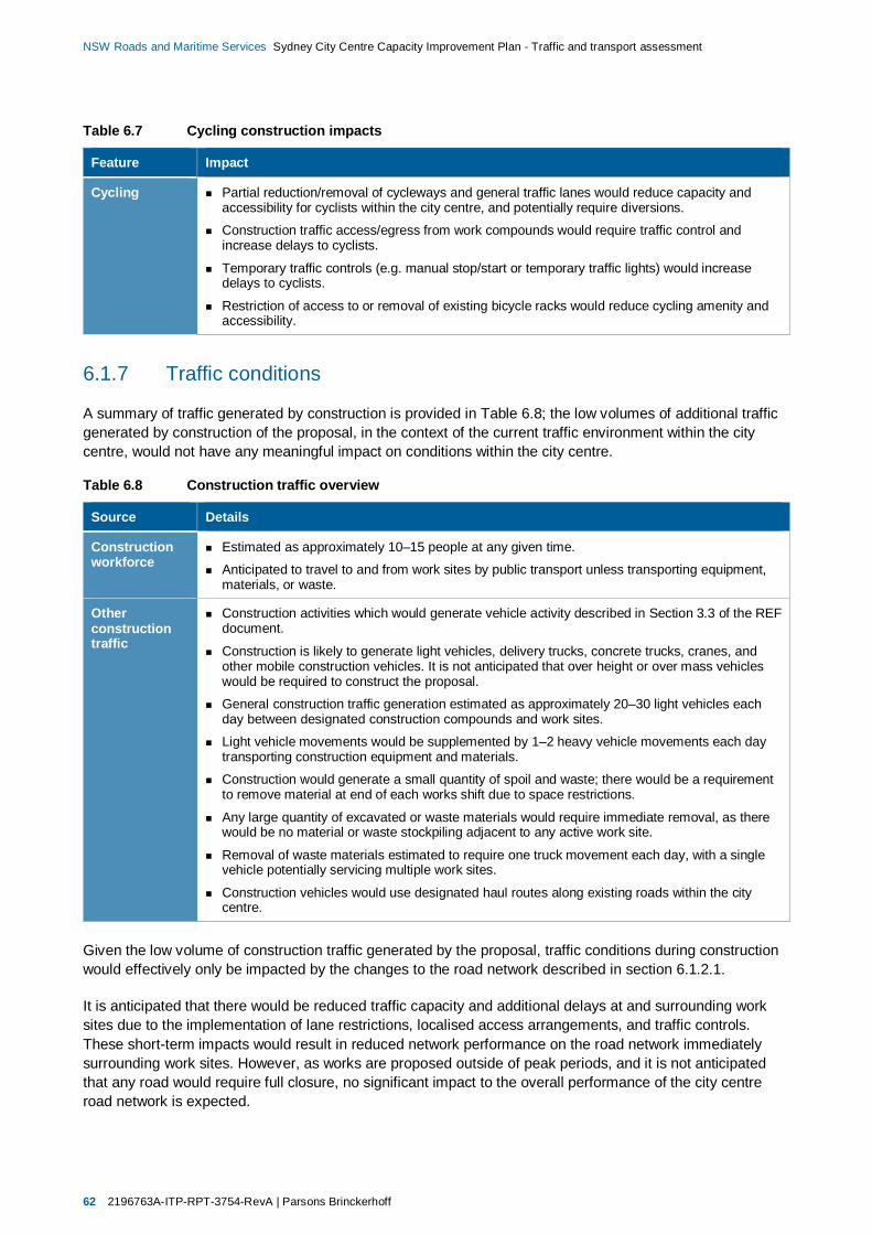
62 2196763A-ITP-RPT-3754-RevA | Parsons Brinckerhoff
NSW Roads and Maritime Services Sydney City Centre Capacity Improvement Plan - Traffic and transport assessment
Table 6.7 Cycling construction impacts
Feature Impact
Cycling Partial reduction/removal of cycleways and general traffic lanes would reduce capacity andaccessibility for cyclists within the city centre, and potentially require diversions.
Construction traffic access/egress from work compounds would require traffic control andincrease delays to cyclists.
Temporary traffic controls (e.g. manual stop/start or temporary traffic lights) would increasedelays to cyclists.
Restriction of access to or removal of existing bicycle racks would reduce cycling amenity andaccessibility.
6.1.7 Traffic conditions
A summary of traffic generated by construction is provided in Table 6.8; the low volumes of additional trafficgenerated by construction of the proposal, in the context of the current traffic environment within the citycentre, would not have any meaningful impact on conditions within the city centre.
Table 6.8 Construction traffic overview
Source Details
Constructionworkforce
Estimated as approximately 10–15 people at any given time.
Anticipated to travel to and from work sites by public transport unless transporting equipment,materials, or waste.
Otherconstructiontraffic
Construction activities which would generate vehicle activity described in Section 3.3 of the REFdocument.
Construction is likely to generate light vehicles, delivery trucks, concrete trucks, cranes, andother mobile construction vehicles. It is not anticipated that over height or over mass vehicleswould be required to construct the proposal.
General construction traffic generation estimated as approximately 20–30 light vehicles eachday between designated construction compounds and work sites.
Light vehicle movements would be supplemented by 1–2 heavy vehicle movements each daytransporting construction equipment and materials.
Construction would generate a small quantity of spoil and waste; there would be a requirementto remove material at end of each works shift due to space restrictions.
Any large quantity of excavated or waste materials would require immediate removal, as therewould be no material or waste stockpiling adjacent to any active work site.
Removal of waste materials estimated to require one truck movement each day, with a singlevehicle potentially servicing multiple work sites.
Construction vehicles would use designated haul routes along existing roads within the citycentre.
Given the low volume of construction traffic generated by the proposal, traffic conditions during constructionwould effectively only be impacted by the changes to the road network described in section 6.1.2.1.
It is anticipated that there would be reduced traffic capacity and additional delays at and surrounding worksites due to the implementation of lane restrictions, localised access arrangements, and traffic controls.These short-term impacts would result in reduced network performance on the road network immediatelysurrounding work sites. However, as works are proposed outside of peak periods, and it is not anticipatedthat any road would require full closure, no significant impact to the overall performance of the city centreroad network is expected.
Parsons Brinckerhoff | 2196763A-ITP-RPT-3754-RevA 63
NSW Roads and Maritime Services Sydney City Centre Capacity Improvement Plan - Traffic and transport assessment
6.2 Operation with proposalThe proposal would optimise the use of the available street space within the city centre. This would maintaineffective transport operations on the city centre’s road network by mitigating:
Existing network deficiencies.
Cumulative impacts anticipated as a result of the construction of other Access Strategy projects andother developments in the city centre.
As discussed in section 2, driving trips to and from the city centre during peak hours have plateaued inrecent years, with much of the road network within the city centre currently operating at or over capacity.section 4 describes how the future capacity of the road network would be reduced, but public and activetransport mode shares increased, as a result of the construction of Access Strategy projects such as theCSELR.
Although the proposal would increase the capacity and efficiency of traffic movements within the city centre,due to the above factors it is not expected to increase (or accommodate growth in) traffic demand travellingto, from, and within the city centre. Consequently the proposal focusses on demand management strategiesto facilitate the effective and efficient operation of the city centre road network, rather than the creation ofhigh-capacity road infrastructure.
The following sections provide a summary of the anticipated operational benefits and impacts of theproposal.
6.2.1 Travel modes
Section 4.2 provides an overview of anticipated travel modes to, from, and within the city centre following theimplementation of the Access Strategy9:
Rail would remain the dominant travel mode
Light rail projects would introduce new public transport options
Bus routes would be redesigned, with fewer buses operating more efficiently due to the introduction oflight rail
Integrated timetabling and a new ferry hub at Barangaroo would increase ferry accessibility
Walking and cycling would continue to perform a major role in facilitating travel to, from, and within thecity centre
Pedestrians would still generate the vast majority of trips made within the city centre.
By increasing the availability, capacity, and efficiency of public transport it is anticipated that overall trafficvolumes would remain relatively constant, with increased public and active transport patronageaccommodating overall demand growth.
9 Sydney City Centre Access Strategy, TfNSW, December 2013
64 2196763A-ITP-RPT-3754-RevA | Parsons Brinckerhoff
NSW Roads and Maritime Services Sydney City Centre Capacity Improvement Plan - Traffic and transport assessment
6.2.2 Future road network
6.2.2.1 Overview
As discussed in section 4.3.1, the Access Strategy would result in the closure and modifications to thefunction of key road corridors in the city centre, although traffic access would be maintained. The resultingimpacts and adjusted functions of key features of the future road network are detailed in the AccessStrategy, summarised in Table 4.1, and illustrated in Figure 4.2.
To mitigate the potential impacts of Access Strategy projects which prioritise public and active transportmodes, the proposal would involve the implementation of the following traffic capacity improvements atlocations throughout the city centre:
Intersection reconfiguration and geometry modifications
Kerb extension alterations
Footpath width alterations
Turning restrictions and provisions
Traffic signal timings and priorities
Kerbside allocation modifications, including no-stopping provisions
Lane arrangement adjustments.
Generally the schemes proposed would benefit traffic operations and impact other modes/uses, with thecapacity improvements of the proposal developed to provide integrated transport solutions with net benefits.In some instances localised traffic operations would be impacted through the restriction of existing turningmovements proposed to improve overall network performance.
Section 6.2.3 provides details of the future road networks proposed for each of the precincts, and theconsequent benefits and impacts of the proposal within these areas. Further features and details of theproposal are provided in Chapter 3 of the REF document and in the Concept Design document.
6.2.2.2 Kerbside use
The proposal would require the permanent reduction or removal of existing kerbside uses (described insection 2.2.2) at some worksites to achieve the required traffic capacity improvements. A summary of theresulting impacts is provided in Table 6.9.
The most notable loss of on-street parking would be the net loss of between 93-115 on-street parking spaces(including one car share space), six mobility impaired parking spaces, and seven motorcycle parking zones.In some areas the use of existing parking spaces would only be restricted during peak traffic periods. Theresidual net loss of parking would be mitigated by:
The availability and use of alternative on-street parking facilities
Increased utilisation of the current spare capacity at various off-street parking locations, which isencouraged by the Access Strategy.
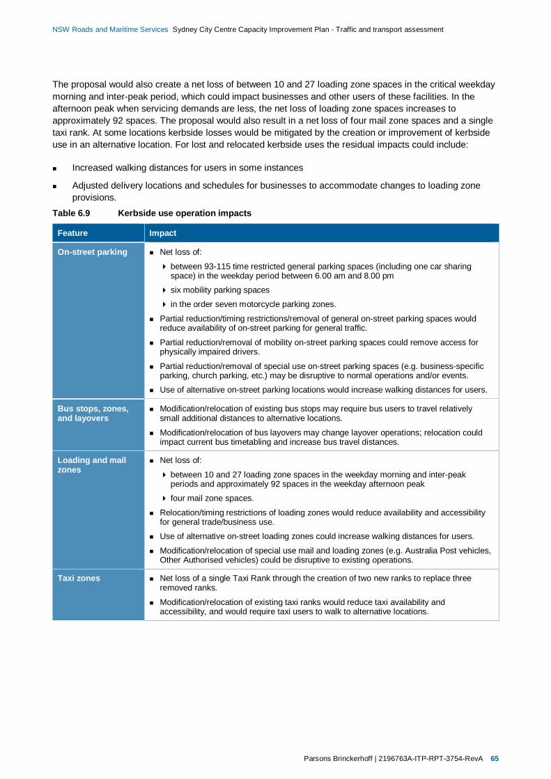
Parsons Brinckerhoff | 2196763A-ITP-RPT-3754-RevA 65
NSW Roads and Maritime Services Sydney City Centre Capacity Improvement Plan - Traffic and transport assessment
The proposal would also create a net loss of between 10 and 27 loading zone spaces in the critical weekdaymorning and inter-peak period, which could impact businesses and other users of these facilities. In theafternoon peak when servicing demands are less, the net loss of loading zone spaces increases toapproximately 92 spaces. The proposal would also result in a net loss of four mail zone spaces and a singletaxi rank. At some locations kerbside losses would be mitigated by the creation or improvement of kerbsideuse in an alternative location. For lost and relocated kerbside uses the residual impacts could include:
Increased walking distances for users in some instances
Adjusted delivery locations and schedules for businesses to accommodate changes to loading zoneprovisions.
Table 6.9 Kerbside use operation impacts
Feature Impact
On-street parking Net loss of:
between 93-115 time restricted general parking spaces (including one car sharingspace) in the weekday period between 6.00 am and 8.00 pm
six mobility parking spaces
in the order seven motorcycle parking zones.
Partial reduction/timing restrictions/removal of general on-street parking spaces wouldreduce availability of on-street parking for general traffic.
Partial reduction/removal of mobility on-street parking spaces could remove access forphysically impaired drivers.
Partial reduction/removal of special use on-street parking spaces (e.g. business-specificparking, church parking, etc.) may be disruptive to normal operations and/or events.
Use of alternative on-street parking locations would increase walking distances for users.
Bus stops, zones,and layovers
Modification/relocation of existing bus stops may require bus users to travel relativelysmall additional distances to alternative locations.
Modification/relocation of bus layovers may change layover operations; relocation couldimpact current bus timetabling and increase bus travel distances.
Loading and mailzones
Net loss of:
between 10 and 27 loading zone spaces in the weekday morning and inter-peakperiods and approximately 92 spaces in the weekday afternoon peak
four mail zone spaces.
Relocation/timing restrictions of loading zones would reduce availability and accessibilityfor general trade/business use.
Use of alternative on-street loading zones could increase walking distances for users.
Modification/relocation of special use mail and loading zones (e.g. Australia Post vehicles,Other Authorised vehicles) could be disruptive to existing operations.
Taxi zones Net loss of a single Taxi Rank through the creation of two new ranks to replace threeremoved ranks.
Modification/relocation of existing taxi ranks would reduce taxi availability andaccessibility, and would require taxi users to walk to alternative locations.
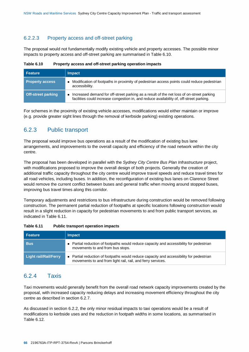
66 2196763A-ITP-RPT-3754-RevA | Parsons Brinckerhoff
NSW Roads and Maritime Services Sydney City Centre Capacity Improvement Plan - Traffic and transport assessment
6.2.2.3 Property access and off-street parking
The proposal would not fundamentally modify existing vehicle and property accesses. The possible minorimpacts to property access and off-street parking are summarised in Table 6.10.
Table 6.10 Property access and off-street parking operation impacts
Feature Impact
Property access Modification of footpaths in proximity of pedestrian access points could reduce pedestrianaccessibility.
Off-street parking Increased demand for off-street parking as a result of the net loss of on-street parkingfacilities could increase congestion in, and reduce availability of, off-street parking.
For schemes in the proximity of existing vehicle accesses, modifications would either maintain or improve(e.g. provide greater sight lines through the removal of kerbside parking) existing operations.
6.2.3 Public transport
The proposal would improve bus operations as a result of the modification of existing bus lanearrangements, and improvements to the overall capacity and efficiency of the road network within the citycentre.
The proposal has been developed in parallel with the Sydney City Centre Bus Plan Infrastructure project,with modifications proposed to improve the overall design of both projects. Generally the creation ofadditional traffic capacity throughout the city centre would improve travel speeds and reduce travel times forall road vehicles, including buses. In addition, the reconfiguration of existing bus lanes on Clarence Streetwould remove the current conflict between buses and general traffic when moving around stopped buses,improving bus travel times along this corridor.
Temporary adjustments and restrictions to bus infrastructure during construction would be removed followingconstruction. The permanent partial reduction of footpaths at specific locations following construction wouldresult in a slight reduction in capacity for pedestrian movements to and from public transport services, asindicated in Table 6.11.
Table 6.11 Public transport operation impacts
Feature Impact
Bus Partial reduction of footpaths would reduce capacity and accessibility for pedestrianmovements to and from bus stops.
Light rail/Rail/Ferry Partial reduction of footpaths would reduce capacity and accessibility for pedestrianmovements to and from light rail, rail, and ferry services.
6.2.4 Taxis
Taxi movements would generally benefit from the overall road network capacity improvements created by theproposal, with increased capacity reducing delays and increasing movement efficiency throughout the citycentre as described in section 6.2.7.
As discussed in section 6.2.2, the only minor residual impacts to taxi operations would be a result ofmodifications to kerbside uses and the reduction in footpath widths in some locations, as summarised inTable 6.12.
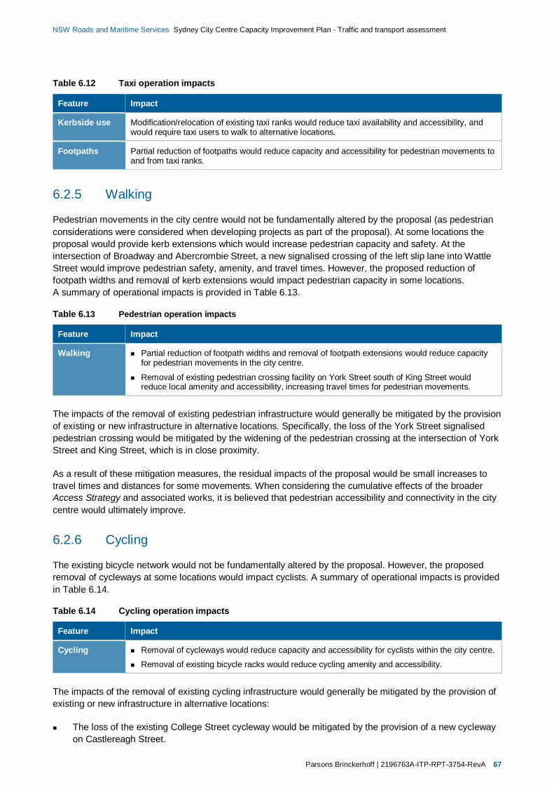
Parsons Brinckerhoff | 2196763A-ITP-RPT-3754-RevA 67
NSW Roads and Maritime Services Sydney City Centre Capacity Improvement Plan - Traffic and transport assessment
Table 6.12 Taxi operation impacts
Feature Impact
Kerbside use Modification/relocation of existing taxi ranks would reduce taxi availability and accessibility, andwould require taxi users to walk to alternative locations.
Footpaths Partial reduction of footpaths would reduce capacity and accessibility for pedestrian movements toand from taxi ranks.
6.2.5 Walking
Pedestrian movements in the city centre would not be fundamentally altered by the proposal (as pedestrianconsiderations were considered when developing projects as part of the proposal). At some locations theproposal would provide kerb extensions which would increase pedestrian capacity and safety. At theintersection of Broadway and Abercrombie Street, a new signalised crossing of the left slip lane into WattleStreet would improve pedestrian safety, amenity, and travel times. However, the proposed reduction offootpath widths and removal of kerb extensions would impact pedestrian capacity in some locations.A summary of operational impacts is provided in Table 6.13.
Table 6.13 Pedestrian operation impacts
Feature Impact
Walking Partial reduction of footpath widths and removal of footpath extensions would reduce capacityfor pedestrian movements in the city centre.
Removal of existing pedestrian crossing facility on York Street south of King Street wouldreduce local amenity and accessibility, increasing travel times for pedestrian movements.
The impacts of the removal of existing pedestrian infrastructure would generally be mitigated by the provisionof existing or new infrastructure in alternative locations. Specifically, the loss of the York Street signalisedpedestrian crossing would be mitigated by the widening of the pedestrian crossing at the intersection of YorkStreet and King Street, which is in close proximity.
As a result of these mitigation measures, the residual impacts of the proposal would be small increases totravel times and distances for some movements. When considering the cumulative effects of the broaderAccess Strategy and associated works, it is believed that pedestrian accessibility and connectivity in the citycentre would ultimately improve.
6.2.6 Cycling
The existing bicycle network would not be fundamentally altered by the proposal. However, the proposedremoval of cycleways at some locations would impact cyclists. A summary of operational impacts is providedin Table 6.14.
Table 6.14 Cycling operation impacts
Feature Impact
Cycling Removal of cycleways would reduce capacity and accessibility for cyclists within the city centre.
Removal of existing bicycle racks would reduce cycling amenity and accessibility.
The impacts of the removal of existing cycling infrastructure would generally be mitigated by the provision ofexisting or new infrastructure in alternative locations:
The loss of the existing College Street cycleway would be mitigated by the provision of a new cyclewayon Castlereagh Street.
68 2196763A-ITP-RPT-3754-RevA | Parsons Brinckerhoff
NSW Roads and Maritime Services Sydney City Centre Capacity Improvement Plan - Traffic and transport assessment
The loss of bicycle racks would be mitigated by the relocation of these facilities, and/or the availability ofother bicycle racks at nearby locations.
As a result of these mitigation measures, the residual impacts of the proposal would be small increases totravel times and distances for some movements. When considering the cumulative effects of the broaderAccess Strategy and associated works, it is believed that cyclist accessibility and connectivity in the citycentre would ultimately improve.
6.2.7 Traffic conditions
As discussed in section 6.2, the proposal is not expected to increase or accommodate growth in trafficdemand. Consequently the proposal provides demand management strategies to facilitate the effective andefficient operation of the city centre road network, mitigating the impacts resulting from changes to trafficpatterns and behaviours as a result public and active transport projects proposed by the Access Strategy,supporting the effective and efficient movement of buses, taxis, service and delivery vehicles, and generaltraffic.
The proposal would improve the capacity for, and efficiency of, traffic movements at pinch points within thecity centre, and consequently reduce overall delays, queue lengths, and congestion through theimplementation of road network modifications described in section 6.2.2.1. The proposal would also improveoverall road network management, including the use of kerbside space, to ensure the city centre roadnetwork provides safe and effective access.
In addition to schemes which directly improve capacity on north-south corridors such as College Street andClarence Street, the proposal also includes improvements to the capacity of east-west routes including KingStreet and Market Street. In the context of the city centre’s grid-like system of roads connected by signalisedintersections, improvements to any approach would improve overall intersection (and ultimately network)capacity:
Increased approach lane capacity for east-west movements would reduce traffic delays and green timerequired to achieve equivalent throughput, directly benefitting east-west traffic movements.
Reduced green time for east-west traffic movements would consequently enable greater green time(and capacity) for north-south traffic, reducing delays and improving capacity for north-south trafficmovements.
SIDRA intersection models for each worksite have been developed to assess future operational performance(Level of Service) at a micro-level, based on the modified road network when subjected to existing trafficvolumes and patterns.
The implementation of the proposal would improve capacity and consequently reduce intersection DoS.However, in the city centre road network context the benefits of these capacity improvements would relyupon, and be effected by, corresponding capacity increases at surrounding intersections. Due to this thecombined effects on improved capacity on a worksite corridor basis have been estimated where relevant, asdescribed in section 3.3.
The primary objective of schemes proposed is to provide additional intersection capacity. However, in someinstances the proposal includes schemes which would marginally reduce intersection capacity whencompared to existing layouts and geometries. In these instances the proposal includes measures which:
Respond to anticipated changes to existing traffic patterns, and/or;
Are proposed to address specific existing operational issues.

Parsons Brinckerhoff | 2196763A-ITP-RPT-3754-RevA 69
NSW Roads and Maritime Services Sydney City Centre Capacity Improvement Plan - Traffic and transport assessment
Where schemes are proposed which would reduce intersection capacity, it is anticipated that thereconfiguration would result in improved intersection and network operations when compared to future Donothing conditions.
The following sections provide the results of this modelling to illustrate the anticipated intersection andworksite corridor performance benefits of the proposal. In addition the potential increases in daily traffic as aresult of an increase in worksite corridor capacities are provided. These forecasts are based on theassumption that redistributed traffic demand in the future would increase localised intersection and worksitedemand, resulting in similar Degrees of Saturation to existing conditions.
The SIDRA modelling undertaken provides detailed intersection performance indicators which have beenused to develop, test and refine the traffic management schemes proposed. The modelling has beenundertaken using the existing conditions models described in section 2.3 as a basis. Consequently theresults presented in the following sections provide a ‘like-for-like’ indication of the improvements to individual,isolated intersection performance as a result of the proposal.
Section 2.3 discusses the effects of queuing in the city centre context; vehicle queues which extend to andthrough adjacent intersections can dramatically reduce intersection capacity and efficiency and overallnetwork efficiency as a result of further cascading impacts. Conversely, a reduction in queue lengths throughcapacity and efficiency improvements could result in benefits to both intersection and wider networkperformance.
6.2.7.1 North-west precinct
Proposed traffic management plan
A summary of the proposed traffic management plan for the North-west precinct is provided in Table 6.15.Schematic diagrams used as the basis to assess the operational benefits of the proposed trafficmanagement plans are provided in Appendix A. The concept designs for the proposal schemes are providedin the Concept Design report.
Traffic volumes and network performance
Table 6.16 provides a summary of performance at key intersections within the precinct which would bemodified following implementation of the proposal. The proposal would improve capacity and consequentlyreduce intersection DoS when compared to existing conditions, with the most significant reductions in DoSachieved at the following intersections:
Kent Street with Erskine Street
King Street with York Street.
The estimated cumulative benefits to intersection and worksite corridor capacities are summarised inTable 6.17 and illustrated in Figure 6.1, which indicate increases of approximately:
3 per cent on King Street between Sussex Street and Castlereagh Street
3 per cent in the vicinity of the Kent Street and Erskine Street intersection.
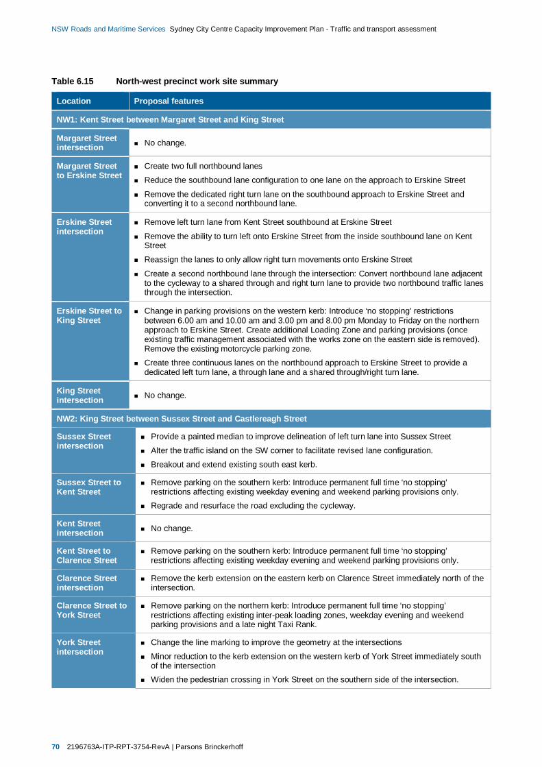
70 2196763A-ITP-RPT-3754-RevA | Parsons Brinckerhoff
NSW Roads and Maritime Services Sydney City Centre Capacity Improvement Plan - Traffic and transport assessment
Table 6.15 North-west precinct work site summary
Location Proposal features
NW1: Kent Street between Margaret Street and King Street
Margaret Streetintersection No change.
Margaret Streetto Erskine Street
Create two full northbound lanes
Reduce the southbound lane configuration to one lane on the approach to Erskine Street
Remove the dedicated right turn lane on the southbound approach to Erskine Street andconverting it to a second northbound lane.
Erskine Streetintersection
Remove left turn lane from Kent Street southbound at Erskine Street
Remove the ability to turn left onto Erskine Street from the inside southbound lane on KentStreet
Reassign the lanes to only allow right turn movements onto Erskine Street
Create a second northbound lane through the intersection: Convert northbound lane adjacentto the cycleway to a shared through and right turn lane to provide two northbound traffic lanesthrough the intersection.
Erskine Street toKing Street
Change in parking provisions on the western kerb: Introduce ‘no stopping’ restrictionsbetween 6.00 am and 10.00 am and 3.00 pm and 8.00 pm Monday to Friday on the northernapproach to Erskine Street. Create additional Loading Zone and parking provisions (onceexisting traffic management associated with the works zone on the eastern side is removed).Remove the existing motorcycle parking zone.
Create three continuous lanes on the northbound approach to Erskine Street to provide adedicated left turn lane, a through lane and a shared through/right turn lane.
King Streetintersection No change.
NW2: King Street between Sussex Street and Castlereagh Street
Sussex Streetintersection
Provide a painted median to improve delineation of left turn lane into Sussex Street
Alter the traffic island on the SW corner to facilitate revised lane configuration.
Breakout and extend existing south east kerb.
Sussex Street toKent Street
Remove parking on the southern kerb: Introduce permanent full time ‘no stopping’restrictions affecting existing weekday evening and weekend parking provisions only.Regrade and resurface the road excluding the cycleway.
Kent Streetintersection No change.
Kent Street toClarence Street
Remove parking on the southern kerb: Introduce permanent full time ‘no stopping’restrictions affecting existing weekday evening and weekend parking provisions only.
Clarence Streetintersection
Remove the kerb extension on the eastern kerb on Clarence Street immediately north of theintersection.
Clarence Street toYork Street
Remove parking on the northern kerb: Introduce permanent full time ‘no stopping’restrictions affecting existing inter-peak loading zones, weekday evening and weekendparking provisions and a late night Taxi Rank.
York Streetintersection
Change the line marking to improve the geometry at the intersections
Minor reduction to the kerb extension on the western kerb of York Street immediately southof the intersectionWiden the pedestrian crossing in York Street on the southern side of the intersection.
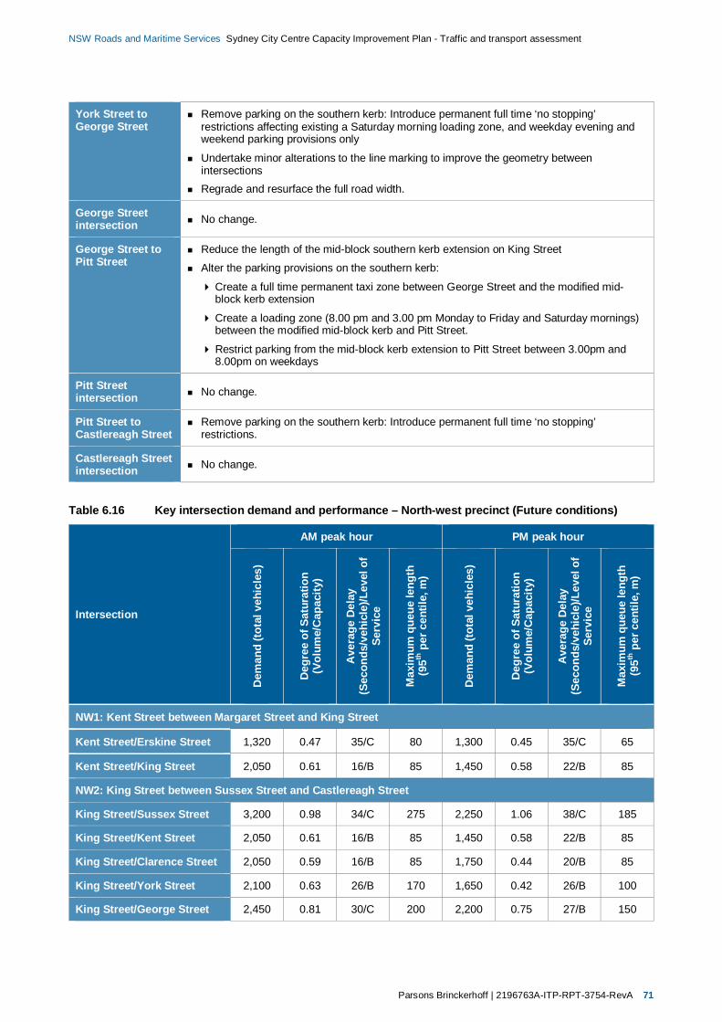
Parsons Brinckerhoff | 2196763A-ITP-RPT-3754-RevA 71
NSW Roads and Maritime Services Sydney City Centre Capacity Improvement Plan - Traffic and transport assessment
York Street toGeorge Street
Remove parking on the southern kerb: Introduce permanent full time ‘no stopping’restrictions affecting existing a Saturday morning loading zone, and weekday evening andweekend parking provisions only
Undertake minor alterations to the line marking to improve the geometry betweenintersectionsRegrade and resurface the full road width.
George Streetintersection No change.
George Street toPitt Street
Reduce the length of the mid-block southern kerb extension on King Street
Alter the parking provisions on the southern kerb:
Create a full time permanent taxi zone between George Street and the modified mid-block kerb extension
Create a loading zone (8.00 pm and 3.00 pm Monday to Friday and Saturday mornings)between the modified mid-block kerb and Pitt Street.
Restrict parking from the mid-block kerb extension to Pitt Street between 3.00pm and8.00pm on weekdays
Pitt Streetintersection No change.
Pitt Street toCastlereagh Street
Remove parking on the southern kerb: Introduce permanent full time ‘no stopping’restrictions.
Castlereagh Streetintersection No change.
Table 6.16 Key intersection demand and performance – North-west precinct (Future conditions)
Intersection
AM peak hour PM peak hour
Dem
and
(tota
lveh
icle
s)
Deg
ree
ofSa
tura
tion
(Vol
ume/
Cap
acity
)
Ave
rage
Del
ay(S
econ
ds/v
ehic
le)/L
evel
ofSe
rvic
e
Max
imum
queu
ele
ngth
(95th
perc
entil
e,m
)
Dem
and
(tota
lveh
icle
s)
Deg
ree
ofSa
tura
tion
(Vol
ume/
Cap
acity
)
Ave
rage
Del
ay(S
econ
ds/v
ehic
le)/L
evel
ofSe
rvic
e
Max
imum
queu
ele
ngth
(95th
perc
entil
e,m
)
NW1: Kent Street between Margaret Street and King Street
Kent Street/Erskine Street 1,320 0.47 35/C 80 1,300 0.45 35/C 65
Kent Street/King Street 2,050 0.61 16/B 85 1,450 0.58 22/B 85
NW2: King Street between Sussex Street and Castlereagh Street
King Street/Sussex Street 3,200 0.98 34/C 275 2,250 1.06 38/C 185
King Street/Kent Street 2,050 0.61 16/B 85 1,450 0.58 22/B 85
King Street/Clarence Street 2,050 0.59 16/B 85 1,750 0.44 20/B 85
King Street/York Street 2,100 0.63 26/B 170 1,650 0.42 26/B 100
King Street/George Street 2,450 0.81 30/C 200 2,200 0.75 27/B 150
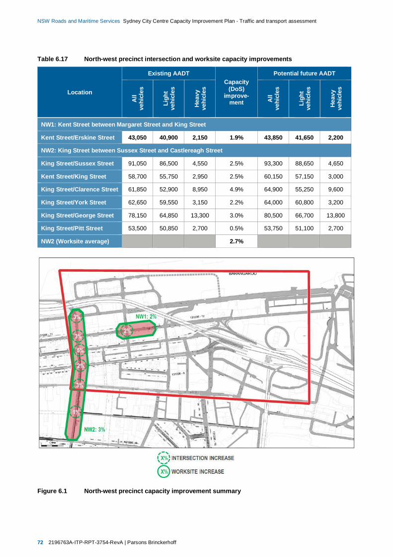
72 2196763A-ITP-RPT-3754-RevA | Parsons Brinckerhoff
NSW Roads and Maritime Services Sydney City Centre Capacity Improvement Plan - Traffic and transport assessment
Table 6.17 North-west precinct intersection and worksite capacity improvements
Location
Existing AADTCapacity
(DoS)improve-
ment
Potential future AADT
All
vehi
cles
Ligh
tve
hicl
es
Hea
vyve
hicl
es
All
vehi
cles
Ligh
tve
hicl
es
Hea
vyve
hicl
es
NW1: Kent Street between Margaret Street and King Street
Kent Street/Erskine Street 43,050 40,900 2,150 1.9% 43,850 41,650 2,200
NW2: King Street between Sussex Street and Castlereagh Street
King Street/Sussex Street 91,050 86,500 4,550 2.5% 93,300 88,650 4,650
Kent Street/King Street 58,700 55,750 2,950 2.5% 60,150 57,150 3,000
King Street/Clarence Street 61,850 52,900 8,950 4.9% 64,900 55,250 9,600
King Street/York Street 62,650 59,550 3,150 2.2% 64,000 60,800 3,200
King Street/George Street 78,150 64,850 13,300 3.0% 80,500 66,700 13,800
King Street/Pitt Street 53,500 50,850 2,700 0.5% 53,750 51,100 2,700
NW2 (Worksite average) 2.7%
Figure 6.1 North-west precinct capacity improvement summary
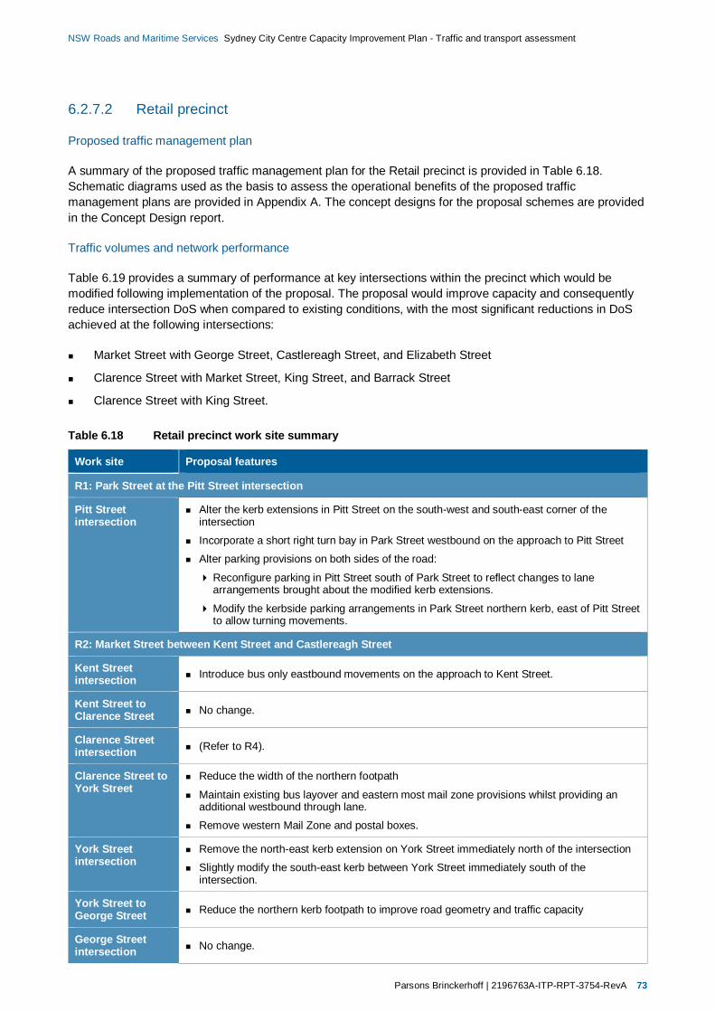
Parsons Brinckerhoff | 2196763A-ITP-RPT-3754-RevA 73
NSW Roads and Maritime Services Sydney City Centre Capacity Improvement Plan - Traffic and transport assessment
6.2.7.2 Retail precinct
Proposed traffic management plan
A summary of the proposed traffic management plan for the Retail precinct is provided in Table 6.18.Schematic diagrams used as the basis to assess the operational benefits of the proposed trafficmanagement plans are provided in Appendix A. The concept designs for the proposal schemes are providedin the Concept Design report.
Traffic volumes and network performance
Table 6.19 provides a summary of performance at key intersections within the precinct which would bemodified following implementation of the proposal. The proposal would improve capacity and consequentlyreduce intersection DoS when compared to existing conditions, with the most significant reductions in DoSachieved at the following intersections:
Market Street with George Street, Castlereagh Street, and Elizabeth Street
Clarence Street with Market Street, King Street, and Barrack Street
Clarence Street with King Street.
Table 6.18 Retail precinct work site summary
Work site Proposal features
R1: Park Street at the Pitt Street intersection
Pitt Streetintersection
Alter the kerb extensions in Pitt Street on the south-west and south-east corner of theintersection
Incorporate a short right turn bay in Park Street westbound on the approach to Pitt Street
Alter parking provisions on both sides of the road:
Reconfigure parking in Pitt Street south of Park Street to reflect changes to lanearrangements brought about the modified kerb extensions.
Modify the kerbside parking arrangements in Park Street northern kerb, east of Pitt Streetto allow turning movements.
R2: Market Street between Kent Street and Castlereagh Street
Kent Streetintersection Introduce bus only eastbound movements on the approach to Kent Street.
Kent Street toClarence Street No change.
Clarence Streetintersection (Refer to R4).
Clarence Street toYork Street
Reduce the width of the northern footpath
Maintain existing bus layover and eastern most mail zone provisions whilst providing anadditional westbound through lane.
Remove western Mail Zone and postal boxes.
York Streetintersection
Remove the north-east kerb extension on York Street immediately north of the intersection
Slightly modify the south-east kerb between York Street immediately south of theintersection.
York Street toGeorge Street Reduce the northern kerb footpath to improve road geometry and traffic capacity
George Streetintersection No change.

74 2196763A-ITP-RPT-3754-RevA | Parsons Brinckerhoff
NSW Roads and Maritime Services Sydney City Centre Capacity Improvement Plan - Traffic and transport assessment
Work site Proposal features
George Street toPitt Street
Alter the parking provisions on the southern kerb:
Relocate the existing coach parking on the southern kerb to the western kerb on PittStreet
Remove a section of loading zone (18–20 metres) on Pitt Street to accommodate coachparking relocated from Market Street
Introduce permanent ‘no stopping’ restrictions on southern kerb of Market Street.
Alter the parking provisions on the northern kerb:
Modify the length of ‘no parking’ adjacent to Swissotel
Create a loading zone (6.00 am–10.00 am) during the early morning and taxi zone for therest of the day in this location
Modify the length of the combination Authorised Parking and Mail Zone.
Pitt Streetintersection No change.
Pitt Street toCastlereagh Street
Alter parking provisions on the southern kerb: Introduce ‘no stopping’ restrictions between6.00 am and 8.00 pm Monday to Friday, and extend an existing taxi zone to operate at othertimes.
Castlereagh Streetintersection No change.
R3: Sussex Street between King Street and Druitt Street
King Streetintersection
Provide a painted median to improve delineation of left turn lane into Sussex Street
Alter the traffic island on the SW corner to facilitate revised lane configuration
Breakout and extend existing south east kerb.
King Street toMarket Street
Remove parking on eastern kerb: Introduce permanent full time ‘no stopping’ restrictions onthe eastern kerb
Alter parking provisions on the western kerb: Reallocate certain parking spaces to loadingzone (6.00 am–6.00 pm and Saturday 6.00am–10.00am)
Slightly modify the southbound lane widths; however no change to turning movements orpriorities.
Market Streetintersection No change.
Market Street toDruitt Street
Remove parking on eastern kerb: Introduce permanent ‘no stopping’ restrictions.
Alter parking provisions on the western kerb:
Reallocate certain parking spaces to loading zone (6.00 am–3.00 pm and Saturday6.00 am–10.00 am)
Extend the operating time and length of the existing taxi zone between 3.00 pm and10.00 pm Monday–Friday
Reconfigure lane markings to provide a minimum of two through lanes at all times south ofMarket Street, and three through lanes from adjacent to the existing recessed taxi rank toDruitt Street.
Druitt Streetintersection No change.
R4: Clarence Street between Jamison Street and Druitt Street
Jamison Streetintersection No change.

Parsons Brinckerhoff | 2196763A-ITP-RPT-3754-RevA 75
NSW Roads and Maritime Services Sydney City Centre Capacity Improvement Plan - Traffic and transport assessment
Work site Proposal features
Jamison Street toMargaret Street
Alter the parking provisions on the eastern kerb:
Introduce full time ‘no stopping’ restrictions
Remove two mobility impaired parking spaces
Remove loading zone provisions which would be replaced elsewhere on the corridor.
Maintain existing full time Bus Zone on the western side
Relocate the bus lane from the western kerb to the adjacent lane.
Margaret Streetintersection No change.
Margaret Street toErskine Street
Alter the parking provisions on the eastern kerb:
Introduce full time ‘no stopping’ restrictions affecting weekday evening and weekendparking as well as loading zones between 7.00 am and 6.00 pm on weekdays andSaturday mornings (Note: the impact of the losses of loading zone would be off-set byadditional loading provisions introduced elsewhere on the corridor)
Alter the parking provisions on the western kerb:
Introduce no stopping between 3.00 pm and 8.00 pm on weekdays
Provide loading zones between bus zones between 6.00 am and 3.00 pm on weekdays
Enable parking between bus zones after 8.00 pm on weekdays and on weekends
Relocate the bus lane from the western kerb northbound lane to the adjacent lane.
Erskine Streetintersection No change.
Erskine Street toBarrack Street
Alter the parking provisions on the eastern kerb:
Introduce full time ‘no stopping’ restrictions affecting weekday evening and weekendparking as well as loading zones between 7.00 am and 6.00 pm on weekdays andSaturday mornings (Note: the impact of the losses of loading zone would be off-set byadditional loading provisions introduced elsewhere on the corridor).
Alter the parking provisions on the western kerb:
Introduce ‘no stopping’ restrictions between 3.00 pm and 8.00 pm on weekdays
Provide loading zones between bus zones between 6.00 am and 3.00 pm on weekdays
Enable parking between bus zones after 8.00 pm on weekdays and on weekends.
Relocate the bus lane from the western kerb northbound lane to the adjacent lane.
Barrack Streetintersection
Remove the two kerb extensions located on the eastern kerb to create an additional lanethrough the intersection.
Barrack Street toKing Street
Remove the mid-block kerb extension located on the eastern kerb in front of Clarence StreetCyclery
Relocate the bicycle parking provisions
Create an additional northbound lane to allow the relocation of the bus lane
Alter the parking provisions on the eastern kerb:
Lengthen the extent of full time ‘no stopping’ restrictions on the approach to BarrackStreet
Modify remaining loading zones on the eastern side to operate between 6.00 am–10.00 am on weekdays and extend across the area of the removed mid-block kerbextension.
Alter the parking provisions on the western kerb:
Introduce ‘no stopping’ restrictions between 3.00 pm and 8.00 pm on weekdays
Provide loading zones between bus zones between 6.00 am and 3.00 pm on weekdays
Enable parking between bus zones after 8.00 pm on weekdays and on weekends
Relocate the bus lane from the western kerb northbound lane to the adjacent lane.
76 2196763A-ITP-RPT-3754-RevA | Parsons Brinckerhoff
NSW Roads and Maritime Services Sydney City Centre Capacity Improvement Plan - Traffic and transport assessment
Work site Proposal features
King Streetintersection
Remove the kerb extension on the eastern kerb on Clarence Street immediately north of theintersection.
King Street toMarket Street
Alter the parking provisions on the eastern kerb:
Extend full time no stopping restriction on the approach to King Street.
Modify the timing provisions of loading zones
Remove two mobility impaired parking spaces and a single consular vehicle parkingspace.
Alter the parking provisions on the western kerb:
Introduce ‘no stopping’ restrictions between 3.00 pm and 8.00 pm on weekdays
Provide loading zones between bus zones between 6.00 am and 3.00 pm on weekdays Enable parking between bus zones after 8.00 pm on weekdays and on weekends.
Relocate the bus lane from the western kerb northbound lane to the adjacent lane.
Market Streetintersection
Create a new kerb extension in Clarence Street on the north-west corner of the intersection
Slightly cut back the northern kerb of Market Street on the north-west corner of theintersection
Market Street toDruitt Street No changes.
Druitt Streetintersection No changes.
R5: York Street between King Street and Druitt Street
King Streetintersection
Modify line marking in York Street through the intersection to improve the geometry.
Minor reduction to the kerb extension on the western kerb of York Street immediately southof the intersection
Widen the pedestrian crossing in York Street on the southern side of the intersection.
King Street toMarket Street
Remove mid-block signals and kerb extension adjacent to Grace Hotel and modify/adjustadjacent kerbside parking.
Market Streetintersection
Remove the north-east kerb extension on York Street immediately north of the intersection
Slightly modify the south-east kerb between York Street immediately south of theintersection.
Market Street toDruitt Street
Slightly realign the traffic lanes to improve bus flows and operations adjacent to the QueenVictoria Building.
Slightly adjust the southbound lane widths; however no change to associated footpathwidths.
Druitt Streetintersection No change.
The estimated cumulative benefits to intersection and worksite corridor capacities are summarised inTable 6.20 and illustrated in Figure 6.2, which indicate increases of approximately:
13 per cent in the vicinity of the Park Street and Pitt Street intersection
26 per cent on Market Street between Kent Street and Castlereagh Street
15 per cent on Sussex Street between King Street and Druitt Street
13 per cent on Clarence Street between Jamison Street and Druitt Street
15 per cent on York Street between King Street and Druitt Street.
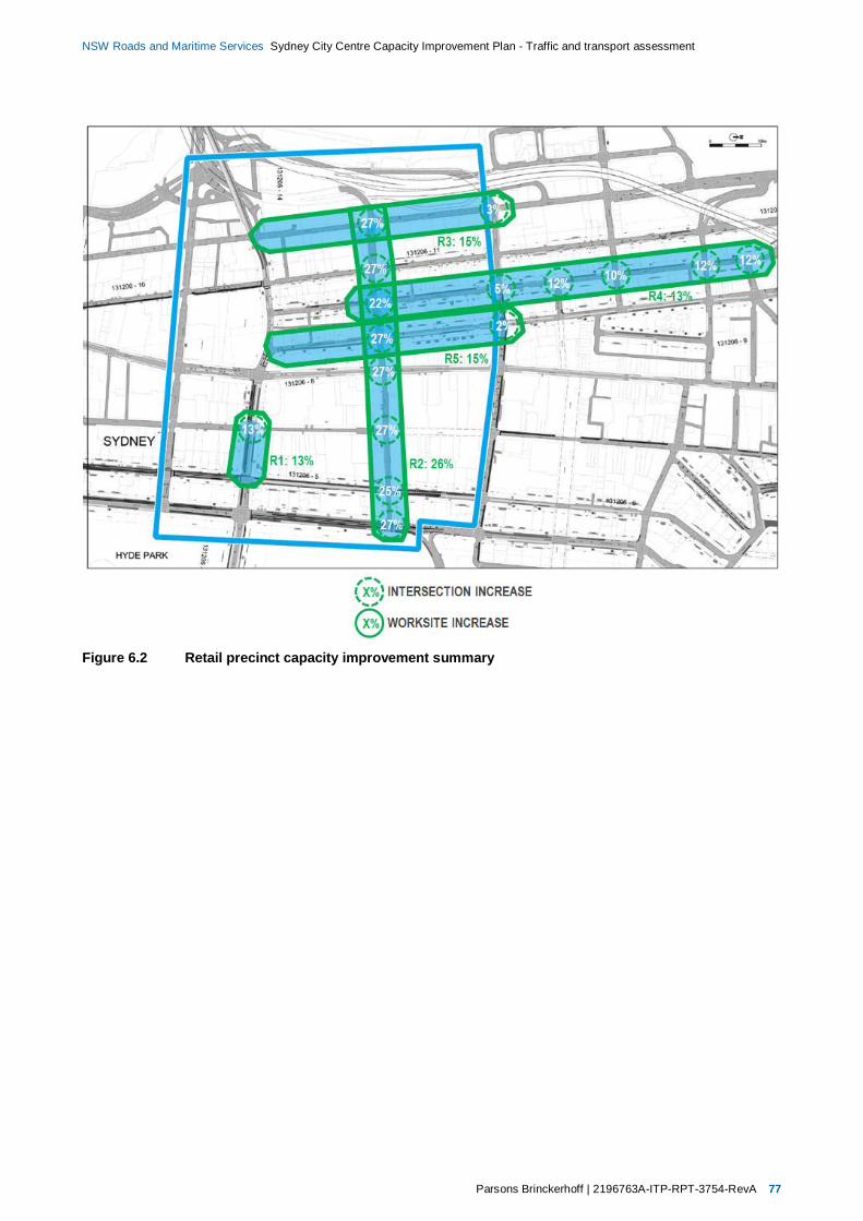
Parsons Brinckerhoff | 2196763A-ITP-RPT-3754-RevA 77
NSW Roads and Maritime Services Sydney City Centre Capacity Improvement Plan - Traffic and transport assessment
Figure 6.2 Retail precinct capacity improvement summary
78 2196763A-ITP-RPT-3754-RevA | Parsons Brinckerhoff
NSW Roads and Maritime Services Sydney City Centre Capacity Improvement Plan - Traffic and transport assessment
Table 6.19 Key intersection performance – Retail precinct (Future conditions)
Intersection
AM peak hour PM peak hour
Dem
and
(tota
lveh
icle
s)
Deg
ree
ofSa
tura
tion
(Vol
ume/
Cap
acity
)
Ave
rage
Del
ay(S
econ
ds/v
ehic
le)/L
evel
ofSe
rvic
e
Max
imum
queu
ele
ngth
(95th
perc
entil
e,m
)
Dem
and
(tota
lveh
icle
s)
Deg
ree
ofSa
tura
tion
(Vol
ume/
Cap
acity
)
Ave
rage
Del
ay(S
econ
ds/v
ehic
le)/L
evel
ofSe
rvic
e
Max
imum
queu
ele
ngth
(95th
perc
entil
e,m
)
R1: Park Street at the Pitt Street intersection
Park Street/Pitt Street 1,350 0.91 20/B 110 1,200 0.67 15/A 70
R2: Market Street between Kent Street and Castlereagh Street
Market Street/Kent Street 1,950 0.55 21/B 85 2,100 0.62 20/B 85
Market Street/Clarence Street 1,850 0.52 17/B 75 2,050 0.52 16/B 75
Market Street/York Street 1,700 0.79 29/C 90 1,750 0.55 23/B 70
Market Street/George Street 800 0.25 9/A 30 950 0.30 9/A 35
Market Street/Pitt Street 900 0.47 19/B 45 1,150 0.67 22/B 65
Market Street/Castlereagh Street 1,350 0.63 24/B 130 1,350 0.71 25/B 110
R3: Sussex Street between King Street and Druitt Street
Sussex Street/King Street 3,200 0.98 34/C 275 2,250 1.06 38/C 185
R4: Clarence Street between Jamison Street and Druitt Street
Clarence Street/Jamison Street 1,200 0.63 21/B 85 1,250 0.46 16/B 90
Clarence Street/Margaret Street 1,350 0.56 23/B 100 1,500 0.80 27/C 90
Clarence Street/Erskine Street 1,200 0.41 14/A 40 1,300 0.43 14/A 30
Clarence Street/Barrack Street 750 0.29 10/A 30 950 0.30 10/A 30
Clarence Street/King Street 2,050 0.59 16/B 85 1,750 0.44 20/B 85
Clarence Street/Market Street 1,850 0.52 17/B 75 2,050 0.52 16/B 75
R5: York Street between King Street and Druitt Street
York Street/King Street 2,100 0.63 26/B 170 1,650 0.42 26/B 100
York Street/Market Street 1,700 0.79 29/C 90 1,750 0.55 23/B 70
Parsons Brinckerhoff | 2196763A-ITP-RPT-3754-RevA 79
NSW Roads and Maritime Services Sydney City Centre Capacity Improvement Plan - Traffic and transport assessment
Table 6.20 Retail precinct intersection and worksite capacity improvements
Location
Existing AADTCapacity
(DoS)improve-
ment
Potential future AADT
All
vehi
cles
Ligh
tve
hicl
es
Hea
vyve
hicl
es
All
vehi
cles
Ligh
tve
hicl
es
Hea
vyve
hicl
es
R1: Park Street at the Pitt Street intersection
Park Street/Pitt Street 42,850 33,700 9,200 12.7% 48,300 37,950 10,350
R2: Market Street between Kent Street and Castlereagh Street
Market Street/Sussex Street 80,400 76,400 4,000 26.9% 102,050 96,950 5,100
Market Street/Kent Street 68,800 65,350 3,450 26.5% 87,050 82,700 4,350
Market Street/Clarence Street 65,100 57,350 7,750 21.7% 79,250 70,400 8,850
Market Street/York Street 57,050 51,050 6,000 26.5% 72,150 64,600 7,550
Market Street/George Street 63,700 60,500 3,200 26.9% 46,950 44,600 2,350
Market Street/Pitt Street 34,800 33,050 1,750 27.0% 44,200 41,200 2,200
Market Street/Castlereagh Street 45,400 37,800 7,600 25.3% 56,900 47,350 9,600
Market Street/Elizabeth Street 69,450 51,400 18,000 26.5% 87,850 65,050 22,800
R2 (Worksite average) 25.9%
R3: Sussex Street between King Street and Druitt Street
Sussex Street/King Street 91,050 86,500 4,550 2.5% 93,300 88,650 4,650
Sussex Street/Market Street 80,400 76,400 4,000 26.9% 102,050 96,950 5,100
R3 (Worksite Average) 15.2%
R4: Clarence Street between Jamison Street and Druitt Street
Clarence Street/Jamison Street 41,250 30,200 11,000 11.5% 46,000 33,700 12,300
Clarence Street/Margaret Street 48,350 38,400 10,000 11.6% 53,950 42,850 11,150
Clarence Street/Erskine Street 44,950 35,500 9,400 10.2% 49,550 39,100 10,450
Clarence Street/Barrack Street 28,500 20,450 8,050 11.6% 31,800 22,800 9,000
Clarence Street/King Street 61,850 52,900 8,950 4.9% 64,900 55,250 9,600
Clarence Street/Market Street 65,100 57,350 7,750 21.7% 79,250 70,400 8,850
R4 (Worksite average) 12.5%
R5: York Street between King Street and Druitt Street
York Street/Market Street 57,050 51,050 6,000 26.5% 72,150 64,600 7,550
York Street/King Street 62,650 59,550 3,150 2.2% 64,000 60,800 3,200
R5 (Worksite average) 15.0%

80 2196763A-ITP-RPT-3754-RevA | Parsons Brinckerhoff
NSW Roads and Maritime Services Sydney City Centre Capacity Improvement Plan - Traffic and transport assessment
6.2.7.3 Southern precinct
Proposed traffic management plan
A summary of the proposed traffic management plan for the Southern precinct is provided in Table 6.21.Schematic diagrams used as the basis to assess the operational benefits of the proposed trafficmanagement plans are provided in Appendix A. The concept designs for the proposal schemes are providedin the Concept Design report.
Traffic volumes and network performance
Table 6.22 provides a summary of performance at key intersections within the precinct which would bemodified following implementation of the proposal. The proposal would improve capacity and consequentlyreduce intersection DoS when compared to existing conditions, with the most significant reductions in DoSachieved at the following intersections:
Sussex Street with Liverpool Street
Pitt Street with Campbell Street
Ultimo Road with Harris Street.
The estimated cumulative benefits to intersection and worksite corridor capacities are summarised inTable 6.23 and illustrated in Figure 6.3, which indicate increases of approximately:
2 per cent on Sussex Street between Liverpool Street and Goulburn Street
10 per cent in the vicinity of the Goulburn Street and George Street intersection
10 per cent on Pitt Street between Liverpool Street and Rawson Place.
The proposal would improve the overall traffic capacity across the Southern precinct. However, as a result ofthe implementation of the proposal at the Pitt Street/George Street/Lee Street intersection, capacity at thislocation would be reduced by around three per cent when compared to the existing configuration.
The reduction in capacity would be the result of the reconfiguration of the second lane on the north-eastbound George Street approach. This lane currently provides a second left turn lane onto George Streetnorthbound. The proposal would convert this lane into a north-eastbound through lane for traffic travellingfrom George Street to Pitt Street, with a short exit lane of approximately 40 m provided on the Pitt Street exitto accommodate three lanes of traffic through the intersection, as shown in Appendix A3 (Table A3.1).
Although the reconfiguration would reduce overall potential intersection capacity, the proposal would providea targeted capacity increase for the George Street to Pitt Street through movement. Demand for thismovement is expected to increase following the pedestrianisation of George Street, with Pitt Street andconnecting routes used as alternatives for displaced traffic travelling to and through the city centre.
Traffic conditions without the proposal are expected to deteriorate when compared to existing conditions, asthe anticipated change in demand and traffic patterns would result in the intersection operating over capacityfor particular movements. Conversely the modelled performance of the intersection including the proposalindicates that performance improvements including reduced delays and queuing would be created whencompared to existing conditions, despite the marginal reduction in overall intersection capacity.
Additional sensitivity modelling has also been undertaken for the Pitt Street/George Street/Lee Streetintersection, re-distributing 50 per cent of existing demand travelling to and from the northern George Streetarm, to equivalent movements using the north-eastern Pitt Street arm. The results of this modelling indicateexisting performance levels would be maintained despite the change in traffic patterns.
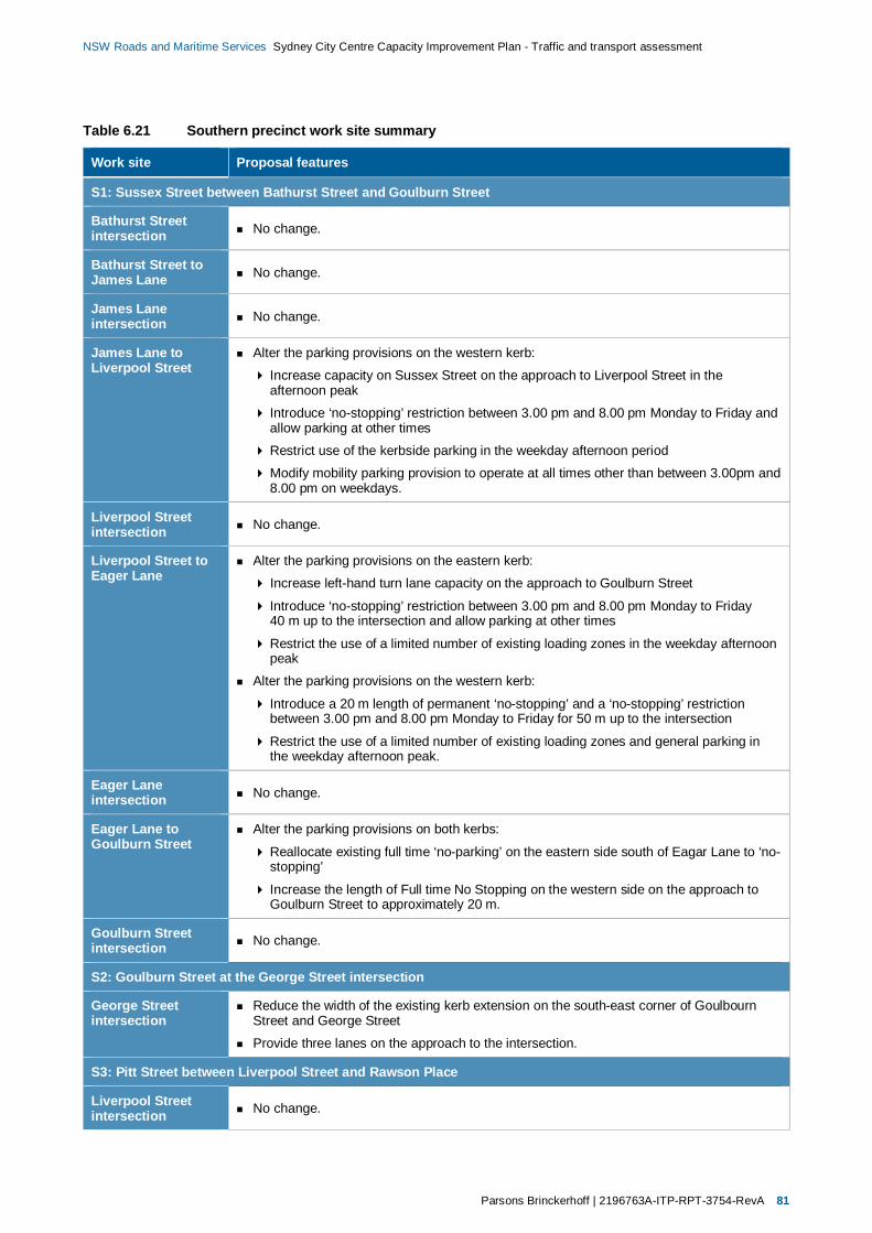
Parsons Brinckerhoff | 2196763A-ITP-RPT-3754-RevA 81
NSW Roads and Maritime Services Sydney City Centre Capacity Improvement Plan - Traffic and transport assessment
Table 6.21 Southern precinct work site summary
Work site Proposal features
S1: Sussex Street between Bathurst Street and Goulburn Street
Bathurst Streetintersection No change.
Bathurst Street toJames Lane No change.
James Laneintersection No change.
James Lane toLiverpool Street
Alter the parking provisions on the western kerb:
Increase capacity on Sussex Street on the approach to Liverpool Street in theafternoon peak
Introduce ‘no-stopping’ restriction between 3.00 pm and 8.00 pm Monday to Friday andallow parking at other times
Restrict use of the kerbside parking in the weekday afternoon period
Modify mobility parking provision to operate at all times other than between 3.00pm and8.00 pm on weekdays.
Liverpool Streetintersection No change.
Liverpool Street toEager Lane
Alter the parking provisions on the eastern kerb:
Increase left-hand turn lane capacity on the approach to Goulburn Street
Introduce ‘no-stopping’ restriction between 3.00 pm and 8.00 pm Monday to Friday40 m up to the intersection and allow parking at other times
Restrict the use of a limited number of existing loading zones in the weekday afternoonpeak
Alter the parking provisions on the western kerb:
Introduce a 20 m length of permanent ‘no-stopping’ and a ‘no-stopping’ restrictionbetween 3.00 pm and 8.00 pm Monday to Friday for 50 m up to the intersection
Restrict the use of a limited number of existing loading zones and general parking inthe weekday afternoon peak.
Eager Laneintersection No change.
Eager Lane toGoulburn Street
Alter the parking provisions on both kerbs:
Reallocate existing full time ‘no-parking’ on the eastern side south of Eagar Lane to ‘no-stopping’
Increase the length of Full time No Stopping on the western side on the approach toGoulburn Street to approximately 20 m.
Goulburn Streetintersection No change.
S2: Goulburn Street at the George Street intersection
George Streetintersection
Reduce the width of the existing kerb extension on the south-east corner of GoulbournStreet and George Street
Provide three lanes on the approach to the intersection.
S3: Pitt Street between Liverpool Street and Rawson Place
Liverpool Streetintersection No change.
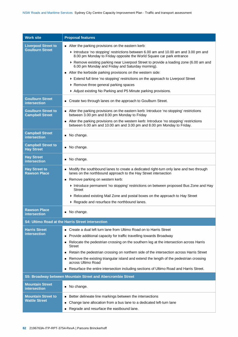
82 2196763A-ITP-RPT-3754-RevA | Parsons Brinckerhoff
NSW Roads and Maritime Services Sydney City Centre Capacity Improvement Plan - Traffic and transport assessment
Work site Proposal features
Liverpool Street toGoulburn Street
Alter the parking provisions on the eastern kerb:
Introduce ‘no stopping’ restrictions between 6.00 am and 10.00 am and 3.00 pm and8.00 pm Monday to Friday opposite the World Square car park entrance
Remove existing parking near Liverpool Street to provide a loading zone (6.00 am and6.00 pm Monday and Friday and Saturday morning).
Alter the kerbside parking provisions on the western side:
Extend full time ‘no stopping’ restrictions on the approach to Liverpool Street
Remove three general parking spaces
Adjust existing No Parking and P5 Minute parking provisions.
Goulburn Streetintersection Create two through lanes on the approach to Goulburn Street.
Goulburn Street toCampbell Street
Alter the parking provisions on the eastern kerb: Introduce ‘no stopping’ restrictionsbetween 3.00 pm and 8.00 pm Monday to Friday
Alter the parking provisions on the western kerb: Introduce ‘no stopping’ restrictionsbetween 6.00 am and 10.00 am and 3.00 pm and 8.00 pm Monday to Friday.
Campbell Streetintersection No change.
Campbell Street toHay Street No change.
Hay Streetintersection No change.
Hay Street toRawson Place
Modify the southbound lanes to create a dedicated right-turn only lane and two throughlanes on the northbound approach to the Hay Street intersection
Remove parking on western kerb:
Introduce permanent ‘no stopping’ restrictions on between proposed Bus Zone and HayStreet
Relocated existing Mail Zone and postal boxes on the approach to Hay Street
Regrade and resurface the northbound lanes.
Rawson Placeintersection No change.
S4: Ultimo Road at the Harris Street intersection
Harris Streetintersection
Create a dual left turn lane from Ultimo Road on to Harris Street
Provide additional capacity for traffic travelling towards Broadway
Relocate the pedestrian crossing on the southern leg at the intersection across HarrisStreet
Retain the pedestrian crossing on northern side of the intersection across Harris Street
Remove the existing triangular island and extend the length of the pedestrian crossingacross Ultimo Road
Resurface the entire intersection including sections of Ultimo Road and Harris Street.
S5: Broadway between Mountain Street and Abercrombie Street
Mountain Streetintersection No change.
Mountain Street toWattle Street
Better delineate line markings between the intersections
Change lane allocation from a bus lane to a dedicated left-turn lane
Regrade and resurface the eastbound lane.
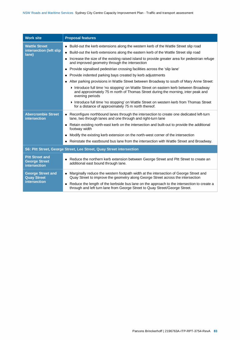
Parsons Brinckerhoff | 2196763A-ITP-RPT-3754-RevA 83
NSW Roads and Maritime Services Sydney City Centre Capacity Improvement Plan - Traffic and transport assessment
Work site Proposal features
Wattle Streetintersection (left sliplane)
Build-out the kerb extensions along the western kerb of the Wattle Street slip road
Build-out the kerb extensions along the eastern kerb of the Wattle Street slip road
Increase the size of the existing raised island to provide greater area for pedestrian refugeand improved geometry through the intersection
Provide signalised pedestrian crossing facilities across the ‘slip lane’
Provide indented parking bays created by kerb adjustments
Alter parking provisions in Wattle Street between Broadway to south of Mary Anne Street:
Introduce full time ‘no stopping’ on Wattle Street on eastern kerb between Broadwayand approximately 75 m north of Thomas Street during the morning, inter peak andevening periods
Introduce full time ‘no stopping’ on Wattle Street on western kerb from Thomas Streetfor a distance of approximately 75 m north thereof.
Abercrombie Streetintersection
Reconfigure northbound lanes through the intersection to create one dedicated left-turnlane, two through lanes and one through and right-turn lane
Retain existing north-east kerb on the intersection and built-out to provide the additionalfootway width
Modify the existing kerb extension on the north-west corner of the intersection
Reinstate the eastbound bus lane from the intersection with Wattle Street and Broadway.
S6: Pitt Street, George Street, Lee Street, Quay Street intersection
Pitt Street andGeorge Streetintersection
Reduce the northern kerb extension between George Street and Pitt Street to create anadditional east bound through lane.
George Street andQuay Streetintersection
Marginally reduce the western footpath width at the intersection of George Street andQuay Street to improve the geometry along George Street across the intersection
Reduce the length of the kerbside bus lane on the approach to the intersection to create athrough and left turn lane from George Street to Quay Street/George Street.

84 2196763A-ITP-RPT-3754-RevA | Parsons Brinckerhoff
NSW Roads and Maritime Services Sydney City Centre Capacity Improvement Plan - Traffic and transport assessment
Table 6.22 Key intersection performance – Southern precinct (Future conditions)
Intersection
AM peak hour PM peak hour
Dem
and
(tota
lveh
icle
s)
Deg
ree
ofSa
tura
tion
(Vol
ume/
Cap
acity
)
Ave
rage
Del
ay(S
econ
ds/v
ehic
le)/L
evel
ofSe
rvic
e
Max
imum
queu
ele
ngth
(95th
perc
entil
e,m
)
Dem
and
(tota
lveh
icle
s)
Deg
ree
ofSa
tura
tion
(Vol
ume/
Cap
acity
)
Ave
rage
Del
ay(S
econ
ds/v
ehic
le)/L
evel
ofSe
rvic
e
Max
imum
queu
ele
ngth
(95th
perc
entil
e,m
)
S1: Sussex Street between Bathurst Street and Goulburn Street
Sussex Street/Liverpool Street 700 0.47 17/B 35 1,150 0.57 25/B 80
Sussex Street/Goulburn Street 2,450 0.95 11/A 110 2,600 0.91 12/A 65
S2: Goulburn Street at the George Street intersection
George Street/Goulburn Street 4,000 0.96 34/C 395 3,300 0.87 28/B 250
S3: Pitt Street between Liverpool Street and Rawson Place
Pitt Street/Liverpool Street 1,400 0.47 13/A 60 1,400 0.44 15/B 60
Pitt Street/Goulburn Street 2,550 1.58 53/D 240 2,650 1.29 33/C 140
Pitt Street/Campbell Street 800 0.24 21/B 50 850 0.21 21/B 40
Pitt Street/Hay Street 900 0.69 37/C 80 1,000 0.92 46/D 145
Pitt Street/Rawson Place 2,900 0.84 31/C 195 3,250 0.86 32/C 190
S4: Ultimo Road at the Harris Street intersection
Ultimo Road/Harris Street 2,350 0.49 12/A 115 2,750 0.59 20/B 170
S5: Broadway between Mountain Street and Abercrombie Street
Broadway/Wattle Street/Abercrombie Street 5,150 0.88 34/C 245 5,200 0.92 38/D 260
S6: Pitt Street, George Street, Lee Street, Quay Street intersection
Pitt Street/George Street/Lee Street/Quay Street 3,700 0.71 34/C 160 3,950 0.67 36/D 120
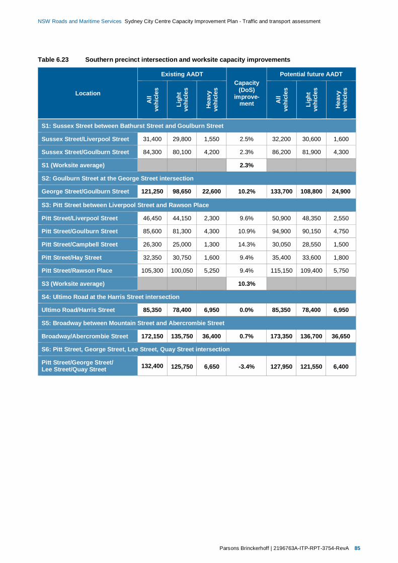
Parsons Brinckerhoff | 2196763A-ITP-RPT-3754-RevA 85
NSW Roads and Maritime Services Sydney City Centre Capacity Improvement Plan - Traffic and transport assessment
Table 6.23 Southern precinct intersection and worksite capacity improvements
Location
Existing AADTCapacity
(DoS)improve-
ment
Potential future AADT
All
vehi
cles
Ligh
tve
hicl
es
Hea
vyve
hicl
es
All
vehi
cles
Ligh
tve
hicl
es
Hea
vyve
hicl
es
S1: Sussex Street between Bathurst Street and Goulburn Street
Sussex Street/Liverpool Street 31,400 29,800 1,550 2.5% 32,200 30,600 1,600
Sussex Street/Goulburn Street 84,300 80,100 4,200 2.3% 86,200 81,900 4,300
S1 (Worksite average) 2.3%
S2: Goulburn Street at the George Street intersection
George Street/Goulburn Street 121,250 98,650 22,600 10.2% 133,700 108,800 24,900
S3: Pitt Street between Liverpool Street and Rawson Place
Pitt Street/Liverpool Street 46,450 44,150 2,300 9.6% 50,900 48,350 2,550
Pitt Street/Goulburn Street 85,600 81,300 4,300 10.9% 94,900 90,150 4,750
Pitt Street/Campbell Street 26,300 25,000 1,300 14.3% 30,050 28,550 1,500
Pitt Street/Hay Street 32,350 30,750 1,600 9.4% 35,400 33,600 1,800
Pitt Street/Rawson Place 105,300 100,050 5,250 9.4% 115,150 109,400 5,750
S3 (Worksite average) 10.3%
S4: Ultimo Road at the Harris Street intersection
Ultimo Road/Harris Street 85,350 78,400 6,950 0.0% 85,350 78,400 6,950
S5: Broadway between Mountain Street and Abercrombie Street
Broadway/Abercrombie Street 172,150 135,750 36,400 0.7% 173,350 136,700 36,650
S6: Pitt Street, George Street, Lee Street, Quay Street intersection
Pitt Street/George Street/Lee Street/Quay Street 132,400 125,750 6,650 -3.4% 127,950 121,550 6,400
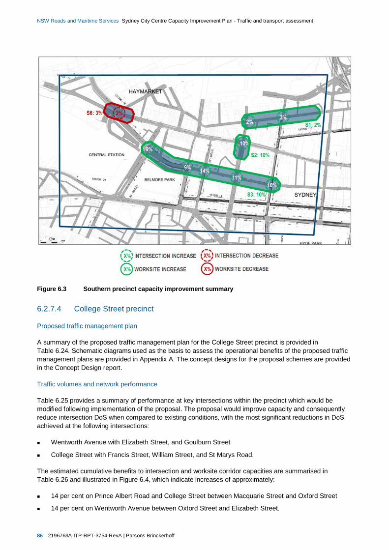
86 2196763A-ITP-RPT-3754-RevA | Parsons Brinckerhoff
NSW Roads and Maritime Services Sydney City Centre Capacity Improvement Plan - Traffic and transport assessment
Figure 6.3 Southern precinct capacity improvement summary
6.2.7.4 College Street precinct
Proposed traffic management plan
A summary of the proposed traffic management plan for the College Street precinct is provided inTable 6.24. Schematic diagrams used as the basis to assess the operational benefits of the proposed trafficmanagement plans are provided in Appendix A. The concept designs for the proposal schemes are providedin the Concept Design report.
Traffic volumes and network performance
Table 6.25 provides a summary of performance at key intersections within the precinct which would bemodified following implementation of the proposal. The proposal would improve capacity and consequentlyreduce intersection DoS when compared to existing conditions, with the most significant reductions in DoSachieved at the following intersections:
Wentworth Avenue with Elizabeth Street, and Goulburn Street
College Street with Francis Street, William Street, and St Marys Road.
The estimated cumulative benefits to intersection and worksite corridor capacities are summarised inTable 6.26 and illustrated in Figure 6.4, which indicate increases of approximately:
14 per cent on Prince Albert Road and College Street between Macquarie Street and Oxford Street
14 per cent on Wentworth Avenue between Oxford Street and Elizabeth Street.

Parsons Brinckerhoff | 2196763A-ITP-RPT-3754-RevA 87
NSW Roads and Maritime Services Sydney City Centre Capacity Improvement Plan - Traffic and transport assessment
Table 6.24 College Street precinct work site summary
Work site Proposal features
C1: Wentworth Avenue between Oxford Street and Campbell Street
Oxford Streetintersection
Alter the lane configuration on the northbound approach to the intersection to create anadditional northbound lane comprising three through-lanes (one of which would also be aleft-turn lane) and two dedicated right-turn lanes
Remove the kerb extensions on south-east corner of the intersection
Regrade and resurface the intersection.
Oxford Street toWemyss Lane
Remove parking on the eastern kerb: Introduce permanent ‘no stopping’ restrictions
Alter the parking provisions on the western kerb: Introduce ‘no stopping between 6.00 amand 10.00 am and 3.00 pm and 8.00 pm Monday to Friday.
Wemyss Laneintersection No change.
Wemyss Lane toGoulburn Street
Improve the kerb alignment immediately north of Lyons Lane on the western kerbImprove the kerb alignment immediately north of Commonwealth Street on the western kerb
Restrict the general parking and motorbike parking on the eastern kerb:
Introduce ‘no stopping’ during the weekday morning and afternoon periods
Provide an additional loading zone in the inter peak period
Alter the parking and loading provisions on the western kerb: Introduce ‘no stopping’between 6.00 am and 10.00 am and 3.00 pm and 8.00 pm Monday to Friday.
Goulburn Streetintersection
Modify Wentworth Avenue at the northern end of the intersection
Realign the existing central median north of the intersection approximately 1–1.5 m to thewest
Reduce the southbound lane widths on the approach to the intersection to create foursouthbound lanes (three through-lanes (one of which would also be a left-turn lane) and onededicated right-turn lane
Modify Wentworth Avenue immediately north of the Hunt Street intersection
Realign the existing central median north of the intersection approximately 1–1.5 m to theeast
Reduce the southbound lane widths on the approach to the intersection to create fournorthbound lanes over the existing three lanes (comprising three through-lanes and onededicated right-turn lane)Modify Wentworth Avenue immediately south of the Hunt Street intersection
Realign existing central median north of the intersection approximately 1–1.5 m to the east
Reduce the southbound lane widths on the approach to the intersection to create fournorthbound lanes over the existing three lanes (comprising three through-lanes; one ofwhich is also a left-turn lane; and one dedicated right-turn slip lane)
Relocate the eastbound approach median from Goulburn Street to Wentworth Avenue
Reduce the size of the pedestrian island from the northbound to westbound slip road fromWentworth Avenue to Goulburn Street.
Goulburn Street toCampbell Street
Alter the parking, loading zone and motorcycle provisions on the eastern kerb:
Introduce ‘no stopping’ between 6.00 am and 10.00 am and 3.00 pm and 8.00 pmMonday to Friday
Alter the parking and loading provisions on the western kerb:
Extend the length of the existing full time ‘no stopping’ on the intersection approach toGoulburn Street’
Alter the northbound lanes to create four traffic lanes to replace the existing three lanes.
Campbell Streetintersection
Modify Wentworth Avenue at the northern end of the intersection
Realign the existing central median north of the intersection approximately 1.0 m to enablethe creation of three northbound through lanes.
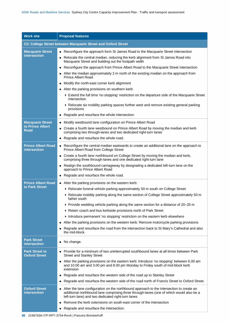
88 2196763A-ITP-RPT-3754-RevA | Parsons Brinckerhoff
NSW Roads and Maritime Services Sydney City Centre Capacity Improvement Plan - Traffic and transport assessment
Work site Proposal features
C2: College Street between Macquarie Street and Oxford Street
Macquarie Streetintersection
Reconfigure the approach form St James Road to the Macquarie Street intersection
Relocate the central median, reducing the kerb alignment from St James Road intoMacquarie Street and building out the footpath width
Reconfigure the approach from Prince Albert Road to the Macquarie Street intersection
Alter the median approximately 2 m north of the existing median on the approach fromPrince Albert Road
Modify the north-east corner kerb alignment
Alter the parking provisions on southern kerb:
Extend the full time ‘no stopping’ restriction on the departure side of the Macquarie Streetintersection
Relocate six mobility parking spaces further west and remove existing general parkingprovisions
Regrade and resurface the whole intersection.
Macquarie Streetto Prince AlbertRoad
Modify westbound lane configuration on Prince Albert Road
Create a fourth lane westbound on Prince Albert Road by moving the median and kerbcomprising two through-lanes and two dedicated right-turn lanesRegrade and resurface the whole road.
Prince Albert Roadintersection
Reconfigure the central median eastwards to create an additional lane on the approach toPrince Albert Road from College Street
Create a fourth lane northbound on College Street by moving the median and kerb,comprising three through-lanes and one dedicated right-turn lane
Realign the southbound carriageway by designating a dedicated left-turn lane on theapproach to Prince Albert Road
Regrade and resurface the whole road.
Prince Albert Roadto Park Street
Alter the parking provisions on the eastern kerb:
Relocate funeral vehicle parking approximately 50 m south on College Street
Relocate mobility parking along the same section of College Street approximately 50 mfather south
Provide wedding vehicle parking along the same section for a distance of 20–25 m
Retain coach and bus kerbside provisions north of Park Street
Introduce permanent ‘no stopping’ restriction on the eastern kerb elsewhere
Alter the parking provisions on the western kerb: Remove motorcycle parking provisions
Regrade and resurface the road from the intersection back to St Mary’s Cathedral and alsothe mid-block.
Park Streetintersection No change.
Park Street toOxford Street
Provide for a minimum of two uninterrupted southbound lanes at all times between ParkStreet and Stanley Street
Alter the parking provisions on the eastern kerb: Introduce ‘no stopping’ between 6.00 amand 10.00 am and 3.00 pm and 8.00 pm Monday to Friday south of mid-block kerbextension
Regrade and resurface the western side of the road up to Stanley Street
Regrade and resurface the western side of the road north of Francis Street to Oxford Street.
Oxford Streetintersection
Alter the lane configuration on the northbound approach to the intersection to create anadditional northbound lane comprising three through-lanes (one of which would also be aleft-turn lane) and two dedicated right-turn lanesRemove the kerb extensions on south-east corner of the intersection
Regrade and resurface the intersection.

Parsons Brinckerhoff | 2196763A-ITP-RPT-3754-RevA 89
NSW Roads and Maritime Services Sydney City Centre Capacity Improvement Plan - Traffic and transport assessment
Table 6.25 Key intersection performance – College Street precinct (Future conditions)
Intersection
AM peak hour PM peak hour
Dem
and
(tota
lveh
icle
s)
Deg
ree
ofSa
tura
tion
(Vol
ume/
Cap
acity
)
Ave
rage
Del
ay(S
econ
ds/v
ehic
le)/L
evel
ofSe
rvic
e
Max
imum
queu
ele
ngth
(95th
perc
entil
e,m
)
Dem
and
(tota
lveh
icle
s)
Deg
ree
ofSa
tura
tion
(Vol
ume/
Cap
acity
)
Ave
rage
Del
ay(S
econ
ds/v
ehic
le)/L
evel
ofSe
rvic
e
Max
imum
queu
ele
ngth
(95th
perc
entil
e,m
)
C1: Wentworth Avenue between Oxford Street and Campbell Street
Wentworth Avenue/Oxford Street/College Street 3,750 1.04 51/D 245 3,900 1.01 49/D 195
Wentworth Avenue/Goulburn Street 2,750 0.68 32/C 105 3,150 0.68 32/C 120
Wentworth Avenue/Elizabeth Street 2,950 0.71 20/B 95 3,150 0.63 26/B 110
C2: College Street between Macquarie Street and Oxford Street
Prince Albert Road/Macquarie Street 2,250 0.75 30/C 105 2,450 1.25 49/D 195
College Street/St Marys Road 2,250 0.44 23/B 75 2,450 0.57 25/B 140
College Street/William Street 3,550 1.07 74/F 340 3,750 0.81 45/D 145
College Street/Francis Street 1,750 0.25 6/A 45 2,000 0.28 8/A 50
Table 6.26 College Street precinct intersection and worksite capacity improvements
Location
Existing AADTCapacity
(DoS)improve-
ment
Potential future AADT
All
vehi
cles
Ligh
tve
hicl
es
Hea
vyve
hicl
es
All
vehi
cles
Ligh
tve
hicl
es
Hea
vyve
hicl
es
C1: Wentworth Avenue between Oxford Street and Campbell Street
Wentworth Avenue/Oxford Street/College St 130,400 106,350 24,050 13.5% 148,050 120,750 27,300
Wentworth Avenue/Goulburn Street 70,750 67,200 3,550 13.4% 80,250 76,250 4,000
Wentworth Avenue/Elizabeth Street 101,300 96,250 5,050 13.5% 115,000 109,250 5,750
C1 (Worksite average) 13.5%
C2: College Street between Macquarie Street and Oxford Street
Prince Albert Road/Macquarie Street 34,100 32,400 1,700 13.6% 38,750 36,800 1,950
College Street/St Marys Road 45,550 43,250 2,300 13.5% 51,700 49,150 2,600
College Street/William Street 123,850 102,450 21,350 13.5% 140,600 116,350 24,250
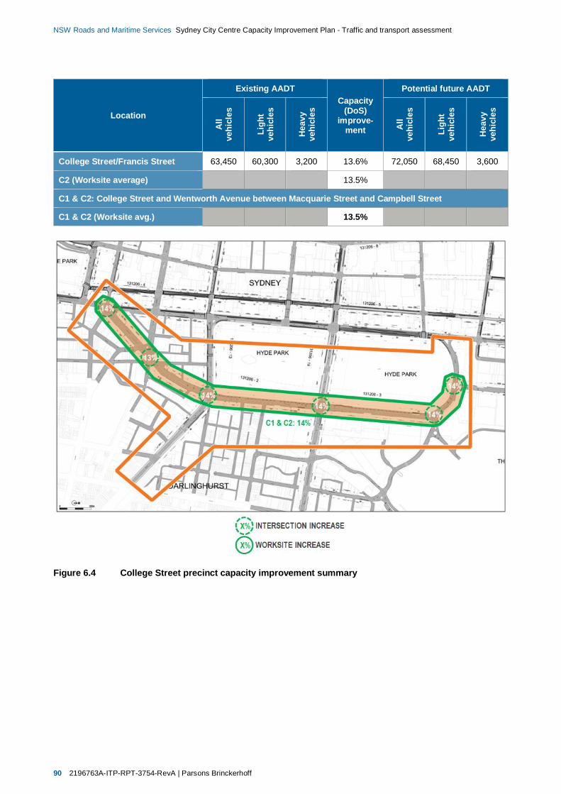
90 2196763A-ITP-RPT-3754-RevA | Parsons Brinckerhoff
NSW Roads and Maritime Services Sydney City Centre Capacity Improvement Plan - Traffic and transport assessment
Location
Existing AADTCapacity
(DoS)improve-
ment
Potential future AADT
All
vehi
cles
Ligh
tve
hicl
es
Hea
vyve
hicl
es
All
vehi
cles
Ligh
tve
hicl
es
Hea
vyve
hicl
es
College Street/Francis Street 63,450 60,300 3,200 13.6% 72,050 68,450 3,600
C2 (Worksite average) 13.5%
C1 & C2: College Street and Wentworth Avenue between Macquarie Street and Campbell Street
C1 & C2 (Worksite avg.) 13.5%
Figure 6.4 College Street precinct capacity improvement summary

Parsons Brinckerhoff | 2196763A-ITP-RPT-3754-RevA 91
NSW Roads and Maritime Services Sydney City Centre Capacity Improvement Plan - Traffic and transport assessment
6.2.7.5 Financial precinct
Proposed traffic management plan
A summary of the proposed traffic management plan for the Financial precinct is provided in Table 6.27.Schematic diagrams used as the basis to assess the operational benefits of the proposed trafficmanagement plans are provided in Appendix A. The concept designs for the proposal schemes are providedin the Concept Design report.
Traffic volumes and network performance
Table 6.28 provides a summary of performance at key intersections within the precinct which would bemodified following implementation of the proposal.
The estimated cumulative benefits and impacts to intersection and worksite corridor capacities aresummarised in Table 6.29 and illustrated in Figure 6.5, which indicate an increase of approximately 4 percent in the vicinity of the Macquarie Street and Bridge Street intersection.
Section 2.6.5.2 notes that eastbound traffic queues on Hunter Street on the approach to the MacquarieStreet intersection currently extend to Elizabeth Street during PM peak periods, consequently reducingnetwork capacity and performance.
One of the key benefits of the proposed modifications within the Financial precinct is an improvement to thecurrent operation of the Macquarie Street and Hunter Street intersection during PM peak periods, with theright turn lane from Macquarie Street southbound into Hunter Street eastbound removed. The SIDRAmodelling undertaken for this intersection indicates that the current average delay on the Hunter Streetapproach is over 50 seconds (LoS D). The proposal would improve the performance of this approach to anaverage delay of less than 40 seconds (LoS C), while both Macquarie Street approaches would continue tooperate at LoS A. The reduction in average delay on Hunter Street would be expected to benefit widernetwork performance by reducing critical queue lengths when compared to conditions without the proposal.
Despite the anticipated network benefits the proposal would create a localised capacity decrease ofapproximately eight per cent at the Macquarie Street and Hunter Street intersection when compared toexisting conditions. The proposal would also redirect traffic through the Macquarie Street and Bent Streetintersection which would reduce available capacity at this location. It is therefore proposed that furtherinvestigation would be undertaken during detailed design to maintain or improve the network-wide benefits ofthe Financial precinct schemes, while further reducing the localised capacity impacts.

92 2196763A-ITP-RPT-3754-RevA | Parsons Brinckerhoff
NSW Roads and Maritime Services Sydney City Centre Capacity Improvement Plan - Traffic and transport assessment
Table 6.27 Financial precinct work site summary
Work site Proposal features
F1: Macquarie Street between Bent Street and Bridge Street
Bent Street intersection No change.
Bent Street to Bridge Street Remove kerb extension on the western kerb south of Phillip Lane.
Alter the parking provisions on the western kerb north of the removed kerbextension to Phillip Lane.
Introduce ‘no stopping’ restrictions between 6.00 am and 10.00 am and 3.00pm and 8.00 pm Monday to Friday.
Provide loading zone and after hours general parking in area of removed kerbextension other than during the proposed AM and PM No Stopping hours
Bridge Street intersection No change.
F2: Macquarie Street at the Hunter Street intersection
Hunter Street intersection Remove right turn bay on Macquarie Street on the southbound approach toHunter Street to prevent right-turn movements into Hunter Street.
Replace with a right filter lane northbound on the approach to ShakespearePlace.
Table 6.28 Key intersection performance – Financial precinct (Future conditions)
Intersection
AM peak hour PM peak hour
Dem
and
(tota
lveh
icle
s)
Deg
ree
ofSa
tura
tion
(Vol
ume/
Cap
acity
)
Ave
rage
Del
ay(S
econ
ds/v
ehic
le)/L
evel
ofSe
rvic
e
Max
imum
queu
ele
ngth
(95th
perc
entil
e,m
)
Dem
and
(tota
lveh
icle
s)
Deg
ree
ofSa
tura
tion
(Vol
ume/
Cap
acity
)
Ave
rage
Del
ay(S
econ
ds/v
ehic
le)/L
evel
ofSe
rvic
e
Max
imum
queu
ele
ngth
(95th
perc
entil
e,m
)
F1: Macquarie Street between Bent Street and Bridge Street
Macquarie Street/Bridge Street 2,750 0.73 29/C 110 2,200 0.77 31/C 105
Macquarie Street/Bent Street 4,000 1.02 61/E 330 4,150 1.03 43/D 325
F2: Macquarie Street at the Hunter Street intersection
Macquarie Street/Hunter Street 2,050 0.44 15/B 70 2,250 0.49 15/B 80
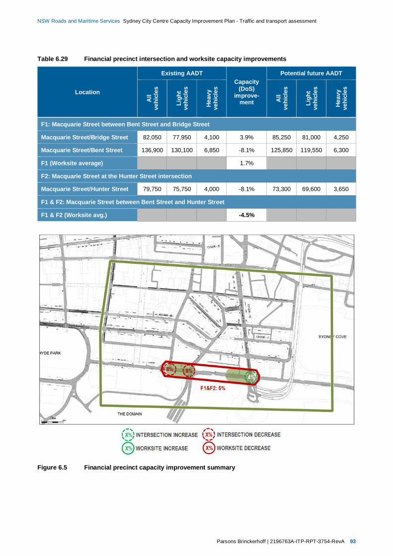
Parsons Brinckerhoff | 2196763A-ITP-RPT-3754-RevA 93
NSW Roads and Maritime Services Sydney City Centre Capacity Improvement Plan - Traffic and transport assessment
Table 6.29 Financial precinct intersection and worksite capacity improvements
Location
Existing AADTCapacity
(DoS)improve-
ment
Potential future AADT
All
vehi
cles
Ligh
tve
hicl
es
Hea
vyve
hicl
es
All
vehi
cles
Ligh
tve
hicl
es
Hea
vyve
hicl
es
F1: Macquarie Street between Bent Street and Bridge Street
Macquarie Street/Bridge Street 82,050 77,950 4,100 3.9% 85,250 81,000 4,250
Macquarie Street/Bent Street 136,900 130,100 6,850 -8.1% 125,850 119,550 6,300
F1 (Worksite average) 1.7%
F2: Macquarie Street at the Hunter Street intersection
Macquarie Street/Hunter Street 79,750 75,750 4,000 -8.1% 73,300 69,600 3,650
F1 & F2: Macquarie Street between Bent Street and Hunter Street
F1 & F2 (Worksite avg.) -4.5%
Figure 6.5 Financial precinct capacity improvement summary
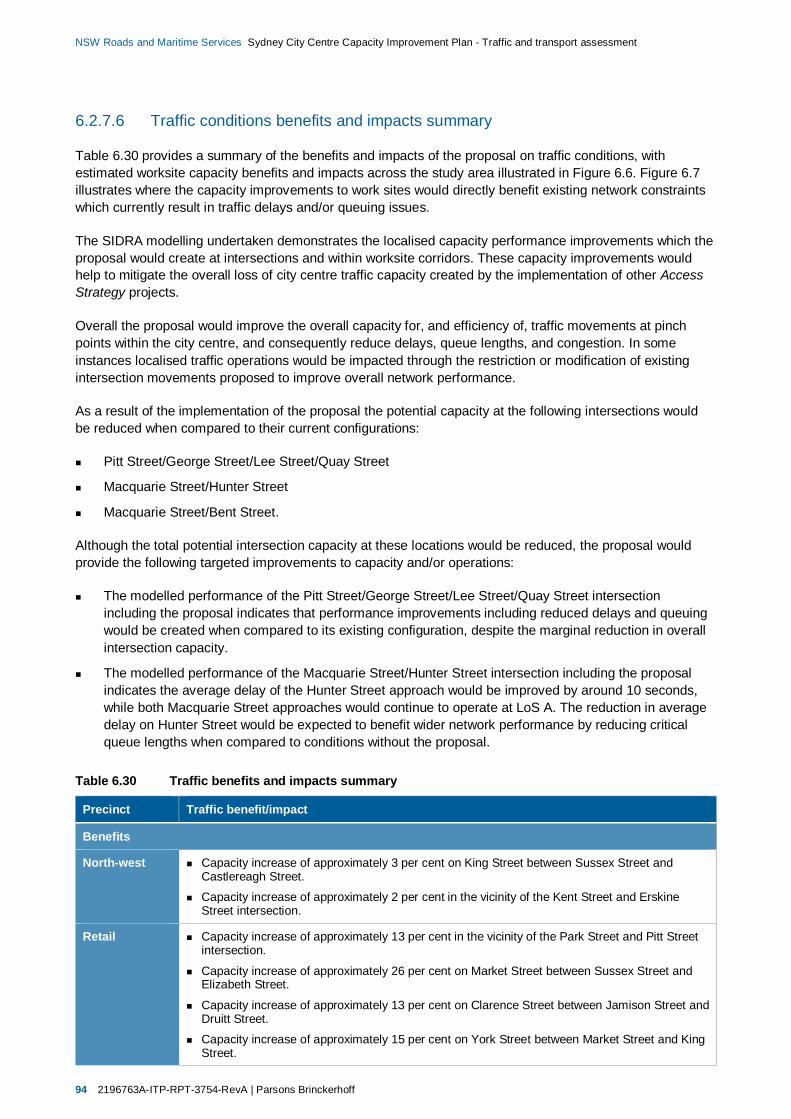
94 2196763A-ITP-RPT-3754-RevA | Parsons Brinckerhoff
NSW Roads and Maritime Services Sydney City Centre Capacity Improvement Plan - Traffic and transport assessment
6.2.7.6 Traffic conditions benefits and impacts summary
Table 6.30 provides a summary of the benefits and impacts of the proposal on traffic conditions, withestimated worksite capacity benefits and impacts across the study area illustrated in Figure 6.6. Figure 6.7illustrates where the capacity improvements to work sites would directly benefit existing network constraintswhich currently result in traffic delays and/or queuing issues.
The SIDRA modelling undertaken demonstrates the localised capacity performance improvements which theproposal would create at intersections and within worksite corridors. These capacity improvements wouldhelp to mitigate the overall loss of city centre traffic capacity created by the implementation of other AccessStrategy projects.
Overall the proposal would improve the overall capacity for, and efficiency of, traffic movements at pinchpoints within the city centre, and consequently reduce delays, queue lengths, and congestion. In someinstances localised traffic operations would be impacted through the restriction or modification of existingintersection movements proposed to improve overall network performance.
As a result of the implementation of the proposal the potential capacity at the following intersections wouldbe reduced when compared to their current configurations:
Pitt Street/George Street/Lee Street/Quay Street
Macquarie Street/Hunter Street
Macquarie Street/Bent Street.
Although the total potential intersection capacity at these locations would be reduced, the proposal wouldprovide the following targeted improvements to capacity and/or operations:
The modelled performance of the Pitt Street/George Street/Lee Street/Quay Street intersectionincluding the proposal indicates that performance improvements including reduced delays and queuingwould be created when compared to its existing configuration, despite the marginal reduction in overallintersection capacity.
The modelled performance of the Macquarie Street/Hunter Street intersection including the proposalindicates the average delay of the Hunter Street approach would be improved by around 10 seconds,while both Macquarie Street approaches would continue to operate at LoS A. The reduction in averagedelay on Hunter Street would be expected to benefit wider network performance by reducing criticalqueue lengths when compared to conditions without the proposal.
Table 6.30 Traffic benefits and impacts summary
Precinct Traffic benefit/impact
Benefits
North-west Capacity increase of approximately 3 per cent on King Street between Sussex Street andCastlereagh Street.
Capacity increase of approximately 2 per cent in the vicinity of the Kent Street and ErskineStreet intersection.
Retail Capacity increase of approximately 13 per cent in the vicinity of the Park Street and Pitt Streetintersection.
Capacity increase of approximately 26 per cent on Market Street between Sussex Street andElizabeth Street.
Capacity increase of approximately 13 per cent on Clarence Street between Jamison Street andDruitt Street.
Capacity increase of approximately 15 per cent on York Street between Market Street and KingStreet.

Parsons Brinckerhoff | 2196763A-ITP-RPT-3754-RevA 95
NSW Roads and Maritime Services Sydney City Centre Capacity Improvement Plan - Traffic and transport assessment
Precinct Traffic benefit/impact
Southern Capacity increase of approximately 2 per cent on Sussex Street between Liverpool Street andGoulburn Street.
Capacity increase of approximately 10 per cent in the vicinity of the Goulburn Street andGeorge Street intersection.
Capacity increase of approximately 10 per cent on Pitt Street between Liverpool Street andRawson Place.
Reduced delays and queuing at the Pitt Street/George Street/Lee Street/Quay Streetintersection when compared to existing configuration and performance.
College Street Capacity increase of approximately 14 per cent on Prince Albert Road and College Streetbetween Macquarie Street and Oxford Street.
Capacity increase of approximately 14 per cent on Wentworth Avenue between Oxford Streetand Elizabeth Street.
Financial Capacity increase of approximately 4 per cent in the vicinity of the Macquarie Street and BridgeStreet intersection.
Average delay of the Hunter Street approach would be improved at the Macquarie Street andHunter Street intersection, reducing critical queue lengths.
Impacts
North-west Existing left turn movement from Kent Street on the southbound approach to Erskine Streetprohibited.
Retail No traffic movement/performance impacts.
Southern Capacity decrease of approximately 3 per cent in the vicinity of the George Street/PittStreet/Lee Street/Quay Street intersection.
College Street No traffic movement/performance impacts.
Financial Existing right turn movements from Macquarie Street on the southbound approach to HunterStreet prohibited.
Capacity decrease of approximately 8 per cent on Macquarie Street between Bent Street andHunter Street.
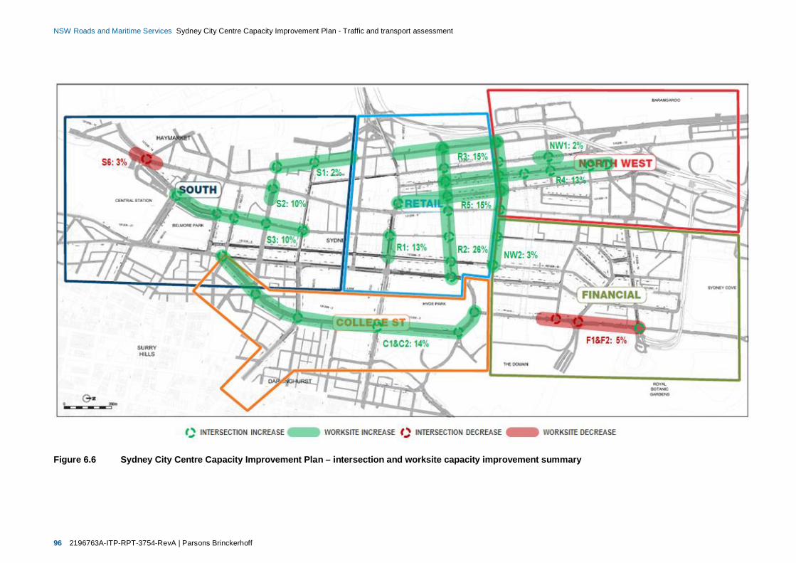
96 2196763A-ITP-RPT-3754-RevA | Parsons Brinckerhoff
NSW Roads and Maritime Services Sydney City Centre Capacity Improvement Plan - Traffic and transport assessment
Figure 6.6 Sydney City Centre Capacity Improvement Plan – intersection and worksite capacity improvement summary

Parsons Brinckerhoff | 2196763A-ITP-RPT-3754-RevA 97
NSW Roads and Maritime Services Sydney City Centre Capacity Improvement Plan - Traffic and transport assessment
Figure 6.7 Sydney City Centre Capacity Improvement Plan – existing performance and work site capacity improvement summary
Parsons Brinckerhoff | 2196763A-ITP-RPT-3754-RevA 99
NSW Roads and Maritime Services Sydney City Centre Capacity Improvement Plan - Traffic and transport assessment
7. Mitigation and managementstrategy
The impacts of the proposal during and following construction would be mitigated to minimise their effects.Table 7.1 summarises the overarching traffic and transport safeguards and management measures thatwould be implemented, and the responsibility for and timing of implementation.
Table 7.1 Key traffic and transport safeguards and responsibilities
Impact (acrossproposal footprint) Safeguard/Responsibility/Timing
Construction trafficimpacts
Prepare a construction traffic management plan (CTMP) in accordance with TrafficControl at Works Sites (Roads and Maritime, 2011) and QA specification G10: Control ofTraffic (Roads and Maritime, 2011). It would form a sub-plan of the CEMP. As aminimum, the plan would include the following controls:
Minimise use of heavy vehicle on local roads
Restrict deliveries to outside of peak traffic periods where possible
Ensure emergency vehicle access is maintained, including consultation withemergency services
Manage short-term access restrictions during construction
Regulate traffic movements and minimise traffic switching during construction throughimplemented traffic controls
Maintain continuous, safe and efficient traffic movement
Identify haulage routes and minimise impacts on local routes
Maintain local road and property access, including the use of temporary turn-aroundbays
Maintain pedestrian and cyclist access throughout
Provide warning and advisory signage
Provide for local community consultation and notification of local road network andtraffic impacts
Identify and consider other construction works occurring in the area at the same timeto minimise additive traffic conflict and congestion impacts.
Note: the plan would be reviewed by City of Sydney and CSTTC.
Responsibility/timing: Construction contractor/Pre-construction
Access restrictionsduring construction
Design the construction staging and program with the objective of minimising accessrestrictions in any one given location.
Avoid implementing driveway access restrictions during peak demand periods, which mayvary throughout the day and over the week due to associated off-street use.Responsibility/timing: Roads and Maritime/Detailed design
Public transport delaysand access restrictionsduring construction
Coordinate all Access Strategy projects to minimise public transport delays.
Develop or input to a public transport plan to ensure connectivity, access and way-findingare maintained across the city centre during construction to allow people to transfer easilybetween transport modes.
Consider relaxing public transport restrictions during peak periods, which would includeFriday and Saturday nights, plus during any special events.
Responsibility/timing: Roads and Maritime/Detailed design
100 2196763A-ITP-RPT-3754-RevA | Parsons Brinckerhoff
NSW Roads and Maritime Services Sydney City Centre Capacity Improvement Plan - Traffic and transport assessment
Impact (acrossproposal footprint) Safeguard/Responsibility/Timing
Pedestrians and cyclistimpacts duringconstruction
Maintain pedestrian and cyclist access.
Display diversionary signposts around each work site.
Notify pedestrians and cyclists, including user groups and advocacy groups in advance ofthe works (refer to section 5.6 of the REF document).
Responsibility/timing: Construction contractor/Construction
Temporary accessrestrictions duringconstruction
Develop management plan to deal with temporary loss of access to off-street parking andother accesses during construction.
Responsibility/timing: Roads and Maritime/Detailed design
Temporary accessrestrictions duringconstruction
Implement a traffic management control plan that allows for varying controls to beimplemented at different times of the day and different days of the week to maintainrequired access during peak periods, at weekends and during special events.
Note: ‘required access’ would be determined in consultation with CSTTC, City of Sydneyand Roads and Maritime.
Responsibility/timing: Construction contractor/Pre-construction
Temporary trafficmanagement controlsduring construction
Work with City of Sydney and the CSTTC ahead of construction to ensure there is anintegrated response to traffic management across the city centre and there is no impacton roads, traffic and transport.
Responsibility/timing: Roads and Maritime/Detailed design/pre-construction
Long-term trafficimpacts/ benefits oncethe proposal isoperational
The CSTTC would review the long-term traffic network modelling result to ensure thetraffic capacity improvements would achieve the required LoS in the future.
Responsibility/timing: Roads and Maritime and CSTTC/Detailed design
7.1 Construction of proposalAs noted in section 6.1, construction of the proposal is anticipated to start in early 2015, with the worksexpected to be completed within four months. Construction would be undertaken during off-peak periodswhere possible to minimise the effects of impacts. In addition, it is not anticipated that any road would requirefull closure at any point to enable construction. Consequently construction activities would not fundamentallychange the function of any key element of the city centre road network during peak periods. An overview ofthe impacts and mitigation strategy of the proposal during construction is provided in Table 7.2.
The proposed mitigation measures would be taken forward for development in the detail design. They wouldbe implemented under a Construction Traffic Management Plan (CTMP). The CTMP would provide thedetails of the traffic management controls required to ensure that traffic flow is maintained within the citycentre during construction. The plan would also contain specific traffic, pedestrian and cyclist control plans.
Parsons Brinckerhoff | 2196763A-ITP-RPT-3754-RevA 101
NSW Roads and Maritime Services Sydney City Centre Capacity Improvement Plan - Traffic and transport assessment
Table 7.2 Summary of construction impacts and mitigation measures
Feature Impact Mitigation measures Residual impacts
Road network
Networkcapacity
Reduced network capacity due to partialreduction/removal of traffic lanes at work sites.
Construction of the proposal undertaken duringoff-peak periods where possible.
Integrated construction staging plan developedto ensure no road fully closed at any point,including consideration of timing of other AccessStrategy projects and major developments in thecity centre.
Network management strategy developed inconsultation with City of Sydney and Roads andMaritime traffic management centres (TMCs).
Affected users notified of changes to roadnetwork in advance of construction.
No fundamental changes to the function of anykey element of the city centre road networkduring peak periods.
Delays to road traffic due to short-term impactsto network capacity.
Movementefficiency
Reduced network efficiency for road traffic dueto:
Temporary traffic controls (e.g. manualstop/start or temporary traffic lights).
Control of construction traffic access/egressfrom work compounds.
Disorientation for road users as a result oftraffic management controls and diversions.
Construction of the proposal undertaken duringoff-peak periods where possible.
No road fully closed at any point.
Temporary signage used to communicatechanges to traffic conditions, highlight expecteddelays, and identify alternative routes.
Implementation of appropriate trafficmanagement controls including temporary trafficlights and stop-go controls.
Temporary lighting installed prior to therelocation of existing road lighting.
Delays to road traffic, due to short-term impactsto movement efficiency.
Turningmovements
Reduced/removed turning movement capacitydue to partial reduction/removal of turning lanesat worksites.
Construction of the proposal undertaken duringoff-peak periods where possible.
Alternative routes available for all prohibitedturning movements.
Affected users notified of changes to futurerestrictions to existing turning movements inadvance of construction.
Existing turning movements prohibited:
No left turn on Kent Street on the southboundapproach to Erskine Street.
No right turn on Macquarie Street, on thesouthbound approach to Hunter Street.
Delays to road traffic, due to short-term impactsto turning movement capacity and vehicularaccess.

102 2196763A-ITP-RPT-3754-RevA | Parsons Brinckerhoff
NSW Roads and Maritime Services Sydney City Centre Capacity Improvement Plan - Traffic and transport assessment
Feature Impact Mitigation measures Residual impacts
Kerbside use
On-streetparking
Reduced availability of on-street parking forgeneral traffic due to partial reduction/removal ofgeneral on-street parking spaces.
Reduced access for physically impaired driversdue to partial reduction/removal of mobility on-street parking spaces.
Disruption to normal operations and/or events ofusers of special use parking (e.g. business-specific parking, church parking, etc.) due topartial reduction/removal of special use on-streetparking spaces.
Construction of the proposal undertaken duringoff-peak periods where possible.
Modifications to special use parking allocationsto be minimised where possible, and developedin consultation with affected users(e.g. St Mary’s Cathedral).
Creation of new on-street parking facilities topartially replace loss of on-street parking.
Promotion of availability of off-street parking inproximity of lost on-street parking facilities.
Net loss of on-street parking managed underTfNSW kerbside allocation strategy.
Affected users notified of changes to kerbsideuses in advance of construction.
Kerbside use allocations reinstated at the end ofeach work shift where possible.
Net loss of on-street parking to accommodaterelocation/creation of other kerbside uses.
Reduced access for physically impaired drivers.
Increased walking distances for users ofalternative parking locations.
Increased walking distances for users of specialuse on-street parking facilities at some locations.
Bus stops,zones, andlayovers
Reduced bus accessibility for pedestrians due toremoval of existing bus stops.
Changes to existing bus operations due to partialreduction/removal of bus layover facilities.
Construction of the proposal undertaken duringoff-peak periods where possible.
Provision of temporary bus stops and alternativebus layover locations.
Temporary locations selected to allow safe andefficient operations while minimising relocationdistance.
Increased walking distances for bus users.
Loading andmail zones
Reduced kerbside availability and accessibilityfor general trade/business traffic due to partialreduction/removal of loading zones.
Increased walking distances due to use ofalternative on-street loading zones.
Disruptions to existing Australia Post and otherAuthorised user operations due to partialreduction/removal of special use mail andloading zones.
Construction of the proposal undertaken duringoff-peak periods where possible.
Relocation of mail zones developed inconsultation with Australia Post and otherAuthorised users.
Modification/relocation/creation of loading zonesdeveloped in consultation with affectedbusinesses.
Availability of nearby alternatives further reducesimpact of loss of loading zones.
Kerbside use allocations reinstated at the end ofeach work shift where possible.
Net loss of loading zones and mail zones toaccommodate relocation/creation of otherkerbside uses.
Increased walking distances for loading and mailzone users.
Adjustments to deliveries and other activities ofaffected businesses/operations.
Parsons Brinckerhoff | 2196763A-ITP-RPT-3754-RevA 103
NSW Roads and Maritime Services Sydney City Centre Capacity Improvement Plan - Traffic and transport assessment
Feature Impact Mitigation measures Residual impacts
Taxi zones Reduced taxi availability and accessibility due topartial reduction/removal of existing taxi ranks.
Construction of the proposal undertaken duringoff-peak periods where possible.
Relocation of existing taxi ranks.
Creation of new taxi ranks.
Net loss of taxi zones to accommodaterelocation/creation of other kerbside uses.
Increased walking distances for taxi rank users.
Property access and off-street parking
Propertyaccess
Reduced kerbside access for vehicles to andfrom property frontages due to partial reduction/removal of traffic lanes.
Reduced pedestrian accessibility due to partialreduction of footpaths.
Construction generally undertaken outsidebusiness hours or during off-peak periods.
Development of Access Plans and TrafficManagement Plans (TMPs) in consultation withproperty tenants.
Business and residential property access,including garbage truck and emergency vehicleaccess, maintained throughout construction.
Affected users notified of changes to propertyaccess in advance of construction.
Significant restriction and/or full closure ofbusiness access only undertaken outsidebusiness hours or during period of lowestactivity.
Increased walking distances and delays due toreductions to existing accessibility.
Increased delays for other affected transportmodes due to reductions to existing accessibility.
Off-streetparking
Reduced/removed access to off-street parkinglocations due to partial reduction/removal oftraffic lanes.
Increased delays due to reduced accessibilityand traffic management control for vehiclesentering and leaving off-street parking locations.
Construction of the proposal undertaken outsideof business hours or during off-peak periods.
Significant restriction and/or full closure ofaccess only undertaken outside business hoursor during period of lowest activity.
Prevention of access to/from off-street parkinglocations for short periods of time.
Increased walking distances for users ofalternative parking locations.
Delays for vehicles entering and exiting off-streetparking locations.
Traffic conditions
Constructionworkforce
Increased transport demand to/from city centregenerated by construction workforce(approximately 10–15 people).
Construction workforce anticipated to travel toand from work sites by public transport unlesstransporting equipment, materials, or waste.
No significant residual impacts – demandgenerated by construction workforce would notaffect existing conditions or operations.

104 2196763A-ITP-RPT-3754-RevA | Parsons Brinckerhoff
NSW Roads and Maritime Services Sydney City Centre Capacity Improvement Plan - Traffic and transport assessment
Feature Impact Mitigation measures Residual impacts
Otherconstructiontraffic
Increased daily traffic in the city centre due toconstruction activities estimated asapproximately:
20–30 light vehicles between designatedconstruction compounds and work sites.
1–2 truck movements transportingconstruction equipment and materials.
One truck movement to remove wastematerial.
Construction of the proposal undertaken duringoff-peak periods where possible.
Vehicle movements generated by constructionwould service multiple work sites wherepossible.
Construction vehicles would use designated haulroutes along existing roads within the city centre.
Access to and from worksites controlled bytemporary traffic controls to maintain safety andefficiency.
No significant residual impacts – trafficgenerated by construction would not changeexisting conditions.
Public transport
Bus Increased bus travel times due to reduced roadnetwork capacity and additional traffic delays atand surrounding work sites.
Reduced bus accessibility due to removal ofexisting bus stops.
Reduced capacity and accessibility forpedestrian movements to and from bus stopsdue to partial reduction/removal of footpaths.
Reduced capacity/performance of bus servicesdue to partial reduction/removal of bus zoneswhich would reduce kerbside capacity forpickups and set downs.
Construction of the proposal undertaken duringoff-peak periods where possible.
Provision of temporary bus stops and buslayover facilities.
Temporary locations selected to allow safe andefficient operations while minimising relocationdistance.
Bus re-routing implemented where necessary tomaintain services.
Bus routes reinstated at end of each work shift ifpossible, and following completion ofconstruction.
Bus management strategy developed inconsultation with relevant bus operators.
Affected users notified of changes to busoperations in advance of construction.
Increased bus travel times and delays inproximity of work sites.
Increased walking distances and delays for bususers.
Increased bus route lengths and travel times dueto re-routing as a result of the relocation of busstops and/or lane closures.
Modifications to bus timetabling and increasedbus travel distances due to the relocation of buslayover facilities.
Light rail/Rail/Ferry
Reduced capacity and accessibility forpedestrian movements to and from light rail, rail,and ferry services due to partialreduction/removal of footpaths.
Construction of the proposal undertaken duringoff-peak periods where possible.
Increased walking distances and delays for lightrail, rail, and ferry users.
Parsons Brinckerhoff | 2196763A-ITP-RPT-3754-RevA 105
NSW Roads and Maritime Services Sydney City Centre Capacity Improvement Plan - Traffic and transport assessment
Feature Impact Mitigation measures Residual impacts
Walking and cycling
Walking Reduced capacity and accessibility forpedestrian movements in the city centre due topartial reduction/removal of footpaths.
Increased delays to pedestrians due totemporary traffic controls (e.g. trafficmanagement staff controlling pedestrian accesson footpaths in proximity of worksites).
Increased delays and travel times for pedestrianmovements due to partial reduction/removal ofexisting pedestrian crossing facilities (e.g. signalcontrols, pedestrian islands).
Construction of the proposal undertaken duringoff-peak periods where possible.
Pedestrian diversions implemented wherenecessary to maintain connectivity.
Signage and work site traffic controllers wouldencourage pedestrians to use alternate routeswhere possible.
Temporary footpaths may be required inlocations where footpath is completely blocked.
Increased walking distances and delays forpedestrians.
Reduced amenity and accessibility forpedestrians.
Cycling Reduced capacity and accessibility for cyclistsdue to partial reduction/removal of cyclewaysand general traffic lanes.
Increased delays to cyclists due to temporarytraffic controls (e.g. manual stop/start ortemporary traffic lights).
Reduced cycling amenity and accessibility dueto restriction of access to or removal of existingbicycle racks.
New cycleway on Castlereagh Street.
Construction of the proposal undertaken duringoff-peak periods where possible.
Cycling diversions implemented wherenecessary to maintain connectivity.
Removed cycle racks relocated to nearbylocations where possible.
Existing cycle racks at nearby locations providealternative bicycle parking facilities.
Affected users notified of changes to cyclinginfrastructure in advance of construction.
Increased travel distances and delays forcyclists.
Reduced amenity and accessibility for cyclists.

106 2196763A-ITP-RPT-3754-RevA | Parsons Brinckerhoff
NSW Roads and Maritime Services Sydney City Centre Capacity Improvement Plan - Traffic and transport assessment
7.2 Operation with proposalThe proposal generally balances improved traffic capacity throughout the city centre with a reduction in theavailability of certain kerbside uses. Transport for NSW is also committed developing a kerbside allocationstrategy to mitigate the cumulative impacts introduced by the proposal and the other Access Strategyprojects. The focus of this proposal – the Sydney City Centre Capacity Improvement Plan – is to implementthe modifications necessary changes to allow the other committed projects to progress in a timely andefficient manner.
The proposal would improve the capacity for, and efficiency of, traffic movements at pinch points within thecity centre, and consequently reduce overall delays, queue lengths, and congestion through theimplementation of road network modifications described in section 6.2.2.1. The proposal would also improveoverall road network management, including the use of kerbside space, to ensure the city centre roadnetwork provides safe and effective access.
A summary of the impacts to the transport network as a result of implementing the proposal, and mitigationmeasures to reduce the effects of these impacts, is provided in Table 7.3.
Parsons Brinckerhoff | 2196763A-ITP-RPT-3754-RevA 107
NSW Roads and Maritime Services Sydney City Centre Capacity Improvement Plan - Traffic and transport assessment
Table 7.3 Summary of operation impacts and mitigation measures
Feature Impact Mitigation measures Residual impacts
Road network
Networkcapacity
Marginal reduction in total intersection capacityat the following locations:
Pitt Street/George Street/Lee Street/QuayStreet Macquarie Street/Hunter Street
Macquarie Street/Bent Street.
Targeted capacity increase provided byreallocation of existing capacity of the PittStreet/George Street/Lee Street/Quay Streetintersection.
Targeted change to operation of MacquarieStreet/Hunter Street intersection to reducecritical queue length on Hunter Street during PMpeak periods.
Increased delays at the Macquarie Street andHunter Street intersection during AM peakperiods.
Movementefficiency
Disorientation for road users as a result ofchanges to existing road network.
Communicate changes to traffic conditions toaffected road users prior to and afterimplementation.
No notable negative impacts.
Turningmovements
Existing turning movements prohibited:
No left turn on Kent Street on the southboundapproach to Erskine Street.
No right turn on Macquarie Street, on thesouthbound approach to Hunter Street.
Communicate changes to traffic conditions andalternative routes to affected road users prior toand after implementation.
Increased travel distances for affected roadusers.
Kerbside use
On-streetparking
Reduced availability of on-street parking due tonet loss of:
93-115 unrestricted on-street parking spaces(including one car sharing space).
six mobility parking spaces.
seven motorcycle parking zones.
Reduced/removed access for physicallyimpaired drivers at some locations.
Disruption to normal operations and/or events ofusers of special use parking (e.g. business-specific parking, church parking, etc.) due topartial reduction/removal of special use on-streetparking spaces.
Modifications to special use parking allocationsto be minimised where possible, and developedin consultation with affected users(e.g. St Mary’s Cathedral).
Creation of new on-street parking facilities topartially replace loss of on-street parking.
Promotion of availability of off-street parking inproximity of lost on-street parking facilities.
Net loss of on-street parking managed underTfNSW kerbside allocation strategy.
Affected users notified of changes to kerbsideuses in advance of implementation.
On-street parking only restricted during peakperiods if and where possible.
Net loss of on-street parking to accommodaterelocation/creation of other kerbside uses.
Reduced access for physically impaired drivers.
Increased walking distances for users ofalternative parking locations.
Increased walking distances for users of specialuse on-street parking facilities at some locations.

108 2196763A-ITP-RPT-3754-RevA | Parsons Brinckerhoff
NSW Roads and Maritime Services Sydney City Centre Capacity Improvement Plan - Traffic and transport assessment
Feature Impact Mitigation measures Residual impacts
Bus stops,zones, andlayovers
Modification/relocation of bus stops.
Modification/relocation of bus layover facilities.
New locations selected to allow safe andefficient operations while minimising relocationdistance.
Increases to walking distances for bus users.
Modifications to bus timetabling and increasedbus travel distances due to the relocation of buslayover facilities.
Loading andmail zones
Reduced availability of loading zones and mailzones due to net loss of:
10-27 loading zone spaces during theweekday morning and inter-peak periods andin the order of 92 spaces in the weekdayevening period.
4 mail zone spaces.
Reduced kerbside availability and accessibilityfor general trade/business traffic due torelocation and/or timing restrictions of loadingzones.
Increased walking distances due to use ofalternative on-street loading zones.
Disruptions to existing Australia Post and otherAuthorised user operations due to relocation ofspecial use mail and loading zones.
Relocation of mail zones developed inconsultation with Australia Post and otherAuthorised users.
Modification/relocation/creation of loading zonesdeveloped in consultation with affectedbusinesses.
Availability of nearby alternatives further reducesimpact of loss of loading zones.
Loading zones only restricted during peakperiods if and where possible.
Net loss of loading zones and mail zones toaccommodate relocation/creation of otherkerbside uses.
Increased walking distances for loading and mailzone users.
Adjustments to deliveries and other activities ofaffected businesses/operations.
Taxi zones Net loss of six taxi zone spaces.
Reduced taxi availability and accessibility due toremoval and relocation of taxi ranks.
Relocation of existing taxi ranks.Creation of new taxi ranks.
Net loss of taxi zones to accommodaterelocation/creation of other kerbside uses.
Increased walking distances for some existingtaxi rank users.
Property access and off-street parking
Propertyaccess
Reduced pedestrian accessibility due to partialreduction of footpaths.
Development of Access Plans and TrafficManagement Plans (TMPs) in consultation withproperty tenants.
Affected users notified of changes to propertyaccess prior to implementation.
Footpath reductions not implemented in areas ofheavy pedestrian demand.
Possible minor increases to pedestrian delaysdue to reductions to existing footpath capacity.

Parsons Brinckerhoff | 2196763A-ITP-RPT-3754-RevA 109
NSW Roads and Maritime Services Sydney City Centre Capacity Improvement Plan - Traffic and transport assessment
Feature Impact Mitigation measures Residual impacts
Off-streetparking
Increased congestion in, and reduced availabilityof, off-street parking facilities due to displacedon-street parking demand.
Net loss of on-street parking spaces notexpected to generate significant additionaldemand for off-street parking.
Minor additional delays for vehicles entering andexiting off-street parking locations.
Minor decrease in the availability of off-streetparking.
Traffic conditions
Operationaltrafficconditions
Minor changes to existing traffic patterns andincreases to intersection demand due torestriction of existing turning movements.
Restrictions only implemented at locations whereexisting spare capacity is able to accommodatere-routed traffic.
Increased intersection delays due to increaseddemand generated by re-routed traffic.
Public transport
Bus Modification/relocation of bus stops.
Reduced capacity for pedestrian movements toand from bus stops due to partial reduction offootpaths.
New locations selected to allow safe andefficient operations while minimising relocationdistance.
Footpath reductions not implemented in areas ofheavy pedestrian demand.
Affected users notified of changes to busoperations in advance of implementation.
Minor increases to walking distances for bususers.
Possible minor increases to pedestrian delaysdue to reductions to existing footpath capacity.
Light rail/Rail/Ferry
Reduced capacity for pedestrian movements toand from light rail, rail, and ferry services due topartial reduction of footpaths.
Footpath reductions not implemented in areas ofheavy pedestrian demand.
Possible minor increases to pedestrian delaysdue to reductions to existing footpath capacity.
Walking and cycling
Walking Reduced capacity for pedestrian movements inthe city centre due to partial reduction offootpaths.
Increased travel times for pedestrian movementsdue to removal of existing pedestrian crossingfacility on York Street south of King Street.
Footpath reductions not implemented in areas ofheavy pedestrian demand.
Removal of existing York Street crossingmitigated by the proximity of the pedestriancrossing at the intersection of York Street andKing Street.
Affected users notified of changes to pedestrianfacilities in advance of implementation.
Possible minor increases to pedestrian delaysdue to reductions to existing footpath capacity.
Reduced local amenity and accessibility forpedestrians crossing York Street south of KingStreet.
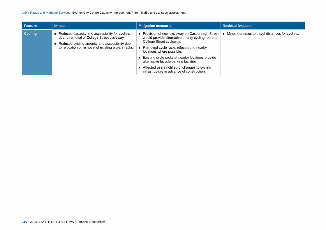
110 2196763A-ITP-RPT-3754-RevA | Parsons Brinckerhoff
NSW Roads and Maritime Services Sydney City Centre Capacity Improvement Plan - Traffic and transport assessment
Feature Impact Mitigation measures Residual impacts
Cycling Reduced capacity and accessibility for cyclistsdue to removal of College Street cycleway.
Reduced cycling amenity and accessibility dueto relocation or removal of existing bicycle racks.
Provision of new cycleway on Castlereagh Streetwould provide alternative priority cycling route toCollege Street cycleway.
Removed cycle racks relocated to nearbylocations where possible.
Existing cycle racks at nearby locations providealternative bicycle parking facilities.
Affected users notified of changes to cyclinginfrastructure in advance of construction.
Minor increases to travel distances for cyclists.

Parsons Brinckerhoff | 2196763A-ITP-RPT-3754-RevA 111
NSW Roads and Maritime Services Sydney City Centre Capacity Improvement Plan - Traffic and transport assessment
8. Next steps (Future AIMSUNModelling)
This traffic and transport assessment focusses on the analysis of localised performance improvements atselected locations across the city centre road network. It is proposed that AIMSUN modelling would beundertaken as part of an ongoing process to analyse the cumulative effects of transport developmentsincluding the proposal and other Access Strategy projects across the city centre. This modelling would alsoable to consider regional growth factors including other major committed and approved traffic generatingdevelopments in the city centre.
The AIMSUN traffic model would be used to estimate existing and future traffic distribution, and assess theoverall performance of the Sydney city centre traffic network. Importantly this modelling would be used toforecast the cumulative impacts of Access Strategy projects impacts, including:
CBD to South East Light Rail project (CSELR)
Sydney City Centre Bus Infrastructure project
The Sydney City Centre Cycleways projects
The proposal.
The model would be used to estimate the key performance statistics for the city centre road networksummarised in discussed in section 3. The comparison of performance statistics for alternative networkoption scenarios would ultimately provide an indication of the anticipated cumulative benefits and/or impactsacross the city centre road network. Specifically, it is proposed that AIMSUN modelling would be undertakento demonstrate:
Existing network conditions to provide a benchmark to test future network options against.
Future conditions based on the road network conditions proposed by Access Strategy projectsexcluding the proposal to determine the cumulative network impacts of Access Strategy projects.
Future conditions based on the road network conditions proposed by Access Strategy projectsincluding the proposal to determine the cumulative network benefits of the proposal.
AIMSUN modelled traffic volumes of elements of the road network impacted by the proposal would also beused to sense-check the outputs of proposal work site traffic models.
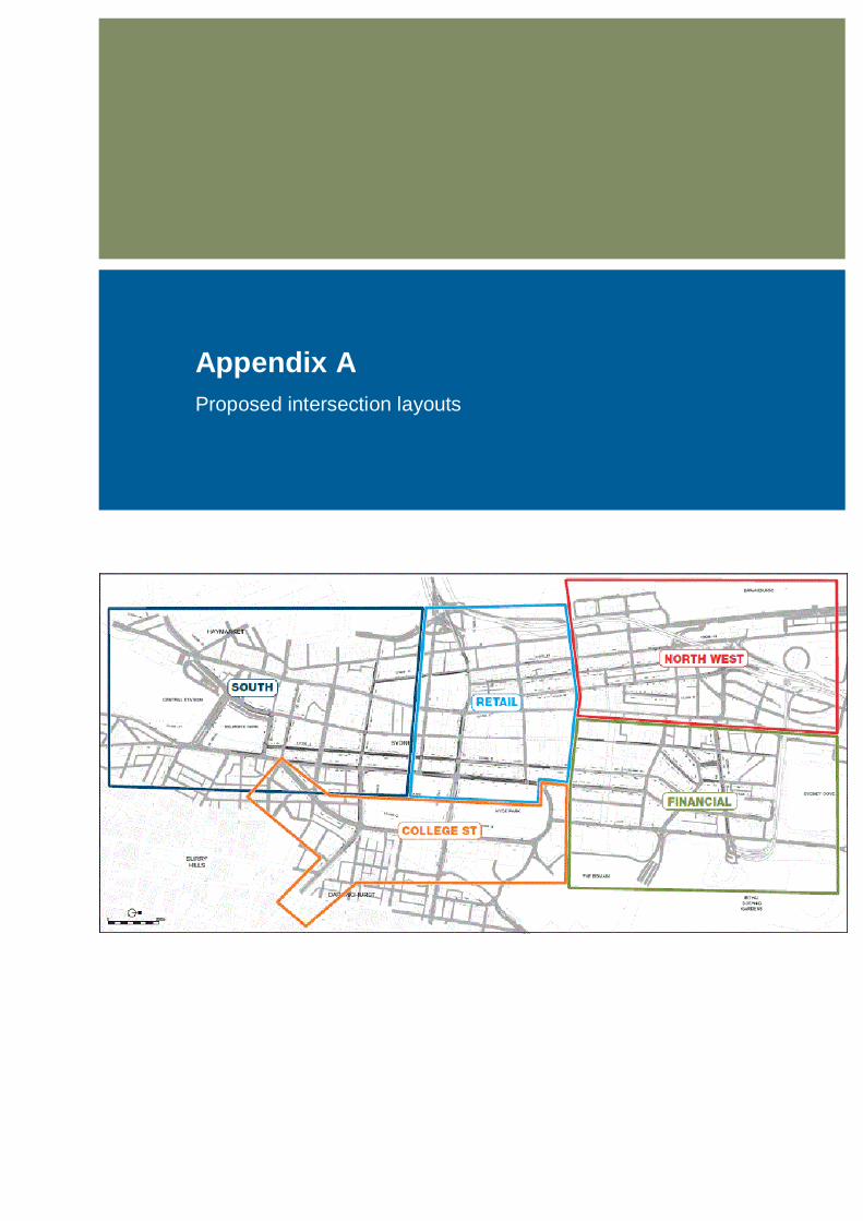
Appendix AProposed intersection layouts
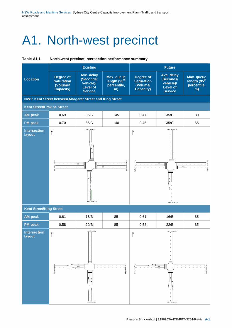
NSW Roads and Maritime Services Sydney City Centre Capacity Improvement Plan - Traffic and transportassessment
Parsons Brinckerhoff | 2196763A-ITP-RPT-3754-RevA A-1
A1. North-west precinctTable A1.1 North-west precinct intersection performance summary
Location
Existing Future
Degree ofSaturation(Volume/Capacity)
Ave. delay(Seconds/vehicle)/Level ofService
Max. queuelength (95th
percentile,m)
Degree ofSaturation(Volume/Capacity)
Ave. delay(Seconds/vehicle)/Level ofService
Max. queuelength (95th
percentile,m)
NW1: Kent Street between Margaret Street and King Street
Kent Street/Erskine Street
AM peak 0.69 36/C 145 0.47 35/C 80
PM peak 0.70 36/C 140 0.45 35/C 65
Intersectionlayout
Kent Street/King Street
AM peak 0.61 15/B 85 0.61 16/B 85
PM peak 0.58 20/B 85 0.58 22/B 85
Intersectionlayout
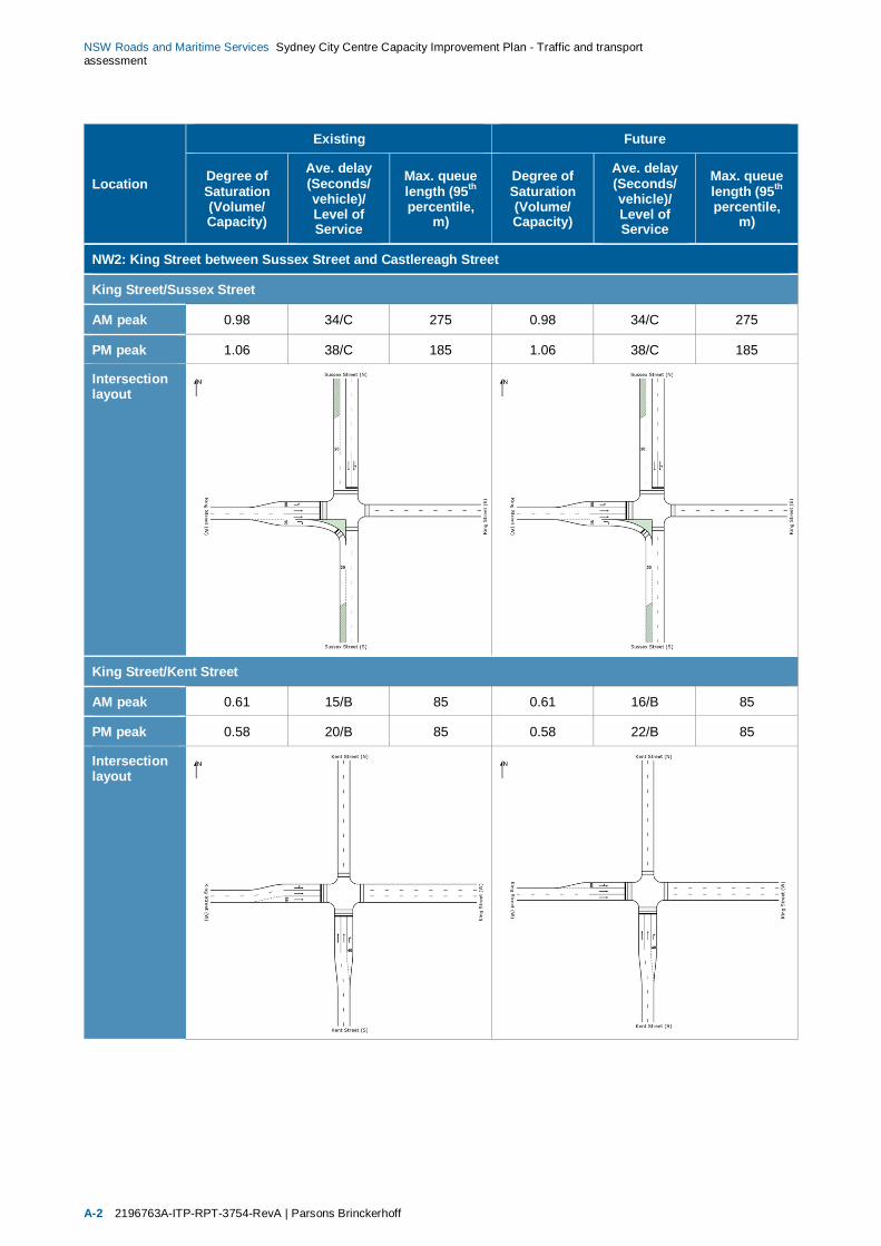
NSW Roads and Maritime Services Sydney City Centre Capacity Improvement Plan - Traffic and transportassessment
A-2 2196763A-ITP-RPT-3754-RevA | Parsons Brinckerhoff
Location
Existing Future
Degree ofSaturation(Volume/Capacity)
Ave. delay(Seconds/vehicle)/Level ofService
Max. queuelength (95th
percentile,m)
Degree ofSaturation(Volume/Capacity)
Ave. delay(Seconds/vehicle)/Level ofService
Max. queuelength (95th
percentile,m)
NW2: King Street between Sussex Street and Castlereagh Street
King Street/Sussex Street
AM peak 0.98 34/C 275 0.98 34/C 275
PM peak 1.06 38/C 185 1.06 38/C 185
Intersectionlayout
King Street/Kent Street
AM peak 0.61 15/B 85 0.61 16/B 85
PM peak 0.58 20/B 85 0.58 22/B 85
Intersectionlayout
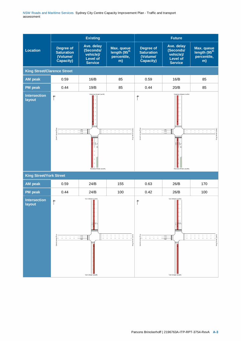
NSW Roads and Maritime Services Sydney City Centre Capacity Improvement Plan - Traffic and transportassessment
Parsons Brinckerhoff | 2196763A-ITP-RPT-3754-RevA A-3
Location
Existing Future
Degree ofSaturation(Volume/Capacity)
Ave. delay(Seconds/vehicle)/Level ofService
Max. queuelength (95th
percentile,m)
Degree ofSaturation(Volume/Capacity)
Ave. delay(Seconds/vehicle)/Level ofService
Max. queuelength (95th
percentile,m)
King Street/Clarence Street
AM peak 0.59 16/B 85 0.59 16/B 85
PM peak 0.44 19/B 85 0.44 20/B 85
Intersectionlayout
King Street/York Street
AM peak 0.59 24/B 155 0.63 26/B 170
PM peak 0.44 24/B 100 0.42 26/B 100
Intersectionlayout

NSW Roads and Maritime Services Sydney City Centre Capacity Improvement Plan - Traffic and transportassessment
A-4 2196763A-ITP-RPT-3754-RevA | Parsons Brinckerhoff
Location
Existing Future
Degree ofSaturation(Volume/Capacity)
Ave. delay(Seconds/vehicle)/Level ofService
Max. queuelength (95th
percentile,m)
Degree ofSaturation(Volume/Capacity)
Ave. delay(Seconds/vehicle)/Level ofService
Max. queuelength (95th
percentile,m)
King Street/George Street
AM peak 0.81 30/C 200 (No change as part of proposal)
PM peak 0.75 27/B 150
Intersectionlayout
King Street/Pitt Street
AM peak 0.55 25/B 120 (No change as part of proposal)
PM peak 0.57 29/C 100
Intersectionlayout

NSW Roads and Maritime Services Sydney City Centre Capacity Improvement Plan - Traffic and transportassessment
Parsons Brinckerhoff | 2196763A-ITP-RPT-3754-RevA A-5
Location
Existing Future
Degree ofSaturation(Volume/Capacity)
Ave. delay(Seconds/vehicle)/Level ofService
Max. queuelength (95th
percentile,m)
Degree ofSaturation(Volume/Capacity)
Ave. delay(Seconds/vehicle)/Level ofService
Max. queuelength (95th
percentile,m)
King Street/Castlereagh Street
AM peak 0.55 18/B 95 (No change as part of proposal)
PM peak 0.57 18/B 100
Intersectionlayout

NSW Roads and Maritime Services Sydney City Centre Capacity Improvement Plan - Traffic and transportassessment
A-6 2196763A-ITP-RPT-3754-RevA | Parsons Brinckerhoff
A2. Retail precinctTable A2.1 Retail precinct intersection performance summary
Location
Existing Future
Degree ofSaturation(Volume/Capacity)
Ave. delay(Seconds/vehicle)/Level ofService
Max. queuelength (95th
percentile,m)
Degree ofSaturation(Volume/Capacity)
Ave. delay(Seconds/vehicle)/Level ofService
Max. queuelength (95th
percentile,m)
R1: Park Street at the Pitt Street intersection
Park Street/Pitt Street
AM peak 0.84 19/B 150 0.91 20/B 110
PM peak 0.64 15/B 80 0.67 15/A 70
Intersectionlayout
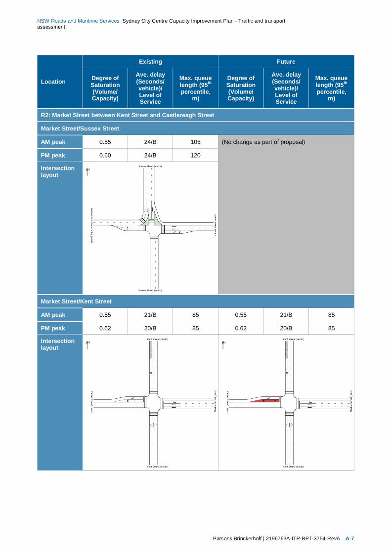
NSW Roads and Maritime Services Sydney City Centre Capacity Improvement Plan - Traffic and transportassessment
Parsons Brinckerhoff | 2196763A-ITP-RPT-3754-RevA A-7
Location
Existing Future
Degree ofSaturation(Volume/Capacity)
Ave. delay(Seconds/vehicle)/Level ofService
Max. queuelength (95th
percentile,m)
Degree ofSaturation(Volume/Capacity)
Ave. delay(Seconds/vehicle)/Level ofService
Max. queuelength (95th
percentile,m)
R2: Market Street between Kent Street and Castlereagh Street
Market Street/Sussex Street
AM peak 0.55 24/B 105 (No change as part of proposal)
PM peak 0.60 24/B 120
Intersectionlayout
Market Street/Kent Street
AM peak 0.55 21/B 85 0.55 21/B 85
PM peak 0.62 20/B 85 0.62 20/B 85
Intersectionlayout
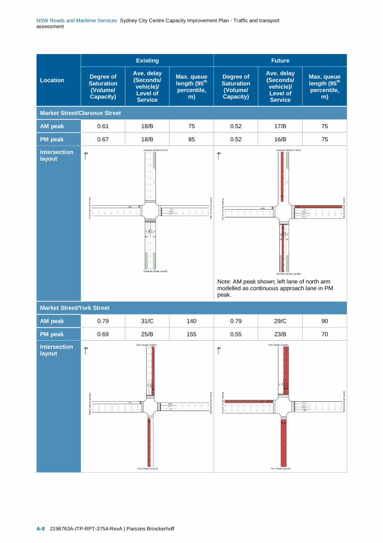
NSW Roads and Maritime Services Sydney City Centre Capacity Improvement Plan - Traffic and transportassessment
A-8 2196763A-ITP-RPT-3754-RevA | Parsons Brinckerhoff
Location
Existing Future
Degree ofSaturation(Volume/Capacity)
Ave. delay(Seconds/vehicle)/Level ofService
Max. queuelength (95th
percentile,m)
Degree ofSaturation(Volume/Capacity)
Ave. delay(Seconds/vehicle)/Level ofService
Max. queuelength (95th
percentile,m)
Market Street/Clarence Street
AM peak 0.61 18/B 75 0.52 17/B 75
PM peak 0.67 18/B 85 0.52 16/B 75
Intersectionlayout
Note: AM peak shown; left lane of north armmodelled as continuous approach lane in PMpeak.
Market Street/York Street
AM peak 0.79 31/C 140 0.79 29/C 90
PM peak 0.69 25/B 155 0.55 23/B 70
Intersectionlayout
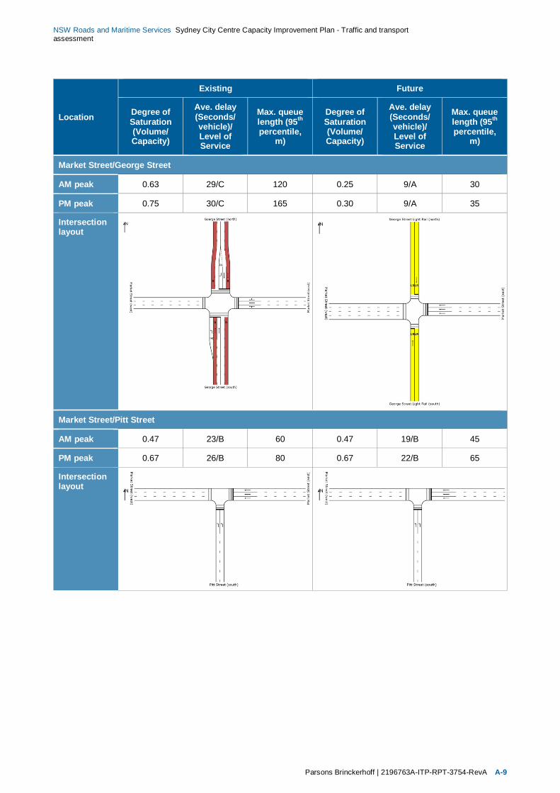
NSW Roads and Maritime Services Sydney City Centre Capacity Improvement Plan - Traffic and transportassessment
Parsons Brinckerhoff | 2196763A-ITP-RPT-3754-RevA A-9
Location
Existing Future
Degree ofSaturation(Volume/Capacity)
Ave. delay(Seconds/vehicle)/Level ofService
Max. queuelength (95th
percentile,m)
Degree ofSaturation(Volume/Capacity)
Ave. delay(Seconds/vehicle)/Level ofService
Max. queuelength (95th
percentile,m)
Market Street/George Street
AM peak 0.63 29/C 120 0.25 9/A 30
PM peak 0.75 30/C 165 0.30 9/A 35
Intersectionlayout
Market Street/Pitt Street
AM peak 0.47 23/B 60 0.47 19/B 45
PM peak 0.67 26/B 80 0.67 22/B 65
Intersectionlayout
NSW Roads and Maritime Services Sydney City Centre Capacity Improvement Plan - Traffic and transportassessment
A-10 2196763A-ITP-RPT-3754-RevA | Parsons Brinckerhoff
Location
Existing Future
Degree ofSaturation(Volume/Capacity)
Ave. delay(Seconds/vehicle)/Level ofService
Max. queuelength (95th
percentile,m)
Degree ofSaturation(Volume/Capacity)
Ave. delay(Seconds/vehicle)/Level ofService
Max. queuelength (95th
percentile,m)
Market Street/Castlereagh Street
AM peak 0.70 23/B 80 0.63 24/B 130
PM peak 0.82 25/B 95 0.71 25/B 110
Intersectionlayout
Market Street/Elizabeth Street
AM peak 0.84 28/B 215 (No change as part of proposal)
PM peak 0.70 26/B 140
Intersectionlayout
NSW Roads and Maritime Services Sydney City Centre Capacity Improvement Plan - Traffic and transportassessment
Parsons Brinckerhoff | 2196763A-ITP-RPT-3754-RevA A-11
Location
Existing Future
Degree ofSaturation(Volume/Capacity)
Ave. delay(Seconds/vehicle)/Level ofService
Max. queuelength (95th
percentile,m)
Degree ofSaturation(Volume/Capacity)
Ave. delay(Seconds/vehicle)/Level ofService
Max. queuelength (95th
percentile,m)
R3: Sussex Street between King Street and Druitt Street
Sussex Street/Druitt Street
AM peak 0.44 25/B 80 (No change as part of proposal)
PM peak 0.49 28/B 100
Intersectionlayout
Sussex Street/Market Street
AM peak 0.55 24/B 105 (No change as part of proposal)
PM peak 0.60 24/B 120
Intersectionlayout
NSW Roads and Maritime Services Sydney City Centre Capacity Improvement Plan - Traffic and transportassessment
A-12 2196763A-ITP-RPT-3754-RevA | Parsons Brinckerhoff
Location
Existing Future
Degree ofSaturation(Volume/Capacity)
Ave. delay(Seconds/vehicle)/Level ofService
Max. queuelength (95th
percentile,m)
Degree ofSaturation(Volume/Capacity)
Ave. delay(Seconds/vehicle)/Level ofService
Max. queuelength (95th
percentile,m)
Sussex Street/King Street
AM peak 0.98 34/C 275 0.98 34/C 275
PM peak 1.06 38/C 185 1.06 38/C 185
Intersectionlayout
R4: Clarence Street between Jamison Street and Druitt Street
Clarence Street/Jamison Street
AM peak 0.63 21/B 85 0.63 21/B 85
PM peak 0.46 16/B 90 0.46 16/B 90
Intersectionlayout
NSW Roads and Maritime Services Sydney City Centre Capacity Improvement Plan - Traffic and transportassessment
Parsons Brinckerhoff | 2196763A-ITP-RPT-3754-RevA A-13
Location
Existing Future
Degree ofSaturation(Volume/Capacity)
Ave. delay(Seconds/vehicle)/Level ofService
Max. queuelength (95th
percentile,m)
Degree ofSaturation(Volume/Capacity)
Ave. delay(Seconds/vehicle)/Level ofService
Max. queuelength (95th
percentile,m)
Clarence Street/Margaret Street
AM peak 0.67 25/B 120 0.56 23/B 100
PM peak 0.80 28/B 105 0.80 27/C 90
Intersectionlayout
Clarence Street/Erskine Street
AM peak 0.64 14/A 60 0.41 14/A 40
PM peak 0.65 15/B 60 0.43 14/A 30
Intersectionlayout
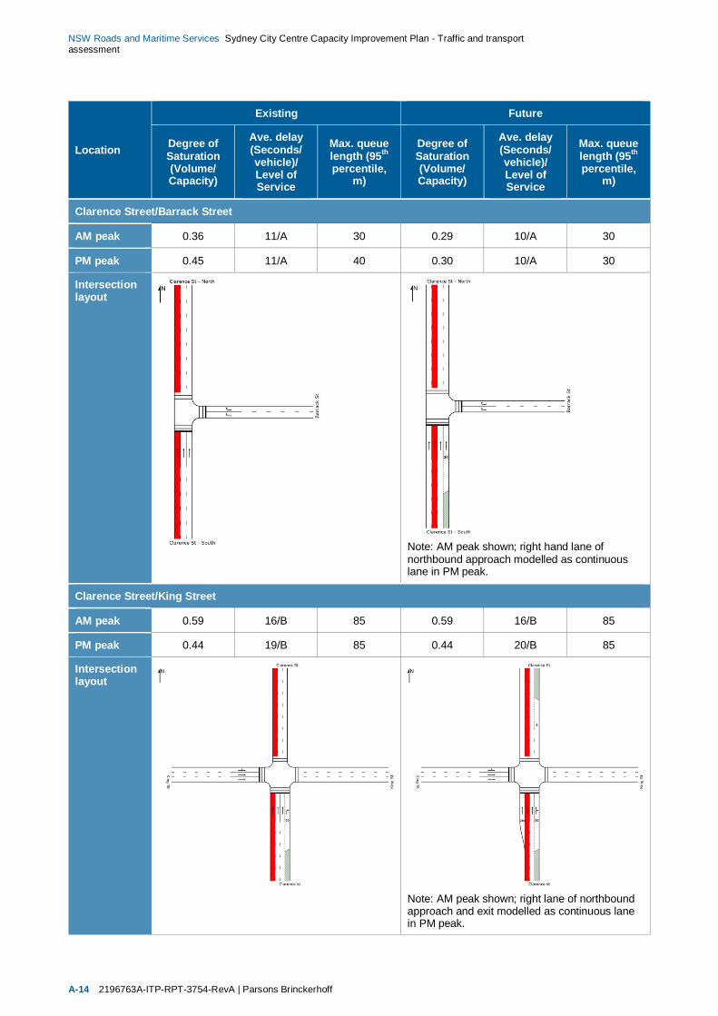
NSW Roads and Maritime Services Sydney City Centre Capacity Improvement Plan - Traffic and transportassessment
A-14 2196763A-ITP-RPT-3754-RevA | Parsons Brinckerhoff
Location
Existing Future
Degree ofSaturation(Volume/Capacity)
Ave. delay(Seconds/vehicle)/Level ofService
Max. queuelength (95th
percentile,m)
Degree ofSaturation(Volume/Capacity)
Ave. delay(Seconds/vehicle)/Level ofService
Max. queuelength (95th
percentile,m)
Clarence Street/Barrack Street
AM peak 0.36 11/A 30 0.29 10/A 30
PM peak 0.45 11/A 40 0.30 10/A 30
Intersectionlayout
Note: AM peak shown; right hand lane ofnorthbound approach modelled as continuouslane in PM peak.
Clarence Street/King Street
AM peak 0.59 16/B 85 0.59 16/B 85
PM peak 0.44 19/B 85 0.44 20/B 85
Intersectionlayout
Note: AM peak shown; right lane of northboundapproach and exit modelled as continuous lanein PM peak.
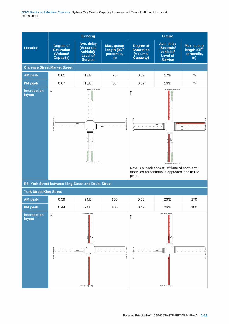
NSW Roads and Maritime Services Sydney City Centre Capacity Improvement Plan - Traffic and transportassessment
Parsons Brinckerhoff | 2196763A-ITP-RPT-3754-RevA A-15
Location
Existing Future
Degree ofSaturation(Volume/Capacity)
Ave. delay(Seconds/vehicle)/Level ofService
Max. queuelength (95th
percentile,m)
Degree ofSaturation(Volume/Capacity)
Ave. delay(Seconds/vehicle)/Level ofService
Max. queuelength (95th
percentile,m)
Clarence Street/Market Street
AM peak 0.61 18/B 75 0.52 17/B 75
PM peak 0.67 18/B 85 0.52 16/B 75
Intersectionlayout
Note: AM peak shown; left lane of north armmodelled as continuous approach lane in PMpeak.
R5: York Street between King Street and Druitt Street
York Street/King Street
AM peak 0.59 24/B 155 0.63 26/B 170
PM peak 0.44 24/B 100 0.42 26/B 100
Intersectionlayout
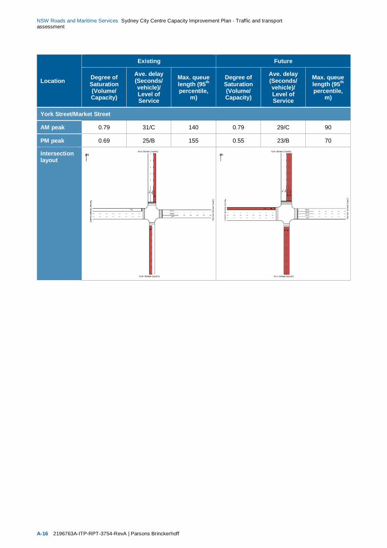
NSW Roads and Maritime Services Sydney City Centre Capacity Improvement Plan - Traffic and transportassessment
A-16 2196763A-ITP-RPT-3754-RevA | Parsons Brinckerhoff
Location
Existing Future
Degree ofSaturation(Volume/Capacity)
Ave. delay(Seconds/vehicle)/Level ofService
Max. queuelength (95th
percentile,m)
Degree ofSaturation(Volume/Capacity)
Ave. delay(Seconds/vehicle)/Level ofService
Max. queuelength (95th
percentile,m)
York Street/Market Street
AM peak 0.79 31/C 140 0.79 29/C 90
PM peak 0.69 25/B 155 0.55 23/B 70
Intersectionlayout
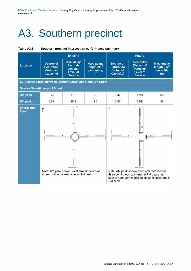
NSW Roads and Maritime Services Sydney City Centre Capacity Improvement Plan - Traffic and transportassessment
Parsons Brinckerhoff | 2196763A-ITP-RPT-3754-RevA A-17
A3. Southern precinctTable A3.1 Southern precinct intersection performance summary
Location
Existing Future
Degree ofSaturation(Volume/Capacity)
Ave. delay(Seconds/vehicle)/Level ofService
Max. queuelength (95th
percentile,m)
Degree ofSaturation(Volume/Capacity)
Ave. delay(Seconds/vehicle)/Level ofService
Max. queuelength (95th
percentile,m)
S1: Sussex Street between Bathurst Street and Goulburn Street
Sussex Street/Liverpool Street
AM peak 0.47 17/B 35 0.47 17/B 35
PM peak 0.57 25/B 80 0.57 25/B 80
Intersectionlayout
Note: AM peak shown; west arm modelled asthree continuous exit lanes in PM peak.
Note: AM peak shown; west arm modelled asthree continuous exit lanes in PM peak; rightlane of north arm modelled as 60 m short lane inPM peak.
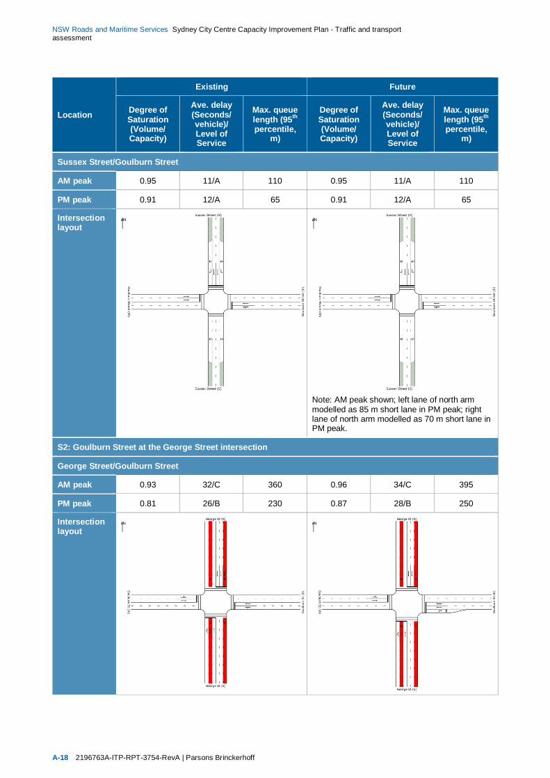
NSW Roads and Maritime Services Sydney City Centre Capacity Improvement Plan - Traffic and transportassessment
A-18 2196763A-ITP-RPT-3754-RevA | Parsons Brinckerhoff
Location
Existing Future
Degree ofSaturation(Volume/Capacity)
Ave. delay(Seconds/vehicle)/Level ofService
Max. queuelength (95th
percentile,m)
Degree ofSaturation(Volume/Capacity)
Ave. delay(Seconds/vehicle)/Level ofService
Max. queuelength (95th
percentile,m)
Sussex Street/Goulburn Street
AM peak 0.95 11/A 110 0.95 11/A 110
PM peak 0.91 12/A 65 0.91 12/A 65
Intersectionlayout
Note: AM peak shown; left lane of north armmodelled as 85 m short lane in PM peak; rightlane of north arm modelled as 70 m short lane inPM peak.
S2: Goulburn Street at the George Street intersection
George Street/Goulburn Street
AM peak 0.93 32/C 360 0.96 34/C 395
PM peak 0.81 26/B 230 0.87 28/B 250
Intersectionlayout

NSW Roads and Maritime Services Sydney City Centre Capacity Improvement Plan - Traffic and transportassessment
Parsons Brinckerhoff | 2196763A-ITP-RPT-3754-RevA A-19
Location
Existing Future
Degree ofSaturation(Volume/Capacity)
Ave. delay(Seconds/vehicle)/Level ofService
Max. queuelength (95th
percentile,m)
Degree ofSaturation(Volume/Capacity)
Ave. delay(Seconds/vehicle)/Level ofService
Max. queuelength (95th
percentile,m)
S3: Pitt Street between Liverpool Street and Rawson Place
Pitt Street/Liverpool Street
AM peak 0.47 13/A 60 0.47 13/A 60
PM peak 0.44 15/B 60 0.44 15/B 60
Intersectionlayout
Pitt Street/Goulburn Street
AM peak 1.58 65/E 240 1.58 53/D 240
PM peak 1.29 34/C 140 1.29 33/C 140
Intersectionlayout
Note: AM peak shown; left exit lane of south armmodelled as continuous lane in PM peak.
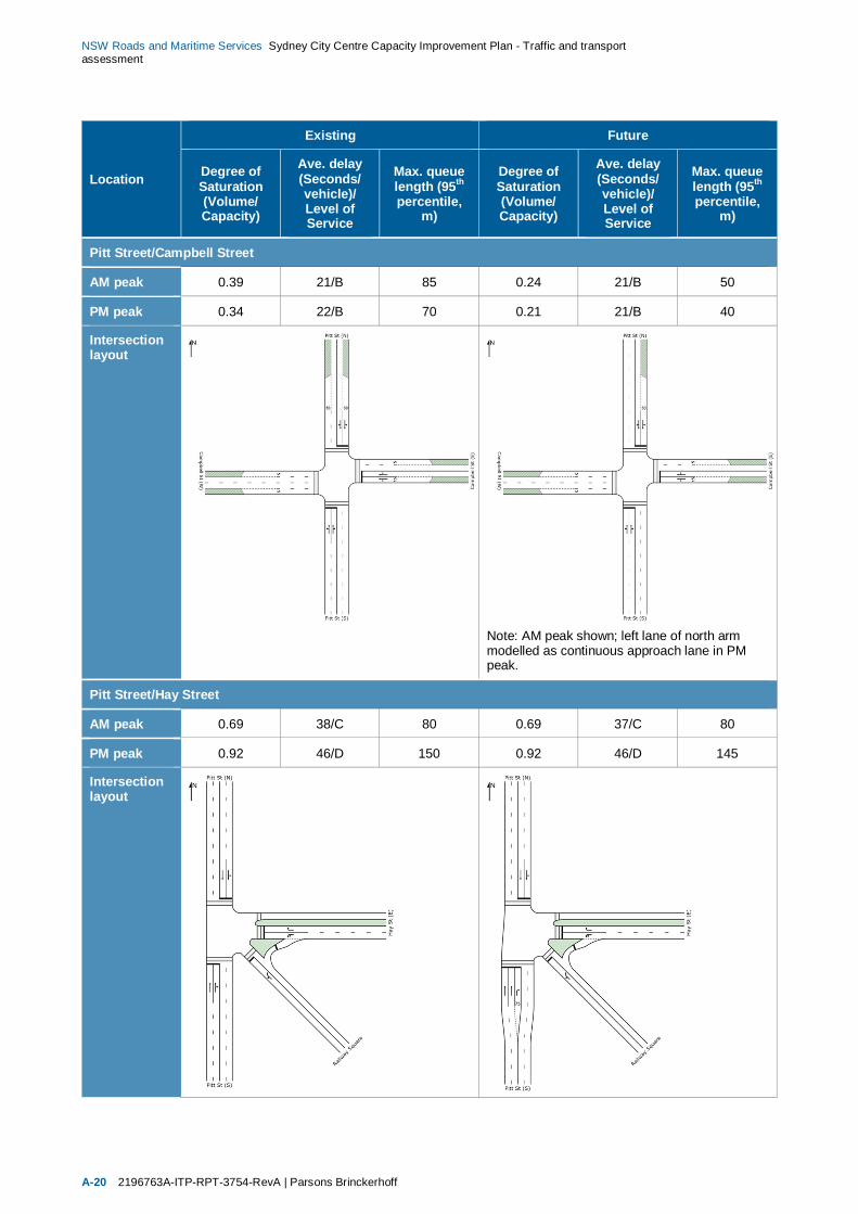
NSW Roads and Maritime Services Sydney City Centre Capacity Improvement Plan - Traffic and transportassessment
A-20 2196763A-ITP-RPT-3754-RevA | Parsons Brinckerhoff
Location
Existing Future
Degree ofSaturation(Volume/Capacity)
Ave. delay(Seconds/vehicle)/Level ofService
Max. queuelength (95th
percentile,m)
Degree ofSaturation(Volume/Capacity)
Ave. delay(Seconds/vehicle)/Level ofService
Max. queuelength (95th
percentile,m)
Pitt Street/Campbell Street
AM peak 0.39 21/B 85 0.24 21/B 50
PM peak 0.34 22/B 70 0.21 21/B 40
Intersectionlayout
Note: AM peak shown; left lane of north armmodelled as continuous approach lane in PMpeak.
Pitt Street/Hay Street
AM peak 0.69 38/C 80 0.69 37/C 80
PM peak 0.92 46/D 150 0.92 46/D 145
Intersectionlayout

NSW Roads and Maritime Services Sydney City Centre Capacity Improvement Plan - Traffic and transportassessment
Parsons Brinckerhoff | 2196763A-ITP-RPT-3754-RevA A-21
Location
Existing Future
Degree ofSaturation(Volume/Capacity)
Ave. delay(Seconds/vehicle)/Level ofService
Max. queuelength (95th
percentile,m)
Degree ofSaturation(Volume/Capacity)
Ave. delay(Seconds/vehicle)/Level ofService
Max. queuelength (95th
percentile,m)
Pitt Street/Rawson Place
AM peak 0.84 31/C 195 0.84 31/C 195
PM peak 0.86 32/C 190 0.86 32/C 190
Intersectionlayout
S4: Ultimo Road at the Harris Street intersection
Ultimo Road/Harris Street
AM peak 0.49 12/A 115 0.49 12/A 115
PM peak 0.85 21/B 170 0.59 20/B 170
Intersectionlayout
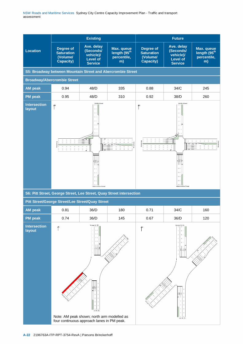
NSW Roads and Maritime Services Sydney City Centre Capacity Improvement Plan - Traffic and transportassessment
A-22 2196763A-ITP-RPT-3754-RevA | Parsons Brinckerhoff
Location
Existing Future
Degree ofSaturation(Volume/Capacity)
Ave. delay(Seconds/vehicle)/Level ofService
Max. queuelength (95th
percentile,m)
Degree ofSaturation(Volume/Capacity)
Ave. delay(Seconds/vehicle)/Level ofService
Max. queuelength (95th
percentile,m)
S5: Broadway between Mountain Street and Abercrombie Street
Broadway/Abercrombie Street
AM peak 0.94 48/D 335 0.88 34/C 245
PM peak 0.95 48/D 310 0.92 38/D 260
Intersectionlayout
S6: Pitt Street, George Street, Lee Street, Quay Street intersection
Pitt Street/George Street/Lee Street/Quay Street
AM peak 0.81 36/D 180 0.71 34/C 160
PM peak 0.74 36/D 145 0.67 36/D 120
Intersectionlayout
Note: AM peak shown; north arm modelled asfour continuous approach lanes in PM peak.
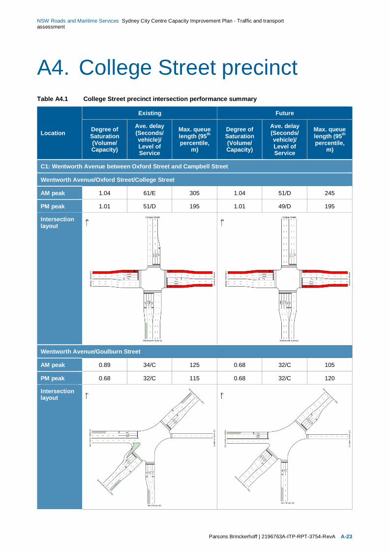
NSW Roads and Maritime Services Sydney City Centre Capacity Improvement Plan - Traffic and transportassessment
Parsons Brinckerhoff | 2196763A-ITP-RPT-3754-RevA A-23
A4. College Street precinctTable A4.1 College Street precinct intersection performance summary
Location
Existing Future
Degree ofSaturation(Volume/Capacity)
Ave. delay(Seconds/vehicle)/Level ofService
Max. queuelength (95th
percentile,m)
Degree ofSaturation(Volume/Capacity)
Ave. delay(Seconds/vehicle)/Level ofService
Max. queuelength (95th
percentile,m)
C1: Wentworth Avenue between Oxford Street and Campbell Street
Wentworth Avenue/Oxford Street/College Street
AM peak 1.04 61/E 305 1.04 51/D 245
PM peak 1.01 51/D 195 1.01 49/D 195
Intersectionlayout
Wentworth Avenue/Goulburn Street
AM peak 0.89 34/C 125 0.68 32/C 105
PM peak 0.68 32/C 115 0.68 32/C 120
Intersectionlayout

NSW Roads and Maritime Services Sydney City Centre Capacity Improvement Plan - Traffic and transportassessment
A-24 2196763A-ITP-RPT-3754-RevA | Parsons Brinckerhoff
Location
Existing Future
Degree ofSaturation(Volume/Capacity)
Ave. delay(Seconds/vehicle)/Level ofService
Max. queuelength (95th
percentile,m)
Degree ofSaturation(Volume/Capacity)
Ave. delay(Seconds/vehicle)/Level ofService
Max. queuelength (95th
percentile,m)
Wentworth Avenue/Elizabeth Street
AM peak 0.71 20/B 95 0.71 20/B 95
PM peak 0.72 27/B 115 0.63 26/B 110
Intersectionlayout
C2: College Street between Macquarie Street and Oxford Street
Prince Albert Road/Macquarie Street
AM peak 0.67 30/C 105 0.75 30/C 105
PM peak 1.25 49/D 195 1.25 49/D 195
Intersectionlayout

NSW Roads and Maritime Services Sydney City Centre Capacity Improvement Plan - Traffic and transportassessment
Parsons Brinckerhoff | 2196763A-ITP-RPT-3754-RevA A-25
Location
Existing Future
Degree ofSaturation(Volume/Capacity)
Ave. delay(Seconds/vehicle)/Level ofService
Max. queuelength (95th
percentile,m)
Degree ofSaturation(Volume/Capacity)
Ave. delay(Seconds/vehicle)/Level ofService
Max. queuelength (95th
percentile,m)
College Street/St Marys Road
AM peak 0.54 24/B 135 0.44 23/B 75
PM peak 0.57 25/B 140 0.57 25/B 140
Intersectionlayout
College Street/William Street
AM peak 1.58 200/F 655 1.07 74/F 340
PM peak 1.39 120/F 475 0.81 45/D 145
Intersectionlayout
Note: AM peak shown; left turn lane of north armmodelled as 180 m short lane in PM peak.
Note: AM peak shown; left turn lane of north armmodelled as continuous lane in PM peak.

NSW Roads and Maritime Services Sydney City Centre Capacity Improvement Plan - Traffic and transportassessment
A-26 2196763A-ITP-RPT-3754-RevA | Parsons Brinckerhoff
Location
Existing Future
Degree ofSaturation(Volume/Capacity)
Ave. delay(Seconds/vehicle)/Level ofService
Max. queuelength (95th
percentile,m)
Degree ofSaturation(Volume/Capacity)
Ave. delay(Seconds/vehicle)/Level ofService
Max. queuelength (95th
percentile,m)
College Street/Francis Street
AM peak 0.33 7/A 65 0.25 6/A 45
PM peak 0.42 8/A 85 0.28 8/A 50
Intersectionlayout

NSW Roads and Maritime Services Sydney City Centre Capacity Improvement Plan - Traffic and transportassessment
Parsons Brinckerhoff | 2196763A-ITP-RPT-3754-RevA A-27
A5. Financial precinctTable A5.1 Financial precinct intersection performance summary
Location
Existing Future
Degree ofSaturation(Volume/Capacity)
Ave. delay(Seconds/vehicle)/Level ofService
Max. queuelength (95th
percentile,m)
Degree ofSaturation(Volume/Capacity)
Ave. delay(Seconds/vehicle)/Level ofService
Max. queuelength (95th
percentile,m)
F1: Macquarie Street between Bent Street and Bridge Street
Macquarie Street/Bridge Street
AM peak 0.79 30/C 110 0.73 29/C 110
PM peak 0.77 31/C 105 0.77 31/C 105
Intersectionlayout

NSW Roads and Maritime Services Sydney City Centre Capacity Improvement Plan - Traffic and transportassessment
A-28 2196763A-ITP-RPT-3754-RevA | Parsons Brinckerhoff
Location
Existing Future
Degree ofSaturation(Volume/Capacity)
Ave. delay(Seconds/vehicle)/Level ofService
Max. queuelength (95th
percentile,m)
Degree ofSaturation(Volume/Capacity)
Ave. delay(Seconds/vehicle)/Level ofService
Max. queuelength (95th
percentile,m)
Macquarie Street/Bent Street
AM peak 0.88 38/C 200 1.02 61/E 330
PM peak 1.03 43/D 325 1.03 43/D 325
Intersectionlayout
Note: AM peak shown; left turn lane of north armmodelled as 75 m short lane in PM peak.
Note: AM peak shown; left turn lane of north armmodelled as 75 m short lane in PM peak.
F2: Macquarie Street at the Hunter Street intersection
Macquarie Street/Hunter Street
AM peak 0.61 12/A 65 0.44 15/B 70
PM peak 0.49 13/A 80 0.49 15/B 80
Intersectionlayout
Sydney City Centre Capacity Improvement Plan Appendix DReview of Environmental Factors
Appendix DNoise and vibration specialist study

Sydney City Centre
Capacity Improvements Plan
Appendix D: Noise and Vibration Assessment
Report Number 610.13473-R1
11 November 2014
Parsons Brinckerhoff Australia Pty Limited
Level 27 Ernst & Young Centre680 George Street Sydney NSW 2000GPO Box 5394
Version: Revision 0
Parsons Brinckerhoff Australia Pty Limited Sydney City Centre Capacity Improvements Plan Appendix D: Noise and Vibration Assessment
Report Number 610.13473-R1 11 November 2014
Revision 0 Page 2
SLR Consulting Australia Pty Ltd
Sydney City Centre
Capacity Improvements Plan
Appendix D: Noise and Vibration Assessment
PREPARED BY:
SLR Consulting Australia Pty Ltd ABN 29 001 584 612
2 Lincoln Street Lane Cove NSW 2066 Australia
(PO Box 176 Lane Cove NSW 1595 Australia)
T: 61 2 9428 8100 F: 61 2 9427 8200
E: [email protected] www.slrconsulting.com
This report has been prepared by SLR Consulting Australia Pty Ltd
with all reasonable skill, care and diligence, and taking account of the
timescale and resources allocated to it by agreement with the Client.
Information reported herein is based on the interpretation of data collected,
which has been accepted in good faith as being accurate and valid.
This report is for the exclusive use of Parsons Brinckerhoff Australia Pty Limited.
No warranties or guarantees are expressed or should be inferred by any third parties.
This report may not be relied upon by other parties without written consent from SLR Consulting.
SLR Consulting disclaims any responsibility to the Client and others in respect of any matters outside the agreed scope of the work.
DOCUMENT CONTROL
Reference Status Date Prepared Checked Authorised
610.13473-R1 Revision 0 11 November 2014 Mark Russell
Henrik Malker
Tom Cockings Henrik Malker

Parsons Brinckerhoff Australia Pty Limited Sydney City Centre Capacity Improvements Plan Appendix D: Noise and Vibration Assessment
Report Number 610.13473-R1 11 November 2014
Revision 0 Page 3
Executive Summary
SLR Consulting Australia Pty Ltd
PROJECT DESCRIPTION
Roads and Maritime propose to introduce a number of traffic efficiency improvements in 17 congested and critical locations across the city centre to make better use of the available street space as described in the Sydney City Centre Access Strategy (the Access Strategy) (Transport for NSW, 2013) (the proposal).
SLR Consulting Australia (SLR) was commissioned to prepare a construction and operational noise and vibration impact assessment to support the proposal review of environmental factors (REF).
The proposal would include the following six general types of traffic efficiency improvements:
Intersection reconfiguration and geometry modifications
Kerb extension alterations
Footpath width alterations
Turning restrictions and provisions
Kerbside allocation modifications
Lane arrangements.
This would be supplemented by other supporting work including surface drainage and utility modifications and adjustments and tree pruning/removal etc.
The proposal is divided into 17 work sites across five precincts. This is to assist in describing the existing environment and assessing the proposal's potential impacts. The precincts are:
Precinct 1: North West
Precinct 2: Retail
Precinct 3: Southern
Precinct 4: College
Precinct 5: Financial
Construction is anticipated to start in the first half of 2015 and it would take up to one year to complete due to the complexities of programming the work to avoid impacting on the city’s traffic. To avoid impacting on the city’s traffic night-time works would also likely be required.
EXISTING ENVIRONMENT
As part of this proposal, operator-attended noise monitoring was undertaken at 19 locations within the study area during September 2014. In addition both long-term unattended and short-term attended noise monitoring undertaken for the Sydney City Centre Bus Infrastructure REF (Jacobs, 2014) was used for this proposal.
The purpose of the noise monitoring was to determine existing noise levels in the study area and establish construction Noise Management Levels (NMLs) for the assessment of potential noise impacts during construction.
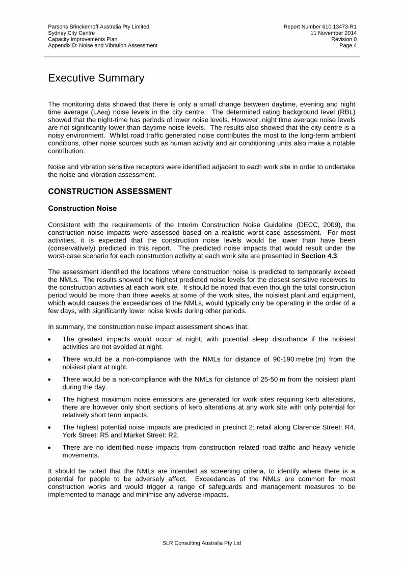
Parsons Brinckerhoff Australia Pty Limited Sydney City Centre Capacity Improvements Plan Appendix D: Noise and Vibration Assessment
Report Number 610.13473-R1 11 November 2014
Revision 0 Page 4
Executive Summary
SLR Consulting Australia Pty Ltd
The monitoring data showed that there is only a small change between daytime, evening and night time average (LAeq) noise levels in the city centre. The determined rating background level (RBL) showed that the night-time has periods of lower noise levels. However, night time average noise levels are not significantly lower than daytime noise levels. The results also showed that the city centre is a noisy environment. Whilst road traffic generated noise contributes the most to the long-term ambient conditions, other noise sources such as human activity and air conditioning units also make a notable contribution.
Noise and vibration sensitive receptors were identified adjacent to each work site in order to undertake the noise and vibration assessment.
CONSTRUCTION ASSESSMENT
Construction Noise
Consistent with the requirements of the Interim Construction Noise Guideline (DECC, 2009), the construction noise impacts were assessed based on a realistic worst-case assessment. For most activities, it is expected that the construction noise levels would be lower than have been (conservatively) predicted in this report. The predicted noise impacts that would result under the worst-case scenario for each construction activity at each work site are presented in Section 4.3.
The assessment identified the locations where construction noise is predicted to temporarily exceed the NMLs. The results showed the highest predicted noise levels for the closest sensitive receivers to the construction activities at each work site. It should be noted that even though the total construction period would be more than three weeks at some of the work sites, the noisiest plant and equipment, which would causes the exceedances of the NMLs, would typically only be operating in the order of a few days, with significantly lower noise levels during other periods.
In summary, the construction noise impact assessment shows that:
The greatest impacts would occur at night, with potential sleep disturbance if the noisiest activities are not avoided at night.
There would be a non-compliance with the NMLs for distance of 90-190 metre (m) from the noisiest plant at night.
There would be a non-compliance with the NMLs for distance of 25-50 m from the noisiest plant during the day.
The highest maximum noise emissions are generated for work sites requiring kerb alterations, there are however only short sections of kerb alterations at any work site with only potential for relatively short term impacts.
The highest potential noise impacts are predicted in precinct 2: retail along Clarence Street: R4, York Street: R5 and Market Street: R2.
There are no identified noise impacts from construction related road traffic and heavy vehicle movements.
It should be noted that the NMLs are intended as screening criteria, to identify where there is a potential for people to be adversely affect. Exceedances of the NMLs are common for most construction works and would trigger a range of safeguards and management measures to be implemented to manage and minimise any adverse impacts.
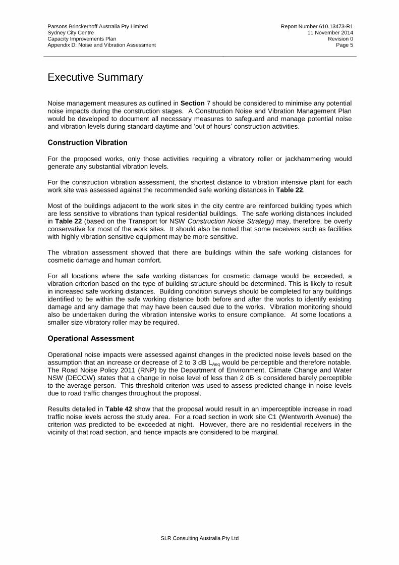
Parsons Brinckerhoff Australia Pty Limited Sydney City Centre Capacity Improvements Plan Appendix D: Noise and Vibration Assessment
Report Number 610.13473-R1 11 November 2014
Revision 0 Page 5
Executive Summary
SLR Consulting Australia Pty Ltd
Noise management measures as outlined in Section 7 should be considered to minimise any potential noise impacts during the construction stages. A Construction Noise and Vibration Management Plan would be developed to document all necessary measures to safeguard and manage potential noise and vibration levels during standard daytime and ‘out of hours’ construction activities.
Construction Vibration
For the proposed works, only those activities requiring a vibratory roller or jackhammering would generate any substantial vibration levels.
For the construction vibration assessment, the shortest distance to vibration intensive plant for each work site was assessed against the recommended safe working distances in Table 22.
Most of the buildings adjacent to the work sites in the city centre are reinforced building types which are less sensitive to vibrations than typical residential buildings. The safe working distances included in Table 22 (based on the Transport for NSW Construction Noise Strategy) may, therefore, be overly conservative for most of the work sites. It should also be noted that some receivers such as facilities with highly vibration sensitive equipment may be more sensitive.
The vibration assessment showed that there are buildings within the safe working distances for cosmetic damage and human comfort.
For all locations where the safe working distances for cosmetic damage would be exceeded, a vibration criterion based on the type of building structure should be determined. This is likely to result in increased safe working distances. Building condition surveys should be completed for any buildings identified to be within the safe working distance both before and after the works to identify existing damage and any damage that may have been caused due to the works. Vibration monitoring should also be undertaken during the vibration intensive works to ensure compliance. At some locations a smaller size vibratory roller may be required.
Operational Assessment
Operational noise impacts were assessed against changes in the predicted noise levels based on the assumption that an increase or decrease of 2 to 3 dB LAeq would be perceptible and therefore notable. The Road Noise Policy 2011 (RNP) by the Department of Environment, Climate Change and Water NSW (DECCW) states that a change in noise level of less than 2 dB is considered barely perceptible to the average person. This threshold criterion was used to assess predicted change in noise levels due to road traffic changes throughout the proposal.
Results detailed in Table 42 show that the proposal would result in an imperceptible increase in road traffic noise levels across the study area. For a road section in work site C1 (Wentworth Avenue) the criterion was predicted to be exceeded at night. However, there are no residential receivers in the vicinity of that road section, and hence impacts are considered to be marginal.

Parsons Brinckerhoff Australia Pty Limited Sydney City Centre Capacity Improvements Plan Appendix D: Noise and Vibration Assessment
Report Number 610.13473-R1 11 November 2014
Revision 0 Page 6
Table of Contents
SLR Consulting Australia Pty Ltd
1 INTRODUCTION 9
1.1.1 Construction program 10
1.1.2 Construction hours and duration 10
1.1.3 Noise and vibration generation 10
1.2 Study area 10
1.3 Acoustic Terminology 12
2 EXISTING NOISE ENVIRONMENT 13
2.1 Attended Noise Monitoring 13
2.2 Unattended Noise Monitoring 17
2.3 Identification of Noise and Vibration Sensitive Receivers 18
2.4 Precinct 1 (North West) 19
2.5 Precinct 2 (Retail) 20
2.6 Precinct 3 (Southern) 23
2.7 Precinct 4 (College) 28
2.8 Precinct 5 (Financial) 30
3 NOISE CRITERIA 30
3.1 Construction Noise Criteria 30
3.1.1 NSW Interim Construction Noise Guideline 30
3.2 Construction Vibration Criteria 34
3.2.1 Vibration Damage Goals 34
3.2.2 Human Comfort Goals for Construction Vibration 36
3.2.3 Safe Working Distances for Vibration Intensive Plant 36
3.3 Operational Noise Criteria 37
4 CONSTRUCTION ASSESSMENT 38
4.1 Construction hours 38
4.2 Construction Works and Equipment 38
4.3 Construction Noise Predictions 40
4.3.1 Precinct 1: North-West 40
4.3.2 Precinct 2: Retail 42
4.3.3 Precinct 3: Southern 46

Parsons Brinckerhoff Australia Pty Limited Sydney City Centre Capacity Improvements Plan Appendix D: Noise and Vibration Assessment
Report Number 610.13473-R1 11 November 2014
Revision 0 Page 7
Table of Contents
SLR Consulting Australia Pty Ltd
4.3.4 Precinct 4: College 51
4.3.5 Precinct 5: Financial 53
4.4 Construction Sleep Disturbance Assessment 55
4.5 Discussion of Construction Noise Impacts 55
4.6 Construction Vibration Assessment 56
5 OPERATIONAL ASSESSMENT 58
5.1 Summary of Road Traffic Noise Impacts 58
5.2 Operational Vibration Assessment 59
6 CUMULATIVE 59
7 RECOMMENDED MITIGATION MEASURES 60
7.1 Construction Noise Mitigation Measures 60
8 REFERENCES 63
TABLES
Table 1 Precinct Summary and Work Site Limits 10 Table 2 Summary of Attended Noise Monitoring Data for the Study Area 13 Table 3 Attended noise measurement equipment serial numbers 14 Table 4 Results of Attended Noise Monitoring – September 2014 16 Table 5 Summary of Unattended Noise Monitoring Data for the Study Area 18 Table 6 Nearest Sensitive Receivers – Kent Street: NW1 and King Street: NW2 19 Table 7 Nearest Sensitive Receivers – Park Street: R1, Market Street: R2, Sussex Street: R3
and York Street: R5 21 Table 8 Nearest Sensitive Receivers – Clarence Street: R4 22 Table 9 Nearest Sensitive Receivers – S1 and S2 23 Table 10 Nearest Sensitive Receivers – S3 24 Table 11 Nearest Sensitive Receivers – Ultimo Road S4 25 Table 12 Nearest Sensitive Receivers – Broadway:S5 26 Table 13 Nearest Sensitive Receivers – Pitt Street: S6 27 Table 14 Nearest Sensitive Receivers – Wentworth Avenue: C1 28 Table 15 Nearest Sensitive Receivers – College Street: C2 29 Table 16 Nearest Sensitive Receivers –Macquarie Street: F1 and Macquarie Street: F2 30 Table 17 NMLs for Airborne Construction Noise at Residences 31 Table 18 Interim Construction Noise Guideline - Other Sensitive Land Uses 32 Table 19 NMLs (Residential Receivers) 33 Table 20 Transient Vibration Guide Values – Minimal Risk of Cosmetic Damage 35 Table 21 Preferred and Maximum VDVs for Intermittent Vibration 36 Table 22 Recommended Safe Working Distances for Vibration Intensive Plant 37 Table 23 Construction Activities and Estimated Worst Case SWL 39 Table 24 Work Site NW1 - Kent Street between Margaret Street and King Street 41 Table 25 Work Site NW2 - King Street between Sussex Street and Castlereagh Street 42 Table 26 Work Site R1 - Park Street at the Pitt Street intersection 43

Parsons Brinckerhoff Australia Pty Limited Sydney City Centre Capacity Improvements Plan Appendix D: Noise and Vibration Assessment
Report Number 610.13473-R1 11 November 2014
Revision 0 Page 8
Table of Contents
SLR Consulting Australia Pty Ltd
Table 27 Work Site R2 - Market Street between Kent Street and Castlereagh Street 43 Table 28 Work Site R3 - Sussex Street between King Street and Druitt Street 44 Table 29 Work Site R4 - Clarence Street between Jamison Street and Druitt Street 45 Table 30 Work Site R5 - York Street between King Street and Druitt Street 46 Table 31 Work Site S1 - Sussex Street between Bathurst Street and Goulburn Street 46 Table 32 Work Site S2 - Park Street at the Pitt Street intersection 47 Table 33 Work Site S3 - Park Street at the Pitt Street intersection 48 Table 34 Work Site S4 - Park Street at the Pitt Street intersection 49 Table 35 Work Site S5 - Broadway between Mountain Street and Abercrombie Street 50 Table 36 Work Site S6 - Pitt Street at the Lee Street and George Street intersection 51 Table 37 Work Site C1 - Wentworth Avenue between Oxford Street and Campbell Street 51 Table 38 Work Site C2 - College Street between Macquarie Street and Oxford Street 53 Table 39 Work Site F1 - Macquarie Street between Bent Street and Bridge Street 54 Table 40 Work Site F2 - Macquarie Street at the Hunter Street intersection 55 Table 41 Construction Vibration Assessment 57 Table 42 Summary of predicted change in noise levels 58
FIGURES
Figure 1 Study Area 11 Figure 2 Noise Monitoring Locations 15 Figure 3 Kent Street: NW1 and King Street: NW2 19 Figure 4 Work Site Park Street: R1, Market Street: R2, Sussex Street: R3 and York Street: R5 20 Figure 5 Work Site Clarence Street: R4 22 Figure 6 Work Site Sussex Street: S1 and Goulburn Street: S2 23 Figure 7 Work Site Pitt Street: S3 24 Figure 8 Work Site Ultimo Road: S4 25 Figure 9 Work Site Broadway:S5 26 Figure 10 Work Site Pitt Street: S6 27 Figure 11 Work Site Wentworth Avenue: C1 28 Figure 12 Work Site College Street: C2 29 Figure 13 Work Site Macquarie Street: F1 and Macquarie Street: F2 30 Figure 14 Transient Vibration Guide Values for Cosmetic Damage 35
APPENDICES
Attachment A Acoustic Terminology Attachment B Construction Works and Used Equipment Attachment C Predicted Operational Noise Levels

Parsons Brinckerhoff Australia Pty Limited Sydney City Centre Capacity Improvements Plan Appendix D: Noise and Vibration Assessment
Report Number 610.13473-R1 11 November 2014
Revision 0 Page 9
SLR Consulting Australia Pty Ltd
1 INTRODUCTION
Roads and Maritime propose to introduce a number of traffic efficiency improvements in 17 congested and critical locations across the city centre to make better use of the available street space as described in the Sydney City Centre Access Strategy (the Access Strategy) (Transport for NSW, 2013) (the proposal).
SLR Consulting Australia (SLR) has been to prepare a construction and operational noise and vibration impact assessment to support the proposal review of environmental factors (REF).
The proposal would affect 17 locations and involve implementing one of six general types of traffic efficiency improvement:
Intersection reconfiguration and geometry modifications
Kerb extension alterations
Footpath width alterations
Turning restrictions and provisions
Traffic signal timing priorities
Kerbside allocation modifications.
A range of supporting work would also be required under the proposal including:
Major equipment relocation (eg telephone boxes, parking ticket vending machines, post boxes)
Tree pruning or removal
Bus lane marking alterations or instalment
Road regrading and resurfacing
Traffic signal and lighting pole works
Surface drainage modification and relocation
Bus shelter relocation
Utility works.
For ease of reference, the proposal has been split across five precincts:
Precinct 1: north-west
Precinct 2: retail
Precinct 3: southern
Precinct 4: college
Precinct 5: financial.
Each precinct contains one or more of the 17 work site locations refer to Table 1.
Parsons Brinckerhoff Australia Pty Limited Sydney City Centre Capacity Improvements Plan Appendix D: Noise and Vibration Assessment
Report Number 610.13473-R1 11 November 2014
Revision 0 Page 10
SLR Consulting Australia Pty Ltd
Table 1 Precinct Summary and Work Site Limits
Precinct Work site reference and limits
Precinct 1: north-west
NW1: Kent Street between Margaret Street and King Street
NW2: King Street between Sussex Street and Castlereagh Street
Precinct 2: retail
R1: Park Street at the Pitt Street intersection
R2: Market Street between Kent Street and Castlereagh Street
R3: Sussex Street between King Street and Druitt Street
R4: Clarence Street between Jamison Street and Druitt Street
R5: York Street between King Street and Druitt Street
Precinct 3: southern
S1: Sussex Street between Bathurst Street and Goulburn Street
S2: Goulburn Street at the George Street intersection
S3: Pitt Street between Liverpool Street and Rawson Place
S4: Ultimo Road at the Harris Street intersection
S5: Broadway between Mountain Street and Abercrombie Street
S6: Pitt Street at the Lee Street and George Street intersection
Precinct 4: college
C1: Wentworth Avenue between Oxford Street and Campbell Street
C2: College Street between Macquarie Street and Oxford Street
Precinct 5: financial
F1: Macquarie Street between Bent Street and Bridge Street
F2: Macquarie Street at the Hunter Street intersection
1.1.1 Construction program
Construction is anticipated to start in the first half of 2015 and it would take up to one year to complete due to the complexities of programming the works to avoid impacting on the city’s traffic.
1.1.2 Construction hours and duration
In order to minimise impacts on some of Sydney’s busiest roads the majority of the construction works would need to take place outside of peak periods (termed ‘out of hours’ working). This would include working at night and over the weekend. This would achieve the most efficient and shortest construction program. The extent, duration and construction timing would be confirmed and finalised by the construction contractor as part of the construction staging however the impacts of this have been considered in this specialist study.
1.1.3 Noise and vibration generation
The proposal has the potential to generate noise and vibration as a result of:
Construction work
Operational traffic.
Consequently, the above activities may impact on sensitive receivers located within the five city centre precincts described above (the study area). The purpose of this report is to identify these impacts.
1.2 Study area
The noise and vibration assessment study area considered the people and other sensitive receivers and buildings that would be affected by construction and operational noise and vibration within the five precincts shown on Figure 1.

Parsons Brinckerhoff Australia Pty Limited Sydney City Centre Capacity Improvements Plan Appendix D: Noise and Vibration Assessment
Report Number 610.13473-R1 11 November 2014
Revision 0 Page 11
SLR Consulting Australia Pty Ltd
Figure 1 Study Area
Parsons Brinckerhoff Australia Pty Limited Sydney City Centre Capacity Improvements Plan Appendix D: Noise and Vibration Assessment
Report Number 610.13473-R1 11 November 2014
Revision 0 Page 12
SLR Consulting Australia Pty Ltd
1.3 Acoustic Terminology
Below provides a brief summary of the acoustic terminology used throughout the report. Further information is provided in Attachment A.
LA1(1minute) the “typical maximum noise level” for an event, used in the assessment of potential sleep disturbance during night-time periods. Alternatively, assessment may be conducted using the LAmax or maximum noise level.
LAeq (15minute) the “energy average noise level” evaluated over a 15-minute period. This parameter is used to assess the potential construction noise impacts.
LA90 the “background noise level” in the absence of construction activities. This parameter represents the average minimum noise level during the daytime, evening and night-time periods respectively. The LAeq(15 minute) construction Noise Management Levels are based on the LA90 background noise levels.
LA10 describes the noise levels that occur for 10 per cent of the time, therefore describing the noisiest periods
LAmax describes the maximum noise level recorded at any point in time
Rating background (noise) levels (RBLs) describe the ambient background noise levels during the day, evening and at night.
The subscript “A” indicates that the noise levels are filtered to match normal human hearing characteristics (ie A-weighted).

Parsons Brinckerhoff Australia Pty Limited Sydney City Centre Capacity Improvements Plan Appendix D: Noise and Vibration Assessment
Report Number 610.13473-R1 11 November 2014
Revision 0 Page 13
SLR Consulting Australia Pty Ltd
2 EXISTING NOISE ENVIRONMENT
Noise monitoring data were used to characterise the existing ambient noise environment across the study area and to establish the noise emission targets.
Data from other projects were used and supplemented by collecting additional data for this proposal.
Data from the Bus Infrastructure project and the CBD to South East Light Rail (CSLER) environmental impact statement (EIS) were reviewed and supplemented by environmental noise monitoring undertaken during September 2014 at a number of representative locations. The following summarises the environmental noise monitoring data used for this assessment.
The monitoring data showed that there is only a small change between daytime, evening and night time average (LAeq) noise levels in the city centre. The determined RBL showed that the night-time has periods of lower noise levels. However, night time average noise levels are not significantly lower than daytime average noise levels. The results also showed that the city centre is a noisy environment. Whilst road traffic generated noise contributes the most to the long-term ambient conditions, other noise sources such as human activity and air conditioning units also make a notable contribution.
2.1 Attended Noise Monitoring Attended noise monitoring surveys were undertaken to support the Sydney City Centre Bus Infrastructure REF. The monitoring locations that were relevant to this proposal’s study area are shown on Figure 2 and summarised below in Table 2.
Table 2 Summary of Attended Noise Monitoring Data for the Study Area
Report Reference 1
(Location) Date Time of Day
Noise levels (dBA)2
LAmax LA10 LAeq LA90
(ref: BPI – AT08)
Park St between Pitt Street and George Street
18/9/13
1.16 pm 86 72 71 67
12.07 am 86 70 67 60
(ref: BPI – AT10)
Clarence Street between Market and Druitt Street
18/9/13
3.23 pm 91 74 71 62
11.50 pm 86 69 66 59
(ref: BPI – AT12)
King Street between Clarence St and York Street
18/9/13
2.45 pm 81 70 67 63
11.00 pm 82 70 68 57
Note 1: BPI denotes a measurement referenced form the Sydney City Centre Bus Infrastructure.
Note 2: Attended measurements were conducted over a 10 minute period for the Sydney City Centre Bus Infrastructure.
These data were supplemented for the purpose of this proposal to ensure there was sufficient information on the study area’s existing noise environment relative to all the work sites.
The above data were completed by gathering additional short-term measurements using the equipment detailed in Table 3. The equipment was set up with microphones at 3.5 m above the ground level. This is representative of the first floor, which is the height above ground where the noise guidance limits are set in this instance as most residential receivers within the city centre would be located on first floor or above with commercial on ground floor. All microphones were fitted with wind shields.

Parsons Brinckerhoff Australia Pty Limited Sydney City Centre Capacity Improvements Plan Appendix D: Noise and Vibration Assessment
Report Number 610.13473-R1 11 November 2014
Revision 0 Page 14
SLR Consulting Australia Pty Ltd
Table 3 Attended noise measurement equipment serial numbers
Equipment type Serial Number
Brüel & Kjær 2260 Sound Investigator 214605
Brüel & Kjær 2250 L Sound Level Meter 3003389
Svan 958 14295
Svan 958 36168
All noise measurement instrumentation used in the surveys was designed to comply with the requirements of Australian Standard AS IEC 61672.1-2004 Electroacoustics - Sound level meters, Part 1: Specifications and carried appropriate and current National Association of Testing Authorities (NATA) calibration certificates. The calibration of the loggers was checked both before and after each measurement survey and the variation in calibration at all locations was found to be within acceptable limits at all times.
The locations where additional supplementary data were collected are shown in Figure 2 and described in Table 4.
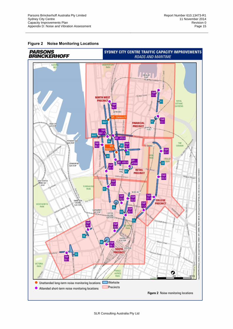
Parsons Brinckerhoff Australia Pty Limited Sydney City Centre Capacity Improvements Plan Appendix D: Noise and Vibration Assessment
Report Number 610.13473-R1 11 November 2014
Revision 0 Page 15
SLR Consulting Australia Pty Ltd
Figure 2 Noise Monitoring Locations
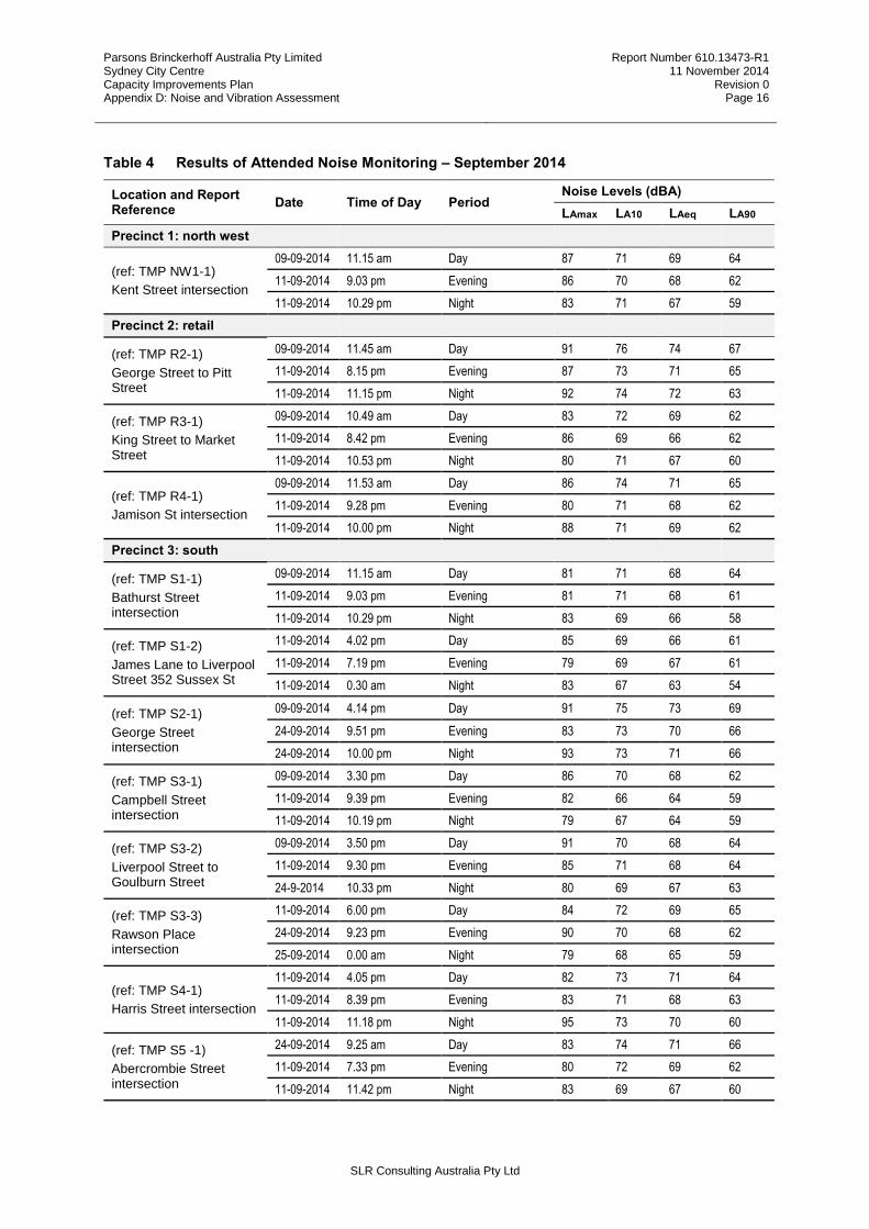
Parsons Brinckerhoff Australia Pty Limited Sydney City Centre Capacity Improvements Plan Appendix D: Noise and Vibration Assessment
Report Number 610.13473-R1 11 November 2014
Revision 0 Page 16
SLR Consulting Australia Pty Ltd
Table 4 Results of Attended Noise Monitoring – September 2014
Location and Report Reference
Date Time of Day Period Noise Levels (dBA)
LAmax LA10 LAeq LA90
Precinct 1: north west
(ref: TMP NW1-1)
Kent Street intersection
09-09-2014 11.15 am Day 87 71 69 64
11-09-2014 9.03 pm Evening 86 70 68 62
11-09-2014 10.29 pm Night 83 71 67 59
Precinct 2: retail
(ref: TMP R2-1)
George Street to Pitt Street
09-09-2014 11.45 am Day 91 76 74 67
11-09-2014 8.15 pm Evening 87 73 71 65
11-09-2014 11.15 pm Night 92 74 72 63
(ref: TMP R3-1)
King Street to Market Street
09-09-2014 10.49 am Day 83 72 69 62
11-09-2014 8.42 pm Evening 86 69 66 62
11-09-2014 10.53 pm Night 80 71 67 60
(ref: TMP R4-1)
Jamison St intersection
09-09-2014 11.53 am Day 86 74 71 65
11-09-2014 9.28 pm Evening 80 71 68 62
11-09-2014 10.00 pm Night 88 71 69 62
Precinct 3: south
(ref: TMP S1-1)
Bathurst Street intersection
09-09-2014 11.15 am Day 81 71 68 64
11-09-2014 9.03 pm Evening 81 71 68 61
11-09-2014 10.29 pm Night 83 69 66 58
(ref: TMP S1-2)
James Lane to Liverpool Street 352 Sussex St
11-09-2014 4.02 pm Day 85 69 66 61
11-09-2014 7.19 pm Evening 79 69 67 61
11-09-2014 0.30 am Night 83 67 63 54
(ref: TMP S2-1)
George Street intersection
09-09-2014 4.14 pm Day 91 75 73 69
24-09-2014 9.51 pm Evening 83 73 70 66
24-09-2014 10.00 pm Night 93 73 71 66
(ref: TMP S3-1)
Campbell Street intersection
09-09-2014 3.30 pm Day 86 70 68 62
11-09-2014 9.39 pm Evening 82 66 64 59
11-09-2014 10.19 pm Night 79 67 64 59
(ref: TMP S3-2)
Liverpool Street to Goulburn Street
09-09-2014 3.50 pm Day 91 70 68 64
11-09-2014 9.30 pm Evening 85 71 68 64
24-9-2014 10.33 pm Night 80 69 67 63
(ref: TMP S3-3)
Rawson Place intersection
11-09-2014 6.00 pm Day 84 72 69 65
24-09-2014 9.23 pm Evening 90 70 68 62
25-09-2014 0.00 am Night 79 68 65 59
(ref: TMP S4-1)
Harris Street intersection
11-09-2014 4.05 pm Day 82 73 71 64
11-09-2014 8.39 pm Evening 83 71 68 63
11-09-2014 11.18 pm Night 95 73 70 60
(ref: TMP S5 -1)
Abercrombie Street intersection
24-09-2014 9.25 am Day 83 74 71 66
11-09-2014 7.33 pm Evening 80 72 69 62
11-09-2014 11.42 pm Night 83 69 67 60

Parsons Brinckerhoff Australia Pty Limited Sydney City Centre Capacity Improvements Plan Appendix D: Noise and Vibration Assessment
Report Number 610.13473-R1 11 November 2014
Revision 0 Page 17
SLR Consulting Australia Pty Ltd
Location and Report Reference
Date Time of Day Period Noise Levels (dBA)
LAmax LA10 LAeq LA90
(ref: TMP S6-1)
S6(A) Pitt Street: Pitt Street and George Street intersection
24-09-2014 5.15 pm Day 86 77 74 67
11-09-2014 8.09 pm Evening 91 77 74 65
11-09-2014 10.47 pm Night 89 75 71 60
Precinct 4: college
(ref: TMP C1-1)
Oxford Street intersection
09-09-2014 2.23 pm Day 91 74 71 65
11-09-2014 8.45 pm Evening 84 72 70 64
24-09-2014 11.05 am Night 85 72 69 63
(ref: TMP C1-2)
Goulburn Street to Campbell Street
09-09-2014 2.50 pm Day 88 72 69 63
11-09-2014 9.04 pm Evening 87 72 69 59
24-09-2014 11.31 pm Night 77 68 65 56
(ref: TMP C2-1)
Prince Albert Road to Park Street
09-09-2014 1.26 pm Day 85 71 68 59
11-09-2014 7.53 pm Evening 85 72 68 58
11-09-2014 10.22 pm Night 82 71 67 57
(ref: TMP C2-2)
Park Street to Oxford Street
09-09-2014 1.51 pm Day 86 73 70 63
11-09-2014 8.18 pm Evening 83 72 68 58
11-09-2014 11.46 pm Night 84 70 66 54
Precinct 5: financial
(ref: TMP F1-1)
Bent Street intersection
09-09-2014 12.3 am Day 82 69 67 63
11-09-2014 7.00 pm Evening 81 70 68 63
11-09-2014 10.25 pm Night 81 69 66 61
(ref: TMP F2-1)
Hunter Street intersection
09-09-2014 12.59 am Day 80 70 67 62
11-09-2014 7.29 pm Evening 81 69 66 60
11-09-2014 10.48 pm Night 88 69 67 59
2.2 Unattended Noise Monitoring
Unattended noise monitoring data were used to describe the average (LAeq) and maximum (LA90) noise levels over a 24-hour period as well as other relevant statistical noise levels during the daytime, evening and night-time periods.
Certain unattended noise monitoring data gathered as part of the Sydney City Centre Bus Infrastructure REF are relevant to this proposal as shown in Figure 2 and described in Table 5
Representative RBL and LAeq (energy averaged) noise levels during the daytime, evening and night-time periods are shown in Table 5.
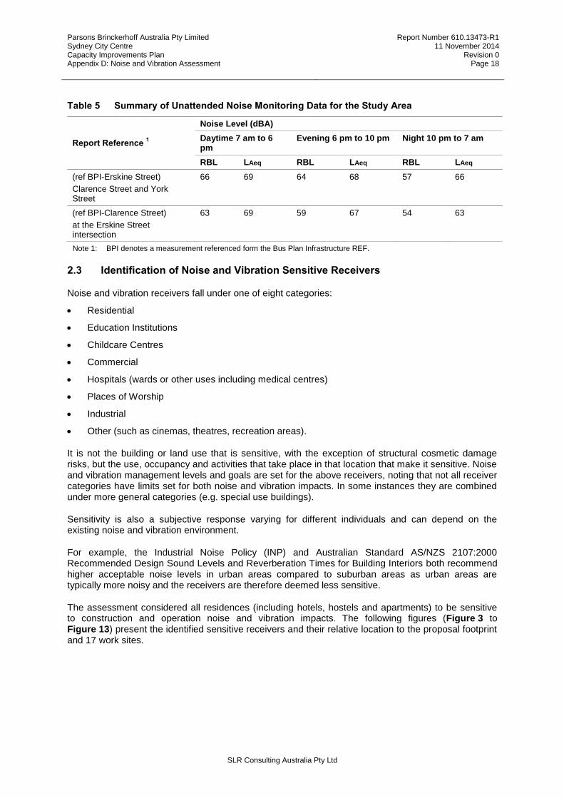
Parsons Brinckerhoff Australia Pty Limited Sydney City Centre Capacity Improvements Plan Appendix D: Noise and Vibration Assessment
Report Number 610.13473-R1 11 November 2014
Revision 0 Page 18
SLR Consulting Australia Pty Ltd
Table 5 Summary of Unattended Noise Monitoring Data for the Study Area
Report Reference 1
Noise Level (dBA)
Daytime 7 am to 6 pm
Evening 6 pm to 10 pm Night 10 pm to 7 am
RBL LAeq RBL LAeq RBL LAeq
(ref BPI-Erskine Street)
Clarence Street and York Street
66 69 64 68 57 66
(ref BPI-Clarence Street)
at the Erskine Street intersection
63 69 59 67 54 63
Note 1: BPI denotes a measurement referenced form the Bus Plan Infrastructure REF.
2.3 Identification of Noise and Vibration Sensitive Receivers
Noise and vibration receivers fall under one of eight categories:
Residential
Education Institutions
Childcare Centres
Commercial
Hospitals (wards or other uses including medical centres)
Places of Worship
Industrial
Other (such as cinemas, theatres, recreation areas).
It is not the building or land use that is sensitive, with the exception of structural cosmetic damage risks, but the use, occupancy and activities that take place in that location that make it sensitive. Noise and vibration management levels and goals are set for the above receivers, noting that not all receiver categories have limits set for both noise and vibration impacts. In some instances they are combined under more general categories (e.g. special use buildings).
Sensitivity is also a subjective response varying for different individuals and can depend on the existing noise and vibration environment.
For example, the Industrial Noise Policy (INP) and Australian Standard AS/NZS 2107:2000 Recommended Design Sound Levels and Reverberation Times for Building Interiors both recommend higher acceptable noise levels in urban areas compared to suburban areas as urban areas are typically more noisy and the receivers are therefore deemed less sensitive.
The assessment considered all residences (including hotels, hostels and apartments) to be sensitive to construction and operation noise and vibration impacts. The following figures (Figure 3 to Figure 13) present the identified sensitive receivers and their relative location to the proposal footprint and 17 work sites.
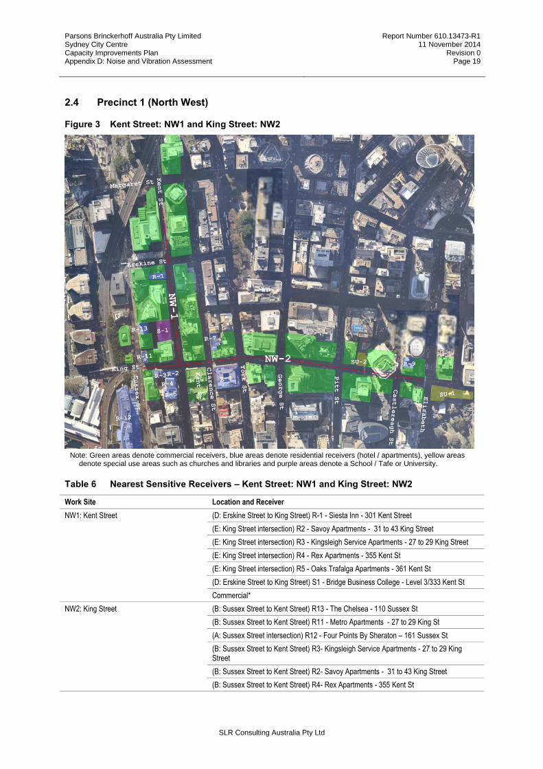
Parsons Brinckerhoff Australia Pty Limited Sydney City Centre Capacity Improvements Plan Appendix D: Noise and Vibration Assessment
Report Number 610.13473-R1 11 November 2014
Revision 0 Page 19
SLR Consulting Australia Pty Ltd
2.4 Precinct 1 (North West)
Figure 3 Kent Street: NW1 and King Street: NW2
Note: Green areas denote commercial receivers, blue areas denote residential receivers (hotel / apartments), yellow areas denote special use areas such as churches and libraries and purple areas denote a School / Tafe or University.
Table 6 Nearest Sensitive Receivers – Kent Street: NW1 and King Street: NW2
Work Site Location and Receiver
NW1: Kent Street (D: Erskine Street to King Street) R-1 - Siesta Inn - 301 Kent Street
(E: King Street intersection) R2 - Savoy Apartments - 31 to 43 King Street
(E: King Street intersection) R3 - Kingsleigh Service Apartments - 27 to 29 King Street
(E: King Street intersection) R4 - Rex Apartments - 355 Kent St
(E: King Street intersection) R5 - Oaks Trafalga Apartments - 361 Kent St
(D: Erskine Street to King Street) S1 - Bridge Business College - Level 3/333 Kent St
Commercial*
NW2: King Street (B: Sussex Street to Kent Street) R13 - The Chelsea - 110 Sussex St
(B: Sussex Street to Kent Street) R11 - Metro Apartments - 27 to 29 King St
(A: Sussex Street intersection) R12 - Four Points By Sheraton – 161 Sussex St
(B: Sussex Street to Kent Street) R3- Kingsleigh Service Apartments - 27 to 29 King Street
(B: Sussex Street to Kent Street) R2- Savoy Apartments - 31 to 43 King Street
(B: Sussex Street to Kent Street) R4- Rex Apartments - 355 Kent St

Parsons Brinckerhoff Australia Pty Limited Sydney City Centre Capacity Improvements Plan Appendix D: Noise and Vibration Assessment
Report Number 610.13473-R1 11 November 2014
Revision 0 Page 20
SLR Consulting Australia Pty Ltd
Work Site Location and Receiver
(B: Sussex Street to Kent Street) R5- Oaks Trafalga Apartments - 361 Kent St
(F: Clarence Street to York Street) R8- The Grace Hotel - 7 York St
(F: Clarence Street to York Street) R7 – Apartments 104 Clarence St
(L: Pitt Street to Castlereagh Street) SU2 - Theatre Royal 106 to 108 King St
R9 - 39 - 59 Castlereagh St
(M: Castlereagh Street intersection) SU1 - St James Church 173 King St
Commercial*
2.5 Precinct 2 (Retail)
Figure 4 Work Site Park Street: R1, Market Street: R2, Sussex Street: R3 and York Street: R5
Note: Green areas denote commercial receivers,
blue areas denote residential receivers (hotel / apartments), yellow areas denote special use areas such as churches and library’s and purple areas denote a school / Tafe or university.

Parsons Brinckerhoff Australia Pty Limited Sydney City Centre Capacity Improvements Plan Appendix D: Noise and Vibration Assessment
Report Number 610.13473-R1 11 November 2014
Revision 0 Page 21
SLR Consulting Australia Pty Ltd
Table 7 Nearest Sensitive Receivers – Park Street: R1, Market Street: R2, Sussex Street: R3 and York Street: R5
Work Site Location and Receiver
R1: Park Street (A: Pitt Street intersection) R16 - Apartments 197 to 199 Castlereagh St
*Commercial
R2: Market Street (A: Kent Street intersection) R12 - Four Points By Sheraton – 161 Sussex St
(B: Kent Street to Clarence Street) R17 - The Berkley - 25 Market St
(H: George Street to Pitt Street) R18 - Swissotel Sydney - 68 Market St
(H: George Street to Pitt Street) SU3 - State Theatre
(K: Castlereagh Street intersection) R71 - Sheraton On The Park - 161 Elizabeth St
Commercial
R3: Sussex Street (A: King Street intersection) R13 - The Chelsea - 110 Sussex St
(B: King Street to Market Street) R12 - Four Points By Sheraton – 161 Sussex St
(A: King Street intersection) R11 - Metro Apartments - 27 to 29 King St
(D: Market Street to Druitt Street) R19 - Astoria Tower - 222 to 228 Sussex St Sydney
(D: Market Street to Druitt Street) R20 - Seasons - 252 Sussex St
(E: Druitt Street intersection) R21 - Parkroyal Darling Harbour
(E: Druitt Street intersection) R22 - Jade Apartments 267 Sussex st
(E: Druitt Street intersection) R23 – Apartments - 278 to 284 Sussex St
(E: Druitt Street intersection) R24 – Apartments - 269 Sussex St
Commercial
R5: York Street (B: King Street to Market Street) R8- The Grace Hotel - 7 York St
Commercial

Parsons Brinckerhoff Australia Pty Limited Sydney City Centre Capacity Improvements Plan Appendix D: Noise and Vibration Assessment
Report Number 610.13473-R1 11 November 2014
Revision 0 Page 22
SLR Consulting Australia Pty Ltd
Figure 5 Work Site Clarence Street: R4
Note: Green areas denote commercial receivers, blue areas denote residential receivers (hotel / apartments), yellow areas denote special use areas such as churches and libraries and purple areas denote a school / Tafe or university.
Table 8 Nearest Sensitive Receivers – Clarence Street: R4
Work Site Location and Receiver
R4: Clarence Street
(A: Jamison Street intersection) SU-7 - Church Hill Anglican - 3 York St
(B: Jamison Street to Margaret Street) R62 - City Hotel Enterprise – 193 to 195 Clarence St
(B: Jamison Street to Margaret Street) R15 - Scots Presbyterian Church Sydney and Apartments above - 44 Margaret St
(F: Erskine Street to Barrack Street) R-6 - Wynyard Hotel – 107 Clarence St
(H: Barrack Street to King Street) R-7 – Apartments 104 Clarence St
(J: King Street to Market Street) R8 - The Grace Hotel - 7 York St
(J: King Street to Market Street) R63 - InterContinental Sydney - 117 Macquarie St
(K: Market Street intersection) R17 - The Berkley 25 Market St Sydney
(L: Market Street to Druitt Street) R76 - Hotel Sweeney's - 236 Clarence St
(M: Druitt Street intersection)SU15 - Sydney City Library
(M: Druitt Street intersection )SU16 - Sydney Town Hall
Commercial

Parsons Brinckerhoff Australia Pty Limited Sydney City Centre Capacity Improvements Plan Appendix D: Noise and Vibration Assessment
Report Number 610.13473-R1 11 November 2014
Revision 0 Page 23
SLR Consulting Australia Pty Ltd
2.6 Precinct 3 (Southern)
Figure 6 Work Site Sussex Street: S1 and Goulburn Street: S2
Note: Green areas denote commercial receivers, blue areas denote residential receivers (hotel / apartments), yellow areas denote special use areas such as churches and libraries and purple areas denote a school / Tafe or university.
Table 9 Nearest Sensitive Receivers – S1 and S2
Work Site Location and Receiver
S1: Sussex Street
(A: Bathurst Street intersection) R21 - Parkroyal Darling Harbour
(A: Bathurst Street intersection) R22 - Jade Apartments 267 Sussex St
(A: Bathurst Street intersection) R23 – Apartments - 278 to 284 Sussex St
(A: Bathurst Street intersection) R24 – Apartments - 269 Sussex St
(B: Bathurst Street to James Lane) R25 – Apartments - 298 to 304 Sussex St
(B: Bathurst Street to James Lane) R26 – Apartments – 289 to 295 Sussex St
(B: Bathurst Street to James Lane) R27 – Apartments - 336 - 352 Sussex St
(B: Bathurst Street to James Lane) R28 – Apartments - 339 Sussex St
(D: Liverpool Street to Eager Lane) R29 - Downtown Apartments - 368 Sussex St
(D: Liverpool Street to Eager Lane R30- The Waldorf Apartment Hotel, 57 Liverpool St
(D: Liverpool Street to Eager Lane R31- Apartments - 569 to 581 George St
Commercial
S2: Goulburn Street (A: George Street intersection) R32- Central Park Back Packers - 611 George St
(A: George Street intersection) R33 - Quest World Square - 2 Cunningham St
Commercial

Parsons Brinckerhoff Australia Pty Limited Sydney City Centre Capacity Improvements Plan Appendix D: Noise and Vibration Assessment
Report Number 610.13473-R1 11 November 2014
Revision 0 Page 24
SLR Consulting Australia Pty Ltd
Figure 7 Work Site Pitt Street: S3
Note: Green areas denote commercial receivers, blue areas denote residential receivers (hotel / apartments), yellow areas denote special use areas such as churches and libraries and purple areas denote a school / Tafe or university.
Table 10 Nearest Sensitive Receivers – S3
Work Site Location and Receiver
S3: Pitt Street
(B: Liverpool Street to Goulburn Street) R35 - Rydges World Square Sydney - 389 Pitt St
(B: Liverpool Street to Goulburn Street) R78 - United Grand Lodge of NSW - 279 Castlereagh St
(B: Liverpool Street to Goulburn Street) R36 - Ibis Sydney World Square – 382 to 384 Pitt St
(C: Goulburn Street intersection) R37 – Apartments - 91 Goulburn St, Sydney
(D: Goulburn Street to Campbell Street) R33- Quest World Square - 2 Cunningham St
(D: Goulburn Street to Campbell Street) R41- Metro Hotel
(D: Goulburn Street to Campbell Street) R34- Nomads Westend Backpackers - 412 Pitt St
(D: Goulburn Street to Campbell Street) R38 – Apartments 416 Pitt St
(D: Goulburn Street to Campbell Street) R40 - Sydney Central Inn 420 Pitt St
(D: Goulburn Street to Campbell Street) R39- Chamberlain Hotel - 428 Pitt St
(D: Goulburn Street to Campbell Street) R42- Apartments - 40 Campbell St
(F: Campbell Street to Hay Street) R77- Capitol Square Hotel Sydney- 3 Campbell St
(I: Rawson Place intersection) R59- Sydney Central YHA 11 Rawson Pl
(I: Rawson Place intersection) R60- 790 on George Backpackers 790 George St
(I: Rawson Place intersection) R47- The Great Southern hotel and The Pacific International Hotel
Commercial
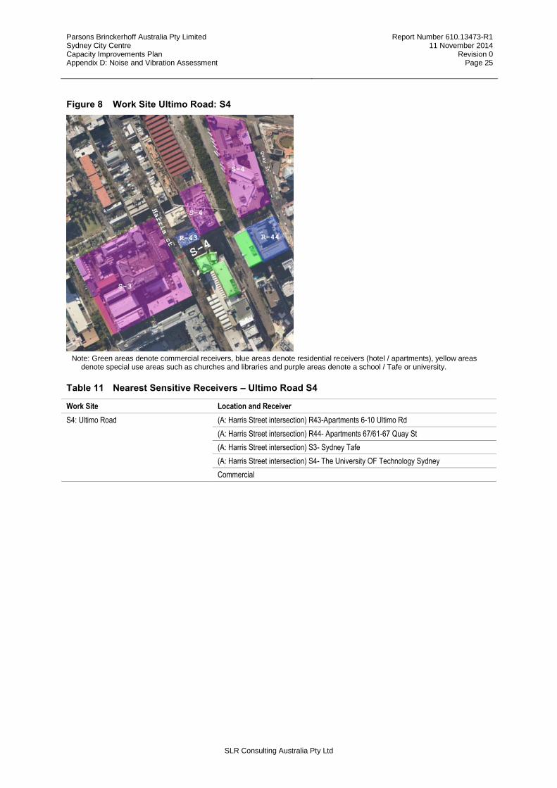
Parsons Brinckerhoff Australia Pty Limited Sydney City Centre Capacity Improvements Plan Appendix D: Noise and Vibration Assessment
Report Number 610.13473-R1 11 November 2014
Revision 0 Page 25
SLR Consulting Australia Pty Ltd
Figure 8 Work Site Ultimo Road: S4
Note: Green areas denote commercial receivers, blue areas denote residential receivers (hotel / apartments), yellow areas denote special use areas such as churches and libraries and purple areas denote a school / Tafe or university.
Table 11 Nearest Sensitive Receivers – Ultimo Road S4
Work Site Location and Receiver
S4: Ultimo Road
(A: Harris Street intersection) R43-Apartments 6-10 Ultimo Rd
(A: Harris Street intersection) R44- Apartments 67/61-67 Quay St
(A: Harris Street intersection) S3- Sydney Tafe
(A: Harris Street intersection) S4- The University OF Technology Sydney
Commercial

Parsons Brinckerhoff Australia Pty Limited Sydney City Centre Capacity Improvements Plan Appendix D: Noise and Vibration Assessment
Report Number 610.13473-R1 11 November 2014
Revision 0 Page 26
SLR Consulting Australia Pty Ltd
Figure 9 Work Site Broadway:S5
Note: Green areas denote commercial receivers, blue areas denote residential receivers (hotel / apartments), yellow areas
denote special use areas such as churches and libraries and purple areas denote a school / Tafe or university.
Table 12 Nearest Sensitive Receivers – Broadway:S5
Work Site Location and Receiver
S5: Broadway
(B: Mountain Street to Wattle Street) R83- Apartments - 70 Mountain St
(A: Mountain Street intersection) R84- Apartments - 29-35 Shepherd St
(A: Mountain Street intersection) R85- Houses 8 - 28 Shepherd St
(A: Mountain Street intersection) R86-Houses 57 - 41 Shepherd St
(C: Wattle Street intersection) S4- University of Technology Sydney
(B: Mountain Street to Wattle Street) S5- The University of Notre Dame Australia
(D: Abercrombie Street intersection) SU-17- St Benedict's Catholic Church - 104 Broadway
(C: Wattle Street intersection) R87 – Apartments 513 Wattle St
(C: Wattle Street intersection) R88 - Apartments 485 Wattle St
(C: Wattle Street intersection) S3- Sydney Tafe

Parsons Brinckerhoff Australia Pty Limited Sydney City Centre Capacity Improvements Plan Appendix D: Noise and Vibration Assessment
Report Number 610.13473-R1 11 November 2014
Revision 0 Page 27
SLR Consulting Australia Pty Ltd
Figure 10 Work Site Pitt Street: S6
Note: Green areas denote commercial receivers, blue areas denote residential receivers (hotel / apartments), yellow areas denote special use areas such as churches and libraries and purple areas denote a school / Tafe or university.
Table 13 Nearest Sensitive Receivers – Pitt Street: S6
Work Site Location and Receiver
S6: Pitt Street
(B: George Street and Quay Street intersection) R75- Wake Up Hotel
(A: Pitt Street and George Street intersection) R79- Rendezvous Studio Hotel Sydney Central - Cnr George Street & Quay Street
(A: Pitt Street and George Street intersection) R80- Urbanest Sydney Student Accommodation - 83 Quay St
(A: Pitt Street and George Street intersection) R81- 851 Broadway
(A: Pitt Street and George Street intersection) R82- Mercure Sydney 818-820 George Street
(A: Pitt Street and George Street intersection) S3- Sydney Tafe
(A: Pitt Street and George Street intersection) S4- University of Technology Sydney
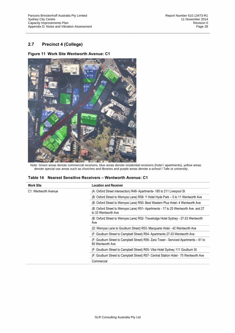
Parsons Brinckerhoff Australia Pty Limited Sydney City Centre Capacity Improvements Plan Appendix D: Noise and Vibration Assessment
Report Number 610.13473-R1 11 November 2014
Revision 0 Page 28
SLR Consulting Australia Pty Ltd
2.7 Precinct 4 (College)
Figure 11 Work Site Wentworth Avenue: C1
Note: Green areas denote commercial receivers, blue areas denote residential receivers (hotel / apartments), yellow areas denote special use areas such as churches and libraries and purple areas denote a school / Tafe or university.
Table 14 Nearest Sensitive Receivers – Wentworth Avenue: C1
Work Site Location and Receiver
C1: Wentworth Avenue
(A: Oxford Street intersection) R48- Apartments- 185 to 211 Liverpool St
(B: Oxford Street to Wemyss Lane) R58- Y Hotel Hyde Park – 5 to 11 Wentworth Ave
(B: Oxford Street to Wemyss Lane) R50- Best Western Plus Hotel- 4 Wentworth Ave
(B: Oxford Street to Wemyss Lane) R51- Apartments - 17 to 25 Wentworth Ave and 27 to 33 Wentworth Ave
(B: Oxford Street to Wemyss Lane) R52- Travelodge Hotel Sydney - 27-33 Wentworth Ave
(D: Wemyss Lane to Goulburn Street) R53- Macquarie Hotel - 42 Wentworth Ave
(F: Goulburn Street to Campbell Street) R54- Apartments 27-33 Wentworth Ave
(F: Goulburn Street to Campbell Street) R56- Zara Tower - Serviced Apartments – 61 to 65 Wentworth Ave
(F: Goulburn Street to Campbell Street) R55- Vibe Hotel Sydney 111 Goulburn St
(F: Goulburn Street to Campbell Street) R57- Central Station Hotel - 75 Wentworth Ave
Commercial
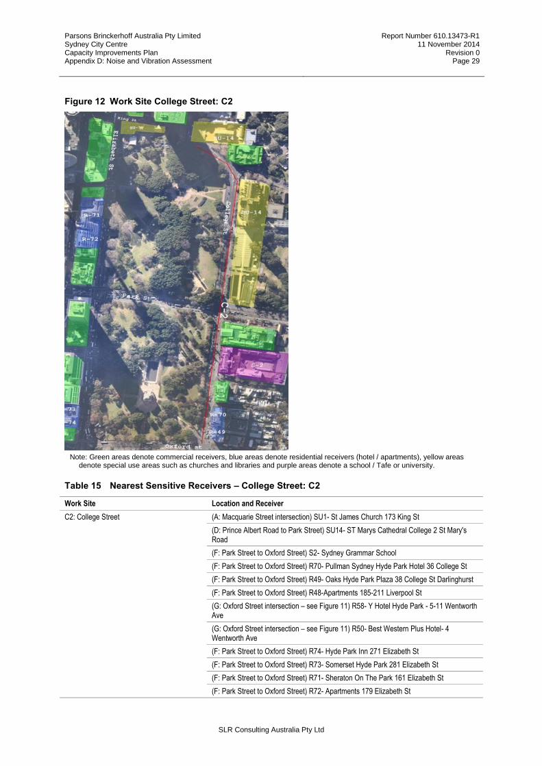
Parsons Brinckerhoff Australia Pty Limited Sydney City Centre Capacity Improvements Plan Appendix D: Noise and Vibration Assessment
Report Number 610.13473-R1 11 November 2014
Revision 0 Page 29
SLR Consulting Australia Pty Ltd
Figure 12 Work Site College Street: C2
Note: Green areas denote commercial receivers, blue areas denote residential receivers (hotel / apartments), yellow areas denote special use areas such as churches and libraries and purple areas denote a school / Tafe or university.
Table 15 Nearest Sensitive Receivers – College Street: C2
Work Site Location and Receiver
C2: College Street
(A: Macquarie Street intersection) SU1- St James Church 173 King St
(D: Prince Albert Road to Park Street) SU14- ST Marys Cathedral College 2 St Mary's Road
(F: Park Street to Oxford Street) S2- Sydney Grammar School
(F: Park Street to Oxford Street) R70- Pullman Sydney Hyde Park Hotel 36 College St
(F: Park Street to Oxford Street) R49- Oaks Hyde Park Plaza 38 College St Darlinghurst
(F: Park Street to Oxford Street) R48-Apartments 185-211 Liverpool St
(G: Oxford Street intersection – see Figure 11) R58- Y Hotel Hyde Park - 5-11 Wentworth Ave
(G: Oxford Street intersection – see Figure 11) R50- Best Western Plus Hotel- 4 Wentworth Ave
(F: Park Street to Oxford Street) R74- Hyde Park Inn 271 Elizabeth St
(F: Park Street to Oxford Street) R73- Somerset Hyde Park 281 Elizabeth St
(F: Park Street to Oxford Street) R71- Sheraton On The Park 161 Elizabeth St
(F: Park Street to Oxford Street) R72- Apartments 179 Elizabeth St
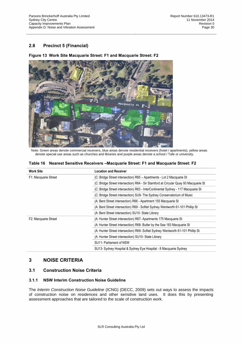
Parsons Brinckerhoff Australia Pty Limited Sydney City Centre Capacity Improvements Plan Appendix D: Noise and Vibration Assessment
Report Number 610.13473-R1 11 November 2014
Revision 0 Page 30
SLR Consulting Australia Pty Ltd
2.8 Precinct 5 (Financial)
Figure 13 Work Site Macquarie Street: F1 and Macquarie Street: F2
Note: Green areas denote commercial receivers, blue areas denote residential receivers (hotel / apartments), yellow areas denote special use areas such as churches and libraries and purple areas denote a school / Tafe or university.
Table 16 Nearest Sensitive Receivers –Macquarie Street: F1 and Macquarie Street: F2
Work Site Location and Receiver
F1: Macquarie Street
(C: Bridge Street intersection) R65 – Apartments - Lot 2 Macquarie St
(C: Bridge Street intersection) R64 - Sir Stamford at Circular Quay 93 Macquarie St
(C: Bridge Street intersection) R63 - InterContinental Sydney - 117 Macquarie St
(C: Bridge Street intersection) SU9- The Sydney Conservatorium of Music
(A: Bent Street intersection) R66 - Apartment 155 Macquarie St
(A: Bent Street intersection) R69 - Sofitel Sydney Wentworth 61-101 Phillip St
(A: Bent Street intersection) SU10- State Library
F2: Macquarie Street (A: Hunter Street intersection) R67- Apartments 175 Macquarie St
(A: Hunter Street intersection) R68- Butler by the Sea 183 Macquarie St
(A: Hunter Street intersection) R69- Sofitel Sydney Wentworth 61-101 Phillip St
(A: Hunter Street intersection) SU10- State Library
SU11- Parliament of NSW
SU13- Sydney Hospital & Sydney Eye Hospital - 8 Macquarie Sydney
3 NOISE CRITERIA
3.1 Construction Noise Criteria
3.1.1 NSW Interim Construction Noise Guideline
The Interim Construction Noise Guideline (ICNG) (DECC, 2009) sets out ways to assess the impacts of construction noise on residences and other sensitive land uses. It does this by presenting assessment approaches that are tailored to the scale of construction work.
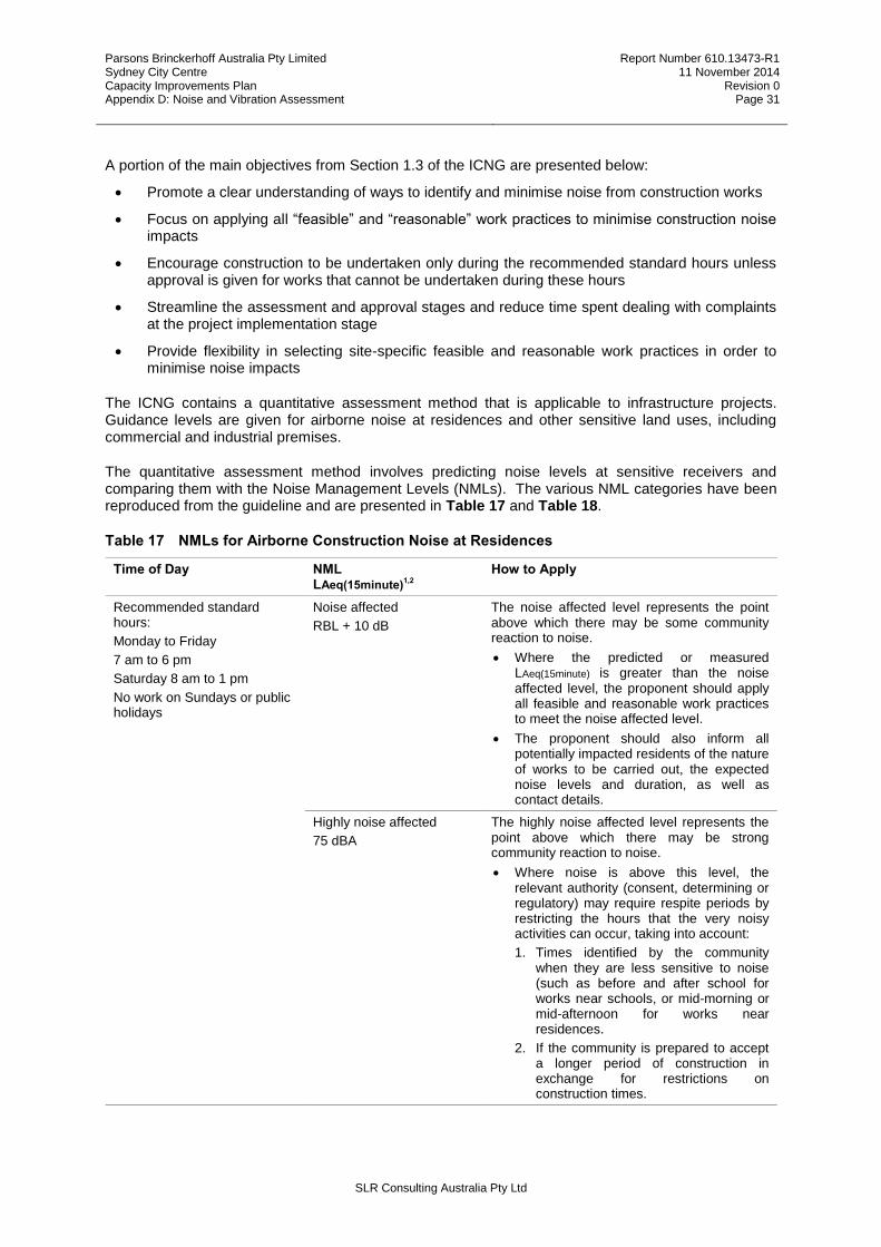
Parsons Brinckerhoff Australia Pty Limited Sydney City Centre Capacity Improvements Plan Appendix D: Noise and Vibration Assessment
Report Number 610.13473-R1 11 November 2014
Revision 0 Page 31
SLR Consulting Australia Pty Ltd
A portion of the main objectives from Section 1.3 of the ICNG are presented below:
Promote a clear understanding of ways to identify and minimise noise from construction works
Focus on applying all “feasible” and “reasonable” work practices to minimise construction noise impacts
Encourage construction to be undertaken only during the recommended standard hours unless approval is given for works that cannot be undertaken during these hours
Streamline the assessment and approval stages and reduce time spent dealing with complaints at the project implementation stage
Provide flexibility in selecting site-specific feasible and reasonable work practices in order to minimise noise impacts
The ICNG contains a quantitative assessment method that is applicable to infrastructure projects. Guidance levels are given for airborne noise at residences and other sensitive land uses, including commercial and industrial premises.
The quantitative assessment method involves predicting noise levels at sensitive receivers and comparing them with the Noise Management Levels (NMLs). The various NML categories have been reproduced from the guideline and are presented in Table 17 and Table 18.
Table 17 NMLs for Airborne Construction Noise at Residences
Time of Day NML LAeq(15minute)
1,2 How to Apply
Recommended standard hours:
Monday to Friday
7 am to 6 pm
Saturday 8 am to 1 pm
No work on Sundays or public holidays
Noise affected
RBL + 10 dB
The noise affected level represents the point above which there may be some community reaction to noise.
Where the predicted or measured LAeq(15minute) is greater than the noise affected level, the proponent should apply all feasible and reasonable work practices to meet the noise affected level.
The proponent should also inform all potentially impacted residents of the nature of works to be carried out, the expected noise levels and duration, as well as contact details.
Highly noise affected
75 dBA
The highly noise affected level represents the point above which there may be strong community reaction to noise.
Where noise is above this level, the relevant authority (consent, determining or regulatory) may require respite periods by restricting the hours that the very noisy activities can occur, taking into account:
1. Times identified by the community when they are less sensitive to noise (such as before and after school for works near schools, or mid-morning or mid-afternoon for works near residences.
2. If the community is prepared to accept a longer period of construction in exchange for restrictions on construction times.
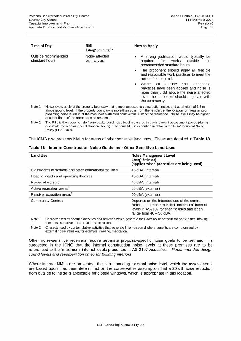
Parsons Brinckerhoff Australia Pty Limited Sydney City Centre Capacity Improvements Plan Appendix D: Noise and Vibration Assessment
Report Number 610.13473-R1 11 November 2014
Revision 0 Page 32
SLR Consulting Australia Pty Ltd
Time of Day NML LAeq(15minute)
1,2 How to Apply
Outside recommended standard hours
Noise affected
RBL + 5 dB
A strong justification would typically be required for works outside the recommended standard hours.
The proponent should apply all feasible and reasonable work practices to meet the noise affected level.
Where all feasible and reasonable practices have been applied and noise is more than 5 dB above the noise affected level, the proponent should negotiate with the community.
Note 1 Noise levels apply at the property boundary that is most exposed to construction noise, and at a height of 1.5 m above ground level. If the property boundary is more than 30 m from the residence, the location for measuring or predicting noise levels is at the most noise-affected point within 30 m of the residence. Noise levels may be higher at upper floors of the noise affected residence.
Note 2 The RBL is the overall single-figure background noise level measured in each relevant assessment period (during or outside the recommended standard hours). The term RBL is described in detail in the NSW Industrial Noise Policy (EPA 2000).
The ICNG also presents NMLs for areas of other sensitive land uses. These are detailed in Table 18.
Table 18 Interim Construction Noise Guideline - Other Sensitive Land Uses
Land Use Noise Management Level LAeq(15minute) (applies when properties are being used)
Classrooms at schools and other educational facilities 45 dBA (internal)
Hospital wards and operating theatres 45 dBA (internal)
Places of worship 45 dBA (internal)
Active recreation areas1 65 dBA (external)
Passive recreation areas2 60 dBA (external)
Community Centres Depends on the intended use of the centre. Refer to the recommended “maximum” internal levels in AS2107 for specific uses and it can range from 40 – 50 dBA.
Note 1: Characterised by sporting activities and activities which generate their own noise or focus for participants, making them less sensitive to external noise intrusion.
Note 2: Characterised by contemplative activities that generate little noise and where benefits are compromised by external noise intrusion, for example, reading, meditation.
Other noise-sensitive receivers require separate proposal-specific noise goals to be set and it is suggested in the ICNG that the internal construction noise levels at these premises are to be referenced to the ‘maximum’ internal levels presented in AS 2107 Acoustics – Recommended design sound levels and reverberation times for building interiors.
Where internal NMLs are presented, the corresponding external noise level, which the assessments are based upon, has been determined on the conservative assumption that a 20 dB noise reduction from outside to inside is applicable for closed windows, which is appropriate in this location.
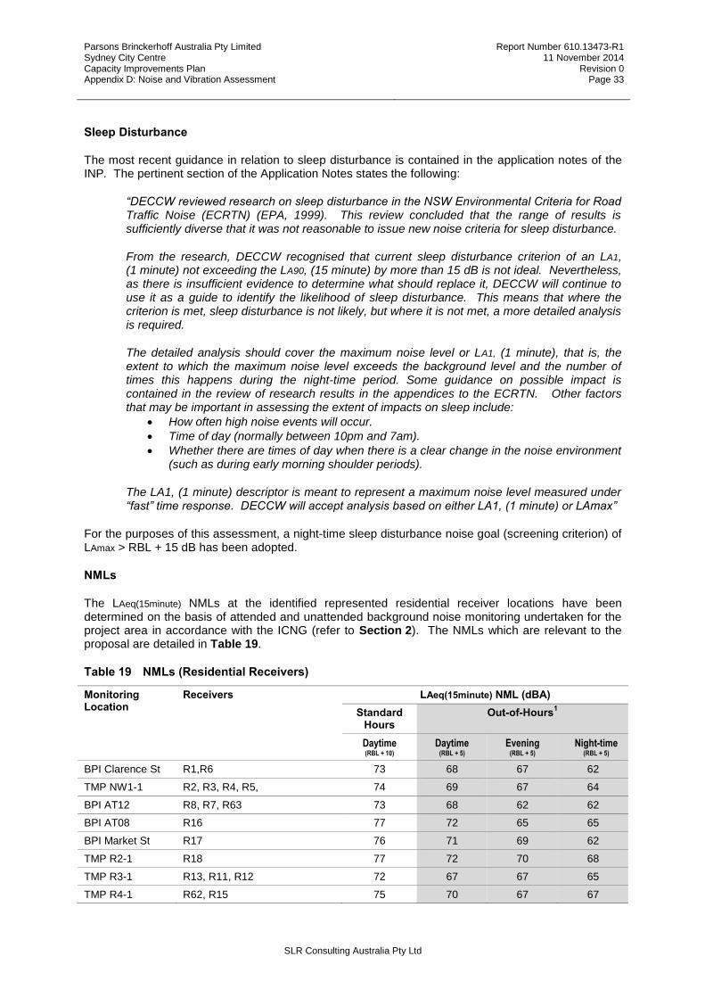
Parsons Brinckerhoff Australia Pty Limited Sydney City Centre Capacity Improvements Plan Appendix D: Noise and Vibration Assessment
Report Number 610.13473-R1 11 November 2014
Revision 0 Page 33
SLR Consulting Australia Pty Ltd
Sleep Disturbance
The most recent guidance in relation to sleep disturbance is contained in the application notes of the INP. The pertinent section of the Application Notes states the following:
“DECCW reviewed research on sleep disturbance in the NSW Environmental Criteria for Road Traffic Noise (ECRTN) (EPA, 1999). This review concluded that the range of results is sufficiently diverse that it was not reasonable to issue new noise criteria for sleep disturbance.
From the research, DECCW recognised that current sleep disturbance criterion of an LA1, (1 minute) not exceeding the LA90, (15 minute) by more than 15 dB is not ideal. Nevertheless, as there is insufficient evidence to determine what should replace it, DECCW will continue to use it as a guide to identify the likelihood of sleep disturbance. This means that where the criterion is met, sleep disturbance is not likely, but where it is not met, a more detailed analysis is required.
The detailed analysis should cover the maximum noise level or LA1, (1 minute), that is, the extent to which the maximum noise level exceeds the background level and the number of times this happens during the night-time period. Some guidance on possible impact is contained in the review of research results in the appendices to the ECRTN. Other factors that may be important in assessing the extent of impacts on sleep include:
How often high noise events will occur.
Time of day (normally between 10pm and 7am).
Whether there are times of day when there is a clear change in the noise environment (such as during early morning shoulder periods).
The LA1, (1 minute) descriptor is meant to represent a maximum noise level measured under “fast” time response. DECCW will accept analysis based on either LA1, (1 minute) or LAmax”
For the purposes of this assessment, a night-time sleep disturbance noise goal (screening criterion) of LAmax > RBL + 15 dB has been adopted.
NMLs
The LAeq(15minute) NMLs at the identified represented residential receiver locations have been determined on the basis of attended and unattended background noise monitoring undertaken for the project area in accordance with the ICNG (refer to Section 2). The NMLs which are relevant to the proposal are detailed in Table 19.
Table 19 NMLs (Residential Receivers)
Monitoring Location
Receivers LAeq(15minute) NML (dBA)
Standard Hours
Out-of-Hours
1
Daytime (RBL + 10)
Daytime (RBL + 5)
Evening (RBL + 5)
Night-time (RBL + 5)
BPI Clarence St R1,R6 73 68 67 62
TMP NW1-1 R2, R3, R4, R5, 74 69 67 64
BPI AT12 R8, R7, R63 73 68 62 62
BPI AT08 R16 77 72 65 65
BPI Market St R17 76 71 69 62
TMP R2-1 R18 77 72 70 68
TMP R3-1 R13, R11, R12 72 67 67 65
TMP R4-1 R62, R15 75 70 67 67
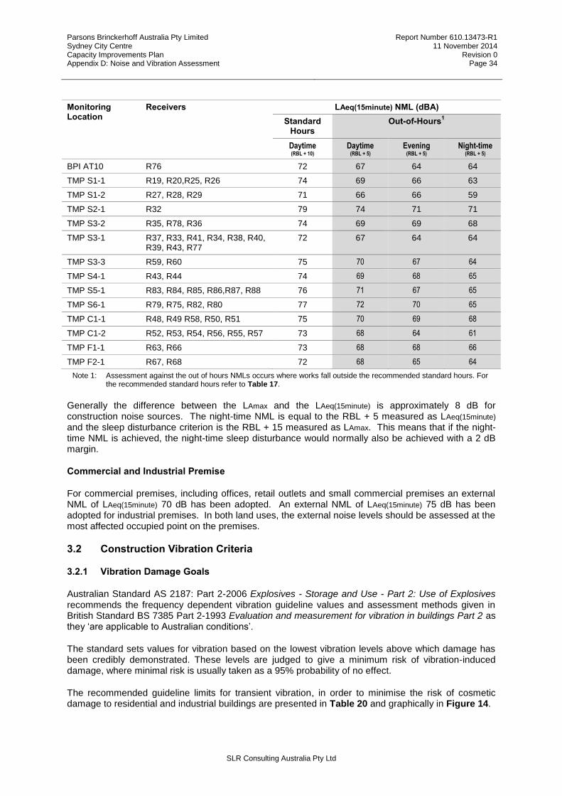
Parsons Brinckerhoff Australia Pty Limited Sydney City Centre Capacity Improvements Plan Appendix D: Noise and Vibration Assessment
Report Number 610.13473-R1 11 November 2014
Revision 0 Page 34
SLR Consulting Australia Pty Ltd
Monitoring Location
Receivers LAeq(15minute) NML (dBA)
Standard Hours
Out-of-Hours
1
Daytime (RBL + 10)
Daytime (RBL + 5)
Evening (RBL + 5)
Night-time (RBL + 5)
BPI AT10 R76 72 67 64 64
TMP S1-1 R19, R20,R25, R26 74 69 66 63
TMP S1-2 R27, R28, R29 71 66 66 59
TMP S2-1 R32 79 74 71 71
TMP S3-2 R35, R78, R36 74 69 69 68
TMP S3-1 R37, R33, R41, R34, R38, R40, R39, R43, R77
72 67 64 64
TMP S3-3 R59, R60 75 70 67 64
TMP S4-1 R43, R44 74 69 68 65
TMP S5-1 R83, R84, R85, R86,R87, R88 76 71 67 65
TMP S6-1 R79, R75, R82, R80 77 72 70 65
TMP C1-1 R48, R49 R58, R50, R51 75 70 69 68
TMP C1-2 R52, R53, R54, R56, R55, R57 73 68 64 61
TMP F1-1 R63, R66 73 68 68 66
TMP F2-1 R67, R68 72 68 65 64
Note 1: Assessment against the out of hours NMLs occurs where works fall outside the recommended standard hours. For the recommended standard hours refer to Table 17.
Generally the difference between the LAmax and the LAeq(15minute) is approximately 8 dB for construction noise sources. The night-time NML is equal to the RBL + 5 measured as LAeq(15minute) and the sleep disturbance criterion is the RBL + 15 measured as LAmax. This means that if the night-time NML is achieved, the night-time sleep disturbance would normally also be achieved with a 2 dB margin.
Commercial and Industrial Premise
For commercial premises, including offices, retail outlets and small commercial premises an external NML of LAeq(15minute) 70 dB has been adopted. An external NML of LAeq(15minute) 75 dB has been adopted for industrial premises. In both land uses, the external noise levels should be assessed at the most affected occupied point on the premises.
3.2 Construction Vibration Criteria
3.2.1 Vibration Damage Goals
Australian Standard AS 2187: Part 2-2006 Explosives - Storage and Use - Part 2: Use of Explosives recommends the frequency dependent vibration guideline values and assessment methods given in British Standard BS 7385 Part 2-1993 Evaluation and measurement for vibration in buildings Part 2 as they ‘are applicable to Australian conditions’.
The standard sets values for vibration based on the lowest vibration levels above which damage has been credibly demonstrated. These levels are judged to give a minimum risk of vibration-induced damage, where minimal risk is usually taken as a 95% probability of no effect.
The recommended guideline limits for transient vibration, in order to minimise the risk of cosmetic damage to residential and industrial buildings are presented in Table 20 and graphically in Figure 14.

Parsons Brinckerhoff Australia Pty Limited Sydney City Centre Capacity Improvements Plan Appendix D: Noise and Vibration Assessment
Report Number 610.13473-R1 11 November 2014
Revision 0 Page 35
SLR Consulting Australia Pty Ltd
Table 20 Transient Vibration Guide Values – Minimal Risk of Cosmetic Damage
Line Type of Building Peak Component Particle Velocity in Frequency Range of Predominant Pulse
4 Hz to 15 Hz1
15 Hz and Above
1 Reinforced or framed structures. Industrial and heavy commercial buildings
50 mm/s2 at 4 Hz and above
2 Unreinforced or light framed structures. Residential or light commercial type buildings
15 mm/s at 4 Hz increasing to 20 mm/s at 15 Hz
20 mm/s at 15 Hz increasing to 50 mm/s at 40 Hz and above
Note 1: Hertz (Hz)
Note 2: Millimetres per second (mm/s)
The guide values in Table 20 relate mainly to transient vibration which does not give rise to resonant responses in structures and low-rise buildings. In the event continuous vibration gives rise to magnification of vibration by resonance (specific conditions where the structure can readily store and transfer vibration energy), then the guide values in Table 20 may need to be reduced by up to 50% (Figure 14).
High intensity activities such as breaking, hammering and piling are considered to have the potential to cause dynamic loading in some structures and it may therefore be appropriate to reduce the transient values by 50 % for these construction activities.
Figure 14 Transient Vibration Guide Values for Cosmetic Damage
For most sources of intermittent vibration during construction, such as vibratory rollers and excavators, the predominant vibration energy occurs at frequencies usually in the 10 Hz to 100 Hz range. On this basis a vibration damage screening level of 7.5 mm/s has been adopted for the purpose of assessing potential impacts.
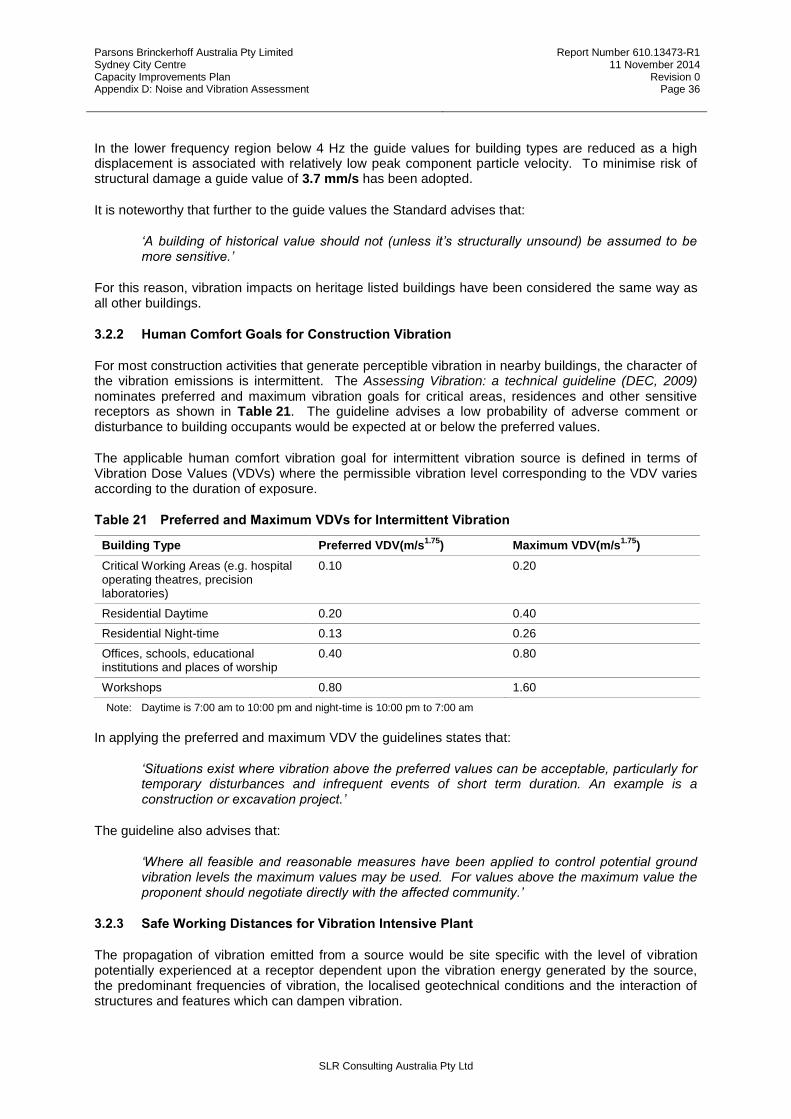
Parsons Brinckerhoff Australia Pty Limited Sydney City Centre Capacity Improvements Plan Appendix D: Noise and Vibration Assessment
Report Number 610.13473-R1 11 November 2014
Revision 0 Page 36
SLR Consulting Australia Pty Ltd
In the lower frequency region below 4 Hz the guide values for building types are reduced as a high displacement is associated with relatively low peak component particle velocity. To minimise risk of structural damage a guide value of 3.7 mm/s has been adopted.
It is noteworthy that further to the guide values the Standard advises that:
‘A building of historical value should not (unless it’s structurally unsound) be assumed to be more sensitive.’
For this reason, vibration impacts on heritage listed buildings have been considered the same way as all other buildings.
3.2.2 Human Comfort Goals for Construction Vibration
For most construction activities that generate perceptible vibration in nearby buildings, the character of the vibration emissions is intermittent. The Assessing Vibration: a technical guideline (DEC, 2009) nominates preferred and maximum vibration goals for critical areas, residences and other sensitive receptors as shown in Table 21. The guideline advises a low probability of adverse comment or disturbance to building occupants would be expected at or below the preferred values.
The applicable human comfort vibration goal for intermittent vibration source is defined in terms of Vibration Dose Values (VDVs) where the permissible vibration level corresponding to the VDV varies according to the duration of exposure.
Table 21 Preferred and Maximum VDVs for Intermittent Vibration
Building Type Preferred VDV(m/s1.75
) Maximum VDV(m/s1.75
)
Critical Working Areas (e.g. hospital operating theatres, precision laboratories)
0.10 0.20
Residential Daytime 0.20 0.40
Residential Night-time 0.13 0.26
Offices, schools, educational institutions and places of worship
0.40 0.80
Workshops 0.80 1.60
Note: Daytime is 7:00 am to 10:00 pm and night-time is 10:00 pm to 7:00 am
In applying the preferred and maximum VDV the guidelines states that:
‘Situations exist where vibration above the preferred values can be acceptable, particularly for temporary disturbances and infrequent events of short term duration. An example is a construction or excavation project.’
The guideline also advises that:
‘Where all feasible and reasonable measures have been applied to control potential ground vibration levels the maximum values may be used. For values above the maximum value the proponent should negotiate directly with the affected community.’
3.2.3 Safe Working Distances for Vibration Intensive Plant
The propagation of vibration emitted from a source would be site specific with the level of vibration potentially experienced at a receptor dependent upon the vibration energy generated by the source, the predominant frequencies of vibration, the localised geotechnical conditions and the interaction of structures and features which can dampen vibration.
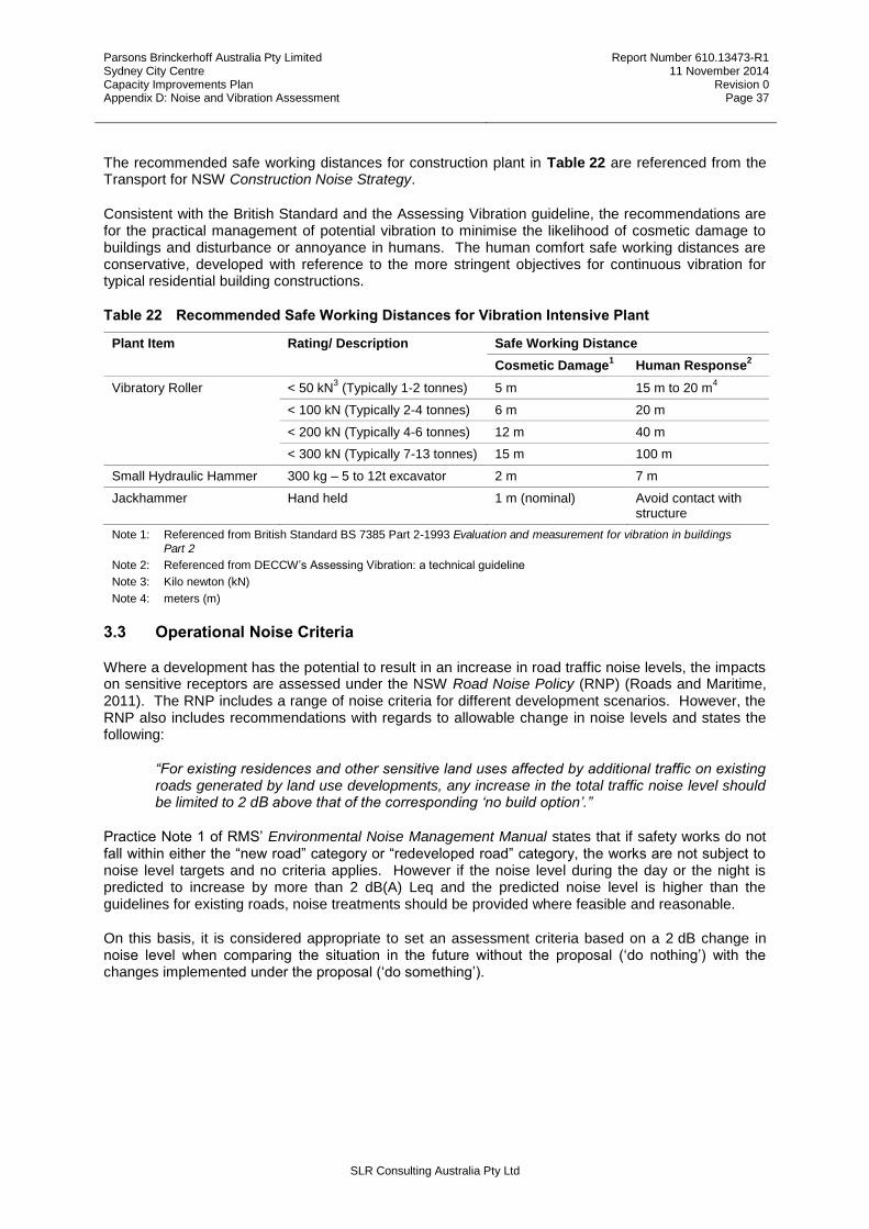
Parsons Brinckerhoff Australia Pty Limited Sydney City Centre Capacity Improvements Plan Appendix D: Noise and Vibration Assessment
Report Number 610.13473-R1 11 November 2014
Revision 0 Page 37
SLR Consulting Australia Pty Ltd
The recommended safe working distances for construction plant in Table 22 are referenced from the Transport for NSW Construction Noise Strategy.
Consistent with the British Standard and the Assessing Vibration guideline, the recommendations are for the practical management of potential vibration to minimise the likelihood of cosmetic damage to buildings and disturbance or annoyance in humans. The human comfort safe working distances are conservative, developed with reference to the more stringent objectives for continuous vibration for typical residential building constructions.
Table 22 Recommended Safe Working Distances for Vibration Intensive Plant
Plant Item Rating/ Description Safe Working Distance
Cosmetic Damage1 Human Response
2
Vibratory Roller < 50 kN3 (Typically 1-2 tonnes) 5 m 15 m to 20 m
4
< 100 kN (Typically 2-4 tonnes) 6 m 20 m
< 200 kN (Typically 4-6 tonnes) 12 m 40 m
< 300 kN (Typically 7-13 tonnes) 15 m 100 m
Small Hydraulic Hammer 300 kg – 5 to 12t excavator 2 m 7 m
Jackhammer Hand held 1 m (nominal) Avoid contact with structure
Note 1: Referenced from British Standard BS 7385 Part 2-1993 Evaluation and measurement for vibration in buildings Part 2
Note 2: Referenced from DECCW’s Assessing Vibration: a technical guideline
Note 3: Kilo newton (kN)
Note 4: meters (m)
3.3 Operational Noise Criteria
Where a development has the potential to result in an increase in road traffic noise levels, the impacts on sensitive receptors are assessed under the NSW Road Noise Policy (RNP) (Roads and Maritime, 2011). The RNP includes a range of noise criteria for different development scenarios. However, the RNP also includes recommendations with regards to allowable change in noise levels and states the following:
“For existing residences and other sensitive land uses affected by additional traffic on existing roads generated by land use developments, any increase in the total traffic noise level should be limited to 2 dB above that of the corresponding ‘no build option’.”
Practice Note 1 of RMS’ Environmental Noise Management Manual states that if safety works do not fall within either the “new road” category or “redeveloped road” category, the works are not subject to noise level targets and no criteria applies. However if the noise level during the day or the night is predicted to increase by more than 2 dB(A) Leq and the predicted noise level is higher than the guidelines for existing roads, noise treatments should be provided where feasible and reasonable.
On this basis, it is considered appropriate to set an assessment criteria based on a 2 dB change in noise level when comparing the situation in the future without the proposal (‘do nothing’) with the changes implemented under the proposal (‘do something’).
Parsons Brinckerhoff Australia Pty Limited Sydney City Centre Capacity Improvements Plan Appendix D: Noise and Vibration Assessment
Report Number 610.13473-R1 11 November 2014
Revision 0 Page 38
SLR Consulting Australia Pty Ltd
4 CONSTRUCTION ASSESSMENT
Construction is anticipated to start in the first half of 2015 and it would take up to one year to complete due to the complexities of programming the works to avoid impacting on the city’s traffic. For the construction noise assessment, worst case noise levels that would occur when the noisiest construction activities are undertaken at the nearest point to identified receptors have been predicted.
4.1 Construction hours
The ICNG describes recommended standard hours for construction works (NSW Environment Protection Authority (NSW EPA), 2009):
7.00 am – 6.00 pm: Monday to Friday
8.00 am – 1.00 pm: Saturday
In order to minimise impacts on some of Sydney’s busiest roads the majority of the construction works would need to take place outside of the above recommended hours (termed ‘out of hours’ working). This would include working at night and over the weekend. This would achieve the most efficient and shortest construction program. The extent, duration and construction timing would be confirmed and finalised by the construction contractor as part of the construction staging.
4.2 Construction Works and Equipment
The proposed construction activities and locations are detailed in Chapter 3 of the REF. This section gives a short summary of the construction works and estimated sound power levels (SWLs).
The proposal involves the following efficiency improvements:
Intersection reconfiguration and geometry modifications
Kerb extension alterations
Footpath width alterations
Turning restrictions and provisions
Kerbside allocation modifications
Lane arrangements
It also includes a range of other supporting work
A mix of construction activities would be required to construct the above traffic efficiency improvements as described in Table 3-10 of the REF. The proposed plant and equipment needed to undertake these activities are described in Table 3-11 of the REF. Attachment B describes in more detail the combination of equipment most likely used for each activity and their corresponding SWL.
Table 23 shows the estimated worst case SWL for each construction activity and details the noisiest plant and equipment that would likely cause the worst case noise emissions.
It should be noted that during times when the noisiest plant and equipment are not operating the noise emissions would be significantly lower. For several of the proposed activities the worst case noise emissions would only occur during a short time period compared to the overall construction period.
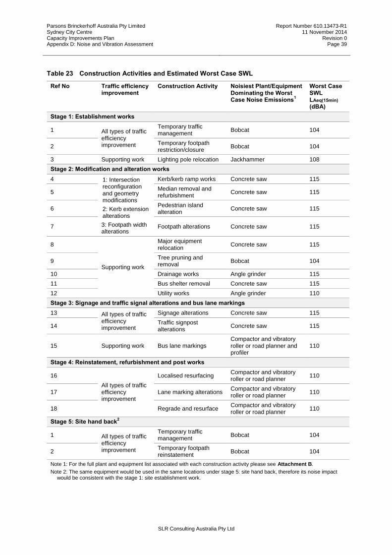
Parsons Brinckerhoff Australia Pty Limited Sydney City Centre Capacity Improvements Plan Appendix D: Noise and Vibration Assessment
Report Number 610.13473-R1 11 November 2014
Revision 0 Page 39
SLR Consulting Australia Pty Ltd
Table 23 Construction Activities and Estimated Worst Case SWL
Ref No Traffic efficiency improvement
Construction Activity Noisiest Plant/Equipment Dominating the Worst Case Noise Emissions
1
Worst Case SWL LAeq(15min) (dBA)
Stage 1: Establishment works
1 All types of traffic efficiency improvement
Temporary traffic management
Bobcat 104
2 Temporary footpath restriction/closure
Bobcat 104
3 Supporting work Lighting pole relocation Jackhammer 108
Stage 2: Modification and alteration works
4 1: Intersection reconfiguration and geometry modifications
2: Kerb extension alterations
3: Footpath width alterations
Kerb/kerb ramp works Concrete saw 115
5 Median removal and refurbishment
Concrete saw 115
6 Pedestrian island alteration
Concrete saw 115
7 Footpath alterations Concrete saw 115
8
Supporting work
Major equipment relocation
Concrete saw 115
9 Tree pruning and removal
Bobcat 104
10 Drainage works Angle grinder 115
11 Bus shelter removal Concrete saw 115
12 Utility works Angle grinder 110
Stage 3: Signage and traffic signal alterations and bus lane markings
13 All types of traffic efficiency improvement
Signage alterations Concrete saw 115
14 Traffic signpost alterations
Concrete saw 115
15 Supporting work Bus lane markings Compactor and vibratory roller or road planner and profiler
110
Stage 4: Reinstatement, refurbishment and post works
16
All types of traffic efficiency improvement
Localised resurfacing Compactor and vibratory roller or road planner
110
17 Lane marking alterations Compactor and vibratory roller or road planner
110
18 Regrade and resurface Compactor and vibratory roller or road planner
110
Stage 5: Site hand back2
1 All types of traffic efficiency improvement
Temporary traffic management
Bobcat 104
2 Temporary footpath reinstatement
Bobcat 104
Note 1: For the full plant and equipment list associated with each construction activity please see Attachment B.
Note 2: The same equipment would be used in the same locations under stage 5: site hand back, therefore its noise impact would be consistent with the stage 1: site establishment work.
Parsons Brinckerhoff Australia Pty Limited Sydney City Centre Capacity Improvements Plan Appendix D: Noise and Vibration Assessment
Report Number 610.13473-R1 11 November 2014
Revision 0 Page 40
SLR Consulting Australia Pty Ltd
4.3 Construction Noise Predictions
Each work site would have different traffic efficiency improvements installed (refer to Table 3-3 to Table 3-7 of the REF). Consequently, each work site would have a different construction program, construction staging, construction timing and require different combinations of equipment.
This section presents predictions and assessment of noise emissions for each work site. The noise predictions are based on the estimated shortest distances between each construction activity and each identified receiver.
The noise predictions do not include shielding by buildings or terrain. With most work sites surrounded by multi-storey high-rise buildings, receivers on adjacent streets with no line of sight to the work site are not expected to be impacted by construction noise.
For receivers at relatively short distances from construction works, meteorological conditions would not significantly affect the noise levels and as such these have not been included in the noise predictions.
4.3.1 Precinct 1: North-West
NW1: Kent Street
Work site NW1 is along Kent Street between Margaret Street and King Street. Proposed construction works are required to provide two northbound traffic lanes at Erskine Street by limiting southbound traffic to a single lane and implementing a ‘no left turn’ restriction at Erskine Street for southbound vehicles.
The proposed construction activities and predicted noise levels at nearby identified receivers for work site NW1 are presented in Table 24.
Predicted worst case noise levels exceed the daytime NMLs by up to 17 dB for commercial receivers and up to 10 dB for residential receiver. Night-time NMLs are exceeded by up to 21 dB for residential receivers.
The total construction period for work site NW1 is estimated to be short-term of less than three weeks. There are some exceedances of the daytime NMLs for receivers within approximately 50 m of the noisiest working plant and the night-time NMLs for receivers within approximately 150 m. Noise management measures as outlined in Section 7 should be considered.
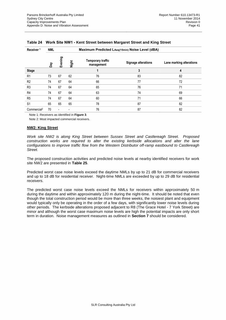
Parsons Brinckerhoff Australia Pty Limited Sydney City Centre Capacity Improvements Plan Appendix D: Noise and Vibration Assessment
Report Number 610.13473-R1 11 November 2014
Revision 0 Page 41
SLR Consulting Australia Pty Ltd
Table 24 Work Site NW1 - Kent Street between Margaret Street and King Street
Receiver 1 NML Maximum Predicted LAeq(15min) Noise Level (dBA) D
ay
Eve
nin
g
Nig
ht Temporary traffic
management Signage alterations Lane marking alterations
Stage 1 3 4
R1 73 67 62 76 83 82
R2 74 67 64 66 77 72
R3 74 67 64 65 76 71
R4 74 67 64 63 74 69
R5 74 67 64 60 71 66
S1 65 65 65 78 87 82
Commercial2 70 - - 76 87 82
Note 1: Receivers as identified in Figure 3.
Note 2: Most impacted commercial receivers.
NW2: King Street
Work site NW2 is along King Street between Sussex Street and Castlereagh Street. Proposed construction works are required to alter the existing kerbside allocations and alter the lane configurations to improve traffic flow from the Western Distributor off-ramp eastbound to Castlereagh Street.
The proposed construction activities and predicted noise levels at nearby identified receivers for work site NW2 are presented in Table 25.
Predicted worst case noise levels exceed the daytime NMLs by up to 21 dB for commercial receivers and up to 18 dB for residential receiver. Night-time NMLs are exceeded by up to 29 dB for residential receivers.
The predicted worst case noise levels exceed the NMLs for receivers within approximately 50 m during the daytime and within approximately 120 m during the night-time. It should be noted that even though the total construction period would be more than three weeks, the noisiest plant and equipment would typically only be operating in the order of a few days, with significantly lower noise levels during other periods. The kerbside alterations proposed adjacent to R8 (The Grace Hotel - 7 York Street) are minor and although the worst case maximum noise levels are high the potential impacts are only short term in duration. Noise management measures as outlined in Section 7 should be considered.

Parsons Brinckerhoff Australia Pty Limited Sydney City Centre Capacity Improvements Plan Appendix D: Noise and Vibration Assessment
Report Number 610.13473-R1 11 November 2014
Revision 0 Page 42
SLR Consulting Australia Pty Ltd
Table 25 Work Site NW2 - King Street between Sussex Street and Castlereagh Street
Receiver 1 NML Maximum Predicted LAeq(15min) Noise Level (dBA) D
ay
Eve
nin
g
Nig
ht
Tem
po
rary
tra
ffic
man
agem
ent
Tem
po
rary
fo
otp
ath
rest
rict
ion
/clo
sure
Lig
hti
ng
wo
rks
Ker
b/k
erb
ram
p w
ork
s
Med
ian
rem
ova
l an
d
refu
rbis
hm
ent
Ped
estr
ian
isla
nd
alte
rati
on
Fo
otp
ath
alt
erat
ion
s
Maj
or
equ
ipm
ent
relo
cati
on
Dra
inag
e w
ork
s
Uti
lity
wo
rks
Sig
nag
e al
tera
tio
ns
Tra
ffic
sig
np
ost
alte
rati
on
s
Lo
calis
ed r
esu
rfac
ing
Lan
e m
arki
ng
alt
erat
ion
s
Reg
rad
e an
d r
esu
rfac
e
Stage 1 1 1 2 2 2 2 2 2 2 3 3 4 4 4
R13 72 67 65 58 58 - 61 69 - 61 - 69 - 68 68 56 64 -
R11 72 67 65 76 76 - 61 83 - 61 - 80 - 80 80 56 78 -
R12 72 67 65 63 - - - - 74 - - 71 - 72 - - 68 66
R3 74 67 64 76 66 - - - 75 - - 77 - 87 - - 84 84
R2 74 67 64 76 62 - - - 73 - - 73 - 87 - - 84 84
R4 74 67 64 68 - - - - - - - - - 77 - - 74 76
R5 74 67 64 62 - - - - - - - - - 71 - - 68 70
R8 73 62 62 76 80 72 91 - - 91 - 81 86 81 - 86 84 82
R7 73 62 62 76 76 68 87 - - 81 - 81 76 73 - 76 76 76
SU2 73 62 62 64 - - 67 - - - - - - 76 - - 71 -
Commercial2 70 - - 76 78 - 91 83 - 91 91 91 86 89 89 84 86 86
Note 1: Receivers as identified in Figure 3.
Note 2: Most impacted commercial receivers.
4.3.2 Precinct 2: Retail
R1: Park Street
Work site R1 is along Park Street at the Pitt Street intersection. Proposed construction works are required to modify the Sydney City Centre Bus Plan Infrastructure designations to provide a short dedicated right-turn lane in Park Street (westbound) at Pitt Street. This would be achieved by shortening the proposed bus lane in Park Street (westbound) to allow this dedicated right-turn lane to be installed.
The proposed construction activities and predicted noise levels at nearby identified receivers for work site R1 are presented in Table 26.
Predicted worst case noise levels exceed the daytime NMLs by up to 21 dB for commercial receivers. For residential receivers only a marginal 2 dB exceedance of the night-time NML is predicted.
The nearest residential receiver is approximately 100 m from any work and only minor exceedances of the night-time NML are predicted. It should be noted that even though the total construction period would be more than three weeks, the noisiest plant and equipment would typically only be operating in the order of a few days, with significantly lower noise levels during other periods. Noise management measures as outlined in Section 7 should be considered for commercial receivers.

Parsons Brinckerhoff Australia Pty Limited Sydney City Centre Capacity Improvements Plan Appendix D: Noise and Vibration Assessment
Report Number 610.13473-R1 11 November 2014
Revision 0 Page 43
SLR Consulting Australia Pty Ltd
Table 26 Work Site R1 - Park Street at the Pitt Street intersection
Receiver 1 NML Maximum Predicted LAeq(15min) Noise Level (dBA) D
ay
Eve
nin
g
Nig
ht
Tem
po
rary
tra
ffic
m
anag
emen
t
Tem
po
rary
fo
otp
ath
re
stri
ctio
n/c
losu
re
Ker
b/k
erb
ram
p
wo
rks
Fo
otp
ath
alt
erat
ion
s
Dra
inag
e w
ork
s
Uti
lity
wo
rks
Sig
nag
e al
tera
tio
ns
Tra
ffic
sig
np
ost
al
tera
tio
ns
Lo
calis
ed
resu
rfac
ing
Lan
e m
arki
ng
al
tera
tio
ns
Stage 1 1 2 2 2 2 3 3 4 4
R16 77 65 65 56 56 67 67 67 - 67 67 62 62
Commercial2 70 - - 72 72 91 87 83 86 87 87 84 84
Note 1: Receivers as identified in Figure 4.
Note 2: Most impacted commercial receivers.
R2: Market Street
Work site R2 is along Market Street between Kent Street and Castlereagh Street. Proposed construction works are required to undertake kerb adjustments and modify kerbside parking allocations to introduce additional traffic efficiency improvements between Castlereagh Street and Clarence Street.
The proposed construction activities and predicted noise levels at nearby identified receivers for work site R2 are presented in Table 27.
Predicted worst case noise levels exceed the daytime NMLs by up to 21 dB for commercial receivers and up to 5 dB for residential receiver. Night-time NMLs are exceeded by up to 19 dB for residential receivers.
It should be noted that even though the total construction period would be more than 3 weeks, the noisiest plant and equipment would typically only be operating in the order of a few days, with significantly lower noise levels during other periods. Noise management measures as outlined in Section 7 should be considered.
Table 27 Work Site R2 - Market Street between Kent Street and Castlereagh Street
Receiver 1 NML Maximum Predicted LAeq(15min) Noise Level (dBA)
Day
Eve
nin
g
Nig
ht
Tem
po
rary
tra
ffic
man
agem
ent
Tem
po
rary
fo
otp
ath
rest
rict
ion
/clo
sure
Lig
hti
ng
wo
rks
Ker
b/k
erb
ram
p
wo
rks
Fo
otp
ath
alt
erat
ion
s
Maj
or
eq
uip
men
t
relo
cati
on
Tre
e m
anag
emen
t
Dra
inag
e w
ork
s
Uti
lity
wo
rks
Sig
nag
e al
tera
tio
ns
Tra
ffic
sig
np
ost
al
tera
tio
ns
Bu
s la
ne
mar
kin
gs
Lo
calis
ed
resu
rfac
ing
Lan
e m
arki
ng
alte
rati
on
s
Stage 1 1 1 2 2 2 2 2 2 3 3 3 4 4
R17 76 69 62 72 70 66 81 81 - - 69 76 - - 62 76 72
R18 77 70 68 72 72 - 77 77 - 58 70 72 70 70 - 72 86
SU3 65 65 65 70 60 - 71 71 - 58 - 66 81 70 - 66 76
Commercial2 70 - - 78 78 82 91 91 87 76 89 86 87 87 82 86 84
Note 1: Receivers as identified in Figure 4.
Note 2: Most impacted commercial receivers.
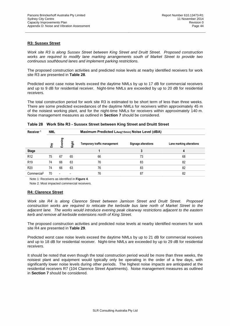
Parsons Brinckerhoff Australia Pty Limited Sydney City Centre Capacity Improvements Plan Appendix D: Noise and Vibration Assessment
Report Number 610.13473-R1 11 November 2014
Revision 0 Page 44
SLR Consulting Australia Pty Ltd
R3: Sussex Street
Work site R3 is along Sussex Street between King Street and Druitt Street. Proposed construction works are required to modify lane marking arrangements south of Market Street to provide two continuous southbound lanes and implement parking restrictions.
The proposed construction activities and predicted noise levels at nearby identified receivers for work site R3 are presented in Table 28.
Predicted worst case noise levels exceed the daytime NMLs by up to 17 dB for commercial receivers and up to 9 dB for residential receiver. Night-time NMLs are exceeded by up to 20 dB for residential receivers.
The total construction period for work site R3 is estimated to be short term of less than three weeks. There are some predicted exceedances of the daytime NMLs for receivers within approximately 45 m of the noisiest working plant, and for the night-time NMLs for receivers within approximately 140 m. Noise management measures as outlined in Section 7 should be considered.
Table 28 Work Site R3 - Sussex Street between King Street and Druitt Street
Receiver 1 NML Maximum Predicted LAeq(15min) Noise Level (dBA)
Day
Eve
nin
g
Nig
ht
Temporary traffic management Signage alterations Lane marking alterations
Stage 1 3 4
R12 75 67 65 66 73 68
R19 74 66 63 76 83 82
R20 74 66 63 76 83 82
Commercial2 70 - - 76 87 82
Note 1: Receivers as identified in Figure 4.
Note 2: Most impacted commercial receivers.
R4: Clarence Street
Work site R4 is along Clarence Street between Jamison Street and Druitt Street. Proposed construction works are required to relocate the kerbside bus lane north of Market Street to the adjacent lane. The works would introduce evening peak clearway restrictions adjacent to the eastern kerb and remove all kerbside extensions north of King Street.
The proposed construction activities and predicted noise levels at nearby identified receivers for work site R4 are presented in Table 29.
Predicted worst case noise levels exceed the daytime NMLs by up to 21 dB for commercial receivers and up to 18 dB for residential receiver. Night-time NMLs are exceeded by up to 29 dB for residential receivers.
It should be noted that even though the total construction period would be more than three weeks, the noisiest plant and equipment would typically only be operating in the order of a few days, with significantly lower noise levels during other periods. The highest noise impacts are anticipated at the residential receivers R7 (104 Clarence Street Apartments). Noise management measures as outlined in Section 7 should be considered.

Parsons Brinckerhoff Australia Pty Limited Sydney City Centre Capacity Improvements Plan Appendix D: Noise and Vibration Assessment
Report Number 610.13473-R1 11 November 2014
Revision 0 Page 45
SLR Consulting Australia Pty Ltd
Table 29 Work Site R4 - Clarence Street between Jamison Street and Druitt Street
Receiver 1 NML Maximum Predicted LAeq(15min) Noise Level (dBA) D
ay
Eve
nin
g
Nig
ht
Tem
po
rary
tra
ffic
m
anag
emen
t
Tem
po
rary
fo
otp
ath
rest
rict
ion
/clo
sure
Ker
b/k
erb
ram
p
wo
rks
Fo
otp
ath
alt
erat
ion
s
Maj
or
eq
uip
men
t
relo
cati
on
Dra
inag
e w
ork
s
Uti
lity
wo
rks
Sig
nag
e al
tera
tio
ns
Bu
s la
ne
mar
kin
gs
Lo
calis
ed
resu
rfac
ing
Lan
e m
arki
ng
alte
rati
on
s
Reg
rad
e an
d
resu
rfac
e
Stage 1 1 2 2 2 2 2 3 3 4 4 4
SU7 65 65 65 62 - - - - - - 73 68 - 68 68
R62 75 67 67 76 - - - - - - 89 78 - 78 82
R15 75 67 67 56 - - - - - - 67 62 - 62 62
R6 75 67 62 76 57 68 68 - 68 63 87 82 63 84 82
R7 73 62 62 76 80 91 91 91 87 86 91 78 86 86 82
R8 73 62 62 76 72 83 83 - 83 86 87 78 78 82 78
R63 73 62 62 76 57 68 68 - 68 63 87 78 63 82 82
R17 76 69 62 70 68 81 81 - 77 76 87 72 76 82 74
R76 72 64 64 70 - - - - - - 81 - - 78 -
SU15 65 65 65 66 - - - - - - 75 - - 72 -
SU16 65 65 65 62 - - - - - - 71 - - 68 -
Commercial2 70 - - 76 80 91 91 91 87 86 91 82 86 86 84
Note 1: Receivers as identified in Figure 5.
Note 2: Most impacted commercial receivers.
R5: York Street
Work site R5 is along York Street between King Street and Druitt Street. Proposed construction works are required to improve bus operations on York Street between Barrack Street and Druitt Street by removing kerb extensions.
The proposed construction activities and predicted noise levels at nearby identified receivers for work site R5 are presented in Table 30.
Predicted worst case noise levels exceed the daytime NMLs by up to 21 dB for commercial receivers and up to 18 dB for residential receiver. Night-time NMLs are exceeded by up to 29 dB for residential receivers.
It should be noted that even though the total construction period would be more than three weeks, the noisiest plant and equipment would typically only be operating in the order of a few days, with significantly lower noise levels during other periods. The kerbside alterations proposed adjacent to R8 (The Grace Hotel - 7 York Street) are minor and although the worst case maximum noise levels are high the potential impacts are only short term in duration. Noise management measures as outlined in Section 7 should be considered.
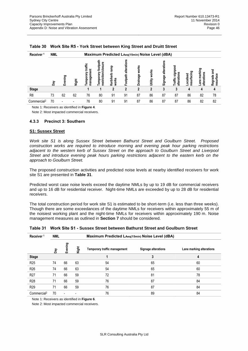
Parsons Brinckerhoff Australia Pty Limited Sydney City Centre Capacity Improvements Plan Appendix D: Noise and Vibration Assessment
Report Number 610.13473-R1 11 November 2014
Revision 0 Page 46
SLR Consulting Australia Pty Ltd
Table 30 Work Site R5 - York Street between King Street and Druitt Street
Receiver 1 NML Maximum Predicted LAeq(15min) Noise Level (dBA) D
ay
Eve
nin
g
Nig
ht
Tem
po
rary
tra
ffic
man
agem
ent
Tem
po
rary
fo
otp
ath
re
stri
ctio
n/c
losu
re
Ker
b/k
erb
ram
p
wo
rks
Fo
otp
ath
alt
erat
ion
s
Dra
inag
e w
ork
s
Uti
lity
wo
rks
Sig
nag
e al
tera
tio
ns
Tra
ffic
sig
np
ost
al
tera
tio
ns
Lo
calis
ed
resu
rfac
ing
Lan
e m
arki
ng
alte
rati
on
s
Reg
rad
e an
d
resu
rfac
e
Stage 1 1 2 2 2 2 3 3 4 4 4
R8 73 62 62 76 80 91 91 87 86 87 87 86 82 78
Commercial2 70 - - 76 80 91 91 87 86 87 87 86 82 82
Note 1: Receivers as identified in Figure 4.
Note 2: Most impacted commercial receivers.
4.3.3 Precinct 3: Southern
S1: Sussex Street
Work site S1 is along Sussex Street between Bathurst Street and Goulburn Street. Proposed construction works are required to introduce morning and evening peak hour parking restrictions adjacent to the western kerb of Sussex Street on the approach to Goulburn Street and Liverpool Street and introduce evening peak hours parking restrictions adjacent to the eastern kerb on the approach to Goulburn Street.
The proposed construction activities and predicted noise levels at nearby identified receivers for work site S1 are presented in Table 31.
Predicted worst case noise levels exceed the daytime NMLs by up to 19 dB for commercial receivers and up to 16 dB for residential receiver. Night-time NMLs are exceeded by up to 28 dB for residential receivers.
The total construction period for work site S1 is estimated to be short-term (i.e. less than three weeks). Though there are some exceedances of the daytime NMLs for receivers within approximately 55 m of the noisiest working plant and the night-time NMLs for receivers within approximately 190 m. Noise management measures as outlined in Section 7 should be considered.
Table 31 Work Site S1 - Sussex Street between Bathurst Street and Goulburn Street
Receiver 1 NML Maximum Predicted LAeq(15min) Noise Level (dBA)
Day
Eve
nin
g
Nig
ht
Temporary traffic management Signage alterations Lane marking alterations
Stage 1 3 4
R25 74 66 63 54 65 60
R26 74 66 63 54 65 60
R27 71 66 59 72 81 78
R28 71 66 59 76 87 84
R29 71 66 59 76 87 84
Commercial2 70 - - 76 89 84
Note 1: Receivers as identified in Figure 6.
Note 2: Most impacted commercial receivers.
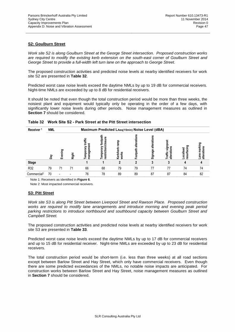
Parsons Brinckerhoff Australia Pty Limited Sydney City Centre Capacity Improvements Plan Appendix D: Noise and Vibration Assessment
Report Number 610.13473-R1 11 November 2014
Revision 0 Page 47
SLR Consulting Australia Pty Ltd
S2: Goulburn Street
Work site S2 is along Goulburn Street at the George Street intersection. Proposed construction works are required to modify the existing kerb extension on the south-east corner of Goulburn Street and George Street to provide a full-width left turn lane on the approach to George Street.
The proposed construction activities and predicted noise levels at nearby identified receivers for work site S2 are presented in Table 32.
Predicted worst case noise levels exceed the daytime NMLs by up to 19 dB for commercial receivers. Night-time NMLs are exceeded by up to 8 dB for residential receivers.
It should be noted that even though the total construction period would be more than three weeks, the noisiest plant and equipment would typically only be operating in the order of a few days, with significantly lower noise levels during other periods. Noise management measures as outlined in Section 7 should be considered.
Table 32 Work Site S2 - Park Street at the Pitt Street intersection
Receiver 1 NML Maximum Predicted LAeq(15min) Noise Level (dBA)
Day
Eve
nin
g
Nig
ht
Tem
po
rary
tra
ffic
m
anag
emen
t
Tem
po
rary
fo
otp
ath
re
stri
ctio
n/c
losu
re
Ker
b/k
erb
ram
p
wo
rks
Fo
otp
ath
alt
erat
ion
s
Sig
nag
e al
tera
tio
ns
Tra
ffic
sig
np
ost
alte
rati
on
s
Lo
calis
ed
resu
rfac
ing
Lan
e m
arki
ng
al
tera
tio
ns
Stage 1 1 2 2 3 3 4 4
R32 79 71 71 66 68 79 79 77 77 74 74
Commercial2 70 - - 76 78 89 89 87 87 84 82
Note 1: Receivers as identified in Figure 6.
Note 2: Most impacted commercial receivers.
S3: Pitt Street
Work site S3 is along Pitt Street between Liverpool Street and Rawson Place. Proposed construction works are required to modify lane arrangements and introduce morning and evening peak period parking restrictions to introduce northbound and southbound capacity between Goulburn Street and Campbell Street.
The proposed construction activities and predicted noise levels at nearby identified receivers for work site S3 are presented in Table 33.
Predicted worst case noise levels exceed the daytime NMLs by up to 17 dB for commercial receivers and up to 15 dB for residential receiver. Night-time NMLs are exceeded by up to 23 dB for residential receivers.
The total construction period would be short-term (i.e. less than three weeks) at all road sections except between Barlow Street and Hay Street, which only have commercial receivers. Even though there are some predicted exceedances of the NMLs, no notable noise impacts are anticipated. For construction works between Barlow Street and Hay Street, noise management measures as outlined in Section 7 should be considered.

Parsons Brinckerhoff Australia Pty Limited Sydney City Centre Capacity Improvements Plan Appendix D: Noise and Vibration Assessment
Report Number 610.13473-R1 11 November 2014
Revision 0 Page 48
SLR Consulting Australia Pty Ltd
Table 33 Work Site S3 - Park Street at the Pitt Street intersection
Receiver 1 NML Maximum Predicted LAeq(15min) Noise Level (dBA) D
ay
Eve
nin
g
Nig
ht
Tem
po
rary
tra
ffic
m
anag
emen
t
Maj
or
eq
uip
men
t re
loca
tio
n
Sig
nag
e al
tera
tio
ns
Tra
ffic
sig
np
ost
alte
rati
on
s
Lan
e m
arki
ng
al
tera
tio
ns
Reg
rad
e an
d
resu
rfac
e
Stage 1 2 3 3 4 4
R35 74 69 68 70 - 77 - 70 -
R78 74 69 68 58 - 69 - 64 -
R36 74 69 68 66 - 87 - 78 -
R37 72 64 64 62 - 73 - 68 -
R33 72 64 64 63 - 75 - 69 -
R41 72 64 64 76 - 87 - 82 -
R34 72 64 64 66 - 83 - 72 -
R38 72 64 64 58 - 83 - 64 -
R40 72 64 64 66 - 87 - 72 -
R39 72 64 64 70 - 87 - 78 -
R42 72 64 64 57 - 67 - 63 -
R77 72 64 64 56 - 65 - 62 -
R59 75 67 64 60 - 71 71 78 61
R60 75 67 64 59 - 69 69 66 -
Commercial2 70 - - 76 87 87 87 82 82
Note 1: Receivers as identified in Figure 7.
Note 2: Most impacted commercial receivers.
S4: Ultimo Road
Work site S4 is along Ultimo Road at the Harris Street intersection. Proposed construction works are required to modify lane arrangements to provide a dual-left turn into Harris Street from Ultimo Street.
The proposed construction activities and predicted noise levels at nearby identified receivers for work site S4 are presented in Table 34.
Predicted worst case noise levels exceed the daytime NMLs by up to 17 dB for commercial receivers and up to 8 dB for residential receiver. Night-time NMLs are exceeded by up to 17 dB for residential receivers.
The total construction period for work site S4 is estimated to be short-term (i.e. less than three weeks). There are some exceedances of the daytime NMLs for receivers within approximately 45 m of the noisiest working plant and the night-time NMLs for receivers within approximately 120 m. Noise management measures as outlined in Section 7 should be considered.
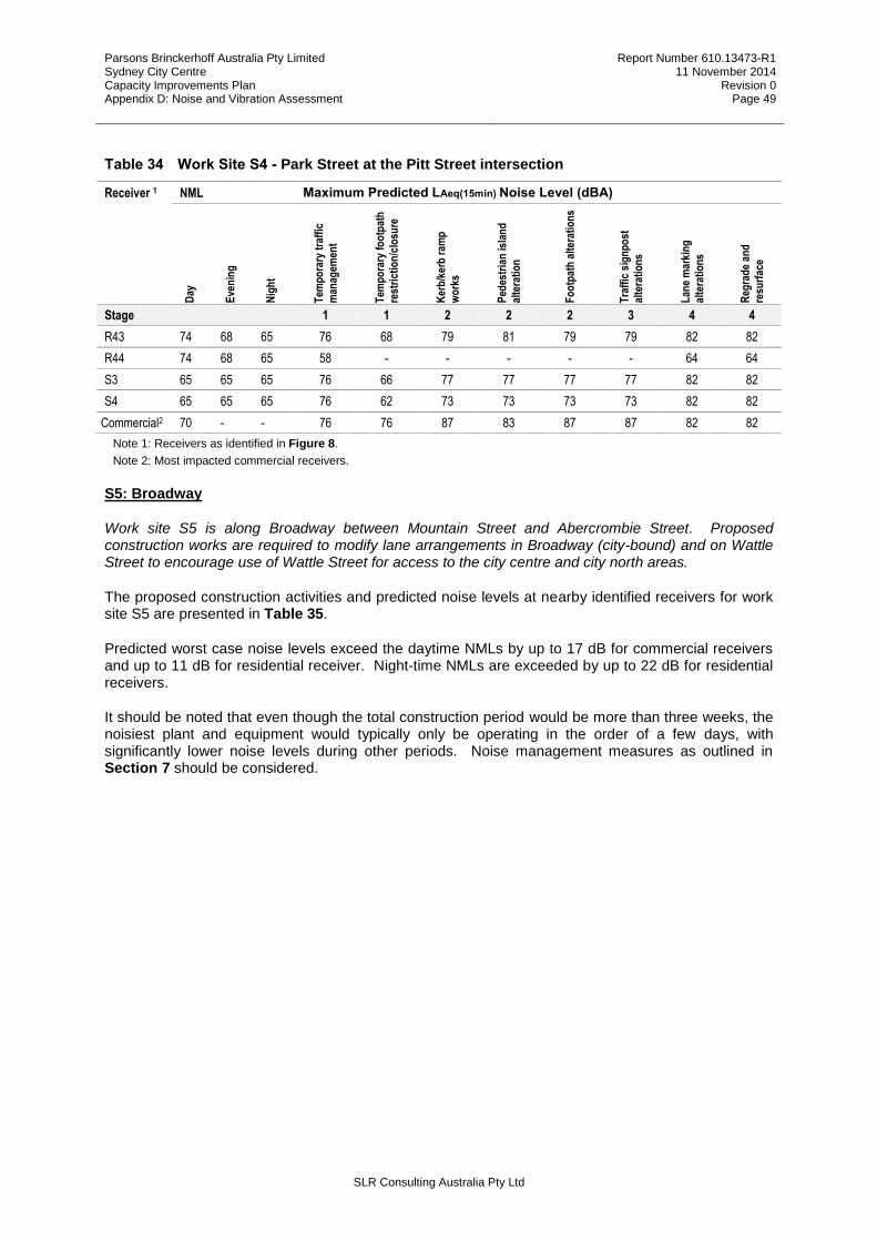
Parsons Brinckerhoff Australia Pty Limited Sydney City Centre Capacity Improvements Plan Appendix D: Noise and Vibration Assessment
Report Number 610.13473-R1 11 November 2014
Revision 0 Page 49
SLR Consulting Australia Pty Ltd
Table 34 Work Site S4 - Park Street at the Pitt Street intersection
Receiver 1 NML Maximum Predicted LAeq(15min) Noise Level (dBA) D
ay
Eve
nin
g
Nig
ht
Tem
po
rary
tra
ffic
m
anag
emen
t
Tem
po
rary
fo
otp
ath
re
stri
ctio
n/c
losu
re
Ker
b/k
erb
ram
p
wo
rks
Ped
estr
ian
isla
nd
al
tera
tio
n
Fo
otp
ath
alt
erat
ion
s
Tra
ffic
sig
np
ost
al
tera
tio
ns
Lan
e m
arki
ng
al
tera
tio
ns
Reg
rad
e an
d
resu
rfac
e
Stage 1 1 2 2 2 3 4 4
R43 74 68 65 76 68 79 81 79 79 82 82
R44 74 68 65 58 - - - - - 64 64
S3 65 65 65 76 66 77 77 77 77 82 82
S4 65 65 65 76 62 73 73 73 73 82 82
Commercial2 70 - - 76 76 87 83 87 87 82 82
Note 1: Receivers as identified in Figure 8.
Note 2: Most impacted commercial receivers.
S5: Broadway
Work site S5 is along Broadway between Mountain Street and Abercrombie Street. Proposed construction works are required to modify lane arrangements in Broadway (city-bound) and on Wattle Street to encourage use of Wattle Street for access to the city centre and city north areas.
The proposed construction activities and predicted noise levels at nearby identified receivers for work site S5 are presented in Table 35.
Predicted worst case noise levels exceed the daytime NMLs by up to 17 dB for commercial receivers and up to 11 dB for residential receiver. Night-time NMLs are exceeded by up to 22 dB for residential receivers.
It should be noted that even though the total construction period would be more than three weeks, the noisiest plant and equipment would typically only be operating in the order of a few days, with significantly lower noise levels during other periods. Noise management measures as outlined in Section 7 should be considered.

Parsons Brinckerhoff Australia Pty Limited Sydney City Centre Capacity Improvements Plan Appendix D: Noise and Vibration Assessment
Report Number 610.13473-R1 11 November 2014
Revision 0 Page 50
SLR Consulting Australia Pty Ltd
Table 35 Work Site S5 - Broadway between Mountain Street and Abercrombie Street
Receiver 1 NML Maximum Predicted LAeq(15min) Noise Level (dBA) D
ay
Eve
nin
g
Nig
ht
Tem
po
rary
tra
ffic
man
agem
ent
Tem
po
rary
fo
otp
ath
rest
rict
ion
/clo
sure
Ker
b/k
erb
ram
p
wo
rks
Fo
otp
ath
alt
erat
ion
s
Uti
lity
wo
rks
Bu
s la
ne
mar
kin
gs
Lan
e m
arki
ng
al
tera
tio
ns
Reg
rad
e an
d
resu
rfac
e
Stage 1 1 2 2 2 3 4 4
R83 76 67 65 68 - - - - 63 74 74
R84 76 67 65 58 - - - - - 62 62
R85 76 67 65 58 - - - - - 62 62
S4 65 65 65 76 76 87 87 82 82 76 -
S5 65 65 65 66 63 74 74 69 68 74 74
SU17 65 65 65 66 64 75 75 70 72 74 74
R87 76 67 65 64 76 87 87 82 69 78 69
R88 76 67 65 60 76 87 87 82 65 78 66
S3 65 65 65 54 63 74 74 69 60 70 60
Commercial2 70 - - 76 76 87 87 82 82 78 82
Note 1: Receivers as identified in Figure 9.
Note 2: Most impacted commercial receivers.
S6: Pitt Street
Work site S6 is along Pitt Street, George Street, Lee Street, Quay Street intersection. Proposed construction works are required to modify lane arrangements to set priorities between Pitt Street, George Street and Quay Street.
The proposed construction activities and predicted noise levels at nearby identified receivers for work site S6 are presented in Table 36.
Predicted worst case noise levels exceed the daytime NMLs by up to 19 dB for commercial receivers and up to 12 dB for residential receiver. Night-time NMLs are exceeded by up to 24 dB for residential receivers.
The total construction period for work site S6 is estimated to be short-term (i.e. less than three weeks). There are some exceedances of the daytime NMLs for receivers within approximately 30 m of the noisiest working plant and the night-time NMLs for receivers within approximately 120 m. Noise management measures as outlined in Section 7 should be considered.

Parsons Brinckerhoff Australia Pty Limited Sydney City Centre Capacity Improvements Plan Appendix D: Noise and Vibration Assessment
Report Number 610.13473-R1 11 November 2014
Revision 0 Page 51
SLR Consulting Australia Pty Ltd
Table 36 Work Site S6 - Pitt Street at the Lee Street and George Street intersection
Receiver 1 NML Maximum Predicted LAeq(15min) Noise Level (dBA) D
ay
Eve
nin
g
Nig
ht
Tem
po
rary
tra
ffic
m
anag
emen
t
Tem
po
rary
fo
otp
ath
re
stri
ctio
n/c
losu
re
Ker
b/k
erb
ram
p
wo
rks
Ped
estr
ian
isla
nd
al
tera
tio
n
Fo
otp
ath
alt
erat
ion
s
Dra
inag
e w
ork
s
Sig
nag
e al
tera
tio
ns
Tra
ffic
sig
np
ost
al
tera
tio
ns
Bu
s la
ne
mar
kin
gs
Lo
calis
ed
resu
rfac
ing
Lan
e m
arki
ng
alte
rati
on
s
Stage 1 1 2 2 2 2 3 3 3 4 4
R75 77 70 65 72 76 89 74 89 81 87 79 65 82 82
R79 77 70 65 70 76 87 81 87 81 87 87 78 82 82
R80 77 70 65 60 62 73 70 73 73 73 73 64 68 68
S3 65 65 65 70 76 87 77 87 81 87 81 78 82 82
Commercial2 70 - - 72 76 89 - 87 87 87 87 69 82 82
Note 1: Receivers as identified in Figure 10.
Note 2: Most impacted commercial receivers.
4.3.4 Precinct 4: College
C1: Wentworth Avenue
Work site C1 is along Wentworth Avenue between Oxford Street and Campbell Street. Proposed construction works are required to maximise the use of the 21-metre wide carriageway to provide an additional eastbound and westbound lane over much of the length of the corridor whilst improving the turning movements at both Goulburn Street and Oxford Street.
The proposed construction activities and predicted noise levels at nearby identified receivers for work site C1 are presented in Table 37.
Predicted worst case noise levels exceed the daytime NMLs by up to 13 dB for commercial receivers and up to 14 dB for residential receiver. Night-time NMLs are exceeded by up to 26 dB for residential receivers.
It should be noted that even though the total construction period would be more than three weeks, the noisiest plant and equipment would typically only be operating in the order of a few days, with significantly lower noise levels during other periods. Noise management measures as outlined in Section 7 should be considered.
Table 37 Work Site C1 - Wentworth Avenue between Oxford Street and Campbell Street
Receiver 1 NML Maximum Predicted LAeq(15min) Noise Level (dBA)
Day
Eve
nin
g
Nig
ht
Tem
po
rary
tra
ffic
man
agem
ent
Tem
po
rary
fo
otp
ath
rest
rict
ion
/clo
sure
Ker
b/k
erb
ram
p
wo
rks
Med
ian
rem
ova
l an
d
refu
rbis
hm
ent
Ped
estr
ian
isla
nd
al
tera
tio
n
Fo
otp
ath
alt
erat
ion
s
Maj
or
eq
uip
men
t re
loca
tio
n
Tre
e m
anag
emen
t
Dra
inag
e w
ork
s
Uti
lity
wo
rks
Sig
nag
e al
tera
tio
ns
Tra
ffic
sig
np
ost
alte
rati
on
s
Lan
e m
arki
ng
alte
rati
on
s
Reg
rad
e an
d
resu
rfac
e
Stage 1 1 2 2 2 2 2 2 2 2 3 3 4 4
R48 75 69 68 72 76 87 83 - 87 77 - 87 82 83 87 82 82
R58 75 69 68 72 66 77 76 - 77 77 - 77 72 83 77 82 72
R50 75 69 68 72 62 73 72 - 73 83 70 73 68 83 73 78 68
R51 75 69 68 72 72 83 68 - 83 73 70 68 78 83 83 82 63
R52 73 64 61 72 65 76 81 77 76 70 - - 72 83 81 78 -

Parsons Brinckerhoff Australia Pty Limited Sydney City Centre Capacity Improvements Plan Appendix D: Noise and Vibration Assessment
Report Number 610.13473-R1 11 November 2014
Revision 0 Page 52
SLR Consulting Australia Pty Ltd
Receiver 1 NML Maximum Predicted LAeq(15min) Noise Level (dBA)
Day
Eve
nin
g
Nig
ht
Tem
po
rary
tra
ffic
man
agem
ent
Tem
po
rary
fo
otp
ath
rest
rict
ion
/clo
sure
Ker
b/k
erb
ram
p
wo
rks
Med
ian
rem
ova
l an
d
refu
rbis
hm
ent
Ped
estr
ian
isla
nd
al
tera
tio
n
Fo
otp
ath
alt
erat
ion
s
Maj
or
eq
uip
men
t re
loca
tio
n
Tre
e m
anag
emen
t
Dra
inag
e w
ork
s
Uti
lity
wo
rks
Sig
nag
e al
tera
tio
ns
Tra
ffic
sig
np
ost
alte
rati
on
s
Lan
e m
arki
ng
alte
rati
on
s
Reg
rad
e an
d
resu
rfac
e
Stage 1 1 2 2 2 2 2 2 2 2 3 3 4 4
R53 73 64 61 72 65 76 81 71 76 70 - - 71 83 81 78 -
R54 73 64 61 72 76 87 79 81 79 - - - 82 83 81 78 -
R56 73 64 61 72 57 68 72 68 68 - - - 63 83 69 78 -
R55 73 64 61 60 60 71 69 70 69 - - - 66 71 70 66 -
R57 73 64 61 72 56 67 76 67 67 - - - 62 83 76 78 -
R70 75 69 68 76 59 70 70 - 70 - - 70 65 70 70 82 82
R49 75 69 68 76 64 75 75 - 75 - - 75 70 75 75 82 82
Commercial2 70 - - 76 72 83 83 79 79 83 72 83 78 83 81 82 82
Note 1: Receivers as identified in Figure 11.
Note 2: Most impacted commercial receivers.
C2: College Street
Work site C2 is along College Street between Macquarie Street and Oxford Street. Proposed construction works are required to create additional lengths for left and right turns on both of the approaches to Park Street. The works would also modify the road geometry at the northern end of College Street and on Prince Albert Road to introduce capacity for the traffic approaching Macquarie Street. Construction works to modify the lane arrangements between Macquarie Street and College Street to introduce northbound capacity are also proposed.
The proposed construction activities and predicted noise levels at nearby identified receivers for work site C2 are presented in Table 38.
Predicted worst case noise levels exceed the daytime NMLs by up to 13 dB for commercial receivers and up to 3 dB for residential receiver. Night-time NMLs are exceeded by up to 10 dB for residential receivers.
There are predicted exceedances of the NMLs at both commercial and residential receivers for this work site. It should be noted that even though the total construction period would be more than three weeks, the noisiest plant and equipment would typically only be operating in the order of a few days, with significantly lower noise levels during other periods. Noise management measures as outlined in Section 7 should be considered.

Parsons Brinckerhoff Australia Pty Limited Sydney City Centre Capacity Improvements Plan Appendix D: Noise and Vibration Assessment
Report Number 610.13473-R1 11 November 2014
Revision 0 Page 53
SLR Consulting Australia Pty Ltd
Table 38 Work Site C2 - College Street between Macquarie Street and Oxford Street
Receiver 1 NML Maximum Predicted LAeq(15min) Noise Level (dBA) D
ay
Eve
nin
g
Nig
ht
Tem
po
rary
tra
ffic
man
agem
ent
Tem
po
rary
fo
otp
ath
re
stri
ctio
n/c
losu
re
Ker
b/k
erb
ram
p
wo
rks
Med
ian
rem
ova
l an
d
refu
rbis
hm
ent
Fo
otp
ath
alt
erat
ion
s
Maj
or
eq
uip
men
t re
loca
tio
n
Tre
e m
anag
emen
t
Dra
inag
e w
ork
s
Uti
lity
wo
rks
Sig
nag
e al
tera
tio
ns
Tra
ffic
sig
np
ost
alte
rati
on
s
Lan
e m
arki
ng
alte
rati
on
s
Reg
rad
e an
d
resu
rfac
e
Stage 1 1 2 2 2 2 2 2 2 3 3 4 4
SU1 65 65 65 72 70 81 74 81 74 68 71 76 81 75 78 78
SU14 65 65 65 72 72 83 81 83 77 60 83 78 81 79 78 78
S2 65 65 65 72 76 87 - 87 - - - 82 83 83 78 78
R70 75 69 68 72 - - - - - - - - 77 - 78 78
R49 75 69 68 72 - - - - - - - - 77 - 78 78
Commercial2 70 - - 72 72 83 81 83 77 70 73 78 83 83 78 78
Note 1: Receivers as identified in Figure 12.
Note 2: Most impacted commercial receivers.
4.3.5 Precinct 5: Financial
F1: Macquarie Street
Work site F1 is along Macquarie Street between Bent Street and Bridge Street. Proposed construction works are required to introduce northbound capacity in the morning and evening peak periods on the approach to Bridge Street.
The proposed construction activities and predicted noise levels at nearby identified receivers for work site F1 are presented in Table 39.
Predicted worst case noise levels exceed the daytime NMLs by up to 13 dB for commercial receivers. For residential receivers only a marginal 1 dB exceedance of the night-time NML is predicted.
There are predicted exceedances of the NMLs at both commercial and residential receivers for this work site. It should be noted that even though the total construction period would be more than three weeks, the noisiest plant and equipment would typically only be operating in the order of a few days, with significantly lower noise levels during other periods. Noise management measures as outlined in Section 7 should be considered.

Parsons Brinckerhoff Australia Pty Limited Sydney City Centre Capacity Improvements Plan Appendix D: Noise and Vibration Assessment
Report Number 610.13473-R1 11 November 2014
Revision 0 Page 54
SLR Consulting Australia Pty Ltd
Table 39 Work Site F1 - Macquarie Street between Bent Street and Bridge Street
Receiver 1 NML Maximum Predicted LAeq(15min) Noise Level (dBA) D
ay
Eve
nin
g
Nig
ht
Tem
po
rary
tra
ffic
m
anag
emen
t
Tem
po
rary
fo
otp
ath
re
stri
ctio
n/c
losu
re
Ker
b/k
erb
ram
p
wo
rks
Fo
otp
ath
alt
erat
ion
s
Maj
or
eq
uip
men
t re
loca
tio
n
Sig
nag
e al
tera
tio
ns
Lo
calis
ed
resu
rfac
ing
Lan
e m
arki
ng
alte
rati
on
s
Stage 1 1 2 2 2 3 4 4
R63 73 68 66 56 54 65 65 65 66 60 62
SU9 65 65 65 55 54 65 65 65 66 60 60
R66 73 68 66 56 56 67 67 67 67 62 62
Commercial2 70 - - 72 72 83 83 83 83 78 78
Note 1: Receivers as identified in Figure 13.
Note 2: Most impacted commercial receivers.
F2: Macquarie Street
Work site F2 is along Macquarie Street at the Hunter Street intersection. Proposed construction works are required to remove the right turn bay on Macquarie Street on the approach to Hunter Street in order to increase right turn capacity for motorists accessing Shakespeare Place and the Eastern Distributor.
The proposed construction activities and predicted noise levels at nearby identified receivers for work site F2 are presented in Table 40.
Predicted worst case noise levels exceed the daytime NMLs by up to 19 dB for commercial receivers and up to 11 dB for residential receiver. Night-time NMLs are exceeded by up to 19 dB for residential receivers.
The total construction period for work site F2 is estimated to be short-term (i.e. less than three weeks). Even though there are some exceedances of the daytime NMLs for receivers within approximately 55 m of the noisiest working plant and the night-time NMLs for receivers within approximately 140 m, no notable noise impacts are anticipated due to the short-term nature of the works.

Parsons Brinckerhoff Australia Pty Limited Sydney City Centre Capacity Improvements Plan Appendix D: Noise and Vibration Assessment
Report Number 610.13473-R1 11 November 2014
Revision 0 Page 55
SLR Consulting Australia Pty Ltd
Table 40 Work Site F2 - Macquarie Street at the Hunter Street intersection
Receiver 1 NML Maximum Predicted LAeq(15min) Noise Level (dBA) D
ay
Eve
nin
g
Nig
ht
Temporary traffic management Signage alterations Lane marking alterations
Stage 1 3 4
R67 72 65 64 72 83 78
R68 72 65 64 72 83 78
SU10 65 65 65 70 79 74
SU11 65 65 65 61 72 67
SU13 65 65 65 58 69 64
Commercial2 70 - - 65 89 84
Note 1: Receivers as identified in Figure 13.
Note 2: Most impacted commercial receivers.
4.4 Construction Sleep Disturbance Assessment
The predictions shows major exceedances of up to 29 dB above the night-time NMLs and 27 dB above the ICNG sleep disturbance trigger level. This may cause sleep disturbance at several residential receivers throughout most of the work sites, with the exception of R1: Park Street and F1: Macquarie Street which have only marginal exceedance of the night-time NMLs.
It is therefore recommended that the noisiest construction activities, which are only required for a short period of the overall construction timeframe (such as operations of vibratory rollers, jackhammers, concrete saws, angle grinders, compactors, profilers and road planers) should not be undertaken at night. Removing these noisy activities from night works, would reduce the night-time noise levels by approximately 10 dB. Furthermore, avoiding night-time works in close proximity of residential buildings would typically further reduce the noise levels by another 10 dB. With these management measures any potential sleep disturbance impacts would be minimised.
These and further noise management measures are outlined in Section 7.
4.5 Discussion of Construction Noise Impacts
For most work sites in the city centre, screening by adjacent buildings would limit noise from traveling any significant distance except along the road where work is being undertaken. Therefore, no notable noise impacts are anticipated for receivers in adjacent street blocks. There are predicted exceedances of the “noise affected” and “highly noise affected” NMLs in all work sites. There are also predicted exceedances of other sensitive land uses across the study area.
Of the 17 work sites, the following six would only require short-term works of less than three weeks:
NW1: Kent Street
R3: Sussex Street
S1: Sussex Street, S4: Ultimo Road, S6: Pitt Street
F2: Macquarie Street.
At the following 11 work sites, the overall construction period is more than three weeks and there are predicted exceedances of the NMLs for both commercial and residential receivers:
NW2: King Street
R1: Park Street, R2: Market Street, R4: Clarence Street, R5: York Street
Parsons Brinckerhoff Australia Pty Limited Sydney City Centre Capacity Improvements Plan Appendix D: Noise and Vibration Assessment
Report Number 610.13473-R1 11 November 2014
Revision 0 Page 56
SLR Consulting Australia Pty Ltd
S2: Goulburn Street, S3: Pitt Street, S5: Broadway
C1:Wentworth Avenue, C2: College Street
F1: Macquarie Street.
Even though the total construction period would be more than three weeks at these work sites, the noisiest plant and equipment that would cause the exceedances of the NMLs, would typically only be operating intermittently and only for a few days, with significantly lower noise levels during other periods.
In summary the impact assessment shows that:
The greatest impacts would occur at night, with potential sleep disturbance if the noisiest activities are not avoided. The predictions shows exceedances of up to 29 dB above the night-time NMLs and 27 dB above the ICNG sleep disturbance trigger level.
Depending on the work site, there would be non-compliance with the NMLs for distances of up to 90-190 m from the noisiest plant at night.
Depending on the work site, there would be non-compliance with the NMLs for distances of up to 25-50 m from the noisiest plant during the day.
The highest maximum noise emissions are generated for work sites requiring kerb alterations, there are however only short sections of kerb alterations at any work site with only potential for relatively short term impacts.
The highest potential noise impacts are predicted in precinct 2: retail along Clarence Street: R4, York Street: R5 and Market Street: R2.
Noise management measures as outlined in Section 7 should be considered to minimise any potential noise impacts during the construction stages.
4.6 Construction Vibration Assessment
For the construction vibration assessment, the estimated shortest distance to vibration intensive plant for each work site was assessed against the recommended safe working distances in Table 22.
The recommended safe working distances in Table 22 are indicative only and would vary depending on the particular item of plant, geology and building structure. It should be noted that most of the buildings adjacent to the work sites will be reinforced. These buildings are less sensitive to vibration than typical residential buildings. The safe working distances in Table 22, as taken from the Transport for NSW Construction Noise Strategy, may therefore be overly conservative for most of the work sites. It should also be noted that some receivers such as facilities with highly vibration sensitive equipment may be more sensitive.
For the proposed works, only those activities requiring vibratory roller or jackhammering would generate ground-borne vibration with the potential to cause any impacts.
The proposed works have been analysed based on best estimates of the minimum distances between nearest receivers and the equipment to be used that is most likely to be vibration intensive, as shown in Table 41. This allows for a comparison to the safe working distances listed in Table 22 when determining the likely vibration impacts of the construction activities.

Parsons Brinckerhoff Australia Pty Limited Sydney City Centre Capacity Improvements Plan Appendix D: Noise and Vibration Assessment
Report Number 610.13473-R1 11 November 2014
Revision 0 Page 57
SLR Consulting Australia Pty Ltd
Table 41 Construction Vibration Assessment
Vibration Intensive Equipment
Work Site Distance to nearest receiver (m)
Within Safe Working Distance (any plant item)?
Cosmetic Damage
1
Human Response
1
Vibratory Roller (4-6 tonne)2
NW1: Kent Street 10 Yes Yes
NW2: King Street 6 Yes Yes
R1: Park Street 6 Yes Yes
R2: Market Street 6 Yes Yes
R3: Sussex Street 10 Yes Yes
R4: Clarence Street 6 Yes Yes
R5: York Street 6 Yes Yes
S1: Sussex Street 6 Yes Yes
S2: Goulburn Street 6 Yes Yes
S3: Pitt Street 10 Yes Yes
S4: Ultimo Road 10 Yes Yes
S5: Broadway 10 Yes Yes
S6: Pitt Street 10 Yes Yes
C1:Wentworth Avenue 10 Yes Yes
C2: College Street 10 Yes Yes
F1: Macquarie Street 15 No Yes
F2: Macquarie Street 15 No Yes
Jackhammer
NW1: Kent Street 10 No No
NW2: King Street 6 No No
R1: Park Street 6 No No
R2: Market Street 6 No No
R3: Sussex Street 10 No No
R4: Clarence Street 6 No No
R5: York Street 6 No No
S1: Sussex Street 6 No No
S2: Goulburn Street 6 No No
S3: Pitt Street 10 No No
S4: Ultimo Road 10 No No
S5: Broadway 10 No No
S6: Pitt Street 10 No No
C1:Wentworth Avenue 10 No No
C2: College Street 10 No No
F1: Macquarie Street 15 No No
F2: Macquarie Street 15 No No
Note 1: Refer to Section 3.2 for more details and explanations regarding cosmetic damage and human comfort criteria.
Note 2: Estimated vibratory roller capacity
Parsons Brinckerhoff Australia Pty Limited Sydney City Centre Capacity Improvements Plan Appendix D: Noise and Vibration Assessment
Report Number 610.13473-R1 11 November 2014
Revision 0 Page 58
SLR Consulting Australia Pty Ltd
For all locations where the safe working distances for cosmetic damage are likely to be exceeded, a vibration criterion based on the type of building structure should be determined. This is likely to result in increased safe working distances. Vibration monitoring would be undertaken during the vibration intensive works to ensure compliance. At some locations a smaller size vibratory roller may be required.
5 OPERATIONAL ASSESSMENT
5.1 Summary of Road Traffic Noise Impacts
The operational noise assessment was based on traffic modelling (refer section 6.1 and appendix B of the REF), which provided predicted future traffic volumes for the following two scenarios:
A do-nothing scenario reporting the change in operational noise due to the existing noise plus the future development of other committed projects in the city centre excluding the proposal.
A do-something scenario reporting the change in operational noise due to the existing noise plus the future development of other committed projects in the city centre including the proposal.
The operational noise assessment was undertaken based on the predicted traffic efficiency improvements provided by the proposal. It should be noted that this provides the maximum possible increase in traffic volumes, whereas the actual increase in traffic volumes may be less (i.e. the approach was conservative).
It was also assumed that traffic speeds would not change due to the proposal.
In some locations the proposal would increase the number of lanes from two to three, which means that some of the traffic for these road sections would be closer to the receivers. Due to the reverberant noise build-up, caused by multiple reflections between buildings in these road sections, the noise level would not decrease proportionally to the change in distance. Predictions were undertaken for typical scenarios of introducing a new lane on these inner city roads. The increased noise level due to shifting part of the traffic closer to the receivers was approximately 1 dB.
For the road sections where a new lane would be introduced, there would be a change in road traffic noise level due to a change in traffic volumes as well as a change in lane arrangement. For these road sections, an additional 1 dB has, therefore, been added to the predicted change in road traffic noise level due to the change in traffic volume.
Attachment C details the predicted change in road traffic noise levels across the proposal. The results indicate that the predicted change in road traffic noise within the city centre would be negligible and imperceptible to most people. Table 42 below summarises the predicted noise level increase at each work site.
Table 42 Summary of predicted change in noise levels
Work Site Predicted change in road traffic noise level (dB)
Day Night
Precinct 1
NW1: Kent Street 0 to 0.4 0 to 0.4
NW2: King Street 0 to 1.1 0 to 1.1
Precinct 2: retail
R1: Park Street 0.5 0.5
R2: Market Street 1 to 2 1 to 2
R3: Sussex Street 0 0

Parsons Brinckerhoff Australia Pty Limited Sydney City Centre Capacity Improvements Plan Appendix D: Noise and Vibration Assessment
Report Number 610.13473-R1 11 November 2014
Revision 0 Page 59
SLR Consulting Australia Pty Ltd
Work Site Predicted change in road traffic noise level (dB)
Day Night
R4: Clarence Street 0.4 to 1.4 0.4 to 1.4
R5: York Street 0 0
Precinct 3: southern
S1: Sussex Street 0.1 0.1
S2: Goulburn Street 0.4 to 1.4 0.4 to 1.4
S3: Pitt Street 0.4 to 1.4 0.4 to 1.4
S4: Ultimo Road 0 0
S5: Broadway 0 to 1 0 to 1
S6: Pitt Street 0 0-0.1
Precinct 4: college
C1: Wentworth Avenue 0.5 to 1.6 0.5 to 2.3
C2: College Street 0.6 to 1.6 0.6 to 1.6
Precinct 5: financial
F1: Macquarie Street 0.2 0.2
F2: Macquarie Street 0 0
Results detailed above in Table 42 show that the proposal would not significantly increase the road traffic noise exposure. The average increase is 1 dB for both the day and night periods. Given that the predicted increase in traffic noise would be less than 2 dBA, the project is not subject to noise level targets under the RNP.
However, one road section within work site C1 (Wentworth Avenue) shows a marginal predicted exceedance of the incremental noise criteria for the night-time period. It should be noted that the predictions are conservative in the sense that the traffic volumes are based on proposed efficiency improvements rather than actual increases in traffic. It is also noted that for this section of road there are no identified adjacent residential receivers. The only potentially impacted receiver adjacent would be the Australian Museum, which does not operate during the night-time period. It is therefore considered unlikely that the increase in road traffic noise for this road section would cause any notable noise impacts.
5.2 Operational Vibration Assessment
Given the existing road traffic in the proposal area and the marginal changes to lane configurations and traffic volumes, no operational vibration impacts are anticipated as a result of the proposal.
6 CUMULATIVE
There is the potential for cumulative noise impacts. They would occur as a result of:
Receivers that would be impacted during construction from multiple work sites activities
Additive proposal-wide impacts across the entire proposal footprint during construction
The combined impacts from the construction of this proposal and the construction of other projects
Receivers that have frontages along more than one street where traffic efficiency improvements are proposed

Parsons Brinckerhoff Australia Pty Limited Sydney City Centre Capacity Improvements Plan Appendix D: Noise and Vibration Assessment
Report Number 610.13473-R1 11 November 2014
Revision 0 Page 60
SLR Consulting Australia Pty Ltd
The combined impacts from the operation of this proposal and the construction or operation of other projects.
This could result in some receivers potentially exposed to construction noise for longer periods or that are exposed to high-intensity noise and vibration impacts than assessed in this report. The maximum noise and vibration levels would however not increase due to simultaneous construction works. This is because the maximum noise levels are generated when the noisiest construction activities (such as concrete sawing and jackhammering) are undertaken in close proximity to receivers and this would not happen simultaneously for multiple work sites.
Section 6-15 of the REF describes the cumulative noise effects on the city centre in more detail.
7 RECOMMENDED MITIGATION MEASURES
In all instances, construction works would be carried out in accordance with a Construction Noise and Vibration Management Plan (CNVMP). The noise management measures within the CNVMP would be developed in accordance with the ICNG and Sections 5 and 9 of the Environmental Noise Management Manual (ENMM) (Roads and Maritime, 2011).
A key measure for the construction works would be the requirement for the contractor to notify the local community prior to starting any works onsite.
7.1 Construction Noise Mitigation Measures
Based on the assessment of construction noise impacts in this report, a range of noise mitigation measures have been recommended, where feasible and reasonable, to reduce and minimise potential construction noise impacts. The reasonableness of the identified feasible mitigation measures would be considered during the construction planning and site establishment phases of the proposal, and in the development of the CNVMP. In general, mitigation measures that should be considered are summarised in Table 44.
Table 44 Noise and vibration safeguards and management measures
Impact Environmental safeguard Responsibility Timing
The potential for exceedance of the NMLs across the proposal footprint
Prepare a construction noise and vibration management plan (CNVMP) in accordance with Section 5 and 9 of the ENMM (Roads and Maritime, 2001). It would be a sub-plan of the CEMP.
As a minimum, the plan would:
Map the sensitive receiver locations including residential properties
Include safeguards and management measures to manage out of hours working
Include a assessment to determine potential risk for activities likely to affect receivers, including for activities undertaken during and outside of standard working hours
Include a process for assessing the performance of the implemented safeguards and management measures
Specify the equipment restrictions that would be implemented at night
Describe the respite periods that would be implemented
Specify restrictions on allowing equipment,
Construction contractor
Pre-construction
Parsons Brinckerhoff Australia Pty Limited Sydney City Centre Capacity Improvements Plan Appendix D: Noise and Vibration Assessment
Report Number 610.13473-R1 11 November 2014
Revision 0 Page 61
SLR Consulting Australia Pty Ltd
Impact Environmental safeguard Responsibility Timing
plant and traffic to idle on site
Specify the avoidance of activities that would generate impulsive noise
Ensure any potentially impacted receivers are informed ahead of any planned works taking place outside of the recommended standard hours for construction works
Ensure noise at sensitive receivers is monitored
Identify how the construction staging and program includes for monitoring at sensitive receivers
Include a specific process for documenting and resolving issues and complaints
Note: The CNVMP would be routinely updated in response to any changes in noise and vibration. Tool box talks would be used to communicate constructor obligations and responsibilities under the plan.
The potential for exceedance of the NMLs across the proposal footprint
Further investigate all feasible and reasonable safeguards and management measures for affected receivers in accordance with Road Noise Policy (DECCW, 2011) and Environmental Noise Management Manual Practice Note 4 (Roads and Maritime, 2001).
Roads and Maritime
Detailed design
The potential for exceedance of the NMLs across the proposal footprint
Locate fixed plant as far from residences as possible and behind site structures
Construction contractors
Construction
The potential for exceedance of the NMLs across the proposal footprint
Restrict the use of reversing alarms where it is feasible notwithstanding worker and public health and safety requirements
Construction contractors
Construction
The potential for exceedance of the NMLs across the proposal footprint
Aim to schedule delivery times to within the recommended standard hours for construction notwithstanding the need to avoid peak periods where possible
Construction contractors
Construction
The potential for exceedance of the NMLs across the proposal footprint
Out of hours working would comply with the requirements of quality assurance specification G36 relating to community notification requirements
Construction contractors
Construction
Potential for sleep disturbance across the
Restrict the use of vibratory roller, jackhammers, concrete saws, angle grinders, compactors, profilers, road planers and other noise-intensive equipment between 11.00 pm and 7.00 am
Construction contractor
Pre-construction/ construction
Parsons Brinckerhoff Australia Pty Limited Sydney City Centre Capacity Improvements Plan Appendix D: Noise and Vibration Assessment
Report Number 610.13473-R1 11 November 2014
Revision 0 Page 62
SLR Consulting Australia Pty Ltd
Impact Environmental safeguard Responsibility Timing
proposal footprint
Potential for construction vibration causing structural damage and human discomfort and the effects of groundborne noise across at all work sites except F1 and F2
Undertake a location-specific vibration assessment prior to construction in locations where the safe working distances for cosmetic damage are predicted to be exceeded
Undertake the following actions in locations where there is the potential for vibration impacts:
Building condition surveys for any locations identified to be within the safe working distance both before and after the works to identify existing damage and any damage due to the works
Vibration monitoring during vibration intensive works
In the case that exceedances are detected review the situation and identify means to minimise impacts to residents and the appropriate changes made and the CNVMP updated accordingly
Restrict the use of any vibratory rollers above four tonnes. If this is not feasible implement respite periods to manage human comfort impacts.
Construction contractor
Pre-construction
Potential noise and vibration nuisance and amenity impacts during construction. Affects the entire proposal footprint.
Provide a 24-hour community hotline for complaints and queries concerning construction and advertise this ahead of starting any work
Develop a complaints handling procedure
Inform the community in advance of commencing any planned works, through advertisement, flyers and community consultation sessions.
Make the construction program available to the community and ensure it is routinely updated as works progress.
Note: the above actions would be undertaken as part of the consultation strategy described in section 5.6 of the REF
Construction contractor
Pre-construction
Parsons Brinckerhoff Australia Pty Limited Sydney City Centre Capacity Improvements Plan Appendix D: Noise and Vibration Assessment
Report Number 610.13473-R1 11 November 2014
Revision 0 Page 63
SLR Consulting Australia Pty Ltd
8 REFERENCES
Assessing Vibration: a technical guideline, DEC, 2006
AS 2187: Part 2-2006 Explosives – Storage and use – Part 2: Use of Explosives, Standards Australia 2006
AS IEC 61672.1-2004 Electroacoustics - Sound Level Meters, Part 1: Specifications
BS 7385 Part 2-1993 Evaluation and measurement for vibration in buildings Part 2, BSI, 1993
Construction Noise Strategy, TfNSW, 2012
Environmental Noise Management Manual (ENMM), RTA, 2001
Industrial Noise Policy, NSW, DECCW, 2000
Interim Construction Noise Guideline, DECC, 2009
Road Noise Policy, NSW, EPA, 2011
Sydney City Centre Bus Plan Infrastructure Review of environmental factors, SKM, June 2014
CBD and South East Light Rail Project Environmental Impact Statement Noise and Vibration, SLR, November 2013
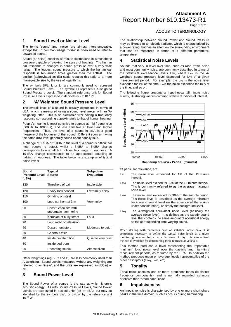
Attachment A
Report Number 610.13473-R1 Page 1 of 2
ACOUSTIC TERMINOLOGY
SLR Consulting Australia Pty Ltd
1 Sound Level or Noise Level
The terms ‘sound’ and ‘noise’ are almost interchangeable, except that in common usage ‘noise’ is often used to refer to unwanted sound.
Sound (or noise) consists of minute fluctuations in atmospheric pressure capable of evoking the sense of hearing. The human ear responds to changes in sound pressure over a very wide range. The loudest sound pressure to which the human ear responds is ten million times greater than the softest. The decibel (abbreviated as dB) scale reduces this ratio to a more manageable size by the use of logarithms.
The symbols SPL, L or LP are commonly used to represent Sound Pressure Level. The symbol LA represents A-weighted Sound Pressure Level. The standard reference unit for Sound Pressure Levels expressed in decibels is 2 x 10
-5 Pa.
2 ‘A’ Weighted Sound Pressure Level
The overall level of a sound is usually expressed in terms of dBA, which is measured using a sound level meter with an ‘A-weighting’ filter. This is an electronic filter having a frequency response corresponding approximately to that of human hearing.
People’s hearing is most sensitive to sounds at mid frequencies (500 Hz to 4000 Hz), and less sensitive at lower and higher frequencies. Thus, the level of a sound in dBA is a good measure of the loudness of that sound. Different sources having the same dBA level generally sound about equally loud.
A change of 1 dBA or 2 dBA in the level of a sound is difficult for most people to detect, whilst a 3 dBA to 5 dBA change corresponds to a small but noticeable change in loudness. A 10 dBA change corresponds to an approximate doubling or halving in loudness. The table below lists examples of typical noise levels
Sound Pressure Level (dBA)
Typical Source
Subjective Evaluation
130 Threshold of pain Intolerable
120 Heavy rock concert Extremely noisy
110 Grinding on steel
100 Loud car horn at 3 m Very noisy
90 Construction site with pneumatic hammering
80 Kerbside of busy street Loud
70 Loud radio or television
60 Department store Moderate to quiet
50 General Office
40 Inside private office Quiet to very quiet
30 Inside bedroom
20 Recording studio Almost silent
Other weightings (eg B, C and D) are less commonly used than A-weighting. Sound Levels measured without any weighting are referred to as ‘linear’, and the units are expressed as dB(lin) or dB.
3 Sound Power Level
The Sound Power of a source is the rate at which it emits acoustic energy. As with Sound Pressure Levels, Sound Power Levels are expressed in decibel units (dB or dBA), but may be identified by the symbols SWL or LW, or by the reference unit 10
-12 W.
The relationship between Sound Power and Sound Pressure may be likened to an electric radiator, which is characterised by a power rating, but has an effect on the surrounding environment that can be measured in terms of a different parameter, temperature.
4 Statistical Noise Levels
Sounds that vary in level over time, such as road traffic noise and most community noise, are commonly described in terms of the statistical exceedance levels LAN, where LAN is the A-weighted sound pressure level exceeded for N% of a given measurement period. For example, the LA1 is the noise level exceeded for 1% of the time, LA10 the noise exceeded for 10% of the time, and so on.
The following figure presents a hypothetical 15 minute noise survey, illustrating various common statistical indices of interest.
LA1
LA10
LA90
LAeq
LAmax
25
30
35
40
45
50
55
00:00 05:00 10:00 15:00
Monitoring or Survey Period (minutes)
So
un
d P
ressu
re L
evel
(d
BA
)
Of particular relevance, are:
LA1 The noise level exceeded for 1% of the 15 minute interval.
LA10 The noise level exceed for 10% of the 15 minute interval. This is commonly referred to as the average maximum noise level.
LA90 The noise level exceeded for 90% of the sample period. This noise level is described as the average minimum background sound level (in the absence of the source under consideration), or simply the background level.
LAeq The A-weighted equivalent noise level (basically the average noise level). It is defined as the steady sound level that contains the same amount of acoustical energy as the corresponding time-varying sound.
When dealing with numerous days of statistical noise data, it is sometimes necessary to define the typical noise levels at a given
monitoring location for a particular time of day. A standardised
method is available for determining these representative levels.
This method produces a level representing the ‘repeatable minimum’ LA90 noise level over the daytime and night-time measurement periods, as required by the EPA. In addition the method produces mean or ‘average’ levels representative of the other descriptors (LAeq, LA10, etc).
5 Tonality
Tonal noise contains one or more prominent tones (ie distinct frequency components), and is normally regarded as more offensive than ‘broad band’ noise.
6 Impulsiveness
An impulsive noise is characterised by one or more short sharp peaks in the time domain, such as occurs during hammering.

Attachment A
Report Number 610.13473-R1 Page 2 of 2
ACOUSTIC TERMINOLOGY
SLR Consulting Australia Pty Ltd
7 Frequency Analysis
Frequency analysis is the process used to examine the tones (or frequency components) which make up the overall noise or vibration signal. This analysis was traditionally carried out using analogue electronic filters, but is now normally carried out using Fast Fourier Transform (FFT) analysers.
The units for frequency are Hertz (Hz), which represent the number of cycles per second.
Frequency analysis can be in:
Octave bands (where the centre frequency and width of each band is double the previous band)
1/3 octave bands (3 bands in each octave band)
Narrow band (where the spectrum is divided into 400 or more bands of equal width)
The following figure shows a 1/3 octave band frequency analysis where the noise is dominated by the 200 Hz band. Note that the indicated level of each individual band is less than the overall level, which is the logarithmic sum of the bands.
30
40
50
60
70
80
90
125
160
200
250
315
400
500
630
800
100
0
1250
160
0
2000
250
0
3150
Overa
ll
1/3 Octave Band Centre Frequency (Hz)
So
un
d P
ressu
re L
evel
(dB
A)
8 Vibration
Vibration may be defined as cyclic or transient motion. This motion can be measured in terms of its displacement, velocity or acceleration. Most assessments of human response to vibration or the risk of damage to buildings use measurements of vibration velocity. These may be expressed in terms of ‘peak’ velocity or ‘rms’ velocity.
The former is the maximum instantaneous velocity, without any averaging, and is sometimes referred to as ‘peak particle velocity’, or PPV. The latter incorporates ‘root mean squared’ averaging over some defined time period.
Vibration measurements may be carried out in a single axis or alternatively as triaxial measurements. Where triaxial measurements are used, the axes are commonly designated vertical, longitudinal (aligned toward the source) and transverse.
The common units for velocity are millimetres per second (mm/s). As with noise, decibel units can also be used, in which case the reference level should always be stated. A vibration level V, expressed in mm/s can be converted to decibels by the formula 20 log (V/Vo), where Vo is the reference level (10
-9 m/s).
Care is required in this regard, as other reference levels may be used by some organizations.
9 Human Perception of Vibration
People are able to ‘feel’ vibration at levels lower than those required to cause even superficial damage to the most susceptible classes of building (even though they may not be disturbed by the motion). An individual's perception of motion or response to vibration depends very strongly on previous experience and expectations, and on other connotations associated with the perceived source of the vibration. For example, the vibration that a person responds to as ‘normal’ in a car, bus or train is considerably higher than what is perceived as ‘normal’ in a shop, office or dwelling.
10 Over-Pressure
The term ‘over-pressure’ is used to describe the air pressure pulse emitted during blasting or similar events. The peak level of an event is normally measured using a microphone in the same manner as linear noise (ie unweighted), at frequencies both in and below the audible range.
11 Ground-borne Noise, Structure-borne Noise and Regenerated Noise
Noise that propagates through a structure as vibration and is radiated by vibrating wall and floor surfaces is termed ‘structure-borne noise’, ‘ground-borne noise’ or ‘regenerated noise’. This noise originates as vibration and propagates between the source and receiver through the ground and/or building structural elements, rather than through the air.
Typical sources of ground-borne or structure-borne noise include tunnelling works, underground railways, excavation plant (eg rockbreakers), and building services plant (eg fans, compressors and generators).
The following figure presents the various paths by which vibration and ground-borne noise may be transmitted between a source and receiver for construction activities occurring within a tunnel.
The term ‘regenerated noise’ is also used in other instances where energy is converted to noise away from the primary source. One example would be a fan blowing air through a discharge grill. The fan is the energy source and primary noise source. Additional noise may be created by the aerodynamic effect of the discharge grill in the airstream. This secondary noise is referred to as regenerated noise
Attachment B
Report Number 610.13473-R1 Page 1 of 2
CONSTRUCTION WORKS AND USED EQUIPMENT
SLR Consulting Australia Pty Ltd
Plant Item SWL (dBA)
Construction activity
Tem
po
rary
tra
ffic
man
agem
ent
Tem
po
rary
fo
otp
ath
rest
rict
ion
/clo
sure
Lig
hti
ng
wo
rks
Ker
b/k
erb
ram
p w
ork
s
Med
ian
rem
ova
l an
d
refu
rbis
hm
ent
Ped
estr
ian
isla
nd
alte
rati
on
Fo
otp
ath
alt
erat
ion
s
Maj
or
eq
uip
men
t
relo
cati
on
Tre
e m
anag
emen
t
Dra
inag
e w
ork
s
Bu
s sh
elte
r re
mo
val
Uti
lity
wo
rks
Sig
nag
e al
tera
tio
ns
Tra
ffic
sig
np
ost
alte
rati
on
s
Bu
s la
ne
mar
kin
gs
Lo
calis
ed r
esu
rfac
ing
Lan
e m
arki
ng
alte
rati
on
s
Reg
rad
e an
d r
esu
rfac
e
Stage 1 2 3 4
Angle grinder 110 - - - 110 110 110 110 - - 110 - 110 110 110 - - - -
Asphalt paver 104 - - - - - - - - - - - 104 - - 104 104 104 104
Backhoe 102 - - 102 102 102 102 102 - 102 102 - 102 102 102 - - - -
Bitumen sprayer 100 - - - - - - - - - - - - - - - 100 100 100
Bobcat 104 104 104 - 104 104 104 104 - 104 104 - 104 104 104 - - - -
Compactor 108 - - - 108 108 108 108 - - - - - - - 108 108 108 108
Concrete agitator 106 - - - 106 106 106 106 106 - - 106 106 106 106 106 106 - 106
Concrete pump 106 - - - 106 106 106 106 - - - - 106 106 106 106 106 - 106
Concrete saw 115 - - - 115 115 115 115 115 - 115 115 - 115 115 - - - -
Generator 95 95 95 95 95 95 95 95 95 95 95 95 95 95 95 95 95 95 95
Hand tools 94 94 94 94 94 94 94 94 94 94 94 94 94 94 94 94 94 94 94
Hydraulic crane 102 - - 102 - - - - 102 - - 102 102 102 102 - - - -
Jackhammer 108 - - 108 108 108 108 108 108 - 108 108 108 108 108 - - - -
Kerbing machine 105 - - - 105 105 105 105 105 - 105 105 105 - - - - - -
Line marking machine 98 - - - - - - - - - - - 98 - - 98 - 98 -
Mini excavator 100 - - 100 100 100 100 100 - 100 100 - 100 100 100 100 100 - 100
Paving machine 104 - - - 104 104 104 104 - - 104 - 104 - - 104 104 - 104
Profiler 107 - - - - - - - - - - - - - - 107 - - -
Road planer 107 - - - - - - - - - - - - - - 107 107 107 107
Roller 100 - - - 100 100 100 100 - - - - - - - 100 100 100 100
Small dozer 106 - - - - - - - - - - - - - - 106 106 - 106

Attachment B
Report Number 610.13473-R1 Page 2 of 2
CONSTRUCTION WORKS AND USED EQUIPMENT
SLR Consulting Australia Pty Ltd
Plant Item SWL (dBA)
Construction activity
Tem
po
rary
tra
ffic
man
agem
ent
Tem
po
rary
fo
otp
ath
rest
rict
ion
/clo
sure
Lig
hti
ng
wo
rks
Ker
b/k
erb
ram
p w
ork
s
Med
ian
rem
ova
l an
d
refu
rbis
hm
ent
Ped
estr
ian
isla
nd
alte
rati
on
Fo
otp
ath
alt
erat
ion
s
Maj
or
eq
uip
men
t
relo
cati
on
Tre
e m
anag
emen
t
Dra
inag
e w
ork
s
Bu
s sh
elte
r re
mo
val
Uti
lity
wo
rks
Sig
nag
e al
tera
tio
ns
Tra
ffic
sig
np
ost
alte
rati
on
s
Bu
s la
ne
mar
kin
gs
Lo
calis
ed r
esu
rfac
ing
Lan
e m
arki
ng
alte
rati
on
s
Reg
rad
e an
d r
esu
rfac
e
Stage 1 2 3 4
Small grader 106 - - - - - - - - - - - - - - 106 106 - 106
Suction sweeper 98 - - - 98 98 98 98 98 - 98 98 98 98 98 98 98 98 98
Tipper truck 97 97 97 97 97 97 97 97 - - 97 - 97 97 97 97 97 97 97
Trucks 103 103 103 103 103 103 103 103 103 103 103 103 103 103 103 103 103 103 103
Vibratory roller 109 - - - 109 109 109 109 - - - - - - - 109 109 109 109
Water cart 98 - - - 98 98 98 98 - - - - - - - 98 98 98 98
Overall worst case SWL (dBA)
1
104 104 108 115 115 115 115 115 104 115 115 110 115 115 110 110 110 110
Note 1: Worst case SWL in any 15 minute period for each construction activity.

Sydney City Centre Capacity Improvement Plan Appendix EReview of Environmental Factors
Appendix ENon-Aboriginal heritage specialist study

Report Register
The following report register documents the development and issue of the report entitled Sydney CityCentre Capacity Improvement Plan Non-Aboriginal Heritage Technical Report, undertaken by GMLHeritage Pty Ltd in accordance with its quality management system.
Quality Assurance
GML Heritage Pty Ltd operates under a quality management system which has been certified ascomplying with the Australian/New Zealand Standard for quality management systems AS/NZS ISO9001:2008.
The report has been reviewed and approved for issue in accordance with the GML quality assurancepolicy and procedures.
Copyright
Historical sources and reference material used in the preparation of this report are acknowledged andreferenced at the end of each section and/or in figure captions. Reasonable effort has been made to identify,contact, acknowledge and obtain permission to use material from the relevant copyright owners.
owners of any pre-existing historic source or reference material.
Moral Rights
GML asserts its Moral Rights in this work, unless otherwise acknowledged, in accordance with the
authorship, the right not to have the work falsely attributed and the right to integrity of authorship.
Right to Use
-free right toreproduce or use the material from this report, except where such use infringes the copyright and/or MoralRights of GML or third parties.

Contents Page
1.0 Introduction ................................................................................................................................................ 1
1.1 Background .............................................................................................................................................. 11.2 Study area ................................................................................................................................................ 11.3 Methodology ............................................................................................................................................. 4
1.3.1 Desktop Research ............................................................................................................................ 41.3.2 Fieldwork ........................................................................................................................................... 5
1.4 Limitations ................................................................................................................................................ 51.5 Author Identification ................................................................................................................................. 5
2.0 Existing Environment ............................................................................................................................. 23
2.1 Historical Outline .................................................................................................................................... 232.2 Heritage Context .................................................................................................................................... 24
3.0 Heritage Impact Advice .......................................................................................................................... 29
3.1 Approach to Heritage Impact Advice .................................................................................................... 293.2 Assumptions ........................................................................................................................................... 293.3 Built Heritage Impact Assessment ....................................................................................................... 303.4 Archaeological Impact Assessment ..................................................................................................... 47
4.0 Conclusion and Recommendations .................................................................................................... 59
4.1 Conclusions ............................................................................................................................................ 594.1.1 Built Heritage ................................................................................................................................... 594.1.2 Archaeology .................................................................................................................................... 60
4.2 Recommendations ................................................................................................................................. 614.2.1 Built Heritage ................................................................................................................................... 614.2.2 Archaeology .................................................................................................................................... 61
1.0
1.1 BackgroundGML Heritage Pty Ltd (GML) has been engaged by Parsons Brinckerhoff on behalf of Roads and MaritimeServices (RMS) to prepare a Non-Aboriginal Heritage Technical Report for the Sydney City CentreCapacity Improvement Plan project. This report forms an Appendix to the Review of Environmental Factors(REF) for the project being prepared by Parsons Brinkerhoff.
The project comprises the installation of a number of traffic capacity improvements within the Sydney citycentre and
traffic volumes or will provide an essential function in enablingAccess Strategy (Transport for NSW
2013). Enabled projects will include: the CBD to South East Light Rail project, the Sydney City Centre BusInfrastructure project and the Sydney City Centre Cycleways projects.
This report has been prepared to provide heritage impact advice for the project and is based on aphysical assessment and desktop review of the study area, its statutory context and the various
, prepared by Parsons Brinckerhoff.
1.2 Study areaThe study area includes all roads and buildings subject to or immediately adjacent to the worksproposed within the five precincts across the Sydney City Centre:
Precinct 1: North-west (NW);
Precinct 2: Retail (R);
Precinct 3: Southern (S);
Precinct 4: College (C); and
Precinct 5: Financial (F).
Each Precinct contains one or more of the 17 worksites that start and end at major road intersections(Figures 1.1 to 1.17). Each intersection, and road between each intersection, has also been given aletter reference that has been adopted throughout this report and the REF.
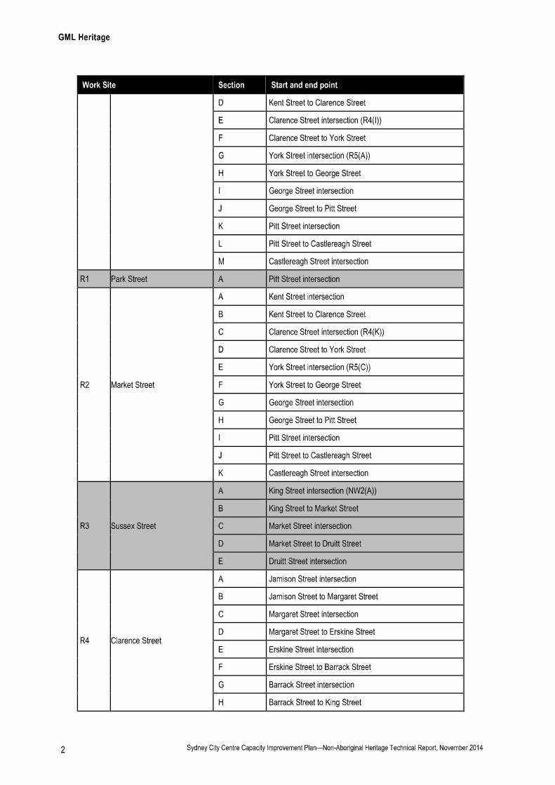
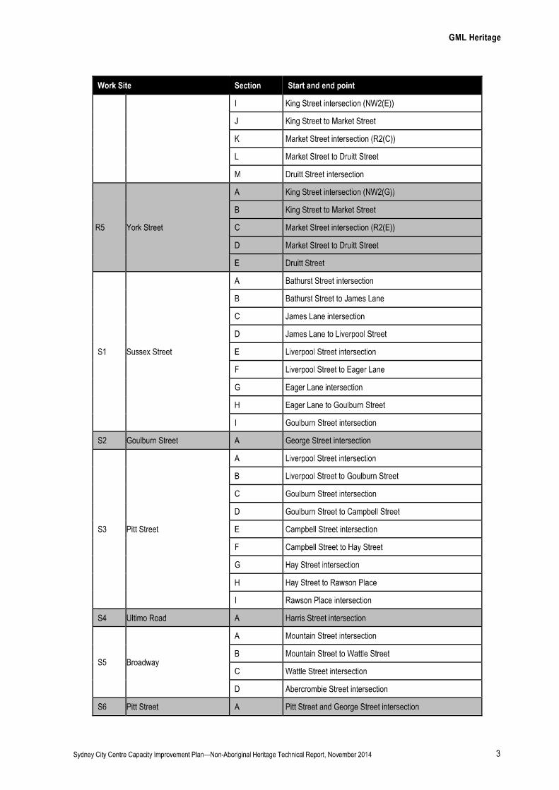

1.3 MethodologyThe following tasks have been completed in preparation of this report:
1.3.1 Desktop Research
Relevant heritage registers were searched in August 2014 to identify heritage items within and in thevicinity of the work sites. These registers comprised:
Statutory heritage lists including the:
UNESCO World Heritage List (WHL);
National Heritage List (NHL);
Commonwealth Heritage List (CHL);
State Heritage Register (SHR);
Schedule 5 of the City of Sydney Local Environmental Plan 2012 (LEP);
State Heritage Inventory (SHI); and

Section 170 Heritage and Conservation Registers.
Non-statutory lists including the:
National Trust of Australia Register;
Australian Institute of Architects Register of Significant Architecture in NSW (AIA);
the Register of the National Estate (RNE) database; and
City of Sydney Archaeological Zoning Plan 1992.
Statements of Significance for existing heritage items within and in the vicinity of the proposed workssite were reviewed (where they were available).
Relevant historical maps, plans and aerial photographs were also reviewed to identify any formerstructures, roads or landscape features, within or in the vicinity of the worksite, in order to establish apreliminary understanding of archaeological potential.
Relevant background reports were reviewed including:
by SKM in May 2014; and
.
1.3.2 Fieldwork
Inspections were undertaken by GML in September 2014 to review the results of desktop research, toconfirm the condition and significance of existing fabric and elements proposed for removal, and toprovide context for listed heritage items and areas of archaeological potential.
1.4 LimitationsThis report is a technical paper and a detailed Heritage Impact Assessment.
The historical archaeological potential of each worksite has been informed by a preliminary review ofreadily available documentation such as historical maps and aerial photographs of areas that would bedirectly affected by the proposed works, relevant heritage registers and heritage reports, as well as asite inspection. The assessment of archaeological potential and its significance is an overview only,and may be subject to revision following preparation of a more detailed historical assessment of theproposal, as part of the next stage of the project.
1.5 Author IdentificationThis report was prepared by Nina Pollock, Consultant. Archaeological assessment and input has beenprovided by Anita Yousif, Senior Associate. Assistance in finalising the report was provided by JulianSiu, Consultant. Review and input was provided by Peter Romey and David Logan, Partners of GMLHeritage. Historical research was undertaken by Michelle Richmond, Senior Consultant and Historian.

NW1(A) NW1(B) NW1(C) NW1(D) NW1(E)
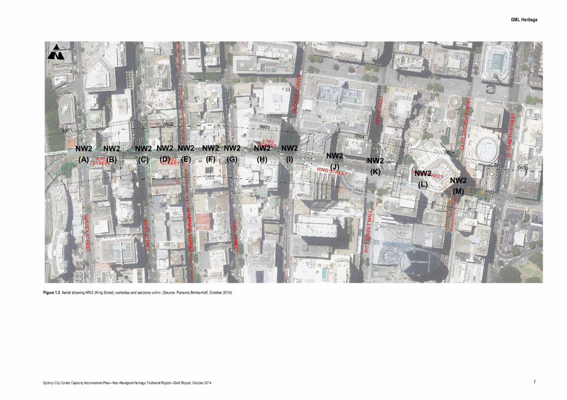
NW2(A)
NW2(B)
NW2(C)
NW2(D)
NW2(E)
NW2(F)
NW2(G)
NW2(H)
NW2(I) NW2
(J)NW2(K) NW2
(L) NW2(M)
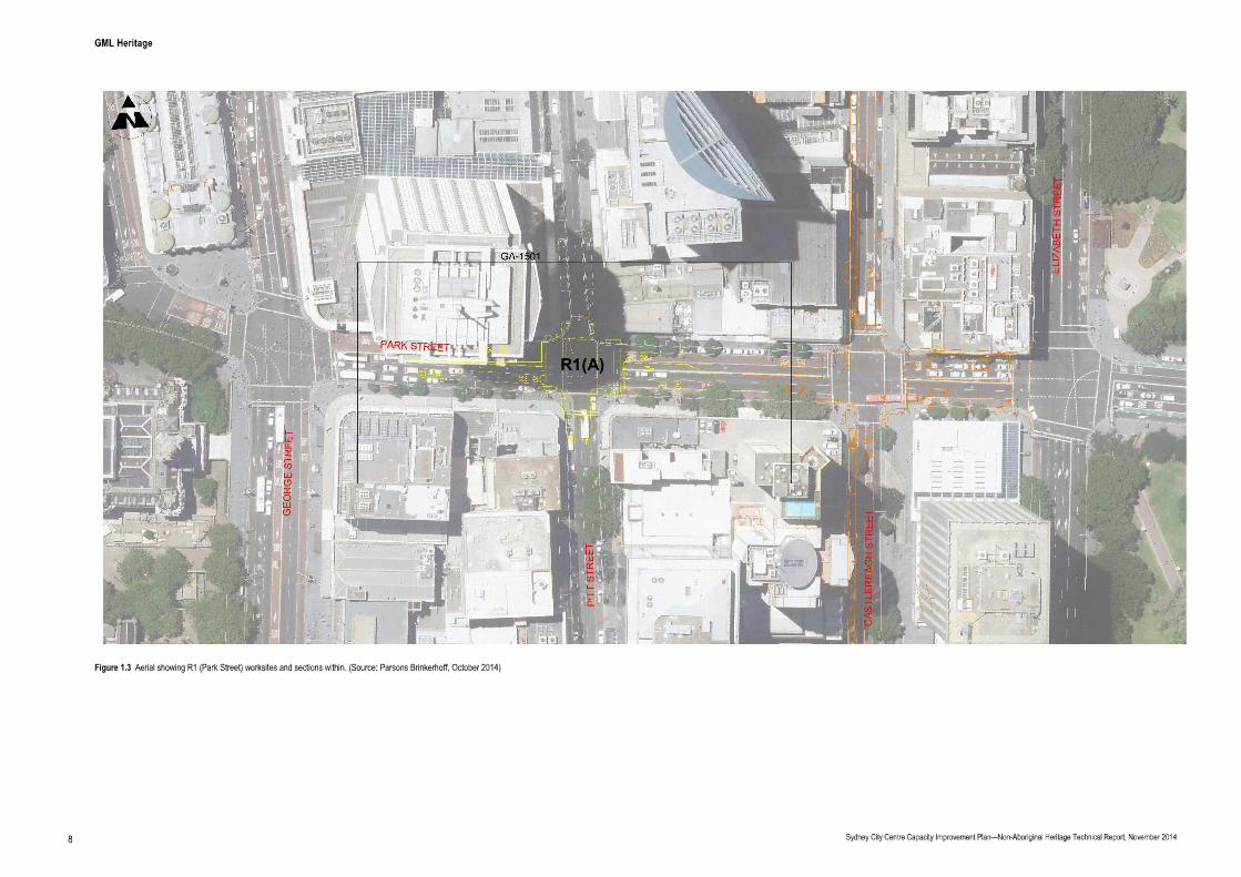
R1(A)

R2(A)
R2(B)
R2(C)
R2(D)
R2(E)
R2(F)
R2(G)
R2(H)
R2(I)
R2(J)
R2(K)

R3(A)
R3(B)
R3(C)
R3(D)
R3(E)

R4(C)
R4(K)
R4(M)
R4(L)
R4(J)
R4(I)
R4(H)
R4(G)
R4(F)
R4(E)
R4(D)
R4(A)
R4(B)

R5(A)
R5(B)
R5(C)
R5(D)
R5(E)

S1(A)
S1(I)
S1(E)
S1(B)
S1(C)
S1(D)
S1(F)
S1(H)
S1(G)

S2(A)
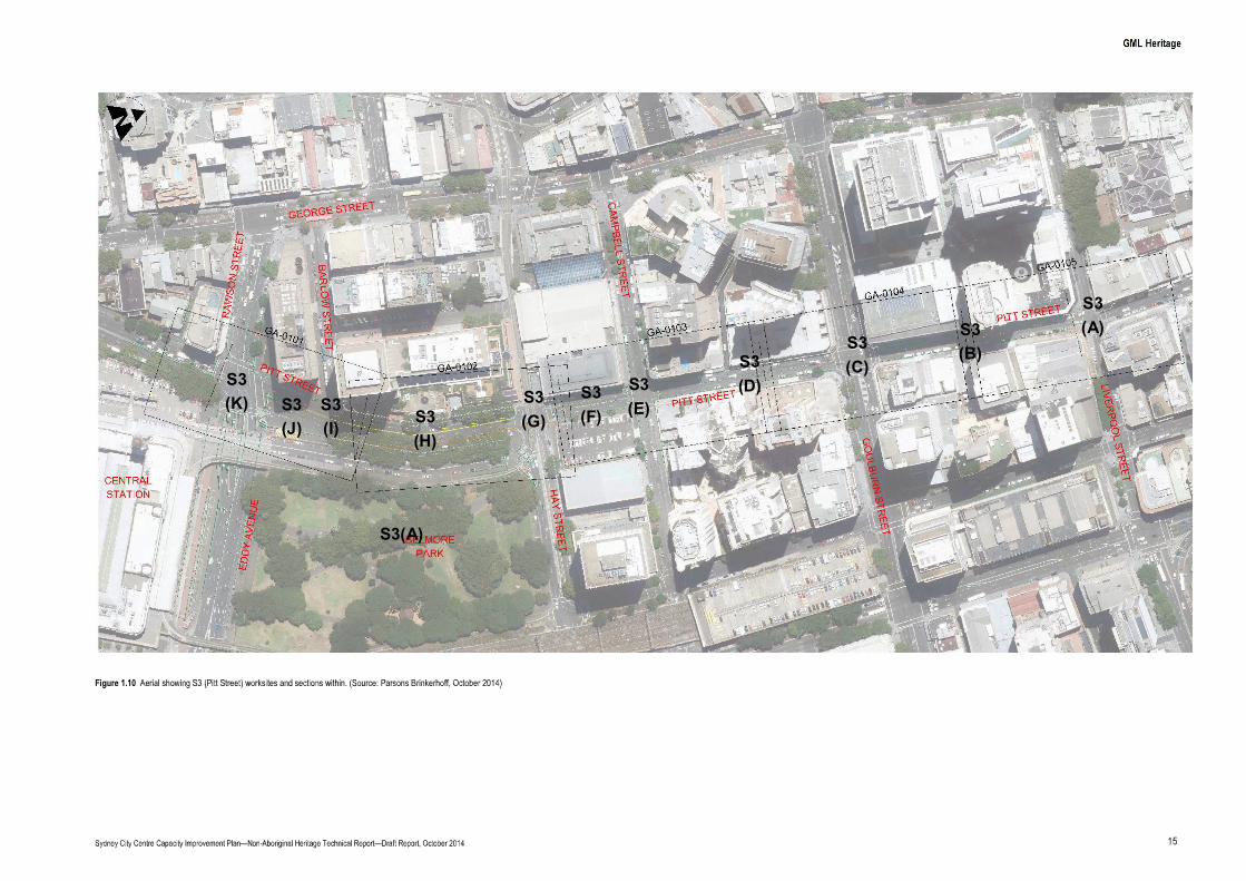
S3(A)
S3(A)S3
(B)S3(C)S3
(D)S3(E)
S3(F)
S3(G)S3
(H)
S3(I)
S3(J)
S3(K)
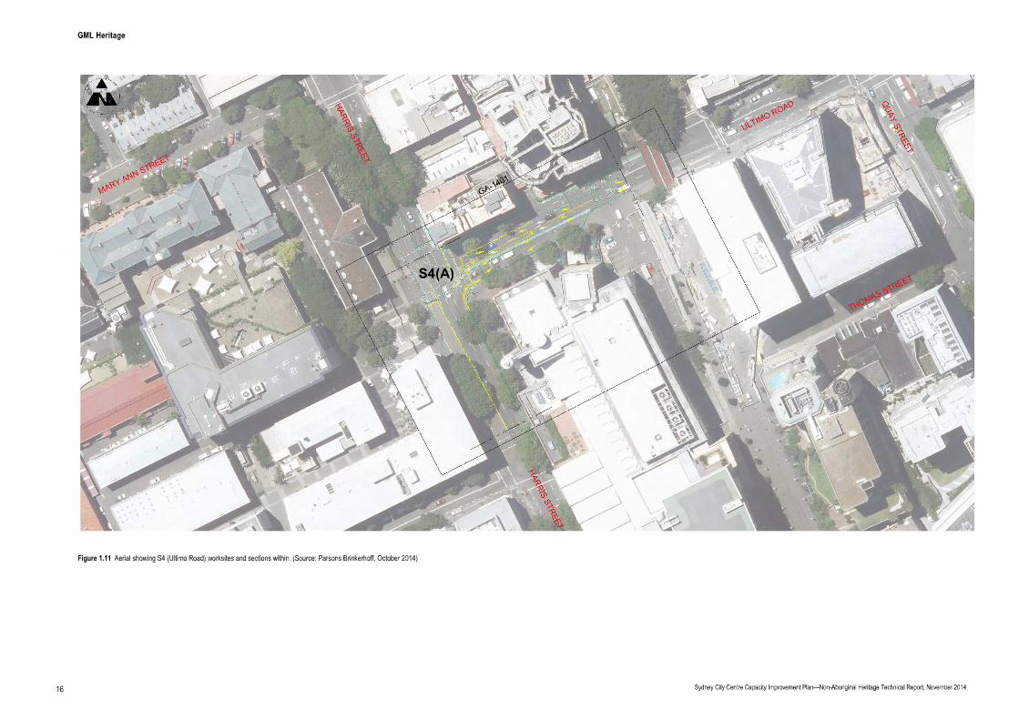
S4(A)
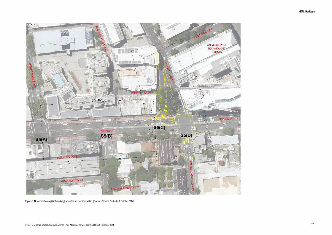
S5(A)S5(B)
S5(C)
S5(D)

S6(A)

C1(A)
C1(B)
C1(C)
C1(D)
C1(E) C1
(F) C1(G)
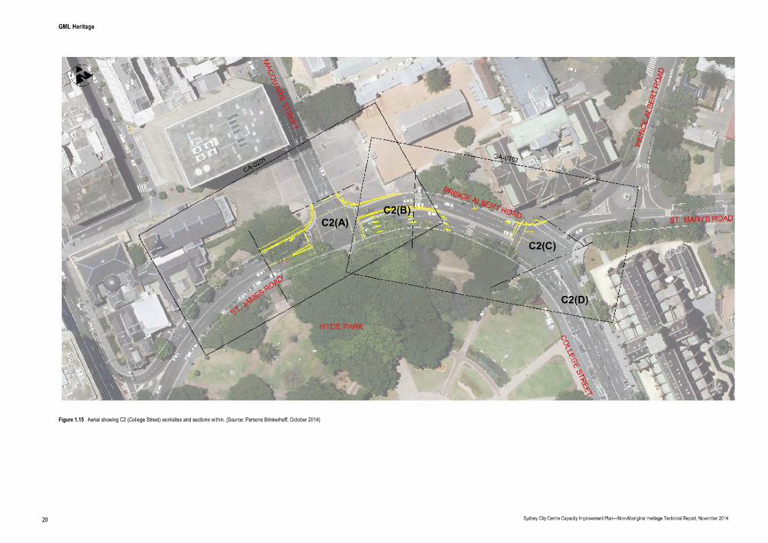
C2(A)C2(B)
C2(C)
C2(D)
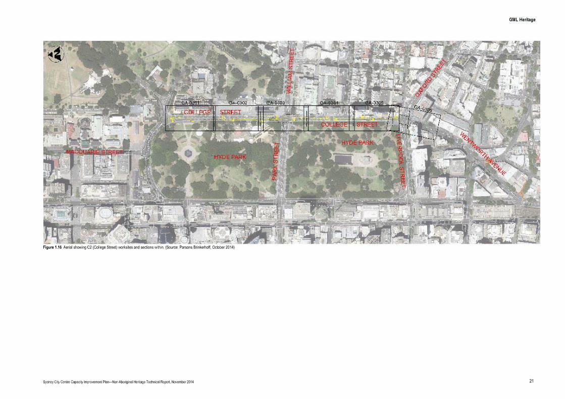

F1(A) F2(A)F1(B)F1(C)

2.0
2.1 Historical OutlineThe following historical outline has been extracted from the Sydney City Centre Access Strategy BusInfrastructure HIA prepared by SKM in May 2014:
2.2 Heritage ContextA number of heritage items are located within or in the immediate vicinity of the proposed worksites.They comprise:
two World Heritage sites (expressly, some work is located within the buffer zone of the SydneyOpera House and Hyde Park Barracks (part of the Australian Convict Sites inscription));
one nationally listed item (Hyde Park Barracks);
22 State listed items; and
54 locally listed items.
Table 6.1 identifies the heritage items and heritage conservation areas with the potential to be directlyaffected by the proposed works, either through direct physical impacts to significant fabric or elements,or impacts on their visual setting. Certain heritage items are within close proximity to two or more worksites. As such, they are listed separately for each occurrence:
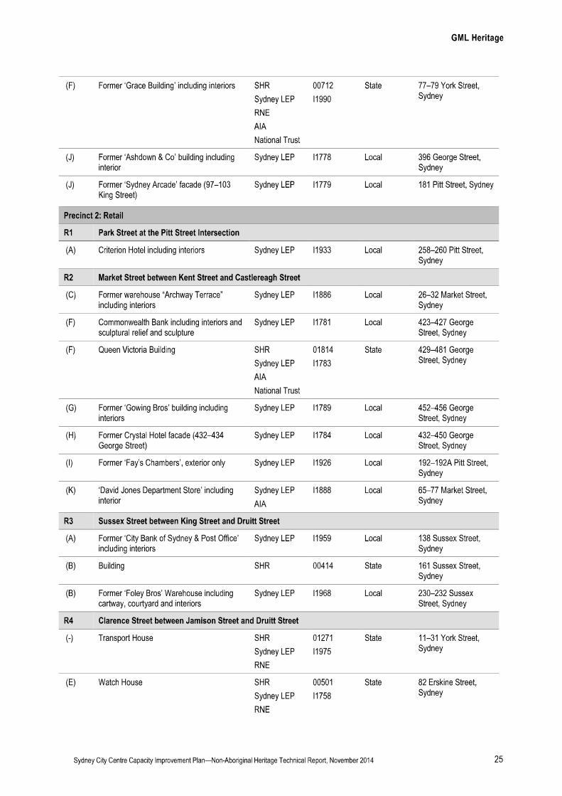
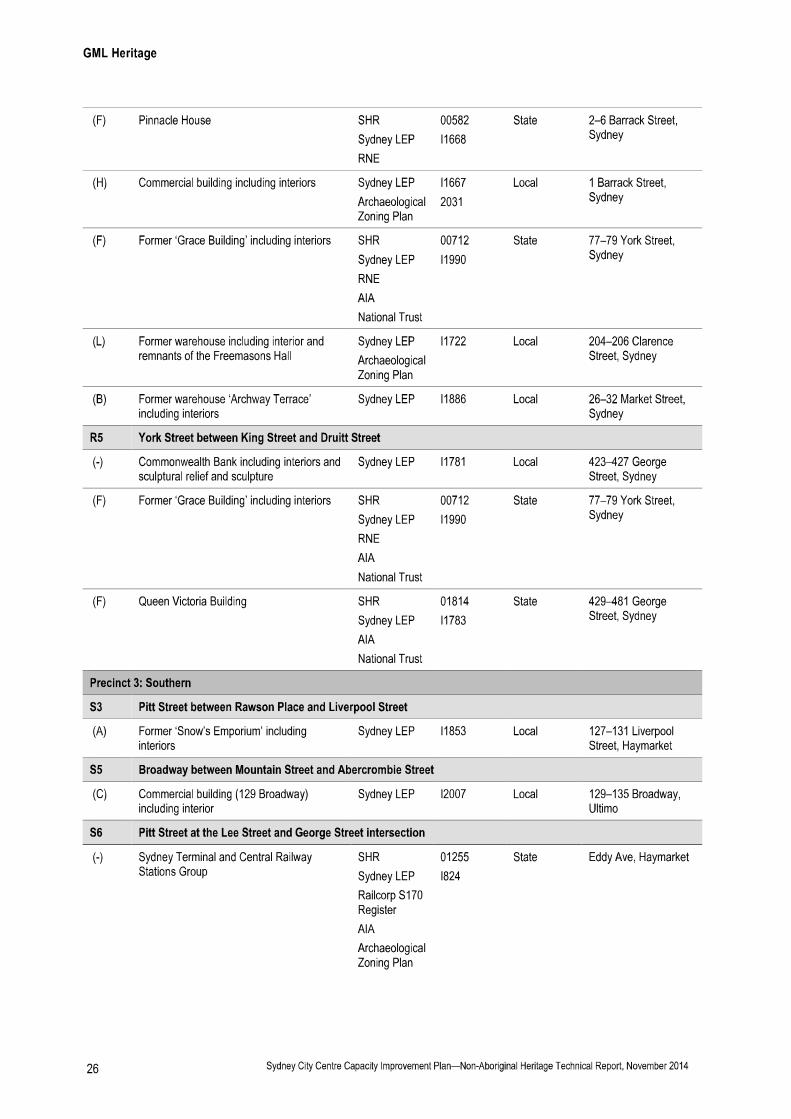
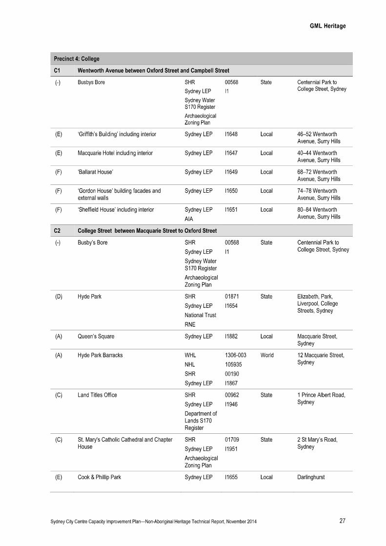
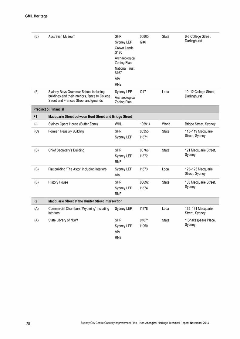

3.0
3.1 Approach to Heritage Impact AdviceThe potential for heritage impacts has been assessed across the study area by considering the builtheritage impacts and the archaeological impacts.
The following approach has been employed in assessing built heritage impacts:
identification of heritage items that could potentially be impacted by the proposed work;
identification of their level of significance;
a description of proposed works in the area around the heritage item; and
an overview assessment of the heritage impact.
The following approach has been employed in assessing archaeological impacts:
an indication of the type of archaeological resource that is potentially present in the areas ofdirect impacts;
the level of survival of the potential archaeological resource;
the significance of the potential archaeological resource;
a description of proposed works in the area where the archaeological remains are potentiallypresent; and
an overview assessment of archaeological impact.
3.2 AssumptionsIt is assumed that any work, including any drainage works, adjustments and modifications would notphysically alter heritage-listed buildings.
It is assumed that requirements for additional signage will, where possible, replace existing rather thanadd to existing, and seek to reduce visual clutter (combine and/or collocate), particularly in the views toheritage buildings.
It is also assumed that regrading work would only extend to 50 millimetres (mm) below the surface.The depth to excavation is not currently known and would be confirmed during the detailed design.The maximum excavation depth would occur for utility adjustments, drainage modifications, light-postrelocation and traffic signal relocation. This could be down to three metres below ground; however, thiswould be an exceptional worst case scenario, with proposed construction works typically extending toone to one-and-a-half metres below ground.
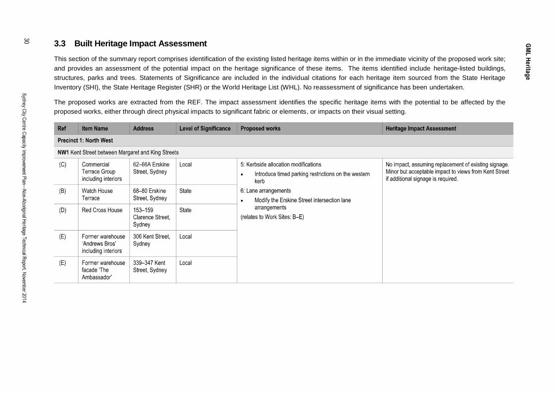
3.3 Built Heritage Impact AssessmentThis section of the summary report comprises identification of the existing listed heritage items within or in the immediate vicinity of the proposed work site;and provides an assessment of the potential impact on the heritage significance of these items. The items identified include heritage-listed buildings,structures, parks and trees. Statements of Significance are included in the individual citations for each heritage item sourced from the State HeritageInventory (SHI), the State Heritage Register (SHR) or the World Heritage List (WHL). No reassessment of significance has been undertaken.
The proposed works are extracted from the REF. The impact assessment identifies the specific heritage items with the potential to be affected by theproposed works, either through direct physical impacts to significant fabric or elements, or impacts on their visual setting.

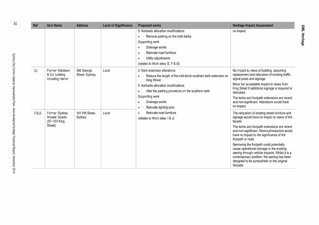
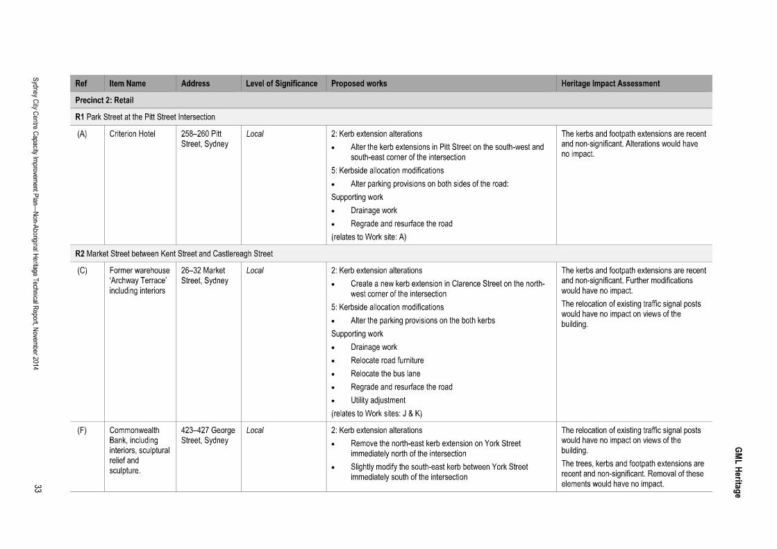
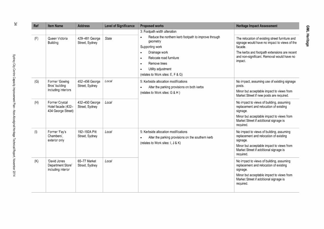
Local

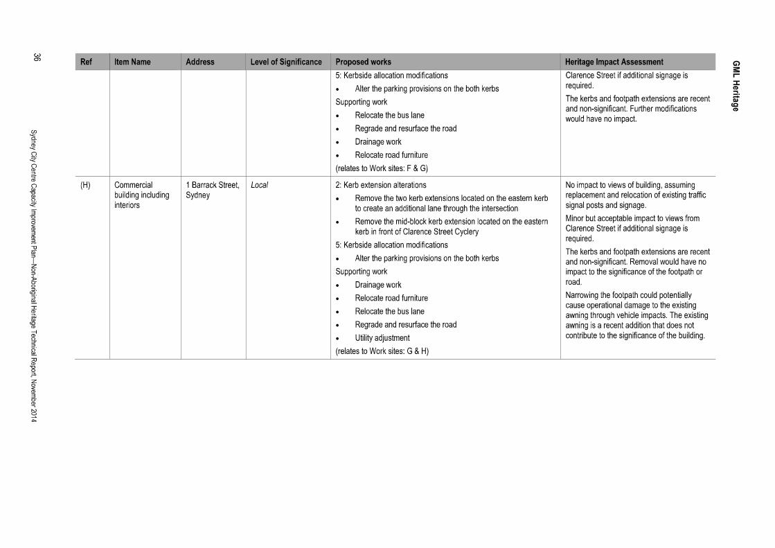
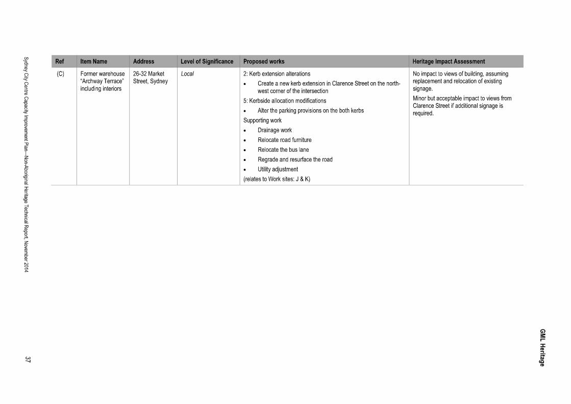


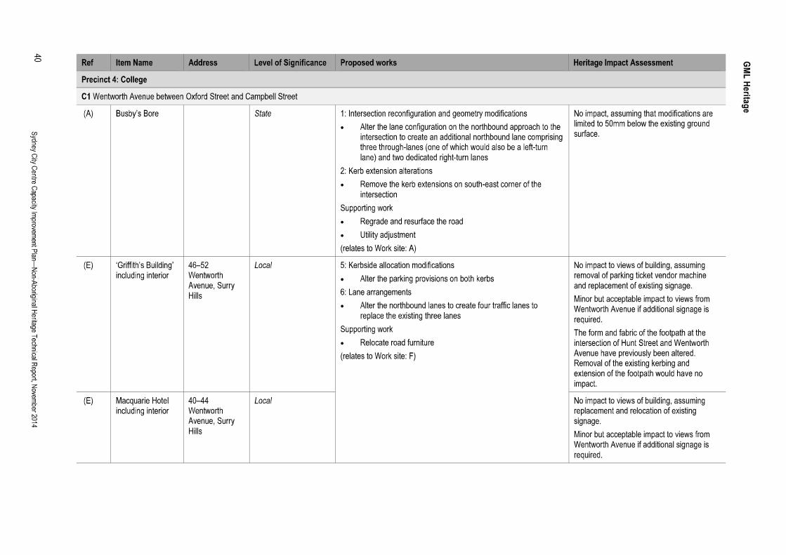

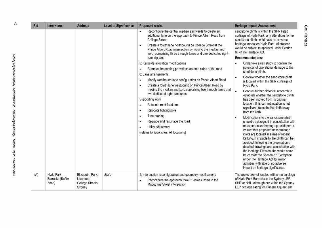

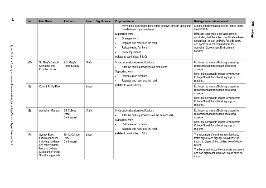


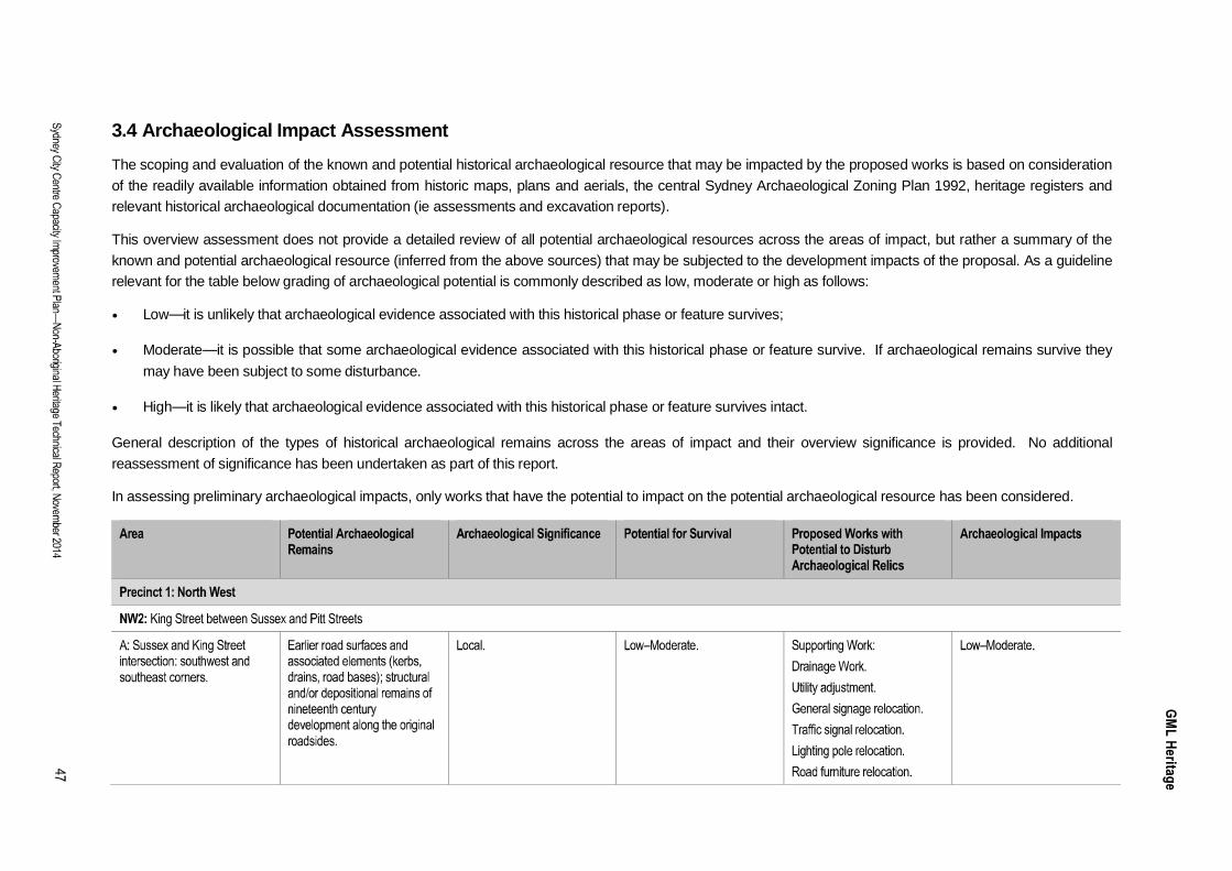
3.4 Archaeological Impact AssessmentThe scoping and evaluation of the known and potential historical archaeological resource that may be impacted by the proposed works is based on considerationof the readily available information obtained from historic maps, plans and aerials, the central Sydney Archaeological Zoning Plan 1992, heritage registers andrelevant historical archaeological documentation (ie assessments and excavation reports).
This overview assessment does not provide a detailed review of all potential archaeological resources across the areas of impact, but rather a summary of theknown and potential archaeological resource (inferred from the above sources) that may be subjected to the development impacts of the proposal. As a guidelinerelevant for the table below grading of archaeological potential is commonly described as low, moderate or high as follows:
Low it is unlikely that archaeological evidence associated with this historical phase or feature survives;
Moderate it is possible that some archaeological evidence associated with this historical phase or feature survive. If archaeological remains survive theymay have been subject to some disturbance.
High it is likely that archaeological evidence associated with this historical phase or feature survives intact.
General description of the types of historical archaeological remains across the areas of impact and their overview significance is provided. No additionalreassessment of significance has been undertaken as part of this report.
In assessing preliminary archaeological impacts, only works that have the potential to impact on the potential archaeological resource has been considered.

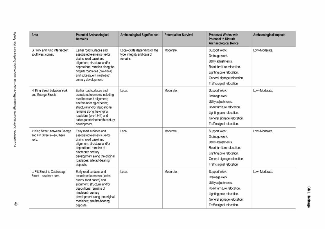

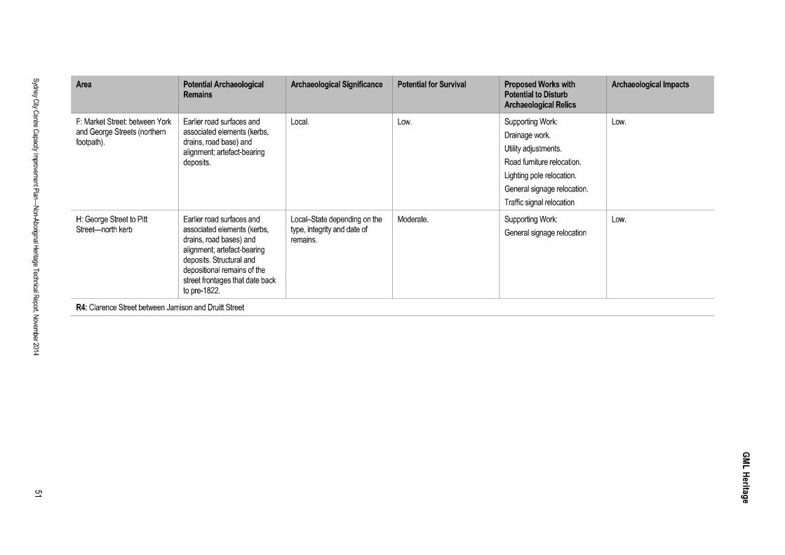
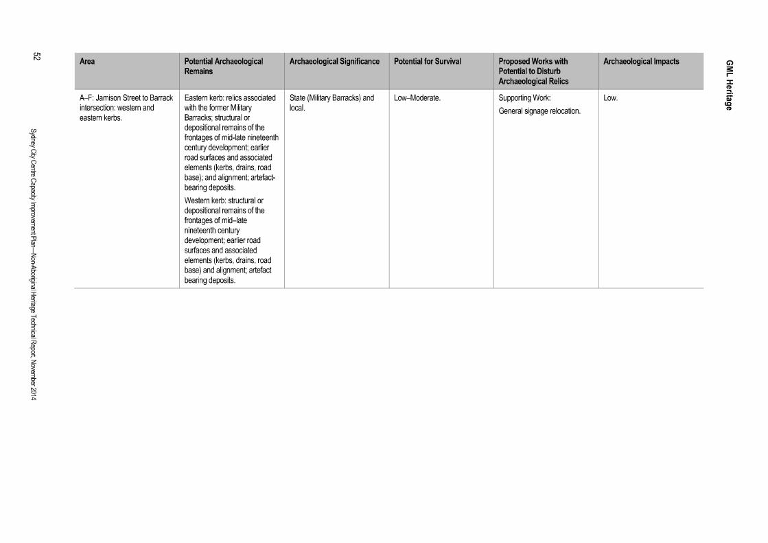


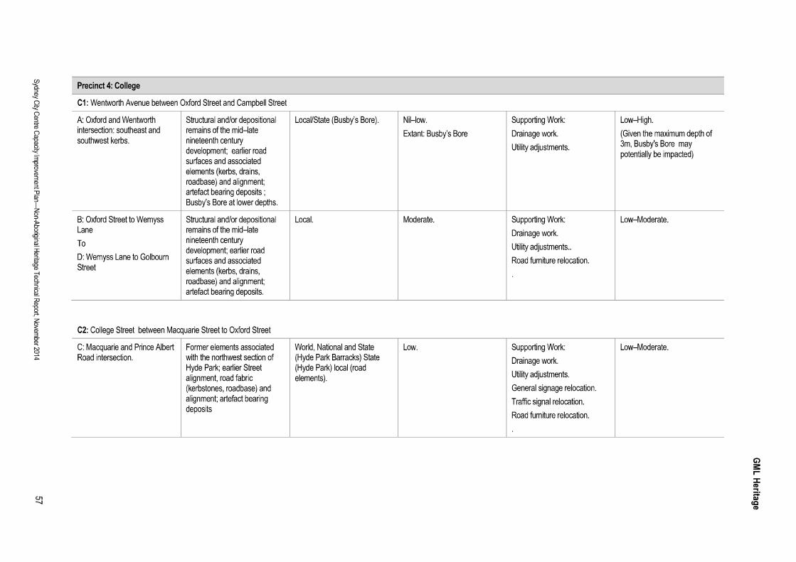

4.0
4.1 Conclusions
4.1.1 Built Heritage
The Sydney City Capacity Improvement Plan generally comprises minor alterations to previouslymodified roads and footpaths throughout the city centre and does not involve alterations to anyheritage items within the five precincts. Whilst there would be a minor impact through the introductionof new signage adjacent to a number of heritage items, these impacts are considered minor in nature,and as a whole the proposal would have a negligible impact on heritage significance.
Pending further refinement during detailed design for the proposal, the planned traffic efficiencyimprovements that would be introduced adjacent to a number of building façades and awnings mayslightly affect their visual setting. This would include:
NW1: Kent Street: Watch House Terrace (state listed), Red Cross House (state listed),Commercial Terrace Group (locally listed), Andre Bros warehouse (locally listed) and theAmbassador warehouse (locally listed);
NW2: King Street: The Grace building (state listed), former unnamed warehouse (locally listed),;
R2: Market Street:Chambers (locally listed) and the David Jones Department Store (locally listed);
R3: Sussex Street: Unnamed building (state listed), City Bank of Sydney and Post Office(locally listed), Foley Building warehouse (locally listed);
R4: Clarence Street: Transport House (state listed), Watch House (state listed), PinnacleHouse (state listed), Commercial building (locally listed) and(locally listed);
R5: York Street: The Grace Building (state listed) and the Commonwealth Bank (locally listed);
S3: Pitt Street: Snow Emporium (locally listed);
C1: Wentworth Avenue: ocally listed), Ballarat House(locally listed), Gordon House (locally listed), and Sheffield House (locally listed); and
C2: College Street: Land Titles Office (state listed), St. Mary's Catholic Cathedral and ChapterHouse (state listed), Cook and Phillip Park (locally listed) and the Australian Museum (statelisted).
Should the detailed design require an impact on the fabric of any of these State heritage buildings, thework would require approval from the NSW Heritage Council under Section 60 of the Heritage Act1977 (NSW), or a Section 57(2). Exemption may apply (depending on the extent and nature of thework). A development application may need to be submitted to the City of Sydney for works physicallyimpacting on local heritage items. Both processes would require a Heritage Impact Assessment to beundertaken and submitted.

The proposed kerb modifications at the intersection of Macquarie Street and St James Road andPrince Albert Road are located within the buffer zone of Hyde Park Barracks, listed as a component ofthe Australian Convict Sites World Heritage Listing. Approval under the Environmental Protection andBiodiversity Conservation Act (1999) EPBC Act would be required for any action occurring within oroutside a declared World Heritage property that has, will have, or is likely to have a significant impacton its outstanding universal values. However, given that the proposal involves alterations to roads andfootpaths that have previously been modified, the works would not impact on the outstanding universalvalues of Hyde Park Barracks, and it is unlikely they would result in a significant impact to a matter ofnational significance under the EPBC Act. An EPBC Act referral may not be required.
It is unknown at this stage whether works are proposed in the World Heritage listed buffer zone of theSydney Opera House, which extends through the Royal Botanic Gardens along the eastern length ofMacquarie Street (contained in worksite F1). However, considering the generally minor nature of worksproposed, it is unlikely they would have a significant impact on the outstanding universal values ofSydney Opera House. An EPBC Act referral may not be required.
Under the EPBC Act, the proponent (RMS) can undertake a self-assessment to determine whether theaction is likely to have a significant impact on Hyde Park Barracks or the Sydney Opera House, and todetermine whether a referral is required to the Australian Government Environment Minister. Given theminor nature of the works described above, it would be appropriate to determine that no action underthe EPBC Act is required.
4.1.2 Archaeology
e the ground has been highlydisturbed as a result of development throughout the nineteenth and twentieth centuries, leaving much
Based on the high level of disturbance, the archaeological potential of the proposal footprint and studyarea is assessed to be generally low. Fragmentary historical archaeological remains may survive insome areas not impacted by the substantial ground disturbances required for construction ofbasements, services, roads and major subsurface infrastructure works such as road and train tunnelsand underground stations all of which were constructed during the late nineteenth and early twentiethcentury developments.
The majority of the potential historical archaeological resources within the proposal footprint areassessed to be significant at the local level, with a limited number that could be considered to besignificant at the State and/or World Heritage level. These would constitute relics within the definitionof the Heritage Act, and should be managed in accordance with the relics provision of the Act. Ingeneral, the proposal would involve localised ground disturbance, with some work requiring excavationto a depth of up to three metres, which could impact on potential archaeological resources.
These works would include utility adjustments, drainage modifications, light post and traffic signalrelocation. The excavation depth in some areas could reach three metres below the current groundsurface. The excavation details would be confirmed during detailed design and preconstruction toallow the appropriate safeguards and management measures to be identified.

4.2 Recommendations
4.2.1 Built Heritage
Undertake risk studies to confirm the potential damage from traffic to the sandstone plinth alongthe eastern perimeter of Hyde Park in College Street.
Any additional signage should, where possible, replace existing signage rather than add toexisting, and seek to reduce visual clutter (by combining and/or collocating), particularly in theviews of heritage buildings.
Where there is potential for damage to significant fabric, explore alternative design options toavoid or mitigate impacts. Proceed with works only if/when it can be demonstrated essential tothe functionality of the Capacity Improvement Plan, and cannot be mitigated or avoided.
Owing to the large scale and low extent of proposed works taking place in the vicinity of heritagelisted buildings, it would be beneficial to brief the Heritage Division about the proposed worksand anticipated impacts in order to determine which works would require Section 60Applications or be subject to Section 57 Exemptions.
Should the detailed design confirm the potential requirement to physically modify heritage items(including awnings) this should be designed in consultation with an experienced heritagepractitioner to reduce potential adverse heritage impacts on significant fabric.
Following finalisation of the design, RMS should undertake a self-assessment in accordancewith the EPBC Act to confirm that the proposed works are not likely to have a significant impacton the outstanding universal values of Hyde Park Barracks or the Sydney Opera House.
4.2.2 Archaeology
Once the extent and location of below-ground excavation is confirmed during the detaileddesign, it should be reconciled against the assessment in this report to identify coinciding areaswhere there could be a potential archaeological impact.
Based on the overall assessment of archaeological potential and its significance within theindividual precincts, it is recommended that ground disturbance works with the potential tocause archaeological impacts be recorded and undergo archaeological monitoring as part ofmitigation measures (refer to Section 3.4 of the report).
Archaeological monitoring and recording should be undertaken in accordance with relevantapprovals under the Heritage Act, commensurate with the significance of the potentialarchaeological resource and the level of archaeological impacts.
Ground disturbance works that have the potential to impact on archaeological resources of localsignificance should be undertaken in accordance with an Excavation Permit under Section 140or Exception Notification under Section 139(4) of the Heritage Act. The type of approvalrequired can be determined once the details of the proposed work have been finalised (ie thedepth and extent of excavation).
Ground disturbance works that have the potential to impact on the archaeological resourceswithin the curtilages of the SHR listed items should be undertaken in accordance with an

Approval under Section 60 or Exemption under Section 57(2) of the Heritage Act. The type ofapproval required can be determined once the details of the proposed ground disturbance workhas been finalised and further assessment completed.
Each application would need to be accompanied by an Archaeological Research Design orWork Method Statement, which would provide an appropriate archaeological methodology andresearch framework to guide the works.
The results of archaeological monitoring and recording should be presented in a succinctexcavation report used to inform future interpretation measures (if appropriate), as part of theproposed development of the site.
Any historical artefacts retrieved during the site works would be the responsibly of the owner ofthe site. This would include appropriate artefact management and long-term storage inaccordance with recommendations detailed in the relevant Archaeological Research Design orWork Method Statement.
In the event that significant historical archaeological evidence not identified in this report was tobe encountered during site works, works should cease and the NSW Heritage Division, Office ofEnvironment and Heritage (OEH) be notified immediately in accordance with Section 146 of theHeritage Act. Further assessment and/or approval may be required before works couldrecommence.
Any unexpected archaeological resource should be managed in accordance with RMSUnexpected Finds Procedure.
In the event that archaeological evidence relating to Aboriginal occupation and/or use of theproject precincts were to be identified during the proposed works, works should cease in theimmediate area and the OEH be notified immediately pursuant to Section 89A of the NationalParks and Wildlife Act 1974 (NSW), unless an Aboriginal Heritage Impact Permit has beenalready issued for the project.
Appendix F
Kerbside use restrictions during construction and operation
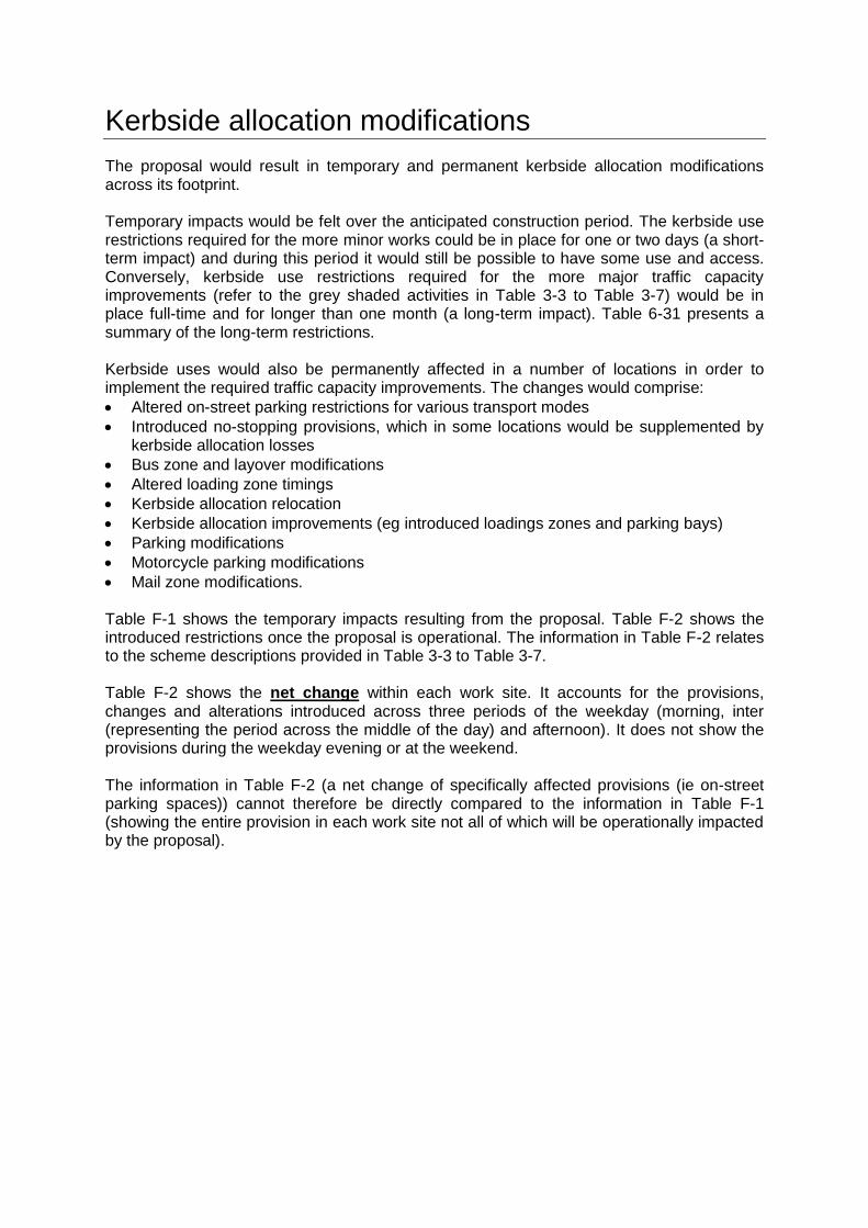
Kerbside allocation modifications
The proposal would result in temporary and permanent kerbside allocation modifications across its footprint. Temporary impacts would be felt over the anticipated construction period. The kerbside use restrictions required for the more minor works could be in place for one or two days (a short-term impact) and during this period it would still be possible to have some use and access. Conversely, kerbside use restrictions required for the more major traffic capacity improvements (refer to the grey shaded activities in Table 3-3 to Table 3-7) would be in place full-time and for longer than one month (a long-term impact). Table 6-31 presents a summary of the long-term restrictions. Kerbside uses would also be permanently affected in a number of locations in order to implement the required traffic capacity improvements. The changes would comprise:
Altered on-street parking restrictions for various transport modes
Introduced no-stopping provisions, which in some locations would be supplemented by kerbside allocation losses
Bus zone and layover modifications
Altered loading zone timings
Kerbside allocation relocation
Kerbside allocation improvements (eg introduced loadings zones and parking bays)
Parking modifications
Motorcycle parking modifications
Mail zone modifications. Table F-1 shows the temporary impacts resulting from the proposal. Table F-2 shows the introduced restrictions once the proposal is operational. The information in Table F-2 relates to the scheme descriptions provided in Table 3-3 to Table 3-7. Table F-2 shows the net change within each work site. It accounts for the provisions, changes and alterations introduced across three periods of the weekday (morning, inter (representing the period across the middle of the day) and afternoon). It does not show the provisions during the weekday evening or at the weekend. The information in Table F-2 (a net change of specifically affected provisions (ie on-street parking spaces)) cannot therefore be directly compared to the information in Table F-1 (showing the entire provision in each work site not all of which will be operationally impacted by the proposal).
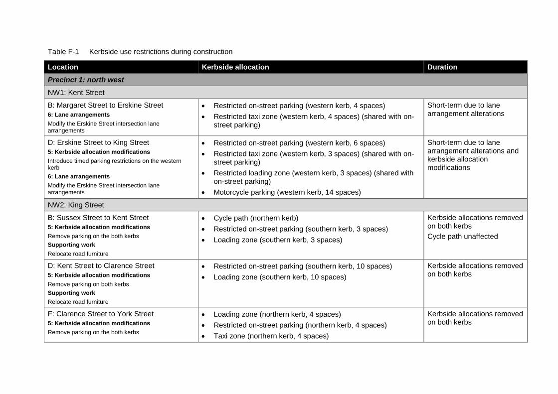
Table F-1 Kerbside use restrictions during construction
Location Kerbside allocation Duration
Precinct 1: north west
NW1: Kent Street
B: Margaret Street to Erskine Street
6: Lane arrangements
Modify the Erskine Street intersection lane arrangements
Restricted on-street parking (western kerb, 4 spaces)
Restricted taxi zone (western kerb, 4 spaces) (shared with on-street parking)
Short-term due to lane arrangement alterations
D: Erskine Street to King Street
5: Kerbside allocation modifications
Introduce timed parking restrictions on the western kerb
6: Lane arrangements
Modify the Erskine Street intersection lane arrangements
Restricted on-street parking (western kerb, 6 spaces)
Restricted taxi zone (western kerb, 3 spaces) (shared with on-street parking)
Restricted loading zone (western kerb, 3 spaces) (shared with on-street parking)
Motorcycle parking (western kerb, 14 spaces)
Short-term due to lane arrangement alterations and kerbside allocation modifications
NW2: King Street
B: Sussex Street to Kent Street
5: Kerbside allocation modifications
Remove parking on the both kerbs
Supporting work
Relocate road furniture
Cycle path (northern kerb)
Restricted on-street parking (southern kerb, 3 spaces)
Loading zone (southern kerb, 3 spaces)
Kerbside allocations removed on both kerbs
Cycle path unaffected
D: Kent Street to Clarence Street
5: Kerbside allocation modifications
Remove parking on both kerbs
Supporting work
Relocate road furniture
Restricted on-street parking (southern kerb, 10 spaces)
Loading zone (southern kerb, 10 spaces)
Kerbside allocations removed on both kerbs
F: Clarence Street to York Street
5: Kerbside allocation modifications
Remove parking on the both kerbs
Loading zone (northern kerb, 4 spaces)
Restricted on-street parking (northern kerb, 4 spaces)
Taxi zone (northern kerb, 4 spaces)
Kerbside allocations removed on both kerbs
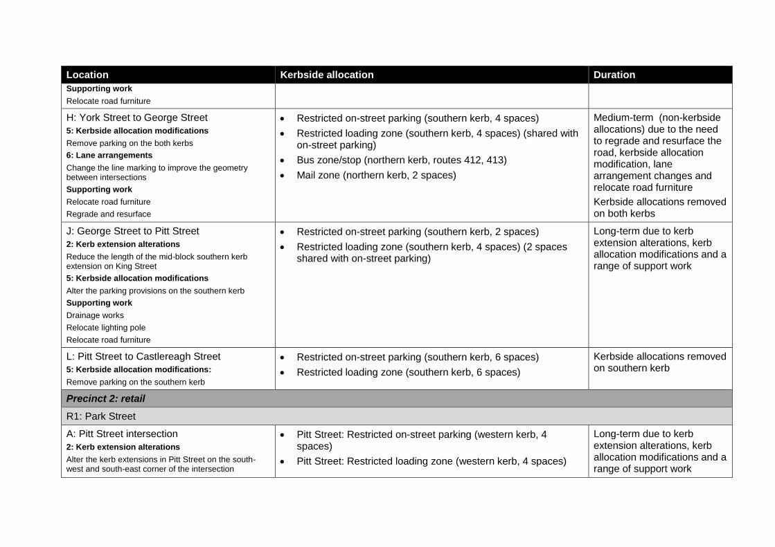
Location Kerbside allocation Duration
Supporting work
Relocate road furniture
H: York Street to George Street
5: Kerbside allocation modifications
Remove parking on the both kerbs
6: Lane arrangements
Change the line marking to improve the geometry between intersections
Supporting work
Relocate road furniture
Regrade and resurface
Restricted on-street parking (southern kerb, 4 spaces)
Restricted loading zone (southern kerb, 4 spaces) (shared with on-street parking)
Bus zone/stop (northern kerb, routes 412, 413)
Mail zone (northern kerb, 2 spaces)
Medium-term (non-kerbside allocations) due to the need to regrade and resurface the road, kerbside allocation modification, lane arrangement changes and relocate road furniture
Kerbside allocations removed on both kerbs
J: George Street to Pitt Street
2: Kerb extension alterations
Reduce the length of the mid-block southern kerb extension on King Street
5: Kerbside allocation modifications
Alter the parking provisions on the southern kerb
Supporting work
Drainage works
Relocate lighting pole
Relocate road furniture
Restricted on-street parking (southern kerb, 2 spaces)
Restricted loading zone (southern kerb, 4 spaces) (2 spaces shared with on-street parking)
Long-term due to kerb extension alterations, kerb allocation modifications and a range of support work
L: Pitt Street to Castlereagh Street
5: Kerbside allocation modifications:
Remove parking on the southern kerb
Restricted on-street parking (southern kerb, 6 spaces)
Restricted loading zone (southern kerb, 6 spaces)
Kerbside allocations removed on southern kerb
Precinct 2: retail
R1: Park Street
A: Pitt Street intersection
2: Kerb extension alterations
Alter the kerb extensions in Pitt Street on the south-west and south-east corner of the intersection
Pitt Street: Restricted on-street parking (western kerb, 4 spaces)
Pitt Street: Restricted loading zone (western kerb, 4 spaces)
Long-term due to kerb extension alterations, kerb allocation modifications and a range of support work

Location Kerbside allocation Duration
5: Kerbside allocation modifications
Alter parking provisions on both sides of the road:
Supporting work
Drainage work
Regrade and resurface the road
R2: Market Street
D: Clarence Street to York Street
3: Footpath width alterations:
Reduce the width of the northern footpath
Maintain existing bus layover and mail zone provisions whilst providing an additional westbound through lane
Supporting work:
Drainage work
Relocate road furniture
Relocate lighting pole
Mail zone (northern kerb, 2 spaces)
Bus zone (northern kerb, layover)
Medium-term due to footpath width alteration, drainage work, relocate road furniture, relocate lighting pole
H: George Street to Pitt Street
5: Kerbside allocation modifications
Alter the parking provisions on both kerbs and move coach parking to Pitt Street
Market Street: Restricted on-street parking (northern kerb, 4 spaces)
Market Street: Mail zone (northern kerb, 1 space)
Market Street: Motorcycle parking (northern kerb, 9 spaces)
Market Street: coach parking (southern kerb)
Pitt Street: Restricted on-street parking (western kerb, 5 spaces)
Pitt Street: Restricted loading zone (western kerb, 5 spaces) (shared with on-street parking)
Short-term due to kerbside allocation modifications
J: Pitt Street to Castlereagh Street
5: Kerbside allocation modifications
Alter the parking provisions on the southern kerb
Bus zone (southern kerb)
Bus stop (southern kerb, route 441)
Taxi zone (southern kerb, 2 spaces)
Short-term due to kerbside allocation modifications

Location Kerbside allocation Duration
R3: Sussex Street
B: King Street to Market Street
5: Kerbside allocation modifications
Remove parking on eastern kerb
Alter parking provisions on the western kerb
Restricted on-street parking (western kerb, 8 spaces and eastern kerb, 7 spaces)
Taxi zone (western kerb, 10 spaces) (3 spaces shared with on-street parking)
Restricted loading zone (eastern kerb, 5 spaces) (shared with on-street parking)
Works zone (western kerb, 5 spaces (shared with on-street parking)
Bus zone (eastern kerb)
Mail zone (eastern kerb, 2 spaces)
Motorcycle parking (western kerb, 7 spaces)
Non-kerbside allocations Short-term due to kerbside allocation modifications
Kerbside allocations removed on eastern kerb
D: Market Street to Druitt Street
5: Kerbside allocation modifications
Remove parking on eastern kerb
Alter parking provisions on the western kerb
6: Lane arrangements
Reallocate the southbound lane on the western kerb on the approach to Druitt Street to create a right-only turning
Restricted on-street parking (western kerb, 10 spaces and eastern kerb, 12 spaces)
Restricted loading zone (eastern kerb, 3 spaces) (shared with on-street parking)
Mail zone (eastern kerb, 1 space)
Taxi zone including taxi excepted (western kerb, 8 spaces and eastern kerb, 2 spaces)
Non-kerbside allocations: Medium-term due to kerbside allocation modifications and lane arrangement changes
Kerbside allocations removed on eastern kerb
R4: Clarence Street
B: Jamison Street to Margaret Street
5: Kerbside allocation modifications
Alter parking on both sides of the road
Supporting work
Relocate the bus lane
Regrade and resurface the road
Restricted on-street parking (eastern kerb, 6 spaces)
Restricted loading zone (eastern kerb, 4 spaces) (shared with on-street parking)
Bus stop (western kerb, routes M61, 607X, 610, 610X, 613X, 614X, 615X, 616X, 617X, 618)
Bus lane/zone (western kerb)
Mobility parking (eastern kerb, 2 spaces)
Medium-term due to reallocating the bus lane from the inside lane to the adjacent lane, kerbside allocation modifications and regrading and resurfacing the road
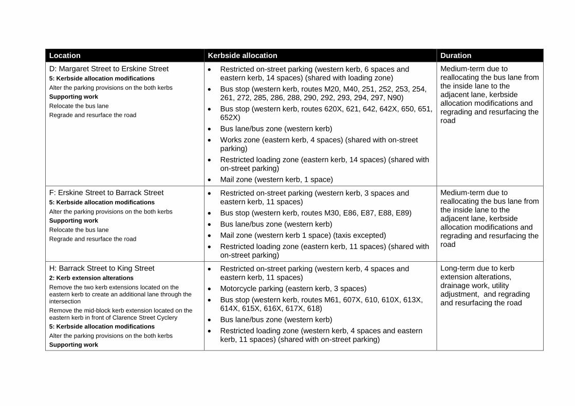
Location Kerbside allocation Duration
D: Margaret Street to Erskine Street
5: Kerbside allocation modifications
Alter the parking provisions on the both kerbs
Supporting work
Relocate the bus lane
Regrade and resurface the road
Restricted on-street parking (western kerb, 6 spaces and eastern kerb, 14 spaces) (shared with loading zone)
Bus stop (western kerb, routes M20, M40, 251, 252, 253, 254, 261, 272, 285, 286, 288, 290, 292, 293, 294, 297, N90)
Bus stop (western kerb, routes 620X, 621, 642, 642X, 650, 651, 652X)
Bus lane/bus zone (western kerb)
Works zone (eastern kerb, 4 spaces) (shared with on-street parking)
Restricted loading zone (eastern kerb, 14 spaces) (shared with on-street parking)
Mail zone (western kerb, 1 space)
Medium-term due to reallocating the bus lane from the inside lane to the adjacent lane, kerbside allocation modifications and regrading and resurfacing the road
F: Erskine Street to Barrack Street
5: Kerbside allocation modifications
Alter the parking provisions on the both kerbs
Supporting work
Relocate the bus lane
Regrade and resurface the road
Restricted on-street parking (western kerb, 3 spaces and eastern kerb, 11 spaces)
Bus stop (western kerb, routes M30, E86, E87, E88, E89)
Bus lane/bus zone (western kerb)
Mail zone (western kerb 1 space) (taxis excepted)
Restricted loading zone (eastern kerb, 11 spaces) (shared with on-street parking)
Medium-term due to reallocating the bus lane from the inside lane to the adjacent lane, kerbside allocation modifications and regrading and resurfacing the road
H: Barrack Street to King Street
2: Kerb extension alterations
Remove the two kerb extensions located on the eastern kerb to create an additional lane through the intersection
Remove the mid-block kerb extension located on the eastern kerb in front of Clarence Street Cyclery
5: Kerbside allocation modifications
Alter the parking provisions on the both kerbs
Supporting work
Restricted on-street parking (western kerb, 4 spaces and eastern kerb, 11 spaces)
Motorcycle parking (eastern kerb, 3 spaces)
Bus stop (western kerb, routes M61, 607X, 610, 610X, 613X, 614X, 615X, 616X, 617X, 618)
Bus lane/bus zone (western kerb)
Restricted loading zone (western kerb, 4 spaces and eastern kerb, 11 spaces) (shared with on-street parking)
Long-term due to kerb extension alterations, drainage work, utility adjustment, and regrading and resurfacing the road
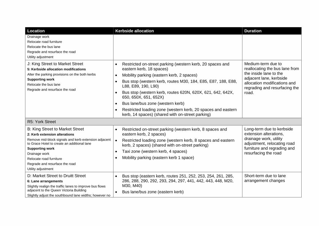
Location Kerbside allocation Duration
Drainage work
Relocate road furniture
Relocate the bus lane
Regrade and resurface the road
Utility adjustment
J: King Street to Market Street
5: Kerbside allocation modifications
Alter the parking provisions on the both kerbs
Supporting work
Relocate the bus lane
Regrade and resurface the road
Restricted on-street parking (western kerb, 20 spaces and eastern kerb, 18 spaces)
Mobility parking (eastern kerb, 2 spaces)
Bus stop (western kerb, routes M30, 184, E85, E87, 188, E88, L88, E89, 190, L90)
Bus stop (western kerb, routes 620N, 620X, 621, 642, 642X, 650, 650X, 651, 652X)
Bus lane/bus zone (western kerb)
Restricted loading zone (western kerb, 20 spaces and eastern kerb, 14 spaces) (shared with on-street parking)
Medium-term due to reallocating the bus lane from the inside lane to the adjacent lane, kerbside allocation modifications and regrading and resurfacing the road.
R5: York Street
B: King Street to Market Street
2: Kerb extension alterations
Remove mid-block signals and kerb extension adjacent to Grace Hotel to create an additional lane
Supporting work
Drainage work
Relocate road furniture
Regrade and resurface the road
Utility adjustment
Restricted on-street parking (western kerb, 8 spaces and eastern kerb, 2 spaces)
Restricted loading zone (western kerb, 8 spaces and eastern kerb, 2 spaces) (shared with on-street parking)
Taxi zone (western kerb, 4 spaces)
Mobility parking (eastern kerb 1 space)
Long-term due to kerbside extension alterations, drainage work, utility adjustment, relocating road furniture and regrading and resurfacing the road
D: Market Street to Druitt Street
6: Lane arrangements
Slightly realign the traffic lanes to improve bus flows adjacent to the Queen Victoria Building
Slightly adjust the southbound lane widths; however no
Bus stop (eastern kerb, routes 251, 252, 253, 254, 261, 285, 286, 288, 290, 292, 293, 294, 297, 441, 442, 443, 448, M20, M30, M40)
Bus lane/bus zone (eastern kerb)
Short-term due to lane arrangement changes
Location Kerbside allocation Duration
change to associated footpath widths
Precinct 3: southern
S1: Sussex Street
D: James Lane to Liverpool Street
5: Kerbside allocation modifications:
Alter the parking provisions on the western kerb
On-street restricted parking (western kerb, 4 spaces and eastern kerb, 6 spaces)
Motorcycle parking (eastern kerb, 7 spaces)
Mobility parking (western kerb 2 spaces)
Short-term due to kerbside allocation modifications
F: Liverpool Street to Eager Lane
5: Kerbside allocation modifications:
Alter the parking provisions on both kerbs
On-street restricted parking (western kerb, 16 spaces and eastern kerb, 10 spaces)
Motorcycle parking (western kerb, 6 spaces and eastern kerb, 6 spaces)
Restricted loading zone (western kerb 22 spaces) (partially shared with on-street parking)
Short-term due to kerbside allocation modifications
S2: Goulburn Street
A: George Street intersection
2: Kerb extension alterations:
Reduce the existing kerb extension on the south-east corner of Goulbourn Street and George Street
Provide three through lanes on the approach to the intersection
Goulburn Street: On-street restricted parking (south-eastern kerb 6 spaces)
Goulburn Street: Restricted loading zone (south-eastern kerb 6 spaces)
Medium-term due to kerb extension alterations
S3: Pitt Street
B: Liverpool Street to Goulburn Street
5: Kerbside allocation modifications
Alter the parking provisions on the eastern kerb
Restricted on-street parking (eastern kerb 14 spaces)
Restricted loading zone (eastern kerb 9 spaces)
Motorcycle parking (eastern kerb, 8 spaces)
Short-term due to kerbside allocation modifications
D: Goulburn Street to Campbell Street
5: Kerbside allocation modifications
Alter the parking provisions on both kerbs
Restricted on-street parking (western kerb, 9 spaces and eastern kerb, 11 spaces)
Restricted loading zone (western kerb, 9 spaces and eastern
Short-term due to kerbside allocation modifications
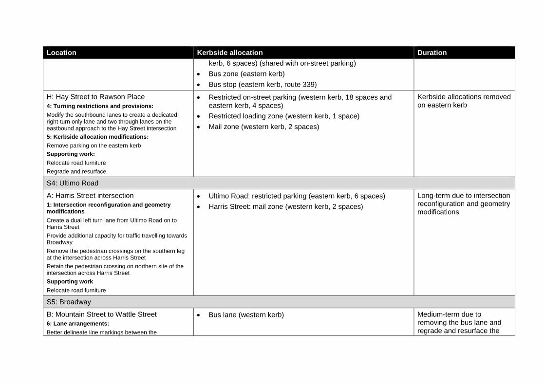
Location Kerbside allocation Duration
kerb, 6 spaces) (shared with on-street parking)
Bus zone (eastern kerb)
Bus stop (eastern kerb, route 339)
H: Hay Street to Rawson Place
4: Turning restrictions and provisions:
Modify the southbound lanes to create a dedicated right-turn only lane and two through lanes on the eastbound approach to the Hay Street intersection
5: Kerbside allocation modifications:
Remove parking on the eastern kerb
Supporting work:
Relocate road furniture
Regrade and resurface
Restricted on-street parking (western kerb, 18 spaces and eastern kerb, 4 spaces)
Restricted loading zone (western kerb, 1 space)
Mail zone (western kerb, 2 spaces)
Kerbside allocations removed on eastern kerb
S4: Ultimo Road
A: Harris Street intersection
1: Intersection reconfiguration and geometry modifications
Create a dual left turn lane from Ultimo Road on to Harris Street
Provide additional capacity for traffic travelling towards Broadway
Remove the pedestrian crossings on the southern leg at the intersection across Harris Street
Retain the pedestrian crossing on northern site of the intersection across Harris Street
Supporting work
Relocate road furniture
Ultimo Road: restricted parking (eastern kerb, 6 spaces)
Harris Street: mail zone (western kerb, 2 spaces)
Long-term due to intersection reconfiguration and geometry modifications
S5: Broadway
B: Mountain Street to Wattle Street
6: Lane arrangements:
Better delineate line markings between the
Bus lane (western kerb) Medium-term due to removing the bus lane and regrade and resurface the
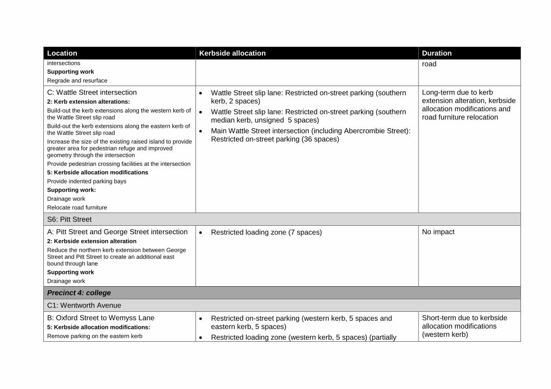
Location Kerbside allocation Duration
intersections
Supporting work
Regrade and resurface
road
C: Wattle Street intersection
2: Kerb extension alterations:
Build-out the kerb extensions along the western kerb of the Wattle Street slip road
Build-out the kerb extensions along the eastern kerb of the Wattle Street slip road
Increase the size of the existing raised island to provide greater area for pedestrian refuge and improved geometry through the intersection
Provide pedestrian crossing facilities at the intersection
5: Kerbside allocation modifications
Provide indented parking bays
Supporting work:
Drainage work
Relocate road furniture
Wattle Street slip lane: Restricted on-street parking (southern kerb, 2 spaces)
Wattle Street slip lane: Restricted on-street parking (southern median kerb, unsigned 5 spaces)
Main Wattle Street intersection (including Abercrombie Street): Restricted on-street parking (36 spaces)
Long-term due to kerb extension alteration, kerbside allocation modifications and road furniture relocation
S6: Pitt Street
A: Pitt Street and George Street intersection
2: Kerbside extension alteration
Reduce the northern kerb extension between George Street and Pitt Street to create an additional east bound through lane
Supporting work
Drainage work
Restricted loading zone (7 spaces) No impact
Precinct 4: college
C1: Wentworth Avenue
B: Oxford Street to Wemyss Lane
5: Kerbside allocation modifications:
Remove parking on the eastern kerb
Restricted on-street parking (western kerb, 5 spaces and eastern kerb, 5 spaces)
Restricted loading zone (western kerb, 5 spaces) (partially
Short-term due to kerbside allocation modifications (western kerb)
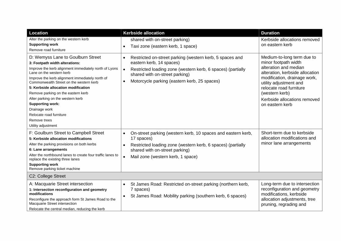
Location Kerbside allocation Duration
Alter the parking on the western kerb
Supporting work
Remove road furniture
shared with on-street parking)
Taxi zone (eastern kerb, 1 space)
Kerbside allocations removed on eastern kerb
D: Wemyss Lane to Goulburn Street
3: Footpath width alterations:
Improve the kerb alignment immediately north of Lyons Lane on the western kerb
Improve the kerb alignment immediately north of Commonwealth Street on the western kerb
5: Kerbside allocation modification
Remove parking on the eastern kerb
Alter parking on the western kerb
Supporting work:
Drainage work
Relocate road furniture
Remove trees
Utility adjustment
Restricted on-street parking (western kerb, 5 spaces and eastern kerb, 14 spaces)
Restricted loading zone (western kerb, 6 spaces) (partially shared with on-street parking)
Motorcycle parking (eastern kerb, 25 spaces)
Medium-to-long term due to minor footpath width alteration and median alteration, kerbside allocation modification, drainage work, utility adjustment and relocate road furniture (western kerb)
Kerbside allocations removed on eastern kerb
F: Goulburn Street to Campbell Street
5: Kerbside allocation modifications
Alter the parking provisions on both kerbs
6: Lane arrangements
Alter the northbound lanes to create four traffic lanes to replace the existing three lanes
Supporting work
Remove parking ticket machine
On-street parking (western kerb, 10 spaces and eastern kerb, 17 spaces)
Restricted loading zone (western kerb, 6 spaces) (partially shared with on-street parking)
Mail zone (western kerb, 1 space)
Short-term due to kerbside allocation modifications and minor lane arrangements
C2: College Street
A: Macquarie Street intersection
1: Intersection reconfiguration and geometry modifications
Reconfigure the approach form St James Road to the Macquarie Street intersection
Relocate the central median, reducing the kerb
St James Road: Restricted on-street parking (northern kerb, 7 spaces)
St James Road: Mobility parking (southern kerb, 6 spaces)
Long-term due to intersection reconfiguration and geometry modifications, kerbside allocation adjustments, tree pruning, regrading and
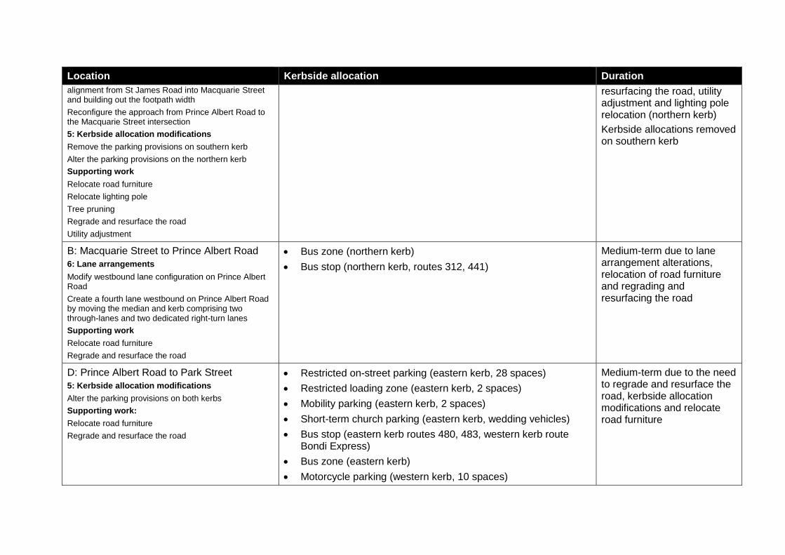
Location Kerbside allocation Duration
alignment from St James Road into Macquarie Street and building out the footpath width
Reconfigure the approach from Prince Albert Road to the Macquarie Street intersection
5: Kerbside allocation modifications
Remove the parking provisions on southern kerb
Alter the parking provisions on the northern kerb
Supporting work
Relocate road furniture
Relocate lighting pole
Tree pruning
Regrade and resurface the road
Utility adjustment
resurfacing the road, utility adjustment and lighting pole relocation (northern kerb)
Kerbside allocations removed on southern kerb
B: Macquarie Street to Prince Albert Road
6: Lane arrangements
Modify westbound lane configuration on Prince Albert Road
Create a fourth lane westbound on Prince Albert Road by moving the median and kerb comprising two through-lanes and two dedicated right-turn lanes
Supporting work
Relocate road furniture
Regrade and resurface the road
Bus zone (northern kerb)
Bus stop (northern kerb, routes 312, 441)
Medium-term due to lane arrangement alterations, relocation of road furniture and regrading and resurfacing the road
D: Prince Albert Road to Park Street
5: Kerbside allocation modifications
Alter the parking provisions on both kerbs
Supporting work:
Relocate road furniture
Regrade and resurface the road
Restricted on-street parking (eastern kerb, 28 spaces)
Restricted loading zone (eastern kerb, 2 spaces)
Mobility parking (eastern kerb, 2 spaces)
Short-term church parking (eastern kerb, wedding vehicles)
Bus stop (eastern kerb routes 480, 483, western kerb route Bondi Express)
Bus zone (eastern kerb)
Motorcycle parking (western kerb, 10 spaces)
Medium-term due to the need to regrade and resurface the road, kerbside allocation modifications and relocate road furniture
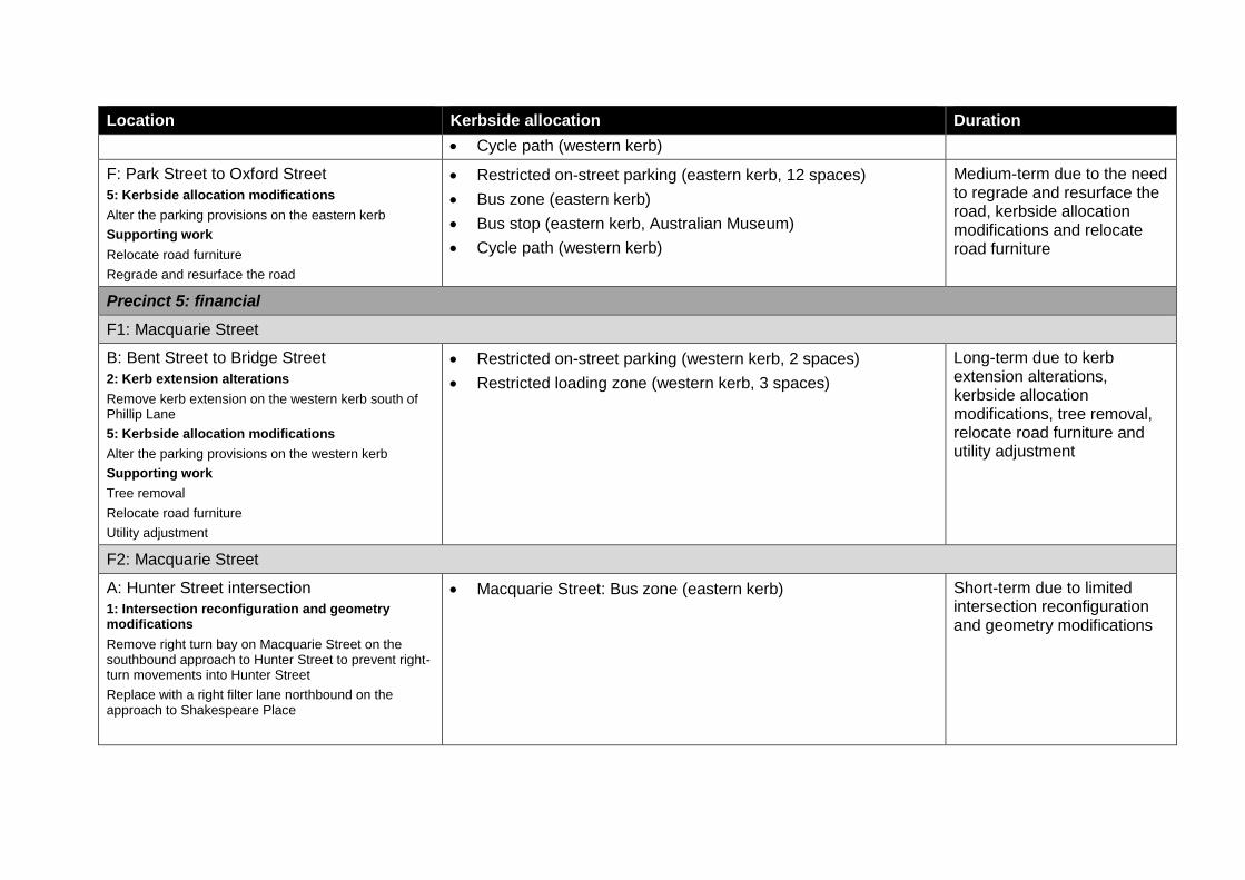
Location Kerbside allocation Duration
Cycle path (western kerb)
F: Park Street to Oxford Street
5: Kerbside allocation modifications
Alter the parking provisions on the eastern kerb
Supporting work
Relocate road furniture
Regrade and resurface the road
Restricted on-street parking (eastern kerb, 12 spaces)
Bus zone (eastern kerb)
Bus stop (eastern kerb, Australian Museum)
Cycle path (western kerb)
Medium-term due to the need to regrade and resurface the road, kerbside allocation modifications and relocate road furniture
Precinct 5: financial
F1: Macquarie Street
B: Bent Street to Bridge Street
2: Kerb extension alterations
Remove kerb extension on the western kerb south of Phillip Lane
5: Kerbside allocation modifications
Alter the parking provisions on the western kerb
Supporting work
Tree removal
Relocate road furniture
Utility adjustment
Restricted on-street parking (western kerb, 2 spaces)
Restricted loading zone (western kerb, 3 spaces)
Long-term due to kerb extension alterations, kerbside allocation modifications, tree removal, relocate road furniture and utility adjustment
F2: Macquarie Street
A: Hunter Street intersection
1: Intersection reconfiguration and geometry modifications
Remove right turn bay on Macquarie Street on the southbound approach to Hunter Street to prevent right-turn movements into Hunter Street
Replace with a right filter lane northbound on the approach to Shakespeare Place
Macquarie Street: Bus zone (eastern kerb) Short-term due to limited intersection reconfiguration and geometry modifications
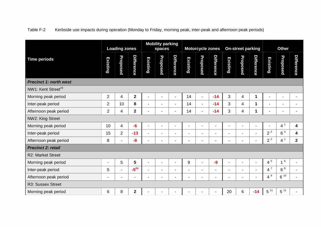
Table F-2 Kerbside use impacts during operation (Monday to Friday, morning peak, inter-peak and afternoon peak periods)
Time periods
Loading zones Mobility parking
spaces Motorcycle zones On-street parking Other
Ex
istin
g
Pro
po
sed
Diffe
ren
ce
Ex
istin
g
Pro
po
sed
Diffe
ren
ce
Ex
istin
g
Pro
po
sed
Diffe
ren
ce
Ex
istin
g
Pro
po
sed
Diffe
ren
ce
Ex
istin
g
Pro
po
sed
Diffe
ren
ce
Precinct 1: north west
NW1: Kent Street23
Morning peak period 2 4 2 - - - 14 - -14 3 4 1 - - -
Inter-peak period 2 10 8 - - - 14 - -14 3 4 1 - - -
Afternoon peak period 2 4 2 - - - 14 - -14 3 4 1 - - -
NW2: King Street
Morning peak period 10 4 -6 - - - - - - - - - - 4 1 4
Inter-peak period 15 2 -13 - - - - - - - - - 2 2 6 3 4
Afternoon peak period 8 - -8 - - - - - - - - - 2 2 4 1 2
Precinct 2: retail
R2: Market Street
Morning peak period - 5 5 - - - 9 - -9 - - - 4 5 1 6 -
Inter-peak period 5 - -524 - - - - - - - - - 4 7 6 8 -
Afternoon peak period - - - - - - - - - - - - 4 9 6 10 -
R3: Sussex Street
Morning peak period 6 8 2 - - - - - - 20 6 -14 5 11 5 11 -

Inter-peak period 6 8 2 - - - - - - 20 6 -14 5 11 5 11 -
Afternoon peak period 6 4 -2 - - - - - - 16 - -16 9 12 8 13 -1 13
R4: Clarence Street
Morning peak period 61 61 - 4 - -4 3 - -3 3 - -3 1 14 - -1 14
Inter-peak period 56 48 -8 4 - -4 3 - -3 3 - -3 1 14 - -1 14
Afternoon peak period 48 8 -40 4 - -4 3 - -3 3 - -3 1 14 - -1 14
Precinct 3: southern
S1: Sussex Street
Morning peak period 22 20 -2 2 2 - 19 19 - 19 19 - 6 15 6 15 -
Inter-peak period 22 20 -2 2 2 - 19 19 - 19 19 - 6 15 6 15 -
Afternoon peak period 22 9 -13 2 - -2 19 19 - 19 13 -6 6 15 6 15 -
S3: Pitt Street
Morning peak period 24 14 -10 - - - 8 8 - 21 7 -14 3 16 1 17 -
Inter-peak period 24 22 -2 - - - 8 8 - 21 4 -17 3 16 3 16 -
Afternoon peak period 24 11 -13 - - - 8 8 - 21 0 -21 3 16 - -
S5: Broadway
Morning peak period - - - - - - - - - 16 4 -12 7 10 3 25
Inter-peak period - - - - - - - - - 43 19 -24 7 10 3 25
Afternoon peak period - - - - - - - - - 16 4 -12 7 10 3 25
S6: Pitt Street
Morning peak period - - - - - - - - - - - - - - -
Inter-peak period 7 7 - - - - - - - - - - - - -
Afternoon peak period - - - - - - - - - - - - - - -
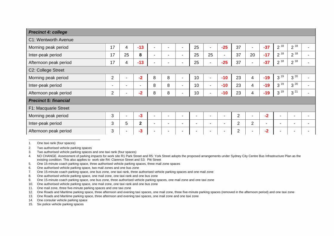
1. One taxi rank (four spaces)
2. Two authorised vehicle parking spaces
3. Two authorised vehicle parking spaces and one taxi rank (four spaces)
4. NO CHANGE. Assessment of parking impacts for work site R1 Park Street and R5: York Street adopts the proposed arrangements under Sydney City Centre Bus Infrastructure Plan as the existing condition. This also applies to work site R4: Clarence Street and S3: Pitt Street
5. One 15-minute coach parking space, three authorised vehicle parking spaces, three mail zone spaces
6. One authorised vehicle parking space, two mail zones and one bus zone
7. One 15-minute coach parking space, one bus zone, one taxi rank, three authorised vehicle parking spaces and one mail zone
8. One authorised vehicle parking space, one mail zone, one taxi rank and one bus zone
9. One 15-minute coach parking space, one bus zone, three authorised vehicle parking spaces, one mail zone and one taxi zone
10. One authorised vehicle parking space, one mail zone, one taxi rank and one bus zone
11. One mail zone, three five-minute parking spaces and one taxi zone
12. One Roads and Maritime parking space, three afternoon and evening taxi spaces, one mail zone, three five-minute parking spaces (removed in the afternoon period) and one taxi zone
13. One Roads and Maritime parking space, three afternoon and evening taxi spaces, one mail zone and one taxi zone
14. One consular vehicle parking space
15. Six police vehicle parking spaces
Precinct 4: college
C1: Wentworth Avenue
Morning peak period 17 4 -13 - - - 25 - -25 37 - -37 2 18 2 18 -
Inter-peak period 17 25 8 - - - 25 25 - 37 20 -17 2 18 2 18 -
Afternoon peak period 17 4 -13 - - - 25 - -25 37 - -37 2 18 2 18 -
C2: College Street
Morning peak period 2 - -2 8 8 - 10 - -10 23 4 -19 3 19 3 20 -
Inter-peak period - - - 8 8 - 10 - -10 23 4 -19 3 19 3 20 -
Afternoon peak period 2 - -2 8 8 - 10 - -10 23 4 -19 3 19 3 21 -
Precinct 5: financial
F1: Macquarie Street
Morning peak period 3 - -3 - - - - - - 2 - -2 - - -
Inter-peak period 3 5 2 - - - - - - 2 2 - - - -
Afternoon peak period 3 - -3 - - - - - - 2 - -2 - - -

16. One 5-minute coach parking spaces and two 15-minute coach parking spaces
17. One 5-minute coach parking space
18. One mail zone and one coach parking spaces
19. Morning, inter and afternoon coach parking (75 metres) and up to eight wedding and funeral vehicle parking spaces
20. Morning, inter and afternoon coach Parking (75 metres) and up to six wedding and funeral vehicle parking spaces
21. Up to eight wedding and funeral vehicle parking spaces
22. Up to six wedding and funeral vehicle parking spaces
23. Existing parking supply impacted by works zone on eastern side
24. The change does not account for the removed loading zone provisions in Pitt Street
25. Drop-off/pick-up parking spaces
Appendix G
Outdoor seating and dining impacts

Outdoor seating and dining impacts
The proposed kerbside and footpath modifications along with the road resurfacing works would occur close to a number of outdoor seating and dining areas. Due to needing to close off sections of footpath during construction and work within the kerbside, this may conflict with the use of these areas. As discussed in section 6.4.3 this would lead to an amenity impact. At this stage there is not anticipated requirement to restrict the use of these outdoor dining/seating areas; however this would only be confirmed once the construction method is confirmed by the contractor.
Table G-1 Temporarily affected outdoor seating and outdoor dining
Location Affected outdoor seating/dining
Reason for impact
Precinct 1: north west
NW2: King Street
F: King Street: Clarence Street to York Street
Good Life (Grace Hotel)
Mecca (Grace Hotel)
Vermicelli (Grace Hotel)
Type No. 5: Kerbside allocation modifications:
Temporary traffic management
Signage relocation
Lane marking alterations
Supporting work:
Remove the parking ticket vending machine
G: King Street: York Street intersection
Vapiano (Grace Hotel) on its York Street frontage
Forbes Hotel
CBD Hotel
6: Lane arrangements
Signage relocation
Lane marking alterations
Supporting work
Regrade and resurface the road
Precinct 2: retail
R4: Clarence Street
G: Barrack Street intersection
Mach 2 2: Kerb extension alterations:
Remove the two kerb extensions located on the eastern kerb to create an additional lane through the intersection
Supporting work:
Drainage work
Relocate road furniture
H: Barrack Street to King Street
Bistro Papillon 2: Kerb extension alterations
Remove the two kerb extensions located on the eastern kerb to create an additional lane through the intersection
Remove the mid-block kerb extension located on the eastern kerb in front of Clarence Street Cyclery
5: Kerbside allocation modifications
Alter the parking provisions on the both kerbs
Supporting work
Drainage work
Relocate road furniture
Relocate the bus lane
Regrade and resurface the road
Utility adjustment

Location Affected outdoor seating/dining
Reason for impact
K: Market Street intersection
The Berkley Expresso Bar
De Vine
2: Kerb extension alterations
Create a new kerb extension in Clarence Street on the north-west corner of the intersection
3: Footpath width alterations
Slightly adjust the north-west corner kerb on the intersection
Supporting work
Drainage work
Relocate road furniture
R5: York Street
B: King Street to Market Street
Vapiano (Grace Hotel) on its York Street frontage
Chop Chop/Sub York
2: Kerb extension alterations
Remove mid-block signals and kerb extension adjacent to Grace Hotel to create an additional lane
Supporting work
Drainage work
Relocate road furniture
Regrade and resurface the road
Utility adjustment
Precinct 3: southern
S2: Goulburn Street
A: George Street intersection
Scruffy Murphy’s 2: Kerb extension alterations:
Reduce the existing kerb extension on the south-east corner of Goulbourn Street and George Street
Provide three through lanes on the approach to the intersection
S3: Pitt Street
H: Hay Street to Rawson Place
Fire Station Cafe 4: Turning restrictions and provisions
Modify the southbound lanes to create a dedicated right-turn only lane and two through lanes on the eastbound approach to the Hay Street intersection
5: Kerbside allocation modifications
Remove parking on the eastern kerb
Supporting work:
Relocate road furniture
Regrade and resurface
S6: Pitt Street
A: Pitt Street and George Street intersection
Side Bar (northern intersection kerb of George Street and Lee Street)
2: Kerbside extension alteration
Reduce the northern kerb extension between George Street and Pitt Street to create an additional east bound through lane
Supporting work
Drainage work
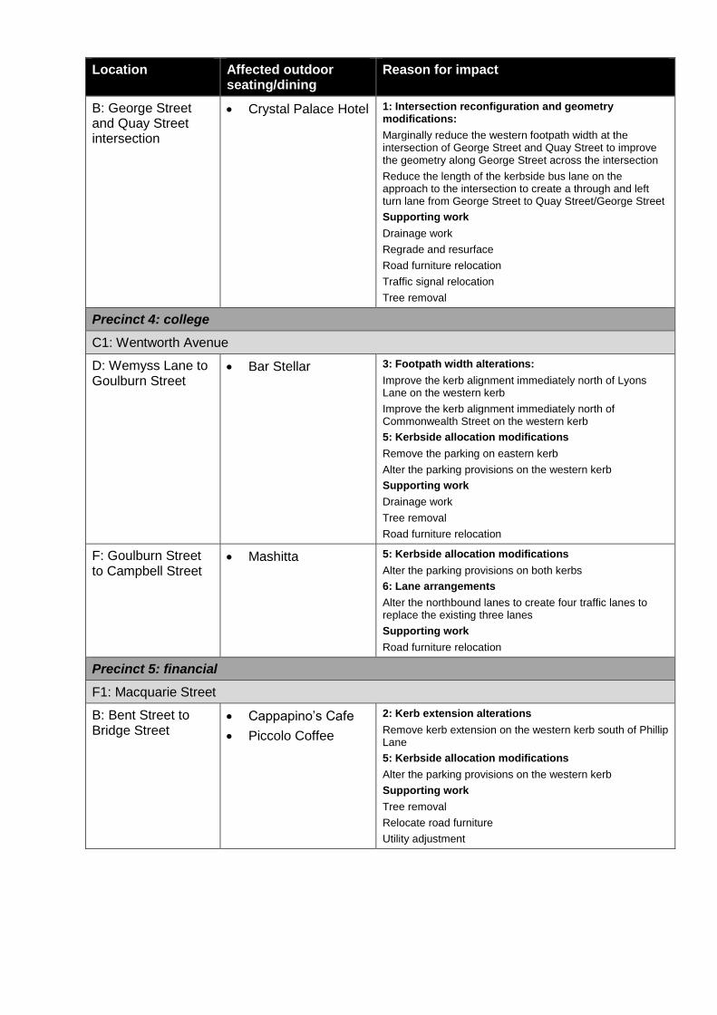
Location Affected outdoor seating/dining
Reason for impact
B: George Street and Quay Street intersection
Crystal Palace Hotel 1: Intersection reconfiguration and geometry modifications:
Marginally reduce the western footpath width at the intersection of George Street and Quay Street to improve the geometry along George Street across the intersection
Reduce the length of the kerbside bus lane on the approach to the intersection to create a through and left turn lane from George Street to Quay Street/George Street
Supporting work
Drainage work
Regrade and resurface
Road furniture relocation
Traffic signal relocation
Tree removal
Precinct 4: college
C1: Wentworth Avenue
D: Wemyss Lane to Goulburn Street
Bar Stellar 3: Footpath width alterations:
Improve the kerb alignment immediately north of Lyons Lane on the western kerb
Improve the kerb alignment immediately north of Commonwealth Street on the western kerb
5: Kerbside allocation modifications
Remove the parking on eastern kerb
Alter the parking provisions on the western kerb
Supporting work
Drainage work
Tree removal
Road furniture relocation
F: Goulburn Street to Campbell Street
Mashitta 5: Kerbside allocation modifications
Alter the parking provisions on both kerbs
6: Lane arrangements
Alter the northbound lanes to create four traffic lanes to replace the existing three lanes
Supporting work
Road furniture relocation
Precinct 5: financial
F1: Macquarie Street
B: Bent Street to Bridge Street
Cappapino’s Cafe
Piccolo Coffee
2: Kerb extension alterations
Remove kerb extension on the western kerb south of Phillip Lane
5: Kerbside allocation modifications
Alter the parking provisions on the western kerb
Supporting work
Tree removal
Relocate road furniture
Utility adjustment

Appendix H
Public amenity impacts
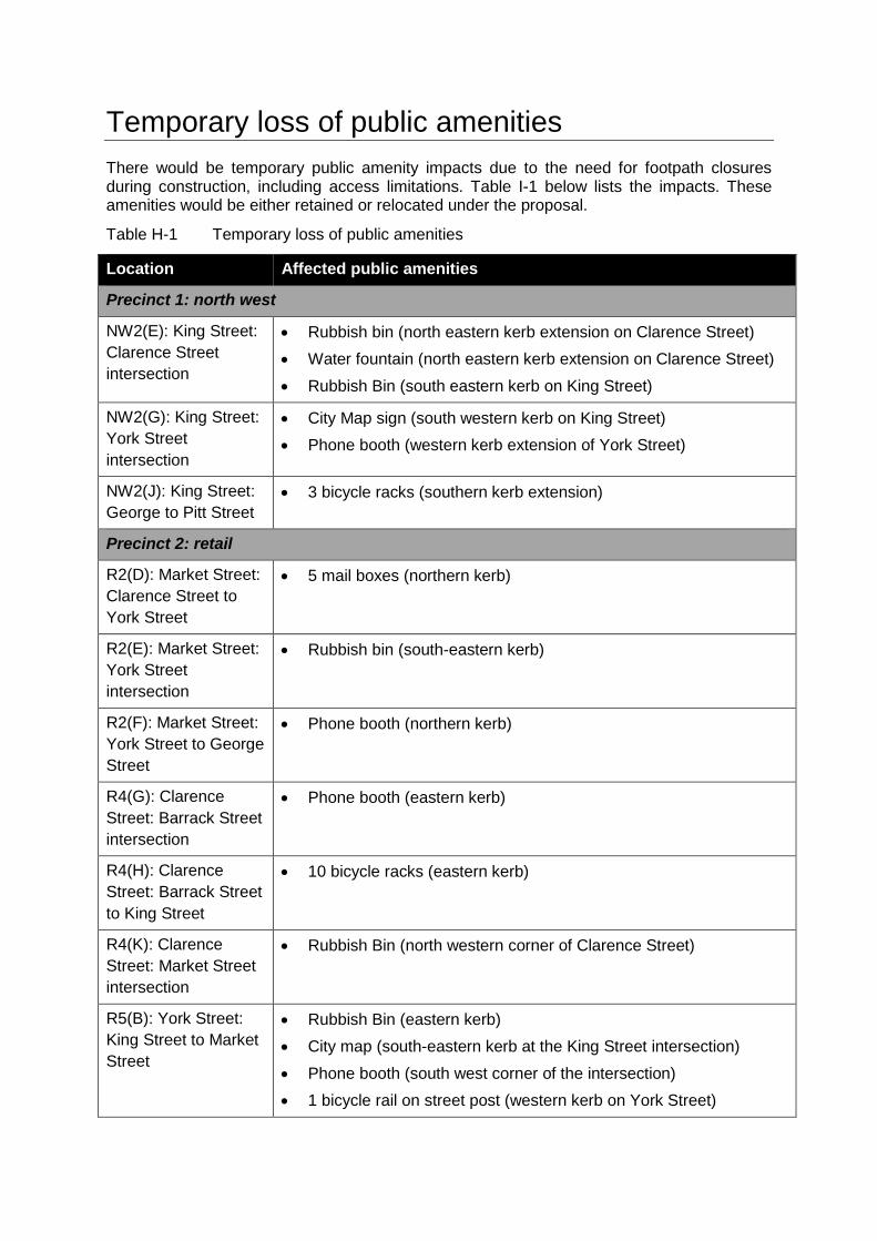
Temporary loss of public amenities
There would be temporary public amenity impacts due to the need for footpath closures during construction, including access limitations. Table I-1 below lists the impacts. These amenities would be either retained or relocated under the proposal.
Table H-1 Temporary loss of public amenities
Location Affected public amenities
Precinct 1: north west
NW2(E): King Street:
Clarence Street
intersection
Rubbish bin (north eastern kerb extension on Clarence Street)
Water fountain (north eastern kerb extension on Clarence Street)
Rubbish Bin (south eastern kerb on King Street)
NW2(G): King Street:
York Street
intersection
City Map sign (south western kerb on King Street)
Phone booth (western kerb extension of York Street)
NW2(J): King Street:
George to Pitt Street
3 bicycle racks (southern kerb extension)
Precinct 2: retail
R2(D): Market Street:
Clarence Street to
York Street
5 mail boxes (northern kerb)
R2(E): Market Street:
York Street
intersection
Rubbish bin (south-eastern kerb)
R2(F): Market Street:
York Street to George
Street
Phone booth (northern kerb)
R4(G): Clarence
Street: Barrack Street
intersection
Phone booth (eastern kerb)
R4(H): Clarence
Street: Barrack Street
to King Street
10 bicycle racks (eastern kerb)
R4(K): Clarence
Street: Market Street
intersection
Rubbish Bin (north western corner of Clarence Street)
R5(B): York Street:
King Street to Market
Street
Rubbish Bin (eastern kerb)
City map (south-eastern kerb at the King Street intersection)
Phone booth (south west corner of the intersection)
1 bicycle rail on street post (western kerb on York Street)

Location Affected public amenities
Precinct 3: southern
S3(H): Pitt Street:
Hay Street to Barlow
Street
1 mail box (western kerb)
S4(A): Ultimo Road:
Harris Street
intersection
2 mail boxes (western kerb of Harris Street)
S5(C): Broadway:
Wattle Street
intersection
Historic mail box (western kerb)
1 bicycle rail on street post (western kerb)
Precinct 4: College
C1(D): Wentworth
Avenue: Wemyss
Lane to Goulburn
Street
2 bicycle rails on street post (western kerb)
Rubbish bin (western kerb)
C2(B): College Street:
Macquarie Street to
Prince Albert Road
1 bicycle rail on street post (western kerb)
C2(D): College
Street: Prince Albert
Road to Park Street
9 bicycle rails on street posts (eastern kerb)
C2(F): College Street:
Park Street to Oxford
Street
7 bicycle rails on street posts (eastern kerb)
Precinct 5: financial
F1(B): Macquarie
Street: Bent Street to
Bridge Street
Phone box (western kerb)
2 bicycle rails on street post (western kerb)

Appendix I
Landscape character and visual impacts
Landscape character and visual impacts
Landscape character
Method and approach
This appendix contains the detail of the assessment of the proposal’s impact on each identified landscape character (sub) zones. The assessment is based on both the zone’s sensitivity and the change to the zone’s characteristics during construction and operation. A judgement has been made as to the quality and extent of change resulting from the mass, scale, presence, dominance and influence of the proposal on the zone’s landscape character. Construction and operational impacts have been considered. Construction impact duration has been defined as:
Short-term where the works would last less than one week
Medium-term where the works would last one week to one month
Long-term where the works would last over one month.
Operational impacts have been defined as either being temporary or permanent.
Existing environment
Regional landscape character
The proposal would take place within Australia’s oldest city. The built form is highly developed and comprises a mixture of iconic, identifiable and historic buildings, which collectively provide key reference points within the city streetscape. They allow both user navigation and provide context to the city’s development history. The broad landscape character of the city can be divided into a number of areas that represent key districts:
North: The Rocks retains its historic character typified by its narrower, occasionally cobble-paved, streets fronted with low-rise sandstone-clad historic buildings. These provide an important context and reference to the city’s first settlers and its early years.
Central corridor: Across the central corridor high-rise office blocks and residential buildings (typically above 100 metres) frame and contain the streetscape below. Views are restricted other than at key high points and intersections. Along the narrower streets, shade effects increase the sense of enclosure. Within this area there is a clear distinction and contrast between the old and the new. Importantly the key historic buildings within the area are celebrated and have been enhanced over time to increase their prominence and importance in the landscape. The other main feature within this area is the creation of a number of pedestrianised streets. They introduce important boulevard and plaza characteristics, and contain seating, landscaping and other street furniture to provide a greater sense of openness and tranquillity compared to the adjacent city streets.
East: The park areas form an important green eastern edge to the city and provide an important connected recreational open space. They clearly separate the city from the residential areas to the east. They frame an important gateway to the city creating a number of important views on approaching the city. Hyde Park has two distinct edges to the north and east and separately to the south and west. Important institutional free-standing sandstone buildings front College Street and St James Road, with the likes of Queens Square providing an early example of formal urban design in the city. The high-rise central corridor, creates encloses the park by forming a strong street alignment.
South: Remnant warehouses and service laneways provide evidence of the area’s historic role as a market area and its proximity to the port of Darling Harbour. This market character is reinforced by the grained subdivision patters, narrow frontages, informal public spaces and low building heights. Unlike the central corridor there is more light penetration throughout this area, which lends to a more pleasant microclimate and removes the sense of enclosure felt elsewhere to the north.
Local landscape character and value
The above districts have their history in providing the city with key distinct services and functions namely, finance, transport, retail, commercial, civic, governance and education. These districts have been broadly represented through the five precincts considered in this REF. Each precinct therefore has its key characteristics, qualities and sensitivities to change as summarised in Table I-1, which shows the proposal footprint to comprise nine landscape character (sub) zones.
Table I-1 Local landscape characteristics
Precinct Landscape character and sensitivity
Precinct 1: north-west
Zone 1: King Street and Kent Street contain many of the characteristics of the adjacent retail precinct (see below). Modern and historic development coincides. Certain historic warehouses remain, providing reference to the area’s development history. As with the retail precinct there is an architectural emphasis on the buildings located at key intersections, which lends to the distinctive character of the area. The landscape character is assessed as being of good quality and in the context of the proposal would only have a negligible-to-low sensitivity to change.
Precinct 2: retail
Zone 2: The retail precinct contains a mixture of historic and modern development. The area’s history is evidenced in the early warehouses that, in part, have been retained and redeveloped through a process of gentrification. Some of the warehouses have given way to medium-story 19th and 20th century masonry buildings, which are of a consistent scale, form and character. There is an architectural emphasis on the buildings located at key intersections, which lends to the distinctive character of the area. The other key feature is the network of lanes and internal courtyards. They provide a uniform block pattern with narrow frontages. The QVB provides further evidence of the markets that once existed in the area. It retains a grand scale and rare composition in the city centre. At the periphery, the medium-rise development gives way to newer high-rise commercial buildings along the northern end of Clarence Street and Sussex Street. They frame and contain the roads. In general however the landscape character is assessed as being of is of good quality and in the context of the proposal would only have a negligible-to-low sensitivity to change.
Precinct 3: southern
The southern precinct contains a number of distinct characteristics that can be characterised into four separate subzones.
Subzone 3a (Haymarket): As noted above Haymarket area contains remnant warehouses and service lanes characteristic of the areas market history. Many of the buildings have been redeveloped following the relocation of the markets to Flemington. Paddy’s Market is central to the area’s character having been in existence since the 1830s. The area offers evidence of its development and later decline. Despite this, it retains a market atmosphere characterised by a diversity of uses, street life and social and ethnic mix. The landscape character is assessed as being of good quality and in the context of the proposal would only have a negligible-to-low sensitivity to change.
Subzone 3b (Central Station): Railway Square forms a major visual and functional gateway. Pitt Street/George Street is a busy large intersection dispersing traffic and pedestrians into and out of the city. The area has functioned for over 150 years as a railway station and transport interchange. It provides both symbolic and historic reference as the main hub of NSW’s train network. The current civic heritage of the area is evident in the built form and structure. It provides important reference to the current and past. The wider area comprises mixed commercial, institutional, residential and hotel uses. The landscape character is assessed as being of good quality and in

Precinct Landscape character and sensitivity
the context of the proposal would only have a negligible-to-low sensitivity to change.
Subzone 3c (Ultimo and Broadway): This area forms a distinct neighbourhood predominantly comprising institutional and commercial buildings. It is distinct and separate from the rest of the city centre considered under this proposal. A number of retained historic buildings have been adapted and reused. They are interspersed with new development that has maintained street legibility throughout the neighbourhood. Broadway is characteristic of its namesake providing a wide boulevard and transport corridor into the city flanked by a number of important architectural buildings. These themes continue on Ultimo Road however there are fewer historic buildings in favour of newer medium rise development. The landscape character is assessed as being of good quality and in the context of the proposal would only have a negligible-to-low sensitivity to change.
Subzone 3d (Pitt Street and Goulburn Street): These streets are typical of the high-rise central corridor described above. They comprise several iconic buildings over 100 metres tall. These landmark buildings, focussed around World Square, are interspersed with medium-rise masonry historic buildings that have been converted to a mixture of retail and commercial uses. Whilst there is less historical cohesion along these streets the area remains typical and representative of many of the streets throughout the central part of the city. In context the landscape character is assessed as being of ordinary quality and in the context of the proposal would only have a negligible sensitivity to change.
Precinct 4: college
The college precinct contains two distinctive subzones.
Subzone 4a (Wentworth Avenue): Wentworth Avenue is in contrast to Hyde Park. It forms a wide trafficked boulevard flanked by median-rise residential development and lower-rise commercial properties interspersed with occasional historical buildings. Occasional mature trees add to the streetscape. The falling topography affords long-distance views along the road corridor to the south. The landscape character is assessed as being of ordinary quality ordinary quality and in the context of the proposal would only have a negligible sensitivity to change.
Subzone 4b (College Street/Hyde Park): As noted above, College Street and Hyde Park create a clearly distinct area. Hyde Park forms an important open space in the city. It provides a transition point between the city centre high-rise and the key suburbs to the east. To the east and north the institutional, governance and historic character of the area has been retained. These components form to create a strong distinct relationship. Hyde Park is Sydney’s oldest public open space and is prized for its recreational opportunities. It contains a number of important monuments. The landscape character is assessed as being an attractive landscape however in the context of the proposal would only have a low sensitivity to change.
Precinct 5: financial
Zone 5: Macquarie Street contains a collection of highly significant historic buildings. Originally developed as a government precinct it expanded to contain prominent residential and professional uses and latterly commercial and tourism uses.
Macquarie Street forms the eastern built edge of the city. Its western side comprises a built edge of medium-rise buildings beyond which is the city high-rise. These combine to create a prominent skyline when viewed from the Botanic Gardens. The eastern edge is in contrast containing joined areas of open space along with a cohesive group of public historic buildings that terminate west-east streets and create significant vistas. Macquarie Street is also recognised for its historic civic function and its relationship to Hyde Park to the south and Bennelong Point to the north now occupied by the Sydney

Precinct Landscape character and sensitivity
Opera House. The landscape character is assessed as being an attractive landscape however in the context of the proposal would only have a low sensitivity to change.
The above quality of each landscape character zone and sub zone reflects how sensitive it would be to change in the context of the proposal. Each work site is located within one of the landscape character zones above. It too has the same qualities reflecting the landscape character however each work site would be more sensitive to change due to the immediacy of the impact of the proposal within the road corridor and its effects on each work site’s streetscape. Table I-2 describes the sensitivity of each work site.
Table I-2 Streetscape quality and sensitivity to change
Corresponding landscape character zone
Work Site Streetscape quality
Streetscape sensitivity to change
Precinct 1: north west
Zone 1: north west
NW1: King Street Good Low
NW2: Kent Street Good Low
Precinct 2: retail
Zone 2: retail R1: Park Street Good Low
R2: Market Street Good Low
R3: Sussex Street Good Low
R4: Clarence Street Good Low
R5: York Street Good Low
Precinct 3: southern
Subzone 3a: Haymarket S1: Sussex Street Good Low
Subzone 3d: Pitt Street/Goulburn Street
S2: Goulburn Street Ordinary Negligible
Subzone 3c: Ultimo and Broadway S4: Ultimo Road Good Low
S5: Broadway Good Low
Subzone 3a: Haymarket S3: Pitt Street Good Low
Subzone 3b: Central Station S6: Pitt Street Good Low
Precinct 4: college
Subzone 4a: Wentworth Avenue C1: Wentworth Avenue Ordinary Negligible
Subzone 4b: College Street/Hyde Park
C2: College Street High Moderate
Precinct 5: financial
Zone 5: financial F1: Macquarie Street High Moderate
F2: Macquarie Street High Moderate

Construction impacts
Various works would take place within each landscape character zone. Whilst the exact construction staging is still to be confirmed, no one location (or work site) would be affected for longer than a few months, and in many cases the impact duration would be either medium-term or short-term. The impact on the landscape and streetscape character of the area would depend on the type of construction activity taking place in a given location and the duration of the work. The construction activities required at each work site are described in Table 3-3 to Table 3-7 with a summary provided in Table 3-2 and Table 3-10. They include:
The installation of equipment to support temporary traffic management controls
The installation of equipment to support temporary footpath restrictions
Major equipment relocation
Tree removal and punning
Ground excavation work associated with utility adjustments, drainage modifications and general signal, lighting pole and traffic signal relocations
Regarding and resurfacing the road
Adjustments to the footpaths, kerbs and intersections requiring cutting, grinding and sawing.
The work site’s character would also be impacted by general construction activities, dust generation, amenity affects (including noise and vibration impacts), loading and unloading activities, the presence of construction equipment, and the bollards, fencing and hoardings that would be used to demark all active working areas. In certain locations the construction work is expected to last longer than three months. These locations are shaded grey in Table 3-3 to Table 3-7 and the impacts would be more notable that the short-term minor work that would typically last less than two weeks and potentially only a few days. There is an important distinction between the impacts on the local landscape character versus the impacts within the streetscape. In particular the changes would be more notable within the streetscape of each road versus affecting the overall landscape character of an area. The above factors were considered in determining the proposal’s landscape/streetscape impacts. Whilst the construction impacts would depend on the activities taking place in a given location and the duration of the activities, it was broadly assessed that the more major supporting work and traffic capacity improvements (refer to Table 3-2) would require a greater level of construction activity in a given location for a longer period of time. On this basis the following impact magnitude ratings were used to assess the impact on landscape/streetscape character
1: Intersection reconfiguration and geometry modifications: moderate
2: Kerb extension alterations: low-moderate
3: Footpath width alterations: moderate
5: Kerbside allocation modifications: low
6: Lane arrangements: low
Supporting work: - Major equipment relocation: low-moderate - Tree pruning or removal: low-moderate - Bus lane marking alterations or instalment: low - Road regrading and resurfacing: low-moderate - Traffic signal and lighting pole works: low - Surface drainage modification and relocation: low - Bus shelter relocation: low - Utility works: low-moderate

The above ratings were applied to the construction activity taking place in each location as described in Table 3-3 to Table 3-7. The assessment considered the highest impact magnitude rating occurring within a given work site and applied it to the whole work site. It did not differentiate between variability in the type and scale of activity within a work site.
Table I-3 details the proposal’s landscape and streetscape character impacts during construction. It also describes the work activities that would result in the impact and identifies which work sites would include more major work activities consistent with the information presented in Table 3-3 to Table 3-7.

Table I-3 Landscape characteristic impacts (construction)
Work site Sensitivity to change Magnitude of change
Impact rating
Streetscape Landscape Streetscape Landscape
Landscape character zone (Z), landscape character subzone (SZ)
Notes: The table shows the sections within each work site where the various traffic capacity improvements would be installed. The bold text shows the sections where the traffic capacity improvements form part of a major work site (refer to the grey shaded text in table 3-3 to table 3-7).
Precinct 1: north-west
NW1: Kent Street
5: Kerbside allocation modifications
6: Lane arrangements
Low (Z1) Negligible-to-low
Low Low Negligible
NW2: King Street (major work site)
1: Intersection reconfiguration and geometry modifications
2: Kerb extension alterations
5: Kerbside allocation modifications
6: Lane arrangements
Supporting work (drainage modification, general signage relocation, road furniture relocation, street lighting relocation)
Utility adjustment
Low Moderate Moderate-to-low
Negligible
Precinct 2: retail
R1: Park Street (major work site)
2: Kerb extension alterations
Supporting work (drainage modification, general signage relocation, regrade and resurface the road)
Utility adjustment
Low (Z2) Negligible-to-low
Moderate Moderate-to-low
Negligible
R2: Market Street (major work site)
1: Intersection reconfiguration and geometry modifications
2: Kerb extension alterations
3: Footpath width alterations
5: Kerbside allocation modification
Supporting work (drainage modification, relocate road furniture,
Low Moderate Moderate-to-low
Negligible

Work site Sensitivity to change Magnitude of change
Impact rating
Streetscape Landscape Streetscape Landscape
lighting pole relocation, general signage relocation, tree removal)
Utility adjustment
R3: Sussex Street
5: Kerbside allocation modifications
6: Lane arrangements
Low Low Low Negligible
R4: Clarence Street (major work site)
2: Kerb extension alterations
3: Footpath width alterations
5: Kerbside allocation modifications
Supporting work (drainage modification, relocate road furniture, lighting pole relocation, general signage relocation, regrade and resurface the road)
Utility adjustment
Low Moderate Moderate-to-low
Negligible
R5: York Street (major work site)
2: Kerb extension alterations
Supporting work (drainage modification, relocate road furniture, regrade and resurface the road)
Utility adjustment
Low Moderate Moderate-to-low
Negligible
Precinct 3: southern
S1: Sussex Street
5: Kerbside allocation modifications
Low (SZ3a) Negligible-to-low
Low Low Negligible
S2: Goulburn Street (major work site)
2: Kerb extension alterations
Negligible (SZ3d) Negligible Moderate Moderate-to-low
Negligible
S3: Pitt Street (major work site)
1: Intersection reconfiguration and geometry modifications
4: Turning restrictions and provisions
5: Kerbside allocation modifications
Supporting work (relocate road furniture, regrade and resurface the
Low (SZ3a) Negligible-to-low
Moderate Moderate-to-low
Negligible

Work site Sensitivity to change Magnitude of change
Impact rating
Streetscape Landscape Streetscape Landscape
road)
S4: Ultimo Road (major work site)
1: Intersection reconfiguration and geometry modifications
Supporting work (relocate road furniture, regrade and resurface the road)
Low (SZ3c) Negligible-to-low
Moderate Moderate-to-low
Negligible
S5: Broadway (major work site)
1: Intersection reconfiguration and geometry modifications
2: Kerb extension alterations
5: Kerbside allocation modifications
6: Lane arrangements
Supporting work (drainage modifications, relocate road furniture, regrade and resurface the road)
Utility adjustment
Low (SZ3c) Negligible-to-low
Moderate Moderate-to-low
Negligible
S6: Pitt Street (major work site)
1: Intersection reconfiguration and geometry modifications
2: Kerb extension alterations
Supporting work (drainage modifications, relocate one bus stop, relocate road furniture, regrade and resurface the road, tree removal)
Utility adjustment
Low (SZ3b) Negligible-to-low
Moderate Moderate-to-low
Negligible
Precinct 4: college
C1: Wentworth Avenue (major work site)
1: Intersection reconfiguration and geometry modifications
2: Kerb extension alterations
3: Footpath width alterations
5: Kerbside allocation modifications
Supporting work (drainage modifications, relocate one bus stop, relocate road furniture, regrade and resurface the road, tree removal)
Utility adjustment
Low (SZ4a) Negligible Moderate Moderate-to-low
Negligible

Work site Sensitivity to change Magnitude of change
Impact rating
Streetscape Landscape Streetscape Landscape
C2: College Street (major work site)
1: Intersection reconfiguration and geometry modifications
5: Kerbside allocation modifications
6: Lane arrangements
Supporting work (drainage modifications, relocate road furniture, regrade and resurface the road, tree pruning)
Utility adjustment
Moderate (SZ4b) Low Moderate Moderate Moderate-low
Precinct 5: financial
F1: Macquarie Street (major work site)
2: Kerb extension alterations
5: Kerbside allocation modifications
Supporting work (relocate road furniture, tree removal)
Utility adjustment
Moderate (Z5) Low Moderate Moderate Moderate-low
F2: Macquarie Street
1: Intersection reconfiguration and geometry modifications
Moderate (Z5) Low Low Moderate-low Low

Operational impacts
New or upgraded road infrastructure would be introduced into an established road corridor. In all locations, the mass and scale of the changes would not be sufficient to influence the context or setting the road has on the local landscape character. This is reinforced by the fact that the proposal has been designed to be consistent with the urban character of the road (refer to section 3.2.4 of the main REF). It achieves this by replicating design elements and materials already used within the road corridor. In the majority of locations the change would therefore be negligible. There would be two exceptions to the above:
Where road would be widened within the existing corridor either by widening the footpath or removing a kerb extension
Where the kerbside allocations are either revised or removed providing an extra traffic lane closer to the footpath and adjacent building frontages.
The above would lend to a sense of intensification within the local streetscape as more traffic capacity is introduced in certain locations. This would alter established relationships and settings resulting in localised impacts. These changes are considered more notable than the other proposed improvements which focus on moving traffic more efficiently through an intersection and along sections of road. There would also be other localised effects where the street lighting is altered or trees would be removed. Table I-4 assesses the landscape character impacts that would result from road widening, kerb alteration and kerbside allocation modification works.
Table I-4 Landscape characteristic impacts (operation)
Precinct Landscape character and sensitivity
Zone 1: north west
NW2: King Street
The proposed kerb and footpath realignments throughout this work site would provide additional west-east traffic capacity along the majority of the corridor. As a result, road traffic would become more dominant in the context of the landscape, marginally altering its relationship to and influence on the urban landscape. This would be more marked in King Street than elsewhere in the proposal footprint as the road is narrower and enclosed. It may have an effect on the spatial quality of the street’s architectural importance and therefore its character. Despite this, the change would be at work moderate between Clarence Street and York Street.
At the zone level the change would be contained within the immediate corridor with the broader character zone remaining unaffected. The impact would therefore be negligible
At the street level, the impact would be low adverse at worst due to the low level of change that would occur.
Zone 2: retail
R2: Market Street
The proposed kerb and footpath realignments throughout this work site would provide additional west-east traffic capacity along the majority of the corridor. This would be complemented by creating an additional eastbound traffic between George Street and Pitt Street, as a result of implementing permanent no stopping restrictions. Unlike Market Street the major works would be limited to the central section of the work site between Clarence Street and George Street. As a result, the road traffic would only become a more dominant component of the landscape character centrally. Market Street is also a wider corridor and therefore the changes could be better contained and accommodated.
At the zone level the change would be contained within the immediate corridor with the broader character zone remaining unaffected. The

Precinct Landscape character and sensitivity
impact would therefore be negligible.
At the street level, the impact would be low adverse at worst due to the ability for the road corridor to better accommodate the changes
R3: Sussex Street
The proposed implementation of permanent no-stopping on both kerbsides would create continuous southbound lanes. The road contains fewer components that define the character of the retail zone. In part Sussex Street already functions as a bypass corridor, consistent objective of the transport priorities defined under the Access Strategy. The removal of parking along the street would intensify this function by facilitating increased southbound traffic movements. This is supported by the lack of cohesion along this part of Sussex Street with the rest of the more historic city centre despite the occasional fronting heritage-listed building.
At the zone level the change would be contained within the immediate corridor with the broader character zone remaining unaffected. The impact would therefore be negligible
At the street level, the proposal would reinforce the function of this section of Sussex Street as a bypass outer traffic corridor. This distinction is considered of low beneficial.
R4: Clarence Street
The proposed relocation of the bus lane to the inside lane would introduce more bus traffic closer to the kerb. As a result there would be improved capacity for buses along this established major south-north traffic corridor. Whilst the proposal would not introduce more buses along Clarence Street the containment of buses to the inside western kerb would alter the character along this frontage. These changes would take place along a road that retains many of the characteristics that define the retail zone.
At the zone level the change would be contained within the immediate corridor with the broader character zone remaining unaffected. The impact would therefore be negligible
At the street level, the impact would be low beneficial due to reallocation of priorities, the removal of traffic conflict and the relocation of the bus lane from the kerbside.
R5: York Street
Improved bus operations in York Street would function to reduce the layover times and movement of southbound traffic along the road, especially during the peak hour period, when the changes would be complemented through kerbside use restrictions. Unlike Clarence Street, the change would not force bus traffic to the inside lane. Consistent with the current arrangement, buses could continue to use all the available lanes.
At the zone level the change would be contained within the immediate corridor with the broader character zone remaining unaffected. The impact would therefore be negligible
At the street level, the impact would be low adverse at worst due to the improved movement along the road and the ability for buses to use all traffic lanes. It is possible that the changes would have a beneficial impact on the character of the street. This would depend on how significant the altered traffic conditions were, especially during the peak hour periods.
Subzone 3a: southern (Haymarket)
S1: Sussex Street
Despite being located within an alternative landscape character zone the characteristics of Sussex Street south of Bathurst Street are generally consistent with work site R3 (Sussex Street). The street’s function as a bypass route is retained and there is only slightly more reference to the
Precinct Landscape character and sensitivity
area’s market history.
At the zone level the change would be contained within the immediate corridor with the broader character zone remaining unaffected. The impact would therefore be negligible
At the street level, the proposal would reinforce the function of this section of Sussex Street as a bypass outer traffic corridor. This distinction is considered of low beneficial.
Subzone 3b: southern (Central Station)
S6: Pitt Street The modifications would be limited to minor kerb alignment adjustments in Pitt Street and George Street. The changes are of a mass and scale to have little influence on the street or zone’s landscape character:
The zone would also remain unaffected and therefore the impact would be negligible
At the street level, the changes would be inconsequential and therefore the impact would be negligible.
Subzone 3c: southern (Ultimo and Broadway)
S4: Ultimo Road
The modifications would be limited to kerbside changes around one intersection. Their mass and scale is not sufficient to have an influence on the street or zone’s landscape character.
The zone would also remain unaffected and therefore the impact would be negligible
At the street level, the changes would be inconsequential and therefore the impact would be negligible.
S5: Broadway Despite removing the bus lane along part of Broadway this would not affect its overall boulevard characteristics. The change would also be less marked due to the wide road corridor. Conversely, the Wattle Street intersection’s character would markedly change. Defining and delineating kerbside uses on the intersection provides an opportunity to increase the quality of the street frontage to service the adjacent buildings.
At the zone level the change would be contained within the immediate corridor with the broader character zone remaining unaffected. The impact would therefore be negligible
Providing the landscape design of the Wattle Street intersection adopts the urban design principles (refer to chapter 3) the change may be of low beneficial at the streetscape level
Subzone 3d: southern (Pitt Street and Goulburn Street)
S2: Goulburn Street
The modifications would be limited to kerbside changes around one intersection. Their mass and scale is not sufficient to have an influence on the street or zone’s landscape character.
The zone would also remain unaffected and therefore the impact would be negligible
At the street level, the changes would be inconsequential and therefore the impact would be negligible.
S3: Pitt Street The introduction of more stringent parking and loading controls would allow the inside traffic lanes to be used in peak hours. This road is narrow and retains many characteristics of the retail zone, with narrower footpaths than elsewhere in the proposal footprint and a reduce road width. As a result, road traffic would become more dominant in the context of the landscape, marginally altering its relationship to and influence on the urban landscape. This would be more marked in Pitt Street than elsewhere in the

Precinct Landscape character and sensitivity
proposal footprint as the road is narrower and enclosed. However it would have less of an effect on the spatial quality as the street frontage is of lesser architectural importance.
At the zone level the change would be contained within the immediate corridor with the broader character zone remaining unaffected. The impact would therefore be negligible
At the street level, the impact would be low adverse at worst due to the low level changes that would occur.
Subzone 4a: college (Wentworth Avenue)
C1: Wentworth
Wentworth Avenue forms an important wide corridor. Consistent with Broadway the scale of the changes would not affect this road’s overall characteristics as a significant arterial road. Whilst the lost mature tree contributes to the character of the road frontage its loss would not significantly alter the streetscape.
At the zone level the change would be contained within the immediate corridor with the broader character zone remaining unaffected. The impact would therefore be negligible
At the street level, the changes would be inconsequential and therefore negligible.
Subzone 4b: college (College Street/Hyde Park)
C2: College Street
The most notable change would be around the Macquarie Street intersection. The kerbside adjustments would permit traffic to use all lanes on entry to and from Macquarie Street. This would bring traffic closer to the Hyde Park Barracks. The other notable change would be the pruning of the line of fig trees to provide an improved kerb geometry and traffic coming closer to Queens Square (and the associated Queen Victoria monument).
Unlike elsewhere in the proposal footprint the changes would also potentially affect the historic values, context and setting of the zone albeit at a localised scale. Consequently, the impact is assessed as low adverse
Around the Macquarie Street intersection the impact would be moderate-low adverse at worst depending on the final extent of pruning and the kerb realignment
Zone 5: financial
F1: Macquarie Street
The removal of the mid-block kerb extension and use of the inside lane for traffic would slightly alter the road’s relationship
The result of removing the midblock kerb extension would be that road traffic would become more dominant in the context of the landscape, marginally altering its relationship to and influence on the urban landscape. Despite returning the kerb to its original alignment it would affect the relationship to a number of adjacent and important historical buildings. This would be intensified through the removal of two mature eucalypts. Despite, this the changes would be localised to a short section of Macquarie Street and despite being typical in character of the zone the impact would be limited in context.
At the zone level the change would be contained within the immediate corridor with the broader character zone remaining unaffected. The impact would therefore be negligible
At the street level, the impact would be low adverse at worst due to the low level of change that would occur.
Visual impacts
Method and approach
The visual impact assessment is based on the observation that the proposal’s visual envelope and catchment would be constrained to the immediate road corridor. The assessment as considered the impact on a number of representative receivers within the visual envelope. Not all individual receivers have been identified in preference of identifying the most sensitive receivers. An assessment has been made based on a composite of the sensitivity of the view and magnitude of the proposal in that view. Nature, scale, size, character are the aspects that have been adopted to assess impact magnitude. As with the landscape character assessment construction and operational impacts have been considered. Construction impact duration has been defined as:
Short-term where the works would last less than one week
Medium-term where the works would last one week to one month
Long-term where the works would last over one month.
Operational impacts have been defined as either being temporary or permanent.
Visual receivers
Visual receivers are those people who would be affected by landscape and streetscape impacts. They are assessed in terms of identify places where people regularly congregate and include residential property, public buildings, public spaces, heritage items and key businesses. With reference to the proposal the visual receivers include:
Occupiers of buildings fronting the proposal footprint and its intersecting roads
Passengers, drivers and other road users (eg pedestrians and cyclists) travelling throughout the proposal footprint and its intersecting roads
Café, restaurant and retail customers using the amenities and businesses fronting the proposal footprint and its intersecting roads.
The sensitivity of each receiver to the landscape and streetscape changes that would be introduced under the proposal is affected by a combination whether:
They would be permanently or temporarily affected (eg people that live in the city versus people that work in the city)
The function and use of each receiver (eg a residential property versus a public open space)
Their location relative to the proposal footprint.
In the case of the proposal ground-floor receivers adjacent to the proposal footprint are assessed as being the most sensitive to change compared to those receivers either further away or located above ground level.
The above parameters were considered in this assessment such that the identified receivers are typically restricted to ground-floor businesses, public buildings and public spaces fronting the proposal footprint. It therefore typically residential receivers as they are generally located above ground level and in some instances set back from the proposal footprint. The few exceptions are described below. It was not feasible to assess the impact at every single receiver. Consequently, a number of representative receivers were selected for assessment, as set out in Table 6-40. These receivers are located immediately adjacent to the locations in the proposal footprint where the more major traffic capacity improvements would be installed (as described in Table 3-2), specifically:
Intersection reconfigurations and geometry modifications
Kerb extension alterations
Footpath width alterations. It therefore excludes receivers located adjacent to the following work sites (NW1: Kent Street, R3: Sussex Street, S1: Sussex Street and F2: Macquarie Street) as the visual impact of the construction and operation are assessed as negligible. Each receiver has been graded according to its sensitivity to change. As noted above, all the selected receivers are located immediately adjacent to the proposal footprint. Their sensitivity to change is therefore a combination of the receivers use and function and consequentially whether the people who congregate there would be temporarily or permanently affected by the change. Typically:
Business premises would have a low sensitivity to change as they are only temporarily occupied during the daytime, evening or night and are already exposed to the visual impact of the existing road
Cafés, restaurants, hotels and pubs with no outdoor seating or dining would have a low to medium sensitivity to change as their patrons would only be temporarily affected by the proposal and the business does not rely on the kerbside. Consideration was also given as to whether these receivers are lower end establishment (eg a fast food restaurant or backpacker hostels) or whether it is a higher end establishment (eg a fine dining restaurant, four star hotels)
Cafés, restaurants, hotels and pubs with outdoor seating or dining areas are assessed as being typically more sensitive to change due to their reliance on the kerbside. Again consideration was given to the type of establishment
Retail premises would typically have a low sensitivity to change as their patrons would only be temporarily affected, however certain boutique or higher end or specialist retail stores were considered more-sensitive
Public buildings are assessed as having varying levels of sensitivity deepening on their use
Public spaces, key land mark buildings and heritage listed buildings typically have a high sensitivity to change due to their role and function
Table I-5 Representative visual receivers and their sensitivity to change
Location Receiver
* Items marked with an asterisk are heritage-listed
Precinct 1: north west
NW2: King Street
E: Clarence Street intersection
Key businesses: China Southern (airline) (L), Subway (food store) (L)
G: York Street intersection
Key businesses: *Grace Hotel (hotel, bar, restaurants (with outdoor dining)) (H), Forbes Hotel (bar) (M) and CBD Hotel (bar, restaurant) (M)
J: George Street to Pitt Street
Key businesses: Hugo Boss (retail store) (M), Ben Sherman (retail store) (M), Mont Blanc (retail store) (M)
Precinct 2: retail
R1: Park Street
A: Pitt Street intersection
Key businesses: Lowes (retail store) (L), Criterion Hotel (bar) (M)
R2: Market Street
D: Clarence Street to York Street
Key businesses: Westpac (high-rise office headquarters) (L)
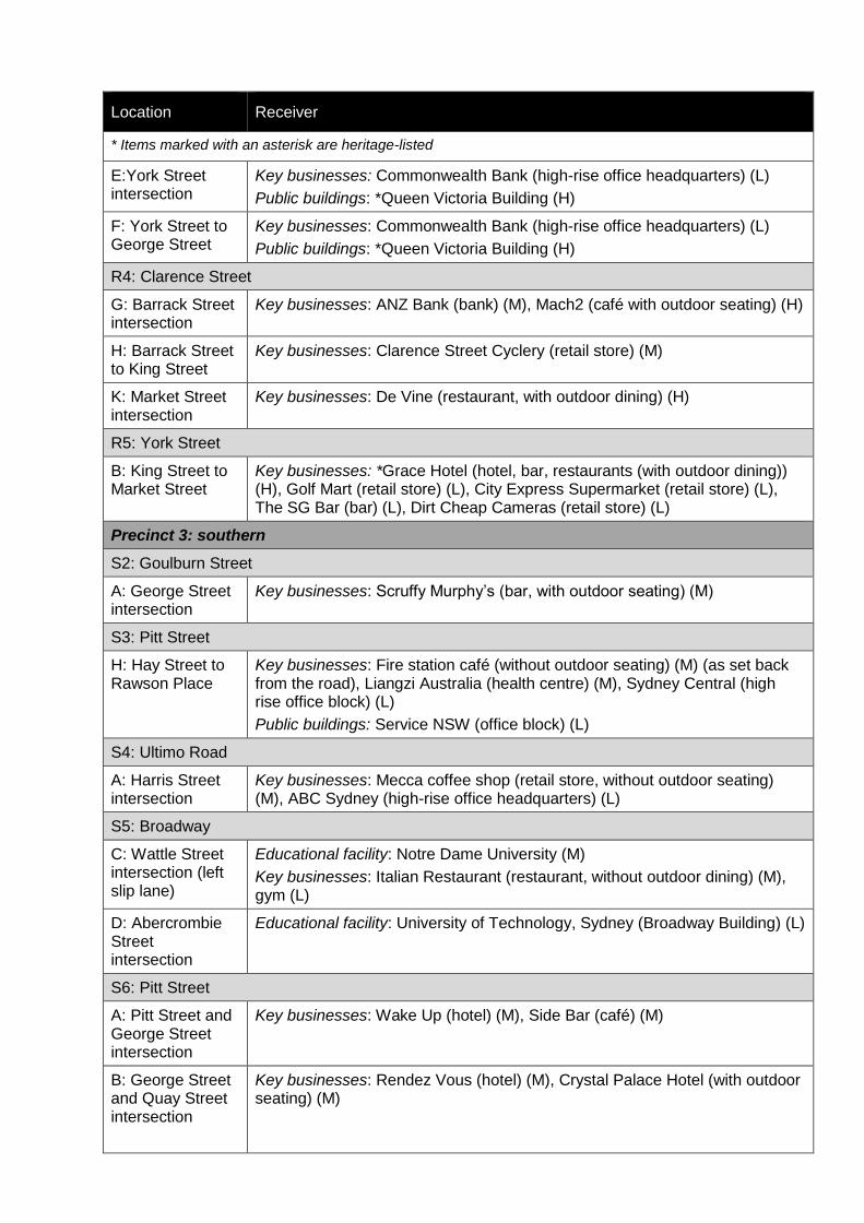
Location Receiver
* Items marked with an asterisk are heritage-listed
E:York Street intersection
Key businesses: Commonwealth Bank (high-rise office headquarters) (L)
Public buildings: *Queen Victoria Building (H)
F: York Street to George Street
Key businesses: Commonwealth Bank (high-rise office headquarters) (L)
Public buildings: *Queen Victoria Building (H)
R4: Clarence Street
G: Barrack Street intersection
Key businesses: ANZ Bank (bank) (M), Mach2 (café with outdoor seating) (H)
H: Barrack Street to King Street
Key businesses: Clarence Street Cyclery (retail store) (M)
K: Market Street intersection
Key businesses: De Vine (restaurant, with outdoor dining) (H)
R5: York Street
B: King Street to Market Street
Key businesses: *Grace Hotel (hotel, bar, restaurants (with outdoor dining)) (H), Golf Mart (retail store) (L), City Express Supermarket (retail store) (L), The SG Bar (bar) (L), Dirt Cheap Cameras (retail store) (L)
Precinct 3: southern
S2: Goulburn Street
A: George Street intersection
Key businesses: Scruffy Murphy’s (bar, with outdoor seating) (M)
S3: Pitt Street
H: Hay Street to Rawson Place
Key businesses: Fire station café (without outdoor seating) (M) (as set back from the road), Liangzi Australia (health centre) (M), Sydney Central (high rise office block) (L)
Public buildings: Service NSW (office block) (L)
S4: Ultimo Road
A: Harris Street intersection
Key businesses: Mecca coffee shop (retail store, without outdoor seating) (M), ABC Sydney (high-rise office headquarters) (L)
S5: Broadway
C: Wattle Street intersection (left slip lane)
Educational facility: Notre Dame University (M)
Key businesses: Italian Restaurant (restaurant, without outdoor dining) (M), gym (L)
D: Abercrombie Street intersection
Educational facility: University of Technology, Sydney (Broadway Building) (L)
S6: Pitt Street
A: Pitt Street and George Street intersection
Key businesses: Wake Up (hotel) (M), Side Bar (café) (M)
B: George Street and Quay Street intersection
Key businesses: Rendez Vous (hotel) (M), Crystal Palace Hotel (with outdoor seating) (M)
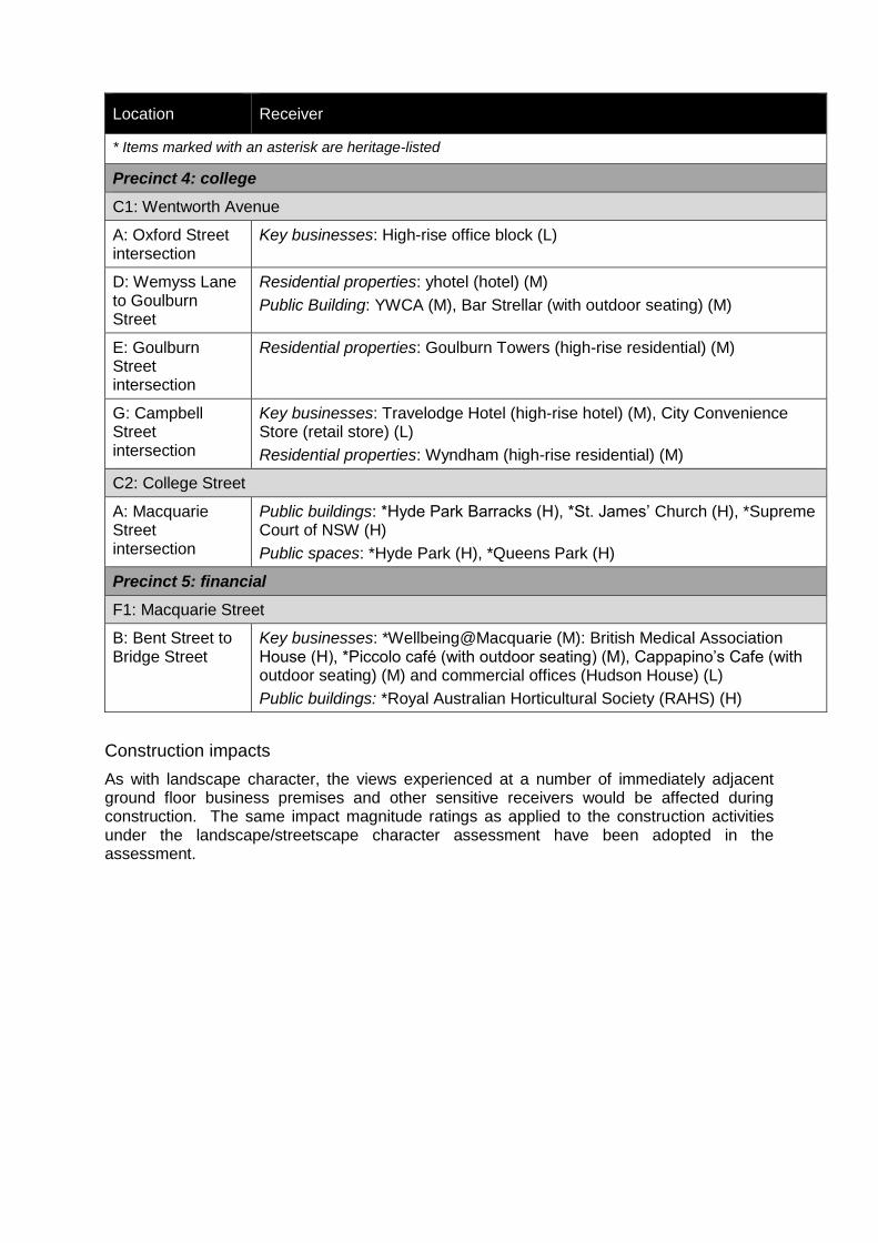
Location Receiver
* Items marked with an asterisk are heritage-listed
Precinct 4: college
C1: Wentworth Avenue
A: Oxford Street intersection
Key businesses: High-rise office block (L)
D: Wemyss Lane to Goulburn Street
Residential properties: yhotel (hotel) (M)
Public Building: YWCA (M), Bar Strellar (with outdoor seating) (M)
E: Goulburn Street intersection
Residential properties: Goulburn Towers (high-rise residential) (M)
G: Campbell Street intersection
Key businesses: Travelodge Hotel (high-rise hotel) (M), City Convenience Store (retail store) (L)
Residential properties: Wyndham (high-rise residential) (M)
C2: College Street
A: Macquarie Street intersection
Public buildings: *Hyde Park Barracks (H), *St. James’ Church (H), *Supreme Court of NSW (H)
Public spaces: *Hyde Park (H), *Queens Park (H)
Precinct 5: financial
F1: Macquarie Street
B: Bent Street to Bridge Street
Key businesses: *Wellbeing@Macquarie (M): British Medical Association House (H), *Piccolo café (with outdoor seating) (M), Cappapino’s Cafe (with outdoor seating) (M) and commercial offices (Hudson House) (L)
Public buildings: *Royal Australian Horticultural Society (RAHS) (H)
Construction impacts
As with landscape character, the views experienced at a number of immediately adjacent ground floor business premises and other sensitive receivers would be affected during construction. The same impact magnitude ratings as applied to the construction activities under the landscape/streetscape character assessment have been adopted in the assessment.

Table I-6 Visual impacts (construction)
Work site Section Visual receiver Traffic capacity improvement Sensitivity to change
Magnitude of change
Visual impact
Precinct 1: north west
NW1: Kent Street
Entire work site NW1: Kent Street
5: Kerbside allocation modifications
6: Lane arrangements
Negligible
NW2: King Street
E: Clarence Street intersection
China Southern NW2: King Street (major work site)
1: Intersection reconfiguration and geometry modifications
2: Kerb extension alterations
5: Kerbside allocation modifications
6: Lane arrangements
Supporting work (drainage modification, general signage relocation, road furniture relocation, street lighting relocation)
Utility adjustment
Low Moderate Moderate-low
Subway Low Moderate Moderate-low
G: York Street intersection Forbes Hotel Moderate Moderate Moderate
CBD Hotel Moderate Moderate Moderate
Grace Hotel High Moderate High-moderate
J: George Street to Pitt Street Hugo Boss Moderate Moderate Moderate
Ben Sherman Moderate Moderate Moderate
Mont Blanc Moderate Moderate Moderate
Precinct 2: retail
R1: Park Street
A: Pitt Street intersection Lowes R1: Park Street (major work site)
2: Kerb extension alterations
Supporting work (drainage modification, general signage relocation, regrade and resurface the road)
Utility adjustment
Low Moderate Moderate-low
Criterion Hotel Moderate Moderate Moderate
R2: Market Street
D: Clarence Street to York Street
Westpac R2: Market Street (major work site)
1: Intersection reconfiguration and geometry modifications
Low Moderate Moderate-low
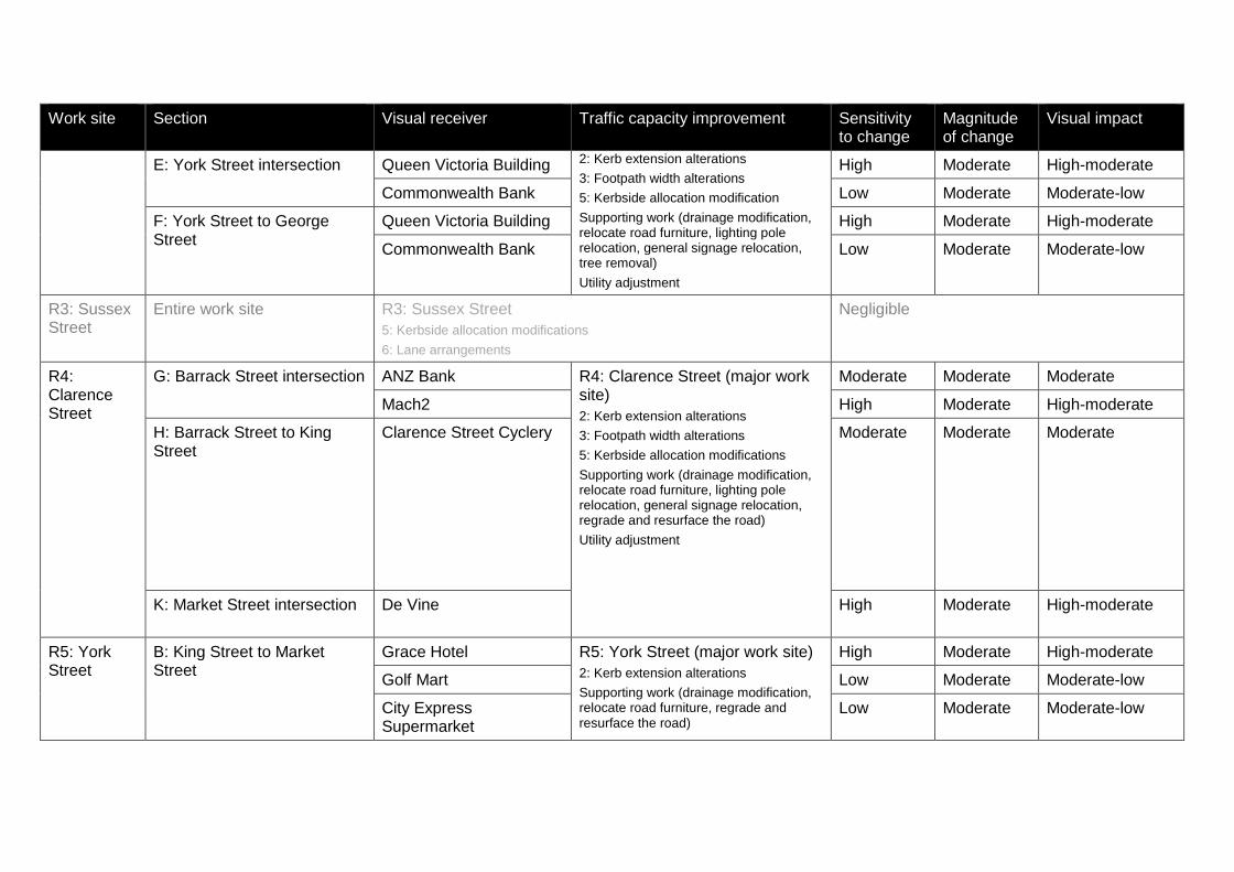
Work site Section Visual receiver Traffic capacity improvement Sensitivity to change
Magnitude of change
Visual impact
E: York Street intersection Queen Victoria Building 2: Kerb extension alterations
3: Footpath width alterations
5: Kerbside allocation modification
Supporting work (drainage modification, relocate road furniture, lighting pole relocation, general signage relocation, tree removal)
Utility adjustment
High Moderate High-moderate
Commonwealth Bank Low Moderate Moderate-low
F: York Street to George Street
Queen Victoria Building High Moderate High-moderate
Commonwealth Bank Low Moderate Moderate-low
R3: Sussex Street
Entire work site R3: Sussex Street
5: Kerbside allocation modifications
6: Lane arrangements
Negligible
R4: Clarence Street
G: Barrack Street intersection ANZ Bank R4: Clarence Street (major work site)
2: Kerb extension alterations
3: Footpath width alterations
5: Kerbside allocation modifications
Supporting work (drainage modification, relocate road furniture, lighting pole relocation, general signage relocation, regrade and resurface the road)
Utility adjustment
Moderate Moderate Moderate
Mach2 High Moderate High-moderate
H: Barrack Street to King Street
Clarence Street Cyclery Moderate Moderate Moderate
K: Market Street intersection De Vine High Moderate High-moderate
R5: York Street
B: King Street to Market Street
Grace Hotel R5: York Street (major work site)
2: Kerb extension alterations
Supporting work (drainage modification, relocate road furniture, regrade and resurface the road)
High Moderate High-moderate
Golf Mart Low Moderate Moderate-low
City Express Supermarket
Low Moderate Moderate-low

Work site Section Visual receiver Traffic capacity improvement Sensitivity to change
Magnitude of change
Visual impact
The SG Bar Utility adjustment Low Low Low
Dirt Cheap Cameras Low Low Low
Precinct 3: southern
S1: Sussex Street
Entire work site S1: Sussex Street
5: Kerbside allocation modifications
Negligible
S2: Goulburn Street
A: George Street intersection Scruffy Murphy’s S2: Goulburn Street (major work site)
2: Kerb extension alterations
Moderate Moderate Moderate
S3: Pitt Street
H: Hay Street to Rawson Place
Fire station café S3: Pitt Street (major work site)
1: Intersection reconfiguration and geometry modifications
4: Turning restrictions and provisions
5: Kerbside allocation modifications
Supporting work (relocate road furniture, regrade and resurface the road)
Moderate Moderate Moderate
Liangzi Australia Moderate Moderate Moderate
Sydney Central Low Moderate Moderate-low
Service NSW Low Moderate Moderate-low
S4: Ultimo Road
A: Harris Street intersection Mecca coffee shop S4: Ultimo Road (major work site)
1: Intersection reconfiguration and geometry modifications
Supporting work (relocate road furniture, regrade and resurface the road)
Moderate Moderate Moderate
ABC Sydney Low Moderate Moderate-low
S5: Broadway
C: Wattle Street intersection Notre Dame University S5: Broadway (major work site)
1: Intersection reconfiguration and geometry modifications
2: Kerb extension alterations
Moderate Moderate Moderate
Italian Restaurant Moderate Moderate Moderate
Gym Low Moderate Moderate-low

Work site Section Visual receiver Traffic capacity improvement Sensitivity to change
Magnitude of change
Visual impact
D: Abercrombie Street intersection
University of Technology 5: Kerbside allocation modifications
6: Lane arrangements
Supporting work (drainage modifications, relocate road furniture, regrade and resurface the road)
Utility adjustment
Low Moderate Moderate-low
S6: Pitt Street
A: Pitt Street and George Street intersection
Rendez Vous S6: Pitt Street (major work site)
1: Intersection reconfiguration and geometry modifications
2: Kerb extension alterations
Supporting work (drainage modifications, relocate one bus stop, relocate road furniture, regrade and resurface the road, tree removal)
Utility adjustment
Moderate Moderate Moderate
Crystal Palace Moderate Moderate Moderate
B: George Street and Quay Street intersection
Wake Up Moderate Moderate Moderate
Side Bar Moderate Moderate Moderate
Precinct 4: college
C1: Wentworth Avenue
A: Oxford Street intersection High-rise office block C1: Wentworth Avenue (major work site)
1: Intersection reconfiguration and geometry modifications
2: Kerb extension alterations
3: Footpath width alterations
5: Kerbside allocation modifications
Supporting work (drainage modifications, relocate one bus stop, relocate road furniture, regrade and resurface the road, tree removal)
Utility adjustment
Low Moderate Moderate-low
D: Wemyss Lane to Goulburn Street
Yhotel Moderate Moderate Moderate
YWCA Moderate Moderate Moderate
Bar Strellar Moderate Moderate Moderate
E: Goulburn Street intersection
Goulburn Towers Moderate Moderate Moderate
G: Campbell Street City Convenience Store Low Moderate Moderate-low
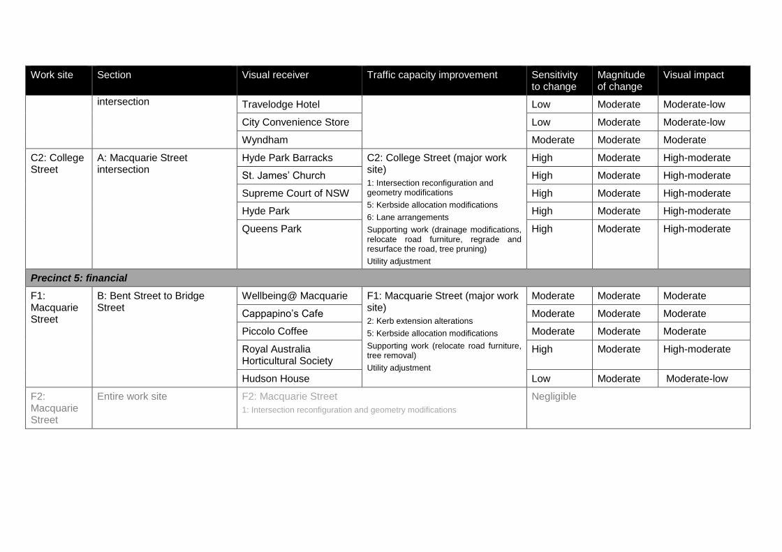
Work site Section Visual receiver Traffic capacity improvement Sensitivity to change
Magnitude of change
Visual impact
intersection Travelodge Hotel Low Moderate Moderate-low
City Convenience Store Low Moderate Moderate-low
Wyndham Moderate Moderate Moderate
C2: College Street
A: Macquarie Street intersection
Hyde Park Barracks C2: College Street (major work site)
1: Intersection reconfiguration and geometry modifications
5: Kerbside allocation modifications
6: Lane arrangements
Supporting work (drainage modifications, relocate road furniture, regrade and resurface the road, tree pruning)
Utility adjustment
High Moderate High-moderate
St. James’ Church High Moderate High-moderate
Supreme Court of NSW High Moderate High-moderate
Hyde Park High Moderate High-moderate
Queens Park High Moderate High-moderate
Precinct 5: financial
F1: Macquarie Street
B: Bent Street to Bridge Street
Wellbeing@ Macquarie F1: Macquarie Street (major work site)
2: Kerb extension alterations
5: Kerbside allocation modifications
Supporting work (relocate road furniture, tree removal)
Utility adjustment
Moderate Moderate Moderate
Cappapino’s Cafe Moderate Moderate Moderate
Piccolo Coffee Moderate Moderate Moderate
Royal Australia Horticultural Society
High Moderate High-moderate
Hudson House Low Moderate Moderate-low
F2: Macquarie Street
Entire work site F2: Macquarie Street
1: Intersection reconfiguration and geometry modifications
Negligible

Operational impacts
Drivers, pedestrians, cyclists and other road users (including retail customers, tourists and office workers) would have transient views of the proposal. There would be few fixed receivers at ground-level who would be permanently impacted. Despite this, many of the city’s streets are used on a daily basis by commuters. They tend to have established travel patterns using the same routes to travel to and from work at the same times each day. Consequently, whilst they form a transient receiver group they would be routinely exposed to the changes introduced under the proposal and are therefore more sensitive than occasional visitors (assuming they would not permanently change their travel patterns in response to the proposal (refer to section 6.1.3)). This regular exposure would likely extend to the use of shops, cafés, restaurants and bus stops. A number of residential properties overlook the affected streets. Whilst these receivers would not be likely to be able to distinguish between individual components introduced under the proposal, they would be able to distinguish the overall increase in traffic capacity and introduction of additional traffic lanes and turning movements along the affected roads. The overall impact would be affected by the altered street geometries and the ‘intensification’ of traffic within sections of road corridor. There would also be some visual changes due to the relocation of equipment, lighting posts, traffic signals and the removal of trees Table I-7 (overleaf) describes the visual impacts across the proposal footprint relative to each assessed receiver. Change has been assessed as:
1: Intersection reconfiguration and geometry modifications: negligible-low
2: Kerb extension alterations: negligible-low
3: Footpath width alterations: negligible-low
5: Kerbside allocation modifications: negligible
6: Lane arrangements: negligible
Again, the overall change would depend on the scale of the work. In certain locations, multiple traffic capacity improvements would have been installed, whilst in other locations the degree of change would be larger to achieve the same general type of improvement (e.g. the kerb would be adjusted more in one location than another). This is reflected in the following table and above ratings.
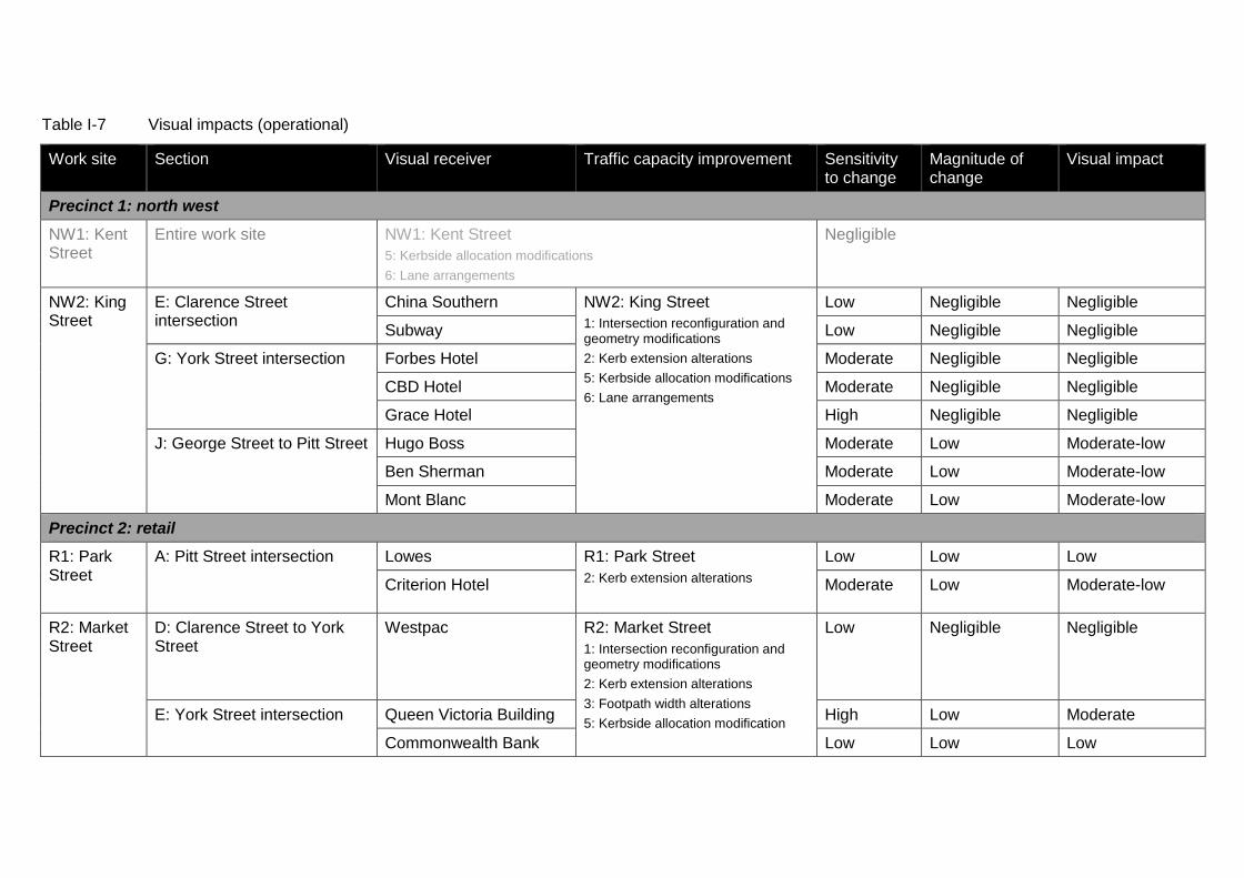
Table I-7 Visual impacts (operational)
Work site Section Visual receiver Traffic capacity improvement Sensitivity to change
Magnitude of change
Visual impact
Precinct 1: north west
NW1: Kent Street
Entire work site NW1: Kent Street
5: Kerbside allocation modifications
6: Lane arrangements
Negligible
NW2: King Street
E: Clarence Street intersection
China Southern NW2: King Street
1: Intersection reconfiguration and geometry modifications
2: Kerb extension alterations
5: Kerbside allocation modifications
6: Lane arrangements
Low Negligible Negligible
Subway Low Negligible Negligible
G: York Street intersection Forbes Hotel Moderate Negligible Negligible
CBD Hotel Moderate Negligible Negligible
Grace Hotel High Negligible Negligible
J: George Street to Pitt Street Hugo Boss Moderate Low Moderate-low
Ben Sherman Moderate Low Moderate-low
Mont Blanc Moderate Low Moderate-low
Precinct 2: retail
R1: Park Street
A: Pitt Street intersection Lowes R1: Park Street
2: Kerb extension alterations
Low Low Low
Criterion Hotel Moderate Low Moderate-low
R2: Market Street
D: Clarence Street to York Street
Westpac R2: Market Street
1: Intersection reconfiguration and geometry modifications
2: Kerb extension alterations
3: Footpath width alterations
5: Kerbside allocation modification
Low Negligible Negligible
E: York Street intersection Queen Victoria Building High Low Moderate
Commonwealth Bank Low Low Low

Work site Section Visual receiver Traffic capacity improvement Sensitivity to change
Magnitude of change
Visual impact
F: York Street to George Street
Queen Victoria Building High Low Moderate
Commonwealth Bank Low Low Moderate-low
R3: Sussex Street
Entire work site R3: Sussex Street
5: Kerbside allocation modifications
6: Lane arrangements
Negligible
R4: Clarence Street
G: Barrack Street intersection ANZ Bank R4: Clarence Street
2: Kerb extension alterations
3: Footpath width alterations
5: Kerbside allocation modifications
Moderate Low Moderate-low
Mach2 High Low Moderate
H: Barrack Street to King Street
Clarence Street Cyclery Moderate Low Moderate-low
K: Market Street intersection De Vine High Low Moderate
R5: York Street
B: King Street to Market Street
Grace Hotel R5: York Street
2: Kerb extension alterations
High Low Moderate
Golf Mart Low Low Low
City Express Supermarket
Low Low Low
The SG Bar Low Low Low
Dirt Cheap Cameras Low Low Low
Precinct 3: southern
S1: Sussex Entire work site S1: Sussex Street Negligible
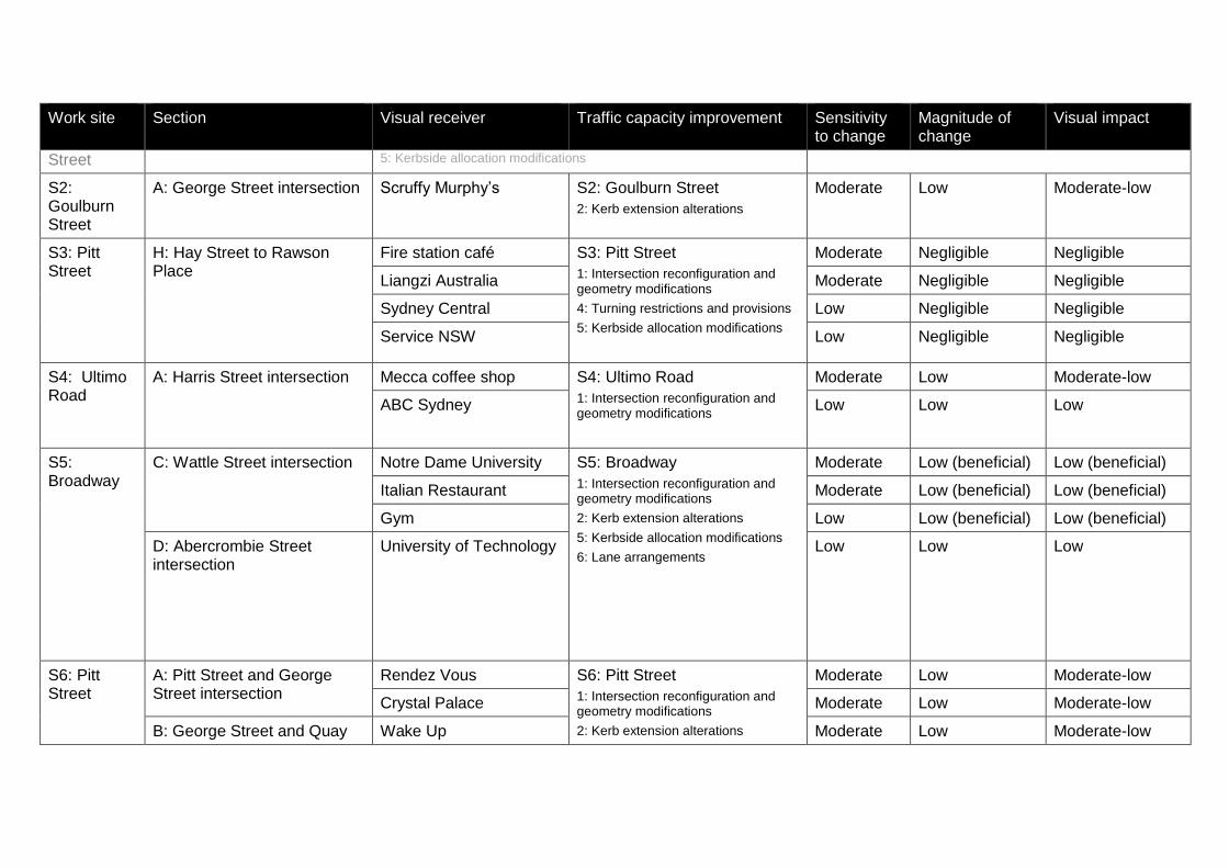
Work site Section Visual receiver Traffic capacity improvement Sensitivity to change
Magnitude of change
Visual impact
Street 5: Kerbside allocation modifications
S2: Goulburn Street
A: George Street intersection Scruffy Murphy’s S2: Goulburn Street
2: Kerb extension alterations
Moderate Low Moderate-low
S3: Pitt Street
H: Hay Street to Rawson Place
Fire station café S3: Pitt Street
1: Intersection reconfiguration and geometry modifications
4: Turning restrictions and provisions
5: Kerbside allocation modifications
Moderate Negligible Negligible
Liangzi Australia Moderate Negligible Negligible
Sydney Central Low Negligible Negligible
Service NSW Low Negligible Negligible
S4: Ultimo Road
A: Harris Street intersection Mecca coffee shop S4: Ultimo Road
1: Intersection reconfiguration and geometry modifications
Moderate Low Moderate-low
ABC Sydney Low Low Low
S5: Broadway
C: Wattle Street intersection Notre Dame University S5: Broadway
1: Intersection reconfiguration and geometry modifications
2: Kerb extension alterations
5: Kerbside allocation modifications
6: Lane arrangements
Moderate Low (beneficial) Low (beneficial)
Italian Restaurant Moderate Low (beneficial) Low (beneficial)
Gym Low Low (beneficial) Low (beneficial)
D: Abercrombie Street intersection
University of Technology Low Low Low
S6: Pitt Street
A: Pitt Street and George Street intersection
Rendez Vous S6: Pitt Street
1: Intersection reconfiguration and geometry modifications
2: Kerb extension alterations
Moderate Low Moderate-low
Crystal Palace Moderate Low Moderate-low
B: George Street and Quay Wake Up Moderate Low Moderate-low
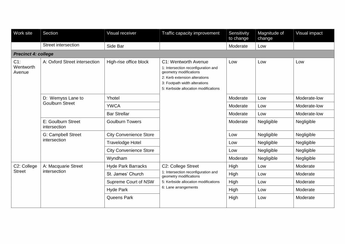
Work site Section Visual receiver Traffic capacity improvement Sensitivity to change
Magnitude of change
Visual impact
Street intersection Side Bar Moderate Low
Precinct 4: college
C1: Wentworth Avenue
A: Oxford Street intersection High-rise office block C1: Wentworth Avenue
1: Intersection reconfiguration and geometry modifications
2: Kerb extension alterations
3: Footpath width alterations
5: Kerbside allocation modifications
Low Low Low
D: Wemyss Lane to Goulburn Street
Yhotel Moderate Low Moderate-low
YWCA Moderate Low Moderate-low
Bar Strellar Moderate Low Moderate-low
E: Goulburn Street intersection
Goulburn Towers Moderate Negligible Negligible
G: Campbell Street intersection
City Convenience Store Low Negligible Negligible
Travelodge Hotel Low Negligible Negligible
City Convenience Store Low Negligible Negligible
Wyndham Moderate Negligible Negligible
C2: College Street
A: Macquarie Street intersection
Hyde Park Barracks C2: College Street
1: Intersection reconfiguration and geometry modifications
5: Kerbside allocation modifications
6: Lane arrangements
High Low Moderate
St. James’ Church High Low Moderate
Supreme Court of NSW High Low Moderate
Hyde Park High Low Moderate
Queens Park
High Low Moderate
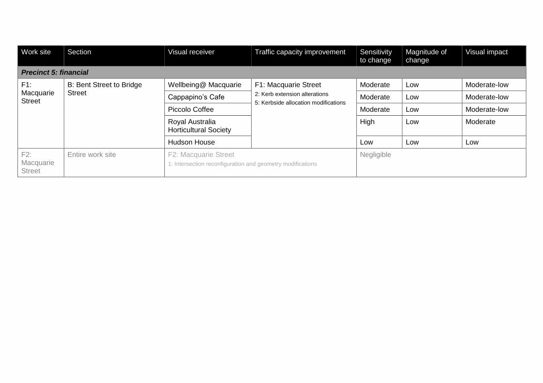
Work site Section Visual receiver Traffic capacity improvement Sensitivity to change
Magnitude of change
Visual impact
Precinct 5: financial
F1: Macquarie Street
B: Bent Street to Bridge Street
Wellbeing@ Macquarie F1: Macquarie Street
2: Kerb extension alterations
5: Kerbside allocation modifications
Moderate Low Moderate-low
Cappapino’s Cafe Moderate Low Moderate-low
Piccolo Coffee Moderate Low Moderate-low
Royal Australia Horticultural Society
High Low Moderate
Hudson House Low Low Low
F2: Macquarie Street
Entire work site F2: Macquarie Street
1: Intersection reconfiguration and geometry modifications
Negligible

Sydney City Centre Capacity Improvement Plan Appendix JReview of Environmental Factors
Appendix JBiodiversity detailed search results

EPBC Act Protected Matters Report
This report provides general guidance on matters of national environmental significance and othermatters protected by the EPBC Act in the area you have selected.
Information on the coverage of this report and qualifications on data supporting this report arecontained in the caveat at the end of the report.
Information is available about Environment Assessments and the EPBC Act including significanceguidelines, forms and application process details.
Other Matters Protected by the EPBC Act
Acknowledgements
Buffer: 10.0Km
Matters of NES
Report created: 26/09/14 09:50:13
Coordinates
This map may contain data which are©Commonwealth of Australia(Geoscience Australia), ©PSMA 2010
CaveatExtra Information
DetailsSummary
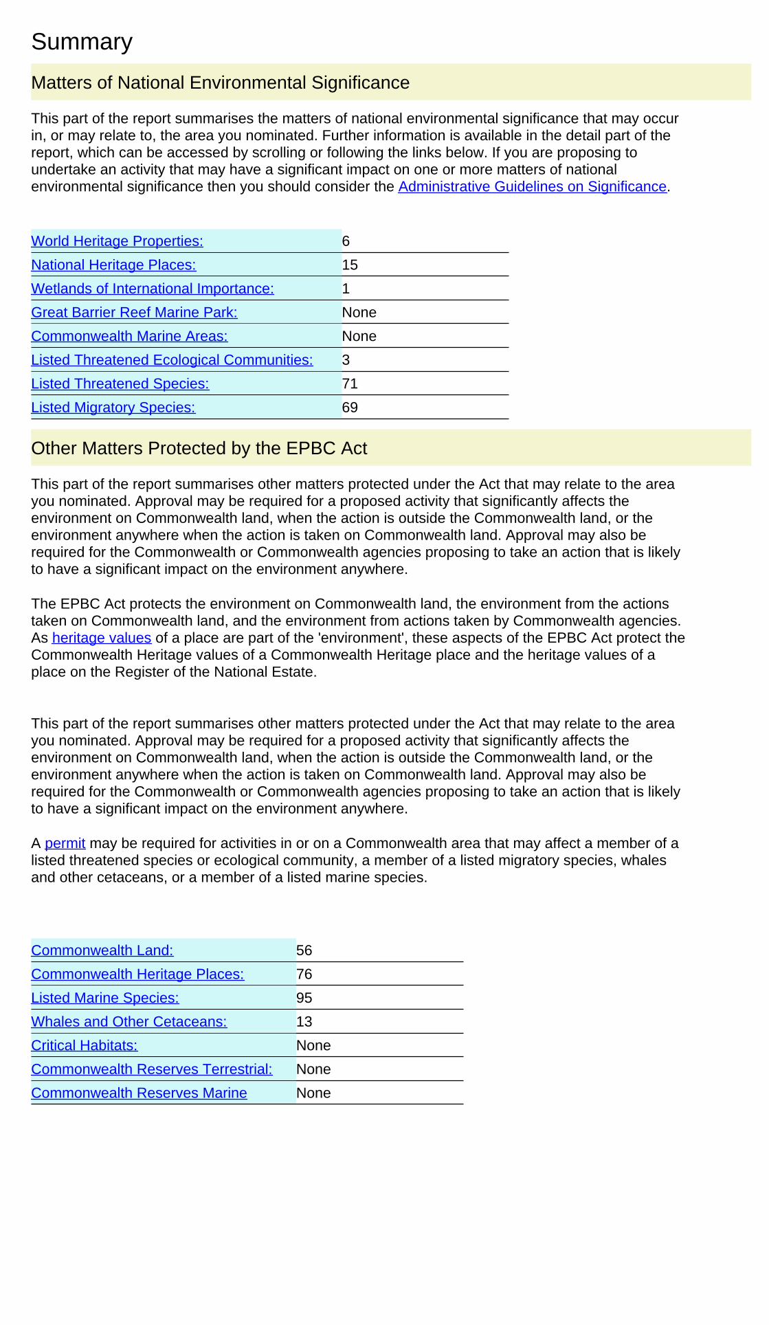
Summary
This part of the report summarises the matters of national environmental significance that may occurin, or may relate to, the area you nominated. Further information is available in the detail part of thereport, which can be accessed by scrolling or following the links below. If you are proposing toundertake an activity that may have a significant impact on one or more matters of nationalenvironmental significance then you should consider the Administrative Guidelines on Significance.
Matters of National Environmental Significance
Listed Threatened Ecological Communities:
Listed Migratory Species:
3
Great Barrier Reef Marine Park:
Wetlands of International Importance:
Listed Threatened Species:
None
71
15
6
National Heritage Places:
Commonwealth Marine Areas:
World Heritage Properties:
1
None
69
This part of the report summarises other matters protected under the Act that may relate to the areayou nominated. Approval may be required for a proposed activity that significantly affects theenvironment on Commonwealth land, when the action is outside the Commonwealth land, or theenvironment anywhere when the action is taken on Commonwealth land. Approval may also berequired for the Commonwealth or Commonwealth agencies proposing to take an action that is likelyto have a significant impact on the environment anywhere.
The EPBC Act protects the environment on Commonwealth land, the environment from the actionstaken on Commonwealth land, and the environment from actions taken by Commonwealth agencies.As heritage values of a place are part of the 'environment', these aspects of the EPBC Act protect theCommonwealth Heritage values of a Commonwealth Heritage place and the heritage values of aplace on the Register of the National Estate.
This part of the report summarises other matters protected under the Act that may relate to the areayou nominated. Approval may be required for a proposed activity that significantly affects theenvironment on Commonwealth land, when the action is outside the Commonwealth land, or theenvironment anywhere when the action is taken on Commonwealth land. Approval may also berequired for the Commonwealth or Commonwealth agencies proposing to take an action that is likelyto have a significant impact on the environment anywhere.
A permit may be required for activities in or on a Commonwealth area that may affect a member of alisted threatened species or ecological community, a member of a listed migratory species, whalesand other cetaceans, or a member of a listed marine species.
Other Matters Protected by the EPBC Act
None
None
13
Listed Marine Species:
Whales and Other Cetaceans:
95
Commonwealth Heritage Places:
56
76
Critical Habitats:
Commonwealth Land:
Commonwealth Reserves Terrestrial:
NoneCommonwealth Reserves Marine

Details
Wetlands of International Importance (RAMSAR) [ Resource Information ]Name ProximityTowra point nature reserve Within 10km of Ramsar
World Heritage Properties [ Resource Information ]Name StatusStateAustralian Convict Sites (Cockatoo Island Convict Site BufferZone)
Declared propertyNSW
Australian Convict Sites (Cockatoo Island Convict Site) Declared propertyNSWAustralian Convict Sites (Hyde Park Barracks Buffer Zone) Declared propertyNSWAustralian Convict Sites (Hyde Park Barracks) Declared propertyNSWSydney Opera House Declared propertyNSWSydney Opera House - Buffer Zone Declared propertyNSW
National Heritage Properties [ Resource Information ]Name StatusStateIndigenousCyprus Hellene Club - Australian Hall Listed placeNSWHistoricIndependent Theatre Indicative placeNSWBondi Beach Listed placeNSWCockatoo Island Listed placeNSWFirst Government House Site Listed placeNSWHyde Park Barracks Listed placeNSWNorth Head - Sydney Listed placeNSWSydney Harbour Bridge Listed placeNSWSydney Opera House Listed placeNSWAustralia's 3 Little Italys - Norton Street Precinct Nominated placeNSWCallan Park Conservation Area and Buildings Nominated placeNSWColonial Sydney Nominated placeNSWKelly's Bush Nominated placeNSWNational Trust Urban Conservation Areas of Kur-ring-gai Nominated placeNSWBondi Surf Pavilion Within listed placeNSW
For threatened ecological communities where the distribution is well known, maps are derived fromrecovery plans, State vegetation maps, remote sensing imagery and other sources. Where threatenedecological community distributions are less well known, existing vegetation maps and point locationdata are used to produce indicative distribution maps.
Listed Threatened Ecological Communities [ Resource Information ]
Name Status Type of PresenceEastern Suburbs Banksia Scrub of the SydneyRegion
Endangered Community known tooccur within area
Turpentine-Ironbark Forest in the Sydney BasinBioregion
Critically Endangered Community likely tooccur within area
Western Sydney Dry Rainforest and MoistWoodland on Shale
Critically Endangered Community may occurwithin area
Matters of National Environmental Significance
This part of the report provides information that may also be relevant to the area you have nominated.
Extra Information
Regional Forest Agreements:
49
Place on the RNE:
5
1
Invasive Species:
None
Nationally Important Wetlands:
State and Territory Reserves:
1681
Key Ecological Features (Marine) None

Listed Threatened Species [ Resource Information ]Name Status Type of PresenceBirds
Regent Honeyeater [82338] Endangered Species or specieshabitat known to occurwithin area
Anthochaera phrygia
Australasian Bittern [1001] Endangered Species or specieshabitat known to occurwithin area
Botaurus poiciloptilus
Eastern Bristlebird [533] Endangered Species or specieshabitat likely to occurwithin area
Dasyornis brachypterus
Southern Royal Albatross [25996] Vulnerable Foraging, feeding orrelated behaviour likelyto occur within area
Diomedea epomophora epomophora
Northern Royal Albatross [82331] Endangered Foraging, feeding orrelated behaviour likelyto occur within area
Diomedea epomophora sanfordi
Antipodean Albatross [82269] Vulnerable Foraging, feeding orrelated behaviour likelyto occur within area
Diomedea exulans antipodensis
Tristan Albatross [82337] Endangered Species or specieshabitat may occur withinarea
Diomedea exulans exulans
Gibson's Albatross [82271] Vulnerable Foraging, feeding orrelated behaviour likelyto occur within area
Diomedea exulans gibsoni
Wandering Albatross [1073] Vulnerable Foraging, feeding orrelated behaviour likelyto occur within area
Diomedea exulans (sensu lato)
White-bellied Storm-Petrel (Tasman Sea), White-bellied Storm-Petrel (Australasian) [64438]
Vulnerable Species or specieshabitat likely to occurwithin area
Fregetta grallaria grallaria
Swift Parrot [744] Endangered Species or specieshabitat likely to occurwithin area
Lathamus discolor
Southern Giant-Petrel [1060] Endangered Species or specieshabitat may occur withinarea
Macronectes giganteus
Northern Giant-Petrel [1061] Vulnerable Species or specieshabitat may occur withinarea
Macronectes halli
Orange-bellied Parrot [747] Critically Endangered Species or specieshabitat may occur withinarea
Neophema chrysogaster
Gould's Petrel [26033] Endangered Species or specieshabitat may occur withinarea
Pterodroma leucoptera leucoptera
Kermadec Petrel (western) [64450] Vulnerable Foraging, feeding orrelated behaviour mayoccur within area
Pterodroma neglecta neglecta
Australian Painted Snipe [77037] Endangered Species or specieshabitat likely to occurwithin area
Rostratula australis
Australian Fairy Tern [82950] Vulnerable Species or speciesSternula nereis nereis
Name Status Type of Presencehabitat known to occurwithin area
Buller's Albatross, Pacific Albatross [64460] Vulnerable Species or specieshabitat may occur withinarea
Thalassarche bulleri
Shy Albatross, Tasmanian Shy Albatross [82345] Vulnerable Foraging, feeding orrelated behaviour likelyto occur within area
Thalassarche cauta cauta
Salvin's Albatross [82343] Vulnerable Foraging, feeding orrelated behaviour likelyto occur within area
Thalassarche cauta salvini
White-capped Albatross [82344] Vulnerable Foraging, feeding orrelated behaviour likelyto occur within area
Thalassarche cauta steadi
Chatham Albatross [64457] Endangered Foraging, feeding orrelated behaviour likelyto occur within area
Thalassarche eremita
Black-browed Albatross [66472] Vulnerable Species or specieshabitat may occur withinarea
Thalassarche melanophris
Campbell Albatross [82449] Vulnerable Species or specieshabitat may occur withinarea
Thalassarche melanophris impavida
Fish
Black Rockcod, Black Cod, Saddled Rockcod[68449]
Vulnerable Species or specieshabitat likely to occurwithin area
Epinephelus daemelii
Australian Grayling [26179] Vulnerable Species or specieshabitat likely to occurwithin area
Prototroctes maraena
Frogs
Giant Burrowing Frog [1973] Vulnerable Species or specieshabitat likely to occurwithin area
Heleioporus australiacus
Green and Golden Bell Frog [1870] Vulnerable Species or specieshabitat likely to occurwithin area
Litoria aurea
Stuttering Frog, Southern Barred Frog (in Victoria)[1942]
Vulnerable Species or specieshabitat likely to occurwithin area
Mixophyes balbus
Mammals
Large-eared Pied Bat, Large Pied Bat [183] Vulnerable Species or specieshabitat likely to occurwithin area
Chalinolobus dwyeri
Spot-tailed Quoll, Spotted-tail Quoll, Tiger Quoll(southeastern mainland population) [75184]
Endangered Species or specieshabitat known to occurwithin area
Dasyurus maculatus maculatus (SE mainland population)
Southern Right Whale [40] Endangered Species or specieshabitat known to occurwithin area
Eubalaena australis
Southern Brown Bandicoot (Eastern) [68050] Endangered Species or specieshabitat likely to occurwithin area
Isoodon obesulus obesulus
Humpback Whale [38] Vulnerable Species or specieshabitat known to occurwithin area
Megaptera novaeangliae
Name Status Type of Presence
Brush-tailed Rock-wallaby [225] Vulnerable Species or specieshabitat may occur withinarea
Petrogale penicillata
Koala (combined populations of Queensland, NewSouth Wales and the Australian Capital Territory)[85104]
Vulnerable Species or specieshabitat likely to occurwithin area
Phascolarctos cinereus (combined populations of Qld, NSW and the ACT)
New Holland Mouse, Pookila [96] Vulnerable Species or specieshabitat likely to occurwithin area
Pseudomys novaehollandiae
Grey-headed Flying-fox [186] Vulnerable Roosting known to occurwithin area
Pteropus poliocephalus
Plants
Bynoe's Wattle, Tiny Wattle [8575] Vulnerable Species or specieshabitat likely to occurwithin area
Acacia bynoeana
Downy Wattle, Hairy Stemmed Wattle [18800] Vulnerable Species or specieshabitat likely to occurwithin area
Acacia pubescens
Sunshine Wattle [64829] Endangered Species or specieshabitat known to occurwithin area
Acacia terminalis subsp. terminalis MS
[21932] Endangered Species or specieshabitat may occur withinarea
Allocasuarina glareicola
Nielsen Park She-oak [21937] Endangered Species or specieshabitat known to occurwithin area
Allocasuarina portuensis
[56780] Endangered Species or specieshabitat may occur withinarea
Asterolasia elegans
Thick-lipped Spider-orchid, Daddy Long-legs[2119]
Vulnerable Species or specieshabitat likely to occurwithin area
Caladenia tessellata
Leafless Tongue-orchid [19533] Vulnerable Species or specieshabitat likely to occurwithin area
Cryptostylis hunteriana
[14619] Vulnerable Species or specieshabitat likely to occurwithin area
Darwinia biflora
[7438] Endangered Species or specieshabitat likely to occurwithin area
Deyeuxia appressa
Camfield's Stringybark [15460] Vulnerable Species or specieshabitat likely to occurwithin area
Eucalyptus camfieldii
Yellow Gnat-orchid [7528] Endangered Species or specieshabitat known to occurwithin area
Genoplesium baueri
Biconvex Paperbark [5583] Vulnerable Species or specieshabitat may occur withinarea
Melaleuca biconvexa
Deane's Melaleuca [5818] Vulnerable Species or specieshabitat may occur withinarea
Melaleuca deanei

Name Status Type of Presence
Angus's Onion Orchid [64530] Endangered Species or specieshabitat likely to occurwithin area
Microtis angusii
Omeo Stork's-bill [84065] Endangered Species or specieshabitat may occur withinarea
Pelargonium sp. Striatellum (G.W.Carr 10345)
[4182] Vulnerable Species or specieshabitat known to occurwithin area
Pimelea curviflora var. curviflora
Spiked Rice-flower [20834] Endangered Species or specieshabitat may occur withinarea
Pimelea spicata
Seaforth Mintbush [7555] Critically Endangered Species or specieshabitat known to occurwithin area
Prostanthera marifolia
Siah's Backbone, Sia's Backbone, Isaac Wood[21618]
Endangered Species or specieshabitat likely to occurwithin area
Streblus pendulinus
Magenta Lilly Pilly, Magenta Cherry, Pocket-lessBrush Cherry, Scrub Cherry, Creek Lilly Pilly,Brush Cherry [20307]
Vulnerable Species or specieshabitat likely to occurwithin area
Syzygium paniculatum
Austral Toadflax, Toadflax [15202] Vulnerable Species or specieshabitat likely to occurwithin area
Thesium australe
Reptiles
Loggerhead Turtle [1763] Endangered Species or specieshabitat known to occurwithin area
Caretta caretta
Green Turtle [1765] Vulnerable Foraging, feeding orrelated behaviour knownto occur within area
Chelonia mydas
Leatherback Turtle, Leathery Turtle, Luth [1768] Endangered Foraging, feeding orrelated behaviour knownto occur within area
Dermochelys coriacea
Hawksbill Turtle [1766] Vulnerable Species or specieshabitat known to occurwithin area
Eretmochelys imbricata
Broad-headed Snake [1182] Vulnerable Species or specieshabitat likely to occurwithin area
Hoplocephalus bungaroides
Flatback Turtle [59257] Vulnerable Foraging, feeding orrelated behaviour knownto occur within area
Natator depressus
Sharks
Grey Nurse Shark (east coast population) [68751] Critically Endangered Species or specieshabitat known to occurwithin area
Carcharias taurus (east coast population)
Great White Shark [64470] Vulnerable Species or specieshabitat known to occurwithin area
Carcharodon carcharias
Green Sawfish, Dindagubba, Narrowsnout Sawfish[68442]
Vulnerable Species or specieshabitat may occur withinarea
Pristis zijsron
Whale Shark [66680] Vulnerable Species or specieshabitat may occur within
Rhincodon typus
Name Status Type of Presencearea
Listed Migratory Species [ Resource Information ]* Species is listed under a different scientific name on the EPBC Act - Threatened Species list.Name Threatened Type of PresenceMigratory Marine Birds
Fork-tailed Swift [678] Species or specieshabitat likely to occurwithin area
Apus pacificus
Antipodean Albatross [64458] Vulnerable* Foraging, feeding orrelated behaviour likelyto occur within area
Diomedea antipodensis
Tristan Albatross [66471] Endangered* Species or specieshabitat may occur withinarea
Diomedea dabbenena
Southern Royal Albatross [1072] Vulnerable* Foraging, feeding orrelated behaviour likelyto occur within area
Diomedea epomophora (sensu stricto)
Wandering Albatross [1073] Vulnerable Foraging, feeding orrelated behaviour likelyto occur within area
Diomedea exulans (sensu lato)
Gibson's Albatross [64466] Vulnerable* Foraging, feeding orrelated behaviour likelyto occur within area
Diomedea gibsoni
Northern Royal Albatross [64456] Endangered* Foraging, feeding orrelated behaviour likelyto occur within area
Diomedea sanfordi
Southern Giant-Petrel [1060] Endangered Species or specieshabitat may occur withinarea
Macronectes giganteus
Northern Giant-Petrel [1061] Vulnerable Species or specieshabitat may occur withinarea
Macronectes halli
Flesh-footed Shearwater, Fleshy-footedShearwater [1043]
Foraging, feeding orrelated behaviour likelyto occur within area
Puffinus carneipes
Little Tern [813] Breeding likely to occurwithin area
Sterna albifrons
Buller's Albatross, Pacific Albatross [64460] Vulnerable Species or specieshabitat may occur withinarea
Thalassarche bulleri
Shy Albatross, Tasmanian Shy Albatross [64697] Vulnerable* Foraging, feeding orrelated behaviour likelyto occur within area
Thalassarche cauta (sensu stricto)
Chatham Albatross [64457] Endangered Foraging, feeding orrelated behaviour likelyto occur within area
Thalassarche eremita
Campbell Albatross [64459] Vulnerable* Species or specieshabitat may occur withinarea
Thalassarche impavida
Black-browed Albatross [66472] Vulnerable Species or specieshabitat may occur withinarea
Thalassarche melanophris
Salvin's Albatross [64463] Vulnerable* Foraging, feeding orrelated behaviour likelyto occur within area
Thalassarche salvini

Name Threatened Type of Presence
White-capped Albatross [64462] Vulnerable* Foraging, feeding orrelated behaviour likelyto occur within area
Thalassarche steadi
Migratory Marine Species
Bryde's Whale [35] Species or specieshabitat may occur withinarea
Balaenoptera edeni
Pygmy Right Whale [39] Species or specieshabitat may occur withinarea
Caperea marginata
Great White Shark [64470] Vulnerable Species or specieshabitat known to occurwithin area
Carcharodon carcharias
Loggerhead Turtle [1763] Endangered Species or specieshabitat known to occurwithin area
Caretta caretta
Green Turtle [1765] Vulnerable Foraging, feeding orrelated behaviour knownto occur within area
Chelonia mydas
Leatherback Turtle, Leathery Turtle, Luth [1768] Endangered Foraging, feeding orrelated behaviour knownto occur within area
Dermochelys coriacea
Dugong [28] Species or specieshabitat may occur withinarea
Dugong dugon
Hawksbill Turtle [1766] Vulnerable Species or specieshabitat known to occurwithin area
Eretmochelys imbricata
Southern Right Whale [40] Endangered Species or specieshabitat known to occurwithin area
Eubalaena australis
Dusky Dolphin [43] Species or specieshabitat may occur withinarea
Lagenorhynchus obscurus
Porbeagle, Mackerel Shark [83288] Species or specieshabitat likely to occurwithin area
Lamna nasus
Giant Manta Ray, Chevron Manta Ray, PacificManta Ray, Pelagic Manta Ray, Oceanic Manta Ray[84995]
Species or specieshabitat may occur withinarea
Manta birostris
Humpback Whale [38] Vulnerable Species or specieshabitat known to occurwithin area
Megaptera novaeangliae
Flatback Turtle [59257] Vulnerable Foraging, feeding orrelated behaviour knownto occur within area
Natator depressus
Killer Whale, Orca [46] Species or specieshabitat may occur withinarea
Orcinus orca
Whale Shark [66680] Vulnerable Species or specieshabitat may occur withinarea
Rhincodon typus
Indo-Pacific Humpback Dolphin [50] Species or specieshabitat likely to occurwithin area
Sousa chinensis
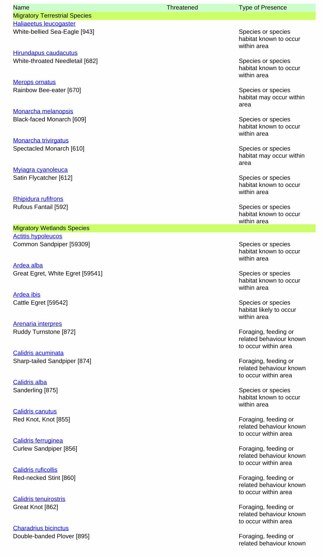
Name Threatened Type of PresenceMigratory Terrestrial Species
White-bellied Sea-Eagle [943] Species or specieshabitat known to occurwithin area
Haliaeetus leucogaster
White-throated Needletail [682] Species or specieshabitat known to occurwithin area
Hirundapus caudacutus
Rainbow Bee-eater [670] Species or specieshabitat may occur withinarea
Merops ornatus
Black-faced Monarch [609] Species or specieshabitat known to occurwithin area
Monarcha melanopsis
Spectacled Monarch [610] Species or specieshabitat may occur withinarea
Monarcha trivirgatus
Satin Flycatcher [612] Species or specieshabitat known to occurwithin area
Myiagra cyanoleuca
Rufous Fantail [592] Species or specieshabitat known to occurwithin area
Rhipidura rufifrons
Migratory Wetlands Species
Common Sandpiper [59309] Species or specieshabitat known to occurwithin area
Actitis hypoleucos
Great Egret, White Egret [59541] Species or specieshabitat known to occurwithin area
Ardea alba
Cattle Egret [59542] Species or specieshabitat likely to occurwithin area
Ardea ibis
Ruddy Turnstone [872] Foraging, feeding orrelated behaviour knownto occur within area
Arenaria interpres
Sharp-tailed Sandpiper [874] Foraging, feeding orrelated behaviour knownto occur within area
Calidris acuminata
Sanderling [875] Species or specieshabitat known to occurwithin area
Calidris alba
Red Knot, Knot [855] Foraging, feeding orrelated behaviour knownto occur within area
Calidris canutus
Curlew Sandpiper [856] Foraging, feeding orrelated behaviour knownto occur within area
Calidris ferruginea
Red-necked Stint [860] Foraging, feeding orrelated behaviour knownto occur within area
Calidris ruficollis
Great Knot [862] Foraging, feeding orrelated behaviour knownto occur within area
Calidris tenuirostris
Double-banded Plover [895] Foraging, feeding orrelated behaviour known
Charadrius bicinctus

Name Threatened Type of Presenceto occur within area
Greater Sand Plover, Large Sand Plover [877] Foraging, feeding orrelated behaviour knownto occur within area
Charadrius leschenaultii
Lesser Sand Plover, Mongolian Plover [879] Foraging, feeding orrelated behaviour knownto occur within area
Charadrius mongolus
Oriental Plover, Oriental Dotterel [882] Species or specieshabitat known to occurwithin area
Charadrius veredus
Latham's Snipe, Japanese Snipe [863] Foraging, feeding orrelated behaviour knownto occur within area
Gallinago hardwickii
Grey-tailed Tattler [59311] Foraging, feeding orrelated behaviour knownto occur within area
Heteroscelus brevipes
Broad-billed Sandpiper [842] Species or specieshabitat known to occurwithin area
Limicola falcinellus
Bar-tailed Godwit [844] Foraging, feeding orrelated behaviour knownto occur within area
Limosa lapponica
Black-tailed Godwit [845] Foraging, feeding orrelated behaviour knownto occur within area
Limosa limosa
Eastern Curlew [847] Foraging, feeding orrelated behaviour knownto occur within area
Numenius madagascariensis
Little Curlew, Little Whimbrel [848] Foraging, feeding orrelated behaviour likelyto occur within area
Numenius minutus
Whimbrel [849] Foraging, feeding orrelated behaviour knownto occur within area
Numenius phaeopus
Pacific Golden Plover [25545] Foraging, feeding orrelated behaviour knownto occur within area
Pluvialis fulva
Grey Plover [865] Species or specieshabitat known to occurwithin area
Pluvialis squatarola
Painted Snipe [889] Endangered* Species or specieshabitat likely to occurwithin area
Rostratula benghalensis (sensu lato)
Marsh Sandpiper, Little Greenshank [833] Foraging, feeding orrelated behaviour knownto occur within area
Tringa stagnatilis
Terek Sandpiper [59300] Species or specieshabitat known to occurwithin area
Xenus cinereus
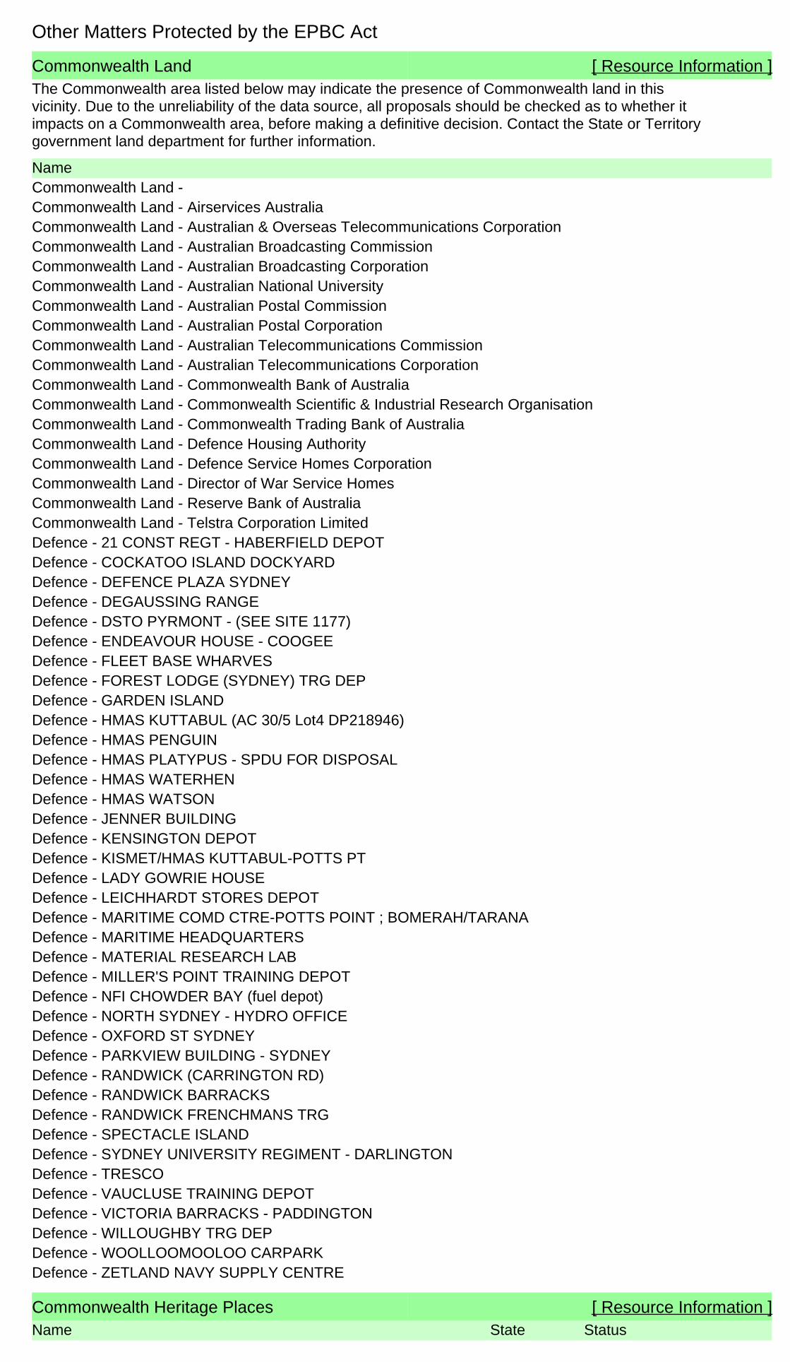
Commonwealth Land [ Resource Information ]The Commonwealth area listed below may indicate the presence of Commonwealth land in thisvicinity. Due to the unreliability of the data source, all proposals should be checked as to whether itimpacts on a Commonwealth area, before making a definitive decision. Contact the State or Territorygovernment land department for further information.
NameCommonwealth Land -Commonwealth Land - Airservices AustraliaCommonwealth Land - Australian & Overseas Telecommunications CorporationCommonwealth Land - Australian Broadcasting CommissionCommonwealth Land - Australian Broadcasting CorporationCommonwealth Land - Australian National UniversityCommonwealth Land - Australian Postal CommissionCommonwealth Land - Australian Postal CorporationCommonwealth Land - Australian Telecommunications CommissionCommonwealth Land - Australian Telecommunications CorporationCommonwealth Land - Commonwealth Bank of AustraliaCommonwealth Land - Commonwealth Scientific & Industrial Research OrganisationCommonwealth Land - Commonwealth Trading Bank of AustraliaCommonwealth Land - Defence Housing AuthorityCommonwealth Land - Defence Service Homes CorporationCommonwealth Land - Director of War Service HomesCommonwealth Land - Reserve Bank of AustraliaCommonwealth Land - Telstra Corporation LimitedDefence - 21 CONST REGT - HABERFIELD DEPOTDefence - COCKATOO ISLAND DOCKYARDDefence - DEFENCE PLAZA SYDNEYDefence - DEGAUSSING RANGEDefence - DSTO PYRMONT - (SEE SITE 1177)Defence - ENDEAVOUR HOUSE - COOGEEDefence - FLEET BASE WHARVESDefence - FOREST LODGE (SYDNEY) TRG DEPDefence - GARDEN ISLANDDefence - HMAS KUTTABUL (AC 30/5 Lot4 DP218946)Defence - HMAS PENGUINDefence - HMAS PLATYPUS - SPDU FOR DISPOSALDefence - HMAS WATERHENDefence - HMAS WATSONDefence - JENNER BUILDINGDefence - KENSINGTON DEPOTDefence - KISMET/HMAS KUTTABUL-POTTS PTDefence - LADY GOWRIE HOUSEDefence - LEICHHARDT STORES DEPOTDefence - MARITIME COMD CTRE-POTTS POINT ; BOMERAH/TARANADefence - MARITIME HEADQUARTERSDefence - MATERIAL RESEARCH LABDefence - MILLER'S POINT TRAINING DEPOTDefence - NFI CHOWDER BAY (fuel depot)Defence - NORTH SYDNEY - HYDRO OFFICEDefence - OXFORD ST SYDNEYDefence - PARKVIEW BUILDING - SYDNEYDefence - RANDWICK (CARRINGTON RD)Defence - RANDWICK BARRACKSDefence - RANDWICK FRENCHMANS TRGDefence - SPECTACLE ISLANDDefence - SYDNEY UNIVERSITY REGIMENT - DARLINGTONDefence - TRESCODefence - VAUCLUSE TRAINING DEPOTDefence - VICTORIA BARRACKS - PADDINGTONDefence - WILLOUGHBY TRG DEPDefence - WOOLLOOMOOLOO CARPARKDefence - ZETLAND NAVY SUPPLY CENTRE
Commonwealth Heritage Places [ Resource Information ]Name StatusState
Other Matters Protected by the EPBC Act
Name StatusStateHistoric
Indicative PlaceAnnandale Post Office NSWIndicative PlaceGarden Island - Captain Cook Dock Precinct NSWIndicative PlaceSydney ( Kingsford Smith ) Airport Group NSWListed placeAdmiralty House Garden and Fortifications NSWListed placeAdmiralty House and Lodge NSWListed placeArmy Cottage with return verandah NSWListed placeBarracks Block NSWListed placeBarracks Group HMAS Watson NSWListed placeBatteries A83 and C9A NSWListed placeBattery B42 NSWListed placeBattery for Five Guns NSWListed placeBiloela Group NSWListed placeBondi Beach Post Office NSWListed placeBotany Post Office NSWListed placeBuilding VB1 and Parade Ground NSWListed placeBuilding VB2 Guard House NSWListed placeBuildings 31 and 32 NSWListed placeBuildings MQVB16 and VB56 NSWListed placeBuildings VB13, 15, 16 & 17 NSWListed placeBuildings VB41, 45 & 53 NSWListed placeBuildings VB60 and VB62 NSWListed placeBuildings VB69, 75 & 76 including Garden NSWListed placeBuildings VB83, 84, 85, 87 & 89 NSWListed placeBuildings VB90, 91, 91A & 92 NSWListed placeChain and Anchor Store (former) NSWListed placeChowder Bay Barracks Group NSWListed placeCliff House NSWListed placeCockatoo Island Industrial Conservation Area NSWListed placeCommonwealth Avenue Defence Housing NSWListed placeCottage at Macquarie Lighthouse NSWListed placeCustoms Marine Centre NSWListed placeDefence site - Georges Heights and Middle Head NSWListed placeFactory NSWListed placeFitzroy Dock NSWListed placeGarden Island Precinct NSWListed placeGazebo NSWListed placeGeneral Post Office NSWListed placeGolf Clubhouse (former) NSWListed placeHMAS Penguin NSWListed placeHeadquarters 8th Brigade Precinct NSWListed placeHeadquarters Training Command Precinct NSWListed placeKirribilli House NSWListed placeKirribilli House Garden & Grounds NSWListed placeMacquarie Lighthouse NSWListed placeMacquarie Lighthouse Group NSWListed placeMacquarie Lighthouse Surrounding Wall NSWListed placeMarine Biological Station (former) NSWListed placeMarrickville Post Office NSWListed placeMess Hall (former) NSWListed placeMilitary Guard Room NSWListed placeMilitary Road Framework - Defence Land NSWListed placeNaval Store NSWListed placeNavy Refuelling Depot and Caretakers House NSWListed placeNorth Sydney Post Office NSWListed placeOffice Building NSWListed placeOfficers Mess, HQ Training Command NSWListed placePaddington Post Office NSWListed placePower House / Pump House NSWListed placePrison Barracks Precinct NSWListed placePyrmont Post Office NSWListed placeReserve Bank NSWListed placeResidences Group NSWListed placeRigging Shed and Chapel NSWListed placeSchool of Musketry and Officers Mess, Randwick Army
BarracksNSW

Listed Marine Species [ Resource Information ]* Species is listed under a different scientific name on the EPBC Act - Threatened Species list.Name Threatened Type of PresenceBirds
Common Sandpiper [59309] Species or specieshabitat known to occurwithin area
Actitis hypoleucos
Fork-tailed Swift [678] Species or specieshabitat likely to occurwithin area
Apus pacificus
Great Egret, White Egret [59541] Species or specieshabitat known to occurwithin area
Ardea alba
Cattle Egret [59542] Species or specieshabitat likely to occurwithin area
Ardea ibis
Ruddy Turnstone [872] Foraging, feeding orrelated behaviour knownto occur within area
Arenaria interpres
Sharp-tailed Sandpiper [874] Foraging, feeding orrelated behaviour knownto occur within area
Calidris acuminata
Sanderling [875] Species or specieshabitat known to occurwithin area
Calidris alba
Red Knot, Knot [855] Foraging, feeding orrelated behaviour knownto occur within area
Calidris canutus
Curlew Sandpiper [856] Foraging, feeding orrelated behaviour knownto occur within area
Calidris ferruginea
Pectoral Sandpiper [858] Foraging, feeding orrelated behaviour knownto occur within area
Calidris melanotos
Red-necked Stint [860] Foraging, feeding orrelated behaviour knownto occur within area
Calidris ruficollis
Long-toed Stint [861] Species or specieshabitat known to occurwithin area
Calidris subminuta
Great Knot [862] Foraging, feeding orrelated behaviour knownto occur within area
Calidris tenuirostris
Name StatusStateListed placeShark Point Battery NSWListed placeSnapper Island NSWListed placeSpectacle Island Explosives Complex NSWListed placeSutherland Dock NSWListed placeSydney Customs House (former) NSWListed placeTen Terminal Regiment Headquarters and AusAid Training
CentreNSW
Listed placeThirty Terminal Squadron Precinct NSWListed placeUnderground Grain Silos NSWListed placeVictoria Barracks Perimeter Wall and Gates NSWListed placeVictoria Barracks Precinct NSWListed placeVictoria Barracks Squash Courts NSWListed placeWoolwich Dock NSW

Name Threatened Type of Presence
Double-banded Plover [895] Foraging, feeding orrelated behaviour knownto occur within area
Charadrius bicinctus
Greater Sand Plover, Large Sand Plover [877] Foraging, feeding orrelated behaviour knownto occur within area
Charadrius leschenaultii
Lesser Sand Plover, Mongolian Plover [879] Foraging, feeding orrelated behaviour knownto occur within area
Charadrius mongolus
Red-capped Plover [881] Foraging, feeding orrelated behaviour knownto occur within area
Charadrius ruficapillus
Oriental Plover, Oriental Dotterel [882] Species or specieshabitat known to occurwithin area
Charadrius veredus
Antipodean Albatross [64458] Vulnerable* Foraging, feeding orrelated behaviour likelyto occur within area
Diomedea antipodensis
Tristan Albatross [66471] Endangered* Species or specieshabitat may occur withinarea
Diomedea dabbenena
Southern Royal Albatross [1072] Vulnerable* Foraging, feeding orrelated behaviour likelyto occur within area
Diomedea epomophora (sensu stricto)
Wandering Albatross [1073] Vulnerable Foraging, feeding orrelated behaviour likelyto occur within area
Diomedea exulans (sensu lato)
Gibson's Albatross [64466] Vulnerable* Foraging, feeding orrelated behaviour likelyto occur within area
Diomedea gibsoni
Northern Royal Albatross [64456] Endangered* Foraging, feeding orrelated behaviour likelyto occur within area
Diomedea sanfordi
Latham's Snipe, Japanese Snipe [863] Foraging, feeding orrelated behaviour knownto occur within area
Gallinago hardwickii
Swinhoe's Snipe [864] Foraging, feeding orrelated behaviour likelyto occur within area
Gallinago megala
Pin-tailed Snipe [841] Foraging, feeding orrelated behaviour likelyto occur within area
Gallinago stenura
White-bellied Sea-Eagle [943] Species or specieshabitat known to occurwithin area
Haliaeetus leucogaster
Grey-tailed Tattler [59311] Foraging, feeding orrelated behaviour knownto occur within area
Heteroscelus brevipes
Wandering Tattler [59547] Species or specieshabitat known to occurwithin area
Heteroscelus incanus
Black-winged Stilt [870] Foraging, feeding orrelated behaviour knownto occur within area
Himantopus himantopus
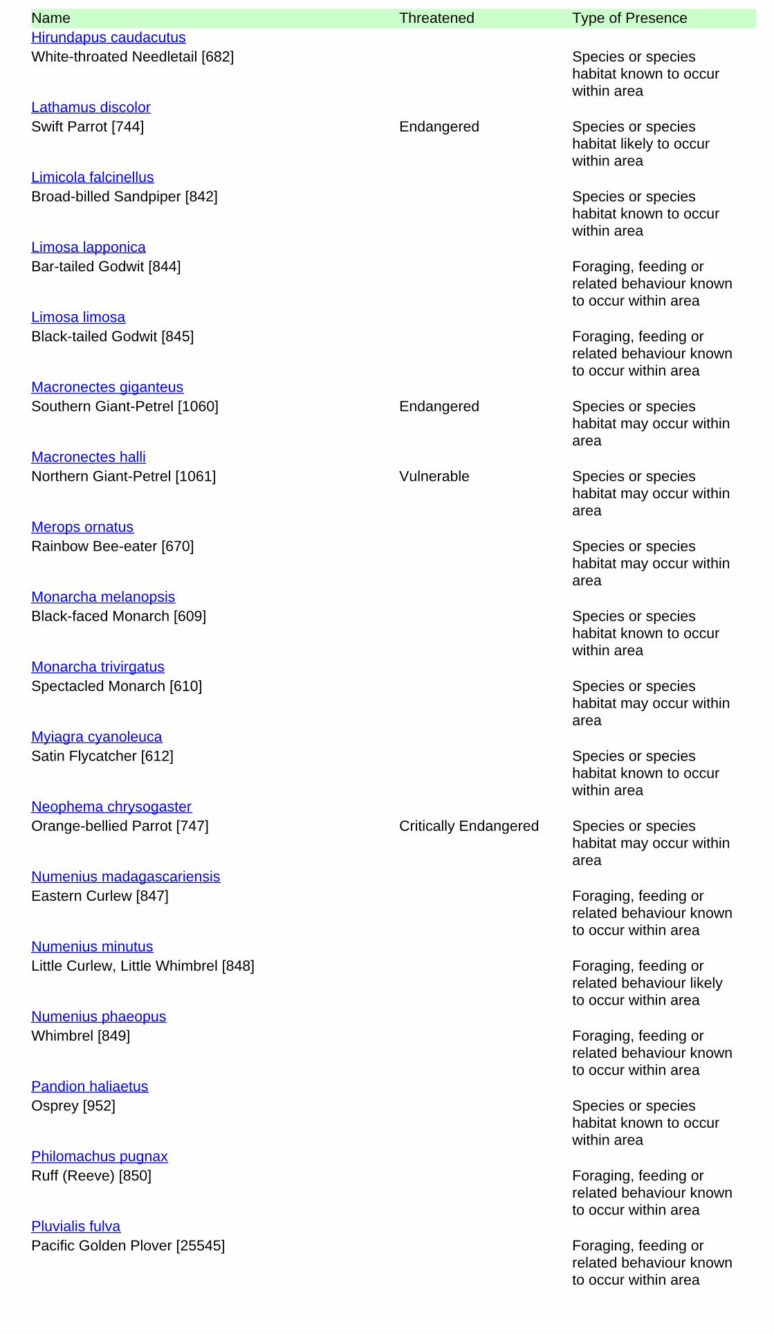
Name Threatened Type of Presence
White-throated Needletail [682] Species or specieshabitat known to occurwithin area
Hirundapus caudacutus
Swift Parrot [744] Endangered Species or specieshabitat likely to occurwithin area
Lathamus discolor
Broad-billed Sandpiper [842] Species or specieshabitat known to occurwithin area
Limicola falcinellus
Bar-tailed Godwit [844] Foraging, feeding orrelated behaviour knownto occur within area
Limosa lapponica
Black-tailed Godwit [845] Foraging, feeding orrelated behaviour knownto occur within area
Limosa limosa
Southern Giant-Petrel [1060] Endangered Species or specieshabitat may occur withinarea
Macronectes giganteus
Northern Giant-Petrel [1061] Vulnerable Species or specieshabitat may occur withinarea
Macronectes halli
Rainbow Bee-eater [670] Species or specieshabitat may occur withinarea
Merops ornatus
Black-faced Monarch [609] Species or specieshabitat known to occurwithin area
Monarcha melanopsis
Spectacled Monarch [610] Species or specieshabitat may occur withinarea
Monarcha trivirgatus
Satin Flycatcher [612] Species or specieshabitat known to occurwithin area
Myiagra cyanoleuca
Orange-bellied Parrot [747] Critically Endangered Species or specieshabitat may occur withinarea
Neophema chrysogaster
Eastern Curlew [847] Foraging, feeding orrelated behaviour knownto occur within area
Numenius madagascariensis
Little Curlew, Little Whimbrel [848] Foraging, feeding orrelated behaviour likelyto occur within area
Numenius minutus
Whimbrel [849] Foraging, feeding orrelated behaviour knownto occur within area
Numenius phaeopus
Osprey [952] Species or specieshabitat known to occurwithin area
Pandion haliaetus
Ruff (Reeve) [850] Foraging, feeding orrelated behaviour knownto occur within area
Philomachus pugnax
Pacific Golden Plover [25545] Foraging, feeding orrelated behaviour knownto occur within area
Pluvialis fulva

Name Threatened Type of Presence
Grey Plover [865] Species or specieshabitat known to occurwithin area
Pluvialis squatarola
Flesh-footed Shearwater, Fleshy-footedShearwater [1043]
Foraging, feeding orrelated behaviour likelyto occur within area
Puffinus carneipes
Red-necked Avocet [871] Foraging, feeding orrelated behaviour knownto occur within area
Recurvirostra novaehollandiae
Rufous Fantail [592] Species or specieshabitat known to occurwithin area
Rhipidura rufifrons
Painted Snipe [889] Endangered* Species or specieshabitat likely to occurwithin area
Rostratula benghalensis (sensu lato)
Little Tern [813] Breeding likely to occurwithin area
Sterna albifrons
Buller's Albatross, Pacific Albatross [64460] Vulnerable Species or specieshabitat may occur withinarea
Thalassarche bulleri
Shy Albatross, Tasmanian Shy Albatross [64697] Vulnerable* Foraging, feeding orrelated behaviour likelyto occur within area
Thalassarche cauta (sensu stricto)
Chatham Albatross [64457] Endangered Foraging, feeding orrelated behaviour likelyto occur within area
Thalassarche eremita
Campbell Albatross [64459] Vulnerable* Species or specieshabitat may occur withinarea
Thalassarche impavida
Black-browed Albatross [66472] Vulnerable Species or specieshabitat may occur withinarea
Thalassarche melanophris
Salvin's Albatross [64463] Vulnerable* Foraging, feeding orrelated behaviour likelyto occur within area
Thalassarche salvini
White-capped Albatross [64462] Vulnerable* Foraging, feeding orrelated behaviour likelyto occur within area
Thalassarche steadi
Marsh Sandpiper, Little Greenshank [833] Foraging, feeding orrelated behaviour knownto occur within area
Tringa stagnatilis
Terek Sandpiper [59300] Species or specieshabitat known to occurwithin area
Xenus cinereus
Fish
Shortpouch Pygmy Pipehorse [66187] Species or specieshabitat may occur withinarea
Acentronura tentaculata
Girdled Pipefish [66214] Species or specieshabitat may occur withinarea
Festucalex cinctus
Tiger Pipefish [66217] Species or specieshabitat may occur withinarea
Filicampus tigris
Name Threatened Type of Presence
Upside-down Pipefish, Eastern Upside-downPipefish, Eastern Upside-down Pipefish [66227]
Species or specieshabitat may occur withinarea
Heraldia nocturna
Beady Pipefish, Steep-nosed Pipefish [66231] Species or specieshabitat may occur withinarea
Hippichthys penicillus
Big-belly Seahorse, Eastern Potbelly Seahorse,New Zealand Potbelly Seahorse [66233]
Species or specieshabitat may occur withinarea
Hippocampus abdominalis
White's Seahorse, Crowned Seahorse, SydneySeahorse [66240]
Species or specieshabitat may occur withinarea
Hippocampus whitei
Crested Pipefish, Briggs' Crested Pipefish, Briggs'Pipefish [66242]
Species or specieshabitat may occur withinarea
Histiogamphelus briggsii
Javelin Pipefish [66251] Species or specieshabitat may occur withinarea
Lissocampus runa
Sawtooth Pipefish [66252] Species or specieshabitat may occur withinarea
Maroubra perserrata
Red Pipefish [66265] Species or specieshabitat may occur withinarea
Notiocampus ruber
Common Seadragon, Weedy Seadragon [66268] Species or specieshabitat may occur withinarea
Phyllopteryx taeniolatus
Spiny Pipehorse, Australian Spiny Pipehorse[66275]
Species or specieshabitat may occur withinarea
Solegnathus spinosissimus
Robust Ghostpipefish, Blue-finned Ghost Pipefish,[66183]
Species or specieshabitat may occur withinarea
Solenostomus cyanopterus
Rough-snout Ghost Pipefish [68425] Species or specieshabitat may occur withinarea
Solenostomus paegnius
Ornate Ghostpipefish, Harlequin Ghost Pipefish,Ornate Ghost Pipefish [66184]
Species or specieshabitat may occur withinarea
Solenostomus paradoxus
Spotted Pipefish, Gulf Pipefish [66276] Species or specieshabitat may occur withinarea
Stigmatopora argus
Widebody Pipefish, Wide-bodied Pipefish, BlackPipefish [66277]
Species or specieshabitat may occur withinarea
Stigmatopora nigra
Double-end Pipehorse, Double-ended Pipehorse,Alligator Pipefish [66279]
Species or specieshabitat may occur withinarea
Syngnathoides biaculeatus
Bentstick Pipefish, Bend Stick Pipefish, Short-tailed Pipefish [66280]
Species or specieshabitat may occur withinarea
Trachyrhamphus bicoarctatus
Hairy Pipefish [66282] Species or specieshabitat may occur withinarea
Urocampus carinirostris

Name Threatened Type of Presence
Mother-of-pearl Pipefish [66283] Species or specieshabitat may occur withinarea
Vanacampus margaritifer
Mammals
New Zealand Fur-seal [20] Species or specieshabitat may occur withinarea
Arctocephalus forsteri
Australian Fur-seal, Australo-African Fur-seal[21]
Species or specieshabitat may occur withinarea
Arctocephalus pusillus
Dugong [28] Species or specieshabitat may occur withinarea
Dugong dugon
Reptiles
Loggerhead Turtle [1763] Endangered Species or specieshabitat known to occurwithin area
Caretta caretta
Green Turtle [1765] Vulnerable Foraging, feeding orrelated behaviour knownto occur within area
Chelonia mydas
Leatherback Turtle, Leathery Turtle, Luth [1768] Endangered Foraging, feeding orrelated behaviour knownto occur within area
Dermochelys coriacea
Hawksbill Turtle [1766] Vulnerable Species or specieshabitat known to occurwithin area
Eretmochelys imbricata
Flatback Turtle [59257] Vulnerable Foraging, feeding orrelated behaviour knownto occur within area
Natator depressus
Yellow-bellied Seasnake [1091] Species or specieshabitat may occur withinarea
Pelamis platurus
Whales and other Cetaceans [ Resource Information ]Name Status Type of PresenceMammals
Minke Whale [33] Species or specieshabitat may occur withinarea
Balaenoptera acutorostrata
Bryde's Whale [35] Species or specieshabitat may occur withinarea
Balaenoptera edeni
Pygmy Right Whale [39] Species or specieshabitat may occur withinarea
Caperea marginata
Common Dophin, Short-beaked CommonDolphin [60]
Species or specieshabitat may occur withinarea
Delphinus delphis
Southern Right Whale [40] Endangered Species or specieshabitat known to occurwithin area
Eubalaena australis
Risso's Dolphin, Grampus [64] Species or specieshabitat may occur withinarea
Grampus griseus
Dusky Dolphin [43] Species or specieshabitat may occur within
Lagenorhynchus obscurus

Name Status Type of Presencearea
Humpback Whale [38] Vulnerable Species or specieshabitat known to occurwithin area
Megaptera novaeangliae
Killer Whale, Orca [46] Species or specieshabitat may occur withinarea
Orcinus orca
Indo-Pacific Humpback Dolphin [50] Species or specieshabitat likely to occurwithin area
Sousa chinensis
Spotted Dolphin, Pantropical Spotted Dolphin [51] Species or specieshabitat may occur withinarea
Stenella attenuata
Indian Ocean Bottlenose Dolphin, SpottedBottlenose Dolphin [68418]
Species or specieshabitat likely to occurwithin area
Tursiops aduncus
Bottlenose Dolphin [68417] Species or specieshabitat may occur withinarea
Tursiops truncatus s. str.
Extra Information
Places on the RNE [ Resource Information ]
Note that not all Indigenous sites may be listed.
Name StatusStateNatural
Indicative PlaceBundock Street Banksia Scrub NSWIndicative PlaceGlebe Island Dyke Exposures NSWIndicative PlaceNorth Sydney Harbour Aquatic Reserve NSWIndicative PlaceParramatta and Lane Cove Rivers Landscapes NSWRegisteredBantry Bay Reserve Area (former) NSWRegisteredBondi Northern Cliffline NSWRegisteredLane Cove Bushland Park NSWRegisteredManly Dam and Surrounds NSWRegisteredNorth Head NSWRegisteredSt Peters Brickpit Geological Site NSWRegisteredSydney Harbour National Park (1980 Boundary) NSW
IndigenousIndicative PlaceAboriginal Boat Carvings NSWRegisteredBerry Island Reserve NSWRegisteredThe Block NSW
HistoricIdentified PlaceABC Gore Hill NSWIndicative PlaceAWA Building (former) NSWIndicative PlaceAberdeen House NSWIndicative PlaceAngus and Son Building NSWIndicative PlaceArdenclutha NSWIndicative PlaceArt Room at Newington College NSWIndicative PlaceArtney NSWIndicative PlaceAshfield Park NSWIndicative PlaceAvondale NSWIndicative PlaceBBC Hardware NSWIndicative PlaceBalls Head Coal Loader NSWIndicative PlaceBalmoral Baths NSWIndicative PlaceBalmoral Shark Proof Pool NSWIndicative PlaceBancroft Avenue Urban Conservation Precinct NSW
Name StatusStateIndicative PlaceBatemans Hut NSWIndicative PlaceBathurst House NSWIndicative PlaceBlackwood NSWIndicative PlaceBland / Nicholson Streets Group NSWIndicative PlaceBligh / Camperdown Terrace Conservation Area NSWIndicative PlaceBondi Beach Post Office NSWIndicative PlaceBondi Post Office NSWIndicative PlaceBotany Fire Station NSWIndicative PlaceBotany Swamps NSWIndicative PlaceBronte Beach Baths NSWIndicative PlaceBronte House Gardens NSWIndicative PlaceBuckle House (former) NSWIndicative PlaceBurns Bay Sewerage Aqueduct NSWIndicative PlaceCammeray Conservation Area NSWIndicative PlaceCampbell Parade Streetscape NSWIndicative PlaceCanada House NSWIndicative PlaceCareening Cove Conservation Area NSWIndicative PlaceCarrum Carrum NSWIndicative PlaceCentury House NSWIndicative PlaceChamberlain Hotel NSWIndicative PlaceChatswood Rifle Range (former) NSWIndicative PlaceChatswood Septic Tanks (former) NSWIndicative PlaceChatswood Urban Conservation Area NSWIndicative PlaceChristian Brothers High School (former) NSWIndicative PlaceClem Morath Pool NSWIndicative PlaceClive Park Rock Pool NSWIndicative PlaceClovelly Bay Enclosure & Baths NSWIndicative PlaceColes Fosseys 1915 Building (former) NSWIndicative PlaceColes Fosseys 1935 Building (former) NSWIndicative PlaceCommercial Terrace NSWIndicative PlaceConstables Cottage NSWIndicative PlaceCoogee Bay Hotel NSWIndicative PlaceCoolooba NSWIndicative PlaceCooper Street Conservation Area NSWIndicative PlaceCremorne Conservation Area NSWIndicative PlaceCremorne Point Conservation Area NSWIndicative PlaceCriterion Hotel NSWIndicative PlaceCrown Lodge NSWIndicative PlaceCrows Nest Road Conservation Area NSWIndicative PlaceDarrell Lea Shop (Facade) NSWIndicative PlaceDobroyd Stormwater Channel NSWIndicative PlaceDouglass Lane NSWIndicative PlaceDrummoyne Avenue Group NSWIndicative PlaceDrummoyne Fire Station NSWIndicative PlaceDry Stone Wall and Water Channel NSWIndicative PlaceDudley House NSWIndicative PlaceDunaverty NSWIndicative PlaceDunham House NSWIndicative PlaceEarlwood North Urban Conservation Area NSWIndicative PlaceEast Lindfield Urban Conservation Precinct NSWIndicative PlaceEdgecliff Post Office NSWIndicative PlaceEdward Street Conservation Area NSWIndicative PlaceEgyptian Room Scottish Royal Arch Masonic Temple NSWIndicative PlaceElismere & Studley Royal NSWIndicative PlaceEnmore Post Office (former) NSWIndicative PlaceEvening Star Hotel NSWIndicative PlaceEventide including Front Fence NSWIndicative PlaceFairmont NSWIndicative PlaceFayworth House NSWIndicative PlaceFerndale NSWIndicative PlaceFire Station (former) NSWIndicative PlaceFlat Rock Creek Bridge NSWIndicative PlaceFlorence Bartley Library NSWIndicative PlaceFoley Bros Warehouses (former) NSWIndicative PlaceForbes Terrace NSWIndicative PlaceGarden Island - Captain Cook Dock Precinct NSW
Name StatusStateIndicative PlaceGates and Fence of North Sydney Demonstration School NSWIndicative PlaceGeorge Bosch Chambers NSWIndicative PlaceGeorgian Style Gable Roofed Cottage NSWIndicative PlaceGiles Baths & Bath-House NSWIndicative PlaceGladesville Bridge NSWIndicative PlaceGlenore & Buninyong NSWIndicative PlaceGolden Barley Hotel NSWIndicative PlaceGower NSWIndicative PlaceGreenwich Baths NSWIndicative PlaceGriffiths Building NSWIndicative PlaceHammerhead Crane NSWIndicative PlaceHaven Amphitheatre NSWIndicative PlaceHawthornden NSWIndicative PlaceHaymarket Post Office NSWIndicative PlaceHighbury NSWIndicative PlaceHollis Park and Environs / Urban Conservation Area NSWIndicative PlaceHoltermann Estate Conservation Area (A) NSWIndicative PlaceHoltermann Estate Conservation Area (B) NSWIndicative PlaceHoltermann Estate Conservation Area (C) NSWIndicative PlaceHoltermann Estate Conservation Area (D) NSWIndicative PlaceHome Yardage Building NSWIndicative PlaceHonda NSWIndicative PlaceHoraceville NSWIndicative PlaceHouse NSWIndicative PlaceHouse NSWIndicative PlaceHouse NSWIndicative PlaceHouse NSWIndicative PlaceHouse NSWIndicative PlaceHouse and Garden NSWIndicative PlaceHouses NSWIndicative PlaceHunters Hill Conservation Area Extension NSWIndicative PlaceIBM Centre (former) NSWIndicative PlaceIver NSWIndicative PlaceJackson Place Cottages NSWIndicative PlaceJohn Sands Building (former) NSWIndicative PlaceKenilworth NSWIndicative PlaceKindersley House NSWIndicative PlaceKing George Hotel (former) NSWIndicative PlaceKings Theatre (former) NSWIndicative PlaceKurraba Point Conservation Area NSWIndicative PlaceLane Cove House NSWIndicative PlaceLaurelbank NSWIndicative PlaceLaureston NSWIndicative PlaceLavender Bay Conservation Area NSWIndicative PlaceLeamington NSWIndicative PlaceLeamington NSWIndicative PlaceLedbury NSWIndicative PlaceLegion House NSWIndicative PlaceLeichhardt Fire Station NSWIndicative PlaceLincoln Building NSWIndicative PlaceLindfield Urban Conservation Precinct NSWIndicative PlaceLittle Sirius Cove Enclosure Remnants NSWIndicative PlaceLlanthony NSWIndicative PlaceLongueville Pool NSWIndicative PlaceLoughrea NSWIndicative PlaceLower Kirribilli Conservation Area NSWIndicative PlaceMan O'War Steps & Jetty NSWIndicative PlaceManufacturers House NSWIndicative PlaceMarist Brothers Provincialate of Sydney NSWIndicative PlaceMaroubra Fire Station NSWIndicative PlaceMarrickville Fire Station NSWIndicative PlaceMarrickville Post Office NSWIndicative PlaceMascot Fire Station NSWIndicative PlaceMcCallum Pool NSWIndicative PlaceMcIvers Baths NSWIndicative PlaceMcLaren Street Conservation Area NSW
Name StatusStateIndicative PlaceMcMahons Point North Conservation Area NSWIndicative PlaceMcMahons Point South Conservation Area NSWIndicative PlaceMiddle Harbour Submarine Sewerage Syphon NSWIndicative PlaceMiddle Head and Georges Heights NSWIndicative PlaceMilson Park NSWIndicative PlaceMilson Road Group NSWIndicative PlaceMobarik NSWIndicative PlaceMontague Road Conservation Area NSWIndicative PlaceMosman Reservoir NSWIndicative PlaceNational Building NSWIndicative PlaceNeilsen Park Pool & Associated Structures NSWIndicative PlaceNeptune Engineering including Bay Foreshores NSWIndicative PlaceNeutral Bay Fire Station NSWIndicative PlaceNewmarket Hotel NSWIndicative PlaceNorth Sydney Fire Station (former) NSWIndicative PlaceNorth Sydney Sewerage Sewer Aqueduct NSWIndicative PlaceNorthbridge Pool NSWIndicative PlacePainters and Dockers Union Hall NSWIndicative PlacePair of Semi-Detached Dwelling NSWIndicative PlacePark Avenue Urban Conservation Precinct NSWIndicative PlacePark Lane Mansions NSWIndicative PlacePark and Oaks Avenues Conservation Area NSWIndicative PlaceParsley Bay Swimming Enclosure NSWIndicative PlacePeckham NSWIndicative PlacePenston Hall NSWIndicative PlacePitt Street Gardens NSWIndicative PlacePlateau Conservation Area NSWIndicative PlacePrince Alfred Park NSWIndicative PlacePyrmont Point NSWIndicative PlaceQantas House (former) NSWIndicative PlaceRaben Footwear NSWIndicative PlaceRandwick Fire Station NSWIndicative PlaceRedleaf Pool NSWIndicative PlaceReservoir No 120 and Reservoir No 121 NSWIndicative PlaceResidence NSWIndicative PlaceRockend NSWIndicative PlaceRockleigh Grange NSWIndicative PlaceRose Bay Post Office NSWIndicative PlaceRoseville NSWIndicative PlaceRoseville Baths Remnants NSWIndicative PlaceRoseville Bush Trail NSWIndicative PlaceRoseville Chase Urban Conservation Precinct NSWIndicative PlaceRoss Jones Memorial Pools NSWIndicative PlaceRoyal Alexander Hospital for Children (former) Garden
RemnantsNSW
Indicative PlaceRoyal Navy Logistics Store NSWIndicative PlaceRozelle Railway Goodsline Viaduct NSWIndicative PlaceSewer Vent Shaft NSWIndicative PlaceShalimar, Including Garden, Fence and Gates NSWIndicative PlaceSheffield House NSWIndicative PlaceShirley Road Urban Conservation Precinct NSWIndicative PlaceShone Ejector Station (former) NSWIndicative PlaceSimpson House NSWIndicative PlaceSir John Young Hotel NSWIndicative PlaceSirius Hoe NSWIndicative PlaceSlipway and Wharf NSWIndicative PlaceSt Albans Anglican Church NSWIndicative PlaceSt Albans Group NSWIndicative PlaceSt Albans Rectory NSWIndicative PlaceSt Josephs Convent Group NSWIndicative PlaceSt Judes Rectory Garden NSWIndicative PlaceSt Leonards Catholic Church NSWIndicative PlaceSt Leonards Park & North Sydney Oval NSWIndicative PlaceSt Marks Catholic Church NSWIndicative PlaceSt Marks Catholic Church Group NSWIndicative PlaceSt Marks Community Hall NSW

Name StatusStateIndicative PlaceSt Marks Presbytery NSWIndicative PlaceSt Peters Anglican Church NSWIndicative PlaceSt Peters Presbyterian School Hall NSWIndicative PlaceSt Thomas Anglican Church Memorial Hall NSWIndicative PlaceStanmore House NSWIndicative PlaceStone Retaining Wall and Gateposts to Rose Hall NSWIndicative PlaceSugarloaf Bay Catchment and Headlands NSWIndicative PlaceSummer Hill Post Office (former) NSWIndicative PlaceSummerfield Terrace NSWIndicative PlaceSummerhill NSWIndicative PlaceSurrey NSWIndicative PlaceSydenham Village NSWIndicative PlaceSydney Harbour Entrance NSWIndicative PlaceSydney Harbour Landscape Area NSWIndicative PlaceSydney Hospital Nightingale Wing NSWIndicative PlaceTambourine Bay Baths NSWIndicative PlaceTarella NSWIndicative PlaceTaringa NSWIndicative PlaceTerrace NSWIndicative PlaceTerrace NSWIndicative PlaceTerrace NSWIndicative PlaceThe Bear Pits Moore Park Zoo NSWIndicative PlaceThe Cedars NSWIndicative PlaceThe House of the Seven Lanterns NSWIndicative PlaceThe Pressure Tunnel NSWIndicative PlaceThe Scotland Australia Cairn NSWIndicative PlaceThe Towers - Residence NSWIndicative PlaceTrethaway House NSWIndicative PlaceTudor Lodge NSWIndicative PlaceUndercliffe Urban Conservation Area NSWIndicative PlaceUnion / Bank / Thomas Streets Conservation Area NSWIndicative PlaceUniversity of Technology Kuring-gai Campus NSWIndicative PlaceUpper Middle Harbour Area NSWIndicative PlaceVictorian Regency Terrace NSWIndicative PlaceVictorian Rustic Gothic Cottage NSWIndicative PlaceVictorian, Wooden Ridgeline, Semi-detached House NSWIndicative PlaceWalker / Ridge Streets Conservation Area NSWIndicative PlaceWar Memorial 1914-18 NSWIndicative PlaceWarehouse NSWIndicative PlaceWarren Ball Avenue Victorian Terrace Houses NSWIndicative PlaceWater Police Station (former) NSWIndicative PlaceWaterside Workers Federation Building NSWIndicative PlaceWatsons Bay Baths NSWIndicative PlaceWaverley Post Office NSWIndicative PlaceWaverley Tramway Depot Tramshed Remains NSWIndicative PlaceWays Terrace Group NSWIndicative PlaceWest End Hotel NSWIndicative PlaceWest Lindfield Urban Conservation Precinct NSWIndicative PlaceWestgate Post Office NSWIndicative PlaceWhaling Road Conservation Area NSWIndicative PlaceWhite Bay Power Station NSWIndicative PlaceWhitehaven NSWIndicative PlaceWilliam Croft Building (former) NSWIndicative PlaceWollstonecraft Conservation Area NSWIndicative PlaceWoollahra Fire Station NSWIndicative PlaceWoollahra Post Office NSWIndicative PlaceWorrall Theatre Complex & St Lukes Chapel NSWIndicative PlaceWylies Baths NSWIndicative PlaceYthanbank NSWInterim ListAlexandra Canal NSWInterim ListBotany Water Supply Scheme Remains NSWInterim ListHMAS Platypus NSWInterim ListSewage Pumping Station 38, Substation and Inspection Hall NSWInterim ListSouthern & Western Suburbs Ocean Outfall Sewers NSWInterim ListSydney ( Kingsford Smith ) Airport Group NSWRegisteredANZ Bank NSW
Name StatusStateRegisteredANZ Bank NSWRegisteredANZ Bank (former) NSWRegisteredANZ Bank (former) NSWRegisteredASN Hotel (former) NSWRegisteredAbbotsford House NSWRegisteredAccountants House NSWRegisteredAdministration Building A Sydney Technical College NSWRegisteredAdmiralty House Garden and Fortifications NSWRegisteredAdmiralty House and Lodge NSWRegisteredAgar Steps & Adjacent Trees NSWRegisteredAgar Steps Houses NSWRegisteredAgincourt Hotel NSWRegisteredAlbion Place Group NSWRegisteredAlcee NSWRegisteredAlfred Street Entrance Luna Park NSWRegisteredAlfreds Terrace NSWRegisteredAlicia NSWRegisteredAll Saints Anglican Church NSWRegisteredAll Saints Anglican Church NSWRegisteredAll Saints Rectory NSWRegisteredAll Souls Anglican Church, Rectory & Minor Church Buildings NSWRegisteredAlroy NSWRegisteredAmerican Express Tower (former) NSWRegisteredAmmunition Store (former) NSWRegisteredAnesbury NSWRegisteredAngel Hotel (former) NSWRegisteredAnnabel Lea NSWRegisteredAnnandale Council Chambers (former) NSWRegisteredAnnandale North Public School NSWRegisteredAnnandale Post Office NSWRegisteredAnnandale Public School and Infants Building NSWRegisteredAnnandale Uniting Church NSWRegisteredAnzac Memorial NSWRegisteredArabela Terrace NSWRegisteredAraluen NSWRegisteredAraluen House NSWRegisteredArchibald Fountain NSWRegisteredArchina and Ascot and Surrounds NSWRegisteredArdath NSWRegisteredArden Lea NSWRegisteredArgyle Cut and Argyle Street Space NSWRegisteredArgyle House NSWRegisteredArgyle Place Park NSWRegisteredArgyle Place Precinct NSWRegisteredArgyle Precinct NSWRegisteredArgyle Stores NSWRegisteredArgyle Sub-Station NSWRegisteredArgyle Terrace NSWRegisteredArmy Cottage with return verandah NSWRegisteredArt Gallery of NSW NSWRegisteredAscham School Precinct NSWRegisteredAshfield Castle NSWRegisteredAshton Park NSWRegisteredAston Lodge Group NSWRegisteredAstor Apartment Building NSWRegisteredAustralasian Steam Navigation Company Building NSWRegisteredAustralian Consolidated Industries Building (former) NSWRegisteredAustralian Financial Press Building NSWRegisteredAustralian Gaslight Company Showroom Building (former) NSWRegisteredAustralian Hotel NSWRegisteredAustralian Hotel (former) NSWRegisteredAustralian Joint Stock Bank (former) NSWRegisteredAustralian Museum NSWRegisteredAustralian Workers Union Building NSWRegisteredAvonmore Terrace NSWRegisteredBMA House NSW

Name StatusStateRegisteredBabworth House NSWRegisteredBakery (former) NSWRegisteredBakery House and Loft (former) NSWRegisteredBalmain Civic Group NSWRegisteredBalmain Cooperative Society Building (former) NSWRegisteredBalmain Courthouse, Police Station and Post Office NSWRegisteredBalmain Public School NSWRegisteredBalmain Volunteer NSWRegisteredBalmoral Beach Conservation Area NSWRegisteredBanco Court Building NSWRegisteredBanking House and Westpac Bank NSWRegisteredBanksia and Witchagil NSWRegisteredBantry Bay Public Magazine NSWRegisteredBarford and Garden NSWRegisteredBarham (excluding later additions) NSWRegisteredBarrack House NSWRegisteredBarracks Block NSWRegisteredBarracks Group HMAS Watson NSWRegisteredBathurst NSWRegisteredBatteries A83 and C9A NSWRegisteredBattery B42 NSWRegisteredBattery for Five Guns NSWRegisteredBayfield NSWRegisteredBeares Stairs NSWRegisteredBelgrave Terrace (former) NSWRegisteredBelvedere NSWRegisteredBeneficial House NSWRegisteredBentham NSWRegisteredBettington and Merriman Streets Group NSWRegisteredBiloela Group NSWRegisteredBirtley Towers NSWRegisteredBishopscourt NSWRegisteredBlackfriars Public School (former) NSWRegisteredBlacksmith and Machine Shop NSWRegisteredBlair Athol NSWRegisteredBlenerne NSWRegisteredBlenheim House NSWRegisteredBomera NSWRegisteredBondi Beach NSWRegisteredBondi Beach Pool Group NSWRegisteredBondi Surf Pavilion NSWRegisteredBoomerang NSWRegisteredBooth House (former) NSWRegisteredBossley Terrace NSWRegisteredBotany Building NSWRegisteredBotany Post Office NSWRegisteredBourke Street Public School NSWRegisteredBradleys Head Fortification Complex NSWRegisteredBriarbank NSWRegisteredBristol Arms Hotel NSWRegisteredBronte House and surrounds NSWRegisteredBrooklyn Hotel NSWRegisteredBroughton House NSWRegisteredBryson House NSWRegisteredBuilding VB1 and Parade Ground NSWRegisteredBuilding VB2 Guard House NSWRegisteredBuildings NSWRegisteredBuildings 31 and 32 NSWRegisteredBuildings MQVB16 and VB56 NSWRegisteredBuildings VB13, 15, 16 & 17 NSWRegisteredBuildings VB41, 45 & 53 NSWRegisteredBuildings VB60 and VB62 NSWRegisteredBuildings VB69, 75 & 76 including Garden NSWRegisteredBuildings VB83, 84, 85, 87 & 89 NSWRegisteredBuildings VB90, 91, 91A & 92 NSWRegisteredBurnham NSW

Name StatusStateRegisteredBurns Philp Building (former) NSWRegisteredBusbys Bore or The Tunnel NSWRegisteredByrock and Uralla NSWRegisteredCBC Bank Facade (former) NSWRegisteredCSR Cooperage Building (former) NSWRegisteredCSR Gate House (former) NSWRegisteredCSR Laboratory B Building (former) NSWRegisteredCSR Main Office Building (former) NSWRegisteredCSR Managers House (former) NSWRegisteredCSR Store House (former) NSWRegisteredCSR Tablet House (former) NSWRegisteredCadmans Cottage Space NSWRegisteredCadmans Cottage including Grounds and Trees NSWRegisteredCaerleon NSWRegisteredCahill Expressway Space NSWRegisteredCallan Park Conservation Area NSWRegisteredCallan Park House NSWRegisteredCallooa and Garden NSWRegisteredCambridge NSWRegisteredCambridge Street Precinct NSWRegisteredCamelot NSWRegisteredCampbell Street Group NSWRegisteredCampbells Cove Space NSWRegisteredCampbells Storehouse NSWRegisteredCapitol Theatre NSWRegisteredCaptain Arthur Phillip Fountain NSWRegisteredCarabella Street Group NSWRegisteredCarey Cottage NSWRegisteredCarla Zampatti Building NSWRegisteredCarleith NSWRegisteredCarlson Terrace NSWRegisteredCarmelita and Bethania NSWRegisteredCarthona and Grounds NSWRegisteredCast Iron Drinking Fountain NSWRegisteredCastlereagh Street Group NSWRegisteredCathedral and Forbes Streets Group NSWRegisteredCathedral and Judge Streets Group NSWRegisteredCathedral and Riley Streets Group NSWRegisteredCatholic Convent of the Sacred Heart NSWRegisteredCentennial Park NSWRegisteredCentennial Park Gates NSWRegisteredCentennial Parklands NSWRegisteredCentral Police Courts NSWRegisteredCentral Railway Station NSWRegisteredChain and Anchor Store (former) NSWRegisteredChamber of Commerce Building (former) NSWRegisteredCharles Parsons and Company Building (former) NSWRegisteredChatswood South Uniting Church & Grounds NSWRegisteredCheong House NSWRegisteredChief Mechanical Engineers Office (former) NSWRegisteredChief Secretarys Building NSWRegisteredChinese Christian Church NSWRegisteredChowder Bay Barracks Group NSWRegisteredChrist Church Anglican Church, Gates & Grounds NSWRegisteredChrist Church Anglican Rectory NSWRegisteredChrist Church St Laurence Anglican Church NSWRegisteredChrist Church St Laurence Group NSWRegisteredChrist Church St Laurence Rectory NSWRegisteredChrist Church St Laurence School and Hall (former) NSWRegisteredChurch of the Holy Name of Mary NSWRegisteredCintra NSWRegisteredCircular Quay West / Campbells Storehouse Space NSWRegisteredCity Ford NSWRegisteredCity House NSWRegisteredCity Mutual Life Assurance Building NSWRegisteredCity South Telephone Exchange NSW
Name StatusStateRegisteredCity Tattersalls Club NSWRegisteredCleland Bond Store NSWRegisteredCleveland House NSWRegisteredCleveland Street Public School NSWRegisteredCleverton NSWRegisteredCliff House NSWRegisteredCliff Tunnel and Chamber NSWRegisteredCliffbrook House, Stables & Stone Walls NSWRegisteredClifton NSWRegisteredClifton (including Front Fence) NSWRegisteredClifton Villa NSWRegisteredClivedon NSWRegisteredCloncorrick NSWRegisteredClyde Bank NSWRegisteredCockatoo Island Industrial Conservation Area NSWRegisteredCollege Street Group NSWRegisteredCollins Street Terraces NSWRegisteredColonial Mutual Building Facade NSWRegisteredCommercial Bank of Sydney Facade (former) NSWRegisteredCommercial Building NSWRegisteredCommercial Building (former) NSWRegisteredCommercial Building (former) NSWRegisteredCommercial Buildings NSWRegisteredCommercial Buildings NSWRegisteredCommercial Buildings NSWRegisteredCommercial High School (former) NSWRegisteredCommercial Stores (former) NSWRegisteredCommercial Terrace NSWRegisteredCommercial Terrace NSWRegisteredCommercial Terrace NSWRegisteredCommercial Terrace NSWRegisteredCommercial Terrace Houses NSWRegisteredCommercial and Residential Buildings NSWRegisteredCommonwealth Avenue Defence Housing NSWRegisteredCommonwealth Bank NSWRegisteredCommonwealth Bank NSWRegisteredCommonwealth Bank NSWRegisteredCommonwealth Bank (former) NSWRegisteredCommonwealth Bank and Gallipoli Club NSWRegisteredCommonwealth Trading Bank Building NSWRegisteredComus Villa NSWRegisteredConey Island Luna Park NSWRegisteredCongregational Church NSWRegisteredCongregational Manse NSWRegisteredConservatorium of Music NSWRegisteredConvicts Dungeon (former) NSWRegisteredCooks River Sewer Aqueduct NSWRegisteredCooper Park NSWRegisteredCoorabel NSWRegisteredCopy of Choragic Monument of Lysicrates NSWRegisteredCoralynn NSWRegisteredCorio NSWRegisteredCorn Exchange and Fruit Market (former) NSWRegisteredCorner Shop NSWRegisteredCorona & Hygeia Victorian Terraces NSWRegisteredCoroners Court (former) NSWRegisteredCorporation Building NSWRegisteredCottage NSWRegisteredCottage NSWRegisteredCottage NSWRegisteredCottage NSWRegisteredCottage NSWRegisteredCottage NSWRegisteredCottage NSWRegisteredCottage NSWRegisteredCottage No 1 NSW
Name StatusStateRegisteredCottage No 2 NSWRegisteredCottage No 3 NSWRegisteredCottage No 4 NSWRegisteredCottage at Macquarie Lighthouse NSWRegisteredCottages and Gardens NSWRegisteredCouncil Terrace Houses NSWRegisteredCourthouse & Police Station NSWRegisteredCraigends NSWRegisteredCranbrook Avenue Group NSWRegisteredCranbrook Group NSWRegisteredCranbrook Group NSWRegisteredCranbrook School Sports Pavilion NSWRegisteredCrater Cove Huts NSWRegisteredCrown Street Public School NSWRegisteredCrows Nest Fire Station NSWRegisteredCroxted NSWRegisteredCrystal Palace Luna Park NSWRegisteredCulwalla Chambers NSWRegisteredCulwalla Chambers Group NSWRegisteredCumberland Street Group NSWRegisteredCunningham Monument NSWRegisteredCurators Residence (former) NSWRegisteredCustoms House Hotel NSWRegisteredCustoms Marine Centre NSWRegisteredCypress Grove NSWRegisteredCyprus Hellene Club and Australian Hall NSWRegisteredDaceyville Garden Suburb Urban Conservation Area NSWRegisteredDacre Villa NSWRegisteredDaily Telegraph Building (former) NSWRegisteredDaking House NSWRegisteredDalgety Terrace NSWRegisteredDalgetys Bond Store (former) NSWRegisteredDanchen House (former) NSWRegisteredDarley Street Group NSWRegisteredDarlinghurst Courthouse NSWRegisteredDarlinghurst Fire Station NSWRegisteredDarlinghurst Gaol (former) NSWRegisteredDarlinghurst Police Station and Residence NSWRegisteredDarlinghurst Public School (1883 Section) NSWRegisteredDarlington Conservation Area NSWRegisteredDavid Jones Department Store NSWRegisteredDawes Point Park and Reserve NSWRegisteredDawn Fraser Swimming Pool NSWRegisteredDaybreak NSWRegisteredDefence Site - Georges Heights and Middle Head NSWRegisteredDelphin House NSWRegisteredDepartment Store Group NSWRegisteredDoctors Residence NSWRegisteredDomain Lodge and Gate Piers NSWRegisteredDon Bank NSWRegisteredDoor and Surrounds School of Rural Studies NSWRegisteredDowling Street Group NSWRegisteredDrill Hall (former) NSWRegisteredDrummoyne Telephone Exchange NSWRegisteredDuke of Edinburgh Hotel NSWRegisteredDulwich Hill High School 1892 Building NSWRegisteredDunara NSWRegisteredDundee Arms (former) NSWRegisteredDunheved NSWRegisteredDunkirk Hotel NSWRegisteredDuplex NSWRegisteredDuplex NSWRegisteredDuplex NSWRegisteredDuplex NSWRegisteredDurham Hall NSWRegisteredDymocks Building NSW

Name StatusStateRegisteredES&A Bank (former) NSWRegisteredEaton Street Group NSWRegisteredEdina NSWRegisteredEdinburgh Castle Hotel NSWRegisteredEducation Department Building NSWRegisteredEdwardian Buildings Group NSWRegisteredEdwardian Commercial Group NSWRegisteredEdwin Davey & Sons Flour MIll NSWRegisteredElder Smith Goldsborough Mort and Company No 3
WoolstoreNSW
RegisteredElder Smith Goldsbrough Mort No 1 Woolstore NSWRegisteredElectricity Substation NSWRegisteredElizabeth Bay House NSWRegisteredEllesmere NSWRegisteredElsetta NSWRegisteredEngehurst NSWRegisteredEntrance Face and Towers Luna Park NSWRegisteredEntrance Gates (original work) NSWRegisteredErskine Street Watch House Group NSWRegisteredErskineville Public School NSWRegisteredEscarpment Terraces NSWRegisteredEsher NSWRegisteredEssex NSWRegisteredEsslemont and Grounds NSWRegisteredEumalga including Stone Wall, Gates and Posts NSWRegisteredEurodux NSWRegisteredEurondella NSWRegisteredEuthella NSWRegisteredEveleigh Railway Workshops NSWRegisteredEverleigh Glendoon NSWRegisteredExchange Hotel NSWRegisteredFactory NSWRegisteredFairhaven NSWRegisteredFairwater NSWRegisteredFamily Hotel (former) NSWRegisteredFarmers and Graziers No 2 Woolstore (former) NSWRegisteredFarmers and Graziers Woolstore No1 NSWRegisteredFather Michael Rohan Memorial School NSWRegisteredFederation Monument NSWRegisteredFederation Place NSWRegisteredFence, Gates and Lodge NSWRegisteredFenton and Garden NSWRegisteredFernbank NSWRegisteredFernleigh Castle NSWRegisteredFestival Records Building NSWRegisteredFig Tree House NSWRegisteredFig and Coral Trees Luna Park NSWRegisteredFigurehead of Windsor Castle NSWRegisteredFigurehead of the Ship Consuela NSWRegisteredFiona & Gates NSWRegisteredFire Brigade Amenities Building NSWRegisteredFire Brigade Headquarters NSWRegisteredFire Engine House (former) NSWRegisteredFire Station NSWRegisteredFirst Government House Site NSWRegisteredFishermans Cottage Group NSWRegisteredFitzroy Dock NSWRegisteredFitzroy Terrace NSWRegisteredFive Storey Building NSWRegisteredFlats NSWRegisteredFlinders Street Group NSWRegisteredFormer Shops and Residences NSWRegisteredFort Denison NSWRegisteredFort Street School (former) (western addition) NSWRegisteredFortuna NSWRegisteredFour Dwellings and former Shop NSW

Name StatusStateRegisteredFrazer Fountain NSWRegisteredG A Zink and Sons Building NSWRegisteredGarden Island Precinct NSWRegisteredGarden Palace Gates (original work) NSWRegisteredGardeners Cottage NSWRegisteredGaribaldi Inn (former) NSWRegisteredGate Lodge (former) NSWRegisteredGatekeepers Cottage NSWRegisteredGatekeepers Lodge NSWRegisteredGates Glenrock Ascham School NSWRegisteredGates and Gate Lodge NSWRegisteredGazebo NSWRegisteredGeneral Post Office NSWRegisteredGenoa NSWRegisteredGents Lavatory and Stone Walls NSWRegisteredGeological and Mining Museum NSWRegisteredGeorge Patterson House NSWRegisteredGeorge Street / Kendall Lane Precinct NSWRegisteredGeorge Street Business Precinct NSWRegisteredGeorgian Cottage NSWRegisteredGeorgian House and Barn NSWRegisteredGeorgian Terrace NSWRegisteredGeorgian Terrace NSWRegisteredGeorgian Townhouses NSWRegisteredGeorgian Warehouse (former) NSWRegisteredGinahgulla NSWRegisteredGladesville Mental Hospital Precinct NSWRegisteredGladswood House NSWRegisteredGlasgow Arms Hotel NSWRegisteredGlebe Conservation Area NSWRegisteredGlebe Courthouse NSWRegisteredGlebe Island Bridge NSWRegisteredGlebe Post Office NSWRegisteredGlebe Town Hall NSWRegisteredGlen Mahr NSWRegisteredGlencairn NSWRegisteredGlenrock NSWRegisteredGlenrock NSWRegisteredGlenview NSWRegisteredGloucester Street North Precinct NSWRegisteredGloucester Street North, Gloucester Walk and Escarpment
SpaceNSW
RegisteredGlover Cottages NSWRegisteredGoat Island Ammunition Store Group NSWRegisteredGoat Island Precinct NSWRegisteredGoldring House NSWRegisteredGolf Clubhouse (former) NSWRegisteredGoodmans Buildings NSWRegisteredGordon Street Group NSWRegisteredGore Hill Memorial Cemetery NSWRegisteredGovernment House NSWRegisteredGovernment House, Associated Buildings and Garden NSWRegisteredGowing Brothers Building NSWRegisteredGrace Brothers Ltd Building NSWRegisteredGrace Brothers Store (former) NSWRegisteredGrace Building NSWRegisteredGrafton Bond Store (former) NSWRegisteredGrahames Corner NSWRegisteredGraythwaite including Gardens and Outbuildings NSWRegisteredGreek Orthodox Church NSWRegisteredGreenway NSWRegisteredGreigs Building NSWRegisteredGresham Hotel (former) NSWRegisteredGreycliffe House NSWRegisteredGroup of Service Buildings NSWRegisteredGuard Room (former) NSW
Name StatusStateRegisteredGuardhouse and Officers Quarters (former) NSWRegisteredHMAS Penguin NSWRegisteredHMAS Rushcutter (former) NSWRegisteredHMAS Sydney Mast NSWRegisteredHaberfield Conservation Area NSWRegisteredHaeremai NSWRegisteredHall Building B Sydney Technical College NSWRegisteredHamilton and The Hermitage NSWRegisteredHannans Butcher Shop NSWRegisteredHardware House (former) NSWRegisteredHarrington Argyle Precinct NSWRegisteredHarrington Place Space NSWRegisteredHarris Street Conservation Area NSWRegisteredHastings NSWRegisteredHawken and Vance Produce Exchange (former) NSWRegisteredHayling NSWRegisteredHaymarket Urban Conservation Area NSWRegisteredHeadquarters 8th Brigade Precinct NSWRegisteredHeadquarters Training Command Precinct NSWRegisteredHeadquarters of the Australasian Federation League (former) NSWRegisteredHealth Commission Building (former) NSWRegisteredHealth Department Building (former) NSWRegisteredHelen Keller House NSWRegisteredHelensleigh NSWRegisteredHenry Lawson Memorial NSWRegisteredHerbarium Seed House NSWRegisteredHerne NSWRegisteredHero of Waterloo Hotel NSWRegisteredHestock NSWRegisteredHexam Terrace NSWRegisteredHigh Cross Precinct NSWRegisteredHighclare and Romney Hall NSWRegisteredHillrest NSWRegisteredHills Stairs NSWRegisteredHillside NSWRegisteredHilton NSWRegisteredHilton Hotel Marble Bar and Bar Room NSWRegisteredHistory House NSWRegisteredHitching Posts (two) NSWRegisteredHollingworth NSWRegisteredHoly Trinity Anglican Church Hall NSWRegisteredHoover Cinema NSWRegisteredHorbury Terrace (former) NSWRegisteredHornby Lighthouse NSWRegisteredHornby Lighthouse Group NSWRegisteredHornby Lighthouse Keepers Cottages NSWRegisteredHotel York (former) NSWRegisteredHouse NSWRegisteredHouse NSWRegisteredHouse NSWRegisteredHouse NSWRegisteredHouse NSWRegisteredHouse NSWRegisteredHouse NSWRegisteredHouse NSWRegisteredHouse NSWRegisteredHouse NSWRegisteredHouse NSWRegisteredHouse NSWRegisteredHouse NSWRegisteredHouse NSWRegisteredHouse NSWRegisteredHouse NSWRegisteredHouse NSWRegisteredHouse NSWRegisteredHouse NSW
Name StatusStateRegisteredHouse NSWRegisteredHouse NSWRegisteredHouse NSWRegisteredHouse NSWRegisteredHouse NSWRegisteredHouse NSWRegisteredHouse NSWRegisteredHouse NSWRegisteredHouse NSWRegisteredHouse NSWRegisteredHouse NSWRegisteredHouse NSWRegisteredHouse NSWRegisteredHouse NSWRegisteredHouse NSWRegisteredHouse NSWRegisteredHouse NSWRegisteredHouse and Gardens NSWRegisteredHouse and Grounds NSWRegisteredHouse and Grounds NSWRegisteredHouse and Stables NSWRegisteredHouse, Stone Stables and Fences at rear NSWRegisteredHouses NSWRegisteredHouses NSWRegisteredHouses NSWRegisteredHouses NSWRegisteredHouses NSWRegisteredHouses NSWRegisteredHouses and Terraces NSWRegisteredHouses and Terraces NSWRegisteredHousing Board Building NSWRegisteredHudson House Facade (former) NSWRegisteredHunter Baillie Memorial Presbyterian Church NSWRegisteredHunter River Steamship Company Office (former) NSWRegisteredHunters Hill Conservation Area NSWRegisteredHunters Hill Post Office NSWRegisteredHuntleys Point House NSWRegisteredHurworth NSWRegisteredHyde Park Barracks NSWRegisteredHydraulic Pumping Station NSWRegisteredIOOF Hall NSWRegisteredIndustrial Therapy Unit NSWRegisteredIndustrial Therapy Unit NSWRegisteredInnisfallen Castle and Grounds NSWRegisteredInnisfree NSWRegisteredInstitute Building NSWRegisteredIolanthe NSWRegisteredIona NSWRegisteredIrene NSWRegisteredIsere NSWRegisteredItalianate House NSWRegisteredItalianate Terrace NSWRegisteredItalianate Terrace NSWRegisteredIvanhoe NSWRegisteredJ A D Gibson and Company (facade) NSWRegisteredJ H Geddes Woolstore (former) NSWRegisteredJenner NSWRegisteredJenner Garden NSWRegisteredJobbins Terrace NSWRegisteredJohn Storey Memorial Clinic (former) NSWRegisteredJohn Street Terrace Group NSWRegisteredJohnstons Creek Sewer Aqueduct NSWRegisteredJosie NSWRegisteredJuniper Hall NSWRegisteredKaoota NSWRegisteredKareela NSW

Name StatusStateRegisteredKareela NSWRegisteredKellett Street Group NSWRegisteredKellys Bush NSWRegisteredKent Street Terrace Group East Side NSWRegisteredKent Street Terrace Group West Side NSWRegisteredKent Street Warehouse Group NSWRegisteredKent Street Warehouse Group 2 NSWRegisteredKentigern NSWRegisteredKien Hay Centre NSWRegisteredKing George V Memorial Hospital NSWRegisteredKing Street Conservation Area NSWRegisteredKiola NSWRegisteredKirkbride Block NSWRegisteredKirribilli House NSWRegisteredKirribilli House Garden & Grounds NSWRegisteredKirribilli Neighbourhood Centre NSWRegisteredKyarra NSWRegisteredKyle House NSWRegisteredLEP House Facade NSWRegisteredLabrena NSWRegisteredLady Members Stand NSWRegisteredLands Department Building NSWRegisteredLantana NSWRegisteredLatona Terrace NSWRegisteredLeichhardt Civic Precinct NSWRegisteredLeichhardt Post Office NSWRegisteredLeichhardt Public School Buildings NSWRegisteredLeichhardt Town Hall NSWRegisteredLennox Street Terraces NSWRegisteredLetraset House NSWRegisteredLewis Wolfe Levy Fountain NSWRegisteredLilyvale NSWRegisteredLilyville NSWRegisteredLindesay NSWRegisteredLinsley Terrace NSWRegisteredLisgar House NSWRegisteredLismore Hotel (former) NSWRegisteredLiverpool Street Group NSWRegisteredLoch Galli and Garden NSWRegisteredLochiel and Garden NSWRegisteredLochnager NSWRegisteredLong Cove Creek Whipple Truss Rail Bridge NSWRegisteredLongs Lane Precinct NSWRegisteredLoombah NSWRegisteredLord Nelson Hotel NSWRegisteredLord Wolseley Hotel NSWRegisteredLoreto Convent NSWRegisteredLow Level Sewage Pumping Station No 2 NSWRegisteredLower Fort Street West Side Group NSWRegisteredLower Fort Street East Side Group NSWRegisteredLugano NSWRegisteredLuna Park Precinct NSWRegisteredLyndcote NSWRegisteredLyndhurst NSWRegisteredLyndhurst NSWRegisteredMMI Building NSWRegisteredMWS&DB Building (1939) (former) NSWRegisteredMacknade House (former) NSWRegisteredMacleay Museum Building NSWRegisteredMacquarie House NSWRegisteredMacquarie Lighthouse NSWRegisteredMacquarie Lighthouse Group NSWRegisteredMacquarie Lighthouse Surrounding Wall NSWRegisteredMacquarie Place Buildings Group NSWRegisteredMacquarie Place Park & Structures NSWRegisteredMacquaries Obelisk NSW
Name StatusStateRegisteredMacquaries Wall and Gateway NSWRegisteredMain Building - East Range and Great Hall NSWRegisteredMain Building Additions & Quadrangle NSWRegisteredMain Gates (former) NSWRegisteredMarathon Terrace NSWRegisteredMarcus Clark Building (former) NSWRegisteredMarine Biological Station (former) NSWRegisteredMarist Brothers High School (former) NSWRegisteredMarist Fathers Seminary NSWRegisteredMaritime Services Board Building (former) NSWRegisteredMark Foys Building (former) NSWRegisteredMarrickville Town Hall (former) NSWRegisteredMartin Place GPO Precinct NSWRegisteredMartin Place Urban Conservation Area NSWRegisteredMaruna NSWRegisteredMarveen Duplex NSWRegisteredMasonic Club NSWRegisteredMaybanke Kindergarten NSWRegisteredMcCafferys Building NSWRegisteredMcComas and Price Williams Wool Press NSWRegisteredMedical Centre NSWRegisteredMedical Records Department NSWRegisteredMedical School NSWRegisteredMedical Superintendents Residence (former) NSWRegisteredMelba NSWRegisteredMembers Stand NSWRegisteredMembers Stand Royal Randwick Racecourse NSWRegisteredMemorial to World War One NSWRegisteredMendip NSWRegisteredMens Lavatory NSWRegisteredMercantile Hotel NSWRegisteredMerimbah NSWRegisteredMermaid Baths NSWRegisteredMerriman Street Precinct NSWRegisteredMerryfield Hotel Group NSWRegisteredMeryla NSWRegisteredMess Hall (former) NSWRegisteredMethodist Church (former) NSWRegisteredMethodist Parsonage (former) NSWRegisteredMia Mia NSWRegisteredMiddle Head Fortifications NSWRegisteredMilestone Obelisk NSWRegisteredMilford Haven NSWRegisteredMilitary Guard Room NSWRegisteredMilitary Road Framework - Defence Land NSWRegisteredMilitary Road Framework - Sydney Harbour National Park NSWRegisteredMillers Point Post Office NSWRegisteredMillinery House NSWRegisteredMilsons Point Public School (former) NSWRegisteredMilthorpe NSWRegisteredMilton Terrace NSWRegisteredMinerva Cinema formerly The Metro NSWRegisteredMint Building, Wing of Rum Hospital (former) NSWRegisteredMirvac Trust Building NSWRegisteredMona NSWRegisteredMontefalco NSWRegisteredMoocooboolah NSWRegisteredMoon House NSWRegisteredMoore Park Road Group Terraces and Houses NSWRegisteredMoore Stairs NSWRegisteredMoorefield House NSWRegisteredMorella NSWRegisteredMorts Dock Historic Site NSWRegisteredMortuary Terminal (former) NSWRegisteredMr John and Merivale Building NSWRegisteredMrs Quirks Cottage NSW
Name StatusStateRegisteredMuirbank NSWRegisteredMyall NSWRegisteredNSW Department of Labour & Industry Building (former) NSWRegisteredNSW Government Railway Administrative Building NSWRegisteredNSW Permanent Building Society Building (former) NSWRegisteredNSW Sports Club Five Storey Building NSWRegisteredNSW Sports Club Four Storey Building NSWRegisteredNalpa NSWRegisteredNational Bank NSWRegisteredNational Bank (former) NSWRegisteredNational Trust Centre NSWRegisteredNaval Store NSWRegisteredNavy Refuelling Depot and Caretakers House NSWRegisteredNew Metcalfe Bond NSWRegisteredNew Metcalfe Bond / George Street Precinct NSWRegisteredNew South Wales Club House (former) NSWRegisteredNew York Hotel NSWRegisteredNewmarket House NSWRegisteredNewmarket Precinct NSWRegisteredNewtown Courthouse & former Police Station NSWRegisteredNewtown Courthouse Group NSWRegisteredNewtown Post Office NSWRegisteredNewtown Public School and War Memorial NSWRegisteredNewtown Telephone Exchange NSWRegisteredNewtown Uniting Church Group NSWRegisteredNicholson Street Public School NSWRegisteredNobel NSWRegisteredNorth Head Quarantine Station & Reserve (former) NSWRegisteredNorth Sydney Courthouse NSWRegisteredNorth Sydney Olympic Pool Complex NSWRegisteredNorth Sydney Post Office Group NSWRegisteredNorth Sydney Technical High School (former) NSWRegisteredNorth Sydney Telephone Exchange NSWRegisteredNorths Factory NSWRegisteredNorwood NSWRegisteredNovar NSWRegisteredNugal Hall NSWRegisteredNurses Quarters NSWRegisteredNutcote and Garden NSWRegisteredOatlands NSWRegisteredObelisk NSWRegisteredObservatory Park NSWRegisteredObserver Hotel NSWRegisteredObyin, Including Stone Walls NSWRegisteredOcean View and Grounds NSWRegisteredOffice Building NSWRegisteredOfficers Mess, HQ Training Command NSWRegisteredOld Training Block, Fort Street School (former) NSWRegisteredOpera House Gate Royal Botanic Gardens NSWRegisteredOreldalodge NSWRegisteredOrient Hotel NSWRegisteredOriginal (1836-38) Quadrangular Asylum Ranges NSWRegisteredOriginal Public School & Eulbertie NSWRegisteredOsborne House NSWRegisteredOxford Square Group NSWRegisteredOzanam House and Marist Chapel NSWRegisteredPMG Stores Building (former) NSWRegisteredPacific Highway Group NSWRegisteredPaddington Conservation Area NSWRegisteredPaddington Police Station (former) NSWRegisteredPaddington Post Office NSWRegisteredPaddington Public School 1870 and 1892 Buildings NSWRegisteredPaddington Public School Group NSWRegisteredPaddington Reservoir NSWRegisteredPaddington Town Hall NSWRegisteredPair of Joined Houses NSW

Name StatusStateRegisteredPair of Neo Classic Town Houses NSWRegisteredPair of Semi-detached Houses NSWRegisteredPair of Stone Houses NSWRegisteredPair of Stone Houses NSWRegisteredPair of Stone Terraces NSWRegisteredPalisade Hotel NSWRegisteredPalisade Hotel and adjoining Terraces NSWRegisteredPangas House NSWRegisteredParagon Hotel (former) NSWRegisteredParaza NSWRegisteredParker Galleries NSWRegisteredParliament House NSWRegisteredPassy NSWRegisteredPaterson, Reid and Bruce Ltd Building NSWRegisteredPeniarth NSWRegisteredPerpetual Trustee Company Building NSWRegisteredPetersham Park NSWRegisteredPetersham Railway Station (former) NSWRegisteredPhysics Building NSWRegisteredPilgrim House NSWRegisteredPinnacle House NSWRegisteredPitt / King Street Group NSWRegisteredPitt Son and Badgery Wool Store NSWRegisteredPitt Street Group NSWRegisteredPitt Street Uniting Church NSWRegisteredPlayfair, George, Hickson Space NSWRegisteredPlaza Theatre (former) NSWRegisteredPolice Station NSWRegisteredPolice Station (former) NSWRegisteredPolice Station (former) NSWRegisteredPolice Station (former) NSWRegisteredPolice Station and Fire Station Group NSWRegisteredPottery Building NSWRegisteredPower House / Pump House NSWRegisteredPowerhouse Museum (Stage One) NSWRegisteredPowerhouse Museum (Stage Two) NSWRegisteredPremises NSWRegisteredPresbyterian Church NSWRegisteredPresbyterian Church (former) NSWRegisteredPresbyterian Church Group NSWRegisteredPresbyterian Hall NSWRegisteredPresbyterian Manse NSWRegisteredPresbyterian Manse (former) NSWRegisteredPresident Lincoln Hotel (former) NSWRegisteredPrevost House NSWRegisteredPrince of Wales Hospital Gates and Fence NSWRegisteredPrince of Wales Hospital Group NSWRegisteredPrince of Wales Hospital Main Block (former) NSWRegisteredPrince of Wales Hospital Outpatients Building (former) NSWRegisteredPrison Barracks Precinct NSWRegisteredProvision Store NSWRegisteredPunt Road Gates NSWRegisteredPyrmont / Ultimo Centre NSWRegisteredPyrmont Bridge NSWRegisteredPyrmont Bridge Hotel NSWRegisteredPyrmont Bridge Road Hotel NSWRegisteredPyrmont Conservation Area NSWRegisteredPyrmont Fire Station NSWRegisteredPyrmont Point Carriageway Dividing Fence NSWRegisteredPyrmont Point Escarpment Face NSWRegisteredPyrmont Point Escarpment Palisade Fence and Stone
GatepostsNSW
RegisteredPyrmont Point Railway Cutting & Tunnel NSWRegisteredPyrmont Post Office NSWRegisteredPyrmont Power Station Building A NSWRegisteredPyrmont Public School (former) NSW

Name StatusStateRegisteredPyrmont Square Group NSWRegisteredPyrmont and Murray Streets Residential Group NSWRegisteredQuarrymans Hotel NSWRegisteredQuedgley NSWRegisteredQueen Street Group NSWRegisteredQueen Victoria Building NSWRegisteredQueens Place Group NSWRegisteredQueensland Insurance Building NSWRegisteredRadio Signal Station - Middle Head NSWRegisteredRailway Institute Building NSWRegisteredRailway Square Post Office (former) NSWRegisteredRailway Viaduct NSWRegisteredRandwick Police Station NSWRegisteredRandwick Post Office NSWRegisteredRandwick Town Hall NSWRegisteredRawson Institute for Seamen (former) NSWRegisteredRawson Place Group NSWRegisteredRectory and Stone Walls (former) NSWRegisteredRectory of St Marks Church, Stables & Garden NSWRegisteredRed Cross House NSWRegisteredRedfern Courthouse NSWRegisteredRedfern Post Office NSWRegisteredRedleaf NSWRegisteredRegency Townhouses NSWRegisteredRegistrar Generals Department Building NSWRegisteredRegistry Office NSWRegisteredReinga NSWRegisteredReserve Bank NSWRegisteredReservoir Fence and Steps NSWRegisteredResidence and Shop NSWRegisteredResidences Group NSWRegisteredRetail Traders Association of NSW Building (former) NSWRegisteredRetail and Commercial Building NSWRegisteredRetail and Commercial Building NSWRegisteredRetail and Commercial Building NSWRegisteredReussdale NSWRegisteredReynolds Cottage and Shop NSWRegisteredRichard Johnson Memorial NSWRegisteredRichmond NSWRegisteredRichmond Villa NSWRegisteredRigging Shed and Chapel NSWRegisteredRitz Cinema NSWRegisteredRobert Burns Statue NSWRegisteredRobert Reid and Company Warehouse NSWRegisteredRoberts House NSWRegisteredRocklands NSWRegisteredRockwall NSWRegisteredRona NSWRegisteredRosamond NSWRegisteredRose Bay Police Station NSWRegisteredRosemont NSWRegisteredRoslyndale NSWRegisteredRoyal Agricultural Society Showground Conservation Area NSWRegisteredRoyal Australian College of Physicians Building NSWRegisteredRoyal Australian Naval House NSWRegisteredRoyal Automobile Club NSWRegisteredRoyal Botanic Gardens and Domain NSWRegisteredRoyal College of Radiologists Building NSWRegisteredRoyal Edward Victualling Yard Group NSWRegisteredRoyal Exchange Assurance Building (former) NSWRegisteredRoyal George Hotel (former) NSWRegisteredRoyal Hotel NSWRegisteredRoyal Hotel NSWRegisteredRoyal Pacific Hotel NSWRegisteredRoyal Prince Alfred Hospital NSWRegisteredRozelle Public School NSW
Name StatusStateRegisteredRunnymede NSWRegisteredRydal NSWRegisteredSILF Company Building NSWRegisteredSacred Heart Monastry & Chapel excluding 1921 & c1960
additionsNSW
RegisteredSaintonge NSWRegisteredSalvation Army Womens Hostel Facade (former) NSWRegisteredSanderslaben NSWRegisteredSandstone Cottage NSWRegisteredSandstone Walling NSWRegisteredSarahville NSWRegisteredSchool of Mechanical and Automotive Engineering NSWRegisteredSchool of Musketry and Officers' Mess, Randwick Army
BarracksNSW
RegisteredSchute, Bell, Badgery & Lumby Store NSWRegisteredScience Road Bridge NSWRegisteredScience Road Precinct NSWRegisteredScottish Hospital NSWRegisteredScout Hall NSWRegisteredSeaforth House NSWRegisteredSemi detached Houses NSWRegisteredSemidetached Villas NSWRegisteredSergeant Majors Row Terraces NSWRegisteredShark Point Battery NSWRegisteredShelbourne Hotel NSWRegisteredShelter House NSWRegisteredShetland NSWRegisteredShip Inn Hotel (former) NSWRegisteredShipping Agents Office (former) NSWRegisteredShipwrights Arms Hotel (former) NSWRegisteredShop NSWRegisteredShop NSWRegisteredShop & House NSWRegisteredShops NSWRegisteredShops Residences and Offices NSWRegisteredShops and Hotel Group NSWRegisteredShops and Offices NSWRegisteredSierra Lucena NSWRegisteredSir John Robertson Memorial NSWRegisteredSir John Robertson Statue NSWRegisteredSirius Anchor and Cannon NSWRegisteredSirius House NSWRegisteredSkinners Family Hotel (former) NSWRegisteredSmith Copeland Warehouse (former) NSWRegisteredSnapper Island NSWRegisteredSociete Generale House NSWRegisteredSoul Pattinson and Company Building NSWRegisteredSouth Head Signal Station NSWRegisteredSpectacle Island Explosives Complex NSWRegisteredSport House including Original Interiors NSWRegisteredSportsgirl Building NSWRegisteredSt Andrews Anglican Cathedral and Chapter House NSWRegisteredSt Andrews College NSWRegisteredSt Andrews Congregational Church and Hall NSWRegisteredSt Andrews Presbyterian Church (former) NSWRegisteredSt Augustines Church and Former Church NSWRegisteredSt Bedes Church, School & Presbytery NSWRegisteredSt Benedicts Catholic Church NSWRegisteredSt Benedicts Convent and Hall NSWRegisteredSt Benedicts Precinct NSWRegisteredSt Brigids Catholic Church NSWRegisteredSt Brigids Catholic Church & School NSWRegisteredSt Davids Uniting Church Precinct NSWRegisteredSt Francis Xaviers Catholic Church NSWRegisteredSt Francis Xaviers Church School Hall NSWRegisteredSt Francis Xaviers Presbytery NSWRegisteredSt Georges Free Presbyterian Church NSW

Name StatusStateRegisteredSt Georges Hall NSWRegisteredSt Ignatius College Riverview Main Building NSWRegisteredSt Ives NSWRegisteredSt James Anglican Church NSWRegisteredSt John House NSWRegisteredSt Johns Anglican Church NSWRegisteredSt Johns Anglican Church Group NSWRegisteredSt Johns Anglican Parish Hall NSWRegisteredSt Johns College NSWRegisteredSt Johns Rectory NSWRegisteredSt Johns Rectory (former) NSWRegisteredSt Johns Road Group NSWRegisteredSt Johns Uniting Church NSWRegisteredSt Johns Uniting Church Group NSWRegisteredSt Johns Uniting Church Manse NSWRegisteredSt Johns Uniting Church Manse / Schoolhouse NSWRegisteredSt Josephs College NSWRegisteredSt Judes Anglican Church & Cemetery NSWRegisteredSt Judes Anglican Church Group NSWRegisteredSt Judes Rectory and Curates Residence NSWRegisteredSt Kevins NSWRegisteredSt Magdalenes Retreat NSWRegisteredSt Marks Anglican Church NSWRegisteredSt Marks Anglican Church NSWRegisteredSt Marks Anglican Church Group NSWRegisteredSt Marks Cottage NSWRegisteredSt Mary the Virgin Anglican Church NSWRegisteredSt Marys Cathedral NSWRegisteredSt Marys Catholic Church NSWRegisteredSt Marys Catholic Church NSWRegisteredSt Matthews Anglican Church NSWRegisteredSt Matthias Anglican Church NSWRegisteredSt Matthias Church Group NSWRegisteredSt Matthias Church Hall NSWRegisteredSt Michaels Anglican Church NSWRegisteredSt Michaels Anglican Church, Hall & Rectory NSWRegisteredSt Michaels Church Group NSWRegisteredSt Patricks Catholic Church NSWRegisteredSt Patricks Convent NSWRegisteredSt Patricks Convent Chapel NSWRegisteredSt Patricks Hall and School NSWRegisteredSt Pauls College NSWRegisteredSt Pauls Presbyterian Church (former) NSWRegisteredSt Peter Chanel Catholic Church NSWRegisteredSt Peters Anglican Church & Graveyard NSWRegisteredSt Peters Anglican Church (former) NSWRegisteredSt Peters Anglican Church and Adjacent Bush NSWRegisteredSt Peters Presbyterian Church NSWRegisteredSt Peters Presbyterian Church and Manse NSWRegisteredSt Peters Presbyterian Manse NSWRegisteredSt Peters Presbyterian Schoolhouse NSWRegisteredSt Peters Rectory (former) NSWRegisteredSt Philips Anglican Church NSWRegisteredSt Saviours Anglican Church NSWRegisteredSt Stephens Anglican Church & Cemetery NSWRegisteredSt Thomas Anglican Church NSWRegisteredSt Thomas Anglican Church Group NSWRegisteredSt Thomas Anglican Church Rectory NSWRegisteredSt Thomas Kindergarten Hall NSWRegisteredStafford Terrace (part) NSWRegisteredStanton Road Group NSWRegisteredStar Hotel NSWRegisteredState Library of NSW NSWRegisteredState Library of NSW Forecourt NSWRegisteredState Theatre NSWRegisteredStation House NSW
Name StatusStateRegisteredStatue of Albert the Good NSWRegisteredStatue of Captain James Cook RN NSWRegisteredStatue of Dunmore Lang NSWRegisteredStatue of King Edward VII NSWRegisteredStone Cottage and Adjacent Stone Wall NSWRegisteredStone Pillar NSWRegisteredStone Wall NSWRegisteredStone Wall, Entrance Gate and Sentry Box NSWRegisteredStoneleigh NSWRegisteredStoneleigh NSWRegisteredStoneleigh House NSWRegisteredStrand Arcade and street facade NSWRegisteredStrickland House & Grounds NSWRegisteredSugar House NSWRegisteredSummer Hill Public School NSWRegisteredSunnyside NSWRegisteredSunnyside and Grounds NSWRegisteredSuperintendents Residence NSWRegisteredSuperintendents Residence (former) NSWRegisteredSupreme Court Building NSWRegisteredSupreme Court Group NSWRegisteredSurry Hotel (former) NSWRegisteredSusannah Place Terrace NSWRegisteredSuspension Bridge NSWRegisteredSussex Street Group NSWRegisteredSussex Street Technical College (former) NSWRegisteredSutherland Dock NSWRegisteredSydney Ancher House NSWRegisteredSydney Arcade (former) NSWRegisteredSydney City Markets Group NSWRegisteredSydney Cricket Ground Group NSWRegisteredSydney Customs House (former) NSWRegisteredSydney Grammar School NSWRegisteredSydney Harbour Bridge NSWRegisteredSydney Hospital NSWRegisteredSydney Hospital Nurses Annex NSWRegisteredSydney Observatory NSWRegisteredSydney Opera House and Surrounds NSWRegisteredSydney Sailors Home (former) NSWRegisteredSydney School of Arts (former) NSWRegisteredSydney Technical College Group NSWRegisteredSydney Town Hall NSWRegisteredSydney Trades Hall NSWRegisteredSydney University Main Building Precinct NSWRegisteredT S Mort Statue NSWRegisteredTank Stream Tunnel NSWRegisteredTarana NSWRegisteredTatler Hotel (former) NSWRegisteredTaunton and Eldon NSWRegisteredTechnological Museum (former) NSWRegisteredTelford Trust Building NSWRegisteredTelford Type Roadway NSWRegisteredTen Terminal Regiment Headquarters and AusAid Training
CentreNSW
RegisteredTerana NSWRegisteredTerminus Hotel NSWRegisteredTerrace NSWRegisteredTerrace NSWRegisteredTerrace NSWRegisteredTerrace NSWRegisteredTerrace NSWRegisteredTerrace NSWRegisteredTerrace NSWRegisteredTerrace NSWRegisteredTerrace NSWRegisteredTerrace NSW

Name StatusStateRegisteredTerrace NSWRegisteredTerrace NSWRegisteredTerrace NSWRegisteredTerrace NSWRegisteredTerrace Facade NSWRegisteredTerrace House NSWRegisteredTerrace House NSWRegisteredTerrace House NSWRegisteredTerrace House and Corner Shop NSWRegisteredTerrace House with Mural NSWRegisteredTerrace Houses NSWRegisteredTerrace Houses NSWRegisteredTerrace Houses NSWRegisteredTerrace Houses NSWRegisteredTerrace Houses NSWRegisteredTerrace Houses NSWRegisteredTerrace Houses NSWRegisteredTerrace Houses NSWRegisteredTerrace Houses NSWRegisteredTerrace Houses NSWRegisteredTerrace Houses NSWRegisteredTerrace Houses NSWRegisteredTerrace Houses NSWRegisteredTerrace Houses NSWRegisteredTerrace Houses NSWRegisteredTerrace Houses NSWRegisteredTerrace Houses NSWRegisteredTerrace Houses NSWRegisteredTerrace Houses NSWRegisteredTerrace Houses NSWRegisteredTerrace Houses NSWRegisteredTerrace Houses NSWRegisteredTerrace Houses NSWRegisteredTerrace Houses NSWRegisteredTerrace Houses NSWRegisteredTerrace Houses NSWRegisteredTerrace Houses NSWRegisteredTerrace Houses NSWRegisteredTerrace Houses NSWRegisteredTerrace Houses NSWRegisteredTerrace Houses NSWRegisteredTerrace Houses NSWRegisteredTerrace Houses NSWRegisteredTerrace Houses NSWRegisteredTerrace Houses NSWRegisteredTerrace Houses NSWRegisteredTerrace Houses (former) NSWRegisteredTerrace Houses Group NSWRegisteredTerrace Houses Group NSWRegisteredTerrace Houses including Front Fences NSWRegisteredTerrace and Commercial Building NSWRegisteredTerrace and Town House Group NSWRegisteredTerrace and Townhouses NSWRegisteredTerrace of Three Shops NSWRegisteredTerraced Houses NSWRegisteredTerraces NSWRegisteredTerraces NSWRegisteredTerraces NSWRegisteredTerraces NSWRegisteredTerraces NSWRegisteredTerraces NSWRegisteredTerraces NSWRegisteredTerraces NSWRegisteredTerraces NSWRegisteredTerraces NSWRegisteredTerraces NSW
Name StatusStateRegisteredTerraces NSWRegisteredTerraces NSWRegisteredTerraces including Front Fences NSWRegisteredTerraces Facade NSWRegisteredTerraces Facade NSWRegisteredTerraces and Retaining Wall NSWRegisteredTerraces and Shop NSWRegisteredTerraces and Street Trees NSWRegisteredTerraces and Townhouses NSWRegisteredTerraces and Townhouses NSWRegisteredThames Street Ferry Wharf and Shelter NSWRegisteredThe Abbey and Stone Walls NSWRegisteredThe Barn (Scout Hall) NSWRegisteredThe Big Stable NSWRegisteredThe Bungalow NSWRegisteredThe Bushells Building NSWRegisteredThe Chalet NSWRegisteredThe Cobbles NSWRegisteredThe Counting House NSWRegisteredThe Dower House NSWRegisteredThe Duncan House NSWRegisteredThe Eagles NSWRegisteredThe Fishwick House NSWRegisteredThe Garrison Church NSWRegisteredThe Gladstone NSWRegisteredThe Grange NSWRegisteredThe Great Synagogue NSWRegisteredThe Grove Group NSWRegisteredThe Guest House NSWRegisteredThe Haven NSWRegisteredThe Herbarium NSWRegisteredThe Hermitage NSWRegisteredThe Hub NSWRegisteredThe Jacaranda Including Outbuilding NSWRegisteredThe Judges House NSWRegisteredThe Lodge NSWRegisteredThe Mansions Terrace (Facade only) NSWRegisteredThe Priory NSWRegisteredThe Rocks Conservation Area NSWRegisteredThe Scout Hall and Garden of Remembrance NSWRegisteredThe Swifts NSWRegisteredThe Sydney Eye Hospital (former) NSWRegisteredThe Womens College NSWRegisteredThirty Terminal Squadron Precinct NSWRegisteredThree Terrace Buildings NSWRegisteredThree Terrace Houses NSWRegisteredThree Victorian Residences NSWRegisteredThree Weatherboard Cottages NSWRegisteredTimber Cottage NSWRegisteredTimber Cottage NSWRegisteredTimber House NSWRegisteredTower House and Stone Perimeter Walls NSWRegisteredTown Hall NSWRegisteredTown Hall NSWRegisteredTown Hall Group NSWRegisteredTown House NSWRegisteredTown House NSWRegisteredTownhouse NSWRegisteredTownhouses NSWRegisteredTowns Store NSWRegisteredTraffic Court Group (former) NSWRegisteredTraffic Court No 1 (former) NSWRegisteredTraffic Court No 2 (former) NSWRegisteredTranby NSWRegisteredTransport House NSWRegisteredTreago NSW
Name StatusStateRegisteredTreasury Building & Premiers Office NSWRegisteredTresco including Grounds and Trees NSWRegisteredTrocadero Hall NSWRegisteredTrust Building NSWRegisteredTucker and Company Warehouse NSWRegisteredTusculum NSWRegisteredTwin Residences NSWRegisteredTwo Adjoining Terrace Houses NSWRegisteredTwo Fig Trees NSWRegisteredTwo Storey Georgian House NSWRegisteredTwo Storey House NSWRegisteredTwo Storey House NSWRegisteredTwo Terrace Houses NSWRegisteredTwo Terraces NSWRegisteredUltimo Conservation Area NSWRegisteredUltimo Post Office (former) NSWRegisteredUltimo Sewage Pumping Station NSWRegisteredUltimo Uniting Church Group NSWRegisteredUndercliff Cottage (former) NSWRegisteredUnderground Grain Silos NSWRegisteredUnion Bank (former) NSWRegisteredUnion Bond Store NSWRegisteredUniting Church (former) NSWRegisteredUniting Church Group NSWRegisteredUnwins Coach House NSWRegisteredUnwins Store NSWRegisteredVailele NSWRegisteredVaucluse House & Grounds NSWRegisteredVenice NSWRegisteredVentnor NSWRegisteredVeredelaise NSWRegisteredVictoria / Brougham Streets Precinct NSWRegisteredVictoria Barracks Perimeter Wall and Gates NSWRegisteredVictoria Barracks Precinct NSWRegisteredVictoria Barracks Squash Courts NSWRegisteredVictoria Lodge NSWRegisteredVictorian Cottage NSWRegisteredVictorian Shops NSWRegisteredVictorian Timber Cottage NSWRegisteredVictorian Weatherboard Cottage NSWRegisteredVienna NSWRegisteredView Terrace Facade NSWRegisteredViewforth NSWRegisteredVilla Maria Group NSWRegisteredVine House NSWRegisteredVinetta NSWRegisteredVisitors Accommodation (former) NSWRegisteredVulcan Hotel NSWRegisteredWadim (Bill) Jegorow Reserve NSWRegisteredWaimea Avenue Group NSWRegisteredWainload NSWRegisteredWairoa NSWRegisteredWaite and Bull Building NSWRegisteredWaiwera and St Claire NSWRegisteredWales House NSWRegisteredWalker Street Group NSWRegisteredWally Weekes Pool NSWRegisteredWalsh Bay Wharves NSWRegisteredWalshale NSWRegisteredWalter Burley Griffin Incinerator NSWRegisteredWalton and Herberton NSWRegisteredWandella NSWRegisteredWar Memorial Hospital Group NSWRegisteredWard 14 and15 NSWRegisteredWards 17 and 18 NSWRegisteredWarehouse NSW

Name StatusStateRegisteredWarehouse NSWRegisteredWarehouse NSWRegisteredWarehouse (former) NSWRegisteredWarehouse (former) NSWRegisteredWarehouse (former) NSWRegisteredWarehouse (former) NSWRegisteredWarehouse (former) NSWRegisteredWarehouse Facade NSWRegisteredWarehouse Group NSWRegisteredWarehouse and Factory Facade (former) NSWRegisteredWarehouses NSWRegisteredWarehouses NSWRegisteredWarehouses (former) NSWRegisteredWarehouses (former) NSWRegisteredWarehouses (former) NSWRegisteredWarrawillah NSWRegisteredWatch House NSWRegisteredWatch House (former) NSWRegisteredWaterloo Public School NSWRegisteredWatsons Bay Church Group NSWRegisteredWaverley Cemetery NSWRegisteredWays Terrace NSWRegisteredWentworth Mausoleum NSWRegisteredWesleyan Chapel (former) NSWRegisteredWestminister and Garden NSWRegisteredWestpac Bank NSWRegisteredWestpac Bank NSWRegisteredWestpac Bank (former) facade NSWRegisteredWestpac Bank Archives (former) NSWRegisteredWharf 19, 20 & 21 NSWRegisteredWharf Road Precinct NSWRegisteredWhite City NSWRegisteredWhitehall NSWRegisteredWhites Creek Sewer Aqueduct NSWRegisteredWild Cat Luna Park NSWRegisteredWilona House NSWRegisteredWinden NSWRegisteredWindermere NSWRegisteredWindermere Chambers NSWRegisteredWindmill Street North Side Group NSWRegisteredWindmill Street Southside Group NSWRegisteredWindradine NSWRegisteredWinery Warehouse NSWRegisteredWinsbury Terrace NSWRegisteredWiston Gardens Houses Group NSWRegisteredWolli Creek Sewer Aqueduct NSWRegisteredWongonui & Wlangaroa NSWRegisteredWoodbank NSWRegisteredWoods Avenue Group NSWRegisteredWoodstock NSWRegisteredWoodstock NSWRegisteredWoodville NSWRegisteredWoolbrokers Arms Hotel NSWRegisteredWoollahra Public School 1877 Building NSWRegisteredWoollahra Public School 1899 Building NSWRegisteredWoolloomooloo Finger Wharf NSWRegisteredWoolshed Inn NSWRegisteredWoolstores No 1 Group NSWRegisteredWoolstores No 2 Group NSWRegisteredWoolwich Dock NSWRegisteredWorking Mens Institute NSWRegisteredWorkshop NSWRegisteredWurley Court NSWRegisteredWyaldara NSWRegisteredWybalena NSWRegisteredWybalena NSW
State and Territory Reserves [ Resource Information ]Name StateGarigal NSWLane Cove NSWParramatta River NSWSydney Harbour NSWWolli Creek NSW
Name StatusStateRegisteredWyoming NSWRegisteredYMCA Building Facade (former) NSWRegisteredYandra NSWRegisteredYasmar Hostel Garden NSWRegisteredYasmar Hostel, Garden and Gates NSWRegisteredYeo Park Band Rotunda NSWRegisteredYork Street Group NSWRegisteredYoung Princess Hotel (former) NSWRegisteredYsabel NSW
Invasive Species [ Resource Information ]Weeds reported here are the 20 species of national significance (WoNS), along with other introducedplants that are considered by the States and Territories to pose a particularly significant threat tobiodiversity. The following feral animals are reported: Goat, Red Fox, Cat, Rabbit, Pig, Water Buffaloand Cane Toad. Maps from Landscape Health Project, National Land and Water Resouces Audit,2001.
Name Status Type of PresenceBirds
Common Myna, Indian Myna [387] Species or specieshabitat likely to occurwithin area
Acridotheres tristis
Skylark [656] Species or specieshabitat likely to occurwithin area
Alauda arvensis
Mallard [974] Species or specieshabitat likely to occurwithin area
Anas platyrhynchos
European Goldfinch [403] Species or specieshabitat likely to occurwithin area
Carduelis carduelis
European Greenfinch [404] Species or specieshabitat likely to occurwithin area
Carduelis chloris
Rock Pigeon, Rock Dove, Domestic Pigeon [803] Species or specieshabitat likely to occurwithin area
Columba livia
Nutmeg Mannikin [399] Species or specieshabitat likely to occurwithin area
Lonchura punctulata
House Sparrow [405] Species or specieshabitat likely to occurwithin area
Passer domesticus
Eurasian Tree Sparrow [406] Species or specieshabitat likely to occurwithin area
Passer montanus
Red-whiskered Bulbul [631] Species or specieshabitat likely to occurwithin area
Pycnonotus jocosus
Spotted Turtle-Dove [780] Species or specieshabitat likely to occur
Streptopelia chinensis
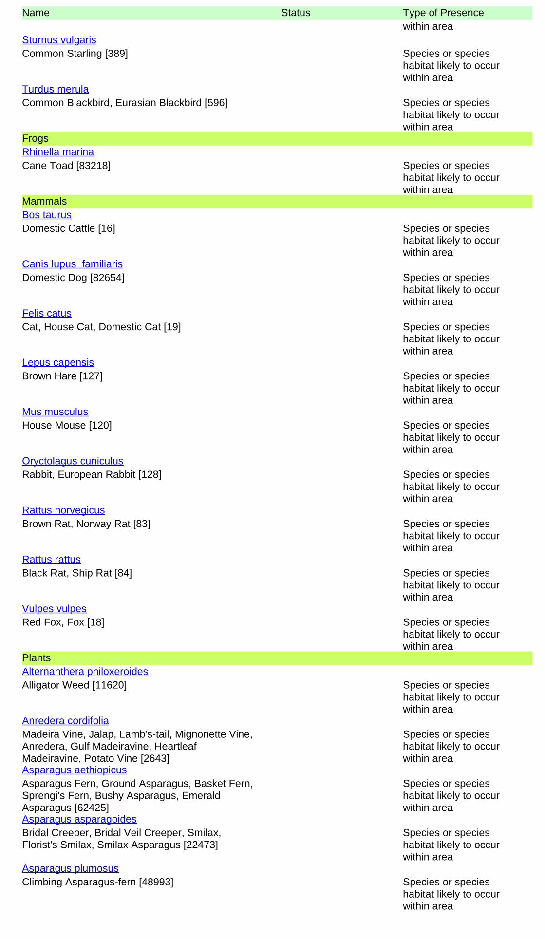
Name Status Type of Presencewithin area
Common Starling [389] Species or specieshabitat likely to occurwithin area
Sturnus vulgaris
Common Blackbird, Eurasian Blackbird [596] Species or specieshabitat likely to occurwithin area
Turdus merula
Frogs
Cane Toad [83218] Species or specieshabitat likely to occurwithin area
Rhinella marina
Mammals
Domestic Cattle [16] Species or specieshabitat likely to occurwithin area
Bos taurus
Domestic Dog [82654] Species or specieshabitat likely to occurwithin area
Canis lupus familiaris
Cat, House Cat, Domestic Cat [19] Species or specieshabitat likely to occurwithin area
Felis catus
Brown Hare [127] Species or specieshabitat likely to occurwithin area
Lepus capensis
House Mouse [120] Species or specieshabitat likely to occurwithin area
Mus musculus
Rabbit, European Rabbit [128] Species or specieshabitat likely to occurwithin area
Oryctolagus cuniculus
Brown Rat, Norway Rat [83] Species or specieshabitat likely to occurwithin area
Rattus norvegicus
Black Rat, Ship Rat [84] Species or specieshabitat likely to occurwithin area
Rattus rattus
Red Fox, Fox [18] Species or specieshabitat likely to occurwithin area
Vulpes vulpes
Plants
Alligator Weed [11620] Species or specieshabitat likely to occurwithin area
Alternanthera philoxeroides
Madeira Vine, Jalap, Lamb's-tail, Mignonette Vine,Anredera, Gulf Madeiravine, HeartleafMadeiravine, Potato Vine [2643]
Species or specieshabitat likely to occurwithin area
Anredera cordifolia
Asparagus Fern, Ground Asparagus, Basket Fern,Sprengi's Fern, Bushy Asparagus, EmeraldAsparagus [62425]
Species or specieshabitat likely to occurwithin area
Asparagus aethiopicus
Bridal Creeper, Bridal Veil Creeper, Smilax,Florist's Smilax, Smilax Asparagus [22473]
Species or specieshabitat likely to occurwithin area
Asparagus asparagoides
Climbing Asparagus-fern [48993] Species or specieshabitat likely to occurwithin area
Asparagus plumosus

Name Status Type of Presence
Asparagus Fern, Climbing Asparagus Fern[23255]
Species or specieshabitat likely to occurwithin area
Asparagus scandens
Cabomba, Fanwort, Carolina Watershield, FishGrass, Washington Grass, Watershield, CarolinaFanwort, Common Cabomba [5171]
Species or specieshabitat likely to occurwithin area
Cabomba caroliniana
Bitou Bush, Boneseed [18983] Species or specieshabitat may occur withinarea
Chrysanthemoides monilifera
Boneseed [16905] Species or specieshabitat likely to occurwithin area
Chrysanthemoides monilifera subsp. monilifera
Bitou Bush [16332] Species or specieshabitat likely to occurwithin area
Chrysanthemoides monilifera subsp. rotundata
Broom, English Broom, Scotch Broom, CommonBroom, Scottish Broom, Spanish Broom [5934]
Species or specieshabitat likely to occurwithin area
Cytisus scoparius
Cat's Claw Vine, Yellow Trumpet Vine, Cat's ClawCreeper, Funnel Creeper [85119]
Species or specieshabitat likely to occurwithin area
Dolichandra unguis-cati
Water Hyacinth, Water Orchid, Nile Lily [13466] Species or specieshabitat likely to occurwithin area
Eichhornia crassipes
Flax-leaved Broom, Mediterranean Broom, FlaxBroom [2800]
Species or specieshabitat likely to occurwithin area
Genista linifolia
Montpellier Broom, Cape Broom, Canary Broom,Common Broom, French Broom, Soft Broom[20126]
Species or specieshabitat likely to occurwithin area
Genista monspessulana
Broom [67538] Species or specieshabitat may occur withinarea
Genista sp. X Genista monspessulana
Lantana, Common Lantana, Kamara Lantana,Large-leaf Lantana, Pink Flowered Lantana, RedFlowered Lantana, Red-Flowered Sage, WhiteSage, Wild Sage [10892]
Species or specieshabitat likely to occurwithin area
Lantana camara
African Boxthorn, Boxthorn [19235] Species or specieshabitat likely to occurwithin area
Lycium ferocissimum
Prickly Pears [82753] Species or specieshabitat likely to occurwithin area
Opuntia spp.
Radiata Pine Monterey Pine, Insignis Pine, WildingPine [20780]
Species or specieshabitat may occur withinarea
Pinus radiata
Climbing Asparagus-fern, Ferny Asparagus[11747]
Species or specieshabitat likely to occurwithin area
Protasparagus plumosus
Blackberry, European Blackberry [68406] Species or specieshabitat likely to occurwithin area
Rubus fruticosus aggregate
Delta Arrowhead, Arrowhead, Slender Arrowhead[68483]
Species or specieshabitat likely to occurwithin area
Sagittaria platyphylla

Nationally Important Wetlands [ Resource Information ]Name StateBotany Wetlands NSW
Name Status Type of Presence
Willows except Weeping Willow, Pussy Willow andSterile Pussy Willow [68497]
Species or specieshabitat likely to occurwithin area
Salix spp. except S.babylonica, S.x calodendron & S.x reichardtii
Salvinia, Giant Salvinia, Aquarium Watermoss,Kariba Weed [13665]
Species or specieshabitat likely to occurwithin area
Salvinia molesta
Fireweed, Madagascar Ragwort, MadagascarGroundsel [2624]
Species or specieshabitat likely to occurwithin area
Senecio madagascariensis

-33.86354 151.20767
Coordinates
- non-threatened seabirds which have only been mapped for recorded breeding sites
- migratory species that are very widespread, vagrant, or only occur in small numbers
- some species and ecological communities that have only recently been listed
Not all species listed under the EPBC Act have been mapped (see below) and therefore a report is a generalguide only. Where available data supports mapping, the type of presence that can be determined from thedata is indicated in general terms. People using this information in making a referral may need to considerthe qualifications below and may need to seek and consider other information sources.
For threatened ecological communities where the distribution is well known, maps are derived fromrecovery plans, State vegetation maps, remote sensing imagery and other sources. Where threatenedecological community distributions are less well known, existing vegetation maps and point location dataare used to produce indicative distribution maps.
- seals which have only been mapped for breeding sites near the Australian continentSuch breeding sites may be important for the protection of the Commonwealth Marine environment.
For species where the distributions are well known, maps are digitised from sources such as recovery plansand detailed habitat studies. Where appropriate, core breeding, foraging and roosting areas are indicatedunder 'type of presence'. For species whose distributions are less well known, point locations are collatedfrom government wildlife authorities, museums, and non-government organisations; bioclimaticdistribution models are generated and these validated by experts. In some cases, the distribution maps arebased solely on expert knowledge.
The information presented in this report has been provided by a range of data sources as acknowledged atthe end of the report.
Caveat
- migratory and
The following species and ecological communities have not been mapped and do not appear in reportsproduced from this database:
- marine
This report is designed to assist in identifying the locations of places which may be relevant in determiningobligations under the Environment Protection and Biodiversity Conservation Act 1999. It holds mappedlocations of World Heritage and Register of National Estate properties, Wetlands of InternationalImportance, Commonwealth and State/Territory reserves, listed threatened, migratory and marine speciesand listed threatened ecological communities. Mapping of Commonwealth land is not complete at thisstage. Maps have been collated from a range of sources at various resolutions.
- threatened species listed as extinct or considered as vagrants
- some terrestrial species that overfly the Commonwealth marine area
The following groups have been mapped, but may not cover the complete distribution of the species:
Only selected species covered by the following provisions of the EPBC Act have been mapped:

-Department of the Environment, Climate Change, Energy and Water-Birds Australia-Australian Bird and Bat Banding Scheme
-Department of Environment and Conservation, Western Australia
Acknowledgements
-Department of Environment, Climate Change and Water, New South Wales
-Department of Primary Industries, Parks, Water and Environment, Tasmania
-Parks and Wildlife Service NT, NT Dept of Natural Resources, Environment and the Arts-Environmental and Resource Management, Queensland
-Department of Sustainability and Environment, Victoria
-Australian National Wildlife Collection
-Department of Environment and Natural Resources, South Australia
This database has been compiled from a range of data sources. The department acknowledges thefollowing custodians who have contributed valuable data and advice:
-Australian Museum
-National Herbarium of NSW
-State Forests of NSW-Australian Government, Department of Defence
-State Herbarium of South Australia
The Department is extremely grateful to the many organisations and individuals who providedexpert advice and information on numerous draft distributions.
-Natural history museums of Australia
-Queensland Museum
-Australian National Herbarium, Atherton and Canberra
-Royal Botanic Gardens and National Herbarium of Victoria
-Geoscience Australia
-Ocean Biogeographic Information System
-Online Zoological Collections of Australian Museums-Queensland Herbarium
-Western Australian Herbarium
-Tasmanian Herbarium
-Northern Territory Herbarium
-SA Museum
-Museum Victoria
-University of New England
-CSIRO-Other groups and individuals
© Commonwealth of Australia
+61 2 6274 1111
Canberra ACT 2601 Australia
GPO Box 787
Department of the Environment
Please feel free to provide feedback via the Contact Us page.

Species listed under the Sensitive Species Data Policy may have their locations denatured (^ rounded to 0.1°; ^^ rounded to 0.01°).
Copyright the State of NSW through the Office of Environment and Heritage.
Report generated on 26/09/2014 8:19 AM
Kingdom Class FamilySpecies
CodeScientific Name Exotic Common Name
NSW
status
Comm.
status
Record
sInfo
Animalia Amphibia Myobatrachida
e
3001 Adelotus brevis Tusked Frog P 1
Animalia Amphibia Myobatrachida
e
3134 Crinia signifera Common Eastern Froglet P 20
Animalia Amphibia Myobatrachida
e
3061 Limnodynastes peronii Brown-striped Frog P 18
Animalia Amphibia Myobatrachida
e
3116 Pseudophryne australis Red-crowned Toadlet V,P 6
Animalia Amphibia Myobatrachida
e
3117 Pseudophryne bibronii Bibron's Toadlet P 1
Animalia Amphibia Hylidae 3166 Litoria aurea Green and Golden Bell Frog E1,P V 3
Animalia Amphibia Hylidae 3180 Litoria dentata Bleating Tree Frog P 3
Animalia Amphibia Hylidae 3183 Litoria fallax Eastern Dwarf Tree Frog P 2
Animalia Amphibia Hylidae 3190 Litoria jervisiensis Jervis Bay Tree Frog P 1
Animalia Amphibia Hylidae 3204 Litoria peronii Peron's Tree Frog P 1
Animalia Amphibia Bufonidae 3269 Rhinella marina * Cane Toad 1
Animalia Reptilia Chelidae 2017 Chelodina longicollis Eastern Snake-necked Turtle P 6
Animalia Reptilia Gekkonidae 2077 Diplodactylus vittatus Wood Gecko P 10
Animalia Reptilia Gekkonidae 2118 Oedura lesueurii Lesueur's Velvet Gecko P 1
Animalia Reptilia Gekkonidae 2129 Phyllurus platurus Broad-tailed Gecko P 13
Animalia Reptilia Gekkonidae 2138 Underwoodisaurus milii Thick-tailed Gecko P 10
Animalia Reptilia Pygopodidae 2170 Lialis burtonis Burton's Snake-lizard P 12
Animalia Reptilia Pygopodidae 2174 Pygopus lepidopodus Common Scaly-foot P 11
Animalia Reptilia Scincidae 2331 Cryptoblepharus virgatus Cream-striped Shinning-
skink
P 12
Animalia Reptilia Scincidae 2375 Ctenotus robustus Robust Ctenotus P 8
Animalia Reptilia Scincidae 2386 Ctenotus taeniolatus Copper-tailed Skink P 1
Animalia Reptilia Scincidae 2557 Eulamprus quoyii Eastern Water-skink P 25
Animalia Reptilia Scincidae 2559 Eulamprus tenuis Barred-sided Skink P 10
Animalia Reptilia Scincidae 2450 Lampropholis delicata Dark-flecked Garden
Sunskink
P 19
Animalia Reptilia Scincidae 2451 Lampropholis guichenoti Pale-flecked Garden
Sunskink
P 39
Animalia Reptilia Scincidae T117 Lampropholis sp. unidentified grass skink P 2
Animalia Reptilia Scincidae 2542 Saiphos equalis Three-toed Skink P 10
Animalia Reptilia Scincidae 2452 Saproscincus mustelinus Weasel Skink P 5
Animalia Reptilia Scincidae 2583 Tiliqua rugosa Shingle-back P 1
Animalia Reptilia Scincidae 2580 Tiliqua scincoides Eastern Blue-tongue P 91
Animalia Reptilia Agamidae 2252 Intellagama lesueurii Eastern Water Dragon P 47
Animalia Reptilia Agamidae 5075 Intellagama lesueurii
lesueurii
Eastern Water Dragon P 29
Animalia Reptilia Varanidae 2283 Varanus varius Lace Monitor P 2
Animalia Reptilia Typhlopidae 2588 Ramphotyphlops
bituberculatus
Prong-snouted Blind Snake P 1
Animalia Reptilia Typhlopidae 2603 Ramphotyphlops
proximus
Proximus Blind Snake P 1
Animalia Reptilia Boidae 5096 Morelia spilota spilota Diamond Python P 5
Animalia Reptilia Colubridae 2633 Dendrelaphis punctulatus Common Tree Snake P 17
Animalia Reptilia Elapidae 2647 Cacophis squamulosus Golden-crowned Snake P 18
Animalia Reptilia Elapidae 2669 Furina diadema Red-naped Snake P 4
Animalia Reptilia Elapidae 2674 Hemiaspis signata Black-bellied Swamp Snake P 1
Animalia Reptilia Elapidae 2754 Hydrophis elegans Elegant Seasnake P 1
Animalia Reptilia Elapidae 2726 Parasuta dwyeri Dwyer's Snake P 1
Animalia Reptilia Elapidae 2693 Pseudechis porphyriacus Red-bellied Black Snake P 18
Animalia Reptilia Elapidae 9075 Pseudechis sp. Unidentified Black Snake P 1
Animalia Reptilia Elapidae 2734 Vermicella annulata Bandy-bandy P 4
Animalia Aves Megapodiidae 0008 Alectura lathami Australian Brush-turkey P 119
Animalia Aves Phasianidae 0009 Coturnix pectoralis Stubble Quail P 3
Animalia Aves Phasianidae 0011 Coturnix ypsilophora Brown Quail P 2
Animalia Aves Phasianidae 0012 Excalfactoria chinensis King Quail P 1
Animalia Aves Anseranatidae 0199 Anseranas semipalmata Magpie Goose V,P 9
Animalia Aves Anatidae 0210 Anas castanea Chestnut Teal P 23
Animalia Aves Anatidae 0211 Anas gracilis Grey Teal P 6
Animalia Aves Anatidae 0948 Anas platyrhynchos * Mallard 35
Animalia Aves Anatidae 0208 Anas superciliosa Pacific Black Duck P 183
Animalia Aves Anatidae 0215 Aythya australis Hardhead P 3
Animalia Aves Anatidae 0217 Biziura lobata Musk Duck P 4
Data from the BioNet Atlas of NSW Wildlife website, which holds records from a number of custodians. The data are only indicative and cannot be considered a
comprehensive inventory, and may contain errors and omissions.
Search criteria : Public Report of all Valid Records of Entities in selected area [North: -33.8 West: 151.14 East: 151.24 South: -33.9] returned a total of 17,243
records of 1,922 species.
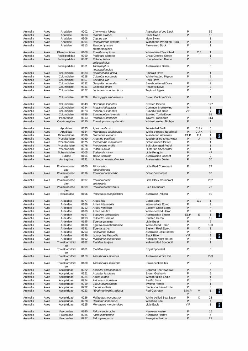
Animalia Aves Anatidae 0202 Chenonetta jubata Australian Wood Duck P 59
Animalia Aves Anatidae 0203 Cygnus atratus Black Swan P 12
Animalia Aves Anatidae 0906 Cygnus olor * Mute Swan 1
Animalia Aves Anatidae 0204 Dendrocygna arcuata Wandering Whistling-Duck P 1
Animalia Aves Anatidae 0213 Malacorhynchus
membranaceus
Pink-eared Duck P 1
Animalia Aves Phaethontidae 0108 Phaethon lepturus White-tailed Tropicbird P C,J 1
Animalia Aves Podicipedidae 0060 Podiceps cristatus Great Crested Grebe P 1
Animalia Aves Podicipedidae 0062 Poliocephalus
poliocephalus
Hoary-headed Grebe P 3
Animalia Aves Podicipedidae 0061 Tachybaptus
novaehollandiae
Australasian Grebe P 3
Animalia Aves Columbidae 0033 Chalcophaps indica Emerald Dove P 1
Animalia Aves Columbidae 0028 Columba leucomela White-headed Pigeon P 3
Animalia Aves Columbidae 0957 Columba livia * Rock Dove 101
Animalia Aves Columbidae 0032 Geopelia humeralis Bar-shouldered Dove P 2
Animalia Aves Columbidae 9931 Geopelia striata Peaceful Dove P 3
Animalia Aves Columbidae 0027 Lopholaimus antarcticus Topknot Pigeon P 5
Animalia Aves Columbidae 0029 Macropygia amboinensis Brown Cuckoo-Dove P 1
Animalia Aves Columbidae 0043 Ocyphaps lophotes Crested Pigeon P 127
Animalia Aves Columbidae 0034 Phaps chalcoptera Common Bronzewing P 1
Animalia Aves Columbidae 0023 Ptilinopus superbus Superb Fruit-Dove V,P 7
Animalia Aves Columbidae 0989 Streptopelia chinensis * Spotted Turtle-Dove 53
Animalia Aves Podargidae 0313 Podargus strigoides Tawny Frogmouth P 114
Animalia Aves Caprimulgidae 0330 Eurostopodus mystacalis White-throated Nightjar P 1
Animalia Aves Apodidae 0335 Apus pacificus Fork-tailed Swift P C,J,K 5
Animalia Aves Apodidae 0334 Hirundapus caudacutus White-throated Needletail P C,J,K 7
Animalia Aves Diomedeidae 0086 Diomedea exulans Wandering Albatross E1,P E,J 1
Animalia Aves Procellariidae 0069 Ardenna pacificus Wedge-tailed Shearwater P J 3
Animalia Aves Procellariidae 0075 Pterodroma macroptera Great-winged Petrel P 1
Animalia Aves Procellariidae 0076 Pterodroma mollis Soft-plumaged Petrel P 1
Animalia Aves Procellariidae 0068 Puffinus gavia Fluttering Shearwater P 1
Animalia Aves Spheniscidae 0005 Eudyptula minor Little Penguin P 47
Animalia Aves Sulidae 0104 Morus serrator Australasian Gannet P 2
Animalia Aves Anhingidae 8731 Anhinga novaehollandiae Australasian Darter P 55
Animalia Aves Phalacrocoraci
dae
0100 Microcarbo
melanoleucos
Little Pied Cormorant P 77
Animalia Aves Phalacrocoraci
dae
0096 Phalacrocorax carbo Great Cormorant P 30
Animalia Aves Phalacrocoraci
dae
0097 Phalacrocorax
sulcirostris
Little Black Cormorant P 232
Animalia Aves Phalacrocoraci
dae
0099 Phalacrocorax varius Pied Cormorant P 77
Animalia Aves Pelecanidae 0106 Pelecanus conspicillatus Australian Pelican P 99
Animalia Aves Ardeidae 0977 Ardea ibis Cattle Egret P C,J 1
Animalia Aves Ardeidae 0186 Ardea intermedia Intermediate Egret P 2
Animalia Aves Ardeidae 8712 Ardea modesta Eastern Great Egret P 4
Animalia Aves Ardeidae 0189 Ardea pacifica White-necked Heron P 9
Animalia Aves Ardeidae 0197 Botaurus poiciloptilus Australasian Bittern E1,P E 1
Animalia Aves Ardeidae 0193 Butorides striatus Striated Heron P 15
Animalia Aves Ardeidae 0185 Egretta garzetta Little Egret P 2
Animalia Aves Ardeidae 0188 Egretta novaehollandiae White-faced Heron P 133
Animalia Aves Ardeidae 0191 Egretta sacra Eastern Reef Egret P C 1
Animalia Aves Ardeidae 8703 Ixobrychus dubius Australian Little Bittern P 3
Animalia Aves Ardeidae 0196 Ixobrychus flavicollis Black Bittern V,P 2
Animalia Aves Ardeidae 0192 Nycticorax caledonicus Nankeen Night Heron P 5
Animalia Aves Threskiornithid
ae
0182 Platalea flavipes Yellow-billed Spoonbill P 1
Animalia Aves Threskiornithid
ae
0181 Platalea regia Royal Spoonbill P 5
Animalia Aves Threskiornithid
ae
0179 Threskiornis molucca Australian White Ibis P 293
Animalia Aves Threskiornithid
ae
0180 Threskiornis spinicollis Straw-necked Ibis P 2
Animalia Aves Accipitridae 0222 Accipiter cirrocephalus Collared Sparrowhawk P 4
Animalia Aves Accipitridae 0221 Accipiter fasciatus Brown Goshawk P 9
Animalia Aves Accipitridae 0224 Aquila audax Wedge-tailed Eagle P 1
Animalia Aves Accipitridae 0234 Aviceda subcristata Pacific Baza P 5
Animalia Aves Accipitridae 0219 Circus approximans Swamp Harrier P 1
Animalia Aves Accipitridae 0232 Elanus axillaris Black-shouldered Kite P 3
Animalia Aves Accipitridae 0223 ^Erythrotriorchis radiatus Red Goshawk E4A,P,
2
V 1
Animalia Aves Accipitridae 0226 Haliaeetus leucogaster White-bellied Sea-Eagle P C 28
Animalia Aves Accipitridae 0228 Haliastur sphenurus Whistling Kite P 4
Animalia Aves Accipitridae 0225 Hieraaetus morphnoides Little Eagle V,P 1
Animalia Aves Falconidae 0240 Falco cenchroides Nankeen Kestrel P 16
Animalia Aves Falconidae 0235 Falco longipennis Australian Hobby P 4
Animalia Aves Falconidae 0237 Falco peregrinus Peregrine Falcon P 29

Animalia Aves Rallidae 0059 Fulica atra Eurasian Coot P 8
Animalia Aves Rallidae 0056 Gallinula tenebrosa Dusky Moorhen P 29
Animalia Aves Rallidae 0046 Gallirallus philippensis Buff-banded Rail P 3
Animalia Aves Rallidae 0045 Lewinia pectoralis Lewin's Rail P 1
Animalia Aves Rallidae 0058 Porphyrio porphyrio Purple Swamphen P 9
Animalia Aves Rallidae 0050 Porzana pusilla Baillon's Crake P 2
Animalia Aves Rallidae 0051 Porzana tabuensis Spotless Crake P 3
Animalia Aves Burhinidae 0174 Burhinus grallarius Bush Stone-curlew E1,P 4
Animalia Aves Haematopodida
e
0130 Haematopus longirostris Pied Oystercatcher E1,P 1
Animalia Aves Recurvirostrida
e
0146 Himantopus himantopus Black-winged Stilt P 2
Animalia Aves Charadriidae 0143 Charadrius ruficapillus Red-capped Plover P 1
Animalia Aves Charadriidae 0144 Elseyornis melanops Black-fronted Dotterel P 3
Animalia Aves Charadriidae 0132 Erythrogonys cinctus Red-kneed Dotterel P 1
Animalia Aves Charadriidae 8006 Pluvialis fulva Pacific Golden Plover P C,J,K 3
Animalia Aves Charadriidae 0133 Vanellus miles Masked Lapwing P 285
Animalia Aves Charadriidae 0134 Vanellus miles
novaehollandiae
[Spur-winged Plover] P 1
Animalia Aves Charadriidae 0135 Vanellus tricolor Banded Lapwing P 3
Animalia Aves Scolopacidae 0157 Actitis hypoleucos Common Sandpiper P C,J,K 2
Animalia Aves Scolopacidae 0892 Bartramia longicauda Upland Sandpiper P 1
Animalia Aves Scolopacidae 0163 Calidris acuminata Sharp-tailed Sandpiper P C,J,K 37
Animalia Aves Scolopacidae 0161 Calidris ferruginea Curlew Sandpiper E1,P C,J,K 8
Animalia Aves Scolopacidae 0978 Calidris melanotos Pectoral Sandpiper P J,K 1
Animalia Aves Scolopacidae 0168 Gallinago hardwickii Latham's Snipe P C,J,K 3
Animalia Aves Scolopacidae 0153 Limosa lapponica Bar-tailed Godwit P C,J,K 3
Animalia Aves Scolopacidae 0151 Numenius minutus Little Curlew P C,J,K 2
Animalia Aves Scolopacidae 0158 Tringa nebularia Common Greenshank P C,J,K 1
Animalia Aves Scolopacidae 0159 Tringa stagnatilis Marsh Sandpiper P C,J,K 1
Animalia Aves Turnicidae 0019 Turnix pyrrhothorax Red-chested Button-quail P 1
Animalia Aves Turnicidae 0014 Turnix varius Painted Button-quail P 1
Animalia Aves Turnicidae 0018 Turnix velox Little Button-quail P 1
Animalia Aves Stercorcariidae 0945 Stercorarius pomarinus Pomarine Jaeger P C,J 1
Animalia Aves Laridae 0110 Chlidonias hybrida Whiskered Tern P 2
Animalia Aves Laridae 0125 Chroicocephalus
novaehollandiae
Silver Gull P 1294
Animalia Aves Laridae 0112 Hydroprogne caspia Caspian Tern P C,J 2
Animalia Aves Laridae 0981 Larus dominicanus Kelp Gull P 1
Animalia Aves Laridae 0885 Leucophaeus pipixcan Franklin's Gull P 2
Animalia Aves Laridae 0953 Sterna hirundo Common Tern P C,J,K 12
Animalia Aves Laridae 0114 Sterna striata White-fronted Tern P 2
Animalia Aves Laridae 0117 Sternula albifrons Little Tern E1,P C,J,K 2
Animalia Aves Laridae 0115 Thalasseus bergii Crested Tern P 26
Animalia Aves Cacatuidae 0269 Cacatua galerita Sulphur-crested Cockatoo P 198
Animalia Aves Cacatuidae 0271 Cacatua sanguinea Little Corella P 12
Animalia Aves Cacatuidae T187 Cacatua sp. P 1
Animalia Aves Cacatuidae 0272 Cacatua tenuirostris Long-billed Corella P 3
Animalia Aves Cacatuidae 0267 Calyptorhynchus
funereus
Yellow-tailed Black-Cockatoo P 60
Animalia Aves Cacatuidae 0265 ^Calyptorhynchus
lathami
Glossy Black-Cockatoo V,P,2 2
Animalia Aves Cacatuidae 0273 Eolophus roseicapillus Galah P 38
Animalia Aves Cacatuidae 0274 Nymphicus hollandicus Cockatiel P 1
Animalia Aves Psittacidae 0281 Alisterus scapularis Australian King-Parrot P 159
Animalia Aves Psittacidae 0280 Aprosmictus
erythropterus
Red-winged Parrot P 1
Animalia Aves Psittacidae 0294 Barnardius zonarius Australian Ringneck P 5
Animalia Aves Psittacidae 0258 Glossopsitta concinna Musk Lorikeet P 10
Animalia Aves Psittacidae 0260 Glossopsitta pusilla Little Lorikeet V,P 2
Animalia Aves Psittacidae 0309 ^^Lathamus discolor Swift Parrot E1,P,3 E 3
Animalia Aves Psittacidae 0310 Melopsittacus undulatus Budgerigar P 3
Animalia Aves Psittacidae 0286 Platycercus adscitus Pale-headed Rosella P 1
Animalia Aves Psittacidae 0282 Platycercus elegans Crimson Rosella P 65
Animalia Aves Psittacidae 0283 Platycercus elegans
adelaidae
[Adelaide Rosella] P 1
Animalia Aves Psittacidae 0288 Platycercus eximius Eastern Rosella P 49
Animalia Aves Psittacidae 0289 Platycercus icterotis Western Rosella P 1
Animalia Aves Psittacidae 0295 Psephotus
haematonotus
Red-rumped Parrot P 5
Animalia Aves Psittacidae 0256 Trichoglossus
chlorolepidotus
Scaly-breasted Lorikeet P 8
Animalia Aves Psittacidae 9947 Trichoglossus
haematodus
Rainbow Lorikeet P 294
Animalia Aves Psittacidae 8882 Trichoglossus
haematodus moluccanus
P 2
Animalia Aves Centropodidae 0349 Centropus phasianinus Pheasant Coucal P 2
Animalia Aves Cuculidae 0338 Cacomantis flabelliformis Fan-tailed Cuckoo P 11
Animalia Aves Cuculidae 0337 Cacomantis pallidus Pallid Cuckoo P 4
Animalia Aves Cuculidae 0339 Cacomantis variolosus Brush Cuckoo P 1
Animalia Aves Cuculidae 0342 Chalcites basalis Horsfield's Bronze-Cuckoo P 4

Animalia Aves Cuculidae 0343 Chalcites lucidus Shining Bronze-Cuckoo P 4
Animalia Aves Cuculidae 0341 Chalcites osculans Black-eared Cuckoo P 1
Animalia Aves Cuculidae 0347 Eudynamys orientalis Eastern Koel P 131
Animalia Aves Cuculidae 8930 Eudynamys orientalis
cyanocephala
P 2
Animalia Aves Cuculidae 0348 Scythrops
novaehollandiae
Channel-billed Cuckoo P 160
Animalia Aves Strigidae 0246 ^^Ninox connivens Barking Owl V,P,3 2
Animalia Aves Strigidae 9922 Ninox novaeseelandiae Southern Boobook P 61
Animalia Aves Strigidae 0248 ^^Ninox strenua Powerful Owl V,P,3 68
Animalia Aves Tytonidae 9923 Tyto javanica Eastern Barn Owl P 3
Animalia Aves Alcedinidae 0319 Ceyx azureus Azure Kingfisher P 4
Animalia Aves Alcedinidae 0322 Dacelo novaeguineae Laughing Kookaburra P 364
Animalia Aves Alcedinidae 0326 Todiramphus sanctus Sacred Kingfisher P 19
Animalia Aves Coraciidae 0318 Eurystomus orientalis Dollarbird P 11
Animalia Aves Climacteridae 0558 Cormobates leucophaea White-throated Treecreeper P 5
Animalia Aves Ptilonorhynchid
ae
0679 Ptilonorhynchus
violaceus
Satin Bowerbird P 10
Animalia Aves Maluridae 0529 Malurus cyaneus Superb Fairy-wren P 251
Animalia Aves Maluridae 0536 Malurus lamberti Variegated Fairy-wren P 19
Animalia Aves Maluridae 0526 Stipiturus malachurus Southern Emu-wren P 1
Animalia Aves Acanthizidae 0486 Acanthiza chrysorrhoa Yellow-rumped Thornbill P 3
Animalia Aves Acanthizidae 0470 Acanthiza lineata Striated Thornbill P 1
Animalia Aves Acanthizidae 0471 Acanthiza nana Yellow Thornbill P 20
Animalia Aves Acanthizidae 0475 Acanthiza pusilla Brown Thornbill P 19
Animalia Aves Acanthizidae 0454 Gerygone mouki Brown Gerygone P 6
Animalia Aves Acanthizidae 0453 Gerygone olivacea White-throated Gerygone P 1
Animalia Aves Acanthizidae 0493 Sericornis citreogularis Yellow-throated Scrubwren P 1
Animalia Aves Acanthizidae 0488 Sericornis frontalis White-browed Scrubwren P 180
Animalia Aves Acanthizidae 0465 Smicrornis brevirostris Weebill P 1
Animalia Aves Pardalotidae 0565 Pardalotus punctatus Spotted Pardalote P 25
Animalia Aves Pardalotidae 0976 Pardalotus striatus Striated Pardalote P 1
Animalia Aves Meliphagidae 0591 Acanthorhynchus
tenuirostris
Eastern Spinebill P 40
Animalia Aves Meliphagidae 0638 Anthochaera carunculata Red Wattlebird P 49
Animalia Aves Meliphagidae 0710 Anthochaera chrysoptera Little Wattlebird P 17
Animalia Aves Meliphagidae 0603 Anthochaera phrygia Regent Honeyeater E4A,P E 2
Animalia Aves Meliphagidae 0614 Caligavis chrysops Yellow-faced Honeyeater P 10
Animalia Aves Meliphagidae 0448 Epthianura albifrons White-fronted Chat V,P 1
Animalia Aves Meliphagidae 0448 Epthianura albifrons White-fronted Chat
population in the Sydney
Metropolitan Catchment
Management Area
E2,V,P 1
Animalia Aves Meliphagidae 0619 Lichenostomus
melanops
Yellow-tufted Honeyeater P 1
Animalia Aves Meliphagidae 0625 Lichenostomus
penicillatus
White-plumed Honeyeater P 13
Animalia Aves Meliphagidae 0634 Manorina melanocephala Noisy Miner P 249
Animalia Aves Meliphagidae 0633 Manorina melanophrys Bell Miner P 1
Animalia Aves Meliphagidae 0605 Meliphaga lewinii Lewin's Honeyeater P 1
Animalia Aves Meliphagidae 0578 Melithreptus lunatus White-naped Honeyeater P 12
Animalia Aves Meliphagidae 0645 Philemon corniculatus Noisy Friarbird P 5
Animalia Aves Meliphagidae 0631 Phylidonyris
novaehollandiae
New Holland Honeyeater P 132
Animalia Aves Psophodidae 0421 Psophodes olivaceus Eastern Whipbird P 145
Animalia Aves Campephagida
e
0424 Coracina
novaehollandiae
Black-faced Cuckoo-shrike P 34
Animalia Aves Campephagida
e
0430 Lalage sueurii White-winged Triller P 1
Animalia Aves Pachycephalida
e
0408 Colluricincla harmonica Grey Shrike-thrush P 6
Animalia Aves Pachycephalida
e
0416 Falcunculus frontatus
frontatus
Eastern Shrike-tit P 3
Animalia Aves Pachycephalida
e
0398 Pachycephala pectoralis Golden Whistler P 8
Animalia Aves Pachycephalida
e
0401 Pachycephala rufiventris Rufous Whistler P 15
Animalia Aves Oriolidae 0671 Oriolus sagittatus Olive-backed Oriole P 2
Animalia Aves Oriolidae 0432 Sphecotheres vieilloti Australasian Figbird P 41
Animalia Aves Artamidae 0547 Artamus cyanopterus Dusky Woodswallow P 3
Animalia Aves Artamidae 0543 Artamus leucorynchus White-breasted
Woodswallow
P 3
Animalia Aves Artamidae 0544 Artamus personatus Masked Woodswallow P 1
Animalia Aves Artamidae 0700 Cracticus nigrogularis Pied Butcherbird P 1
Animalia Aves Artamidae 0705 Cracticus tibicen Australian Magpie P 189
Animalia Aves Artamidae 8499 Cracticus tibicen tibicen P 2
Animalia Aves Artamidae 0702 Cracticus torquatus Grey Butcherbird P 285
Animalia Aves Artamidae 0694 Strepera graculina Pied Currawong P 207
Animalia Aves Dicruridae 0673 Dicrurus bracteatus Spangled Drongo P 21
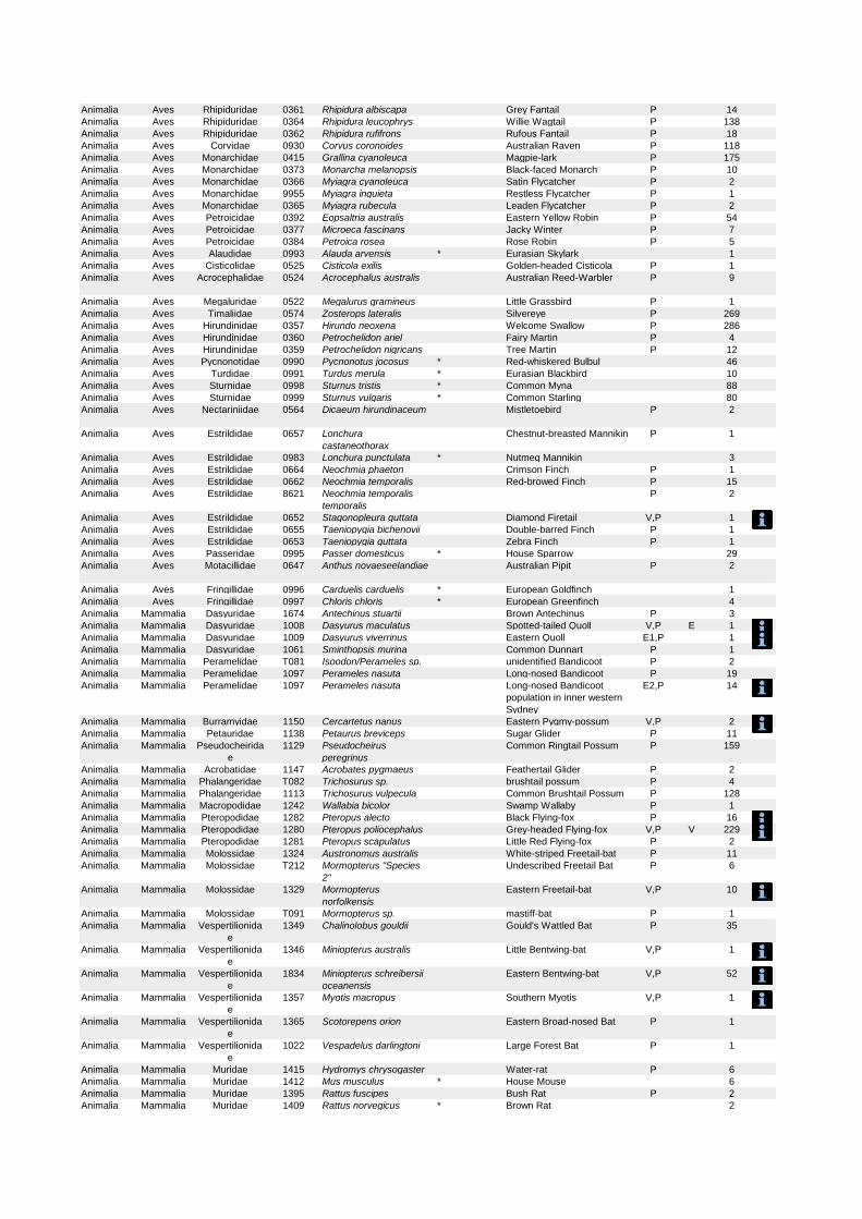
Animalia Aves Rhipiduridae 0361 Rhipidura albiscapa Grey Fantail P 14
Animalia Aves Rhipiduridae 0364 Rhipidura leucophrys Willie Wagtail P 138
Animalia Aves Rhipiduridae 0362 Rhipidura rufifrons Rufous Fantail P 18
Animalia Aves Corvidae 0930 Corvus coronoides Australian Raven P 118
Animalia Aves Monarchidae 0415 Grallina cyanoleuca Magpie-lark P 175
Animalia Aves Monarchidae 0373 Monarcha melanopsis Black-faced Monarch P 10
Animalia Aves Monarchidae 0366 Myiagra cyanoleuca Satin Flycatcher P 2
Animalia Aves Monarchidae 9955 Myiagra inquieta Restless Flycatcher P 1
Animalia Aves Monarchidae 0365 Myiagra rubecula Leaden Flycatcher P 2
Animalia Aves Petroicidae 0392 Eopsaltria australis Eastern Yellow Robin P 54
Animalia Aves Petroicidae 0377 Microeca fascinans Jacky Winter P 7
Animalia Aves Petroicidae 0384 Petroica rosea Rose Robin P 5
Animalia Aves Alaudidae 0993 Alauda arvensis * Eurasian Skylark 1
Animalia Aves Cisticolidae 0525 Cisticola exilis Golden-headed Cisticola P 1
Animalia Aves Acrocephalidae 0524 Acrocephalus australis Australian Reed-Warbler P 9
Animalia Aves Megaluridae 0522 Megalurus gramineus Little Grassbird P 1
Animalia Aves Timaliidae 0574 Zosterops lateralis Silvereye P 269
Animalia Aves Hirundinidae 0357 Hirundo neoxena Welcome Swallow P 286
Animalia Aves Hirundinidae 0360 Petrochelidon ariel Fairy Martin P 4
Animalia Aves Hirundinidae 0359 Petrochelidon nigricans Tree Martin P 12
Animalia Aves Pycnonotidae 0990 Pycnonotus jocosus * Red-whiskered Bulbul 46
Animalia Aves Turdidae 0991 Turdus merula * Eurasian Blackbird 10
Animalia Aves Sturnidae 0998 Sturnus tristis * Common Myna 88
Animalia Aves Sturnidae 0999 Sturnus vulgaris * Common Starling 80
Animalia Aves Nectariniidae 0564 Dicaeum hirundinaceum Mistletoebird P 2
Animalia Aves Estrildidae 0657 Lonchura
castaneothorax
Chestnut-breasted Mannikin P 1
Animalia Aves Estrildidae 0983 Lonchura punctulata * Nutmeg Mannikin 3
Animalia Aves Estrildidae 0664 Neochmia phaeton Crimson Finch P 1
Animalia Aves Estrildidae 0662 Neochmia temporalis Red-browed Finch P 15
Animalia Aves Estrildidae 8621 Neochmia temporalis
temporalis
P 2
Animalia Aves Estrildidae 0652 Stagonopleura guttata Diamond Firetail V,P 1
Animalia Aves Estrildidae 0655 Taeniopygia bichenovii Double-barred Finch P 1
Animalia Aves Estrildidae 0653 Taeniopygia guttata Zebra Finch P 1
Animalia Aves Passeridae 0995 Passer domesticus * House Sparrow 29
Animalia Aves Motacillidae 0647 Anthus novaeseelandiae Australian Pipit P 2
Animalia Aves Fringillidae 0996 Carduelis carduelis * European Goldfinch 1
Animalia Aves Fringillidae 0997 Chloris chloris * European Greenfinch 4
Animalia Mammalia Dasyuridae 1674 Antechinus stuartii Brown Antechinus P 3
Animalia Mammalia Dasyuridae 1008 Dasyurus maculatus Spotted-tailed Quoll V,P E 1
Animalia Mammalia Dasyuridae 1009 Dasyurus viverrinus Eastern Quoll E1,P 1
Animalia Mammalia Dasyuridae 1061 Sminthopsis murina Common Dunnart P 1
Animalia Mammalia Peramelidae T081 Isoodon/Perameles sp. unidentified Bandicoot P 2
Animalia Mammalia Peramelidae 1097 Perameles nasuta Long-nosed Bandicoot P 19
Animalia Mammalia Peramelidae 1097 Perameles nasuta Long-nosed Bandicoot
population in inner western
Sydney
E2,P 14
Animalia Mammalia Burramyidae 1150 Cercartetus nanus Eastern Pygmy-possum V,P 2
Animalia Mammalia Petauridae 1138 Petaurus breviceps Sugar Glider P 11
Animalia Mammalia Pseudocheirida
e
1129 Pseudocheirus
peregrinus
Common Ringtail Possum P 159
Animalia Mammalia Acrobatidae 1147 Acrobates pygmaeus Feathertail Glider P 2
Animalia Mammalia Phalangeridae T082 Trichosurus sp. brushtail possum P 4
Animalia Mammalia Phalangeridae 1113 Trichosurus vulpecula Common Brushtail Possum P 128
Animalia Mammalia Macropodidae 1242 Wallabia bicolor Swamp Wallaby P 1
Animalia Mammalia Pteropodidae 1282 Pteropus alecto Black Flying-fox P 16
Animalia Mammalia Pteropodidae 1280 Pteropus poliocephalus Grey-headed Flying-fox V,P V 229
Animalia Mammalia Pteropodidae 1281 Pteropus scapulatus Little Red Flying-fox P 2
Animalia Mammalia Molossidae 1324 Austronomus australis White-striped Freetail-bat P 11
Animalia Mammalia Molossidae T212 Mormopterus "Species
2"
Undescribed Freetail Bat P 6
Animalia Mammalia Molossidae 1329 Mormopterus
norfolkensis
Eastern Freetail-bat V,P 10
Animalia Mammalia Molossidae T091 Mormopterus sp. mastiff-bat P 1
Animalia Mammalia Vespertilionida
e
1349 Chalinolobus gouldii Gould's Wattled Bat P 35
Animalia Mammalia Vespertilionida
e
1346 Miniopterus australis Little Bentwing-bat V,P 1
Animalia Mammalia Vespertilionida
e
1834 Miniopterus schreibersii
oceanensis
Eastern Bentwing-bat V,P 52
Animalia Mammalia Vespertilionida
e
1357 Myotis macropus Southern Myotis V,P 1
Animalia Mammalia Vespertilionida
e
1365 Scotorepens orion Eastern Broad-nosed Bat P 1
Animalia Mammalia Vespertilionida
e
1022 Vespadelus darlingtoni Large Forest Bat P 1
Animalia Mammalia Muridae 1415 Hydromys chrysogaster Water-rat P 6
Animalia Mammalia Muridae 1412 Mus musculus * House Mouse 6
Animalia Mammalia Muridae 1395 Rattus fuscipes Bush Rat P 2
Animalia Mammalia Muridae 1409 Rattus norvegicus * Brown Rat 2
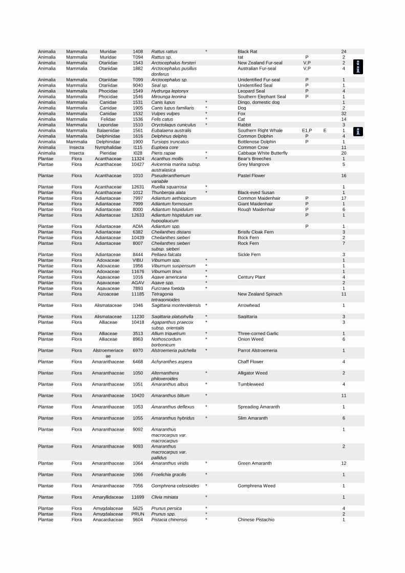
Animalia Mammalia Muridae 1408 Rattus rattus * Black Rat 24
Animalia Mammalia Muridae T094 Rattus sp. rat P 2
Animalia Mammalia Otariidae 1543 Arctocephalus forsteri New Zealand Fur-seal V,P 2
Animalia Mammalia Otariidae 1882 Arctocephalus pusillus
doriferus
Australian Fur-seal V,P 4
Animalia Mammalia Otariidae T099 Arctocephalus sp. Unidentified Fur-seal P 1
Animalia Mammalia Otariidae 9040 Seal sp. Unidentified Seal P 1
Animalia Mammalia Phocidae 1549 Hydrurga leptonyx Leopard Seal P 4
Animalia Mammalia Phocidae 1546 Mirounga leonina Southern Elephant Seal P 1
Animalia Mammalia Canidae 1531 Canis lupus * Dingo, domestic dog 1
Animalia Mammalia Canidae 1905 Canis lupus familiaris * Dog 2
Animalia Mammalia Canidae 1532 Vulpes vulpes * Fox 32
Animalia Mammalia Felidae 1536 Felis catus * Cat 14
Animalia Mammalia Leporidae 1510 Oryctolagus cuniculus * Rabbit 3
Animalia Mammalia Balaenidae 1561 Eubalaena australis Southern Right Whale E1,P E 1
Animalia Mammalia Delphinidae 1616 Delphinus delphis Common Dolphin P 4
Animalia Mammalia Delphinidae 1900 Tursiops truncatus Bottlenose Dolphin P 1
Animalia Insecta Nymphalidae I115 Euploea core Common Crow 11
Animalia Insecta Pieridae I028 Pieris rapae * Cabbage White Butterfly 20
Plantae Flora Acanthaceae 11324 Acanthus mollis * Bear's Breeches 1
Plantae Flora Acanthaceae 10427 Avicennia marina subsp.
australasica
Grey Mangrove 5
Plantae Flora Acanthaceae 1010 Pseuderanthemum
variabile
Pastel Flower 16
Plantae Flora Acanthaceae 12631 Ruellia squarrosa * 1
Plantae Flora Acanthaceae 1012 Thunbergia alata * Black-eyed Susan 1
Plantae Flora Adiantaceae 7997 Adiantum aethiopicum Common Maidenhair P 17
Plantae Flora Adiantaceae 7999 Adiantum formosum Giant Maidenhair P 1
Plantae Flora Adiantaceae 8000 Adiantum hispidulum Rough Maidenhair P 6
Plantae Flora Adiantaceae 12633 Adiantum hispidulum var.
hypoglaucum
P 1
Plantae Flora Adiantaceae ADIA Adiantum spp. P 1
Plantae Flora Adiantaceae 6382 Cheilanthes distans Bristly Cloak Fern 3
Plantae Flora Adiantaceae 10439 Cheilanthes sieberi Rock Fern 2
Plantae Flora Adiantaceae 8007 Cheilanthes sieberi
subsp. sieberi
Rock Fern 7
Plantae Flora Adiantaceae 8444 Pellaea falcata Sickle Fern 3
Plantae Flora Adoxaceae VIBU Viburnum spp. * 1
Plantae Flora Adoxaceae 1956 Viburnum suspensum * 1
Plantae Flora Adoxaceae 11676 Viburnum tinus * 1
Plantae Flora Agavaceae 1016 Agave americana * Century Plant 4
Plantae Flora Agavaceae AGAV Agave spp. * 2
Plantae Flora Agavaceae 7893 Furcraea foetida * 1
Plantae Flora Aizoaceae 11185 Tetragonia
tetragonioides
New Zealand Spinach 11
Plantae Flora Alismataceae 1046 Sagittaria montevidensis * Arrowhead 1
Plantae Flora Alismataceae 11230 Sagittaria platyphylla * Sagittaria 3
Plantae Flora Alliaceae 10418 Agapanthus praecox
subsp. orientalis
* 3
Plantae Flora Alliaceae 3513 Allium triquetrum * Three-corned Garlic 1
Plantae Flora Alliaceae 8963 Nothoscordum
borbonicum
* Onion Weed 6
Plantae Flora Alstroemeriace
ae
6970 Alstroemeria pulchella * Parrot Alstroemeria 1
Plantae Flora Amaranthaceae 6468 Achyranthes aspera Chaff Flower 4
Plantae Flora Amaranthaceae 1050 Alternanthera
philoxeroides
* Alligator Weed 2
Plantae Flora Amaranthaceae 1051 Amaranthus albus * Tumbleweed 4
Plantae Flora Amaranthaceae 10420 Amaranthus blitum * 11
Plantae Flora Amaranthaceae 1053 Amaranthus deflexus * Spreading Amaranth 1
Plantae Flora Amaranthaceae 1055 Amaranthus hybridus * Slim Amaranth 6
Plantae Flora Amaranthaceae 9092 Amaranthus
macrocarpus var.
macrocarpus
1
Plantae Flora Amaranthaceae 9093 Amaranthus
macrocarpus var.
pallidus
2
Plantae Flora Amaranthaceae 1064 Amaranthus viridis * Green Amaranth 12
Plantae Flora Amaranthaceae 1066 Froelichia gracilis * 1
Plantae Flora Amaranthaceae 7056 Gomphrena celosioides * Gomphrena Weed 1
Plantae Flora Amaryllidaceae 11699 Clivia miniata * 1
Plantae Flora Amygdalaceae 5625 Prunus persica * 4
Plantae Flora Amygdalaceae PRUN Prunus spp. * 2
Plantae Flora Anacardiaceae 9604 Pistacia chinensis * Chinese Pistachio 1

Plantae Flora Anacardiaceae 1086 Schinus areira * Pepper Tree 2
Plantae Flora Anacardiaceae 10050 Toxicodendron
succedaneum
* Rhus Tree 3
Plantae Flora Anthericaceae 7333 Caesia parviflora var.
vittata
1
Plantae Flora Anthericaceae 3538 Chlorophytum comosum * Spider Plant 5
Plantae Flora Anthericaceae 3556 Laxmannia gracilis Slender Wire Lily 1
Plantae Flora Anthericaceae 3567 Sowerbaea juncea Vanilla Plant 1
Plantae Flora Anthericaceae 3572 Thysanotus juncifolius 2
Plantae Flora Aphanopetalac
eae
2266 Aphanopetalum
resinosum
Gum Vine 1
Plantae Flora Apiaceae 1094 Actinotus helianthi Flannel Flower P 9
Plantae Flora Apiaceae 1095 Actinotus minor Lesser Flannel Flower 9
Plantae Flora Apiaceae 1101 Apium graveolens * Celery 2
Plantae Flora Apiaceae 1104 Apium prostratum Sea Celery 1
Plantae Flora Apiaceae 1106 Centella asiatica Indian Pennywort 3
Plantae Flora Apiaceae 8754 Centella cordifolia 1
Plantae Flora Apiaceae 1107 Conium maculatum * Hemlock 1
Plantae Flora Apiaceae 11064 Coriandrum sativum * Coriander 1
Plantae Flora Apiaceae 11195 Cyclospermum
leptophyllum
* Slender Celery 9
Plantae Flora Apiaceae 6453 Eryngium pandanifolium * 5
Plantae Flora Apiaceae 1118 Foeniculum vulgare * Fennel 8
Plantae Flora Apiaceae 7959 Hydrocotyle acutiloba 1
Plantae Flora Apiaceae 1123 Hydrocotyle bonariensis * 6
Plantae Flora Apiaceae 7961 Hydrocotyle
sibthorpioides
9
Plantae Flora Apiaceae 8572 Hydrocotyle sp. aff.
acutiloba
2
Plantae Flora Apiaceae HYDR Hydrocotyle spp. * 1
Plantae Flora Apiaceae 1144 Platysace lanceolata Shrubby Platysace 10
Plantae Flora Apiaceae 1145 Platysace linearifolia 7
Plantae Flora Apiaceae 8785 Trachymene incisa
subsp. incisa
2
Plantae Flora Apiaceae 1162 Xanthosia pilosa Woolly Xanthosia 15
Plantae Flora Apiaceae 1163 Xanthosia tridentata Rock Xanthosia 6
Plantae Flora Apocynaceae 11047 Araujia sericifera * Moth Vine 4
Plantae Flora Apocynaceae 1224 Asclepias curassavica * Blood Flower 2
Plantae Flora Apocynaceae 1227 Gomphocarpus
fruticosus
* Narrow-leaved Cotton Bush 1
Plantae Flora Apocynaceae 1231 Marsdenia flavescens Hairy Milk Vine 1
Plantae Flora Apocynaceae 1234 Marsdenia rostrata Milk Vine 2
Plantae Flora Apocynaceae 1235 Marsdenia suaveolens Scented Marsdenia 1
Plantae Flora Apocynaceae 10204 Nerium oleander * Oleander 6
Plantae Flora Apocynaceae PLMR Plumeria spp. * Frangipani 1
Plantae Flora Apocynaceae 1240 Tylophora barbata Bearded Tylophora 1
Plantae Flora Araceae 8672 Alocasia brisbanensis Cunjevoi 4
Plantae Flora Araceae ALOC Alocasia spp. 1
Plantae Flora Araceae 12671 Alocasia zebrina * 1
Plantae Flora Araceae 1194 Colocasia esculenta * Taro 2
Plantae Flora Araceae 1195 Gymnostachys anceps Settler's Twine 4
Plantae Flora Araceae 12673 Homalomena
lauterbachii
* 1
Plantae Flora Araceae 11289 Monstera deliciosa * Fruit Salad Plant 4
Plantae Flora Araceae 9308 Pistia stratiotes * Water Lettuce 1
Plantae Flora Araceae 1198 Zantedeschia aethiopica * Arum Lily 3
Plantae Flora Araliaceae 1201 Astrotricha floccosa 9
Plantae Flora Araliaceae 1205 Astrotricha longifolia 2
Plantae Flora Araliaceae 1207 Hedera helix * English Ivy 9
Plantae Flora Araliaceae 12681 Meryta sinclairii * 1
Plantae Flora Araliaceae 1209 Polyscias elegans Celery Wood 1
Plantae Flora Araliaceae 1210 Polyscias murrayi Pencil Cedar 1
Plantae Flora Araliaceae 1211 Polyscias sambucifolia Elderberry Panax 27
Plantae Flora Araliaceae 12373 Polyscias sambucifolia
subsp. sambucifolia
1
Plantae Flora Araliaceae 8701 Schefflera actinophylla * Umbrella Tree 2
Plantae Flora Araliaceae 12682 Trevesia palmata * 2
Plantae Flora Araucariaceae 1214 Araucaria heterophylla * Norfolk Island Pine 1
Plantae Flora Araucariaceae 12683 Araucaria scopulorum * 1
Plantae Flora Arecaceae 11435 Archontophoenix
alexandrae
* Alexandra Palm 1
Plantae Flora Arecaceae 6458 Archontophoenix
cunninghamiana
Bangalow Palm P 1
Plantae Flora Arecaceae 1218 Howea forsteriana Kentia Palm P 1
Plantae Flora Arecaceae 1221 Livistona australis Cabbage Palm P 10
Plantae Flora Arecaceae 11354 Phoenix canariensis * Canary Island Date Palm 7
Plantae Flora Arecaceae 11731 Syagrus romanzoffiana * Cocos Palm 1
Plantae Flora Asparagaceae 11784 Asparagus aethiopicus * Asparagus Fern 34
Plantae Flora Asparagaceae 3519 Asparagus asparagoides * Bridal Creeper 4
Plantae Flora Asparagaceae 3521 Asparagus officinalis * Asparagus 1
Plantae Flora Asparagaceae 11785 Asparagus plumosus * Climbing Asparagus Fern 3
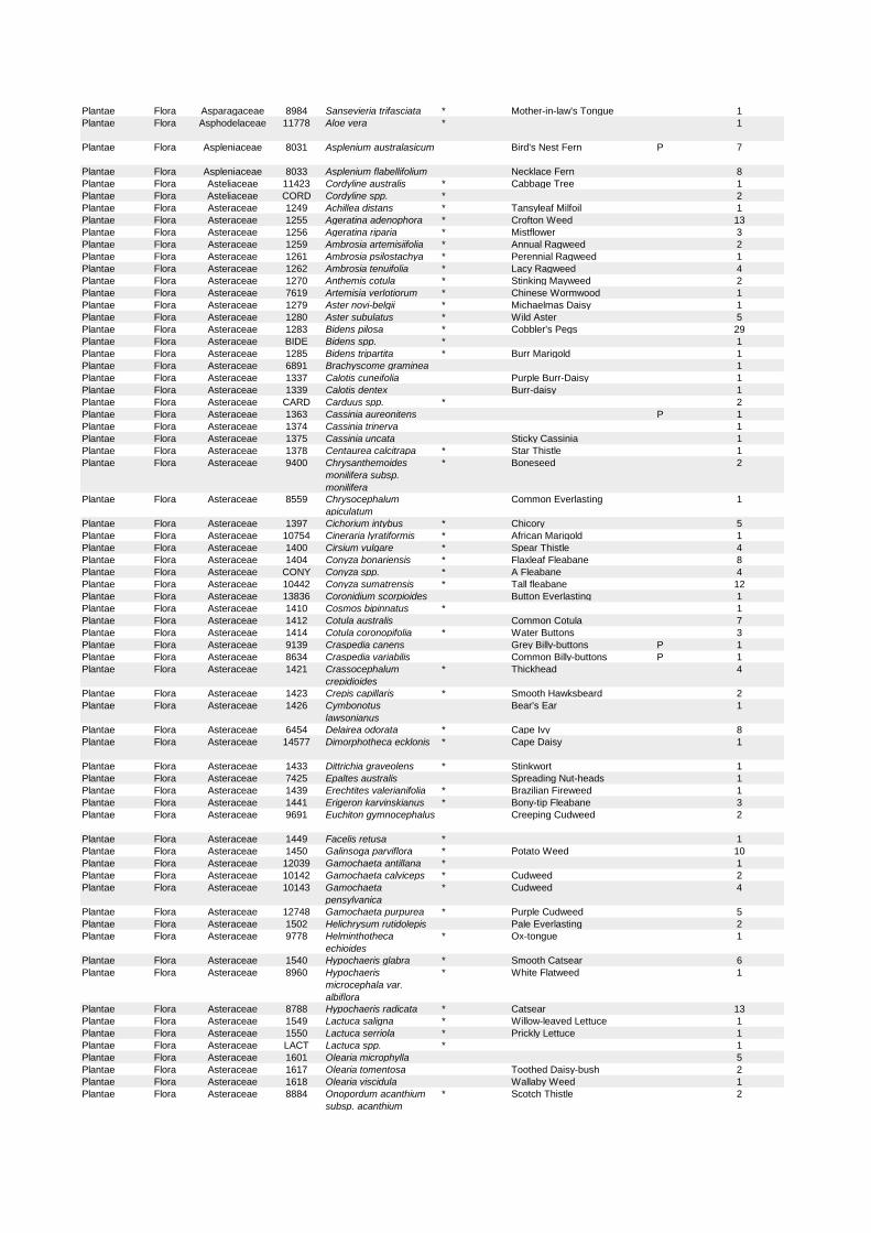
Plantae Flora Asparagaceae 8984 Sansevieria trifasciata * Mother-in-law's Tongue 1
Plantae Flora Asphodelaceae 11778 Aloe vera * 1
Plantae Flora Aspleniaceae 8031 Asplenium australasicum Bird's Nest Fern P 7
Plantae Flora Aspleniaceae 8033 Asplenium flabellifolium Necklace Fern 8
Plantae Flora Asteliaceae 11423 Cordyline australis * Cabbage Tree 1
Plantae Flora Asteliaceae CORD Cordyline spp. * 2
Plantae Flora Asteraceae 1249 Achillea distans * Tansyleaf Milfoil 1
Plantae Flora Asteraceae 1255 Ageratina adenophora * Crofton Weed 13
Plantae Flora Asteraceae 1256 Ageratina riparia * Mistflower 3
Plantae Flora Asteraceae 1259 Ambrosia artemisiifolia * Annual Ragweed 2
Plantae Flora Asteraceae 1261 Ambrosia psilostachya * Perennial Ragweed 1
Plantae Flora Asteraceae 1262 Ambrosia tenuifolia * Lacy Ragweed 4
Plantae Flora Asteraceae 1270 Anthemis cotula * Stinking Mayweed 2
Plantae Flora Asteraceae 7619 Artemisia verlotiorum * Chinese Wormwood 1
Plantae Flora Asteraceae 1279 Aster novi-belgii * Michaelmas Daisy 1
Plantae Flora Asteraceae 1280 Aster subulatus * Wild Aster 5
Plantae Flora Asteraceae 1283 Bidens pilosa * Cobbler's Pegs 29
Plantae Flora Asteraceae BIDE Bidens spp. * 1
Plantae Flora Asteraceae 1285 Bidens tripartita * Burr Marigold 1
Plantae Flora Asteraceae 6891 Brachyscome graminea 1
Plantae Flora Asteraceae 1337 Calotis cuneifolia Purple Burr-Daisy 1
Plantae Flora Asteraceae 1339 Calotis dentex Burr-daisy 1
Plantae Flora Asteraceae CARD Carduus spp. * 2
Plantae Flora Asteraceae 1363 Cassinia aureonitens P 1
Plantae Flora Asteraceae 1374 Cassinia trinerva 1
Plantae Flora Asteraceae 1375 Cassinia uncata Sticky Cassinia 1
Plantae Flora Asteraceae 1378 Centaurea calcitrapa * Star Thistle 1
Plantae Flora Asteraceae 9400 Chrysanthemoides
monilifera subsp.
monilifera
* Boneseed 2
Plantae Flora Asteraceae 8559 Chrysocephalum
apiculatum
Common Everlasting 1
Plantae Flora Asteraceae 1397 Cichorium intybus * Chicory 5
Plantae Flora Asteraceae 10754 Cineraria lyratiformis * African Marigold 1
Plantae Flora Asteraceae 1400 Cirsium vulgare * Spear Thistle 4
Plantae Flora Asteraceae 1404 Conyza bonariensis * Flaxleaf Fleabane 8
Plantae Flora Asteraceae CONY Conyza spp. * A Fleabane 4
Plantae Flora Asteraceae 10442 Conyza sumatrensis * Tall fleabane 12
Plantae Flora Asteraceae 13836 Coronidium scorpioides Button Everlasting 1
Plantae Flora Asteraceae 1410 Cosmos bipinnatus * 1
Plantae Flora Asteraceae 1412 Cotula australis Common Cotula 7
Plantae Flora Asteraceae 1414 Cotula coronopifolia * Water Buttons 3
Plantae Flora Asteraceae 9139 Craspedia canens Grey Billy-buttons P 1
Plantae Flora Asteraceae 8634 Craspedia variabilis Common Billy-buttons P 1
Plantae Flora Asteraceae 1421 Crassocephalum
crepidioides
* Thickhead 4
Plantae Flora Asteraceae 1423 Crepis capillaris * Smooth Hawksbeard 2
Plantae Flora Asteraceae 1426 Cymbonotus
lawsonianus
Bear's Ear 1
Plantae Flora Asteraceae 6454 Delairea odorata * Cape Ivy 8
Plantae Flora Asteraceae 14577 Dimorphotheca ecklonis * Cape Daisy 1
Plantae Flora Asteraceae 1433 Dittrichia graveolens * Stinkwort 1
Plantae Flora Asteraceae 7425 Epaltes australis Spreading Nut-heads 1
Plantae Flora Asteraceae 1439 Erechtites valerianifolia * Brazilian Fireweed 1
Plantae Flora Asteraceae 1441 Erigeron karvinskianus * Bony-tip Fleabane 3
Plantae Flora Asteraceae 9691 Euchiton gymnocephalus Creeping Cudweed 2
Plantae Flora Asteraceae 1449 Facelis retusa * 1
Plantae Flora Asteraceae 1450 Galinsoga parviflora * Potato Weed 10
Plantae Flora Asteraceae 12039 Gamochaeta antillana * 1
Plantae Flora Asteraceae 10142 Gamochaeta calviceps * Cudweed 2
Plantae Flora Asteraceae 10143 Gamochaeta
pensylvanica
* Cudweed 4
Plantae Flora Asteraceae 12748 Gamochaeta purpurea * Purple Cudweed 5
Plantae Flora Asteraceae 1502 Helichrysum rutidolepis Pale Everlasting 2
Plantae Flora Asteraceae 9778 Helminthotheca
echioides
* Ox-tongue 1
Plantae Flora Asteraceae 1540 Hypochaeris glabra * Smooth Catsear 6
Plantae Flora Asteraceae 8960 Hypochaeris
microcephala var.
albiflora
* White Flatweed 1
Plantae Flora Asteraceae 8788 Hypochaeris radicata * Catsear 13
Plantae Flora Asteraceae 1549 Lactuca saligna * Willow-leaved Lettuce 1
Plantae Flora Asteraceae 1550 Lactuca serriola * Prickly Lettuce 1
Plantae Flora Asteraceae LACT Lactuca spp. * 1
Plantae Flora Asteraceae 1601 Olearia microphylla 5
Plantae Flora Asteraceae 1617 Olearia tomentosa Toothed Daisy-bush 2
Plantae Flora Asteraceae 1618 Olearia viscidula Wallaby Weed 1
Plantae Flora Asteraceae 8884 Onopordum acanthium
subsp. acanthium
* Scotch Thistle 2
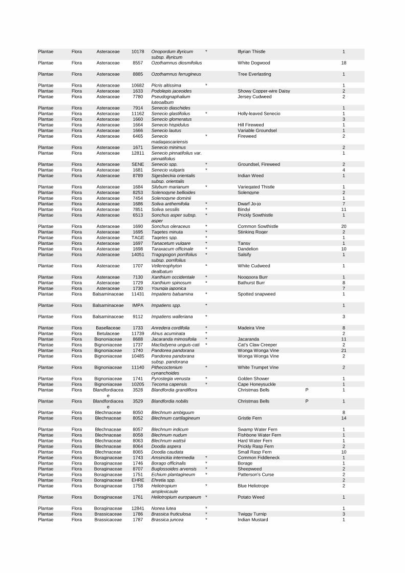
Plantae Flora Asteraceae 10178 Onopordum illyricum
subsp. illyricum
* Illyrian Thistle 1
Plantae Flora Asteraceae 8557 Ozothamnus diosmifolius White Dogwood 18
Plantae Flora Asteraceae 8885 Ozothamnus ferrugineus Tree Everlasting 1
Plantae Flora Asteraceae 10682 Picris altissima * 1
Plantae Flora Asteraceae 1633 Podolepis jaceoides Showy Copper-wire Daisy 2
Plantae Flora Asteraceae 7780 Pseudognaphalium
luteoalbum
Jersey Cudweed 2
Plantae Flora Asteraceae 7914 Senecio diaschides 1
Plantae Flora Asteraceae 11162 Senecio glastifolius * Holly-leaved Senecio 1
Plantae Flora Asteraceae 1660 Senecio glomeratus 3
Plantae Flora Asteraceae 1664 Senecio hispidulus Hill Fireweed 1
Plantae Flora Asteraceae 1666 Senecio lautus Variable Groundsel 1
Plantae Flora Asteraceae 6465 Senecio
madagascariensis
* Fireweed 2
Plantae Flora Asteraceae 1671 Senecio minimus 2
Plantae Flora Asteraceae 12811 Senecio pinnatifolius var.
pinnatifolius
1
Plantae Flora Asteraceae SENE Senecio spp. * Groundsel, Fireweed 2
Plantae Flora Asteraceae 1681 Senecio vulgaris * 4
Plantae Flora Asteraceae 8789 Sigesbeckia orientalis
subsp. orientalis
Indian Weed 1
Plantae Flora Asteraceae 1684 Silybum marianum * Variegated Thistle 1
Plantae Flora Asteraceae 8253 Solenogyne bellioides Solengyne 2
Plantae Flora Asteraceae 7454 Solenogyne dominii 1
Plantae Flora Asteraceae 1686 Soliva anthemifolia * Dwarf Jo-jo 7
Plantae Flora Asteraceae 7851 Soliva sessilis * Bindyi 11
Plantae Flora Asteraceae 6513 Sonchus asper subsp.
asper
* Prickly Sowthistle 1
Plantae Flora Asteraceae 1690 Sonchus oleraceus * Common Sowthistle 20
Plantae Flora Asteraceae 1695 Tagetes minuta * Stinking Roger 2
Plantae Flora Asteraceae TAGE Tagetes spp. * 1
Plantae Flora Asteraceae 1697 Tanacetum vulgare * Tansy 1
Plantae Flora Asteraceae 1698 Taraxacum officinale * Dandelion 10
Plantae Flora Asteraceae 14051 Tragopogon porrifolius
subsp. porrifolius
* Salsify 1
Plantae Flora Asteraceae 1707 Vellereophyton
dealbatum
* White Cudweed 1
Plantae Flora Asteraceae 7130 Xanthium occidentale * Noogoora Burr 1
Plantae Flora Asteraceae 1729 Xanthium spinosum * Bathurst Burr 8
Plantae Flora Asteraceae 1730 Youngia japonica 7
Plantae Flora Balsaminaceae 11431 Impatiens balsamina * Spotted snapweed 1
Plantae Flora Balsaminaceae IMPA Impatiens spp. * 1
Plantae Flora Balsaminaceae 9112 Impatiens walleriana * 3
Plantae Flora Basellaceae 1733 Anredera cordifolia * Madeira Vine 8
Plantae Flora Betulaceae 11739 Alnus acuminata * 2
Plantae Flora Bignoniaceae 8688 Jacaranda mimosifolia * Jacaranda 11
Plantae Flora Bignoniaceae 1737 Macfadyena unguis-cati * Cat's Claw Creeper 2
Plantae Flora Bignoniaceae 1740 Pandorea pandorana Wonga Wonga Vine 21
Plantae Flora Bignoniaceae 10485 Pandorea pandorana
subsp. pandorana
Wonga Wonga Vine 2
Plantae Flora Bignoniaceae 11140 Pithecoctenium
cynanchoides
* White Trumpet Vine 2
Plantae Flora Bignoniaceae 1741 Pyrostegia venusta * Golden Shower 1
Plantae Flora Bignoniaceae 10205 Tecoma capensis * Cape Honeysuckle 1
Plantae Flora Blandfordiacea
e
3528 Blandfordia grandiflora Christmas Bells P 1
Plantae Flora Blandfordiacea
e
3529 Blandfordia nobilis Christmas Bells P 1
Plantae Flora Blechnaceae 8050 Blechnum ambiguum 8
Plantae Flora Blechnaceae 8052 Blechnum cartilagineum Gristle Fern 14
Plantae Flora Blechnaceae 8057 Blechnum indicum Swamp Water Fern 1
Plantae Flora Blechnaceae 8058 Blechnum nudum Fishbone Water Fern 1
Plantae Flora Blechnaceae 8063 Blechnum wattsii Hard Water Fern 1
Plantae Flora Blechnaceae 8064 Doodia aspera Prickly Rasp Fern 2
Plantae Flora Blechnaceae 8065 Doodia caudata Small Rasp Fern 10
Plantae Flora Boraginaceae 1743 Amsinckia intermedia * Common Fiddleneck 1
Plantae Flora Boraginaceae 1746 Borago officinalis * Borage 1
Plantae Flora Boraginaceae 8707 Buglossoides arvensis * Sheepweed 2
Plantae Flora Boraginaceae 1751 Echium plantagineum * Patterson's Curse 2
Plantae Flora Boraginaceae EHRE Ehretia spp. 2
Plantae Flora Boraginaceae 1758 Heliotropium
amplexicaule
* Blue Heliotrope 2
Plantae Flora Boraginaceae 1761 Heliotropium europaeum * Potato Weed 1
Plantae Flora Boraginaceae 12841 Nonea lutea * 1
Plantae Flora Brassicaceae 1786 Brassica fruticulosa * Twiggy Turnip 3
Plantae Flora Brassicaceae 1787 Brassica juncea * Indian Mustard 1
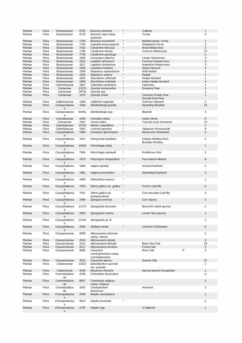
Plantae Flora Brassicaceae 6762 Brassica oleracea * Collards 1
Plantae Flora Brassicaceae 9732 Brassica rapa subsp.
sylvestris
* Turnip 3
Plantae Flora Brassicaceae 1790 Brassica tournefortii * Mediterranean Turnip 1
Plantae Flora Brassicaceae 1794 Capsella bursa-pastoris * Shepherd's Purse 5
Plantae Flora Brassicaceae 7410 Cardamine flexuosa * Wood Bittercress 2
Plantae Flora Brassicaceae 1795 Cardamine hirsuta * Common Bittercress 10
Plantae Flora Brassicaceae 7746 Cardamine paucijuga 1
Plantae Flora Brassicaceae 1800 Coronopus didymus * Lesser Swinecress 9
Plantae Flora Brassicaceae 1815 Lepidium africanum * Common Peppercress 3
Plantae Flora Brassicaceae 1817 Lepidium bonariense * Argentine Peppercress 3
Plantae Flora Brassicaceae 1833 Lobularia maritima * Sweet Alyssum 4
Plantae Flora Brassicaceae 1839 Raphanus raphanistrum * Wild Radish 1
Plantae Flora Brassicaceae 1840 Raphanus sativus * Radish 1
Plantae Flora Brassicaceae 1854 Sisymbrium officinale * Hedge Mustard 1
Plantae Flora Brassicaceae 1855 Sisymbrium orientale * Indian Hedge Mustard 4
Plantae Flora Cabombaceae 1867 Cabomba caroliniana * Cabomba 1
Plantae Flora Cactaceae 11223 Opuntia monacantha * Drooping Pear 1
Plantae Flora Cactaceae OPUN Opuntia spp. * 1
Plantae Flora Cactaceae 1875 Opuntia stricta * Common Prickly Pear,
Smooth Pest Pear
1
Plantae Flora Callitrichaceae 1909 Callitriche stagnalis * Common Starwort 2
Plantae Flora Campanulacea
e
1934 Wahlenbergia gracilis Sprawling Bluebell 13
Plantae Flora Campanulacea
e
WAHL Wahlenbergia spp. Bluebell 3
Plantae Flora Cannabaceae 1939 Cannabis sativa * Indian Hemp 6
Plantae Flora Cannaceae 1941 Canna indica * Tous-les-mois Arrowroot 10
Plantae Flora Caprifoliaceae 10755 Abelia x grandiflora * 1
Plantae Flora Caprifoliaceae 1952 Lonicera japonica * Japanese Honeysuckle 8
Plantae Flora Caryophyllacea
e
1960 Cerastium glomeratum * Mouse-ear Chickweed 6
Plantae Flora Caryophyllacea
e
1974 Paronychia brasiliana * Chilean Whitlow Wort,
Brazilian Whitlow
1
Plantae Flora Caryophyllacea
e
13845 Petrorhagia dubia * 1
Plantae Flora Caryophyllacea
e
7584 Petrorhagia nanteuilii * Proliferous Pink 2
Plantae Flora Caryophyllacea
e
1979 Polycarpon tetraphyllum * Four-leaved Allseed 8
Plantae Flora Caryophyllacea
e
1980 Sagina apetala * Annual Pearlwort 2
Plantae Flora Caryophyllacea
e
1981 Sagina procumbens * Spreading Pearlwort 4
Plantae Flora Caryophyllacea
e
1984 Scleranthus annuus * 1
Plantae Flora Caryophyllacea
e
7020 Silene gallica var. gallica * French Catchfly 6
Plantae Flora Caryophyllacea
e
7021 Silene gallica var.
quinquevulnera
* Five-wounded Catchfly 3
Plantae Flora Caryophyllacea
e
1996 Spergula arvensis * Corn Spurry 3
Plantae Flora Caryophyllacea
e
11170 Spergularia bocconei * Bocconi's Sand-spurrey 1
Plantae Flora Caryophyllacea
e
2000 Spergularia marina Lesser Sea-spurrey 1
Plantae Flora Caryophyllacea
e
11244 Spergularia sp. B 1
Plantae Flora Caryophyllacea
e
2006 Stellaria media * Common Chickweed 6
Plantae Flora Casuarinaceae 9009 Allocasuarina diminuta
subsp. mimica
2
Plantae Flora Casuarinaceae 2010 Allocasuarina distyla 9
Plantae Flora Casuarinaceae 2012 Allocasuarina littoralis Black She-Oak 29
Plantae Flora Casuarinaceae 2017 Allocasuarina torulosa Forest Oak 3
Plantae Flora Casuarinaceae 9006 Casuarina
cunninghamiana subsp.
cunninghamiana
River Oak P 3
Plantae Flora Casuarinaceae 2022 Casuarina glauca Swamp Oak 21
Plantae Flora Celastraceae 12523 Elaeodendron australe
var. australe
1
Plantae Flora Celastraceae 2035 Maytenus silvestris Narrow-leaved Orangebark 1
Plantae Flora Centrolepidace
ae
2038 Centrolepis fascicularis 6
Plantae Flora Centrolepidace
ae
8807 Centrolepis strigosa
subsp. strigosa
2
Plantae Flora Ceratophyllace
ae
2042 Ceratophyllum
demersum
Hornwort 2
Plantae Flora Chenopodiacea
e
2046 Atriplex australasica 1
Plantae Flora Chenopodiacea
e
9614 Atriplex prostrata * 1
Plantae Flora Chenopodiacea
e
ATRI Atriplex spp. A Saltbush 1
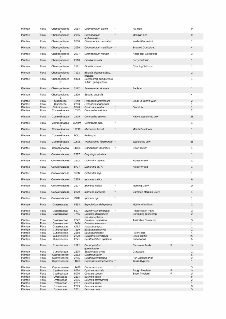
Plantae Flora Chenopodiacea
e
2084 Chenopodium album * Fat Hen 9
Plantae Flora Chenopodiacea
e
2085 Chenopodium
ambrosioides
* Mexican Tea 9
Plantae Flora Chenopodiacea
e
2088 Chenopodium carinatum Keeled Goosefoot 1
Plantae Flora Chenopodiacea
e
2096 Chenopodium multifidum * Scented Goosefoot 4
Plantae Flora Chenopodiacea
e
2097 Chenopodium murale * Nettle-leaf Goosefoot 3
Plantae Flora Chenopodiacea
e
2110 Einadia hastata Berry Saltbush 1
Plantae Flora Chenopodiacea
e
2111 Einadia nutans Climbing Saltbush 1
Plantae Flora Chenopodiacea
e
7193 Einadia trigonos subsp.
trigonos
2
Plantae Flora Chenopodiacea
e
9423 Sarcocornia quinqueflora
subsp. quinqueflora
1
Plantae Flora Chenopodiacea
e
2172 Sclerolaena calcarata Redburr 1
Plantae Flora Chenopodiacea
e
2200 Suaeda australis 4
Plantae Flora Clusiaceae 7240 Hypericum gramineum Small St John's Wort 2
Plantae Flora Clusiaceae 2203 Hypericum japonicum 1
Plantae Flora Colchicaceae 3548 Gloriosa superba * Glory Lily 1
Plantae Flora Commelinacea
e
10305 Commelina africana * 2
Plantae Flora Commelinacea
e
2209 Commelina cyanea Native Wandering Jew 25
Plantae Flora Commelinacea
e
COMM Commelina spp. * 1
Plantae Flora Commelinacea
e
12216 Murdannia keisak * Marsh Dewflower 1
Plantae Flora Commelinacea
e
POLL Pollia spp. 1
Plantae Flora Commelinacea
e
10508 Tradescantia fluminensis * Wandering Jew 36
Plantae Flora Convallariacea
e
11328 Ophiopogon japonicus * Dwarf lilyturf 1
Plantae Flora Convolvulaceae 2217 Calystegia silvatica * 1
Plantae Flora Convolvulaceae 2222 Dichondra repens Kidney Weed 10
Plantae Flora Convolvulaceae 8727 Dichondra sp. A Kidney Weed 1
Plantae Flora Convolvulaceae DICN Dichondra spp. 1
Plantae Flora Convolvulaceae 2225 Ipomoea cairica * 6
Plantae Flora Convolvulaceae 2227 Ipomoea indica * Morning Glory 14
Plantae Flora Convolvulaceae 2229 Ipomoea purpurea * Common Morning Glory 1
Plantae Flora Convolvulaceae IPOM Ipomoea spp. * 1
Plantae Flora Crassulaceae 8813 Bryophyllum delagoense * Mother of millions 2
Plantae Flora Crassulaceae 6827 Bryophyllum pinnatum * Resurrection Plant 3
Plantae Flora Crassulaceae 7745 Crassula decumbens
var. decumbens
Spreading Stonecrop 2
Plantae Flora Crassulaceae 2242 Crassula sieberiana Australian Stonecrop 3
Plantae Flora Crassulaceae 12424 Crassula tetramera 1
Plantae Flora Crassulaceae KALA Kalanchoe spp. * 1
Plantae Flora Cunoniaceae 7219 Bauera microphylla 1
Plantae Flora Cunoniaceae 2268 Bauera rubioides River Rose 4
Plantae Flora Cunoniaceae 2270 Callicoma serratifolia Black Wattle 20
Plantae Flora Cunoniaceae 2271 Ceratopetalum apetalum Coachwood 5
Plantae Flora Cunoniaceae 2272 Ceratopetalum
gummiferum
Christmas Bush P 14
Plantae Flora Cunoniaceae 2275 Schizomeria ovata Crabapple 1
Plantae Flora Cupressaceae 2282 Callitris muelleri 5
Plantae Flora Cupressaceae 2285 Callitris rhomboidea Port Jackson Pine 2
Plantae Flora Cupressaceae 11359 Cupressus sempervirens * Italian Cypress 1
Plantae Flora Cupressaceae 11428 Cupressus spp. * 3
Plantae Flora Cyatheaceae 8074 Cyathea australis Rough Treefern P 14
Plantae Flora Cyatheaceae 8076 Cyathea cooperi Straw Treefern P 14
Plantae Flora Cyperaceae 2294 Baumea acuta 8
Plantae Flora Cyperaceae 2295 Baumea arthrophylla 2
Plantae Flora Cyperaceae 2297 Baumea gunnii 1
Plantae Flora Cyperaceae 2299 Baumea juncea 3
Plantae Flora Cyperaceae 2301 Baumea nuda 5

Plantae Flora Cyperaceae 2302 Baumea rubiginosa 5
Plantae Flora Cyperaceae BAUM Baumea spp. 1
Plantae Flora Cyperaceae 2303 Baumea teretifolia 3
Plantae Flora Cyperaceae 2306 Bolboschoenus fluviatilis Marsh Club-rush 1
Plantae Flora Cyperaceae 2327 Carex inversa Knob Sedge 4
Plantae Flora Cyperaceae 2341 Caustis flexuosa Curly Wig P 9
Plantae Flora Cyperaceae 10330 Caustis recurvata var.
hirsuta
P 1
Plantae Flora Cyperaceae 2344 Chorizandra cymbaria 1
Plantae Flora Cyperaceae 2345 Chorizandra
sphaerocephala
Roundhead Bristle-sedge 4
Plantae Flora Cyperaceae 2347 Cyathochaeta diandra 5
Plantae Flora Cyperaceae 8845 Cyperus aggregatus * 1
Plantae Flora Cyperaceae 2348 Cyperus albostriatus * 3
Plantae Flora Cyperaceae 2352 Cyperus bowmannii 1
Plantae Flora Cyperaceae 2353 Cyperus brevifolius * 12
Plantae Flora Cyperaceae 2358 Cyperus congestus * 4
Plantae Flora Cyperaceae 7143 Cyperus difformis Dirty Dora 3
Plantae Flora Cyperaceae 2364 Cyperus eragrostis * Umbrella Sedge 5
Plantae Flora Cyperaceae 2365 Cyperus esculentus * Yellow Nutgrass 3
Plantae Flora Cyperaceae 2374 Cyperus gracilis Slender Flat-sedge 4
Plantae Flora Cyperaceae 2377 Cyperus imbecillis 1
Plantae Flora Cyperaceae 2378 Cyperus involucratus * Umbrella Plant 2
Plantae Flora Cyperaceae 2380 Cyperus laevis 2
Plantae Flora Cyperaceae 2383 Cyperus lucidus Leafy Flat Sedge 1
Plantae Flora Cyperaceae 2384 Cyperus mirus 4
Plantae Flora Cyperaceae 2386 Cyperus papyrus * 1
Plantae Flora Cyperaceae 8483 Cyperus polystachyos 9
Plantae Flora Cyperaceae 2393 Cyperus rotundus * Nutgrass 12
Plantae Flora Cyperaceae 2395 Cyperus sanguinolentus 4
Plantae Flora Cyperaceae 2398 Cyperus sesquiflorus * 8
Plantae Flora Cyperaceae 7469 Cyperus tenellus * 6
Plantae Flora Cyperaceae 2403 Cyperus tetraphyllus 2
Plantae Flora Cyperaceae 10333 Cyperus vorsteri * 3
Plantae Flora Cyperaceae 2408 Eleocharis acuta 5
Plantae Flora Cyperaceae 2412 Eleocharis dietrichiana 1
Plantae Flora Cyperaceae 2415 Eleocharis minuta * 5
Plantae Flora Cyperaceae 2417 Eleocharis pachycarpa * 6
Plantae Flora Cyperaceae 6988 Eleocharis sphacelata Tall Spike Rush 1
Plantae Flora Cyperaceae 12416 Ficinia nodosa Knobby Club-rush 8
Plantae Flora Cyperaceae 2426 Fimbristylis bisumbellata 1
Plantae Flora Cyperaceae 7435 Fimbristylis dichotoma Common Fringe-sedge 3
Plantae Flora Cyperaceae 2429 Fimbristylis velata 9
Plantae Flora Cyperaceae 2432 Gahnia clarkei Tall Saw-sedge 4
Plantae Flora Cyperaceae 2439 Gahnia melanocarpa Black Fruit Saw-sedge 6
Plantae Flora Cyperaceae 2442 Gahnia sieberiana Red-fruit Saw-sedge P 8
Plantae Flora Cyperaceae GAHN Gahnia spp. 1
Plantae Flora Cyperaceae 2445 Gymnoschoenus
sphaerocephalus
Button Grass 3
Plantae Flora Cyperaceae 2454 Isolepis inundata Club-rush 4
Plantae Flora Cyperaceae 2459 Isolepis producta 1
Plantae Flora Cyperaceae 2460 Isolepis prolifera * 7
Plantae Flora Cyperaceae 6455 Isolepis sepulcralis * 5
Plantae Flora Cyperaceae 8380 Lepidosperma concavum 3
Plantae Flora Cyperaceae 2465 Lepidosperma filiforme 4
Plantae Flora Cyperaceae 2467 Lepidosperma forsythii 4
Plantae Flora Cyperaceae 8749 Lepidosperma gunnii 1
Plantae Flora Cyperaceae 6402 Lepidosperma laterale Variable Sword-sedge 27
Plantae Flora Cyperaceae 2471 Lepidosperma neesii 5
Plantae Flora Cyperaceae LEPD Lepidosperma spp. 2
Plantae Flora Cyperaceae 2475 Lepidosperma
urophorum
1
Plantae Flora Cyperaceae 11028 Lepidosperma viscidum 1
Plantae Flora Cyperaceae 6742 Lipocarpha microcephala Button Rush 2
Plantae Flora Cyperaceae 8956 Ptilothrix deusta 2
Plantae Flora Cyperaceae 2486 Schoenoplectus erectus * 1
Plantae Flora Cyperaceae 6707 Schoenoplectus
mucronatus
2
Plantae Flora Cyperaceae 2490 Schoenoplectus validus 2
Plantae Flora Cyperaceae 2491 Schoenus apogon Fluke Bogrush 5
Plantae Flora Cyperaceae 2492 Schoenus brevifolius 5
Plantae Flora Cyperaceae 2495 Schoenus ericetorum 2
Plantae Flora Cyperaceae 2496 Schoenus imberbis 2
Plantae Flora Cyperaceae 9057 Schoenus lepidosperma
subsp. pachylepis
1
Plantae Flora Cyperaceae 2499 Schoenus maschalinus 2
Plantae Flora Cyperaceae 2500 Schoenus
melanostachys
4
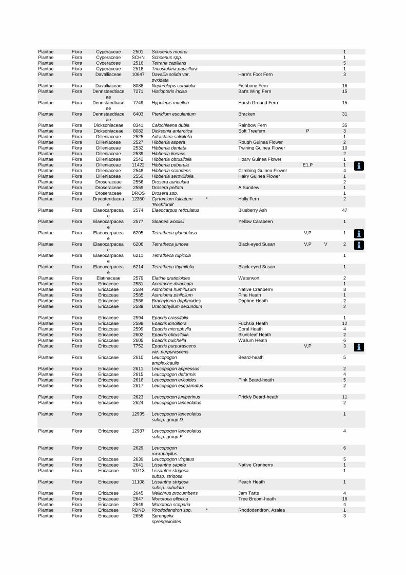
Plantae Flora Cyperaceae 2501 Schoenus moorei 1
Plantae Flora Cyperaceae SCHN Schoenus spp. 1
Plantae Flora Cyperaceae 2516 Tetraria capillaris 5
Plantae Flora Cyperaceae 2518 Tricostularia pauciflora 1
Plantae Flora Davalliaceae 10647 Davallia solida var.
pyxidata
Hare's Foot Fern 3
Plantae Flora Davalliaceae 8088 Nephrolepis cordifolia Fishbone Fern 16
Plantae Flora Dennstaedtiace
ae
7271 Histiopteris incisa Bat's Wing Fern 15
Plantae Flora Dennstaedtiace
ae
7749 Hypolepis muelleri Harsh Ground Fern 15
Plantae Flora Dennstaedtiace
ae
6403 Pteridium esculentum Bracken 31
Plantae Flora Dicksoniaceae 8341 Calochlaena dubia Rainbow Fern 35
Plantae Flora Dicksoniaceae 8082 Dicksonia antarctica Soft Treefern P 3
Plantae Flora Dilleniaceae 2525 Adrastaea salicifolia 1
Plantae Flora Dilleniaceae 2527 Hibbertia aspera Rough Guinea Flower 2
Plantae Flora Dilleniaceae 2532 Hibbertia dentata Twining Guinea Flower 10
Plantae Flora Dilleniaceae 2539 Hibbertia linearis 2
Plantae Flora Dilleniaceae 2542 Hibbertia obtusifolia Hoary Guinea Flower 1
Plantae Flora Dilleniaceae 11422 Hibbertia puberula E1,P 1
Plantae Flora Dilleniaceae 2548 Hibbertia scandens Climbing Guinea Flower 4
Plantae Flora Dilleniaceae 2550 Hibbertia serpyllifolia Hairy Guinea Flower 1
Plantae Flora Droseraceae 2556 Drosera auriculata 2
Plantae Flora Droseraceae 2559 Drosera peltata A Sundew 1
Plantae Flora Droseraceae DROS Drosera spp. 1
Plantae Flora Dryopteridacea
e
12350 Cyrtomium falcatum
'Rochfordii'
* Holly Fern 2
Plantae Flora Elaeocarpacea
e
2574 Elaeocarpus reticulatus Blueberry Ash 47
Plantae Flora Elaeocarpacea
e
2577 Sloanea woollsii Yellow Carabeen 1
Plantae Flora Elaeocarpacea
e
6205 Tetratheca glandulosa V,P 1
Plantae Flora Elaeocarpacea
e
6206 Tetratheca juncea Black-eyed Susan V,P V 2
Plantae Flora Elaeocarpacea
e
6211 Tetratheca rupicola 1
Plantae Flora Elaeocarpacea
e
6214 Tetratheca thymifolia Black-eyed Susan 1
Plantae Flora Elatinaceae 2579 Elatine gratioloides Waterwort 2
Plantae Flora Ericaceae 2581 Acrotriche divaricata 1
Plantae Flora Ericaceae 2584 Astroloma humifusum Native Cranberry 3
Plantae Flora Ericaceae 2585 Astroloma pinifolium Pine Heath 1
Plantae Flora Ericaceae 2586 Brachyloma daphnoides Daphne Heath 2
Plantae Flora Ericaceae 2589 Dracophyllum secundum 2
Plantae Flora Ericaceae 2594 Epacris crassifolia 1
Plantae Flora Ericaceae 2598 Epacris longiflora Fuchsia Heath 12
Plantae Flora Ericaceae 2599 Epacris microphylla Coral Heath 4
Plantae Flora Ericaceae 2602 Epacris obtusifolia Blunt-leaf Heath 2
Plantae Flora Ericaceae 2605 Epacris pulchella Wallum Heath 6
Plantae Flora Ericaceae 7752 Epacris purpurascens
var. purpurascens
V,P 3
Plantae Flora Ericaceae 2610 Leucopogon
amplexicaulis
Beard-heath 5
Plantae Flora Ericaceae 2611 Leucopogon appressus 2
Plantae Flora Ericaceae 2615 Leucopogon deformis 4
Plantae Flora Ericaceae 2616 Leucopogon ericoides Pink Beard-heath 5
Plantae Flora Ericaceae 2617 Leucopogon esquamatus 2
Plantae Flora Ericaceae 2623 Leucopogon juniperinus Prickly Beard-heath 11
Plantae Flora Ericaceae 2624 Leucopogon lanceolatus 2
Plantae Flora Ericaceae 12935 Leucopogon lanceolatus
subsp. group D
1
Plantae Flora Ericaceae 12937 Leucopogon lanceolatus
subsp. group F
4
Plantae Flora Ericaceae 2629 Leucopogon
microphyllus
6
Plantae Flora Ericaceae 2639 Leucopogon virgatus 5
Plantae Flora Ericaceae 2641 Lissanthe sapida Native Cranberry 1
Plantae Flora Ericaceae 10713 Lissanthe strigosa
subsp. strigosa
1
Plantae Flora Ericaceae 11108 Lissanthe strigosa
subsp. subulata
Peach Heath 1
Plantae Flora Ericaceae 2645 Melichrus procumbens Jam Tarts 4
Plantae Flora Ericaceae 2647 Monotoca elliptica Tree Broom-heath 16
Plantae Flora Ericaceae 2649 Monotoca scoparia 4
Plantae Flora Ericaceae RDND Rhododendron spp. * Rhododendron, Azalea 1
Plantae Flora Ericaceae 2655 Sprengelia
sprengelioides
3
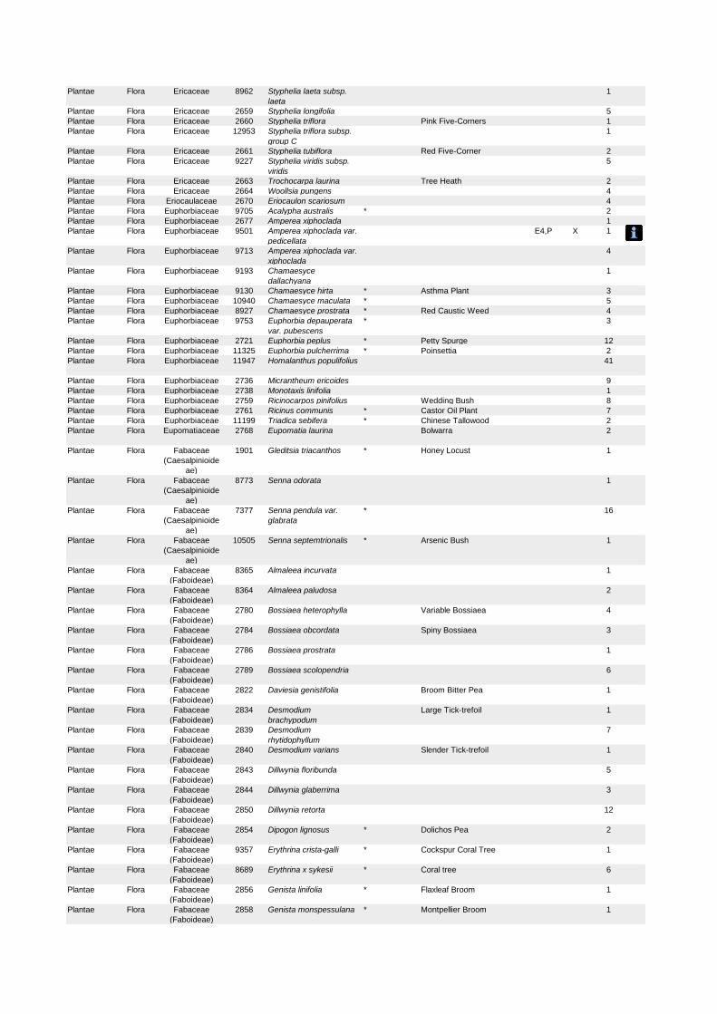
Plantae Flora Ericaceae 8962 Styphelia laeta subsp.
laeta
1
Plantae Flora Ericaceae 2659 Styphelia longifolia 5
Plantae Flora Ericaceae 2660 Styphelia triflora Pink Five-Corners 1
Plantae Flora Ericaceae 12953 Styphelia triflora subsp.
group C
1
Plantae Flora Ericaceae 2661 Styphelia tubiflora Red Five-Corner 2
Plantae Flora Ericaceae 9227 Styphelia viridis subsp.
viridis
5
Plantae Flora Ericaceae 2663 Trochocarpa laurina Tree Heath 2
Plantae Flora Ericaceae 2664 Woollsia pungens 4
Plantae Flora Eriocaulaceae 2670 Eriocaulon scariosum 4
Plantae Flora Euphorbiaceae 9705 Acalypha australis * 2
Plantae Flora Euphorbiaceae 2677 Amperea xiphoclada 1
Plantae Flora Euphorbiaceae 9501 Amperea xiphoclada var.
pedicellata
E4,P X 1
Plantae Flora Euphorbiaceae 9713 Amperea xiphoclada var.
xiphoclada
4
Plantae Flora Euphorbiaceae 9193 Chamaesyce
dallachyana
1
Plantae Flora Euphorbiaceae 9130 Chamaesyce hirta * Asthma Plant 3
Plantae Flora Euphorbiaceae 10940 Chamaesyce maculata * 5
Plantae Flora Euphorbiaceae 8927 Chamaesyce prostrata * Red Caustic Weed 4
Plantae Flora Euphorbiaceae 9753 Euphorbia depauperata
var. pubescens
* 3
Plantae Flora Euphorbiaceae 2721 Euphorbia peplus * Petty Spurge 12
Plantae Flora Euphorbiaceae 11325 Euphorbia pulcherrima * Poinsettia 2
Plantae Flora Euphorbiaceae 11947 Homalanthus populifolius 41
Plantae Flora Euphorbiaceae 2736 Micrantheum ericoides 9
Plantae Flora Euphorbiaceae 2738 Monotaxis linifolia 1
Plantae Flora Euphorbiaceae 2759 Ricinocarpos pinifolius Wedding Bush 8
Plantae Flora Euphorbiaceae 2761 Ricinus communis * Castor Oil Plant 7
Plantae Flora Euphorbiaceae 11199 Triadica sebifera * Chinese Tallowood 2
Plantae Flora Eupomatiaceae 2768 Eupomatia laurina Bolwarra 2
Plantae Flora Fabaceae
(Caesalpinioide
ae)
1901 Gleditsia triacanthos * Honey Locust 1
Plantae Flora Fabaceae
(Caesalpinioide
ae)
8773 Senna odorata 1
Plantae Flora Fabaceae
(Caesalpinioide
ae)
7377 Senna pendula var.
glabrata
* 16
Plantae Flora Fabaceae
(Caesalpinioide
ae)
10505 Senna septemtrionalis * Arsenic Bush 1
Plantae Flora Fabaceae
(Faboideae)
8365 Almaleea incurvata 1
Plantae Flora Fabaceae
(Faboideae)
8364 Almaleea paludosa 2
Plantae Flora Fabaceae
(Faboideae)
2780 Bossiaea heterophylla Variable Bossiaea 4
Plantae Flora Fabaceae
(Faboideae)
2784 Bossiaea obcordata Spiny Bossiaea 3
Plantae Flora Fabaceae
(Faboideae)
2786 Bossiaea prostrata 1
Plantae Flora Fabaceae
(Faboideae)
2789 Bossiaea scolopendria 6
Plantae Flora Fabaceae
(Faboideae)
2822 Daviesia genistifolia Broom Bitter Pea 1
Plantae Flora Fabaceae
(Faboideae)
2834 Desmodium
brachypodum
Large Tick-trefoil 1
Plantae Flora Fabaceae
(Faboideae)
2839 Desmodium
rhytidophyllum
7
Plantae Flora Fabaceae
(Faboideae)
2840 Desmodium varians Slender Tick-trefoil 1
Plantae Flora Fabaceae
(Faboideae)
2843 Dillwynia floribunda 5
Plantae Flora Fabaceae
(Faboideae)
2844 Dillwynia glaberrima 3
Plantae Flora Fabaceae
(Faboideae)
2850 Dillwynia retorta 12
Plantae Flora Fabaceae
(Faboideae)
2854 Dipogon lignosus * Dolichos Pea 2
Plantae Flora Fabaceae
(Faboideae)
9357 Erythrina crista-galli * Cockspur Coral Tree 1
Plantae Flora Fabaceae
(Faboideae)
8689 Erythrina x sykesii * Coral tree 6
Plantae Flora Fabaceae
(Faboideae)
2856 Genista linifolia * Flaxleaf Broom 1
Plantae Flora Fabaceae
(Faboideae)
2858 Genista monspessulana * Montpellier Broom 1
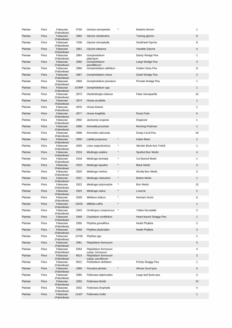
Plantae Flora Fabaceae
(Faboideae)
9756 Genista stenopetala * Madeira Broom 1
Plantae Flora Fabaceae
(Faboideae)
2860 Glycine clandestina Twining glycine 8
Plantae Flora Fabaceae
(Faboideae)
7208 Glycine microphylla Small-leaf Glycine 8
Plantae Flora Fabaceae
(Faboideae)
2861 Glycine tabacina Variable Glycine 4
Plantae Flora Fabaceae
(Faboideae)
2864 Gompholobium
glabratum
Dainty Wedge Pea 1
Plantae Flora Fabaceae
(Faboideae)
2865 Gompholobium
grandiflorum
Large Wedge Pea 3
Plantae Flora Fabaceae
(Faboideae)
2866 Gompholobium latifolium Golden Glory Pea 8
Plantae Flora Fabaceae
(Faboideae)
2867 Gompholobium minus Dwarf Wedge Pea 2
Plantae Flora Fabaceae
(Faboideae)
2868 Gompholobium pinnatum Pinnate Wedge Pea 1
Plantae Flora Fabaceae
(Faboideae)
GOMP Gompholobium spp. 1
Plantae Flora Fabaceae
(Faboideae)
2873 Hardenbergia violacea False Sarsaparilla 13
Plantae Flora Fabaceae
(Faboideae)
2874 Hovea acutifolia 1
Plantae Flora Fabaceae
(Faboideae)
2876 Hovea linearis 1
Plantae Flora Fabaceae
(Faboideae)
2877 Hovea longifolia Rusty Pods 6
Plantae Flora Fabaceae
(Faboideae)
2892 Jacksonia scoparia Dogwood 1
Plantae Flora Fabaceae
(Faboideae)
2896 Kennedia prostrata Running Postman 1
Plantae Flora Fabaceae
(Faboideae)
2898 Kennedia rubicunda Dusky Coral Pea 18
Plantae Flora Fabaceae
(Faboideae)
2900 Lablab purpureus * Indian Bean 1
Plantae Flora Fabaceae
(Faboideae)
2905 Lotus angustissimus * Slender Birds-foot Trefoil 1
Plantae Flora Fabaceae
(Faboideae)
2916 Medicago arabica * Spotted Burr Medic 4
Plantae Flora Fabaceae
(Faboideae)
2918 Medicago laciniata * Cut-leaved Medic 1
Plantae Flora Fabaceae
(Faboideae)
2919 Medicago lupulina * Black Medic 4
Plantae Flora Fabaceae
(Faboideae)
2920 Medicago minima * Woolly Burr Medic 2
Plantae Flora Fabaceae
(Faboideae)
2921 Medicago orbicularis * Button Medic 1
Plantae Flora Fabaceae
(Faboideae)
2922 Medicago polymorpha * Burr Medic 13
Plantae Flora Fabaceae
(Faboideae)
2924 Medicago sativa * Lucerne 2
Plantae Flora Fabaceae
(Faboideae)
2928 Melilotus indicus * Hexham Scent 6
Plantae Flora Fabaceae
(Faboideae)
13033 Millettia caffra * 1
Plantae Flora Fabaceae
(Faboideae)
2943 Ornithopus compressus * Yellow Serradella 2
Plantae Flora Fabaceae
(Faboideae)
2949 Oxylobium cordifolium Heart-leaved Shaggy Pea 1
Plantae Flora Fabaceae
(Faboideae)
2956 Phyllota grandiflora Heath Phyllota 2
Plantae Flora Fabaceae
(Faboideae)
2958 Phyllota phylicoides Heath Phyllota 3
Plantae Flora Fabaceae
(Faboideae)
13706 Phyllota spp. 1
Plantae Flora Fabaceae
(Faboideae)
2961 Platylobium formosum 5
Plantae Flora Fabaceae
(Faboideae)
9354 Platylobium formosum
subsp. formosum
4
Plantae Flora Fabaceae
(Faboideae)
8614 Platylobium formosum
subsp. parviflorum
2
Plantae Flora Fabaceae
(Faboideae)
9912 Podolobium ilicifolium Prickly Shaggy Pea 1
Plantae Flora Fabaceae
(Faboideae)
2969 Psoralea pinnata * African Scurf-pea 5
Plantae Flora Fabaceae
(Faboideae)
2985 Pultenaea daphnoides Large-leaf Bush-pea 4
Plantae Flora Fabaceae
(Faboideae)
2993 Pultenaea flexilis 13
Plantae Flora Fabaceae
(Faboideae)
3002 Pultenaea linophylla 4
Plantae Flora Fabaceae
(Faboideae)
11407 Pultenaea mollis 1
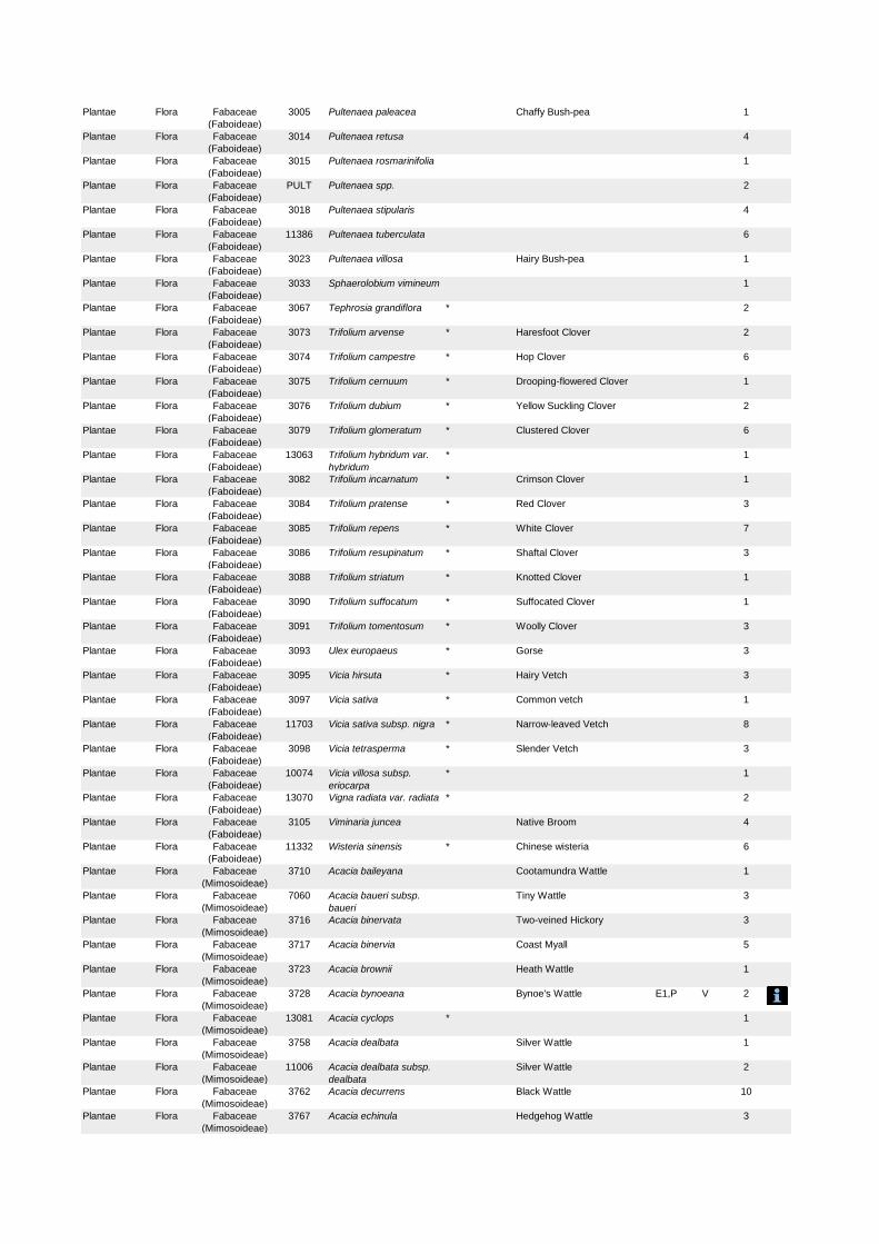
Plantae Flora Fabaceae
(Faboideae)
3005 Pultenaea paleacea Chaffy Bush-pea 1
Plantae Flora Fabaceae
(Faboideae)
3014 Pultenaea retusa 4
Plantae Flora Fabaceae
(Faboideae)
3015 Pultenaea rosmarinifolia 1
Plantae Flora Fabaceae
(Faboideae)
PULT Pultenaea spp. 2
Plantae Flora Fabaceae
(Faboideae)
3018 Pultenaea stipularis 4
Plantae Flora Fabaceae
(Faboideae)
11386 Pultenaea tuberculata 6
Plantae Flora Fabaceae
(Faboideae)
3023 Pultenaea villosa Hairy Bush-pea 1
Plantae Flora Fabaceae
(Faboideae)
3033 Sphaerolobium vimineum 1
Plantae Flora Fabaceae
(Faboideae)
3067 Tephrosia grandiflora * 2
Plantae Flora Fabaceae
(Faboideae)
3073 Trifolium arvense * Haresfoot Clover 2
Plantae Flora Fabaceae
(Faboideae)
3074 Trifolium campestre * Hop Clover 6
Plantae Flora Fabaceae
(Faboideae)
3075 Trifolium cernuum * Drooping-flowered Clover 1
Plantae Flora Fabaceae
(Faboideae)
3076 Trifolium dubium * Yellow Suckling Clover 2
Plantae Flora Fabaceae
(Faboideae)
3079 Trifolium glomeratum * Clustered Clover 6
Plantae Flora Fabaceae
(Faboideae)
13063 Trifolium hybridum var.
hybridum
* 1
Plantae Flora Fabaceae
(Faboideae)
3082 Trifolium incarnatum * Crimson Clover 1
Plantae Flora Fabaceae
(Faboideae)
3084 Trifolium pratense * Red Clover 3
Plantae Flora Fabaceae
(Faboideae)
3085 Trifolium repens * White Clover 7
Plantae Flora Fabaceae
(Faboideae)
3086 Trifolium resupinatum * Shaftal Clover 3
Plantae Flora Fabaceae
(Faboideae)
3088 Trifolium striatum * Knotted Clover 1
Plantae Flora Fabaceae
(Faboideae)
3090 Trifolium suffocatum * Suffocated Clover 1
Plantae Flora Fabaceae
(Faboideae)
3091 Trifolium tomentosum * Woolly Clover 3
Plantae Flora Fabaceae
(Faboideae)
3093 Ulex europaeus * Gorse 3
Plantae Flora Fabaceae
(Faboideae)
3095 Vicia hirsuta * Hairy Vetch 3
Plantae Flora Fabaceae
(Faboideae)
3097 Vicia sativa * Common vetch 1
Plantae Flora Fabaceae
(Faboideae)
11703 Vicia sativa subsp. nigra * Narrow-leaved Vetch 8
Plantae Flora Fabaceae
(Faboideae)
3098 Vicia tetrasperma * Slender Vetch 3
Plantae Flora Fabaceae
(Faboideae)
10074 Vicia villosa subsp.
eriocarpa
* 1
Plantae Flora Fabaceae
(Faboideae)
13070 Vigna radiata var. radiata * 2
Plantae Flora Fabaceae
(Faboideae)
3105 Viminaria juncea Native Broom 4
Plantae Flora Fabaceae
(Faboideae)
11332 Wisteria sinensis * Chinese wisteria 6
Plantae Flora Fabaceae
(Mimosoideae)
3710 Acacia baileyana Cootamundra Wattle 1
Plantae Flora Fabaceae
(Mimosoideae)
7060 Acacia baueri subsp.
baueri
Tiny Wattle 3
Plantae Flora Fabaceae
(Mimosoideae)
3716 Acacia binervata Two-veined Hickory 3
Plantae Flora Fabaceae
(Mimosoideae)
3717 Acacia binervia Coast Myall 5
Plantae Flora Fabaceae
(Mimosoideae)
3723 Acacia brownii Heath Wattle 1
Plantae Flora Fabaceae
(Mimosoideae)
3728 Acacia bynoeana Bynoe's Wattle E1,P V 2
Plantae Flora Fabaceae
(Mimosoideae)
13081 Acacia cyclops * 1
Plantae Flora Fabaceae
(Mimosoideae)
3758 Acacia dealbata Silver Wattle 1
Plantae Flora Fabaceae
(Mimosoideae)
11006 Acacia dealbata subsp.
dealbata
Silver Wattle 2
Plantae Flora Fabaceae
(Mimosoideae)
3762 Acacia decurrens Black Wattle 10
Plantae Flora Fabaceae
(Mimosoideae)
3767 Acacia echinula Hedgehog Wattle 3

Plantae Flora Fabaceae
(Mimosoideae)
3768 Acacia elata Mountain Cedar Wattle 4
Plantae Flora Fabaceae
(Mimosoideae)
3771 Acacia falcata 9
Plantae Flora Fabaceae
(Mimosoideae)
3774 Acacia fimbriata Fringed Wattle 1
Plantae Flora Fabaceae
(Mimosoideae)
3777 Acacia floribunda White Sally 3
Plantae Flora Fabaceae
(Mimosoideae)
7229 Acacia gordonii E1,P E 1
Plantae Flora Fabaceae
(Mimosoideae)
3790 Acacia hispidula 3
Plantae Flora Fabaceae
(Mimosoideae)
3792 Acacia implexa Hickory Wattle 11
Plantae Flora Fabaceae
(Mimosoideae)
6472 Acacia irrorata subsp.
irrorata
Green Wattle 4
Plantae Flora Fabaceae
(Mimosoideae)
3812 Acacia linearifolia Narrow-leaved Wattle 1
Plantae Flora Fabaceae
(Mimosoideae)
3814 Acacia linifolia White Wattle 28
Plantae Flora Fabaceae
(Mimosoideae)
3816 Acacia longifolia 20
Plantae Flora Fabaceae
(Mimosoideae)
10790 Acacia longifolia subsp.
longifolia
Sydney Golden Wattle 14
Plantae Flora Fabaceae
(Mimosoideae)
10791 Acacia longifolia subsp.
sophorae
Coastal Wattle 3
Plantae Flora Fabaceae
(Mimosoideae)
3817 Acacia longissima Long-leaf Wattle 3
Plantae Flora Fabaceae
(Mimosoideae)
6748 Acacia lunata Lunate-leaved Acacia 1
Plantae Flora Fabaceae
(Mimosoideae)
3834 Acacia myrtifolia Red-stemmed Wattle 3
Plantae Flora Fabaceae
(Mimosoideae)
3846 Acacia parramattensis Parramatta Wattle 6
Plantae Flora Fabaceae
(Mimosoideae)
3853 Acacia podalyriifolia Queensland Silver Wattle 2
Plantae Flora Fabaceae
(Mimosoideae)
3857 Acacia prominens Gosford Wattle 1
Plantae Flora Fabaceae
(Mimosoideae)
3863 Acacia quadrilateralis 3
Plantae Flora Fabaceae
(Mimosoideae)
3873 Acacia saligna * Golden Wreath Wattle 2
Plantae Flora Fabaceae
(Mimosoideae)
3874 Acacia schinoides Green Cedar Wattle 1
Plantae Flora Fabaceae
(Mimosoideae)
ACAC Acacia spp. Wattle 3
Plantae Flora Fabaceae
(Mimosoideae)
3880 Acacia stricta Straight Wattle 1
Plantae Flora Fabaceae
(Mimosoideae)
3881 Acacia suaveolens Sweet Wattle 32
Plantae Flora Fabaceae
(Mimosoideae)
3885 Acacia terminalis Sunshine Wattle 21
Plantae Flora Fabaceae
(Mimosoideae)
10793 Acacia terminalis subsp.
angustifolia
1
Plantae Flora Fabaceae
(Mimosoideae)
9984 Acacia terminalis subsp.
longiaxialis
5
Plantae Flora Fabaceae
(Mimosoideae)
9672 Acacia terminalis subsp.
terminalis
Sunshine Wattle E1,P E 28
Plantae Flora Fabaceae
(Mimosoideae)
3893 Acacia ulicifolia Prickly Moses 25
Plantae Flora Fabaceae
(Mimosoideae)
13108 Serianthes calycina * 2
Plantae Flora Fabaceae
(Mimosoideae)
13109 Serianthes sachetae * 1
Plantae Flora Fagaceae 11675 Quercus palustris * Pin Oak 1
Plantae Flora Fagaceae QUER Quercus spp. * 1
Plantae Flora Fumariaceae 9367 Fumaria muralis subsp.
muralis
* Wall Fumitory 5
Plantae Flora Fumariaceae 3129 Fumaria officinalis * 2
Plantae Flora Gentianaceae 3133 Centaurium tenuiflorum * Branched Centaury, Slender
centaury
4
Plantae Flora Geraniaceae 3139 Erodium botrys * Long Storksbill 1
Plantae Flora Geraniaceae 3148 Geranium homeanum 5
Plantae Flora Geraniaceae 3151 Geranium obtusisepalum 1
Plantae Flora Geraniaceae 10097 Geranium purpureum
subsp. purpureum
* 1
Plantae Flora Geraniaceae GERA Geranium spp. * 2
Plantae Flora Geraniaceae PELA Pelargonium spp. * 1
Plantae Flora Gleicheniaceae 11076 Dicranopteris linearis var.
linearis
P 1
Plantae Flora Gleicheniaceae 7138 Gleichenia dicarpa Pouched Coral Fern 13
Plantae Flora Gleicheniaceae 6708 Gleichenia microphylla Scrambling Coral Fern 1
Plantae Flora Gleicheniaceae 8093 Gleichenia rupestris 5
Plantae Flora Gleicheniaceae 11175 Sticherus flabellatus var.
flabellatus
Umbrella Fern P 5
Plantae Flora Goodeniaceae 3166 Coopernookia barbata Purple Goodenia 2
Plantae Flora Goodeniaceae 3172 Dampiera purpurea 1
Plantae Flora Goodeniaceae 3174 Dampiera stricta 3
Plantae Flora Goodeniaceae 9078 Goodenia bellidifolia
subsp. argentea
1
Plantae Flora Goodeniaceae 8711 Goodenia bellidifolia
subsp. bellidifolia
2
Plantae Flora Goodeniaceae 8874 Goodenia dimorpha var.
dimorpha
1
Plantae Flora Goodeniaceae 3188 Goodenia hederacea Ivy Goodenia 1
Plantae Flora Goodeniaceae 9279 Goodenia hederacea
subsp. hederacea
1
Plantae Flora Goodeniaceae 10197 Goodenia heterophylla
subsp. heterophylla
1
Plantae Flora Goodeniaceae 7057 Goodenia paniculata 3
Plantae Flora Goodeniaceae 3197 Goodenia stelligera Spiked Goodenia 1
Plantae Flora Goodeniaceae 3202 Scaevola albida Pale Fan-flower 1
Plantae Flora Goodeniaceae 3208 Scaevola ramosissima Purple Fan-flower 2
Plantae Flora Goodeniaceae 3210 Selliera radicans Swamp Weed 1
Plantae Flora Grammitidacea
e
10518 Grammitis billardierei Finger Fern 2
Plantae Flora Haloragaceae 8649 Gonocarpus micranthus
subsp. micranthus
5
Plantae Flora Haloragaceae 8648 Gonocarpus micranthus
subsp. ramosissimus
2
Plantae Flora Haloragaceae 3248 Gonocarpus teucrioides Germander Raspwort 8
Plantae Flora Haloragaceae 3259 Myriophyllum aquaticum * Parrots Feather 2
Plantae Flora Haloragaceae 7456 Myriophyllum gracile var.
lineare
10
Plantae Flora Haloragaceae 6677 Myriophyllum simulans 2
Plantae Flora Hamamelidace
ae
11353 Liquidambar styraciflua * Sweetgum 2
Plantae Flora Hydrocharitace
ae
3269 Elodea canadensis * Elodea 1
Plantae Flora Hydrocharitace
ae
3270 Halophila decipiens 2
Plantae Flora Hydrocharitace
ae
6772 Hydrilla verticillata Hydrilla 2
Plantae Flora Hydrocharitace
ae
14246 Vallisneria australis Eelweed 1
Fungi Flora Hygrophoracea
e
F006 Camarophyllopsis
kearneyi
E1,P 1
Fungi Flora Hygrophoracea
e
F003 Hygrocybe anomala var.
ianthinomarginata
V,P 1
Fungi Flora Hygrophoracea
e
F004 Hygrocybe aurantipes V,P 1
Fungi Flora Hygrophoracea
e
F001 Hygrocybe
austropratensis
E1,P 1
Fungi Flora Hygrophoracea
e
F007 Hygrocybe collucera E1,P 1
Fungi Flora Hygrophoracea
e
F008 Hygrocybe griseoramosa E1,P 1
Fungi Flora Hygrophoracea
e
F005 Hygrocybe lanecovensis E1,P 1
Fungi Flora Hygrophoracea
e
F002 Hygrocybe reesiae V,P 1
Fungi Flora Hygrophoracea
e
F015 Hygrocybe rubronivea V,P 1
Plantae Flora Hymenophyllac
eae
8107 Hymenophyllum
cupressiforme
Common Filmy Fern 2
Plantae Flora Hypoxidaceae 7859 Hypoxis pratensis var.
pratensis
1
Plantae Flora Iridaceae 3277 Anomatheca laxa * 1
Plantae Flora Iridaceae 11579 Dietes bicolor * 1
Plantae Flora Iridaceae 3283 Dietes robinsoniana Lord Howe Wedding Lily 1
Plantae Flora Iridaceae 10698 Freesia hybrid * Freesia 1
Plantae Flora Iridaceae 3289 Gladiolus undulatus * Wild Gladiolus 1
Plantae Flora Iridaceae 10267 Ixia polystachya * Variable Ixia 1
Plantae Flora Iridaceae 3298 Libertia paniculata Branching Grass-flag 1
Plantae Flora Iridaceae 3301 Patersonia glabrata Leafy Purple-flag 3
Plantae Flora Iridaceae 3303 Patersonia sericea Silky Purple-Flag 2
Plantae Flora Iridaceae 7477 Romulea rosea var.
australis
* Onion Grass 2
Plantae Flora Iridaceae 3306 Sisyrinchium iridifolium * Blue Pigroot 2
Plantae Flora Iridaceae 8957 Sisyrinchium sp. A * Scourweed 2
Plantae Flora Iridaceae 10270 Sparaxis bulbifera * Harlequin Flower 1
Plantae Flora Juncaceae 9311 Juncus acutus subsp.
acutus
* Sharp Rush 1
Plantae Flora Juncaceae 3316 Juncus articulatus * A Rush 1
Plantae Flora Juncaceae 3318 Juncus bufonius * Toad Rush 10
Plantae Flora Juncaceae 3322 Juncus capensis * 7
Plantae Flora Juncaceae 3323 Juncus capillaceus * 2
Plantae Flora Juncaceae 3325 Juncus cognatus * 6
Plantae Flora Juncaceae 3326 Juncus continuus 15
Plantae Flora Juncaceae 8632 Juncus continuus x
usitatus
1
Plantae Flora Juncaceae 3330 Juncus flavidus 11
Plantae Flora Juncaceae 3332 Juncus holoschoenus 1
Plantae Flora Juncaceae 3333 Juncus homalocaulis 8
Plantae Flora Juncaceae 3334 Juncus imbricatus * 2
Plantae Flora Juncaceae 7430 Juncus kraussii subsp.
australiensis
Sea Rush 4
Plantae Flora Juncaceae 3338 Juncus pallidus 4
Plantae Flora Juncaceae 3340 Juncus planifolius 7
Plantae Flora Juncaceae 3341 Juncus polyanthemus 1
Plantae Flora Juncaceae 3342 Juncus prismatocarpus 2
Plantae Flora Juncaceae JUNC Juncus spp. A Rush 1
Plantae Flora Juncaceae 3348 Juncus subsecundus Finger Rush 2
Plantae Flora Juncaceae 3349 Juncus tenuis * 10
Plantae Flora Juncaceae 3350 Juncus usitatus 18
Plantae Flora Juncaginaceae 3368 Triglochin procera Water Ribbons 5
Plantae Flora Lamiaceae 6243 Chloanthes stoechadis 1
Plantae Flora Lamiaceae 6484 Clerodendrum
tomentosum
Hairy Clerodendrum 8
Plantae Flora Lamiaceae 3376 Hemigenia purpurea 2
Plantae Flora Lamiaceae 3377 Lamium amplexicaule * Dead Nettle 1
Plantae Flora Lamiaceae 12158 Leonurus japonicus * 2
Plantae Flora Lamiaceae 3381 Marrubium vulgare * White Horehound 1
Plantae Flora Lamiaceae 3384 Mentha diemenica Slender Mint 1
Plantae Flora Lamiaceae 3397 Plectranthus parviflorus 4
Plantae Flora Lamiaceae 10230 Plectranthus verticillatus * 1
Plantae Flora Lamiaceae 3405 Prostanthera denticulata Rough Mint-bush 1
Plantae Flora Lamiaceae 3411 Prostanthera howelliae Prostanthera 1
Plantae Flora Lamiaceae 3417 Prostanthera linearis Narrow-leaved Mint-bush 2
Plantae Flora Lamiaceae 3418 ^^Prostanthera marifolia Seaforth Mintbush E4A,P,
3
CE 4
Plantae Flora Lamiaceae 3423 Prostanthera ovalifolia 2
Plantae Flora Lamiaceae 3442 Salvia coccinea * 1
Plantae Flora Lamiaceae 3449 Scutellaria racemosa * 1
Plantae Flora Lamiaceae 3450 Stachys arvensis * Stagger Weed 6
Plantae Flora Lamiaceae 13164 Vitex lucens * 1
Plantae Flora Lamiaceae 3459 Westringia fruticosa Coastal Rosemary 7
Plantae Flora Lauraceae 3467 Cassytha glabella 3
Plantae Flora Lauraceae 9274 Cassytha glabella f.
glabella
2
Plantae Flora Lauraceae 3469 Cassytha pubescens Downy Dodder-laurel 14
Plantae Flora Lauraceae 3471 Cinnamomum camphora * Camphor Laurel 28
Plantae Flora Lauraceae 3479 Cryptocarya glaucescens Jackwood 1
Plantae Flora Lauraceae 13172 Litsea glutinosa * 1
Plantae Flora Lemnaceae 7689 Spirodela punctata 2
Plantae Flora Lentibulariacea
e
3507 Utricularia dichotoma Fairy Aprons 1
Plantae Flora Lentibulariacea
e
7257 Utricularia uliginosa Asian Bladderwort 1
Plantae Flora Liliaceae 3559 Lilium formosanum * Formosan Lily 1
Plantae Flora Linaceae 3584 Linum trigynum * French Flax 1
Plantae Flora Linaceae 3585 Linum usitatissimum * Flax 1
Plantae Flora Lindsaeaceae 6406 Lindsaea linearis Screw Fern 4
Plantae Flora Lindsaeaceae 6401 Lindsaea microphylla Lacy Wedge Fern 5
Plantae Flora Lobeliaceae 7965 Isotoma fluviatilis subsp.
borealis
3
Plantae Flora Lobeliaceae 10465 Lobelia anceps 5
Plantae Flora Lobeliaceae 14464 Lobelia andrewsii Trailing Lobelia 2
Plantae Flora Lobeliaceae 13182 Monopsis debilis var.
depressa
* 2
Plantae Flora Lobeliaceae 1925 Pratia purpurascens Whiteroot 10
Plantae Flora Loganiaceae 13183 Chilianthus oleaceus * 1
Plantae Flora Loganiaceae 3588 Logania albiflora 3
Plantae Flora Loganiaceae 3592 Mitrasacme paludosa 1
Plantae Flora Loganiaceae 3595 Mitrasacme polymorpha 2
Plantae Flora Lomandraceae 6298 Lomandra cylindrica 1
Plantae Flora Lomandraceae 6302 Lomandra filiformis Wattle Matt-rush 3
Plantae Flora Lomandraceae 6511 Lomandra filiformis
subsp. coriacea
Wattle Matt-rush 1
Plantae Flora Lomandraceae 7931 Lomandra filiformis
subsp. filiformis
4
Plantae Flora Lomandraceae 6303 Lomandra fluviatilis 1
Plantae Flora Lomandraceae 6304 Lomandra glauca Pale Mat-rush 3

Plantae Flora Lomandraceae 6305 Lomandra gracilis 10
Plantae Flora Lomandraceae 6308 Lomandra longifolia Spiny-headed Mat-rush 73
Plantae Flora Lomandraceae 9082 Lomandra micrantha
subsp. tuberculata
Small-flowered Mat-rush 1
Plantae Flora Lomandraceae 8802 Lomandra multiflora
subsp. multiflora
Many-flowered Mat-rush 6
Plantae Flora Lomandraceae 6312 Lomandra obliqua 13
Plantae Flora Lomandraceae LOMA Lomandra spp. Mat-rush 3
Plantae Flora Loranthaceae 6856 Amyema congener
subsp. congener
10
Plantae Flora Loranthaceae 3607 Amyema pendula 1
Plantae Flora Loranthaceae 3613 Dendrophthoe vitellina 3
Plantae Flora Loranthaceae 3619 Muellerina celastroides 14
Plantae Flora Loranthaceae 3620 Muellerina eucalyptoides 4
Plantae Flora Luzuriagaceae 6015 Eustrephus latifolius Wombat Berry 22
Plantae Flora Luzuriagaceae 6016 Geitonoplesium
cymosum
Scrambling Lily 3
Plantae Flora Lycopodiaceae 10641 Lycopodiella cernua Scrambling Clubmoss 2
Plantae Flora Lycopodiaceae 9293 Lycopodiella lateralis Slender Clubmoss 1
Plantae Flora Lycopodiaceae 6409 Lycopodium
deuterodensum
Bushy Clubmoss P 1
Plantae Flora Lythraceae 11362 Lagerstroemia indica * 3
Plantae Flora Lythraceae 3623 Lythrum hyssopifolia Hyssop Loosestrife 1
Plantae Flora Magnoliaceae MAGN Magnolia spp. * 1
Plantae Flora Malaceae 5612 Cotoneaster
glaucophyllus
* 6
Plantae Flora Malaceae 5614 Cotoneaster pannosus * 2
Plantae Flora Malaceae COTO Cotoneaster spp. * 1
Plantae Flora Malaceae 5618 Eriobotrya japonica * Loquat 3
Plantae Flora Malaceae 5627 Pyracantha angustifolia * Orange Firethorn 1
Plantae Flora Malaceae 12465 Pyracantha
crenatoserrata
* 2
Plantae Flora Malaceae 5631 Rhaphiolepis indica * Indian Hawthorn 3
Plantae Flora Malvaceae 3628 Abutilon grandifolium * 1
Plantae Flora Malvaceae 7802 Alcea rosea * Hollyhock 1
Plantae Flora Malvaceae HIBI Hibiscus spp. 5
Plantae Flora Malvaceae 3648 Hibiscus trionum Flower-of-an-hour 2
Plantae Flora Malvaceae 11113 Malva linnaei * Cretan Hollyhock 2
Plantae Flora Malvaceae 3655 Malva neglecta * Dwarf Mallow 1
Plantae Flora Malvaceae 3656 Malva nicaeensis * Mallow of Nice 6
Plantae Flora Malvaceae 3657 Malva parviflora * Small-flowered Mallow 7
Plantae Flora Malvaceae 3658 Malva sylvestris * Tall Mallow 2
Plantae Flora Malvaceae 3660 Modiola caroliniana * Red-flowered Mallow 6
Plantae Flora Malvaceae 3673 Sida rhombifolia * Paddy's Lucerne 17
Plantae Flora Malvaceae 6781 Urena lobata * Conga Jute 1
Plantae Flora Martyniaceae 4653 Proboscidea fragrans * 1
Plantae Flora Martyniaceae 4654 Proboscidea louisianica * Purple-flowered Devil's Claw 1
Plantae Flora Melastomatace
ae
3675 Melastoma affine Blue Tongue 1
Plantae Flora Melastomatace
ae
TIBO Tibouchina spp. * 1
Plantae Flora Meliaceae 3680 Melia azedarach White Cedar 2
Plantae Flora Meliaceae 11178 Synoum glandulosum
subsp. glandulosum
Scentless Rosewood 6
Plantae Flora Meliaceae 13215 Turraea obtusifolia * 1
Plantae Flora Menispermace
ae
3688 Sarcopetalum
harveyanum
Pearl Vine 5
Plantae Flora Menispermace
ae
3690 Stephania japonica Snake vine 3
Plantae Flora Menispermace
ae
8428 Stephania japonica var.
discolor
Snake Vine 3
Plantae Flora Menyanthacea
e
7891 Nymphoides indica Water Snowflake 2
Plantae Flora Menyanthacea
e
3692 Villarsia exaltata Yellow Marsh Flower 2
Plantae Flora Moraceae 7479 Ficus coronata Creek Sandpaper Fig 3
Plantae Flora Moraceae 8778 Ficus elastica * 2
Plantae Flora Moraceae 3922 Ficus macrophylla 6
Plantae Flora Moraceae 7301 Ficus obliqua Small-leaved Fig 2
Plantae Flora Moraceae 3923 Ficus pumila * Creeping Fig 2
Plantae Flora Moraceae 3924 Ficus rubiginosa Port Jackson Fig 26
Plantae Flora Moraceae 11720 Ficus rubiginosa f.
rubiginosa
6
Plantae Flora Moraceae 3930 Morus alba * White Mulberry 9
Plantae Flora Moraceae 8693 Morus nigra * Black Mulberry 1
Plantae Flora Musaceae 11327 Musa acuminata * Edible banana 2
Plantae Flora Myoporaceae 9043 Myoporum boninense
subsp. australe
3
Plantae Flora Myrsinaceae 7459 Aegiceras corniculatum River Mangrove 2
Plantae Flora Myrsinaceae 5334 Anagallis arvensis * Scarlet Pimpernel 6
Plantae Flora Myrsinaceae 11953 Myrsine variabilis 18
Plantae Flora Myrtaceae 3968 Acmena smithii Lilly Pilly 24
Plantae Flora Myrtaceae 11432 Agonis flexuosa * 1
Plantae Flora Myrtaceae 3969 Angophora bakeri Narrow-leaved Apple 6
Plantae Flora Myrtaceae 3970 Angophora costata Sydney Red Gum 61
Plantae Flora Myrtaceae 9012 Angophora crassifolia 2
Plantae Flora Myrtaceae 3971 Angophora floribunda Rough-barked Apple 6
Plantae Flora Myrtaceae 3972 Angophora hispida Dwarf Apple 4
Plantae Flora Myrtaceae ANGO Angophora spp. 1
Plantae Flora Myrtaceae 3982 Austromyrtus tenuifolia 4
Plantae Flora Myrtaceae 3984 Backhousia myrtifolia Grey Myrtle 12
Plantae Flora Myrtaceae 3993 Baeckea diosmifolia Fringed Baeckea 1
Plantae Flora Myrtaceae 3995 Baeckea imbricata 5
Plantae Flora Myrtaceae 4004 Callistemon citrinus Crimson Bottlebrush 10
Plantae Flora Myrtaceae 4007 ^^Callistemon
linearifolius
Netted Bottle Brush V,P,3 4
Plantae Flora Myrtaceae 4008 Callistemon linearis Narrow-leaved Bottlebrush 7
Plantae Flora Myrtaceae 4009 Callistemon montanus Mountain Bottlebrush 1
Plantae Flora Myrtaceae 4014 Callistemon rigidus Stiff Bottlebrush 1
Plantae Flora Myrtaceae 4015 Callistemon salignus Willow Bottlebrush 2
Plantae Flora Myrtaceae CALL Callistemon spp. 4
Plantae Flora Myrtaceae 4019 Callistemon viminalis Weeping Bottlebrush 3
Plantae Flora Myrtaceae 4021 Calytrix tetragona Common Fringe-myrtle 2
Plantae Flora Myrtaceae 11748 Corymbia citriodora * Lemon-scented Gum 3
Plantae Flora Myrtaceae 9743 Corymbia eximia Yellow Bloodwood 2
Plantae Flora Myrtaceae 9687 Corymbia gummifera Red Bloodwood 29
Plantae Flora Myrtaceae 9692 Corymbia maculata Spotted Gum 3
Plantae Flora Myrtaceae 4024 Darwinia biflora V,P V 2
Plantae Flora Myrtaceae 6508 Darwinia fascicularis
subsp. fascicularis
1
Plantae Flora Myrtaceae 4030 Darwinia leptantha 1
Plantae Flora Myrtaceae 7027 Eucalyptus acmenoides White Mahogany 1
Plantae Flora Myrtaceae 4060 Eucalyptus botryoides Bangalay 10
Plantae Flora Myrtaceae 9959 Eucalyptus botryoides <--
> saligna
4
Plantae Flora Myrtaceae 4067 Eucalyptus camfieldii Camfield's Stringybark V,P V 4
Plantae Flora Myrtaceae 4069 Eucalyptus capitellata Brown Stringybark 11
Plantae Flora Myrtaceae 4074 Eucalyptus crebra Narrow-leaved Ironbark 2
Plantae Flora Myrtaceae 4087 Eucalyptus eugenioides Thin-leaved Stringybark 1
Plantae Flora Myrtaceae 4091 Eucalyptus fibrosa Red Ironbark 1
Plantae Flora Myrtaceae 9720 Eucalyptus fracta Broken Back Ironbark V,P 1
Plantae Flora Myrtaceae 4097 Eucalyptus globoidea White Stringybark 4
Plantae Flora Myrtaceae 4101 Eucalyptus grandis Flooded Gum 1
Plantae Flora Myrtaceae 4104 Eucalyptus haemastoma Broad-leaved Scribbly Gum 5
Plantae Flora Myrtaceae 4128 Eucalyptus microcorys Tallowwood 3
Plantae Flora Myrtaceae 4129 Eucalyptus moluccana Grey Box 8
Plantae Flora Myrtaceae 4134 Eucalyptus nicholii Narrow-leaved Black
Peppermint
V,P V 6
Plantae Flora Myrtaceae 4141 Eucalyptus oblonga Stringybark 1
Plantae Flora Myrtaceae 10029 Eucalyptus obstans Port Jackson Mallee 4
Plantae Flora Myrtaceae 4149 Eucalyptus paniculata Grey Ironbark 3
Plantae Flora Myrtaceae 8831 Eucalyptus paniculata
subsp. paniculata
1
Plantae Flora Myrtaceae 4155 Eucalyptus pilularis Blackbutt 34
Plantae Flora Myrtaceae 4156 Eucalyptus piperita Sydney Peppermint 27
Plantae Flora Myrtaceae 4163 Eucalyptus pulverulenta Silver-leafed Gum V,P V 1
Plantae Flora Myrtaceae 4165 Eucalyptus punctata Grey Gum 2
Plantae Flora Myrtaceae 13276 Eucalyptus punctata
subsp. punctata
3
Plantae Flora Myrtaceae 13277 Eucalyptus punctata
subsp. wianamattica
1
Plantae Flora Myrtaceae 4168 Eucalyptus racemosa Narrow-leaved Scribbly Gum 12
Plantae Flora Myrtaceae 13278 Eucalyptus ravida * 2
Plantae Flora Myrtaceae 4170 Eucalyptus resinifera Red Mahogany 15
Plantae Flora Myrtaceae 9450 Eucalyptus resinifera
subsp. resinifera
1
Plantae Flora Myrtaceae 4171 Eucalyptus robusta Swamp Mahogany 5
Plantae Flora Myrtaceae 4177 Eucalyptus saligna Sydney Blue Gum 16
Plantae Flora Myrtaceae 9953 Eucalyptus scias subsp.
scias
1
Plantae Flora Myrtaceae 4178 Eucalyptus sclerophylla Hard-leaved Scribbly Gum 1
Plantae Flora Myrtaceae 4181 Eucalyptus sideroxylon Mugga Ironbark 1
Plantae Flora Myrtaceae 4182 Eucalyptus sieberi Silvertop Ash 8
Plantae Flora Myrtaceae 8353 Eucalyptus sparsifolia Narrow-leaved Stringybark 1
Plantae Flora Myrtaceae 4191 Eucalyptus tereticornis Forest Red Gum 14
Plantae Flora Myrtaceae 4196 Eucalyptus umbra Broad-leaved White
Mahogany
1
Plantae Flora Myrtaceae 11218 Euryomyrtus
ramosissima subsp.
ramosissima
1
Plantae Flora Myrtaceae 4204 Kunzea ambigua Tick Bush P 35
Plantae Flora Myrtaceae 4207 Kunzea capitata P 5
Plantae Flora Myrtaceae 4213 Leptospermum
arachnoides
4
Plantae Flora Myrtaceae 8314 Leptospermum deanei V,P V 1
Plantae Flora Myrtaceae 7766 Leptospermum
grandifolium
Woolly Teatree 2
Plantae Flora Myrtaceae 4221 Leptospermum
juniperinum
Prickly Tea-tree 2
Plantae Flora Myrtaceae 4222 Leptospermum
laevigatum
Coast Teatree 4
Plantae Flora Myrtaceae 4233 Leptospermum
parvifolium
2
Plantae Flora Myrtaceae 4234 Leptospermum
petersonii
Lemon-scented Teatree 1
Plantae Flora Myrtaceae 7245 Leptospermum
polygalifolium
Tantoon 5
Plantae Flora Myrtaceae 8197 Leptospermum
polygalifolium subsp.
polygalifolium
4
Plantae Flora Myrtaceae LEPT Leptospermum spp. Tea-tree 1
Plantae Flora Myrtaceae 4239 Leptospermum
squarrosum
15
Plantae Flora Myrtaceae 8486 Leptospermum
trinervium
Slender Tea-tree 11
Plantae Flora Myrtaceae 4242 Lophostemon confertus Brush Box 6
Plantae Flora Myrtaceae 11117 Melaleuca armillaris
subsp. armillaris
Bracelet Honey-myrtle 5
Plantae Flora Myrtaceae 4248 Melaleuca deanei Deane's Paperbark V,P V 5
Plantae Flora Myrtaceae 4249 Melaleuca decora 2
Plantae Flora Myrtaceae 6391 Melaleuca ericifolia Swamp Paperbark 1
Plantae Flora Myrtaceae 4254 Melaleuca hypericifolia Hillock bush 1
Plantae Flora Myrtaceae 4257 Melaleuca linariifolia Flax-leaved Paperbark 6
Plantae Flora Myrtaceae 4258 Melaleuca nodosa 7
Plantae Flora Myrtaceae 4260 Melaleuca quinquenervia Broad-leaved Paperbark 9
Plantae Flora Myrtaceae MELA Melaleuca spp. 2
Plantae Flora Myrtaceae 4262 Melaleuca squamea Swamp Honey-myrtle 1
Plantae Flora Myrtaceae 4264 Melaleuca styphelioides Prickly-leaved Tea Tree 4
Plantae Flora Myrtaceae 4266 Melaleuca thymifolia Thyme Honey-myrtle 4
Plantae Flora Myrtaceae 11326 Metrosideros excelsa * New Zealand Christmas
Bush
1
Plantae Flora Myrtaceae 4283 Rhodamnia rubescens Scrub Turpentine 1
Plantae Flora Myrtaceae 13751 Sannantha pluriflora 1
Plantae Flora Myrtaceae 6688 Syncarpia glomulifera Turpentine 26
Plantae Flora Myrtaceae 10748 Syncarpia glomulifera
subsp. glomulifera
4
Plantae Flora Myrtaceae 4293 Syzygium paniculatum Magenta Lilly Pilly E1,P V 6
Plantae Flora Myrtaceae SYZY Syzygium spp. 1
Plantae Flora Myrtaceae 4295 Tristania neriifolia Water Gum 1
Plantae Flora Myrtaceae 4296 Tristaniopsis collina Mountain Water Gum 2
Plantae Flora Myrtaceae 4297 Tristaniopsis laurina Kanooka 6
Plantae Flora Nandinaceae 9645 Nandina domestica * Japanese Sacred Bamboo 3
Plantae Flora Nelumbonacea
e
13302 Nelumbo nucifera * 1
Plantae Flora Nyctaginaceae BOUG Bougainvillea spp. * 2
Plantae Flora Nyctaginaceae 4300 Mirabilis jalapa * Four-o'clock Flower 1
Plantae Flora Nymphaeaceae 4305 Nymphaea mexicana * Yellow Waterlily 2
Plantae Flora Nymphaeaceae 13303 Nymphaea nouchali * 1
Plantae Flora Ochnaceae 4306 Ochna serrulata * Mickey Mouse Plant 32
Plantae Flora Olacaceae 6407 Olax stricta 1
Plantae Flora Oleaceae 12177 Fraxinus angustifolia
subsp. angustifolia
* Desert Ash 1
Plantae Flora Oleaceae 10913 Jasminum polyanthum * White Jasmine 4
Plantae Flora Oleaceae 4312 Ligustrum lucidum * Large-leaved Privet 28
Plantae Flora Oleaceae 4313 Ligustrum sinense * Small-leaved Privet 29
Plantae Flora Oleaceae 4318 Notelaea longifolia Large Mock-olive 38
Plantae Flora Oleaceae 6423 Notelaea longifolia f.
longifolia
11
Plantae Flora Oleaceae NOTE Notelaea spp. 1
Plantae Flora Oleaceae 4322 Notelaea venosa Veined Mock-olive 1
Plantae Flora Oleaceae 4324 Olea europaea * Common Olive 3
Plantae Flora Oleaceae 11220 Olea europaea subsp.
cuspidata
* African Olive 5
Plantae Flora Oleaceae 7688 Olea europaea subsp.
europaea
* Olive 4
Plantae Flora Onagraceae 4327 Epilobium ciliatum * 2
Plantae Flora Onagraceae 4330 Epilobium hirtigerum 1
Plantae Flora Onagraceae 4331 Epilobium pallidiflorum 1
Plantae Flora Onagraceae 11110 Ludwigia longifolia * 2
Plantae Flora Onagraceae 7375 Ludwigia peploides
subsp. montevidensis
Water Primrose 9
Plantae Flora Onagraceae 4338 Ludwigia peruviana * 4
Plantae Flora Onagraceae 7724 Oenothera glazioviana * 1
Plantae Flora Onagraceae 6837 Oenothera indecora
subsp. bonariensis
* 1
Plantae Flora Onagraceae 4344 Oenothera mollissima * 1
Plantae Flora Ophioglossace
ae
8144 Botrychium australe Parsley Fern 1
Plantae Flora Orchidaceae 4351 Acianthus caudatus Mayfly Orchid P 6
Plantae Flora Orchidaceae 4352 Acianthus exsertus Mosquito Orchid P 3
Plantae Flora Orchidaceae 4353 Acianthus fornicatus Pixie Caps P 4
Plantae Flora Orchidaceae ACIA Acianthus spp. Mosquito Orchid P 3
Plantae Flora Orchidaceae 6703 Caladenia catenata White Caladenia P 6
Plantae Flora Orchidaceae 4386 ^Caladenia tessellata Thick Lip Spider Orchid E1,P,2 V 2
Plantae Flora Orchidaceae 4389 Caleana major Large Duck Orchid P 1
Plantae Flora Orchidaceae 4394 Calochilus paludosus Red Beard Orchid P 2
Plantae Flora Orchidaceae 4395 Calochilus robertsonii Purplish Beard Orchid P 4
Plantae Flora Orchidaceae 4399 Chiloglottis formicifera Ant Orchid P 1
Plantae Flora Orchidaceae 4402 Chiloglottis reflexa P 1
Plantae Flora Orchidaceae 4404 Corybas aconitiflorus Spurred Helmet Orchid P 1
Plantae Flora Orchidaceae 4407 Corybas fimbriatus Fringed Helmet Orchid P 1
Plantae Flora Orchidaceae 4410 Corybas pruinosus Toothed Helmet Orchid P 1
Plantae Flora Orchidaceae CORY Corybas spp. P 1
Plantae Flora Orchidaceae 4414 Cryptostylis erecta Tartan Tongue Orchid P 8
Plantae Flora Orchidaceae CRYT Cryptostylis spp. P 1
Plantae Flora Orchidaceae 4417 Cryptostylis subulata Large Tongue Orchid P 6
Plantae Flora Orchidaceae 11228 Cyanicula caerulea Blue Caladenia P 2
Plantae Flora Orchidaceae 4419 Cymbidium suave Snake Orchid P 1
Plantae Flora Orchidaceae 6889 Cyrtostylis reniformis Gnat Orchid P 2
Plantae Flora Orchidaceae 11984 Dendrobium speciosum
var. speciosum
Rock Orchid P 1
Plantae Flora Orchidaceae 7887 Dipodium punctatum P 1
Plantae Flora Orchidaceae DIPO Dipodium spp. P 1
Plantae Flora Orchidaceae 7888 Dipodium variegatum P 1
Plantae Flora Orchidaceae 4441 Diuris aurea P 5
Plantae Flora Orchidaceae 12238 Epidendrum radicans x
secundum hybrid
complex
* Crucifix Orchid 1
Plantae Flora Orchidaceae 8949 Erythrorchis
cassythoides
Climbing Orchid P 1
Plantae Flora Orchidaceae 4463 Gastrodia sesamoides Cinnamon Bells P 1
Plantae Flora Orchidaceae 9197 Genoplesium archeri Variable Midge Orchid P 1
Plantae Flora Orchidaceae 4464 ^Genoplesium baueri Bauer's Midge Orchid E1,P,2 E 2
Plantae Flora Orchidaceae 8872 Genoplesium fimbriatum Fringed Midge Orchid P 3
Plantae Flora Orchidaceae 9544 Genoplesium woollsii P 1
Plantae Flora Orchidaceae 4465 Glossodia major Waxlip Orchid P 3
Plantae Flora Orchidaceae 4466 Glossodia minor Small Waxlip Orchid P 3
Plantae Flora Orchidaceae 4472 Lyperanthus suaveolens Brown Beaks P 4
Plantae Flora Orchidaceae 7622 Microtis parviflora Slender Onion Orchid P 1
Plantae Flora Orchidaceae 7101 Microtis rara Scented Onion Orchid P 2
Plantae Flora Orchidaceae 4473 Microtis unifolia Common Onion Orchid P 1
Plantae Flora Orchidaceae 4476 Orthoceras strictum Bird's-mouth Orchid P 2
Plantae Flora Orchidaceae 4478 Paracaleana minor Small Duck Orchid P 1
Plantae Flora Orchidaceae 11839 Petalochilus minor P 1
Plantae Flora Orchidaceae 4497 Prasophyllum elatum Tall Leek Orchid P 2
Plantae Flora Orchidaceae 4502 Prasophyllum flavum Yellow Leek Orchid P 1
Plantae Flora Orchidaceae 4517 Prasophyllum patens Broad-lipped Leek Orchid P 1
Plantae Flora Orchidaceae 4535 Pterostylis acuminata Pointed Greenhood P 1
Plantae Flora Orchidaceae 4544 Pterostylis concinna Trim Greenhood P 1
Plantae Flora Orchidaceae 4545 Pterostylis curta Blunt Greenhood P 2
Plantae Flora Orchidaceae 4546 Pterostylis daintreana P 2
Plantae Flora Orchidaceae 4554 Pterostylis grandiflora Cobra Greenhood P 5
Plantae Flora Orchidaceae 4559 Pterostylis longifolia Tall Greenhood P 1
Plantae Flora Orchidaceae 4562 Pterostylis nutans Nodding Greenhood P 2
Plantae Flora Orchidaceae 4566 Pterostylis parviflora Tiny Greenhood P 1
Plantae Flora Orchidaceae 4573 Pterostylis rufa Rusty Hood P 1
Plantae Flora Orchidaceae PTER Pterostylis spp. Greenhood P 2
Plantae Flora Orchidaceae 10853 Pyrorchis nigricans P 4
Plantae Flora Orchidaceae 4578 Rimacola elliptica Green Rock Orchid P 1
Plantae Flora Orchidaceae 11877 Spiranthes australis Ladies' Tresses P 1
Plantae Flora Orchidaceae 11449 Thelymitra angustifolia P 2
Plantae Flora Orchidaceae 4592 Thelymitra carnea Tiny Sun Orchid P 2
Plantae Flora Orchidaceae 8968 Thelymitra ixioides var.
ixioides
Dotted Sun Orchid P 1
Plantae Flora Osmundaceae 8151 Todea barbara King Fern P 3
Plantae Flora Oxalidaceae 4608 Oxalis articulata * 1
Plantae Flora Oxalidaceae 4610 Oxalis bowiei * 1
Plantae Flora Oxalidaceae 4611 Oxalis brasiliensis * 1
Plantae Flora Oxalidaceae 4613 Oxalis corniculata * Creeping Oxalis 30
Plantae Flora Oxalidaceae 9250 Oxalis debilis var.
corymbosa
* 12
Plantae Flora Oxalidaceae 4615 Oxalis exilis 1
Plantae Flora Oxalidaceae 4617 Oxalis incarnata * 3
Plantae Flora Oxalidaceae 4618 Oxalis latifolia * 1
Plantae Flora Oxalidaceae 4621 Oxalis perennans 3
Plantae Flora Oxalidaceae 4622 Oxalis pes-caprae * Soursob 9
Plantae Flora Oxalidaceae 4624 Oxalis radicosa 1
Plantae Flora Oxalidaceae 4625 Oxalis rubens 2
Plantae Flora Oxalidaceae OXAL Oxalis spp. 6
Plantae Flora Oxalidaceae 9292 Oxalis thompsoniae * 12
Plantae Flora Papaveraceae 7115 Argemone ochroleuca
subsp. ochroleuca
* Mexican Poppy 1
Plantae Flora Papaveraceae 9362 Argemone subfusiformis
subsp. subfusiformis
* American Poppy 1
Plantae Flora Papaveraceae 4637 Papaver dubium * Longhead Poppy 1
Plantae Flora Papaveraceae 4638 Papaver hybridum * Rough Poppy 5
Plantae Flora Papaveraceae 9647 Papaver somniferum
subsp. setigerum
* 1
Plantae Flora Passifloraceae 4643 Passiflora edulis * Common Passionfruit 5
Plantae Flora Passifloraceae 4646 Passiflora herbertiana 1
Plantae Flora Passifloraceae 8886 Passiflora herbertiana
subsp. herbertiana
Native Passionfruit 1
Plantae Flora Passifloraceae PASS Passiflora spp. * 1
Plantae Flora Passifloraceae 4649 Passiflora suberosa * Cork Passionfruit 3
Plantae Flora Passifloraceae 4650 Passiflora subpeltata * White Passionflower 1
Plantae Flora Phormiaceae 3540 Dianella caerulea Blue Flax-lily 37
Plantae Flora Phormiaceae 6700 Dianella caerulea var.
caerulea
1
Plantae Flora Phormiaceae 7337 Dianella caerulea var.
producta
13
Plantae Flora Phormiaceae 7783 Dianella longifolia Blueberry Lily 3
Plantae Flora Phormiaceae 3542 Dianella revoluta Blueberry Lily 3
Plantae Flora Phormiaceae 7580 Dianella revoluta var.
revoluta
A Blue Flax Lily 2
Plantae Flora Phormiaceae 7664 Thelionema caespitosum Tufted Blue-lily 1
Plantae Flora Phormiaceae 6461 Thelionema umbellatum 1
Plantae Flora Phyllanthaceae 2695 Breynia oblongifolia Coffee Bush 25
Plantae Flora Phyllanthaceae 7866 Glochidion ferdinandi Cheese Tree 29
Plantae Flora Phyllanthaceae 9360 Glochidion ferdinandi
var. ferdinandi
Cheese Tree 7
Plantae Flora Phyllanthaceae 8821 Glochidion ferdinandi
var. pubens
Hairy Cheese Tree 3
Plantae Flora Phyllanthaceae 8216 Phyllanthus hirtellus Thyme Spurge 13
Plantae Flora Phyllanthaceae 2751 Phyllanthus tenellus * Hen and Chicken 7
Plantae Flora Phyllanthaceae 2753 Poranthera corymbosa 1
Plantae Flora Phyllanthaceae 2754 Poranthera ericifolia 1
Plantae Flora Phyllanthaceae 7395 Poranthera microphylla Small Poranthera 1
Plantae Flora Phytolaccaceae 4658 Phytolacca octandra * Inkweed 7
Plantae Flora Pinaceae 11357 Cedrus deodara * Deodar Cedar 1
Plantae Flora Pinaceae 4661 Pinus radiata * Radiata Pine 2
Plantae Flora Pittosporaceae 4671 Billardiera scandens Hairy Apple Berry 22
Plantae Flora Pittosporaceae 4674 Bursaria spinosa Native Blackthorn 4
Plantae Flora Pittosporaceae 11018 Bursaria spinosa subsp.
spinosa
Native Blackthorn 1
Plantae Flora Pittosporaceae 4683 Pittosporum revolutum Rough Fruit Pittosporum 17
Plantae Flora Pittosporaceae 11793 Pittosporum tenuifolium * Tawhiwhi 1
Plantae Flora Pittosporaceae 4685 Pittosporum undulatum Sweet Pittosporum 73
Plantae Flora Plantaginaceae 4689 Plantago coronopus * Buck's-horn Plaintain 1
Plantae Flora Plantaginaceae 6586 Plantago coronopus
subsp. coronopus
* 2
Plantae Flora Plantaginaceae 4699 Plantago lanceolata * Lamb's Tongues 10
Plantae Flora Plantaginaceae 4700 Plantago major * Large Plantain 8
Plantae Flora Plantaginaceae 6002 Veronica arvensis * Wall Speedwell 4
Plantae Flora Plantaginaceae 6003 Veronica calycina Hairy Speedwell 1
Plantae Flora Plantaginaceae 13400 Veronica peregrina
subsp. xalapensis
* 1
Plantae Flora Plantaginaceae 6009 Veronica plebeia Trailing Speedwell 11
Plantae Flora Plantaginaceae 6010 Veronica serpyllifolia 1
Plantae Flora Platanaceae PLAU Platanus spp. * 1
Plantae Flora Plumbaginacea
e
11674 Plumbago auriculata * Cape leadwot 1
Plantae Flora Poaceae 4722 Agrostis gigantea * Redtop Bent 12
Plantae Flora Poaceae 4728 Agrostis stolonifera * Creeping Bent 1
Plantae Flora Poaceae 10360 Agrostis viridis * Water Bent 1
Plantae Flora Poaceae 4730 Aira caryophyllea * Silvery Hairgrass 2
Plantae Flora Poaceae 4731 Aira cupaniana * Silvery Hairgrass 1
Plantae Flora Poaceae 4733 Aira praecox * Early Hairgrass 1
Plantae Flora Poaceae 6842 Amphibromus nervosus Swamp Wallaby Grass 1
Plantae Flora Poaceae 7650 Amphipogon strictus var.
strictus
Greybeard Grass 1
Plantae Flora Poaceae 4748 Andropogon virginicus * Whisky Grass 2
Plantae Flora Poaceae 4749 Anisopogon avenaceus Oat Speargrass 1
Plantae Flora Poaceae 4750 Anthoxanthum odoratum * Sweet Vernal Grass 5
Plantae Flora Poaceae 4770 Aristida ramosa Purple Wiregrass 1
Plantae Flora Poaceae 4773 Aristida vagans Threeawn Speargrass 3
Plantae Flora Poaceae 9340 Arrhenatherum elatius
var. elatius
* False Oatgrass 1
Plantae Flora Poaceae 4777 Arundo donax * Giant Reed 4
Plantae Flora Poaceae 10393 Austrostipa mollis Soft Speargrass 5
Plantae Flora Poaceae 9603 Austrostipa pubescens 4
Plantae Flora Poaceae AUSO Austrostipa spp. A Speargrass 1
Plantae Flora Poaceae 4779 Avena barbata * Bearded Oats 4
Plantae Flora Poaceae 4780 Avena fatua * Wild Oats 5
Plantae Flora Poaceae 11194 Axonopus fissifolius * Narrow-leafed Carpet Grass 1
Plantae Flora Poaceae 10346 Bothriochloa bladhii
subsp. bladhii
Forest Bluegrass 1
Plantae Flora Poaceae 4790 Bothriochloa macra Red Grass 8
Plantae Flora Poaceae 4800 Briza maxima * Quaking Grass 3
Plantae Flora Poaceae 4801 Briza minor * Shivery Grass 3
Plantae Flora Poaceae 4802 Briza subaristata * 1
Plantae Flora Poaceae 4804 Bromus arenarius Sand Brome 1
Plantae Flora Poaceae 7813 Bromus catharticus * Praire Grass 8
Plantae Flora Poaceae 4806 Bromus diandrus * Great Brome 4
Plantae Flora Poaceae 4807 Bromus hordeaceus * Soft Brome 3
Plantae Flora Poaceae 4810 Bromus madritensis * Madrid Brome 3
Plantae Flora Poaceae 6413 Cenchrus ciliaris * Buffel Grass 3
Plantae Flora Poaceae 6890 Cenchrus echinatus * Mossman River Grass 1
Plantae Flora Poaceae 4826 Cenchrus pennisetiformis * Buffel Grass 4
Plantae Flora Poaceae CENC Cenchrus spp. * 1
Plantae Flora Poaceae 13419 Chloris barbata * 1
Plantae Flora Poaceae 4831 Chloris gayana * Rhodes Grass 3
Plantae Flora Poaceae 4833 Chloris truncata Windmill Grass 1
Plantae Flora Poaceae 6655 Chloris virgata * Feathertop Rhodes Grass 1
Plantae Flora Poaceae 4838 Coix lacryma-jobi * Job's Tears 1
Plantae Flora Poaceae 4839 Cortaderia selloana * Pampas Grass 3
Plantae Flora Poaceae CORT Cortaderia spp. * 2
Plantae Flora Poaceae 4841 Cymbopogon refractus Barbed Wire Grass 3
Plantae Flora Poaceae 6540 Cynodon dactylon Common Couch 22
Plantae Flora Poaceae 4842 Cynodon incompletus * 5
Plantae Flora Poaceae 4846 Dactylis glomerata * Cocksfoot 2
Plantae Flora Poaceae 4847 Dactyloctenium australe * Durban Grass 3
Plantae Flora Poaceae 4881 Deyeuxia decipiens Devious Bent-grass 3
Plantae Flora Poaceae 4886 Deyeuxia mesathera 8
Plantae Flora Poaceae 4891 Deyeuxia quadriseta 3
Plantae Flora Poaceae 4895 Dichanthium setosum Bluegrass V,P V 1
Plantae Flora Poaceae 4897 Dichelachne crinita Longhair Plumegrass 9
Plantae Flora Poaceae 8748 Dichelachne
inaequiglumis
1
Plantae Flora Poaceae 4898 Dichelachne micrantha Shorthair Plumegrass 5
Plantae Flora Poaceae 8767 Dichelachne parva 1
Plantae Flora Poaceae 9151 Dichelachne sieberiana 1
Plantae Flora Poaceae DICE Dichelachne spp. A Plumegrass 2
Plantae Flora Poaceae 4900 Digitaria aequiglumis * 8
Plantae Flora Poaceae 6554 Digitaria ciliaris * Summer Grass 1
Plantae Flora Poaceae 4904 Digitaria didactyla Queensland Blue Couch 10
Plantae Flora Poaceae 4905 Digitaria diffusa Open Summer-grass 3
Plantae Flora Poaceae 4907 Digitaria divaricatissima Umbrella Grass 1
Plantae Flora Poaceae 13426 Digitaria eriantha * Finger Panic Grass 1
Plantae Flora Poaceae 4913 Digitaria parviflora Small-flowered Finger Grass 10
Plantae Flora Poaceae 6937 Digitaria sanguinalis * Crab Grass 9
Plantae Flora Poaceae DIGI Digitaria spp. * A Finger Grass 1
Plantae Flora Poaceae 4920 Diplachne fusca Brown Beetle Grass 1
Plantae Flora Poaceae 7607 Echinochloa colona Awnless Barnyard Grass 1
Plantae Flora Poaceae 4923 Echinochloa crus-galli * Barnyard Grass 1
Plantae Flora Poaceae 4924 Echinochloa crus-
pavonis
* South American Barnyard
Grass
1
Plantae Flora Poaceae 9330 Echinochloa esculenta * Japanese Millet 3
Plantae Flora Poaceae 4927 Echinochloa telmatophila Swamp Barnyard Grass 2
Plantae Flora Poaceae 4929 Echinopogon
caespitosus
Bushy Hedgehog-grass 7
Plantae Flora Poaceae 7593 Echinopogon
caespitosus var.
caespitosus
Tufted Hedgehog Grass 2

Plantae Flora Poaceae 4934 Echinopogon ovatus Forest Hedgehog Grass 1
Plantae Flora Poaceae 4937 Ehrharta erecta * Panic Veldtgrass 25
Plantae Flora Poaceae 4938 Ehrharta longiflora * Annual Veldtgrass 3
Plantae Flora Poaceae 7196 Eleusine indica * Crowsfoot Grass 11
Plantae Flora Poaceae 4940 Eleusine tristachya * Goose Grass 1
Plantae Flora Poaceae 13430 Elymus rectisetus 1
Plantae Flora Poaceae 8796 Elymus scaber Common Wheatgrass 1
Plantae Flora Poaceae 4946 Entolasia marginata Bordered Panic 39
Plantae Flora Poaceae ENTO Entolasia spp. 2
Plantae Flora Poaceae 4947 Entolasia stricta Wiry Panic 35
Plantae Flora Poaceae 4951 Eragrostis basedowii 1
Plantae Flora Poaceae 7921 Eragrostis brownii Brown's Lovegrass 10
Plantae Flora Poaceae 6387 Eragrostis cilianensis * Stinkgrass 3
Plantae Flora Poaceae 4952 Eragrostis curvula * African Lovegrass 2
Plantae Flora Poaceae 4955 Eragrostis elongata Clustered Lovegrass 1
Plantae Flora Poaceae 4960 Eragrostis leptostachya Paddock Lovegrass 6
Plantae Flora Poaceae 4962 Eragrostis mexicana * Mexican Lovegrass 15
Plantae Flora Poaceae 4967 Eragrostis parviflora Weeping Lovegrass 1
Plantae Flora Poaceae 13440 Eragrostis plana 1
Plantae Flora Poaceae 6378 Eragrostis setifolia Neverfail 1
Plantae Flora Poaceae 4974 Eragrostis tenuifolia * Elastic Grass 3
Plantae Flora Poaceae 13444 Eriachne armittii * 1
Plantae Flora Poaceae 7228 Eriochloa procera Spring Grass 1
Plantae Flora Poaceae 8745 Festuca elatior * Tall Fescue 5
Plantae Flora Poaceae 4993 Festuca pratensis * Meadow Fescue 2
Plantae Flora Poaceae 10364 Festuca rubra subsp.
rubra
* Red Fescue 1
Plantae Flora Poaceae 4996 Glyceria australis Australian Sweetgrass 1
Plantae Flora Poaceae 4999 Glyceria maxima * Reed Canegrass 1
Plantae Flora Poaceae 5000 Hainardia cylindrica * Common Barbgrass 2
Plantae Flora Poaceae 5001 Hemarthria uncinata Matgrass 2
Plantae Flora Poaceae 7871 Hemarthria uncinata var.
uncinata
3
Plantae Flora Poaceae 5005 Holcus lanatus * Yorkshire Fog 4
Plantae Flora Poaceae 5008 Hordeum distichon * Two Row Barley 1
Plantae Flora Poaceae 5016 Hyparrhenia hirta * Coolatai Grass 1
Plantae Flora Poaceae 6803 Imperata cylindrica Blady Grass 13
Plantae Flora Poaceae 5017 Isachne globosa Swamp Millet 1
Plantae Flora Poaceae 11387 Lachnagrostis billardierei
subsp. billardierei
1
Plantae Flora Poaceae 11388 Lachnagrostis filiformis 11
Plantae Flora Poaceae 13450 Lachnagrostis plebeia * 1
Plantae Flora Poaceae 5022 Lagurus ovatus * Hare's Tail Grass 2
Plantae Flora Poaceae 14476 Leptochloa asthenes * 1
Plantae Flora Poaceae 5030 Lolium loliaceum * Stiff Ryegrass 8
Plantae Flora Poaceae 5031 Lolium multiflorum * Italian Ryegrass 1
Plantae Flora Poaceae 5032 Lolium perenne * Perennial Ryegrass 10
Plantae Flora Poaceae 5033 Lolium rigidum * Wimmera Ryegrass 6
Plantae Flora Poaceae 5034 Lolium temulentum * Darnel 2
Plantae Flora Poaceae 14421 Megathyrsus maximum
var. pubiglumis
* green panic 2
Plantae Flora Poaceae 14001 Megathyrsus maximus * 1
Plantae Flora Poaceae 12592 Megathyrsus maximus
var. maximus
* 1
Plantae Flora Poaceae 10904 Melinis repens * Red Natal Grass 3
Plantae Flora Poaceae 5037 Microlaena stipoides Weeping Grass 38
Plantae Flora Poaceae 7707 Microlaena stipoides var.
stipoides
Weeping Grass 12
Plantae Flora Poaceae 5041 Nassella trichotoma * Serrated Tussock 1
Plantae Flora Poaceae 5044 Oplismenus aemulus 23
Plantae Flora Poaceae 5045 Oplismenus imbecillis 17
Plantae Flora Poaceae OPLI Oplismenus spp. 4
Plantae Flora Poaceae 5049 Panicum antidotale * Giant Panic Grass 2
Plantae Flora Poaceae 5053 Panicum capillare * Witchgrass 1
Plantae Flora Poaceae 6395 Panicum decompositum Native Millet 1
Plantae Flora Poaceae 5059 Panicum miliaceum * French Millet 2
Plantae Flora Poaceae 5060 Panicum obseptum White Water Panic 3
Plantae Flora Poaceae 5063 Panicum pygmaeum Pygmy Panic 1
Plantae Flora Poaceae 7486 Panicum schinzii * 1
Plantae Flora Poaceae 5066 Panicum simile Two-colour Panic 2
Plantae Flora Poaceae 5070 Parapholis incurva * Coast Barb Grass 3
Plantae Flora Poaceae 7172 Paspalidium distans 9
Plantae Flora Poaceae 5086 Paspalum dilatatum * Paspalum 7
Plantae Flora Poaceae 5087 Paspalum distichum Water Couch 3
Plantae Flora Poaceae 5088 Paspalum notatum * Bahia Grass 1
Plantae Flora Poaceae 5089 Paspalum orbiculare Ditch Millet 1
Plantae Flora Poaceae 5092 Paspalum quadrifarium * Tussock Paspalum 1
Plantae Flora Poaceae 5093 Paspalum urvillei * Vasey Grass 6
Plantae Flora Poaceae 6563 Paspalum vaginatum Salt-water Couch 1
Plantae Flora Poaceae 5096 Pennisetum
clandestinum
* Kikuyu Grass 16
Plantae Flora Poaceae 5097 Pennisetum macrourum * African Feather Grass 7

Plantae Flora Poaceae 5098 Pennisetum purpureum * Elephant Grass 1
Plantae Flora Poaceae 5099 Pennisetum setaceum * Fountain Grass 5
Plantae Flora Poaceae 5100 Pennisetum villosum * Feathertop 3
Plantae Flora Poaceae 5105 Phalaris angusta * 1
Plantae Flora Poaceae 5108 Phalaris canariensis * Canary Grass 1
Plantae Flora Poaceae 5110 Phalaris minor * Lesser Canary Grass 1
Plantae Flora Poaceae PHAA Phalaris spp. * 1
Plantae Flora Poaceae 5113 Phragmites australis Common Reed 7
Plantae Flora Poaceae 5114 Phyllostachys aurea * Fishpole Bamboo 3
Plantae Flora Poaceae 5115 Phyllostachys nigra * Black Bamboo 1
Plantae Flora Poaceae 9118 Piptatherum miliacea * Rice Millet 1
Plantae Flora Poaceae 5120 Poa affinis 13
Plantae Flora Poaceae 5121 Poa annua * Winter Grass 9
Plantae Flora Poaceae 5125 Poa compressa * Canada Bluegrass 3
Plantae Flora Poaceae 5129 Poa fordeana Sweet Swamp-grass 1
Plantae Flora Poaceae 11196 Poa labillardierei var.
labillardierei
Tussock 2
Plantae Flora Poaceae 11143 Poa poiformis var.
poiformis
1
Plantae Flora Poaceae 5138 Poa pratensis * Kentucky Bluegrass 18
Plantae Flora Poaceae 7878 Rostraria cristata * Annual Cat's Tail 2
Plantae Flora Poaceae 14305 Rytidosperma
caespitosum
Ringed Wallaby Grass 1
Plantae Flora Poaceae 14309 Rytidosperma fulvum Wallaby Grass 1
Plantae Flora Poaceae 14312 Rytidosperma longifolium Long-leaved Wallaby Grass 2
Plantae Flora Poaceae 14317 Rytidosperma
racemosum
Wallaby Grass 2
Plantae Flora Poaceae 14322 Rytidosperma setaceum Small-flowered Wallaby-
grass
2
Plantae Flora Poaceae RYTI Rytidosperma spp. 3
Plantae Flora Poaceae 14323 Rytidosperma tenuius A Wallaby Grass 12
Plantae Flora Poaceae 5155 Sacciolepis indica Indian Cupscale Grass 6
Plantae Flora Poaceae 5159 Secale cereale * Cereal Rye 1
Plantae Flora Poaceae 5164 Setaria italica * Foxtail Millet 1
Plantae Flora Poaceae 5165 Setaria palmifolia * Palm Grass 8
Plantae Flora Poaceae 13468 Setaria parviflora * 19
Plantae Flora Poaceae 7842 Setaria pumila * Pale Pigeon Grass 3
Plantae Flora Poaceae 5167 Setaria sphacelata * South African Pigeon Grass 2
Plantae Flora Poaceae SETA Setaria spp. * 1
Plantae Flora Poaceae 5169 Setaria verticillata * Whorled Pigeon Grass 1
Plantae Flora Poaceae 5170 Setaria viridis * Green Pigeon Grass 4
Plantae Flora Poaceae 9322 Sorghum bicolor subsp.
drummondii
* 1
Plantae Flora Poaceae 5176 Sporobolus africanus * Parramatta Grass 4
Plantae Flora Poaceae 5179 Sporobolus creber Slender Rat's Tail Grass 2
Plantae Flora Poaceae 5181 Sporobolus elongatus Slender Rat's Tail Grass 2
Plantae Flora Poaceae 5184 Sporobolus virginicus 6
Plantae Flora Poaceae 5185 Stenotaphrum
secundatum
* Buffalo Grass 15
Plantae Flora Poaceae 5217 Tetrarrhena juncea Wiry Ricegrass 2
Plantae Flora Poaceae 7993 Tetrarrhena turfosa 2
Plantae Flora Poaceae 5219 Themeda australis Kangaroo Grass 24
Plantae Flora Poaceae THEM Themeda spp. * 1
Plantae Flora Poaceae 5234 Triticum aestivum * Wheat 1
Plantae Flora Poaceae 13473 Uniola latifolia * 2
Plantae Flora Poaceae 5237 Urochloa panicoides * Urochloa Grass 1
Plantae Flora Poaceae 5239 Vulpia bromoides * Squirrel Tail Fesque 1
Plantae Flora Poaceae 5242 Vulpia myuros * Rat's Tail Fescue 7
Plantae Flora Podocarpaceae 13480 Afrocarpus falcatus * 1
Plantae Flora Podocarpaceae 5246 Podocarpus elatus Plum Pine 1
Plantae Flora Podocarpaceae 5248 Podocarpus spinulosus Spiny-leaf Podocarp 6
Plantae Flora Polygalaceae 5255 Comesperma retusum 1
Plantae Flora Polygalaceae 5261 Polygala myrtifolia * 2
Plantae Flora Polygonaceae 5263 Acetosa sagittata * Rambling Dock 15
Plantae Flora Polygonaceae 5265 Acetosella vulgaris * Sheep Sorrel 7
Plantae Flora Polygonaceae 5266 Emex australis * Spiny Emex 10
Plantae Flora Polygonaceae 5278 Persicaria capitata * 6
Plantae Flora Polygonaceae 7568 Persicaria decipiens Slender Knotweed 17
Plantae Flora Polygonaceae 5281 Persicaria hydropiper Water Pepper 1
Plantae Flora Polygonaceae 5282 Persicaria lapathifolia Pale Knotweed 1
Plantae Flora Polygonaceae 7001 Persicaria maculosa * Redshank 1
Plantae Flora Polygonaceae 5285 Persicaria prostrata Creeping Knotweed 1
Plantae Flora Polygonaceae PERC Persicaria spp. * Knotweed 1
Plantae Flora Polygonaceae 5286 Persicaria strigosa 1
Plantae Flora Polygonaceae 5288 Polygonum aviculare * Wireweed 4
Plantae Flora Polygonaceae 5296 Rumex brownii Swamp Dock 8
Plantae Flora Polygonaceae 5297 Rumex conglomeratus * Clustered Dock 3
Plantae Flora Polygonaceae 5298 Rumex crispus * Curled Dock 2
Plantae Flora Polygonaceae 5302 Rumex obtusifolius * Broadleaf Dock 3
Plantae Flora Polygonaceae 5303 Rumex pulcher * Fiddle Dock 2
Plantae Flora Polygonaceae RUME Rumex spp. * Dock 3
Plantae Flora Polypodiaceae 8159 Platycerium bifurcatum Elkhorn Fern P 4
Plantae Flora Polypodiaceae 8163 Pyrrosia rupestris Rock Felt Fern 3
Plantae Flora Pontederiaceae 5305 Eichhornia crassipes * Water Hyacinth 1
Plantae Flora Portulacaceae 5324 Portulaca oleracea Pigweed 1
Plantae Flora Posidoniaceae 5327 Posidonia australis Seagrass 1
Plantae Flora Potamogetonac
eae
5330 Potamogeton crispus Curly Pondweed 1
Plantae Flora Potamogetonac
eae
5331 Potamogeton ochreatus Blunt Pondweed 5
Plantae Flora Potamogetonac
eae
13488 Potamogeton octandrus 7
Plantae Flora Potamogetonac
eae
5332 Potamogeton pectinatus Sago Pondweed 3
Plantae Flora Potamogetonac
eae
5718 Ruppia polycarpa 1
Plantae Flora Primulaceae 5337 Samolus repens Creeping Brookweed 1
Plantae Flora Proteaceae 5339 Banksia aemula Wallum Banksia 5
Plantae Flora Proteaceae 5342 Banksia ericifolia Heath-leaved Banksia 8
Plantae Flora Proteaceae 11049 Banksia ericifolia subsp.
ericifolia
4
Plantae Flora Proteaceae 5343 Banksia integrifolia Coast Banksia 7
Plantae Flora Proteaceae 6603 Banksia integrifolia
subsp. integrifolia
Coastal Banksia 10
Plantae Flora Proteaceae 5344 Banksia marginata Silver Banksia 6
Plantae Flora Proteaceae 5345 Banksia oblongifolia Fern-leaved Banksia 2
Plantae Flora Proteaceae 10874 Banksia paludosa subsp.
paludosa
4
Plantae Flora Proteaceae 5347 Banksia robur Swamp Banksia 1
Plantae Flora Proteaceae 5348 Banksia serrata Old-man Banksia 17
Plantae Flora Proteaceae 5349 Banksia spinulosa Hairpin Banksia P 8
Plantae Flora Proteaceae 7488 Banksia spinulosa var.
spinulosa
P 4
Plantae Flora Proteaceae BANK Banksia spp. 2
Plantae Flora Proteaceae 9976 Conospermum
ericifolium
1
Plantae Flora Proteaceae 8612 Conospermum
longifolium subsp.
longifolium
1
Plantae Flora Proteaceae 5352 Conospermum taxifolium Variable Smoke-bush 1
Plantae Flora Proteaceae 5364 Grevillea buxifolia Grey Spider Flower 1
Plantae Flora Proteaceae 8409 Grevillea buxifolia subsp.
buxifolia
3
Plantae Flora Proteaceae 5381 Grevillea linearifolia Linear-leaf Grevillea 19
Plantae Flora Proteaceae 5382 Grevillea longifolia P 1
Plantae Flora Proteaceae 5389 Grevillea parviflora 1
Plantae Flora Proteaceae 5396 Grevillea robusta Silky Oak 5
Plantae Flora Proteaceae 5399 Grevillea sericea Pink Spider Flower 4
Plantae Flora Proteaceae 10979 Grevillea sericea subsp.
sericea
5
Plantae Flora Proteaceae 5401 Grevillea speciosa Red Spider Flower 4
Plantae Flora Proteaceae 5402 Grevillea sphacelata Grey Spider Flower 1
Plantae Flora Proteaceae GREV Grevillea spp. 3
Plantae Flora Proteaceae 13508 Hakea cucullata * 1
Plantae Flora Proteaceae 5409 Hakea dactyloides Finger Hakea 14
Plantae Flora Proteaceae 5415 Hakea gibbosa 2
Plantae Flora Proteaceae 10804 Hakea laevipes subsp.
laevipes
1
Plantae Flora Proteaceae 5424 Hakea salicifolia Willow-leaved Hakea 3
Plantae Flora Proteaceae 5425 Hakea sericea Needlebush 12
Plantae Flora Proteaceae 5427 Hakea teretifolia Needlebush 5
Plantae Flora Proteaceae 13512 Hakea undulata * 1
Plantae Flora Proteaceae 5433 Isopogon anemonifolius Broad-leaf Drumsticks P 5
Plantae Flora Proteaceae 6839 Isopogon anethifolius Narrow-leaf Drumsticks P 1
Plantae Flora Proteaceae 5440 Lambertia formosa Mountain Devil 8
Plantae Flora Proteaceae 5444 Lomatia myricoides River Lomatia 4
Plantae Flora Proteaceae 5445 Lomatia silaifolia Crinkle Bush P 14
Plantae Flora Proteaceae 5458 ^^Persoonia hirsuta Hairy Geebung E1,P,3 E 3
Plantae Flora Proteaceae 5460 Persoonia lanceolata Lance Leaf Geebung P 6
Plantae Flora Proteaceae 5461 Persoonia laurina Laurel Geebung P 3
Plantae Flora Proteaceae 9823 Persoonia laurina subsp.
laurina
P 2
Plantae Flora Proteaceae 5462 Persoonia levis Broad-leaved Geebung P 7
Plantae Flora Proteaceae 11756 Persoonia levis x linearis P 7
Plantae Flora Proteaceae 5463 Persoonia linearis Narrow-leaved Geebung P 6
Plantae Flora Proteaceae 5469 Persoonia pinifolia Pine-leaved Geebung P 7
Plantae Flora Proteaceae 5479 Petrophile pulchella Conesticks P 4
Plantae Flora Proteaceae 5480 Petrophile sessilis P 1
Plantae Flora Proteaceae 5485 Symphionema
paludosum
2

Plantae Flora Proteaceae 5488 Telopea speciosissima Waratah P 1
Plantae Flora Proteaceae 5490 Xylomelum pyriforme Woody Pear P 1
Plantae Flora Psilotaceae 8165 Psilotum nudum Skeleton Fork-Fern 7
Plantae Flora Psilotaceae 8170 Tmesipteris truncata P 2
Plantae Flora Pteridaceae 8175 Pteris tremula Tender Brake 6
Plantae Flora Pteridaceae 8177 Pteris vittata Chinese Brake 3
Plantae Flora Pucciniaceae F044 Uredo rangelii * Myrtle Rust 2
Plantae Flora Ranunculaceae 5493 Clematis aristata Old Man's Beard 1
Plantae Flora Ranunculaceae 5495 Clematis glycinoides Headache Vine 1
Plantae Flora Ranunculaceae 5511 Ranunculus muricatus * Sharp Buttercup 3
Plantae Flora Ranunculaceae 5524 Ranunculus sceleratus * Celery Buttercup 2
Plantae Flora Restionaceae 10607 Baloskion gracile 3
Plantae Flora Restionaceae 10614 Baloskion tetraphyllum
subsp. meiostachyum
Plume Rush 1
Plantae Flora Restionaceae 13527 Chordifex dimorphus 14
Plantae Flora Restionaceae 13528 Chordifex fastigiatus 1
Plantae Flora Restionaceae 5532 Empodisma minus 5
Plantae Flora Restionaceae 10615 Eurychorda complanata 2
Plantae Flora Restionaceae 5533 Hypolaena fastigiata 4
Plantae Flora Restionaceae 5534 Leptocarpus tenax 7
Plantae Flora Restionaceae 5535 Lepyrodia anarthria 7
Plantae Flora Restionaceae 5540 Lepyrodia muelleri 1
Plantae Flora Restionaceae 5541 Lepyrodia scariosa 3
Plantae Flora Restionaceae 10603 Sporadanthus gracilis 9
Plantae Flora Rhamnaceae 5554 Cryptandra amara Bitter Cryptandra 1
Plantae Flora Rhamnaceae 5562 Cryptandra spinescens 1
Plantae Flora Rhamnaceae 13537 Phylica plumosa * 1
Plantae Flora Rhamnaceae 5577 Pomaderris discolor 1
Plantae Flora Rhamnaceae 9868 Pomaderris elliptica
subsp. elliptica
2
Plantae Flora Rhamnaceae 5579 Pomaderris ferruginea 3
Plantae Flora Rhamnaceae 5581 Pomaderris lanigera Woolly Pomaderris 2
Plantae Flora Rhamnaceae POMA Pomaderris spp. 1
Plantae Flora Rosaceae 5605 Acaena ovina Acaena 1
Plantae Flora Rosaceae 5635 Rosa rubiginosa * Sweet Briar 1
Plantae Flora Rosaceae 11733 Rubus anglocandicans * Blackberry 3
Plantae Flora Rosaceae 11303 Rubus fruticosus sp.
agg.
* Blackberry complex 5
Plantae Flora Rosaceae 13549 Rubus laudatus * Blackberry 1
Plantae Flora Rosaceae 5642 Rubus parvifolius Native Raspberry 1
Plantae Flora Rosaceae 5644 Rubus roribaccus * North American Dewberry 1
Plantae Flora Rosaceae RUBU Rubus spp. * 2
Plantae Flora Rosaceae 5646 Rubus ulmifolius * Blackberry 2
Plantae Flora Rubiaceae 11599 Cyclophyllum
longipetalum
Coast Canthium 1
Plantae Flora Rubiaceae 5685 Galium liratum 1
Plantae Flora Rubiaceae 6860 Morinda jasminoides Sweet Morinda 7
Plantae Flora Rubiaceae 5697 Opercularia aspera Coarse Stinkweed 7
Plantae Flora Rubiaceae 5701 Opercularia varia Variable Stinkweed 2
Plantae Flora Rubiaceae 5703 Pomax umbellata Pomax 8
Plantae Flora Rubiaceae 5713 Richardia stellaris * 2
Plantae Flora Rutaceae 5722 Acronychia oblongifolia White Aspen 1
Plantae Flora Rutaceae 12364 Boronia barkeriana
subsp. barkeriana
P 1
Plantae Flora Rutaceae 5740 Boronia floribunda Pale-pink Boronia P 2
Plantae Flora Rutaceae 5741 Boronia fraseri P 2
Plantae Flora Rutaceae 5744 Boronia ledifolia Sydney Boronia P 4
Plantae Flora Rutaceae 5746 Boronia mollis Soft Boronia P 1
Plantae Flora Rutaceae 5749 Boronia parviflora Swamp Boronia P 5
Plantae Flora Rutaceae 5750 Boronia pinnata P 1
Plantae Flora Rutaceae 5754 Boronia rigens Stiff Boronia P 2
Plantae Flora Rutaceae 5756 Boronia rubiginosa P 1
Plantae Flora Rutaceae 5759 Boronia serrulata Rose Boronia P 5
Plantae Flora Rutaceae 7210 Boronia thujona P 1
Plantae Flora Rutaceae 10758 Citrus x taitensis * Rough Lemon 2
Plantae Flora Rutaceae 5772 Correa reflexa Native Fuschia 4
Plantae Flora Rutaceae 8801 Correa reflexa var.
reflexa
Native Fuschia 2
Plantae Flora Rutaceae 10797 Correa reflexa var.
speciosa
2
Plantae Flora Rutaceae 5775 Crowea saligna P 9
Plantae Flora Rutaceae CROW Crowea spp. 1
Plantae Flora Rutaceae 5776 Eriostemon australasius P 2
Plantae Flora Rutaceae 5796 Flindersia schottiana Cudgerie 1
Plantae Flora Rutaceae 13575 Glycosmis citrifolia * 1
Plantae Flora Rutaceae 10727 Leionema dentatum Toothed Phebalium 4
Plantae Flora Rutaceae 9042 Murraya paniculata * 2
Plantae Flora Rutaceae 10742 Nematolepis squamea
subsp. squamea
Satinwood 1

Plantae Flora Rutaceae 8374 Phebalium squamulosum
subsp. squamulosum
P 2
Plantae Flora Rutaceae 10577 Philotheca buxifolia P 1
Plantae Flora Rutaceae 10578 Philotheca buxifolia
subsp. buxifolia
P 4
Plantae Flora Rutaceae 10990 Philotheca reichenbachii P 2
Plantae Flora Rutaceae 5831 Philotheca salsolifolia P 4
Plantae Flora Rutaceae 10596 Philotheca salsolifolia
subsp. salsolifolia
P 2
Plantae Flora Rutaceae 8842 Sarcomelicope
simplicifolia subsp.
simplicifolia
Big Yellow Wood 1
Plantae Flora Rutaceae 5841 Zieria laevigata Smooth Zieria 5
Plantae Flora Rutaceae 5845 Zieria pilosa Pilose-leafed Zieria 7
Plantae Flora Rutaceae 5847 Zieria smithii Sandfly Zieria 18
Plantae Flora Salicaceae 5849 Populus nigra * Lombardy Poplar 2
Plantae Flora Salicaceae 5851 Salix babylonica * Weeping Willow 1
Plantae Flora Salviniaceae 8178 Salvinia molesta * 3
Plantae Flora Salviniaceae 13593 Salvinia radula * 1
Plantae Flora Santalaceae 5860 Exocarpos
cupressiformis
Cherry Ballart 1
Plantae Flora Santalaceae 5865 Leptomeria acida Sour Currant Bush 5
Plantae Flora Santalaceae 5871 Thesium australe Austral Toadflax V,P V 1
Plantae Flora Sapindaceae 1014 Acer negundo * Box Elder 1
Plantae Flora Sapindaceae ACER Acer spp. * 1
Plantae Flora Sapindaceae 5875 Alectryon subcinereus Wild Quince 1
Plantae Flora Sapindaceae 5882 Cardiospermum
grandiflorum
* Balloon Vine 11
Plantae Flora Sapindaceae 5884 Cupaniopsis
anacardioides
Tuckeroo 2
Plantae Flora Sapindaceae 5911 Dodonaea triquetra Large-leaf Hop-bush 45
Plantae Flora Sapindaceae 5912 Dodonaea truncatiales Angular Hop-bush 1
Plantae Flora Schizaeaceae 8182 Schizaea dichotoma Branched Comb Fern 1
Plantae Flora Schizaeaceae 8184 Schizaea rupestris 1
Plantae Flora Scrophulariace
ae
9736 Cymbalaria muralis
subsp. muralis
* Ivy-leaved Toadflax 3
Plantae Flora Scrophulariace
ae
7739 Euphrasia collina subsp.
speciosa
1
Plantae Flora Scrophulariace
ae
5972 Limosella australis Australian Mudwort 1
Plantae Flora Scrophulariace
ae
13598 Linaria purpurea * 1
Plantae Flora Scrophulariace
ae
11115 Maurandya barclayana * 1
Plantae Flora Scrophulariace
ae
7062 Misopates orontium * Lesser Snapdragon 2
Plantae Flora Scrophulariace
ae
4607 Orobanche minor * Broomrape 1
Plantae Flora Scrophulariace
ae
5999 Verbascum virgatum * Twiggy Mullein 3
Plantae Flora Selaginellaceae 8186 Selaginella kraussiana * Spreading Clubmoss 3
Plantae Flora Selaginellaceae 8187 Selaginella uliginosa Swamp Selaginella 2
Plantae Flora Simaroubaceae 6012 Ailanthus altissima * Tree of Heaven 1
Plantae Flora Smilacaceae 7592 Smilax australis Lawyer Vine 12
Plantae Flora Smilacaceae 6022 Smilax glyciphylla Sweet Sarsparilla 36
Plantae Flora Solanaceae 13605 Anthocercis viscosa
subsp. viscosa
* 1
Plantae Flora Solanaceae 6027 Cestrum parqui * Green Cestrum 11
Plantae Flora Solanaceae 7869 Cyphomandra betacea * Tamarillo 1
Plantae Flora Solanaceae 6033 Datura stramonium * Common Thornapple 2
Plantae Flora Solanaceae 6036 Duboisia myoporoides Corkwood 1
Plantae Flora Solanaceae 6040 Lycium ferocissimum * African Boxthorn 1
Plantae Flora Solanaceae 6041 Lycopersicon
esculentum
* Tomato 2
Plantae Flora Solanaceae 6042 Nicandra physalodes * Apple-of-Peru 1
Plantae Flora Solanaceae 6045 Nicotiana glauca * Tree Tobacco 1
Plantae Flora Solanaceae 6053 Petunia axillaris * 1
Plantae Flora Solanaceae 7823 Physalis minima Wild Gooseberry 1
Plantae Flora Solanaceae 6061 Salpichroa origanifolia * Pampas Lily-of-the-valley 5
Plantae Flora Solanaceae 7043 Solanum americanum Glossy Nightshade 5
Plantae Flora Solanaceae 6065 Solanum aviculare Kangaroo Apple 2
Plantae Flora Solanaceae 6071 Solanum chenopodioides * Whitetip Nightshade 1
Plantae Flora Solanaceae 9211 Solanum linnaeanum * Apple of Sodom 2
Plantae Flora Solanaceae 6090 Solanum mauritianum * Wild Tobacco Bush 9
Plantae Flora Solanaceae 6091 Solanum nigrum * Black-berry Nightshade 24
Plantae Flora Solanaceae 6101 Solanum
pseudocapsicum
* Madeira Winter Cherry 2
Plantae Flora Solanaceae 6104 Solanum seaforthianum * Climbing Nightshade 1
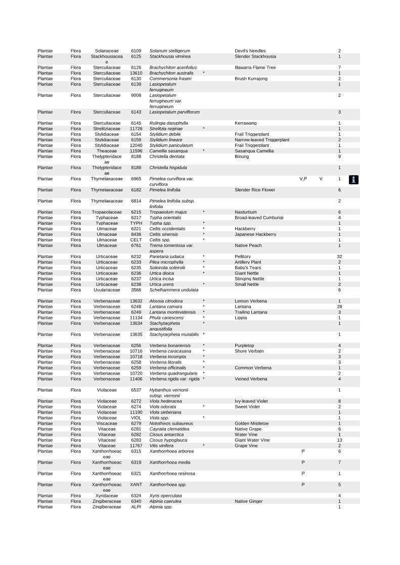
Plantae Flora Solanaceae 6109 Solanum stelligerum Devil's Needles 2
Plantae Flora Stackhousiacea
e
6125 Stackhousia viminea Slender Stackhousia 1
Plantae Flora Sterculiaceae 6126 Brachychiton acerifolius Illawarra Flame Tree 7
Plantae Flora Sterculiaceae 13610 Brachychiton australis * 1
Plantae Flora Sterculiaceae 6130 Commersonia fraseri Brush Kurrajong 2
Plantae Flora Sterculiaceae 6139 Lasiopetalum
ferrugineum
1
Plantae Flora Sterculiaceae 9008 Lasiopetalum
ferrugineum var.
ferrugineum
2
Plantae Flora Sterculiaceae 6143 Lasiopetalum parviflorum 3
Plantae Flora Sterculiaceae 6145 Rulingia dasyphylla Kerrawang 1
Plantae Flora Strelitziaceae 11726 Strelitzia reginae * 1
Plantae Flora Stylidiaceae 6154 Stylidium debile Frail Triggerplant 1
Plantae Flora Stylidiaceae 6159 Stylidium lineare Narrow-leaved Triggerplant 2
Plantae Flora Stylidiaceae 12040 Stylidium paniculatum Frail Triggerplant 1
Plantae Flora Theaceae 11596 Camellia sasanqua * Sasanqua Camellia 1
Plantae Flora Thelypteridace
ae
8188 Christella dentata Binung 9
Plantae Flora Thelypteridace
ae
8189 Christella hispidula 1
Plantae Flora Thymelaeaceae 6965 Pimelea curviflora var.
curviflora
V,P V 1
Plantae Flora Thymelaeaceae 6182 Pimelea linifolia Slender Rice Flower 6
Plantae Flora Thymelaeaceae 6814 Pimelea linifolia subsp.
linifolia
2
Plantae Flora Tropaeolaceae 6215 Tropaeolum majus * Nasturtium 6
Plantae Flora Typhaceae 6217 Typha orientalis Broad-leaved Cumbungi 4
Plantae Flora Typhaceae TYPH Typha spp. * 1
Plantae Flora Ulmaceae 6221 Celtis occidentalis * Hackberry 1
Plantae Flora Ulmaceae 8436 Celtis sinensis * Japanese Hackberry 1
Plantae Flora Ulmaceae CELT Celtis spp. * 1
Plantae Flora Ulmaceae 6761 Trema tomentosa var.
aspera
Native Peach 1
Plantae Flora Urticaceae 6232 Parietaria judaica * Pellitory 32
Plantae Flora Urticaceae 6233 Pilea microphylla * Artillery Plant 2
Plantae Flora Urticaceae 6235 Soleirolia soleirolii * Baby's Tears 1
Plantae Flora Urticaceae 6236 Urtica dioica * Giant Nettle 1
Plantae Flora Urticaceae 6237 Urtica incisa Stinging Nettle 1
Plantae Flora Urticaceae 6238 Urtica urens * Small Nettle 2
Plantae Flora Uvulariaceae 3566 Schelhammera undulata 6
Plantae Flora Verbenaceae 13632 Aloysia citrodora * Lemon Verbena 1
Plantae Flora Verbenaceae 6248 Lantana camara * Lantana 28
Plantae Flora Verbenaceae 6249 Lantana montevidensis * Trailing Lantana 3
Plantae Flora Verbenaceae 11134 Phyla canescens * Lippia 1
Plantae Flora Verbenaceae 13634 Stachytarpheta
angustifolia
* 1
Plantae Flora Verbenaceae 13635 Stachytarpheta mutabilis * 1
Plantae Flora Verbenaceae 6256 Verbena bonariensis * Purpletop 4
Plantae Flora Verbenaceae 10716 Verbena caracasana * Shore Verbain 2
Plantae Flora Verbenaceae 10718 Verbena incompta * 3
Plantae Flora Verbenaceae 6258 Verbena litoralis * 3
Plantae Flora Verbenaceae 6259 Verbena officinalis * Common Verbena 1
Plantae Flora Verbenaceae 10720 Verbena quadrangularis * 2
Plantae Flora Verbenaceae 11406 Verbena rigida var. rigida * Veined Verbena 4
Plantae Flora Violaceae 6537 Hybanthus vernonii
subsp. vernonii
1
Plantae Flora Violaceae 6272 Viola hederacea Ivy-leaved Violet 8
Plantae Flora Violaceae 6274 Viola odorata * Sweet Violet 2
Plantae Flora Violaceae 11190 Viola sieberiana 1
Plantae Flora Violaceae VIOL Viola spp. * 1
Plantae Flora Viscaceae 6279 Notothixos subaureus Golden Mistletoe 1
Plantae Flora Vitaceae 6281 Cayratia clematidea Native Grape 6
Plantae Flora Vitaceae 6282 Cissus antarctica Water Vine 1
Plantae Flora Vitaceae 6283 Cissus hypoglauca Giant Water Vine 13
Plantae Flora Vitaceae 11767 Vitis vinifera * Grape Vine 2
Plantae Flora Xanthorrhoeac
eae
6315 Xanthorrhoea arborea P 6
Plantae Flora Xanthorrhoeac
eae
6319 Xanthorrhoea media P 7
Plantae Flora Xanthorrhoeac
eae
6321 Xanthorrhoea resinosa P 1
Plantae Flora Xanthorrhoeac
eae
XANT Xanthorrhoea spp. P 5
Plantae Flora Xyridaceae 6324 Xyris operculata 4
Plantae Flora Zingiberaceae 6340 Alpinia caerulea Native Ginger 1
Plantae Flora Zingiberaceae ALPI Alpinia spp. 1

Plantae Flora Zingiberaceae 6787 Hedychium
gardnerianum
* Ginger Lily 7

Noxious weed declarations
Noxious weed declarations for Council of the City of SydneyNote: this control area includes the local council areas of - Sydney
Weed Class Legal requirements
African boxthorn [Lycium ferocissimum] 4 The plant must not be sold, propagated or knowinglydistributed
African feathergrass [Pennisetum macrourum] 5 The requirements in the Noxious Weeds Act 1993 for anotifiable weed must be complied withThis is an All of NSW declaration
African turnip weed [Sisymbrium runcinatum] 5 The requirements in the Noxious Weeds Act 1993 for anotifiable weed must be complied withThis is an All of NSW declaration
African turnip weed [Sisymbrium thellungii] 5 The requirements in the Noxious Weeds Act 1993 for anotifiable weed must be complied withThis is an All of NSW declaration
Alligator weed [Alternanthera philoxeroides] 3 The plant must be fully and continuously suppressed anddestroyed
Anchored water hyacinth [Eichhornia azurea] 1 The plant must be eradicated from the land and that landmust be kept free of the plantThis is an All of NSW declaration
Annual ragweed [Ambrosia artemisiifolia] 5 The requirements in the Noxious Weeds Act 1993 for anotifiable weed must be complied withThis is an All of NSW declaration
Arrowhead [Sagittaria calycina variety calycina(syn. Sagittaria montevidensis subspeciescalycina)]
4 The plant must not be sold, propagated or knowinglydistributed
Artichoke thistle [Cynara cardunculus] 5 The requirements in the Noxious Weeds Act 1993 for anotifiable weed must be complied withThis is an All of NSW declaration
Asparagus [Asparagus species ]Ex A.aethiopicus A.africanus A.asparagoides A.declinatus
A.falcatus A.macowanii var. zuluensis A.officinalis
A.plumosus A.racemosus A.virgatus
4 The plant must not be sold, propagated or knowinglydistributed
Asparagus fern [Asparagus virgatus (syn.Protasparagus virgatus)]A Weed of National Significance
2 The plant must be eradicated from the land and that landmust be kept free of the plant
Athel tree / Athel pine [Tamarix aphylla]A Weed of National Significance
5 The requirements in the Noxious Weeds Act 1993 for anotifiable weed must be complied withThis is an All of NSW declaration
Bear-skin fescue [Festuca gautieri] 5 The requirements in the Noxious Weeds Act 1993 for anotifiable weed must be complied withThis is an All of NSW declaration
Black knapweed [Centaurea xmoncktonii] 1 The plant must be eradicated from the land and that landmust be kept free of the plant
Return to start pageThis is a printer friendly page
Page 1 of 8Noxious weed declarations | NSW Department of Primary Industries
26/09/2014http://www.dpi.nsw.gov.au/agriculture/pests-weeds/weeds/noxweed/noxious-app-appl...
This is an All of NSW declaration
Black willow [Salix nigra]A Weed of National Significance
2 The plant must be eradicated from the land and that landmust be kept free of the plant
Blackberry [Rubus fruticosus aggregate species]
except cultivars Black satin Chehalem Chester Thornless
Dirksen Thornless Loch Ness Murrindindi Silvan Smooth
stem Thornfree
4 The growth of the plant must be managed in a manner thatcontinously inhibits the ability of the plant to spread and theplant must not be sold, propagated or knowingly distributedThis is an All of NSW declaration
Boneseed [Chrysanthemoides moniliferasubspecies monilifera]A Weed of National Significance
1 The plant must be eradicated from the land and that landmust be kept free of the plantThis is an All of NSW declaration
Bridal creeper [Asparagus asparagoides (syn.Myrisphyllum asparagoides, Asparagusmedeoloides)]
4 The plant must not be sold, propagated or knowinglydistributed
Bridal veil creeper [Asparagus declinatus (syn.Asparagus crispus, Myrsiphyllum declinatum)]A Weed of National Significance
1 The plant must be eradicated from the land and that landmust be kept free of the plantThis is an All of NSW declaration
Broad-leaf pepper tree [Schinus terebinthifolius] 2 The plant must be eradicated from the land and that landmust be kept free of the plant
Broomrapes [Orobanche species except thenative O. cernua variety australiana and O.minor]
1 The plant must be eradicated from the land and that landmust be kept free of the plantThis is an All of NSW declaration
Burr ragweed [Ambrosia confertiflora] 5 The requirements in the Noxious Weeds Act 1993 for anotifiable weed must be complied withThis is an All of NSW declaration
Cabomba [All Cabomba species except C.furcata]
5 The requirements in the Noxious Weeds Act 1993 for anotifiable weed must be complied withThis is an All of NSW declaration
Castor oil plant [Ricinus communis] 4 The growth of the plant must be managed in a manner thatcontinously inhibits the ability of the plant to spread
Cat's claw creeper [Dolichandra unguis-cati(syn. Macfadyena unguis-cati)]A Weed of National Significance
4 The growth of the plant must be managed in a manner thatcontinously inhibits the ability of the plant to spread
Cayenne snakeweed [Stachytarphetacayennensis]
5 The requirements in the Noxious Weeds Act 1993 for anotifiable weed must be complied withThis is an All of NSW declaration
Chilean needle grass [Nassella neesiana]A Weed of National Significance
4 The growth of the plant must be managed in a manner thatcontinously inhibits the ability of the plant to spread and theplant must not be sold, propagated or knowingly distributed
Chinese celtis [Celtis sinensis] 4 The growth of the plant must be managed in a manner thatcontinously inhibits the ability of the plant to spread and theplant must not be sold, propagated or knowingly distributed
Chinese violet [Asystasia gangetica subspeciesmicrantha]
1 The plant must be eradicated from the land and that landmust be kept free of the plantThis is an All of NSW declaration
Climbing asparagus fern [Asparagus plumosus(syn. Protasparagus plumosus)]
2 The plant must be eradicated from the land and that landmust be kept free of the plant
Page 2 of 8Noxious weed declarations | NSW Department of Primary Industries
26/09/2014http://www.dpi.nsw.gov.au/agriculture/pests-weeds/weeds/noxweed/noxious-app-appl...

A Weed of National Significance
Climbing asparagus fern [Asparagus plumosus(syn. Protasparagus plumosus)]A Weed of National Significance
4 The plant must not be sold, propagated or knowinglydistributed
Clockweed [Gaura parviflora] 5 The requirements in the Noxious Weeds Act 1993 for anotifiable weed must be complied withThis is an All of NSW declaration
Coolatai grass [Hyparrhenia hirta] 3 The plant must be fully and continuously suppressed anddestroyed and the plant must not be sold, propagated orknowingly distributed
Corn sowthistle [Sonchus arvensis] 5 The requirements in the Noxious Weeds Act 1993 for anotifiable weed must be complied withThis is an All of NSW declaration
Dodder [All Cuscuta species except the nativespecies C. australis, C. tasmanica and C.victoriana]Includes All Cuscuta species except the native species C.
australis, C. tasmanica and C. victoriana
5 The requirements in the Noxious Weeds Act 1993 for anotifiable weed must be complied withThis is an All of NSW declaration
Espartillo [Amelichloa brachychaeta, Amelichloacaudata]
5 The requirements in the Noxious Weeds Act 1993 for anotifiable weed must be complied withThis is an All of NSW declaration
Eurasian water milfoil [Myriophyllum spicatum] 1 The plant must be eradicated from the land and that landmust be kept free of the plantThis is an All of NSW declaration
Fine-bristled burr grass [Cenchrus brownii] 5 The requirements in the Noxious Weeds Act 1993 for anotifiable weed must be complied withThis is an All of NSW declaration
Fireweed [Senecio madagascariensis]A Weed of National Significance
4 The plant must not be sold, propagated or knowinglydistributed
Flax-leaf broom [Genista linifolia]A Weed of National Significance
4 The plant must not be sold, propagated or knowinglydistributed
Fountain grass [Pennisetum setaceum] 5 The requirements in the Noxious Weeds Act 1993 for anotifiable weed must be complied withThis is an All of NSW declaration
Frogbit / Spongeplant [Limnobium laevigatumand L. spongia]
1 The plant must be eradicated from the land and that landmust be kept free of the plantThis is an All of NSW declaration
Gallon's curse [Cenchrus biflorus] 5 The requirements in the Noxious Weeds Act 1993 for anotifiable weed must be complied withThis is an All of NSW declaration
Gamba grass [Andropogon gayanus] 5 The requirements in the Noxious Weeds Act 1993 for anotifiable weed must be complied withThis is an All of NSW declaration
Giant reed / Elephant grass [Arundo donax] 4 The plant must not be sold, propagated or knowinglydistributed
Glaucous star thistle [Carthamus glaucus] 5 The requirements in the Noxious Weeds Act 1993 for anotifiable weed must be complied with
Page 3 of 8Noxious weed declarations | NSW Department of Primary Industries
26/09/2014http://www.dpi.nsw.gov.au/agriculture/pests-weeds/weeds/noxweed/noxious-app-appl...

This is an All of NSW declaration
Golden thistle [Scolymus hispanicus] 5 The requirements in the Noxious Weeds Act 1993 for anotifiable weed must be complied withThis is an All of NSW declaration
Gorse [Ulex europaeus]A Weed of National Significance
3 The plant must be fully and continuously suppressed anddestroyed
Green cestrum [Cestrum parqui] 3 The plant must be fully and continuously suppressed anddestroyed
Grey sallow [Salix cinerea]A Weed of National Significance
2 The plant must be eradicated from the land and that landmust be kept free of the plant
Ground asparagus [Asparagus aethiopicus (syn.Protasparagus aethiopicus)]
4 The plant must not be sold, propagated or knowinglydistributed
Groundsel bush [Baccharis halimifolia] 3 The plant must be fully and continuously suppressed anddestroyed
Harrisia cactus [Harrisia species] 4 The growth of the plant must be managed in a manner thatcontinously inhibits the ability of the plant to spread and theplant must not be sold, propagated or knowingly distributed
Hawkweed [Hieracium species] 1 The plant must be eradicated from the land and that landmust be kept free of the plantThis is an All of NSW declaration
Heteranthera / Kidneyleaf mud plantain[Heteranthera reniformis]
1 The plant must be eradicated from the land and that landmust be kept free of the plantThis is an All of NSW declaration
Honey locust [Gleditsia triacanthos] 3 The plant must be fully and continuously suppressed anddestroyed and the plant must not be sold, propagated orknowingly distributed
Horsetail [Equisetum species] 1 The plant must be eradicated from the land and that landmust be kept free of the plantThis is an All of NSW declaration
Hydrocotyl / Water pennywort [Hydrocotylranunculoides]
1 The plant must be eradicated from the land and that landmust be kept free of the plantThis is an All of NSW declaration
Hygrophila [Hygrophila costata] 2 The plant must be eradicated from the land and that landmust be kept free of the plant
Hymenachne [Hymenachne amplexicaulis andhybrids]A Weed of National Significance
1 The plant must be eradicated from the land and that landmust be kept free of the plantThis is an All of NSW declaration
Karroo thorn [Acacia karroo] 1 The plant must be eradicated from the land and that landmust be kept free of the plantThis is an All of NSW declaration
Kochia [Bassia scoparia (syn. Kochia scoparia)except B. scoparia subspecies trichophylla]except Bassia scoparia subspecies trichophylla
1 The plant must be eradicated from the land and that landmust be kept free of the plantThis is an All of NSW declaration
Koster's curse / Clidemia [Clidemia hirta] 1 The plant must be eradicated from the land and that landmust be kept free of the plantThis is an All of NSW declaration
Page 4 of 8Noxious weed declarations | NSW Department of Primary Industries
26/09/2014http://www.dpi.nsw.gov.au/agriculture/pests-weeds/weeds/noxweed/noxious-app-appl...

Kudzu [Pueraria lobata] 2 The plant must be eradicated from the land and that landmust be kept free of the plant
Lagarosiphon [Lagarosiphon major] 1 The plant must be eradicated from the land and that landmust be kept free of the plantThis is an All of NSW declaration
Lantana [Lantana species]A Weed of National Significance
4 The growth of the plant must be managed in a manner thatcontinously inhibits the ability of the plant to spread
Leafy elodea / Dense waterweed / Egeria[Egeria densa (syn. Elodea densa)]
4 The plant must not be sold, propagated or knowinglydistributedThis is an All of NSW declaration
Lippia [Phyla canescens] 4 The plant must not be sold, propagated or knowinglydistributed except incidentally in hay or lucerneThis is an All of NSW declaration
Long-leaf willow primrose [Ludwigia longifolia] 3 The plant must be fully and continuously suppressed anddestroyed and the plant must not be sold, propagated orknowingly distributed
Ludwigia [Ludwigia peruviana] 3 The plant must be fully and continuously suppressed anddestroyed
Mexican feather grass [Nassella tenuissima] 1 The plant must be eradicated from the land and that landmust be kept free of the plantThis is an All of NSW declaration
Mexican poppy [Argemone mexicana] 5 The requirements in the Noxious Weeds Act 1993 for anotifiable weed must be complied withThis is an All of NSW declaration
Miconia [Miconia species] 1 The plant must be eradicated from the land and that landmust be kept free of the plantThis is an All of NSW declaration
Mikania vine [Mikania micrantha] 1 The plant must be eradicated from the land and that landmust be kept free of the plantThis is an All of NSW declaration
Mimosa [Mimosa pigra]A Weed of National Significance
1 The plant must be eradicated from the land and that landmust be kept free of the plantThis is an All of NSW declaration
Ming (Pom pom / Zig zag) asparagus fern[Asparagus macowanii var. zuluensis (syn. A.retrofractus)]
2 The plant must be eradicated from the land and that landmust be kept free of the plant
Mossman River grass [Cenchrus echinatus] 5 The requirements in the Noxious Weeds Act 1993 for anotifiable weed must be complied withThis is an All of NSW declaration
Mother-of-millions [Bryophyllum species]See Weed Control Order 30 for more explanation
4 The growth of the plant must be managed in a manner thatcontinously inhibits the ability of the plant to spread and theplant must not be sold, propagated or knowingly distributed
Pampas grass [Cortaderia species] 3 The plant must be fully and continuously suppressed anddestroyed and the plant must not be sold, propagated orknowingly distributed
Paper mulberry [Broussonetia papyrifera] 2 The plant must be eradicated from the land and that landmust be kept free of the plant
Page 5 of 8Noxious weed declarations | NSW Department of Primary Industries
26/09/2014http://www.dpi.nsw.gov.au/agriculture/pests-weeds/weeds/noxweed/noxious-app-appl...
Parthenium weed [Parthenium hysterophorus]A Weed of National Significance
1 The plant must be eradicated from the land and that landmust be kept free of the plantThis is an All of NSW declaration
Pond apple [Annona glabra]A Weed of National Significance
1 The plant must be eradicated from the land and that landmust be kept free of the plantThis is an All of NSW declaration
Prickly acacia [Vachellia nilotica (syn. Acacianilotica)]A Weed of National Significance
1 The plant must be eradicated from the land and that landmust be kept free of the plantThis is an All of NSW declaration
Prickly pear [Opuntia species except O. ficus-indica]
4 The growth of the plant must be managed in a manner thatcontinously inhibits the ability of the plant to spread and theplant must not be sold, propagated or knowingly distributed
Prickly pear [Cylindropuntia species]A Weed of National Significance
4 The growth of the plant must be managed in a manner thatcontinously inhibits the ability of the plant to spread and theplant must not be sold, propagated or knowingly distributedThis is an All of NSW declaration
Privet (Broad-leaf) [Ligustrum lucidum] 4 The growth of the plant must be managed in a manner thatcontinously inhibits the ability of the plant to spread
Privet (Narrow-leaf/Chinese) [Ligustrum sinense] 4 The growth of the plant must be managed in a manner thatcontinously inhibits the ability of the plant to spread
Red rice [Oryza rufipogon] 5 The requirements in the Noxious Weeds Act 1993 for anotifiable weed must be complied withThis is an All of NSW declaration
Rhus tree [Toxicodendron succedaneum (syn.Toxicodendron succedanea, Rhus succedanea)]
4 The growth of the plant must be managed in a manner thatcontinously inhibits the ability of the plant to spread and theplant must not be sold, propagated or knowingly distributedThis is an All of NSW declaration
Rubber vine [Cryptostegia grandiflora]A Weed of National Significance
1 The plant must be eradicated from the land and that landmust be kept free of the plantThis is an All of NSW declaration
Sagittaria [Sagittaria platyphylla (syn. Sagittariagraminea variety platyphylla)]A Weed of National Significance
4 The plant must not be sold, propagated or knowinglydistributed
Salvinia [Salvinia molesta]A Weed of National Significance
2 The plant must be eradicated from the land and that landmust be kept free of the plant
Scotch broom / English broom [Cytisusscoparius subspecies scoparius]A Weed of National Significance
4 The plant must not be sold, propagated or knowinglydistributed
Senegal tea plant [Gymnocoronis spilanthoides] 1 The plant must be eradicated from the land and that landmust be kept free of the plantThis is an All of NSW declaration
Serrated tussock [Nassella trichotoma]A Weed of National Significance
4 The growth of the plant must be managed in a manner thatcontinously inhibits the ability of the plant to spread and theplant must not be sold, propagated or knowingly distributed
Siam weed [Chromolaena odorata] 1 The plant must be eradicated from the land and that landmust be kept free of the plantThis is an All of NSW declaration
Page 6 of 8Noxious weed declarations | NSW Department of Primary Industries
26/09/2014http://www.dpi.nsw.gov.au/agriculture/pests-weeds/weeds/noxweed/noxious-app-appl...

Sicklethorn [Asparagus falcatus] 2 The plant must be eradicated from the land and that landmust be kept free of the plant
Silver-leaf nightshade [Solanum elaeagnifolium]A Weed of National Significance
4 The plant must not be sold, propagated or knowinglydistributed
Smooth-stemmed turnip [Brassica barrelierisubspecies oxyrrhina]
5 The requirements in the Noxious Weeds Act 1993 for anotifiable weed must be complied withThis is an All of NSW declaration
Soldier thistle [Picnomon acarna] 5 The requirements in the Noxious Weeds Act 1993 for anotifiable weed must be complied withThis is an All of NSW declaration
Spotted knapweed [Centaurea stoebesubspecies micranthos]
1 The plant must be eradicated from the land and that landmust be kept free of the plantThis is an All of NSW declaration
St. John's wort [Hypericum perforatum] 4 The growth of the plant must be managed in a manner thatcontinously inhibits the ability of the plant to spread and theplant must not be sold, propagated or knowingly distributed
Texas blueweed [Helianthus ciliaris] 5 The requirements in the Noxious Weeds Act 1993 for anotifiable weed must be complied withThis is an All of NSW declaration
Tropical soda apple [Solanum viarum] 1 The plant must be eradicated from the land and that landmust be kept free of the plantThis is an All of NSW declaration
Tussock paspalum [Paspalum quadrifarium] 4 The growth of the plant must be managed in a manner thatcontinously inhibits the ability of the plant to spread and theplant must not be sold, propagated or knowingly distributed
Water caltrop [Trapa species] 1 The plant must be eradicated from the land and that landmust be kept free of the plantThis is an All of NSW declaration
Water hyacinth [Eichhornia crassipes]A Weed of National Significance
2 The plant must be eradicated from the land and that landmust be kept free of the plant
Water lettuce [Pistia stratiotes] 1 The plant must be eradicated from the land and that landmust be kept free of the plantThis is an All of NSW declaration
Water soldier [Stratiotes aloides] 1 The plant must be eradicated from the land and that landmust be kept free of the plantThis is an All of NSW declaration
Willows [Salix species except S. babylonica, S.xreichardtii, S. xcalodendron, S. cinerea and S.nigra]Includes all Salix species except S. babylonica, S. x
reichardtii, S. x calodendron
4 The plant must not be sold, propagated or knowinglydistributed
Witchweed [Striga species except the nativeStriga parviflora]
1 The plant must be eradicated from the land and that landmust be kept free of the plantThis is an All of NSW declaration
Yellow bells [Tecoma stans] 3 The plant must be fully and continuously suppressed anddestroyed
Yellow burrhead [Limnocharis flava] 1 The plant must be eradicated from the land and that land
Page 7 of 8Noxious weed declarations | NSW Department of Primary Industries
26/09/2014http://www.dpi.nsw.gov.au/agriculture/pests-weeds/weeds/noxweed/noxious-app-appl...

Accessibility | Privacy | Copyright | Disclaimer | Feedback | Report a problemNSW Government | jobs.nsw
must be kept free of the plantThis is an All of NSW declaration
Yellow nutgrass [Cyperus esculentus] 5 The requirements in the Noxious Weeds Act 1993 for anotifiable weed must be complied withThis is an All of NSW declaration
Page 8 of 8Noxious weed declarations | NSW Department of Primary Industries
26/09/2014http://www.dpi.nsw.gov.au/agriculture/pests-weeds/weeds/noxweed/noxious-app-appl...

Search Result
Click on a name to see the page for that taxon.* denotes an introduced species+ denotes a species listed on the schedules of the Threatened Species Conservation Act (TSCA)◊ denotes a ROTAP listed species‡ denotes a gazetted weed.
NEW SOUTH WALES FLORA ONLINE
All taxa collected in the SYDNEY Local Government Area (LGA)
Aizoaceae Tetragonia tetragonioidesAlismataceae Sagittaria ‡ platyphyllaAlliaceae Nothoscordum * gracileAmaranthaceae Achyranthes aspera
Amaranthus ** albus* blitum* deflexus* hybridus* macrocarpus var. pallidus* viridis
Froelichia* gracilis
Gomphrena * celosioidesAmygdalaceae Prunus * persicaAnthericaceae Thysanotus juncifoliusApiaceae Actinotus helianthi
minorCentella
asiaticaCyclospermum * leptophyllumHydrocotyle acutiloba
* bonariensisPlatysace lanceolata
linearifoliaXanthosia pilosa
Apocynaceae Tabernaemontana ceriferapandacaqui
Araceae Aglaonema pictumCyrtosperma beccarianum x cuspidispathumHomalomena lauterbachii
sp.SchismatoglottisTyphonium brownii
Araliaceae Astrotricha floccosaMeryta sinclairiiTrevesia palmata
Araucariaceae Agathis robustaAraucaria scopulorum
Asteraceae Ageratina *‡ adenophoraAnthemis * cotulaBidens * pilosaCalotis cuneifoliaChamomilla recutitaCichorium * intybusCineraria lyratiformisConyza * sumatrensisCotula australis
* coronopifoliaCrassocephalum * crepidioidesCrepis capillarisCymbonotus lawsonianusDelairea * odorataDimorphotheca * ecklonisDittrichia * graveolensEpaltes australisEriocephalus * africanusEthulia conyzoidesEuchiton involucratusGalinsoga * parvifloraGamochaeta * americana
* antillana* calviceps* pensylvanica
Hypochaeris * radicataLactuca * serriola f. integrifoliaLeontodon taraxacoides subsp. taraxacoidesOlearia microphyllaPseudognaphalium luteo-albumSenecio *‡ madagascariensis
* vulgarisSolenogyne bellioides
dominiiSoliva * anthemifolia
* sessilisSonchus * oleraceusTagetes * minutaTaraxacum * officinaleXanthium *‡ spinosumYoungia japonica
Bignoniaceae Pandorea pandorana subsp. pandoranaBlandfordiaceae Blandfordia grandiflora
nobilisBlechnaceae Doodia asperaBoraginaceae Amsinckia * intermedia
Heliotropium * europaeumNonea * lutea
Brassicaceae Brassica * rapa
Page 1 of 7PlantNET - FloraOnline
26/09/2014http://plantnet.rbgsyd.nsw.gov.au/web2printer/web2printer4.php?img=0&lnk=3&styl...

tournefortiiCardamine * flexuosa
* hirsutaLepidium didymumLobularia * maritimaRaphanus * raphanistrumSisymbrium * officinale
* orientaleCactaceae Opuntia ‡ monacanthaCallitrichaceae Callitriche * stagnalisCalycanthaceae Calycanthus occidentalis
Chimonanthus praecoxCampanulaceae Wahlenbergia gracilisCannaceae Canna * indicaCaryophyllaceae Paronychia * brasiliana
Polycarpon * tetraphyllumSilene * gallica var. gallicaSpergula * arvensisSpergularia tasmanica
Casuarinaceae Casuarina glaucaCelastraceae Cassine australis var. australisCentrolepidaceae Centrolepis fascicularisChenopodiaceae Chenopodium album
* album* ambrosioides
Einadia trigonos subsp. trigonosSuaeda australis
Convolvulaceae Ipomoea * purpureaCrassulaceae Crassula decumbensCunoniaceae Bauera rubioides
Callicoma serratifoliaCeratopetalum gummiferum
Cyperaceae Baumea acutaChorizandra cymbaria
sphaerocephalaCyperus * brevifolius
* congestuspolystachyos
* rotundussanguinolentus
* sesquiflorusFimbristylis dichotomaGymnoschoenus sphaerocephalusIsolepis inundata
* levynsianaproducta
Lepidosperma viscidumSchoenus apogon
ericetorumDavalliaceae Davallia solida var. pyxidataDennstaedtiaceae Histiopteris incisaDroseraceae Drosera auriculataElaeocarpaceae Elaeocarpus kirtonii
reticulatusSloanea woollsii
Ericaceae - Styphelioideae Acrotriche divaricataAstroloma humifusumBrachyloma daphnoidesDracophyllum secundumEpacris crassifolia
longifloramicrophyllaobtusifolia
Leucopogon appressusdeformisericoidesesquamatusjuniperinusmicrophyllus
Monotoca ellipticascoparia
Styphelia laeta subsp. laetatriflora subsp. group cviridis subsp. viridis
Trochocarpa laurinaWoollsia pungens
Euphorbiaceae Acalypha * australisChamaesyce hirta
maculata* maculata
prostrataEuphorbia * oblongata
peplus* peplus
Ricinocarpos pinifoliusRicinus *‡ communis
Eupomatiaceae Eupomatia laurinaFabaceae - Caesalpinioideae Bauhinia x blakeanaFabaceae - Faboideae Bossiaea heterophylla
obcordatascolopendria
Daviesia genistifoliaDesmodium brachypodum
rhytidophyllumvarians
Dillwynia retortaErythrina x sykesiiGenista stenopetalaGlycine tabacina complexGompholobium glabratum
grandiflorumminus
Page 2 of 7PlantNET - FloraOnline
26/09/2014http://plantnet.rbgsyd.nsw.gov.au/web2printer/web2printer4.php?img=0&lnk=3&styl...
pinnatumHardenbergia violaceaHovea longifoliaKennedia prostrata
rubicundaLotus * angustissimusMedicago * arabica
hispida var. inermis* lupulina* polymorpha var. brevispina* polymorpha var. vulgaris
Melilotus * indicusMillettia caffraPodolobium staurophyllumPultenaea daphnoides
paleacearetusatuberculata
Sphaerolobium vimineumTephrosia * grandifloraTrifolium * arvense
* campestre* cernuum* dubium* glomeratum* hybridum var. hybridum* pratense* repens* resupinatum* striatum
Ulex *‡ europaeusVicia * sativa subsp. nigra
* villosa subsp. eriocarpaVigna * radiata var. radiataViminaria juncea
Fabaceae - Mimosoideae Acacia browniidealbatadecurrenselatahispidulalinifolialongifolia
* podalyriifoliaquadrilateralissuaveolensterminalis
◊+ terminalis subsp. terminalisulicifolia
Prosopis * juliflora* juliflora var. velutina
Flagellariaceae Flagellaria indicaFumariaceae Corydalis sp.
Fumaria * muralis subsp. muralis* officinalis
Pseudofumaria * albaGentianaceae Centaurium * tenuiflorumGeraniaceae Erodium * botrysGleicheniaceae Gleichenia dicarpa
rupestrisSticherus flabellatus var. flabellatus
Goodeniaceae Coopernookia barbataScaevola albida
ramosissimaHaloragaceae Gonocarpus micranthus subsp. ramosissimus
Myriophyllum * aquaticumHymenophyllaceae Hymenophyllum cupressiformeHypoxidaceae Hypoxis pratensis var. pratensisIlliciaceae Illicium ?parviflorum
anisatumIridaceae Ixia * polystachya
Sisyrinchium * iridifolium* sp. A sensu James & Brown (1993)
Sparaxis * bulbiferaJuncaceae Juncus articulatus
bufonius* cognatus
continuushomalocaulisprismatocarpussubsecundus
* tenuisusitatus
Lamiaceae Chloanthes stoechadisLamium * amplexicauleLeonurus * japonicusMarrubium * vulgarePlectranthus parviflorusSalvia * leucanthaScutellaria * racemosaVitex lucens
Lardizabalaceae Akebia quinataStauntonia hexaphylla
Lauraceae Cassytha paniculatapubescens
Cryptocarya glaucescensobovata
Linaceae Linum * usitatissimumLindsaeaceae Lindsaea microphyllaLobeliaceae Lobelia anceps
Monopsis * debilis var. depressaPratia purpurascens
Lomandraceae Lomandra filiformis subsp. filiformis
Page 3 of 7PlantNET - FloraOnline
26/09/2014http://plantnet.rbgsyd.nsw.gov.au/web2printer/web2printer4.php?img=0&lnk=3&styl...
gracilislongifolia
Loranthaceae Muellerina celastroidescelastroides – eucalyptoideseucalyptoides
Luzuriagaceae Eustrephus latifoliusLycopodiaceae Lycopodiella cernuaMagnoliaceae Magnolia grandiflora
kobus var. stellataobovata
Malvaceae Abutilon * grandifoliumCommersonia fraseriHibiscus * trionumMalva *
* linnaei* nicaeensis* parviflora* sylvestris
Modiola * carolinianaMartyniaceae Proboscidea * fragrans
* louisianaMeliaceae Turraea obtusifoliaMenispermaceae Legnephora mooreiMonimiaceae Daphnandra apatela
Doryphora sassafrasMoraceae Ficus coronata
eugenioidesrubiginosa f. rubiginosa
Myrsinaceae Anagallis * arvensisMyrtaceae Angophora costata
Baeckea imbricataCallistemon citrinus
linearisCalothamnusCorymbia eximiaEucalyptus ? marginata
haemastoma – racemosapaniculatapilularisracemosatereticornis
Euryomyrtus ramosissima subsp. ramosissimaKunzea ambigua
capitataLeptospermum arachnoides
squarrosumtrinervium
Melaleuca armillarisnodosaquinquenerviathymifolia
Rhodamnia rubescensSannantha plurifloraTristaniopsis collina
Nelumbonaceae Nelumbo nuciferaNyctaginaceae Mirabilis * jalapaNymphaeaceae Nymphaea * capensis
nouchaliOchnaceae Ochna * serrulataOlacaceae Olax strictaOleaceae Notelaea longifolia f. longifoliaOnagraceae Epilobium * ciliatumOrchidaceae Acianthus caudatus
reniformisCaladenia catenataCorybas fimbriatus
pruinosusCymbidium suaveEria xanthocheilaGenoplesium archeriGoodyera rubicundaParacaleana minorPterostylis acuminata
furva ined.rufa
Thelymitra carneaOrobanchaceae Orobanche * minorOxalidaceae Oxalis *‡ brasiliensis
corniculata f. tropaeoloides*‡ corniculata*‡ pes-caprae
thompsoniaePapaveraceae Papaver * hybridumPassifloraceae Passiflora * subpeltataPhormiaceae Dianella caerulea var. producta
Thelionema umbellatumPhyllanthaceae Phyllanthus * tenellus
Poranthera corymbosaPicrodendraceae Micrantheum ericoidesPittosporaceae Billardiera scandens
Hymenosporum flavumPittosporum revolutum
undulatumPlantaginaceae Plantago * major
Veronica * arvensisPlatanaceae Platanus x hispanicaPoaceae Agrostis
* gigantea* viridis
Amphibromus nervosusAndropogon * virginicusAnthoxanthum * odoratum
Page 4 of 7PlantNET - FloraOnline
26/09/2014http://plantnet.rbgsyd.nsw.gov.au/web2printer/web2printer4.php?img=0&lnk=3&styl...

Arrhenatherum * elatius var. elatiusAvena * fatuaBothriochloa macraBriza * maxima
* minorBromus *
* catharticus* hordeaceus
Cenchrus ciliaris* ciliaris* pennisetiformis
Chloris * virgataCortaderia *‡ selloanaCymbopogon refractusCynodon dactylon
* incompletusDactylis * glomerataDactyloctenium * australeDanthonia racemosa
tenuiorDeyeuxiaDichelachne crinita
inaequiglumismicranthaparva
Digitaria * aequiglumis* ciliaris
didactyladiffusaerianthaparviflora
* sanguinalisDiplachne fuscaEchinochloa colonaEleusine * indicaElymus rectisetus
scaberEntolasia marginata
strictaEragrostis
aff. pilosa* aff. pilosa
basedowiibrowniibrownii sens. lat.
* cilianensis* curvula
elongataleptostachya
* mexicanaparviflorasetifolia
* virescensEriachne armittiiFestuca * arundinacea
* nigrescenspratensis
* pratensis* rubra
Glyceria australisHainardia * cylindricaHolcus * lanatusHordeum * distichonLachnagrostis filiformisLeptochloa asthenesLolium *
* loliaceum* perenne* rigidum
Melinis * repensPanicum * antidotale
* capillare* maximum var. trichoglume* miliaceum* schinzii
Paspalidium distansPaspalum
distichum* urvillei
Pennisetum * clandestinum*‡ setaceum*‡ villosum
Phalaris * angusta* aquatica* canariensis
Phragmites australisPoa * annua
poiformis* pratensis
Rostraria * cristataSacciolepis indicaSetaria * glauca
* parvifloraverticillata
* viridisSporobolus
* africanuselongatus
Stenotaphrum * secundatumThemeda triandraTrisetum * flavescensUniola latifolia
Page 5 of 7PlantNET - FloraOnline
26/09/2014http://plantnet.rbgsyd.nsw.gov.au/web2printer/web2printer4.php?img=0&lnk=3&styl...
Urochloa * panicoidesVulpia * myuros f. megaluraZoysia * pacifica
Podocarpaceae Podocarpus elatusPolygonaceae Acetosa * sagittata
Acetosella * vulgarisEmex * australisPersicaria hydropiper
* maculosaPolygonum * aviculareRumex brownii
* conglomeratus* obtusifolius* pulcher
Polypodiaceae Platycerium bifurcatumPotamogetonaceae Ruppia polycarpaProteaceae Banksia aemula
ericifolia subsp. ericifoliaintegrifolia subsp. integrifoliamarginata
Brabejum stellatifoliumGrevillea banksii
linearifolia◊ longifolia
parviflorarosmarinifoliasericea subsp. sericeasphacelata
Hakea cucullatagibbosasericeaundulata
Lomatia silaifoliaPersoonia ◊+hirsuta subsp. hirsuta
lanceolatalaurina subsp. laurinalinearis
Symphionema paludosumXylomelum pyriforme
Psilotaceae Psilotum nudumPteridaceae Adiantum hispidulum var. hypoglaucum
Pteris vittataRanunculaceae Ranunculus * muricatusRestionaceae Leptocarpus tenaxRhamnaceae Cryptandra amara
spinescensPaliurus spina-christiPhylica plumosaPomaderris ferruginea
lanigeraZiziphus mauritiana
Rubiaceae Opercularia asperaPomax umbellata
Rutaceae Acronychia oblongifoliaBoronia floribunda
◊ fraserimollisparviflorapinnatarubiginosa
◊ serrulatathujona
Crowea salignaEriostemon australasius
buxifolius subsp. buxifoliusNematolepis squamea subsp. squameaPhilotheca reichenbachii
salsolifoliaSarcomelicope simplicifolia subsp. simplicifoliaZieria laevigata
smithiiSalviniaceae Salvinia * auriculata
*‡ molestaSapindaceae Cardiospermum ‡ grandiflorum
Cupaniopsis anacardioidesDodonaea triquetra
truncatialesScrophulariaceae Cymbalaria * muralis subsp. muralis
Euphrasia collina subsp. speciosaHebe sp. nov.Maurandya * barclayana
Selaginellaceae Selaginellabraunii
* kraussianaSmilacaceae Smilax glyciphyllaSolanaceae Datura * stramonium
Lycopersicon * esculentumPhysalis * minimaSalpichroa * origanifoliaSolanum
* betaceum* linnaeanum* mauritianum* nigrum
stelligerumUrticaceae Parietaria *‡ judaica
Pilea microphyllaUrtica * urens
Verbenaceae Aloysia citrodoraLantana *‡ camara var. camara
*‡ montevidensisStachytarpheta angustifolia
Page 6 of 7PlantNET - FloraOnline
26/09/2014http://plantnet.rbgsyd.nsw.gov.au/web2printer/web2printer4.php?img=0&lnk=3&styl...

This page URL:http://plantnet.rbgsyd.nsw.gov.au/cgi-bin/NSWfl.pl?page=nswfl&spatquer=yes&forest=&npres=&cmas=&ibra=&lga=SYDNEY&nswsdiv=&maxy=&maxym=&maxyd=S&miny=&minym=&minyd=S&maxx=&maxxm=&maxxd=E&minx=&minxm=&minxd=E&near=&state=NSW&range=0.09670&vasc=yes&threat=
* mutabilisVerbena * brasiliensis
* incompta* litoralis
Violaceae Hybanthus vernonii subsp. vernoniiViola sieberiana
Viscaceae Notothixos subaureusVitaceae Cissus antarctica
hypoglauca
Page 7 of 7PlantNET - FloraOnline
26/09/2014http://plantnet.rbgsyd.nsw.gov.au/web2printer/web2printer4.php?img=0&lnk=3&styl...

Sydney City Centre Capacity Improvement Plan Appendix KReview of Environmental Factors
Appendix KAboriginal heritage informationmanagement system search results
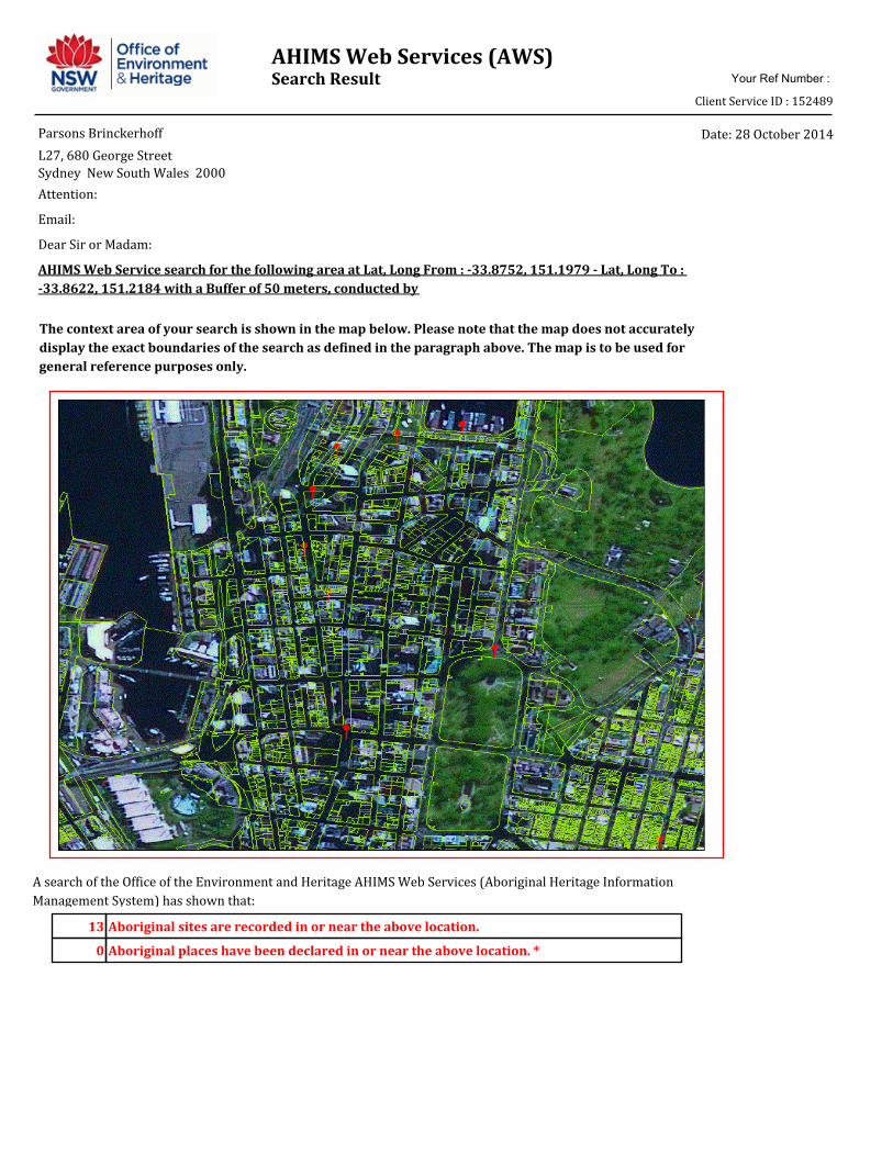
AHIMS Web Services (AWS)Search Result Your Ref Number :
Client Service ID : 152489
Date: 28 October 2014Parsons Brinckerhoff
L27, 680 George Street
Sydney New South Wales 2000
A search of the Office of the Environment and Heritage AHIMS Web Services (Aboriginal Heritage Information
Management System) has shown that:
13
0
Aboriginal sites are recorded in or near the above location.
Aboriginal places have been declared in or near the above location. *
Email:
Attention:
Dear Sir or Madam:
AHIMS Web Service search for the following area at Lat, Long From : -33.8752, 151.1979 - Lat, Long To :
-33.8622, 151.2184 with a Buffer of 50 meters, conducted by
The context area of your search is shown in the map below. Please note that the map does not accurately
display the exact boundaries of the search as defined in the paragraph above. The map is to be used for
general reference purposes only.

If your search shows Aboriginal sites or places what should you do?
Important information about your AHIMS search
You can get further information about Aboriginal places by looking at the gazettal notice that declared it.
Aboriginal places gazetted after 2001 are available on the NSW Government Gazette
(http://www.nsw.gov.au/gazette) website. Gazettal notices published prior to 2001 can be obtained from
Office of Environment and Heritage's Aboriginal Heritage Information Unit upon request
Aboriginal objects are protected under the National Parks and Wildlife Act 1974 even if they are not recorded
as a site on AHIMS.
You must do an extensive search if AHIMS has shown that there are Aboriginal sites or places recorded in the
search area.
If you are checking AHIMS as a part of your due diligence, refer to the next steps of the Due Diligence Code of
practice.
AHIMS records information about Aboriginal sites that have been provided to Office of Environment and
Heritage and Aboriginal places that have been declared by the Minister;
Information recorded on AHIMS may vary in its accuracy and may not be up to date .Location details are
recorded as grid references and it is important to note that there may be errors or omissions in these
recordings,
Some parts of New South Wales have not been investigated in detail and there may be fewer records of
Aboriginal sites in those areas. These areas may contain Aboriginal sites which are not recorded on AHIMS.
This search can form part of your due diligence and remains valid for 12 months.
The information derived from the AHIMS search is only to be used for the purpose for which it was requested.
It is not be made available to the public.
PO BOX 1967 Hurstville NSW 2220
43 Bridge Street HURSTVILLE NSW 2220
Tel: (02)9585 6345 (02)9585 6471 Fax: (02)9585 6094
ABN 30 841 387 271
Email: [email protected]
Web: www.environment.nsw.gov.au
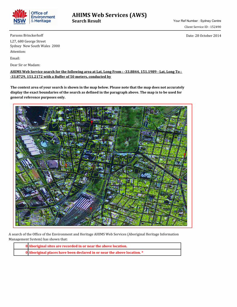
AHIMS Web Services (AWS)Search Result Your Ref Number : Sydney Centre
Client Service ID : 152490
Date: 28 October 2014Parsons Brinckerhoff
L27, 680 George Street
Sydney New South Wales 2000
A search of the Office of the Environment and Heritage AHIMS Web Services (Aboriginal Heritage Information
Management System) has shown that:
8
0
Aboriginal sites are recorded in or near the above location.
Aboriginal places have been declared in or near the above location. *
Attention:
Email:
Dear Sir or Madam:
AHIMS Web Service search for the following area at Lat, Long From : -33.8844, 151.1989 - Lat, Long To :
-33.8729, 151.2172 with a Buffer of 50 meters, conducted by
The context area of your search is shown in the map below. Please note that the map does not accurately
display the exact boundaries of the search as defined in the paragraph above. The map is to be used for
general reference purposes only.

If your search shows Aboriginal sites or places what should you do?
Important information about your AHIMS search
You can get further information about Aboriginal places by looking at the gazettal notice that declared it.
Aboriginal places gazetted after 2001 are available on the NSW Government Gazette
(http://www.nsw.gov.au/gazette) website. Gazettal notices published prior to 2001 can be obtained from
Office of Environment and Heritage's Aboriginal Heritage Information Unit upon request
Aboriginal objects are protected under the National Parks and Wildlife Act 1974 even if they are not recorded
as a site on AHIMS.
You must do an extensive search if AHIMS has shown that there are Aboriginal sites or places recorded in the
search area.
If you are checking AHIMS as a part of your due diligence, refer to the next steps of the Due Diligence Code of
practice.
AHIMS records information about Aboriginal sites that have been provided to Office of Environment and
Heritage and Aboriginal places that have been declared by the Minister;
Information recorded on AHIMS may vary in its accuracy and may not be up to date .Location details are
recorded as grid references and it is important to note that there may be errors or omissions in these
recordings,
Some parts of New South Wales have not been investigated in detail and there may be fewer records of
Aboriginal sites in those areas. These areas may contain Aboriginal sites which are not recorded on AHIMS.
This search can form part of your due diligence and remains valid for 12 months.
The information derived from the AHIMS search is only to be used for the purpose for which it was requested.
It is not be made available to the public.
PO BOX 1967 Hurstville NSW 2220
43 Bridge Street HURSTVILLE NSW 2220
Tel: (02)9585 6345 (02)9585 6471 Fax: (02)9585 6094
ABN 30 841 387 271
Email: [email protected]
Web: www.environment.nsw.gov.au

AHIMS Web Services (AWS)Search Result Your Ref Number : Sydney South
Client Service ID : 152491
Date: 28 October 2014Parsons Brinckerhoff
L27, 680 George Street
Sydney New South Wales 2000
A search of the Office of the Environment and Heritage AHIMS Web Services (Aboriginal Heritage Information
Management System) has shown that:
7
0
Aboriginal sites are recorded in or near the above location.
Aboriginal places have been declared in or near the above location. *
Attention:
Email:
Dear Sir or Madam:
AHIMS Web Service search for the following area at Lat, Long From : -33.8862, 151.1937 - Lat, Long To :
-33.8805, 151.2028 with a Buffer of 0 meters, conducted by
The context area of your search is shown in the map below. Please note that the map does not accurately
display the exact boundaries of the search as defined in the paragraph above. The map is to be used for
general reference purposes only.

If your search shows Aboriginal sites or places what should you do?
Important information about your AHIMS search
You can get further information about Aboriginal places by looking at the gazettal notice that declared it.
Aboriginal places gazetted after 2001 are available on the NSW Government Gazette
(http://www.nsw.gov.au/gazette) website. Gazettal notices published prior to 2001 can be obtained from
Office of Environment and Heritage's Aboriginal Heritage Information Unit upon request
Aboriginal objects are protected under the National Parks and Wildlife Act 1974 even if they are not recorded
as a site on AHIMS.
You must do an extensive search if AHIMS has shown that there are Aboriginal sites or places recorded in the
search area.
If you are checking AHIMS as a part of your due diligence, refer to the next steps of the Due Diligence Code of
practice.
AHIMS records information about Aboriginal sites that have been provided to Office of Environment and
Heritage and Aboriginal places that have been declared by the Minister;
Information recorded on AHIMS may vary in its accuracy and may not be up to date .Location details are
recorded as grid references and it is important to note that there may be errors or omissions in these
recordings,
Some parts of New South Wales have not been investigated in detail and there may be fewer records of
Aboriginal sites in those areas. These areas may contain Aboriginal sites which are not recorded on AHIMS.
This search can form part of your due diligence and remains valid for 12 months.
The information derived from the AHIMS search is only to be used for the purpose for which it was requested.
It is not be made available to the public.
PO BOX 1967 Hurstville NSW 2220
43 Bridge Street HURSTVILLE NSW 2220
Tel: (02)9585 6345 (02)9585 6471 Fax: (02)9585 6094
ABN 30 841 387 271
Email: [email protected]
Web: www.environment.nsw.gov.au
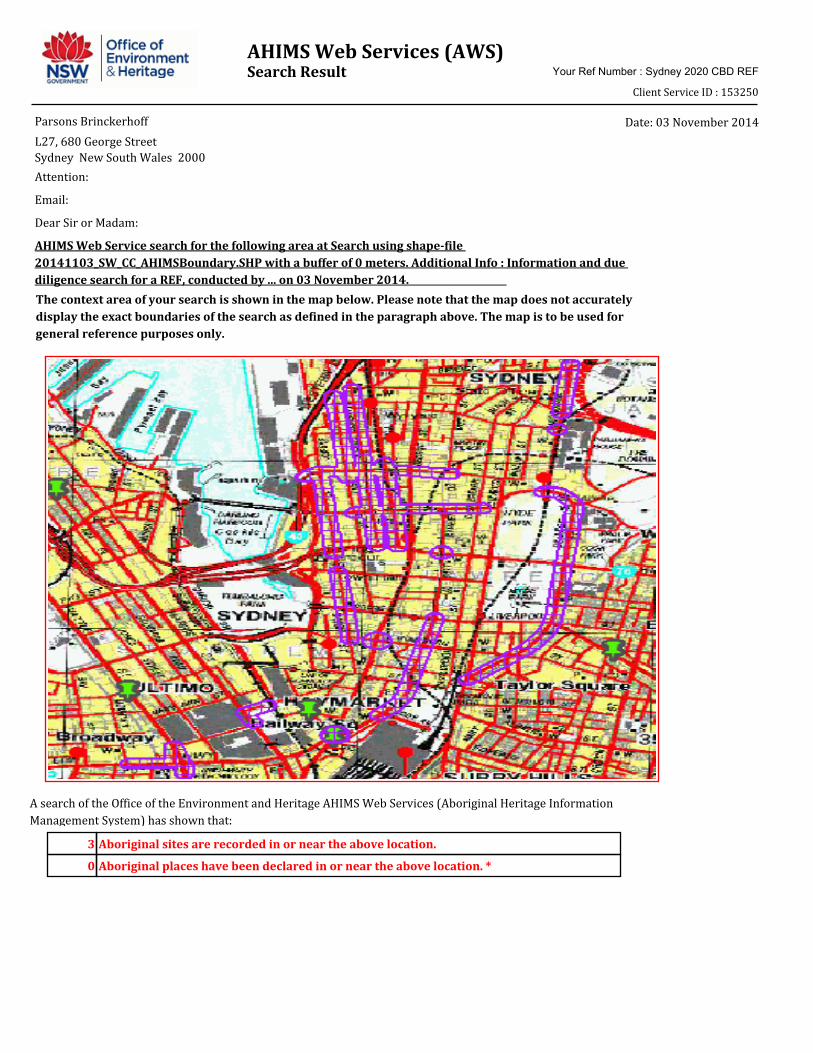
AHIMS Web Services (AWS)Search Result Your Ref Number : Sydney 2020 CBD REF
Client Service ID : 153250
Date: 03 November 2014Parsons Brinckerhoff
L27, 680 George Street
Sydney New South Wales 2000
A search of the Office of the Environment and Heritage AHIMS Web Services (Aboriginal Heritage Information
Management System) has shown that:
3
0
Aboriginal sites are recorded in or near the above location.
Aboriginal places have been declared in or near the above location. *
Attention:
Email:
Dear Sir or Madam:
AHIMS Web Service search for the following area at Search using shape-file
20141103_SW_CC_AHIMSBoundary.SHP with a buffer of 0 meters. Additional Info : Information and due
diligence search for a REF, conducted by ... on 03 November 2014.
The context area of your search is shown in the map below. Please note that the map does not accurately
display the exact boundaries of the search as defined in the paragraph above. The map is to be used for
general reference purposes only.

If your search shows Aboriginal sites or places what should you do?
Important information about your AHIMS search
You can get further information about Aboriginal places by looking at the gazettal notice that declared it.
Aboriginal places gazetted after 2001 are available on the NSW Government Gazette
(http://www.nsw.gov.au/gazette) website. Gazettal notices published prior to 2001 can be obtained from
Office of Environment and Heritage's Aboriginal Heritage Information Unit upon request
Aboriginal objects are protected under the National Parks and Wildlife Act 1974 even if they are not recorded
as a site on AHIMS.
You must do an extensive search if AHIMS has shown that there are Aboriginal sites or places recorded in the
search area.
If you are checking AHIMS as a part of your due diligence, refer to the next steps of the Due Diligence Code of
practice.
AHIMS records information about Aboriginal sites that have been provided to Office of Environment and
Heritage and Aboriginal places that have been declared by the Minister;
Information recorded on AHIMS may vary in its accuracy and may not be up to date .Location details are
recorded as grid references and it is important to note that there may be errors or omissions in these
recordings,
Some parts of New South Wales have not been investigated in detail and there may be fewer records of
Aboriginal sites in those areas. These areas may contain Aboriginal sites which are not recorded on AHIMS.
This search can form part of your due diligence and remains valid for 12 months.
The information derived from the AHIMS search is only to be used for the purpose for which it was requested.
It is not be made available to the public.
PO BOX 1967 Hurstville NSW 2220
43 Bridge Street HURSTVILLE NSW 2220
Tel: (02)9585 6345 (02)9585 6471 Fax: (02)9585 6094
ABN 30 841 387 271
Email: [email protected]
Web: www.environment.nsw.gov.au

AHIMS Web Services (AWS)Extensive search - Site list report
SiteID SiteName Datum Zone Easting Northing Context SiteFeatures SiteTypes Reports
Your Ref Number : Sydney 2020 CBD REF
Client Service ID : 153250
Site Status
45-6-2637 George street 1 AGD 56 333860 6249880 Open site Valid Artefact : - 98238,102494,
102763,10276
5
1369PermitsDominic Steele Archaeological ConsultingRecordersContact
45-6-2680 Broadway Picture Theatre PAD 1 AGD 56 333150 6249000 Open site Valid Potential
Archaeological
Deposit (PAD) : -
102142,10249
4,102763,1027
65
1854PermitsJim WheelerRecordersContact
45-6-3116 Wynyard Walk PAD GDA 56 333931 6251252 Open site Valid Potential
Archaeological
Deposit (PAD) : 1
3670PermitsGodden Mackay Logan Heritage ConsultantsRecordersContact
Report generated by AHIMS Web Service on 03/11/2014 for Christopher Curtis for the following area at Search using shape-file 20141103_SW_CC_AHIMSBoundary.SHP with a buffer of 0
meters. Additional Info : Information and due diligence search for a REF.. Number of Aboriginal sites and Aboriginal objects found is 3
This information is not guaranteed to be free from error omission. Office of Environment and Heritage (NSW) and its employees disclaim liability for any act done or omission made on the information and consequences of such
acts or omission.
Page 1 of 1
Appendix L
Air quality data

Precinct 1: north west NW1 Kent Street Note: no increases in traffic volumes above 1000 at NW1(A): Margaret Street intersection, NW1(C) Erskine Street intersection NW2 King Street
Location
King Street corridor (NW2)
Anticipated increase in traffic volumes (daily) – above 1000
Anticipated increase in HV volumes – above 200
A: Sussex Street intersection
1119 -
E: Clarence Street intersection
Refer to R4 Refer to R4
I: George Street intersection
1171 250
Note: no increases in traffic volumes above 1000 at NW2(C): Kent Street intersection, NW2(G): York Street intersection, NW2(K) Pitt Street intersection and NW2(M): Castlereagh Street intersection
Precinct 2: retail R1: Park Street
Location
Pitt Street / Park Street (R1)
Anticipated increase in traffic volumes (daily) – above 1000
Anticipated increase in HV volumes – above 200
A: Pitt Street / Park Street intersection
2702 580
R2: Market Street
Location
Market Street corridor (R2)
Anticipated increase in traffic volumes (daily) – above 1000
Anticipated increase in HV volumes – above 200
Sussex Street intersection
10832 541
A: Kent Street intersection
9130 456
C: Clarence Street intersection
Refer to R4 Refer to R4
E: York Street intersection
7544 777
G: George Street Due to the running of the LRT up Due to the running of the LRT

Location
Market Street corridor (R2)
Anticipated increase in traffic volumes (daily) – above 1000
Anticipated increase in HV volumes – above 200
intersection George Street at this location there will likely be an overall reduction in traffic volumes
up George Street at this location there will likely be an overall reduction in traffic volumes
I: Pitt Street intersection
4694 234
K: Castlereagh Street intersection
5761 983
Elizabeth Street intersection
9207 2393
R3: Sussex Street Note: no increases in traffic above 1000 at R3(A): King Street intersection, R3(C): Market Street intersection , R3(E): Druitt Street intersection R4: Clarence Street
Location
Clarence Street corridor (R4)
Anticipated increase in traffic volumes (daily) – above 1000
Anticipated increase in HV volumes – above 200
A: Jamison Street intersection
1343 493
C: Margaret Street intersection
1702 448
E: Erskine Street intersection
1598 423
G: Barrack Street intersection
- 363
I: King Street intersection
1530 340
K: Market Street intersection
7069 551
M: Druitt Street intersection
- 408
Note: no increases in traffic above 1000 at R4(G): Barrack Street intersection, R4(M): Druitt Street intersection R5: York Street Note: R5(C): Market Street data is presented as R2(E): York Street above. No increases in traffic above 1000 at R5(A): King Street intersection, R5(E): Druitt Street intersection

Precinct 3: southern
S1: Sussex Street Note: no increases in traffic above 1000 at S1(A): Bathurst Street intersection, S1(C): James Lane intersection, S1(E): Liverpool Street intersection, S1(G): Eager Lane intersection S1(I): Goulburn Street intersection S2: Goulburn Street
Location
Goulburn Street / George Street (S2)
Anticipated increase in traffic volumes (daily) – above 1000
Anticipated increase in HV volumes – above 200
A: Goulburn Street / George Street intersection
6208 1154
S3: Pitt Street
Location
Pitt Street corridor (S3)
Anticipated increase in traffic volumes (daily) – above 1000
Anticipated increase in HV volumes – above 200
A: Liverpool Street intersection
2206 -
C: Goulburn Street intersection
4666 233
E: Campbell Street intersection
1881 -
G: Hay Street intersection
1505 -
I: Rawson Place Intersection
4921 246
S4: Ultimo Road Note: no increases in traffic above 1000 at S4(A): Harris Street intersection S5: Broadway Note: no increases in traffic above 1000 at S5(A): Mountain Street intersection, S5(C): Wattle Street intersection, S5(D): Abercrombie Street intersection S6: Pitt Street Note: no increases at S6(A): Pitt Street and George Street intersection, S6(B): George Street and Quay Street intersection
Precinct 4: college C1: Wentworth Avenue

Location
Wentworth Street Corridor (C)
Anticipated increase in traffic volumes (daily) – above 1000
Anticipated increase in HV volumes – above 200
A: Oxford Street intersection
8825 1629
E: Goulburn Street intersection
6787 248
G: Campbell Street intersection (Elizabeth Street intersection)
6854 330
Note: no increases in traffic above 1000 at C1(C): Wemyss Lane intersection C2: College Street
Location
College Street Corridor (C2)
Anticipated increase in traffic volumes (daily) – above 1000
Anticipated increase in HV volumes – above 200
A: Macquarie Street intersection
2317 -
C: Prince Albert Road intersection
3091 -
E: Park Street intersection
8380 1448
F:Park Street to Oxford Street (Francis Street intersection)
4288 214
Note: C2(G): Oxford Street intersection is presented previously as C1(A): Oxford street intersection
Precinct 5: financial F1: Macquarie Street
Location
Bridge Street / Macquarie Street (F1)
Anticipated increase in traffic volumes (daily) – above 1000
Anticipated increase in HV volumes – above 200
C: Bridge Street / Macquarie Street intersection
1608 -
Note: no increases in traffic above 1000 at F2 Macquarie Street (A): Hunter Street intersection F2: Macquarie Street Note: no increases in traffic volumes above 1000 at F2(A): Hunter Street intersection