Result of Scheme Formulation in Mvomero District
88
Result of Scheme Formulation in Mvomero District Record of Site Inspection (Step-2)
-
Upload
khangminh22 -
Category
Documents
-
view
2 -
download
0
Transcript of Result of Scheme Formulation in Mvomero District
Result of Scheme Formulation in Mvomero District
Record of Site Inspection (Step-2)
Result of Scheme Formulation in Mvomero District
B-2-29
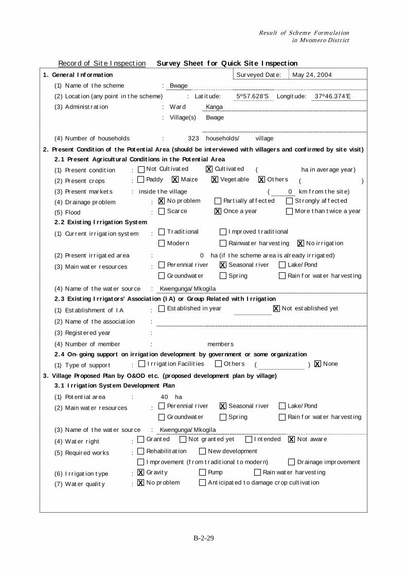
Record of Site Inspection Survey Sheet for Quick Site Inspection 1. General Information Surveyed Date: May 24, 2004 (1) Name of the scheme : Bwage (2) Location (any point in the scheme) : Latitude: 5º57.628’S Longitude: 37º46.374’E (3) Administration : Ward Kanga : Village(s) Bwage
(4) Number of households : 323 households/ village
2. Present Condition of the Potential Area (should be interviewed with villagers and confirmed by site visit) 2.1 Present Agricultural Conditions in the Potential Area
(1) Present condition : Not Cultivated Cultivated ( ha in average year)
(2) Present crops : Paddy Maize Vegetable Others ( ) (3) Present markets : inside the village ( 0 km from the site) (4) Drainage problem : No problem Partially affected Strongly affected
(5) Flood : Scarce Once a year More than twice a year
2.2 Existing Irrigation System
(1) Current irrigation system : Traditional Improved traditional
Modern Rainwater harvesting No irrigation
(2) Present irrigated area : 0 ha (if the scheme area is already irrigated)
(3) Main water resources : Perennial river Seasonal river Lake/Pond
Groundwater Spring Rain for water harvesting
(4) Name of the water source : Kwengunga/Mkogila 2.3 Existing Irrigators’ Association (IA) or Group Related with Irrigation
(1) Establishment of IA : Established in year Not established yet
(2) Name of the association :
(3) Registered year :
(4) Number of member : members 2.4 On-going support on irrigation development by government or some organization
(1) Type of support : Irrigation Facilities Others ( ) None
3. Village Proposed Plan by O&OD etc. (proposed development plan by village) 3.1 Irrigation System Development Plan
(1) Potential area : 40 ha
(2) Main water resources : Perennial river Seasonal river Lake/Pond
Groundwater Spring Rain for water harvesting
(3) Name of the water source : Kwengunga/Mkogila
(4) Water right : Granted Not granted yet Intended Not aware
(5) Required works : Rehabilitation New development
Improvement (from traditional to modern) Drainage improvement
(6) Irrigation type : Gravity Pump Rain water harvesting
(7) Water quality : No problem Anticipated to damage crop cultivation
X X X X
X X
X
X
X
X
X
X X X
Chapter 2 Record of Training on Irrigation Scheme Formulation for DADP in Mvomero District
B-2-30
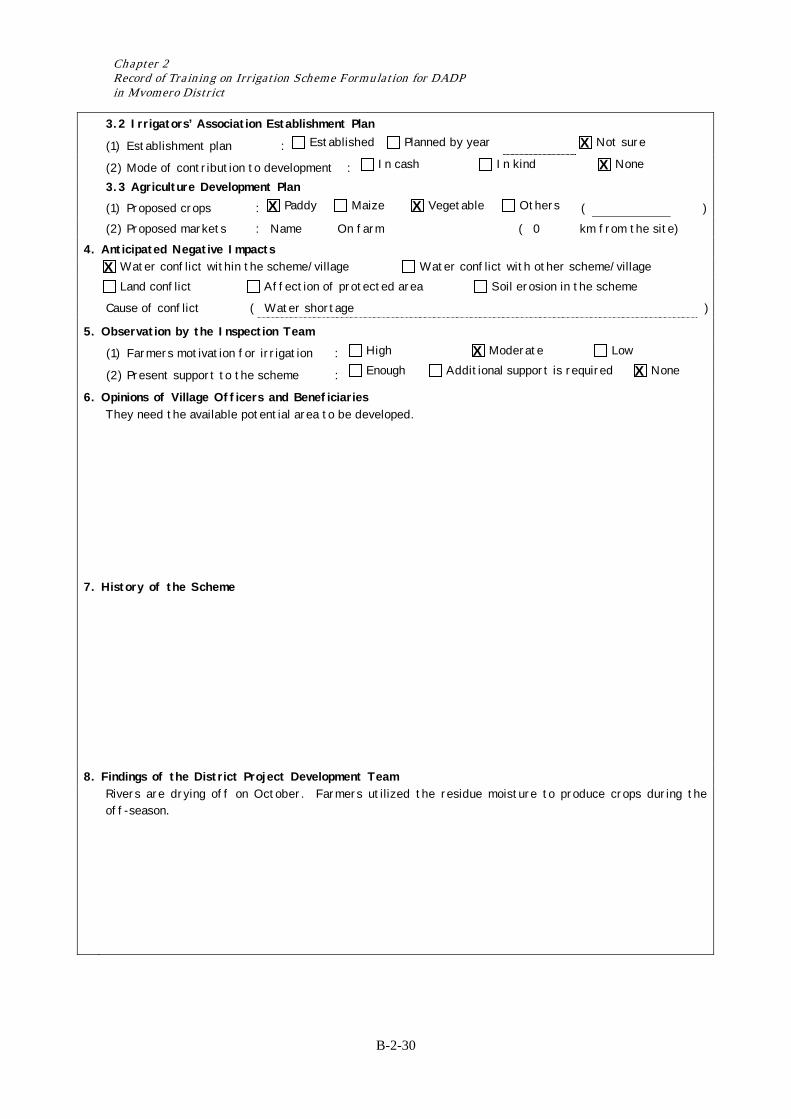
3.2 Irrigators’ Association Establishment Plan
(1) Establishment plan : Established Planned by year Not sure
(2) Mode of contribution to development : In cash In kind None
3.3 Agriculture Development Plan (1) Proposed crops : Paddy Maize Vegetable Others ( ) (2) Proposed markets : Name On farm ( 0 km from the site) 4. Anticipated Negative Impacts Water conflict within the scheme/village Water conflict with other scheme/village
Land conflict Affection of protected area Soil erosion in the scheme
Cause of conflict ( Water shortage )
5. Observation by the Inspection Team
(1) Farmers motivation for irrigation : High Moderate Low
(2) Present support to the scheme : Enough Additional support is required None
6. Opinions of Village Officers and Beneficiaries They need the available potential area to be developed.
7. History of the Scheme
8. Findings of the District Project Development Team Rivers are drying off on October. Farmers utilized the residue moisture to produce crops during the
off-season.
X X
X X
X
X X
Result of Scheme Formulation in Mvomero District
B-2-31
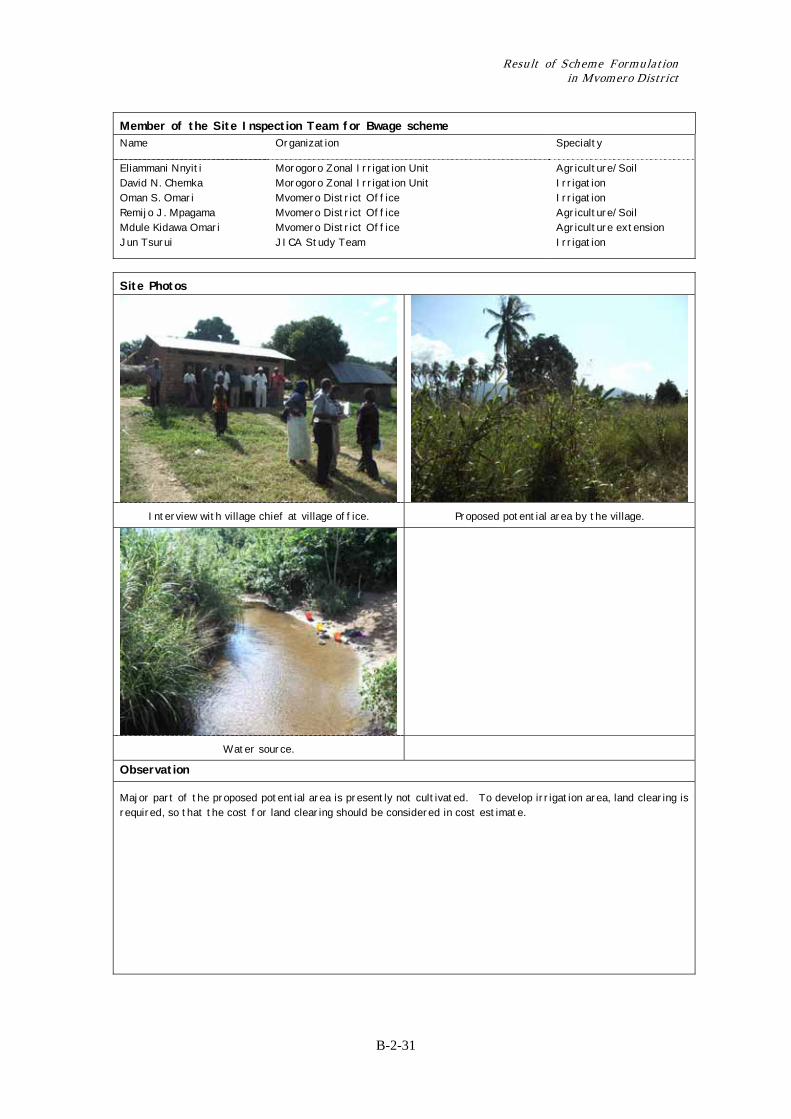
Member of the Site Inspection Team for Bwage scheme Name Organization Specialty
Eliammani Nnyiti David N. Chemka Oman S. Omari Remijo J. Mpagama Mdule Kidawa Omari Jun Tsurui
Morogoro Zonal Irrigation Unit Morogoro Zonal Irrigation Unit Mvomero District Office Mvomero District Office Mvomero District Office JICA Study Team
Agriculture/Soil Irrigation Irrigation Agriculture/Soil Agriculture extension Irrigation
Site Photos
Interview with village chief at village office. Proposed potential area by the village.
Water source.
Observation
Major part of the proposed potential area is presently not cultivated. To develop irrigation area, land clearing is required, so that the cost for land clearing should be considered in cost estimate.
Chapter 2 Record of Training on Irrigation Scheme Formulation for DADP in Mvomero District
B-2-32
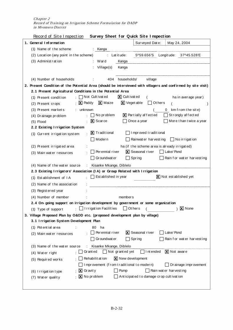
Record of Site Inspection Survey Sheet for Quick Site Inspection 1. General Information Surveyed Date: May 24, 2004 (1) Name of the scheme : Kanga (2) Location (any point in the scheme) : Latitude: 5º59.656’S Longitude: 37º45.528’E (3) Administration : Ward Kanga : Village(s) Kanga
(4) Number of households : 404 households/ village
2. Present Condition of the Potential Area (should be interviewed with villagers and confirmed by site visit) 2.1 Present Agricultural Conditions in the Potential Area
(1) Present condition : Not Cultivated Cultivated ( ha in average year)
(2) Present crops : Paddy Maize Vegetable Others ( ) (3) Present markets : unknown ( 0 km from the site) (4) Drainage problem : No problem Partially affected Strongly affected
(5) Flood : Scarce Once a year More than twice a year
2.2 Existing Irrigation System
(1) Current irrigation system : Traditional Improved traditional
Modern Rainwater harvesting No irrigation
(2) Present irrigated area : ha (if the scheme area is already irrigated)
(3) Main water resources : Perennial river Seasonal river Lake/Pond
Groundwater Spring Rain for water harvesting
(4) Name of the water source : Kisanke Mkange, Diblelo 2.3 Existing Irrigators’ Association (IA) or Group Related with Irrigation
(1) Establishment of IA : Established in year Not established yet
(2) Name of the association :
(3) Registered year :
(4) Number of member : members 2.4 On-going support on irrigation development by government or some organization
(1) Type of support : Irrigation Facilities Others ( ) None
3. Village Proposed Plan by O&OD etc. (proposed development plan by village) 3.1 Irrigation System Development Plan
(1) Potential area : 80 ha
(2) Main water resources : Perennial river Seasonal river Lake/Pond
Groundwater Spring Rain for water harvesting
(3) Name of the water source : Kisanke Mkange, Diblelo
(4) Water right : Granted Not granted yet Intended Not aware
(5) Required works : Rehabilitation New development
Improvement (from traditional to modern) Drainage improvement
(6) Irrigation type : Gravity Pump Rain water harvesting
(7) Water quality : No problem Anticipated to damage crop cultivation
X X X X
X X
X
X
X
X
X
X X X X
Result of Scheme Formulation in Mvomero District
B-2-33
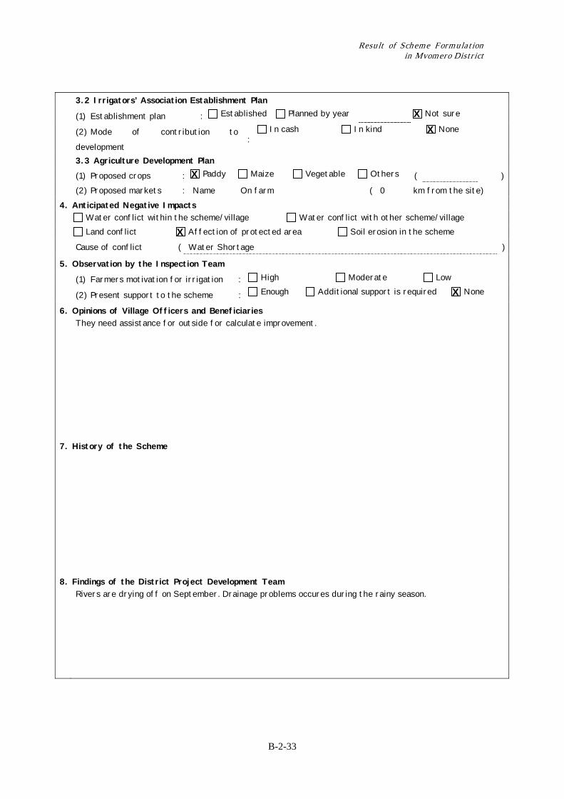
3.2 Irrigators’ Association Establishment Plan
(1) Establishment plan : Established Planned by year Not sure
(2) Mode of contribution to
development :
In cash In kind None
3.3 Agriculture Development Plan (1) Proposed crops : Paddy Maize Vegetable Others ( ) (2) Proposed markets : Name On farm ( 0 km from the site) 4. Anticipated Negative Impacts Water conflict within the scheme/village Water conflict with other scheme/village
Land conflict Affection of protected area Soil erosion in the scheme
Cause of conflict ( Water Shortage )
5. Observation by the Inspection Team
(1) Farmers motivation for irrigation : High Moderate Low
(2) Present support to the scheme : Enough Additional support is required None
6. Opinions of Village Officers and Beneficiaries They need assistance for outside for calculate improvement.
7. History of the Scheme
8. Findings of the District Project Development Team Rivers are drying off on September. Drainage problems occures during the rainy season.
X X
X
X
X
Chapter 2 Record of Training on Irrigation Scheme Formulation for DADP in Mvomero District
B-2-34
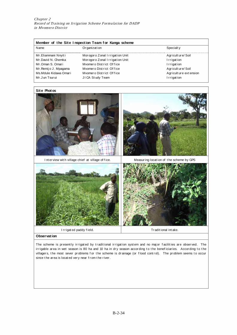
Member of the Site Inspection Team for Kanga scheme Name Organization Specialty
Mr.Eliammani Nnyiti Mr.David N. Chemka Mr.Oman S. Omari Mr.Remijo J. Mpagama Ms.Mdule Kidawa Omari Mr.Jun Tsurui
Morogoro Zonal Irrigation Unit Morogoro Zonal Irrigation Unit Mvomero District Office Mvomero District Office Mvomero District Office JICA Study Team
Agriculture/Soil Irrigation Irrigation Agriculture/Soil Agriculture extension Irrigation
Site Photos
Interview with village chief at village office. Measuring location of the scheme by GPS
Irrigated paddy field. Traditional intake.
Observation
The scheme is presently irrigated by traditional irrigation system and no major facilities are observed. The irrigable area in wet season is 80 ha and 10 ha in dry season according to the beneficiaries. According to the villagers, the most sever problems for the scheme is drainage (or flood control). The problem seems to occur since the area is located very near from the river.

Result of Scheme Formulation in Mvomero District
B-2-35
Record of Site Inspection Survey Sheet for Quick Site Inspection 1. General Information Surveyed Date: May 24, 2004 (1) Name of the scheme : Dihinda/ Difinga (2) Location (any point in the scheme) : Latitude: 6º03.832’S Longitude: 37º41.556’E (3) Administration : Ward Kanga : Village(s) Dihinda
(4) Number of households : households/
2. Present Condition of the Potential Area (should be interviewed with villagers and confirmed by site visit) 2.1 Present Agricultural Conditions in the Potential Area
(1) Present condition : Not Cultivated Cultivated ( ha in average year)
(2) Present crops : Paddy Maize Vegetable Others ( Yams ) (3) Present markets : Inside the village ( 0 km from the site) (4) Drainage problem : No problem Partially affected Strongly affected
(5) Flood : Scarce Once a year More than twice a year
2.2 Existing Irrigation System
(1) Current irrigation system : Traditional Improved traditional
Modern Rainwater harvesting No irrigation
(2) Present irrigated area : 2 ha (if the scheme area is already irrigated)
(3) Main water resources : Perennial river Seasonal river Lake/Pond
Groundwater Spring Rain for water harvesting
(4) Name of the water source : R Lusonge 2.3 Existing Irrigators’ Association (IA) or Group Related with Irrigation
(1) Establishment of IA : Established in year Not established yet
(2) Name of the association :
(3) Registered year :
(4) Number of member : members 2.4 On-going support on irrigation development by government or some organization
(1) Type of support : Irrigation Facilities Others ( ) None
3. Village Proposed Plan by O&OD etc. (proposed development plan by village) 3.1 Irrigation System Development Plan
(1) Potential area : 200 ha
(2) Main water resources : Perennial river Seasonal river Lake/Pond
Groundwater Spring Rain for water harvesting
(3) Name of the water source : R. Lusonge
(4) Water right : Granted Not granted yet Intended Not aware
(5) Required works : Rehabilitation New development
Improvement (from traditional to modern) Drainage improvement
(6) Irrigation type : Gravity Pump Rain water harvesting
(7) Water quality : No problem Anticipated to damage crop cultivation
X X X X X
X X
X
X
X
X
X
X X X X
Chapter 2 Record of Training on Irrigation Scheme Formulation for DADP in Mvomero District
B-2-36
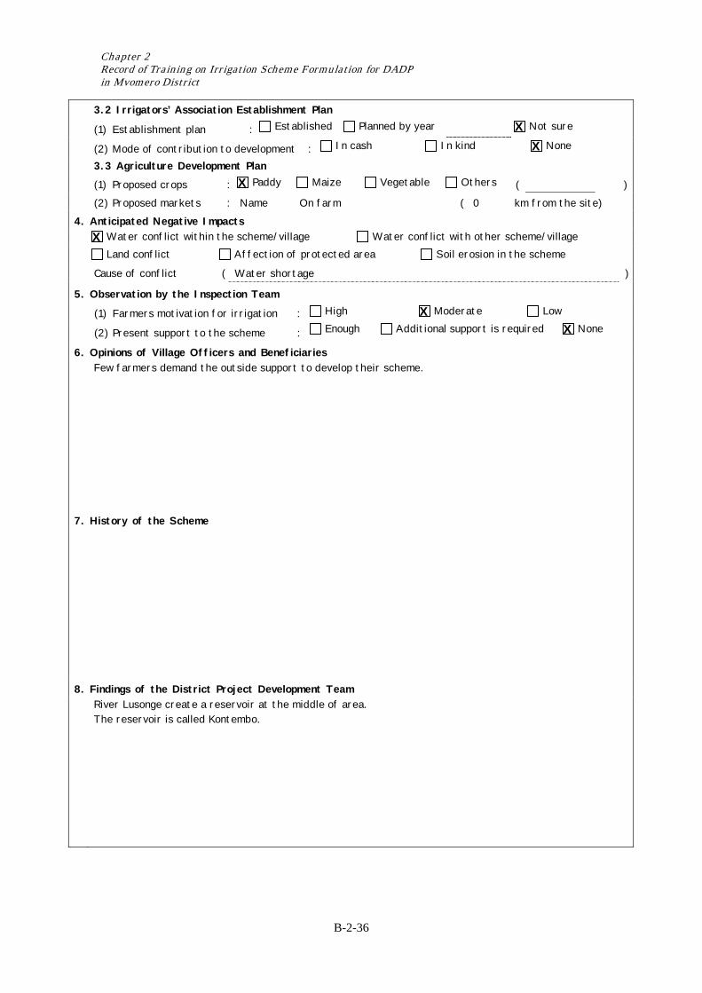
3.2 Irrigators’ Association Establishment Plan
(1) Establishment plan : Established Planned by year Not sure
(2) Mode of contribution to development : In cash In kind None
3.3 Agriculture Development Plan (1) Proposed crops : Paddy Maize Vegetable Others ( ) (2) Proposed markets : Name On farm ( 0 km from the site) 4. Anticipated Negative Impacts Water conflict within the scheme/village Water conflict with other scheme/village
Land conflict Affection of protected area Soil erosion in the scheme
Cause of conflict ( Water shortage )
5. Observation by the Inspection Team
(1) Farmers motivation for irrigation : High Moderate Low
(2) Present support to the scheme : Enough Additional support is required None
6. Opinions of Village Officers and Beneficiaries Few farmers demand the outside support to develop their scheme.
7. History of the Scheme
8. Findings of the District Project Development Team River Lusonge create a reservoir at the middle of area.
The reservoir is called Kontembo.
X X
X
X
X X

Result of Scheme Formulation in Mvomero District
B-2-37
Member of the Site Inspection Team for Dihinda schme Name Organization Specialty
Mr.Eliammani Nnyiti Mr.David N. Chemka Mr.Oman S. Omari Mr.Remijo J. Mpagama Ms.Mdule Kidawa Omari Mr.Jun Tsurui
Morogoro Zonal Irrigation Unit Morogoro Zonal Irrigation Unit Mvomero District Office Mvomero District Office Mvomero District Office JICA Study Team
Agriculture/Soil Irrigation Irrigation Agriculture/Soil Agriculture extension Irrigation
Site Photos
Interview with village chief in front of village office. Rainfed paddy area.
Sub-water source. Main water source.
Observation
The scheme seems to have some amount of water resource potential. However, the scheme is laying two villages and some farmers in upstream village already started irrigation by themselves. Social aspects on irrigation development need to be carefully studied for this scheme.
Chapter 2 Record of Training on Irrigation Scheme Formulation for DADP in Mvomero District
B-2-38
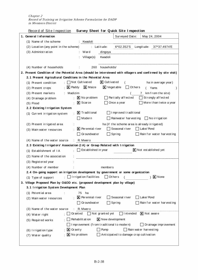
Record of Site Inspection Survey Sheet for Quick Site Inspection 1. General Information Surveyed Date: May 24, 2004 (1) Name of the scheme : Kwadoli (2) Location (any point in the scheme) : Latitude: 6º02.352’S Longitude: 37º37.4974’E (3) Administration : Ward dingoya : Village(s) Kwadoli
(4) Number of households : 260 households/
2. Present Condition of the Potential Area (should be interviewed with villagers and confirmed by site visit) 2.1 Present Agricultural Conditions in the Potential Area
(1) Present condition : Not Cultivated Cultivated ( ha in average year)
(2) Present crops : Paddy Maize Vegetable Others ( Yams ) (3) Present markets : Madizim ( 7 km from the site) (4) Drainage problem : No problem Partially affected Strongly affected
(5) Flood : Scarce Once a year More than twice a year
2.2 Existing Irrigation System
(1) Current irrigation system : Traditional Improved traditional
Modern Rainwater harvesting No irrigation
(2) Present irrigated area : ha (if the scheme area is already irrigated)
(3) Main water resources : Perennial river Seasonal river Lake/Pond
Groundwater Spring Rain for water harvesting
(4) Name of the water source : R. Mwero 2.3 Existing Irrigators’ Association (IA) or Group Related with Irrigation
(1) Establishment of IA : Established in year Not established yet
(2) Name of the association :
(3) Registered year :
(4) Number of member : members 2.4 On-going support on irrigation development by government or some organization
(1) Type of support : Irrigation Facilities Others ( ) None
3. Village Proposed Plan by O&OD etc. (proposed development plan by village) 3.1 Irrigation System Development Plan
(1) Potential area : 75 ha
(2) Main water resources : Perennial river Seasonal river Lake/Pond
Groundwater Spring Rain for water harvesting
(3) Name of the water source : R. Mwero
(4) Water right : Granted Not granted yet Intended Not aware
(5) Required works : Rehabilitation New development
Improvement (from traditional to modern) Drainage improvement
(6) Irrigation type : Gravity Pump Rain water harvesting
(7) Water quality : No problem Anticipated to damage crop cultivation
X X X X
X X
X
X
X
X
X
X X X X
Result of Scheme Formulation in Mvomero District
B-2-39
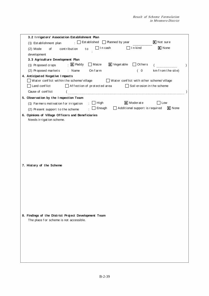
3.2 Irrigators’ Association Establishment Plan
(1) Establishment plan : Established Planned by year Not sure
(2) Mode of contribution to
development :
In cash In kind None
3.3 Agriculture Development Plan (1) Proposed crops : Paddy Maize Vegetable Others ( ) (2) Proposed markets : Name On farm ( 0 km from the site) 4. Anticipated Negative Impacts Water conflict within the scheme/village Water conflict with other scheme/village
Land conflict Affection of protected area Soil erosion in the scheme
Cause of conflict ( )
5. Observation by the Inspection Team
(1) Farmers motivation for irrigation : High Moderate Low
(2) Present support to the scheme : Enough Additional support is required None
6. Opinions of Village Officers and Beneficiaries Needs irrigation scheme.
7. History of the Scheme
8. Findings of the District Project Development Team The place for scheme is not accessible.
X X
X X
X X
Chapter 2 Record of Training on Irrigation Scheme Formulation for DADP in Mvomero District
B-2-40
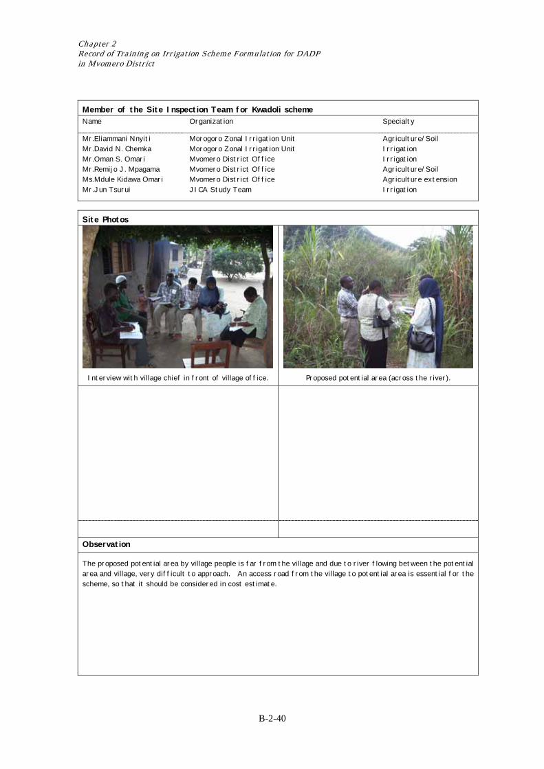
Member of the Site Inspection Team for Kwadoli scheme Name Organization Specialty
Mr.Eliammani Nnyiti Mr.David N. Chemka Mr.Oman S. Omari Mr.Remijo J. Mpagama Ms.Mdule Kidawa Omari Mr.Jun Tsurui
Morogoro Zonal Irrigation Unit Morogoro Zonal Irrigation Unit Mvomero District Office Mvomero District Office Mvomero District Office JICA Study Team
Agriculture/Soil Irrigation Irrigation Agriculture/Soil Agriculture extension Irrigation
Site Photos
Interview with village chief in front of village office. Proposed potential area (across the river).
Observation
The proposed potential area by village people is far from the village and due to river flowing between the potential area and village, very difficult to approach. An access road from the village to potential area is essential for the scheme, so that it should be considered in cost estimate.
Result of Scheme Formulation in Mvomero District
B-2-41
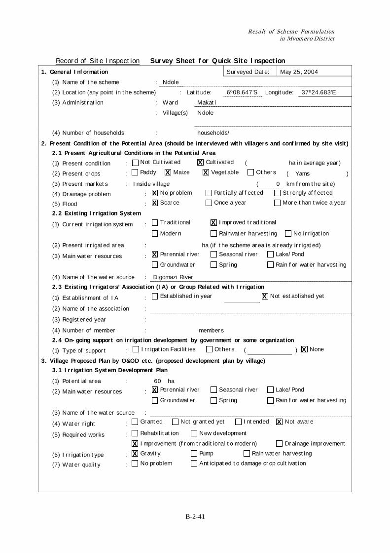
Record of Site Inspection Survey Sheet for Quick Site Inspection 1. General Information Surveyed Date: May 25, 2004 (1) Name of the scheme : Ndole (2) Location (any point in the scheme) : Latitude: 6º08.647’S Longitude: 37º24.683’E (3) Administration : Ward Makati : Village(s) Ndole
(4) Number of households : households/
2. Present Condition of the Potential Area (should be interviewed with villagers and confirmed by site visit) 2.1 Present Agricultural Conditions in the Potential Area
(1) Present condition : Not Cultivated Cultivated ( ha in average year)
(2) Present crops : Paddy Maize Vegetable Others ( Yams ) (3) Present markets : Inside village ( 0 km from the site) (4) Drainage problem : No problem Partially affected Strongly affected
(5) Flood : Scarce Once a year More than twice a year
2.2 Existing Irrigation System
(1) Current irrigation system : Traditional Improved traditional
Modern Rainwater harvesting No irrigation
(2) Present irrigated area : ha (if the scheme area is already irrigated)
(3) Main water resources : Perennial river Seasonal river Lake/Pond
Groundwater Spring Rain for water harvesting
(4) Name of the water source : Digomazi River 2.3 Existing Irrigators’ Association (IA) or Group Related with Irrigation
(1) Establishment of IA : Established in year Not established yet
(2) Name of the association :
(3) Registered year :
(4) Number of member : members 2.4 On-going support on irrigation development by government or some organization
(1) Type of support : Irrigation Facilities Others ( ) None
3. Village Proposed Plan by O&OD etc. (proposed development plan by village) 3.1 Irrigation System Development Plan
(1) Potential area : 60 ha
(2) Main water resources : Perennial river Seasonal river Lake/Pond
Groundwater Spring Rain for water harvesting
(3) Name of the water source :
(4) Water right : Granted Not granted yet Intended Not aware
(5) Required works : Rehabilitation New development
Improvement (from traditional to modern) Drainage improvement
(6) Irrigation type : Gravity Pump Rain water harvesting
(7) Water quality : No problem Anticipated to damage crop cultivation
X X X
X X
X
X
X
X
X
X X X
Chapter 2 Record of Training on Irrigation Scheme Formulation for DADP in Mvomero District
B-2-42
3.2 Irrigators’ Association Establishment Plan
(1) Establishment plan : Established Planned by year Not sure
(2) Mode of contribution to development : In cash In kind None
3.3 Agriculture Development Plan (1) Proposed crops : Paddy Maize Vegetable Others ( ) (2) Proposed markets : Name On farm ( 0 km from the site) 4. Anticipated Negative Impacts Water conflict within the scheme/village Water conflict with other scheme/village
Land conflict Affection of protected area Soil erosion in the scheme
Cause of conflict ( Poor conveyance structure )
5. Observation by the Inspection Team
(1) Farmers motivation for irrigation : High Moderate Low
(2) Present support to the scheme : Enough Additional support is required None
6. Opinions of Village Officers and Beneficiaries They need a support for rehabilitate their scheme.
7. History of the Scheme
8. Findings of the District Project Development Team Water confict arises due to water losses along the conveyance structures.
X X
X X X
X X
X X
Result of Scheme Formulation in Mvomero District
B-2-43
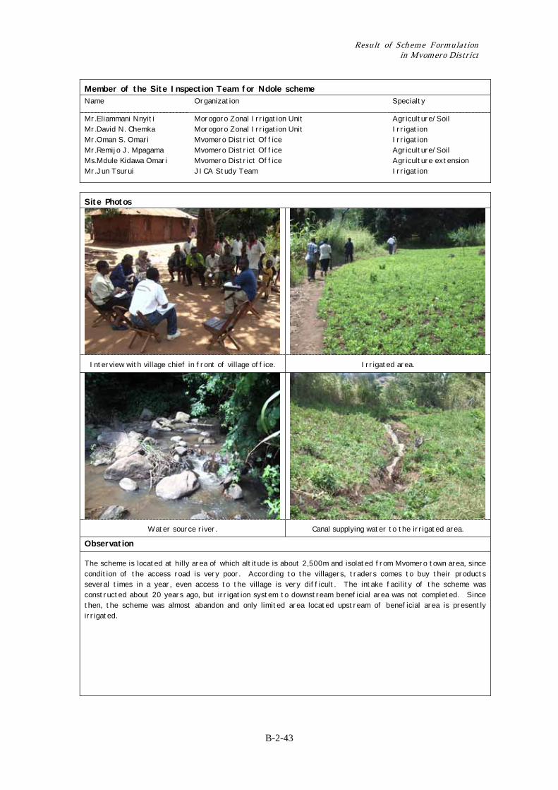
Member of the Site Inspection Team for Ndole scheme Name Organization Specialty
Mr.Eliammani Nnyiti Mr.David N. Chemka Mr.Oman S. Omari Mr.Remijo J. Mpagama Ms.Mdule Kidawa Omari Mr.Jun Tsurui
Morogoro Zonal Irrigation Unit Morogoro Zonal Irrigation Unit Mvomero District Office Mvomero District Office Mvomero District Office JICA Study Team
Agriculture/Soil Irrigation Irrigation Agriculture/Soil Agriculture extension Irrigation
Site Photos
Interview with village chief in front of village office. Irrigated area.
Water source river. Canal supplying water to the irrigated area.
Observation
The scheme is located at hilly area of which altitude is about 2,500m and isolated from Mvomero town area, since condition of the access road is very poor. According to the villagers, traders comes to buy their products several times in a year, even access to the village is very difficult. The intake facility of the scheme was constructed about 20 years ago, but irrigation system to downstream beneficial area was not completed. Since then, the scheme was almost abandon and only limited area located upstream of beneficial area is presently irrigated.
Chapter 2 Record of Training on Irrigation Scheme Formulation for DADP in Mvomero District
B-2-44
Record of Site Inspection Survey Sheet for Quick Site Inspection 1. General Information Surveyed Date: 25 May, 2004 (1) Name of the scheme : Digoma (2) Location (any point in the scheme) : Latitude: 6º05.820’S Longitude: 27º36.400’E (3) Administration : Ward Diongoya : Village(s) Digoma
(4) Number of households : 619 households/
2. Present Condition of the Potential Area (should be interviewed with villagers and confirmed by site visit) 2.1 Present Agricultural Conditions in the Potential Area
(1) Present condition : Not Cultivated Cultivated ( ha in average year)
(2) Present crops : Paddy Maize Vegetable Others ( Yams ) (3) Present markets : Inside the village ( 0 km from the site) (4) Drainage problem : No problem Partially affected Strongly affected
(5) Flood : Scarce Once a year More than twice a year
2.2 Existing Irrigation System
(1) Current irrigation system : Traditional Improved traditional
Modern Rainwater harvesting No irrigation
(2) Present irrigated area : 3 ha (if the scheme area is already irrigated)
(3) Main water resources : Perennial river Seasonal river Lake/Pond
Groundwater Spring Rain for water harvesting
(4) Name of the water source : Mjonga/Lugofu 2.3 Existing Irrigators’ Association (IA) or Group Related with Irrigation
(1) Establishment of IA : Established in year Not established yet
(2) Name of the association : Lugofu Agriculture Group
(3) Registered year :
(4) Number of member : 14 members 2.4 On-going support on irrigation development by government or some organization
(1) Type of support : Irrigation Facilities Others ( ) None
3. Village Proposed Plan by O&OD etc. (proposed development plan by village) 3.1 Irrigation System Development Plan
(1) Potential area : 200 ha
(2) Main water resources : Perennial river Seasonal river Lake/Pond
Groundwater Spring Rain for water harvesting
(3) Name of the water source : River Mjonga/ Lugofu
(4) Water right : Granted Not granted yet Intended Not aware
(5) Required works : Rehabilitation New development
Improvement (from traditional to modern) Drainage improvement
(6) Irrigation type : Gravity Pump Rain water harvesting
(7) Water quality : No problem Anticipated to damage crop cultivation
X X
X X
X
X
X
X
X
X X X X
Result of Scheme Formulation in Mvomero District
B-2-45
3.2 Irrigators’ Association Establishment Plan
(1) Establishment plan : Existing Planned by year Not sure
(2) Mode of contribution to
development :
In cash In kind None
3.3 Agriculture Development Plan (1) Proposed crops : Paddy Maize Vegetable Others ( ) (2) Proposed markets : Name On farm ( 0 km from the site) 4. Anticipated Negative Impacts Water conflict within the scheme/village Water conflict with other scheme/village
Land conflict Affection of protected area Soil erosion in the scheme
Cause of conflict ( Changes of river corse )
5. Observation by the Inspection Team
(1) Farmers motivation for irrigation : High Moderate Low
(2) Present support to the scheme : Enough Additional support is required None
6. Opinions of Village Officers and Beneficiaries They highly require irrigation facilities.
7. History of the Scheme
8. Findings of the District Project Development Team River banks are not stable at the middle part of the scheme.
X X
X X
X
X X
Chapter 2 Record of Training on Irrigation Scheme Formulation for DADP in Mvomero District
B-2-46
Member of the Site Inspection Team for Digoma scheme Name Organization Specialty
Mr.Eliammani Nnyiti Mr.David N. Chemka Mr.Oman S. Omari Mr.Remijo J. Mpagama Ms.Mdule Kidawa Omari Mr.Jun Tsurui
Morogoro Zonal Irrigation Unit Morogoro Zonal Irrigation Unit Mvomero District Office Mvomero District Office Mvomero District Office JICA Study Team
Agriculture/Soil Irrigation Irrigation Agriculture/Soil Agriculture extension Irrigation
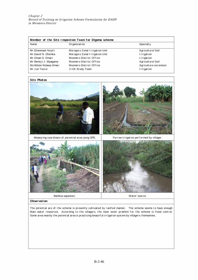
Site Photos
Measuring coordinate of potential area using GPS. Furrow irrigation performed by villager.
Bamboo aqueduct. Water source.
Observation
The potential are of the scheme is presently cultivated by rainfed manner. The scheme seems to have enough Main water resources. According to the villagers, the most sever problem for the scheme is flood control. Some area nearby the potential area is practicing beautiful irrigation system by villagers themselves.
Result of Scheme Formulation in Mvomero District
B-2-47
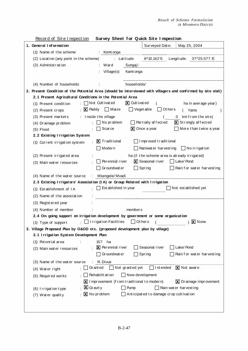
Record of Site Inspection Survey Sheet for Quick Site Inspection 1. General Information Surveyed Date: May 25, 2004 (1) Name of the scheme : Komtonga (2) Location (any point in the scheme) : Latitude: 6º10.142’S Longitude: 37º25.077.’E (3) Administration : Ward Sungaji : Village(s) Kamtonga
(4) Number of households : households/
2. Present Condition of the Potential Area (should be interviewed with villagers and confirmed by site visit) 2.1 Present Agricultural Conditions in the Potential Area
(1) Present condition : Not Cultivated Cultivated ( ha in average year)
(2) Present crops : Paddy Maize Vegetable Others ( Yams ) (3) Present markets : Inside the village ( 0 km from the site) (4) Drainage problem : No problem Partially affected Strongly affected
(5) Flood : Scarce Once a year More than twice a year
2.2 Existing Irrigation System
(1) Current irrigation system : Traditional Improved traditional
Modern Rainwater harvesting No irrigation
(2) Present irrigated area : ha (if the scheme area is already irrigated)
(3) Main water resources : Perennial river Seasonal river Lake/Pond
Groundwater Spring Rain for water harvesting
(4) Name of the water source : Msengele/Mvadi 2.3 Existing Irrigators’ Association (IA) or Group Related with Irrigation
(1) Establishment of IA : Established in year Not established yet
(2) Name of the association :
(3) Registered year :
(4) Number of member : members 2.4 On-going support on irrigation development by government or some organization
(1) Type of support : Irrigation Facilities Others ( ) None
3. Village Proposed Plan by O&OD etc. (proposed development plan by village) 3.1 Irrigation System Development Plan
(1) Potential area : 157 ha
(2) Main water resources : Perennial river Seasonal river Lake/Pond
Groundwater Spring Rain for water harvesting
(3) Name of the water source : R. Divue
(4) Water right : Granted Not granted yet Intended Not aware
(5) Required works : Rehabilitation New development
Improvement (from traditional to modern) Drainage improvement
(6) Irrigation type : Gravity Pump Rain water harvesting
(7) Water quality : No problem Anticipated to damage crop cultivation
X X
X X
X
X
X
X
X X X X X
Chapter 2 Record of Training on Irrigation Scheme Formulation for DADP in Mvomero District
B-2-48
3.2 Irrigators’ Association Establishment Plan
(1) Establishment plan : Established Planned by year Not sure
(2) Mode of contribution to development : In cash In kind None
3.3 Agriculture Development Plan (1) Proposed crops : Paddy Maize Vegetable Others ( ) (2) Proposed markets : Name ( km from the site) 4. Anticipated Negative Impacts Water conflict within the scheme/village Water conflict with other scheme/village
Land conflict Affection of protected area Soil erosion in the scheme
Cause of conflict ( )
5. Observation by the Inspection Team
(1) Farmers motivation for irrigation : High Moderate Low
(2) Present support to the scheme : Enough Additional support is required None
6. Opinions of Village Officers and Beneficiaries Irrigation facilities required in order to improve the scheme.
7. History of the Scheme
8. Findings of the District Project Development Team River Divue which is a permenent river could used to irrigate large area of Komtonga scheme. However
drainage improvement should also taken into account.
X
Result of Scheme Formulation in Mvomero District
B-2-49
Member of the Site Inspection Team for Komtonga scheme Name Organization Specialty
Mr.Eliammani Nnyiti Mr.David N. Chemka Mr.Oman S. Omari Mr.Remijo J. Mpagama Ms.Mdule Kidawa Omari Mr.Jun Tsurui
Morogoro Zonal Irrigation Unit Morogoro Zonal Irrigation Unit Mvomero District Office Mvomero District Office Mvomero District Office JICA Study Team
Agriculture/Soil Irrigation Irrigation Agriculture/Soil Agriculture extension Irrigation
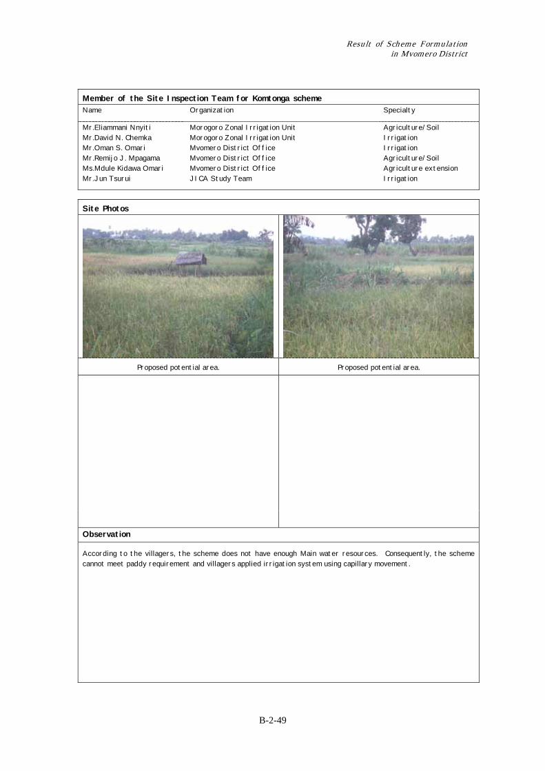
Site Photos
Proposed potential area. Proposed potential area.
Observation
According to the villagers, the scheme does not have enough Main water resources. Consequently, the scheme cannot meet paddy requirement and villagers applied irrigation system using capillary movement.
Chapter 2 Record of Training on Irrigation Scheme Formulation for DADP in Mvomero District
B-2-50
Record of Site Inspection Survey Sheet for Quick Site Inspection
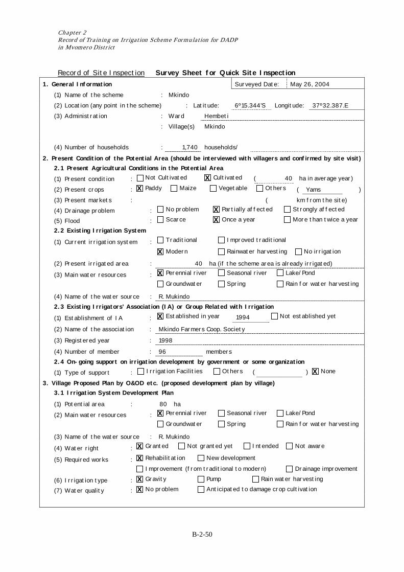
1. General Information Surveyed Date: May 26, 2004 (1) Name of the scheme : Mkindo (2) Location (any point in the scheme) : Latitude: 6º15.344’S Longitude: 37º32.387.E (3) Administration : Ward Hembeti : Village(s) Mkindo
(4) Number of households : 1,740 households/
2. Present Condition of the Potential Area (should be interviewed with villagers and confirmed by site visit) 2.1 Present Agricultural Conditions in the Potential Area
(1) Present condition : Not Cultivated Cultivated ( 40 ha in average year)
(2) Present crops : Paddy Maize Vegetable Others ( Yams ) (3) Present markets : ( km from the site) (4) Drainage problem : No problem Partially affected Strongly affected
(5) Flood : Scarce Once a year More than twice a year
2.2 Existing Irrigation System
(1) Current irrigation system : Traditional Improved traditional
Modern Rainwater harvesting No irrigation
(2) Present irrigated area : 40 ha (if the scheme area is already irrigated)
(3) Main water resources : Perennial river Seasonal river Lake/Pond
Groundwater Spring Rain for water harvesting
(4) Name of the water source : R. Mukindo 2.3 Existing Irrigators’ Association (IA) or Group Related with Irrigation
(1) Establishment of IA : Established in year 1994 Not established yet
(2) Name of the association : Mkindo Farmers Coop. Society
(3) Registered year : 1998
(4) Number of member : 96 members 2.4 On-going support on irrigation development by government or some organization
(1) Type of support : Irrigation Facilities Others ( ) None
3. Village Proposed Plan by O&OD etc. (proposed development plan by village) 3.1 Irrigation System Development Plan
(1) Potential area : 80 ha
(2) Main water resources : Perennial river Seasonal river Lake/Pond
Groundwater Spring Rain for water harvesting
(3) Name of the water source : R. Mukindo
(4) Water right : Granted Not granted yet Intended Not aware
(5) Required works : Rehabilitation New development
Improvement (from traditional to modern) Drainage improvement
(6) Irrigation type : Gravity Pump Rain water harvesting
(7) Water quality : No problem Anticipated to damage crop cultivation
X X
X X
X
X
X
X
X
X X X X
Result of Scheme Formulation in Mvomero District
B-2-51
3.2 Irrigators’ Association Establishment Plan
(1) Establishment plan : Existing Planned by year Not sure
(2) Mode of contribution to development : In cash In kind None
3.3 Agriculture Development Plan (1) Proposed crops : Paddy Maize Vegetable Others ( ) (2) Proposed markets : Name On farm ( km from the site) 4. Anticipated Negative Impacts Water conflict within the scheme/village Water conflict with other scheme/village
Land conflict Affection of protected area Soil erosion in the scheme
Cause of conflict ( Shortage of irrigation water due to water losses in main canal. )
5. Observation by the Inspection Team
(1) Farmers motivation for irrigation : High Moderate Low
(2) Present support to the scheme : Enough Additional support is required None
6. Opinions of Village Officers and Beneficiaries Improvement of main canal is needed.
7. History of the Scheme
8. Findings of the District Project Development Team See page on main canal which is not lined. Lining is needed.
Field canal needs to be rehabilitate. Out growers encroached irrigation water. Poor field levelling causes poor drainage.
X X
X
X
X X
Chapter 2 Record of Training on Irrigation Scheme Formulation for DADP in Mvomero District
B-2-52
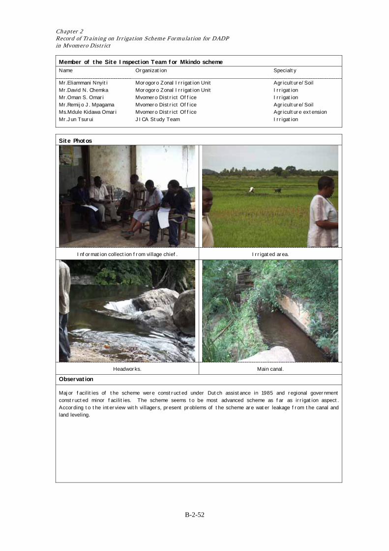
Member of the Site Inspection Team for Mkindo scheme Name Organization Specialty
Mr.Eliammani Nnyiti Mr.David N. Chemka Mr.Oman S. Omari Mr.Remijo J. Mpagama Ms.Mdule Kidawa Omari Mr.Jun Tsurui
Morogoro Zonal Irrigation Unit Morogoro Zonal Irrigation Unit Mvomero District Office Mvomero District Office Mvomero District Office JICA Study Team
Agriculture/Soil Irrigation Irrigation Agriculture/Soil Agriculture extension Irrigation
Site Photos
Information collection from village chief. Irrigated area.
Headworks. Main canal.
Observation
Major facilities of the scheme were constructed under Dutch assistance in 1985 and regional government constructed minor facilities. The scheme seems to be most advanced scheme as far as irrigation aspect. According to the interview with villagers, present problems of the scheme are water leakage from the canal and land leveling.
Result of Scheme Formulation in Mvomero District
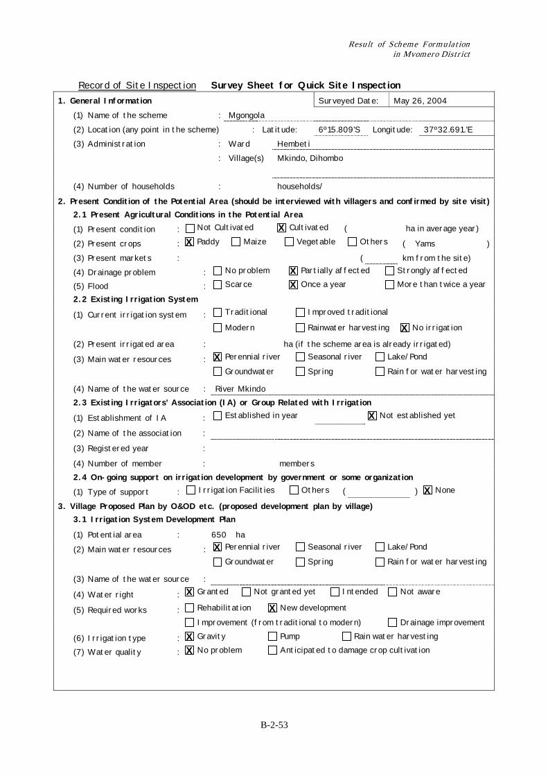
B-2-53
Record of Site Inspection Survey Sheet for Quick Site Inspection 1. General Information Surveyed Date: May 26, 2004 (1) Name of the scheme : Mgongola (2) Location (any point in the scheme) : Latitude: 6º15.809’S Longitude: 37º32.691.’E (3) Administration : Ward Hembeti : Village(s) Mkindo, Dihombo
(4) Number of households : households/
2. Present Condition of the Potential Area (should be interviewed with villagers and confirmed by site visit) 2.1 Present Agricultural Conditions in the Potential Area
(1) Present condition : Not Cultivated Cultivated ( ha in average year)
(2) Present crops : Paddy Maize Vegetable Others ( Yams ) (3) Present markets : ( km from the site) (4) Drainage problem : No problem Partially affected Strongly affected
(5) Flood : Scarce Once a year More than twice a year
2.2 Existing Irrigation System
(1) Current irrigation system : Traditional Improved traditional
Modern Rainwater harvesting No irrigation
(2) Present irrigated area : ha (if the scheme area is already irrigated)
(3) Main water resources : Perennial river Seasonal river Lake/Pond
Groundwater Spring Rain for water harvesting
(4) Name of the water source : River Mkindo 2.3 Existing Irrigators’ Association (IA) or Group Related with Irrigation
(1) Establishment of IA : Established in year Not established yet
(2) Name of the association :
(3) Registered year :
(4) Number of member : members 2.4 On-going support on irrigation development by government or some organization
(1) Type of support : Irrigation Facilities Others ( ) None
3. Village Proposed Plan by O&OD etc. (proposed development plan by village) 3.1 Irrigation System Development Plan
(1) Potential area : 650 ha
(2) Main water resources : Perennial river Seasonal river Lake/Pond
Groundwater Spring Rain for water harvesting
(3) Name of the water source :
(4) Water right : Granted Not granted yet Intended Not aware
(5) Required works : Rehabilitation New development
Improvement (from traditional to modern) Drainage improvement
(6) Irrigation type : Gravity Pump Rain water harvesting
(7) Water quality : No problem Anticipated to damage crop cultivation
X X
X X
X
X
X
X
X
X X X X
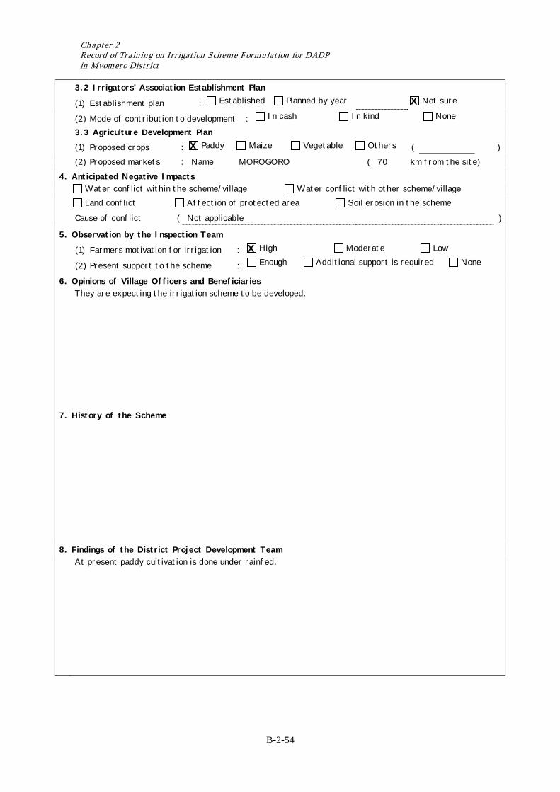
Chapter 2 Record of Training on Irrigation Scheme Formulation for DADP in Mvomero District
B-2-54
3.2 Irrigators’ Association Establishment Plan
(1) Establishment plan : Established Planned by year Not sure
(2) Mode of contribution to development : In cash In kind None
3.3 Agriculture Development Plan (1) Proposed crops : Paddy Maize Vegetable Others ( ) (2) Proposed markets : Name MOROGORO ( 70 km from the site) 4. Anticipated Negative Impacts Water conflict within the scheme/village Water conflict with other scheme/village
Land conflict Affection of protected area Soil erosion in the scheme
Cause of conflict ( Not applicable )
5. Observation by the Inspection Team
(1) Farmers motivation for irrigation : High Moderate Low
(2) Present support to the scheme : Enough Additional support is required None
6. Opinions of Village Officers and Beneficiaries They are expecting the irrigation scheme to be developed.
7. History of the Scheme
8. Findings of the District Project Development Team At present paddy cultivation is done under rainfed.
X
X
X
Result of Scheme Formulation in Mvomero District
B-2-55
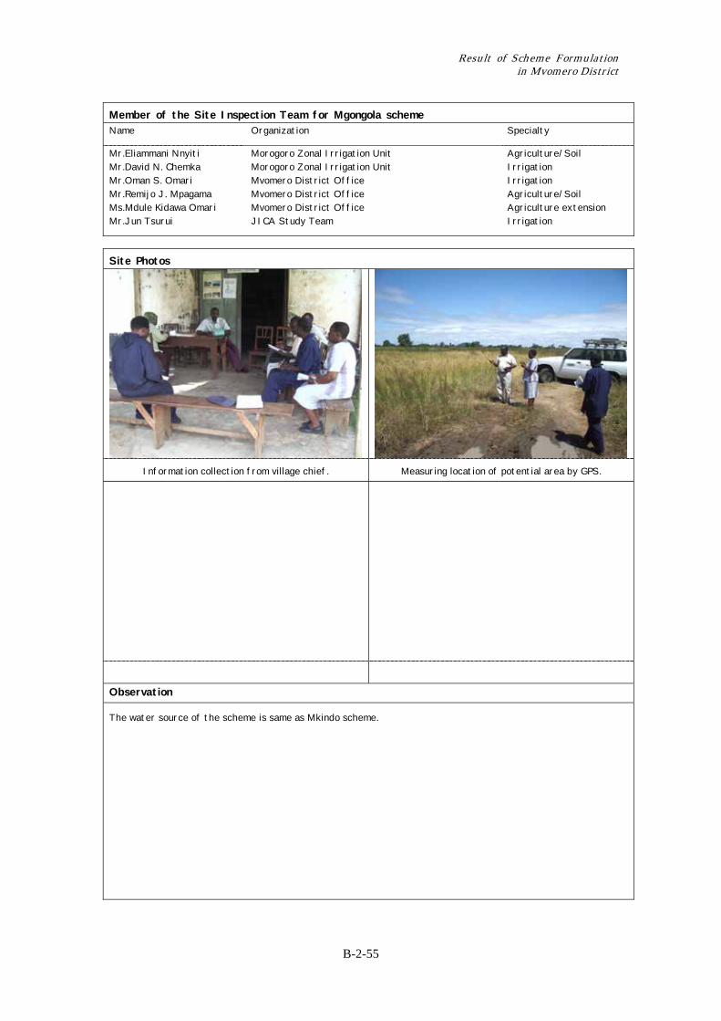
Member of the Site Inspection Team for Mgongola scheme Name Organization Specialty
Mr.Eliammani Nnyiti Mr.David N. Chemka Mr.Oman S. Omari Mr.Remijo J. Mpagama Ms.Mdule Kidawa Omari Mr.Jun Tsurui
Morogoro Zonal Irrigation Unit Morogoro Zonal Irrigation Unit Mvomero District Office Mvomero District Office Mvomero District Office JICA Study Team
Agriculture/Soil Irrigation Irrigation Agriculture/Soil Agriculture extension Irrigation
Site Photos
Information collection from village chief. Measuring location of potential area by GPS.
Observation
The water source of the scheme is same as Mkindo scheme.
Chapter 2 Record of Training on Irrigation Scheme Formulation for DADP in Mvomero District
B-2-56
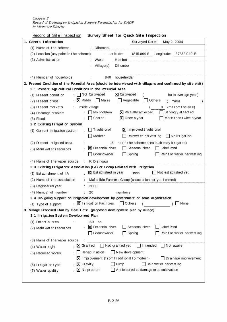
Record of Site Inspection Survey Sheet for Quick Site Inspection 1. General Information Surveyed Date: May 2, 2004 (1) Name of the scheme : Dihombo (2) Location (any point in the scheme) : Latitude: 6º15.869’S Longitude: 37º32.040.’E (3) Administration : Ward Hembeti : Village(s) Dihombo
(4) Number of households : 840 households/
2. Present Condition of the Potential Area (should be interviewed with villagers and confirmed by site visit) 2.1 Present Agricultural Conditions in the Potential Area
(1) Present condition : Not Cultivated Cultivated ( ha in average year)
(2) Present crops : Paddy Maize Vegetable Others ( Yams ) (3) Present markets : Inside village ( 0 km from the site) (4) Drainage problem : No problem Partially affected Strongly affected
(5) Flood : Scarce Once a year More than twice a year
2.2 Existing Irrigation System
(1) Current irrigation system : Traditional Improved traditional
Modern Rainwater harvesting No irrigation
(2) Present irrigated area : 16 ha (if the scheme area is already irrigated)
(3) Main water resources : Perennial river Seasonal river Lake/Pond
Groundwater Spring Rain for water harvesting
(4) Name of the water source : R. Dizingawi 2.3 Existing Irrigators’ Association (IA) or Group Related with Irrigation
(1) Establishment of IA : Established in year 1999 Not established yet
(2) Name of the association : Mafanikio Farmers Group (association not yet formed)
(3) Registered year : 2000
(4) Number of member : 20 members 2.4 On-going support on irrigation development by government or some organization
(1) Type of support : Irrigation Facilities Others ( ) None
3. Village Proposed Plan by O&OD etc. (proposed development plan by village) 3.1 Irrigation System Development Plan
(1) Potential area : 160 ha
(2) Main water resources : Perennial river Seasonal river Lake/Pond
Groundwater Spring Rain for water harvesting
(3) Name of the water source :
(4) Water right : Granted Not granted yet Intended Not aware
(5) Required works : Rehabilitation New development
Improvement (from traditional to modern) Drainage improvement
(6) Irrigation type : Gravity Pump Rain water harvesting
(7) Water quality : No problem Anticipated to damage crop cultivation
X X
X X
X
X
X
X
X
X X X X
Result of Scheme Formulation in Mvomero District
B-2-57
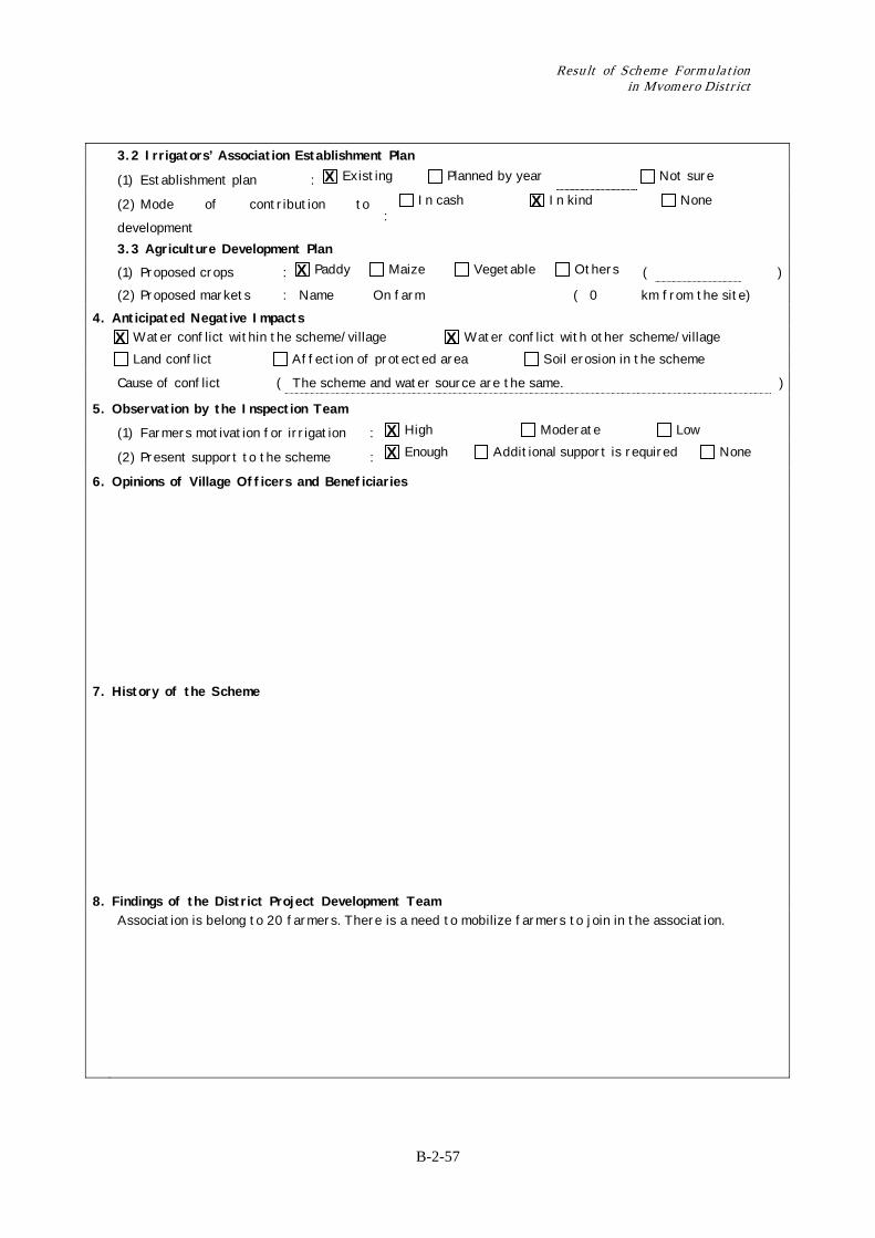
3.2 Irrigators’ Association Establishment Plan
(1) Establishment plan : Existing Planned by year Not sure
(2) Mode of contribution to
development :
In cash In kind None
3.3 Agriculture Development Plan (1) Proposed crops : Paddy Maize Vegetable Others ( ) (2) Proposed markets : Name On farm ( 0 km from the site) 4. Anticipated Negative Impacts Water conflict within the scheme/village Water conflict with other scheme/village
Land conflict Affection of protected area Soil erosion in the scheme
Cause of conflict ( The scheme and water source are the same. )
5. Observation by the Inspection Team
(1) Farmers motivation for irrigation : High Moderate Low
(2) Present support to the scheme : Enough Additional support is required None
6. Opinions of Village Officers and Beneficiaries
7. History of the Scheme
8. Findings of the District Project Development Team Association is belong to 20 farmers. There is a need to mobilize farmers to join in the association.
X X
X
X X
X X
Chapter 2 Record of Training on Irrigation Scheme Formulation for DADP in Mvomero District
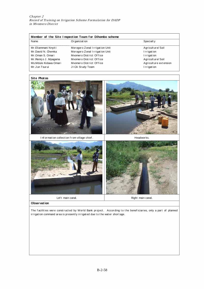
B-2-58
Member of the Site Inspection Team for Dihombo scheme Name Organization Specialty
Mr.Eliammani Nnyiti Mr.David N. Chemka Mr.Oman S. Omari Mr.Remijo J. Mpagama Ms.Mdule Kidawa Omari Mr.Jun Tsurui
Morogoro Zonal Irrigation Unit Morogoro Zonal Irrigation Unit Mvomero District Office Mvomero District Office Mvomero District Office JICA Study Team
Agriculture/Soil Irrigation Irrigation Agriculture/Soil Agriculture extension Irrigation
Site Photos
Information collection from village chief. Headworks.
Left main canal. Right main canal.
Observation
The facilities were constructed by World Bank project. According to the beneficiaries, only a part of planned irrigation command area is presently irrigated due to the water shortage.

Result of Scheme Formulation in Mvomero District
B-2-59
Record of Site Inspection Survey Sheet for Quick Site Inspection
1. General Information Surveyed Date: May 26, 2004 (1) Name of the scheme : Hembeti (2) Location (any point in the scheme) : Latitude: 6º16.250’S Longitude: 37º31.050.’E (3) Administration : Ward Hembeti : Village(s) Hembeti
(4) Number of households : 720 households/
2. Present Condition of the Potential Area (should be interviewed with villagers and confirmed by site visit) 2.1 Present Agricultural Conditions in the Potential Area
(1) Present condition : Not Cultivated Cultivated ( ha in average year)
(2) Present crops : Paddy Maize Vegetable Others ( Yams ) (3) Present markets : Inside the village ( 0 km from the site) (4) Drainage problem : No problem Partially affected Strongly affected
(5) Flood : Scarce Once a year More than twice a year
2.2 Existing Irrigation System
(1) Current irrigation system : Traditional Improved traditional
Modern Rainwater harvesting No irrigation
(2) Present irrigated area : 20 ha (if the scheme area is already irrigated)
(3) Main water resources : Perennial river Seasonal river Lake/Pond
Groundwater Spring Rain for water harvesting
(4) Name of the water source : 2.3 Existing Irrigators’ Association (IA) or Group Related with Irrigation
(1) Establishment of IA : Established in year 2001 Not established yet
(2) Name of the association : Umoja Irrigation Group
(3) Registered year :
(4) Number of member : 5 members 2.4 On-going support on irrigation development by government or some organization
(1) Type of support : Irrigation Facilities Others ( ) None
3. Village Proposed Plan by O&OD etc. (proposed development plan by village) 3.1 Irrigation System Development Plan
(1) Potential area : 80 ha
(2) Main water resources : Perennial river Seasonal river Lake/Pond
Groundwater Spring Rain for water harvesting
(3) Name of the water source : Dizingwi
(4) Water right : Granted Not granted yet Intended Not aware
(5) Required works : Rehabilitation New development
Improvement (from traditional to modern) Drainage improvement
(6) Irrigation type : Gravity Pump Rain water harvesting
(7) Water quality : No problem Anticipated to damage crop cultivation
X X
X X
X
X
X
X
X
X X X X
Chapter 2 Record of Training on Irrigation Scheme Formulation for DADP in Mvomero District
B-2-60
3.2 Irrigators’ Association Establishment Plan
(1) Establishment plan : Existing Planned by year Not sure
(2) Mode of contribution to development : In cash In kind None
3.3 Agriculture Development Plan (1) Proposed crops : Paddy Maize Vegetable Others ( ) (2) Proposed markets : Name On farm ( km from the site) 4. Anticipated Negative Impacts Water conflict within the scheme/village Water conflict with other scheme/village
Land conflict Affection of protected area Soil erosion in the scheme
Cause of conflict ( Poor water management )
5. Observation by the Inspection Team
(1) Farmers motivation for irrigation : High Moderate Low
(2) Present support to the scheme : Enough Additional support is required None
6. Opinions of Village Officers and Beneficiaries Improvement of Irrigation structures required.
7. History of the Scheme
8. Findings of the District Project Development Team No parmanent intake.
Irrigation canal constructed does not meet the standard.
X X
X
X
X X
Result of Scheme Formulation in Mvomero District
B-2-61
Member of the Site Inspection Team for Hembeti scheme Name Organization Specialty
Mr.Eliammani Nnyiti Mr.David N. Chemka Mr.Oman S. Omari Mr.Remijo J. Mpagama Ms.Mdule Kidawa Omari Mr.Jun Tsurui
Morogoro Zonal Irrigation Unit Morogoro Zonal Irrigation Unit Mvomero District Office Mvomero District Office Mvomero District Office JICA Study Team
Agriculture/Soil Irrigation Irrigation Agriculture/Soil Agriculture extension Irrigation
Site Photos
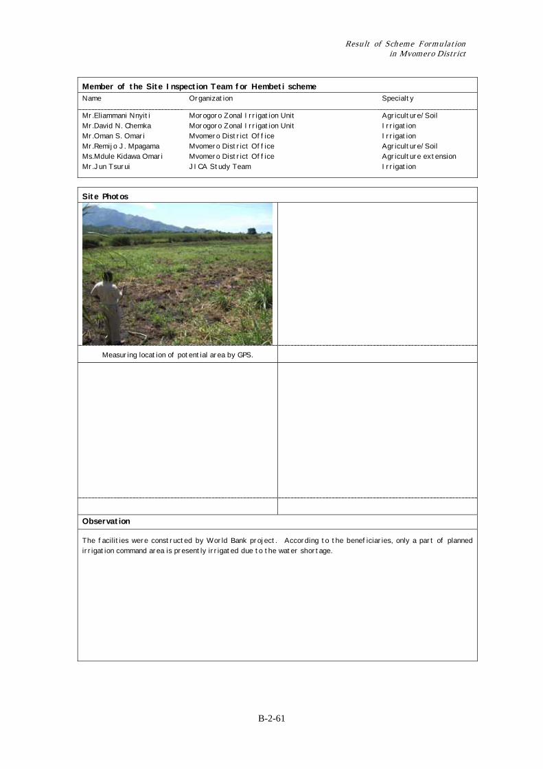
Measuring location of potential area by GPS.
Observation
The facilities were constructed by World Bank project. According to the beneficiaries, only a part of planned irrigation command area is presently irrigated due to the water shortage.
Chapter 2 Record of Training on Irrigation Scheme Formulation for DADP in Mvomero District
B-2-62
Record of Site Inspection Survey Sheet for Quick Site Inspection 1. General Information Surveyed Date: May 26, 2004 (1) Name of the scheme : Dakawa (2) Location (any point in the scheme) : Latitude: º’S Longitude: º.’E (3) Administration : Ward Mvomero : Village(s) Dakawa
(4) Number of households : households/
2. Present Condition of the Potential Area (should be interviewed with villagers and confirmed by site visit) 2.1 Present Agricultural Conditions in the Potential Area
(1) Present condition : Not Cultivated Cultivated ( ha in average year)
(2) Present crops : Paddy Maize Vegetable Others ( Yams ) (3) Present markets : Inside the village ( 0 km from the site) (4) Drainage problem : No problem Partially affected Strongly affected
(5) Flood : Scarce Once a year More than twice a year
2.2 Existing Irrigation System
(1) Current irrigation system : Traditional Improved traditional
Modern Rainwater harvesting No irrigation
(2) Present irrigated area : 2,000 ha (if the scheme area is already irrigated)
(3) Main water resources : Perennial river Seasonal river Lake/Pond
Groundwater Spring Rain for water harvesting
(4) Name of the water source : Wami River 2.3 Existing Irrigators’ Association (IA) or Group Related with Irrigation
(1) Establishment of IA : Established in year Not established yet
(2) Name of the association :
(3) Registered year :
(4) Number of member : members 2.4 On-going support on irrigation development by government or some organization
(1) Type of support : Irrigation Facilities Others ( ) None
3. Village Proposed Plan by O&OD etc. (proposed development plan by village) 3.1 Irrigation System Development Plan
(1) Potential area : 3,000 ha
(2) Main water resources : Perennial river Seasonal river Lake/Pond
Groundwater Spring Rain for water harvesting
(3) Name of the water source : Wami River
(4) Water right : Granted Not granted yet Intended Not aware
(5) Required works : Rehabilitation New development
Improvement (from traditional to modern) Drainage improvement
(6) Irrigation type : Gravity Pump Rain water harvesting
(7) Water quality : No problem Anticipated to damage crop cultivation
X X
X X
X
X
X
X X X X
Result of Scheme Formulation in Mvomero District
B-2-63
3.2 Irrigators’ Association Establishment Plan
(1) Establishment plan : Existing Planned by year Not sure
(2) Mode of contribution to
development :
In cash In kind None
3.3 Agriculture Development Plan (1) Proposed crops : Paddy Maize Vegetable Others ( ) (2) Proposed markets : Name MOROGORO ( 45 km from the site) 4. Anticipated Negative Impacts Water conflict within the scheme/village Water conflict with other scheme/village
Land conflict Affection of protected area Soil erosion in the scheme
Cause of conflict ( Not equal distribution due to the absence of pump. )
5. Observation by the Inspection Team
(1) Farmers motivation for irrigation : High Moderate Low
(2) Present support to the scheme : Enough Additional support is required None
6. Opinions of Village Officers and Beneficiaries They need to have an identified water users association.
7. History of the Scheme
8. Findings of the District Project Development Team Water conflict due to insufficient water supply to the scheme.
Only 2 pumps are functioning out pf 6 pumps.
X X
X
X
X X
Chapter 2 Record of Training on Irrigation Scheme Formulation for DADP in Mvomero District
B-2-64
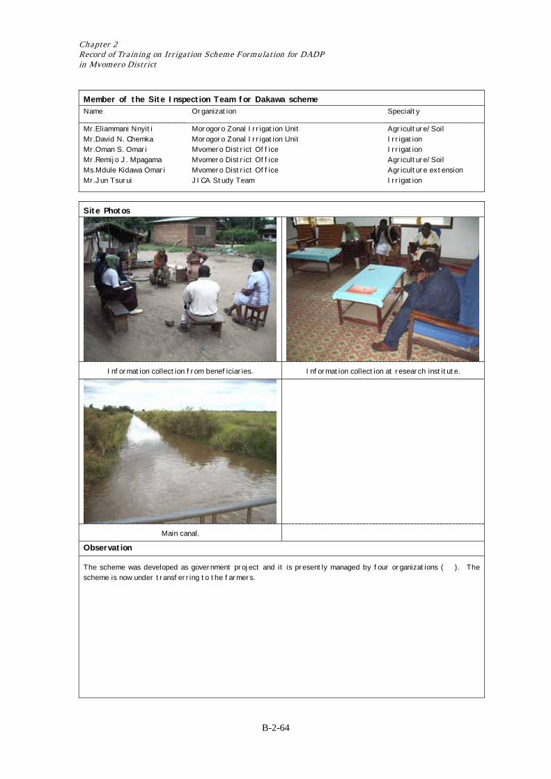
Member of the Site Inspection Team for Dakawa scheme Name Organization Specialty
Mr.Eliammani Nnyiti Mr.David N. Chemka Mr.Oman S. Omari Mr.Remijo J. Mpagama Ms.Mdule Kidawa Omari Mr.Jun Tsurui
Morogoro Zonal Irrigation Unit Morogoro Zonal Irrigation Unit Mvomero District Office Mvomero District Office Mvomero District Office JICA Study Team
Agriculture/Soil Irrigation Irrigation Agriculture/Soil Agriculture extension Irrigation
Site Photos
Information collection from beneficiaries. Information collection at research institute.
Main canal.
Observation
The scheme was developed as government project and it is presently managed by four organizations ( ). The scheme is now under transferring to the farmers.

Result of Scheme Formulation in Mvomero District
B-2-65
Record of Site Inspection Survey Sheet for Quick Site Inspection
1. General Information Surveyed Date: May 26, 2004 (1) Name of the scheme : Wami Luhindo (2) Location (any point in the scheme) : Latitude: 6º28.379’S Longitude: 37º33.337.’E (3) Administration : Ward Mvomero : Village(s) Wami Luhindo
(4) Number of households : 665 households/
2. Present Condition of the Potential Area (should be interviewed with villagers and confirmed by site visit) 2.1 Present Agricultural Conditions in the Potential Area
(1) Present condition : Not Cultivated Cultivated ( ha in average year)
(2) Present crops : Paddy Maize Vegetable Others ( Yams ) (3) Present markets : ( km from the site) (4) Drainage problem : No problem Partially affected Strongly affected
(5) Flood : Scarce Once a year More than twice a year
2.2 Existing Irrigation System
(1) Current irrigation system : Traditional Improved traditional
Modern Rainwater harvesting No irrigation
(2) Present irrigated area : ha (if the scheme area is already irrigated)
(3) Main water resources : Perennial river Seasonal river Lake/Pond
Groundwater Spring Rain for water harvesting
(4) Name of the water source : R. Luhindo 2.3 Existing Irrigators’ Association (IA) or Group Related with Irrigation
(1) Establishment of IA : Established in year 2002 Not established yet
(2) Name of the association : Mkombozi
(3) Registered year :
(4) Number of member : 30 members 2.4 On-going support on irrigation development by government or some organization
(1) Type of support : Irrigation Facilities Others ( ) None
3. Village Proposed Plan by O&OD etc. (proposed development plan by village) 3.1 Irrigation System Development Plan
(1) Potential area : 100 ha
(2) Main water resources : Perennial river Seasonal river Lake/Pond
Groundwater Spring Rain for water harvesting
(3) Name of the water source : R. Luhindo
(4) Water right : Granted Not granted yet Intended Not aware
(5) Required works : Rehabilitation New development
Improvement (from traditional to modern) Drainage improvement
(6) Irrigation type : Gravity Pump Rain water harvesting
(7) Water quality : No problem Anticipated to damage crop cultivation
X X
X X
X
X
X
X
X
X X X X
Chapter 2 Record of Training on Irrigation Scheme Formulation for DADP in Mvomero District
B-2-66
3.2 Irrigators’ Association Establishment Plan
(1) Establishment plan : Established Planned by year Not sure
(2) Mode of contribution to development : In cash In kind None
3.3 Agriculture Development Plan (1) Proposed crops : Paddy Maize Vegetable Others ( ) (2) Proposed markets : Name On farm ( 0 km from the site) 4. Anticipated Negative Impacts Water conflict within the scheme/village Water conflict with other scheme/village
Land conflict Affection of protected area Soil erosion in the scheme
Cause of conflict ( Insufficient Irrigation water. )
5. Observation by the Inspection Team
(1) Farmers motivation for irrigation : High Moderate Low
(2) Present support to the scheme : Enough Additional support is required None
6. Opinions of Village Officers and Beneficiaries They highly need a support to improve their Rainwater harvesting system.
7. History of the Scheme
8. Findings of the District Project Development Team Canal construction is needed.
X X
X
X
X X
Result of Scheme Formulation in Mvomero District
B-2-67
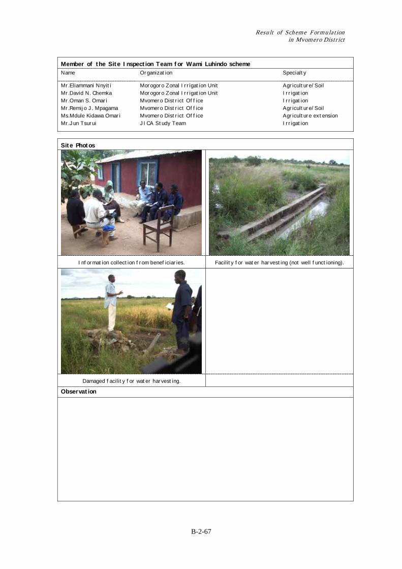
Member of the Site Inspection Team for Wami Luhindo scheme Name Organization Specialty
Mr.Eliammani Nnyiti Mr.David N. Chemka Mr.Oman S. Omari Mr.Remijo J. Mpagama Ms.Mdule Kidawa Omari Mr.Jun Tsurui
Morogoro Zonal Irrigation Unit Morogoro Zonal Irrigation Unit Mvomero District Office Mvomero District Office Mvomero District Office JICA Study Team
Agriculture/Soil Irrigation Irrigation Agriculture/Soil Agriculture extension Irrigation
Site Photos
Information collection from beneficiaries. Facility for water harvesting (not well functioning).
Damaged facility for water harvesting.
Observation
Chapter 2 Record of Training on Irrigation Scheme Formulation for DADP in Mvomero District
B-2-68
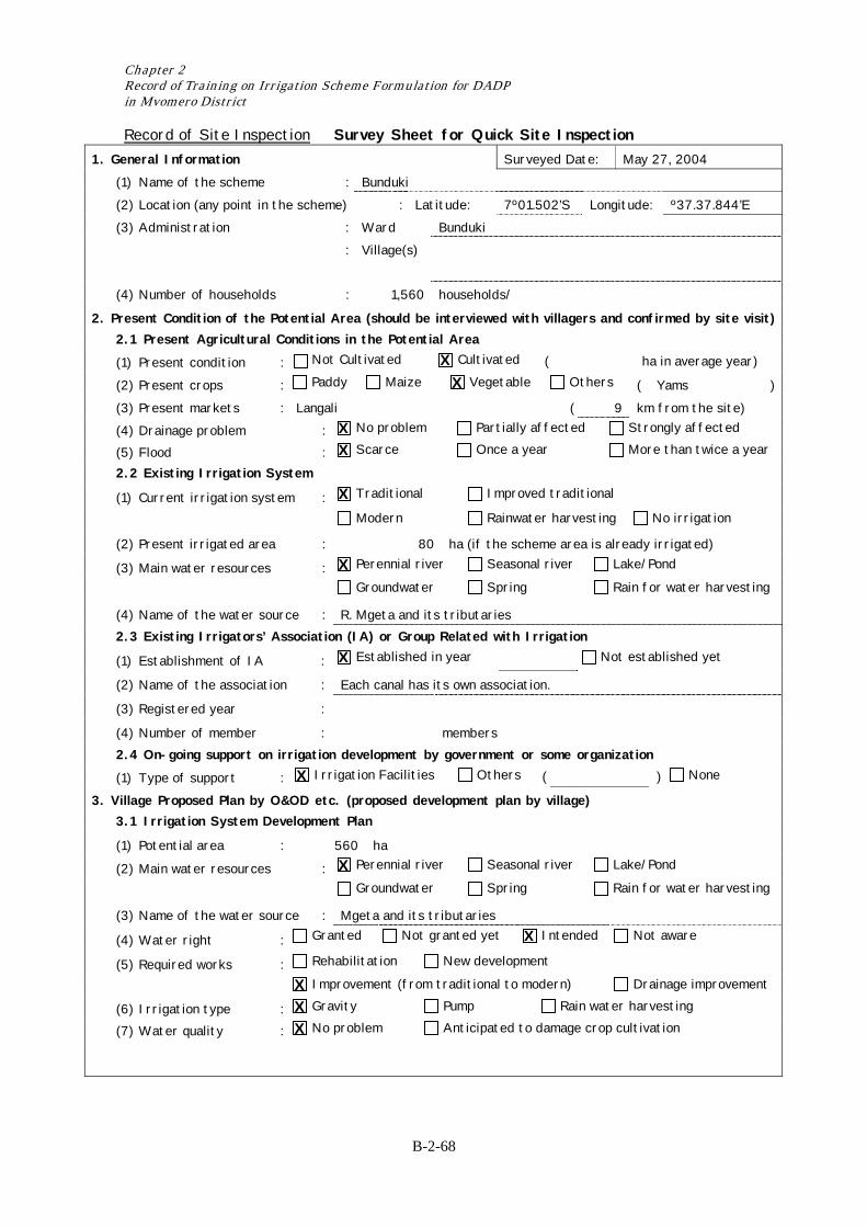
Record of Site Inspection Survey Sheet for Quick Site Inspection 1. General Information Surveyed Date: May 27, 2004 (1) Name of the scheme : Bunduki (2) Location (any point in the scheme) : Latitude: 7º01.502’S Longitude: º37.37.844’E (3) Administration : Ward Bunduki : Village(s)
(4) Number of households : 1,560 households/
2. Present Condition of the Potential Area (should be interviewed with villagers and confirmed by site visit) 2.1 Present Agricultural Conditions in the Potential Area
(1) Present condition : Not Cultivated Cultivated ( ha in average year)
(2) Present crops : Paddy Maize Vegetable Others ( Yams ) (3) Present markets : Langali ( 9 km from the site) (4) Drainage problem : No problem Partially affected Strongly affected
(5) Flood : Scarce Once a year More than twice a year
2.2 Existing Irrigation System
(1) Current irrigation system : Traditional Improved traditional
Modern Rainwater harvesting No irrigation
(2) Present irrigated area : 80 ha (if the scheme area is already irrigated)
(3) Main water resources : Perennial river Seasonal river Lake/Pond
Groundwater Spring Rain for water harvesting
(4) Name of the water source : R. Mgeta and its tributaries 2.3 Existing Irrigators’ Association (IA) or Group Related with Irrigation
(1) Establishment of IA : Established in year Not established yet
(2) Name of the association : Each canal has its own association.
(3) Registered year :
(4) Number of member : members 2.4 On-going support on irrigation development by government or some organization
(1) Type of support : Irrigation Facilities Others ( ) None
3. Village Proposed Plan by O&OD etc. (proposed development plan by village) 3.1 Irrigation System Development Plan
(1) Potential area : 560 ha
(2) Main water resources : Perennial river Seasonal river Lake/Pond
Groundwater Spring Rain for water harvesting
(3) Name of the water source : Mgeta and its tributaries
(4) Water right : Granted Not granted yet Intended Not aware
(5) Required works : Rehabilitation New development
Improvement (from traditional to modern) Drainage improvement
(6) Irrigation type : Gravity Pump Rain water harvesting
(7) Water quality : No problem Anticipated to damage crop cultivation
X X
X X
X
X
X
X
X
X X X X
Result of Scheme Formulation in Mvomero District
B-2-69
3.2 Irrigators’ Association Establishment Plan
(1) Establishment plan : Existing Planned by year Not sure
(2) Mode of contribution to
development :
In cash In kind None
3.3 Agriculture Development Plan (1) Proposed crops : Paddy Maize Vegetable Others ( ) (2) Proposed markets : Name Langali ( 9 km from the site) 4. Anticipated Negative Impacts Water conflict within the scheme/village Water conflict with other scheme/village
Land conflict Affection of protected area Soil erosion in the scheme
Cause of conflict ( )
5. Observation by the Inspection Team
(1) Farmers motivation for irrigation : High Moderate Low
(2) Present support to the scheme : Enough Additional support is required None
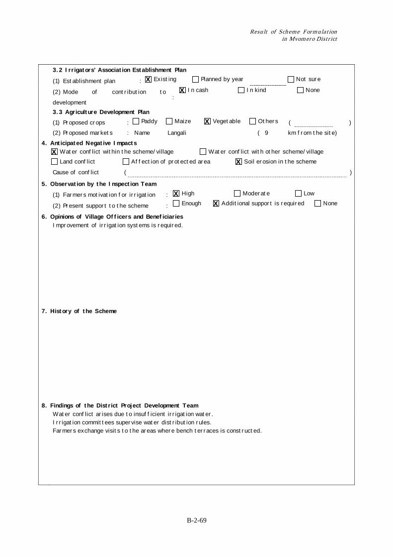
6. Opinions of Village Officers and Beneficiaries Improvement of irrigation systems is required.
7. History of the Scheme
8. Findings of the District Project Development Team Water conflict arises due to insufficient irrigation water.
Irrigation committees supervise water distribution rules. Farmers exchange visits to the areas where bench terraces is constructed.
X X
X
X X
X X
Chapter 2 Record of Training on Irrigation Scheme Formulation for DADP in Mvomero District
B-2-70
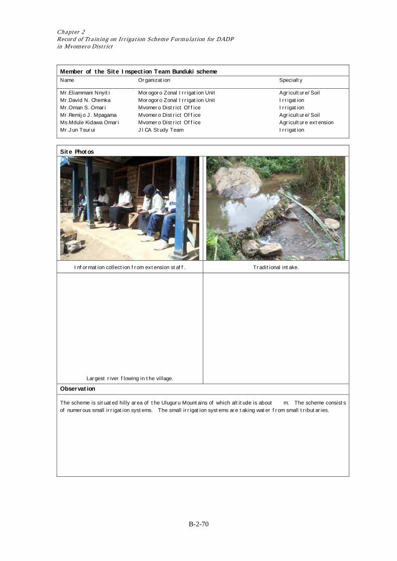
Member of the Site Inspection Team Bunduki scheme Name Organization Specialty
Mr.Eliammani Nnyiti Mr.David N. Chemka Mr.Oman S. Omari Mr.Remijo J. Mpagama Ms.Mdule Kidawa Omari Mr.Jun Tsurui
Morogoro Zonal Irrigation Unit Morogoro Zonal Irrigation Unit Mvomero District Office Mvomero District Office Mvomero District Office JICA Study Team
Agriculture/Soil Irrigation Irrigation Agriculture/Soil Agriculture extension Irrigation
Site Photos
Information collection from extension staff. Traditional intake.
Largest river flowing in the village.
Observation
The scheme is situated hilly area of the Uluguru Mountains of which altitude is about m. The scheme consists of numerous small irrigation systems. The small irrigation systems are taking water from small tributaries.
Result of Scheme Formulation in Mvomero District
B-2-71
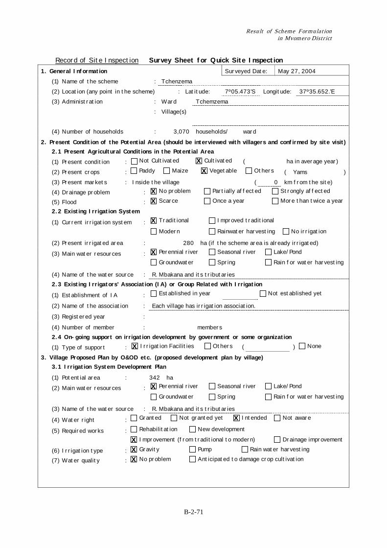
Record of Site Inspection Survey Sheet for Quick Site Inspection 1. General Information Surveyed Date: May 27, 2004 (1) Name of the scheme : Tchenzema (2) Location (any point in the scheme) : Latitude: 7º05.473’S Longitude: 37º35.652.’E (3) Administration : Ward Tchemzema : Village(s)
(4) Number of households : 3,070 households/ ward
2. Present Condition of the Potential Area (should be interviewed with villagers and confirmed by site visit) 2.1 Present Agricultural Conditions in the Potential Area
(1) Present condition : Not Cultivated Cultivated ( ha in average year)
(2) Present crops : Paddy Maize Vegetable Others ( Yams ) (3) Present markets : Inside the village ( 0 km from the site) (4) Drainage problem : No problem Partially affected Strongly affected
(5) Flood : Scarce Once a year More than twice a year
2.2 Existing Irrigation System
(1) Current irrigation system : Traditional Improved traditional
Modern Rainwater harvesting No irrigation
(2) Present irrigated area : 280 ha (if the scheme area is already irrigated)
(3) Main water resources : Perennial river Seasonal river Lake/Pond
Groundwater Spring Rain for water harvesting
(4) Name of the water source : R. Mbakana and its tributaries 2.3 Existing Irrigators’ Association (IA) or Group Related with Irrigation
(1) Establishment of IA : Established in year Not established yet
(2) Name of the association : Each village has irrigation association.
(3) Registered year :
(4) Number of member : members 2.4 On-going support on irrigation development by government or some organization
(1) Type of support : Irrigation Facilities Others ( ) None
3. Village Proposed Plan by O&OD etc. (proposed development plan by village) 3.1 Irrigation System Development Plan
(1) Potential area : 342 ha
(2) Main water resources : Perennial river Seasonal river Lake/Pond
Groundwater Spring Rain for water harvesting
(3) Name of the water source : R. Mbakana and its tributaries
(4) Water right : Granted Not granted yet Intended Not aware
(5) Required works : Rehabilitation New development
Improvement (from traditional to modern) Drainage improvement
(6) Irrigation type : Gravity Pump Rain water harvesting
(7) Water quality : No problem Anticipated to damage crop cultivation
X X
X X
X
X
X
X
X X X X
Chapter 2 Record of Training on Irrigation Scheme Formulation for DADP in Mvomero District
B-2-72
3.2 Irrigators’ Association Establishment Plan
(1) Establishment plan : Existing Planned by year Not sure
(2) Mode of contribution to development : In cash In kind None
3.3 Agriculture Development Plan (1) Proposed crops : Paddy Maize Vegetable Others ( ) (2) Proposed markets : Name On farm ( 0 km from the site) 4. Anticipated Negative Impacts Water conflict within the scheme/village Water conflict with other scheme/village
Land conflict Affection of protected area Soil erosion in the scheme
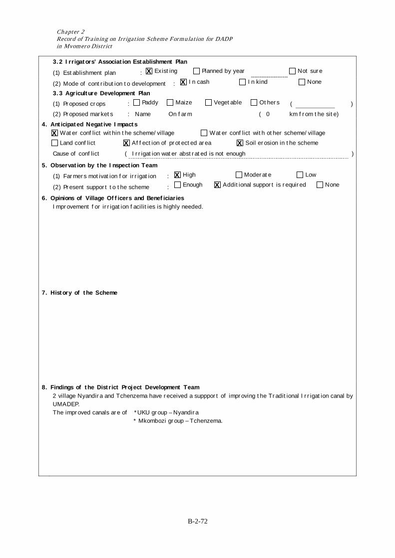
Cause of conflict ( Irrigation water abstrated is not enough )
5. Observation by the Inspection Team
(1) Farmers motivation for irrigation : High Moderate Low
(2) Present support to the scheme : Enough Additional support is required None
6. Opinions of Village Officers and Beneficiaries Improvement for irrigation facilities is highly needed.
7. History of the Scheme
8. Findings of the District Project Development Team 2 village Nyandira and Tchenzema have received a suppport of improving the Traditional Irrigation canal by
UMADEP. The improved canals are of *UKU group – Nyandira * Mkombozi group – Tchenzema.
X X
X X X
X X
Result of Scheme Formulation in Mvomero District
B-2-73
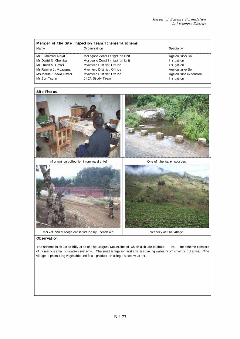
Member of the Site Inspection Team Tchenzema scheme Name Organization Specialty
Mr.Eliammani Nnyiti Mr.David N. Chemka Mr.Oman S. Omari Mr.Remijo J. Mpagama Ms.Mdule Kidawa Omari Mr.Jun Tsurui
Morogoro Zonal Irrigation Unit Morogoro Zonal Irrigation Unit Mvomero District Office Mvomero District Office Mvomero District Office JICA Study Team
Agriculture/Soil Irrigation Irrigation Agriculture/Soil Agriculture extension Irrigation
Site Photos
Information collection from ward chief. One of the water sources.
Market and storage construction by French aid. Scenery of the village.
Observation
The scheme is situated hilly area of the Uluguru Mountains of which altitude is about m. The scheme consists of numerous small irrigation systems. The small irrigation systems are taking water from small tributaries. The village is promoting vegetable and fruit production using its cool weather.
Chapter 2 Record of Training on Irrigation Scheme Formulation for DADP in Mvomero District
B-2-74
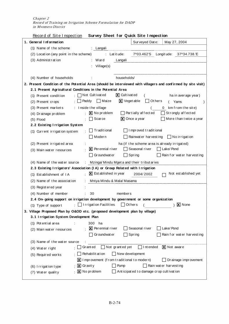
Record of Site Inspection Survey Sheet for Quick Site Inspection 1. General Information Surveyed Date: May 27, 2004 (1) Name of the scheme : Langali (2) Location (any point in the scheme) : Latitude: 7º03.462’S Longitude: 37º34.738.’E (3) Administration : Ward Langali : Village(s)
(4) Number of households : households/
2. Present Condition of the Potential Area (should be interviewed with villagers and confirmed by site visit) 2.1 Present Agricultural Conditions in the Potential Area
(1) Present condition : Not Cultivated Cultivated ( ha in average year)
(2) Present crops : Paddy Maize Vegetable Others ( Yams ) (3) Present markets : Inside the village ( 0 km from the site) (4) Drainage problem : No problem Partially affected Strongly affected
(5) Flood : Scarce Once a year More than twice a year
2.2 Existing Irrigation System
(1) Current irrigation system : Traditional Improved traditional
Modern Rainwater harvesting No irrigation
(2) Present irrigated area : ha (if the scheme area is already irrigated)
(3) Main water resources : Perennial river Seasonal river Lake/Pond
Groundwater Spring Rain for water harvesting
(4) Name of the water source : Mzinga/Mindu Mgeta and their tributaries 2.3 Existing Irrigators’ Association (IA) or Group Related with Irrigation
(1) Establishment of IA : Established in year 2004/2002 Not established yet
(2) Name of the association : Mniya Mindu & Mala/Masama
(3) Registered year :
(4) Number of member : 30 members 2.4 On-going support on irrigation development by government or some organization
(1) Type of support : Irrigation Facilities Others ( ) None
3. Village Proposed Plan by O&OD etc. (proposed development plan by village) 3.1 Irrigation System Development Plan
(1) Potential area : 300 ha
(2) Main water resources : Perennial river Seasonal river Lake/Pond
Groundwater Spring Rain for water harvesting
(3) Name of the water source :
(4) Water right : Granted Not granted yet Intended Not aware
(5) Required works : Rehabilitation New development
Improvement (from traditional to modern) Drainage improvement
(6) Irrigation type : Gravity Pump Rain water harvesting
(7) Water quality : No problem Anticipated to damage crop cultivation
X X
X X
X
X
X
X
X X X X
Result of Scheme Formulation in Mvomero District
B-2-75
3.2 Irrigators’ Association Establishment Plan
(1) Establishment plan : Existing Planned by year Not sure
(2) Mode of contribution to
development :
In cash In kind None
3.3 Agriculture Development Plan (1) Proposed crops : Paddy Maize Vegetable Others ( ) (2) Proposed markets : Name ( km from the site) 4. Anticipated Negative Impacts Water conflict within the scheme/village Water conflict with other scheme/village
Land conflict Affection of protected area Soil erosion in the scheme
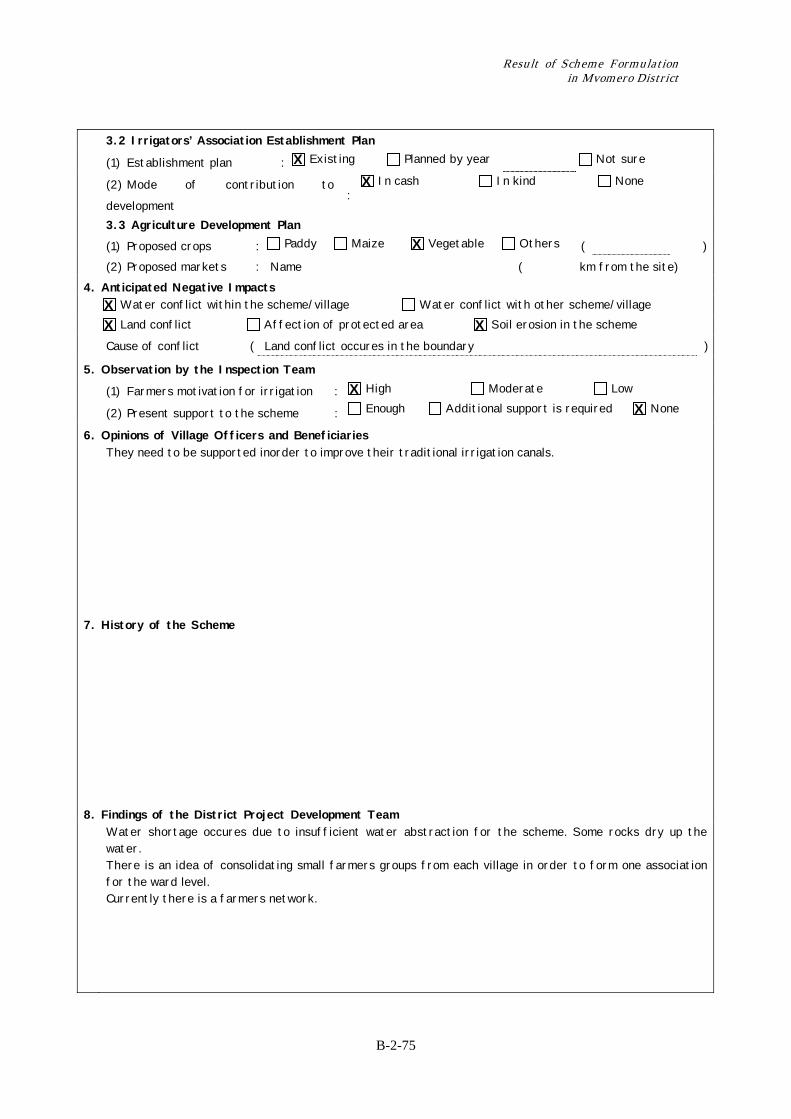
Cause of conflict ( Land conflict occures in the boundary )
5. Observation by the Inspection Team
(1) Farmers motivation for irrigation : High Moderate Low
(2) Present support to the scheme : Enough Additional support is required None
6. Opinions of Village Officers and Beneficiaries They need to be supported inorder to improve their traditional irrigation canals.
7. History of the Scheme
8. Findings of the District Project Development Team Water shortage occures due to insufficient water abstraction for the scheme. Some rocks dry up the
water. There is an idea of consolidating small farmers groups from each village in order to form one association for the ward level. Currently there is a farmers network.
X X
X
X X X
X X
Chapter 2 Record of Training on Irrigation Scheme Formulation for DADP in Mvomero District
B-2-76
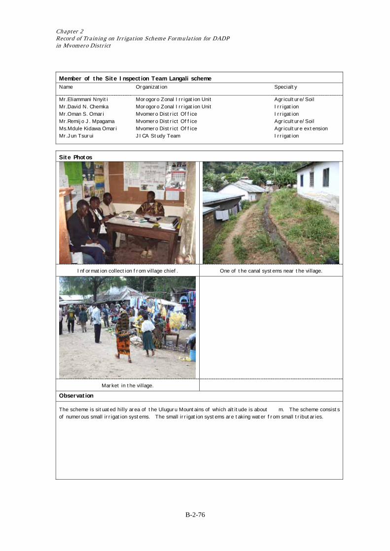
Member of the Site Inspection Team Langali scheme Name Organization Specialty
Mr.Eliammani Nnyiti Mr.David N. Chemka Mr.Oman S. Omari Mr.Remijo J. Mpagama Ms.Mdule Kidawa Omari Mr.Jun Tsurui
Morogoro Zonal Irrigation Unit Morogoro Zonal Irrigation Unit Mvomero District Office Mvomero District Office Mvomero District Office JICA Study Team
Agriculture/Soil Irrigation Irrigation Agriculture/Soil Agriculture extension Irrigation
Site Photos
Information collection from village chief. One of the canal systems near the village.
Market in the village.
Observation
The scheme is situated hilly area of the Uluguru Mountains of which altitude is about m. The scheme consists of numerous small irrigation systems. The small irrigation systems are taking water from small tributaries.
Result of Scheme Formulation in Mvomero District
B-2-77
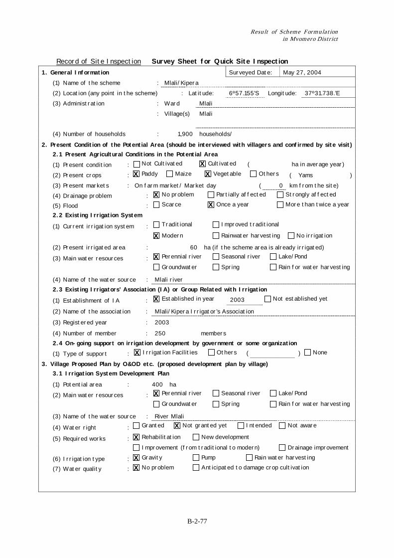
Record of Site Inspection Survey Sheet for Quick Site Inspection 1. General Information Surveyed Date: May 27, 2004 (1) Name of the scheme : Mlali/Kipera (2) Location (any point in the scheme) : Latitude: 6º57.155’S Longitude: 37º31.738.’E (3) Administration : Ward Mlali : Village(s) Mlali
(4) Number of households : 1,900 households/
2. Present Condition of the Potential Area (should be interviewed with villagers and confirmed by site visit) 2.1 Present Agricultural Conditions in the Potential Area
(1) Present condition : Not Cultivated Cultivated ( ha in average year)
(2) Present crops : Paddy Maize Vegetable Others ( Yams ) (3) Present markets : On farm market/ Market day ( 0 km from the site) (4) Drainage problem : No problem Partially affected Strongly affected
(5) Flood : Scarce Once a year More than twice a year
2.2 Existing Irrigation System
(1) Current irrigation system : Traditional Improved traditional
Modern Rainwater harvesting No irrigation
(2) Present irrigated area : 60 ha (if the scheme area is already irrigated)
(3) Main water resources : Perennial river Seasonal river Lake/Pond
Groundwater Spring Rain for water harvesting
(4) Name of the water source : Mlali river 2.3 Existing Irrigators’ Association (IA) or Group Related with Irrigation
(1) Establishment of IA : Established in year 2003 Not established yet
(2) Name of the association : Mlali/Kipera Irrigator’s Association
(3) Registered year : 2003
(4) Number of member : 250 members 2.4 On-going support on irrigation development by government or some organization
(1) Type of support : Irrigation Facilities Others ( ) None
3. Village Proposed Plan by O&OD etc. (proposed development plan by village) 3.1 Irrigation System Development Plan
(1) Potential area : 400 ha
(2) Main water resources : Perennial river Seasonal river Lake/Pond
Groundwater Spring Rain for water harvesting
(3) Name of the water source : River Mlali
(4) Water right : Granted Not granted yet Intended Not aware
(5) Required works : Rehabilitation New development
Improvement (from traditional to modern) Drainage improvement
(6) Irrigation type : Gravity Pump Rain water harvesting
(7) Water quality : No problem Anticipated to damage crop cultivation
X X X
X X
X
X
X
X
X
X X X X
Chapter 2 Record of Training on Irrigation Scheme Formulation for DADP in Mvomero District
B-2-78
3.2 Irrigators’ Association Establishment Plan
(1) Establishment plan : Existing Planned by year Not sure
(2) Mode of contribution to development : In cash In kind None
3.3 Agriculture Development Plan (1) Proposed crops : Paddy Maize Vegetable Others ( ) (2) Proposed markets : Name On farm ( 0 km from the site) 4. Anticipated Negative Impacts Water conflict within the scheme/village Water conflict with other scheme/village
Land conflict Affection of protected area Soil erosion in the scheme
Cause of conflict ( Water shortage )
5. Observation by the Inspection Team
(1) Farmers motivation for irrigation : High Moderate Low
(2) Present support to the scheme : Enough Additional support is required None
6. Opinions of Village Officers and Beneficiaries They need an additional support to make the system function properly.
7. History of the Scheme
8. Findings of the District Project Development Team Siltation at the intake was reported.
The scheme experiences water shortage. There is a need to educate farmers not to cultivate near the river banks.
X X
X X
X X
X X
Result of Scheme Formulation in Mvomero District
B-2-79
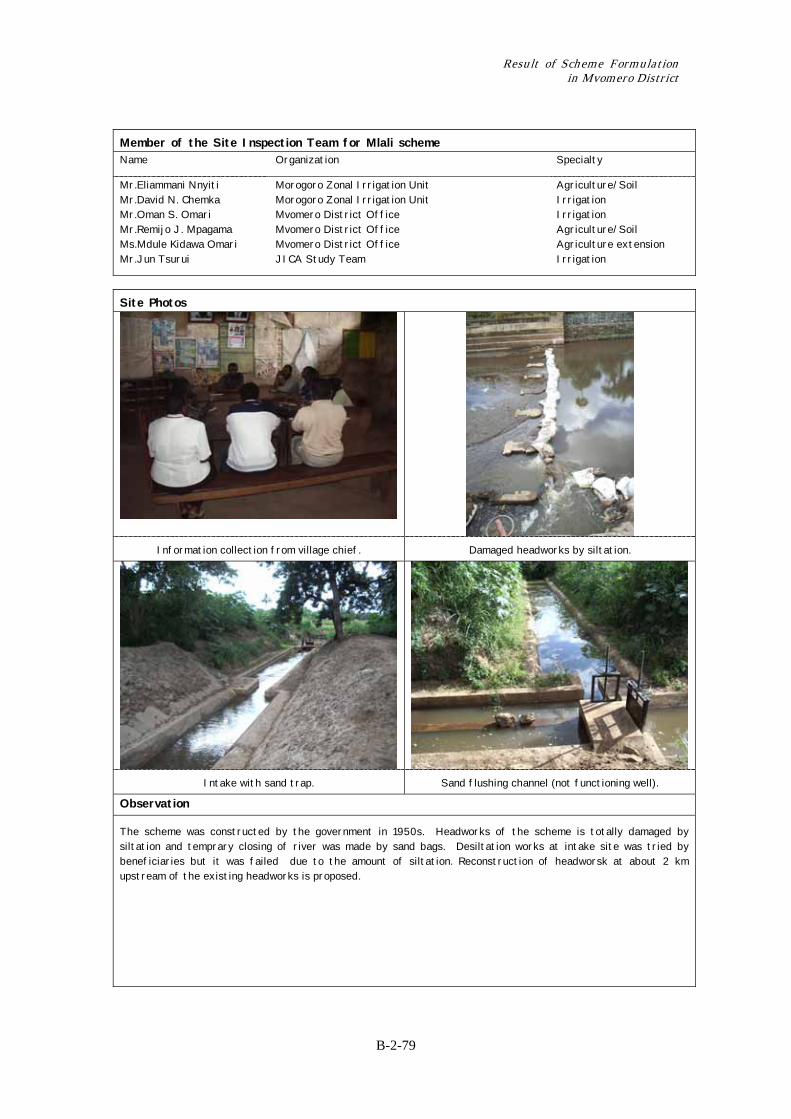
Member of the Site Inspection Team for Mlali scheme Name Organization Specialty
Mr.Eliammani Nnyiti Mr.David N. Chemka Mr.Oman S. Omari Mr.Remijo J. Mpagama Ms.Mdule Kidawa Omari Mr.Jun Tsurui
Morogoro Zonal Irrigation Unit Morogoro Zonal Irrigation Unit Mvomero District Office Mvomero District Office Mvomero District Office JICA Study Team
Agriculture/Soil Irrigation Irrigation Agriculture/Soil Agriculture extension Irrigation
Site Photos
Information collection from village chief. Damaged headworks by siltation.
Intake with sand trap. Sand flushing channel (not functioning well).
Observation
The scheme was constructed by the government in 1950s. Headworks of the scheme is totally damaged by siltation and temprary closing of river was made by sand bags. Desiltation works at intake site was tried by beneficiaries but it was failed due to the amount of siltation. Reconstruction of headworsk at about 2 km upstream of the existing headworks is proposed.
Chapter 2 Record of Training on Irrigation Scheme Formulation for DADP in Mvomero District
B-2-80
Record of Site Inspection Survey Sheet for Quick Site Inspection 1. General Information Surveyed Date: May 27, 2004 (1) Name of the scheme : Manza (2) Location (any point in the scheme) : Latitude: 7º00.932’S Longitude: 37º30.795.’E (3) Administration : Ward : Village(s) Manza
(4) Number of households : 451 households/
2. Present Condition of the Potential Area (should be interviewed with villagers and confirmed by site visit) 2.1 Present Agricultural Conditions in the Potential Area
(1) Present condition : Not Cultivated Cultivated ( ha in average year)
(2) Present crops : Paddy Maize Vegetable Others ( Yams ) (3) Present markets : Inside the village, Mlali ( km from the site) (4) Drainage problem : No problem Partially affected Strongly affected
(5) Flood : Scarce Once a year More than twice a year
2.2 Existing Irrigation System
(1) Current irrigation system : Traditional Improved traditional
Modern Rainwater harvesting No irrigation
(2) Present irrigated area : 40 ha (if the scheme area is already irrigated)
(3) Main water resources : Perennial river Seasonal river Lake/Pond
Groundwater Spring Rain for water harvesting
(4) Name of the water source : R. Mandee 2.3 Existing Irrigators’ Association (IA) or Group Related with Irrigation
(1) Establishment of IA : Established in year Not established yet
(2) Name of the association :
(3) Registered year :
(4) Number of member : members 2.4 On-going support on irrigation development by government or some organization
(1) Type of support : Irrigation Facilities Others ( ) None
3. Village Proposed Plan by O&OD etc. (proposed development plan by village) 3.1 Irrigation System Development Plan
(1) Potential area : 120 ha
(2) Main water resources : Perennial river Seasonal river Lake/Pond
Groundwater Spring Rain for water harvesting
(3) Name of the water source : R. Mandee
(4) Water right : Granted Not granted yet Intended Not aware
(5) Required works : Rehabilitation New development
Improvement (from traditional to modern) Drainage improvement
(6) Irrigation type : Gravity Pump Rain water harvesting
(7) Water quality : No problem Anticipated to damage crop cultivation
X X X
X X
X
X
X
X
X
X X X X
Result of Scheme Formulation in Mvomero District
B-2-81
3.2 Irrigators’ Association Establishment Plan
(1) Establishment plan : Established Planned by year Not sure
(2) Mode of contribution to
development :
In cash In kind None
3.3 Agriculture Development Plan (1) Proposed crops : Paddy Maize Vegetable Others ( ) (2) Proposed markets : Name ( km from the site) 4. Anticipated Negative Impacts Water conflict within the scheme/village Water conflict with other scheme/village
Land conflict Affection of protected area Soil erosion in the scheme
Cause of conflict ( )
5. Observation by the Inspection Team
(1) Farmers motivation for irrigation : High Moderate Low
(2) Present support to the scheme : Enough Additional support is required None
6. Opinions of Village Officers and Beneficiaries Water source is so deep to abstruct its water.
7. History of the Scheme
8. Findings of the District Project Development Team Irrigation water seems not to be enough.
In the potential area, 40 ha is occupied by one person.
X X
X X
X X X
X X
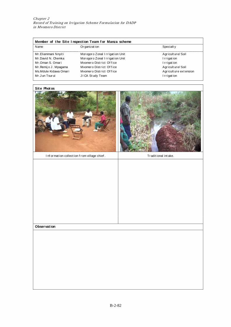
Chapter 2 Record of Training on Irrigation Scheme Formulation for DADP in Mvomero District
B-2-82
Member of the Site Inspection Team for Manza scheme Name Organization Specialty
Mr.Eliammani Nnyiti Mr.David N. Chemka Mr.Oman S. Omari Mr.Remijo J. Mpagama Ms.Mdule Kidawa Omari Mr.Jun Tsurui
Morogoro Zonal Irrigation Unit Morogoro Zonal Irrigation Unit Mvomero District Office Mvomero District Office Mvomero District Office JICA Study Team
Agriculture/Soil Irrigation Irrigation Agriculture/Soil Agriculture extension Irrigation
Site Photos
Information collection from village chief. Traditional intake.
Observation
Result of Scheme Formulation in Mvomero District
B-2-83
Record of Site Inspection Survey Sheet for Quick Site Inspection
1. General Information Surveyed Date: May 27, 2004 (1) Name of the scheme : Tangeni (2) Location (any point in the scheme) : Latitude: 6º55.711’S Longitude: 37º36.2 09.’E (3) Administration : Ward Mzumbe : Village(s) Tangeni
(4) Number of households : households/
2. Present Condition of the Potential Area (should be interviewed with villagers and confirmed by site visit) 2.1 Present Agricultural Conditions in the Potential Area
(1) Present condition : Not Cultivated Cultivated ( ha in average year)
(2) Present crops : Paddy Maize Vegetable Others ( Yams ) (3) Present markets : Inside the village ( 0 km from the site) (4) Drainage problem : No problem Partially affected Strongly affected
(5) Flood : Scarce Once a year More than twice a year
2.2 Existing Irrigation System
(1) Current irrigation system : Traditional Improved traditional
Modern Rainwater harvesting No irrigation
(2) Present irrigated area : 50 ha (if the scheme area is already irrigated)
(3) Main water resources : Perennial river Seasonal river Lake/Pond
Groundwater Spring Rain for water harvesting
(4) Name of the water source : Tangeni River 2.3 Existing Irrigators’ Association (IA) or Group Related with Irrigation
(1) Establishment of IA : Established in year Not established yet
(2) Name of the association : Several groups are responsible for water management.
(3) Registered year :
(4) Number of member : members 2.4 On-going support on irrigation development by government or some organization
(1) Type of support : Irrigation Facilities Others ( ) None
3. Village Proposed Plan by O&OD etc. (proposed development plan by village) 3.1 Irrigation System Development Plan
(1) Potential area : 200 ha
(2) Main water resources : Perennial river Seasonal river Lake/Pond
Groundwater Spring Rain for water harvesting
(3) Name of the water source : Tangeni River
(4) Water right : Granted Not granted yet Intended Not aware
(5) Required works : Rehabilitation New development
Improvement (from traditional to modern) Drainage improvement
(6) Irrigation type : Gravity Pump Rain water harvesting
(7) Water quality : No problem Anticipated to damage crop cultivation
X X
X X
X
X
X
X
X X X X
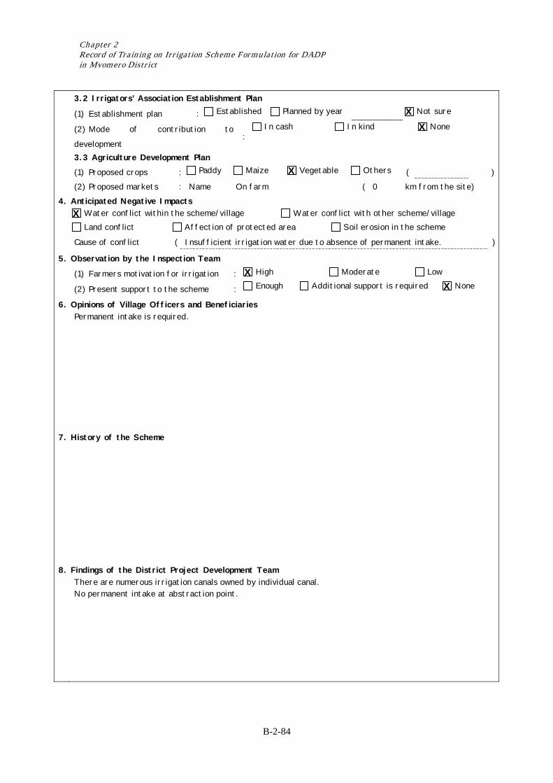
Chapter 2 Record of Training on Irrigation Scheme Formulation for DADP in Mvomero District
B-2-84
3.2 Irrigators’ Association Establishment Plan
(1) Establishment plan : Established Planned by year Not sure
(2) Mode of contribution to
development :
In cash In kind None
3.3 Agriculture Development Plan (1) Proposed crops : Paddy Maize Vegetable Others ( ) (2) Proposed markets : Name On farm ( 0 km from the site) 4. Anticipated Negative Impacts Water conflict within the scheme/village Water conflict with other scheme/village
Land conflict Affection of protected area Soil erosion in the scheme
Cause of conflict ( Insufficient irrigation water due to absence of permanent intake. )
5. Observation by the Inspection Team
(1) Farmers motivation for irrigation : High Moderate Low
(2) Present support to the scheme : Enough Additional support is required None
6. Opinions of Village Officers and Beneficiaries Permanent intake is required.
7. History of the Scheme
8. Findings of the District Project Development Team There are numerous irrigation canals owned by individual canal.
No permanent intake at abstraction point.
X X
X
X
X X
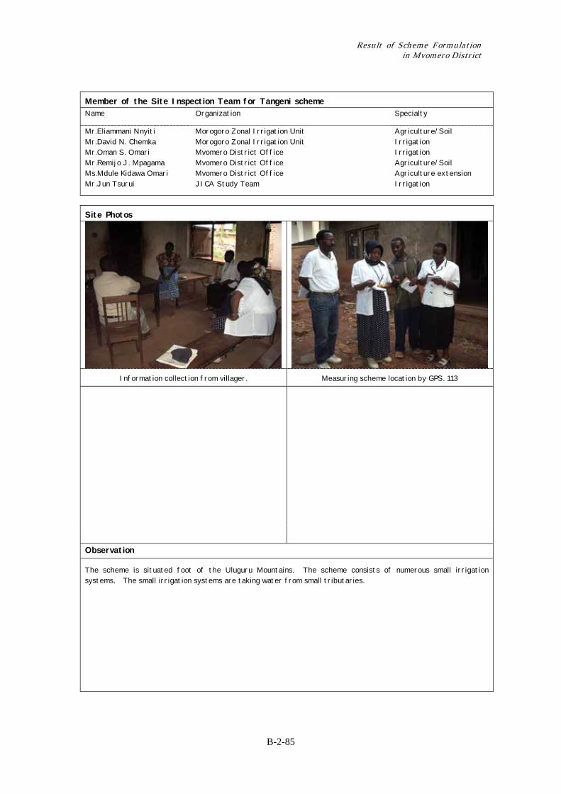
Result of Scheme Formulation in Mvomero District
B-2-85
Member of the Site Inspection Team for Tangeni scheme Name Organization Specialty
Mr.Eliammani Nnyiti Mr.David N. Chemka Mr.Oman S. Omari Mr.Remijo J. Mpagama Ms.Mdule Kidawa Omari Mr.Jun Tsurui
Morogoro Zonal Irrigation Unit Morogoro Zonal Irrigation Unit Mvomero District Office Mvomero District Office Mvomero District Office JICA Study Team
Agriculture/Soil Irrigation Irrigation Agriculture/Soil Agriculture extension Irrigation
Site Photos
Information collection from villager. Measuring scheme location by GPS. 113
Observation
The scheme is situated foot of the Uluguru Mountains. The scheme consists of numerous small irrigation systems. The small irrigation systems are taking water from small tributaries.

Chapter 2 Record of Training on Irrigation Scheme Formulation for DADP in Mvomero District
B-2-86
Record of Site Inspection Survey Sheet for Quick Site Inspection 1. General Information Surveyed Date: May 27, 2004 (1) Name of the scheme : Vikenge (2) Location (any point in the scheme) : Latitude: 6º54.933’S Longitude: 37º34.504.’E (3) Administration : Ward Mzumbe : Village(s) Vikenge
(4) Number of households : 1,400 households/
2. Present Condition of the Potential Area (should be interviewed with villagers and confirmed by site visit) 2.1 Present Agricultural Conditions in the Potential Area
(1) Present condition : Not Cultivated Cultivated ( ha in average year)
(2) Present crops : Paddy Maize Vegetable Others ( Yams ) (3) Present markets : Inside the village ( 0 km from the site) (4) Drainage problem : No problem Partially affected Strongly affected
(5) Flood : Scarce Once a year More than twice a year
2.2 Existing Irrigation System
(1) Current irrigation system : Traditional Improved traditional
Modern Rainwater harvesting No irrigation
(2) Present irrigated area : ha (if the scheme area is already irrigated)
(3) Main water resources : Perennial river Seasonal river Lake/Pond
Groundwater Spring Rain for water harvesting
(4) Name of the water source : Mgera /Lukulunge R. 2.3 Existing Irrigators’ Association (IA) or Group Related with Irrigation
(1) Establishment of IA : Established in year Not established yet
(2) Name of the association :
(3) Registered year :
(4) Number of member : members 2.4 On-going support on irrigation development by government or some organization
(1) Type of support : Irrigation Facilities Others ( ) None
3. Village Proposed Plan by O&OD etc. (proposed development plan by village) 3.1 Irrigation System Development Plan
(1) Potential area : 200 ha
(2) Main water resources : Perennial river Seasonal river Lake/Pond
Groundwater Spring Rain for water harvesting
(3) Name of the water source : Mgera/Lukulunge R.
(4) Water right : Granted Not granted yet Intended Not aware
(5) Required works : Rehabilitation New development
Improvement (from traditional to modern) Drainage improvement
(6) Irrigation type : Gravity Pump Rain water harvesting
(7) Water quality : No problem Anticipated to damage crop cultivation
X X X
X X
X
X
X
X
X
X X X
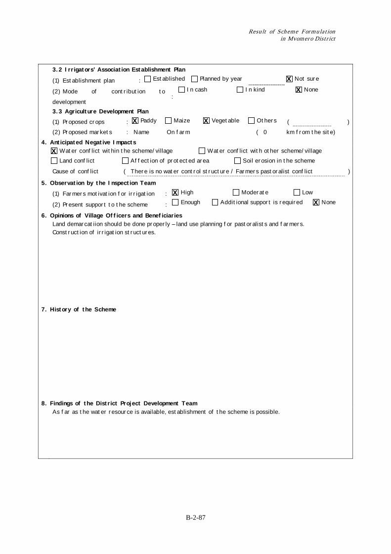
Result of Scheme Formulation in Mvomero District
B-2-87
3.2 Irrigators’ Association Establishment Plan
(1) Establishment plan : Established Planned by year Not sure
(2) Mode of contribution to
development :
In cash In kind None
3.3 Agriculture Development Plan (1) Proposed crops : Paddy Maize Vegetable Others ( ) (2) Proposed markets : Name On farm ( 0 km from the site) 4. Anticipated Negative Impacts Water conflict within the scheme/village Water conflict with other scheme/village
Land conflict Affection of protected area Soil erosion in the scheme
Cause of conflict ( There is no water control structure / Farmers pastoralist conflict )
5. Observation by the Inspection Team
(1) Farmers motivation for irrigation : High Moderate Low
(2) Present support to the scheme : Enough Additional support is required None
6. Opinions of Village Officers and Beneficiaries Land demarcatiion should be done properly – land use planning for pastoralists and farmers.
Construction of irrigation structures.
7. History of the Scheme
8. Findings of the District Project Development Team As far as the water resource is available, establishment of the scheme is possible.
X X
X X
X
X X
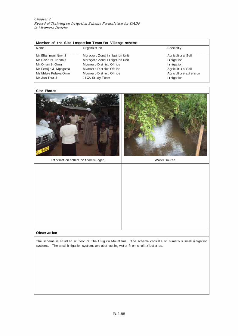
Chapter 2 Record of Training on Irrigation Scheme Formulation for DADP in Mvomero District
B-2-88
Member of the Site Inspection Team for Vikenge scheme Name Organization Specialty
Mr.Eliammani Nnyiti Mr.David N. Chemka Mr.Oman S. Omari Mr.Remijo J. Mpagama Ms.Mdule Kidawa Omari Mr.Jun Tsurui
Morogoro Zonal Irrigation Unit Morogoro Zonal Irrigation Unit Mvomero District Office Mvomero District Office Mvomero District Office JICA Study Team
Agriculture/Soil Irrigation Irrigation Agriculture/Soil Agriculture extension Irrigation
Site Photos
Information collection from villager. Water source.
Observation
The scheme is situated at foot of the Uluguru Mountains. The scheme consists of numerous small irrigation systems. The small irrigation systems are abstracting water from small tributaries.
Result of Scheme Formulation in Mvomero District
Record of Preliminary Planning (Step-5 and -6)

Result of Scheme Formulation in Mvomero District
Form-3 Survey Sheet for Interview Survey with Stakeholders (1/3) Sub-step 3(a) Present Conditions of Agriculture and Marketing Applicability The sub-step should be applied to all schemes. 1) Land Use in the Potential Area Scheme Name Komtonga Surveyed Date 15/6/2004 If the potential area is not clearly defined, agree with villagers on the potential area as village area,
basin area or other area. If the cultivated area is not clear, estimate from the total household number and the average holding size. The village extension officer should confirm the villagers’ answers in order to avoid odd data.
(1) Potential Area (ha): 140 ha (2) Cultivated Area within the Potential Area (ha): 140 ha (3) Present Irrigated Area in the cultivated Area (ha): 50 ha (4) Present Rainfed Area in the Cultivated Area (ha): 90 ha (5) Average Holding Size/Family in the Potential Area (ha): 1 ha (6) Total Household Number in the Potential Area: 589 2) Crop Production in the Potential Area Let the farmers select two major rainy and dry season crops grown in the potential area. As for the
yield and the price (farm gate price), ask farmers the maxima and minima in order to obtain average figures. Avoid any data for extraordinary years. The village extension officer should confirm the villagers’ answers in order to avoid odd data. * Unit for Yield: bags/acre and weight/bag for cereals (paddy/maize), kg/acre for vegetables ** Unit for Price: Tsh/bag and weight/bag for cereals (paddy/maize), Tsh/kg for vegetables
Rainy Season Dry Season (1) Name of Crops: Paddy Paddy
(2) Cropped Area (ha): 70 ha 50 ha
(3) Rainfed or Irrigated: Rainfed Irrigated
(4) Month of Land Preparation: Nov-Dec Aug-July
(5) Month of Harvest: April-May Dec-Nov
(6) Maximum Yield*: 1.2 ton/ha 2 ton/ha
Minimum Yield*: 0.8 ton/ha 1 ton/ha
Weight/bag (kg): (7) Maximum Price**: 208 Tsh/kg 160 Tsh/kg
Minimum Price**: 180 Tsh/kg 100 Tsh/kg
Weight/bag (kg): 3) Major Constraints to Crop Production Let the farmers select three major constraints to crop production in the potential area. Do not spend a
long time for discussion; just try to understand the level of irrigation needed for the scheme. (1) Poor drainage (2) Poor lay ut/water distributiono (3) Lack of cropping calendar 4) Farmers Supporting System Ask the following questions on technical assistance and extension services. (1) Technical Assistance X Available (extension) X Available (other party) Not on Irrigation available (2) Extension Services: X Satisfied Not satisfied (Reasons) 5) Input Supply for the Potential Area (1) Improved Seeds: In use: Amount X Not in Use: Reason Not available
(2) Chemical Fertilizers: In use: Amount X Not in Use: Reason Not affordable
B-2-89
Chapter 2 Record of Training on Irrigation Scheme Formulation for DADP in Mvomero District
(3) Agro-chemicals: In use: Amount X Not in Use: Reason Not affordable
(4) Agricultural Machinery: In use: Amount X Not in Use: Reason Poor drainage
6) Marketing System in the Potential Area (1) Market for Paddy: X Middleman X Local Market Town Market (2) Market for Vegetables: X Middleman X Local Market Town Market 7) Possibility of Group Purchasing and Selling Since group purchasing and selling of inputs and products seems important for future development, ask
the possibility in the future. High possibility through X Low possibility No possibility
B-2-90
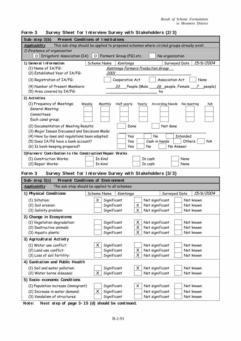
Result of Scheme Formulation in Mvomero District
Form-3 Survey Sheet for Interview Survey with Stakeholders (2/3) Sub-step 3(b) Present Conditions of Institutions Applicability This sub-step should be applied to proposed schemes where circled groups already exist. 1) Existence of organization O Irrigators’ Association (IA) O Farmers’ Group (FG) etc. No organization 1) General Information Scheme Name Komtonga Surveyed Date 15/6/2004 (1) Name of IA/FG: Komtonga Farmers Production Group (2) Established Year of IA/FG: 2001 (3) Registration of IA/FG: Cooperative Act Association Act None (4) Number of Present Members: 33 People (Male 26 people, Female 7 people) (5) Area covered by IA/FG: ha 2) Activities (1) Frequency of Meetings; Weekly Monthly Half yearly Yearly According Needs No meeting NA General Meeting: Committees: Each canal group: (2) Documentation of Meeting Results: Done Not done (3) Major Issues Discussed and Decisions Made: (4) Have by-laws and regulations been adopted: Yes No Intended (5) Does IA/FG have a bank account? Yes Cash in hands Others NA (6) Is book-keeping prepared? Yes No No Answer 3)Farmers’ Contribution to the Construction/Repair Works (1) Construction Works: In Kind In cash None (2) Repair Works: In kind In cash None
Form-3 Survey Sheet for Interview Survey with Stakeholders (3/3) Sub-step 3(c) Present Conditions of Environment Applicability The sub-step should be applied to all schemes. 1) Physical Conditions Scheme Name Komtonga Surveyed Date 15/6/2004 (1) Siltation: X Significant Not significant Not known (2) Soil erosion: Significant X Not significant Not known (3) Salinity problem: Significant X Not significant Not known 2) Change in Ecosystems (1) Vegetation degradation: Significant X Not significant Not known (2) Destructive animals: Significant X Not significant Not known (3) Aquatic plants: Significant X Not significant Not known 3) Agricultural Activity (1) Water use conflict: X Significant Not significant Not known (2) Land use conflict: Significant X Not significant Not known (3) Loss of soil fertility: Significant X Not significant Not known 4) Sanitation and Public Health (1) Soil and water pollution: Significant X Not significant Not known (2) Water borne diseases: X Significant Not significant Not known 5) Socio-economic Conditions (1) Population increase (immigrant) Significant X Not significant Not known (2) Increase in water demand: X Significant Not significant Not known (3) Vandalism of structures: Significant Not significant Not known Note: Next step of page 3-15 (d) should be continued.
B-2-91
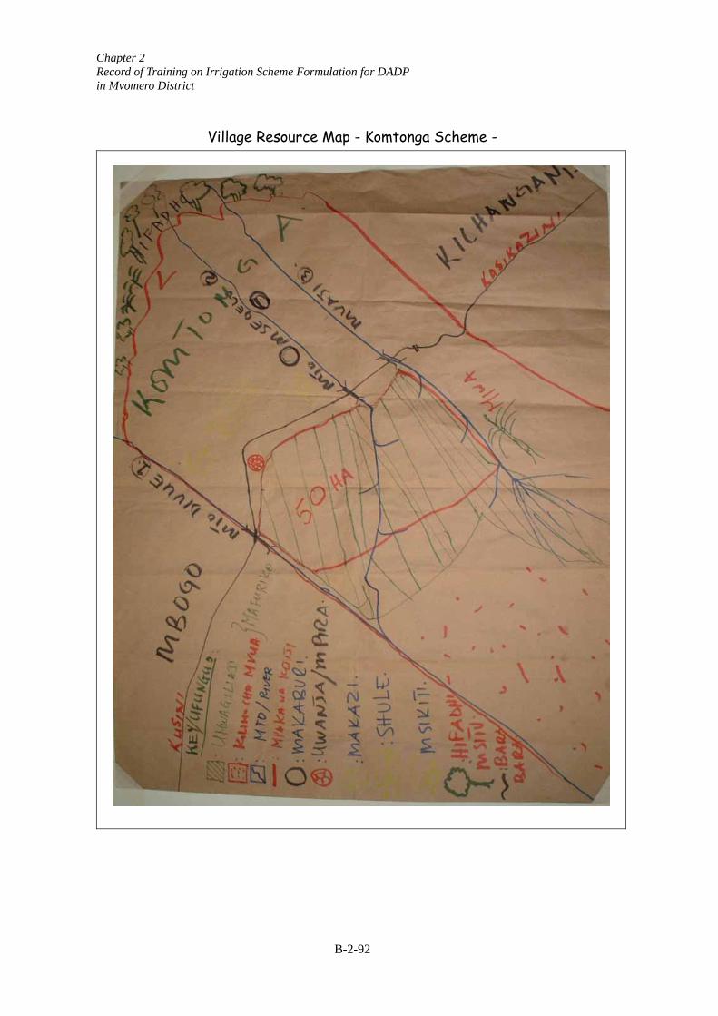
Chapter 2 Record of Training on Irrigation Scheme Formulation for DADP in Mvomero District
Village Resource Map - Komtonga Scheme -
B-2-92

Result of Scheme Formulation in Mvomero District
Form-4 Survey Sheet for Field Condition Confirmation (1/7)
Sub-step 1 Confirm Soil Texture of the Proposed area Applicability The sub-step can be skipped for non-circled type of scheme 1) Type of irrigation O Gravity O Pump (River) O Pump (Lake/pond) O Rain water harvesting 2) Type of irrigation development O Rehabilitation O Improvement O New Development O Extension Drainage Instruction Scheme Name Komtonga Surveyed Date 15/6/2004 1) Visit the survey together with village chief and villagers.
Visit the proposed area and choose typical soil in the area with the consultation of the village chairperson and villagers.
2) Sampling of the soil Gather a soil sample from the soil surface (sample should be about 10 x 10 x 10 cm).
3) Knead the soil with water. Add some water to the soil sample so it is moist but not wet. Knead it well. Pebbles should be removed.
4) Try to create ring shapes with the soil sample and choose the most advanced shape that can be made.
5) Evaluate the soil texture
According to the result of 4), circle one of the detailed soil texture types and choose a general soil texture type by conversion of the detailed soil texture type.
Detailed soil texture type conversion General soil texture type Shape A Sand if you choose Shape A Sand
A: Soil can only be shaped into a cone. No other shapes hold together. B: Soil can be formed into a circle, but not a rod shape. C: Soil can be formed into a stout rod shape. D: A thin rod (about 6 mm diameter) can be formed but not bent. E: Thin rod can be bent without breaking F: Circle can be formed with some breaks. G: Complete circle with no breaks can be formed.
Shape B Loamy sand Shape C Silty Loam
if you choose Shape B or C Sandy Loam
Shape D Loam X Shape E Clay Loam X
if you choose Shape D or E Clay Loam
Shape F Light Clay Shape G Heavy Clay
if you choose Shape F or G Clay
6) Notable Soil Characteristics If there are any notable soil characteristics such as high rock outcrop, shallow soil depth and symptom of salt accumulation, please note. Note:
B-2-93
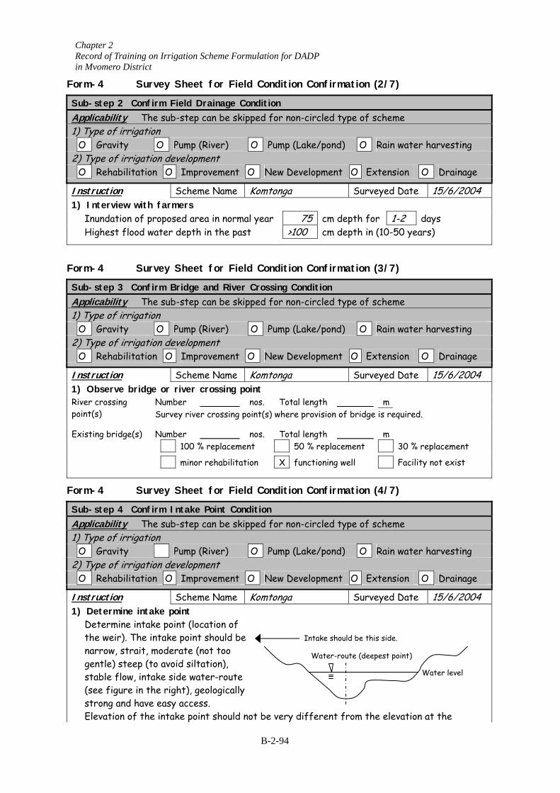
Chapter 2 Record of Training on Irrigation Scheme Formulation for DADP in Mvomero District
Form-4 Survey Sheet for Field Condition Confirmation (2/7)
Sub-step 2 Confirm Field Drainage Condition Applicability The sub-step can be skipped for non-circled type of scheme 1) Type of irrigation O Gravity O Pump (River) O Pump (Lake/pond) O Rain water harvesting 2) Type of irrigation development O Rehabilitation O Improvement O New Development O Extension O Drainage Instruction Scheme Name Komtonga Surveyed Date 15/6/2004 1) Interview with farmers
Inundation of proposed area in normal year 75 cm depth for 1-2 days Highest flood water depth in the past >100 cm depth in (10-50 years)
Form-4 Survey Sheet for Field Condition Confirmation (3/7)
Sub-step 3 Confirm Bridge and River Crossing Condition Applicability The sub-step can be skipped for non-circled type of scheme 1) Type of irrigation O Gravity O Pump (River) 2) Type of irrigation development O Rehabilitation O Improvement Instruction Scheme Name 1) Observe bridge or river crossing po
Number River crossing oint(s) p Survey river crossing po
Number 100 % replacemen minor rehabilitat
Existing bridge(s)
Form-4 Survey Sheet for Field
Sub-step 4 Confirm Intake Point CondApplicability The sub-step can be skip1) Type of irrigation O Gravity Pump (River) 2) Type of irrigation development O Rehabilitation O Improvement Instruction Scheme Name 1) Determine intake point
Determine intake point (location of the weir). The intake point should be narrow, strait, moderate (not too gentle) steep (to avoid siltation), stable flow, intake side water-route (see figure in the right), geologically strong and have easy access. Elevation of the intake point should n
O Pump (Lake/pond) O Rain water harvesting
O New Development O Extension O Drainage
Komtonga Surveyed Date 15/6/2004 int nos. Total length m int(s) where provision of bridge is required.
nos. Total length m t 50 % replacement 30 % replacement
ion X functioning well Facility not exist
Condition Confirmation (4/7)
ition ped for non-circled type of scheme
O Pump (Lake/pond) O Rain water harvesting
O New Development O Extension O Drainage
Komtonga Surveyed Date 15/6/2004
ot be very different from the elevation at the
Intake should be this side.
Water-route (deepest point)
Water level
B-2-94
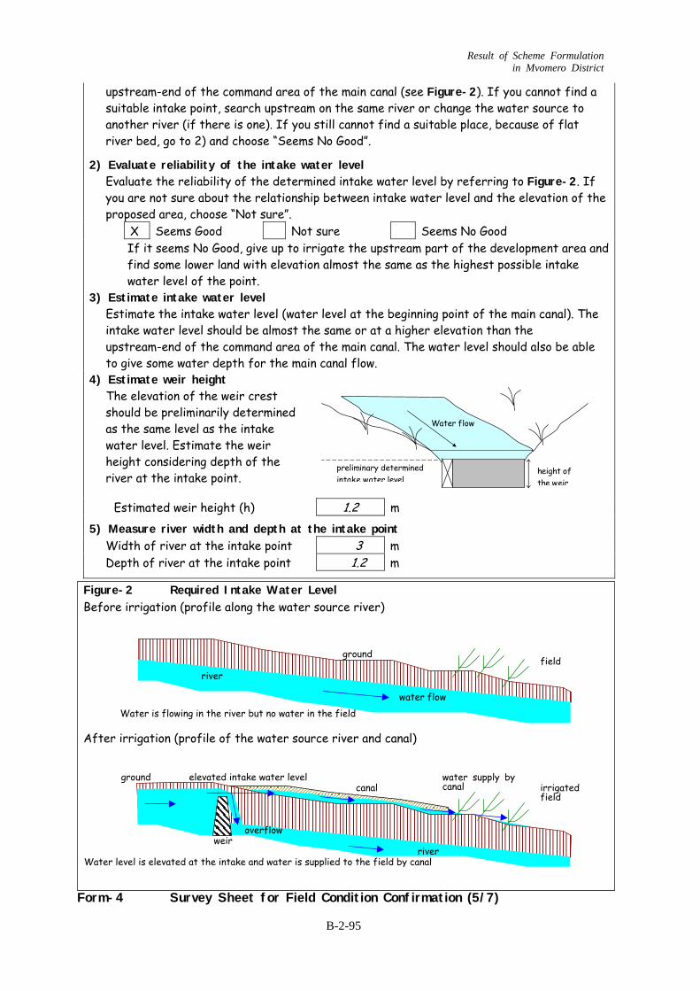
Result of Scheme Formulation in Mvomero District
upstream-end of the command area of the main canal (see Figure-2). If you cannot find a suitable intake point, search upstream on the same river or change the water source to another river (if there is one). If you still cannot find a suitable place, because of flat river bed, go to 2) and choose “Seems No Good”.
2) Evaluate reliability of the intake water level Evaluate the reliability of the determined intake water level by referring to Figure-2. If you are not sure about the relationship between intake water level and the elevation of the proposed area, choose “Not sure”. X Seems Good Not sure Seems No Good
If it seems No Good, give up to irrigate the upstream part of the development area and find some lower land with elevation almost the same as the highest possible intake water level of the point.
3) Estimate intake water level Estimate the intake water level (water level at the beginning point of the main canal). The intake water level should be almost the same or at a higher elevation than the upstream-end of the command area of the main canal. The water level should also be able to give some water depth for the main canal flow.
4) Estimate weir height The elevation of the weir crest should be preliminarily determined as the same level as the intake water level. Estimate the weir height considering depth of the river at the intake point.
Estimated weir height (h) 1.2 m 5) Measure river width and depth at the intake point
Width of river at the intake point 3 m Depth of river at the intake point 1.2 m
Figure-2 Required Intake Water Level Before irrigation (profile along the water source river)
After irrigation (profile of the water source river and canal)
Form-4 Survey Sheet for Field Condition Confirmation (5/7)
Water level is elevated at the intake and water is supplied to the field by canal
ground irrigated field
canal canal
weir river
overflow
water supply by elevated intake water level
ground field
river
Water is flowing in the river but no water in the field water flow
height ofthe weir
Water flow
preliminary determinedintake water level
B-2-95
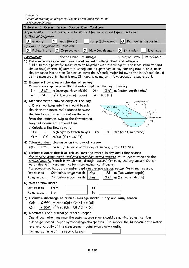
Chapter 2 Record of Training on Irrigation Scheme Formulation for DADP in Mvomero District Sub-step 5 onfirm Water Source River Condition CApplicability The sub-step can be skipped for non-circled type of scheme 1) Type of irr ation ig O Gravity O Pump (River) Pump (Lake/pond) O Rain water harvesting 2) Type of irrigation development O Rehabilitation O Improvement O New Develop O ment Extension Drainage Instruction Scheme Name Komtonga Surveyed Date 15/6/2004 1 easur e village chief
ur
) Determine mFind a su
ement point togt for measurem
ther withnt togethe
and villagers lagers. The measitable poin e r with the vil
should be a) narrow, b) strait, c) steep, and d) upstream of any existing intaement point
ke, or e) near the proposed intake site. In case of pump (lake/pond), major inflow to the lake/pond shouldbe the measured, if there is any. If there is no major inflow, proceed to sub-step 3.
2) Estimate flow area on the day of survey Measure average river width and water depth on the day of survey.
B = 3.15 m (average river width) Dt= 0.45 m (water depth today) At= 2 B x t)1.42 m (flow area of today) (At = D 3) M re er y easu wat flow velocity of the da
a) Drive two twigs into the ground beside the river at a measured distance between the two twigs. b) Float a leaf on the water from the upstream twig to the downstream twig and measure the travel time. c) Calculate the flow velocity.
leaf upsteram twig
downsteramtwig
B d
Water flow
twigs) Tt= 5 sec (consumed time) Ls = 3 m (length between Vt = 0.6 m/sec (V t = Ls/ Tt) 4) C te r of su vey alcula rive discharge on the day r Qt= 0.852 m/sec (discharge on the day of survey) (Qt = At x Vt) 5) Estimate water ason depth at critical/average month in dry and rainy se
For gravity, pump (river) and rain water harvesting scheme, ask villagers when are the critical months (month in which most drought occurs) for rainy and dry season. Obtain water depth in those months by interviewing the villagers. For pump irrigation, obtain water depth in average discharge months in each season.
D ry season Critical/average month Sep 0.3 m (Dd; water depth) Rainy season 0 Critical/average month May .45 m (Dr; water depth) 6) m Water flow onth Dry season from to Rainy season from to 7) c ical/average month in dry and rainy season Estimate dis harge at crit Qd= 0.568 m3/sec (Qd = Qt / Dt x Dd) Qr= 0.852 m /sec (Qr = Qt / Dt x Dr) 3 8) Nominate river discharge record keeper
One villager who lives near the water source river should be nominated as the river ater discharge record keeper by the village chairperson. The keeper should measure the w
level and velocity of the measurement point once every month. Nominated name of the record keeper
B-2-96
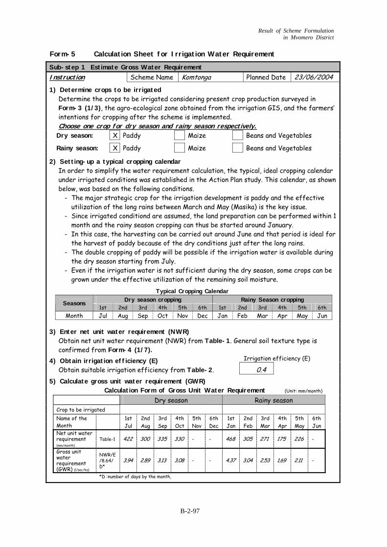
Result of Scheme Formulation in Mvomero District
Form-5 Calculation Sheet for Irrigation Water Requirement
Sub-step 1 Estimate Gross Water Requirement Instruction Scheme Name Komtonga Planned Date 23/06/2004 1) Determine crops to be irrigated
Determine the crops to be irrigated considering present crop production surveyed in Form-3 (1/3), the agro-ecological zone obtained from the irrigation GIS, and the farmers’ intentions for cropping after the scheme is implemented. Choose one crop for dry season and rainy season respectively.Dry season: X Paddy Maize Beans and Vegetables Rainy season: X Paddy Maize Beans and Vegetables
2) Setting-up a typical cropping calendar In order to simplify the water requirement calculation, the typical, ideal cropping calendar under irrigated conditions was established in the Action Plan study. This calendar, as shown below, was based on the following conditions.
- The major strategic crop for the irrigation development is paddy and the effective utilization of the long rains between March and May (Masika) is the key issue.
- Since irrigated conditiond are assumed, the land preparation can be performed within 1 month and the rainy season cropping can thus be started around January.
- In this case, the harvesting can be carried out around June and that period is ideal for the harvest of paddy because of the dry conditions just after the long rains.
- The double cropping of paddy will be possible if the irrigation water is available during the dry season starting from July.
- Even if the irrigation water is not sufficient during the dry season, some crops can be grown under the effective utilization of the remaining soil moisture.
Typical Cropping Calendar Dry season cropping Rainy Season cropping Seasons
1st 2nd 3rd 4th 5th 6th 1st 2nd 3rd 4th 5th 6th Month Jul Aug Sep Oct Nov Dec Jan Feb Mar Apr May Jun
3) Enter net unit water requirement (NWR)
Obtain net unit water requirement (NWR) from Table-1. General soil texture type is confirmed from Form-4 (1/7).
Irrigation efficiency (E) 4) Obtain irrigation efficiency (E)
Obtain suitable irrigation efficiency from Table-2. 0.4 5) Calculate gross unit water requirement (GWR)
Calculation Form of Gross Unit Water Requirement (Unit: mm/month) Dry season Rainy season Crop to be irrigated 1st 2nd 3rd 4th 5th 6th 1st 2nd 3rd 4th 5th 6th
Name of the Month
Jul Aug Sep Oct Nov Dec Jan Feb Mar Apr May Jun
Net unit water requirement (mm/month)
Table-1 422 300 335 330 - - 468 305 271 175 226 -
Gross unit water requirement (GWR) (l/sec/ha)
NWR/E/8.64/ D*
3.94 2.89 3.13 3.08 - - 4.37 3.04 2.53 1.69 2.11 -
*D :number of days by the month,
B-2-97
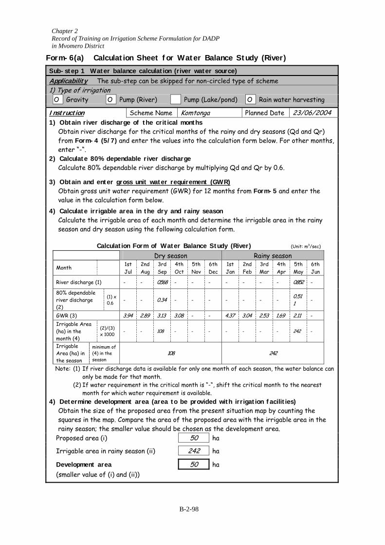
Chapter 2 Record of Training on Irrigation Scheme Formulation for DADP in Mvomero District
Form-6(a) Calculation Sheet for Water Balance Study (River) Sub-step 1 Water balance calculation (river water source) Applicability The sub-step can be skipped for non-circled type of scheme 1) Type of irrigation O Gravity O Pump (River) Pump (Lake/pond) O Rain water harvesting Instruction Scheme Name Komtonga Planned Date 23/06/2004 1) Obtain river discharge of the critical months
Obtain river discharge for the critical months of the rainy and dry seasons (Qd and Qr) from Form-4 (5/7) and enter the values into the calculation form below. For other months, enter “-“.
2) Calculate 80% dependable river discharge Calculate 80% dependable river discharge by multiplying Qd and Qr by 0.6.
3) Obtain and enter gross unit water requirement (GWR)Obtain gross unit water requirement (GWR) for 12 months from Form-5 and enter the value in the calculation form below.
4) Calculate irrigable area in the dry and rainy season Calculate the irrigable area of each month and determine the irrigable area in the rainy season and dry sea
Calcu
Month
River discharge (1)
80% dependable river discharge (2)
(1) 0.6
GWR (3)
Irrigable Area (ha) in the month (4)
(2)/(3x 1000
Irrigable Area (ha) in the season
minimum o(4) in the season
Note: (1) If river disonly be mad
(2) If water remonth for w
4) Determine develoObtain the size ofsquares in the maprainy season; the s
Proposed area (i) Irrigable area in ra Development area (smaller value of (i)
son using the following calculation form.
lation Form of Water Balance Study (River) (Unit: m3/sec) Dry season Rainy season
1st 2nd 3rd 4th 5th 6th 1st 2nd 3rd 4th 5th 6th
Jul Aug Sep Oct Nov Dec Jan Feb Mar Apr May Jun
- - 0.568 - - - - - - - 0.852 -
x - - 0.34 - - - - - - - 0.51
1 -
3.94 2.89 3.13 3.08 - - 4.37 3.04 2.53 1.69 2.11 -
) - - 108 - - - - - - - 242 -
f 108 242
charge data is available for only one month of each season, the water balance can e for that month. quirement in the critical month is “-“, shift the critical month to the nearest hich water requirement is available. pment area (area to be provided with irrigation facilities) the proposed area from the present situation map by counting the . Compare the area of the proposed area with the irrigable area in the maller value should be chosen as the development area.
50 ha
iny season (ii) 242 ha
50 ha and (ii))
B-2-98
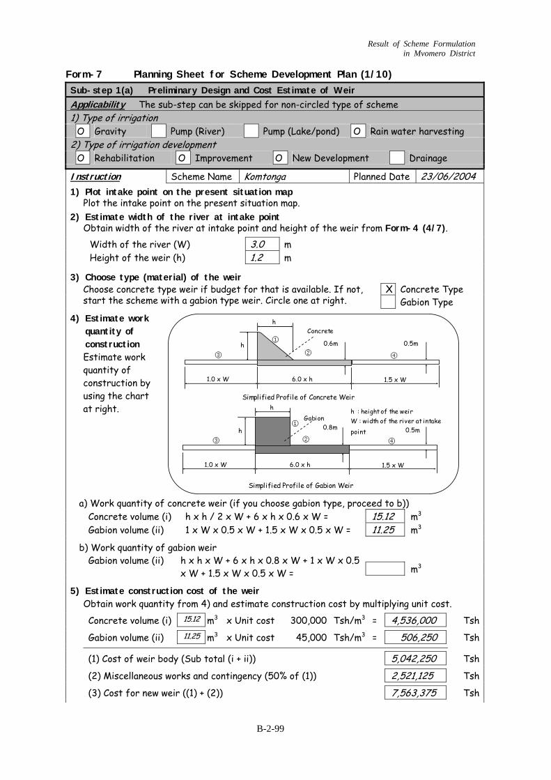
Result of Scheme Formulation in Mvomero District
Form-7 Planning Sheet for Scheme Development Plan (1/10) Sub-step 1(a) Preliminary Design and Cost Estimate of Weir Applicability The sub-step can be skipped for non-circled type of scheme 1) Type of irrigation O Gravity Pump (River) Pump (Lake/pond) O Rain water harvesting 2) Type of irrigation development O Rehabilitation O Improvement O New Development Drainage Instruction Scheme Name Komtonga Planned Date 23/06/2004 1) Plot intake point on the present situation map
Plot the intake point on the present situation map. 2) Estimate width of the river at intake point
Obtain width of the river at intake point and height of the weir from Form-4 (4/7). Width of the river (W) 3.0 m Height of the weir (h) 1.2 m 3) Choose type (material) of the weir
X Concrete Type Choose concrete type weir if budget for that is available. If not, start the scheme with a gabion type weir. Circle one at right. Gabion Type
4) Estimate work quantity of construction Estimate work quantity of construction by using the chart at right.
a) Work quantity of concrete weir (if you choose gabion type, proceed to b)) Concrete volume (i) h x h / 2 x W + 6 x h x 0.6 x W = 15.12 m3
Gabion volume (ii) 1 x W x 0.5 x W + 1.5 x W x 0.5 x W = 11.25 m3
b) Work quantity of gabion weir m3
Gabion volume (ii) h x h x W + 6 x h x 0.8 x W + 1 x W x 0.5 x W + 1.5 x W x 0.5 x W =
5) Estimate construction cost of the weir Obtain work quantity from 4) and estimate construction cost by multiplying unit cost.
Concrete volume (i) 15.12 m3 x Unit cost 300,000 Tsh/m3 = 4,536,000 Tsh Gabion volume (ii) 11.25 m3 x Unit cost 45,000 Tsh/m3 = 506,250 Tsh (1) Cost of weir body (Sub total (i + ii)) 5,042,250 Tsh (2) Miscellaneous works and contingency (50% of (1)) 2,521,125 Tsh (3) Cost for new weir ((1) + (2)) 7,563,375 Tsh
h
h
6.0 x h
0.6m
1.0 x W 1.5 x W
①
②③ ④
hSimplified Profile of Concrete Weir
Simplified Profile of Gabion Weir
h
6.0 x h
0.8m
1.0 x W 1.5 x W
①
②③ ④
h : height of the weirW : width of the river at intakepoint
0.5m
0.5m
Concrete
Gabion
B-2-99
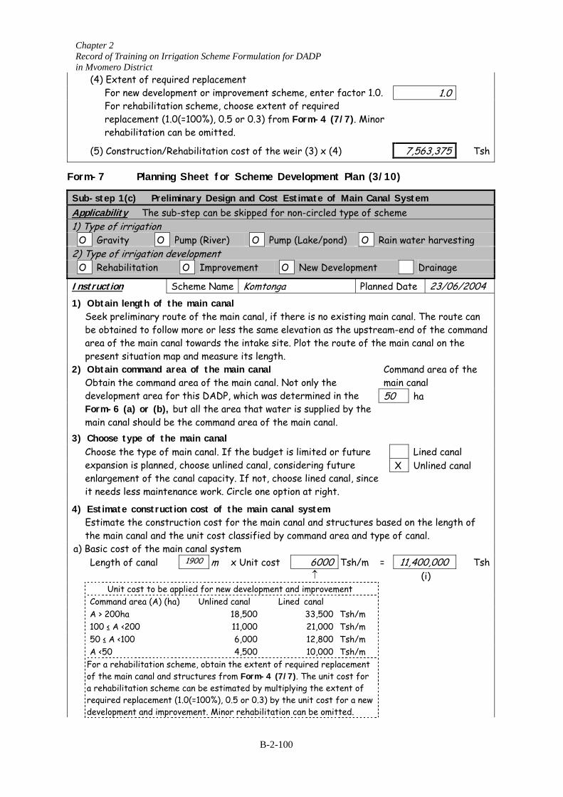
Chapter 2 Record of Training on Irrigation Scheme Formulation for DADP in Mvomero District
1.0
(4) Extent of required replacement For new development or improvement scheme, enter factor 1.0. For rehabilitation scheme, choose extent of required replacement (1.0(=100%), 0.5 or 0.3) from Form-4 (7/7). Minor rehabilitation can be omitted.
(5) Construction/Rehabilitation cost of the weir (3) x (4) 7,563,375 Tsh
Form-7 Planning Sheet for Scheme Development Plan (3/10)
Sub-step 1(c) Preliminary Design and Cost Estimate of Main Canal System Applicability The sub-step can be skipped for non-circled type of scheme 1) Type of irrigation O Gravity O Pump (River) O Pump (Lake/pond) O Rain water harvesting 2) Type of irrigation development O Rehabilitation O Improvement O New Development Drainage Instruction Scheme Name Komtonga Planned Date 23/06/2004 1) Obtain length of the main canal
Seek preliminary route of the main canal, if there is no existing main canal. The route can be obtained to follow more or less the same elevation as the upstream-end of the command area of the main canal towards the intake site. Plot the route of the main canal on the present situation map and measure its length.
Command area of the main canal 50 ha
2) Obtain command area of the main canal Obtain the command area of the main canal. Not only the development area for this DADP, which was determined in the Form-6 (a) or (b), but all the area that water is supplied by the main canal should be the command area of the main canal.
3) Choose type of the main canal
Lined canal X Unlined canal
Choose the type of main canal. If the budget is limited or future expansion is planned, choose unlined canal, considering future enlargement of the canal capacity. If not, choose lined canal, since it needs less maintenance work. Circle one option at right.
4) Estimate construction cost of the main canal system
Estimate the construction cost for the main canal and structures based on the length of the main canal and the unit cost classified by command area and type of canal.
a) Basic cost of the main canal system Length of canal 1900 m x Unit cost 6000 Tsh/m = 11,400,000 Tsh
↑ (i) Unit cost to be applied for new development and improvement Command area (A) (ha) Unlined canal Lined canal A > 200ha 18,500 33,500 Tsh/m 100 ≤ A <200 11,000 21,000 Tsh/m 50 ≤ A <100 6,000 12,800 Tsh/m A <50 4,500 10,000 Tsh/m For a rehabilitation scheme, obtain the extent of required replacement
of the main canal and structures from Form-4 (7/7). The unit cost for a rehabilitation scheme can be estimated by multiplying the extent of required replacement (1.0(=100%), 0.5 or 0.3) by the unit cost for a new development and improvement. Minor rehabilitation can be omitted.
B-2-100
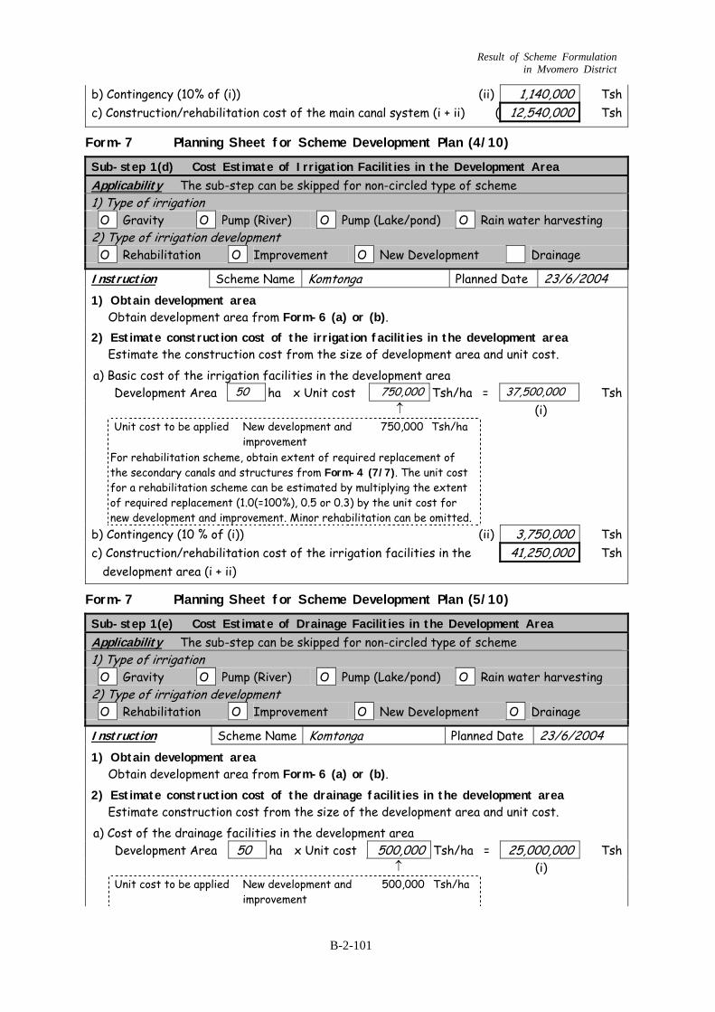
Result of Scheme Formulation in Mvomero District
b) Contingency (10% of (i)) (ii) 1,140,000 Tsh c) Construction/rehabilitation cost of the main canal system (i + ii) ( 12,540,000 Tsh
Form-7 Planning Sheet for Scheme Development Plan (4/10)
Sub-step 1(d) Cost Estimate of Irrigation Facilities in the Development Area Applicability The sub-step can be skipped for non-circled type of scheme 1) Type of irrigation O Gravity O Pump (River) O Pump (Lake/pond) O Rain water harvesting 2) Type of irrigation development O Rehabilitation O Improvement O New Development Drainage Instruction Scheme Name Komtonga Planned Date 23/6/2004 1) Obtain development area
Obtain development area from Form-6 (a) or (b). 2) Estimate construction cost of the irrigation facilities in the development area
Estimate the construction cost from the size of development area and unit cost. a) Basic cost of the irrigation facilities in the development area Development Area 50 ha x Unit cost 750,000 Tsh/ha = 37,500,000 Tsh
↑ (i) Unit cost to be applied New development and
improvement 750,000 Tsh/ha
For rehabilitation scheme, obtain extent of required replacement of the secondary canals and structures from Form-4 (7/7). The unit cost for a rehabilitation scheme can be estimated by multiplying the extent of required replacement (1.0(=100%), 0.5 or 0.3) by the unit cost for new development and improvement. Minor rehabilitation can be omitted.
b) Contingency (10 % of (i)) (ii) 3,750,000 Tsh c) Construction/rehabilitation cost of the irrigation facilities in the 41,250,000 Tsh
development area (i + ii)
Form-7 Planning Sheet for Scheme Development Plan (5/10)
Sub-step 1(e) Cost Estimate of Drainage Facilities in the Development Area Applicability The sub-step can be skipped for non-circled type of scheme 1) Type of irrigation O Gravity O Pump (River) O Pump (Lake/pond) O Rain water harvesting 2) Type of irrigation development O Rehabilitation O Improvement O New Development O Drainage Instruction Scheme Name Komtonga Planned Date 23/6/2004 1) Obtain development area
Obtain development area from Form-6 (a) or (b). 2) Estimate construction cost of the drainage facilities in the development area
Estimate construction cost from the size of the development area and unit cost. a) Cost of the drainage facilities in the development area Development Area 50 ha x Unit cost 500,000 Tsh/ha = 25,000,000 Tsh
↑ (i) Unit cost to be applied New development and
improvement 500,000 Tsh/ha
B-2-101
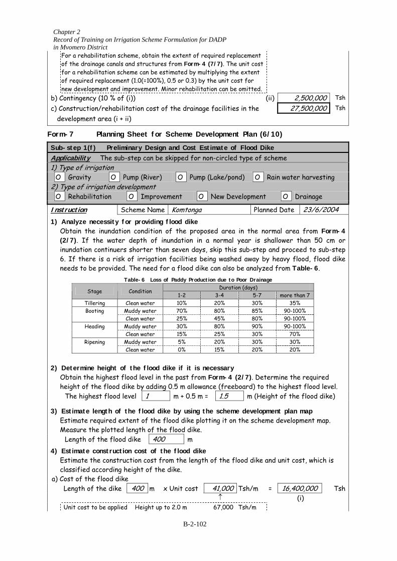
Chapter 2 Record of Training on Irrigation Scheme Formulation for DADP in Mvomero District
For a rehabilitation scheme, obtain the extent of required replacement of the drainage canals and structures from Form-4 (7/7). The unit cost for a rehabilitation scheme can be estimated by multiplying the extent of required replacement (1.0(=100%), 0.5 or 0.3) by the unit cost for new development and improvement. Minor rehabilitation can be omitted.
b) Contingency (10 % of (i)) (ii) 2,500,000 Tsh
c) Construction/rehabilitation cost of the drainage facilities in the 27,500,000 Tsh
development area (i + ii)
Form-7 Planning Sheet for Scheme Development Plan (6/10)
Sub-step 1(f) Preliminary Design and Cost Estimate of Flood Dike Applicability The sub-step can be skipped for non-circled type of scheme 1) Type of irrigation O Gravity O Pump (River) O Pump (Lake/pond) O Rain water harvesting 2) Type of irrigation development O Rehabilitation O Improvement O New Development O Drainage Instruction Scheme Name Komtonga Planned Date 23/6/2004 1) Analyze necessity for providing flood dike
Obtain the inundation condition of the proposed area in the normal area from Form-4 (2/7). If the water depth of inundation in a normal year is shallower than 50 cm or inundation continuers shorter than seven days, skip this sub-step and proceed to sub-step 6. If there is a risk of irrigation facilities being washed away by heavy flood, flood dike needs to be provided. The need for a flood dike can also be analyzed from Table-6.
Table-6 Loss of Paddy Production due to Poor Drainage Duration (days) Stage Condition
1-2 3-4 5-7 more than 7 Tillering Clean water 10% 20% 30% 35%
Muddy water 70% 80% 85% 90-100% Booting Clean water 25% 45% 80% 90-100%
Muddy water 30% 80% 90% 90-100% Heading Clean water 15% 25% 30% 70%
Muddy water 5% 20% 30% 30% Ripening Clean water 0% 15% 20% 20%
2) Determine height of the flood dike if it is necessary
Obtain the highest flood level in the past from Form-4 (2/7). Determine the required height of the flood dike by adding 0.5 m allowance (freeboard) to the highest flood level.
The highest flood level 1 m + 0.5 m = 1.5 m (Height of the flood dike) 3) Estimate length of the flood dike by using the scheme development plan map
Estimate required extent of the flood dike plotting it on the scheme development map. Measure the plotted length of the flood dike.
Length of the flood dike 400 m 4) Estimate construction cost of the flood dike
Estimate the construction cost from the length of the flood dike and unit cost, which is classified according height of the dike.
a) Cost of the flood dike Length of the dike 400 m x Unit cost 41,000 Tsh/m = 16,400,000 Tsh
↑ (i) Unit cost to be applied Height up to 2.0 m 67,000 Tsh/m
B-2-102
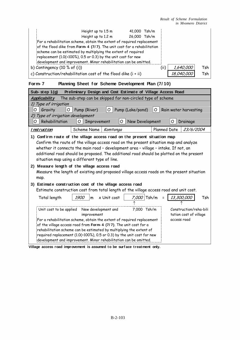
Result of Scheme Formulation in Mvomero District
Height up to 1.5 m 41,000 Tsh/m Height up to 1.2 m 26,000 Tsh/m
For a rehabilitation scheme, obtain the extent of required replacement of the flood dike from Form-4 (7/7). The unit cost for a rehabilitation scheme can be estimated by multiplying the extent of required replacement (1.0(=100%), 0.5 or 0.3) by the unit cost for new development and improvement. Minor rehabilitation can be omitted.
b) Contingency (10 % of (i)) (ii) 1,640,000 Tsh c) Construction/rehabilitation cost of the flood dike (i + ii) 18,040,000 Tsh
Form-7 Planning Sheet for Scheme Development Plan (7/10)
Sub-step 1(g) Preliminary Design and Cost Estimate of Village Access Road Applicability The sub-step can be skipped for non-circled type of scheme 1) Type of irrigation O Gravity O Pump (River) O Pump (Lake/pond) O Rain water harvesting 2) Type of irrigation development O Rehabilitation O Improvement O New Development O Drainage Instruction Scheme Name Komtonga Planned Date 23/6/2004 1) Confirm route of the village access road on the present situation map
Confirm the route of the village access road on the present situation map and analyze whether it connects the main road – development area – village – intake. If not, an additional road should be proposed. The additional road should be plotted on the present situation map using a different type of line.
2) Measure length of the village access road Measure the length of existing and proposed village access roads on the present situation map.
3) Estimate construction cost of the village access road Estimate construction cost from total length of the village access road and unit cost.
Total length 1900 m x Unit cost 7,000 Tsh/m = 13,300,000 Tsh ↑ ↑ Unit cost to be applied New development and
improvement 7,000 Tsh/m
For a rehabilitation scheme, obtain the extent of required replacement of the village access road from Form-4 (7/7). The unit cost for a rehabilitation scheme can be estimated by multiplying the extent of required replacement (1.0(=100%), 0.5 or 0.3) by the unit cost for new development and improvement. Minor rehabilitation can be omitted.
Construction/reha-bilitation cost of village access road
Village access road improvement is assumed to be surface treatment only.
B-2-103
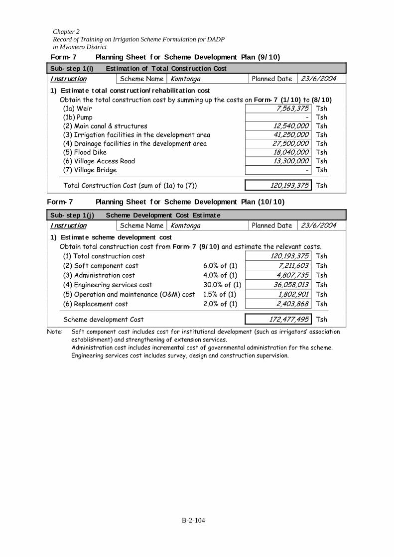
Chapter 2 Record of Training on Irrigation Scheme Formulation for DADP in Mvomero District
Form-7 Planning Sheet for Scheme Development Plan (9/10) Sub-step 1(i) Estimation of Total Construction Cost Instruction Scheme Name Komtonga Planned Date 23/6/2004 1) Estimate total construction/rehabilitation cost
Obtain the total construction cost by summing up the costs on Form-7 (1/10) to (8/10) (1a) Weir 7,563,375 Tsh (1b) Pump - Tsh (2) Main canal & structures 12,540,000 Tsh (3) Irrigation facilities in the development area 41,250,000 Tsh (4) Drainage facilities in the development area 27,500,000 Tsh (5) Flood Dike 18,040,000 Tsh (6) Village Access Road 13,300,000 Tsh (7) Village Bridge - Tsh Total Construction Cost (sum of (1a) to (7)) 120,193,375 Tsh
Form-7 Planning Sheet for Scheme Development Plan (10/10)
Sub-step 1(j) Scheme Development Cost Estimate Instruction Scheme Name Komtonga Planned Date 23/6/2004 1) Estimate scheme development cost
Obtain total construction cost from Form-7 (9/10) and estimate the relevant costs. (1) Total construction cost 120,193,375 Tsh (2) Soft component cost 6.0% of (1) 7,211,603 Tsh (3) Administration cost 4.0% of (1) 4,807,735 Tsh (4) Engineering services cost 30.0% of (1) 36,058,013 Tsh (5) Operation and maintenance (O&M) cost 1.5% of (1) 1,802,901 Tsh (6) Replacement cost 2.0% of (1) 2,403,868 Tsh Scheme development Cost 172,477,495 Tsh
Note: Soft component cost includes cost for institutional development (such as irrigators’ association establishment) and strengthening of extension services.
Administration cost includes incremental cost of governmental administration for the scheme. Engineering services cost includes survey, design and construction supervision.
B-2-104
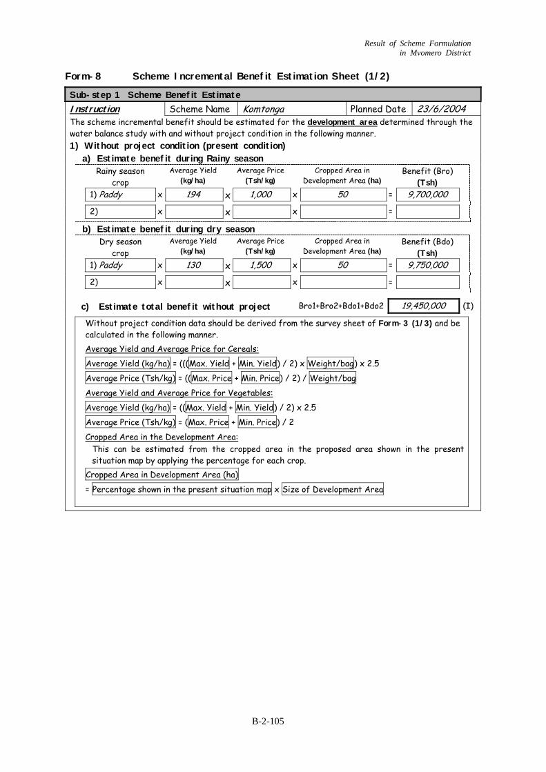
Result of Scheme Formulation in Mvomero District
Form-8 Scheme Incremental Benefit Estimation Sheet (1/2)
Sub-step 1 Scheme Benefit Estimate Instruction Scheme Name Komtonga Planned Date 23/6/2004 The scheme incremental benefit should be estimated for the development area determined through the water balance study with and without project condition in the following manner. 1) Without project condition (present condition)
a) Estimate benefit during Rainy season Rainy season
crop Average Yield
(kg/ha) Average Price
(Tsh/kg) Cropped Area in
Development Area (ha) Benefit (Bro)
(Tsh)
1) Paddy x 194 x 1 00,0 x 50 = 9,700,000 2) x x x =
b) Estimate benefit during dry season Dry season
crop Average Yield
(kg/ha) Average Price
(Tsh/kg) Cropped Area in
Development Area (ha) Benefit (Bdo)
(Tsh)
1) Paddy x 130 x 1 00,5 x 50 = 9,750,000 2) x x x = c) Estimate total benefit without project Bro1+Bro2+Bdo1+Bdo2 19,450,000 (I)
Without project condition data should be derived from the survey sheet of Form-3 (1/3) and be calculated in the following manner. Average Yield and Average Price for Cereals:
Average Yield (kg/ha) = (((Max. Yield + Min. Yield) / 2) x Weight/bag) x 2.5
Average Price (Tsh/kg) = ((Max. Price + Min. Price) / 2) / Weight/bag
Average Yield and Average Price for Vegetables:
Average Yield (kg/ha) = ((Max. Yield + Min. Yield) / 2) x 2.5
Average Price (Tsh/kg) = (Max. Price + Min. Price) / 2
Cropped Area in the Development Area: This can be estimated from the cropped area in the proposed area shown in the present situation map by applying the percentage for each crop.
Cropped Area in Development Area (ha)
= Percentage shown in the present situation map x Size of Development Area
B-2-105
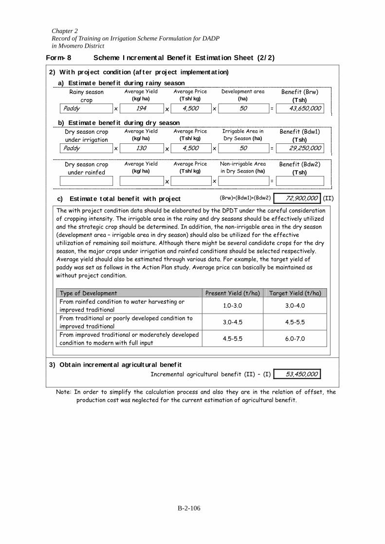
Chapter 2 Record of Training on Irrigation Scheme Formulation for DADP in Mvomero District
Form-8 Scheme Incremental Benefit Estimation Sheet (2/2) 2) With project condition (after project implementation)
a) Estimate benefit during rainy season Rainy season
crop Average Yield
(kg/ha) Average Price
(Tsh/kg) Development area
(ha) Benefit (Brw)
(Tsh)
Paddy x 194 x 4,500 x 50 = 43,650,000
b) Estimate benefit during dry season Dry season crop
under irr ion Average Yield
(kg/ha) Average Price
(Tsh/kg) Irrigable Area in
Dry Season (ha) Benefit (Bdw1)
(Tsh)
Paddy Dry seaso
under ra c) Estima The with pro
of cropping iand the stra(developmenutilization ofseason, the mAverage yielpaddy was sewithout proj
Type of DeFrom rainfeimproved trFrom traditimproved trFrom improcondition to
3) Obtain inc Note: In ord
produ
igat
x 130n crop infed
Average Yie(kg/ha)
te total benefit with
ject condition data shontensity. The irrigable tegic crop should be det area – irrigable area in remaining soil moistureajor crops under irriga
d should also be estimatt as follows in the Actiect condition.
velopment d condition to water haaditional ional or poorly developeaditional ved traditional or mode modern with full input
remental agriculturaI
er to simplify the calction cost was neglecte
x 4,500 x 50 = 29,250,000
ld Average Price (Tsh/kg)
Non-irrigable Area in Dry Season (ha)
Benefit (Bdw2) (Tsh)
x x =
project (Brw)+(Bdw1)+(Bdw2) 72,900,000 (II)
uld be elaborated by the DPDT under the careful consideration area in the rainy and dry seasons should be effectively utilized termined. In addition, the non-irrigable area in the dry season dry season) should also be utilized for the effective . Although there might be several candidate crops for the dry tion and rainfed conditions should be selected respectively. ed through various data. For example, the target yield of
on Plan study. Average price can basically be maintained as
Present Yield (t/ha) Target Yield (t/ha) rvesting or 1.0-3.0 3.0-4.0
d condition to 3.0-4.5 4.5-5.5
rately developed 4.5-5.5 6.0-7.0
l benefit ncremental agricultural benefit (II) – (I) 53,450,000
culation process and also they are in the relation of offset, the d for the current estimation of agricultural benefit.
B-2-106
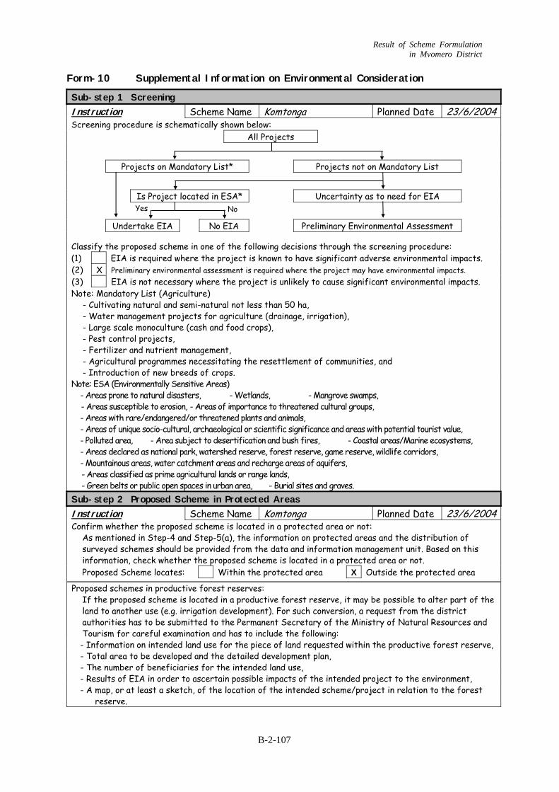
Result of Scheme Formulation in Mvomero District
Form-10 Supplemental Information on Environmental Consideration
Sub-step 1 Screening Instruction Scheme Name Komtonga Planned Date 23/6/2004 Screening procedure is schematically shown below: All Projects
Projects on Mandatory List* Projects not on Mandatory List
Is Project located in ESA* Uncertainty as to need for EIA
Undertake EIA No EIA Preliminary Environmental Assessment Classify the proposed scheme in one of the following decisions through the screening procedure: (1) EIA is required where the project is known to have significant adverse environmental impacts. (2) X Preliminary environmental assessment is required where the project may have environmental impacts. (3) EIA is not necessary where the project is unlikely to cause significant environmental impacts. Note: Mandatory List (Agriculture)
- Cultivating natural and semi-natural not less than 50 ha, - Water management projects for agriculture (drainage, irrigation), - Large scale monoculture (cash and food crops), - Pest control projects, - Fertilizer and nutrient management, - Agricultural programmes necessitating the resettlement of communities, and - Introduction of new breeds of crops.
Note: ESA (Environmentally Sensitive Areas) - Areas prone to natural disasters, - Wetlands, - Mangrove swamps, - Areas susceptible to erosion, - Areas of importance to threatened cultural groups, - Areas with rare/endangered/or threatened plants and animals, - Areas of unique socio-cultural, archaeological or scientific significance and areas with potential tourist value, - Polluted area, - Area subject to desertification and bush fires, - Coastal areas/Marine ecosystems, - Areas declared as national park, watershed reserve, forest reserve, game reserve, wildlife corridors, - Mountainous areas, water catchment areas and recharge areas of aquifers, - Areas classified as prime agricultural lands or range lands, - Green belts or public open spaces in urban area, - Burial sites and graves.
Sub-step 2 Proposed Scheme in Protected Areas Instruction Scheme Name Komtonga Planned Date 23/6/2004 Confirm whether the proposed scheme is located in a protected area or not: As mentioned in Step-4 and Step-5(a), the information on protected areas and the distribution of
surveyed schemes should be provided from the data and information management unit. Based on this information, check whether the proposed scheme is located in a protected area or not.
Proposed Scheme locates: Within the protected area X Outside the protected area Proposed schemes in productive forest reserves: If the proposed scheme is located in a productive forest reserve, it may be possible to alter part of the
land to another use (e.g. irrigation development). For such conversion, a request from the district authorities has to be submitted to the Permanent Secretary of the Ministry of Natural Resources and Tourism for careful examination and has to include the following: - Information on intended land use for the piece of land requested within the productive forest reserve, - Total area to be developed and the detailed development plan, - The number of beneficiaries for the intended land use, - Results of EIA in order to ascertain possible impacts of the intended project to the environment, - A map, or at least a sketch, of the location of the intended scheme/project in relation to the forest
reserve.
Yes No
B-2-107
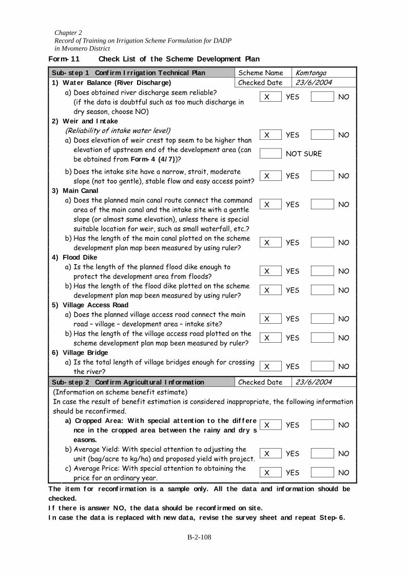
Chapter 2 Record of Training on Irrigation Scheme Formulation for DADP in Mvomero District
Form-11 Check List of the Scheme Development Plan
Sub-step 1 Confirm Irrigation Technical Plan Scheme Name Komtonga 1) Water Balance (River Discharge) Checked Date 23/6/2004
X YES NO
a) Does obtained river discharge seem reliable? (if the data is doubtful such as too much discharge in
dry season, choose NO)
2) Weir and Intake X YES NO NOT SURE
(Reliability of intake water level) a) Does elevation of weir crest top seem to be higher than
elevation of upstream end of the development area (can be obtained from Form-4 (4/7))?
X YES NO
b) Does the intake site have a narrow, strait, moderate slope (not too gentle), stable flow and easy access point?
3) Main Canal X YES NO
a) Does the planned main canal route connect the command area of the main canal and the intake site with a gentle slope (or almost same elevation), unless there is special suitable location for weir, such as small waterfall, etc.?
X YES NO
b) Has the length of the main canal plotted on the scheme development plan map been measured by using ruler?
4) Flood Dike X YES NO
a) Is the length of the planned flood dike enough to protect the development area from floods?
X YES NO b) Has the length of the flood dike plotted on the scheme
development plan map been measured by using ruler? 5) Village Access Road
X YES NO
a) Does the planned village access road connect the main road – village – development area – intake site?
X YES NO b) Has the length of the village access road plotted on the
scheme development plan map been measured by ruler? 6) Village Bridge
X YES NO
a) Is the total length of village bridges enough for crossing the river?
Sub-step 2 Confirm Agricultural Information Checked Date 23/6/2004 (Information on scheme benefit estimate) In case the result of benefit estimation is considered inappropriate, the following information should be recon
NO a) Croppednce in theasons.
NO b) Average unit (bag
NO c) Average price for
The item for r be checked. If there is answIn case the dat
firmed. X YES Area: With special attention to the differe
e cropped area between the rainy and dry s
X YES Yield: With special attention to adjusting the
/acre to kg/ha) and proposed yield with project. X YES Price: With special attention to obtaining the
an ordinary year. econfirmation is a sample only. All the data and information should
er NO, the data should be reconfirmed on site.
a is replaced with new data, revise the survey sheet and repeat Step-6.B-2-108
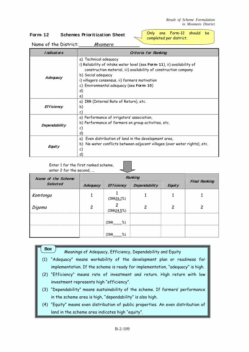
Result of Scheme Formulation in Mvomero District
Form-12 Schemes Prioritization Sheet
Name of the District: Mvomero Indicators Criteria for Ranking
Adequacy
a) Technical adequacy i) Reliability of intake water level (see Form-11), ii) availability of
construction material, iii) availability of construction company b) Social adequacy i) villagers consensus, ii) farmers motivation c) Environmental adequacy (see Form-10) d) e)
Efficiency a) IRR (Internal Rate of Return), etc. b) c)
Dependability
a) Performance of irrigators’ association, b) Performance of farmers on group activities, etc. c) d)
Equity
a) Even distribution of land in the development area, b) No water conflicts between adjacent villages (over water rights), etc. c) d)
Enter 1 for the first ranked scheme, enter 2 for the second, ...
Ranking Name of the Scheme Selected Adequacy Efficiency Dependability Equity
Final Ranking
Komtonga 1 1 (IRR26.1%)
1 1 1
Digoma 2 2 (IRR24.5 %)
2 2 2
(IRR %)
(IRR %)
Only one Form-12 should be completed per district.
Meanings of Adequacy, Efficienc
(1) “Adequacy” means workability of the
implementation. If the scheme is ready
(2) “Efficiency” means rate of investmen
investment represents high “efficiency”
(3) “Dependability” means sustainability of
in the scheme area is high, “dependabili
(4) “Equity” means even distribution of pub
land in the scheme area indicates high “
Box
B-2-109
y, Dependability an
development pla
for implementatio
t and return. H
.
the scheme. If f
ty” is also high.
lic properties. An
equity”.
d Equity
n or readiness for
n, “adequacy” is high.
igh return with low
armers’ performance
even dist
ribution of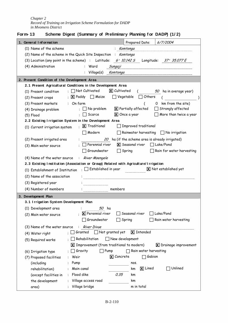
Chapter 2 Record of Training on Irrigation Scheme Formulation for DADP in Mvomero District
Form-13 Scheme Digest (Summary of Preliminary Planning for DADP) (1/2)
1. General Information Prepared Date: 6/7/2004 (1) Name of the scheme : Komtonga (2) Name of the scheme in the Quick Site Inspection : Komtonga (3) Location (any point in the scheme) : Latitude: 6°10.142 S Lon (4) Administration : Ward Sungaji : Village(s) Komtonga 2. Present Condition of the Development Area 2.1 Present Agricultural Conditions in the Development Area
(1) Present condition : Not Cultivated Cultivated (
(2) Present crops : Paddy Maize Vegetable Ot
(3) Present markets : On farm ( (4) Drainage problem : No problem Partially affected
(5) Flood : Scarce Once a year
2.2 Existing Irrigation System in the Development Area
(1) Current irrigation system : Traditional Improved tradit
Modern Rainwater harve
(2) Present irrigated area : 20 ha (if the scheme area
(3) Main water source : Perennial river Seasonal river
Groundwater Spring
(4) Name of the water source : River Msengele 2.3 Existing Institution (Association or Group) Related with Agriculture/I
(1) Establishment of Institution : Established in year
(2) Name of the association :
(3) Registered year :
(4) Number of members : members 3. Development Plan 3.1 Irrigation System Development Plan
(1) Development area : 50 ha
(2) Main water source : Perennial river Seasonal river
Groundwater Spring
(3) Name of the water source : River Divue
(4) Water right : Granted Not granted yet Intende
(5) Required works : Rehabilitation New development
Improvement (from traditional to modern)
(6) Irrigation type : Gravity Pump Rain water
(7) Proposed facilities : Weir Concrete G
(including : Pump nos.
rehabilitation) : Main canal km Li
(except facilities in : Flood dike 0.35 km
the development : Village access road km
area) : Village bridge m in total
X X
X X
X
X
X
X
X
X
X
X
B-2-110
gitude: 37°
50 ha inhers (
0 km fr Strong
More t
ional sting No
is already irr Lake/Pon
Rain for
rrigation Not establi
Lake/Pon
Rain wate
d
Drain
harvesting abion
ned
X
35.077 E
average year)
) om the site) ly affected han twice a year
irrigation
igated) d
water harvesting
shed yet
d
r harvesting
age improvement
Unlined
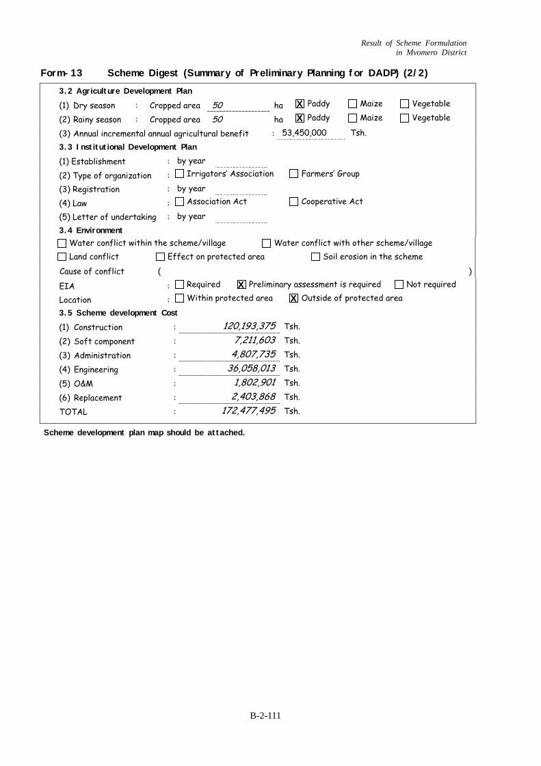
Result of Scheme Formulation in Mvomero District
B-2-111
Form-13 Scheme Digest (Summary of Preliminary Planning for DADP) (2/2)
3.2 Agriculture Development Plan (1) Dry season : Cropped area 50 ha Paddy Maize Vegetable (2) Rainy season : Cropped area 50 ha Paddy Maize Vegetable (3) Annual incremental annual agricultural benefit : 53,450,000 Tsh. 3.3 Institutional Development Plan
(1) Establishment : by year
(2) Type of organization : Irrigators’ Association Farmers’ Group
(3) Registration : by year
(4) Law : Association Act Cooperative Act
(5) Letter of undertaking : by year 3.4 Environment
Water conflict within the scheme/village Water conflict with other scheme/village
Land conflict Effect on protected area Soil erosion in the scheme
Cause of conflict ( )
EIA : Required Preliminary assessment is required Not required
Location : Within protected area Outside of protected area
3.5 Scheme development Cost (1) Construction : 120,193,375 Tsh.
(2) Soft component : 7,211,603 Tsh.
(3) Administration : 4,807,735 Tsh.
(4) Engineering : 36,058,013 Tsh.
(5) O&M : 1,802,901 Tsh.
(6) Replacement : 2,403,868 Tsh.
TOTAL : 172,477,495 Tsh.
X X
X X
Scheme development plan map should be attached.

Chapter 2 Record of Training on Irrigation Scheme Formulation for DADP in Mvomero District
B-2-112
Form-14 District Supporting Programme Digest
1) Title of the District Supporting Programme Planned Date 6/7/2004 To improve farmers skills and knowledge on irrigation practices.
2) Target Group (Who will benefit from the plan?)
Farmers ( Common farmers and Group target). 3) Goal of the Programme (should be only one) (What is the outcome of the plan?)
(By when should it be achieved?)
The principal of irrigation farming should be known by every farmers.
Before the implementation work.
4) Activities (Required activities to achieve the goal of the programme) (Activities) (Who will take action?) (Time Schedule)
a) Training (Resident) First quarter 10 days
b) Training (Field visit) Second of Third quarter 10 days
c) Training (Practice Training on site) Last quarter 10 days
5) Inputs (Required inputs to conduct the activities) (Activities) (Required Manpower) (Required Equipment) (Cost)
a) -District Extension Officer
-D&MS - Irrigation
Vehicles Stationary
2,070,000/=
b) -Crop Officers, Soil Scientist
-Cooperative Officer
c)
(Total) 2,070,000
Note: This sheet is applicable to present the plan for one programme.
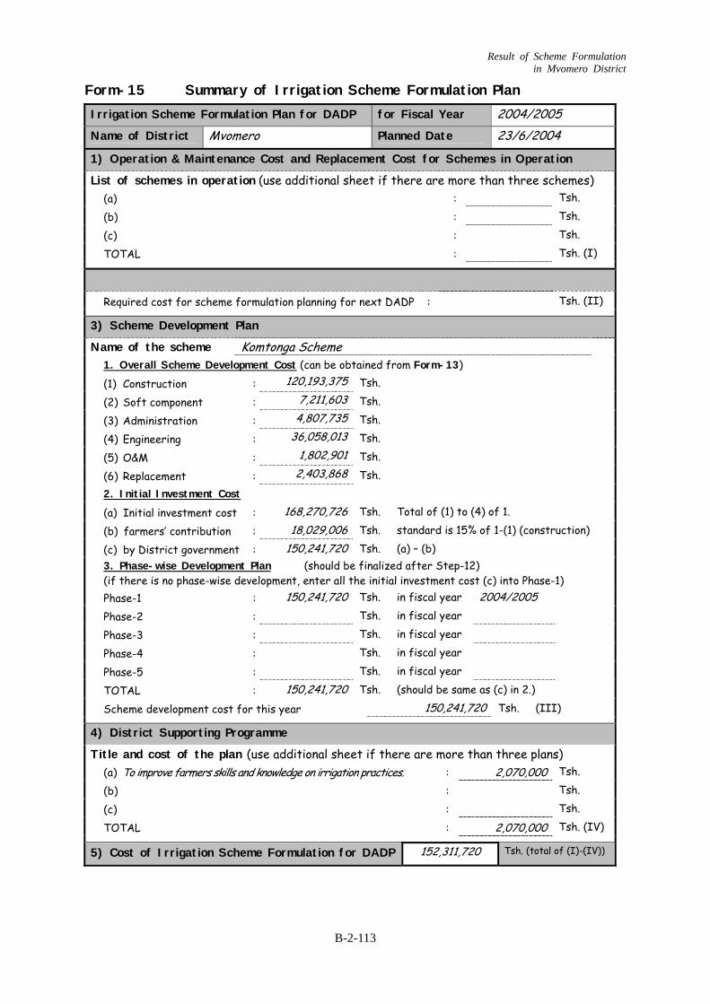
Result of Scheme Formulation in Mvomero District
B-2-113
Form-15 Summary of Irrigation Scheme Formulation Plan Irrigation Scheme Formulation Plan for DADP for Fiscal Year 2004/2005 Name of District Mvomero Planned Date 23/6/2004
1) Operation & Maintenance Cost and Replacement Cost for Schemes in Operation
List of schemes in operation (use additional sheet if there are more than three schemes) (a) : Tsh.
(b) : Tsh.
(c) : Tsh.
TOTAL : Tsh. (I)
Required cost for scheme formulation planning for next DADP : Tsh. (II) 3) Scheme Development Plan
Name of the scheme Komtonga Scheme 1. Overall Scheme Development Cost (can be obtained from Form-13) (1) Construction : 120,193,375 Tsh.
(2) Soft component : 7,2 1,603 1 Tsh.
(3) Administration : 4,807,735 Tsh.
(4) Engineering : 36,058,013 Tsh.
(5) O&M : 1,802,901 Tsh.
(6) Replacement : 2,403,868 Tsh. 2. Initial Investment Cost
(a) Initial investment cost : 168,270,726 Tsh. Total of (1) to (4) of 1.
(b) farmers’ contribution : 18,029,006 Tsh. standard is 15% of 1-(1) (construction)
(c) by District government : 150,241,720 Tsh. (a) – (b)
3. Phase-wise Development Plan (should be finalized after Step-12) (if there is no phase-wise development, enter all the initial investment cost (c) into Phase-1)
Phase-1 : 150,241,720 Tsh. in fiscal year 2004/2005
Phase-2 : Tsh. in fiscal year
Phase-3 : Tsh. in fiscal year
Phase-4 : Tsh. in fiscal year
Phase-5 : Tsh. in fiscal year
TOTAL : 150,241,720 Tsh. (should be same as (c) in 2.)
Scheme development cost for this year 150,241,720 Tsh. (III) 4) District Supporting Programme
Title and cost of the plan (use additional sheet if there are more than three plans) (a) To improve farmers kill and knowledge on irrigation p actices. s s r : 2,070,000 Tsh.
(b) : Tsh.
(c) : Tsh.
TOTAL : 2,070,000 Tsh. (IV) 5) Cost of Irrigation Scheme Formulation for DADP 152,311,720 Tsh. (total of (I)-(IV))
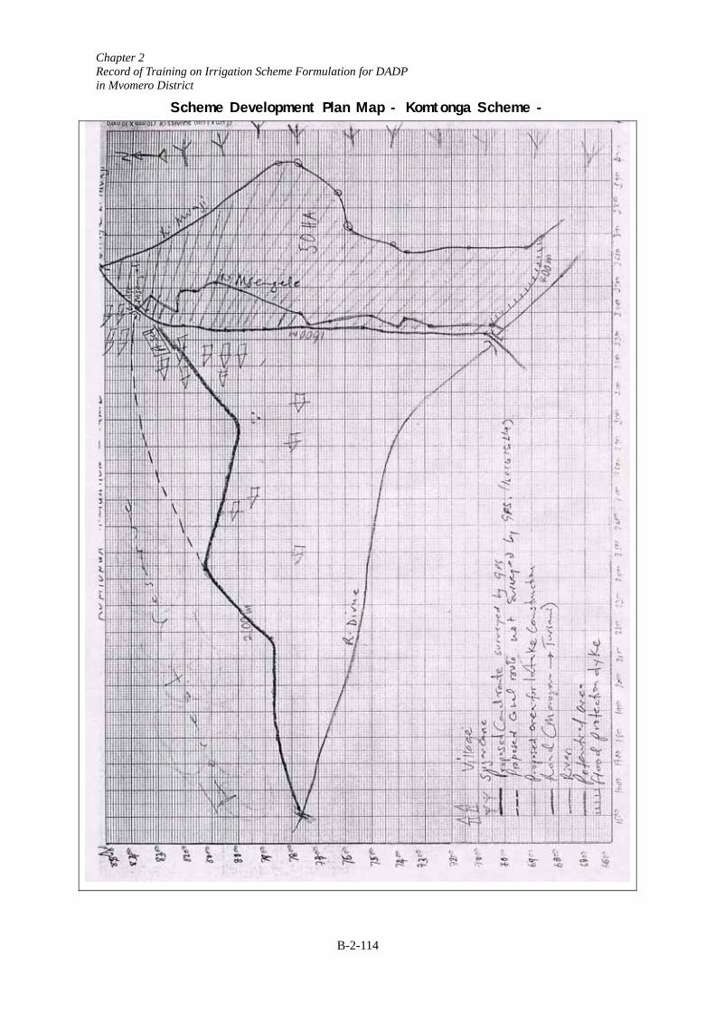
Chapter 2 Record of Training on Irrigation Scheme Formulation for DADP in Mvomero District
B-2-114
Scheme Development Plan Map - Komtonga Scheme -