Reserve selection for conserving groundwater biodiversity
16
Reserve selection for conserving groundwater biodiversity GEORGES MICHEL*, FLORIAN MALARD † , LOUIS DEHARVENG ‡ , TIZIANA DI LORENZO § , BORIS SKET – AND CLAUDE DE BROYER** *Commission Wallonne d’Etude et de Protection des Sites Souterrains, Brussels, Belgium † UMR CNRS 5023, Ecologie des Hydrosyste `mes Fluviaux, Universite ´ Claude Bernard Lyon 1, Villeurbanne, France ‡ UMR 5202, Origine, Structure et E ´ volution de la Biodiversite ´, Muse ´um National d’Histoire Naturelle, Paris, France § Dipartimento di Scienze Ambientali, Universita ` di L’Aquila, L’Aquila, Italy – Oddelek za biologijo, Biotehnis ˇka fakulteta, Univerza v Ljubljani, Ljubljana, Slovenia **De ´partement des Inverte ´bre ´s (Carcinologie), Institut Royal des Sciences Naturelles de Belgium (IRScNB), Brussels, Belgium SUMMARY 1. A possible conservation strategy to minimise the risk of groundwater biodiversity loss due to human activities consists in designing a network of reserve areas at the continental scale that collectively include most groundwater species. To this end, we compared the efficiency of three area selection methods (species richness hotspots, endemism hotspots and complementarity) and examined the influence of spatial constraints (reduced extent and increased aggregation of reserve areas) on the representation of 1059 groundwater species in six European regions. 2. Presence data from a data base elaborated as part of a European initiative on groundwater biodiversity, the PASCALIS project, were referenced onto 4675 grid cells (0.2 by 0.2°). Complementary performed much better than traditional selection methods for maximising species representation in a reserve network arbitrarily limited to 10% of all the cells containing groundwater fauna. It captured 155 more species than areas selected on richness and 77 more species than areas selected on endemism hotspots. 3. Representing species in a specified proportion of their area of occupancy (i.e. 100%, 50% and 10% of the area of occupancy of species occurring in 1, £10, and >10 cells, respectively) required inclusion of 46% of the cells containing groundwater fauna. The reserve network needed to achieve this level of coverage may be too large and fragmented to be implemented and managed in practice. 4. Reduction of the reserve areas to 10% of the landscape containing groundwater fauna and their aggregation into a smaller number of cell clusters resulted in a more realistic reserve network that represented 73.8% (782 species) and 59.1% (274 endemics) of the total number of species and endemics, respectively. 5. We propose several research priorities to improve the design of effective ground- water reserve networks in Europe: (i) devising sampling strategies that reduce uncertainties in the placement of reserves and increase the number of alternative reserve networks and (ii) shifting from a grid-cell selection approach to an aquifer- selection approach that incorporates species representation targets, minimum space requirement and also socio-economic costs related to the vulnerability of aquifers and degree of human activity in the catchment. Correspondence: Georges Michel, Commission Wallonne d’Etude et de Protection des Sites Souterrains, 20 Avenue Gilbert, 1050 Brussels, Belgium. E-mail: [email protected] Freshwater Biology (2009) 54, 861–876 doi:10.1111/j.1365-2427.2009.02192.x Ó 2009 Blackwell Publishing Ltd 861
-
Upload
independent -
Category
Documents
-
view
0 -
download
0
Transcript of Reserve selection for conserving groundwater biodiversity

Reserve selection for conserving groundwaterbiodiversity
GEORGES MICHEL*, FLORIAN MALARD †, LOUIS DEHARVENG ‡, TIZIANA DI LORENZO § ,
BORIS SKET– AND CLAUDE DE BROYER**
*Commission Wallonne d’Etude et de Protection des Sites Souterrains, Brussels, Belgium†UMR CNRS 5023, Ecologie des Hydrosystemes Fluviaux, Universite Claude Bernard Lyon 1, Villeurbanne, France‡UMR 5202, Origine, Structure et Evolution de la Biodiversite, Museum National d’Histoire Naturelle, Paris, France§Dipartimento di Scienze Ambientali, Universita di L’Aquila, L’Aquila, Italy–Oddelek za biologijo, Biotehniska fakulteta, Univerza v Ljubljani, Ljubljana, Slovenia
**Departement des Invertebres (Carcinologie), Institut Royal des Sciences Naturelles de Belgium (IRScNB), Brussels, Belgium
SUMMARY
1. A possible conservation strategy to minimise the risk of groundwater biodiversity
loss due to human activities consists in designing a network of reserve areas at the
continental scale that collectively include most groundwater species. To this end, we
compared the efficiency of three area selection methods (species richness hotspots,
endemism hotspots and complementarity) and examined the influence of spatial
constraints (reduced extent and increased aggregation of reserve areas) on the
representation of 1059 groundwater species in six European regions.
2. Presence data from a data base elaborated as part of a European initiative on
groundwater biodiversity, the PASCALIS project, were referenced onto 4675 grid cells
(0.2 by 0.2�). Complementary performed much better than traditional selection methods
for maximising species representation in a reserve network arbitrarily limited to 10% of
all the cells containing groundwater fauna. It captured 155 more species than areas
selected on richness and 77 more species than areas selected on endemism hotspots.
3. Representing species in a specified proportion of their area of occupancy (i.e. 100%,
50% and 10% of the area of occupancy of species occurring in 1, £10, and >10 cells,
respectively) required inclusion of 46% of the cells containing groundwater fauna. The
reserve network needed to achieve this level of coverage may be too large and fragmented
to be implemented and managed in practice.
4. Reduction of the reserve areas to 10% of the landscape containing groundwater fauna
and their aggregation into a smaller number of cell clusters resulted in a more realistic
reserve network that represented 73.8% (782 species) and 59.1% (274 endemics) of the total
number of species and endemics, respectively.
5. We propose several research priorities to improve the design of effective ground-
water reserve networks in Europe: (i) devising sampling strategies that reduce
uncertainties in the placement of reserves and increase the number of alternative
reserve networks and (ii) shifting from a grid-cell selection approach to an aquifer-
selection approach that incorporates species representation targets, minimum space
requirement and also socio-economic costs related to the vulnerability of aquifers and
degree of human activity in the catchment.
Correspondence: Georges Michel, Commission Wallonne d’Etude et de Protection des Sites Souterrains, 20 Avenue Gilbert, 1050
Brussels, Belgium.
E-mail: [email protected]
Freshwater Biology (2009) 54, 861–876 doi:10.1111/j.1365-2427.2009.02192.x
� 2009 Blackwell Publishing Ltd 861

Keywords: biodiversity hotspots, complementary areas, endemism, reserve design, subterraneanecosystem
Introduction
In the face of the irretrievable loss of biodiversity
world-wide, the designation of nature reserve net-
works has become a cornerstone of most conservation
strategies (McDonnell et al., 2002). Whereas earlier
reserves were largely selected in an ad hoc fashion,
considerable progress has been made over the
last 20 years in the designation of reserve net-
works that meet well-defined ecological objectives
(Bedward, Pressey & Nicholls, 1991; Pressey et al.,
1993; Prendergast, Quinn & Lawton, 1999). This
progress owes much to the development of heuristic
algorithms that find near optimal solutions to prob-
lems such as the representation of attributes (habitats
or species) in a near minimum area (Diniz-Filho et al.,
2005), or their maximisation for a given fixed area or
cost (Pressey, Possingham & Day, 1997; Possingham,
Ball & Andelman, 2000; Fischer & Church, 2005). All
heuristic algorithms use complementarity, ‘a measure
of the extent to which an area, or set of areas,
contributes unrepresented features to an existing area
or set of areas’ (Margules & Pressey, 2000, p. 249). As
heuristics become increasingly sophisticated, they can
be used to generate more flexible conservation sce-
narios that explicitly consider configurational features
such as size, aggregation, spacing and connectivity of
individual patches (Fischer & Church, 2003; Fuller
et al., 2006; Moilanen & Wintle, 2006) and economic
costs of reserved areas (Faith et al., 2003; Stewart &
Possingham, 2005). Flexibility refers to the possibility
of identifying not one, but a range of reserve networks
that meet a particular conservation goal, this property
being particularly advantageous for solving conflict
situations (Possingham et al., 2000). The incorporation
of spatially explicit constraints in the design of reserve
networks is a product of the Single Large Or Several
Small reserves debate (SLOSS) which addresses the
significance of spatial configuration of reserves
areas in determining their conservation efficiency
(Diamond, 1975; Simberloff & Martin, 1991;
Ovaskainen, 2002; Halpern & Warner, 2003). Heuristic
algorithms have been successfully applied to design
reserve networks for the conservation of a variety of
ecosystems and organisms, including a coral reef
(Leslie et al., 2003), tropical rain forest (Chave,
Wiegand & Levin, 2002), plants (Barker, Wardlaw &
Brown, 1996), invertebrates (Pante et al., 2006), fishes
(Cook & Auster, 2005), birds (Garson, Aggarwal &
Sarkar, 2002) and mammals (Fjeldsa et al., 2004).
Although much effort has been made to protect
groundwater resources, the conservation of ground-
water biodiversity is still in its infancy (Juberthie,
1995; Danielopol et al., 2003). There is no evidence that
environmental policy for protecting aquifers used for
drinking water supply would contribute much to the
maintenance of groundwater biodiversity. Most ini-
tiatives for the conservation of groundwater fauna
consist in designating a number of threatened species
(Arntzen et al., 2008) or identifying cave systems that
harbour an unusually high number of species (i.e. the
hotspot approach; Juberthie & Juberthie-Jupeau, 1975;
Malard, Gibert & Laurent, 1997; Culver & Sket, 2000).
The majority of groundwater species on earth could
potentially be listed as endangered taxa because their
geographical range size is extremely small compared
to those of epigean species (Gibert & Deharveng,
2002). As Culver et al. (2000, p. 395) argued, ‘there are
simply too many subterranean species at risk to deal
with them one at time’. A more comprehensive
strategy for minimising the risk of groundwater
biodiversity loss due to human activities would
consist in identifying a network of protected sites
that collectively encompass the majority of ground-
water species at large spatial scales. In the past, few
attempts were made in this direction, probably
because distributional data on groundwater fauna
were too sparse to be used for simulating any realistic
conservation scenarios at spatial scales larger than
that of the region (Culver et al., 2000; Ferreira et al.,
2007). In recent years, however, distributional data
bases became available in a number of countries,
including the U.S.A. (Culver et al., 2000), Italy (Stoch,
2001), Slovenia and most Balkan countries (Sket,
Paragamian & Trontelj, 2004), France (Ferreira et al.,
2003) and the U.K. (Proudlove et al., 2003), thereby
providing unique opportunities to design groundwa-
ter reserve networks. Although groundwater species
862 G. Michel et al.
� 2009 Blackwell Publishing Ltd, Freshwater Biology, 54, 861–876

inventories are still highly incomplete, it is preferable
to design reserve areas based on our present state of
knowledge rather than letting human activities cause
further groundwater habitat damage and biodiversity
loss.
In this paper, we take advantage of the distribu-
tional data assembled as part of a large coordinated
European initiative, the PASCALIS project (Protocols
for the ASsessment and Conservation of Aquatic Life
In the Subsurface; Gibert, 2001), to explore the
capacity for designing subsurface reserve systems
that adequately represent well-defined conservation
objectives at the European scale. Whereas heuristics
have long been used to design effective reserve
networks in terrestrial and marine systems, this study
is one of the first to groundwater systems and one of
few applications of complementarity algorithms
(Culver et al., 2000; Ferreira et al., 2007). The objectives
of this paper are (i) to compare the efficiency of
hotspot selection (species richness and endemism)
and complementarity in representing as many species
and endemics as possible within an area-limited
reserve network; (ii) to examine the effect of spatial
constraints (reduced extent and increased aggregation
of reserved areas) on the representation of species or a
given proportion of their area of occupancy and (iii) to
identify research avenues for implementing efficient
groundwater reserve networks at the continental
scale.
Methods
Species distribution data
Distribution data were extracted from the groundwa-
ter species database elaborated within the framework
of the European project PASCALIS (Deharveng et al.,
2009). They comprised a total of 10 183 records for
1059 obligate groundwater species (i.e. stygobiotic
species) in six countries (Belgium, France, Italy,
Portugal, Slovenia and Spain). The data were
compiled from multiple sources including: (i) pub-
lished records; (ii) existing data bases; (iii) personal
collections and (iv) extensive sampling surveys
carried out in six selected regions (Dole-Olivier et al.,
2009). Species lists, records and distribution maps
were submitted to taxonomists for correction and
validation. Presence data were referenced onto 4675
0.2 by 0.2� grid cells (400 km2) covering the land
territory of the six countries, using a geographical
information system (ARCGISARCGIS 8.2 software, Esai, Red-
lands, CA, U.S.A.).
Geographical patterns of diversity
We first investigated distribution patterns of diversity
because they ultimately control the capacity to design
reserve networks with distinct conservation objectives
and spatial constraints. The frequency distribution of
range sizes of species was determined using two
distinct measures: the area of occupancy of a species
and its extent of occurrence (Gaston, 1991). Area of
occupancy was the number of cells in which a species
occurred. The total number of cells contained within
the rectangle drawn between the most widely
separated sites occupied by a species, was used as a
measure of its extent of occurrence. We defined
endemics as species that were restricted to a single
cell. Distribution maps of species richness and
endemism were produced by counting the number
of species and endemics present in the 4675 cells of
the grid coverage. Latitudinal variation of biodiversity
was examined by counting the number of all
stygobiotic species and of the endemic, and exclusive
species in each of fifteen 1�-latitudinal bands spanning
the study area from 36 to 51�N. Total richness and
endemic species richness were plotted against the
number of distribution records per sampling band to
assess the influence of sampling heterogeneity on
geographical diversity patterns.
Comparison of selection methods
We used three methods for choosing 10% of all the
0.2 · 0.2� grid cells containing species to represent the
diversity of groundwater fauna in the study area: (i)
hotspots of species richness; (ii) hotspots of endemism
and (iii) complementarity. All of these methods have
been suggested, and in some cases applied, for
designating priority sites of groundwater species
conservation (Culver & Sket, 2000; Culver et al.,
2000; Ferreira et al., 2007). Although this upper 10%
limit was an arbitrary threshold used for comparing
methods, it followed the guidelines of Natura 2000, a
network of nature conservation sites across Europe,
which recommended that at least 10% of the
European landscape should be reserved for conserva-
tion purposes. In the present study, this upper 10%
Groundwater reserve selection 863
� 2009 Blackwell Publishing Ltd, Freshwater Biology, 54, 861–876

limit corresponded to 128 cells because only 1280 cells
out of 4675 contained at least one species. Defining
hotspots of richness and endemism [methods (i) and
(ii)] consisted of selecting the 128 grid cells richest in
total species and endemics, respectively. A random
draw was performed to select between ties (i.e. grid
cells having the same score) in the number of species
richness or endemism.
In this study, complementarity (method iii) refers to
the degree to which a cell contributes otherwise
unrepresented species to a set of cells (Vane-Wright,
Humphries & Williams, 1991). We used MARXANMARXAN
software (version 1.8.6, University of Queensland,
Australia) for selecting a network of 128 complemen-
tary cells (Possingham et al., 2000; Ball & Possingham,
2001). This optimisation package attempts to minimise
the total cost of a reserve network:
Total cost ¼X
cells
cell costs
þ BLM�X
cells
boundary costs
þX
species
SPF� penalty
þ cost threshold penalty,
where the first term is the sum of the costs of cells
included in the reserve network (all cells were
attributed a cost of 1), the second term is the cost of
the total boundary length of the network, the third
term is a penalty given to species that have not met
their representation target and the last term is a cost
applied when exceeding a desired number of cells.
The species penalty factor (SPF) is a weighting factor
which determines the relative importance for ade-
quately representing a particular species. Boundary
costs of each cell selected in the network are added up
and multiplied by the boundary length modifier
(BLM). The BLM is a constant that can be varied to
adjust the spatial aggregation of the reserve network
(Stewart & Possingham, 2005): a small BLM allows the
selection of isolated cells with high conservation value
whereas a high BLM enables clustering of cells despite
an increase in cell costs. Boundary costs equal to the
length of adjacent cells were automatically generated
using the ARCGISARCGIS extension developed by A. Cottam
(http://www.ecology.uq.edu.au). The reserve net-
work was aggregated by experimentally increasing
the BLM value from 0 (no clustering constraint) to
1000. We used complementarity to represent as many
species as possible at least once in a reserve network
of 128 cells. To this end, we applied a high penalty to
enforce a 128-cell maximum. We followed the proce-
dure described in Ardron, Lash & Haggarty (2002)
which consisted in using the summed irreplaceability
algorithm (Pressey, Johnson & Wilson, 1994) in
concert with simulated annealing (Kirkpatrick, Gelatt
& Vecchi, 1983) to select the reserve network. Then,
the swap iterative improvement algorithm was used
to check for the utility of each cell in the reserve
network (Ball & Possingham, 2000). This procedure
was performed 1000 times and the best reserve
network (i.e. the one with the best score according
to the objective function) was retained for comparison
with the hotspot networks.
To demonstrate how groundwater reserve networks
can be designed to protect certain species, we intro-
duced another complementarity solution in which we
gave higher conservation values to taxonomically
isolated taxa (hereafter referred to as the weighted
complementary areas). Taxonomic distinctness for a
particular species was defined as the cumulative
taxonomic distance (measured as tree length on the
Linnaean classification) between this species and all
other species in the study area (Clarke & Warwick,
1998). For each species, the following scores were
used to calculate the taxonomic distinctness index:
1 = congeneric species; 2 = species in the same family
but different genera; 3 = the same order but different
families; 4 = the same class but different orders;
5 = same phylum but different classes and 6 = differ-
ent phyla. The taxonomic distinctness index was used
as a SPF that directed the relative search effort for
taxonomically isolated taxa. To this end, the index for
all species was experimentally normalised between 1
and 50 in MARXANMARXAN.
The total number of species and endemics, the
average distinctness index of species and the propor-
tion of shared cells were used to compare the reserve
networks obtained with the different selection meth-
ods. In order to determine the effect of retaining one
network (A) rather than another (B) on species
composition, the total number of species present in
any combination of two reserve networks was decom-
posed into three components: (i) the percentage of
species shared by networks A and B; (ii) the percent-
age of species present exclusively in network A and
(iii) the percentage of species present exclusively in
864 G. Michel et al.
� 2009 Blackwell Publishing Ltd, Freshwater Biology, 54, 861–876

network B. The sum of the three components equalled
100%. We also compared the frequency of species
representation in the reserve network by each of the
three selection methods.
Spatial constraints
We explored the effect of reduced size and increased
compactness of the reserve network on our ability to
(i) represent all species at least once and (ii) capture a
certain proportion of their area of occupancy. For this
second scenario, representation targets were defined
as a proportion of each species’ area of occupancy,
choosing for illustrative purpose targets of 100%, 50%
and 10% for species having areas of occupancy of 1
(i.e. endemic species by definition), £10 and >10 cells,
respectively. The minimum network size for achiev-
ing these two conservation goals was determined
using MARXANMARXAN.
The selection frequency of each cell in 1000 runs
performed in MARXANMARXAN, which indicates how many
times each cell was included in the final solution,
was used to assess the flexibility of the reserve
networks. Next, we examined the reduction in the
number of species that met their targets when
successively reducing the network size to 128 cells
by applying a cost-threshold penalty and aggregat-
ing these 128 cells into a smaller number of clusters
by varying the BLM. Raising the BLM to increase
compactness of the reserve network showed that
little aggregation was achieved in a reserve net-
work limited to 128 cells without reducing our
conservation targets. This situation of conflicting
constraints was irresolvable by the selection
algorithm. Thus, we experimentally set the SPFs at
values lower than 1 so that some species could be
under-represented by the algorithm, in order to
aggregate the reserve network.
Results
Geographical patterns of diversity
The distribution of geographical range sizes was
strongly skewed towards small areas of occupancy
and extents of occurrence (Fig. 1a). A total of 1059
species, 464 (44%) were endemic and 763 (72%) had
an extent of occurrence of less than 16 (i.e. 24) grid
cells at most. Only 9.4 and 12.0 % of species had an
area of occupancy respectively higher than 10 cells
and an extent of occurrence higher than 128 cells. Of
a total of 4675 cells, 1280 (27.4%) contained at least
one species (Fig. 2). A high proportion of cells
contained relatively few species: 78% of the 1280
cells had less than 5 species (Fig. 1b). The 464
endemic species were distributed over 262 cells,
70% of which contained only one endemic. A
disproportionately high number of species and
endemics occurred in five latitudinal bands extend-
ing from 42 to 47�N (Fig. 3). A total of 705 species
(67%) were exclusive to a least one of these five
latitudinal bands. The number of species and
endemics in a latitudinal band increased linearly
with the number of distributional records (species
richness: y = 0.13x, n = 16, r2 = 0.84, P < 0.001; en-
30
20
10
0
40
30
20
10
0
40
33–6417–329–165–83–421 > 64
33–6
4
65–1
28
129–
256
257–
512
513–1
024
1025
–204
8
17–3
29–1
65–
83–
421
Species richness
Endemic richness
Number of cells
Number of species
Extent of occurrence
Area of occupancy
Per
cent
age
of c
ells
Per
cent
age
of s
peci
es
(a)
(b)
Fig. 1 Frequency distribution of (a) the extent of occurrence
and area of occupancy among the 1059 species listed in the
European data base on groundwater biodiversity and (b) total
species richness and endemic species richness among the 1280
grid cells (0.2 · 0.2�) containing groundwater fauna.
Groundwater reserve selection 865
� 2009 Blackwell Publishing Ltd, Freshwater Biology, 54, 861–876

demic richness: y = 0.04x, n = 16, r2 = 0.77,
P < 0.001). Despite this uneven latitudinal distribu-
tion of species and endemics, the ratio of endemic
richness to species richness calculated for each band
decreased linearly with increasing latitude
(y = )0.02x + 1.2, n = 15, r2 = 0.76, P < 0.001).
Species richness1–6
41–8820–407–19
0 300 km
2
3 4
5
1
6
Endemic richness1
10–155–92–4
50°
40°
45°
–5°(a)
(b)
0° 5° 15°10°Belgium
France
Portugal
Spain
Italy
Slovenia
Fig. 2 Patterns of total species richness
(a) and endemic species richness
(b) among 0.2 · 0.2� grid cells in southern
Europe. Circles show areas sampled
intensively during the PASCALIS survey
of groundwater biodiversity in six
European regions: (1) Wallonia;
(2) southern French Jura; (3) Cantabria;
(4) Roussillon; (5) Lessinian Mountains
and (6) Krim Massif.
0
100
200
300
400
36 37 38 39 40 41 42 43 44 45 46 47 48 49 50 510
1000
2000
3000
4000
Latitude (°N)
Num
ber
of r
ecor
ds (
)
Num
ber
of s
peci
es (
),
end
emic
spe
cies
(
)or
spe
cies
exc
lusi
ve to
a 1
° la
titud
inal
ban
d (
)
Fig. 3 Latitudinal variation in the number
of species, endemic species, exclusive
species and distributional records across
Europe.
866 G. Michel et al.
� 2009 Blackwell Publishing Ltd, Freshwater Biology, 54, 861–876

Comparison of reserve networks derived from three
selection methods
Selection of the most species-rich cells resulted in a
reserve network that differed markedly from those
obtained by selecting the cells richest in endemics and
most complementary (Fig. 4, Tables 1 & 2). Richness
hotspots contained 78 and 155 fewer species and 101
and 85 fewer endemics than the endemism hotspots
and complementary areas without SPF, respectively
(Table 1). The reserve networks of 128 cells based on
endemism hotspots and complementary shared only
52 and 59 cells with richness hotspots, respectively.
Endemism hotspots and complementary areas were
typically more fragmented and extended further
southwards: they comprised 87 and 95 clusters (i.e.
groups of contiguous cells and isolated cells), 51 and
43 of which occurred south of the 42� latitude,
respectively. In contrast, richness hotspots had only
44 clusters, five of which were located south of the 42�latitude. Selection of the most species-rich cells
increased the frequency of occurrences of species in
the reserve network. Fifty-six per cent of the species
occurred more than once in the richness hotspots
whereas this proportion was only 39% and 37% for
the endemism hotspots and complementary cells,
respectively (Fig. 5).
The reserve networks resulting from selection of the
cells richest in endemics and most complementary
shared 81% and 70% of species and cells, respectively
(Table 2). However, whereas complementary areas
captured 77 more species, they contained only 16
endemic species less than endemism hotspots (Ta-
ble 1). Application of SPFs for preferentially selecting
taxonomically isolated species (i.e. higher average
distinctness index in Table 1) decreased the number
of species and endemics captured by the algorithm,
although weighted complementary areas still con-
tained 39 more species than endemism hotspots.
Representing all species at least once
A total of 316 cells (29.8% of the 1280 cells containing
groundwater fauna) were needed to achieve the goal
of representing all 1059 species at least once (Fig. 6a).
The reserve network representing all species exhibited
a low level of flexibility. Only 373 cells out of 1280
appeared in at least one of the 1000 runs of the
optimisation algorithms, among which 278 (88%)
appeared in all solutions representing 1013 species.
Of the 278 cells appearing in all runs, 262 contained
the entire distribution of one or more species and
were therefore irreplaceable. Although one-quarter of
the cells (316 cells out of 1280) were needed to capture
all species at least once, a high proportion of species
rapidly accumulated in relatively few cells (Fig. 7). Of
a total of 1059 species, 531 (50%) were represented in
only 32 cells and 74% of species were represented in
96 cells. Adding an additional cell beyond 96 cells
resulted in an increase of only two or one species. The
best solution of the optimisation algorithm when
constraining the reserve network to a maximum
extent of 128 cells comprised 79.7% (844) of the total
0 300 km
(a)
(b)
(c)
45°
45°
45°
Fig. 4 Distribution of the 128 cells selected by three different
methods to represent groundwater fauna in southern Europe:
(a) richness hotspots, (b) endemism hotspots, and
(c) complementary areas. See Tables 1 & 2 for species
representation in each network.
Groundwater reserve selection 867
� 2009 Blackwell Publishing Ltd, Freshwater Biology, 54, 861–876

number of species and 67.7% (314) of the total number
of endemics (Fig. 6b). This solution with no aggrega-
tion constraint (BLM = 0) contained 95 clusters most
of which (79%) were distributed in the two southern
thirds of the study area (latitude < 45�N). The aggre-
gated solution obtained by experimentally varying the
values of BLM and SPF comprised only 37 cell
clusters, that collectively encompassed 73.8% (782)
of the total number of species and 59.1% (274) of the
total number of endemics (Fig. 6c). The aggregation
constraint resulted in the exclusion of many isolated
cells in the most southern third of the study area and
delineation of larger cell clusters along a longitudinal
Alpine axis that extended from Cantabria to the
Dinaric karst. The 10 clusters (65.6% of 128 selected
cells) located along this axis comprised 72.3% of the
total species and 72.6% of the endemics included in
the aggregated reserve network.
Representing a certain proportion of the species area
occupancy
A total of 484 cells (45.7% of the 1280 cells contain-
ing groundwater fauna) were needed to meet the
Table 2 Differences in species composition between any combination of 2 reserve networks of 128 cells selected using different
methods and representation targets
Reserve networks Features
Endemism
hotspots (B)
Complementary areas (B)
No
SPF
With
SPF
Area of
occupancy
Richness hotspots (A) Shared cell 40.6 46.1 47.7 64.8
Shared species 69.7 73.0 74.7 81.9
Exclusive species
A 10.6 4.7 5.8 2.6
B 19.7 22.2 19.4 15.6
Endemism hotspots (A) Shared cell 70.3 60.2 53.1
Shared species 81.0 76.8 75.3
Exclusive species
A 5.2 9.4 10.8
B 13.8 13.7 13.9
Complementary areas
No SPF (A) Shared cell 69.5 68.7
Shared species 85.1 86.3
Exclusive species
A 9.7 9.7
B 5.3 4.1
With SPF (A) Shared cell 60.2
Shared species 82.4
Exclusive species
A 9.4
B 8.2
SPF, species penalty factor.
Table 1 Species representation in different kinds of reserve networks limited to 128 cells
Reserve networks
No.
records
No.
species
Proportion of
species (%)
No.
endemics
Proportion of
endemics (%)
Distinctness
index
Richness hotspots 5858 689 65.1 229 49.4 2.66
Endemism hotspots 4005 767 72.4 330 71.1 2.60
Complementary areas
No SPF 4359 844 79.7 314 67.7 2.59
With SPF 4380 805 76.0 291 62.7 2.76
Area of occupancy 5163 795 75.1 275 59.3 2.59
Total cells (1280) 10183 1059 100.0 464 100.0 2.55
SPF, species penalty factor.
868 G. Michel et al.
� 2009 Blackwell Publishing Ltd, Freshwater Biology, 54, 861–876

conservation targets of the area of occupancy for all
species (Fig. 8a). Flexibility was low because 84% of
cells included in the network appeared in all runs of
the algorithm. The constraints imposed on the max-
imum area (128 cells) and aggregation of the reserve
network resulted in a severe reduction in the propor-
tion of species for which the conservation target was
achieved. The reserve network with a maximum
extent of 128 cells still contained 795 species (75.1%)
but only 628 of them met their conservation target
(59.3% of the total number of species; Fig. 8b).
Inclusion of conservation targets as percentages of
the area of species occupancy markedly affected the
ability of the algorithm to select endemic species
(Table 1) and resulted in a spatial configuration
resembling that of richness hotspots (Fig. 4, Table 2).
Aggregation of the 128 cells resulted in a network
made of only 17 clusters, most of which fell in the 42–
47�N latitudinal band (Fig. 8c). This aggregated net-
work contained 63.4% and 49.8% of the total number
of species and endemics, respectively, and fulfilled the
conservation targets of only 53.8% of the species.
Discussion
Hotspots and complementary areas
When designing priority areas for stygobiotic species
protection, the efficiency of the selection methods
depends on the conservation targets initially chosen.
If emphasis is placed on vulnerable species with
narrow distributional ranges, then the recommended
network of reserves would focus on hotspots of
endemism. If a given proportion of the species range
needs to be included in the reserve network, then
networks ensuring the duplication of richness hot-
spots are desirable. If the criteria require the greatest
number of species overall to be included in the
network, then complementarity selection is a power-
ful approach as it pays particular attention to
between-cell diversity. Indeed, the selection of com-
plementary areas was more efficient than the selection
of hotspots of species richness and endemism in
maximising the representation of species in a reserve
0 300 km
(a)
(c)
(b)
45°
45°
45°
Fig. 6 Depiction of the best reserve networks obtained from
1000 runs of the complementarity algorithm for representing all
species at least once. (a) Solution with no spatial constraints
(representation goal fully achieved); (b) reserve network
limited to 10% of the cells containing groundwater fauna;
(c) aggregated reserve network limited to 10% of the cells
containing groundwater fauna. See text for species
representation in solutions (b) and (c).
Number of cells occupied
Per
cent
age
of s
peci
es
17–329–165–83–421
40
20
0
60 Richness hotspots
Endemism hotspots
Complementary areas
Fig. 5 Frequency of species representation in reserve networks
as determined by each of three selection methods: richness
hotspots, endemism hotspots, and complementary areas.
Groundwater reserve selection 869
� 2009 Blackwell Publishing Ltd, Freshwater Biology, 54, 861–876

network limited to 10% of the 1280 cells containing
groundwater fauna. The performance of complemen-
tarity over traditional selection methods for repre-
senting species in a near minimum area or
maximising their representation in a given fixed area
was emphasised in a number of studies (Williams
et al., 1996; Kati et al., 2004; Fox & Beckley, 2005).
Araujo (1999) found that the complementarity crite-
rion performed better than richness and rarity hot-
spots for complementing current reserve areas for
vertebrates and plants in Portugal.
The heuristic algorithm, which gave explicit atten-
tion to patterns of between-cell complementarity,
selected the most species-rich cells in multiple
regions, thereby potentially facilitating maintenance
of regionally distinct assemblages at the European
scale. In contrast, richness hotspots were heavily
influenced by the concentration of many species-rich
cells in a few regions. Regions designated as hotspots
of species richness coincided with areas that had
received a disproportionately high sampling effort.
The strong redundancy in species composition among
the most species-rich cells limited the total number of
species and endemics included in that particular
reserve system. This is confirmed by inspection of
the world list of subterranean biodiversity hotspots
(i.e. caves and wells with more than 20 species) in
which the five richest cave systems in France comprise
in total less then 60 different species because they are
located in only two ecoregions (the Pyrenees and
Languedoc) (Culver & Sket, 2000).
Complementary areas obtained without species
penalties were almost as efficient as endemism
hotspots in selecting endemics. This is not surprising
because (i) endemism hotspots are complementary by
nature and (ii) endemic species themselves strongly
influence the cell selection process as they constitute a
high proportion of the total richness of the ground-
water fauna (44%). The possibility of preferentially
selecting taxonomically isolated taxa using SPFs
without dramatically affecting the total number of
different species included in the reserve network
illustrates the variety of conservation strategies that
can be addressed using the objective function in
0 300 km
(a)
(b)
(c)
45°
45°
45°
Fig. 8 Depiction of the best reserve networks obtained from
1000 runs of the complementarity algorithm for representing
100%, 50% and 10% of the area of occupancy of species
present in 1, £10, and >10 cells, respectively. (a) Solution with no
spatial constraints (representation goal fully achieved);
(b) reserve network limited to 10% of the cells containing
groundwater fauna; (c) aggregated reserve network limited to
10% of the cells containing groundwater fauna. See text for
species representation in solutions (b) and (c).
0
20
40
60
80
100
0 50 100 150 200 250 300Number of cells
Per
cent
age
of to
tal s
peci
es n
umbe
r
Fig. 7 Species accumulation curve for 316 cells representing all
species at least one.
870 G. Michel et al.
� 2009 Blackwell Publishing Ltd, Freshwater Biology, 54, 861–876
MARXANMARXAN. Alternatively, lower penalty factors could
be applied to species with doubtful taxonomic status
or distribution range to ensure that they do not drive
the cell selection process (but see Ardron et al., 2002,
for a discussion on the multiplicity of SPF usage).
The choice of a particular selection method not only
affected the number of represented species but also
the spatial distribution and fragmentation of the
reserve network. Species richness hotspots formed a
few cell clusters at mid latitudes, where sampling was
most intensive, whereas the distribution of cells
richest in endemics and most complementary was
more fragmented and extended southward. This
reflects the occurrence of many cells containing
endemic species in the Iberian and Italian peninsulas.
The southward increase in the ratio of endemic
species richness to total species richness was consis-
tent with the hypothesis that many species went
extinct in northern areas during Pleistocene glacia-
tions (Howarth, 1980). However, the spatial distribu-
tion of selected cells in all reserve networks was
heavily influenced by the occurrence of a mid-latitude
ridge of high biodiversity (c. 42–47�N). This ridge
accounted for 87%, 59% and 63% of cells and 92%,
80% and 79% of species included in the richness
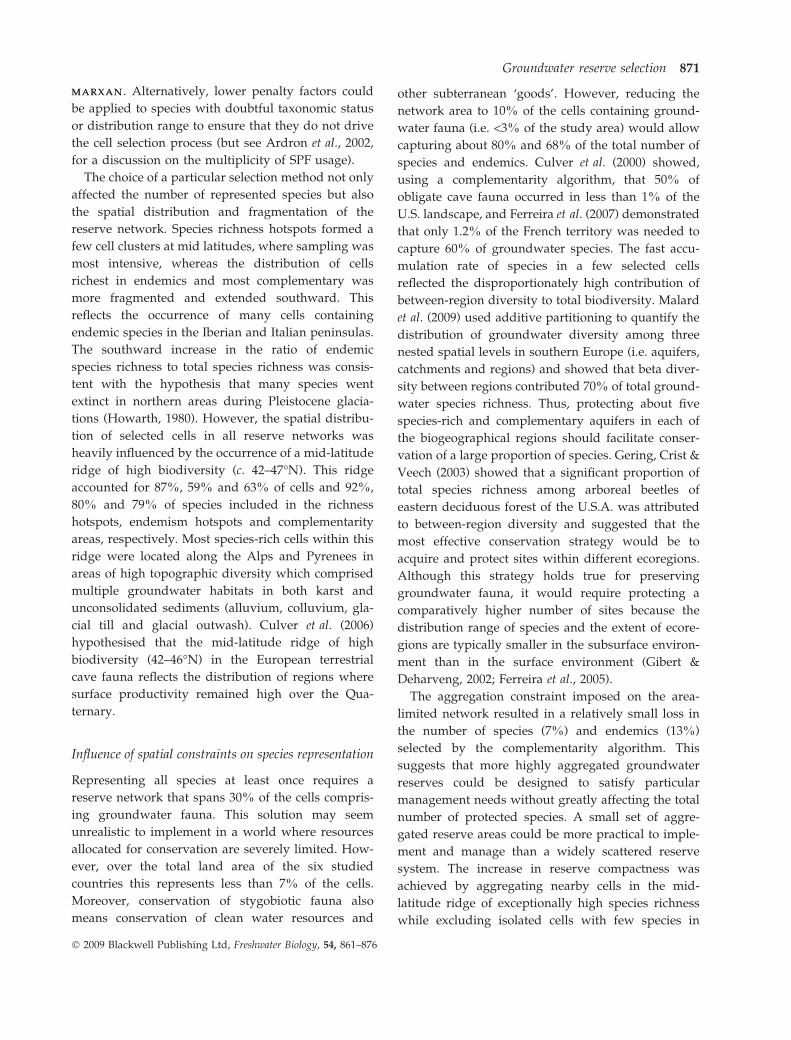
hotspots, endemism hotspots and complementarity
areas, respectively. Most species-rich cells within this
ridge were located along the Alps and Pyrenees in
areas of high topographic diversity which comprised
multiple groundwater habitats in both karst and
unconsolidated sediments (alluvium, colluvium, gla-
cial till and glacial outwash). Culver et al. (2006)
hypothesised that the mid-latitude ridge of high
biodiversity (42–46�N) in the European terrestrial
cave fauna reflects the distribution of regions where
surface productivity remained high over the Qua-
ternary.
Influence of spatial constraints on species representation
Representing all species at least once requires a
reserve network that spans 30% of the cells compris-
ing groundwater fauna. This solution may seem
unrealistic to implement in a world where resources
allocated for conservation are severely limited. How-
ever, over the total land area of the six studied
countries this represents less than 7% of the cells.
Moreover, conservation of stygobiotic fauna also
means conservation of clean water resources and
other subterranean ‘goods’. However, reducing the
network area to 10% of the cells containing ground-
water fauna (i.e. <3% of the study area) would allow
capturing about 80% and 68% of the total number of
species and endemics. Culver et al. (2000) showed,
using a complementarity algorithm, that 50% of
obligate cave fauna occurred in less than 1% of the
U.S. landscape, and Ferreira et al. (2007) demonstrated
that only 1.2% of the French territory was needed to
capture 60% of groundwater species. The fast accu-
mulation rate of species in a few selected cells
reflected the disproportionately high contribution of
between-region diversity to total biodiversity. Malard
et al. (2009) used additive partitioning to quantify the
distribution of groundwater diversity among three
nested spatial levels in southern Europe (i.e. aquifers,
catchments and regions) and showed that beta diver-
sity between regions contributed 70% of total ground-
water species richness. Thus, protecting about five
species-rich and complementary aquifers in each of
the biogeographical regions should facilitate conser-
vation of a large proportion of species. Gering, Crist &
Veech (2003) showed that a significant proportion of
total species richness among arboreal beetles of
eastern deciduous forest of the U.S.A. was attributed
to between-region diversity and suggested that the
most effective conservation strategy would be to
acquire and protect sites within different ecoregions.
Although this strategy holds true for preserving
groundwater fauna, it would require protecting a
comparatively higher number of sites because the
distribution range of species and the extent of ecore-
gions are typically smaller in the subsurface environ-
ment than in the surface environment (Gibert &
Deharveng, 2002; Ferreira et al., 2005).
The aggregation constraint imposed on the area-
limited network resulted in a relatively small loss in
the number of species (7%) and endemics (13%)
selected by the complementarity algorithm. This
suggests that more highly aggregated groundwater
reserves could be designed to satisfy particular
management needs without greatly affecting the total
number of protected species. A small set of aggre-
gated reserve areas could be more practical to imple-
ment and manage than a widely scattered reserve
system. The increase in reserve compactness was
achieved by aggregating nearby cells in the mid-
latitude ridge of exceptionally high species richness
while excluding isolated cells with few species in
Groundwater reserve selection 871
� 2009 Blackwell Publishing Ltd, Freshwater Biology, 54, 861–876

sparsely sampled southern regions. There is a limit to
the extent of aggregation because the final number of
reserve clusters must retain reserves from each
species-rich ecoregion in order to encompass the
diversity among regions. From considerations of life-
history and dispersal patterns of surface animals,
large connected patches are often advocated for
reserve delineation (Ovaskainen, 2002; Fischer &
Church, 2003; Naidoo & Ricketts, 2006). However,
this may be contraindicated for groundwater conser-
vation strategies, as many species are narrow range
endemics with limited dispersal capacity (Stoch, 1995;
Sket, 1999; Galassi, 2001; Trontelj et al., 2009). More-
over, the demography, life history and movement
behaviour of most groundwater species are unknown,
thereby complicating determination of the optimum
size and spacing of individual reserves.
Reduced size and increased aggregation were typ-
ically more constraining when the conservation goal
was to represent a desired proportion of species area-
occupancy. Indeed, area and aggregation constraints
successively decreased to 59.3% and 53.8% of the
proportion of species that met their conservation
targets. Moreover, the achievement of conservation
targets in the area-limited network resulted in the
exclusion of a disproportionate number of endemic
species. Most studies have recognised the need for an
effective reserve network to protect a minimum
proportion (>20%) of the distribution range of species
(Ney-Nifle & Mangel, 2000; Airame et al., 2003).
However, the question arises whether this strategy,
which tends to underrepresent endemic species,
should be applied to groundwater systems although
the distribution range of most groundwater species is
so poorly documented. Ferreira et al. (2007) showed
that the range size of groundwater species collected in
France markedly increased over the last 100 years as
distributional data accumulated. Conversely, recent
genetic studies showed that the apparently wide
distribution range of several groundwater species
was an artefact generated by our ignorance of cryptic
diversity (Goricki & Trontelj, 2006; Lefebure et al.,
2006, 2007; Trontelj et al., 2009).
Research needs for improving groundwater reserve
design
We identified three major research gaps that severely
limit the implementation of an effective groundwater
reserve network at the European scale. First, sampling
heterogeneity results in uncertainties in the placement
of individual reserves. The strong positive correlation
(r = 0.92) between the number of species and distri-
bution records suggests that there is a risk to misdirect
conservation actions towards a few highly sampled
regions. Analyses of changes that have occurred over
the last 60 years in apparent patterns of stygobiotic
richness hotspots in France (Ferreira et al., 2007),
Slovenia (Culver et al., 2004) and the U.S.A. (Culver
et al., 2000) yielded disparate findings, ranging from
little to marked variation in the location of hotspots in
response to increased sampling effort. Nevertheless,
efforts should be made to focus faunal inventories in
weakly sampled regions of southern Europe, thereby
increasing chances of identifying new complementary
hotspots. This sampling strategy need not markedly
increase the proportion of the landscape allocated for
groundwater biodiversity conservation but it could
increase the fragmentation of the reserve network if a
greater number of hotspots required protection.
Secondly, the lack of flexibility to design ground-
water reserve networks severely limits our ability to
circumvent conflicts between biodiversity conserva-
tion and economic activity by proposing alternative
scenarios with similar species coverage. Flexibility is a
key feature of reserve networks that often determines
their successful implementation (Rodrigues, Cerdeira
& Gaston, 2000). Although the narrow distribution
range of most groundwater species inevitably affects
flexibility, incomplete sampling in most regions also
severely reduces flexibility in the placement of indi-
vidual reserves. An adequate strategy would thus be
to probe for alternative richness hotspots by sampling
additional areas in species-rich regions that have been
sampled in a heterogeneous way. For example,
increased sampling along the southern alluvial corri-
dor of the Rhone River, France, could result in a
number of aquifers with similar species assemblages
(Dole-Olivier et al., 1994; Gibert et al., 2000).
Thirdly, the establishment of a groundwater reserve
network is ultimately dependent upon socio-economic
factors. These factors can either be assessed as post hoc
filters of groundwater reserves selected according to
biological criteria or, preferably, they can be integrated
earlier as costs in the objective function (Faith et al.,
2003; Stewart & Possingham, 2005; Yang et al., 2005).
However, consideration of socio-economic factors
would necessarily impose that the grid cell approach
872 G. Michel et al.
� 2009 Blackwell Publishing Ltd, Freshwater Biology, 54, 861–876

be replaced by an approach focusing on aquifer
selection (Di Lorenzo et al., 2004). Indeed, the two
features that need to be considered for evaluating the
implementation cost of a reserve, namely groundwa-
ter vulnerability and extent of human activity, can
only be assessed at the aquifer scale. Groundwater
vulnerability, which refers to the sensitivity of ground
water to human activities, depends on intrinsic prop-
erties of aquifers such as soil cover, thickness of the
vadose zone and sediment permeability. Human
activities resulting in the loss (by groundwater extrac-
tion) or degradation (by diffuse and point-source
pollution) of groundwater habitats likewise have to be
mapped at the scale of the surface catchment that
contributes to the aquifer recharge.
Conservation measures would be more constraining
and costly when the interaction between human
activities and aquifer vulnerability results in a high
risk of biodiversity loss. Yet, even the least expensive
conservation measures would be difficult to imple-
ment because there is almost no specific policy frame-
work nor legislative means at the European, national or
local scale to protect groundwater fauna (Danielopol
et al., 2004). The distribution of groundwater biodiver-
sity reserves does not necessarily fit that of aquifers
used for drinking water supply which are currently
managed for conservation through a number of regu-
lations (COST, 1995; European Commission, 2006).
With recent advances in the knowledge of groundwa-
ter biodiversity (Deharveng et al., 2009), lack of specific
legislation to protect groundwater ecosystems emerges
as a major constraint for the successful conservation of
groundwater fauna (Stoch, 2001).
Acknowledgments
We are indebted to the numerous scientists who were
involved in the assembly of the European groundwa-
ter species database. We thank three anonymous
reviewers for comments that improved an earlier
version of this manuscript. This work was supported
by the European project PASCALIS (Protocols for the
ASsessment an Conservation of Aquatic Life In the
Subsurface, No EVK2-CT-2001-00121).
References
Airame S., Dugan J., Laferty K., Leslie H., Mc Ardle D. &
Warner R. (2003) Applying ecological criteria to
marine reserve design: a case study from the California
Channel islands. Ecological Applications, 13, S170–S184.
Araujo M. (1999) Distribution patterns of biodiversity
and the design of a representative reserve network in
Portugal. Diversity and Distributions, 5, 151–163.
Ardron J.A., Lash J. & Haggarty D. (2002) Modelling a
Network of Marine Protected Areas for the Central Coast of
British Columbia. Version 3.1. Living Oceans Society,
Sointula, BC.
Arntzen J.W., Denoel M., Miaud C., Andreone F., Vogrin
M., Edgar P., Isailovic J.C., Ajtic R. & Corti C. (2008)
Proteus anguinus. IUCN Red List of Threatened Species,
IUCN. Available at: http://www.iucnredlist.org.
Ball I.R. & Possingham H.P. (2000) MARXAN (V1.8.2):
Marine Reserve Design Using Spatially Explicit Annealing, a
Manual. Available at: http://www.ecology.uq.edu.au.
Ball I.R. & Possingham H.P. (2001) The design of marine
protected areas: adapting terrestrial techniques. In:
Proceedings of the International Congress on Modelling and
Simulation, Natural Systems (Vol. 2) (Eds F. Ghassemi,
P. Whetton, R. Little & M. Littleboy), pp. 769–774. The
Modelling and Simulation Society of Australia and
New Zealand Inc., Canberra.
Barker P., Wardlaw T. & Brown M. (1996) Selection and
design of Phytophthora management areas for the
conservation of threatened flora in Tasmania. Biological
Conservation, 76, 187–193.
Bedward M., Pressey R.L. & Nicholls A.O. (1991) Score
and score classes for evaluation criteria: a comparison
based on the cost of reserving all natural features.
Biological Conservation, 56, 281–294.
Chave J., Wiegand K. & Levin S. (2002) Spatial and
biological aspects of reserve design. Environmental
Modeling and Assessment, 7, 115–122.
Clarke K.R. & Warwick R.M. (1998) A taxonomic
distinctness index and its statistical properties. Journal
of Applied Ecology, 35, 523–531.
Cook R. & Auster P. (2005) Use of simulated annealing
for indentifying essential fish habitat in a multispecies
context. Conservation Biology, 19, 876–886.
COST (1995) Hydrogeological Aspects of Groundwater Pro-
tection in Karstic Areas. Final Report. European Com-
mission, Directorate-General XII Science, Research and
Development, Brussels.
Culver D.C. & Sket B. (2000) Hotspots of subterranean
biodiversity in caves and wells. Journal of Cave and
Karst Studies, 62, 11–17.
Culver D.C., Master L.L., Christman M.C. & Hobbs H.H.
III (2000) Obligate cave fauna of the 48 contiguous
United States. Conservation Biology, 14, 386–401.
Culver D.C., Christman M.C., Sket B. & Trontelj P. (2004)
Sampling adequacy in an extreme environment:
Groundwater reserve selection 873
� 2009 Blackwell Publishing Ltd, Freshwater Biology, 54, 861–876

species richness patterns in Slovenian caves. Biodiver-
sity and Conservation, 13, 1209–1229.
Culver D.C., Deharveng L., Bedos A., Lewis J.J., Madden
M., Reddell J.R., Sket B., Trontelj P. & White D. (2006)
The mid-latitude biodiversity ridge in terrestrial cave
fauna. Ecography, 29, 120–128.
Danielopol D.L., Griebler C., Gunatilaka A. &
Notenboom J. (2003) Present state and future prospects
for groundwater ecosystems. Environmental Conserva-
tion, 30, 104–130.
Danielopol D.L., Gibert J., Griebler C., Gunatilaka A.,
Hahn H.J., Messana G., Notenboom J. & Sket B. (2004)
Incorporating ecological perspectives in European
groundwater management policy. Environmental Con-
servation, 31, 185–189.
Deharveng L., Stoch F., Gibert J. et al. (2009) Groundwa-
ter biodiversity in Europe. Freshwater Biology, 54, 709–
726.
Di Lorenzo T., Stoch F., Fiasca B., Gattone E., De
Laurentiis P., Ranalli F. & Galassi D.M.P. (2004)
Environmental quality of the groundwater in the
Lessinian Massif (Italy): signposts for sustainability.
In: Proceedings of an International Symposium on World
Subterranean Biodiversity (Ed. J. Gibert), pp. 115–124.
Villeurbanne, France, 8–10 December 2004. University
of Lyon, Lyon.
Diamond J.M. (1975) The island dilemma: lessons of
modern biogeographic studies for the design of natural
preserves. Biological Conservation, 7, 129–146.
Diniz-Filho J.A.F., Bini L.M., Bastos R.P., Vieira C.M. &
Vieira L.C.G. (2005) Priority areas for anuran conser-
vation using biogeographical data: a comparison of
greedy, rarity, and simulated annealing algorithms to
define reserve networks in Cerrado. Brazilian Journal of
Biology, 65, 251–261.
Dole-Olivier M.-J., Marmonier P., Creuze des Chatelliers
M. & Martin D. (1994) Interstitial fauna associated with
the alluvial floodplains of the Rhone River (France). In:
Groundwater Ecology (Eds J. Gibert, D. Danielopol & J.A.
Stanford), pp. 313–346. Academic Press, San Diego, CA.
Dole-Olivier M.-J., Castellarini F., Coineau N., Galassi
D.M.P., Martin P., Mori N., Valdecasas A. & Gibert J.
(2009) Towards an optimal sampling strategy to assess
groundwater biodiversity: comparison across six Euro-
pean regions. Freshwater Biology, 54, 777–796.
European Commission (2006) Directive on the protection
of groundwater against pollution and deterioration
(2006 ⁄ 118 ⁄EC). Official Journal of the European Union, L
372, 19–31.
Faith D.P., Carter G., Cassis G., Ferrier S. & Wilkie L.
(2003) Complementarity, biodiversity viability analysis
and policy-based algorithms for conservation. Envi-
ronmental Science and Policy, 6, 311–328.
Ferreira D., Dole-Olivier M.-J., Malard F., Deharveng L.
& Gibert J. (2003) Faune aquatique souterraine de
France: base de donnees et elements de biogeographie.
Karstologia, 42, 15–22.
Ferreira D., Malard F., Dole-Olivier M.-J. & Gibert J.
(2005) Hierarchical patterns of obligate groundwater
biodiversity in France. In: Proceedings of an International
Symposium on World Subterranean Biodiversity (Ed. J.
Gibert), pp. 75–78. Villeurbanne, France, 8–10 Decem-
ber 2004. University of Lyon, Lyon.
Ferreira D., Malard F., Dole-Olivier M.-J. & Gibert J.
(2007) Obligate groundwater fauna of France: species
richness patterns and conservation implications. Bio-
diversity and Conservation, 16, 567–596.
Fischer D.T. & Church R.L. (2003) Clustering and
compactness in reserve site selection: an extension of
the biodiversity management area selection model.
Forest Science, 49, 555–565.
Fischer D.T. & Church R.L. (2005) The SITES reserve
selection system: a critical review. Environmental Mod-
eling and Assessment, 10, 215–228.
Fjeldsa J., De Klerk H.M., Blyth S. & Burgess N.D. (2004)
Where are the major gaps in the reserve network for
Africa’s mammals? Oryx, 38, 17–25.
Fox N. & Beckley L. (2005) Priority areas for conservation
of Western Australian coastal fishes: a comparison of
hotspot, biogeographical and complementarity ap-
proaches. Biological Conservation, 125, 399–410.
Fuller T., Munguıa M., Mayfield M., Sanchez-Corderdo
V. & Sarkar S. (2006) Incorporating connectivity into
conservation planning: a multi-criteria case study from
Central Mexico. Biological Conservation, 133, 131–142.
Galassi D.M.P. (2001) Groundwater copepods: diversity
patterns over ecological and evolutionary scales. Hyd-
robiologia, 453 ⁄454, 227–253.
Garson J., Aggarwal A. & Sarkar S. (2002) Birds as
surrogates for biodiversity: an analysis of a data set
from southern Quebec. Journal of Biosciences, 27, 347–360.
Gaston K.J. (1991) How large is a species geographic
range? Oikos, 61, 434–438.
Gering J.C., Crist T.O. & Veech J.A. (2003) Additive
partitioning of species diversity across multiple spatial
scales: implications for regional conservation of biodi-
versity. Conservation Biology, 17, 488–499.
Gibert J. (2001) Protocols for the assessment and conser-
vation of aquatic life in the subsurface (PASCALIS): a
European project. In: Mapping Subterranean Biodiversity
(Eds D.C. Culver, L. Deharveng, J. Gibert & I.D.
Sasowsky), pp. 19–21. Special Publication 6, Karst
Waters Institute, Charles Town, West Virginia.
Gibert J. & Deharveng L. (2002) Subterranean ecosys-
tems: a truncated functional biodiversity. BioScience,
52, 473–481.
874 G. Michel et al.
� 2009 Blackwell Publishing Ltd, Freshwater Biology, 54, 861–876
Gibert J., Malard F., Turquin M.-J. & Laurent R. (2000)
Karst ecosystems in the Rhone River basin. In: Subter-
ranean Ecosystems. Ecosystems of the World 30 (Eds
H. Wilkens, D.C. Culver & W.F. Humphreys), pp.
533–558. Elsevier, Amsterdam.
Goricki S. & Trontelj P. (2006) Structure and evolution
of the mitochondrial control region and flanking
sequences in the European cave salamander Proteus
anguinus. Gene, 378, 31–41.
Halpern B. & Warner R.R. (2003) Matching marine
reserve design to reserve objectives. Proceedings of the
Royal Society of London, Series B, 270, 1871–1878.
Howarth F.G. (1980) The zoogeography of specialized
cave animals: a bioclimatic model. Evolution, 34, 394–
406.
Juberthie C. (1995) Underground Habitats and their Protec-
tion. Nature and Environment, 72. Council of Europe,
Strasbourg.
Juberthie C. & Juberthie-Jupeau L. (1975) La reserve
biologique du laboratoire souterrain du CNRS a Sauve
(Gard). Annales de Speleologie, 30, 539–551.
Kati V., Devillers P., Dufrene M., Legakis A., Vokou D. &
Lebrun P. (2004) Hotspots, complementarity or repre-
sentativeness? Designing optimal small-scale reserves
for biodiversity conservation. Biological Conservation,
120, 471–480.
Kirkpatrick S., Gelatt C.D. Jr & Vecchi M.P. (1983)
Optimization by simulated annealing. Science, 220,
671–680.
Lefebure T., Douady C.J., Gouy M., Trontelj P., Briolay J.
& Gibert J. (2006) Phylogeography of a subterranean
amphipod reveals cryptic diversity and dynamic evo-
lution in extreme environments. Molecular Ecology, 15,
1797–1806.
Lefebure T., Douady C.J., Malard F. & Gibert J. (2007)
Testing dispersal and cryptic diversity in a widely
distributed groundwater amphipod (Niphargus rheno-
rhodanensis). Molecular Phylogenetics and Evolution, 42,
676–686.
Leslie H., Ruckelshaus M., Ball I., Andelman S. &
Possingham H. (2003) Using sitting algorithms in the
design of marine reserve networks. Ecological Applica-
tions, 13, 185–198.
Malard F., Gibert J. & Laurent R. (1997) L’aquifere de la
source du Lez: un reservoir d’eau et de biodiversite.
Karstologia, 30, 49–54.
Malard F., Boutin C., Camacho A.I., Ferreira D., Michel
G., Sket B. & Stoch F. (2009) Diversity patterns of
stygobiotic crustaceans across multiple spatial scales in
Europe. Freshwater Biology, 54, 756–776.
Margules C.R. & Pressey R.L. (2000) Systematic conser-
vation planning. Nature, 405, 243–253.
McDonnell M., Possingham H., Ball I. & Cousins E.
(2002) Mathematical methods for spatially cohesive
reserve design. Environmental Modeling and Assessment,
7, 107–114.
Moilanen A. & Wintle B.A. (2006) Uncertainty analysis
favours selection of spatially aggregated reserve struc-
tures. Biological Conservation, 129, 427–434.
Naidoo R. & Ricketts T.H. (2006) Mapping the economic
costs and benefits of conservation. PLoS Biology, 4,
2153–2164.
Ney-Nifle M. & Mangel M. (2000) Habitat loss and
changes in the species–area relationship. Conservation
Biology, 14, 893–898.
Ovaskainen O. (2002) Long-term persistence of species
and the SLOSS problem. Journal of Theoretical Biology,
218, 419–433.
Pante E., Adjeroud M., Dustan P., Penin L. & Schrimm
M. (2006) Spatial patterns of benthic invertebrate
assemblages within atoll lagoons: importance of hab-
itat heterogeneity and considerations for marine pro-
tected area design in French Polynesia. Aquatic Living
Resources, 19, 207–217.
Possingham H., Ball I. & Andelman S. (2000) Mathemat-
ical methods for identifying representative reserve
networks. In: Quantitative Methods for Conservation
Biology (Eds S. Ferson & M. Burgman), pp. 291–305.
Springer-Verlag, New York.
Prendergast J.R., Quinn R.M. & Lawton J.H. (1999) The
gaps between theory and practice in selecting nature
reserves. Conservation Biology, 13, 484–492.
Pressey R.L., Humphries C.J., Margules C.R., Vane-
Wright R.I. & Williams P.H. (1993) Beyond opportun-
ism: key principles for systematic reserve selection.
Trends in Ecology and Evolution, 8, 124–128.
Pressey R.L., Johnson I.R. & Wilson P.D. (1994) Shades of
irreplaceability towards a measure of the contribution
of sites to a reservation goal. Biodiversity and Conserva-
tion, 3, 242–262.
Pressey R.L., Possingham H.P. & Day J.R. (1997) Effec-
tiveness of alternative heuristic algorithms for identi-
fying indicative minimum requirements for
conservation reserves. Biological Conservation, 80, 207–
219.
Proudlove G.S., Wood P.J., Harding P.T., Horne D.J.,
Gledhill T. & Knight L.R.F.D. (2003) A review of the
status and distribution of the subterranean aquatic
Crustacea of Britain and Ireland. Cave and Karst Science,
30, 53–74.
Rodrigues A., Cerdeira O. & Gaston K. (2000) Flexibility,
efficiency and accountability: adapting reserve selec-
tion algorithms to more complex conservation prob-
lems. Ecography, 23, 565–574.
Groundwater reserve selection 875
� 2009 Blackwell Publishing Ltd, Freshwater Biology, 54, 861–876

Simberloff D. & Martin J.-L. (1991) Nestedness of insular
avifaunas: simple summary statistics masking complex
species patterns. Ornis Fennica, 68, 178–192.
Sket B. (1999) The nature of biodiversity in hypogean
waters and how it is endangered. Biodiversity and
Conservation, 8, 1319–1338.
Sket B., Paragamian K. & Trontelj P. (2004) A census of the
obligate subterranean fauna in the Balkan Peninsula.
In: Balkan Biodiversity. Pattern and Process in Europe’s
Biodiversity Hotspot (Eds H.I. Griffiths, B. Krystufek &
J.M. Reed ), pp. 309–322. Kluwer, Dordrecht.
Stewart R.R. & Possingham H.P. (2005) Efficiency, costs
and trade-offs in marine reserve system design. Envi-
ronmental Modeling and Assessment, 10, 203–213.
Stoch F. (1995) The ecological and historical determinants
of crustacean diversity in groundwaters, or: why are
there so many species? Memoires de Biospeleologie, 22,
139–160.
Stoch F. (2001) Mapping subterranean biodiversity:
structure of the database, mapping software (CKMAP),
and a report of status for Italy. In: Mapping Sub-
terranean Biodiversity (Eds D.C. Culver, L. Deharveng,
J. Gibert & I.D. Sasowsky), pp. 29–35. Special Publica-
tion 6, Karst Waters Institute, Charles Town, West
Virginia.
Trontelj P., Douady C.J., Fiser C., Gibert J., Goricki S.,
Lefebure T., Sket B. & Zaksek V. (2009) A molecular
test for cryptic diversity in ground water: how large
are the ranges of macro-stygobionts? Freshwater Biol-
ogy, 54, 727–744.
Vane-Wright R.I., Humphries C.J. & Williams P.H. (1991)
What to protect? Systematics and the agony of choice
Biological Conservation, 55, 235–254.
Williams P., Gibbons D., Margules C., Rebelo A.,
Humphries C. & Pressey R. (1996) A comparison of
richness hotspots, rarity hotspots, and complementary
areas for conserving diversity of British birds. Conser-
vation Biology, 10, 155–174.
Yang W., Khanna M., Farnsworth R. & Ona H. (2005) Is
geographical targeting cost-effective? The case of the
conservation reserve enhancement program in Illinois.
Review of Agricultural Economics, 27, 70–88.
(Manuscript accepted 29 January 2009)
876 G. Michel et al.
� 2009 Blackwell Publishing Ltd, Freshwater Biology, 54, 861–876