Republic of Macedonia and the European integration process – possibilities and realities
250
UNIVERSITY OF ŁÓDŹ Department of Political Geography and Regional Studies GOVERNMENTAL RESEARCH INSTITUTE Silesian Institute in Opole SILESIAN INSTITUTE SOCIETY HISTORICAL REGIONS DIVIDED BY THE BORDERS GENERAL PROBLEMS AND REGIONAL ISSUE REGION AND REGIONALISM No. 9 vol. 1 edited by Marek Sobczyński Łódź–Opole 2009
Transcript of Republic of Macedonia and the European integration process – possibilities and realities

UNIVERSITY OF ŁÓDŹ Department of Political Geography and Regional Studies
GOVERNMENTAL RESEARCH INSTITUTE Silesian Institute in Opole
SILESIAN INSTITUTE SOCIETY
HISTORICAL REGIONS DIVIDED BY THE BORDERS
GENERAL PROBLEMS AND REGIONAL ISSUE
REGION AND REGIONALISM
No. 9 vol. 1
edited by Marek Sobczyński
Łódź–Opole 2009

REVIEWER Tadeusz Marszał
MANAGING EDITOR
Anna Araszkiewicz
COVER Marek Jastrzębski
MAPS AND FIGURES
Anna Wosiak
ENGLISH VERIFICATION BY Wojciech Leitloff Patryk Marczuk
Publikacja dofinansowana Przez Ministra Nauki i Szkolnictwa Wyższego
Publikacja współfinansowana
ze środków Samorządu Województwa Opolskiego
ISBN 987-83-7126-247-0 978-83-62105-04-5
PAŃSTWOWY INSTYTUT NAUKOWY – INSTYTUT ŚLĄSKI W OPOLU
WYDAWNICTWO INSTYTUT ŚLĄSKI Sp. z o.o.
CONTENTS
Foreword (Marek SOBCZYŃSKI) ........................................................................ 5
Section I GENERAL PROBLEMS
9 Roman SZUL The interplay of politics, economy and culture, and the changing borders in the Southern Baltic region .................................................................................
9 Sandra GLADANAC Failure to launch: The EU integration policy disintegrating historical regions .....
23
Wojciech JANICKI Multiple Europe of nation-states or multiple Europe of non-nation regions? Politicisation of the dilemma and contribution of Poland to the European image
35 Zbigniew RYKIEL Pomerania as a historical region .....................................................................
49
Section II ALPEN-ADRIA REGION
59
Rosella REVERDITO Land and sea boundaries between Slovenia and Croatia from federal Yugoslavia to the Schengen fortress ........................................................................................
59 Jan D. MARKUSSE Borders in the historical crown land of Tyrol ........................................................
69
Ernst STEINICKE and Norbert WEIXLBAUMER Transborder relations and co-operation in historical regions divided by the state border – opportunities and problems. Case studies in Italy’s and Austria’s annexed territories .................................................................................................
83 Antonio VIOLANTE The past does not seem to pass at the Venezia Giulia border ................................
97
Janez BERDAVS and Simon KERMA Borders in Istria as a factor of territorial (dis)integration ......................................
113
Joanna MARKOWSKA and Jarosław WIŚNIEWSKI Republic of Macedonia and the European integration process – possibilities and realities ..................................................................................................................
127

Section III CENTRAL EUROPEAN REGION
137
Krystian HEFFNER and Brygida SOLGA Evolution of social, cultural and economic processes in border regions (using the example of Opole Silesia) .....................................................................................
137 Daniela SZYMAŃSKA, Jadwiga MAŚLANKA and Stefania ŚRODA-MURAWSKA A demographic border inside Germany – does it still exist? ...............................
147 Marek SOBCZYŃSKI Polish-German boundary on the eve of the Schengen Agreement .......................
155
Marek BARWIŃSKI and Tomasz MAZUREK The Schengen Agreement at the Polish-Czech border ..........................................
163
Tamás HARDI Changing cross-border movements in the Slovak-Hungarian border region after the EU accession ...................................................................................................
175 Marek BARWIŃSKI The contemporary Polish-Ukrainian borderland – its political and national aspect
187
Tomasz MAZUREK and Marek BARWIŃSKI Polish eastern border as an external European Union border ...............................
209
Zdeněk KUČERA and Silvie KUČEROVÁ Heritage in changing landscape – selected examples from Czechia .....................
217
Csaba M. KOVÁCS The Upper-Tisza region: changing borders and territorial structures ...................
229
Izabela LEWANDOWSKA Warmia and Masuria – Kaliningrad oblast – Klaipèda region. Three regions instead of one (East Prussia) .................................................................................
241

No 9
FOREWORD
In the unifying Europe, especially within the borders of EU, the issue of different regions’ individuality clearly becomes visible. Among them, histo-rical regions form a vast majority. They are determined not only by historical distinction, but also by different features such as national, ethnical, religious, linguistic, cultural, political and economic structures. There are also some historical regions, which in the course of political changes (usually throughout last 100 years) were divided by state borders, which led to their internal spatial disintegration. This however, did not influence their cultural cohesion. Polish borders, both the ones established in 1918 and modern ones established as a result of Potsdam agreements, have divided numerous historical regions in this part of Europe.
The monographic study Historical regions divided by the borders is the ninth tome within the “Region and Regionalism” series published by Department of Political Geography of the University of Łódź and Silesian Institute in Opole. In vol. 1, titled General problems and regional issue, 20 articles were gathered. They were prepared by authors from EU member states, mainly by political geographers from Austria, Czech Republic, Great Britain, Hungary, Italy, the Netherlands, Poland, Romania and Slovenia.
The subject of the presented volume is up-to-date in the light of EU regional policy and regional policies of individual states. The process of division of historical regions also occurs outside the borders of EU and European continent in general. It frequently leads to local political conflicts and, in extreme cases, to armed conflicts (latest examples of Kosovo and Georgia).
Both, a large number of publications within this study and their diverse coverage led to the division of this volume into three separate parts. The first part titled General problems is dedicated to the general subject of historical regions divided by borders. Here, the authors present a theoretical approach.
Foreword
6
The issue of three factors influencing political changes – politics, economy and culture – is discussed (Roman Szul). The decomposition of a historical region into new political-administrative units, sanctioned by an informal acceptance of their separateness by the EU is also shown (Sandra Gladanac). Two main, opposing, European tendencies – centralization and maintaining strong national states within united Europe – are also discussed (Wojciech Janicki). The Pomerania region is presented as example of political region as well as historical region in both, Polish and German traditions, and different ways of regionalization of this historic region within both cultures are shown (Zbigniew Rykiel).
The next part of presented volume is more region-oriented and is divided into two parts, which contain studies on different geographical-political regions: Alpen-Adria Region, called the Upper Adriatic and Central Euro-pean Region. Both these regions form a new political entity called the Central European Initiative.
The part dedicated to Alpen-Adria Region contains publications on terri-torial conflict and sea border between Slovenia and Croatia (Rosella Reverdito); Austrian borderland along the Italian and Hungarian borders (Jan Markusse, Ernst Steinicke and Norbert Weixlbaumer). An issue of trans-border traffic in the historical Istria region is also discussed (Janez Berdavs and Simon Kerma) as well as the subject of Macedonia in the unifying Europe (Joanna Markowska and Jarosław Wiśniewski).
Next part of the study is dedicated to the issues of historical regions divided by borders within Central Europe. The issue of borders’ durability in the cultural landscape of the Opole Silesia region as a borderland of states, cultures and societies is discussed (Krystian Heffner and Brygida Solga); a demographic border between the lands of former Western Germany and newly annexed eastern lands is described (Daniela Szymańska and Stefania Środa-Murawska). A large number of publications is related to the subject of functioning of Polish, German, Czech, Hungarian and Slovakian state borders after the accession of these countries to the Schengen Agreement (Marek Sobczyński, Marek Barwiński and Tomasz Mazurek, Tamás Hardi) as well as other Polish borders, which are not within the Schenen zone (Marek Barwiński, Tomasz Mazurek and Marek Barwiński). The next part of the study is dedicated to the subject of defining cultural landscape, region and borderland as well as protection of cultural landscape values (Zdeněk Kučera and Silvie Kučerová). It is also dedicated to the role of Transylvania as well as Warmia and Masuria in the processes of territorial integration and disintegration of the regions (Csaba Miklós Kovács, Izabela Lewandowska).

Foreword
7
The book Historical regions divided by the borders. General problems and regional issue published as tome No. 9 of “Region and Regionalism” series is the first volume of the study. The second volume is titled Historical regions divided by the borders. Cultural heritage and multicultural cities and discusses the geographical-historical issues as well as the issue of multi-cultural cities divided by political borders.
The editors hope that both monographic volumes of the ninth tome of “Region and Regionalism” will be a useful compendium of political geo-graphy studies on historical regions and will become the contribution for further research in this field.
Marek Sobczyński
Department of Political Geography and Regional Studies, University of Łódź

Foreword
8
SECTION I
GENERAL PROBLEMS
Roman SZUL Centre for European Regional and Local Studies University of Warsaw, POLAND
No 9
THE INTERPLAY OF POLITICS, ECONOMY AND CULTURE, AND THE CHANGING BORDERS
IN THE SOUTHERN BALTIC REGION
1. INTRODUCTION
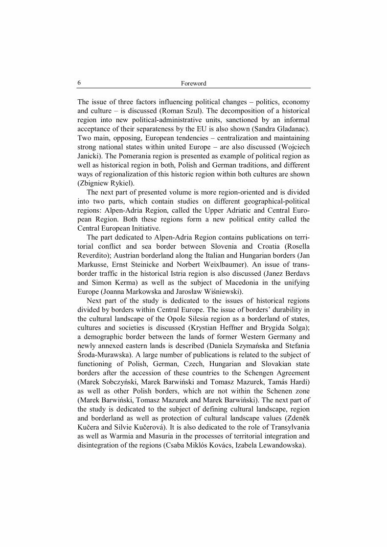
In a simple way history can be described as an interplay between politics, economy and culture in given geographical circumstances, see figure 1. (A more detailed analysis would entail more elements, such as demography, technology, etc., but for the sake of simplicity and given the subject and scope of this paper these elements can be omitted or included into the mentioned three). The term “interplay” suggests that the three elements are interrelated but also that they are relatively autonomous in the sense that each of them can act as “independent variable” influencing the other two. In other words, in some places and periods “culture” determines “politics” and “eco-nomy”, in other situations “economy” influences “politics” and “culture” and in yet another places and times “politics” shapes “economy” and “culture”.
This general approach can be used to any area of the world. In this paper it will be applied to the history of the Southern Baltic region (SBR), and more specifically to changes in state borders in this area. The Southern Baltic region used in this paper denotes territories of Germany and Poland along the Baltic Sea.
Given that the term “culture” is often used in various meanings and con-texts, in this paper it means first of all “way of life” including customs, religion, language, but also education, artistic and scientific activity influe-ncing way of life and identity of peoples and their attitudes to other peoples.

Roman Szul
10
Economy
External factors
Culture
Politics
Borders
Fig. 1. The interplay between Economy, Culture and Politics as factors determining, and determined by, border changes
Source: Author’s own elaboration
The aim of the paper is first of all to indicate the relevance of the inter-relation between the three mentioned elements, and not to describe in detail the history of the area. Therefore attention will be focused only on some historical periods when this interrelation was especially visible and when it was connected with changes in state borders.
2. CULTURE AND ECONOMY AS REASONS OF DEFEAT OF BALTIC SLAVS AND EXPANSION OF GERMANS
IN THE FIRST CENTURIES OF THE 2nd MILLENNIUM
After the Great Migrations of Peoples in the early Middle Ages the Southern Baltic coast was almost entirely populated by Slavic peoples forming several tribal organizations. Later on, in the western sector of this area (west of the Odra/Oder River), Slavic tribes were militarily defeated, politically dominated and culturally totally absorbed (assimilated) by expanding Germans1. In the eastern sector of the area (between Odra and Vistula Rivers) the situation was more complicated (as there were more political and cultural actors, notably Poland) and the result was also more complicated. Nevertheless, also there, around the middle of the millennium Germanic states dominated and most local Slavs had been pushed out or culturally Germanized and thus integrated into the German political and cultural life.
1 For more details see e.g. http://de.wikipedia.org/wiki/Geschichte_Mecklenburgs, http://wikipedia.org/wiki?geschichte_Pommerns.

The interplay of politics, economy and culture...
11
The case of the fate of Slavs west of the Odra River is especially instructive as an illustration of the role of culture and economy as factors determining politics and borders. Their defeat in confrontation with Germans can be attributed to their “cultural inadequacy” and lower economic efficiency. Their “cultural inadequacy” consisted in their pagan religion and strong adherence to it2, in the time of expansion of Christendom, especially in the time of crusades in the 12th century. Therefore it can be said that their culture was inadequate to “cultural norms” of Europe of that time. This “inadequacy” placed western Baltic Slavs outside the civitas Dei or Christian community. According to the “rules of the game” of then Europe, pagan (as well as other non-Christian and heretic) peoples were subject of religious missions to turn them to Christianity. If such missions failed and these peoples persevered in their wrong believes, Christian rulers had the right and even obligation to invade them and to force them to turn to Christianity or simply to annihilate them3. The same rules of the game made that pagan tribes could hardly receive help from Christian peoples, as the latter were afraid of being accused for conspiracy with “infidels” which would be dangerous to them. In such a way, “culture” (in this case religion and related customs) determined “politics” – political attitudes and situation of rulers and whole peoples. With the expansion of Christendom, political position of pagans, deteriorated. Their lands were invaded and conquered by neigh-bouring or distant Christian peoples (invited by the neighbours if they were not able to win militarily). This was also the case of western Baltic Slavs. After several wars they were militarily defeated and their lands conquered by German rulers (around 1160). Other western Slavs, which had turned to Christianity and eventually formed what is now Polish nation, as good Christians, participated in these wars on the Christian side.
Military conquest of lands of western Baltic Slavs meant a shift of borders of German duchies to the north and east (approximately to the Odra River).
This conquest did not mean immediate disappearance of Slavs in this area4. As the history indicates, quite often militarily defeated peoples survive
2 As a matter of fact some rulers of these Slavic tribes tried to introduce Christianity
but their attempts failed. 3 A good description of the attitude of the Christian community towards non-Chris-
tians in Middle Ages can be found in Preece J.J. (2005), Chapter 2 “Religion”. 4 In fact, the son of the last independent Slavic ruler of these tribes Niklot (defeated
by the German duke Heinrich the Lion), Pribislav, was given back most of his father’s land as a feud and became Heinrich’s vassal. Pribislav’s descendants ruled this area
Roman Szul
12
the defeat and even assimilate their conquerors and rulers. It was not, however, the case here. It was so because western Baltic Slavs turned out to be also economically less efficient and did not create enough attractive culture to sustain their separate identity.
The lesser economic efficiency of Slavic population in comparison with German settlers consisted in the lesser productivity of the former. Due to their agricultural techniques, they needed more land to produce the same amount of food or, inversely, they could produce less food, sustain less people and pay less taxes than German settlers could. Therefore, apart from other reasons, local landlords preferred German settlers whose number continuously grew, thus making local Slavs minority population. In such a way local Slavs were also defeated demographically.
As mentioned above, they did not create any alternative attractive culture so that they were gradually assimilated to Germans. In such as a way German domination in the western sector of the Southern Baltic region was con-solidated.
A similar mechanism operated in the area located east of the lower Vistula, in what was later called Eastern Prussia. Local Baltic tribes (Prussians) also rejected Christianity and became militarily defeated and conquered by Christians – mostly by Teutonic (German) crusaders invited by a Polish duke, and finally were assimilated by Germans.
The situation in the eastern sector of the SBR was considerably different, but some mechanisms described above also operated. The main difference was that local Slavic tribes were not militarily defeated and conquered by German rulers, and other external actors were also involved, namely Poles, Danes and later on Swedes, which hindered political, demographic and cultural expansion of Germans. Local Slavic dukes who managed in due time to take Christianity had more political manoeuvre space. However, also here German population expanded (due to settlement and assimilation) and the local duchies were gradually integrated with the German political space. (Assimilated were also dukes themselves). The main mechanism was again economy, supported by the cultural factor.
It should be noted that until the Reformation, assimilation of local Slavs to the German language and culture was not completed – in the eastern part of this territory a compact area, and in the central part some pockets, remained where the population still spoke Slavonic dialects and stuck to (Mecklenburg) nominally until 1918. Of course, they were Christians, assimilated to the German language and culture.
The interplay of politics, economy and culture...
13
traditional costumes. They, however, represented lower strata of the popu-lation, the upper strata being German (or Germanized).
With the collapse of the Commonwealth of the Two Nations (Poland) by the end of the 18th century and unification of German states (namely Brandenburg and Prussia) the whole area of Southern Baltic belonged to the German State of Prussia with predominantly German population.
3. CULTURAL SPLIT CAUSED BY THE REFORMATION AND ITS POLITICAL CONSEQUENCES
Reformation of the 16th century produced a split in West Christendom dividing it into Catholicism and Protestantism. Being a cultural and spiritual phenomenon it immediately generated political consequences. In the area under investigation it separated a part of Slavic population (Kashubians) loyal to the Catholic Church from Protestant majority consisting both of German and Slavic population.
This separation would have far reaching political consequences as those two religious groups evolved separately. While the Protestant group was dominated by Germans and consolidated in German culture, language and political loyalty to the Prussian/German state, especially because of the tight links between the Prussian state and Protestant Church in Prussia, the Catholic group was highly represented, if not dominated by, the Slavic (Kashubian) population, stayed apart from the process of integration of the German nation, and treated Prussia/Germany with suspicion if not hate. As a result of this split, Slavic Protestants, through participation in the German religious, cultural and political life and in the German society (e.g. due to mixed marriages) gradually abandoned their Slavonic language and consciousness becoming eventually Germans5. At the same time Catholic Kashubians created a consolidated isolated local community rejecting both
5 Interestingly, Kashubian Protestants earlier than Kashubian Catholics used Polish
(with local elements) as liturgical language, instead of Latin. This, however, did not prevent them from assimilation to the German language and culture, while Kashubian Catholics retained their idiom and identity. Similar process occurred among Lusatianas: Lusatian Protestants, first to adopt Lusatian as liturgical language, easily assimilated to the Germanness while Lusatian Catholics retained their language and identity. More on language, religion and identity of Kashubians see in: Borzyszkowski, Mordawski, Treder (1999). (This book is written in two linguistic versions: in standard Polish and in Kashubian.)

Roman Szul
14
Protestantism and Germanness. Attempts of Prussian authorities in the 19th century to force them to become Germans and various forms of discrimi-nation against them only strengthened their determination to defend their identity.
The division into Protestants and Catholics generated serious political implication in the 19th century with the spread of nationalism. The choice of national consciousness was obvious for the German-speaking and Protestant population: it was simply German consciousness. This category also included practically all Protestant Kashubians. A more complicated was the choice for Catholic Kashubians. What was sure for them was the rejection of being German. They had two options: to form a separate Slavic nation or to join the culturally, linguistically and geographically nearest Slavic and Catholic nation – the Poles. There were proponents of both options in the second half of the 19th century and at the beginning of the 20th century, but given that the defence from Germanization and liberation from the Prussian/German state was their common concern, both political orientations intensified their relations with the Polish national movement and opted for an independent Poland. The group identifying itself with Poland (or only opting for political integration with Poland) was in majority in a strip of land in Eastern Pomerania, west of Gdansk.
Presence of this group turned out to be especially relevant during the redrawing of state borders after the First World War. The area populated by this group was included to Poland. At the same time this area separated the two parts of the German state; East Prussia (and the so-called the Free City of Gdansk/Danzig, nominally a separate political-territorial entity) and the rest of Germany. The separation of East Prussia otherwise would become one of causes of dissatisfaction of Germany demanding a “corridor” through Polish territory to connect the two parts of German territory. Polish rejection of this demand was the immediate cause (or rather pretext) for Germany to attack Poland on September 1, 1939, thus starting the Second World War.
When analysing the history of Kashubians it is interesting to note that the term “Kashubian” first (in the Middle Ages) related to Slavic population in Western Pomerania and then “moved eastwards” to finally mean the Slavic population in the vicinity of Gdansk in Eastern Pomerania. The “eastward move” of the term was accompanied by the eastward expansion of the area populated by the German population caused by German settlement and by assimilation of the local population to the German language and culture due to the high economic efficiency and cultural attractiveness of Germans. Only
The interplay of politics, economy and culture...
15
the Reformation erecting walls of mistrust between Protestants and Catholics stopped this process.
4. THE SECOND WORLD WAR AND ITS IMPACT ON BORDERS AND CULTURES
The Second World War, which started in the area under consideration (although its deeper political and ideological roots were elsewhere) dra-matically changed the whole political, cultural, ethnic, economic, and demo-graphic landscape of the area. The pre-war borders were abolished, new ones were established, changes of ethnic composition of the population with related cultures and languages in a large part of the area took place and a new political and economic system was introduced in the whole area.
As it is known, the whole eastern sector of the SBR as well as the southern part of East Prussia was incorporated to Poland, the German population in the territory (forming a vast majority before the war) was replaced by the Polish (including Kashubian) population. New inhabitants brought with them their language – Polish and its Kashubian dialect (by some considered as a separate language). In such as way, the process of demographic and cultural expansion of Germans in this area, which had lasted several centuries, was reversed in a few months. Germany was divided into two states: the GDR and the FR of Germany and the frontier dividing them (including in the Baltic coast) was also a frontier between the two political-military blocks and socio-economic systems during the cold war. The socialist system and the Soviet political domination extended to Poland and the GDR, in other words to almost the whole South Baltic region (in addition to the whole East Baltic region).
The new borders were almost totally impermeable. The border between Poland and the GDR was not only a state border but also a clear-cut ethnic and linguistic border with monoglots on the two sides lacking any common language. It was also a religious border as the vast majority of Poles were Catholic while on the other side of the border there were mostly Protestants and non-believers6. This was a new phenomenon given that in the past there was always an ethnic, linguistic and religious mixture (although with
6 To compare, in 2004, according to Evangelic Church in Germany (Evangelische Kirche in Deutschland, EKD) in the Land Mecklenburg-Vorpommern, non-believers formed 78.2% of the population, Evangelic (Protestants) 18.4% and Catholics 3.4%. (Evangelische Kirche..., 2005).

Roman Szul
16
changing proportions of components) and a part of the population was bi-lingual.
When analysing the Second World War and its implications for the region, it is worth noting that, although the war started in the analysed region and initially involved the two countries of the region, the final outcome of the war was determined by external powers – the winning powers of the war, their military strengths and political interests. In such a way, external political factor determined other elements – demography, economy, culture, language, etc.
5. END OF THE COLD WAR, EUROPEAN INTEGRATION, SOCIO-ECONOMIC TRANSFORMATION AND THEIR
IMPACT ON BORDERS, CULTURES AND ECONOMIES
Also the end of the cold war was mostly caused by external factors (such as the collapse of the Soviet Union and the demise of communist ideology), although, again, the region, especially the Polish part of it (events in Gdansk in 1970, “Solidarity” movement in 1980/1981 and later on which started in Gdansk, substantial role of people from Gdansk in the Round Table and in the first non-communist government in Poland and in this part of the world in 1989, etc.) substantially contributed to it. The collapse of the communist/ socialist system was undoubtedly due to a large extent to its lower economic efficiency (in comparison to the leading free-market economies) and to its cultural inadequacy to needs of a large part of the population, especially in such countries as Poland. In such a way this great political event, the collapse of the communism and the end of the cold war, was an outcome of economic and cultural factors. Nevertheless, these factors acted in a broader area of the communist bloc, so the changes in the region concerned cannot be attributed to lower economic efficiency or cultural inadequacy of this particular region.
In the sphere of politics and borders the most spectacular and immediate result of the end of the cold war was the breakdown of the GDR and its absorption by the Federal Republic of Germany in 1990 (usually called “reunification of Germany”) with the elimination of the German-German border.
The political decision of Poland to embark on building a free-market economy and democracy (”transformation” or “transition”), and to join Western political and economic institutions – the European Union (European integration) and NATO, as well as the favourable attitude of Germany

The interplay of politics, economy and culture...
17
towards Polish plans, considerably changed the nature of the Polish-German border. Elimination of visa requirement at the beginning of the 1990s, access of Poland to the EU in 2004 and to the Schengen area of free crossborder movement of persons made the Polish-German border permeable for people, goods and capital (although not for workforce).
The opening up of the Polish-German borders along with some economic factors (such as differences in living costs, especially in housing costs, and in wages between the two sides of the border, as well as under-utilised agricultural land in Poland) resulted in a cross-border migration and ethnic mixing of the population: e.g. Polish inhabitants of German Löcknitz working in Polish Szczecin (Stettin), Polish and German students attending the same secondary schools in the border zone, as well as German (and Dutch) farmers in Poland. The expected elimination of restriction on the German labour market and on the real estate market in Poland will probably accelerate the cross-border migrations. The permeability of the border and growing contacts of the two populations are followed by many phenomena, such as bilingualism (it is, however, mostly asymmetrical: these are mostly Poles who learn and speak German7).
It can be said that the situation in the Polish-German border zone near Szczecin in some respects resembles that existing one thousand years ago: ethnically mixed Slavic and Germanic population, cultural asymmetry in favour of the Germanic population, economically efficient German settlers… There are, of course, considerable differences, too, in comparison to what was one thousand years ago, just to mention higher demographic vitality of the Polish population in the area and the tendency to migrate to the West rather than to the East among the German population, let alone quite a different political situation in the area.
6. RETURN OF THE OLD-STYLE GEOPOLITICS AROUND THE GERMAN-POLISH BORDER?
Opening up of the German-Polish border and the membership of the two countries in the European Union and NATO do not mean that the border has
7 It does not mean that the German side totally ignores Polish. For instance, some
German school children do learn Polish (first of all in the German-Polish gymnasium at Löcknitz), internet portal of the land Mecklenburg-Vorpommern (bordering with Poland) has a Polish language version, see www.mecklenburg-vorpommern.eu.

Roman Szul
18
lost its political and economic meaning. A spectacular reminder that the German-Polish border has not lost its meaning as a line separating different national political and economic interests is the recent German-Russian Nord Stream project (signed in 2005).
This project supported by German and Russian governments envisages building on the Baltic Sea bottom a pipeline transporting natural gas, connecting Russia and Germany, bypassing Poland and other east-European countries. The pipeline should reach the seashore just a few kilometres west of the German-Polish border (at Lubmin near Greifswald), and then one of branches of the pipeline should run alongside the German-Polish border (on the German side) to the Czech Republic thus visibly stressing its character as a line bypassing Poland.
The Nord Stream project revealed or accentuated political differences between Poland and Germany and increased mistrust of Poland towards German strategic political goals.
For the German governments and firms which signed and supported the agreement as well as for the German public opinion the project is a strictly economic undertaking that would ensure supply of Russian natural gas to Germany and thus strengthen so profitable German-Russian economic co-operation8. Possible impact of this project on third countries such as Poland was probably not taken into account at all. Absence of any attempt to consult the agreement with Poland, or even to inform Poland about it before its signing, can be interpreted as an unconscious negligence of third countries or as a deliberate behaviour (agreed upon jointly by the German and Russian leaders) to ignore Poland and thus to avoid a necessity to respond to Polish objections given that Polish dissatisfaction would be obvious.
For the Polish side (government, politicians of all orientations, experts, public opinion) the Nord Stream is unanimously interpreted as a threat to Polish energy security and, consequently, to its political security. It is because of Poland’s high dependence on Russian oil and gas supplies. So far Russian gas and oil are transferred to Poland through pipelines, which end in Germany. Because Germany is a strategic economic partner for Russia, Russia would not dare to stop supplies by these pipelines, which makes
8 See for instance interview with the chief manager of Eon (one of the two German
firms in the undertaking): Eon-Chef Reutersberg: “Russland ist ein zuvelässiger Partner”, Süddeutsche Zeitung, 3.09.2008.

The interplay of politics, economy and culture...
19
Poland secure from possible Russian blackmail – it is argued in Poland9. Building a line bypassing Poland would dramatically deteriorate the position of Poland in the energy supply and transfer network, making it vulnerable to Russian (as well as German) pressures. To some (if not all) Poles this project reminds earlier instances of German-Russian co-operation to the detriment of Poland (such as partitioning of Poland at the end of the 18th century, Hitler- -Stalin agreement in 1939, etc.). Poles see this project as purely political undertaking, which is not justified by technological, economic or ecological considerations. According to the Polish point of view, the pipeline should be built on the ground and should lead through Poland. Such a project called Yamal-2 (line 2) was agreed upon already in the 1990s but later on the Russian side abandoned it without explaining the reasons. Such an attitude of the Russian side gives grounds for suspicion that the real aim to build a pipeline bypassing Poland is to weaken the position of Poland. Partici-pation of Germany in this project, and the above-mentioned circumstances of signing the German-Russian agreement, raises Polish doubts as to German intentions regarding Poland.
Whether Polish reasoning is correct or not, the Nord Stream project only strengthened Poland’s concern about its national security. For some Polish politicians Poland’s membership in the European Union and NATO alone is not a guarantee for its security. They argue that Poland must look for (or, more precisely, must stick to) a powerful ally – the USA. Although this point of view is not shared by all politicians and experts and the whole public opinion (many believe in viability of the European Union and NATO without special relations of Poland with the USA), it is especially popular among politicians in power (regardless of their political colour).
The recent US-Polish agreement on locating in Poland elements of the American “missile shield” confirms this statement. The missile shield, otherwise, should be located near the Baltic Sea shore, or in the area investigated by this paper.
Although the Polish consent to locate in Poland elements of the American military installation is not a reaction to the Nord Stream project, both
9 It is interesting that this reasoning is not taken into account in Germany. In the German media Polish complaints are either ignored or misinterpreted. One can find a thesis that Poland opposes the project of building a pipeline bypassing its territory because it will lose possible income from transit fees. Compare: Die Polen stehen ohnehin unter dem Verdacht, dass sie vor allem deswegen beleidigt sind, weil sie künftig weniger Durchleitungsgebühren kassieren werden. „Ostsee-Pipeline: Eine Verbindung unter Druck. Das Das riecht nach Macht Süddeutsche Zeitung, 6.07.2008

Roman Szul
20
projects resemble an old-style geopolitics. Hopefully, the real old-style geopolitics confronting Poland and Germany will not return.
7. CONCLUSIONS
The thousand years of history of the Southern Baltic Region is an illustration of the interplay between culture, economy and politics, and of their interrelations with changing borders (i.e. geographical location and character of the latter).
“Cultural inadequacy” of pagan tribes in the western part (west of the Odra/Oder River) and in the eastern part (east of the Vistula River) to the then “cultural norm” or Christianity resulted in their political isolation and finally in their military defeat and in political, cultural economic and demographic domination of Germans in these areas. Cultural and economic factors also explain the constant diffusion of German culture and language in the central part of the SBR and its integration with the German political (as well as cultural and economic) space. As a result, borders of Germanic states moved eastwards and in the 19th century the whole area was under political control of Germany. A cultural factor – namely the split within Christendom into Protestants and Catholics – also explains resistance of a part of the local population (Catholic Kashubians) to the German culture, language and identity and its adherence to the Polish culture, language (Kashubian being mostly perceived as a dialect or variety of Polish) and identity. This, in turn, was a decisive factor in drawing state borders after the First World War when the area populated by Kashubians was annexed to the re-emerged Polish state.
Not always changes in borders and political situation in the SBR can be attributed to local cultural, economic and political factors. Dramatic military and political events of the Second World War and its aftermaths were decided upon in battlefields and negotiations which took place mostly outside the area. Their most immediate results were changes in state borders and massive migrations of populations in most of the area leading to its fundamental demographic, ethnic, cultural and linguistic transformation. Also the collapse of the communist system and the end of the cold war in 1989–1991 enabling unification of Germany and integration of Poland with the EU and NATO, were largely due to external political factors although the region of Southern Baltic, first of all Gdansk, took its part in initiating or accelerating of these events. They resulted in the elimination of one border

The interplay of politics, economy and culture...
21
(between the two German states) and in the change of the character of the Polish-German border. This led to significant changes in the sphere of culture and economy – accelerated cross-border flows of people, goods and capital, to some ethnic mixing of the population and increased (asymme-trical) bilingualism. The new character of the German-Polish state border has not removed, however, all its economic and political significance, which is clearly demonstrated by the Nord Stream project. This German-Russian pipeline project bypassing Poland is considered by Poland as threatening its security, and by Germany as strengthening its security.
REFERENCES
BORZYSZKOWSKI, J., MORDAWSKI, J. and TREDER, J., 1999, Historia, geografia, język i piśmiennictwo Kaszubów /J. Bòrzëszkòwsczi, J. Mòrdawsczi, J. Tréder: Historia, Geògrafia, Jãzëk i Pismienizna Kaszëbów, Gdańsk/Gduńsk: Wydawnictwo M. Rożak.
Eon-Chef Reutersberg: “Russland ist ein zuverlässiger Partner”, Süddeutsche Zeitung 3.09.2008.
Evangelische Kirche in Deutschland, “Kirchenmidgliederzahlen am 31.12.2004”, EKD, 2005, www.ekd.de/download/kimi_2004.pdf .
Ostsee-Pipeline: Eine Verbindung unter Druck. Das Gas riecht nach Macht, Süddeutsche Zeitung 6.07.2008
PREECE, J.J., 2005, Minority rights, Cambridge: Polity Press; Polish edition: Prawa mniejszości, 2007, Warszawa: Wydawnictwo Sic!
http://de.wikipedia.org/wiki/Geschichte_Mecklenburgs http://wikipedia.org/wiki?geschichte_Pommerns www.mecklenburg-vorpommern.eu

Roman Szul
22

Sandra GLADANAC University of Milan, ITALY
No 9
FAILURE TO LAUNCH: THE EU INTEGRATION POLICY DISINTEGRATING HISTORICAL REGIONS
Since the end of the last Balkan wars, the civilized world and the European Union started to give attention to this “black hole” of the European continent. Given the situation and the scale of destruction, it was clear that there was an enormous amount of work to do. It did not involve mere reconstructing; social structures were destroyed as the former Yugoslavia broke into pieces, inhabitants displaced or dead, lives of millions of people changed irreversibly from every point of view.
The present work concentrates both on the recent past and the present, as they both show clearly the European Union’s policy towards the Balkans. Bosnia and Herzegovina, the first of the examined countries, is a perfect example of what years of “help” and questionable managing can do. The case of Kosovo and Serbia has created – and still creates – a significant rupture in international laws and policies, which represents a dangerous precedent.
1. NEVER ALONE: EU’S NEVER-ENDING PRESENCE STOPS BOSNIA FROM GROWING UP
The Dayton Agreement, signed on November 21st 1995, put an end to an absurd war in the very heart of Europe, that culminated in Srebrenica’s massacre after years of fighting, and made impossible for the USA and the EU not to intervene in a firm manner. There is no need to explain in details how Bosnia was divided with the Dayton agreement1. The document has
1 The full document can be found at the Office of the High Representative’s website, http://www.ohr.int/dpa/default.asp?content_id=380.
Sandra Gladanac 24
been discussed in numerous articles, books, conferences over the world. Still, it is important to mention that the constitution itself was never voted or approved by Bosnian citizens (in years following the war), therefore it could hardly be called “the Bosnian constitution”. It was certainly the first – and in a way, the most comprehensible – sign of the EU’s presence, necessary at the moment, but not perfect in any way.
Besides, the Agreement itself and the war settlements it introduced is absurd if considered in its intents. Bosnia, a country divided by an atrocious war, most certainly did not need any more divisions; and yet, the Agreement that saved human lives and months of eventual fighting to come actually brought a legitimization of ethnic divisions which inflamed the war at the beginning. The parties involved that signed it, were the Republic of Bosnia and Herzegovina, the Republic of Croatia, the Federal Republic of Yugo-slavia, the Federation of Bosnia and Herzegovina, and the Republika Srpska2. Out of them, only the first three could be considered legitimate as they existed before 1991, while the last two based their legitimization only on the 1995 war situation.
The intention was to save Bosnia and Herzegovina from ulterior disasters, possibly by keeping it as a multiethnic state, accordingly to its history. The only alternative was to create three separate states based on the ethnic groups that lived there: Bosniacs (of Muslims), Croats and Serbs, which unfortu-nately meant also giving legitimacy to all the killing and ethnic cleansing done in the years of war. The international political scene, together with the EU, thought that isolating the problems and solving them separately would facilitate the process of healing what was irrevocably broken (Dérens, 2008). The “time heals everything” policy turned out to be very wrong in the ex- -Yugoslavia’s case, as at the present time no miracle has happened, and the lack of a true regional policy that would confront the problems as a whole – and not only one at a time, often too late, when they already started other crisis – left its marks on the region.
Nevertheless, choices were made and Bosnia was re-born as an inter-national protectorate, clearly unable to stand on its own legs, and with all the economical, political and social structures to re-build. If we consider how Bosnia was seen in world media during the war, it is easily explained how natural it was for the EU to assume control over this country, in the name of “integration, peace and a new life”. Incredible to understand and realize, the Bosnian war was something inevitable, predestined to happen between semi-
2 Annex 1B of the Dayton Agreement.

Failure to launch: the EU integration policy...
25
-barbarous populations divided by ancestral hatred, alimented by ethnic and religious fanaticism, and nothing could stop the madness happening at the doorstep of the “civilized Europe”. That is a cliché that sadly still exists and stands in Bosnia’s way whenever joining Europe is mentioned: it is always “unstable”, “potentially dangerous because of its Muslims”, “unable to go forward”, etc.
Serb
Bosniac
Croat
Controlled territory:
Inter Entity BoundaryLine (IEBL)
F
RS
RSBosniac-CroatFederationRepublika Srpska
F
RS
BosanskiBrod
Bihać
Prijedor
BaniaLuka
Doboj
Brčko
Tuzla
Zvornik
Srebrenica
Zelenica
Mostar
Jajce
Foča
Trebinje
Goražde
Fig. 1. Bosnia and Herzegovina under the Dayton Peace Agreement Source: After www.ohr.int
A country unable to stand on its own legs needs to be supported, and therefore gaining control is a natural step. Every institution was re-created and supervised by international organizations, and a new figure was born:
Sandra Gladanac 26
High Representative of the International Community (since 2002 also Special Representative of the European Union), with his own office. There is no similar figure in the world that could be compared to this function: the man who gets that office has more power in Bosnia than any other political body of the country itself, including the power of veto and supervising the decisions of the very complicatedly organized government. It was the decision made at the Bonn Conference, when it was clear that it would be impossible to get all the parts involved to get along and to pursue common interests, and that is widely known as “Bonn powers”3. This phrase has its own meaning in Bosnia and translates into a sense of helpless resignation to the power of the Western World in Bosnian matters.
Apparently, all the premises were there to make Bosnia functional again. The European Union and the rest of the Western world was in control of the country after the war, had imposed peace and created structures that were supposed to restart the state engines. The newly created figure of the High Representative was there to make sure that the Dayton Agreement was implemented and respected, and there were plenty of international organisations that were willing to invest in Bosnia through some ad hoc programs, and the private foreign capitals were to follow right after. So what went wrong and why is Bosnia still an “under-age” country, which is not able to stand on its own?
A first answer could be found in the Bosnia’s state structure itself. There are two big sections: the Federation and the Republika Srpska (Republic of Srpska). The Federation tries to keep inside the Croatians and the Muslims, while the Republika Srpska is entirely on its own, with even its name to confirm a special status given by Dayton. How is it then possible that a Republic could have been created inside a Republic, when the international community was looking for a way to recompose Bosnia and avoid subsequent divisions? And more, why giving only the Serbian entity such liberty and recognition? The answer is very simple and obvious: stopping the war was a priority, and it looked like an appropriate response. But the situation that arrived within few years after the war emergency has become an obvious proof that such a solution was unequivocally the one to stop the war, but also a living contradiction: reintegrating of what was destroyed into one whole country, but disintegrating even more by creating a state inside
3 The Bonn Conference conclusions document, and its XI paragraph regarding the
High Representative’s new powers can be downloaded or read at http://www.ohr.int/pic/ default.asp?content_id=5182#11.

Failure to launch: the EU integration policy...
27
a sovereign state4. In fact, the Annex IV of the Dayton Peace Agreement limits the state responsibilities (but perhaps this can be read also as “powers”) and favours the Entities’ rights5. This has proved to be a notice-able obstacle when it comes to the state functioning, and gradually down-graded growth of some sectors such as state defence, economy, police system and generally the safety issues.
Today’s European Union is pursuing goals that often mention “common identity” and “cancelling borders”, but in the very heart of the European continent there is still Bosnia, once a true example of inter-ethnic cohabitation and a no-border land, but now a Frankenstein made of smaller entities with less or more official recognition (but evident concrete results/issues), that exists only because of the EU presence, which only keeps the “monster” alive. Bosnia never grows, just continues its existence in a permanent state of everyday situations that are to be solved immediately. There is only short-term planning, and the conscience of the fact that whatever happens, there is an international power representative that, if need be, is ready to assume all the responsibilities. Basically, there is the figure of a tutor that fails to teach. That is simply an illness in the heart of Europe, a policy of allowing nationalism and ethnic-based priorities for each Bosnian entity, a tribal situation that keeps that “barbarian myth” mentioned before alive in the eyes of the international community.
This impasse is even more significant if we consider that the Republika Srpska’s Prime Minister Milorad Dodik never denied having international aspirations: entering the EU, as a state, preferably as a sovereign one, but possibly also as an entity with sovereign powers if the first option turns out to be impossible (Katana, 2008). The nationalistic current legitimized with the Dayton agreement fails to recognize its own incapacities, and leads an aggressive policy that refuses any kind of negotiation of the only document that justifies its existence. However, it seems that these aspirations of sovereignty cannot coexist with Bosnia’s entrance into the EU. The High Representative himself appears to recognize the failure, but also avoids proposing any kind of solution to the situation by saying that “the international community cannot impose a constitution on Bosnia” (despite de facto doing it already). On the other hand, he states that “Bosnia will suffer
4 International Crisis Group, The wages of Sin. Confronting Bosnia’s Republika
Srpska, ICG Balkans Report n° 118, published on October 8th 2001. 5 For a more detailed explanation, the full document can be consulted at
http://www.state.gov/www/regions/eur/bosnia/bosagree.html.

Sandra Gladanac 28
until the local politicians are ready to search and find an answer to this issue” (Katana, 2008).
A good example of an apparent victory of the International Representative – which in fact proved to be a failure – is the Police Reform. After several attempts, it was eventually implemented in October 2007, but it did not change anything in real life. It could be said that the main problem was the refusal of the Republika Srpska to join the idea of creating a unique police body. It would be normal in a sovereign state, but obviously it was not considered to be desirable. Republika Srpska’s Prime Minister Dodik had affirmed many times that his entity was not interested in the European Path, if the only way to it was to get deprived of its own entity police. Clearly, having their own police was a guarantee of having really a state inside of a state, and therefore a clear proof of the Republika Srpska’s legitimate existence. Apparently, no way out.
In no other country of the region has the international community spent more money and resources on reforms, and in no other country there was such a failure. Also, absurdly, having the EU inside their own home failed to bring Bosnians closer to the Western World through EU’s gates. Despite the fact that international presence was necessary, in 2008 it seems that 13 years after the war ended Bosnia is still treated differently from all other countries in the region. As matter of fact, it is put aside as a failure that nobody wants to deal with. The isolation of ethnic problems and issues, which was supposed to calm the situation, brought about further divisions and established legitimate cultural and political borders that are now considered unbreakable by the ones perpetuating them.
The question that needs to be answered is: will Bosnia open its eyes to the fact that nationalism and the legacy of the hurtful past will only keep her image of “European black hole”, and will it be able to embrace those values publicized largely through the various Representatives? Surely, Bosnia cannot expect to be integrated with the EU before 2020. Obviously, an integration of a country that already is the contrary of integration is hardly imaginable. Unfortunately, by legitimizing ethnic divisions, the Dayton Agreement has put Bosnia in a unique position of a state with various states inside and with a complicated government system. In such a situation staying united is almost impossible.

Failure to launch: the EU integration policy...
29
2. SERBIA/KOSOVO ISSUE: BREAKING INTERNATIONAL LAWS
When the majority of the EU members recognized Kosovo as an inde-pendent state, the EU itself indirectly favoured a subsequent fragmentation of the Balkan region. This new step in the process of disintegration of Western Balkans, which is far from completion – despite what is believed and contrary to the author’s opinion – will be able to produce regional instability and could possibly start a dangerous “domino effect”. This is aggravated by the fact that such an illegitimate act of recognition of this new state – at least when it comes to international laws that are still in power – is entirely the opposite of the European integration professed (in words only) by the Bruxelles Commission.
Given that Kosovo is an Autonomous Region internal to the Republic of Serbia, any kind of imposition coming from the international community can rightfully be seen as interference with internal policy of a sovereign state. Kosovo is, however, not just a Serbian matter. It is above all a European issue: first of all because it was the international community that supported this secession, and secondly, because now it has to proof that there still exists an international common interest in disintegration of a historical region. In addition to that, there is the question of Vojvodina, the other autonomous region of Serbia – having the same status Kosovo once had. If we assume that Kosovo – as any other ex-Yugoslav republic – had the right to become a sovereign state, the question can be asked about Vojvodina’s future. From the point of view of the international law, it is not clear whether an autonomous region is equal to a republic. Nevertheless, once a precedent has been created, what can prevent Vojvodina from declaring a secession? Does Serbia’s way to European Union involve further fragmentation and will its entrance be conditioned by this new possibility?
Another possibility that emerges is Republika Srpska’s independence of the state it already does not recognize. Has the Republic created by the Dayton Agreement – the supreme constitution act of Bosnia – a reason and a right to exist now, when Kosovo is a state, too? Its prime minister Dodik admits now that the recognition of Kosovo opens new possibilities, and so does the example of the Russian recognition of South Ossetia and Abkhasia: “Should it happen that certain states acknowledge Kosovo’s independence, it

Sandra Gladanac 30
will, if not right away than in time, create various consequences, one of them being that everybody should have an equal right to demand independence.”6
International boundaryRoadRailway
Republic boundary
National capitalProvince capital
Autonomous provinceboundary
Airport
20 km100
Gnjilane
Obilić
Srbica
KosovskaMitrovica
Vučitrn
PodujevoZvečan
ZubinPotok
NoviPazar Leposavić
RaškaSjenica
Tutlin
Rožaj
IstokĐurakovac
(Djurakovac)Vitomirica
Đakovica(Djakovica)
Blance
Kuršumlija
Prokuplije
Brestovac
Bojnik
LebaneMedveďa
(Medvedja)
NovoBrdo Kosovska
Kamenica
PRIŠTINA
Janjevo
G ogovacl
PećKlina
Decani
Junik
BajramCurri
Plav
Orahovac
Mališevo
Prizren
SuvaReka
ŠtimljeUroševac
Štrpce Kacanik
Vitina
SKOPJE
Tetovo
Kamenjane
Vrapčište
Gostivar
Brod
Niš
Vranje
Bujanovac
Kumanovo
S E R B I AM o n t e n e g r o
THE FORMERYUGOSLAV REPUBLIC
OF MACEDONIA
Dragaš
Fig. 2. The Serbia and Kosovo detailed map Source: After www.dunav.org
This scenario leaves Serbia alone on its path to the EU, with nothing but obstacles on her way. Serbia is isolated on the international scene, and still fights an already lost battle for keeping Kosovo, using even legal means. In fact, the intention was to submit the Kosovo case at the 63rd General Assembly of the United Nations, asking the member states to question the
6 A short interview published on September 23rd 2007, at www.b92.net.

Failure to launch: the EU integration policy...
31
International Court of Justice over the legitimacy of Kosovo’s recognition. This move cannot be considered as a mere act of stubbornness, as an eventual positive response of the Court could help Serbia gain a moral victory. In fact, Serbia succeeded and the UN Assembly did approve a draft resolution asking for the ICJ to give its (non-binding) opinion on the matter. This has been greeted in Serbia as a big step, while Kosovo’s government expressed its disappointment. Nevertheless, there is no real possibility of reversing what has been done, with 50 out of 192 UN member states recognizing the newborn republic; Serbia’s impossible fight for the preservation of international laws really hides a profound wish for redemption in front of the world’s eyes. By having to suffer from what has been presented as inevitable and natural, considering the very tense situation in the Kosovo region, the only way to restore this country’s faith in itself would be to obtain a favourable ICJ opinion in the matter of legitimacy of Kosovo’s succession. The new rupture in already fragmented Balkan region involves also the remaining states’ neighbourly relationships.
The case of a permanently divided Montenegro and its formal recognition of Kosovo’s independence started new issues in the tormented relationship between the two former state partners. The fact that Montenegro and FYROM – widely known as Macedonia – issued a joined statement produced harsh reactions in Serbian public opinion. On a more popular level, such decision is considered to be “high treason”, considering the historical, cultural, ethnic and linguistic bond between Serbia and Montenegro, and historical vicinity as well as fraternal feelings that Serbia and Macedonia shared. Montenegro’s purposes are not hidden at all: its President Filip Vujanović states that “Montenegro wants to be a part of Europe and NATO, and the Kosovo’s recognition issue could not be delayed anymore on Montenegro’s path to Euro-Atlantic integration” (Gilić, 2008). This decision has been promptly greeted by the USA, who claim that recognizing Kosovo equals to reaching more quickly the goal of a stable and democratic society. What really happened is that this move resulted in violence, with protests and hatred against the two former Yugoslav republics all across Serbia. There has been also a curious situation between the Montenegro Airlines and the Belgrade Airport authorities: the Montenegrin company has been fully declared as “foreign” and therefore got the same treatment as any other non-Serbian carrier. This translated into an augmentation by 90% of the airport fees, which in Montenegro has been perceived as a reply to their political decision regarding Kosovo. The Kosovo scenario opens various possibilities, none of them bringing any prospects of stability for the Balkan region. Serbia

Sandra Gladanac 32
has always been a delicate field, with many emotional and cultural components ruling its habitants’ lives; Kosovo is of great importance, with its monasteries (as the religious homeland) and the famous Kosovo battle, that never ceased to be mentioned during the new battle for that ground which was lost at the end. The EU policy of isolating the problems and dividing what apparently cannot function together anymore will certainly introduce new problems that will overcome the Balkan borders.
3. CONCLUSIONS
What has the International Community done in the Balkans? Bosnia appears to be non self-sufficient, Serbia is no longer in the Union with Montenegro and now faces the loss of Kosovo, with an open dangerous possibility of having problems with Vojvodina too.
Apparently, the only successful process of integration into EU’s organization chart was Slovenia, the only one among the ex-Yugoslav states that managed to stay out of the Balkan mess. However Slovenia has always been perceived as “different”, staying away from the wars and being open to the Western Society. Despite of its belonging to the Balkans, Slovenia chose to turn to its Western roots and became the living proof of success in terms of international policy. Croatia and Macedonia are the only official candidates for joining the EU, differing in the fact that the Croatians do not need any visas to enter the EU’s territory. Hopefully, Croatia could reach its goal before 2012, despite its issues of nationalism that still inflame the public opinion and a very weak economy that does not quite meet EU’s standards.
Serbia has very similar problems, and despite signing the SAA (Stabi-lization and Association Agreement) is nowhere near to reaching Croatia’s status. It can be said then, that the EU used two different approaches for very similar situations, in Bosnia and Serbia and Montenegro’s case. Citizens face the visa obligation, difficulties to travel, and the countries are suffocated by isolation that today more than ever is obvious, in Europe with no borders. The obvious solution would be integrating these countries immediately, without repeating mistakes made in Bosnia. This, however, is very unlikely to happen.
The EU integration policy fails when it comes to a true integration. In fact, it is limited to controlling and putting in new requests and limits. Therefore, it only leads to disintegration by creating divisions (keeping the

Failure to launch: the EU integration policy...
33
Balkan countries inside a ghetto) and instigates insane competition between countries involved, alimenting newly reborn hatred.
REFERENCES
ALLCOCK, J.B., 2000, Explaining Yugoslavia, New York: Columbia University Press. BOSE, S., 2002, Bosnia after Dayton. Nationalist partition and international
intervention, New York: Oxford University Press. BOULANGER, P., 2002, La Bosnie-Herzégovine. Une géopolitique de la déchirure,
Paris, Karthala. DÉRENS, J.-A., 2008, Balkans occidentaux: les responsabilités de l’Union européenne,
published online on May 26th 2008 at http://balcans.courriers.info. GILIĆ, J., 2008, Il Montenegro diviso riconosce il Kosovo, published on October 14th
2008 at www.osservatoriobalcani.org. IMAMOVIĆ, M., 2006, Bosnia and Herzegovina. Evolution of its political and legal
institutions, Sarajevo: Magistrat. KATANA, G., 2008, Mission Impossible, published online on June 13th 2008 at
www.osservatoriobalcani.org. SANGUIN, A.-L., CATTARUZZA, A. and CHAVENEAU-LE BRUN, E. (eds.), 2005,
L’ex-Yugoslavie dix ans après Dayton. De nouvenaux Etats entre déchirement communautaires et intégration européenne, Paris: L’Harmattan.
SOLIOZ, C., 2003, L’après-guerre dans les Balkans. L’appropriation des processus de transition et de democratization pour enjeu, Paris: Karthala.
SOLIOZ, C., 2005, Turning points in post-war Bosnia. Ownership process and European Integration, Baden-Baden: Nomos.
SOLIOZ, C. and VOGEL, T.K. (eds.), 2004, Dayton and Beyond: Perspectives on the future of Bosnia and Herzegovina, Baden-Baden: Nomos.

Sandra Gladanac 34

Wojciech JANICKI Department of Economic Geography Maria Curie-Sklodowska University, POLAND
No 9
MULTIPLE EUROPE OF NATION-STATES OR MULTIPLE EUROPE OF NON-NATION REGIONS?
POLITICISATION OF THE DILEMMA AND CONTRIBUTION OF POLAND
TO THE EUROPEAN IMAGE
1. INTRODUCTION
Europe has for centuries suffered from conflicts. The vast majority of them originated on the continent, resulting from imperial ambitions, geopolitical visions, territorial disputes, breakdowns of multinational states, increases of nationalistic feelings, struggles for independence, just to name a few reasons. In the 21st century, Europe has significantly turned to peaceful coexistence of states, co-operating on political, economic and military grounds. This co-operation, gradually extending its spatial range, is deeply rooted in foundations of the European Union – the most effective multistate organisation of the continent that ever existed.
The changing geopolitical situation, both within the EU and outside, requires constant adaptation of the EU to meet new challenges. One of them is protection of human rights of all European citizens, regardless of their ethnic background. In this context, one of the important elements that need close examination is the internal structure of the EU. Organization of reciprocal relationships between the EU, its member states and their regions is crucial both for proper management of this highly diversified area and for its inhabitants. The possible solutions for said structure vary from European Homeland through Europe of Nations to Europe of Regions. Although this is not explicit, the choice has critical consequences for national and ethnic groups inhabiting the continent, since it implies the scope of self-determination possibilities for them. This paper aims at exposing inter-

Wojciech Janicki 36
connections between the internal structure of the EU and ethnic structures of its inhabitants and will also try to evaluate possible results of adoption of each of the structures mentioned above. Polish approach will be presented in the context of tendencies observed in Europe.
2. CONCEPTUAL BACKGROUND – VARIOUS “EUROPES” CONFRONTED
Contemporary Europe faces three opposing tendencies. The first one is rooted in Winston Churchill’s idea, presented for the first time in Zurich in 1946:
There is a remedy which [...] would in a few years make all Europe [...] free and [...] happy. It is to re-create the European family, or as much of it as we can, and to provide it with a structure under which it can dwell in peace, in safety and in freedom. We must build a kind of United States of Europe (Zurich, 1946: Europa. Gateway to the European Union, http://europa.eu).
Churchill and his successors perceived existence of sovereign govern-ments in European nation-states as the main cause of centuries of disastrous wars, that used to destroy human lives and property all round Europe (Europa..., 2008). According to his vision, federal Europe with central government, central parliament and highest judicial authorities should prevent an outburst of new conflicts and clashes between nations inhabiting the continent. It would require transferring political competences and aims from a country level onto continental level. Foundation of such a federation of states, similar in its structure and functions to the U.S.A., would create a super-state, an empire that could compete with other empires, namely the U.S.A., the Soviet Union, and China (Europa..., 2008). Consistently, poten-tial domination zone claims would expand behind the confines of the united continent, securing peace for its very territory. Additional attributes of power would be one army, common foreign policy and one currency. Both real and de iure lack of internal state borders would accelerate creation of a European identity, connected with the United States of Europe first, only then with its parts. If this concept, usually called Homeland Europe, succeeded, it might probably decrease ethnic tensions and ethnic egoisms between national groups and reduce the intensity of “Us vs. Them” syndrome, thanks to leading to inclusion of large groups of people to the “We” group, shaped by

Multiple Europe of nation-states or multiple Europe of non-nation-regions?...
37
the European identity. To date, the United States of Europe was not given a chance to prove that its theoretical advantages may come true.
The second concept of Europe is closely connected with Charles de Gaulle’s vision of restoring empire. Only seemingly similar to Churchill’s vision, this conception assumed Europe consisting of community of independent states, competing with two other super-powers: the U.S.A. and China. De Gaulle’s vision of Europe did not find space for United Kingdom on the continent, because he perceived the British as a Trojan horse of the U.S.A. in Europe and rejected their philosophy of Atlanticism (Portal..., 2008). It was reflected in his famous words:
Yes, it is Europe – a Europe from the Atlantic to the Urals, all of Europe – that will decide the destiny of the world! (Strasbourg, 1959: BBC http://news.bbc.co.uk /2/hi/europe/3954631.stm)
In 1960 de Gaulle for the first time used another well-known expression, that would later on label his vision for decades: Europe of Nations. Europe was described as a confederation of fully sovereign states (homelands), with state governments consulting their decisions on a European forum. Instead of creation of one super-state, strengthening economic links among the existing states, with respect to their economic sovereignty, was expected to improve the position of Europe in the face of growing competition on the world market (Szczepański, 1979). Particularly strong emphasis was put on main-taining cultural differences between states. In line with the French approach to the issue, nationality was identified with citizenship, and consistently national territories were identified with states. Summarizing, de Gaulle pursued maintaining strong European nation-states (Leksykon..., 2001).
The third competing vision of Europe is Europe of Regions. This concept seems to be contradictory to the other ones. Instead of either pushing more power up the ladder, to the very centre of pan-European state (Homeland Europe case), or sustaining power in the hands of nation-states’ authorities (Europe of Nations case), it follows the well-known subsidiarity rule and argues for furnishing regional authorities with more power (Bankowicz, 2000). According to the EU subsidiarity rule, all decisions should be taken by the authorities of the lowest possible level, which are capable of successful conduction of necessary actions. The said rule follows a con-viction, that citizens know best their every-day needs, and the closer the decision making centre to the citizen, the more effective management on the local level. Plenty of competences, that used to be secured by state authorities, may be successfully transferred to regions. Consequently, local

Wojciech Janicki 38
homelands (regions) are strengthened, become more stand-alone, decide about themselves to a larger extent than ever before, and may gradually take responsibility over wider and wider aspects of economic, social and political life on their territories. Eventually, the EU becomes a federation of autonomous regions, replacing nation-states in their role as partners on the European arena (Leonard, 2000; Sroka, 2003).
There are only a few features of states that cannot be or should not be seized by regions, because of either their costs or overall character. Undoubtedly, defence, foreign policy and currency can be dealt with much more effectively on pan-European level, than on regional level. Therefore, Europe of Regions needs a common representation to perform such continental-scale duties (Gabiś, 2002). European Homeland seems to fulfil this need perfectly, so an informal alliance of supporters of Europe of Regions and European Homeland appears natural. Therefore, in further sections of the paper the three concept outlined above will be rescaled to just two: Europe of Nations versus Europe of Regions.
3. REGIONAL IDEAS – ANTICIPATIONS AND FEARS
Europe of Regions is disregarded by many because of fears that arose around this concept. One of the most often expressed potential threats is loss of national identity that would inevitably follow loss of power at national level. Such conviction is especially strong among representatives of nation-states, as they believe state is the most important guard of national identity. This approach is rooted in historical experiences connected with ethnogenesis, that in case of most European nations is believed to have taken part in the 19th century. However, as Kułakowski (2002) notices, such attitude is a clear example of misapprehension of mutually identified sovereignty of states and identity of their inhabitants. Political unity identified with cultural identity creates a situation, where within the borders of one state there is space just for one nation. In case of civic nations of North America or western part of European continent, the very concept of a civic nation determines and justifies such isomorphism. However, in case of multiethnic nations of Central-Eastern Europe it creates strife towards ethnic or national homogeneity of citizens of a state, which is alarmingly close to an increase of ethnic egoisms and rise of nationalisms and interethnic tensions. According to Antonsich (2006), isomorphism between cultural identity, exemplified by nation and territory, identified with state, is

Multiple Europe of nation-states or multiple Europe of non-nation-regions?...
39
untenable. Cultural and political borders do not follow the same lines. Even if they ever did, immigration significantly changes ethnic structures, and share of non-nationals in most of the EU countries is constantly increasing (see Fig. 1). It finally makes nation-states rather ephemeral beings, with their beginnings around the turn of the 18th and century and incoming, not yet defined decay.
5
10
20
30
40%
15
25
35
0
Finland
Portugal
Italy
Netherlands
United
Kingdom
Denmark
Sweden
France
Spain
Ireland
Greece
Belgium
Germany
Austria
Luxembourg
1990
2004
Fig. 1. Share of non-Nationals in the EU-15, in 1990 and 2004 Source: Eurostat
The second commonly raised fear linked to Europe of Regions is disintegration of states, that is presumed to result from increase of centrifugal forces inevitably connected with transferring more power down to the regions. Consequently, regionalism is implied to be synonymous with separatism. It is worthwhile to reveal what may be the results of such approach. If the state reacts with a defensive feedback to seemingly centrifugal forces, it leads to intensification of struggle towards possessing more power by regions and therefore to increase of tensions. If a region is dominated by an ethnic group different from the ethnos dominating in the whole country, rising nationalism is likely to be observed at both sides of the conflict (Malendowski and Szczepaniak, 2000).
The opposite direction seems to be a better remedy against centrifugal forces. Federalisation of states, obviously connected with transferring competences and funds down the administrative ladder, may meet the local or regional needs of power, and therefore prevent future fragmentation of the

Wojciech Janicki 40
country. Belgium, Spain and Italy, outlined in the following section, are striking examples of success of this strategy (Pietrzyk, 2000).
4. EUROPEAN TENDENCIES
Although not perfectly clear, there seems to exist a link between the type of regime of a state and the attitude of its authorities towards regionalization of Europe. Already federal Germany or Austria, where the centre shares competences with regions, if not directly support ideas of Europe of Regions, at least do not reject them. Some countries have experienced a shift towards federation, with an illustrative example of Belgium, where in 1993 three regions were created and three cultural communities lawfully identified. The case of Italy, where gradual regionalization of state at least since 1946 till 1977 was implemented, may be interpreted in similar categories of drift in the same direction (Pietrzyk, 2000). For centuries fragmented, then united only in 1861, now the country does not seem to suffer fears about the breakdown or less-centralized state, even despite Northern League’s struggle for independence of Padania. Spain in 1978 introduced new constitution, increasing competences of regional authorities (Pietrzyk, 2000), and in 2006 allowed their largest minority – the Catalonians – to officially declare a separate nationality. United Kingdom in 1998 granted Scotland the right to have its own Parliament for the first time since 1707, and the spectrum of its legislative domain covers as diverse fields as agriculture, education, environment, health, police, research, social work, income tax, etc. (Scotland Act, 1998).
The approach sketched above is opposite to the one in countries with little regional competences, like Ireland, Portugal, Finland or Luxembourg. Even France, although undeniably unitary, in 1982 introduced 22 regions as planning units, which may be seen as a step towards decentralization. Greece faced a different move, although in the same direction. Greek central government in 1994 introduced local authorities at the second level of administration (Pietrzyk, 2000).
Despite the fact that, according to the LOGON Report (2002, p.94), “nowhere are there any tendencies for increased centralism; but almost everywhere the regions have increased their powers”, unitary countries continue to perceive Europe of Regions as a threat to their integrity. Their central authorities do not share, but transfer down to regions some of their competences, but are still in power to withdraw them. Hence, the position of

Multiple Europe of nation-states or multiple Europe of non-nation-regions?...
41
regions defined through their capabilities is relatively weak in both economic and socio-cultural terms. This is usually followed by lack of regional identity in most of the regions, and quite often also by changes of their borders, being politically driven manipulations (Janicki, 2008).
In Europe, there exist many organizations explicitly supporting regional ideas. The only official voice of the EU in this context is the Committee of Regions of the EU. The prerogatives of the Committee are limited, although the European Commission and the European Council have to consult with it a number of issues that have consequences at regional or local level. The Committee provides also a forum for political debates (Alwasiak, 2000; Europa..., 2008). The EU has produced a variety of formal tools and documents, specifying role of regions, including Single European Act, budget of European Regional Policy (approx. 1/3 of EU budget) and Euroregions. European Parliament hosts European Free Alliance, a political party pursuing its vision of Europe: decentralized, regionalized and federalized.
Apart from the central institutional solutions, European regions form organisations, associations and other legal bodies, whose goals usually have strengthening the role of regions in the European Union. Among others, we may emphasize the role of AER – the Assembly of European Regions, RETI – the European Regions of Industry and Technology, AEBR – the Asso-ciation of European Border Regions, CRE – the Constitutional Regions of Europe, CPMR – the Conference of Peripheral Maritime Regions and others.
5. ATTITUDES IN POLAND
The role of regions in the regime of Poland is rather marginal. The country is not only highly centralised, but any regionalization attempts are more or less purposely and consciously hampered. Regions hardly exist in people’s minds, there are no regional “imagined communities”, to relate to national terminology (Hall, 1992; Anderson, 2006). This is mostly due to the fact, that regional borders are not stable. They have not only changed because of amendments of external state border, but even within relatively short periods of time of territorial stability they were constantly moved. Since the Second World War, Poland experienced three significant changes of administrative units of the first order, not to mention tens of less important changes: the number of provinces jumped from 14 in 1946 to 17 in 1950, then to 49 in 1975 and fell down to 16 in 1999. At present, most of the

Wojciech Janicki 42
administrative borders follow neither the historical borders of regions nor physical (geographical) ones. Historical Upper Silesia has been divided between Silesian and Opole Provinces, mostly due to great effort of Opole region inhabitants (including German minority), struggling for higher status for this town (Faruga, 2004). As a result, Silesian Province contains only about one third of historical region of Upper Silesia, but almost half of the present Silesian Province is constituted by lands that have never been a part of Silesia (Waniek, 2004). At the same time Małopolskie Province includes only about one third of historical region of Małopolska (Lesser Poland). The name of Lubuskie Province comes from a non-existent region, and from a small town of Lebus located westwards from Odra River, in Germany – just to provide a few examples.
The number of provinces that were about to be created in 1999, was subject to lengthy political bargaining. Various proposals differed greatly as to the number of provinces: 5, 6, 7, 8 (large, relatively autonomous regions), 12 (governmental proposal), 16 (final shape), 17 (comeback to 1950–1961 situation), 25, 31, 35, 40 (elimination of weakest units) and finally 49 (no change). The number of proposals itself is a proof of lack of real regions in the country. If they existed, there would not be such a discussion. Four regional movements succeeded and four additional provinces, compared to governmental proposal, were created.
Although since 1999 no essential changes were made, almost immediately after the new administrative structure was implemented, a discussion about new reform started. Among the most often current proposals are 1) Staro-polskie Province, containing the whole of present Świętokrzyskie, northernmost part of Silesian and southern part of Łódzkie Province, 2) Środkowopolskie Province, consisting of south-eastern part of Wielkopolskie and south-western part of Łódzkie and 3) Środkowopomorskie Province, joining bordering areas of Pomorskie, Zachodniopomorskie and Wielko-polskie (see figure 2). The latter case has been subject to governmental deliberations. On March 2nd, 2006 the Council of Ministers led by Jarosław Kaczyński voted against creation of Środkowopomorskie Province, justifying the decision with high costs of the operation. Interestingly, on October 10th, 2007 the same politician, then already former prime minister, during electoral campaign declared publicly: “if PiS1 wins the election, creation of Środkowopomorskie Province will be reconsidered” (Kancelaria..., 2007).
1 PiS is an abbreviation of Prawo i Sprawiedliwość (Law and Justice), the name of a political party led to date by Jarosław Kaczyński, former prime minister.

Multiple Europe of nation-states or multiple Europe of non-nation-regions?...
43
It became clear that administrative division of Poland is a strictly political issue.
Fig. 2. Proposals of new administrative reform in Poland Source: author based on: Ustawa o zmianie ustawy z dnia 24. lipca 1998 r.
o wprowadzeniu zasadniczego trójstopniowego podziału terytorialnego państwa. (http://orka.sejm.gov.pl); Częstochowska republika (www.czestochowska.republika.pl).
Nowe województwo? TVP Poznań, 25 lipca 2006 (http://ww6.tvp.pl). Another example of regional struggle aiming at creation of a new
province is the case of Częstochowskie Province. One of the Polish catholic newspapers published an article (Skubiś, 2006), whose author supported the idea of Częstochowa being the capital of this province, using the following arguments:

Wojciech Janicki 44
Częstochowa has been discriminated against; [...] it is our spiritual capital; [...] so important events for our country as defence of the monastery against the Swedish Deluge’ (Nov.-Dec. 1655, added by the author); politicians used to talk about their catholicism [...] or 4 million pilgrims yearly.
These arguments are clearly emotional, trying to prove that a town important for religious reasons deserves the status of the province capital.
No matter how quality of the discussion outlined above is assessed, it is itself just another proof showing, how strong in Polish society is the desire to get more power down to the regions. People believe they will better deal with their everyday socioeconomic problems, than the central government does. It requires a struggle against centralism and transfer of more competences and financial resources down. Regrettably, most of such moves are obstructed by central authorities and regionalization of the country is perceived as disintegration threat. Characteristically, regional tendencies were defined by former prime minister Jarosław Kaczyński as “introducing Landisation through back door” (TVN24, May 26th, 2008). Therefore, administrative structure of Germany was used as a threat and a scarer for the Polish audience. Additionally, electoral system in Poland strongly supports nationwide parties, regional parties are marginalized and any change of this situation seems impossible. Among formal reasons explaining such attitude of Polish central authorities, an expression included in the Constitution of the Republic of Poland of April 2nd, 1997, currently in force, may be mentioned: “the Republic of Poland shall be a unitary state” (art. 3) (Sejm..., 2008). Hence, any regionalization attempts are recognized as breaking the foundations of the Polish state.
Another reason explaining hostile attitude of Polish central authorities toward regionalization of the country is the fact that national identity is considered to be strongly linked with citizenship. Despite the fact, that Polish researchers entirely separate nationality and citizenship, acknowledging eastern European model of ethnic states and treating citizenship as an expression of affiliation to a state, while nationality is deemed as an indication of belonging to a nation, in the Preamble to the Polish Constitution we may see the following: “We, the Polish Nation – all citizens of the Republic” (Sejm..., 2008). Hence, increase of importance of regions is imputed to be a threat for national identity. Therefore, regional policy goes hand-in-hand with Poland’s one-nation-one-state policy.
Followers of this concept seem to ignore results of research concerning identities of Polish citizens. According to one of the polls (see Firlit, 2002)
Multiple Europe of nation-states or multiple Europe of non-nation-regions?...
45
vast majority of the respondents feel attached very much (79.8%) or much (16.6%) to the Polish nation. The same analysis reveals, that as many as 88% is proud to be Polish (51% – very much, 37% – much). Interestingly, the share of respondents attached mostly to their little homeland (town, city) is much higher (57%), than the share of respondents attached mostly to their country (22%). “My region” comes next with 15% and Europe is on the last position with 2%. The distribution of answers is strikingly similar to what Scartezzini’s predictions (2000). According to his deliberations, in the future national identity will be maintained and European identity will be the weakest among all other identities. As Rokita (2002) noticed, regional identity does not have to interfere with national identity – it is possible to feel attached to Cracow, Poland and Europe at a time. For that reason, patriotism may be identified not only with devotion to a country, but also to a region or continent. In these contexts it seems reasonable to ask, what is the real reason for disturbances for development of regional ties, often clearly visible in government policy – with its particularly explicit expression in a shape of changes of administrative units in the country, as outlined above. In such circumstances, it is really hard to create and maintain regional identity. Such actions prove the lack of regional policy and lack of interest in real regional policy. The only visible goal that can be seen here is that it is done to undermine any embryo of regional identity.
6. DILEMMA TRANSFORMED
The tough choice for the future of our continent between Europe of States and Europe of Regions, along with questions arising around this issue, may accordingly be transformed into another question: Europe of Nations versus Europe of Regional Communities. If states are identified with nations inhabiting their territories, then regions could successfully be identified with people conscious of their regional identity at least to some degree. That being the case, differences between regional identities would be smaller, than differences between national identities, across borders. Strong cultural distinctiveness of state borders would be substituted by much weaker cultural distinctiveness of regional borders, which might decrease tensions between neighbouring regions, when compared to tensions at national level.
Putting national identity first in interstate relations usually triggers tensions, therefore there is a need to redefine traditional approach to national identity. As Sowiński (2002) expressed it, the modern identity might be as

Wojciech Janicki 46
follows: born – in Poland, studied – in France, working – in Spain, speaking – in English, married – to a German, etc. Building and protecting one’s own culture, understood as a milestone of identity, needs points of reference – to be aware what it means to be Polish, we need to be acquainted with other cultures (Skotnicka-Illasiewicz, 2002). This is diffusion of cultures that leads to interculturalism and constant shaping of identity, not sealing own culture and barricading behind closed cultural borders (Konopczyński, 2002).
7. CONCLUSIONS
According to the Council of Europe (1991), multicultural society is one of the goals for the whole continent. Sine qua non conditions on reaching the goal are social integration, equality of citizens, respect for cultural differences and preventing discrimination of immigrants. Nation-states constitute political organisms that, because of their very nature, limit the cultural diversity and because of putting nationality first, they trigger tensions. As W. Safran expressed it, “one-nation and one-language state poses the main problem, because it is not capable of appropriate reacting to multiethnic reality” (after Ratajczak, 2003). It is hard to overlook the fact, that because of demographic and economic reasons, in the foreseeable future of European continent replacement migration is indispensable, which will undoubtedly result in further development of multiethnic and multicultural societies. Consequently, nation-state time will have gone, and this will affect also relatively homogenous countries such as Poland. Hence, the question is not whether or not, but how to transform Europe of Nations (nation-states) into Europe of Regions (local communities).
In case of Europe of Nations, states decide about all their regions, especially in strong, unitary states, while in Europe of Regions, these are regions that decide about themselves. Within the first solution, nations constitute separate cultural entities, while in the latter regional communities compose units being relatively homogenous cultural entities. As a result, a borderline between “Us” and “Them” gets down from high, national level to much lower, regional level. It is likely to decrease tensions between national groups and reduce the intensity of “Us vs. Them” syndrome. Last, but not least, Europe of Nations is a solution supporting nations that were lucky enough to have got their states, while Europe of Regions provides an opportunity of limited self-governance also for stateless nations and ethnic groups, to date hopelessly fighting for their rights. It is especially

Multiple Europe of nation-states or multiple Europe of non-nation-regions?...
47
emphasized by many, including the Unrepresented Nations and Peoples Organisation, an international body trying to protect human and cultural rights of indigenous peoples and minorities.
REFERENCES
ALWASIAK, S., 2000, Reprezentacja interesów społeczności terytorialnych w Europie w perspektywie europejskiej integracji Polski, [in:] Polska w Europie regionów, eds. A. Mania and B. Płonka, Kraków: Wydawnictwo ProVero, p. 75–88.
ANDERSON, B., 2006, Imagined communities: reflections on the origin and spread of nationalism, Verso: New Edition.
ANTONSICH, M., 2006, Spaces of political loyalty and spaces of cultural belonging. Not published presentation at a conference Borderscapes: Spaces in Conflict / Symbolic Places / Networks of Peace, Trento, Italy, 11–14 June 2006.
BANKOWICZ, M., 2000, Polityka regionalna Wspólnoty Europejskiej, [in:] Polska w Europie regionów, eds. A. Mania and B. Płonka, Kraków: Wydawnictwo ProVero, p. 89–106.
BBC, 2008, http://news.bbc.co.uk/2/hi/europe/3954631.stm, 6 September 2008. Council of Europe, 1991, http://www.coe.int, 6 September 2008. Częstochowska republika, www.czestochowska.republika.pl. Europa. Gateway to the European Union, 2008, http://europa.eu, 6 September 2008. FARUGA, A., 2004, Czy Ślązacy są narodem? Przemilczana historia Górnego Śląska.
Radzionków: Rococo. FIRLIT, E., 2002, Poczucie tożsamości narodowej Polaków w świetle badań empiry-
cznych, [in:] Tożsamość narodowa Polaków w przyszłej Europie, eds. P. Gulczyński and B. Loba, Warszawa: Fundacja: „Instytut Lecha Wałęsy”, p. 44–52.
GABIŚ, T., 2002, Regiony w Imperium Europejskim, [in:] Lokalna wspólnota poli-tyczna a zagadnienie tożsamości zbiorowej, ed. R. Piekarski, Kraków: Universitas.
HALL, S., 1992, The question of cultural identity, [in:] Modernity and its futures, eds. S. Hall, D. Held and T. McGrew, Cambridge: Polity Press.
JANICKI, W., 2008, Minority recognition in nation-states – the case of Silesians in Poland, Cambridge Scholar Publishing, incoming.
Kancelaria Prezesa Rady Ministrów, 2008, http://www.kprm.gov.pl/s.php?id=1225), 3 September 2008.
KONOPCZYŃSKI, M., 2002, Od wielokulturowości do międzykulturowości. Czas zmiany, [in:] Tożsamość narodowa Polaków w przyszłej Europie, eds. P. Gulczyński and B. Loba, Warszawa: Fundacja: „Instytut Lecha Wałęsy”, p. 59–62.
KUŁAKOWSKI, J., 2002, Polityczny wymiar dyskusji o problemie tożsamości narodowej w jednoczącej się Europie, eds. P. Gulczyński and B. Loba, Warszawa: Fundacja: „Instytut Lecha Wałęsy”, p. 12–13.
Leksykon Unii Europejskiej, 2001, eds. Z. Czachor and Cz. Mojsiewicz, Wrocław: Atla2. LEONARD, M., 2000, Sposób na Europę. Pomiędzy federalizmem a Europą narodów,
Warszawa: Instytut Spraw Publicznych.
Wojciech Janicki 48
LOGON Report 2002: Lobbying in Europe: A challenge for local and regional governments, 2002, Local Governments Network of Central and Eastern European Countries.
MALENDOWSKI, W. and SZCZEPANIAK M., 2000, Euroregiony – mosty do Europy bez granic, Warszawa: Dom Wydawniczy Elipsa.
Nowe województwo? TVP Poznań, 25 lipca 2006, http://ww6.tvp.pl, 10 December 2008. PIETRZYK, I., 2000, Struktury terytorialne w państwach Unii Europejskiej, [in:] Polska
w Europie regionów, eds. A. Mania and B. Płonka, Kraków: Wydawnictwo ProVero, p. 47–74.
Portal spraw zagranicznych, 2008, http://www.psz.pl, 12 December 2008. RATAJCZAK, M., 2003, Oblicza wielokulturowości, [in:] Wkraczając w XXI wiek –
między globalizacją a zróżnicowaniem, ed. E. Stadtmuller, Wrocław. ROKITA, J.M., 2002, Polityczny wymiar dyskusji o problemie tożsamości narodowej
w jednoczącej się Europie, eds. P. Gulczyński and B. Loba, Warszawa: Fundacja: „Instytut Lecha Wałęsy”, p. 24–26.
SCARTEZZINI, R., 2000, Państwa, narody, regiony i tożsamość europejska, [in:] Polska w Europie regionów, eds. A. Mania and B. Płonka, Kraków: Wydawnictwo ProVero, p. 13–28.
Scotland Act, 1998. Sejm Rzeczypospolitej Polskiej, 2008, http://www.sejm.gov.pl, 6 September 2008. SKOTNICKA-ILLASIEWICZ, E., 2002, Czynniki formacji i deformacji tożsamości
narodowej Polaków, [in:] Tożsamość narodowa Polaków w przyszłej Europie, eds. P. Gulczyński and B. Loba, Warszawa: Fundacja: „Instytut Lecha Wałęsy”, p. 38–43.
SKUBIŚ, I., 2006, Częstochowa – powiat czy województwo, Niedziela, Edycja często-chowska 11/2006, http://www.niedziela.pl, 6 September 2008.
SOWIŃSKI, S., 2002, Tożsamość narodowa, ale jaka? Przyczynki do określenia losu polskiej tożsamości narodowej w jednoczącej się Europie, [in:] Tożsamość narodowa Polaków w przyszłej Europie, eds. P. Gulczyński and B. Loba, Warszawa: Fundacja: „Instytut Lecha Wałęsy”, p. 53–58.
SROKA, A., 2003, Regionalizm jako jedna z tendencji we współczesnej Europie, [in:] Wkraczając w XXI wiek – między globalizacją a zróżnicowaniem, ed. E. Stadtmueller, Wrocław: Arboretum, p. 169–200.
SZCZEPAŃSKI, W.J., 1979, Europa w myśli politycznej de Gaulle’a, Warszawa: PWN. TVN24, 2008, http://www.tvn24.pl, 10 December 2008. Ustawa o zmianie ustawy z dnia 24 lipca 1998 r. o wprowadzeniu zasadniczego trójstop-
niowego podziału terytorialnego państwa, http://orka.sejm.gov.pl, 12 December 2008.
WANIEK, H., 2004, Mühlstraße / ulica Młyńska, [in:] Nadciągają Ślązacy, ed. L.M. Nijakowski, Warszawa: Wydawnictwo Naukowe Scholar, p. 217–235.

Zbigniew RYKIEL Department of Sociology Rzeszów University, POLAND
No 9
POMERANIA AS A HISTORICAL REGION
1. CONCEPTS OF POLITICAL REGION
The concept of political region cannot be abstracted from the notion of region in general. The understanding of “region” is far from unequivocal. The unequivocalness is strongly biased ideologically and can be analysed in many aspects (Rykiel, 2001). First, in the general methodological aspect, a question may be asked whether the region exists objectively, i.e. independently of any one’s will and consciousness, as the substantialist approach suggest, or it is merely an intellectual construct of the student, as the analytical approach maintain.
Secondly, in the hierarchical aspect, a question arises whether the region is an entity of any hierarchical level or it is located between the national and local levels. If the former, the city or the state can be recognized as a region while they could not if the latter.
Thirdly, in the conceptual aspect, socio-economic and physical regions can be identified. Importantly, they are essentially different methodologically and thus hardly any isomorphism between them can be indicated.
Fourthly, in the formal aspect, nodal and uniform regions are identified. As, however, Dziewoński (1967) indicated, this dichotomy would be rather substituted by one between vector and scalar region. This division applies to socio-economic regions and not to physical regions, which are uniform, i.e. scalar, by definition. Since was, however, indicated elsewhere (Rykiel, 2001) that the scalar is a special case of the vector, being a vector of a null length, vector, i.e. nodal, regions are the only socio-economic regions.
Fifthly, in the essential aspect, regions are identified according to their social containment rather than spatial form. Sociological definitions of the region are thus useful, according to which region is a correlate of the regional

Zbigniew Rykiel 50
community (Sadowski, 2005), including regional consciousness (Rykiel, 1985).
Sixthly, in the functional aspect, sentimental and behavioural social regions can be distinguished. The former are based on regional conscious-ness, identity and sentiments while the latter regions are based on de facto spatial behaviour of individuals and groups, even if the behaviour is inconsistent with the regional sentiments.
Seventhly, in the semantic aspect, three main meanings of the term “region” can be distinguished (Dziewoński, 1967), viz. 1) region as a tool of activity, i.e. a political (administrative or planning) region, 2) region as a subject of investigation or cognition, i.e. a real-life objective region, and 3) region as a tool of investigation, i.e. a statistical region.
Eighthly, in the practical aspect, six main ways of understanding of “region” can be identified, viz. 1) any part of a country around a regional centre; 2) the part of a country, for which noticeable closure of interactions under consideration are characteristic; 3) a considerably closed part of a country, which forms a system of the intermediate, i.e. non-local, level; 4) a daily urban system (DUS) of a regional centre so that the set of the DUS’s does not cover the national territory; 5) an urban region (UR) of a regional centre so that the set of the UR’s covers the national territory; 6) an inter-mediate-level territorial political unit, e.g. province.
Generally, the political region, most interesting herein, is an objectively existent vector or nodal socio-economic region intermediate between national and local.
2. THE CONCEPT OF “HISTORICAL REGION”
The concept of “historical region” is not unequivocal, either. It may refer to either the region as a historical phenomenon, i.e. one emerging, developing and collapsing over time, or to an obsolete regional entity, i.e. a relict region.
A lack of terminological discipline was characteristic of the discussion on the “historical regions” in the traditional approach to Polish geography. The notion of “historical region” has never been defined while it was used interchangeably with, also undefined, term “geographical region”. Finally, even, equally undefined, “geogaphico-historical regions” were conceived (Kiełczewska-Zaleska, 1980).

Pomerania as a historical region
51
The “historical” regionalisation was opposed to both economic and natural regionalisations (Szczepkowski, 1977). The respective regions were therefore abstracted from both time and space. They were seen as “innate” and unchangeable while the students were interested, at the most, in the origin but not development of those regions.
It was, however, indicated that the notions of some traditional Polish regions do not function in social consciousness (Jałowiecki, 1996) or they do as non-spatial notions (Rykiel, 1989, 1991) or the respective regional identity is very weak in places (Rykiel, 1993, 1994) vis-à-vis not only national and local but even European identity (Jałowiecki, 1996). Thus relict rather than “geogaphico-historical” regions were proposed (Jałowiecki, 1996).
Generally, the very notion of the “historical regions”, in the traditional approach, was inconsistent. On the one hand, the regions were conceived as represented the “innate” spatial pattern while, on the other, they were conceptualised as a special case of “artificial regions”, i.e. ones not only not created by nature but even inconsistent with its general spatial patterns. From the latter point of view, those regions were related to the spatial pattern of the fourth sector of the economy, i.e. they were simply old, outmoded political, including administrative, divides.
This specific view of the regions implied a metaphysical understanding of history. The latter was understood as a knowledge of the completed past events, isolated from the present days, rather than a science of a permanent historical process. The history of the finished phenomena ended, for the adherents of this approach, with the divisions of Poland (1795), or the first industrial revolution (the 19th century), or, at best, the beginning of the second world war (1939). In this way, two recent centuries of the history of the territorial organisation were ignored, including that of industrialisation and massive urbanisation, not to mention the communist period. What this approach implied was therefore a methodological conservatism, according to which what had been sanctified by long duration was harmonious while innovations were perceived as destructive to the harmony (Wojciechowski, 1986).
The metaphysical background of the concept of the “historical region” in the traditional approach implied a mythologisation of the notion of geography (Dziewoński, 1960) and, especially, history. The adherents of the traditional approach to the “historical regionalisation” ignore therefore the fact that the number of regions in a given area changed over time, as well as their boundaries did and, even more importantly, the very scale of social interrelationships changed. This is to say that regions appeared only on

Zbigniew Rykiel 52
a certain stage of the socio-economic development (Długoborski, 1973) while local areas had dominated the socio-economic territorial organisation before. From this point of view therefore hardly any economic and political regions could exist before the first industrial revolution or, at the very least, before the French revolution.
In the modern approach, based on historical materialism, the socio- -economic region as a historical entity is seen as a temporal-spatial rather than purely spatial phenomenon (Dziewoński, 1961). As such the region is a product of the capitalist relations of production, development of the internal market and territorial division of labour (Długoborski, 1973). In this context, region cannot be therefore recognized as everlasting; having it origin, it is expected to collapse over time, specifically with the development of post-industrial world cities under globalisation.
3. POMERANIA IN POLISH AND GERMAN TRADITIONS
Pomerania is interesting to analyse as a historical political region since its concept and extension differs in Polish and German traditions. In Poland a vivid discussion even developed on whether Pomerania had ever been one region or merely a common term for two regions.
Over a millennium ago, i.e. in times of tribal states on the southern bank of the Baltic, two main Slavic and one Baltic tribal unions were being developed out of the local tribal territories. Based on waters as main communication routs, the unions developed around, respectively, the lower Oder and the Pomeranian Bay, the lower Vistula and the Gulf of Gdańsk, and the Pregel (Pregolya). The new developing entities, then provinces, had their own names in the local Slavic and Baltic dialects; the names were written down in their Latin forms, as Pomerania in the west, Pomerelia in the centre, and Borusia in the east (Długosz, 1701-2). Interestingly however, the original name of the central province was not preserved in Polish terminology. Instead, the original name of the western province expanded to cover its central counterpart, the more so that in Polish the name (Pomorze) literally means “located on the seaside”. To distinguish the two, West Pomerania and East Pomerania were coined, the latter being subsequently substituted by Gdańsk Pomerania.
In German terminology things went their own way. After the settlement of the Teutonic Order in Poland in 1226 and the subsequent conquest of original Prussia, the Teutonic possessions in this part of Europe were being

Pomerania as a historical region
53
identified with Prussia. This also applied to original Pomerelia, occupied by the Order in 1308. After the thirteen-years war (1454–1466) the so far Prussia was divided between Royal Prussia within Poland and the Order’s Prussia under the Teutons. The name of Prussia was therefore kept even within Poland for all possessions ceded by the Order. Interestingly, however, within Royal Prussia three voivodeships (apart from the Bishopric of Ermland) were established, of which the one that covered the former Gdańsk Pomerania was named the Pomeranian voivodeship. Literally therefore the terms of Pomerania and Prussia overlapped. Interestingly, Pomerelia, as the name that was not preserved in Polish terminology, did so in German terminology (Pommerellen), even though it changed its extension to be equivalent of the Kashubian speaking ethnic area in the north-western half of Royal Prussia. After the first partition of Poland (1772), when most of the former possessions of the Teutonic Order were reunited within the Kingdom of Prussia, the two provinces under consideration were renamed as Western and Eastern Prussia, respectively. This event finalised the split between Pomerania and Prussia in German terminology.
It was not so, however, in Polish terminology. After the partitions of Poland, two westernmost of the southern Baltic maritime provinces in consideration, i.e. original Pomerania and Pomerelia, were referred to as Pomerania, the fact that 1) referred to their maritime location (Pomorze), 2) indicated a minor interest in the respective local situation among inland Poles, and 3) legitimised Polish national ideology by simple terminological opposition of Polish Pomerania and German Prussia. The latest tendency was even reinforced after the second world war (1945) when the southern Baltic sea-side was reunited within Poland and, with the liquidation of the Prussian State, the very name of Prussia was removed from the politically correct regional terminology (Tab. 1).
After the territorial reorganisation of public administration in Poland in 1999 quasi-historical names were given to voivodeships. Interestingly however, as much as three regional units were given names related with Pomerania, i.e. the West Pomeranian voivodeships in the northwest, the Pomeranian voivodeship east of the former, and the Cuiavian-Pomeranian voivodeship south of the latter. This pattern implied that the second of the three, i.e. former Pomerelia, was recognised as Pomerania proper. This fact was based on the interwar regional Polish political terminology, related to the fact that original Pomerelia, somewhat expanded to the southeast, was organised as the Pomeranian voivodeship simply because it was the only Pomeranian (in the common Polish meaning) area within the then Poland.

Zbigniew Rykiel 54
Table 1. Polish vs. German regionalisation of southern Baltic coastland
Part of the coastland Ethno-lingual terminology
western central eastern Original unknown Latin Pomerania Pomerelia Borusia
detailed West Pomerania East Pomerania Prussia Polish
generalised Pomerania Prussia detailed Pomerania Western Prussia Eastern Prussia
German generalised Pomerania Prussia
Source: Author’s own elaboration.
A nominalist fallacy therefore appeared that the common regional name reflects the fact of the regional unity of the two provinces in question (Natanson-Leski, 1953; Kondracki, 1964; Szczepkowski, 1977), even though other authors opposed to the fallacy (Łęga, 1929; Lehr-Spławiński, 1937; Kiersnowski, 1952; Dowiat, 1954; Janiszewski, 1959; Piskozub, 1968).
Apart from the terminology, discussed above, the changes in the borders of the maritime provinces in question during history must be stressed. Importantly for the present Polish-German neighbourhood, the original Pomerania expanded westward beyond the limit Poland had ever reached in its history. In this context, the Oder-Neisse line, even though similar to the border that existed in that area a millennium ago, divided a well established region of (West) Pomerania. The question of the possible reintegration of historical regions divided by borders applies therefore to that entity.
4. VISIONS OF A REINTEGRATION
Original Pomerania, or West Pomerania according to Polish terminology, is the subject of this section. A question arises to what extent it is a region, in what sense it is a historical region, whether or not it is a region divided by a political border, and what perspectives are of its possible reintegration.
West Pomerania is certainly a “historical region” understood as a relict region. After the post-war division of the province between Poland and Germany and the population resettlement, hardly any regional traditions were preserved on the Polish side. Rather a new regional identity has been built. This was based on three main assumptions. First was the ideology of
Pomerania as a historical region
55
re-Polonisation of what had been forcedly separated from the mother country and Germanised in the same way, notwithstanding the fact that the Polish domination over West Pomerania had been brief, the local Slavic tribes opposed militarily to both Germany and Poland and finally were, to much extent, hierarchically top-down voluntarily Germanised. Secondly, a new territorial base for the region was provided, not only by the – minor in fact – limitation of the region by the international border in the west but more importantly by the socio-technical experiment with the building of “Middle Pomerania” in the east. Thirdly, the very process of the development of the regional identity was strongly limited by the, dominant under communism, sociological vacuum (Nowak, 1979), in which strong social ties applied to both elementary social groups (e.g. family) and the ideologised nation while hardly any considerable social ties were observed between them, including territorial identity.
Similar tendencies were observed on the German side of the border. This applied to the general ideological context within the German Democratic Republic. On the local level, however, the western fringe of (West) Pomerania, identified, not very reasonably, with Fore-Pomerania since 1990, was amalgamated in, much more extensive, Mecklenburg, and subsequently even more so with the global society of the GDR.
West Pomerania can therefore be considered as a historical phenomenon that emerged, developed and collapsed over time. As a relict region, it preserved few of its past, i.e. mostly its name, while the extent and, especially, its social containment changed substantially. A wide spectrum of visions of a possible reintegration of the region in question can thus be discussed.
First, the main question of the possible reintegration of West Pomerania is not the reintegration across the international border but rather a possible expansion of the Szczecin urban region up to the historical eastern limit of the province. This is, however, rather unrealistic since the contemporary socio-economic interrelationships are based more on the accessibility via motorways and railways than natural waterways, the fact that is responsible for the gravitation of the eastern part of original West Pomerania to Gdańsk rather than Szczecin.
Secondly, the restitution of the relict region in its traditional boundaries would be nonsense. Instead, the de facto liquidation of the Polish-German border within the European Union resulted in a border-free spatial development of the Szczecin daily urban system, including the Polish settlement in some eastern German towns. This development is based on the

Zbigniew Rykiel 56
simple fact that the city of Szczecin as a regional centre is located a few kilometres from the international boundary and thus it expands economically over the thinly populated areas on the other side of the boundary. By no means it is, however, to say that the expansion would follow the historical inter-provincial boundaries, the more so that they were also redrawn on the German side.
Thirdly, the extended Szczecin region strongly gravitates to Berlin as a supra-regional centre, the more so that Berlin is located physically closer to Szczecin than any Polish supra-regional centre.
Fourthly, the integration processes, pointed to above, apply to the functional region as a real-life subject of investigation rather than the formal political region as a tool of activity. In the latter sense, political regions cannot expand over international boundaries by very definition.
Fifthly, the above mentioned processes underlain a new, or at least modified, regionalisation rather than a restitution of the outdated region, the event that, again, is hardly possible by the very definition.
Sixthly, the new regional pattern applies to behavioural rather than sentimental regions.
5. CONCLUSIONS
The question of the reintegration of historical regions divided by borders seem ill-defined, at least in case of West Pomerania. As a historically embedded phenomenon, the region works as far as the respective socio-economic processes apply. Else it is being reduced to a relict region, which cannot be revived. Instead, a new regionalisation is being superimposed on the traditional regionalisation. Within the European integration, borders are no longer spatial barriers to hamper spatial interactions. As a result, border-free functional regions develop, which are based on spatial accessibility.
This is, however, inconsistent with the functioning of political regions as tools of activity. Those, as instruments of nation states, cannot ignore international borders, even if the latter do not form spatial barriers for footloose interactions. West Pomerania cannot therefore be reintegrated neither as a functional nor as a political region simply because it generally collapsed as a social phenomenon. As a relict region, it has preserved a few more than its regional name. Within the relict, however, some objects of material, and even ideal, culture remained that may be valuable for either of

Pomerania as a historical region
57
the two national communities involved. The question may thus be asked about the cultural heritage of historical regions rather than their reintegration.
REFERENCES
DŁUGOBORSKI, W., 1973, Więź ekonomiczna między zagłębiami Górnośląskim i Dąbrowskim w epoce kapitalizmu, Katowice: ŚIN.
DŁUGOSZ, J., 1701-2, Annales seu cronicae incliti Regni Poloniae, Leipzig: H. Huysen. DOWIAT, J., 1954, Pochodzenie dynastii zachodniopomorskiej i ukształtowanie się
terytorium księstwa zachodniopomorskiego, Przegląd Historyczny, 14, p. 268–276. DZIEWOŃSKI, K., 1960, Dyskusja w sprawie „regionów geograficznych Polski”
M. Janiszewskiego, Przegląd Geograficzny, 32, p. 365–371. DZIEWOŃSKI, K., 1961, Elementy teorii regionu ekonomicznego, Przegląd Geogra-
ficzny, 33, p. 593–613. DZIEWOŃSKI K., 1967, Teoria regionu ekonomicznego, Przegląd Geograficzny, 39,
p. 33–50. JAŁOWIECKI, B., 1996, Przestrzeń historyczna, regionalizm, regionalizacja; [in:]
Oblicza polskich regionów, ed. B. Jałowiecki, Warszawa: Uniwersytet Warszawski, Europejski Instytut Rozwoju Regionalnego i Lokalnego, Studia Regionalne i Lo-kalne, 17 (50), p. 19–88.
JANISZEWSKI, M., 1959, Regiony geograficzne Polski, Warszawa: PZWS. KIEŁCZEWSKA-ZALESKA, M., 1980, O znaczeniu regionów geograficzno-historycz-
nych w geografii Polski, Przegląd Geograficzny, 53, p. 705–715. KIERSNOWSKI, R., 1952, Plemiona Pomorza Zachodniego w świetle najstarszych
źródeł pisanych, Slavia Antiqua, 3, p. 109–130. KONDRACKI, J., 1964, Pomorze. Szkic geograficzny, Warszawa: PWN. LEHR-SPŁAWIŃSKI, T., 1937, Zachodnia granica kaszubszczyzny w wiekach
średnich, Slavia Occidentalis, 16, p. 139–150. ŁĘGA, W., 1929, Kultura Pomorza we wczesnym średniowieczu na podstawie
wykopalisk, Rocznik Towarzystwa Naukowego w Toruniu, 35, p. 411–421. NATANSON-LESKI, J., 1953, Zarys granic i podziałów Polski najstarszej, Wrocław:
Ossolineum. NOWAK, S., 1979, System wartości społeczeństwa polskiego, Studia Socjologiczne, 4. PISKOZUB, A., 1968, Gniazdo Orła Białego, Warszawa: IWPax. RYKIEL, Z., 1985, Regional consciousness in the Katowice Region, Poland, Area, 17,
p. 285–293. RYKIEL, Z., 1989, Wyobrażenia i stereotypy Śląska; [in:] Struktury i procesy
społeczno-demograficzne w regionie katowickim, ed. Z. Rykiel, Warszawa: Polska Akademia Nauk, Instytut Geografii i Przestrzennego Zagospodarowania, Prace Geograficzne, 151, p. 107–120.
RYKIEL, Z., 1991, Rozwój regionów stykowych w teorii i w badaniach empirycznych, Wrocław: Ossolineum; Polska Akademia Nauk, Instytut Geografii i Przestrzennego Zagospodarowania, Prace Habilitacyjne.

Zbigniew Rykiel 58
RYKIEL, Z., 1993, Typologia ruchów regionalnych w Polsce, [in:] Region, regionalizm – pojęcia i rzeczywistość, ed. K. Handtke, Warszawa: Slawistyczny Ośrodek Wydawniczy, p. 87–96.
RYKIEL, Z., 1994, Regionalism in Poland, with special reference to Upper Silesia; [in:] Inner divisions. Region and Regionalism, No. 1, ed. M. Koter, Łódź–Opole: University of Łódź, Department of Political Geography and Regional Studies; Governmental Research Institute in Opole, p. 117–126.
RYKIEL, Z., 2001, Krytyka teorii regionu społeczno-ekonomicznego, Białystok: Wyższa Szkoła Finansów i Zarządzania.
SADOWSKI, A., 2005, Od Polski lokalnej do regionalnej, [in:] Kręgi integracji i ro-dzaje tożsamości. Polska, Europa, świat, eds. W. Wesołowski and J. Włodarek, Warszawa.
SZCZEPKOWSKI, J., 1977, Struktura przestrzenna regionu bydgosko-toruńskiego. Ewolucja i dynamika, Polska Akademia Nauk, Instytut Geografii i Przestrzennego Zagospodarowania, Prace Geograficzne, 118.
WOJCIECHOWSKI, K., 1986, Problemy percepcji i oceny estetycznej krajobrazu, Lublin: UMCS, Wydział BiNoZ, Rozprawy Habilitacyjne, 28.

SECTION II
ALPEN-ADRIA REGION
Rosella REVERDITO Department of Geography and Human Environmental Sciences University of Milan, ITALY
No 9
LAND AND SEA BOUNDARIES BETWEEN SLOVENIA AND CROATIA FROM FEDERAL YUGOSLAVIA TO
THE SCHENGEN FORTRESS
1. THE DEFINITION OF “LOCAL” IN A “GLOBAL” DIMENSION
The definition of boundaries in the Northern Adriatic has historically been at the centre of political change and diplomatic relations between countries in the area.
Moreover, in contemporary times and in particular from the end of the Second World War until today, the northwestern Balkans have had to redefine their territories in a constant international dimension, initially playing the role of a “middle land” between two political and economic visions of the world and later of a new frontier subject to the enlargement of the European Union, with its controversial prospects.
The Memorandum of London of 1954 traced the boundaries between Italy and Yugoslavia, which were reconfirmed years later by the Treaty of Osimo, ending a dispute between the two countries that had been dragging on inconclusively for years. The solution proposed by the Anglo-Americans, which recognised small territorial modifications in favour of Yugoslavia in the vicinity of Punta Grossa, near Capodistria, was arrived at in a relatively rapid manner, not only to end continuous episodes of tension, but also, probably, with hopes of integrating Tito’s federation into the orbit of the Western alliances. Tito, who did not honour the potential Atlantic alliance

Rosella Reverdito 60
the following year, refusing to make a military agreement with NATO, greeted the new border limitations as favourable for the Slovenians as well, declaring that Capodistria had become a guarantee for “opening up the entire Southern region of the Slovenian coast, securing a seaport for the Slovenian population after centuries of adversity” (Cattaruzza, 2007, p. 323–324).
In effect, the adversities cited, in the form of border controversies between Croatians and Slovenians, had received new impetus during the Second World War. Following the union of Croatian Istria with the motherland, which was proclaimed in September 1943 by the Provincial Committee for Popular Liberation, the Slovenian Front of Liberation responded by declaring the right to annex the “Slovenian coast”. The result of these declarations, however, was only to contribute to the growing confusion in the debate on the demarcation of the area. Well aware of this, the Istrians themselves (through both their Slovenian and Croatian representations) agreed to define the Croatian-Slovenian border along the Dragogna River through Topolovez, Pregara and Cernizza up to the Obrov- -Rupa line in northeastern Istria1.
Gažon
Šmarje
Koštabona
Merišče
KOPER
BUZET
Piran
BUJE
Izola
Novgrad
Topolovec
GradinUmag
Petrovija
Savudrija
Kaštel
Korte
Krasica
Momjan
KrkavčeSvati Peter
Movraž
Lovrečica
Brtonigla
Kek
tani
ja
Novaves
Pomjan
Marezige
Truške
Kubed
Sočerga
Čmica Slum
Salež
Skotije
ČepičŠtern
a
Brdo
Kube
rton
Triban
Boršt
PiranBay
A d r i a t i c S e a
in 1945Boundaries: in 1910communes
Fig. 1. Map attached to the National Cadastre of Istria Source: Author’s own elaboration
1 Compare: http://razor.arnes.si/~mkralj/istra-history/i-periodtotal.html, consulted in
July 2008.

Land and sea boundaries between Slovenia and Croatia...
61
The choice of considering the river a boundary, moreover, as it already had been at other times in history, probably came about following contrast between the Croatian representatives and the civil population (Ostanek, 1991, Annales 1/91, p. 218): the former would have liked to include the mixed-language territories in Croatia as well, while the latter appealed to a Slovenian national conscience, which had been built up over the last few decades by a certain bourgeoisie2. Although the result had not been formalised in specific treaties or agreements, it became the boundary between the two states, which is still recognised today.
Getting back to the London Accords of 1954, they only partially resolved the burning questions relative to the land boundaries, as did the Treaty of Osimo of 1975 – especially between Yugoslavia and Italy; the internal borders of Yugoslavia, instead, were not taken into consideration because they were between federated republics. The vulnus left in defining the maritime boundaries in the Bay of Pirano, off the coasts of Croatia and Slovenia, is of the same nature: this tract of sea was regulated by defining the entire question of Italian and Yugoslavian territorial waters.
Starting in 1991, however, following recognition of their national sovereignty, Slovenia and Croatia found themselves separated by a boundary that had not been precisely defined during the period of the Socialist Republic, which had changed from a “domestic” border to an international one. This border was a subject of dispute, not only because it had acquired new meanings3, but also because, according to the principles of international
2 The close relationship between boundaries and national identity emerges early on,
when Slovenia was in the orbit of the Austrian Empire and a particular political and cultural climate favoured the evolution of a national identity: on one hand it enriched the traits that made the country more similar to central European and non-Balkan countries and, on the other, it developed an innovative and original line of political thought, oriented towards claiming equal dignity and identity for all of the nations in the Austrian Empire. Compare Reverdito (2006, p. 27–28).
This period, on the eve of the great world conflicts of the 20th century, is well described by the phenomenon of Austroslavism, by Pirjevec (2002, p. 158–160).
3 The change in the nature of the borders between Slovenia and Croatia made relations between the two countries more complex from time to time: from merely administrative and, as stated, stabilised rather arbitrarily at the end of the Second World War, it became a national border in 1991: as such, it is much more rigid than before and has caused new uneasiness for the bordering populations on both sides. This uneasiness was further complicated on 1st May 2004, when the Slovenian border acquired a super-national character, with Slovenia’s entry into the European Union, and as the external limit of the European Union.

Rosella Reverdito 62
law, the definition of the maritime boundary starts from the land boundary. This scenario was destined to become even more complicated less than fifteen years later, in 2004, when Slovenia officially entered the European Union, as the first member state from the tormented Balkan Peninsula. These boundaries thus became the “indicator lights” of a dispute that is once again not only local, especially due to the strategic and economic repercussions that control of the Gulf of Pirano entails, despite its small size. In this context, the European Union seems destined to act as the “needle of the scales” between a member country and a country that will soon be annexed, both of which are intent on obtaining as much as possible for themselves. Once again, as in the time of the Second World War, the Northern Adriatic region has returned to the international limelight, albeit the interests related to the cold war have now subsided. It started from the dispute over the control of a gulf that is actually quite small in size and over access to international waters, which Slovenia absolutely refuses to give up. It confirms the thesis of Schmitt, that starting from the second post-war period, the sea had begun to be considered a decisive element in controlling the world. Schmitt’s idea was that the simultaneous collapse of the international political influence of the historical European powers would have been determined precisely by their lack of access to the sea (Schmitt, 2002, p. 88 and following).
2. ECONOMICS AND STRATEGY
Despite having signed the Convention of the United Nations on international maritime law in 1982, in the absence of a truly shared agreement, the two former Yugoslavian states maintain contrasting positions today, which have not yet been resolved, neither by direct negotiations nor by making recourse to the jurisdiction of institutions such as the International Court of Justice.
When Slovenia and Croatia declared independence in 1991, which was immediately and mutually recognised, they asserted that they had no border disputes. In effect, their reciprocal recognition of the border was judged by an international commission of arbitration for the former Yugoslavia, presided over by the French judge Robert Badinter, which guaranteed peaceful coexistence between the two states, in the absence of official pacts

Land and sea boundaries between Slovenia and Croatia...
63
and agreements. This was considered a sufficient element for international diplomacy, which quickly recognised the two new nations4.
Nevertheless, the precariousness of this solution became apparent shortly thereafter, when Croatia, having recognised the abundant fishing grounds in the Gulf of Pirano, engaged in a match of arm wrestling with Ljubljana in support of their fishermen, who had been hindered in fishing in those waters by the Slovenians. The dispute gained new impetus almost immediately, citing the lack of maritime boundaries (as there had never been a demar-cation of the waters between the various Yugoslavian republics, which merely divided areas of control) but also questioning the last 7 km of the land boundary, which, as previously stated, contributes to determining the boundary in the Gulf.
The dispute appeared to be close to a solution with an agreement concluded in July 2001 between the prime ministers of the two countries, Drnovsek and Racan. According to this agreement, which was re-proposed in 2004 on the eve of Slovenia’s entry into the European Union and never officially took effect because it was never ratified by Croatia, two thirds of the bay would have been assigned to Slovenia, which would also have been able to gain access to international waters, starting from the terminal point of the Treaty of Osimo of 1975, through a corridor of about 50 m2, free from foreign interference.
But the “peace” did not last long. Slovenia and Croatia soon resumed their exchanges or reciprocal provocations and reopened the debate, which was conducted with tones that were anything but diplomatic, even in connection with the land boundary.
The dispute again questions, above all, the choice of positioning the national boundary on the Dragogna River, which is considered a natural boundary by the Croatians, which therefore cannot be disregarded, while the Slovenians place the accent on historical customs and consider the Dragogna a natural element among the others in the area, which the bordering populations have always utilised without considering any special limit.
These two positions reflect a geographical and historical debate, which is well described by Kałuska and Kałuski (2005, p. 35–39), who sees the counterposed positions of those who consider rivers as spatial barriers and those who do not, sustaining, on the contrary, that any limitation is such if it
4 Compare Juri, “The Slovenian and Croatian dispute: a dangerous spark in the
Western Balkans” at http://osservatoriobalcani.org/article/articleview/3526/1/50, publis-hed on line on 19th October 2004.
Rosella Reverdito 64
has been created by man, while in other cultures and ages they have been regarded as points of co-operation and integration.
15 km0
SezanaTRIESTE
Koper(Capadostria)
Izola (Isola)Piran (Pirano)
Umag (Umago)
Buje (Buie)Novigrad (Cittanova d’Istria)
Poreč (Porenzo)
Žminj
Pazin(Pisino)
Buzet
C R O A T I A
S L O V E N I A
I T A L Y
I S T R I A
Monfalcone
Grado
Cervignanodel Friuli
LignanoSabbiadoro
Latisana
CaorleI t a l ia n
S ea
Cro a t i a n
S e a
S lo ve n i a nS ea
In t e r n a t io n a lS e a
Fig. 2. The “Corridor” between the Slovenian sea and international waters5 Source: Author’s own elaboration
In any case, Croatia claims agreements have been made that place the “true” Slovenian boundary along the Dragogna River. Slovenia, on the other hand, defends its position, claiming territorial and cultural customs according to which, for centuries, the territories in question have been Slovenian language territories. In this connection, the case of Joras, a member of the Slovenian popular party, is emblematic. In 1984 Mr. Joras, who comes from Maribor, built his home on the left bank of the Dragogna River, obtaining all building permits from the Croatian town of Buie. About ten years later,
5 The map shows today’s conditions of management of the Gulf of Pirano, which has never been officially signed, however. Slovenia claims an internationally recognised agreement to avoid losing the guarantee of a “corridor” between its national waters and international waters; Croatia, on the other hand, laments the excessive disparity in control of the Gulf and demands greater maritime space (Sabatti, 2003).

Land and sea boundaries between Slovenia and Croatia...
65
however, several cadastral registers were found in the town of Pirano, which identified the villages of Mulino, Busini and Scodellini as belonging to Slovenia (although they are in Croatia today). Since Joško Joras had built his home in this area, he began to declare that he was in Slovenia, with the support of several Slovenian political fringe groups. Croatia raised the stakes, not only refusing to recognise documents belonging to a foreign cadastre (additionally, those approximately 130 hectares of territory were also recognised by international diplomacy as belonging to Croatia in 1991), but also observed that the original course of the Dragogna, prior to rectification of the terminal portion, which had been engineered in previous years by communist Yugoslavia for agricultural reasons, had its mouth a kilometre and a half further north, smack in the middle of Slovenia6.
The problem has more complex aspects than a simple ideological/ historical dispute, because variation of the land boundary, even of a few hundred metres, determine whether or not Slovenia has a sea opening through territorial waters.
In this climate of dispute, Croatia has proposed the division of the bay of Pirano with an equidistant line, appealing to international law and, in particular, to article 15 of the Convention on Maritime Law (Montego Bay, 1982). The Slovenian government, on the other hand, refers to the disposition of the same convention that provides for different solutions for gulfs where there are particular historical and cultural customs, forcefully claiming sovereignty over the waters of much of the Bay, with a line starting from the peninsula of Point Salvatore. In fact, Slovenia is today completely surrounded by the territorial waters of Italy and Croatia, as defined by the Treaty of Osimo. If the land borders of Slovenia were changed in favour of Croatia, her territorial waters would be reduced, obliging her to access international waters through a regime of inoffensive transit through the maritime territory of Italy and Croatia. Additionally, Croatian law (Article 10 of the Maritime Code approved with the law of 27 January 1994)7 envisions the obligation of prior notice of inoffensive transit of foreign warships, which would also add nuances of strategic advantages of no small account to the more evident economic consequences.
The international convention was again referred to in order to enforce the reciprocal Croatian and Slovenian rights over the epicontinental strip. The
6 Compare: http://osservatoriobalcani.org/article/articleview/3441/1/50, published on
line on 30th September 2004. 7 Compare: http://www.marina.difesa.it, consulted in July 2008.

Rosella Reverdito 66
first unilateral move that enflamed the dispute from this point of view was the proclamation of an area of exclusive economic exploitation on the part of the Croatian government. This area would also have involved the territorial waters under the jurisdiction of Slovenia, which responded by emanating a decree of sovereignty over the entire Gulf of Pirano and the Istrian Croatian coast up to Vrsar8. Neither of these declarations was translated into practical action, but did open up the entire and most recent chapter relative to the ZERP, a Zone of Ecological and Fishing Protection, which would include a good portion of the Italian and Slovenian territorial waters.
0 100 km
SLOVENIA
CROATIA
HUNGARY
ITALY
BOSNIAAND
HERZEGOVINA
Zagreb
Teritorial waters:Croatians
Ecological and FisheriesProtection ZoneHigh seaLimits of plateau
continental
Italians
Slovenians
A d r i a t i c
S e a
Fig. 3. The Italian, Croatian and Slovenian seas, according to the Croatian ZERP proposal9
8 Compare Juri, “A hot freeze out in the Adriatic” at http://osservatoriobalcani.org/
article/articleview/4621/1/50, published on line on 24th August 2005. 9 Compare: Brisera, “Fishing in the Adriatic: Zagreb attracts lightening from the
European Union” at http://balkans.courriers.info/article9136.html, published on 14th November 2007.

Land and sea boundaries between Slovenia and Croatia...
67
This proposal, which should have become operational in January 2008, according to Zagabria, definitively got the EU involved in the Gulf of Pirano “swamp”, as it is now obliged to settle a dispute between member states (not only just Slovenia, now, but Italy as well) and a soon-to-be member like Croatia. The communitarian embarrassment is also born of the difficult interpretation of international maritime codes, which on one hand provide for the possibility of sovereign states to unilaterally declare exclusive economic areas of 200 miles, and on the other, take into consideration exceptions, precisely like the Adriatic Sea, where there should be no national economic areas due to the peculiar physical characteristics of the maritime space10.
Additionally, the European negotiations for the membership of Croatia must also be taken into consideration, which definitely cannot take place in the presence of a dispute with a member state, even if they are widely supported in all diplomatic circles. In this case, Slovenia would also have a decisive influence on the result of the consultations, precisely due to its role as a locomotive for the countries on the Balkan Peninsula, which it earned even before 2004.
In this general picture, the role of the EU is seen as decisive by both countries11, to the point that although Slovenia pressures the union against the ZERP from its position of strength (e.g. claiming control of the Istrian coast) Croatia has foregone making its maritime plans official, perhaps awaiting its entry into the European Union.
The situation is still explosive today, fed by frequent “border incidents”, and is the constant subject of instrumental forays by national-popular journalists from both countries, without any intervention by international diplomacy succeeding in proposing a solution. This all confirms the difficulty in defining the borders of a historically divisive and mobile region, with local and supranational juridical codes that are anything but harmonised and economic and strategic interests that are still strongly nationalistic and the consequent instrumental citation of historical and cultural aspects. In this scenario, even the sea has become a “terrain” of dispute, in a complex political evolution, which has changed the status of countries from federated
10 Compare Grbac, “Why Croatia has renounced to her fishing grounds” at http://balkans.courriers.infor/article0193.html, published on line on 8th April 2008.
11 In November 2007, Olli Rehn, European Commissary for enlargement, in asserting Croatia’s right to proclaim its area of ecological protection, declared that if such a decision were to create “possible difficulties for fishing boats coming from member countries, the European Union could make decisions that would generate negative con-sequences for the negotiations for Croatian membership in the Union”, compare note 10.

Rosella Reverdito 68
states to fully sovereign states and communitarian members, without realising a true solution to the conflicts.
REFERENCES
BUFON, M., 1998, Borders and border landscapes: a theoretical assessment, [in:] The role of borderlands in united Europe. Region and Regionalism, No. 3, eds. M. Koter and M. Sobczynski, Opole–Łódź.
BUFON, M., 2005, Geography of border landscape, borderlands and Euroregions in the enlarged Europe, [in:] The role of borderlands in united Europe. Region and Regionalism, No. 7 (1), eds. M. Koter and M. Sobczyński, Łódź–Opole.
BRISERA, F., 2007, “Pêche en Adriatique: Zagreb s’attire les foudres de l’Unionne europeenne” in http://balkans.courriers.info/article9136.html, pubblicaro il 14 novembre.
CATTARUZZA, M., 2007, L’Italia e il confine orientale, Bologna: il Mulino. De CASTRO, D., 1981, La questione di Trieste. L'azione politica e diplomatica italiana
dal 1943 al 1954, Trieste: Lint Editoriali Associati. GRBAC, D., 2008, “Pourquoi la Croatie a-t-elle renoncé à sa zone de pêche” in
http://balkans.courriers.info/imprime.php3?id_article=10193, pubblicato on line l’8 aprile.
JURI, F., 2004, “Il contenzioso sloveno e croato: una pericolosa scintilla nei Balcani occidentali” in http://www.osservatoriobalcani.org/article/articleview/3526/1/50, pubblicato on line il 19 ottobre.
JURI, F., 2005, “Gelo rovente in Adriatico” in http://osservatoriobalcani.org/article /articleview/4621/1/50, pubblicato on line il 24 agosto.
KAŁUSKA, B. and KAŁUSKI, S., 2005, Dual function of border rivers in European integration process, [in:] The role of borderlands in united Europe. Region and Regionalism, No. 7 (1), eds. M. Koter and M. Sobczyński, Łódź–Opole.
LOPANDIĆ, B., 2003, Zagabria e Lubiana, duello sull’Adriatico, Limes, 6. NEWSOME, B.N., 2003, Dead lands or new Europe? Reconstructing Europe, re-
configuring Eastern Europe: “westerners” and the aftermath of the world war, East European Quarterly, 1.
OSTANEK, F., 1991–1993, Slovensko-hrvatska jezikovna meja v Istri. Gradivo za obdobje od leta 1860 do 1956, Annales, 1/’91, 2/’92, 3/’93.
PIRJEVEC, J., 2002, Serbi Croati Sloveni. Storia di tre nazioni, Bologna: il Mulino. PIRJEVEC, J., 2002, Le guerre jugoslave; 1991–1999, Torino: Einaudi tascabili. REVERDITO, R., 2006, I confini della Slovenia tra Unione europea e mondo balcanico,
Milano: Cuem. SABATTI, P., 2003, L’Istria divisa fra l’Europa e i Balcani, Limes, 6. SCHMITT, C., 2002, Terra e mare (Land und Meer. Eine weltgeschichtliche Betrach-
tung, Reclam, Leipzig 1942), Milano: Adelphi. SZEKELY-KOTOSZ, A., 2005, Euroregions and/or Cross-border regions?, [in:] The
role of borderlands in united Europe. Region and Regionalism, No. 7 (1), eds. M. Koter and M. Sobczyński, Łódź–Opole.

Jan D. MARKUSSE Institute for Geography, Planning and International Development Studies University of Amsterdam, the NETHERLANDS
No 9
BORDERS IN THE HISTORICAL CROWN LAND OF TYROL
1. INTRODUCTION
Heute sehen die Schützen ihre Feste als Ausdruck eines lebendigen Landes-bewusstseins. Sie sollen Gelegenheit zur Besinnung auf die historisch gewachsene und kulturell ausgeprägte Zusammengehörigkeit ganz Tirols geben […] Kitt und Klammer der zerrissenen Landesteile zu sein, gehöre zu den Aufgaben des Tiroler Schützenwesens (Dolomiten, 22/23-5-1993)1.
The former Habsburg Crown Province of Tyrol can be considered as a historical region divided by boundaries. After the First World War the territory of Tyrol was split up between the new Austrian Republic and Italy. At the Austrian side the non-contiguous areas of North Tyrol and East Tyrol form together the Federal Land of Tyrol. The part at the Italian side is now the autonomous region of Trentino – Alto Adige/ South Tyrol. This region however, is divided in the two much more powerful autonomous provinces: Bozen or Bolzano, which is also known as South Tyrol or Alto Adige, and Trento, which is also known as Trentino. Hence, today the bounded area of the former Crown Province can no longer be considered as a self-evident region. It has lost its former status, functions and unity. Instead, the area is now divided into established successor regions, which belong to two different territorial state systems. As federal land or autonomous province they have a prominent profile.
1 (English translation) Today, the self-defence corpses see their manifestations as
expression of a vital regional consciousness. They should give opportunity to contem-plate on the historically grown and culturally marked unity of the entire Tyrol […] to be glue and clip for the torn up parts of the land belongs to the tasks of the Tyrolese self defence associations.

Jan D. Markusse
70
In the past, the division of Tyrol has caused tension and struggle. The conflict arose from the situation in South Tyrol. The German-Tyrolese majority of population in this province disagreed and resisted policies of the Italian government concerning their position in the Italian state. Eventually, much of the tensions softened when after negotiations the province obtained a far-reaching autonomy in 1972.
There are many conceptions of regions. Contemporary approaches stress the social dynamic side. In literature on regionalism, regions are depicted as a level of government, as units of economic dynamism, or as a level of territorial identity (Keating, 1998; Painter, 2000; Loughlin, 2001). In the well-known conceptualization of Paasi, the institutionalization of regions depends on simultaneous, interrelated processes of production and repro-duction of a territorial shape, symbols and institutions, as well as a regional identity in social practices and consciousness for its population and for a wider society (i.e. Paasi, 2002). Regional identity can be understood in two ways, as identity of a region or as the identification of people with a region.
Obviously, the identity of a region does not just have to concern characteristics of the region itself, but also its belonging to wider cultural and political entities. Because of the sociocultural aspect of regions, regions and regional boundaries can diverge and be subject of controversies, the Basque country providing an example (Mansvelt Beck, 2005). Likewise, identifi-cation with regions and perception of the identity of a region should not necessarily be commonly shared and accepted.
The above citation is from the association of traditional self-defence corps (Schützen). These corps can be found in all parts of historical Tyrol, in particular in Austrian Tyrol and South Tyrol. They are definitely not representing the whole population. Still, identification with historical Tyrol cannot be considered as a marginal phenomenon. Regional identity and regional identification can be subject of identity politics. It can be embraced as an inextricable combination of a set of cultural ideals and a set of forces of social coherence and mobilization.
This paper deals with some aspects of the identification with historical Tyrol in the acceptance of the status quo in this historical region divided by boundaries, more particularly in relation with processes of European integration. I do not intend to reduce the complexity of the former South Tyrol conflict to identity politics. Still, it makes an interesting component.
Alcock (1970) stresses that concerns for loss of Tyrolese identity for South Tyrol, has played a crucial role. The situation has turned from conflict to harmony, in line with a general trend for zones along formerly contested

Borders in the historical crown land of Tyrol
71
borders in Europe (Minghi, 2002). The post-war European political co-ope-ration and integration have significantly contributed to peaceful relations between neighbouring states. Also at the level of the regional scale, European integration has contributed to peaceful relations.
2. HISTORICAL TYROL
Bruckmüller typifies the county of Tyrol as a pass state (Bruckmüller, 1984). It covered a mountain area in the central Alps with strategic mountain passes between the valleys of the Inn and the Adige, and at a larger scale between Germany and Italy. In 1363 the county got into Habsburg hands. Around 1500 the territory of Tyrol has approximately got the shape of the combined Austrian Tyrol and South Tyrol. The rulers exercised considerable influence on affairs in the prince-bishopric of Trentino. In 1815 Trentino became an integral part of Tyrol.
Habsburg Tyrol was a multilingual region. In later Austrian Tyrol and South Tyrol German was spoken. This part of Tyrol was known as “Deutsch-tirol”. In Trentino population spoke Italian. This area was also known as “Welschtirol”. The linguistic boundary had no political or administrative status, but was rather sharp because it coincided with the boundary between the dioceses of Brixen and Trento. “Welshtirol” also included some rural valleys where the Rhaeto-Romance Ladin was spoken. The Ladin language has survived until today, and has even gained in popularity.
In the course of the 19th century the importance of the linguistic division within Tyrol was changing due to emerging German and Italian nationalism. However, it would be too simple to describe the situation as a binary division between Great-Germany nationalism and Italian Risorgimento nationalism. These forms of nationalism were mainly adhered to by activist elites from urban centres. The majority adhered to regionalist variants. In Trentino many advocated a more independent position within the Habsburg Empire. In the German-speaking part of Tyrol a Tyrolese regionalism emerged which had no eye for Trentino aspirations (Cole and Wolf, 1976).
When the Habsburg Empire fell apart after World War I, there seemed to be a strong case for a new international border between Deutschtirol and Welshtirol. But for other reasons it was eventually decided that the new boundary between Italy and the Austrian Republic should follow the main watershed between the northern and the southern side of the Alps (Alcock,

Jan D. Markusse
72
1970). The upper part of the Adige basin, which belonged to Deutschtirol was allocated to Italy.
When South Tyrol came under Italian rule, Italian-speakers and Ladins were small minorities. A vast majority of population in the new border region was culturally German and shared a common identity with their German-speaking fellow Tyroleses at the other side of the border. Today 25% of the population is Italian-speaking, in 1961 it was even 35% percent (ASTAT, 1991; 2007). The presence of the Italian-speaking population is a legacy of immigration, which was initiated in the episode of Fascism. The Italian settlers came from the industrial areas in the Po Plain and from other parts of the Italian interior (Leidlmaier, 1958). They identified themselves as members of the Italian national society. The Italian-speaking were town dwellers employed in public service and heavy industry. There were considerable differences with the autochthonous German-speaking and Ladin population.
After the Second World War, Austria could become the official protector (Schützmacht) of the German- and Ladin-speaking populations in the multiethnic border region. In 1948 an autonomous status was given to the entire region of Trentino-Alto Adige. This implied that the Italian-speakers became the majority in the autonomous region. Moreover, the legislative implementation stagnated. Italian authorities were reluctant to give up control over the province, not unlikely because they mistrusted intentions of German-speaking politicians. On the other hand, the German-speakers expressed their anxiety that Italianization of the province would not stop under the existing conditions (Alcock, 1970). In 1954 German-speaking political leaders even accused the Italian authorities of ethnic genocide.
After a number of years the German-speaking concluded that this First Autonomy Statute could not fulfil their aspirations for self-determination. In the 1950s and the 1960s, South Tyrol was the scene of lasting protests of the German-speaking and even of violent attacks by German-speaking terrorists. Their case was supported by Austria, which claimed that Italy had not fulfilled its obligations resulting from the post-war international agreement. Years of negotiations between Austria and the South Tyroleses with the Italian government resulted in a detailed agreement, known as Das Paket or Il Pachetto, on a new Second Autonomy Statute which was introduced in 1972. This time far-reaching autonomy was guaranteed for each of the two provinces separately, although the common autonomous region Trentino- -Alto Adige has not been completely abolished. The comprehensive legal and administrative implementation of the new autonomy statute lasted until

Borders in the historical crown land of Tyrol
73
1992 and was followed by a formal declaration by the Austrian government confirming that Italy had fulfilled the obligations resulting from their international agreement.
3. CONCERNS AMONG GERMAN-SPEAKING LEADERS
In his comprehensive historical study on the South Tyrolese question during the 1950s and 1960s, Alcock sketches the backgrounds of the fear among the German-speaking elite in the province, for a creeping Italianization of their homeland (Alcock, 1970). The legacy of twenty years of fascist rule had left the province with an Italian-oriented cultural and educational infrastructure. Due to firm integration policies public and semi- -public institutions had become fully integrated into the Italian system. The implementation of an equal position for the German language was slow and met obstacles. Moreover, many institutions had Italian organizational culture and were subordinated to the Italian rules and requirements. This was a potential risk of pressure on the German-speaking population to adapt and start to adopt the Italian language and attitudes.
However, apart from this dissatisfaction about institutions and orga-nizations there were also concerns about assimilation and Italianization due to socioeconomic and demographic developments. Within the multi-ethnic society there was a considerable asymmetry between the ethnic groups concerning their social and economic positions and resources. In short, the German-speaking were more rural, had lower levels of education and were more occupied in traditional trades than the Italian-speaking. The Italian- -speaking immigrants worked in public service and in modern segments of the economy. They became the new town dwellers and had considerably higher levels of education than the German-speaking and Ladin population of the province (Leidlmaier, 1958).
There was anxiety about continued immigration of ethnic Italians and emigration of ethnic Germans. In the 1950s, there was still limited propensity to move to the towns among German-speaking youth, to follow secondary or higher education, or to enter modern sectors of employment (Leidlmaier, 1958). By the state of affairs in the 1950s, the Italians-speaking in the province had a firmer and potentially more expansive economic base than the German-speaking. The sectors which were assumed to have the better growth potentials, like the public sector and the manufacturing industries, were extensions of Italian structures, with Italian-speaking employees and a cul-

Jan D. Markusse
74
tural atmosphere that was alien for the German-speaking. The German- -speaking population segment was economically dependent on traditional non-expanding or declining activities like agriculture and rural crafts. Because of employment-shortage German-speaking were commuting to Austria and Switzerland, which could be a stepping stone to emigration. Others definitively left as Gastarbeiter to Germany. However, in the relatively closed Italian national economy of the 1950s, it could be expected that expansion of industrial employment would have a one-sided Italian origin with all consequences thereof. All this makes clear that numerical development of the German-speaking and Italian-speaking populations as well as developments around the segmented employment structure have played a crucial role in the stabilization of the political situation.
Eventually, further Italianization of the South Tyrolese population has not taken place. There has been only a very small increase of the Italian-speaking population during the 1950s, and since 1961 the proportion of the Italian- -speaking is decreasing. Although today most German-speaking have a good command of the Italian language, it is clear that they are not inclined to adopt Italian as their official language. Moreover, it is clear that there has been no creeping process of Italianization by immigration of Italian-speaking. On the contrary, the decreasing proportion of Italian-speakers is partly the result of emigration.
4. CROSS BORDER RELATIONS WITH THE GERMAN-SPEAKING HINTERLAND
IN THE ECONOMIC REALM
In the 1950s, it was hard to predict the developments in the regional economy that have created a firm economic base for the German-speaking population (Leidlmair, 1958). Between 1961 and 1981 the percentage of the German-speaking working force in agriculture has decreased from 45% in 1961 to 20% in 1981. Simultaneously there was an increase of the labour employed in trade and tourism from 17% to 29% (Markusse, 1996). The percentage of the German-speaking workforce in the public sector was sharply increasing because of widespread application of ethnic proportio-nality and the expansion of the public sector. The percentage of German- -speaking in the manufacturing and crafts remained stable at about 15%. The stability of this figure indicates a revitalization of the secondary sources of employment among the German-speaking which is in contrast with general

Borders in the historical crown land of Tyrol
75
trends in whole Western Europe and also with the developments within the Italian-speaking active population. The percentage of Italian-speaking employed in manufacturing, mining and energy has decreased from 30% in 1961 to 20% in 1981.
These developments are result of a decreasing dependence of the South Tyrolese regional economy on Italy. At the same time the region is increasingly orientated toward the area north of the Brenner Pass as the integration of European economy proceeds. Heavy industry plants, which were founded in the framework of the fascist national economic development policies, could provide less and less employment for the Italian-speaking labour (Freshi, 1988). Simultaneously, modern industrial sector with small plants spreads all over the region (Pixner, 1983). The new industrial sector is much less one-sidedly oriented on the Italian national economy. A growing number of firms were endogenous, but at the beginning in the 1960s the establishment of branch plants from abroad has largely contributed to this new wave of industrialization. Many were from Germany. German entrep-reneurs wanted to profit from lower costs of Italian labour at that time. In South Tyrol they could find such a cheap, and culturally German, labour force at relatively short distance. These new industrial plants eased the tran-sition of German-speaking South Tyroleses to non-agricultural occupations.
The emergence of new industrial activities is not the only source of revitalization of the economic base of the German-speaking population in the province. There has also been a spectacular expansion of the rural tourist industry in the province, which is almost completely generated by endogenous entrepreneurship. From the beginning of the 1960s till the middle of the 1990s the annual number of nights spend by tourists has increased from 5 millions in the 1960s to 25 millions in the 1990s (ASTAT, 1993, 2007). The tourist industry business is dominated by the German- -speaking and Ladins. The immense expansion of the tourist sector since 1960 was a result of a growing number of visitors from abroad, especially from Germany. The coming of the German-speaking tourists not only supported the economic base of the German-speaking population in South Tyrol. For many, it was an opportunity to establish contacts with the greater German cultural area north of the Brenner Pass. However, in the realm of culture and language crossborder contacts with institutions and organizations are more important.

Jan D. Markusse
76
5. CROSS-BORDER SUPPORT FOR INSTITUTIONS
The present stability in the province is based on the recognition and institutionalization of the ethnic boundary within the South Tyrolese population. The provincial political and social institutional system has the characteristics of the so-called consociational democracy at a regional scale. This system, which has been systematically described by Lijphart (1977) implies power sharing between potentially antagonist groups in politics and common organizations. It does also imply that the groups have a great number of separate associations, organizations and institutions. Naturally, not all types of organizations are equally essential for promoting group interests and maintenance of German-Tyrolese identity. From this point of view, political parties, schools and educational institutions, and also mass media can be considered as important.
Among the relevant political parties in the province only the Green Party is multiethnic. There are two parallel school systems with German or Italian as language of instruction. The German-speaking considered monolingual educational and cultural institutions, which use Hochdeutsch as a necessary condition to avoid a gradual adaptation of Italian by the German-speaking population, even in Italian schools because schools have free choice (Egger, 1977). The Ladins in the towns have no access to the Ladin multilingual school system, which is territorially confined to the Ladin homeland.
Most of the organizations and institutions that are considered essential for the preservation of the German language and Tyrolese identity can exist at the scale of a province with 300,000 German-speaking inhabitants. Only since the mid-1990s South Tyrol has a university. The Free University of Bozen-Bolzano has an international European, non-specifically Italian profile with courses in German, Italian and English. Still many German-speaking university students go to Austrian universities, in particular to the Leopold- -Franzens-University in the Austrian Tyrolese capital of Innsbruck. It is officially recognised as the Landesuniversität for the entire German-speaking Tyrol. Here, one can study Italian law. For a long time the German-speaking political elite considered studying in Austria to be favourable for the future German-speaking elite (Alcock, 1982). The role of Innsbruck university as Landesuniversität antedates the 1972 Autonomy Statute. The statute has provided for official recognition of Austrian university grades and quali-fications (Bonell and Winkler, 1994). For a long time, the need for domestic

Borders in the historical crown land of Tyrol
77
Italian diplomas could be a handicap for German-speaking who had studied in Austria, in particular for those in the medical sector (Alcock, 1982).
Medical services in the province have compulsory bilingual personnel. However, the hospitals in South Tyrol are not equipped for highly specialised medical care. For more specialised treatments the German-speaking can rely on the cross-border relation with the academic clinic of the Innsbruck University. When the clinic announced a ban on transplantation for foreign patients, it did not apply to South Tyroleses (Dolo, 27/28-11-1993).
The public broadcasting organization has an independent German- -speaking section within the local RAI-Bolzano. However, there is no German-speaking equivalent for the large national Italian radio- and TV networks. Therefore, the big radio- and TV-networks and the university had to be substituted by cross-border relations. The 1972 Autonomy Statute has allowed the provincial government to establish a technical broadcasting organization RAS for relaying the programmes of national networks of the German-speaking countries: Austria, Germany and Switzerland. The RAS, which was established before the era of saucer antennas. There is a province-wide network of transmitting stations in order to make sure that the TV- -programmes from the greater German-speaking world can be received everywhere in the mountainous countryside.
6. TRANSBORDER REGIONS
The Austrian Land of Tyrol and the autonomous provinces of South Tyrol and Trentino participate in ARGE-ALP and in ALPEN-ADRIA – two macroregional transborder alliances founded in the 1970s. The participants are the relatively autonomous regions in the German, Swiss, Italian and formerly Yugoslavian parts of the central Alps and the adjacent Adriatic. These large-scale transborder alliances have facilitated transborder co-ope-ration between different regional authorities in the territory of the former Habsburg Kronland of Tyrol, but cannot be considered as a Tyrolese transborder region.
Formal transborder regional alliance at the lower scale level of the historical Tyrol was established much later. Since the beginning of the 1990s, the concept of a Tyrol Euroregion has been increasingly used in the smaller variant of Austrian Tyrol and South Tyrol, as well as in the larger variant that includes Trentino. In 1995, the name Tyrol Europaregion was

Jan D. Markusse
78
used for the joint representation of the three “regions” for the EU commission in Brussels. In 1998, the Tyrol-Alto Adige/South Tyrol-Trentino Europaregion was proclaimed by the joint assembly of their three parliaments. The new Europaregion is not attributed with institutions (Perkmann, 1999). Except for its representative in Brussels, the only institutionalization is in the form of the triennial joint meetings of the regional parliaments; however, this symbolic co-operation antedates the proclamation of the Euroregion (Südtirol Handbuch, 2007).
In contrast to many other Euroregions, this Euroregion coincides with a historical region with an inherited identity that is still strong. Also the majority of its population can identify themselveswith this region. Nevertheless, the Tyrolese Euroregion has a relatively low profile. It seems that many regional authorities want to avoid discussions on a restored historical Tyrol within unified Europe. Although most of the German- -speakers in South Tyrol seem to be satisfied with the present situation, the fear of latent German-Tyrolese nationalist aspirations is not completely unrealistic. In the 1990s, a prominent German-speaking politician published a plan for the gradual integration of South Tyrol into Austria (Pahl, 1996). In the same period, a mass meeting for Tyrolese unity was going to attract so many people that the heads of government in Austrian Tyrol and South Tyrol found it wise to take over the initiative in order to give a symbolic interpretation of unity in moderate speeches (Dolomiten, 16-8-1991). Ethnic Italian politicians criticised political statements on a unified Tyrol in a Europe of regions (Dolomiten, 11-10-1993; 20-12-1993). Discussion of the issue is thought to raise tensions between the German-speaking and the ethnic Italian community, especially because there have also been calls for the abolition of the overarching autonomous region of Trentino-Alto Adige with its Italian-speaking majority (Barozzi, 1997; Dolomiten, 4-6-1993).
The moderate German-speaking Tyrolese nationalists, who control the governments in South Tyrol and in Austrian Tyrol, seem to be satisfied with the situation of substantial autonomy for the province of South Tyrol, which implies a dominant position for the German-speaking majority. They are reluctant to discursive actions that may be interpreted as irredentist aspirations of German-Tyrolese nationalists, which would lead to reactions on the Italian side. These kinds of disputes undermine the position of their Italians-speaking counterparts and menace peaceful inter-ethnic relations in the province. Although these risks are diminishing, they still played a role in discussions on the establishment of a Euroregion when Austria joined the EU in the early 1990s. Even recently in 2006, the German-speaking leaders

Borders in the historical crown land of Tyrol
79
strongly condemned the former Italian prime minister and president Cossiga who suggested a referendum giving South Tyrol the choice to become Austrian.
From a governance point of view, there is no urgent need to establish a Euroregion as an instrument to promote cross-border co-operation. Ger-man-Tyrolese politicians and officials from South Tyrol and Austrian Tyrol have always maintained friendly and co-operative relations. Moreover, since the 1970s they have had a formal platform for co-operation in the framework of Arge-Alp and Alpen-Adria and other interregional cross-border initiatives which include the Swiss canton of Graubünden.
When incentives to establish a Euroregion in Tyrol increased in the 1990s, there were good reasons to avoid an exclusive union of Austrian Tyrol and South Tyrol with a dominant majority of German-speakers with a Tyrolese identity and a significant minority of ethnic Italians. The inclusion of the whole of historical Tyrol with Trentino neutralises the ethnic German Tyrolese nationalist meaning of the new Euroregion. This strategy is reflected in the history of the joint meetings of the regional parliaments. These meetings begun with a session of the two parliaments of Austrian Tyrol and South Tyrol after the conclusion of the agreement on the provincial autonomy for South Tyrol. In 1991, the regional parliament of Trentino and that of the Austrian Land of Vorarlberg were found to be prepared to participate in these meetings (Südtirol Handbuch, 2007). Although Vorarlberg was once joined with Tyrol for a limited period, it certainly does not share the German-Tyrolese identity. This most western of Austria’s federal Länder, which is more interested in transborder co-operation with adjacent Switzerland and Germany, later withdrew its full participation but is still involved as an observer.
7. CONCLUSION
The situation in South Tyrol is the most delicate legacy of the division of the historical Tyrol by territorial international an interregional borders. In this successor region there is also a non-territorial socio-ethnic boundary within the population. The so-called “South Tyrolese Question”(Alcock, 1970), has been the most serious problem resulting from the division. Among others, incongruent regional identities have been an important facet of the problems. On one side there is the Tyrolese identity of the region and its
Jan D. Markusse
80
indigenous population. On the other side it is the Upper Adige basin, which belongs to the Italian national state.
Evidently, the 1972 autonomy for the province that gave the German-Tyrolese majority a firm grip on affairs has been the most important step to consolidation of Tyrolese identity. The autonomy also implies proportional representation and compulsory bilingualism in the public and semi-public sector, and other institutional developments. However, in this contribution it was shown that expanding cross-border relations have played a comple-mentary role.
It seems that Tyrolese identity and historical solidarity has played a Janus- -faced role. On the one hand solidarity of Austrian Tyrolese with the German-speaking South Tyroleses with whom they share their Tyrolese identity has eased resolution of conflict. On the other hand the firm holding on to the historical legacy of Tyrolese identity was a cause of these conflicts. The discursive potentials of Tyrolese identity are still a cause of concern even for mainstream German-speaking leaders.
REFERENCES
ALCOCK, A., 1970, The history of the South Tyrol question, London: Michael Joseph Ltd. ALCOCK, A., 1982, Geschichte der Südtirolfrage, Südtirol seit dem Paket 1970–1980,
Ethnos 24, Wien: Braumüller. ASTAT, 1991; 1993; 2007, Statistisches Jahrbuch für Südtirol/Annuario Statistico della
Provincia di Bolzano, Bozen–Bolzano: Astat. BAROZZI, M., 1997, Le Trentin-Haut Adige, Une Region Italienne sous Pression,
LiMes, revue française geopolitique, 2, p. 221–231. BLOCK, M. de, 1954, Südtirol, Historische Studies Instituut voor Geschiedenis Rijks-
universiteit Utrecht II, Groningen–Djakarta: Wolters. BONELL, L. and WINKLER, I., 1994, Südtirols Autonomie: Beschreibung der autonomen
Gesetzgebungs- und Verwaltungszüständigkeiten des Landes Südtirol, Dritte erweiterte auflage, Bozen: Autonome Provinz Bozen-Südtirol.
BRUCKMÜLLER, E., 1985, Sozialgeschichte Österreichs, Wien: Herold. COLE, J. and WOLF, E., 1974, The Hidden Frontier: Ecology and Ethnicity in an
Alpine Valley, New York/Londen: Academic Press. Dolomiten. Tagblatt der Südtiroler, Bozen: Athesiadruck. EGGER, K., 1977, Zweisprachigkeit in Südtirol, Bozen: Athesia. FRESCHI, L., 1988, Le Haut Adige – Tyrol du Sud: Autonomie et développement.
Grenoble: Editions des Cahiers de l'Alpe de la Société des Ecrivains Dauphinois. KEATING, M., 1998, The new regionalism in Western Europe: territorial restructuring
and political change, Chaltenham: Edward Elgar.

Borders in the historical crown land of Tyrol
81
LEIDLMAIER, A., 1958, Bevölkerung und Wirtschaft in Südtirol. Tiroler Wirtschafts-studien 6, Innsbruck: Universitätsverlag Wagner.
LIJPHART, A., 1977, Democracy in plural societies: A comparative exploration, New Haven: Yale University Press.
LOUGHLIN, J. (ed.), 2001, Subnational democracy in the European Union: challenges and opportunities, Oxford: University Press.
MANSVELT BECK, J., 2005, Territory and terror, conflicting nationalism in the Basque country, London–New York: Routledge.
MARKUSSE, J., 1996, Zuid-Tirol: de pacificatie van een multi-etnische regio, Amsterdam: Knag.
MINGHI, J., 2002, Changing geographies of scale and hierarchy in European border-lands, [in:] Boundaries and place: European borderlands in geographical context, eds. D. Kaplan and J. Häkli, Lanham: Rowman & Littelfield, p. 34–49.
PAASI, A., 2001, Europe as a social process and discourse: considerations of place, boundaries and identity, European Urban and Regional Studies, 8 (1), p. 7–28.
PAHL, F., 1996, Tiroler Einheit – jetzt: Der Plan zur Wiedervereinigung Südtirols mit Österreich, Kiel: Arndt.
PAINTER, J., 2002, Multi-level citizenship, identity and regions in contemporary Europe, [in:] Transnational democracy: Political spaces and border crossings, ed. J. Anderson, London: Routledge, ch. 5, p. 93–110.
PERKMANN, M., 1999, Building governance institutions across European borders, Regional Studies, 33 (7), p. 657–667.
PIXNER, A., 1983, Industrie in Südtirol: Standorte und Entwicklung seit dem Zweiten Weltkrieg, Innsbrucker Geographische Studien, Band 9, Innsbruck: Institut für Geografie der Universität Innsbruck.
Südtirol Handbuch 2007, Bozen: Autonome Provinz Bozen Südtirol.

Jan D. Markusse
82

Ernst STEINICKE Department of Geography, University of Innsbruck, AUSTRIA Norbert WEIXLBAUMER Institute of Geography and Regional Studies University of Vienna, AUSTRIA
No 9
TRANSBORDER RELATIONS AND CO-OPERATION IN HISTORICAL REGIONS DIVIDED BY THE STATE
BORDER – OPPORTUNITIES AND PROBLEMS. CASE STUDIES IN ITALY’S AND AUSTRIA’S
ANNEXED TERRITORIES
1. INTRODUCTION
After the First World War the Austrian provinces of Carinthia and Tyrol were divided: Apart from small areas ceded to the SHS state, Carinthia lost the Valcanale while Tyrol lost its whole southern part, both to Italy. At the same period, however, Austria was compensated with the Burgenland, which came from Hungary. The objective of this contribution is to highlight maintained as well as severed relations within these distinct historical regions divided by the state border and to present opportunities and problems of current transborder co-operation. The study seeks to analyze the transborder processes on the basis of three case studies.
South Tyrol and the Valcanale were severed from Austria, whereby German and Ladin-speaking Tyroleans, as well as German and Slovene-speaking Carinthians suddenly became Italian citizens. The period between the Wars was characterized by a government-sponsored migration policy attracting ethnic Italians to these areas, which resulted in massive assimi-lation. However, since the end of the Second World War, both regions have seen a quite different development. Although the resettlement agreement (the so-called “Option Agreement”) of 1939 – whereby the population was made to choose between German or Italian citizenship – extended to both parts, the ethnic proportions in South Tyrol changed only for a few years. The excellent autonomy rights eventually guaranteed the preservation of the

Ernst Steinicke and Norbert Weixlbaumer 84
German and Ladin-speaking minority in Italy. Unlike the South Tyroleans, the remaining German and Slovene-speaking population of the Valcanale were not granted such rights. Therefore, it makes sense to present transborder processes by a comparison of the cultural relationships between the Valcanale (Italy) and Carinthia, as well as between South Tyrol and Tyrol.
Apart from these ethno-cultural relations in the Alps our research also referred to current co-operation between the Neusiedler Lake Area (Lake Neusiedl) in Austria’s province of Burgenland and the Hungarian region of Moson-Sopron-Vas. Here again we focus on the various promoting and preventing aspects of transborder phenomena. On the example of the cross-border protected areas system (National Park Fertö-Neusiedler See, UNESCO World Heritage Fertö-Neusiedler See, NATURA 2000, Green Belt) we discuss promoting activities regarding the common natural and cultural heritage as a developing chance for the present Austro-Hungarian border region.
2. VALCANALE (ITALY) AND CARINTHIA (AUSTRIA): INTERMARRIAGE AS DRIVING FORCE FOR THE
EVANESCENCE OF AUTOCHTHONOUS MINORITIES
Situated in the extreme north-east of Italy, the Valcanale/Kanalska dolina/Valcjanâl/Kanaltal is the region where Europe’s three most important language families meet – the Slavs, Romans and Germanics – and no fewer than four distinct ethnic groups have settled next to each other and mixed in an overlapping pattern: the Friulians, Italians, Slovenes, and Germans1. Today, they live side by side in a particularly limited space. Remarkably, the elder Slovenes in the Valcanale are using all four of these languages in their day-to-day conversations – a phenomenon which is quite unique in Western Europe. Assimilation and bio-demographic processes are the reasons why their numbers have fallen from 2,500 after the Second World War (Valcanale’s total pop. 1951: about 9,000) to currently around 1,200 persons (about 6,000 pop.). Seventy percent of them are Slovene speakers, thirty percent speak German (Vavti and Steinicke, 2006). Their numerical decline in the last decades has not been caused by an exodus of sorts, but rather, as
1 In the following chapters the place names of the quadralingual Valcanale are
written either in the official German version before 1919 or in today’s official version, i.e. Italian.

Transborder relations and co-operation in historical regions...
85
mentioned before, first and foremost by assimilation into the Romanic ethnicity. Decisive changes in the future could be triggered by tendencies in neighbouring areas across the border towards a “revival” of both ethnicities, such as transformations in labour migration or regional marital relations. According to the official migration statistics (ISTAT, 1970) and own research2, Carinthians do not seek work in the Valcanale, and there is only a very modest labour migration from Slovenia to the Valcanale. Furthermore, for the young population in the Valcanale Austria’s education establishments do not play a pull factor for migration: Only half a dozen of them attend schools or universities in Austria.
In order to answer the question about a current intercultural relationship between the Valcanale and Carinthia it seems appropriate to analyse the regional marital behaviour of the autochthonous population in the Valcanale. As they are capable of communicating in several languages, it can be assumed that marital connections across German respectively Slovene language boundaries have not ceased. Sources for obtaining the regional and linguistic provenance of partners in marriage across the Valcanale’s German and Slovene-speaking population are offered in the registrar’s offices’ marriage lists (Registri di matrimonio). Table 1 presents an overview of intermarriages across differences in language on the one hand, and on the other, marriages where both spouses share the same linguistic background, from Austria or Slovenia. Although marital connections of long-established residents of the Valcanale could be traced, it was not always possible to clearly establish the command of language of the individuals, who in many cases turned out to be assimilated. For this reason it seemed appropriate to depict the share in intermarriages within the total marriage figures in the same scope.
In the entire period between 1960 and 2005 this portion represented more than two thirds of all marriages. At 50–60% between 1960 and 1974, it had increased to 67–70% by 1989, and since then four out of five marital partnerships have been made between individuals of different language backgrounds. The results of the research prove therefore that mixed-language marriages in the Valcanale have steadily increased in the last decades. They have a decisive impact upon the linguistic habits of old-established
2 Cf. the various publications of the research project funded by the Austrian Science
Fund (FWF-Project – P16664-G03: “The Threat to Ethno-Linguistic Diversity in the Valcanale, Italy”) e.g. Vavti and Steinicke (2006) or Steinicke and Vavti (2007).

Ernst Steinicke and Norbert Weixlbaumer 86
inhabitants of the Valcanale and are thus mainly responsible for the decrease in German respectively Slovene-speakers (Tab. 1).
Table 1. The marital relations of Valcanale’s German and Slovene-speaking population seen from a regional and linguistic perspective (1960–2005)
Period Total
number of marriages
Percentage of intermarriage
(predominantly with Friulians/Italians)
Marital connections with same-language partners from Austria or Slovenia
1960–1974 693 50–60 27 (3.9%) 1975–1989 529 67–70 22 (4.2%) 1990–2005 480 80–82 26 (5.4%) 1960–2005 1702 ca. 68 75 (4.4%)
Source: Registri di matrimonio in the municipalities of Tarvisio and Malborghetto- -Valbruna; own research and tabulations.
Of the 1,702 marriages established in the Valcanale between 1960 and 2005, 75 partners (4.4%) came from other Slovene or German-language areas, particularly from Carinthia. Although it can be determined that this proportion has slightly increased (to 5.4%) since the 1990s, which may be in part a result of Austria’s accession to the European Union, it cannot be concluded that this represents a turn in trend. The main crest of the Carnic Alps and the watershed of Rateče, which separate the Valcanale from Austria and Slovenia since 1919, form also the borderline in regards to spatial interactions resulting in marriage. The numerical ranking of the two former Austrian minority groups is only marginally enforced by marriages between members of the same linguistic background from Carinthia or Slovenia.
3. SOUTH TYROL (ITALY) AND TYROL (AUSTRIA): THE UNIVERSITY OF INNSBRUCK – STILL THE UNIVERSITY
OF BOTH TYROL AND SOUTH TYROL
As of 1948, the German and Ladin-speaking South Tyroleans who had opted for Germany before the War were allowed to return; as a result, the German-speaking segment once again formed the majority population (cf. Leidlmair, 1958). The autonomy rights of 1946, in particular the so-called “Package Legislation for South Tyrol” dating back to the year 1972, even-tually guaranteed the preservation of this minority group in Italy. The 2001

Transborder relations and co-operation in historical regions...
87
census showed that, out of a total of 462,999 South Tyroleans, 69.1% formed part of the German-speaking language group, 26.5% belonged to the Italian-, and 4.4% to the Ladin-speaking group (http://tirolatlas.uibk.ac.at). What is striking is that the Italian-speaking population has lost almost 3% between 1991 and 2001. Due to a negative natural-demographic balance, as well as a negative migration balance of the five South Tyrolean communities (out of 117) with Italian majority, we can deduct that the Italian population in South Tyrol is still decreasing.
The German and Ladin-speaking South Tyroleans enjoy Europe’s most comprehensive minority protection rights. They extend to all levels of public life – from pre-schools and schools, to the use of one’s preferred language with public authorities, including the courts. The practiced principle of “ethnic proportionality” (“ethnischer Proporz”) is particularly evident in the hiring policies of the public sector: the ethnic composition of the civil servants who had to pass a bilingualism test reflects the results of the language census. Today the preservation of the German-speaking portion of the population is no longer in jeopardy. That segment of the population has even registered a clear numerical increase (1991–2001: +2,7%). Although all German-speaking South Tyroleans have studied Italian in school, to-date we do not see the emergence of a truly bilingual society. Compared with Italy’s other minorities, a part of the German-speaking South Tyroleans has a rather poor command of Italian (quite in contrast to Valcanale’s old Austrian minorities). The Ladin-speaking South Tyroleans nonetheless are tri-lingual. They benefit in particular from economic and cultural autonomy. Most importantly, however, their ethnic self-confidence has been reinforced – a fact which is reflected in a considerable growth of this small group from 12,594 to 19,607 persons during the period between 1961 and 2001. Overall, unlike the old Austrian minorities in the Valcanale, the South Tyrolean Germans and Ladins show population growth.
An important ethno-political development has been the formation of the “Euro-Region Tyrol – South Tyrol – Trentino” (cf. Andreotti, 1995). This is a “confederation” between the Austrian province of Tyrol (pop. 2007: 703,512) on one side, and South Tyrol (pop. 2007: 487,673) and the Trentino (i.e. the Italian-speaking Tyrol; pop 2007: 507,030) on the other side of the border, with a common parliament, and even with its own representational structures in Brussels. This “All-Tyrolean Region” aims at greater transborder co-operation in business, traffic infrastructure, and in the cultural field. Expectations are that it will lead to a further strengthening of the two ethnic minorities in South Tyrol.

Ernst Steinicke and Norbert Weixlbaumer 88
In contrast to Carinthia, which has not substantially supported the old Austrian minorities in the Valcanale, even though they were not granted any minority rights after the Second World War, Tyrol has always campaigned for the German and Ladin-speaking population in South Tyrol. Moreover, numerous privileges and exception rules were established for South Tyroleans living in or coming to Tyrol. As a result, in the (North) Tyrolean public sector they are treated almost equal with the Austrians – at any rate, in Tyrol they can enjoy yet more rights than non-Austrian citizens of the EU.
This is the main reason why within the Euro-Region, but specifically between Tyrol and South Tyrol, a particularly rich variety of transborder relations and co-operation exists in various fields (culture, education, economy, politics, traffic and transport). The following chapters seek therefore to present one of the most impressive transborder processes: South Tyroleans studying at the University of Innsbruck, Tyrol. Current studies at Innsbruck’s Institute of Geography, so far not published, can provide deeper insights into this phenomenon3.
The University of Innsbruck founded in 1669 has always been the University of the whole Tyrol. Even in the present the official South Tyrol considers it as its “Home University” (“Tiroler Landesuniversität”), even though in 1992 South Tyrol founded the EURAC (European Acadamie), in 1996 the College for Health-Care Professions and in 1997 a completely new university in Bolzano. A glance at Innsbruck University statistics shows that all these newly established facilities, which were able to raise their respective student numbers considerably in the past ten years, could not weaken the traditional ties with the University of Innsbruck significantly (cf. Fig. 1). On the contrary, a concentrated co-operation has developed between the individual South Tyrolean academic departments and the “Home University” Innsbruck, as previously shown in the example of the South Tyrolean Theological College (Südtiroler Theologische Hochschule), founded in 1603. Most South Tyrolean departments are to be viewed as complements to the ”Landesuniversität”, and serious rivalry is noticeable only within a few branches of study. The slight decline in numbers of South Tyrolean students at Innsbruck since 1997 can be traced on the one hand to inner-Austrian occurrences, such as the creation of numerous colleges as an alternative to
3 Research project (2007/08) “South Tyrolean Students at the University of
Innsbruck” funded by the University of Innsbruck (project leaders: Martin Coy and Ernst Steinicke). The studies of Hofmann (2008), Reiter (2008), and Walder (2008) are not yet published.

Transborder relations and co-operation in historical regions...
89
university, the attractiveness of various other Austrian universities as a pull factor, in addition to the establishment of tuition fees in Austria in 2001. Another influential aspect is the university reform in Italy in 2001.
There were 11,315 South Tyrolean students in all during the academic period of 2005/06, of which 5,251 were enrolled at Austrian and 6,064 at Italian universities. Out of the total Italian student population, 1,956 studied at South Tyrolean universities or colleges. Regardless of these facts, the University of Innsbruck is still considered the most-frequented university of German and Ladin-speaking South Tyroleans.
Number of South Tyrolean students
WS – Winter semester
0
500
1000
1500
2000
2500
3000
3500
4000
4500
WS 1987 WS 1997 WS 2001 WS 2002 WS 2003 WS 2004 WS 2005 WS 2006 WS 2007
1864
4278
3653 3716 37403541 3449 3368 3407
Fig. 1. South Tyrol’s Students at the University of Innsbruck 1987–2007 (including Innsbruck’s University of Medical Science)
Source: Hofmann (2008, p. 57); modified
This is also shown in a survey taken in October 2007 among graduates of German-language South Tyrolean grammar schools with intentions of further education in the near future (Reiter 2008.) More than 32% declared that they planned to study at Innsbruck. Named in second place was Vienna and the rest of Italy (20.3% respectively 20.6%), followed by universities and colleges within South Tyrol (12.3%), and further on the rest of Austria and Germany (7.4% each). Language invariably plays the main role in the choice of study location, but the graduates also stated that for them the quality of the academic program is a determining factor. In this context it should not be overlooked that almost 80% of all teachers at the German-language grammar

Ernst Steinicke and Norbert Weixlbaumer 90
schools in South Tyrol are products of Austrian teacher’s education facilities, and more specifically of Innsbruck University. In all it can be established, even with reference to the future, that the University of Innsbruck res-pectively the Tyrolean colleges will continue to constitute important driving forces for transborder relations and collaboration between Tyrol and South Tyrol.
4. THE CASE OF THE INTERREGIO FERTÖ-NEUSIEDLER SEE
The Interregio Fertö-Neusiedler See (Lake Neusiedl) is on the one hand an example for the multi-functional orientation of cross-border protected areas; on the other hand it represents opportunities in managing transborder co-operation in an historical region of the former Austro-Hungarian Monarchy. At first we will provide some hints regarding the relevant theoretical background in nature conservation, e.g. the paradigm shift regarding large-scale protected areas that are increasingly being viewed in the context of regional development expressly for the sake of achieving conservation objectives. In a second step we will discuss current and future opportunities in fostering the common natural and cultural heritage as a chance for the present Austro-Hungarian border region co-operation. First and foremost we will provide some basic introductions to the border region and to the regional and political context.
The Region of the Fertö-Neusiedler See in the eastern part of Austria is a sort of international heritage link between Austria und Hungary (cf. Fig. 2). In 2001 it became a UNESCO World Heritage site with a surface of 750 km2. The cultural landscape is not only Burgenland’s centre of tourism (two thirds of the overnight stays occur in the region around the lake), it is also a leisure focal point of the Vienna-Bratislava-Györ-Sopron metropolitan region. The main features of the Fertö-Neusiedler See landscape are reeds, water and hilly vineyards. The region is of unique diversity in both geological and climatic terms. This westernmost steppe lake within Euro-Asia is an extremely important habitat for migratory birds. Overall, the region is a meeting point of not only international but also floral and faunal borders. The ethnic composition of the population – with German, Slav (Croatian) and Finno-Ugrian-Altaic (Hungarian) ethnic elements – shows a similar diversity. The area of the Fertö-Neusiedler See has been the meeting place of various civilizations for eight millennia. This is demon-

Transborder relations and co-operation in historical regions...
91
strated by its varied landscape, the result of an evolutionary symbiosis between human activity and the physical environment. The remarkable rural architecture of the villages surrounding the lake and several 18th and 19th-century palaces adds to the area’s considerable cultural interest. After a thou-sand-year old common development, the area was torn apart in 1921.
GERMANY
ITALY
AUSTRIA
SLOVENIA CROATIA
CZECH REPUBLIC
SLOVAKIA
HUNGARY
ROMANIA
BratislavaVienna
SopronEisenstadt
Budapest
FERTÖ--NEUSIEDLER
Fig. 2. Map of the Fertö-Neusiedler See Region Source: UNESCO World Heritage
4.1. Regional and political context
The Burgenland, which is the youngest member province of the Republic of Austria, constitutes the far east of the country’s territory. At the so-called “Eastern border” it meets the Hungarian regions Vas and Györ-Moson-Sopron, one of the best-developed parts of Hungary. The areas on both sides of the border share many similarities and do not only meet spatially. During the last decades, INTERREG and PHARE-projects supported cross-border co-operation, and political plans emerged to gain the EUREGIO-status for this border region. Although the two border zones belonged to different political systems over a period of more than four decades, the relative economic similarity of the areas surrounding the border and the common cultural traditions – at least until 1921 – provides a basis for a fruitful neighbourhood policy. As a whole, the geopolitical situation of the border territory – also regarding the natural environment – presents a relatively favourable precondition for future transborder co-operation.

Ernst Steinicke and Norbert Weixlbaumer 92
Therefore, only a few years after the opening of the Iron Curtain in 1991, a National Park was established on the Hungarian side. In 1993 – after decades of discussion – the Austrian side followed. Since that time a cross-border area of 300 km2 constitutes the National Park Fertö-Neusiedler See. In the background of this development was the creation in 1990 of an NGO- -alliance called “Ecological Bricks for Our Common House of Europe” (Hamilton, 2002, p. 29). Following this initiative, several nature protection areas were established which include the “security-protected” buffer zone between countries of the East and West, where for years the human imprint was reduced and nature allowed to recover. In 2004, the Green Belt initiative – “borders separate, nature unites” – was a further step in this internationally oriented policy of nature protection. The vision of this initiative is to create a backbone of an ecological network, running from the Barents Sea to the Black Sea, “as a living monument and global symbol for transboundary co- -operation in nature conservation and sustainable development” (http://www.greenbelteurope.eu/index.php?lang=en). The World Conserva-tion Union (IUCN) coordinates the pan-European Green Belt initiative4, linking the stakeholders with each other and with the secretariat, contributing to the development of projects and acting as an information hub.
The border between Hungary and Austria became the first part of the Iron Curtain to be dismantled in 1989. However, in the following years the former Iron Curtain Area was not completely permeable. During the Cold War the socialist countries protected the border to prevent emigration and espionage. Recently, the western countries, supported by their eastern partners, safeguarded their “Schengen-Border” from illegal immigration and smug-gling. But at the end of the year 2007 the “Schengen-Border” moved farther eastwards, making the former Iron Curtain boundary more yielding. Nowadays we have – as an important basis for transboundary co-operation – the situation of a quite accessible border area.
4 The Green Belt starts in the Small Pannonian Basin south of the Danube river and
passes Lake Fertő and the surrounding hilly wine-growing district (Fertő World Heritage, Fertő-Hanság National Park). It follows the transition line between Eastern Alpine Foothills and the Pannonian Lowlands (Nature Parks Sopron Mountains and Íroettko/Geschriebenstein) till it ends with the gentle hill region of the trinational nature park Raab – Örseg – Goricko. The transition from suboceanic to warm continental climate of the Pannonian Lowlands along the Austro-Hungarian Green Belt provides conditions for species of both regions, resulting in a very high biodiversity (www.greenbelteurope.eu/index.php?lang=en).

Transborder relations and co-operation in historical regions...
93
For a better understanding of the opportunities in current nature conservation, as well as for a general view at the possibilities of a modern protected areas policy, we refer to Mose (2007). The following chapter, however, seeks to focus on an example in the “world of opportunities.”
4.2. A world of opportunities
In the Fertö-Neusiedler See Region several transborder projects deal with protection, development and research/educational activities. Many projects and activities are in progress, but often it is difficult to make their results visible. Therefore, we will take a look at an already completed project, supported financially by the transnational Community Initiative INTERREG. The Project is called SISTEMaPARC, an acronym for Spatial Information Systems for Transnational Environmental Management of Protected Areas and Regions in CADSES (Central, Adriatic, Danubian and South-Eastern European Space).
The National Park Fertö-Neusiedler See is a very unique institution because of its cross-border location and the resulting challenges in management and planning, e.g. different political systems and administrative structures in Austria and Hungary. For this reason, the co-operating project SISTEMaPARC attempted to gain control over problems resulting from parallel management and administrative structures for identical ecosystems. EDP-supported spatial information systems (SIS) play a key role in achieving this goal. Such systems contain all relevant data essential for landscape and open-space management, the long term monitoring of fauna and flora, tourism marketing, visitor information, etc. The problem is that in most cases land-use monitoring is implemented according to technical standards that vary from country to country, and the fact that it compiles different data in different fashion or varies in degrees of sophistication. The benefits of developing a common standard for cross-border national parks through an EU-funded project are therefore obvious: it minimizes development costs and permits tapping into the experience gained by partners. For visitors of the Inter-National Park, this results in concrete advantages, e.g. interactive digital maps providing vivid descriptions of the changes of the steppe landscape and its ecosystem through the interaction of humankind and nature (see: Federal Chancellery, 2007, p. 44).
In summary, the work packages of the project covered the following transnational spatial data bases:

Ernst Steinicke and Norbert Weixlbaumer 94
– data base networks and management, homogenisation of transnational spatial data bases,
– analysis tools and monitoring methods, – integration and maintenance of spatial information networks as local
and regional actors, – transnational management and dissemination of results. Main effects of the project are (http://www.sistemaparc.eu): – fostering the coordinated transnational development of cross-border
protected regions, – supporting transnational strategies of planning and monitoring of
cross-border protected areas, – increasing the awareness of the values of conservation and develop-
ment of natural heritage, – preparing and facilitating the implementation of transnational stra-
tegies, – developing indicators for changes in land use and land cover.
5. CONCLUSIONS
Our case studies of sustained as well as severed relations within distinct historical regions proved that transborder processes depend primarily upon the political frameworks between the neighbouring regions. The current cultural relations between Carinthia and the Valcanale are not close because there have hardly been contacts between both regions since the Second World War. The Valcanale has even disappeared from the historical textbooks in the Carinthian elementary schools. While South Tyrol, which had a similar territorial-political destiny, was supported impressively by Tyrol, which subsequently has led to intensive transborder relations, the Valcanale lost sight of the North and was thus obliged to orientate itself on the now-Italian South. Consequently, it is not surprising that both old-Austrian minorities will soon be a historical reminiscence. In South Tyrol, however, the permanent and wholehearted co-operation with Tyrol’s Austrian part represents the crucial factor for preserving its German and Ladin-speaking population.
Our study also sought to emphasize current opportunities in managing the co-operation within historical regions, exemplified through the transborder area Fertö-Neusiedler See.

Transborder relations and co-operation in historical regions...
95
The Declaration of Principles of the International Conference on Parks for Peace (held in South Africa in 1997) stated:
A major contribution can be made to international co-operation, regional peace and stability by the creation of trans-frontier conservation areas which promote biodiversity conservation, sustainable development, and management of natural and cultural resources […] such areas can be managed co-operatively, across internatio-nal land or sea boundaries without compromising national sovereignty (Hamilton, 2002, p. 29).
In this sense, there are ample opportunities for the transborder area Fertö- -Neusiedler See. A large number of different protected areas and a huge size of transnational programs build the backbone for peaceful cross-border co- -operation and transregional sustainable development. It depends on the local actors and participants to take this chance and rescue borderland communities from marginalization, decline of culture and biodiversity, as well as from persistent conflict.
Currently we have to deal with some problems and obstacles regarding transborder co-operation. The main difficulties are related to the different languages, mentalities and political systems (between Austria and Hungary). Sometimes physical barriers are a further hindrance for transborder co- -operation. Nevertheless, projects like mentioned above raises hope that the next generation will be able to bridge the various gaps on the way to fruitful cross-border co-operation.
REFERENCES
ANDREOTTI, G., 1995, Euroregione Tirolo – Euroregion Tirol, Trento. Federal Chancellery, Div. IV/4 (ed.), 2007, drei B. INTERREG IIIB promotes
transnational co-operation for sustainable spatial development, Vienna. HAMILTON, L.S., 2002, Reducing Tensions. Parks are for Peace, [in:] World
Conservation, The IUCN Bulletin, No. 1, p. 28–29. HOFMANN, H., 2008, Südtirol als Einzugsbereich höherer Tiroler Bildungseinrich-
tungen, unpublished M.A. dissertation in Institute of Geography University of Innsbruck.
ISTAT – ISTITUTO CENTRALE DI STATISTICA, 1955, Censimento generale della popolazione 1951, 1961, 1971, 1981, 1991, 2001, Roma.
ISTAT – ISTITUTO CENTRALE DI STATISTICA, 1970, Popolazione e movimento anagrafico dei comuni (statistiche demografiche), Roma (from 1982 onwards cf. http://www.demo.istat.it).

Ernst Steinicke and Norbert Weixlbaumer 96
LEIDLMAIR, A., 1958, Bevölkerung und Wirtschaft in Südtirol. Tiroler Wirtschafts-studien, 6, Innsbruck.
MOSE, I. (ed.), 2007, Protected areas and regional development in Europe, Aldershot. REITER, A., 2008, Studienortpräferenzen Südtiroler Maturanten, unpublished M.A.
dissertation in Institute of Geography University of Innsbruck. STEINICKE, E. and VAVTI, S., 2007, Ethnischer Wandel im Kanaltal – Deutsche und
Slowenen zwischen Abwanderung und Intermarriage, Geographischer Jahresbericht aus Österreich, 62/63, p. 9–25.
Tirol Atlas neu, 2000, Institut of Geographie, University of Innsbruck: (cf. http://tirolatlas.uibk.ac.at).
VAVTI, S. and STEINICKE, E., 2006, Biographie, Identität und ethnische Vielfalt: Bedrohung und Chancen im Kanaltal (Italien). Kanaltal (Italien), Europa Ethnica, 63, p. 12–20.
WALDER, J., 2008, Räumliches Mobilitäts- und Versorgungsverhalten Südtiroler Studierender, unpublished M.A. dissertation in Institute of Geography University of Innsbruck.
http://www.sistemaparc.eu (access: August 2008). http://www.greenbelteurope.eu/index.php?lang=en (access: August 2008).

Antonio VIOLANTE Department of Geography and Human Environmental Sciences University of Milan, ITALY
No 9
THE PAST DOES NOT SEEM TO PASS AT THE VENEZIA GIULIA BORDER
1. EXPANSION OF THE ITALIAN BORDER IN THE BALKANS
After the fall of the Berlin wall, the European economical community, that afterwards became the European Union, expanded in North-East direction for more than thousand kilometres, and it finally incorporated pieces of territory that once belonged to the Soviet Union. Peoples of different cultures and languages take part in common institutions and share the same values, despite the hatred that divided them in recent past, because of millions of casualties during the war, mainly civilians. Even in the decades that came after 1945, the Iron Curtain hampered any transborder activity and it created a climate of rivalry – if not of political hatred – that translated physically into closed frontiers, military checkpoints, barbed wire, and borders that were off limits for common citizens. On the other hand, in South Europe, along the dividing line between the communist block and the rest of the world, that is between Italy and Yugoslavia, none of that existed: despite the political blockade, there was a liberty of movement between the two territories, for holidays, shopping or pleasure. But after the Cold War, and the Balkan wars in the 1990s, the European integration involved Slovenia only, and stopped only a few tens of kilometres from Trieste.
In fact, Croatia – that incorporates Istria, which until 1947 had been legally Italian – is an extra- European country, as are the other states that were born from the ex-Yugoslav federation. Among these, the EU installed itself as a sort of a new Iron Curtain, almost off limits for the citizens of Western Balkans (with Croatia as the only exception because its citizens do not need a visa to visit EU countries), despite the ancient cultural and

Antonio Violante 98
political Italian presence, especially in Venezia Giulia, in the Istrian Peninsula, on the islands and along the Adriatic coast. More specifically, Gorizia, Trieste and other cities in Venezia Giulia and Istria with their provinces have always had both Italian and Slavic populations, a situation that was never influenced by the political sovereignty over the territory.
The present political fracture that separates the wealthy Europe from the Balkan “Black hole” (whose citizens consider the Western society as an impossible dream), that reveals an underground hostility that cannot be concealed by the apparently good relations between Italians on one side and the Slovenes and Croats on the other, has historical origins that can be explained considering what happened after the First World War. Victorious Italy extended its territory north-eastward, incorporating an area with some 350,000 Slovenes and Croats (Crainz, 2005, p. 28). Such an enlargement brought a forced “Italianisation” of the newly acquired regions, that made it mandatory for all citizens to use publicly the Italian language, the cancellation of Slav toponyms, the Italianisation of personal names and surnames, the closure of Slovene schools. With the beginning of the Fascism and after the affirmation of the Mussolini’s dictatorship, the anti-Slav feelings brought about their extreme consequences, the prohibition of non-Italian languages, even in the private use (cfr. Oliva, 2006, p. 45). The fire destruction of the Narodni dom (a Slovenian culture house) provides the top example of such a heavy atmosphere: it happened in July 1920 and was done by Fascist squads, with no intervention by the legitimate authorities1; according to the data collected by Verginella in Slovenian sources (2008, p. 63), in consequence of such an atmosphere of hatred more than 100,000 Slovenes and Croats emigrated from Venezia Giulia in the period between the two wars, about 70,000 went to Yugoslavia and 30,000 to Latin America.
During the Second World War, after the Axis powers’ aggression against Yugoslavia on April 6th 1941, Italy was given rights upon the areas of Fiume, Zara and the new provinces of Ljubljana, Split and Kotor, together with other territorial enlargements. While in Slovenia the occupational fascist regime had a moderate profile, and did not pursue any Italianisation (not even the most nationalist circles) (Cattaruzza, 2007, p. 210), in Dalmatia such process did actually take place along the entire coastal region, with changing names
1 The author does not wish to analyze border and national problems in the period
between two world wars, and suggests the following readings: Valussi (2000, p. 91–115), Crainz (2005, p. 17–34), Cattaruzza (2007, p. 113–205), Verginella (2008, p. 3–62).

The past does not seem to pass at the Venezia Giulia border
99
into Italian ones, and by making Italian language mandatory for public use including education (Cattaruzza, 2007, p. 213). Mussolini strove for the annexation of Dalmatia, which was inhabited mostly by hostile Croats, and therefore not suitable in any way to the ally of the Independent State of Croatia; such an act was indispensable “in order to maintain the prestige that would derive from an annexation of territories where the myth of a mutilated victory was born”2, despite the fact that the operation itself produced resentment against Italy in both Slav population and authorities. At the time, the very idea of an alliance between Italians and Slavs was perceived as unnatural, because the two peoples were historical enemies separated by the Adriatic sea (Gobetti, 2007, p. 46). The programme actuated by the fascists that wanted to eliminate the Slovene and Croatian identities ensured a complete identification with Italy and Italians themselves in the eyes of the Slav population; therefore the latter was naturally brought to refuse anything that was Italian (Crainz, 2005, p. 35).
Moreover, the war atmosphere induced the occupying Italian authorities to use a violent repression against the local populations, that were suspected of supporting the Slav partisan resistance. An example of such an attitude is provided by the 3C circular of the General Mario Roatta, the commander in chief of the armed forces of Slovenia and Dalmatia, published on March 1st 1942. It considered the possibility of killing hostages, burning and demo-lishing houses and villages, and even mass internment of inhabitants that were considered as hostile (Crainz, 2005, p. 36, Cattaruzza, 2007, p. 225). Such a repressive attitude, very similar to the one that the German ally had, was applied in a soft manner in only few cases (cfr. Cattaruzza, 2007). It contributed to the demolition of the myth persisting among the Slav population of “Italians, good people”, willing to fraternize with the inhabi-tants of the occupied countries (Oliva, 2006, p. 15), thus very different from the Nazi invader. However, that myth continued to exist until today both in the Italian public opinion and the historians, with the exception of occasional critical voices (cfr. Gobetti, 2007, p. 19–20).
2 Gobetti (2007, p. 45). The London pact, that introduced Italy into the First World
War next to the Allies, brought also the annexation of Split to Italy.

Antonio Violante 100
2. THE NEW POST-WAR BORDERS DO NOT REFLECT THE ETHNO-NATIONAL DIVISIONS
The Yugoslav military occupation of Trieste (from May 1st to June 9th 1945), and more generally the occupation of Venezia Giulia, that lasted until the partisan communist forces lead by Tito had to withdraw beyond the Morgan line, was accompanied by mass murders, deportations towards Slovenia of the Italian population – considered tout court as the fascists – if only they tried to oppose the Yugoslav annexation of the territory (Cattaruzza, 2007, p. 293–294).
Both Venezia Giulia and Istria were then – as they mostly are today – regions inhabited by communities of people having Slav languages or Italian as mother tongue, with political and administrative divisions that fail to reflect different national identities that the inhabitants assumed. The Yugoslav war winners, having victory as a plus compared to the English and American allies (despite their choice of a communist and pro-Soviet path that they would keep until 1948), wanted to annex to their own state Gorizia (with mixed populations) and Trieste (mostly Italian) along with their surrounding areas, with a Slav majority. Such a project was to be pursued as a consequence of a ius belli that would have necessarily favoured the winners. On the other hand it was also based on the ancient 19th-century concept that saw the cities depending upon their surrounding areas. Consequently, only those areas formed the original identity of the territory, while the cities were only administrative centres (Oliva, 2006, p. 40). This point of view is identical to the primary idea that led to the useless fratricide war in Bosnia at the end of the 20th century, despite the main criteria of identity being not the language but the religion.
The Paris Conference of the allied forces held from July 29th to October 15th 1946, which yielded the peace treaty on February 10th 1947, did not give Italy any political favours. In fact, despite its status of war partner of the winners, Italy was a German ally. Its territorial dispute with Yugoslavia was a conflict with a country that fought against the Axis powers since the 1941 invasion. Moreover, Yugoslavia still had the Soviet Union’s support (Cattaruzza, 2007, p. 300), as it wanted to extend the communist range of influence in Mediterranean Europe. Losing Istria and part of Venezia Giulia was the foreseeable final result for Italy. In addition, a little state named “The Free Territory of Trieste” was created, extending from the Timavo River (near Duino) to the Quieto River (near Cittanova) (Valussi, 2000, p. 139),

The past does not seem to pass at the Venezia Giulia border
101
divided into two zones – A and B. The former was under English-American administration, and the latter was controlled by Yugoslavia.
A territorial dispute was almost a normal consequence, since the large border areas were – and still partially are – inhabited by populations both speaking Italian and Slav languages (Slovenian or Croat). Italy – represented in Paris by Alcide de Gasperi – still managed to keep Gorizia and Monfalcone, thus avoiding restoration of the 1866 borders. The proposal of a plebiscite regarding areas inhabited mainly by Italians but assigned to Yugoslavia had been refused by the Italian Government. The English and Soviet request of extending the plebiscite to other linguistically mixed areas, would have probably resulted in incorporation of South Tirol by Austria (Cattaruzza, 2007, p. 305).
The consequences of such political divisions were very heavy for the populations involved. Gorizia lost its eastern surrounding areas, with lands and properties belonging to its Italian inhabitants. Next to the border a new Yugoslav suburb named Nova Gorica was built. It was reunited with the rest of the city only in December 2007, when the Schengen treaty was finally applied between Italy and Slovenia. In the predominantly Italian city of Trieste, an atmosphere of permanent national mobilisation persisted, with a constant increase of hatred barriers between Italian and Yugoslav quarters, that sometimes resulted in violent battles between the opponents (Cattaruzza, 2007, p. 309).
After the annexation of Istria by Yugoslavia the Italian speaking population had the possibility to chose the Italian citizenship within a year from the treaty, including the option of transferring mobile goods and bank funds, as well as selling their real estate properties (Cattaruzza, 2007, p. 311). As a matter of fact, the Italians who embarked on this Istria exodus (some 300,000 people)3 could not benefit from the favourable conditions that existed only theoretically. They left the region in an atmosphere of hatred, generated not only by nationalistic motivations, but above all political ones. The “refugees” belonged to a higher social class and were considered as “fascists” and “bourgeois”, as in contrast to the Slovene and Croat populations, which were ruled by the communist regime that won the war. Consequently, flows of refugees, victims of outrages and intimidations, that
3 Cattaruzza (2007, p. 311). The number mentioned in the text above is the vulgata –
the one usually used and generally accepted by the media. However, there is also a theory that looks into the historical documentation, and mentions about 204,000 exiled from the ex-Italian territory (cfr. Juri, 2007).

Antonio Violante 102
lost all their belongings, reached Italy. Such a situation opened a dispute between Italy and Yugoslavia. The 1954 “London Memorandum” was an unsuccessful attempt to settle the matter by giving the “A” zone of Trieste to Italy and the “B” zone to Yugoslavia. It only produced new waves of refugees. The 1975 Osimo treaty that established the final border between Italy and Yugoslavia was another failure.
3. THE ITALIAN PUBLIC OPINION AND ITS INSTITUTIONS GIVE THEMSELVES ABSOLUTION FROM THE FASCIST
CRIMES
Dramatic post-war events, including killing Italians considered or at least suspected to be fascists4 and the exodus that saw hundreds of thousands people expelled, were pushed aside for decades and reduced to the local Venezia-Giulia history. In other words, those facts never became a part of common national conscience (Oliva, 2006, p. 16–17). Until the 1990s, there was no will to talk about the Venezia-Giulia, Istria and Dalmatia refugees, because they were witnesses to a lost war. In fact, a peace treaty that brings a territory loss can only be treated as a defeat. However, it can be argued that the Italian silence over the victims of the Yugoslav forces and over the refugees was caused by at least two facts.
First, the Italian political class that formed the predominantly Christian democratic government was deaf to the requests of the living witnesses of a failure. Second, there was no will to explain the extreme nationalist and anti-Slav political direction that was taken after the First World War, and the fascist crimes committed when Italy went to war. In fact, this context generated the violent anti-Italian reaction that produced thousands of casualties and hundreds of thousands of refugees. What is even worse, Italy has never fully assumed responsibility for the crimes committed by the fascists. The war criminals have not been tried in a tribunal similar to that in Nuremberg. In the eyes of a large part of the public opinion, Mussolini’s Fascism was not a merciless dictatorship that eliminated thousands of opponents. We should also add that there was even less attention given to those refugees among members of the Left-wing opposition, mostly represented by the communist party. In fact, those exiled people that suffered violence and abuse from Yugoslav communist partisans generally
4 On this subject, the author suggests reading Oliva (2006, p. 162–169).

The past does not seem to pass at the Venezia Giulia border
103
sympathised politically with the neofascist Italian Right wing, especially after the Osimo treaty (cfr. Cattaruzza, 2007, p. 362).
After the Berlin Wall fell, the communist parties disappeared or experienced a period of crisis everywhere in Europe. Yugoslavia was divided in sovereign republics, one of them Slovenia, neighbouring with Italy and Croatia, both having Italian language minorities. However, despite the new political climate the Osimo treaty and the question of confiscated properties lost by those exiled from Yugoslavia to Italy has not been re-discussed. In fact, only the Italian Social Movement proposed (unsuccessfully) that the recognition of Slovenia and Croatia by Italian parliament (which took place on January 15th 1992) be conditional upon settling these issues and protection of the Italian minorities (cfr. Krasna, 2000, p. 211, n. 9). Nevertheless, in 2004 the Italian Parliament, dominated by Centre-Right oriented parties, established (with approval of the Centre-Left parties) the Remembrance Day (February 10th) meant to remember the foibe victims and the Italian refugees that came from the territories assigned to Yugoslavia. The chosen date is also the anniversary of the Paris Peace Treaty, that brought about a westward shift of the border between Italy and Yugoslavia.
Such a “selective memory” does not help to determine the true context of these atrocious events. They resulted directly from the unfortunate participation of Fascist Italy in the war on the German side as well as from the necessity (which was obvious in post-war Europe) to accentuate ethnic homogeneity of the countries after the disastrous war experience. It should also be stated that the infoibamenti (hiding victims of executions done by communist partisans into holes in the ground) were happening in an atmosphere of reaction to violent anti-Slav repression during the Italian occupation. Already in 1920, when Mussolini was a Fascist boss but still not in charge, in a famous speech held in Pula he claimed that there was a need to “expel this barbarous and inferior Slav race from all the Adriatic territory”. Even the foibe solution has Fascist rather than “Tito-esque”, origin and not if we consider the words full of hatred coming from Giuseppe Coboldi Gigli, the Fascist minister of Public deeds, in 1928: “He who does not accept the Italianness of Istria and Dalmatia will end in the foibe...”5. On the contrary, the “memory” that February 10th recalls is completely a one-
5 The myth of 20,000 infoibati (people buried into the stone holes in the ground)
“only because they were Italians”, but according to the research of Nevenka Troha, an expert of massacres of the after-war period – whose data was collected by Franco Juri (2007), the victims of the foibe were only about 1,600.

Antonio Violante 104
way thing: Fascism only is to be blamed for every occupation of Slav territories and for the historical conflicts, while the Italians – which are not to be held responsible – were merely victims. This is easily proved if we consider the choice of the date for such a day – the date of a peace which could not favour Italy, considering the fact that it had lost the war, and also considering the rhetoric that invades the official celebrations of the Remembrance Day, that since 2005 tell the story of Italians as innocent victims of the Slav fury. Such a one-way memory, as Michele Nardelli says (2005),
Will only result into bringing to life all sorts of rancorous emotions, despite the time that has passed. And that is exactly what is happening. In fact, to a growing number of Remembrance days does not correspond a rigorous historical research, not to mention attempts of collective elaboration of the conflicts, but there is only an exploitative use of the history, generally functional to the political and cultural approach. In other words, intellectual dishonesty.
Such a selective memory of past times regarding facts that involved the populations of the Italian-Yugoslav border, used in the celebrations until 2008, not only did not favour the possibility of a reconciliation with the inhabitants of Slovenia and Croatia, but it fully contributed to the weakening of good relationships of mutual tolerance between governments and populations of these states. In Italy, that historical knowledge, redesigned with a auto-absolution intent, is greatly considered not in historiography debates in academic circles, but in the declarations of politicians, in the newspapers, on television talk shows; therefore, the media provides the much needed aid to form (or re-form) the public opinion. In a press conference held by some politicians on Remembrance Day held in Rome on February 6th 2007, Gianfranco Fini (who was the president of National Alliance at the time) sustained in his speech the necessity of a Remembrance Day law, in order to dismantle the threat of losing that memory of suffering and sacrifice that the Italian refugees kept inside, or better, to breach that “conspiracy of silence” that makes a true danger to the memory of those refugees’ suffering when they were forced to abandon their homes and lands, because of the nationalist and totalitarian plans of Tito’s Yugoslavia6. All this was said without ever mentioning the Fascist violence that lasted for decades in the regions acquired by Italy against the will of the Slav population, that
6 A synthesis of the press conference has been published online: www.arcipelagoadriatico.it.

The past does not seem to pass at the Venezia Giulia border
105
afterwards provoked anti-Italian reactions. That historical revisionism with an intent of absolution when it came to Italian crimes can however be traced already decades before; it was never made public despite the existence of documentation. An example of this affirmation could be the documentary “Fascist Legacy”, aired by BBC in 1989: it contains not only the atrocities which were inflicted during the Ethiopia conquest, but also those that occurred with the invasion of Yugoslavia: mass executions, destruction of villages and killings in concentration camps. However, despite the fact that the show had been translated and bought by RAI, was never aired (Pivato, 2007, p. 95).
The presentation of the foibe as criminal acts and completely extracted from the context of reaction to the Fascism in which they occurred, reached the maximum level of paradox in the declarations of Maurizio Gasparri, an exponent of National Alliance7, since 2008 on of the leaders in the Senate of the People of Freedom, that defined the foibe as the “Italian Holocaust”, without considering the fact that the same term is used in historiography to indicate the extermination of thousands of Italian Jews, made possible exactly with the collaboration of the Fascist party (Pivato, 2007, p. 127). The latter is the same party that originated the political formation of Gasparri, to which he owes his career, as a member of National Alliance – once called Italian Social Movement.
This victimization and the auto-absolving attitude regarding the events on the eastern Italian border can be seen even in the words of the President of the Republic. He held a speech in the Quirinale on February 10th 2007 saying
in autumn 1943 there was “some imprecise and tumultuous will to make justice, nationalist paroxysm, social paybacks and a plan to eradicate” the Italian presence from what was – and ceased to be – Venezia Giulia. There was a movement of hatred and blood-thirsty fury, and a Slav annexation plan, that prevailed in the 1947 Peace Treaty, and that transformed into a sinister “ethnic cleansing” [...] We should also remember the unforgivable horror against humanity that went by the name of foibe, but also the odyssey of exodus, pain and the effort that the inhabitants of Fiume, Istria and Dalmatia had to make in order to rebuild some kind of life in Italy that in the meanwhile was free and independent again, but humiliated and mutilated by losing its eastern region. Also, there should be remembrance [...] of the “conspiracy of silence”, “the less dramatic phase, but more bitter and demoralizing than the oblivion”.
7 A party born out of the Italian Social Movement, which since 1946 was the political
heir of the Italian Social Republic lead by Mussolini and a German ally between 1943 and 1945.

Antonio Violante 106
4. THE REACTION OF THE COUNTERPART POLITICIANS AND INTELLECTUALS
President Napolitano’s speech mentioned above has not been appreciated at the other side of the Adriatic, despite the fact that the President announced “that Italy was working for a full European recognition of Slovenia as a friendly partner and also the recognition of Croatia as a new candidate to EU membership”.
In an article published in “Novi List” (a daily paper in Rijeka) on February 12th 2007, Damir Grubiša affirms that with his words, Napolitano alimented the historical revisionism by presenting the foibe tragedy in a unilateral way, and that by not admitting the complexity of the problem by reducing it to a “movement of hatred and blood-thirsty fury”, caused by a “Slav annexation plan”, he reduced the entire thing and allowed its political manipulation. And more, there was no mentioning of the ethnic cleansing of Slavs that was first theorized and than actuated by the Fascists as soon as they got the power into their hands. A stigmatization of such an attitude coming from the President is comprehensible and evident, because it obstructs the possibility of the reconciliation that is apparently warmly pursued by the politicians, at least in words; therefore it is very possible that this reconciliation between Croatia and Italia will be delayed and that such an atmosphere will only bring to an escalation of hatred and reciprocal accusations between the two countries.
In fact, the Croatian reaction to the words of the Italian president was very quick. The Croatian President Stipe Mesić let the public opinion know – even if not directly but through a press release of the Croatian Presidential Office – that “it was impossible not to notice elements of open racism, historical revisionism and political payback” in the words of the Italian President. Such a polemic reply that examined very thoroughly every sentence of Napolitano’s speech started a political dispute between the two countries, which was however promptly sedated from a diplomatic point of view already on February 13th, in occasion of a meeting of the Foreign Minister Massimo D’Alema and the Croatian Ambassador Tomislav Vidosević. Afterwards, the very President Mesić calmed the atmosphere down by admitting that in Napolitano’s words there was no polemical intent towards Croatia.
The memory of state made official by the institution of the Remembrance Day did not just produce the short polemic matter with Croatia; it initiated also a very critical dispute among famous intellectuals and journalists, which

The past does not seem to pass at the Venezia Giulia border
107
were paying much attention to events and moods that could be felt around east Italian borders. In an article published online on February 13th 20078.
TolmezzoChiusaforte
Plezzo
0 30 km2010
Tarvisio
Pontebba
VEGLIA
TRIESTE
UDINE
Palmanova
Cervignano
Tarcento
Gemona
Cividale
Caporetto
WilsonYugoslaviaUSRRUnited KingdomUSAFranceFree Territory of Triest(FTT) 1947–1954Part of FTT under Italianadministration sinceOctober 5, 1954
Morgan
Boundaries:in 1866 in 1920
proposed by:
GORIZIA
Canale
Aidussina
Idria
Postumia
Sesana
Matteria
Pinguente
Rozzo
Visinada
Castelnuovo
AbbaziaFIUME
RovignoValle
Parenzo
POLA
Mediolino
Barbana
Pisino
Fianona
Longatico
LUBIANA(Ljubljana)
Tolmino
Brestovizza
Buie
CHERSO
Pirano
Umago
Grado
Monfalcone
Gradisca
Fig. 1. Proposals of borders between Italy and Yugoslavia after the Second World War Source: After Valussi (2000, p. 136).
8 www.osservatoriobalcani.org.

Antonio Violante 108
Franco Juri radically criticized Napolitano’s speech, affirming that it was full of a memory rhetoric which contained anti-Slav stereotypes that until recently were typical of the extreme nationalist Right wing only, but that afterwards became common to the entire Italian political class, which supported its own President. Even though Juri recognizes that Mesić’s reaction to the speech was out of line when it accused Italy of “racism and political payback”, he however admits that mentioning a “Slav expansio-nism” with an obvious ethnic value gives a deliberate negative meaning to a historical phenomenon, which was really much more complex. The journalist also indicated that “the hatred and the blood-thirsty fury” associated with the “Slav expansionism” evokes a barbarous meaning that comes from the East. All this is perfectly in line with the attribution made by national media of the obviously disparaging epithet “Slav” to citizens of the non-EU Balkan states (but not anymore to Slovenians, Poles, Czechs, Slovaks or Bulgarians), while nobody would even think of giving the ethnic denomination of “Latins” to Spanish, Portuguese or French citizens.
The famous writer, essayist and Professor of Slav Studies at the University La Sapienza in Rome Predrag Matvejević expressed himself without any doubt about the political usage of the Remembrance Day. According to him, the Italy that “used” the foibe Remembrance Day is not the one “projected to the future, a country that wants to give Europe a new direction, the Mediterranean direction”, but it was “another Italy, that still lives with dead bodies of a part of the other one”. In Professor’s opinion, the Remembrance Day was strongly pursued by National Alliance for electoral reasons combined with a McCarthy-like vision of demonization of the communists which is typical of the Prime Minister Berlusconi, with no respect of the historical truth. For these reasons, in 2007 Matvejević auspicated that the Remembrance Day would be transformed into a Memory Day dedicated also to the Fascists’ Slav victims, in order to avoid the possibility of “remembering a crime being built on the oblivion of another crime”9.
Melita Richter, a sociologist and a writer, examined the dispute between Mesić and Napolitano over the Remembrance Day. By realizing the impossibility of sharing a common interpretation of the events that saw Italians and Yugoslavs as opponents, she suggested to confront – at least for the sake of the younger generations – the points of view of both populations.
9An interview published on L’Unità mentioned in the note 6 and published online on February 13th 2007 on www.osservatoriobalcani.org.
The past does not seem to pass at the Venezia Giulia border
109
This way there could be an alternative to media disputes that have nothing to do with history didactics, which was replaced by a learning method influenced by presumptuous television fictions, that always presents situations with a neat division of right and wrong (cfr. Corriere della Sera, 07.04.2008).
In a letter to the Italian President which was published on Trieste’s il Piccolo on March 28th 200810, Paolo Rumiz highlighted the fact that Italy – unlike Germany – still refuses to acknowledge the fact that it lost the war and that it was a fascist state. The Remembrance Days in Germany truly do reflect responsibility and repent, while in Italy they were made for blaming the Slavs; therefore auto-absolution and perpetuating the myth of “Italians – good people”. There was an exhumation of 1945 tragedies “as if they came out of nowhere”, without acknowledging the fact that the persecution against Jews and Slavs started exactly in Trieste. With a benevolent consent of the Allies, Italy never had a Nuremberg equivalent, and therefore – according to the meaning of Rumiz’s words – it has no right to ask its neighbors to ask forgiveness for their faults. There is such a limit to Italy’s foreign policy that makes extremely difficult any kind of relationship at the north-eastern border, a fact that has also material consequences, such as the lack of integration between neighbor ports of Trieste, Capodistria and Rijeka. The abolition of the border which happened on December 20th 2007 was a festive occasion for Slovenia, but not for Trieste and Gorizia that saw that event as something negative. With the attribution of “Slav fury” to the crimes against Italians, every Remembrance Day – that Rumiz defines ironically as the days of auto-absolution – will only bring up tensions among populations and authorities at the other side of the border, and will also stop the economic renewal of the Adriatic.
Napolitano’s speech on the occasion of the 2007 Remembrance Day did not provoked the reaction of the President Mesić, but also the one of the ex- -Slovenian President Janez Drnovšek, which however was not so dramatic. In fact, he replied with a private message. The message was published after his death by the Slovenian press (cfr. Juri, 2008). It highlights the fact that with such selective historical memory the only goal achieved is the continuation of payback intentions and historical revisionism. Drnovšek precised also that from a President it could be expected to “give a balanced memory of tragedies and mistakes made on both sides of the border by brutal regimes”. Such an attempt of a shared historical reconstruction of recent past
10 Appeared online on April 1st 2008 on www.osservatoriobalcani.org.

Antonio Violante 110
events was made by a commission of Italian and Slovenian researchers that worked from 1993 to 2000, and produced a common final report on June 27th 2000 in Udine. In Italy it was never publicly presented, either by the institutions or academic circles, and it would have probably been completely ignored if the local press had not given some attention to it. This was happening while the rest of Europe was trying to found history didactics based on books written by authors of different nationalities. An example of such effort is the French-German text for high schools promoted by Schröder and Chirac in 2006, Histoire-Geschichte (Sighele, 2008).
5. CONCLUSIONS
By answering the message of the ex-Slovenian President, Napolitano replied that his position is aimed to give attention to the darkest chapters of the continent’s story, in order to build a peaceful and friendly future for the populations and “a political integration of Europe” (Juri, 2008). However, in the author’s opinion, giving attention to “the darkest chapters” of the others is much easier than recognizing one’s own. Doing that would absurdly mean to deny the political integration of Europe, and it is easily proved by the facts. Going north, where Germany never minimized its own faults since 1945, the European integration reached Sankt Petersburg, including even ex-Soviet republics. Germans never even manifested any kind of victimization attitude with regard to millions of their nationals expelled from Prussia, Slesia, Sudeten, Vojvodina and other Slav regions, after they lost the war. There was no reaction even after hundreds of Germans died during the exodus, although most certainly they were not all Nazi criminals. When it comes to the Balkans, the EU stopped at their doorstep, without any sign of a rapid admission inside the organization of the Balkan “black hole”.
When events are stigmatized and even the Remembrance Day is celebrated on the day of the peace treaty which is perceived as a national tragedy, it seems not fair to isolate those events from the context in which they happened, when that context is characterized by a violent anti-Slav persecution that started as soon as the First World War ended. It does not mean that in order to cancel an injustice one needs to commit another one – just the opposite. The author’s only intent is to highlight the fact that , if we want to obtain a “shared memory”, it is necessary to fully clear the facts without prejudices (obviously without terms such as “Slav fury”) and to comprehend a past of hatred that today Italy and Slovenia as both EU

The past does not seem to pass at the Venezia Giulia border
111
members have to leave behind, same as Croatia will have to do in future. It is also obvious that celebrating the Remembrance Day (since 2004 observed throughout Italy) that carries lots of payback wishing, is not a suitable road for Italy. Also, the auto-absolution for crimes of nationalist and Fascist bases which were committed in the past is very similar to the one that arrived after the ex-Yugoslav republics’ wars at the end of the 1990s. In fact, in the “departed federation” there is a lack of a “true” and complete peace among the various nationalities involved, despite the end of hostilities, which is understandable considering that mutual accusing and attributing any kind of responsibility to “others” only leads to impossibility of elaboration of their recent past.
REFERENCES
CATTARUZZA, M., 2007, L’Italia e il confine orientale, Bologna: il Mulino. CRAINZ, G., 2005, Il dolore e l’esilio. L’Istria e le memorie divise d’Europa, Roma:
Donzelli. FUMAGALLI, M., 2008, Pahor riapre la polemica sulle foibe, Corriere della Sera,
27.04. GOBETTI E., 2007, L’occupazione allegra. Gli italiani in Jugoslavia (1941–1943),
Roma: Carocci. GRUBIŠA, D., 2007, Napolitanov rivizionistički govor, Novi List, 12.02.2007(it. ed.
Napolitano e le foibe, published online on www.osservatoriobalcani.org). JURI, F., 2007, Perché Napolitano non ha ragione, published online on 13.02.2007 on
www.osservatoriobalcani.org. JURI, F., 2008, Lettere sul confine, published online on 14.04.2008 on
www.osservatoriobalcani.org. KRASNA, F., 2000, Le principali vicende che hanno interessato il confine nord-
orientale d’Italia dal 1972 ai giorni nostri, [in:] Il confine nordorientale d’Italia, Gorizia: Valussi, p. 203–230.
MATVEJEVIĆ, P., 2008, I fascisti inventarono le fosse poi le vittime furono italiane, Corriere della Sera, 27.04.2008
NARDELLI, M., 2005, 10 febbraio, le vittime delle foibe, published online on 7.02.2005 on www.osservatoriobalcani.org.
OLIVA, G., 2006, Profughi. Dalle foibe all’esodo: la tragedia degli italiani d’Istria, Fiume e Dalmazia, Milano: Mondadori.
PIVATO, S., 2007, Vuoti di memoria. Usi e abusi della storia nella vita pubblica italiana, Roma–Bari: Laterza.
RICHTER, M., 2007, Cosa abbiamo imparato?, published online on 23.02.2007 on osservatoriobalcani.org.
RUMIZ, P., 2008, I troppi nodi irrisolti, published online on 01.04.2008 on www.osservatoriobalcani.org.

Antonio Violante 112
SIGHELE, C., 2008, Commissione italo-slovena: per una storia condivisa, published online on 22.04.2008 on www.osservatoriobalcani.org.
VALUSSI, G., 2000, Il confine nordorientale d’Italia, Gorizia: Institute of International Sociology of Gorizia.
VERGINELLA, M., 2008, Il confine degli altri. La questione giuliana e la memoria slovena, Roma: Donzelli.

Janez BERDAVS Simon KERMA Science and Research Centre of Koper University of Primorska, SLOVENIA
No 9
BORDERS IN ISTRIA AS A FACTOR OF TERRITORIAL (DIS)INTEGRATION
1. INTRODUCTION
Slovenia experienced fast geopolitical transition in the last seventeen years. This caused a basic change in the nature of its borders: what used to be a borderline between Yugoslavia, Austria and Italy, and also a line of division between two different political systems, is now a boundary between the EU member states. A border regime on borders with Austria and Italy, quite liberal before 1991, has further relaxed thereafter. Slovenian border with Hungary has undergone even deeper changes: once a strict border with a Warsaw pact member state has become an internal EU borderline. Development took opposite direction on Croatian border: once internal border between two Yugoslav republics is nowadays outer border of the EU and with Slovenia’s accession to “Schengenland” border regime with its southern neighbour has become even stricter. Described processes are most obvious in Istria, a historical region divided now by the internal and external EU borders between the countries of Croatia, Slovenia and Italy.
The aim of the paper is to investigate an influence of changing border regimes on intensity of cross-border co-operation and integration of the region in question. Research of the characteristics and intensity of socio-cultural contacts along and across the two borders in Istria will include the analysis of public opinion, behaviour and spatial mobility of the local population, the analysis of traffic intensity on border crossings, and the research of EU supported cross-border co-operation programmes with the analysis of coordination practices between spatial planning offices as a case of cross-border integration of public services. According to our hypothesis, the areas in Istria along the Slovenian-Italian border should show processes

Janez Berdavs and Simon Kerma 114
in favour of integration, whereas the areas along the Slovenian-Croatian border should show significant evidence of the disintegration processes.
2. METHODOLOGY
This paper was based on selected reading of the relevant literature related to the theoretical frameworks and approaches in border studies and studies of Istria region. Our research approach is mostly based on theoretical and methodological apparatus developed by Milan Bufon (1995) and the following results of various investigations of the area under consideration (Kržišnik-Bukić, 1999; Požeš, 1999; Bufon, 2001; etc.).
Methods used for the research included a field-work with questionnaires and interviews conducted in spring 2007 along the Slovenian-Italian (7 micro-locations) and Slovenian-Croatian border areas (6 micro-locations) in Slovenian Istria, compared to the results in selected border areas in Italian Istria (Municipality of San Dorligo della Valle/Dolina) and Croatian Istria (Municipality of Buje/Buie). Questionnaires were distributed among 130 families living mostly in rural areas; only 3 of the selected micro-locations could be characterised by a higher level of urbanization. The aim of the field- -work was to detect socio-cultural (formal and informal) cross-border ties and mobility of the local population and its identifications with or attachment to different places/areas.
Official statistical data was also used for the analysis of cross-border traffic flows, which could be a useful indicator of the intensity of cross- -border contacts. The analysis of spatial planning practices in cross-border area was taken as a case of (non)integration of various public administration systems in the area. Evaluation of the institutional forms of co-operation across the two borders in Istria was based on analysis of the EU cross-border programmes and projects in order to estimate the effects on the intensity of integration of the studied border area.
3. SPATIAL MOBILITY OF LOCAL POPULATION IN SELECTED BORDER AREAS IN ISTRIA
Field research began with detecting family backgrounds (place of origin of family members). It was found that the percentage of families with members that immigrated from other places (predominantly from the Istria

Borders in Istria as a factor of territorial (dis)integration
115
peninsula and from other regions in each country) is more or less the same within the micro-locations along the two borders in Slovenian Istria (slightly above 50%), similarly in Croatian cross-border area, whereas in the selected Italian border area it is not higher than 25% (Questionnaire, 2007). People from the areas under investigation move(d) mostly to the nearest centres of employment (coastal towns Trieste, Koper, Izola, Umag, Novigrad), other bigger towns within or outside the regions of Istria or Friuli-Venezia Giulia (Ljubljana, Gorizia, Udine, Milano, Pula, Rijeka, etc).
Istria region 12%
Croatia4%
Municipality 12%
Abroad(Slovene Istria)
32%
Placeof residence
40%
SLOVENIAN-CROATIAN BORDER AREA
SELECTED BORDER AREA IN CROATIA
Placeof residence
47%
Municipality 38%
Trieste area15%
SloveneIstria50%
Slovenia6%
Abroad (Croatian Istria)
9%
Primorskaregion
5%
Placeof residence
30%
SloveneIstria55%
Slovenia9%
Abroad1%
SLOVENIAN-ITALIAN BORDER AREA
SELECTED BORDER AREA IN ITALY
Placeof residence
30%Primorskaregion
5%
Fig. 1. Friendships of respondents according to the place of residence Source: Questionnaire (2007)
Other places mentioned by the respondents were mostly connected with economic emigration to North and South America (Argentina, Chile, the USA) and Australia. Results of these movements are evident also in cross-

Janez Berdavs and Simon Kerma 116
border kinship relations. Social cross-border ties can be further detected in percentage of the respondents and their family members having friends or jobs across the border. The prevailing motives of the respondents for cross-border movements and the intensity of territorial identification with the selected places have also been taken into consideration.
Croatia4%
Slovenia21%
Italy9%
World2%
Croatian Istria 26%
Buje38%
Slovenia11%
Italy5%
Trieste58%
Dolina26%
SloveneIstria16%
Slovenia5%
Italy8%
Koper58%
Border area13%
SLOVENIAN-CROATIAN BORDER AREA
SELECTED BORDER AREA IN CROATIA
SLOVENIAN-ITALIAN BORDER AREA
SELECTED BORDER AREA IN ITALY
SloveneIstria27%
Slovenia9%
Italy2%
Europe2% Border area
29%
Koper31%
Fig. 2. Place of employment of the respondents and their family members Source: Questionnaire (2007)
Relatively low percentage of respondents from all the selected border
areas has acknowledged to have friends outside their home region. Within Slovenian Istria, friendships are mostly made in the place of residence or broader region of Primorska (Littoral). However, we can see an important distinction in the percentage of friendships abroad, since almost 10% of the respondents along the Slovenian-Croatian border mention friends in Croatian Istria. In San Dorligo della Valle/Dolina, the highest percentage of respon-

Borders in Istria as a factor of territorial (dis)integration
117
dents has mentioned friends in the local area (place and/or municipality of residence) and no friends outside the Trieste area or across the border (despite the Slovenian minority that forms the majority of the local population in the selected border area and its relatively intensive functional cross-border ties). The respondents in the Buje municipality in Croatian Istria have – not surprisingly – mentioned almost one third of friendships in Slovenian Istria. It can be explained in terms of a significant number of Slovenian population who moved to the area before the disintegration of Yugoslavia, and still have jobs in the Slovenian coastal towns.
010
2030
4050
607080
90100
%
1 2 3 4 5 6 7 8 9
010
20304050
607080
90100
%
1 2 3 4 5 6 7 8 9
010
2030
4050
607080
90100
%
1 2 3 4 5 6 7 8 9
010
20304050
607080
90100
%
1 2 3 4 5 6 7 8 9
weakmediumstrong
SLOVENIAN-CROATIAN BORDER AREA
SELECTED BORDER AREA IN CROATIA
SLOVENIAN-ITALIAN BORDER AREA
SELECTED BORDER AREA IN ITALY
Fig. 3. Territorial identification of respondents with selected places Source: Questionnaire (2007)
As expected, place of employment of the majority of respondents and their family members is within the country of residence (within the municipality or in the nearby regional employment centres). The only exception is the micro-location in Croatian Istria where as much as a third of the respondents go to work outside Croatia (21% to Slovenian coastal towns and 9% to Italy). Residents of Slovenian towns along the border with Croatia

Janez Berdavs and Simon Kerma 118
rarely get jobs outside the country (they mostly work on the Coast, less than 10% elsewhere in Slovenia). Residents of San Dorligo della Valle/Dolina mostly find jobs in their municipality and especially the city of Trieste (like people on the Slovenian side of the border who depend on Koper). Some 10% of the respondents from the selected micro-locations in Italy work in Slovenia, mostly in Koper. Due to its vicinity, Trieste is an employment centre for a relatively higher percentage of the population from the area of Slovenian Istria along the Slovenian-Italian border. However, also the respondents claim that the number of Slovenian citizens working in Italy (also illegally) is dropping.
Respondents from the selected border micro-locations exhibit different degree of attachment to specific places (1 – place of residence, 2 – closer domestic area, 3 – municipality, 4 – (micro)region, 5 – broader (mezzo)-region, 6 – country/state, 7 – neighbouring cross-border area, 8 – neighbour state, 9 – Europe). Those living in both border areas of Slovenian Istria show similar territorial identification, which becomes weaker with growing distance (except for Europe, to which respondents feel more strongly attached than to neighbour countries of Croatia or Italy). In the selected Italian border area, we noticed stronger local identity and close attachment to Slovenia or neighbouring cross border area, while surprisingly the weakest identification is with the broader region of Friuli Venezia Giulia. Interestin-gly, similarly situation as in San Dorligo della Valle/Dolina can be observed in the chosen border area of Croatian Istria, but with much stronger regional (Istrian) identity.
4. MOTIVATION FOR CROSS-BORDER MOVEMENTS
Motives for cross-border movements of respondents from both border areas of Slovenian Istria are very different. Those living along the Slovenian-Italian border most frequently cross the border with Italy for shopping, while respondents living along the Slovenian-Croatian border go to the two neighbour countries mostly to visit family and/or friends and for trips and vacation (both in Croatia) or for work, study and shopping in Italy. The survey showed a similar motivation for cross-border movements of residents in Croatia and Italy; the main motives being shopping, visiting family and friends and entertainment, however, there are some differences as regards

Borders in Istria as a factor of territorial (dis)integration
119
work and study (higher percentage in Buje) and free-time activities (higher percentage in San Dorligo della Valle/Dolina).
5. CROSS-BORDER TRAFFIC
Traffic volumes across both borders show high rate of independence from political (dis)integration processes. Break of Yugoslavia resulted in decline of traffic on both borders between 1989 and 1992. Slovenian accession to the EU, however, did not leave any significant impact on traffic volumes. Far larger influence have tourism and price differences, which caused cross-border shopping, most visible in very high traffic on the Italian border in 1997 as the result of difference in petrol price between Italy and Slovenia. Petrol prices have been equalised in Friuli Venezia Giulia with those in Slovenia later; further prices equalisation as a consequence of the common currency will further decrease cross-border shopping.
Year1989 1992 1997 2003 2005 2007
0
1.000
2.000
3.000
4.000
5.000
Passenger vehicles entries (in thousands)
from ItalyAll traffic:
from Croatia
from ItalyLocal border traffic:
Fig. 4. Cross-border traffic to Slovenian Istria Source: SURS (1989–2007)
Janez Berdavs and Simon Kerma 120
6. SPATIAL PLANNING AS AN EXAMPLE OF (NON)INTEGRATION OF PUBLIC
ADMINISTRATION SYSTEMS
Spatial development is an important field for future development of the EU and its integration process. Balanced competitiveness and sustainable development of its territory and social and economic cohesion is a basic goal of EU policies (Why the EU needs..., 2004). The reference document for European spatial planning is The European Spatial Development Perspective (ESDP) which offers a framework for national spatial development policies. It recommends measures towards integration of spatial planning systems in border areas.
Cross-border co-operation and integration in spatial planning are largely disregarded in Slovenian spatial planning legislation. Neither former nor the presently valid Spatial Planning Act mention cross-border co-operation, although The Spatial Development Strategy of Slovenia (strategic document on spatial planning) suggests formation of common regions with develop-ment programmes (Strategija prostorskega razvoja Slovenije, 2004, p. 24). None of the documents envisages adoption of any by the ESDP recom-mended cross-border documents. We can conclude that the process of European integration has not markedly influenced Slovenian national spatial legislation in the sense of international co-operation and integration in spatial planning.
Spatial legislation, clearly, does not provide for direct co-operation of Slovenian municipalities with municipalities across state borders. Conseq-uently, it is not possible to expect a high degree of cross-border coordination in spatial planning on a local level. Spatial plans of most Slovenian municipalities were adopted already in the mid-1980s and have only been amended thereafter. These municipal plans typically plan spatial develop-ment disregarding neighbouring municipalities. Co-operation with neigh-bouring municipalities in Slovenia or abroad is not included. Cross-border municipality can not be a subject in procedures of adoption of a municipal spatial plan, this principle holds for the planning systems of all three countries. Border municipalities in Istria and Carst virtually do not co- -operate in the field of spatial planning; municipal planners are in some cases even without any contact. Spatial plans of municipalities on either side of the international border consequently do not correspond with each other.
The lack of coordination and integration in spatial planning between

Borders in Istria as a factor of territorial (dis)integration
121
border municipalities causes various problems both for the local population and development of the area concerned. Examples include protected natural areas, lying directly on the borderline and bordering on completely unprotected areas, sometimes leaving part of natural area in neighbouring state. There are two such cases in the area: a cross-border canyon (Val Rosandra/Glinščica), protected only in Italy, but not in Slovenia, and wetlands (Sečoveljske soline), protected as strict nature park and listed by Ramsar convention that lies in Slovenia, directly on Croatian border.
Cross-border co-operation is needed also in planning and constructing infrastructure networks. Borderlines do not follow watershed lines, which makes water provision and discharge of waste water difficult in hilly areas without constructing cross-border systems. There is a strong interest in cross- -border public transportation because of the daily migration from Slovenian and Croatian Istria to Trieste in Italy – both bus and boat transit is planned. Municipality representatives have emphasised the need to reconnect roads on the Italian border after Slovenian accession to the Schengen Agreement. At present there are numerous cases where roads or cycling tracks end abruptly at the borderline or change type (width, equipment). Contacts should be tighter when planning development with potential cross-border environ-mental impact, as the intended construction of a LNG terminal in the Italian part of the gulf of Trieste a few hundred metres from the maritime border with Slovenia has shown.
Important reason for the low-level co-operation and coordination in planning is a lack of jurisdiction in the hands of the municipalities. Slovenian spatial legislature defines any development on border line as jurisdiction of the state. Similar is the legislation for public transportation, and most of protected areas. The non-existence of regional authorities in Slovenia only aggravates the problem, as the state level is simply too distant from problems that arise in border municipalities. Coordination of planning activities within the border space is further aggravated by differences in administration and planning systems.
The situation is largely the same in Croatian and Italian border area and is similar in the fields of public services. Education and health systems remain firmly divided along the international borders. Co-operation between the systems are mostly limited to general international co-operation, specific cross-border forms of co-operation are sporadic.
Janez Berdavs and Simon Kerma 122
7. INSTITUTIONALLY SUPPORTED CROSS-BORDER CO-OPERATION
In this section we would like to focus on institutional support for cross-border co-operation. While cross-border co-operation had been made possible in the years after the Second World War with opening of the border and later mitigated with a number of bilateral agreements, it had not been actively supported until the mid-1990s. The major role in the institutional support in Istria has been played by the EU ever since.
This section presents and analyses institutional cross-border co-operation in Slovenian Istria. Programmes of institutional support are one of the positive factors of cross-border integration. Therefore we are interested in the extend of support, efficiency, spatial and substantial structure of the institutional cross-border co-operation in Slovenian Istria.
The programmes of institutional support for cross-border co-operation started in the year 1994 and continued only on Italian border area until 2004, when programmes on Croatian border area joined with the Slovenian accession to the EU. In this regard, the EU supported programmes were for ten years a factor of increasing difference between the situation on the Italian border, where cross-border area had been becoming increasingly integrated and the situation on the Croatian border, where cross-border area experienced prolonged disintegration.
Whole period of programmes running can be divided into several periods: – period 1994–1999: PHARE CBC programme, 3,100,000 € EU funds
granted (to the projects, taking place in Slovenian Istria only); – period 2000–2003: transition period to INTERREG IIIA, 2,000,000 €
EU funds granted; – period 2004–2006: INTERREG IIIA Slovenia – Italy, 1,800,000 € EU
funds granted and INTERREG IIIA Slovenia – Hungary – Croatia. Unfortunately it was not possible to obtain detailed data on programme
INTERREG IIIA Slovenia – Hungary – Croatia, therefore we can only present the situation on the Italian border.
The whole area of Slovenian Istria is eligible for support from both programmes with Italy and programmes with Croatia. This is understandable, as the area of Slovenian Istria consists of only three municipalities and borders on both countries. The entire eligible area of the programme INTERREG IIIA Slovenia-Italy is very wide. On the Slovenian side the eligible area consisted of both regions that border on Italy, while on Italian
Borders in Istria as a factor of territorial (dis)integration
123
side certain distant provinces are included, that have only a weak spatial connection with Slovenia. It is questionable if support given to these distant regions can promote cross-border integration. In the new programming period 2007–2013, the eligible area was even further widened (e.g. to include the Province of Bologna).
The institutions, eligible for support, are public administration bodies, research institutes, education institutions, NGOs and in case of some programmes also companies. There is a trend to exclude for-profit bodies from receiving support and in the new programme with Croatia, valid for the new financial perspective, companies are not eligible without exceptions. This seems to be a correct orientation, as substantial efforts have been made to mitigate economic co-operation, however, public services, like education, health or spatial planning system, are left behind on the field of cross-border co-operation and integration. Majority of available funds were given to support economic development and culture.
As analysis of programmes of cross-border co-operation has shown that they had only limited effect on integration of a border area. This is a con-sequence of several unfavourable factors:
1. Cross-border programmes are implemented exclusively through projects. The majority of projects are not mutually connected or coordinated; they are thematically inconsistent as they solve issues from different sectors; they take place in geographically different areas and are carried out in different periods. In short, there is a low rate of mutual synergy between projects and programmes of cross-border co-operation.
2. Projects can be problematic from a time perspective as well. The end of a project period and the end of financing often means the end of all activity; in case of physical investments, maintenance is not guaranteed.
3. Until the programmes start in programming period 2007–2013 a cer-tain number of projects, supported through programmes of cross-border co- -operation, actually lacked cross-border dimension. They have been achieved only on one side of border, without cross-border partners.
4. The programmes of cross-border co-operation suffered lack of funds. Projects were consequently financially weak. The average volume of EU funding in Slovenian Istria amounted 100,000 € per project in 1994–1999 period, 50,000 € per project in 2000–2003 period and 180,000 € per project in 2004–2006 period.
5. The eligible areas in both INTERREG programmes (2004–2006 and 2007–2013) are defined too widely, as has been mentioned above.

Janez Berdavs and Simon Kerma 124
6. Recipients of support have complained about lengthy bureaucratic procedures and delays of payments.
It is obvious that territorial co-operation programmes can not substitute a systematic approach towards coordination and integration of border areas. These programmes can, nevertheless, solve individual problems that arise as a consequence of a lack of a systematic approach.
8. CONCLUSION
The analysis could only in minor part confirm our hypothesis. As visible from the point of view of the local population, estimated from the questionnaires there is no major step towards cross-border integration in the area along Italian border or disintegration in the area along Croatian border. The former is more integrated according to functional factors (employment, etc.), the latter is more integrated according to social factors (personal ties, etc.). Cross-border traffic volume shows changes, independent from integration processes on political level.
The initiatives towards integration at the European level, have influenced certain elements of state administration system in even smaller degree than population. While EU-level initiatives to strengthen integration and cohesion have produced some well visible results, e.g. free circulation of goods, capital, people and services, especially single currency and abolition of border controls, they have not touched areas outside the EU competence. We present the case of spatial planning systems, which did not show notable signs of integration. Integration initiatives within the public service systems are limited to rare, individual cases of co-operation, conducted at the investigation of individual local actors (bottom-up approach). The EU- -supported programmes of cross-border co-operation play an important role here. The analysis of those programmes has shown that they can not substitute a systematic approach towards coordination and integration of public service systems. A combination of top-down assured framework and bottom-up initiatives is necessary.
Establishing an international state border between Croatia and Slovenia and its further strengthening after Slovenian accession to the EU along with occasional tensions between both states have resulted in a sharp decline of cross-border traffic after 1991 (though it has been gradually recovering thereafter) and loss of institutional ties. Social and cultural cross-border ties have also been dramatically affected, but in some way to large extent have

Borders in Istria as a factor of territorial (dis)integration
125
been preserved, which appears quite clearly from the motives of the local population for crossing the border. It is obvious that borders remain important factors of spatial and social division in Istria, both on Italian- -Slovenian and Croatian-Slovenian border, as well as a key-factor of national homogenisation within individual countries.
REFERENCES
BATIČ, A., 2007, Interview. Hrpelje, Municipality of Hrpelje-Kozina, 11.10.2007. BUFON, M., 1995, Prostor, meje, ljudje, Trst: Slovenski raziskovalni inštitut. BUFON, M., 2001, Čezmejne prostorske vezi na tromeji med Italijo, Slovenijo in
Hrvaško. Annales, 11 (2). KRŽIŠNIK-BUKIĆ, V. (ed.), 1999, Slovensko-hrvaški obmejni prostor: življenje ob
meji, Ljubljana: Inštitut za narodnostna vprašanja. PLAZAR, M., 2007, Interview. Piran, Municipality of Piran, 24.10.2007. POŽEŠ, M. 1999, Slovene Istria, Geographica Slovenica, 31. Questionaire, 2007, Results of a field-work and questionnaires conducted in Spring 2007
along the Slovenian-Italian and Slovenian-Croatian border areas, Koper: University of Primorska, Faculty of Humanties Koper.
RENER, T., 2004, Čezmejni programi med Slovenijo in Italijo, Ljubljana: Agencija RS za regionalni razvoj, 32.
RENER, T., ABRAM, O. and HAREJ, A., 2005, Zbornik sofinanciranih projektov v okviru prvega javnega razpisa, Štanjel: Agencija RS za regionalni razvoj, Regio-nalna pisarna Štanjel.
SOVINC, A., 2007, Interview. Seča, Soline d.o.o., 9.11.2007. Strategija prostorskega razvoja Slovenije, 2004, Ljubljana: Ministrstvo za Okolje
Prostor in Energijo. SURS, 1989–2007, Letni pregled prometa in zvez. Rezultati raziskovanj, Ljubljana:
Statistični urad Republike Slovenije. ŠKULJ, S., 2007, Interview. Sežana, Municipality of Sežana, 17.10.2007. ŠTRKALJ, I., 2007, Interview. Koper, City municipality of Koper, 13.11.2007. Why the EU needs a European Spatial Development Policy, 2004, Hanover: Akademie
für Raumforschung und Landesplannung. http://www.at-si.net, 2007, Interreg IIIA Austria – Slovenia. Community Initiative
Programme 2000–2006. http://www.at-si.net/data/AT_SI_CIP.pdf (accessed Septem-ber 2007).
http://www.interreg.mop.gov.si, 2007, http://www.interreg.mop.gov.si/indexsl.html (ac-cessed September 2007).
http://www.interreg-it-si.org, 2000, Program pobude skupnosti Interreg IIIA Slovenija – Italija 2000 – http://www.interreg-it-si.org/index.php?vie=cnt&lng=slo&gr1=fnd& gr2=cpn (accessed September 2007).

Janez Berdavs and Simon Kerma 126

Joanna MARKOWSKA Department of Regional Geography University of Warsaw, POLAND Jarosław WIŚNIEWSKI European Studies, King’s College, London, GREAT BRITAIN
No 9
REPUBLIC OF MACEDONIA AND THE EUROPEAN INTEGRATION PROCESS – POSSIBILITIES
AND REALITIES
1. INTRODUCTION
The Republic of Macedonia (FYROM) is one of seven independent countries, established following the dissolution of the Federal Republic of Yugoslavia. What makes Macedonia extraordinary among other former republics of Yugoslavia, is the peaceful withdrawal from the Federation, as, similarly to the case of Montenegro, no single gunshot has been fired against it.
The proclamation of independence on 8th of November 1991 brought into light what turned out to be a major security issue in relations with Greece and Bulgaria – the so-called “Macedonian question”. The conflict has its roots in historical processes within the Balkan region, primarily connected with the results of the Treaty of Bucharest of 1913, ending the Balkan Wars of 1912 and 1913 and dividing the geographical region of Macedonia between Greece (51%), Serbia (34%) and Bulgaria (15%), and with the geostrategic position of the territory of today’s Republic of Macedonia. The region was high on the agenda both during the Second World War (as a part of the struggle between Bulgaria and Greece) (Papavizas, 2006, p. 104–145) and during the Cold War (as a conflicting point between Bulgaria, Greece and Yugoslavia) (Papavizas, 2006, p. 211–243). The “Macedonian question” became the source of a conflict, manifested by reciprocal boycotts of Greek food products in Macedonia and Macedonian products in Greece, problems with crossing the common border, and most recently (April 2008) with Greece blocking Macedonian application to NATO. Officially, the Republic of Macedonia is recognized by 118 countries in the world, including USA,

Joanna Markowska and Jarosław Wiśniewski 128
Canada, China, the Russian Federation and Turkey. Within the EU however, only three countries recognize the Republic of Macedonia under this name – Bulgaria, Slovenia and Poland (from 2005).
In our opinion the Republic of Macedonia fulfils many of the re-quirements defined by the European Union (EU) for the applicant countries. Analysis of the level of preparation of the country to become a member state is therefore the object of this article. The article will also refer to proposals being issued by the main countries involved (Bulgaria, Greece and the Republic of Macedonia) aimed at the de-escalation of the conflict.
2. INTEGRATION WITH THE EU
Situated in the central part of the Balkan Peninsula, the Republic of Macedonia covers the area of 25,333 km2 (The World Factbook, 2008). According to the 2002 census the Republic of Macedonia is inhabited by 2,022,547 people, 25% of whom is living in the capital city of Skopje (506,926).
The ethnic composition of the country is a result of historical processes and its geopolitical position, being a part of a disputed zone of influence between different local powers in different periods – Greece, the Ottoman Empire, Serbs (later Yugoslavia), Albania. Macedonian ethnicity and self- -identity remains a subject of frequent disputes (Cowan, 2000). According to the 2002 census, Macedonians constitute the predominant group (60%), with Albanian minority representing 25% of population. Since the proclamation of independence, the Republic of Macedonia has received support from the European Union, intended to foster the pursuit of democracy and market reforms. The country plays a stabilization role in the region through, among others, implementing legislation regulating minority-majority relations, e.g. the Ohrid Framework Agreement. Among the main improvements within the country, one can point out establishment of a third national television programme for minorities, ratification of a law on local governments and the ratification of the “European Charter for Regional or Minority Languages”.
The policies of social integration and cohesion of minorities implemented by Skopje can be seen as an example of convergence into policies promoted by the EU in the region marked by divisions rather than integration processes. The Albanian surge of 2001, solved with the support of Western states, set a precedent in the region where ethnicity-based tensions led to

Republic of Macedonia and the European integration process...
129
bloody conflicts. Not without a reason did British Prime Minister Tony Blair write to NATO Secretary General Lord Robertson
a triumph of preventative diplomacy which went largely unsung...defusing a crisis which could so easily have led to another Balkan war (Laity, 2008, p. 1).
A success of the negotiations that finished with the Ohrid Framework Agreement, solving the 2001 Albanian insurgency, should be credited to three people directly involved in it – the US representative James Pardew and especially EU representatives: Francois Leonard and Javier Solana, the EU High Representative for Common Foreign and Security Policy (CFSP) (Cameron, 2007, p. 179).
Table 1. The ethnic composition of Macedonia in 2002
Ethnic group Number Percentage Macedonians 1,297,981 64.2 Albanians 509083 25.2 Turks 77,959 3.8 Roms 53,879 2.7 Serbs 35,939 1.8 Bosnians 17,018 0.8 Vlachs 9,695 0.5 Others 98,952 4.9
Source: Statistical yearbook..., 2007.
3. THE EU AND MACEDONIA
Nowadays Europe faces two contradictory processes – deepening integration within the EU, and disintegration outside the EU. While the year 2004 saw the biggest EU enlargement in history, when 10 new member states, the year 2008 witnessed creation of yet another post-Yugoslav country, Kosovo. Back in June 2006 Montenegro proclaimed independence after a referendum held in May 2006. The case of Slovenia – a former Yugoslav republic that joined the EU in May 2004, and from January 2007 adopted common EU currency – EUR, is an example to be followed by all other Western Balkan countries. Both the Republic of Macedonia and Croatia became candidate countries for EU membership. In case of Croatia it
Joanna Markowska and Jarosław Wiśniewski 130
happened in 2004 (negotiations begun in 2005) while Macedonia received the status of a candidate country following the European Council session of the 17th of December 2005. Even though direct negotiations did not begin yet (one of the reasons is the “Macedonian question” and tensed relations with Greece – a EU member) the Republic of Macedonia has been a beneficent of EU funds, e.g. 25 million EUR received in 2000 through PHARE programme. The EU has been also actively involved in solving the ethnic tensions within Macedonia, first as already mentioned, through active pre- -emptive diplomacy, second through implementation of its agreements. On the 21st of March 2003 the EU has replaced NATO military forces with EUFOR (European Union Military Operation in the Former Yugoslav Republic of Macedonia) Concordia. The mission has been completed in December 2003 (Cameron 2007, p. 179). From the 15th of December 2003 EU police mission, under the name EUPOL-Proxima, has been established in Macedonia, with the task of training, advising and mentoring to local police forces (Cameron, 2007, p. 180). In 2005, EUPOL-Proxima has been replaced by EUPAT (EU Police Advisory Team), focusing on: public peace and order, organized crime and criminal police, border police, and co-operation bet-ween police and judiciary (Cameron, 2007, p. 180).
As Fraser Cameron (2007, p. 180) summarizes, between 1992 and 2005 the EU has provided over 76 million EUR of aid. The European Union, first through the Community Assistance for Reconstruction, Development and Stabilization (CARDS) programme, then (from 2007) through the Instrument for Pre-Accession Assistance (IPA) tends to support Macedonia on its way toward stable democracy. Currently, through IPA, the EU is supporting five main objectives: transition and institution building, cross-border co-opera-tion, regional development, human resources development and rural develop-ment (http://europa.eu/scadplus/leg/en/lvb/e50020.htm).
4. EU PRE-ACCESSION PREPARATIONS
Every country wishing to join the EU has to comply with the Copenhagen Criteria. These are the rules through which EU defines whether an applicant country is ready to join the Union. The criteria have been established during the European Council meeting in Denmark in June 1993. Together with the “geographic criteria of membership” (defined by the Article 49 of the Maastricht Treaty 1992), they constitute the main categories an applicant ought to fulfil before joining the EU. By giving Macedonia the status of a “candidate country” in November 2005

Republic of Macedonia and the European integration process...
131
the EU has sent a clear signal to the country that if it follows necessary reforms and improvements, in compliance with the Copenhagen Criteria, it can become a EU member state.
The European Commission’s Decision from 2007 on a Multi-annual Indicative Planning Document (MIPD) 2007–2009 for the Former Yugoslav Republic of Macedonia (http://ec.europa.eu/enlargement/pdf/ mipd_fyrom_2007_2009_en.pdf) recommends a set of political, institu-tional and economic reforms. Within the Transition Assistance and Institution Building component, the EU aims at supporting Macedonia in improving its rule of law, economic development and social cohesion, ability to assume the obligations of membership and to support participation in Community Programmes and Agencies. Within the second component, Cross Border-Co-operation, the EU aims at improve-ment of bilateral relations between Macedonia and Bulgaria, Greece and other Western Balkans neighbours, in particular concerning local co- -operation, economic development of bordering regions, technical assistance, environmental protection and improvements in infrastructure. Regional Development component is tackling the necessary improve-ments in transport and environmental issues in Macedonia, while Human Resources component aims at tackling the employment, education and social cohesion problems. The fifth component of IPA – Rural Develop-ment, in the years 2007–2009, aims at development of rural areas in Macedonia.
Analysis of the above mentioned rules was made based on statistical information and field studies. The main aim was to answer the question: to what extent does Macedonia fulfils these requirements? The economic growth of Macedonia is relatively fast, especially concerning the economic problems the Republic has faced, first after the collapse of Yugoslavia and then again in 2001 when the country was on the edge of a civil war. Comparing Gross Domestic Product of ex-Yugoslavian republics Macedonia is on the fourth place after Slovenia, Croatia and Serbia with GDP of $ 8400 (Tab. 2).
In spite of the economic growth caused mainly by direct investments and help received thorough PHARE programme, the biggest problem is relatively high unemployment. In last few years the unemployment rate stabilised at above 30% and its reduction is one of the main goals of the government. Comparing to other ex-Yugoslavian countries, higher rate of unemployment is only in Bosnia and Herzegovina and Kosovo (Tab. 3).

Joanna Markowska and Jarosław Wiśniewski 132
Table 2. Selected variables of the socioeconomic development of Balkan states (2007)
Country GDP per capita ($)
Unemployment rate (%)
Population below poverty
line (%) Bosnia and Herzegovina 6,100 45.5 25.0 Croatia 15,500 11.8 11.0 Montenegro 3,800 14.7 7.0 Kosovo 1,800 43.0 37 Macedonia 8,400 34.9 29.8 Serbia 10,400 18.8 6.5 Slovenia 28,000 7.7 12.9
Source: The world factbook, 2008.
Table 3. The unemployment rate in Macedonia in the years 2003–2007
Year 2003 2004 2005 2006 2007 Rate of unemployment (%) 36,7 37,2 36,7 36,0 34,9
Source: Statistical yearbook..., 2007.
The foreign investments has increased in last years (Tab. 4): in 2005 it was nearly fifty percent higher than in 2002. The main export partners of Macedonia are: Serbia, Montenegro, Germany, Greece and Italy and the main import partners are: Germany, Greece, Russia, Bulgaria, Serbia and Montenegro. The most important investments relate to the banking and financial sectors.
Table 4. Direct foreign investments in Macedonia in 2002–2005
Year 2002 2003 2004 2005 Direct foreign investments (in $ thousands)
77,812 80,643 139,460 116,168
Source: Statistical yearbook..., 2007.
Joining European Union is one of the priorities of the Macedonian government. The above analysis show that in South-Eastern Europe
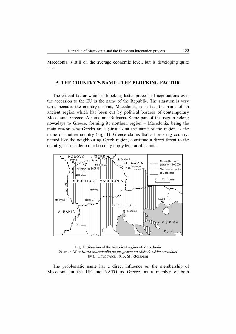
Republic of Macedonia and the European integration process...
133
Macedonia is still on the average economic level, but is developing quite fast.
5. THE COUNTRY’S NAME – THE BLOCKING FACTOR
The crucial factor which is blocking faster process of negotiations over the accession to the EU is the name of the Republic. The situation is very tense because the country’s name, Macedonia, is in fact the name of an ancient region which has been cut by political borders of contemporary Macedonia, Greece, Albania and Bulgaria. Some part of this region belong nowadays to Greece, forming its northern region – Macedonia, being the main reason why Greeks are against using the name of the region as the name of another country (Fig. 1). Greece claims that a bordering country, named like the neighbouring Greek region, constitute a direct threat to the country, as such denomination may imply territorial claims.
KOSOVO SERBIA
BULGARIA
ALBANIA
G R E E C E
REPUBLIC OF MACEDONIA
Prizren
Tetovo
Gostivar
SKOPJEKumanovo
Kyustendil
Blagoevgrad
Thesaloniki
Kavala
Prilep
BitolaElbasan
National borders(state for 1.10.2008)The historical regionof Macedonia
A e g e a n
S e a
100 km0 50
Fig. 1. Situation of the historical region of Macedonia Source: After Karta Makedoniia po programa na Makedonskite narodnici
by D. Chupovski, 1913, St Petersburg
The problematic name has a direct influence on the membership of Macedonia in the UE and NATO as Greece, as a member of both

Joanna Markowska and Jarosław Wiśniewski 134
organizations, uses its right to veto. With this instrument Greece is constantly obstructing the accession of Macedonia into European structures. Last time this situation happened in March, 2008, when during NATO summit in Bucharest Greece did not agree on Macedonian accession with its contemporary name. The immediate reaction of the Macedonian delegation was to leave the summit.
At present the official name of the country used on the international arena is FYROM which stands for Former Yugoslavian Republic of Macedonia. Citizens of Macedonia, however, find this name derogatory.
Macedonia is in a difficult situation. Although it seems that it will soon meet the conditions set by the EU for prospective member states, nevertheless the unsolved Macedonian-Greek problem makes the accession impossible. Both countries defend strongly their positions, leaving no space for compromise. Macedonia wants to be recognized on the international arena under the name Macedonia but Greeks underline that this name is reserved for the Greek region. Despite 600 years that have passed since the collapse of ancient Macedonia after the Ottoman invasion on the Balkan Peninsula, the name of the region still connotes its former extent. The prime minister of Greece said in 2007 that Greece does not agree that FYROM changes its name as its approval would mean supporting separatism in northern Greece.
Till now the negotiations have brought no solution despite a few alternative name have been proposed. The Greek government proposed the following names: Northern Macedonia, Republic of Skopje (Macedonia), Republic of Macedonia (Skopje), which were unacceptable for the Macedonian government, that proposes the names: the Independent Republic of Macedonia or Sovereign Macedonia, which are not approved by the Greek side. So far no proposal given would satisfy both countries, which leaves the EU accession process suspended.
6. CONCLUSION
Macedonia is a country which nearly meets political, institutional and economic criteria set by the EU for the prospective member state. Some reforms have been implemented to improve the economic situation of the country. However, lack of co-operation with the Greek government is the crucial obstacle which delays its accession to the EU. Further negotiations and reforms are needed to achieve a compromise between two countries. The

Republic of Macedonia and the European integration process...
135
situation also affects the regional stability, especially after the proclamation of independence by Kosovo. Macedonia, bordering with two Albanian states – Albania and Kosovo, having a large minority of Albanians, is extremely vulnerable to any potential crisis. Even though implementation of the Ohrid Framework Agreement provides an example of good co-operation between majority and minority populations, instability with regards to the problem remains. Macedonia, a critical hub during the war in Kosovo (Laity, 2008), which is not allied with NATO, is likely to see separatist movements in the western part of the country. Although it does not seem probable in foreseeable future, such a scenario could support the claims for “Greater Albania” – unification of all lands being inhibited by Albanians. Such a situation would represent a serious threat to the stability of the region, more dangerous than Greek fears of unification of Macedonian lands. The Republic of Macedonia remains an important actor in Western Balkans, whose stability ought to be a priority of the European Union and NATO when examining the policies related to the Balkan Peninsula. As the NATO summit in April 2008 has shown, any discussion over the Macedonia’s accession will remain groundless until the “Macedonian question” has been solved.
REFERENCES
CAMERON, F., 2007, An introduction to European foreign policy, New York: Routledge.
COWAN, K.J. (ed.), 2000, Macedonia. The politics of identity and difference, London: Pluto Press.
LAITY, M., 2008, Preventing war in Macedonia. Pre-Emptive diplomacy for the 21st century, Routledge: London.
Statistical yearbook of the Republic of Macedonia, 2007. PAPAVIZAS, C.G., 2006, Claiming Macedonia. The struggle for the heritage, territory
and name of the historic Hellenic land, 1864–2004, London: MacFarland & Company Inc.
ROUDOMETOF, V. (ed.), 2000, The Macedonian question: culture, historiography, politics, New York: Boulder.
The Phare Programme, Annual Report, 2000; www.ec.europa.eu. The World Factbook, 2008, Central Intelligence Agency. http://www.stat.gov.mk http://www.stat.gov.mk/english/glavna_eng.asp http://www.greekembassy.org

Joanna Markowska and Jarosław Wiśniewski 136

SECTION III
CENTRAL EUROPEAN REGION
Krystian HEFFNER State Scientific Institute. The Silesian Institute in Opole, POLAND Brygida SOLGA Faculty of Management and Production Engineering Technical University of Opole, POLAND
No 9
EVOLUTION OF SOCIAL, CULTURAL AND ECONOMIC PROCESSES IN BORDER REGIONS
(USING THE EXAMPLE OF OPOLE SILESIA)
1. INTRODUCTION
Progressing globalisation, liberalisation of international trade, progress of democracy in social life and international integration causes fundamental changes in functions of borders. The role of state borders as barriers restricting mutual capital flow diminishes (the economic aspect of border). On the other hand, the role of internal in interregional borders increases. At the same time, however, the problem of a lasting character of borders seems to be present all the time due to a considerable and diversified impact of state and regional borders in spite of the historical process of their disappearance. Opole Silesia borderland is a good example of the lasting character of borders where it is still reflected in the sphere of regional social, cultural, economic and political relations and some other phenomena resulting from proprium silesiacum of this region in spite of the fact that the border running through this region disappeared long ago.
2. BORDERS AND THEIR LASTING CHARACTER IN THE CULTURAL LANDSCAPE
Each border is to a lesser or greater extent a barrier restricting the flow of people, goods and money, and sometimes, mutual cultural and ideological

Krystian Heffner and Brygida Solga
138
influence (Kałuski, 1983, p. 129–131). Establishment of a border or a signi-ficant change of its functions in a certain region means a change of the type of economy, settlement and structure of the population and also of the landscape of the borderland. Even borders not running along geographical features ingrow into the cultural landscape of the region and because of their long-lasting character they become somehow natural leaving clearly visible and more or less lasting traces on the material landscape (industry, agriculture, road network) and in non-material landscape (culture, customs and people’s mentality).
This is the reason why historical border existing for a long time are quite often still noticeable in the territories of present day countries and have impact on their contemporary spatial pattern in the form of ethnic and cultural differences, distribution of infrastructure and the level of economic development. In Poland, borders of former partitions are still visible in the form of differences in the social and cultural structure just like the border dividing eastern (Byzantine) and western Roman Empire which remains to a certain extent in the form of civilisation “furrow” running through the contemporary Europe (Baczwarow and Suliborski, 2003, p. 72–79). The existence of the state border may cause cultural diversification of the region in spite of the fact of existence of a regional labour market even if it was ethnically uniform earlier, like in the case of the Swiss-Alsatian borderland around Basel or in the Dąbrowa region in Upper Silesia (Rykiel, 1991, p. 37–43).
In history, and even at the present time, there are many politically unstable regions with frequently changing borders. These territories termed shatterbelt in political geography (Otok, 1996, p. 78–79) can be found mainly in the Near East, South-East Asia, Central Asia and Central Europe where the greatest border shifts took place in the 20th century (Kosmala, 1993).
Poland is a country where border changes occurred particularly often. The present state border is in 14.2% identical with the first republic borders, in 3.2% identical with the borders of the First and the Second Partition, in 10.8% with the Third Partition borders, in 11% with borders of the Grand Duchy of Warsaw of 1809 and of the Kingdom of Poland, while 23.1% of the border are the same as the political border of the inter-war Poland (Sobczyński, 1984, p. 119–133). Such changes undoubtedly exerted a con-siderable impact on the cultural landscape of the country and especially of regions where political borders existed for a long time. One of such places is the former Polish-German borderland on the upper Prosna River. This river in its section from Jelonków to Kostowo constituted the state border from

Evolution of social, cultural and economic processes in border regions...
139
about 1320 till 1939, i.e. for about 600 years with only a short break in the years 1793–1806 when partition borders were in force. After the Second World War, this section of the river still remained an administrative border between the Łódź Voivodeship and at first the Dąbrowa Silesia Voivodeship, and later the Opole Silesia Voivodeships. Then, till 1999 it constituted the border between the Częstochowa Voivodeship and the Opole Voivodeship. Researches indicate that, after abolition of the state border, there still remained an informal barrier, not of physiographical but rather of cultural, social, economic character (Solga, 1994, p. 353–367). The diversified pattern of economic and social relations (differences in transportation network, buildings, economic methods, living conditions, customs and mentality) that emerged as a result of secular existence of the Polish-German border on the upper Prosna is still noticeable in this territory even today in spite of progressing unification and integration.
The historical development of spatial barriers cause also emergence of so called contact areas situated where various regions meet. Such an area, although formally divided among several regions (voivodeships) and among different state in the past, constitutes a functional entity. One of most typical contact area is the Katowice region where social relations even today reflect borders between of Upper Silesia, the Dąbrowa Basin and the Chrzanów District established in the 19th century.
3. OPOLE SILESIA – HISTORICAL-POLITICAL, SOCIAL AND CULTURAL BORDERLAND
The notion of Opole Silesia is relatively new. It appeared only in the 19th century and, at the same time it cannot be uniformly defined. Initially, in a broader interpretation it denoted the inter-war administrative unit, i.e. the part of historical Upper Silesia which remained within the German State with such border towns as Raciborz, Gliwice, Zabrze and Bytom (called Prussian Upper Silesia). Such an understanding of the region’s borders remained in force till 1950 when the post-war Silesian Voivodeship was divided into the Opole Voivodeship and the Katowice Voivodeships. The former included two Lower Silesian districts (powiat) of Brzeg and Namysłów, which did not belong to Prussian Upper Silesia before. The Katowice Voivodeship included several industrialised districts (Bytom, Gliwice, Zabrze), which belonged to Opole Silesia earlier (Linek, 2005, p. 11–57). At present, this notion applies

Krystian Heffner and Brygida Solga
140
to administrative borders of the Opole Voivodeship which were changed in the course of consecutive administrative reforms of the country.
Opole Silesia together with whole Silesia is an area where internal and external borders were frequently changed and reshaped. This area, initially inhabited by Slav tribes, belonged to Bohemia state in the10th century and became a part of the Polish state by the end of this century. Opole constituted the centre of this area due to the fact that important trade routes crossed the area. During the division of Poland in 1138 this territory formed the Duchy of Opole (also called the Duchy of Opole and Racibórz) established by the end of the 12th century. Opole was the capital. Starting from 1335 when Casimir the Great resigned his rule over Silesia, the duchy belonged to the Kingdom of Bohemia under the Luxembourg dynasty for more than two centuries (Lesiuk, 1992, p. 67).
The political change of the early 12th century was accompanied by far-reaching civilisational changes (inflow of settlers, foundation of towns, development of monasteries and establishment of parish structures). After the extinction of the Opole Piasts dynasty, Opole Silesia found itself under the rule of the Habsburg monarchy. Two hundred years later, as a result of the Silesian Wars between Austria and Prussia, nearly whole Silesia (with the exception of the Duchies of Teschen (Cieszyn) and Opava and parts of the Duchies of Krnov/Karniów and Nysa) was annexed by Prussia. This territory bordered in the north with Wielkopolska (Great Poland – the Poznań province), in the west with Wrocław province constituting a part of Lower Silesia and in the east and north-east with the Russian partition territories (belonging to Poland from 1918). In the south, it bordered with Austrian Cieszyn, Opava and Krnov/Karniów Silesia (belonging to Czechoslovakia from 1918) (Lesiuk, 1992, p. 77–78). Far-reaching social, economic and political changes took place in the Opole district at this time (military reforms, development of industry, establishment of new industrial settlements, self-government reforms, development of political groupings, a significant growth of urban population, reorientation of agricultural production, development of technical infrastructure). Administrative authorities of the district and region were established in Opole. However, the landtag determining the financial policy of the province was located in Racibórz, another historical capital of the region. The Prussian–German rule in Silesia lasted till 1945 with the exception of the eastern part of Upper Silesia which, as a result of the plebiscite of 1921, constituted the autonomous Silesian Voivodeship within the framework of the reborn Polish State till 1939 (Heffner and Lesiuk, 1995, p. 43–67). After the Second World

Evolution of social, cultural and economic processes in border regions...
141
War, practically entire Prussian Silesia was annexed to Poland. Administra-tively, it lied within borders of the Wrocław Voivodeship and the Dąbrowa Silesia Voivodeship. The latter was divided into an industrial part (the Katowice Voivodeship with Bytom, Zabrze and Gliwice) and agricultural one (the Opole Voivodeship with Brzeg and Namysłów).
Opole Silesia was, therefore, a borderland where borders of three states converged (Prussia/Germany – Russia – Austro-Hungary and Prussia/ Germany – Poland and Czechoslovakia after the First World War) and three cultures overlapped – Polish, German and Czech. It was situated on periphe-ries of strong political and cultural centres of Central Europe. Trans-formations of administrative and political character undoubtedly did not remain without impact on culture and civilisation of the region, as well as on social, ethnic, national and economic relations. They are reflected at present in the specific shape of in its social, economic, ethnic and cultural structure (Heffner, 2008, p. 172–175).
4. SOCIAL AND CULTURAL PROCESSES IN THE TERRITORY OF THE FORMER
SOCIAL AND CULTURAL BORDERLAND
The social and cultural diversification of Opole Silesia clearly distin-guishes this region within the country and constitutes signum specificum of the region. Opole Silesia is culturally diversified which results from its situation in the social and cultural borderland and is a consequence of social processes taking place in the region after the Second World War. The region’s population is characterised by strong regional bonds and relatively weak bonds with the state and the nation which is typical for a borderland. It is the reason of vague and diversified national attitudes manifested by native inhabitants of Opole Silesia. On the other hand, the inflow of new inhabitants to the region after 1945 led to a clash of very different cultures and commenced the process of social adaptation and integration (Ruszczewska, 2001, p. 63–73).
The particular situation of the region in the past as well as present day social and political processes result in the following processes:
– ethnic relations understood as specific relations between original population and newcomers;
– unidirectional character of foreign migrations related to ethnically preconditioned emigration of native population;
Krystian Heffner and Brygida Solga
142
– population dichotomy and diversified development of demographic processes;
– emergence and formation of the German minority; – double citizenship. It is worth mentioning that these phenomena are not only the subject or a
regular scientific research. They are also used in programming local and regional development and taken into consideration in strategic programming, i.e. the voivodeship development strategy. This document stresses, for example, that the Opole region is diversified culturally and that the cause of this diversification results from its history. Therefore, the development of the region depends on recognition that multiculturality is a lasting asset, favourable for the region and deserving support (Strategia rozwoju…, 2005, p. 58–62). On the one hand, it is a precondition of a common regional identity integrating all inhabitants, and on the other hand, such an image of multicultural society can positively distinguish the Opole region among other areas in the country and in Europe.
The newest research into these phenomena reflecting the complicated past of Opole Silesia concentrates on the phenomenon of multiple citizenship. It is part of broader discussion on oncoming changes of the citizenship concept as the individuals increasingly wider possibilities of choosing more than one national attachment (Obywatelstwo wielokrotnego wyboru…, 2007).
In the Opole region a significant part of the region’s inhabitants have double Polish and German citizenship as is the German legal principle of ius sanguinis applies to this area. Moreover, this legal solution determines the fact that the inhabitants concerned do not need to apply for the second citizenship but just for confirmation or recognition of the German citizenship possessed by them for historical reasons. This largely influences the way they understand the status of the double citizenship as they avail themselves of the right to it due to their German origin (Heffner and Solga, 2007, p. 66–91). Since 1990 most applicants availed themselves of the opportunity created by democratic transformations in the country enabling to obtaining confirmation of the German citizenship without leaving Poland.
In spite of the fact that they constitute a group of persons whose multiple citizenship results from blood bonds they do not manifest a uniform attitude towards motives of confirmation of their German citizenship and their emotions related to possession of the citizenship are not equally important to them. In this respect, their society is diversified and their attitudes towards the fact of having double citizenship is extremely diversified. For some of them, the German citizenship is an element of their cultural identity and has

Evolution of social, cultural and economic processes in border regions...
143
a symbolic meaning. For others, only the usefulness of this citizenship is important and they confirmed their citizenship only in order to secure the right to use it.
Emotional reasons resulting from cultural links with Germany play the most important role for the group of people who confirmed their German citizenship in the time of democratic transformation after 1989. In the Opole region, it was a period of an unusual mobilisation of the Silesian local society for which Germanism constitutes and important manifestation of identity. Although pragmatic advantages resulting from confirmation of the German citizenship are of importance to them, they state most frequently that there exist more or less strong bonds with the German nation. We may suppose that along with other changes that took place in the region at the time (including granting subjectivity to the Silesian population in various spheres of life, official recognition of the German minority) a confirmation of the German citizenship was and element strengthening the identity of Silesian based on their cultural distinctness.
Persons who confirmed their German citizenship only because they wanted to avail themselves of advantages resulting from it related to the possibility of finding a legal job in West European countries constitute the most numerous group. They confirmed their German citizenship during the late 1990s or even more recently. There is no way to avoid the impression that they treat their second citizenship in a very instrumental manner as a convenient tool to obtain a material advantage, although not all of them use their foreign citizenship for emigrate. The German citizenship is considered only as a possibility of migration and taking a job remunerated much higher than in Poland, as well as settling in a country of a higher standard of living.
Also, the feeling of security, stability and assurance related to citizenship of a politically, economically and socially strong state is of great importance for persons confirming their German citizenship. In this case, the German citizenship most frequently plays the role of a “safety valve” in the situation requiring using chances offered by this country.
5. CONCLUSION
Although the role of borders in the contemporary international relations changes considerably, processes resulting from the existence of boundaries are of extreme importance. Borders that present or in the past constituted a kind of political, cultural (ethnic) or administrative barrier cause often

Krystian Heffner and Brygida Solga
144
meaningful changes of social and economic landscape of borderland. As a result, the character of borderland may exert an impact on shaping of a number of specific structural features becoming quite frequently a pheno-menon of social, cultural, political or economic importance. Transformation of such areas may proceed in different directions which is a challenge for institutions responsible for their development. On their decisions depends whether this development will be based on co-operation or conflict dia-lectics. At present, an effective form of borderlands co-operation are Euroregions. Their development prove that they are a successful solution to marginalisation of borderlands in many countries of Europe.
REFERENCES
BACZWAROW, M. and SULIBORSKI, A., 2003, Kompendium wiedzy o geografii politycznej i geopolityce. Terminologia, Warszawa: Wydawnictwo Naukowe PWN.
HEFFNER, K., 2008, Regional identity and citizenship in Silesia, [in:] Reinventing Poland. Economic and political transformation and evolving national identity, eds. M. Myant and T. Cox, London–New York: Routledge, p. 165–178.
HEFFNER, K. and SOLGA, B., 2007, Podwójne obywatelstwo na Śląsku Opolskim, [in:] Obywatelstwo wielokrotnego wyboru. Interdyscyplinarne ujęcie kwestii podwójnego obywatelstwa w Polsce, eds. A. Górny and P. Koryś, Warszawa: Ośrodek Badań nad Migracjami Uniwersytetu Warszawskiego.
HEFFNER, K. and LESIUK, W., 1995, Ekonomiczne i społeczne skutki podziału Górnego Śląska w 1922 r., Studia Śląskie, 54.
JONDERKO, F., 2007, Społeczne uwarunkowania budownictwa mieszkaniowego na wsi na Śląsku Opolskim, Stowarzyszenie Instytut Śląski, PIN – Instytut Śląski w Opolu, Wojewódzka Biblioteka Publiczna im. E. Smołki w Opolu, Opole.
KAŁUSKI, S., 1983, Granice polityczne jako przedmiot badań geograficznych, Przegląd Zagranicznej Literatury Geograficznej, 4.
KOSMALA, G., 1993, Zmiany granic politycznych w Europie Środkowej w okresie ostatnich stu lat, Wrocław: Uniwersytet Wrocławski.
LESIUK, W., 1992, Historyczne uwarunkowania odrębności regionalnej Opolszczyzny, [in:] Śląsk Opolski. Region i jego struktura, ed. S. Malarski, Opole: Stowarzyszenie Instytut Śląski w Opolu.
LINEK, B., 2005, Dzieje Śląska Opolskiego, [in:] Śląsk Opolski. Dziedzictwo i współ-czesność, ed. D. Simonides, Opole: Oficyna Piastowska.
Obywatelstwo wielokrotnego wyboru. Interdyscyplinarne ujęcie kwestii podwójnego obywatelstwa w Polsce, eds. A. Górny and P. Koryś, 2007, Warszawa: Ośrodek Badań nad Migracjami Uniwersytetu Warszawskiego.
OTOK, S., 1996, Geografia polityczna, Warszawa: Wydawnictwo Naukowe PWN. RUSZCZEWSKA, V., 2001, Poznawanie Śląska w badaniach socjologicznych, [in:]
O społeczeństwie śląskim na przełomie wieków, eds. K. Frysztacki and T. Sołdra-Gwiżdż, Opole: Stowarzyszenie Instytut Śląski, PIN – Instytut Śląski w Opolu.

Evolution of social, cultural and economic processes in border regions...
145
RYKIEL, Z., 1991, Rozwój regionów stykowych w teorii i badaniach empirycznych, Wrocław: Instytut Geografii i Przestrzennego Zagospodarowania PAN, Zakład Narodowy im. Ossolińskich.
SOBCZYŃSKI, M., 1984, Niezmienność dawnych granic politycznych na obszarze Polski, „Acta Universitatis Lodziensis. Folia Geografica”, 3.
SOLGA, B., 1994, Ślady granicy państwowej we współczesnym krajobrazie kulturo-wym rejonu górnej Prosny, Studia Śląskie, 53.
Strategia rozwoju województwa opolskiego, 2005, Opole: Urząd Marszałkowski Woje-wództwa Opolskiego.

Krystian Heffner and Brygida Solga
146

Daniela SZYMAŃSKA Jadwiga MAŚLANKA Department of Urban and Recreation Studies
Stefania ŚRODA-MURAWSKA
Department of Economic Geography and Regional Studies Nicolaus Copernicus University in Torun, POLAND
No 9
A DEMOGRAPHIC BORDER INSIDE GERMANY – DOES IT STILL EXIST?
In the space of history state borders have been, and unfortunately still are, a distinct element making countries separate physico-geographical and socio- -economic entities. Nevertheless, the meaning of the word “border” as understood by the citizens of European countries, and especially those living in the European Union, has been gradually changing. How can we define the socio-economic or physico-geographical borders between two countries when the only distinguishing element is the official language they use and only a roadside board informs that the border is being crossed?
This article sets out to answer the question how belonging to separate political and economic structures has contributed (contributes) to the emergence of diverse population processes and structures, as well as their spatial variations. As an example useful in investigating such phenomena we have chosen Germany, that had constituted two different states – socio- -political and economic organisms, i.e. the German Democratic Republic (GDR) and the Federal Republic of Germany (FRG) – until the year 1990.
The authors ask the question whether procreative behaviours and population structures and processes are shaped differently in the eastern and western part of the country whose population totals today 82 million people. Has the period that elapsed from the unification of the two German states been long enough to smooth out all dissimilarities and demographic trends?
While distinct material relics of the former system (neglected infra-structure, dilapidated housing stock, etc.) can sometimes be seen in the federated states (Länder) that used to belong to the German Democratic Republic (East Germany), “the demographic border” manifests itself in a more subtle manner. Even though older persons outnumber the younger

Daniela Szymańska et al.
148
ones on the streets of East German towns and villages (compared with the West Länder), it is difficult to assess explicitly the correctness of this observation without conducting an investigation.
This investigation is a preliminary attempt at explaining whether the demographic processes and structures existing in areas that formerly, i.e. till the year 1990, belonged to either the GDR or the FRG show any differences. Demographic variations were sought based on deviations (plus or minus) from the average values of three selected measures: the balance of migration (‰), the share of persons aged 65 and older in the total number of population (%), and the birth rate (‰).
The measures enabled the analysis focused on the period 1991–2005 (the 14 years that passed from the unification of Germany) to capture some differences between the eastern and western parts of the present Federal Republic of Germany (i.e. between the new and old Länder) (Środa, 2003; Szymańska and Środa, 2006).
While in 1991 in more than half of the federated Länder (9 units representing 56.1% of their total number), all being former West German Länder, the examined measures exceeded their average values (+ + +) calculated for the 16 Länder, at the end of 2005 only 3 such A-type (+ + +) Länder could be found, also in West Germany (Tab. 1).
Table 1. The structure of the federated Länder in the Federal Republic of Germany in 1991 and 2005 according to the table with signs
Type A B C D E F G H
(+ + +) (+ + -) (+ - +) (+ - -) (- + +) (- + -) (- - +) (- - -) Total
1 2 1 2 1 2 1 2 1 2 1 2 1 2 1 2 1 2 G 9 56.1 - - 1 6.3 1 6.3 - - 1 6.3 - - 4 25.0 16 100 EG - - - - - - 1 16.7 - - 1 16.7 - - 4 66.6 6 100
1991
WG 9 90.0 - - 1 10.0 - - - - - - - - - - 10 100 G 3 18.7 - - 6 37.5 - - - - 6 37.5 1 6.3 - - 16 100 EG - - - - 1 16.7 - - - - 5 83.3 - - - - 6 100 20
05
WG 3 30.0 - - 5 50.0 - - - - 1 10.0 1 10.0 - - 10 100
Note: 1 – number of the federated Länder, 2 – share (%) in the total number of the federated Länder, G – Germany total, EG – East Germany, WG – West Germany Source: Authors’ based on data from DESTATIS.

A demographic border inside Germany – does it still exist?
149
(+ + +)(+ + -)(+ - +)(+ - -)(- + +)(- + -)(- - +)(- - -)
2005
1995
2000
100 km
1991
Fig. 1. The typology of the Federal Republic of Germany according to the table with
signs (the balance of migration (‰), the share of persons aged 65 and older in the total number of population (%), and the birth rate (‰), years 1991–2005, by federated Land
Source: Authors based on data from DESTATIS
Daniela Szymańska et al.
150
In contrast, in four out of six East German Länder the values of all measures were below the average (type H/- - -) in 1991. The two exceptions were Berlin (type D/+ - -), the capital of Germany, where demography evolved differently after 1991 than in the other new Länder (Środa, 2003), and Saxony (type F/- + -) (Fig. 1). As for Berlin, the average was exceeded by the balance of migration, and in the other case it was the share of persons aged 65 plus in the total number of population. The two remaining measures were below the average in each case.
Interestingly, in 2005 Germany did not have a single Land where all three measures were lower than the average (- - - ). In half of the western Länder type C (+ - +) prevailed, in which both the balance of migration and the birth rate exceeded the average, and the share of persons aged 65 years and older in the total number of population was less than average. On the other hand, in all Länder of the former German Democratic Republic (except Berlin) the share of older persons in the total number of population was the only measure to exceed the average (- + -) (Tab. 1).
The above data lead to the conclusion that in both 1991 and 2005 the border between the old and new Länder separated the population processes and structures in the Federal Republic of Germany (Fig. 1).
However, searching for demographic variations on the macro-scale only (at the level of Länder) seems insufficient. For that reason, an analogous analytical procedure was applied to counties (Kreise) and special towns with the county status (Kreisstädte), totalling 439 administrative units.
According to the investigation, 120 counties (27.3% of their total number) in 1991 were type A (+ + +) where the three analysed measures had above- -average values, and all the counties belonged to the FRG. Another 124 (28.2% of their total number) counties where only the share of older persons in the total number of population was below the average (type C/+ - +) also belonged to the “old” Länder. It should be stressed that in 1991 the H-type (- - -) counties where the measures were below their average values accounted for 19.0% (83 counties) of the total and all but one were located in East Germany. In the remaining 31 East German counties (excluding Berlin), only the proportion of persons aged 65 plus in the total number of population exceeded the average (Tab. 2).
Between 1991 and 2005 the number of counties where all measures exceeded their respective averages (type A/+ + +) went down from 120 to merely 28 units, with only two of them being located in the former GDR. The number of the H-type ( - - -) counties where values of the three measures were lower than average also decreased: from 83 units in 1991 to 26 in 2005.

A demographic border inside Germany – does it still exist?
151
It is worth mentioning that while in 1991 only one of the H-type (- - -) counties was located in West Germany, after fourteen years the number of such counties in that part of Germany expanded to 12 units (Tab. 2).
Table 2. The structure of the FRG counties (Kreise) in 1991 and 2005 according to the table with signs
TYPE A B C D E F G H (+ + +) (+ + -) (+ - +) (+ - -) (- + +) (- + -) (- - +) (- - -)
Total
1 2 1 2 1 2 1 2 1 2 1 2 1 2 1 2 1 2 G 120 27.3 27 6.2 124 28.2 6 1.4 27 6.2 41 9.2 11 2.5 83 19.0 439 100 EG - - - - - - 1 0.9 - - 30 26.5 - - 82 72.6 113 100
1991
WG 120 36.8 27 8.3 124 38.0 5 1.5 27 8.3 11 3.4 11 3.4 1 0.3 326 100 G 28 6.4 34 7.8 130 29.6 23 5.2 26 5.9 119 27.1 53 12.1 26 5.9 439 100
EG 2 1.8 6 5.3 6 5.3 7 6.2 1 0.9 76 67.2 1 0.9 14 12.4 113 100
2005
WG 26 8.0 28 8.6 124 38.0 16 4.9 25 7.7 43 13.2 52 15.9 12 3.7 326 100
Note: 1 – number of the FRG counties, 2 – share (%) in the total number of the FRG counties, G – Germany total, EG – East Germany, WG – West Germany
Source: Authors based on data from DESTATIS.
On the other hand, the number of counties where the balance of migration was the only measure to exceed the average (type D/+ - -) increased between 1991 and 2005 from 6 to 23 units. The number of the F-type (- + -) counties where the share of older persons in the total number of population was higher than the average also expanded, from 41 to 119 (Fig. 2). The growing proportion of older persons in the overall number of Germany’s population in the investigated period was caused by the declining number of births and by the growing human life expectancy.
In 2005, only 21 counties among all East German counties had the balance of migration in excess of its average, in another 10 counties the average was exceeded by the birth rate. These numbers correspond, respectively, to 18.6% and 8.9% of all counties in East Germany. In the other counties (103) on that territory the birth rates were lower than average. Two factors were behind this situation: following the unification of Germany the young population living within the former GDR became more concerned about their future, and additionally new career options became available (especially to women) – all this induced a rapid decline in the number of births (Birg, 2002).

Daniela Szymańska et al.
152
2005
(+ + +)(+ + -)(+ - +)(+ - -)(- + +)(- + -)(- - +)(- - -)
1995
2000
100 km
1991
Fig. 2. The typology of the Federal Republic of Germany according to the table with
signs (the balance of migration (‰), the share of persons aged 65 and older in the total number of population (%), and the birth rate (‰), years 1991–2005, by counties (Kreise)
Source: Authors based on data from DESTATIS

A demographic border inside Germany – does it still exist?
153
Indirectly, the drop in the number of births was also brought about by the huge outmigration from eastern to western Länder, especially among young persons (Mai, 2006). Consequently, the balance of migration recorded in West Germany in 2005 exceeded the average value in as many as 194 counties (5.5% of the western counties). The birth rates also surpassed the average in 227 counties representing 69.6% of all western counties (Tab. 2).
The conclusion is that in 1991 West Germany and East Germany had their specific population structures in both the Länder and individual counties. The main types of Länder in West Germany were A and C (the balance of migration and birth rates were higher than average), while on the territory of the former German Democratic Republic definitely predominated types of Länder where values of both the balance of migration and of the birth rate were below average (F and H) (Fig. 1). Analysing then the 2005 values of the measures by a federated Land we can see that Germany was clearly divided into her eastern Länder (where in most cases the balance of migration and the birth rates were below average and the shares of persons aged 65 plus in the total number of population were higher than average), and western Länder where the lower-than-average share of older persons in the total number of population co-occurred with values of the balance of migration and birth rates exceeding the average – type C (Fig. 1). As for the county level in 2005, the German-German “demographic border” was not so distinct as in 1991 (Fig. 2). At the beginning of the investigated period (1991) the structure of eastern counties in respect of the selected measures revealed two types – F and H, but in 2005 it was the mosaic of all types, with clear prevalence of type F.
Therefore, that fact that until the year 1990 the two German states represented two diverse political, socio-economic and cultural structures contributed, and still contributes, to the different courses of demographic processes, with the resulting dissimilarity of demographic structures in the eastern and western parts of Germany, both among the Länder and at the county level.
REFERENCES
BIRG, H., 2002, Die demographische Zeitwende. Der Bevölkerungsruckgang in Deutschland und Europa, München: Verlag C.H. Beck.
MAI, R., 2006, Die alterselektive Abwanderung aus Ostdeutschland, [in:] Bundesamt für Bauwesen und Raumordnung, Raumforschung und Raumordnung, 5 (64) Bonn: Carl Heymanns Verlag, p. 355–369.

Daniela Szymańska et al.
154
SZYMAŃSKA, D. and ŚRODA, S., 2006, Le proces sus de viellissement de la population en Allemagne dans les années 1995–2003, [in:] Les territoires face au viellissement en France et en Europe, ed. Dumont G.F., Paris: Ellipses Edition, p. 297–305.
ŚRODA, S., 2003, Socio-demographic problems in Berlin in the years 1990–2002, Bulletin of Geography (socio-economic series), 2, p. 123–129

Marek SOBCZYŃSKI Department of Political Geography and Regional Studies University of Łódź, POLAND
No 9
POLISH-GERMAN BOUNDARY ON THE EVE OF THE SCHENGEN AGREEMENT
Polish accession to the Schengen Agreement and abolition of border control within EU countries on 21st December 2007, is a good occasion to summarize the role of boundaries in the period directly preceding the revolutionary changes that took place on EU internal borders of Poland. In the paper author analyses one out of four land borders encompassed by the Schengen Agreement, namely the western border with Germany. Remaining sections of land borders, where abolition of border control took place at the same time, are: south-western border (with the Czech Republic), south-eastern border (with Slovakia) and north-eastern border (with Lithuania). Also, however to some extent only, the sea and airports border control was cancelled (only for cruises and flights to signatory countries of the Schengen Agreement).
The Polish border with Germany is 467 km long which represents 24,5% of land borders encompassed by the Schengen Agreement (1908 km).
Analysed borders begins at the junction of Polish, Czech and German borders in the Zittau Valley in the middle of the Lusatian Neisse River (Nysa Łużycka). From this point it runs northward almost entirely (89% of it length) along waters; at the beginning along the Nysa Łużycka River, and then along the Odra up to Gryfino. Only from this point towards north it runs on the left bank of the river and for 47 km it is a land border. Further it becomes again a water border while cutting the Stettiner Haff. The last fragment of this border (8 km) before reaching the Baltic Sea cuts the Isle of Usedom, whereas about half of its length runs along a drainage channel.
The Polish-German border is one of the least stable borders of Poland. It was created only in 1945 as a result of the Potsdam Agreement and it divided the historical regions of Pomerania, Brandenburg, Silesia and Saxony. Only
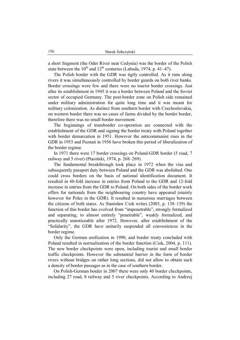
Marek Sobczyński
156
a short fragment (the Oder River near Cedynia) was the border of the Polish state between the 10th and 12th centuries (Labuda, 1974, p. 41–47).
The Polish border with the GDR was tigtly controlled. As it runs along rivers it was simultaneously controlled by border guards on both river banks. Border crossings were few and there were no tourist border crossings. Just after its establishment in 1945 it was a border between Poland and the Soviet sector of occupied Germany. The post-border zone on Polish side remained under military administration for quite long time and it was meant for military colonization. As distinct from southern border with Czechoslovakia, on western border there was no cases of farms divided by the border border, therefore there was no small border movement.
The beginnings of transborder co-operation are connected with the establishment of the GDR and signing the border treaty with Poland together with border demarcation in 1951. However the anticommunist rises in the GDR in 1953 and Poznań in 1956 have broken this period of liberalization of the border regime.
In 1971 there were 17 border crossings on Poland-GDR border (5 road, 7 railway and 5 river) (Ptasiński, 1974, p. 268–269).
The fundamental breakthrough took place in 1972 when the visa and subsequently passport duty between Poland and the GDR was abolished. One could cross borders on the basis of national identification document. It resulted in 48-fold increase in entries from Poland to the GDR and 12-fold increase in entries from the GDR to Poland. On both sides of the border work offers for nationals from the neighbouring country have appeared (mainly however for Poles in the GDR). It resulted in numerous marriages between the citizens of both states. As Stanisław Ciok writes (2003, p. 138–139) the function of this border has evolved from “impenetrable”, strongly formalized and separating, to almost entirely “penetrable”, weakly formalized, and practically unnoticeable after 1972. However, after establishment of the “Solidarity”, the GDR have unitarily suspended all conveniences in the border regime.
Only the German unification in 1990, and border treaty concluded with Poland resulted in normalization of the border function (Ciok, 2004, p. 111). The new border checkpoints were open, including tourist and small border traffic checkpoints. However the substantial barrier in the form of border rivers without bridges on rather long sections, did not allow to obtain such a density of border passages as in the case of southern border.
On Polish-German border in 2007 there were only 40 border checkpoints, including 27 road, 8 railway and 5 river checkpoints. According to Andrzej

Polish-German boundary on the eve of the Schengen Agreement
157
Stasiak (1996, p. 11), the most important border checkpoints on Polish- -German border are: Kołbaskowo, Kostrzyn (the shortest connection with Berlin), Świecko (on the highway A-2 under construction, it concentrated 20% of the whole truck traffic from Poland), Zgorzelec (on the highway A-4 under construction) and Olszyna.
For the purpose of the analysis of transborder traffic the most important checkpoints have been chosen located on all fragments. The aim of the paper is to present a peculiar balance, which is the state from before the abolishing of border control, however author decided to analyse the border traffic for the year 2006, because the data for 2007 were incomplete. The reason for it was the acceleration of border control abolishment on the 21st December 2007, therefore the data did not cover the whole year1.
On the Polish-German border there were in total 12 analysed border checkpoints including road passages (7): Zgorzelec, Jędrzychowice, Olszyna, Świecko, Kostrzyn, Kołbaskowo and Świnoujście and railway passages (5): Zgorzelec, Zasieki, Kunowice, Kostrzyn, Szczecin-Gumieńce.
The border traffic on different checkpoints varies greatly. The border road traffic on Polish-German border does not concentrate on one section only (Fig. 1). On the contrary, the growth of the border traffic is noticeable in central parts of three sections in the south (Jędrzychowice 11.27 million people) in the middle part (Świecko 12.50 million) and in the northern part (Kołbaskowo 6.40 million people), what is partly convergent with the Pan- -European transport corridors: No. 1 Via Hanseatica Lübeck-St. Petersburg, no 2 East-West Berlin-Nizhny Novgorod and no 3 Brussels-Kiev. On the remaining analysed border checkpoints the border traffic was not signi-ficantly smaller (Olszyna 7.53 million, Kostrzyn 4.81 million, Świnoujście 4.16). The least intensive border road traffic on Polish-German border among analysed border crossing points was noted in Zgorzelec – 3.37 million.
The road cargo transport through the Polish-German border is concentrated most of all on the border crossing in Świecko, and to smaller extent in Kołbaskowo , Olszyna and Zgorzelec.
As to the passenger bus transport, the highest traffic volume is recorded in Jędrzychowice, Olszyna, Świecko and Kołbaskowo (Fig. 2).
1 All statistic data used in the paper come from unpublished reports of National Border Service and were obtain through the Main Statistical Office in Warsaw.
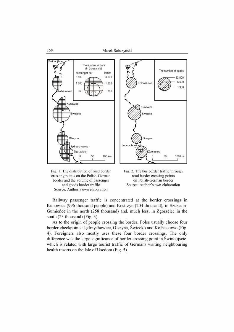
Marek Sobczyński
158
0 100 km50
Kunowice
Ko baskowoł
J drzychowiceę
Zgorzelec
Olszyna
Świecko
Ś świnouj cie
3 600
1 800
360
The number of cars(in thousands)
3 600
1 800
360
passenger-car lorries
Fig. 1. The distribution of road border crossing points on the Polish-German border and the volume of passenger
and goods border traffic Source: Author’s own elaboration
0 100 km50
Kunowice
Ko baskowoł
J drzychowiceę
Zgorzelec
Olszyna
Świecko
13 0006 5001 300
The number of buses
Fig. 2. The bus border traffic through road border crossing points on Polish-German border
Source: Author’s own elaboration
Railway passenger traffic is concentrated at the border crossings in
Kunowice (996 thousand people) and Kostrzyn (204 thousand), in Szczecin-Gumieńce in the north (258 thousand) and, much less, in Zgorzelec in the south (23 thousand) (Fig. 3).
As to the origin of people crossing the border, Poles usually choose four border checkpoints: Jędrzychowice, Olszyna, Świecko and Kołbaskowo (Fig. 4). Foreigners also mostly uses these four border crossings. The only difference was the large significance of border crossing point in Świnoujście, which is related with large tourist traffic of Germans visiting neighbouring health resorts on the Isle of Usedom (Fig. 5).

Polish-German boundary on the eve of the Schengen Agreement
159
0 100 km50
Kostrzyn
Kunowice
Szczecin--Gumie ceń
Zgorzelec
Zasieki
13 000
6 500
1 300
The number of trains:
13 000
6 500
1 300
passenger-train goods-train
Fig. 3. Distribution of railway border crossing points on Polish-German border and the volume of the border passenger
and goods traffic Source: Author’s own elaboration
Kostrzyn
Kunowice
Ko baskowoł
Szczecin--Gumie ceń
J drzychowiceę
Zgorzelec
Olszyna
Świecko
Ś świnouj cie
0 100 km50
7 0003 500700
The size of the border traffic of Poles(in thousands)
Fig. 4. The volume of the border traffic of citizens of Poland on the road and
railway border crossing points on Polish-German border
Source: Author’s own elaboration
Many Swedes and Danes use the border crossing in Kołbaskowo, whereas in Świnoujście the citizens of the two states represent approx. 25% foreigners. Citizens of Russia and Belarus choose almost exclusively the border crossing points in the central part of the border: in Świecko and Kostrzyn they represent approx. 60% of foreigners.
The smaller border traffic of citizens of these states is recorded in two southern border crossings: Jędrzychowice and Zgorzelec, while in the northern section it is not recorded at all. Ukrainians mostly cross the border in the southern section in Olszyna and Zgorzelec where they represent more then a half of foreigners, but they also use the many different border crossings in the north, including the railway passage in Szczecin-Gumieńce. Czechs usually use two southern border crossings in Olszyna and Jędrzy-chowice but their number there is not significant.

Marek Sobczyński
160
Kostrzyn
Kunowice
Ko baskowoł
Szczecin--Gumie ceń
J drzychowiceę
Zgorzelec
Olszyna
Świecko
Ś świnouj cie
7 0003 500700
The size of the border traffic
of foreigners(in thousands)
50 km0
Fig. 5. The volume of the border traffic of foreigners on the road and railway border crossing points on
Polish-German border Source: Author’s own elaboration
0 100 km50
Kostrzyn
Kuno-wice
Ko baskowoł
Szczecin--Gumie ceń
J drzychowiceęZgorzelec
Olszyna
Świecko
Ś świnouj cie
RUSSIANS
AUSTRIANS
UKRAINIANS
BULGARIANS
BELORUSSIANS
DUTCHMEN
FRENCHMEN
LATVIANS
LITHUANIANS
ROMANIANS
SWEDES
BRITISH
ESTONIANS
BELGIANS
DANES
AMERICANSITALIANS
REMAINING FOREIGNERS
CZECHS
Fig. 6. Nationality of foreigners crossing the Polish-German border on the road and railway
border crossing points Source: Author’s own elaboration
On the border with Germany Lithuanians, Latvians and Estonians
concentrate exclusively on the passage in Kołbaskowo, where together with British, Dutch and Danes they represent over a half of foreigners. Dutch use most of the border crossing points on the Polish-German border, however their intensive traffic can be clearly noticed at the passages in Świnoujście and Kołbaskowo in the north, Kostrzyn in the middle part of the border and Olszyna in the south, but also through all railway passages. Belgians and Romanians concentrate on the border crossing points in Olszyna, while Bulgarians and Moldavians in Jędrzychowice. Quite unexpectedly the largest traffic of Italians was noted in the north in Świnoujście and Szczecin-Gumieńce (railway). Possibly they use this route on the way to Scandinavia. Americans are noticed in the group of first 6 nations on almost all analysed border crossing points of the Polish-German border (except Kołbaskowo) most of all in Zgorzelec, Kostrzyn, Świnoujście and on all railway passages.

Polish-German boundary on the eve of the Schengen Agreement
161
Whereas the presence of French-men was noted only on the railway border crossing points in Szczecin-Gumieńce (Fig. 6).
To analyse the nationality of people who cross both borders the typogram method (weight) was applied. The values on the right typogram’s axes sum up to 100% of Poles using analysed border crossing points. Remaining axes include such elements as the volume of the border movement on the border crossing points (measured by the share in the total number of people crossing the border through analysed passages), the participation of the border crossing point in the total number of citizens of bordering state, and also the participation of the border crossing point in the total number of remaining foreigners who cross the border through the analysed border crossing points (Fig. 7). General conclusion following this analysis is a considerable diversity of traffic intensification on border crossing points and strong concentration of it in only few places. On Polish-German border the traffic is rather regularly distributed (Zgorzelec, Świecko). The second principal conclusion is a clear domination of citizens of both states divided by this border in almost all border crossing points. The only exception is the border crossing point in Świnoujście, where the number of Poles was insignificant.
The second typogram was used for means of transport analysis that cross the border (the proportional usage of buses, trains, cars and trucks was analysed) (Fig. 8). For this aim the railway border crossing points were analysed together with, usually accompanying them, road crossing points. Only one border crossing point are characterized by the substantial domination of the car and truck movement on the border with Germany – Świecko. The balance in the types of individual means of transport was noticed in the north of the border with Germany (Szczecin-Gumieńce and Kołbaskowo border passages) and in the south of this border in Zgorzelec.
Abolishment of the border control resulted in closure of border facilities After the abolition of the border control and the extension of the customs control rights on the area of the whole country, there is no sense to keep border crossing points, especially while border crossing is possible at any point of the border.
On the other hand, in case of expected restoration, even temporary, of border control on Schengen borders (e.g. in the time of Euro 2012) border facilities may turn out useful again. On former border crossing points there are still some tourists services (sale of insurances and vignettes, money exchange points, petrol stations, car parks, restaurants). On some border crossings larger customs buildings are still in use.

Marek Sobczyński
162
Kostrzyn
Kunowice
Ko baskowoł
Szczecin--Gumie ceń
J drzychowiceę
Zgorzelec
Olszyna
Świecko
Ś świnouj cie
0 100 km50
The total number of bordercrossing points users (in %)
The total number of remaining citizenswho use the border crossing points (in %)
The totalnumberof Poleswho usethe bordercrossing
points (in %)
The total numberof citizensof Germanywho usethe bordercrossing
points (in %)
small medium
THE INTENSIFICATIONOF THE PERSONAL TRAFFIC
ON ANALYZED BORDERCROSSING POINTS:
large
PEOPLE USING THE ANALYZEDBORDER CROSSING POINTS
0
10
20
Fig. 7. Typogram of nationality of people crossing the border and its intensification
on road and railway border crossing points on Polish-German border
Source: Author’s own elaboration
Kostrzyn
Kunowice
Ko baskowoł
Szczecin--Gumie ceń
J drzychowiceę
Zawidów
Zgorzelec
Olszyna
Świecko
0 100 km50
small medium
THE INTENSIFICATION OF THE VEHICLE TRAFFIC ON ANALYZEDBORDER CROSSING POINTS:
large
The total number of buses (in %)
The total number of trains (in %)
The totalnumber ofpassenger-
-cars(in %)
The totalnumberof lories(in %)
VEHICLES USING THE ANALYZEDBORDER CROSSING POINTS
0
10
20
Fig. 8. Typograms of the structure of means of transport used in the border
traffic on the border crossing points on Polish-German border
Source: Author’s own elaboration
REFERENCES
CIOK, S., 2003, Konsekwencje ustalenia granicy państwowej dla rozwoju pogranicza na przykładzie granicy polsko-niemieckiej, [in:] Granice. Obszary przygraniczne. Euro-regiony, ed. J. Runge J., Katowice: Wyd. Uniwersytetu Śląskiego, p. 131–141.
CIOK, S., 2004, Pogranicze polsko-niemieckie. Problemy współpracy transgranicznej, Wrocław: Wyd. Uniwersytetu Wrocławskiego.
JARZYNA, F., 1974, Umowy graniczne PRL. Wybór tekstów, Warszawa: Wydawnictwo Prawnicze.
LABUDA, G., 1974, Polska granica zachodnia. Tysiąc lat dziejów politycznych, Poznań: Wyd. Poznańskie.
PTASIŃSKI, R., 1974, Granice państwowe PRL. Wybór przepisów, Warszawa: Wydawnictwo Prawnicze.
STASIAK, A., 1996, Badania pogranicza jako ważny element koncepcji zagospoda-rowania przestrzennego, [in:] Strefa pogranicza Polska-Czechy. Procesy trans-formacji i rozwoju, eds. K. Heffner and W. Drobek, Opole: Instytut Śląski, p. 9–13.
Marek BARWIŃSKI Tomasz MAZUREK Department of Political Geography and Regional Studies University of Łódź, POLAND
No 9
THE SCHENGEN AGREEMENT AT THE POLISH-CZECH BORDER
1. INTRODUCTION
According to the legislation approved by the parliament, Poland acceded to the Schengen Agreement on 21st December 2007. After this date, the control of Polish borders with EU countries was removed. Crossing the border and carriage of goods became possible in every place at every possible time, regardless of nationality. Removal of the border control does not result in the liquidation of the border itself. The borders are still defined by the appropriate international agreements and national legislations. There are also some restrictions to the limits of alcohol and cigarette carriage.
Accession of new countries to the Schengen Agreement is a next step to a further integration of Europe. It entails many advantages and facilitations for EU citizens, but also creates new problems and theoretical threats.
Main problems related to border control liquidation are: increasing crime rate, especially smuggling (e.g. drugs, weapon, cultural assets, cigarettes and alcohol), but also increasing number of border crossings by undesirable people (wanted criminals, people that illegally crossed the external EU borders). Therefore, individual countries are introducing a number of common legal and organizational regulations aiming to maintain previous level of safety, before accessing the Schengen Agreement. As a result of border checkpoints liquidation after Schengen Agreement accession, customs officers were anxious of losing their jobs or being moved to the eastern Polish border. However, the border protection is still based on Border Guard activity. This is where the major modifications were introduced. Amongst others, Border Guard activity and mobility was increased, the scope of their activity was extended to the whole country, road patrols and controls were

Marek Barwiński and Tomasz Mazurek
164
intensified, and the transboundary pursuit was permitted. From January 2008, the common Polish-Czech border patrols emerged. Moreover, the Border Guard must be constantly ready for border control re-establishment. Experiences of other EU countries show, that to preserve the previous level of safety, the number of Border Guards cannot be reduced but rather increased (www.luzycki.strazgraniczna.pl).
2. POLISH-CZECH BORDER
The border with Czech Republic is 796 km long and is the longest Polish border, with developed infrastructure. In autumn 2007, directly after accession to the Schengen Agreement, there were 121 different kinds of border checkpoints1.
Back in the nineties, before Polish and Czech EU accession, this border could be crossed without visa or any larger difficulties. EU accession of these two countries in May 2004, and subsequent accession to the Schengen Agreement in 2007, has completely eliminated any limitations in border crossing.
With border control abolished, the following question has arisen: Will such a model of border crossing influence the transboundary traffic augmentation, but also the intensification of contacts and transboundary co-operation between individual cities and regions? Larger number of travelers can stimulate the economic development of individual regions (e.g. trade, service, tourism), but also generate the increase in different kinds of difficulties (e.g. larger car traffic, noise, pollution, smuggling, crime).
In the last decade, the largest passenger traffic at the Polish-Czech border was observed between 1997 and 2001 and was oscillating at the level of 74–82 million people (Tab. 1). In the later stage it systematically began to fall, therefore in the time of Polish EU accession in 2004, the number of people crossing the Polish-Czech border was approximately 52.5 million.
It could have been expected, that the successive facilitations which were introduced for Polish-Czech border crossing in 2004 (especially with passport possession being obsolete), will contribute to the increase in the transboundary traffic. However, after Polish and Czech accession to EU, the passenger traffic began to fall. In 2005, it decreased to approximately 48
1 Including 30 road border checkpoints, 9 railway border checkpoints, 51 tourist border checkpoints and 31 small scale traffic border checkpoints (www.sg.gov.pl)
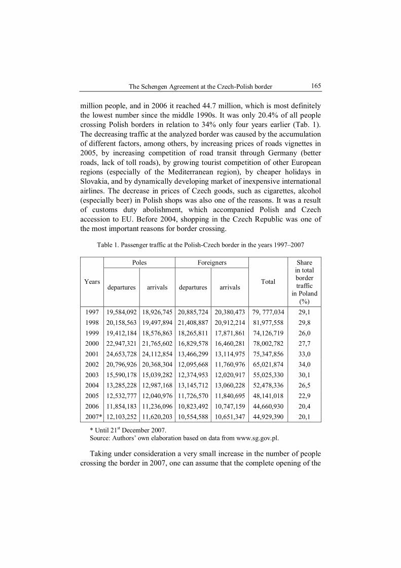
The Schengen Agreement at the Czech-Polish border
165
million people, and in 2006 it reached 44.7 million, which is most definitely the lowest number since the middle 1990s. It was only 20.4% of all people crossing Polish borders in relation to 34% only four years earlier (Tab. 1). The decreasing traffic at the analyzed border was caused by the accumulation of different factors, among others, by increasing prices of roads vignettes in 2005, by increasing competition of road transit through Germany (better roads, lack of toll roads), by growing tourist competition of other European regions (especially of the Mediterranean region), by cheaper holidays in Slovakia, and by dynamically developing market of inexpensive international airlines. The decrease in prices of Czech goods, such as cigarettes, alcohol (especially beer) in Polish shops was also one of the reasons. It was a result of customs duty abolishment, which accompanied Polish and Czech accession to EU. Before 2004, shopping in the Czech Republic was one of the most important reasons for border crossing.
Table 1. Passenger traffic at the Polish-Czech border in the years 1997–2007
Poles Foreigners
Years departures arrivals departures arrivals
Total
Share in total border traffic
in Poland (%)
1997 19,584,092 18,926,745 20,885,724 20,380,473 79, 777,034 29,1 1998 20,158,563 19,497,894 21,408,887 20,912,214 81,977,558 29,8 1999 19,412,184 18,576,863 18,265,811 17,871,861 74,126,719 26,0 2000 22,947,321 21,765,602 16,829,578 16,460,281 78,002,782 27,7 2001 24,653,728 24,112,854 13,466,299 13,114,975 75,347,856 33,0 2002 20,796,926 20,368,304 12,095,668 11,760,976 65,021,874 34,0 2003 15,590,178 15,039,282 12,374,953 12,020,917 55,025,330 30,1 2004 13,285,228 12,987,168 13,145,712 13,060,228 52,478,336 26,5 2005 12,532,777 12,040,976 11,726,570 11,840,695 48,141,018 22,9 2006 11,854,183 11,236,096 10,823,492 10,747,159 44,660,930 20,4
2007* 12,103,252 11,620,203 10,554,588 10,651,347 44,929,390 20,1
* Until 21st December 2007. Source: Authors’ own elaboration based on data from www.sg.gov.pl.
Taking under consideration a very small increase in the number of people crossing the border in 2007, one can assume that the complete opening of the

Marek Barwiński and Tomasz Mazurek
166
border after accessing the Schengen Zone will not cause any boost in the border traffic between Poland and Czech Republic, but rather maintain the existing tendencies in the nearest future2. In the future, the factors which can cause the reduction of the passenger traffic are: further development of air transportation, increasing prices in the Czech Republic and the growing attractiveness of other European regions. On the other hand, the growing number of cars, increasing wealth of Polish people and subsequently more frequent vacations abroad can result in the gradual increase in border crossings.
Theoretically, removal of border control could also result in the growth of border crossings by undesirable people (wanted by the law enforcement, people that illegally crossed the external EU borders) and smuggling.
The number of people, who illegally cross the border, systematically decreases from 1559 in 2001 to 676 in 2007. Most of the detainees are Polish or Czech citizens. Directly after EU accession, between 2004 and 2005, the number of Poles and Czechs trying to cross the border illegally decreased significantly. On the other hand, the number of illegal Ukrainians and Russians has increased (20–27% of detainees). In the last three years the number of illegal border crossings by citizens from beyond the eastern border has fallen. It is interesting, that their place was taken by the Germans, whose number in 2007 has oscillated at the same level as the number of Poles and Czechs illegally crossing the border (www.sg.gov.pl). Part of these illegal border crossings from before accessing Schengen Zone, most likely took place on the mountain tourist routes in the Sudetes and, to a large degree, resulted from ignorance of the law, according to which, before 2008 only a few tourist routes in Poland could be legally crossed across the border.
Situation concerning smuggling at the Polish-Czech border is varied3 (Tab. 2). Car smuggling systematically decreases and drugs smuggling is relatively low (except for 2006). On the other hand, high prices of tobacco in Poland influence the increasing cigarette smuggling. In 2005 and 2006, it reached the value of about 10 million Euros, and in 2007 it almost doubled (19.4 million EUR). Moreover, the value of smuggled cultural assets is increasing. Although in 2007 there were only 375 detainees who smuggled
2 After Polish and Czech accession to the Schengen Zone (21.12.2007), the statistical data on the Polish-Czech border traffic, as well as on the other EU internal borders, has no longer been recorded.
3 Analysis and data are related only to values of the so-called “detainee smuggling”, which is intercepted by Border Control. The real volume, value and structure of the smuggled goods can vary.

The Schengen Agreement at the Czech-Polish border
167
valuable items (as compared to 2889 in 2005), the value of the goods itself doubled (www.sg.gov.pl).
Table 2. The value of detained smuggled goods at the Polish-Czech border in the years 2002–2007 (in EUR4)
Smuggled goods 2002 2003 2004 2005 2006 2007
Motor vehicles 11,534,003 11,795,236 11,986,576 12,761,197 8,429,370 8,259,606
Alcohol 10,371,610 1,571,628 1,040,382 4,080,198 633,987 1,117,593 Cigarettes 8,754,036 10,371,610 8,648,278 9,967,157 9,924,691 19,357,237 Drugs 651,630 1,217,526 2,191,683 886,031 6,611,138 739,769 Cultural assets 8,594 31,364 20,727 42,151 40,303 89,465
Other 3,582,474 4,644,231 6,791,443 6,418,487 9,334,082 6,181,121 Total 34,902,347 29,631,595 30,679,089 34,155,222 34,973,571 35,744,792
Source: Authors’ own elaboration based on data from www.sg.gov.pl.
When comparing the share of the intercepted smuggling values for individual kinds of smuggled goods between 2004 and 2007, some changes can be noticed (Tab. 2). During the period of Polish membership in EU, the decrease of share of motor vehicle smuggling in the total value of smuggled goods is the most noticeable. On the other hand, illegal cigarettes in 2007 constituted more than a half of the smuggled goods’ value (these are mostly cigarettes from Ukraine). Unfortunately, in the last few years the total value of all smuggled goods has increased slowly but systematically. One can assume that after Polish and Czech accession to the Schengen Agreement, the value of smuggled goods will start to decrease, mainly because of changes in the customs legislation, which significantly increases permissible amount of the legally transported cigarettes and especially alcohol, namely goods which previously constituted the main part of the total smuggling5. However, the smuggling of goods (especially Ukrainian and Russian
4 Rate of exchange 1 EUR = 3.3 PLN 5 The following limits are in effect for a single carriage of cigarettes and alcohol for
one’s own use in the Schengen Zone: 800 cigarettes, 200 cigars, 1 kg tobacco, 10 liters of spirits, 20 liters of strong wine, 90 liters of wine and 110 liters of beer (based on www.luzycki.strazgraniczna.pl).

Marek Barwiński and Tomasz Mazurek
168
cigarettes) from beyond the eastern Polish border will certainly still exist or maybe even increase, as well as the large scale smuggling organized by criminal groups. Its scale will depend mainly on the effectiveness of the Border Guard patrols.
One of the specific consequences of Polish and Czech accession to the Schengen Agreement is the deterioration and damages of border markers. From the beginning of 2007 they are being deprived of number plates or national emblems which are commonly removed as mementos. Devastation of border markers is a penal act, and the liquidation of the border control is obviously not synonymous with liquidation of the border itself, which should remain visibly marked in the open area (www.luzycki.strazgraniczna.pl).
3. SCHENGEN AGREEMENT IN THE OPINION OF THE POLISH-CZECH BORDERLAND CITIZENS
Accession of Poland and Czech Republic to the Schengen Agreement was certainly a very important or even historic event, especially in the historical context for this part of Europe in the second half of the 20th century. During the period of communism and soviet domination, the national borders were seen as very hermetic, armed barriers with barbed wire entanglements.
Enlargement of the EU, and especially Schengen Zone, has entirely changed the function, concept and philosophy of an international border in central Europe. Despite the importance of this event, the results of the questionnaires carried out three months before accession to the Schengen Agreement among the citizens of the Polish-Czech borderland, revealed very little knowledge about the nearest future, as well as the scale of anxieties and hopes related to it6.
Only about half of the respondents living in the Polish-Czech borderland were conscious of what the Schengen Agreement concerns to (Tab. 3). Considering a relatively short period of time between the field studies and complete removal of the border control and respondents’ proximity to the border, it is a very small number. It clearly shows a low interest of Poles and Czechs in the integration processes within Europe, the insufficient information campaign in media or the influence of both of these factors.
6 Based on Naremski (2008). Questionnaires were performed during the period of
September – November 2007, among 172 randomly chosen citizens of the Polish-Czech borderland (including 101 respondents from Poland and 71 from the Czech Republic).

The Schengen Agreement at the Czech-Polish border
169
Table 3. Respondents’ opinions about the Schengen Agreement in %
Schengen Agreement concerns: Poles Czechs Introducing Euro in Poland/Czech Republic 31 21 Free flow of people 51 46 Exchange of thoughts and technology 18 33
Source: Authors’ own elaboration based on Naremski (2008).
The respondents were asked how in their opinion the Schengen Agreement could influence the situation of private companies, service institutions and the general the situation of borderland (Fig. 1). As one can notice, the optimistic attitude predominates. Most of the citizens of both, Polish and Czech, borderlands expect the development of commercial and service institutions. The development of private companies and general development of borderland are slightly less expected. However, the percentage of respondents believing that nothing will change is also relatively high, especially among the Czech citizens. The number of skeptical respondents, who foresee the deterioration of general situation in the borderland is insignificant and does not exceed 7% on Polish, and 9% on Czech side.
Very high expectations of the Poles are related to the decrease in unemployment (70% respondents). 59% of the respondents believe that immigration, which is already high, will rise in numbers, 56% think that also the phenomenon of foreigners settling on the borderland will increase. In case of Czechs, due to a better situation on the labor market, only 48% of respondents expect the decrease of unemployment. Similar percentage of respondents, as in case of Poland, believes that the complete opening of the border will intensify the occurrence of foreigners settling on the borderland (52%). Only 36% of the respondents think that Schengen Agreement will influence the increase in emigration, as the economic emigration in the Czech Republic is not very significant and the anxiety of large-scale emigration is rather slight.
Respondents were also asked about the supposable influence of the Schengen Agreement on the chosen spheres of their lives. Answers varied, as most of the negative answers related to the field of natural environment, which according to 34% Polish and 42% Czech respondents will undergo deterioration. On the other hand, 69% respondents believe that it will influence the general conditions of life with profit.

Marek Barwiński and Tomasz Mazurek
170
Fig. 1. The influence of the Schengen Agreement on the economic situation of Polish-Czech borderland, according to the respondents
Source: Authors’ own elaboration based on Naremski (2008)
In comparison to the Poles, the Czechs have a more skeptical approach. According to 53% of the respondents, Schengen Agreement will enhance their living conditions, but 40% believes that it will not influence their life at all. Taking into consideration the level of education and civil consciousness, in both cases majority of respondents believe that they will not undergo any changes and respectively, 12% of the Polish respondents and 15% of the Czechs stated that the lack of border control would not influence any field of their lives. One can clearly see that Czech citizens have smaller expectations towards membership in the Schengen Agreement than the Poles, who in majority expect the improvement of their living conditions and development of the borderland.
Respondents, who were asked to indicate the consequences of the free flow of people, perceived both positive and negative effects. Most frequently, they saw the intensification of contacts between the citizens of different EU countries and the growth of crime rate and emigration. The number of people expecting social changes was relatively high. Despite the popular saying “the
80% 0 10 20 30 40 50 60 70
BORDER AREAS
COMMERCIAL AND SERVICE COMPANIES
PRIVATE COMPANIES AND PLANTS
development no changes deterioration
Czechs
Czechs
Czechs
Poles
Poles
Poles

The Schengen Agreement at the Czech-Polish border
171
Pole can do it”, considerably less people believed that the Schengen Agreement would influence the growth of entrepreneurship among the citizens of the borderland. Poles, more often than Czechs, were afraid of the increase in emigration. However, Czechs indicated the growth of crime rate more frequently (Fig. 2).
Fig. 2. Consequences of Poland’s and Czech Republic’s accession to the Schengen Agreement, according to the respondents
Source: Authors’ own elaboration based on Naremski (2008)
According to the respondents, the accession to Schengen Agreement will bring the same amount of advantages for both Polish and Czech borderlands. 52% of the Polish and 63% of the Czech respondents are convinced about it.
Respondents were also asked about their expectations towards the accession to Schengen Zone (Tab. 4). Results show, that hope predominates over fears, especially among Poles. Czechs are more anxious of the situation after extending the Schengen Zone. Moreover, a large part of Czech respondents declares both, hope and the fear.
On both sides of the border, respondents declaring fear are mostly concerned about the growth of smuggling and crime rate (41%). Moreover, the anxiety is also connected with increasing inflow of undesirable foreigners and the growth of emigration.
increase in entrepreneurship
70
POLES CZECHS
58
36
46 41
54 57
24
14
66
2 4 0
10
20
30
40
50
60
% 70
increased emigration social changes increase in crime rate and smuggling
intensified contacts others
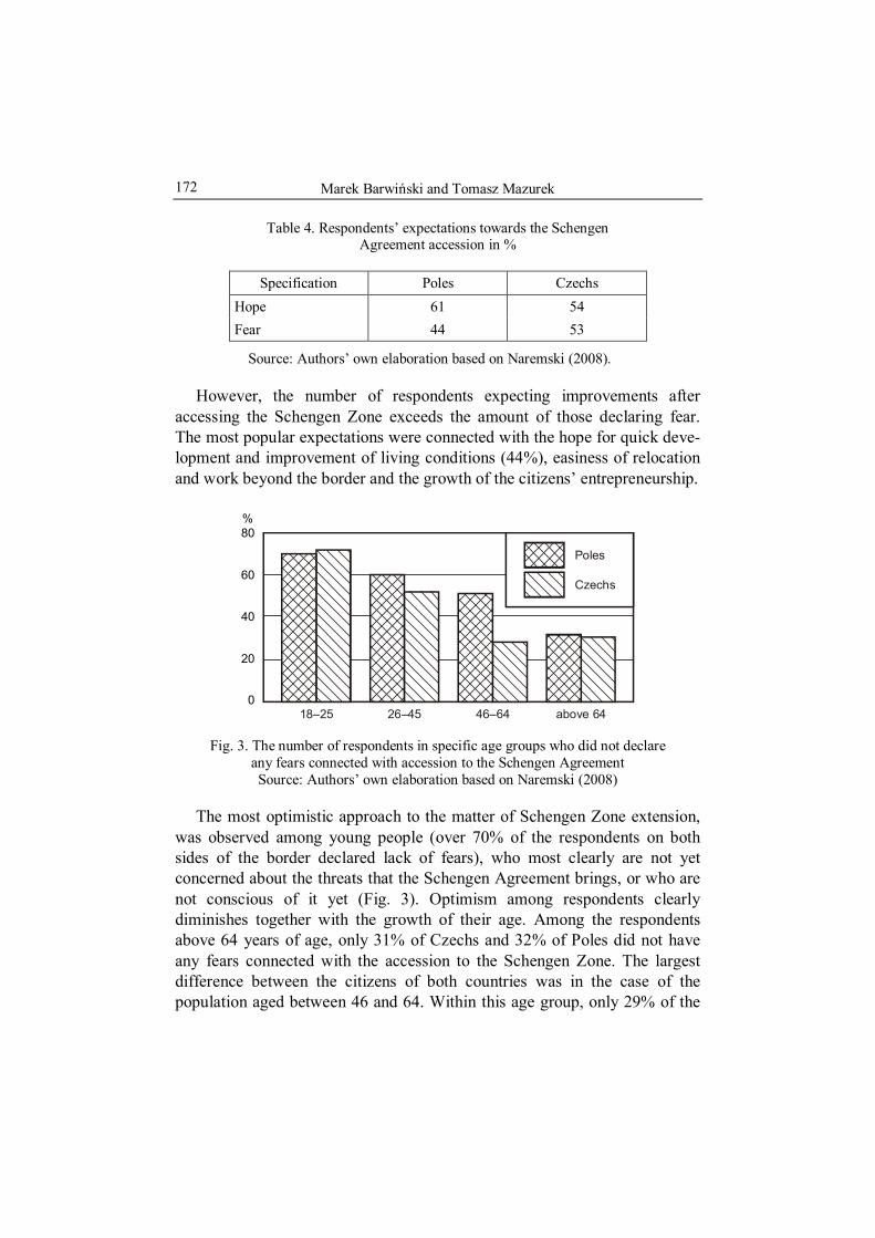
Marek Barwiński and Tomasz Mazurek
172
Table 4. Respondents’ expectations towards the Schengen Agreement accession in %
Specification Poles Czechs Hope 61 54 Fear 44 53
Source: Authors’ own elaboration based on Naremski (2008).
However, the number of respondents expecting improvements after accessing the Schengen Zone exceeds the amount of those declaring fear. The most popular expectations were connected with the hope for quick deve-lopment and improvement of living conditions (44%), easiness of relocation and work beyond the border and the growth of the citizens’ entrepreneurship.
40
20
0
60
80%
18–25 26–45 46–64 above 64
Czechs
Poles
Fig. 3. The number of respondents in specific age groups who did not declare any fears connected with accession to the Schengen Agreement Source: Authors’ own elaboration based on Naremski (2008)
The most optimistic approach to the matter of Schengen Zone extension, was observed among young people (over 70% of the respondents on both sides of the border declared lack of fears), who most clearly are not yet concerned about the threats that the Schengen Agreement brings, or who are not conscious of it yet (Fig. 3). Optimism among respondents clearly diminishes together with the growth of their age. Among the respondents above 64 years of age, only 31% of Czechs and 32% of Poles did not have any fears connected with the accession to the Schengen Zone. The largest difference between the citizens of both countries was in the case of the population aged between 46 and 64. Within this age group, only 29% of the

The Schengen Agreement at the Czech-Polish border
173
Czech respondents did not have any fears, which makes them the largest pessimistic and skeptical group (Fig. 3). Taking into consideration the gender structure, women tend to be more skeptical, both in Poland and Czech Republic.
4. CONCLUSIONS
1. The extension of the Schengen Agreement to the countries of Central Europe is the historic event, which finally ended the isolation of the communist period, entirely changing the functions and perception of the state border in this region of Europe and accelerating the integration of European states.
2. Despite the border control removal, one should not expect immediate growth of the border traffic at the Polish-Czech border. However the smuggling of goods may still intensify.
3. Despite the great importance of the Schengen Agreement, the knowledge of Polish-Czech borderland citizens about this event several months before its introduction was scarce. One should hope, that introduction of a new legislation and its practical use, will significantly change the consciousness of citizens.
4. The majority of the respondents on both sides of the border expect that the opening of the border will positively change the image of the Polish-Czech borderland. However, there is also a large group of people, especially on Czech side of the border, who think that the Schengen Agreement will not introduce any changes, although the number of pessimists foreseeing the deterioration of the situation is scarce.
5. Respondents on the Polish side of the border have larger expectations towards functioning of the Schengen Agreement, while Czechs are more skeptical about it.
6. There is a strong dependence between the age of the respondents and declaration of fears connected with the accession to the Schengen Zone – the older the respondents, the higher percentage of skeptical people.
7. Expectations and hopes connected with functioning of the Schengen Agreement are related mainly to the economic development of the border-land, especially trade, services, enterprises, as well as with the improvement of living conditions and facilitations in transboundary contacts and foreign travel. Among respondents’ expectations, economic benefits are the most popular.

Marek Barwiński and Tomasz Mazurek
174
8. The most frequently indicated fears, connected with the lack of border control, are the growth of crime rate, smuggling and deterioration of natural environment. Moreover, Polish citizens are afraid of the increase in an already high emigration rate.
REFERENCES
NAREMSKI, M., 2008, Polish-Czech border and borderland on the eve of accession to Schengen Agreement, master’s thesis written in the Department of Political Geography in University of Lodz, supervisor M. Barwiński.
www.luzycki.strazgraniczna.pl www.sg.gov.pl

Tamás HARDI Hungarian Academy of Science Györ, HUNGARY
No 9
CHANGING CROSS-BORDER MOVEMENTS IN THE SLOVAK-HUNGARIAN BORDER REGION
AFTER THE EU ACCESSION
1. INTRODUCTION
This study is based on an empirical survey conducted in the Slovak- -Hungarian border region. Due to historical, ethnic and spatial characteristics this region always had strong internal relations, even in the decades when the separating character of the borders was dominant. In Europe there are border regions where a “wall” between the two border regions still exists, despite the existing formalised relations and the virtualised borders (Paasi and Prokkola, 2008). The number and volume of interactions do not increase as dynamically as one would expect. In some other places the inhabitants of a border region have various relations with the other side of the border, irrespective of the relationship between the two states and the officially functioning cross-border organisations. The opening of the border will in all cases lead to an increase in cross-border movements. Krakover (1997), however, emphasises that the opening of the border will not always bring tangible results, especially in situations where no significant commercial relationships can be established between the two countries (e.g. due to the weakness of the economy). Accordingly, short term interests (such as the incubation of economic units in their infancy, and protectionism) act against the opening of the border. Our experiences suggest that this phenomenon does not necessarily take place at the state level; it can also be seen at certain sections of the borders where the general socioeconomic conditions are bad. To the opposite, a dense network of personal and economic relations can develop at the common border of countries having poor mutual relationship, if the borders is permeable.
The relationship between Slovakia and Hungary is not free from conflicts.

Tamás Hardi 176
The relationship was conflict-burdened during the 20th century history of the two countries as well (including the relationship of Hungary with former Czechoslovakia), but the tensions are especially serious at the beginning of the 21st century. Nevertheless considerable personal and economic movements and co-operation characterise the common border region of the two states, and in our opinion this one of the sections of Hungarian border where real cross- -border regions can came into being.
The aim of our survey was to examine types, frequency and intensity of personal movements across the border, and how these are affected by the accession of the two countries concerned to the European Union. Included in the analysis were cross-border commuting to work, migrations and the use of public services (education and health care). In order to obtain this information a questionnaire survey has been conducted among 2000 inhabitants, and 500 commuting employees. In addition to this, we made in-depth interviews at the offices, local governments, public service providers and non-govern-mental organisations.
For the designation of the research area we had to define a functional border region. The administrative borders (of counties and districts) were not suitable for this, because these areas are too extended in some cases and contain parts that do not have evident functional cross-border relations. In other cases, areas with strong cross-border relations reached beyond the boundaries of the administrative units along the border. To eliminate this problem we used a research area designated by our former researches: it was a zone which is home to approximately 2 million inhabitants on the two sides of the 679-kilometre-long state border.
For the definition of the research area we used the Martinez’ dynamic border region classification which derives the types of border regions from the number and depth of cross-border interactions and accordingly differentiates alienated, co-existing, mutually co-operating and integrated border regions (Martinez, 1994). This reveals that the historical role of the border changes. The historical changes modify the relationship between the states and accordingly the functions of the state border, on the one hand; and the different borders separate areas of different geographical endowments, on the other hand. The characteristics of state borders are in close interrelation not only with the characteristics of the states that they surround but also the characteristics of the respective border areas. Accordingly, the functional classification featured above and the categories distinguished by Martinez are not only the respective states of a temporal change but can also be spatial types following the uniqueness of the border regions (Hardi, 2001). In other words,

Changing cross-border movements in the Slovak-Hungarian border...
177
areas of different geographical endowments have different chances for creation of interrelated cross-border regions.
Along the less and less separating borders of these days, the basis for the definition of a border region can be the existence of cross-border interactions as a common feature determining a region. Today, when the borders are permeable, those areas are considered as border regions where the everyday life of the inhabitants is basically influenced by the interactions with the neighbouring border area; cross-border regions are those where these interactions create a spatially designable intensive system of relations. Pertinent literature more and more argues that sharp separation of regions (of areas belonging to different states) is an obsolete approach now and more and more often zones of transitory character are formed – i.e. border regions (Fleischer, 2001; Novotny, 2007). These border regions can be of different width and depth on the different sides of the border. Within these areas those particular spatial units called cross-border regions can emerge.
2. THE HUNGARIAN-SLOVAK BORDER REGION
The Slovak-Hungarian state border is situated in an area that used to belong to a single state (the Kingdom of Hungary or the Austro-Hungarian Monarchy) until the end of the First World War. The peace treaty closing the First World War created the state border between Czechoslovakia and Hungary. The state border did not follow the ethnic divisions; large areas of Hungarian ethnic majority were annexed to Czechoslovakia. In the peace treaty of 1920 the designation of the border was mainly based on economic, military-strategic and transport geographical considerations (Hevesi and Kocsis, 2003). The network of personal relations so important for the organisation of the everyday life, the aspects of the settlement network and the ethnic aspects were more or less neglected. The border was moved northward after the Munich Treaty of 1938, and this situation existed until the end of the Second World War. The ceasefire agreement at the end of the war restored the conditions before 1938, and then the peace treaty annexed another small area to Czechoslovakia in the Bratislava region. After the disintegration of Czechoslovakia, Slovakia inherited the state borders.
The border regions have multi-ethnic character. On the Slovak side, along the whole border section the proportion of the Hungarian ethnic minority is significant, in fact there are still Hungarian ethnic majority areas, especially in

Tamás Hardi 178
the western areas where in some districts Hungarians represent more than 80% of the population. (For the whole of Slovakia, the share of Hungarian-speaking citizens is 9.67%, the majority of whom live in the border zone.) In the eastern part of the border region the situation is somewhat different; here we find areas and villages with either Hungarian or Slovak majority.
On the Hungarian side we find inhabitants and villages of Slovak ethnicity as well. Although the share of Slovaks in the total population of Hungary is small (0.17%), along the border we find several villages with Slovak popu-lation (A significant part of Slovaks in Hungary live far away from the Hungarian-Slovak border region, in the south-eastern part of Hungary.) In the western part of the border region (the Danubian border) we find the most economically developed areas of the two countries. In Slovakia the three adjacent west Slovak districts (Bratislava, Trnava and Nitra) produce half of the Slovak GDP; the share of Budapest and the three counties along the border (Pest, Komárom-Esztergom and Győr-Moson-Sopron) in the Hungarian GDP is similar. Especially in Slovakia this proportion seems to be growing. On the other hand, the development level of the eastern areas is below average in both countries, poor regions are neighbour to each other. It is true, however, that the city of Košice stands out as a developing economic enclave in Slovakia.
3. CONTACTS AND RELATIONS BETWEEN PEOPLE
During the research we also focused on the mutual relations of the in-habitants of both sides of the border region. Because of the ethnic com-position, however, it was not enough to differentiate the respondents according to their nationality; ethnic belonging was also to be considered. In our questionnaire survey, 40% of the respondents in Slovakia were of Slovak ethnicity, accordingly to the ethnic composition of the research area. At the evaluation of the responses we differentiated among the groups of respondents who were Slovaks in Slovakia, Hungarians in Slovakia and Hungarian citizens. Unfortunately the sample included very few Slovak respondents living in Hungary, so they could not be treated as a separate group. We analysed their relations using in-depth interviews.
According to our experiences there is a clear-cut asymmetry in the citizens’ relations across the two border regions. In general we can say that the Slovak side – irrespective of ethnic belonging of the respondents – has much more intensive relationships with Hungary than the Hungarian side has

Changing cross-border movements in the Slovak-Hungarian border...
179
in Slovakia. Among the Hungarian respondents living in Slovakia almost every one claimed having contacts with the Hungarian side. This refers as well to a significant proportion of Slovak respondents, whereas the intensity of the relationships of the Hungarian citizens with Slovakia is much lower. This is not a unique phenomenon. Anderson and O’Dowd (1999) pointed out that the cross-border relations were asymmetric because of differences among the border regions. The reasons for this asymmetry in our case are as follows:
1. For the Hungarians in Slovakia, keeping in touch with the Hungarian areas close to them is also keeping in touch with the mother country, i.e. there is also an ethnic-emotional motivation behind the relations.
2. For the inhabitants on the Slovak side, language use is less of a problem than for the inhabitants of the Hungarian side. The Slovak citizens of Hunga-rian ethnicity naturally speak Hungarian, and even a significant part (82%) of the Slovaks understand or speak Hungarian. On the other hand, the proportion of Slovak-speaking inhabitants on the Hungarian side is negligible (6.8%). During the daily travels this is not an obstacle, as in the Slovak areas along the border Hungarian language can be used almost everywhere. Nevertheless the use of services is made difficult by the lack of language skills.
Our analyses reveal this asymmetry as well. Among all inhabitants in the border region the proportion of those who have never been to the other side is small. On the whole, 80% of our respondents have already been to the other side of the border, which is a proportion similar to those typical in other border regions (Hardi, 1999). For instance in the Austrian-Hungarian border region only 10% of the Hungarians and 20% of the Austrians declared that they had never crossed the border. A basic finding of our survey is that more inhabitants visit Hungary from Slovakia than from the opposite direction. As regards the respondents of the questionnaire survey in Slovakia, 96.1% have already been to Hungary, whereas this proportion is only 79.7% among the Hungarian respondents. Hungarians living in Slovakia travel often across the border: 97% of them have already visited Hungary, compared to 94% of the Slovaks in Slovakia. The lowest proportion of visits to the other side is among the Hungarian citizens: only 79.9% of them have ever crossed the border to Slovakia. It is interesting that the least active group as to cross-border movements are Hungarian citizens.
Much smaller share of the inhabitants have friends or family relations, but the asymmetry can be seen in this respect too (Csizmadia, 2008). Many Slovak citizens have relations in Hungary while Hungarians having family or friends Slovakia are much fewer. On the other hand, Slovak citizens have bigger number of relationships than their Hungarian counterparts have (Fig. 1).

Tamás Hardi 180
0 10 20 30Relatives frequency – Answer “yes”
40 50 60%
Do you have anyrelationship in theneighbour country?
Do you haverelatives in theneighbour country?
Do you have in the
neighbour country?friends
Do you haveancquantances in theneighbour country?
Do you havecolleagues in theneighbour country?
Do you havebuissnes partners the neighbour country?
in
25,7
12,7
10,8
8,7
2,2
1,2
53,1
35,4
28,2
24,9
4,2
2,816,2
Hungary
Slovakia
Difference
16,2
47,2
22,7
27,4
Fig. 1. Frequency and types of cross-border relationships Source: Author based on questionnaire survey (2008)
20
40
60
80%
00
1 2 3 4 5How many types relationships do you have in the neighbour country (max. 5)?
Hungary
Slovakia
74
18
6 6
47
26
15
10
2 1
Fig. 2. Number of different kinds of cross-border relations Source: Author based on questionnaire survey (2008)

Changing cross-border movements in the Slovak-Hungarian border...
181
As to strong relations, most Slovak respondents have relatives or friends in the capital city, followed by the big cities and the local centres along the border. A similar regularity refers the weak relations too: the dominance of the capital city can also be seen here. Komárom represents a case apart; it is the third destination as to the number of relations in each type of relation, after Budapest and Győr, despite its much smaller population (Fig. 3).
Obviously, the list is not suitable for drawing far-reaching conclusions, but it is useful to demonstrate integrations mechanisms in the border region through interpersonal ties.
59029559
VelkeKapusany
Nyiregyhaza
Debrecen
BRATISLAVA I
Medvedov
GyorKomarom
Esztergom
Hajduszoboszlo
BUDAPEST
Balatonfured
Salgotarjan
Komarno
DunajskaStreda
VelkyMeder
Sturovo Eger
Miskolc
Roznava
VysokeTatry
Tachty
RimavskaSobota
Tornala
Filakovo
Ozd
LucenecSatoraljaujhely
SlovenskeNove Mesto
Moldavan. Bodvou
DobsinaKosice I
PopradLiptovskyMikulas
Number of people
Fig. 3. Destinations of cross-border travels Source: Author based on questionnaire survey (2008)
3. CHANGING MOVEMENTS
The spatial movements of people are usually motivated by some economic necessity or benefit. Economic benefit does not only mean a profit that can be achieved through an economic activity (business or employment) but also a better access to certain facilities or services (education, health care,
Tamás Hardi 182
transport infrastructure, housing), possibly of better quality, with less travel or at a lower cost. The same rule holds true for cross-borders movements.
Activities undertaken on the other side of the border more or less regularly must yield a benefit that counterbalance the obstacles resulting from the existence of the state border (border checks, different social and economic environment, mental border, different currency, etc.). This is usually true for both cross-border movements and international migrations alike. Specificity of movements between border regions, however, consists in the fact that due to spatial proximity the benefits of one’s daily routine activities are accessible within the range of local and micro-regional movements.
Characteristic for the Slovak-Hungarian border are “traditional” cross- -border movements. Even in the socialist times mutual cross-border employ-ment and shopping tourism was common. In recent decades the use of institutions has become more and more widespread, e.g. a significant number of Slovak students study in schools in Hungary, in some areas the nearest hospital is on the territory of the other country. Since the EU accession it has become frequent that Hungarian businesses move to the other side of the border (due to more business-friendly tax system). Also an increasing number of people move across the border. The suburbanisation of Bratislava and Košice has already reached the border areas of Hungary, while in smaller towns Hungarian inhabitants buy real estates on the Slovak side. In this essay two movements are analysed: the suburbanisation of Bratislava and cross-border commuting.
3.1. Dilemmas of the expansion of the Bratislava agglomeration into Hungary
Bratislava, a dynamically growing capital city, has developed, like other European cities, a suburban zone of considerable size. Due to particular location of the Slovakia’s capital city close to the border as well as characteristics of the real estate market, this suburban zone has already penetrated into the Hungarian and Austrian. Further dynamic suburbanisation is to be expected, especially on the Hungarian side, because of the specificity of transportation network. Some 3,000–5,000 Slovak citizens have moved to the Hungarian border region until the autumn 2008.
Suburbanisation is a development process that naturally takes place in every big city, which exerts impact on both the city itself and its environ-ment. Beside “usual” consequences, in this case the advantages and disadvan-tages specific for the cross-border urban region also have to be considered. The

Changing cross-border movements in the Slovak-Hungarian border...
183
issues that appear in this context include (to mention just a few): How will the Hungarian local government provide public services (education, health care, etc.) for the incoming Slovak-speaking population (not having Hungarian citizenship)?; What network co-operations can be established among the neighbouring Hungarian and Slovak municipalities to tackle the problems?; What regulations concerning taxes should be implemented (the incomers pay taxes in Slovakia but use some of the public services in Hungary)?; How will the newly arriving groups integrate into the receiving society and will ethnic segregation and conflicts appear?
3.2. Cross-border commuting and the local labour market
Cross-border commuting can be considered legally as an international migration, but mostly within local circumstances. This phenomenon is diffe-rent from the traditional employment “abroad” as the employees live in the neighbour state but have their place of work in another state. This situation differentiates these employees from other foreigners, and their special situation raises a number of issues, from the organisation of daily transportation through the use of public services to taxation and conversion of the incomes. According to our survey, some 10% of the inhabitants living in the Slovak border region has already worked, are presently working, or are planning to work in Hungary. Taking into account their families, the cross-border employ-ment concerns much larger population.
Since the turn of the 20th century commuting has been one of the most dynamically developing cross-border movements. Cross-border employment has traditionally existed in the region, including in the socialist era. However, the economic decline in the 1990s temporarily put an end to cross-border employment. After the years of stagnation, from 1999 on the number of employees commuting from Slovakia to Hungary rapidly increased. In the western border region there were higher unemployment rates on the Slovak side than in Hungary, whereas on the Hungarian side there were large industrial centres that had already exhausted their local labour resources. Regular commuting is set back, however, by small number of bridges on the Danube. Actually, bridges have accounted for intensive cross-border relations of Mosonmagyaróvár, Győr and Komárom (the same role is assigned to the rebuilt Mária Valéria Bridge in Esztergom). Ferry as a means of transport is rather uncertain and largely depends on weather conditions changing with seasons. After 1999 the development of commuting was also induced by the

Tamás Hardi 184
framework agreement between the two states, as it allowed people to find employment in another country (evidently it was Hungary in the first place). In fact, the limits were set so high in the year prior to the EU accession that the barriers to the movement of labour were practically eliminated. In May 2004, the time of the accession, the labour market was not unprepared. In 2005 the number of Slovak citizens employed in Hungary was estimated at 30,000, and this number has remained more or less stable. Since the EU accession, Slovakia has experienced a very rapid economic development, which of course affects the labour market of Slovakia. Accordingly, the number of commuters in the western border region is decreasing, it is expected to stabilise at a normal level and probably those will choose employment in Hungary for whom a nearby Hungarian town or city is a spatial advantage. At the same time a reverse process has started. Hungarian employees are attracted to Slovakia by Slovak businesses, which needs experts for the management. From Komárom-Esztergom county some people commute as far as to Trnava, employed mainly in the automotive industry. Recently, in the eastern areas, where unemployment is higher, Slovak entrepreneurs are recruiting Hungarian labour force. It shows that in peripheral border regions from where the majority of the skilled workers have already moved out the demand for qualified labour is high.
An estimated 30,000 employees lost employment, two-thirds of whome were from the border districts of West Slovakia, from the Dunajská Streda, Komarno, Nove Zamky and Levice districts inhabited by mixed Hungarian and Slovak population. In December 2007 a total of 9,780 persons from these four districts were employed directly by Hungarian firms: 2,200 from the Dunajská Streda, 6,000 from the Komarno, 1,200 from the Nove Zamky and 380 from the Levice district (Eures Danubius Conference, Dunajská Streda, 14 March 2008). The rest, approximately 10,000–10,200 persons found employment in Hungary via Slovak labour recruitment agencies. We lack exact figures of the similar breakdown of the approximately 10 thousand employees living in East and Central Slovakia; it can be presumed though, that these regions saw similar tendencies as in West Slovakia.
Our research has shown that the phenomenon of cross-border employment does not depend only on the elements of economic growth. Apart from higher salaries in the neighbour country, proximity of the workplace was equally important for the respondents. It can be stated that the cross-border employment in our region can not be seen as a traditional international migration. It is based on the classic urban-rural relations. Its volume depends on differences in salaries, but the majority of the commuters who have

Changing cross-border movements in the Slovak-Hungarian border...
185
poorly paid did not have significantly higher income across the border. The introduction of Euro in Slovakia will certainly set back the movement to some extent, but it will not eliminate it. It is worth continuing the professional talks in this field and promoting an even broader co-operation in the fields of vocational training, strengthening thereby the cross-border labour market.
4. CONCLUSION
Simultanous integration of Slovakia and Hungary with the European Union created various opportunities for the border region concerned. Mutual contacts here are facilitated by the common Hungarian language, spoken or at least understood by majority of the population. The theoretical hinterlands (and more and more frequently the real ones) of the cities along the border expand into the other side of the border and integrate smaller or larger areas. These processes have implications for everyday life. For the inhabitants and the entrepreneurs alike it is becoming more and more natural to take advantage of the other side of the border.
A relatively small share of the population of the border region are involved in regular cross-border movements (1–2% of the total population on the Hungarian side and 20–30% on the Slovak side). The main driving forces behind the movements are economic growth, economic interests and the characteristics of the spatial structure (revival of the centre and hinterland relations). The EU accession resulted in the increasing intensity of the movement in all fields and directions. The differences of the national systems (social security, training, taxation, etc.) promote the penetration of the shadow or black economy and complicate the everyday life.
Approximately 30,000 employees from Slovakia work in Hungary, and recent years saw increasing commuting from Hungary to Slovakia. More and more businesses move to the neighbour country, some people choose school or even place of residence in the neighbour state. These phenomena have been reinforced by the accession to the EU, as the macro-level processes offered new possibilities. The possibility of free movement, employment, migration and business activity is used to large extent by the population. Who could imagine that the agglomeration of Bratislava would reach Hungary and hundreds of Slovak families would buy flats in Rajka and its surroundings, raising the issue of extending the local bus line from Bratislava to Rajka? Who could expect that it would be possible to go to school (or maybe visit the nearest hospital) across a Schengen border?
Tamás Hardi 186
It has become reality, but change is so rapid that the driving forces and motivations are largely ignored. Obviously, there are still many obstacles hampering complete integration. The national systems (education, health care, public administration, bureaucracy, etc.) still encounter difficulties in han-dling the natural processes of the border regions. Those who cross the borders are actually foreign citizens but also “local inhabitants”. It is difficult to put them into the traditional categories of “domestic” and “foreign” citizens, and the administrative problems resulting from this are still to be resolved e.g. the issue of common use of health care institutions. These problems often turn out to be harmful (e.g. tax evasion), but their significance seems to be relatively small compared to benefits produced by those natural processes that connect the border regions and their integration.
REFERENCES
ANDERSON, J. and O’DOWD, L., 1999, Border, border regions and territoriality: contradictory meanings, changing significance, Regional Studies, 33 (7), p. 593–604.
CSIZMADIA, Z., 2008, Társadalmi kapcsolatok a szlovák-magyar határtérségben, Tér és Társadalom. 3, p. 27–50.
FLEISCHER, T., 2001, Régiók, határok, hálózatok, Tér és Társadalom. 3–4, p. 55–67. HARDI, T., 1999, A határ és az enber, [in:] Elválaszt és összeköt – a határ, eds. M.
Nárai and J. Rechnitzer, MTA RKK, Pécs–Győr, p. 159–189. HARDI, T., 2001, Az egységes határrégiók kialakulásának feltételei – lehetséges
határrégiók a Kárpát-medencében. Ph. D. thesis. PTE KTK „Regionális politika és gazdaságtan” PhD. program.
HEVESI, A. and KOCSIS, K., 2003, A magyar-szlovák határvidék földrajza, Dunaszer-dahely: Lilium Aurum.
KRAKOVER, Sh., 1997, Boundary openness model applied to Israel, Egypt and Gaza strip Tri-border Area. Paper presented at the European Regional Science Association Summer Institute, Are.
MARTINEZ, O.J., 1994, The dynamics of border interaction: New approaches to border analysis, [in:] Global boundaries (World boundaries series 1), ed. C.H. Schofield, London–New York: Routledge, p. 1–15.
NOVOTNY, G., 2007, Határon átnyúló regionális hálózatok Európában, [in:] Évkönyv 2006, eds. A. Buday-Sántha and G. Lux, Pécs: PTE KTK Regionális Politika és Gazdaságtan Doktori Iskola, p. 385–408.
PAASI, A. and PROKKOLA, E.-K., 2008, Territorial dynamics, cross-border work and everyday life in the Finnish-Swedish border area, Space and Polity, 12 (1), p. 13–29.

Marek BARWIŃSKI Department of Political Geography and Regional Studies University of Łódź, POLAND
No 9
THE CONTEMPORARY POLISH-UKRAINIAN BORDERLAND – ITS POLITICAL
AND NATIONAL ASPECT
1. INTRODUCTION
Borderland is the transitory area between two or several nations. Usually it is a zone, socially and culturally diversified, formed as a consequence of multiple historical changes in political affiliation of the given territory, population mixing, intersecting of political and social influences as well as penetration of different cultural elements of the of neighbouring nations. The essential aspect of borderland is its political dimension, because very often creation or transformation of borderland areas was an immediate result of border shifts. However, there are also borderlands, on areas where political borders never existed or appeared very late (Koter, 1995; Sadowski, 1995; Babiński, 1997; Barwiński, 2002, 2004).
Sometimes the extent of a borderland is clearly defined (e.g. between rivers, mountain ranges), however most often it can be delimited only on the basis of the settlement geography. Its actual area and range is marked by migrations, colonization and cultural differentiation of its occupants (Babiński, 1997).
As early as in the Middle Ages the present Polish-Ukrainian borderland had the character of political and national-religious borderland, as it was the peripheral area, both for Poland and Ruthenia. After the period of fierce rivalry over this region (11th–14th century), which engaged particularly Poland and Ruthenia, but also Lithuania and Hungary, for several years it was annexed to Poland. Only at the turn of the 18th century, as the result of Poland’s partitions, the whole Galicia for over 100 years got under Austrian rule. The most turbulent period marked with political transformation of the

Marek Barwiński
188
Polish-Ukrainian borderland was the 20th century, when this area has re-peatedly changed hands (Austria, Russia, Poland, Germany, USSR, Poland, Ukraine). Despite of the very turbulent history, this region for centuries has not been divided by state borders. Only in 1939, and then again in 1945, the national Polish-Ukrainian borderland was divided by the political border and annexed to different states.
The Polish-Ukrainian borderland was formed as a result of long-lasting historical processes, which shaped political, territorial, as well as national, religious, cultural, social and economic transformations. Already in the Middle Ages the ethno-religious mosaic was shaped on this area. Apart from the predominant Ruthenian (Ukrainian) and Polish population, also Arme-nians, Jews, and Germans lived here for centuries. The national diversity was overlapped by religious divisions, mostly between eastern and western Christianity. Moreover, the ethno-religious divisions were overlapped by social and economic ones. On territories east from the San River, Poles were pre-dominantly Catholic, mainly townsmen or nobility, whereas an over-whelming majority of Ruthenians (Ukrainians) were Orthodox (later Greek Catholics) peasants living in the countryside.
In the 19th century national aspirations and ideas of independence in-creased among Poles and Ukrainians alike, which on the ethnic borderland inevitably led to a conflict. In 1918 the Polish-Ukrainian war started, which ended with the Ukrainian defeat and the annexation of the whole Galicia to Poland. The interwar period saw further growth of the conflict between five-million Ukrainian minority and Polish state. However, the most tragic events in the history of Polish-Ukrainian relations took place during and after the Second World War. In this time the conflict affected the whole borderland, and the bloody Polish-Ukrainian fights in 1943–1947 connected with the activity of Ukrainian Insurgent’s Army (UPA), especially in Volhynia, can be considered as a genocide of Polish population. After the war Polish authorities have responded with repressions and mass resettlement of the Ukrainian population. These events seriously affected Polish-Ukrainian relations in the following decades (Torzecki, 1993; Wojakowski, 1999; Cha-łupczak and Browarek, 2000; Goluba, 2004; Grübner and Spregnel, 2005).
2. THE POLISH-SOVIET BORDER
As a consequence of the Ribbentrop-Molotov pact and the division of the territory of Poland between Nazi Germany and the USSR in September 1939,

The contemporary Polish-Ukrainian borderland...
189
the area of the Polish-Ukrainian borderland became artificially divided by a state border between these two countries (Fig. 1). At the end of the war the Soviet authorities spared no efforts to make sure the western border of the USSR would be in line with the 1939–1941 Soviet-German border. Finally, it has been decided apply Curzon’s proposition submitted at the Versailles conference in 1919. In July 1944, as the result of an agreement between PKWN1 and the Soviet government, that is de facto under Stalin’s dictate, the eastern border of Poland was marked, based on the “Curzon Line2” – according to the so-called “A variant”, which was an option most unfavo-rable for Poland, leaving Lvov (Lwów) on the Soviet side (Fig. 1). This border course was subsequently confirmed by the international conferencies (Yalta and Potsdam) and by agreement between Polish and Soviet governments signed in August 1945. As a consequence of these decisions Poland lost the territories which for over 600 years were under Polish rule, and the Polish-Ukrainian borderland was cut by political border, which never ran here before. This entirely artificial border, marked out according to exclusively political criteria, is deprived of any historical and ethnic justification (Eberhardt, 1993). Its artificial character is clearly visible by the lineal course of the border section between the Bug River and the Carpathians (Fig. 1). It is an example of so-called “geometrical borders”, that run irrespective of natural, ethnic, cultural and economic features of divided territory. It is a border imposed as a result of treaty arrangements. Borders of this type are also called – quite pertinently the “scars of history” (Barbag, 1987).
The most tragic and harmful consequences of marking out these borders (German-Soviet in 1939 and Polish-Soviet in 1944), both for Poles and Ukrainians living on the borderland, were the population displacements. First deportations in 1939–1941 involved mainly Poles displaced to the USSR.
1 Polish Committee of National Liberation – established in 1944 in Moscow Polish
Communist Government, entirely subordinated to Stalin. 2 Conventional name of the line recommended by Ambassador Committee as a
temporary eastern border of Poland (08.12.1919). The name comes from the surname of Great Britain Foreign Minister – Lord Curzon of Kadleston. This line ran from Grodno district in the north, to Niemirów, then along the Bug River up to the Sokal district. Between the Bug River and the Carpathian Mountains its route was not marked out interchangeably. There were two options of its route: “A” and “B” (Fig. 1). This project practically did not played any role in demarcation of the Polish borders after the First World War, however it had important consequences for the route of the eastern border of Poland after the Second World War (Eberhardt, 1993).

Marek Barwiński
190
Włodawa
Kraśnik
JanówLubelski
Zamość
Biłgoraj
Nowowołyńsk
Hrubieszów
Tomaszów Lub.
Iwaniczi
Sokal
Włodzimierz
Czerwonograd(Krystanopol)
Chodorów
KałuszDolina
Stryj
ŻydaczówDrohobycz
Truskawiec
Mikołajów
Szack
Luboml
Chełm
Krasnystaw
RawaRuska
LubaczówSieniawa
Łańcut
Leżajsk
Przemyśl
Dobromil
Mościska
Kowel
Bełz
JaworówLWÓW
GródekJagieloński
SądowaWisznia
Turka
Borysław
SamborSanok UstrzykiDolne
SLOVAKIA
BELORUS
Jarosław
Przeworsk
U K R A I N E
P O L A N D
Soviet territory annexedto Poland in 1951Polish territory annexedto USSR in 1951German-Soviet borderestablished in September 1939Curzon LineCurzon Line ACurzon Line BContemporary state bordersRivers
Wieprz
Tanew
San
Wisłok
Dniestr
Dniestr
Stryj
Sołakija
Bug
Ług
Prypeć
Fig. 1. State borders and border projects on the Polish-Ukrainian borderland in the 20th century Source: Author based on Eberhardt (1993) and Goluba (2004)

The contemporary Polish-Ukrainian borderland...
191
They were followed by mass displacement of Poles and Ukrainians in 1944–1946 and Ukrainians displacement within the “Vistula” action in 19473. These activities have entirely destroyed multiethnic and the multi-cultural character of the Polish-Ukrainian borderland, and the newly establi-shed border very quickly became not only political border, but also the national border.
The course of the Polish-Soviet border underwent changes in 1951, when Poland was forced to sign the agreement on mutual exchange of territories covering 480 km2. As a consequence of this agreement Poland lost the area west from Sokal situated between the Bug and Sołokija Rivers. In exchenge Poland received a territory of the same area in Ustrzyki Dolne region (Fig. 1). After this modification the Polish-Soviet border has never undergone any changes again (Eberhardt, 1993; Grübner and Spregnel, 2005).
Through the whole period of the Polish People’s Republic (PRL) and USSR existence this border was first of all a barrier tightly separating Polish and Ukrainian population with similar culture, language and morals. The Polish-Soviet border during a long time hampered effectively the contacts between Polish and Ukrainian nations and also destroyed the original character of the Polish-Ukrainian borderland. As Eberhardt (1993) wrote:
Polish-Soviet border marked out after the Second World War was during next several decades one of cordons dividing districts in the great totalitarian camp which was stretching from Elbe to Kamchatka.
On both sides of the border communist authorities introduced the policy of national minorities’ assimilation. As a consequence of it during 30 years (1959–1989) the number of Polish population in Ukraine decreased, according to official statistics from 363.3 thousand to 219.2 thousand. In the frontier district of Lvov, Polish population decreased more then a half, from 59.1 thousand to 26.9 thousand4. In Poland, as a result of the displacement and dispersion of the Ukrainian population in the northern and western territories, the assimilation process proceeded even faster, however the official statistics for this period does not exist. Also the traces of culture and religion of minorities were destroyed, e.g. Greek-Catholic Orthodox chur-ches in Poland and Catholic churches in Ukraine, the Greek-Catholic church was declared illegal, in the USSR and Poland alike (Wojewoda, 1994).
3 This issue is analyzed wider in: Barwiński (2008). 4 Based on www.wspolnota-polska.org.pl.

Marek Barwiński
192
In spite of the fact that the border between Poland and USSR existed only 47 years (1944–1991), its influence on the Polish-Ukrainian borderland was very strong. Its marking out had a direct influence on displacement of hundreds of thousands people, it brought to almost entire isolation of both parts of the divided territory, it caused their differentiation both in national-cultural and political-economic respect. The multicultural and multiethnic character of the borderland shaped through centuries was destroyed.
3. THE POLISH-UKRAINIAN BORDER
The situation changed essentially after the fall of the communism in Poland, the break-up of the USSR and the rise of independent Ukraine. The former border with the totalitarian USSR, became the border between two fully independent, democratic states Republic of Poland and Ukraine. The border crossing became very easy. Next to the already existing border crossing in Medyka, which for several years was the only one, new border posts were opened in Krościenko, Korczowa, Werchrata, Hrebenne, Hru-bieszów, Zosin, Dorohusk. Facilitation in Polish-Ukrainian border crossing have enlivened mutual relation and made possible more frequent contacts of the representatives of the Polish and Ukrainian minorities with their native country and families. The new political situation offers favourable conditions for economic, social and cultural development of the Polish-Ukrainian borderland, which in the communist times was stagnant. Eberhardt (1993) affirms, that the Poles’ and Ukrainians’ duty is to
overcome this border through cultivating all traditions which testify to the cultu-ral and historical community.
This aim is contemporarily realized both on the level of the international Polish-Ukrainian relations which in last years are very good particularly in political, economic, social and cultural respect, as well as on the level of private contacts, e.g. tourism and trade.
From the early 1990s Polish border regions, following the example of existing European patterns, have started the transborder co-operation within the Euroregions. On the Polish-Ukrainian borderland two large Euroregions exist: “Carpathian” (from 1993, as the second in Poland), and “Bug” (from 1995). The range of both Euroregions encompasses the whole zone of the Polish-Ukrainian borderland. The main aims of their functioning is to initiate and co-ordinate the activities relating with the transborder co-operation on

The contemporary Polish-Ukrainian borderland...
193
economic, scientific, cultural, educational, tourist and ecological level but also to promote the region. Unlike the Euroregions on the western and southern border, these two Euroregions have been created owing to efforts of central and province authorities with only marginal participation of local authorities (Sobczyński, 2001, 2005).
Questionnaire surveys conducted between 1998–1999 in Polish part of Euro-region “Bug”, revealed that the respondents had very little knowledge on the transborder co-operation and hardly perceived any advantages. On the one hand respondents indicated strictly economic advantages, e.g. “economic development of border territories”, “increase in trade exchange”, “leveling developmental differences”. On the other hand they paid attention to very important social matters, like “bring closer together people from both sides of the border”, “effacing the sorrowful past” and “favourable conditions for neighbourly relations”. Among negative elements majority of respondents in-dicated “increase in crime” (Sobczyński, 2001, 2005).
The activation of the Polish-Ukrainian borderland is clearly visible in the increase in border traffic. From the mid-1990s one could notice its slow growth, with a little breakdown in 1998. However, a rapid increase in border traffic by 46.5%, took place in 20055 (Fig. 2).
Accession of Poland to the EU in May 2004, meant the “transformation” of the Polish-Ukrainian border into external EU border, together with all its consequences, e.g. intensified control, “tightening”, visa obligation. So rapid increase in border traffic in this period is surprising keeping in mind new formal requirements concerning border crossing, mainly so-called “EU visas”6. It can be stated that the Polish accession to EU itself had influenced the rapid growth of the border traffic. Poland as a EU member state became an attractive country for many foreigners from the East. It led to growing interest in economy, trade and tourism, both in Poland and in Ukraine. It is interesting to note that such dynamic increase in border traffic after 2004 did
5 In 2004 the Polish-Ukrainian border was crossed by 12,163,967 people, whereas in
2005 already 17,824,836 people, in 2006 – 19,497,223 people, and in 2007 – 19,201,528 people (based on www.strazgraniczna.pl).
6 Before Polish accession to EU, the citizens of Ukraine also had to possess visas to Poland, however they were free of charge, multiple and easy to get. After Polish accession to EU the “union visas” were introduced which were more difficult to get, however still free of charge. Only together with the accession of Poland to Schengen Agreement visas became chargeable (35 EUR) and applying procedure became more bureaucratized and difficult. Whereas Poles still do not have to possess visas while entering Ukraine.

Marek Barwiński
194
not occurred on other sections of Polish part of the EU external border (borders with Russia and Belarus) (Fig. 2). This probably results from international Polish-Ukrainian relations, which presently are much better then those with Russia and Belarus on the political, economic and social level. Moreover Ukrainian citizens – unlike Russians and Belarusians – did not have to pay for visas to Poland for over three years after accession of Poland to the EU.
1995 1996 1997 1998 1999 2000 2001 2002 2003 2004 2005 2006 20070
5
10
15
25The number of border crossings (in millions)
20 RussiaBelarusUkraine
The border with:
Fig. 2. Border traffic on the Polish section of external EU border (border with Russia, Belarus, Ukraine) between 1995–2007
Source: Author based on www.strazgraniczna.pl
The situation changed in December 2007 when Poland implemented provisions of the Schengen Agreement. Introduction of charges for visas (35 EUR) to all states of Schengen area (including Poland) for citizens of Ukraine and large bureaucratization of the visa application procedures, caused a break down of the border traffic. In the first half of the year 2008 the traffic on Polish-Ukrainian border dropped only by 19% in comparison with the same period of 2007, however the number of foreigners crossing the border (mainly Ukrainian citizens) dropped by almost 60%, that is approx. 3 million people. Polish citizens cross the Polish-Ukrainian border more often than before the Polish accession to the Schengen Agreement (24% increase), which proves that visas requirements played a very important role in the total breakdown of border traffic from Ukraine to Poland (Tab. 1, Fig. 3).

The contemporary Polish-Ukrainian borderland...
195
Tabl
e 1.
The
cha
nges
in b
orde
r tra
ffic
on
the
Polis
h-U
krai
nian
bor
der
afte
r Pol
and
acce
ssio
n to
the
Sche
ngen
Agr
eem
ent
Sour
ce: A
utho
r bas
ed o
n w
ww
. stra
zgra
nicz
na.p
l.

Marek Barwiński
196
All together Polish citizens Foreigners0
2
4
6
12The number of border crossings (in millions)
8
102007
2008
Fig. 3. Changes in border traffic on the Polish-Ukrainian border after Poland accession to the Schengen Agreement
Source: Author based on www. strazgraniczna.pl
The radical reduction of the number of arrivals of Ukrainian citizens to Poland in 2008 has essentially influenced the breakdown of the crossborder trade. It has very negative consequences for a large part of the borderland citizens. From the early 1990s the neighbourly relations between Poland and Ukraine have influenced the situation of the borderland, resulting in special economic advantages, so important for this poor region. The heavy border traffic resulted in frequent Polish-Ukrainian social contacts, including cultural exchange (although most contacts were of purely economic nature). It is difficult to estimate the cultural and social signification of these mutual relations for Polish-Ukrainian borderland. It certainly changed the perception of national minorities living in the borderland, both Polish and Ukrainian (Wojakowski, 1999, 2002). Tightening of the border during the preparation period before Poland’s accession to the EU and visa requirements introduced in December 2007, were important obstacles for mutual contacts of the borderland inhabitants.
Hopefully the Polish-Ukrainian agreement on the „local border traffic” signed in March 2008 will improve this situation with time. This agreement is especially important for Ukrainian residents of the border area. However the agreement on the „local border traffic” is not in operation yet, as it was questioned by the European Commission. According to the EU guidelines

The contemporary Polish-Ukrainian borderland...
197
the border area should be 30 km wide, whereas according to Polish-Ukrai-nian agreement the border zone would reach up to 50 km. The EU considers extension of the border zone, however, it can be done only in an exceptional situations. The European Commission demanded appropriate corrections to the agreement which would adapt it to regulations of the EU7.
Analyzing Polish-Ukrainian border traffic, it should be kept in mind that a bulk of Polish tourist excursions to Ukraine, especially to Western Ukraine, include the borderland area. The popularity of such trips in last years has essentially increased. They have usually sentimental and historical character. The tours to Ukraine are economically important for Ukrainians but also for Poles living in Ukraine. Moreover, they contribute to improvement of Polish- -Ukrainian relations. According to the questionnaire survey8 conducted in Autumn 2007 Polish minority in Ukraine and Ukrainian minority in Poland hardly perceive any important positive changes in Polish-Ukrainian relations after Poland’s accession to the EU. Moreover, the respondents indicated negative changes more often than positive ones (Tab. 2).
The answer “no changes” was particularly common among Ukrainian residents of the Polish side of borderland (almost half of respondents). Comparing to Poles living in Ukraine they more rarely indicated negative changes and refused giving answers (Tab. 2).
Results of investigations clearly show that new visa's requirements introduced in 2004 made life for borderland residents very difficult, both on Ukrainian and Polish side (Tab. 2). Respondents consider them as the main negative change in Polish-Ukrainian relations after the accession of Poland to the EU. It is more noticeable in Ukraine, where for over 35% of respondents it entailed negative changes. Respondents from Ukraine are the represen-tatives of Polish minority. For them Schengen visas mean substantial obstacle in contacts with their native country. In Poland much less people notice the visa problem, what is comprehensible, because Polish citizens (including the representatives of the Ukrainian minority) are not obliged to have visas to enter Ukraine. Nevertheless, for Ukrainians living in Poland, transformation of the Polish-Ukrainian border into external EU border also represents a problem (19.1%). They emphasize that new legislations cause
7 Based on www.euractiv.pl/polityka-zagraniczna. 8 Based on Lis (2008). Questionnaire investigations took place in September 2007, in
the territory of Poland and Ukraine, among 265 citizens of Polish-Ukrainian borderland (including 126 respondents from Poland and 139 from Ukraine). Respondents from Poland are the representatives of Ukrainian minority, whereas from Ukraine – of Polish minority.

Marek Barwiński
198
queues at the border and make contacts with family and friends who live in Ukraine difficult as they have to apply for visas to be able to come to Poland9.
Table 2. Changes in the Polish-Ukrainian relations after Poland’s accession to the EU
Changes
Ukrainian minority in Poland
(%)
Polish minority
in Ukraine (%)
Negative
No changes Visas Other* Do not know No answer
53.2 19.1 10.3
6.3 11.1
23.0 35.3
9.4 11.4 20.9
No changes Organization of EURO 2012
49.2 7.1
33.2 9.4
Improvement in relation between both countries 3.2 6.5
Larger interest in Ukraine on the Polish side 4.8 - Other* 17.5 16.6 Do not know 7.1 13.4
Positive
No answer 11.1 20.9
* Very differentiated, single answers, usually not to the point. Source: Author based on Lis (2008).
Respondents notice also positive changes in Polish-Ukrainian relations after the accession of Poland to the EU. However some of the changes indicated by respondents can be hardly considered as a direct result of Poland’s accession to the EU, e.g. granting to Poland and Ukraine the privilege of organizing the European football championships (Tab. 2). Indicated changes are mainly the effect of mediumistic reports which often inform about commitment of Poland into integration of Ukraine with the EU and NATO and about common organization of Euro 2012.
9 While analyzing the results one should remember, that questionnaire investigations were held in September 2007, three months before accession of Poland to the Schengen Agreement, which caused even larger difficulties with obtaining visas. Nowadays it is probable that more people would declare problems with visas as a negative change in Polish-Ukrainian relations.

The contemporary Polish-Ukrainian borderland...
199
Interestingly many respondents, especially among Poles in Ukraine (over 30%), refused to answer or did not know how to answer the questions (Tab. 2). It can be explained in terms of reluctance of respondents to answer open questions, as well as from little knowledge about the consequences of the EU extension.
Most respondents perceived political changes, resulting from international agreements and treaties. These agreements in general do not have significant influence on relations between Polish and Ukrainian nations, however sometimes they have a huge influence on Polish-Ukrainian borderland and its residents (e.g. visa restrictions). The negative effects of the accession of Poland to the EU are more noticeable, as they concern border traffic which affects a large part of the borderland residents. The positive aspects of the accession of Poland to the EU in Polish-Ukrainian relations are perceived by respondents only in a small degree, as it does not influence their everyday life.
4. POLISH-UKRAINIAN NATIONAL BORDERLAND
Polish-Ukrainian borderland, formerly very diversified as to ethnic com-position, at present in the large degree has lost its original character, mainly due to Soviet and German repressions during the Second World War, bloody Polish-Ukrainian fights, political and constitutional changes after 1945, resettlements and migrations and later assimilation of national minorities. Nevertheless, nowadays on the Polish-Ukrainian political borderland, one can define areas where the Polish-Ukrainian national borderland is still apparent. Such areas are the frontier concentrations of national minorities: Ukrainian in Poland and Poles in Ukraine (Fig. 4).
The basic source of information about the present distribution and number of Ukrainian and Polish minority on the borderland area are the data from censuses conducted in 2001 in Ukraine and in 2002 in Poland. Surprisingly, these censuses revealed that the minorities are very small. It was caused by many factors, e.g. migrations, intensive assimilation, negative stereotypes, fear from declaring their own „minority” national identity10. Although the results of the Polish and Ukrainian general census are not fully credible, they are the basic source of information about the present national composition of the Polish-Ukrainian borderland, because they are the most current,
10 This issue is analyzed wider in: Barwiński (2006, p. 345–370).

Marek Barwiński
200
comparable data, gathered by official institutions. Moreover, they are based on declaration of the national identity. However, the figures provided by both censuses should be considered as minimum values, and the real number of Polish and Ukrainian minorities in analyzed area is certainly much bigger.
Today’s distribution and number of Ukrainians in Poland is mostly influenced by the „Vistula” action and the policy of Polish communist authorities, aiming at assimilation of this community. Compulsory resettle-ment, the separation from the „ethnic motherland”, very large territorial dispersion, migrations to cities, as well as post-war negative stereotypes, were among the main factors contributing to the very intense assimilation of Ukrainian minority, which brought to the spectacular decrease of the number of this group, from an estimated 150–300 thousand to merely 27.2 thousand declared during the 2002 census. The results of the census also proved that distribution of the Ukrainian minority shaped as a result of the “Vistula” action did not undergo essential changes during last half a century. Contemporarily a large majority of Polish Ukrainians (68%) live in three provinces of northern Poland, whereas in south-eastern Poland, on the area of the former national Polish-Ukrainian borderland, presently there are only 11% of Ukrainians living in Poland, who represent less than 0.5% of all border are residents (Barwiński, 2006).
Although Ukrainians displaced in 1947 gained the possibility to return after 1956, only a small part of them decided to come back to territories of south-eastern Poland. Small number of returns was caused by the discoura-ging policy of Polish authorities. Those who were decided to return could not get back their own buildings and farms. The return was the easiest for those whose farms were not occupied by Polish settlers. All remaining Ukrainians had to buy their properties back. However, the majority of displaced people decided to stay in western and northern Poland, because there they have reached higher economic and social status. Moreover, they were afraid of difficulties connected with another change of the place of residence. At last, between 1956–1958 only several thousand of Ukrainians have returned, from among approx. 140–150 thousand displaced in 1947. Most of Ukrainian families returned then to territories of the Lublin province and to Przemyśl (Babiński, 1997; Drozd, 1998).
Today on the Polish-Ukrainian borderland, according to data from 2002 census, there is only about 3 thousand of people who declared Ukrainian nationality. The largest concentration of the Ukrainian minority is in Przemyśl (814 people, 1.2% of total number of residents) and also in the districts of Jarosław and Sanok (Fig. 4).

The contemporary Polish-Ukrainian borderland...
201
SLOVAKIA
0 50 km25
BELORUS
V O L H Y N I AD I S T R I C T
L V I V D I S T R I C T
U K R A I N E
P O L A N D
Lubaczów
Sanok
UstrzykiDolne
San
Dniestr
Bug
Drohobycz
TruskawiecTurka
WielkieBerezne
Borysław
Stryj
Włodawa
Zamość Nowowołyńsk
WłodzimierzHrubieszów
Sokal
Czerwonograd(Krystanopol)
Szack
LubomlChełm
TomaszówLubelski
RZESZÓW
Przemyśl
StarySambor
Sambor
Mościska4700
Iwaniczi
JaworówŻółkiew
LWÓW6400
Jarosław
Lesko
L U B E L S K I E
V O I V O D E S H I P
P O D K A R P A C K I EV O I V O D E S H I P
TRANSCARPATIAN
DISTRICT
Capitals:Borders of:
500–1000
200–500
100–200below 100
National minority:Ukrainian Polish
0 50 km25
statesvoivodeships and districts
districts and regionsRivers
Fig. 4. Contemporary distribution of Polish and Ukrainian minority on the Polish-Ukrainian borderland
Source: Author based on results of the censuses in Ukraine (2001) and in Poland (2002)

Marek Barwiński
202
However in none of these administrative districts the number of Ukra-inians in total number of population exceeds 1%. The largest number of the Ukrainian population is in Komańcza (10%) and Stubno communes (8.5%). Although on the borderland as a whole, the Ukrainian community is clearly outnumbered by Poles, nevertheless there are still some places where Ukrainians constitute the majority of residents e.g. the villages of Kalników in the Stubno commune, Chotyniec in the Radymno commune and Mokre in the Komańcza commune (Lis, 2008).
On the Ukrainian side of the borderland Polish minority is much more numerous, although its number in total number of inhabitants is also insignificant. According to the data from 2001census, in the borderland area there are 14.6 thousand Poles, which is approx. 10% of total number of Polish minority in Ukraine. The largest concentrations of Polish minority are in Lvov (6.4 thousand Poles or 0.9% of residents), the Mościska district (4.7 thousand Poles or 7.6% of the total), Sambor, Borysław and Drohobycz (Fig. 4).
Polish community on this area is represented mostly by Poles, who after the Second World War decided to stay despite the shift of borders and the possibility of moving to Poland. Many of them lost their Polish national identity during the Soviet period. Maintaining of Polish identity was greatly supported by Roman Catholic Church. Therefore nowadays most of people declare Polish nationality in places where Roman Catholics parishes operated during the whole period of the USSR e.g. in Mościska and Lvov (Lis, 2008).
The very small number and insignificant share of national minorities on both sides of borderland, is obviously a consequence of the division of this area by political border. It also results from migrations (both voluntary and compulsory) and assimilation policy pursued by both Polish and Soviet authorities. It was based mainly on hindering national, political, cultural and educational activity of minority groups but also on discrimination of the minority population. It included restrictions against the Catholic Church in Ukraine and Greek-Catholic Church in Poland, which was so important for Polish and Ukrainian national identity.
After the constitutional changes in the early 1990s and democratization of the socio-political life in Poland and in Ukraine, the situation of national minorities in both states changed fundamentally. National minorities experienced a revival, many new organization were established, local com-munities became more active. The political-legal regulations were introduced leading to social, cultural and political development of national minorities. Suitable regulations were contained in the Constitutions of both states,
The contemporary Polish-Ukrainian borderland...
203
however the most detailed regulations were introduced into the Ukrainian legislation on national minorities in Ukraine and in Polish legislation on ethnic minorities and regional language. They guarantee full protection of rights for both Ukrainian minority in Poland and Polish in Ukraine. However the practical realization of these regulations in the large degree depends on financial and organizational possibilities of state and on attitude of local authorities, which not always is in line with official guidelines. It should be stated though, that political-legal regulations are likely to stop assimilation of minorities. To the contrary, after political transformations in the early 1990s, both in Poland and in Ukraine one can observe farther decrease in the number of national minorities. In Poland we can only compare estimates concerning the number of Ukrainians from the first half of the 1990s with the results of the 2002 census, which turned out to be significantly smaller (Barwiński, 2006). In Ukraine one can compare the censuses from 1989 (the Soviet period) and 2001 (independent Ukraine). Although in 1990s the discriminatory policy of Ukraine authorities towards minorities ended, the census from 2001 revealed only 144.1 thousand people declaring Polish nationality down from 219.2 thousand in 1989. This means, that according to the official data, the number of Polish minority during 12 years has decreased by 34.2%. This is the sharpest decrease in the number of Poles in Ukraine during an inter-census period after the Second World War. In the Lvov district the number of Poles has decreased from 26.9 thousand to 18.9 thousand, that is 29.7%11 between 1989–2001.
This tendency is caused by many factors that occur on both sides of the border. First the minorities are much dispersed (in most districts they represent less than 1% of inhabitants). Second: intermarriages and migration to cities favour assimilation. Moreover, the full political recognition of the minority, the existence of many, often competitive „minority” organizations, their involvement in political battle may prevent some people from declaring unambiguously their nationality, particularly on the area of the ethnically diversified borderland. In Ukraine the essential factor that accelerates the assimilation of the Polish population is introduction of the Ukrainian language in place of Polish language into Roman Catholic liturgy.
Next censuses will surely reveal further decrease in the number of both Polish and Ukrainian minority because the above-mentioned „assimilative factors” are unlikely to diminish in the future.
11 Based on www.wspolnota-polska.org.pl.

Marek Barwiński
204
5. CONCLUSION
Summing up, the situation of the Polish-Ukrainian borderland and its inhabitants largely depends on the function and role of the Polish-Ukrainian border. Functions of the state border influence and shape the borderland in very essential way, both in terms of socio-economic as well as national and cultural transformations, because the border can be either a barrier or an integrating factor for borderland area (Heffner, 1998). When the border is a barrier, then the borderland on both sides diverge. If, however, the border is penetrable and open, the borderland areas become similar and they undergo cultural and social mixing (Sadowski, 1995).
During several years the Polish-Ukrainian border was the barrier which strictly separated Polish and Ukrainian nation, as well as the area of the borderland. The situation changed for better after the fall of the communism. The Polish-Ukrainian borderland has visibly livened up, not only in econo-mically but also culturally. The border started to unite both sides of border-land. The numerous transborder contacts between Poles and Ukrainians, both on regional and local level led to establishment of the community which has the permanent contact with Polish and Ukrainian population, culture and language. After the accession of Poland to the Schengen area these contacts were inhibited by new regulations. In 2008 the authorities of both states signed the agreement on the local border traffic. Hopefully this agreement will soon come into force and allow to recover the former level of transborder contacts but also will soften the negative effects the external EU border exerts on the borderland.
The political, economic and social situation of the Polish-Ukrainian borderland largely depends on political relations between Warsaw and Kiev. From 1991 these relations has markedly improved, and after the so-called “orange revolution” in Ukraine in 2004, Poland became one of the closest political partners of Ukraine, that many times has played the role of its “barrister” on the EU and NATO forum. Mutual political relations are noticeable in both, symbolic acts (e.g. in Lvov or in Volhynia) as well as in common activities on international arena and also common economic and sport projects. Granting to Poland and Ukraine the privilege of organization of the European football championships in 2012, can become a very positive factor of the further activation in Polish-Ukrainian co-operation but also can become an element which would contribute to diminish the mutual negative prejudices and stereotypes. The consistent policy of Polish authorities

The contemporary Polish-Ukrainian borderland...
205
towards Ukraine is very rational, because stable, democratic Ukraine co- -operating with European structures, is very important from Polish geo-political point of view. However, very difficult internal political situation of Ukraine makes this co-operation increasingly difficult.
Despite very good official Polish-Ukrainian relations it should be kept in mind that this borderland was an area where bloody ethnic conflicts took place in the past. These events are still alive among part of citizens of the borderland. The difficult past and national resentments are still apparent in disputes about organization of various cultural or national events by minorities on both sides of the border, e.g. erecting monuments for UPA soldiers or their victims, war cemeteries. The history still separates rather than unites the inhabitants of the borderland, especially the members of national minorities12.
In national respect the Polish-Ukrainian borderland underwent a sub-stantial change during last several years. For hundreds of years it was a typical borderland, that is borderland between communities related in terms of linguistic and ethnic aspects, with very large territorial extent where cultural elements of both nations interpenetrated (Chlebowczyk, 1983). However as a consequence of armed conflicts, political transformations, resettlements of population and the division of the borderland by the interstate border, the traditional character of this borderland was destroyed. Nevertheless, it is still an area inhabited by national minorities living here for ages, linguistically and culturally related. Small in number, territorially dispersed, they constitute a marginal part of the borderland population dominated by the “state nation”. It has implications for the character of the borderland which nowadays is political rather than national borderland.
In all respects – ethnic, religious, cultural, political, economic – the present borderland is divided in two clearly separated parts: Polish and Ukrainian, remaining under the predominant influence of two political, economic and cultural centres.
REFERENCES
BABIŃSKI, G., 1997, Pogranicze polsko-ukraińskie. Etniczność, zróżnicowanie religij-ne, tożsamość, Kraków.
BARBAG, J., 1987, Geografia polityczna ogólna, Warszawa.
12 It is confirmed by the results of different kinds of social researches, among the
others by Babiński (1997) and Lis (2008).

Marek Barwiński
206
BARWIŃSKI, M., 2002, Pogranicze w aspekcie geograficzno-socjologicznym – zarys problematyki, Acta Universitatis Lodziensis, Folia Geographica Socio-Oeconomica, 4, p. 59–74.
BARWIŃSKI, M., 2004, Podlasie jako pogranicze narodowościowo-wyznaniowe, Łódź. BARWIŃSKI, M., 2006, Liczebność i rozmieszczenie mniejszości narodowych i etnicz-
nych w Polsce w 2002 roku a wcześniejsze szacunki, [in:] Obywatelstwo i toż-samość w społeczeństwach zróżnicowanych kulturowo i na pograniczach, ed. Bieńkowska-Ptasznik M., Krzysztofek K. and Sadowski A., vol. 1, Białystok, p. 345–370.
BARWIŃSKI, M., 2008, Konsekwencje zmian granic i przekształceń politycznych po II wojnie światowej na liczebność i rozmieszczenie Ukraińców, Łemków, Białorusinów i Litwinów w Polsce, [in:] Problematyka geopolityczna Ziem Polskich, ed. P. Eber-hardt, Zeszyty Naukowe IGiPZ PAN, Prace Geograficzne, nr 218, Warszawa, p. 217–236.
CHAŁUPCZAK, H., BROWAREK, T., 1998, Mniejszości narodowe w Polsce 1918–1995, Lublin.
CHLEBOWCZYK, J., 1983, O prawie do bytu małych i młodych narodów, Warszawa–Kraków.
DROZD, R., 1998, Ukraińcy w Polsce w okresie przełomów politycznych 1944–1981, [in:] Mniejszości narodowe w Polsce. Państwo i społeczeństwo polskie a mniejszości narodowe w okresach przełomów politycznych (1944–1989), ed. P. Madajczyk, Warszawa, p. 180–244.
EBERHARDT, P., 1993, Polska granica wschodnia 1939–1945, Warszawa. EBERHARDT, P., 1994, Przemiany narodowościowe na Ukrainie w XX wieku,
Warszawa. GOLUBA, R., 2004, Niech nas rozsądzi miecz i krew..., Poznań. GRÜBNER, K., SPREGNEL, B., 2005, Trudne sąsiedztwo. Stosunki polsko-ukraińskie
w X–XX wieku, Warszawa. HEFFNER, K., 1998, Population changes and processes of development in the Polish-
Czech borderland zone, [in:] Borderlands or transborder regions – geographical, social and political problems. Region and Regionalism, No. 3, eds. Koter M. and Heffner K., Łódź–Opole, p. 204–216.
KOTER, M., 1995, Ludność pogranicza – próba klasyfikacji genetycznej, Acta Uni-versitatis Lodziensis. Folia Geographica, 20, p. 239–246.
LIS, A., 2008, Pogranicze polsko-ukraińskie jako pogranicze narodowościowo-wyzna-niowe, master’s thesis wrote in Department of Political Geography, University of Lodz, promoter M. Barwiński.
SADOWSKI, A., 1995, Pogranicze polsko-białoruskie. Tożsamość mieszkańców, Białystok.
SOBCZYŃSKI, M., 2001, Perception of Polish-Ukrainian and Polish-Russian trans-border co-operation by the inhabitants of border voivodships, [in:] Changing role of border areas and regional policies, Region and Regionalism, No. 5, eds. M. Koter and K. Heffner, Łódź–Opole, p. 64–72.
SOBCZYŃSKI, M., 2005, Percepcja współpracy transgranicznej Polski z sąsiadami pośród mieszkańców pograniczy, [in:] Granice i pogranicza nowej Unii Euro-pejskiej. Z badań regionalnych, etnicznych i lokalnych, ed. M. Malikowski and D. Wojakowski, Kraków, p. 55–76.

The contemporary Polish-Ukrainian borderland...
207
TORZECKI, R., 1993, Polacy i Ukraińcy. Sprawa ukraińska w czasach II wojny światowej na terenach II Rzeczpospolitej, Warszawa.
WOJAKOWSKI, D., 1999, Charakter pogranicza polsko-ukraińskiego – analiza socjologiczna, [in:] Między Polską a Ukrainą. Pogranicze – mniejszości, współpraca regionalna, ed. M. Malikowski and D. Wojakowski, Rzeszów, p. 61–81.
WOJAKOWSKI, D., 2002, Polacy i Ukraińcy. Rzecz o pluralizmie i tożsamości na pograniczu, Kraków.
WOJEWODA, Z., 1994, Zarys historii Kościoła greckokatolickiego w Polsce w latach 1944–1989, Kraków.
www.euractiv.pl/polityka-zagraniczna www.strazgraniczna.pl www.ukrcensus.gov.ua www.wspolnota-polska.org.pl

Marek Barwiński
208

Tomasz MAZUREK Marek BARWIŃSKI Department of Political Geography and Regional Studies University of Łódź, POLAND
No 9
POLISH EASTERN BORDER AS AN EXTERNAL EUROPEAN UNION BORDER
1. INTRODUCTION
The date 1st May 2004 is crucial in the history of Poland, as European Union opened out to new countries including Poland. Beside numerous advantages resulting from the fact of joining EU, new obligations and threats appeared. Most of the eastern Polish border, including Polish-Russian, Polish-Byelorussian and Polish-Ukrainian borders, became an external border of EU. Poland became automatically responsible for protection of one of the longest sections of the common external land EU border, receiving for this task 313 million Euro from Schengen funds.
According to Accession Treaty, regulating Poland’s access conditions to EU, from the date of joining Poland is obliged to put Schengen I category law into practice.
Parallel to signing Accession Treaty, there were preparations to Poland’s access to Schengen Agreement. The most important strategic document concerning implementation of Schengen law in Poland was the Schengen Action Plan. This annually renewed document defines both priorities and instruments of introducing Schengen’s output in Poland as well as time-limits for individual impacts.
The conclusion of Poland’s accession to Schengen Zone was the acceptance of a legal act about Poland’s share in Schengen Information System and Visa Information by the Parliament and its approval by the President on 24th August 2007.
Four months later, on 21st December 2007, Poland officially joined Schengen Zone. Removal of border control on Schengen Agreement’s signatories’ borders resulted in Polish eastern border becoming an actual

Tomasz Mazurek and Marek Barwiński 210
gateway to all EU countries. Crossing it opened almost unlimited possibi-lities of travelling around the entire European Union.
In fact, the removal of border control and removal of border checkpoints do not mean that international border traffic is not monitored. Identity control, in spite of not being done at the border checkpoint, can be performed randomly within the entire Schengen Zone. In case of serious threat to public order, a protective clause allows each member country to temporarily restore control at its borders with different countries of Schengen Zone, as it was in 2004 in Portugal and in 2008 in Austria during European Cup or in 2006 in Germany during the World Cup. Nevertheless, the chance of control after the removal of border checkpoints within Schengen Zone becomes minimal and that is why solid protection of Polish eastern border is crucial.
2. BORDER INFRASTRUCTURE AT THE POLISH EASTERN BORDER
Eastern border of Poland, which is an external border of EU and Schengen Zone, is 1185 km long, including 232 km1 of Polish-Russian, 418 km of Polish-Byelorussian and 535 km Polish-Ukrainian borders. At the eastern border, only 104 km between Lithuania and Poland is an internal EU border. There are only 31 border checkpoints in authors’ area of interest: 6 between Poland and Russia, 13 between Poland and Byelorussia, and 12 between Poland and Ukraine (Tab. 1). Comparing with other Polish borders with border checkpoints existing before 21st December 2007 (Tab. 2), the situation here seems to be definitely worse. It is clearly seen that border infrastructure on the eastern side is underdeveloped.
Development of the border checkpoints’ network is the key to improve and develop transborder traffic in described area. However, it is noteworthy that the situation at the eastern border has undergone a positive change. In the early nineties, there were only a few border checkpoints at the entire eastern border, while nowadays their number grew up to 31. This does not mean that there is room for improvement. The most important aspect from the EU point of view is the tightness of the border and its protection system. Polish Border Guard has been preparing for the tasks imposed by Schengen
1 Including the part delimiting territorial waters of the Republic of Poland and
Russian Federation – 22 km.

Polish eastern border as an external European Union border
211
Agreement for many years, modernizing and developing infrastructure at the eastern border.
Table 1. Types and quantity of border checkpoints between Poland and Russia, Byelorussia and Ukraine
Type and quantity Border
car railway water total Length
Polish / Russian 3 3 none 6 232 Polish / Byelorussian 7 5 1 13 418 Polish / Ukrainian 6 6 none 12 535 Total 16 14 1 31 1185
Source: Authors’ own elaboration based on data from www.sg.gov.pl.
Table 2. Types and quantity of border checkpoints in various parts of Poland before 21st December 2007
Border Number of checkpoints
Polish / Russian 6 Polish / Lithuanian 4 Polish / Byelorussian 13 Polish / Ukrainian 12
Eastern border
Polish / Slovakian 54 Polish / Czech 121
Southern border
Polish / German 40 Western border
Source: Authors’ own elaboration based on data from http://www.strazgraniczna.pl.
A significant number of guards from the western and southern borders was moved to the eastern border and trained to fulfill new tasks. Modern communication systems, documents, identifications as well as means of land, water and air transportation were purchased. Border Guard structures were rearranged, totaling four squads operating at the eastern border at the total of 56 posts2.
2 Respectively: Warmińsko-Mazurski Unit – 10 posts, Podlaski Unit – 16 posts,
Nadbużański – 17 posts, Bieszczadzki Unit – 13 posts, source: www.strazgraniczna.pl.
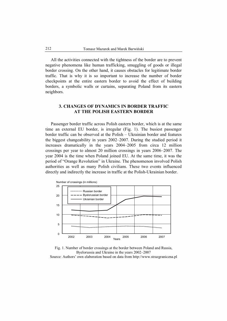
Tomasz Mazurek and Marek Barwiński 212
All the activities connected with the tightness of the border are to prevent negative phenomena like human trafficking, smuggling of goods or illegal border crossing. On the other hand, it causes obstacles for legitimate border traffic. That is why it is so important to increase the number of border checkpoints at the entire eastern border to avoid the effect of building borders, a symbolic walls or curtains, separating Poland from its eastern neighbors.
3. CHANGES OF DYNAMICS IN BORDER TRAFFIC AT THE POLISH EASTERN BORDER
Passenger border traffic across Polish eastern border, which is at the same time an external EU border, is irregular (Fig. 1). The busiest passenger border traffic can be observed at the Polish – Ukrainian border and features the biggest changeability in years 2002–2007. During the studied period it increases dramatically in the years 2004–2005 from circa 12 million crossings per year to almost 20 million crossings in years 2006–2007. The year 2004 is the time when Poland joined EU. At the same time, it was the period of “Orange Revolution” in Ukraine. The phenomenon involved Polish authorities as well as many Polish civilians. These two events influenced directly and indirectly the increase in traffic at the Polish-Ukrainian border.
Russian borderByelorussian border
Ukrainian border
Years2002 2003 2004 2005 2006 2007
Number of crossings (in millions)
0
5
10
15
20
25
Fig. 1. Number of border crossings at the border between Poland and Russia, Byelorussia and Ukraine in the years 2002–2007
Source: Authors’ own elaboration based on data from http://www.strazgraniczna.pl

Polish eastern border as an external European Union border
213
In case of Byelorussian and Russian border passenger traffic, it is definitely limited and the amounts are respectively about 9 million and 3.5 million crossings per year. In the years 2002–2007 the border traffic is relatively steady. Rapid increase in the year 2004 was not observed as opposed to the activity at the Ukrainian border.
The situation at the eastern border entirely changed after Poland’s acce-ssion to Schengen Agreement (Tab. 3). Passenger border traffic decreased dramatically at the discussed borders.
Table 3. The amount of border crossings at the Polish-Russian, Polish- Byelorussian and Polish-Ukrainian borders, during the first 9 months of 2008
Including Total
from Poland to Poland
9 months 2008
9 months 2008
9 months 2008
Part of border
9 months 2007
relation-ship
between 2007 2008 in %
9 months 2007
relation-ship
between 2007 2008 in %
9 months 2007
relation-ship
between 2007 2008 in %
1,498,478 749,270 749,208 Russia
2,334,835 -35,8
1,159,770 -35,4
1,175,065 -36,2
3,960,617 2,061,311 1,899,306 Byelorussia
7,127,200 -44,4
3,607,339 -42,9
3,519,861 -46,0
12,580,233 6,204,910 6,375,323 Ukraine
14,877,077 -15,4
7,358,591 -15,7
7,518,486 -15,2
Source: Authors’ own elaboration based on data from http://www.strazgraniczna.pl.
At the moment, data from only first nine months of 2008 are available. In comparison to analogical data from the year 2007 in case of Byelorussia, the decrease of circa 44% is observed. The situation looks better at Russian and Ukrainian borders, where the decrease reaches respectively 35% and 15%. The reasons of such dramatic changes derive from greater rigors in the border traffic control which result from Poland’s accession to Schengen Agreement.
Citizens of neighboring countries have to fulfill the following require-ments to enter Schengen territory:
– to have valid travel documents and visa, if it is required from the citizen of the given country;
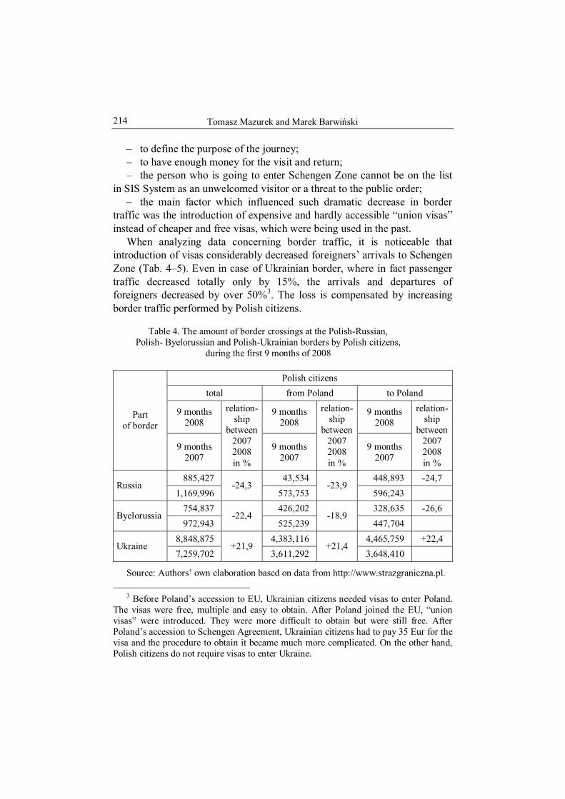
Tomasz Mazurek and Marek Barwiński 214
– to define the purpose of the journey; – to have enough money for the visit and return; – the person who is going to enter Schengen Zone cannot be on the list
in SIS System as an unwelcomed visitor or a threat to the public order; – the main factor which influenced such dramatic decrease in border
traffic was the introduction of expensive and hardly accessible “union visas” instead of cheaper and free visas, which were being used in the past.
When analyzing data concerning border traffic, it is noticeable that introduction of visas considerably decreased foreigners’ arrivals to Schengen Zone (Tab. 4–5). Even in case of Ukrainian border, where in fact passenger traffic decreased totally only by 15%, the arrivals and departures of foreigners decreased by over 50%3. The loss is compensated by increasing border traffic performed by Polish citizens.
Table 4. The amount of border crossings at the Polish-Russian, Polish- Byelorussian and Polish-Ukrainian borders by Polish citizens,
during the first 9 months of 2008
Polish citizens total from Poland to Poland
9 months 2008
9 months 2008
9 months 2008
Part of border
9 months 2007
relation-ship
between 2007 2008 in %
9 months 2007
relation-ship
between 2007 2008 in %
9 months 2007
relation-ship
between 2007 2008 in %
885,427 43,534 448,893 -24,7 Russia
1,169,996 -24,3
573,753 -23,9
596,243 754,837 426,202 328,635 -26,6
Byelorussia 972,943
-22,4 525,239
-18,9 447,704
8,848,875 4,383,116 4,465,759 +22,4 Ukraine
7,259,702 +21,9
3,611,292 +21,4
3,648,410
Source: Authors’ own elaboration based on data from http://www.strazgraniczna.pl.
3 Before Poland’s accession to EU, Ukrainian citizens needed visas to enter Poland. The visas were free, multiple and easy to obtain. After Poland joined the EU, “union visas” were introduced. They were more difficult to obtain but were still free. After Poland’s accession to Schengen Agreement, Ukrainian citizens had to pay 35 Eur for the visa and the procedure to obtain it became much more complicated. On the other hand, Polish citizens do not require visas to enter Ukraine.

Polish eastern border as an external European Union border
215
Table 5. The amount of border crossings at the Polish-Russian, Polish- Byelorussian and Polish-Ukrainian borders by foreigners, during the first 9 months of 2008
Foreigners total from Poland to Poland
9 months 2008
9 months 2008
9 months 2008
Part of border
9 months 2007
relation-ship
between 2007 2008 in %
9 months 2007
relation-ship
between 2007 2008 in %
9 months 2007
relation-ship
between 2007 2008 in %
613,051 312,736 300,315 Russia
1,164,839 -47,4
586,017 -46,6
578,822 -48,1
3,205,780 1,635,109 1,570,671 Byelorussia
6,154,257 -47,9
3,082,100 -46,9
3,072,157 -48,9
3,731,358 1,821,794 1,909,564 Ukraine
7,617,375 -51,0
3,747,299 -51,4
3,870,076 -50,7
Source: Authors’ own elaboration based on data from http://www.strazgraniczna.pl.
4. CONCLUSIONS
1. Apart from Finnish-Russian border, Polish eastern border is one of the longest external European Union and Schengen Agreement land borders under the control of a single country.
2. For the last few years, Polish Government has significantly improved the infrastructure of Border Guard at the eastern border in order to prevent “flooding” of Europe by illegal immigrants and smuggled goods.
3. Despite this fact, Polish eastern border does not have sufficient infrastructure, especially when the number of border checkpoints and roads is taken into consideration. The abovementioned, along with difficult border crossing procedures, may lead to creating a new symbolic “wall” separating Poland from its eastern neighbors. To avoid this, it seems necessary to introduce procedures, both on regional and international levels, to encourage trans-border regions’ integration. Co-operation should be dealt both in industry as well as in cultural and scientific fields
4. Border traffic at the polish eastern border has been relatively steady for the last few years and even in the case of Ukraine its intensity was

Tomasz Mazurek and Marek Barwiński 216
increasing. Poland’s accession to Schengen Agreement dramatically reduced border traffic at all three borders. Initially, it was caused by the visas for the citizens of neighboring countries and difficult access to them. As a con-sequence, the number of crossings at the eastern border by the foreigners dropped in certain places even by 50%. To improve the situation it is necessary to simplify visa procedures. Moreover, works on introducing possibilities of crossing borders within so-called small border traffic guaranteed by the EU law, should be finished as quickly as possible. Otherwise, restrictions in border traffic may weaken economic development in border regions and decrease trade exchange, both on local and regional scale.
REFERENCES
Gateways to Europe Checkpoints on the EU External Land Border. Monitoring Report, 2008, Stefan Batory Foundation, Warsaw.
Journal of Laws, 2007, No. 165, position 1170. KAWAŁKO, B., 2007, Granica wschodnia jako czynnik ożywienia i rozwoju społeczno-
-ekonomicznego regonów przygranicznych, Warszawa: http://www.mrr.gov.pl/polityka_regionalna/SRPW_2020/
Poland in Schengen Zone – Information Bulletin of Home and Administration Ministry, 2008, Warsaw.

Zdeněk KUČERA Silvie KUČEROVÁ Department of Social Geography and Regional Development Charles University in Prague, CZECH REPUBLIC
No 9
HERITAGE IN CHANGING LANDSCAPE – SELECTED EXAMPLES FROM CZECHIA
1. Introduction
This article is part of a research project, focused on seeking answers primarily to these questions: 1) Is landscape heritage either a combination of cultural and natural heritage or is it something specific? 2) For whom and for what is landscape heritage important? How much is areal preservation important in landscape management? And why? 4) Does, or at least may, areal preservation positively affect development and future landscape changes in certain area as a platform for co-operation, or is it rather a source of conflicts? And, as such, it is an inseparable part of the series of studies on these topics (e.g. Kučera, Matějček, Kuldová and Chromý, 2007; Kučera, Kuldová and Chromý, 2008).
However, the following sub-topics, relating primarily to the second of the questions listed above, also arise on the basis of these more general questions. Landscape as a heritage is something that connects not only us, but entire regions with their past. In this way it becomes a part of their identity as well as their symbol, in both the positive and negative sense of the word. Regions, however, are not homogenous units. Multiple landscapes, from which only a select few attract attention, can be found in the same region. And so, only certain landscapes become the image of selected regions. Therefore, in relation to regions, a lot also depends on how we define or give priority to certain landscapes, on the basis of the given characteristics and values that we assign to them. And it is on this very question concerning the relationship between landscape, as an image of a certain territory, and region, as a perceived territorial unit, that we focus, in this paper. The relationships between landscapes, to which we attach

Zdeněk Kučera and Silvie Kučerová 218
a certain significance, and regions, in which these landscapes are located, can be ambiguous. In the text that follows, we attempt to show to what extent it is the case in the specific border regions and territorial protection in Czechia.
2. LANDSCAPE – REGION
What we mean by the term landscape is often felt rather than strictly defined. It is something very hard to outline and work with, but, on the other hand, anyone, who knows what we are speaking about, is able to develop an attitude towards it. Regarding the ambiguity of this term, “landscape” is often confused with other terms such as, for example, environment, region or place (see for example the discussion of Hägerstrand, 1995; Baker, 2003; Setten, 2006). This occurs both in common language as well as in academic texts. A good example of the ambiguity of this term is found, for instance, in the very long lasting debate over the meaning and content of the term landscape in geography, interchangeably transporting landscape to the forefront of our interest, according to whether it is considered a central geographic concept (see, for example, Sauer, 1925), or rejected (Hartshorne, 1939), whether its imagery or scenic nature is emphasized (Cosgrove, 1985, 1998) or its territorial (Olwig, 1996, 2002) aspect. In fact, during the 20th century, the debate over the meaning of the term landscape went beyond the borders of geography and landscape became an object of interest for many additional disciplines, a movement, which went so far as to encourage Lowenthal (2007, p. 640) to establish that
cultural theorists and social scientists, historians and anthropologists [...] seize on “landscape” as a trendy catch-all term.
Nonetheless, these words were also written at a time, when the signi-ficance of landscape for society, as a whole, is increasingly emphasized and, because it is becoming an object of interest in a series of legislative documents, the need to develop a uniform definition of landscape is being discussed (see for example Jones, 1991).
One of the attempts at formulating such a uniform definition of landscape is found in the European Landscape Convention, which designates landscape as “an area, as perceived by people, whose character is the result of the action and interaction of natural and/or human factors”. At this point, we will, of course, not discuss in detail the content of this definition and compare it with other definitions. For the purposes of this text, we consider it

Heritage in changing landscape...
219
to be suitable. The bottom line for us is what this definition says about the nature of landscape. Significant characteristics of landscape, therefore, include the fact that: 1) landscape has not only a visual (scenery), but also a spatial aspect (territory); 2) because it is a territory, it is spatially definable, it has definite borders; 3) we perceive it and therefore it is something that we can develop a certain relation to, it can become part of our identity or we can perceive it as a symbol or a part of the identity of something (someone) different. It can become a specific type of heritage and as such it is perceived especially on two levels, which are not separate, but interconnected: A) the level of individual experience and B) the level of societal ideology (compare for example with Taylor, 1981; see also Jones, 1988). Our perception of landscape as image of the immediately lived environment (Granö, 1929/1997) is internal and personal (Wright, 1947; Lowenthal, 1961; Tuan, 1990; compare Wylie, 2007 for some recent developments in cultural geography) and as unique subjects we are able to give landscape many different meanings and values. In addition to these individual values, there are also values, which are believed to be societal and are expressed through political decisions. These values are symbolically represented, for example, through the designation of protected areas (for further discussion of these statements, see Kučera and Kučerová, 2008).
In the light of the above-mentioned characteristics, landscape can even become a part of regional identity, or rather the identity of a region, and the basis of the regional consciousness of its inhabitants, as it is defined by Paasi (1986). Landscape, which we perceive in a certain way, in this same way also influences how we perceive a given region. Nonetheless, the relationship between certain landscape(s) and the region, in which they are located, is not direct or clearly one-sided. This is so, primarily, due to the following reasons: 1) regions, to which we assign a perceived image are defined more on the basis of relationships than homogeneity (Hampl, Gardavský and Kühnl, 1987; Hampl, 2005), while we usually define a given landscape according to its homogeneity and the consistency of its structural characteristics (Löw and Míchal, 2003; Lipský and Romportl, 2007); 2) and then, of course, a certain discrepancy can exist between the definition of a given region and the landscape with the characteristic scenery by which we identify the region. Their territorial definitions do not have to be identical; 3) however, the way we perceive a certain area on the basis of its scenery is not only dependent on where we define its borders, but also on how we perceive the significance of these borders in relation to others. This idea will be developed in a latter section of the paper.

Zdeněk Kučera and Silvie Kučerová 220
3. FIRST ISSUE – BORDERLAND
One of the factors influencing the definition of a certain region is the regional awareness of its inhabitants. However, regional awareness does not develop outside the surroundings in which the people concerned live, but in direct contact with them. They can react to these surroundings both positively as well as negatively, according to whether or not they need to remain part of the surroundings. On a regional scale, entire areas can differ from each other according to the strength of the relationship between people and the location in which they live (Kučera and Kuldová, 2008).
To assess people’s potential local attachment to the place where they live in Czechia, we have developed a simple model of reality, based on accessible, predicative and reliable data which could be also used in the formulation of future research (for further discussion on it, see Kučera and Kučerová, 2008). We suppose that with the help of appropriately chosen indicators we will be able, at least preliminarily, to predict the qualitative or cultural characteristics of the environment (see for example Kuldová, 2005). However, one must always keep in mind that this model is only an artificial representation of reality, based on accessible and subjectively chosen parameters. Thus, the findings presented and discussed hereafter can not be considered absolutely perfect.
The construction of our model arises from the presupposition that the landscape in which people want to live is valuable to them. The direct expression of this value is that an individual: a) wants to stay in the landscape, to live there, does not want to emigrate; and b) participates actively in making decisions about its future development, either directly through his/her own practice or indirectly through discussion. It is important to note that we are assessing the potential for attachment only from the perspective of people living there, in the landscape (insiders), not tourists or holidaymakers (outsiders).
The selection of the indicators used to assess inhabitants’ potential for attachment to the landscape is based on these statements. Then the data chosen as indicators were analysed using component analysis. The outcome presented three components, from which we will further discuss only the first and the most significant. We have named this component “Traditional non- -transfer municipalities” and it explains 30% of the original variability of the data set. The share of natives and believers are the main contributors to this component, along with the share of election participants. On the other hand,

Heritage in changing landscape...
221
the share of inhabitants with a different nationality contributes to it nega-tively. The component has high values particularly in the eastern part of Czechia (see figure 1). These are the areas which were not affected by the transfer of the Czech Germans and subsequent resettlement, after the Second World War (Staněk, 1991; Čapka, Slezák and Vaculík, 2005). This part of Czechia is traditionally very religious (Havlíček and Hupková, 2008).
Fig. 1. Potential local attachment of inhabitants, districts of municipalities, Czechia, 2001
Source: Authors’ own elaboration
In the light of the results of the analysis described above, we can state that: 1) significant conditions continue to exist here for perceiving the former (before 1945), predominantly German, border regions as independent territorial units, primarily designated as “the Borderland”; 2) this, in spite of the fact that, in no way, is it a homogenous unit (Chromý, 2000) and that we regularly use the term borderland to describe areas lying along the country’s borders or certain regions in general (Jeřábek, Dokoupil, Havlíček et al., 2004). The landscape in these borderlands changed significantly after the departure of the Czech Germans (Jeleček, 1995; Chromý, 2003; Bičík and Jančák, 2005) and the former Czech-German linguistic border remains an

Zdeněk Kučera and Silvie Kučerová 222
important historic border, expressing itself in the geographic organization of Czech society (Kučera and Kuldová, 2006). Nonetheless, all subsequent changes to the landscape in “the Borderland” do not have to be perceived necessarily negatively today. Moreover, with time ethnic characteristics that served as determining factors in distinguishing “the Borderland” from the country’s interior have been subsequently replaced by environmental factors.
4. SECOND ISSUE – AREAL PRESERVATION AND LANDSCAPE VALUE
One of the ways, in which the value of certain surroundings are empha-sized, today, is areal preservation. We traditionally define this as the more or less successful management of certain characteristics or elements in particular areas selected and designated for protection. We have attempted elsewhere to discuss the issue of whether words “areal preservation” should mean merely activities directly associated with the administration of protected territorial units (Kučera, Matějček, Kuldová and Chromý, 2007; Kučera, Kuldová and Chromý, 2008). For the purposes of this paper, we will hold to the above-noted, narrower definition.
Because particular protected areas were defined according to presupposed societal preferences and values, they may also be used as an indicator in determining the most valuable landscapes. Thus, by using data about contemporary protected areas, it was possible to create a typology of Czechia, according to presupposed landscape values (see figure 2). Its main presumption is that landscape is most valuable where it is most intensively protected. Thus, the bigger the share of a municipality’s area in protected areas of various categories and the greater the number of such areas, the more valuable the landscape is (for further discussion of this typology see for example Kučera and Kuldová, 2008).
In our typology, the landscapes of Czechia are grouped into four main types, the areas where the importance of areal preservation and landscape values are: 1) high, 2) medium, 3) low or 4) non-existent. Landscapes with high and medium values (types 1 and 2 in our typology) are located mainly either in “the Borderland” where the protection of natural heritage, traditionally, holds a very strong position (all four national parks in Czechia are situated near state borders: České Švýcarsko, Krkonoše, Podyjí, Šumava; as are the majority of landscape protected areas), around major regional borders or in the areas with a significant intersection of natural and cultural

Heritage in changing landscape...
223
values (for example Třeboňsko). Significant values are also located in some core areas due to the intensive protection of cultural heritage. The area of the capital city Prague stands out in this regard (Fig. 2).
Fig. 2. Importance of areal preservation, districts of municipalities, Czechia, 2007 Source: Authors’ own elaboration
The above map shows that polarization of settlement, in terms of its intensity, goes hand in hand with polarization of values assigned to certain landscapes. Thus, we assign the highest values either to relatively natural and extensively utilized landscapes or, in contrast, to landscapes that are very intensively shaped by human activity.
If we then compare the results of this typology with the potential relationship of inhabitants to place as presented above, we can distinguish the following types of areas:
1) areas where both characteristics are very significant – this includes primarily the eastern and south-eastern parts of Moravia, where we have a tendency to extend the impression of these areas to the remainder of the land within a wider territorial unit;
2) areas of small potential for the relationship of inhabitants to place, but the landscape value is high – this includes primarily the borderlands of

Zdeněk Kučera and Silvie Kučerová 224
southern, western and northern Bohemia. On the one hand, we are confronted here with cases, where the areas around national border themselves become the outward symbols, outward image, of regions extending far into the country’s interior. As an example one can take the relationship between Šumava and southern Bohemia where, moreover, from a linguistic point-of- -view, a formerly non-Czech territory is becoming the symbol even for the interior of the wider region that it belongs to. On the other hand, the influence of positive landscape values in perceiving a given region can be quite small, limited by the influence of a strong negative dominant feature. For instance, we perceive northern Bohemia, thanks to the strong and pronounced image of its core areas (industry and surface mining of lignite) primarily as a region with very low landscape values in spite of the fact that significant protected areas are also located here (e.g. České Švýcarsko National Park);
3) areas of very small significance of landscape values – these territories have either an image founded on values other than the significance of the perceived landscape or they have a very weak image, because such pronounced landscapes as those found in the previous two types of areas, are not found in them. This includes primarily the area of central Bohemia, the so-called typical Czech countryside. A term which is very difficult to connect with a certain, clearly definable territory or region.
5. CONCLUSION
Relationships between regions and their landscapes can be manifold. The image of landscape in our mind is not always a representative sample of the landscape of a given region. Frequently, our view depends primarily on which landscapes we consider, at a given moment, to be valuable and how we define them. And, without a doubt, areal preservation plays a very significant role in this. It can be illustrated, for example, by a recent publication popularizing landscape and care for landscape in the Czech Republic (Němec and Pojer, 2007). In spite of the fact that its title and introductory chapters present preservation of landscape as a whole, on the pages that follow, it merely introduces details concerning landscapes of large scale special protected areas: national parks and protected landscape areas. Thus, if we are speaking about regions divided by borders, we should also more frequently consider the influence and significance of other types of
Heritage in changing landscape...
225
borders, in addition to administrative or political ones, whether they are current or historic.
Acknowledgements The contribution is based on results of research grant projects supported by The
Grant Agency of Charles University (No. 150007) “Areal Preservation – Barrier or Tool of Areal Development?” and by the VaV project MMR ČR (No. WD-01-07-1) “Regional differenciation of rural municipalities in Czechia: Disparities and develop-mental opportunities.” Authors thank for the support.
REFERENCES
BAKER, A. R. H., 2003, Geography and history. Bridging the divide, Cambridge: Cambridge University Press.
BIČÍK, I. and JANČÁK, V., 2005, Transformační procesy v českém zemědělství po roce 1990, UK v Praze, PřF, Praha: KSGRR.
CHROMÝ, P., 2000, Historickogeografické aspekty vymezování pohraničí jako součást geografické analýzy, Geografie – Sborník ČGS, 105 (1), p. 63–76.
CHROMÝ, P., 2003, Vývoj krajiny a formování identity území: příspěvek k environ-mentálním dějinám na příkladu České Kanady, Historická Geografie, 32, p. 115–134.
COSGROVE, D., 1985, Prospect, perspective and the evolution of the landscape idea, Transactions of the Institute of British Geographers New Series, 10, p. 45–62.
COSGROVE, D.E., 1998, Social formation and symbolic landscape, Madison: The University of Wisconsin Press.
ČAPKA, F., SLEZÁK, L. and VACULÍK, J., 2005, Nové osídlení pohraničí českých zemí po druhé světové válce, Brno: Cerm.
European Landscape Convention, 2000, Florence. GRANÖ, J.G., 1929/1997, Pure geography, Baltimore: The Johns Hopkins University
Press. HAMPL, M., 2005, Geografická organizace společnosti v České republice: transfor-
mační procesy a jejich obecný kontext, Praha:Univerzita Karlova v Praze, PřF. HAMPL, M., GARDAVSKÝ, V. and KÜHNL, K., 1987, Regionální struktura a vývoj
systému osídlení ČSR, Praha: Univerzita Karlova. HARTSHORNE, R., 1939, The nature of geography: A critical survey of current thought
in the light of the past, Annals of the Association of American Geographers, 29 (3) and 29 (4), p. 173–412 and 413–658.
HAVLÍČEK, T. and HUPKOVÁ, M., 2008, Religious landscape in Czechia: new structures and trends, Geografie – Sborník ČGS, 113 (3), p. 302–319.
HÄGERSTRAND, T., 1995, Landscape as overlapping neighbourhoods, [in:] Geography, history and social sciences, eds. G.B. Benko and U. Strohmayer, London–Boston: Kluwer, Dordrecht, p. 83–96.
JELEČEK, L., 1995, Využití půdního fondu České republiky 1845 – 1995: hlavní trendy a širší souvislosti, Geografie – Sborník ČGS, 100 (4), p. 276–291.

Zdeněk Kučera and Silvie Kučerová 226
JEŘÁBEK, M., DOKOUPIL, J., HAVLÍČEK, T. et al., 2004, České pohraničí – bariéra nebo prostor zprostředkování? Praha: Academia.
JONES, M., 1988, Land-tenure and landscape change in fishing communities on the outer coast of central Norway, c. 1880 to the present: Methodological approaches and modes of explanation, Geografiska Annaler, 70 B (1), p. 197–204.
JONES, M., 1991, The elusive reality of landscape. Concepts and approaches in landscape research, Norsk Geografisk Tiddskrift, 45, p. 229–244.
KUČERA, Z. and KULDOVÁ, S., 2006, Historická česko-německá etnická hranice a proměna krajiny pohraničí. Proceedings of the conference IX. sjezd Českých historiků, Pardubice (in print).
KUČERA, Z. and KULDOVÁ, S., 2008, Designated landscape values versus local attachment – A Preliminary survey. Proceedings of the conference „Venkov je náš svět / Countryside – Our World“, Kutná Hora, 16. – 18. 4. 2008, Kutná Hora (in print).
KUČERA, Z., KULDOVÁ, S. and CHROMÝ, P., 2008, Landscape heritage between areal preservation and areal development – the case of Czechia, Geographia Polonica (in print).
KUČERA, Z., MATĚJČEK, T., KULDOVÁ, S. and CHROMÝ, P., 2007, Areal preservation – barrier or tool of areal development? Proceedings of the conference „VI. polsko-czesko-słowacke seminarium geograficzne”, Kruklanki, 11–15.06.2007, (in print).
KULDOVÁ, S., 2005, Příspěvek ke kulturněgeografickému výzkumu: možnosti hodnocení kulturních aspektů pomocí statistických metod, Geografie – Sborník ČGS, 110 (4), p. 300–314.
LIPSKÝ, Z. and ROMPORTL, D., 2007, Typologie krajiny v Česku a zahraničí: stav problematiky, metody a teoretická východiska, Geografie – Sborník ČGS, 112 (1), p. 61–83.
LOWENTHAL, D., 1961, Geography, experience, and imagination: Towards a geo-graphical epistemology, Annals of the Association of American Geographers, 51 (3), p. 241–260.
LOWENTHAL, D., 2007, Living with and looking at landscape, Landscape Research, 32 (5), p. 635–656.
LÖW, J. and MÍCHAL, I., 2003, Krajinný ráz. Lesnická práce, Kostelec nad Černými Lesy.
NĚMEC, J. and POJER, F. (eds.), 2007, Krajina v České republice, Praha: Consult. OLWIG, K.R., 1996, Recovering the substantive nature of landscape, Annals of the
Association of American Geographers, 86 (4), p. 630–653. OLWIG, K.R., 2002, Landscape nature and the body politic: From Britain’s
renaissance to America’s new world, Madison: The University of Wisconsin Press. PAASI, A., 1986, The institutionalization of regions: a theoretical framework for
understanding the emergence of regions and the constitution of regional identity, Fennia, 164 (1), p. 105–146.
SAUER, C.O., 1925, The morphology of landscape, reprinted in Leighly, J., ed., 1983,: Land and life: A selection from the writings of Carl Ortwin Sauer, Berkeley–Los Angeles–London: University of California Press, p. 315–350.
SETTEN, G., 2006, Fusion or exclusion? Reflections on conceptual practices of landscape and place in human geography, Norsk Geografisk Tiddskrift, 60, p. 32–45.

Heritage in changing landscape...
227
STANĚK, T., 1991, Odsun Němců z Československa 1945–1947, Praha: NČSAV a Naše vojsko.
TAYLOR, P.J., 1981, Geographical scales within the world-economy approach, Review, 5 (1).
TUAN, Y.-F., 1990, Topophilia: A study of environmental perception, attitudes, and values, New York: Columbia University Press.
WRIGHT, J.K., 1947, Terrae incognitae: The place of the imagination in geography, Annals of the Association of American Geographers, 37 (1), p. 1–15.
WYLIE, J., 2007, Landscape, Abingdon: Routledge.

Zdeněk Kučera and Silvie Kučerová 228

Csaba M. KOVÁCS Department of Human Geography Babes-Bolyai University, Cluj-Napoca, ROMANIA
No 9
THE UPPER-TISZA REGION: CHANGING BORDERS AND TERRITORIAL STRUCTURES
1. THE UPPER-TISZA REGION
The Upper-Tisza region is a historical region of the ancient Kingdom of Hungary, situated in the upper basin of the Tisza River, presently in four countries. There are at least two views on the geographic extension of the Upper-Tisza region: in the broader meaning it covers roughly the territory of the counties Maramureş and Satu Mare in Romania, Szabolcs-Szatmár-Bereg and Borsod-Abaúj-Zemplén in Hungary, Košice and Prešov in Slovakia, and Zakarpatskaia region in Ukraine, while in the narrow meaning it refers to the Hungarian-inhabited ethnic territory of the ancient counties of Szabolcs, Szatmár, Ugocsa, Máramaros, Bereg, Ung and Zemplén. It is further divided into even smaller areas. The part of the Bereg along the Tisza River is called the Bereg-Tiszahát region, and the Nyírség region, covered with wind-blown sand begins on the western side of the river. In Szatmár the gentle slopes of the Szamos River form the Szamoshát region, while the area along the Tisza River is referred to as the Szatmár-Tiszahát region. The Erdohát region covered with extensive forests is situated between them. The Szamoshát region is bordered by the former Ecsed-moor (also called the Rétoldal) in the southwest, and beyond it the Nyírség region is situated. These geographical areas cannot be strictly separated from each other, as they merge into each other almost invisibly.
The geographical identity of the region is reinforced not only by its history and traditions, but also by the commonly spoken Hungarian dialect named Upper-Tisza or North-eastern dialect, which gave origin to the formation of modern Hungarian and is also characteristic for the historical counties of Hajdú and Szilágy.

Csaba M. Kovács 230
Historically the region was inhabited from very ancient times by pre-Arian and indo-European peoples, namely Scythians, Thracians, Celts and Slavs, until the arrival of the first Altaic peoples (Avars and Bulgarians). The mainstream of the Hungarian immigration came from the northeast by the Verecke pass and found the region belonging to the Kingdom of Moravia, with a predominantly Slavic population. The integration into the newly formed Kingdom of Hungary was a very slow process, with major interruptions caused by invasions and wars. In fact, the whole history of the region was divided between major periods of integration and shorter periods of political division, described below:
2. 1000–1526: INTEGRATION INTO THE MEDIAEVAL KINGDOM OF HUNGARY
The formation of the mediaeval Kingdom of Hungary under the rule its first Arpadian king, Saint Stephen I (997–1038) also resulted in the first administrative organization of the Carpathian Basin as a unitary political entity. The Christianization of the Hungarians and the other ethnic groups living in this geographic area started earlier, but it was only after the crowning of Stephen when the Christian church was organized as a central state church with the first dioceses and unique direction under the archdiocese of Esztergom. At the same time, the first secular administration system was organized in the typical feudal territorial units known as counties, many of which survived within roughly the same limits until the 20th century.
The northeastern part of Hungary, later also known as the Upper-Tisza region, used to belong to the diocese of Eger, except its parts situated south of the Tisza River, which belonged to the diocese of Transylvania. Also, the secular administration started to be formed with first major counties (Szatmár, Bihar, Ung, Zemplén, Borsod), which lasted with some changes until the modern times (Fig. 1).
The socioeconomic evolution of the region was dominated by agriculture, starting from a primitive semi-nomad system and slowly evolving to the sedentary feudal organization, with a merely extensive character and rather low productivity. This is one of the reasons why the population was sparse and very slowly increasing. The presence of large uninhabitable swamp areas in the valleys of major rivers made also difficult any kind of sedentary life. The only exceptions were the mining areas, especially in the Gutin

The Upper-Tisza region: changing borders...
231
Mountains in the county of Szatmár, where gold, silver and other metals were exploited since the earliest times, but also the salt mines, spread throughout a larger area.
Biharvár
Szatmárvár
Krasznavár
DobokaD O B O K A
Désvár
Ungvár
UN
G
Zemplénvár
Szabolcsvár
Borsodvár
BO
RS
OD
Szerencs
UjvárUJ
VÁ
R
Békésvár
Várad
KolozsvárK O L O Z SB É K É S
B I H A R
N Y I R
ZE
MP
LÉ
N
Borsovavár
B O R S O V A
S Z A T M Á R
Tordavár
Fig. 1. Northeastern Hungary during the rule of Saint Stephen I Source: After Györffy (1983)
This relatively peaceful period of mediaeval history was dramatically interrupted in 1241, when the Mongol invasion almost destroyed the Hungarian state. The Tatars under the leadership of Batu Khan invaded the Carpathian Basin mainly by the Verecke pass, the same place the Hungarians entered three and a half centuries earlier, although other ways were also used for the invasion. Excepting the smaller earlier conflicts with the Principality of Halitch, this was the first time in Hungarian history when the Upper-Tisza region became subject to invasion and a theater of war. Although they did not occupy Hungary or any of its regions, the Tartras caused immense damages wherever they passed, destroying cities, villages, crops and inflicting tremendous number of human casualties. It took a long time to rebuild the kingdom’s infrastructures and institutions, and the human losses were also the reason for stimulating the immigration of other peoples into the

Csaba M. Kovács 232
Carpathian Basin, a policy largely encouraged not only by the king, but also by the nobles and the church, as the feudal economy was in a desperate need for manpower.
After the Mongol invasion a new age of development started, with particularly prosperous periods under the rules of the Anjou (14th century), the Luxembourg and Hunyadi dynasties (15th century). This was the period when the feudal system knew its classical and most developed phase in Hungary, with a progressing agriculture, important revenues from mining and commerce, when new cities and villages were founded, the ethnic diversity was increasing. The increase of the population and settlements made also necessary the reorganization of the administrative system, enlarged with new counties (Máramaros, Bereg, Ugocsa, Szabolcs, Abaúj), while the old ones got their definitive borders (Fig. 2).
PatakTállya
Székelyhíd
Kölesér
RahómezóVisk
SzolyvaTerebes
Kálló
Várad
Debrecen
Nagybánya
Böszörmény
DésKRASZNA
Beregszász
Miskolc Tokaj
Bátor
UGOCSA
Kassa
SZABOLCS SZATMAR
KÖZÉP-SZOLNOK
BIHAR KOLOZS Kolozsvár
BELSÓ-SZOLNOK
BESZTERCE
DOBOKA
MÁRAMAROS
BEREG
UNG
Ungvár
ZEMPLÉNSÁROS
ABAÚJ
Eperies
Bártfa
Nagyszólós
K I N G D O M O F P O L A N D
Beszterce
VisóSziget
Hosszúmezó
Homonna
Fig. 2. Northeastern Hungary in the second half of the 15th century Source: After Romsics (2007)
The Kingdom of Hungary was then a major power in Central Europe, and this had its positive consequences for the northeastern counties too. Their peaceful evolution was partly due to the good relations with the northern and northeastern neighbours, the Kingdom of Poland and the Grand Duchy of

The Upper-Tisza region: changing borders...
233
Lithuania. However, in the second half of the 15th century the presence of the two major empires (the Habsburgs and the Ottomans) at the western and at the southern borders of Hungary was already anticipating the major conflicts and threats for the future of the kingdom.
3. 1526–1711: DIVISION AND BUFFER ZONE BETWEEN THE EMPIRES
The death of King Louis II at the battle of Mohács in 1526, rivalries between the pro-Habsburg and the pro-Szapolyai parties and the fall of Buda in 1541 lead ultimately to the dismantlement of the Hungarian Kingdom. By 1565, its territories became divided between the Habsburgs (the remains of the Kingdom of Hungary in the western and northwestern parts), the Ottoman Empire (the Vilayet of Buda in the central part) and the newly formed Principality of Transylvania (with the eastern counties of Hungary attached under the name of Partium), a Turkish vassal state with a large autonomy. The decades of Transylvanian autonomy (1542–1690) represented a long period of constant conflicts between the Habsburgs and the Turks, with guerilla warfare alternating the major wars and invasions and thus with immense losses of people and liabilities in the whole Carpathian Basin, and especially in the Plains.
Situated at the limit between the Kingdom of Hungary and Transylvania, from a remote periphery the Upper-Tisza region suddenly became a buffer zone between the two empires, each incapable of vanquishing the other for a century and a half. The political attachment of the region, especially of the “seven counties” (Szatmár, Ugocsa, Bereg, Szabolcs, Zemplén, Abaúj and Borsod), lately included into the Captainship of Upper Hungary, often changed, according to the military successes of the Habsburgs or of the princes of Transylvania. A typical situation was illustrated by the fact that several counties (e.g. Szatmár, Bihar and Middle Szolnok), in order to buy a relative peace, accepted to pay taxes to both emperors, or even to three rulers (to the prince of Transylvania separately).
The political conflicts between the empires were even aggravated by the religious conflict, as the 16th and 17th centuries were also the times of Reformation and of the beginning of Counter-Reformation in Hungary. Two of the most successful Protestant princes of Transylvania (Gabriel Bethlen and George Rákoczi I) got also involved in the Thirty Years War, with the tacit agreement of Constantinople. Both of them won important victories,

Csaba M. Kovács 234
conquered the counties of Upper Hungary and Transylvania was finally represented at the peace treaties of Westphalia, but the inner crisis of the Ottoman Empire did not allow for an effective assistance and finally a major breakthrough. Another major anti-Habsburg revolt (kurucz) took place between 1672–1685, with the support of the Turks and the French, under the leadership of Imre Thököly, when a fourth political entity appeared on the map of Hungary, as Thököly was elected prince of Upper Hungary.
The end of the Turkish occupation of Hungary after the conquest of Buda in 1686 was supposed to bring a more peaceful period, but it did not last long, because shortly the new occupants became unbearable for the Hungarians, so a new war of liberation (the kurucz-labancz war) broke out against the Habsburgs, with the initial support of king Louis XIV of France. This war, lead by Prince Francis Rákóczi II, took place between 1704–1711 and the major operations started again and also finished on the territory of Upper Hungary.
4. 1711–1918: REINTEGRATION, DIVERSITY AND STAGNATION
The Peace of Szatmár (April 1711) put an end to the anti-Habsburg wars and became a crossroads in Hungarian history, because it inaugurated the period of almost two centuries of Habsburg domination, a mostly peaceful age, in spite the fact that the Austrian Empire participated at several wars during the 18th century, culminating with the Napoleonic wars. The northeastern part of the Empire (and of Hungary) was however far from the theaters of war and the relations with the Russian Empire were rather friendly, especially if we think about the division of Poland and later the common participation at the Holy Alliance. At the middle of the 19th century, a short but major interruption of the Habsburg’s rule took place in 1848–1849, during the revolution and anti-Habsburg liberation war, ended only with the help of the Russian troops.
The evolution of the Upper-Tisza region during the 18th century was marked at first by the Counter-Reformation, which was aimed to change the religious structure of the population from a predominantly protestant area to a more Catholic one. Though an important part of the Hungarian population resisted the Counter-Reformation and remained Protestant, the colonization of Catholic Germans (especially in Szatmár county) and the unification of the formerly Greek Orthodox (mainly Romanian and Ukrainian) population

The Upper-Tisza region: changing borders...
235
with the Church of Rome changed significantly the religious structure of the area. The local importance of the Catholic Church increased so much that in 1804 a new diocese was created at Szatmár, including the counties of Máramaros, Ugocsa, Szatmár, Bereg and Ung (Fig. 3).
ARCH
IDIO
ECES
IS A
GRIE
NSIS
DIOECESISCASSOVIENSIS
DIOECESISPREMISLIENSIS
DIOECESISMAGNO-
-VARADINENSISDIOECESIS TRANSSYLVANIAE
ARCHIDIOECESISLEOPOLITANI
VICARIATBUKOVINE
I V
VII
VIII
IX
VI
XI
X
II
IV
III
U N G
B E R E G
UGOCSA
S Z A T M Á R
M Á R A M A R O S
Fig. 3. The Roman Catholic diocese of Szatmár (Satu Mare), founded in 1804 Source: After Cholnoky Map Found, B.B.U., Cluj-Napoca
Ethnically the Upper-Tisza region had always been a mixed area where Hungarians, Romanians, Germans, Ukrainians, Slovaks and Gypsies lived together or more or less segregated. Another element of diversity, both from the ethnic and religious points of view, was the immigration of an important number of Jews from Polish provinces of Austria and Russia, who formed large communities in the towns and villages of Northeastern Hungary and Northern Transylvania, so that their proportion reached in certain areas up to 30–40% of the total population by the end of the 19th century.
The economy of the region in the 18th century was still dominated by agriculture, with a certain progress in the cultivating systems, technology and the introduction of new crops (e.g. maize and potatoes). The progress in agriculture was followed by a slightly positive demographic evolution, the population density remained however low at the end of the century (under 20

Csaba M. Kovács 236
inhabitants/km2 in Máramaros, Ugocsa, Bereg, Ung counties and 20–30 inhabitants/km2 in Szatmár and Szabolcs). The predominance of agriculture remained a basic characteristic for the economy of the region, with only local industries, which explains the fact that in 1910 the rates of the industrial population were among the lowest in all Hungary (15–20% in Szatmár county, 10–15% in Szabolcs, Bereg, Ung, Zemplén and below 10% in Ugocsa and Máramaros).
The demographic transition started in the 19th century and as a con-sequence an important increase of population took place, so by 1910 the population density in the lower regions reached 50–90 inhabitants/km2. Unfortunately in a predominantly agricultural area with no major industries this also meant a significant demographic surplus, which was eventually constraint to emigrate. The number of emigrants between 1899 and 1913 was in excess of 10,000 for each county, with over 20,000 in Szatmár and Szabolcs and over 40,000 in Ung and Zemplén.
5. 1918–1989: NEW DIVISION AND PERIPHERAL DEVELOPMENT
The fall of Austro-Hungary after the First World War had dramatic con-sequences for whole Hungary, but the northeastern region was particularly affected, mainly as a result of the very mixed population. The peace treaties signed at Trianon in 1920 divided the region between three countries (Czechoslovakia took the largest northern part, Romania the southern part of Máramaros and about 3/4 of Szatmár, while the remaining southwestern part went to Hungary), so that major cities and territories with predominantly Hungarian population found themselves outside Hungary, becoming peripheries and minority regions within the newly created borders (Fig. 4). The major infrastructure systems (mainly the railways) were dismantled, the cities along the new borders lost important parts of their zones of influence, while their former attraction areas became deprived of urban centers.
The frustration caused by the Versailles peace treaties largely facilitated the instauration of the far-right Horthy regime, with revisionism as main political goal and leading soon to the alliance with Nazi Germany. The political pressures of revisionism and the evolution of the military situation resulted eventually in the Vienna dictates, reattaching to Hungary in November 1938 the Hungarian-inhabited areas of Southern Slovakia, the Ukrainian-inhabited areas in March 1939, Northern Transylvania from

The Upper-Tisza region: changing borders...
237
Romania in August 1940, then Voivodina and the Muraköz from Yugoslavia in April 1941. The defeat of Nazi Germany and its allies in the Second World War and the Soviet occupation resulted in a new political revision of the whole area, restoring the post the First World War boundaries, with the exception of the Ukrainian-inhabited areas (northern Máramaros, Ugocsa, Bereg and Ung counties), annexed by the USSR. As a result, after the Paris peace treaties the Upper-Tisza region became divided between four countries (Romania, Hungary, Slovakia and the Soviet Union), all with communist regimes for the following 45 years.
Halitsch
Kolomea(Kołomyja)
Czernowitz(Cernauti)
KamenezPodolsk
B u k o w i n a
S i e b e n b ü r g e n
K a r p a t o - R u ß l a n d
G a l i z i e n
S l o w a k e i
S L O W A K E I
P O L E N
R U M Ä N I E NU N G A R N
Bistritz(Bistriţa)
M o l d a u
Maros-Vásárhely(Tirgu Mureş)
Karlsburg
Klausenburg(Cluj)
Sächs.-Regen(Reghin)Großwardein
(Oradea)
Großwardein
Világos(Sitia)Arad
Békés
Szolnok
Szegedin(Szeged)
Kecskemet
BUDAPEST
Erlau(Eger)
MiskolcSchemnitz
(B. Stiavnica)
Waitzen(Vác)
Gran(Esztergom)
Stuhlweißenburg(Székesfehérvár)
Neutra(Nitra)
Altsohl(Zvolen)
Gran
Waag
Weichsel
San
SbruczDniestr
Sereth
Pruth
Sillein(Žilina)
Neumarkt(Nowy Targ)
Mähr.-OstrauTeschen
Wieliczka
Krakau(Kraków)Kattowitz
(Katowice)
Beuthen
Sandomir(Sandomierz)
Tarnów
Neu-Sandez(Nowy Sącz)
Jaroslau(Jarosław)
Przemyśl
Sambor
Stryj
Lemberg(Lwów)
Stanislau(Stanisław)
Brody
Tarnopol
OstrogSokal
Sathmar(Satu Máré)
Szamos
Munkács(Mukačevo)
Eperies(Prešov)
Kaschau (Košice)
Käsmark(Kežmarok)
Theis
Theis
Korös
Tokaj
Debrezin(Debrecen)
Fig. 4. Northeastern Hungary and southeastern Poland after the Treaty of Versailles (1920)
Source: Putzger, F.W., Historischer Weltatlas (1981) Under the patronage of the USSR, the socialist countries were supposed
to become friends and allies, especially after the Warsaw Treaty and the COMECOM were formed. However, the politico-military relationships between the partners reminded rather of some Soviet colonies or vassal
Csaba M. Kovács 238
states, which became obvious especially during the military invasions of Hungary in 1956 and of Czechoslovakia in 1968.
In the meantime, the borders between the neighbours remained mainly closed and impenetrable, not only for persons, but partly for merchandize and information too, so the further socioeconomic evolution of the former Hungarian counties reflected the particular features of each country they were belonging to: a rather soft communism and a relative economic prosperity for Hungary and Slovakia (even if the northeastern counties remained the less developed in both of them), while a reinforcing isolation, stagnation, poverty and a police-state system was the main characteristic of Romania (until December 1989) and of the Soviet Union (at least until 1985, when Gorbatchev came to power).
6. 1989–2008: TRANSITION AND EUROPEAN INTEGRATION
The fall of the communist regimes between 1989 and 1991 gave new hopes for the peoples living within the borders of the four countries in the Upper-Tisza region, not for reunification, but for political freedom and economic prosperity. But before these hopes could come true, the nationalist problem complicated the whole political situation, leading to tensions between the neighbours and to separatism within Czechoslovakia and the USSR. As a result, two new countries appeared on the map of the historical region: Ukraine in December 1991, after the disintegration of the Soviet Union, and Slovakia in January 1993, after it separated from the Czech Republic, fortunately both in peaceful conditions.
After a hard period of economic transition, the perspective of European integration became the main goal for Hungary, Slovakia and Romania, so the neighbours became interested in solving their political problems (on top of which was the minorities’ situation) and also in the opening of their boundaries, mainly for economic reasons, but also for reinforcing the political and cultural relationships. Following the European model of transborder co-operation, the counties and regions with common boundaries formed several Euroregions (Fig. 5), aiming the economic, social and cultu-ral co-operation of the neighbouring territories. The EU membership of Hungary, Slovakia and Poland since 2004 and of Romania since 2007 resulted however in a relative isolation of Ukraine, as the eastern EU

The Upper-Tisza region: changing borders...
239
boundary moved right to the western Ukrainian frontier, making it difficult for the Ukrainian citizens to travel into the new EU countries.
Miskolc-KassaEuroregio
Interregio
Hajdú-Bihar-BihorEuroregioBihar-BihorEuroregio
P O L A N D
H U N G A R Y
R O M A N I A
U K R A I N AS L O V A K I A
Biharkeresztes OradeaSzolnok
Eger
Debrecen
Satu Mare Baia MareSuceva
Batoşani
Černovcy
LvivRzeszów
Miskolc
Prešov
Košice Uzhgorod
Zalău
Miercurea-Civc
Nyiregyháza
Ivano-Frankivsk
Fig. 5. The Carpathian Euroregion and other border regional co-operations in Northeastern Hungary, in 2001
Source: After Hardi T., Dancs, L., M.T.A. (2002)
On the other hand, the improvement in the relationship and the economic development of the neighbouring regions seems to take shape and shows encouraging perspectives, though the economic discrepancies between the different countries are important and the forms of transborder co-operation are still at their beginning. The free circulation of persons, merchandises and information seems to be the only solution for the future development of this area, so more and more the entrepreneurs and also the political factors understand the importance of co-operation between the neighbours.

Csaba M. Kovács 240
REFERENCES
BAGOSSY, B., 1910, Szatmár vármegye története, [in:] Magyarország vármegyéi és városai, Országos Monográfia Társaság, Budapest.
GYÖRFFY, G., 1983, István király és műve, Budapest: Gondolat. MOLNÁR, E., 1971, Magyarország története, Budapest Gondolat. MORARIU, T. and OPREANU, S., 1947, Graniţa de vest a României, Cluj: Institutul de
Geografie. ROMSICS, I. (ed.), 2007, Magyarország története, Budapest: Akadémiai Kiadó. VÁRKONYI, R.Á. (ed.), 1987, Magyarország története 1526–1686, Budapest: Akadé-
miai Kiadó. SZÁSZ, Z. (ed.), 1988, Erdély története III, 1830-tól napjainkig, Budapest: Akadémiai
Kiadó.

Izabela LEWANDOWSKA Institute of History and International Relations University of Warmia and Masuria in Olsztyn, POLAND
No 9
WARMIA AND MASURIA – KALININGRAD OBLAST – KLAIPÈDA REGION. THREE REGIONS INSTEAD
OF ONE (EAST PRUSSIA)
1. INTRODUCTION
The history of Europe shows that many nations do not live in their original countries. It was true especially after the First World War when the biggest superpowers, such as Russia, the Austrian-Hungarian Empire, the German Empire disintegrated. In the newly created countries nations were mixed. Also after the Second World War some areas have changed their state affiliation, East Prussia providing a good example. It was divided between two countries: Poland and the Soviet Union. Nowadays former territories of East Prussia are divided in three parts belonging to three different countries − Warmia and Masuria Voivodeship is situated in the north-eastern part of Poland, Kaliningrad Oblast is situated in the western part of Russia as an exclave by the Baltic Sea and Klaipèda Region is located in the western part of Lithuania.
2. CONTEMPORARY STATUS OF THE THREE REGIONS
Warmińsko-Mazurskie Voivodeship (earlier southern part of East Prussia) is the fourth largest region of Poland with the area of about 24,000 square km. The capital of the region is Olsztyn (approx.180,000 inhabitants). Other large cities are: Elbląg (130,000), Ełk (60,000). The Warmińsko- -Mazurskie Voivodeship has population of 1,2 million people (60 persons per sq. km). The national minorities include Ukrainians (6.6%), Germans (1.6%) and Belarusians (0.2%).
Izabela Lewandowska
242
Referred to as “the land of one thousand lakes”, the region is recognised as one of the most beautiful areas of Poland. Waters covers 5% of the province’s area. The Great Masurian Lakes are situated in the area between Węgorzewo, Giżycko, Mikołajki and Ryn. Natural qualities (lakes, rivers, unique fauna and flora) of the region attract tourist. Nevertheless, Warmia and Masuria province is one of the least economically-developed areas in Poland, which results from many factors, such as: bankruptcy of state-owned farms, low industrialisation, difficult climatic conditions and poor trans-portation infrastructure.
Kaliningrad Oblast (earlier central part of East Prussia) is an exclave of Russia surrounded by Lithuanian and Polish lands. Kaliningrad was earlier called Koenigsberg – in German and Królewiec in Polish. This westernmost part of Russian Federation is isolated from the main part of the country and surrounded by foreign territory since the fall of the Soviet Union in 1991. Moreover, political aspects of the region’s isolation became distinct as soon as Lithuania and Poland joined the European Union, North Atlantic Treaty Organization, and implemented the terms of the Schengen Agreement.
Kaliningrad is not only the headquarters of Russian Baltic Fleet, but also the most militarized area of the Russian Federation. The number of military installations situated in Kaliningrad Oblast is the highest in Europe. The principal means of transport is railway. The most prosperous industries are car and truck assemblies e.g. GM, BMW, KIA along with production of auto parts. Fishing is also one of the region’s most important industries with extensive fishing ports in Kaliningrad and Pionerskoe.
Kaliningrad is a seaport and the administrative center of Kaliningrad Oblast. According to the census conducted in 2002, Kaliningrad was populated with 430,000 citizens. The whole oblast was populated with 955,000 inhabitants of which 78% were urban and 22% rural. Kaliningrad Oblast, with 62.5 residents per square kilometers, is the fourth most densely populated area in the Russian Federation. The numerical data displays that 86% of the inhabitants were of Russian origin, however there were many national minorities including: Belarusians (5.3%), Ukrainians (4.9%), Lithu-anians (1.4%), Armenians (0.9%), Germans (0.8%), Tatars (0.5%), Poles (0.4%) and others.
Klaipèda Region (County) (earlier north-west part of East Prussia) is nowadays called the Neman River Country. Klaipèda means “Memel” in German the same as the Neman River. Today Klaipèda Region includes in some part: Klaipèda, Klaipèda district, Neringa municipality and Šilutė district are Old Prussian area, earlier called Lithuania Minor. But Palanga

Warmia and Masuria – Kaliningrad Oblast...
243
municipality, Skuodas district and Kretinga district belonged to Samogitia, so they had more connection to Poland than to Germany or East Prussia.
Klaipèda County has an area of 5.2 km² and has approximately 380,000 inhabitants. The population of the capital of Klaipèda County is 187,400. The official enumeration of the population conducted in 2003 indicates that there were several distinct ethnic groups including: 63% of Lithuanians, 28.2% of Russians, 4.8% of Poles, 0.5% of Belarusians, and 3.5% of other origin.
After the Second World War the three groups of people started living together: 1) old natives of the Lithuania Minor – Prussia’s Lithuanians, Curonians and Germans; 2) Lithuanian’s settlers who have arrived from Samogitia and central Lithuania; 3) Russians and other ethnic groups coming from the Soviet Union.
Klaipèda is conveniently located at the mouth of the Curonian Lagoon where it flows into the Baltic Sea. After the Second World War a gigantic shipyard, dockyard, and a fishing port were constructed there. Nowadays Klaipèda is the sole Lithuania’s harbor that enables to travel to Sweden and Germany by ferryboats. There are at least two widely appreciated seaside resorts in the vicinity of Klaipèda i.e. Nida to the south on the Curonian Spit, and Palanga to the north.
3. COMMON HERITAGE
3.1. The history
Common history began in the times of Prussians (the 7th century B.C. – 13th century). Prussians had never formed a separate country, but they were organized in several tribes. At the end of the 13th century, Prussian tribes were completely exterminated by the Teutonic Order, which introduced Christian culture here and created the most powerful religious state in contemporary Europe. In 1466 the whole Teutonic area was divided into Royal Prussia (belonging to Poland) and Prussia of the Teutonic Order. After secularization, a laic Prussian Duchy (with Królewiec as the capital city) was formed, which remained a Polish feud till 1657.
In 1701 Prussia was declared monarchy and from that moment on the state was quickly developing, rapidly expanding its territory and gaining political power. At the beginning of the 19th century, the process of cultural unification of the German state started. As a consequence of administrative reforms in 1815, Prussia was divided into East Prussia (including

Izabela Lewandowska
244
Koenigsberg and Klaipèda) (Fig. 1) and West Prussia (with Malbork and Elbląg). In the mid-19th century, the southern part of East Prussia was renamed Masuria and its habitants – Masurians. Curonians (the native settlers of the Curonian Lagoon) and mostly Lithuanians lived in the northern part of East Prussia.
ROSENBERG
MOHRUNGEN
WORMDITT
GUTTSTADT
OSTERODEALLENSTEIN
HEILSBERG
HOHENSTEIN
GILGENBURG
STOLP
LEBA PUTZIG
GDINGENZOPPOT
KARTHAUS
DANZIG
KONITZ
PR. STARGARD
DIRSCHAU MARIENBURGELBING
MARIENWERDER
NIMMERSATT
MEMEL
SCHWARZORT
NIDDEN
HEYDEKRUG
HEINRICHS-WALDE
LABIAU
TILSIT RAGNIT
PILLENKALLEN
Memel
Gilg
e
Ruß
WEHLAU
TAPIAU ALLENBURG
INSTERBURG
FRIEDLAND
GERDAUENANGERBURG
GOLDAP
GUMBINNEN
LÖTZENRASTENBURG
RÖSSELLYCK
TREUBURG
NIKOLAIKEN
SENSBURG
AllePR. EYLAU
DT. EYLAU
JOHHANISBURG
ORTELSBURGLÖBAU
SOLDAU
NEIDENBURGGRAUDENZ
KULM
SCHWETZ
BRAUNSBERG
MEHLSACK
HEILGENBEIL
PILLAU KÖNIGSBERG
Pregel
CRANZRAUCHEN
PALMINICKEN
NogatFREIE STADT
DANZIG
M E M E L L A N D
E R M L A N D
S A M L A N D
M A S U R E N
HELADanziger
Bucht
OSTPRUSSEN
O s t s e e
0 500 km
POLAND
Fig. 1. East Prussia in the end of 19th century and area of the East Prussia today Source: Längin (1995) (inside part of the book)
The next reinforcement of Prussian Monarchy was the unification of Germany in 1871 – it became the German Empire. The German national identity was constituted not only by ethnic Germans, but also by Germans by choice, who in consequence of Germanizing actions adopted nationality complying with their national status. The preference for German-speaking people in schools, offices and army made being German simply easier.
Inter-war years were different for northern and southern part of East Prussia. Under the Treaty of Versailles after the First World War, Memel was made a protectorate of the Entente States. The decision to invade Memel

Warmia and Masuria – Kaliningrad Oblast...
245
Territory was made in January 1923. The incorporation of the city resulted in its acquiring Lithuanian name Klaipèda. Furthermore, the annexation of the Memel Territory with its numerous German population was highly beneficial to the Lithuanian economy for the fact that this region accounted for 30% of the Lithuania’s entire production at a later time. In 1933 economic sanctions were imposed on the region by the German government and in March 1939 Adolph Hitler occupied Memelland and annexed it into East Prussia.
3.2. Under the Soviet control
All territories of East Prussia were captured by the Soviet Red Army in January-April 1945. The Memel Territory was therefore incorporated into the Lithuanian SSR, marking the start of a new epoch in the history. After 1945 the entire area was under control of the USSR (the Union of Soviet Socialist Republics): Warmia and Masuria within borders of Poland, Kaliningrad Oblast as a part of the Soviet Russia and Klaipèda Region as a part of Lithuanian SSR. This period saw some characteristic processes: 1) displacement of Germans fleeing the Red Army or expelled by virtue of the Potsdam Treaty (August, 1945); 2) Arrival of new colonists; 3) devastation of most churches during the Soviet occupation, especially in Kaliningrad Oblast and Klaipèda Region, and oppression of the Catholic and Protestant clergy; 4) economic exploitation of Kaliningrad and Klaipèda cities – foremost ice-free ports in the Eastern Baltic – by the USRR; 5) limited contacts between people of the Kaliningrad Oblast which was a closed military base.
3.3. Culture
The territory of former Prussia features many historical monuments such as castles, city walls and cemeteries. Although Prussian language, customs and beliefs disappeared, we can still see some remainders of it in the architecture of towns (main routes, moats, city walls) and also in place names. The Teutonic Order set up (only in the southern part of its country) 93 towns and about 1,500 villages. In towns Gothic town halls, city walls, granaries, tenement-houses for townspeople, castles and also churches, cathedrals and monasteries were built and some of them have been preserved till now. The old towns quarters (e.g. in Toruń, Gdańsk, Elbląg and Braniewo) and the Teutonic castles are among the most splendid Gothic monuments in the Teutonic state. Residences of Prussian families were the

Izabela Lewandowska
246
most famous and splendid in East Prussia. These sites constituted large complexes of great architectural value, but during the Soviet period they were nearly completely destroyed.
3.4. The heroes
Herkus Monte originated from Natangia, one of the Old Prussians territory. He is considered as a widely known and esteemed leader of the Great Prussian Uprising against the Catholic Teutonic Knights and Northern Crusaders. In his youth, he was captured by the Teutonic Knights and brought to Magdeburg, Germany, as a hostage. The Natangians elected him a leader of their forces for the fact that he was well acquainted with German military tactics. His first successful battle took place in 1261. The rebellion ceased in 1274 and the conquering of the rest of the Baltic tribes proceeded.
Herkus Monte is considered a hero of Lithuania Minor and one of its icons. The outcomes of his high reputation are as follows: one of the main streets of Klaipèda was named after him – Herkaus Manto Street, his life and dramatic resistance to mightier enemy became the inspiration for a couple of literary works, e.g. a historical drama Herkus Mantas, depicting him as a romantic hero, and the Lithuanian movie Herkus Mantas issued in 1972. Herkus Monte is known in Warmia and Masuria too, especially around Bartoszyce and Kamieniec, which are situated on the old Natangian Land.
Nicolaus Copernicus (1473–1543) – was the most famous clergyman who provided the first modern formulation of a heliocentric (sun-centered) theory of the Solar System in his epochal book De revolutionibus orbium coelestium (On the Revolutions of the Celestial Spheres). Copernicus was a mathematician, astronomer, jurist, physician, classical scholar, governor, administrator, diplomat, economist, and soldier. He lived for a few years in Olsztyn, then in Lidzbark, and the last 30 years until his death – in Frombork.
Nicolaus Copernicus was born in the city of Toruń. There was a city in Royal Prussia, an autonomous region of the Kingdom of Poland. After the death of Nicolas’s father, Lucas Watzenrode, his maternal uncle, became Nicolas’s guardian and took responsibility for his upbringing and future career. Copernicus studied astronomy at the Krakow Academy (now Jagiellonian University), canon and civil law and medicine at the universities of Bologna and Padua.
In 1503 Copernicus returned to Polish Prussia, to the Prince-Bishopric of Warmia, to his uncle Lucas Watzenrode, where he resided for the rest of his

Warmia and Masuria – Kaliningrad Oblast...
247
life. Between 1516 and 1521 Copernicus was economic administrator in Warmia. Copernicus oversaw the defense of the castle of Olsztyn (Allenstein) at the head of Royal Polish forces when the town was besieged by the Teutonic Knights during the Polish-Teutonic War (1519–1521). Two years before Copernicus's death, Duke Albert urgently summoned him to Koenigsberg to treat one of his counselors, who was dangerously ill.
Albrecht Hohenzollern, born in Ansbach in Franconia, was the Grand Master of the Teutonic Knights. He converted to Lutheranism and became the first duke of the Duchy of Prussia. His mother, Sophia, was the daughter of Casimir IV Jagiellon Grand Duke of Lithuania and King of Poland. Hohenzollern was elected Grand Master of the Teutonic Order in 1511. The main reason of this election was the hope that his kinship with his maternal uncle Sigismund I the Old, Grand Duke of Lithuania and King of Poland, would alleviate a settlement of the disputes over eastern Prussia, which had been held by the Order under Polish suzerainty since the Second Peace of Thorn (1466). Unfortunately a war (1519–1521) between the Teutonic Order and Poland began. Next Albert was influenced by Protestantism and in 1525 Albert and his brothers received the Duchy of Prussia as a fief from the Polish King, Sigismund I the Old.
The new duke exploited his authority to promote the doctrines of Luther in newly allied lands. However, this conversion did not take place without a strong public expression of disagreement and disapproval. Furthermore, he did something for the furtherance of learning by establishing schools in every town and by freeing serfs who adopted a scholastic life. In 1544, in spite of some opposition, he founded Koenigsberg University. In Poland that Uni-versity was called “Albertyna” in honor for the Duke Albrecht Hohenzollern.
In 1891, a statue was erected to his memory in Koenigsberg, which was moved Berlin before the Second World War.
Immanuel Kant is often said to have been one of the most influential thinkers and idealist philosophers of modern Europe. He was born in 1724 in the Prussian city of Koenigsberg. The Critique of Pure Reason and the Critique of Practical Reason, which examine the relation of epistemology, metaphysics, and ethics, are among his most important works. Kant believed himself to be creating a compromise between the empiricists and the rationalists.
The mausoleum, in which Kant’s tomb is located, was constructed by the architect Friedrich Lahrs and was finished in 1924 in time for the bicentenary of Kant's birth. The mausoleum adjoins the northeast corner of Kaliningrad Cathedral. Kant’s remains were moved outside and put in a neo-Gothic
Izabela Lewandowska
248
chapel adjacent to the northeast corner of the cathedral in 1880. Over the years, the chapel fell into ruin and was demolished. The mausoleum was built on the same spot as the chapel.
The tomb and its mausoleum are considered to be the artifacts of German times maintained by the Soviets after conquering and incorporating the city. Nowadays, recently married couples tend to bring flowers to the mausoleum. The German entity donated the reproduction of the statue of Kant and located it in front of the main University of Koenigsberg building in the early 1990s.
Paul Thomas Mann was born in 1875 in Lübeck, Germany. He was a novelist, social critic, essayist, short story writer, philanthropist, and 1929 Nobel Prize winner. His series of exceptionally symbolic and witty epic novels, and mid-length stories often had the capacity to discern the true nature of psychology of the artists and the intellectuals. The modernized German and Biblical stories, as well as the ideas of Goethe, Nietzsche, and Schopenhauer were adapted by him to analyze and criticize the European and German soul.
When his family moved to Munich, Mann was prepared for a journalism career; he studied history, economics, art history, and literature. The fishing village of Nidden (Nida, Lithuania), on the Curonian Spit, was the location where Mann had his cottage built in 1929. The place is considered as a German art colony. Furthermore, Mann spent the summers of 1930–1932 there, working on Joseph and his Brothers. This small vacation house is said to be Mann’s cultural centre for the fact that it hosts a small exhibition of his. In 1933, after Hitler gained power, he emigrated to Switzerland and next, in 1939, to the United States. The writer returned to Europe in 1952. He stayed near Zürich, Switzerland where he died in 1955.
4. CONCLUSION
Nowadays, three parts of former East Prussia are completely different regions. First of all foreign policies of Poland, Lithuania and Russia, and their economic development are completely different. Despite the long-lasting unification of culture and tradition, the homogeneity could not be obtained. The multiculturalism is purposefully emphasized, as it enriches the culture. These three regions since the 1990s have begun to co-operate in Euroregions – Baltic, Neman, and Łyna-Lawa. People began to co-operate in cultural projects. They arrange meetings, conferences, print books and periodicals.

Warmia and Masuria – Kaliningrad Oblast...
249
REFERENCES
KIBELKA, R., 2002, Memelland. Fünf Jarzenhnte Nachkriegsgeschichte, Berlin. KOSSERT, A., 2005, Ostpreussen. Geschichte und Mythos, München. KRUK, E., 2003, Warmia i Mazury, Wrocław. LÄNGIN, B., 1995, Unvergessene Heimat Ostpreussen. Städte, Landschaften und
Menschen auf alten Fotos, Augsburg. SAKSON, A., 2007, Kraj Kłajpedzki. Zmiany ludnościowe 1945–1950, Przegląd
Zachodni, 3, p. 105–125. STANLEY, W. and KNAPPE, E., 1999, Kaliningrad and the changing geopolitics of the
Baltic, [in:] Multicultural regions and cities. Region and Regionalism, No. 4, ed. M. Koter and K. Heffner, Łódź–Opole, p. 41–45.
WOJNOWSKI, E., 2006, Obwód Kaliningradzki Federacji Rosyjskiej – od obszaru zamkniętego ku regionowi współpracy (1946–2006), Olsztyn.
http://en.wikipedia.org.

Izabela Lewandowska
250