Remediation Plan on Ecological Damage
59
-
Upload
khangminh22 -
Category
Documents
-
view
6 -
download
0
Transcript of Remediation Plan on Ecological Damage


Remediation Plan on Ecological
Damage
On Black Galaxy Granite Mine
(1.975 Ha.)
Of
M/s. Sri Surya Granites Black Galaxy Granite
At
Sy.No. 979/8, 9&10, Chimakurthy village &Mandal,
Praksam District, Andhra Pradesh State
SUBMITTED TO
STATE LEVEL ENVIRONMENT IMPACT ASSESSMENT
AUTHORITY,
ANDHRA PRADESH
SUBMITTED BY:
M/s. Sri Surya Granites Black Galaxy
Granite
Sy.No. 979/8,9&10 , Chimakurthy village
&Mandal, , Praksam District,
Andhra Pradesh State
PREPARED BY:
M/s. PRIDHVI ENVIROTECH (P) LTD.
NABET ACCREDIATTIONS. NO. 121
REV NO. 70 Oct 11, 2018.
184/C LAWN HOUSE. 4TH FLOOR, VENGALRAO NAGAR,
HYDERABAD - 500038,
Phon : 040-40179770
E-mail: [email protected]

List of Contents
Ecological Damage and Remediation Plan Page No
1.0 Introduction 1
1.1 Applicability of EIA Notification 1
1.2 Previous Environmental clearance 2
1.3 Application for expansion and initiation of credible
action
2
1.4 Current Stage of Project 3
1.5 Cluster of Mines 4
2.0 Salient Features of Mine 12
2.1 Site Analysis 13
2.2 Connectivity 14
2.3 Site Description 14
2.4 Human Settlement 22
3.1 Existing Social Infrastructure 23
3.1.1 Land Use Information Of The Area 23
3.1.2 Contour Map And Elevations Of Study Area 23-24
3.1.3 Land Use Land Cover Statistics Of Buffer Zone 28
4.0 Geomorphology, Hydrology and Climatic Data of the area
29
4.1 Geomorphology 29
4.2 Soils 30
4.3 Climate & Rainfall 30-34
4.4 Drainage 35-37
4.5 Hydrogeology 37-38
4.5.1 Ground Water Levels 38-40
4.5.2 Ground Water Resources Estimation 41
4.5.3 Water Quality 42
5.0 Mining Activity 45
5.1 Regional Geology 45-46
5.2 Local Geology 46
5.3 Geological Reserves 46
5.4 Method Of Quarrying 47
5.4.1 Opencast semi Mechanized Method of Mining 47
5.4.2 Development of Benches and Working Faces 47
5.4.3 Separation primary blocks from the mother rock 47-48

5.4.4 Extent of Mechanization 48
6.0 Waste Generation & Disposal 49
6.1 Solid Waste Generation 49
6.1.1 Dump Handling 49-50
6.1.2 Wind Directions And Likely Affected Villages 51-54
6.1.3 Predominant Wind Directions 55
6.1.4 Villages Within 5 Km Distance With Direction From
Dump Sites 55
7.0 Flora & Fauna Of the Area 56
7.1 Description Of The Project Site Environment 56
7.2 Agriculture 57
7.3 Mine Lease Area 57
7.4 Dump Area 59
7.5 Reserve Forest Vegetation 60
7.6 Quantitative Analysis 61-66
8.0 Compliance To Conditions Prescribed In Previous EC 67
9.0 Remediation Action Plan 68
9.1 Green Belt 69-71
9.2 Overall Budget and time frames for Remediation
measures 72
10.0 Community And Natural Resource Augmentation
Plan 73
10.1 Human Habitation 73
10.2 Water Bodies 73
10.3 Public Roads 73
10.4 CSR Activity 73
10.5 ESR Activity 74

List of Tables
Table
No
Content Page No
1.0 Year Wise Production Details 3
2.0 Salient Features Of The Project Site And Project 12
3.0 Salient Features Of The Project Site 13
4.0 Habitations Surrounding The Quarry Lease Area 23
5.0 The Statistical Break-Up Of The Land Use Classes
Of Buffer Zone
29
6.0 Climate Data Of Ongole, District Head Quarters, Prakasam District, AP
31
7.0 Annual Rainfall Details Of Chimakurthy Mandal 34
8.0 Ground Water Resources Of Chimakurthy Mandal, Prakasam District, A.P
41
9.0 Hydro chemical Details Of Ground Water Samples 43
10.0 Details Of Reserves Of Mine 46
11.0 Machinery Used For Mining 48
12.0 Details Of year Wise Solid Waste Generation 49
13.0 List Of Villages In 5 Km Radius From The Mine Area
55
14.0 Major Tree Species In The Ml Area 57
15.0 Phytosociological Data Of Study Area 61
16.0 List Of Local Vegetation Observed During The Field
Visit
62
17.0 Condition Wise Compliance Form Certified Compliance Report
67
18.0 List Of Existing Trees Near The Plantation 69
19.0 Overall Budget And Time Frames For Remediation
Measures
72

List of Figures
Figure
No Content Page
No
1.0 Image Copy of proceedings from Assistant Director
5
2.0 Sketch of Cluster of Mines 11
3.0 Topo Map 10Km radius from Project Site 15
4.0 TopoMap 5Km radius from Project Site 16
5.0 Base Map 10Km radius from Project Site 17
6.0 Base Map 5Km radius from Project Site 18
7.0 Base Map 2Km radius from Project Site 19
8.0 Google Map Showing 500M Boundaries from
Project Site
20
9.0 Photographs of the Current status of the quarry 21
10.0 TopoMap of the site area and 10Km radius
showing mining area settlements
22
11.0 Satellite Image of the Site 25
12.0 Contour map and Elevations of study area 26
13.0 Drain network and waterbodies in the study area 27
14.0 The statistical break-up of the land use classes of
buffer zone
28
15.0 Structural and Denudational Hills near Patimedapalem
30
16.0 Annual Rainfall during the years 1999-2017. 32
17.0 Mean Monthly Rainfall 33
18.0 Regional Map of the Area showing the Paleru
River Catchment
35
19.0 Drainage Distribution and Watershed Demarcation of the Study Area.
36
20.0 Hydrogeology Map of Prakasam District 38
21.0 Depth to Ground Water Levels in the Study Area 39
22.0 Ground Water Levels and Fluctuations at
Chimakurthy.
40
23.0 Google Map Showing Dumpsite 49
24.0 Dumpsite photo graph 50
25.0 Wind Rose Diagram for summer reason 51
26.0 Wind Rose Diagram for Monsoon season 52

27.0 Wind rose for Post Monsoon season 53
28.0 Wind Rose for winter season 54
29.0 Vegetation near Mine lease area office 58
30.0 Vegetation from Dumpsite 59
31.0 Graph showing Important Value Index of
dominant tree species within study area
61
32.0 Reserve forest vegetation photos 66
33.0 Photos of Greenbelt 70

List of Annexures
Annexure
No
Content
I Copy of Approved Mining Plan
II Copy of Environmental Clearance
III Certified Compliance Report
IV Court Order and Challan

1
PART−2
BASIS OF CALCULATION OF BANK GUARANTEE FOR
REMEDIATION WORKS AND RESOURCE AUGMENTATION
WORKS
DETAILS OF QUARRY AT A GLANCE
S.No Detail Description
1 Name of the quarry M/S Surya Granites
2 Name of the lessee B. Subbareddy
3 Extent of quarry & Category for Scoping
1.975 Hectares B2 Category mine
4 Location (Village) Chimakurthy
5 Survey No Sy. No. 979/8, 9 & 10
6 Mandal & District Chimakurthy (M) Prakasam District
7 Weather EC obtained or not Yes obtained 1st EC in 2013
8 Did the quarry go for credible
action
Yes. Credible action
completed in 2017
9 If credible action is initiated CC
No
CC 9/2017
10 Type of violation Expansion without EC
11 Total 'Bank Guarantee' value
arrived at
Rs.3,54,954
12 Any further details
Part-A- Basis of Unit calculation of remediation works
Introduction: he quarry is leased to Sri B. Subbareddy which has an extent
of 1.975 ha. The quarry is leased for quarrying Black Galaxy Granite mineral.
The quarry lease was obtained during the year in 1991 and renewed in 2011
the location of the quarry is detailed in the data sheet enclosed with this
report.
The quarry is a ground level quarry. The operations will extend below the
super adjacent ground level. However the present Ground Water level in this
area is at 300 feet below the existing ground. For this reason there will not
be any interference of the quarry operations with the Ground Water levels.

2
However since the quarry is disturbed the natural courses of water existing
previously are disturbed and there must be some disturbances to the
recharge quantum reaching the Ground Water depths. For this reason the
calculation under the head 'remediation value for water regime'.
From the profiles drawn it can be seen that the quarry is more or less a flat
one. Thus there will be natural tendency of water flow in the modified
direction as per the quarry workings.
This part of the report briefly describes the basis of arriving at the standard
costs for different works. The rates that have been approved by different
Governmental bodies are much lesser than that of these rates, probably due
to their past dated rates. The present rates are arrived at by the available
market prices in general. The variation if any may be 10% either side.
Remediation cost: The dictionary meaning of the word remediation is "the
action of remedying something, in particular of reversing or stopping
environmental damage". Before arriving at the formation of ‘Unit costs’
the areas where the environmental protection works are needed are
enumerated.
a. The compensation to loss of greenery due to feeling of trees and
clearing the area for quarrying.
b. The compensation to the loss of rain water, that could have
incurred due to poor/zero planning of tapping the resources and streamlining them,
c. The cost of providing a proper fencing or wall around the
boundary, whose failure can create un-safe conditions of working,
d. Cost of water sprinkling for dust suppression, on roads used by the lessee which otherwise do not belong to him,
e. Cost of providing boulder wall or trench as the case may be for
arresting rolling boulders,

3
f. Cost of providing a trench around the waste dump which can arrest the muddy waters and allow clear waters outside.
Resource augmentation: To plan augmentation of resources that were
otherwise existing or getting supported from the virgin land of lease are to
be considered. The community resources are ‘Grazing Lands’, ‘Water tanks’,
‘Ground water’, ‘Gardens, Parks’ etc. The quarry operations could have
affected the ground water resources seriously. This area requires
augmentation of water resource that is generally used by the local
community.
EC Conditions and Environmental protection: The EC issued to any
operation consists of some conditions either general or specific in nature.
These are meant for protection of environment and for community resource
protection and augmentation. The cue for preparing this report is taken from
the most commonly imposed conditions by PCB. Some are enumerated
below and the cue taken from different conditions and the action proposed
and covered is given below.
S.NO
Condition
generally
specified by
Authority
Possible
damage to
environment or
persons if not
complied with
Challenge Possible remedy
A Specific conditions
1 Air pollution: Green belt
should be developed
along the boundary of
the Mining
lease area and also in
back filled and
reclaimed areas with
tall growing native
species in consultation
There will be more dust to
the surroundings.
In most of the
quarries the nature
of ground is rocky
and hence
the plantation
survival is poor
To search an alternate site for plantation and
include the cost of plantation

4
with the local agricultural
department.
Effective safe
guard
measures such as
regular water sprinkling
shall be carried out in
critical areas prone to
pollution.
Heavy dust
could have
damaged the health of the
persons working and
also the atmosphere
would have become dust
laden.
Availability
of water to
some extent.
To add the cost of
sprinkling in the
remediation cost.
The
proponent shall take
precautions against noise
arising out of mining
operations and shall be
abated or controlled at
the source so as to keep it
within the permissible
limits.
The hearing
ability of the
persons
working could
have reduced
if these are not
complied with.
Nil The proponent has to
provide suitable PPE for ear protection and the
cost of the same is to be included in the EMP
submitted for quarry operations.
Garland drains and
Siltation ponds of
appropriate size should
be constructed
for the
working pit to arrest flow of
silt and sediment.
Non construction of
garland drains would have
given way for water to go
waste and the water that
goes out could
have polluted the water
sources. The ground water
Hardness of ground
and slope conditions
To continue in future by construction of garland
drains and also compensate for the water
lost in terms of the 'applicable cess' for the
water not conserved properly. This amount is
to be added in
remediation cost.
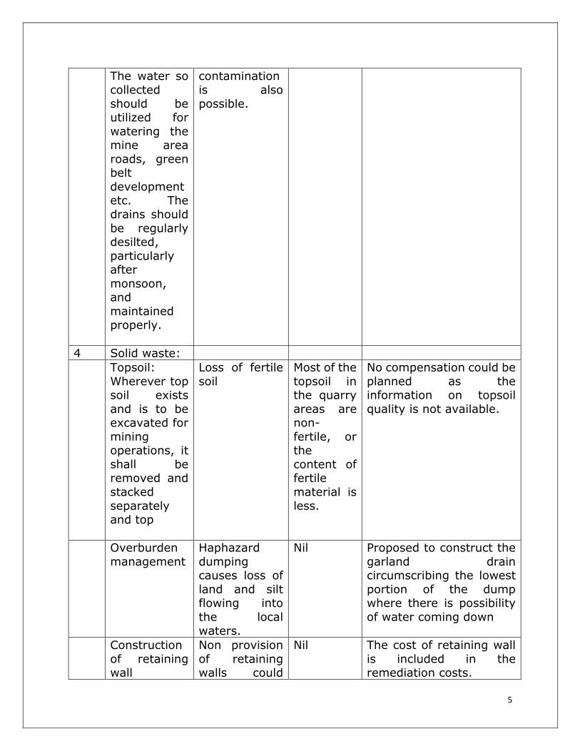
5
The water so collected
should be utilized for
watering the mine area
roads, green belt
development etc. The
drains should
be regularly desilted,
particularly after
monsoon, and
maintained properly.
contamination is also
possible.
4 Solid waste:
Topsoil:
Wherever top soil exists
and is to be excavated for
mining operations, it
shall be removed and
stacked
separately and top
Loss of fertile
soil
Most of the
topsoil in the quarry
areas are non-
fertile, or the
content of fertile
material is
less.
No compensation could be
planned as the information on topsoil
quality is not available.
Overburden
management
Haphazard
dumping causes loss of
land and silt flowing into
the local
waters.
Nil Proposed to construct the
garland drain circumscribing the lowest
portion of the dump where there is possibility
of water coming down
Construction
of retaining wall
Non provision
of retaining walls could
Nil The cost of retaining wall
is included in the remediation costs.

6
have allowed the boulders in
the surrounding
lands if the land is sloping
The
proponent shall obtain
all other mandatory
clearances from
respective departments
DGMS
permission is mandatory for
safety and environmental
protection.
Nil Proposes to apply for
106(2(b)) and register in ‘Shram Suvidha’

7
METHOD OF MINING AND POSSIBLE POLLUTANTS FOR WHICH REMEDIATION IS TO BE CONSIDERED & UNIT COST CALCULATIONS
1. Details of Mining methodology and possible pollutants from the
operations: The present case pertains to Galaxy black Granite Mining which
is also known as dimension stone mining. The general method of operations
is through either open pit or contour mining method. The operations involve
making an initial cut, detaching the granite block from the parent block,
dressing the blocks into saleable blocks, shifting the generated waste to the
waste dump are important works. Another work which is environmental
friendly is cutting with wire saw machine. These operations are completely
done under wet conditions only with a water jet directed to the cutting wire.
Thus these operations are dust-free in nature. For these operations
excavators of 300-400 capacity are used. Jackhammers are used for dressing
the blocks are dust polluting machines. The transport of material to waste
dump causes dust generated during movement of tippers/ dumpers.
2. Loss of greenery due to mining operations: The greenery is to be
provided on the buffer zone as per the conditions of EC. Apart from this when
the bench preparation is taken up there can be loss of initially existing
greenery all over the leased land. For this purpose the buffer zone area of
the lease is arrived at initially. This area is supposed to have been utilized
for plantation. As per the standards 1 Ha (10000 square meters) of area can
be used for planting 1000 number of trees. This amounts to 10 square
meters per plantation. With this standard the number of plants to be planted
is arrived at.
The tree density that originally existed in the lease area is approximately
taken from the available ‘Topo Sheets’. If the area was densely populated
with trees, the loss per hectare is taken as ‘10’. If the area was moderately
populated with trees, the loss of trees per hectare is taken as ‘8’ per hectare.
Thus the loss of trees due to initial mining operations is arrived at. The sum
of the trees to be planted on buffer zone and the initial tree loss is taken as
total trees to be planted. The cost of the plantation is part of the remediation
cost, which is part of the bank guarantee.

8
3. Transport route span from quarry to the nearest out going road for
dispatch of mineral: This part of the road on which the trucks move, is not
a part of the lease area. Since the lessee is using this road, the responsibility
of suppressing the dust on this road lies with the lessee. The total road length
is taken into consideration within 500 m boundary. The road width is taken
as ‘3’ meters which is most common. This width multiplied with the span of
road gives the area to be wetted. Thus the cost for sprinkling is part of the
bank guarantee to be provided.
4. Construction of trench for water collection in the downward-slope
portion on the ground: The trench dug in the downward portion of the
lease area (within lease area) will allow water to collect and the pure water
is let out. The cost of trenching forms a part of the bank guarantee. This cost
is applicable only for hilly deposits.
5. Construction of trench around the waste dump: This trench will arrest
the boulders that may roll from the dump and also prevents muddy water
that can directly enter local water regime from the waste dump catchment.
This cost is also taken as a part of the bank guarantee.
6. Construction of fencing: This cost is applicable only for the ground level
quarries. The fencing is to be provided all around the quarry to prevent
inadvertent entry of persons and accidental entry of stray animals. This cost
is also taken into consideration.
7. Water regime loss: The water regime loss is taken into account as the
mining operations without proper planning to manage water flow properly
could have caused loss of recharge of the ground water. For this purpose the
total area taken in meter square multiplied with the highest rain fall of the
previous 10 years gives the water addition to the local regime. This is taken
for 10 years in kilo liters. Out of this water natural ground infiltration and
evaporation is taken collectively as 40% for hard grounds, 60% for
permissible grounds and 80% for sandy soils. In the same manner the water
that could have naturally entered into the local course (Without any attempts
of lessee) is taken as 40% for hard ground, 20% for permissible grounds,
and nil for sandy soils. Thus in every case around 20% of water is lost due

9
to poor catchment water management due to the lessee. This cost is added
as the bank guarantee amount which will be used for community resource
(Ground water) augmentation purposes. The cost is taken as Rs.1.00 per
kilo liter of water which is the cess vale that is imposed by existing standards.
8. Calculation of unit costs for different remediation works and bank
guarantee value:
Cost of Plantation: The cost of each plant is taken as Rs.20/-. The cost of
pitting is taken as Rs.10/- per plant. The cost of guard that protects plant is
taken as Rs.100/- per plant. This part of the cost comes to Rs.130/- per
plant. Coming to watering of plants daily consumption of water per plant is
taken as 20 liters. For a period of 9 months this comes to 5400 liters per
plant. This is equal to (7500/5400) 0.7 tankers. Cost of each tanker of water
is taken as Rs.150/-. Thus the cost of water per plant per year is 150 x 0.7
= Rs.105/-. For two years this comes to Rs.210/- and this adds up to the
initial cost of Rs.130/-. Thus the total cost of plantation works out to
be (130 + 210) Rs.330/-. This cost includes watch and ward also.
Total lease area is 19750 square meters. The extent of buffer zone is 4950
square meters. The number of plants to be planted in lieu of the buffer zone
plantation is 4950 / 10 = 495 numbers. The tree density of the initial status
of the leased land is taken as ‘10’ trees per hectare. Thus for the given lease
area the number of tree loss is arrived at as 1.97 x 10 = 19.7 or say 20
numbers. Thus the total number of trees to be planted is 495 + 20 = 515
numbers. The cost of plantation for one plant is arrived at as Rs.330/- (See
above). Thus the bank value to be provided for plantation is equal to No. of
plants x Rs.330. this comes to 515 x 330= Rs. 169950/-. Thus for
plantation the remediation cost is Rs.169950/-
Basis for Cost of trenching and De-silting/Boulder wall construction:
The cost of trenching is taken on the basis of machine hours needed for
preparing the trench. A standard excavator of 200 range is sufficient for
trenching. The present rent per excavator per hour is Rs.3500/- including
manpower cost and diesel cost. The material that an excavator can excavate
in hard ground is around 50 cubic meters. Although an excavator can
excavate around 300 tons per hour, the reduced quantum is owing to the

10
difficulty of digging on ground and the dimensions which are less. This
machine associated with at least 2 tippers in one hour to haul the given
material. The cost of tippers with diesel per hour is around Rs.500/-. Thus
for hauling one cubic meter trench works out to be (3500 + 500)/ 50 = 80/-
. The total cost of trenching is arrived with a basic cost of Rs.80/- per cubic
meter of material to be handled. In the present case the quarry being a
flat one we need the trenching or boulder wall only around the waste
dump.
Dump sites are established at two places i.e. In SY. No 96/2 which is 4.58
acres and sy. NO. 114 with 2.18 acres. Both are in RL Puram (V) of
Chimakurthy Mandal and located at about 1.5 KM from the mine sites.
(Dump site is common for two quarries of same company ie. One in Sy. No.
979/8, 9 & 10 to an extent of 1.975 Hectares and another one in Sy. 977/10,
11, 978/1 to 6 & 979/1 & 2 with an extent of mine of 3.846 Hectares)
The total perimeter dump site I is - 575.1 Meters and for dump site – II is –
387 meters. Thus total perimeter required trench is 962.1 meters
The total coverage of boulder wall and the trench around the waste
dump of the quarry comes to 962.1 meters which costs 962.1 x 80
= Rs. 76,968/-
This cost is apportioned on two mines. Hence cost for one mine is Rs.
38,484/-
Basis for calculation of loss to water regime due to quarrying: The
present area is 1.975 hectares. The average rain fall is taken as maximum
of 1.0 m per annum. The total rain catchment is 19750 x 1.0 = 19750 cubic
meters. As explained above 20% of the water quantity is taken as mis-
managed quantity i.e., 3950 cum. The cess is taken as Rs.1.0/- kilo liter
of water. Thus the cost of water loss per year is arrived at as Rs. 3950/- and
for 10 years it is Rs. 39500/-
Cost of fencing: The cost of fencing of substantial nature includes, the cost of
pillar grouting, the cost of fence, and labor involved. The cost of fence per

11
square meter is around Rs.50/-. For a linear meter with a height of 2 meters
the cost of fence material is Rs.100. The span of pillars is taken as 3 meters.
Each pillar cost is taken as Rs.50/-. Thus for a distance of 30 meters the cost
of fencing comes to (60 x 50) + (10 x 50) = 3500/-. Thus for a linear meter
the cost of fencing is around Rs.117/-. This calculation includes the cost of
labor and machine if used including the watch and ward. With this basis
the total cost of fencing is arrived at as 660 x 117 = Rs.77, 220/-.
This is included in the bank guarantee.
Cost for water sprinkling on roads: The consumption of water for only
outside the lease area roads is considered. The total area to be wetted
is 1620 Sq.m. As per standards one square meter of area needs 1 liter for
wetting. Thus taking around 3 trips of water sprinkling per day a square
meter of area needs 3 liters of water. For the given area of 1620 square
meters we need 3 x 1620 = 4860 liters of water per day. For 9 months of
period (leaving aside the rainy season) we need to sprinkle 230 days
(deducting 40 days of holidays and Sundays). With this basis the water
consumption is 230 x 4860 = 1117800 liters. Taking a standard tanker of
7500 liters we need 1138500 / 7500 = 149 tankers of water. The cost of
each tanker is taken as Rs.200/-. Thus the cost of water sprinkling is arrived
at as 149 x 200 = Rs.29,800/-

12
VALUE OF BANK GUARANTEE BEING SUBMITED
S.No Remediation work
Value in Rs.
1 Plantation 1,69,950
2 Boulder wall & trench
38,484
3 Cost of fencing 77,220
4 Cost of sprinkling 29,800
5 Cost of water
regime
39,500
Total 3,54,954
As per the above calculation an amount of Rs.5, 00, 000/- is being submitted as bank guarantee, guaranteed by Axis Bank and the
validity is for a period up to 2020

M/s. Sri Surya Granites.
Ext. 1.975Ha, Chimakurthy (V&M), Remediation Plan on Ecological Damage Prakasam (Dt), Andhra Pradesh
1
Pridhvi Envirtech Pvt. Ltd.
Remediation Plan on Ecological Damage
1.0 INTRODUCTION:
M/s. Sri Surya Granites., was granted quarry lease for mining of Black
Granite over an extent 0.582 Ha or 1.44 Acres for 5 years in Sy.No.979/10
of Chimakurthy village in the year of 1991 vide proceeding
No.4426/Q2/1991, dated 28/11/1991 of DDMG Guntur and over an extent
1.392 Ha or 3.44 Acres in Sy.No:979/8&9 of Chimakurthy village in the year
1991 vide proceedings no:328/Q2/1991, dated 27/09/1991of the DDM&G,
Guntur and above two lease clubbed over an extent 1.975 Ha or 4.88 Acers
in Sy.No:979/8.9&10 of Chimakurthy village in the year 1996 vide
Proceeding No:12805/K4/95, dated 27/06/1996 of the DM&G, Hyderabad.
Subsequently the lease renewed for further 15 years i.e. up to
06/12/2011.Further second renewal of quarry lease for 20 years period
oven an extent 1.975 Hectares/4.88 Acres in Sy.No.979/8.9&10 of
Chimakurthy V&M, Prakasam District, AP Vide proceeding No. 30221/ R3-
1/ 2010, dated 08.04.2011 of DDMG Hyderabad.
The second renewal of quarry lease deed executed by the Asst. Director of
Mines & Geology, Ongole, and Vide: Proceedings No: 5812/Q/2010 dated
28/04/2011 for the period from 07/12/2011 to 06/12/2031.
Mine plan prepared for five year period i.e, 2017-2018 to 2021-2022 and
got approved from Deputy Director of Mines & Geology, Guntur, vide letter
No.762/MS/Bgg/OGL/2017. Dated 11.04.2017.
Copy of Approved current mine plan is given as ANNEXURE – I.
1.1 Applicability of EIA Notification:
As per the Ministry of Environment, Forest and Climate Change, New Delhi,
Notification, S.O. 141(E) Appendix - XI, dt 15th January 2016, the project
falls under Category “B2”,which mandates obtaining Environmental

M/s. Sri Surya Granites.
Ext. 1.975Ha, Chimakurthy (V&M), Remediation Plan on Ecological Damage Prakasam (Dt), Andhra Pradesh
2
Pridhvi Envirtech Pvt. Ltd.
Clearance from respective State Environmental Impact Assessment
Authority (SEIAA) Andhra Pradesh.
1.2 Previous Environmental clearance:
The company obtained Environmental Clearance for the said project, vide
letter no. SEIAA/AP/PKM-135/2013-2378, Dated 10.07.2013 for a
production capacity of 4,800 m3/annum based on the Mining Plan approved
by the department of Mines & Geology vide letter no. 367//MP/OGL/2013,
dated 25.05.2013 which is valid up to 2013-14 to 2016-17 with the
Production of 4,800 M3/Annum.
The project obtained CFE order No:P-174/PCB/ZO-VJA/CFE/2013-115
dated:13.09.2013 for production capacity of Black Galaxy granite-4800
M3/annum and also CFO was taken consent order No:P-131/PCB/ZO-
VJA/CFO/W&A/2013-760 date:23.06.2015 and got auto renewal of same up
to 31.07.2023
Copy of Environmental Clearance & CFO are enclosed at annexure II
1.3 Application for expansion and initiation of credible action:
In 2014, M/S Sri Surya Granites applied for expansion of production
capacity of mine from 4800 M3/Annum to 23,472 M3/annum vide their
application dated 5.11.2014. Certified compliance report from MOEF&CC
obtained by the proponents vide letter F. NO. EP/12.1/2014 -15
/SEIAA/2/AP/122 dated 30th March, 2015 which is submitted at Annexure
III.
Their application was considered by SEAC on 22.01.2016 and SEIAA on
03.02.2016 and recommended initiation of credible action by the
Government under E (P) Act as company increased production without
obtaining prior EC. In this regard, The Assistant Direction of Mines and
Geology, Ongole filed a complaint in the Special Judicial Magistrate of 1
class, Ongole as C.C.No.9/2017 and court in its final hearing on 11th Day,

M/s. Sri Surya Granites.
Ext. 1.975Ha, Chimakurthy (V&M), Remediation Plan on Ecological Damage Prakasam (Dt), Andhra Pradesh
3
Pridhvi Envirtech Pvt. Ltd.
February, 2017 cleared case by imposing a fine of Rs. 1,00,000/-. This
amount was paid by the proponent in the court on 11.02.2017. Copy of the
court order and challan copy are submitted at Annexure IV.
As the credible action process was completed, proponents applied for
expansion again with MOEF&CC vide 12.09.2017 under MOEF Notification of
SO 804 dated 14.03.2017 vide proposal no. IA/AP/MIN/69427/2017.
As per the subsequent clarification from MOEF&CC, as the case comes
under B2 category and shall be dealt by the state environmental
committee, proponents applied for expansion EC application under violation
to SEIAA,AP on 13.04.2018 vide proposal No: SIA/AP/MIN/24200/2018.
1.4 Current stage of project:
It is an existing mine and the Production per annum has obtained
Environmental Clearance produce 4800 Cbm/Annum of Black Galaxy
Granite Mine over an extent:1.975 Hectares, Located in
979/8,979/9&979/10 of Chimakurthy V&M, Prakasam dist., AP EC order No:
SEIAA/AP/PKM-135/2013, Dated:10-07-2013, the production per annum
has mined more quantity than the EC approved quantity, the production
details provided by the proponent year wise is here with presented in the
table1.0
Table 1.0: Year wise Production Details
Year Dispatches(Cbm)
2011-12 6377.108
2012-13 8020.435
2013-14 4614.148
2014-15 9981.399
2015-16 15407.795
2016-17 11035.651
2017-18 10357.114
2018 (Jan-March) 7151.464
2018 (April-June) 3573.183

M/s. Sri Surya Granites.
Ext. 1.975Ha, Chimakurthy (V&M), Remediation Plan on Ecological Damage Prakasam (Dt), Andhra Pradesh
4
Pridhvi Envirtech Pvt. Ltd.
The state pollution control Board issued top production order vide Order No.
Mines/APPCB/RO-NLR/2018-538 dated 1.6.2018
Accordingly the company suspended operations with effect from 11.6.2018
1.5 Cluster of mines:
Assistant Director of Mines, Prakasam, provided a cluster certificate vide his
letter 5612/Q/2010 dated 30.10.2018, on our request. A total of 33 quarry
leases were given within 500 meters distance of M/s. Sri Surya Granite
with a total extent of 101.05 Hectares. As per the list of leases granted, there
is only lease granted to M/s. K. V. Rama Rao mine with an extent of 1.324
Hectares after 9th September, 2013 and Rest of the leases were granted prior
to 9th September, 2013. As per the Gazette Notification, SO. 2269 (E) dated
1st July, 2016, the cluster mining will be applicable only for those mines
whose mining leases were granted after 9th September, 2013. Thus though
number of mines within 500 meters distance are more, cluster rule does not
applicable here as per the MOEF notification. Copy of proceedings from
Assistant Director Mines, Prakasam is given along with sketch.
Fig 1.0 Image Copy of proceedings from Assistant Directo

M/s. Sri Surya Granites.
Ext. 1.975Ha, Chimakurthy (V&M), Remediation Plan on Ecological Damage Prakasam (Dt), Andhra Pradesh
5
Pridhvi Envirtech Pvt. Ltd.
2.0 Salient Features of Mine
Below table provides the salient features of the mine
Table 2.0 Salient Features of the Project
Name of the Organization M/s. Sri Surya Granites
Quarry lease area 1.975 Ha.
Appraisal Category B2
Location Sy. No.979/8,9&10
Chimakurthy Village& Mandal,
Prakasam District,
Andhra Pradesh.
Name of the Proponent & address B. Subba Reddy,
Proprietor,
Gandhi nagar, 1st Line, Koti Reddy Bazar,
Chimakurthy(V&M), Prakasam(Dt),AP.
Type of Land Government Land
Dump Site
Sy. NO. 4.19 ha Sy. No.580/1 and2, 96/2 &
114, , RL Puram (V), Chimakurthy (M),
Prakasam District
Nearest Habitation Raju Palem village about 1.60 kms from the
due South West of QL area
Nearest Sea Port KrishnaPatnam Port 150 kms the due South
Nearest Railway Station
Ongole Railway Station is about 28 Kms due
SE from the Lease Area
Nearest Air Port
Vijayawada Airport about 148 Kms in NE
direction
Type of Activity Black Galaxy Granite Mining
Production Capacity 23472 M3/annum (Maximum
Peak Production)
Method of Mining Open Cast Semi Mechanized method
Man power Requirement 111 No’s
water Requirement
Source of Water Tankers nearby villages

M/s. Sri Surya Granites.
Ext. 1.975Ha, Chimakurthy (V&M), Remediation Plan on Ecological Damage Prakasam (Dt), Andhra Pradesh
6
Pridhvi Envirtech Pvt. Ltd.
2.1 Site Analysis
The salient features of the project site are as follows:
Table 3.0: Salient Features of the Project site
2.2 Connectivity:
The area is located at a distance of about 1.60 Km due North of R.L.Puram
village and 3.7 Km West of Chimakurthy on B.T. road Ongole-Kurnool State
S.No Particulars Details
1. Name of the project Sri Surya Granite
Nature Quarrying Black Galaxy Granite
Size of the project 1.975 Ha.
2. Type of land Government waste land
3. Location Details
Survey No 979/8,9&10
Village Chimakurthy village
Mandal Chimakurthy village
District Prakasam District
State Andhra Pradesh
4. Latitude & Longitude N 15035’00.5’’ E 79049’53.33’’
N 15035’00.1’’ E 79049’57.8’’
N15035’00.5’’ E 79049’57.6’’
N15035’00.1’’ E 79050’01.2’’
N15035’01.7’’ E 79050’01.7’’
N15035’04.0’’ E 79049’52.6’’
5. Environmental Setting
Nearest village RLpuram 1.60 Km
Nearest town Chimakurthy – 3.7 Km
Nearest Railway Station Ongole railway station-25.90km
Inter State Boundary No
Water Bodies
Ramatirtham reservoir -4.6 KM
Musi River-3.1 Km
Reserve forest
Chimakurthy RF-2.3 Km
Devarapalem RF-6.0
Historical /Important
Places None
Ecologically Sensitive
Areas None

M/s. Sri Surya Granites.
Ext. 1.975Ha, Chimakurthy (V&M), Remediation Plan on Ecological Damage Prakasam (Dt), Andhra Pradesh
7
Pridhvi Envirtech Pvt. Ltd.
Highway No.53. The quarry lease area can be approached by earthen road
from this State Highway.
2.3 Site Description:
The area is located on Topo Sheet No: 57M/14 at the junction of the quarry
lease area consists of undulating with gently sloping to East and South
covered under 6M soil and weathered zone.
The Topo sheet of the site area and 10 KM radius is given at Figure 3.0
The Topo sheet of the site area and 5.0 KM radius is given at Figure 4.0
The base map of the site area and 10 KM radius is given at Figure 5.0
The base map of the site area and 5 KM radius is given at Figure6.0
The base map of the site area and 2 KM radius is given at Figure 7.0
The Google map showing 500 meter distance boundary is given at Figure8.0
The Photographs Photo graphs of the Current status of the quarry are given at
Figure9.0
The Topo Map of the site area and 10 KM radius showing mining area
settlements and roads is given at Figure 10.0
FIGURE 4.0: TOPO MAP SHOWING 5 KM RADIUS OF THE SITE
FIGURE 6.0: BASE MAP 5.0 KM RADIUS FROM PROJECT SITE

M/s. Sri Surya Granites.
Ext. 1.975Ha, Chimakurthy (V&M), Remediation Plan on Ecological Damage Prakasam (Dt), Andhra Pradesh
8
Pridhvi Envirtech Pvt. Ltd.
FIGURE 8.0: GOOGLE MAP SHOWING 500 M BOUNDARIES FROM
PROJECT SITE
Figure9.0: Photographs of the Current status of the quarry
2.4 Human settlement
The nearest village Rajupalem Laxmi puram is situated 1.60 Km due South-
West of the quarry lease area, having of 300. Agriculture and sheep breeding
are important profession of the people living in the villages besides involving
themselves in quarrying activity. The habitations surrounding the lease area
is mentioned in table 4.0
Table 4.0: Habitations surrounding the quarry lease area
nt
3.1 Existing Social Infrastructure:
Basic Amenities:
A. Communication Network:- tele Communication facility is available at
RL Puram village
B. School: - Primary School Education is available at R.L.Puram village.
Higher Education is available at Chimakurthy & Ongole Towns.
C. Nearest Hospital: - Registered Medical Practitioner is available at
R.L.Puram village. Chimakurthy & Ongole Towns are well placed for
Medical facilities.
3.1.1 Land use information of the area
Satellite Data:

M/s. Sri Surya Granites.
Ext. 1.975Ha, Chimakurthy (V&M), Remediation Plan on Ecological Damage Prakasam (Dt), Andhra Pradesh
9
Pridhvi Envirtech Pvt. Ltd.
The Satellite IRS P-6 LISSIV images are obtained from National Remote
Sensing Centre (NRSC) Hyderabad. The latitude and longitudes as observed
in the site by GPS are 15°35'00.5"N latitude and 79°49'53.4"E longitude.
The satellite image of the site is presented in Fig.11.0.
3.1.2 Contour Map and Elevations of Study Area:
The contours in Topo sheet have been digitized in the GIS environment and
assigned the respective elevation values in meters with reference to the
mean sea level. Using the SRTM (Shuttle Radar Topography Mission) data,
the elevation values has been verified. Thereafter final contour map has
been prepared with combination of Topo sheet and SRTM with contour
interval of 10 m. Project site contours vary from 74 m to 76 m above MSL
and the study area contours vary from 30 m to 480 m above MSL. From the
project site the high range hill area were observed towards North West
direction and the lowest contours were observed in South direction. While
the remaining areas showed variations with respect to contours. Contour
Map and Elevations of Study Area is presented in Fig.12.0. The drain
network and water bodies existing in the study area are presented in Figure
13.0.
FIG. 11.0 SATELLITE IMAGE OF THE SITE
FIGURE.12.0 CONTOUR MAP AND ELEVATIONS OF STUDY AREA
FIGURE 13.0 DRAIN NETWORK AND WATER BODIES IN THE
STUDY AREA

M/s. Sri Surya Granites.
Ext. 1.975Ha, Chimakurthy (V&M), Remediation Plan on Ecological Damage Prakasam (Dt), Andhra Pradesh
10
Pridhvi Envirtech Pvt. Ltd.
3.1.3 Land use land cover statistics of buffer zone
Map showing the Land Use Land Cover classification in the study area is
presented in Fig.3.4.11 it is clearly that the area is mostly covered with
Fallow land around 36 % and Open scrub is 13% respectively of the total
area. Which is taken up for cultivation but is temporarily allowed to rest, un-
cropped for one or more season, but not less than one year. Thus, total
cultivable land is 36 %.The land with Plantation is with 3 %, Other class is
Around the Fallow land edges the Settlement (Built-up area) is located and
occupies around 8 %, and Hill are around 4% and Roads 10% of the total
study area. It is an area of human habitation developed due to non-
agricultural use and that has a cover of buildings, transport and
communication, utilities in association with water, vegetation and vacant
lands. The Mining area is 3 % surrounding villages and habitation. The water
bodies cover 11.96% of the total area. The water bodies cover MusiRiver,
Reservoir. These area have a very prominent signature and can be seen as
almost Dark blue and light blue in the satellite image.
The statistical break-up of the land use classes of buffer zone are presented in
Table 5.0 and depicted in Fig. 14.0.
Figure 14.0 The statistical break-up of the land use classes of
Buffer zone
Table 5.0. The statistical break-up of the land use classes of buffer
Zone
4.0 Geomorphology, Hydrology and climatic data of the area
4.1 Geomorphology:
Figure 15.0. Structural and Denudational Hills near Patimedapalem

M/s. Sri Surya Granites.
Ext. 1.975Ha, Chimakurthy (V&M), Remediation Plan on Ecological Damage Prakasam (Dt), Andhra Pradesh
11
Pridhvi Envirtech Pvt. Ltd.
The main mining quarry area is located about 2 km south of the Denudational
hill, with an undulating terrain with a gentle slope towards south and
southeast, which is along the course of the Musi river.
4.2 SOILS:
The area is mostly covered by brownish red loamy soils. These soils are
largely originated by the granitic parental rock. The thickness of soils usually
varies from 0.50 to 0.80 m. along the river stream courses the alluvial soils
are found. The area around the granite quarries is largely unfit for agriculture
as it is strewed with dust, mined out granitic blocks, boulders and rocky
waste.
4.3 Climate & Rainfall
The climate of the area is moderate and sub-tropical. The summer season is
from March to May. This is followed by monsoon period from June to
December, the post monsoon from October to November and the winter
season from December to February. The average annual rainfall of Prakasam
district is 924 mm.
Figure 16.0 Annual Rainfall during the years 1999-2017
Figure 17. Mean Monthly Rainfall
Table 7.0: Annual Rainfall details of Chimakurthy Mandal
4.4 DRAINAGE:
The area regionally forms part of the Paleru River Catchment System. The
Musi River located 5.50 km west of the quarry site forms part of its stream.
The Musi River originates in the Darsi -Donakonda hills and upland areas of
Prakasam district, and flows 33 km southwardly to reach the study area, and
further flows 23 km southeasterly and joins the Paleru River near Kamepalli
(6 km south of Kondapi), which then flows 30 km eastwards to join the Bay
of Bengal.

M/s. Sri Surya Granites.
Ext. 1.975Ha, Chimakurthy (V&M), Remediation Plan on Ecological Damage Prakasam (Dt), Andhra Pradesh
12
Pridhvi Envirtech Pvt. Ltd.
The Sri Surya Granite (East West) area lies within a local catchment area
referred here Pulikonda Watershed. The watershed is about 30 sq. km in
areal extent, and forms part of the Musi river catchment (Figures 18 and
19).
Figure 18. Regional Map of the Area showing the Paleru River Catchment
Figure 19.0. Drainage Distribution and Watershed Demarcation of the Study Area.
(Watershed boundary is shown with Blue Outline, and Musi river is seen
southwest of the watershed).
The overall area is regionally characterized by dendritic pattern of drainage,
with a general slope towards main river and stream courses. The percolation
tanks and water bodies in the area are either dry or gradually getting reduced
over the years with the slowing down of inflows, and erratic rain fall.
4.5 HYDROGEOLOGY:
Ground water occurrence, movement and recharge to aquifers are controlled
by degree of weathering, fracture pattern, geomorphological setup and
rainfall. The litho units of peninsular gneissic group constitute major aquifers
in the area. Ground water occurs in phreatic condition in the weathered zone
and under semi confined to confined condition in fractured and jointed rock
formations. The Hydrogeology Map of the Prakasam District is shown in
Figure 20.0
Figure 20.0. Hydrogeology Map of Prakasam District
(Source: CGWB, 2013)

M/s. Sri Surya Granites.
Ext. 1.975Ha, Chimakurthy (V&M), Remediation Plan on Ecological Damage Prakasam (Dt), Andhra Pradesh
13
Pridhvi Envirtech Pvt. Ltd.
4.5.1 Ground Water Levels:
Behavior of ground water level is essentially controlled by physiography,
lithology and rainfall. There is general decline and rise of water during pre-
and post-monsoon seasons. The rises are due to the general buildup of water
levels in response to rains, and declines are due to erratic monsoon, less
recharge (due to urbanization), and exploitation of groundwater resources.
Figure 21.0. Depth to Ground Water Levels in the Study Area
(Regional Flow Gradient towards Musi River is indicated by Pink Arrow)
The long term fluctuation data of representative Central Ground Water Board
(CGWB) monitoring station (bore well) located at Chimakurthy was analyzed.
The analyzed plot is shown in Figure 22.0.
Figure 22.0. Ground Water Levels and Fluctuations at
Chimakurthy.
Ground Water Levels of Chimakurthy, Prakasam District, Andhra Pradesh.
4.5.2 Ground Water Resources Estimation:
In collaboration with the state departments, Central Ground Water Board
(CGWB) carried out ground water resource estimation and categorization
studies for the Chimakurthy Mandal of Prakasam District for the year 2008 -
09.
The CGWB has categorized the area as ‘safe’ with the stage of ground
water utilization of 28%, indicating little scope for further ground water

M/s. Sri Surya Granites.
Ext. 1.975Ha, Chimakurthy (V&M), Remediation Plan on Ecological Damage Prakasam (Dt), Andhra Pradesh
14
Pridhvi Envirtech Pvt. Ltd.
development. The Details are given in Table 4. These details are applicable to
the study area also, as it forms part of this Mandal.
The study area mainly comprises of unconsolidated hard rock formations. The
chief sources of surface irrigation are through distributaries of Nagarjunasagar
Right Canal and tanks. Ground water irrigation in the study area is not
intensive, but in some areas is developed by means of dug-cum-bore wells
and bore well.
Table 8.0. Ground Water Resources of Chimakurthy Mandal,
Prakasam District, A.P. Note: Year of Ground Water Assessment: 2009.
4.5.3 Water Quality:
The ground water in the study area occurs under moderate and deep water
level conditions, and quality-wise is generally suitable for domestic, irrigation,
and industrial purposes. The quality of ground water in and around the project
site is potable.

M/s. Sri Surya Granites Pvt Ltd. Remediation Plan on Ecological Damage
Ext. 1.975ha, Chimakurthy (V&M), Prakasam (Dt), Andhra Pradesh.
15
Pridhvi Envirtech Pvt. Ltd.
Table 9.0. Physical and Chemical Parameters of Ground Water Analysis Report
S.No. PARAMETER Method APHA
22nd Edition Unit
RESULTS
As per IS:10500 - 2012
RAVIPADU LAKSHMI PURAM MARRICHETLA PALEM
BAKKIREDDIPALEM
CHEEMAKURTHI
Requirement Acceptable
limit
Permissible limit in the absence of alternative
source
1 pH 4500 H+B −− 7.38 7.77 7.64 7.40 7.29 6.50 - 8.50 NS
2 Color (Hazen units) 2120 B Hazen <1.0 2.00 <1.0 <1.0 3.00
5 max 15 max
3 Total dissolved solids 2540 C mg/l 986 524 892 810 1,815
500 max 2000 max
4 Total alkalinity as CaCo3 2320 B mg/l 430 232.00 383 345 774
200 max 600 max
5 Total hardness as CaCo3 2340 C mg/l 550 297.00 490 441 479
200 max 600 max
6 Calcium as Ca 3500 Ca B mg/l 92 58.0 104 80 98
75 max 200 max
7 Magnesium as Mg 3500-Mg B mg/l 77.78 36.95 55.90 58.58 56.88
30 max 100 max
8 Sulphates as SO4 4500 SO4D mg/l 96.00 52.00 86 77 172.80
200 max 400 max
9 Chlorides as Cl 4500 Cl-C mg/l 195.7 105.68 112.55 101.30 352.26
250 max 1000 max
10 Lead as Pb 3111B mg/l 0.02 0.009 0.013 0.05 0.08
0.01 max No relaxation
11 Cadmium as Cd 3111B mg/l 0.008 0.01 0.004 0.03 0.06
1 max No relaxation
12 Total Chromium as Cr 3111B mg/l <0.001 <0.001 <0.001 <0.001 <0.001
0.05 max No relaxation
13 Copper as Cu 3111B mg/l 0.06 0.030 0.02 0.01 0.09
0.05 max 1.5 max
14 Zinc as Zn 3111B mg/l 0.06 0.030 0.02 0.01 0.09
5.0 max 15 max
15 Nickel as Ni 3111B mg/l 0.003 0.007 0.005 0.02 0.07
0.02 max No relaxation
16 Flourides as F 4500 F-D mg/l 0.81 0.74 0.96 0.92 0.79
1.0 max 1.5 max
17 Aluminium as A1 3500 Al B mg/l 0.04 0.009 0.02 0.006 0.01
0.03 max 0.2 max

M/s. Sri Surya Granites Pvt Ltd. Remediation Plan on Ecological Damage
Ext. 1.975ha, Chimakurthy (V&M), Prakasam (Dt), Andhra Pradesh.
16
Pridhvi Envirtech Pvt. Ltd.
18 Boron as B 4500 B B mg/l 0.10 0.25 0.17 0.29 0.46
0.5 max 1 max
19 Manganese as Mn 3111 B mg/l 0.020 0.013 0.026 0.015 0.04
0.1 max 0.3 max
20 Iron as Fe 3500 Fe B mg/l 0.35 0.29 0.42 0.38 0.05
0.3 max No relaxation
21 Nitrates as NO3 4500 NO3B mg/l 18.60 10.05 16.60 14.94 33.50
45 max No relaxation
22 Sodium as Na 3500 Na B mg/l 120.00 64.80 107.00 96.30 415.43
NS NS
23 Potassium as K 3500 K B mg/l 8.21 4.44 7.32 6.59 75
NS NS
24 Odour 2150 C −− Agreeable Agreeable Agreeable Agreeable Agreeable
Agreeable Agreeable
25 E.C (micromhos/cm) 2510 B µmho/cm 1,642 887 1,464 1,318 2,956
NS NS
26 Phosphorus as P 4500 P B 0.28 0.51 0.36 0.20 0.63
NS NS
27 Carbonates as CaCo3
2320 B mg/l Nil Nil Nil Nil Nil
NS NS
28 Bicarbonates as Hco3
2320 B mg/l 524.60 283.04 467.26 420.90 944.28
NS NS
* NS - Not Specified
The quality of ground water in and around the project site is potable. Ground water samples were collected from
the ‘representative’ areas around 5 km radius of the mining site, and some important physical and chemical
parameters were estimated as given in Table 9.0 The ground water in the study area is generally potable, and
suitable for domestic, irrigation, and industrial purposes.

M/s. Sri Surya Granites Pvt Ltd. Ecological Damage and Remediation Plan
Ext. 1.975ha, Chimakurthy (V &M),
Prakasam (Dt), Andhra Pradesh
17
Pridhvi Envirtech Pvt. Ltd.
5.0 Mining Activity
5.1 Regional Geology:
The Chimakurthy igneous complex is an oval shaped igneous body, comparable
to Bushveld Igneous Complex of South Africa and skeeargard Intrusive of
Greenland. Similar to these occurrences, the Chimakurthy igneous Complex is
considered as “Massive Concentric Type” intrusive magmatic body. As the
source of magma is from deeper levels, the depth continuity of the bronzite
gabbro may be few kilometers below the surface.
5.2 Local Geology:
The geomorphology plan in this area reflects the presentence of sub-
surface bronzite bearing gabbro (galaxy granite); located at the central
swollen portion of bronzite gabbro rim. The quarry gabbro formation and
its exploration in the quarries around the quarry lease area. From the
working quarries i.e. towards the northern and southern, south-eastern
parts of the quarry lease area amply testify the sub-surface continuity of
formation in the quarry lease area. All these evidences undoubtedly
confirm the lateral continuity and presence of black galaxy (bronzite
gabbro) at sub-surface levels in this lease area. However the premise for
occurrence of workable deposits at shallower level is positively indicated
by the excavation carried in the quarry lease area.
5.3 Geological Reserves:
The details of the reserves of mine are given in the table –10.0
Table 10.0– details of reserves of mine
Life of mine = (Total Recoverable Reserves/Average Annual Production) = 8.7 years
5.4 Method of Quarrying:
5.4.1 Opencast semi Mechanized Method of Mining:

M/s. Sri Surya Granites Pvt Ltd. Ecological Damage and Remediation Plan
Ext. 1.975ha, Chimakurthy (V &M),
Prakasam (Dt), Andhra Pradesh
18
Pridhvi Envirtech Pvt. Ltd.
To cut down the cost of production and achieving the required quantities
as per market requirements, the operations are planned to be carried out
partly by manually and partly by machinery.
The Overburden mining consists of soil, morum, weathered rock and hard
rock. The weathered rock and useless boulders can be drilled by
jackhammers to blast them for removal. The excavators load the blasted
fragments/debris in to dumpers and then transport to waste dump Yard.
After removal of Overburden and weathered rock, small and medium size
boulders or hard sheet rock will expose. The boulders are split into two or
more pieces in required sizes for making marketable blocks. The exposed
sheet will be cut in the conventional manner by selecting a suitable
platform. The Platform will be constructed by digging for positioning
machines. The first cut will be a triangular cut. Further cuttings will be
rectangular for removing the mass from in-situ mass.
5.4.2 Development of Benches and Working Faces:
After removal of overburden, the exposed sheet rock developed in
naturally occurred joint Plane i.e. attempted to develop a working face.
After exposing the working face up to 6-10m depth, the rock splitting is
affected by using jack hammers holes and edging or shuttering. The first
cut will be a triangular cut for entering into the sheet. Further rectangular
cuttings 10m length and 10m width with 6 to 10 meters height will
proceed for separation.
5.4.3 Separation primary blocks from the mother rock:
Primary Splitting:
• After removal of overburden the exposed sheet rock mass as in- situ
mass will be separated by wire saw cuttings.
• Further the separated mass will be spitted into sub-mass by line drilling
& gunpowder or wire saw cuttings for removing conveniently by
excavators.

M/s. Sri Surya Granites Pvt Ltd. Ecological Damage and Remediation Plan
Ext. 1.975ha, Chimakurthy (V &M),
Prakasam (Dt), Andhra Pradesh
19
Pridhvi Envirtech Pvt. Ltd.
• Sub-mass will be spitted into handable blocks by jackhammer/
Hydraulic drilling and edging.
• The blocks thus separated, will be split in to smaller blocks at location
as per the demand.
• After separation of blocks, these will be rolled down by the excavator
for clearance and further operations.
Second Splitting:
The separated pieces are examined for defects and line, then the block or
blocks marked in clear area and holes are drilled along the line marking
with feather and wedges and the waste portions are separated forming
cuboids. Any bulges are removed by drilling and wedging making in
prefect cuboids.
5.4.4 Extent of Mechanization:
The machinery proposed and approved in the previous scheme of mining
will be used in the present scheme also. However for ready reference the
list is reproduced under the table.
6.0 Waste generation & Disposal
6.1 Solid waste Generation
6.1.1 Dump handling:
There are two dumping sites approved by the mining department. SY. NO.
114 and 96/2 to an extent of 6.76 acres in Chimakurthy (V&M), Prakasam
District. Which is about 1.5 KM from the mine site. Currently the mine is
using this dump site.
The Geographic coordinates of the Second dump site between 15034’
45.2”N 79049’18.3”E and 15034’ 39.7”N 79049’11.4”E

M/s. Sri Surya Granites Pvt Ltd. Ecological Damage and Remediation Plan
Ext. 1.975ha, Chimakurthy (V &M),
Prakasam (Dt), Andhra Pradesh
20
Pridhvi Envirtech Pvt. Ltd.
Fig 23.0. Google Map Showing Dumpsite
Figure 24.0: Dumpsite photo graph
6.1.2 Wind directions and likely affected villages
Based on Met data from Ongole Met station, the seasonal wind directions
are plotted in wind rose diagrams. Which are given in Figure 25.0 to Fig
28.0
Figure25.0: Wind Rose Diagram for summer season

M/s. Sri Surya Granites Pvt Ltd. Ecological Damage and Remediation Plan
Ext. 1.975ha, Chimakurthy (V &M),
Prakasam (Dt), Andhra Pradesh
21
Pridhvi Envirtech Pvt. Ltd.
Figure26.0: Wind Rose Diagram for Monsoon season
Fig 27.0 Wind rose for Post Monsoon season

M/s. Sri Surya Granites Pvt Ltd. Ecological Damage and Remediation Plan
Ext. 1.975ha, Chimakurthy (V &M),
Prakasam (Dt), Andhra Pradesh
22
Pridhvi Envirtech Pvt. Ltd.
Fig 28.0 Wind Rose for winter season
6.1.3 Predominant Wind Directions:
Based on the data, the predominant wind direction in summer is from
South East direction. During the monsoon the predominant wind direction
is from South West. During the post monsoon, the predominant wind
direction is South West and South Eastern side. During the winter, the
predominant wind direction is from North Eastern & South Eastern sides.
6.1.4 Villages within 5 KM distance with Direction from dump sites:
Table 13.0 List of villages in 5 Km radius from the Mine area
7.0 Flora & Fauna of the area
7.1 Description of the project site environment:
The project site is open land without any vegetation except natural grass
and common weeds.

M/s. Sri Surya Granites Pvt Ltd. Ecological Damage and Remediation Plan
Ext. 1.975ha, Chimakurthy (V &M),
Prakasam (Dt), Andhra Pradesh
23
Pridhvi Envirtech Pvt. Ltd.
The proposed project falls in
• 6D – Deccan Peninsula Deccan Plateau as per the Biogeography
Classification of India.
• Hot Semi-arid type as per the India's Köppen climate classification.
The vegetation of the study area falls under
• 5A: Southern tropical dry deciduous forests C3: Southern dry mixed
deciduous forest;
7.2 Agriculture:
Crops raised in the buffer zone: Out of the total croplands, more than
70% was under Paddy, Maize, Chilies, Red gram, Black gram, Green gram
and Groundnut. Remaining was a current fallow without any crops but
ready for cultivation.
7.3 Mine Lease Area:
The existing mine lease area is adjoining to other mines under operation.
Hence there is no particular space for developing any vegetation near the
boundary of the mining area. No vegetation near the approach road to
Mining site. None of the community resources present in and around 500
m radial distance from the mine site boundary.
The vegetation raised near the office premises are recorded. The major
tree species raised within the office premises are given in Table 14.0.
Table 14.0 Major tree species in the ML area
Figure29: Vegetation near Mine lease area office

M/s. Sri Surya Granites Pvt Ltd. Ecological Damage and Remediation Plan
Ext. 1.975ha, Chimakurthy (V &M),
Prakasam (Dt), Andhra Pradesh
24
Pridhvi Envirtech Pvt. Ltd.
7.4 Dump area:
Few sporadically naturally grown trees such as Eucalyptus and Senna
auriculata are observed along with Prosophis which is a common weed
throughout the region.
No possibility of growing grass on dump slopes to stabilize them and to
avoid the dust as there is no soil binding capacity
7.5 Reserve forest vegetation:
Chimakurthy RF contain good number of trees such as Buchanania lanzan,
Azadirachta indica, Balanites aegyptiaca, Butea monosperma, Phoenix
sylvestris, Acacia nilotica, Dalbergia sissoo etc and shrubs such as Senna
auriculata, Calotropis procera, Caralluma umbellata, Euphorbia
antiquorum, Euphorbia tortillis, Dodonaea viscose Jatropha
gossypifolia,Cariss spinarum, Prosopis juliflora, Acacia nilotica, Acacia
leucophloea, and Lantana camara and other all common herbs and
climbers
7.6 Quantitative analysis:
The tree density is calculated with quadrant plot analysis for 20 X 20 m
(400 m2) plot shows for 10 plots = 4000 m2
This may be due to more slop and soil condition. More number of shrubs
are observed rather that big trees.
It was observed that the tree density is very low i.e. 8 trees for 10,000 m2
8.0 Compliance to conditions prescribed in previous EC
The following observations in the certified copy of the compliance report
by MOEF&CC, Southern Region confirms our efforts in this direction
Table 17.0
Condition wise Compliance form Certified Compliance report

M/s. Sri Surya Granites Pvt Ltd. Ecological Damage and Remediation Plan
Ext. 1.975ha, Chimakurthy (V &M),
Prakasam (Dt), Andhra Pradesh
25
Pridhvi Envirtech Pvt. Ltd.
S.No Condition Compliance
1 Wet drilling & Wire saw
cutting method shall be used
Complied with. PP informed that wire saw cutting method is adopted in the mine.so far blasting has not done in this mine. Instead expensive mortar will be used for separating mother rock. This will not have any vibrations and dust.
2 Fugitive Dust emissions shall be controlled by water sprinkling
Complied with. Water sprinkling is being done at haul roads and mining area to control the fugitive dust emissions.
3 Dust emission monitoring Partly complied with. PP informed that the AAQ is being monitored at 3 locations only on quarterly basis by a third party report provided during the site visit shows that the AAQ result are within the limits.
4 Provision of garland drains, bund
and siltation ponds for OB dump
Complied with. PP has provided the garland drain
and siltation ponds of appropriate size to arrest
flow of silt and sediment.
9.0 REMEDIATION ACTION PLAN:
It may be seen that the 'Bank Guarantee' amount covers the following
areas. The proposed method of completion of the remediation works
proposed is as under.
1. Plantation: The total plantation planned is 515 trees which can be
seen from the attached document. For this area required 0.515 ha. Since
the present quarry area is rocky and non-fertile, the proponents planted
4800 trees in an area admeasuring 3.54 ha in his own land locally in Sy.
No. 428 & 438/1 Chimakurthy Village. This will be further augmented with
additional trees as required above
2. Water regime: Since the damage that took place to the water regime
cannot be reversed, and since this is the community resource, it is
proposed to direct the catchment water of the quarry into a local recharge
point. The amount of money allocated to the water regime remediation
will be spent in providing the water harvesting points in the villages
nearby. However an account of the same will be maintained. If such water
harvesting methods are available in the nearby village, this amount will be
spent for the benefit of the community development in the form of
providing benches in the schools, providing computers, making one

M/s. Sri Surya Granites Pvt Ltd. Ecological Damage and Remediation Plan
Ext. 1.975ha, Chimakurthy (V &M),
Prakasam (Dt), Andhra Pradesh
26
Pridhvi Envirtech Pvt. Ltd.
digitized class room in a government school, or by providing a playground
or a park for the locals. This will be in addition to the proposed CSR
activities.
3. Water sprinkling and Fencing: The water sprinkling is a regular
operation. A separate book in this regard will be maintained and will be
presented when the inspecting authorities ask for. The fencing is not only
for preventing inadvertent entry, but also is for internal security. The
same will be planned and will be completed within the two year period.
4. Provision of trenches and their de-silting: The trench construction
will be started immediately and will be completed as early as possible. It
is planned to de-silt them every post monsoon
9.1 Green belt:
Based on the guidelines approved in the mine plan, they need to develop
green belt in buffer area of the mine. The total periphery of the mine is
660 Meters. By taking 7.5 meters of buffer zone width, total green belt to
be developed by the proponents is 4950 square meters or 0.495 ha. As
the mine area is covered with sheet rock and surrounded my similar
mines, they could not develop the green belt in the mine area. Total
number of trees to be developed will be 515 number of trees (calculations
are given in Part II – Remediation and Resource augmentation plan). In
lieu of this they have taken a land of 8.76 acres own patta land SY. NO.
428 and 438/1 of Chimakurthy village, and developed the plantations. A
total of 4800 trees were developed by the proponents in this land as
detailed below. The photographs of the developed plantations are given
below.
9.2 Overall Budget and time frames for Remediation measures:

M/s. Sri Surya Granites Pvt Ltd. Ecological Damage and Remediation Plan
Ext. 1.975ha, Chimakurthy (V &M),
Prakasam (Dt), Andhra Pradesh
27
Pridhvi Envirtech Pvt. Ltd.
Bellow table provide details overall budget & Time frames for completion
of proposed for remediation measures as described above.
Table 19.0 Overall Budget and time frames for Remediation
Measures
S.No Remediation measure
Budget in
Rs
.
Time frame for
completion
1 Cost of additional Greenbelt 1,69,950 Continuous process
2 Trench for the 38,484 One month
dump sites
3 Loss of water Regime 39,500 Will be contributed to village
4 Water sprinkling on hauling road 29,800 continuous process
5 Fencing of mine area 77,220
As the mine gone down from
GL, Fencing will be done on two
sides without obstructing
mining vehicle movement
Total Budget 3,54,954
10.0 Community and Natural Resource augmentation Plan:
10.1 Human Habitation:
As such there are no villages within 500 meter distance from mine site or
from dump site. The nearest village from mine site is RL Puram at 1.6 KM
and nearest village from dump site is RL Puram (V) which at 0.59 KM in
the South Eastern direction.
10.2 Water bodies:
There are no water reservoirs and pond within 1 KM distance. The nearest
water pond is Kunamneni varipalem which is at a distance of 2.6 KM from
mine site and 3.98 KM from the dump site in the East and North East
direction, towards the land slopes are there. Nagarjuna Sagar Right canal
is at about 0.7 KM from the mine site towards North Direction and 1.9 KM

M/s. Sri Surya Granites Pvt Ltd. Ecological Damage and Remediation Plan
Ext. 1.975ha, Chimakurthy (V &M),
Prakasam (Dt), Andhra Pradesh
28
Pridhvi Envirtech Pvt. Ltd.
from the dump site in the North direction. Based on the physical
observations; there are no water flows into the pond from dump sites.
Also there is high way in between the canal and dump site.
10.3 Public Roads:
This site is connected by Kurnool-Ongole State High way No.53. This is
two lane roads. The total hauling road length for moving material out from
the mine site is 500m. This is the road stretch used by the proponent
outside the mine area before it reaches the state Highway.
10.4 CSR Activity:
Company contributed to take up CSR activities in the nearby villages
through association of mines located in this area. These funds are utilized
for various developments works such improvement of roads and other
infrastructure
10.5 ESR Activity:
Company is committed to take up improve projects on environment
through ESR funds such as providing plantations on road side, providing
percolation pits to augment ground water resources in the nearby villages
and de-silting of irrigation tanks. A provision of Rs.1, 00, 000 per annum
is made towards its contribution to take up these activities in consultation
with District authorities.