
Relief evolution in northern Corsica (western Mediterranean): Constraints on uplift and erosion on...
16
Relief evolution in northern Corsica (western Mediterranean): Constraints on uplift and erosion on long-term and short-term timescales Maria Giuditta Fellin, Massimiliano Zattin, and Vincenzo Picotti Dipartimento di Scienze della Terra e Geologico-Ambientali, Alma Mater Studiorum, Universita ` di Bologna, Bologna, Italy Peter W. Reiners and Stefan Nicolescu Department of Geology and Geophysics, Yale University, New Haven, Connecticut, USA Received 14 May 2004; revised 1 October 2004; accepted 8 December 2004; published 24 March 2005. [1] The long-term erosional evolution of relief is revealed by low-temperature thermochronometric data, whereas geomorphic features give constraints on the short-term evolution. We discuss the topographic evolution of northeastern Corsica by fission track and (U-Th)/He dating of apatite, the provenance of Neogene alluvial sediments, an analysis of uplifted strath terraces, and the shape of river profiles. Cooling ages indicate high cooling rates of up to 40°C/Myr during the early-middle Miocene, when this region was affected by extensional tectonics. Cooling rates are less than 7.5°C/Myr from the middle Miocene to the present, when topographic perturbations are detected by variations in the source areas of middle-to-late Miocene alluvial sediments and by the presence of large-scale irregularities along modern river longitudinal profiles. We suggest that the contrast of slow long-term erosion rates and the high local relief in the present Corsican landscape require that the landscape be in a transient state in response to a recent tectonic event. Citation: Fellin, M. G., M. Zattin, V. Picotti, P. W. Reiners, and S. Nicolescu (2005), Relief evolution in northern Corsica (western Mediterranean): Constraints on uplift and erosion on long-term and short-term timescales, J. Geophys. Res., 110, F01016, doi:10.1029/2004JF000167. 1. Introduction [2] The topographic state of an orogen is the result of two primary coupled processes: tectonic uplift of rocks and erosion, which tend naturally toward equilibrium, or a steady state [Willett and Brandon, 2002, and references therein]. Thus the topographic state of an orogen is linked to its erosional state, and this linkage permits derivation of constraints on the evolution of topography from thermo- chronological data [Burbank, 2002]. Low-temperature chro- nometers such as apatite fission track and (U-Th)/He can provide constraints on the long-term erosional evolution of an orogen, typically at 10 6 year timescales. Erosion rates can be estimated directly from cooling ages on the basis of the age-elevation relationships in situations where older cooling ages are found at the higher elevations [e.g., Stu ¨we et al., 1994; Mancktelow and Grasemann, 1997]. However, in an area undergoing rapid erosion or for low closure temperature chronometers the age-elevation relationship can be significantly affected by advection or topographic bend- ing of isotherms [Stu ¨we et al., 1994; Mancktelow and Grasemann, 1997; Braun, 2002]. Perturbations of isotherms involves deflections related to the elevation and wavelength of surface topography, to the geothermal gradient and the rate of erosion. Topographic deflections of isotherms decreases exponentially with depth [Turcotte and Schubert, 1982], and therefore in most situations only low- temperature isotherms are significantly perturbed by relief [Stu ¨we et al., 1994; Mancktelow and Grasemann, 1997; Braun, 2002]. The age-elevation relationship can be disrupted also by faulting, and the distribution of cooling ages in an area can reflect the different exhumation rates and times of the walls of a fault [e.g., Stockli et al., 2003]. Moreover, erosion and topography can have short-term fluctuations which cannot be detected by thermochronology because such measurements are averaged over a long time period. Short-term fluctuations can be related to climate changes which may vary with rates of about 10 5 years [Burbank, 2002]. [3] Constraints on the short-term rates and patterns of erosional and uplift evolution of an orogen can be derived by geomorphic features such as strath terraces along bed- rock channels and the shape of river longitudinal profiles [e.g., Pazzaglia et al., 1998]. The elevation of strath terraces along bedrock channels permits estimates of stream incision rates, which generally constrain erosion rates at a 10 5 – 10 4 year timescale. River longitudinal profiles can provide some predictions on spatial variations of rock uplift rates and on the steadiness of a fluvial landscape. Under steady conditions the regional pattern of bedrock incision rates correspond closely with the pattern of long-term erosion JOURNAL OF GEOPHYSICAL RESEARCH, VOL. 110, F01016, doi:10.1029/2004JF000167, 2005 Copyright 2005 by the American Geophysical Union. 0148-0227/05/2004JF000167$09.00 F01016 1 of 16
Transcript of Relief evolution in northern Corsica (western Mediterranean): Constraints on uplift and erosion on...

Relief evolution in northern Corsica (western Mediterranean):
Constraints on uplift and erosion on long-term and
short-term timescales
Maria Giuditta Fellin, Massimiliano Zattin, and Vincenzo PicottiDipartimento di Scienze della Terra e Geologico-Ambientali, Alma Mater Studiorum, Universita di Bologna, Bologna, Italy
Peter W. Reiners and Stefan NicolescuDepartment of Geology and Geophysics, Yale University, New Haven, Connecticut, USA
Received 14 May 2004; revised 1 October 2004; accepted 8 December 2004; published 24 March 2005.
[1] The long-term erosional evolution of relief is revealed by low-temperaturethermochronometric data, whereas geomorphic features give constraints on the short-termevolution. We discuss the topographic evolution of northeastern Corsica by fission trackand (U-Th)/He dating of apatite, the provenance of Neogene alluvial sediments, ananalysis of uplifted strath terraces, and the shape of river profiles. Cooling ages indicatehigh cooling rates of up to 40�C/Myr during the early-middle Miocene, when this regionwas affected by extensional tectonics. Cooling rates are less than 7.5�C/Myr from themiddle Miocene to the present, when topographic perturbations are detected by variationsin the source areas of middle-to-late Miocene alluvial sediments and by the presence oflarge-scale irregularities along modern river longitudinal profiles. We suggest that thecontrast of slow long-term erosion rates and the high local relief in the present Corsicanlandscape require that the landscape be in a transient state in response to a recenttectonic event.
Citation: Fellin, M. G., M. Zattin, V. Picotti, P. W. Reiners, and S. Nicolescu (2005), Relief evolution in northern Corsica (western
Mediterranean): Constraints on uplift and erosion on long-term and short-term timescales, J. Geophys. Res., 110, F01016,
doi:10.1029/2004JF000167.
1. Introduction
[2] The topographic state of an orogen is the result of twoprimary coupled processes: tectonic uplift of rocks anderosion, which tend naturally toward equilibrium, or asteady state [Willett and Brandon, 2002, and referencestherein]. Thus the topographic state of an orogen is linked toits erosional state, and this linkage permits derivation ofconstraints on the evolution of topography from thermo-chronological data [Burbank, 2002]. Low-temperature chro-nometers such as apatite fission track and (U-Th)/He canprovide constraints on the long-term erosional evolution ofan orogen, typically at �106 year timescales. Erosion ratescan be estimated directly from cooling ages on the basis ofthe age-elevation relationships in situations where oldercooling ages are found at the higher elevations [e.g., Stuweet al., 1994; Mancktelow and Grasemann, 1997]. However,in an area undergoing rapid erosion or for low closuretemperature chronometers the age-elevation relationship canbe significantly affected by advection or topographic bend-ing of isotherms [Stuwe et al., 1994; Mancktelow andGrasemann, 1997; Braun, 2002]. Perturbations of isothermsinvolves deflections related to the elevation and wavelengthof surface topography, to the geothermal gradient and the
rate of erosion. Topographic deflections of isothermsdecreases exponentially with depth [Turcotte and Schubert,1982], and therefore in most situations only low-temperature isotherms are significantly perturbed by relief[Stuwe et al., 1994; Mancktelow and Grasemann, 1997;Braun, 2002]. The age-elevation relationship can bedisrupted also by faulting, and the distribution of coolingages in an area can reflect the different exhumation rates andtimes of the walls of a fault [e.g., Stockli et al., 2003].Moreover, erosion and topography can have short-termfluctuations which cannot be detected by thermochronologybecause such measurements are averaged over a long timeperiod. Short-term fluctuations can be related to climatechanges which may vary with rates of about 105 years[Burbank, 2002].[3] Constraints on the short-term rates and patterns of
erosional and uplift evolution of an orogen can be derivedby geomorphic features such as strath terraces along bed-rock channels and the shape of river longitudinal profiles[e.g., Pazzaglia et al., 1998]. The elevation of strath terracesalong bedrock channels permits estimates of stream incisionrates, which generally constrain erosion rates at a 105–104 year timescale. River longitudinal profiles can providesome predictions on spatial variations of rock uplift ratesand on the steadiness of a fluvial landscape. Under steadyconditions the regional pattern of bedrock incision ratescorrespond closely with the pattern of long-term erosion
JOURNAL OF GEOPHYSICAL RESEARCH, VOL. 110, F01016, doi:10.1029/2004JF000167, 2005
Copyright 2005 by the American Geophysical Union.0148-0227/05/2004JF000167$09.00
F01016 1 of 16

rates indicated by low-temperature thermochronometers[Pazzaglia and Brandon, 2001]. Thus the comparisonbetween long-term and short-term erosion rates can providea key for the understanding of the relation between erosionand rock uplift [Pazzaglia and Brandon, 2001; Willett andBrandon, 2002]; that is, if long-term and short-term erosionrates show similar patterns and magnitudes, then conditionsof topographic steady state might be expected.[4] In the first section of this paper, the long-term
erosional evolution of northeastern Corsica is examinedfrom the perspective of apatite fission track and (U-Th)/He ages. Moreover, the age-elevation relation is examinedthrough thermal modeling and integration with geologicaldata in order to analyze the role of thermal perturbations.The second section of this work aims to compare long-termand short-term erosion rates in the study area. Short-termerosion rates can be approximated at least locally byincision rates of rivers derived from the analysis of strathterraces along bedrock channels. Spatial variations in upliftrate can be inferred from analysis of river longitudinalprofiles.
2. Geological Setting
[5] Northeastern Corsica consists mostly of metamorphicrocks, the so-called Alpine units, which are in contact withthe granitoid rocks of the Hercynian basement exposed inwestern Corsica (Figure 1). The Alpine units compriseoceanic rocks of Jurassic age and their sedimentary cover,folded together with slices of Hercynian granitoids (e.g., theTenda and Farinole-Oletta orthogneiss). The lower Alpineunits (‘‘Schistes Lustres’’ s.l.) suffered blue-schist faciesconditions and were accreted westward from Late Creta-ceous to Eocene [Cohen et al., 1981; Gibbons and Horak,1984; Caron, 1994; Tribuzio and Giacomini, 2002]. Theupper Alpine units, e.g., the Nebbio and Balagne units,were thrusted westward and experienced anchi-metamor-phic conditions.[6] During the Oligocene, the high-grade Alpine units
were exhumed to low-pressure conditions in a state ofregional extension which reactivated the Alpine contactsas normal shear zones [Jolivet et al., 1991; Daniel et al.,1996; Brunet et al., 2000]. The inversion of the Alpinethrusts brought the ‘‘Schistes Lustres’’ s.l. in contact withthe low-grade Alpine units which were preserved fromdenudation in the core of large-scale synclines. During theearly to middle Miocene, the Alpine units cooled to lowtemperatures less than �100�C, as indicated by apatitefission track data [Cavazza et al., 2001; Zarki-Jakni et al.,2004], and the Corsica-Sardinia block drifted off fromsouthern France to its present position as the westernMediterranean basins formed [Vigliotti and Langenheim,1995]. Shallow water sediments were deposited above thelow-grade Alpine units in small Miocene basins, namely inthe St. Florent, Francardo and Corsica basins [Orszag-Sperber and Pilot, 1976]. The St. Florent and Francardobasins are presently exposed subaerially on Corsica andconsist of alluvial and shallow marine sediments of Burdi-galian to middle Serravallian age [Ferrandini et al., 1998;Cubells et al., 1994]. The Corsica basin is the deepest partof the North Tyrrhenian sea and its western margin isexposed onshore in the Aleria plain where the marine
sedimentary record spans from Burdigalian to lower Plio-cene [Caron and Loye-Pilot, 1990]. The extensional defor-mation recorded by the sedimentary basins of Corsicaduring Miocene, and by the Alpine units during Oligocenehave been interpreted as related to the extension in the back-arc area of the Apennines orogen [e.g., Jolivet et al., 1999,and references therein]. Since late Miocene no majortectonic events have affected Corsica, but instead affectedthe Tyrrhenian sea, whose opening has been related to theeastward migration of back-arc extension. Transpressivefaults affecting the St. Florent, the Aleria successions andalso the Alpine units suggest that far-field compressionalstresses have affected northeastern Corsica during the mid-dle Serravallian–Tortonian and Pliocene-Quaternary [Fellinet al., 2005].
3. Thermochronological Data
[7] Fission track dating of zircon (ZFT) and apatite (AFT)is commonly used to quantify timing and rates of exhuma-tion through temperatures of about 240�C [Brandon et al.,1998] and 110�C [e.g., Gallagher et al., 1998], respectively.Apatite (U-Th)/He dating (AHe) is used in similar ways, buthas a lower closure temperature, 70�C [Wolf et al., 1996;Farley, 2000]. For details on the analytical procedures of thedating methods see Appendix A.[8] In this paper we present new AFT and AHe data from
northeastern Corsica (Figure 1, Tables 1a–1c), integratedwith previous ZFT and AFT data by Zattin et al. [2001] andCavazza et al. [2001]. New bedrock AFT ages are in thesame range depicted by Cavazza et al. [2001], between 20to 13 Ma, whereas AHe age range from 8 to 20 Ma. Threesamples yield AHe ages much younger than AFT ages, andAFT and AHe ages are significantly different only forsamples with AFT ages younger than 16 Ma (Figure 2).Four samples show AFT and AHe age differences ofapproximately ±1 Ma, which is within the range of 2sanalytical error for these ages, implying rapid cooling at thistime for these samples.[9] The new bedrock AFT samples did not contain
suitable crystals for the measurement of AFT track lengthsbut track length measurements by Cavazza et al. [2001] (seealso Tables 1a–1c) clearly showed that mean track lengthsare persistently higher than 13.5 mm and in most casesshowed a unimodal, fairly symmetric and narrow tracklength distribution.[10] To constrain the relationship between erosion and
sedimentation during the Miocene, we dated a pebble fromthe upper Burdigalian–lower Langhian sediments (deposi-tional age �16.5 Ma [Fellin et al., 2005]) of the St. Florentbasin (sample TE48, Figure 1). It gave an age of 18.2 ±3.7 Ma, similar to the AFT ages of the bedrock exposed atpresent in its probable source area, the Tenda massif. Thisresult is consistent with a similar detrital age of 17.6 ±2.4 Ma in the St. Florent basin reported by Zarki-Jakni et al.[2004].[11] One of the most striking features of the thermochro-
nologic data is the roughly inverse correlation between ageand elevation (Figure 2). Moreover, at low elevations, AFTand AHe ages are similar, whereas, at higher elevations,their age difference increases. An inverse age-elevationrelationship could be related to topographic thermal pertur-
F01016 FELLIN ET AL.: RELIEF EVOLUTION IN NORTHERN CORSICA
2 of 16
F01016

Figure 1. (a) Sketch map of the western Mediterranean and location of Corsica. (b) Location of thestudy area shown in Figure 1c. (c) Geological sketch map of northeastern Corsica with location and ageof samples modified after Cavazza et al. [2001], Jourdan [1988], and Rossi et al. [1994]. (d) Sketch crosssection across northeastern Corsica modified after Daniel et al. [1996]; for location, see AA0 in Figure 1c.
F01016 FELLIN ET AL.: RELIEF EVOLUTION IN NORTHERN CORSICA
3 of 16
F01016
bations [Braun, 2002]. Alternatively, the observed agedistribution pattern might be related to differential exhuma-tion rates and times due to faulting. Thermal model can testthese two hypothesis as discussed in the following sections.
3.1. Inferred Cooling Rates and Closure Temperatures
[12] Any thermal modeling involving cooling ages isnecessarily based on the closure temperature of the adoptedthermochronometric system, and on the conversion of theclosure temperature to closure depth. In order to assign aclosure temperature and depth to a low-temperature ther-mochronometric system, one should take into account thethermal structure of the crust and its dependence on erosionrate and other thermal parameters as discussed in thefollowing paragraphs.[13] Through the Dodson relation and using a steady state
erosion solution for the advective heat flow problem, it ispossible to relate cooling ages to erosion rates, closuretemperatures and depths as described by Brandon et al.[1998]. Calculations require the assumption of parametersdescribing the initial thermal structure of the crust includingthe surface temperature (15�C), the thermal diffusivity(32 km2/Myr) and a layer thickness representing the depthat which temperature is assumed to be constant (30 km).[14] Closure temperatures are most sensitive to two
parameters, the background geothermal gradient and theerosion rate. At present, in Corsica the heat flux rangesbetween 60 and 90 mW m�2 from south to northeast[Pasquale et al., 1997], and according to thermal modelingin southern Corsica temperatures of 206� ± 17�C and 142� ±17�C are expected at depths of �10 and �5 km, respec-tively [Verdoya et al., 1998]. The present thermal regimehas been interpreted as related to a warming phase duringthe formation of the western Mediterranean basins fromOligocene to middle Miocene. Thus given the north and easttrending increase of heat flux and the warming phase, arelatively high geothermal gradient is suggested for thermalmodeling in the study area. Our thermal history interpreta-
tion is based on an initial (preerosion) geothermal gradientof 35� ± 5�C/km which can be considered an average valueduring the waxing of the Miocene thermal anomaly in thearea.[15] Taking into account the range of cooling ages and
varying the geothermal gradient between 30� and 40�C/km,estimated cooling rates, closure temperatures and depthsvary within relatively narrow ranges. For each thermochron-ometer the resulting ranges of cooling rate, closure temper-ature and depth are listed in Table 2. It is worth noting thatthe inferred cooling rates are averaged over the time elapsedbetween the onset of cooling through the critical isothermand the present (i.e., between the early to middle Mioceneand the present). In contrast, the observation that most ZFT,AFT and AHe ages are early-middle Miocene suggests thaterosion and cooling rates were higher during this time. Thisis clearly shown by the time-temperature (Tt) paths ofFigure 3 which summarizes the calculation of Table 2. Highearly to middle Miocene cooling rates are also consistentwith observed track lengths which show means higher than13.5 mm [Cavazza et al., 2001]. The assumption of aconstant rate of erosion made in the preceding analysis isnot consistent with this observation.[16] As an alternative to the steady state thermal model
used above, we can assume a cooling rate and estimateclosure temperatures directly through the Dodson relation[Brandon et al., 1998]. A rough estimate of the early-middleMiocene cooling rates can be derived from mineral pairages: given age differences of �1 Myr, and a closuretemperature difference of �40�C between AFT and AHesystems, cooling rates correspond to �40�C/Myr. For thiscooling rate, the inferred closure temperatures correspond to�75�C for the AHE system, �120�C for the AFT systemand over 300�C for the ZFT system. These closure temper-atures are significantly higher than those predicted from thesteady state model, and this suggests that closure tempera-ture values determined from cooling ages alone should beregarded as minimum closure temperatures.
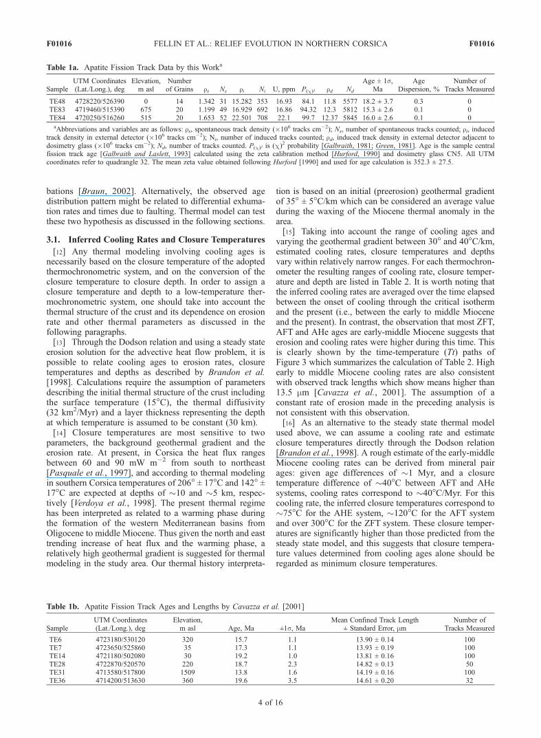
Table 1a. Apatite Fission Track Data by this Worka
SampleUTM Coordinates(Lat./Long.), deg
Elevation,m asl
Numberof Grains rs Ns ri Ni U, ppm P(c)2 rd Nd
Age ± 1s,Ma
AgeDispersion, %
Number ofTracks Measured
TE48 4728220/526390 0 14 1.342 31 15.282 353 16.93 84.1 11.8 5577 18.2 ± 3.7 0.3 0TE83 4719460/515390 675 20 1.199 49 16.929 692 16.86 94.32 12.3 5812 15.3 ± 2.6 0.1 0TE84 4720250/516260 515 20 1.653 52 22.501 708 22.1 99.7 12.37 5845 16.0 ± 2.6 0.1 0aAbbreviations and variables are as follows: rs, spontaneous track density (�106 tracks cm�2); Ns, number of spontaneous tracks counted; ri, induced
track density in external detector (�106 tracks cm�2); Ni, number of induced tracks counted; rd, induced track density in external detector adjacent todosimetry glass (�106 tracks cm�2); Nd, number of tracks counted. P(c)2 is (c)
2 probability [Galbraith, 1981; Green, 1981]. Age is the sample centralfission track age [Galbraith and Laslett, 1993] calculated using the zeta calibration method [Hurford, 1990] and dosimetry glass CN5. All UTMcoordinates refer to quadrangle 32. The mean zeta value obtained following Hurford [1990] and used for age calculation is 352.3 ± 27.5.
Table 1b. Apatite Fission Track Ages and Lengths by Cavazza et al. [2001]
SampleUTM Coordinates(Lat./Long.), deg
Elevation,m asl Age, Ma ±1s, Ma
Mean Confined Track Length± Standard Error, mm
Number ofTracks Measured
TE6 4723180/530120 320 15.7 1.1 13.90 ± 0.14 100TE7 4723650/525860 35 17.3 1.1 13.93 ± 0.19 100TE14 4721180/502080 30 19.2 1.0 13.81 ± 0.16 100TE28 4722870/520570 220 18.7 2.3 14.82 ± 0.13 50TE31 4713580/517800 1509 13.8 1.6 14.19 ± 0.16 100TE36 4714200/513630 360 19.6 3.5 14.61 ± 0.20 32
F01016 FELLIN ET AL.: RELIEF EVOLUTION IN NORTHERN CORSICA
4 of 16
F01016

3.2. Thermal History Interpretation
[17] The negative correlation between age and elevationis intriguing and we see two possible explanations which weinvestigate here. The first hypothesis is that this correlationis due to spatial variation in erosion rate associated with alarge decrease in topographic relief. The second hypothesisis that the different cooling histories reflect exhumation bynormal faulting. In this section, we consider what magni-tude of differential exhumation is needed in either model toproduce the observed age difference.[18] The age-elevation correlation is investigated in
two different areas: (1) the St. Florent region (Figure 4)and (2) the Tenda crystalline massif (Figure 5). The modelsare based on the distance-elevation profiles of samples, onthe time-temperature paths and on the closure temperaturesdiscussed in the previous section.[19] 1. Samples TE6 and TE7 are located in the St. Florent
region, their elevation difference is approximately 300 mand their horizontal distance is �4.3 km. Sample TE6comes from the high-grade Oletta orthogneiss (HP Alpineunit), and sample TE7 from the low-grade Nebbio unit. Asshown in Figure 4, the overlapping AFT and AHe ages ofsample TE7 together with its mean track length of 13.93 ±0.19 mm indicate very rapid cooling of the Nebbio unitthrough temperatures of �110� to �60�C between 19 and16 Ma. The cooling ages of sample TE6 constrain theexhumation of the HP Alpine unit from �236�C at 19 Mato 60�C at 11.8 Ma, and both its ages and its mean tracklength (13.90 ± 0.19 mm) indicate very rapid cooling. Thusboth the Nebbio and the HP Alpine units cooled rapidly butat 19 Ma the Nebbio unit was at a temperature between 110�and 60�C whereas the HP Alpine unit was at 236�C. If weassume that there has been no vertical movement of the HPAlpine unit with respect to the Nebbio unit since Miocene(Figure 4d), the difference in temperature between the twounits at �19 Ma has to be related to a vertical deflection ofthe isotherms. Assuming a geothermal gradient of 35� ±5�C/km, the vertical deflection of the 236�C isotherm is3.5 km. Varying the geothermal gradient between 40� and30�C/km, the vertical deflection ranges from 3.1 to 3.9 km.The alternative model, assuming no relief decrease butrelative vertical motion in response to normal faulting,suggests 3.5 ± 0.4 km rock uplift of the HP Alpine withrespect to the Nebbio unit (Figure 4e).
[20] 2. Five samples were collected in the Tenda crystal-line massif along an 11 km horizontal southwest-northeasttransect, at elevations between 220 and 1509 m (Figure 5).TE36 and TE28 are located at the two ends of the transectand show overlapping AFT and AHE ages, indicating arelatively high cooling rate between 19 and 21 Ma. A high
Table 1c. Apatite (U-Th)/He Data by this Worka
Sample
UTMCoordinates
(Lat./Long.), degElevation,m asl
CorrectedAge, Ma ±2s, Ma Ft mwar, mm Mass, mg U, ppm Th, ppm Th/U
He,ncc STP/mg
TE6 4723180/530120 320 11.8 0.7 0.652 36.8 1.61 18.0 32.0 1.77 23.7TE6 r 4723180/530120 320 11.8 0.7 0.613 31.7 2.04 113.0 47.0 0.42 108.1TE7 4723650/525860 35 18.1 1.1 0.647 37.0 1.37 12.0 20.0 1.67 23.2TE14 4721180/502080 30 20.1 1.2 0.657 37.5 1.51 104.0 111.0 1.07 208.2TE14 r 4721180/502080 30 21.7 1.3 0.686 40.7 4.40 147.0 161.0 1.09 333.3TE28 4722870/520570 220 19.8 1.2 0.632 34.8 1.36 18.0 42.0 2.30 43.2TE28 r 4722870/520570 220 19.2 1.2 0.589 31.6 2.51 26.0 62.0 2.40 55.0TE31 4713580/517800 1509 8.51 0.5 0.604 31.0 1.29 44.0 112.0 2.53 43.9TE36 4714200/513630 360 18.4 1.1 0.564 31.8 5.60 18.0 47.0 2.58 37.0TE36 r 4714200/513630 360 21.2 1.3 0.502 25.0 8.80 27.0 60.0 2.24 52.5TE83 4719460/515390 675 7.70 0.5 0.566 29.0 8.90 102.0 486.0 4.75 114.5TE84 4720250/516260 515 13.4 0.8 0.472 23.3 3.40 66.6 160.0 2.40 80.0
aAbbreviations are as follows: Ft, a-ejection correction [Farley et al., 1996; Farely, 2002]; mwar, mass-weighted average radius (or simply radius forsingle grains).
Figure 2. (a) Diagram showing apatite fission track (AFT)and (U-Th)/He (AHe) ages projected along a southwest-northeast direction and elevation of samples. (b) Diagramshowing that differences between fission track and (U-Th)/He ages are significant only for samples located at thehigher elevations and/or younger than �16 Ma.
F01016 FELLIN ET AL.: RELIEF EVOLUTION IN NORTHERN CORSICA
5 of 16
F01016

cooling rate is consistent with the very high mean tracklength of both samples (14.61 ± 0.20 mm and 14.82 ±0.13 mm, respectively) The remaining three samples arelocated in the core of the massif and, together with sampleTE28, they show a trend of ages increasing from southwestto northeast. Where available, the mean track length doesnot show significant variation either with sample age orlocation, and it indicates high cooling rates for all samples.Samples TE36 and TE31 are located at 360 m and at1509 m, respectively, i.e., at the foothills and near the topof the most elevated part of the massif, and show the highestdifference in age. The time-temperature paths of these twosamples show that for example at 13.8 Ma, sample TE31was �110�C, whereas sample TE36 was �46�C. Again, wecalculated models assuming either a relief decrease or adifferential motion due to faulting. Assuming a geothermalgradient of 35�C/km, the deflection of the 110�C isothermcorresponds to 3.1 km (Figure 5d). Varying the geothermalgradient between 40� and 30�C/km, the vertical deflectionranges from 2.9 to 3.4 km. In the fault model, the increasingtrend of ages from southwest to northeast suggests possiblenormal movement along a fault with footwall tilt resultingfrom flexural unloading as shown in Figure 5e.[21] The calculation above demonstrates that either of the
two hypotheses could potentially explain the age differen-tial. The fault hypothesis supports that extensional faultsmight have been active also at shallow depths, under brittleconditions, and they might have produced significant offsetsof the order of 3–4 km. The relief-decrease hypothesis isviable, but the fact that the thermal perturbation decreasesexponentially with depth [Turcotte and Schubert, 1982] andthat there is perturbation of even the deep ZFT closureisotherm (236�C) suggests that this effect must be large.This implies either differential erosion due to very highsurface relief, much higher than 3 km in the Tenda massifand than 4 km in the St. Florent region, or a geothermalgradient higher than 40�C/km required to attain the higherdeflection at depth. We can test the relief-decrease modelwith the numerical analysis of the topographic perturbationeffect as given in the solution by Mancktelow andGrasemann [1997]. This will be discussed in the nextsection. Moreover, further constraints to test both modelscan be derived from geological data (see section 3.4).
3.3. Influence of Topographic Relief
[22] The effect of thermal disturbance related to advectionand topography can be quantified using the steady state
solution of Mancktelow and Grasemann [1997]. Thisanalytical solution derives the convex-concave shape andthe depth of the isotherms as a function of the amplitude(2H0) and wavelength (l) of topography, the backgroundthermal structure of the crust and the erosion rate duringcooling. Thus this solution enables us to quantify therelative deflection of the isotherms which can be describedas d, where d = (Zv � Zr)/2H0 and Zv and Zr are depths to theisotherm (with respect to the mean elevation) beneath valleyand ridge, respectively.[23] Parameters for the calculations and the most signif-
icant results are reported in Figure 6 and briefly describedbelow. The wavelength of topography used for calculationsrange between 10 and 20 km consistent with the presenttopographic relief in northeastern Corsica which is charac-terized by a l on the order of 15 km (Figure 7). Given thatsince middle Miocene no major tectonic events are thoughtto have occurred in the area, and that at present the Miocenebasins still lie in topographic lows, l has likely remainedconstant at least since the early Miocene. Howevertopographic amplitude might have changed significantly,thus calculations have been performed with (1) a 2H0
value of 1500 m, consistent with the present amplitude oftopographic relief in the study area and (2) a 2H0 value of3000 m which represents the case of the high early tomiddle Miocene relief as predicted by the relief-decreasemodel (see section 3.2). The erosion rate assumed forcalculations has been derived from the direct conversionof a cooling rate of �40�C/Myr to �1 km/Myr assuming aconstant geothermal gradient of 35� ± 5�C/km. Parametersconcerning the thermal structure of the crust in Corsicahave been derived from previous studies on the present heatflux and rheology of the Western Mediterranean [Pasqualeet al., 1997, 2002; Verdoya et al., 1998]. The inferredgeothermal gradient varies between 30� and 40�C/km to a
Figure 3. Time-temperature paths based on fission trackand (U-Th)/He ages on apatite from northeastern Corsicaand on closure temperatures calculated following Brandonet al. [1998] (see section 3.1 for details). This diagramshows the decreasing trend of cooling rates from 30� to40�C/Myr during the early-middle Miocene to less than7�C/Myr from the middle Miocene to the present.
Table 2. Cooling Rates, Closure Temperatures, and Depth
Inferred From Cooling Ages Through the Dodson Relation and
the Steady State Solution for the Advective Heat Problema
ZFT AFT AHe
Cooling rates, �C/Myr30�C/km 10.7 4.7 1.840�C/km 11.5 7.1 6.3
Closure T, �C30�C/km 23.5 108 5640�C/km 23.6 111 63
Closure depths, km30�C/km 5.0 2.2 1.040�C/km 6.5 2.9 1.5aFollowing Brandon et al. [1998].
F01016 FELLIN ET AL.: RELIEF EVOLUTION IN NORTHERN CORSICA
6 of 16
F01016

depth of 10 km as shown in Figure 6. The deflection valuesd for the ZFT closure temperature (Tc) isotherm is lowerthan 0.3 indicating that this isotherm is only slightlyaffected by topographic bending whereas for the AFT Tcisotherm d range between 0.2 and 0.5 (Figure 6). Thesed values for the AFT Tc isotherm correspond to depthdifferences below the ridge and below the valley rangingbetween 340 and 680 m for a 2H0 of 1500 m, and between720 m and 1450 m for a 2H0 of 3000 m. The d values for
the AHe Tc isotherm could be determined only for a 2H0 of1500 m, and in this case they range between 0.5 and 0.7corresponding to depth differences around 900 m. For a2H0 of 3000 m, the AHe Tc isotherm is strongly bent andlies at very shallow depths. In this case, the Mancktelowand Grasemann solution does not provide a reliable destimate because the isotherm depth can be calculated onlywhen the isotherm is significantly deeper than the meanelevation (y = 0, Figure 6). Thus the d values obtained can
Figure 4. Modeling of samples TE6 and TE7 from the St. Florent region based upon (a) the time-temperature paths, (b) the elevation-distance profiles, and a constant geothermal gradient of 35�C/km.The shaded regions in Figure 4a represent the envelopes of the errors of fission track and (U-Th)/He ageson apatite (2s) and of closure temperatures (±10�C). (c) Legend of models shown in Figures 4d and 4e.(d) Distribution of isotherms, consistent with cooling, in response to high-relief erosion. (e) Distributionof isotherms offset by extensional faulting.
F01016 FELLIN ET AL.: RELIEF EVOLUTION IN NORTHERN CORSICA
7 of 16
F01016

be regarded as meaningful only for the closure isothermsfor AFT and ZFT, and for the AHE Tc isotherm solely inthe low-relief case.[24] The differential isotherm elevation for the AFT Tc
and ZFT Tc obtained through the two-dimensional analysisof topographic disturbance are much lower than thosepredicted from the one-dimensional relief decrease modeldiscussed in section 3.2. In fact, the one dimensional modelsuggests that the data require differential elevation on theclosure isotherms of the order of 3–4 km for the ZFTisotherm in the St. Florent case and a similar value for theAFT isotherm in Tenda massif case. The two-dimensionalmodeling shows that this can be attained only with verylarge amplitude topography.
3.4. Constraints From Geologic Data
[25] The models discussed in section 3.2 have beencompared with results of the thermal perturbation analysisbased on a topographic relief with a wavelength between 10and 20 km, and an amplitude between 1500 and 3000 m.The topographic wavelength in northeastern Corsica has
likely remained constant from the early Miocene to thepresent whereas topographic amplitude might have changedsignificantly, and the relief-decrease model suggests that thepresent inverse age-elevation relationship might be relatedto some extent to the deflection of the isotherm due to thedifferential erosion associated with a reduction of a veryhigh relief during the early-middle Miocene. Geologic datarelative to the Miocene tectonic deformation and to fluvialadjustments inferred from the provenance of alluvial sedi-ments in the study area provide further constraints on thethermal problem which has been so far investigated mostlyon the basis of cooling ages alone.[26] In the St. Florent region, the Nebbio and the HP
Alpine units are separated by a west dipping Alpine contactreactivated as an extensional fault under ductile-to-brittleconditions [Jolivet et al., 1998]. During the early to middleMiocene, shallow water sediments were deposited above theNebbio unit in the St. Florent basin, which is bordered anddissected by syn- to postsedimentary extensional faults[Ferrandini et al., 1998; Jolivet et al., 1998; Fellin et al.,2005]. There are three primary source regions for pebbles in
Figure 5. Modeling on samples TE31 and TE36 from the Tenda massif based upon (a) the time-temperature paths, (b) the elevation-distance profiles, and a constant geothermal gradient of 35�C/km.The shaded regions in Figure 5a represent the envelopes of the errors of fission track and (U-Th)/He ageson apatite (2s) and of closure temperatures (±10�C). (c) Legend of models shown in Figures 5d and 5e.(d) Distribution of isotherms, consistent with cooling, in response to high-relief erosion. (e) Distributionof isotherms offset by extensional faulting.
F01016 FELLIN ET AL.: RELIEF EVOLUTION IN NORTHERN CORSICA
8 of 16
F01016

Figure 6
F01016 FELLIN ET AL.: RELIEF EVOLUTION IN NORTHERN CORSICA
9 of 16
F01016

the St. Florent Miocene sediments: a local one providingsubangular pebbles from the Nebbio and the HP Alpineunits, and two distal ones supplying rounded rhyolitepebbles from the Hercynian basement and rare orthogneisslikely from the Tenda crystalline massif. This indicates thatthere was some relief where these units were exposed, and
that the local source regions likely formed the shoulders ofthe basin (Figure 8). Thus extension was active during theearly to middle Miocene.[27] The Tenda massif is located between the St. Florent
basin to the east and the Hercynian basement to the west/southwest. Cooling ages and provenance of pebbles in the
Figure 7. Simplified geological sketch map of northeastern Corsica with the location of four west-easttopographic profiles. The profiles show the wavelength of present topography.
Figure 6. Topographic perturbations of the isotherms at depth determined by the steady state solutions ofMancktelow andGrasemann [1997]. (a) Thermal parameters used for calculations (see text for details). (b) Diagram showing the variation ofthe geothermal gradient between 30� and 40�C/km to a depth of 10 km as inferred from the assumed thermal parameters.(c) Diagrams showing the convex-concave shape of specific isotherms at depth as determined for relief with a wavelength(l) ranging between 10 and 20 km and an amplitude (2H0) of 1500 and 3000 m. The isotherms correspond to the closuretemperature (Tc) isotherms for the fission track dating systems on zircon (ZFT) and apatite (AFT) and for the (U-Th)/Hesystem on apatite (AHe). Closure temperatures have been inferred following Brandon et al. [1998] and correspond to�60�C for the AHe system, �110�C for the AFT system, and �236�C for the ZFT system. Variable d describes thedeflection of the isotherms and corresponds to (Zv � Zr)/2H0, where Zv and Zr are depths to the isotherm (with respect tothe mean elevation) beneath valley and ridge. Given that depths are calculated with respect to the mean elevation (y = 0), theisotherms at levels shallower than the mean elevation cannot be determined from this solution (e.g., the AHe Tc isothermwith a 2H0 of 3000 m). In this case the shallowest isotherms are considered approximately parallel to the topographicsurface, and their depth is determined as a function of erosion rate and heat production (see shaded dashed lines).
F01016 FELLIN ET AL.: RELIEF EVOLUTION IN NORTHERN CORSICA
10 of 16
F01016

Miocene sediments indicate not only that during the early tomiddle Miocene the Tenda massif was exposed at surface,but also that its relief was not high enough to obstruct thealluvial supply from the Hercynian basement (Figure 8). Atpresent no detritus from the Hercynian basement reaches theSt. Florent basin, and the top of the St. Florent successiondates back to middle Serravallian, thus relief likely in-creased, rather than decreased during the late Miocene(Figure 8 [Orszag-Sperber and Pilot, 1976]). Moreover,the Tenda massif is in contact to the west with the Balagneunit, and this contact is a west-southwest dipping Alpinefault reactivated under an extensional regime as did the faultbetween the Nebbio and HP Alpine units. Geologic dataindicate that (1) during the early to middle Miocene theTenda crystalline massif was bordered on the west by anextensional fault and it was uplifting but (2) its relief wasrelatively low at least until middle Serravallian. This lowrelief suggests that the early to middle Miocene topographicamplitude might have been lower than the present dayimplying deflection values lower than those calculated insection 3.3.[28] We can conclude that geologic and thermochrono-
logic data support an early to middle Miocene high coolingrate which is related to erosion and to tectonic denudation inresponse to rock uplift driven by the extensional tectonicsunder a thermal regime characterized by a high geothermalgradient. We can envisage, also, that the interaction of theseprocesses produced significant thermal perturbationsreflected in differential cooling rates and ages. Moreover,geologic evidence does not support the hypothesis that earlyto middle Miocene topographic thermal perturbations in
northeastern Corsica might have been related to the pres-ence of a high relief formed earlier.
3.5. Exhumation Rate and Relief Evolution
[29] Time-temperature paths indicate that high coolingrates up to �40�C/Myr affected much of northern Corsicauntil �14 Ma (Figure 3). After this, cooling rates decreasedto less than�7.5�C/Myr (Figure 3), although the data cannotdistinguish between a gradual or an abrupt rate decrease.Converting cooling rates directly to exhumation ratesthrough a constant geothermal gradient, we obtain early tomiddle Miocene exhumation rates �1 km/Myr, althoughthese rates should be corrected for the effect of topographicperturbations. High exhumation rates during the early tomiddle Miocene are also suggested by the detrital AFT agederived from the pebble sample, likely from the Tendamassif, deposited in the St. Florent basin at �16.5 Ma[Fellin et al., 2005]. The resulting lag time, as defined byGarver et al. [1999], is of about 1.7 Myr and documentsrapid exhumation at a rate of about 1.5 km/Myr. High earlyto middle Miocene exhumation rates are in contrast to ratesless than 0.2 km/Myr after 14 Ma, based on large AFT-AHeage differences for samples with late Miocene ages.[30] The provenance of pebbles in the Neogene basins of
Corsica provides some constraint on the river networkevolution which is related to the evolution of relief. In theFrancardo basin, early to middle Miocene alluvial depositscomprise pebbles and blocks exclusively from the Hercy-nian basement (Figure 8). As discussed above, provenancedata from the St. Florent basin document an importantchange in river drainage, probably in the late Miocene. In
Figure 8. Paleogeographic sketch maps of Corsica based upon the different source areas of pebbles inthe Miocene marine shallow water sediments, which are interfingered with alluvial deposits and atpresent are located onshore.
F01016 FELLIN ET AL.: RELIEF EVOLUTION IN NORTHERN CORSICA
11 of 16
F01016

the Aleria succession, the appearance of pebbles of Alpineprovenance in the early Messinian units has been interpretedas related to the subaerial exposure of the Alpine unitsduring Tortonian (Figure 6 [Orzsag-Sperber and Pilot,1976; Caron and Loye-Pilot, 1990; Loye-Pilot et al.,2004]). These data indicate that significant changes of relieflikely occurred during Tortonian when the exhumation rateswere low over the study area. They also suggest a possiblecorrelation between changes of relief and compressionaldeformation inferred to have occurred during the middleSerravallian to Tortonian [Fellin et al., 2005]. Finally, theyindicate that the high-grade Alpine units have been exposedat least locally since the Burdigalian, and that the paleoge-ography of exposed bedrock units did not change signifi-cantly after the late Miocene.
4. Incision Rate
[31] Radioisotopic data alone are not able to constraintopographic evolution over short timescales. However, acomparison of spatial distribution of direct or indirectmeasures of erosion at distinctly different timescalesgives some indications about the evolution of a landscape[Pazzaglia and Brandon, 2001; Burbank, 2002].[32] Toward these ends, we use values of incision rates
obtained by strath terrace heights above bedrock channels asdescribed by Pazzaglia and Brandon [2001]. This method isbased on the assumption that there is no lag time betweenthe cutting of the strath and the deposition of the overlyingstrath terrace.[33] West of the Marana plain, the Golo river flows over
the bedrock in a narrow valley where 2- to 5-m-thick relicsof alluvial deposits lie on top of strath surfaces (Figure 9).Exposure conditions allow only local correlation of thealluvial deposits along the valley with those in the plain.Alluvial deposits of the Golo river in the Marana plain havebeen subdivided in seven units (N1 to N7) by Conchon[1977, 1978]. The N4 deposits have been correlated to theoxygen isotopic stage (OIS) 5a on the basis of interbeddingrelations with marine sediments and oxygen isotopeanalyses of planktonic foraminifers from cores offshoreCorsica [Conchon, 1985, 1986]. Thus we assign an age of80–90 ka [Martinson et al., 1987] to the N4 unit. Theweathering degree and the relative stratigraphy of thealluvial deposits indicate a possible correlation betweenthe N3 unit and the upper OIS 6, dated between 150 and130 ka, and the N2 unit might have a minimum age of190 ka based on the correlation with the OIS 7a.[34] The height of the strath was obtained from 1:25,000
topographic maps by IGN of France, and elevations werechecked in the field using an altimeter with a two standarderror precision of 5 m. Despite the many uncertainties aboutthe age of the straths and the precision of measurements, theresulting incision rates vary in a relatively narrow rangebetween 0.2 and 0.4 km/Myr over the past 105 years.Figure 8 shows that the incision rates are significantlyhigher than the exhumation rates inferred for the last�15 Ma from AFT and AHe thermochronology.
5. River Profiles
[35] Channel and valley profiles of rivers vary their shapethrough time in order to reach a balance between denudation
and rock uplift [e.g., Pazzaglia et al., 1998]. For the channelprofile the river length is measured along the channelthalweg; for the valley profile the elevation of the valleybottom is projected to a vertical plane oriented along thevalley axis. Channel and valley profiles differ in that theoverall channel profile shape reflects the distribution ofstream power along a channel, whereas the valley profile isthe result of fluvial landscape evolution and records geo-morphic evolution over longer timescales than the channelprofile. A regular valley profile can be reproduced by apower law, i.e., the theoretical profile of a steady stateerosional river [Sklar and Dietrich, 1998; Snyder et al.,2000]. The comparison between the valley profile shape andthe theoretical profile permits us to identify profile irregu-larities which might be related to spatial variations of rockuplift rates and/or to a transient state of the fluvial land-scape. Long profiles exhibit large convexities primarily intectonically active settings, particularly in the presence ofresistant rock types or local active structures, and to a lesserextent in tectonically stable setting where precipitation ishighly variable.[36] Channel and valley profiles of three main rivers of
northeastern Corsica have been plotted and fitted by apower law to identify profile irregularities.[37] 1. The Golo river drains the most elevated area of
Corsica culminating in Mt. Cinto (2706 m; Figure 10a). Thewestern southwest-northeast Golo segment cuts throughHercynian rocks of similar erosional resistance. The S-Nsegment flows along the Hercynian/Alpine contact, and theeastern segment incises the various Alpine units (‘‘SchistesLustres’’ s.l.). The channel lies above alluvial deposits in theMarana plain. The transition from bedrock to alluvialchannel is abrupt and is located to the east of a main brittleextensional paleofault, WNW/NW trending. Upstream ofthis fault, the river incises narrow meanders in the bedrockand the valley profile shows marked irregularities. Thisrelation suggests a possible recent reactivation of the fault orthe presence of lithologic discontinuities. The valley profileshows two main irregularities: (1) a convexity coincidingwith a high in the watershed profile along the western Golosegment and (2) a smooth convexity along the eastern Golosegment. These convexities are much larger in scale than thepossible effects related to bedrock heterogeneities in theAlpine and Hercynian units.[38] 2. The Fiume Alto river incises the ‘‘Schistes
Lustres’’ units (Figure 10b). The thickness of alluvialdeposits along almost the entire length of the channel isestimated to be less than 3 m. Its profile is �30 km long andshows three different trends. Meanders incised in thebedrock are located at the margin with the Marana plain,and coincide with a major northwest trending structurallineament. Both valley and channel profiles show a broadconvexity, larger in scale than irregularities related tolithologic differences. The eastern end of the convexitycoincides with the incised meanders.[39] 3. The Bevinco stream flows from the Tenda
crystalline massif, through the ‘‘Schistes Lustres’’ units,to the Marana plain with an overall WSW-ENE direction(Figure 10c). Its profile is nearly 40 km long. Thestream incises a canyon valley along its eastern segment.Along the channel, deposits with a significant thickness(�10 m) are present only over an area some tens of
F01016 FELLIN ET AL.: RELIEF EVOLUTION IN NORTHERN CORSICA
12 of 16
F01016

meters wide upstream from the canyon. The canyoncoincides with a pronounced knickzone of the valleyand channel profiles.[40] The convexities of the three river profiles are not
related to lithologic heterogeneity because their width ismuch larger than lithologic variations. Given the relativelyconstant areal distribution of rock types over the last�8 Myr, the convexities of river profiles in Corsica canbe interpreted as possibly related to local variations of therock uplift rate. The large-scale convexities of the Golo,Fiume Alto and Bevinco profiles are located along the
north-south, Cap Corse–Bastia and Castigniccia rangewhose recent uplift is supported by leveling data [Lenotreet al., 1996]. This range is a topographic and structural highdelimited by polyphase brittle faults locally showing reversereactivation that can be related to compressional deforma-tion observed in the Pliocene-to-Quaternary sediments ofthe Aleria and Marana plains [Fellin et al., 2005]. Thisinferred compressional deformation has been attributed tothe effects of far-field tectonic activity, and their occurrencesuggest a possible relation to topographic perturbations. Apotential relation between topographic perturbations and
Figure 9. (a) Sketch map of the Marana plain and eastern Golo valley modified after Conchon [1977]and Lahondere et al. [1994] and projection along channel of the terraces of the Golo river. (b) Locationmap of the Golo river and of the thermochronologic data. (c) Diagrams showing the erosion ratesobtained from cooling ages versus the bedrock incision rates based on strath terraces data.
F01016 FELLIN ET AL.: RELIEF EVOLUTION IN NORTHERN CORSICA
13 of 16
F01016

compressional deformation is also evident during the lateMiocene (see section 3.5).
6. Conclusion
[41] Apatite (U-Th)/He and fission track ages from north-eastern Corsica record rapid exhumation at rates greaterthan 1 km/Myr during the early to middle Miocene whenthe Corsica-Sardinia block was drifting off from southernFrance [Vigliotti and Langenheim, 1995]. There is aninverse relationship between elevation and thermochrono-metric ages observed in northeastern Corsica, which can beinterpreted as being the result of early to middle Mioceneextensional tectonics, however a contribution from topo-graphic influence on isotherm depths cannot be excluded if
relief were considerably larger in the early to middleMiocene. Detrital AFT ages and provenance of pebblessuggest that the relief of northern Corsica grew in responseto extensional tectonics and exhumation during the Mio-cene. After the middle Miocene, erosion rates and bedrockincision rates decreased to less than 0.4 km/Myr. Thus thepresent topography of northern Corsica can be envisaged asa paleotopography that has been sustained over the last14 Ma by low erosion rates. These low erosion rates areconsistent with the lack of significant active tectonics andgrowth of topography, as expected for the study area. On theother hand, the low erosion rates over the last 14 Ma are incontrast with the high relief of Corsica. Our data suggestthat the occurrence of short-term tectonic or geomorphicevents may have perturbed topography and, at least partly,
Figure 10. Valley and channel profiles of three main rivers of northeastern Corsica, with their locationsin the inset. Valley profiles are fit with a power law curve to mark the irregularities of the river profiles.The irregularities of the river profiles can be correlated with the topographic highs shown by theprojection of the watershed along channel.
F01016 FELLIN ET AL.: RELIEF EVOLUTION IN NORTHERN CORSICA
14 of 16
F01016

provide an explanation for this contrast. Evidence of theseshort-term events is supported by three different types ofdata. First, the provenance of pebbles in the Miocenedeposits indicate that a major pulse of surface uplift innortheastern Corsica occurred soon after the middle Serra-vallian, thus after the decrease in exhumation rate. Second,bedrock erosion rates over 104 years are locally significantlyhigher than long-term erosion rates over 106 years. Third,comparison between theoretical and actual river profilesdemonstrates that the stream power along three main fluvialsystems of northern Corsica is not sufficient to create andmaintain regular valley profiles. These events may beassociated with compressional deformation related to far-field stress changes that affected the study area during themiddle Serravallian to Tortonian and Pliocene to Quaternarytimes [Fellin et al., 2005], that is during the same periods oftime when the topographic perturbations are recorded. Thissuggests that the effects of relatively subtle tectonic activitymay be detected through the comparison between long-termand short-term erosion rates, and by river profiles despiteoverall low long-term erosion rates.
Appendix A: Analytical Procedures forAge Determinations
A1. Apatite Fission Track Analysis
[42] Sample preparation for the AFT analysis consists ofthree main procedures: separation, etching and irradiation.Apatites are separated from �5 kg bulk samples usingstandard heavy liquids (Li-metatungstate and methyleneiodide) and magnetic separation techniques. Spontaneoustracks are revealed through polishing of grain mounts andetching with 5N HNO3 at 20�C for 20 s. Samples areirradiated with thermal neutrons in the O.S.U. Triga reactor(USA) with a nominal neutron fluence of 9 � 1015 n cm�2.The standard glass CN-5 is used as a dosimeter to measurethe neutron fluence. After irradiation, induced fission tracksin the low-U muscovite that cover apatite grain mounts andglass dosimeter are etched in 40% HF at 20�C for 40 min.Apatite fission track central ages (±1s [Galbraith andLaslett, 1993]) are measured and calculated using theexternal detector and the zeta calibration methods withIUGS age standards [Hurford, 1990].
A2. (U-Th)/He Dating
[43] Apatite (U-Th)/He ages were measured on singlegrains, and performed by Nd:YAG laser heating for Heextraction and sector inductively coupled plasma massspectrometry (ICP-MS) for U-Th determinations at YaleUniversity. He was measured by 3He isotope dilution usinga quadrupole mass spectrometer following cryogenic puri-fication. Uranium and Th were measured by 229Th and 233Uisotope dilution using a Finnigan Element 2 inductivelycoupled plasma mass spectrometer. a-ejection was cor-rected using the method described by Farley et al. [1996]and Farley [2002]. Estimated 2s uncertainty is 6% forapatite He ages.[44] Dated crystals were hand-picked from separates with
high-power (160�) stereo-zoom microscopes with crosspolarization for screening inclusions. Selected crystals weremeasured and digitally photographed in at least two differ-ent orientations for a-ejection corrections. Crystals were
loaded into 1 mm Pt foil tubes, which were then loadedinto copper or stainless steel sample planchets, loadedinto a �10 cm laser cell with sapphire window,connected by high-vacuum flexhose to the He extrac-tion/measurement line. Once in the laser cell and pumpedto <10�7–10�8 torr, crystal-bearing foil tubes were indi-vidually heated for 3 min using power levels of 1–5 Won the Nd:YAG. Temperatures of heated foil packets werenot measured, but from experiments relating luminosityand stepwise degassing of apatite, we estimate typicalheating temperatures of �950�C.
[45] Acknowledgments. This research was funded by MIUR grant97/98 and 99/00 to Gian Gaspare Zuffa who is thanked for his constantsupport. Frank J. Pazzaglia is acknowledged for his suggestions and thefruitful discussion. We are indebted to Sean Willett who helped us duringthe preparation of the manuscript. Special thanks to Darryl Granger forreading an early version of the paper and for the useful review. We wouldlike to express our sincere thanks to the reviewers Andrew Gleadow andPeter van der Beek.
ReferencesBrandon, M., M. K. Roden-Tice, and J. I. Garver (1998), Late Cenozoicexhumation of the Cascadia accretionary wedge in the Olympic Moun-tains, NW Washington State, Geol. Soc. Am. Bull., 110, 985–1009.
Braun, J. (2002), Quantifying the effect of recent relief changes on age-elevation relationships, Earth Planet. Sci. Lett., 200, 331–343.
Brunet, C., P. Monie, L. Jolivet, and J.-P. Cadet (2000), Migration ofcompression and extension in the Tyrrhenian Sea from 40Ar/39Ar ageson micas along a transect from Corsica to Tuscany, Tectonophysics, 321,127–155.
Burbank, D. W. (2002), Rates of erosion and their implications for exhu-mation, Mineral. Mag., 66, 25–52.
Caron, J. M. (1994), Metamorphism and deformation in Alpine Corsica,Schweiz. Mineral. Petrogr. Mitt., 74, 105–114.
Caron, J. M., and M. D. Loye-Pilot (1990), Notice Explicative de la FeuillePietra-di-Verde Carte Geologique de la France a 1/50000, BRGM,Orleans, France.
Cavazza, W., M. Zattin, B. Ventura, and G. G. Zuffa (2001), Apatite fission-track analysis of Neogene exhumation in northern Corsica (France), TerraNova, 13, 51–57.
Cohen, C. R., R. A. Schweikert, and A. L. Odom (1981), Age of emplace-ment of the Schistes Lustres Nappe, Alpine Corsica, Tectonophysics, 72,267–284.
Conchon, O. (1977), Neotectonique en Corse orientale d’apres l’etudedes formations quaternaires: Comparaison entre la Marana et la plained’Aleria, Bull. Soc. Geol. Fr., 19, 631–639.
Conchon, O. (1978), Quaternary studies in Corsica (France), Quat. Res., 9,41–53.
Conchon, O. (1985), Le Quaternaire litoral de Corse: Nouvelles donnees,Bull. Assoc. Fr. Quat., 1, 13–20.
Conchon, O. (1986), Correlations entre les formations glaciaires, fluviatileset marines de Corse et les sediments sous-marins de Mediterraneeoccidentale au Pleistocene superieur, Rev. Geol. Dyn. Geogr. Phys., 27,85–93.
Cubells, J. F., J. Ferrandini, M. Ferrandini, J. Gaudant, and M. D. Loye-Pilot (1994), Presence du genre Aphanius NARDO, famille des Cypri-nodontidae, dans le Miocene du Bassin de Francardo Ponte Leccia(Corse), Geol. Mediter., 21, 19–24.
Daniel, J. M., L. Jolivet, B. Goffe, and C. Poinssot (1996), Crustal-scalestrain partitioning: Footwall deformation below the Alpine Oligo-Miocene detachment of Corsica, J. Struct. Geol., 18, 41–59.
Farley, K. A. (2000), Helium diffusion from apatite: General behavior asillustrated by Durango fluorapatite, J. Geophys. Res., 105, 2903–2914.
Farley, K. A. (2002), (U-Th)/He dating: Techniques, calibrations, andapplications, Min. Soc. Am. Rev. Mineral. Geochem., 47, 819–844.
Farley, K. A., R. A. Wolf, and L. T. Silver (1996), The effects of long alpha-stopping distances on (U-Th)/He ages, Geochim. Cosmochim. Acta, 60,4223–4229.
Fellin, M. G., V. Picotti, and M. Zattin (2005), Neogene to Quaternaryrifting and inversion in Corsica: Retreat and collision in the westernMediterranean, Tectonics, 24, TC1011, doi:10.1029/2003TC001613.
Ferrandini, M., J. Ferrandini, M. D. Loye-Pilot, J. Butterlin, J. Cravette, andM. C. Janin (1998), Le Miocene du Bassin de Saint-Florent (Corse):Modalites de la transgression du Burdigalien Superieur et mise en evi-dence du Serravallien, Geobios, 31, 125–137.
F01016 FELLIN ET AL.: RELIEF EVOLUTION IN NORTHERN CORSICA
15 of 16
F01016

Galbraith, R. F. (1981), On statistical models for fission tracks counts,Math. Geol., 13, 471–478.
Galbraith, R. F., and G. M. Laslett (1993), Statistical models for mixedfission track ages, Nucl. Tracks Radiat. Meas., 21, 459–470.
Gallagher, K., R. W. Brown, and C. Johnson (1998), Fission track analysisand its application to geological problems, Annu. Rev. Earth Planet. Sci.,26, 519–572.
Garver, J. I., M. T. Brandon, M. Roden-Tice, and P. J. J. Kamp (1999),Exhumation history of orogenic highlands determined by detrital fission-track thermochronology, Spec. Publ. Geol. Soc. London, 154, 283–304.
Gibbons, W., and J. Horak (1984), Alpine metamorphism of Hercynianhornblende granodiorite beneath the blueschists facies Schistes Lustresnappe of NE Corsica, J. Metamorphic Geol., 2, 95–113.
Green, P. F. (1981), A new look at statistics in fission track dating, Nucl.Tracks, 5, 77–86.
Hurford, A. J. (1990), Standardization of fission track dating calibration:Recommendation by the Fission Track Working Group of the I. U. G. S.Subcommission on Geochronology, Chem. Geol. Ist. Geosci. Sect., 80,171–178.
Jolivet, L., J. M. Daniel, and M. Fournier (1991), Geometry and kinematicsof ductile extension in Alpine Corsica, Earth Planet. Sci. Lett., 104, 278–291.
Jolivet, L., C. Faccenna, B. Goffe, M. Mattei, F. Rossetti, C. Brunet,F. Storti, R. Funiciello, J. P. Cadet, N. d’Agostino, and T. Parra (1998),Midcrustal shear zones in postorogenic extension: Example from thenorthern Tyrrhenian Sea, J. Geophys. Res., 103, 12,123–12,160.
Jolivet, L., D. Frizon De Lamotte, A. Mascle, and M. Seranne (1999), TheMediterranean basins: Tertiary extension within the Alpine Orogen—Anintroduction, Spec. Publ. Geol. Soc. London, 156, 1–14.
Jourdan, C. (1988), Balagne orientale et massif du Tende (Corse septen-trionale): Etude structurale, interpretation des accidents et des deforma-tions, reconstitutions geodynamiques, Ph.D. thesis, Univ. e de Paris Sud,Paris.
Lahondere, J.-C., O. Conchon, and D. Lahondere (1994), Vescovato, inCarte Geologique de la France, Map 1107, scale 1/50,000, BRGM,Orleans, France.
Lenotre, N., J. Ferrandini, M. Delfau, and J. Panighi (1996), Mouvementsverticaux actuels de la Corse (France) par comparaison de nivellements,C. R. Acad. Sci., Ser. IIa Sci. Terre Planetes, 323, 957–964.
Loye-Pilot, M.-D., M. Durand-Delga, H. Feinberg, Y. Gourinard, andJ. Magne (2004), Les formations burdigaliennes de Corse orientale dansleur cadre geodynamique, C. R. Geosciences, 336, 919–930.
Mancktelow, N. S., and B. Grasemann (1997), Time-dependent effects ofheat advection and topography on cooling histories during erosion, Tec-tonophysics, 270, 167–195.
Martinson, D. G., N. G. Pisias, J. D. Hays, J. Imbrie, T. C. Moore, and N. J.Shackleton (1987), Age dating and orbital theory of the ice ages: Devel-opment of a high resolution 0 to 300,000-year chronostratigraphy, Quat.Res., 27, 1–29.
Orszag-Sperber, F., and M. D. Pilot (1976), Grand traits du Neogene deCorse, Bull. Soc. Geol. Fr., 18, 1183–1187.
Pasquale, V., M. Verdoya, P. Chiozzi, and G. Ranalli (1997), Rheology andseismotectonic regime in the northern central Mediterranean, Tectonophy-sics, 270, 239–257.
Pasquale, V., M. Verdoya, and P. Chiozzi (2002), A possible mechanism forthe thermal asymmetry of the Ligurian basin, Terra Nova, 14, 484–490.
Pazzaglia, F. J., and M. T. Brandon (2001), A fluvial record of long-termsteady state uplift and erosion across the Cascadia forearc high, westernWashington State, Am. J. Sci., 301, 385–431.
Pazzaglia, F. J., T. W. Gardner, and D. J. Merritts (1998), Bedrock fluvialincision and longitudinal profile development over geologic time scalesdetermined by fluvial terraces, in Rivers Over Rock: Fluvial Processes inBedrock Channels, Geophys. Monogr. Ser., vol. 107, edited by K. J.Tinkler and E. E. Wohl, pp. 207–235, AGU, Washington, D. C.
Rossi, P., M. Durand-Delga, J. M. Caron, G. Guieu, O. Conchon, M. D.Loye-Pilot, and J. Rouire (1994), Corte, in Carte Geologique de laFrance, Map 1110, scale 1/50,000, BRGM, Orleans, France.
Sklar, L., and W. E. Dietrich (1998), River longitudinal profiles and bed-rock incision models: Stream power and the influence of sediment supply,in Rivers Over Rock: Fluvial Processes in Bedrock Channels, Geophys.Monogr. Ser., vol. 107, edited by K. J. Tinkler and E. E. Wohl, pp. 237–260, AGU, Washington, D. C.
Snyder, N., K. Whipple, G. Tucker, and D. Merrits (2000), Landscaperesponse to tectonic forcing: Digital elevation model analysis of streamprofiles in the Mendocino triple junction region, northern California,Geol. Soc. Am. Bull., 112, 1250–1263.
Stockli, D. F., T. A. Dumitru, M. O. McWilliams, and K. A. Farley (2003),Cenozoic tectonic evolution of the White Mountains, California andNevada, Geol. Soc. Am. Bull., 115, 788–816.
Stuwe, K., L. White, and R. Brown (1994), The influence of erodingtopography on steady-state isotherms, Earth Planet. Sci. Lett., 124,63–74.
Tribuzio, R., and F. Giacomini (2002), Blueschist facies metamorphismof peralkaline rhyolites from the Tenda crystalline massif (northernCorsica): Evidence for involvement in the Alpine subduction event?,J. Metamorphic Geol., 20, 1–14.
Turcotte, D. L., and G. Schubert (Eds.) (1982), Geodynamics, 450 pp., JohnWiley, Hoboken, N. J.
Verdoya, M., V. Pasquale, P. Chiozzi, and I. T. Kukkonen (1998), Radio-genic heat production in the Variscan crust: New determinations anddistribution models in Corsica (northwestern Mediterranean), Tectono-physics, 291, 63–75.
Vigliotti, L., and V. E. Langenheim (1995), When did Sardinia stop rotat-ing?: New paleomagnetic results, Terra Res., 7, 424–435.
Willett, S. D., and M. T. Brandon (2002), On steady states in mountainbelts, Geology, 30, 175–178.
Wolf, R. A., K. A. Farley, and L. T. Silver (1996), Helium diffusion and lowtemperature thermochronometry of apatite, Geochim. Cosmochim. Acta,60, 4231–4240.
Zarki-Jakni, B., P. van der Beek, G. Poupeau, M. Sosson, E. Labrin,P. Rossi, and J. Ferrandini (2004), Cenozoic denudation of Corsica inresponse to Ligurian and Tyrrhenian extension: Results from apatitefission track thermochronology, Tectonics, 23, TC1003, doi:10.1029/2003TC001535.
Zattin, M., M. G. Fellin, W. Cavazza, V. Picotti, J. A. Vance, and G. G.Zuffa(2001), Exhumation of northern Corsica (France), Geophys. Res.Abstr., 3, 531.
�����������������������M. G. Fellin, V. Picotti, and M. Zattin, Dipartimento di Scienze della
Terra e Geologico-Ambientali, Alma Mater Studiorum, Universita diBologna, via Zamboni 67, I-40126 Bologna, Italy. ([email protected];[email protected]; [email protected])S. Nicolescu and P. W. Reiners, Department of Geology and Geophysics,
Yale University, New Haven, CT 06520, USA. ([email protected];[email protected])
F01016 FELLIN ET AL.: RELIEF EVOLUTION IN NORTHERN CORSICA
16 of 16
F01016