Rejuvenation of Shahjahanabad - Delhi Urban Art Commission
160
CITY LEVEL PROJECTS REJUVENATION OF SHAHJAHANABAD
-
Upload
khangminh22 -
Category
Documents
-
view
2 -
download
0
Transcript of Rejuvenation of Shahjahanabad - Delhi Urban Art Commission

CITY LEVEL PROJECTS
Rejuvenation of Shahjahanabad


delhi urban art Commission
The Delhi Urban Art Commission was set up by an Act of Parliament in 1973
to “advise the Government of India in the matter of preserving, developing
and maintaining the aesthetic quality of urban and environmental design within
Delhi and to provide advice and guidance to any local body in respect of any
project of building operations or engineering operations or any development
proposal which affects or is like to affect the skyline or the aesthetic quality of
the surroundings or any public amenity provided therein”.
(An ISO 9001 : 2008 Certified Organisation)

(An ISO 9001 : 2008 Certified Organisation)
delhi urban art Commission
Prof. Dr. P.S.N. Rao Chairman
Sonali Bhagwati Member (Upto 5 October, 2017)Samir Mathur MemberSonali Rastogi MemberDurga Shanker Mishra Member & Addl. Secretary, Ministry of Housing and Urban Affairs
(Upto 10 August, 2017) Manoj Kumar Member & Addl. Secretary, Ministry of Housing and Urban Affairs
(From 11 August, 2017)Vinod Kumar Secretary
duaC StaffRajeev Kumar Gaur, Raghvendra Singh, Indu Rawat, Amit Mukherji, Uma Bhati, Manju Anjali, Siddharth Sagar,Nihal Chand
Senior ConsultantSatish Khanna
Consultants 3d visualizervisualizerAbhishek Gaurav Nikhil PandeyKomal Gupta Anil KumarNeha Chhabra Nidhi KrishanPriyadarshini GhoshRiti Samanta Sulabh GoelVanita Varma

DELHI URBAN ART COMMISSION with gratitude duly acknowledges the valuable contributions of the
following in making this report:
Organisations / Others
Ministry of Urban Development
Delhi Development Authority
Government of National Capital Territory of Delhi
North Delhi Municipal Corporation
East Delhi Municipal Corporation
South Delhi Municipal Corporation
New Delhi Municipal Council
Geospatial Delhi Limited
Delhi Metro Rail Corporation
Delhi Urban Shelter Improvement Board
BSES Rajdhani Power Limited
BSES Yamuna Power Limited
RWA’s and Area Councillors
Google Earth

*DISCLAIMER*
This report is for academic purposes only and has been prepared on the basis
of information gathered from various sources, in cases without any independent
verification. The report can be adopted and utilized by any Government
Authority/Local Body in the Country and is provided free of cost. The report is
not meant to derive any kind of gain, monetary or otherwise.
Though all efforts have been made to ensure the accuracy of the information
in this report, the same should not be construed as a statement of law or
used for any legal purposes. Delhi Urban Art Commission (DUAC) accepts no
responsibility in relation to the accuracy, completeness, usefulness or otherwise,
of the information contained in the publication. Stakeholders are advised to
verify/check any information with the relevant Government Department(s) and/
or other source(s), and to obtain any appropriate advice before acting on the
information provided in the report.
While adequate measures have been taken to acknowledge the source of
the information used in the report, the nature of the process and the diverse
sources from which information is collected makes it difficult for the Commission
to ascertain whether each piece of information/data impinges upon any third
party intellectual property rights. DUAC shall consequently not be responsible
for any inadvertent and / or bonafide omission of acknowledgement of source of
information.
In no event will the DUAC be liable for any expense, loss or damage including,
without limitation, indirect or consequential loss or damage, or any expense,
loss or damage whatsoever arising out of any person/ stakeholder using or
implementing or relying on any information in this report.
(An ISO 9001 : 2008 Certified Organisation)

Preface
The city of Delhi, capital of this vast land of diversities, is a city laden with
layers of history, a place where civilizations have lived, prospered and perished
over centuries. The modern city today, built over and around a rich tapestry
of heritage, presents an opportunity at every turn, to allow for coexistence of
the past, present and the future. In order to understand this multidimensional
urban spectrum and attempt to plan the future, various city level studies have
been initiated by the DUAC. I hope that these studies will help the planners
of modern day Delhi to carefully articulate urban space, structure, form and
environment and sensitively address future requirements.
I convey my thanks to all the Consultants and Members of the Commission
who have tirelessly worked on this research project to bring out this document.
I also take this opportunity to place on record my sincere appreciation of
the efforts of Secretary and other staff of DUAC for providing the necessary
administrative support to make this happen.
I fondly hope that the authorities of the local, state and national government
take these studies seriously and implement, in right earnest, the suggestions given
herein.
October, 2017 Prof. Dr. P.S.N. Rao Chairman, DUAC
Sd/-

Contents1 Introduction 9 1.1 Cities of Delhi 10
1.2 Building Shahjahanabad 12
1.3 Under British Rule 14
1.4 Present Day Shahjahanabad 15
2 Overview of the Area 24 2.1 Legislative Boundaries 24
2.2 Connectivity 25
2.3 Land Use 26
2.4 Pattern of Development 27
2.5 Sub-Zones 28
3 Analysis – Learning and Understanding 36 3.1 Accessibility 36
3.2 Historical Context 40
3.3 Quality of Space 44
3.4 Significant Activity 47
3.5 Physical Infrastructure 51
3.6 Assessment and Inferences 52
4 Proposals 54 4.1 Development Strategies 54
4.2 Generating an Experience 55
4.3 General Recommendations for Designing Tourist Routes 62
5 Proposals for Built Environment 67 5.1 Activity Node Planning for a Basic Route 67
5.2 Street Restructuring and Façade Uplift 70
6 Proposals for Open Spaces 84 6.1 Landscape redevelopment of the Jama Masjid and Red Fort Precinct 84
6.2 Enhancing Open Spaces around Town Hall Precinct 104
7 Recommendations and Guidelines for Implementation 128 7.1 Legislative Framework 128
8 Annexures 133

Summary
Historically, every city started as a small agglomeration along or around a water
body and over the years it grew in size and value, into a unique settlement, rich
with stories and culture. The evolution of Delhi is similar. What is different however,
is that based on evidence found, it is not one, but seven historic cities, that have
merged to finally form the megalopolis that we now know as Delhi.
“SHAHJAHANABAD” is one such city of Delhi which withstood the test of
time and development. Till date, it holds a diverse population and a pulsating
economy within its walls. The Mughal Emperor Shah Jahan laid the foundation of
this city in 1639, thereby founding the Seventh city of Delhi. It was designed with
forts, mansions, markets, religious buildings and magnificent gardens and became
a self-sufficient fortified sanctuary for royalty, nobility and commoners alike.
However, with time and ensuing political upheavals, the city fell prey to neglect,
consequently degenerating the quality of life it once provided. With the British
Siege, “Shahjahanabad” became the “Old City” of Delhi and the focus shifted to
newer settlements further southwest. A shift of land use from predominantly
residential to trade and commerce can be observed, establishing Old Delhi
as one of Asia’s largest wholesale markets. Further increase in population and
deteriorating infrastructure have created slum-like conditions in the city.
However, despite years of plunder and neglect, it’s magnificent scale is breathtaking.
Apart from the grandeur of what remains of its architectural splendour, the city
also showcases an array of traditional art, craft, beliefs and practices. Various layers
of markets, food stalls, and cultural stops make it an everlasting fete. Today, the city
features an unaccounted built heritage, glistening bazaars, interesting and complex
built forms and an extravagant culture,with the potential to become a global
tourist destination.
Thus, this study aims at Transforming Shahjahanabad into a positive active space
for “Public Interactions”. The motive of the project is to improve the quality
of experience of visitors to Shahjahanabad, and at the same time by using its
heritage tourism potential, rejuvenate the city for its residents. While basing our
analysis on data collected from secondary sources, the project was developed
with the intention of proposing strategies as preliminary actions that could initiate
redevelopment before a large-scale, complete development scheme for the area
is created. With a minimum intervention approach towards recommendations,
our scope of work was to develop and enhance public spaces and experiences.
The objectives of this study are to:
1. Infuse life into the walled city
2. To use the heritage, crafts and culinary experiences of Shahjahanabad to make
it a global tourist destination
3. Improve the quality of public spaces
The development strategy for designing alternatives was to concentrate on
Heritage, Tourism and Development as the key guiding parameters. Tourist
-oriented proposals were devised keeping in mind upgrading and uplifting the
built environment that visitors would experience. Routes have been identified
and interactive activities created along these routes to make it a memorable
experience, while visitors get an opportunity to glimpse the tangible and intangible
heritage of the Old City. At the same time developing open public spaces, creating
windows for revenue generation and enhancing services was also looked into, so
as to facilitate and ease a person’s visit to the area, as well as improve the quality
of space for its residents. Recommendations were proposed to create a sense of
ownership and pride amongst all stakeholders, while increasing the financial and
experiential value of the city.
8 CITY LEVEL ProjECT

The area under study is that which falls within the fortification (line of fortification) built by Shah Jahan in the construction of the city of Shahjahanabad.
Also, known as “Walled City” or “Old City” of Delhi.
It was once filled with mansions of the nobility and members of the royal court, along with elegant mosques and gardens. Today, despite having become extremely crowded and dilapidated, it still serves as the symbolic heart of metropolitan Delhi.
It is surrounded by: •DensecommercialareasofSadarBazaar
and Paharganj on the west•PredominantlyInstitutionalAreaofCivil
Lines on the North•PartofNewDelhitowardsthesouth
and •OpenareassuchasRajGhatand
Shakti Sthal with the riverbank and river beyond towards the east
about the area of Study
Key Map
IntR
Od
Uc
tIO
n
9rEjuVEnaTIon of Shahjahanabad

1.1 Cities of delhi
Geographically, the narrow flat neck of land, known as Delhi, formed the northern gateway to the Gangetic Plain and the Southern Peninsula, thereby establishing it as the most important seat of power. Thus, the building and destruction of the city periodically was an recurring feature in the history of Delhi. Physical evidence of seven such cities remain within parks and habitation in modern Delhi.
It is said that the first city to have been established was Indraprastha, built by the Pandavas during the age of the Mahabharata. Even though the site has been identified as the one where Purana Qila is located, no such archeological evidence is available.
The earliest remains, dating back to the 8th century are that of LAL KOT built by Anangpal II of the Tomar Dynasty of Rajasthan. This is situated in present day Mehrauli. Earlier Anangpal I built a fortification around a village and the Surajkund reservoir.
The ruins of QILA RAI PITHORA built by Prithviraj Chauhan in 1108 can be seen beyond the area of Lal Kot.
Mehrauli remained an important city for the Asian Turks who later invaded India and established the Delhi Sultanate in the subcontinent under the leadership of Qutub-ud-din Aibak, a slave and a general in the army of Mohammad Ghori. He started building the famous Qutub Minar, which was completed after his death by his successor Illtutmish.
To increase defence against continuous Mongol invasions Allaudin Khilji, the second ruler of the succeeding Khilji dynasty, built the fortification of SIRI thereby founding a new capital city in 1303.
Ghiyas-ud-din Tughlaq, founder of the Tughlaq dynasty, also took precautions against Mongol invasion and founded the fortified city of TUGHLAQABAD, further south of Siri.
In 1325, Mohammad Tughlaq moved back to the city of Siri, but to accommodate the growing population, he fortified the area between Qila Rai Pithora and Siri to form JAHAPANAH, parts of which can be seen in Begumpur and Jahanpanah Forest near Greater Kailash II
With the Mongol threat receding, Firoz Shah Tughlaq built the city of FIROZABAD in 1354, closer to the river. The remains of Firoz Shah Kotla survive as evidence of this city.
Before the downfall of the Delhi Sultanate, the Sayyids and Lodis, whose territories were much reduced, concentrated more on building elaborate mausoleums and gardens rather than grand fortified cities. In the 16th century, with the invasion of Babur, Mughal rule was established in India.
Cities of DelhiBase Map Source: Google Earth. Information Source: Delhi Ancient History, edited by Upinder Singh; Shahjahanabad The Sovereign City in Mughal India 1639–1739, Stephen P. Blake
IntR
Od
Uc
tIO
n
10 CITY LEVEL ProjECT

In 1533, Humayun the second Mughal emperor, founded the city of DINPANNAH to the north of Nizamuddin which is believed to be the site of Indraprastha. Interrupting his rule, Sher Shah Suri built SHERGARH around 1538 by adding to the existing city.
After a brief shift of the capital to Agra in 1639, Shah Jahan, the fifth Mughal Emperor returned to Delhi to establish his capital, thereby laying the foundations for the grand city of SHAHJAHANABAD (present day Old Delhi). It was built north of all the existing cities of Delhi, but much closer to the river.
After the British Siege of Delhi in 1857, the city fell into the hands of new rulers, who ruled from Calcutta before shifting their capital to Delhi in 1911. However, during this period Delhi was still used for holding imperial ceremonies and experienced many physical, spatial and cultural changes. In the durbar of 1911, it was announced that Delhi would be the new imperial capital. Construction of New Delhi began in 1912, and it was inaugurated in 1931.
These historical cities have henceforth guided the framework of development in Delhi to bring it to its present form.
Cities of DelhiBase Map Source: Google Earth. Information Source: Delhi Ancient History, edited by Upinder Singh; Shahjahanabad The Sovereign City in Mughal India 1639–1739, Stephen P. Blake
IntR
Od
Uc
tIO
n
11rEjuVEnaTIon of Shahjahanabad

1.2 building Shahjahanabad
a) Availability of high lands near river and natural protection by mountain ranges made this site suitable for new development. Existing features at the site were the Kalan Masjid (1387, Feroz Shah) and Salimgarh Fort (1546, Salim Shah Suri).
e) Chandni Chowk was a tree-lined avenue with shops, residences and public amenities such as a kotwali, mosques and caravan sarais, located along it. A central water canal flowed through the centre.
f) Present day Phawara Chowk (1870s) became a prominent square. Faiz Bazaar was another important commercial street and Daryaganj was a harbour for ships carrying goods.
g) Connections to the fort, masjid and the gates became commercial streets, such as Dariba Kalan (gold, silver), Kinari Bazaar (gilt, sequins), Khari Baoli (spice), Katra Neel (fabrics) etc.
h) The areas within, developed organically into katras (alleys of shops and houses) and kunchas (houses arranged around courts), divided according to the occupation of the residents.
b) An 8 km long mud wall was built. The construction of the Red Fort began in 1639 and was completed in 1648.By 1650 the wall was fortified.
c) In 1650 Nawab Fatehpuri Begum, one of Shah Jahan’s wives, commissioned the construction of Fatehpuri Masjid, as a mosque for the poor. Hauz Qasi was built as a reservoir for the city.
d) From 1644 to 1658 Jama Masjid, the grand mosque for royalty, was built. It was connected to the fort by a short but important street that was mainly used for imperial processions.
IntR
Od
Uc
tIO
n
12 CITY LEVEL ProjECT

i) Gurudwara Sisganj was built in 1783 by Baghel Singh to commemorate the site of the martyrdom of the ninth Sikh guru, Guru Tegh Bahadur. Sunehri Masjid was built for noblemen and merchants.
k) Chandni Chowk and Faiz Bazaar bifurcated the city into 3 distinct parts. 1) Organic growth of residential areas to the south 2) Planned colony of Daryaganj and 3) Royal residences to the north.
j) Near Ajmeri Gate is the tomb of Ghazi-ud-Din Khan, one of Aurangzeb’s noblemen. Attached was a madrasa and between 1825 to 1842 it housed the famous Delhi College. Today, it is the Anglo Arabic School.
The City of Delhi before Siege of 1857Source: www.wikipedia.com The Illustrated London News Jan 16, 1858 . Scan provided by Prof. Emerita Frances Pritchett, Columbia
l) By 1857 the city had grown into a self-sufficient urban hub of culture and commerce with issues of overcrowding and neglect.
In the course of its existence Shahjahanabad saw many invasions, the most famous being that of Nadir Shah of Persia, which led to the death of thousands and widespread destruction of properties. After this, in the 18th century, Delhi underwent a cultural and intellectual renaissance.
Thereafter began the gradual decline of Mughal power in Delhi, with the final blow being dealt by the Mutiny of 1857. The later Mughal Emperors had fraternized with the British and had tried to integrate the new foreign culture into their own. However this angered the mutineers even further and drove them to carry out blind killings of the British during the Mutiny in Delhi in May 1857. Consequently, the growing political power of the British was now not limited to trade alone, and after the Mutiny was quelled, they overthrew the last Mughal Emperor and took over Delhi to establish it as a part of the Empire, thus forcing Shahjahanabad to undergo innumerable physical and cultural changes.
Base Map Source: William McKenzie Map, 1857
IntR
Od
Uc
tIO
n
13rEjuVEnaTIon of Shahjahanabad

1.3 under british Rule
a) 1857 saw the siege of the walled city by the British followed by the Mutiny which started around the areas of Kashmere Gate and Calcutta Gate. The mutineers came from across the river and from the northern ridge.
e) The road that formed the north and south axis of the walled city (now Netaji Subhash Road) was cleared for processions and vehicles.
f) In 1913–14 the wall between Kabuli Gate and Lahori Gate was demolished to build Naya Bazaar and Shraddhanand Marg, and also to create space for the growing population.
g) In 1930, again part of the wall between Ajmeri Gate and Delhi Gate was demolished. Following this further demolition was done to accommodate the growing population.
h) At present only 5 out of 13 gates and a part of the wall between Delhi and Kabuli Gate to the east of the Red Fort remain as evidence of the grandeur of the city.
b) Three Durbars were held in 1877,1903 and 1911 for which many prominent buildings within the Red Fort and walls were demolished and new structures erected to house festivities following the coronation ceremony.
c) Barracks were built within the fort and in Daryaganj. Shahjahanabad was colonially retrofitted with a clock tower (1950s), a Town Hall (1863) and other structures along Chandni Chowk and Kashmere Gate.
d) The railway was introduced in 1864–65 which ran through Salimgarh Fort and cut across the northern areas of the city. The Old Delhi Railway station and Queen’s Way (the road in front of it) was constructed to welcome visitors.
IntR
Od
Uc
tIO
n
14 CITY LEVEL ProjECT

1.4 Present day Shahjahanabad
Following British Rule, Delhi underwent major reforms with respect to politics, culture, way of life and urban form. Legislative bodies with representatives of the local population were formed to control development and regulate the deteriorating city. Infrastructure upgradation became the top priority of the authorities. A number of roads were built to connect newer parts of Delhi to the older parts of the city and the ease of mobility was a major concern.
Housing in the new imperial capital complex was limited to high officials leading to over-densification of Old Delhi. Proximity to the railway station and ease of access for goods and passengers, further intensified the problem. Even though infrastructure was continuously upgraded, the services were inadequate because of rapid population growth, which Delhi witnessed post Independence.
This led to the need for a new perspective on Old Delhi. Therefore major sections in the Master Plans were dedicated to the Old City. A chronological account of events which led to the present structure of Shahjahanabad is given below.
What Followed?
IntR
Od
Uc
tIO
n
15rEjuVEnaTIon of Shahjahanabad

A. Legislative Set UpThe Legislative set up for Heritage Management in Shahjahanabad can be studied in two parts as given below.
1. For “Core Area” other than Identified Heritage Monuments and Buildings:a) NODAL AGENCY FOR IMPLEMENTATIONMaster Plan, 2021 identifies the Municipal Corporation of Delhi, North, as the nodal agency for planning, implementation and execution of any renewal or redevelopment schemes within Shahjahanabad.
b) AGENCIES INVOLVED IN PLANNING FOR HERITAGE CONSERVATION AND MANAGEMENTThe Delhi Development Authority monitors and administers development within Shahjahanabad.It is authorized to provide guidelines and regulations for Shahjahanabad’s redevelopment through notified documents such as Master Plans, Zonal Plans, Local Area Plans, Redevelopment Schemes or Action Plans and Building Bye-laws
The Shahjahanabad Redevelopment Corporation founded by the Government to promote heritage conservation in the area through capacity building camps, awareness drives, organizing heritage walks and similar events, building a data centre and advising and planning for redevelopment programs.
Identified Documentation Resource Centre for National Mission for Monuments and Antiquities under ASI.
c) OTHER BODIES INVOLVED IN CLEARANCES AND ADVISORYDUAC, HCC, DMRC, Other trusts related to eminent religious buildings within the core and NGOs.
2. FOR IDENTIFIED HERITAGE MONUMENTS AND BUILDINGS:a) Archeological Survey of India (ASI): responsible under the Ancient Monuments and Archeological Sites and Remains Act, 1956 for notifying and protecting buildings or sites of national importance.
b) National Monuments Authority (NMA): responsible for controlling development in the buffer zones around identified monuments.
c) Department of Archeology, Delhi (since 1978): responsible under the Delhi Ancient Monuments and Archeological Sites and Remains Act, 2004 for notifying and protecting buildings or sites of heritage value other than those of national importance.
Documents which govern the legislative provisions for Heritage Management of Shahjahanabad are: Master Plan 2021, Zonal Development Plan, 1999 and Building Bye-laws amended in 2007 to incorporate heritage regulations.
Legislative set-up explained in terms of institutions involved and laws followed at different levels of administration for Heritage Management of Shahjahanabad
IntR
Od
Uc
tIO
n
16 CITY LEVEL ProjECT

B. Master Plan (Highlights)The first Master Plan of Delhi, 1962, identified that Shahjahanabad needed a major thrust in urban renewal and redevelopment. It proposed decongesting the area by shifting 45% of the population out. In MPD 2001, it was identified as a“Special Area” and the need was felt to formulate appropriate planning standards for the area.
In MPD 2021, Shahjahanabad was identified as a “Conservation Zone”. The most important part of the Special Area is the traditional City of Shahjahanabad, part of which is a core business district. This area was seen as prone to commercialization, particularly with improved accessibility due to the MRTS. The Plan proposes to regulate and shift noxious and hazardous wholesale trades and industrial activity from this area. Traditional areas in the Walled City need special treatment to conserve its heritage value while retaining its residential character. Redevelopment of katras is to be taken up on a priority basis.Proposals for Shahjahanabad under the Master Plan should be studied under two heads as follows:a) Proposals for redevelopment in generalb) Proposals for redevelopment in context to Shahjahanabad
Proposals for redevelopment in general
Redevelopment of Existing Urban Areas•Optimumutilizationofexistingurbanland•To re-organize/pool properties provision of social infrastructure
through transferable development rights/accommodation reservation•Reducespacestandardsforunplannedarea•Flexibleconceptformixed-usezonesinspecialareas•Schemestobepreparedbylocalbody/landowners/residents.
Source: MPD 2021 (2015, p. 3-9)
Special Areas Redevelopment Strategy•Low-rise,highdensitydevelopmentsaccommodatingresidential,
commercial (both retail and wholesale) and industrial uses•Permittedvarietyofusesaspermixed-useregulation•Requiredopenspacesandparkingtobeprovidedaspernorms•Eliminateriskgeneratingstructures•Redevelopmenttoensureallmodernamenitiesandservices
Source: MPD 2021 (2015, p. 3-10, 3-11)
Land Use within Special Area and Extension as Identified in the Master Plan Delhi, 2021Proposed Land use MPD, 2021 Map Source: www.dda.org/planningProposed Land use of Special Area and Extension, MPD, 2021 Map Source: www.dda.org/planning
IntR
Od
Uc
tIO
n
17rEjuVEnaTIon of Shahjahanabad

Proposals for redevelopment in context to Shahjahanabad
Special Areas Redevelopment Strategy•Toshiftnoxiousandhazardouswholesaletradeandindustrialactivityfromthisarea•Conserveheritagevalue•Governmentownedkatrastobetakenonasapriorityandpromoteprivatelyowned
katras for redevelopment•AreassurrenderedforpublicfacilitiesandheritagevaluetobeusedastradableFAR•StrengthenlinkagesbetweenMetrostationsandresidentialareasandprovide common facilities•Roadwidth/wideningtobedictatedbyfireanddisastermanagementcriteria•Roadsof30mto50mlengthtobeminimum3mwide,roadsmorethan50min
length to be minimum 4.5 m wide•Toplayaroleinprovidinghousing•Developmentofareaswithheritagevaluetobeinconsultationwith
archaeological norms•ConcernedmunicipalbodytobethenodalagencywhichwillprepareaSpecialArea
Redevelopment Scheme for traditional areas within a given time frame•Objectivefortheredevelopmentschemetobeinsituimprovementswhichhelp
improve the architectural character, layout and revitalize trade and commerce•Toensurepermissibilityofmixed-usezoningofpropertyorwithinpremiselevelis
compatible to residential areas Source: MPD 2021 (2015, p. 3-11; 2015, p. 4-5)
Wholesale Trade •Removeallunauthorizedencroachmentsforbettertrafficmovement•Wholesaleactivitytobestoppedinthewalledcityanditsextensionbyusing
incentives and disincentivesIncentives•Theliasionofficesoftraders/agentstocontinueinthepresentlocation
•Developmentofalternatemarketsforwholesaletradeandwarehousing•Thesenewmarketsshouldhaveaccessfromnationalhighways,arterialnetworksand
connectivity with MRTS•IncentivessuchasTransferableDevelopmentRights(TDR)andreducedtaxesto
enable start up/expanding of activity in the new markets
Disincentives •Restrictionontheentryofheavygoodsvehiclesinthespecialarea•Storageofhazardous/inflammablecommoditiessuchaspaper,plastic/PVC,chemicals,
petroleum and its products, to be discouraged •Restrictiononstorage/warehousingofbulkycommoditieslikefoodgrains,fruitand
vegetables, dairy, poultry/fish, iron and steel, and building materials•Non-renewabletradelicensesforwarehousingtradeinnonconformingareas
Source: MPD 2021 (2015, p. 6-1)
Connectivity•Mediumcapacitymasstransittobeconsideredonselectedroutes•Restrictuseofprivatemodesoftransportationandprovisionforparking•ManageadditionaltrafficatMetrostations•Need-basedtrafficcirculationscheme•Improvemajorroadstretchesandintersections•Removeencroachments•HeavyvehiclestobebannedintheWalledCityandlightcommercialtobeallowed
only at nightSource: MPD 2021 (2015, p. 12-13)
IntR
Od
Uc
tIO
n
18 CITY LEVEL ProjECT

Proposals for redevelopment in context to Shahjahanabad
Special Area Regulations•Redevelopmentschemetobepreparedbyconcernedmunicipalbodywithinthreeyears•Specialareabuildingregulationswillbepreparedbytheauthorityinconsultationwiththelocalbodywithinaperiod
of three years and notified with the approval of the central governmentSource: MPD 2021 (2015, p. 16-2, 16-3)
Mixed-Use RegulationsThe following are not allowed under mixed-use•Hazardousmaterialhandlingtrade(retail/wholesale)•Repair/workshopsofautomobiles,tyrere-soling,retreading,andbatterycharging•Warehousing/storage•Junkshops(exceptpaperandglasswaste)•Liquorshops•Printing,dyeingandvarnishing•Anyotheractivitynotifiedfromtime-to-timebythegovernment
Activities not included above •Businessoffinishedmarbleproducts•Retailofsandandgravel,cement(materialtobestackedonlyintheplotpremises)•Repairshopsforautomobileswillbeallowedonplotsabuttingmixed-usestreetsorcommercialstreetsof
30 m ROW or moreSource: MPD 2021 (2015, p. 15-7)
•Mixed-usestreetstobeminimumof9mROW•Streetslessthan6mROWnotifiedasmixed-usestreetsorascommercialstreetswillbedeclaredaspedestrian
shopping streets (PSS) where motorized transport will not be allowedSource: MPD 2021 (2015, p. 15 -4)
Permissible Uses: SHAHJAHANABAD•Public/semi-publicuseswillberetainedintheirpresentlocationsandadditionalsitescouldbeindicatedinthescheme•Ownerscanregisterwiththelocalbodywithinsixmonthsandsubmitacertificateofstructuralsafetybyqualified
engineers•SpecialareashouldbepreparedbythelocalbodywithinthreeyearsofapprovaloftheMasterPlanDelhi,2021
Source: MPD 2021 (2015, p. 16-3)
Land use of areas surrounding Shahjahanabad Special Area, as identified in the Master Plan Delhi, 2021Proposed Land use MPD, 2021 Map Source: www.dda.org/planning
IntR
Od
Uc
tIO
n
19rEjuVEnaTIon of Shahjahanabad

C. Zonal Development Plan (Highlights)
A Zonal Development Plan for the Walled City was prepared in 1999 by the Delhi Development Authority. The plan considered the “Walled City” to comprise 15 sub-zones of Zone A and one sub-zone of Zone C. It was taken up separately because of its special historical and architectural character and urban form.
The area under consideration was of 569.0 ha with a population of 2,35,160 persons (2001, projected as per MPD 2001). Surprisingly, the population has been reducing over the years due to growing wholesale trade in this area. Even though the average gross density in this area is 596 ppha, the net residential density in some areas is as high as 4400 ppha.
The walled city has been demarcated as an Urban Renewal Area under MPD 2001 based on which recommendations have been given in ZDP 1999 for noxious industries and hazardous trades, redevelopment of katras and Evacuee Properties, development of open space and planning for control zones around important monuments. These can be studied under different heads as discussed below.
Walled City Urban Renewal Scheme•Hazardousindustriestobeshutandnewcompatibleusestobeaddedinthescheme•Publicandsemi-publicspacestoberetainedatthesamelocation•NowarehousingtobeallowedintheWalledCity•PhoolManditobedevelopedasapark•TheTownHallandtheadjacentareatobeconvertedintoapublicrecreationalspace•ASImonumentprescientconservationplantobecarefullyexamined
Source: ZDP (A&C) (1999, p.6, 7)
Building Control•MaximumFARandgroundcoveragetobesameasofresidentialplots•Constructiontobeinthesamestyle•Minimumroadwidthtobe4.5m,wherenospaceforsetbackisavailable•LajpatRaiMarket:singlestoreytoberetainedalongChandniChowk•Constructiontobebasedonavailableapprovedlayoutplans
Source: ZDP (A&C) (1999, p.7)
Urban Design Scheme•Allimportantstreetsandjunctionstobeidentified•Heritagebuildingsurroundingstobeexaminedandconsideredinscheme•AfterclearancefromDUAC,MCDwillsanctionchangestolistedbuildings
Source: ZDP (A&C) (1999, p.7, 8)
Redevelopment of Katras and Evacuee Katras•Governmentownedkatrasindangerouscondition:tobetakenupforredevelopment
by the government•Governmentownedkatrasinnon-dangerouscondition:toformco-operativesocieties
and provide leasehold rights for development or to be linked with co-operative society with HUDCO etc.
•Privatelyowned:suggestionstoprepareaschemetogiverighttoownershipbyforming co-operative societies after acquisition
Source: ZDP (A&C) (1999, p.8)
Sub-zone as per ZDP for Walled City,1999
IntR
Od
Uc
tIO
n
20 CITY LEVEL ProjECT

Historical premises within control zones•Controlovervolumeandfaçadetreatmentintheadjoiningbuildings•Streetscapingandlandscaping•Provisionofpropertydesignapproach/access•Useofbuildingsmaterialsinharmonywiththeoriginallyusedinrepair/upkeepofmonuments
Source: ZDP (A&C) (1999, p.11)
ASI controls•Protectedmonumentsupto100m:prohibitedarea(no-constructionzone)•Protectedmonumentsnext200m:protectedarea(controlledconstructionwithpermission)•Unprotectedmonumentscaredforbypropertyownerswillbeconserved.
Source: ZDP (A&C) (1999, p.11)
Recommendations for preparation of Urban Renewal Scheme•Toincreasegreenopenspacesbyutilizingevacueeproperties•IdentifiedsixundergroundparkinglinkedwithPark&RideorPark&Walksystem•TomakeprovisionforRemoteLineUnit
Source: ZDP (A&C) (1999, p.12)
Conversion charges and other penalties From residential to commercial to be fixed and recovered by DDA/Local Body based on the following:•Currentmarketprice•Costofprovisionofparkingandsocialinfrastructure
Source: ZDP (A&C) (1999, p.19)Delineated proposed areas of conservationInformation Source: ZDP (A&C) (1999, p.10 ), www.dda.org/planning
Identified Mixed-use StreetsInformation Source: ZDP (A&C) (1999)
Identified Open SpacesInformation Source: ZDP (A&C) (1999)
Proposed Transport Facilities InformationSource: ZDP (A&C) (1999)
New areas for public and semi-public facilities•Evacueepropertyunderprivateholdtogethercanamalgamateto
facilitate public and semi-public uses •9pocketsidentifiedforspecificpurposeafterdetailedsurveyand
analysis, such as community halls, libraries, dispensaries, fire stations, police stations, vocational schools and training centres, night shelters etc.
•StreetsidentifiedintheZDPformixed-use•Mixed-usestreetswouldhavecommercialonthegroundfloorup
to one property depth and existing commercial activities on upper floors
Source: ZDP (A&C) (1999, p.17, 18)
IntR
Od
Uc
tIO
n
21rEjuVEnaTIon of Shahjahanabad

D. Building Bye-laws (Highlights)
Grade I Grade II Grade III
Definition
This comprises buildings and precincts of national or historic importance, embodying excellence in architectural style, design, technology and material usage and/or aesthetics; they may be associated with a great historic event, personality, movement or institution. They have been, and are the prime landmark of the region. All natural sites shall fall within Grade I
Grade II (A&B) comprises buildings of regional and local importance, possessing special architectural or aesthetic merits, or of cultural or historical significance, though of a lower scale than Grade I. They are landmarks which contribute to the image and identity of the region. They may be the work of master craftsman or may be models of proportion and ornamentation or designed to suit a particular climate
This comprises buildings and precincts of importance for the townscape that evoke architectural, sociological or aesthetic interest though not as much as in Grade II. These contribute to the character of the locality and can be representative of the lifestyle of a particular community or region and may also be distinguished bysettingorspecialcharacterofthefaçadeanduniformity of height, width and scale
Objective Careful preservation Intelligent conservation Intelligent conservation on a lesser scale and special protection to unique features and attributes
Scope for Changes
No intervention shall be permitted either on the exterior or the interior, unless it is necessary in strengthening or prolonging the life of the building, precinct or any feature. For this purpose, absolutely essential and minimum changes may be allowed provided that the changes conform to the original
Grade IIA: Internal changes and adaptive re-use may be and at large be allowed but subject to strict scrutiny. Care would be taken to ensure the conservation of all special aspects for which it is included in the grade listGrade IIB: In addition to the above, extension or additional building in the same plot may be permitted in certain cases provided it is in harmony withtheexistingheightandfaçade
Internal changes and adaptive re-use may by and large be allowed. Changes can include extensions and additional buildings in the same plot, provided they are in harmony with and should be such that they do not detract from the existing heritage building/precinct
ProcedureDevelopment permissions for the changes would be given on the advice of the Heritage Conservation Committee
Development permissions for the changes would be given on the advice of the Heritage Conservation Committee
Development permissions for the changes would be given on the advice of the Heritage Conservation Committee
Vistas/Surrounding Development
All development in areas surrounding Heritage Grade I shall be regulated and controlled, ensuring that it does not mar the grandeur of, or view from Heritage Grade I
All development in areas surrounding Heritage Grade I shall be regulated and controlled, ensuring that it does not mar the grandeur of, or view from Heritage Grade I
All development in areas surrounding Heritage Grade I shall be regulated and controlled, ensuring that it does not mar the grandeur of, or view from Heritage Grade I
The building bye laws sketches out the levels of intervention that could be achieved in buildings with varying historic significance and requirements of upgradation by setting them into different grades as shown below. However this is limited to buildings listed in the MPD, 2021 or by other institutions.
IntR
Od
Uc
tIO
n
22 CITY LEVEL ProjECT

To understand the complexity of problems in the Shahjahanabad area, it is important that we assess the frequency and objectives of some of the previous studies done for redevelopment. Since these studies were conducted for segregated pockets, our project would consider linking them, such that the benefits of these studies is reaped for this area as a whole.
PROJECT 1: Redevelopment of Jama Masjid Precinct (2010)
Agencies involved: SRDC, MCD and Pradeep Sachdeva Design AssociatesStatus: In process for clearance and implementationObjectives: •Identifiableurbanformfortheprecinct•Contemporaryenvironmentbefittingtheheritage
of this precinct•Openupvisualandphysicallinks•Createdemocraticmulti-usecivicspaceand
streetscapes•Developmentofanewphysicalplan,incorporating
modifications in land use, built fabric, movement networks, parking, urban infrastructure services, rationalization of spaces for commercial and other uses.
PROJECT 5: Conservation and Development Guidelines around Protected Monuments: Ajmeri Gate (2006) Agencies involved: DUAC and TVBStatus: StudyObjective: Devising a development plan that identifies Core Zone and Buffer Zone with different levels of controls guided by the specificity of context. Thus, the blanket ASI rule to be done away with.
PROJECT 2: Shahjahanabad Streetscaping: SP Mukherjee Marg (2010)
Agencies involved: SRDC, MCD and Pradeep Sachdeva DesignAssociatesStatus: Report submittedObjectives: •Easingoutcongestionbymeansofsegregatedand
controlled traffic movement•Designforapedestrian-friendlyenvironment•FacilitatingaccesstotheOldRailwayStation
PROJECT 3: Chandni Chowk Redevelopment Plan Red Fort To Fatehpuri Masjid Road Stretch (2011)
Agencies involved: CSIR, MCD and Abhimanyu Dalal ArchitectsStatus: Report submittedObjectives: •Createanuniqueculturallysignificantdestinationand
public urban space•Creatingapedestriananduser-friendlypublic
transport system•Restatingphysical,visualandhistoriclinkages
E. Schemes for Redevelopment
PROJECT 4: Redevelopment of Begum ka Bagh (2002) Agencies involved: DUAC and SPA (Urban Design)Status: StudyObjective: To restore the importance of Begum ka Bagh as a destination, and not merely as a transportation node. Simultaneously, the development respects the historicity of the site and will recreate the essence of a singular public open space to be used by all. Alongside is a proposal to better traffic movement on major roads in front of the railway station, including entry/exit planning in order to reduce congestion.
Source: PPT on delhi.gov.in
Source: Reports by Pradeep Sachdeva Design Associates
Source: Reports by Pradeep Sachdeva Design Associates
IntR
Od
Uc
tIO
n
23rEjuVEnaTIon of Shahjahanabad

2.1 Legislative boundaries
Planning ZonesFor planning purposes DDA has divided Delhi into 15 ‘Planning Zones’. Shahjahanabad falls under two zones – Zone A and C.As per the Zonal Development Plan (1999) also prepared by the DDA, the Walled City has been divided into:•15sub-zonesofZoneA•Onesub-zoneofZoneCThe Walled City has been taken up separately because of its special character.
MCD ZonesFor the purpose of execution and maintenance the MCD has divided areas of Delhi under its jurisdiction into 12 zones which are further divided into wards. Shahjahanabad falls under three zones as shown below:•CivilLinesZone–KashmereGateArea:1Ward(77)•SadarPaharganjZone–FarshKhanaAreaandG.B.Road:2wards(76and85)•CityZone–RestoftheWalledCityincludingDaryaganjandRedFort:8wards
(79, 80, 81, 82, 83, 84, 86, 153)
Ov
ERv
IEw
Of
thE
ARE
A
24 CITY LEVEL ProjECT

2.2 Connectivity
Connectivity by Mass and Public Transit Modes•TheWalledCityiswell-connectedbyboththeRedandYellowLinesoftheMetro.The
extension of the Violet Line will form the Heritage Loop with stations at Delhi Gate, Jama Masjid and Red Fort, terminating at Kashmere Gate
•BothpassengerandfreightmovementisfacilitatedfromtheWalledCitybecauseofitsproximity to Old Delhi and New Delhi Railway Stations
•DTCBusRoutesconnecttheWalledCitymostlyontheperiphery
Connectivity by Road•Collectorroadwidthsvaryfrom15–18m•Widthofgaliscanvaryfrom6–9m,someofthemareasnarrowas2m.Thusthese
form physical barriers for traffic to enter the core areas and form a predominantly pedestrian movement path
•Trafficwithinthecoreisrestrictedtonon-motorizedvehicles,E-Rickshaws,two-wheelers and cycles. Animal-drawn carts are also used
•Mostfrequenteddrop-off/pick-uppointsarearoundJamaMasjidandRedFort
Ov
ERv
IEw
Of
thE
ARE
A
25rEjuVEnaTIon of Shahjahanabad

Key Plan
2.3 Land use
Indicative Land use within the Walled CityWithin the core of the Walled City, residential areas have mixed-use development owing to the organic nature of its growth. Following older development patterns, major streets connecting landmarks have developed into commercial corridors for wholesale trade and warehousing. Public/Semi-public facilities are a bare minimum. Information Source: www.dda.org/planning and Reci Survey
Indicative land use of Special Area Extension (excluding Walled City) Residential areas within “Special Area Extension” which comprise the areas of Paharganj, Sadar Bazaar, Motia Khan etc. have mixed-use conditions, with the ground floor being used for commercial activities and upper floors as residential. Pockets
such as Sadar Bazar, Narain Market, Motia Khan are being used for wholesale activities.
Land use as per MPD 2021:The Walled City Area has been marked as a Special Area in MPD 2021. Land use of the surrounding areas are mainly in the form of: •RecreationalGreens•Institutions•PublicandSemi-publicFacilities•Commercial
Ov
ERv
IEw
Of
thE
ARE
A
26 CITY LEVEL ProjECT

Key Plan
2.4 Pattern of developmentThe pattern of development observed within the Walled City is organic in nature and mainly guided by 3 interrelated core aspects – street pattern, activity and congestion on streets.
•Spacerequirementsofdifferentactivitiesdeterminethattheybe located along streets of a particular width. The width of these streets also accommodate activities of similar character
•Alongthemaincollectorroads,groundfloorsofbuildingsareused for commercial purposes and upper floors are used as warehouses or godowns
•Alongwiderlocalstreets(12m–9mwide),groundfloorsofbuildings are used for commercial purposes and upper floors are used as warehouses or godowns or residences
•Alonggalis(6m–2mwide)thegroundfloorsofbuildingsareused as warehouses and godowns and upper floors are used as residences or the entire building is used as a residence
•Congestionduetodifferentactivitiestendstobelimitedtoparticular parts or types of streets due to street width constraints and vice versa. Streets and activities around streets with a history of being highly congested are designed with higher space requirement thresholds
Ov
ERv
IEw
Of
thE
ARE
A
27rEjuVEnaTIon of Shahjahanabad

2.5 Sub-Zones
Sub-zone: C-1 Areas: Ram Bazaar, Kashmere Gate and GPO•Thisareaispredominantly
a wholesale market for automobile spare parts, electrical and electronic items and small scale machines
•Incontrasttotherestof Shahjahanabad, the architectural character of this zone is colonial in nature and houses innumerable examples of early colonial architecture, as this area was developed during the early years of British rule in Delhi
•RoadswithinRamBazaararea vary from 6 m–9 m in width. Sub-arterial roads are 18–24 m wide
•Plottedhousingdevelopment with main roads demonstrate mixed-use
Sub-zone: A-13Area: Kuncha Pati Ram•Thisareaisfamousfor
the havelis of Kashmiri migrants (1800 to mid 1900). Ajmeri Gate, Turkmani Gate and Kalan Masjid (1378, which is the oldest mosque within the Walled City) are located in this zone. This area represents the earliest phase of the Walled City to be developed, dating back to the Tughlaq Era. Consequently, it also happens to be the most densely populated
•Marketisknownforaccessories and sequins
•Roadswithintheareavaryfrom 4 m–6 m in width
•Typicalkatraandkunchatype of mixed-use development
Dara Shikoh Library
Source: http://www.ummid.com/news/2015/February/03.02.2015/dara-shikoh-neglected-library.html
Kalan Masjid
Source: https://www.tripadvisor.in/LocationPhotoDirectLink-g304551-d5537047-i85122608-Walks_2_Remember-New_Delhi_National_Capital_Territory_of_Delhi.html
Ov
ERv
IEw
Of
thE
ARE
A
28 CITY LEVEL ProjECT

Sub-zone: A-14Area: Chitli Qabar•Thisisoneofthemost
densely populated zones and the street has general retail stores
•Thereareanumberofhotels, inns and other non-hierarchical commercial spaces like the Delhi Stock Exchange and Delite Cinema along Asaf Ali Marg
•Roadswithintheareavaryfrom 4 m–6 m in width
•Typicalkatraandkunchatype of mixed-use development in the core, but it’s edge is defined by a colonnaded structure which was added later by the British to connect the Old Delhi Railway Station to New Delhi
Sub-zone: A-15Areas: Matia Mahal and Pataudi House•Thisareaisknownfor
its eateries, Urdu Bazaar (hub for Urdu books) and shops selling products for the weekly informal market. The main street of Matia Mahal is a food lover’s paradise and special markets are held during the festivals of Eid and Diwali. There are high-end retail shops, hotels and inns along Netaji Subhash Marg
•Publicamenitiessuchasa hospital, masjid etc are located around Pataudi House
•Roadsvaryfrom4m–6min width and 7–9 m along the periphery
•Typicalkatraandkunchatype of mixed-use development.
Turkaman Gate Urban form of Matia Mahal
Ov
ERv
IEw
Of
thE
ARE
A
29rEjuVEnaTIon of Shahjahanabad

Sub-zone: A-16Areas: Churiwalan and Sitaram Bazaar•Thisareaisknownfor
its jewellery/accessories shops, food outlets and catering service providers. Churiwalan, traditionally known for its bangle sellers, is now a wholesale market for automobile spare parts
•ThetombofRaziaSultana which now is an ASI enlisted monument is located here. This area is the oldest parts of the Walled City which was developed even before Shahjahanabad
•Roadswithintheareavaryfrom 4 m–6 m in width
•Typicalkatraandkunchatype of mixed- use development
Sub-zone: A-17Areas: Farash Khana and Lal Kuan•FarashKhanaisaslum
located near Naya Bazar•LalKuanisfamousfor
shops selling kites; the market is also frequented for a number of well- known spice and sweet shops. This street becomes especially vibrant with kite shops and street food stalls selling sweets and savoury items during the festivals of Janmasthami, Raksha Bandhan, Ugadi and 15th August. Apart from these, there are shops that sell automobile parts, machines and other hardware products
•Roadswithintheareavaryfrom 4 m–6 m in width.
•Typicalkatraandkunchatype of mixed-use development.
Razia Sultana’s Tomb
Source: http://www.wikiwand.com/en/Razia_Sultana
Lal Kuan Market
Ov
ERv
IEw
Of
thE
ARE
A
30 CITY LEVEL ProjECT

Sub-zone: A-18Areas: Naya Bazaar, Fatehpuri•NayaBazaarisknownfor
shops selling food items and grains, and a market that sells optical items along Ballimaran and Gadodia
•Themarketisanextensionof the Spice Market (built around the 1920s by a local merchant )
•FatehpuriMasjid(1650;built by Fatehpuri Begum, ShahJahan’s wife) is located here. This area houses inexpensive accommodation such as dharamshalas and lodges for visitors
•Roadswithintheareavaryfrom 4 m–6 m in width
•Typicalkatraandkunchatype of mixed-use development.
Sub-zone: A-19Areas: Tilak Bazaar, Bara Dari, Peeli Kothi•Traditionallyanareafor
leather industries; it is now a wholesale market for chemical products, small-scale manufacturing units, dyes, chemicals, and spices. The Khari Baoli Market is one of Asia’s largest spice markets attracting tourists with culinary interests from all over the world
•Thepresenceofcertainhazardous industries and trading houses in this area is a concern and plans to relocate them are under way
•Roadswithintheareavaryfrom 4 m–6 m in width
•Typicalkatraandkunchatype of mixed-use development
Entrance to Fatehpuri Masjid Khari Baoli Main Street
Source: https://en.wikipedia.org/wiki/Khari_Baoli
Ov
ERv
IEw
Of
thE
ARE
A
31rEjuVEnaTIon of Shahjahanabad

Sub-zone: A-20Area: Daryaganj•Historicallythiswas
the dockside of the Walled City, populated by European settlers and Christian families. Later army barracks came up in the area. Now, mostly a residential area
•Itisknownforitsprintingpresses and publishing houses. Apart from the oldest book stores and Mandi, Daryaganj’s Sunday book market along Netaji Subhash Marg attracts thousands of local visitors
•Roadsvaryfrom12m– 15 m in width
•Plottedhousingdevelopment with houses arranged around green spaces and mixed-use development along collector roads. The buildings in Daryaganj are examples of Art Deco architecture
Sub-zone: A-21Areas: Jama Masjid, Netaji Subhash Place•Theentireprecinctfalls
under the control zone as per ZDP and comprises:
•JamaMasjidandMeenaBazaar
•ParadeGroundParking•NetajiSubhashPark,Urdu
Park and Entertainment Park
•JainMandir(BirdHospital)•NewLajpatRaiMarket
for electronics and other general goods
•Thecommercialsetupis a mix of regularized and informal markets. New Lajpat Rai Market is famous for electronic goods. Meena Bazar is known for bicycle parts, blankets, machines and hardware, as well as a vibrant and variant market for general goods
Ansari Road, Daryaganj Jama Masjid
Ov
ERv
IEw
Of
thE
ARE
A
32 CITY LEVEL ProjECT

Sub-zone: A-22Areas: Ballimaran and Charkhe Walan•ThehouseofMirzaGhalib
is a famous landmark in this area. Historically it was a colony of boatsmen. Churiwalan was famous for the production of glass bangles and a few shops in this area still sell bangles and other accessories
•Apartfromspecializedoptical, wooden and leather goods, the area is also known for books and stationery along Nai Sarak.
•Roadswithintheareavaryfrom 4 m–6 m in width
•Typicalkatraandkunchatype of mixed-use development
Sub-zone: A-23Areas: Malliwada, Kinari Bazaar•Historically,barberslivedin
this area and it was called Naiwada. This area has developed into a market for sequins, lace and gilt work, dress materials and festive clothes. Chawri Bazaar is a market for paper products. It is also famous for traditional sweet shops
•SisganjGurudwaraislocated in this area. The residential area has a collection of the grandest and oldest Hindu Havelis and a Jain Mandir with intricate carvings and murals
•Roadswithintheareavaryfrom 4 m–6 m in width
•Typicalkatraandkunchatype of mixed-use development
Shops in Ballimaran
Source: http://delhimagic.blogspot.in/2012/08/mystery-shop-in-ballimaran.html
Kinari Bazaar
Ov
ERv
IEw
Of
thE
ARE
A
33rEjuVEnaTIon of Shahjahanabad

Sub-zone: A-24Areas: Katra Neel, Town Hall, Gandhi Ground•Thisisfamousforits
wholesale fabric market and eateries
•TheTownHall,RamjasSchool, Lala Hardayal Singh Library and gardens such as Kachcha Bagh, Diwar Park, Gandhi Ground etc are also within this area
•Roadswithinthecommercial area vary from 4 m–6 m in width. However, those set around the Town Hall are 15 m wide and designed with avenues of trees and continuous pathways
•Typicalkatraandkunchatype of mixed-use development. This area houses old and famous Havelis, Shivalayas and a series of godowns
Sub-zone: A-25Areas: Lajpat Rai Market, Bhagirath Palace•BhagirathPalacewas
formerly the palace of Begum Samru
•ThefamousFountainChowk is also located at the edge of this sub-zone
•Thisareahasawholesalemarket for electronic and electrical goods. This market is a must visit during the festivals of Diwali and Dusherra when it is bustling with shops selling electronic and manual lighting devices and fixtures
•Roadswithintheareavaryfrom 4 m–6 m in width
•Typicalkatraandkunchatype of mixed-use development. A planned Railway Colony also exists on SP Mukherjee Marg
Town Hall, Chandni Chowk Jama Masjid
Source: http://www.supdelhi.com/the-most-affordable-electronic-markets-in-new-delhi/
Ov
ERv
IEw
Of
thE
ARE
A
34 CITY LEVEL ProjECT

Sub-zone: A-26Areas: Red Fort and Salimgarh Fort•Theentireprecinctfalls
under the control zone in Zonal Development Plan
•TheRedFortisaUNESCO World Heritage Site. Also within this zone is Sunehri Masjid, which is an ASI listed monument. Salimgarh is under army control and houses a war memorial
•TheRedFortusedtohold festivities during various durbars held in Delhi and as a result many changes have been made to the structures post the 1857 siege. Barracks and officers quarters were constructed in both the Red Fort and Salimgarh Fort compounds. The most significant change was the puncturing of the fort walls for the railway line and the construction of the arched bridge between the two forts
Lahori Gate, Red Fort
Source: http://www.sxc.hu/photo/265265
Structures within the Red Fort Campus
Lahori Gate Retained as Original
Delhi Gate Retained as Original
Water Gate Blocked
Chatta Chowk Retained as Original
Naubat Khana Retained as Original
Diwan-i-Khas Retained as Original
Nahr-i-Behisht Partially blocked
Mumtaz Mahal Retained as Original
Rang Mahal Retained as Original
Khas Mahal Retained as Original
Diwan-i-Aam Retained as Original
Hamam Modified
Baoli with Zafar Mahal Modified but Zafar Mahal is being restored
Moti Masjid Retained as Original
Hira Masjid Retained as Original
Shahi Burj Retained as Original
Hayat Bagh Baksh Modified
Princes’ Quarters Retained as Original
Ov
ERv
IEw
Of
thE
ARE
A
35rEjuVEnaTIon of Shahjahanabad

3.1 accessibility
Circulation by MetroThe advent of the Metro has helped Chandni Chowk develop into a destination. It is by far the easiest and most hassle-free mode of transportation to the core of Shahjahanabad. In 2004 this was the first section of the yellow line that was developed by DMRC and has been extended ever since, increasing connectivity to Shahjahanabad to almost 15 to 22 km around it.
The Walled City is well connected by both the Red and Yellow Lines of the Metro. Main nodes on Chandni Chowk and Chawri Bazaar serve as access points.
New Heritage Line (an extension of the Violet Line) will increase connectivity to the monuments within the Walled City namely Red Fort and Jama Masjid.
Circulation by RailThe railways were introduced in Delhi in 1864 for trains coming from Calcutta. The Old Delhi Railway Station was opened for public use only after 1903 and New Delhi Railway station in 1931.
Due to its proximity to Old Delhi and New Delhi Railway Stations, there are facilities for both passenger and freight movement in the Walled City. A large quantity of freight movement takes place to and from Old Delhi Railway Station. Therefore Shahjahanabad grew as a wholesale and commercial hub.
Accessibility to the stations have been improved by integration with nearby Metro stations (New Delhi and Kashmere Gate) and the bus terminal (Kashmere Gate).
Circulation by BusBuses were introduced in 1948, and continue to be the most popular means of transportation for intra-city travel. DTC bus routes connect the Walled City, but ply mostly along the periphery, since they cannot access the core due to physical limitations.
Inter-city connectivity to Shahjahnabad is facilitated by its proximity to the Kashmere Gate ISBT. It has been in operation since 1976 and now caters to buses from seven states: Haryana, Jammu and Kashmir, Punjab, Himachal Pradesh, Uttar Pradesh, Rajasthan and Uttarakhand.
The RRTS (Rapid Rail Transit System) is also scheduled to open soon with a station at Kashmere Gate, thus creating a mega mass transit hub.
An
ALy
SIS
– LE
ARn
InG
An
d U
nd
ERSt
An
dIn
G
36 CITY LEVEL ProjECT

Circulation by RoadA few motorable roads were made within the boundaries of Shahjahanabad for the durbars during the British Period. These are the oldest in the area. Motorized vehicle movement is restricted within the core area, and is limited to Chandni Chowk Road, Chawri Bazaar Road and Urdu Bazaar Road.
Other major streets which serve as main collector roads within the Walled City are: Nai Sarak, Ballimaran Road, Churiwalan Road, Lal Kuan Road etc. These have non-motorized vehicular and pedestrian movement only. However, these collector roads, being major commercial streets, are choked with light commercial vehicles throughout the day and use up space for loading and unloading goods.
•45mstreetsforallmodesoftraffic on Ring Road and Lala Hardev Singh Marg
•30mstreetsforallmodesoftraffic on Netaji Subhash Marg and S P Mukherjee Marg
•30mstreetsforrestrictedtraffic in Chandni Chowk
•20mstreetsforrestrictedtraffic on Naya Bazaar, G B Road
•18mstreetsforrestrictedtraffic on Nai Sadak
•24mstreetsforallmodesof traffic on Nicholson Road, Lothian Road, Asaf Ali Marg
•24mstreetsforrestrictedtraffic in Chawri Bazaar
• 15mstreetsforallmodesoftraffic on Nishad Raj Marg, and Ansari Road
•15mstreetsforrestrictedtrafficonSitaram Bazaar and H C Sen Marg
•12mstreetswithrestrictedtraffic on Church Mission Road, Lal Kuan, Ballimaran, Matia Mahal, Urdu Bazaar, Esplanade Road and Churiwalan
•Thebelowmentionedstreetsare the most frequented local streets or galis; 6–9 m in width and limited to non-motorized traffic and two-wheelers only.
•GaliNaiBasti•TilakRoad•TulsiRamSethMarg•KatraNeel/KrishnaGali•MoreSaraiBaoli•DiwanHallRoad•DaribaKalanRoad•GaliBhojpura•KinariBazaar•MohallaGharaia•GaliKhaseemJaan•KatraBariyan•FarashKhana•Shahganj•GaliBidarman•KunchaPatiRam•GaliBulbuliKhan•ShahAbdulKhanMarg•KalanaMahalRoad•DakhniRajStreet
An
ALy
SIS
– LE
ARn
InG
An
d U
nd
ERSt
An
dIn
G
37rEjuVEnaTIon of Shahjahanabad

Built form surrounding the roadsThe built form along wider streets demonstrate colonnaded walkways which allow space for visitors to window shop and access shops. Overhanging structures along the narrow streets encroach upon the air space and block views. A large number of of basements, used for parking and as storehouses are another feature along local narrower streets.
An
ALy
SIS
– LE
ARn
InG
An
d U
nd
ERSt
An
dIn
G
38 CITY LEVEL ProjECT

Access Points to Shahjahanabad
Entry/Exit Points: Access points to the Walled City are located where historic gates to the City once stood. Characteristically these areas are:•Pointswherewiderplannedroadsroadmeet
the narrow streets or kunchas of the Walled City
•Pointswherearterialroadsmeetthecollectorstreets within the Walled City
•Pointswheremajorarterialroadscontinueinto the walled city
Important Intersections: Within the City these are the points of transition between different areas/katras of the Walled City. Historically these were points of public gatherings and commercial activities, most of which are in close proximity to the monuments.Most of them are located within 5–10 minutes walking distance from each other, creating interesting walking routes throughout the commercial areas and heritage precincts.
Parking Zones: These have been located just outside the crowded residential core to accommodate the vehicles of shop owners and residents which are parked for long hours, as well as short term parking by day visitors.Red Fort has a separate visitor’s parking. The three MCD parking lots (partly utilizing basements) have a capacity of almost 1000 cars each. However, they do not cater to heavy passenger or para transit vehicles.
Key Observations:
The proximity and availability of mass transit options to reach the core of the Old City is a potential that should be tapped to facilitate the development of this area as a tourist hub.The roads need restructuring and decongestion plans to upgrade them to meet present day requirements while retaining their historic character.Access nodes need to be accentuated and parking to be upgraded in terms of capacity and facilities so that they function as reception plazas instead of drop off zones alone.
An
ALy
SIS
– LE
ARn
InG
An
d U
nd
ERSt
An
dIn
G
39rEjuVEnaTIon of Shahjahanabad

3.2 historical Context
ASI listed buildings:Within the Walled City ASI has recognized 41 monuments in its list.These are:•BuildingswithinRedFort•
(36 buildings)•SunehriMasjid•DelhiGate•RaziaSultana’sTomb•AjmeriGate•KashmereGateandtheCityWall
For notified heritage structures under ASI, a prohibited area is to be declared up to 100 m from the protected limits and a regulated area, upto 200 m.
INTACH listed heritage buildings, gateways and havelis:INTACH had prepared an inventory of all heritage monuments including buildings in use and gateways of national, regional and local significance.
These buildings were categorized into different grades based on their age, state of preservation, and architectural, archeological and historical significance.
The inventory also throws light on the original and present use of these buildings. As a result we have buildings such as schools, dharamshalas, gateways, shivalayas and havelis featuring in the list.
As per the inventory, Jama Masjid, Fatehpuri Masjid and the Town Hall fall under Grade 1 buildings which are the prime landmarks of the city and need to be kept under a permanent state of preservation.
Havelis form an important component of heritage within the Walled City and have been given due consideration. Some famous havelis listed are: Chunnamal ki Haveli, Mirza Ghalib’s Haveli and Zeenat Mahal.
HCC/MCD listed buildings:MCD has also identified buildings of local or regional significance apart from the ones listed by ASI. HCC of Delhi till date follows the same list. Based on the architectural and historical value, these buildings have been classified under different grades and the building bye laws govern the levels of intervention allowed for each. For example, no intervention is allowed in Grade 1 buildings without permission, but consideration is allowed for grade 3 buildings.
An
ALy
SIS
– LE
ARn
InG
An
d U
nd
ERSt
An
dIn
G
40 CITY LEVEL ProjECT

Heritage Precincts based on different architectural styles:Heritage precincts of distinct architectural styles can be identified based on lists prepared by various organizations:
Tughlaq Era: Important Example – Kalan Masjid Tapering walls, conical corners, no ornamentation, simple stucco mouldings, shallow domes and rubble masonry.
Mughal Era: Important Example – Red Fort, Jama Masjid Pointed/ornamental/double/bulbous domes, recessed archways inside rectangular frontons, cusped arches, tall and slender minarets/turrets and chhatris, located amidst gardens, symmetrical, balanced and delicate detailing in design, use of gold, silver and semi- precious stones for inlay work in interiors and calligraphy on exteriors.
Late Mughal Era: Important Example – Havelis of Kinari Bazaar Subtle use of colonial construction elements and design features, elongated domes, floral ornamental work both on the exteriors and interiors in the form of paintings or stucco, high plinths to accommodate basements, pointed/cusped arches supported on stone pilasters, shift from jharokhas to colonnaded balconies, stone panels/plaster over brick walls.
Early Colonial Era: Important Example – Havelis in Khari Baoli, Anglo Arabic SchoolLight ornamentation, geometric motifs and floral ornamentation on plaster mouldings/ stucco, high plinths to accommodate basements, recessed semicircular/segmented arches, balconies supported on ornate brackets, stone panels /plaster over brick walls and timber for posts and louvres.
Colonial Era: Important Example – Houses in Daryaganj, St. James Church, Structures inside Red Fort Complex , Town Hall Ironwork in pillars, railings staircases, window grills, ornamental stucco work, brick masonry with plaster, semicircular arches with elaborate entablature, motifs in the form of figures (apart from floral, wreath and vine type patterns). Some houses demonstrate simple circular geometric designs; use of glass in window panes and etched glass.
Key Observations:•Theentireareacanbedividedintodistinctinterestzonesbasedondifferent
architectural styles of monuments and havelis; these can be developed as tourist destinations.
An
ALy
SIS
– LE
ARn
InG
An
d U
nd
ERSt
An
dIn
G
41rEjuVEnaTIon of Shahjahanabad

Heritage Buildings and Monuments
Red Fort (1639–48)ASI protected monumentUNESCO world heritage siteSource:https://commons.wikimedia.org/wiki
Fatehpuri Masjid (1650)MCD Grade IINTACH Grade ASource:https://upload.wikimedia.org
Old Delhi Railway Station (1900-03)MCD Grade IINTACH Grade ASource:travellinganimal.files.wordpress.com
Jama Masjid (1656)MCD Grade IINTACH Grade ASource:https://upload.wikimedia.org
Town Hall (1860-63)MCD Grade IINTACH Grade ASource:http://www.skyscrapercity.com
Anglo Arabic School (1696)MCD Grade IINTACH Grade ASource:dh1rvgpokacch.cloudfront.net
An
ALy
SIS
– LE
ARn
InG
An
d U
nd
ERSt
An
dIn
G
42 CITY LEVEL ProjECT

Havelis, Gateways and other Public Buildings
Chunnamal ki Haveli, Chandni ChowkEarly Colonial era, INTACH Grade ASource:https://3.bp.blogspot.com/
Gateway to Zeenat Mahal,Lal Kuan,Late Mughal era, INTACH Grade BSource: https://dustedoff.files.wordpress.com
Anand Aushdhalaya,Dharampura Colonial era, INTACH Grade APicture Credit: Sulabh Goel
Mirza Ghalib’s Haveli,Gali Qasim Jaan Late Mughal era, INTACH Grade ASource:https://upload.wikimedia.org/
Haveli,Kuncha Pati Ram Colonial era, INTACH Grade BPicture Credit: Abhishek Gaurav
Temple and School,Katra NeelLate Mughal era, INTACH Grade APicture Credit: Sulabh Goel
An
ALy
SIS
– LE
ARn
InG
An
d U
nd
ERSt
An
dIn
G
43rEjuVEnaTIon of Shahjahanabad

3.3 Quality of Space
Density Study (Residential Population)Where residential density is considered, the areas of Kuncha Pati Ram and Sitaram Bazaar are by far the most densely populated areas, with gross densities as high as 852 persons per hectare. General observation shows that the sub-zones located at the periphery of the city, along the line of the walls, are the ones with higher densities. These areas typically demonstrate narrower street patterns, smaller property sizes and less maintained built forms. Availability of open spaces is almost negligible.
Mass and Void StudyThe eastern side of the Walled City exhibits open spaces in the form of buffer zones, parks and gardens around Red Fort, Jama Masjid and the Town Hall. An organized mass void ratio is seen in Daryaganj as it was perhaps the only planned part of the settlement. The edge of the wall is most densely built with a dearth of open space. In the core of the settlement, available open spaces are in the form of courts, courtyards or chowks. It is noted that historical open spaces such as Begum ka Bagh around the Town Hall have now been encroached upon and reduced in size.
An
ALy
SIS
– LE
ARn
InG
An
d U
nd
ERSt
An
dIn
G
44 CITY LEVEL ProjECT

Public open spaces associated to heritage buildings: Used for fairs, assembly, parking, parks, lawns and gardens
Fair outside Red FortSource: https://dillifood.wordpress.com
General Public Open Spaces: Used for local/informal markets, assembly, parking
Informal Market outside Jama Masjid Picture Credit: Abhishek Gaurav
General Private Open Spaces: Used as courtyards, dump yards, assembly space or courts of religious structures, grounds and lawns, parking and storageCourtyard being used for religious purposes
Picture Credits: Abhishek Gaurav
Private Open Spaces Associated with Heritage Building: Used for assembly, as playgrounds, lawns and gardens, courtyards of havelisPlayground of Anglo Arabic School
Source: http://angloarabic.co.in/playground
Key Observations:Dearth of interactive open space within the core of the city is detrimental in terms of tourism developmentThe streets and squares have the potential to be developed as public spaces. Private courtyards could also be innovatively used for public purposes
Types of Open Spaces
An
ALy
SIS
– LE
ARn
InG
An
d U
nd
ERSt
An
dIn
G
45rEjuVEnaTIon of Shahjahanabad

Congestion– 2:30 am to 9:00 am:•5:00amonwardsmoderatecongestion
is observed as loading/unloading starts at Khari Baoli, Naya Bazaar, Chawri Bazar etc.
•From5:00amonwardsalongMatiaMahal and Chitli Qabar following morning prayers; people are seen gathering for breakfast
Congestion– Fridays and Afternoon Prayers (12:30 pm to 1:30 pm):•Apartfromtheusualcongestionthat
is observed throughout the day, areas around Jama Masjid, Lal Kuan, Charkhey Walan, Ballimaran and Chitli Qabar become extremely crowded during afternoon prayers and particularly on Fridays due the presence of Islamic religious structures
Congestion–Sundays:•SincemarketsareshutonSundaysinthe
Walled City, crowd and NMT/pedestrian movement is moderately high along the Red Fort–Nai Sarak–Jama Masjid loop due to visitors visiting landmarks
•Daryaganjhasanumberofactivitiesapart from general retail on Sundays such as the Mandi and the Weekly Book Market
Congestion– 9:00 am to 9:30 pm:•Highcongestionisobservedalong
commercial streets selling specialized goods such as hardware, spices and food grains, paper and electronics
•Nodes(HauzQaziandBharshbullahChowk) are extremely crowded due to on-street parking of commercial vehicles
Congestion– 9:30 pm to 2:30 am:•Areaswithfoodoutletsthatareopen
till late at night, attract visitors leading to moderately crowded streets
•CongestionontheRingRoadincreases during this time as heavy goods vehicles that are permitted to pass through the city, take this route
Key Observations:•Avarietyofactivitiesalongthestreetscreateinterestingexperiencesandthese
should not be changed. These need to be incorporated into the design for redevelopment of the core
•On-streetparking,loading/unloadingactivitiesandtemporarystackingofgoodsonstreets are the main cause of congestion on the streets
•Fewofthenarrowerstreetsposephysicallimitations,andbecomecongestedduringpeak hours
•Sinceactivitiescannotbereorganizedorrelocatedtime-basedtrafficmanagementplan should be considered to decongest the area
Circulation of Emergency vehicles need to be facilitated
Congestion ConditionsA
nA
LySI
S –
LEA
RnIn
G A
nd
Un
dER
StA
nd
InG
46 CITY LEVEL ProjECT

3.4 Significant activity
Special markets that attract touristsThese markets attract tourists from all over and are introduced to the intangible heritage of the city – traditional crafts and skills of different genres and fields of expertise •Fatehpuri,KhariBaoli,andNayaBazaar :Spices,grainsandfoodproducts•KatraNeelandMalliwada:Fabricandcloth•ChandniChowkandDaryaganj:High-endretailandeateries•KinariBazaarandDaribaKalan:Jewelleryandsequinproducts•SitaramBazaarandChuriwalan:Accessories•MatiaMahal:Eateries•LalKaun:Kites•Ballimaran:Opticals,woodenandleathergoods
Sliver jewellery store in Dariba Kalan Source:https://lbb.in/delhi/dariba-kalan-silver-old-delhi
Book browsing on Nai SarakSource:https://blog.fabhotels.com/delhi/markets
Food galore at Matia Mahal bazaarSource:http://www.livemint.com/Leisure/
Cloth market at Katra NeelSource:https://www.flickr.com/photos acmpix/7167919051
Spice market at Khari BaoliSource: http://www.thebetterindia.com/12299/
Ribbon shops in Kinari BazaarPicture Credit: Abhishek Gaurav
An
ALy
SIS
– LE
ARn
InG
An
d U
nd
ERSt
An
dIn
G
47rEjuVEnaTIon of Shahjahanabad

Old Lajpat Rai MarketSource: http://www.sodelhi.com/malls-markets
Wholesale Utility Goods Market:Old Delhi is one of Asia’s largest wholesale markets for specialized utility goods. Trade and transactions are conducted, not just at the local level, but also at a regional and national scale. Therefore, the market sees a constant flow of people and vehicles throughout the day. •TilakBazaarandKhariBaoli:Chemicalsandplasticproducts•LajpatRaiMarket:Electronicsandelectricalgoods•JamaMasjidandMeenaBazaar :Cycles,sparepartsandscrapmetal•MatiaMahal,SitaramBazaarandChitliQabar:Genralretailshops•ChawriBazaar :Hardware,automobilepartsandmetalproducts•GBRoad:Sanitaryware
Automobile part shops around Jama MasjidPicture Credit: Abhishek Gaurav
Hardware shops in Chawri BazaarPicture Credits: Priyadarshini Ghosh
Sanitaryware shops on Grastin Bastion Road Source: http://cooltravelandtours.com/garstin-bastion
Chitli Qabar market near Turkman GatePicture Credits: Priyadarshini Ghosh
Informal market outside Jama MasjidPicture Credit: Sulabh Goel
An
ALy
SIS
– LE
ARn
InG
An
d U
nd
ERSt
An
dIn
G
48 CITY LEVEL ProjECT

Culinary ExperiencesThe food culture of the Old City is much celebrated. The aroma of sweet and savoury items sold in traditional eateries enhances the experience of tourists. Every food sold here has an unique story – be it the history, the skill and technique involved, or the ingredients. Culinary zones can be delineated based on the type of product being sold and time of services.• Breakfast – Non-vegetarian food: Chitli Qabar and Matia Mahal ; Vegetarian food:
Malliwada (Paranthewali and Kachoriwali Gali), Khari Baoli, around Fatehpuri Masjid• All Day Meals, Sweetmeats, Snacks and Street Food: Chandni Chowk, Khari Baoli,
around Fatehpuri Masjid, Sitaram Bazaar, Chawri Bazaar, Dharampura• Late Night Meals – non-vegetarian food: Matia Mahal, Ballimaran, Sitaram Bazaar, near
Turkmani Gate; vegetarian food: Chandni Chowk near the Town Hall, Khari Baoli, around Fatehpuri Masjid
Kallu NihariwalaSource: https://yummraj.com/2015/01/17/kallu nihariwale/
Chat at Bishan SwaroopSource: http://cookininpajamas.blogspot.in/2015/05/
Kulfi at Kuremal Mohanlal KulfiSource: http://www.onthegrid.city/new-delhi/old-delhi/
Crowd at lunchtime at Kake di HattiSource: https://yummraj.com/2013/03/23/kake-di-hatti
Eateries at Paranthewali GaliSource:http://olddelhiheritage.in/2014/03/
Fruit sandwich at Jain Coffee HouseSource:https://mydarlingjalebi.wordpress com/2014/07/19/
An
ALy
SIS
– LE
ARn
InG
An
d U
nd
ERSt
An
dIn
G
49rEjuVEnaTIon of Shahjahanabad

Festival Specific Activity ZoneDuring festivals the streets are transformed into fetes with lights, decorations, music, food stalls and shops selling specialized goods. Different zones become active during festivals depending upon the goods being sold and the preferences of communities residing in these zones, as discussed below:Eid: Jama Masid, Meena Bazaar, Matia Mahal, Chitli Qabar, BallimaranDiwali: Lajpat Rai Market and its extension, Kinari Bazaar, Malliwada, Sitaram Bazaar, Khari Baoli, Dariba Kalan, Dharampura Dusshera: Lal Kuan, Katra Neel, Parade GroundMany special events take place at various locations of the city from time to time, such as: kite flying at the Red Fort greens, poetry competitions in Mirza Ghalib’s Haveli, pigeon flying competitions etc.
Ramzan festivities in Old DelhiSource: http://delhi-fun-dos.com/tag/ramadan-special/
Shops in Khari Baoli selling sweets for DiwaliSource: https://eatanddust.com/tag/old-delhi-street-food/
Decorations for sale at Kinari BazaarSource: http://buriedshiva.com.au/indiablog/
Pigeon keeping is a popular sport Source: https://www.youtube.com/watch?v=zYy6FgGWrTs
Dussehra celebrations at Ram Lila MaidanSource:https://worldbeneaththefeet.com/2014/10/04/
Eid-ul-Fitr being celebrated at Jama MasjidSource: http://dailyworld.in/eid-ul-fitr-celebrated-in-delhi/
An
ALy
SIS
– LE
ARn
InG
An
d U
nd
ERSt
An
dIn
G
50 CITY LEVEL ProjECT

3.5 Physical infrastructure
Water Supply:This area first received piped water supply during the1890s. However the Zonal Development Plan, 1999 says it would be desirable to make these connections compulsory for all properties.
Sewerage and Sanitation:•Thisareawascoveredwithaninlaidseweragelineinlate1800s.HowevertheZonalDevelopmentPlan,1999saysitwouldbedesirabletomaketheseconnectionscompulsoryfor
all properties•SubsidySchemesforsanitationi.e.conversionofdrylatrinestowaterbornearetobeenforced•Thesewerlinesneedaugmentation
Solid Waste: •Shahjahanabadhasanareaof569hawithahighdensity(approx.439pph).Thetotal
waste generated is 125 TPD.•Thetotalcostoftransportingwastetolandfillsitesbythelocalbodyisestimatedto
be Rs 87,500 per day (700 x 125 tons) i.e. Rs 26.25 lakhs per month.
The area has enormous economic activities in the market as well as the on ribbon corridor roads which generates huge waste, as discussed below: •Organicwaste(40%)•Recyclablewastecomprisingglass,
ceramic, metal, paper and plastic (39%) •Combustiblewastecomprisingtextile
and wood (10%) •Inertwaste(15%)
Based on the land use type, the waste generated differs as explained below:•Residentialareas:Biodegradable,paperandplastic,textile,glass,sanitarywaste.•Commercialandmixed-usestreets:Biodegradablewaste,plastic,paper,textile,glass,
sanitary, bio medical, inert•Roads/Streetareas:dust,paperandplasticetc•Greenareas:Biodegradablewaste,paperandplastic•PublicandSemi-publicuse:Biodegradablewaste,organicwaste,flowersandperishable
items waste, recyclable
Key Observations:No segregation of waste at source100% is not covered for door-to-door waste collection; nor is it collected dailyOverflowing waste encroachs on to pedestrian paths and creates unhygienic conditions at roadside dumping areasDhalaos are poorly designed with no space for sorting, segregation or a separate area for storage of waste
Location of Sanitary Landfill Site for disposal of waste from ShahjahanabadInformation Source: Master Plan 2021
An
ALy
SIS
– LE
ARn
InG
An
d U
nd
ERSt
An
dIn
G
51rEjuVEnaTIon of Shahjahanabad
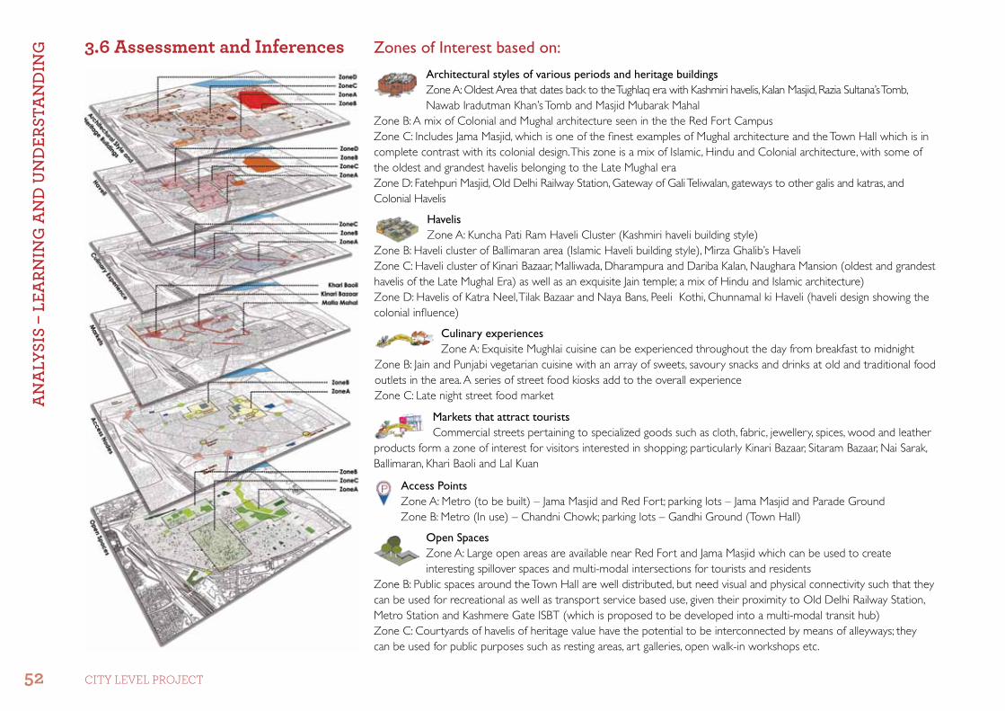
Zones of Interest based on:3.6 assessment and inferencesArchitectural styles of various periods and heritage buildingsZone A: Oldest Area that dates back to the Tughlaq era with Kashmiri havelis, Kalan Masjid, Razia Sultana’s Tomb,Nawab Iradutman Khan’s Tomb and Masjid Mubarak Mahal
Zone B: A mix of Colonial and Mughal architecture seen in the the Red Fort CampusZone C: Includes Jama Masjid, which is one of the finest examples of Mughal architecture and the Town Hall which is in complete contrast with its colonial design. This zone is a mix of Islamic, Hindu and Colonial architecture, with some of the oldest and grandest havelis belonging to the Late Mughal era Zone D: Fatehpuri Masjid, Old Delhi Railway Station, Gateway of Gali Teliwalan, gateways to other galis and katras, and Colonial Havelis
HavelisZone A: Kuncha Pati Ram Haveli Cluster (Kashmiri haveli building style)
Zone B: Haveli cluster of Ballimaran area (Islamic Haveli building style), Mirza Ghalib’s HaveliZone C: Haveli cluster of Kinari Bazaar, Malliwada, Dharampura and Dariba Kalan, Naughara Mansion (oldest and grandest havelis of the Late Mughal Era) as well as an exquisite Jain temple; a mix of Hindu and Islamic architecture)Zone D: Havelis of Katra Neel, Tilak Bazaar and Naya Bans, Peeli Kothi, Chunnamal ki Haveli (haveli design showing the colonial influence)
Markets that attract touristsCommercial streets pertaining to specialized goods such as cloth, fabric, jewellery, spices, wood and leather
products form a zone of interest for visitors interested in shopping; particularly Kinari Bazaar, Sitaram Bazaar, Nai Sarak, Ballimaran, Khari Baoli and Lal Kuan
Access PointsZone A: Metro (to be built) – Jama Masjid and Red Fort; parking lots – Jama Masjid and Parade GroundZone B: Metro (In use) – Chandni Chowk; parking lots – Gandhi Ground (Town Hall)
Open SpacesZone A: Large open areas are available near Red Fort and Jama Masjid which can be used to create interesting spillover spaces and multi-modal intersections for tourists and residents
Zone B: Public spaces around the Town Hall are well distributed, but need visual and physical connectivity such that they can be used for recreational as well as transport service based use, given their proximity to Old Delhi Railway Station, Metro Station and Kashmere Gate ISBT (which is proposed to be developed into a multi-modal transit hub)Zone C: Courtyards of havelis of heritage value have the potential to be interconnected by means of alleyways; they can be used for public purposes such as resting areas, art galleries, open walk-in workshops etc.
Culinary experiencesZone A: Exquisite Mughlai cuisine can be experienced throughout the day from breakfast to midnight
Zone B: Jain and Punjabi vegetarian cuisine with an array of sweets, savoury snacks and drinks at old and traditional food outlets in the area. A series of street food kiosks add to the overall experienceZone C: Late night street food marketA
nA
LySI
S –
LEA
RnIn
G A
nd
Un
dER
StA
nd
InG
52 CITY LEVEL ProjECT

SWOT Analysis:•Strength: Varied layers of tangible and intangible heritage attract a large number of tourists•Weakness: Unaccounted economic development •Opportunities: Proximity to major transport hubs such as railway stations, Metro station and bus terminals, as well as a well-knit circulation pattern within the Walled City limits•Threats: Increase in wholesale trade along with uncontrolled development of built structures
Based on the study of different formative layers of Shahjahanabad the Zones of Interest can be perceived as follows along major commercial spines and around landmark monuments
An
ALy
SIS
– LE
ARn
InG
An
d U
nd
ERSt
An
dIn
G
53rEjuVEnaTIon of Shahjahanabad

4.1 development Strategies
Our objective would be to tap the potential of the existing intangible heritage and develop an urban form to support this heritage. The elements of heritage to be looked into are as follows: •Oraltraditionsandexpressions,includinglanguage•Performingarts•Socialpractices,ritualsandfestiveevents•Tradeandcommerce•Traditionalcraftsmanship
Thus the three aspects that need to be interlinked to form strategies of development are Heritage, Tourism and Development as discussed below:
The proposals are to be designed with the intent of minimal intervention and without drastically changing the existing character of the place. They need to be both resident as well as tourist oriented, as the development for each of these segments are symbiotic to each other’s betterment.
Tourist oriented proposals shall be more to do with redesigning spaces, face-lifts to the buildings, streetscaping and activity distribution with the purpose of developing tourism related infrastructure. In order to facilitate implementation of the proposals, regulations and controls that need to be followed shall also be suggested.
Resident oriented proposals will be designed to ease circulation within the core, develop public spaces, upgrade infrastructure and manage space. Suggestions have also made to increase the fiscal value of the properties by means of heritage listing, adaptive reuse etc.
The overall action plan will be to develop tourist circuits to connect major monuments within the city such as Jama Masjid, Red Fort, Town Hall, Fatehpuri Masjid and Ajmeri Gate. Additional lateral connectors will be developed to take tourists through areas that are rich in havelis, historical market areas etc. Additionally open areas and public spaces are to be created within particular zones or katras for the redevelopment of congested residential areas.
PRO
POSA
LS
54 CITY LEVEL ProjECT

4.2 Generating an experience
Route Delineation and Activity Distribution
To generate a memorable experience for visitors with various requirements, routes will be delineated and various activities will be infused along these routes. The purpose is to create an interesting, informative and interactive ambience for tourists visiting Shahjahanabad.
Basic Route:Red Fort and Jama Masjid are the most visited monuments within the City. The basic route would cover these, taking visitors through Nai Sarak, which offers a varied shopping experience and Matia Mahal, famous for its eateries. The length of this route is 3.25 km; being the shortest route to be laid out which can be covered in 2.5 hrs approximately, with 1 hour of walking time and 1.5 hours of viewing time. Access Points: Parking – Parade Ground, Metro – Chandni Chowk
Places of Interests:•HeritageBuildings:JamaMasjid,Fatehpuri
Mosque, Town Hall (Viewing of Old Delhi Railway Station), Sisganj Gurudwara, Bhagirath Palace, Jain Mandir, Red Fort (ASI Grade-A Monument)
•Markets:MatiaMahal(foodoutlets),papermarket, Nai Sarak (books stationery, cloth and fabric), Chandni Chowk (food outlets and high- end retail)
•Helpdesks/receptionkiosksprovidingvisitorswith information regarding history, routes, important landmarks, activities within the area, location of resource centres, visitor’s facilities, special needs facilities etc.
Public conveniences: •Blockswouldhavefacilitiessuchastoilets,
drinking water fountains, snack bars etc. with universal design for greater accessibility
Activity Delineation – Entry Exit nodes:•Parkingforallmodesof
transport including both public and private vehicles could be developed as small inter-modal transit nodes
•Entranceplazaforpeopletoassemble before the starting the walk
PRO
POSA
LS
55rEjuVEnaTIon of Shahjahanabad

Route Details
Extensive Route:Offers a compilation of important built heritage (havelis, tombs and masjids) including the oldest areas within the Walled City, along with a peek into major commercial streets within the core.The length of this route is 6.5 km that would take 5 hours approximately – 2 hours of walking time and 3 hours of viewing time, and can be developed into a full day tour. Another option is to divide this route into 2 segments as described below:•Segment A: 1.3 km (glimpses of the oldest
structures within the wall)•Segment B: 1.2 km (a walk through interesting
bazaars and a taste of haveli lifestyle )
Access Points:•Parking–ParadeGround•Metro–ChandniChowk,ChawriBazaar
Places of Interests:•Heritage Buildings: Jama Masjid, Fatehpuri
Mosque, Town Hall (viewing of Old Delhi Railway Station), Sisganj Gurudwara, Bhagirath Palace, Lal Jain Mandir, Red Fort (ASI Grade-A Monument) Segment A: Khankha Masjid, Razia Sultana’s Grave, Kalan Masjid, Segment B: Masjid Mubarak Begum, Zeenat Mahal, Nawab Iradutmund Khan’s Tomb, Mirza Ghalib’s Haveli, Jogiwada Haveli Complex
•Markets: Matia Mahal (food outlets), Sitaram Bazaar and Lal Kuan Bazaar, Ballimaran and Jogiwara, Nai Sarak (books stationery, cloth and fabric), Chandni Chowk (food outlets and retail)
PRO
POSA
LS
56 CITY LEVEL ProjECT

Associated Activities
Extensive Route:Offers a more interactive experience to visitors and thus requires a more informative and active approach towards associated activities. It was found desirable to locate History and Heritage Centres and Activity Centres along this route
History and Heritage Centres:Location: These can be located near important entry/exit nodes or at precincts with a distinct character or
interesting stories to recountThese centres will be developed as mini-museums which would introduce visitors to the characteristics of the precinct they are about to visitThey will also have interactive information kiosks, guide training centres etc.
Activity Centres:Location: These can be located at junctions with dense activity related to a particular skill, trade, art or craft
•Thesenodeswouldbedevelopedasworkshopsorvocational training centres for traditional skills, art and craft or for other related fields, such as:
•Cookeryclasses•Jewellerymakingworkshops•Vernacularorancientarchitectureorconstruction
workshops•Photographyworkshops•Potteryclasses•Theme-basedpaintingandcraftclasses•Theactivitycentrescanalsobeusedforscreening
documentaries or short movies, conducting studies or group discussions/activities related to the intangible heritage of the Old City
PRO
POSA
LS
57rEjuVEnaTIon of Shahjahanabad

Route Details
Haveli Route:Offers a compilation of specialized routes which would take visitors through different haveli precincts. This route, apart from other landmarks covered in the extensive route, will also showcase the traditional haveli building culture.
Depending on distinct architectural styles, four segments have been delineated and can be chosen for detailed guided tours. Each of these routes can be completed in a time span of 1 to 2 hours. These segments are:•Segment A: This 1.2 km long route covers Katra
Neel, Haveli Haider Quli and Kuncha Ghasiram – areas which reveal colonial elements in their design as they belong to the late Mughal and early Colonial eras
•Segment B: This route is 1.4 km long and covers the areas of Charkhe Walan and Ballimaran, where the famous haveli of Mirza Ghalib is located. This area showcases modest havelis of the early colonial and colonial eras
•Segment C: This segment is the shortest, with a 1 km walk and covers Gali Kuncha Pati Ram. This demonstrates intricate carving and mural work inspired by Kashmiri building elements
•Segment D: This 1.99 km walk will take visitors through Kinari Bazaar, Dharampura and Dariba Kalan which have sme of the oldest and grandest havelis in the city, built on the lines of Hindu architecture. This area also boasts of beautiful Jain temples and adjoining haveli complexes, as seen in Naughara Mansions in Kinari Bazaar
Access Points: Parking – Parade Ground, Metro Station – Chandni Chowk, Chawri Bazaar
PRO
POSA
LS
58 CITY LEVEL ProjECT
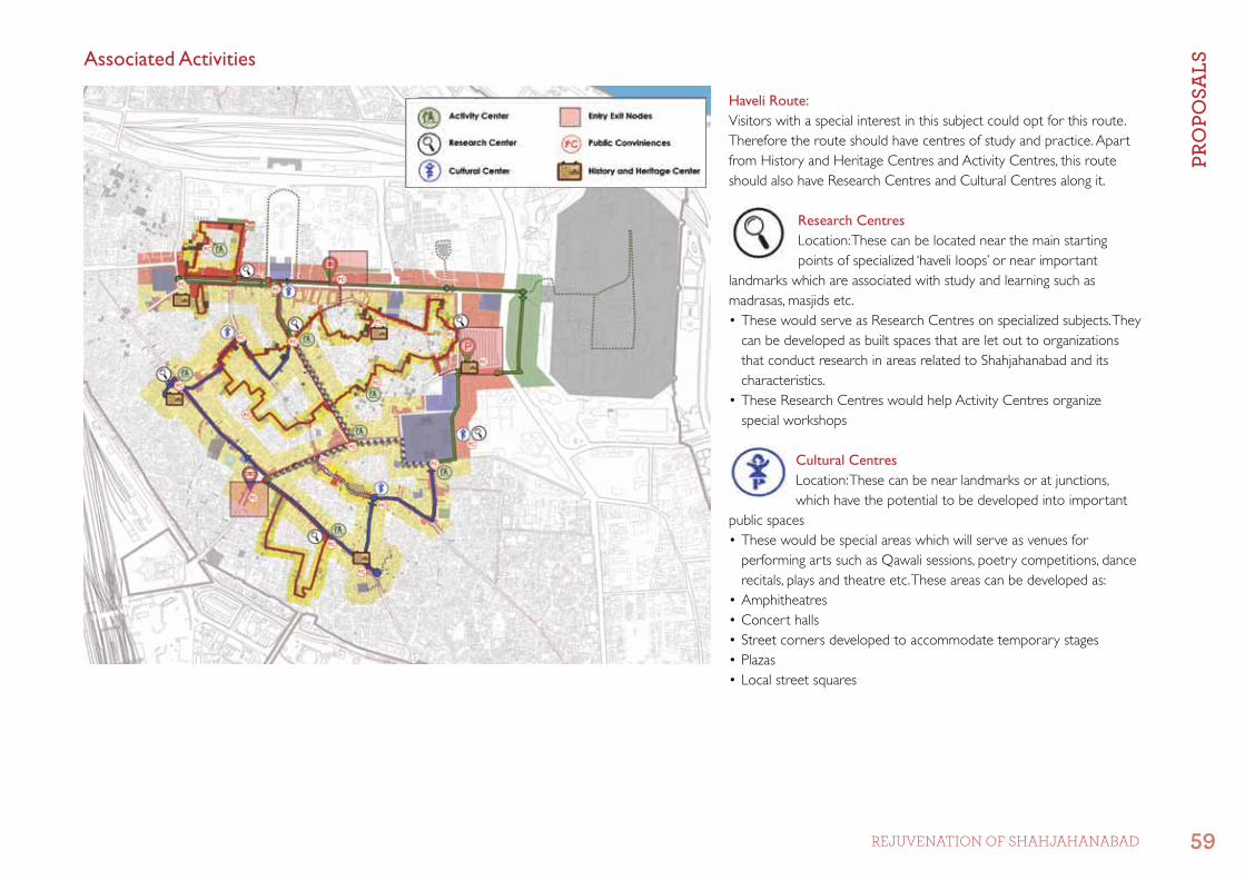
Associated Activities
Haveli Route: Visitors with a special interest in this subject could opt for this route. Therefore the route should have centres of study and practice. Apart from History and Heritage Centres and Activity Centres, this route should also have Research Centres and Cultural Centres along it.
Research CentresLocation: These can be located near the main starting points of specialized ‘haveli loops’ or near important
landmarks which are associated with study and learning such as madrasas, masjids etc.•ThesewouldserveasResearchCentresonspecializedsubjects.They
can be developed as built spaces that are let out to organizations that conduct research in areas related to Shahjahanabad and its characteristics.
•TheseResearchCentreswouldhelpActivityCentresorganizespecial workshops
Cultural CentresLocation: These can be near landmarks or at junctions, which have the potential to be developed into important
public spaces•Thesewouldbespecialareaswhichwillserveasvenuesfor
performing arts such as Qawali sessions, poetry competitions, dance recitals, plays and theatre etc. These areas can be developed as:
•Amphitheatres•Concerthalls•Streetcornersdevelopedtoaccommodatetemporarystages•Plazas•Localstreetsquares
PRO
POSA
LS
59rEjuVEnaTIon of Shahjahanabad

Route Details
Market Route:This introduces visitors to the vibrant bazaar culture prevalent since the inception of the city. These specialized routes have been divided into segments to offer an experience of shopping in traditional markets of the city along with the culinary extravagance of famous food outlets. Each of these routes can be covered in an hour, however the allocated time will not be sufficient if one indulges in shopping at every commercial street. These segments are:•Segment A: This 1.2 km long route covers the
areas of Malliwada, Kinari Bazaar and Dariba Kalan (famous for its cloth and jewellery market). There are shops here which specialize in gilt work, lace and border making. Visitors also have an option of trying out the famous sweetmeats and paranthas at Chandni Chowk and Paranthewali Gali
•Segment B: This route is 3.1 km long and covers the spice market of Khari Baoli, fabric market of Katra Neel, kite market at Lal Kuan and wooden and leather products in Ballimaran. Traditional food outlets in this area are known to serve lip- smacking vegetarian snacks, kulfis and lassis
•Segment C: This segment 2.1 km long takes visitors past the accessories market of Sitaram Bazaar and Meena Bazaar, traditionally known to have been a trade centre for precious stones and metal products. This route also passes through the major non-vegetarian food zone of Matia Mahal where one gets to sample Mughal cuisine
Access Points:•Parking–ParadeGround•Metro–ChandniChowk,ChawriBazaar
PRO
POSA
LS
60 CITY LEVEL ProjECT

Associated Activities
Market Route:This is the most interactive route and would generate unguided circulation of visitors. Thus it is important that people are well informed about the streets they are exploring. An interactive guide to food outlets, shops and products would facilitate the movement of visitors in the core and increase accessibility to the core. Product information hubs shall be located at regular intervals.
Product Information HubsLocation: These can be located at regular intervals along tourist-attracting commercial streets
•Initiallytobeinstalledasplaquesonwallsgivinginformation of products and shops specialising in these products.
•Theplaquescanlaterbeupgradedtocentrespromoting online shopping and providing space for direct interaction between retailers and customers.
Famous Food OutletsLocation: Near or around traditional food outlets
•Theareasaroundtraditionalandfamousfoodoutletswould be demarcated and designed such that they facilitate both eating for customers and operations and maintenance by owners.
•Thevicinityofsuchshopsorfoodareaswouldbehighlighted to direct visitors to closeby food outlets as well as draw their attention to a particular shop
•Plaquesoraudio-visualsetscouldbeusedatthesepoints telling people about the history and other information of food available at the shop and the area
•Thebuiltenvironmentcanbedesignedwithdifferentpaving material, paint or signage
PRO
POSA
LS
61rEjuVEnaTIon of Shahjahanabad

4.3 General Recommendations for designing tourist RoutesTraffic Regulation Plan: Mix of commercial and residential activity in the core of the Old City has lead to a complex composition of vehicles with commercial as well as passenger vehicles accessing the main commercial streets throughout the day. Activities such as loading and unloading of goods cannot be stopped. Drop-off or pick-up by inter-para transit vehicles too cannot be hindered. Hence, the situation calls for a traffic regulation plan which has been designed as a unidirectional time-based circulation system. Emergency vehicles should be allowed free passage at all times
Peak Tourist Time Circulation (8 am to 10 pm): It has been observed that here is a sudden influx of visitors in the core area when shops open. This can be regulated by limiting traffic into the core during this time period. To ensure accessibility, one way circulation loops have been created around markets
Off Tourist Time Circulation (10 pm to 8 am): The time after markets close will be utilized to carry out loading/unloading activities. Goods vehicles should also follow the one way circulation system so that clearing of the area is easier as the “No Entry” time period starts in the morning
PRO
POSA
LS
62 CITY LEVEL ProjECT

Waste Management Plan: Intense commercial activity leads to the generation of huge quantities of solid waste which is neither collected or segregated on a regular basis leading to overflowing bins and dhalaos and increasing filth on the already overcrowded streets of the City. Compact urban fabric and high population density guided the Management Plan to be based on a hierarchal collection, transportation and processing system which allows for segregation at source, regular collection and transportation, temporary storage and processing with a scope of resource recovery by means of recycling and composting. Availability of all items required for the operation of this plan shall be the responsibility of the authority in charge of maintenance.
The Process: All waste shall be disposed after being segregated by individuals at designated Community Collection Points (CCPs). Owners of properties where garbage is left unattended to on streets will be penalized. The CCPs shall be located at intervals of 150 to 200 m, along specified collection routes that collection vans will follow for collection of waste. Authorities shall run street cleaning vehicles at regular intervals to ensure that the streets are cleaned throughout the day. The waste shall be stored temporarily at Recycling Depots, located on the periphery of the city.
Waste Collection at Community LevelCommunity Collection Points: •Wastebags(everyhouseholdandshoptoprepare
segregated bags of garbage) that have to be dumped at Community Collection Points for further collection by authority vans.
•Colourcodedbinsatamaximumdistanceof150mapart•Conceptuallyestimatednumberofbins–400forexisting
2.5 lakh population
Waste Transportation and Storage at Neighbourhood LevelHigh-tech Recycling Depots: •Fromthesecollectionpointsthewastewillbetakentohigh-
tech recycling depots located on the periphery of the Old City for further processing
•Conceptually12locationsforRecyclingDepotshavebeenidentified.
•Twoprototypescanbedevelopedbasedontheavailabilityof space: i) to be located in parks and ii) to be located along pathways
Resource Recovery at Area LevelHigh-tech Recycling Depots: •ThesemaybeequippedwithCompostPitswherespaceis
available
Biogas Plant: •Restaurants,hotelsandculinaryzonescontributetoorganic
waste which will be treated in a biogas plant with a capacity of 5 tons/day which can be installed in an open space of 50 sq m.
Proposed Levels in Waste Management:
Hie
rarc
hy o
f Was
te M
anag
emen
t Sy
stem
Source : Delhi Urban Art Commission, Solid waste management - CR park, 2017
PRO
POSA
LS
63rEjuVEnaTIon of Shahjahanabad

Colour Theme Palatte: Toinstilhomogeneityinthebuiltenvironmentalongroutes,apaletteofcolourshasbeendevelopedthatcanbeusedonbuildingfaçades,pavedsurfaces,fenestrations and street furniture etc., based on the predominant architectural character of different areas. The palette has been designed keeping in mind the styles of architecture adopted in different eras such as: Mughal, Colonial, Art Deco and Contemporary.
Rules of use of the palate:•Buildingfaçadesshouldnotusemorethanthreecolours•Simplecolourschemestobeencouraged•Black,fluorescentandneoncoloursshouldnotbeusedastheprimarycolour(coveringmorethaneightypercent(80%)ofthebuildingfaçadearea)
•Blackordarkbrownshouldberestrictedtodoorsandwindowframes,metalworkand security
This colour palette is indicative and can be used as a base or as high-lighters in buildings along the tourist routes so that the built environment can be given a harmonious face-lift.
Art
Dec
o/
Con
tem
pora
ry/
Span
ish
Baro
que
Mug
hal/
Indo
-Isla
mic
Earl
y C
olon
ial/
N
eo-C
lass
ical
BaseTocover75–80%ofthefaçade
HighlighterTo be used on doors, windows, frames, grills etc to highlight elevation features
Base or Highlighter
Colours from the palette can be used in different permutations and combinations to create different architectural styles
PRO
POSA
LS
64 CITY LEVEL ProjECT

Material Theme Palette: The built environment around the routes have to be restructured in a manner that they are in harmony with the overall character and feel of the space and to ensure this, elements cannot be designed in stark contrast to the prevalent architectural style of the precincts. Thus a suggested palate has been created which may be followed while redesigning the edges along routes. Options have been given for both vertical and horizontal surfaces considering the need of both permanent and temporary features.
Rules of use of the palette:•Thethemeshouldbekeptsurrealandearthy,inline
with the overall character of the space•UseofAlu-decorpanelswithmetallicorplasticfinish
should be avoided•Apartfrombuildingmaterials,differentlightingfixtures
may also be used as highlighting elements but should not be aligned in such a way that it disturbs people using the space around such buildings.
•Temporarystructuresandpavingmaterialsshouldbelow maintenance and of adequate strength. Ground cover should preferably be semi-pervious and should not cause hindrance to vehicle or pedestrian movement
•Projectionsofbuildingsshouldbetreatedsimilarto,orwhichiscompatiblewiththeoverallfaçadeofthebuilding
•Contrastcreatedintexturestohighlightedareasshouldnot be overwhelming
PRO
POSA
LS
65rEjuVEnaTIon of Shahjahanabad

Streetscaping Regulations: Certain rules and regulations need to be followed so that implementation of design themes along the tourist routes becomes easy, homogeneity is maintained and that maintenance becomes easier for the concerned authorities.
Aspects Desired Design Limitations
Façade Upgradation •Colourthemetobefollowedasprescribed •Useofplastic/fibre/stainlesssteeltobelimitedsoastonottodisturbtheoverall character
Landscape•Droughtresistant,nativeandnaturalizedmaterialstobeused•Self-sustainingandeco-friendlydesigns(suchasin-builtbiodigesterplanters
etc.) to support vegetation
•Plantingbigtreesorplantsshouldbelimitedtoopenspacesandcourtyards with considerable distance from buildings
Lighting•Castconcrete,stainlesssteelorironpoleswithpoleheightsupportingboth
pedestrian and vehicular movement and attached signage to be used; should be painted according to selected theme
•Separateprovisionforlighting,vehicularcarriagewayandpedestrianwalkway
•Floodlightingtocoverlargespacesorjunctions
Sidewalks
•Sidewalktobeofaminimumwidthof1.8mwith0.5mfromthecurbedgeto be reserved for street furniture
•Partofcarriagewaytobemarkedwithoutagradeseparation,asaoverlapzone accommodating informal commercial, pedestrian and NMT vehicles
•Drivewaysorwalkwaystobeaccommodatedusingtabletopcrossingscreating a seamless walking space
•Pavementsatfoodpointsorotherjunctionstobehighlightedbymixingmaterials
•Useofcorbelledfinishoranyotherroughfinishthatwouldmakewalkingdifficult
Seating•Heavy-duty,low-maintenancebenchestobeplacedatevery30mwhichmay
have electrical points•Foodkiosksorshopsmayalsoprovidefortemporaryseatingarrangements
Public Convenience Block•Theseblocksshallbedesignedfollowingtheprescribedcolour,materialand
design element theme, with provision for drinking water and one washroom each for males and females
•Tobelimitedwithinplotlinesandnottobeplacedonsidewalksasportableunits
Dustbins •Heavy-duty,low-maintenancedustbinswhichmaybeinnovativelydesignedtoinclude planters, spittoons and cigarette bins •Singlecontainerunittobediscouragedtoensuresegregationatsource
Utilities •Allutilitiestobeshiftedundergroundortobeshiftedwithinplotlineswithcareful buffering
PRO
POSA
LS
66 CITY LEVEL ProjECT

5.1 activity node Planning for basic Route Nine important nodes have been identified along the route where specific activity distribution has been done on the basis of activity and character of different areas:
Node A:•ParkingandReceptionPlaza•ResearchCentreforHandloomandJewellerymakingstudies•MainHistoryandHeritageCentreintroducingpeopletotheRed
Fort, Jama Masjid and the Walled City’s DevelopmentNode B:•CulturalCentreagainstthebackdropofJamaMasjid•ResearchCentreforIslamicStudiesNode C:•Spilloutarea•SpecialCookeryClassesNode D:•ActivityCentreforPaper-relatedCrafts•BookReadingCentres•PaintingandCraftsWorkshopsNode E:•JewelleryMakingWorkshop•GildingandStitchingclasses•PoetryReadingandSingingworkshops•Photographyworkshops•ResearchCentresfortheabovementionedactivitycentresandfor
development of Walled CityNode F:•CulturalCentretoholdstreet,outdoorandindoorplaysand
concertsNode G:•HistoryandHeritageCentreintroducingpeopletotheCityCore,
development of bazaars and evolution of present day cityNode H:•ParkingandReceptionPlaza
Detailing Out: The basic route has been selected for detailing the proposed changes and process to demonstrate the effects of the recommendations, if they are executed on site. Previous interventions by different organizations at important nodes and streets have also been incorporated with a few modifications in design for our proposals.
PRO
POSA
LS f
OR
BUIL
t En
vIR
On
mEn
t
67rEjuVEnaTIon of Shahjahanabad

Detailing for the Basic Route has been carried out in 3 segments, namely:
1) Proposed Built EnvironmentThe built environment has been modified based on the proposed recommendations at selected spots with different land use, character of space, street widths and heritage value.
Commercial Streets:
• Point1:Jama Masjid Junction (Paper Market), portion of a commercial street approaching an important landmark of the area where buildings on both sides show distinct architectural character (Late Mughal)
• Point2: Nai Sarak near Town Hall Junction, portion of a commercial street approaching an important landmark of the area, where buildings on both sides show no distinct character
• Point3:Kinari Bazaar, portion of a narrow highly dense commercial street
Residential Streets:• Point4: Gali Kuncha Pati Ram, portion of a
residential street with historic havelis on both sides• Point5:Gali Kuncha Khasi Ram (Katra Neel),
portion of a street with historic havelis on one side and godowns on the other
Courtyards:• Point6:Courtyard of an identified heritage building
(Chawri Bazaar), courtyard which is believed to have been a hamam for Razia Sultana, now lies vacant, unattended and filthy. The pool has been filled to ground level
• Point7:Courtyard of a private building (Katra Neel), courtyard of vacant haveli being used as a godown
PRO
POSA
LS f
OR
BUIL
t En
vIR
On
mEn
t
68 CITY LEVEL ProjECT

2) Proposed Public Spaces
Precinct 1: Jama Masjid Precinct•Sincethereisalargechunkofopenspace
already available in front of Jama Masjid, this precinct has the potential to be developed as a positive active space for interaction
•Theareaalsoformsacrucialtransithubforcommuters using both public and private transportation with a new Metro station being constructed within the precinct
Precinct 2: Town Hall Precinct•TownHallfromtheNaiSarakJunction
extends up to the Old Delhi Railway Station.•OpenspacearoundtheTownHallprecincthas
a potential to be redeveloped into more active public spaces.
•Theareaalsoformsacrucialtransithubforcommuters using both public and private transport. Because of its proximity to the Railway Station and Kashmere Gate ISBT, it has the potential to be used as a halting zone for goods vehicles, as a bus depot or for parking
3) Legislative Provisions for Implementation•TheMasterPlanandZonalPlandocuments
have already laid down policies related to: •Upgradationofareasofheritagevalue•Developmentofpublicspaces•Enhancementofaccessibility,connectivityand
circulation•UrbandesignThe above have guided the recommendations given for development of the core area and helped formulate suggestions and guidelines to promote tourist-oriented development.
PRO
POSA
LS f
OR
BUIL
t En
vIR
On
mEn
t
69rEjuVEnaTIon of Shahjahanabad

5.2 Street Restructuring and façade uplift
Existing Condition:
First Floor and Above•Thesefloorsdemonstratearichheritageintheformofarchitectural
features such as railings, pillars, brackets, sun shades, louvres etc. These features are doneaway with or not maintained.
•Overhanginghigh-tensionwires,otherelectricalsupplyunitsandlamp posts all end at this level; hanging outdoor units of ACs, add to the mess
•Façadefinishesonsomeofthebuildingsareincompletecontrasttothe character of the space
•Temporarysheltersonthetopmostfloorgiveamessyappearance
Ground Floor Level•Haphazardplacementandlackofmaintenanceofhoardingson
buildings•Columnsorpillarshavebeenbuiltupon,thereforelosingtheircharm•Shuttersofshopsarenotmaintainedaddingtotheclumsyappearanceofthefaçade
Street Level•Unmaintainedandnon-continuouspathwaysencroacheduponby
buildings and utilities•Nodesignatedspaceforinformalcommercialset-ups
Commercial Streets – Point 1: Jama Masjid Junction(Paper Market) Portion of a commercial street approaching an important landmark of the area where buildings on both sides show distinct architectural character (Late Mughal period)
PRO
POSA
LS f
OR
BUIL
t En
vIR
On
mEn
t
70 CITY LEVEL ProjECT

Proposed Changes:The intention of this proposal is to homogenizethefaçades,re-instiltheoveralllate-Mughal character of the space and accentuate the frame of the building form as one approaches the landmark monument in the precinct
First Floor and Above•Uniformityinthefaçadeadheringtothe
characteristics of the space; repairing and retaining existing architectural features
•Clearingupofviewsbyremovingoverhanging wires and on-surface utilities
•Temporarysheltersonthetopmostfloorsto be redone in line with the overall building façadeandwiththeuseofprescribedmaterials and colour themes
Ground Floor Level•Uniformityinsignageandtreatmentof
shutters•Existingcolumnshavebeenaccommodated
within the footpath’s width and the colonnade accentuated by addition and repair
Street Level•Restructuringstreetstoensurecontinuous
pathways; accommodating all street furniture, including permanent and temporary seating
•Commonshareroadspacetoaccommodate pedestrian movement and informal commercial activities during peak hours
PRO
POSA
LS f
OR
BUIL
t En
vIR
On
mEn
t
71rEjuVEnaTIon of Shahjahanabad

Commercial Streets – Point 2: Town Hall Junction (Nai Sarak)Portion of a commercial street approaching an important landmark of the area where buildings on both sides show no distinct character
Existing Condition:
First Floor and Above•Onlyafewbuildingshavesomeheritage
architectural features, but are not maintained
•Overhanginghigh-tensionwires,otherelectrical supply units and lamp posts all end at this level; hanging outdoor units of ACs add to the mess
•Façadefinishesonsomeofthebuildingsare in complete contrast to the character of the space
•Temporarysheltersonthetopmostfloor give a messy appearance
Ground Floor Level•Haphazardplacementandlackof
maintenance of hoardings on buildings•Columnsorpillarshavebeenbuiltupon
therefore losing their charm•Shuttersofshopsarenotmaintained
adding to the clumsy appearance of the façade
Street Level•Unmaintainedandnon-continuous
pathways encroached upon by buildings and utilities
•Nodesignatedspaceforinformalcommercial set-ups
•On-streetparkingfurtherreducesthewalking area
PRO
POSA
LS f
OR
BUIL
t En
vIR
On
mEn
t
72 CITY LEVEL ProjECT

Proposed Changes:
First Floor and Above•Uniformityinthefaçadeadheringto
the characteristics of the space and redesigning architectural features of the buildings.
•Anyinterestingfeaturecouldberepairedand retained if its condition permits
•Clearingupviewsbyremovingoverhanging wires and on-surface utilities
•Temporarysheltersonthetopmostfloors to be redone in harmony with theoverallbuildingfaçadewithuseofprescribed materials and colour themes
Ground Floor Level•Uniformityinsignageandtreatment
of shutters•Existingcolumnshavebeen
accommodated within the footpath’s width and the colonnade accentuated by addition and repair
•AlloutdoorACunitstobeshiftedtotheterrace and wiring to be concealed using frames, louvres or mouldings
Street Level•Restructuringstreetstoensure
continuous pathways, accommodating all street furniture
•Commonsharedroadspaceforpedestrian and informal commercial activities
Theintentionofthisproposalistohomogenizethefaçades.Theavenueofbuildingswastoframetheapproachinglandmarkintheprecinct. Owning to the mixed commercial character of the street, it is necessary to accommodate informal commercial activities with ease and without compromising the overall width available for traffic movement on the street. Services for the buildings cannot be ignored and space allocation for various service lines and equipment is necessary. They should beintegratedwiththenewfaçadesinsuchawaythattheydonothamperthelookofthesebuildingsandcanbeinstalledinacosteffective and easy manner.
PRO
POSA
LS f
OR
BUIL
t En
vIR
On
mEn
t
73rEjuVEnaTIon of Shahjahanabad

Commercial Streets – Point 3:Near Naughara Junction (Kinari Bazaar) Portion of a narrow, highly dense commercial street with galis and residential buildings opening on to it. Pedestrians, NMT and two-wheelers use this stretch
Existing Condition:
First Floor and Above•Projectionsofbuildingsobstructtheviewofbuildingfaçadesand
restrict natural light penetration•Overhanginghigh-tensionwires,otherelectricalsupplyunitsand lamp posts all end at this level; hanging outdoor units of ACs add to the mess•Temporarysheltersonthetopmostfloorgiveamessyappearance
Ground Floor Level•Haphazardplacementandlackofmaintenanceofhoardingson
buildings. Different sizes and designs of the signage break the virtual viewing lines thereby creating more confusion in the perception of the street
•Shuttersandshutterframesofshopsarenotmaintainedaddingtotheclumsyappearanceofthefaçade
Street Level•Streetistoonarrowtocatertobothpedestriansandvehicles•Utilitiessuchasstreetlights,publicconveniencesandhawker’sareas
face space restrictions
PRO
POSA
LS f
OR
BUIL
t En
vIR
On
mEn
t
74 CITY LEVEL ProjECT

Proposed Changes:•Theintentionofthisproposalistohomogenizethefaçades,clear
the air space so as to create a sense of open space along the narrow lane and accommodate as much of street design elements as possible in the available width.
First Floor and Above•Projectionshavebeenlimitedtoaparticulardepthorcompletely
done away with so as to not hinder light penetration or view of the façades
•Clearingupofviewsbyremovingoverhangingwiresandon-surfaceutilities
•Anyinterestingarchitecturalfeaturecouldberepairedandretainedif its condition permits
•Temporarysheltersontopmostfloorstoberedonefollowingprescribed materials and colour themes
Ground Floor Level•Uniformityinsignageandtreatmentofshutters.Signagetobe
placed at a particular height •Displaycounterstobelimitedwithinshoppremisestoallowclear
walking paths
Street Level•Thestreetneedstohaveacontinuoussmoothfinishtofacilitate
pedestrian movement•In-builtstreetlightingtodoawaywithlampposts•Sincevehicularmovementonthisstreethastoberestrictedduring
peak hours, bollards or barriers also need to be added
PRO
POSA
LS f
OR
BUIL
t En
vIR
On
mEn
t
75rEjuVEnaTIon of Shahjahanabad

Portion of a residential street with historical havelis placed along a 6–8 m wide local street.
Residential Streets – Point 4: Gali Kuncha Pati Ram (Near Sitaram Bazaar)
Existing Condition:
First Floor and Above•Thesefloorshavearichheritagein
the form of architectural features such as railings, pillars, brackets, sun shades, louvres etc. These features are done away with or not maintained.
•Overhanginghigh-tensionwires,otherelectrical supply units and lamp posts all end at this level; hanging outdoor units of ACs add to the mess
•Temporarysheltersonthetopmostfloor give a messy appearance
Ground Floor Level•Façadesofshopsandcommercialoutlets
are in complete contrast to character of the area
•Thisfloorrevealsarichheritageintheform of architectural features such as doorways, mural work around door frames, pillars and verandahs whose views should be framed and enhanced
Street Level•Streetistoonarrowtocatertoboth
pedestrians and vehicles•Utilitiessuchasstreetlights,public
conveniences, hawker’s areas face space restrictions
•On-Streetparkingtendstohinderfreemovement during peak hours
PRO
POSA
LS f
OR
BUIL
t En
vIR
On
mEn
t
76 CITY LEVEL ProjECT

Theintentionofthisproposalistocreateacleargroundandairspaceforanuninterruptedviewofhavelifaçadesalong the street.
The width of the street and the need for clear views limits the use of above ground services or street furniture. Therefore it becomes necessary to use in-built and low height services. The dead space in front of these havelis has the potential to be developed as rest areas or waiting zones for visitors. The objective is to create viewing areas to observe these facades. However, all these interventions aretobeincorporatedwithoutdisturbingtheoriginalbuiltenvironmentordamagingthefaçades.
Proposed Changes:
First Floor and Above•Uniformityinthefaçadeadheringtothe
characteristics of the space; restoring and retaining the existing architectural features
•Clearingupviewsbyremovingoverhanging wires and on-surface utilities
•Temporarysheltersonthetopmostfloors to be redone in harmony with the building’sfaçadewithuseofprescribedmaterials and colour themes
Ground Floor Level•Uniformityinsignageandtreatment
of shutters. They also need to be interestinglyintegratedintothefaçade
•Existingfeaturesshouldbepreservedand enhanced in every possible way by allowing other buildings to form frames for the heritage buildings
Street Level•Thestreetneedstohaveacontinuous
smooth finish so as to facilitate pedestrian movement
•In-builtstreetlighting,soastodoawaywith lamp posts
•Intermediate,informalrestareasforvisitors
Street furniture needs to be in character with the space and innovatively designed
PRO
POSA
LS f
OR
BUIL
t En
vIR
On
mEn
t
77rEjuVEnaTIon of Shahjahanabad

Residential Streets – Point 5: Gali Kuncha Khasi Ram (Katra Neel)Portion of a street with historical havelis on one side and godowns on the other. The lane is as narrow as 4m and requires space for loading/unloading activity
Existing Condition:
First Floor and Above•Thesefloorsrevealarichheritagein
the form of architectural features such as railings, pillars, brackets, sun shades, louvres etc. These features are done away with or not maintained.
•Overhanginghigh-tensionwires,otherelectrical supply units and lamp posts all end at this level; hanging outdoor units of ACs add to the mess
•Temporarysheltersonthetopmostfloor give a messy appearance
Ground Floor Level•Façadesofshopsandcommercialoutlets
are in complete contrast to character of the area
•Thisfloordemonstratesarichheritagein the form of architectural features such as doorways, mural work around door frames, pillars and verandah whose views should be framed and enhanced for visitors
Street Level•Streetistoonarrowtocatertoboth
pedestrians and vehicles•Utilitiessuchasstreetlights,public
conveniences and hawker’s areas face space restrictions
•On-Streetparkingtendstohinderfreemovement during peak hours
PRO
POSA
LS f
OR
BUIL
t En
vIR
On
mEn
t
78 CITY LEVEL ProjECT

Theintentionofthisproposalistocreateacleargroundandairspaceforanuninterruptedviewofhavelifaçadesalongthestreet.Atthesametime,theblankfaçadesonthesidewiththegodownsneedbemadeinterestingsothattheydonotdilutetheentirefeelofthe space. Thus, these surfaces are proposed be used as exhibition panels for artwork and handicraft.The street needs to be cleared to provide ample space for the movement of pedestrians and light goods vehicles as and when required. This also guided the design of spacing and locating street furniture such as lighting, signage etc. in an innovate way.
Proposed Changes:
First Floor and Above•Uniformityinthefaçadeadheringtothe
characteristics of the space, repairing and retaining the existing architectural features
•Clearingupofviewsbyremovingoverhung wires and on-surface utilities
•Temporarysheltersonthetopmostfloors to be redone in-line with the overallbuildingfaçadeusingprescribedmaterials and colour themes
Ground Floor Level•Uniformityinsignageandtreatment
of shutters. They also need to be interestinglyintegratedwiththefaçade
•Existingfeaturesshouldbepreservedand in every way enhanced by allowing other buildings to form frames for the heritage buildings
Street Level•Thestreetneedstohaveacontinuous
smooth finish so as to facilitate pedestrian movement
•In-laidstreetlightingsoastodoawaywith need to provide lamp posts
•Intermediateinformalrestareasforvisitors
•Streetfurnitureneedstobeinnovativelydesigned and in character with the space
PRO
POSA
LS f
OR
BUIL
t En
vIR
On
mEn
t
79rEjuVEnaTIon of Shahjahanabad

Courtyards Point 7: Gali Kuncha Khasi Ram (Katra Neel)Courtyards of vacant, privately owned havelis being used as godowns and as rest areas for workers of the godown
Existing Condition:
Ceiling•Wiresrunacrosstheceilingwithout
being concealed or covered•Hooksforfansandlightsarenotputto
use •Oldermaterialhasbeencoveredwith
plaster •Theopentoskycentralcourtiscovered
by fibre sheets or air space has been encroached upon by extensions or projections
Vertical elements•Finisheshavenotbeenmaintainedand
have deteriorated•Architecturalfeaturessuchasjharokhas,
and doors are in a dilapidated state Many such features have been blocked or done away with
•Mostofthespacehasbeentakenupbygoods being stored on the premises
Floor•Thepavingisbrokenandnotsmooth•Someportionshavebeenlinedwith
newer materials•Opengarbagedisposalisaproblem•Centralcourtsofthepropertieswith
basements or reservoirs have these segments filled up or blocked so as to extend surface area
PRO
POSA
LS f
OR
BUIL
t En
vIR
On
mEn
t
80 CITY LEVEL ProjECT

The intention of this proposal is to reuse courtyards of privately owned havelis which are not enlisted as Heritage Buildings, but have significant architectural and historical value. Adaptive reuse of these courtyards would generate spaces for bed and breakfast services, hotels and lodges catering to visitors. Authorities could provide incentives or assistance to owners of such properties in terms of marketing and maintenance services. This will increase the overall revenue generating power of the properties in the city. Even if these buildings continue to be used for storage, owners could be encouraged to put part of their property to some kind of public use and maintain basic design standards laid down by the authorities.
Proposed Changes:
Ceiling•Wirestobeconcealedusingmoludings
or designer frames•Fixturesthatareaddedshouldfollow
the overall theme of the area; old fixtures to be done away with unless reused or repaired
•Originalmaterialforceilingfinishtobe preserved, if possible. However, patchwork repair of roofs should not be encouraged
Vertical elements•Originalfinishestobekept,ifpossible.
However, patchwork repair of roofs should not be encouraged
•Architecturalfeaturessuchasjharokhas,doors to be retained, repaired and reused wherever possible
•Thesesurfacescouldalsobeinnovativelyused to display traditional art and craft
Floor•Garbagecollectionandstoragetobe
strictly controlled•Spacedifferentiationusingdifferent
materials to be allowed, but should follow the overall character and prescribed theme
•Centralcourtsofthepropertieswithbasements or reservoirs need to be opened up to create interesting design features
PRO
POSA
LS f
OR
BUIL
t En
vIR
On
mEn
t
81rEjuVEnaTIon of Shahjahanabad

Existing Condition Garbage is dumped in the corners of the court
The courtyard could be developed for public seating and as a rest area in the form of gardens or an amphitheatre
The elevations are finished with materials from the recommended material palette
Building elements like balconies and fenestrations to be changed to follow a particular theme
Walls have been to designed as display panels for art and craft
Vegetation has destroyed parts of the buildings
Façadeisleftunfinishedwithhaphazard or no treatment done which has completely destroyed its original character No uniformity of fenestrations
Proposed Changes
Courtyards – Point 6: Identified Heritage Haveli Grade-C (Chawri Bazaar)This courtyard which is believed to be a Hamam for Razia Sultana now lies vacant, unattended and filthy. The pool has been filled up to the ground level.
Such courtyards of Havelis which have been enlisted as Heritage Buildings, could be used to create space for public activities required to support tourist routes such as cultural centres, activity centres, public galleries, rest areas with public conveniences. Authorities may provide incentives to owners of such properties by means of fund raising, marketing and maintenance services.
PRO
POSA
LS f
OR
BUIL
t En
vIR
On
mEn
t
82 CITY LEVEL ProjECT

Homogeneity in thefaçade
The built environment that has been altered according to the recommendations can create a huge difference in the character of precincts around important landmarks, as shown below, on the altered panoramicviewoftheseriesoffaçadesofbuildingsontheMatiaMahalRoad,aroundJamaMasjid
Existing Condition
Proposed Changes
Temporary structures built using plastic and asbestos
Overhanging jumbled wires and transformer boxes
Significant architectural features such as railings and brackets are hidden or constructed upon
No uniformity of fenestrations
Durable and light weight materials used for temporary sun shades
Viewoffaçadeclearedupbyremoving over-ground services
Architectural features are reconstructed to their original design and the height of hoardings limited to the same line
PRO
POSA
LS f
OR
BUIL
t En
vIR
On
mEn
t
83rEjuVEnaTIon of Shahjahanabad

The Jama Masjid and the Red Fort are magnificent examples of Mughal Architecture. The Jama Masjid or the Friday Mosque is the religious heart of the Walled City. It has been an active place of worship since its completion in 1656. The mosque and its surroundings continue to play an important role in the religious traditions, culture and economy of not just Shahjahanabad, but also the whole of Delhi. Surrounding the Red Fort and along the main axes of the city, were extensive gardens, elegant palaces and mosques built for the royal family and nobility. Prominent amongst these were the Fatehpuri Mosque at the western end of Chandni Chowk and the subsequently demolished Akbarabadi Mosque in Faiz Bazaar.
Another important bazaar, Khas Bazaar, once existed between the Jama Masjid and the Red Fort. It was very popular, with a variety of shops. The Bazaar was divided into two parts by the Salahuddin Chowk. On the Jama Masjid side, the bazaar was known as Zeenat Khas Bazaar. The royal procession used this route to go to the Jama Masjid for Friday prayers . One of Delhi’s earlier rulers, Firoz Shah Tuglaq (1351–1388), had created a system of canals by diverting water from the Yamuna upstream. Shah Jahan restored this network of canals and extended it to the new city. One branch of the canal ran through the middle of Chandni Chowk and another flowed through gardens north of Chandni Chowk and then entered the Red Fort.
The city had many gardens within, as well as outside the city walls. Notable gardens built in the 1650s were Tis Hazari Bagh (outside Kabuli gate), Roshnara Bagh (near Lahori gate) and Shalimar Bagh (six miles beyond Lahori Gate) which was inspired by the Shalimar Baghs in Lahore and Kashmir. The largest garden of them all was Sahibabad – north of Chandni Chowk, built by Jahanara Begum in 1650.
Jama Masjid Red Fort Meena Bazaar
Key plan
6.1 Landscape redevelopment of the jama Masjid and Red fort Precinct
Introduction
Source : http://www.albumislam.com/2011/01/jama-masjid-delhi.html Source : http://drewdalyonline.com/explore-magnificent-forts-of-india/
Jama Masjid
Red Fort
PRO
POSA
LS f
OR
OPE
n S
PAc
ES
84 CITY LEVEL ProjECT

The ‘buffer zone’ identified by the ASI for the site is the area surrounding Red Fort and Salimgarh Fort. The edges of the buffer zone are delineated by important city roads. This zone is largely made up of open spaces on the eastern, southern and western edges of the fort. The northern edge and the south-eastern corner have a dense built fabric. The open spaces in the zone have been developed as landscaped lawns or parks enclosed by boundary walls and railings. The parks along the eastern edge are ‘Dilli Chalo Park’ and ‘August Kranti Park’. The space immediately in front of Lahori Gate forms the forecourt for the entry of visitors to the Fort. Two major annual national events are celebrated here: Independence Day, on 15th August, when the prime minister addresses the nation from the ramparts of the barbican of Lahori Gate, and the Republic Day parade which starts at Rajpath, culminates in this space. Sunehri Masjid, which is also a protected monument, is located in the buffer zone, adjacent to the road which leads to Delhi Gate.
A parking lot is being developed along the southern edge for visitors to the Fort. Historically the Fort had an intrinsic relationship with the walled city of Shahjahanabad on the one hand and the Yamuna riverfront on the other. While the inner spaces of the Fort were greatly altered by British interventions, the built edges (fort walls) continue to retain their original Mughal features. The urban fabric and elements such as the roads enclosing the buffer zone have also changed over time.
Mazaar Maulana Azad Sunehri Masjid Netaji Subhash Statue
Site plan
Chawri Bazaar
Chandni Chowk
Lahori Gate M
ahatma G
andhi MargDelhi Gate
Red Fort Vijay Ghat
Shakti Sthal
Netaji Subhash M
arg
Jama Masjid
Urdu bazar Rd
Shantivan Marg
Purdah Bagh
Source : http://www.thedelhiwalla.com/2012/09/29/city-monument-maulana-azads-tomb-near-meena-bazaar/
Source : https://commons.wikimedia.org/wiki/File:Sunehri_Masjid_in_Delhi.jpg
PRO
POSA
LS f
OR
OPE
n S
PAc
ES
85rEjuVEnaTIon of Shahjahanabad

Distant view of Jama Masjid c 1865 Royal Gate of Jama Masjid c 1875
View from Urdu Bazaar c 1857Jama Masjid 19th century Lahori Gate of Red Fort c 1858
View from Nukkad Faiz Bazaar c 1857Source : http://www.thedelhiwalla.com/2012/04/02/city-series-stones-of-jama-masjid-iii-shahjahanabad/
Source : http://oldpicturesandpostcards.blogspot.in/2013/04/old-postcards-of-delhi-lal-chand.html
Source : https://commons.wikimedia.org/wiki/File:The_Lahore_Gate_(Western-Gate)_of_the_Red_Fort_in_1858.jpg
Source : http://www.vintag.es/2013/03/photographs-of-old-delhi-from-19th.html
PRO
POSA
LS f
OR
OPE
n S
PAc
ES
86 CITY LEVEL ProjECT

Wall of Red Fort c 1858Rear view of Jama Masjid c 1858
View from Jama Masjid early 19th century Jama Masjid early 20th century View from Jama Masjid 2014
Delhi Gate of Red Fort c 1858
Source : http://www.oldindianphotos.in/2013/06/rear-view-of-jami-masjid-delhi-c1857.html
Source : http://www.reckontalk.com/delhi-photos-old-historical-images-india-part-5/ Source : http://thadhagadhan.blogspot.in/2012/05/
Source : http://www.vijendranagar.com/early-delhi/
PRO
POSA
LS f
OR
OPE
n S
PAc
ES
87rEjuVEnaTIon of Shahjahanabad

Consolidation of all open spaces into one single open space by eliminating all barriers and creating a unified space for multipurpose activities.
EXISTING SCENARIO
The present day scenario of Jama Masjid and Red Fort precincts is the result of historical, political and cultural layering over decades.
Not much thought has been given to planning in this area which has led to fragmentation and creation of a number of small pockets of spaces. Areas, especially parks, which could be available for public use, are locked behind gates and high walls. Location and installation of various urban utilities such as electrical transformers, electrical cables, light poles, water tanks and pumping stations etc. is inappropriate and insensitive.
Excluding Meena Bazaar, Edward Park has been subdivided since Independence into Subhash Park, Urdu Park, Ladies Park, Maulana Abul Kalam Azad Mazaar and Dangal grounds.
Open Space Consolidation
Jama Masjid
Jama Masjid Metro Station
Lal Quila Metro Station
Shah Burj
Moti Masjid
Rang Mahal
Diwan-i-Aam
Red Fort
ASI Power House
Mumtaz Mahal
Indian War Memorial Museum
Ghanta Ghar
Gurudwara Sis Ganj Sahib
Diw
an H
all R
oad
Chandni Chowk Marg
Espl
anad
e R
oad
Netaji Subhash M
arg
Shantivana Marg
Kasturba Hospital Marg
Delhi Gate
Urdu Park
Netaji Subhash Park
Lahori Gate
PRO
POSA
LS f
OR
OPE
n S
PAc
ES
88 CITY LEVEL ProjECT

Consolidation of all open spaces into one single open space by eliminating all barriers and creating a unified space for multipurpose activities.
PROPOSED SCENARIOFragmented open spaces have been clubbed together to form a single and large open space catering to multipurpose use.
Jama Masjid and Red Fort precincts read as one open space without or with low height boundary walls or fences that earlier divided the space.
Orchards spreading over the entire space bind the landscape giving it a unified character. The landscape flows from one point to another without being broken or divided.
The multipurpose spaces and parks open up for various formal and informal activities.
Jama Masjid
Jama Masjid Metro Station
Lal Quila Metro Station
Shah Burj
Moti Masjid
Rang Mahal
Diwan-i-Aam
Red Fort
ASI Power House
Mumtaz Mahal
Indian War Memorial Museum
Ghanta Ghar
Gurudwara Sis Ganj Sahib
Diw
an H
all R
oad
Chandni Chowk Marg
Espl
anad
e R
oad
Netaji Subhash M
arg
Shantivana Marg
Kasturba Hospital Marg
Delhi Gate
Urdu Park
Netaji Subhash Park
Lahori Gate
PRO
POSA
LS f
OR
OPE
n S
PAc
ES
89rEjuVEnaTIon of Shahjahanabad

Creation of a ‘Visual System’ in terms of visual experience and visual continuity with a strong visual axis in between important nodes and elements.
EXISTING SCENARIOThere are various zones and hierarchies of commercial activities in the precinct. The largest of these is Meena Bazaar, which occupies prime location in front of the mosque. This large market comprises almost 600 shops and kiosks. Meena Bazaar is most disorganised. It blocks most pedestrian movement routes. Kiosks occupy open courtyards between its blocks of shops, affecting light and ventilation. The terraces above the shops are littered with junk. Seen from the Jama Masjid level, it as an ugly sight. It is also a major fire hazard.
Along another major access from the north to the mosque, known as Cotton Market, shops have encroached onto the road. Their location prevents development of this important link to the Jama Masjid-Shahi Entry Road intersection. There are hundreds of hawkers in the area, their numbers increase and decrease according to the usage of the mosque. They are predominant around Esplanade Junction.
Visual System
Legend:
Sight lines
Built up area
Fences/boundary walls
Jama Masjid
Jama Masjid Metro Station
Lal Quila Metro Station
Shah Burj
Moti Masjid
Rang Mahal
Diwan-i-Aam
Red Fort
ASI Power House
Mumtaz Mahal
Indian War Memorial Museum
Ghanta Ghar
Gurudwara Sis Ganj Sahib
Diw
an H
all R
oad
Chandni Chowk Marg
Espl
anad
e R
oad
Netaji Subhash M
arg
Shantivana Marg
Kasturba Hospital Marg
Delhi Gate
Urdu ParkNetaji Subhash Park
Lahori Gate
PRO
POSA
LS f
OR
OPE
n S
PAc
ES
90 CITY LEVEL ProjECT

Creation of a ‘Visual System’ in terms of visual experience and visual continuity with a strong visual axis in between important nodes and elements.
PROPOSED SCENARIOJama Masjid and Red Fort are the key historical components which have huge foregrounds that need to be redesigned to link the two – not only physically, but visually as well.Some of the key design principles can be as follows:•RelocatingMeenaBazaartoa
different location so as to get clear sight lines from the Red Fort.
•Relocatingtheparkingareainfront of the Delhi Gate of the Red Fort to a different location so that there is continuity in landscape from Jama Masjid to Red Fort. Redesigning the foreground of the Jama Masjid to enhance the grandeur and respect the scale of both monuments.
Legend:
Key nodes
Sight lines
Jama Masjid
Jama Masjid Metro Station
Lal Quila Metro Station
Shah Burj
Moti Masjid
Rang Mahal
Diwan-i-Aam
Red Fort
ASI Power House
Mumtaz Mahal
Indian War Memorial Museum
Ghanta Ghar
Gurudwara Sis Ganj Sahib
Diw
an H
all R
oad
Chandni Chowk Marg
Espl
anad
e R
oad
Netaji Subhash M
arg
Shantivana Marg
Kasturba Hospital Marg
Delhi Gate
Urdu Park
Netaji Subhash Park
Lahori Gate
PRO
POSA
LS f
OR
OPE
n S
PAc
ES
91rEjuVEnaTIon of Shahjahanabad

Establishing connections without changing vehicular circulation or functional requirements.
EXISTING SCENARIONetaji Subhash Marg divides the space visually and physically in two parts: one being the Jama Masjid precinct and the other being the Red Fort precinct.
Movement/circulation is restricted within the respective precincts leading to a restricted experience of the landscape as a whole. The two spaces read as two different landscapes with different characteristics.
Legend:
Movement/circulation
Netaji Subhash Marg
Connections
Jama Masjid
Jama Masjid Metro Station
Lal Quila Metro Station
Shah Burj
Moti Masjid
Rang Mahal
Diwan-i-Aam
Red Fort
ASI Power House
Mumtaz Mahal
Indian War Memorial Museum
Ghanta Ghar
Gurudwara Sis Ganj Sahib
Diw
an H
all R
oad
Chandni Chowk Marg
Espl
anad
e R
oad
Netaji Subhash M
arg
Shantivana Marg
Kasturba Hospital Marg
Delhi Gate
Urdu Park
Netaji Subhash Park
Lahori Gate
PRO
POSA
LS f
OR
OPE
n S
PAc
ES
92 CITY LEVEL ProjECT

Establishing connections without changing vehicular circulation or functional requirements.
PROPOSED SCENARIOIn the proposed design, connections have been established without changing vehicular or functional requirements.
The site is well-connected from all sides. Roads through large plazas act as entry nodes to the premises. The orchards frame the Jama Masjid and continue in the Red Fort precinct, giving continuity
Legend:
Key Entry Plazas/Connections
Parking /Entry Plaza
Orchard Walk
Cultural Loop
Metro Underpass
Key Structures
Jama Masjid
Jama Masjid Metro Station
Lal Quila Metro Station
Shah Burj
Moti Masjid
Rang Mahal
Diwan-i-Aam
Red Fort
ASI Power House
Mumtaz Mahal
Indian War Memorial Museum
Ghanta Ghar
Gurudwara Sis Ganj Sahib
Diw
an H
all R
oad
Chandni Chowk Marg
Espl
anad
e R
oad
Netaji Subhash M
arg
Shantivana Marg
Kasturba Hospital Marg
Delhi Gate
Urdu Park
Netaji Subhash Park
Lahori Gate
PRO
POSA
LS f
OR
OPE
n S
PAc
ES
93rEjuVEnaTIon of Shahjahanabad

Sketch showing initial concept development of the site with regard to existing conditions, outlining the open spaces, tree planting strategy, key nodes, relocation of certain structures etc.
Sketch showing overall concept/scheme for the proposal
Programme for Open Spaces
Jama Masjid
Red Fort
ASI Power House
Indian War Memorial Museum
Chandni Chowk Marg
Espl
anad
e R
oad
Netaji Subhash M
arg
Shantivana Marg
Kasturba Hospital Marg
Delhi Gate
Netaji Subhash Park
Lahori Gate
Jama Masjid
Red Fort
ASI Power House
Indian War Memorial Museum
Chandni Chowk Marg
Espl
anad
e R
oad
Netaji Subhash M
arg
Shantivana Marg
Kasturba Hospital Marg
Delhi Gate
Netaji Subhash Park
Lahori Gate
PRO
POSA
LS f
OR
OPE
n S
PAc
ES
94 CITY LEVEL ProjECT

Consolidation of all open spaces into one single open space by eliminating all the barriers and creating a unified space for multipurpose activities
ZONE 1 (Recreational Zone)Is a mix of active and passive zones with activities like eating places, sit out areas, orchards and plazas.
ZONE 2 (Multipurpose Zone)Is an intense activity zone. A large unified open space, which can be used for various purposes like festivals, meetings, plays, theatre with Jama Masjid as the backdrop. The space can be used by the children to play and for families to relax.
ZONE 3 (Commercial Zone)This is a service and commercial zone with a parking zone. The Meena Bazaar punctured with open spaces that can be used as resting points. This too could be an activity zone for large gatherings.
ZONE 4 (Intermediate Zone)This forms an intermediate zone that connects the two precincts. This roadside zone is characterized by tree-lined walkways and places for pedestrians to pause. Medians have shrubs and trees to provide shade and enhance the character of the whole scheme.
ZONE 2
ZONE 1
ZONE 3
ZO
NE
4
Jama Masjid
Red Fort
ASI Power House
Indian War Memorial Museum
Chandni Chowk MargEs
plan
ade
Roa
d
Netaji Subhash M
arg
Shantivana Marg
Kasturba Hospital Marg
Delhi Gate
Lahori Gate
PRO
POSA
LS f
OR
OPE
n S
PAc
ES
95rEjuVEnaTIon of Shahjahanabad

Legend:
1 Jama Masjid2 Mazaar Sufi Sarmad & Hare Bhare Shah3 Mazaar Maulana Azad4 Mazaar Baba Ubbrey Shah &
Gen Shah Nawaz5 Meena Bazaar6 Police Station7 Fire Station8 School9 Shahi Entry Road10 Dargah Sheikh Kallimullah11 Proposed Jama Masjid Metro Station12 DJB13 Substation14 Netaji Subhash Statue15 Amphitheatre16 Pardah Bagh17 Sunehri Masjid18 Parking19 Delhi Gate20 Red Fort21 Lahori Gate22 Parade Ground23 Parking
Existing Layout
11
16
13
18
21
12 17
14
19
22
15
20
23
1
6
3
8
2
7
4
9
5 10
Chawri Bazaar
Lal Quila Metro Station
Shah Burj
Moti Masjid
Rang Mahal
Diwan-i-Aam
ASI Power House Mumtaz
Mahal
Indian War Memorial Museum
Ghanta Ghar
Gurudwara Sis Ganj Sahib
Diw
an H
all R
oad
Chandni Chowk Marg
Espl
anad
e R
oad
Netaji Subhash M
arg Shantivana Marg
Kasturba Hospital Marg
Delhi Gate
Urdu Park
Netaji Subhash Park
Lahori Gate
PRO
POSA
LS f
OR
OPE
n S
PAc
ES
96 CITY LEVEL ProjECT

Legend:
1 Jama Masjid2 Mazaar Sufi Sarmad & Hare Bhare Shah3 Mazaar Maulana Azad4 Mazaar Baba Ubbrey Shah & Gen Shah
Nawaz5 Meena Bazaar6 Orchards7 Netaji Subhash Statue8 Dargah Sheikh Kallimullah9 Food & Beverage Area10 Parking11 Multipurpose open space12 Entrance Plaza13 Heritage/Cultural loop14 Central Square15 Sunehri Masjid16 Proposed Jama Masjid Metro Station
Proposed Layout
1
23
5
10
11
12
11
11
13
8
16
7
15
12 11
10
9
9
6
6
6
6
144
Chawri Bazaar
Lal Quila Metro Station
Shah Burj
Moti Masjid
Rang Mahal
Diwan-i-Aam
ASI Power House
Mumtaz Mahal
Indian War Memorial Museum
Ghanta Ghar
Gurudwara Sis Ganj Sahib
Diw
an H
all R
oad
Chandni Chowk Marg
Espl
anad
e R
oad
Netaji Subhash M
arg Shantivana Marg
Kasturba Hospital Marg
Delhi Gate
Urdu Park
Netaji Subhash Park
Lahori Gate
PRO
POSA
LS f
OR
OPE
n S
PAc
ES
97rEjuVEnaTIon of Shahjahanabad

Proposed Layout
A
A’
B’
BKasturba Hospital Marg
Netaji Subhash M
arg
Shantivana Marg
Delhi GateMeena Bazaar
Dargah Sheikh Kallimullah
Central Square
Orchards
Multi- purpose Open Space
Multi- purpose Open Space
Food and Beverage Area
Food and Beverage Area
Heritage and Cultural Loop
School
Fire Station
Police Station
Jama MasjidSunehri Masjid
Parking
Espl
anad
e R
oad
Diw
an Hall Road
Chandni Chowk Marg
PRO
POSA
LS f
OR
OPE
n S
PAc
ES
98 CITY LEVEL ProjECT

Proposed Layout
Longitudinal Section A-A’ through Jama Masjid and Multi-purpose Open Space showing space distribution of the area
Road Section B-B’ through Netaji Subhash Marg
PRO
POSA
LS f
OR
OPE
n S
PAc
ES
99rEjuVEnaTIon of Shahjahanabad

Proposed Views
View Showing organized Meena Bazaar Market space with the backdrop of Jama Masjid
PRO
POSA
LS f
OR
OPE
n S
PAc
ES
100 CITY LEVEL ProjECT

Proposed Views
Birds Eye view of Jama Masjid looking towards Red Fort
Central Avenue looking towards Jama Masjid View showing parking space near Ghanta Ghar segregated for cars, busses and scooters
Recreational Space near Meena Bazaar
PRO
POSA
LS f
OR
OPE
n S
PAc
ES
101rEjuVEnaTIon of Shahjahanabad

Parking areas•Idealplantmaterialintheparkingareaistreesandshrubs.Trees
provide shade in summer and improve the environment of a car park, provide a visual break to the appearance, screen off parking areas and define parking rows.
•Deciduoustreesshedleavesintermittentlyandmaintenanceisneeded to keep drainage clear. Therefore, it is advisable to plant evergreen and flowering trees. Evergreen trees also provide protection from sun rays which cause discolouration of painted surface of vehicles.
•Fruitbearingtreesarealsonotadvisedasfallenfruitcandamagethesurface of vehicles.
Open Spaces•Speciesusedshouldberesistanttodrought,pestsanddiseases,
and should be capable of thriving under conditions prevailing in an urban environment, such as pollution, trampling, heat etc. and should possess properties which help to create a pleasant and diverse urban environment all-year-round.
•Theplantpalettesfortransitionallandscapesshouldtypicallyconsistof a combination of appropriate and compatible native or indigenous species to promote biodiversity For example Acacia auriculiformis, Lagerstroemia flos reginae (Pride of India), Pterospermum acerifolium (Kanak Champa), Alstonia scholaris, Putranjiva roxburghii (Jalpitri), Azardirachata indica (Neem), Dalbergia sissoo (Sheesham) etc.
•SpecimentreessuchasFicus bengalensis (Banyan), Cassia fistula (Amaltas), Bombax malabaricum (Silk Cotton), Cassia nodosa (Pink Javanica), Jacaranda mimosaefolia (Neeli Gulmohar), Chrosia speciosa, Mimusops elengi (Moulsari) Callistemon lanceolatus (Bottle Brush) etc. can be planted to give unique/strong character to the open space.
•Selectivepruningorcuttingoftreesandshrubswillberequiredat situations where these (i) interfere with sight distance, (ii) come in the way of effective street illumination,(iii) are too close to the carriageway so as to be hazardous, (iv) conceal desirable views and scenic vistas and (v) have become too old or dead.
Planting Policy
Source : http://www.nationwideconsultingllc.com/landscaping-walkways-and-open-space-in-commercial-parking-lot-design/
Source : http://www.telegraph.co.uk/gardening/gardens-to-visit/best-orchards-to-visit/
Source : https://www.colourbox.com/image/footpath-in-a-beautiful-park-landscape-image-2299441
Source : http://plannersweb.com/2013/08/a-tale-of-three-parks/
PRO
POSA
LS f
OR
OPE
n S
PAc
ES
102 CITY LEVEL ProjECT

Screening •Plantationofpollutionresistentdwarfshrubspeciesinthemedian
to prevent glare from vehicles moving in opposite direction during the night.
•Amixofmediumandlargetreesalongtheroadsidetoscreentheevening glare for the traffic moving towards west-northwest.
•Screenplantationasavisualbarrierinschools,hospitals,residentialcolonies, etc.
e.g. Casuarina equisetifolia, Grevllea robusta (silver oak), Ficus benjamina, Polyalthia longifolia (Ashok), Putranjiva roxburghii, Schleichera trijuga (Kusum), Golden bamboo etc.
Aesthetics•Provisionoffloweringtreesinurbansectionsandmajorcrossings•Provisionoffloweringshrubsinthemedian•Softeningverticalsurfacesofretainingwallsofgradeseparatorsand
raised sections of the carriageway with climbers.
ShadeOne of the main objectives of tree plantation is to provide shade. Large and spreading shade trees, with thick foliage are proposed to provide much needed shade in hot, glaring open spaces during summer. Evergreen trees do not have substantial leaf fall, which avoids the nuisance of clogging of lined drains.
Road PlantationThe species to be planted in median would be of low or medium height with ornamental value to enhance the visual experience of the road corridor. It will also act as a screen to prevent glare from oncoming vehicles.
Planting Policy
Source : http://plannersweb.com/2013/08/a-tale-of-three-parks/
Source : http://florida-inform.com/fruit-and-spice-park.php Source : http://www.landezine.com/index.php/2011/06/tree-museum-by-enzo-enea/tree-museum-enea-garden-design-03/
Source : http://www.decorbold.net/street-planting-design.html Source : http://www.akarlandscaping.com/portfolio-2/4-columns-2/#all
PRO
POSA
LS f
OR
OPE
n S
PAc
ES
103rEjuVEnaTIon of Shahjahanabad

The walled city of Shahjahanabad was built during 1639–48 as an abode for Emperor Shah Jahan after he decided to move his capital from Agra to Delhi, as Agra became too crowded to support ceremonial processions and general movement. Since Delhi was already known for its past glories, Shah Jahan, the Mughal emperor who suceeded Akbar, decided to build his capital on a new site on the banks of River Yamuna The new capital had Red Fort as its focal point, Jama Masjid as the centre for prayer, and the fascinating Chandni Chowk market as its commercial zone.
Chandni Chowk, or the Moonlight Square, was designed and established by Princess Jahanara Begum, Shah Jahan’s favourite daughter, in 1650 CE. Originally, it contained 1,560 shops. The bazaar was 40 yards wide and 1,520 yards long. A pool in the centre of the complex added elegance to this square-shaped bazaar. The pool shimmered in the moonlight, a feature which was perhaps gave the bazaar its name. Shops were originally placed along a crescent, now non-existent. It was was famous for its silver merchants, which may have contributed to the name, as silver is referred to as Chandi in Hindi, a slight variation of which forms Chandni.
The pool in the chowk was replaced by a clock tower (Ghantaghar) until the 1950s. The centre of the market is still referred to as Ghantaghar. Chandni Chowk was once the grandest Indian market. Mughal imperial processions passed through Chandni Chowk. The tradition was continued when the Delhi Durbar was held in 1903. The Delhi Town Hall was built in 1863 by the British. Chandni Chowk runs through the middle of the Walled City, from the Lahori Gate of the Red Fort to Fatehpuri Masjid. Originally, a canal ran through the middle of the street.
Town Hall Inside the Town Hall premises View of Nai Sarak
Key Plan
6.2 enhancing open Spaces around town hall Precinct
Introduction
Source : https://www.colourbox.com/image/footpath-in-a-beautiful-park-landscape-image-2299441
Town Hall
Old Delhi Railway Station
PRO
POSA
LS f
OR
OPE
n S
PAc
ES
104 CITY LEVEL ProjECT

In the centre of Chandni Chowk an iconic clock tower, termed Northbrook Clock Tower or Ghantaghar was located, till the early 20th century. Built in 1870, it collapsed and was subsequently demolished in the 1950s. The old city of Delhi was laid out by Princess Jahanara Begum, who constructed an elegant caravanserai on the east side of the street with gardens at the back.
The serai was demolished even before 1857, and was replaced by the Victorian-Edwardian style building now known as the Town Hall. The pool in the middle of the square was replaced by a grand clock tower. The Town Hall was actually planned before the Revolt, and was built between 1860–1865, as a centre for Europeans and was initially called the Lawrence Institute. The Institute, contained a Darbar Hall with a public library and reading rooms. In front of the Lawrence Institute, stood the Northbrook Clock Tower.
A bronze statue of Queen Victoria stood between the tower and the municipal building in 1902 which was later moved to the Delhi College of Art, when India became independent. The upper part of the tower collapsed in 1950, killing some local citizens. In 1957 the Municipal Corporation allocated Rs 2 lakh for its rebuilding. However the structure had come to be known as an English relic, and thus it was never rebuilt.
Mahatma Gandhi Park Old Delhi Railway Station Swami Shraddhanand Park
Site Plan
Chandni Chowk
Old Delhi Rly Stn
Town hall
Nai
Sar
ak
Fatehpuri Masjid Lahori Gate
Delhi Gate
Red Fort
Netaji Subhash M
arg
Katra B
ariyan
SP Mukherjee Marg
Kinari Bazaar
Jama Masjid
Kachha Bagh area
Bhagirath Palace
Lajpat Rai Market
Baba More Sarai
HC
Sen
Mar
g
Khar
i Bao
li Rd
Shan
ti D
esai
Mar
g
Rai K
edar
nath
Mar
g
PRO
POSA
LS f
OR
OPE
n S
PAc
ES
105rEjuVEnaTIon of Shahjahanabad

Jahanara Begum’s caravanserai that formed the original Chandni Chowk, from Sir Thomas Theophilus Metcalf ’s 1843 Album
“A street scene in the imperial City,” photo by Jadu Kissen, acquired by a visitor in 1910, as viewed from Nai Sarak
A photograph by Lala Deen Dayal, c.1880’s“The Imperial Assembly of India at Delhi: the Viceregal Procession passing the Clock Tower and Delhi Institute in the Chandni Chowk,”
Lahori Gate of Red Fort c 1858
Indian National Flag hoisted at Chandni Chowk, 15 August 1947
Source : https://www.colourbox.com/image/footpath-in-a-beautiful-park-landscape-image-2299441
Source : https://commons.wikimedia.org/wiki/File:Kissen1910.jpg Source : http://www.reckontalk.com/delhi-photos-old-historical-images-india-part-3/
Source : http://www.wikiwand.com/en/Colonialism Source : http://vintageindica.blogspot.in/2010/08/chandni-chowk-in-1880sclock-tower-seen.html
Source : https://commons.wikimedia.org/wiki/File:The_Lahore_Gate_(Western-Gate)_of_the_Red_Fort_in_1858.jpg
PRO
POSA
LS f
OR
OPE
n S
PAc
ES
106 CITY LEVEL ProjECT

Wall of Red Fort c 1858Begum Sanru’s Palace in Begum ka Bagh c 1840
View of Chandni Chowk from the Red Fort c 1840 From the top of Lahore Gate of Red Fort-the canal running down the middle can be clearly seen. 1814-1815, British Library
The former “Begam Samru’s House” on Chandni Chowk was made into a bank. This painting from the 1820’s is in the Aga Khan Museum
Source : http://www.columbia.edu/itc/mealac/pritchett/00routesdata/1600_1699/shahjahanabad/panoramas/redfortpanorama/redfortpanorama.html
Source : http://mariam-uz-zamani.blogspot.in/2015/12/#.WTjsLOuGNaQ
Source : https://adatewithdelhi.files.wordpress.com/2013/07/begum-samrus-palae-south-view-chandni-chowk.jpg
Source : http://www.reckontalk.com/delhi-photos-old-historical-images-india-part-5/ Source : http://www.columbia.edu/itc/mealac/pritchett/00routesdata/1600_1699/shahjahanabad/delhibank/delhibank.html
PRO
POSA
LS f
OR
OPE
n S
PAc
ES
107rEjuVEnaTIon of Shahjahanabad

Town Hall and Key Surroundings
Begum ka Bagh/Begumabad
In 1650, Jahanara Begum commissioned the construction of a massive structure of stone and marble, surrounded by a garden with huge trees and magnificent fountains. Jahanara’s caravan sarai was a two-storeyed building, that housed Persian and Uzbek merchants in 90 lavishly decorated rooms. A large courtyard dominated the centre of the building, complete with canals and gardens. There was also a Prayer Hall attached to the Sarai. It was set in an enclosed garden, with pools and channels for running water. Only women and children were allowed to enter the bagh. There were fountains and canopies supported on 12 pillars of red stone. These provided cool resting places for people who came to the garden. The water in the channels came from a special canal system and helped irrigate the trees and plants. There were plenty of flowering and fruit trees – some of them with swings. It was the favourite resting place for the princesses and ladies of the palace, and was often visited by the wives and daughters of the nobles. Many festivals were celebrated within Begum ka Bagh, the most important of which was the ‘Pankhon ka Mela’ – a week long fair exclusively for ladies. There were stalls of beautiful embroidered kurtas and dupattas, colourful bangles and other jewellery, toys and all kinds of goodies to eat, gleaming utensils and sparkling crockery, paintings, clay figures and every kind of
beautiful objects that you can think of. There were singing sessions, poetry readings, festivities and games as well.
Later, a section of the garden was gifted to the mother of Shah Jahan, Begum Samro. She built a palace there, which is now known as Bhaghirath Palace. It remained a garden for royal ladies until the reign of Shah Alam II before becoming the Company Bagh during the early rule of the British East India Company. In 1876 it was again renamed as the ‘Queen’s Garden’ following Queen Victoria’s elevation to Empress of India. Sadly, the Begum Samro’s Palace which was built in a garden during the reign of Shah Alam II, is now one of Delhi’s main markets for electrical goods. The only surviving part of the garden is the now Mahatma Gandhi Park.
Town HallThe Town Hall was completed in 1865, though the construction began five years earlier, when Bahadur Shah still occupied the Red Fort, but was a prisoner of the British. Civic affairs were not conducted at the Town Hall in those days – it was then the Lawrence Institute of Educational and Cultural Affairs. Later it was converted into the Municipal Headquarters, though the European Club and Library continued to exist within it. The statue of Queen Victoria outside has been replaced by one of Swami Shraddhanand. Queen Victoria was then at the helm of affairs– at a turning point in history and statues to commemorate her were erected in many cities, gardens and parks.
Old Delhi Railway StationDelhi Junction, also known as Old Delhi Railway Station, is the oldest railway station in the city. It was established near Chandni Chowk in 1864 when trains from Howrah, Calcutta started operating up to Delhi. Its present building
was constructed by the British Indian government in the style of the red-coloured Fort in its vicinity and was opened in 1903.
Mahatma Gandhi ParkMahatma Gandhi Park is located on Church Road near Old Delhi Railways Station. It is also referred to as ‘Company Bagh’ as it was an integral part of European social life in the early 19th century. The park had a cricket ground which was the favourite game of the British. Mahatma Gandhi Park is a small, simple park originally called ‘Queen’s Park’ by the British which was then used as an open air club and meeting place for the affluent and served as a venue for various cultural, religious, musical and other programmes. When India became Independent it was renamed after the driving force behind the movement, Mohandas Karamchand Gandhi. Sometimes community functions, cultural and social activities are celebrated here. The Mahatma Gandhi Park has a bronze coloured statue of Mahatma Gandhi and many towering trees around it give it a sheltered look.
Source : http://www.alamy.com/stock-photo-old-delhi-railway-station-111376290.html
Source : http://mariam-uz-zamani.blogspot.in/2015/12/#.WTjy5OuGNaQ
PRO
POSA
LS f
OR
OPE
n S
PAc
ES
108 CITY LEVEL ProjECT

1. Town Hall2. Old Delhi Railway Station3. Fatehpuri Masjid4. Chandni Chowk Metro Station
(Yellow Line)5. Kacha Bagh6. Mahatama Gandhi Park7. Bagh Diwar Park
12
7 1113
6
5
4
9
2
1
3
10
8
Open Space Analysis
Begum ka Bagh no longer exists as a single large open space. Over time, division of the available land into smaller parcels has resulted in a fragmented and incoherent space with no image of its own.
At present,the only green spaces in the site are Mahatma Gandhi Park, Kachha Bagh, Bagh Diwar Park and a park near Khoya Mandi. These greens are well- maintained, though restricted entry timings prevent active usage throughout the day. Portions of the Bagh are not maintained, thereby encouraging encroachment and informal activities.
Apart from the Town Hall, several offices and stores of MCD, Delhi Jal Board and Delhi Vidyut Board are scattered over the site. Parking requirements for these offices results in cars being parked along inner roads. A notable feature of the site is the presence of socio-cultural facilities, namely two libraries – the Hardyal Library and the Delhi Public Library. Along the northern edge of the site are a number of clubs: Youth Club and National Club.The Bagh is also the site for the Metro station which has greatly increased the number of people coming to the area, causing congestion.
Existing Layout
8. Park9. Car Parking10. Nai Sadak11. Dangal Maidan12. Tennis Garden near Dangal ground13. Gandhi Maidan
Vehicular route – Heavy VehiclesVehicular route – CarsPedestrian routesParks
Heritage StructuresLEGEND
Vehicular route – Heavy VehiclesVehicular route – CarsPedestrian routesParks
Heritage StructuresLEGEND
Vehicular route – Heavy VehiclesVehicular route – CarsPedestrian routesParks
Heritage StructuresLEGEND
Vehicular route – Heavy VehiclesVehicular route – CarsPedestrian routesParks
Heritage StructuresLEGEND
Vehicular route – Heavy VehiclesVehicular route – CarsPedestrian routesParks
Heritage StructuresLEGEND
Legend:
Heritage Structures
Vehicular route- Heavy Vehicles
Vehicular route-cars
Pedestrian route
Parks
Chu
rch
Mis
sion
Roa
d
Chandani Chowk Marg
Tulsi Ram Seth Marg
Kri
shna
Gal
iKatr
a Bari
yan
Shan
ti D
esai
Mar
g HC
Sen Marg
Rai
Ked
arna
th M
arg
Mahatma Gandhi Park
Delhi Public Library
National Club
Hardayal Municipal Public Library
Kucha Mahajani Market
PRO
POSA
LS f
OR
OPE
n S
PAc
ES
109rEjuVEnaTIon of Shahjahanabad

Accessibility by Metro
Metro Entry/Exit for Old Delhi Railway Station
Metro Entry/Exit at S.P Mukherjee Marg
Metro Entry/Exit for Town Hall
Metro Entry/Exit for Chandni Chowk Market
Shyama Prasad Mukherjee Marg
Shan
ti D
esai
Mar
g
Rai
Ked
arna
th M
arg
Mahatma Gandhi Park
Delhi Public Library
Town Hall
Dangal MaidanBagh Diwar
Tennis Garden
Gandhi Maidan
Car Parking
Chandni Chowk Metro Station
Kacha Bagh
Old Delhi Railway Station
Hardayal Municipal Public Library
HC
Sen Marg
Kri
shna
Gal
i
Tulsi Ram Seth Marg
Chandani Chowk Marg
Kucha Mahajani Market
LEGEND
Metro Access
Bus Stops
Car Access
LEGEND
Metro Access
Bus Stops
Car Access
LEGEND
Metro Access
Bus Stops
Car Access
Heritage Buildings
Metro Station entry/exits
Metro Line
Main movement paths
Heritage Buildings
Metro Station entry/exits
Metro Line
Main movement paths
Heritage Buildings
Metro Station entry/exits
Metro Line
Main movement paths
Heritage Buildings
Metro Station entry/exits
Metro Line
Main movement paths
Legend:
Metro Access
Bus Stops
Metro Station Entry/Exits
Car Access
Metro Line
Heritage Buildings
Main Movement Paths
Bar Club Greens
PRO
POSA
LS f
OR
OPE
n S
PAc
ES
110 CITY LEVEL ProjECT

1. Entry towards Chandni Chowk from the Metro Station (Chandni Chowk Station – Yellow Line) exit
3. Entry towards Old Delhi Railway Station (Chandni Chowk Station – Yellow Line) exit
2. Approach towards Chandni Chowk Metro station (Chandni Chowk Station – Yellow Line)
4. Entry towards Chandni Chowk from the Metro Station (Chandni Chowk Station –Yellow Line) exit
3
4
2
1
Shyama Prasad Mukherjee Marg
Gandhi Maidan
Car Parking
Chandni Chowk Metro Station
Kacha Bagh
HC
Sen Marg
Chandani Chowk Marg
PRO
POSA
LS f
OR
OPE
n S
PAc
ES
111rEjuVEnaTIon of Shahjahanabad

The Town Hall precinct is bordered on three sides by roads – on the north SP Mukherjee Marg, east HC Sen Marg and Church Mission Road on the west.Chandni Chowk, the main street of Shahjahanabad is in close proximity to the south. Transverse movement between the two primary roads is mainly through Mission Church road and HC Sen Marg. As a result of this, the Bagh is almost an island, surrounded by moderate to heavy traffic. Internal roads are narrow and at a pedestrian scale.
Old Delhi Railway Station serves as the largest transportation node of the city. The nature of activities within the precinct generate a very high demand for parking. The wholesale market generates a lot of movement of goods going out and coming in from the Railway Station.
Several alleys and lanes are used as short-cuts for the movement of goods, resulting in strong transverse linkages throughout the site. One such important pedestrian link is through Katra Neel, connecting Chandni Chowk to SP Mukherjee Marg.
Pedestrian movement is particularly intense along the main roads and due to the presence of the Metro station within the precinct.Certain important squares are also present within the precinct which form important points of cross-overs, entry and halting for road users. These are mainly the Fountain Chowk and Nai Sarak on Chandni Chowk and Old Delhi Railway Station crossing on SP Mukherjee Marg.
Accessibility by Road
1
6
3
8
2
7
4
5
Shyama Prasad Mukherjee Marg
Shan
ti D
esai
Mar
g
Rai
Ked
arna
th M
arg
Mahatma Gandhi Park
Delhi Public Library
Dangal MaidanBagh Diwar
Tennis Garden
Gandhi Maidan
Car Parking
Chandni Chowk Metro Station
Kacha Bagh
Old Delhi Railway Station
Hardayal Municipal Public Library
HC
Sen Marg
Kri
shna
Gal
i
Chandani Chowk Marg
Kucha Mahajani Market
Tulsi Ram Seth Marg
Chu
rch
Mis
sion
Roa
d
Town Hall
Nai
Sar
ak
Bar Club Greens
Fatehpuri Masjid
PRO
POSA
LS f
OR
OPE
n S
PAc
ES
112 CITY LEVEL ProjECT

1. Entry towards Chandni Chowk from the Metro station
5. Old Delhi Railway Station as seen from SP Mukherjee Marg
2. Narrow gali (Natraj gali) access route between Metro station and Chandni Chowk Road
6. SP Mukherjee Marg
3. Town Hall building on the Chandni Chowk Road
7. Town Hall abutting Shanti Desai Marg
4. Chandni Chowk Road
8. Shanti Desai Marg, encircling Town Hall
PRO
POSA
LS f
OR
OPE
n S
PAc
ES
113rEjuVEnaTIon of Shahjahanabad

Open Space Layout
Parks1. Azad Park2. Town Hall Complex Park 3. Swami Shradhanand Park, Town Hall4. Tennis Ground (Near Dangal Maidan)5. Bagh Diwar Park 6. Mother Dairy Park7. Kaccha Bagh8. Gandhi Maidan9. Bar Club Greens
ParkingA. Gandhi Maidan ParkingB. Car Parking near Bagh Diwar Park
PAVED SURFACEC. Chandni Chowk Underground Metro Station
9 8
A
7
C6
1
2
3
A
5
4
B
Old Delhi Railway Station
Town Hall
Kucha Mahajani Market
Nai
Sar
ak
Mahatma Gandhi Park
Hardayal Municipal Public Library
HC
Sen Marg
Shyama Prasad Mukherjee Marg
Gandhi Maidan
Tulsi Ram Seth Marg
Kri
shna
Gal
i
Chu
rch
Mis
sion
Roa
d
Chandni Chowk Marg
Dangal Maidan
Bagh Diwar Park
Tennis Garden Delhi Public
Library
Shan
ti D
esai
Mar
g
Rai
Ked
arna
th M
arg
PRO
POSA
LS f
OR
OPE
n S
PAc
ES
114 CITY LEVEL ProjECT

Ownership of Open Spaces
North Municipal Corporation of Delhi 1. Azad Park2. Swami Shradhanand Park, 3. Town Hall Complex Park4. Tennis Ground5. Mother Dairy Park6. Kaccha Bagh7. Bagh Diwar Park8. Gandhi Maidan9. Gandhi Maidan Parking10. Car Parking near Bagh Diwar Park
Delhi Development Authority (DDA)A. Dangal Maidan (Bus Parking)
Private Ownershipa. Bar Club
Delhi Metro Rail Corporation (DMRC)B. Chandni Chowk Underground Metro Station
Data Source: North Municipal
Corporation of Delhi
On- surface parking
Paved surface
Accessible greens
Non-Accessible greens
LEGEND
On- surface parking
Paved surface
Accessible greens
Non-Accessible greens
LEGEND
On- surface parking
Paved surface
Accessible greens
Non-Accessible greens
LEGEND
On- surface parking
Paved surface
Accessible greens
Non-Accessible greens
LEGENDLegend:
On- surface Parking
Paved Surface
Accessible greens
Non-Accessible greens
8
9
6
B
51
3
2
a
A710
4
Old Delhi Railway Station
Town Hall
Nai
Sar
ak
Mahatma Gandhi Park
Hardayal Municipal Public Library
HC
Sen Marg
Shyama Prasad Mukherjee Marg
Gandhi Maidan
Tulsi Ram Seth Marg
Kri
shna
Gal
i
Chu
rch
Mis
sion
Roa
d
Chandani Chowk Marg
Dangal Maidan
Bagh Diwar Park
Tennis Garden
Delhi Public LibraryBar Club
Greens
Shan
ti D
esai
Mar
g
Rai
Ked
arna
th M
arg
PRO
POSA
LS f
OR
OPE
n S
PAc
ES
115rEjuVEnaTIon of Shahjahanabad

Urban Character
Built Character and Edges
The built fabric in and around the precinct is very dense with fine grain and texture and latticework of narrow alleys. Important monuments and structures are distinguished by their scale, and thus act as visual landmarks.
Buildings abutting roads such as Chandni Chowk, Mission Church Road and Bagh Diwar formacontinuousfaçade.
The edges of the precinct are defined by roads: SP Mukherjee Marg on the north, HC Sen Marg on the east and Mission Church Road on the west. However, the Bagh cannot be perceived from these corridors as an open space from any of these three sides since there is no visual connection. On the southern edge, the tall buildings along Bagh Diwar and Kucha Natwa provide a sense of enclosure giving a definite edge to the open space.
Builtup Mass
Fatehpuri Masjid
Bagh DiwarPark
DangalGround
Mahatma Gandhi Park
Kachha Bagh
Town Hall complex Park
Car Parking
Swami ShradhanandPark
Old Delhi Railway Station
Delhi Public Library
Bar Club Greens
Chandani Chowk Marg
Shyama Prasad Mukherjee Marg
Chu
rch
Mis
sion
Roa
d
Tulsi Ram Seth Marg
Kri
shna
Gal
i
Shan
ti D
esai
Mar
g
Rai
Ked
arna
th M
arg
Nai
Sar
ak
Tennis Garden
PRO
POSA
LS f
OR
OPE
n S
PAc
ES
116 CITY LEVEL ProjECT

Usage Pattern
Green spaces in the site today are in the form of parks. These parks are well-maintained, but are fenced and gated, thus accessible to the public only at certain times in the morning and evening. The rest of the time they remain inactive. However, for the duration that they are accessible, all the parks are actively used. Each open space is used in a unique way, catering to a specific user group. For example, the Mahatma Gandhi Park is used by Town Hall employees as a private open space with entry allowed only for visitors to the Town Hall.
Bagh Diwar Park is used mainly by shopkeepers and residents of Bagh Diwar and Katra Neel. A flight of steps connects it to the roof of the adjoining MCD parking, perhaps the roof may have originally been designed to be used as an extension of the park. The park opposite Ramjas School is used mainly by children of all ages for cricket matches.
Highly Active
Moderately Active
Less Active
Bagh DiwarPark
DangalGround
Mahatma Gandhi Park
Kachha Bagh
Gandhi Maidan
Gandhi MaidanCar Parking
Town Hall complex Park
Car Parking
Swami ShradhanandPark
Old Delhi Railway Station
Chandni Chowk Marg
Shyama Prasad Mukherjee Marg
Chu
rch
Mis
sion
Roa
d
Tulsi Ram Seth Marg
HC
Sen Marg
Shan
ti D
esai
Mar
g
Rai
Ked
arna
th M
arg
Tennis Garden
PRO
POSA
LS f
OR
OPE
n S
PAc
ES
117rEjuVEnaTIon of Shahjahanabad

Tourism and Food-based Activity
Zones of interest with respect to markets that attract tourists
Zones of Interest with respect toCulinary zones
Major nodes
Old Delhi railway station
Kucha Ghasiram
The objective would be to tap the potential of the existing intangible heritage and develop an urban form to support this heritage.
Developing tourist circuits which would connect major monuments within the city such as Jama Masjid, Red Fort, Town Hall, Fatehpuri Masjid and Ajmeri Gate. Additional lateral connectors could be developed which would take tourists through areas rich in havelis, specific historical market areas etc.
Additionally open areas and public spaces to be created within particular zones or katras with the idea of redevelopment of congested residential areas.
These could also be redeveloped into active public areas and social infrastructure zones which will help residents within the Walled City and help reduce overcrowding.
Katra Neel
Chandni Chowk Marg
Shan
ti D
esai
Mar
g
Rai
Ked
arna
th M
arg
Town Hall Complex Park
Kachha Bagh
Gandhi MaidanCar Parking
Kri
shna
Gal
i
Nai
Sar
ak
Shyama Prasad Mukherjee Marg
Mahatma Gandhi Park
Delhi Public Library
Bar Club Greens
HC
Sen Marg
Fatehpuri Masjid
PRO
POSA
LS f
OR
OPE
n S
PAc
ES
118 CITY LEVEL ProjECT

Tourism and Food-based Activity
Key segments of the Haveli Route and the Culinary Route pass through this precinct. The areas around famous, traditional food outlets will be demarcated and designed such that both eating for customers and operations and maintenance by owners is taken care off. Plaques or AV sets could be used at these points telling people about the history, as well as other information about the food available at particular shops in the area. Public conveniences have also been provided along these routes.
Cultural Centres will be special areas which will serve as venues for performing arts etc. These areas can be developed as:•Amphitheatres•ConcertHalls•Streetcornerstobedevelopedtoaccommodatetemporarystagesand
plazas
Town Hall
Katra Neel Haveli cluster
Fatehpuri Masjid
Old Delhi railway station Haveli Route
Public Conveniences
Culinary Route
Cultural Centres
Heritage Route
Havelis
Interpretation Centre
Alternate route delineation node
PC
IC
Chandani Chowk Marg
Shan
ti D
esai
Mar
g
Rai
Ked
arna
th M
arg
Kachha Bagh
Gandhi MaidanCar Parking
Nai
Sar
ak
Shyama Prasad Mukherjee Marg
Delhi Public Library
HC
Sen Marg
IC
IC
IC
IC
IC
PC
PC
PCPC
PRO
POSA
LS f
OR
OPE
n S
PAc
ES
119rEjuVEnaTIon of Shahjahanabad

Pedestrian LinkagesIn context to the historicity there is a need to restore the original essence of space that Begum ka Bagh represented. Hence, a seamless movement pattern is proposed to connect all the open spaces through defined movement corridors and public facilities.
EdgesAt present the edges of the open spaces are not well-defined. Hence, uniformity in the treatment of edges has been proposed which will not act as visual or physical barriers. Also, edges where shrubs are too high should be reduced to the same height everywhere to give a uniform character.
StreetscapeWith the identification of major movement corridors and nodes binding the entire site, certain landscape elements like benches, light poles, bins etc. should be incorporated into the scheme.
Planning and Design Intent
Zones of interest with respect tomarkets that attract tourists
Zones of interest with respect toCulinary zones
Major nodesEntry nodes
Circulation network/linkages
Shyama Prasad Mukherjee Marg
Old Delhi railway station
Town Hall Complex Park
Gandhi MaidanCar Parking
HC
Sen Marg
Kachha BaghK
rish
na G
ali
Chandni Chowk Marg
Tulsi Ram Seth Marg
Delhi Public Library
Dangal Maidan
Bagh Diwar
Tennis Garden
Gandhi Maidan
Kucha Mahajani Market
Chu
rch
Mis
sion
Roa
d
Nai
Sar
ak
Bar Club Greens
PRO
POSA
LS f
OR
OPE
n S
PAc
ES
120 CITY LEVEL ProjECT

The species used should be drought, pest and disease resistant, capable of thriving in conditions like pollution, trampling, heat etc. and that which create a pleasant and diverse urban environment all-year-round.
Selective pruning or cutting of trees and shrubs will be required in situations where these (i) interfere with sight distance, (ii) come in the way of effective street illumination, (iii) are too close to the carriageway so as to be hazardous, (iv) conceal desirable views and scenic vistas and (v) have become too old or dead.
Appropriate and compatible native or indigenous species denoting traditional landscapes: Acacia auriculiformis, Lagerstroemia flos reginae (Pride of India), Pterospermum acerifolium (Kanak Champa), Alstonia scholaris, Putranjiva roxburghii (Jalpitri), Azardirachata indica (Neem), Dalbergia sissoo (Sheesham) etc.
Specimen trees to give unique/strong character to the open space: Ficus bengalensis (Banyan), Cassia fistula (Amaltas), Bombax malabaricum (Silk Cotton), Cassia nodosa (Pink Javanica), Jacaranda mimosaefolia (Neeli Gulmohar). Chrosia speciosa, Mimusops elengi (Mulsari) Callistemon lanceolatus (Bottle Brush) etc. can be planted
Large and spreading shade trees, with thick foliage should be proposed to provide much needed shade in hot open spaces during summer
Open spaces like parks and gardens can have tree enclosures of various scales with different activities/functions in every space
The most desirable plant material in parking area are trees and shrubs. Trees provide shade in summer and improve the environment of a car park, provide a visual break to the appearance, screen off parking areas and define some of the rows of parking
Meandering paths opening into chowks or meeting points enclosed by variety of trees providing shade as well as permeable character to the space
Open spaces can be designed in a way so as to balance the hardscape and softscape by choosing trees that don’t visually obstruct the creation of a large gathering space
Specimen trees like Delonix regia, Bombax malabaricum etc add a unique character to the space by defining the space and making it more dynamic
Planting Design
Source : https://destinationfiction.blogspot.in/2014/04/luxembourg-gardens-paris.html
Source : http://www.localecologist.org/2009/10/cooling-parking-lots-trees-face.html
Source : http://www.wikiwand.com/zh-sg/%E4%B9%9D%E9%BE%8D%E4%BB%94%E5%85%AC%E5%9C%92
Source : https://www.housingauthority.gov.hk/sc/about-us/publications-and-statistics/housing-dimensions/article/20090227/detail/okl48.html
Source : http://galleryensign.blogspot.in/2011_04_01_archive.html
PRO
POSA
LS f
OR
OPE
n S
PAc
ES
121rEjuVEnaTIon of Shahjahanabad

Key Objectives
1. Creating visual and physical permeability•Physicalaxis:Creationofcontinuousmovement
corridors for ease of access •Visualaxis:Throughlandscapeelements2. Improving accessibility between transit points and
destinations3. Creating seamless access4. Connecting open and green spaces 5. Upgradation of public facilities and pedestrian links
Key Design principles
The basic concept was to create strong and prominent horizontal and vertical axes of physical connectivity and visual perception of the site on the whole.
Horizontal Axis •Definingmovementpaths.Connectingacrossallthe
transit nodes, i.e the Metro station exit to the adjoining work centres/neighbourhoods, etc.
•Optimumuseofavailablegreens.
Vertical Axis•Creatingaseamlessaccesstoheritagestructures
through continuous landscape •Seamlessaccessandconnectingopenspaceswhich
are otherwise segregated by increasing the scope of unhindered percolation from one space to the other. Uninterrupted views from one open space to the other, at the same time framing landmark buildings
Design ConceptualizationPR
OPO
SALS
fO
R O
PEn
SPA
cES
122 CITY LEVEL ProjECT

Design Intent
Nodes with proximity to monuments and important heritage buildings Open spaces
Nodes with proximity to monuments and important heritage buildings
Sight lines
Vehicular route – Heavy VehiclesVehicular route – CarsPedestrian routesParks
Heritage StructuresLEGEND
Vehicular route – Heavy VehiclesVehicular route – CarsPedestrian routesParks
Heritage StructuresLEGEND
Vehicular route – Heavy VehiclesVehicular route – CarsPedestrian routesParks
Heritage StructuresLEGEND
Vehicular route – Heavy VehiclesVehicular route – CarsPedestrian routesParks
Heritage StructuresLEGEND
Vehicular route – Heavy VehiclesVehicular route – CarsPedestrian routesParks
Heritage StructuresLEGENDHeritage structures
Route for heavy vehicles
Pedestrian routes
Parks
Route for cars
Shyama Prasad Mukherjee Marg
Mahatma Gandhi Park
Delhi Public Library
Dangal Maidan
Bagh Diwar
Tennis Garden
Gandhi Maidan
Car Parking
Chandni Chowk Metro Station
Kacha Bagh
Old Delhi Railway Station
HC
Sen Marg
Kri
shna
Gal
i
Chandni Chowk Marg
Kucha Mahajani Market
Tulsi Ram Seth Marg
Chu
rch
Mis
sion
Roa
d
Town Hall
Nai
Sar
ak
Bar Club Greens
Fatehpuri Masjid
Hardayal Municipal Public Library
PRO
POSA
LS f
OR
OPE
n S
PAc
ES
123rEjuVEnaTIon of Shahjahanabad

Proposed Design
12
7
11
15
6
13
4
2
2
2
8
10 10
3
9
1. Azad Park2. Plaza 3. Town Hall4. Town Hall Park5. Parking Area6. Bagh Diwar Park7. Extension of Bagh Diwar Park
8. Entry to Katra Neel9. Fatehpuri Masjid10. Entry to Chandni Chowk
Metro Station11. Kaccha Bagh12. Parking Area13. Gandhi Maidan
Fatehpuri Masjid Chandni Chowk Marg
Shan
ti D
esai
Mar
g
Rai
Ked
arna
th M
arg
Town Hall
Town Hall Park
Kachha Bagh
Plaza
Gandhi MaidanCar Parking
Mahatma Gandhi Park
Azad Park
Delhi Public Library
Bar Club Greens
Old Delhi Railway station
Shyama Prasad Mukherjee Marg
Kri
shna
Gal
i
Tulsi Ram Seth Marg
Kucha Mahajani Market
Chu
rch
Mis
sion
Roa
d
Nai
Sar
ak
PRO
POSA
LS f
OR
OPE
n S
PAc
ES
124 CITY LEVEL ProjECT

Area showing Bagh Diwar park and its extension
Area showing Kachha Bagh and the entry plaza around the Metro area Area showing the connectivity of Old Delhi Railway Station with Town hall
Chandni Chowk Marg
Chandani Chowk Marg
Shan
ti D
esai
Mar
g
Shan
ti D
esai
Mar
g
Rai
Ked
arna
th M
arg
Rai
Ked
arna
th M
arg
Town Hall
Town Hall
Town Hall Park
Kachha Bagh
Plaza
Plaza
Gandhi MaidanCar Parking
Mahatma Gandhi Park
Azad Park
Parking Area
Bagh Diwar Park
Extension of Bagh Diwar Park
Old Delhi Railway station
Shyama Prasad Mukherjee Marg
Shyama Prasad Mukherjee Marg
HC
Sen Marg
Kri
shna
Gal
i
Tulsi Ram Seth Marg
Tulsi Ram Seth Marg
Chu
rch
Mis
sion
Roa
d
PRO
POSA
LS f
OR
OPE
n S
PAc
ES
125rEjuVEnaTIon of Shahjahanabad

Old Delhi Railway Station
Town Hall
Proposed Aerial View of Town Hall and Surrounding Areas
Shyama Prasad M
ukherjee Marg
Chandni Chowk Marg
HC Sen Marg
Church
Mission R
oad
Proposed View showing the visual and physical connections creating a seamless access to heritage structures through continuous landscape
PRO
POSA
LS f
OR
OPE
n S
PAc
ES
126 CITY LEVEL ProjECT

Proposed View highlighting the roundabout design on Chandni Chowk Marg for seamless connectivity
PRO
POSA
LS f
OR
OPE
n S
PAc
ES
127rEjuVEnaTIon of Shahjahanabad

While considering upgradation of ‘Areas of Heritage Value’ in the City the following interventions were proposed, for which legal provisions have been studied and further guidelines given as discussed below:
A. Adoptive reuse of buildings to provide for public/semi-public useLegislative Provisions:•Annexure-IIofBuildingByeLaws2016.•3.3Redevelopmentofexistingurbanarea(permission
to recognize/pool properties through TDR or Accommodation Rights), MPD 2021 (2015, p. 3-9)
•3.3.1.2Specialareas,A.Shahjahanabad(WalledCity),MPD 2021 (2015, p. 3-11)
•16.2SpecialAreaRegulationsMPD2021(2015,p.16-2)•5.7RedevelopmentofKatrasandevacueeproperties.
ZDP (1999, p.8)
Suggested Guidelines:•Identificationandgradingofbothpublicandprivate
buildings that have heritage value; levels of intervention in buildings of different grades to be set by the authority following building bye law regulations
•Suggestedlistofactivities(suchasF&B,Hotels,Lodges, Restaurants, Research Centres, Activity Centres or Workshops, Culture Centres etc.) to be made permissible in such premises
Fiscal schemes to be developed for the upgradation of such buildings using innovative techniques such as:•Incentivesforupgradationofprivatebuildings–soft
loans, TDR, tax concessions, relaxation of charges or levy if expert bodies, trusts, corporates or co-operative societies are involved, leasehold rights of developed
7.1 Legislative framework
Upgradation of Areas of Heritage Value
properties, concession on charges for change of use, flexible development charge slab, property evaluation based on its holding capacity. Penalty – 6 months time to notify the authority of intentions of use, time period for development of property to be finalized by agreement between owner and authority and in case of failure to comple development in time, the defaulter will have to get into an agreement with the competent authority accepting either a fine-based extension on time of completion or surrender the property to the authoritiy. Defaulters may also be subject to scrutiny under criminal offence.
•Incentivesforupgradationofpublicbuildings–relaxation of charges or levy if expert bodies, trusts, corporates or co-operative societies are involved in promoting FDI, PPP models, leasehold rights of developed properties, property evaluation based on its holding capacity. Penalty – defaulters may be subject to scrutiny under criminal offence
B. Infrastructure upgradation along identified heritage trails or precinctsLegislative provisions:•11.0UrbanDesign2.WalledCityandExtensions,MPD
2021 (2015, p. 11-2)
Suggested Guidelines:•Innovativereinstallationofutilities(suchaselectric
wires, DG sets, transformers, drains, lighting fixtures etc.), without damaging the existing elevation or visual harmony
REc
Om
mEn
dAt
IOn
S A
nd
GU
IdEL
InES
fO
R Im
PLEm
EntA
tIO
n
128 CITY LEVEL ProjECT

While considering developing existing public spaces and developing new ones, the following interventions were proposed for which legal provisions have been studied and further guidelines given as discussed below:
A. Identified Heritage Walk CircuitsLegislative Provisions:•11.0UrbanDesign2.WalledCityandExtensions,MPD
2021 (2015, p. 11-2)
Suggested Guidelines:•Identifyingandlocatingpublicamenitiesfortourists,such
as parking, toilet blocks, drinking water fountains, help desks, reception centres etc. along heritage trails
•Developinganoperationsandmaintenanceprofileforthe above mentioned services
•Partofstretchestobedesignedasopenartandcraftgalleries or exhibition spaces
B. Development of Open Public Spaces for TouristsLegislative Provisions:•11.0UrbanDesign2.WalledCityandExtensions,MPD
2021 (2015, p. 11-2•6.1PreparationofUrbanRenewalPlan,ZDP(1999,
p.11)•6.3RecommendationofUrbanRenewalSchemein
Walled city, ZDP (1999, p.11)
Suggested Guidelines:•Enhanceaccessibilitytoidentifiedprecinctsby
integrating interfaces of various modes of transportation for e.g. Metro stations with authorized parking areas, bus stands and other pick up and drop off points.
•Tourist-basedactivitiestobepermittedwithinand
Development of Public Spaces
around precincts along with required public amenities. Tourist based activities can be:
•Culturalcentres,•Parks,amphitheatres,•Openworkshopsforartandculture•Minimuseum•Interpretationcentres,researchcentres•Landscapingofexistinggreenareasandadaptive
reuse of the existing buildings to be taken up on a priority basis, and to be designed/developed without compromising its original character
C. Development of Public AmenitiesLegislative Provisions:•6.3RecommendationofUrbanRenewalSchemein
Walled city, ZDP (1999, p.11)
Suggested Guidelines:•Proposeawastemanagementplantoincreasecapacity
building for proper storage, collection and disposal of garbage and locating strategic community collection points (CCP),
•Governmentorprivateevacueepropertiestoberedeveloped as public and semi-public buildings.
REc
Om
mEn
dAt
IOn
S A
nd
GU
IdEL
InES
fO
R Im
PLEm
EntA
tIO
n
129rEjuVEnaTIon of Shahjahanabad

Enhancement of Accessibility, Connectivity and Circulation
Accessibility to the City, circulation within it and connectivity to it have always been critical issues for which the following interventions were proposed and for which legal provisions have been studied and further guidelines given as discussed below:
A. Congestion Management Legislative Provisions:12.8 Transportation for Special Areas , MPD 2021(2015, p.12-13)
Suggested Guidelines:Traffic regulation on a time based uni-directional circulation system. Design intersections to control traffic movement and speed at selected junctions in the form of dividers, temporary medians and roundabouts.
B. Improved accessLegislative Provisions:6.3 Recommendation of Urban Renewal Scheme in Walled city, ZDP (1999, p.12)
Suggested Guidelines:Filtered vehicular and pedestrian movement based on street width and its carrying capacity.Park and ride facilities in the form of e-rickshaw stands at drop-off/pick-up points and parking zonesPark and walk continuous walkways connectivity linking to tourist circuits and landmarks.
REc
Om
mEn
dAt
IOn
S A
nd
GU
IdEL
InES
fO
R Im
PLEm
EntA
tIO
n
130 CITY LEVEL ProjECT

Urban Design
To improve the overall quality of space in the City while retaining its original character, the following interventions were proposed for which legal provisions have been studied and further guidelines given as discussed below:
A. StreetscapingLegislative Provisions:•5.8.3Measurestobetakenaroundhistoricalpremiseswithinthecontrolzone,
ZDP(2015, p.11)
Suggested Guidelines:•Restructuringandupgradationofstreetstoaccommodateactivitieslikeinformal
commercial set-ups and pedestrian and vehicular traffic•Sharedspacestobegeneratedforinformalcommerceandpedestriansvehicles•Lightingfixturestobeinaccordancewithpresentconditionsofstreetsnotified
B. HomogeneityLegislative Provisions:•4.2.2.2.TraditionalInnerCityandUnplannedareas,A.SpecialAreaandVillages•5.4Controlforbuilding/buildingswithinusepremises,ZDP(1999,p.7)•5.8.3Measurestobetakenaroundhistoricalpremiseswithinthecontrolzone,ZDP
(2015, p.11)
Suggested Guidelines:•Themebasedfaçadeupliftmentasperprescribedcolour,materialanddesignelementspalette.•Developingvisualavenuesbycleaningexposedelectricalwires,exceededshading
devices and other projections•Uniformityinsignage/hoardingsandshadingdevices•Innovativeshutterdesignstobeincorporatedwithrespecttothecontext
C. LandscapingLegislative Provisions:•5.8.3Measurestobetakenaroundhistoricalpremiseswithinthecontrolzone,
ZDP(2015, p.11)
Suggested Guidelines:•Drought-resistant,nativeandnaturalizedmaterialstobeused•Self-sustainingandeco-friendlydesigns(suchasin-builtbiodigesterplantersetc.)to
support vegetation•Plantingofbigtreesorplantsshouldbelimitedtoopenspacesandcourtyardsata
considerable distance from buildings
REc
Om
mEn
dAt
IOn
S A
nd
GU
IdEL
InES
fO
R Im
PLEm
EntA
tIO
n
131rEjuVEnaTIon of Shahjahanabad


anneXuReS•Analysis
•Proposals
•SiteofHariNagarGreens
•ExistingInfrastructure
- Area of Intervention
- Major Landmarks
- Existing Land Use Patterns
- Circulation Patterns
•SiteScenarioofHariNagarLakePark
•KeyIssuesofHariNagarLakePark
An
nEX
URE
S
133rEjuVEnaTIon of Shahjahanabad

analysis
Grade I
Idgah
Fatehpuri Masjid A40
Old Delhi Railway Station A77
Sunehri Masjid A85
Gurudwara Sis Ganj A88
St. Mary’s Church A95
Gateway of Zinat Mahal A95
Lal Mandir A139
Bridge near Lahore Gate, Red Fort
Mosque of Ghaziuddin Khan A168
Anglo-Arabic Public School A170
Rehmani Masjid A171
Holy Trinity Church A189
Mosque of Shah Ghulam Ali A105
Dargah of Shah Ghulam Ali A106
Sunehri Masjid A208
Shroff Eye Hospital A223
City Wall South Daryaganj A227
Mortello Tower A228
Town Hall A74
Company Bagh A75
State Bank of India A83
Historical ContextMonuments under HCC – Grade 1
Grade I HCC Heritage Buildings
An
nEX
URE
S
134 CITY LEVEL ProjECT

Grade II
Hauzwali Masjid Naya Bans
St. Stephen’s Church Chandni Chowk
Gateway Katra Neel
Shivalaya Kunniji Maharaj Katra Neel
Manakchanda Shivalaya Katra Neel
Bada Shivalaya Katra Neel
Residence Katra Neel
Shivalaya Ghanteshwar Mahadev Katra Neel
Dhumirnal Shivalaya Katra Neel
Pandit Hari Ramji ka Shivalaya Katra Neel
ANZ Grindlays Building Chandni Chowk
Union Bank of India Building Chandni Chowk
Oriental Bank of Commerce Building Chandni Chowk
Gateway to Katra Neel Katra Neel
Mirza Gahlib’s Haveli Ballimaran
Mirza Gahlib’s In-laws Haveli Ballimaran
Hakim Mihr Ali Shah’s Mosque Chandni Chowk
Bhagirath Palace Chandni Chowk
Masjid Mubarak Begum Hauz Quari
Jain Mandir Chandni Chowk
Kasturba Zenana Hospital Daryaganj
Badi Masjid Turkman Gate
Kalan Masjid Turkman Gate
Amnudwall Masjid Sitaram Bazaar
Masjid Beriwali Daryaganj
Police Station Daryaganj
H.M.D.A.V Middle School Daryaganj
Gateway to Katra Nawab Chandni Chowk
Historical ContextMonuments under HCC – Grade 2
Grade II HCC Heritage Buildings
An
nEX
URE
S
135rEjuVEnaTIon of Shahjahanabad

Grade III
Residence Sitaram Bazaar
Tomb of Razia Sultana Turkaman Gate
Jain Temple and School Daryaganj
Hotel Moti Mahal Daryaganj
Residence cum Commercial Bulding Daryaganj
Commercial Street Daryaganj
Hindi Park Housing Area Daryaganj
Dr Ansari’s House Daryaganj
Historical ContextMonuments under HCC – Grade 3
Grade III HCC Heritage Buildings
An
nEX
URE
S
136 CITY LEVEL ProjECT

Historical ContextMonuments under HCC
Identified after site visits; heritage structures under Heritage Conservation Committee:i No development or redevelopment or engineering
operation of additions/alterations, repairs, renovations of the listed buildings or listed precincts or listed natural feature areas shall be allowed except with the prior permission of the Commissioner. Before granting such permission, the agency concerned shall consult the Heritage Conservation Committee and shall act in according with the advice of the Heritage Conservation Committee.
ii Provided that, before granting any permission, objections and suggestions from the public shall be invited and shall be considered by the Heritage Conservation Committee.
iii Provided that, only in exceptional cases, the case maybe reconsidered. However, the decision of the Heritage Conservation Committee after such reconsideration shall be final and binding.
Grade I HCC Heritage Buildings
Grade II HCC Heritage Buildings
Grade III HCC Heritage Buildings
An
nEX
URE
S
137rEjuVEnaTIon of Shahjahanabad

INTACH’s guidelines for listing buildings: The grade assigned to a building or property will depend ona. Ageb. State of Preservationc. Archaeological, Historical and Architectural Value
GRADEGrade I: Buildings/Properties in this category are of exceptional national/regional importance with unique features and are the prime landmarks of a city/town. These buildings need to be kept under a permanent state of preservation, and can be recommended for protection. Intervention in such structures is to be closely monitored.Grade I* : This category comprises buildings and precincts of national and historic importance and are under the protection of the ASI or the State Department of Archaeology.Grade III: This category comprises buildings of local importance, possessing special architectural or historical value. These buildings are local landmarks contributing to the image and identity of the city.Grade III: This category comprises buildings/precincts, which normally do not qualify for permanent retention, but are nevertheless of some historical or architectural importance and contribute to determining character of the locality.
Historical ContextMonuments under INTACH
INTACH Grade A Heritage Haveli
INTACH Grade B Heritage Buildings
INTACH Grade B Heritage Haveli
INTACH Grade C Heritage Buildings
INTACH Grade C Heritage Haveli
INTACH Grade A Heritage Buildings
An
nEX
URE
S
138 CITY LEVEL ProjECT

Historical ContextMonuments under INTACH – Grade A
Red Fort1. Red Fort2. Salimgarh
Kashmere Gate3. Dara Shikoh Library4. Kashmere Gate5. City Wall6. St. James Church
Chandni Chowk7. Digambar Jain Lal Mandir8. Bhagirath Palace9. Gurudwara Sis Ganj10 Sunehri Masjid11. Northbrook Fountain12. Town Hall13. Old Delhi Railway Station14. St. Mary’s Church
Fatehpuri15. Fatehpuri Masjid16. Gododia Market17. Pandit Hari Ramji ka Shivalaya
Khari Baoli18. St. Stephen’s Church
Ajmeri Gate19. Anglo Arabic School20. Ajmeri Gate
Lal Kuan21. Nawab Iradatmand Khan’s Grave22. Masjid Mubarak Begum
Chawri Bazar23. Masjid Rubin ud Dawa24. Jama Masjid
Kinari Bazar25. Shri Marwari Aushadhalaya26. Ram Nath Indra Devi Trust Dhramshala27. Meru Mandir
Dharampura28. Anand Aushadhalaya
Turkman Gate29. Kalan Masjid30. Turkman Gate31. Tomb of Razia Sultana
Chitli Qabar32. Digambar Jain Mandir
Dariyaganj33. Zeenat ul Masjid or Ghata Masjid34. City Wall
INTACH Grade A Heritage Buildings
An
nEX
URE
S
139rEjuVEnaTIon of Shahjahanabad

Historical ContextMonuments under INTACH – Grade BKashmere Gate1. Post Office2. Magazine Gateway3. Delhi Girls BNNCC4. Old St. Stephen’s College5. Ambedkar University Office6. William Frazer’s Residences
Chandni Chowk8. E S Peearay Lal Building9. SBI Building10. Central Baptist Church11. Mahavir Building12. Allahabad Bank Building
Fatehpuri13. Bhowani Shankar ki Kacheri14. Dharamashala Ray Sahab Lal Laxmi Narayan15. Bada Shivalaya16. Ghanteshwar Mahadev Mandir
Ballimaran17. Hindustani Dawa Khana18. Lala Shamnath Smriti Vachnalay19. Chaumukhi Mandi20. Akhil Bharatiya Jangrid Brahman Mahasabha21. Gateway to Ahata Mohalla
Nai Sarak22. Katra Mahesh Das23. Marwari Dharamshala
Malliwada24. Mandir Shri Balu Kesariji
Kinari Bazar25. Shri Mani Bhadravir Mandir
Dharampura26. Baabe Mandir27. Mahabir Mandir28. Shri Radha Krishna Mandir
Dariba Kalan29. Jain Dharamashala
Chawri Bazar30. Arya Samaj Girls School
Khari Baoli31. Golden Building32. Mandir Shri Ramchandraji Maharaj33. Dharamashala Salekh Chand34. Gateway to Galli Tellian and Katra Ghee35. Phatak Nahar Saadat Khan36. Hotel Taj Mahal37. Hotel FrontierINTACH Grade B Heritage Buildings
An
nEX
URE
S
140 CITY LEVEL ProjECT

Historical ContextMonuments under INTACH – Grade B
Naya Bans38. Delhi Art Press39. Tahawwur Rana Masjid40. Prathmik Vidyalaya41. St. John’s Dispensary
Lal Kuan42. Gateway to Zeenat Mahal43. Pyarelal Building
Ajmeri Gate44. Tara Devi Happy School45. Gayatari Building46. Chitragupta Bhawan
Sitaram Bazaar47. Hauz Quazi Masjid48. Dharamshala Pyarelal Madho Ram49. MSD School50. Phatak Sher Singh Turkman Gate51. Teliyon Ka Phatak52. Khankha Masjid53. Holy Tirnity Church54. Arya Samaj Mandir
Chitli Qabar55. MCD Model School56. Masjid Pahari Imli
Dariyaganj57. Krishnadevi Rajkrishna Jain Smriti Bhawan58. Jain Residence59. Radha Krishna Bhawan60. Jain Balasharam61. ASVJ School62. Hindustan Refrigerator Building63. Dargah Shah Shabir Baksh64. Masjid Beriwali65. Sterling House66. Sarans Heritage Hotel
INTACH Grade B Heritage Buildings
An
nEX
URE
S
141rEjuVEnaTIon of Shahjahanabad

Historical ContextMonuments under INTACH – Grade C
Fatehpuri1. Building2. Hotel Wall City
Ballimaran3. Muslim Musafir Khana4. Sharif Manzil5.Anglo Sanskrit School6. Reaba Girls School
Nai Sarak7. Haji Ali Jaan Building8. Rani Sati Mandir
Malliwara9. Ayurveda Seva Samiti Aushdhalaya
Chawri Bazar10. Hotel Jamla
Dariba Kalan11. Shri Jagannath Temple12. Hero Cycles Office
Khari Baoli13. Gateway to Tilak Bazaar14. Thakurdwara Dharamshala15. Masjid Hafizullah Khan
Lal Kuan16. Netaji Building17. Sirkiwalan Gateway18. Municipal Dispensary19. Ganga Dharamshala20. Phatak Dhobiya
Ajmeri Gate21. Unchil Masjid
Sitaram Bazaar22. Lala Bhaganwandas Heeralal Building23. Lal Darwaza24. Ayurvedic Dispensary25. Dhamani Market
Turkman Gate26. Amnuowalli Masjid27. Benwall Masjid
Chitli Qabar28. CPI (M) Office Building29. Haji Hotel & Police Station30. Dalwali Masjid
Dariyaganj31. HMDAV School32. Sitaram Ferozilal Jain Building33. Durga Bhawan34. Canara Bank Building
INTACH Grade C Heritage Buildings
An
nEX
URE
S
142 CITY LEVEL ProjECT

Town Hall
Fatehpuri Mosque
Jama Masijid
Historical ContextMonuments under INTACH
INTACH Grade B Heritage Buildings INTACH Grade C Heritage BuildingsINTACH Grade A Heritage Buildings
An
nEX
URE
S
143rEjuVEnaTIon of Shahjahanabad

Historical ContextHavelis under INTACH – Grade A
FatehpuriGrade A Havelis – (FA1-Chunnamal ki Haveli)
BallimaranGrade A Havelis: 2 (BMA1 – Mirza Galib ki Haveli)(BMA2 – Haveli Sharif Manzil)
Nai SarakGrade A Havelis: 9 (NA4 – Twin Havelis)
MalliwaraGrade A Havelis: 3
Kinari BazarGrade A Havelis: 11(KNA1– Naughara Mansions)
Dariba KalanGrade A Havelis:1
Chawri BazarGrade A Havelis:1
DharampuraGrade A Havelis: 8
INTACH Grade A Heritage Haveli
An
nEX
URE
S
144 CITY LEVEL ProjECT

Historical ContextHavelis under INTACH – Grade B
Khari BaoliGRADE B: Peeli Kothi
Ajmeri GateGrade B Havelis: 3
Sitaram BazarGrade B Havelis:1 (SBB1- Haksar Haveli)
FatehpuriGrade B Havelis:2
BallimaranGrade B Havelis: 10
Nai SarakGrade B Havelis:5
MalliwaraGrade B Havelis: 7
Kinari BazarGrade B Havelis: 7
INTACH Grade B Heritage Haveli
An
nEX
URE
S
145rEjuVEnaTIon of Shahjahanabad

Historical ContextHavelis under INTACH – Grade C
Kashmere GateGRADE C Havelis:1
Khari BaoliGate C Havelis: 30
Ajmeri GateGrade C Havelis: 3
Sitaram Bazar Grade C Havelis: 4
FatehpuriGrade C Havelis: 1
BallimaranGrade C Havelis: 5
Nai SarakGrade C Havelis:1
MalliwaraGrade C Havelis:1
Naya BansGrade C Havelis: 7
Lal KaunGrade C Havelis: 5 (LKC1– Haveli of Zeenat Mahal)
INTACH Grade C Heritage Havelis
An
nEX
URE
S
146 CITY LEVEL ProjECT

Chunnamal ki Haveli
Mirza Galib ki Haveli
Zeenat Mahal ki Haveli
Historical ContextHavelis under INTACH
INTACH Grade A Heritage Havelis INTACH Grade B Heritage Havelis INTACH Grade C Heritage Havelis
An
nEX
URE
S
147rEjuVEnaTIon of Shahjahanabad

ObjectiveTo implement a zero waste management strategy in Shahjahanabad through segregation, collection, storage transportion, processing and disposal.
Existing Conditions •Shahjahanabadhasanareaof569hawithahighdensity
approx. 439 pph. The total waste generated is 125 TPD.•Thetotalcostoftransportingwastetolandfillsitesby
the local body is estimated at Rs 87,500 per day (700/- x 125 tons) i.e Rs. 26.25 lakhs per month.
•Theareahasenormouseconomicactivityinthemarketas well as on the ribbon corridor roads which generate large amounts of waste:
i. Organic waste (40%) ii. Recyclable waste (39%) iii. Combustible waste (10%) iv. Invert waste (15%)
Map showing location of sanitary landfill site disposal of waste from Shahjahanbad
Composition of Municipal Solid Waste Generated Shahjahanabad
General Recommendations for Designing Tourist RoutesWaste Management Plan
Proposals
Non-recyclable waste of 5–10%will be disposed in the landfill site.
Area Total Population
Solid Waste generated @ 0.5 kg per capita per day (in kg)
Organic Waste (40%)Bio-degradable
Recyclable Waste (39%)
Glass + Ceramic (5%) Metal (3%) Paper (23%) Plastic 4%)
Combustible Waste
Textile (9%) Wood (1%)
Inert Waste
Shahjahanabad 125000 50000 6250 3750 28750 5000 11250 1250 18750
Total 250000 125000(125 tons)
50000(50 tons)
43750 kg (44 tons)
12500 kg (13 tons)
18750 kg (19 tons)
Ghazipur Landfill Site Shahjahanabad
An
nEX
URE
S
148 CITY LEVEL ProjECT

Map showing typologies of waste generated and related issues in different land uses
Solid Waste Management: Typologies of Waste Generated and Related Issues General Recommendations for Designing Tourist RoutesWaste Management Plan
Roads / Street areaTypologies of wasteDust, paper and plastic etc.
Issues•Burningofwaste•Nodailysweeping•CoverageofsweepingnotsufficientGreen areasTypologies of wasteBiodegradable waste, paper and plastic
Issues•Burningofleavesetc.•Nodailycollection/sweeping.
Residential areasTypologies of wasteBiodegradable waste, paper and plastic, textile, glass and sanitary waste.Issues•Nodaliycollectionofwaste•Nosegregationatsource•Overflowingbinsanddhalaosleadingto
encroachment on streets and pedestrain paths
•Nospaceforsortingandsegreationinthe dhalao
Commercial and Mixed Use Streets:Typologies of wasteBiodegradable waste, paper and plastic, textile, glass, sanitary and bio-medical inert waste
Issues•Binsarenotdistributeduniformly
throughout markets•Encroachmentofoverflowingwasteon
to pedestraion and road ROW.
Public and Semi-public UseTypologies of wasteBio-degradable waste, organic waste, flower and perishable items, recyclable waste
Issues•Binsareoftenoverflowing•Nouniformpatterninbinplacement•Burningofwastecausingpollution•Encroachmentofoverflowingwasteon
to pedestrain paths and ROWSummary•Nosegreationofwasteatsource•No100percentcoverageofdoor-to-
door collection•Wastenotcollecteddaily
•Overflowingofwasteencroachesontothe pedestrian path and creates unhygienic conditions on roadside dumping areas
•Dhalaospoorlydesignedwithnospaceforsorting, segreation, separtion and storage of waste
An
nEX
URE
S
149rEjuVEnaTIon of Shahjahanabad

Provision of dustbins•Compulsorilyuseandmaintenanceofdustbinsthat
will be provided to shopkeepers, both in groups or as individuals, depending upon the type of waste generated. This would ensure incentives in the form of compensations in the form of better levy/maintenance charges charged by authorities.
•Authoritiescanprescribethedustbindesigntypetobeused. However they should be equipped with a spittoon, waste segregator and cigarette stubbing stand.
Regular collection and street cleaning•Allwaste,includingdomesticwastewillbedisposedby
individuals at designated community collection points. Property owners who leave garbage unattended on the street will be penalized.
•Thecommunitycollectionpoints(CCPs)willbelocated at intervals such that they have a coverage of 150 to 200 m along specified routes followed by the authority collection vans for collection and dumping of solid waste.
•Authoritieswillrunstreetcleaningvehiclesatregularintervals to ensure that the streets are clean throughout the day.
Community Collection Points/ Dustbin Prototypes•Designedforeaseof
segregation at source•Minimumspillageand
ease of maintenance•Minimumopendumping
General Recommendations for Designing Tourist RoutesWaste Management Plan
Source : Delhi Urban Art Commission , Solid waste management – CR park, 2017
An
nEX
URE
S
150 CITY LEVEL ProjECT
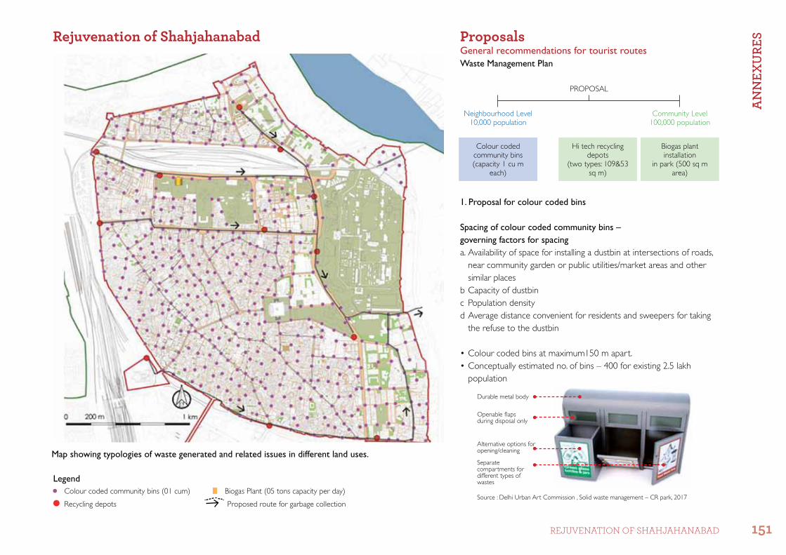
1. Proposal for colour coded bins
Spacing of colour coded community bins – governing factors for spacinga. Availability of space for installing a dustbin at intersections of roads,
near community garden or public utilities/market areas and other similar places
b Capacity of dustbinc Population densityd Average distance convenient for residents and sweepers for taking
the refuse to the dustbin
•Colourcodedbinsatmaximum150mapart.•Conceptuallyestimatedno.ofbins–400forexisting2.5lakh
population
Durable metal body
Openable flaps during disposal only
PROPOSAL
Neighbourhood Level10,000 population
Colour codedcommunity bins(capacity 1 cu m
each)
Hi tech recycling depots
(two types: 109&53 sq m)
Biogas plant installation
in park (500 sq m area)
Community Level100,000 population
Map showing typologies of waste generated and related issues in different land uses.Alternative options for opening/cleaning
Separate compartments for different types of wastes
Waste Management Plan
ProposalsGeneral recommendations for tourist routes
Rejuvenation of Shahjahanabad
LegendBiogas Plant (05 tons capacity per day)
Proposed route for garbage collection
Colour coded community bins (01 cum)
Recycling depotsSource : Delhi Urban Art Commission , Solid waste management – CR park, 2017
An
nEX
URE
S
151rEjuVEnaTIon of Shahjahanabad

2. Proposal for colour coded Bins
•12LocationsforRecyclingDepotsidentified•TwotypesofRecyclingDepotshavebeenproposed,
depending on availability of space, to replace existing dhalaos.
Type 1 – Hi-Tech Recycling Depots:
Type 2 – Hi- Tech Recycling Depots:
RECYCLING DEPOTS
3 D View of Type-1Hi-Tech Recycling Depot 3 D View of Type-2 Hi-Tech Recycling Depot
TYPE 1Inset in parks109 sq m
Total: 06 in number
Facilities1. Area for segregation and temporary storage of recyclable waste2. Public toilet compost pits
Facilities1. Area for segregation and temporary storage of recyclable waste2. Public toilet
Total: 06 in number
TYPE 2On pedestrian paths53 sq m
Compost Pit
Public Toilet
Space for sorting and segregation
Advertising Panel
Landscape Area
Storage for recyclable waste only
Separate entry to toilet
Compost Pit
Waste Management Plan
General Recommendations for Tourist Routes
Advertising Panel
Solar Panel
Storage for recyclable waste only
Space for sorting and segregation
Public Toilet
Temporary storage for organic waste
Design credits : Delhi Urban Art Commission , Solid waste management – CR
park, 2017
An
nEX
URE
S
152 CITY LEVEL ProjECT

The proposed biogas plant with a capacity of 05 tons per day requires about 500 sq m area in Bagh Diwar Park
The following are the standard calculations for 5 ton biogas plants utilized for electricity generation:
3. Lighting of public open spaces-based biogas plant in Bagh Diwar Park:
•Restaurants,hotelsandculinaryzonescontributetoorganicwastewhichwillbetreatedinthe biogas plant.
•Theproposedbiogasplantwillhelpgenerateelectricityandproducemanureasaby-product. This energy can be utilized to light public open spaces (about 700 tube lights).
•ThecapitalcostoftheplantattheexistingmarketvalueisapproximatelyRs.120lakhs.Thepaybackperiod of the project is estimated at 8 years.
Tentative Location of Biogas Plant
Formal Restaurants and Hotels
Culinary Zones – All Day Meals and Snacks Area
Legend
General Recommendations for Tourist RoutesWaste Management Plan
Project biogas utilized for electricity Generation
1. Plant cost Rs 120 Lakhs
2. Biogas generated 300 cum/day
3. Electricity generated 400 kwh/day
4. Auxiliary consumption @ 50kwh/day
5. Annual saving by using biogas (considering 330 operating days)
Rs 7.50 lakhs (350 kwh/day x Rs 6.50/ kwh x 330 days
6. Annual saving from manure Rs 1.8 lakhs (150 tons per annum x Rs 1200/ MT)
7. Savings (electricity+ manure + transportion Rs. 20.8 lakhs
8. Saving to ULB in transportion of waste to landfill site
Rs 11.50 lakhs (5TPD x Rs. 700/ tons x 330 days
9. O & M Cost Rs 20.8 lakhs
10. Net savings Rs 9.50 lakhs/year
11. Simple pay-back period 08 years
An
nEX
URE
S
153rEjuVEnaTIon of Shahjahanabad

Reference list • Blake, Stephen P.,1991, ‘Shahjahanabad The Sovereign City in Mughal India 1639-1739’, Cambridge
University press • Delhi Development Authority, March 2017, ‘Master Plan of Delhi 2021’, Available at: http://dda.org.in/
tendernotices_docs/may1 MPD-2021_31.03.2003041717.pdf• Delhi Development Authority, 1999, ‘ Zonal development plan A & C’, Available at: https://www.dda.org.
in/planning/docs/Zone%20A&C.pdf• Delhi Urban Art Commission , 2017, Solid waste management, C.R. Park• Singh, Upinder, 2006, ‘Readings in History, Delhi: Ancient History’ , New Delhi, Social Science press


Secretary
delhi urban art CommissionCore-6A, Upper Ground Floor, India Habitat Centre, Lodhi Road, New Delhi-110003
Tel: +91-11-24618607, +91-11-24619593Email: [email protected], [email protected] Website: www.duac.org