Reflections on 300 years of the Scots Irish in Maine
256
Reflections on 300 years of the Scots Irish in Maine 1718-2018
-
Upload
khangminh22 -
Category
Documents
-
view
0 -
download
0
Transcript of Reflections on 300 years of the Scots Irish in Maine

Reflections on 300 yearsof the Scots Irish in Maine
1718-2018


ii
First published in 2019 by the Ulster-Scots AgencyThe Corn Exchange, 31 Gordon Street, Belfast BT1 2LG
© 2019 Maine Ulster Scots Project and the Ulster-Scots Agency
ISBN 978 0 9932528 9 1
www.maineulsterscots.comwww.ulsterscotsagency.com
All rights reserved. No part of this publication may be reproduced, stored in a retrieval system, or transmitted in any form or by any means, electronic,
mechanical, photocopying, recording or otherwise, without the prior written permission of the publisher and copyright holder.
The website addresses listed in this book are correct at the time of going to print. However, neither the Ulster-Scots Agency nor the Maine Ulster Scots Project
are responsible for content hosted by third parties. Please be aware that online content can be subject to change.
1718-2018Reflections on 300 years
of the Scots Irish in Maine

iii
Contents
Acknowledgements ivForeword – Norman J. Houston vIntroduction – Rebecca Graham viiRev. James Woodside ix
1. Culture & History 1Aspects of Life in the Bann Valley in the Early Eighteenth-Century – William Roulston 3 Relationships with the Land – John Mann 13By Another Route – Carol Gardner 30 The Somersett Site – Pamela Crane 48European Occupation of Maine’s Eastern Frontier – J. N. Leith Smith & John P. Mosher 69Sarah Montgomery – Rebecca Graham 86Resistance and Reprisal – Michael Dekker 95Causeway Eighteenth-Century: Society in Transition – Helen Perry 116Scots Irish in Brunswick, Topsham and Harpswell – Chip Griffin 131Maps 149
2. Family Stories 153The 1718 Journey of the Andrew McFadden Family and My Personal Journey – Bradford A. McFadden 155The Fighting Woodsides – Fred Koerber 164The Wilsons of Topsham, Maine – Delia Wilson-Lunsford 178Introduction to the Sam Henry Collection – Sarah Carson 197The First Families 205
3. Essays & Music 211The Scots-Irish Reunion March – Composed by Frank Ferrel 213Robert Dinsmoor - Albion’s Seedling – Alister McReynolds 214 Scots-Irish Songs in Maine – Julia Lane 221The 1718 Exhibition at 1st Dunboe Presbyterian Church – Rev. Jim & Alison McCaughan 232
4. Past, Present & Future 241Past, Present & Future – Richard Hanna 243

iv
Maine Ulster Scots Project Committee of Editors
Rebecca J. GrahamPamela Crane
Marilyn Sterling-GondekJudith E. Lindsey
Julie A. Potter-Dunlop
Map Maker
Peter Morrison
Cover Artist
Bill McKeen
Abbreviations
Maine Ulster Scots Project (MUSP)Presbyterian Historical Society of Ireland (PHSI)
Public Record Office of Northern Ireland (PRONI)The Honourable The Irish Society (THIS)
Acknowledgements

v
As Northern Ireland’s diplomatic representative to the United States, I spend most of my professional life promoting my small region of the world in this wonderful country. I must confess, I could not wish for a better job in a more welcoming country and I feel truly blessed to live and work here. When Rebecca Graham asked me to participate in the Diaspora Reunion and Conference in Brunswick, Maine, in August 2018, I did not hesitate in accepting her invitation.
My Scots Irish heritage runs to the very core of my DNA. I was born and raised in Larne, County Antrim, into a family of Non-Subscribing Presbyterians whose ancestors had helped found the local church in 1625 after migrating from the west of Scotland. In the 18th century the port of Larne was a well-used embarkation point for many Ulster Scots who left the north of Ireland to seek religious freedom and economic advancement in the American colonies.
Three centuries later, the descendants of those immigrants have made an indelible mark on the political, religious and economic landscape of the United States. They are as relevant today as they were all those years ago, and they continue to promote a modern and successful Northern Ireland by encouraging Americans, from every background, to invest, visit and study there.
What struck me most about the people I met in Brunswick was not only their passion about their lineage, but their continued commitment to helping people like me raise the profile of Northern Ireland in the United States.
I am most grateful to Rebecca Graham for her enthusiasm for all things Scots Irish, and for her ability to bring people together to explore the rich heritage of the Scots Irish in America. It was a pleasure to travel to Maine in August and to tread the hallowed corridors of Bowdoin College in the company of so many wonderful new friends.
Norman J. Houston OBEDirector/CounsellorNorthern Ireland BureauWashington, D.C.
Foreword


vii
Ten years ago, four unlikely individuals realized they were all independently pursuing a common goal. Each was exploring an important group of people who formed the foundations of everything presently recognized as the quintessential Maine character, and they decided to join efforts. While John Mann and Bill McKeen were busy collecting the family stories and genealogical history of Maine’s Scots Irish families, Barry H. Rodrigue and Rebecca Graham were embarking on documenting a Scots Irish archaeological record along the Eastern border of Merrymeeting Bay. For Mann and McKeen, this was a personal quest to document their own 300 years of connections to Maine. For Rodrigue and Graham, the quest was academic to change the historic narrative of a misidentified community through archaeology and find the “lost” or “transient” colony of “Cork” definitively.
As the work grew, it attracted interest and more passionate participants and was consistently supported by the St. Andrews Society of Maine. While efforts at the Cork Colony wound down, focus shifted towards the western side of Merrymeeting Bay, where Archaeologist Pam Crane joined the efforts, and work shifted to the less disturbed side of Merrymeeting Bay in search of Somersett. The McFaddens, Bradburys, Stinsons, and possibly also the Wilson families that settled Somersett came on the same ship with settlers at Cork; though chose to locate their homes across the water highway from their shipmates. As potential sites were identified, the deed records showed that one site of interest was still owned by the descendant of the 1718 McFadden family. What was once an abstract and technical project to add greater detail to history quickly became personal and lifechanging for the site owner, Bradford McFadden, contributor to this volume.
Over the next five years, as the homestead was uncovered by the centimeter through heat, brown tail moth epidemics, and the onslaught of tick season, each digging team member grew more and more determined to mark the impending 300-year anniversary of the first large scale movement from present-day Northern Ireland to Maine. It was this determination to not let 2018 pass without an event that would provide a platform to launch a wide body of work from many enthusiasts that led to the 1718-2018 Diaspora Conference and Reunion. The goal was, not only to celebrate the anniversary of the initial settlement, but also to highlight a selection of the abundant Scots-Irish stories in Maine, and the significant role these individuals had in shaping Maine. Most importantly, we wanted to share these stories both locally and internationally.
This volume is filled with only a sampling of the papers that were presented over the three days of conference proceedings during August 14-16, 2018 at Bowdoin College, in Brunswick Maine. Some of the papers are very academic; others are poetic, or personal. Two papers in the volume were presented at a sister conference held in Coleraine, Northern Ireland in June 2018. This conference, hosted by Ulster University’s Director of Irish and Scottish Studies, Frank Ferguson, opened the door to deeper collaboration and storytelling
Introduction

viii
internationally. Recognizing the breadth of enthusiasts interested in the topic, and the desire to include family stories, the only caveat for contributing was a passion for the topic. Many of the contributors are from the United Kingdom and Ireland so; language formatting has been retained to reflect original authorial intent.
Additionally, our editing team decided to leave the labels for this group as the author has intended. Terms like Ulster Scots, Scots Irish, Scotch-Irish, all refer to individuals generally understood to have migrated to the United States from the north of the island of Ireland. Due to the political geography of the colonial era, the identity of the first settlers has been muddled adding to the loss of many of these stories. In 1680, Boston leadership adopted laws against the importation of “Irish”, a label that applied to any settler traveling from Ireland who could not prove English lineage so, in many commentaries of the period this group is often referred to as “Irish”. Later generalizations of the term “British” have served to confuse them with the English. All of the descendants of this group in Maine self-identify as Scots-Irish, though as uncovered by Dr. Michael Roe of Seattle Pacific University, their primary identity is often “American” or “Mainer”.
There are also regional differences with labeling this group within the United States. Those with Southern roots tend to use the term Scotch-Irish, while many in New England do not like this term. Three hundred years of moving borders may have diluted the origins, but it has not softened the debate about how to identify our ancestors properly. However, this contemporary, often politically motivated, debate about labels continues to shift the focus away from what is most important—the people. It is because of this we will continue to let the debate play out elsewhere, and like Maine’s indigenous, give the right to the people (or in this case, the authors) to self-identify.
This volume could not have been possible without the continued efforts of new friends and old. The list of individuals who directly had a hand in this effort is enormous in both number and geography. Many thanks go out to each of the contributors to this volume who put up with constant badgering and pleas to make deadlines while maintaining their day jobs. A very special thanks is reserved for our amazing team of editors and map makers, Pam, Judy, Marilyn, Julie, and Peter, who met weekly following the conference to accomplishing a herculean effort of collecting papers, and juggling versions, and chasing materials to meet a moving deadline. Finally, without the commitment of the Ulster-Scots Agency in general, and Richard Hanna in particular, you would not have the opportunity to read these stories. For this, the Maine Ulster Scots Project will be eternally grateful.
Corrections to this volume along with a detailed index of terms will be available at the Maine Ulster Scots website. If you would like to learn more about our work, this publication, or support our efforts, please visit us on the web at www.maineulsterscots.com.
Rebecca GrahamMaine Ulster Scots Project
ix
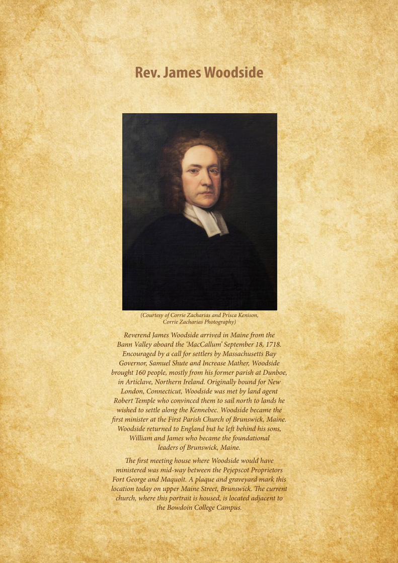
Reverend James Woodside arrived in Maine from the Bann Valley aboard the ‘MacCallum’ September 18, 1718.
Encouraged by a call for settlers by Massachusetts Bay Governor, Samuel Shute and Increase Mather, Woodside
brought 160 people, mostly from his former parish at Dunboe, in Articlave, Northern Ireland. Originally bound for New London, Connecticut, Woodside was met by land agent
Robert Temple who convinced them to sail north to lands he wished to settle along the Kennebec. Woodside became the
first minister at the First Parish Church of Brunswick, Maine. Woodside returned to England but he left behind his sons,
William and James who became the foundational leaders of Brunswick, Maine.
The first meeting house where Woodside would have ministered was mid-way between the Pejepscot Proprietors
Fort George and Maquoit. A plaque and graveyard mark this location today on upper Maine Street, Brunswick. The current
church, where this portrait is housed, is located adjacent to the Bowdoin College Campus.
Rev. James Woodside
(Courtesy of Corrie Zacharias and Prisca Kenison, Corrie Zacharias Photography)


1


3
ASPECTS OF LIFE IN THE BANN VALLEY IN THE EARLY EIGHTEENTH-CENTURY
ASPECTS OF LIFE IN THE BANN VALLEY IN THE EARLY EIGHTEENTH-CENTURY
WILLIAM ROULSTON
Early eighteenth-century Ulster remains a shadowy world. The major events, episodes and processes have been highlighted, examined and outlined. However, to a large extent our understanding of how these impacted or were played out at local level is sketchy. This essay does no more than explore a number of aspects of life in early eighteenth-century Ulster, the era in which large-scale emigration from north of Ireland to America began. Attention is focused primarily on one of the regions most affected by the exodus to New England in 1718, namely the valley of the River Bann.
The aftermath of the Williamite War
Let us begin with the closing moments of the Siege of Derry. The Siege had taken place during the Williamite War fought between supporters of James II and those of William III. On 28 July 1689, a boy named James McGregor is reputed to have climbed to the top of the tower on St Columb’s Cathedral in Derry and fired the cannon that signalled the breaking of the boom – this was the barrier that had been placed across the River Foyle by Jacobite troops to prevent supplies from reaching the city. The breaking of the boom led to the lifting of the siege of Derry and relief for those who remained inside the city’s walls. As many as 30,000 people as well as a garrison of 7,000 men had been packed into the city for over three months and it is reckoned that 15,000 of them died of fever or starvation, or were killed in battle. The legacy of the siege continues to be felt today. Furthermore, it was an event of immense importance in the lives of many subsequent emigrants. Memories of this time were carried with them to the New World and passed down through the generations.
The effects of the Williamite War were not as severe on Ulster as some previous conflicts. Nonetheless large parts of Ulster experienced considerable devastation. In November 1690 John Mogridge prepared a report on the state of the lands of the London companies. The estates in the north of the county largely escaped the destruction of the recent war, though other consequences were being felt. The estate of the Merchant Taylors’ Company, for example, ‘for the most part escap’t burning’, but, Mogridge noted, the ‘few Tenants on it sitt in theire owne houses poor and disconsolate’.1 Other estates in the Bann Valley fared less well. The town of Bellaghy on the Vintners’ estate had been destroyed by fire. At Garvagh on the Ironmongers’ estate, Captain Canning’s house ‘with fine improvements’ he had created over many years and at great cost’ was burnt down along with the village and the best of the tenants’ houses. Mogridge noted that returning tenants were not prepared to hold their lands without coming to new terms with their landlords; landlords in turn were forced to comply with their demands for fear that their lands should become even more wasted.
1 A. H. Johnson, The History of the Worshipful Company of the Drapers of London (Oxford, 1922), v, p. 604.

4
ASPE
CTS O
F LIF
E IN
THE B
ANN
VALL
EY IN
THE E
ARLY
EIG
HTEE
NTH-
CENT
URY
The aftermath of the Siege of Derry saw a fresh influx of Scots to the north of Ireland. In his report of November 1690 Mogridge observed that hundreds of families from Scotland had arrived since the previous winter, though he had few hopes for them noting that they were ‘in appearance poore and indigent persons coming to benefitt themselves’. However, he believed that if peace could be established firmly then ‘many Thousands would come out of Scotland to plant in this kingdome and bee able improve it in some measure.2 It is believed that as many as 50,000 Scots crossed the North Channel into Ulster in the 1690s. This was the most intensive period of immigration to Ulster in the 1600s, greater than the movement of families into the province in the period of the Plantation of Ulster of the early seventeenth century. Many of these migrants were attracted to Ulster because of the prospect of renting land at reasonable prices. Mogridge’s comments on the weak bargaining position of landlords at this time have been noted already. Many others had left Scotland because of the harvest crises in their native land in the mid-1690s which had resulted in considerable hardship – in effect, these were famine refugees. An anonymous tract of c.1711 noted that after 1690 ‘Scottish men came over into the north with their families and effects and settled there, so that they are now at this present the greater proportion of the inhabitants’.3 Though this was an exaggeration of the overall numerical position of the Scots in Ulster, there is no doubt that in certain areas they formed the dominant element in the population.
The religious consequences of this recent immigration were noted by several observers. In 1693 it was recorded that most of the inhabitants of the dioceses of Connor and Down (covering all of County Antrim as well as north and east County Down) were Presbyterians.4
In 1700 the bishop of Derry wrote that due to a fresh wave of migration from Scotland, ‘the dissenters measure mightily in the north’.5 What alarmed him was the fact that in many places there were Presbyterian ministers where previously there had been none. In general, Presbyterian ministers provided leadership to their communities and some of them were to play an important role in the emigration to the New World.
Religious controversy
The period following the end of the Williamite war in Ireland was to prove hugely disappointing for Presbyterians. Having fought for King William, Presbyterians expected their loyalty to be rewarded by the government. However, to their considerable frustration they found themselves excluded from full access to political and civil power as a result of the Penal Laws that were passed by the Anglican-dominated Irish Parliament. The Penal Laws were passed to preserve the privileged position of the Anglican elite. For example, as the result of a series of acts of parliament Catholics were forbidden to bear arms, to enter the legal profession, to own a horse worth more than £5, to buy land, and to lease land for more than 31 years, while in 1728 they were denied the vote. While Catholics may have
2 Ibid., p. 605.3 R. Gillespie, ‘Continuity and Change: Ulster in the Seventeenth Century’, in C. Brady, M. O’Dowd and
B. Walker (eds), Ulster: An Illustrated History (London, 1989), p. 125.4 PRONI, DIO/4/5/3, no. 23.5 PRONI, DIO/4/29/2/1/2, no. 10.

5
ASPECTS OF LIFE IN THE BANN VALLEY IN THE EARLY EIGHTEENTH-CENTURY
been the main target of the Penal Laws, this legislation also affected Presbyterians and other nonconformist Protestants.
Presbyterians were particularly aggrieved when the provisions of the Test Act were extended to Ireland in 1704. Henceforth those wishing to hold civil and military office would have to produce evidence that they had taken communion in the Church of Ireland. Furthermore, marriages conducted by Presbyterian ministers were not considered valid and children born of such marriages were regarded as illegitimate. It is true that in 1719 the Toleration Act was passed, but this simply gave Presbyterians the right to attend their own places of worship without being penalised. Presbyterians particularly resented having to pay the tithes that were demanded by Church of Ireland clergy. The manner in which these tithes could be collected also provoked consternation. According to Pyke, tithes were collected from tenants on the Ironmongers’ estate ‘in so rigorous a manner as is not known and scarce would be believed in England, so that I do not wonder they have so few converts from ye Roman Catholic religion to ye Church and yet Presbyterians have so many.’ 6 He also regarded the payment of tithes as a discouragement to agricultural improvement. For instance, farmers were put off from transforming bogland into farmland for once they had done so they would have to pay tithes on it.
The Church of Ireland may have been the state or established church in Ireland. Yet it enjoyed the support of only around 10% of the population of Ireland as a whole in the north of Ireland this figure would have been around 20-25%). Its dominance, however, can be seen in the fact that a list of c. 1730 of gentlemen in Ulster believed to be worth more than £100 per annum included the names of 490 members of the Church of Ireland, but only 41 Presbyterians and a mere 8 Catholics.7 For many members of the establishment, Presbyterians were regarded as more of a threat than Catholics, especially because of their numerical superiority over Anglicans in Ulster. No less a figure than Jonathan Swift is believed to have been the author of a 1733 tract in which the writer asked ‘Whether the Scottish Ulster Presbyterian Farmers, Tradesmen and Cottagers’ were a ‘more knavish, wicked, thievish race than even the natural Irish of the other three provinces’. 8
Ezekiel Stewart of Fortstewart, County Donegal, was clear in his own mind as to who was encouraging discontent among Presbyterians as the following extract from a letter of 1729 reveals:
“The Presbiteirien Ministers have taken their shear of pains to seduce their poor ignorant heares by bellowing from their pulpits against ye landlords and ye clargey, calling them rackers of rents, and servers of tythes, with other reflections of this nature, which they know is pleasing to their people, at ye same time telling them that God had appoynted a country for them to dwell in (nameing New England) and desires them to depart thence, where they will be freed from the bondage of Egipt and go to ye land of Cannan.” 9
6 London Metropolitan Archives, MS 17,275.7 PRONI, T3446/1.8 I. McBride, Eighteenth-Century Ireland (Dublin), p. 291.9 PRONI, D2092/1/3.

6
ASPE
CTS O
F LIF
E IN
THE B
ANN
VALL
EY IN
THE E
ARLY
EIG
HTEE
NTH-
CENT
URY
Among the reasons that the establishment was particularly concerned with the Presbyterian Church was that it provided an alternative source of authority through its different levels of church government. For example at congregational level was the session, composed of the minister and elders, above that was the presbytery which included a number of congregations in a defined geographical area. At the top was the Synod of Ulster, which drew representatives from each of the congregations. The Aghadowey session book provides us with a unique opportunity to delve into the workings of a Presbyterian congregation in the Bann Valley in the early 1700s.
The earliest surviving session book for the Presbyterian congregation of Aghadowey begins in 1702 and continues until 1761.10 This is one of the most important documents relating to Presbyterians in this area. In 1909 the session book was donated to the Presbyterian Historical Society of Ireland, which remains its custodian. There is a great deal more detail in the minutes for the early decades, with the records of meetings becoming very brief towards the end. Intriguingly, the minutes make no specific mention of the departure of McGregor and others from the congregation in 1718.
From this session book, we can learn about the discipline that was exercised over members of the congregations who had transgressed in various ways. These extended beyond the moral conduct of the members. For example, in 1705 the session dealt with a dispute among some of the farmers in the congregation over the possession of a certain landholding. Several times the session admonished farmers for using charms to cure livestock of diseases. One woman was accused of being a witch. The session book also includes accounts showing the distribution of funds to those in need. Additional references to the meeting house indicate it was either rebuilt or extended at the beginning of the eighteenth century. This building was thatched as was the small, separate session house. The seating arrangements in the meeting house were also ultimately regulated by the session. Interestingly, a number of Gaelic Irish names appear in the session book – O’Cahan and O’Dugan, for example – indicating that the congregation was not entirely composed of families with Scottish roots. Having said that, it would seem that none of these individuals held a particularly important role in the management of congregation, none of them was an elder, for example, though John O’Quig had possession of the keys of the meeting house and may have been the sexton.
The economy
The single most important reason for the development of Ulster’s economy in the eighteenth century and the province’s increasing prosperity, was the rise of the domestic linen industry.11 Linen had been part of the Ulster economy prior to 1700, but it was in the eighteenth century that it emerged as its most powerful element. A factor encouraging the linen industry was the passing of an act in the English Parliament which allowed Irish linens to be imported into England duty free. In 1704 a further act of the English Parliament permitted Irish linens to be exported directly to America.
10 On deposit in the Library of the Presbyterian Historical Society of Ireland, Belfast.11 For more on the linen industry see W. H. Crawford, The Impact of the Domestic Linen Industry in Ulster
(Belfast, 2005).

7
ASPECTS OF LIFE IN THE BANN VALLEY IN THE EARLY EIGHTEENTH-CENTURY
The main areas in which the linen industry developed initially were north Armagh and the Lagan valley. However, at a fairly early period the impact of the linen industry began to be felt in the Bann Valley. In September 1709 the corporation of Coleraine petitioned the Irish Society of London – the Irish Society was a kind of umbrella organisation for the London companies with lands in County Londonderry. The corporation requested assistance from the Irish Society to ‘encourage the establishment of a linen manufacture in that town as a means of increasing the trade and prosperity thereof but the Society doubted whether such an undertaking was practicable and consistent with the constitution of the Society to encourage’. That was no doubt deeply frustrating to the townsmen. However, by an Act of Parliament of 1711 the term ‘Coleraines’ was applied to linens that were seven-eighths of a yard wide, suggesting that the industry had put down strong foundations in the area.
Economic progress, however, was not entirely in one direction and there were many fluctuations in trade and commerce which impacted upon the livelihoods of families in Ulster. According to the one historian, in the years following 1710 ‘the Ulster economy went into a severe and prolonged depression.’ 12 Population growth virtually ceased. The population of the province in 1712 has been estimated at around 600,000. Twenty years later the population was still around 600,000. From the mid eighteenth century the economy began to improve and the population of Ulster – and Ireland – began to increase quite dramatically and in fact by the early 1820s had increased to 2 million – a trebling of the position just 90 years before.
Landed estates
Let us now turn to the relationship between people and the land and to note at the outset that until the beginning of the twentieth century the most important unit of land organisation in Ulster, like the rest of Ireland, was the estate. Very few farmers owned their farms outright, but rather leased them from a landlord or an intermediary known as a middleman. It was not until the passing of a series of acts of parliament in the late nineteenth and early twentieth centuries that an owner-occupier class of farmers was created. As already noted, the 1690s was a comparatively good time for farmers to lease land as landlords were not in a strong bargaining position. However, from the mid 1710s landlords began to raise rents. Tenants, needless to say, were hostile to this.
Perhaps to deflect attention from their own role in encouraging emigration, the Anglican clergy were quick to blame landlords for creating the circumstances in which emigration was viewed as a better option than remaining in Ulster. In 1719 the archbishop of Dublin observed that the sharp rise in the rents mean that it was ‘impossible for people to live or subsist on their farms’. Others were hearing these arguments first hand from the departing migrants. In August 1718 Joseph Marriott informed the Clothworkers’ Company and the Merchant Taylors’ Company, both London guilds with lands in the Bann Valley, that ‘one reason they give for their going is the raising of the rent of the land to such a
12 R. Gillespie, ‘The early modern economy, 1600–1700’ in L. Kennedy and P. Ollerenshaw (eds), Ulster since 1600: politics, economy and society (Oxford, 2013), p. 22.

8
ASPE
CTS O
F LIF
E IN
THE B
ANN
VALL
EY IN
THE E
ARLY
EIG
HTEE
NTH-
CENT
URY
high rate that they cannot support their families thereon with the greatest industry’. A few months before this, Marriott had commented that on one estate near Coleraine – that leased by Richard Jackson from the Clothworkers’ Company of London – the rents on several farms had been raised to double and in a few instances even treble their value since 1690.13
An interesting memorial from James Willson, dating from May 1735, provides a further insight into the situation prevailing in the Bann Valley at that time. Willson, who was the lessee of the lands of the Mercers Company of London, wrote:
“That about 12 years since [one can quibble about the span of years] several of the inhabitants of Ireland (and more particularly in that part of the kingdom where your Worships’ estate is situated) began to leave their settlements, and transport themselves into several colonies in the West Indies [a term frequently applied at this time to North America in general].” 14
The main reason for this, according to Willson, was the ‘great oppression of landlords’ in raising rents. The consequence of this for the tenantry was that it had ‘reduced them to such a state of despair that they chose rather to leave their native country and seek their fortunes in a strange land than starve at home’. As a result many estates ‘are become almost entirely desolate’. The departure of so many of their tenants was a cause of considerable concern to many Ulster landlords as they feared that it would lower the value of their estates. Landlords were also worried that vacated farms would be taken by tenants of lower calibre than their predecessors. There was realistically little landowners could do to prevent tenants from leaving their farms. Robert McCausland advised William Conolly in November 1718 that if there was any decree from the government forbidding people from emigrating ‘it would make them the fonder to go’. 15 He set out his own position on the matter: ‘all I would have done, if it were possible, to oblige these “rougs” who goes of[f] to pay their just debts before they go, and then let all go when they please who are inclined to go’.
Vulnerability to the elements
If the general economic pressures facing families were not bad enough, there were also the added pressures of inclement weather producing bad harvests or periods of drought. When you read contemporary letters and accounts you are struck by the sheer vulnerability of our ancestors to the elements. Periods of difficulty, such as the late 1710s, left many people in situations of real need. In June 1718 the English-born bishop of Derry wrote that he had ‘never beheld (even in Picardy, Westphalia or Scotland) such dismal marks of hunger and want as appeared in the countenances of most of the poor creatures that I meet with on the road.’ A few years later, in 1721, he observed that ‘the miseries of this kingdom are truly deplorable. The number of starving beggars daily increase in proportion to the general want of money’. Exacerbating the situation was the fact that that year a ‘hard winter killed most of the cattle’. Back in 1716 and 1717 disease had killed large numbers of livestock.
13 R. J. Dickson, Ulster Emigration to Colonial America (London, 1966), p. 29. 14 PRONI, MIC/225/2.15 PRONI, T2825/C/27/2.

9
ASPECTS OF LIFE IN THE BANN VALLEY IN THE EARLY EIGHTEENTH-CENTURY
The late 1720s was another period of intense suffering. In February 1729 Hugh Boulter, archbishop of Armagh, wrote to the lord mayor of London, telling him that there had been three bad harvests in the last four years and the most recent had been the worst of all. He related that on the previous 1 August a ‘great tempest’ had destroyed the corn crop. As a result, the price of corn had increased to such an extent that the poorer people were starving. Boulter hoped that the London companies ‘would not be wanting out of their plenty to contribute to the relief of ye many thousand distrest protestants in those parts’. As well as poor harvests, Boulter also lamented ‘the additional misfortune’ of emigration to America, a ‘humour’, he noted, which ‘spreads like an infectious distemper’ amongst people of substance and poor alike.’ This was an additional incentive for the London Companies to intervene to help to relieve starvation for it might halt the tide of migration.16
Towns, villages and rural settlement
While the great majority of people were rural dwellers, a number of towns and villages had developed in the course of the eighteenth century. Coleraine was the most important settlement in the Bann Valley. It was a corporate or borough town – a town that had the right to return two members of parliament to the Irish House of Commons in Dublin. Its status also meant that it had its own form of self-government through the corporation. When Thomas Molyneux visited Coleraine in 1708 his initial impressions of it were positive for he described it as ‘a good, large, compact, well-built Town, situated on the Fine River Bann. It looks like a clean, pretty Town as you go thro’ it’. However, his impressions of the inn in which he stayed were less positive for he described it as ‘the most drunken, Stinking Kennel that ever I smelt or saw.’ 17
Other towns included Ballymoney, described by Molyneux as ‘a pretty, clean, English-like Town belonging to the Earl of Antrim’. We can see its layout from this map of 1734 from the Antrim estate collection. In viewing one will note a well developed street system with tenements running back from the street fronts. You can also note the Church of Ireland church, the ruins of which can still be seen in the old graveyard in the town, and the Presbyterian meeting house. These towns possessed an emerging middle class of merchants and shopkeepers and a few professionals, such as doctors and lawyers. An improving road network connected these towns. Molyneux was full of praise for the newly laid out road from Coleraine to Limavady. He noted:
“From this to near Newtown, which is half-way to Derry, is all a most Excellent, new, artificially-made Cawsey in dismall, wild, boggy mountains. It runs for Some miles in an Exact Straight Line, and it makes a pretty figure to see a work so perfectly owing to Art and Industry in So wild a place. ’Twill cost 600l.”
Landlords played their role in urban development. For example, in 1725 Pyke described how the landlord of Garvagh, a settlement of 55 houses, was actively developing it, writing, ‘Mr Canning in order to improve this part of his Estate is abot Building 4 Double houses with upper rooms and 6 Lesser and also dividing ye Land into many small fields’. Twenty of
16 PRONI, D4108/1/14O.17 R. M. Young, Historical Notices of Old Belfast (Belfast, 1896), pp 157–8.

10
ASPE
CTS O
F LIF
E IN
THE B
ANN
VALL
EY IN
THE E
ARLY
EIG
HTEE
NTH-
CENT
URY
these were to be of a single acre in extent to be near the tenant’s houses, the rest of 4-6 acres. Pyke also noted the Church of Ireland church in Garvagh, which had been built in 1670, but which was ‘not only out of repair, but kept scandalously nasty on ye inside’.
Further down the scale were villages such as Artikelly, which had emerged as the chief settlement on the Haberdashers’ Company’s estate in the early seventeenth century. In 1690 Mogridge described it a ‘long Country towne’. The Beresford estate map of 1717 18 shows its linear pattern very clearly. There were also some ‘lost towns’, settlements that had been created in the early 1600s during the initial phase of the Plantation, but which had disappeared over the course of the seventeenth century. These included the settlement near Agivey created by the Ironmongers’ Company, which you can see in a drawing prepared in 1622 by the cartographer Thomas Raven. 19 By 1725 Pyke found that all that remained of the castle was ‘Two old Towers at the Salliant or extream angles, on one there is a Pidgeon house, ye other when in use has been a Summer House, but now both ready to fall in’.
Landscape
The rural settlement pattern varied quite considerably, depending on the nature of the terrain and the intensity of the farming. Overall, the landscape of the Bann Valley was not the tightly packed network of fields divided by hedgerows that we are familiar with today. Whereas Molyneux in 1708 noted the enclosures around places like Lisburn in south County Antrim, he did not make any mention of this when he moved further north. Indeed, he observed that his journey to Ballymoney had been through a ‘wild, open Countrey’. When Pyke visited the Ironmongers’ estate in 1725 he found some enclosure, but also much open land. For example, in Lissmore he found about 18 well-enclosed fields. On the other hand he noted the following about Bwalla O’Cahane: ‘the land lies naked without fence or hedge, which makes it cold and spouty’ – spouty being a word for ‘wet’. Bwalla Clogh was ‘cold, naked & open without any trees or fences’. There was certainly room for improvement and he recommended in general that land should be enclosed, the fields of 4-10 acres surrounded by stone walls.
With regard to the sort of houses that people lived in during this period, Pyke has left us a good description of the houses of the farmers that he encountered on the Ironmongers estate:
“A house in this country usually consists of 3 Rooms about 12 or 14 Foot each, and to that house a Stable Cowhouse and sometimes a Barn but the Barn is commonly at some distance so that one of the houses measured on the outside is between 70 and 80 Feet long, I have measured many of them and find that they are all thereabouts, they are built with Stones and Mudd and but few of them are pointed with mortar, they are very low, the windows small and ordinary, many of them have no windows, the Covering is a thatch of Straw of Course Rushey Grass but as there is not any thing uniform about them, it may be sufficient to say they are such as they build themselves without the help of carpenters or masons.”
18 Stewart, Alexander, Maps of Sir Marcus Beresford’s Estate (National Library of Ireland, MS L 405).19 Thomas Raven’s map of the Ironmonger’s lands (Lambeth Palace Library).

11
ASPECTS OF LIFE IN THE BANN VALLEY IN THE EARLY EIGHTEENTH-CENTURY
On the other hand, Pyke noted that the homes of the cottiers were much smaller, though he does give us a specific description of them.
The Beresford estate maps of 1717 20 provide cartographic evidence of the nature of rural settlement. For instance, in the townland of Movennis, marked as Movenny on the map, we note a cluster of sixteen houses. Now how much we can read into the way the forms of the houses are represented on this map is uncertain – they do not resemble the long farmhouses that Pyke noted. Nonetheless, it is interesting that all of the houses in this townland are in this cluster. The same pattern of clustering can be observed in other townlands on the estate, but we also find townlands where the houses are most scattered. It is unfortunate that we do not have additional information on the management of the estate at this time and so therefore we should be cautious about drawing too many conclusions on the basis of the maps alone. However, it may be the case that the practice of rundale was in operation. Under this system land was leased in partnership by several families, perhaps, but not necessarily, related to each other. These families then allocated the land among themselves. It was a system that varied considerably and offered great flexibility to the farmers.
In general, in the Bann Valley the population density was low in the early eighteenth century – it would certainly become much more densely populated as the century wore on. Several times Pyke lamented the low population density on the Ironmongers’ estate. This was a concern for him for it means that it was difficult to raise rents even on good land. He noted that ‘it may appear that this land is lett very low which I think may be imputed to the small numbers of people who inhabit there for were there more people to be tennants lands would lett better but the North of Ireland is better peopled than many other parts, yet industrious men to become tennants are much wanted.’ One of his suggestions for improving the estate was the encouragement of the linen industry. He urged:
“To remedy which ’tis propper to give encouragement to people skilfull in the linnen manufacture to settle, and that encouragement may as well be given by advancing the rents and by lowering them for the spinners and weavers need no land or but very litle just for a garden to their houses. & therefore I have no better way than to build several small houses with each about an acre or less of land enclosed and these houses will never want tennants.”
His preference was for ‘some poor weaving families from England’ to be settled on the estate, though he acknowledged that there would be expenses associated with this.
Pyke also encountered evidence that the landscape had once been more densely populated that he found it in 1725. For instance, with regard to the townland of Gortacloghan Pyke noted, ‘Ye foundation of several Houses and ye remains of Divers Fences which shows this Land has been much better inhabited than it is’. One wonders whether that was to do with the recent migration to New England or an earlier exodus from the land. He found that Bwalla O’Hagan had ‘formerly been very well enclosed with quickset and other hedges & many ash or fir trees, still remaining in the hedge rows now run to ruin’. Furthermore, the tenants has ‘plowed ye heart out of it’. Pyke attributed this situation to the fact that the
20 Stewart, Alexander, Maps of Sir Marcus Beresford’s Estate (National Library of Ireland, MS L 405).

12
ASPE
CTS O
F LIF
E IN
THE B
ANN
VALL
EY IN
THE E
ARLY
EIG
HTEE
NTH-
CENT
URY
tenants in this townland were getting ready to leave the land. He noted that ‘most of them have agreed to go to New England where many do go from hence every year, these are most of them Scotch people.’
Conclusion
In broad terms, something of the nature of the economy and society of early eighteenth century Ulster, with a focus on the Bann Valley, has been outlined in this essay. This era witnessed the first great surge of migration from Ulster to America, which lasted from the late 1710s to the late 1720s. During this period families from Ulster, the great majority of them Presbyterians, comprised the largest grouping to cross the Atlantic, with the exception of those who were transported there in chains as slaves. The factors that lay behind emigration from Ulster were many and complex. When we read the arguments of contemporaries we see ample evidence of the blame game – Anglican landlords blamed the Anglican clergy, the Anglican clergy blamed the Anglican landlords. The Presbyterian clergy were blamed by both, while in turn the Presbyterians blamed the Anglicans.
Earlier writers tended to put the religious argument for emigration front and centre. More recent historians have argued for the primacy of economic factors. However, in the reasoning of our ancestors there probably was not a clear cut separation of the issues. Religious pressures and economic difficulties were bound up together. As has been observed by others, hardship and oppression went hand in hand.21 However, as well as the push factors, we also need to consider the pull factors and the draw of the New World. The men, women and children who left for America in the early 1700s were certainly not the last to make this momentous journey. Many hundreds of thousands of others would follow. Today, the descendants of many of these emigrants travel to Northern Ireland, retracing the steps of their ancestors as they try to find out more about their roots and reconnect with long-lost cousins.
21 Patrick Griffin, The People with No Name: Ireland’s Ulster Scots, America’s Scots Irish, and the creation of a British Atlantic World, 1689–1764 (Princeton, 2001), p. 83.

13
RELATIONSHIPS WITH THE LAND
RELATIONSHIPS WITH THE LANDThe Scots Irish experience in the district of Maine
JOHN MANN
I have come to believe three primary elements supported the successful transition of Scots Irish from the North of Ireland to the District of Maine – Family, Faith, and Freedom.
Freedom started with owning land. With secure land titles, the Ulster emigrants would be free from rent payments, free to support themselves, and free from the schemes of absentee landlords and empire builders. They could have freedom that was built on sweat-equity, individual liberty, and family support. Their version of freedom was far removed from the social ordinances of Puritan Massachusetts and the centralized authority of an English monarchy. Acquiring defendable land title in Maine required dealing with a Massachusetts based land title history and power structure. But, with the right piece of land, a young man could build a home. With a home, he could support a wife. With a wife, he could support a family. With a family, he could work the land and create an estate that could be transferred reserving a life estate for the room, board, and care during old age and to create a start for future generations. Success would require the support of family, a faith that would sustain the will to persevere, and a working relationship with the land.1
Land Acquisition
We all recognize the outline of the State of Maine as currently established, but reaching the current boundary definition was a long, often violent, and confrontational process. 2
Defining ownership boundaries was also a challenge for the individual European property owners that first managed to take root here. Creating defendable land titles was an ongoing process. How that story evolved has affected the lives and fortunes of everyone involved, and continues today.
Land and title background leading up to the 1718-1722 arrival of the Scots Irish
It is well-documented that over 30 communities of Scots Irish settled in the District of Maine before the American Revolutionary War. 3 Each community has its unique history –making generalizations about why and how the land was acquired often through risky processes that were prone to incorrect or misleading conclusions.
For purposes of this paper, and in keeping with the 1718-2018 reunion themes, I am focusing on the start of the great wave of immigration from the North of Ireland that arrived in the District of Maine from 1718 to the break-out of Lovewell’s War in 1722. There were arrivals before that date, but the numbers were relatively few.
1 My father summed this philosophy up in one phrase that he used when he asked why I was building a house at the age of 18: “It takes a cage to catch a canary”.
2 Acts and Resolves Public and Private of the Province of Massachusetts Bay (1902). Boston, MA: Wright & Potter; 9, Chapter 119 (December 3, 1710), p. 636.
3 Hannah, C. A., The Scots in North Britain, North Ireland and North America (1968).

14
RELA
TION
SHIP
S WIT
H TH
E LAN
D
It is certainly true that the Scots Irish had a great desire to own land. It was quite possibly the greatest motivator for those that chose to remain in Maine. Although there were a few tenancies among the early arrivals, that system of land occupancy was not preferred, and great expenditures of energy were put into acquiring freehold interests in land. The notion of a successful transition from life in Ireland to life in America was centered on the acquisition of large tracts of land, and the new arrivals were quick to push for ownership of the best locations they could find.
Occupying the land and having defendable title to the land are two very different things. The success and fortunes of the Scots Irish in Maine for the next century would
Figure 1A look at the region known as Maine from the perspective of New France was much different, with New France and the Abenaki claiming most of what is now the State of Maine.4
4 Maine Historical Society, (1976).

15
RELATIONSHIPS WITH THE LAND
hinge on what piece of land they occupied and whether they could successfully acquire defendable title to it.
The separation that began the Maine experience
The early arrival of the Scots Irish in Maine included those at Falmouth on the Robert, connected with Reverend McGregor’s group, those who arrived in Brunswick on the MacCallum with Reverend Woodside’s group, and also those who arrived on several ships at Cork with Robert Temple’s group. The new arrivals soon separated into two major
Figure 2 Detail from “Mitchell’s Map of North America, 1755” courtesy of the Maine Ulster Scots Project [MUSP] with special thanks to David Mitchell.

16
RELA
TION
SHIP
S WIT
H TH
E LAN
D
factions: Those who stayed in Maine (who would now be known as Mainers) and those that moved on (who would now be called “from away”). The following is a list of the earliest “Scotch-Irish” settling at Casco Bay, taken from Charles Knowles Bolton’s Scotch-Irish Pioneers in Ulster and America (1910).
James Armstrong John Armstrong Simeon ArmstrongThomas Armstrong John Barbour Thomas BoltonRev William Cornwall Joshua Gray Anne HansonRobert Holmes & wife William Holmes & child William Jameson Joan Maccoullah Randall McDonaldBryce McLellan Robert Means Andrew SimontonWilliam Slemons or Slemmons 5
5 Bolton, C. K., Scotch Irish Pioneers in Ulster and America (1910).
This time is a defining moment in the resulting culture and character of the Maine Scots Irish experience. This experience forms a somewhat different culture and experience from that of our cousins in New Hampshire and the South.
Some of those that moved on stayed connected initially to Reverend McGregor and his organized Presbyterian based religious community, developed an organized, centralized town and parish which remained relatively free of troubles during territorial disputes with the native Wabanki, and assisted with the emigration and distribution of many new emigrants from the North of Ireland.
Those who remained in the District of Maine were spread out over large, remote, geographic areas in indefensible locations with hit-or-miss access to Presbyterian clergy. They faced bothersome interference and ineffective support of a faraway Massachusetts, Puritan-based government. The Massachusetts government was at odds with their French neighbors to the north and east, and their Wabanaki neighbors to the north, east, and west, and they were insistent on the support of their Congregational Church, all of which created ongoing problems for Maine’s Scots Irish.
The group that stayed in the District of Maine was augmented over time by many new Ulster emigrants who continued to spread East on the District of Maine’s coast and rivers, always looking for the best land, the best prospect, and learning to expect little or no help from any far away centralized government body. They looked to the land to provide their support, and the culture defined itself around that relationship with the land. There are numerous accounts of Maine Scots Irish being temporarily driven from the land, or sending vulnerable family members south during the Indian Wars, only to return and continue occupying their Maine homesteads after the troubles subsided. Maine’s coastal towns are still occupied with descendants of those first tenacious Scots Irish emigrants living and working the land and the sea that they first took possession.
Those who now live on just a small corner of the original family farm, after all the best land has been sold or split off, are sometimes referred to as “Swamp Yankees.”

17
RELATIONSHIPS WITH THE LAND
Land, Freedom, and the Need to Defend Land Titles
The struggle to establish defendable title to land in Maine has a long complicated history. Suffice it here to say that the “District of Maine,” in 1718, lay between the Province of New Hampshire border on the west and the Kennebec River on the east beyond which was the region commonly called “Sagadahoc” and Nova Scotia, claimed by France. The Native American territory also extended from Quebec southerly down the Kennebec River valley into Merrymeeting Bay and to the eastward.
The Maine Ulster Scots Project is learning from our Maine-based stories of where a family settled in relation to the Kennebec River had an enormous impact on their resulting success.
The Ulster families that were settled east of the Kennebec River by David Dunbar, Robert Temple, Samuel Waldo, and others, struggled for a century with the uncertainty resulting from challenged land titles. They had no freedom from land-lords or Massachusetts-based empire builders. They were ultimately forced to mount their backwoods revolution of “Liberty Men” and “white Indians” to clear the title to their homesteads. 6
Families occupying land west of the Kennebec River, like the McLellan’s of Gorham and Falmouth and the Patten’s of Cathance Point, were able to purchase land titles that were existing in less disputed territory. Their resulting land-based freedom sometimes led to substantial financial success. The McLellan’s oral family stories were captured in writing by a descendant, Reverend Elijah Kellogg, and so have endured being examined in relation to the larger Ulster-Maine emigration story. 7 Timber and farmland anchored Hugh McLellan’s financial success. Transforming timber into shipping and trade anchored the Patten family fortunes.
The McFadden family first settled in the heart of the Kennebec River valley at Merrymeeting Bay and was driven out during an Indian Raid in 1722, at the beginning of Dummer’s War. They, and other Ulster Scot families, relocated down river before spreading into new territories. 8 Their story represents the “hot molten center” of the territorial disputes that occurred during the Indian Wars. 9
Together these stories help to explain why the Kennebec River Valley is central to the current investigative work of the Maine Ulster Scots Project (MUSP). The project’s archaeological studies along the Kennebec River at Merrymeeting Bay, survey work at Flying Point, and continuing archival research of Maine’s first Ulster families are bringing us ever closer to understanding the first years of settlement in the District of Maine and the relationship between the Kennebec Valley in the District of Maine and the river valleys in Northern Ireland. This work will help save the facts of our shared history and perhaps even add a written chapter to our Maine history books.
6 Taylor, Alan, Liberty Men and Great Proprietors: The Revolutionary Settlement of the Maine Frontier, 1760-1820 (1990).
7 Kellogg, Rev. E, Good Old Times ; or, Grandfathers struggles for a homestead (1878).8 Allen, C. E., History of Dresden Maine (1905).9 Webb, J., Born Fighting: How the Scots-Irish Shaped America (Broadway Books, 2004).

18
RELA
TION
SHIP
S WIT
H TH
E LAN
D
Maine: A History of Interrupted Land Claims
Massachusetts-based merchants and land speculators had gambled heavily on vast inexpensive land claims in the District of Maine during the seventeenth century. The English system of wealth and class structure relied in large part on ownership of large tracts of land by the privileged few. Confusing and overlapping land titles and recurring hostilities with the French and Wabanaki, made a land acquisition in nearby Maine relatively inexpensive, but very risky. If land titles claimed through land grants and Indian deeds could be secured through occupation and improvements by settlers under the direction of Massachusetts proprietors, rewards from increased property values and tenant rents might secure a family aristocracy in the New World. Such gambling on land titles was extensive among many of the most prominent families in Massachusetts and by the end of the seventeenth century, several mill privileges and settlements were established between the Piscataqua and the Kennebec rivers, including the up and coming settlements at York and Falmouth. The stakes were enormous. Tensions were high. Disaster followed.
In May 1690, Fort Loyall in Falmouth on Casco Bay was attacked. French and Wabanaki forces laid siege and, upon surrender of the fort, some 200 occupants were killed. Approximately one hundred people were taken captive.
Then, disaster struck the District of Maine again and sent its ugly repercussions into the heart of Puritan Massachusetts society. On Candlemas, near the end of January 1692, Wabanaki and French military officers attacked York killing nearly 100 people, including the Congregational minister Shubael Dummer. Another 80 were taken captive and marched overland to Canada, including Dummer’s wife Lydia, who died during the ordeal, and their son. Many of the buildings north of the York River were burned. The English settlements in the District of Maine collapsed back into Massachusetts and a form of hysteria ensued.
Fear of the French and Wabanaki was obvious and understandable at this point. The near total collapse of property values within the vast District of Maine landholdings was undoubtedly a severe financial shock that might take generations for investor’s families to recover from, if ever. The balance of good and evil was apparently shifting dramatically to the “dark side”. There was no ability to foresee what calamity and sudden loss of life and fortune would happen next. From the Puritan perspective, the Devil and his minions were obviously at work. Someone must be to blame for bringing the terrible forces of darkness to the doorsteps of Essex County. Something had to be done to restore the light and the blessings of God upon the people of the District of Maine and Massachusetts. This was an old theme, and, it did not seem hard to point blame, and perhaps settle old scores with accusations against those in league with the Devil himself.
Two groups were easily identified; the “heathen” Indians and “Papist” French. It was also easy to imagine devilish connections with those who consorted with the Indians by bartering for Indian deeds and like transactions.10 Emerson Baker and James Kences in Maine History, Vol. 40, number 3, Fall 2001 reports that Cotton Mather, leader of the Puritan Church, was able to point out the source of the problem: “…in the ‘more Pagan [out-] skirts
10 Kershaw, G. E., The Kennebec Proprietors (1975).

19
RELATIONSHIPS WITH THE LAND
of New-England Satan terribly makes prey of you, and Leads you Captive to do his Will.” John Francis Sprague state in ‘Sprague’s Journal of Maine’ “... that strange and awful delusion led by Cotton Mather and his cruel and blood thirsty associates swept over Puritan New England, in the last days of the Seventeenth Century, known...as the ‘Salem Witchcraft...” 11
After the initial hysteria of the Salem witch trials subsided, there was still the problem of how to restart the economic engine of land settlement on the Eastern Frontier. Land claims in the District of Maine lay idle and the potential fortunes from future land sales and development of Maine’s natural resources were at risk of being completely annexed to French control at Nova Scotia. The Nova Scotia claim already extended as far west as the Kennebec River and with English settlement west of the river virtually wiped out; the entire District was at risk of being lost to France.
Ironically, the Scots that had moved to Ulster Plantation during a period of religious intolerance and witch persecution now became the Puritan focus for confronting witches and demons in the Maine frontier. By 1718, the circumstances that brought Scots to Ulster had deteriorated. Cotton Mather followed the course of these events in Ulster and saw a solution for the problems in the District of Maine. The Presbyterian Scots of Ulster may have been “greatly obnoxious to the ruling party of New England...” Reverend Jacob Bailey of Pownalboro, Maine, would later write in his journals but they were not “Papists or heathens.” And, they had earned a strong reputation as fighters while defending their frontier territory in Ulster against the “heathen Irish.” The Ulster Scots victory for the Protestant, William of Orange at the Siege of Londonderry had been contemporaneous with some of the worst of the Indian troubles in Maine. Mather hoped an introduction of the Scots Irish in the District of Maine would assist in securing eventual English possession of the Eastern Frontier and Nova Scotia. On September 20, 1706 Mather records: “I write letters unto diverse persons of Honour in Scotland and in England; to procure settlements of good Scotch Colonies, to the Northward of us, this may be a thing of great consequence.” 12
One particular area of great consequence to Massachusetts investors was the area surrounding the confluence of the Kennebec and Androscoggin Rivers near the current towns extending from Small Point to Brunswick and Bowdoinham, District of Maine. Several large tracts of land held by Massachusetts proprietors connected or overlapped in this area, including the Kennebec Patent, the Pejepscot Patent, and the Dummer Claim. It also included “Merrymeeting Bay,” which was an important and historic summer meeting place for Wabanaki Indians.
Reverend James Woodside of Garvagh was the leader of one of several congregations that accepted the challenge and brought his followers to New England early in the 18th century. Mather wrote to Woodside on 3 December 1718, extending his confidence in the new settlement at Brunswick near the confluence of the Androscoggin and the Kennebec Rivers. He wrote,
“The people who were formerly taking Root there (at the Pejepscot Patent) carried not ye ministry of ye Gospel with ym , and were once and again suddenly
11 “The Towne Family in Piscataquis County and the Salem Witchcraft,” Sprague’s Journal of Maine History Vol. 3, No. 1, May 1915, p.178.12 Bolton, C. K., (1910).

20
RELA
TION
SHIP
S WIT
H TH
E LAN
D
cursed by God. The Indians have never yett been permitted of Heaven to break up a Town that had a minister of ye gospel in it. It is a vast encouragement unto o’ expectations of a smile from God on the plantation now going forward, that we see a Woodside...appearing there...” 13
Apparently Mather chose to forget, or not mention, the destruction of York and the death of Reverend Dummer at the Candlemas Massacre of 1692.
All of this conflict leading up to the introduction of Scots Irish was in affect an attempt to establish defensible title for the Massachusetts-based land holders in the District of Maine. In this instance, they sought the title for the area around Fort Loyall at Falmouth and within the Kennebec River valley. If these land holders, known collectively as the “Great Proprietors” were to protect their claims and profit from the land they needed permanent settlers who would not abandon their land claims during potential future conflict. The “Mainers” who had chosen to stay in this challenging situation were the great hope of a “grand design” to save New England from France, save Massachusetts from Native American raids, and boost property values and revenue for the Great Proprietors.
Likewise, it was the great hope of each Scots Irish family that settled in this territory that they would hold defensible title to their piece of America and be successful in supporting their family and building a secure future. The results were wildly different depending on where and how the land was acquired.
Where and How the Land was Acquired
Some of the proprietors offering land for settlement had a long and well- established (often previously litigated) history of land ownership resulting in land titles that would prove to be defendable over time. Land at Falmouth had been occupied by European emigrants, off and on, since 1632. As a location of navigational importance, it had been mapped, and land title claims well documented. The area in and near Brunswick and Topsham, held by the Pejepscot Proprietors, was also an area where land titles were based on a long history of prior recognized ownership. Homesteaders acquiring title in that area were particularly fortunate. The land near Fort George was soon supplemented by a garrison constructed on Reverend Woodside’s property making the area arguably safer than the outlying districts. The land between the two strongholds sat on a ledge-free stretch of arable soils that could be cleared and planted relatively quickly. Families like the Woodsides and the Dunnings would benefit over time from taking their land titles from that location.
The Kennebec Proprietors claimed land over-lapping the Pejepscot Proprietors’ and the two groups would fight over the exact boundary for decades.14 Their land was now mostly further up-river (in the back country 15 miles either side of the Kennebec River), and more clearly in Indian Territory. The competition for each company to attract settlers that would improve their claim to land title could result in disaster for the new settlers. Families like the McFadden’s would pay a high price for being settled so far up river that
13 Massachusetts, Melville Madison Bigelow and Abner Cheney Goodell, The Acts and Resolves, Public and Private, of the Province of the Massachusetts Bay: to Which Are Prefixed the Charters of the Province: With Historical And Explanatory Notes, And an Appendix, Boston: Wright & Potter, printers, (1689), p.19.
14 Wheeler, Reuben J., Kennebec Patent, an overview of early land titles & early land surveying, Pejepscot Chapter of the Maine Society of Land Surveyors, (1995).

21
RELATIONSHIPS WITH THE LAND
their property was arguably beyond the final Pejepscot Proprietor’s claim and was also quick to be burned out in the Native American raid of 1722.
SMALL PROPRIETORSSmall proprietors (i.e. owners of smaller land tracts) often had a long history of ownership pre-dating King William’s War. Such previous occupancy and/or ownership also meant the boundaries were more likely to be definable and defendable. Emigrants that could afford to purchase the tracts had greater security of land ownership. Those able to buy land near the old Fort Loyall site at Falmouth like the McClellan family or later at the Dummer Claim west of Brunswick, like the Andersons, would have benefited from this, although the extent of their boundaries and tidal rights might still be challenged.
INDIAN DEEDSSome parcels had a history of being based on Indian Deeds passed prior to or contemporaneously with Proprietors’ Claims. These claims often needed to be supported by a history of occupation over long periods of time to secure the defendable title and definable boundaries resulting from litigation or acquiescence.
POSSESSION/OCCUPATION/QUIT CLAIM DEEDSLand in the backcountry, typically with no shore or river frontage, might still be within the bounds of a Great Proprietors claim. Such parcels might not get surveyed, mapped and deeded for decades after the land was a homestead. Land claims in this circumstance often relied on evidence of occupation over long periods of time (20 years became typical) to establish defendable title. Boundaries of a claim might get marked with blazed trees, stump fences, poles laid end-to-end, or another improvised fencing. The title thus created was, of course, subject to challenge by the Proprietors. Until such challenges were settled, the title was often passed between parties with the use of quit-claim deeds. Disputes resulting from these possession interests lasted well into the nineteenth century and boundary disagreements can still flare up today.
LOCATION, LOCATION, LOCATION
West of the KennebecAs a general rule, parcels acquired west of the Kennebec River were based on Great Proprietor’s deeds, or Small Proprietor’s deeds, were surveyed before or relatively soon after being transferred to the new immigrant arrivals. Land titles generally withstood subsequent challenges. The cost of expensive litigation spared, and the land was likely to be more arable, (with exceptions around the Cork Colony) which allowed the purchasers to prosper more quickly.
East of the KennebecLand east of the Kennebec River was generally more likely to have land title challenges. The land was more often ledgey and rocky (again with the exception of the farmland at/near Cork). Disputes between “Liberty Men” and the Great Proprietors raged on until well past the American Revolutionary War and generally depressed property values and restricted the economy of the area for decades.

22
RELA
TION
SHIP
S WIT
H TH
E LAN
D
Along the Kennebec ValleyA defendable land title was not only a problem for proprietors and settlers; it was, of course, a problem for the native Wabanaki. In 1720 a group of Indian representatives listed their grievances with the newly arrived settlers. Among the list is their complaint that:
“…the English being setled & Settling above or northwestward of Merrymeeting Bay particularly Swan Island in Kennebeck river and a Settlement called Cork to the Eastward of that River the Inhabitants at a place called Somersett to the Westward of that River All which the Indians utterly deny to have disposed of and although (the Massachusetts agents) provided a Deed (for a) great Tract of land from Small Point to Maquoit and S. Eastward to Kennebec River yet the Indians Do Constantly Affirm that the persons Executing that Deed were all Amriscoggin Indians (except one) and never had any Right thereto…” 15
Because differences in the concept of land ownership by the Native Americans and competition between the French and English for control of the Kennebec, these grievances could not be resolved. With the end of Seven Years War, the English gained title to all of the lands of New France.
Names and Faces
For the sake of putting a human face on how the land was occupied and acquired and to illustrate the price paid, I include this excerpt on the Alexander family:
“David Alexander emigrated from Ulster, Ireland to Topsham, Maine in 1719. David was killed by Indians in “Lovewell’s War,” about 1722 – 1725…. In 1731 deeds were entered for those residents of Topsham who retained possession of their land holdings through the Indian Wars of 1722 – 1725. Among the 41 entries appears the name of William Alexander. His farm, consisting of 100 acres, was on Cathance River…Under the terms published by the Pejepscot Proprietors, 100 acres cost £25, provided that a house was built within one year and the lands were improved for three years. It could be paid in wood or timber ready for shipment to Boston.” 16
The Alexander family experience is a familiar one. It highlights the fact that not only was the acquisition of defendable land title from the Proprietors, great and small, a challenge to a successful relationship with the land, the threat from raids and ambushes from Native Americans was a nearly constant problem to be dealt with both in their daily lives but also strategically.
Some would attempt a solution to the problem on their own initiative:
“White Indians were the sons and grandsons of mis[sic]-eighteenth century settlers who had wrested the land away from Maine’s real Indians. For example, Davistown settler David Cargill was the son of Colonel James Cargill of Newcastle, an Antifederalist, a violent foe of proprietary land claims, a Revolutionary War militia officer, a sternly devout Presbyterian, and a cold-blooded scalp hunter in the French and Indian Wars. By massacring a party of
15 Massachusetts Archives, Vol. 29, Pages 59-63, July 15, 1720 (1720).16 Wheeler, G. A. & Wheeler, H. W., History of Brunswick, Topsham, and Harpswell, Maine including the ancient
territory known as Pejepscot (1878).

23
RELATIONSHIPS WITH THE LAND
peaceful Indian men, women and children at Owl’s Head near Thomaston in 1755 to obtain their scalps, Cargill sparked the war that crushed the Penobscot tribe and opened the backcountry to settlement.” 17
Others joined in the group effort to end the French and Indian alliance via a direct siege of the French fortress at Louisburg, Nova Scotia in 1745. The McClellan and many others including a future signer of the Declaration of Independence, Matthew Thornton, would serve in this campaign to end the Indian menace permanently. 18
[Note: Matthew Thornton was born in Ireland in 1714 and moved with his parents to the settlement at Brunswick. They survived the Indian raid of 1722, but fled from their burning home and eventually moved to the Londonderry, Province of New Hampshire settlement. In 1775, he made the rank of Colonel in the Londonderry Militia. He had many other governmental duties and chaired the committee that drafted the document “that became the foundation for the Declaration of Independence.” He went on to be a signer of the Declaration. A granite memorial to him is located on the Rossmore Road in Brunswick.] 19
That the Pejepscot Proprietors offered to take land payments, in “wood or timber ready for shipment” may sound ideal, but cutting and transporting wood through forests with no
Figure 3Source: Kellogg, Rev. Elijah, Good Old Times; or, Grandfather’s struggles for a homestead, (Boston, 1878).
17 Taylor, Alan, (1990).18 Burrage, D. D. & Henry S., Maine at Louisburg in 1745. Augusta, ME: Burleigh& Flynt.19 The Means Family History Traced from Scotland to Ireland to America, www.lindajdunn.com/meanshistorry.html

24
RELA
TION
SHIP
S WIT
H TH
E LAN
D
roads, and river landings either far away, or not yet constructed, with few tools, and oxen not yet trained to the woods would be an enormous challenge. 20
Lack of infrastructure was both an immediate and an ongoing problem: meeting houses, adequate block houses, forts and garrisons had to be built, land had to be cleared of forest, and houses constructed. Roads had to be swamped out, corduroyed and maintained. In some communities, ordinances were passed requiring all scoots, a type of sled for hauling forest products, be constructed with their wooden runners all the same width. The ordinance assured just one set of skid ruts going through the mud and snow. 21 The lack of connectivity via roads presented not only a challenge to daily living and creating an income, but it was also a challenge to the defensive posture of the communities.
The following excerpt from the Massachusetts Archives, Volume 29, pp. 59-63, date July 15, 1720, highlights the problem:
“Settlements have been extended further Eastward to Cape Porpus Winter Harbour on Saco River, Scarboro, Black Point ~ Spurwink Falmouth North Yarmouth Brunswick Topsham Somersett Swan Island Cork Arrowsick and Small Point all of them (Except Falmouth and Arrowsick) very scattering settled [sic] here and there a Family undefensible and not Conformable to the Order of the General Court and its almost impossible to protect and Defend them in their irrerular livings in case of a War This new Frontier from Wells as the Towns are Ranged above and So to Maquoit is in length at least One Hundred and Thirty Miles besides they are Exposed as much by Water no place of Retreat or Safety for Inhabitants there about by reason of its being Situate at the End of a long Neck of Land and at present much out of repair. And the Fort at Pejepscot not capable to receive the Inhabitants in those parts in case of a Rupture it being so Built as not to Lodge above fifteen men and their Stores…” The Road by the Sea Side being (...) Difficult by reason of the many rivers between Wells and Kennebec River to pass over besides the Tarrying for the Tide that it should Seam very convenient if an [sic] other way was made passable which would be much nearer and avoid Many of those Lesser Rivers.”
This paper only deals in broad strokes with the challenges faced by those first Ulster families arriving in Maine and their attempt to gain freedom through a successful relationship with the land. The Ulster settlers needed to rapidly transition from a farm products economy to forest products, fishing, shipbuilding, maritime trade and subsistence farming. All were contingent on the defendable title to the land for immediate success.
The three families occupying the peninsula known as Lower Flying Point, located just beyond the southwesterly edge of the Brunswick settlement, have left records that give us a good idea of how life was being conducted by first and second generation Scots Irish settlers. This author is a descendant of all three families, Anderson, Man(n) and Means. 22 Having arrived in the area between 1718 and 1750, by 1756 (during the outbreak of yet another French and Indian War), had purchased a defendable title to their adjoining homesteads
20 Kellogg, Rev. E, (1878).21 Town Clerk Records, Bowdoin, Maine.22 The Means Massacre: Molly Finney, The Canadian Captive. (1932).

25
RELATIONSHIPS WITH THE LAND
from the heirs of Richard Dummer. The Dummer’s were a Massachusetts-based proprietor family that had been driven off their 900-acre land claim during earlier conflicts. 23, 24 & 25
Jacob Anderson had likely been homesteading at Flying Point the longest. 26 & 27 The Anderson family had quickly built a “block house” for defense against Indian attack and by the time of the Seven Years War had gained a reputation for fighting Indians. The Massachusetts Tax Valuation for 1771 shows Anderson being taxed for 1 house, 10 tons of vessels, 3 cattle, 9 goats and sheep, 24 acres of pasture, 1 acre of tillage and 8 acres of hay field. A descendant, George Rogers Anderson, would become one of the region’s most notable shipbuilders. 28 & 29
His neighbor, Gideon Man, 30, 31 & 32 was taxed for 1 house, 45 tons of vessels, 4 cattle, 4 acres of tillage, 15 acres of pasture and 10 acres of hay field. 33 Clearly subsistence farming and maritime trade were part of their daily lives.[Note: For perspective, 25 acres of cleared land equals approximately 1500 cords of wood or a stack of harvested wood 4’ x 4’ x 12,000’ (2.27 miles) long weighing about 3750 tons; not to mention the slash which would add about another 30% to the total.]
Man’s neighbors to the East were the Means family. Thomas Means’ parents and grandparents had arrived on the Robert at Falmouth in 1718.34 Means had lived during that time in Purpooduc (presently Falmouth), possibly Biddeford, Cathance Point. 35
(Merrymeeting Bay) and Flying Point (formerly North Yarmouth). Thomas Means and his infant son, Robert, were killed in an Indian raid at their home on Flying Point, May 10, 1756. 36 This tragedy resulted in an inventory of his estate which gives us a rare detailed look at one family’s relationship with the land at that point in time. Very similar to Mans and Andersons, Means had 8 acres in tillage, 1 sow, 3 spring pigs, 2 yearling steers, 1 yearling heifer, 2 milk cows and their calves, 1 yoke of oxen, and 1/6 share in a sloop of 77 tons of burthen. 37, 38 & 39
The Means’ extended family included the Pattens 40, McLellans, and the Skolfields 41, all of whom became very prosperous shipbuilding, sailing, and/or trading goods families.
23 Mann, John T., Ulster Scots on the Coast of Maine, Vol. 1, The Means Massacre: Background and Location (2006).
24 Deed, Samuel Dummer to John Powell, 1731, York County Registry of Deeds.25 Articles of Agreement of Division & Partition, Jeremiah Powell, et al., 1743, York County Registry of Deeds.26 Records of Edward E. Anderson, Capt. USN Retired, Chesapeake, VA., Including: The Andersons of
SixMileCross with the poem Aghaloo by Joseph H. Anderson, Circa 1977.27 Deed, Jeremiah Powell to Jacob Anderson, 1757.28 Thurston, F. G., Cross & Harmon, S., Three Centuries of Freeport (1940).29 Maine Ulster Scots Project (MUSP) Family History Archives, Bowdoin, Maine.30 Deed, Jeremiah Powell to Gideon Man, 1757.31 Falker ( f/Clark), Linda Bean, Mann family Genealogy.32 James T. Mann, Means descendant.33 Thurston, F. G., Cross & Harmon, S., (1940).34 Various newspaper and scrap book articles and photos, from Maybury, Verna Noble and Mann Family
collections.35 Contract for land sale at Cathance Point, 1749, Maine Historical Society.36 Dorothy Maybury, Means descendant. 37 The Means Massacre (1932).38 Thurston, F. G., Cross & Harmon, S. (1940).39 Mann, John T. (2006).40 Deed, Jeremiah Powell to Matthew Patten, 1757.41 Richard Barton, husband of Barbara Skolfield, Barton, Skolfield and Means descendant.

26
RELA
TION
SHIP
S WIT
H TH
E LAN
D
Other items in Thomas Means’ inventory of estate give us a more intimate look at their lives: 42 the first was a small house, quite probably a log home. Homes in this area are described by eye witness accounts in 1786:
“The few farmers that have come here to live are in small cabins made from tree trunks still covered by their bark. They are fitted together at the corners and the spaces between the logs are filled with clay to keep out the wind and rain. These miserable huts are no higher than 14 to 16 feet and eight by ten feet square. They are covered by a roof formed of large pieces of fir bark, the one that is called Hemlock-Fir by the English. Then (to reach the sawmill at Brunswick) one must do eight miles by a muddy path through the middle of a forest, half blocked by the large trunks of fallen trees, making it almost impassable.” 43
Figure 4Thomas Means’ inventory.
42 Various newspaper and scrap book articles and photos, from Maybury, Verna Noble and Mann Family collections.
43 Castiglioni, L., A Journey into Maine, 1786 (1960).

27
RELATIONSHIPS WITH THE LAND
Forest Products included:10 cords of wood in Mathews hands, 5 Merch(t) bords, 3 dry bords, 4 cords wood, 3 cut rales
Farming and logging gear:1 yoke oxen, tools, syth, adz, chain, yoke and irons, sled, plow, yearling steers
Farm animals:2 milch cows and a calf, 1 sow and 3 spring pigs
Household items:Frying pan, iron shue and trammel, 2 iron pots, desk and drawers, tea pot & canister, 2 pewter basons, 1 pewter quart, 1 doz. pewter plates, 4 small pewter dishes, 2 tables, 1 linnen wheel, 3 chests, 1 case bottles, 5 blankets, 5 sheets.
Capital reserve:One piece of gold worth 18 pounds.
It is interesting to note that at this “small house” probably no more than 14 feet square, was sheltering a husband, a pregnant wife, 3 children, a sister-in-law, 1 hired man, with one bed and 5 blankets, plus the other mentioned furniture, a fireplace, and an ash pit. 44 & 45
Small wonder that one author/historian has noted that the homes were so small that the women went oudoors to spin. 46
I would argue that this is an impressive list of possessions to have been acquired in just 38 years of homesteading in multiple locations in search of defendable title and safe quarters in the forests on the coast of Maine.
Figure 5Source: Kellogg, Rev. Elijah, Good Old Times; or, Grandfather’s struggles for a homestead, (Boston, 1878).
44 Dorothy Maybury, Means descendant. 45 Various newspaper and scrap book articles and photos, from Maybury, Verna Noble and Mann Family
collections.46 Kellogg, Rev. E, (1878).
28
RELA
TION
SHIP
S WIT
H TH
E LAN
D
REFERENCES
BOOKSDickson, R. J., Ulster Emigration to Colonial America. (Ulster Historical Foundation, 2001).Maine Historical Society, Maine Bicentennial Atlas: An Historical Survey (1976).Thurston, F. G., Cross & Harmon, S., Three Centuries of Freeport. (Freeport ME: Southworth-Anthoensen Press, Portland, 1940).Hannah, C. A., The Scots in North Britain, North Ireland and North America (Baltimore, MD: Genealogical Publishing Company, 1968).Bolton, C. K., Scotch Irish Pioneers in Ulster and America (Boston, MA: Boston, Bacon and Brown, 1910).Webb, J., Born Fighting: How the Scots-Irish Shaped America (Broadway Books, 2004).The Means Massacre: Molly Finney, The Canadian Captive. (Freeport, ME: The Freeport Press, 1932).Allen, C. E. History of Dresden Maine (1905).Massachusetts Archives, Vol. 29, Pages 59-63, July 15, 1720 (1720).Taylor, Alan, Liberty Men and Great Proprietors: The Revolutionary Settlement of the Maine Frontier, 1760-1820 (The University of North Carolina Press, 1990).Kershaw, G. E., The Kennebec Proprietors (Maine Historical Society, 1975).Kellogg, Rev. E, Good Old Times; or, Grandfathers struggles for a homestead, (Boston, MA: Lee and Shepard Publishers, 1878).Burrage, D. D. & Henry S., Maine at Louisburg in 1745. Augusta, ME: Burleigh& Flynt.Town Clerk Records, Bowdoin, Maine.Maine Ulster Scots Project (MUSP) Family History Archives, Bowdoin, Maine.Wheeler, G. A. & Wheeler, H. W., History of Brunswick, Topsham, and Harpswell, Maine including the ancient territory known as Pejepscot (1878).Mann, John T., Ulster Scots on the Coast of Maine, Vol. 1, The Means Massacre: Background and Location. Saint Andrews Society of Maine. Bowdoin, ME: Will-Dale Press, 2006).
Conclusion
The story of the Scots Irish emigration to the District of Maine has been much overlooked and under-reported. It is clear that they wanted to own land and gain the resulting freedom it could afford them and their families. Earning that opportunity by homesteading the forested wilderness and defending their claims was the bargain that they made. Their scramble to secure the best locations and defendable land title combined with their skills at working the land and adapting to new opportunities would determine their success. Their extended families and their faith would support them throughout the transition. They brought with them a tradition of pioneering expertise, and a reputation for defending their property at all costs. These skills were born from centuries of hard necessity, both in Scotland and in Ulster. The stories of Maine’s Scots Irish deserve to be further explored and reported on. I hope this report will serve to encourage others to look further.

29
RELATIONSHIPS WITH THE LAND
Castiglioni, L., A Journey into Maine, 1786 (translated by F. Staak, published Milan, Italy, 1790, DownEast magazine Jan. 1960).
INTERNET SOURCESScotch-Irish in New England, Homepages.rootsweb.com/~merle/History/SI-NE.htmScotch-Irish Pioneers in Ulster and America, Excerpts from the book by Charles Knowles Bolton, https://archive.org/details/scotchirish00boltrich/page/n4The Means Family History Traced from Scotland to Ireland to America, http://www.lindajdunn.com/genealogy/means.html
OTHER SOURCESDoran, Laurie, Thornton Links Brunswick to nation’s birth, Times Record, 7-01-2005Written records of Leon Maybury, Maybury and Mann family collections.Various newspaper and scrap book articles and photos, from Maybury, Verna Noble and Mann Family collections.Thomas Means inventory of Estate, 1756, York County Probate records.Contract for land sale at Cathance Point, 1749, Maine Historical Society.Various survey plans and research files from Mann Associates, Inc., Bowdoin, Maine.Deed, Samuel Dummer to John Powell, 1731, York County Registry of Deeds.Records of Edward E. Anderson, Capt. USN Retired, Chesapeake, VA., Including: The Andersons of SixMileCross with the poem Aghaloo by Joseph H. Anderson, Circa 1977.Plan, “…Plan of …North Yarmouth…” between 1681 and 1735, tracing 1883, Cumberland County Registry of Deeds.“The Massachusetts Tax Valuation List of 1771”, North Yarmouth.North Yarmouth proprietors records, Town Clerks records 1735-1784.Pope, Geoffrey W., Trustee, Freeport Historical Society, The Means Massacre, Molly Finney, The Canadian Captive, April 20, 2003.Freeport High School Students of Norman L. Buttrick, The Archaeology of the Thomas Means Site ME 161-19 on Maquoit Bay, 1984-88.Articles of Agreement of Division & Partition, Jeremiah Powell, et al., 1743, York County Registry of Deeds.
Deed, Jeremiah Powell to Gideon Man, 1757.Deed, Jeremiah Powell to Jacob Anderson, 1757.Deed, Jeremiah Powell to Matthew Patten, 1757.
Wheeler, Reuben J., Kennebec Patent, an overview of early land titles & early land surveying, Pejepscot Chapter of the Maine Society of Land Surveyors, 1995.Falker ( f/Clark), Linda Bean, Mann family Genealogy.
Parole information from:James T. Mann, Means descendant.Dorothy Maybury, Means descendant. Richard Barton, husband of Barbara Skolfield, Barton, Skolfield and Means descendant.

30
BY A
NOTH
ER R
OUTE
BY ANOTHER ROUTEThe Ulster Scots and the Scottish prisoners
of 1650–1651
CAROL GARDNER
Carol Gardner holds a Ph.D. in English from The Johns Hopkins University and is the author of The Involuntary American: A Scottish Prisoner’s Journey to the New World.
In 1718, the first Ulster Scots arrived in New England. Although they’d endured hardship in Ireland, most had come of their own volition. To escape a society where religious freedom and economic opportunities were diminishing, most of the migrants paid their own passages, looking to start new lives in a new land.
A generation earlier, 422 Scots had arrived in New England. Unlike the Ulster Scots, they hadn’t come willingly. Captured in 1650 and 1651 during the Wars of the Three Kingdoms—or the English Civil Wars—these soldiers had been shipped by force to Boston in Massachusetts Bay.
The first group of Scottish prisoners to arrive—those from the Battle of Dunbar—had been force-marched 108 miles from Dunbar to Durham Cathedral and castle in England, where they were imprisoned for two months with scant food, heat or medical care. During this time, 150 of them became the “property” of two English industrialists: Jonathan Foote and John Becx, who had interests in an iron smelting factory and several sawmills in New England. Once they arrived in Boston, 62 of the prisoners of war were put to work at the Hammersmith Iron Works at Saugus and Braintree, Massachusetts as unpaid laborers. The remainder were sold to farmers, millers, and craftsmen throughout New England for £20 to 30 each. A year later, after the Battle of Worcester, another 272 Scottish prisoners of war were shipped to Boston and once again sold to farms, mills, and workshops throughout the region. 1
Despite their very different routes to the New World, the Ulster Scots and the Scottish prisoners of 1650-51 were involved in the same social, religious and political struggles of the First Global Age. From 1650 to 1718 and beyond, the Scottish prisoners and the Ulster Scots—and their descendants—comprised successive waves of white settlement on the New England frontier. For better or worse, those ongoing waves of immigrants played a significant role in transforming the region from a European outpost in a Native American land to a predominantly English-speaking, European colony.
Through generations of intermarriage, the two groups merged, giving present-day northern New England—especially the State of Maine—one of the largest proportions of citizens of Scottish and Scot Irish heritage among the U.S. states. According to the 2000 U.S. Census Bureau, Maine has the highest per capita percentage of individuals of Scottish heritage in the United States and ranks third in the nation for Scots-Irish descendants. 2
1 Charles Edward Banks, “Scotch Prisoners Deported to New England by Cromwell, 1651-1652.” Proceedings of the Massachusetts Historical Society, 61 (1927-1928): 4-29.
2 Maine Ulster Scots Project, retrieved from Data from 2000 U.S. Census. See www.maineulsterscots.com.

31
BY ANOTHER ROUTEFrom Scotland to New England
What was behind the migration of Scottish prisoners to New England? The Battles of Dunbar (1650) and Worcester (1651) were decisive battles in the Wars of the Three Kingdoms, pitting the Scottish Presbyterians, or Covenanters, against the English Parliamentarians led by the Puritan leader Oliver Cromwell. Only a short time before, the two sides had fought together against King Charles I. But, in 1649, Cromwell and parliament executed the king and seized control of the government without consulting their Scottish allies. Not surprisingly, the Scots turned on them.
To consolidate power and keep the Scots from conspiring with the executed king’s son—also named Charles—Cromwell invaded Scotland. His well-trained troops routed the Scottish Army at the Battle of Dunbar despite difficult odds. A year later, on September 3, 1651, he again defeated the Scots at Worcester, England, in the final battle of the Wars of the Three Kingdoms.3 Cromwell and his Ironsides captured as many as 10,000 Scottish soldiers at each battle. But he feared that if he set them free, the healthy captives would likely rise against his army again. So, he ordered many of them to be “transported beyond seas” to places including Virginia, the Caribbean, and New England.
In late 1650, the first group of 150 prisoners from the Battle of Dunbar arrived on the shores of the Massachusetts Bay Colony. They were joined a year later by 272 prisoners from the Battle of Worcester. Exiled thousands of miles from home, these men were expected to serve new masters for six, seven, or eight years.
The Scottish Diaspora in Context
VOLUNTARY MIGRATIONThe journeys of the Scottish prisoners and the Ulster Scots are smaller components of a mass migration from Scotland during the seventeenth and early eighteenth centuries. Between 1600 and 1650, 100,000 individuals left Scotland voluntarily, seeking better opportunities abroad. Estimates are that some 40,000 Scots ended up in Poland, 30,000 in Scandinavia, and 30,000 in Ireland. 4 At the time, the population of Scotland was some 1.2 million 5 (slightly less than the 1.3 million who currently inhabit the state of Maine). In the first half of the century alone, Scotland lost eight percent of its population.
Then the tide shifted west; emigrants left Scotland in droves for Ireland and the American colonies. James VI’s Ulster Plantation Scheme encouraged Lowland Scots to migrate to Ulster, lured by the promise of land; land was seized from Irish Catholics and redistributed among Protestants from England and Scotland. By the end of the century, well over 100,000 Scots, primarily Lowlanders, had emigrated there. 6 America, too, with its wide-open spaces and desperate need for laborers, was beginning to exert a tremendous magnetic pull.
3 These conflicts are sometimes referred to as the English or British Civil Wars.4 Richards, E. (2004). Britannia’s children: Emigration from England, Scotland, Wales and Ireland since 1600.
New York: Hambledon and London. 53.5 The country’s first census by the Reverend Alexander Webster in 1755 estimated the population of Scotland
at 1,265,380. See National Records of Scotland, https://www.nrscotland.gov.uk/research/guides/census-records/webster’s-census-of-1755.
6 Richards, Brittania’s children. 53.

32
BY A
NOTH
ER R
OUTE
In the early 1700s, many Ulster Scots were once again motivated to migrate: this time, from Ireland to America. A variety of factors caused their departure: a severe drought, increasing rents, lack of a voice in political and religious matters in Ulster, and England’s suppression of woolen exports from Ireland, which cut sharply into families’ livelihoods.
INVOLUNTARY MIGRATIONDuring the period, the forced removal of political prisoners, convicts, and the poor from England, Scotland, and Ireland was equally significant. Those in power—the king, his advisory bodies, and local magistrates—believed that they could solve political, social, and religious problems by moving populations around. As a result, governments often authorized shipping undesirables abroad. Early in the century, the Council for New England, which advised the king on colonial matters, urged the “Setting forth of the poorer sort of people for New England.” The reason: “It will thereby disburthen the Comonwealth of a multitude of poore that are likely dayly to increase, to the infinite trouble and prejudice of the publique state.” 7
Scotland was no different. During the 1660s, Edinburgh magistrates petitioned “to send all such men and women who shall be legallie found guiltie of whoredom or theift aff this kingdome with the first conveniency to Barbados.” 8 In 1668, a Scottish ship captain named Guthrie, master of The Ewe and Lamb, announced to the Scottish Privy Council, another governing board, that his vessel was “ready to transport vagabonds, idle beggars, and other criminals to Virginia, Barbadoes and other remote islands,” and he “crave[d] delivery of such according to the intention and custom of the Council.” 9
Captain Guthrie’s plan was merely the tip of the iceberg. Many such ships traveled between the British Isles and America with unwilling emigrants. And if ships’ masters couldn’t scare up enough passengers from local jails to make the trip worthwhile, they would often kidnap more unsuspecting individuals from the streets. A complaint was later registered against Captain Guthrie himself, informing the Privy Council that “some persons are by compulsion and violence caryed aboord the ship called . . . The Ewe and Lamb at present in the roads of Leeth . . . to be caryed to Virginia.” 10
In August of 1654, perhaps the very same Unity that carried the Dunbar Scots to Boston waited in Dublin Harbor for 200 Irish servants to come aboard to be transported to America. When the captain of the voyage, Jacob Moulson arrived, however, the local prisons yielded only 13 or 14 potential servants. To not disappoint his investors and ruin his chances for profit, Moulson hired “a joiner” to scare up 39 more. The other unfortunates came randomly from the streets of Dublin. 11 Once the ship reached Antigua, the captives were “sold at the best rates obtainable,” according to the deposition of a mariner on the voyage. 12
7 Report on the Records of the City of Exeter. (1916). London, UK: The Hereford Times, Ltd. 167.8 Brown, P.H. (1903-1933). Register of the privy council of Scotland. (3rd series). Edinburgh, UK: H.M. General
Register House. 1 (1661-1664), 181.9 Brown, Register of the privy council of Scotland. (3rd series). 2 (1665-1669), 446.10 Brown, Register of the privy council of Scotland. (3rd series). 2 (1665-1669), 503.11 Blake, J. (1943). Irish transportation to America, 1653–1660. Irish Historical Studies, 3, no. 11, 278.12 Coldham, P. (1984). English adventurers and emigrants, 1609-1660. Baltimore, MD: Genealogical Publishing
Company. 163-164.

33
BY ANOTHER ROUTENor were the poor or criminals the only individuals shipped abroad. Banishment “beyond the seas” was a very common punishment for political prisoners. In addition to the 422 soldiers from the Battles of Dunbar and Worcester transported to New England, we know that at least 1,300 captives from the Battle of Worcester were transported to Barbados, 13 and 277 participants in Argyll’s Rising (1685) were sent to Jamaica and New Jersey. 14 Those are merely the Scottish prisoners we can document. Many more individuals, from Scotland and elsewhere, were shipped abroad against their wills as a result of the wars.
Throughout the century even New England officials transported conquered warriors after battles. At the conclusion of the Pequot War of 1636-37, English settlers shipped 17 Pequot boys into slavery in the Caribbean. 15 Later in the century, in the aftermath of King Philip’s War, English colonists once again shipped 1,000 Native Americans as slaves or bonded laborers to Bermuda, Cadiz, and elsewhere. 16
All of these events occurred just as the slave trade between Africa and the American colonies had begun to expand. Scholar Wendy Warren found documentary evidence of 19 trading voyages that “followed the telltale slaving route of New England to Africa to the West Indies and back.” And that was in the seventeenth century alone. “Even more trading voyages carrying slaves went back and forth between the Caribbean and New England, a slow but steady influx,” wrote Warren. 17
Forced migration was so common in the seventeenth century that English usage reflects it. Consider, for example, the seventeenth century meanings for three words:
Transportation, noun: the shipping of undesirable people into exile abroad;
Barbadose, verb: to send someone into servitude in Barbados or similar location where they would be unlikely to survive for long;
Spirit, noun: operative of a professional kidnapping ring who entraps and forces individuals onto ships to be sold as servants abroad.
Abandoning Scotland: Causes
Why did so many Scots abandon their country during the century? A combination of factors caused this out-migration: religious-political disputes, climatic extremes, and the lack of available land were among the most disruptive.
The Reformation in the sixteenth century brought on generations’ worth of disputes, power struggles, and wars among Catholics, Puritans, Presbyterians, and Anglicans. On
13 Newman, S.P. (2013). A new world of labor: The development of plantation slavery in the British Atlantic. Philadelphia, PA: University of Pennsylvania. 80.
14 Davies, K.G. (1974). The North Atlantic world in the seventeenth century. Minneapolis, MN: University of Minnesota. 92.
15 Newell, M.E. Indian slavery in colonial New England. In Gallay, A. (Ed.) Indian slavery in colonial New England. Lincoln, NE: University of Nebraska. 36-37.
16 Margaret Ellen Newell offers an excellent, in-depth discussion of Indian slavery during and after King Philip’s War in Newell, M.E. (2015) Brethren by nature: New England Indians, colonists, and the origins of American slavery. Ithaca, NY: Cornell University. See espec. pp. 143-154. See also Parker, G. (2014) Global crisis: War, climate change & catastrophe in the seventeenth century, New Haven, CT: Yale University, 454, and Philbrick, N. (2006) Mayflower, New York, NY: Penguin, 252.
17 Warren, W. (2016). New England bound: Slavery and colonization in early America. New York, NY: Liveright. 45.

34
BY A
NOTH
ER R
OUTE
July 23, 1637, for example, King Charles I tried to introduce a new Anglican prayer book into churches throughout Scotland to unify his “three kingdoms” 18 through religion. Presbyterian Scots saw this move as a threat to their religious sovereignty and identity. While the common people rioted, influential Scots drafted and swore allegiance to the National Covenant—an agreement to defend Presbyterianism as the official religion of Scotland. The Scots’ insistence on religious sovereignty became a major catalyst for the Wars of the Three Kingdoms, including the Battles of Dunbar and Worcester. For the Scottish prisoners of 1650-51, war—fought largely on the grounds of religious ideology—was a constant in their lives from birth until age 20 or 21.
Economic factors also encouraged Scots to seek better opportunities abroad. The worst famines in all of Scottish history occurred between the middle of the sixteenth and the middle of the seventeenth centuries, just as the Scottish prisoners were being born and coming of age. 19 And evidence of hardship is written in their very bones. In England, Durham University’s Archeology Department analyzed skeletons of Scottish soldiers from the Battle of Dunbar who had been imprisoned and buried at Durham. The researchers found significant evidence of malnutrition among the soldiers, not just over short periods, but throughout their lives. One-third of the skeletons analyzed showed signs of rickets, a vitamin-D deficiency syndrome. 20
Between 1637 and 1649, leading up to the Battles of Dunbar and Worcester, Scotland suffered the longest drought in its history. 21 The English and Scottish armies—not to mention civilians—suffered acute shortages of food and rations as a result of that drought.
Land and labor were equally important factors behind migration. In the seventeenth century, England and Scotland, which were still largely agrarian societies, faced surpluses of laborers and diminishing space for them to farm. Wealthy lairds owned most of the arable land in Scotland, and it was nearly impossible for laborers to acquire property or improve their circumstances.
In contrast, the American colonies had huge labor needs and abundant land. The land was often disputed; English settlers and Native Americans had conflicting views of ownership. As those quarrels simmered, the English had all the more incentive to encourage white migration to the colonies. As a result, trafficking in laborers became a lucrative enterprise. The businessmen who shipped the Scottish prisoners to New England for Cromwell, for example, made a handsome six-figure profit in today’s dollars from selling only 72 of the 422 total prisoners who arrived. 22
18 Charles I, like James I (VI) before him, was king of England, Scotland, and Ireland.19 Gibson, A. and Smout, T.C. (1989). Scottish food and Scottish history, 1500-1800. In R.A. Houston & I.D.
Whyte (Eds.), Scottish society 1500-1800. Cambridge, UK: Cambridge University. 73.20 Gerrard, C., Graves, P., Millard, A., Annis, R., & Caffell, A. (2018) Lost lives, new voices: Unlocking the stories
of the Scottish soldiers from the Battle of Dunbar 1650. Oxford, UK: Oxbow. 55.21 Parker, G. Global Crisis. 675.22 See Banks, C.E. (1927-28). Scotch prisoners deported to New England by Cromwell, 1651-52. In Proceedings
of the Massachusetts Historical Society, 61, 13. Banks concludes that Becx and Foote must have made around £1,500 from the sale of Scots, but he fails to account for the death of some 10% of the prisoners aboard ship. Calculating the worth of £1,000 in today’s dollars is a thorny and controversial proposition. Still, it’s important for emphasizing that trafficking in slaves and servants was a profit-making activity. The “six-figure” estimation was reached using the Measuring Worth calculator (http://www.measuringworth.com). According to this tool, the “commodity value,” “labour value,” and “income value” of 1,000 pounds in 1650 all resulted in six-figure amounts for 2017 British Pounds.

35
BY ANOTHER ROUTEThe Scottish Prisoners in New England
SAUGUS AND BRAINTREE IRON WORKSAmong the first shipment of Scottish prisoners from the Battle of Dunbar, 62 became the property of iron foundries at Saugus and Braintree, Massachusetts, where they served without wages. At the time, iron was extremely important for pots, tools, weapons, hardware, nails, and fittings. The Hammersmith Iron Works comprises one of the earliest industrial sites in North America. Before the company was established in the 1640s, all those items were imported from Europe, making them extremely expensive.
The Wars of the Three Kingdoms had cut severely into the number of servants arriving in New England since so many young men were being conscripted and recruited to fight. So, industrialists, particularly investors in the iron works, were thrilled to have these prisoners as laborers.
What was life like for these involuntary immigrants? The Scots arrived in the dead of winter and set about cutting trees to build their living quarters and to turn into charcoal for the iron furnaces. The Scots were charged with mining ore and tending cattle and gardens for the company. Mining was carried out in the warmer months and entailed digging into the sodden earth and extracting the ore: very heavy and unpleasant work, particularly given the heat, humidity, and the scourge of biting, swarming insects. Most of those forging the iron were not Scottish prisoners, but skilled laborers who were paid salaries or wages.
At Hammersmith, the Scots received rudimentary clothing, housing, and food. The ironworks manager purchased hops, malt, bread, mackerel, wheat, peas and pork—and “a Case of strong Waters for ye Scotts and other menn.” 23 Although fresh water was clean and abundant, Europeans were wary of drinking it, so “strong waters” were considered a necessity, not a luxury.
At Hammersmith, the Scots probably ate better than they had in a long time. They had not only come of age during very lean times; they were kept without food for many days as prisoners of war. Still, the ironworks English investors wrote letters to reprimand manager John Giffard for feeding them too well. “I have advised with some of the Company & thay tell me that 3s 6d p. weeke is a sufficient allowance for every man,” they wrote in a letter of April 1652, “Considering the cheapness of provision their, you haveing ther plenty of fish, both fresh & salte & pidgions & venison & corne & pease at a very cheape Rate.” 24 As investors, they were naturally concerned about expenses for an operation that as yet hadn’t turned a profit.
PISCATAQUA SAWMILLSOwners of several lumber mills at Piscataqua—the area on both sides of the river that separates Maine from New Hampshire--bought Scots prisoners. Seven or eight Scottish prisoners served at the Squamscott (Exeter, NH) sawmill of Nicholas Lissen, who may have been of Scottish heritage himself. 25 At Oyster River (present-day Durham, NH) from seven
23 Company of Undertakers of the Iron Works in New England. (1650-1685). Records of the iron works at Lynn, Massachusetts. (Iron Works Papers). Baker Library, Harvard University Business School. 128, 59.
24 Letter of Undertakers to Giffard. April 26, 1652. In Iron Works Papers, 28, 37-38.25 See Stackpole, E.S. (1916). The history of New Hampshire. New York, NY: American Historical Society. 1, 76.

36
BY A
NOTH
ER R
OUTE
to 18 Scottish prisoners ended up at Valentine Hill’s mill. 26 Hill was a Puritan and good friend of the Winthrops, the founding family of Massachusetts Bay Colony. From 15 to 25 Scottish prisoners worked at the Great Works Sawmill at Newichawannock (present-day South Berwick, ME) beginning under Richard Leader, who had spent time in Ireland and who had managed the iron works at Saugus for a time. It’s possible that other mill owners in the area purchased Scottish prisoners, too. We believe that at least one Scot served with another lumber miller: Henry Sayward at York. 27
The Scots were engaged in very physical labor at Piscataqua. In winter, they’d cut trees by hand using saws and axes, and haul them from the woods with teams of oxen. In spring and summer, they’d transport the logs downstream to sawmills for processing and shipment. It was dangerous and grueling work. Court records recount the deaths of several men while lumbering. In 1659, for example, James Morray (or Murray), a Dunbar prisoner living in Oyster River, was “Acedently killd” by “A Lime of A Tree falling downe upon his head.” 28
Lumber mills were essential to the settlement of New England and the other American colonies. Wood was used for building homes, mills, meetinghouses, and fences, making utensils and tools, and even for currency. Pipe staves and board feet were more common as currency in 1650 than were English pounds—at least in Maine and New Hampshire. 29 Most important, wood was virtually the only fuel used for cooking and heating. A typical household could easily run through 30 to 40 cords of wood annually, which required cutting more than an acre of forest. 30
By the time the Scottish prisoners arrived in Maine and New Hampshire, sawmills were going up quickly. And they continued to be built at a breakneck pace. A map drawn between 1660 and 1685 shows 15 sawmills between Exeter, New Hampshire, and York, Maine. 31 Although the map doesn’t extend north along the coast, we know that there were many more sawmills between York and Casco Bay, in locations including Wells, Saco, and Black Point. In 1677, Puritan writer and historian William Hubbard wrote, “There is scarce a River or Creek in those parts that hath not some of those Engines [sawmills] erected upon them.” 32
Maine and New Hampshire still had stands of virgin pine with trees up to 16 feet in circumference. Timbers, boards, and pipe staves were shipped to the Caribbean for fuel, barrels, and other containers for the sugar industry. Most of the islands had already used
26 Dover, New Hampshire Town Records, 1, 59, indicate that Hill owned “seven Scotes in the year 1652.” But later tax records indicate more Dunbar and Worcester prisoners living in the area. Hill may have purchased some of these men at later dates; others may have worked for him as free employees once their terms of servitude expired elsewhere. Still others may simply have moved to Oyster River to live and work in and among their countrymen. See Stinson, C.B. (2016). Oyster River Scots. http://www.scottishprisonersofwar.com.
27 Banks, C.E. (1927-28). Scotch prisoners deported to New England by Cromwell, 1651-52, 14. See also, Province and court records of Maine (1931), C.T. Libby (Ed.), Portland, ME: Maine Historical Society, 2, 241.
28 New Hampshire court records, 1643-1692 (State Papers Series), 40, 465.29 Candee, R.M. (1970). Merchant and millwright: The water powered sawmills of the Piscataqua. Old-Time
New England, 60, 132.30 Cronon, W. (2003). Changes in the land, Indians, colonists, and the ecology of New England. New York, NY:
Hill & Wang,120-21.31 See Pascatway River in New England by J.S., available at http://www.mainememory.net/artifact/6665.32 Hubbard, W. (1677). The history of the Indian wars in New England from the first settlement to the termination
of the war with King Philip in 1677. S.G. Drake (Ed.) Roxbury, MA: Elliot Woodward, 1865. 2, 75-76.

37
BY ANOTHER ROUTEup their forests. Wood was also shipped farther away across the Atlantic Basin to places like Madeira, to use in the wine trade. Large pines, for masts for the King’s Navy, were shipped to England.
Most histories suggest that early colonial New England was a very pious place: a religious refuge, particularly for Puritans. It proved to be less of a refuge for those like the Presbyterian Scottish prisoners, Quakers, and Antinomians with dissenting religious views. But it was also a mercantile environment; New England colonists shipped fish, furs, and lumber to ports all over the world, and nearly everyone engaged in trade in some fashion or another. The Scottish prisoners were particularly important to the growth of two industries—forging iron and lumbering—and had a hand in building early forges, dams, mills, forts, and other installations in the Piscataqua region and beyond. They were also critically important operatives in New England’s mercantile environment.
For the most part, the Scots at Piscataqua are largely absent from the court records during their periods of servitude. But one court case from 1654 shows what could happen should they challenge their masters.
“Allexander Maxell for his grosse offence in his exorbitant & abusive carages towards his Maister . . . shall bee brought forth to the Whipping Post whereunto . . . 30 lashes bee given him upon the bare skine. Maxell is injoyned to give full satisfaction to his Maister for the expence of tyme & dyett dureing the tyme of his imprisonment. In case that Maxell do att any tyme for the future misbehave . . . his Maister hath full Lyberty to make sayle of Maxell to Virginia, Barbadoes, or any other of the English Plantations.” 33
(Courtesy of Andrew Comas)
33 Province and court records of Maine, 2, 28.

38
BY A
NOTH
ER R
OUTE
34 See http://www.scots-charitable.org/about/. The Scots Charitable Society owns a burial plot in the Mount Auburn Cemetery in Cambridge, Massachusetts, where some 220 Scots are buried. See http://www.mountauburn.org. Today the organization provides scholarships for students.
35 Email communication from Rebecca Graham, 6/25/18.36 Boyd, J. (1837). Address delivered before the Charitable Irish Society in Boston at the celebration of their
centennial anniversary, March 17, 1837. Boston, MA. 5.
Alexander Maxell or Maxwell was a Dunbar prisoner of war who had had a disagreement with his master George Leader at the Great Works sawmill. Maxwell was imprisoned, publicly whipped, and forced to compensate Leader for time away from work and his board while at the local jail. The threat for committing a second offense was that his master would be allowed to sell Maxwell to Virginia or Barbados, where the servant culture was much more brutal. Maxwell survived this controversy and gained his freedom along with a grant of land around 1657.
Maxwell’s case is not typical. Very few Scottish prisoners appeared at court while serving as bonded laborers. Once they earned their freedom in 1656, 1657, and 1658, however, they began to show up more frequently in court for transgressions such as fighting, fornication, avoiding church and “lying drunk in the highway.” These infractions don’t distinguish them from the New England population at large. On the contrary, they suggest that the Scots behaved a lot like their English neighbors.
Freedom
CHARITABLE SOCIETIESAfter six, seven, or eight years of labor, the Scottish prisoners were set free. Away from home without families or other community supports, the Scots relied heavily on each other. And one of the first things they did was to create their own safety net.
In Boston in January of 1657, 28 Scots, some former prisoners and some not, founded the oldest ongoing charitable organization in America: the Scots’ Charitable Society. It was founded just when many of the Scottish prisoners of war were emerging from their terms of servitude. The members made small regular payments into a kitty and then decided as a group who merited assistance. “Our benevolence,” reads the founding document, “is for the releefe of our selves being Scottishmen or for any of the Scottish nation whome we may see cause to helpe.” Money was often given for burial fees for indigent Scots, and to widows. 34 In the eighteenth century, the Society shows payment on behalf of at least one Ulster Scot. It paid £30 to Ulster Scot Hugh Milliken, whom a local court had directed to “return to Ireland or pay the fine.” 35
A generation later, in 1737, 26 Ulster Scots formed their own society: the Charitable Irish Society of Boston. This organization was intended to help fellow Irishmen who faced poverty, illness, or other troubles. The preamble to the Society’s rules stated that “Several Gentlemen, Merchants and Others of the Irish Nation residing in Boston in New England . . . Have thought fitt to form themselves into a Charitable Society, for the relief of such of their poor and indigent Countrymen.” 36
The Charitable Irish Society no doubt had been influenced by and modeled on the Scots’ Charitable Society of Boston. Both of these societies are still in operation today.

39
BY ANOTHER ROUTETheir founding suggests a strong sense of community and connection among Scots and Ulster Scots in colonial New England.
LANDExiled abroad against their wishes, the Scottish prisoners nevertheless gained an advantage from the ordeal: the ability to obtain land once their terms of service were over. The opportunity to own or purchase land simply wasn’t available to the vast majority of Scots who’d stayed behind. The mid-17th century in Scotland saw the enclosure of most grazing and agricultural land, and common lands became privately owned, causing the rise of large landowners and the demise of small farms. All but the very wealthy found themselves without access to land except as renters and wage laborers, which made it extremely difficult to improve their circumstances. 37 The availability of land in New England—and the lack of it in Scotland—was likely an important reason why none of the prisoners appear to have returned to the country of their birth.
The Massachusetts Body of Liberties of 1641, which was a sort of Constitution for the Massachusetts Bay Colony, dictated that “Servants that have served deligentlie and faithfully to the benefitt of their maisters seaven yeares, shall not be sent away emptie.” Consequently, at the end of their service, the Scots received compensation, either in the form of money or land grants.
Valentine Hill, the master of several Scottish prisoners at Oyster River, conveyed land to servants James Oare, Henry Brown, and Patrick Jameson. Jameson, a captive from the Battle of Worcester, received a parcel on the north side of the Oyster River in New Hampshire in 1659. In a deposition some decades later, a neighbor testified that he had asked Valentine Hill why he conveyed the land to Jameson. Jameson “was my servant,” answered Hill, “and I would have him settled by mee.” 38
Thomas Doughty, another Dunbar prisoner, and servant for Hill, likely received money at the end of his indenture, which he immediately used to purchase land on the Oyster River. 39 With Hill, Doughty had trained as a lumberman and miller. So unlike many of his peers, he didn’t farm the land; instead, he cut the timber and then sold the land as farmland. Because the forests were disappearing fast in Piscataqua, Doughty then moved north into the Province of Maine looking for other opportunities.
Similarly, the prospect of land seems to have induced many Ulster Scots to immigrate to New England. In August of 1718, Thomas Lechmere, the surveyor-general of customs at Boston, wrote to John Winthrop the younger, governor of Connecticut. Lechmere described the new arrivals from Ireland: “They . . . have come over hither for no other reason but upon encouragement sent from hence upon notice given that they should have so many acres of land given them gratis to settle our frontiers as a barrier against the Indians.” 40
37 Devine, T.M. (1989). Social responses to agrarian ‘improvement’: The Highland and Lowland clearances in Scotland.” In R.A. Houston and I.D. Whyte (Eds.) Scottish Society 1500-1800. Cambridge, UK: Cambridge University Press. 149.
38 New Hampshire Court Files. Folder 17101 (17090). New Hampshire State Archives. 39 Doughty’s land originally belonged to William Roberts, but no record of that transfer exists. Proof of
Doughty’s ownership was recorded later, on October 5, 1667, when Doughty sold the parcel to John Cutt. See Doutie to Cutt, item #138, October 5, 1667, New Hampshire State Archives.
40 See Ford, H.J. (1915). The Scotch-Irish in America. Princeton, NJ: Princeton University Press. 222-223.

40
BY A
NOTH
ER R
OUTE
41 Ford, The Scotch-Irish in America, 223. 42 July 5, 1664. Province and Court Records of Maine, 2, 152.43 See Huchison v. Douty, September 19 and November 9, 1671, Records of the Suffolk County Court, 1671-1680,
29. Original contract was dated June 1, 1665.
Once again, those in power were seeking to manage the influx of immigrants. Lechmere seemed truly disappointed that the newcomers had paid for their passages and could not be purchased as laborers, telling Winthrop that it was “much out of the way to think that these Irish are servants.” 41 But there was a prevailing notion that the newcomers could “settle our frontiers as a barrier against the Indians,” expanding English influence and protecting the more settled—and more English and Puritan—communities of Massachusetts Bay.
Governor Samuel Shute had encouraged their migration, promising land grants to those who would settle on “vacant” lands. If lands weren’t occupied and hadn’t been “improved” with farms, buildings, or installations, the English viewed them as unused: an excuse to appropriate them. Native peoples didn’t consider any such lands “vacant,” and found them more useful and valuable without the permanent homes, fences, dams, and mills that encroached on their hunting and fishing grounds.
The Ulster Scots were encouraged by the abundance of land available in New England, even if those lands were located at the farthest reaches of the Massachusetts Bay Colony, in places such as western Massachusetts, New Hampshire, and Maine. But, like the Scottish prisoners before them, they didn’t anticipate how hard it would be to hang onto that land, and the ultimate cost many would pay attempting to do so.
UNITYFreed Scottish prisoners in Piscataqua engaged mostly in farming, lumbering, and milling. They formed tight-knit communities. Many Scots had settled at Newichawannock, or present-day South Berwick, Maine, where they had labored at the Great Works sawmill. Soon, the area was known as Unity Parish, after the ship that brought the first 150 prisoners to New England. But “unity” was also a metaphor for the way Scots had chosen to live. Having left their families and homeland behind, the Scots staved off cultural alienation by living with and among their countrymen, engaging in joint work contracts, and standing up for one another in English courts. Scots also settled together at Exeter and Oyster River, New Hampshire, and Wells and Saco in Maine. To this day, a neighborhood of York, Maine is known as Scotland for the former prisoners who settled there.
Dunbar Prisoners Henry Brown and James Oare lived together throughout their adult lives. They were close friends with Thomas Doughty, and with him, they fulfilled several lumber contracts for local sawmills. Patrick Jameson, another of the Oyster River Scots, also worked with Brown, Oare, and Doughty.
But relationships extended beyond work. Thomas Doughty engaged in a £20 bond with his friend and fellow Dunbar prisoner Peter Grant, when Grant was accused of living with his widowed sister-in-law without being married. 42 Doughty’s willingness to put his assets on the line for Grant probably saved Peter from a whipping, imprisonment, or a large fine. The following year, Grant returned the favor, serving as security for Doughty on a contract with industrialist Eliakim Hutchinson to operate the Great Works sawmill. 43 Two other

41
BY ANOTHER ROUTEScottish prisoners, James Grant of York and John Taylor, also signed onto the agreement with Doughty as the principal.
Even in Maine, where the Scots Charitable Society didn’t reach, Scots lived and worked together and built a network of support that would serve them for the rest of their adult lives.
WARBetween 1675 and 1763, six wars rocked the New England frontier. The Scottish prisoners fought in, died in, or endured, the first two: King Philip’s War, (1675-1678) and King William’s War (1688-1699).
During King Philip’s War, natives burned many sawmills and homes north of Wells, Maine. Thomas Doughty, for example, was burned out of house and mill at Saco, and he and his young family were forced to move in with Dunbar Scots James Oare and Henry Brown on the Mousam River near Wells. Several families of Scottish prisoners were killed. In 1676, Natives killed James Jackson, a prisoner of war from the Battle of Worcester, along with his wife and two children. 44 James Ross, his wife and some of their children, were killed the same year. 45
Once a treaty was signed ending King Philip’s War, many settlers were optimistic that peace could be maintained. In 1678, Thomas Doughty returned to Saco to rebuild and manage a lumber business at Saco Falls that thrived for some ten years. Oare and Brown remained on the Mousam where they, too, ran a bustling lumber and milling business.
But after a decade of uneasy relations between colonists and natives, violence erupted again. King William’s War—a conflict that pitted English (and Scottish) colonists against French colonists and their Wabanaki allies—began in 1688. And Scots in the settlements of Exeter, Oyster River, Unity Parish, Wells, and Saco were in the center of French and Indian raids. That year, Henry Brown and James Oare were burned out of their mill at Mousam. 46
John Key, a Dunbar prisoner who lived at Unity Parish, was captured along with family members and marched to Quebec, where he remained until at least 1695. 47 At age 58, Thomas Doughty had seen and experienced enough; he and his family abandoned the frontier for Salem, Massachusetts, leaving the land, home, mill, business and everything they had worked so hard to build behind. They left just as coastal settlements went up in smoke; from 1689 to 1713, no houses or mills remained north of Wells.
The Scottish prisoners in Maine and New Hampshire had served as “barriers against the Indians” for a generation: the first line of defense for English settlements along New England’s coastline. But by the outbreak of Dummer’s War (also known as Lovewell’s War, or the fourth Anglo-Abenaki War) in 1721, it was up to the Scottish prisoners’ offspring and the incoming Ulster Scots to take their places. Later conflicts, King George’s War (1744-1751) and the French & Indian Wars (1754-1763), would further test their mettle.
These wars were largely territorial and caused the boundaries of English-speaking New England to expand into and contract from the Province of New Hampshire, the District
44 Stackpole, E.S. (1922). Scotch exiles in New England. Portland, ME: Maine Historical Society. 97.45 Stackpole, Scotch exiles in New England. 133. 46 Varney, G.J. (1881). A gazetteer of the state of Maine. Boston, MA: B.B. Russell. 297.47 Varney, A gazetteer of the state of Maine. 100.

42
BY A
NOTH
ER R
OUTE
48 Willis, W. (1865). The history of Portland, from 1632 to 1864: With notice of previous settlements, colonial grants, and changes of government in Maine. Portland: Bailey & Noyes. 325.
49 Acts and Resolves Public and Private of the Province of Massachusetts Bay (1902). Boston, MA: Wright & Potter. 9, chapter 119 (December 3, 1719), 636.
50 Particularly in the mid- and south coast regions of Maine, we see many of these families marrying. The Doughtys (heirs of Dunbar prisoner Thomas) intermarried with Ulster Scots families including the Alexanders and Orrs in Harpswell. In Scarborough, the Boothbys from Ireland married descendants of prisoner Duncan Stewart. (Thanks to Patti Alden for information on the Boothbys and Stewarts.) Further research would undoubtedly reveal many more such unions among second-, third-, and fourth-generation Scots and Ulster Scots.
of Maine, and western Massachusetts. As they fought to defend territory, were pushed back, and resettled abandoned areas, the Scottish prisoners and Ulster Scots contributed to successive waves of European settlement and resettlement in the District of Maine.
Scottish Prisoners and Ulster Scots Converge on the New England Frontier
Portland, or Falmouth as it was known, was devastated and abandoned by the English during King William’s and Queen Anne’s Wars. But in 1716, English-speaking families tried again. James Doughty and his wife, and Elizabeth Doughty and her husband, Thomas Thomes, moved back. James and Elizabeth were the offspring of Dunbar prisoner Thomas Doughty, who had abandoned Saco, Maine for Salem, Massachusetts during King William’s War.
In late 1718, the Doughtys and Thomeses encountered “300 souls . . . Arrived from Ireland.” These were the first of the Ulster Scots, who arrived on the ship Robert and spent a miserable winter in Casco Bay. Food was in short supply all around: “Not one Half have provisions near sufficient to live upon over the Winter, & so poor as they are not able to buy any,” states a petition for assistance to the Massachusetts Bay Colony government…& none of the First inhabitants so well furnished as that they are able to supply them.” 48 White settlers who had moved back to Falmouth—lured once again by the availability of “vacant” land—were themselves struggling to survive, and were unable to provide much assistance to the newcomers. Fortunately, the Massachusetts government did: “Ordered: that One Hundred Bushels of Indian Meal be allowed & given to the Irish People mentioned in the petition.” 49
Despite the many hardships that the New England frontier promised, the Ulster Scots had established a foothold in the District of Maine and Province of New Hampshire in 1718-19. Along with second-generation Scottish immigrants, they would reclaim lands that the Scottish prisoners had helped to settle, and then abandon, during three decades of war. They would intermarry with many of the Scottish prisoners’ descendants, 50 and together, they would continue to move even deeper into Maine’s interior. Their progress would be sporadic, as the settlement and abandonment of Cork on Merrymeeting Bay prove. But over time, both the Scottish prisoners and the Ulster Scots—and their descendants—would work to defend English territory while building families and communities that reflected their distinct Scottish and Scots Irish heritage.

43
BY ANOTHER ROUTELinkages: Ulster Scots and the Scottish Prisoners
As citizens of the First Global Age, both the Scottish prisoners and the Ulster Scots were swept up in waves of migration throughout the Atlantic Basin. Some were encouraged to emigrate; others were forced to do so. Regardless, both had left their native land behind, falling in with hundreds of thousands of religious, economic, and political refugees; servants and slaves; and adventurers seeking their fortunes far from home.
Scottish-Presbyterian identity was a driving force behind their migrations. The Scottish prisoners had taken up arms in defense of Presbyterianism and a sovereign Scotland. They were forced into exile abroad when they lost that battle. The Presbyterian Ulster Scots had been encouraged to settle in Ireland as a bulwark against the Irish Catholics who were chafing under Protestant rulers. But as the eighteenth century dawned, Scots who had moved to Ulster began to experience economic hardship and discrimination as a result of their identity. Increased rents, constraints on the woolen market imposed by the English government, and religious discrimination perpetrated by Anglican authorities caused them to migrate again, this time to New England and elsewhere on the American continent.
Conflict, colonization, and social engineering—the purposeful redistribution of populations in an attempt to solve social and political problems—caused both groups to sever their relationships with the land: in most cases, more than once. Not only did they leave their native soil, many were also forced out of their adopted lands by hardship, war, or the lure of available land in the New World.
In 1718, the Ulster Scots and the children of the Scottish prisoners came together at Casco Bay on the New England frontier. The two groups joined together to rebuild from the remnants of communities established by their predecessors and left behind in the wake of war. Together, the Scottish prisoners and Ulster Scots comprised successive waves of settlement at the outer edges of the Massachusetts Bay Colony, both to the west and to the east. They and their descendants continued to settle and defend the frontier, and their independence, resilience, and cultural traditions played a significant role in shaping the character of modern-day New England.

44
BY A
NOTH
ER R
OUTE
APPENDIX A
Historic Sites in New England Associated with the Scottish Prisoners of 1650-51
These sites give us an idea of the physical, social and economic contributions that the Scottish prisoners made to New England society from the 1600s until today.
Saugus Iron Works National Historic Site, Saugus, MAMore than 60 Scottish prisoners from the Battle of Dunbar (1650) were employed here. Today, the ironworks is a national historic site featuring a reconstructed campus and a plaque to the Scottish prisoners. Visitors can see all but the Scots’ dwellings.
Three Chimneys Inn and Frost Sawyer Tavern, Durham, NHThe original structure on the site was built as early as 1651, likely by Scottish Prisoners from Dunbar, as a home for their master, Valentine Hill. The Inn sits above Oyster River, where Hill and his Scots built one of the earliest sawmills in New Hampshire. Over time, Hill may have purchased as many as 18 of the Scottish prisoners to work with him.

45
BY ANOTHER ROUTEVaughan Woods Park, South Berwick, METhe area encompassed by this park once comprised the homestead of Dunbar prisoner James Warren. Walking along the park’s trails, one can see uncarved or faintly carved stones that mark the graves of members of the Warren family going back to the 1600s. Other Scottish Prisoners owned land nearby, including Peter Grant, John Taylor, and Alexander Maxey.
Doughty Falls, North Berwick, METhomas Doughty, a Dunbar prisoner of war, built the original dam on the Great Works River in North Berwick. North Berwick itself was once known as “Doughty Falls.” Throughout Casco Bay, the Doughty name is common as both a family and a place name (Doughty Point, Doughty Point Road, Doughty Island, Doughty Cemetery) testifying to the many generations who have inhabited the area. The majority of Doughty families in the area today are likely direct descendants of Dunbar Scot Thomas Doughty.

46
BY A
NOTH
ER R
OUTE
McIntire Garrison, York (Scotland), METhe McIntire Garrison is one of the oldest houses in Maine, probably built around 1707 and used during the French and Indian Wars. The land originally belonged to Alexander Maxwell, a Dunbar prisoner, whose disagreement with his master caused him to be imprisoned and whipped. Maxwell sold the land to John McIntire, the son of another Scottish prisoner. John McIntire is believed to have built this garrison. Because of the garrison and settlement of numerous Scots in this part of York, the neighborhood became known as “Scotland.”
Great Works River, South Berwick, MELocated in the rocky gorge in South Berwick is the former site of the Great Works Sawmill, a 20-saw operation, where 15-25 Scottish Prisoners labored. Many Scots settled in and around this area after gaining their freedom.
Acknowledgement: (Images courtesy of Carol Gardner).

47
BY ANOTHER ROUTEAPPENDIX B
For Further Study
Scottish Soldiers Project, Durham University, Durham, UK: https://www.dur.ac.uk/archaeology/research/projects/europe/pg-skeletons/
Gerrard, C., et al. (2018). Lost Lives, New Voices: Unlocking the stories of the Scottish soldiers at the Battle of Dunbar 1650. Cambridge, UK: Oxbow Books. https://www.oxbowbooks.com/oxbow/lost-lives-new-voices.html
Gardner, C. (2018). The Involuntary American: A Scottish prisoner’s journey to the new world. Yardley, PA: Westholme. http://www.westholmepublishing.com/
Scottish Prisoners of War Society: website/blog/Facebook pages of the descendants of Scottish prisoners of war from the Battles of Dunbar and Worcester: http://scottishprisonersofwar.com/
For lists of possible prisoners from the Battle of Dunbar, see Company of Undertakers of the Iron Works in New England. Records of the Iron Works at Lynn, Massachusetts, 1650-1685 inclusive. Baker Library, Harvard University Business School. See also, George Sawin Stewart, letter to Elizabeth French on January 18, 1911, New England Historic Genealogical Society, Boston, Massachusetts.
For a list of Scottish prisoners from the Battle of Worcester, see Suffolk Deeds, 1, 5.

48
THE
SOM
ERSE
TT S
ITE
THE SOMERSETT SITEAn archaeological portrait of an Ulster-Scots
habitation on the Maine frontier
PAMELA CRANE
In 1718, a group of Ulster-Scots settlers arrived on the shore of Merrymeeting Bay, in what is now Maine. The Bay itself is a large estuary at the confluence of five rivers: the Muddy, Androscoggin, Cathance, Abagadasset, Kennebec, and Eastern Rivers. Among the new arrivals from Ulster, were Andrew and Jane McFadden. They named their new homestead “Somersett”; the landscape of the Bay reminded them of them of their former environs on the Bann River in Northern Ireland. 1 Their house at Somersett was burned four years later, during the border conflict known as Dummer’s War.
In 1675, Andrew was born on the Isle of Mull, in the Inner Hebrides of Scotland. 2 He moved to Londonderry some time before 1693, and died in Georgetown, Maine in 1753. At that time, Georgetown was of Massachusetts. In 1704, he married Jane Linsday in Garvagh. Jane, a native of Garvagh, was born in 1678. 3 She, too, died at Georgetown in 1776. Andrew and Jane had seven children: Andrew, William, Daniel, Somersett, James, John, and Thomas.
The couple was remarkable. The span of Andrew’s and Jane’s lifetimes included three seminal events: King Philip’s War; the beginning of one hundred years of warfare between the French and their Wabanaki allies and the English; the arrival of five ships carrying Ulster-Scots settlers into Boston beginning the diaspora of Ulster-Scots from the North of Ireland; and the Declaration of Independence separating the America colonies from the British Empire.
In 1718, Joseph Heath drafted a map of Merrymeeting Bay (Figure 1). Heath was a member of the Pejepscot Proprietors, a consortium of investors intent on developing the Bay after the devastation of Queen Anne’s War. The purpose was commercial; it showed the division of lots between the Proprietors on Merrymeeting Bay. Heath depicted the three homesteads lying on a point between the Cathance and Abagadasset Rivers, comprising the Somersett settlement. A cellar hole tucked into a cove, at the north end of the point, has long been presumed as the site of the McFadden homestead. Nevertheless, the McFadden family and their story remain a touchstone to the early experience of the Maine Ulster-Scots.
A year later, Heath and Stephen Minot drew a second map (Figure 2). Minot was also a Proprietor. The purpose of the map was clearly political. At the time, England claimed the east side of the Kennebec River. The French Wabanaki claimed the west shore as their
1 Jane McFadden, deposition before the Pejepscot and Kennebec Proprietors , in Charles Edwin Allen 1977, History of Dresden, Maine, pp. 67-68.
2 “Andrew McFadden (1675-1758),” GENi, https://www.geni.com/people/AndrewMcFadden/6000000002741970989, accessed 16 November 2018.
3 “Jane McFadden (Lindsay) (1687-1776),” GENi, https://www.geni.com/people/Jane-McFadden/6000000002741972004, accessed 16 November 2018.

49
THE SOMERSETT SITE
Figure 1Heath Map of 1718 depicting lot divisions of the Pejepscot Proprietorship on the west side of Merrymeeting Bay and Kennebec River. The excavated site corresponds in location to the house at the south end of lot No. 6. Based on differences in script, the lot descriptions and many places were placed on the map when it was originally drafted. Over the lifetime of the proprietorship, additional notes were added. Thus, it is confirmed that a saw mill on a tributary to the Cathance River was available to provide sawn planks to the settlers, even at this early date. The description of the saw mill on the Abagadasset River, on the other hand, was not added until 1740. Most importantly, an annotation to lot No. 5 states that “McFadden & Wilson were tenants on ys [this] lot” raises the possibility that the excavated site was not that of Jane and Andrew McFaddens, but rather, one of their neighbors. Item 12631, Collection of Maine Historical Society.
territorial boundary. The map depicts the settlers’ houses on the Bay and the Wabanaki Village at Norridgewock. Most importantly, the map also includes a description of the Norridgewock Village.
In 2012, archaeological work was initiated on a cellar hole on land owned by Bradford McFadden, a descendent of Andrew and Jane. Unequivocally, this site represents a first-generation Ulster-Scot habitation in Maine. The charred remains of what is presumed to be Andrew’s and Jane’s house lay undisturbed for 300 years. Excavations at the site have provided information on the material culture of Ulster in 1718, and the first interactions of English settlers, the newly-arrived Ulster-Scots, and the native Wabanaki.

50
THE
SOM
ERSE
TT S
ITE
Figure 2Heath-Minot Map of 1719 depicting Merrymeeting Bay, the Sagadahoc River (the bay’s outlet river) and the Kennebec River, as far inland as the Native village at Norridgewock. At Somersett, three homesteads were, once again, depicted. Note also, Richmond Fort just north of Garden Island on the Kennebec. This map was drafted at two distinct scales, with the one used to record Merrymeeting Bay exaggerated by a factor of 16 compared to that used to record the length of the river. Item 11979, Collection of Maine Historical Society.

51
THE SOMERSETT SITE
Introduction
In 2006, John Mann and Bill McKeen launched the Maine Ulster-Scots Project in 2006, with the goal of identifying, documenting, and sharing the history, culture, and contribution of the Ulster-Scots, to the State of Maine. Some years later, I was asked to serve as project archaeologist: my task was to identify and characterize a first-generation Ulster-Scots site Maine. The excavation would serve as link from the tangible customs of Ulster in 1718, to those that developed Maine, from 1718 to the present. This work has been supported by the St. Andrews Society of Maine and the Maine Historic Preservation Commission, as well as through the labor of numerous volunteers.
The field of historical archaeology was eloquently defined by James Deetz, as “the archaeology of the spread of European culture throughout the world since the fifteenth century and its impact on indigenous peoples.” 4 Certainly, English, Scot, Huguenot settlers had a profound effect on the native Irish, as did the English and French settlers on the Wabanaki Indians of Maine. This field of study is reliant of written records, the objects people have left behind, and the environment of where they lived. One of the discipline’s value is that it offers an avenue to study the common who were illiterate or did not record in detail the activities of their daily lives. Jane was illiterate. She signed land deeds and a deposition and attested to the veracity of her statements with an “x”. From the archaeological record, we know she grew medicinal plants and made herbal medicines. 5
In 1989, David Fischer published Albion’s Seed. This ambitious volume details four, mostly-Protestant, waves of migration from Britain to America, from 1629 to 1775. These included Puritans from East Anglia; wealthy Royalists and their minions from the West Country to Virginia; a group from the North Midlands and Wales to the Delaware Valley; and “English speaking people from the borders of North Britain and Northern Ireland to the Appalachian backcountry mostly during the half-century between 1718 to 1775.” 6
Fischer’s characterization of “backcountry folkways” has become the de facto model for Ulster folkways in Maine.
Fischer’s work is an important contribution to the understanding of the historic background for the regional character of America. It remains as a first step, to be verified and refined by subsequent scholars. One problem for the student of the Ulster-Scots lies in his definition of their geographical background. Fisher defines the origins of the backcountry as borderers of England, Lowland Scots, and Northern Ireland. Yet, due to the establishment the English Plantation of Ulster in 1606, the 1718, immigrants from Northern Ireland were culturally akin to both East Anglia and the Puritans and borderers and lowlanders of the backcountry.
This paper outlines the current historical and archaeological knowledge gained at the Somersett Site. It begins with discussion of the architectural features and artifacts found at the site. It closes with a summary of the current results of investigation.
4 James Deetz 1977, In Small Things Forgotten, p.5.5 York County Registry of Deeds, volume 15, folio 266 dated 26 December 1728; York County Registry of
Deeds, volume 16, folio 68 and 69, dated 15 November 1733.6 David Hackett Fisher 1989, Albion’s Seed Four British Folkways in America, p. 6.

52
THE
SOM
ERSE
TT S
ITE
I am indebted to the stalwart group of volunteers, who lent their backbone–and knees–to the excavations, participated in lively discussions of the architectural remains, and shared the tedium and discovery in the artifact analysis.
ArchitectureThe architectural competence that the Ulster-Scots brought with them to New England could include the traditions from East Anglia and Borderers. Once here, the newly-arrived Ulster Scots also encountered an established culture of New Englanders, whose architectural construction methods and building forms arose from English traditions. In Maine of the seventeenth-century, the influence of the West Country, particularly Devonshire, was important, possibly dominant. But with the complete destruction of Maine settlements east of Wells, the New Englanders who repopulated the region starting in the 1710s brought mainly Massachusetts traditions derived from those of the southeast of England. It was these settlers from further south in New England that would have been among the Ulster-Scots’ nearest neighbors.
Elements of the Built Environment The basic units of structure included its form (overall shape and room arrangement), the overall arrangement of windows and doors, construction materials and methods, and sheathing (coverings for windows, roof, and walls). Deetz speaks of “mental templates,” the collective ideas a society deemed right, appropriate, and normal. In form, houses in England, Scotland, and Ireland fall into two broad groups that may be referred to as the central chimney (lobby entrance) group and the two-cell plan (direct entrance) group. The central chimney group includes the familiar hall-and-parlor house as well as the ubiquitous Cape Cod house of New England, while the two cell group includes the long house and the byre house (Figure 3).
Form and framing The form of the central chimney house does not allow for direct entry into the house. A typical version includes two rooms known as a hall, with the main living space and cooking fireplace, and the parlor, reserved for special occasions. These rooms usually flank a central chimney. Additions are made around these two main elements. Critically, the main entrance opens into a small lobby adjacent to the large chimney stacks, not directly into the living space. Such dwellings are part of the cultural traditions of the east of England.
The form of the long house allows for the direct entry into the hall. There is no central hearth and chimney. Additions are arranged in a linear fashion, with each hearth having its own chimney. Such houses are traditional in the West Country of England and extending through Wales, Ireland, and Scotland. A variant of the long house is the blackhouse. These structures have no chimney to vent smoke and they are commonly built into the side of a hill.
Another trait common to the building traditions of eastern England is the use of timber framing where complex joinery was fastened with mortices and tenons. In New England, with extensive forests, such timber framing was adopted readily, and quickly became the

53
THE SOMERSETT SITE
dominant building method. While Ireland had an indigenous timber framing tradition in medieval times, this was increasingly superseded by mass-walled construction starting in the 1500s so that by 1700, framing was relegated to construction of roof trusses. 7 In the roof, the variety of joints became simplified compared to those that continued to be used in England and New England.
Figure 3 Floorplan classification schemes seen in Britain and Ireland.
I: “central fireplace” houses, common in lowland eastern England and in New England. The principal unifying characteristic of this group is not the location of the chimney with respect to the floor plan, but with respect to the entrance lobby and stairs. The group can be extended from the basic one-cell unit either longitudinally (b and c) or laterally (d). Central chimneys frequently serve multiple hearths placed back-to back in neighboring rooms.
II: Typical two-cell houses, common in the western counties of England. The simplest form consists of a single structural unit separated into two rooms by a partition (variations a-c). The main room was heated by an end-fireplace. The principal entrance usually was directly into the main living-space of the house rather than into a separate lobby. The group includes the longhouse (f) with an animal byre at one end.
III: Direct entry forms seen in rural Ireland show similarities to houses of the two cell plan, while lobby entry houses of that region show some similarity to the arrangement of the central chimney group. A subtle distinction can be seen, however, in that in the central chimney group, the entrance occupies the same structural bay as the chimney stacks.I and II after R. W. Brunskill (1978), page 107. III and IV after Gailey (1984), pages 141-142.
7 Alan Gailey 1984. Rural Houses of the North of Ireland. pages 17, 23.

54
THE
SOM
ERSE
TT S
ITE
8 Cary Carson, Norman F. Barka, William M. Kelso, Garry Wheeler Stone, and Dell Upton 1981. “Impermanent Architecture in the Southern American Colonies.”
9 Emerson W. Baker, Robert L. Bradley, Leon Cranmer and Neill DePaoli 1992, “Earthfast Constuction in Early Maine.”
10 Orloff G. Miller 1991. Archaeological Investigations at Salterstown. Ph.D. dissertation. pp. 320-338.11 Hume 1969, pp. 233-234.
A building may be built on a foundation made of stone or brick. Starting in the 1970s American archaeologists became aware that numerous colonial structures had no such masonry foundation, but rather, had their timbers set directly on or into the ground. 8 In 1992, Emerson Baker, Robert Bradley, Leon Cranmer, and Neil DePaoli delivered a paper on the widespread earthfast structures in Maine. These included temporary wigwams, cabins, and pithhouses, as well as permanent houses, public buildings, and military fortifications. Scholars identified earthfast technology in both the archaeological and documentary record. Earthfast buildings were defined as buildings “with framing members ‘standing or lying directly on the ground or erected in post holes.” 9 Many examples have been found in New England and on the Chesapeake. Importantly, archaeologist Orloff Miller identified post-and-ground structures during excavations at Salterstown, one of the London Company towns established during the Ulster Plantation. 10
Somersett Architecture
A cellar hole on Somersett Point, now called Center Point, was chosen for testing, because it had high visibility on the landscape and tight focus (Figure 4). The cellar hole corresponded to one of the houses depicted on the Heath and Minot plans. The hole sits on top of the knoll commanding a broad view of Merrymeeting Bay. John Mann and I found it during survey work in 2010, although it was very familiar to the McFadden family. Ground truthing began in 2012.
In the first shovel test placed at the center of the cellar hole, John found a few hand-forged nails and pieces of “broad glass” window glass. This type is found on American colonial sites dating to the seventeenth century. 11 Later in the season, Brad McFadden found the wood lining of the west wall of the cellar hole. Excavations have continued until the present.
North-to-south, the cellar measures 5.25 meters long. East-to-west, it measures 4.02 m. In English units this would correspond to seventeen feet long and thirteen feet wide (Figure 5).
Architectural details were increasingly visible with depth, as the environment became more stable (Figure 6). Four courses of the plank lining to the cellar are still present. The planks are uniformly five centimeters in width and fifteen to eighteen centimeters in height. The planks run continuously along the wall in all but the south wall, where it is interrupted by a vertical post. Posts holding the planking to the walls are present in the east south and west walls; in the north wall the planks are held by a simple nailer.
At the southeast corner of the cellar hole was a spectacular structural feature. This was a corner post that had fallen and twisted into the cellar hole. Attached to this was a diagonal brace. There were two mortises on the post indicating English-style framing. The intention of the post and brace was to hold a horizontal girt. This girt, and ones like it,

55
THE SOMERSETT SITE
would have supported the floor of the house. On the floor, at the exact center of the cellar, was a large flat rock. The rock served as the base for a vertical stanchion. The stanchion would have added extra support to the floor above it.
While my first interpretation of the cellar was as a pithouse, or black house dug into the side of the hill, we found no evidence of an entrance. This was confirmed when post holes were found outside the perimeter of the cellar. The dimensions of the house proper are 5.99 meters long and 8.40 in length. In English units this corresponds to approximately 20 feet wide and 28 feet long. The outline of the house was askew to that of the cellar, a circumstance that occurs in other structures of the same time period.
Unlike the cellar, the house and yard areas had poor visibility and focus. Many more units were needed to define architectural features. The perimeter of the house was marked by post holes, linear soil stains indicating possible sills, and store plinths. No doors were readily visible, but there was one window present. Over 300 pieces of broad glass were found inside the cellar midway along the south wall (Figure 7). Most likely, the house was sheathed and roofed with clapboards. There were many three and four penny nails and there were no silica droplets to indicate thatch. Grasses contain silica in their leaves and stems; and a hot fire thatch burns leaving glassy silica droplets.
Figure 4 (above left)The Somersett Site cellar hole was clearly visible on the landscape when first tested archaeologically in 2012, but had been partially filled by nearly 290 years of accumulated sediments. The test pit pit revealed bricks and partially burned wood at the cellar’s floor-level. Viewed to the east.
Figure 5 (above right)Plan of excavated site showing outline of cellar and suggested footprint of the surrounding house and separate shed.

56
THE
SOM
ERSE
TT S
ITE
Figure 6 (above)The Somersett Site cellar-hole as exposed by archaeologists. Planks surviving insitu indicate the outline of the cellar floor. Additional wood, mostly removed by the date of this photograph, revealed details of the cellar’s plank walls as well as suggestions of framing from the house that formerly stood above it. Viewed to the south.
Figure 7 (below)Plan of the excavated site showing the horizontal distribution of window glass and hand-forged nails. The shattered window fragments (green) were tightly concentrated at the south side of the cellar in demolition above the cellar floor, with smaller quantities of glass lying outside of the house to the south. The concentration suggests that the house had only a single glazed window, though additional unglazed windows might have been present. The nails (amber) were spread broadly across the site with a modest concentration at the northwest corner of the cellar.

57
THE SOMERSETT SITE
Just south of the house there is a broad area of darker organic soil. Three post holes are present in that area, indicating another smaller building. Only the south wall and parts of the east and west walls have been found. The south wall is 3.2 meters in length, or 10.5 feet in length. A linear, narrow, v-shaped feature extends from the northeast corner towards the southwest corner. These features have been interpreted as an animal keep with the drain. Few nails were found in this area. Perhaps the building was roofed, but not sheathed.
Unfortunately, convincing evidence of a chimney at hearth were not found. Whole bricks were present in the cellar, but only a few bricks were found in the area of the house proper. This may indicate the separation of the hall and the parlor by a hearth and chimney. It appears that Jane and Andrew were influenced by their time in Ulster and built a house in the style of the East of England.
Assessing the built environment of Somersett was a challenge. The structural evidence from Somerset, reflects traditions of the East of England, Ulster, and colonial English in Maine. E. Estyn Evans visited Maine as a guest scholar at Bowdoin College. While there, he recorded his observations in the Journal of Ulster Folklife. His observations included comparisons of hall-and-parlor form to the New England Cape Cod house. The cape style house is ubiquitous in Maine.
Artifacts
The McFaddens lived at Somersett for four years, but the site is remarkable for its paucity of artifacts. This may reflect on the McFaddens relative wealth or poverty, frugality, or merely the difficulty of obtaining luxury goods in times of conflict. Items found made up the necessities for establishing a basic competency in the wilderness, and included tools for house construction, hunting and defense, food production and consumption, and medicine. The only non-useful items found on the site were related to tobacco smoking. As the excavations and artifact analysis are ongoing; the following is not a complete catalogue.
Tools
The array of tools found during the excavations included those for house construction and agriculture. Spades and hoes are commonly found on sites during the seventeenth and eighteenth centuries, and no wonder. Both of these tools are integral to the basics of life: food and shelter and both were found on the site.
Part of a spade was recovered from the area of the animal keep (Figure 8). Early spades were made of wood and fitted with a steel bit, or shoe. Only one side of a shoe was found, but spades of this era usually measured between 19.6 to 29.4 centimeters. These artifacts are frequently found on sites dating before 1700, but less commonly thereafter. 12 Spade shoes were found during the excavations at colonial Pemaquid in Bristol. A series of forts were built at Pemaquid, including Fort Pemaquid, 1677 to 1689, Fort William Henry 1692 to 1696, and Fort Frederick, 1729 to 1759. The spade shoes were found at Fort William Henry, and at Fort Frederic, in contexts dating from 1729 to 1731. 13
12 Ivor Noël Hume 1969, pp. 274-275. 13 Robert L. Bradley and Helen B. Camp 1994, The Forts of Pemaquid, Maine, pp. 211-212, 217-219.

58
THE
SOM
ERSE
TT S
ITE
Figure 8 (left)Because iron was relatively expensive during the seventeenth and early eighteenth centuries, digging spades were frequently made of wood fitted with and iron bit, or shoe.
Figure 9 (below)Hoe blade (a) and tool ferrule (b). Found separately, they might once have been part of a single tool. Hoes have an obvious role in agriculture, but this specimen could also have been used to loosen hard soil to be removed with the spade.
The hoe blade is complete, but ferrule formerly holding it to a wooden handle is broken. The blade measures 17.2 centimeters (Figure 9). In adding to its use as a garden tool, it is likely that the McFaddens used this implement for grubbing out the cellar–the removal of approximately 33 square meters of earth and stone.
There a few more tools related to construction and tool maintenance recovered from the excavation. These include a fragment of a saw and a complete awl, measuring 7.8 centimeters. Formerly used to sharpen bladed tools, there were five whet stones fragments; four of these were middle piece, square in cross section, the other is an end piece with beveled sides.

59
THE SOMERSETT SITE
Firearms
Clearly, Jane and Andrew had at least one firearm for hunting and protection. Site volunteers recovered gunflints, flakes left over from gunflint repair, and shot.
Gunflints are part of the sparking-mechanism of muskets, whereby a spark generated for the contact of flint and iron ignites gunpowder, propelling lead shot. There are two kinds: spall-type or the blade-type. English makers used chert black, gray, and tan “flint” found in the chalk beds in Suffolk County, England. They manufactured gunflints individually from flint nodules, resulting in a characteristic wedge shape. By the third quarter of the seventeenth century, the French began to make gunflints from prepared blades, a technology that produce gunflints of a more uniform size. Whereas the English used chert, the French used amber-colored, fine-grained, translucent flint for making gunflints. 14
There is at least one complete spall-type gunflint found at Somersett, as well as five burned fragments that were found on the cellar floor. Additionally, there is gray, black, and tan chert debitage. The volunteer archaeologists found a few amber flakes; though blade-type gunflints are commonly found on English colonial sites during the Revolution, blonde-colored blade-type gunflints were imported from France for domestic and military use, and for use in the fur trade. Possibly, the Norridgewock, or their French and Wabanaki allies, repaired their flints after the August 1722 raid.
Preservation on the site was excellent; usually Maine’s soils are too acidic for perishable artifacts to survive. There are two fragments of white paper with red stripes. Molly Carlson, of Head of Tide Archaeological Conservation, identified these as paper charges, that is, pre-measured packets of gunpowder to be loaded into the gun pan before firing. 15 There were only two pieces of lead shot found: one swan and one birdshot. There was not a single piece lead bar, solidified puddles of molten lead, or lead sprue: the McFaddens were not casting their own lead shot. They were likely obtaining munitions from the trading post at Fort Richmond.
Food Consumption and Production
The McFaddens gathered, hunted, fished, and cultivated native plants and animals. They also raised and cultivated Old World meat, poultry, and garden crops. Taken as whole, they had a rich and varied diet. Dietary information was gained archaeologically from ceramics, animal bone, seeds, and pollen. Nancy Asch Siddel, Archeobotanical Consulting, identified the seeds and Dr. Naomi Riddiford, of Harvard and the University of Reading, analyzed the pollen. Of particular importance, the pollen was from a sealed context: it was collected from the cellar floor which had been capped by burning timbers during the raid in 1722, and then covered with sediments from the cellar berm.
Beaudry, Long, Miller, Neuman, and Wheelery performed an exhaustive study on ceramics from tidewater Virginia and Maryland. By going through probate records and other contemporary documents, she compiled a list of the kinds and purposes of different
14 Nancy Kenmotsu 1990, “Gunflints: A Study,” pp. 200-201; Hume 1969, pp. 219-220.15 Personal communication, Molly O’Guinness Carlson, Archaeological Conservator, Head of Tide
Conservation, 15 February 2015.

60
THE
SOM
ERSE
TT S
ITE
ceramics vessel types. 16 Pieces of a complete jar were found on the cellar floor. The jar was made in North Devon in the West of England. 17 It stands 33.5 centimeters tall and has a capacity of 12.8 liters, just over 3 U.S. gallons. These vessels were used to make and store sour cream, clabber, and butter. 18 The vessel provides direct evidence that dairy was a part of their diet. (Figure 10)
Only a single artifact was found relating to food consumption. This is a redware drinking cup, possibly made in the English midlands. The cup was finely potted with thick, black, shiny–almost iridescent–glaze. Squat in shape, it measures 7.0 cm of overall height and has a capacity of 16 ounces. The cup has a loop handle below the rim. 19 (Figure 11) Because this was the only serving utensil found, it may be the McFaddens used wooden trenchers or bowls.
Figure 10 (left)The many pieces of this North Devon butter jar were found at the level of the cellar floor, indicating it was in storage there at the time the house was destroyed. Note that the vessel is inverted in this photograph, as the restored vessel was not sturdy enough to sit right-side-up.
Figure 11 (below)Black glazed redware drinking cup found in the cellar.
From the pollen analysis, wild foods available to the McFaddens included chestnuts, walnuts, hickory nuts, hazelnuts, wild plum, highbush cranberries, and blackberries. Bones of deer, three species of wild duck, and sturgeon were recovered during the excavations. There was one very small fish vertebrae, possibly herring or some other small fish. Domestic animal remains included egg shell, pig digits, a cow or beef scapula. The scapula is small, either from a breed or a young animal.
Several pieces of a single cast iron cooking pot were uncovered (Figure 12). These include the body, rim, and the two lugs holding the two ends of the bale. The lugs are straight and not rounded; the tops of the v-shaped lugs are parallel to the pot’s rim. These attributes date the cooking pot to the seventeenth century. 20
16 Mary Beaudry, Janet Long, Henry M. Miller, Fraser D. Neiman, and Gary Wheeler Stone 1983, “A Vessel Typology for Early Chesapeake Ceramics,” pp. 18-43.
17 Hume 1969, 102, 133-134; Peter C. D. Brears 1971, The English Country Pottery, pp. 175-177; C. Malcom Watkins 1960, North Devon Pottery and its Export to America, pp. 22, 27.
18 Beaudry et al 1983, p. 36.19 Beaudry et al 1983, p. 30.20 Personal communication, Alaric Faulkner, Department of Anthropology, September 1992.

61
THE SOMERSETT SITE
Evidence of the crops that they were growing comes from the pollen analysis seed identification, and is only identified to family. 21 The broad categories included the carrot, cabbage, and grains. Squash and sunflower were certainly introduced by the local Norridgewock or other Wabanaki tribes, or from neighboring New Englanders familiar with these foods. 22
Also present was a number of salad or pot greens, native to Europe. While lettuces are commonly eaten today, others are now considered as weeds. These include purslane,
OLD WORLD NEW WORLD
Apiaceae: eg. celery, carrot, parsley Cucubiteae: eg. pumpkin, winter squash
Brassica: eg. cabbage, turnip, kale Helianthus: sunflower
Lactuceae: eg. lettuce, dandelion, chicory Chenopodium: goosefoot?
Grain type: possibly wheat, oats, or barley
Portulaca: purslane
Chenopodium: eg. C. bonus henricus, Good King Henry or fat hen; C. album, goose foot, lamb’s quarters, pigweed; C. rubrum
Rumex sp: nettle
21 Naomi Grace Riddeford 2016, Pollen analysis results Andrew and Jane McFadden Homestead; Nancy Asch Sidell 2016, Somersett Site (ME 049-002): Plant Remains.
22 Ellen Ruth Cowie 2002, Continuity and Change at Contact-Period Norridgewock, pp. 318-320.
Figure 12Cast iron cooking pot, pieced together from fragments recovered from the cellar floor. (Photography courtesy of Brad McFadden)
Table 1Old World Food Plants Cultivated at Somersett

62
THE
SOM
ERSE
TT S
ITE
nettles, and goosefoot. These were eaten as a matter of course by country folk, but during the seventeenth and eighteenth centuries, the gentry had a mania for wild greens. 23
Goose foot merits further discussion. Chenopodium, a genus of the Amarath family, encompasses a large number of species present in both the Old and New Worlds. These plants produce numerous starchy seeds; one family native to the Andes of South America, C. quinoa, is more familiarly known as quinoa. The seeds of a variety native to Maine, C. berlandiei, were identified in antiquity at the Norridgewock Village site, as well as winter squash, corn, and sunflower. Because Chenopodia require open sunny settings to thrive, it would have been present in the forested area to which the McFaddens arrived. They may have obtained seeds from the local Wabanaki. More likely, the McFaddens brought seeds to Somersett as fodder for poultry, or pot herbs or salad greens. 24
MedicineThe only artifact directly related to health, was the base of a mouth-blown medicine bottle. Of pale blue glass, it has a glass-tip pontil scar, a shallow kick-up, and a diameter of 3.6 centimeters. 25
A minimum of eight medical herbs were identified in the pollen and seed samples. These may have been chewed, or made into poultices, salves, syrups, and teas. Often, they were combined herbs, butter, lard, oil, and spirits. 26 The number and variety of uses indicates a significant level of expertise that would have been invaluable on the frontier.
COMMON NAME SCIENTIFIC NAME USES
nettle Urtica sp anemia, dropsy, hives, kidney disease, jaundice, rashes, rheumatism
plantain Plantago major anemia, gout, stings, skin irritations 27
ragweed Ambrosia sp jaundice, hives 28
curly dock Rumex crispus anemia, jaundice, intestinal disorders, and rheumatism 29
bitter dock Rumex obtusifolius cuts, bleeding, stings, nettles, coughs 30
comfrey Symphytum sp skin irritations, cuts, bleedinm. cough, and stings 31
sweet white clover Meliotus albus skin irritations 32
clover Trifolium sp colds, fevers, gout, anemia 33
table 2Medicinal plants cultivated at Somersett
23 Joan Thirsk 2006, Food in Early Modern England, pp. 8, 17, 285, 290, and 314. 24 M. (Margaret) Grieve 1971, A Common Herbal, 1, pp. 365, 366.25 Olive Jones 1971, “Glass Bottle Push-Ups and Pontil Marks,” p. 68.26 Jessica M. Dolan 2007, “Ochtrinil’s Legacy: Irish Women’s Knowledge of Medical Plants,” p. 378; Grieve
1971, p. 218.27 Martha Ballard , (Robert R. McCausland and Cynthia MacAlman McCausland, editors), Martha Ballard, her
Diary 1785-1812, 1992, p. 299; Grieve 1971, pp. 640-642; Maloney 1972, 75.28 Maloney 1972, pp. 75, 78.29 Ballard 1992, p. 723; Grieve 1971, pp. 258, 258; Maloney 1972, pp. 71, 72, 74, 75; Moloney 1919, p. 39.30 Ballard 1992, p. 723; Grieve 1971, pp. 258, 259; Maloney 1972, pp. 71, 72, 74, 75; Moloney 1919, pp. 39.31 Ballard 1992, p. 47; Dolan 2007, pp. 299, 374, 488; Grieve 1971, pp. 215-218.32 Ballard 1992, pp. 80, 174, 391, 488, 840.33 Gieve 1971, pp. 207, 207; Maloney 1972, p. 74; Molony 1919, p. 20.

63
THE SOMERSETT SITE
By its very name, “aqua vitae,” or “water of life,” distilled spirits were thought to promote health and were medicinal in nature. Indeed, gin was first sold in chemists and apothecary shops, and later in establishments catering to the “basic, visceral human drive for intoxication.” 34 Medically, distilled spirits were ingested directly, applied topically, or used as base for herbal ingredients. 35
Tobacco Smoking
Alaric Faulkner referred to the history of tobacco smoking as the “democratization of a bad habit.” 36 Christopher Columbus’ crew observed the Indians of Central America inhaling tobacco smoke through a pipe shaped like a “little ladle.” 37 By the mid-sixteenth century, tobacco smoking was reserved to the upper classes; there is a charming anecdote that a man cleared the streets by, “emitting smoke through his nostrils” in a dragon-like fashion. 38
And by the beginning of the seventeenth century, the tobacco habit had spread to the gentry and masses alike. 39 Exports from Virginia to Britain jumped from 60,000 pounds in 1622, to 22 million in 1693. 40 Ian Walker estimated an average consumption of four per household per week in eighteenth-century England. 41
Tobacco pipe fragments are cherished by archaeologist for many reasons. They are fragile and easily broken, so they are present in great numbers on most archaeological sites. Because the rapid formal and stylistic changes over time, they can be used to date a site to some specificity. During the seventeenth and eighteenth centuries, they were made mostly in Britain and the Netherlands, but shipped world-wide thus, they offer information on global trade patterns. Bristol pipemakers produced most of the pipes exported to the American colonies, shipping “literally thousands of gross of pipes” from the port of Bristol. 42
While tobacco pipes may date a site by a statistical analysis of the interior diameter of their stems, it requires a large sample to calculate an accurate date. To date, we have collected 117 stems to assess the date of the Somersett site. A more useful way to obtain a date range for the site is by the shape of the bowl, the decoration on the bowl and stem, and stamped makers’ marks on the bowl, heel, or stem of the pipe. Over time, pipe scholars have amassed considerable amount of data on individual pipe makers, their dates of operation, and their trade marks.
There is a single stem with the elaborate rouletting (Figure 13). A partially legible maker’s mark reads “DOESBUR...”. The word seems to be Dutch, as there is a Doesburg located at the confluence of the Rhine and IJessel Rivers in the Netherlands. Whether this pipe was manufactured in that city or manufactured by a person of that name, either in the Netherlands or somewhere in Britain, has yet to be discovered.
34 Richard Barnett 2011, The Book of Gin, pp. 4, 7, 45. 35 Ballard 1992, p. 604.36 Alaric Faulkner and Gretchen 1987, The French at Pentagoet 1635-1674, p. 165. 37 Hume 1969, p. 296.38 Iain Walker 1977, Clay Tobacco Pipes, pp. 25, 30.39 Walker 1977, p. 30.40 Walker 1977, p. 43.41 Walker 1977, p. 3.42 L. T. Alexander 1963, p. 205-206.

64
THE
SOM
ERSE
TT S
ITE
The most common pipe bowl-type found on the site is the funnel-elbow. These lack a resting point, that is they are without a heel. These bowls are unmarked and roughly date from 1700 to 1820. 43
There are several funnel-elbow pipes stamped “RT,” on the back of bowl; some of these have an additional mark on the side, “R/TIPP/ET,” stamped incuse (Figure 13). The mark pertains to three generations of pipemakers belonging to the Tippet family and working in Bristol. Robert Tippet was active between circa 1660 to 1680, Robert Tippet II between 1678 and 1722, and Robert Tippet III between 1713 and 1715. 44 The form and maker’s mark date these are pipes nicely from 1700 to 1722. These pipes have been found on several archaeological sites in Maine, including Fort Richmond, Norridgewock, and Fort William Henry at Pemaquid. 45
Finally, there are three funnel-elbow pipebowls with resting points. These pipes carried the initials “W” and “G,” stamped on either side the heel. The initials are read with stem facing the smoker, so that the given name faces left and surname faces right. These may be ascribed to William Goulding, 1 and 2. They cannot be dated as tightly, but examples were recovered from Fort Frederick at Pemaquid. 46
Figure 13Marked tobacco pipes from the Somersett Site cellar. a: bowl fragment marked with the name R. [Robert] Tippet. This example was manufactured by the second (active 1678-1722) or third (active 1713-1715) of a family of three Bristol pipe makers, father, son, and grandson. b: Pipe stem fragment marked with a common toothed rouletted pattern and the unidentified maker’s mark “DOESBUR...”.
43 Hume 1969, p. 302.44 R. Price 1984, p. 5.45 Bradley and Camp 1994, pp. 102-103; Leith Smith, Maine Historic Preservation Commission, 29 August
2016; Pamela Crane, The Historical Archaeology of the Norridgewock Mission, p. 178.46 Bradley and Camp 1994, p. 103.

65
THE SOMERSETT SITE
Conclusions
Certainly, Jane and Andrew McFadden faced many challenges in their move from Ulster to the shores of Merrymeeting Bay. One contributor to the 1718-2018 Conference at Bowdoin College in August, 2018, Alister McReynolds, characterized them as “hardscrabble times.” When the McFadden’s arrived, they faced potential conflict with the French and their Wabanaki allies. Though they came in the hope of land ownership, if they failed to establish a competency under the requirements of the Pejepscot Proprietors, they faced losing their capital outlay and their dream of land ownership.
Against these odds, they prospered for four years. They were driven from their homestead at Somersett by forces beyond their control: retaliation of the Wabanaki due the failure to settle land disputes with English settlers to the south. Though the house was destroyed in 1722, Andrew’s and Jane’s experiences were saved in the archaeological record and reflect the transmission Ulster lifeways to those on the Massachusetts frontier.
From pollen data, it is evident that the McFaddens carried typical garden seeds to the New World. They also brought atypical seeds, in terms of the current American palate. Now recognized as common weeds, these included goose foot, purslane, and nettle. The McFaddens adopted New World foods, including winter squash.
Earthfast housing, typically found on New England sites, and sites found in the Chesapeake, was found at Somersett. This kind of technology was identified at the excavations from Salterstown, one of the towns establish during the Plantation years of Ulster. Jane and Andrew adopted the New England cellar for food storage.
Occasionally, architectural elements reflect the gender, cultural, and the practical needs of household members. Historian, Joyce Bibber, described the modern household improvements associated with the Greek revival houses built after Maine gained statehood in 1820. These newfangled conveniences improved efficiency in cooking and cleaning. An example would be set kettles that provided constant hot water. Architectural features can reflect cultural preferences. The Caroll house is one of the holdings in Acadia National Park, Maine. John Carroll, a native of Ireland, was a mason. He and his Yankee wife, Rachael Lurvey, built a house reflecting both of the cultural backgrounds of New England Yankees and the Irish. The house they built was a typical New England Cape, reflecting her choices, but it was once covered with stucco, a treatment common in Ireland.
It much more difficult to recognize these distinctions in the archaeological record. Andrew McFadden spent his formative years in Scotland, where longhouses were the norm. Jane spent hers in Ulster where timber-framed hall-and-parlor houses were the norm. Did Jane influence the choice of materials and the form of the house? Jane was responsible for food production, preparation, and preservation. Was it she who recognized the utility of an in-ground cellar, when she saw examples from her New English neighbors?
In conclusion, this one example of an Ulster-Scots site cannot be used as a model for early Ulster sites in Maine as a whole. This work has provided information that reflects Ulster-Scot culture in 1718. As time went on, the Ulster-Scots contributed to the culture of Maine. Tracing these changes and adaptations to the culture of Maine’s Ulster-Scots will be the work of years to come.

66
THE
SOM
ERSE
TT S
ITE
BIBLIOGRAPHY
Alexander, L. T. (1963) “Clay Tobacco Smoking Pipes from the Caleb Pusey House.” The Archaeology of the Clay Tobacco Pipe, Peter Davey, editor, vol. 8, America, British Archaeological Reports, Oxford, Number 175:205-206.
Allen, Charles Edwin (1977) History of Dresden, Maine : formerly a part of the old town of Pownalborough, from its earliest settlement to the year 1900. Kennebec Journal Print Shop], Augusta, Maine.
Baker, Emerson W. (2015) A Storm of Witchcraft the Salem Trials and the American Experience, Oxford University Press, Oxford.
Baker, Emerson W., Robert L. Bradley, Leon Cranmer, and Neil DePaoli, (1992). “Earthfast Architecture in Early Maine.” Paper presented at the Vernacular Architecture Forum, Portsmouth New Hampshire. Virtual Norumbega, http://w3.salemstate.edu/~ebaker/earthfast/earthfastpaper.
Barnett, Richard (2011) The Book of Gin, Grove Press, New York.
Beaudry, Mary C., Janet Long, Henry M. Miller, Fraser D. Neuman, and Gary Stone Wheeler (1983). “A Vessel Typology for Early Chesapeake Ceramics: the Potomac Typological System.” Historical Archaeology, vol. 17(1):18-43.
Bibber, Joyce K. (2000) A Home for Every Man: the Greed Revival and Maine Domestic Architecture, Greater Portland Landmarks, Portland Maine.
Bolton, Charles Knowles (1910 ) Scotch Irish Pioneers of Ulster and America, Bacon & Brown, Boston.
Bradley, Robert L. and Helen B. Camp (1994) “The Forts of Pemaquid, Maine: An Archaeological and Historical Study”, Occasional Papers in Maine Archaeology Number Ten, The Maine Historical Preservation, Augusta, Maine.
Brears, P. C. D. (1971) The English Country Pottery: Its History and Techniques, Charles E. Tuttle and Company, Rutland, Vermont.
Carson, Cary, Nirnan F. Barka, William M. Kelso, Gary Wheeler Stone, and Dell Upton (1981) “Impermanent Architecture in the Souther Colonies,” Winterthur Portfolio, vol 16, (number 2 and 3, summer and autumn):135-196. mpermann.
Cowie, Ellen Ruth (2002) “Continuity and change at contact-period Norridgewock”, Thesis (Ph. D.), University of Pittsburgh, Pittsburgh.
Crane, Pamela (1997) “The Historical Archaeology of the Norridgewock Mission”, Thesis (Master’s), University of Maine, Orono.
Deetz, James (1977) In Small Things Forgotten: The Archaeology of Early American Life, Doubleday, Anchor Books, New York.
Dolan, Jessica M. (2007) “Ochtrinil’s Legacy: Irish Women’s Knowledge of Medicinal Plants.” Harvard Papers in Botany, vol 12 (2): 369-386.

67
THE SOMERSETT SITE
Evans, E. Estyn (1949) “Old Ireland and New England.” The Ulster Journal of Archaeology, 3rd series, vol 12:104-112.
Gailey, Alan (1984) Rural Houses of the North of Ireland, John Donald Publishers LTD, Edinburgh.
Faulkner, Alaric and Gretchen Faulkner (1987) “The French at Pentagoet 1635-1674, an Archaeological Portrait of the Acadian Frontier”, Occasional Publications in Maine Archaeology Number Five, Maine Historical Preservation, Augusta, Maine.
Fischer, David Hackett (1989) Albion’s Seed: Four British Folkways in America, Oxford University Press, New York.
Grieve, Mrs. M. (Margaret) (1971) A Modern Hebal, Dover Publications, Inc., New York. Published in two volumes.
Hume, Ivor Noël (1969) The Artifacts of Colonial America, Alfred A. Knopf, New York.
Jones, Olive R. (1971) “Glass Bottle Push-Ups and Pontil Marks.” Historical Archaeology, vol 5:62-73.
Kenmotsu, Nancy (1990) “Gunflints: A Study”, Historical Archaeology, vol 24(2): 92-124.
McCausland, R. Robert and Cynthia MacAlman McCausland, editors (1992) The Diary of Martha Ballard 1785, Maine Genealogical Society Special Publication No. 1, Picton Press, Camden Maine.
Maloney, Beatrice (1972) “Traditional Herbal Cures in County Cavan: part 1.” Ulster Folklife, The Ulster Folk and Transport Museum, Belfast.
Miller, Orloff (1991) “Archaeological Investigations at Salterstown, County Londonderry Northern Ireland”, Dissertation (PhD), University of Pennsyvania.
Moloey, Michael F. (1919) Irish Ethno-botany and the Evolution of Medicine in Ireland, M. H. Gill & Sons, Dublin.
Price, R. (1984) “Distinguishing “R.Tippet’ Pipes”, Society for Clay Pipe Research Newsletter, vol. 1, (January): 5-6.
Riddiford, Naomi Grace (2016) “Pollen analysis results Andrew and Jane McFadden Homestead (1718-1722) Maine”, prepared for Crane & Morrison Archaeology, Freeport, Maine.
Sidell, Nancy Asch (2016) “Somersett Site (ME 049-002): Plant Remains”, Report prepared by Archeobotanical Consulting, Oakland, Maine for Crane & Morrison Archaeology, Freeport, Maine.
Thirsk, Joan (2006) Food in Early Modern England Phases, Fads, Fashions, 1500-1760, Hambledon Continuum, London.
Watkins, C. M. (1900) “North Devon Pottery and its Export to America in the Seventeenth Century U. S.”, National Museum Bulletin, No. 225, pp. 17-59. Pittsburgh.

68
THE
SOM
ERSE
TT S
ITE
Walker, Ian C. (1977) “Clay Tobacco Pipes, with Particular Reference to the Bristol Industry”, National Historical Parks and Sites Branch, Department of Indian Affairs, Ottawa. In four volumes. First settling in Boston Massachusetts the colony spread from Connecticut New Hampshire and Maine by 1643 there were three or four counties.
Acknowledgement: (Images courtesy of Pamela Crane unless otherwise stated).

69
EUROPEAN OCCUPATION OF MAINE’S EASTERN FRONTIER
EUROPEAN OCCUPATION OF MAINE’S EASTERN FRONTIER
The influence of Fort Richmond on settlement of the Merrymeeting Bay region
J. N. LEITH SMITH & JOHN P. MOSHER
Queen Anne’s War between Britain and France (1702-1713) played out in the American colonies as open hostilities between New France and the English colonies of Massachusetts Bay and New Hampshire. Native Americans, largely represented by the Eastern Abenaki, a branch of the larger Wabanakis who inhabited much of Maine and Quebec, had sided with France during the war, resulting in their direct involvement against English settlements. Peace in Europe was restored with the Treaty of Utrecht. In America a group of Native sachems requested a peace meeting with Massachusetts Governor Joseph Dudley, who initially refused, but later consented to meet in Portsmouth that year. After the participants negotiated terms for a new treaty, six English commissioners and the Abenaki delegation traveled to Casco (Portland) to ratify the agreement. The Abenaki were represented by 180 men and 460 women and children. After hearing the terms some Abenaki signed the document, while others did not, emphasizing the fact that they were capable of ruling themselves and would not become English subjects. Under this Treaty of Portsmouth the Indians agreed (among other terms) to cease acts of hostility, allow the English to return to former settlements, trade only at English trading posts (truck houses) and address grievances through the English court. The treaty also ensured that the Indians were to enjoy free liberty for hunting, fishing, fowling and all other lawful liberties and privileges. 1 The Abenaki interpreted the treaty as a reaffirmation of the Treaty of 1699 at Mare’s Point, which limited British settlements to the west side of the lower Kennebec River. The English, on the other hand, quietly interpreted the treaty as a means of regaining territory lost during Indian uprisings of the 1670s, when Europeans who were not killed outright, were forced to flee southward to York and Portsmouth. In particular, the English hoped to gain control of long-contested lands between the Kennebec River and St. Johns River further north.
At the same time that the Treaty of Portsmouth was being negotiated a group of wealthy and politically connected Boston investors, equivalent to today’s venture capitalists, realized that the return of peace to the “eastern parts” could provide ideal opportunities to cash-in through land sales and exploitation of the region’s timber, fish and fur resources. They preemptively wasted no time in purchasing the Pejepscot Patent from the heirs of Richard Wharton. This tract of land included much of the present towns of Topsham and Brunswick on the Androscoggin River as well as Arrowsic on the coast. The Pejepscot Proprietors as
1 Vaughan, Alden T. and Mandell, Daniel R. (eds.), Early American Indian Documents Treaties and Laws, 1607-1789; Vol. 20 New England Treaties North and West, 1650-1776 (University Publications of America, 1979), p. 95.

70
EURO
PEAN
OCC
UPAT
ION
OF M
AINE
’S EA
STER
N FR
ONTI
ER
they came to be called, petitioned the Massachusetts General Court in 1715 to establish several towns in their newly acquired land. Over the next two years their holdings were expanded, including a purchase of 3200 acres on the west side of Merrymeeting Bay, from Richard Collicut and Samuel and Hannah Holman (Figure 1). The fact that some of these purchases included tracts of land that extended further inland than previous European occupation, lands that the eastern Abenaki as well as the recently signed treaty considered off limits to Europeans, was generally ignored. The Proprietors were far more concerned with attracting settlers, for that was the only way to profit from their investments.
Figure 1 Land of the Pejepscot Proprietors around Merrymeeting Bay and bordering the Androscoggin and Kennebec Rivers.
Peaceful relations resumed after the signing of the Portsmouth Treaty and some Natives who had fled to Quebec returned to their homes. In January 1714, a delegation of Norridgewock and Penobscot travelled to Boston to voice concern over the low prices being paid for furs at English trading posts, the failure of the English to establish new trading posts and the lack of communication from the Governor. Dudley responded with assurances that committees had been created to address their concerns. Over the next year the expansion of English settlements and low demand for furs raised tensions. Later in the year Governor Dudley held a conference at Portsmouth in an attempt to appease the Indians and address additional concerns, including the legality of old deeds to Indian lands. Further straining relations were continued English claims of Indian land ownership and the construction of Fort George on the Androscoggin River in present Brunswick in response to the Pejepscot Proprietor’s attempts to attract settlers. Anger over these issues resulted in the flight of some settlers due to fears of attack.

71
EUROPEAN OCCUPATION OF MAINE’S EASTERN FRONTIER
Meetings continued between new Governor Samuel Shute and Indian delegates in early and mid-January of 1717 at Portsmouth and Georgetown. At the latter Governor Shute’s review of the 1713 Portsmouth Treaty only served to highlight different interpretations between the Abenaki and English. The Indians did not agree with English claims to their lands and they repeated the fact that they did not need to be governed by anyone but themselves. Finally, the Governor was warned that if settlements continued, then war may result. Consensus shifted by the end of the Georgetown conference, however, when the Abenaki recognized English ownership of land as far east as Pemaquid (in present Bristol), but emphasized that no new forts could be built. 2
Despite the fact that there was considerable interaction between Native inhabitants and the English, relations between the two steadily worsened due to general English disrespect of Native occupants and rights, failure to honor agreements established in treaties, differing views of land ownership and the insistence that Indians be subservient to the English Crown and local officials. Adding to tensions were differing views and interpretations of treaties by Wabanakis occupying different regions. On both sides elder statesmen involved in treaty negotiations frequently were not supported by all individuals to whom the treaties applied. In simple terms some Indians wished to preserve the peace, while others did not by actively confronting aggressive English settlers. Close relations between the Abenaki and French priests, who encouraged discontent to promote New France’s interests, only served to strengthen Indian resolve, much to the chagrin of English authorities.
In the same year (1717) Robert Temple sailed from Northern Ireland to Boston with plans to purchase land and establish a farm. Robert was the great grandson of John Temple, an officer in Cromwell’s English army, who was rewarded for his service with land in County Tipperary, Ireland. 3 Upon his arrival in Boston, Robert became acquainted with the Pejepscot Proprietors, who took him in a company sloop to visit their lands on the west side of Merrymeeting Bay. 4 He also met with Colonel Edward Hutchinson and Sir Bibye Lake, heirs to the Clark and Lake tract that bordered both sides of the Kennebec immediately above Merrymeeting Bay. After agreeing to a joint venture, Robert Temple sailed home to Ireland to recruit settlers who were more than willing to endure generally unforeseen hardships for a chance to establish farms of their own.
Ulster Scots from Northern Ireland began arriving in late 1718, amounting to several hundred in total under Temple’s encouragement. Many were directed to the Pejepscot Proprietor’s lands in the area of Merrymeeting Bay, while others headed to Londonderry, New Hampshire and to Pennsylvania. 5 Upon learning of the state of unrest with Native inhabitants and the danger they faced in the “eastern parts,” some settlers returned southward.
In order to protect their investment around Merrymeeting Bay, reassure existing settlers and further encourage settlement, the Pejepscot Proprietors petitioned the
2 Vaughan, (1979) p. 96.3 O’Brien, M. J., The Lost Town of Cork, Maine: An early attempt by Robert Temple and emigrants from Ireland
to establish a settlement in the Kennebec wilderness (Higginson Book Co., Salem, Massachusetts, 1987).4 Thayer, Henry O., “Fort Richmond, Maine” Collections and Proceedings of the Maine Historical Society, 2nd
Series 5:129-160 (MHS, Portland, Maine, 1894).5 O’Brien, (1987).

72
EURO
PEAN
OCC
UPAT
ION
OF M
AINE
’S EA
STER
N FR
ONTI
ER
Massachusetts General Court the following year (1719) to provide security in the form of troops to be stationed at a blockhouse or garrison erected by the Proprietors. Thwait’s Point on the west side of the Kennebec River in present-day Richmond was chosen for the garrison site, which was strategically located opposite the north end of Swan Island at what was then considered the mouth of the Kennebec River and the head of Merrymeeting Bay. The Court consented to the request and a garrison was constructed in 1720 to house a company of 20 soldiers. 6 An outpost at this location was a bold statement by English authorities and could be considered a clear violation of the Portsmouth Treaty depending on interpretation of 17th-century land claims.
Upon observing construction of the garrison, the local Abenaki had a letter sent to Governor Shute in which they expressed surprise and distaste that a place of defense was being built in their territory. 7 At a conference at Georgetown in November of 1720 a group of Kennebecs demanded that settlements on Merrymeeting Bay be abandoned. The English commissioners responded in their usual fashion by belittling Indian demands, which further raised frustrations and feelings of ill will. In July of 1721 the Abenaki with help from French priests sent a letter written in French to Governor Shute demanding the English return Indian hostages and leave their territory. They also rejected English claims to their lands, terms of past treaties, and threatened war if the English took no action to their demands. By December of 1721, Lt. Joseph Heath, an Ulster Scot immigrant and the Pejepscot Proprietor’s chief surveyor, clerk and engineer, assumed command of the garrison at Thwait’s Point. 8
The barracks constructed by the Proprietors is of historical interest because it is the earliest structure in the region built specifically for the purpose of housing and protecting hired militia. Although there is no documentation for the building it was thought to have resembled a fortified house or garrison typically constructed of hewn timber. A portion of Thwait’s Point was the subject of archaeological investigation by the Maine Historic Preservation Commission between 2010 and 2012 to mitigate impacts to cultural resources from construction of a new replacement bridge over the Kennebec River linking the towns of Richmond and Dresden. Of particular interest was identification of the site of Fort Richmond (1723-1755), which was documented to have been in the general area. Investigations succeeded in identifying and recording much of what remained of the fort site.
A fieldstone chimney foundation discovered immediately east and outside of the fort proper was an unexpected find (Figure 2). This feature, in the shape of a large letter ‘H,’ measured 12 feet long by 9 feet deep. The presence of two fireboxes sharing a common back wall showed this to be a central chimney for a building of substantial size. Excavation of the surrounding area failed to produce further evidence of the structure or potentially associated artifacts. This lack of additional evidence, along with careful assessment of the relationship between this building and the adjacent fort coupled with documentation of buildings of
6 Thayer, (1894).7 Vaughan, (1979) p. 97.8 Massachusetts Historical Society, Journals of the House of Representatives of Massachusetts 1721-1722 (MHS,
Boston, 1922) 3: p. 201-204.

73
EUROPEAN OCCUPATION OF MAINE’S EASTERN FRONTIER
Figure 2Garrison chimney foundation.
Figure 3Conjectural plan of the garrison constructed by the Pejepscot Proprietors in 1720.

74
EURO
PEAN
OCC
UPAT
ION
OF M
AINE
’S EA
STER
N FR
ONTI
ER
this early period, provided important clues to the structure’s identity and appearance. The building consisted of a first floor of two rooms divided by the center chimney. The entrance would have been south facing and centered on the chimney. Immediately inside the door would be a staircase leading to a second floor that commonly overhung the building’s first story. Overall dimensions were determined by measuring distances between the chimney and the existing fort wall, and extrapolating from measurements of similarly aged buildings, resulting in a width of approximately 36 feet by 20 feet deep (Figure 3).
This assessment suggests the barracks resembled a garrison constructed of squared hewn logs laid directly on the ground. The walls would have been equipped with narrow openings rather than large windows. It likely was of two stories due to the size of the chimney and absence of a cellar for storage. The building very likely resembled the 1726 McIntire garrison in York, Maine (Figure 4). The location of the garrison off the fort’s northeast corner showed that when the fort was constructed in 1723, the two-year-old barracks was utilized as a corner block house. The absence of artifacts under and around the building would be expected since this was the first European building to be built in the area, and it was soon appended to the fort.
By the spring of 1722 many Abenakis had grown so frustrated with English policies that they went on the offensive. They captured several English vessels at the mouth of the Kennebec River and attacked the Thwait’s Point garrison as well as a number of settlements. Many of the Ulster Scots in the region were forced to flee southward. This flight is exemplified by the experience of the McFadden family at Somersett, which was forced to flee from the west shore of Merrymeeting Bay to Arrowsic. In addition, five English hostages were taken to exchange for Indian hostages being held in Boston. These actions and others on the English frontier caused Governor Shute to declare war on the Eastern Indians in July of that year.
Figure 4McIntire garrison
(1726) in York, Maine.

75
EUROPEAN OCCUPATION OF MAINE’S EASTERN FRONTIER
9 Thayer, (1894), p. 131.10 Thayer, (1894), p. 139.
The hostilities and declaration of war coalesced in the Massachusetts government’s decision to construct a fort at what was then considered the mouth of the Kennebec River immediately above Swan Island (Figure 5). This action not only solidified English presence on the very edge of the eastern frontier, but boldly demonstrated to the French and Eastern Abenaki that the English were determined to promote settlement and ensure settler’s safety. It also satisfied requests of the Pejepscot Proprietors and officials from Arrowsic who wished to curb Indian aggression. 9 Historic records documenting the fort’s specific location and appearance have never been found. Its general location was believed to be in the vicinity of Thwait’s Point (Figure 6). Captain Joseph Heath drew up plans for fort Richmond and sent them to Governor William Dummer, who in a letter of Nov. 19th, 1723, stated his agreement that the fort should be “seventy feet square of hewed timber twelve inches thick with bastions etc.” 10
Archaeological investigations found the original fort to have been slightly larger, measuring 89 by 97 feet (Figure 7). This initial construction consisted of a stone foundation, three feet in width, which supported an enclosure of hewn log walls probably 10 to 12 feet in height. The original garrison served as a blockhouse off the northeast corner, while a smaller watchbox probably sat on top of the enclosure walls at the southwest corner. The fort entrance faced the river and initially consisted of a separate wall of vertical posts with a gate at either end. Buildings in the fort likely consisted of a series of connected rooms
Figure 5 (below left)Aerial view of Thwait’s Point and the location of Fort Richmond depicted in yellow (facing northeast).
Figure 6 (below right)Detail of 1719 Joseph Heath map showing the location of Fort Richmond above Swan Island. The fort was added to the map soon after its construction in 1723.

76
EURO
PEAN
OCC
UPAT
ION
OF M
AINE
’S EA
STER
N FR
ONTI
ER
with shed rooves that utilized the north and west enclosure walls in their construction. Also present in the first fort was a nine-foot diameter cistern that filled with roof runoff via a drain system, and a stone-lined well situated close to the center of the fort courtyard. Wooden planks would have covered much of the interior ground surface to promote cleanliness.
Within three years (1726) the Massachusetts government authorized the establishment of a truck house (trading post) and appointed Joseph Heath as truck master and fort commander, a position he held until 1731. A visitor to the fort during the same year noted the presence of 10 cannons. By approximately 1735 the fort took on a different appearance due to the removal of the garrison blockhouse and addition of a palisade fence composed of spaced, upright posts to the east and south, and posts with no spaces to the north and west of the fort (Figure 8). A garden containing vegetables and herbs was present in the space between the fort’s northwest corner and the surrounding palisade. The fort gate was reconfigured and the buildings along the fort’s north wall were replaced with larger structures with central chimneys. The drain system and cistern had also been filled, possibly due to the difficulty of keeping the water free of contaminants. Among the new buildings
Figure 7Plan of Fort
Richmond 1723- ca.1735.

77
EUROPEAN OCCUPATION OF MAINE’S EASTERN FRONTIER
was an ‘L’-shaped structure just inside the fort gate that may have functioned as a guard house. Artifacts on the cellar floor consisted almost entirely of gun flints and musket balls, indicating storage of these in casks or boxes (Figure 9).
In 1732, John Minot, a merchant by training, son of Pejepscot Proprietor, Stephen Minot, and a Pejepscot employee in his own right, took over the truck house account books for two years before being named truckmaster and commander at Fort Richmond. The truck house system was created to engender good relations with Native Americans by providing a safe place to trade and obtain goods at consistent prices, but it also served as a store and credit union for both soldiers and settlers. Minot recorded truck-house transactions in two account books spanning the years 1732 to 1737 and 1737 to 1742 respectively (Figure 10). The first ledger lists credits and debits of 48 soldiers and settlers and
Figure 8Plan of Fort Richmond ca.1735-1740.

78
EURO
PEAN
OCC
UPAT
ION
OF M
AINE
’S EA
STER
N FR
ONTI
ER
Figure 9Gun flints and
musket balls recovered from
the guard house cellar floor.
Figure 10Page from John Minot’s Fort Richmond ledger.
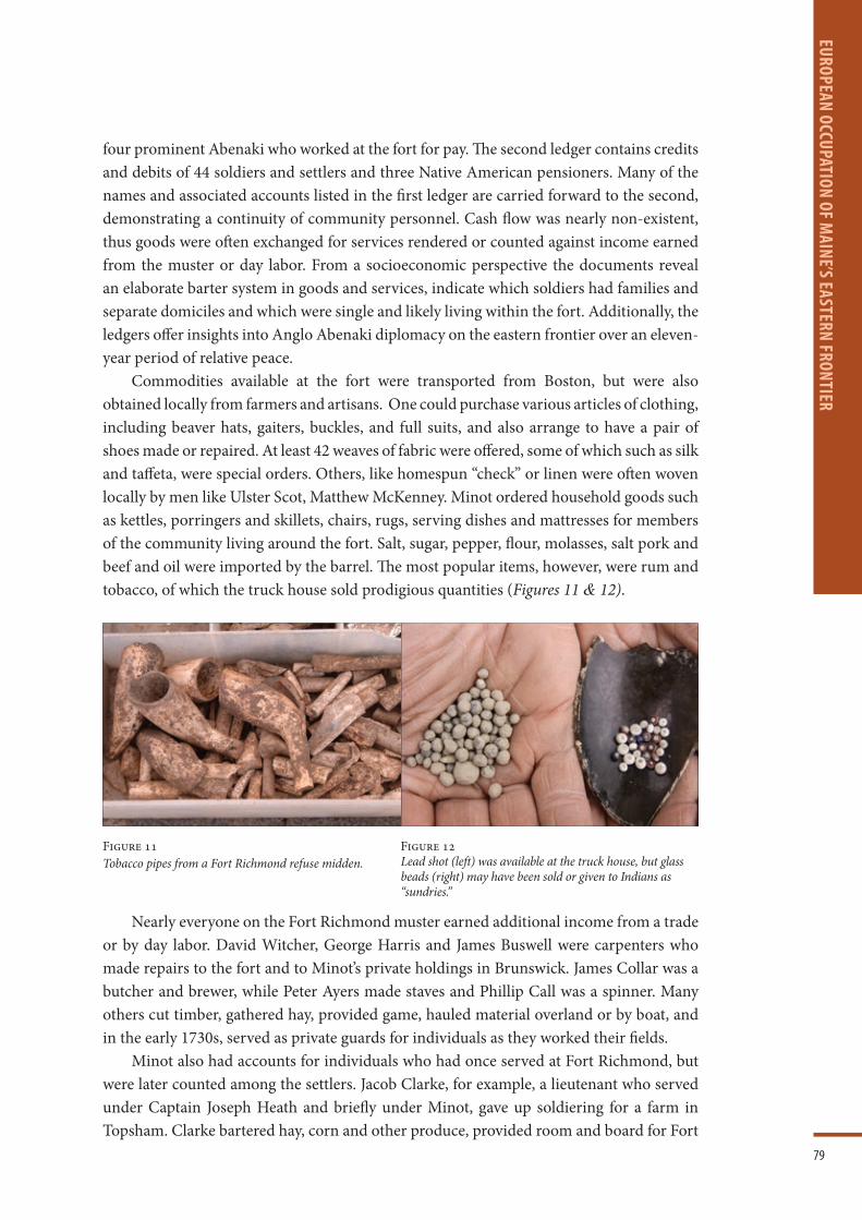
79
EUROPEAN OCCUPATION OF MAINE’S EASTERN FRONTIER
four prominent Abenaki who worked at the fort for pay. The second ledger contains credits and debits of 44 soldiers and settlers and three Native American pensioners. Many of the names and associated accounts listed in the first ledger are carried forward to the second, demonstrating a continuity of community personnel. Cash flow was nearly non-existent, thus goods were often exchanged for services rendered or counted against income earned from the muster or day labor. From a socioeconomic perspective the documents reveal an elaborate barter system in goods and services, indicate which soldiers had families and separate domiciles and which were single and likely living within the fort. Additionally, the ledgers offer insights into Anglo Abenaki diplomacy on the eastern frontier over an eleven-year period of relative peace.
Commodities available at the fort were transported from Boston, but were also obtained locally from farmers and artisans. One could purchase various articles of clothing, including beaver hats, gaiters, buckles, and full suits, and also arrange to have a pair of shoes made or repaired. At least 42 weaves of fabric were offered, some of which such as silk and taffeta, were special orders. Others, like homespun “check” or linen were often woven locally by men like Ulster Scot, Matthew McKenney. Minot ordered household goods such as kettles, porringers and skillets, chairs, rugs, serving dishes and mattresses for members of the community living around the fort. Salt, sugar, pepper, flour, molasses, salt pork and beef and oil were imported by the barrel. The most popular items, however, were rum and tobacco, of which the truck house sold prodigious quantities (Figures 11 & 12).
Nearly everyone on the Fort Richmond muster earned additional income from a trade or by day labor. David Witcher, George Harris and James Buswell were carpenters who made repairs to the fort and to Minot’s private holdings in Brunswick. James Collar was a butcher and brewer, while Peter Ayers made staves and Phillip Call was a spinner. Many others cut timber, gathered hay, provided game, hauled material overland or by boat, and in the early 1730s, served as private guards for individuals as they worked their fields.
Minot also had accounts for individuals who had once served at Fort Richmond, but were later counted among the settlers. Jacob Clarke, for example, a lieutenant who served under Captain Joseph Heath and briefly under Minot, gave up soldiering for a farm in Topsham. Clarke bartered hay, corn and other produce, provided room and board for Fort
Figure 11Tobacco pipes from a Fort Richmond refuse midden.
Figure 12Lead shot (left) was available at the truck house, but glass beads (right) may have been sold or given to Indians as “sundries.”

80
EURO
PEAN
OCC
UPAT
ION
OF M
AINE
’S EA
STER
N FR
ONTI
ER
Richmond soldiers, and sold the services of his ox team to haul timber on the Eastern River. Alexander Campbell, who resided on a farm owned by Job Lewis at Abagadasset Point, had 42 purchases that he paid for by selling butter and mending shoes. Patrick Drummond also sold butter and his labor in exchange for the occasional bolt of cloth, pint of rum and foodstuffs.
While the goods and services offered at the fort would have provided welcome comforts to a remote existence, its mere presence provided a critical sense of security and a means of communication with the outside world. Fort personnel and local settlers relied on the fort for news of current events and the relay of messages. The firing of two cannons in succession signaled to the Abenaki that they were to come to the fort to hear a message from the colonial governor, and interpreters frequently assisted Natives in drafting their own letters to colonial officials. The fort also served as a meeting place for conferences between provincial and Abenaki officials, and as a base for regional reconnaissance missions.
The Minot ledgers along with muster rolls, records of the Pejepscot Company and preserved colonial correspondences among others, illuminate the role and influence of Fort Richmond in the European settlement of the eastern frontier, which centered on Merrymeeting Bay and extended northward to Norridgwock, eastward to the St. George River and southward to Boston. These records also document the presence of many Ulster Scots who came to and persevered in the region. Transactions with no fewer than 19 Ulster Scots are documented in the ledgers and little-known details of their lives are just beginning to be understood and told (Figure 13 & Table 1).
Figure 13Distribution of home sites for individuals associated with Fort Richmond. Ulster Scot, Andrew McFadden is on the west side of Merrymeeting Bay, while Robert Temple settled on the east side.

81
EUROPEAN OCCUPATION OF MAINE’S EASTERN FRONTIER
Threat of war with Spain and France in 1739 resulted in the upgrading of all English coastal defenses including Fort Richmond. The fort by this time was determined to be in such deplorable condition that much of it was taken down and reconstructed. Structures known to have been built in 1740 included a truck house, 30 feet long by 24 feet wide with a gun room above, flanker, barracks, chapel and blockhouse (Figure 14). Archaeological investigations showed the buildings remained within a walled enclosure, but the gate was modified and the outer palisade fence of spaced posts was extended northward and westward, potentially to provide additional space for gardens and livestock. A new structure was constructed off the fort’s northwest corner and the nearby garden may have continued to be used.
The earlier L-shaped guard house inside the gate continued in use or was rebuilt on the existing foundation. The truck house with the over-hanging second story was constructed in the fort’s southeast corner, while the blockhouse was placed in the opposite northwest corner. The latter was equipped with a cellar well room and bulkhead entrance, and likely had an overhanging second story as well. The chapel was probably located in the central
Table 1Names, occupations and residences of Ulster Scots associated with the Fort Richmond truck house.
NAME OCCUPATION RESIDENCE
Alexander Campbell farmer Chops (Dresden)
James Cochrain soldier St. Georges
William Cochrain soldier St. Georges
James Drummond farmer Chops Point
Patrick Drumond farmer Chops Point
Owen Dunning weaver
Robert Lithgow gun smith Topsham
William Lithgow commander Georgetown
James McBride soldier St. Georges
John McCurdy
Andrew McFadden farmer Somersett (Bowdoinham)
Thomas McFadden cobbler
George McKenney
Matthew McKenney weaver Woolwich
William McKenney Woolwich
Kenneth McKenzie
David McLane
John McPheters Woolwich
Arthur Noble colonel/merchant Phippsburg

82
EURO
PEAN
OCC
UPAT
ION
OF M
AINE
’S EA
STER
N FR
ONTI
ER
western portion of the fort, while an additional building or shed likely was present in the fort’s northeast corner. Much of the interior courtyard would have remained covered with wooden planks.
Within approximately ten years (1750) the fort took on a very different appearance. The log enclosure walls at the north end of the fort along with the blockhouse and an additional structure were replaced with a single two-story log blockhouse and barracks that measured 89 ft wide by 45 feet deep (Figure 15). Construction of this building made use of the original fort enclosure foundation on the east and west, but extended further northward where the log walls were laid directly on the ground. The south-facing façade was constructed on a poorly-built stone and brick foundation immediately adjacent to the former blockhouse foundation. The western third of the structure conformed closely to the width of the former blockhouse and made use of its cellar space including its well, well room and bulkhead entrance. A new interior chimney with a rubble foundation was added immediately west of the well room, and would have had fireboxes that serviced a large rear room to the north and a front room that had access to the cellar well. The eastern 2/3rds of the building was similarly divided between north and south spaces on the first floor with the front or south space divided into a west and east half separated by a
Figure 14Plan of Fort Richmond ca. 1740-1750.

83
EUROPEAN OCCUPATION OF MAINE’S EASTERN FRONTIER
central chimney with fire boxes for all three rooms (Figure 16). Root cellars under the rear and front eastern room indicate these spaces functioned for food storage and preparation. The eastern portion of the building was accessed via a common doorway aligned with the central chimney, and by a larger service door outfitted with a ramp.
The guard house inside the fort entrance was taken down and the cellar filled. The two-story truck house with the overhanging second story remained in place as did the chapel and flanker on the fort’s southwest corner, but the building and garden off the fort’s northeast corner were removed. The fort courtyard at this time was paved with a combination of cobblestones and bricks, while the timber palisade of spaced posts continued to serve as a first line of defense and to contain livestock and gardens.
In 1752 Fort Shirley was constructed on the east bank of the Kennebec River a mile or so upstream of Fort Richmond. This was followed two years later by the erection of Fort Western in present Augusta and Fort Halifax further north in present Winslow. The establishment of these fortifications served to shift the frontier further east and considerably inland, essentially rendering Fort Richmond obsolete (Figure 17). The latter was decommissioned in 1755, resulting in the removal of the palisade and the new
Figure 15Plan of Fort Richmond ca. 1750-1755.

84
EURO
PEAN
OCC
UPAT
ION
OF M
AINE
’S EA
STER
N FR
ONTI
ER
Figure 16Dig in progress showing the cobble courtyard (in distance), foundation (yellow) root cellar (green) and chimney base (red) of the large barracks at the north end of the fort. Blue depicts the original fort enclosure wall foundation.
Figure 17Main building at Fort Western constructed of hewn logs in 1754. The ca. 1745 barracks of Fort Richmond probably served as a model for that at Fort Western.
blockhouse and barracks at the north end of the fort. Left standing were the truck house and chapel, which were used for housing reconnaissance missions and served as home to the Reverend Jacob Bailey and his wife between 1761 and 1767. 11 The site lay virtually abandoned until 1776 when members of the Parks family constructed a new house on the foundation of the former truck house and farmed the land. Over the next 50 years
11 Leamon, James S., The Reverend Jacob Bailey, Maine Loyalist: for God, King, Country and for Self (University of Massachusetts Press, Amherst, 2012).

85
EUROPEAN OCCUPATION OF MAINE’S EASTERN FRONTIER
the family used the old fort well and filled the fort cellars with their refuse and additional fill. The Parks family vacated the property in 1827 and it was not until 1891 that Captain James Hathorne constructed his new house on the cellar foundation of the former Parks house and truck house. Construction of a new bridge in 1930-31 called for creation of a new approach road through the rear of the Hathorne house. The house was saved from demolition by moving it to the north side of the new approach road, and the old cellar was filled. Bridge construction personnel plowed right through the center of the old fort, uncovering many vestiges of its existence, but no mention of such discoveries appear to have been recorded and the fort’s location was obscured until archaeologists found it in 2010.
REFERENCES
Leamon, James S., The Reverend Jacob Bailey, Maine Loyalist: for God, King, Country and for Self (University of Massachusetts Press, Amherst, 2012).
Massachusetts Historical Society, Journals of the House of Representatives of Massachusetts 1721-1722 (MHS, Boston, 1922).
O’Brien, M. J., The Lost Town of Cork, Maine: An early attempt by Robert Temple and emigrants from Ireland to establish a settlement in the Kennebec wilderness (Higginson Book Co., Salem, Massachusetts, 1987).
Thayer, Henry O., “Fort Richmond, Maine” Collections and Proceedings of the Maine Historical Society, 2nd Series 5:129-160 (MHS, Portland, Maine, 1894).
Vaughan, Alden T. and Mandell, Daniel R. (eds.), Early American Indian Documents Treaties and Laws, 1607-1789; Vol. 20 New England Treaties North and West, 1650-1776 (University Publications of America, 1979).
Acknowledgement: (Images courtesy of J.N. Leith Smith and John P. Mosher unless otherwise stated).

86
SARA
H M
ONTG
OMER
Y
SARAH MONTGOMERYA lens into frontier women
REBECCA GRAHAM
Maine women have always had a reputation for being tough, resilient, driven, vocal, and unshakeable; these traits are present in what little we know of the women of 1718 as well. It took a special kind of woman to settle what was known as the eastern frontier in 1718, far from any recognizable civic or community structures. Through the lens of the Court of General session Records, The Lincoln County of Common Pleas records, local diaries of the Boothbay peninsula, and the dogged research of Boothbay historian, Barbara Rumsey, a glimpse of female tenacity emerges that is otherwise missing from the minimal amount written about the Scots-Irish migration of the period. Rumsey’s work uncovers Sarah Montgomery, an early example of this now quintessential Maine spirit, whose story is at the heart of East Boothbay history, and offers a small portrait of female life at the Maine frontier born of the 1718 migration.
Barbara Rumsey estimated that Sarah (nee Miller) and her husband Robert Montgomery were born in or around 1700 and were probably teenagers during the voyage from Ulster to Maine in 1718. 1 While there are no definite records yet uncovered regarding where Sarah landed, or where in New England she and Robert settled before arriving at the 1730 Townsend settlement, later depositions indicate that they did arrive in 1718 with many other families from the North of Ireland. 2
In Maine, distance is rarely talked about in terms of miles, and instead, the preference for judging distance is expressed in terms of hours. Figure 1 (opposite) shows the original settlements at Merrymeeting Bay in relation to each other, including Townsend, or present-day East Boothbay Harbor, the settlement that is the focus of Sarah Montgomery’s life. Kinship shaped movement between these areas as much as it did the transatlantic migration and the inter-New England Migration. 3 In fact, it was the kinship ties that likely drew the Montgomerys to settle Townsend, in addition to an enticing offer of land by Colonel David Dunbar.
Knowing your neighbors would be a novelty without the ability to move or get goods to and from major economic hubs. Additionally, proximity to deep water also played an enormous role in the early Maine settlements. There were no roads in the mid-coast area until the latter half of the eighteenth century. Waterways were the highways, and most settlements were established in relation to the ability to reach areas of commerce and proximity to exploitable resources. 4
1 Rumsey, B. (2000). Colonial Boothbay Mid- 1600s to 1775. p. 116 East Boothbay: Winnegance House.2 Maine Historical Society. (n.d.). Samuel McCobb 1772 Deposition. Documentary History of the State of
Maine, 14, p.166. Portland, Maine: Brown Thurston Co.3 There have been many studies both historic and sociological about kinship movement in New England.
One excellent volume challenges the notion that the rise of the Industrial Northeast dramatically changed these traditional patterns of settlement covering early settlement until the 1970’s. See generally: Hareven, Tamara K. Family Time & Industrial Time; The Relationship between the Family and Work in a New England Industrial Community 1982, Cambridge University Press.
4 See generally: Cronon, William, Changes in the Land; Indians, Colonists and the Ecology of New England, 2003 Revised Edition, Hill and Wang, New York.

87
SARAH MONTGOM
ERY
Most of the settlers in Townsend had an Antrim, Northern Ireland connection, including the Beaths and Fullertons who settled nearby. 5 While there are several Montgomerys associated with the 1718 settlement in areas around Massachusetts, New Hampshire, and Maine, it’s Robert’s later connection to Samuel McCobb, a previous “Cork Settlement” and Arrowsic resident and neighbor in Townsend, that makes Robert’s family connection to the John and William Montgomery who settled the Merrymeeting Bay Cork Colony more likely. 6
Dunbar’s Carrot
Colonel David Dunbar, also an Ulsterman, was appointed as Sagadahoc’s Governor and Surveyor of the King’s Woods. It was this role that brought him into conflict with the Massachusetts Bay Colony and their interest in the resources in mid-coast Maine. The English Crown and the Massachusetts Bay Colony were competing for resource control, and who was responsible for protection obligations of the frontier territory. 7 The crux of
Figure 1 The original settlements at Merrymeeting Bay in relation to each other.
5 Clemens, W. (1916). The Montgomery Family Magazine. 1 (4).6 See generally the work of Charles Allen and Reverend Henry O. Thayer on the Cork Settlement. A Phase 1
archaeological survey was conducted by Dr. Barry H. Rodrigue and Rebecca J. Graham in 2007-2009 which formed a model for the settlement and its possible boundaries.
“Cork Settlement Project”, 2007-2008, Barry Rodrigue and Rebecca Graham*, Maine Historic Preservation Committee: Thwings Point Burial Ground ME 495-033, Jonathan Reed Cabin 1 ME 495-034, Jonathan
Reed Cabin 2 ME 495-035, Samuel Reed Farm ME 495-036, Samuel Reed Shipyard ME 495-037, Eames Brickyard and Dump ME 495-038, Thwings Point Colonial Cellar Hole ME 495-039, Cork Settle Point ME 495-040, Reed Wharf ME-495-028, Nathaniel Thwing House ME 495-029, Seth Hawthorn Farm ME 495-030, Unidentified Domestic 1 ME 495-031, Unidentified Barn 1 ME 495-032, Unidentified Domestic 2 ME 129-009, Indian and River Road Farm ME 129-010, McCobb Farm 1 ME 129-009, Cairn & Burial ME 129-015, Kennebec River Wharf ME 129-014, McCobb Riverside Dump ME 129-013, Jacob Eames Farm
ME 129-012, Hawthorn Burial Ground ME 129-011.7 Williamson, W.D., The History of the State of Maine, v. I, 1832, p. 166.

88
SARA
H M
ONTG
OMER
Y
the situation centered on who was financially responsible to provide for the delivery of a military presence in the region and thus responsible for rebuilding the Fort at Pemaquid, versus who was able to reap the rewards of the resource extraction efforts. Massachusetts wanted timber resources for winter fuel and trade, while the Royal Navy wanted the timber resources for ship building. William Cronin estimates it took 20 cords of wood to provide cooking fuel and heat for a single dwelling in New England and the Boston area was already heavily deforested in 1718. 8
The Sheepscot River, which now forms the western borders of the towns of Boothbay, Edgecomb, and Newcastle, at that time, formed the eastern most boundaries of the Massachusetts Bay Colony interest and Nova Scotia which later became a Crown interest. Dunbar’s settlement straddled these communities and those along the Damariscotta River which forms the eastern most border of present-day Boothbay, Edgecomb, and Newcastle and beyond to the Bristol and Friendship Peninsulas. Both governmental structures provided little in response to a settler or indigenous complaints, and when any complaints were answered, they were often prejudiced towards the most beneficial interest of the distant body, be it Boston or London.
This paper will not delve too deeply into David Dunbar because the purpose is to elevate the role of women not reiterate the folly of men. However, his failed endeavors along the Damariscotta River set the stage for future issues faced by Sarah and Robert. Dunbar’s ego seems to have played a role in his troubles which ultimately led to a number of challenges to his settlement. He arrived in Maine with ambition and a Royal Commission but refused to show the commission on demand. 9
Dunbar placed advertisements to settle this “new” area — free for willing undertakers— in the Boston Gazette on October 19, 1729. 10 It is this announcement that Robert and Sarah Montgomery chose to answer, encouraged by their relatives who traveled with them in 1718, settled now at Georgetown, Maine. Ultimately, the voluminous complaints against Dunbar’s efforts resulted in the Crown deciding he was not authorized to settle the area. It was this decision that left the Montgomerys and other Townsend settlers with no deed for their new land, leading to battles over clear land titles that would plague the trusting settlers for decades to follow.
Dunbar promised Sarah and Robert free land if they cleared and improved it with a deed issued from Port Royal (and thus the crown) and not Puritan Boston. 11 While long-term settlement and improvement was a recognized path to land ownership, it is this concept of land ownership when weighed against tenuous Indian deeds that would shape the land battles for the latter half of the eighteenth century. Through depositions provided in response to threats against their property during those later legal battles against the Kennebec Proprietors, we learn of the settler origins, and find what are likely embellished accounts of struggle meant to emphasize the homesteading approach to land ownership.
8 John Winthrop, Winthrop’s Journal, James Kendall Hosmer, ed. (New York, 1908) I, p. 258.9 See Calendar of State Papers Colonial, America and West Indies, “Copy of Instructions Given by Gov.
Belcher to the Lt. Gov and others regarding fortification” October 29, 1729, available at the National Archives and Records Administration, Washington, DC.
10 Boston Gazette, October 19, 1729.11 Williamson, W.D., The History of the State of Maine, v. I, 1832, p. 166.

89
SARAH MONTGOM
ERY
Samuel McCobb deposed that prior to his establishment the area was “devoid of settlers and a perfect wilderness from Townsend to Damariscotta.” He further deposed:
“the lands being naturally poor and more especially then in their wild uncultivated state and the settlers coming generally of low circumstances most them from a Britain and Ireland are utterly unacquainted with the mode of managing land in that state and little of the necessarily of life was raised from the soil-their whole living depending cutting firewood and carrying it to Boston and other towns more than 150 miles from them.” 12
Into this state, Robert and Sarah willingly settled. While it would be easy to imagine the challenges of frontier settlement in the Maine wilderness, it is unlikely the settlers were as completely unprepared as McCobb’s deposition would seem to imply. McCobb and Sarah’s brother William Miller were both settled in Arrowsic following the destruction of the Cork Settlement in 1723, eight years prior to the Townsend settlement. The Cork Settlement was the first undertaking to repopulate the Eastern Frontier with Scots-Irish by the Pejepscot Proprietors who sold the lands at 12 pence an acre payable over time. 13 What they neglected to tell the settlers was that the lands along the Merrymeeting Bay were of significant importance to the Abenaki Tribes along the river. Additionally, a meeting between governor Shute and Samual Penhallow had taken place in 1717 on Arrowsic Island with various tribal representatives who acknowledged that the English had the rights to settle the western side of the Merrymeeting Bay but expressed their unwillingness to allow settlement on the Eastern side of the Merrymeeting (where the Cork settlement was situated) due to their hunting and planting needs. 14 The different ways in which the new settlers and the Abenaki used the land fueled conflict that resulted the settlement being burned in 1723. 15 Appeals for support from both tribal and settler representatives to the Massachusetts Bay leadership were unanswered except to inform the settlers that if they left their property they would be considered traitors. Following the burning of the Merrymeeting Bay and Brunswick settlements, many Scots-Irish refugees from this conflict fled to Boston only to be warned to leave. Another group simply moved closer to the frontier fort at Arrowsic, including the McFaddens also covered in the family section of this volume.
It is logical to ask why anyone knowing what had just happened along Merrymeeting Bay, would move into a different, but no less dangerous frontier region, with no fort nearby, and a well-known raging argument about who would pay for defenses to be rebuilt. Based on the eventual success of those early settlers, it is more likely that they were far from ill-equipped, and more stubbornly determined to forge a new reality. The McCobb and Montgomery depositions should be read in context to the goals they were meant to achieve. Later depositions provided by the Montgomerys, like the McCobb’s, were
12 Maine Historical Society. (n.d.). Samuel McCobb 1772 Deposition. Documentary History of the State of Maine, 14, p.166. Portland, Maine: Brown Thurston Co.
13 Letters between Winthrop and Thomas Lechmere Collections of Massachusetts Historical Society p. 243, 246-249,262,306,307 6th series vol.
14 A Conference of His Excellency the Governor, with Sachems and Chief Men of the Eastern Indians, 9-12 August 1717, UKNA, CO5/868.
15 See Smith & Mosher in this volume, p. 69.

90
SARA
H M
ONTG
OMER
Y
responding to threats against their new homes and were attempting to gain sympathy and support for their land claims from the court by emphasizing their sweat equity in clearing the land. Their occupancy and improvements provided them with a sounder legal reason to retain their land without a title. 16 Homesteading was a recognized path to ownership, particularly since the Townsend area had been devoid of settlers for more than 40 years before Robert and Sarah arrived. Without Dunbar’s promised Port Royal property deed, the Montgomerys and their neighbors needed judicial sympathy.
Family growth is another indicator of frontier conditions on the peninsula. William Montgomery, Sarah’s first son, was three years old when she and Robert decided to pursue their Townsend endeavor. While a toddler in the wilderness is challenging enough, her second son James was born around 1729 and could have been just several months old as they set up shelter between present-day Linekin Bay and the Damariscotta River. Sarah and Robert clearly had some peaceful time on the frontier as Robert Jr., their 3rd son, arrived around 1731. Anna, their first and only daughter, was born next in 1738, John 1740, and finally Samuel in 1742. 17
Property Battles
The first wave of attacks against Sarah, Robert, and their new home came in the way of predatory land claims by individuals buying up old land claims from previous settler families who fled following King Phillips War. 18 This activity — when successful — could be lucrative.
All of the living members of the Champenois family, who were forcibly removed from the area 40 years prior, sold a small piece of their interest in their former lands, inherited after the death of their father Henry, to an ambitious Boston lawyer, John Ludgate. 19
The Champenois family were not interested in resettling the land but could extract any potential monetary reward that might be gained by someone else pursuing collection of an old claim. These actions were likely among the first predatory mortgage note purchases that would form the strategy of the next wave of land speculators.
On May 4, 1736, John Phillips and James Hatch, acting on behalf of Ludgate, showed up at the Montgomery home and intimidated Robert into signing over a portion of his land holdings back to the Champenois heirs. Robert later withdrew his promissory note and decided instead to push back against a claim that was at least 40 years old. By October, a warrant was issued for Robert and agents arrived to serve the notice. Robert was not home, and Sarah refused to accept it, forcing the agents to take her table as surety. 20 This was the first known assault on Sarah’s home, and such a personal family-centric item taken for surety was surely a form of insult to Sarah’s refusal to accept the warrant.
16 Taylor, Alan, Liberty Men and Great Proprietors; The Revolutionary Settlement on The Maine Frontier, 1760-1820, University of North Carolina Press, Chapel Hill & London p. 22-23, 102, Shurtleff interestingly uses John Locke‘s Second Treatise of Government that private property rights were granted through labor and improvement of the wilderness where the proprietors argued using the same document that social compact extended to the wilderness and therefore civil society bestowed property rights.
17 Supra 1, p.116.18 York County Deeds, Book 21:126-131 recorded 1737.19 York County Deeds, Book 18:88 & Book 20:131 recorded 1735.20 York County Court of Common Pleas, Champnois v. Montgomery February 1737.

91
SARAH MONTGOM
ERY
Robert was later found guilty and ordered to restore the acres or pay £500 to the Champenois family. He appealed the decision arguing that Ludgate had not proven his intent to occupy the land in question and pointed out he had made no claim on the property, and unfortunately, he lost again. 21 However, Robert either paid the fine or bought the land outright from the family, as a legal deed in 1760 shows Robert as the sole owner of the property, including the formally contested parcel.
A murder in Townsend provides interesting clues as to how Robert may have cleared his land deed with the Champenois or at least raises some doubt as to the poverty of these “poor” frontier settlers. Three years after Sarah had lost her table, her husband and home were operating under one of two tavern licenses for Townsend. 22 Additionally, the Montgomerys were also innkeepers, and they supplied Boston with timber and staves. The location of their home was made for trade, and its position made both businesses a likely success, as it does today. The area still has a marina, two boat yards, popular restaurants and pubs and a small inn.
While not directly involved in the incident, Sarah and Robert added fuel to the flames by having an abundance of rum when there was the failure of an expected delivery to the other Townsend tavern owner, William Moore. When Edmund Brown arrived without the promised barrel of Rum for Moore, the pair, joined by David Bryant, Brown’s father-in-law, and George Oakes went to Montgomery’s tavern to borrow ten gallons until Moore’s rum arrived. They all proceeded to drink some of the loaned rum together. After a night of drinking at Sarah and Robert’s, old complaints between the two men were enflamed, resulting in Brown killing his father-in-law with an axe. 23
Economic Diversity & Strategy
It is not just inn keeping, logging, and tavern operations that sustained the Montgomerys. In the 1750’s Robert sued some Damariscotta neighbors for unpaid blacksmithing bills. Perhaps Sarah had more help from her newly adult sons, but it is clear the family was still making money through lumber, as well as blacksmithing and their spirits trade.
One court case, in particular, indicates Sarah was a driving force in many ways and maximizing strategic opportunities and not always is the silent ways her traditionalized role would expect. Sarah played a hands-on, active role in every dispute, including those with new neighbors. A boundary dispute joined with a trespassing and riot case involving the Montgomerys and the neighboring Lineken family, can be found in the York Court of General Sessions in 1755. The warrant for the arrest of the Montgomery family paints an interesting picture and reads:
“At said Winnegance he [meaning Lineken] had his dwelling house there standing, pulled down in both frame and boards, Feloniously stolen and carried away, together with two chairs, two women’s gowns, one short Scarlet cloak, two fine women’s shifts, one ruffled shirt, one case with four bottles, one keg with about a gallon of rum in it, one great coat, one narrow ax, one adze, one auger,
21 York County Court of Common Pleas, Champnois v. Montgomery, February 1737.22 York Court of General Sessions, July 1739.23 See Generally Barbara Rumsey’s detailed breakdown of the incident drawn from Reverend Israel Loring’s
Diary p. 125-127.

92
SARA
H M
ONTG
OMER
Y
some nails, some beef steak, Some meal with sundry other small things all the value of 13 pounds. And that he has cause to suspect that Robert Montgomery, gentleman, Robert Montgomery Junior, John Montgomery, John Flanagan laborer, Daniel McCurdy weaver, and Sarah Montgomery spinster, and all of said winnegance did act forth with....
Make diligent search in all such houses and places within your precinct that you together with the complainant shall think proper, and remove all locked bars, or bolts that may be in your way in upon finding there any of the enumerated things, that you see and secure the same together with the person or persons whom you find with them and that you apprehend the boys being named Robert Montgomery, Robert Montgomery Junior, John Montgomery, John Flanagan Daniel McCarthy, and Sarah Montgomery if found in your precinct, and keep them so that you have them before me or another lawful authority to be examined concerning the premises and to be prosecuted against according to the law.” 24
Here Sarah is named as a known player in the suspected offense, not just a passive observer or silent protector. She was not above being at the front line to pursue justice as she saw fit alongside her family. The spinster label Sarah received in this context did not mean that she was an old unmarried woman, but a woman practicing the spinning trade, yet another economic activity to add to the diverse commercial pursuits of the Montgomery clan.
More of Sarah’s character is revealed from other depositions to the case. When the Linkens show up to the Montgomery’s house to seek satisfaction, Clark Linekin watched Sarah’s boys John and Robert carrying in a chest, and afterward testified to this scene:
“He saw Sarah Montgomery one of the respondents running after the said Joseph Linekin with a stick or broom staff in her hand, he heard Linekin say that he would have the things again, and heard Robert Montgomery gentleman, also one of the respondents, say that he should not unless he came with authority, and further the deponent declarith that he saw John Flanagan there” 25
Not only was Sarah actively involved in tearing down the house, but she was also actively involved with continuing to protect her family from their neighbor’s attempts to retrieve their assets.
There is a soft power of women in these situations that is often masked by a seemingly violent display. Her passion is easily excused as a weakness of gender. In fact, this is often a deliberate strategy explored by scholars including Laura Thatcher Ulrich, who posits that only a deeply felt outrage could spark female aggression. 26 The reigning view of the time was that women were weaker and less emotionally stable, making such behavior easier to forgive, dismiss, or deny. 27 Only two of the Montgomerys admitted to the violent behavior in court. John the second youngest son, and Sarah.
Sarah openly confessed that she was the one who had ordered the activity, even directing her family in their actions, but more importantly in her testimony we find out
24 York County Court of General Sessions, Linekin v. Montgomery et al; July 1755.25 York County Court of General Sessions, Linekin v. Montgomery et al; July 1755.26 Ulrich, L.T., Good Wives, 1980. New York, Knopf, p.189-189.27 Maccoby, E. and Jacklin, C., The Psychology of Sex Differences, 1974. Stanford, CA, Stanford University Press
p 243-247.

93
SARAH MONTGOM
ERY
why. The house was part of an unfinished log cabin formerly belonging to her son William, who was recently drowned. Her grief and the proximity of this opportunistic act by the Linekins to his death, made her unreasonable behavior an understandable response of a distraught grieving mother.
Sarah’s strategy worked with the court. Despite fully confessing to her role in the events that led to the formal indictment on the charges of rioting and theft, the jury sided with the Montgomerys. 28 By drawing attention to the insulting injustice she felt upon her son’s memory, Sarah was able to have the lands returned to the Montgomery holdings and taken away from the Linekens, as well has having all charges dismissed, an action that the men in her family could not have achieved with such behavior.
Debt drove the next decade of court action in the Montgomery family. In 1761 the house, 100 cords of wood, and the team of oxen were attached for a debt that was owed to Sarah‘s brother William Miller. Miller’s issue centered on the improper cutting of timber on his property and, as he described it, “other enormities against the peace.” 29 Additionally, Andrew McFarland attached 12,000 in red oak hogshead staves which Sarah’s son John, had said belonged to him. Uncle William also pursues a case against James Montgomery a year later.
Most of the court cases against the Montgomery’s for this decade centered around wood that either had been cut on someone else’s property, or for debts due as a result of Sarah’s boys business dealings. At this time, John Montgomery was making barrels for sugar in the West Indies. The Montgomery boys accumulated local legal complaints that were frequently meted out by the local justice of the peace Joseph Patton instead of making it all the way to court on a regular basis. Patton’s logbook shows that Sarah and John had need of his services on a continual basis. Not to be outdone, or perhaps indicating a norm of frontier relationships, Sarah’s brother, William had 15 court cases between the years 1764-1772. 30
The debt cases seem to indicate a downward shift in the economic situation for Sarah and Robert just as her boys should have been contributing more to the household. Another tragedy, the death of Robert in 1763, indicates that Sarah was still considered Robert’s right-hand woman. Against the custom of the time, Robert made Sarah the executor of his will. While she had a role of significance in the execution of his will, she still received only the customary 1/3 dower rights in law that women of the era could expect. However, there was another usual component to Robert’s will that emphasized the strong role of women in the Montgomery household. Robert elevated his daughter Anna above his sons in the final disposal of Robert’s assets:
“I give and bequeath with my beloved wife Sarah 1/3 part of all my personal and real estate that remains when my debts are paid. And out of the remainder I give and bequeath to my son James Montgomery five shillings lawful money. I give and bequeath to my son Robert Montgomery five shillings lawful money. I give and bequeath to my daughter Anna Montgomery 1/2 of the remainder
28 York County Court of General Sessions, Lineken v. Montgomery et al, Judgement, 2 July 1755.29 Lincoln County Court Papers, April 1761, Miller v. Montgomery, Box 1.30 Supra 1 p. 163.

94
SARA
H M
ONTG
OMER
Y
of my whole estate real and personal. I give and bequeath to my sons John Montgomery and Samuel Montgomery the remainder of my whole estate to be equally divided among them.”
It’s clear that Robert Montgomery valued the women in his life perhaps because of their forthright roles in helping him to succeed. His will reflects that their roles carried significance far beyond that of housekeeper and childminder. The elevation of his daughter over his sons suggests that Anna continued in her mother’s footsteps. Perhaps the one constant in Robert’s life in the decades of turmoil on the eastern frontier was the women at his side.
ConclusionThere is a much deeper collection of legal actions involving Sarah available in records at the Boothbay Historical Society, including debts she had against her sons following Robert’s death, extending into the next generation. It is unlikely that Sarah is the anomaly she appears to be. Her litigious life provides a window into the life of women along the eastern frontier who had wolves at the door in more ways than one, from neighbors and land agents to poorly behaving sons. Sarah’s willingness to shape the household economic prospects through diversification, determination to hold her ground against all threats, and stubborn personality are all key to frontier survival. Sarah’s life is available to us in glimpses because of her desire and ability to masterfully employ the tools of power, including the courts, against those who threatened her home and family.
Since Sarah is not the only woman who survived that era, we can assume there are many more women like her yet to uncover. It would be easy to be taken in by a hardship story of migration that so frequently appears in depositions and canonical writings, but sometimes, as we can see in Sarah’s case, those stories were for a targeted audience that did not include the historian. When we dig deeper, we can reveal the brilliant use of soft power that was applied strategically by frontier women—with broomsticks when necessary. From pushing for the building of churches closer to their frontier homes and the hiring of clergy, to driving town incorporation, women were the silent force behind the creation of most of the civic and social structures we now enjoy. It is hoped that by drawing attention to Sarah’s story for the 2018 reflection of 1718, more research will focus on uncovering those dynamic frontier women who were the driving force of the Scots-Irish cultural impact on Maine, currently viewed primarily through the lens of frontier men.
* Cork Settlement Project
Dr. Barry H. Rodrigue, is an archaeologist, geographer and anthropologist. Formerly Associate Professor of Humanities at University of Southern Maine, he is currently a professor at Symbiosis International University’s School for Liberal Arts in Pune, Maharashtra, India. A Fulbright Scholar, he also works as a research professor in the Eurasian Center for Megahistory & System Forecasting, Oriental Institute, Russian Academy of Sciences. A founder of the International Big History Association (IBHA), he serves as their International Coordinator.
Rebecca J. Graham, LL.M is a graduate of University of Southern Maine, Ulster University, Belfast, and European Inter-University Centre for Human Rights and Democratisation, Venice, Italy. Specializing in democratic governance evaluation and public policy, she works with Organization for Security and
Co-operation in Europe (OSCE) and is currently a public policy expert representing municipal government before Maine’s Legislature at the Joint Standing Committees on Criminal Justice and Public Safety; Agriculture, Conservation and Forestry; Environment and Natural Resources; Inland Fisheries and Wildlife; Insurance and Financial Services; Marine Resources; and Transportation.

95
RESISTANCE AND REPRISAL
RESISTANCE AND REPRISALScots Irish culture and the unfolding of
the French and Indian War in Maine
MICHAEL DEKKER
The Scots Irish have established an enduring legacy of fierce independence, a willingness to resolve perceived transgressions through violent confrontation and grassroots resistance to the intrusions of outside authority. In Maine, there is reasonable recognition of Scots Irish contributions to the struggle for American Independence. There is probably even more awareness of their role as “White Indians” who resisted the pressures of the great proprietors in the land claims crisis prior to statehood. Less well known and understood is the role they played in the unfolding of the last Indian war on the Maine frontier. During this conflict, the Scots Irish residents of the midcoast prosecuted a war against their indigenous neighbors while simultaneously defying the government of Massachusetts and its representatives living in their midst.
The community at St. George was poised on the razor’s edge during the spring of 1755. The return of war to the Maine frontier seemed almost certain. War between the region’s indigenous people and white colonists had been a normal state of affairs for eighty years. Six wars and what amounted to thirty cumulative years of violence punctuated the period. 1 The nature of war on the Maine frontier was particularly ferocious. Civilians were the primary targets on both sides. Countless men, women, and children were killed or taken into captivity to be absorbed by indigenous societies, sold into servitude or held for ransom. Frequently, scalps were stripped from the dead and dying to be sold for exorbitant sums of money as gruesome trophies. Crops, livestock, and property became important targets as both sides sought to deny their opponents shelter and sustenance over harsh Maine winters. Entire communities were destroyed, sometimes repeatedly, or entirely abandoned out of fear and the inability to either support or defend themselves. Many of the regions inhabitants became refugees. Catholic mission villages in Canada provided support and respite for Maine’s indigenous people, while Boston and the surrounding communities of Massachusetts’s north shore and New Hampshire sheltered Maine’s British refugees. Even times of peace were wrought with tension as rumors of war frequently circulated through the communities of the Eastern frontier.
Although many of the conflicts which ravaged the Maine coast occurred within the context of the ongoing struggle between England and France, the focus and nature of these wars was decidedly local. Cultural mistrust, misunderstanding, and incompatibility
1 The outbreak of King Philip’s War in 1675 marked the beginning of six wars which would devastate the communities of Maine, both indigenous and white, until 1759. Although it can be helpful to categorize this period into six individual wars for the sake of chronology, these wars constituted one continuous conflict. For the sake of categorization, there wars were as follows: King Philip’s War (1675-1678), King William’s War (1689-1699), Queen Anne’s War (1703-1713), Dummer’s War (1722-1725), King George’s War (1744-1748) and the French and Indian War (1754-1762).

96
RESI
STAN
CE A
ND R
EPRI
SAL
fostered by years of tension related to issues of land, trade, access to justice and notions of sovereignty fueled the cycle of war. While policy matters may have been determined in Boston or Quebec and influenced by officials in London and Versailles, these wars were largely waged by Maine’s resident population, both indigenous and white. Certainly, the effects of the wars fell on the resident population as homes burned, and families were torn apart by death, captivity, and relocation. In many cases, the combatants on both sides knew or were at least familiar with one another. It is little wonder under these circumstances that the conflict devolved into ethnic destruction by 1755.
The intersection of interests in Versailles, London, and Boston triggered what would become known as the French and Indian War and what would prove to be the last Anglo-Abenaki conflict on the Maine frontier. Following the conclusion of King George’s War in 1748, the French initiated a program of fort construction along the inland waterways of North America to secure their holdings from the Gulf of Saint Lawrence to the Gulf of Mexico. In response, the British government issued directives to its colonial governors in America instructing them to resist and repel French intrusions into disputed territory with military force if necessary. 2
Virginia’s governor, Robert Dinwiddie, sent a young George Washington to the forks of the Ohio River in southwestern Pennsylvania; first as a diplomatic envoy charged with persuading the French to abandon their claims to the region and later as the commander of a provincial military force to expel them by force of arms. Washington failed on both accounts and as a military officer suffered a humiliating defeat. He also set off a chain of events which would lead to open conflict between Britain and France which became known as the French and Indian War in North America and the Seven Years War in Europe. 3
Simultaneously, Governor William Shirley of Massachusetts sent 800 men into the Maine wilderness to remove a rumored French fort at the headwaters of the Kennebec River. Shirley was backed in this endeavor by a powerful cadre of Massachusetts’s political, social and merchant elites known as the Kennebec Proprietors. The Kennebec Proprietors held financial interests in the development of lands along the Kennebec River and up to this point, had been prevented from realizing the full potential of their investments due to treaty understandings with the indigenous people regarding claims to the river above Merrymeeting Bay. Although Governor Shirley secured acquiescence to the projected seizure of indigenous lands from factions of the Kennebec people before launching the expedition, the agreement was in no way representative of the Kennebec people’s desires as a whole. 4
Shirley’s expedition failed to uncover any evidence of the supposed French fort anywhere along the Kennebec. Massachusetts did, however, build a fort of its own in the heart of the Kennebec people’s homeland. Situated at the confluence of the Kennebec and Sebasticook Rivers in what is now Winslow, Fort Halifax was not only an affront to the
2 Correspondence of William Shirley, vol.2, 12-13.3 Anderson, Crucible of War, 42-78.4 Documentary History of the State of Maine, Vol. XII, editor, Maine Historical Society, James Phinney Baxter,
292-304. Goold, Fort Halifax: Its Projectors, Builders and Garrison , Collections of the Maine Historical Society.

97
RESISTANCE AND REPRISAL
Kennebec people but the Penobscot people as well. Sitting aside the Sebasticook River, the fort severed the Penobscot’s principal thoroughfare to Quebec. Maine’s indigenous people interpreted the invasion of the Kennebec’s homelands and the construction of Fort Halifax as a clear indication of Massachusetts expansionist designs and the Maine frontier plunged into another spasm of violence. In November 1754, three months after construction of the fort began, a war party from the mission villages of Canada descended on Fort Halifax killing and scalping one soldier and taking four others captive. 5
The placement of Fort Halifax violated eighty years of treaty understandings concerning the extent of English encroachment upon indigenous lands in the Kennebec Valley. It also impinged upon Penobscot sovereignty and autonomy by restricting the free movement of their people and cutting their ties to Canada. However, Massachusetts’s act of aggression did not inspire universal calls for war among Maine’s indigenous people. The strongest condemnation came from Maine’s indigenous people residing in the Canadian mission villages. While it is impossible to adequately assess the attitudes of the indigenous population residing in Maine, their actions indicate a willingness to uphold treaty obligations while maintaining a position of neutrality and guarded assistance to Massachusetts. 6
The Penobscot’s had assumed the mantle of leadership for Maine’s indigenous people at the conclusion of Dummer’s War in 1725. Claiming to speak on behalf of all the tribes, the Penobscot’s promised to assist Massachusetts militarily in any future outbreaks of hostility on the Maine frontier. 7 With the clouds of war building over Maine, conciliatory resident Penobscot sought to preserve peaceful relations with Massachusetts over the winter of 1755. In accordance with treaty expectations, the Penobscot assisted Massachusetts by providing intelligence. In February, Lieutenant Thomas Fletcher of the Saint George garrison wrote to Governor Shirley informing him:
“I have Received advise from the Chefs of the Penobscot Tribe and thot proper to inform Your Excellency They told me that in the Spring there would be a great number of Canada Indians at their Village; I asked them what they thot their business was they said they could not tell but they thot to do mischief…for that the French for years past had done all they could to break the Peace that now Subsists between your Excellency And us a few days ago the French sent us A hatchet urged us to take it and strike the English We told them we should not whilst the Kings were at peace and they were angry and threatened us…” 8
5 Documentary History of the State of Maine, Vol. XII, editor, Maine Historical Society, James Phinney Baxter, 33-34.
6 Documentary History of the State of Maine, vol. XXIV, ed. Maine Historical Society, James Phinney Baxter, 21-65.
7 Documentary History of the State of Maine, vol. XXIII, ed. Maine Historical Society, James Phinney Baxter, 194. According to what has become known as Dummer’s Treaty signed December 15, 1725, The Penobscot pledged “that in case any of the Tribes of Indians intended to be included in this Treaty shall Notwithstanding continue or renew Acts of Hostility against the English or refuse to confirm to this present Treaty entered into on their behalf, in such case the Penobscot Tribe to covenant and engage with us in reducing them to Reason.” During King George’s War (1744-1748) the Penobscot attempted to steer a course of neutrality and could not and were not willing or able to support Massachusetts militarily. When King Georges War ended the Penobscot re-ratified the terms of Dummer’s Treaty as a condition of peace.
8 Documentary History of the State of Maine, Vol. XII, editor, Maine Historical Society, James Phinney Baxter, 362-363.

98
RESI
STAN
CE A
ND R
EPRI
SAL
During the next several months, the Penobscot continued to provide Massachusetts with intelligence. In early May, based on information obtained from the Penobscot, Lieutenant Fletcher advised the commander of Fort Halifax “that a Body of the Noridgwalk and Assaguntoocook Indians are Going A Gainst The people On the Kennebec River.” 9
Within days of the warnings, attacks resumed against Fort Halifax and the exposed eastern communities. Over the course of May and early June, the frontier was subjected to a series of raids conducted against Saint George (Thomaston, Warren, and Cushing), Broad Bay (Waldoboro), Pleasant Point (Cushing), Sheepscot (Newcastle), Frankfort (Dresden) and North Yarmouth (Yarmouth, Freeport and Harpswell). Outside the walls of Fort Halifax, one soldier was shot and killed while another was taken captive. Further to the west, additional attacks were carried out against the settlements of Gorham and New Gloucester.
Of all the communities in the region, Saint George was arguably the most exposed. The community was established during the longest period of nominal peace the Maine frontier had witnessed since the outbreak of King Philip’s War in 1675. In 1735, twenty-seven heads of households agreed to take up residence along the banks of the Saint George River in what are now the towns of Thomaston and Warren. They were of predominantly Scots Irish descent, and while some may have resided in Boston and the area surrounding Londonderry, New Hampshire, most of them hailed from the area around Pemaquid and Damariscotta. During the summer of 1736, they began occupying their lands at Saint George. Over the course of the next eight years, the community continued to grow as newcomers arriving directly from Ireland and previously established Scots Irish enclaves across New England began to settle along the western banks of the St. George River, in what is now Cushing. By the early 1740’s approximately 50 families called the community at St. George home. 10
Saint George had an unsettled past. The settlement which took root in the 1730’s did not represent the first attempt to plant an English speaking township along the river. In the early 1720’s a fort, mills and house frames were erected for the development of a community called Lincoln. The establishment of the fort at Lincoln proved to be a contributing factor in the outbreak of Dummer’s War in 1722 as it, like Fort Halifax later, was situated in disputed territory. With the construction of the fort at Lincoln, the British pushed the boundary of the Maine frontier from the Kennebec River to the Saint George River. As the new eastern-most British outpost, Saint George drew the particular ire of Maine’s indigenous people. At the outset of Dummer’s War, the mills and house frames were burned to the ground. During the three years in which the war engulfed Maine, the fort withstood three significant attacks. Despite these repeated assaults, the fort endured, and despite continued indigenous resentment, the fort became an important venue for trade and diplomacy.
9 Ibid., p. 391.10 It is unclear exactly how many families were living at Saint George during the period. The upper town
consisted of fifty lots. Initially twenty –seven individuals took possession of these lots with some of the twenty seven purchasing more than one lot. Likewise when the lower town was established, Samuel Waldo created forty lots. Not all of these lots were occupied initially as some individuals as in the upper town held title to more than one lot. Eaton, The Annals of the Town of Warren, in Knox County, Maine, 53-59.Eaton, The History Thomaston, Rockland and South Thomaston, Maine, 51.

99
RESISTANCE AND REPRISAL
When the Scots Irish established their community in the 1730’s the fort was already operating as a vital conduit of intercultural exchange between Massachusetts and the Penobscot. From the walls of the fort, it was possible to look west and see what had become a British world. Looking a half mile to the east stood the indigenous world and the lands of the Penobscot people. The preliminary peace treaty which ended Dummer’s War was signed at the fort and yearly conferences to reaffirm peace and address concerns between Massachusetts and Maine’s indigenous people were conducted at the site. Over the years numerous unrecorded interactions undoubtedly transpired between fort officials and visiting Penobscot. As the local representatives of the Massachusetts government, the fort’s officers became the primary British diplomats on the Maine frontier.
A level of trust and understanding developed between Maine’s resident Penobscot and the fort’s officers. Not only did the fort serve as a bastion of defense and a venue for diplomatic exchanges, but it was also the eastern most trading-post on the Maine frontier. By the time the fort was established, the indigenous people of Maine had become dependent on ready access to European trade goods including textiles, iron tools, and firearms. Trade in the region was highly regulated by the government of Massachusetts to curb abusive and predatory practices among European traders. As a result, Massachusetts required all trade with the indigenous people to be conducted at government-run trade houses, known as truck houses, by government officials known as truck masters. 11
In 1742, Massachusetts appointed Jabez Bradbury military commander and truck master at Saint George’s fort. As such, Bradbury became the primary representative of the Massachusetts government along the mid-coast. As the truck master, Bradbury not only served as the overseer of trade but as the primary link between Massachusetts, the Penobscot and the region’s indigenous people as a whole. Bradbury had served on the Maine frontier as a soldier, trader, and diplomat for more than twenty years before his assignment to Saint George. Capitalizing on his years of experience, Bradbury established a relationship with the Penobscot as a fair, honest diplomat and trader. 12
A pall of suspicion surrounded Jabez Bradbury in the eyes of many residents in and around Saint George. Given the region’s tumultuous history, Bradbury’s close ties and esteem among the Penobscot made him the frequent target of local distrust and invective. During King George’s War, his conduct as the fort’s military commander and truck master were called into question by members of the local community. In 1745, a petition drafted
11 Dekker, The French and Indian Wars In Maine. The truck house system was initiated at the end of King William’s War (1688-1699) to address the indigenous people’s need for trade while eliminating the often abusive trade practices of unregulated traders. Following Queen Anne’s War (1703-1713) the indigenous people expressed dissatisfaction over the lack of truck houses east of Fort New Casco (Falmouth) and the inconveniences of trade as a result. Massachusetts attempted to remedy the situation by outfitting a ship to ply the coast as a mobile truck house. This too proved unsatisfactory. During the early 1720’s Massachusetts suspended the truck house system, opening trade to private individuals to alleviate the situation. Due to indigenous complaints of unscrupulous traders the truck house system was reinitiated in the wake of Dummer’s War. Both Fort Richmond and Saint George’s Fort became government truck houses to help facilitate trade with the Kennebec and Penobscot people respectively.
12 Collections of the Maine Historical Society, vol. IV, 180. During the 1752 annual conference between Maine’s indigenous people and Massachusetts Col. Louis, a Penobscot sachem spoke of the indigenous peoples’ displeasure concerning the prices of Massachusetts’s trade goods. He pointedly addressed his peoples’ regard for Bradbury stating “We have had great and long experience of Capt. Bradbury’s fidelity: The Lieutenant (Bradbury) is a good truck-master; it would do your hearts good to see how kind he is to us, and how justly he treats us.”

100
RESI
STAN
CE A
ND R
EPRI
SAL
by a group of local inhabitants was submitted to the Government of Massachusetts asking for Bradbury’s dismissal.13 Although Bradbury retained his position, he was admonished by the government for imprudently supplying the indigenous people with ammunition. 14 Bradbury’s relationship with many residents of Saint George was further strained by his status as a community outsider. Historians of the Scots Irish have noted their inclination toward local autonomy and distrust of outside authority. Bradbury was of English descent from the north shore of Boston, the very center of Massachusetts Puritanism. Although his religious inclinations are unclear, his family’s English heritage likely set him apart from the Scots Irish population of Saint George due to their long-standing antipathy toward the English. Likewise, as the representative of the Massachusetts Government living in their midst, Bradbury likely engendered feelings of resentment and wariness based on his position alone.
By the outbreak of the final Anglo-Abenaki war in 1754, the community at Saint George was divided both physically and ideologically. By the 1750’s the community which emerged during the 1730’s in what is now Warren had spread down the west bank of the Saint George River into today’s Cushing. The individual land holdings, occupied by settlers of primarily Scots Irish descent, remained physically separated from the fort which stood in the heart of what is now the Thomaston waterfront. This area represented the physical manifestation of Massachusetts’ presence in the area. The fort, which was a military post, trade center, and diplomatic venue, stood atop a bluff overlooking a bend of the Saint George River. From this vantage point, it overlooked portions of the community along the south-west portion of the river known as the lower town and commanded the approaches to the upper town located further upriver. To the west of the main fort was another fortified blockhouse operated by the government of Massachusetts. Between these two fortified positions lay the wharves which accommodated the vessels bringing in the supplies necessary to maintain the settlement, as well as the trade items and gifts facilitating diplomatic relations with the Penobscot. With the outbreak of war, the physical separation of the community would become emblematic of the rift between the policies of Massachusetts and the concerns of the local inhabitants.
With the resumption of hostilities in Maine following the construction of Fort Halifax, the community at Saint George was among the first to feel the sting of indigenous war parties. During late May and early June, several men from the upper community were killed while two others were taken captive from the lower community. In the wake of these and other attacks across the Maine frontier, the General Court of Massachusetts voted to declare war against all Maine’s indigenous people, exclusive of the Penobscot on June 9, 1755. In a subsequent letter to the Penobscot dated June 17, 1755, Governor Shirley reminded them of their previous treaty obligations and conditions of peace stating:
“…as the Penobscot Tribe have distinguished themselves from the rest of the Indians by endeavoring to dissuade the other Indians from their cruel and
13 Documentary History of the State of Maine, Vol. XI, editor: Maine Historical Society, James Phinney Baxter, 306-307.
14 Documentary History of the State of Maine, Vol. XXIII, editor: Maine Historical Society, James Phinney Baxter, 299.

101
RESISTANCE AND REPRISAL
treacherous Designs against us & by their own peaceable Deportment toward us, I do now assure you that if you shall continue in amity with the English you shall receive such marks of kindness from us…And particularly I would in behalf of this Province & Agreeable to our Treaties with you desire that all such of your Tribes and able bodied effective men capable of bearing arms would act offensively with us against those Indians who in the Most audacious Manner have Violated their solemn Treaties with us; By which Treaties you have obliged yourselves to take up Arms as aforesaid; And upon your thus Doing this Government will take care of & support your old, sick, wounded People & your Women & Children if they will come among us & put themselves also under our Protection.” 15
While the flames of war were spreading across the Maine frontier, at least on an official level, it is clear that both Massachusetts and the Penobscot wished to contain the conflagration.
As they had during King George’s War a decade before, the Penobscot attempted to steer a conciliatory course with the government of Massachusetts. Eighty years of conflict had demonstrated to the Penobscot the consequences of war. They had seen their neighboring tribes dismantled and many of their people forced to abandon their homelands in favor of migration to Canada. The Penobscot themselves suffered as a result of war. Their principal village at Pannawambskek was burned on several occasions, and they were regularly and repeatedly harassed by Massachusetts forces while engaged in traditional subsistence practices along the coast. Many of their people had been killed by war and disease while still others had been taken captive and used as hostages by Massachusetts. War brought disruptions in trade which time and again forced famine and hardship upon their people. As a result, many of the more militant factions of the Penobscot migrated to the protective sanctuaries of Saint Francis and Becancour, Jesuit missionary villages along the Saint Lawrence in Canada. Many Penobscot who remained in Maine wished to maintain peaceful coexistence with their British neighbors. However, their position was frequently compromised by the more militant factions of their people residing in Canada. An apparent generational divide also split the Penobscot with many young men favoring the resolution of grievances through confrontation.16 Caught in between, many resident Penobscot Sachems tried to navigate a middle ground between the needs of their people
15 Documentary History of the State of Maine, Vol. XXIV, editor: Maine Historical Society, James Phinney Baxter, 33.
16 Generational division among the indigenous people is a consistent theme throughout New England’s conflicts between the indigenous people and Europeans. This divide is apparent as early as King Philip’s War as evidenced in part by Narragansett sachem Canonicus’s statement that indigenous leaders “could not rule the youth and common people.” Brooks, Our Beloved Kin, 145.
This same schism is apparent throughout the period in Maine as well. In 1745 when pressed to take up arms against other indigenous people the Penobscot declared “…their young men would not comply with the proposal of taking up arms against the St. John’s Indians, their brethren.” Williamson, History of the State of Maine, vol. II, 218.During the final conflict on the Maine frontier which is the focus of this essay, several references to the generational divide appear in the correspondence between Massachusetts and the Penobscot. In a letter to the Penobscot Governor Shirley writes “…your young Men have done cruel things to the English notwithstanding all the Endeavours of your ancient men to the Contrary.” The Penobscot also address this issue in their appeals to Massachusetts indicating “The old men in Penobscutt Salute the Governor in Boston” and “Indians are not very wise and some of our Young men are rougish.” Documentary History of the State of Maine, Vol. XXIV, editor: Maine Historical Society, James Phinney Baxter, 42,72,82.

102
RESI
STAN
CE A
ND R
EPRI
SAL
and the demands of Massachusetts. Ultimately, however, those demands proved impossible to fulfill. Penobscot leaders knew they could not support Massachusetts militarily, nor could they remove themselves from their homeland to live among the British without surrendering the last vestiges of their sovereignty and autonomy. They, therefore, adopted a policy of passive neutrality in hopes of weathering the impending storm. 17
Likewise, Massachusetts sought accommodation with the Penobscot based on their particular circumstances and interests. Although, the construction of Fort Halifax presaged a new round of expansionist policy on behalf of Massachusetts, within a year of its construction, the situation in North America had changed. In Virginia, George Washington’s endeavors under Governor Dinwiddie propelled Britain and France into a worldwide conflict that has come to be known as the French and Indian War. As a result, Massachusetts now found itself embroiled in a conflict against the French in Canada. Considerable material and financial resources were allocated to fighting the French along Lake Champlain, Lake George and the upper reaches of the Hudson River in New York. Massachusetts had previously fought a long series of expensive, inconclusive wars in Maine. 1 8 On more than one occasion these conflicts brought Massachusetts to the verge of financial ruin and forced the adoption of an inflationary monetary policy to keep the colony afloat. In 1755, Massachusetts was ill-equipped to fight a major war against the French while committing to another protracted, expensive war on its eastern frontier. Massachusetts thus chose to pursue diplomatic efforts with the Penobscot to limit the scope of the conflict in Maine.
Although both Massachusetts and the Penobscot sought accommodation with one another as war unfolded yet again in Maine, both parties ultimately failed. In large part, the attitudes and actions of the mid-coast’s predominantly Scots Irish population undermined their efforts. As a result, Maine was thrown into the final spasm of violence between the regions’ indigenous and white populations.
On June 27th, nine principle sachems of the Penobscot arrived at Saint George’s fort to deliver their response to Governor Shirley’s letter of June 17th. The message they delivered to Jabez Bradbury spoke to their desire for peace. The Penobscot delegation acknowledged the participation of militant factions of their people coming out of Canada in the recent wave of attacks but offered assurances that those responsible had already returned to Canada. Their remonstrance for peace was clear:
“…we shall always let you know truly when There is danger. There shall no Damage be done this side of Pemaquid. You must not think that we Disemble, if you Could see our hearts You’d know that we are true. War will hurt us as well as You therefore we are strong against it…” 19
Although the Penobscot arrived at Saint George under the aegis of peace and they were received by Jabez Bradbury accordingly, they were met with unbridled hostility by the community.
17 Documentary History of the State of Maine, Vol. XXIV, editor: Maine Historical Society, James Phinney Baxter, 22-64.
18 Dekker, The French and Indian Wars In Maine. 19 Documentary History of the State of Maine, Vol. XXIV, editor: Maine Historical Society, James Phinney
Baxter, 34.

103
RESISTANCE AND REPRISAL
Having left Bradbury to consult among themselves the diplomatic party was seized by armed inhabitants and members of the fort’s garrison. When Bradbury confronted the assembled vigilantes, they responded: “the Indians Should not go well away till they had givin them Satisfaction.” 20 Facing an armed insurrection which he could not put down by force, Bradbury “thought it best to give soft words” 21 to disarm their concerns. In the end, an agreement was reached by which the Penobscot delegation agreed to surrender three of their sachems as hostage emissaries to consult with Governor Shirley in Boston. In his report of the situation to the Governor, Jabez Bradbury, out of exasperation, asked to be relieved of his duties at Saint George. Bradbury’s request went unfulfilled and he remained in his position as the truck master, fort commander and primary Massachusetts diplomat on the Maine frontier. 22
While this crisis was resolved without bloodshed, further discord would soon erode continued prospects for peace in Maine. With the declaration of war against all Maine’s indigenous people except the Penobscot, Massachusetts issued its customary scalp and captive bounties. The government authorized payment of cash rewards for capturing or taking the scalps of indigenous men, women and children, encouraging participation in the war effort. A proclamation by Governor Shirley, published in the Boston Gazette, a weekly newspaper which circulated in Maine gave notice:
“I do further promise to every Inhabitant of this Province, that whoever shall captivate, or kill one of the enemy Indians…shall be paid out of the public Treasury, the Bounty or Reward following, viz.
For every Captive, the sum of One Hundred, and ten Pounds, and for every Scalp, the sum of One Hundred Pounds.” 23
As had happened in all previous conflicts in Maine, human beings became commodities of war. In an effort to capitalize on the bounties, individuals began forming quasi-military groups to conduct scalp hunting operations. Along the mid-coast, many individuals chose to serve with one of the most successful scalp hunters of the period, James Cargill.
On July 1, 1755, Cargill and his company of volunteers marched eastward from Newcastle. At Broadbay (Waldoboro) and Saint George he recruited additional volunteers. From the lower town of Saint George, (Cushing) Cargill and his men crossed the Saint George River into the homelands of the Penobscot. After marching several miles, the scalp-hunting party fell upon a family in what is now South Thomaston. Here they killed a woman named Margret Moxa, her husband and young child. Margret Moxa was well known to Jabez Bradbury and the inhabitants at Saint George. She had regular, peaceful interactions with community members, had traded at the fort and is thought to have recently provided information to Bradbury concerning Penobscot intentions and activity. As Cargill’s men killed her child, one of them is purported to have proclaimed “every nit will make a louse”; a clear indication of a prevalent animosity for the indigenous people among segments
20 Ibid., 35.21 Ibid.22 Ibid., 3623 The Boston Gazette, Or Country Journal, Monday, June 23, 1755.

104
RESI
STAN
CE A
ND R
EPRI
SAL
of the local population.24 After taking their scalps, the volunteers marched toward Owls Head. Just before nightfall, they encountered another band of Penobscot along the shore of Penobscot Bay. Cargill’s men opened fire killing nine people and sent the rest running for their lives to the nearby woods.
The next morning Cargill presented the scalps he and his men had cut from the heads of their victims to Jabez Bradbury and asked for additional provisions to continue his scalp hunting activities. Incensed by Cargill’s disregard for the existing state of peace with the Penobscot, Bradbury lodged a formal complaint with the government of Massachusetts. Cargill was arrested and held in jail through the fall. Two years later he was tried for his crimes. By the time of his trial, Massachusetts was at war with the Penobscot and Cargill was found not guilty by a jury of his peers.25 Cargill and his men were subsequently awarded their bounty payment, and Cargill proceeded to continue his scalp hunting activities. In retribution, Cargill issued a counterclaim against Bradbury alleging he had abused his position as truck master and engaged in illicit trade with the indigenous people for his own financial benefit. Massachusetts made inquiries to this regard but were unable to substantiate Cargill’s accusations.
Recognizing the damage caused by Cargill’s actions, Massachusetts stepped up diplomatic efforts with the Penobscot over the summer of 1755. On July 12th, Lieutenant Governor Spencer Phips, then acting Governor of Massachusetts, created a safe zone for the Penobscot by prohibiting military operations over a fifty mile stretch of the mid-coast. Phips’ July proclamation read:
“I do therefore hereby strictly forbid all Officers and soldiers scouting, and all Persons whatsoever, acting offensively against the Indians within thirty Miles from Saint George’s Fort, except to the Westward of said Fort, or within twenty Miles of any Part of the River of Penobscot on any Pretense whatsoever.” 26
Phips intended to prevent any further incidents which might jeopardize prospects for peace. In a letter to the Penobscot, Phips’ acknowledged the impropriety of Cargill’s actions and promised to bring the offenders to justice. As an act of good faith, he returned two of the three hostage emissaries sent to Boston in June. Additionally, in accordance with indigenous custom, Massachusetts bestowed gifts upon the families of those killed as a token of respect and to help assuage the anger and grief caused by their loss. 27
Although Massachusetts struck a conciliatory note in its correspondence with the Penobscot, they also continued to press them regarding their treaty obligations to support Massachusetts militarily in the unfolding conflict against the remnants of Maine’s other indigenous people.28 Ostensibly for their safety, Massachusetts additionally asked the
24 Cushman, The History of Ancient Sheepscot and Newcastle[ME], 141.25 Ghere and Morrison, Sanction for Slaughter: Peacetime Slaughter on the Maine Frontier 1749-177226 The Boston Gazette or Country Journal, Monday, July 14, 1755. 27 Ritual gift giving, killing of transgressors and the taking of captives were part of a practice among the
northeast’s indigenous people known as mourning war. Dekker, The French and Indian Wars In Maine, 48.Haefeli and Sweeny, Captive Histories, 5.
28 Documentary History of the State of Maine, Vol. XXIV, editor: Maine Historical Society, James Phinney Baxter, 30-64.

105
RESISTANCE AND REPRISAL
Penobscot to send their elderly, women and children to live among the British in the absence of the men in Massachusetts military service. Understanding this was tantamount to surrendering their autonomy and sovereignty as an independent people; the Penobscot were evasive on this issue in their replies to Massachusetts. By the end of the summer, the two parties had reached an impasse. Due to the apparent unwillingness of the Penobscot to adequately address their requests, Massachusetts began hardening its rhetoric, implying the Penobscot would be treated as enemies if the issue could not be resolved.
The prospect for peace on the Maine frontier was struck another blow when the fort and community at Saint George were attacked in late September 1755. About noon on the 24th, two men were attacked by a indigenous war party a short distance from the fort. The alarm guns were sounded, and dispatches were sent to neighboring communities. The inhabitants of the community either flocked to one of the several fortified garrison houses or sheltered themselves in their homes. The war party ranged across the community until nightfall leaving terror and uncertainty in its wake. Although the war party did not inflict any casualties or significant property damage they killed a considerable portion of the community’s livestock.29 In many cases, the killing of livestock served as a warning presaging more violent attacks against the civilian population. The destruction of cattle and other domestic animals was also a severe blow to a community’s ability to feed and support itself. Coming at the end of September, with the onset of winter fast approaching, such actions seem designed to encourage the abandonment of the settlement rather than inflict casualties. The war party may also have been trying to provide for themselves and their people in the face of winter as they carried away some of the butchered animal parts. Regardless of the war party’s intent, the attack left Saint George in a state of anger, frustration, and terror.
At the time of the attack, Lieutenant Thomas Fletcher was in command of the fort, as Jabez Bradbury was in Boston conferring with government leaders about the situation in the region. Fletcher’s actions during the attack and in its wake provoked the anger of the community’s inhabitants. Over the next year, many members of the community waged a war of words against Fletcher to discredit, disgrace, and ultimately displace him from his command. While their attacks were directed personally against Fletcher, they were also emblematic of their frustration concerning Massachusetts policies toward the Penobscot.
Like Jabez Bradbury, who had been and would continue to be subjected to local invectives and indictments, Thomas Fletcher embodied many of the Scots Irish cultural suspicions. Like Bradbury, Fletcher was an outsider; an Englishman amongst the Scots Irish of Saint George. Fletcher’s name first appeared in the Saint George region in 1748. The fort’s muster rolls from that year list him as a Centinal, the lowest military rank in Massachusetts provincial military service. By the end of 1748, Fletcher had been promoted to the rank of Ensign, a junior grade officer. Such rapid advancement in rank was often the result of familial wealth and influence, political connection or the patronage of a commanding officer such as Jabez Bradbury. It seems likely that the latter accounted for
29 Documentary History of the State of Maine, Vol. XIII, editor: Maine Historical Society, James Phinney Baxter, 1.

106
RESI
STAN
CE A
ND R
EPRI
SAL
Fletcher’s ascendance since little points to familial social, economic or political connections. Perhaps significantly, Fletcher was promoted to this position over many men from the local community who had already served in the ranks, and who continued to do so through the mid 1750’s. By 1752, Fletcher was listed on the muster rolls as a Lieutenant, the second in command at the fort, and from all appearances Jabez Bradbury’s right hand man.30
Like Bradbury, Fletcher acquired familiarity with the indigenous language and frequently served as an intermediary with the Penobscot people. Fletcher would go on to serve as an interpreter at Fort Pownall on the Penobscot River during the 1770’s. 31
When war broke out in June 1755 Fletcher was commissioned to raise a company of soldiers from among the region’s inhabitants. For their service, the men received pay and provisions as Massachusetts soldiers. They were also entitled to claim scalp and captive bounties during the conduct of their service. Fletcher’s company was charged with protecting the communities of the mid-coast from the attacks of indigenous war parties. As such, they participated in patrols between the Saint George and Kennebec Rivers, setting up ambushes on likely approaches and searching for signs of indigenous war parties. The opportunity to protect their homes and families while earning hard currency coupled with the potential for additional income through the taking of scalps and or captives was a powerful inducement to serve. Fletcher readily filled the ranks of his company and within days of the call for enlistments forty-eight men from the community at Saint George agreed to serve under his command. 32
Over the summer, Fletcher’s company saw regular if uneventful service marching “the backs of towns”, bolstering garrisons, protecting hay harvests and providing armed escort to wood cutting parties. Typically, only a portion of the company was deployed at a time. These men performed their duty for several days and were then relieved by another contingent of the company. This way, the company was able to field men on a continual basis while still allowing them some ability to care for their own homes and farms. Unfortunately, this system seems to have paradoxically left Saint George vulnerable. At the time of the attack Thomas Fletcher reported his company “…was on a March with Thirty men But Happyly this Evening returnd…” 33 In his letter to Lieutenant Governor Phips concerning the event, Fletcher indicated his “Design To Go out & Try to Meet with them” 34 (i.e. the indigenous war party) upon the company’s return.
Fletcher did send his men back out in hopes of intercepting the war party. According to the deposition of Samuel Boggs, one of the men serving under Fletcher’s command, Fletcher dispatched his men to the west where they waited in ambush. In all likeliness the indigenous raiding party withdrew eastward toward the Penobscot homelands and the safety of the east bank of the Saint George River less than a mile away from the fort. Unfortunately for Fletcher, his range of action was constrained by the rules of engagement
30 Reed, Colonial Muster Rolls of Maine Forts and Towns 1700-1760, See the muster roll for Jabez Bradbury’s Company, 1752.
31 Goldthwait, The Bangor Historical Magazine, 106. 32 Reed, Colonial Muster Rolls of Maine Forts and Towns 1700-1760, See the muster roll for Thomas Fletcher’s
company 1755. 33 Documentary History of the State of Maine, Vol. XII, editor: Maine Historical Society, James Phinney Baxter,
1-2. 34 Ibid., 2.

107
RESISTANCE AND REPRISAL
established by the very government he served. As an officer in the provincial army of Massachusetts, Fletcher was duty bound to uphold the restrictions the government placed on offensive actions “…within thirty Miles from St. George’s Fort except to the Westward of said Fort…” 35 Constrained as he was by Massachusetts’ desire to preserve peace with the Penobscot, Fletcher’s ability to respond to the attack were limited.
The community was outraged by Fletcher’s actions. In the minds of many, Fletcher had done nothing; he had failed to dispatch the forts garrison while the community was under attack and he had failed to engage the enemy upon the return of the scouting company. Even worse, people began to accuse Fletcher of complicity with the Penobscot, cowardice and treason. On the heels of the attack, the community at Saint George initiated a campaign to ruin the reputation and force the ouster of Thomas Fletcher. In early 1756, the community addressed a formal petition, signed by fifty-nine male members of the community – at least twenty-one of whom served in Fletcher’s company - directly to Governor William Shirley expressing their concerns. In their petition, the signatories asked that Massachusetts remove Fletcher of his command. 36 The petition encapsulated the war of words between Fletcher and the region’s inhabitants. The petitioners accused Fletcher of “weakness, Cowardice and treatury” in his conduct during and after the attack.37 They additionally and specifically claimed “Captain Fletcher and Company were spectators to the Indians killing Cattle in their view at the Fort.”38 The aspersions appear to have flowed both ways as, according to the petitioners, Fletcher characterized them as “Lyars, Rouge Fools and Madmen”. 39
Likewise the petitioners accused Fletcher of lying and falsifying reports to the government. Those signing the petition explicitly asked that “your Excellency may withdraw and never cloath him with the same or any commanding power relating to his Majesty’s Service or any province interest in promoting and protecting these Infant Settlements.” 40
Over the winter of 1756, Massachusetts conducted an investigation into the matter. Depositions were collected from residents across the mid-coast including prominent civilians and soldiers who had served under Fletcher. Although the deponents painted a damning picture of him, the government ultimately decided to retain Fletcher’s services when commissions and enlistment orders were issued in the spring.41 While Fletcher had been able to quickly fill the ranks of his company with Saint George enlistees in 1755, he appears to have encountered more difficulty finding recruits in the spring of 1756. Due to his unpopularity, Fletcher was forced to cast his recruitment net wider, with some enlistees coming from as far away as Townsend (Boothbay). Many of those who served under Fletcher previously decided not to reenlist with him, but instead signed on with a new company raised by Joshua Freeman from Falmouth (Portland).
By the time Fletcher and Freeman were seeking enlistments in the spring of 1756, the
35 The Boston Gazette, Or Country Journal, Monday, June 23, 1755.36 Petition of the Inhabitants of Saint George against Thomas Fletcher, Massachusetts State Archives,
Vol. 54, 148.37 Ibid. 38 Ibid.39 Ibid.,149.40 Ibid., 148.41 Reed, Colonial Muster Rolls of Maine Forts and Towns 1700-1760. See the depositions of Samuel Boggs and
William Miller.

108
RESI
STAN
CE A
ND R
EPRI
SAL
war in Maine had taken on a new dimension. The attack at Saint George prompted both the House and the Council of the Massachusetts General Court to consider war against the Penobscot. The resolutions put forth to this effect were both voted down. Ultimately, the court expressed its desire to seek a peaceful resolution to the crisis while performing due diligence regarding Penobscot culpability in the attack. According to the wishes of the General Court, Lieutenant Governor Phips ordered Jabez Bradbury to make “a strict Enquiry whether the said Indians were concerned in any of the late Mischiefs done to the English.” 42 Phips further instructed Bradbury to remind the Penobscot of their treaty obligations to support Massachusetts military against “our Indian Enemies and Demand of them to send twenty of their men to St Georges Fort to joyn with us for that purpose.” 43
The Penobscot were further warned that failure to comply with this demand within eight days would be deemed a breach of the peace. Under such circumstances, Phips indicated to the Penobscot he “may take such order thereon as the Security of the Inhabitants of this Province may require.” 44
Within three weeks Bradbury reported back to Lieutenant Governor Phips that the Penobscot had made no indication of meeting Massachusetts’ expectations. Bradbury also reported he was “inclined to think the Penobscot were concerned in the Late mischeifs don here.” 45 With Bradbury’s report, the General Court of Massachusetts authorized and asked for a declaration of war against the Penobscot. In the Proclamation of War issued by Phips on November 1, 1755 he declared “I do hereby require his Majesties Subjects of this Province to Embrace all opportunities of pursuing captivating killing and Destroying all and every of the aforesaid Indians.” 46 With the declaration of war against the Penobscot all barriers to unrestrained war on the Maine frontier were removed.
Over the next several years, the war continued unabated. Men from the communities of the mid-coast continued to enlist either as Massachusetts soldiers receiving pay and provisions from the government, or as volunteers in hopes of making good on scalp bounties. Like Thomas Fletcher’s company had done in the summer of 1755, the Massachusetts provincial forces continued to provide protection for frontier communities through defensive patrols and postings. The scalp hunting companies, many of them operating by boat, probed and scoured the shore of Penobscot Bay. By 1756, James Cargill was again operating as a scalp hunter on the Maine frontier, having been released from jail. Among the men from Saint George who served with Cargill following his release were Hans and Archibald Robinson. Both of the Robinsons had previously served under Thomas Fletcher in 1755 and both signed the petition submitted against him. 47 Hans Robinson, in addition to serving under Thomas Fletcher, likely participated in the atrocities committed by Cargill and his volunteers in 1755 as he was called to court in connection with Cargill’s
42 Documentary History of the State of Maine, Vol. XXIV, editor: Maine Historical Society, Baxter, 59.43 Ibid.44 Ibid.45 Ibid., 62.46 Ibid., 63.47 Reed, Colonial Muster Rolls of Maine Forts and Towns 1700-1760, See the muster roll for Thomas Fletcher’s
company 1755.Petition of the Inhabitants of Saint George against Thomas Fletcher, Massachusetts State Archives, Vol. 54, 148

109
RESISTANCE AND REPRISAL
trial. 48 Despite the vigilance of the scouting companies and the activities of the volunteers, indigenous war parties continued to strike and harass the settlements of Maine. Across the region men, women and children were killed or taken captive, homes were destroyed and livestock slaughtered.
By 1757, the Penobscot were exhausted by war and desired to reestablish peace with Massachusetts. The wartime suspension of trade created severe material shortages for the Penobscot, while the activities of volunteer companies such as Cargill’s profoundly disrupted their ability to sustain themselves. Plying the coast in whaleboats and schooners, the volunteers made it hazardous for the Penobscot to harvest clams, oysters, lobster, fish, and seabirds, all important components of the indigenous people’s seasonal subsistence practices. Below average rainfall and unseasonably long, cold winters produced lackluster harvests for both the indigenous and English speaking people of Maine. For the Penobscot, the net result was profound hardship. Weakened as they were, they were struck by a smallpox epidemic during the latter part of 1756 and 1757. For all intents and purposes they were a broken people.
During February 1757, a Penobscot delegation approached Jabez Bradbury at Saint George indicating their desire for peace with Massachusetts. In their appeal to Lieutenant Governor Phips, the delegation stated “Our desire is to live in love as formerly we used to do, for what is the reason we should not want that which is good, for it was not we that were the occasion of any breaking of friendship formerly…The old men in Penobscutt Salute the Governor in Boston.” 49 The Penobscot appeal was forwarded to Boston with the expectation they should return to Saint George in the spring to receive the government’s response. In consideration of the Penobscot appeal, Massachusetts expressed willingness to resume peaceful relations under the same conditions they had demanded of them previously; that they support Massachusetts militarily and move out of their homelands to live among the British.
In mid-May an indigenous delegation returned to Saint George to receive Phips’ response. Fourteen Sachems of the Penobscot and Saint John’s people conferred with the Massachusetts negotiators including Jabez Bradbury and Thomas Fletcher. 50 During the diplomatic exchange, the indigenous party again expressed a desire for trade and a resumption of peaceful relations with the British. Bradbury, adhering to the stipulations laid out by the government, declared no trade could take place so long as a state of war existed between Massachusetts and the indigenous people of Maine. Bradbury went on to reiterate Massachusetts’ expectations for the resumption of peaceful relations. Bradbury further advised the indigenous delegation of his inability to assure the safety of any indigenous people who ventured into British territory, and of the peril they faced returning to the fort with or without a flag of truce due to the disposition of the region’s inhabitants. The
48 Documentary History of the State of Maine, Vol. XXIV, editor: Maine Historical Society, Baxter, 80.49 Ibid., 72.50 Dekker, The French and Indian Wars In Maine, 20-21. The St. John’s represented one of the six
indigenoussocial/political entities recognized by Massachusetts. Today they would be recognized as the Passamaquoddy. Occupying the next major river basin to the east of the Penobscot, the St. John’s were not only neighbors of the Penobscot but also related in many instances through marriage and family. The Penobscot and St. John’s also appear to have a shared ethnic heritage and were often referred to collectively as Tarrentines.

110
RESI
STAN
CE A
ND R
EPRI
SAL
indigenous delegation retired to share the proceedings of the meeting with their people and to consult among themselves concerning further actions.
While the Penobscot and St. John’s diplomats were being denied trade on an official level, individuals from the community and members of the indigenous entourage who traveled with the delegation engaged in clandestine trade. In the course of these illicit transactions, one of the indigenous people was seized. Looking to capitalize on the government’s captive bounty, the perpetrators burst into the fort to present their prisoner as a prize. Bradbury refused to accept the bound prisoner as a lawful captive and the captors only reluctantly relinquished their claim through the intervention of Captain Freeman who was able to convince them of the impropriety of their actions.
Hearing of the affair, Neptune, one of the indigenous diplomats, approached the fort under a flag of truce to retrieve the captive who had been seized. Asking for compensatory trade and again being refused, Neptune became enraged. He destroyed his flag of truce and stated there was a sizable body of Canadian Indians at Penobscot ready to wreak vengeance on the British communities. 51 Several hours later, Thomas Kilpatrick, a prominent local citizen, and one time militia captain, came into the fort claiming he had spoken with Neptune. According to Kilpatrick, Neptune reported being with a party of twenty-six Penobscot and St. John’s Indians which expected to rendezvous with another larger party also bound for Saint George. Under the circumstances, fear spread throughout the community that the Indians’ previous requests for peace and trade might turn to war cries.
In light of recent developments, Bradbury and Freeman determined to send out an armed patrol the next morning. Unbeknownst to either Bradbury or Freeman, a community organized posse set off in pursuit of the indigenous party at around ten o’clock that evening. Within a mile of the blockhouse, they came across a bag on the trail and two indigenous men sleeping nearby. A fire fight ensued in which one indigenous man was killed. Stripping the body of its scalp the party returned to the fort to claim their bounty.
Again, prospects for peace were dashed by the actions of Saint George’s inhabitants. In all likeliness the Penobscot would not have been willing to surrender the last vestiges of their autonomy and sovereignty by coming in to reside among the British. However, the actions of those involved in the incident at Saint George shattered any illusion the two cultures could peacefully coexist. In a subsequent letter to Lieutenant Governor Phips signed by among others, Neptune, The Penobscot stated:
“…for it is true we can not come in and out with safety-We know if it was peace it would or might be soon spoiled, we shall stay where we are, for it is all one as being with the English to stay on our own River.” 52
The division between the Penobscot, Massachusetts and the residents on the mid-coast were too deep to be easily reconciled and war continued to grip the Maine frontier.
In the aftermath of the May incident the division within Saint George reemerged. A war of words again erupted between the community, Jabez Bradbury and Thomas
51 During the period, references to Canadian Indians by either Massachusetts or the Penobscot indicated indigenous people formerly of Maine who sought refuge in the missionary villages of either St. Francis or Becancour. The term is generally synonymous with hostile indigenous war parties.
52 Documentary History of the State of Maine, Vol. XXIV, editor: Maine Historical Society, Baxter, 82.

111
RESISTANCE AND REPRISAL
Fletcher. Joshua Freeman became the spokesperson for the community faction. In a sworn statement to the General Court, Freeman accused Bradbury and Fletcher of disclosing to the indigenous delegation the disposition of provincial forces including the presence of a schooner out of Casco Bay cruising the coast for scalps. Freeman implied Bradbury and Fletcher jeopardized the safety of the region by divulging this information. Freeman went on to accuse Bradbury of facilitating illegal trade during the meeting, stating Neptune made several trips to the fort with a blanket loaded with beaver skins; each time returning empty handed. Freeman also indicated he and Bradbury had quarreled over the death of the indigenous man whose scalp was presented for payment. According to Freeman, Bradbury believed men under Freeman’s command “had made the Indians drunk and then like a parcel of Stout fellows went out and kill’d one” 53 Clearly relations between the community and the representatives of the Massachusetts government in their midst had reached a breaking point. In frustration, Bradbury and Fletcher both tendered their resignations. The government had previously declined Bradbury’s resignation on several other occasions. However, as relations between Massachusetts and the Penobscot were seemingly broken beyond repair and as the war progressed into its final stages, Bradbury’s diplomatic ties with the indigenous people were no longer essential. Massachusetts accepted the resignations of both Bradbury and Fletcher. Although they held no office or official capacity, both Bradbury and Fletcher remained at Saint George until at least the late summer of 1758.
By 1758 the character of war on the eastern frontier was evolving due to circumstances and events far removed from the rocky shores of the mid-coast. In Great Britain, a coalition lead by William Pitt and the Duke of Newcastle ascended to prominence in the government, marking a shift in the conduct of the conflict between Britain and France. Whereas the colonies had previously been reluctant to bear the financial burden asked of them by the Crown in supporting the war in America, Pitt promised reimbursement for all war related expenses. Free from financial constraints, the colonial governments, including Massachusetts redoubled their war efforts. In western Pennsylvania, the British, with colonial support, finally expelled the French from the forks of the Ohio River. In the northeast, the fortress of Louisburg was taken, effectively sealing off the mouth of the Saint Lawrence River. New France was beginning to cave in upon itself.
However, news from the Maine frontier was not altogether encouraging. More than two years of war had brought the communities of the mid-coast to the breaking point. The General Court of Massachusetts was beseeched with requests for aid among dire warning that the communities of the frontier would dissolve without government intervention. In August, 1758, a party of more than four hundred and fifty French Acadians and indigenous warriors drawn from the Micmac, Saint John’s and Penobscot people besieged Saint George’s fort for three days. Although the siege was broken by the arrival of Massachusetts warships, the war party divided and staged a series of raids along the mid-coast. These raids proved to be among the last attacks conducted by indigenous war parties in Maine.
By the autumn of 1759 fighting finally ceased in Maine. In May, Massachusetts embarked on a military expedition to drive a nail in the heart of the Penobscot. From
53 Ibid., 85.

112
RESI
STAN
CE A
ND R
EPRI
SAL
Saint George a force of approximately four hundred men was sent to the mouth of the Penobscot River where they establish a new Provincial fort named Fort Pownall. The idea of establishing a fort on the Penobscot River was not new. Governor Shirley had proposed the idea in 1748 and again in 1756. However, financial and political considerations prevented these plans from ever reaching fruition. With promises of reimbursement from Great Britain and the crumbling of French Canada, Massachusetts was finally able to execute the seizure of Penobscot territory and the construction of the proposed fort. Virtually overnight, Massachusetts pushed the Maine frontier thirty miles to the eastward from the Saint George River to the Penobscot River. The fort was not only situated in the heart of Penobscot territory but it closed off the Penobscot peoples’ access to the Gulf of Maine. 54 In an address to the Penobscot following the establishment of the fort, Governor Pownall proclaimed:
“I am come to build a fort at Penobscot, and will make the land English. I am able to do it-and I will do it. If they say I shall not, let them come to defend their land now in this time of War…As to the People of Penobscot, I seek not their Favour nor do I fear them, for they can do me neither good nor harm. I am sorry for their Distress, and would do them Good. Let them become English, they and their Wives and Families, and come and live under the Protection of the Fort.” 55
The message was clear; the Penobscot were a vanquished people.The construction of Fort Pownall was but one of several devastating blows to the
Penobscot in 1759. In September, Quebec fell to the British, severely hampering the ability of the French to support their indigenous allies. No longer could the more militant factions of Maine’s indigenous people turn to the French for military, political or material support. In the wake of the British triumph at Quebec, the mission village of Saint Francis was attacked by Robert Rogers and his fellow New Englander’s serving under British command. Many of Maine’s indigenous people had fled to Saint Francis seeking refuge from the ravages of war and the mission village had become not only a refugee community, but home for many of the region’s indigenous people. The mission village had also become a sanctuary for the more militant factions of the Penobscot and it was from Saint Francis that many of the war parties striking the Maine frontier originated. With the attack against Saint Francis it became clear there was no longer any safe haven for the indigenous people of Maine. Although the war would not officially end until 1763, the war in Maine effectively came to a close by the fall of 1759. 56
54 In a speech to the General Court of Massachusetts on June 1, 1759 Governor Thomas Pownall proclaimed: “This River was the last and only door that the enemy had left to the Atlantic.”“Governor Pownall’s Journal of His Voyage from Boston to the Penobscot River, May 1759,” Collections of the Maine Historical Society, vol. V, 386.
55 Ibid., 376.56 The French and Indian War or the Seven Years War, as the global conflict was known in Europe, came to an
official end with the signing of the Treaty of Paris in November 1763. In North America, the war effectively came to a conclusion with the British seizure of Montreal in 1760. Anderson, Crucible of War, 505, 388-410.On the Maine frontier, the last spate of indigenous raids took place in late August of 1758 following the attack against St. George’s fort. The expedition to established Fort Pownall marked Massachusetts’ last military endeavor and the conclusion of the war in Maine. Unlike the previous conflicts in Maine no formal treaty established the end of hostilities. Dekker, The French and Indian Wars in Maine, 126-131.

113
RESISTANCE AND REPRISAL
The end of the French and Indian War concluded more than eighty years of conflict in Maine. The end of the war and the destruction of Maine’s indigenous people ushered in a period of unprecedented expansion. In the decade following the war, the population of Maine more than doubled from approximately 23,000 to 47,000 people. 57 The Scots Irish were among the vanguard of this population explosion and the subsequent expansion of townships into the former frontier. However, uncertainty and instability were not vanquished in Maine. Explosive expansion fostered new tensions and over the course of the next fifty years the Scots Irish of Maine continued to confront the outside authority of Massachusetts, the Crown and the Great Proprietors. 58
57 Leamon, Revolution Downeast, 6.58 Leamon, Revolution Downeast. and Taylor, Liberty Men and Great Proprietors.

114
RESI
STAN
CE A
ND R
EPRI
SAL
BIBLIOGRAPHY
PUBLISHED WORKS
Anderson, Fred, Crucible of War: The Seven Years War and the Fate of Empire in British North America, 1754-1766 (New York: Vintage Books, 2000).
Brooks, Lisa, Our Beloved Kin: A New History of King Philp’s War (London and New Haven: Yale University Press, 2018).
Cushman, Reverend David Quimby. The History of Ancient Sheepscot And Newcastle (Bath: E. Upton and Sons, 1882).
Dekker, Michael, The French and Indian Wars in Maine (Charleston: History Press, 2015).
Eaton, Cyrus, Annals of the Town of Warren (Hallowell: Masters and Livermore, 1877).
Eaton, Cyrus, History of Thomaston, Rockland and South Thomaston, Maine (Hallowell: Masters, Smith & Co., 1865).
Fischer, Davis Hackett, Albion’s Seed: Four British Folkways In America (New York: Oxford University Press, 1989).
Ghere, David L., and Morrison, Alvin H., “Sanctions for Slaughter: Peacetime Violence on the Maine Frontier 1749-1772.” Papers of the Twenty Seventh Algonquian Conference, ed. David H Pentland, 1996. 105-116.
Goldthwait, Thomas, “Pay Roll Of The Garrison At Fort Pownal Under The Command Of Thomas Goldthwait Esq., 1774.” The Bangor Historical Magazine, Vol. VI (July 1890-June 1891). 106.
Goold, William, “Fort Halifax: It’s Projectors, Builders and Garrison,” Collections of the Maine Historical Society. Read before the Maine Historical Society, at Portland, March 30, 1876.
Haefeli, Evan and Sweeny, Kevin, Captive Histories: English, French And Indigenous Narratives Of The 1704 Deerfield Raid (Amherst and Boston: University of Massachusetts Press, 2006).
Leamon, James S., Revolution Downeast: The War for American Independence in Maine (University of Massachusetts Press, 1995).
Leyburn, James, The Scotch Irish: A Social History (Chapel Hill: University of North Carolina Press, 1989).
Lincoln, Charles Henry, Correspondence of William Shirley; Governor of Massachusetts and military commander in America 1731-1760 (New York: MacMillan Co., 1912). Also by William Shirley, National Society of the Colonial Dames of America and Massachusetts Governor (1741-1757: Shirley).
Maine Historical Society, Collections of the Maine Historical Society, vol. IV. (Portland: Brown Thurston, 1856).
Maine Historical Society, Collections of the Maine Historical Society, vol.V (Portland: Brown Thurston, 1857).

115
RESISTANCE AND REPRISAL
Maine Historical Society, editor: James Phinney Baxter, Documentary History of the State of Maine, vol. VII (Portland: LeFavor-Tower Co., 1908).
Maine Historical Society, editor: James Phinney Baxter, Documentary History of the State of Maine, vol. XI (Portland: LeFavor-Tower Co., 1908).
Maine Historical Society, editor: James Phinney Baxter, Documentary History of the State of Maine, vol. XII (Portland: LeFavor-Tower Co., 1908).
Maine Historical Society, editor: James Phinney Baxter, Documentary History of the State of Maine, vol. XIII (Portland: LeFavor-Tower Co., 1908).
Maine Historical Society, editor: James Phinney Baxter, Documentary History of the State of Maine, vol. XXIII (Portland: Fred L. Tower Co., 1916).
Maine Historical Society, editor: James Phinney Baxter, Documentary History of the State of Maine, vol. XXIV (Portland: Fred L. Tower Co., 1916).
Reed, Barbara Freeman, Colonial Muster Rolls of Maine Forts and Towns 1700-1760: a partial list copied from the Archives, State House, Boston (Boothbay Harbor, Maine, 1964).
Stahl, Jasper J., History of Old Broad Bay and Waldoboro, vol. I (Portland: The Bond Wheelright Company, 1956).
Taylor, Allan, Liberty Men and Great Proprietors: The Revolutionary Settlement on The Maine Frontier 1760-1820 (Chapel Hill: University of North Carolina Press, 1990).
Webb, James, Born Fighting: How the Scots Irish Shaped America (New York: Broadway Books, 2004).
Williamson, William D., The History of the State of Maine (Hallowell: Glazer, Masters & Co., 1832).
Woodard, Colin, The Lobster Coast: Rebels, Rusticators and the Struggle for a Forgotten Frontier (New York: Viking, 1989).
UNPUBLISHED MANUSCRIPTS
Petition of the Inhabitants of Saint George against Thomas Fletcher, Massachusetts State Archives, Vol. 54, 148.
NEWSPAPERS
Boston Evening Post: September 4, 1758
Boston Gazette and Country Journal: June23, 1755
Boston Gazette and Country Journal: July 14, 1755
Boston Gazette and Country Journal: August, 28, 1758
Boston News Letter: August 31 1758
Boston Post Boy: September 4, 1758

116
CAUS
EWAY
EIG
HTEE
NTH-
CENT
URY:
SOC
IETY
IN TR
ANSI
TION
CAUSEWAY EIGHTEENTH-CENTURY: SOCIETY IN TRANSITION
This place, who was here, what did they do, where were they considering key influences and change.
HELEN PERRY
Preamble
In 2017, Causeway Coast and Glens Borough Council Museum Services commenced developing an exhibition to provide a wider regional context to the 1718 Migration. It was apparent from our collections that whilst there were relevant objects and archives, the level of research into the local area to date was lacking compared to the earlier 17th Century Plantation or the later Victorian periods. The connections between collections and any extant research was even less developed. Museum Services were informed by wider heritage interests that an exhibition couldn’t be done; the material didn’t exist. As a result, that process of making this period more widely accessible and understood is still in the early stages as we develop those connections not only between objects and research but also between specific research work to date. Here is an outline of the story so far.
“From hence [Dunluce] 2 hours ½ brings you to Colerain, which is a good, large, compact well built Town, situated on the Fine River Bann. … About a small mile up the River is the Famous Fishery of Colerain …
‘From this to near Newtown, which is half way to Derry, is all a most Excellent, new, artifically-made Cawsey in dismall wild, boggy mountains, It runs for Some miles in an Exact Straight Line, and it makes a pretty figure to see a work so perfectly owing to Art and Industry in So wild a place, We arrive at Newtown Lemnavaddy, where Mr Connelly lives in about 4 hours.” 1
Wars of the 17th Century, Penal Laws imposing civil and religious penalties, Scottish immigration, economic challenges and the introduction of new industries all impacted on the Causeway area in the early 18th Century. These factors became the background to the first organised group migration from Presbyterian settled areas of Ireland to North America.
In his book, The London Plantation 1609–1914 Dr. J.S Curl 2 refers to; ‘a long period of slow improvement and posterity’, in relation to the 18th century. He would later qualify that compared to the bitter conflicts of the 17th Century, yet, the archives, and collections from this period reveal a much more complex and influential period of history, shaping not only Ulster but what would become the United States of America.
1 Mullin, Rev. T. H., Coleraine in Georgian Times (1977).2 Curl, Dr. J. S, The Londonderry Plantation 1609–1914 (1986).

117
CAUSEWAY EIGHTEENTH-CENTURY: SOCIETY IN TRANSITION
YEAR EVENT(S)
1688 King William of Orange replaces James II
1688–89 Siege of Derry by 3rd Earl of Antrim
1692 Official recognition at the ‘discovery’ of Giant’s Causeway by the Bishop of Derry
1697 William Phillips (playwright), son of Sir Thomas Phillips, sells Limavady estate to William Connolly MP
1698 Act in favour of linen over wool
1704 Test Act following earlier legislation that penalised Catholics and Presbyterians
1710 Linen Trade Commission established
1711 Captain Boyd inherits Ballycastle
1714 Longitude Act - solved in mid 18th-century image of Gunter quadrant introduced in the early 17th century to tell the time using two sights and a plumb line
Year of Drought in Ulster
1716 & 17 Livestock diseases
1718 Reverend Boyd (Macosquin) carries a petition to Governor Shute in Boston
Reverend McGregor (Aghadowey) and his congregation arrives in August in Boston
Reverend Woodside (Dunboe) and his congregation arrives in Boston – going on to Merrymeeting Bay
1719 Reverend McGregor joins others in Nutfield, Province of New Hampshire
Year of drought in Ulster
1720 South Sea Bubble Collapse
1722 Nutfield, Province of New Hampshire renamed Londonderry on incorporation as a town
1723 Reverend Elder appointed to Aghadowey Presbyterian Church
1726–28 Poor harvests across Ulster
1727 New Ironmongers lease for their County Londonderry Estates
1735 First mechanised bleach green at Aghadowey – John Orr
Table 1Timeline of key influencing dates on the lives of people in the Causeway area.

118
CAUS
EWAY
EIG
HTEE
NTH-
CENT
URY:
SOC
IETY
IN TR
ANSI
TION
The Londonderry Plantation
In 1609, King James I agreed a Scheme to ‘Plant’ Ulster after the devastating Nine Years War. ‘Planting’ Ulster would control the area, secure Ireland against invasion and restore his Treasury. Coleraine then Londonderry were to be fortified under the Scheme for new County Londonderry.
The London Livery Companies or Guilds governed the City of London. These Companies were ‘obliged’ by King James I to invest in the Ulster Plantation, competing with funds for the new Virginia Plantation in America. Persuaded by the economic attraction of the fishing rights, Twelve Great Livery Companies with their partners established a Company, now known as The Honourable The Irish Society, to manage their affairs. They were absentee landlords.
The Honourable The Irish Society Company was granted Coleraine and Londonderry with their extensive liberties along with valuable fishing rights. The rest of the newly established County Londonderry was divided up by lots granted to the Twelve Great Livery Companies and their smaller partners. The Companies appointed Agents to manage their lands, conduct regular surveys, commission maps of the holdings as well as manage all matters, and send reports back to the City of London.
Landlords
Other landlords in County Londonderry included the Anglican Church, and those rewarded for their loyalty to the crown including native Irish. In the early 18th century, lands continued to be held by such interests.
There were other challenges to the London Companies. As absentee landlords they were relying on their Agents, some better than others. Reports back to London would at times highlight these failings. The size of the holdings – the Irish Acre, is larger than the English acres, so the costs of settling and managing the land had been underestimated.
Landlords were obliged to plant their holdings with settlers, and from the start, there was a lack of English and even Scottish settlers. They would rely on native Irish, yet the Irish were banned from a Company’s proportion, under a Company’s Charter.
The London Companies were always reluctant players in Ulster. This can be demonstrated by The Worshipful Company of Haberdashers leaving with the Beresford’s becoming the main new landlords of what had been their Proportion in 1674.
By 1729, The Worshipful Company of Merchant Taylors would sell their holdings as it had become an enormous liability and a bottomless financial pit. William Richardson as the new landlord, would build at Somerset.
The Merchant Taylors would continue to be present in County Londonderry as one of the associated companies to The Worshipful Company of Clothworkers Proportion. However, the Clothworkers would disengage in 1871 and have only recently started to re-engage with their history in Ulster.
In the early 18th century leases were being renewed with significant increases in costs. Church tithes were also rising. The Canning family held The Worshipful Company of Ironmongers estate through leases from 1617, but lost out to a higher bidder in 1726. In preparing the next lease, The Ironmongers Company commissioned Pyke to survey their

119
CAUSEWAY EIGHTEENTH-CENTURY: SOCIETY IN TRANSITION
estate. Tithes on the Ironmongers estate were collected ‘in so rigorous a manner as is not known and scarce would be believed in England’ 3
The Honourable The Irish Society by this time, would arbitrate disputes between the London Companies, withholding dividends if necessary. The Society was also trying to conserve woodlands and fisheries from poaching and damage. Further economic pressure came about in 1720, when the financial disaster, The South Sea Bubble Collapse, resulted in heavy losses in the City of London. As a result, the Companies looked to their estates in Ireland to recap their losses.
County Antrim
The MacDonnells, originally a powerful clan from the Scottish Isles, were granted an enormous estate by King James I in 1603, of over 300,000 acres at a time when land grants were a maximum 3,000 acres. The Catholic MacDonnells, would settle those lands substantially with Scottish Presbyterians, although their Catholic faith would be used to try and undermine the family. By the early 17th century, the 4th Earl of Antrim, Randall MacDonnell, is accused by his Agent of Jacobite leanings, although never proved.
From the early 17th century, The MacDonnells would manage their estates through fee farm grants, essentially rights in perpetuity. The Ballycastle estate that Captain Hugh Boyd inherited in 1711, is one such fee farm grant. The practice of using salt pans and the extraction of coal to support the process was at this time already well established across the north coast of County Antrim.
MacDonnell had released 2,000 acres including Coleraine to the London Companies in exchange for the valuable fishing rights around the Causeway coast. Portrush and its safe Harbour would provide the means to trade in and out of his Estates, competing with Coleraine. As ships grew bigger in the 18th century, Portrush Harbour became important to all merchants.
The TownsCORPORATION OF COLERAINE
An inscription on the Mace reads: “This mace was given to the Corporation of Coleraine in the year 1702 by the honourable the trustees appointed by Act of Parliament made in Scotland for ye sale of ye forfeited and other estates and interests in Ireland. Yet this letter from
Figure 1The Coleraine Queen Anne Mace. (Courtesy of Coleraine Museum Collection)
3 Metropolitan Archives, George Pyke Surveyor for The Worshipful Company of Ironmongers Estate 1725 (London).

120
CAUS
EWAY
EIG
HTEE
NTH-
CENT
URY:
SOC
IETY
IN TR
ANSI
TION
Chichester House in Dublin included in the Corporation Minute Books 1671- 1710 records that in December 1702, ‘the Mace is being given to the Worshipfull Mayor of Corporation in gratitude for admitting Trustees into their Society.’
Coleraine’s Common Council was formed in the Town Charter of 28th June 1613. The first appointed Mayor, Sir Tristram Beresford, was also an agent for The Honourable The Irish Society (THIS). The Charter allowed the town to hold markets, to send two representatives to Parliament, and the power to make laws for the regulation of Coleraine, but these had to be approved by The Irish Society. Under the Charter, the Mayor had to have a Chamberlain, a Recorder, A Sword Bearer, and 2 Sergeants at Mace. Little is known about the first Mace.
The early 18th century was an unsettled time for Council, now known as the Corporation of Coleraine. As they were largely self-elected, it had become a closed body under the control of some of the big families, such as the Beresford and Jacksons. The
Figure 2 1758 Map of the Town Lots, Coleraine, with tenants names. By Archbald Stewart. It includes showing the boundary of the fortification from 1609 . The town would remain within this boundary throughout the 18th Century, not expanding beyond until the 19th-century Victorian development. (Courtesy of Coleraine Museum Collection)

121
CAUSEWAY EIGHTEENTH-CENTURY: SOCIETY IN TRANSITION
Minutes of the Court of Common Council of the Town and Liberties of Coleraine 1671- 1710 record various disputes between council members. Incidents included William Jackson withholding the Town Charter, members not attending meetings when summoned and numerous legal disputes against the Mayor, the Corporation or its members. At one stage there was a call to seize the mace and sword which was unsuccessful. William Jackson even attempted to dissolve the Corporation in 1707. Often fines were imposed.
COLERAINE BUILDINGS“Whereas the Towne of Colrain was before the Warr began in 1641 a comly neat and flourishing place…[it] did suffer extreamly in and by the said warr and hath now again suffered very much in the late war which began in 1689 so that good part of the place is ruined and many of the houses are lying wast and falling to decay through want of [inhabitants] and the Common Council is mightily eclipsed of the Honor and Reputation which formerly it had.”
The above quote is from an introduction to a scheme sent to The Honourable The Irish Society to make Coleraine a county town early in the 18th century. The scheme would collapse possibly due to competing interests. 4
The Corporation did attempt to make improvements to the town. They tried to increase trade by making an appeal to advance linen manufacture in the town which was rejected by The Irish Society. The Free School was re-established and efforts made to identify and help the poor of Coleraine. The Irish Society assisted with funds to help build a bridge over the River Bann and a tower on St. Patrick’s Church. Both are visible in this later engraving
Figure 3A view of the Old Bridge at Coleraine. Erected A.D. 1716, taken down 1843. (Courtesy of Coleraine Museum Collection)
4 Mullin, Rev. T. H., (1977).

122
CAUS
EWAY
EIG
HTEE
NTH-
CENT
URY:
SOC
IETY
IN TR
ANSI
TION
of the town. In 1743, The Honourable The Irish Society would build in the Diamond a Courthouse and Market Hall.
We know more about Coleraine and Limavady at this time thanks to two key sources – the archives of The Honourable The Irish Society (THIS), who still hold interests in the town, as well as the County, and the considerable body of work by Reverend T. H. Mullin. The THIS would conduct regular surveys of their holdings and report back to the City of London amassing as a result a considerable and still underexplored archive.
NEWTOWN-LIMAVADY
Newtown-Limavady also received its Charter in 1613. The Corporation of Limavady, under its Charter, had a Provost, not a Mayor. Sir Thomas Phillips (1560 – 1633) was granted land in Roe Valley including the town to compensate for the land he had in Coleraine in 1609 - like MacDonnell; he was bought out of Coleraine holdings by the City of London Scheme. Limavady was burnt during MacDonnell’s retreat from the Siege of Derry in 1689. In 1697, the Limavady estate was bought from Phillips by William Connolly, Speaker of the Irish House of Commons.
Figure 4 (left)Wooden representation of Newtown-Limavady town crest which features the flax flower. (Courtesy of Limavady Museum Collection)
Figure 5 (below)Extract from Limavady 1698 estate maps folios. (Courtesy of Limavady Museum Collection)

123
CAUSEWAY EIGHTEENTH-CENTURY: SOCIETY IN TRANSITION
Reverend Mullin notes in his book Limavady and the Roe Valley, (1983) 5 that:
“The town in 1699 had just one long street, Market Street, later renamed Main Street. There were 20 holdings on the north side of the street …. On the South side there were 28 holdings …… the “Brig of the Roe” which was farther north than the present bridge. Christ Church was on its present site, while opposite was the old Newtown-Limavady Presbyterian meeting house.”
“Newtown is a very clean, English-like town, a Burrough, well planted with English and Scotch inhabitants.” 6
BALLYMONEY
A town located in County Antrim where a grave at the Ballymoney Old Church Graveyard, dates back to 1610. Nearby is a key battle site from the 1641 Rebellion. The town’s history is more dispersed compared to County Londonderry towns, yet, we understand that merchants, ministers, and others from the Ballymoney area were involved in the 1718 Bann Valley Emigration.
5 Mullin, Rev. T. H., Limavady and the Roe Valley (1983).6 Molyneux, Samuel, Journey to the North (1708).
Figure 6Ballymoney Town map of 1734. (Courtesy of Ballymoney Museum Collection)

124
CAUS
EWAY
EIG
HTEE
NTH-
CENT
URY:
SOC
IETY
IN TR
ANSI
TION
BALLYCASTLE
When Hugh Boyd inherited the Ballycastle estate under the fee farm grant system in 1711, the town was very small. The Milltown area had a blacksmith’s shop and corn mill, salt and fish were traded at markets on ‘Margiemore’, and there was an annual fair at Lammas time. As mentioned earlier, salt pans and coal mining to support them was well established by this time.
After a period of study in Dublin, Hugh Boyd took over the Colliery in 1735, realising that the coal could be used to power the development of Dublin. Plans were made to put a harbour in place. Wanting to protect their harbour in Coleraine, The Honourable The Irish Society opposed the Ballycastle harbour. They were unsuccessful because the Colliery and salt pans had been developed through public and private money.
As Boyd’s Colliery Salt Works, the harbour, glassworks, and bleach works developed, more merchants and skilled craftsmen arrived in Ballycastle. Soon there were soapworks, a chandlery, brewery, distillery, limeworks, sandstone quarries, brickworks, and a tannery. Boyd’s industries employed as many as 600 people.
Trades
The Corporation of Coleraine wrote to Queen Anne about the “great decay of our trade” in 1704, and Tristram Beresford described his Coleraine Tenements as in “a very ruinous condition” in 1715.
Access to Coleraine Harbour, via the mouth of the River Bann, was not easy to negotiate, especially for increasingly larger ships. Shipbuilding had ceased in the town though merchants still owned and operated ships. Luxury goods including pottery, glass, textiles, spices, and wine were imported while agricultural goods and fish were exported. Excavations in New Row revealed a chamber pot that was imported from Stoke-on-Trent. Dated after 1720 but before a William Scott moved out of his house in 1730, the Knox Goblet, thought to be imported English glass, was made about 1720 and features a scratched inscription to a ‘charming young lady’.
Figure 7 (right)An account book
from John Ross, Ballymoney kept
during the 18th century. (Courtesy
of Ballymoney Museum
Collection)
Figure 8 (far right)The Knox Goblet.
(Courtesy of Coleraine Museum
Collection)

125
CAUSEWAY EIGHTEENTH-CENTURY: SOCIETY IN TRANSITION
The Custom’s House, with its control of the shipment of goods moved out of town to Killowen after 1672. In 1711, following complaints about loss of income, it moved back. The Customs House built in 1783 on Bridge Street still stands.
Fishing
“The Society was always careful to protect its fishing rights, and the position of Coleraine and Londonderry as ports. In the summer of 1709, warned by Wm. Connolly that there was a proposal before the House of Commons to remove the rocks at Portna and Moyvanagher so to make the Bann navigable from the Salmon Leap to Toome, the Society wrote to the Earl of Wharton asking that the design be discouraged as it was thought it might injure the fish.” 7
In the early 17th century the potential income from the salmon and eels in the Bann had convinced the Companies to invest in Plantation. However, there were endless unresolved disputes over fishing rights, while the fisheries were at times not profitable during the 18th century. In spite of this, the trade in salmon extended as far as Venice.
“ye Irish hereabouts have lost ye English method of making bricks so that now they send so far as Londonderry to have good bricks.” 8
In 1755, Coleraine was second only to Dublin as a distilling centre. Later in the 18th century, there was a bakery in New Row tanning businesses, salt pans, a house for melting tallow off Abbey Street, coopers and coppersmiths, curriers and saddlers, hatters and makers of straw bonnets. There were a bookseller and bookbinders, turners who made spinning wheels, an umbrella maker, and four watch and clockmakers.
“There is a handsome town house in Colerain built by the Society; & they have a great market every Saturday for Linnen…I rid a mile below Colerain to see the Salmon fishery which is very great;...” 9
Figure 9Customs House built in 1783 at the bottom of Bridge St, Coleraine. Watercolour from the Book of Coleraine 1816. (Courtesy of Coleraine Museum Collection)
7 Mullin, Rev. T. H., (1977).8 Metropolitan Archives, (1725).9 McVeagh, John, (ed), Richard Peacocks Irish Tours 1762 (1995).

126
CAUS
EWAY
EIG
HTEE
NTH-
CENT
URY:
SOC
IETY
IN TR
ANSI
TION
In 1702, the Newtown-Limavady Corporation purchased a standard barrel, bushel, peck, and gallon to use as official measures for the town, indicating a prosperous market. The Roe Mill was there for grinding corn with a tuck (woollen) mill nearby. The town had several tan yards and would develop a thriving linen industry.
“A large part of the food would come from the gardens and lands around. Turf bogs for fuel were near at hand. It was a town (Limavady) of shopkeepers and craftsmen: there were tanners and wavers, coopers and carpenters, masons and thatchers, saddlers and smiths, tailors and shoemakers.” 10
Agriculture
Years of drought in 1714 and 1719, poor harvests in 1726 to 1728, as well as livestock disease in 1716 and 1717, affected the agriculture in the area. Improving the quality of land increased its value, shown in rising rental prices during the 18th century. The subsequent rise in rentals for improved land deterred many from undertaking any land improvements. In the Limavady area, Mr Bacon introduced the drainage system for landowners he had seen in the Netherlands, to reclaim wetlands, bogs, and forests.
The 1717 maps of the Beresford Estates 11 show remarkable detail of the land - including the houses and in this case the water power which was transforming the mills. It also showed where poor quality land was.
Linen Trade“I will do all that in me lies to discourage the woollen manufacture in Ireland, and encourage the linen manufacture there ...” William III, 2nd July 1698.
Linen produced in Ireland was imported duty-free to England and America. By the end of the 18th century, linen made up around half of Ireland’s exports. Wool during the 17th century had been the main fibre trade, and tuck (or woollen mills) were to be found across the area. As linen took over, the tuck mills disappeared, replaced by linen bleaching greens. The area grew to heavily rely on income from linen, a more luxurious and expensive cloth.
In the early 18th century, Limavady quickly developed a successful linen trade.
“This town (Limavady) consists of one broad Street and tho it has a mean appearance, yet it has great trade in the linen and linen yarn, insomuch that there are many in the town who can at any time give considerable bills of Exchange in London.” 12
The Corporation of Coleraine proposed to set up a linen industry in the town. They suggested that Protestant Huguenot refugees should be brought to Coleraine to carry on their manufacturing after fires in Lisburn. The Honourable The Irish Society, dismissed the scheme as inconsistent with their constitution. However, the townspeople and others decided it was worth pursuing.
10 Mullin, Rev. T. H., (1983).11 National Library of Ireland, MS L 405.12 McVeagh, John, (1995).

127
CAUSEWAY EIGHTEENTH-CENTURY: SOCIETY IN TRANSITION
From 1730, there began a rapid expansion in Coleraine’s linen trade. In 1734, the first mechanised bleaching green was established by John Orr at Aghadowey. There were 18 bleach greens in the Coleraine area around this time protected by watchtowers. The punishment for stealing linen from a bleaching green was hanging. A turnpike, or toll road was built from Coleraine to Ballymoney, Ballymena, and Antrim to carry linen to Dublin.
Chequer cloth a distinctive blue and white linen cloth was woven and exported to America by John Adams of Loughguile, Ballymoney.
Coleraine’s linen was considered to be one of the finest linens produced in Ireland and in 1763, was defined by an Act of Parliament –“No piece of linen cloth of the kind or denomination commonly called and known by the name of Coleraines shall be sold or exposed to sale, that shall not be, when brown, and before the same shall be bleached, 32 inches broad at least, or that shall not be, when bleached, 30 inches broad at least, upon pain of forfeiting such piece.”
Figure 10 (above left) The Manor House on Rathlin Island, shown here in this later image by Sam Henry 1878-1952, replaced the earlier weaving sheds in 1746.
Figure 11 (above right) Export records from the mid-18th century record Ballycastle exporting linen from its harbour and improvements there to the bleachworks encouraged improvements at other bleachworks. Illustration by D. Magill from Boyds, Ballycastle 2009 (Courtesy of Causeway Museum Service).
Figures 12 & 13 Reversed images of linen seals used to guarantee the quality of linen cloth produced in Coleraine. (Courtesy of Coleraine Museum Collection)

128
CAUS
EWAY
EIG
HTEE
NTH-
CENT
URY:
SOC
IETY
IN TR
ANSI
TION
Figure 14 Gunter Quadrant. (Courtesy of Ballymoney Museum Collection)
Figure 15 Nocturnal. This example bears the date 1781 but would be very similar to those used in 1718. (Courtesy of Ballymoney Museum Collection)
Figure 17 The Blind Harper Denis O’Hempsey 1695-1807. Born Garvagh and buried in Magilligan in the north of Ireland. He travelled extensively through Ireland and Scotland, playing for both Protestant and Catholic patrons including Counsellor Canning, at Garvagh (c.1713) and Bonnie Prince Charlie (1745). (Image: Public domain)
Figure 18 (left)‘The Giants Causeway’ watercolour by John Nixon. 1750- 1818. Purchased with grant aid from The Art Fund UK and Northern Ireland Museums Council. (Courtesy of Ballycastle Museum Collection)
Figure 16 (above)‘A Methodic Introduction to the Theory and Practice of Physic’ by David MacBride, 1772. Purchased with grant aid from Northern Ireland Museums Council 1726-1778. (Courtesy of Ballymoney Museum Collection) David Macbride (1726–1778), a doctor from Ballymoney, played a significant role in the progression of modern medicine and, in particular, finding a cure for scurvy. His books were translated into French and German.

129
CAUSEWAY EIGHTEENTH-CENTURY: SOCIETY IN TRANSITION
Eighteenth Century Arts, Technology and Science
Navigation on land and sea was aided by instruments such as the Gunter Quadrant and night dial or Nocturnal. The Gunter Quadrant in use since the 17th century would help tell the time of day. It had fixed sights to line up the sun and a plumb line hung to show the sun’s altitude. The Nocturnal tells the time at night using the stars. Introduced in the 16th century, they were used until the 19th century.
Artists, authors and playwrights of the 18th century
Artists like Susannah Drury and later John Nixon, captured the public curiosity of the Giant’s Causeway. Sir Thomas Phillips son William, who sold out to Connolly, was a playwright, who would be known through his plays to have Jacobite leanings. The son of a Ballymoney Minister, David MacBride, discovered a cure for scurvy – although he lost out to James Lind and others.
But, perhaps the best way into the 18th century is achieved by the words of the Aghadowey poetess Olivia Elder – daughter of Reverend Elder who was appointed to Aghadowey in 1723.
“… Yet Beauties Queen, and wisdoms GoddessI quit to mend my whale bone bodice;Or like the Shepherd God Apollo.Leave wit and verse a Cow to follow. …I sometimes sew, and sometimes knit:And oft in social circle sit;Leave mending of ye Kitchen fires,Drink Tea and Coffy, laugh and chat,…” 13
Extract To Mrs A.C.H., an account of the Author’s manner of spending her time Olivia Elder – Aghadowey poetess
13 Carpenter, Andrew (ed), The Poems of Olivia Elder (2017).

130
CAUS
EWAY
EIG
HTEE
NTH-
CENT
URY:
SOC
IETY
IN TR
ANSI
TION
DIGGING DEEPER
Museum Services Resource area – Ballymoney Town Hall, Northern Ireland.
www.niarchive.org including online museums collections, resources, and projects by Museum Services including Sam Henry, Plantation, 1718, PEACEIV, Boyd’s Ballycastle.
The Honourable The Irish Society and individual Livery Companies Archives – London, England.
Linen Centre & Lisburn Museum, Lisburn, Northern Ireland.
Public Records Office Northern Ireland.
National Library of Ireland – including Beresford’s maps 1717 and Olivia Elder’s notebookwww.ballymoneyancestry.com
CONTACTemail: [email protected]
website: www.niarchive.org
Follow us on facebook Coleraine Museum, Ballymoney Museum, Limavady & Green Lane Museum and The Friends of Ballycastle Museum
REFERENCES
Carpenter, Andrew (ed), The Poems of Olivia Elder (Irish Manuscripts Commission, 2017).
Curl, Dr. J. S, The Londonderry Plantation 1609–1914 (Phillimore, 1986).
Metropolitan Archives, George Pyke Surveyor for The Worshipful Company of Ironmongers Estate 1725. (London).
Molyneux, Samuel, Journey to the North (August 7th, 1708).
Mullin, Rev. T. H., Coleraine in Georgian Times (Belfast, 1977).
Mullin, Rev. T. H., Limavady and the Roe Valley (Limavady, 1983).
McVeagh, John, (ed), Richard Peacocks Irish Tours 1762 (Irish Academic Press, 1995).

131
SCOTS IRISH IN BRUNSWICK, TOPSHAM
AND HARPSWELL
Our Scots Irish History Must Be Shared
“[I]n the context of recent American politics this is the story of the culture around which Red State America has gathered and thrived. Its tendency toward egalitarian traditions, mistrust of central authority, frequent combativeness, and an odd indifference to wealth make the Scots Irish a uniquely based culture, whose historical journey has been marked by fierce loyalties to leaders who will not betray their ideals. And its migration from Northern Ireland directly to the wilderness of the Appalachian Mountains, bypassing even the rudiments of colonial civilization, accentuated a strong sense of individualism and self-reliance, while also bringing a cultural regression in terms of education and social refinements.” Senator James Webb, Born Fighting, How the Scots Irish Shaped America, p. xiv (2004).
We are who preceded us. We cannot help that. I probably have little or no Scots Irish blood, but that is not the point. I and you share their cultural legacy, for good and for bad. For example, many of us have absorbed their egalitarian and libertarian ethos, but also their excessive drinking and inadequate education. All of you have served on nonprofit boards or have participated in families of close friends; reflect on how differently you act when you are on different boards or in different families. Our thoughts and actions are influenced profoundly and generally unconsciously by those who preceded us, as well as by those around us.
We can change our preconceptions more effectively only by understanding our cultural predecessors. Only after we comprehend the history of our town and our predecessors can we better understand ourselves, act appropriately with and for our neighbors in the present, and perhaps make changes and leave legacies for those who follow us. This type of local history is critical for us to understand ourselves, our town, and our age and to effectively use our stories and lessons for today and for our successors.
Different cultures have distinctive qualities. Each culture changes as each culture encounters or isolates itself from other cultures. Each culture has people who stray from their cultural norms. Each culture has its wonders and its warts. Many of us become part of a culture through adoption and absorption, not just through lineal blood lines. But a region’s culture has enormous impact, often unrecognized, upon a region’s inhabitants.
SCOTS IRISH IN BRUNSWICK, TOPSHAM AND HARPSWELL
CHIP GRIFFIN 1
1 I grew up and have lived or worked all but six years of my life, from 1961 until the present, in Boothbay Harbor. However, I resided at Bowdoin College, where I majored in history and helped teach Maine history during some of my four academic years from 1973 until 1977. I lived in Portland during the three following years, attending law school. My wife and I, and later our two daughters, lived in Bath for 21 years and Yarmouth for four years, before relocating for good in the Boothbay Region, in 2005. My law firm, Griffin Law Offices, has been located at 59 Atlantic Avenue in Boothbay Harbor since 1980. (see www.GriffinLawOffices.com).

132
SCOT
S IRI
SH IN
BRU
NSW
ICK,
TOPS
HAM
AND
HAR
PSW
ELL
This recognition of the stunning significance of our Scots Irish cultural ancestors for us today is only beginning to dawn on us. Senator George Mitchell perceived that, although Maine’s Irish have been largely ignored by history and historians, the Irish contributed significantly to Maine and our country. Widespread variation has existed even within the Irish migration, and such variation should contribute to our understanding of the Brunswick area and Maine as more complex and diverse than previously believed. 2
Ulster Scots in Northern Ireland 3
The name, “Scotch Irish,” “Ulster Scots,” or increasingly used today, “Scots Irish,” was unknown in Ulster, the northern province of Ireland, where the Scots Irish left for America. They were far different than the Scottish highlanders and had originated out of the Scottish lowlands, four generations before they departed for America. In the interim, they became a very different people than their Scottish lowland cousins across the sea and took on many aspects of Irish culture. These Ulster Scots were devout Presbyterians, very different from the Irish Catholics, yet subordinate and estranged from English Anglicans. 4 The English lumped these Ulster Irish together with the Irish Catholics and all who lived in Ireland “beyond the Pale,” outside the Dublin urban area, as “wild Irish.” 5 Thus, these Scots Irish Presbyterians had little in common with their Irish Catholic neighbors and even less in common with their English overlords.
These Scots Irish were a people practiced in abandoning their past, for twice in living memory they had moved (from Scotland to Ulster and from Ulster to America). They had an extraordinary willingness to learn from and adapt the ways of others at the expense of their own culture and traditions. Scots Irish traits should be analyzed less in terms of material culture and more in terms of nonmaterial traits, attitudes, and behaviors, such as willingness to adapt, mobility, attachment to Presbyterianism, and land-use practices. 6 These Scots Irish were truly a “people with no name,” as historian Patrick Griffin has written, and thus they have been largely ignored and under the radar for the past three centuries.
Scots Irish in Maine
In 1718, several hundred Scots Irish families left Northern Ireland and arrived on August 4 in five ships at Boston. Most of these Ulster Presbyterians, unwelcome in Boston, scattered to New Hampshire and elsewhere in Massachusetts. Some Scots Irish spent the winter of 1718 to 1719 in the area of what is now Portland, and a remnant of these Scots Irish moved along the Maine frontier to our Midcoast in the spring of 1719. A fresh wave of Scots Irish joined this first wave and settled the short-lived colony of Cork, until they were forced out by the Wabanakis. 7 Cork was in present-day Dresden, and the Scots Irish deserted Cork and
2 Connolly, Michael C., They Change Their Sky: The Irish in Maine (2004), p.x.3 Special thanks to John Mann, founder of the Maine Ulster Scots Project, who has more knowledge of the
Ulster Scots and Scots Irish in Maine than any other person I know. He has reviewed and given me much helpful feedback for parts of this piece, but all mistakes and shortcomings remain my own.
4 Fischer, David Hackett, Albion’s Seed: Four British Folkways in America (1989), pp. 652-655.5 Leyburn, James G., The Scotch Irish: A Social History (1962), p. 84.6 Blethen, H. Tyler and Wood, Curtis W., Jr., From Ulster to Carolina: The Migration of the Scotch-Irish to
Southwestern North Carolina (1998), pp. 32-33.7 Woodard, Colin, The Lobster Coast (2004), pp. 119-120.

133
SCOTS IRISH IN BRUNSWICK, TOPSHAM
AND HARPSWELL
its threatening Native Americans and retreated to Georgetown in 1720, although a garrison remained in Cork in 1722. Other Scots Irish started farms in Topsham, Georgetown, and Swan Island. 8 Another group of Scots Irish settled by 1719 in Brunswick and included Reverend James McKean, the grandfather of the first president of Bowdoin College. 9
By 1729, most of the settlers in the Midcoast were concentrated in Georgetown on the Kennebec, and these pioneers were mainly Ulster Scots and newly settled, as the seventeenth century settlers had been forced out due to Native American hostilities and other hardships. The first Presbyterian Church in New England had been in Londonderry in 1719, with the principal Presbyterian churches in eighteenth century Maine existing in Boothbay, Bristol, Brunswick, Topsham, Turner, Warren, and Windham. By the late 1700s, they had lost their sectarian character and within a few years became Congregational. 10
Place names of the Scots Irish apparently were rarely named after themselves, but rather after towns in Ireland and Scotland. The Boston-based Puritans and Great Proprietors appear to have more commonly named places after themselves, such as Waldo, Knox, and Hancock. One example was Belfast, named by the Scots Irish settlers who settled there in 1769, and tradition is that the toss of a coin decided that it would become Belfast instead of Londonderry. On the other hand, Orr’s Island was named for James Orr, an Ulster weaver and companion of a Dublin-based ancestor of the shipbuilding Skolfield family of Newcastle, Maine. 11 And Henry Knox was one of the few Scots Irish who turned on his kin, sided with, and became one of the Great Proprietors.
Scots Irish squatters successfully persevered like no other culture in their possession claims against the Massachusetts Puritans, the Great Proprietors, and later even against Massachusetts court decrees and sheriff attempts to dispossess them. They and subsequent waves of Scots Irish immigrants strenuously struggled to keep their land in midcoast Maine, despite all these legal obstacles and Indian conflicts that erupted constantly until 1763, often forcing the settlers out for months at a time.
The Indian Wars in Maine raged off and on for 85 years, from 1675 to 1760. From the outset, Brunswick was at the center of Indian attacks, as their Native American leader, King Philip from Rhode Island, organized his Indians to “usually make their place of rendezvous at Pegypscott, which is now Brunswick.” 12 The first three Indian wars created havoc prior to the 1717 formation of the town of Brunswick: King Philip’s War, 1675-1678; King Williams War, 1688-1699; and Queen Anne’s War, 1703-1713. During the years of the Pejepscot proprietors’ efforts to settle their holdings in the Brunswick area, the last three of the six Indian wars were fought: Lovewell’s, or Three Years, War, 1722-1725; King George’s, or Spanish, War, 1745-1749; and finally the French and Indian, or Seven Years, War, 1754-1760. These conflicts delayed settlement of the Pejepscot Company’s land. 13
8 Connolly, Michael C., “The Scotch-Irish of Provincial Maine: Purpooduck, Merrymeeting Bay and Georgia” by R Stuart Wallace in They Change Their Sky: The Irish in Maine (2004), p. 46.
9 Connolly, (2004) p. 16.10 Greene, Francis B., History of Boothbay, Southport and Boothbay Harbor, Maine (1906), pp. 176-178.11 Connolly, (2004) p. 16.12 Sullivan, James, History of the District of Maine (1795), p. 198.13 Wheeler, George Augustus and Wheeler, Henry Warren, History of Brunswick, Topsham, and Harpswell,
Maine (1878), pp. 49-70.

134
SCOT
S IRI
SH IN
BRU
NSW
ICK,
TOPS
HAM
AND
HAR
PSW
ELL
In 1760, Cumberland County was incorporated and split off from its twin, Lincoln County, and from its parent, York County. Our predecessors here in midcoast Maine were fierce frontier folk, who had left poverty, persecution, and famine mostly in Northern Ireland but also other places in Europe. They endured hardships in their transatlantic crossing, discrimination upon arriving in Puritan Boston, and frontier hardships upon settling in our Midcoast Maine frontier. This was, indeed, a long trail from Ulster to Maine during the years between 1718 and 1760.
These predominantly Scots Irish settlers in Brunswick eked out a living amidst a wide diversity of English, French, and a smattering of other Europeans, Africans, and Native Americans. All settlers struggled to clear the land, build primitive huts, and fight displaced Native Americans. They also battled multiple land claimants, primarily from wealthier and absentee Boston-based great proprietors, and against Native Americans, for over a century. In 1760, according to the journal of one Pownalboro (Dresden) inhabitant, Jacob Bailey, this eastern Maine frontier was experiencing “the large increase of a poor, industrious people, consisting of above 7,000 inhabitants.” 14
Life in the Brunswick area was treacherous during the colonial period until at least 1760, which marked the end of not only the six Indian wars but also the end of the first global war, when Britain fought and finally defeated France. This was the decisive war for British hegemony in North America, and the decisive battle occurred on the Plains of Abraham near Quebec City, in September of 1759, less than a year before Cumberland County and Lincoln County were incorporated in 1760 exactly 250 years ago. Midcoast settlers endured incredible hardships, as the Native Americans often aligned with the French and threatened, killed, or forced them out of their tiny settlements. Finally, at this time, American colonists in Boston, Philadelphia, and Charleston lit bonfires in celebration of being loyal subjects of a vast, unrivaled Atlantic empire. This defeat of Catholic France united British Protestants on both sides of the Atlantic with their common notions of British rights and liberties. Yet, frontier settlers, such as Maine’s Midcoast inhabitants, had little to celebrate, as these wars revealed the marginal status and impotent voices of frontier settlers, who had a significant hand in fashioning and defending the British American frontier.
Scots Irish Settle Brunswick’s West End and parts of Topsham, and Harpswell
Brunswick, Topsham, and Harpswell may have been named as early as 1715, when the Pejepscot Proprietors successfully petitioned the Massachusetts General Court for proposals to divide the Pejepscot tract into three townships, to be known as Brunswick, Topsham, and Harpswell. 15 In 1717, the Massachusetts General Court approved Brunswick as a sort of plantation consisting of six square miles from Maquoit Bay to Pejepscot Falls.16
Brunswick became incorporated as Maine’s eleventh corporate town on January 26,
14 Bartlett, William S., The Frontier Missionary: A Memoir of the Life of the Rev. Jacob Bailey (1853), p. 81. This includes illustrations, notes, and an appendix with many journal entries and letters. Special thanks to Jay Robbins, who led me to this great 365-page work. The Frontier Missionary is on line and downloadable at www.arnoldsmarch.com thanks to Tom Desjardin, Historic Sites Magician with ME DOC, Parks and Rec.
15 Ashby, Thompson Eldridge, A History of the First Parish Church in Brunswick, Maine (1969), p. 10.16 Wheeler, p. 104.

135
SCOTS IRISH IN BRUNSWICK, TOPSHAM
AND HARPSWELL
1738/39. 17,18 In 1740, one half of Mair, now Mere, Point had been part of the township of North Yarmouth and successfully petitioned the General Court to be set off from North Yarmouth and become part of Brunswick. 19 Brunswick was likely named after the house of Brunswick, the family of the reigning King George I. 20
Topsham was approved as a township at the same time as Brunswick, in 1717, also to be six miles square. This was when this area received its legal name of Topsham, probably from Topsham, England, where perhaps some settlers or, more likely, proprietors named this place after their former home, also on the bank of a river. Topsham was incorporated in 1764, fifteen years after Brunswick’s incorporation. 21
The lesser part of Harpswell was a portion of Brunswick, but the greater part of Harpswell was formerly part of North Yarmouth, anciently known as Wescustego, which was incorporated as the township, or plantation, of North Yarmouth in 1680, 37 years before Brunswick and Topsham became townships. Thus, the larger portion of present-day Harpswell was a parish within the township of North Yarmouth during much of the colonial period. 22 In 1740, Merriconeag Neck (Harpswell) was briefly annexed to Brunswick but quickly was returned to North Yarmouth in 1741. 23 Harpswell was separated as a “precinct” and later a “second parish” within North Yarmouth before it was incorporated as a separate “district,” in 1758. According to Wheeler, “Harpswell” may not have been used as a name for the area until its incorporation in 1758, contrary to Ashby’s assertion of the Pejepscot Proprietors proposing the name and separate township of Harpswell in 1715; and Wheeler stated that Harpswell was suggested by some emigrant, perhaps the English Dennings, who were from a different county than Harpswell, England, or named by the General Court. However, Harpswell, unlike most other incorporated towns, had no privilege of being represented in the Massachusetts General Court, as it was only a district. 24 Harpswell appears to have become fully a town by 1770, as it was electing representatives. 25 Perhaps it was as late as August 23, 1775 before Harpswell was incorporated as a town. 26 The historically imprecise bounds between Harpswell and Brunswick continue today to haunt and taunt many in the ongoing clam wars and territorial disputes for 300 acres of marine land, as evidenced by a March 3, 2010 article. 27
Thomas Purchase, an Englishman and the first white settler in Brunswick, arrived in this frontier from Plymouth between 1625 and 1628. 28 For many years, Purchase was the
17 Also note that the dates for this and earlier time periods before 1753 can be confusing for January through March, since the British started their calendar year in late March until 1753, when they started their calendar year in January, and we, of course, continue this practice to the present times. Thus, colonials would date letters, for example, as February 3, 1749, and I have tried to correct these dates to, for example, 1750, although the proper method would be to write February 3, 1749/50.
18 Wheeler, pp. 106-107. 19 Wheeler, p. 109.20 Wheeler, p. 104.21 Wheeler, pp. 180-183.22 Wheeler, p. 155.23 Wheeler, pp. 156-158.24 Wheeler, pp. 161-162.25 Wheeler, p. 169.26 Counties, Cities, Towns, and Plantations of Maine (1970).27 Harpswell Anchor, Harpswell, “Harpswell Loses Land and Its Heritage,” by Kenneth Z. Chutchian, March 3,
2010.28 Ashby, p. 6.
136
SCOT
S IRI
SH IN
BRU
NSW
ICK,
TOPS
HAM
AND
HAR
PSW
ELL
only white settler in the Brunswick area, which included the present towns of Brunswick, Harpswell, and Topsham. Thomas Purchase secured a patent right to the Pejepscot territory, “a tract of land . . . lying upon both sides of the river Androscoggin, being four miles square toward the sea,” but the precise terms (if there were any) perished in the fire which consumed the Purchase home. 29 This imprecise territory of the Purchase property, coupled with other claims, led to decades of land disputes. In 1675, Thomas Purchase fled his home when King Philips War broke out and when Indians had invaded and taken over his home, while he had been away. Purchase, then a very old man, died in Boston in 1676 or 1677. 30 Thomas Purchase’s widow petitioned the probate court in 1678, alleging that Thomas Purchase had died at the ancient age of 101. 31 By 1684, a shrewd Boston merchant, Richard Wharton, bought out the heirs of Thomas Purchase and George Way and acquired what is now Brunswick, Harpswell, and Topsham. After the death of Richard Wharton, by 1714, eight Boston-based Pejepscot Proprietors purchased and took over the ownership of this Pejepscot tract when they recorded their deed in the York County Registry of Deeds.
As early as 1715, the Pejepscot Proprietors voted that the meeting house be located halfway between the fort (on the lower side of Merrymeeting Bay on the east, near the Topsham/Brunswick line) and Maquoit Bay to the west. They also voted that some of the lots in the center of Brunswick be set aside for the ministry, the first minister, and the school. 32 This decision soon fostered a delicate compromise between the Scots Irish who would settle the west end of Brunswick and the Puritans who would settle the east end of town.
The Pejepscot Proprietors marketed for settlers and clearly wanted both economic returns and tough frontier fighters amidst these ongoing Indian wars. Brunswick’s settlement furthered these Boston-based Great Proprietors in their twin goals of economic opportunity and Boston’s buffer, as this settlement could be lucrative for these land speculators and could provide a defensive bulwark in the eastern frontier for the settled Massachusetts Puritans.
Between 1717 and 1722, many flocked to Brunswick, and the remaining records reveal at least 41 persons. 33 Many more, especially the poorer Scots Irish, likely settled but were not recorded in written records. The Scots Irish, particularly during these five years, swarmed into the “West End” of Brunswick, from the head of Maquoit Bay to the Androscoggin Falls; while the English Puritans had settled the “East End” from the western shore of the New Meadows River to the old Bath Road. This was one of the earliest settlements in the eastern frontier of the District of Maine, in what was then York County. Friction arose between the Scots Irish and Puritans from the outset. 34
Lovewell’s War began in 1722 and forced most settlers to abandon their homes, escape to the western areas of New Hampshire and Boston, and not return until around 1730. Those few who remained, most of them in garrisons, included John Minot (English),
29 Ashby, pp. 6-7.30 Ashby, p. 8.31 Wheeler, p. 788.32 Wheeler, p. 352.33 Wheeler, p. 37.34 Ashsby, p. 22.

137
SCOTS IRISH IN BRUNSWICK, TOPSHAM
AND HARPSWELL
Andrew Dunning and his sons (English), William Simpson (Irish) and David Giveen and sons (Scots Irish), all of Brunswick; Lieutenant Eaton (English), John Vincent (I have located a William Vincent owning Lots 10 and 11 in the 1768 Topsham map amidst other Scots Irish owners), Thomas Thorn (This is another common Scots Irish name, and I have located him owning Lot 17 in the 1768 Topsham map near other Scots Irish), James Ross (This is another common Scots Irish name, and I have located a William Ross owning Lot 24 in the West End in the 1741 Brunswick map amidst mostly Scots Irish), John Malcom (Another common Scots Irish name, and I have located John Malcom owning Lots 3 and 5 on the West End in the 1741 Brunswick map amidst mostly Scots Irish), James McFarland (Scots Irish), William Stinson (This is another typical Scots Irish name, and I have located William Stinson owning 100 acres near Mere Point in the 1741 Brunswick map in the west side of the central area of Brunswick), and James, Isaac, and John Hunter (Scots Irish); all of Topsham. 35 These remaining Scots Irish appear to have outnumbered the remaining English by well over two to one, perhaps in part due to their fierce fighting abilities and in part to their lack of any welcoming friends or relations to the westward in Massachusetts. Brunswick’s Scots Irish were fulfilling their role as frontier fighters and a Boston bulwark during these Indian wars in early colonial Brunswick and Topsham.
During this colonial period in the greater Brunswick area, most Scots Irish families settled primarily in the west end of Brunswick, many Scots Irish moved into Topsham, but only a few Scots Irish stayed in Harpswell. Some scanty records remain for these original Scots Irish settlers and reveal much about them, their heritage, their times, and their legacy.
Reverend Robert Dunlap was a zealous Presbyterian preacher, born in Ulster in 1715, and he survived a shipwreck en route to America in 1736 on the Isle of Sable, where 96 of the 200 passengers perished. In Boston, Dunlap joined the Presbytery, soon moved on to Dracut, Massachusetts and then to Nobleboro. Later he resided briefly at Boothbay, Newcastle, and then Brunswick. After a probationary period, Brunswick voted to settle him as their minister, and he preached in Brunswick for 13 years, until he was dismissed, in 1760, after difficulties had arisen over his salary. Robert Dunlap had met and modeled himself after the most famous of the Great Awakening preachers, George Whitefield. Dunlap was known for his vehement and persuasive style of preaching. He resided in Brunswick until his death, a week before the Declaration of Independence, at the age of 61. 36
His son, Captain John Dunlap, resolved to be wealthier than his poor parents. He succeeded spectacularly in the fur trade, lumber coasting, and navigation, so much so that Captain John Dunlap had become the wealthiest man in the District of Maine by 1803. He was a representative from Brunswick to the Massachusetts General Court for six years, from 1799 to 1805. He married twice, had nine children, and died in 1824, at the age of 86. The Dunlaps continued their legacy of leadership in Brunswick for several generations. 37
Another Robert Dunlap, the ancestor of the Topsham Dunlaps, came from Northern Ireland in 1730. 38
35 Wheeler, pp. 37, 827-862. 36 Wheeler, pp. 729-730.37 Wheeler, pp. 731-733.38 Wheeler, p. 832.

138
SCOT
S IRI
SH IN
BRU
NSW
ICK,
TOPS
HAM
AND
HAR
PSW
ELL
John Farrin, the son of Irish ancestors from Dublin, was born in Ipswich and arrived in Brunswick in 1735, and he taught school for many years. John Farrin was the ancestor of all the Farrins in the Brunswick area, at least as of 1877. 39
Gowen Fulton, a weaver of linen, and his wife, Margaret Caswell Fulton, came from Northern Ireland in 1730, when they landed in Boston, moved frequently, and then settled in the eastern part of Topsham in 1750. They were the ancestors of all the Fultons in the Brunswick vicinity. Gowen Fulton lived to be 96 and died about 1791, and both Gowen and Margaret were buried on their farm.
David Giveen (or Given), along with his wife and three sons, left Northern Ireland and arrived in Brunswick around 1719, first settling in Mair (Mere) Point in the west side of Brunswick. In 1730, he applied for and received land from the Pejepscot Proprietors on the Maquoit Road (on the west end where most of the Scots Irish lived during these formative years), for his son, David, and his sons-in-law Samuel Clapp and James Campbell. Although Campbell is likely Scots Irish, Clapp is uncertain and raises the likelihood of how soon many more Scots Irish lived with disguised English surnames in the greater Brunswick area and elsewhere. In 1735, David Giveen bought 300 acres at Middle Bay for 48 dollars and soon moved to that western part of Brunswick. He was well esteemed and was a deacon of the old Presbyterian Church. 40
James Henry may have been Scots Irish, and he came from Providence, Rhode Island to Harpswell and soon to Topsham around 1761 or 1762 and married a McNess (whose sister married Samuel Winchell, an Englishman, and another example of Scots Irish with English surnames in Brunswick and Topsham). 41
Lawrence Humphreys, the ancestor of the Brunswick Humpreys, was born in Queenstown, Ireland in 1757, lived in Jamaica for a few years, returned to Ireland, and then shipped out but was shipwrecked and arrived penniless amongst strangers in Phippsburg, then part of Georgetown, where he remained. Lawrence Humphreys married Elizabeth, a Scottish and possibly a Scots Irish descendant in Georgetown, a daughter of one of Georgetown’s leading men, John Campbell, of the Campbell clan (John Campbell’s parents were Alexander and Frances Drummond Campbell, who left Scotland and arrived in Georgetown in 1729). Lawrence and Elizabeth moved to Topsham, and Lawrence’s widow, Elizabeth, removed to Brunswick, where she died at the age of 92 in 1859. 42
General John C. Humphreys was born in Georgetown on February 22, 1798, the son of Lawrence and Elizabeth Campbell Humphreys. After he and his family moved to Topsham, John Humphreys, at the age of 14, worked at the store of Jonathan Stone in Brunswick and, before he reached 18, acquired co-ownership of the store and later formed a partnership and concentrated on lumbering in the woods and manufacturing at their Brunswick mill until 1850. In 1848, he moved his family and business to the Narrows and with his sons ran a thriving saw mill and shipyard. General Humphreys served as a federal collector in the port of Bath, Maine state senator, and Cumberland County high sheriff. He rose to the rank
39 Wheeler, p. 834.40 Wheeler, p. 835.41 Wheeler, p. 838.42 Wheeler, pp. 839-840.

139
SCOTS IRISH IN BRUNSWICK, TOPSHAM
AND HARPSWELL
of Major General of the militia and was chief warden of the Brunswick fire department. He was most widely known throughout Maine as a Mason and was honored with the highest honors of freemasonry in Maine. A contemporary described General Humphreys as “a character above reproach.” He died at the age of 67 on June 18, 1865. 43
James McKean, a Scots Irish immigrant, may have been one of Brunswick’s newcomers around 1718 and may have been the grandfather of Reverend Joseph McKeen. 44
Joseph McKeen grew up in Londonderry, New Hampshire, graduated from Dartmouth College in 1774, and preached in Boston while a candidate for the ministry. He was ordained pastor in Beverly in 1785 and ministered there for 17 years. In 1800, he preached a sermon on the anniversary of the gubernatorial election, adding much to his excellent reputation. He was elected a member of the American Academy of Arts and Sciences, received an honorary degree from Dartmouth in 1804 with the degree of Doctor of Divinity, and, in 1801, was elected president of Bowdoin College. But his tenure was cut short when he died suddenly at the age of 49 years. His brother and his sons were also distinguished professional men in Brunswick and Topsham. 45
James McManus arrived here from Northern Ireland around 1750 and settled at Maquoit, with the rest of the Scots Irish in Brunswick. His son John served as a Revolutionary soldier for nearly four years and was present at the surrender of Burgoyne, served under General Sullivan in the Mohawk country, and was wounded and lamed for life at Cherry Valley. 46
Another of James’ sons Captain Richard McManus enlisted as a solder in Colonel McCobb’s regiment during the War of 1812. Following the war, he worked his way up from a common sailor to the master of the schooner Exchange in 1822, and soon to part owner and commander of several different vessels with Philadelphia merchants. Later, he worked for ten years for the Board of Underwriters and may have become the most widely known ship-master in New England and possibly the United States. He died in Brunswick in 1875. 47
Walter Merryman, a Dublin Irishman, was kidnapped and brought to Boston, where he was sold for his passage to a Cape Elizabeth man. After serving his indenture, Merryman relocated to Harpswell, where he became the ancestor of all the Merrymans as of 1877. 48
Four Orr siblings, Joseph, Clement, John, and Mary Orr came from Ireland with the Skolfield family and arrived in Boston in the early 1700s. After a few years in Boston, in 1742, they relocated to Harpswell and Brunswick. Joseph and Clement settled on the upper part of Harpswell Neck and, around 1748, these two brothers purchased Little Sebascodigan Island, since known as Orr’s Island, for which the folklore is that they paid only two shillings per acre. John Orr settled on Mair, (now Mere), Point. 49 John Orr’s son, Benjamin Orr, a resident of Topsham for many years, became one of the most brilliant and
43 Wheeler, pp. 754-755.44 Connolly, Michael C., “The Irish In Maine: An Overview,” in They Change Their Sky: The Irish In Maine
(2004).45 Wheeler, pp. 767-769.46 Wheeler, p. 842.47 Wheeler, pp. 769-770.48 Wheeler, p. 844.49 Wheeler, pp. 845-846.

140
SCOT
S IRI
SH IN
BRU
NSW
ICK,
TOPS
HAM
AND
HAR
PSW
ELL
successful lawyers in Maine and had a happy marriage which produced two sons, one a lawyer and the other a minister. 50
Another three brothers, David, John, and William Reed, left Northern Ireland and settled in Topsham around 1731. David Reed was an inn owner and retailer. He served as a lieutenant in the Penobscot Expedition during the Revolution, was a member of the Committee of Correspondence, removed to the Penobscot about 1790, and is reputed to have built the first mills in Stillwater. 51
John Reed, from a different Reed family, was also from Northern Ireland, came with his father and settled in Topsham, and fought in the Revolution and rose to the rank of captain. He was wounded in an action just preceding the capture of General Burgoyne’s army in 1777, and he was elected to the office of lieutenant-colonel until his death. 52
Reverend Robert Rutherford haled from Northern Ireland and was a staunch Presbyterian minister. He came to Pemaquid at the call of fellow Scots Irish colonizer, Colonel David Dunbar. Rutherford preached at Pemaquid for four or five years (and probably gave his name to Rutherford Island in South Bristol). Rutherford moved to Brunswick where he was employed from 1735 until 1742 as the minister for First Parish. He then preached in Georgetown for a short time and probably returned to Pemaquid. Rutherford was known for his respectable literary attainments and pious ministry. He died in 1756 at the age of 86 years and was buried at the fort at St. Georges in Cushing. 53
Ebenezer Stanwood, born about 1692, was the Scots Irish ancestor of all Stanwoods in Brunswick and all of Maine and beyond. He settled in Brunswick in 1719, was a lieutenant in the Indian wars, and served as selectman for two years. He died in 1772. 54
James Thompson, born in Kittery in 1707, was from Ireland, perhaps not from Northern Ireland, as he settled about 1739 in New Meadows, the eastern part of Brunswick. Several other Thompsons, probably cousins or siblings, also settled in New Meadows at this time. 55
James Thornton left Northern Ireland and arrived in Brunswick in 1718, when he settled at the head of Maquoit Bay at the west end. The Indians commenced the Three Years, or Lovewell’s, War on June 13, 1722, when 60 Indians in 20 canoes appeared on the north side of Merrymeeting Bay and captured nine entire families. In June or July, perhaps July 11, 1722, the Indians returned, attacked, torched, and destroyed the Brunswick settlement. James Thornton, his wife, and infant son escaped by canoe down the shore of Casco Bay and made their way to Londonderry, New Hampshire, another haven for America’s Scots Irish. The infant grew into an impressive leader, Matthew Thornton, one of the signers of the Declaration of Independence. 56
Thomas Wilson, a Scots Irish Presbyterian, left Northern Ireland at around the age of 15 and later married another likely Scots Irish person, Ann Cochran, of Londonderry, New Hampshire. They settled in Topsham in 1752, although they were forced out during the
50 Wheeler, pp. 777-779.51 Wheeler, pp. 849-850.52 Wheeler, p. 799.53 Wheeler, p. 802.54 Wheeler, p. 854.55 Wheeler, p. 857.56 Ashby, p. 25; Wheeler, p 54.

141
SCOTS IRISH IN BRUNSWICK, TOPSHAM
AND HARPSWELL
Indian wars for awhile. They had several children in Topsham, including their third son, Thomas, who went to sea in the English Navy, died of wounds, and was possibly impressed but was reputed to have turned Tory during the Revolution. The elder Thomas was a noted hunter and was one of the early explorers of present day Farmington. 57
Scots Irish Presbyterians versus English Puritans and Congregationalists
From Brunswick’s beginnings, the established church in Brunswick had served both the Presbyterian and Puritan congregations with one minister. This was a tenuous balance. The first four resident ministers were Scots Irish Presbyterians, reflecting Brunswick’s early plurality of Scots Irish for a half century, until just before the Revolutionary War. These first four Scots Irish ministers were James Woodside, Isaac Taylor, Robert Rutherford, and Robert Dunlap, who spanned the years from 1718 to 1760. 58
Reverend James Woodside, Brunswick’s first minister, built a garrisoned house, fortified with palisades and two large bastions, at the head of Maquoit Bay, where most of the Scots Irish were settling. This house, four years later, proved a safe haven for many Brunswick settlers who could reach it, as the Indians attacked in June and July of 1722 and burned most of the houses. Opposition fire against Reverend Woodside had already been launched from at least the Puritan east end for his Presbyterianism and likely also from the Scots Irish west end for his reputed leanings toward the rituals of the Church of England, which was abhorrent to Puritans and Presbyterians alike. Woodside left for good after two years, in 1720, as he was “displeasing to most of us.” 59
Reverend Isaac Taylor divided his ministry during alternate Sundays between Brunswick and Topsham and thus became Topsham’s first resident minister. He did not last long either, probably due in part to the Indian hostilities the following year, in 1722, forcing most residents to flee from the Maine frontier. He probably would not have lasted long anyway, due to the continuing conflicts between Presbyterians and Puritans and due to his Anglican leanings. In 1729, Taylor returned to Northern Ireland, where he renounced his Presbyterianism and embraced the Church of England. 60
Robert Rutherford, the third Scots Irish resident minister in Brunswick, from 1735 to 1742, was described in Brunswick’s petition for incorporation as “a pious and orthodox minister.” Although Rutherford served for seven years, he never received a formal call nor was he ever a settled minister in Brunswick, probably because the Brunswick church remained too fractured between the more numerous Presbyterians and the more powerful Puritans. A glimpse of this conflict can be seen in a 1739 town vote that Reverend Rutherford “should preach at the southeast [New Meadows] end of the town according to what rates and taxes the residents of that part of the town should pay towards the support of the Ministry.” Two months later, the town tilted differently and voted: “That the Reverend Mr. Rutherford should preach at the east part of the town as often as he pleases.” 61
57 Wheeler, p. 861.58 Ashby, p. 403.59 Ashby, pp. 14-16.60 Ashby, pp. 16-17.61 Wheeler, pp. 355-356.

142
SCOT
S IRI
SH IN
BRU
NSW
ICK,
TOPS
HAM
AND
HAR
PSW
ELL
To add to this toxic mix of feuding Scots Irish Presbyterians and English Puritans were the seemingly endless Indian attacks and wars and the mandates of the Boston-based Pejepscot Proprietors. At a meeting held in Boston on June 1, 1743, the Pejepscot Proprietors voted that all inhabitants be included in the public worship, but at the same time required that “the Pew on the Right Side of the Front Door be & remain for the use of the Proprietors their Heirs & Assigns & wholly at our Disposal.” 62
Robert Dunlap, the fourth resident minister, was the fourth and final Scots Irish Presbyterian minister in Brunswick, from 1747 to 1760, the longest tenure in colonial Brunswick. Since the closest presbytery was in Londonderry, New Hampshire, Dunlap was ordained in Boston on behalf of the town. Dunlap became Brunswick’s first settled minister. 63 Settlement was a colonial custom of offering special inducements beyond those required by law, such as paying his salary and making outright gifts of money, for towns to attract a resident minister. Such special inducements for settling a minister included grants of land for his residence, land to help him earn his living, and provisions for a minister’s house. Such inducements would be retained, even if the minister left willingly or was required to give up his ministry. Indeed, Reverend Robert Dunlap was dismissed from the pastorate in 1760, but he retained his title to his lot of land and even stayed in Brunswick for the rest of his life. 64
Both the town and the church had to agree on extending the invitation for settlement; similarly, both church and town had to agree in order to dismiss a minister. The succeeding minister, John Miller, stayed in his ministry from 1762 until his death in 1789, even after the town voted to dismiss him, since the church refused to dismiss. 65 This stalemate was likely due to the continuing Scots Irish majority in the town but the Puritan majority in the church. Of the 17 male members of the Brunswick church in 1761, nine were Scots Irish and Irish (Samuel Clarke, Ebenezer Stanwood, William Stimpson, David Dunning, John Orr, James Thompson, Samuel Stanwood, and Thomas Skolfield) and eight were English (John Minott, Samuel Whitney, Isaac Snow, Aaron Hinkley, James Elliott, William Ross, Thomas Adams, and John Smart). This was just a slim Presbyterian majority in the church, just a year before Miller’s lengthy ministry began. 66
Another Presbyterian/Puritan conflict raged around the manner of congregational singing. In 1763, the church voted to sing the new collection of Psalms known as the Tate and Brady version, but this encountered stiff opposition from the west meeting house of predominantly Scots Irish Presbyterians. This controversy continued for 25 years, until, in 1786, the town voted to settle this singing controversy by permitting “the people of the east end of the township to regulate the singing in Divine Services as they shall deem proper.” 67
East and west argued over the administering of the Lord’s Supper. The Presbyterian custom was to set the communion table at the front of the church and for the participants to gather about the table and there receive the elements before returning to their seats. The Puritan custom was to carry the elements to the seated participants. Failing to reconcile,
62 Wheeler, p. 358.63 Wheeler, pp. 358-359.64 Ashby, pp. 46-47.65 Ashby, pp. 46-47.66 Wheeler, p. 366 (see also 709-862). 67 Ashby, pp. 51-53; Wheeler, p. 363.

143
SCOTS IRISH IN BRUNSWICK, TOPSHAM
AND HARPSWELL
they decided to tolerate their differences through a vote in 1774 “[t]hat at the west meeting house the sacrament shall be administered according to the Presbyterian form that is the long table, while at the east meeting house it shall be administered according to the Congregational form.” 68
Presbyterians held fast to their insistence that only children of parents in full communion in the church should be given baptism. Early Puritans adhered to this custom but later shifted due largely to the changing landscape of only a few Puritans remaining in full connection with the church in America. In 1762, the Brunswick church compromised with a vote that required parents not in full communion with the church to do so at least one Sabbath before baptism. 69
Aaron Hinckley, a judge and Congregationalist, filed a 1762 petition at the General Court, seeking to split the town into two different towns for the stated reason that “we find by long experience that it is impossible for us to enjoy the preaching of the Gospel while together.” 70 The petition had requested that the Scots Irish west end be set apart into the lower (Lincoln) county, which was predominantly Scots Irish. 71 Hinckley’s petition failed, and the town remained together with feuding areas.
In the mid to late 1760s, some evidence exists that possibly Boothbay’s young and charismatic Scots Irish preacher, John Murray, may have formed a separate Presbyterian church, with Samuel Clark as first deacon, in Brunswick, soon after Robert Dunlap, the first Congregationalist minister, was settled. 72 In 1771, the first Brunswick church organization distinct from the parish was organized along the Presbyterian order by Reverend John Murray of Boothbay and by Reverend Joseph Prince and consisted of 27 members; this church was never strong and ceased to exist around 1789. 73
In the 1760s, the Brunswick church reached a tentative and tenuous compromise that Reverend John Miller would occasionally switch pulpits with Boothbay’s new and youthful Presbyterian pastor, John Murray. When Reverend Murray, then in his early twenties, rose up to preach on Elijah in the Brunswick pulpit, he was interrupted by the staunch, esteemed, and antagonistic Congregationalist, Judge Hinckley, whose ancestors were notable back to ancient times in England and whose grandfather, Samuel Hinckley, arrived from Kent in Boston in 1634, as one of the first Puritans. Judge Aaron Hinckley, in 1762, then 47, had petitioned for separating the east New Meadows end from Brunswick and later helped build the new Congregational church at New Meadows. 74 He was no admirer of Scots Irish Presbyterians. Reverend Murray had just finished reading the lesson of Elijah under the juniper tree. Judge Hinckley arose, stood out onto the broad aisle of his church, and condescendingly asked Murray if he knew in whose presence he stood. Reverend Murray answered completely and accurately that he was aware that he was in the presence of one of the judges of the Inferior Court of Common Pleas. Judge Hinckley queried, upset and
68 Ashby, p. 55.69 Ashby, pp. 55-56.70 Ashby, Thompson Eldridge, A History of the First Parish Church in Brunswick, Maine (1969), pp. 22-23.71 Ashby, pp. 36-37.72 Wheeler, p. 365.73 Wheeler, p. 407.74 Ashby, p. 68; Wheeler, pp. 754, 838-839.

144
SCOT
S IRI
SH IN
BRU
NSW
ICK,
TOPS
HAM
AND
HAR
PSW
ELL
obviously to rattle the young minister: “I say unto you, as the Lord God of Hosts said unto Elijah: ‘What does thou here,’ John Murray?” Reverend Murray immediately responded by quoting from memory Elijah’s answer, “I have been very jealous for the Lord God of Hosts; for the children of Israel have forsaken thy covenant, thrown down thine altars, and slain thy prophets with the sword.” Murray discarded his prepared sermon and extemporaneously preached a lengthy sermon on that Elijah text unkindly invoked by Aaron Hickley. Murray succeeded in sprinkling some very severe and sarcastic remarks and ended any further questions. 75
Other reasons than religion existed for this cultural clash, due to the gulf between the impoverished Scots Irish and their wealthier and more numerous Congregationalists, who increasingly wielded political, economic, and judicial power. Some harmony was achieved during the Revolutionary War, when they had a common foe and when the Scots Irish were becoming outnumbered in Brunswick. 76
Brunswick’s population grew dramatically during the tenure of its first Congregational pastor, from 1761 to 1789. Brunswick’s population almost tripled in the 25 years between 1765 with 500 persons and 1790 with 1,387 persons. Most of these newcomers were of the Congregational tradition, and the Scots Irish had lost their domination forever in Brunswick.77 Historian Ashby pointed out that Brunswick’s church was neither Presbyterian nor Congregational, but rather an unharmonious mixture of both. The Brunswick church did not change from Presbyterianism to Congregationalism; rather it took over a half century to become Congregational rather than Presbyterian.78 Indeed, as late as July 5, 1786, the Brunswick town meeting debated the question of whether the church was Congregational or Presbyterian, and the meeting closed without settling the point. 79
In 1772 or 1773, several Quakers, including the Jones and Hacker families, settled in Brunswick. It is noteworthy that they settled in the Scots Irish western area, where they may have been more welcome or could more easily afford, rather than the Puritan eastern area. 80 Quakers and other nonconformist religious groups probably found the Scots Irish more tolerant and inclusive than the growing Puritan majority, in the eastern end, who were probably more intolerant and exclusive and certainly more powerful.
A peek Into Colonial and Revolutionary Brunswick Through the Eyes of a Contemporary Anglican Minister and Tory
Here is a wonderful window into the poverty of our Midcoast Maine predecessors in colonial times, as preserved in a revealing 1771 letter from the Anglican minister, Reverend Jacob Bailey, of Pownalboro in present-day Dresden:
“The people were thinly settled along the banks of rivers, in a country which afforded a rugged and disagreeable prospect; were, in general, so poor, not to say idle, that their families almost suffered for necessary food and clothing, and they
75 Ashby, p. 68; Wheeler, p. 365.76 Ashby, pp. 22-23.77 Ashby, pp. 62-63.78 Ashby, p. 66.79 Wheeler, p. 370.80 Wheeler, p. 42.

145
SCOTS IRISH IN BRUNSWICK, TOPSHAM
AND HARPSWELL
lived in miserable huts, which scarce afforded them shelter from the inclemency of the weather in a rigorous climate. And their lodgings were rather worse than food, clothing, or habitations. I might here add many affecting instances of their extreme poverty, -- that multitudes of children are obliged to go barefoot through the whole winter, with hardly clothes to cover their nakedness, -- that half the houses were without any chimneys, -- and whole families had scarce anything to subsist upon, for months together, except potatoes, roasted in the ashes. . . . Besides, those who were born and educated in these remote parts, were so little acquainted with any religious worship, and had so long enjoyed their native ignorance, that they discovered hardly any inclination for rational or moral improvement. . . . “[T]he impressions of religion and morality will quickly grow faint, or entirely vanish, where neither schools or Divine service are maintained. This I most positively affirm, that when [11 years earlier in 1760, when Lincoln County and Cumberland County were created] I came to this country [Pownalborough], there was no settled minister of any denomination in the whole extensive territory. I found Christians of eight different persuasions; multitudes could neither read nor write; heads of families were unbaptized; some had a very weak and imperfect notion of a future state; and fancied that they should enjoy their wives and children in another world; many, I may add most houses were destitute of Bibles, or any other books; they had no settled principles; and, in short, their morals were extremely deficient.” 81
In the fall of 1774, Jacob Bailey experienced the first of a series of political persecutions, which would plague him for the next five years. On September 7, 1774, he set off with a friend for Boston, lodged at Stone’s in Brunswick, and noted in his journal that he was “insulted the next day.” 82 That night, he lodged at Millican’s in Scarborough, and was “ill treated” there. He reported in his journal from Newbury of “the country all in commotion.” After attending a convention sermon in Boston on September 14, Bailey started for home and “was mobbed at Brunswick” on September 23. 83 The mob accused Bailey of being a Tory, an enemy to his country, and urged him to sign the solemn league, which Bailey refused to do, and they promised to visit him the following week. 84 This Tory had been insulted and mobbed on two occasions within the space of one week by Brunswick residents, two years before the Revolution.
By the fall of 1777, Jacob Bailey and his family were in dire straits: “I have hitherto performed Divine service every Sunday, though at the risk of my liberty, and even of my life. I have had a warrant after me ever since the 20th of July, for transportation, but by concealing myself during the week time, I have as yet escaped. Mr. Parker and Mr. Bass are the only clergymen beside myself who officiate, but they wholly omit praying for the King, and my principal offence is neglecting to follow their example.” After being confined to his home for five weeks and receiving information about an impending attempt on his life, Bailey left his home the evening of October 15 and was led through intricate paths in the woods for about two miles. Meanwhile, two young lads were fired upon by ruffians, who
81 Bartlett, pp. 88-89.82 Bartlett, p. 350.83 Bartlett, pp. 105-107.84 Bartlett, p. 351.

146
SCOT
S IRI
SH IN
BRU
NSW
ICK,
TOPS
HAM
AND
HAR
PSW
ELL
thought they had spotted Jacob Bailey on horseback. Bailey had to abandon his wife, two girls of about 11, and an infant son with no money or provisions, except a few garden roots. After spending part of the night at his brother’s, Bailey escaped under cover of darkness and in a cloak of fog to Brunswick, in Cumberland County just beyond the newly (in 1760) created limits of the Lincoln County arrest warrant. 85 Bailey roved around southern and western Maine and New Hampshire until the warrant expired, when he returned to Pownalborough. Brunswick, although hostile to Bailey, was a safe haven just beyond the scope of the Lincoln County arrest warrant.
Scots Irish In Post-Revolutionary Brunswick, Topsham, and Harpswell
The preponderance of Brunswick settlers appears to have been Scots Irish, throughout colonial times, from 1718 at least down to 1760 and probably until the 1770s or 1780s, when the population almost tripled. Many more, particularly poorer and less notable people, were under the radar of retained records and probably mostly Scots Irish. Even being conservative, it appears that Scots Irish were just over half of the colonial inhabitants in colonial Brunswick.
Even during early post-Revolutionary times for the rest of the eighteenth century, despite the rising tide of new immigrants, Scots Irish blood may have continued to throb through the veins of over half the inhabitants of Brunswick and Topsham.
By 1815 and 1816, however, the Scots Irish in Brunswick, Topsham, and Harpswell had clearly become outnumbered as can be inferred from the fact that all three towns voted strongly against separation of the District of Maine from the evil Commonwealth of Massachusetts! 86 Indeed, the controversial Brunswick Convention of 1816 was the tipping point that doomed the separation cause throughout Maine that year. 87
It is very interesting to note that Topsham, always with a strong dose of Scots Irish, and whose population did not grow as fast as that of Brunswick during the colonial period, 88 may have retained a Scots Irish majority the longest. Topsham had supported separation from Massachusetts in town votes in 1786, 1791, 1792, 1797 (by a vote of 46-1), and 1819; Topsham had only opposed separation in 1816. 89
Brunswick voted in the early post-Revolutionary years in support of separation, in 1786, 1787, and 1791 (71-25); but Brunswick voted at least four times against separation, in 1792 (61-16), 1795, 1797, and 1816; and finally, in 1819, Brunswick voted in favor of separation. 90
Harpswell, always the most sparsely sprinkled with Scots Irish, voted in favor of separation only in 1787, was clearly undecided in 1792, and voted against separation in 1797, 1798, 1816, and even in July of 1819. Harpswell only supported separation on the very eve of independence from Massachusetts, on December 6, 1819, when the town voted in favor of accepting the Maine Constitution prepared by the Portland convention. 91
85 Bartlett, p. 121.86 Wheeler, pp. 142, 173, and 199.87 Banks, Ronald F., Maine Becomes a State (1970), pp. 91-115. 88 Wheeler, pp. 599 and 617.89 Wheeler, pp. 187-189, 199.90 Wheeler, pp. 132-133, 142-143.91 Wheeler, pp. 171-173.

147
SCOTS IRISH IN BRUNSWICK, TOPSHAM
AND HARPSWELL
Benjamin Orr, a Scots Irish descendant of James Orr and renowned resident of Topsham, ignored his roots and, perhaps influenced by his wife, a descendant of the Pilgrims, 92 and definitely influenced by his role as attorney for the Boston-controlled Bowdoin College, was an avowed antagonist of William King and statehood. 93 On the other hand, most coastal Maine towns voted against separation in 1816, due to the coasting law and economic concerns, but this pattern of voting did mirror the historic, anti-Massachusetts perspectives of communities with long histories of their local squatters fighting Boston-based proprietors over their land. 94
Conclusions
Scots Irish appear to have dominated colonial Brunswick from approximately 1718 to 1760. They may have remained a plurality into Revolutionary times. By the post-Revolutionary period, at least by the early 1800s, the Scots Irish dominance appears to have waned with the population explosion and lack of identity.
However, the Scots Irish characteristics profoundly influenced the development of Brunswick and probably linger and touch us today. These traits, as ably summarized by Senator Jim Webb at the outset, include the Scots Irish egalitarian ethos, distrust of central authority, frequent combativeness, indifference to wealth, and strong self reliance. These traits frequently conflicted with the Puritan hierarchical ethos, use of central authority, delegation of combat to Scots Irish fighters, absorption in wealth, and community focus.
These Brunswick area Scots Irish colonists brought with them not only these traits but also their intense hatred of English authority. This, along with economic woes and religious discrimination, resulted in the Scots Irish naturally swarming to the American frontiers, principally through the port of Philadelphia and immediately west and south along the Appalachian frontier, but also trickling through Boston and north to the eastern Maine frontier, including the Brunswick area.
Their resistance to English authority continued, influenced, and inflamed the American Revolution and post-Revolutionary times. In Brunswick, at Stone’s, where young John Humphreys worked during the next generation, they insulted a departing Reverend Jacob Bailey and then mobbed this Tory a week later on his return, just two years before the Revolution. More concentrated Scots Irish settlers, as Liberty Men or White Indians, led the resistance and prolonged their libertarian and squatter uprisings in the backcountry towns of neighboring Lincoln County immediately east of Brunswick for 50 years after the Revolution.
Divisions were blurred, but divisive, from the outset between the west and east ends of Brunswick, between Presbyterians and Congregationalists, and between Scots Irish and English Puritans. Factions existed between proponents of statehood and Massachusetts advocates, between Scots Irish settlers and Boston-based Great Proprietors, and between poorer Scots Irish and more wealthy Puritans. Walls arose between egalitarian and libertarian Scots Irish and hierarchical and ordered Puritans, between sprawling settlement patterns
92 Wheeler, p. 777-779.93 Banks, Ronald F., (1970), p. 92.94 Banks, pp. 95-100.
148
SCOT
S IRI
SH IN
BRU
NSW
ICK,
TOPS
HAM
AND
HAR
PSW
ELL
of the Scots Irish and ordered homes around a village green of the Puritans. A cultural divide highlighted the educational gap between Scots Irish lowered educational standards and the proprietary, Congregationalist, and elitist Bowdoin College planted in the middle of the two contesting camps just after the Scots Irish dominance had diminished.
We are who preceded us. My guess is that factions, differences, and divisions remain between east and west Brunswick, just as they remain between the town and Bowdoin College and also between Brunswick and Harpswell over the clam flats. Topsham may retain most of the Scots Irish concentrations and heritage. But all this conjecture is best explored and resolved by community members with more local knowledge and empathy for their own communities. More delving into census figures, court records, and newspaper accounts will help reveal the lingering legacy of the Scots Irish in Brunswick, Topsham, and Harpswell.
With this start, perhaps others can peer through this lens of Scots Irish influence and discover more about their towns, their predecessors, and themselves. We are who preceded us. Once we understand this concept, learn about our predecessors, and piece together some of this puzzle, we can then assemble a more clear, coherent, and colorful portrait of our own age, our towns, and ourselves. We can then live more fully in the present and even, perhaps, reach out to make a difference for those who follow.

149
Maps
149

150
MAP
S
Map of Maine

151
MAPS
Map of the North East


153


155
THE 1718 JOURNEY OF THE ANDREW M
cFADDEN FAMILY AND M
Y PERSONAL JOURNEY
THE 1718 JOURNEY OF THE ANDREW McFADDEN FAMILY AND
MY PERSONAL JOURNEYBRADFORD A. McFADDEN
Figure 1Nelson McFadden, circa 1953. (Courtesy of Brad McFadden)
This is a personal reflection about how I came to be part of an archaeological excavation at Somersett on Merrymeeting Bay, Bowdoinham, Maine, and discovered my Ulster-Scot connections to Somersett on the Bann River in Northern Ireland.
Nelson McFadden
I was born and raised in Maine, as were my parents, McFadden grandparents, and great-grandparents. My great-grandfather, Nelson McFadden, grew up in Topsham, Maine. As a young boy, he had heard stories about our ancestor, Andrew McFadden, who with his children and wife, Jane, were one of the first families to emigrate from County Londonderry, North of Ireland to settle and build a home on Merrymeeting Bay in the early 1700’s.
The Bay is an unusual confluence of seven rivers in mid-coast Maine that mingle and then flow to the Atlantic Ocean through the mouth of the Kennebec River. It is close to Topsham, Bowdoinham, Brunswick, and Bath. To navigate from the mouth of the Kennebec upriver past Georgetown and Bath and into the Bay is a challenging trip even today. Nelson was fascinated by the story of his ancestors’ emigration to Maine and Merrymeeting Bay. He dreamt about the possibility of owning the land that was once the site of the family’s original homestead.
Throughout his life, Nelson researched his ancestral roots and discovered a legal deposition dictated by my 7th great-grandmother, Jane McFadden, in 1766. 1 From her description of the Bay, he suspected that the original homestead had been situated on the crest of a small hill on a point overlooking the bay.
In 1950, when Nelson was 71, he had the opportunity to purchase a 148-acre parcel of land that included the area where the homestead might have been situated.2 He was thrilled to have the land “back in the family!” He bought the parcel from the Reverend Frank Sanford, a self-proclaimed religious leader and founder of the “Kingdom of Shiloh” in Brunswick. Followers in the Kingdom gave up all their personal possessions to Sanford when they joined, and the story goes that Sanford had been deeded the land by one of his followers, the last member of the Center family; hence, its present-day name of Center’s Point.
1 Colonel David Dunning deposition of Jane McFadden, 1766, June 16, Andrew McFadden’s Transplanting From Garvagh In the County of Derry to Merrymeeting Bay in 1718, Supreme Court Files, Suffolk County, Massachusetts (Vol. 825) p. 71
2 Todd, Margaret, Nelson McFadden Buys Property That His Ancestors Settled 232 Years Ago, The Brunswick Record, November 23, 1950, p. 3 (Courtesy of Brunswick Times Record, Brunswick, ME).

156
THE 1
718
JOUR
NEY
OF TH
E AND
REW
McF
ADDE
N FA
MILY
AND
MY
PERS
ONAL
JOUR
NEY
When my great-grandfather died in 1972, the land was deeded to my grandfather, Danforth McFadden. He was an avid hunter and built a small two-room hunting camp. The wild rice on the shore of the bay was a great feeding ground for an assortment of ducks and geese as they migrated on the North American flyway. When my brother and I were kids, the Bay was considered the “Chesapeake Bay of the Northeast” for its duck hunting.
We would make our way to the point of land jutting into the bay to dig for arrowheads using spoons from our grandmother’s silverware tray. We imagined that the Indians would have sat under the trees, a perfect vantage point to look up and down the bay while shaping arrowheads. We never found a complete arrowhead, but we collected tons of little flint chips and flakes, remnants left behind when the Indians were shaping the points. We were thrilled to have these “souvenirs” from the Indians, and we kept them in a glass jar on the window sill in camp.
I have spent hours with my children doing the same thing – crouching on our hands and knees, digging with spoons still taken from the camp silverware tray, adding to the collection.
A couple of years ago our family spent an afternoon taking a walk out to the Point. Ambling along the shoreline on our way back, my son looked down at the gravel beach and exclaimed, “No way…!” and he picked up an arrowhead. Although the point had broken off, I couldn’t help but wonder if the arrow had hit a tree? a rock? or even worse, a bone?
When my grandfather died, he bequeathed a portion of the property purchased by my great-grandfather in 1950 to my father, my brother and me. I am very fortunate to be the fourth generation, 7th from Andrew, to now own this beautiful land on the bay.
Figure 2 (left)Center’s Point, Merrymeeting Bay.
Figure 3 (below)Flint chips.
Figure 4“Pointless” arrowhead.

157
THE 1718 JOURNEY OF THE ANDREW M
cFADDEN FAMILY AND M
Y PERSONAL JOURNEY
Andrew and Jane
I am still sorting out my genealogical line, but I believe Andrew McFadden was my 7th great-grandfather. His birth year has been recorded as 1675 in the Scottish Highlands. Some records indicate his birthplace as Inverness. Other sources indicate that the McFadden clan was a sept of the McLean Clan with origins on the Isle of Mull. I have not been able to find out anything about his youth except that he immigrated to Garvagh, County Londonderry, Ireland in 1693 and married Mercy Mallory. They had four sons: William (b. 1695), Thomas (b. 1697), John (b. 1700), and James (b. 1701). Mercy died in 1702. In 1704 Andrew married Jane Lindsey, and they had a son, Andrew, in 1715. In June 1718, the family left Londonderry to come to the New World with their Presbyterian minister, James Woodside, aboard the ship MacCallum.
The MacCallum was “warned” away and the passengers were prevented from putting into port in Boston. Perhaps Reverend Woodside had prior knowledge of property being offered by the Pejepscot Proprietors in the Eastern Country (present day New Hampshire and Maine). So rather than settling as others had in Nutfield and Londonderry NH, and other points throughout Massachusetts, the MacCallum continued sailing Downeast to the mouth of the Kennebec River, the northeastern boundary between French and English territories.
On September 8th, after several weeks traveling by water, Andrew and Jane McFadden made their way to their new home. “They found a suitable spot that gave them a clear view of the Bay, and what seemed to be fertile ground.” 3
Having lived all of my life in Maine, it is mind-boggling to consider how the McFadden’s and their children, unfamiliar with the harsh, long winters of New England, made it through the first winter after arriving in September 1718. What kind of structure did they build to protect themselves from several feet of snow, the prevailing winds off the bay, and dangerous and unfamiliar wildlife including moose, deer, wolves, and black bears? There also were fishers, bobcats, fox, raccoons, skunks, and beavers to fend off. These animals were not only a threat to the humans, but also to any family livestock.
The Deposition
In 1766, there were legal disputes about local land boundaries and Colonel David Dunning deposed several settlers from Ulster who came to the New World at the same time as Andrew McFadden including his wife, Jane; his son, Andrew; and fellow passenger on the MacCallum, John McPhetre. Jane’s deposition in the public record was so descriptive that it gave my Grandfather the impetus to purchase the Center’s Point property almost 200 years later.
In Jane’s deposition of June 19th, 1766, she was about 82 years of age 4, and she stated that:
“she and her late husband, Andrew McFadden, removed from the town of Garvo in the County of Derry in Ireland…to Boston, and from Boston to Merrymeeting
3 Deposition of Jane McFadden, (1766).4 Deposition of Jane McFadden, (1766).

158
THE 1
718
JOUR
NEY
OF TH
E AND
REW
McF
ADDE
N FA
MILY
AND
MY
PERS
ONAL
JOUR
NEY
Bay. [They] … set down on a Point of land laying between the Cathance River and the Abagadusett River, & opposite and a little to the Northward of Brick Island So called, And Said was then called Cathance Point by every Body at that day.”
Jane recalled:“as my husband was aclearing away the Trees to Merrymeeting Bay, he said it was a very pleasant place, and he thought it was like a place called Summersett, on the Ban Water in Ireland, where they lived.” 5
So, Jane and Andrew gave the name of Sumersett to their new home after the one they left behind.
Thanks to the generosity of new friends in Northern Ireland, I have had the good fortune to travel to the Bann River at Somersett Park near Garvagh. I absolutely could see how Merrymeeting Bay would have reminded them of Ireland, and how they would have felt at home. We have the same types of deciduous and coniferous trees, similar climates with temperatures moderated by bodies of water.
Jane’s deposition also mentioned that, at that time:
“…there were no families on the Kennebec north of Arrowsic Island excepting our family and two more that she knew of.”
She continued to say, “There is a large fish in the Kennebec River called sturgeon that jumps ‘plentifully’ in the summer time, …and there are a number of vessels which yearly come to catch these fish called Sturgeon.” 6
On or about August 14, 1722, the Norridgewock Indians attacked the settlements of the Pejepscot Proprietors. These included, but weren’t limited to the Cork Settlement in Dresden, Somersett on Merrymeeting Bay, and Small Point in Phippsburg. Although
Figure 5Bann River, Somerset Park, Coleraine, Co. Londonderry. (Courtesy of Brad McFadden)
5 Deposition of Jane McFadden, (1766).6 Deposition of Jane McFadden, (1766).

159
THE 1718 JOURNEY OF THE ANDREW M
cFADDEN FAMILY AND M
Y PERSONAL JOURNEY
suffering significant damage, the nearby towns of Topsham and Brunswick survived the attacks. 7
Andrew and Jane may have been forewarned of the attacks, or because of the location of their home, they would have been able to see smoke and hear gunfire from the Norridgewock’s approach up the Bay. They abandoned their home and fled in their canoe with little more than their children and the clothes on their backs. In Jane’s deposition she also stated that:
“as they pulled hard to get to a communal Blockhouse for safety, they watched as the Indians set fire to their Log Cabin.” 8
Andrew and Jane retreated to Arrowsic Island where they lived the remainder of their lives.
Brad and the Archaeological Dig
In the late summer of 2012, John Mann, a land surveyor from Bowdoin, Maine, contacted me about the possibility of conducting an archaeological dig on the McFadden property on the Bay. An Ulster-Scot himself, he was interested in his own family’s history and that of other families who immigrated to the new world, specifically Maine. He was hoping to make our State more aware of how the Ulster-Scots played a part in and influenced Maine’s history. He, too, had discovered Jane’s deposition. He was already working with Pamela Crane, an archaeologist from Freeport and they were keen to see if they could excavate and examine any remnants of an Ulster-Scot dwelling that dated to the period of 1718 – 1730. I agreed on one condition: I wanted to be an integral part of the dig. The first week of November 2012, Pam and John and I excavated our first square meter unit. We sifted every spoonful of soil, documenting the location of rocks, root, and artifacts including nails, window glass and bits of brick and wood.
On the third day of digging, we uncovered a burnt timber in the unit. The burnt timber provided reasonable proof that this location could be the site of my family’s first home,
7 Wheeler, G. A., History of Brunswick, Topsham, and Harpwell, Maine Including the Ancient Territory Known as Pejepscot, (1878) pp. 49 – 70.
8 Deposition of Jane McFadden, (1766).
Figure 6Exposure of a burnt timber in the first unit.
Figure 7The Somersett site, Spring 2018.

160
THE 1
718
JOUR
NEY
OF TH
E AND
REW
McF
ADDE
N FA
MILY
AND
MY
PERS
ONAL
JOUR
NEY
and that there had been a fire here many years ago. In the spring of 2013, with the help of many interested, dedicated volunteers from the Maine Ulster Scots Project (MUSP) and St. Andrew’s Society of Maine, the Somersett dig began in earnest and continues to this day.
I will leave the technical details and possible conclusions from the archaeological dig to others, but I would like to share some of the artifacts that we found that are of significance to me personally.
After finding dozens of nails and bits of clay pipes, in 2013, I uncovered the most intact clay pipe artifact I had ever found. The bowl was almost complete with a significant portion of the stem. Even though clay pipe pieces were as plentiful as present-day cigarette butts, finding this pipe was really emotional for me – as I held it for a couple of minutes, I couldn’t help but think that possibly Andrew had set this pipe down, or thrown it in the haste of the Indian attack, only to have it picked up by me almost 300 years later.
In 2015, we found six pieces of a cast iron kettle. The kettle is not dissimilar to kettles from the same time period on display at the Hezlett House which was built in 1690 (National Trust for Places of Historic Interest or Natural Beauty, Articlave, Co. Londonderry, NI).
We also discovered a large pottery shard in a nearby unit. Digging approximately 10 centimeters (4”) deeper revealed a larger cluster of shards amongst a large area of brick rubble. We found hundreds of pieces and they were cleaned and grouped. My wife and I spent the better part of one winter attempting to piece it back together. It was like putting
Figure 8 (above)Kettle, Hezlett House, Articlave, Co. Londonderry.
Figure 9 (above left)Clay pipe.
Figure 10 (left)Kettle, Somersett site, 2015.

161
THE 1718 JOURNEY OF THE ANDREW M
cFADDEN FAMILY AND M
Y PERSONAL JOURNEY
together a 3D puzzle without a picture to go by. Pam’s research determined that this vessel is a piece of North Devon pottery measuring about 13” high which was glazed inside, probably for storing liquids.
Future Plans
Even when I am not at the site, I am still thinking about Andrew and Jane, their incredible voyage, how they lived, where they died, planning the next season of discovery.
During the winter of 2016, Pam, staunch dig volunteer Judy Lindsey (a relative of Jane’s? Another future research project?), and I spent time at the Georgetown Historical Society and Knox County Registry of Deeds researching where Andrew and Jane might have lived after escaping the Somersett raid. Through our research and talking with historians in Georgetown, we located the foundation of a building known by locals as the “McFadden Farm.” There are existing stone walls containing an orchard with fruit trees, and a small
Figure 11 (above)Reconstructed North Devon glazed vessel.
Figure 12 (top, middle)Large pottery shard, Somersett site.
Figure 13 (top, right)Additional shards, Somersett site.
Figure 14 (right, middle)Even more shards!
Figure 15 (right)The most exposed part of the foundation on the McFadden Farm, Georgetown, ME.

162
THE 1
718
JOUR
NEY
OF TH
E AND
REW
McF
ADDE
N FA
MILY
AND
MY
PERS
ONAL
JOUR
NEY
cemetery containing several McFadden headstones located between the foundation and the shore on Georgetown Island. It is believed that both Andrew and Jane are buried on Arrowsic Island but, unfortunately, the location of their graves is unknown. The McFadden Farm property is now maintained by the Nature Conservancy of Maine, and we are grateful that they have given us written permission to do archaeological test holes at the site in the near future.
I conclude with this aerial view of the point at Somersett on Merrymeeting Bay. This Google Earth image taken at low tide has the appearance of a family tree, rooted across the Bay, down the Kennebec. Since 2012, when I became involved in this archaeological dig, I have truly become a branch of this “tree.” To own a pristine piece of the property where your ancestors built their first homestead in a new world three hundred years ago is an incredible honor. My McFadden family story is personal to me. But, I believe many Ulster-Scot families have a parallel story about overcoming great struggles and adversity to become “evenly distributed” across the Eastern seaboard and the United States – a testament to their strength, courage, and work ethic.
During the weeks that we dig, I look forward to staying in the rustic camp my grandfather built near the site. I still “rough” it with no running water or electricity and in many ways, it doesn’t seem much different than it might have been 300 years ago.
I look forward to accompanying my grandchildren when they grab spoons from the silverware drawer and head to the point to dig for “souvenirs” from the Indians. You can be sure that we will add them to the jar on the windowsill.
Thank you for allowing me to share the story of my family’s and my journey. It has been my pleasure to be a part of this Commemoration of the 1718 Ulster-Scot emigration.
Figure 16Aerial view of Center’s Point and the Somersett site on Merrymeeting Bay.

163
THE 1718 JOURNEY OF THE ANDREW M
cFADDEN FAMILY AND M
Y PERSONAL JOURNEY
REFERENCES
Supreme Court Files, Suffolk County, Massachusetts (Vol. 825, p. 71), Colonel David Dunning deposition of Jane McFadden, Andrew McFadden’s Transplanting From Garvagh In the County of Derry to Merrymeeting Bay in 1718.
The Brunswick Record, November 23, 1950, feature article about Nelson McFadden’s purchase of Center Point, Bowdoinham, p. 3.
Wheeler, George Augustus and Henry Warren, The History of Brunswick, Topsham, and Harpswell, Maine, Boston: Alfred Mudge & Son (1878), pp. 49 – 70.
McFadden family photographs and records.
Acknowledgement: (Images courtesy of Bradford McFadden unless otherwise stated).

164
THE
FIGH
TING
WOO
DSID
ES
Reverend James Woodside was a prominent force in promoting Presbyterian emigration to Massachusetts Bay. Despite being highly respected by many of the colony’s luminaries his tenure here was futile and brief. However, in the next stage of life in England, Woodside served as the voice of exploited New England Scots Irish communities before the royal court. His two sons William and James remained on the Maine frontier and assumed military prominence, commanding forts along the coast. Clever, well educated, ambitious, and bold they zealously defended communities of Ulster Scots settlers from Native American threats and subversion by Massachusetts Bay authorities.
Reverend James Woodside was one of a group of prominent Presbyterian ministers from Ulster who lead the 1718 Scots Irish diaspora to northern New England. Inspired by Reverend William Boyd and James McGregor, Woodside boldly made the transatlantic voyage with parishioners from villages and hamlets along the Bann River. The movement had been encouraged by the Puritan leader Increase Mather and Massachusetts Governor Samuel Shute. For the emigrants the promise of land and opportunity was a powerful inspiration to board ships bound for the American Colonies. For Woodside leaving the Dunboe parish he had ministered to since 1698 changed the trajectory of his family’s future in ways beyond their imagination. 1
The hardscrabble setting they were leaving had been ravaged by disease and drought. Although known for their enterprising and hardworking attributes, there was little economic opportunity available for these Scots Irish Presbyterians. Despite those challenges their major grievance was the persecution they faced because of devotion to their faith. Presbyterians had their rights to hold office and even their right to vote abridged by the landholding Anglican interests that controlled government.
Mather and Shute sought to have the new arrivals homestead on the frontiers of Massachusetts, Province of New Hampshire, and the coast of District of Maine. These were regions where colonial authorities had struggled for control during recent conflicts with the indigenous population. By creating a line of new wilderness settlements a barrier of greater security would be provided for those towns previously established a short distance from the frontier.
There was no organized plan to implement this resettlement strategy. When the streets of Boston were soon inundated with newly arrived and homeless Scots Irish, many
THE FIGHTING WOODSIDESDefending Scots Irish communities
on a hostile frontier
FRED KOERBER
1 Several secondary sources state that James Woodside was minister to Garvagh as well as Dunboe during his tenure in Ulster’s Bann Valley. He may have possibly served as an itinerant minister, along with others, to the Garvagh parish for a period of time while there was an open vacancy. Official Presbyterian Church records show James Woodside as only minister of Dunboe. Conversation with Reverend James McCaughan, Minister First Presbyterian Church of Dunboe, conversation; 8/15/2018.

165
THE FIGHTING WOODSIDES
citizens feared the burden of support that they might be forced to assume. For most of the immigrants from Ireland Boston was not the welcoming port they had sought.
The vessel, MacCallum, arrived in Boston on September 1, 1718. Onboard were Reverend James Woodside and approximately twenty families from the Bann Valley. 2
The passengers were originally bound for Connecticut but were convinced to sail to the Kennebec where agent and speculator Robert Temple had interests. Once in Massachusetts the group decided to sail north despite the objections of Lechmere agent for the Connecticut venture. 3 A competing interest for settlers at that time was a group of land investors known as the Pejepscot Proprietors. Comprised of eight wealthy and prominent men from Boston and Salem this group had secured title to nearly 500,000 acres of land at the head of Casco Bay and up the lower reaches of the Androscoggin and Kennebec Rivers. As vested land speculators they received approval from the Massachusetts General Court to establish towns and construct Fort George at Pejepscot Falls on the Androscoggin. Their struggling hamlet of Brunswick nestled between the shores of Casco Bay and Fort George was desperately seeking settlers. The Scot Irish immigrants who flooded Boston and who were anxiously seeking land seemed to be a proper fit to bolster Brunswick and the other reaches of the Proprietors holdings.
MacCallum sailed for the Casco Bay and the Kennebec River a week later where most of the passengers disembarked. A few passengers returned to Boston. Woodside made shore at Falmouth 4 on September 18, 1718. For those who chose to stay, the late season arrival on this distant and harsh frontier meant they would face a challenging winter.
In early November, the Pejepscot Proprietors offered James Woodside the position as minister of Brunswick for an annually salary of £40, as well as a lot of land, and a house close to the fort. A month later Cotton Mather the influential Massachusetts Puritan leader wrote Woodside a letter welcoming him as an important force in serving God in the frontier. 5 Reverend James Woodside was recognized as a man of eminence among the elite and powerful leaders of Massachusetts Bay. In March of 1719 he attended a dinner at Governor Shute’s residence that was held to commemorate the imminent return to Ireland of diaspora leader Reverend William Boyd. Other guests included luminaries Mather and Samuel Sewall. 6
Woodside’s reception among the members of his small parish in Brunswick was not welcoming. The initial settlers comprised of those brought up under the influence of the Puritan faith had clustered near Fort George on the Androscoggin. The arriving Ulster Scots settled on the Maquoit ocean side of the territory four miles away. From the onset there existed a divide within the fabric of the community. Woodside was not able to bridge
2 It is reported that the vessel MacCallum arrived in Boston with about 20 families. However, later James Woodside notes that there were about 40 families transported to Casco Bay and the Kennebec River in the District of Maine. Researcher Colin Brooks believes that the conflicting numbers are due to an increase of Scots Irish passengers taken onboard who had arrived on earlier vessels and sought to escape the hostilities they faced from the citizens of Boston. Conversation, Colin Brooks, 8/14/2018.
3 Bolton, Charles Knowles, Scotch Irish Pioneers in Ulster and America (1910) p. 142.4 Falmouth later became the city of Portland.5 Bolton, (1910) pp. 109-110.6 Collections of the Massachusetts Historical Society, Volume. VII, Fifth Series. Samuel Sewall Diary (1882)
p. 215.

166
THE
FIGH
TING
WOO
DSID
ES
that split and had detractors from both factions. Within six months the congregation stated its dissatisfaction with the Reverend’s ‘Conversation’ 7 and agreed to allow him to preach another six months on a probationary basis. By early September the congregation issued a statement again citing the reverend’s ‘Conversation’ and the fact that he had been absent for seven weeks while in Boston on his own business. They stated they no longer would hear him nor financially support his presence. 8
One week after his dismissal as the first resident minister of Brunswick, the Pejepscot Proprietors sold the ‘Maquoit House’ to James Woodside. The Proprietors had constructed the prominent two-story structure on a precipice overlooking Maquoit Bay in 1716, as a supply depot and pubic house for arriving immigrants. The building and 100 acres of land were purchase by Woodside for £60. 9 The location at the head of the bay and serving as the point of entry for the town of Brunswick was an ideal location to setup a business merchandising supplies for the frontier community. To protect his investment, Woodside added two large bastions and secured the buildings within a palisade. 10
By late January, four months later, Reverend James Woodside was in Boston preparing to depart for London 11 with his wife and daughter. He left behind his sixteen-year-old son William to manage the family fortified garrison at Maquoit. At fourteen his younger son James was serving as an Ensign at Castle William in Boston Harbor. By June young James had been dismissed from service and returned to the family interest in Brunswick. 12
Reverend James arrived in England, settled in Kent, and served as the pastor of the Staplehurst Presbyterian Church from 1721 until 1726. 13 As a father, James Woodside must have had great confidence in his young sons leaving them with land and estate to manage on a distant and uncertain frontier.
Living near the Woodside boys at Maquoit, stretched along the 12 Rod Road that ran from the bay to the falls at Fort George, were several Scots Irish and English Presbyterian neighbors. The typical lots in the Maquoit area were 97 acres of upland accompanied by 3 acres of salt marsh. The Woodside brothers engaged in mercantile trade by selling “…kettles, axes, pots, frying pans…” 14 to frontiersmen.
7 There has been speculation as to defining what the issues where that divided Woodside from his flock. Looking at a Biblical understanding to the term ‘conversation’ offers insight: “Only let your conversation be as it becometh the gospel of Christ: that whether I come and see you, or else be absent, I may hear of your affairs, that ye stand fast in one spirit…” Philippians 1:27. Conversation here refers to manners and morals rather than words spoken. The issue seems to be one of calling into question Woodside’s character and not his teachings. “When the translations of 1611 and 1986 are compared it is clear that the word “conversation” was used 300 years ago to refer – to someone’s “conduct;” to their “way of life;” to “all they did;” to their “behaviour”. Perhaps the current phrase “lifestyle” sums it up fairly well. There can be little doubt that the word “conversation” did not refer to a person’s words or speech when it was used 300 years ago.” – Reverend James McCaughan, First Dunboe Presbyterian Church, 2018.
8 Wheeler, George Augustus, and Henry Warren, The History of Brunswick, Topsham, and Harpswell, Maine (1878) 355.
9 York Deeds, Volume XII, Part 1 (1903) Folio 173.10 America and West Indies: June 1723. Calendar of State Papers Colonial, America and the West Indies:
Volume 33, 1722-1723. British History Online. 18 June 2018. https://www.british-history.ac.uk/cal-state-papers/colonial/america-west-indies/vol33/pp282-301.
11 Ford, Henry James, The Scotch – Irish in America (1915) 350.12 Samuel Sewall Diary (1882) 258.13 Staplehurst in Kent. Ministers of the Congregational Church and United Reform Church Web. 17 July 2017.
https://www.kentarchaeology.org.uk/sites/default/files/mi/pdf/_all_saints_church_and_united_reform_church_staplehurst.pdf
14 Journals of the House of Representatives of Massachusetts, Volume VI (1925) 395.

167
THE FIGHTING WOODSIDES
In 1723, Reverend James Woodside purchased the 102-acre lot just south of his Maquoit garrison from Thomas Wharton. That year he submitted a petition to Massachusetts’ authorities for restitution of loss incurred at the garrison during a violent attack the previous year. In the same request he asked to be appointed a customs official at Boston. 15 Woodside’s appeals went unanswered.
Prior to the arrival of the Scots Irish there were three previous attempts to settle the Maine frontier in the Casco Bay and Kennebec region. Each had failed when war broke out between the indigenous people and European planters. As colonist moved back into the region in 1718, the tribes were willing to concede parts of the coast and some river estuaries to resettlement but firmly stated that there would be no encroachment beyond certain limits. The southern waterway to Merrymeeting Bay, a large inland delta that marks the confluence of six rivers, was one of those defining boundaries. The Scots Irish homesteads above that line on the west shore of Merrymeeting Bay and the new settlement of Cork on the east shore enflamed native rage and sparked an aggressive response.
In July of 1722, members of the Norridgewock tribe, aroused by the Jesuit Priest Sebastian Rasle, swept south wiping out isolated farmsteads, Cork, and nearly destroyed all of Brunswick. Though suffering significant loss of life and property, the community was able to survive because of the presence of Fort George and the Woodside garrison at Maquoit. For the next three years marauding Indian warriors and English troops moved over the landscape seeking to destroy each other. The conflict is known as Governor Dummer’s War or also as Lovewell’s War. This regional struggle destabilized the frontier. It was a period of merciless fighting where horrors were experienced on both sides. The value of the Woodside garrison was recognized by Massachusetts’ authorities who rushed in soldiers to be stationed at the post. These troops fell under the command of nineteen-year-old William Woodside.
Circumstances are not clear but in December 1724, newly-appointed Governor William Dummer sent a letter to young James Woodside instructing him to assume command of the garrison. “You are permitted and directed to enlist two able bodies men in the room of William Woodside already dismiss’d and Robert Donalson whom you are immediately to dismiss if he be another ineffective man, take care that the men you enlist be able bodied men & not inhabitants of any of the frontier.” 16 Through these troubled times the security and provisions offered by the Woodside garrison must have provided a great sense of relief for those living in the area.
Hostilities ended in 1725, followed by a protracted period of negotiations that continued for a year and a half. In 1726, Massachusetts withdrew its troops from the Maquoit garrison. The two Woodside brothers are offered commands; James, Fort Mary at Winter Harbor (Saco) and William, Fort George at Brunswick falls. At age 23, William Woodside was the second man to command this vital garrison. His tenure here was short and the justification for his removal would bar him from any Massachusetts military appointment for the rest of his life.
15 America and West Indies: June 1723. Calendar of State Papers Colonial, America and the West Indies: Volume 33, 1722-1723. British History Online. 18 June 2018. https://www.british-history.ac.uk/cal-state-papers/colonial/america-west-indies/vol33/pp282-301.
16 Massachusetts State Archives, Vol. 52, Folio 102.

168
THE
FIGH
TING
WOO
DSID
ES
Once the fighting stopped there were many issues that had to be resolved. Native American and Colonial negotiators spent several sessions determining where boundaries would be established, what trading practices needed to be instituted, how prisoners’ exchanges would be carried out, and what the means would be for settling future disputes. Several difficult meetings were held. The journals of those discussions are long and detailed. The final negotiations took place in Falmouth in July of 1727. It appeared that all of the issues that led to this violent conflict had been resolved. The Governor asked the Indian representatives if there were any more matters to address. There was but one. The Indians claimed that they felt that they had been over-charged when trading with the commander of Fort George, William Woodside. 17 The Governor directed that Woodside meet with all the negotiators the next day. In his appearance before the tribunal of high colonial officials and Indian leaders the commander vowed to make restitution for the overcharge. A committee determined that amount to be £10 18s. 18
When asked by the Board of Trade to justify his dismissal of William Woodside for a second time, Governor Dummer stated, “It is very unhappy that hee had overreaching some of the Indians in trading with them rendered himselfe so obnoxious to them, and this Government that it’s not thought consistent with the publick safety to continue him in that station.” 19 William returned to manage the family compound at Maquoit and where unshackled from military responsibilities he continued to trade with both settlers and Indians.
For the young Captain James at Fort Mary times were also not easy. An inherent dislike for Ulster Scot settlers was evident among those frontiersmen with strong Puritan roots and more importantly this was true also among the colonial aristocracy that controlled the business network. With their fiery disposition these ‘Irish’ proved to be difficult enough to manage without the emergence of leaders among them. The powerful William Pepperrell 20
of Kittery demanded that both Woodside brothers be stripped of their commands when he introduced a resolution before the Massachusetts House of Representatives.
Another controversy arose around the time of James Woodside’s arrival. Generally the captain of the fort also served as the Truckmaster. Massachusetts’ General Court had attempted to limit most native trade to the site of the forts. The value of pelts and the prices of goods that were posted at the frontier truckhouses were set in Boston. During times of peace the commanders of the forts stood to make a tidy supplemental income as truckmasters. James Woodside’s appointment to Fort Mary was followed by the news that a new truckhouse would be constructed nine miles upstream on the Saco River and the truckmaster would be Samuel Jordan. 21 Jordan was no supporter of Woodside and throughout the time they spent together in the Winter Harbor region he and others served as harsh critics of the garrison’s commander.
17 Collections of the Maine Historical Society, Volume III (1853) 437.18 Ibid, 345.19 Journals of the House of Representatives of Massachusetts, Volume VII (1926) 341.20 William Pepperrell’s business interest where in fishing, trade, and timber. The timber dealings brought him
in partnership with William Belcher, future Governor of both Massachusetts and New Hampshire. They, with others, held title to large tracts of forestland. Scots Irish settlers generally looked upon those arrangements as corrupt being contrary to the interest of small landholders
21 Journals of the House of Representatives of Massachusetts, Volume VII (1926) 61.

169
THE FIGHTING WOODSIDES
Other controversies dogged Woodside. When errors were found in a Fort Mary muster role he submitted, Woodside was accused of fraud. He readily acknowledged the error. The matter was dismissed but suspicion lingered. It was not uncommon for accounts submitted by frontier officers to be challenged. Woodside’s, however, received far more scrutiny than others. There were also stories of “…drunkenness, disorders…among soldiers…” 22 In addition to these challenges, James Woodside’s salary was significantly less than officers at other frontier forts.
In the spring of 1729, an incident occurred that provides a clear understanding of the character of Captain James Woodside. Because of the seriousness of the charges depositions were taken from Woodside’s supporters and his detractors. A group of four men from Winter Harbor strung seines across the Saco River at the falls. This was a clear violation of provincial law. The group included two fishermen, a weaver, and a soldier under the command of Woodside. The men and Woodside were in the home of a Captain John Gray’s house when Deputy Sheriff Joseph Plaisted 23 arrived and sought to arrest the violators and take them to jail in York. Captain Woodside asked if the sheriff had warrants. Plaisted replied he did not need warrants and he intended to hold the four men for trial. Woodside said that he would provide surety that the men would appear to answer charges. Three times Woodside wrote notes stating his assurances that the men would appear and handed them to the sheriff. They were refused. Woodside then asked Plaisted to write one that would satisfy him. When handed to the Captain it was refused and torn up. In frustration a defiant James Woodside called Plaisted a “…blockhead and a foolish fellow…” 24 Woodside next offered himself as surety and saying that he would stand in for the men. This was dismissed as well. As the Sheriff was about to depart with his prisoners, Woodside insisted that the men each enjoy two mugs of cider provided by their host Captain Gray. Although done, this further enraged Deputy Sheriff Plaisted who later sought charges against Woodside for interference in the administration of his duties. 25
The incident gave those who thought ill of the Woodsides new fodder in seeking James’ removal. An astounding list of accusations appeared before the House of Representatives in December of 1729, charging the Captain with offenses such as neglect, allowing men to be off fishing, seldom more than 2 or 3 men at the fort, no sentinels on duty, selling the forts provisions to the point that the soldiers had to go to town to beg for food, abusing and beating the men, and soldiers being drunk – with spirits which Woodside had sold to them. 26 The charges were presented by Samuel Jordan.
As he had on other occasions before, James asked to address the charges before the entire Massachusetts House of Representatives, “…That in Obedience to his Honour the Lieut. Governors Command, he is come to make answer to what is alledged against him as to his Mismanagement in the Publick Service; praying that he may have a Publick Hearing
22 Ibid. 61.23 The wife of Samuel Jordan, Woodside advisory, was Olive Plaisted who’s parents had, previous to this
incident, lived in Brunswick. Whether there is a direct family connection between Olive and Deputy Sheriff Joseph Plaisted has not yet been determined.
24 Maine State Archives: Box 24, Folder 75.25 Ibid, Folder 74.26 Journals of the House of Representatives of Massachusetts, Volume IX (1928) 172.

170
THE
FIGH
TING
WOO
DSID
ES
before the whole Court to make his Defense.” Each time charges were brought the articulate and precise Captain James Woodside prevailed in his defense.
James Woodside’s bold assertion of his rights were matched by his brother William. In July 1731, William was charged with selling strong drink to Indians while engaged in trade. Deponents testified to witnessing William Woodside offering ‘flip’ 27 to Indians at his garrison when a bartering session was taking place. They could not tell for sure if the exchange of pelts was compensation for the liquor because the conversation between Woodside and Native American was in their indigenous language. They noted that the Indians were acting drunk and further reported that Woodside daringly stated “…he did deliver flip to the Indians and had good right to do so, the laws of the Province not withstanding.” 28 As young men the Woodside brothers presented a challenge for Massachusetts officials seeking to manage affairs on the frontier with complete impunity.
For the Ulster Scots on both shores of the Atlantic the prospect of new settlements further north along the District of Maine’s coast offered an exciting opportunity. Since the 1696 devastation of Fort William Henry at Pemaquid at the hands of the French and Indians the region east of the Kennebec River had remained generally void of settlements. Although claimed by Massachusetts and by Nova Scotia neither had invested in the defense or management of civil matters. In 1729, a robust Scots Irish colonel, David Dunbar gained approval of the King’s Board of Trade to build a new fort at Pemaquid. Once the defense was in place Dunbar quickly settled the region with Presbyterian families from Ulster. The project moved ahead and a number of ‘Irish’ families settled about the newly constructed Fort Frederick. Massachusetts’ authorities protested adamantly and threatened to use force to drive out the encroaching settlers. By 1733, the Board of Trade reversed its decision and affirmed Massachusetts’ authority over eastern Maine. For those Scots Irish who had arrived and established homes in the disputed region the news was devastating. For those who had arrived earlier and hailed the establishment of more communities of kinsmen settling along the coast, the actions of Massachusetts were seen as a direct act of subversion against the Scots Irish. Land titles that had been issued by Dunbar were deemed invalid by Massachusetts thus creating desperation among those who recently arrived.
This conflict over authority of eastern Maine coincided with arrival of a new Massachusetts governor, Jonathan Belcher. Throughout his time in office Belcher would prove to be no friend to Ulster Scots settlers and not to the Woodside’s in particular. In moving between policies of appeasement and punishment, Belcher’s term as governor was rocked by controversy. By reducing the Fort Mary garrison to four soldiers and one sergeant he was able to dismiss Captain James Woodside. In an attempt to conciliate the eastern Scots Irish settlers around Pemaquid he appointed James Woodside as Captain of Fort Frederick. Writing to Reverend James Woodside in Chelsea, England Belcher informing him of young James’ appointment and requested “…If you have any proper opportunities I shall not doubt your saying (with truth and justice) that Gov. Belcher does in all things to the upmost of his power support his Majesty’s interest & honor in the governments the
27 Flip was an alcoholic drink of beer, rum, and sugar that was often warmed by a hot poker.28 Maine State Archives: Box 30, Folder 58.

171
THE FIGHTING WOODSIDES
King has committed to his care.” 29 The solicitation of Reverend James suggests that while this Woodside has been in England he has made important and influential connections in the Royal Court.
During Captain James Woodside’s command of Fort Frederick he frequently requested funds to repair and maintain the facilities. Governor Belcher wrote Captain Woodside that the fort was in a defenseless condition on February 11, 1733/34. 30 Despite this recognition of the urgency for repair, Woodside’s requests seeking money to address the matter were seldom adequately funded. Even the call to meet regular maintenance cost met opposition. In June 1736, Captain Woodside forwarded a bill for ‘wooding the fort’ (providing fire wood) for the previous thirteen months. 31 The cost figured out to 285 cords, 32 an absurdly high figure. For a legislative body that followed his accounts scrupulously, the bill generated much alarm and discussion. There can be no question that this was provocatively submitted by Captain Woodside as a way of getting the issue of funding for Fort Frederick before the legislature.
Belcher and his allies in the Legislature responded by developing a plan to close Fort Frederick along with Fort George in Brunswick. By the end of December 1736 the House of Representatives approved a motion to no longer fund the garrison at Pemaquid and directed that the fort be dismantled and demolished. 33 For a second time Captain James Woodside was dismissed from service due to reduction of a frontier fort.
Despite Massachusetts securing control over the District of Maine’s coast from Kittery to the St. Croix River, Belcher’s concern over the cost of defending this extended frontier led him to negotiations with Native tribes. The Indians first offered a lasting peace if the English would remove all of their communities from a mile west of the Saco River to the Nova Scotia border. This was a step way too far to be seriously considered. The continuing conversations led the governor to believe that he could reduce tensions on the frontier by reducing the military presence. In 1737 Belcher proposed reducing the garrisons at Richmond and St. George along with continuing the previously announced plan to remove all troops from Fort Frederick and Fort George. The reaction on the frontier was one of great alarm that united Scots Irish settlers and their Puritan/Congregationalist neighbors in adamantly protesting the move. In this issue there was a unified outcry against the authorities in Boston.
Governor Belcher was facing another challenge that centered on timber rights in the Province of New Hampshire. While Belcher served as Governor both of Massachusetts and New Hampshire, the New Hampshire Lieutenant Governor and surveyor of the King’s forests was his arch advisory David Dunbar. Belcher’s authority was far stronger in Massachusetts. The forested region on the west side of the Merrimack River abutted the Scots Irish communities of Londonderry, Derry, and Windham where the seeds of settlement had been sown by Reverend McGregor in 1719. A continuous influx of Ulster immigrants had
29 Collections of the Massachusetts Historical Society, Sixth Series – Volume VII (1894.) 484.30 Ibid, 456.31 Journals of the House of Representatives of Massachusetts, Volume XVI (1936) 31. 32 A cord of wood is measured in volume by its stackable dimensions with each cord one being 4 feet wide by 4
feet wide by 8 feet long. 33 Journals of the House of Representatives of Massachusetts, Volume XVI (1936) 187.

172
THE
FIGH
TING
WOO
DSID
ES
made the region a Presbyterian stronghold. Large landowners wanted to continue to control of the timber rights. Settlers wanted to have the right to regulate timber management.
The means of limiting the voice of the dissenting Scots Irish in the Province of New Hampshire could be accomplished by placing those western woodlands under the authority of Massachusetts. Belcher proposed moving the border north from the great bend in the Merrimack River to Concord. Here on this frontier, conflict arose between a group of Scots Irish settlers feeling entitled to open land verses large landowners looking to protect their investments and profits.
The issue of timber rights often divided the landed gentry proprietors from the struggling frontiersmen. As late as 1753 Pejepscot Proprietor clerk, Belcher Noyes, wrote to prominent Scots Irish community leader Adam Hunter of Topsham:
“…I am sorry to hear your People have so generally combined in the old Trade of destroying the Lumber on ye Proprietors Interest this is very Abusive Treatment & convinces us you have no Regard to the Laws of God and man, for such a small frontier Settlent to live in such an abandoned State in the open violation of all Law, will expose you to the vengeance due to such Behaviour & it will one day fall heavy on your Heads.” 34
Believing that Governor Belcher had acted with malice against them and fearing further punitive actions, the Scots Irish settlements in the District of Maine and the colony of New Hampshire mounted a campaign to discredit their advisory. Captain James Woodside and Colonel David Dunbar traveled to London to join Reverend James Woodside to petition the Privy Council and Board of Trade for the removal of Jonathan Belcher. The grievances presented were that he negligently disarmed the frontier thereby exposing settlers to great danger and attempting to alter an established boundary between two colonies. Dunbar noted before the Privy Council that New Hampshire was defenseless “…the fort not in condition to keep a cow out.” 35 Between July and September of 1739 Reverend and Captain Woodside made nine appearances before these eminent councils of the King. With a barrage of testimonials, speeches, and petitions they implored action against the Massachusetts governor on behalf of the “…Irish Protestants…” 36 they represent. The Governor’s representatives argued in his defense. Both sides accuse the other of opening confidential correspondences, submitting fraudulent documents, and outright lies. Belcher’s animosity toward the Woodside’s was noted in a letter to his brother-in-law, Richard Partridge “…Woodside is a poor, beggarly wretch a right, false Irish Tike, his father the priest not a whit better.” 37 Again to Richard Partridge in a correspondence, Belcher remarks “That rascal Woodside (Captain) is returned hither to be a lieut in the prest expedition.” 38
In the end the King ruled that the boundary between Massachusetts and New Hampshire would not change thus settling the matter of the border. Jonathan Belcher was replaced a by William Shirley in April 1741.
34 Wheeler & Wheeler, p33.35 “Journal, August 1739: Volume 47.” Journals of the Board of Trade and Plantations: Volume 7, January 1735
- December 1741. Ed. K H Ledward. London: His Majesty’s Stationery Office, 1930. 292-299. British History Online. Web. 2 August 2018. http://www.british-history.ac.uk/jrnl-trade-plantations/vol7/pp292-299.
36 Acts of the Privy Council of England, Vol III (1910) 639.37 Collections of the Massachusetts Historical Society, Sixth Series – Volume VII (1894) 237.38 Ibid, 316.

173
THE FIGHTING WOODSIDES
On his return James Woodside realized that his actions in defending the rights of the Scots Irish cost him any opportunity to serve his new homeland in any military capacity. He arrived on the Maine frontier spent a brief period of time and then volunteered as a Lieutenant in Captain George Stewart’s regiment that was bound for the Cartagena Expedition.
The expedition to Cartagena was a bold endeavor by the Crown to limit Spanish influence in the Caribbean. The expedition was made up of approximately thirteen thousand soldiers and sailors from Britain as well as the American colonies. Jamaica was the rendezvous point where final preparations for the mission were undertaken. From there the forces proceed to Cartagena in an attempt to cripple the Spanish stronghold from infringing on British trade. The Massachusetts call for volunteers yielded five hundred troops to join the great expedition.
The mission was poorly planned and poorly executed. Men were not prepared for the Caribbean heat, food spoiled, fresh water was in short supply, and tropical diseases ravaged the troops. The undertaking was a failure and the loss of men staggering. Of the five hundred men from Massachusetts who joined, only fifty returned. James Woodside was not one of them. “Lieut James Woodside’s estate was administrated on by his widow June, then residing in Boston on 14 Nov. 1743.” 39
In starting as a boy with the responsibilities of a man, James Woodside used his spoken and written eloquence, his wit, and his courage to preserver on the hostile Maine frontier. For Reverend James back in England still serving as an agent of the Scots Irish towns at the edge of the wilderness and for brother, William, still occupying the family garrison at Maquoit, the loss of James must have been staggering.
William was an active and controversial figure in local affairs. In 1735, William Woodside along others requested the House of Representatives grant them the right to petition for a separate town. 40 The divide in the community of Brunswick between the Scots Irish Presbyterian residents and those with a Puritan/Congregationalist heritage was still evident.
In 1743, William Woodside purchased 350 acres of land that abutted the southern property line of the land that his father purchased. The First Parish Church of Boston sold the parcel for £50. The land ran to the Puggymuggy (Bunganuc) Creek. Woodside’s 550 acres at Maquoit made him one the towns largest land holders of a single block of land.
Tensions between Native Americans and settlers deteriorated in the mid 1740s. The situation was exasperated by political turmoil in Europe between the American colonial powers. At the outbreak King George’s War, Reverend James Woodside wrote the Privy Council in the fall of 1744, requesting four soldiers be sent to the family garrison and that his son William be appointed an officer. 41 The petition was sent to the Board of Trade that decided to request the opinion of Massachusetts Bay before acting. 42 Apparently no further action was taken.
39 Publication Society of Colonial Wars (1899) 85.40 Journals of the House of Representatives of Massachusetts, Volume XIII (1932) 52.41 Acts of the Privy Council of England, Vol III (1910) 789.42 “Journal, January 1745: Volume 53.” Journals of the Board of Trade and Plantations: Volume 8, January 1742
- December 1749. Ed. K H Ledward. London: His Majesty’s Stationery Office, 1931. 143-148. British History Online. Web. 2 August 2018. http://www.british-history.ac.uk/jrnl-trade-plantations/vol8/pp143-148.

174
THE
FIGH
TING
WOO
DSID
ES
Again in August 1747, James Woodside of Chelsea, England requested that the Board of Trade write to Governor Shirley in an appeal that 20 to 30 men be sent to assist his son to aid in the defense of his garrison. 43 In May of 1748, James Woodside noted before the Board of Trade that no action was taken on his request for soldiers and a military appointment for his son. Governor Shirley replied that the matter was being considered. 44 A November request that year by William Woodside to the Massachusetts House of Representatives asked that 4 men be stationed at his garrison. The request is dismissed. 45 Massachusetts’ authorities willfully denied William Woodside the opportunity to ever serve the province as a military officer after his dismissal from Fort George in 1727. 46
Around 1754, the Maquoit House that served the Woodside’s as a home, garrison, and trading post was burnt. 47 William constructed a house close to where the garrison once stood. 48 He served as selectman of the Town of Brunswick and a Justice of the Peace. He died in 1778.
43 “Journal, August 1747: Volume 55.” Journals of the Board of Trade and Plantations: Volume 8, January 1742 - December 1749. Ed. K H Ledward. London: His Majesty’s Stationery Office, 1931. 249-254. British History Online. Web. 2 August 2018. http://www.british-history.ac.uk/jrnl-trade-plantations/vol8/pp249-254.
44 “Journal, May 1748: Volume 56.” Journals of the Board of Trade and Plantations: Volume 8, January 1742 - December 1749. Ed. K H Ledward. London: His Majesty’s Stationery Office, 1931. 282-291. British History Online. Web. 2 August 2018. http://www.british-history.ac.uk/jrnl-trade-plantations/vol8/pp282-291.
45 Journals of the House of Representatives of Massachusetts, Volume XXV (1950) 102.46 There are several secondary sources that state William Woodside was appointed Chaplin by Lord Loudoun
during the 1750 Siege of Louisbourg. Historian John McKeen believed that he served in the Roger’s Ranger regiment. However, there was no siege of Louisbourg in 1750. No primary source evidence has been found indicating that William Woodside served in either the 1748 or 1758 Siege of Louisbourg.
47 George and Henry Wheeler believed that the garrison burnt around 1735, however a 1754 Thomas Johnston map “A Plan of Kennebek & Sagadahok Rivers, with the adjacent Coast” clearly shows the two story Maquoit Garrison. A Pejepscot Historical Society undated map shows the locations of the ‘fort cellar’ and ‘William Woodside cellar.’ Above the later is the date 1754.
48 When the William Woodside house was torn down the removal of the clapboards revealed timbers riddled with lead shot. These boards may have originally comprised the walls of the bastions that no longer served a need once the garrison building was destroyed by fire.

175
THE FIGHTING WOODSIDES
BIBLIOGRAPHY
PRINT AND WEB SOURCES:
Acts of the Privy Council of England, Vol III, Hereford: Hereford Times LTD (1910).
Akagi, Roy Hidemichi, The Town Proprietors of the New England Colonies, Gloucester: Peter Smith (1963).
America and West Indies: June 1723. Calendar of State Papers Colonial, America and the West Indies: Volume 33, 1722-1723. British History Online. Web. 18 June 2018. http://www.british-history.ac.uk/cal-state-papers/colonial.america-west-indies/vol33.
Bolton, Charles Knowles, Scotch Irish Pioneers in Ulster and America, Boston: Bacon and Brown (1910).
Collections of the Maine Historical Society, Vol. III, Portland: Brown Thurston (1853).
Collections of the Massachusetts Historical Society Volume VII, Fifth Series. “Samuel Sewall Diary,” Cambridge: University Press (1882).
Collections of the Massachusetts Historical Society, Sixth Series, Vol. VII, Cambridge: University Press (1894).
Collections of the Massachusetts Historical Society, Sixth Series, Vol. VIII, Cambridge: University Press (1894).
Dickson, R.J., Ulster Emigration to Colonial America 1718-1775, London: Routledge and Kegan Paul (1966).
Ford, Henry James, The Scotch–Irish in America, Princeton: Princeton University Press (1915).
Folsom, George, History of Saco and Biddeford, Saco: Alex C. Putnam (1830).
Griffin, Patrick, Experiencing Empire Power, People, and Revolution in Early America, Charlottesville: University of Virginia Press (20170.
“Journal, August 1739: Volume 47.” Journals of the Board of Trade and Plantations: Volume 7, January 1735 - December 1741. Ed. K H Ledward. London: His Majesty’s Stationery Office, 1930. 292-299. British History Online. Web. 2 August 2018. http://www.british-history.ac.uk/jrnl-trade-plantations/vol7/.
Journal, January 1745: Volume 53.” Journals of the Board of Trade and Plantations: Volume 8, January 1742 - December 1749. Ed. K H Ledward. London: His Majesty’s Stationery Office, 1931. 143-148. British History Online. Web. 2 August 2018. http://www.british-history.ac.uk/jrnl-trade-plantations/vol8/.
“Journal, August 1747: Volume 55.” Journals of the Board of Trade and Plantations: Volume 8, January 1742 - December 1749. Ed. K H Ledward. London: His Majesty’s Stationery Office, 1931. 249-254. British History Online. Web. 2 August 2018. http://www.british-history.ac.uk/jrnl-trade-plantations/vol8/.
“Journal, May 1748: Volume 56.” Journals of the Board of Trade and Plantations: Volume 8, January 1742 - December 1749. Ed. K H Ledward. London: His Majesty’s Stationery Office, 1931. 282-291. British History Online. Web. 2 August 2018. http://www.british-history.ac.uk/jrnl-trade-plantations/vol8/.

176
THE
FIGH
TING
WOO
DSID
ES
Journals of the House of Representatives of Massachusetts, Volume VI, Massachusetts Historical Society (1925).
Journals of the House of Representatives of Massachusetts, Vol. VII, Massachusetts Historical Society (1926).
Journals of the House of Representatives of Massachusetts, Vol. IX, Massachusetts Historical Society (1928).
Journals of the House of Representatives of Massachusetts, Volume XVI, Massachusetts Historical Society (1936).
Journals of the House of Representatives of Massachusetts, Vol. XXV, Massachusetts Historical Society (1950).
Otis, James, The Story of Pemaquid, New York: Thomas Y. Cromwell (1902).
Publication Society of Colonial Wars, Boston: Printed for the Society (1899).
“Staplehurst in Kent. Ministers of the Congregational Church and United Reform Church”. Web. 17 July 2017. https://www.kentarchaeology.org.uk/sites/default/files/mi/pdf/_all_saints_church_and_united_reform_church_staplehurst.pdf
The Acts and Resolves, Public and Private of the Provence of Massachusetts Bay. Volume XX, Boston: Wright & Potter printing Co. (1918).
Wheeler, George Augustus and Henry Warren, The History of Brunswick, Topsham, and Harpswell, Maine, Boston: Alfred Mudge & Son (1878).
York Deeds, Volume XII, Part 1, Bethel: E. C. Bowler (1903), Folio 173.
There are several antidotal stories about the exploits of William Woodside that have been passed down from generation to generation in the Woodside family. One tells of an incident that occurred when William was at an advanced age. Despite being a rotund individual, William Woodside challenged a young Indian to a race. The course of the event was to run from the creek up the steep hill to the steps of the garrison where each contestant had placed pelts. The winner was to take them all. As the contest started the Indian and his compatriots were greatly amused to see the old man flounder in his attempt to prevail. They ran about him laughing and ridiculing Woodside’s efforts. As they neared the front of the garrison door, Woodside put forth a sudden burst of speed, reached the goal first, and took the pelts to the surprise of the Indians.
Reverend James and sons William and James prevailed against adverse conditions and fierce rivals whether they were civil authorities, hostile adversaries, or competitors. Serving as advocates and spokesmen they calculatingly understood their opposition, courageously confronted their enemies, and used their intellect to triumph in serving their self-interest and that of their Scots Irish kinsmen, the group that served as the backbone of settlers that finally established permanent communities on the hostile New England frontier.

177
THE FIGHTING WOODSIDES
PRIMARY SOURCES:
Maine Historical Society, Coll. S-542 Misc. Box. 21/7.
Maine State Archives, Box 24, Folder 75.
Maine State Archives, Box 24; Folder 74.
Maine State Archives, Box 30, Folder 58.
Massachusetts State Archives, Vol. 52, Folio 102.
Massachusetts State Archives, Vol. 72, Folio 40.
Massachusetts State Archives, Vol. 115, Folio 39.
Massachusetts State Archives, Vol. 115, Folio 45.
Pejepscot Historical Society, M. Coll. 12, Box 2, Folder Woodside XIII.
Pejepscot Historical Society, Coll. 12 Genealogy Box 3, Folder 1.

178
THE W
ILSO
NS O
F TOP
SHAM
, MAI
NE
THE WILSONS OF TOPSHAM, MAINEA tale of a ‘Scotch-Irish’ family who thrived in 1700s Maine
DELIA WILSON-LUNSFORD
In December of 2012, I started an incredible journey. My mother-in-law had moved in with us, and my husband was querying her about family and genealogy. We quickly realized she could no longer remember her siblings’ birth dates and so I turned to the Internet. After signing up for a two-week trial with Ancestry.comTM, I ran through as much of his mostly British family as easily possible and decided I wanted to do the same for my family.
My mother’s family wasn’t very interesting to me; lots of Brits and a serving of Scotch-Irish (actually a landed Irish family for many generations) but my Dad wasn’t a Southerner. I grew up in North Georgia, and I knew his grandfather was from Boston. His grandmother was from Ireland, and for some reason, I thought the Boston branch was Irish as well. I was astonished when I was forwarded a short family history to find out the family was actually Scotch-Irish from Maine.
That started a near three-year plunge into genealogy, Maine and New England. I had never even visited New England, and I had little to do with any of my Yankee relatives growing up. I had a lot of catching up to do. In that process, I became a genealogist and a Mainer, well as much as one can be without being born in Maine!
The original information compiled by a librarian aunt in Massachusetts told the story of James Wilson, who came to the New World on one of the Temple ships in 1719. Six children were listed, and it was said that James died in 1731. It was also said he became one of the “sturdiest settlers of that town.” Little else written in that document about those early years was probably true. I never was able to find where that quote came from and I had thought that a common name like ‘Wilson’ would make it extremely difficult to find out more. Of course, I found Wheeler and Wheeler’s (1878) book early on and was able to find references to some Wilsons:
“Among the early settlers of Topsham were Hugh, Samuel, Robert, William, and Thomas Wilson; and an Alexander Wilson settled at Harpswell. Hugh, Samuel, Robert, William, and Alexander were probably brothers. Thomas, according to family tradition, was of no relation to the others of the name.
A James Wilson is called the father of Hugh, and so was probably father of Robert, Samuel, William, Alexander, and Jane, who m. William Alexander of Topsham, afterwards of Harpswell.
Hugh Wilson, son of James, was b. about 1729. About 1763 he bought 100 acres of land at Cathance. He had his leg broken among the logs on the eastern branch of the Cathance. An amputation was made by a physician from Casco (Portland), but he did not long survive the operation. He m. Elizabeth Hewey, who survived him and m. Timothy Weymouth. Ch. were: — Hugh; James, who d. s. in 1786; William, who m. Sarah Chase; Betsey, who m. Jessie Davis, of Lisbon; Martha, who m. Ebenezer Farrin.

179
THE WILSONS OF TOPSHAM
, MAINE
Samuel Wilson m. 1st, Mary Reed; and 2d, Elizabeth [Snow] Holbrook. He was licensed as an innholder at Topsham, by the Court of Sessions for Lincoln County, in Oct. 1762, and for each successive year down to Sept. 1766, when his last license was granted. He removed to Lisbon prior to 1790, and lived and d. on the farm owned in 1835 by Charles Thompson. Ch. by first wife were — Hannah, b. Oct. 27, 1762; James, b. July 2, 1764; Susannah, b. May 18, 1766; John, and William. No ch. by second wife.
William Wilson settled in Topsham; m. a Larrabee. Ch. were: William; John; Samuel ; Elizabeth; Isabella ; Hannah.
Alexander Wilson m. Catharine, dau. of Robert Swanzey. Settled on Merriconeag Neck (Harpswell). She d. 1764, aged 37. Ch. were: — James, b. 1747, d. 1838; Mary, b. 1749; Elizabeth, b. 1751; David, b. 1754; Esther, b. 1756; Jennet, b. 1757; Alexander, b. 1759; Swanzey, b. 1761; Catherine, h. 1763.” 1
The Irishman, Thomas Wilson, was also described in Wheeler and Wheeler, but no other Wilsons were mentioned.
I’m just an academic (English teacher, writer) at heart, so I wanted to confirm all that information. I wanted the whole truth. I quickly found out that it was extremely easy to pick up unconfirmed facts on Ancestry.comTM, and to be led astray, down the wrong path and into worlds of fancy. Some family lines had James being born in Scotland and a descendant of a royal branch. I started dumping in information like most folks, without confirming the facts. Somewhere along the line, I decided I wanted sources. I wanted to know where the info was coming from. I ended up learning about genealogical proof standards; I ended up digging into the original source materials such as the Pejepscot Papers, held at the Maine Historical Society in Portland. I ended up reviewing deed and probate books, originals and copies, in Wiscasset, Bath, York, and Portland.
I took a DNA test and matched to third and fourth cousins who reside in New England and in Nevada, California, and even Savannah, Georgia, where some of my first cousins from my mother’s side live. Some of them were descendants of vaguely remembered cousins from New Jersey where my dad had grown up. Some of them were like me, wanting to connect a Scots to their Scotch-Irish family that had pretty much been torn asunder by the loss of wealth, tuberculosis, and a lack of births. Our stories were similar - with lots of dysfunction and alcoholism. All of us were looking for “our roots,” something to be proud of, and something to hold onto.
I got carried away — so many folks who ‘get into genealogy’ tend to get obsessed — and I spent hundreds of hours tracing all descendants of James Wilson that I could find, over 22,000 so far. I finally decided that I needed to do something with all that info so I could claim I had not wasted all that time. So, I wrote a 400+ page book with lots and lots and lots of footnotes.
I learned many things throughout this journey, in addition to the James Wilson genealogy, I feel that is important to talk about what I learned about researching the genealogy of some of the Scotch-Irish families in Maine. Some of this is Maine-specific,
1 Wheeler, George Augustus, and Henry Warren, The History of Brunswick, Topsham, and Harpswell, Maine (1878), 860-861.

180
THE W
ILSO
NS O
F TOP
SHAM
, MAI
NE
and some of this applies to genealogy in general. In no particular order:Firstly, if the Wilson family is an example, the Scots Irish were not as clannish as has
been said - supposedly they tended to only marry within other Scotch- Irish families. This does not mean, however, they married cousins. That did happen, but intermarriage usually started in later generations when it became difficult to avoid. However, marrying first cousins was quite rare.
It was really fun for me to trace someone’s lineage and find out they had married a cousin. However, it was not necessarily so fun for the person to find out at age 65 her hubby is also her distant cousin. It does, however, make family trees easier to accomplish when all you are doing is tying branches together. I did find more differences between those who settled on the coast in the District of Maine and those who stayed inland. Coastal families had more babies and intermarried more - possibly due to island life being more restrictive. The Wilsons further inland had fewer babies or at least less that survived, reducing the numbers of available mates and raising the possibility of marriage to the English descendants who came mostly from Massachusetts. It all seems to describe a different historical path for the family than the Irish, Thomas Wilson family, or the definitively more Scottish family, the Alexanders.
Secondly, in my opinion, the only way to do genealogy is to map the families in an area. I started with the assumption there were multiple families named Wilson in Topsham-Brunswick to find that there just were not that many. Thomas Wilson, an Irishman, could be found in Topsham and William Wilson (Elizabeth Spear) from Braintree, Massachusetts, found in Harpswell were the only two other families in the tri-city area before 1800. Both of them were much younger than James and so were later getting to the area. To keep the three families straight, I literally found every person named Wilson in southern Maine before 1800. I did the same with every family that married in for several generations. In researching the Alexanders, I found every Alexander in the State of Maine. Casting a wide net can reap incredible results.
Thirdly, original sources are required. Sure, you can always quote any source and have it as a legitimate resource. Finding the original sources frequently pinpoints other sources, can clear up mysteries and may bypass mistakes. For example, the Pejepscot Papers are frequently referenced in Wheeler and Wheeler’s (1878) book. One has to search through a lot of folders and pages, but gems exist that no one has documented outside those handwritten documents. Finding James Wilson’s name on a list that may date from 1731 was an incredible find. Viewing old references with Widow Wilson and her boys, Samuel and Hugh, on lists dating from 1746, and finding actual signatures from the Wilson boys was not expected. This provided incontrovertible proof of James Wilson’s existence, the survival of his widow past 1746, the confirmation of the parentage of two of his sons. The list goes on.
Fourthly, in general, don’t head out to the geographical location to start your research. Old papers, deeds, genealogies can be found anywhere and rarely in the exact spot you would think. Historical societies, libraries, local and state, and multiple courthouses for one historical area is where the data is held. Some things only exist in one book; it’s not logical. Keep open to the possibilities.

181
THE WILSONS OF TOPSHAM
, MAINE
Fifthly, don’t forget online resources. There are so many early books that have been made into digital versions and can be found in Google BooksTM or Archive.orgTM. I’ve collected many vital records, genealogies and area history books that my digital bookshelf is sagging while my physical shelf is nearly empty, and my wallet is not depleted. I recommend doing every bit of digital research first. Keep track of your questions that need to be answered while in a physical location like a cemetery. Your research will be more efficient, less expensive and less physically taxing.
Sixthly, sign up for Ancestry.comTM. This is one expense I’ll never regret. The hint system may not be the end all of professional genealogy but it can open new lines of investigation, and those hints keep getting more appropriate and helpful. This is money well spent. I hope I don’t have to remind you though: just because it shows up on Ancestry.comTM does not make it true.
Seventhly, study history - world, national and area history. Genealogy is not just family and biological ties; it is also about the movement of people, disease, wars, and other outside forces. If an area has a prevalence of tuberculosis, the death rate among young people goes up. Lynn, Massachusetts, in the late 1800s and the shoe industry nearly killed off my direct family. That kind of trauma can affect generations of your family and influence spousal choices, family moves and more.
Eighthly, on a Maine-specific note: I realized that those early Mainers stuck close to the original area. I was already aware that my southern ancestors birthed lots of babies and kept moving south and west. So many Georgians descend from families that had moved to Georgia from other areas and directly to Georgia. Some Mainers may have come from Massachusetts, but that was more the English. Once the Scots Irish hit the shores, they hunkered down. The few who left sometimes disappeared forever from families. One branch of the Wilsons left Topsham for Iowa and then Alberta, Canada. Finding them was incredibly difficult and in the end was, hinged on a fateful visit to the Bath Courthouse and lots of original deeds. This family is the only branch of my direct line that left New England!
Ninthly, I’m listing some of the source materials I accessed in the appendix but have to mention the most important Scotch-Irish resource. Written by Charles Knowles Bolton, the Scotch Irish Pioneers in Ulster and America 2 in 1910 can be invaluable. The earlier researchers in the late 1800s didn’t have the information Bolton found. He accessed manifests and ship schedules and pulled out what he thought were Scotch-Irish names. His list of names and the actual ships are invaluable.
And that’s a great lead-into the meat of the Wilson story.
The Arrival, 1718-1722
Ships laden with the Scotch- Irish started arriving in Maine in 1718 and continued up to 1722. Bolton (1910) teased out what details were available about the ships and lists three arriving in 1718 and 1719 from Ireland and Londonderry, bound for the Kennebec (river) and Casco Bay. Most likely it was one of those ships that carried James and his family to the New World. Perhaps this one:
2 Bolton, Charles Knowles, Scotch Irish Pioneers in Ulster and America (1910), 133-153.

182
THE W
ILSO
NS O
F TOP
SHAM
, MAI
NE
[Name Not Given. Joseph ? ] Philip Bass, master, from Londonderry; arr. Aug. 21, at Kennebec River (N. L. Aug. 17-24, 1719). 200 passengers. 3
Bolton states, “Temple could not persuade [Captain] Law and his company to continue their voyage to Connecticut, and on the eighth of September the “Maccallum” sailed out of Boston harbor, for the territory owned by the Gentlemen Proprietors of Eastern Lands, at the mouth of the Kennebec River.” 4
Settlers from the MacCallum and the succeeding ships spread towards Nutfield, Province of New Hampshire, and into the Merrymeeting Bay cities of Brunswick (established as Township May 1717) and Topsham (subsequently laid out in 1717). 5 Much of this land was purchased from the Indians in the late 1600s after King James granted a charter in 1620. Many of the Indians had vacated the area by 1713 after the Treaty of Portsmouth ended most of the regional strife.
But by 1721, war with the Indians once again reigned. In 1722, a war was declared that lasted three years. Named Father Rales, Lovewell’s or Dummer’s War, the root cause was disputed territory east of the Kennebec, the agreed upon boundary in the treaty. Settlers started moving into the area and Indians of the Wabanaki Confederacy eventually started pushing back. 6
In June of 1722, Indians seized (and released) nine entire families in Merrymeeting Bay, not very far north of the Brunswick area where early settlers were living - bringing home the war to my ancestors. 7 The next month, on the twelfth, Brunswick was “reduced to ashes.” 8
Bolton describes life then in the District of Maine:
“During these days of Indian warfare, pillage and reprisal, men were impressed for sentinel duty, and distributed in small groups at garrison houses throughout the frontier towns in Maine, which was then under the jurisdiction of Massachusetts. One of the unpleasant experiences of young Scotch Irishmen was to be met in the street by an officer and his attendants, and forced into military service. Many fell sick under the strain of such a life in the Maine woods, and through rough usage at the hands of officers. This ill-treatment fell heaviest upon the ‘Irish’, and particularly at the outset of the Indian troubles.” 9
At this point, some of the more assumedly more affluent settlers fled permanently south towards Boston and to Pennsylvania. The ones left behind would be those who owned land and those who had nowhere to go. Some of the hardy Scots Irish would be included in the population of those who had nowhere to go.
3 Bolton, (1910), 321.4 Bolton, (1910), 142.5 Wheeler & Wheeler (1878), 29.6 Father Rale’s War, https://goo.gl/rhq4zh, accessed online 4/12/2014.7 Williamson, William Durkee, The History of the State of Maine: from its First Discovery, AD 1602, to the
Separation, AD 1820, Inclusive, Vol. II. (1832), 114.8 Williamson, (1832), 191.9 Bolton, (1910), 227.

183
THE WILSONS OF TOPSHAM
, MAINE
A number tried to sail to Boston but were “warned off.” Included in those lists on “July 28, 1722, from the Eastward viz.1 [the following who from their names, notably that of McFarland, evidently came from about Merrymeeting Bay.]” is a Jean Wilson with 4 Children.10 Bolton also lists Jean and a James Wilson as settlers of Merrymeeting Bay’s Scots Irish Settlers, 1718-1722. 11 So, it’s possible that James’ wife, who might have been Jean, was fleeing Brunswick within weeks of the incursion on July 12.
The Family
It has not been proven who James married or exactly where he came from originally. We believe he came from Scotland to Ireland just to go across the ocean. They may have lived in Northern Ireland for a while; I doubt if we will ever know for sure.
According to various sources, none definitive, James and his wife arrived in the District of Maine with four children. Two more children were born in the District of Maine. I have found no other mention of a Jean Wilson in Maine and for the moment feel safe in assuming she was James’ wife. It may be a bit of a stretch to say her last name was Shaw, but it is a possibility. There are Scottish traces of a Jean Shaw married to a James Wilson, though I do not feel comfortable with any of that data.
Tracing ancestors who were born or lived in Ireland has proven to be a daunting task. Record keeping in Ireland for Protestants may well be found in the Presbyterian churches, but those records are not as well digitized as those in England and Scotland.
Also, the missing data can also be explained by what was happening in Ireland under Queen Anne as noted in chapter two of Bolton’s Scotch Irish Pioneers. 12 If marriages were declared invalid and chapels closed, the Presbyterians may well have lost the church records that would assist us now.
James lived in Brunswick first; his son Samuel II claimed in depositions that he was born there. However, the family had lived in Topsham, before James’ death on 9 September 1743. The Pejepscot Papers list Widow Wilson is living with Hugh2 and Samuel2 on lot 57 in 1746 with William II living on lot 56.13 (Hugh did not reach the age of majority until 1750.) There is also an undated list from that same period which forms a sign-up list of those who want to live in Topsham. This list contains signatures next to names or marks next to the ones who presumably couldn’t write. It is entitled “A list of Settlers to be at Topsham (some of whome came) no date.” James Wilson’s name is on that list with a mark instead of a signature.
Wheeler and Wheeler (1878) states there were only 36 settlers there in 1746. 14 A note in the Pejepscot list says 25 residents were there in 1747, and a number of people are listed as dead and or killed, such as William and John Mustard and William Potter, with the last ones being James McFarland and James Crain.
10 Bolton, (1910), 231.11 Bolton, (1910), 238.12 Bolton, (1910), 15.13 Maine Historical Society, Pejepscot Papers, 3-35.14 Wheeler & Wheeler (1878), 43.

184
THE W
ILSO
NS O
F TOP
SHAM
, MAI
NE
Note the lot numbers on the left; this is dated 9 April 1746. 15
Two deeds, one for Hugh II and one for Samuel II , mention that the land had been previously “taken up by his Father James Wilson.” 16 So James had lived on and worked the land in Topsham before his death.
James is buried in the First Parish Cemetery (Maquoit) in Brunswick. The gravestone inscription identifies his birth year around 1670.
Here lies Buried The Body of Mr. JAMES WILSON Who Departed this LifeSeptember ye 9th 1743in the 73d year of his Age. 17
His granddaughter, Hannah III (Samuel II and Mary’s daughter) who died in 1762, is also buried in the First Parish Cemetery 18 and, as her parents’ graves cannot be found today, they may be buried there as well.
First Parish Church was established in 1717, prior to James’ arrival, and there wasn’t a church in Topsham during James’ life. Son, William II, may also have been a member as a William is listed in one parish record in December of 1762. 19
The eldest known child was the daughter, Jane II or Jennet as she is frequently referred. She was born 1706; her headstone lists her age as 92 when she died 7 March 1798. 20 Her husband, William Alexander, was born that same year in Ulster, Ireland. They married before the birth of their first son, David b.1737, probably in 1736. 21 They lived in Harpswell next to her brother, Alexander Wilson.
Either William II or Robert II was James Wilson’s oldest son; the dates are very close. Robert II may have been born about 1714, and though he is mentioned in the Wheeler and Wheeler’s (1878) history, little information has been found about him. All indications are that he never married but did have a share in the sawmill. There is a deed sale dated 1763, in which his portion of the sawmill was sold to his brother Alexander II which wasn’t registered until after Robert’s death in about 1783. (Lincoln County Deeds, 17:149) A
15 Pejepscot Papers, 3:35.16 Lincoln County Deeds, 3:206, 3:235.17 Findagrave.com, gravestone and personal photograph, http://goo.gl/CvMTWt.18 Findagrave.com, gravestone and personal photograph, http://goo.gl/vle5Fb.19 Wheeler & Wheeler (1878), 375.20 Findagrave.com, gravestone photograph, name is Jennet, http://goo.gl/6d1Oiy21 Clemmons, William M, Alexander Family Records, An Account of the First American Settlers and Colonial
Families of the Name of Alexander, and Other Genealogical and Historical Data, Mostly New and Original Material Including Early Wills and Marriages Heretofore Unpublished, (1914), 15.

185
THE WILSONS OF TOPSHAM
, MAINE
probate record of the administration after his death by Samuel Wilson II is dated 12 Aug 1783. He was declared insolvent, so I don’t see how that came to pass as the number of assets to liabilities does not add up. Besides the sawmill portion, he also had one old boat, an old bedstead, some plates and bottles (3:113):
“Probated 12 Ap., 1783. [II. 187.] Robert Wilson, late of Topsham. Samuel Wilson, residing at little River. so called, Adm’r, 4 June, 1783. [II, 188.] David Reed, of Topsham, and Enoch Danford, of Brunswick, sureties. Inventory by Andrew Dunning, of Brunswick, Actor Patten and James Wilson, both of Topsham, 12 Aug., 1783, .£36: o: o. [III, 113.] John Merrill and Actor Patten, both of Topsham, commissioners to examine claims. [III, 113.] Account filed 4 Jan., 1787.” [Ill, 129.] 22
There are some references to Robert in a list of Captain Adam Hunter’s militia company from 1757. The four Wilsons listed together are the brothers: Hugh II, Robert II, Samuel II
and William II. 23 He appeared to live in Harpswell, proven by deeds that read “Robert Willson of
Harpswell” (3:172) and it was his brother in Harpswell to whom he sold that sawmill portion.
Born about 1715, William II married Isabella Larrabee, the daughter of Benjamin Larrabee, a well-known figure at the time. (William II and Isabella are my fifth generation great-grandparents.)
Alexander II was the third son born around 1716; he married Catharine Swansea (Swanzey) around 1746, but moved about 16 miles away to Harpswell closer to the ocean and raised his family away from Topsham. The two youngest brothers, Hugh II b.1729 and Samuel II b.1722 or 1732, would have been late in life children for James. As we know that Jean tried to flee the Indian wars in 1722, no telling where she actually went and how long they might have been separated.
According to Wheeler and Wheeler (1878), “In 1722 the fourth Indian, or Lovewell’s, war commenced, and the situation of the settlers here became so disagreeable that they nearly all abandoned their homes, and it was not until about 1730 that the settlement was renewed.” 24
It is quite understandable if they had put off having additional children until the area was safer – after the Dummer’s War treaty in 1727. Permanent Topsham settlers did not appear until after 1730, and many families that did remain did not even have homes in years prior to that but resided inside fortifications.
The oldest daughter, Jennett II, did wait until about age 30 to marry and bear her first child in 1737. William II may have been 35 when he married in 1749; Samuel II was nearly 30 if not 40; Robert II most likely did not marry at all. These are all details that provide more indicators of the hard times in the area; interestingly, all marriages except one happened after James’ death. Both William II and Hugh II married in 1749, Alexander II in 1746, Samuel II in 1761 and James’ wife possibly remarried in 1750.
22 Patterson, William Davis, The Probate Records of Lincoln County, Maine: 1760 to 1800, (1895), 121.23 Wheeler & Wheeler (1878), 879.24 Wheeler & Wheeler (1878), 37

186
THE W
ILSO
NS O
F TOP
SHAM
, MAI
NE
There is a record of a Mrs. Elisabeth Wilson announcing intentions to marry Walter McDonall of Georgetown on 31 Dec 1750. 25 I cannot find any Elizabeth Wilson’s married or not from any Wilson family in the area before 1750, so that Elizabeth may have been James’s wife (maybe even a second wife). There is no actual marriage record however for a McDonall marriage. Vital records of Georgetown show a large concentration of “Mc” names - but only one listing for Walter and that is the marriage intention.
Hugh II (James I), Hugh the Eldest
Hugh II was the first cabinet maker in Topsham. He was also the first of the family born in Maine in about 1729. He amassed quite a bit of property quickly and seemed to have been a bit of a controversial fellow. He was part owner of the first dam and sawmill with his brother William II in 1753 26 and served as Topsham’s first constable after its incorporation in 1764. 27
He built a house in Topsham in 1750, which is on present-day Winter Street and listed on the walking tour of Topsham 28 as an example of a Center Chimney Cape-style house. The present owner told me that there used to be a tunnel under the house from the basement to the edge of the land where it drops down. It was an escape tunnel to use if threatened by the Indians. One of the advantages of placing your house on land edged by cliffs!
I took this photo in 2016 from the driveway side, not the roadside which would normally be the front.
Here is almost the same view from the 1995 brochure which is closer to the original house. The picket fence on the right delineates the road.
25 Hill, Mary Pelham, Vital Records of Topsham, Maine to 1892, Vol II, (1929-30), 284.26 Pejepscot Papers.27 Wheeler & Wheeler (1878), 183.28 Topsham Historic District Commission, Topsham, Maine, Historical Walking Tour (1995).

187
THE WILSONS OF TOPSHAM
, MAINE
Hugh holds a permanent place in Topsham history for an accident that led to a leg being amputated; he caught his legs between mill logs on the eastern branch of the Cathance River. He died, about age 40, after the operation on 9 June 1769. 29 Wheeler & Wheeler (1878) claim this incident was the first work-related accident in the area. 30
His marriage to Elizabeth Hewey produced at least three sons, including Hugh III and William III. There was also a James III who died early and two daughters, Martha III and Elizabeth III.
“Elizabeth and Hugh Wilson (the eldest), [ ], P.R.80. [Elizabeth Henry and Hugh Wilson of T., int. Sept. 5, 1759, p.R.106.] [Mrs. Elizabeth Hewey of Brunswick, T.R.4.]” (Topsham II, 130)
Hugh did not prepare for his death; he died intestate while his children were all under the age of 11.
“Hugh Wilson, late of Topsham. Elizabeth Wilson of Topsham, widow, Adm’x, 30 Aug., 1769. [I, 173.] Thomas Willson and Samuel Wilson, sureties. Inventory by Thomas Wilson, Robert Gower and Actor Patten, all of Topsham, 3 Oct., 1769, £649: 11: o. [I, 191.] Account of Elizabeth Weymouth, Adm’x, 9 Mar. 1787. 111, 137 and 245. J Samuel Thompson, of Brunswick, guardian unto William minor son, 17 Sep., 1787. [111, 160.]” 31
Elizabeth did remarry nine years after Hugh’s death, so the children were raised by their mother, a step-father (for a while) and William’s guardian, Samuel Thompson. (Samuel Thompson is the father-in-law of my fourth great-grandfather, John III Wilson)
“Weymouth, Timothy of T., formerly of Berwick, and Mrs. Elizabeth (Hewey) Wilson, wid. of Hugh the eldest, [ ]; they parted, he d. in Brunswick, she in T., P.R.80.” (Topsham II, 273)
As I said, Hugh II bought land. His first recorded land purchase in 1759, was a 100-acre lot allowed him on the Cathance River, an unnumbered lot on the map from 1761. (1:441). He then bought half a lot “taken up by his Father James Wilson” which becomes lot 58. (3:206) He, William II, Samuel II, and others bought 3/4 of an acre with the privilege of building mills in what came to be named Granny’s Hole. (LC 1:443) He kept adding bits and pieces of land over the next few years: 15 acres (LC 3:207), 53 acres (LC 2:213), 50 acres (PP 4:205-207) and 5 acres (LC 4:145). I either missed some deeds at Lincoln County, or not all of the older deeds were there: some of this I pulled out of the Pejepscot Papers.
A Pejepscot surveying mistake that Hugh II obviously didn’t want to deal with was discovered in the Pejepscot Papers.; Stephen Getchell, the surveyor, made some errors that needed to be corrected later. Afterward, Belcher Noyes wrote a letter that called Getchell a “poor, miserable, shufling Fellow” and said he had received numerous complaints about him.32 The mistake was settled by giving someone else more land, but in 1768, Hugh II was
29 Hill, (1929-30), 398.30 Wheeler & Wheeler (1878), 318.31 Patterson, (1895), 45.32 Pejepscot Papers, 164-165.

188
THE W
ILSO
NS O
F TOP
SHAM
, MAI
NE
accused of altering a deed, changing 40 rods to 50 rods so that he had laid claim to 25 acres more than the deed was supposed to contain. 33 The deed to this day, however, still reads 50 rods so although the Pejepscot Proprietors had decided to pursue this in the courts, they must not have prevailed.
He was also embroiled in other controversies, sometimes alone and sometimes with his brothers - it might have been about water rights and trespass to get the rights they needed. I suspect this was about the sawmills, but more study is needed in the Pejepscot Papers to untangle all of it.
In 1789, three men were appointed to split Hugh’s estate; this would have been as the youngest, William III, was not yet 21. Elizabeth was given one-third of the home lot that ran from the Androscoggin River to the Cathance River, which should be where the 1750 house is today. (This one-third approach is the widow’s dowry which by law, the widow was to receive one-third of the estate.) The law was carried to an extreme as she also got one-third of the house, one-third of the barn and two days in the sawmill every week.
Son Hugh III received 30 acres of the homestead, one-third of the barn, two-thirds of the house and one-fifth of the 5-acre meadow lot. William III Junior (called that because there was an elder William II, his uncle) received 66 acres and two-thirds of an acre in the meadow lot. Martha III (and husband Ebenezer Farrin) got 30 acres of the home lot, one-third of the barn, one-sixth of a pasture and one-half of the small meadow lot. Daughter Elizabeth’s children received 61 and one-third acres of the home lot and one-third of the pasture lot. Each were allowed five and one-half days of the saw every four weeks.
At the end of this probate record (19:378), Hugh II is refusing to agree because he says he had paid some bills that should be shared by the others. This controversy was never resolved before he died in 1799.
William (James I), William the Eldest
My fifth generation great-grandfather, WilliamII b.abt 1715, married the daughter of Captain Benjamin Larrabee, Isabella.
“[----] and William Wilson the eldest, the Innholder, [ —], P.R.80. [Isabella, int. July 29, 1749, p.R.106.] [she of Brunswick, he of T., T.R.4.]” (Topsham II, 158, under Larrabee)William the eldest, the Innholder, and [ ], Larrabee, [----], p.R.80. [Isabella, July 29, 1749, int. p.R.106.] [he of T., she of Brunswick, T.R.4.] (Topsham II, 288)Mr William Willson of a place Called Topsom and mrs Isabella Larrabee of Brunswick intends marrige to each other Brunswick Jully 29 1749.” (Brunswick, 117)
Hugh’s signature and requested meadow acreage (Pejepscot Papers)
33 Pejepscot Papers, 2:18.

189
THE WILSONS OF TOPSHAM
, MAINE
Isabella Larrabee Daughter of the above named Benjamin and Mary Larrabee was Born November 27th 1731.
“Isabella, Widow, Oct. —, 1798, a. more than 70 y., C.R.I. [w. William, Oct. 17, in 66th y. of a., G.R.2.]” (Topsham II, 398)
Capt. Benjamin Larrabee was the agent of the Pejepscot Company, he was given in 1737, “full power of attorney to execute deeds to the settlers in Brunswick and Topsham.” 34 Though William married into an influential and rich family, he did so a year after Benjamin’s death in 1748.
William II and Isabella had at least seven children, sons William III, John III, and Samuel III were listed in his will dated 1762 as were daughters Mary III and Isabella.III. Other daughters, not mentioned in the will, were Hannah III and Elizabeth III who must have been born after the will. He probably wouldn’t have worried about changing the will since it states there should be money given to his daughters in an equal share.
According to Wheeler and Wheeler (1878), “In 1762, Samuel Wilson was licensed as an innholder, and for each successive year, down to September, 1766, when his last license was granted. This last year, William Wilson is mentioned in the Pejepscot Papers as an innholder in Topsham. He was licensed in 1761, and an Isabella Wilson in 1767. The precise locality of the two inns kept by the Wilson’s is not known, but they were doubtless within the limits of what now constitutes the village of Topsham. The reason for this supposition is, that Samuel and William Wilson owned lots in 1768, opposite the fort, and in 1773, there was a tavern kept at Topsham Ferry by a Mr. Wilson.” 35
In the vital records and deeds and other papers, William II is frequently referred to as ‘William the Innkeeper’. I didn’t run into any information about a tavern at the Topsham Ferry, so it must have been in the town records. I did go through a fair amount of the records, but it would have been easy for me to miss it due to the quality of the microfilm and handwriting.
William was one of the prime people involved in the Granny’s Hole sawmill. He purchased the land from John Patten in 1762 (3:2) and then divvied it out to the others (3:23). In the end, his boys inherited his portion.
The First Parish Church of Brunswick lists “William Wilson, received December, 1762” 36, two months after his will of October. A new minister had been ordained in November, which may have prompted his joining. The estate inventory does include a pew in the Brunswick Meeting House. Also, mentioned is “half of the ground for a pew in Topsham Meeting House.”
William’s will was written on 1 Oct 1762, when he was very ill and was thinking he would die; two daughters, Elizabeth and Hannah, are not mentioned but the will was probated on 13 Aug 1766, so they must have been born between 1762 and 1766. Elizabeth’s husband was born in 1766, however, therefore I doubt she was born much before his death.
34 Wheeler & Wheeler (1878), 31.35 Wheeler & Wheeler (1878), 298.36 Wheeler & Wheeler (1878), 374.

190
THE W
ILSO
NS O
F TOP
SHAM
, MAI
NE
The will reads:“In the Name of God Amen the Twenty first Day of October 1762 I William Wilson of Topsham in the County of Lincoln Husbandman being Very Sick and Weak in Body but of Perfect Mind and Memory. Thanks be Given to God : Therefore Calling unto mind the mortality of my Body and knowing that it is appointed unto all men once to die do make and ordain this my Last Will and Testament That is to say, Principally and first of all I Give and Recommend my soul into the Hands of God that gave it and my Body I recommend to the Earth To be Buried in decent christian burial at the discretion of my Executors, nothing doubting but at the General Resurrection I shall receive the same again by the mighty Power of God and as touching such worldly Estate wherewith it hath pleased God to bless me in this Life I give demise and dispose of the same in the following manner and form.
Imprimis. I give and bequeath to my well beloved sons viz, William Wilson, John Wilson & Samuel Wilson all and Singular my Lands Messuages and Tenements with all the Right I have in any Saw Mill or Mills Together with all my Household Goods, Chattles, Debts and moveable Effects by them and each of them freely to be possessed & enjoyed I likewise give and bequeath to my well beloved Daughters Mary and Isabella Willson so much money to be raised & levyed out of my Estate by the aforesaid William John and Samuel Wilson to pay to the aforesaid Daughters as shall make all my Children to have an Equal Share—Item. Constitute make and ordain Isabella my dearly and well beloved Wife my Sole executrix of this my last Will and Testament and she the said Isabella to have the Income of said Estate till all the heirs come of age unless she Should marry before that Time And I do hereby utterly I disallow revoke and disannul all and every other former Testament, Wills, Legacies and Bequests and Executors by me in Any ways before named, willed and Bequeathed, ratifying and Confirming this and no other to be my Last will and Testament In Witness whereof, I have hereunto Set my Hand and Seal the Day and year above Written William Wilson and a Seal.
Signed Sealed published pronounced and declared by the Said William Willson as his Last Will and Testament in the Presence of us the Subscribers Thos Willson James Potter Samel Moody Wm Alexander Executors
Probated 13 Aug., 1766. (1:94)Inventory by Thomas Willson, William Alexander and John Merrill, 1 Sep., 1766, £297: 12: 6.” (3:195)
At first, I thought he was buried in the Haley Cemetery next to his wife. There are bits of stone left at the head and the foot of that grave, but no cemetery records exist that lists him or the next graves which I believe to be his son Humphrey and his wife, Nancy. Then, I realized that Haley Cemetery didn’t exist at that time. Isabella was one of the first buried there in 1798. He could have been buried in Topsham’s First Parish Cemetery or even in Brunswick First Parish Cemetery since he seems to have joined both before his death. That was where his father and niece are buried —they were the only deaths previous to his in the family. That may have been the reason he joined First Parish Church of Brunswick after he wrote the will; he may have wanted to be buried there.

191
THE WILSONS OF TOPSHAM
, MAINE
There is one mention about Isabella in Wheeler and Wheeler’s (1878) history.
“As an illustration of the indefinite manner in which many of the roads are recorded, the following is copied: “The Road begining at Issabella’s Barn Running to William Alexander’s house was laid out by the Selectmen in October 1774.” It is, perhaps, needless to say that we have found no allusions to Isabella’s barn elsewhere.” 37
That may have put the road he is talking about up in the meadowlands near the Cathance River since the only piece of land that William Alexander’s name is on was next to William Wilson’s (on the 1768 map), possibly near and/or parallel the path of Route 201 today.
Last but not least, William’s legacy lived on after his death when the children donated a hundred-acre lot to be designated for a school. 38 I’m not sure how that land was originally obtained or which parcel was donated. On the map dated 1768, there is a school lot above Lot 56 which William owned. The donation is dated 1769. It could be that the boys donated Lot 56 to be added to the other existing lot or else the boys had already told them about the donation, but it was not officially recorded when the map was made. I think the knowledge of the donation was there before the map was drawn.
I can find no evidence of any of William’s children living in the area of Lot 56. All the later deeds I found were on the Cathance River, not the Androscoggin River. The inventory taken at the time of his death does not describe where the land and buildings were, but they were assessed at 160 pounds. That may have been only on the plots where the mills were, but it only says “land and buildings thereon.” Five acres of meadowlands were also listed. Also included were two Bibles, five books, various farm tools, animals, a dozen plates, a looking glass, two guns, two pistols and more for a total estate worth about 297 pounds.
Samuel II (James I)
37 Wheeler & Wheeler (1878), 542.38 Pejepscot Papers, 2:19.39 Pejepscot Papers, 9:38.
Samuel’s signature and requested meadow acreage (Pejepscot Papers)
Samuel’s birth year may be 1722 or 1732. Both Alexander and Hugh’s graves still exist, and the dates combined with the ages makes Alexander born in 1718 and Hugh in 1729, but in depositions still in existence in the Pejepscot Papers, Samuel states his age, 55, 61, and 63 respectively. These are dated in a different hand, obviously after the fact and the ink is darker as if years later. Those dates and ages make Samuel’s birth year 1732, but he also states in one that a brother of his is seven years older than him. In 1732, that would make Hugh 5 years older, and in 1722, makes Alexander 4 years older. I also found another deposition summary that included a deposition where he states he is 67, supposedly from 1796 - making him born in 1722.39 So, the numbers don’t add up to give us a solid birth year.

192
THE W
ILSO
NS O
F TOP
SHAM
, MAI
NE
The Pejepscot Papers hold several copies of depositions, letters, and deeds - they are not always marked as copies though it is obvious that some are since duplicates exist. That lowers my trust level in them as factual documents. One deposition, where Samuel states he was 55 in June of 1787, is viewable online at the MaineMemory.netTM website. 40 The full collection is held by the Maine Historical Society in Portland, Maine.
Samuel married Mary Reed and then later Elizabeth Snow 41 after Mary’s death.
“Samuel and Mary Reed, a sister of Col. John Reed, [---]. He rem. to Lisbon prior to 1790, P.R.80. [int. Dec. 11, 1761, P.R.106.] [both of T., T.R.4.] (Topsham II, 288)
Mr Saml Willson & Mrs Mary Ried Jur both of Topsham Intend Marriage Brunswick Decr 11th 1761 (Brunswick, 122)
Holbrook, Elizabeth (Snow), Mrs. (wid. of Abijah H. of Harpswell) and Samuel Wilson (his second w., no issue), p.R.80.” (Topsham II, 135)
No birth or death days or even months are known for either Samuel or his wives, but it appears that Mary was still alive in 1781 and received 6 shillings at the death of her father, John Reed. Mary is listed as the wife of Samuel Wilson in that will. 42
“Item I give to My Daughter Mary the wife of Samuel Wilson Six Shillings to be paid by my Executor.” 43
But then on 1 Jan 1799, we find in a probate record for David Reed, Samuel’s brother-in-law:
“Division of personal estate among widow, mother, Jane, wife of Joseph Foster, Martha, wife of Joseph Randall, Hannah, wife of Robert Potter, Margaret, wife of Robert Jack, Elizabeth, wife of John Soule, Charlotte, wife of John Herrin, the representatives of Samuel Wilson and wife, deceased, and the representatives of John Reed, deceased, 4 Jan., 1799.” 44
Mary died between 1781 and 1798. Since she was not removed from her father’s will by the time he died in 1795, her death date might have been between 1795 and 1798.
The only ‘Elizabeth Snow’ I could find traces of was born 3 Nov 1743 in Brunswick 45 and married Abizir Holbrook in 1762 in Brunswick.46 I could not find a death date for Abizir to help pinpoint when she and Samuel may have married.
Samuel II was the only Samuel in the area except for his nephew, son of William II.According to Wheeler and Wheeler (1878), Samuel II was “licensed as an innholder at
Topsham, by the Court of Sessions for Lincoln County, in Oct. 1762, and for each successive
40 Maine Memory network, https://goo.gl/S24snK, accessed 21 May 2015.41 Woodman, Cyrus, A History of Topsham, Maine, Scrapbook (1835). Archival material, Maine Historical
Society, Coll. 1498, 65.42 Patterson, (1895), 258.43 Patterson, (1895), 258.44 Patterson, (1895), 261.45 Anderson, Joseph C., II. (2004) Vital records of Brunswick, Maine, 1740-1860; and, the Forsaith book of
Brunswick family records, compiled 1876-1880 by Jonathan W. Forsaith, town clerk / compiled by Joseph Crook Anderson, II. Rockport, ME: Picton Press,. 1 Punctuation – comma, period space then 1, what does the 1 represent?
46 Maine, Marriages, 1771-1907, Familysearch.org https://goo.gl/e41xvP.

193
THE WILSONS OF TOPSHAM
, MAINE
year down to Sept. 1766, when his last license was granted.” 47 He is listed in one deed as Samuel the Innkeeper.
Also, Samuel II was granted a ferry license:
“On September 8, 1761, Samuel Wilson was licensed to keep a ferry over the Androscoggin River, about one hundred rods below the falls, and gave bonds in the sum of £20 for the faithful discharge of his trust.” 48
He was permitted to demand and receive of every passenger three “coppers,” and three “coppers” for each horse ferried across. The Topsham landing-place was at first, probably, a short distance east of the present village burying-ground. Later, about 1783 to 1796, it was near the point at the end of the iron railroad bridge, which then went by the name of Ferry Point. During this later period, the ferry was kept by Brigadier Samuel Thompson.
From that description, I assume the ferry then was somewhere near where the railroad bridge is today. He was a surveyor of highways in 1764 49 and was involved in the sawmills along with Hugh II and William II.
Wheeler and Wheeler (1878) claim “He removed to Lisbon prior to 1790, and lived and died on the farm owned in 1835 by Charles Thompson.” 50 He did move to Lisbon (Little River Plantation), but he did not die in 1835. The first mention of Little River was in a deed from 1787, where it is said that he was of “a place called Little River.” 51 The Little River Plantation was part of the Pejepscot Purchase and is now in the area of Lisbon Falls. Other deeds also mention Little River (Lincoln County 27:195, 40:60, 40:65) and in the probate records, he is said to be late of Lisbon. (14:320). In another deed (3:25) he buys land “taken up by his Father James.”
The original mention of the move and death was in the Cyrus Woodman papers (held at the Maine Historical Society) with no mention of a death date. It also said the farm in Lisbon was ‘now’ owned by Charles Thompson, but that doesn’t mean he owned it at the time of Samuel’s death. Wheeler and Wheeler’s claim appears to be incorrect concerning the death date and Samuel living on any land owned by Charles Thompson.
That probate record named his second wife Elizabeth administrator of his estate because he died without a Will. That first notice is dated 30 July 1810. The inventory of his estate, recorded on 20 Aug 1810, does not include any land and is valued at only $81.44, but there are debts totaling $475.17 - all signed notes. In the inventory are listed three-bed quilts, bedstead, chest, trunks, table, desk, chairs, rocking chair, linens, cow, pig, flat irons, crane and dishes/crockery. (14:401).
He had sold by deed his part of the sawmill in 1772, recorded in 1802 (65:98), and sold his part of the long dam to son James in 1797 (40:65). He had amassed a fair amount of land, 190 acres in 1787 (27:195), 65 acres in 1761 (4:195), 30+ in 1764 (3:235), and 100 in 1757 (3:8). I don’t know where the sales of those lots are located, but I certainly could have
47 Wheeler & Wheeler (1878), 860-861. 48 Wheeler & Wheeler (1878), 547.49 Wheeler & Wheeler (1878), 183.50 Wheeler & Wheeler (1878), 861.51 Lincoln County Deeds, 27:195.

194
THE W
ILSO
NS O
F TOP
SHAM
, MAI
NE
52 Watson, S M., Maine Historical and Genealogical Recorder, vol. IX. Portland, Maine, (1898), 198.53 Wheeler & Wheeler (1878), 163.54 Wheeler & Wheeler (1878), 621.55 Findagrave.com, gravestone, http://goo.gl/D1hjdp.56 Findagrave.com, gravestone: http://goo.gl/Adg3CT
missed something in the records though missing all of that is odd. I keep getting the feeling that there are missing records between Lincoln and Sagadahoc Counties. Topsham became part of Sagadahoc in 1854, and this all had to be put together between the two courthouses.
Samuel II and Mary had five known children: Hannah III, James III, Susanna III, John III, and William III but I only traced the children of one, James III who moved north to Belfast, Maine.
Alexander (James I)
Alexander Wilson was born before the family’s arrival in New England; his tombstone lists his age at about 56, which means he would have been born around 1718, probably in Ulster. Settling in Harpswell, before his marriage around 1746, he, like others at that time, waited until he was about 30 to marry.
“Alexander dug his cellar next to G----- lot and cleared about 3 acres of land, got ye timber for his house ready for raising, but was drove off by ye Indians after he had been at ye fight wth Col. Harmon at Summerset all which cost him considerable.” 52
In 1758, at the first recorded meeting of the district, it is noted that “Alexander Wilson and Andrew Dunning should be a committee to settle with North Yarmouth, and to receive whatever money was due the town.” 53 (Andrew Dunning would provide one daughter-in-law to him later.) As the town’s representative, his name appears regularly in Wheeler and Wheeler’s (1878) history. He also was a tradesman: by about 1762 “Andrew Dunning and Alexander Wilson were also in trade”; that is, they were licensed retailers, and had a stock of goods which they disposed of to the settlers when called upon, but they probably did not confine themselves exclusively to that business. 54
“Alaxander Willson and Katherin Swainey Both of Brunswick intends marriage to each other August the 19 1746.” (Brunswick, 116)
Catharine Swansea (Swanzey) b.1727 d.5 Jan 1764 55 of Harpswell is said to be the daughter of an Irishman, Robert, and his wife, Lillie May Isaacs. There is nothing on record for any Swanzey in the 1700s, and there are very few Swanzey in the United States. Swanzey, New Hampshire, is said to be a spelling of Swansea and seems to be the main origin in the US of the name spelled that way. Most genealogical records spell her name as Swanzey, but the children and grandchildren named Swanzey seemed to spell it in various ways. Alexander died 26 March 1774, according to his tombstone. 56
Alexander’s name is on Lot 56 in Topsham, but William must have taken it when he got of age after Alexander moved to Harpswell. Alexander and Catharine left a legacy; their property is now called Wilson’s Point. Their descendants occupied that land until 1949. The description of the property is as follows:

195
THE WILSONS OF TOPSHAM
, MAINE
“We have been told that the first dwelling on the property was a simple ‘log cabin’ near the high cliff on the shore. It was likely to have been built by Alexander Wilson, who also established a small shipyard on his land in Wilson Cove near the point. Alexander and his nephew John Alexander built the first craft there. Its size and name are not known, but, in May 1763, the town voted to pay Benjamin Jaques, Alexander Wilson, and John Alexander the sums assessed against them for the sloop built the previous year.”
They had nine children, James III, Mary III, Elizabeth III, David III, Esther III, Jennet III, Alexander III, Swanzey III, and Catharine III. Eight of those children survived, but only three had children, James III, David III, and Alexander III, all remained in Harpswell. Alexander married a second time after Catharine’s death to a Sarah Cloof; however, I was not able to find any other information about her.
“Alexander Willson of Harpswell and Sarah Cloof resident at Harpswell were married Aug 12 1766.” (Harpswell, 22)
Jane “Jennet” (James I) A Dynasty All Her Own - The Alexanders
Last, but not least, is Jennet, Jean or Jane, the only known daughter. Wheeler and Wheeler (1878) refers to her as Jane, as do the notations in Hill’s vital records and commonly the plain jane name of Jane is variably treated - I have run across Jennett, Jennet, and Jenet more often than Jane for the 1700s in Maine. Her gravestone has Jennet.
Her husband, William Alexander, was the child of David Alexander and his mother is unknown. His father came to Maine in 1719, with the Robert Temple ships just as James and Jean Wilson did, possibly on the same ship.
“Alexander, William of T. and Harpswell, and Jane Wilson, sister of Elder Hugh, [ ], P.R.80.” (Topsham I, 38)
JaneII and William had seven children, DavidIII, JamesIII, WilliamIII, ElizabethIII, JohnIII, Samuel III, and Hugh and they together produced almost 50 grandchildren for William and Jane II.
Many of their descendants still live in Maine (and Harpswell) today. I am presently writing a book on all the Alexanders of Maine and have many others who are probably related as the William Alexander in Topsham may have been either a cousin or brother of David Alexander.
DNA
One surnamed Wilson and one surnamed Alexander agreed to have DNA testing done in 2017. The Wilson results were extremely disappointing with no matches in the FamilyTreeDNA.comTM Wilson Project. This could indicate James was not a Wilson after all or that he actually lost most of his family before he left. Though the family tree is definite, there also could have been a break in the actual tree and the living Wilson is not actually related at all. Hopefully, more Wilsons will test and give us some more data.

196
THE W
ILSO
NS O
F TOP
SHAM
, MAI
NE
Even more interesting is the Alexander DNA test. The Alexander Project has definitely linked these Alexanders to the Alexanders of Lanarkshire, Scotland. David Alexander is the earliest US entry in the project, but they also settled in Virginia, Canada, South Carolina, Pennsylvania and New York and arrived in the 1800s, some directly from Scotland. Though it is disappointing because it doesn’t tell us where David specifically came from though it makes stronger the possibility that Ireland was a stop along the way to North.

197
INTRODUCTION TO THE SAM HENRY COLLECTION
INTRODUCTION TO THE SAM HENRY COLLECTION
SARAH CARSON
The Sam Henry Collection was donated to the Coleraine Museum, located in Coleraine, Northern Ireland, by the Craig family in 2011. In 2016 the Coleraine Museum received funding from The Esmee Fairbairn Foundation, which is administrated by the Museums Association for the Connecting with the Past, Collecting for the Future project. This paper will explore the Sam Henry collection focusing on items relating to North America.
Sam Henry, born in Coleraine in 1878, is best known as a Folklorist and is recognized for his ‘Songs of the People’ series that ran in the Northern Constitution newspaper between 1923 and 1938. He worked as a Pensions and Excise Officer and said, “In my contact with the old, who have all now passed away, I had the rare privilege of sharing their folklore and their old songs.” 1
The series was edited by Gale Huntington and published in 1990 as Songs of the People, by the University of Georgia Press. Sam’s daughter, Olive, told Gale Huntington that her father often took his fiddle or tin whistle with him when visiting elderly people in the country to assess them for a pension. He would play a tune and then ask if anyone knew the old songs. Olive referred to Sam’s tin whistle as a ‘gadget’ he used as a tool to find common ground with the people he was visiting while managing to preserve songs that otherwise may have been lost. 2 There are photographs in the Collection of Sam sitting outside with his notebook taking down, we presume, a tune or lyrics of a song.
Songs of the People is the biggest collection of folk songs in the inter-war period in Ulster. It was a weekly series that ran in a local newspaper, the Northern Constitution, which published songs known, played and sung by people in Northern Ireland. Sam Henry was the creator of the series, the collector of a vast majority of the songs and lyrics, and the editor of the column between 1923 and 1938. This collection was unique at the time and continues to be of importance due to its size, popularity and that the music and lyrics were published together. This collection captures and celebrates an important aspect of cultural history.
The collection comprises of over 850 Songs contributed by members of the public and those Sam met through his work. It includes songs with origins in Ireland, Scotland, England and beyond. Many of the pieces have been passed down through families orally; therefore, Sam was likely to have been the first person to write down these tunes and the lyrics. He recorded the songs as they were sung, careful to note the dialect of the performer.
American LinksOn searching through the cataloge we came across a document titled, ‘Song-Links with America – Hybrid tune’. For some of these old songs originating in Ulster, Ireland, or
1 Henry, Sam, The Romance of the Revenue, Sam Henry Collection, Coleraine Museum, CM:2017:583.1-42 Huntington, Gale & Herrmann, Lani (ed), Sam Henry’s Songs of the People (1990).

198
INTR
ODUC
TION
TO T
HE S
AM H
ENRY
COL
LECT
ION
Scotland traveled across the water with people emigrating. Folk music is predominantly an oral tradition, and because of this, lyrics or the tune of a song will change slightly. It was and is a living tradition, and it is interesting to discover how these pieces are being sung in America at this time.
One example from Sam’s list is – ‘Oh, Johnny, Johnny.’ He writes that it is on page 16 of the American Songbag, which contains a song titled ‘Waillie, Waillie!.’ The introduction describes it as “an arrangement of an old-time British piece as made known by Daniel Read and Isadora Bennett Read of Chicago, Illinois and Columbia, South Carolina.” 3 In Sam’s collection, there is a paragraph or short script titled ‘Oh Johnny, Johnny.’ He writes,
“Ulster is a land of song with native music going back for six centuries and Gaelic in character until the Plantation in 1610, when the rich contributions of English and Scottish planters were added. Ulster folk melodies are unmatched. They are like its people, straightforward and not obscured by over adornment… My favorite is ‘Oh Johnny, Johnny.’ ”
“This is known far and wide and has many variants. I am using the version collected in his student days by Dr. J. Johnston Abraham, a Harley Street specialist, who noted it from the singing of Mary O’Donnell of Toberdoney near Dervock, County Antrim, an old family retainer. He has proved that the ballad was current in Scotland in 1566 and was brought to Ulster three centuries ago. Under the title, “O, Waly, Waly” you will find a version in the relics of English music collected by Thomas Percy, Bishop of Dromore, County Down. It is also printed in the ballad of Jamie Douglas in the Oxford book of Ballads – but the Antrim version is the oldest and purest.” 4
Sam was always keen to find what he thought of as the ‘oldest and purest’ version of a song. In the Songs of the People series, this song was printed in the column in March 1924. Here it is attributed to Maud Houston. A further note mentions a radio broadcast in 1943 when Henrietta Byrne sings the song so that the above extract may have accompanied her singing. Between 1924 and 1943, Sam must have collected different versions of this same song, which again illustrates this idea of a living fluid collection. When we compare Sam’s version of the song with “Waillie, Waillie” from the American Songbag – the words of the chorus are very similar – with only slight variations.
Sam was also sent songs from North America. One example from the Songs of the People book is ‘The Wild Colonial Boy.’ The source is given as composite – “embodying the best in the several versions received from contributors: Mrs David Browne (Quebec, Canada), John Anderson (Ontario, Canada), Albert Cole (Upperlands, County Derry), Alexander McElmoyle (Limavady), Bernard Walls (Desertmartin), and an esteemed correspondent – a native of County Derry writing from New Zealand.” 5 This demonstrates the popularity of the series.
A series of letters in the collection of Mr. Joseph McGinnis of Brooklyn, New York mirror Sam’s efforts. Mr. McGinnis was collecting what he called “sea stuff – the way the
3 Sandburg, Carl, The American Songbag (1927).4 Henry, Sam, Oh Johnny, Johnny, Sam Henry Collection, Coleraine Museum, CM:2015:616.5 Huntington & Herrmann (1990).

199
INTRODUCTION TO THE SAM HENRY COLLECTION
sailors sing it and not the music hall or parlor style that some of the other collectors put it out.” 6 McGinnis was doing what Sam was doing in Ulster but with a particular theme applied to his song collection.
McGinnis is very complimentary about Sam’s work, commenting that it would “make a very enjoyable and popular book and [he] thinks it would have a good run on this side of the water and especially in Canada as he feels they are better acquainted with old country folk sayings and doings.” 7 Their correspondence began when Sam answered a query that McGinnis had put forward in the New York Times for the Sussex version of “The Bold Privateer.” McGinnis wrote, “Well friend Sam, you certainly are a good sport, and please accept my sincere thanks and good wishes for your kindly act as you have filled a long felt want.”
In return, McGinnis asked what songs Sam hankered for and assured him that he will try to get all that he possibly can for him. He did just that, sending Sam “The Pretty Fair Maid,” “Stornaway Bay,” “The City of Baltimore,” “The Cruise of the Calabar,” “My Love is Like a Lozenger” and others. McGinnis was unable to read the tonic sol-fa that Sam used in the Songs of the People series so, Sam sent him a book, “How to Read Music,” which allowed him to send Sam the tunes of songs in musical notation. McGinnis also consulted his sisters, and family in Leitrim, Ireland about songs that they remembered. His mother was from Glenfarne, Leitrim.
The letters between McGinnis and Henry date between 1927 and 1928; there have not been any documented later than this. It is likely that Sam appreciated the endorsement and praise of his collection from Joseph McGinnis as with his own collection of sea songs. In turn, McGinnis often remarked on his desire to publish his own collection. Unfortunately, this doesn’t seem to have happened. This small group of letters illustrates shared culture and cultural exchange between Ulster and America.
Cultural Expressions
In Songs of the People, there are many songs on the subject of emigration. In fact, one of the chapters is titled “The emigrant’s farewell: Goodbye Home”. The songs in this chapter relate mostly to the nineteenth century.
In Sam’s meticulous notes that accompanied the songs he dated at least 24 songs back to the eighteenth century and recorded that they have been passed down through families. More of the songs could date back further, but cannot be attributed to a known author. If the author is not known, it is more than likely that these songs carried across to America.
As well as printing the series in the Northern Constitution, Sam shared his collection through radio broadcasts on BBC and Radío Éireann. His first broadcast was in May 1925, within the first year of broadcasting activity in Ireland. Sam’s last known broadcast seems to have been in 1946. Sam presented radio broadcasts on lots of different topics. Examples include ‘Ulster’s Heritage of Song’ series in 1935 and 1937; the ‘Undiscovered Ulster’ series
6 McGinnis, Joseph, Letter to Sam Henry 5th Sept, 1927, Sam Henry Collection, Coleraine Museum, CM:2014:7.5.
7 McGinnis, Joseph, Letter to Sam Henry 17th February 1928, Sam Henry Collection, Coleraine Museum, CM:2014:7.11.1.

200
INTR
ODUC
TION
TO T
HE S
AM H
ENRY
COL
LECT
ION
in 1938 and the ‘Adventures of a Song Hunter’ in 1940. He often, during these broadcasts, was accompanied by singers, including James McCafferty and Harriet Brownlow, and by musicians such as fiddler, James Kealey. One program, “Old Customs and Legends of Ulster”, written by Sam, was broadcast to 200 radio stations in North America in 1937. As we have the script used for this broadcast in the collection it is interesting to consider if any of the customs and traditions he mentions were carried over to America by people emigrating from Ulster.
Sam related some of the Ulster traditions surrounding the birth of a baby. He speaks of “…its first venture, in the arms of its nurse must be upwards and most Ulster babies are taken upstairs before being brought down, or if the house is one story, the child is lifted to the ceiling.” 8 The baby’s nails should not be cut for a year and even then; old fashioned mothers would bite the baby’s nails. He moves on to weddings: “In some districts a spray of yarrow is hid under the pillow and the young lady is sure to dream of her future husband.” 9
This tradition is carried on today, but instead of the yarrow, a piece of wedding cake is placed under the pillow.
Sam reported on the traditional practices of curing disease. For a stye in the eye a gooseberry thorn was pointed at it seven times to affect a cure. A child suffering with whooping cough was passed under an ass three times – the cross on its back is supposed to aid the healing of the cough. A man whose name begins with Mac can cure ringworm in cattle by spitting on the animal. Sam moves on to discuss faeries, banshees and ghosts.
While Presbyterians would have rebuked such things there are references to witchcraft in the Aghadowey sessions book. An entry dating from the 7th May 1703 reads:
“Thomas Nickol as appointed summoned John Craig and his daughter Bettey [sic] Craig upon which Betty Craig appears and confesses that she was guilty of charming and spells but that her father was not guilty upon which she was rebuked thoroughly and dismissed.” 10
In 1906, Sam purchased his first camera and recorded its arrival in his 1906 diary. At the back of this diary, he has a list of the very first photographs he took and developed. Over the next fifty years, he photographed people and places across the region – leaving behind an intriguing view of his world. He captured people that he visited and worked with, his friends, as well as places across the region. Many of these were featured in local newspapers, the Derry and Antrim Yearbooks, and even in some of the books that he published. His photographs are extraordinary and irreplaceable. To date, we have scanned over 3000 photographs, negatives, and glass slides.
Sam did travel to America in 1911, but as of yet, the collection hasn’t yielded any photographs from his trip. However, the collection does contain what appears to be a list of photographs that he took when there. He did keep a diary and wrote notes when he was away. He writes about his desire to travel, “The time was ripe to cross the ocean, to see a
8 Henry, Sam, Old Customs and Legends of Ulster, Sam Henry Collection, Coleraine Museum, CM:2014:621.1–6.
9 Henry, Sam, Old Customs and Legends of Ulster, Sam Henry Collection, Coleraine Museum, CM:2014:621.1–6.
10 Presbyterian Historical Society, Aghadowey Session Book 1702-1761.

201
INTRODUCTION TO THE SAM HENRY COLLECTION
new world.” He left on the 21st May 1911 for New York and arrived home on the 1st of July. On his voyage, he recorded that he was sick quite frequently; “miserable, all day in bed.
He ate no food whatsoever. Monday sick. Tuesday nearly all sick.” By Wednesday he was in better form, eating again and playing the fiddle at night. After a week onboard he wrote, “The daily round of dancing talking is becoming monotonous.” That evening he sang the “Mountains of Mourne” at an official concert with success. He mentioned his first view of America – Fire Island, then Fire Island lighthouse, then Long Island, Staten Island, and the Statue of Liberty. He was met by his aunt and cousins who now lived in America.
Sam had a real interest in people who left Ulster to live in America. In the radio script mentioned earlier ‘Old Customs and Legends of Ulster,’ he said “A little land we live up to our reputation. It was not by chance that Ulster gave seven Presidents to the United States and to Canada many of her merchant princes.”
Sam has a folder of research in his collection on Chester Alan Arthur, the 21st president of the United States whose family came from Cullybackey, an Ulster-Scots heartland area. Sam writes:
“In the year 1882 a huge silver trunk arrived in Cullybackey Station. It caused consternation from its dimensions and its grandeur. Accompanying the trunk were a lady of fine presence and charming courtesy, and a growing lad, dressed in a nice blue suit bedecked with bright buttons.”
The lady was Mrs. John McElroy, sister of Chester Alan Arthur, 21st President of the United States, and the boy was his second and only surviving son.
Mrs. McElroy called with the old people of the Cullybackey district, saying that she had come over to see the Arthur “calf ground”, meaning to trace the origins of a family that had given the United States a president. Mrs. McElroy had in her possession, the diary of her father, William Arthur, which began:
“I was born in Draen, near Cullybackey.” 11 After a thorough search, she traced the Arthur homestead to the long one storied whitewashed house now on the upper farm owned by Mr Joseph W. Simpson., situated on Gourlay’s Hill and commanding fine views of the Maine valley. The old homestead is reached by a lane that runs up between the Presbyterian and Methodist Manses.” 12
It goes on:
“Chester Alan Arthur, the President, was born in Fairfield, Vermont on 5th October 1830. He was one of seven children of William Arthur and Malvina Stone. William Arthur was only son of Alan Arthur. He graduated at the Old College, Belfast and at 18 emigrated in 1814 and after various occupations settled as a Baptist Clergyman in Vermont … The Arthurs were of Scottish origin, the original name having been MacArthur, a sept which was of importance in Islay. The MacArthurs were pipers to the MacDonalds of the Isles, in which capacity they last acted in the year 1800 … Now that I have given the President a local habitation and an Ulster name, let us see this man who came of Cullybackey
11 Henry, Sam, 1911 Diary, Sam Henry Collection, Coleraine Museum, CM:2018:292.12 Henry, Sam, The Calf Ground of President Arthur, Sam Henry Collection, Coleraine Museum,
CM:2014:1106.1–5.

202
INTR
ODUC
TION
TO T
HE S
AM H
ENRY
COL
LECT
ION
stock – Chester Alan Arthur. He stood six feet two with whiskers from which he was famous. A man of distinguished presence, affable manners, unfailing courtesy, conscientious, just and courageous … his favourite sport was salmon fishing… .” 13
This article appears to be the culmination of Sam’s research, however, a family member of the Arthur’s disputes that the relatives named as visiting Cullybackey actually made the journey. Sam heard the story from a man in Cullybackey who remembered them visiting and recounted the story to Sam. The Arthur folder contains a family tree, handwritten notes, notes from the Dictionary of American Biography and other books, poems by Chester Alan Arthur, copies of letters written to Mary Ann Arthur, a printed newspaper article by Sam Henry, letters from the Royal Academical Institution in Belfast, the Presbyterian Historical Society, Church of Ireland, Ballymena Rural District Council, the Glasgow Islay Association, and the Ulster Irish Society, including others. There are photographs that Sam took of the house and area. Sam seemed to have been fortunate with his avenues of research as he gathered a great deal of interesting material.
In the Chester Alan Arthur research, there are letters from M. H. Loughridge of the Ulster Irish Society, dating to 1939. From these letters, we know that Sam sent his article on Chester Alan Arthur which was published in the Belfast Weekly Telegraph to Mr. Loughridge along with three films of Cullybackey scenes. After seeing the article, the members of the Society wanted to publish it in their yearbook. The Ulster-Irish Society, according to its letterhead, was founded in 1927, a society in the interests of Ulstermen and the descendants of Ulstermen.
We noticed that later in life, Sam’s letterhead began changes to include ‘Genealogist.’ He began to take this quite seriously. There is a box of green folders in the collection that contains his family history research, and these are yet to be fully documented. We have discovered letters from people in America requesting that Sam research their family tree, as well as a questionnaire that he must have sent them. A lot of this work may have come through his association with the Ulster Irish Society. This review very briefly looks at some of the North American material within the collection.
Collection Legacy
We have been using the collection in the museum since it was first donated, due to the richness of the material. In 2016, we received funding from Esmee Fairbairn for our project, entitled Connecting with the Past, Collecting for the Future. We plan to complete the documentation of the collection; however, when the collection first came in we estimated that there were about 7500 items. We now have over 10,000 artifacts documented on Modes – our museum database. Documented items will then be made accessible through the Northern Ireland Community Archive website as the project progresses.
The first phase of the community engagement element of the project involved working with groups across the Causeway Coast and Glens area. So far seven groups
13 Henry, Sam, The Calf Ground of President Arthur, Sam Henry Collection, Coleraine Museum, CM:2014:1106.1–5.

203
INTRODUCTION TO THE SAM HENRY COLLECTION
have participated in a series of workshops with the Quarto and Coleraine Museum. The workshops introduced Sam Henry and his collection and enabled groups to handle and explore this remarkable archive. Through examining actual objects, participants were inspired to develop exhibition materials, booklets, events and even create newly written pieces.
For this paper, we are concentrated on the residents of Rathlin Island and how their group has contributed to the project. They chose to focus on Sam’s photographs of Rathlin and its people. The Islanders added valuable information to the photographs, telling the stories of people they featured. They added immensely to our documentation as they recognized local places and people that we didn’t.
The Islanders produced a slideshow of the images as well as a booklet. From Sam’s diaries, we know he had a clear affection for the people that lived on Rathlin and a great interest in the island itself. Therefore, there are quite a few photographs of him and the Islanders. Johnny Black is featured driving a horse and trap; the Islanders noted that he lived with his mother Mary and sister’s Annie and Margaret, in a big two-story house at Kinramer North. Their father, Alec, drowned when he was out fishing. The house they lived in is now roofless, and the islanders refer to it as the “forestry house.” Katie Glass, one of the last Gaelic speakers on the island, is also featured in the book. Sam collected several stories told on the island from Katie.
Following the first phase of the project, the Rathlin islanders are now photographing everyone on the island, starting with families outside their homes. They have indicated groups of people they want to photograph, including the ferry crew, the school children, and the Tuesday Club as examples. Not only are they creating a fantastic archive of photographs for the future, they are also creating their own archive. So often, and Sam is included, it is outsiders coming over to Rathlin and taking photographs or recording their folklore, stories, and way of life. But now they are in control and choosing how they want the island to be reflected in this new archive inspired by Sam Henry’s photographs.
To visit the collection or for more information please visit the Northern Ireland Community Archive http://niarchive.org/trails/ or the Coleraine Museum http://www.niarchive.org/coleraine/Default.aspx.
Footnote: In between 1840 and 1859 an estimated 500 people left Rathlin Island. 200 ended up in Washington County Maine where their descendants remain today. They heavily influenced the culture, music and industry of this area.

204
INTR
ODUC
TION
TO T
HE S
AM H
ENRY
COL
LECT
ION
REFERENCES
Henry, Sam, 1911 Diary, Sam Henry Collection, Coleraine Museum, CM:2018:292.
Henry, Sam, The Calf Ground of President Arthur, Sam Henry Collection, ColeraineMuseum, CM:2014:1106.1–5
Henry, Sam, Old Customs and Legends of Ulster, Sam Henry Collection, ColeraineMuseum, CM:2014:621.1–6
Henry, Sam, O Johnny, Johnny, Sam Henry Collection, Coleraine Museum, CM:2015:616
Henry, Sam, The Romance of the Revenue, Sam Henry Collection, Coleraine Museum,CM:2017:583.1-4
Huntington, Gale & Herrmann, Lani (ed), Sam Henry’s Songs of the People, The University of Georgia Press, (1990)
McGinnis, Joseph, Letter to Sam Henry 5th Sept, 1927, Sam Henry Collection, ColeraineMuseum, CM:2014:7.5
McGinnis, Joseph, Letter to Sam Henry 17th February 1928, Sam Henry Collection,Coleraine Museum, CM:2014:7.11.1
Presbyterian Historical Society, Aghadowey Session Book 1702-1761
Sandburg, Carl, The American Songbag, Harcourt, Brace & Company, (1927)

205205
The First Families

206
THE F
IRST
FAM
ILIE
S
NAME BOAT SETTLED NOTES ORIGIN SOURCEAlexander, Wiliam Harpswell Cork
Armstrong, Thomas Robert Falmouth Bolt.
Armstrong, John Robert Bolt.
Armstrong, James Robert Bolt.
Armstrong, Simeon Robert Falmouth Bolt.
Banerian, Mary Brunswick
Barbour, John Worcester
Barbour, John, son Worcester
Beath, Walter Lunenburg, MA/Townsend, ME
Bolton, Thomas Robert
Boyd, William (Rev) Macosquin
Brocas, John Cork
Burns, William Cork
Caldwell Cork
Clark, John Merrymeeting Bay
Clark, Matthew (Rev) Kilrea
Cochran, John Brunswick
Cornwall, Wm. (Rev) Robert Casco Bay to Ireland Clogher
Craighead, Thos. (Rev) Boston MA Donegal
Craighead, Margaret Boston MA Thos. (wife) Donegal
Crook, Thomas Casco Bay
Culberson Cork
Dunlop, Alexander MacCallum Topsham Donegal
Dunlop, Andrew MacCallum Topsham Donegal
Dunlop, Thomas MacCallum Topsham Donegal
Dunlop, Robert, Thos. (son) MacCallum Topsham Donegal
Dunning, David (Col.) MacCallum Gergetown, Maquoit
Dunning, Susan (wife) Gergetown, Maquoit
Dunning, Andrew (David’s father) Brunswick 1717
Edgar Cork
Ewing, Joseph Brunswick Ireland
Fitzgerald, Rev. Worcester Foyle Valley
Fullerton, William Casco Bay
Gray, Joshua Robert Casco Bay
Gray, John (father) Worcester Foyle
Gray, Matthew Worcester Foyle
Gray, Robert Worcester Foyle
Gray, Samuel Worcester Foyle
Gray, William Worcester Foyle
Gray, John, Jr Worcester Foyle
Gregg, Jms (Cpt.) Robert Falmouth to Lond. NH Macosquin Park.
Gregg, Janette Robert Falmouth to Lond. NH Macosquin Park.
Gregg, John Robert Falmouth to Lond. NH Macosquin Park.
Gregg, William Robert Falmouth to Lond. NH Macosquin Park.
Hamilton, John Brunswick
Hamilton, Alexander Cork
Hansen, Anne Robert Casco Bay
Hansen Cork

207
THE FIRST FAMILIESNAME BOAT SETTLED NOTES ORIGIN
Harper, James Brunswick
Hillhouse, Jms. (Rev) New London, CT Londonderry
Hogg, Thomas Arrowsic
Holmes, Robert Robert Casco Bay
Holmes, William Robert Casco Bay
Holmes, Mrs., Rbt. (wife) Robert Falmouth Stragolen
Holmes, Robt. (Capt.) Stagolen
Hunter, Daniel or David Small Point
James, James Cork
Jameson, William Robert Casco Bay
Jameson, James Falmouth
Johnston, Wm. (Rev) Worcester, MA Mullaghmoyle
Lewis, Mehitable Piscataqua
Lithgow, Robert Topsham
Lithgow, Robert Merrymeeting Bay
Lithgow, William Merrymeeting Bay
Love, Ricky Cork
MacCoullah, Joan Robert Casco Bay
MacGregor, Jms. (Rev) Londonderry, NH Aghadowey
McCobb, Samuel Townsend
McCobb, James Townsend
McCausland, James Robert Falmouth
McDonald, Randall Robert Falmouth
McFadden, Andrew MacCallum Sommersett Garvagh
McFadden, Daniel MacCallum Sommersett
McFadden, Andrew MacCallum Somersett Garvagh
McFadden, Jane (wife) MacCallum Somersett Garvagh
McFadden Somersett
McFarland, James Brunswick son of Daniel Ardsraw
McFarland, Daniel Worcester Tyrone
McFarland, John, Sr Worcester Tyrone
McFarland, John, Jr Worcester Tyrone
McFarland, Andrew Worcester Tyrone
McKeen, James Robert Falmouth* to NH Ballymoney
McKeen, Annis Robert Falmouth* Jms. 1 wife Ballymoney
McKeen, John Robert Falmouth* Jms child Ballymoney
McKeen, Mary Robert Falmouth* Jms child Ballymoney
McKeen, David Robert Falmouth* Jms child Ballymoney
McKeen, James Robert Falmouth* Jms child Ballymoney
McKeen, Janet Robert Falmouth* Jms child Ballymoney
McKeen, Janet Robert Falmouth* Jms. 2 wife Ballymoney
McKeen, Elizabeth Robert Falmouth* Jms. 3 wife Ballymoney
McKeen, Janet, Rbt. (wife) Robert Falmouth* Ballymoney
McKeen, John Robert Falmouth* Janet child
McKeen, Robert Robert Falmouth* Janet child
McKeen, Samuel Robert Falmouth* Janet child
McKeen, Mary Robert Falmouth* Janet child
McLellan, Bryce Robert Casco Bay

208
THE F
IRST
FAM
ILIE
S
NAME BOAT SETTLED NOTES ORIGINMcLellan, Margaret, Jms. (wife)
McLellan, James Worcester Foyle Valley
McLellan, John Worcester
McNut Cork
McPhetre, John MacCallum Georgetown Garvagh
Means, Robert Robert Falmouth
Miller, Alexander Saco
Miller, John Moscongus
Mitchell, Henry Merrymeeting Bay
Mitchell, Hugh Merrymeeting Bay
Montgomery, Elizabeth Arrowsic
Montgomery, William Arrowsic
Montgomery, Robert Arrowsic
Montgomery, Sarah (wife) Arrowsic
Montgomery, John St. George, ME
Montgomery, Hugh Cork
Morehead, John (Rev) Boston, MA
Nelson Cork
Nesmith, James Robert Falmouth* Husb Eliz
Nesmith, James Robert Falmouth* Son of James
Patterson, Robert Saco
Rankin, James Cork
Rogers, Patrick Cork
Rylee, Elizabeth Arrowsic
Savage, Edward, Jms. (son) Georgetown Tyrone
Savage, James Georgetown Tyrone
Savage, Edward Worcester Foyle Valley
Savage, James, Jms. (son) Georgetown Coleraine
Savage, Christian, (James wife) Georgetown Coleraine
Savage, Isaac, (Thos. son) Georgetown Coleraine
Savage, Daniel (son) Georgetown Coleraine
Shertwell, Mary Arrowsic
Simington, Andrew Robert Casco Bay
Simington, William Robert Casco Bay
Slemons, William Robert Casco Bay
Spear Brunswick
Starratt, James MacCallum Brunswick
Starratt, James, Jr MacCallum Brunswick Aghadowey
Starratt, Peter MacCallum Brunswick Kilrea
Steel, David Cork
Steel, James Cork
Stinson, Thomas Georgetown Tyrone
Stinson/Stevenson, James Merrymeeting Bay
Taylor, Humphrey Small Point
Temple, Rbt., (Capt.) Boston, MA
Thomas, Mary St. George
Thornton, James (Matthew’s father) Brunswick
Trescott, Zachariah Cork, Nequasset

209
THE FIRST FAMILIESNAME BOAT SETTLED NOTES ORIGIN
Trescott, Mary Cork, Nequaset
Vincent, William Brunswick
Wilson, William MacCallum Topsham Donegal
Wilson, Mary (Wm. daughter) MacCallum Topsham Donegal
Woodside, Jms., (Rev) Brunswick Garvagh
Woodside, Wm., (Capt.) Brunswick Foyle
Young, John Worcester Londonderry
Some assumptions being made, paricularly re: boat name.Courtesy of Bill McKeen, Maine Ulster Scot Project


211211


213
THE SCOTS-IRISH REUNION MARCH

214
ROBE
RT D
INSM
OOR
– AL
BION
’S SE
EDLI
NG
I made my first visit to the United States thirty years ago. I took a wooden box of slides and set up a talk for a Gathering of the McReynolds clan in Fall Creek Falls in Pikeville, Bledsoe County, Tennessee.
When I returned to Ulster an American ‘cousin’ who had been present at the talk posted to me a large, chunky book that cost a fortune to post. The book, Albion’s Seed by David Hackett Fischer-Professor at Brandeis University in Boston and then living in Wayland Massachusetts, I found it to be absolutely fascinating, stimulating and something very different in its approach.
Fischer identifies four cultures that had been transported from the British isles to America and using a set of key indicators he identified how each culture differed from one another and the contrasting effect that they bestowed on society in each of a number of different geographical areas within America.
The four transported cultures were:1. East Anglia to Massachusetts-the English Puritan exodus of 1629-41.2. The south of England to Virginia-distressed Cavaliers and Indentured servants
1642-75.3. North Midlands to the Delaware, The Friends Migration 1675-1725.4. Borderlands to the Backcountry. The flight from North Britain 1717-1775.
That last category Fischer termed as ‘Borderers’ and embraced the people that you and I would call the Scotch-Irish. My problem with that is that my McReynolds 1737 emigrants were not only Quakers, they were also Indentured Servants. Obviously, the Fischer categories were not watertight and leaked from one to another.
In looking at the ‘Borderers’/ Scotch-Irish, Fischer focused on the later migrations to Appalachia, but in doing so identified a number of distinguishing key characteristics. In this paper I have endeavored to look at how the culture and lifestyle of early Scotch-Irish settlers, as portrayed in New England in the poems of Robert Dinsmoor, measured up against Fischer’s template. I have been particularly interested in searching for insights, not so much in the material objects of everyday life, cabins, clothes etc., but rather I’ve looked for insights into the thinking and attitudes that uniquely in poetry unfold and which translate into the actions, the ‘real stuff ’, of everyday life.
The categories of cultural traits that I have selected from Fischer’s Albion’s Seed are most indicative and interesting when it comes to life in early eighteenth century Scotch Irish settlements in New England are as follows:
1. Ideas of Clan and Kinship.2. Standards in Schooling and Literacy.3. Courtship contexts.4. Strict religious viewpoints.
ROBERT DINSMOOR – ALBION’S SEEDLING ALISTER McREYNOLDS

215
ROBERT DINSMOOR – ALBION’S SEEDLING
5. Child-rearing ways.6. Nescient fatalism.
I will consider each of those categories in turn.
Fischer certainly conjures up a clear picture of the, ‘Borderers’, as he likes to call them, he tells us that:
‘The men were tall and lean, with hard, weather-beaten faces. They wore felt hats, loose sackcloth shirts close-belted at the waist, baggy trousers, thick yarn stockings and wooden shoes shod like a horse’s feet with iron.’
He also charts the, ‘mongrel’ or mixed quality in their ethnicity in historical terms as he perceives it –
‘We are a mixed people,’ a border immigrant declared in America during the 18th C!’‘We are a mix’d medley,’ said another. So they were in many ways. They were mixed in their social rank, mixed in their religious denominations, and most profoundly in their ancestry, which was Celtic, Roman, German, English, Scandinavian, Irish and Scottish in varying proportions.’
For my part, I challenge the usefulness of the learned Professor’s categories there, since those emigrants who initially travelled with the Rev. McGregor to New England were overwhelmingly Scots and almost orthopaedically Presbyterian. In Dinsmoor’s terms they were, ‘True Protestants, a noble gender c’ad Presbyterian’.
However Fischer is much more precise when he describes what he constitutes a ‘Clan’:‘The clans of the border were not precisely the same as those of the Scottish Highlands, and very different from the Victorian contrivances of our own time. They had no formal councils, tartans, sporrans, bonnets or septs. But they were clannish in the most fundamental sense: a group of related families who lived near to one another, were conscious of a common identity, carried the same surname, claimed descent from common ancestors and banded together when danger threatened.” Fischer adds that the settlers clung, ‘tenaciously to the customs they had carried’ and that, ’all the world seemed foreign-except their neighbours and kin.’
Dinsmoor is broader than that in geographical terms and sees the Scotch Irish clans as operating and having links well beyond the context of neighbours in New England, beyond Maine or New Hampshire or Massachusetts. So he writes to Col. Silas Dinsmoor of Mobile Alabama—in averse as he puts it—‘in the Scotch Dialect of their ancestors.’ In the poem he gives a sense of America as a big adventure, and somewhere that is there to be explored, no doubt, by his clan and kin which the Dinsmoors very much did subsequently in places such as Kentucky.
‘To cousin Rabin, as ye ca’ me,Ye’d out the city Mobile draw me,An’ Indian tales ‘bout Alabama,Shrewdly y’ed tell ‘im;An’ a Louisiana shaw me,Imprest on vellum.’

216
ROBE
RT D
INSM
OOR
– AL
BION
’S SE
EDLI
NG
This is not a clan permanently enclosed within a stockade or nervous about pushing beyond the confines of the neighbouring hills of New England.
It’s interesting in looking at kinship how often Dinsmoor repeats that word ‘cousin’ in different poems. In an answer to Dr. John Park’s letter, Dinsmoor says,
‘My favorite friend and cousin kind,Your soul seems still with mine entwin’dA constant friend in you I find,Without defection.’
In terms of Clans and Kinship, and indeed friendship, people in Ulster will still often say when inquiring as to whether someone is related to someone else, ‘is he/she a ‘friend’ of yours?’ Meshed DNA obviously counts for quite a bit in Dinsmoor’s world, so Fischer’s observations hold good in that respect.
In Albion’s Seed, Fischer portrays literacy as being weak amongst the Scotch Irish. He relates how one county in North Carolina was so weak that the only literate inhabitant was elected as, ‘county reader’. He does admit however that the pattern was,’mixed and was not weak everywhere.’
In the backcountry settlement of Williamsburg South Carolina, ‘which was planted by Scots-Irish Presbyterians’, Fischer quotes historian, William Boddie as saying that, ‘not more than one man out of the first hundred (signers of) wills and transfers of property had to make his mark.’
However, in the organisation of schooling Fischer is somewhat critical and speaks of,’ small neighborhood schools maintained by private subscription and taught by itinerant masters for a few weeks each year’.
What is clear in Dinsmoor’s work is that various members of the community — not always carefully chosen — took a hand in teaching the young people of the community. Dinsmoor himself was involved in the process, though apparently, he lacked any kind of formal teaching qualification.
‘Yes Jonny, I remember well,I taught you, little words to spell,And sat as master, (strange to tell!) In place of better,And learn’d you how to hold a quill, And form a letter.’
The vignette portrays here also how kinsfolk were involved in child rearing and the whole process of schooling.
‘To the old schoolhouse you would comeThrough drifts of snow, with fingers numbThough Uncle Joe would help you some, But growing colder,The gladly I would take you home, Upon my shoulder.’
Dinsmoor sees religious experience and literacy going hand in hand, and this matches with both Fischer’s and Boddie’s ideas. In the poem, ‘The Poet’s Farewell to the Muses’, he

217
ROBERT DINSMOOR – ALBION’S SEEDLING
tells us that they, ‘taught their offspring to read, and hymn their Maker’s praise.’ Education for Dinsmoor is an important moral instrument in the advancement of civilization. In the poem, ‘To Mrs Agnes Park, On Receiving from Her a copy of Waverly’, Dinsmoor makes that case with the lines:
‘The savage tribe, or polish’d nation,In every age, or place, or station,Or weak, or strong,They differ just by education’Bout right and wrong.’
In the matter of courtship and sexual relations, Fischer is clear that, ‘strict Protestantism of Scottish and Ulster Presbyterians created a heavy overlay of moral restraint.’
Dinsmoor heavily echoes the viewpoint and in his work strives to promote the concept of clean and chaste living standards. In the poem, ‘To Robert Dinsmoor Titcomb–A Young Namesake’, he proffers advice:
‘Th’ illicit lover, pass her doorBe sure with scorn to shun her.May thy chaste soul those scenes abhor,Where virtue falls with honor!’
Dinsmoor reveals in a clever little poem, in which he adopts the voice of his young friend Johnny who is apparently admiring the virtues and attractiveness of his cousin, Molly, and musing on the possible positives of her becoming his wife. He values her practical skills and potential home-making proficiency as well as her cheerful disposition:
‘She is right canny at her warkAn’ thinks but little o’ a daurkAt making hats o’smooth birch-bark,I’m sure she dings-She brisk and bonny as a lark,Melodious sings.’
Dinsmoor also emphasizes the companionship that lies in compatible marriage and portrays:
‘A sober old couple, which like to ride double,To church and to Market their horse;They talk as they go, that corn is too low,Or preaching’s too high, that is worse.’
Fischer says of the Presbyterians in common with Episcopalians;‘They also favoured a broad national church, but one which was ruled by strong synods of ministers and elders rather than bishops and priests. The theology of Presbyterianism was Calvinist, its worship centered on preaching and conversion.’
That is a viewpoint with which Dinsmoor obviously concurs as in the poem, ‘Address To The Branch Church, In Salem Mass.’ In this work the rustic bard demonstrates a belief that he and his peer congregation members can communicate directly with the Almighty and that includes communication in verse format:

218
ROBE
RT D
INSM
OOR
– AL
BION
’S SE
EDLI
NG
‘Long may this branch in Salem grow,A type of heavenly peace below;And God all needful grace bestow, And bless you still;And guard you safe from every foe, To Zion’s hill.’
In the same poem he stresses that Presbyterianism is something universally powerful and beautiful;
‘Fair blooming branch, ordain’d to beA graft in that illustrious treeWhose boughs shall stretch out to the sea.’
Central to the form of worship for the community was the concept that communion with The Creator was carried forth on top of music and psalms and hymns, and also with the beauteous sounds of Nature that were all around this demi-paradise, as they perceived it. The worship of God was deemed to be a phenomenon that was as natural and predictable as the changing seasons:
‘There ’neath the green elm’s bough I’ll sing,With nature’s choir, my voice I’ll raise,With rapture hail the lovely Spring,And chant our great Creator’s praise.’
Dinsmoor’s Presbyterian faith and that of his friends and neighbours was unshakeable in the face of all the forms of adversity that it would have met–‘That none can curse what God has bless’d.’
But surprisingly and contrary to the impression given by Fischer of a people and religion that was inward-looking Dinsmoor’s verse portrays a set of religious views that reach out beyond his own Scotch-Irish community with a missionary zeal to share God’s word amongst people as far away as Africa:
‘Thy hymn, that first in Windham ‘rose,On missionary wings shall soar,From Hampshire hills, now clad with snows,To mounts, on Afric’s sultry shore!There barb’rous tribes of sable hue,Enwrapt, shall own Immannuel’s name;And temples fill’d with converts new,A savior’s honors shall proclaim!’
As a layman Presbyterian Elder, Dinsmoor feels that his understanding of faith is as solid, and the equal of that of any Minister, so he is sufficiently emboldened to write to Rev. William Miltimore (unusual name for Ulster-father English, mother Aiken born Co. Antrim.) of Falmouth Maine whose wife Betsey had recently passed away.
‘Your own advice-O! Be not slack to try it,The doctrine’s good if wisely you apply it.’
In common with many Scotch-Irish citizens of the time both here at home in Ulster, and in America, Dinsmoor finds much religious truth in the words of Robert Burns, a religious

219
ROBERT DINSMOOR – ALBION’S SEEDLING
truth that was built on regard for others– Dinsmoor about Burns–‘Look at his prayers, though they’re in rhyme,How excellent, and how sublime!How penitent does he resign,To God his soul!How to his sway does he incline,To yield the whole!’
Fischer gives us a contrasting picture of child-rearing amongst the Scotch-Irish. He tells us that the rearing of male children in particular was meant to be, positively will-enhancing. Its primary purpose was to foster fierce pride, stubborn independence and a warrior’s courage in the young’. Fischer compares that notion with a system among the East Anglia originating Puritans of nearby Massachusetts, that is designed to be will-breaking. In Cavalier Virginia he characterizes child rearing as will-bending. He comments that the will-enhancing system of the Borderers/Scotch-Irish was, ‘extremely permissive most of the time, but punctuated by acts of angry and illegitimate violence.’
In,‘Farewell to the Muses’, Dinsmoor echoes the concept of ‘will-enhancement’ and stresses the core importance of the love for children that is prevalent in the Bible. He speaks of children being, ‘beneath kind parents’ fostering hand’, and always to be taught to, ’say their catechism and creed, and shun their vicious ways.’
One final aspect of Fischer’s critique which he ascribed to the Borderers’ group, that particularly fascinated me was that which he termed, ‘Nescient Fatalism’. I had to look up what exactly Nescient meant [uninformed, uneducated or unreasonable yet strongly held].
Fischer cites Robert Burns in this way and tells us that the, poetry of Burns, so bright and sunny and good-humored on most subjects, was filled with rage on the subject of mortality, darkness and despair. He quotes an example:
‘I’ve seen yon weary winter- sun,Twice forty Times return,And ev’ry time has added proofsThat Man was made to mourn.’
Dinsmoor in, ‘Verses addressed to Robert Burns The Airshire poet’ echoes the observation and goes so far as to negate Burns’ beautiful Red red rose image.
‘From rural scenes I’ve lang been torn,An’ mony a skelp frae fortune borne,Lamentin’ that o’life’s gay morn,I’m now bereft;I see nae rose, but fin’ the thornAlane is left.’
However, for Dinsmoor the answer to the ‘Grim Reaper’ lay in the positive affirming message of Christ and the certainty of the Resurrection. He explained how he personally dealt with the sorrow that he felt at the death of his daughter Betty in, ‘A Father’s Lament for the Death of a favorite Daughter!’
‘Despair shall not my faith annoy,Her soul immortal, shall not die!Her dust shall rise, and see with joy,

220
ROBE
RT D
INSM
OOR
– AL
BION
’S SE
EDLI
NG
A Saviour’s face,And shall a golden harp employIn endless praise.’
So Albion’s Seed grew in rich deep New England soil.That affirmation and positivity is summed up well in the words from Dinsmoor’s
poem, ‘Lines Written By A Gentleman For His Wife, On a Work-Bag, With Permanent Ink.’–‘When this voyage which with pleasure we took,Shall be o’er, and we feel we must sink,May our names be enroll’d in that book,That is written with permanent ink.’

221
SCOTS-IRISH SONGS IN MAINE
SCOTS-IRISH SONGS IN MAINE JULIA LANE
Throughout the history of humankind, people have expressed themselves and their stories using music as a vehicle. All cultures have their work songs, ballads, religious chants, and mythological sagas. Farmers have created songs recording agricultural phenomena such as seasonal changes, techniques for animal husbandry, or crop cultivation and harvest. Seafaring folk used the song for coordinating the work of sailing ships, hauling nets and processing their catch, experiencing the sea itself. Craftspeople have made songs about their work - weavers, smiths, builders, and laborers of all kinds. Every occupation has a history of songs meant to inform, inspire, and celebrate.
In formal settings, before the advent of writing, trained individuals were tasked with composing songs which preserved the mythology, genealogy, history, laws, and religion of a cultural group. They used the cadence of the music and the structure of verse and rhyme to facilitate memory. 1 This practice continued in non-literate societies well into the nineteenth century. In some cultures, it was believed that if something was written, it could be stolen or that the “the winners wrote the books.” The truth of the folk experience is preserved in the stories and the songs of the people.
In our own culture, this remains true, though modern media has homogenized and diluted cultural information to be more palatable and relevant to a broader spectrum of the population in the name of marketing. However, we can still find windows into our heritage and culture by listening to the songs made by our ancestors. They connect us, not only historically, but geographically as we study the diaspora. Ancient cultures worldwide have legends of “songlines” passing through the earth and directing a journey as the travelers listen to the song.2 As with the ancient tradition, one of the strong undercurrents flowing between the Appalachian regions of the northern hemisphere is that of shared heritage, folkways, lore and music. All of these songs have been passed down through generations and many, though not all, have been adapted as a result of changing times, situations and sensibilities.
Genealogically speaking, the American Northeast embodies one of the oldest populations of Ulster-Scots on the continent. Many of the families who came to the Northeast in the late-seventeenth- and early-eighteenth centuries still have descendants in the area. During the colonial period, to be “Irish” in the Northeast, was to be Protestant, often Presbyterian, and largely from the north of Ireland.3 Catholics came in greater numbers after 1800. The earliest Catholic Church in New England is St Patrick’s, built in 1805 in Newcastle, Maine. 4 Early immigration was stimulated by all the usual situations -
1 They used the cadence of the music and the structure of verse and rhyme to facilitate memory. Two examples of this concept can be found at https://en.wikipedia.org/wiki/Bard https://www.britannica.com/art/bard
2 Genealogically speaking, the American Northeast embodies one of the oldest populations of Ulster Scots on the continent. Many of the families who came in the late seventeenth and early eighteenth centuries still have descendants in the area.
3 During the late seventeenth and into the early eighteenth century, to be “Irish “ in the northeast was to be Protestant, often Presbyterian, and largely from the north of Ireland.
4 Catholics only came in greater numbers after 1800 with the earliest remaining Catholic Church in New England being St Patrick’s built in 1805 in Newcastle Maine. See history of St. Patrick’s available here:
http://www.allsaintsmaine.com/st-patrick-history/

222
SCOT
S-IR
ISH
SONG
S IN
MAI
NE
overpopulation, social unrest, poverty, and famine fueled by persecution and religious zeal. Some emigrants became prey to unscrupulous schemes, perpetrated by greedy landowners and merchants or became victims of the elements. 5 Those that survived were not always welcome and often were “warned out” of established ports like Boston, due to their radical Presbyterian beliefs. The Ulster-Scots were sent to the wilderness, to put their tenacious and resourceful qualities to good use. They providing a buffer against the French and Wabanaki. 6
As the Ulster-Scots settled, they named places for their homeland – Antrim, Derry (and Londonderry), Belfast, Newry, and Coleraine. They named places for themselves. In Midcoast Maine alone, we find numerous places with Ulster-Scots family names – Sproul Farm Road, MacFarland Shore, McCurdy Pond, Elliott Hill Road, Hunter Hill. 7 Anecdotes about their lives appear in local town histories. Indeed, if Britain had prevailed in the Revolutionary War, the area now known as New Brunswick and Maine, would be called “New Ireland.” 8
Northern New England folkways, language, recipes, attitudes, and behaviors all remind us of the origins of the Scots Irish who came here. In Maine especially, the folkways of these people have become embedded in our culture. They were preserved as the state “went to sleep” in the late nineteenth century, due to economic depression. Among these traditions are songs and dance tunes, which created a soundtrack to people’s everyday lives, just as they had in the Old Country. At home, work was accompanied with songs to help pass the time, to or ease loneliness as family members worked away from home in the fields, woods, or at sea. In the evening neighbors would gather for a “kitchen dance” or a “sing,” which included both old favorites and original regional songs incorporating family histories, local events or adventures of community members. 9
Realizing the demise of folk traditions in the development of the modern world, collectors documented these songs during the late nineteenth and early twentieth centuries. Although the more famous scholars, like Frances Child 10 and Cecil Sharp, 11 gave their attention to the Southern states, there were others who ranged the backwaters of
5 Some emigrants became prey to unscrupulous schemes perpetrated by greedy landowners and merchants or became victims of the elements. See Dekker and Graham papers this volume.
6 The Ulster Scots were sent to the wilderness to put their tenacious, resourceful qualities to good use providing a buffer against the French and Indians. See generally: Scotch Irish pioneers in Ulster and America, Charles Knowles Bolton, Bacon and Brown, Boston 1910; The Ulster Scots in New England, Ulster Scots Community Network, Belfast NI; The Scotch Irish in New England, Rev A L Perry, Cushing & Co. Boston 1891; Collections of the Maine Historical Society vol. 6 Portland 1859 ARTICLE I. THE SCOTCH-IRISH IMMIGRATION TO MAINE, AND PRESBYTERIANISM IN NEW ENGLAND.
7 In Midcoast Maine alone, we find numerous places with Ulster Scots family names- Sproul Farm Road, MacFarland Shore, McCurdy Pond, Elliott Hill Rd, Hunter Hill. See: Johnston, John, A history of the towns of Bristol and Bremen in the state of Maine, including the Pemaquid settlement, 1873, Publisher Joel Munsell, Albany, N.Y.; The Maine Atlas and Gazetteer, Historic maps available at: http://docs.unh.edu/nhtopos/Maine.htm and http://docs.unh.edu/nhtopos/Boothbay.htm
8 Indeed, if Britain had prevailed in the Revolutionary War, the area now known as New Brunswick and Maine was to be called “New Ireland”. See: Charter for New Ireland, 1780 available at: https://www.mainememory.net/artifact/6949
9 In the evening, neighbors would gather for a “kitchen dance” or a “sing” which included both old favorites and original regional songs incorporating family histories, local events or adventures of community members. See: Post, Jennifer C. (2004). Music in Rural New England Family and Community Life, 1870-1940. Lebanon, New Hampshire: University of New Hampshire Press.
10 Frances James Child see: https://en.wikipedia.org/wiki/Francis_James_Child 11 Cecil Sharp see: https://en.wikipedia.org/wiki/Cecil_Sharp

223
SCOTS-IRISH SONGS IN MAINE
New England visiting parlors, woods camps, and fish houses. The wealth of songs, mostly sung unaccompanied, is impressive. In the Helen Hartness Flanders collection alone, there are approximately forty-five hundred songs sung by five hundred singers throughout New England. 12
Of all the collections made, Maine has the largest number of older ballads with origins that can be traced to Scotland and Northern Ireland. Phillips Barry, noted ethnomusicologist, remarks, “The Irish element in eastern Maine is much greater and much earlier than it generally is supposed to be . . . It has done more than its share in preserving the old songs...It is from singers with some Irish blood that we have obtained the most songs.”13
As a musician and student of Scottish, Irish, and British folk music, I have always been interested in learning the music which my ancestors may have sung, seeking to connect with them and their experiences. While reading through local histories in search of references to my own heritage, and looking for songs and stories contemporary with their lives, I came across the tale of Ulster-Scots immigrants shipwrecked on an island in northern Maine in 1740.14 Abandoned by the ship’s captain and crew, and stranded through the winter, a group of women with an infant was rescued by Native Americans in the spring. I researched the incident further and became inspired to create a theatrical production, called Grand Design, which dramatizes the incident using historical documentation and music to tell the story. 15 I turned to the archived collections of songs when crafting the soundtrack, seeking authentic voices to express the experience of the people involved. This research led me on an interesting and surprising journey discovering even more songs that reflect the various stories that have shaped our local history.
I began by searching for clues that might reveal the Scots-Irish origins of particular songs. The origin is often revealed in the names of the songs, as well as the tunes themselves, the characters, motifs and place names in the lyrics. Seeking something to express the situations of the people in the story, I discovered “It was on a winter’s morning” in the Eloise Linscott Collection, sung by Carrie Grover of Gorham, Maine in 1943, and archived in the American Folklife Center at the Library of Congress in Washington, DC. 16 It effectively expresses the anxiety of a young woman with her baby stranded in the snow.
“It was on a winter’s morning; the frost came down like snowOver hills and lofty mountains where the wintry winds do blow
12 In the Helen Hartness Flanders collection there are approximately forty-five hundred songs sung by some five hundred singers throughout New England. This is available at: Helen Hartness Flanders Collection http://www.middlebury.edu/academics/lib/libcollections/collections/special/flanders/node/107781 , Davis Family Library 101, 110 Storrs Avenue Middlebury College, Middlebury, VT 05753.
13 It is from singers with some Irish blood that we have obtained the most songs, for example, Barry, Phillips; Eckstorm, Fannie Hardy; Smyth, Mary Winslow (1929). British Ballads from Maine, New Haven Yale University Press p489.
14 I came across the tale of Ulster Scots immigrants shipwrecked on an island in northern Maine in 1740. Annals of the town of Warren Maine, Cyrus Eaton, Masters, Smith & Co, Hallowell, Me. 1851 p58.
15 Castlebay Bay wrote a music and theatrical piece called Grand Design; it dramatizes the incident using historical documentation and music to tell the story. See, the author’s research, The Grand Design www.the-grand-design.org
16 “It was on a winter’s morning” in the Eloise Linscott collection, sung by Carrie Grover of Gorham Maine and archived in the American Folklife center at the Library of Congress in Washington DC.
Eloise Hubbard Linscott Collection, Library of Congress, Washington DC SR179, October 29, 1943 Performed by Carrie B. Grover (vocals), in Gorham, Maine. Collector’s original ID:
XIII. Side A:Digital ID: afc1942002_sr179a It Was On a Winter’s Morning Side B: Digital ID: afc1942002_sr179b It Was On a Winter’s Morning (continued).

224
SCOT
S-IR
ISH
SONG
S IN
MAI
NE
It was there I spied a female form all in a drift of snowWith her infant baby in her arms, she knew not where to go.”
Comparing the song with those in collections made in Northern Ireland, I discovered this similar song “In the Month of January” by Sarah Makem of Armagh, recorded by Sean O’Boyle in 1952.17 Even the melodies are variants of one another.
“It was in the month of January, the hills were clad in snowWhen over hills and valleys my true love he did goIt was there I met a pretty fair maid with a salt tear in her eyeShe had a baby in her arms and bitter she did cry.”
The same song has been recorded as being sung by numerous other Ulster performers. 18 Throughout the collections made in both Maine and Ulster, I was able to find many
songs and tunes which directly supported the drama of the Grand Design story and continued my research for others after the Grand Design was developed and performed. I then looked at other songs by Carrie Grover, which, not surprisingly, revealed numerous examples of songs originating in Northern Ireland. 19 She and many other Maine singers carry direct song lines from Ulster:
“The Diamonds of Derry” (Heritage of Song, p. 71) “The next time you courted me, it is very well known,It was in my father’s garden in the county Tyrone.”
Interestingly, according to Sam Henry’s Songs of the People, the “Diamonds of Derry” refer to the legend of a crystal cave in the Belfast Mountains (Cave Hill) although this does not appear in the Maine version of the song: 20
“Second Day of August” (Heritage of Song, p. 96)“My apprenticeship I served and homeward I did steerAnd coming up to Belfast without a dread or fearIn drinking wine and spending, in quarters there I stayedAnd woe be to the hour when I came to Kelaide
Here’s adieu to the County Antrim and the parish of KelaideWhere I first fell a-courting a lovely young maid”
“The Crockery Ware” (Eloise Linscott Collection LOC)“Oh, a young man lived in Belfast townHe courted a girl called Sally BrownHe asked her for a favor brightIf he could sleep with her all night
17 “In the Month of January” by Sarah Makem of Armagh recorded by Sean O’Boyle in 1952. Kennedy, Peter, Folksongs of Britain & Ireland, Oak Publications, London & NY (1975) p. 354.
18 The same song has been sung by numerous other Ulster singers like Irish Country Songs by Paddy Tunney.19 I then looked at other songs by Carrie Grover which, not surprisingly, revealed numerous other examples
of songs originating in Northern Ireland. Grover, Carrie, A Heritage of Song, Gould Academy Press 1953 /Norwood Press Norwood, Pa., Norwood Editions,1973; Eloise Hubbard Linscott Collection, Library of Congress, Washington DC
20 Interestingly, the “Diamonds of Derry” refer to the legend of a crystal cave in the Belfast Mountains (Cave Hill) although this does not appear in the Maine version of the song. Sam Henry’s Songs of the People, Gale Huntington (editor), Athens, Ga: University of Georgia Press, 1990 p389.

225
SCOTS-IRISH SONGS IN MAINE
To me right fa la, to me toor aye ahRight fa la, to me toor aye ay.”
The version of “The Banks of Newfoundland” found at the Maine Folklife Center and sung by Mabel Worcester in 1967, is virtually the same as that in Sam Henry’s Collection from John Henry Macaulay, Bog Oak Shop, Ballycastle in 1924. 21 This version is unique to these areas with another song of the same name being popular elsewhere.
Two versions of songs which appear exclusively in Maine are especially worth noting:
1) The Dark-Eyed Gypsy
The original true story of the familiar Gypsy Rover (Child 92) involves Lord Cassilis and his lady from southwest Scotland and is circa 1610. Perhaps because of proximity, the song also became popular in Northern Ireland. It was certainly a hit in Maine, and continues to be throughout the English-speaking world. In Maine alone, there are 13 versions with varying endings including a double-murder of the gypsy and lady by the Lord! 22 I find it interesting that this song of a rebellious, independent female was so popular in Maine.
The following examples have specific features which correspond with those from Northern Ireland and do not appear in other variants.
“The Lord’s name Charles or CharleyThere is no singing or ‘charming’ of the lady by the gypsyNo fancy boots or shoes are mentionedThe Lord’s chosen horse is whiteNo mention of finery or other hardships (sleeping on cold ground etc)No other Gypsy followers or cohorts, nor is their fate mentioned. The Lord meets an old man on his way who gives him informationThe Lady winds a garment around her head or waistShe eats of the grass and drinks of the dew.”
THE DARK-EYED GIPSY (Eckstorm / Flanders) from Ancient Ballads Traditionally Sung in New England Volume III by Helen Hartness Flanders, 1963, p. 198
Sent by mail to “HHF” as known to a singer of West Enfield, Maine (name withheld) Printed in the Bangor Daily NewsTM, “New England Folksongs”, No. 19, March 1934, Mrs. Fannie Eckstorm, collector:
“My lord came home one night Inquiring for his Lady-O ‘She’s gone she’s gone,’ said the Old Servant Man, ‘She has followed the dark-eyed Gipsy-O.’
21 The version of The Banks of Newfoundland found at the Maine Folklife Center sung by Mabel Worcester in 1967 is virtually the same as that in Sam Henry’s collection from John Henry Macaulay, Bog Oak Shop, Ballycastle in 1924. 22.
Maine Folklife Center/ Northeast Archives of Folklore and Oral History. https://digitalcommons.library.umaine.edu/songstorysamplercollection/18/ Sam Henry’s Songs of the People, Gale Huntington (editor), Athens, Ga: University of Georgia Press, 1990
p112.22 “The gypsy and lady by the Lord!” Ancient Ballads Traditionally Sung in New England Volume III by Helen
Hartness Flanders 1963 p 198.

226
SCOT
S-IR
ISH
SONG
S IN
MAI
NE
Come saddle me my milk white steed The brown was never so speedy-O I’ll ride away through the dead of the night Till I find out that dark-eyed Gipsy-O..
He rode away through the dead of the night Till early in the morning-O And there he met with an old gray man Who was both wet and weary -O.
And he said, ‘My gray old man Where have you been so early-O And did you see a fair lady Following the dark-eyed Gipsy-O.’
I have been east and I have been west I have been north and southward -O And the fairest lady I ever did see Was following the dark-eyed Gipsy-O.”
He rode east and he rode west He rode north and southwards -O And there he met with his own wedded wife As she followed the dark-eyed Gipsy-O
Will you forsake your house and landsWill you forsake your children-O? Will you forsake your own wedded lord And follow the dark-eyed Gipsy-O.
What do I care for my house and lands What do I care for my children-O What do I care for my own wedded lord But to follow the dark-eyed Gipsy-O?
She took the garment that she wore And wound it as a headdress-O Saying, ‘I’ll eat of the grass and drink of the dew But I’ll follow the dark-eyed Gipsy-O.”
Another, from British Ballads from Maine, Barry, Eckstorm Smyth, 1929, p. 273
Taken down without a title from the recitation of Mrs. Rose Robbins, Northeast Harbor, Maine, 1926
“Charles rode home in the middle of the night Inquiring for his lady-o ‘She’s gone she’s gone,’ cried his own serving maid, ‘She’s following the dark-eyed gipsy-o.’
‘Go saddle, go saddle my milk white steed The fastest of my horses -o And I will ride the length of a night I’ll find out that dark-eyed gipsy-o.’

227
SCOTS-IRISH SONGS IN MAINE
He rode east and he rode west He rode south and northward, too Until he espied a gay old man And he was tired and weary -o
‘Would you forsake your house and lands, Would you forsake your children too?’ ‘I’ll eat of the grass and drink of the dew And I’ll follow the dark-eyed gipsy-o.’
She took off her mantle, she tied it round her waist She looked gay and bonnie -o Saying, ‘I’ll eat of the grass and drink of the dew And I’ll follow my dark-eyed gipsy-o.’”
2) Molly Bawn
This song frequently appears in the tradition in North America, but generally refers to the girl as simply Molly or Polly Bawn/ Vaughn / Wan (which is the Irish for “white”). It describes the tragic accidental shooting of a young woman whose lover mistakes her for either a fawn or a swan. The following version is unique to Maine.
THE SHOOTING OF THE SWAN (Molly Bawn) sung by Sarah Lane, Howland, Maine, 1942, Helen Hartness Flanders Collection, Middlebury College, Middlebury, Vermont Recording D25B13 side A 37:20 Transcribed by Julia Lane
“One story, one story unto you I’ll relateConcerning Molly Lawrie and her cruel fateAs Molly went a-walking at the setting of sunDown by yon green shady bow’r where waters did run.
Then Jimmy went hunting with his dog and his gunDown by yon green shady bow’r where the waters do runMolly’s apron being around her he took her for a swanAnd he shot Molly Lawrie his own darling one.
At the day of the trial Molly’s ghost did appearSaying, ‘Father dearest father my Jimmy is clearMy apron being round me he took me for a swan.’And he shot Molly Lawrie at the setting of sun.”
In at least seven Irish variants, the maiden is specifically identified as Molley Bann Lavery, or Molly Ban Lowry, and the hunter as James (Jimmy) Reynolds. They also make reference to the area around Lisburn in County Down. Clearly, the singers understand the story to be a real event. 23 This information is rarely found in North American versions.
In addition to a myriad of variants of ancient ballads, I found original ballads made in the same way as they were in the Northern Irish tradition. They often described a
23 In at least seven Irish variants the maiden is specifically identified as Molley Bann Lavery, or Molly Ban Lowry, and the hunter as James Reynolds. They also make reference to the area around Lisburn in County Down. See: Ulster Folklife, Volume 18 Page 36 “Molley Bann Lavery” by Hugh Shields 1972. And Canadian Journal for Traditional Music (1986) The Irish Origins and Variations of the Ballad “Molly Brown” by Jennifer J O’Connor.

228
SCOT
S-IR
ISH
SONG
S IN
MAI
NE
particular event, often tragic, sometimes comic. Social songs were generally in English, often with Scots vernacular. Some are occasional Irish / Gaelic words or choruses, which appeared as fuddled “nonsense,” such as “right fa la toor aye ay.” This use of anglicized Scots reveals the origins from Scots-influenced Northern Ireland, rather than further south. As people migrated, old ballads were sometimes used as templates for songs with new, local heroes taking the place of those in the old song. Familiarity with the environment and the trajectories of the original story, helped to keep them intact, though there may be any variants. Some of the most beloved regional songs are based on Scots-Irish predecessors.
In the woods camp and fishing schooner traditions, ballads helped enliven the evening hours after an arduous day’s work. There are songs which describe working conditions and lampoon the members of the crew, similar to the bothy ballads made by the migrant workers of Scotland and Northern Ireland. As in the old country, groups of people, usually men and boys, worked seasonally alternating with winter in the woods and summers onboard ship always spending several months together in a restricted situation such as a shanty, bothy, or fo’c’s’le. A compelling or humorous story in musical form, was a welcome thing on a cold winter’s evening or after a long day hauling nets or trawls.
Excerpt from Hodgdon’s Logging Camp (Boothbay Historical Society archive) 1902.24
“In a large and flat-roofed dwelling of a Maine woods lumber camp Beside a roaring fire where one small and smoky lamp Lit up the place, and song and jest were monarch of the night And time was going merrily with laughter in it’s flight;There was gathered round the table seven men of different climes, Who set the rafters ringing with their jokes and merry rhymes.
‘Twas quite early in December in nineteen hundred two That Tyler came over from Boothbay with this able bodied crew To cut and haul the lumber from the old Wilson place And show the folks from Bristol how they could set the pace.
There was Blake to team the horses, which he did with such wonderful zeal, That Smith, standing out by the roadside thought sure ‘twas an automobile. And said, as with open-mouthed wonder, he gazed after him for a while ‘I never expected or thought I should see logging done after that style.’There was also Dr. Burnham who never did things by halves A master slayer of the sturdy oak and firm believer in Grizzle’s salve. He was always ready and willing all doubtful ones to assure And proved the worth of this remedy by effecting some wonderful cures.
Then Alden comes a driving in with flowing beard and mien, He chops the hemlock with a will and tells big stories of Razorville And Tyler sits and takes them in and thinks what a man he must have been The rest all listen with envy, too and wish they these wonderful things could do.
Yes, some were tall and some were short and some were lank and lean But they were here for business it was plainly to be seen. For Page with his sled and oxen, the most powerful yoke in Maine,And Alden with his good advice why, it just made logging plain.
24 Excerpt from Hodgdon’s Logging Camp, Boothbay Region Historical Society, 70 Oak St, Boothbay Harbor, ME 04538.

229
SCOTS-IRISH SONGS IN MAINE
There was Murray, the champion marksman, who took great pride in dressing his hair, And Leighton who stopped with them for a few nights while cutting poles for his weir. Then Caleb would sometimes come over to stop with them for a while. His was always in want of kidney beans as they were quite to his taste and style.
Last but not least was Gondy the cook of this wonderful crew; He could make the lightest of biscuits and was great on vegetable stew. He took great delight in church socials, as near as we can learn, Was out quite late the night before and let the pudding burn.”
In addition to the content of the songs, we must acknowledge the style of the singing. We are so fortunate to have actual audio recordings made in 1920-1950 that, despite poor recording quality, help us appreciate the vocal nuances the individual singers impart to the songs. Many have the distinctive ornamental “Sean Nos” or old style of the traditional Irish singers, as well as, the practice of speaking the last line, as Scottish Traveler/ Singer, Duncan Williamson, would say, “to break the spell.” 25 My husband’s grandfather, John West, who worked and sang in Maine’s lumber camps, sang this way. In addition, the overwhelming number of recordings are of unaccompanied singers, though fiddles and guitars were certainly available. Singers expressed themselves freely, elongating or shortening notes and phrases for dramatic emphasis. Indeed, the story and the telling of it are the most important thing.
Another consideration in tracing a song’s origins is the actual music; the tunes to which these lyrics are sung. Although some of the songs are traced to the seventeenth and eighteenth centuries published broadsheets and songbooks to which some of the singers may have had access, the vast majority are passed orally /aurally from one singer to another. Many of the published songsters have only lyrics, allowing the singer to use their own melodies.26 In the audio recordings, we have examples of an individual singer using different tunes for the same set of lyrics, the recordings being made at different times. Individual singers will use different tunes for the same “song story.” There is at least one singer who uses the same tune for all their songs and another who changes the melody four times during the course of an individual song. 27 These variations and adaptations indicate the lack of a codified, written source for the learning of the song. In any case, most of the tunes can be traced or correlated with music from the British Isles where the tradition of transplanting music and lyrics is very strong.
Although the singing tradition and the songs themselves reveal the ancestral heritage of the singers, in the mid to late nineteenth century (and into the early twentieth), there was a prejudice against the “Famine Irish,” even among the song catchers. In the British Ballads from Maine, 1929, Fanny Hardy Eckstorm says:
“The Irish songs on the Maine coast were in most cases brought over directly by bold sailors, sturdy fishermen or good craftsmen who came as settlers at an early period, married Yankee girls, and identified themselves with the native
25 Duncan Williamson would say, “to break the spell”. The author’s personal interview with Mr. Williamson.26 Many of the published songsters have only lyrics allowing the singer to use their own melody. Example- Forget me not Songster available at: https://archive.org/details/forget00newy/page/n527 Forslund, Gladys Hall, History of Whiting, Maine (Calais, ME: Advertiser Publishing Company, 1974).

230
SCOT
S-IR
ISH
SONG
S IN
MAI
NE
English stock as the laborers and forced immigrants of the Famine period had never done. The latter class had the comic “Paddy” songs of the middle of the last century, but the old balladry of Ireland which we find abundantly along the Maine coast came here very much earlier.” 28
Occasionally, I found songs with obvious political connotations such as “Freedom for Ireland,” published in Portland, Maine (circa 1900), written by A.W. (Abner Warren) Harmon. This was written in support of members of the Fenian movement, whose members attempted a raid on the Canadian border. Another interesting find, is “The Orange Alphabet,” sung by Will Merritt of Ludlow, Maine, near Houlton. It was collected by Flanders in 1941. The piece seems to be a campaign song supporting the Orange Order, and has many Masonic symbols. Other songs collected from Will Merritt are less political, but are also found in the Ulster-Scots tradition – “The Fate of Franklin,” “The Girl I Left Behind,” “The Heights of Alma,” “The Plains of Waterloo,” among others.
THE ORANGE ALPHABET sung by William Merritt, Ludlow, Maine, 1941 Helen Hartness Flanders Collection, Middlebury College, Middlebury, Vermont Recording D 14B 01 side A 0:46 Transcribed by Julia Lane
“A is for the Ark which by six beasts was carried aroundTill the strong walls of Jericho come dashing to the ground
B stands for Boyne where freedom won the day And dark superstition forever’s lost it’s way
C is for the Covering which for the Ark was made Of badger skins and goat hair and by cunning workmen laid
D stands for Derry in Ireland it is foundIt never has been conquered; it is still an Orange town…”
Interestingly, the town of Whiting in northeastern Maine, was originally called Orangetown, and the local genealogies show a large number of Scots Irish family names. 29
Religious songs are rarely evident in these collections. There is virtually nothing religious of Ulster origins, for the obvious reason that the Presbyterian Church discouraged religious music aside from the psalms. This may also explain the fact that most of the recorded songs are unaccompanied, as people were used to singing without instruments.
In the Northeast, social conflict has been generally about religion more than race. The colonial New England hierarchy discriminated against both Catholics and Presbyterians, as evidenced by the practice of “warning out” Ulster-Scots newcomers, the destruction of their churches, and altercations with those of dominant denominations.30 Later, in the nineteenth century, pressure from Catholic immigrants coming from Ireland and Europe exacerbated that prejudice to the point where Catholic churches were burned in several Maine cities. By this time, to be “Irish” was to be Catholic. Also, the Irish were
28 They Change Their Sky /The Irish in Maine Michael C. Connolly, ed. 2004, Univ of Maine Press, p. 167.29 Town of Whiting in northeastern Maine was originally called Orangetown https://www.mainegenealogy.net/individual_place_record.asp?place=whiting 30 See Graham, Koerber and others in this volume.

231
SCOTS-IRISH SONGS IN MAINE
associated with bad behavior and drunkenness. The Maine temperance law was based on this perception. 31 Families with Scots-Irish ancestry, including my own, quietly dropped the “Irish” association, embracing their Scottishness in a flood of Victorian enthusiasm. But the songs survived and revealed our true folk culture.
As I examined the wealth of songs collected in the Northeast, the priorities and experiences of the people who sang them, and passed them on, unfolded like an illuminated manuscript with intricate details enriching the basic stories of their lives. In these songs, we hear the echoing voices of their forebears in a fresh telling of tragedy or delight. And as we understand that the scions, who have borne fruit in the Northeast, come from the same root as those in other regions, we reconnect along the song lines adding verses to the greater ballad that tells our common story.
Castlebay PO Box 168, Round Pond Maine 04564 [email protected] / 207-529-5438
31 The Maine temperance law was based on this perception. They Change Their Sky /The Irish in Maine Michael C. Connolly, ed. 2004, Univ of Maine Press p168

232
THE
1718
EXH
IBIT
ION
AT 1
st D
UNBO
E PR
ESBY
TERI
AN C
HURC
H
THE 1718 EXHIBITION AT 1st DUNBOE PRESBYTERIAN CHURCH
And other related matters
REV. JIM & ALISON McCAUGHAN
In Autumn 2015, Brad and Cindy McFadden visited Dunboe in County Londonderry, Northern Ireland. That was the start of a journey for us which had its origins in another journey 300 years ago.
It was in 1718 that the momentous decision was made by large numbers of people, from distinct communities, concentrated in the Lower Bann valley to leave Ireland and resettle as families in the “New World”. As we learned about Brad’s ancestors, Andrew and Jane McFadden, who left on the ship Maccallum in June 1718, we realized what a significant role our church family in Dunboe and our minister, the Reverend James Woodside, had played in those historic events.
The account of the Reverend James McGregor and the exodus from Aghadowey, situated about 10 miles from Dunboe, is well known in Northern Ireland. The story of the migration from Dunboe had been included in the book, “Heath, Hearth and Heart: the story of Dunboe and the Meeting House at Articlave” (published 1988) but, in spite of this, the community at large was almost totally unaware of those events. The challenge was to
find a way of effectively communicating, to our local community and beyond, an accurate record of the significant role of Dunboe in the first mass migration from Ireland to America.
We began with a small core committee of four people and a shared vision. A strategy was drawn up as to how we would achieve this goal. We wanted to tell the story of migration from our district, beginning in 1718, but carrying it right through to the present day and beyond. By this time Alison McCaughan had already been asked to produce a paper for the Presbyterian Historical Society of Ireland (PHSI) on the topic, so the research was completed. This was an academic paper which was delivered to the PHSI and to other interested groups, but it needed to be made more user-friendly for the general public and children and young people to read and enjoy.
Figure 1Dunboe with the
Pine Tree Flag.

233
THE 1718 EXHIBITION AT 1st DUNBOE PRESBYTERIAN CHURCH
The project was presented to the Kirk Session of 1st Dunboe, where it was received with whole hearted approval. Two local schools were visited and discussions held with the principals as to how all of the children could be engaged in this local history event. It was agreed that each school could produce about 30 clay models of the ship Maccallum under the direction of a local potter, McCall Gilfillan of Elements Studio, Downhill, Castlerock. Alison presented the project to the Key Stage 1 (4–7 years) and Key Stage 2 pupils (8–11 years) and age appropriate worksheets were produced. As a result, the children already had background knowledge of migration when they were given a guided tour of the exhibition.
Figure 2Students visit the exhibit and mingle amongst the cut outs.
Publicity was deemed to be of crucial importance. As well as having information going into all the homes with pupils at our local Primary schools, additional promotional activities were undertaken. Some research was carried out as to the earliest flags used to represent New England and a flag designed in 1686 by Lieutenant John Graydon showing an Eastern White Pine (Pinus strobus) in the canton of the English flag (St. George’s cross) was chosen. This was reproduced and a flagpole was made from the trunk of a Sitka spruce, which had had its branches removed. This was erected in front of 1st Dunboe church, in the centre of the village and flown there for some 8 weeks prior to the exhibition. A sign was affixed to the “flagpole” with a brief explanation about the flag and the forthcoming exhibition, the intention of creating deeper interest.
Articles were written in local newspapers and the church magazine, the Presbyterian Herald. Alison was interviewed on BBC Radio Ulster TM, and BBC TV TM included the story of the Dunboe migration in a series of programmes called “Hame” which was broadcast in the Spring of 2018. The challenge then became to make the exhibition as accurate and engaging as possible.

234
THE
1718
EXH
IBIT
ION
AT 1
st D
UNBO
E PR
ESBY
TERI
AN C
HURC
H
It was decided to call it “In Search of a New World” and that it would run from Wednesday, 20th June to Sunday, 24th June 2018, concluding with an evening service in the church, at which the Moderator of the Presbyterian Church in Ireland would preach. Fourteen exhibits were to be created as follows:
1. Early Emigration2. Presbyterian discontent3. “The Petition” March 17184. The Farewell June 17185. The Voyages June – September 17186. The Ship7. The Welcome August – September 17188. The Three Main Settlements : Worcester, Massachusetts; Londonderry New Hampshire; Merrymeeting Bay, Maine9. The Rev James Woodside10. The Continuing Pattern of Emigration from Dunboe and the Rev. William Lyle11. The Rev James Mark’s Tour of the USA in 192612. The Crawford Brothers of Parkersburg, West Virginia13. Those Left Behind14. The Ultimate Emigration
A brochure was produced outlining the story behind each of the exhibits together with a short biblical perspective on the subject. The commentary on each exhibit was recorded by fourteen volunteers from the church family, so that visitors could use their smart phones with a QR code to listen to the accounts. The final exhibit incorporated a video recording of some of those fourteen members, and former members of the congregation, explaining who they were and how they were serving the Lord.
Figure 3Sign for the exhibit outside the church.

235
THE 1718 EXHIBITION AT 1st DUNBOE PRESBYTERIAN CHURCH
Contacts were made throughout Northern Ireland to assemble artefacts relevant to the various displays. Some displays were interpretive, while others consisted of authentic, historical items.
Figure 4Students who visited the exhibit signed a petition with their names next to those who departed.
Figure 5Interpretive Rat present on many ships bound for the American Colonies.
Crucial to the exhibition was the involvement of the prisoners and staff at HMP Magilligan, a neighbouring prison. The brochure was produced in the prison print shop and a magnificent model of the ship Maccallum, measuring twenty feet wide and sixteen feet high, was recreated by prisoners and staff in the industrial projects workshop and erected at the front of our church. The sails were made by two ladies from our church family. To say that the ship created an impact would be an understatement. The prisoners also made 160 figures to represent the 160 men, women and children who were on the Maccallum with the Reverend James Woodside. These were set in the pews in the church and gave a striking visual impression of just how many people left our area and the impact it must have made
Figure 6Model of Maccallum built by prisoners and staff at HMP Magilligan

236
THE
1718
EXH
IBIT
ION
AT 1
st D
UNBO
E PR
ESBY
TERI
AN C
HURC
H
on those who were left behind. Additionally, two magnificent emigration tapestries were kindly loaned and were suspended from the gallery in the church.
Teams of volunteers were recruited to welcome visitors to the exhibition and show them around if desired. A number of individuals also acted the roles of eighteenth century pirates, nineteenth century preachers and twentieth century millionaires to the entertainment of the visitors. Having toured the exhibition, visitors were then invited to call in at an “American diner” which had been constructed in our church hall for tea, coffee and cookies.
Sponsorship was received from over fifty local businesses. Admission to the exhibition was completely free, but people were invited to make donations. This enabled us to cover all of our expenses and make a generous donation to a local charity. The exhibition was very well supported by some 2,000 visitors over the four days on which it was open. It can be viewed on YouTubeTM 1 with the commentary by our local members.
We were delighted to be able to travel to the Maine Ulster Scots Project, 1718-2018 Diaspora Reunion & Conference held at Bowdoin College in Brunswick in August. We were particularly interested in the Reverend James Woodside’s story and Jim was very honoured to be invited to speak at First Parish Church, Brunswick where the Reverend Woodside had been their first minister. We were always interested in the fact that Mr. Woodside was dismissed on account of his ‘unsatisfactory conversation’. This was mentioned by a number of speakers at the conference as to what exactly the word “conversation” might have meant to eighteenth century Puritans. As a result, Jim decided to do some work on this and the results follow.
The meaning of the word “conversation” in 1718
In History of the First Parish Church in Brunswick, Maine Thompson Eldridge Ashby writes: “For some reason, not wholly clear, Mr. Woodside failed to give satisfaction to the majority of the inhabitants of Brunswick, but in May 1719, the town voted to continue him for a time in the hope that, “those of us who are dissatisfied with his conversation will treat him as become Christians and receive from him such satisfaction that they will hear him preach for the time aforesaid.” 2
The meaning of the word “conversation” in this context has been a matter of debate ever since. It is hoped that the following observations may throw some light on this.
The Authorised Version of the Bible (AV), which is also referred to as the King James Version (KJV), was published in 1611. Clearly the translation reflects the usage of English which was normal at that time. It seems likely that both Puritans and Presbyterians would have used the AV in private and in public worship, but even if they did not, this version would still reflect the style and meaning of English as it was spoken at that time.
We find the word “conversation” in the following verses in the AV translation:Psalm 37.142nd Corinthians 1.12Galatians 1.13Ephesians 2.3; 4.22
1 https://www.youtube.com/watch?v=j4Qahm1EbsM2 Ashby, Thompson Eldridge, History of the First Parish Church in Brunswick, Maine (1969) p. 15.

237
THE 1718 EXHIBITION AT 1st DUNBOE PRESBYTERIAN CHURCH
Philippians 1.27; 3.201st Timothy 4.12Hebrews 13.5 & 7James 3.131st Peter 1.15; 1.18; 2.12; 3.1-2; 3.162nd Peter 2.7; 3.11
Old Testament HebrewIn the Authorised Version of the Bible (1611) the word “conversation” is used to translate the following Hebrew word in the Old Testament:
The word “derek” is only translated “conversation” in these two instances. There are 500–600 places in the Old Testament where “derek” is translated “way”.
For example, in Deuteronomy 8 v.6 we read:“Therefore thou shalt keep the commandments of the Lord thy God, to walk in His ways [‘derek’], and to fear Him.”
The word “derek” is regularly used to refer to a “way of life”.
New Testament GreekIn the Authorised Version of the Bible (1611) the word “conversation” is used to translate the following Greek words in the New Testament:
HEBREWALPHABET ENGLISH ALPHABET
דרך derek a noun Psalm 37.14; 50.23
GREEK ALPHABET ENGLISH ALPHABET
αναστροφήη anastrophe a noun Galatians 1.13Ephesians 4.221st Timothy 4.12Hebrews 13.5 & 7James 3.131st Peter 1.15; 1.18; 2.12; 3.1-2; 3.162nd Peter 2.7; 3.11
αναστρεφω anastrepho a verb 2nd Corinthians 1.12 Ephesians 2.3
πολιτευομαι politeuomai a verb Philippians 1.27
πολιτευμα politeuma a noun Philippians 3.20
The words “αναστροφήη” (anastrophe) and “αναστρεφω” (anastrepho) come from the same root. The first, anastrophe, is a noun and occurs 13 times in the New Testament, while the second word, anastrepho, is a verb and occurs 9 times in the New Testament.
The literal meaning of the verb is “to overturn”, “to turn round” or “to turn back”. However this literal sense is only found in Acts 5.22 and Acts 15.16. In all of the texts quoted only the figurative meaning is found, that is “to act”, “to behave”, “to conduct oneself.”

238
THE
1718
EXH
IBIT
ION
AT 1
st D
UNBO
E PR
ESBY
TERI
AN C
HURC
H
A COMPARISON OF EIGHTEENTH CENTURY ENGLISH WITH CONTEMPORARY ENGLISH
Authorised Version New International Version
Psalm 37.14 The wicked have drawn out the sword, and have bent their bow, to cast down the poor and needy and to slay such as be of UPRIGHT CONVERSATION.
The wicked draw the sword and have bend the bow to bring down the poor and needy, to slay those whose WAYS ARE UPRIGHT.
2nd Corinthians 1.12
For our rejoicing is this, the testimony of our conscience, that in simplicity and godly sincerity, not with fleshly wisdom, but by the grace of God, WE HAVE HAD OUR CONVERSATION IN THE WORLD . . .
Now this is our boast: our conscience testifies that WE HAVE CONDUCTED OURSELVES IN THE WORLD, and especially in our relations with you, in the holiness and sincerity that are from God.
Galatians 1.13 For ye have heard of my CONVERSATION in time past in the Jews’ religion . . .
For you have heard of my previous WAY OF LIFE Judaism . . .
Ephesians 2.3 Among them also we all HAD OUR CONVERSATION in times past . . .
All of us also LIVED among them at one time.
Ephesians 4.22 That ye put off concerning THE FORMER CONVERSATION the old man . . .
You were taught with regard to your FORMER WAY OF LIFE, to put off your old self . . .
Philippians 1.27 Only let YOUR CONVERSATION be as it becometh the gospel of Christ . . .
Whatever happens, CONDUCT YOURSELVES in a manner worthy of the gospel of Christ . . .
Philippians 3.20 For our CONVERSATION is in Heaven . . . But our CITIZENSHIP is in Heaven . . .
1st Timothy 4.12 Be thou an example of the believers, in word, IN CONVERSATION, in charity, in spirit, in faith, in purity.
But set an example for the believers, in speech, IN LIFE, in love, in faith and in purity.
Hebrews 13.5 Let YOUR CONVERSATION be without covetousness . . .
Keep YOUR LIVES free from the love of money . . .
Hebrews 13.7 . . . whose faith follow, considering the end of THEIR CONVERSATION.
Consider the outcome of THEIR WAY OF LIFE and imitate their faith.
James 3.13 Let him shew out of a GOOD CONVERSATION his works with meekness of wisdom.
Let him show it by his GOOD LIFE, by deeds down in the humility that comes from wisdom.
1st Peter 1.15 Be ye holy IN ALL MANNER OF CONVERSATION.
Be holy IN ALL YOU DO.
1st Peter 1.18 . . . from your VAIN CONVERSATION received by tradition . . .
. . . from the EMPTY WAY OF LIFE handed down to you . .
1st Peter 2.12 Having your CONVERSATION honest among the Gentiles that . . .
Live such GOOD LIVES among the pagans that . . .
1st Peter 3.1-2 . . . if any obey not the word, they also may without the word be won by THE CONVERSATION of the wives; while they behold your chaste CONVERSATION coupled with fear.
. . . if any of them do not believe the word, they may be won over without words by THE BEHAVIOUR of their wives, when they see the purity and reverence of your LIVES.
1st Peter 3.16 . . . your good CONVERSATION in Christ. . . . your good BEHAVIOUR in Christ.
2nd Peter 2.7 . . .vexed with the filthy CONVERSATION of the wicked.
. . . distressed by the filthy LIVES of lawless men.
2nd Peter 3.11 . . . what manner of persons ought ye to be in all holy CONVERSATION and godliness . . .
. . . what kind of people ought you to be? You ought to live holy and godly LIVES.

239
THE 1718 EXHIBITION AT 1st DUNBOE PRESBYTERIAN CHURCH
Likewise the noun, anastrophe, is used in the New Testament in its figurative sense to mean “way of life”, “conduct”, “behavior”. 3
The words “πολιτευμα” (politeuma) and “πολιτευομαι” (politeuomai) also come from the same root. The first, (politeuma), is a noun and only occurs once in the New Testament in Philippians 3.20 where Paul contrasts the Christian lifestyle with that of those who are not followers of Jesus Christ.
There have been many translations of the Bible over the centuries. As mentioned above the Authorised Version (aka the “King James version”) was first published in 1611; the Revised Version (RV) of the New Testament was published in 1881; and the New International Version was first published in Great Britain in 1986.
One scholar writes:“The older translation ‘citizenship’ (RV) stresses the status of the believers, whereas ‘conversation’ (AV), i.e. way of life, has affinities with the verb ‘πολιτευομαι’. ” 4
The second, (politeuomai), is a verb only occurs twice in the New Testament (Acts 23.1 and Philippians 3.20). It means to walk in a way which is in keeping with the faith.
The table opposite shows a comparison between the translation of 1611 and the New International Version (which was first published in Great Britain in 1986). When these two translations are compared it is clear that the word “conversation” was used 300 years ago to refer:
to someone’s “conduct”to their “way of life”to “all they did”to their “behaviour”.
Perhaps the current word “lifestyle” sums it up fairly well. With this in mind, it would seem that the opponents of the Reverend James Woodside were objecting to his “lifestyle” in general.
When we read 1st Timothy 4 .12 we find that what someone does “in word” is considered to be different from what they do “in conversation” as the two phrases are included side by side, and are clearly meant to refer to different things: “Be thou an example of the believers, in word, IN CONVERSATION, in charity, in spirit, in faith, in purity.”
There can be little doubt that the word “conversation” did not refer to a person’s words or speech when it was used 300 years ago.
Conclusion2018 was a significant anniversary for our church family. Many of us, and indeed the wider community, now know why. It is sincerely hoped that the contacts which have been made and the friendships forged with our American cousins will be maintained and developed over the next 300 years!
3 Kubo, Sakae, A Reader’s Greek-English Lexicon of the New Testament (1967), see ‘Special Vocabulary’ p. 242.4 Bietenhard, Hans in The New International Dictionary of New Testament Theology Vol. 2, (1975) p. 804.
Acknowledgement: (Images courtesy of Rev. Jim and Alison McCaughan).


241241


243
PAST, PRESENT & FUTURE
I am delighted for the opportunity to support this publication of papers from the Diaspora Reunion and Conference organised by the Maine Ulster Scots Project in Brunswick Maine in August 2018.
The Ulster-Scots Agency is an international Government agency established as part of the Belfast Agreement in 1998. Our mission is to inspire, educate and empower, helping to develop greater understanding about all aspects Ulster-Scots history and culture.
There is a very large Ulster-Scots diaspora in the United States. Ulster-Scots, Scots-Irish and Scotch-Irish are all terms used to describe those that migrated from Scotland and the Northern regions of England to Ulster in the north of Ireland from the 17th century.
Many of these people migrated to America to escape religious and social persecution in Ireland and build new lives in America.
They were people of strong character, ingenuity and resourcefulness and these characteristics helped them and their descendants become pioneers, patriots and even presidents in America.
This publication makes a valuable contribution to help raise awareness about the people, their impact on America and their enduring legacy.
I commend our kinsfolk in Maine for their ambition and foresight by establishing The Maine Ulster Scots Project for the purpose of sharing learning about these people and their stories.
There are tangible reminders of links between Ulster and Maine. Towns and places in the State share names with those the early Ulster-Scots settlers left behind in Ulster.
As an Ulster-born regular visitor to Maine I always feel a strong sense of affinity with the people and place. Aspects of Ulster-Scot personality and character have endured through generations, contributing to a personal sense of familiarity and belonging for me – a feeling of being ‘home’.
The Ulster-Scots Agency and the Maine Ulster Scots Project have established a meaningful and productive partnership in which we share common objectives. This partnership has already proved mutually beneficial and I look forward to many future opportunities. I would like to acknowledge the efforts of the Chair of the Maine Ulster Scots Project Rebecca Graham. Rebecca’s energy and enthusiasm has helped establish this partnership and resulted in a range of activities that raise awareness about Ulster-Scots in Maine and beyond.
I am very pleased for the Ulster-Scots Agency to be associated with this publication and would like to thank all of the contributors and our friends in the Maine Ulster Scots Project for the meticulous work making this publication possible.
Richard HannaDirector of Education and LanguageUlster-Scots Agency
PAST, PRESENT & FUTURE


This volume provides a sample of papers that were presented at the Maine Ulster Scots Project’s 1718–2018 Ulster Diaspora Conference and Reunion, held in August 2018 at Bowdoin College in Brunswick, Maine. The event marked the 300-year anniversary of the first large scale movement of people to Maine, from what is now Northern Ireland. Some of the papers are academic, some poetic and others personal. Two of the papers were presented at a sister conference in Coleraine, Northern Ireland hosted by the Ulster University in June 2018.This volume aims to share the Scots Irish stories of those who played a significant role in shaping the state of Maine, New England and the United States of America. Each paper reflects deeper stories that remain embedded in colonial identity and conflict. The intent of both conferences and this volume is to explore these historical narratives through the lens of migration from Ulster, and the way the frontier experience shaped the people who invented a nation. For more information on ongoing efforts to make these stories known, visit: www.maineulsterscots.com
Ulster-Scots AgencyThe Corn Exchange31 Gordon StreetBelfast, BT1 2LGNorthern Irelandwww.ulsterscotsagency.com
Maine Ulster Scots Project31 Mount Hunger Road WestEdgecombME, 04556,United Stateswww.maineulsterscots.com
$20 USD £20 GBP