RECE1VED L $ ЛЫК - Utah - Oil and Gas
66
Form 3160-3 FORM APPROVED (September 2001) OMB No. 1004-0136 Expires January 31, 2004 UNITED STATES DEPARTMENT OF THE INTERIOR 5. Lease Serial No. BUREAU OF LAND MANAGEMENT 2OGOOOS609 APPLICATION FOR PERMIT TO DRILL OR RE ENTER 6. If Indian, Allottee or Tribe Name Ute la. Type of Work: | DRILL O REENTER 7. If Unit or CA Agreement, Name and No. N/A 8. Lease Name and Well No. lb. Type of Well: Oil Well Gas Wen Other Single Zone Multiple Zone Ute Tribal 15-21-4-2 2. Name of Operator 9. API Well No. Newfield Production Company g)|ÿ -3 o 3a. Address 3b. Phone No. (include area code) 10. Field and Pool, or Exploratory Route #3 Box 3630, Myton UT 84052 (435) 646-3721 M / p; ¡¿ 4. Location of Well (Report location clearly and in accordance with any State requirements.*) 11. Sec., T., R., M., or Blk. and Survey or Area At surface SW/SE 660' FSL 1974' FEL 3 & SW/SE Sec. 21, T4S R2W At proposed prod. zone 14. Distance in miles and direction from nearest town or post office* 12. County or Parish 13. State Approximatley 9.0 miles south of Myton, Utah Duchesne UT 15. Distance from proposed* 16. No. of Acres in lease 17. Spacing Unit dedicated to this well location to nearest property or lease line, ft. (Also to nearest drig. unit line, if any) Approx. 654' f/Ise, NA' flunit NA 40 Acres 18. Distance from proposed location* 19. Proposed Depth 20. BLM/BIA Bond No. on file to nearest well, drilling, completed, applied for, on this lease, ft. Approx. 1249' 6840' WYBOOO493 21. Elevations (Show whether DF, KDB, RT, GL, etc.) 22. Approximate date work will start* 23. Estimated duration 5368' GL 4th Quarter 2008 Appro×imately seven (7) aavs from spua to ria release. 24. Attachments The following, completed in accordance with the requirements of Onshore Oil and Gas Order No.1, shall be attached to this form: 1. Well plat certified by a registered surveyor. 4. Bond to cover the operations unless covered by an existing bond on file (see 2. A Drilling Plan. Item 20 above). 3. A Surface Use Plan (if the location is on National Forest System Lands, the 5. Operator certification. SUPO shall be filed with the appropriate Forest Service Office). 6. Such other site specific mformation and/or plans as may be required by the authorized officer. 25. Signatu e Name (Printed/Typed) Date Mandie Crozier | 7/10/08 Title Reg i ry peciali ved b ig tur me (Printed/Typed) Date BRADLEYG. HILL Title i Offic€NVIRONMENTAL MANAGER Application approval does not warrant or certify the the applicant holds legal or equitable title to those rights in the subject lease which would entitle the applicant to conduct operations thereon. Conditions of approval, if any, are attached. Title 18 U.S.C. Section 1001 and Title 43 U.S.C. Section 1212, make it a crime for any person knowingly and willfully to make to any department or agency of the United States any false, fictitious or fraudulent statements or representations as to any matter within its jurisdiction. *(Instructions on reverse) RECE1VED ANiersi Approval of thip Action la Necessary L $ ËÛÊ giv.0FOIL, GAS&
-
Upload
khangminh22 -
Category
Documents
-
view
0 -
download
0
Transcript of RECE1VED L $ ЛЫК - Utah - Oil and Gas

Form 3160-3 FORM APPROVED(September 2001) OMB No. 1004-0136
Expires January 31, 2004UNITED STATESDEPARTMENT OF THE INTERIOR 5. Lease Serial No.
BUREAU OF LAND MANAGEMENT 2OGOOOS609
APPLICATION FOR PERMIT TO DRILL OR REENTER 6. If Indian, Allottee or Tribe Name
Utela. Type of Work: | DRILL O REENTER
7. If Unit or CA Agreement, Name and No.
N/A8. Lease Name and Well No.
lb. Type of Well: Oil Well Gas Wen Other Single Zone Multiple Zone Ute Tribal 15-21-4-22. Name of Operator 9. API Well No.Newfield Production Company g)|ÿ -3 o
3a. Address 3b. Phone No. (include area code) 10. Field and Pool, or ExploratoryRoute #3 Box 3630, Myton UT 84052 (435) 646-3721 M /p; ¡¿
4. Location of Well (Report location clearly and in accordance with any State requirements.*) 11. Sec., T., R., M., or Blk. and Survey or Area
At surface SW/SE 660' FSL 1974' FEL 3 &SW/SE Sec. 21, T4S R2WAt proposed prod. zone
14. Distance in miles and direction from nearest town or post office* 12. County or Parish 13. StateApproximatley 9.0 miles south of Myton, Utah Duchesne UT
15. Distance from proposed* 16. No. of Acres in lease 17. Spacing Unit dedicated to this welllocation to nearestproperty or lease line, ft.(Also to nearest drig. unit line, if any) Approx. 654' f/Ise, NA' flunit NA 40 Acres
18. Distance from proposed location* 19. Proposed Depth 20. BLM/BIA Bond No. on fileto nearest well, drilling, completed,applied for, on this lease, ft. Approx. 1249' 6840' WYBOOO493
21. Elevations (Show whether DF, KDB, RT, GL, etc.) 22. Approximate date work will start* 23. Estimated duration5368' GL 4th Quarter 2008 Appro×imately seven (7) aavsfrom spua to ria release.
24. AttachmentsThe following, completed in accordance with the requirements of Onshore Oil and Gas Order No.1, shall be attached to this form:
1. Well plat certified by a registered surveyor. 4. Bond to cover the operations unless covered by an existing bond on file (see2. A Drilling Plan. Item 20 above).3. A Surface Use Plan (if the location is on National Forest System Lands, the 5. Operator certification.
SUPO shall be filed with the appropriate Forest Service Office). 6. Such other site specific mformation and/or plans as may be required by theauthorized officer.
25. Signatu e Name (Printed/Typed) DateMandie Crozier | 7/10/08
TitleReg i ry peciali
ved b ig tur me (Printed/Typed) Date
BRADLEYG. HILLTitle i Offic€NVIRONMENTALMANAGER
Application approval does not warrant or certify the the applicant holds legal or equitable title to those rights in the subject lease which would entitle the applicant to conductoperations thereon.Conditions of approval, if any, are attached.
Title 18 U.S.C. Section 1001 and Title 43 U.S.C. Section 1212, make it a crime for any person knowingly and willfully to make to any department or agency of the UnitedStates any false, fictitious or fraudulent statements or representations as to any matter within its jurisdiction.*(Instructions on reverse)
RECE1VEDANiersi Approval of thipActionla Necessary L $ ËÛÊ
giv.0FOIL,GAS&
T4S, R2W, U.S.B.&M. NEWIELDPRODUCTIONCOMPMYN89°57W - 80.32 (G.L.o.) WELL LOCATION, WELL 15-21-4-2,
NB921'07"W - 5295.51' (Meas.) \ LOCATED AS SHOWN IN THE SW 1/4 SE
a'i cap 797s 1/4 OF SECTION 21, T4S, R2W,tom. c"R U.S.B.&M. DUCHESNE COUNTY, UTAH.
O - Oo o oo O - o
ELL LOGRON: BAR SCALE
ELL 15-21-4-2ELEV UNGRADED GROUND = 5368.1'
2003
THIS IS TO CERTIFY THA g WASPREPARED FROM FIELD F A RVEYSMADE BY ME OR UN THAT
--- THE SAME ARE TRU RRECT T TH T OFMY KNOWLEDGE AN I .No.189377
E LA
STACY W.
ATROA N .
Set Stone Set Stone\and Rebar and Rebor
NBŒ25'JO"W - 5260.63' (Meas.) TRI STATE LANDSURVEYING& CONSULTINGS89°56'W- 80.24 (G.L.O.) 180 NORTH VERNAL AVE. - VERNAL, UTAH 84078
(435) 781-2501
IWELL 15-21-4-2 DATE SURVEYED
= SECTlON CORNERS LOCATED (Surface Location) NAD BJ 09-12-07 SURVEYED BY: T.H.
LAT/7UDE =40° 06' 54.08" DATE DRAWN: DRAWN BY: F.T.M
BASIS OF ELEV; LONG/TUDE =HO° 06' 43.11" 09-18-07
U.S.G.S. 7-1/2 min QUAD (MYTON SE) REVISED: SCALE: 1" = 1000'07-11-08
NEWFIELD PRODUCTION COMPANYUTE TRIBAL 15-21-4-2
SW/SE SECTION 21 T4S, R2WDUCHESNE COUNTY, UTAH
ONSHORE ORDER NO. 1
DRILLING PROGRAM
1. GEOLOGIC SURFACE FORH4TION:
Uinta formation of Upper Eocene Age
2. ESTIMATED TOPS OF IMPORTANT GEOLOGIC MARKERS:
Uinta 0' - 1,880'Green River 1,880'Wasatch 6,840'TD 6,840'
3. ESTIMATED DEPTHS OF ANTICIPATED WATER, OIL, GAS OR MINERALS:
Green River Formation (Oil) 1,880' -6,840'
Fresh water may be encountered in the Uinta Formation, but would not be expected below about350'. All water shows and water bearing geologic units shall be reported to the geologic and
engineering staff of the Vernal Office prior to running the next string of casing or before pluggingorders are requested. All water shows must be reported within one (1) business day after beingencountered.
All usable (<10,000PPM TDS) water and prospectively valuable minerals (as described by BLMat onsite) encountered during drilling will be recorded by depth and adequately protected. Thisinformation shall be reported to the Vernal Office.
Detected water flows shall be sampled, analyzed, and reported to the geologic & engineering staffof the Vernal Office. The office may request additional water samples for further analysis. Usageof the State of Utah form Report of Water Encountered is acceptable, but not required.
The following information is requested for water shows and samples where applicable:
Location & Sampled Interval Date SampledFlow Rate TemperatureHardness pHWater Classification (State of Utah) Dissolved Calcium (Ca) (mg/1)Dissolved Iron (Fe) (ug/l) Dissolved Sodium (Na) (mg/l)Dissolved Magnesium (Mg) (mg/l) Dissolved Carbonate (CO3) (mg/l)
Dissolved Bicarbonate (NaHCO3) (mg/l) Dissolved Chloride (Cl) (mg/l)Dissolved Sulfate (SO4) (mg/Ï) DÌSsolved Total Solids (TDS)
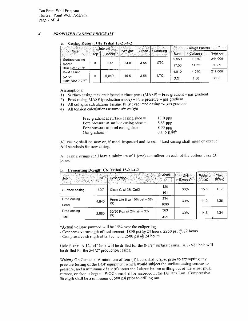
Ten Point Well ProgramThirteen Point Well ProgramPage 2 of 14
4. PROPOSED CASING PROGRAM
a. Casing Desi jn: Ute Tribal 15-21-4-2Interval Design Factors
Size Weight Grade CouplingTop Bottom Burst Collapse Tension
Surface casing 2,950 1,370 244,0008-5/8" O' 300' 24.0 J-55 STC
17.53 14.35 33.89Hole Size 12 1/4"
Prod casing 4,810 4,040 217,000
5-1/2" O' 6,840' 15.5 J-55 LTC2.21 1.86 2.05
Hole Size 7 7/8"
Assumptions:1) Surface casing max anticipated surface press (MASP) = Frac gradient - gas gradient2) Prod casing MASP (production mode) = Pore pressure - gas gradient3) All collapse calculations assume fully evacuated casing w/ gas gradient4) All tension calculations assume air weight
Frac gradient at surface casing shoe = 13.0 ppgPore pressure at surface casing shoe = 8.33 ppgPore pressure at prod casing shoe = 8.33 ppgGas gradient = 0.115 psi/ft
All casing shall be new or, if used, inspected and tested. Used casing shall meet or exceedAPI standards for new casing.
All casing strings shall have a minimum of 1 (one) centralizer on each of the bottom three (3)joints.
b. Cementing Design: Ute Tribal 15-21-4-2Sacks OH Weight Yield
Job Fill Descnption , aR3 Excess (ppg) (ft /sk)
138Surface casing 300' Class G w/ 2% CaCI 30% 15.8 1.17
161
Prod casing Prem Lite II w/ 10% gel + 3% 3344,840' 30% 11.0 3.26
Lead KCI 1090
Prod casing 50/50 Poz w/ 2% gel + 3% 3632,000' 30% 14.3 1.24
Tail KCI 451
*Actual volume pumped will be 15% over the caliper log- Compressive strength of lead cement: 1800 psi @24 hours, 2250 psi @72 hours- Compressive strength of tail cement: 2500 psi @24 hours
Hole Sizes: A 12-1/4" hole will be drilled for the 8-5/8" surface casing. A 7-7/8" hole will
be drilled for the 5-1/2" production casing.
Waiting On Cement: A minimum of four (4) hours shall elapse prior to attempting anypressure testing of the BOP equipment which would subject the surface casing cement topressure, and a minimum of six (6) hours shall elapse before drilling out of the wiper plug,cement, or shoe is begun. WOC time shall be recorded in the Driller's Log. CompressiveStrength shall be a minimum of 500 psi prior to drilling
Ten Point Well ProgramThirteen Point Well ProgmaPage 3 of 14
The Vernal BLM Office shall be notified, with sufficient lead time, in order to have a BLMrepresentative on location while running all casing strings and cementing.
The 8-5/8" surface casing shall in all cases be cemented back to surface. In the event thatduring the primary surface cementing operation the cement does not circulate to surface, or ifthe cement level should fall back more than 8 feet from surface, then a remedial surfacecementing operation shall be performed to insure adequate isolation and stabilization of thesurface casing.
The production casing cementing program shall be conducted as approved to protect and/or
isolate all usable water zones, potentially productive zones, lost circulation zones, abnormallypressured zones, and any prospectively valuable deposits of minerals.
As a minimum, usable water zones shall be isolated and/or protected by having a cement topfor the production casing at least 200 feet above the base of the usable water. If gilsonite isencountered while drilling, it shall be isolated and/or protected via the cementing program.
Top plugs shall be used to reduce contamination of cement by displacement fluid. A bottomplug or other acceptable technique, such as a suitable preflush fluid, inner string cement
method, etc., shall be utilized to help isolate the cement from contamination by the mud beingdisplaced ahead of the cement slurry.
All casing strings below the conductor shall be pressure tested to 0.22 psi per foot of casing
string length or to 1500 psi, whichever is greater, but not to exceed 70% of the minimuminternal yield. If pressure declines more than 10% in 30 minutes, corrective action shall betaken.
A Form 3160-5, "Sundry Notices and Reports on Wells" shall be filed with the Vernal OfficeManager within 30 days after the work is completed. This report must include the followinginformation:
Setting of each string of casing showing the size, grade, weight of casing set, depth, amounts and
type of cement used, whether cement circulated or the top of the cement behind the casing, depthof the cementing tools used, casing test method and results, and the date of the work done. Spuddate will be shown on the first reports submitted.
5. MINIMUM SPECIFICATIONS FOR PRESSURE CONTROL:
The Company's Class 2M minimum specifications for pressure control equipment for a standardMonument Butte development well are as follows:
A 2000 psi WP hydraulic BOP stack consisting of two ram preventers (double or two singles) and
either an annular preventer or a rotating head. If no annular preventer is used, ram blocks will bechanged to match the outside diameter of casing and the stack will be retested prior to running anycasing string.
Connections - All components on the stack and choke and kill lines shall have either flanged,studded, clamp hub or equivalent proprietary connections except control line outlets and pressuregauges.
Choke Manifold - The minimum equipment requirements are shown in Exhibit C. The choke
manifold shall be located at least 5 feet from the BOP stack, outside the substructure.
Pressure Monitoring - A means of monitoring the inlet pressure of the choke manifold shall be
provided. The capability to isolate this outlet shall be
Ten Point Well ProgramThirteen Point Well ProgramPage 4 of 14
Drillstring Control Devices - An upper and lower kelly valve, drillstring safety valve includingcorrect closing handle, and an inside BOP shall be provided. The safety valve and inside BOPshall have connections or crossovers to fit all tubulars with OD to allow adequate clearance forrunning in the hole. All drillstring valves shall be rated to the required BOP WP.
The BOP and related equipment shall meet the minimum requirements of Onshore Oil and GasOrder No. 2 for equipment and testing requirements, procedures, etc., for a 2M system, andindividual components shall be operable as designed.
Function test of the BOP equipment shall be made daily. All required BOP tests and/or drills shallbe recorded in the Driller's report.
Chart recorders will be used for all pressure tests. Test charts, with individual test resultsidentified, shall be maintained on location while drilling and shall be made available to BLMrepresentatives upon request.
Newfield Exploration requests a variance from Onshore Order 2, III.C.7. which states, "...(1)Theflare line discharge shall be located not less than 100 feet from the well...(2)The flare system shallhave an effective method of ignition."
Newfield Exploration requests permission to have a flowline length of 80 feet in order to minimizethe size of the well pad.
Newfield Exploration request permission to conduct operations without an automatic ignitor. Ifcombustible gases are expected, operations will be shut down until an effective method of ignitionhas been installed.
Newfield Exploration requests a variance from Onshore Order 2, III.E.1. which states, "...thefollowing equipment shall be in place and operational during air/gas drilling: (1) Properlylubricated and maintained rotating head ...(2) Blooie line discharge 100 feet from well bore...(3)Automatic igniter or continuous pilot light on the blooie line... (4) compressors located...aminimum of 100 ft from the well bore..."
Newfield Exploration request permission to use a diverter bowl in place of a rotating head. Thediverter bowl forces the air and cutting returns to the reserve pit and is used to drill the surface
casing (surface to a total depth of 350 feet). The surface casing occurs within the Uinta Formationwhich is a non-hydrocarbon bearing zone and thus has no possibility of gas pressure.
Newfield Exploration request permission to use a blooie line with a discharge less than 100 feet
from the wellbore in order to minimize the size of the well pads and direct the cuttings and
circulating mediums into the reserve pit. The well bore is located approximately 35 feet from thereserve pit which is 40 feet wide; a 100 feet blooie line would discharge the cuttings andcirculating mediums across the reserve pit and off the location. The requested length of the blooieline to drill the surface casing (surface to a total depth of 350 feet) is 35 feet. The surface casingoccurs within the Uinta Formation which is a non-hydrocarbon bearing zone and thus has nopossibility of gas pressure.
Newfield Exploration request permission to operate without an automatic igniter or continuous
pilot light on the blooie line due to the fact the air rig is only used to drill the surface casing
(surface to a total depth of 350 feet). The surface casing occurs within the Uinta Formation which
is a non-hydrocarbon bearing zone and thus has no possibility of gas pressure.
Newfield Exploration request permission to use a trailer mounted compressor located less than
100 feet from the well bore in order to minimize the well pad size. The trailer
Ten Point Well ProgramThirteen Point Well ProgramPage 5 of 14
compressor is located 50 feet from the wellbore and in an opposite direction of the blooie line.The compressor has the following safety features: (1) shut off valve on the trailer that is locatedapproximately 15 ft from the air rig, (2) pressure relief valve on the compressor, and (3) Sparkarresters on the motors. The compressor only used in the drilling of the surface casing (surface toa total depth of 350 feet). The surface casing occurs within the Uinta Formation which is a non-
hydrocarbon bearing zone and thus-has no possibility of gas pressure.
6. TYPE AND CHARACTERISTICS OF THE PROPOSED CIRCULATION MUDS:
From surface to ±350 feet will be drilled with an air/mist system. The air rig is equipped with a 6½" blooie line that is straight run and securely anchored. The blooie line is used with a dischargeless than 100 ft from the wellbore in order to minimize the well pad size. The blooie line is notequipped with an automatic igniter or continuous pilot light and the compressor is located lessthan 100 ft from the well bore due to the low possibility of combustion with the air dust mixture.The trailer mounted compressor (capacity of 2000 CFM) has a safety shut-off valve which islocated 15 feet from the air rig. A truck with 70 bbls of water is on stand by to be used as killfluid, if necessary. From about ±350 feet to TD, a fresh water system will be utilized. Clayinhibition and hole stability will be achieved with a KCl substitute additive. This additive will beidentified in the APD and reviewed to determine if the reserve pit shall be lined. This fresh watersystem will typically contain Total Dissolved Solids (TDS) of less than 3000 PPM. Anticipatedmud weight is 8.4 lbs/gal. If necessary to control formation fluids or pressure, the system will beweighted with the addition of bentonite gel, and if pressure conditions warrant, with barite.
No chromate additives will be used in the mud system on Federal and/or Indian lands withoutprior BLM approval to ensure adequate protection of fresh aquifers.
No chemicals subject to reporting under SARA Title III in an amount equal to or greater than10,000 pounds will be used, produced, stored, transported, or disposed of annually in associationwith the drilling, testing, or completing of this well. Furthermore, no extremely hazardoussubstances, as defined in 40 CFR 355, in threshold planning quantities, will be used, produced,stored, transported, or disposed of in association with the drilling, testing, or completing of thiswell.
Hazardous substances specifically listed by the EPA as a hazardous waste or demonstrating a
characteristic of a hazardous waste will not be used in drilling, testing, or completion operations.
Newfield Production will visually monitor pit levels and flow from the well during drillingoperations.
7. AUXILIARY SAFETY EOUIPMENT TO BE USED:Auxiliary safety equipment will be a Kelly Cock, bit float, and a TIW valve with drill pipethreads.
8. TESTING, LOGGING AND CORING PROGRAMS:
a. Logging Program:(the log types run may change at the discretion of the geologist)
FDC/CNL/GR/DLL: TD - 3,200'CBL: A cement bond log will be run from TD to the cement top of the production casing.
A field copy will be submitted to the Vernal BLM Office.
b. Cores: As deemed necessary.
c. Drill Stem Tests: No DSTs are planned in the Green
Ten Point Well ProgramThirteen Point Well ProgrmaPage 6 of 14
Drill stem tests, if they are run, will adhere to the following requirements: Initial opening ofthe drill stem test tools shall be restricted to daylight hours unless specific approval to startduring other hours is obtained from the Authorized Officer (AO). However, DSTs may beallowed to continue at night if the test was initiated during daylight hours and the rate of flowis stabilized and if adequate lighting is available ( i.e., lighting which is adequate for visibilityand vapor-proof for safe operations). Packers can be released but tripping shall not beginbefore daylight, unless prior approval is obtained from the AO. Closed chamber DSTs maybe performed day or night.
Some means of reverse circulation shall be provided in case of flow to the surface showingevidence of hydrocarbons.
Separation equipment required for the anticipated recovery shall be properly installed before atest starts.
If a DST is performed, all engines within 100 feet of the wellbore that are required to beoperational during the test shall have spark arresters or water-cooled exhausts.
9. ANTICIPATED ABNORMAL PRESSURE OR TEMPERATURE:
No abnormal temperatures or pressures are anticipated. No hydrogen sulfide has been encounteredor is known to exist from previous drilling in the area at this depth. Maximum anticipatedbottomhole pressure will approximately equal total depth in feet multiplied by a 0.433 psi/footgradient.
10. ANTICIPATED STARTING DATE AND DURATION OF THE OPERATIONS:
a. Drilling Activity
Anticipated Commencement Date: Upon approval of the site specific APD.Drilling Days: Approximately 7 days.Completion Days: Approximately 10 - 14 days.
b. Notification of Operations
The Vernal BLM office will be notified at least 24 hours prior to the commencement ofspudding the well (to be followed with a Sundry Notice, Form 3160-5), of initiating pressuretests of the blowout preventer and related equipment, and running casing and cementing of all
casing strings. Notification will be made during regular work hours (7:45 a.m.-4:30 p.m.,Monday - Friday except holidays).
Immediate Report: Spills, blowouts, fires, leaks, accidents, or any other unusual
occurrences shall be promptly reported in accordance with the appropriate regulations,
Onshore Orders, or BLM policy.
No location will be constructed or moved, no well will be plugged, and no drilling or
workover equipment will be removed from a well to be placed in suspended status withoutprior approval from the AO. If operations are to be suspended, prior approval of the AO will
be obtained and notification given to the BLM before resumption of operations.
Daily drilling and completion reports shall be submitted to the Vernal BLM Office on aweekly
Ten Point Well ProgramThirteen Point Well ProgramPage 7 of 14
Whether the well is completed as a dry hole or a producer, the "Well Completion and
Recompletion Report and Log" (Form 3160-4) will be submitted not later than 30 days aftercompletion of the well or after completion of operations being performed, in accordance with
43 CFR 3164. One copy of all logs, core descriptions, core analyses, well test data, geologicsummaries, sample description, and all other surveys or data obtained and compiled duringthe drilling, workover, and/or completion operations will be filed with Form 3160-4. Samples(cuttings, fluids, and/or gases) will be submitted when requested by the Authorized Officer(AO).
A completion rig will be used for completion operations after the wells are stimulated to run
the production tubing.. All conditions of this approved plan will be applicable during alloperations conducted with the completion rig.
Operator shall report production data to the MMS pursuant to 30 CFR 216.5 using formMMS/3160. In accordance with Onshore Oil and Gas Order No. 1, a well will be reported onform 3160-6, "Monthly Report of Operations," starting with the month in which operations
commence and continue each month until the well is physically plugged and abandoned. Thisreport will be filed with the Vernal BLM Office.
The date on which production is commenced or resumed will be construed for oil wells as thedate on which liquid hydrocarbons are first sold or shipped from a temporary storage facility,such as a test tank, and for which a run ticket is required to be generated, or the date on whichliquid hydrocarbons are first produced into a permanent storage facility, whichever occurs
first; and for gas wells, as the date on which associated liquid hydrocarbons are first sold or
shipped from a temporary storage facility, such as a test tank, and for which a run ticket isrequired to be generated, or the date on which gas is measured through permanent meteringfacilities, whichever occurs first.
Should the well be successfully completed for production, the AO will be notified when thewell is placed in a producing status. Such notification will be sent by written communicationnot later than 5 days following the date when the well is placed on production.
Pursuant to Onshore Order No. 7, with the approval of the AO, produced water may betemporarily disposed of into unlined pits for a period of up to 90 days. During this period, anapplication for approval of the permanent disposal method must be submitted to the AO.
Pursuant to NTL-4A, lessees or operators are authorized to vent/flare gas during the initialwell evaluation tests, not to exceed 30 days or the production of 50 MMCF of gas, whicheveroccurs first. An application must be filed with the AO and approval received for anyventing/flaring of gas beyond the initial 30 days or authorized test period.
A schematic facilities diagram, as required by 43 CFR 3162.7-5(b.9.d), shall be submitted tothe Vernal BLM Office within 60 days of installation or first production, whichever occursfirst. All site security regulations, as specified in Onshore Oil & Gas Order No. 3, shall beadhered to. All product lines entering and leaving hydrocarbon storage tanks will beeffectively sealed in accordance with 43 CFR 3162.7-5(b.4).
Well abandonment operations shall not be commenced without the prior approval of the AO.In the case of newly drilled dry holes or failures, and in emergency situations, oral approval
will be obtained from the AO. A "Subsequent Report of Abandonment", Form 3160-5, will
be filed with the Authorized Officer within 30 days following completion of the well forabandonment. This report will indicate placement of the plugs and current status of thesurface restoration. Final Abandonment will not be approved until the surface

Ten Point Well ProgramThirteen Point Well ProgramPage 8 of 14
work required by the approved APD or approved abandonment notice has been completed tothe satisfaction of the AO, or the appropriate surface managing agency.
Pursuant to Onshore Oil and Gas Order No. 1, lessees and operators have the responsibility tosee that their exploration, development, production, and construction operations are conductedin a manner which conforms with applicable Federal laws and regulations and with the Stateand local laws, to the extent to which they are applicable, to operations on Federal or Indian
Ten Point Well Program.Thirteen Point Well ProgramPage 9 of 14
NEWFIELD PRODUCTION COMPANYUTE TRIBAL 15-21-4-2
SW/SE SECTION 21, T4S, R2WDUCHESNE COUNTY, UTAH
THIRTEEN POINT SURFACE PROGRAM
l. EXISTING ROADS
See attached Topographic Map "A"
To reach Newfield Production Company well location site Ute Tribal 15-21-4-2 located in theSW¼ SE¼ Section 21, T4S, R2W, S.L.B. & M., Duchesne County, Utah:
Proceed southwesterly out of Myton, Utah along Highway 40 - 1.4 miles ± to the junctionof thishighway and UT State Hwy 53; proceed southeasterly - 5.4 miles ± to it's junctionwith anexisting road to the southwest; proceed southwesterly - 0.3 miles ± to it's junctionwith thebeginning of the proposed access to the west; proceed in a westerly direction along the proposedaccess road - 1.7 miles ± to the proposed well location.
The aforementioned dirt oil field service roads and other roads in the vicinity are constructed outof existing native materials that are prevalent to the existing area they are located in and range
from clays to a sandy-clay shale material.
The roads for access during the drilling, completion and production phase will be maintained atthe standards required by the State of Utah, or other controlling agencies. This maintenance will
consist of some minor grader work for smoothing road surfaces and for snow removal. Anynecessary fill material for repair will be purchase and hauled from private sources.
2. PLANNED ACCESS ROAD
Approximately 9,210'of access road is proposed. See attached Topographic Map "B".
The proposed access road will be an 18' crown road (9' either side of the centerline) with drainageditches along either side of the proposed road whether it is deemed necessary in order to handleany run-off from normal meteorological conditions that are prevalent to this area. The maximum
grade will be less than 8%.
There will be no culverts required along this access road. There will be barrow ditches andturnouts as needed along this road.
There are no fences encountered along this proposed road. There will be no new gates or cattleguards required.
All construction material for this access road will be borrowed material accumulated duringconstruction of the access road.
3. LOCATION OF EXISTING WELLS
Refer to EXHIBIT B.
4. LOCATION OF EXISTING AND/OR PROPOSED
Ten Point Well ProgramThirteen Point Well Prog sa
Page 10 of 14
There are no existing facilities that will be used by this well.
It is anticipated that this well will be a producing oil well.
Upon construction of a tank battery, the well pad will be surrounded by a dike of sufficientcapacity to contain at minimum 110% of the largest tank volume within the facility battery.
Tank batteries will be built to State specifications.
All permanent surface equipment will be painted Carlsbad. All facilities will be painted within sixmonths of installation.
5. LOCATION AND TYPE OF WATER SUPPLY
Newfield Production will transport water by truck for drilling purposes from the following water
sources:
Johnson Water DistrictWater Right: 43-10136
Neil Moon PondWater Right: 43-11787
Maurice Harvey PondWater Right: 47-1358
Newfield Collector WellWater Right: 41-3530 (A30414DV, contracted with the Duchesne County Conservancy District).
There will be no water well drilled at this site.
6. SOURCE OF CONSTRUCTION MATERIALS
All construction material for this location shall be borrowed material accumulated duringconstruction of the location site and access road.
A mineral material application is not required for this location.
7. METHODS FOR HANDLING WASTE DISPOSAL
A small reserve pit (90' x 40' x 8' deep, or less) will be constructed from native soil and claymaterials. The reserve pit will receive the processed drill cutting (wet sand, shale & rock)removed from the wellbore. Any drilling fluids, which do accumulate in the pit as a result ofshale-shaker carryover, cleaning of the sand trap, etc., will be promptly reclaimed. All drillingfluids will be fresh water based, typically containing Total Dissolved Solids of less than 3000PPM. No potassium chloride, chromates, trash, debris, nor any other substance deemed hazardouswill be placed in this pit. Therefore, it is proposed that no synthetic liner be required in the reservepit. However, if upon constructing the pit there is insufficient fine clay and silt present, a linerwill be used for the purpose of reducing water loss through percolation.
Newfield requests approval that a flare pit not be constructed or utilized on this location.
A portable toilet will be provided for human
Ten Point Well ProgramThirteen Point Well ProgramPage 11 of 14
A trash basket will be provided for garbage (trash) and hauled away to an approved disposal site atthe completion of the drilling activities.
Immediately upon first production, all produced water will be confined to a steel storage tank. Ifthe production water meets quality guidelines, it is transported to the Ashley, Monument Butte,Jonah, and Beluga water injection facilities by company or contract trucks. Subsequently, theproduced water is injected into approved Class II wells to enhance Newfield's secondary recovery
pro¡ect.
Water not meeting quality criteria, is disposed at Newfield's Pariette #4 disposal well (Sec. 7, T9SRl9E), State of Utah approved surface disposal facilities, or Federally approved surface disposalfacilities.
8. ANCILLARY FACILITIES:
There are no ancillary facilities planned for at the present time and none foreseen in the nearfuture.
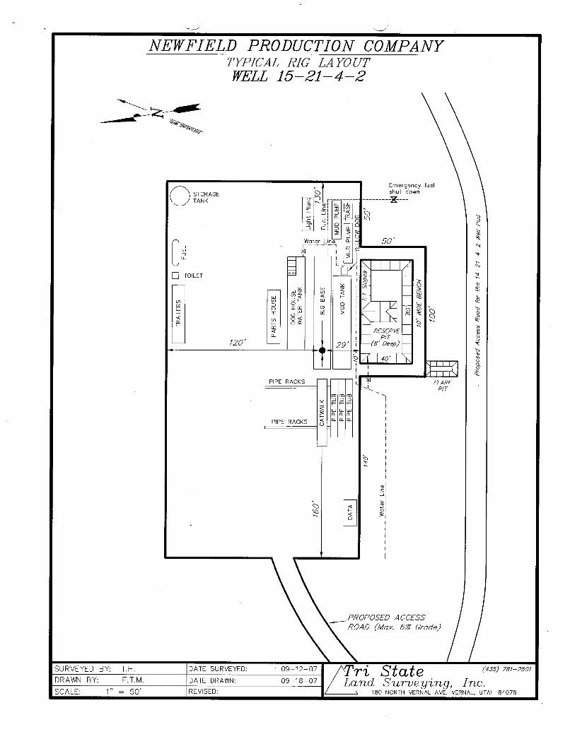
9. WELL SITE LAYOUT:
See attached Location Layout Sheet.
Fencing Requirements
All pits will be fenced according to the following minimum standards:
a) A 39-inch net wire shall be used with at least one strand of barbed wire on top of the net.
b) The net wire shall be no more than two (2) inches above the ground. The barbed wireshall be three (3) inches above the net wire. Total height of the fence shall be at leastforty-two (42) inches.
c) Corner posts shall be centered and/or braced in such a manner to keep tight at all times
d) Standard steel, wood or pipe posts shall be used between the corner braces. Maximumdistance between any two posts shall be no greater than sixteen (16) feet.
e) All wire shall be stretched, by using a stretching device, before it is attached to the cornerposts.
The reserve pit fencing will be on three (3) sides during drilling operations and on thefourth side when the rig moves off location. Pits will be fenced and maintained untilcleanup.
Existing fences to be crossed by the access road will be braced and tied off before cuttingso as to prevent slacking in the wire. The opening shall be closed temporarily asnecessary during construction to prevent the escape of livestock, and upon completion ofconstruction the fence shall be repaired to BLM specifications.
10. PLANS FOR RESTORATION OF SURFACE:
a) Producing Location
Immediately upon well completion, the location and surrounding area will be cleared ofall unused tubing, equipment, debris, material, trash and junk not required for
Ten Point Well Program.Thirteen Point Well ProgramPage 12 of 14
The reserve pit and that portion of the location not needed for productionfacilities/operations will be recontoured to the approximated natural contours. Weatherpermitting, the reserve pit will be reclaimed within one hundred twenty (120) days fromthe date of well completion. Before any dirt work takes place, the reserve pit must haveall fluids and hydrocarbons removed.
b) Dry Hole Abandoned Location
At such time as the well is plugged and abandoned, the operator shall submit asubsequent report of abandonment and the State of Utah will attach the appropriatesurface rehabilitation conditions of approval.
l 1. SURFACE OWNERSHIP: Clinton Moon. See attached Surface Use Agreement.
12. OTHER ADDITIONAL INFORMATION:
Newfield Production Company requests 9,210' of disturbed area be granted to allow forconstruction of the planned access road. Refer to Topographic Map "B". A permanent widthof 30' and a running surface of 18' is proposed for the planned access road. The constructionphase of the planned access road will last approximately (5) days. The planned access road will bean 18' crown road (9' either side of the centerline) with drainage ditches along either side of theproposed road whether it is deemed necessary in order to handle any run-off from normal
meteorological conditions that are prevalent to this area. The maximum grade will be less than8%. There will be no culverts required along this access road. There will be barrow ditches andturnouts as needed along this road. There are no fences encountered along this proposed road.
There will be no new gates or cattle guards required. All construction material for this access roadwill be borrowed material accumulated during construction of the access road.
Newfield Production Company requests l1,910' of disturbed area be granted for construction ofthe proposed gas lines. It is proposed that the disturbed area will temporarily be 50' wide to allowfor construction of a 6" gas gathering line, and a 3" poly fuel gas line, with a permanent width of30' upon completion of the proposed gas lines. The construction phase of the proposed gas lineswill last approximately (5) days. Both proposed lines will tie in to the existing pipelineinfrastructure. Refer to Topographic Map "C."
Newfield Production Company requests l1,910' of disturbed area be granted to allow forconstruction of the proposed water lines. It is proposed that the disturbed area will temporarily be50' wide to allow for construction of a buried 3" steel water injection line and a buried 3" polywater return line and 30' wide upon completion of the proposed water lines. Both proposed lineswill tie in to the existing pipeline infrastructure. Refer to Topographic Map "C." In the event
that the proposed well is converted to a water injection well, a separate injection permit will beapplied for through the proper agencies.
The Surface Use Aggreement for the portion of proposed pipeline that crosses John Kapos'sproperty is enclosed.
a) Newfield Production Company is responsible for informing all persons in the area whoare associated with this project that they will be subject to prosecution for knowinglydisturbing historic or archaeological sites, or for collecting artifacts. If historic orarchaeological materials are uncovered during construction, Newfield is to immediatelystop work that might further disturb such materials and contact the Authorized Officer.
b) Newfield Productíon will control noxious weeds along rights-of-way for roads, pipelines,well sites or other applicable facilities. On State administered land it is required that
Ten Point Well ProgramThirteen Point Well ProgramPage 13 of 14
Pesticide Use Proposal shall be submitted and given approval prior to the application ofherbicides or other possible hazardous chemicals.
c) Drilling rigs and/or equipment used during drilling operations on this well site will not bestacked or stored on State Lands after the conclusion of drilling operations or at any othertime without State authorization. However, if State authorization is obtained, it is only atemporary measure to allow time to make arrangements for permanent storage oncommercial facilities.
The Archaeological and Paleontological Report Waiver is attached.
Additional Surface Stipulations
All lease and/or unit operations will be conducted in such a manner that full compliance is made
with all applicable laws and regulations, Onshore Oil and Gas Orders, the approved plan ofoperations and any applicable Notice to Lessees. A copy of these conditions will be furnished tothe field representative to ensure compliance.
Hazardous Material Declaration
Newfield Production Company guarantees that during the drilling and completion of the UteTribal 15-21-4-2, Newfield will not use, produce, store, transport or dispose 10,000# annually ofany of the hazardous chemicals contained in the Environmental Protection Agency's consolidated
list of chemicals subject to reporting under Title III Superfund Amendments and ReauthorizationAct (SARA) of 1986. Newfield also guarantees that during the drilling and completion of the UteTribal 15-21-4-2 Newfield will use, produce, store, transport or dispose less than the thresholdplanning quantity (T.P.Q.)of any extremely hazardous substances as defined in 40 CFR 355.
A complete copy of the approved APD, if applicable, shall be on location during the construction
of the location and drilling activities.
Newfield Production Company or a contractor employed by Newfield Production shall contact theState office at (801) 722-3417, 48 hours prior to construction activities.
The State office as well as the Ute Tribe Energy and Mineral Department shall be notified uponsite completion prior to moving on the drilling rig.
13. LESSEE'S OR OPERATOR'S REPRENSENTATIVE AND CERTIFICATION:
Representative
Name: Dave AllredAddress: Newfield Production Company
Route 3, Box 3630Myton, UT 84052
Telephone: (435) 646-3721
CertificationPlease be advised that Newfield Production Company is considered to be the operator of well #15-
21-4-2, SW/SE Section 21, T4S, R2W, Duchesne County, Utah and is responsible under the termsand conditions of the lease for the operations conducted upon the leased lands. Bond coverage isprovided by, Federal Bond #WYB000493.
I hereby certify that the proposed drill site and access route have been inspected, and I am familiarwith the conditions which currently exist; that the statements made in this plan are true and

Ten Point Well ProgramThirteen Point Well ProgramPage 14 of 14
to the best of my knowledge; and that the work associated with the operations proposed here willbe performed by Newfield Production Company and its contractors and subcontractors inconformity with this plan and the terms and conditions under which it is approved. This statementis subject to the provisions of the 18 U.S.C. 1001 for the filing of a false statement.
Date 191andieÓrozier LyRegulatory SpecialistNewfield Production
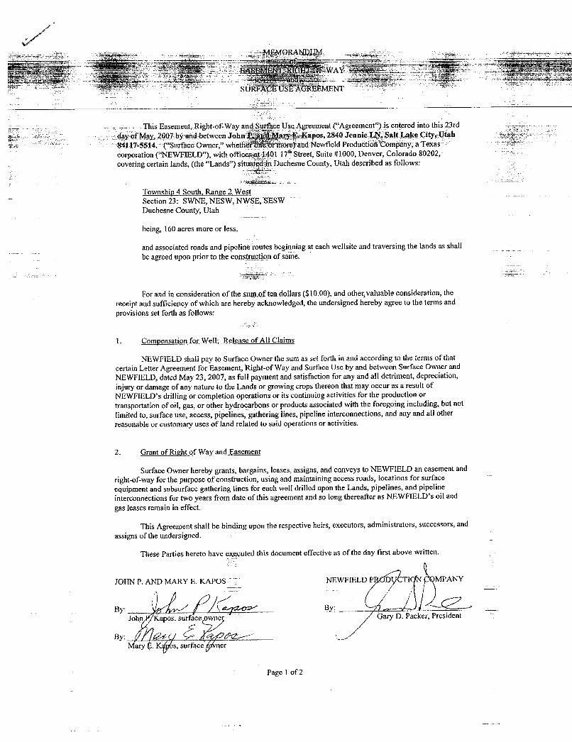
SUIÜ'ÃÕÈUSËAGIfÉŠMENT
This Easement, Right-of-Way and Surface Use Agreement ("Agreement") is entered into this 23rd
day of May, 2007 by and between John I an¾Mary E. Kapos, 2840 Jennic LN, Salt Lake City, Utah84117-5514. ("Surface Owner," whetherŠntfor more) and ÑewfieldProduction Company, a Texascorporation ("NEWFIELD"), with offices at 1401 17"' Street, Suite #1000, Denver, Colorado 80202,covering certain lands, (the "Lands") situated in Duchesne County, Utah described as follows:
Township 4 South, Range 2 WestSection 23: SWNE, NESW, NWSE SESWDuchesne County, Utah
being, 160 acres more or less,
and associated roads and pipeline routes beginning at each wellsite and traversing the lands as shall
be agreed upon prior to the construction of same.
For and in consideration of the sum of ten dollars($10.00),and othergvaluable consideration, thereceipt and sufficiency of which are hereby acknowledged, the undersigned hereby agree to the terms andprovisions set forthas follows:
1. Compensation for Well; Release of All Claims
NEWFIELD shall pay to Surface Owner the sum as set forth in and according to the terms of thatcertain Letter Agreement for Easement, Right-of Way and Surface Use by and between Surface Owner and
NEWFIELD, datedMay 23, 2007, as full payment and satisfaction for any and all detriment, depreciation,injury or damage of any nature to the Lands or growing crops thereonthat may occur as a result ofNEWFIELD's drilling or completion operations or its continuing activities for the production ortransportation of oil, gas, or other hydrocarbons or products associated with the foregoing including, but not
limited to, surface use, access, pipelines, gathering lines, pipeline interconnections,and any and all otherreasonable or customary uses of land related to said operations or activities.
2. Grant of Right of Way and Easement
Surface Owner herebygrants, bargains, leases, assigns, and conveys to NEWFIELD an easement andright-of-way for the purpose of construction, using and maintaining access roads, locations for surface
equipment and subsurface gathering lines for each well drilled upon the Lands, pipelines, and pipeline
interconnections for two years from date of this agreement and so long thereafter as NEWFIELD's oil and
gas leases remain in effect.
This Agreement shall be binding upon the respective heirs, executors, administrators, successors, and
assigns of the undersigned.
JOHN
PThese Parties here have e ted this document effective as of tEhed st ov wr ttenlWPANY
By: ByJohn Kapos, surface owne Gary D. Packer, President
By: /
Mary Ë. K s, surface ner
Page 1 of
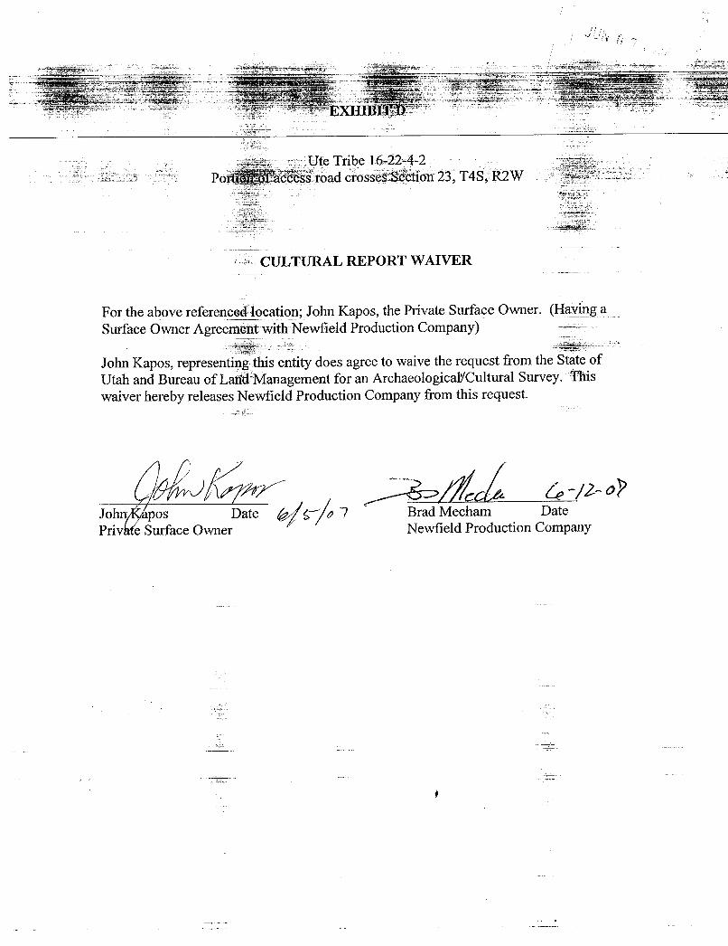
EXHIBITO
Ute Tribe 16-22-4-2Port f access road crosses Section 23, T4S, R2W
CULTURAL REPORT WAIVER
For the above referenced_location; John Kapos, the Private Surface Owner. (Having aSurface Owner Agreement with Newfield Production Company)
John Kapos, representing this entity does agree to waive the request from the State ofUtah and Bureau of Land Management for an Archaeologicaf/Cultural Survey. Thiswaiver hereby releases Newfield Production Company from this request.
Johr pos Date a 7 Brad Mecham DatePrivate Surface Owner Newfield Production
SURFACE USE AGREEMENTor: biEWF ELD ROCKY N
This Easement, Right-of-Way and Surface Use Agreement ("Agreement") is entered into this 22"day of March, 2007 by and betweenClinton Moon whose address Ïs MÚ$4 Béx113 Duchesne, Utah8402t("Surface Owner,"Whether one or more) andNewfield Prodüßti ifCompany, a Texas corporation("NEWFIELD"), with offices at 1401 17* Street, Suite #1000, Denver Colorado80202, covering certainlands, (the "Lands") situated in Duchesne County, Utah described as follows:
Township 4 South, Range 2 WestSE, NESW, SWSW, SESW, Section 22
Duchesne County, Utah
being, 280 acres more or less,
and associated roads and pipeline routes beginningat each welÏsiteand traversing the lands as shallbe agreed upon prior to the construction of same.
For and in consideration of the sum of ten dollars ($10.00),and other valuable consideration, thereceipt and sufficiency of which are hereby acknowledged, the undersigned hereby agree to the terms andprovisions set forth as follows:
1. Comoensation for Well; Release of All Claims
NEWFIELD shall pay to Surface Owner the sum as set forth in and according to the terms ofthatcertain Letter Agreement for Easement, Right-of Way and Surface Use by and between Surface Owner andNEWFIELD, dated April 1, 2007, as full payment and satisfaction for any and all detriment, depreciation,injury or damage of any nature to the Lands or growing crops thereon that may occur as a result ofNEWFIELD's drilling or completion operations or its continuiog activities for the production ortransportation of oil, gas, or other hydrocarbons or products associated with the foregoing including, but notlimited to, surface use, access, pipelines, gathering lines, pipeline interconnections, and any and all otherreasonable or customary uses of land related to said operations or activities.
2. Grant of Right of Way and Easement
Surface Owner hereby grants, bargains, leases, assigns, and conveys to NEWFIELD an easement andright-of-way for the purpose of construction, using and maintaining access roads, locations for surfaceequipment and subsurface gathering lines for each well drilled upon the Lands, pipelines, and pipelineinterconnections for two years from date of this agreement and so long thereafter as NEWFIELD's oil andgas leases remain in effect.
This Agreement shall be binding upon the respective heirs, executors, administrators, successors, andassigns of the undersigned.
These Parties hereto have executed this document effective as of the day first above written.
RFACE NEWFIE C ION COMPANY
Clinton Moon, Surfac$ Owner / ry D. Packer, Presi
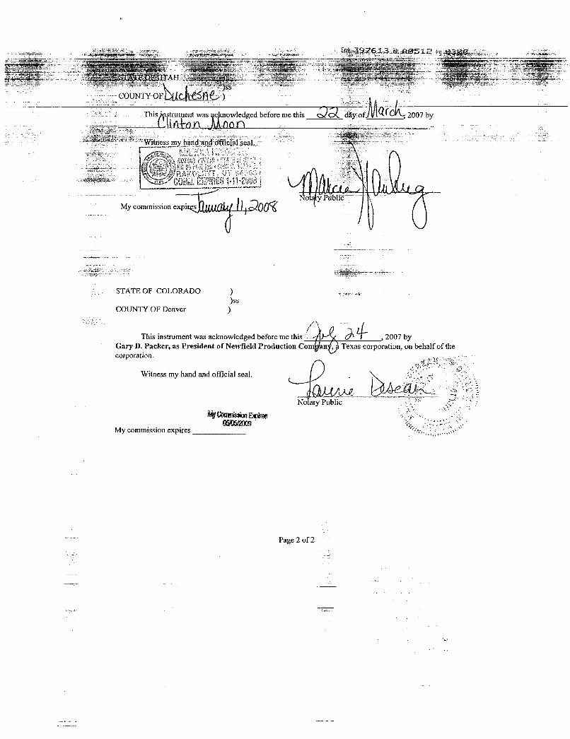
ot 397613 okAO512 già3
TAH
COUNTY OF
This trument was owledged before me tlus day o 2007 by
My commission expi filÛ
STATE OF COLORADO ))ss
COUNTY OF Denver )
This instrument was acknowledged before me this , 2007 byGary D. Packer, as President of Newfield Production Co n , Texas corporation, on behalf of thecorporation.
Witness my hand and official seal.
No ry PublicMyConsissionBolme
gi¾f2009My commission expires
Page 2 of

EXHIBIT D
Well located on Clinton and Donette Moon(Private Land Owners)
ARCHAEOLOGICAL & PALEOTOLOGICAL REPORT WAIVER
For the above referenced location; Clinton and Donette Moon, the Private SurfaceOwner. (Having a Surfac60Wner Agreement with Newfield Production
Companý)¯
Clinton Moon, representing this entity does agree to waive the request from the State ofUtah and Bureau of Land Management for an Archaeological/Cultural and PaleotologicalResource Survey for any élls covered by the Surface Use Agreement dated 05/27/08between the above said private land owner and Newfield Production. This waiver herebyreleases Newfield Production Company from this request.
CÏintonMoon / Date EËadMecham DatePrivate Surface Owner Newfield Production
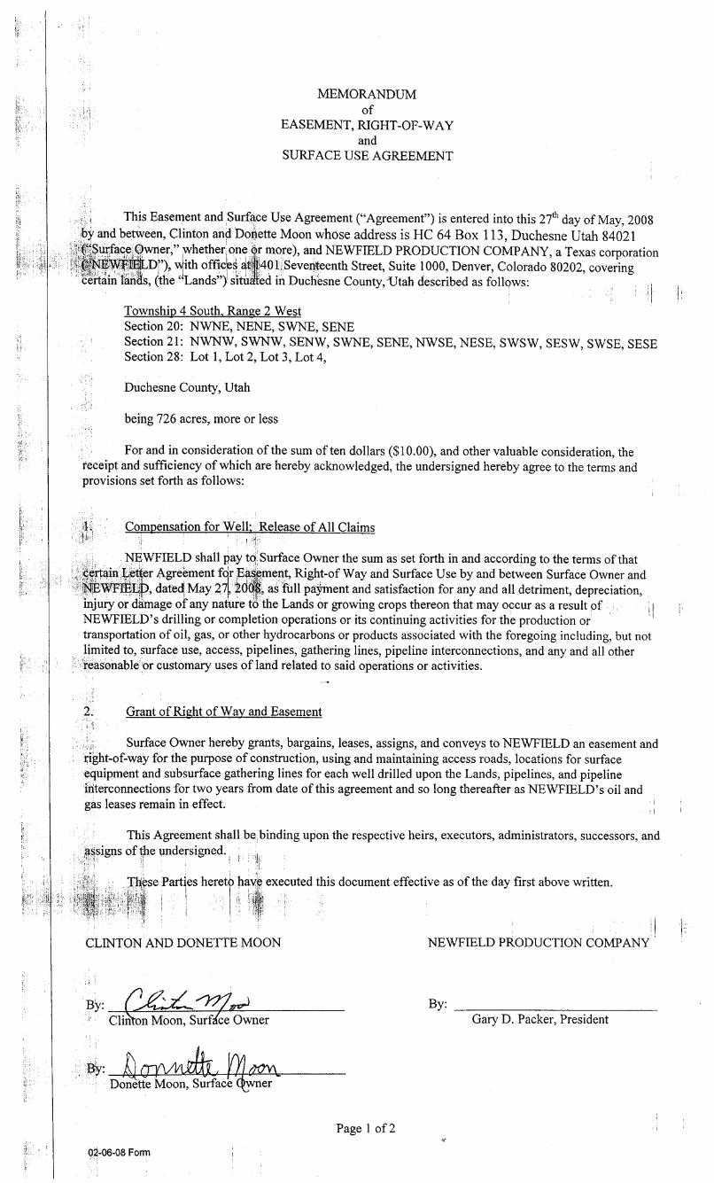
MEMORANDUMof
EASEMENT RIGHT-OF-WAYand
SURFACE USE AGREEMENT
This Easement and Surface Use Agreement ("Agreement") is entered into this 27* day of May, 2008by and between, Clintonand Donette Moon whose address is HC 64 Box 113, Duchesne Utah 84021("Surface Owrier," whether one or more), and NEWFIELD PRODUCTION COMPANY, a Texas corporation
EWFIELD ') v(ith offices at 401 Seventeenth Street, Suite 1000, Denver, Colorado 80202, coveringcèrtain lands, the "Lands") situÀedin Ducliesne County,Utah describedas follqws:
Township 4 South, Range 2 WestSection 20: NWNE, NENE, SWNE, SENESection 21: NWNW, SWNW, SENW, SWNE, SENE, NWSE, NESE, SWSW, SESW, SWSE, SESESection 28: Lot 1, Lot 2, Lot 3, Lot 4,
Duchesne County, Utah
being726 acres, more or less
For and in consideration of the sum of ten dollars ($10.00),and other valuable consideration, thereceipt and sufficiency of which are hereby acknowledged, the undersigned hereby agree to the terms andprovisions set forth as follows:
1. Compensation for Well: Release of All Claims
NEWFIELD shall pay to Surface Owner the sum as set forth in and according to the terms of thatcertain Let(er Agrement for Easpment, Right-of Way and Surface Use by and between Surface Owner andNSWFIELþ, datedMay 27Ë2001, as full pdýment and satisfaction for any and all detriment, depreciation,injury or damage of any nature to the Lands or growing crops thereon that may occur as a result ofNEWFIELD's drilling or completion operations or its continuing activities for the production ortransportation of oil, gas, or other hydrocarbons or products associated with the foregoing including, but notlimitedto, surface use, access, pipelines, gathering lines, pipeline interconnections, and any and all otherreasonable or customary uses of land related to said operations or activities.
2. Grant of Right of Way and Easement
Surface Owner hereby grants, bargains, leases, assigns, and conveys to NEWFIELD an easement andright-of-wäy for the purpose of construction, using and maintaining access roads, locations for surfaceequipment and subsurface gathering lines for each well drilled upon the Lands, pipelines, and pipelineinteiconnections for two years from date of this agreement and so long thereafter as NEWFIELD's oil andgas leases temain in effect.
This Agreement shall be binding upon the respective heirs, executors, administrators, successors, andsigns of e undersigned.
lgse Parties hereto have executed this document effective as of the day first above written.
CLINTON AND DONETTE MOON NEWFIELD PliODUCTION COMPANY
Clinton Moon, Surf ce Owner Gary D. Packer, President
By: CryVM R.Donette Moon, Surface wner
Page 1 of 2
-06-08
MEMORANDUMof
EASEMENT, RIGHT-OF-WAYand
SURFACE USE AGREEMENT
This Easement, P ight-of-Way and Surface Use Agreement ("Aggement") is entered into this 14'day of August, 2007 by and between Clinton and Donnette Moon who Èessis ÈC 4 Ñox113Duchesne, Utah 84021 ("Surface Owner," whether one or more) and NÔfielEProduction Company, aTexas corporation ("NEWFIELD"), with offices at 1401 17 Street, Suitg #1000, Denver, Colorado 80202,covering certain lands, (the "Lands") situated in Duchesno County, Utah described as follows:
Township 4 South, Range 2 WestSection 23: NWSW, SWSW
Duchesne County, Utah
being, 80 acres more or less,
and associated roads and pipeline routes beginning at each wellsite and traversing the lands as shallbe agreed upon prior to the construction of same.
For and in consideration of the sum of ten dollars ($10.00),and other valuable consideration, thereceipt and sufficiency of which are hereby acknowledged, the undersigned hereby agree to the terms andprovisions set forth as follows:
1. Compensation for Well; Release of All Claims
NEWFIELD shall pay to Surface Owner the sum as set forth in and according to the terms of thatcertain Letter Agreement for Easement, Right-of Way and Surface Use by and between Surface Owner andNEWFIELD, dated August 14, 2007, as full payment and satisfaction for any and all detriment, depreciation,injury or damage of any nature to the Lands or growing crops thereon that may occur as a result ofNEWFIELD's drilling or completion operations or its continuing activities for the production ortransportation of oil, gas, or other hydrocarbons or products associated with the foregoing including, but notlimited to, surface use, access, pipelines, gathering lines, pipeline interconnections, and any and all otherreasonable or customary uses of land related to said operations or activities.
2. Grant of Right of Way and Easement
Surface Owner hereby grants, bargains, leases, assigns, and conveys to NEWFIELD an easement andright-of-way for the purpose of construction, using and maintaining access roads, locations for surfaceequipment and subsurface gathering lines for each well drilled upon the Lands pipelines, and pipelineinterconnections for two years from date of this agreement and so long thereaf er as NEWFgLD's oil andgas leases remain in effect. 'i i I
This Agreement shall be binding upon the respective heirs, executors, administrators, successors, andassigns of the undersigned.
These Parties hereto have executed this document effective as of the day first above written.
SURFACE OWNER NEWFIELD PRODUCTION COMPANY
Clinton Moon, Surface Owner Gary D. Packer, President
Donnette Moon, Surface Owner
Page 1 of
EASEMENT,RIGHT-OF-WAYand
SURFACEUSEAGREEMENT
This Easement and Surface Use Agreement ("Agreement") is entgred into thisll4thday of August2007 by and between, Clinton and Donnette Moon whose address is HC 64 Box 113,Duchesne, Utah84021, ("Surface Owner," whether one or more), and NEWFIELD PRODUCTION COMPANY, a Texascorporation ("NEWFIELD"),with offices at 1401 Seventeenth Street,Suite 1000, Denver, Colorado80202,covering certain lands, (the "Lands") situated in Duchesne County, Utah described as follows:Township 4 South, Range 2 WestSection 23: NWSW, SWSW
Duchesne County, Utahbeing 80 acres, more or less
and associated road and pipeline routes beginning at each of the wellsites and traversingthe lands as shall be agreed upon prior to the construction of same.
Grantof Right of Way and Easement
Surface Owner hereby grants, bargains, leases, assigns, and conveys to NEWFIELD an easement andright-of-way for the purpose of construction, using and maintaining access roads, locations for surfaceequipment and surface and subsurface gathering lines, pipelines, and pipeline nterconnections, for each welldrilled upon the Lands, for two years from the date of this agreement and o lo g thereafteras NEWFIELD'soil and gas leases on the Lands remain in effect.
For and in consideration of the sum of ten dollars ($10.00),and qghervaluableconsidefation, the ,receipt and sufficiency of which are herebyacknowledged, the undersigned hereby agree to the terms and 1provisions set forth as follows:
Compensation for Operations; Release of All Claims
A. Drillsites, Access Roads, and Facilities
NEWFIELD shall pay to Surface Owner on or before the construction of any drillsitelocation, the sum of Two Thousand Dollars ($2,000)for each well located on the surfaceand/or access road upon the surface of the Lands. Such payment shall be a one time paymentper well as full and final settlement and satisfaction for any and all detriment, depreciation,injury or damage of any nature to the Lands or growing crops thereon that may occur as a resultof NEWFIELD's drilling or completion operations or its use of road rights-of way and itscontinuing activities related to the production or transportation of oil, gas or other hydrocarbonsor products associated with the foregoing including, but not limited to, surface use, access,surface damages, and any and all other reasonable and customary uses of land related to saidoperations or activities.
Additionally, NEWFIELD shall pay to Surface Owner on or beforeAdgust 14th of Lac aagreement is in affect, as rental, the sum of One ÍhousandDollgys ($1000)per year for eachwell located on the surface and/or access road upon the surfa4e of the non-croy lands andTwo Thousand Dollars ($2000)per year for each well located ion the surface and/or accessroad upon the surface of crop lands.
B. Road Access
Surface Owner hereby grants NEWFIELD the right to build and use roads to access each welllocation, as long as there is no interference with Surface Owners operations. NEWFIELD shallmake such upgrades to the existing road as may be necessary for rig operations and shallcontinue to maintain each road so long thereafter as NEWFIELD's oil and gas leases remain ineffect to that location.
Page 1 of
C. Pipelines
NEWFIELD shall pay to SurfaceOwner, the amount as set out below, per rod for pipelines,gathering lines, and pipeline interconnections installed upon the Lands. The path and the lengthof the pipeline upon the Lands shall be established and measuredfurgg an ongsite inspectionprior to the commencement of drilling operations, which shall beglirýved by $urfacepwner. Aone time payment for each disturbed surface as full and final settlemerit and satisfadtion for anyand all detriment, depreciation, injury or damage of any nature to the lands or growing cropsthereon that may occur as a result of NEWFIELD's pipeline operition .
l. Ten Dollars ($10.00)per rod for pipelines, gathering lines, and pipelineinterconnections installed on crop lands upon the Lands. Crop land is defined as thatwhich is now cultivated, seeded, harvested and the crop sold.
2. Five Dollars ($5.00)per rod for pipelines, gathering lines, and pipelineinterconnections installed on non-crop lands upon the Lands. Non-crop land isdefined as that which is not crop land.
Agreement Terms for Operations of Drillsites, Access Roads, Pipelines, and FacilitiesA. Road/pipeline rights-of-way shall be limited to 30' in width, with an 18' travel surfaceand pipelines to be installed to one side of the right-of-way.
B. Roads constructed by NEWFIELD shall, at all times, be properly graded, drained andmaintained by NEWFIELD. Adequate culverts, at ditch and dyainage e,rossing, andbarrow pits shall be instaliledwhere roads cross ditches or dgi ges.C. Any fences cut shall be restored to their original condition and or BLM fencespecifications.
D. If Surface Owner or NEWFIELD chooses to lock any gates on access routes, the partylocking the gate will provide keys to NEWFIELD or Surface Owner.
E. Fences will be installed around the locations and/or gates and/or cattlegaurds installedany where along the access road as needed upon request of the Surface Owner.F. All road rights-of-way herein conveyed shall be for the private use of NEWFIELD, itsagents, employees, contractors and subcontractors only, with no right of use to thepublic.
G. Surface Owner, his agents and/or assigns, shall have the right to use the roadsconstructed by NEWFIELD under thetermsof this Agreement. However,such use shallbe at Surface Owner's sole risk and expense and Surface Owner shall indemnify andholdNEWFIELDharmlessagainst any claims for injuries and/or losses, which resultform such use of roads. Should NEWFIELD no longer need to use all or any portion ofthe roads constructed on the leased premises, SurfaceOwner shall havelthe option,:butnot the obligation, to take over maintenance of such boad.'Should Surfice Ownèr älectnot to take over maintenance of the abandoned road or road section, NEWFIELD shallrestore such road surface according to the standards set fggh herein.
H. Restoration of the Lands shall commence as soon as practicable after drilling andcompletion activities are concluded. All disturbed Land will be maintained andreclaimed in accordance with Bureau of Land Management Standards.
I. All pipelines and flow lines outside of the permanent production facility shall be laid onthe surface. When requested by Surface Owner, pipelines traversing crop lands; asdefinedabove, may be buried belowplow depthand surface areas impactedby theconstruction shall be rehabilitated to their original state.
J. Newfield agrees to reclaim all pipelines that it abandons and restore the surface inaccordance with Bureau of Land Management Standards.
K. This agreement is made and entered into for the drilling and continued operations ofwells located on the Lands as described above. Any additional wells, road easements,pipelines for wells outside of the described Lands shall require additional contracts to benegotiated at that time.Page 2 of
Notices
Noticesby either party hereto shall be promptly given in writing ud n ailed to
Surface Owner: Clinton and Donnette MoonAttn: Clinton MoonHC 64 Box 113Duchesne, Utah 84021435-738-2059
NEWFIELD: Newfield Production Company1401 17* Street, Suite 1000Denver, CO 80202(303) 893-0102 FAX:(303) 893-0103
This Agreement shall be binding upon the respective heirs, executors, administrators, successors, andassigns of the undersigned.
The parties hereto have executed this document and madeeffecti e as f the day first above writ en.
NEWFIELD PRODUCTION COMPANY
By:Gary D. Packer, President
SURFACE OWNER
By:Clinton Moon, Surface Owner
Donnette Moon, Surface Owner
Page 3 of
NEWFIELD PRODUCTION COMPANYWELL 15-21-4-2
Section 21, T4S, R2W, U.S.B.&M.
Toe of . É/2.7
STA 2+90
P/T ÌÔPSO/Lsrocxett
A
STA. 2+20 E/0.1
2' Berm Around E///Portion of Location
F/2. 5 a o , C/0. 6 ,cC/1.7
STA. 1+60
P/T
WELL HEAD:UNGRADED = 5368.7' ' Note
/N. GRADE = 53675' ' I Te P// IS fobe /ocated aminimum of 80'
EXCESSMATERML from we// head
• STA. 0+00
Top ofCu t S/op e
REFERENCE POINTS170' NORTHEAST = 5364.7' PROPOSED ACCESS220' NORTHEAST = 5364.2' 'ROAD (Max. 6% Grade)
180' SOUTHEAST = 5367.0'230' SOUTHEAST = 5368.2'
SURVEYED BY: T.H. DATE SURVEYED: 09-12-07 (4J5) 781-2501
DRAWN BY: F.T.M. DATE DRAWN: 09-18-07 Lo,nd Surveying, Inc.SCALE: 1" = 50' REVISED: \ 180 NORTH VERNAL AVE. VERNAL, UTAH
NEWFIELD PRODUCTION COMPANYCROSS SECTIONS
WELL 15-21-4-2
^o
1" = 50' SM. 2+90
so' SM. 2+20
EX/ST/NCH
WELL HEAD
A
o' SM. 1+60
1" = so' SM. 0+00 ESTIMATED EARTHWORK QUANTITIES(No Shrink or swell adjustments have been used)
(Expressed in Cubic Yards)
ITEM CUT FILL 6" TOPSOIL EXCESS
NOTE: PAD 970 970 Topsoil is Onot included
UNLESS OTHERWISE PlT 640 0 in Pad Cut 640NOTED ALL CUT/FILLSLOPES ARE AT 1.5:1 TOTALS 1,610 970 950 640
SURVEYED BY: T.H. DATE SURVEYED: 09-12-07 ri State cass;zer-2sor
DRAWN BY: F.T.M. DATE DRAWN: 09-18-07 Land Surveying, Inc.SCALE: 1" = 50' REVISED: x 180 NORTH VERNAL AVE. VERNAL, UTAH
mom
O¯O
C>>
¯0
NTR
AIL
ERS
FUEL
PAR
TSH
OU
SE
DO
GH
OU
SEW
ATE
RTA
NK
X,
Ligh
tPl
ant
160
ii1]
O'
CA
TWA
LK-¾
RIG
BA
SEi
Fuel
Line
PIPE
TUB
--
MU
DPU
MP
PIPE
TUB
MU
DTA
NK
DA
TAPI
PETU
BM
UD
PUM
PT
H-1
0'-
--
--
--
---
----
-
YFL
LOW
DO
G14
0'1.
1S/
opes
50'
Wat
erLi
nern
so10
W/D
EB
ENC
H'3
too'
Prop
osed
Acc
ess
Roa
dfo
rth
e14
-21-
4-2
Wel
/Po
d
Lwfield Production CompnyProposed Site Facility Diagram
Ute Tribal 15-21-4-2
SW/SE Sec. 21, T4S, R2W
Duchesne County, Utah
2OG0005609
Well Head 55 GallonsMethonol
Pumping Unit 150 Gallons LegendChemical Drums
Emulsion Line ·
LoadRack -----------
55 GallonsWater Line - -· - -· --
MotorOil Heater GasSales - - --· --··
Treater Oil Line
Gas Sales Meter,
IIIWater Tank 6 -·- -
200 bbi I Production Phase:I 1) Valves 1, 3, and 4 sealed closedI
2) Valves 2, 5, and 6 sealed open
2Sales Phase:
4 Production Tank 3 - - - - - - - - - - - - - -
Load Rack1) Valves 1, 2, 4, 5, and 6 sealed closed
400 bbl 1 . -. I
I | 2) Valve 3 open
I5 I
Draining Phase:
2 1) Valves 1 and 6 open
Production Tank4
400 bbl3 -- j-
Diked
(0
Arced
i axeBorea
co
LLEY
Proposed LocationUte Tribal 15-21
to
.. To e
er
e «EEP imf• Y
SLM 234
--- Legend
Existing Road------ Proposed Access
(435) 781-2501
38 West 100 North Vemal, Utah 84078
Ute Tribal 15-21-4-2- .. ... . - - - - - -
SEC. 21, T4S, R2W, U.S.B.&M. • = ' "A"B - I' .
FLJAS
5 6
PLEAS/
ANAL
PL
A E20 21 2 .
ePt
P posed Location 1,23 1,140'I Ute Tribal 15-21280 800'
1 21,440 1,02040' liso'
5388 |
18½
2
Dal Hole Dnn
IEEP
(435) 781-2501180 North Vemal Ave. Vemal. Utah 84078
Ute Tribal 15-21-4-2. ,,, . -. -
SEC. 21, T4S, R2W, U.S.B.&M. • · · - ngu.. y :

JM
5153
525
g) 5248 5203
PLEAST"" 16
CANAL
RL
Tie in at A 1xlsting Waterline
20 21 22 2 v.±2,700' Gra ; Pa
IProposed Location Tie in atUte Tribal 15-21 ± 1,140' Existing Gastine
180',180,
21,020. 1,280 80023
,700'
40'
180'T1
23
14
Dalt Hole DallHole
Legend -
Stars ------------- Roads------ Proposed Gas Um------ Proposed Water Une
(435) 781-2501180 North Vemal Ave. Vemal, Utah 84078
Ute Tribal 15-21-4-2,,, . -. - - - - -
SEC. 21, T4S, R2W, U.S.B.&M. •
4 3 2 1 6 5 4 3 2 1 6 5 4 3 2 1 6 S 4 3 2 1 NewrieldWellso Locaton* Surface Spude Drilling
9 10 11 12 7 8 9 10 11 12 7 8 9 10 11 12 7 8 9 10 11 12Waiting on Completion
• Producing Oil Well -
| 4 SR 2W \ 4 R 1VV Producing Gas Well/ Water Injection Well
16 15 14 13 18 17 16 15 14 13 18 17 16 15 14 13 18 17 16 16 14 13Dry Hole
T40-R3W_
T4S R1F # TemporarilyAbandoned -+ Plugged &Abandoned/ Shut In
21 22 23 24 19 20 21 22 23 24 21 22 3 24 19 20 21 22 23 24 y Water Source Well
2e
/ Wate DnisposalWell ,
ao30 UnitOutlines
28 . 27 26 25 234 e
au 29 28 27 26 25
21 Hawke e
is
- ± t 8S-R1 3'
25 30 297raws
27 a,927
i---, 8 SR 16 E .
. 2. « -
a aWesi Point Weli r
sais 26 5 4
4 335 38 vas 31
sis rPa a a 22
8S-R_15E+ y,
.f. TO 2E
•<:.¿4 43 2AÊaë 1 6 5
16 se ee so 1
e Ên ei Ze a 7 e si 10° 1 12 7 8 9 10
21 3e 16 su
143
7 16 15 14 13 7 a17
16 16
28 e sia esy a s$o sin afaa 22 23 a es e An ei si sil ,* 23 24 19 aAaYeais a omaiv 21 22 23 24 19 20 21 2
Ami2o 9Ô19 20 si ou$o $2419 20 4Ôe
S -R 15E T9 S '-"
.• A t.,
J.
30 29 28 27 26 7 25 30 29 28 27 26 25 30 29 s24e 28 27 26 25 30 29
sia
434 36 36 31 32 33 34 35 36 31 32 33 34 36 35 31 32 33 34 35 36 31 32 33
NEWFIELD «
32165432654321654321
ROCKY MOUNTAINS
g 10 11 12 7 8 9 10 11 12 7 8 9 10 11 12 7 6 9 10 11 12
S.??3ro
17 17 16
BM
PLEPLEASANT
Sheep CaropfrM
VALLEY
C stern
20 20 21 22
Proposed LocationUte Tribal 15-21
e o e e •
5388
l 4
29
D I HoleHrie
21
Dnl He54
Legend --
LocationO One-Mile Radius
(435) 781-2501180 North Vemal Ave. Vemal, Utah 84078
Ute Tribal 15-21-4-2 ••• - -• - -
SEC. 21, T4S, R2W, U.S.B.&M- ' Exhibit
2-M SYSTEMBlowout Prevention Equipment Systems
ii
fI
I
I I
I
EXHIBIT
WORKSHEETAPPLICATION FOR PERMIT TO DRILL
APD RECEIVED: 07/14/2008 API NO. ASSIGNED: 43-013-34035
WELL NAME: UTE TRIBAL 15-21-4-2
OPERATOR: NEWFIELD PRODUCTION ( N2695 ) PHONE NUMBER: 435-646-3721
CONTACT: MANDIE CROZIER
PROPOSED LOCATION: INSPECT LOCATN BY: / /
SWSE 21 040S 020W . .Tech Review Initials DateSURFACE: 0660 FSL 1974 FEL
BOTTOM: 0660 FSL 1974 FEL Engineering
COUNTY: DUCHESNE GeologyLATITUDE: 40.11499 LONGITUDE: -110.1113
UTM SURF EASTINGS:575732 NORTHINGS: 4440688 Surface
FIELD NAME: UNDESIGNATED ( 2 )
LEASE TYPE: 2 - Indian
LEASE NUMBER: 2OGOOO5609 PROPOSED FORMATION: GRRV
SURFACE OWNER: 4 - Fee COALBED METHANE WELL? NO
RECEIVED AND/OR REVIEWED: LOCATION AND SITING:
,« Plat R649-2-3.
«K Bond: Fed[] Ind[2] Sta[] Fee[]Unit:
No. WYBOOO493 ))L Potash (Y/N) y'^R649-3-2. General
Oil Shale 190-5 (B) or 190-3 or 190-13 Siting: 460 From Qtr/Qtr & 920' Between Wells
Water Permit R649-3-3. ExceptionNo.43-10136 )
Drilling UnitRDCC Review (Y/N)
Board Cause No:(Date:
Eff Date:Fee Surf Agreement /N) Siting:
Intent to Commingle (Y/N) R649-3-11. Directional Drill
COMMENTS:'¯
STIPULATIONS:
1716
T4S R2W
UTE TRIBALUTE TRIBAL 15-22+2 UTE
UTE TRIBAL UTE TRIB L IITE .
IBAL 14- +2
14-21-4-2 15-21+1 * 16-21+2
1is
28
MONUMENT BU
19
MONUMENTTES y BUTTE FIELD
MONBUII:
FEDERAL JENSEN 15-21-8 16
FEDERALDERAL 8 2 8 16
(2) JENSEN A-1FEDERAL
ERA ass12-21-8-16
FEDERAL10-20-8-16
PLFASANT
OPERATOR: NEWFIELD PROD CO (N2695)UTAH
SEC:21 T.4S R.2W DNRFIELD: UNDESIGNATED (002)
COUNTY: DUCHESNE
Wells StatusSPACING: R649-3-2 / GENERAL SITING GAS INJECTION
g GAS STORAGE OIL, GAS & MININGx LOCATION ABANDONEDO NEW LOCATION NField Status Unit Status PLUGGED & ABANDONED
ABANDONED[¯|EXPLORATORY PRODUCING GAS
ACTIVE GAS STORAGE PRODUCING OILNF PP OIL g SHUT-IN GASCOMBINED NF SECONDARY -e-- SHUT-IN OIL W E
INACTIVE NODING )g' TEMP. ABANDONEDPROPOSED o TEST WELL
RMNGAETED GG
THERML A WATER INJECTION SPP OIL g WATER SUPPLY PREPARED BY: DIANA MASONSECONDARY WATER DISPOSAL DATE: 18-JULY-2008TERMINATED
Application for Permit to DrillStatement of Basis
8/19/2008 Utah Division of Oil, Gas and Mining Page 1
APD No API WellNo Status Well Type Surf Ownr CBM880 43-013-34035-00-00 OW P NoOperator NEWFIELD PRODUCTION COMPANY Surface Owner-APD
Well Name UTE TRIBAL 15-21-4-2 UnitField UNDESIGNATED Type of WorkLocation SWSE 21 4S 2W U 660 FSL 1974 FEL GPS Coord (UTM) 575732E 4440688N
Geologic Statement of BasisThe mineral rights for the proposed well are owned by the Ute Tribe. The BLM will be the agency responsiblefor evaluating and approving the drilling, casing and cementing programs.
Brad Hill 8/19/2008APD Evaluator Date / Time
Surface Statement of BasisThe proposed location is approximately 9.0 road miles southwest of Myton, UT in a sub-drainage of PleasantValley Wash which drains into the Pariette Draw drainage of Duchesne County. Both of these draws containperennial streams somewhat consisting of irrigation runoff and seepage. Pariette Draw runs into the GreenRiver approximately 6 miles downstream from Ouray, Utah and about 13 miles downstream from the location.Broad flats with those in lower Pleasant Valley frequently used for agriculture characterize the area. Flats areintersected by drainages with gentle to moderate side slopes. Access is by State, County and existing or plannedoil field development roads. One-hundred and eighty feet of new road will be constructed to reach the location.
The proposed Ute Tribal 15-21-4-2 oil well location is in the non-irrigated area of upper Pleasant Valley. It ison nearly flat terrain which has a slight slope to the north. A gentle swale runs thru the northwest corner of theproposed pad. Slight overland flow exists. A berm is planned around the edge of the pad. This will divert anyexterior flows from the pad. No springs, streams, seeps or ponds are known to exist in the immediate area. Ahigh-tension power line is located a short distance south of the pad but no interference should occur.
The surface is private, owned by Mr. Clinton Moon. The minerals are owned by the United States Governmentand held in trust for the Ute Indian Tribe. The BLM, representing the Ute Tribe conducted a previous pre-siteevaluation and did not invite the Utah Division of Oil gas and Mining. Mr. Moon attended this visit. Mr. KevinStevens of Newfield also attended this evaluation and stated Mr. Moon had no significant concerns not coveredin the Land Owner Agreement.
The location appears to be a suitable site for drilling and operating a well.
Floyd Bartlett 8/5/2008Onsite Evaluator Date / Time
Conditions of Approval / Application for Permit to DrillCategory ConditionPits A synthetic liner with a minimum thickness of 16 mils with a felt subliner shall be
properly installed and maintained in the reserve pit.Surface The well site shall be bermed to prevent fluids from entering or leaving the pad.Surface The reserve pit shall be fenced upon completion of drilling
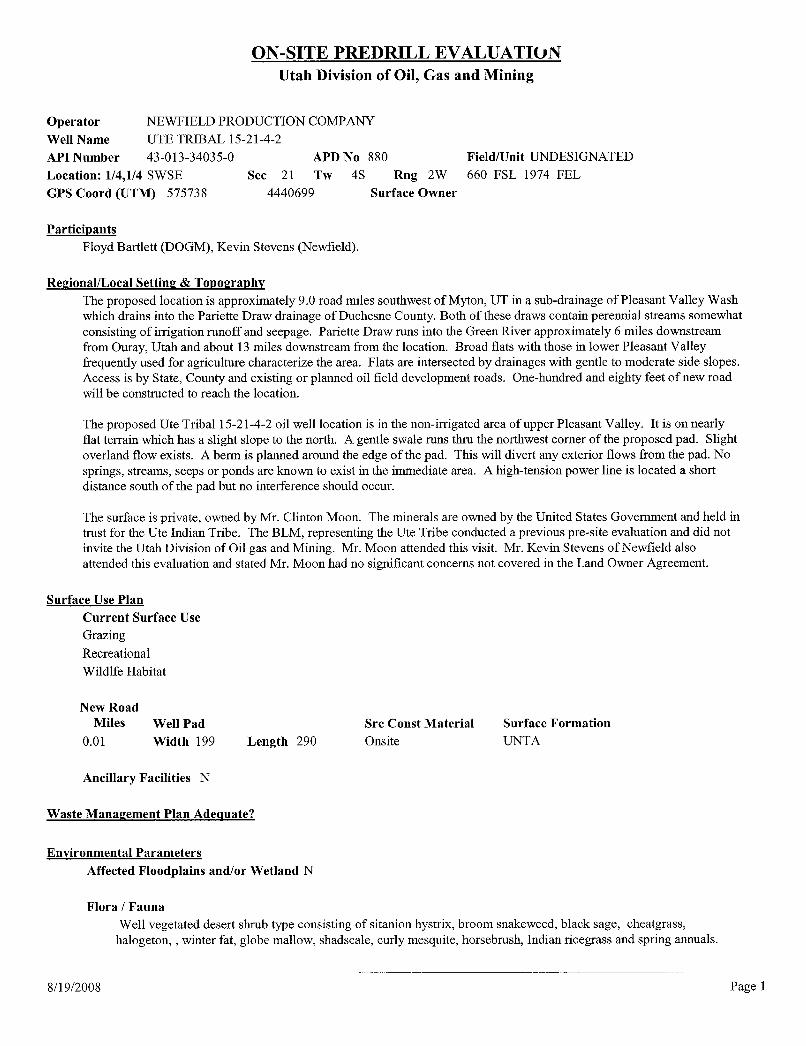
ON-SITE PREDRILL EVALUATIONUtah Division of Oil, Gas and Mining
Operator NEWFIELD PRODUCTION COMPANYWell Name UTE TRIBAL 15-21-4-2
API Number 43-013-34035-0 APD No 880 Field/Unit UNDESIGNATEDLocation: 1/4,1/4 SWSE Sec 21 Tw 4S Rng 2W 660 FSL 1974 FELGPS Coord (UTM) 575738 4440699 Surface Owner
ParticipantsFloyd Bartlett (DOGM), Kevin Stevens (Newfield).
Regional/Local Setting & TopographyThe proposed location is approximately 9.0 road miles southwest of Myton, UT in a sub-drainage of Pleasant Valley Washwhich drains into the Pariette Draw drainage of Duchesne County. Both of these draws contain perennial streams somewhatconsisting of irrigation runoff and seepage. Pariette Draw runs into the Green River approximately 6 miles downstreamfrom Ouray, Utah and about 13 miles downstream from the location. Broad flats with those in lower Pleasant Valleyfrequently used for agriculture characterize the area. Flats are intersected by drainages with gentle to moderate side slopes.Access is by State, County and existing or planned oil field development roads. One-hundred and eighty feet of new roadwill be constructed to reach the location.
The proposed Ute Tribal 15-21-4-2 oil well location is in the non-irrigated area of upper Pleasant Valley. It is on nearlyflat terrain which has a slight slope to the north. A gentle swale runs thru the northwest corner of the proposed pad. Slightoverland flow exists. A berm is planned around the edge of the pad. This will divert any exterior flows from the pad. Nosprings, streams, seeps or ponds are known to exist in the immediate area. A high-tension power line is located a shortdistance south of the pad but no interference should occur.
The surface is private, owned by Mr. Clinton Moon. The minerals are owned by the United States Government and held intrust for the Ute Indian Tribe. The BLM, representing the Ute Tribe conducted a previous pre-site evaluation and did notinvite the Utah Division of Oil gas and Mining. Mr. Moon attended this visit. Mr. Kevin Stevens of Newfield alsoattended this evaluation and stated Mr. Moon had no significant concerns not covered in the Land Owner Agreement.
Surface Use PlanCurrent Surface UseGrazingRecreationalWildlfe Habitat
New RoadMiles Well Pad Src Const Material Surface Formation
0.01 Width 199 Length 290 Onsite UNTA
Ancillary Facilities N
Waste Management Plan Adequate?
Environmental ParametersAffected Floodplains and/or Wetland N
Flora / FaunaWell vegetated desert shrub type consisting of sitanion hystrix, broom snakeweed, black sage, cheatgrass,
halogeton, , winter fat, globe mallow, shadscale, curly mesquite, horsebrush, Indian ricegrass and spring annuals.
8/19/2008 Page
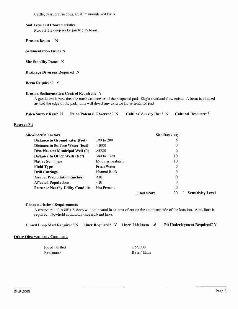
Cattle, deer, prairie dogs, small mammals and birds.
Soil Type and CharacteristicsModerately deep rocky sandy clay loam.
Erosion Issues N
Sedimentation Issues N
Site Stability Issues N
Drainage Diverson Required N
Berm Required? Y
Erosion Sedimentation Control Required? YA gentle swale runs thru the northwest corner of the proposed pad. Slight overland flow exists. A berm is plannedaround the edge of the pad. This will divert any exterior flows from the pad
Paleo Survey Run? N Paleo Potental Observed? N Cultural Survey Run? N Cultural Resources?
Reserve Pit
Site-Specific Factors Site RankingDistance to Groundwater (feet) 100 to 200 5Distance to Surface Water (feet) >1000 0Dist. Nearest Municipal Well (ft) >5280 0Distance to Other Wells (feet) 300 to 1320 10Native Soil Type Mod permeability 10Fluid Type Fresh Water 5Drill Cuttings Normal Rock 0Annual Precipitation (inches) <10 0Affected Populations <10 0Presence Nearby Utility Conduits Not Present 0
Final Score 30 1 Sensitivity Level
Characteristics / RequirementsA reserve pit 40' x 80' x 8' deep will be located in an area of cut on the southeast side of the location. A pit liner isrequired. Newfield commonly uses a 16 mil liner.
Closed Loop Mud Required? N Liner Required? Y Liner Thickness 16 Pit Underlayment Required? Y
Other Observations / Comments
Floyd Bartlett 8/5/2008Evaluator Date / Time
8/19/2008 Page

State of UtahDEPARTMENT OF NATURAL RESOURCES
MICHAEL R. STYLER, . * Executive Director
JON M. HUNTSMAN, JR.Division of Oil, Gas and Mining
Governor JOHN R. BAZADivision Director
GARY R. HERBERTLieutenant Governor
August 20, 2008
Newfield Production CompanyRt. #3, Box 3630Myton, UT 84052
Re: Ute Tribal 15-21-4-2 Well, 660' FSL, 1974' FEL, SW SE, Sec. 21, T. 4 South, R. 2 West,Duchesne County, Utah
Gentlemen:
Pursuant to the provisions and requirements of Utah Code Ann.§ 40-6-1 et seq., UtahAdministrative Code R649-3-1 et seq., and the attached Conditions of Approval, approval to drillthe referenced well is granted.
This approval shall expire one year from the above date unless substantial and continuousoperation is underway, or a request for extension is made prior to the expiration date. The APIidentification number assigned to this well is 43-013-34035.
Sincerely,
Gil HuntAssociate Director
pabEnclosures
cc: Duchesne County AssessorBureau of Land Management, Vernal Office
UTAH
DNR
1594 West North Temple, Suite 1210, PO Box 145801, Salt Lake City, UT 84114-5801
telephone (801) 538-5340 • facsimile (801) 359-3940 • TTY (801) 538-7458 • www.ogm.utah.goV OD., GAS &
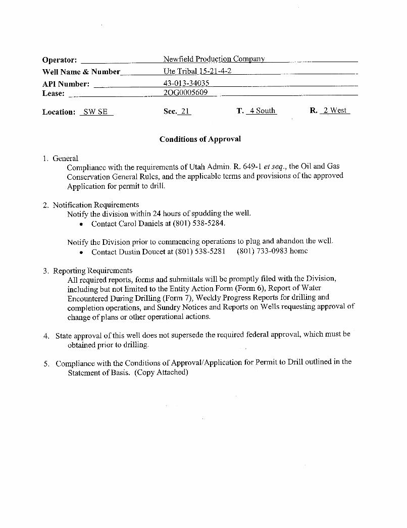
Operator: Newfield Production CompanyWell Name & Number Ute Tribal 15-21-4-2
API Number: 43-013-34035Lease: 2OG0005609
Location: SW SE Sec.X T. 4 South R. 2 West
Conditions of Approval
1. GeneralCompliance with the requirements of Utah Admin. R. 649-1 et seq., the Oil and GasConservation General Rules, and the applicable terms and provisions of the approvedApplication for permit to drill.
2. Notification ReqttirementsNotify the division within 24 hours of spudding the well.
• Contact Carol Daniels at (801) 538-5284.
Notify the Division prior to commencing operations to plug and abandon the well• Contact Dustin Doucet at (801) 538-5281 (801) 733-0983 home
3. Reporting RequirementsAll required reports, forms and submittals will be promptly filed with the Division,including but not limited to the Entity Action Form (Form 6), Report of WaterEncountered During Drilling (Form 7), Weekly Progress Reports for drilling andcompletion operations, and Sundry Notices and Reports on Wells requesting approval of
change of plans or other operational actions.
4. State approval of this well does not supersede the required federal approval, which must beobtained prior to drilling.
5. Compliance with the Conditions of Approval/Application for Permit to Drill outlined in theStatement of Basis. (Copy
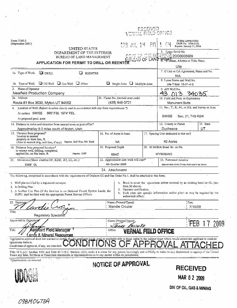
Form 3160-3 FORM APPROVED(September 2001) g(Q I p OMB No, 1004-0136
(.. J ..., ., L - i ! Expires January 31, 2004UNITED STATES
DEPARTMENT OF THE INTERIOR L ase Serial No.
BUREAUOFLANDMANAGEMENT DEPT OF DE ; 2OGOOO5609BURUd F in'dian,Allottee or Tribe NameAPPLICATION FOR PERMIT TO DRILL OR REENTER
Ute7. If Unit or CA Agreement, Name and No.la. Type of Work: DRILL Ü REENTER
N/A8. Lease Name and Well No.
Ib. Type of Well: Oil Well Gas Well Ü Other Single Zone Ü Multiple Zone Ute Tribal 15-21-4-2
2. Name of Operator 9. API Well No.Newfield Production Company 43 ()) () (3a. Address 3b. Phone No. (include area code) 10. Field and Pool, or Exploratory
Route #3 Box 3630, Myton UT 84052 (435)646-3721 Monument Butte4. Location of Well (Report location clearly and in accordance with any State requirements.*) 11. Sec.,T., R., M., or Blk. and Survey or Area
At surface SWISE 660' FSL 1974' FELAt proposed prod. zone
SWISE Sec. 21, T4S R2W
14. Distance in miles and direction from nearest town or post office* 12. County or Parish 13. State
Approximatley 9.0 miles south of Myton., Utah Duchesne UT15. Distance from proposed* 16. No. of Acres in lease . 17. Spacing Unit dedicated to this well
location to nearestproperty or lease line, ft.(Also to nearest drig. unit line, if any) Approx. 654' flise, NA' flunit NA 40 Acres
18. Distance from proposed location* 19. Proposed Depth 20. BLM/BIA Bond No. on fileto nearest well, drilling, completed,applied for, on this lease, ft. Approx. 1249' 6840' WYBOOO493
21. Elevations (Show whether DF, KDB, RT, GL, etc.) 22. Approximate date work will start* 23. Estimated duration
5368' GL 4th Quarter 2008 Approximately seven (7) days fmm spud to rig.release.
24. AttachmentsThe following, completed in accordance with the requirements of Onshore Oil and Gas Order No.1, shall be attached to this form:
1. Well plat certified by a registered surveyor. 4. Bond to cover the operations unless covered by an existing bond on file {see2. A Drilling Plan. Item 20 above).
3. A Surface Use Plan (if the location is on National Forest System Lands, the 5. Operator certification.
SUPO shall be filed with the appropriate Forest Service Office). 6. Such other site specific information and/or plans as may be required by theauthorized officer.
25, Name (P nted/OZyCed) D e10/08
TitleRegulatory Specialist
Approved by Name (Printed/Typed)
Title ntFieldManager o' VEPJ .NELDOFRCE80 &MingrâiRSSOUTCW
on i s of appro a ,
fSann arranator cert th e I t e r it e ti se s th u t e i w d a d
Title 18 U.S.C. Section 1001 and Title 43 U.S,C, Section 1212, make it a crime for any person knowingly and willfully to make to any department or agency of the UnitedStates any false, fictitious or fraudulent statements or representations as to any matter within its jurisdiction.
tructions on reverse)
ft0T EOFAPPROVALRECEIVEDMARO2 2089
DIV.OFOIL,GAS&MINING

UNITED STATES DEPARTMENT OF THE INTERIORBUREAU OF LAND MANAGEMENT
VERNAL FIELD OFFICE170 South 500 East VERNAL, UT 84078 {435) 781-4400
CONDITIONS OF APPROVAL FOR APPLICATION FOR PERMIT TO DRILLCompany: Newfield Production Company Location: SWSE, Sec. 21, T4S, R2WWell No: Ute Tribal 15-21-4-2 Lease No: 2OG0005609API No: 43-013-34035 Agreement: N/A
Title Name Office Phone Number Cell Phone NumberPetroleum Engineer: Matt Baker (435) 781-4490 (435) 828-4470Petroleum Engineer: Michael Lee (435) 781-4432 (435) 828-7875Petroleum Engineer: Ryan Angus (435) 781-4430 (435) 828-7368Supervisory Petroleum Technician: Jamie Sparger (435) 781-4502 (435) 828-3913Supervisory NRS: Karl Wright (435) 781-4484NRS/Enviro Scientist: Holly Villa (435) 781-4404 (435) 828-3544NRS/Enviro Scientist: James Hereford (435) 781-3412 (435) 828-3546NRS/Enviro Scientist: Chuck Macdonald (435) 781-4441 (435) 828-7481NRS/Enviro Scientist: Dan Emmett (435) 781-3414 (435) 828-4029NRS/Enviro Scientist: Paul Percival (435) 781-4493 (435) 828-7381NRS/Enviro Scientist: Anna Figueroa (435) 781-3407 (435) 828-3548NRS/Enviro Scientist: Verlyn Pindell (435) 781-3402 (435) 828-3547NRS/Enviro Scientist: Nathan Packer (435) 781-3405 (435) 828-3545NRS/Enviro Scientist: David Gordon (435) 781-4424NRS/Enviro Scientist: Christine Cimiluca (435) 781-4475NRS/Enviro Scientist: Lori Ford (435) 781-4406
Fax: (435) 781-3420
A COPY OF THESE CONDITIONS SHALL BE FURNISHED TO YOURFIELD REPRESENTATIVE TO INSURE COMPLIANCE
All lease and/or unit operations are to be conducted in such a manner that full compliance is made with theapplicable laws, regulations (43 CFR Part 3160), and this approved Application for Permit to Drill includingSurface and Downhole Conditions of Approval. The operator is considered fully responsible for the actions of hissubcontractors. A copy of the approved APD must be on location during construction, drilling, and completionoperations. This permit is approved for a two (2) year period, or until lease expiration, whichever occursfirst. An additional extension, up to two (2) years, may be applied for by sundry notice prior to expiration.
NOTIFICAConstruction Activity - The Ute Tribe Energy & Minerals Dept. shall be notified in
writing 48 hours in advance of any construction activity. TheUte Tribal office is open Monday through Thursday.
Construction Completion - Upon completion of the pertinent APD/ROW construction,notify the Ute Tribe Energy & Minerals Dept. for a TribalTechnician to verify the Affidavit of Completion.
Spud Notice - Twenty-Four (24) hours prior to spudding the well.(Notify Petroleum Engineer)Casing String & Cementing - Twenty-Four (24) hours prior to running casing and cementing(Notify Supv. Petroleum Tech.) all casing strings.BOP & Related Equipment Tests - Twenty-Four (24) hours prior to initiating pressure tests.(Notify Supv. Petroleum Tech.)First Production Notice - Within Five (5) business days after new well begins or(Notify Petroleum Engineer) production resumes after well has been off production for more
than ninety (90)
Page 2 of 8Well: Ute Tribal 15-21-4-2
2/18/2009
SURFACE USE PROGRAMCONDITIONS OF APPROVAL (COAs)
BLM CONDITIONS OF APPROVALSPLIT ESTATE SURFACE USE PROGRAM(IN CONSULTATION WITH THE PRIVATE SURFACE OWNER)APPLICATION FOR PERMIT TO DRILL
UT 14-21-4-2, UT 15-21-4-2, UT 16-21 -4-2
1. For Ute Tribal 14-21-4-2: install a low water crossing at the wash on the eastern side of the wellpad.
2. For Ute Tribal 16-21-4-2: install a low water crossing or culvert at the drainage channel that islocated approximately 900 ft. on the eastern side of the well pad.
3. Restrictions for placement of surface pipelines:-a) Surface pipelines will be placed 5-10 feet outside of the borrow area.b) Surface pipelines will be placed in such a way that they will not wander into the borrow area.c) Pipelines will be buried at all major road and drainage crossings.
4. Interim Reclamation:All portions of the well pads and ROWS not utilized for the operation phase of the project will bere-seeded. Post construction seeding applications will continue until determined successful by thePrivate Surface owner.
• During interim reclamation of the surface, the following seed mixture will be used PLS(Pure Live Seed) formula as recommended by the Surface Land Owner.
galleta grass (Hilaria jamesii)...........................................3 lbs/acreshadscale (Atriplex confertifolia)).................................3 lbs/acreScarlet Globemallow (Sphaeralcea coccinea).........................3 lbs/acrehycrest crested wheatgrass(Agropyron cristayum/Agropyron desertorum hybrid.................2 lbs/acre
Rates are set for drill seeding; double the rate if broadcasting.• Reseeding may be required if initial seeding is not successful.
5. Paint all facilities Carlsbad Canyon within six months of installation, except those facilities whichare required to comply with the Occupational Safety and Health Act
Page 3 of 8Well: Ute Tribal 15-21-4-2
2/18/2009
DOWNHOLE PROGRAMCONDITIONS OF APPROVAL (COAs)
SITE SPECIFIC DOWNHOLE COAs:
• Production casing cement shall be brought up and into the surface.
• All requirements will be adhered to covering air/gas drilling operations as described in Onshore Order #2III. E. 1. Drilling Operations, Special Drilling Operations, air/gas drilling.
Variance(s) to Onshore Order #2 Drilling Operations III. E.
• Automatic igniter or continuous pilot light on the blooie lineRequirement waived for ignitor and pilot lightOperators blooie line output fluid stream is an aerated water stream
• Compressors located in opposite direction from the blooie line a minimum of 100 feetCompressors are truck mounted. Operators standard practice is to rig up with truck mounted compressorsoriented ninety degrees to blooie line. Compressors are truck mounted with spark arresters.
• Requirement for rotating head equipmentRequirement waived for rotating head equipment subtitution of rotating head equipment with a diverterbowl equipment (drilling without back pressure)
• Specification of blooie line discharge where Blooie line discharge 100 feet from well bore.blooie line can be 35 feet for surface hole drilling.
• No hydrocarbons present in drilled intervals reduced size well pad
• Covering mud drilling operations, a variance is granted for Onshore Order #2 Drilling Operations III. C.Mud Program Requirements "flare line discharge shall be located not less than 100 feet from wellhead" Flare line discharge line can be 80 feet.
• Logging: A Gamma Ray well Log shall be run from the well Total Depth to the surface.A copy of the Gamma Ray well Log shall be submitted to the BLM Vernal Field Office.
All provisions outlined in Onshore Oil & Gas Order #2 Drilling Operations shall be strictlyadhered to. The following items are emphasized:
DRILLING/COMPLETION/PRODUCING OPERATING STANDARDS
• The spud date and time shall be reported orally to Vernal Field Office within 24 hours ofspudding.
• Notify Vernal Field Office Supervisory Petroleum Engineering Technician at least 24 hours inadvance of casing cementing operations and BOPE & casing pressure
Page 4 of 8Well: Ute Tribal 15-21-4-2
2/18/2009
• All requirements listed in Onshore Order #2 III. E. Special Drilling Operations are applicable forair drilling of surface hole.
• Blowout prevention equipment (BOPE) shall remain in use until the well is completed orabandoned. Closing unit controls shall remain unobstructed and readily accessible at all times.Choke manifolds shall be located outside of the rig substructure.
• All BOPE components shall be inspected daily and those inspections shall be recorded in thedaily drilling report. Components shall be operated and tested as required by Onshore Oil & GasOrder No. 2 to insure good mechanical working order. All BOPE pressure tests shall beperformed by a test pump with a chart recorder and NOT by the rig pumps. Test shall bereported in the driller's log.
• BOP drills shall be initially conducted by each drilling crew within 24 hours of drilling out fromunder the surface casing and weekly thereafter as specified in Onshore Oil & Gas Order No. 2.
• Casing pressure tests are required before drilling out from under all casing strings set andcemented in place.
• No aggressive/fresh hard-banded drill pipe shall be used within casing.
• Cement baskets shall not be run on surface casing.
• The operator must report all shows of water or water-bearing sands to the BLM. If flowingwater is encountered it must be sampled, analyzed, and a copy of the analyses submitted to theBLM Vernal Field Office.
• The operator must report encounters of all non oil & gas mineral resources (such as Gilsonite, tarsands, oil shale, trona, etc.) to the Vernal Field Office, in writing, within 5 working days of eachencounter. Each report shall include the well name/number, well location, date and depth (fromKB or GL) of encounter, vertical footage of the encounter and, the name of the person makingthe report (along with a telephone number) should the BLM need to obtain additionalinformation.
• A complete set of angular deviation and directional surveys of a directional well will besubmitted to the Vernal BLM office engineer within 30 days of the completion of the well.
• While actively drilling, chronologic drilling progress reports shall be filed directly with theBLM, Vernal Field Office on a weekly basis in sundry, letter format or e-mail to the PetroleumEngineers until the well is completed.
• A cement bond log (CBL) will be run from the production casing shoe to the top of cement andshall be utilized to determine the bond quality for the production casing. Submit a field copy ofthe CBL to this
Page 5 of 8Well: Ute Tribal 15-21-4-2
2/18/2009
• Please submit an electronic copy of all other logs run on this well in LAS format toUT_VN [email protected]. This submission will supersede the requirement forsubmittal of paper logs to the BLM.
• There shall be no deviation from the proposed drilling, completion, and/or workover program asapproved. Safe drilling and operating practices must be observed. Any changes in operationmust have prior approval from the BLM Vernal Field
Page 6 of 8Well: Ute Tribal 15-21-4-2
2/18/2009
OPERATING REQUIREMENT REMINDERS:
• All wells, whether drilling, producing, suspended, or abandoned, shall be identified inaccordance with 43 CFR 3162.6. There shall be a sign or marker with the name of the operator,lease serial number, well number, and surveyed description of the well.
• In accordance with 43 CFR 3162.4-3, this well shall be reported on the "Monthly Report ofOperations" (Oil and Gas Operations Report ((OGOR)) starting with the month in whichoperations commence and continue each month until the well is physically plugged andabandoned. This report shall be filed in duplicate, directly with the Minerals ManagementService, P.O. Box 17110, Denver, Colorado 80217-0110, or call 1-800-525-7922 (303) 231-3650 for reporting information.
• Should the well be successfully completed for production, the BLM Vernal Field office must benotified when it is placed in a producing status. Such notification will be by writtencommunication and must be received in this office by not later than the fifth business dayfollowing the date on which the well is placed on production. The notification shall provide, as aminimum, the following informational items:
o Operator name, address, and telephone number.
o Well name and number.
o Well location (¼¼,Sec., Twn, Rng, and P.M.).
o Date well was placed in a producing status (date of first production for which royalty willbe paid).
o The nature of the well's production, (i.e., crude oil, or crude oil and casing head gas, ornatural gas and entrained liquid hydrocarbons).
o The Federal or Indian lease prefix and number on which the well is located; otherwise thenon-Federal or non-Indian land category, i.e., State or private.
o Unit agreement and/or participating area name and number, if applicable.
o Communitization agreement number, if applicable.
• Any venting or flaring of gas shall be done in accordance with Notice to Lessees (NTL) 4A andneeds prior approval from the BLM Vernal Field Office.
• All undesirable events (fires, accidents, blowouts, spills, discharges) as specified in NTL 3A willbe reported to the BLM, Vernal Field Office. Major events, as defined in NTL3A, shall bereported verbally within 24 hours, followed by a written report within 15 days. "Other thanMajor Events" will be reported in writing within 15 days. "Minor Events" will be reported onthe Monthly Report of Operations and
Page 7 of 8Well: Ute Tribal 15-21-4-2
2/18/2009
• Whether the well is completed as a dry hole or as a producer, "Well Completion andRecompletion Report and Log" (BLM Form 3160-4) shall be submitted not later than 30 daysafter completion of the well or after completion of operations being performed, in accordancewith 43 CFR 3162.4-1. Two copies of all logs run, core descriptions, and all other surveys ordata obtained and compiled during the drilling,workover, and/or completion operations, shall befiled on BLM Form 3160-4. Submit with the well completion report a geologic report including,at a minimum, formation tops, and a summary and conclusions. Also include deviation surveys,sample descriptions, strip logs, core data, drill stem test data, and results of production tests ifperformed. Samples (cuttings, fluid, and/or gas) shall be submitted only when requested by theBLM, Vernal Field Office.
• All off-lease storage, off-lease measurement, or commingling on-lease or off-lease, shall haveprior written approval from the BLM Vernal Field Office.
• Oil and gas meters shall be calibrated in place prior to any deliveries. The BLM Vernal FieldOffice Petroleum Engineers will be provided with a date and time for the initial meter calibrationand all future meter proving schedules. A copy of the meter calibration reports shall besubmitted to the BLM Vernal Field Office. All measurement facilities will conform to the APIstandards for liquid hydrocarbons and the AGA standards for natural gas measurement. Allmeasurement points shall be identified as the point of sale or allocation for royalty purposes.
• A schematic facilities diagram as required by Onshore Oil & Gas Order No. 3 shall be submittedto the BLM Vernal Field Office within 30 days of installation or first production, whicheveroccurs first. All site security regulations as specified in Onshore Oil & Gas Order No. 3 shall beadhered to. All product lines entering and leaving hydrocarbon storage tanks will be effectivelysealed in accordance with Onshore Oil & Gas Order No. 3.
• Any additional construction, reconstruction, or alterations of facilities, including roads, gatheringlines, batteries, etc., which will result in the disturbance of new ground, shall require the filing ofa suitable plan and need prior approval of the BLM Vernal Field Office. Emergency approvalmay be obtained orally, but such approval does not waive the written report requirement.
• No location shall be constructed or moved, no well shall be plugged, and no drilling or workoverequipment shall be removed from a well to be placed in a suspended status without priorapproval of the BLM Vernal Field Office. If operations are to be suspended for more than 30days, prior approval of the BLM Vernal Field Office shall be obtained and notification givenbefore resumption of operations.
• Pursuant to Onshore Oil & Gas Order No. 7, this is authorization for pit disposal of waterproduced from this well for a period of 90 days from the date of initial production. A permanentdisposal method must be approved by this office and in operation prior to the end of this 90-dayperiod. In order to meet this deadline, an application for the proposed permanent disposalmethod shall be submitted along with any necessary water analyses, as soon as possible, but nolater than 45 days after the date of first production. Any method of disposal which has not beenapproved prior to the end of the authorized 90-day period will be considered as an Incident ofNoncompliance and will be grounds for issuing a shut-in order until an acceptable manner fordisposing of said water is provided and approved by this
Page 8 of 8Well: Ute Tribal 15-21-4-2
2/18/2009
• Unless the plugging is to take place immediately upon receipt of oral approval, the Field OfficePetroleum Engineers must be notified at least 24 hours in advance of the plugging of the well, inorder that a representative may witness plugging operations. If a well is suspended orabandoned, all pits must be fenced immediately until they are backfilled. The "SubsequentReport of Abandonment" (Form BLM 3160-5) must be submitted within 30 days after the actualplugging of the well bore, showing location of plugs, amount of cement in each, and amount ofcasing left in hole, and the current status of the surface
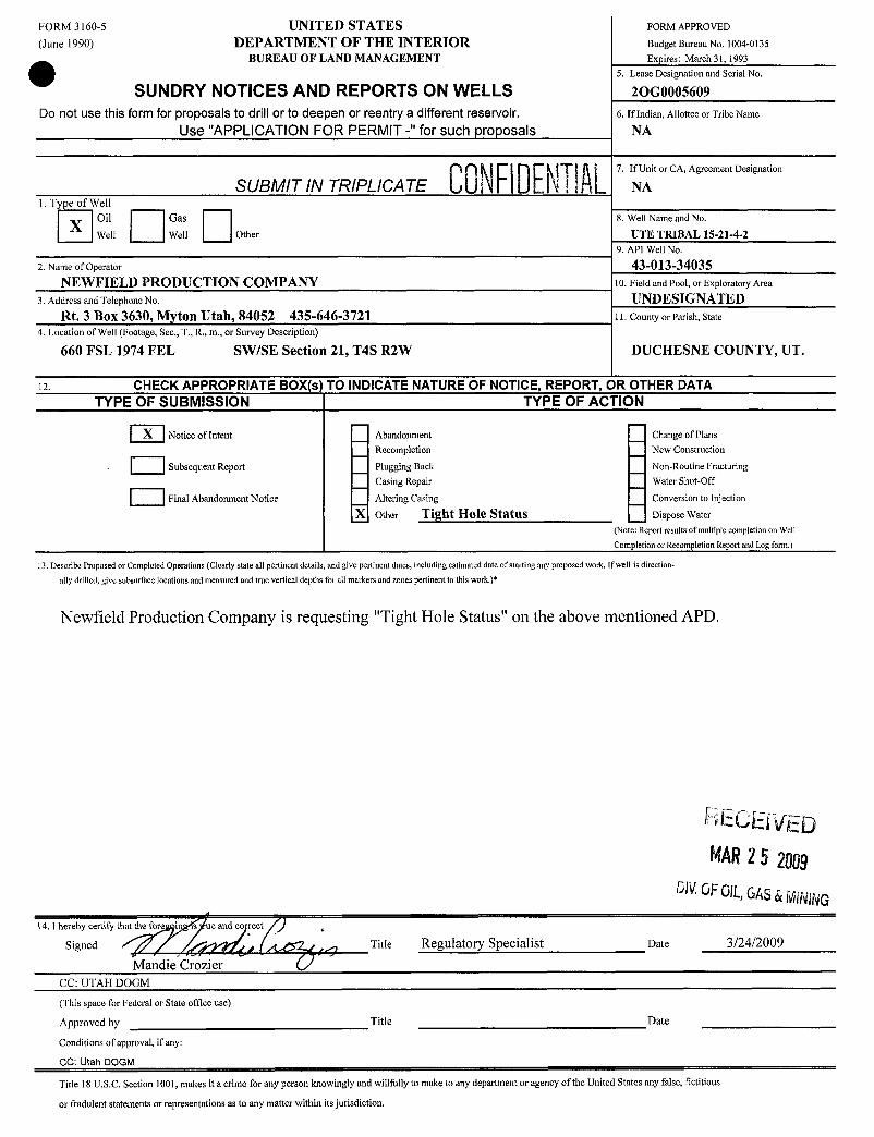
FORM 3160-5 UNITED STATES FORM APPROVED
(June 1990) DEPARTMENT OF THE INTERIOR BudgetBureauNo. 1004-0135
BUREAU OF LAND MANAGEMENT Expires: March 31, 19935. Lease Designation and Serial No.
SUNDRY NOTICES AND REPORTS ON WELLS 2OG0005609Do not use this form for proposals to drill or to deepen or reentry a different reservoir. 6. If Indian, Allottee or Tribe Name
Use "APPLICATION FOR PERMIT -" for such proposals NA
00 7. If Unit or CA, Agreement Designation
SUBMIT IN TRIPLICATE Ill IU Li i ! 9 L NA1. Type of Well
Oil Gas 8. Well Name and No.XWell Well Other UTE TRIBAL 15-21-4-2
9. API Well No.
2. Name of Operator 43-013-34035NEWFIELD PRODUCTION COMPANY 10. Field and Pool, or Exploratory Area
3. Address and Telephone No. UNDESIGNATEDRt. 3 Box 3630, Myton Utah, 84052 435-646-3721 11. County or Parish, State
4. Location of Well (Footage, Sec., T., R., m., or Survey Description)
660 FSL 1974 FEL SWISE Section 21, T4S R2W DUCHESNE COUNTY, UT.
12. CHECK APPROPRIATE BOX(s) TO INDICATE NATURE OF NOTICE, REPORT, OR OTHER DATATYPE OF SUBMISSION TYPE OF ACTION
X |Notice of Intent Abandonment Change of PlansRecompletion New Construction
Subsequent Report Plugging Back Non-Routine FracturingCasing Repair Water Shut-Off
Final Abandonment Notice Altering Casing Conversion to Injection
X other Tight Hole StatBS Dispose Water
(Note: Report results of multiple completionon Well
Completion or Recompletion Report and Log form.)
11 Describe Proposed or Completed Operations (Clearly state all pertinent details, and give pertinent dates, including estimated date of starting any proposed work. If well is direction-
ally drilled, give subsurface locations and measured and true vertical depths for all markers and zones pertinent to this work.)*
Newfield Production Company is requesting "Tight Hole Status" on the above mentioned APD.
RECEÏVEDMAR25 2009
DIVGFOIL,GAS&MINING14. I hereby certify thatthe fore i s ue and co rect
Signed / Title Regulatory Specialist Date 3/24/2009
Mandie CrozierCC: UTAH DOGM
(This space for Federal or State office use)
Approved by Title Date
Conditions of approval, if any:
CC: Utah DOGM
Title 18 U.S.C. Section 1001,makes it a crime for any person knowingly and willfully to make to any department or agency ofthe United States any false, fictitious
or fradulent statements or representations as to any matter within its
'
so 00NRDENRBLM- Vernal Field Office - Notification Form
Operator Newfield Production RigName/# Ross # 21 Submitted By Jim SmithPhone Number (435)-823-2072Well Name/Number Ute Tribal 15-21-4-2
Qtr/QtrSWsE Section 21 Township 4SRange 2WLease Seria\ Number 2OGOOO5609API Number 43-013-34035
Spud Notice - Spud is the initial spudding of the well, not drillingout below a casing string.
Date/Time 7/3/09 9:00AM PM
Casinq - Please report timecasing run starts, not cementingtimes.
Surface CasingIntermediate CasingProduction CasingLinerotherDate/Time 7/3/09 5:00 AM PM
BOPEInitial BOPE test at surface casing pointBOPEtest at intermediate casing point30 day BOPEtest
. FORM 3160-5 UNITED STATES FoRM APPROVED
(August 2007) DEPARTMENT OF THE INTERIORBUREAU OF LAND MANAGEMENT 5. Lease Serial No.
SUNDRYNOTICES AND REPORTS ON WELLSDo not use this form for proposals to drill or to re-enter an
abandoned well. Use Form 3160-3 (APD) for such proposals. 6. If Indian, Allottee or Tribe Name.
SUBMIT IN TRIPLICATE - Other Instructions on page 2 7. If Unit or CA/Agreement, Nameand/or
1. Type of WellOil Well O Gas Well Other 8. Well Name and No.
2. NameofOperator UTE TRIBAL 15-21-4-2
NEWFIELDPRODUCTIONCOMPANY PAPI VMI No3a. Address Route 3 Box 3630 3b. Phone (include are code) 4301334035
Myton, UT 84052 | 435 646 3721 10.Field and Pool, or Exploratory Area4. Location ofWell (Footage, Sec., T., R., M, or Survey Description) MONUMENT BUTTE
11. Countyor Parish, State
SWSE Section 21 T4S R2W DUCHESNE, UT
12. CHECK APPROPRIATE BOX(ES) TO INIDICATE NATURE OF NOTICE, OR OTHER DATA
TYPE OF SUBMISSION TYPEOF ACTION
Acidize O Deepen Q Production(Start/Resume) Water Shut-OffO Notice of Intent
Alter Casing O Fracture Treat Q Reclamation Well Integrity
Subsequent Report Casing Repair O New Construction Q Recomplete OtherChange Plans O Plug & Abandon O Temporarily Abandon Spud Notice
Final Abandonment Convert to Injector Q Plug Back O Water Disposal
I3. Describe Proposed or CompletedOperation:(Clearly state all pertinent details, includingestimated starting date of any proposed work and approximate duration thereof. If the
proposal is to deependirectionallyor recomplete horizontally,give subsurface locationsand measured and true vertical depthsof all pertinent markers and zones. Attach the
Bond under which the work will be performed or provide the Bond No. on file with BLMlBIA. Required subsequentreports shallbe filed within 30 days following completion
of the involvedoperations. If the operation results in a multiple completion or recompletionin a new interval,a Form 3160-4 shall be filed once testing has been completed.
Final Abandonment Notices shall be filed only after all requirements, including reclamation, havebeen completed, and the operator has determined that the site is ready for final
inspection.)
On 7/3/09/MIRU Ross #29.Spud well @9:00am. Drill 310' of 12 1/4" hole with air mist. TIH W/ 8 Jt's 8 5/8" J-55 24 # csgn. [email protected]'On 7/9/09 cement with 160 sks of class "G" w/ 2% CaCL2 + 1/4# sk Cello- Flake Mixed @ 15.8 ppg > 1.17 cf/ sk yelld.Returned 5 bbls cement to pit. WOC.
CONFIDENTIALI hereby certify that the foregoing is true and Titlecorrect (Printed/ Typed)
pon pastj4n Drilling Foreman
Sig D e7/10/2009
THIS SPACE FOR FEDERAL OR STATE OFFICE USE
Approved by . . . . . . . . . . . Title pateConditions of approval, if any, are attached. Approval of this notice does not warrant or
certify that the applicant holds legal or equitable title to those rights in the subject lease Officewhich would entitle the agglicant to conduct operations thereon.
Title 18 U.S.C. Section 1001 and Title 43 U.S.C. Section 1212, make it a crime for any person knowingly and willfully to make to any departrtient y fthe United
States anv false. fictitious and fraudulentstatements or representations as to anv matter within its jurisdiction. FD(ED
(Instructions on page 2)JUL1 3 2009
DIV.0FOIL,GAS&
NEWFIELD PRODUCTION COMPANY - CASING & CEMENT REPORT
8 5/8" CASING SET AT 314.12
LAST CASING 8 5/8" SET AT 314.12 OPERATOR Newfield Exploration CompanyDATUM 12 WELL UTE TRIBAL 15-21-4-2DATUM TO CUT OFF CASING 12 FIELD/PROSPECT Monument ButteDATUM TO BRADENHEAD FLANGE 12 CONTRACTOR & RIG # Ross Rig # 29TD DRILLER 310 LOGGERHOLE SIZE 12 1/4"
LOG OF CASING STRING:PIECES OD ITEM - MAKE - DESCRIPTION WT / FT GRD THREAD CONDT LENGTH
1 Whi-92 Well Head 8rd A 0.958 8 5/8" Maverick ST&C Csg ( Shoe Jt. 38.60') 24# J-55 8rd A
_
300.271 8 5/8" Guide Shoe 8rd A 0.9
CASING INVENTORY BAL. FEET JTS TOTAL LENGTH OF STRING 302.12TOTAL LENGTH OF STRING 302.12 8 LESS CUT OFF PIECELESS NON CSG. ITEMS 1.85 PLUS DATUMTO T/CUT OFF CSG 12PLUS FULL JTS. LEFT OUT 0 0 CASING SET DEPTH 314.12
TOTAL 300.27 8 -
TOTAL CSG. DEL. (W/O THRDS) 300.27 8 ~ COMPARETIMING
BEGIN RUN CSG. Spud 9:00 AM 7/3/2009 GOOD CIRC THRUJOB YesCSG. IN HOLE 4:00 PM 7/3/2009 Bbis CMT CIRC TO SURFACE 5BEGIN CIRC 8:13 AM 7/9/2009 RECIPROCATED PIPI NoBEGIN PUMP CMT 8:27 AM 7/9/2009BEGIN DSPL. CMT 8:35 AM 7/9/2009 BUMPED PLUG TO 390PLUG DOWN 8:47 AM
e
CEMENT USED CEMENT COMPANY- BJSTAGE # SX CEMENT TYPE & ADDITIVES
1 160 Class G + 2%CalciumChloride+ 1/4#[email protected]/SKYield
CENTRALIZER I. SCRATCilER PLACEMENT SHOW MAKE& SPACINGMiddle 1ts Top 2nd & 3rd or Total Of 3F
COMPANY REPRESENTATIVE Don Bastian DATE

STATEOF UTAH OPERATOR: NEWFIELD PRODUCTION CONIPANY OPERATOR ACCT.No, N2695OlVISIONOF OIL,GAS AND MINING ADDRESS: RT. 3 BOX 3630ENTITYACTION FORM -FORM 6 MYTON, UT 84052
ACTION CURRENT NEW API NUMBER WELL MAME WELL LOCATION S UO EFFECTIVECODE ENTITY NO. ENTITY NO. QU RU [ UUUNI : DATE DATE
GREATER BOUNDARY llB 99999 12391 4301333939 6$ V-28-8-17 NWNE 8S 17E DUCHESNE 6/29/2009
WELL 1 COMM
ACTION CURRENT NEW API NUMBER WELL NAME WELL LOCATlON SPUD EFFECTIVE
coA
9 999 9 4301333781 UTE TRIBAL 15-20-4-1 S SE 0 S 1 DUCHESNE
7/7DI2
09 0
GdWACTION CURRENT NEW API NUMBER WELL NAME WELL LOCATION SPUD ÈFFECTIVE
9 4304740504 UTE TRIBAL 3-30-4-1E NE W 0 S 1 UI AH
7/11æl
009
ACTION CURRENT N6W API NUMBER WELL NAME WELL LOCAflON SPUD EFFECTIVECODE E9N
4301334035 UTE TRIBAL 15-21-4-2 S SE 1 S 2 DU ESNE
7/3D/2
09
WELL 5 COMMENTS.
ACTION CURRENT NEW API NUMBER WELL NAME WELL LOCATtoN SPUD EFFECTNECODE ENTITYNO. ENTITY NO. QQ SC TP RG COUNTY QATE DATE
WELL SCOMMENTS:
ACTION CODES(Seemstructionson barAof form)A - 1 newentity for new well (singlewell only)8- wellioexistingentity(grouporunitwell) RECElVED A¿T / eneC- from one existingentityto another existing entity j gnaD - weß from one existingerttityto a new entitye - mer(explain in commentssecaon> JUL 2 8 2009 Production CI 07/10/09
DateMOTE. Use COMMENT sectionto explainwhy each Action Code was selected.
DNOF0lL,GAS&
CONFIDENÐLFORM 3160-5 UNITED STATES FORM APPROVED
(August 2007) DEPARTMENT OF THE INTERIORBUREAUOF LAND MANAGEMENT 5. Lease Serial No.
SUNDRY NOTICES AND REPORTS ON WELLS UTE TRIBE EDA 20GOOO5609Do not use this form for proposals to drill or to re-enter anabandoned well. Use Form 3160-3 (APD) for such proposalS. 6. If Indian, Allottee or Tribe Name.
SUBMIT IN TRIPLICATE - Other Instructions on page 2 7. If Unit or CA/Agreement,Name and/or
1. Type of WellOil Well O Gas Well Other 8. Well Name and No.
2. Name of Operator UTE TRIBAL 15-21-4-2NEWFIELDPRODUCTION COMPANY 9. API Wall lla.
3a. Address Route 3 Box 3630 3b. Phone (include are code) 4301334035Myton, UT 84052 \ 435646 3771 10 Field and Pool or Explor9tny Aren
4. Location of Well (Footage, Sec., T., R., M, or SurveyDescription) MONUMENT BUTTE11. County or Parish, State
SWSE Section21 T4S R2W DUCHESNE, UT
12. CHECK APPROPRIATE BOX(ES) TO INIDICATE NATURE OF NOTICE, OR OTHER DATA
TYPE OF SUBMISSION TYPE OF ACTION
Acidize O Deepen Q Production (Start/Resume) O Water Shut-OffNotice of Intent O Alter Casing Q Fracture Treat Q Reclamation Q Well Integrity
SubsequentReport Casing Repair Q New Construction Q Recomplete OtherChange Plans Plug & Abandon Q Temporarily Abandon Weekly Status Report
Final Abandonment Convert to Injector Q Plug Back O Water Disposal
13. Describe Proposedor CompletedOperation:(Clearly state all pertinent details, includingestimated starting dateof any proposed work and approximate duration thereof Iftheproposal is to deepen directionallyor recomplete horizontally,give subsurface locationsand measured and true vertical depths ofall pertinent markers and zones. Attach theBond under which the work will be performed or provide the Bond No. on file with BLM/BIA. Required subsequentreports shall be filed within 30 days following completionof the involvedoperations. Ifthe operationresults in a multiple completion or recompletion in a new interval,a Form 3160-4 shall be filed once testing has been completed.Final Abandonment Notices shall be filed only after all requirements, includingreclamation, have been completed, and the operator has determinedthat the site is ready for finalinspection.)
On 7/16/09 Ml&RUNDSI Rig #3. Set allequipment. Pressure test Kelly,TIW, Choke manifold,& Bop's to 2,000 psi. Test 8,625csgn to 1,500 psi. Vernal BLMfield, & Roosevelt DOGM office was notifed of test. PU BHAand tag cement @275'. Drilloutcement &shoe. Drilla 7.875 hole with fresh water to a depth of 6710'. Lay down drillstring& BHA. Open hole log w/ Dig/SPIGRlog's TD tosurface. Production decided to P&Awell. PU & RIHw/213jts of DP . Set plug #1 From 6695' to 6510'w/229 sks classG 15.8 ppg cmt. LD66 jts DP. Set plug #2 @4618' to 4430' wl76 sks class G 15.8 ppg cmt . POOH wl22 stds & 1 single DP.Set plug # 3 1942' to 1750' w/ 97 sks class G cmt. . WOC 4 hrs. TlH tagged cmt@ 1770'. . TOOH LD DP to 504'..Set plug #4504' to surface w/110 sks class G 15.8 cmt. TOOH LD DP. ND BOP's.Release rig @6:00 AM 7/22/09
RECEIVEDAUS04 2009
DIVOFOIL,GAS&MINING
I hereby certify that the foregoingis true and Titlecorrect (Printed/ TVped)
Johnnv Davis Drilling Foreman
Signature D e7/23/2009
THIS SPACE FOR FEDERAL OR STATE OFFICE USE
Approved by. . . Title Opte
Conditions of approval, if any, are attached Approval ofthis notice does not warrant orcertify that the applicant holds legalor equitable title to those rights in the subject lease Officewhich would entitle the applicant to conduct operations thereon.
Title 18 U.S.C. Section 1001 and Title 43 U.S.C. Section 1212, make it a crime for any person knowingly and willfully to make to any departmentor agency ofthe United
States anv false, fictitious and fraudulent statements or reoresentations as to anv matter within its jurisdiction
(Instructions on page
NEWFIELD Well Name: UTE TRIBAL 15-21-4-2Daily Drilling Report Report Date: 7/22/2009
ROCKY MOUNTAINs Present Ops: Rigging down
Field: MYTON AREA 00NFilEBL NDSI #3 Report No: Daily 6Location: S21 T4S R2W KB: 12 Since Spud: 6County: DUCHESNE Supervisor: Johnny Davis 823-3610 AFE No: 17525State: UT Daily Cost: 38,732Elevation: 5368 Rig Phone: 823-1943 Cum. Cost: 231,891
Formation: GREEN RIVER Rig Email:
Depth (MD): 6,710' PTD (MD): 6,710' Daily Footage: O' Avg ROP:Depth (TVD): 6,710' PTD (TVD): 6,710' Drilling Hours: 0.0 Exp TD Date: 7/21/2009
Casing Data:Typè W¾ WSlië¾@~ñ Wëfght Ofad4§¾$¾¢onnection' Top Bottóm Shöe TestSurface 8 5/8" 24# J-55 STC 314'Conductor 14" 9'
Mud Properties Drilling Parameters: BHA:Type: Fresh water WOB Göin¢dughtgh Eëndtlg IÐÿ ODWeight 8.4 Tot(tBMg PDC bit 1.00'Vis 37 ofúñë¾ MM 34.70'PV /U)Wt 21 6" DC's 618.29'
Oil/H tlES Surveys:
PflMf I 2,065' 0.50°
% Sëli 3,062' 4.25° TÒfŠŠËffgth)g ggý g663 99 .% LGS 3,445' 3.50°°/ Sgad 4,038' 4.00° Hydraulics:LCM (þþt) 4,517' 3.00° RE;I firi DB/DQgCalõiWnti GSM) WR?gbif(§ SËAWigi PZ-9Chloridas TFAj$ 04tgilg¾ SR |#2¾¶(10psi @51 sp
Bit Info:Bit # Size Makè Type SIN Jets In Out = Footage Hrs ' ROP Gradá
1 7 7/8" Varel VTD616 5707 6x18 275' 6,435' 73.5 87.6 1
Activity Sunmary (6:00,m - 6:0 lam)
6:00 7:00 1.0 P Wait on orders7:00 15:00 8.0 P PU & RIH with 213 jts of DP open ended to 6695'15:00 16:00 1.0 P Circ & RU BJ16:00 16:30 0.5 P BJ pumped 229 sks Class G cmt / Plug # 1 6695' to 651016:30 18:00 1.5 P TOOH with 22 stands of DP & set @4618'18:00 18:30 0.5 P BJ pumped 76 sks class G cmt/ Plug #2 4618' to 4430'18:30 19:00 0.5 P TOOH with 28 stands & 1 single to 1942'19:00 19:30 0.5 P BJ pumped 97 sks class G cmt / Plug #3 1942' to 1750'19:30 23:00 3.5 P TOOH with 7 stands of DP / LDDP23:00 23:30 0.5 P TIH / Tag cmt @ 1770'23:30 2:00 2.5 P LDDP to 504'2:00 2:30 0.5 P BJ pumped 110sks of class G cmt/ Plug #4 504' to surface2:30 3:00 0.5 P TOOH LDDP &wash stack3:00 6:00 3.0 P Clean mud tanks & RD to move to Ute Tribal 15-20-4-1W
Release rig @ 6:00 AM 7/22/09
24 Hour Activity Summary:Set 4 Cmt plugs for abandonment
24 Hour Plan Forward:Move from Ute Tribal 15-21-4-2W to Ute Tribal 15-20-4-1W
Safety Weather FuelLast BOlgesti 7/16/2009 BORLD¢lliggggg yes Hiëlg/jgggg 97 I 59 Diëšël Gädgggi 414BOPKäättBrsa 2000 Eligtl@¾eafgg No Cânditf6tfä g Cloudy Ofånät ge dg 0NeMigdg 6 Júdid46tág§gg None indggggg SE @8 Diësål 6ti lydd¶ 1,689Contrabi år
FORM 3160-5 UNITED STATES FORM APPROVED(August 2007) DEPARTMENTOF THE INTERId
BUREAU OF LAND MANAGEMENT Lease Serial No.SUNDRY NOTICES AND REPORTS ON W JTE TRIBE EDA 20GOOO5609Do not use this form for proposals to drill or túabandoned well. Use Form 3160-3 (APD) for such proposa s. &ndian, Allottee or Tribe Name.
SUBMIT IN TRIPLICATE - Other Instructions on page 2 7. If Unit or CA/Agreement, Name and/or
1. Type of WellOil Well Ge Wen O Other 8. Well Name and No.
2. Name of Operator UTE TRIBAL 15-21-4-2NEWFIELD PRODUCTIONCOMPANY p¡ g¡g §3a. Address Route 3 Box 3630 3b. Phone (include are code) 4301334035
Myton, UT 84052 435646 3721 10 Field and Pool, or Exploratory Area4. LocationofWell (Footage, Sec., T, R,, M, or SurveyDescription) MONUMENT BUTTE
1LCounty or Parish, State -
SWSE Section 21 T4S R2WDUCHESNE,UT
12. CHECK APPROPRIATE BOX(ES) TO INIDICATE NATURE OF NOTICE, OR OTHER DATATYPE OF SUBMISSION TYPE OF ACTION
Acidize Deepen Production (Start/Resume) Water Shut-OffNotice of ItitentAlter Casing Fracture Treat Reclamation Well Integrity
Subsequent Report Casing Repair New Construction Recomplete OtherChange Plans Plug & Abandon Temporarily Abandon Weekly StatusReport
Final Abandonment Convert to Injector Q Plug Back Water Disposal13 Describe Proposedor CompletedOperation:(Clearly state all pertinent details, includingestimated starting date of any proposed work and approximate duration thereof. If the
proposal is to deepen directionallyor recomplete horizontally, give subsurface locationsand measured and true vertical depths ofall pertinent markers and zones. Attach theBond under which the work will be performed or provide the Bond No. on file with BLM/BIA. Required subsequent reports shall be filed within 30 days followingcompletionof the involved operations. Ifthe operation results in a multiple completion or recompletionin a new interval, a Form 3160-4 shall be filed once testing has been completed.Final Abandonment Notices shall be filed only after all requirements, including reclamation, have been completed, and the operator has determined that the site is ready for finalinspection.)
On 7/16/09 MI&RUNDSI Rig #3. Set all equipment. Pressure test Kelly,TIW, Choke manifold, & Bop's to 2,000 psi. Test 8.625csgn to 1,500 psi. Vemal BLMfieldy& Roosevelt DOGM officewas notifed of test. PÚBHA and tag cement @275'. Drilloutcement & shoe. Drilla 7.875 hole with fresh water to a depth of 6710'. Lay dáwn dfill string & BHA. Open hole log wl Dig/SP/GRlog's TD to surface Production decided to P&A welL PU & RIH w/213jts of DP . Set plug #1 From 6695' to 6510'w/229 sks classG 15.8 ppg cmt. LØ66jts DP. Set plug #2 @4618' to 4430' w/76 sks class G 15.8 ppg cmt . POOH w/ 22 stds & 1 single DP.Set plug # 3 1942' to 1750' w/ 97 sks class G cmt. WOC 4 hrs. TlH taggedcmt@ 1770'. . TOOH LD DP to 504'..Set plug #4504' to surface w/110sks class G 15.8 cmt. TOOH LD DP. ND BOP's.Release rig @6:00 AM 7/22/09
I hereby certify that the foregoing is true and Titlecorrect (Printed/ Typed)
Johnny Davi DrillingForemanSignature Date
07/23/2009
THIS SPACE FOR FEDERAL OR STATE OFFICE USE
Approved by Title DateConditions of approval, if any, are attached. Approval of this notice does not warrant orcertify that the applicant holds legal or equitable title to those rights in the subject lease Officewhich would entitle the applicant to conduct overations thereon.Title 18 U.S.C.Section 1001 and Title 43 U.S C. Section 1212,make it a crime for any person knowinglyand w llfully to make to any department or agency ofthe RECEIVEDStates anv false, fictitiousand fraudulentstatements or representations as to any matter within its jurisdiction(Instructions on page 2)
DIV.0FOlL,GAS&
Form 3160-4(August 2007)
UNITED STATES
O FORM APPROVEDDEPARTMENT OF THE INTERIOR OMB NO. 1004-0137
BUREAU OF LAND MANAGEMENT Expires: July 31, 2010
WELL COMPLETION OR RECOMPLETION REPORT AND LOG 5. Lease Serial No.20GOOO5609
la. Type of Well OOil Well O Gas Well O Dry O Other 6. If Indian, Allottee or Tribe Nameb. Type of Completion: New Well O Work Over O Deepen Plug Back Diff. Resvr., UTE TRIBAL
Other: P &A 7. Unit or CA Agreement Name and No.UTE TRIBAL
2. Name of Operator 8. Lease Name and Well No.NEWFIELD EXPLORATION COMPANY UTE TRIBAL 15-21-4-23. Address 3a. Phone No. (include area code) 9. AFI Well No.
1401 17TH ST. SUITE 1000 DENVER, CO 80202 (435)646-3721 43-013-340354. Location of Well (Report location clearly and in accordance with Federal requirements)* 10. Field and Pool or Exploratory
MONUMENT BUTTEAt surface 660' FSL & 1974' FEL (SWSE) SEC 21, T4S, R2W 11. Sec., T., R., M., on Block and
Survey or AreaSEC. 21, T4S, R2W
At top prod. interval reported below 12. County or Parish 13. State
At totaldepth 6710' DUCHESNE UT
14. Date Spudded 15. Date T.D. Reached 16. Date Completed 07/22/2009 17. Elevations (DF, RKB, RT, GL)*
07/03/2009 07/21/2009 D & A Q Ready to Prod. 5368' GL 5380' KB18. Total Depth: MD 6710' 19. Plug Back T.D.: MD 20. Depth Bridge Plug Set: MD
TVD TVD TVD21. Type Electric & Other Mechanical Logs Run (Submit copy of each) 22. Was well cored? No Yes (Submit analysis)
DUAL IND GRD, SP, COMP. DENSITY,COMP. NEUTRON,GR,CALIPER, CMT BOND WasDSTrun? No Yes (Submitreport)Directional Survey? No Yes (Submit copy)
23. Casing and Liner Record (Report all strings set in well)
Hole Size Size/Grade Wt. (#/ft.) Top (MD) Bottom (MD) Stage mhenter No of SCke$& Slurry Vol. Cement Top* Amount Pulled
12-1/4" 8-5/8" J-55 24# 330' 160 CLASS G7-7/8" 6695' 6510' 229 CLASS G
4618' 4430' 76 CLASS G1942' 1750' 97CLASSG504' SURFACE 110 CLASS G SUFACE
24. Tubing TecordSize Depth Set (MD) Packer Depth (MD) Size Depth Set (MD) Packer Depth (MD) Size Depth Set (MD) Packer Depth (MD)
25. Producing Intervals - 26. Perforation RecordFormation Top Bottom Perforated Interval Size No. Holes Perf. Status
A)
B)
C)
D)
27. Acid, Fracture, Treatment, CementSqueeze, etc.Depth Interval Amount and Type of Material
28. Production - Interval ADate First Test Date Hours Test Oil Gas Water Oil Gravity Gas Production MethodProduced Tested Production BBL MCF BBL Corr. API Gravity
Choke Tbg. Press. Csg. 24 Hr. Oil Gas Water Gas/Oil Well StatusSize Flwg. Press. Rate BBL MCF BBL Ratio P &A
SI
28a. Production - Interval BDate First Test Date Hours Test Oil Gas Water Oil Gravity Gas Production MethodProduced Tested Production BBL MCF BBL Corr.API Gravity
Choke Tbg. Press. Csg. 24 Hr. Oil Gas Water Gas/Oil Well StatusSize Flwg. Press. Rate BBL MCF BBL Ratio
SI
*(See instructions and spaces for additional data on page 2)
DROFOR,ms&
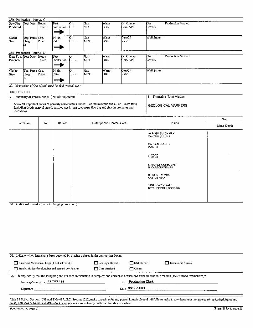
28b. Production - Interval CDate First Test Date Hours Test Oil Gas Water Oil Gravity Gas Production MethodProduced Tested Production BBL MCF BBL Corr. API Gravity
Choke Tbg. Press. Csg. 24 Hr. Oil Gas Water Gas/Oil Well StatusSize Flwg. Press. Rate BBL MCF BBL Ratio
SI
28c. Production - Interval DDate First Test Date Hours Test Oil Gas Water Oil Gravity Gas Production MethodProduced Tested Production BBL MCF BBL Corr. API Gravity
Choke Tbg. Press. Osg. 24 Hr. Oil Gas Water Gas/Oil Well StatusSize Flwg. Press. Rate BBL MCF BBL Ratio
SI
29. Disposition of Gas (Solid, used forfkel, vented, etc.)
USED FOR FUEL
30. Summary of Porous Zones (Include Aquifers): 31. Formation (Log) Markers
Showall important zones of porosity and contents thereof: Cored intervals and all drill-stem tests' GEOLOGICAL MARKERSincluding depth interval tested, cushion used, time tool open, flowing and shut-in pressures andrecoveries.
TopFormation Top Bottom Descriptions, Contents, etc. Name
Meas. Depth
GARDEN GULCH MRKGARDEN GULCH 1
GARDEN GULCH 2POINT3
X MRKRY MRKR
DOUGALS CREEK MRKBI CARBONATE MRK
B LIMESTON MRKCASTLE PEAK
BASAL CARBONATETOTAL DEPTH (LOGGERS)
32. Additional remarks (include plugging procet ure):
33. Indicate which items have been attached by placing a check in the appropriate boxes:
O Electrical/Mechanical Logs (1 full set req'd.) Geologic Report DST Report Directional Survey
Sundry Notice for plugging and cement verification Core Analysis Other:
34. I hereby certify that the foregoing and attached information is complete and correct as determined from all available records (see attached instructions)*
Name (please pring Tammi Lee Title Production Clerk
Signature Date 08/03/2009
Title 18 U.S.C. Section 1001 and Title 43 U.S.C.Section 1212, make it a crime for any person knowingly and willfully to make to any department or agency of the United States anyfalse, fictitious or fraudulent statements or representations as to any matter within its jurisdiction.(Continuedon page 3) (Form 3160-4, page
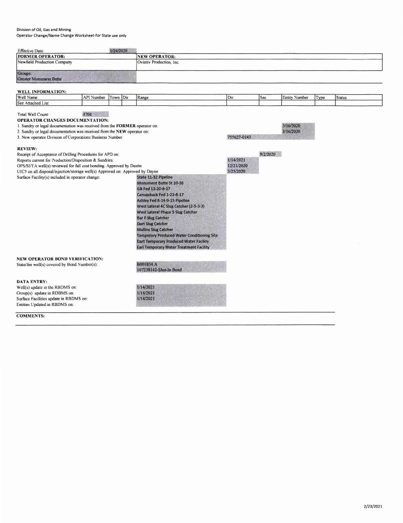
Division of Oil, Gas and Mining
Operator Change/Name Change Worksheet-for State use only
Effective Date : 112412020 -, FORMER OPERATOR: NEW OPERA TOR: Newfield Production Company Ovintiv Production, Inc.
Groups: Greater MOIIUIDeIIlBulle , ~:<,
WELL INFORMATION: WeU Name See Attached List
Total Well Count: OPERATOR CHANGES DOCUMENTATION: I. Sundry or legal documentation was received from the FORMER operator on : 2. Sundry or legal documentation was received from the NEW operator on: 3. New operator Division of Corporations Business Number:
REVIEW: Receipt of Acceptance of Drilling Procedures for APD on: Reports current for Production/Disposition & Sundries: OPS/SIIT A well(s) reviewed for fuU cost bonding: Approved by Dustin
UIC5 on all disposaVinjection/storage well(s) Approved on: Approved by Dayne Surface Facility(s) included in operator change: State 11-32 Pipetine
Monument Butte St 10-36 GB Fed 13-20-8-17 Call1l8Sback Fed 1-22-8-17 Ashley Fed 8-14-9-15 PIpeline
NEW OPERATOR BOND VERIFICATION: State/fee well(s) covered by Bond Number(s):
DATA ENTRY: Well(s) update in the RBDMS on: Group(s) update in RDBMS on: Surface Facilities update in RBDMS on: Entities Updated in RBDMS on:
COMMENTS:
west Iateral4C SIus Catcher (2-5-3-3) West latent Phase 5 Slug Catcher Bar F SIua Catcher Dart SIui CetdIer Mullins SIu& CatdIer Temporary PnIducecI Water Conditioning Site
Dart Temporary Produced w.rter FacUity EariT ra waterJreatment aclllty
1/1412021 111412021 1/1412021
755627-0143
3/1612020 ____ .... 3/1612020
.--=-=:-__ 91212020 111412021 1212112020 312512020
I
I
Status
2/23/2021
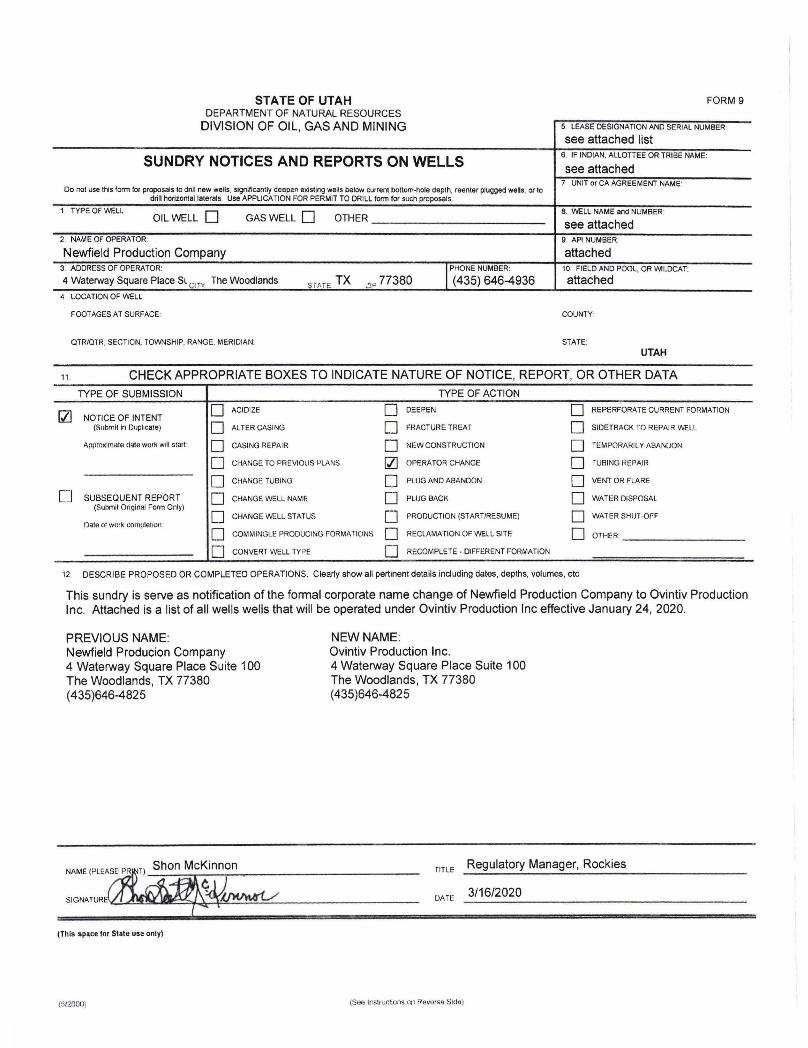
STATE OF UTAH DEPARTMENT OF NATURAL RESOURCES
DIVISION OF OIL, GAS AND MINING
SUNDRY NOTICES AND REPORTS ON WELLS
Do not use this lonn lor proposals to drill new wells, significantly deepen existing wells below current bottom-hole depth, reenter plugged wells, or to drill horizontsl lstersls. Use APPLICA nON FOR PERMIT TO DRILL form for such proposals.
1. TYPE OF WELl. OIL WELL 0 GAS WELL 0 OTHER ______________________ __
2 . NAM E OF OPERATOR:
Newfield Production Company 3. ADDRESS OF OPERATOR:
4 Waterway Square Place Sl CIT'! The Woodlands SiME TX 21P 77380 4. LOCATION OF WELL
FOOTAGES AT SURFACE:
QTR/OTR, SECTION, TOWNSHIP, RANGE, MERIDIAN:
FORM 9
5. LEASE DESIGNATION AND SERIAL NUMBER'
see attached list 6. IF INDIAN, ALLOTTEE OR TRIBE NAME:
see attached 7 UNIT or CA AGREEMENT NAME'
8. 'Mi:LL NAME and NUMBER '
see attached 9 API NUMBER:
attached 10. FIELD AND POOL, OR WILDCAT:
attached
COUNTY'
STATE:
UTAH
11 . CHECK APPROPRIATE BOXES TO INDICATE NATURE OF NOTICE, REPORT, OR OTHER DATA
TYPE OF SUBMISSION TYPE OF ACTION
Q] 0 ACIDIZE 0 DEEPEN 0 REPERFORATE CURRENT FORMATION NOTICE OF INTENT
(Submit in fluplir.ate) 0 ALTER CASING 0 fRACTURE TREAT 0 SIDETRACK 1'0 REPAIR WELL
ApproxllTlatA cjijte wOlk Will staft 0 CASING REPAIR 0 NEW CONSTRUCTION 0 TEMPORARIL Y ABANDON
D CHANGE TO PREVIOUS f'LANS fZl OPERATOR CHANGE 0 fUSING Rt:PAIf<
0 CHANGE TUBING 0 PLUG AND ABANDON 0 VENT OR FI.ARE
[ J SUBSEQUENT REPORT 0 GrIANGE WELL NAME 0 PLUG SACK 0 WATER DISPOSAL (Submit Original Form Only)
0 0 0 CHANGE WELL STATUS PRODUCTION (START/RESUME) WATER SHIJT -OFF Datn of work completion
0 0 0 COMMINGLE PRODUCING FORMATIONS RECLAMATION OF WELL SITE OTHER
0 CONVERT WELL TYPE 0 RECOMPLETE - DIFFERENT FORMATION
12 DESCRIBE PROPOSED OR COMPLETED OPERATIONS, Clearly show all pertinent details including dates , depths, VOlumes, etc,
This sundry is serve as notification of the formal corporate name change of Newfield Production Company to Ovintiv Production Inc, Attached is a list of all wells wells that will be operated under Ovintiv Production Inc effective January 24, 2020,
PREVIOUS NAME: Newfield Producion Company 4 Waterway Square Place Suite 100 The Woodlands, TX 77380 (435)646-4825
(This space ror State U5. only)
(ti/2000)
NEW NAME: Ovintiv Production Inc, 4 Waterway Square Place Suite 100 The Woodlands, TX 77380 (435)646-4825
flT l E Regulatory Manager, Rockies
DATE 3/16/2020
STATE OF UTAH DEPARTMENT OF NATURAL RESOURCES
DIVISION OF OIL, GAS AND MINING
SUNDRY NOTICES AND REPORTS ON WELLS
Do not use this form lor proposals 10 drill new wells. significantly deepen existing wells below current bottom-hal. depth, reenter plugged wells, or to drill horizontal laterals. Use APPLICATION FOR PERMIT TO DRILL form for such proposals.
1. TYPE OF WEll. OIL WELL 0 GAS WELL 0 OTHER ______________________ __
2. NAME OF OPERATOR:
Newfield Production Company 3. ADDRESS OF OPERATOR:
4 Waterway Square Place SL CIT" The Woodlands smE TX 2iP 77380 4. LOCATION OF WELL
FOOTAGES AT SURFACE:
OTR/OTR. SECTION, TOWNSHIP, RANGE, MERIDIAN:
FORM 9
5. LEASE DESIGNATION AND SERIAL NUMBER
see attached list 6. IF INDIAN. ALLOTTEE OR TRIBE NAME:
see attached 7 UNIT or CA AGREEMENT NAME'
8. V',ELL NAME and NUMBER'
see attached 9 API NUMBER:
attached 10. FIELD AND POOL, OR 'M'-DCAT:
attached
COUNTY'
STATE: UTAH
11 . CHECK APPROPRIATE BOXES TO INDICATE NATURE OF NOTICE, REPORT, OR OTHER DATA
TYPE OF SUBMISSION TYPE OF ACTION
121 0 ACIDIZE 0 DEEPEN 0 REPERFORATE CURRENT FORMATION NOTICE OF INTENT
(Submit in Duplicate) 0 ALTER CASING 0 FRACTURE TREAT 0 SIDETRACK 1'0 REPAIR WELL
ApproXimate elale work will start: 0 CASING REPAIR 0 NEW CONSTRUCTION 0 TEMPORARIL Y ABANDON
0 CHANGE TO PREVIOUS PLANS 121 OPF.RATOR CHANGE 0 rUSING REPAlil
0 CHANGE TUBING [J PUJG AND ABANDON D VENT OR FLARE
[J SUBSEQUENT REPORT D OIANGE WELL NAME 0 PLUG BACK 0 WATER DISPOSAL (Submit Original Form Only)
D D 0 CHANGE WELL STATUS PRODUCTION (START/RESUME) WATER SHtH .oF" Of:lln of work completion
0 0 0 COMMINGLE PRODUCING FORMATIONS RECLAMATION OF WEl.L SITE OTHER.
0 CONVERT WELL TYPE 0 RECOMPLETE· DIFFERENT FORMATION
t2 DESCRIBE PROPOSED OR COMPLETED OPERATIONS. Clearly show all pertinent details including dates, depths, volumes, etc.
This sundry is serve as notification of the formal corporate name change of Newfield Production Company to Ovintiv Production Inc. Attached is a list of all wells wells that will be operated under Ovintiv Production Inc effective January 24, 2020.
PREVIOUS NAME: Newfield Producion Company 4 Waterway Square Place Suite 100 The Woodlands, TX 77380 (435)646-4825
(This space 1M State us. only)
(tiI2000)
NEW NAME: Ovintiv Production Inc. 4 Waterway Square Place Suite 100 The Woodlands, TX 77380 (435)646-4825
TITLE Regulatory Manager, Rockies
DArE 3/16/2020