The Effect of Public Investment on Private Sector Investments in Turkey: 1970-2009
Upload
khangminh22Category
view
5download
0
Initial Environmental Examination
Document Stage: Revised Project Number: 40031-053 February 2014
IND: Rajasthan Urban Sector Development
Investment Program - Nagaur Water Supply
Subproject
(Additional Scope) The work of water supply subproject is already under execution in Tr-02. The scope of works under execution includes construction/rehabilitation of distribution network construction of raising mains, OHSRs, CWR and an intermediate pump house. Some additional areas are proposed to lay distribution network and construction of ESRs.
Prepared by Local Self Government Department
For the Government of Rajasthan Rajasthan Urban Infrastructure Development Project
The initial environmental examination is a document of the borrower. The views expressed
herein do not necessarily represent those of ADB’s Board of Directors, Management, or staff,
and may be preliminary in nature.
ABBREVIATION
ADB - Asian Development Bank DSC - Design and Supervision Consultancy EA - Executing Agency EAC - Expert Appraisal Committee FI - Financial Intermediary GLSR - Ground Level Service Reservoir GoI - Government of India GoR - Government of Rajasthan GSI - Geological Survey of India IA - Implementing Agency IEE - Initial Environmental Examination IPMC - Investment Programme Management Consultancy IPMU - Investment Programme Management Unit JNNURM - Jawaharlal Nehru National Urban Renewal Mission LSGD - Local Self-Government Department MFF - Multitranche Financing Facility MoEF - Ministry of Environment and Forests NAAQS - National Ambient Air Quality Standards OD - Outer Diameter OHSR - Over Head Service Reservoir OM - Operations Manual PHED - Public Health Engineering Department PMU - Project Management Unit RCC - Reinforced Cement Concrete ROW - Right of Way RPCB - Rajasthan State Pollution Control Board RSPM - Respirable Suspended Particulate Matter RUIDP - Rajasthan Urban Infrastructure Development Project RUSDIP - Rajasthan Urban Sector Development Investment
Program SPM - Suspended Particulate Matter STP - Sewerage Treatment Plant ToR - Terms of Reference UA - Urban Agglomeration UIDSSMT - Urban Infrastructure Development Scheme for Small
and Medium Towns USEPA - United States Environmental Protection Agency

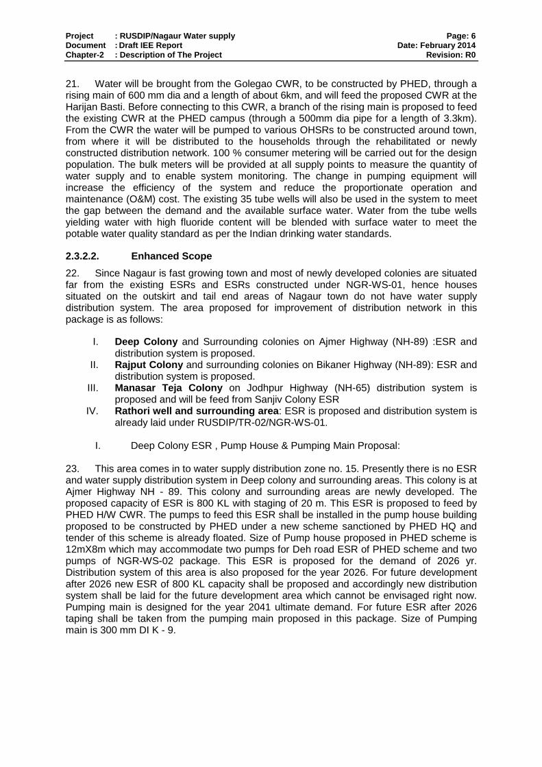
WEIGHTS AND MEASURES
Lakh – 100 thousand = 100,000
Crore – 100 lakhs = 10,000,000
µg/m3 – micrograms per cubic meter
Km – Kilometer
Lpd – liters per day
M – Meter
mg/l – milligrams per liter
Mm – Millimeter
Ppm – parts per million
NOTE{S}
(i) In this report, "$" refers to US dollars. (ii) “INR” and “Rs” refer to Indian rupees

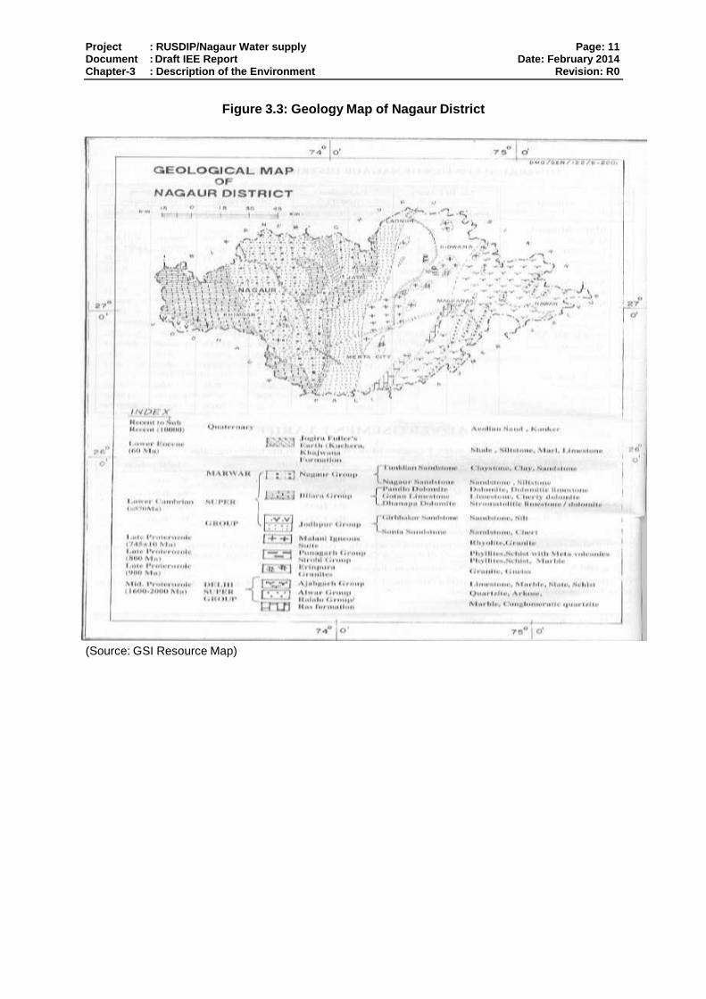
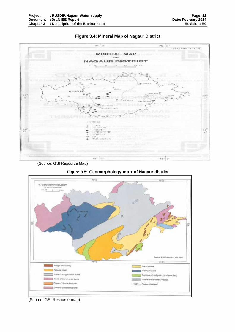
CONTENTS
1. INTRODUCTION ....................................................................................................... 1
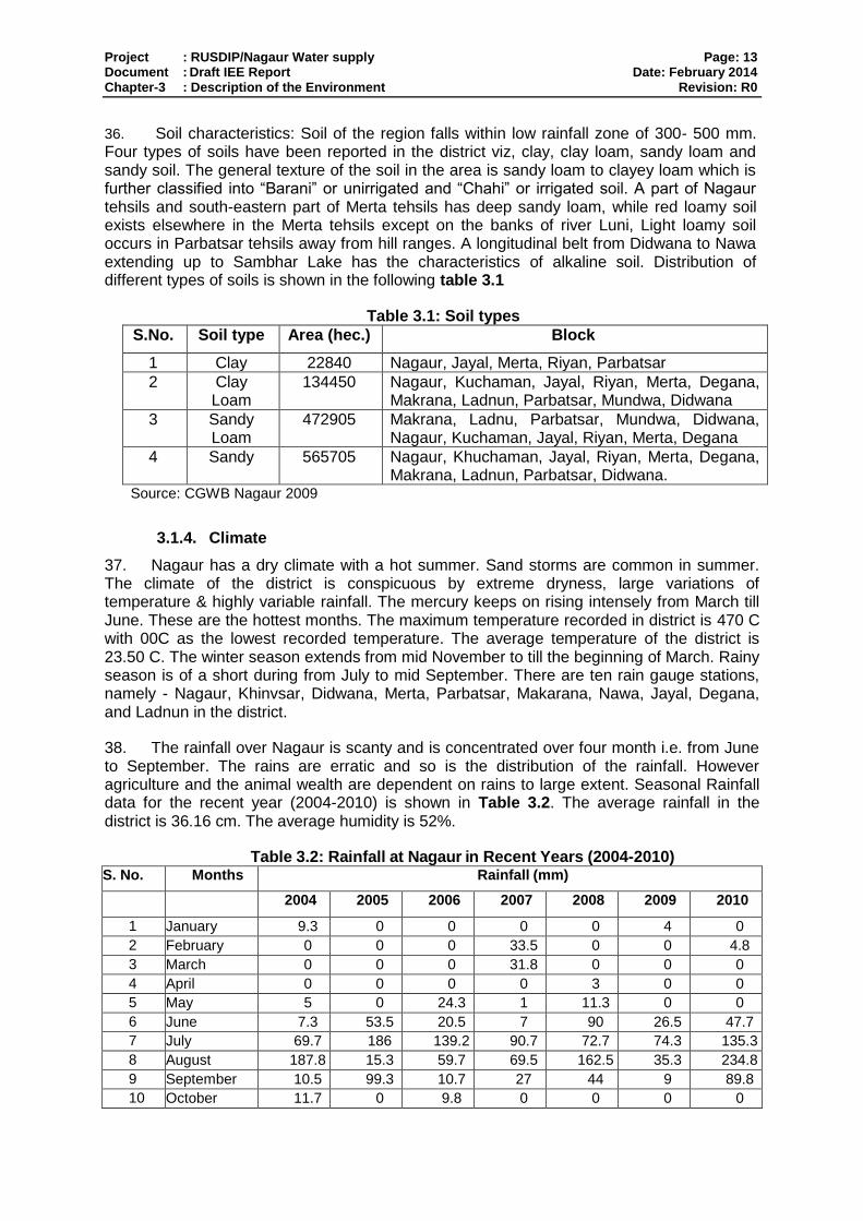
1.1. Purpose of the report ................................................................................................. 1
1.2. Extent of the IEE study .............................................................................................. 1
1.2.1. ADB Policy .............................................................................................................. 1
1.2.2. National Law ........................................................................................................... 2
1.2.3. Review and Approval Procedure ............................................................................. 2
1.2.4. Scope of Study ....................................................................................................... 3
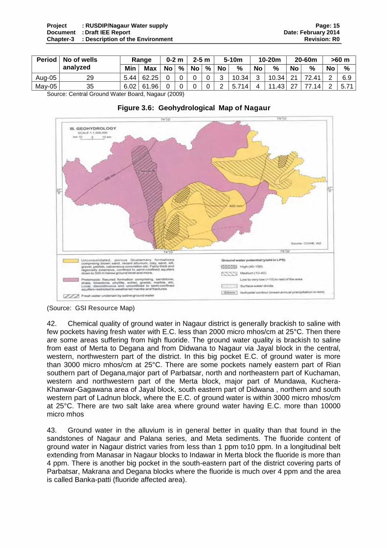
2. DESCRIPTION OF THE PROJECT .......................................................................... 4
2.1. Type, Category and Need.......................................................................................... 4
2.2. Location, Size and Implementation Schedule ............................................................ 4
2.3. Description of the sub-project .................................................................................... 4
2.3.1. Description of Existing Water Supply System .......................................................... 4
2.3.2. Description of the Sub-project including detail scope of works ................................ 5
3. DESCRIPTION OF THE ENVIRONMENT ................................................................. 9
3.1. Physical Resources ................................................................................................... 9
3.1.1. Location .................................................................................................................. 9
3.1.2. Topography, Natural hazard and Drought ............................................................... 9
3.1.3. Geology, geomorphology, mineral resources and soil ........................................... 10
3.1.4. Climate ................................................................................................................. 13
3.1.5. Air Quality ............................................................................................................. 14
3.1.6. Surface Water ....................................................................................................... 14
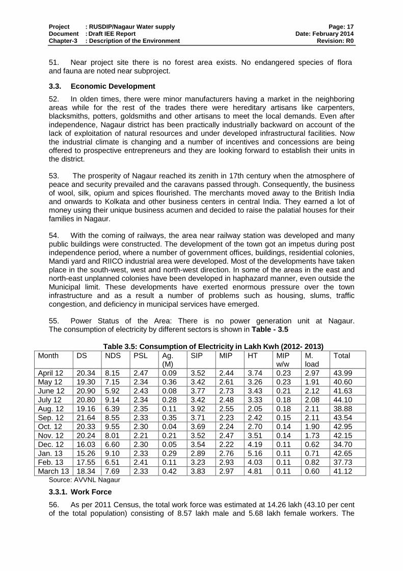
3.1.7. Geohydrology and Groundwater ........................................................................... 14
3.2. Ecological Resources .............................................................................................. 16
3.3. Economic Development ........................................................................................... 17
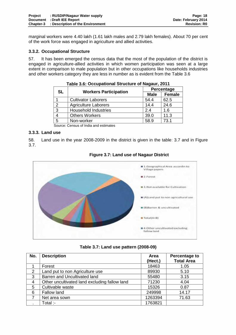
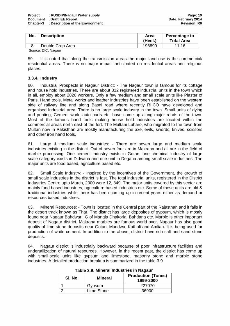
3.3.1. Work Force ........................................................................................................... 17
3.3.2. Occupational Structure ......................................................................................... 18
3.3.3. Land use ............................................................................................................... 18
3.3.4. Industry ................................................................................................................. 19
3.3.5. Agriculture: ........................................................................................................... 20
3.3.6. Infrastructure ......................................................................................................... 20
3.3.7. Transportation ....................................................................................................... 22
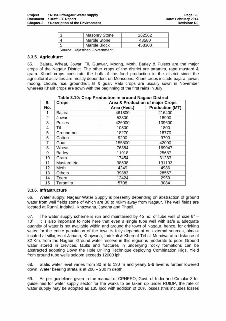
3.4. Social and Cultural Resources ................................................................................ 23
4. ANTICIPATED ENVIRONMENTAL IMPACTS AND MITIGATION ........................... 26
4.1. Pre-construction- Location and Design .................................................................... 26
4.2. Infrastructure Construction ...................................................................................... 27
4.2.1. Screening out areas of no significant impact ......................................................... 27
4.2.2. Construction method ............................................................................................. 28
4.3. Anticipated Environmental Impact and Mitigation Measure ...................................... 28
4.3.1. Physical Resources .............................................................................................. 28
4.3.2. Ecological Resources ........................................................................................... 29
4.3.3. Economic Development ........................................................................................ 30
4.3.4. Socio-economic .................................................................................................... 30
4.3.5. Social and Cultural Resources .............................................................................. 32
4.4. Operation and Maintenance .................................................................................... 33
4.4.1. Screening out areas of no significant impact ......................................................... 33
4.4.2. Physical Resources .............................................................................................. 33
4.4.3. Ecological Resources ........................................................................................... 34
4.4.4. Economic Development ........................................................................................ 34
4.4.5. Social and Cultural Resources .............................................................................. 34
5. PUBLIC CONSULTATION AND INFORMATION DISCLOSURE ............................. 36
5.1. Project stakeholders ................................................................................................ 36
5.2. Consultation and disclosure to date ......................................................................... 36
5.3. Future consultation and disclosure .......................................................................... 37
6. Grievance Redress Mechanism ............................................................................... 39
7. ENVIRONMENTAL MANAGEMENT PLAN ............................................................. 40
7.1. Summary of environmental impacts and mitigation measures ................................. 40
7.2. Institutional arrangements for project implementation .............................................. 40
7.2.1. Responsible for carrying out mitigation measures ................................................. 40
7.2.2. Responsible for carrying out monitoring measures................................................ 41
7.2.3. Responsible for reporting ...................................................................................... 41
7.3. Environmental Mitigation Plan ................................................................................. 41
7.4. Environmental Monitoring Plan ................................................................................ 62
7.5. Environmental Management and Monitoring Costs.................................................. 62
8. FINDINGS AND RECOMMENDATIONS ................................................................. 64
8.1. Findings ................................................................................................................... 64
8.2. Recommendations................................................................................................... 66
9. CONCLUSIONS ...................................................................................................... 67
ANNEXURE– I: PHOTOGRAPH 68
ANNEXURE- II: RAPID ENVIRONMENTAL ASSESSMENT (REA) CHECKLIST 69
ANNEXURE- III: PUBLIC CONSULTATION 75

EXECUTIVE SUMMARY
1. Introduction and Regulatory Framework: Rajasthan Urban Sector Development Investment Program (RUSDIP) is intended to optimize social and economic development in 15 selected towns in the State, particularly district headquarters and towns with significant tourism potential. RUSDIP Phase II to be implemented over a seven year period beginning in 2008, and will be funded by a loan via the Multitranche Financing Facility (MFF) of the ADB. RUSDIP will improve infrastructure through the design and implementation of a series of subprojects, each providing improvements in a particular sector (water supply, sewerage, drainage, road, solid waste etc) in one town.
2. The impacts of subprojects prepared according to ADB Environment Policy (2002, 2009) and Indian National Law. Projects are screened for their expected environmental impacts and are assigned to Category A, B, C and F1. RUSDIP has been classified by ADB as environmental assessment category B (some negative impacts but less significant than category A). The only type of infrastructure provided by the RUSDIP that is specified in the EIA Notification (2006) of Govt. Of India is solid waste management, where Environmental Clearance (EC) is required for all Common Municipal Solid Waste Management Facilities. EC is thus not required for Nagaur water Supply sub project and but subject to Environmental Examination. This is the Initial Environmental Examination (IEE) report for the Nagaur water Supply Project. It discusses the generic environmental impacts and mitigation measures relating to the location, design, construction and operation of physical works proposed under this subproject.
3. Project Description: The sub-project is located in Nagaur, the headquarters town of Nagaur district, in the North West part of Rajasthan. The main component of the sub-project is Additional Water Supply Work at Nagaur”
4. Description of Environment: Nagaur is the district headquarters. It is located at latitude (26o25’ to 27o40’and 23o3’ to 30o 12’) north and longitude (73o18’ to 75o15’ and 69o 30’ to 78o 17’) east, at a height of about 327m above the mean sea level. The town is at a distance of 112 Km. from Bikaner and 262 Km. from Jaipur and 160 km approx from Jodhpur by rail and connected with Ajmer Pushkar by road. It is very well connected by road, as such State Highway No. 2 & No. 3 pass through here. It is situated amidst seven districts namely Bikaner, Churu, Sikar, Jaipur, Ajmer, Pali, Jodhpur. Because of its central situation in Rajasthan, it shares its border with several other districts of the state. In the north, it is bound by Bikaner and Churu districts, in the east by Sikar and Jaipur districts, in the south by Ajmer and Pali districts and in the west by Jodhpur district. The site on which the town stands is of great significance in its natural setting. Nagaur has a dry climate with a hot summer. Sand storms are common in summer. The climate of the district is conspicuous by extreme dryness, large variations of temperature & highly variable rainfall. The mercury keeps on rising intensely from March till June. These are the hottest months. The maximum temperature recorded in district is 47o C with 0o C as the lowest recorded temperature. The average temperature of the district is 23.5o C. The winter season extends from mid November to till the beginning of March. Rainy season is of a short during from July to mid September. There are ten rain gauge stations, namely - Nagaur, Khinvsar, Didwana, Merta, Parbatsar, Makarana, Nawa, Jayal, Degana, and Ladnun in the district. 5. Economic base of a town reflects its prosperity. Nagaur being district headquarter, has been functioning as administrative city with sustained growth in tertiary economic activities. The Nagaur town is famous for its cottage and house hold industries. There are about 812 registered industrial units in the town which in all, employ about 2820 workers. Only a few medium and small scale units like Plaster of Paris, Hand tools, Metal works and leather industries have been established on the western side of railway line and along Basni
road where recently RIICO have developed and organized Industrial area. There is no large scale industry in the town. Small units of dying and printing, Cement work, auto parts etc. have come up along major roads of the town. Most of the famous hand tools making house hold industries are located within the commercial areas north east of the fort. The Multani Luharo, who migrated to the town from Multan now in Pakistan are mostly manufacturing the axe, evils, swords, knives, scissors and other iron hand tools. 6. Nagaur town is facing severe sewerage problem resulting unsanitary conditions through the year. The topography of the town is quite undulating and is evident from the contour map that the natural disposal of sewage of the town toward vacant disposal area out of the municipal limit is difficult. Due to the increasing demands of water, the supply has been substantially increased by augmentation schemes, resulting significant increase in the sewage gets accumulated in town areas. The problem gets aggravated when the wastewater remain stagnant for quite long time in the low lying area and cause hard ship to the inhabitants as well as creates unhygienic conditions. The present waste water flow system comprising of secondary drain (streams and artificial drains) and tertiary drains (mostly roadside drains), the most of town drain towards Dulaya Pond from South & East part of town and waste water of rest of town is accumulated at several low laying areas forming an unhygienic ponds is commonly called “Ginanies” in these areas. There are about 13 identified Ginanies out of which 3 are very minor, rest of 10 Ginanies creates unhygienic ponds full of wastewater smelling badly. These ponds expand their surface area tremendously during rainfall and water get entry in houses and shops. This situation continuous for hours in most of the areas and in other area it goes for 2-3 days, namely Samas Talab, Gaji Khada, Bacha Khada etc. Nagaur city has nearly 20% of total urban population of the district. In 2011 its population was 637204 persons. Growth rate has not been significant during last two decades because of lack of economic factor. During last decade (1991-2001) the growth rate was 26.65% only which was even less than the national population growth rate.
7. Potential environmental impacts and mitigation measure: All pre-construction (design), construction, and operation activities that are likely to cause environmental impacts were identified, and evaluated to assess their magnitude, duration, and potential receptors in consultation with the stakeholders. Most of the individual elements of the subproject are relatively small and involve straightforward construction and operation, so impacts will be mainly localized and not greatly significant during design phase.
8. There is no involuntary resettlement impact through any component of the proposed sub-project.
9. During project implementation the impacts are consider on physical environment like water, air, soil, noise; on biological environment, like flora and socio-economic environment (which is positive in some extent) and sensitive receptors. All the impacts are temporary and for short duration. In all the cases mitigation measures i.e. control of air, dust pollution, checking of water and noise pollution, protection of biological environment and minimize the social impacts are taken care. Safety measures, both occupational and social are considered and those are depicted in this report. Traffic management plan will be implemented during construction of water supply work. During operation phases there are few positive socio-economic impacts will be anticipated.
10. Institutional responsibility and Environmental management and monitoring plan: LSGD is the Executing Agency (EA) responsible for management, coordination and execution of all activities funded under the loan. Environmental issues will be coordinated by an Environmental Specialist within the IPMU/ IPMC, who will ensure that all subprojects
comply with environmental safeguards. An Environmental Monitoring Specialist (EMS) who is part of the DSC team will implement the Environmental Monitoring Plan from each IEE, to ensure that mitigation measures are provided and protect the environment as intended.
11. Implementation of Environmental management plan and monitoring frequency will be taken care during construction phase. Most the mitigation activities are the responsibility of the Construction Contractors (CC) employed to build the infrastructure during the construction stage, or the O&M Contractors employed to conduct maintenance or repair work when the system is operating. Responsibility for the relevant measures will be assigned to the Contractors via the contracts through which they are appointed (prepared by the DSC during the detailed design stage), so they will be legally required to take the necessary action. There are also some actions that need to be taken by LSGD in their role as project proponent, and some actions related to the design that will be implemented by the DSC. Mitigation measures are fairly standard methods of minimizing disturbance from building in urban areas (maintaining access, planning work to avoid sensitive times, finding uses for waste material, etc), and experienced Contractors should be familiar with most of the requirements. Monitoring of such measures normally involves making observations in the course of site visits, although some require more formal checking of records and other aspects. There will also be some surveys of residents, as most of the measures are aimed at preventing impacts on people and the human environment. Environmental management and monitoring cost for the sub-project has been estimated as INR 25.7 Lakh,
12. Public consultation, information disclosure and grievance redress mechanism: Public consultation with primary and secondary stakeholders has been conducted to understanding the local issues and public views regarding the possible impact. The group discussion meeting was conduct by RUIDP after advertising in Local NEWS papers. The issues like, awareness and extent of the project and development components, benefits of project for the economic and social upliftment of community, labour availability in the project area or requirement of outside labour involvement, local disturbances due to project construction work, necessity of tree felling etc. at project sites, water logging and drainage problem if any, drinking water problem, forest and sensitive area nearby the project site etc. On the basis of outcome of consultation the action plan has been developed. LSGD will extend and expand the consultation and disclosure process significantly during implementation of RUSDIP. They will appoint an experienced NGO to handle this key aspect of the programme.
13. The project authority will establish a mechanism to receive and facilitate resolution of affected persons’ concerns, complaints and grievances about the project’s environmental performance.
14. Recommendation and Conclusion: There are two straightforward but essential recommendations that need to be followed to ensure that the environmental impacts of the project are successfully mitigated. These are that LSGD should ensure that, all mitigation, compensation and enhancement measures proposed in this IEE report and in the Resettlement Framework for the RUSDIP are implemented in full, as described in these two documents and the Environmental Monitoring Plan proposed in IEE and the internal and external monitoring proposed in the Resettlement Framework are also implemented in full.
15. This initial environmental examination (IEE) ascertains that the subproject is unlikely to cause any significant environmental impacts. Few impacts were identified attributable to the proposed subproject, all of which are localized and temporary in nature and can be easily mitigated with minor to negligible residual impacts. There are no uncertainties in the analysis, and no additional work is required to comply with ADB procedure.
Project : RUSDIP/Nagaur Water supply Page: 1 Document : Draft IEE Report Date: February 2014 Chapter-1 : Introduction Revision: R0
1. INTRODUCTION
1.1. Purpose of the report
1. Rajasthan Urban Sector Development Investment Program (RUSDIP) is intended to optimize social and economic development in 15 selected towns in the State, particularly district headquarters and towns with significant tourism potential. This will be achieved through investments in urban infrastructure (water supply; sewerage and sanitation; solid waste management; urban drainage; urban transport and roads), urban community upgrading (community infrastructure; livelihood promotion) and civic infrastructure (art, culture, heritage and tourism; medical services and health; fire services; and other services). RUSDIP will also provide policy reforms to strengthen urban governance, management, and support for urban infrastructure and services. The assistance will be based on the State-level framework for urban reforms, and institutional and governance reforms recommended by the Government of India (GoI) through the Jawaharlal Nehru National Urban Renewal Mission (JNNURM) and Urban Infrastructure Development Scheme for Small and Medium Towns (UIDSSMT).
2. RUSDIP Phase II to be implemented over a seven year period beginning in 2008, and will be funded by a loan via the Multi-tranche Financing Facility (MFF) of the ADB. The Executing Agency (EA) is the Local Self-Government Department (LSGD) of the Government of Rajasthan (GoR); and the Implementing Agency (IA) is the Project Management Unit (PMU) of the Rajasthan Urban Infrastructure Development Project (RUIDP), which is currently in the construction stage.
3. RUSDIP will improve infrastructure through the design and implementation of a series of subprojects, each providing improvements in a particular sector (water supply, sewerage, solid waste etc) in one town. RUSDIP has been classified by ADB as environmental assessment category B (some negative impacts but less significant than category A). The impacts of subprojects prepared according to ADB Safeguard Policy Statement (2009) and Environmental Assessment Guidelines (2003).
1.2. Extent of the IEE study
4. Indian law and ADB policy require that the environmental impacts of development projects are identified and assessed as part of the planning and design process, and that action is taken to reduce those impacts to acceptable levels. This is done through the environmental assessment process, which has become an integral part of lending operations and project development and implementation worldwide.
1.2.1. ADB Policy
5. ADB’s Safeguard Policy Statement (2009) requires the consideration of environmental issues in all aspects of the Bank’s operations, and the requirements for Environmental Assessment are described in Operations Manual (OM) 20: Section F1/BP (2006) Environmental Considerations in ADB Operations. This states that ADB requires environmental assessment of all project loans, programme loans, sector loans, sector development programme loans, financial intermediation loans and private sector investment operations.
6. The nature of the assessment required for a project depends on the significance of its environmental impacts, which are related to the type and location of the project, the sensitivity, scale, nature and magnitude of its potential impacts, and the availability of cost-effective mitigation measures. Projects are screened for their expected environmental impacts and are assigned to one of the following categories:
Project : RUSDIP/Nagaur Water supply Page: 2 Document : Draft IEE Report Date: February 2014 Chapter-1 : Introduction Revision: R0
Category A: Projects that could have significant environmental impacts. An Environmental Impact Assessment (EIA) is required.
Category B: Projects that could have some adverse environmental impacts, but of less significance than those for category A. An Initial Environmental Examination (IEE) is required to determine whether significant impacts warranting an EIA are likely. If an EIA is not needed, the IEE is regarded as the final environmental assessment report.
Category C: Projects those are unlikely to have adverse environmental impacts. No EIA or IEE is required, although environmental implications are reviewed.
Category FI: Projects that involve a credit line through a financial intermediary (FI) or an equity investment in a FI. The FI must apply an environmental management system, unless all subprojects will result in insignificant impacts.
7. The Bank has categorised this program as Category B and following normal procedure for MFF loans has determined that one Environmental Examination will be conducted for each sub-project, with a subproject being the infrastructure improvements in a particular sector (water supply, sewerage, etc) in one town.
1.2.2. National Law
8. The GoI EIA Notification of 2006 and 2009 (replacing the EIA Notification of 1994), sets out the requirement for Environmental Assessment in India. This states that Environmental Clearance (EC) is required for specified activities/projects, and this must be obtained before any construction work or land preparation (except land acquisition) may commence. Projects are categorised as A or B depending on the scale of the project and the nature of its impacts.
9. Categories A projects require Environmental Clearance from the National Ministry of Environment and Forests (MoEF). The proponent is required to provide preliminary details of the project in the form of a Notification, after which an Expert Appraisal Committee (EAC) of the MoEF prepares comprehensive Terms of Reference (ToR) for the EIA study, which are finalized within 60 days. On completion of the study and review of the report by the EAC, MoEF considers the recommendation of the EAC and provides the EC if appropriate.
10. Category B projects require environmental clearance from the State Environment Impact Assessment Authority (SEIAA). The State level EAC categorizes the project as either B1 (requiring EIA study) or B2 (no EIA study), and prepares TOR for B1 projects within 60 days. On completion of the study and review of the report by the EAC, the SEIAA issues the EC based on the EAC recommendation. The Notification also provides that any project or activity classified as category B will be treated as category A if it is located in whole or in part within 10 km from the boundary of protected areas, notified areas or inter-state or international boundaries.
1.2.3. Review and Approval Procedure
11. For Category B projects the Draft Environmental Status report and its summary (SIEE) are reviewed by ADB’s Regional Department sector division and Environment and Social Safeguards Division, and by the Executing Agency, and additional comments may be sought from project affected people and other stakeholders. All comments are incorporated in preparing the final documents, which are reviewed by the Executing Agency. The EA then

Project : RUSDIP/Nagaur Water supply Page: 3 Document : Draft IEE Report Date: February 2014 Chapter-1 : Introduction Revision: R0
officially submits the IEE and SIEE reports to ADB for consideration by the Board of Directors. Completed reports are made available worldwide by ADB, via the depository library system and the ADB website.
1.2.4. Scope of Study
12. This is the IEE for the Nagaur water Supply subproject. It discusses the generic environmental impacts and mitigation measures relating to the location, design, construction and operation of physical works proposed under this subproject.
Project : RUSDIP/Nagaur Water supply Page: 4 Document : Draft IEE Report Date: February 2014 Chapter-2 : Description of The Project Revision: R0
2. DESCRIPTION OF THE PROJECT
2.1. Type, Category and Need
13. This is a water supply subproject, and has been classified by ADB as Category B, because it is not expected to have major negative environmental impacts. Under ADB procedures such projects require an IEE to identify and mitigate the impacts, and to determine whether further study or a more detailed EIA may be required. The subproject is needed because the present water supply infrastructure in Nagaur is inadequate for the needs of the growing population.
14. The provision is also unequal, with un-served areas being mainly the slums and newly- developed areas. This is one of a series of subprojects designed by the RUSDIP that are intended to raise the standards of the municipal infrastructure and services of Nagaur and the other urban centers to those expected of modern Asian towns.
15. The augmentation and network improvement for water supply in Nagaur town was design considering the whole town which is being implementing in phases. The work of water supply is already under execution under package RUSDIP/TR-02/ NGR/WS/01 of tranche – 02 which include construction/rehabilitation of distribution network, construction of raising mains, OHSRs, CWR and an intermediate pump house. Some additional areas of Nagaur town are proposed under this package to lay distribution network and construction of ESRs.
2.2. Location, Size and Implementation Schedule
16. The sub-project is located in Nagaur district, the headquarters town of Nagaur district, in the central part of Rajasthan (Figure 1.1). Strengthening the water distribution network will benefit some additional area of Nagaur town such as Deep colony, Rajput colony, Manasar teja colony and Rathori well areas (Figure 1.1). The proposed work will start in early 2014 and will be completed within 18 months. The photographs of the project area are attached as Annexure I
2.3. Description of the sub-project
2.3.1. Description of Existing Water Supply System
17. The present water supply of Nagaur is wholly from the groundwater sources, extracted through tube wells located at various well-fields situated at 30 to 40 km from the town center. Out of a total number of existing 46 tube wells, water quality in 35 tube wells, located at Khajwana, Janana and Indokali well-fields, meet the Indian drinking water standards. Water extracted from rest of the tube wells located at Khen, Soliyana and Fagli well-fields have high fluoride content ranging between 5 and 7 ppm, which is above the permissible Indian drinking water standards. At present, water abstracted through these tube wells are pumped to one CWR and blended with water from the other tube wells before the supply in order to bring the quality to the acceptable limit to the extent possible.
18. The current water production from the tube wells in total is 7.9 million liters per day (MLD). The losses are reported to be high and in the order of 40%. Considering the present estimated production level, the present per capita water supply is estimated to be 43 liter per capita per day (lpcd). In addition to the inadequate production, the system suffers from old and leaking distribution lines, inequitable pressure distribution, inadequate storage, lack of metering, etc. There are currently 8 OSHRs of total capacity of 4.7 million liters (ML). There are 10,698 connections, out of which 10,464 connections are domestic. The rest are commercial and industrial. Most of the connections are metered, however only 1,150 of the total are in a functional or working order. At present, water is being disinfected through
Project : RUSDIP/Nagaur Water supply Page: 5 Document : Draft IEE Report Date: February 2014 Chapter-2 : Description of The Project Revision: R0
application of bleaching powder, which is rudimentary and inefficient. The existing situation warrants urgent source augmentation, rehabilitation/improvement of the existing distribution system, increase in the storage capacity, provision of metering and provision of disinfection facilities.
2.3.2. Description of the Sub-project including detail scope of works
19. The Subproject will construct the downstream facilities and strengthen the existing water supply system in phases for the town to receive and distribute the additional 22.65 MLD water supplied through the Naguar Lift Project implemented by Public Health Engineering Department (PHED). The Subproject is also expected, among other things, to reduce the unaccounted for water (UFW) by billing for the actual quantity of water supplied, since the house connections will be expanded to cover at least 90% of the town population, with either new water meters or a rehabilitated water meter. Disinfection facilities, in the form of chlorinator plants at CWRs, will also be provided and the distribution network will be expanded and strengthened to fully absorb the additional water supply from the Naguar Lift Project.
20. As discussed above the work of water supply in Nagaur is already under execution under package RUSDIP/TR-02/ NGR/WS/01 of tranche – 02. Table 2.1 shows the nature and size of the various components of previous and enhanced scope of the subproject. There are three main elements: augmentation of the water source and supply; expansion/improvement of the distribution network; and reduction of non-revenue water (NRW). The descriptions shown in Table 2.1 are based on the present proposals, which are expected to be substantially correct, although certain details may change as the development of the subproject progresses. In case of significant change in scope the report will be revised.
2.3.2.1. Existing Scope
a. Procurement of pumps: 3 pumps with 204 liters per second (lps) capacity and associated electrical equipment for the CWR. The pump house in Gogelao Headwater is to be constructed and installed by PHED and not included in this subproject
b. Construction of the rising mains: 6 km of 600 mm diameter (dia) pipes, from the Gogelao pump house to an intermediate pump house at the Harijan Basti. The transmission main is 3.3 km of 600/500 mm dia pipes branching before intermediate pump house, to the existing CWR at PHED campus;
c. Construction of an intermediate pump house at Harijan Basti: installation of 4 pumps with 90 lps capacity and 45 m pressure head, and rehabilitation of the existing intermediate pump house at PHED compound;
d. Construction and rehabilitation of the water supply distribution system/ network for the town – 86 km of pipelines with of diameter 150mm to 500mm;
e. Construction of 8 OHSRs of total capacity 5.35 ML at various locations in town;
f. Construction of a CWR of 1.6 ML capacity;
g. Procurement and installation of 10,500 new household water meters and rehabilitation of 5,200 existing household water meters; and
h. Procurement and installation of 32 bulk water meters at all supply points.
Project : RUSDIP/Nagaur Water supply Page: 6 Document : Draft IEE Report Date: February 2014 Chapter-2 : Description of The Project Revision: R0
21. Water will be brought from the Golegao CWR, to be constructed by PHED, through a rising main of 600 mm dia and a length of about 6km, and will feed the proposed CWR at the Harijan Basti. Before connecting to this CWR, a branch of the rising main is proposed to feed the existing CWR at the PHED campus (through a 500mm dia pipe for a length of 3.3km). From the CWR the water will be pumped to various OHSRs to be constructed around town, from where it will be distributed to the households through the rehabilitated or newly constructed distribution network. 100 % consumer metering will be carried out for the design population. The bulk meters will be provided at all supply points to measure the quantity of water supply and to enable system monitoring. The change in pumping equipment will increase the efficiency of the system and reduce the proportionate operation and maintenance (O&M) cost. The existing 35 tube wells will also be used in the system to meet the gap between the demand and the available surface water. Water from the tube wells yielding water with high fluoride content will be blended with surface water to meet the potable water quality standard as per the Indian drinking water standards.
2.3.2.2. Enhanced Scope
22. Since Nagaur is fast growing town and most of newly developed colonies are situated far from the existing ESRs and ESRs constructed under NGR-WS-01, hence houses situated on the outskirt and tail end areas of Nagaur town do not have water supply distribution system. The area proposed for improvement of distribution network in this package is as follows:
I. Deep Colony and Surrounding colonies on Ajmer Highway (NH-89) :ESR and distribution system is proposed.
II. Rajput Colony and surrounding colonies on Bikaner Highway (NH-89): ESR and distribution system is proposed.
III. Manasar Teja Colony on Jodhpur Highway (NH-65) distribution system is proposed and will be feed from Sanjiv Colony ESR
IV. Rathori well and surrounding area: ESR is proposed and distribution system is already laid under RUSDIP/TR-02/NGR-WS-01.
I. Deep Colony ESR , Pump House & Pumping Main Proposal:
23. This area comes in to water supply distribution zone no. 15. Presently there is no ESR and water supply distribution system in Deep colony and surrounding areas. This colony is at Ajmer Highway NH - 89. This colony and surrounding areas are newly developed. The proposed capacity of ESR is 800 KL with staging of 20 m. This ESR is proposed to feed by PHED H/W CWR. The pumps to feed this ESR shall be installed in the pump house building proposed to be constructed by PHED under a new scheme sanctioned by PHED HQ and tender of this scheme is already floated. Size of Pump house proposed in PHED scheme is 12mX8m which may accommodate two pumps for Deh road ESR of PHED scheme and two pumps of NGR-WS-02 package. This ESR is proposed for the demand of 2026 yr. Distribution system of this area is also proposed for the year 2026. For future development after 2026 new ESR of 800 KL capacity shall be proposed and accordingly new distribution system shall be laid for the future development area which cannot be envisaged right now. Pumping main is designed for the year 2041 ultimate demand. For future ESR after 2026 taping shall be taken from the pumping main proposed in this package. Size of Pumping main is 300 mm DI K - 9.
Project : RUSDIP/Nagaur Water supply Page: 7 Document : Draft IEE Report Date: February 2014 Chapter-2 : Description of The Project Revision: R0
II. Rajput Colony ESR , Pump House & Pumping Main Proposal
24. This area comes in to water supply distribution zone no. 1. Presently there is no ESR and water supply distribution system in Rajput colony and surrounding areas/colonies. This colony is at Bikaner Highway NH - 65. This colony and surrounding areas are newly developed. The proposed capacity of ESR is 800 KL. This ESR is proposed to feed by Kankariya School H/W constructed under NGR-WS-01 contract package. Pumps to feed this ESR shall be installed in the Kankariya School Pump House Building at the space already available. This ESR is proposed for the demand of 2041 yr. Distribution system of this area is also proposed for the year 2041. Distribution main are designed for expansion of the distribution system for areas which will develop in future.
III. Teja Colony Water Supply Distribution System
25. Teja Colony area is outside municipal boundary. EE, IPIU, Nagaur has assured that approval for the proposal of water supply network in Teja Colony shall be taken from CLC for inclusion in RUSDIP. This area is having growth potential since area is located near NH-65 (Nagaur - Jodhpur Highway) and Jodhpur - Bikaner bypass. This area is proposed as the expansion of ward no. 2 of Nagaur Municipality. Storage Demand of Ward no. 2 was taken up in Sanjay Colony ESR in contract package RUSDIP/NGR-WS-01 therefore additional ESR is not recommended for this colony. Water supply distribution system has been designed keeping in view of future expansion. Demand for future expansion has been kept on node no. 74, 76, 52, 38, 90 & 96 pressure head is also kept so that it can be serve future expansion. Distribution System has been designed for demand of ultimate year 2041
IV. Rathori Well ESR Proposal
26. Rathori Well and Sarda Bal ESR are under water supply zone - 8. 400 KL ESR for 2041 demand is proposed under this package at Rathoriwell Govt. School. Distribution of Rathori Well ESR is already laid under NGR-WS-01 contract package of RUSDIP. This ESR shall be connected by taping the Pumping main of 300 mm for Badli ESR laid under contract package NGR-WS-01. 250 mm Pumping main is proposed to tap from 300 mm pumping main of Badli ESR. From 250 mm pumping main one branch of pumping main of dia 150 mm shall go to proposed Rathoriwell ESR and another branch of 150 mm shall to existing Sarda Bal ESR. Demand of Both Sardabal (Existing) and Rathoriwell (Proposed) ESR were taken in 300 mm dia pumping main coming from Kakariya School Pump House executed under RUSDIP/NGR-WS-01 and head required to feed both ESRs are available at taping point as per design of rising main of NGR-WS-01.
Project : RUSDIP/Nagaur Water supply Page: 8 Document : Draft IEE Report Date: February 2014 Chapter-2 : Description of The Project Revision: R0
Figure 2.1: Flow Diagram of Nagaur Water Supply system

Project : RUSDIP/Nagaur Water supply Page: 9 Document : Draft IEE Report Date: February 2014 Chapter-3 : Description of the Environment Revision: R0
3. DESCRIPTION OF THE ENVIRONMENT
3.1. Physical Resources
3.1.1. Location
27. The Urban Agglomeration (UA) of Nagaur district is located about 300 km from Jaipur. It is surrounded by Jaipur, Ajmer, Jodhpur, Bikaner, Churu, and Sikar districts. The total area of the town is 37.81 sq km. Nagaur town is the administrative headquarter of the district. Its geographical spread is a good combine of plain, hills, sand mounds and as such it is a part of the great Indian Thar Desert.
28. For the purpose of administration, the district is divided into nine administrative sub- division, viz., Nagaur, Merta,Jayal, Degana, Deedwana, Ladnun, Makarana, Nawa and Parbatsar. There are ten tehsils under the sub-division2 viz., Nagaur, Merta,Jayal, Degana, Deedwana, Ladnun, Makarana, Nawa, Parbatsar.and Khivansar.
29. The present district of Nagaur finds a place in the heart of the Rajasthan state. If we draw a cross over the map of Rajasthan the centre of this cross is bound to fall in the district of Nagaur. Before the merger of the states, Nagaur was a part of the erstwhile Jodhpur State. It is about 135 km from Jodhpur, 112 km from Bikaner and 300 km from Jaipur. The nearest Airport is at Jodhpur (137 km). District map of Nagaur is shown in Figure 3.1.
Figure 3.1: District Map of Nagaur
3.1.2. Topography, Natural hazard and Drought
30. Topography: Nagaur is the district headquarters. It is located at latitude (26o25’ to 27o40’ and 23o3’ to 30o12’) north and longitude (73o18’ to 75o15’ and 69o30’ to 78o17’) east, at a height of about 327m above the mean sea level.
31. Natural Hazards: Nagaur town lies in low damage risk zone II. The area is less prone to earthquakes as it is located on comparatively stable geological plains based on evaluation
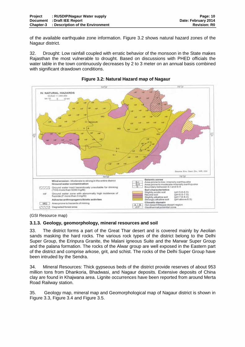
Project : RUSDIP/Nagaur Water supply Page: 10 Document : Draft IEE Report Date: February 2014 Chapter-3 : Description of the Environment Revision: R0
of the available earthquake zone information. Figure 3.2 shows natural hazard zones of the Nagaur district.
32. Drought: Low rainfall coupled with erratic behavior of the monsoon in the State makes Rajasthan the most vulnerable to drought. Based on discussions with PHED officials the water table in the town continuously decreases by 2 to 3 meter on an annual basis combined with significant drawdown conditions.
Figure 3.2: Natural Hazard map of Nagaur
(GSI Resource map)
3.1.3. Geology, geomorphology, mineral resources and soil
33. The district forms a part of the Great Thar desert and is covered mainly by Aeolian sands masking the hard rocks. The various rock types of the district belong to the Delhi Super Group, the Erinpura Granite, the Malani igneous Suite and the Marwar Super Group and the palana formation. The rocks of the Alwar group are well exposed in the Eastern part of the district and comprise arkose, grit, and schist. The rocks of the Delhi Super Group have been intruded by the Sendra.
34. Mineral Resources: Thick gypseous beds of the district provide reserves of about 953 million tons from Dhankoria, Bhadwasi, and Nagaur deposits. Extensive deposits of China clay are found in Khajwana area. Lignite occurrences have been reported from around Merta Road Railway station.
35. Geology map, mineral map and Geomorphological map of Nagaur district is shown in Figure 3.3, Figure 3.4 and Figure 3.5.
Project : RUSDIP/Nagaur Water supply Page: 11 Document : Draft IEE Report Date: February 2014 Chapter-3 : Description of the Environment Revision: R0
Figure 3.3: Geology Map of Nagaur District
(Source: GSI Resource Map)
Project : RUSDIP/Nagaur Water supply Page: 12 Document : Draft IEE Report Date: February 2014 Chapter-3 : Description of the Environment Revision: R0
Figure 3.4: Mineral Map of Nagaur District
(Source: GSI Resource Map)
Figure 3.5: Geomorphology map of Nagaur district
(Source: GSI Resource map)
Project : RUSDIP/Nagaur Water supply Page: 13 Document : Draft IEE Report Date: February 2014 Chapter-3 : Description of the Environment Revision: R0
36. Soil characteristics: Soil of the region falls within low rainfall zone of 300- 500 mm. Four types of soils have been reported in the district viz, clay, clay loam, sandy loam and sandy soil. The general texture of the soil in the area is sandy loam to clayey loam which is further classified into “Barani” or unirrigated and “Chahi” or irrigated soil. A part of Nagaur tehsils and south-eastern part of Merta tehsils has deep sandy loam, while red loamy soil exists elsewhere in the Merta tehsils except on the banks of river Luni, Light loamy soil occurs in Parbatsar tehsils away from hill ranges. A longitudinal belt from Didwana to Nawa extending up to Sambhar Lake has the characteristics of alkaline soil. Distribution of different types of soils is shown in the following table 3.1
Table 3.1: Soil types
S.No. Soil type Area (hec.) Block
1 Clay 22840 Nagaur, Jayal, Merta, Riyan, Parbatsar
2 Clay Loam
134450 Nagaur, Kuchaman, Jayal, Riyan, Merta, Degana, Makrana, Ladnun, Parbatsar, Mundwa, Didwana
3 Sandy Loam
472905 Makrana, Ladnu, Parbatsar, Mundwa, Didwana, Nagaur, Kuchaman, Jayal, Riyan, Merta, Degana
4 Sandy 565705 Nagaur, Khuchaman, Jayal, Riyan, Merta, Degana, Makrana, Ladnun, Parbatsar, Didwana.
Source: CGWB Nagaur 2009
3.1.4. Climate
37. Nagaur has a dry climate with a hot summer. Sand storms are common in summer. The climate of the district is conspicuous by extreme dryness, large variations of temperature & highly variable rainfall. The mercury keeps on rising intensely from March till June. These are the hottest months. The maximum temperature recorded in district is 470 C with 00C as the lowest recorded temperature. The average temperature of the district is 23.50 C. The winter season extends from mid November to till the beginning of March. Rainy season is of a short during from July to mid September. There are ten rain gauge stations, namely - Nagaur, Khinvsar, Didwana, Merta, Parbatsar, Makarana, Nawa, Jayal, Degana, and Ladnun in the district.
38. The rainfall over Nagaur is scanty and is concentrated over four month i.e. from June to September. The rains are erratic and so is the distribution of the rainfall. However agriculture and the animal wealth are dependent on rains to large extent. Seasonal Rainfall data for the recent year (2004-2010) is shown in Table 3.2. The average rainfall in the district is 36.16 cm. The average humidity is 52%.
Table 3.2: Rainfall at Nagaur in Recent Years (2004-2010) S. No. Months Rainfall (mm)
2004 2005 2006 2007 2008 2009 2010
1 January 9.3 0 0 0 0 4 0
2 February 0 0 0 33.5 0 0 4.8
3 March 0 0 0 31.8 0 0 0
4 April 0 0 0 0 3 0 0
5 May 5 0 24.3 1 11.3 0 0
6 June 7.3 53.5 20.5 7 90 26.5 47.7
7 July 69.7 186 139.2 90.7 72.7 74.3 135.3
8 August 187.8 15.3 59.7 69.5 162.5 35.3 234.8
9 September 10.5 99.3 10.7 27 44 9 89.8
10 October 11.7 0 9.8 0 0 0 0
Project : RUSDIP/Nagaur Water supply Page: 14 Document : Draft IEE Report Date: February 2014 Chapter-3 : Description of the Environment Revision: R0
11 November 0 0 0 0 0 0 17.3
12 December 0 0 0 0.5 0 0 0
13 Annual Rainfall
301.3 354.1 265.2 261 383.2 149.1 529.7
(Source- IMD District-wise Rainfall data 2004-2010 Rajasthan)
3.1.5. Air Quality
39. Ambient Air Monitoring was done in year 2013, the results of that are shown in Table-3.3. Traffic is the only significant pollutant in Nagaur, so levels of oxides of sulphur and nitrogen are likely to be well within the National Ambient Air Quality Standards (NAAQS).
Table 3.3: Ambient Air Quality Monitoring Result of Nagaur
SL.N0. Date of
Monitoring PM10
(µg/m3)
PM2.5
(µg/m3)
SO2
(µg/m3)
NO2
(µg/m3)
CO (mg/m
3)
A. Sugan Singh Circle, Nagaur
1 15/02/2013 113.8 39.5 11.5 21.8 <1.15
2 16/02/2013 110.8 29.5 11.2 23.2 <1.15
Average 112.3 34.5 11.4 22.5 <1.15
B. Vijay Ballabh Circle, Nagaur
1 17/02/2013 196.5 23.0 22.0 12.1 <1.15
2 18/02/2103 186.4 19.4 20.5 15.1 <1.15
Average 191.4 21.2 21.3 13.6 <1.15
Permissible limits as per CPCB Notification, New Delhi, 18
th November,
2009
100 60 80 80 2
Note: Sampling and Analysis done according to IS 5182(Pt- 2, 4, 5, 6, 10, 23) BDL= Below Detection Limit, Detection Limit of CO = 0. 625 mg/m
3
3.1.6. Surface Water
40. No surface water resource in district has been reported except a few salt lakes. There is salt lake (Sambhar Lake) at south west of Didwana having an area of 777 hectare The Nawa tehsil also shares a part of well known Sambhar Lake in Jaipur district. There are eight (8) numbers of ponds in the district. Out of these 5 are in Degana and 3 in Parbatsar blocks. River Luni is a non-perennial river, it rises near Pushkar in Ajmer district and after passing over the western slopes of the Aravali, it crosses Nagaur district in the south and flows through it towards the west for nearly 37 km. before entering into Pali.
3.1.7. Geohydrology and Groundwater
41. There are number of National Hydrographic monitoring stations of Central Ground Water Board in and around Nagaur. Fluctuation of ground water level is shown in Table 3.4. The ground water table in most of the cases ranged between 20 to 60 m below ground level. Geohydrological map of the district is shown in Figure 3.6
Table 3.4: Number and Percentage of National Hydrograph Network Station (Nagaur) with Water Fluctuation Range
Period No of wells analyzed
Range 0-2 m 2-5 m 5-10m 10-20m 20-60m >60 m
Min Max No % No % No % No % No % No %
Jan-06 27 5.37 63.5 0 0 0 0 2 7.41 4 14.81 19 70.37 2 7.41
Nov-05 28 5.27 62.25 0 0 0 0 3 10.34 3 10.34 21 72.41 2 6.9
Project : RUSDIP/Nagaur Water supply Page: 15 Document : Draft IEE Report Date: February 2014 Chapter-3 : Description of the Environment Revision: R0
Period No of wells analyzed
Range 0-2 m 2-5 m 5-10m 10-20m 20-60m >60 m
Min Max No % No % No % No % No % No %
Aug-05 29 5.44 62.25 0 0 0 0 3 10.34 3 10.34 21 72.41 2 6.9
May-05 35 6.02 61.96 0 0 0 0 2 5.714 4 11.43 27 77.14 2 5.71 Source: Central Ground Water Board, Nagaur (2009)
Figure 3.6: Geohydrological Map of Nagaur
(Source: GSI Resource Map)
42. Chemical quality of ground water in Nagaur district is generally brackish to saline with few pockets having fresh water with E.C. less than 2000 micro mhos/cm at 25°C. Then there are some areas suffering from high fluoride. The ground water quality is brackish to saline from east of Merta to Degana and from Didwana to Nagaur via Jayal block in the central, western, northwestern part of the district. In this big pocket E.C. of ground water is more than 3000 micro mhos/cm at 25°C. There are some pockets namely eastern part of Rian southern part of Degana,major part of Parbatsar, north and northeastern part of Kuchaman, western and northwestern part of the Merta block, major part of Mundawa, Kuchera-Khanwar-Gagawana area of Jayal block, south eastern part of Didwana , northern and south western part of Ladnun block, where the E.C. of ground water is within 3000 micro mhos/cm at 25°C. There are two salt lake area where ground water having E.C. more than 10000 micro mhos
43. Ground water in the alluvium is in general better in quality than that found in the sandstones of Nagaur and Palana series, and Meta sediments. The fluoride content of ground water in Nagaur district varies from less than 1 ppm to10 ppm. In a longitudinal belt extending from Manasar in Nagaur blocks to Indawar in Merta block the fluoride is more than 4 ppm. There is another big pocket in the south-eastern part of the district covering parts of Parbatsar, Makrana and Degana blocks where the fluoride is much over 4 ppm and the area is called Banka-patti (fluoride affected area).
Project : RUSDIP/Nagaur Water supply Page: 16 Document : Draft IEE Report Date: February 2014 Chapter-3 : Description of the Environment Revision: R0
3.1.7.1. Ground water quality in deeper aquifers
44. The ground water quality is brackish to saline from east of Merta to Degana and from Didwana to Nagaur via Jayal block in the central part of the district. In this big pocket covering about 6000 km2 area the E.C. of ground water is more than 5000 µmhos/cm at 25°C. There are three pockets namely around Nimri in Ladnun block, around Gotan in Merta block and in a longitudinal belt in the eastern part of the district where the E.C. of ground water is within 2000 micro mhos/cm at 25°C.
45. Ground water in the alluvium is in general better in quality than that found in the sandstones of Nagaur and Palana series. Table 20 indicate that the ground water in quaternary alluvium has less than 1000 ppm T.D.S. (E.C. less than 2000 micro mhos/cm) only in the eastern part which in the widely spread area the range is between 1000-3000 ppm T.D.S. in the wells penetrating Tertiary sediments the salinity exceeds 3000 ppm. T.D.S.
46. The E.C. of ground water in the shallow aquifer of Nagaur and Palana sandstone varies from 900 to 6000 micro mhos/cm at 25°C. However the quality of water deteriorates with depth. At Merta city the borehole of 421.20 m deep, the ground water was with 28496 micro mhos/cm electrical conductance. The tube wells of the average depth of around 80 m tapping sandstones, the E.C. of ground water is around 2000 micro mhos/cm. The tube wells tapping phyllites, schists and gneisses, the quality of ground water is very poor.
47. The fluoride content in ground water of tube wells constructed at Kanwai (Didwana block), Roru and As Ki Dhani (Ladnun block) is more than 3 ppm. The production well at Luniawas (Morta block) and Gorera (Nagaur block) also yielded water with more than 3 ppm fluoride.
3.2. Ecological Resources
48. Flora: The flora of the district is not rich owing to its geographical situation and scanty rainfall. The south-eastern areas including a part of the northern tehsils of Ladnun and Didwana are much greener than the northwest region of district. Khejri trees are commonly found in the district. The leaves are used as fodder. It also gives gum. Apart from commercial value, this tree is considered holy. The tree also plays an important role in checking soil erosion. The other common species found in the district are babul, neem, shisham, peepal, rohira, kalsi, dhangood, akara and rohira trees provide timber & is used for making furniture. Dhangood is generally used for making cots. A common shrub-phog provides building material from its roots & twings. Common grass found in the district include bargers, bhambar etc.
49. Fauna: Wild Animals such as chinkaras and black bucks which are rarely seen in this area are protected species under the Rajasthan Wild Animals and Birds Protection Act (1951). Among the small game, only titars are found. Other fauna of the district consists of deer, hare, jackal, pig, wild cat and birds. The common birds fluttering in the district include bulbul, sugan chiri, and mor (peacocks).
50. The district of Nagaur is poor in forest resources. The total area under including hills is reported to be 240.92 sq km, which is 1.3 percent of total geographical area of the district. Scanty rainfall and other geographical constraints account for this. The western part of the district is divided of natural vegetation cover except for herb and grass which grows on low sand dunes. However, the south-eastern part of the district and part of the northern tehsil of Ladnun and Didwana have much greater greenery as compared to north-west part of the district.
Project : RUSDIP/Nagaur Water supply Page: 17 Document : Draft IEE Report Date: February 2014 Chapter-3 : Description of the Environment Revision: R0
51. Near project site there is no forest area exists. No endangered species of flora and fauna are noted near subproject.
3.3. Economic Development
52. In olden times, there were minor manufacturers having a market in the neighboring areas while for the rest of the trades there were hereditary artisans like carpenters, blacksmiths, potters, goldsmiths and other artisans to meet the local demands. Even after independence, Nagaur district has been practically industrially backward on account of the lack of exploitation of natural resources and under developed infrastructural facilities. Now the industrial climate is changing and a number of incentives and concessions are being offered to prospective entrepreneurs and they are looking forward to establish their units in the district.
53. The prosperity of Nagaur reached its zenith in 17th century when the atmosphere of peace and security prevailed and the caravans passed through. Consequently, the business of wool, silk, opium and spices flourished. The merchants moved away to the British India and onwards to Kolkata and other business centers in central India. They earned a lot of money using their unique business acumen and decided to raise the palatial houses for their families in Nagaur.
54. With the coming of railways, the area near railway station was developed and many public buildings were constructed. The development of the town got an impetus during post independence period, where a number of government offices, buildings, residential colonies, Mandi yard and RIICO industrial area were developed. Most of the developments have taken place in the south-west, west and north-west direction. In some of the areas in the east and north-east unplanned colonies have been developed in haphazard manner, even outside the Municipal limit. These developments have exerted enormous pressure over the town infrastructure and as a result a number of problems such as housing, slums, traffic congestion, and deficiency in municipal services have emerged.
55. Power Status of the Area: There is no power generation unit at Nagaur. The consumption of electricity by different sectors is shown in Table - 3.5
Table 3.5: Consumption of Electricity in Lakh Kwh (2012- 2013)
Month DS NDS PSL Ag. (M)
SIP MIP HT MIP w/w
M. load
Total
April 12 20.34 8.15 2.47 0.09 3.52 2.44 3.74 0.23 2.97 43.99
May 12 19.30 7.15 2.34 0.36 3.42 2.61 3.26 0.23 1.91 40.60
June 12 20.90 5.92 2.43 0.08 3.77 2.73 3.43 0.21 2.12 41.63
July 12 20.80 9.14 2.34 0.28 3.42 2.48 3.33 0.18 2.08 44.10
Aug. 12 19.16 6.39 2.35 0.11 3.92 2.55 2.05 0.18 2.11 38.88
Sep. 12 21.64 8.55 2.33 0.35 3.71 2.23 2.42 0.15 2.11 43.54
Oct. 12 20.33 9.55 2.30 0.04 3.69 2.24 2.70 0.14 1.90 42.95
Nov. 12 20.24 8.01 2.21 0.21 3.52 2.47 3.51 0.14 1.73 42.15
Dec. 12 16.03 6.60 2.30 0.05 3.54 2.22 4.19 0.11 0.62 34.70
Jan. 13 15.26 9.10 2.33 0.29 2.89 2.76 5.16 0.11 0.71 42.65
Feb. 13 17.55 6.51 2.41 0.11 3.23 2.93 4.03 0.11 0.82 37.73
March 13 18.34 7.69 2.33 0.42 3.83 2.97 4.81 0.11 0.60 41.12 Source: AVVNL Nagaur
3.3.1. Work Force
56. As per 2011 Census, the total work force was estimated at 14.26 lakh (43.10 per cent of the total population) consisting of 8.57 lakh male and 5.68 lakh female workers. The
Project : RUSDIP/Nagaur Water supply Page: 18 Document : Draft IEE Report Date: February 2014 Chapter-3 : Description of the Environment Revision: R0
marginal workers were 4.40 lakh (1.61 lakh males and 2.79 lakh females). About 70 per cent of the work force was engaged in agriculture and allied activities.
3.3.2. Occupational Structure
57. It has been emerged the census data that the most of the population of the district is engaged in agriculture-allied activities in which women participation was seen at a large extent in comparison to male population but in other occupations like households industries and other workers category they are less in number as is evident from the Table 3.6
Table 3.6: Occupational Structure of Nagaur, 2011
SL Workers Participation Percentage
Male Female
1 Cultivator Laborers 54.4 62.5
2 Agriculture Laborers 14.4 24.6
3 Household Industries 2.4 1.6
4 Others Workers 39.0 11.3
5 Non-worker 58.9 73.1 Source: Census of India and estimates
3.3.3. Land use
58. Land use in the year 2008-2009 in the district is given in the table: 3.7 and in Figure 3.7.
Figure 3.7: Land use of Nagaur District
Table 3.7: Land use pattern (2008-09)
No. Description Area (Hect.)
Percentage to Total Area
1 Forest 18463 1.05
2 Land put to non Agriculture use 89930 5.10
3 Barren and Uncultivated land 55480 3.15
4 Other uncultivated land excluding fallow land 71230 4.04
5 Cultivable waste 15326 0.87
6 Fallow land 249998 14.17
7 Net area sown 1263394 71.63
. Total :- 1763821
Project : RUSDIP/Nagaur Water supply Page: 19 Document : Draft IEE Report Date: February 2014 Chapter-3 : Description of the Environment Revision: R0
No. Description Area (Hect.)
Percentage to Total Area
8 Double Crop Area 196890 11.16 Source: DIC, Nagaur
59. It is noted that along the transmission areas the major land use is the commercial/ residential areas. There is no major impact anticipated on residential areas and religious places.
3.3.4. Industry
60. Industrial Prospects in Nagaur District: - The Nagaur town is famous for its cottage and house hold industries. There are about 812 registered industrial units in the town which in all, employ about 2820 workers. Only a few medium and small scale units like Plaster of Paris, Hand tools, Metal works and leather industries have been established on the western side of railway line and along Basni road where recently RIICO have developed and organised Industrial area. There is no large scale industry in the town. Small units of dying and printing, Cement work, auto parts etc. have come up along major roads of the town. Most of the famous hand tools making house hold industries are located within the commercial areas north east of the fort. The Multani Luharo, who migrated to the town from Multan now in Pakisthan are mostly manufacturing the axe, evils, swords, knives, scissors and other iron hand tools.
61. Large & medium scale industries: - There are seven large and medium scale industries existing in the district. Out of seven four are in Makrana and all are in the field of marble processing. One cement industry exists in Gotan, one chemical industry of large scale category exists in Didwana and one unit in Degana among small scale industries. The major units are food based, agriculture based etc.
62. Small Scale Industry: - Inspired by the incentives of the Government, the growth of small scale industries in the district is fast. The total industrial units, registered in the District Industries Centre upto March, 2000 were 12, 849. The major units covered by this sector are mainly food based industries, agriculture based industries etc. Some of these units are old & traditional industries while there has been coming up in recent years either as demand or resources based industries.
63. Mineral Resources: - Town is located in the Central part of the Rajasthan and it falls in the desert track known as Thar. The district has large deposites of gypsum, which is mostly found near Nagaur Bahdwari, G of Mangla Dhakoria, Bahdana etc. Marble is other important deposit of Nagaur district. Makrana marbles are famous world over. Nagaur has also good quality of lime stone deposits near Gotan, Mundwa, Katholi and Amliah. It is being used for production of white cement. In addition to the above, district have rich salt and sand stone deposits.
64. Nagaur district is industrially backward because of poor infrastructure facilities and underutilization of natural resources. However, in the recent past, the district has come up with small-scale units like gypsum and limestone, masonry stone and marble stone industries. A detailed production breakup is summarized in the table 3.9
Table 3.9: Mineral Industries in Nagaur
Sl. No. Mineral Production (Tones)
1999-2000
1 Gypsum 227070
2 Lime Stone 36900
Project : RUSDIP/Nagaur Water supply Page: 20 Document : Draft IEE Report Date: February 2014 Chapter-3 : Description of the Environment Revision: R0
3 Masonry Stone 162562
4 Marble Stone 48580
5 Marble Block 458300 Source: Rajasthan Government
3.3.5. Agriculture:
65. Bajara, Wheat, Jowar, Til, Guawar, Moong, Moth, Barley & Pulses are the major crops of the Nagaur District. The other crops of the district are taramira, rape mustard & gram. Kharif crops constitute the bulk of the food production in the district since the agricultural activities are mostly dependent on Monsoons. Kharif crops include bajara, jowar, moong, choula, rice, groundnut, til & guar. Rabi crops are usually sown in November whereas Kharif crops are sown with the beginning of the first rains in July
Table 3.10: Crop Production in around Nagaur District
S. No.
Crops Area & Production of major Crops
Area (Hect.) Production (MT)
1 Bajara 461800 216400
2 Jowar 53800 18900
3 Pulses 426000 109600
4 Til 10800 1800
5 Ground-nut 18270 18770
6 Cotton 9200 9700
7 Guar 155800 42000
8 Wheat 76384 169047
9 Barley 11918 25687
10 Gram 17454 31233
11 Mustard etc. 98538 131133
12 Methi 4249 4986
13 Others 39883 28567
14 Zeera 12424 2959
15 Taramira 5708 3084
3.3.6. Infrastructure
66. Water supply: Nagaur Water Supply is presently depending on abstraction of ground water from well fields some of which are 30 to 40km away from Nagaur. The well fields are located at Runni, Indakali, Khazwana, Janana and Phagli.
67. The water supply scheme is run and maintained by 45 no. of tube well of size 8” – 10”. , It is also important to note here that even a single tube well with safe & adequate quantity of water is not available within and around the town of Nagaur, hence, for drinking water for the entire population of the town is fully dependent on external sources, almost located at villages of Janana, Khajwana, Indokali & Khen of Tehsil Mundwa at a distance of 32 Km. from the Nagaur. Ground water reserve in this region is moderate to poor. Ground water stored in crevices, faults and fractures in underlying rocky formations can be abstracted adopting Down the Hole Drilling Technique deploying Combination Rigs. Yield from ground tube wells seldom exceeds 12000 lph.
68. Static water level varies from 80 m to 130 m and yearly 5-6 level is further lowered down. Water bearing strata is at 200 – 230 m depth.
69. As per guidelines given in the manual of CPHEEO, Govt. of India and Circular-3 for guidelines for water supply sector for the works to be taken up under RUIDP, the rate of water supply may be adopted as 135 lpcd with addition of 20% losses (this includes losses
Project : RUSDIP/Nagaur Water supply Page: 21 Document : Draft IEE Report Date: February 2014 Chapter-3 : Description of the Environment Revision: R0
for transmission system if very long @ 2% (max) and 3% for treatment plant may be taken where applicable and 15% distribution losses).
70. For augmentation of water supply of Nagaur town one water supply contract package RUSDIP / TR – 02 / NGR / WS – 01 is under execution. This is ADB funded project and RUIDP is executing the work. After commissioning of this project Nagaur town will get the water supply from Indira Gandhi Canal.
71. Under this package 8 ESRs at various locations of Nagaur and one CWR with pumping station is proposed at Kankariya School, Nagaur. Pumping main of different dia is also proposed to feed ESRs. New water supply distribution lines are proposed along with new metered house service connections.
72. Sewerage System: At present there is no Sewerage system in the town. Drainage system for storm water has also not yet been planned properly. In the town, some pucca drains are there. But these are also not sufficient for carriage of sullage & storm water. The waste from most of the the part of the town is disposed into depressed area which has been taken the form of pond. However, in last few years’ some works as development of Infrastructure specially in drainage has been carried in the town, but still they overflows during heavy rainfall in rainy season.
73. Presently very few houses or Govt. institutions have their own onsite disposal system comprising of septic tanks or soak pits for disposal of their own sewage. Planned collection & carriage system for sewage and subsequent treatment and disposal does not exist
74. At present there are two packages are under execution at Nagaur for sewerage network at Nagaur town. One contract package RUSDIP//TR-02/NGR/WW-02/Lot – 02 is under execution. Under this package construction of 8 MLD Sewage Treatment Plant is proposed for safe disposal of sewage. Waste stabilization treatment process is proposed to treat sewage. One intermediate sewage pumping station of 3 MLD is also proposed to construct in this package.
75. Second project is RUSDIP//TR-02/NGR/WW-03 under which sewerage trunk main and apprx. 10 km laterals are proposed to lay.
76. Sanitation: Only 70 % of the households reportedly has septic tanks and soaks well for sewerage disposal. The remaining accounted for cases of open defecation which is an unacceptable and unhygienic practice. The raw settled sewage from septic tank is periodically flushed out by sanitary workers of the Municipal Board and discharge to open spaces, agricultural lands in an indiscriminate manner. Slum areas were also not equipped with requisite sanitation resulting in open defecation.
77. Drainage: Almost all the areas of the town totally lack in drainage and sewerage system. Waste water gets accumulated in streets creating unhygienic conditions, which is ultimately soaked in the sub soil. In some of the areas there are pucca drains but part of this waste water is carried to various tanks creating un-hygienic conditions.
78. Industrial Effluents. : Industries exist in Nagaur, which is outside the town area and effluent disposed scattered in local nallahs. As reported by the local MC, the responsibility of effluent disposal is under Industry’s own and could not be connected to the proposed sewer network. The individual industry should treat their effluent to bring it to the required standard before final disposal.

Project : RUSDIP/Nagaur Water supply Page: 22 Document : Draft IEE Report Date: February 2014 Chapter-3 : Description of the Environment Revision: R0
79. Solid Waste: Municipal Board’s jurisdiction is spread over an area of 37.81 sq km. 52 tons of solid waste is collected daily. In addition to household (domestic) solid waste, the main waste generation sources in the town are vegetable and fruit markets, commercial and institutional establishments including hotels and eateries, construction activities, and other tourism related activities
80. Waste Collection - The MSW generated in the Nagaur town (including slum area) mainly consist of domestic refuses, waste from commercial area, Vegetable-Fruit market, bio-medical waste, waste from Hotels and Restaurants, Industries etc. The waste collection system being followed is quite primitive, individual households/units throw the garbage on road side/open drains close to their houses and the sweepers collect the garbage in the form of small heaps on road sides. Similarly the open drains are also cleaned periodically and the sludge is heaped adjacent to the drain where it is left for 2-3 days to get dried and lifted. Tractor trolleys then lift these dumps the heaped garbage once or twice a day. The MSW generated is transported to garbage dumping site. The MB has engaged one loader and three tractors and four private tractors for collecting and transporting the solid waste material. The waste material is lifted by loaders and put on trolley for transportation to disposal site. Roads in Nagaur town are very narrow, which is the main hindrance to carry solid waste material through tractors. It is very necessary to develop infrastructure i.e. adequate equipment like wheelbarrows, dumper placer, containers, dumper placers, machines, and storage devices for collection, transportation and disposal. There are 3 waste dumping sites, 3 nos. transfer station in operation. Transfer stations are located on an average 2 km from the disposal site.
81. Irrigation Canals: Canals have been constructed through almost all the dry valleys, making the lands around them very productive. The important canal systems are the Ganga canal system, the Bhakra canal system, the west Yamuna canal system, and the Indira Gandhi canal system. Nagaur will tap water supply from the Indira Gandhi Canal. Indira Gandhi Nahar Project (IGNP) is one of the most gigantic projects in the world aiming to desertify and transform desert waste land into agriculturally productive area. The project objectives include drought proofing, providing drinking water, improvement of environment, afforestation, employment, rehabilitation, development and projection of animal wealth and increasing agricultural produce. The construction of the project commenced in the year 1958. Though the project is only partially complete it has shown remarkable success.
82. Indira Gandhi Nahar Project was designed to utilize 9,367 Mm3/yr of the total 10,608 Mm3/yr allocated to Rajasthan from the surplus waters of the Ravi and Beas rivers – Which is applicable to Nagaur and provide more information.
3.3.7. Transportation
83. Table 3.11 provides a breakdown of road surface composition in Physical growth of the town has resulted in a corresponding increase in vehicular traffic greater than that of the town’s population growth due to improving economic status of the town.
Table 3.11: Road Surface Composition
Surface Type Total (km)
Concrete 30
Bituminous 108
WBM 18 Source: PWD Nagaur
84. Overall road network of the district is given in Table 3.12

Project : RUSDIP/Nagaur Water supply Page: 23 Document : Draft IEE Report Date: February 2014 Chapter-3 : Description of the Environment Revision: R0
Table 3.12: Road Network of Nagaur
S. No. Category of Road Length in Kms.
1 National Highway (N.H. No. 65 & 89) 321.00
2 B.T. Road 6100.00
3 Metal Road 105.00
4 Gravel Road 452.00
5 Kuchcha Road 99.00
Total 7077.00
3.4. Social and Cultural Resources
85. Demography: -As per provisional reports of Census India, population of Nagaur in 2011 is 100,618; of which male and female are 52,220 and 48,398 respectively. Although Nagaur city has population of 100,618; its urban / metropolitan population is 108,540 of which 56,310 are males and 52,230 are females.
Table 3.13 Population Growth Trends of Nagaur Town
SL Year Population % Growth
1 1901 15657
2 1911 16038 02.43
3 1921 16932 05.57
4 1931 21965 29.72
5 1941 28269 28.70
6 1951 40047 41.66
7 1961 41,727 04.20
8 1971 52,505 28.83
9 1981 61,811 17.72
10 1991 82,464 33.41
11 2001 1,01,874 23.54
12 2011 1,02,699 00.81
Table 3.14 Demographic features of Nagaur Town, 2011
Description Qty.
Total Population 1,00,618
Urban Population 108,540 Sex Ratio (Females per 1000 Male) 927
Literacy Rate (%) 73.05 Female Literacy Rate (%) 82.06
86. Growth Rate: - The decennial growth of the city since 1901 has exhibited a continuous increase trend up to the year 1951 i.e. from 2.43% to 41.66%. The rate of growth was highest during 1941-1951 i.e. 41.66%. In the next decade i.e. 1951-1961 there was a sudden reversal in the trend when it fell only to 4.20%. The lower growth rate during recent years could be attributed to lack of employment opportunities, together without migration of businessmen to the metropolitan cities of the country.
Table 3.15 Ward wise Population of Nagaur Town, 2011
Ward No. Population Ward No. Population
1 2,961 23 1,114
2 4,387 24 1,937
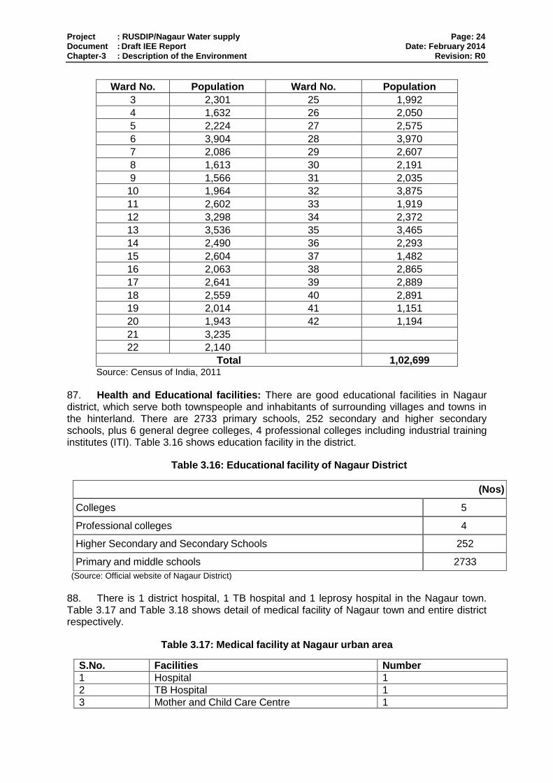
Project : RUSDIP/Nagaur Water supply Page: 24 Document : Draft IEE Report Date: February 2014 Chapter-3 : Description of the Environment Revision: R0
Ward No. Population Ward No. Population
3 2,301 25 1,992
4 1,632 26 2,050
5 2,224 27 2,575
6 3,904 28 3,970
7 2,086 29 2,607
8 1,613 30 2,191
9 1,566 31 2,035
10 1,964 32 3,875
11 2,602 33 1,919
12 3,298 34 2,372
13 3,536 35 3,465
14 2,490 36 2,293
15 2,604 37 1,482
16 2,063 38 2,865
17 2,641 39 2,889
18 2,559 40 2,891
19 2,014 41 1,151
20 1,943 42 1,194
21 3,235
22 2,140
Total 1,02,699 Source: Census of India, 2011
87. Health and Educational facilities: There are good educational facilities in Nagaur district, which serve both townspeople and inhabitants of surrounding villages and towns in the hinterland. There are 2733 primary schools, 252 secondary and higher secondary schools, plus 6 general degree colleges, 4 professional colleges including industrial training institutes (ITI). Table 3.16 shows education facility in the district.
Table 3.16: Educational facility of Nagaur District
(Nos)
Colleges 5
Professional colleges 4
Higher Secondary and Secondary Schools 252
Primary and middle schools 2733
(Source: Official website of Nagaur District)
88. There is 1 district hospital, 1 TB hospital and 1 leprosy hospital in the Nagaur town. Table 3.17 and Table 3.18 shows detail of medical facility of Nagaur town and entire district respectively.
Table 3.17: Medical facility at Nagaur urban area
S.No. Facilities Number
1 Hospital 1
2 TB Hospital 1
3 Mother and Child Care Centre 1

Project : RUSDIP/Nagaur Water supply Page: 25 Document : Draft IEE Report Date: February 2014 Chapter-3 : Description of the Environment Revision: R0
4 Leprosy Hospital. 1
5 Total 4 Source: Official website of district
Table 3.18: Medical Facility at Nagaur District
Description Nos.
Hospitals / Dispensaries 11
Primary Health Centers 96
Sub Health Centers 605
Beds 1458
Community Health Centers 17
Block Primary Health Centers 11
Medical Relief Society 105
Ayurvedic Hospitals / Dispensaries 154
Homeopathic Hospitals 3
Yunani Hospitals 4
Allopethic Hospitals 2
Source: Official website of district
89. History, culture and tourism Nagaur has moderate tourist inflows with main attractions being Nagaur Fort, Tarkeen Dargah, Jain Temple in Glass, Saiji Ka Tanka, Khinvasar fort, Dadhimati temple, Meera Bai Temple. – include more information from http://www.nagaur.nic.in/ because we need to establish that although there are many historical, cultural and tourist palaces in Nagaur, these places will not be impacted.

Project : RUSDIP/Nagaur Water supply Page: 26 Document : Draft IEE Report Date: February 2014 Chapter-4 : Anticipated Impact and Mitigation Measure Revision: R0
4. ANTICIPATED ENVIRONMENTAL IMPACTS AND MITIGATION
90. This section of the IEE reviews possible subproject-related impacts, in order to identify issues requiring further attention and screen out issues of no relevance. ADB SPS (2009) require that impacts and risks will be analyzed during pre-construction, construction, and operational stages in the context of the subproject’s area of influence.
91. The ADB prescribed Rapid Environmental Assessment Checklist for water supply projects was used to screen the subproject for environmental impacts and to determine the scope of the IEE investigation. The completed checklist is presented in Annexure II.
92. In the case of this subproject (i) most of the individual elements are relatively small and involve straightforward construction and operation, so impacts will be mainly localized and not greatly significant; (ii) most of the predicted impacts are associated with the construction process, and are produced because that process is invasive, involving excavation and earth movements; and (iii) being located in the built-up area of Nagaur, will not cause direct impact on biodiversity values. The subproject will be in properties held by the local self government and access to the subproject area is thru public rights-of-way and existing roads hence, land acquisition and encroachment on private property will not occur.
4.1. Pre-construction- Location and Design
93. ADB Environmental Assessment Guidelines require that an IEE should evaluate impacts due to the location, design, construction and operation of the project. Construction and operation are the two activities in which the project interacts physically with the environment, so they are the two activities during which the environmental impacts occur. In assessing the effects of these processes therefore, all potential impacts of the project are identified, and mitigation is devised for any negative impacts.
94. Environmentally-sensitive areas: Location impacts are not significant as there are no environmentally sensitive areas within the subproject area. The construction of any component of proposed Nagaur water supply sub-project will not involve any tree cutting as per primary survey. But prior to construction, the Design and Supervision Consultants (DSC) in close coordination with the Investment Project Implementation Unit (IPIU) will ensure the necessity of the tree cutting and if it can not avoid, tree-cutting permit will be obtained from Nagaur Municipal Council and/or District Collector; and will include in the bid document provisions on re plantation of 3 trees for every one tree cut during construction.
95. Utilities: Telephone lines, electric poles and wires, existing water and sewer lines within the proposed alignment may be affected and/or damaged. To mitigate the adverse impacts due to relocation of the utilities, DSC will (i) identify and include locations and operators of these utilities in the detailed design documents to prevent unnecessary disruption of services during construction phase; and (ii) require construction contractors to prepare a contingency plan to include actions to be done in case of unintentional interruption of services.
96. Existing Roads: If any road closing for some time due to excavation of trenches for laying of pipes is required, affected communities will be consulted prior to finalizing any subproject lay-out and design and they will be informed well in advance before the start of the work about nature of disturbance and duration of impact.
97. Social and Cultural Resources: any construction activities that involve excavation/ground disturbance have a risk to uncover and damage archaeological and
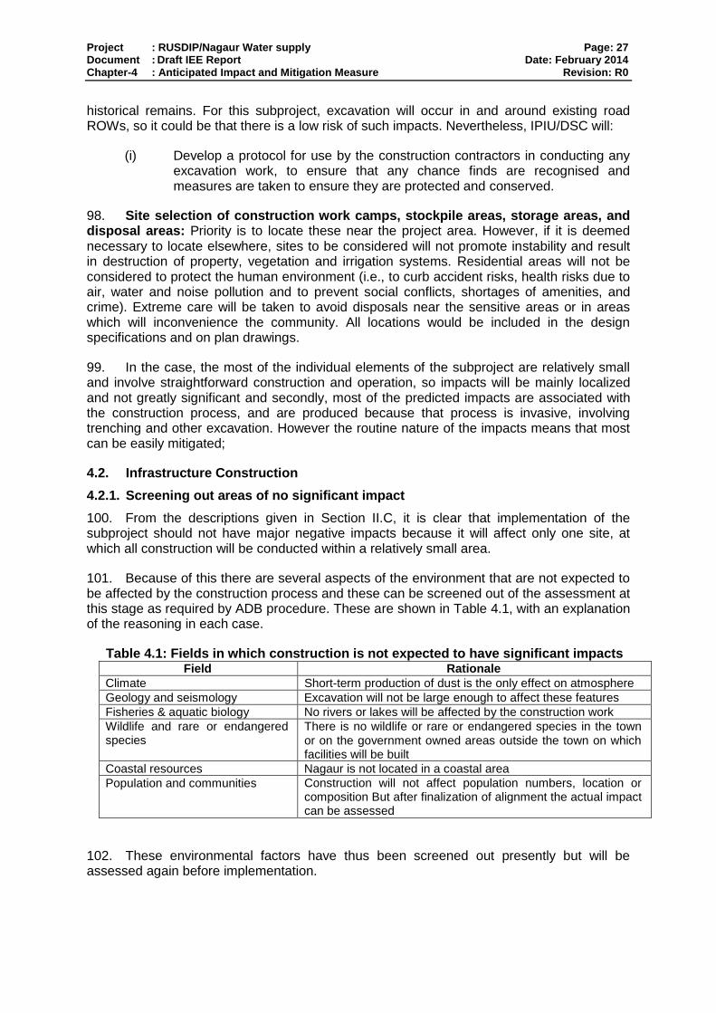
Project : RUSDIP/Nagaur Water supply Page: 27 Document : Draft IEE Report Date: February 2014 Chapter-4 : Anticipated Impact and Mitigation Measure Revision: R0
historical remains. For this subproject, excavation will occur in and around existing road ROWs, so it could be that there is a low risk of such impacts. Nevertheless, IPIU/DSC will:
(i) Develop a protocol for use by the construction contractors in conducting any excavation work, to ensure that any chance finds are recognised and measures are taken to ensure they are protected and conserved.
98. Site selection of construction work camps, stockpile areas, storage areas, and disposal areas: Priority is to locate these near the project area. However, if it is deemed necessary to locate elsewhere, sites to be considered will not promote instability and result in destruction of property, vegetation and irrigation systems. Residential areas will not be considered to protect the human environment (i.e., to curb accident risks, health risks due to air, water and noise pollution and to prevent social conflicts, shortages of amenities, and crime). Extreme care will be taken to avoid disposals near the sensitive areas or in areas which will inconvenience the community. All locations would be included in the design specifications and on plan drawings.
99. In the case, the most of the individual elements of the subproject are relatively small and involve straightforward construction and operation, so impacts will be mainly localized and not greatly significant and secondly, most of the predicted impacts are associated with the construction process, and are produced because that process is invasive, involving trenching and other excavation. However the routine nature of the impacts means that most can be easily mitigated;
4.2. Infrastructure Construction
4.2.1. Screening out areas of no significant impact
100. From the descriptions given in Section II.C, it is clear that implementation of the subproject should not have major negative impacts because it will affect only one site, at which all construction will be conducted within a relatively small area.
101. Because of this there are several aspects of the environment that are not expected to be affected by the construction process and these can be screened out of the assessment at this stage as required by ADB procedure. These are shown in Table 4.1, with an explanation of the reasoning in each case.
Table 4.1: Fields in which construction is not expected to have significant impacts Field Rationale
Climate Short-term production of dust is the only effect on atmosphere Geology and seismology Excavation will not be large enough to affect these features Fisheries & aquatic biology No rivers or lakes will be affected by the construction work Wildlife and rare or endangered species
There is no wildlife or rare or endangered species in the town
or on the government owned areas outside the town on which facilities will be built
Coastal resources Nagaur is not located in a coastal area Population and communities Construction will not affect population numbers, location or
composition But after finalization of alignment the actual impact can be assessed
102. These environmental factors have thus been screened out presently but will be assessed again before implementation.
Project : RUSDIP/Nagaur Water supply Page: 28 Document : Draft IEE Report Date: February 2014 Chapter-4 : Anticipated Impact and Mitigation Measure Revision: R0
4.2.2. Construction method
103. As explained above, strengthening of water supply network will involve construction of 6.7 km transmission/raising main.
4.3. Anticipated Environmental Impact and Mitigation Measure
4.3.1. Physical Resources
104. Sources of Materials: Significant amount of gravel, sand, and cement will be required for this subproject. The construction contractor will be required to:
(i) Use quarry sites and sources permitted by government;
(ii) Verify suitability of all material sources and obtain approval of Investment Program Implementation Unit (IPIU);
(iii) If additional quarries will be required after construction has started, obtain written approval from PMU; and
(iv) Submit to DSC on a monthly basis documentation of sources of materials
105. Air Quality: Emissions from construction vehicles, equipment, and machinery used for excavation will induce impacts on the air quality in the construction sites as well in the vicinity. Anticipated impacts include dusts and increase in concentration of vehicle-related pollutants such as carbon monoxide, sulphur oxides, particulate matter, nitrous oxides, and hydrocarbons but temporary and during construction activities only. To mitigate the impacts, construction contractors will be required to:
(i) Consult with IPIU/DSC on the designated areas for stockpiling of clay, soils, gravel, and other construction materials;
(i) Excavate the required ground at a time so that dug material is used immediately, avoiding the need to stockpile on site;
(ii) Damp down exposed soil and any stockpiled on site by spraying with water when necessary during dry weather;
(iii) Use tarpaulins to cover sand and other loose material when transported by trucks; and
(iv) Fit all heavy equipment and machinery with air pollution control devices which are operating correctly and ensure that only those vehicles having PUC should be permitted to work on site.
106. Surface Water Quality: Construction activities may result mobilization of settled silt materials, run-off from stockpiled materials, and chemical contamination from fuels and lubricants during construction works, which may contaminate downstream surface water quality of nearby drains, nallahs, and ponds of the town. These potential impacts are temporary and short-term duration only and to ensure these are mitigated, construction contractor will be required to:
(ii) Avoid stockpiling of earth fill especially during the monsoon season unless covered by tarpaulins or plastic sheets;
(iii) Prioritize re-use of excess soils and materials in the construction works. If soils will be disposed, consult with IPIU/DSC on designated disposal areas;
(iv) Install temporary silt traps or sedimentation basins along the drainage leading to the water bodies;
(v) Place storage areas for fuels and lubricants away from any drainage leading
Project : RUSDIP/Nagaur Water supply Page: 29 Document : Draft IEE Report Date: February 2014 Chapter-4 : Anticipated Impact and Mitigation Measure Revision: R0
to water bodies;
(vi) Dispose any wastes generated by construction activities in designated sites; and
(vii) Conduct surface quality inspection according to the Environmental Management Plan (EMP).
107. Noise Levels: There are no pale-ontological or architectural sites near the construction sites. The sensitive receptors are the adjacent settlements, health facilities, general public and visitors. Increase in noise level may be caused by earth-moving and excavation equipment, and the transportation of equipment, materials, and people. Impact is negative, short-term, and reversible by mitigation measures. The construction contractor will be required to:
(i) Plan activities in consultation with IPIU/DSC so that activities with the greatest potential to generate noise are conducted during periods of the day which will result in least disturbance;
(ii) Require horns not be used unless it is necessary to warn other road users or animals of the vehicle’s approach;
(iii) Minimize noise from construction equipment by using vehicle silencers, fitting jackhammers with noise-reducing mufflers, and portable street barriers the sound impact to surrounding sensitive receptor; and
(iv) Maintain maximum sound levels not exceeding 80 decibels (dbA) when measured at a distance of 10 m or more from the vehicle/s.
108. Existing Infrastructure and Facilities: Telephone lines, electric poles and wires, water and sewer lines within the existing road ROW will be removed/shifted thus there is anticipated disruption of service during construction. Excavation could however damage existing infrastructure located alongside the proposed alignment, in particular water supply pipes lines. It will be particularly important to avoid damaging existing water pipes if these are manufactured from Asbestos Cement (AC), which can be carcinogenic if inhaled, so there are serious health risks for both workers and the public. It is therefore important that construction contractors will be required to:
(i) Obtain from IPIU and/or DSC the list of affected utilities and operators;
(ii) Prepare a contingency plan to include actions to be done in case of unintentional interruption of services. and
(iii) Develop and implement an Asbestos Cement Pipes Management Plan
4.3.2. Ecological Resources
109. Flora and Fauna: There are no protected areas or locations of any ecological interest at or near any of the sites affected by these works, so it is unlikely that the construction process will have any ecological impacts. No tree will be impacted due to construction activities. However, during the course of project construction, technical demand of the project and presence of workers in the sites can damage or cause loss of existing flora. The only concern would be if trees were removed unnecessarily. To avoid this, the Contractor should be required to plant and maintain three new trees for every one that is removed. Potential impacts are negative but reversible by mitigation measures. The construction contractors will be required to:
(i) Minimize removal of vegetation and disallow cutting of trees if not required for
Project : RUSDIP/Nagaur Water supply Page: 30 Document : Draft IEE Report Date: February 2014 Chapter-4 : Anticipated Impact and Mitigation Measure Revision: R0
the construction activities;
(ii) If tree removal will be required, obtain tree-cutting permit from the Municipal Board or District Collector;
(iii) Earth-ball trees and transplant to IPIU-approved areas;
(iv) Require to plant three native trees for every one that is removed; and
(v) Prohibit employees from cutting of trees for firewood.
4.3.3. Economic Development
110. The transmission main will be located on government owned land, so there should be no need to acquire land from private owners, which might affect the income and assets of owners and tenants. There should also be no effects on other features with economic implications (such as infrastructure, industry and commerce), as there are none of these facilities on these sites.
111. There could however be significant disruption of traffic, business and other activities, if trucks carrying waste material were allowed to enter Nagaur town or other built-up areas. The transportation of waste will be implemented by the Contractor in liaison with the town authorities, and the following additional precautions should thus be adopted to avoid these impacts:
(i) Planning transportation routes so that heavy vehicles do not enter Nagaur Town or other built-up areas and do not use narrow local roads, except near delivery sites; and
(ii) Scheduling of the transportation of waste to avoid peak traffic periods.
4.3.4. Socio-economic
112. Manpower will be required during the whole period of construction stage. This can result to generation of contractual employment and increase in local revenue. Thus potential impact is positive and long-term. The construction contractor will be required to:
(i) Employ at least 50% of the labour force, or to the maximum extent, local persons within the 2-km immediate area if manpower is available; and
(ii) Procure construction materials from local market.
113. Occupational Health and Safety: Workers need to be mindful of the occupational hazards which can arise from working. Potential impacts are negative and long-term but reversible by mitigation measures. The construction contractor will be required to:
(i) Develop and implement site-specific Health and Safety (H&S) Plan which will include measures such as: (a) excluding public from the site; (b) ensuring all workers are provided with and use Personal Protective Equipment; (c) H&S Training1 for all site personnel; (d) documented procedures to be followed for all site activities; and (e)
1
Some of the key areas that may be covered during training as they relate to the primary causes of accidents include (i) slips, trips and falls; (ii) personal protective equipment; (iii) ergonomics, repetitive motion, and manual handling; (iv) workplace transport; and (v) legislation and responsibilities. Training can provide the foundations of competence but it does not necessarily result in a competent worker. Therefore, it is essential to assess staff competence to ensure that the training provided is relevant and effective. Supervision and monitoring arrangements shall be in place to ensure that training has been effective and the worker is competent at their job. The level of supervision and monitoring required is a management decision that shall be based on the risks associated with the job, the level of competence required, the experience of the individual and whether the worker works as part of a team or is a lone worker.

Project : RUSDIP/Nagaur Water supply Page: 31 Document : Draft IEE Report Date: February 2014 Chapter-4 : Anticipated Impact and Mitigation Measure Revision: R0
documentation of work-related accidents; (ii) Ensure that qualified first-aid can be provided at all times. Equipped first-aid
stations shall be easily accessible throughout the site; (iii) Provide medical insurance coverage for workers; (iv) Secure all installations from unauthorized intrusion and accident risks; (v) Provide supplies of potable drinking water; (vi) Provide clean eating areas where workers are not exposed to hazardous or
noxious substances; (vii) Provide H&S orientation training to all new workers to ensure that they are
apprised of the basic site rules of work at the site, personal protective protection, and preventing injuring to fellow workers;
(viii) Provide visitor orientation if visitors to the site can gain access to areas where hazardous conditions or substances may be present. Ensure also that visitor/s do not enter hazard areas unescorted;
(ix) Ensure the visibility of workers through their use of high visibility vests when working in night or walking through heavy equipment operating areas;
(x) Ensure moving equipment is outfitted with audible back-up alarms; (xi) Mark and provide sign boards for hazardous areas such as energized
electrical devices and lines, service rooms housing high voltage equipment, and areas for storage and disposal. Signage shall be in accordance with international standards and be well known to, and easily understood by workers, visitors, and the general public as appropriate; and
(xii) Disallow worker exposure to noise level greater than 85 dBA for duration of more than 8 hours per day without hearing protection. The use of hearing protection shall be enforced actively.
114. Community Health and Safety: Hazards posed to the public; specifically in high-pedestrian areas (such as the busy road) may include traffic accidents and vehicle collision with pedestrians. Potential impact is negative but short-term and reversible by mitigation measures. The construction contractor will be required to:
(i) Plan routes to avoid times of peak-pedestrian activities. (ii) Liaise with IPIU/DSC in identifying high-risk areas on route cards/maps. (iii) Maintain regularly the vehicles and use of manufacturer-approved parts to
minimize potentially serious accidents caused by equipment malfunction or premature failure.
(iv) Provide road signs and flag persons to warn of dangerous conditions.
115. Work Camps: Operation of work camps can cause temporary air and noise pollution from machine operation, water pollution from storage and use of fuels, oils, solvents, and lubricants. Potential impacts are negative but short-term and reversible by mitigation measures. The construction contractor will be required to:
(i) Consult with IPIU/DSC before locating project offices, sheds, and construction plants;
(ii) Minimize removal of vegetation and disallow cutting of trees; (iii) Provide water and sanitation facilities for employees; (iv) Train employees in the storage and handling of materials which can
potentially cause soil contamination; (v) Recover used oil and lubricants and reuse or remove from the site; (vi) Manage solid waste according to the following preference hierarchy: reuse,
recycling and disposal to designated areas; (vii) Remove all wreckage, rubbish, or temporary structures (such as buildings,
Project : RUSDIP/Nagaur Water supply Page: 32 Document : Draft IEE Report Date: February 2014 Chapter-4 : Anticipated Impact and Mitigation Measure Revision: R0
shelters, and latrines) which are no longer required; and (viii) Request IPIU/DSC to report in writing that the camp has been vacated and
restored to pre-project conditions before acceptance of work.
4.3.5. Social and Cultural Resources
116. Rajasthan is an area with a rich and varied cultural heritage that includes many forts and palaces from the Rajputs and Mughal periods, and large numbers of temples and other religious sites, so there is a risk that any work involving ground disturbance could uncover and damage archaeological and historical remains. In this case the excavation will occur in and around an existing roadway, so it could be that there is a low risk of such impacts. Nevertheless this should be ascertained by consulting the appropriate authorities and steps should be taken according to the nature of the risk. This should involve:
o Considering an alternative alignment/location if the site is found to be of medium or high risk;
o Including state and local archaeological, cultural and historical authorities and interest groups in consultation forums as project stakeholders so that their expertise can be made available to the project;
o Developing a protocol for use by the contractor in conducting any excavation work, to ensure that any chance finds are recognized and measures are taken to ensure they are protected and conserved. This should involve:
Having excavation observed by a person with archaeological field training;
Stopping work immediately to allow further investigation if any finds are suspected;
Calling in the state archaeological authority if a find is suspected, and taking any action they require ensuring its removal or protection in situ.
117. There are no modern-day social and cultural resources (such as schools and hospitals) near the site, and no areas that are used for religious or other purposes, so there is no risk of other impacts on such community assets.
118. The construction activities of the sub-project component may impact the local residents so action should be taken to minimize disturbance as far as possible. This will require:
o Consultation with the local community to inform them of the nature, duration and likely effects of the construction work, and to identify any local concerns so that these can be addressed;
o Involving the community in planning the work programme so that any particularly noisy or otherwise invasive activities can be scheduled to avoid sensitive times;
o Avoiding conducting noise-generating activities at night;
o Utilizing modern vehicles and machinery with the requisite adaptations to limit noise and exhaust emissions, and ensuring that these are maintained to manufacturers’ specifications at all times.

Project : RUSDIP/Nagaur Water supply Page: 33 Document : Draft IEE Report Date: February 2014 Chapter-4 : Anticipated Impact and Mitigation Measure Revision: R0
119. Finally, there could be some short-term socio-economic benefits from the construction work if local people are able to gain employment in the construction workforce. To direct these benefits to the communities directly affected by the work, the Contractor should be required to employ at least 50% of his labour force from communities in the vicinity of the site. This will have the added benefit of avoiding social problems that sometimes occur when workers are imported into host communities, and avoiding environmental and social problems from workers housed in poorly serviced camp accommodation.
4.4. Operation and Maintenance
4.4.1. Screening out areas of no significant impact
120. There are several environmental factors that should be unaffected once the constructed infrastructure began to function. These are identified in Table 4.2 below, with an explanation of the reasoning in each case. These factors are thus screened out of the impact assessment and will not be mentioned further.
Table 4.2: Fields in which operation and maintenance of the completed road improvement is not expected to have significant impacts
Field Rationale Topography, Drainage, and Natural Hazards
Activities are not large enough to affect these features.
Geology, Geomorphology, Mineral Resources, and Soils
Activities are not large enough to affect these features. No mineral resources in the subproject sites.
Climate Activities are not large enough to affect this feature.
Geohydrology and Groundwater Source of water for supply is canal water so no impact anticipated on ground water table
Protected Areas Subproject sites are not located near protected areas
Flora and Fauna No rare or endangered species.
Land Use No change in land use.
Commerce, Industry, and Agriculture Activities are not large enough to affect these features
Population Activities are not large enough to affect this feature.
Paleontological, or Architectural sites No paleontological or architectural sites near the subproject sites
4.4.2. Physical Resources
121. If trenches are dug to locate and repair leaks or remove and replace lengths of pipe or Illegal connections, the work will follow the same procedure that was followed during construction phase. In this case soil and backfilled sand will be removed to expose the leaking junction or pipe, and if necessary a new pipe will be brought to site and replaced. The trench will then be refilled and re-compacted. This work should be very infrequent, and will affect individual small locations for short periods only (an average of a few hours for most repairs). Physical impacts will therefore be negligible. Work will not be conducted during rainfall so there will be no effect on drainage, and the removed material will be replaced in the trench so there will be no waste.
122. One of the main risks of improving a water supply system through increased abstraction is that the source will be used unsustainably, at a rate that is above the level of natural replenishment, and that the source becomes depleted as a result. That should not be an issue in this case as the water will be extracted from river. There is downstream abstraction and some water is used by local farmers, this requires only a proportion of the volume available, and the Irrigation Department has granted approval for the abstraction for the municipal supply. It should also be noted that water conservation measures included in the subproject (in particular the replacement of leaking distribution mains and faulty house connections) should significantly reduce system losses, and thus limit the volume needed.
Project : RUSDIP/Nagaur Water supply Page: 34 Document : Draft IEE Report Date: February 2014 Chapter-4 : Anticipated Impact and Mitigation Measure Revision: R0
4.4.3. Ecological Resources
123. There are no significant ecological resources in or around the town, so any repairs or Maintenance work can be conducted without ecological impacts. As there is no significant flora and fauna in or around project site, there should also not be any ecological impacts from the increase in abstraction.
4.4.4. Economic Development
124. Although network repairs could result in shops losing some business if the work means that access is difficult for customers, any losses will be small and short-lived and will probably be at the level of normal business fluctuations. Nevertheless simple steps should be taken to reduce the inconvenience of the works, including:
o Informing all residents and businesses about the nature and duration of any work well in advance so that they can make preparations if necessary;
o Requiring contractors employed to conduct these works to provide wooden walkways
across trenches for pedestrians and metal sheets where vehicle access is required; o Consulting the local police regarding any such work so that it can be planned to avoid
traffic disruption as far as possible, and road diversions can be organized if necessary.
125. The provision of an improved and expanded water supply system is not expected to have direct economic benefits for business or industry, as connections will only be provided to domestic users. However businesses will almost certainly benefit from the expected improvement in the health and wellbeing of their workforce (see below) as this should result in fewer days lost through illness, and overall increased productivity.
4.4.5. Social and Cultural Resources
126. Although there is a high risk of excavation in the town discovering material of historical or archaeological importance, there will be no need to take precautions to protect such material when areas are excavated to repair leaks in the network, as all work will be conducted in trenches that have already been disturbed when the infrastructure was installed.
127. Repair work could cause some temporary disruption of activities at locations of social and cultural importance such as schools, hospitals, temples, tourist sites etc, so the same precautions as employed during the construction period should be adopted. These include:
o Consulting the town authorities to identify any buildings at risk from vibration damage and avoiding any use of pneumatic drills or heavy vehicles in the vicinity;
o Completing work in these areas quickly; o Providing wooden bridges for pedestrians and metal sheets for vehicles to allow
access across open trenches where required; o Consulting municipal authorities, custodians of important buildings, cultural and
tourism authorities and local communities in advance of the work to identify and address key issues, and avoid working at sensitive times, such as religious and cultural festivals.
Project : RUSDIP/Nagaur Water supply Page: 35 Document : Draft IEE Report Date: February 2014 Chapter-4 : Anticipated Impact and Mitigation Measure Revision: R0
128. The responsible authorities will employ local contractors to conduct network repairs, and contractors should be required to operate the same kinds of Health and Safety procedures as used in the construction phase (see Section IV.C.5) to protect workers and the public. This should include application of the asbestos protocol if any AC pipes are encountered, and prohibition of the use of AC pipes for any repair or maintenance work.
129. The use of local contractors will provide economic benefits to the companies and the workers they employ. There is however little prospect of directing these benefits to persons affected by any maintenance or repair works as contractors will utilise their existing workforce. To provide at least some economic benefits to affected communities, persons employed to maintain the ORs and CWR should be residents of the neighbouring areas.
130. The citizens of the town will be the major beneficiaries of the improved water supply, as they will be provided with a constant supply of better quality water, piped into their homes. This should improve the social capital of the town, and individual and community health and wellbeing. Diseases of poor sanitation, such as diarrhoea and dysentery, should be reduced, so people should spend less on healthcare and lose fewer working days due to illness, so their economic status should also improve, as well as their overall health.

Project : RUSDIP/Nagaur Water supply Page: 36 Document : Draft IEE Report Date: February 2014 Chapter-5 : Public Consultation and Information Disclosure Revision: R0
5. PUBLIC CONSULTATION AND INFORMATION DISCLOSURE
5.1. Project stakeholders
131. Most of the main stakeholders have already been identified preliminary. If any other stakeholders that are identified during project implementation will be brought into the process in the future. Primary stakeholders are:
• Residents, shopkeepers and businesspeople who live and work alongside the roads
in which network improvements will be provided and near sites where facilities will be built.
• Owners and users of any land that is acquired along the transmission main route;
• Custodians and users of socially and culturally important buildings in affected areas;
• State and local authorities responsible for the protection and conservation of
archaeological relics, historical sites and artefacts;
• State and local tourism authorities.
132. Secondary stakeholders are:
LSGD as the Executing Agency;
Other government institutions which handle areas or issues affected by the project (state and local planning authorities, Department of Public Health Engineering, Local Government Dept, Ministry of Environment and Forests, Roads and Highways Division, etc);
NGOs and CBOs working in the affected communities;
Other community representatives (prominent citizens, religious leaders, elders, women’s groups);
The beneficiary community in general; and
The ADB and the Government of India, Ministry of Finance.
5.2. Consultation and disclosure to date
133. Some informal discussion was held with the local people during site visit. Issues discussed are
o Awareness and extent of the project and development components o Benefits of Project for the economic and social Upliftment of Community o Labour availability in the Project area or requirement of outside labour involvement o Local disturbances due to Project Construction Work o Necessity of tree felling etc. at project sites o Water logging and drainage problem if any o Drinking water problem. o Forest and sensitive area nearby the project site. o Movement of wild animal etc.
Project : RUSDIP/Nagaur Water supply Page: 37 Document : Draft IEE Report Date: February 2014 Chapter-5 : Public Consultation and Information Disclosure Revision: R0
134. Local populations are very much interested on the project and they will help project authorities in all aspects. But mitigation measures will be required at project sites to minimize the impact on environment.
135. The public Consultation and group discussion meeting were conduct by RUIDP on Date 06 October 2013. The objective of the meeting was to appraise the stakeholders about the environmental and social impacts of the proposed program and the safeguards provided in the program to mitigate the same. In the specific context of Nagaur, the environmental and social impacts of the proposed subprojects under Tranche 3 in Nagaur were discussed.
136. Meetings and individual interviews were held at potentially temporarily affected areas; and local informal interviews were conducted to determine the potential impacts of sub-project construction to prepare the sample Environmental Framework. A town-wise stakeholder consultation workshop was conducted which provided an overview of the Program and sub- projects to be undertaken in Nagaur; and discussed the Government and ADB’s Environment policies acts and potential environment impacts of the sub-projects in Nagaur. During the workshop, Hindi versions of the Environmental Framework were provided to ensure participants understood the objectives, policy principles and procedures related to Environment, English and Hindi versions of the Environmental Framework have been placed in the Urban Local Body (ULB) office and Environmental Framework will be provided later on. The NGO to be engaged to implement the Mitigation Measures will continue consultations, information dissemination, and disclosure. The Environmental Framework will be made available in the ULB office, Investment Program Project Management Unit and Implementation Unit (IPMU and IPIU) offices, and the town library. The finalized IEE containing Mitigation Measures will also be disclosed in ADB’s website, the State Government website, the local government website, and the IPMU and IPIU websites. ADB review and approval of the RP is required prior to award of civil works contracts. Details of this Public consultation / Group Discussion are enclosed in Annexure-III.
137. Major Issues discussed during Public consultation are
o Proposed water supply project should ensure enough supply of drinking water in all wards of town.
o Executive agency should give preference to engage internationally reputed contractor like Gammon, HCC, etc as people do not faith about the local contractors in respect of quality of works as well as timely completion of work;
o Efforts should be made by government to supply drinking water round the clock; o Livelihood affected households should be given assistance in the mode of cash
compensation; o Local people should be employed by the contractor during construction work; o Adequate safety measures should be taken during construction work; o Mobile kiosks/vendors/hawkers have shown willingness to shift in nearby places
without taking any compensation and assistance from the Executing Agency; o Local people have appreciated the water supply proposal of the government and they
have ensured that they will cooperate with the Executing Agency during project implementation.
5.3. Future consultation and disclosure
138. LSGD will extend and expand the consultation and disclosure process significantly during implementation of RUSDIP. The NGO (IIRM under CAPP) is appointed in the beginning of the project and assisting the Investment Program Implementation Unit (IPIUs) for implementation of R&R activities successfully in running subprojects in each town and to
Project : RUSDIP/Nagaur Water supply Page: 38 Document : Draft IEE Report Date: February 2014 Chapter-5 : Public Consultation and Information Disclosure Revision: R0
handle this key aspect of the programme, through conducting a wide range of activities in relation to all new subprojects, to ensure that the needs and concerns of stakeholders are registered, and are addressed in project design, construction or operation where appropriate. The programme of activities will be developed during the detailed design stage, and is likely to include the following:
139. Consultation during detailed design:
o Focus-group discussions with affected persons and other stakeholders (including women’s groups, NGOs and CBOs) to hear their views and concerns, so that these can be addressed in subproject design where necessary;
o Structured consultation meetings with the institutional stakeholders (government bodies and NGOs) to discuss and approve key aspects of the project.
140. Consultation during construction:
o Public meetings with affected communities to discuss and plan work programs and allow issues to be raised and addressed once construction has started;
o Smaller-scale meetings to discuss and plan construction work with individual communities to reduce disturbance and other impacts, and provide a mechanism through which stakeholders can participate in subproject monitoring and evaluation;
141. Project disclosure:
o Public information campaigns (via newspaper, TV and radio) to explain the project to the wider city population and prepare them for disruption they may experience once the construction programme is underway;
o Public disclosure meetings at key project stages to inform the public of progress and future plans, and to provide copies of summary documents in Hindi;
o Formal disclosure of completed project reports by making copies available at convenient locations in the study towns, informing the public of their availability, and providing a mechanism through which comments can be made.
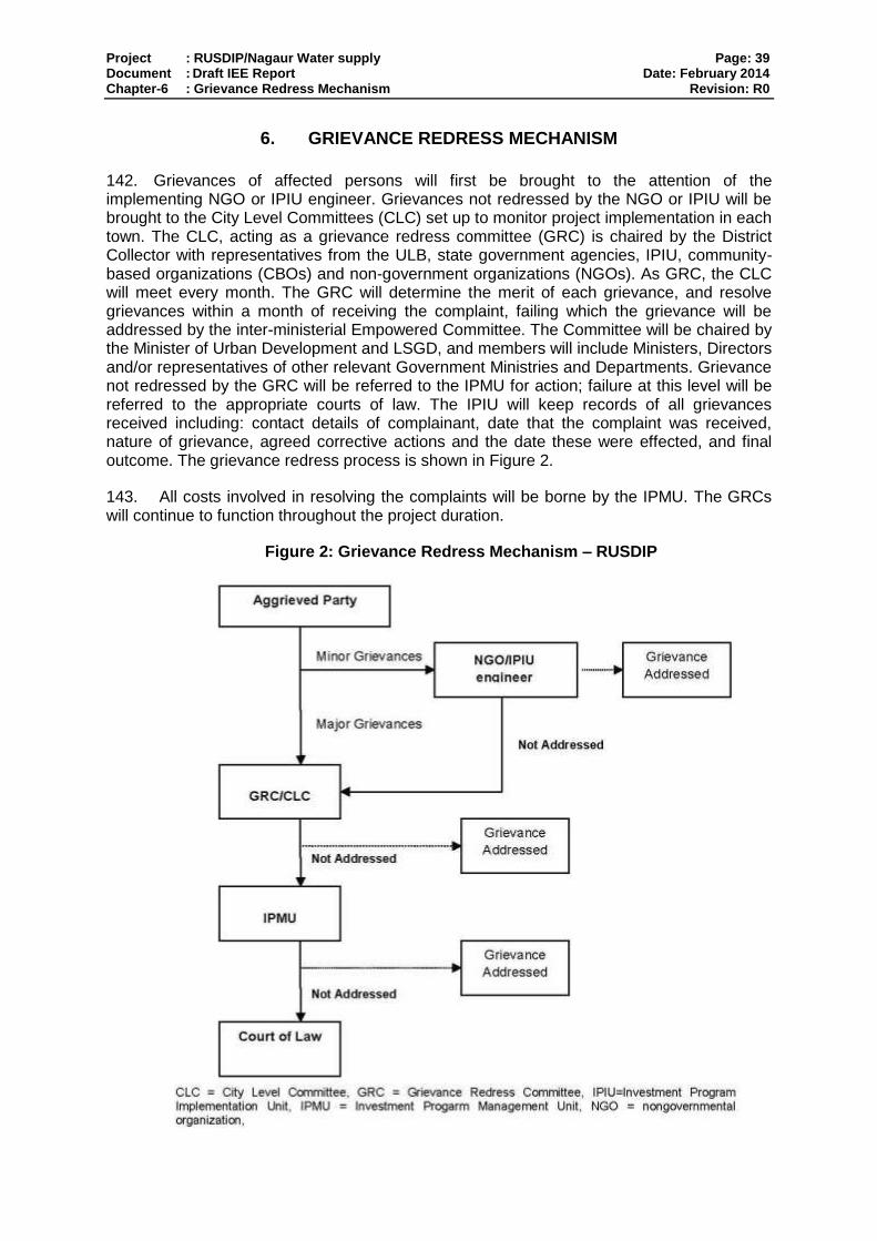
Project : RUSDIP/Nagaur Water supply Page: 39 Document : Draft IEE Report Date: February 2014 Chapter-6 : Grievance Redress Mechanism Revision: R0
6. GRIEVANCE REDRESS MECHANISM
142. Grievances of affected persons will first be brought to the attention of the implementing NGO or IPIU engineer. Grievances not redressed by the NGO or IPIU will be brought to the City Level Committees (CLC) set up to monitor project implementation in each town. The CLC, acting as a grievance redress committee (GRC) is chaired by the District Collector with representatives from the ULB, state government agencies, IPIU, community-based organizations (CBOs) and non-government organizations (NGOs). As GRC, the CLC will meet every month. The GRC will determine the merit of each grievance, and resolve grievances within a month of receiving the complaint, failing which the grievance will be addressed by the inter-ministerial Empowered Committee. The Committee will be chaired by the Minister of Urban Development and LSGD, and members will include Ministers, Directors and/or representatives of other relevant Government Ministries and Departments. Grievance not redressed by the GRC will be referred to the IPMU for action; failure at this level will be referred to the appropriate courts of law. The IPIU will keep records of all grievances received including: contact details of complainant, date that the complaint was received, nature of grievance, agreed corrective actions and the date these were effected, and final outcome. The grievance redress process is shown in Figure 2.
143. All costs involved in resolving the complaints will be borne by the IPMU. The GRCs will continue to function throughout the project duration.
Figure 2: Grievance Redress Mechanism – RUSDIP
Project : RUSDIP/Nagaur Water supply Page: 40 Document : Draft IEE Report Date: February 2014 Chapter-7 : Environmental Management Plan Revision: R0
7. ENVIRONMENTAL MANAGEMENT PLAN
7.1. Summary of environmental impacts and mitigation measures
144. Table 7.1 lists the potential adverse impacts of the Nagaur Water Supply subproject as identified and discussed in Sections IV, V and VI, and the mitigation proposed to reduce these impacts to acceptable levels. The table also shows how the mitigation will be implemented, who will be responsible, and where and when the mitigation activities will take place. The mitigation programme is shown as the quarter of each year in which each activity will occur, which relates to the project programme described in Section II.B.
7.2. Institutional arrangements for project implementation
145. The main agencies involved in managing and implementing the subproject are,
o LSGD is the Executing Agency (EA) responsible for management, coordination and execution of all activities funded under the loan.
o The Implementing Agency (IA) is the Project Management Unit of the ongoing RUIDP, which will be expanded to include a broader range of skills and representation from the Urban Local Bodies (ULB, the local government in each town). Assigned as the RUSDIP Investment Program Management Unit (IPMU), this body will coordinate construction of subprojects across all towns, and ensure consistency of approach and performance.
o The IPMU will be assisted by Investment Program Management Consultants (IPMC) who will manage the program and assure technical quality of design and construction; and Design and Supervision Consultants (DSC), who will design the infrastructure, manage tendering of Contractors and supervise the construction process.
o Investment Program Implementation Units (IPIU) will be established in seven zones across the State to manage implementation of subprojects in their area. IPIUs will be staffed by professionals seconded from government departments (PHED, PWD), ULBs, and other agencies, and will be assisted by consultants from the IPMC and DSC as necessary.
o The IPMU will appoint Construction Contractors (CC) to build elements of the infrastructure in a particular town. The CCs will be managed by the IPIU, and construction will be supervised by the DSC.
o LSGD will be assisted by an inter-ministerial Empowered Committee (EC), to provide policy guidance and coordination across all towns and subprojects. The EC will be chaired by the Minister of Urban Development and LSG, and members will include Ministers, Directors and/or representatives of other relevant Government Ministries and Departments.
o City Level Committees (CLCs) have also been established in each town, chaired by the District Collector, with members including officials of the ULB, local representatives of state government agencies, the IPIU, and local NGOs and CBOs. The CLCs will monitor project implementation in the town and provide recommendations to the IPIU where necessary.
146. Figure 7.1 shows institutional responsibility for implementation of environmental safeguard at different level.
7.2.1. Responsible for carrying out mitigation measures
147. During construction stage, implementation of mitigation measures is the construction contractor’s responsibility while during operation stage, Nagaur Municipal Board (NMB) will be responsible for the conduct of maintenance or repair works.

Project : RUSDIP/Nagaur Water supply Page: 41 Document : Draft IEE Report Date: February 2014 Chapter-7 : Environmental Management Plan Revision: R0
148. To ensure implementation of mitigation measures during the construction period, contract clauses for environmental provisions will be part of the civil works contracts. Contractors’ conformity with contract procedures and specifications during construction will be carefully monitored by IPIU.
7.2.2. Responsible for carrying out monitoring measures
149. During construction, DSC’s Environment Safeguards Officer and the designated representative of IPIU will monitor the construction contractor’s environmental performance.
150. During the operation stage, monitoring will be the responsibility of NMB.
7.2.3. Responsible for reporting
151. LSGD will submit to ADB quarterly reports on implementation of the EMP and will permit ADB to field annual environmental review missions which will review in detail the environmental aspects of the Project. Any major accidents having serious environmental consequences will be reported immediately.
7.3. Environmental Mitigation Plan
152. Tables 7.1 to 7.3 show the potential adverse environmental impacts, proposed mitigation measures, and responsible parties. This EMP will be included in the bid documents and will be further reviewed and updated during implementation.
153. Resettlement issues will be coordinated centrally by a Resettlement Specialist within the IPMU, who will ensure consistency of approach between towns. A local Resettlement Specialist will also be appointed to IPIUs of zones in which there are resettlement impacts and they will prepare and implement local Resettlement Plans following the framework established in Tranche 1.
154. Environmental issues will be coordinated by an Environmental Specialist within the IPMU/ IPMC, who will ensure that all subprojects comply with environmental safeguards. An Environmental Monitoring Specialist (EMS) who is part of the DSC team will implement the Environmental Monitoring Plan from each IEE (see below) to ensure that mitigation measures are provided and protect the environment as intended. Environmental Consultants will be appointed by each IPIU to update the existing IEEs in the detailed design stage, and to prepare IEEs or EIAs for new subprojects, where required to comply with national law and/or ADB procedure.

Project : RUSDIP/Nagaur Water supply Page: 42 Document : Draft IEE Report Date: February 2014 Chapter-7 : Environmental Management Plan Revision: R0
Figure 7.1: Institutional Responsibly- RUSDIP
Ministry of Urban Development
(MoUD), LSGD- EA
Government of Rajasthan
Rajasthan Urban Sector Development
Investment Program (RUSDIP)
Project Implementation Authority (National
Level)
Implementing Agency
-Investment Program Implementation
Units (IA - IPMU)
Several Construction Packages
for different tranche under each
IPIU
Design and Supervision Consultants
(DSC)
Construction Contractors (CC)
Environmental Monitoring Specialist
(EMS)
Provided by DSC
Independent Environmental
Testing & Monitoring Agency
(On need basis)
IMPLEMENTATION OF EMAP
ADB
Investment Program
Management Consultancy
(IPMC)
Appointed by RUSDIP
Environmental
Expert of IPMC
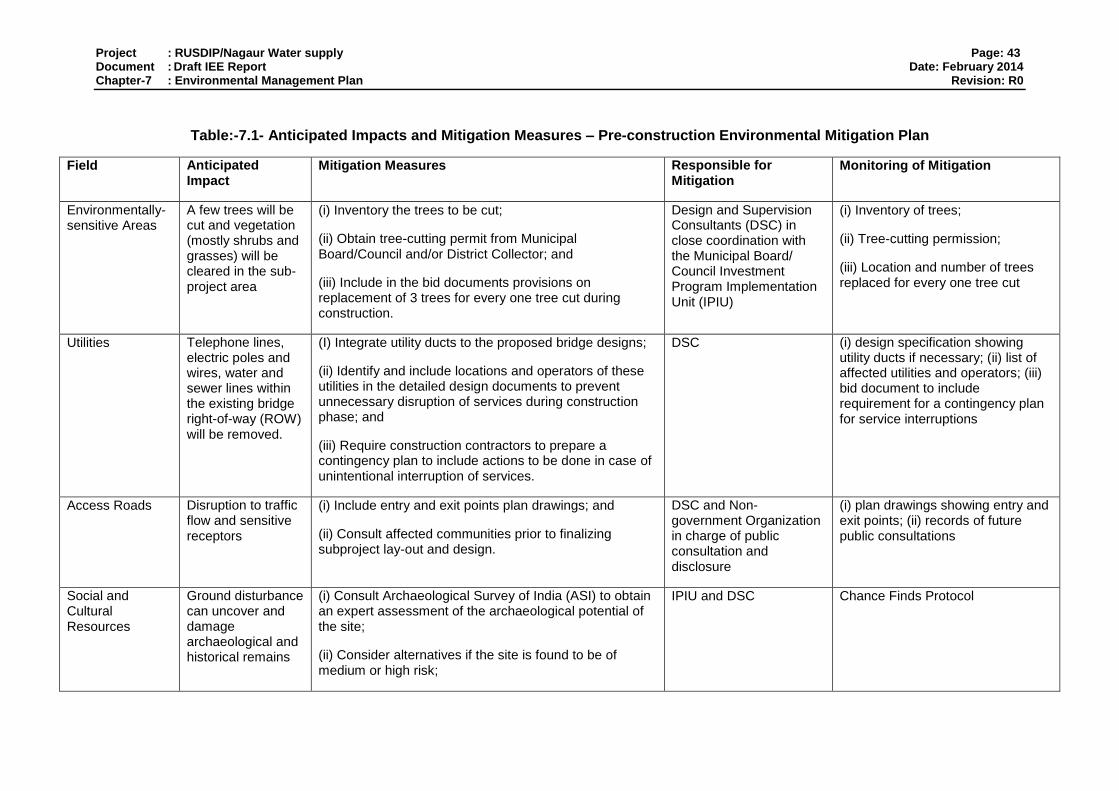
Project : RUSDIP/Nagaur Water supply Page: 43 Document : Draft IEE Report Date: February 2014 Chapter-7 : Environmental Management Plan Revision: R0
Table:-7.1- Anticipated Impacts and Mitigation Measures – Pre-construction Environmental Mitigation Plan
Field Anticipated Impact
Mitigation Measures Responsible for Mitigation
Monitoring of Mitigation
Environmentally-sensitive Areas
A few trees will be cut and vegetation (mostly shrubs and grasses) will be cleared in the sub-project area
(i) Inventory the trees to be cut;
(ii) Obtain tree-cutting permit from Municipal Board/Council and/or District Collector; and
(iii) Include in the bid documents provisions on replacement of 3 trees for every one tree cut during construction.
Design and Supervision Consultants (DSC) in close coordination with the Municipal Board/ Council Investment Program Implementation Unit (IPIU)
(i) Inventory of trees;
(ii) Tree-cutting permission;
(iii) Location and number of trees replaced for every one tree cut
Utilities Telephone lines, electric poles and wires, water and sewer lines within the existing bridge right-of-way (ROW) will be removed.
(I) Integrate utility ducts to the proposed bridge designs;
(ii) Identify and include locations and operators of these utilities in the detailed design documents to prevent unnecessary disruption of services during construction phase; and
(iii) Require construction contractors to prepare a contingency plan to include actions to be done in case of unintentional interruption of services.
DSC (i) design specification showing utility ducts if necessary; (ii) list of affected utilities and operators; (iii) bid document to include requirement for a contingency plan for service interruptions
Access Roads Disruption to traffic flow and sensitive receptors
(i) Include entry and exit points plan drawings; and
(ii) Consult affected communities prior to finalizing subproject lay-out and design.
DSC and Non-government Organization in charge of public consultation and disclosure
(i) plan drawings showing entry and exit points; (ii) records of future public consultations
Social and Cultural Resources
Ground disturbance can uncover and damage archaeological and historical remains
(i) Consult Archaeological Survey of India (ASI) to obtain an expert assessment of the archaeological potential of the site;
(ii) Consider alternatives if the site is found to be of medium or high risk;
IPIU and DSC Chance Finds Protocol
Project : RUSDIP/Nagaur Water supply Page: 44 Document : Draft IEE Report Date: February 2014 Chapter-7 : Environmental Management Plan Revision: R0
Field Anticipated Impact
Mitigation Measures Responsible for Mitigation
Monitoring of Mitigation
(iii) Include state and local archaeological, cultural and historical authorities, and interest groups in consultation forums as project stakeholders so that their expertise can be made available; and
(iv) Develop a protocol for use by the construction contractors in conducting any excavation work, to ensure that any chance finds are recognized and measures are taken to ensure they are protected and conserved.
Construction work camps, hot mix plants, stockpile areas, storage areas, and disposal areas.
Disruption to traffic flow and sensitive receptors
(i) Prioritize areas within or nearest possible vacant space in the subproject sites;
(ii) If it is deemed necessary to locate elsewhere, consider sites that will not promote instability and result in destruction of property, vegetation, irrigation, and drinking water supply systems;
(iii) Do not consider residential areas;
(iv) Take extreme care in selecting sites to avoid direct disposal to nallahs/water body or in areas which will
inconvenience the community.
IPIU and DSC to determine locations prior to award of construction contracts.
List of selected sites for construction work camps, hot mix plants, stockpile areas, storage areas, and disposal areas.
Sources of Materials
Extraction of materials can disrupt natural land contours and vegetation resulting in accelerated erosion, disturbance in natural drainage patterns, ponding
(i) Prioritize sites already permitted by the Mining Department;
(ii) If other sites are necessary, inform construction contractor that it is their responsibility to verify the suitability of all material sources and to obtain the approval of IPIU; and
(iii) If additional quarries will be required after construction is started, inform construction contractor to
IPIU and DSC to prepare list of approved quarry sites and sources of materials
(i) list of approved quarry sites and sources of materials; (ii) bid document to include requirement for verification of suitability of sources and permit for additional quarry sites if necessary.
Project : RUSDIP/Nagaur Water supply Page: 45 Document : Draft IEE Report Date: February 2014 Chapter-7 : Environmental Management Plan Revision: R0
Field Anticipated Impact
Mitigation Measures Responsible for Mitigation
Monitoring of Mitigation
and water logging, and water pollution.
obtain a written approval from IPMU.
Table 7.2: Anticipated Impacts and Mitigation Measures – Construction Environmental Mitigation Plan
Field Anticipated Impact
Mitigation Measures Responsible for Mitigation
Monitoring of Mitigation
Sources of Materials
Extraction of rocks and material from nallah may cause general scouring resulting in endangerment of bridges and continuous degradation of nallah regime.
(i) Use quarry sites and sources permitted by government;
(ii) Verify suitability of all material sources and obtain approval of investment Program Implementation Unit (IPIU);
(iii) If additional quarries will be required after construction has started, obtain written approval from PMU; and;
(iv) Submit to DSC on a monthly basis documentation of sources of materials.
Construction Contractor Construction Contractor documentation
Air Quality Emissions from construction vehicles, equipment, and machinery used for excavation and construction resulting to dusts and increase in concentration of
(i) Consult with IPIU/DSC on the designated areas for stockpiling of clay, soils, gravel, and other construction materials;
(ii) Excavate the water Supply line foundations at the same time as the access roads are built so that dug material is used immediately, avoiding the need to stockpile on site;
(iii) Damp down exposed soil and any stockpiled on site by spraying with water when necessary during dry
Construction Contractor (i) Location of stockpiles; (ii) complaints from sensitive receptors; (iii) heavy equipment and machinery with air pollution control devices (iii) ambient air for Particulate Matter as PM10 and PM2.5. (iv) vehicular emissions such as sulphur dioxide (SO2), nitrous oxides (NOx), carbon monoxide

Project : RUSDIP/Nagaur Water supply Page: 46 Document : Draft IEE Report Date: February 2014 Chapter-7 : Environmental Management Plan Revision: R0
Field Anticipated Impact
Mitigation Measures Responsible for Mitigation
Monitoring of Mitigation
vehicle-related pollutants such as carbon monoxide, sulfur oxides, particulate matter, nitrous oxides, and hydrocarbons)
weather;
(iv) Use tarpaulins to cover sand and other loose material when transported by trucks; and
(v) Fit all heavy equipment and machinery with air pollution control devices which are operating correctly.
(CO), and hydrocarbons
Surface water quality
Mobilization of settled silt materials, run-off from stockpiled materials, and chemical contamination from fuels and lubricants during construction works can contaminate downstream surface water quality.
(i) Avoid stockpiling of earth fill especially during the monsoon season unless covered by tarpaulins or plastic sheets;
(ii) Prioritize re-use of excess spoils and materials in the construction works. If spoils will be disposed, consult with IPIU/DSC on designated disposal areas;
(iii) Install temporary silt traps or sedimentation basins along the drainage leading to the water bodies;
(iv) Place storage areas for fuels and lubricants away from any drainage leading to water bodies;
(v) Dispose any wastes generated by construction activities in designated sites; and
(vi) Conduct surface quality inspection according to the Environmental Management Plan (EMP).
Construction Contractor (i) Areas for stockpiles, storage of fuels and lubricants and waste materials; (ii) number of silt traps installed along drainages leading to water bodies; (iii) records of surface water quality inspection; (iv) effectiveness of water management measures; (v) for inland water: suspended solids, oil and grease, biological oxygen demand (BOD), and coliforms.
Noise Levels Increase in noise level due to earth-moving and excavation equipment, and the transportation of equipment,
(i) Plan activities in consultation with IPIU/DSC so that activities with the greatest potential to generate noise are conducted during periods of the day which will result in least disturbance;
(ii) Require horns not be used unless it is necessary to warn other road users or animals of the vehicle’s
Construction Contractor (i) Complaints from sensitive receptors; (ii) use of silencers in noise-producing equipment and sound barriers; (iii) equivalent day and night time levels
Project : RUSDIP/Nagaur Water supply Page: 47 Document : Draft IEE Report Date: February 2014 Chapter-7 : Environmental Management Plan Revision: R0
Field Anticipated Impact
Mitigation Measures Responsible for Mitigation
Monitoring of Mitigation
materials, and people
approach;
(iii) Minimize noise from construction equipment by using vehicle silencers, fitting jackhammers with noise-reducing mufflers, and portable street barriers the sound impact to surrounding sensitive receptor; and
(iv) Maintain maximum sound levels not exceeding 80 decibels (dbA) when measured at a distance of 10 m or more from the vehicle/s.
Existing Infrastructure and Facilities
Disruption of service and damage to existing infrastructure located alongside roads, in particular water supply pipes and sewer lines.
(i) Obtain from IPIU and/or DSC the list of affected utilities and operators;
(ii) Prepare a contingency plan to include actions to be done in case of unintentional interruption of services; and
(iii) Develop and implement an Asbestos Cement Pipes Management Plan
Construction Contractor (i) Existing Utilities Contingency Plan; (ii) Asbestos Cement Pipes Management Plan
Flora and Fauna Land-clearing activities and presence of workers in the sites can damage or cause loss of existing flora
(i) Minimize removal of vegetation and disallow cutting of trees if not required for the construction activities;
(ii) If tree-removal will be required, obtain tree-cutting permit from the Municipal Council or District Collector;
(iii) Earth-ball trees and transplant to IPIU-approved areas;
(iv) Require to plant three native trees for every one that is removed; and
(v) Prohibit employees from cutting of trees for firewood.
Construction Contractor (i) tree-cutting permit for affected trees; (ii) number of replanted trees

Project : RUSDIP/Nagaur Water supply Page: 48 Document : Draft IEE Report Date: February 2014 Chapter-7 : Environmental Management Plan Revision: R0
Field Anticipated Impact
Mitigation Measures Responsible for Mitigation
Monitoring of Mitigation
Landscape and Aesthetics
solid wastes as well as excess construction materials
(i) Prepare and implement Waste Management Plan;
(ii) Recover used oil and lubricants and reuse or remove from the sites; (iii) Manage solid waste according to the following preference hierarchy: reuse, recycling and disposal to designated areas;
(iv) Remove all wreckage, rubbish, or temporary structures (such as buildings, shelters, and latrines) which are no longer required; and
(v) Request IPIU/DSC to report in writing that the necessary environmental restoration work has been adequately performed before acceptance of work.
Construction Contractor (i) Waste Management Plan; (ii) complaints from sensitive receptors; (iii) IPIU/DSC to report in writing that the necessary environmental restoration work has been adequately performed before acceptance of work.
Transportation – Accessibility
traffic problems and conflicts in right-of-way (ROW)
(i) Plan transportation routes so that heavy vehicles do not use narrow local roads, except in the immediate vicinity of delivery sites;
(ii) Schedule transport and hauling activities during non-peak hours;
(iii) Locate entry and exit points in areas where there is low potential for traffic congestion;
(iv) Keep the site free from all unnecessary obstructions;
(v) Drive vehicles in a considerate manner;
(vi) Coordinate with Municipal Traffic Office for temporary road diversions and with for provision of traffic aids if transportation activities cannot be avoided during peak hours; and
(vii) Notify affected sensitive receptors by providing sign
Construction Contractor (i) Traffic Management Plan; (ii) complaints from sensitive receptors; (iii) number of signages placed at subproject sites.
Project : RUSDIP/Nagaur Water supply Page: 49 Document : Draft IEE Report Date: February 2014 Chapter-7 : Environmental Management Plan Revision: R0
Field Anticipated Impact
Mitigation Measures Responsible for Mitigation
Monitoring of Mitigation
boards informing nature and duration of construction works and contact numbers for concerns/complaints.
Socio-Economic-Income
Impede the access of residents and customers to nearby shops
(i) Prepare and implement spoils management plan (ii) Leave spaces for access between mounts of soil (iii) Provide walkways and metal sheets where required
for people (iv) Increase workforce in front of critical areas such as
institutions, place of worship, business establishment, hospitals and schools
(v) Consult business and institution regarding operating hours and factoring this in work schedule
(vi) Provide sign boards for pedestrians to inform nature and duration of construction work and contact numbers for concerns/complaints
Construction Contractor Complaints from sensitive receptors
Number of walkways, signage and metal sheets placed at project location
Socio-Economic- Employment
generation of contractual employment and increase in local revenue
(i) Employ at least 50% of the labour force, or to the maximum extent, local persons within the 2-km immediate area if manpower is available; and
(ii) Secure construction materials from local market.
Construction Contractor (i) employment records; (ii) records of sources of materials
Occupational Health and Safety
occupational hazards which can arise from working in infrastructures like excavation of water supply line
(i) Develop and implement site-specific Health and Safety (H and S) Plan which will include measures such as: (a) excluding public from the site; (b) ensuring all workers are provided with and use Personal Protective Equipment; (c) H and S Training for all site personnel; (d) documented procedures to be followed for all site activities; and (e) documentation of work-related accidents;
(ii) Ensure that qualified first-aid can be provided at all times. Equipped first-aid stations shall be easily accessible throughout the site;
Construction Contractor (i) site-specific Health and Safety (H and S) Plan;
(ii) Equipped first-aid stations;
(iii) Medical insurance coverage for workers;
(iv) Number of accidents;
(v) Supplies of potable drinking water;

Project : RUSDIP/Nagaur Water supply Page: 50 Document : Draft IEE Report Date: February 2014 Chapter-7 : Environmental Management Plan Revision: R0
Field Anticipated Impact
Mitigation Measures Responsible for Mitigation
Monitoring of Mitigation
(iii) Provide medical insurance coverage for workers;
(iv) Secure all installations from unauthorized intrusion and accident risks;
(v) Provide supplies of potable drinking water;
(vi) Provide clean eating areas where workers are not exposed to hazardous or noxious substances;
(vii) Provide Health and Safety orientation training to all new workers to ensure that they are apprised of the basic site rules of work at the site, personal protective protection, and preventing injuring to fellow workers;
(viii) Provide visitor orientation if visitors to the site can gain access to areas where hazardous conditions or substances may be present. Ensure also that visitor/s do not enter hazard areas unescorted;
(ix) Ensure the visibility of workers through their use of high visibility vests when working in or walking through heavy equipment operating areas;
(x) Ensure moving equipment is outfitted with audible back-up alarms;
(xi) Mark and provide sign boards for hazardous areas such as energized electrical devices and lines, service rooms housing high voltage equipment, and areas for storage and disposal. Signage shall be in accordance with international standards and be well known to, and easily understood by workers, visitors, and the general public as appropriate; and
(vi) Clean eating areas where workers are not exposed to hazardous or noxious substances;
(vii) record of Health and Safety orientation trainings
(viii) personal protective equipments;
(ix) % of moving equipment outfitted with audible back-up alarms;
(xi) sign boards for hazardous areas such as energized electrical devices and lines, service rooms housing high voltage equipment, and areas for storage and disposal.

Project : RUSDIP/Nagaur Water supply Page: 51 Document : Draft IEE Report Date: February 2014 Chapter-7 : Environmental Management Plan Revision: R0
Field Anticipated Impact
Mitigation Measures Responsible for Mitigation
Monitoring of Mitigation
(xii) Disallow worker exposure to noise level greater than 85 dB (A) for a duration of more than 8 hours per day without hearing protection. The use of hearing protection shall be enforced actively.
Community Health and Safety.
traffic accidents and vehicle collision with pedestrians
(i) Plan routes to avoid times of peak-pedestrian activities.
(ii) Liaise with IPIU/DSC in identifying high-risk areas on route cards/maps.
(iii) Maintain regularly the vehicles and use of manufacturer-approved parts to minimize potentially serious accidents caused by equipment malfunction or premature failure.
(iv) Provide road signs and flag persons to warn of dangerous conditions.
Construction Contractor (i) Traffic Management Plan; (ii) complaints from sensitive receptors
Work Camps temporary air and noise pollution from machine operation, water pollution from storage and use of fuels, oils, solvents, and lubricants
(i) Consult with IPIU/DSC before locating project offices, sheds, and construction plants;
(ii) Minimize removal of vegetation and disallow cutting of trees;
(iii) Provide water and sanitation facilities for employees;
(iv) Prohibit employees from poaching wildlife and cutting of trees for firewood;
(v) Train employees in the storage and handling of materials which can potentially cause soil contamination;
(vi) Recover used oil and lubricants and reuse or remove
Construction Contractor (i) complaints from sensitive receptors; (ii) water and sanitation facilities for employees; and (iii) IPIU/DSC report in writing that the camp has been vacated and restored to pre-project conditions
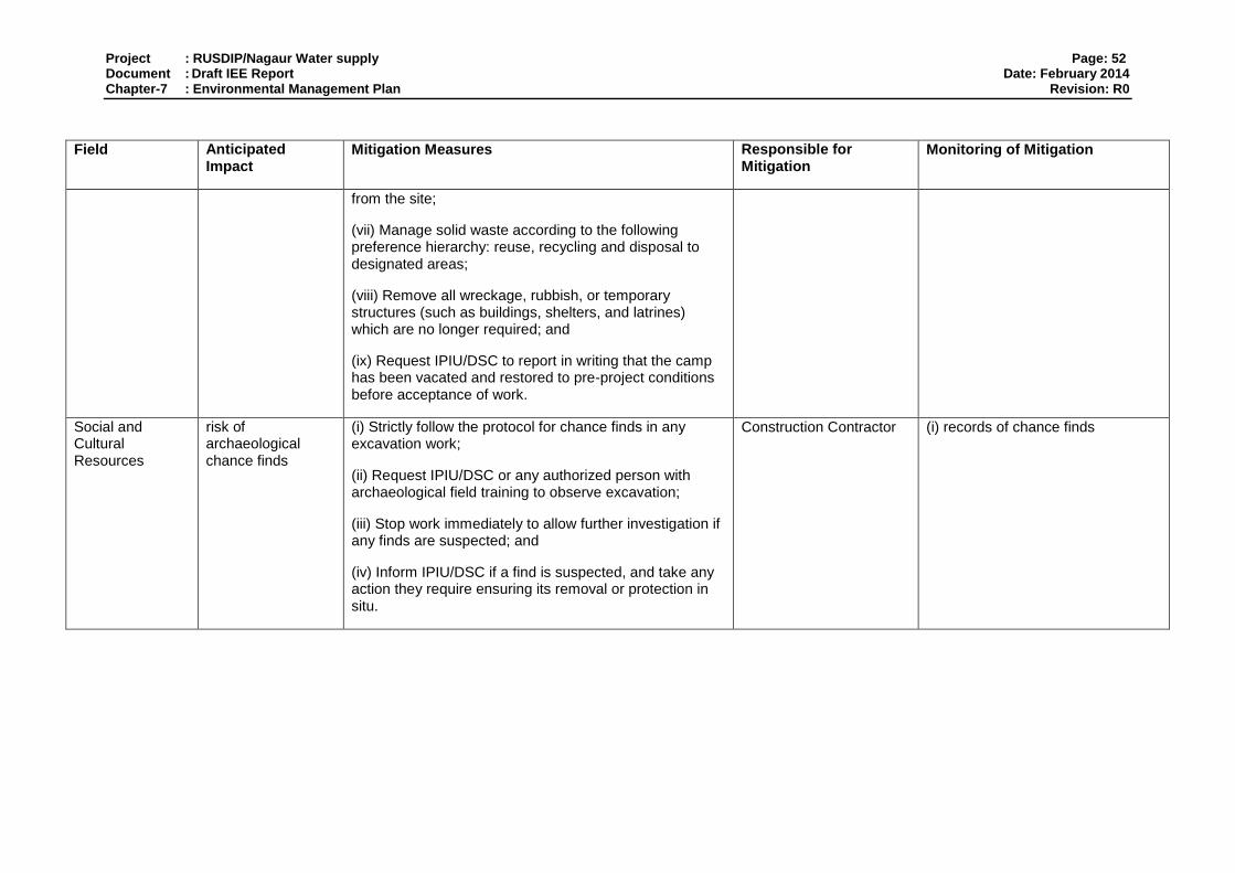
Project : RUSDIP/Nagaur Water supply Page: 52 Document : Draft IEE Report Date: February 2014 Chapter-7 : Environmental Management Plan Revision: R0
Field Anticipated Impact
Mitigation Measures Responsible for Mitigation
Monitoring of Mitigation
from the site;
(vii) Manage solid waste according to the following preference hierarchy: reuse, recycling and disposal to designated areas;
(viii) Remove all wreckage, rubbish, or temporary structures (such as buildings, shelters, and latrines) which are no longer required; and
(ix) Request IPIU/DSC to report in writing that the camp has been vacated and restored to pre-project conditions before acceptance of work.
Social and Cultural Resources
risk of archaeological chance finds
(i) Strictly follow the protocol for chance finds in any excavation work;
(ii) Request IPIU/DSC or any authorized person with archaeological field training to observe excavation;
(iii) Stop work immediately to allow further investigation if any finds are suspected; and
(iv) Inform IPIU/DSC if a find is suspected, and take any action they require ensuring its removal or protection in situ.
Construction Contractor (i) records of chance finds

Project : RUSDIP/Nagaur Water supply Page: 53 Document : Draft IEE Report Date: February 2014 Chapter-7 : Environmental Management Plan Revision: R0
Table 7.3: Anticipated Impacts and Mitigation Measures – Operation and Maintenance Environmental Mitigation Plan
Field Anticipated Impact
Mitigation Measures Responsible for Mitigation
Monitoring of Mitigation
Noise Level noise levels tend to increase with vehicular traffic
Put signages and implement “no blowing of horns” zones where there are sensitive receptors
Road & Highway Department
complaints from sensitive receptors
Accessibility Portions of the roads may be affected during routine repairs of water supply line
Coordinate with the Police Department so that warning signs and traffic diversions can be set up when necessary
Road & Highway Department
complaints from sensitive receptors
Ecological Resources
ecological gain from the planting of replacement trees
Coordinate with the Municipal Council for the continuous care of the planted trees.
Municipal Corporation of Nagaur
% survival of planted trees
Table 7.4: Pre-construction Environmental Monitoring Program
Field Location Responsible for Mitigation
Monitoring of Mitigation Method of Monitoring
Indicators/ Standards Frequency Responsible for Monitoring
Permits – Trees and Vegetation
not applicable Design and Supervision Consultants (DSC) in close coordination with the town Investment Project Implementation Unit (IPIU)
(i) Inventory of trees;
(ii) Tree-cutting permit;
(iii) Location and number of trees replaced for every one tree cut
checking of records
(i) Inventory of trees prepared;
(ii) Tree-cutting permit obtained from Municipal Council or District Collector;
(iii) Location identified and number of trees estimated
once IPMU
Utilities Design and Supervision
(i) design specification showing utility ducts if necessary; (ii) list of
checking of records
(i) utility ducts included in the design; (ii) list of affected utilities and operators
once IPMU
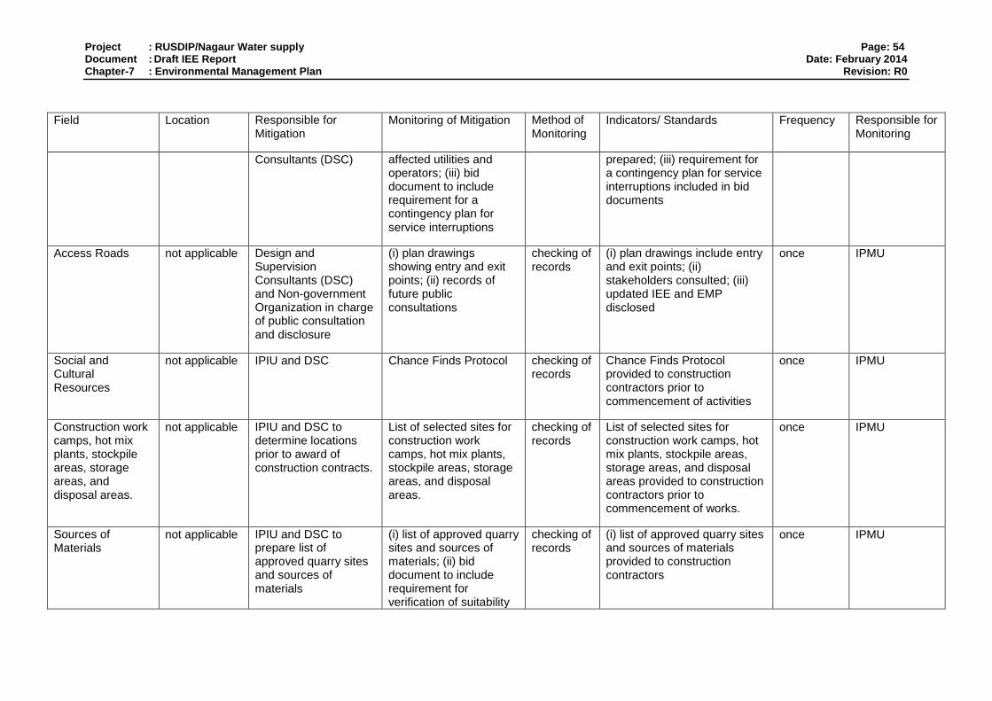
Project : RUSDIP/Nagaur Water supply Page: 54 Document : Draft IEE Report Date: February 2014 Chapter-7 : Environmental Management Plan Revision: R0
Field Location Responsible for Mitigation
Monitoring of Mitigation Method of Monitoring
Indicators/ Standards Frequency Responsible for Monitoring
Consultants (DSC) affected utilities and operators; (iii) bid document to include requirement for a contingency plan for service interruptions
prepared; (iii) requirement for a contingency plan for service interruptions included in bid documents
Access Roads not applicable Design and Supervision Consultants (DSC) and Non-government Organization in charge of public consultation and disclosure
(i) plan drawings showing entry and exit points; (ii) records of future public consultations
checking of records
(i) plan drawings include entry and exit points; (ii) stakeholders consulted; (iii) updated IEE and EMP disclosed
once IPMU
Social and Cultural Resources
not applicable IPIU and DSC Chance Finds Protocol checking of records
Chance Finds Protocol provided to construction contractors prior to commencement of activities
once IPMU
Construction work camps, hot mix plants, stockpile areas, storage areas, and disposal areas.
not applicable IPIU and DSC to determine locations prior to award of construction contracts.
List of selected sites for construction work camps, hot mix plants, stockpile areas, storage areas, and disposal areas.
checking of records
List of selected sites for construction work camps, hot mix plants, stockpile areas, storage areas, and disposal areas provided to construction contractors prior to commencement of works.
once IPMU
Sources of Materials
not applicable IPIU and DSC to prepare list of approved quarry sites and sources of materials
(i) list of approved quarry sites and sources of materials; (ii) bid document to include requirement for verification of suitability
checking of records
(i) list of approved quarry sites and sources of materials provided to construction contractors
once IPMU
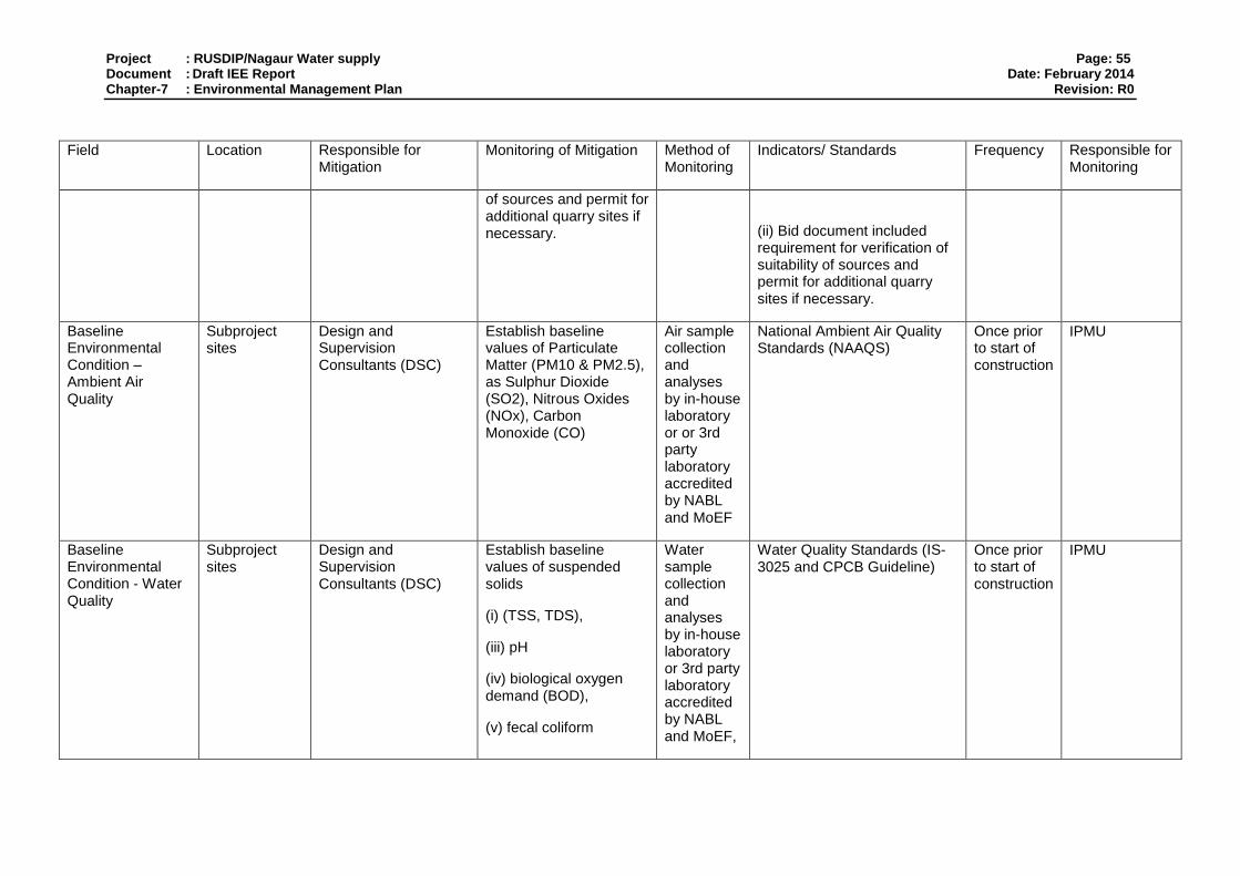
Project : RUSDIP/Nagaur Water supply Page: 55 Document : Draft IEE Report Date: February 2014 Chapter-7 : Environmental Management Plan Revision: R0
Field Location Responsible for Mitigation
Monitoring of Mitigation Method of Monitoring
Indicators/ Standards Frequency Responsible for Monitoring
of sources and permit for additional quarry sites if necessary.
(ii) Bid document included requirement for verification of suitability of sources and permit for additional quarry sites if necessary.
Baseline Environmental Condition – Ambient Air Quality
Subproject sites
Design and Supervision Consultants (DSC)
Establish baseline values of Particulate Matter (PM10 & PM2.5), as Sulphur Dioxide (SO2), Nitrous Oxides (NOx), Carbon Monoxide (CO)
Air sample collection and analyses by in-house laboratory or or 3rd party laboratory accredited by NABL and MoEF
National Ambient Air Quality Standards (NAAQS)
Once prior to start of construction
IPMU
Baseline Environmental Condition - Water Quality
Subproject sites
Design and Supervision Consultants (DSC)
Establish baseline values of suspended solids
(i) (TSS, TDS),
(iii) pH
(iv) biological oxygen demand (BOD),
(v) fecal coliform
Water sample collection and analyses by in-house laboratory or 3rd party laboratory accredited by NABL and MoEF,
Water Quality Standards (IS-3025 and CPCB Guideline)
Once prior to start of construction
IPMU
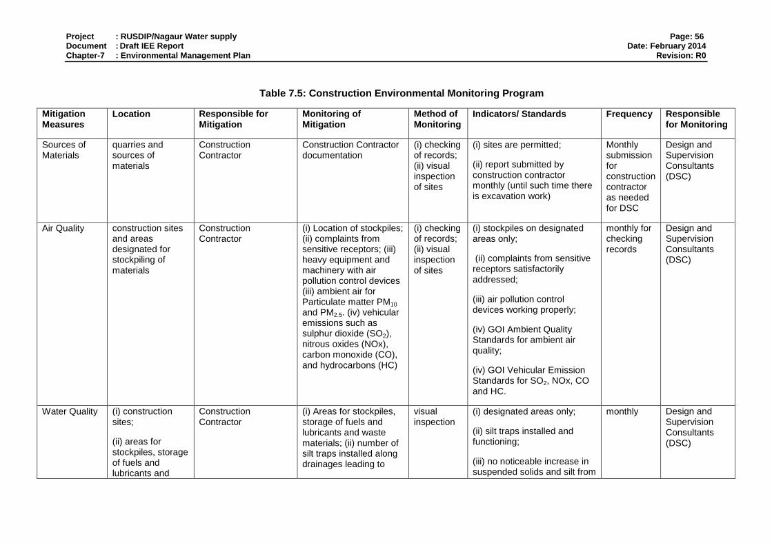
Project : RUSDIP/Nagaur Water supply Page: 56 Document : Draft IEE Report Date: February 2014 Chapter-7 : Environmental Management Plan Revision: R0
Table 7.5: Construction Environmental Monitoring Program
Mitigation Measures
Location Responsible for Mitigation
Monitoring of Mitigation
Method of Monitoring
Indicators/ Standards Frequency Responsible for Monitoring
Sources of Materials
quarries and sources of materials
Construction Contractor
Construction Contractor documentation
(i) checking of records; (ii) visual inspection of sites
(i) sites are permitted;
(ii) report submitted by construction contractor monthly (until such time there is excavation work)
Monthly submission for construction contractor as needed for DSC
Design and Supervision Consultants (DSC)
Air Quality construction sites and areas designated for stockpiling of materials
Construction Contractor
(i) Location of stockpiles; (ii) complaints from sensitive receptors; (iii) heavy equipment and machinery with air pollution control devices (iii) ambient air for Particulate matter PM10 and PM2.5. (iv) vehicular emissions such as sulphur dioxide (SO2), nitrous oxides (NOx), carbon monoxide (CO), and hydrocarbons (HC)
(i) checking of records; (ii) visual inspection of sites
(i) stockpiles on designated areas only;
(ii) complaints from sensitive receptors satisfactorily addressed;
(iii) air pollution control devices working properly;
(iv) GOI Ambient Quality Standards for ambient air quality;
(iv) GOI Vehicular Emission Standards for SO2, NOx, CO and HC.
monthly for checking records
Design and Supervision Consultants (DSC)
Water Quality (i) construction sites;
(ii) areas for stockpiles, storage of fuels and lubricants and
Construction Contractor
(i) Areas for stockpiles, storage of fuels and lubricants and waste materials; (ii) number of silt traps installed along drainages leading to
visual inspection
(i) designated areas only;
(ii) silt traps installed and functioning;
(iii) no noticeable increase in suspended solids and silt from
monthly Design and Supervision Consultants (DSC)

Project : RUSDIP/Nagaur Water supply Page: 57 Document : Draft IEE Report Date: February 2014 Chapter-7 : Environmental Management Plan Revision: R0
Mitigation Measures
Location Responsible for Mitigation
Monitoring of Mitigation
Method of Monitoring
Indicators/ Standards Frequency Responsible for Monitoring
waste materials;
water bodies; (iii) records of surface water quality inspection; (iv) effectiveness of water management measures; (v) for inland water: suspended solids, oil and grease, biological oxygen demand (BOD), and coliforms.
construction activities (iv) GOI Standards for Water Discharges to Inland Waters and Land for Irrigation
Noise Levels (i) construction sites;
(ii) areas for stockpiles, storage of fuels and lubricants and waste materials;
(iii) work camps
Construction Contractor
(i) Complaints from sensitive receptors; (ii) use of silencers in noise-producing equipment and sound barriers; (iii) equivalent day and night time levels
(i) checking of records;
(ii) visual inspection
(i) complaints from sensitive receptors satisfactorily addressed; and (ii) silencers in noise-producing equipment functioning as design; and
(iii) sound barriers installed where necessary
Monthly Design and Supervision Consultants (DSC)
Existing Infrastructure and Facilities
(i) construction sites;
(ii) alignment of affected utilities
Construction Contractor
(i) Existing Utilities Contingency Plan; (ii) Asbestos Cement Pipes Management Plan
(i) checking of records;
(ii) visual inspection
implementation according to Utilities Contingency Plan and Asbestos Cement Plan
as needed Design and Supervision Consultants (DSC)
Flora and Fauna
(i) construction sites;
(ii) location where replacement trees will be planted
Construction Contractor
(i) tree-cutting permit for affected trees; (ii) number of replanted trees
(i) checking of records;
(ii) visual inspection
number of trees cut, replanted and location according to the tree-cutting permit
as needed Design and Supervision Consultants (DSC)
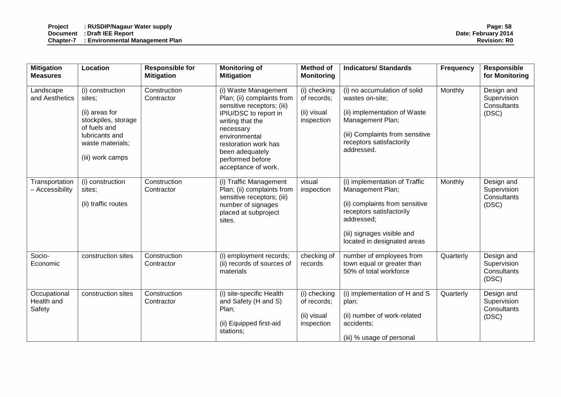
Project : RUSDIP/Nagaur Water supply Page: 58 Document : Draft IEE Report Date: February 2014 Chapter-7 : Environmental Management Plan Revision: R0
Mitigation Measures
Location Responsible for Mitigation
Monitoring of Mitigation
Method of Monitoring
Indicators/ Standards Frequency Responsible for Monitoring
Landscape and Aesthetics
(i) construction sites;
(ii) areas for stockpiles, storage of fuels and lubricants and waste materials;
(iii) work camps
Construction Contractor
(i) Waste Management Plan; (ii) complaints from sensitive receptors; (iii) IPIU/DSC to report in writing that the necessary environmental restoration work has been adequately performed before acceptance of work.
(i) checking of records;
(ii) visual inspection
(i) no accumulation of solid wastes on-site;
(ii) implementation of Waste Management Plan;
(iii) Complaints from sensitive receptors satisfactorily addressed.
Monthly Design and Supervision Consultants (DSC)
Transportation – Accessibility
(i) construction sites;
(ii) traffic routes
Construction Contractor
(i) Traffic Management Plan; (ii) complaints from sensitive receptors; (iii) number of signages placed at subproject sites.
visual inspection
(i) implementation of Traffic Management Plan;
(ii) complaints from sensitive receptors satisfactorily addressed;
(iii) signages visible and located in designated areas
Monthly Design and Supervision Consultants (DSC)
Socio-Economic
construction sites Construction Contractor
(i) employment records; (ii) records of sources of materials
checking of records
number of employees from town equal or greater than 50% of total workforce
Quarterly Design and Supervision Consultants (DSC)
Occupational Health and Safety
construction sites Construction Contractor
(i) site-specific Health and Safety (H and S) Plan;
(ii) Equipped first-aid stations;
(i) checking of records;
(ii) visual inspection
(i) implementation of H and S plan;
(ii) number of work-related accidents;
(iii) % usage of personal
Quarterly Design and Supervision Consultants (DSC)

Project : RUSDIP/Nagaur Water supply Page: 59 Document : Draft IEE Report Date: February 2014 Chapter-7 : Environmental Management Plan Revision: R0
Mitigation Measures
Location Responsible for Mitigation
Monitoring of Mitigation
Method of Monitoring
Indicators/ Standards Frequency Responsible for Monitoring
(iii) Medical insurance coverage for workers;
(iv) Number of accidents;
(v) Supplies of potable drinking water;
(vi) Clean eating areas where workers are not exposed to hazardous or noxious substances;
(vii) record of Health and Safety orientation trainings
(viii) personal protective equipments;
(ix) % of moving equipment outfitted with audible back-up alarms;
(xi) sign boards for hazardous areas such as energized electrical devices and lines, service rooms housing high voltage equipment, and areas for storage and disposal.
protective equipment;
(iv) number of first-aid stations, frequency of potable water delivery, provision of clean eating area, and number of sign boards are according to approved plan;
(v) % of moving equipment outfitted with audible back-up alarms
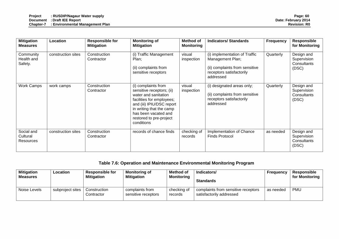
Project : RUSDIP/Nagaur Water supply Page: 60 Document : Draft IEE Report Date: February 2014 Chapter-7 : Environmental Management Plan Revision: R0
Mitigation Measures
Location Responsible for Mitigation
Monitoring of Mitigation
Method of Monitoring
Indicators/ Standards Frequency Responsible for Monitoring
Community Health and Safety.
construction sites Construction Contractor
(i) Traffic Management Plan;
(ii) complaints from sensitive receptors
visual inspection
(i) implementation of Traffic Management Plan;
(ii) complaints from sensitive receptors satisfactorily addressed
Quarterly Design and Supervision Consultants (DSC)
Work Camps work camps Construction Contractor
(i) complaints from sensitive receptors; (ii) water and sanitation facilities for employees; and (iii) IPIU/DSC report in writing that the camp has been vacated and restored to pre-project conditions
visual inspection
(i) designated areas only;
(ii) complaints from sensitive receptors satisfactorily addressed
Quarterly Design and Supervision Consultants (DSC)
Social and Cultural Resources
construction sites Construction Contractor
records of chance finds checking of records
Implementation of Chance Finds Protocol
as needed Design and Supervision Consultants (DSC)
Table 7.6: Operation and Maintenance Environmental Monitoring Program
Mitigation Measures
Location Responsible for Mitigation
Monitoring of Mitigation
Method of Monitoring
Indicators/
Standards
Frequency Responsible for Monitoring
Noise Levels subproject sites Construction Contractor
complaints from sensitive receptors
checking of records
complaints from sensitive receptors satisfactorily addressed
as needed PMU

Project : RUSDIP/Nagaur Water supply Page: 61 Document : Draft IEE Report Date: February 2014 Chapter-7 : Environmental Management Plan Revision: R0
Mitigation Measures
Location Responsible for Mitigation
Monitoring of Mitigation
Method of Monitoring
Indicators/
Standards
Frequency Responsible for Monitoring
Accessibility subproject sites Construction Contractor
complaints from sensitive receptors
checking of records
complaints from sensitive receptors satisfactorily addressed
as needed PMU
Ecological Resources
subproject sites Construction Contractor
% survival of planted trees
checking of records
at least 80% survival rate quarterly PMU

Project : RUSDIP/Nagaur Water supply Page: 62 Document : Draft IEE Report Date: February 2014 Chapter-7 : Environmental Management Plan Revision: R0
7.4. Environmental Monitoring Plan
155. Tables above show that most mitigation activities are the responsibility of the Construction Contractors2 (CC) employed to build the infrastructure during the construction stage or the O&M Contractors employed to conduct maintenance or repair work when the system is operating. Responsibility for the relevant measures will be assigned to the Contractors via the contracts through which they are appointed (prepared by the DSC during the detailed design stage), so they will be legally required to take the necessary action. There are also some actions that need to be taken by LSGD in their role as project proponent, and some actions related to the design that will be implemented by the DSC.
156. A program of monitoring will be conducted to ensure that all parties take the specified action to provide the required mitigation, to assess whether the action has adequately protected the environment, and to determine whether any additional measures may be necessary. This will be conducted by a qualified Environmental Monitoring Specialist (EMS) from the DSC. The EMS will be responsible for all monitoring activities and reporting the results and conclusions to the IPMU, and will recommend remedial action if measures are not being provided or are not protecting the environment effectively. The EMS may be assisted by environmental specialists in particular technical fields, and junior or medium-level engineers who can make many of the routine observations on site. Post-construction monitoring will be conducted by the relevant Government Agency (GA) to whom responsibility for the infrastructure will pass once it begins to operate3.
157. Table 7.1 to 7.3 shows that most of the mitigation measures are fairly standard methods of minimising disturbance from building in urban areas (maintaining access, planning work to avoid sensitive times, finding uses for waste material, etc), and experienced Contractors should be familiar with most of the requirements. Monitoring of such measures normally involves making observations in the course of site visits, although some require more formal checking of records and other aspects. There will also be some surveys of residents, as most of the measures are aimed at preventing impacts on people and the human environment.
158. Table 7.3 to 7.6 shows the proposed Environmental Monitoring Plan (EMP) for this subproject, which specifies the various monitoring activities to be conducted during all phases. The EMP describes: (i) mitigation measures, (ii) location, (iii) measurement method, (iv) frequency of monitoring and (v) responsibility (for both mitigation and monitoring). It does not show specific parameters to be measured because as indicated above, most measures will be checked by simple observation, by checking of records, or by interviews with residents or workers.
7.5. Environmental Management and Monitoring Costs
159. Most of the mitigation measures require the Construction Contractors (CC) to adopt good site practice, which should be part of their normal procedures already, so there are unlikely to be major costs associated with compliance. Regardless of this, any costs of mitigation by the
2 During implementation the contractor will submit monthly progress reports, which includes a section on EMP implementation
to the IPIU. The IPIU will submit reports to the IPMU for review. The IPMU will review progress reports to ensure that the all mitigation measures are properly implemented. The IPMU will consolidate monthly reports and submit quarterly reports to ADB for review 3 In the operational period some infrastructure will be the responsibility of the Municipal Boards/Councils, whilst others will be the
responsibility of the appropriate branch of the State government (such as PWD, PHED, etc)
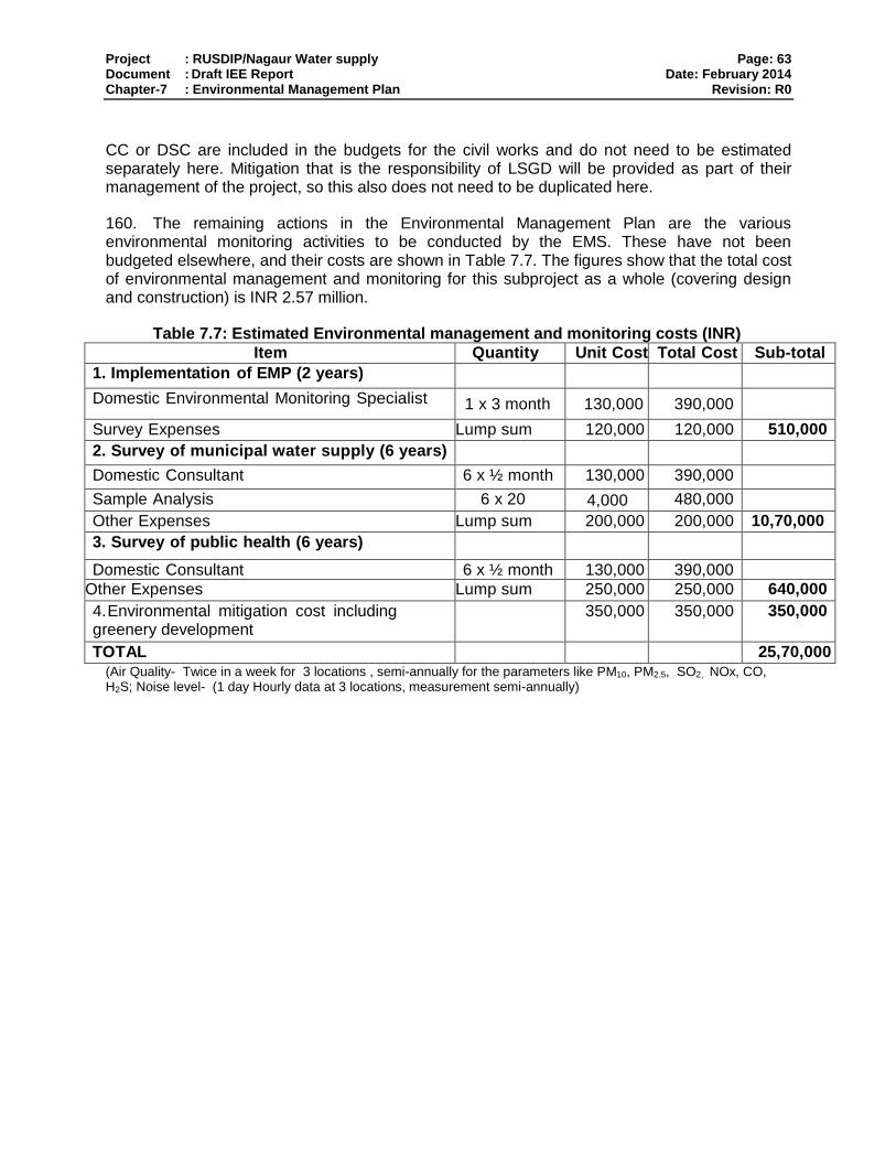
Project : RUSDIP/Nagaur Water supply Page: 63 Document : Draft IEE Report Date: February 2014 Chapter-7 : Environmental Management Plan Revision: R0
CC or DSC are included in the budgets for the civil works and do not need to be estimated separately here. Mitigation that is the responsibility of LSGD will be provided as part of their management of the project, so this also does not need to be duplicated here.
160. The remaining actions in the Environmental Management Plan are the various environmental monitoring activities to be conducted by the EMS. These have not been budgeted elsewhere, and their costs are shown in Table 7.7. The figures show that the total cost of environmental management and monitoring for this subproject as a whole (covering design and construction) is INR 2.57 million.
Table 7.7: Estimated Environmental management and monitoring costs (INR)
Item Quantity Unit Cost Total Cost Sub-total
1. Implementation of EMP (2 years)
Domestic Environmental Monitoring Specialist 1 x 3 month 130,000 390,000
Survey Expenses Lump sum 120,000 120,000 510,000
2. Survey of municipal water supply (6 years)
Domestic Consultant 6 x ½ month 130,000 390,000
Sample Analysis 6 x 20 4,000 480,000
Other Expenses Lump sum 200,000 200,000 10,70,000
3. Survey of public health (6 years)
Domestic Consultant 6 x ½ month 130,000 390,000
Other Expenses Lump sum 250,000 250,000 640,000
4. Environmental mitigation cost including greenery development
350,000 350,000 350,000
TOTAL 25,70,000 (Air Quality- Twice in a week for 3 locations , semi-annually for the parameters like PM10, PM2.5, SO2, NOx, CO, H2S; Noise level- (1 day Hourly data at 3 locations, measurement semi-annually)
Project : RUSDIP/Nagaur Water supply Page: 64 Document : Draft IEE Report Date: February 2014 Chapter-8 : Findings and Recommendations Revision: R0
8. FINDINGS AND RECOMMENDATIONS
8.1. Findings
161. The Project is designed to improve the quality of life of small town residents and enhance the small towns' roles as market, services, and manufacturing centers. It has a strong community development focus reinforced by integrated poverty reduction, health and hygiene improvement investment projects. The towns' economies will benefit from enhanced productivity as a result of health improvement, time savings in collecting water, as well as from increased urban efficiency arising from improved roads, bridges, drainage, drinking water and sanitation. Residents in towns will also benefit from savings in health care costs.
162. During project design, community meetings were held with beneficiaries to discuss sanitation, poverty, resettlement, affordability issues, and environmental concerns. Socioeconomic surveys obtained information and individual views on current situations and future preferences. Potential environmental impacts of urban infrastructure improvements are mainly short-term during the construction period and can be minimized by the proposed mitigating measures and environmentally sound engineering and construction practices.
163. The process described in this document has assessed the environmental impacts of all elements of the infrastructure proposed under the Nagaur Water Supply Subproject. Potential negative impacts were identified in relation to construction and operation of the improved infrastructure, and the design and location of the subproject. Mitigation measures have been developed to reduce all negative impacts to acceptable levels. These were discussed with specialists responsible for the engineering aspects, and as a result some measures have already been included in the outline designs for the infrastructure. These include:
Locating the trunk main and water supply networks within the ROW of existing roads, to avoid the need to acquire land or relocate people;
Locating sewers on unused land adjacent to roads wherever possible, to avoid damaging roads and disrupting traffic and other activities.
164. This means that the number of impacts and their significance has already been reduced by amending the design.
165. Regardless of these and various other actions taken during the IEE process and in developing the subproject, there will still be impacts on the environment when the infrastructure is built and when it is operating. This is mainly because of the invasive nature of trenching work and the excavation because the sewer network is located in a town, some parts of which are densely populated; and because Rajasthan is an area with a rich history, in which there is a high risk that ground disturbance may uncover important remains. Because of these factors the most significant impacts are on the physical environment, the human environment, and the cultural heritage.
166. During the construction phase, impacts mainly arise from the need to dispose of large quantities of waste soil; and from the disturbance of residents, businesses, traffic and important buildings by the construction work. These are common impacts of construction in urban areas, and there are well developed methods for their mitigation. These include:
Finding beneficial uses for waste material;
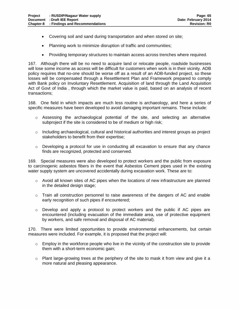
Project : RUSDIP/Nagaur Water supply Page: 65 Document : Draft IEE Report Date: February 2014 Chapter-8 : Findings and Recommendations Revision: R0
Covering soil and sand during transportation and when stored on site;
Planning work to minimize disruption of traffic and communities;
Providing temporary structures to maintain access across trenches where required.
167. Although there will be no need to acquire land or relocate people, roadside businesses will lose some income as access will be difficult for customers when work is in their vicinity. ADB policy requires that no-one should be worse off as a result of an ADB-funded project, so these losses will be compensated through a Resettlement Plan and Framework prepared to comply with Bank policy on Involuntary Resettlement. Acquisition of land through the Land Acquisition Act of Govt of India , through which the market value is paid, based on an analysis of recent transactions;
168. One field in which impacts are much less routine is archaeology, and here a series of specific measures have been developed to avoid damaging important remains. These include:
o Assessing the archaeological potential of the site, and selecting an alternative subproject if the site is considered to be of medium or high risk;
o Including archaeological, cultural and historical authorities and interest groups as project stakeholders to benefit from their expertise;
o Developing a protocol for use in conducting all excavation to ensure that any chance finds are recognized, protected and conserved.
169. Special measures were also developed to protect workers and the public from exposure to carcinogenic asbestos fibers in the event that Asbestos Cement pipes used in the existing water supply system are uncovered accidentally during excavation work. These are to:
o Avoid all known sites of AC pipes when the locations of new infrastructure are planned in the detailed design stage;
o Train all construction personnel to raise awareness of the dangers of AC and enable early recognition of such pipes if encountered;
o Develop and apply a protocol to protect workers and the public if AC pipes are encountered (including evacuation of the immediate area, use of protective equipment by workers, and safe removal and disposal of AC material).
170. There were limited opportunities to provide environmental enhancements, but certain measures were included. For example, it is proposed that the project will:
o Employ in the workforce people who live in the vicinity of the construction site to provide them with a short-term economic gain;
o Plant large-growing trees at the periphery of the site to mask it from view and give it a more natural and pleasing appearance.

Project : RUSDIP/Nagaur Water supply Page: 66 Document : Draft IEE Report Date: February 2014 Chapter-8 : Findings and Recommendations Revision: R0
171. These and the other mitigation and enhancement measures are summarized in Table 6.1, which also shows the location of the impact, the body responsible for the mitigation, and the programme for its implementation.
172. On completion the Water Supply system should operate with routine maintenance, which should not significantly affect the environment, providing certain pre-conditions are met. These are that:
o The operation and integrity of sewers are checked regularly and any leaks are repaired rapidly and effectively to avoid public health risks and contamination of land and water.
173. The repair of water supply will have fewer environmental impacts than the original water supply construction as the work will be infrequent and will affect small areas only. It will also be conducted in areas that have already been excavated, so there will be no need to protect archaeological material.
174. Table 6.1 also assesses the effectiveness of each mitigation measure in reducing each impact to an acceptable level. This is shown as the level of significance of the residual impact (remaining after the mitigation is applied). This shows that all impacts will be rendered at least neutral (successfully mitigated), and that certain measures will produce a benefit (in addition to the major benefits provided by the operating schemes).
175. Mitigation will be assured by a programme of environmental monitoring conducted during both construction and operation to ensure that all measures are provided as intended, and to determine whether the environment is protected as envisaged. This will include observations on and off site, document checks, and interviews with workers and beneficiaries, and any requirements for remedial action will be reported to the IPMU.
8.2. Recommendations
176. There are two straightforward but essential recommendations that need to be followed to ensure that the environmental impacts of the project are successfully mitigated. These are that LSGD should ensure that:
o All mitigation, compensation and enhancement measures proposed in this IEE report and in the Resettlement Framework for the RUSDIP are implemented in full,
o The Environmental Monitoring Plan proposed in this report and the internal and external monitoring proposed in the Resettlement Framework is also implemented in full.

Project : RUSDIP/Nagaur Water supply Page: 67 Document : Draft IEE Report Date: February 2014 Chapter-9 : Conclusions Revision: R0
9. CONCLUSIONS
177. The environmental status of the proposed improvements in water supply in Nagaur Town has been assessed. Issues related to Involuntary Resettlement were assessed by a parallel process of resettlement planning and will be compensated by measures set out in detail in the Resettlement Framework for the subproject.
178. The overall conclusion of both processes is that providing the mitigation, compensation and enhancement measures are implemented in full, there should be no significant negative environmental impacts as a result of location, design, construction or operation of the subproject. There should in fact be some small benefits from recommended mitigation and enhancement measures, and major improvements in quality of life and individual and public health once the scheme is in operation
179. There are no uncertainties in the analysis, and no further studies are required to comply with ADB procedure or national law.

Project : RUSDIP/Nagaur Water supply Page: 68 Document : Draft IEE Report Date: February 2014 Annexure I : Photographs Revision: R0
Annexure– I: Photograph
Proposed Site for Construction of ESR at Deep Colony

Project : RUSDIP/Nagaur Water supply Page: 69 Document : Draft IEE Report Date: February 2014 Annexure II : Rapid Environmental Assessment Checklist Revision: R0
Annexure- II: Rapid Environmental Assessment (REA) Checklist
Instructions:
(i) The project team completes this checklist to support the environmental classification of a project. It is to be attached to the environmental categorization form and submitted to the Environment and Safeguards Division (RSES) for endorsement by the Director, RSES and for approval by the Chief Compliance Officer.
(ii) This checklist focuses on environmental issues and concerns. To ensure that social dimensions are
adequately considered, refer also to ADB's (a) checklists on involuntary resettlement and
Indigenous Peoples; (b) poverty reduction handbook; (c) staff guide to consultation and
participation; and (d) gender checklists.
(iii) Answer the questions assuming the “without mitigation” case. The purpose is to identify potential
impacts. Use the “remarks” section to discuss any anticipated mitigation measures.
Country/Project Title:
Sector Division:
Screening Questions Yes No Remarks
A. PROJECT SITING IS THE PROJECT AREA…
DENSELY POPULATED? √ Population density of Nagaur is
only 157 persons in 1 sq km
HEAVY WITH DEVELOPMENT ACTIVITIES?
√
ADJACENT TO OR WITHIN ANY ENVIRONMENTALLY SENSITIVE AREAS?
CULTURAL HERITAGE SITE
√ Heritage sites are located in
and around the town, but away
from the subproject sites
PROTECTED AREA
√
WETLAND
√ No designated wetland nearby
the subproject site
MANGROVE
√
ESTUARINE
√
India/RUSDIP
Nagaur Water Supply Subproject

Project : RUSDIP/Nagaur Water supply Page: 70 Document : Draft IEE Report Date: February 2014 Annexure II : Rapid Environmental Assessment Checklist Revision: R0
Screening Questions Yes No Remarks
BUFFER ZONE OF PROTECTED AREA
√ No protected area nearby the
subproject site
SPECIAL AREA FOR PROTECTING BIODIVERSITY
√ No special area of protected
land of significant biodiversity
located nearby
BAY
√
B. POTENTIAL ENVIRONMENTAL IMPACTS Will the Project cause…
pollution of raw water supply from upstream wastewater discharge from communities, industries, agriculture, and soil erosion runoff?
√ No such source of pollution at the up stream of the intake point.
impairment of historical/cultural monuments/areas and loss/damage to these sites?
√ The Water Supply system will
not impact any such structures.
hazard of land subsidence caused by excessive ground water pumping?
√ The scope of sub-project is only
strengthening the existing water
supply network in the town
receiving the water supplied
through the Naguar Lift Project
implemented by Public Health
Engineering Department
(PHED)
social conflicts arising from displacement of communities ?
√ Most of the worker will be from
local area
conflicts in abstraction of raw water for water supply with other beneficial water uses for surface and ground waters?
√
unsatisfactory raw water supply (e.g. excessive pathogens or mineral constituents)?
√ Raw water will be treated
properly considering the
characteristics of the water.
Although provision will be made
for regular water quality
monitoring

Project : RUSDIP/Nagaur Water supply Page: 71 Document : Draft IEE Report Date: February 2014 Annexure II : Rapid Environmental Assessment Checklist Revision: R0
Screening Questions Yes No Remarks
delivery of unsafe water to distribution system?
√ Proper care has been taken
during design of the system.
O&M manual will be prepared,
training will be given to the
staffs and to collect water
sample time to time and analyze
the same to ensure the quality
of the supplied water
inadequate protection of intake works or wells, leading to pollution of water supply?
√ Proper design of the intake will
minimize the problems.
over pumping of ground water, leading to salinization and ground subsidence?
√ The water will be supplied
through the Naguar Lift Project
implemented by Public Health
Engineering Department
(PHED)
excessive algal growth in storage reservoir?
√ The storage reservoirs are
covered from top and proper
treatment like chlorination of
water will not allow algal growth
in the reservoirs.
increase in production of sewage beyond capabilities of community facilities?
√ Sewage volume will increase
slightly. The construction of new
sewerage network and
treatment facility for the town is
in progress by RUIDP.
inadequate disposal of sludge from water treatment plants?
√ Sludge will disposed off in
designated site.
inadequate buffer zone around pumping and treatment plants to alleviate noise and other possible nuisances and protect facilities?
√
impairments associated with transmission lines and access roads?
√ Impairments may be with
access road but it is and can be
minimized taking regulatory
measures temporary in nature.
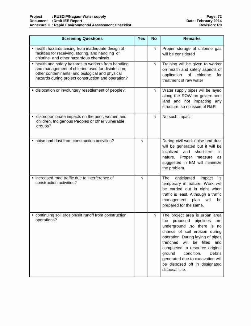
Project : RUSDIP/Nagaur Water supply Page: 72 Document : Draft IEE Report Date: February 2014 Annexure II : Rapid Environmental Assessment Checklist Revision: R0
Screening Questions Yes No Remarks
health hazards arising from inadequate design of facilities for receiving, storing, and handling of chlorine and other hazardous chemicals.
√ Proper storage of chlorine gas
will be considered
health and safety hazards to workers from handling and management of chlorine used for disinfection, other contaminants, and biological and physical hazards during project construction and operation?
√ Training will be given to worker
on health and safety aspects of
application of chlorine for
treatment of raw water
dislocation or involuntary resettlement of people? √ Water supply pipes will be layed
along the ROW on government
land and not impacting any
structure, so no issue of R&R
disproportionate impacts on the poor, women and children, Indigenous Peoples or other vulnerable groups?
√ No such impact
noise and dust from construction activities?
√ During civil work noise and dust
will be generated but it will be
localized and short-term in
nature. Proper measure as
suggested in EM will minimize
the problem.
increased road traffic due to interference of construction activities?
√ The anticipated impact is
temporary in nature. Work will
be carried out in night when
traffic is least. Although a traffic
management plan will be
prepared for the same.
continuing soil erosion/silt runoff from construction operations?
√ The project area is urban area
the proposed pipelines are
underground .so there is no
chance of soil erosion during
operation. During laying of pipes
trenched will be filled and
compacted to resource original
ground condition. Debris
generated due to excavation will
be disposed off in designated
disposal site.
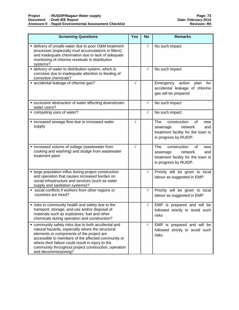
Project : RUSDIP/Nagaur Water supply Page: 73 Document : Draft IEE Report Date: February 2014 Annexure II : Rapid Environmental Assessment Checklist Revision: R0
Screening Questions Yes No Remarks
delivery of unsafe water due to poor O&M treatment processes (especially mud accumulations in filters) and inadequate chlorination due to lack of adequate monitoring of chlorine residuals in distribution systems?
√ No such impact
delivery of water to distribution system, which is corrosive due to inadequate attention to feeding of corrective chemicals?
√ No such impact
accidental leakage of chlorine gas?
√ Emergency action plan for
accidental leakage of chlorine
gas will be prepared
excessive abstraction of water affecting downstream water users?
√ No such impact
competing uses of water? √ No such impact
increased sewage flow due to increased water supply
√ The construction of new
sewerage network and
treatment facility for the town is
in progress by RUIDP.
increased volume of sullage (wastewater from cooking and washing) and sludge from wastewater treatment plant
√ The construction of new
sewerage network and
treatment facility for the town is
in progress by RUIDP.
large population influx during project construction and operation that causes increased burden on social infrastructure and services (such as water supply and sanitation systems)?
√ Priority will be given to local
labour as suggested in EMP
social conflicts if workers from other regions or countries are hired?
√ Priority will be given to local
labour as suggested in EMP
risks to community health and safety due to the transport, storage, and use and/or disposal of materials such as explosives, fuel and other chemicals during operation and construction?
√ EMP is prepared and will be
followed strictly to avoid such
risks
community safety risks due to both accidental and natural hazards, especially where the structural elements or components of the project are accessible to members of the affected community or where their failure could result in injury to the community throughout project construction, operation and decommissioning?
√ EMP is prepared and will be
followed strictly to avoid such
risks

Project : RUSDIP/Nagaur Water supply Page: 74 Document : Draft IEE Report Date: February 2014 Annexure II : Rapid Environmental Assessment Checklist Revision: R0
* Hazards are potentially damaging physical events.
Climate Change and Disaster Risk Questions
The following questions are not for environmental
categorization. They are included in this checklist to help
identify potential climate and disaster risks.
Yes No Remarks
Is the Project area subject to hazards such as earthquakes, floods, landslides, tropical cyclone winds, storm surges, tsunami or volcanic eruptions and climate changes (see Appendix I)?
√ Nagaur town lies in low damage
risk zone II. The area is less prone
to earthquakes
Could changes in temperature, precipitation, or extreme events patterns over the Project lifespan affect technical or financial sustainability (e.g., changes in rainfall patterns disrupt reliability of water supply; sea level rise creates salinity intrusion into proposed water supply source)?
√ No such possibility
Are there any demographic or socio-economic aspects of the Project area that are already vulnerable (e.g.,high incidence of marginalized populations, rural-urban migrants, illegal settlements, ethnic minorities, women or children)?
√ No such possibility
Could the Project potentially increase the climate or disaster vulnerability of the surrounding area (e.g., by using water from a vulnerable source that is relied upon by many user groups, or encouraging settlement in earthquake zones)?
√ No such possibility

Project : RUSDIP/Nagaur Water supply Page: 75 Document : Draft IEE Report Date: February 2014 Annexure III : Public Consultation Revision: R0
Annexure- III: Public Consultation
Issues discussed
Awareness and extent of the project and development components
Benefits of Project for the economic and social Upliftment of Community
Labour availability in the Project area or requirement of outside labour involvement
Local disturbances due to Project Construction Work
Necessity of tree felling etc. at project sites
Water logging and drainage problem if any
Drinking water problem
Forest and sensitive area nearby the project site
Movement of wild animal if any
Date of Consultation :- 06.10.2013,
Time of Consultation :- 02:50 PM
Location :- Near Deep Colony, Nagaur
Issues of the Public Consultation- Design Phase
Sr. No.
Key issues/Demands Perception of community Action to be Taken
1. Awareness of the project – including Project Coverage area
Some People are aware of the proposed Project
An NGO is appointed for awareness programme in this town
Public Consultation near Deep Colony
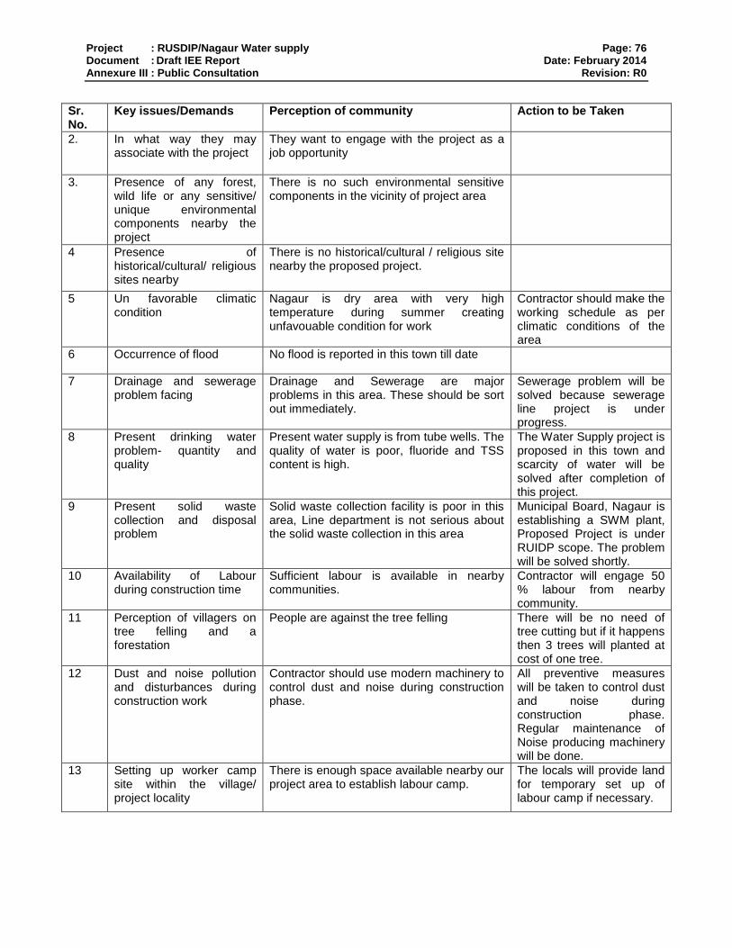
Project : RUSDIP/Nagaur Water supply Page: 76 Document : Draft IEE Report Date: February 2014 Annexure III : Public Consultation Revision: R0
Sr. No.
Key issues/Demands Perception of community Action to be Taken
2. In what way they may associate with the project
They want to engage with the project as a job opportunity
3. Presence of any forest, wild life or any sensitive/ unique environmental components nearby the project
There is no such environmental sensitive components in the vicinity of project area
4 Presence of historical/cultural/ religious sites nearby
There is no historical/cultural / religious site nearby the proposed project.
5 Un favorable climatic condition
Nagaur is dry area with very high temperature during summer creating unfavouable condition for work
Contractor should make the working schedule as per climatic conditions of the area
6 Occurrence of flood No flood is reported in this town till date
7 Drainage and sewerage problem facing
Drainage and Sewerage are major problems in this area. These should be sort out immediately.
Sewerage problem will be solved because sewerage line project is under progress.
8 Present drinking water problem- quantity and quality
Present water supply is from tube wells. The quality of water is poor, fluoride and TSS content is high.
The Water Supply project is proposed in this town and scarcity of water will be solved after completion of this project.
9 Present solid waste collection and disposal problem
Solid waste collection facility is poor in this area, Line department is not serious about the solid waste collection in this area
Municipal Board, Nagaur is establishing a SWM plant, Proposed Project is under RUIDP scope. The problem will be solved shortly.
10 Availability of Labour during construction time
Sufficient labour is available in nearby communities.
Contractor will engage 50 % labour from nearby community.
11 Perception of villagers on tree felling and a forestation
People are against the tree felling There will be no need of tree cutting but if it happens then 3 trees will planted at cost of one tree.
12 Dust and noise pollution and disturbances during construction work
Contractor should use modern machinery to control dust and noise during construction phase.
All preventive measures will be taken to control dust and noise during construction phase. Regular maintenance of Noise producing machinery will be done.
13 Setting up worker camp site within the village/ project locality
There is enough space available nearby our project area to establish labour camp.
The locals will provide land for temporary set up of labour camp if necessary.
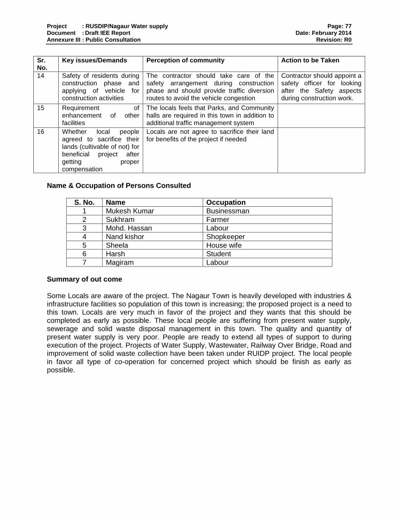
Project : RUSDIP/Nagaur Water supply Page: 77 Document : Draft IEE Report Date: February 2014 Annexure III : Public Consultation Revision: R0
Sr. No.
Key issues/Demands Perception of community Action to be Taken
14 Safety of residents during construction phase and applying of vehicle for construction activities
The contractor should take care of the safety arrangement during construction phase and should provide traffic diversion routes to avoid the vehicle congestion
Contractor should appoint a safety officer for looking after the Safety aspects during construction work.
15 Requirement of enhancement of other facilities
The locals feels that Parks, and Community halls are required in this town in addition to additional traffic management system
16 Whether local people agreed to sacrifice their lands (cultivable of not) for beneficial project after getting proper compensation
Locals are not agree to sacrifice their land for benefits of the project if needed
Name & Occupation of Persons Consulted
S. No. Name Occupation
1 Mukesh Kumar Businessman
2 Sukhram Farmer
3 Mohd. Hassan Labour
4 Nand kishor Shopkeeper
5 Sheela House wife
6 Harsh Student
7 Magiram Labour
Summary of out come Some Locals are aware of the project. The Nagaur Town is heavily developed with industries & infrastructure facilities so population of this town is increasing; the proposed project is a need to this town. Locals are very much in favor of the project and they wants that this should be completed as early as possible. These local people are suffering from present water supply, sewerage and solid waste disposal management in this town. The quality and quantity of present water supply is very poor. People are ready to extend all types of support to during execution of the project. Projects of Water Supply, Wastewater, Railway Over Bridge, Road and improvement of solid waste collection have been taken under RUIDP project. The local people in favor all type of co-operation for concerned project which should be finish as early as possible.
Copyright © 2022 FDOKUMEN