Master of Science in Counseling (MSC) Syllabus MSC 553, Section ...
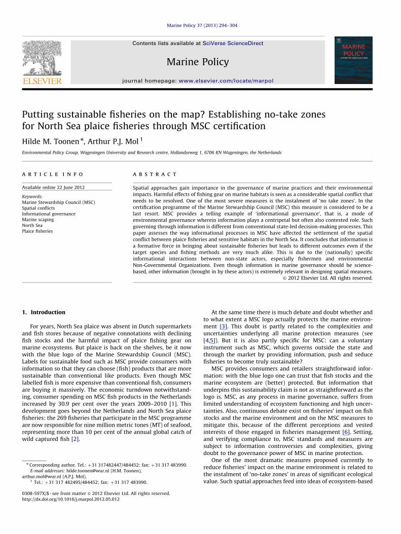
Marine Policy 37 (2013) 294–304
Contents lists available at SciVerse ScienceDirect
Marine Policy
0308-59
http://d
n Corr
E-m
arthur.m1 Te
journal homepage: www.elsevier.com/locate/marpol
Putting sustainable fisheries on the map? Establishing no-take zonesfor North Sea plaice fisheries through MSC certification
Hilde M. Toonen n, Arthur P.J. Mol 1
Environmental Policy Group, Wageningen University and Research centre, Hollandseweg 1, 6706 KN Wageningen, the Netherlands
a r t i c l e i n f o
Available online 22 June 2012
Keywords:
Marine Stewardship Council (MSC)
Spatial conflicts
Informational governance
Marine scaping
North Sea
Plaice fisheries
7X/$ - see front matter & 2012 Elsevier Ltd.
x.doi.org/10.1016/j.marpol.2012.05.012
esponding author. Tel.: þ31 317482447/484
ail addresses: [email protected] (H.M. Too
[email protected] (A.P.J. Mol).
l.: þ31 317 482495/484452; fax: þ31 317 4
a b s t r a c t
Spatial approaches gain importance in the governance of marine practices and their environmental
impacts. Harmful effects of fishing gear on marine habitats is seen as a considerable spatial conflict that
needs to be resolved. One of the most severe measures is the instalment of ‘no take zones’. In the
certification programme of the Marine Stewardship Council (MSC) this measure is considered to be a
last resort. MSC provides a telling example of ‘informational governance’, that is, a mode of
environmental governance wherein information plays a centripetal but often also contested role. Such
governing through information is different from conventional state-led decision-making processes. This
paper assesses the way informational processes in MSC have affected the settlement of the spatial
conflict between plaice fisheries and sensitive habitats in the North Sea. It concludes that information is
a formative force in bringing about sustainable fisheries but leads to different outcomes even if the
target species and fishing methods are very much alike. This is due to the (nationally) specific
informational interactions between non-state actors, especially fishermen and environmental
Non-Governmental Organizations. Even though information in marine governance should be science-
based, other information (brought in by these actors) is extremely relevant in designing spatial measures.
& 2012 Elsevier Ltd. All rights reserved.
1. Introduction
For years, North Sea plaice was absent in Dutch supermarketsand fish stores because of negative connotations with decliningfish stocks and the harmful impact of plaice fishing gear onmarine ecosystems. But plaice is back on the shelves, be it nowwith the blue logo of the Marine Stewardship Council (MSC).Labels for sustainable food such as MSC provide consumers withinformation so that they can choose (fish) products that are moresustainable than conventional like products. Even though MSClabelled fish is more expensive than conventional fish, consumersare buying it massively. The economic turndown notwithstand-ing, consumer spending on MSC fish products in the Netherlandsincreased by 30.9 per cent over the years 2009–2010 [1]. Thisdevelopment goes beyond the Netherlands and North Sea plaicefisheries: the 269 fisheries that participate in the MSC programmeare now responsible for nine million metric tones (MT) of seafood,representing more than 10 per cent of the annual global catch ofwild captured fish [2].
All rights reserved.
452; fax: þ31 317 483990.
nen),
83990.
At the same time there is much debate and doubt whether andto what extent a MSC logo actually protects the marine environ-ment [3]. This doubt is partly related to the complexities anduncertainties underlying all marine protection measures (see[4,5]). But it is also partly specific for MSC: can a voluntaryinstrument such as MSC, which governs outside the state andthrough the market by providing information, push and seducefisheries to become truly sustainable?
MSC provides consumers and retailers straightforward infor-mation: with the blue logo one can trust that fish stocks and themarine ecosystem are (better) protected. But information thatunderpins this sustainability claim is not as straightforward as thelogo is. MSC, as any process in marine governance, suffers fromlimited understanding of ecosystem functioning and high uncer-tainties. Also, continuous debate exist on fisheries’ impact on fishstocks and the marine environment and on the MSC measures tomitigate this, because of the different perceptions and vestedinterests of those engaged in fisheries management [6]. Setting,and verifying compliance to, MSC standards and measures aresubject to information controversies and complexities, givingdoubt to the governance power of MSC in marine protection.
One of the most dramatic measures proposed currently toreduce fisheries’ impact on the marine environment is related tothe instalment of ‘no-take zones’ in areas of significant ecologicalvalue. Such spatial approaches feed into ideas of ecosystem-based
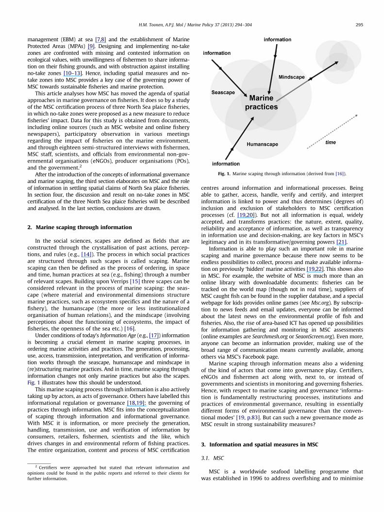
Fig. 1. Marine scaping through information (derived from [16]).
H.M. Toonen, A.P.J. Mol / Marine Policy 37 (2013) 294–304 295
management (EBM) at sea [7,8] and the establishment of MarineProtected Areas (MPAs) [9]. Designing and implementing no-takezones are confronted with missing and contested information onecological values, with unwillingness of fishermen to share informa-tion on their fishing grounds, and with obstruction against installingno-take zones [10–13]. Hence, including spatial measures and no-take zones into MSC provides a key case of the governing power ofMSC towards sustainable fisheries and marine protection.
This article analyses how MSC has moved the agenda of spatialapproaches in marine governance on fisheries. It does so by a studyof the MSC certification process of three North Sea plaice fisheries,in which no-take zones were proposed as a new measure to reducefisheries’ impact. Data for this study is obtained from documents,including online sources (such as MSC website and online fisherynewspapers), participatory observation in various meetingsregarding the impact of fisheries on the marine environment,and through eighteen semi-structured interviews with fishermen,MSC staff, scientists, and officials from environmental non-gov-ernmental organisations (eNGOs), producer organisations (POs),and the government.2
After the introduction of the concepts of informational governanceand marine scaping, the third section elaborates on MSC and the roleof information in settling spatial claims of North Sea plaice fisheries.In section four, the discussion and result on no-take zones in MSCcertification of the three North Sea plaice fisheries will be describedand analysed. In the last section, conclusions are drawn.
2. Marine scaping through information
In the social sciences, scapes are defined as fields that areconstructed through the crystallisation of past actions, percep-tions, and rules (e.g., [14]). The process in which social practicesare structured through such scapes is called scaping. Marinescaping can then be defined as the process of ordering, in spaceand time, human practices at sea (e.g., fishing) through a numberof relevant scapes. Building upon Verrips [15] three scapes can beconsidered relevant in the process of marine scaping: the seas-cape (where material and environmental dimensions structuremarine practices, such as ecosystem specifics and the nature of afishery), the humanscape (the more or less institutionalizedorganisation of human relations), and the mindscape (involvingperceptions about the functioning of ecosystems, the impact offisheries, the openness of the sea etc.) [16].
Under conditions of today’s Information Age (e.g., [17]) informationis becoming a crucial element in marine scaping processes, inordering marine activities and practices. The generation, processing,use, access, transmission, interpretation, and verification of informa-tion works through the seascape, humanscape and mindscape in(re)structuring marine practices. And in time, marine scaping throughinformation changes not only marine practices but also the scapes.Fig. 1 illustrates how this should be understood.
This marine scaping process through information is also activelytaking up by actors, as acts of governance. Others have labelled thisinformational regulation or governance [18,19]: the governing ofpractices through information. MSC fits into the conceptualizationof scaping through information and informational governance.With MSC it is information, or more precisely the generation,handling, transmission, use and verification of information byconsumers, retailers, fishermen, scientists and the like, whichdrives changes in and environmental reform of fishing practices.The entire organization, content and process of MSC certification
2 Certifiers were approached but stated that relevant information and
opinions could be found in the public reports and referred to their clients for
further information.
centres around information and informational processes. Beingable to gather, access, handle, verify and certify, and interpretinformation is linked to power and thus determines (degrees of)inclusion and exclusion of stakeholders to MSC certificationprocesses (cf. [19,20]). But not all information is equal, widelyaccepted, and transforms practices: the nature, extent, quality,reliability and acceptance of information, as well as transparencyin information use and decision-making, are key factors in MSC’slegitimacy and in its transformative/governing powers [21].
Information is able to play such an important role in marinescaping and marine governance because there now seems to beendless possibilities to collect, process and make available informa-tion on previously ‘hidden’ marine activities [19,22]. This shows alsoin MSC. For example, the website of MSC is much more than anonline library with downloadable documents: fisheries can betracked on the world map (though not in real time), suppliers ofMSC caught fish can be found in the supplier database, and a specialwebpage for kids provides online games (see Msc.org). By subscrip-tion to news feeds and email updates, everyone can be informedabout the latest news on the environmental profile of fish andfisheries. Also, the rise of area-based ICT has opened up possibilitiesfor information gathering and monitoring in MSC assessments(online examples are Searchmesh.org or SeaonScreen.org). Even more,anyone can become an information provider, making use of thebroad range of communication means currently available, amongothers via MSC’s Facebook page.
Marine scaping through information means also a wideningof the kind of actors that come into governance play. Certifiers,eNGOs and fishermen act along with, next to, or instead ofgovernments and scientists in monitoring and governing fisheries.Hence, with respect to marine scaping and governance ‘informa-tion is fundamentally restructuring processes, institutions andpractices of environmental governance, resulting in essentiallydifferent forms of environmental governance than the conven-tional modes’ [19, p.83]. But can such a new governance mode asMSC result in strong sustainability measures?
3. Information and spatial measures in MSC
3.1. MSC
MSC is a worldwide seafood labelling programme thatwas established in 1996 to address overfishing and to minimise
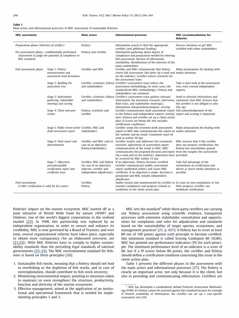
Table 1Main actors and informational processes in MSC assessment of sustainable fisheries.
MSC assessment Main actors Informational processes MSC recommendations forfisheries
Preparation phase (Selection of certifier) Fishery Information search to find the appropriate
certifier (and additional funding)
Discuss intention to get MSC
certified with other stakeholders
Pre-assessment phase—confidentially performed
(Assessment to judge the potential of compliance to
MSC standard)
Fishery and certifier Information gathering about degree of
compliance and preparation needed for entering
full assessment; Review of information
availability; Identification of the interests of the
main stakeholders
Full assessment phase Stage 1: Fishery
announcement and
assessment team formation
Certifier and MSC Certifier and MSC communicate that fishery
enters full assessment (the latter by e-mail and
on the website); Certifier selects scientists for
the assessment team
Make preparations for dealing with
media attention
Stage 2: Building the
assessment tree
Certifier, scientists, fishery
and stakeholders
Certifier’s assessment team selects the
assessment methodology (in most cases, the
standardized MSC methodology); Fishery and
stakeholders can comment
Take a close look at the assessment
tree, even consult independent
experts.
Stage 3: Information
gathering, stakeholder
meetings and scoring
Certifier, scientists, fishery
and stakeholders
Certifier’s assessment team gathers relevant
information (by document research, interviews,
field visits, and stakeholder meetings);
information interpretation/analysis; scoring
Send in relevant information and
comments (but MSC stresses that
the certifier is not obliged to take
this up).
Stage 4: Client and peer
review
Fishery, scientists and
certifier
Certifier communicates draft assessment report
to the fishery and independent experts (mostly
two). Fishery and certifier set up a client action
plan (if scores are below 80, this includes
certification conditions)
Full acknowledgement of the
report and scoring is important
Stage 5: Public review of the
draft assessment report
Certifier, MSC and
stakeholders
Certifier sends the reviewed draft assessment
report to MSC who communicates the report on
the website and by email; Comments must be
send in within 30 day
Make preparations for dealing with
media attention
Stage 6: Final report and
determination
Certifier and MSC (and in
case of an objection:
fishery/stakeholder).
Certifier studies and addresses the comments
received; adjustment of assessment report;
communication of the result to MSC; MSC
communicates the proposed decision and report
(by e-mail and on the website); objections must
be received by MSC within 15 day
MSC stresses that if the certifier
does not propose certification, the
fishery has nevertheless gained
from the insights the assessment
provided.
Stage 7: Objections
procedure/public
certification report and
certificate issue
Certifier, MSC and fishery
(in case of an objection:
objector, certifier and
independent adjudicator)
If no objections: fishery becomes certified.
Certifier communicates public assessment
report (published online) and issues MSC
certificate. If an objection is made: decision is
postponed and MSC installs independent
adjudicator
Take full advantage of the
momentum of certification and
derive as much media attention as
possible.
Post-assessment
(A MSC certification is valid for five years)
Certifier,
fishery
Audits (yearly and unannounced) by certifier to
monitor compliance and progress related to
conditions in the client action plan
In cases on non-compliance or too
little progress, certifier can
withdraw certification
H.M. Toonen, A.P.J. Mol / Marine Policy 37 (2013) 294–304296
fisheries’ impact on the marine ecosystem. MSC started off as ajoint initiative of World Wide Fund for nature (WWF) andUnilever, one of the world’s biggest corporations in the seafoodmarket [23]. In 1998, this partnership was replaced by anindependent organization, in order to ensure and enhance itscredibility. MSC is now governed by a Board of Trustees, and overtime, several organizational reforms have taken place, especiallyto obtain more transparancy (for an elaborated overview, see[21,23]). With MSC fisheries have to comply to higher sustain-ability standards than the prevailing legal standards of nationalgovernments [23–25]. The MSC environmental standard for fish-eries is based on three principles [26]:
1.
Sustainable fish stocks, meaning that a fishery should not leadto overfishing or the depletion of fish stocks, and in case ofoverexploitation, should contribute to fish stock recovery;2.
3
Minimising environmental impact, pointing to measures takento maintain (or even strengthen) the structure, productivity,function and diversity of the marine ecosystem;
MSC has developed a standardized, default Fisheries Assessment Methodol-
ogy (FAM). If a fishery cannot be assessed against this standard because for example
3.of limited availability of information, the certifier can set up a case-specific
assessment tree [26].
Effective management, aimed at the application of an institu-tional and operational framework that is needed for imple-menting principles 1 and 2.
MSC sets the standard3 while third-party certifiers are carryingout ‘fishery assessment using scientific evidence, transparentprocesses with extensive stakeholder consultation and opportu-nities for complaints and rules for adjudication and standardsbased on the sustainability of target species, ecosystems, andmanagement practices’ [21, p. 657]. A fishery has to score at least80 out of 100 points against each principle to become certified;this minimum standard is called Scoring Guidepost 80 (SG80).MSC has pointed out performance indicators (PI) for each princi-ple. The minimum performance level of an indicator is a score of60, but if a PI scores below 80 points, the certifier and fisheryshould define a certification condition concerning this issue in theclient action plan.
Table 1 presents the different phases in the assessment withthe main actors and informational processes [27]. The fishery isclearly an important actor, not only because it is the client, butalso in providing and communicating information. Certifiers are
H.M. Toonen, A.P.J. Mol / Marine Policy 37 (2013) 294–304 297
working with scientific experts in order to get and interpret thenecessary input in the assessment, and independent experts haveto judge the draft assessment. This highlights the MSC prerequi-site that information should be science-based. Another importantinformational characteristic is the harmonisation principle: certi-fiers should look into the assessments of fisheries that have ‘areasof overlap’ [28]. Hereby, MSC strives to level the playing field andto ensure consistency in certification.
Stakeholders (fishermen, fishery representatives, govern-ments, eNGOs and others who have an interest) may commenton the assessment. Transparency is seen as a key component instakeholder involvement, but there is no full disclosure in MSC.Although fishermen most often share information with kin, closefriends or fellow villagers on a reciprocal basis, they tend to keepinformation about good fishing spots to themselves, doing other-wise might lead to jeopardising one’s competitive position [11].This information strategy is respected and adopted by MSC: in thepublic reports, certifiers do not have to publish competition-sensitive information. If the client or stakeholders do not agreewith the certifier’s proposed decision, there is a formal objectionprocedure that is according to MSC ‘yet another way the MSCprogramme ensures that decisions are transparent and credible’[29]. Reasons for objection are: a serious irregularity in theassessment; unjustified scoring (due to factual errors, omissionof relevant information or arbitrariness); or additional relevantinformation has not been taken into account [30].
3.2. North Sea plaice fisheries
The North Sea is a shallow, salty, relatively cold, and ecologi-cally rich European sea, and one of the most heavily used marineareas in the world [31]. Plaice are commercially importantspecies. Over the last ten years, around 43% of the plaice waslanded by the Netherlands, followed by the United Kingdom (UK)with 24% and Denmark with 17% [32]. Plaice is mainly targeted byDutch fishermen, even more than the percentages above suggestbecause a part of them operates under foreign flag. Plaice is a flatfish that hides in the seabed, burrowing itself under the sand ormud. The most common fishing method is demersal trawling: atrawl (with tickler chains) is towed close to or along the bottomso the plaice will be disturbed and swim up into the nets.
Addressing fisheries and related environmental issues at theNorth Sea is a shared effort of the European Union (EU) and theNorth Sea states, through different kind of arrangements rangingfrom government-led management to participatory forms ofgovernance. Habitat impact of bottom-touching gear is consid-ered to be of great concern. Because the trawls scrape the seabed,demersal fisheries have an impact on the marine ecosystem,especially on benthos which are organisms that live near, on,and in the seafloor, for example corals, worms, clams and seastars [33]. The allocation of fisheries is debated in state-ledworking groups, such as the German project ‘EnvironmentallySound Fisheries Management in Marine Protected Areas’ (EMPAS)and the Dutch project ‘Fishing in Marine Protected Areas’(FIMPAS). But existing activities in these areas are not restricted,it is only recently (December 2011) that the Dutch governmentdefined zoning measures for two areas within the 12 nautical milezone (one area includes a 25% closed zone for beam trawlers) [34].
The seascape characteristics of North Sea plaice fisheries affectthe content of information that is needed to address spatialconflicts. A fishery has to comply to existing rules and regulations,but in order to meet the MSC standard, the assessment team hasto gather information about the benthic values of the specificfishing grounds, and need to assess the habitat impact of thebottom touching gear. In a recent communication, the TechnicalAdvisory Board (TAB) of MSC stated that: ‘Knowledge of the
structure and role of habitats is often very limited, and there isnot general or widespread agreement on the equivalent of targetsand limits for fishery impacts’ [35]. It is generally recognised thatall trawling methods sort effect though to different extents; ottertrawling is for example considered to be less harmful than beamtrawling [36]. Gear impact is also related to the specific seabed:sandy and muddy areas are more resilient than reefs. However,marine research is difficult and costly, information is often notconclusive, and cause-effect relations are hard to prove. Fisher-men thus often argue that one storm has a greater effect than ahundred beam trawls.
How actors deal with this information depends on perceptions,experiences and interests. Especially relevant is the mindscapedifference between fishermen, scientists and eNGOs. For fisher-men, log data, maps and other information is directly related tothe amount of fish they catch, and thus their economic gains.Fishermen state that it is in their own interest to act sustainablysince the marine ecosystem provides them their livelihoods.Because they spent so much time at sea, they have a richecological knowledge. This is widely acknowledged, but becausethe aim of their information gathering is fish-finding, they ‘see’differently than marine scientists (cf. [6,11,37,38]). Environmen-tal NGOs are well-known for their ability to use scientificinformation to bring across their conservation message [39,40].But even though they often side with scientists, their informa-tional practices are quite different, since they do not collectprimary data at sea but draw on secondary (albeit often scientific)information sources.
3.3. Addressing spatial conflicts in MSC
The only fishing methods that are explicitly excluded fromMSC certification are the use of poison and dynamite. Fisheriesemploying any other method, such as trawling, can in principleapply for certification. Whether additional measures to addresshabitat-gear interactions have to be set, is dependent on thescoring on principle 2, and especially the habitat-component.Components under principle 2 are assessed against three PIs,namely outcome (impact of the fishery on the specific compo-nent), management (reliability and implementation of proposedactions, tools or strategies to manage the fishery’s impact) andinformation (nature, extent, quality and reliability of relevantinformation) [26]. Management system criteria are set underprinciple 3, indicating tools and mechanisms for implementingstrategies that are formulated under principle 1 and 2. Criterion10e under principle 3 indicates the establishment of no-takezones ‘where appropriate’, as a possible spatial measure [41].
As stated, spatial measures to deal with habitat impact are notwithout controversy, especially creating no-take zones. Fisher-men are reluctant to share information about their fishing spotsand ‘want to maintain the traditional practice of full flexibility interms of how, when and where to fish’ [13, p. 186]. North Seafishermen are especially wary because of their experience withthe so-called ‘plaice box’. This plaice box was established in 1989to enhance plaice recruitment, and still is a semi-closed area. In2000, an assessment pointed to a stock decrease in the plaice box,in contrast to expectations [42]. Until today, the effectiveness ofthe plaice box remains disputed. Nonetheless, recent figures showthat the overall North Sea plaice stock stays ‘well within precau-tionary boundaries, and has reached its highest levels in recordedhistory’ [32, p. 66].
In scientific literature, there is no general consensus about theeffectiveness of closed areas, although zoning measures areconsidered important in EBM [7,43]. Since conservation goalsare difficult to quantify, eNGOs argue that no-take zones shouldbe ‘large enough’. In the North Sea area, the German and Dutch
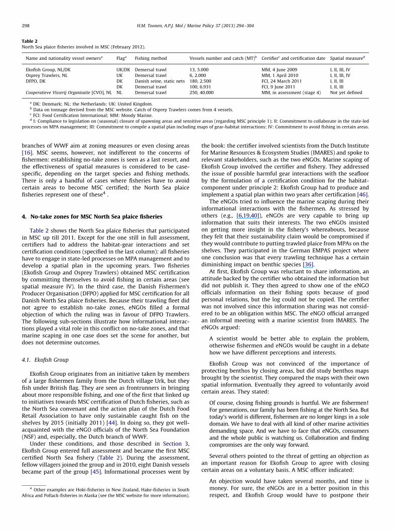
Table 2North Sea plaice fisheries involved in MSC (February 2012).
Name and nationality vessel ownersa Flaga Fishing method Vessels number and catch (MT)b Certifierc and certification date Spatial measured
Ekofish Group, NL/DK UK/DK Demersal trawl 13, 5.000 MM, 4 June 2009 I, II, III, IV
Osprey Trawlers, NL UK Demersal trawl 6, 2.000 MM, 1 April 2010 I, II, III, IV
DFPO, DK DK Danish seine, static nets 180, 2.500 FCI, 24 March 2011 I, II, III
DK Demersal trawl 100, 6.931 FCI, 9 June 2011 I, II, III
Cooperatieve Visserij Organisatie [CVO], NL NL Demersal trawl 250, 40.000 MM, in assessment (stage 4) Not yet defined
a DK: Denmark; NL: the Netherlands; UK: United Kingdom.b Data on tonnage derived from the MSC website. Catch of Osprey Trawlers comes from 4 vessels.c FCI: Food Certification International; MM: Moody Marine.d I: Compliance to legislation on (seasonal) closure of spawning areas and sensitive areas (regarding MSC principle 1); II: Commitment to collaborate in the state-led
processes on MPA management; III: Commitment to compile a spatial plan including maps of gear-habitat interactions; IV: Commitment to avoid fishing in certain areas.
H.M. Toonen, A.P.J. Mol / Marine Policy 37 (2013) 294–304298
branches of WWF aim at zoning measures or even closing areas[16]. MSC seems, however, not indifferent to the concerns offishermen: establishing no-take zones is seen as a last resort, andthe effectiveness of spatial measures is considered to be case-specific, depending on the target species and fishing methods.There is only a handful of cases where fisheries have to avoidcertain areas to become MSC certified; the North Sea plaicefisheries represent one of these4 .
4. No-take zones for MSC North Sea plaice fisheries
Table 2 shows the North Sea plaice fisheries that participatedin MSC up till 2011. Except for the one still in full assessment,certifiers had to address the habitat-gear interactions and setcertification conditions (specified in the last column): all fisherieshave to engage in state-led processes on MPA management and todevelop a spatial plan in the upcoming years. Two fisheries(Ekofish Group and Osprey Trawlers) obtained MSC certificationby committing themselves to avoid fishing in certain areas (seespatial measure IV). In the third case, the Danish Fishermen’sProducer Organisation (DFPO) applied for MSC certification for allDanish North Sea plaice fisheries. Because their trawling fleet didnot agree to establish no-take zones, eNGOs filled a formalobjection of which the ruling was in favour of DFPO Trawlers.The following sub-sections illustrate how informational interac-tions played a vital role in this conflict on no-take zones, and thatmarine scaping in one case does set the scene for another, butdoes not determine outcomes.
4.1. Ekofish Group
Ekofish Group originates from an initiative taken by membersof a large fishermen family from the Dutch village Urk, but theyfish under British flag. They are seen as frontrunners in bringingabout more responsible fishing, and one of the first that linked upto initiatives towards MSC certification of Dutch fisheries, such asthe North Sea convenant and the action plan of the Dutch FoodRetail Association to have only sustainable caught fish on theshelves by 2015 (initially 2011) [44]. In doing so, they got well-acquainted with the eNGO officials of the North Sea Foundation(NSF) and, especially, the Dutch branch of WWF.
Under these conditions, and those described in Section 3,Ekofish Group entered full assessment and became the first MSCcertified North Sea fishery (Table 2). During the assessment,fellow villagers joined the group and in 2010, eight Danish vesselsbecame part of the group [45]. Informational processes went by
4 Other examples are Hoki-fisheries in New Zealand, Hake-fisheries in South
Africa and Pollack-fisheries in Alaska (see the MSC website for more information).
the book: the certifier involved scientists from the Dutch Institutefor Marine Resources & Ecosystem Studies (IMARES) and spoke torelevant stakeholders, such as the two eNGOs. Marine scaping ofEkofish Group involved the certifier and fishery. They addressedthe issue of possible harmful gear interactions with the seafloorby the formulation of a certification condition for the habitat-component under principle 2: Ekofish Group had to produce andimplement a spatial plan within two years after certification [46].
The eNGOs tried to influence the marine scaping during theirinformational interactions with the fishermen. As stressed byothers (e.g., [6,19,40]), eNGOs are very capable to bring upinformation that suits their interests. The two eNGOs insistedon getting more insight in the fishery’s whereabouts, becausethey felt that their sustainability claim would be compromised ifthey would contribute to putting trawled plaice from MPAs on theshelves. They participated in the German EMPAS project whereone conclusion was that every trawling technique has a certaindiminishing impact on benthic species [36].
At first, Ekofish Group was reluctant to share information, anattitude backed by the certifier who obtained the information butdid not publish it. They then agreed to show one of the eNGOofficials information on their fishing spots because of goodpersonal relations, but the log could not be copied. The certifierwas not involved since this information sharing was not consid-ered to be an obligation within MSC. The eNGO official arrangedan informal meeting with a marine scientist from IMARES. TheeNGOs argued:
A scientist would be better able to explain the problem,otherwise fishermen and eNGOs would be caught in a debatehow we have different perceptions and interests.
Ekofish Group was not convinced of the importance ofprotecting benthos by closing areas, but did study benthos mapsbrought by the scientist. They compared the maps with their ownspatial information. Eventually they agreed to voluntarily avoidcertain areas. They stated:
Of course, closing fishing grounds is hurtful. We are fishermen!For generations, our family has been fishing at the North Sea. Buttoday’s world is different, fishermen are no longer kings in a soledomain. We have to deal with all kind of other marine activitiesdemanding space. And we have to face that eNGOs, consumersand the whole public is watching us. Collaboration and findingcompromises are the only way forward.
Several others pointed to the threat of getting an objection asan important reason for Ekofish Group to agree with closingcertain areas on a voluntary basis. A MSC officer indicated:
An objection would have taken several months, and time ismoney. For sure, the eNGOs are in a better position in thisrespect, and Ekofish Group would have to postpone their
H.M. Toonen, A.P.J. Mol / Marine Policy 37 (2013) 294–304 299
selling of MSC caught plaice. But of course, Ekofish Groupdidn’t like the measure, nor did their fellow fishermen.
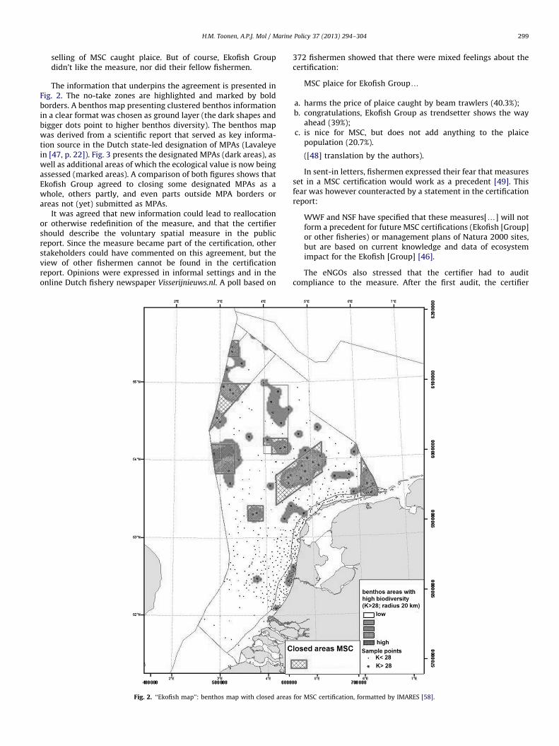
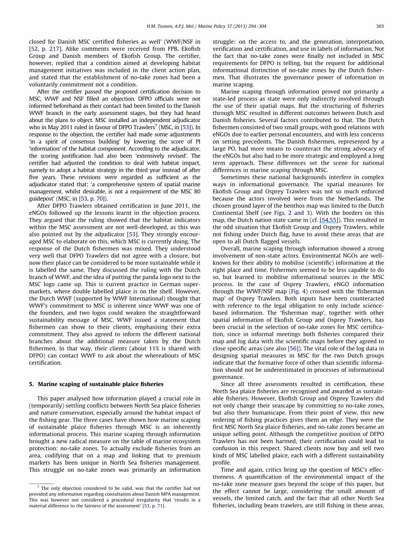
The information that underpins the agreement is presented inFig. 2. The no-take zones are highlighted and marked by boldborders. A benthos map presenting clustered benthos informationin a clear format was chosen as ground layer (the dark shapes andbigger dots point to higher benthos diversity). The benthos mapwas derived from a scientific report that served as key informa-tion source in the Dutch state-led designation of MPAs (Lavaleyein [47, p. 22]). Fig. 3 presents the designated MPAs (dark areas), aswell as additional areas of which the ecological value is now beingassessed (marked areas). A comparison of both figures shows thatEkofish Group agreed to closing some designated MPAs as awhole, others partly, and even parts outside MPA borders orareas not (yet) submitted as MPAs.
It was agreed that new information could lead to reallocationor otherwise redefinition of the measure, and that the certifiershould describe the voluntary spatial measure in the publicreport. Since the measure became part of the certification, otherstakeholders could have commented on this agreement, but theview of other fishermen cannot be found in the certificationreport. Opinions were expressed in informal settings and in theonline Dutch fishery newspaper Visserijnieuws.nl. A poll based on
Fig. 2. ‘‘Ekofish map’’: benthos map with closed areas
372 fishermen showed that there were mixed feelings about thecertification:
MSC plaice for Ekofish Groupy
a.
for
harms the price of plaice caught by beam trawlers (40.3%);
b. congratulations, Ekofish Group as trendsetter shows the wayahead (39%);
c. is nice for MSC, but does not add anything to the plaicepopulation (20.7%).
([48] translation by the authors).
In sent-in letters, fishermen expressed their fear that measuresset in a MSC certification would work as a precedent [49]. Thisfear was however counteracted by a statement in the certificationreport:
WWF and NSF have specified that these measures[y] will notform a precedent for future MSC certifications (Ekofish [Group]or other fisheries) or management plans of Natura 2000 sites,but are based on current knowledge and data of ecosystemimpact for the Ekofish [Group] [46].
The eNGOs also stressed that the certifier had to auditcompliance to the measure. After the first audit, the certifier
MSC certification, formatted by IMARES [58].
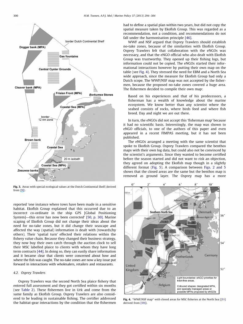
Fig. 3. Areas with special ecological values at the Dutch Continental Shelf (derived
from [9]).
Fig. 4. ‘‘WWF/NSF map’’ with closed areas for MSC fisheries at the North Sea ([51]
derived from [59]).
H.M. Toonen, A.P.J. Mol / Marine Policy 37 (2013) 294–304300
reported ‘one instance where tows have been made in a sensitivehabitat. Ekofish Group explained that this occurred due to anincorrect co-ordinate in the ship GPS [Global PositioningSystem]—this error has now been corrected’ [50, p. 30]. Marinescaping of Ekofish Group did not change their ideas about theneed for no-take zones, but it did change their seascape andaffected the way (spatial) information is dealt with (towards/byothers). Their ‘spatial turn’ effected their relations within thefishery value chain. Because they changed their business strategy,they now buy their own catch through the auction clock to selltheir MSC labelled plaice to clients with whom they have longterm contracts [44]. In doing so, they can easily share informationand it became clear that clients were concerned about how andwhere the fish was caught. The no-take zones are now a key issue putforward in interactions with wholesalers, retailers and restaurants.
4.2. Osprey Trawlers
Osprey Trawlers was the second North Sea plaice fishery thatentered full assessment and they got certified within six months(see Table 2). These fishermen live in Urk and come from thesame family as Ekofish Group. Osprey Trawlers are also consid-ered to be leading in sustainable fishing. The certifier addressedthe habitat-gear interactions by the condition that the fishermen
had to define a spatial plan within two years, but did not copy thespatial measure taken by Ekofish Group. This was regarded as arecommendation, not a condition, and recommendations do notfall under the harmonisation principle [46].
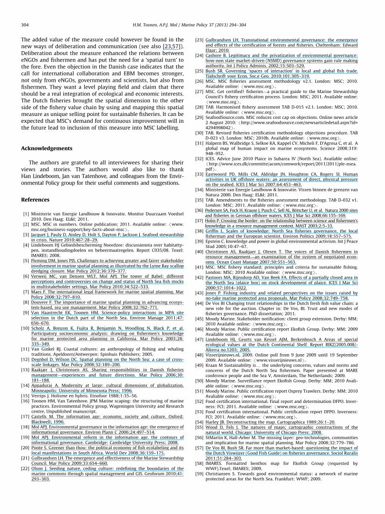
WWF and NSF argued that Osprey Trawlers should establishno-take zones, because of the similarities with Ekofish Group.Osprey Trawlers felt that collaboration with the eNGOs wasnecessary, and that the eNGO official who also dealt with EkofishGroup was trustworthy. They opened up their fishing logs, butinformation could not be copied. The eNGOs started their infor-mational interactions however by putting their own map on thetable (see Fig. 4). They stressed the need for EBM and a North Seawide approach, since the measure for Ekofish Group had only aDutch scope. The WWF/NSF map was not accepted by the fisher-men, because the proposed no-take zones covered a huge area.The fishermen decided to compile their own map:
Based on his experiences and that of his predecessors, afisherman has a wealth of knowledge about the marineecosystem. We know better than any scientist where theseabed consists of rocks, where birds feed and where fishbreed. Day and night we are out there.
In turn, the eNGOs did not accept this ‘fisherman map’ becauseit had no scientific basis. Interestingly, the map was shown toeNGO officials, to one of the authors of this paper and evenappeared in a recent FIMPAS meeting, but it has not beenpublished.
The eNGOs arranged a meeting with the same scientist thatspoke to Ekofish Group. Osprey Trawlers compared the benthosmaps with their own log data, but could also not be convinced bythe scientist’s arguments. Since they wanted to become certifiedbefore the season started and did not want to risk an objection,they agreed on adopting the Ekofish map though in a slightlydifferent format (Fig. 5). A comparison between Figs. 2 and 5shows that the closed areas are the same but the benthos map isremoved as ground layer. The Osprey map has a more
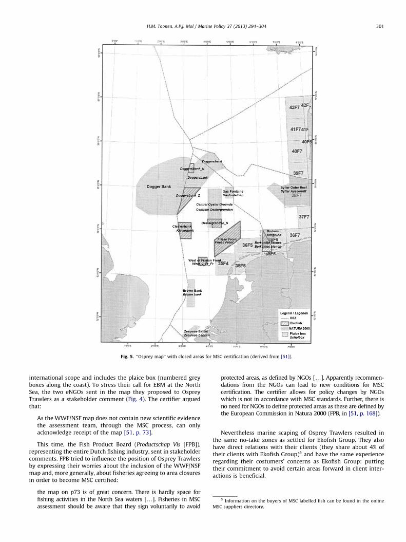
Fig. 5. ‘‘Osprey map’’ with closed areas for MSC certification (derived from [51]).
5 Information on the buyers of MSC labelled fish can be found in the online
MSC suppliers directory.
H.M. Toonen, A.P.J. Mol / Marine Policy 37 (2013) 294–304 301
international scope and includes the plaice box (numbered greyboxes along the coast). To stress their call for EBM at the NorthSea, the two eNGOs sent in the map they proposed to OspreyTrawlers as a stakeholder comment (Fig. 4). The certifier arguedthat:
As the WWF/NSF map does not contain new scientific evidencethe assessment team, through the MSC process, can onlyacknowledge receipt of the map [51, p. 73].
This time, the Fish Product Board (Productschap Vis [FPB]),representing the entire Dutch fishing industry, sent in stakeholdercomments. FPB tried to influence the position of Osprey Trawlersby expressing their worries about the inclusion of the WWF/NSFmap and, more generally, about fisheries agreeing to area closuresin order to become MSC certified:
the map on p73 is of great concern. There is hardly space forfishing activities in the North Sea waters [y]. Fisheries in MSCassessment should be aware that they sign voluntarily to avoid
protected areas, as defined by NGOs [y]. Apparently recommen-dations from the NGOs can lead to new conditions for MSCcertification. The certifier allows for policy changes by NGOswhich is not in accordance with MSC standards. Further, there isno need for NGOs to define protected areas as these are defined bythe European Commission in Natura 2000 (FPB, in [51, p. 168]).
Nevertheless marine scaping of Osprey Trawlers resulted inthe same no-take zones as settled for Ekofish Group. They alsohave direct relations with their clients (they share about 4% oftheir clients with Ekofish Group)5 and have the same experienceregarding their costumers’ concerns as Ekofish Group: puttingtheir commitment to avoid certain areas forward in client inter-actions is beneficial.
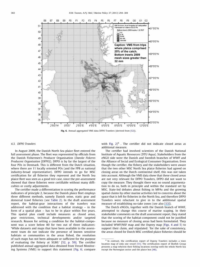
Fig. 6. Annual aggregated VMS data DFPO Trawlers (derived from [52]).
6 In contrast, the certification report of Osprey Trawlers includes a tows
location map of only one vessel [51]. The certification report of Ekofish Group
presents a map wherein their fishing locations overlap with the whole North Sea
except the Norwegian sector and the plaice box [46].
H.M. Toonen, A.P.J. Mol / Marine Policy 37 (2013) 294–304302
4.3. DFPO Trawlers
In August 2009, the Danish North Sea plaice fleet entered thefull assessment phase. The fleet was represented by officials fromthe Danish Fishermen’s Producer Organisation (Danske Fiskeres
Producent Organisation [DFPO]). DFPO is by far the largest of thefour POs in Denmark. This is different from the Dutch situation,where there are 11 locally oriented POs (and the FPB as nationalindustry-broad representative). DFPO intends to go for MSCcertification for all fisheries they represent and the North Seaplaice fleet was seen as a good test case, since the pre-assessmentshowed that these fisheries were certifiable without many diffi-culties or costly adjustments.
The certifier made a differentiation in scoring the performanceindicators of principle 2, because the Danish plaice fleet employsthree different methods, namely Danish seine, static gear anddemersal trawl fisheries (see Table 2). In the draft assessmentreport, the habitat-gear interactions of the trawlers wasaddressed with the condition that a habitat strategy – in theform of a spatial plan – has to be in place within five years.This spatial plan could include measures as closed areas,gear restrictions, technical developments and/or targetedresearch. Reason for setting a condition for the habitat-compo-nent was a score below 80 for two out of three indicators:‘While datasets and maps that have been available to the assess-ment team do not indicate the presence of known sensitivehabitats or communities in the areas fished, the resolutionof such maps has not been adequate or sufficient for the purposeof evaluating the fishery at SG80.’ [52, p. 59]. The certifierpublished annual aggregated data obtained from Vessel Monitor-ing Systems (VMS) to support this statement (Fig. 6; compare
with Fig. 2)6 . The certifier did not indicate closed areas asadditional measure.
The certifier had involved scientists of the Danish NationalInstitute of Aquatic Resources (DTU Aqua). Stakeholders from theeNGO side were the Danish and Swedish branches of WWF andthe Alliance of Social and Ecological Consumer Organisation. Eventhough the certifier, the fishery and the stakeholders were awarethat the two other MSC North Sea plaice fisheries had agreed onclosing areas on the Dutch continental shelf, this was not takeninto account. Although the VMS data show that these closed areasare not very relevant for DFPO Trawlers, DFPO did not want tocopy the measure. They thought there was no sound argumenta-tion to do so, both in principle and within the standard set byMSC. State-led debates about fishing in MPAs and the growingspatial claims by other marine activities led to concerns about thespace that is left for fisheries in the North Sea, and therefore DFPOTrawlers were reluctant to give in to the additional spatialmeasure of establishing no-take zones (see also [13]).
The Dutch eNGOs, together with the Danish branch of WWF,attempted to change this course of marine scaping. In theirstakeholder comments on the draft assessment report, they statedthat the scoring of the habitat-component could not be justifiedbecause no measure of closing areas had been formulated. Theyincluded WWF/NSF map and the Osprey map (Figs. 4 and 5) tosupport their claim, and stipulated: ‘for the sake of consistency,the areas closed for Dutch MSC certified plaice fisheries should be
H.M. Toonen, A.P.J. Mol / Marine Policy 37 (2013) 294–304 303
closed for Danish MSC certified fisheries as well’ (WWF/NSF in[52, p. 217]. Alike comments were received from FPB, EkofishGroup and Danish members of Ekofish Group. The certifier,however, replied that a condition aimed at developing habitatmanagement initiatives was included in the client action plan,and stated that the establishment of no-take zones had been avoluntarily commitment not a condition.
After the certifier passed the proposed certification decision toMSC, WWF and NSF filled an objection. DFPO officials were notinformed beforehand as their contact had been limited to the DanishWWF branch in the early assessment stages, but they had heardabout the plans to object. MSC installed an independent adjudicatorwho in May 2011 ruled in favour of DFPO Trawlers7 (MSC, in [53]). Inresponse to the objection, the certifier had made some adjustments‘in a spirit of consensus building’ by lowering the score of PI‘information’ of the habitat component. According to the adjudicator,the scoring justification had also been ‘extensively revised’. Thecertifier had adjusted the condition to deal with habitat impact,namely to adopt a habitat strategy in the third year instead of afterfive years. These revisions were regarded as sufficient as theadjudicator stated that: ‘a comprehensive system of spatial marinemanagement, whilst desirable, is not a requirement of the MSC 80guidepost’ (MSC, in [53, p. 70]).
After DFPO Trawlers obtained certification in June 2011, theeNGOs followed up the lessons learnt in the objection process.They argued that the ruling showed that the habitat indicatorswithin the MSC assessment are not well-developed, as this wasalso pointed out by the adjudicator [53]. They strongly encour-aged MSC to elaborate on this, which MSC is currently doing. Theresponse of the Dutch fishermen was mixed. They understoodvery well that DFPO Trawlers did not agree with a closure, butnow their plaice can be considered to be more sustainable while itis labelled the same. They discussed the ruling with the Dutchbranch of WWF, and the idea of putting the panda logo next to theMSC logo came up. This is current practice in German super-markets, where double labelled plaice is on the shelf. However,the Dutch WWF (supported by WWF International) thought thatWWF’s commitment to MSC is inherent since WWF was one ofthe founders, and two logos could weaken the straightforwardsustainability message of MSC. WWF issued a statement thatfishermen can show to their clients, emphasising their extracommitment. They also agreed to inform the different nationalbranches about the additional measure taken by the Dutchfishermen. In that way, their clients (about 11% is shared withDFPO) can contact WWF to ask about the whereabouts of MSCcertification.
5. Marine scaping of sustainable plaice fisheries
This paper analysed how information played a crucial role in(temporarily) settling conflicts between North Sea plaice fisheriesand nature conservation, especially around the habitat impact ofthe fishing gear. The three cases have shown how marine scapingof sustainable plaice fisheries through MSC is an inherentlyinformational process. This marine scaping through informationbrought a new radical measure on the table of marine ecosystemprotection: no-take zones. To actually exclude fisheries from anarea, codifying that on a map and linking that to premiummarkets has been unique in North Sea fisheries management.This struggle on no-take zones was primarily an information
7 The only objection considered to be valid, was that the certifier had not
provided any information regarding consultation about Danish MPA management.
This was however not considered a procedural irregularity that ‘results in a
material difference to the fairness of the assessment’ [53, p. 71].
struggle: on the access to, and the generation, interpretation,verification and certification, and use in labels of information. Notthe fact that no-take zones were finally not included in MSCrequirements for DFPO is telling, but the request for additionalinformational distinction of no-take zones by the Dutch fisher-men. That illustrates the governance power of information inmarine scaping.
Marine scaping through information proved not primarily astate-led process as state were only indirectly involved throughthe use of their spatial maps. But the structuring of fisheriesthrough MSC resulted in different outcomes between Dutch andDanish fisheries. Several factors contributed to that. The Dutchfishermen consisted of two small groups, with good relations witheNGOs due to earlier personal encounters, and with less concernson setting precedents. The Danish fishermen, represented by alarge PO, had more means to counteract the strong advocacy ofthe eNGOs but also had to be more strategic and employed a longterm approach. These differences set the scene for nationaldifferences in marine scaping through MSC.
Sometimes these national backgrounds interfere in complexways in informational governance. The spatial measures forEkofish Group and Osprey Trawlers was not so much enforcedbecause the actors involved were from the Netherlands. Thechosen ground layer of the benthos map was limited to the DutchContinental Shelf (see Figs. 2 and 3). With the borders on thismap, the Dutch nation state came in (cf. [54,55]). This resulted inthe odd situation that Ekofish Group and Osprey Trawlers, whilenot fishing under Dutch flag, have to avoid these areas that areopen to all Dutch flagged vessels.
Overall, marine scaping through information showed a stronginvolvement of non-state actors. Environmental NGOs are well-known for their ability to mobilise (scientific) information at theright place and time. Fishermen seemed to be less capable to doso, but learned to mobilise informational sources in the MSCprocess. In the case of Osprey Trawlers, eNGO informationthrough the WWF/NSF map (Fig. 4) crossed with the ‘fishermanmap’ of Osprey Trawlers. Both inputs have been counteractedwith reference to the legal obligation to only include science-based information. The ‘fisherman map’, together with otherspatial information of Ekofish Group and Osprey Trawlers, hasbeen crucial in the selection of no-take zones for MSC certifica-tion, since in informal meetings both fisheries compared theirmap and log data with the scientific maps before they agreed toclose specific areas (see also [56]). The vital role of the log data indesigning spatial measures in MSC for the two Dutch groupsindicate that the formative force of other than scientific informa-tion should not be underestimated in processes of informationalgovernance.
Since all three assessments resulted in certification, theseNorth Sea plaice fisheries are recognised and awarded as sustain-able fisheries. However, Ekofish Group and Osprey Trawlers didnot only change their seascape by committing to no-take zones,but also their humanscape. From their point of view, this newordering of fishing practices gives them an edge. They were thefirst MSC North Sea plaice fisheries, and no-take zones became anunique selling point. Although the competitive position of DFPOTrawlers has not been harmed, their certification could lead toconfusion in this respect. Shared clients now buy and sell twokinds of MSC labelled plaice, each with a different sustainabilityprofile.
Time and again, critics bring up the question of MSC’s effec-tiveness. A quantification of the environmental impact of theno-take zone measure goes beyond the scope of this paper, butthe effect cannot be large, considering the small amount ofvessels, the limited catch, and the fact that all other North Seafisheries, including beam trawlers, are still fishing in these areas.
H.M. Toonen, A.P.J. Mol / Marine Policy 37 (2013) 294–304304
The added value of the measure could however be found in thenew ways of deliberation and communication (see also [23,57]).Deliberation about the measure enhanced the relations betweeneNGOs and fishermen and has put the need for a ‘spatial turn’ tothe fore. Even the objection in the Danish case indicates that thecall for international collaboration and EBM becomes stronger,not only from eNGOs, governments and scientists, but also fromfishermen. They want a level playing field and claim that thereshould be a real integration of ecological and economic interests.The Dutch fisheries brought the spatial dimension to the otherside of the fishery value chain by using and mapping this spatialmeasure as unique selling point for sustainable fisheries. It can beexpected that MSC’s demand for continuous improvement will inthe future lead to inclusion of this measure into MSC labelling.
Acknowledgements
The authors are grateful to all interviewees for sharing theirviews and stories. The authors would also like to thankHan Lindeboom, Jan van Tatenhove, and colleagues from the Envir-onmental Policy group for their useful comments and suggestions.
References
[1] Ministerie van Energie Landbouw & Innovatie. Monitor Duurzaam Voedsel2010. Den Haag: EL&I; 2011.
[2] MSC. MSC in numbers. Online publication; 2011. Available online: /www.msc.org/business-support/key-facts-about-mscS.
[3] Jacquet J, Pauly D, Ainley D, Holt S, Dayton P, Jackson J. Seafood stewardshipin crisis. Nature 2010;467:28–29.
[4] Lindeboom HJ Gebiedsbescherming Noordzee: discussienota over habitatty-pen, instandhoudingdoelen en beheermaatregelen. Report C035/08. Texel:IMARES; 2008.
[5] Fleming DM, Jones PJS. Challenges to achieving greater and fairer stakeholderinvolvement in marine spatial planning as illustrated by the Lyme Bay scallopdredging closure. Mar Policy 2012;36:370–377.
[6] Verweij MC, van Densen WLT, Mol APJ. The tower of Babel: differentperceptions and controversies on change and status of North Sea fish stocksin multistakeholder settings. Mar Policy 2010;34:522–533.
[7] Maes F. The international legal framework for marine spatial planning. MarPolicy 2008;32:797–810.
[8] Douvere F. The importance of marine spatial planning in advancing ecosys-tem-based, sea use management. Mar Policy 2008;32:762–771.
[9] Van Haastrecht EK, Toonen HM. Science-policy interactions in MPA siteselection in the Dutch part of the North Sea. Environ Manage 2011;47:656–670.
[10] Scholz A, Bonzon K, Fujita R, Benjamin N, Woodling N, Black P, et al.Participatory socioeconomic analysis: drawing on fishermen’s knowledgefor marine protected area planning in California. Mar Policy 2003;28:335–349.
[11] Van Ginkel RJ. Coastal cultures: an anthropology of fishing and whalingtraditions. Apeldoorn/Antwerpen: Spinhuis Publishers; 2005.
[12] Degnbol D, Wilson DC. Spatial planning on the North Sea: a case of cross-scale linkages. Mar Policy 2008;32:189–200.
[13] Raakjær J, Christensen AS. Sharing responsibilities in Danish fisheriesmanagement—experiences and future directions. Mar Policy 2006;30:181–188.
[14] Appadurai A. Modernity at large: cultural dimensions of globalization.Minneapolis: University of Minnesota Press; 1996.
[15] Verrips J. Holisme en hybris. Etnofoor 1988;1:35–56.[16] Toonen HM, Van Tatenhove. JPM Marine scaping: the structuring of marine
practices. Environmental Policy group, Wageningen University and Researchcentre, Unpublished manuscript.
[17] Castells M. The information age: economy, society and culture. Oxford:Blackwell; 1996.
[18] Mol APJ. Environmental governance in the information age: the emergence ofinformational governance. Environ Plann C 2006;24:497–514.
[19] Mol APJ. Environmental reform in the information age. the contours ofinformational governance. Cambridge: Cambridge University Press; 2008.
[20] Ponte S. Greener than thou: the political economy of fish ecolabeling and itslocal manifestations in South Africa. World Dev 2008;36:159–175.
[21] Gulbrandsen LH. The emergence and effectiveness of the Marine StewardshipCouncil. Mar Policy 2009;33:654–660.
[22] Olson J. Seeding nature, ceding culture: redefining the boundaries of themarine commons through spatial management and GIS. Geoforum 2010;41:293–303.
[23] Gulbrandsen LH. Transnational environmental governance: the emergenceand effects of the certification of forests and fisheries. Cheltenham: EdwardElgar; 2010.
[24] Cashore B. Legitimacy and the privatization of environmental governance:how-non state market-driven (NSMD) governance systems gain rule makingauthority. Int J Policy Adminis. 2002;15:503–529.
[25] Bush SR. Governing ‘spaces of interaction’ in local and global fish trade.Tijdschrift voor Econ. Soc.e Geo. 2010;101:305–319.
[26] MSC. MSC fisheries assessment methodology v2.1. London: MSC; 2010.Available online: /www.msc.orgS.
[27] MSC. Get certified! fisheries—a practical guide to the Marine StewardshipCouncil’s fishery certification process. London: MSC; 2011. Available online:/www.msc.orgS.
[28] TAB. Harmonised fishery assessment TAB D-015 v2.1. London: MSC; 2010.Available online: /www.msc.orgS.
[29] SeafoodSource.com. MSC reduces cost cap on objections. Online news article2 August 2010: /http://www.seafoodsource.com/newsarticledetail.aspx?id=4294998042S.
[30] TAB. Revised fisheries certification methodology objections procedure. TABD-023 v3. London: MSC; 2010b. Available online: /www.msc.orgS.
[31] Halpern BS, Walbridge S, Selkoe KA, Kappel CV, Micheli F, D’Agrosa C, et al. Aglobal map of human impact on marine ecosystems. Science 2008;319:948–952.
[32] ICES. Advice June 2010 Plaice in Subarea IV (North Sea). Available online:/http://www.ices.dk/committe/acom/comwork/report/2011/2011/ple-nsea.pdfS.
[33] Eastwoord PD, Mills CM, Aldridge JN, Houghton CA, Rogers SI. Humanactivities in UK offshore waters: an assessment of direct, physical pressureon the seabed. ICES J Mar Sci 2007;64:453–463.
[34] Ministerie van Energie Landbouw & Innovatie. Vissen binnen de grenzen vanNatura 2000. Den Haag: EL&I; 2011.
[35] TAB. Amendments to the fisheries assessment methodology. TAB D-032 v1.London: MSC; 2011. Available online: /www.msc.orgS.
[36] Pedersen SA, Fock H, Krause J, Pusch C, Sell AL, Bottcher U, et al. Natura 2000 sitesand fisheries in German offshore waters. ICES J Mar Sci 2008;66:155–169.
[37] Holm P. Crossing the border: on the relationship between science and fishermen’sknowledge in a resource management context. MAST 2003;2:5–33.
[38] Griffin L. Scales of knowledge: North Sea fisheries governance, the localfisherman and the European scientist. Environ Politics 2009;18:557–575.
[39] Epstein C. knowledge and power in global environmental activism. Int J PeaceStud 2005;10:47–67.
[40] Christinsen AS, Raakjaer J, Olesen T. The voices of Danish fishermen inresource management—an examination of the system of negotiated econ-omy. Ocean Coast Manage 2007;50:551–563.
[41] MSC. MSC fishery standard; principles and criteria for sustainable fishing.London: MSC; 2010 Available online: /www.msc.orgS.
[42] Pastoors MA, Rijnsdorp AD, Van Beek FA. Effects of a partially closed area inthe North Sea (plaice box) on stock development of plaice. ICES J Mar Sci2000;57:1014–1022.
[43] Jones P. Fishing industry and related perspectives on the issues raised byno-take marine protected area proposals. Mar Policy 2008;32:749–758.
[44] De Vos BI Changing trust relationships in the Dutch fresh fish value chain: anew role for the auction. Chapter in: De Vos, BI. Trust and new modes offisheries governance. PhD dissertation; 2011.
[45] Moody Marine. Stakeholder notification: client group extension. Derby: MM;2010 Available online: /www.msc.orgS.
[46] Moody Marine. Public certification report Ekofish Group. Derby: MM; 2009Available online: /www.msc.orgS.
[47] Lindeboom HJ, Geurts van Kessel AJM, Berkenbosch A Areas of specialecological values at the Dutch Continental Shelf. Report RIKZ/2005.008/-Alterra no.1203; 2005.
[48] Visserijnieuws.nl, 2009. Online poll from 9 June 2009 until 19 September2009. Available online: /www.visserijnieuws.nlS.
[49] Kraan M Sustainability isy the underlying concerns, values and norms andconcerns of the Dutch North Sea fishermen. Paper presented at MAREconference people and the Sea V, Amsterdam, The Netherlands; 2009.
[50] Moody Marine. Surveillance report Ekofish Group. Derby: MM; 2010 Avali-able online: /www.msc.orgS.
[51] Moody Marine. Public certification report Osprey Trawlers. Derby: MM; 2010Avaliable online: /www.msc.orgS.
[52] Food certification international. Final report and determination DFPO. Inver-ness: FCI; 2011. Available online: /www.msc.orgS.
[53] Food certification international. Public certification report DFPO. Inverness:FCI; 2011. Available online: /www.msc.orgS.
[54] Harley JB. Deconstructing the map. Cartographica 1989;26:1–20.[55] Wood D, Fels J. The natures of maps; cartographic constructions of the
natural world. Chicago: University of Chicago Press; 2008.[56] StMartin K, Hall-Arber M. The missing layer: geo-technologies, communities
and implication for marine spatial planning. Mar Policy 2008;32:779–786.[57] De Vos BI, Bush SR. Far more than market-based: questioning the impact of
the Dutch Viswijzer (Good Fish Guide) on fisheries governance. Sociol Ruralis2011;51:284–303.
[58] IMARES. Formatted benthos map for Ekofish Group (requested byWWF).Texel; IMARES; 2009.
[59] Christiansen S. Towards good environmental status: a network of marineprotected areas for the North Sea. Frankfurt: WWF; 2009.
Copyright © 2022 FDOKUMEN