PUBLIC ! t-rl-n - Amazon S3
155
Jnofflclal FERC-Generated PDF of 20050817-0175 Received by FERC OSEC 08/16/2005 in Docket#: P-20-065~ ORIGINAL 825 N.E. Mu/mom~, Suite 1500 Po./,~M, ~ 97232 (503) 813-5000 41t I:: CIFIQ3RP Iwtl~@~ I t.ell@4 i = o m m August 15, 2005 Honorable Magalie R. Sales Secretary Federal Energy Regulatory Commission 888 First S~reet, N.E. Washington, DC 20429 PUBLIC ! t-rl-n z t,~ Re: Pacificorp's Application for Amendment of License and Submission of Offer of Settlement to Remove the Cove Development and Reduce Minimum Flow Requirements in the Grace Bypassed Reach; Bear River Hydroelectric Project, No. 20 -- O~ 5 Secretary Salas: Enclosed for filing in the above-referencedproceeding me an original and fourteen(14) copiesofPac/fiCorp'sApplic.ation forAmendment of License (''the Application")and Offer of Settlementto Remove the Cove Development and Reduce Minimum Flow Requirements in the Grace Bypassed Reach. As explainedin detailin the Applicationand the Offer of Settlement, PacifiCorpisproposing to amend the licenseforthe Bear River Hydroelec~c Project("the Project") to authorizethe removal of the Cove develolxnent, and to reduce minimum flow requirements in the Grace bypassed res=h. PacifiCo~, Federal and State resources agencies, the Shnshone-Barmock Tribes, and envirortmenta] organizations have found that the proposed license amendment, and the Offer of Settlemant upon which it is based, are fair and reasonable, and in the public intcr~t Pursuant to the Commission's regulations at 18 C.F.R. § 385.602, PacifiCorp is submitting a Settlement Agreement ("Agreement") and a separate Explanatory Statement that provides the rationale behind the measures contained in the Agreement. Nothing in the Explanatory Statement is intended to modify the terms of the Agreement. Any conflict between the language in the Agreement and the Explanatory Statement should be resolved in favor of the Agrzemmt. In accordance with Commission's regulations, any person wi~thing to comment on the Offer of Settlement must file such comments with the Secretary no later than 20 days after the filing of his Offer of Settlement. Through this letter, the PacifiCorp hereby provides notification to all participants that comments on the Agreement are due by September 9, 2005. F.~fll¢*3270800 1 00588154)0085
-
Upload
khangminh22 -
Category
Documents
-
view
0 -
download
0
Transcript of PUBLIC ! t-rl-n - Amazon S3

Jnofflclal FERC-Generated PDF of 20050817-0175 Received by FERC OSEC 08/16/2005 in Docket#: P-20-065~
ORIGINAL
825 N.E. Mu/mom~, Suite 1500 Po./,~M, ~ 97232 (503) 813-5000
41t I:: CIFIQ3RP Iwtl~@~ I t.ell@4 i = o m m
August 15, 2005
Honorable Magalie R. Sales Secretary Federal Energy Regulatory Commission 888 First S~reet, N.E. Washington, DC 20429
PUBLIC ! t-rl-n
z t , ~
Re: Pacificorp's Application for Amendment of License and Submission of Offer of Settlement to Remove the Cove Development and Reduce Minimum Flow Requirements in the Grace Bypassed Reach; Bear River Hydroelectric Project, No. 20 -- O ~ 5
Secretary Salas:
Enclosed for filing in the above-referenced proceeding me an original and fourteen (14) copies ofPac/fiCorp's Applic.ation for Amendment of License (''the Application") and Offer of Settlement to Remove the Cove Development and Reduce Minimum Flow Requirements in the Grace Bypassed Reach. As explained in detail in the Application and the Offer of Settlement, PacifiCorp is proposing to amend the license for the Bear River Hydroelec~c Project ("the Project") to authorize the removal of the Cove develolxnent, and to reduce minimum flow requirements in the Grace bypassed res=h. PacifiCo~, Federal and State resources agencies, the Shnshone-Barmock Tribes, and envirortmenta] organizations have found that the proposed license amendment, and the Offer of Settlemant upon which it is based, are fair and reasonable, and in the public intcr~t
Pursuant to the Commission's regulations at 18 C.F.R. § 385.602, PacifiCorp is submitting a Settlement Agreement ("Agreement") and a separate Explanatory Statement that provides the rationale behind the measures contained in the Agreement. Nothing in the Explanatory Statement is intended to modify the terms of the Agreement. Any conflict between the language in the Agreement and the Explanatory Statement should be resolved in favor of the Agrzemmt.
In accordance with Commission's regulations, any person wi~thing to comment on the Offer of Settlement must file such comments with the Secretary no later than 20 days after the filing of his Offer of Settlement. Through this letter, the PacifiCorp hereby provides notification to all participants that comments on the Agreement are due by September 9, 2005.
F.~fll¢*3270800 1 00588154)0085

Jnofflclal FERC-Generated PDF of 20050817-0175 Received by FERC OSEC 08/16/2005 in Docket#: P-20-065
Please note that the Offer of Settlement includes a Cove development Removal Plan ("the Removal Plan") (Appendix B to Settlement Agreement) that contains "critical energy infrastructure information" ("CEIl") as that term is defined under the Commission's regulations. See 18 C.F.R. § 388.112. An original and two copies of the CEIl volume are enclosed and marked accordingly. PacifiCorp requests that the Removal Plan be treated as privileged and confidential, and withheld from public disclosure under the Commission's regulations.
The enclosed Removal Plan contains preliminary engineering and design information that will serve as the basis for updated Exhibits. PacifiCorp will, after consultation with Commission staff, tile final updated Exhibits with the Commission upon completion of the Removal Plan.
Please contact Monte Garrett at 503-813-6629, if you have any questions regarding this tiling.
Sincerely, .., ../~
Managing Direetor, Hydro Relicensing and Compliance
Ce: Environmental Coordination Committee (Without CEIl) Service List (Without CEII)
Enclosures
Scalfi¢-327~O0.! 0058815-00085

Jnofflclal FERC-Generated PDF of 20050817-0175 Received by FERC OSEC 08/16/2005 in Docket#: P-20-0651
UNITED STATES OF AMERICA FEDERAL ENERGY REGULATORY COMMISSION
Project No. 20- 0 & 5 Bear R/ver Hydroelecffic Project
PaciflCorp ) )
Application for Amendment of License ) and Submission of Offer of Settlement )
)
APPLICATION OF PACIFICORP FOR AMENDMENT OF LICENSE AND SUBMISSION OF OFFER OF SETTLEMENT CONCERNING THE
DECOMMISSIONING OF THE COVE DEVELOPMENT
Puzsuant to Subpart L of Part 4 of the Comm/ssion's regulations, and Subpan F of
the Commission's Rules of Practice and Procedure, PacifiCorp, licens~ for the Bear
River Hydroelectric Project No. 20 ("the Project") hereby applies to the Federal Energy
Regulatory Commission ("the Commission'~ to amend the Project license to permit the
removal of the Cove development and adjustment of minimum instre~n flow
requirements in the Grace development's bypassed reach. The enclosed Offer of
Settlement submitted by PacifiCorp under 18 C.F.R. § 385.602 contains the Company's
proposed terms and conditions of the propoced License Amer~lrncnL and reflects a
careful balancing of environmental and economic interests.
C o m m u n i ~ r~,arding thin application should be addressed to the following
individuals, whose names should be placed on the Commission's official s~Tvice list for
pmcAmilng:
John S mple, PacifiCoTp 1500 Lloyd Cemer Tower 825 NE Mulmomah Street Portland, OR 97232-2135 Telephone: (503) 813-6629
Mo zv C,m tt, Projm PscifiCorp 1500 Lloyd Canter Tow~ 825 NE Multnomah Street Portland, OR 97232-2135 Telephone: (503) 813-6629
PACIFICOI~ ALPPLICATION FOR UL'~NSE AMENDMF~VT AND OFFER OF SET77,,EMF, NT 1 Bear Rh~r ~ Project (No. 2O)

Jnofflclal FERC-Generated PDF of 20050817-0175 Received by FERC OSEC 08/16/2005 in Docket#: P-20-065
Facsimile: (503) 813-6633 Facsimile: (503) 813-6633 E-mail: [email protected] E-mail: john.sample~acifiCorp.com
PURPOSE OF APPLICATION
The purpose of this application is to seek Commission authorization for
PacifiCorp to remove the Cove development as described in the enclosed Offer of
Settlement, and to adjust minimum instream flows in the Grace development bypassed
reach as described in the Offer of Settlement. Removal of the Cove development in
accordance with the terms of the Offer of Settlement will enhance environmental
resources in the Project area, and reductions in Grace development bypassed reach
minimum flows will partially offset the cost of Cove development removal.
BACKGROUND
The Project, located on the Bear River in Caribou and Franklin Counties, Idaho,
was licensed by the Commission in 2003. Prior to license issuance, on August 28, 2002,
PacifiCorp executed a comprehensive settlement agreement ("the Relicensing Settlement
Agreement") with sixteen state and federal resource agencies, Indian Tribes, and non-
governmental organizations (collectively, "the Parties") 1 to resolve all issues regarding
relicensing of the Project and for the purpose of obtaining a new Project license (''New
License") from the Commission. 2 On SeptembeT 26, 2002, PacifiCorp flied the
Relicensing Settlement Agreement with the Commission, along with an Explanatory
Pat-flea to the Reliceming Settlemea! Agreement and th~ Agreement include the United Stat¢~ Frith and Wildlife Service; umted States Bureau of Land Management; United Statea National Park Service; United Statea Forest Service; ~ - B a n n o c k T ~ ; Idaho Depm'tmem of Environmemal Quality; Idaho DepasUnem off i sh and Game; Idaho Departme~ of Parks and Recreation; Idaho Cotmcfl of Trout Unfimited; Idaho Rivers United; Greater Yellowstone Coalition; American Whitewater; and other intervenen.
2 The history ofthe Bear River Hych'oelectric Project liceming proceeding is discussed in the Explanatory Statement accompanying the August 28, 2002, Reliceming Settlement Agreement, and the
PACIFICORP APPLIC_~TION FOR LICENSE AMENDMENT AND OFFER OF SETTLEMENT 2 Bear River H.vdr~ec~c Project (No. 20)

Jnofflclal FERC-Generated PDF of 20050817-0175 Received by FERC OSEC 08/16/2005 in Docket#: P-20-065
Statement and proposed license articles. On December 22, 2003, the Commission issued
a New License adopting in large part the Relicensing Settlement Agreement and
incorporating its terms into license articles.
Section 3.1.2.6 of the Relicensing Settlement Agreement required PacifiCorp to
conduct a feasibility study to evaluate methods to improve fish passage at Cove dam,
with alternatives ranging fiom modification of existing facilities, to decommissioning of
the Cove development. PacifiCorp complied with this requirement by providing the
Parties with the Cove Feasibility Study on June 14, 2004. The Cove Feasibility Study
assessed (1) the technical and economic feasibility of decommissioning and removing the
Cove development; (2) interconnecting the Grace tailrace and Cove flume, and removing
Cove dam; and (3) constructing a range offish passage facilities to reduce the barrier
effect of the current infraslxucture.
On December 10, 2004, PacifiCorp, on behalf of the Envimumental Coordinating
Committee ("ECC"), submitted a letter to the Commission selecting Cove development
decommissioning as the recommended alternative under Section 3.1.2.6 of the
Relicensing Settlement Agreement. The Parties determined that Cove development
decommissioning was consistent with the Parties' objectives for restoring river processes
and improving water quality, while at the same time providing increased operational and
economic certainty for PacifiCorp.
On July 20, 2005, the Parties executed a comprehensive settlement agreement to
decommission the Cove development ("the Agreement"), attached as Attachment A to
this Application for License Amendment. This Agreement proposes to modify certain
Commission's December 22, 2003, Order Approving Settlement Agreement and Issuing New License. See 105 FERC ¶ 62,207.
PACIFICORP APPLICATION FOR LICENSE AMENDMENT AND OFFER OF SETTLEMENT 3 Bear River Hydroelec~c Project (No. 20)
Jnofflclal FERC-Generated PDF of 20050817-0175 Received by FERC OSEC 08/16/2005 in Docket#: P-20-065
provisions ofthe New License as described below. In reaching an agreement to
decommission the Cove development, the Parties recognized the importance of clearly
defining PacifiCorp's obligations to remove the Cove development, and providing
contingencies to cease decommissioning in the event unforeseen permitting or other
requirements materially alter the terms of the Cove development removal plan ("the
Removal Plan"), attached as Appendix B to the Agreement.
DESCRIPTION OF PROPOSAL
Under the proposed License Amendment, PacifiCorp would remove the Cove
development consistent with the terms and schedule contained in the Settlement
Agreement and the Removal Plan. Under the proposal, PacifiCorp would deconstruct
and remove portions of the Cove development, and adjust minimum flows in the Grace
bypassed reach to compensate for deconstruction and removal costs. The principle
elements of the Application for License Amendment are described generally below, and
more specifically in the Agreement and Removal Plan.
!. Cove Development Deeonstruttion and Removal
The process of removing the Cove dam and associated facilities is scheduled to
commence in July, 2006, and continue through November, 2006. Cove development
decommissioning involves two types of actions - facility changes and operational
changes. Further, the Removal Plan includes a sequence of steps to accomplish the
work. Figure 2 of the Environmental Report, attached as Appendix C to the Agreement,
depicts the main elements of the Removal Plan. While the following phases of
decommissioning are currently scheduled for the period of July to November, 2006,
demolition work in the Cove forebay area would be performed during October and
PACIFICORP APPLICATION FOR LICENSE AMENDMENT AND OFFER OF SETTLEMENT 4 Bear River Hydroelectric Project (No. 20)

Jnofflclal FERC-Generated PDF of 20050817-0175 Received by FERC OSEC 08/16/2005 in Docket#: P-20-065
November when river flows are typically low in order to minimize sediment transport
potential.
The initial phase of decommissioning would be dewatering the forebay. The
forebay would be decanted or incrementally emptied via the existing intake slructure.
Flows would be spilled into the fiver channel immediately below the dam rather than
continuing through the flume to the Cove Powcrhouse. Power generation flows to the
intake structure have m~intained a channel through the forebay to the intake, and this
channel would contain most ofthe flow during initial dewatcring. Controlling the river
flow in staged releases is intended to minimize sedimentation.
The second phase of work would be demolition of the Cove dam and relocation of
sediment to form the new river channel. Once the forebay reached equilibrium (i.e., all
free water had been drained), a cofferdam would be installed below the dam to divert the
spilled flow away from the work area and provide a dry area for demolition activities.
Initially, the dam's concrete wall would be "soflened" using explosives to facilitate the
removal process. Heavy mobile hydraulic equipment such as tracked excavators,
bulldozers, dump trucks, and hydraulic hammers and shears would be used to break up
concrete into smaller sizes suitable for handling. The concrete material would be either
removed or buried on site. Any remaining concrete rubble would be excavated, and the
area graded.
The third phase of deeommissioning would be demolition and removal of the
Cove intake steel superstructure, flume, and pressure box. Heavy equipment similar to
that used in dam removal would be utilized to complete this phase. All concrete and
rubble associated with demolition of the structures would be buried in designated
PACIFICORP APPLICATION FOR LICENSE AMENDMENT AND OFFER OF SETTLEMENT 5 Bear River Hydroelectric Project (No. 20)

Jnofflclal FERC-Generated PDF of 20050817-0175 Received by FERC OSEC 08/16/2005 in Docket#: P-20-065
locations on site, where it would facilitate grading. The flume's remaining concrete,
wood, and liner material would be buried in place within the flume footprinL All
protruding metal would be cot-off flush with the ground's surface and removed from the
site. Wetlands and drainages around the flume would be protected fiom damage and kept
free from demolition and soil fill. All safety precautions including securing windows,
interior hatches and passageways as well as removal of all petroleum products would be
taken to ensure public safety.
The final phase of decommissioning includes revegetation of all disturbed areas,
through hydro-seeding with an ECC-appmved seed mix and willow slips. Temporary
sediment control measures (e.g., silt fencing, membrane, and straw bales) installed before
and during construction would be leR in place until these areas were considered stable
and vegetation established.
II. Minimum Flow Changes
Under the proposed License Amendment, Article 40803) of the New License
would be amended by (1) eliminating minimum flow requirements at the Cove
development in view of facility decommissioning; and (2) reducing minimum flow levels
in the Grace bypass to the lower of 63 cubic feet per second ("cfs") or inflow, in addition
to current leakage from Grace Dam. Reducing minimum flow requirements in the Grace
bypassed reach (about 6.6 miles of the Bear River channel) from 80 cfs to 63 cfs, plus
leakage from the dam of about 2 cfs, would provide PacifiCorp with 17 cfs of additional
flow for power generation at the Grace powerhouse that would partially offset the loss of
Cove development generation. Proposed license articles, attached as Appendix A to the
PACIFICORP APPLICATION FOR LICENSE AMENDMENT AND OFFER OF SETTLEMENT 6 Bear River Hydroelectric Project (No. 20)

Jnofflclal FERC-Generated PDF of 20050817-0175 Received by FERC OSEC 08/16/2005 in Docket#: P-20-065
Agreement, provide suggested additions and revisions to existing Project license articles
to accomplish Agreement implementation.
PacifiCorp proposes to decommission the Cove development as described in the
Removal Plan, but believes the cost of such a measure would, on its own, be prohibitive.
In view of these considerations, the Parties have agreed that the minimum flows in the
Grace bypassed reach established in the new license (Article 408Co)) should be reduced
from 80 cfs to 63 efs in the event PaciflCorp decommissions the Cove development. The
extra generation derived from the reduction would partially offset both the
decommissioning costs and the power generation lost by taking the Cove development
out of service.
APPROVAL OF THE APPLICATION AND THE OFFER OF SETTLEMENT IS IN THE PUBLIC INTEREST
I. Removal of the Cov~ Devckppmcn¢ Will Result In Environmental Benefits for Aquatie Resources Loeated in the Pro|eet Area
Removing the Cove development will result in the restoration of run-of-river
flows in the Cove bypassed reach (about 1.7 miles of the Bear River channel below the
dam site). Once the dam is removed, migratory fauna may colonize both the previously
impounded area and upstream reaches. This movement would allow nutxient transport
and increase the potential for genetic changes. The restoration of counectivity could also
lead to the reduction of fauna that formerly occurred upstream from the impoundment. In
addition, Cove dam removal would eliminate the need for a fish passage structure, thus
precluding the potential offish mortality or injury in passage mechanisms (i.e., fish
ladders).
PACIFICORP APPLICATION FOR LICENSE AMENDMENT AND OFFER OF SETTLEMENT 7 Bear River HydroeJecwic Project (No. 20)

Jnofflclal FERC-Generated PDF of 20050817-0175 Received by FERC OSEC 08/16/2005 in Docket#: P-20-065
Cove development decommissioning may result in the suspension and transport of
sed'unents accumulated in the Cove dam forebay when the dam is removed. Measures
contained in the Removal Plan will minimize the potential for sediment transport by: (1)
slowly draining of the forebay, decanting the water offthe top of the impoundment while
leaving a majority of sediments as undisturbed as possible; (2) regrading remaining
sediments "in the dry" using conventional equipment; (3) establishing a streambed and
channel banks; and (4) stabilizing and revegetating disturbed areas as soon as possible
after work is complete.
II. Removing the Cove Development and Reducing Minimum Flows In The Grace Bypassed Reach Will Provide Net Customer Benefits
As indicated in the Environmental Report, while the proposed decommissioning
of the Cove development would result in a net loss of power generation at the Project, the
need for power was a consideration in developing the proposal. The Project as a whole
has historically produced 366,528 MWh/year (30-year net generation average). The
Grace development has produced 148,353 MWh/year, and the Cove development 29,513
MWh/year. Elimination o f the Cove development output would be partially offset by the
addition of 17 cfs to the Grace powerhouse due to the reduced minimum flow
requirement in the Grace bypassed reach included in the Proposed Action. This
additional flow would result in approximately 4,721 MWh/year in generation by the
Grace development.
in evaluating Cove development decommissioning and rehabilitation alternatives,
PacifiCorp conducted a customer benefit analysis comparing Cove decommissioning
with flume rehabilitation and resumed operation. To determine the value of the
additional 17 cfs to be received at the Grace development under the decommissioning
PACIFICORP APPLICATION FOR LICENSE AMENDMENT AND OFFER OF SETI'LEMENT 8 Bear River I-l.vdroelec~'i¢ Projec~ (No. 20)

Jnofflclal FERC-Generated PDF of 20050817-0175 Received by FERC OSEC 08/16/2005 in Docket#: P-20-065
proposal, PacifiCorp conducted an incremental analysis comparing the benefit of
decommissioning and associated proposed additional flows to the Grace development
over 30 years, assuming $3.2 million in estimated decommissioning costs. The results of
the analysis indicated a net customer benefit as a result of decommissioning. In addition,
this analysis indicated that the return on generation potential would be equivalent, on a
total Project basis, to compensation for the estimated decommissioning costs.
IlL Reducing Minimum Flows in The Grace Bypassed Reach Will Not Result in Slpifleant Adverse Environment Impacts
PacifiCorp and the resource agencies have consulted over the potential
environmental impacts associated with minimum flow reductions in the Grace bypassed
reach. The Parties agree that while river substrate and spawning beds may be affected by
decreased minimum flows in the Grace bypassed reach, a reduction in minimum flows
from 80 cfs to 63 cfs in this reach will not significantly impact aquatic resources. As
described in the Environmental Report, physical data collected from Black Canyon, a
river reach located near the Project area, suggests that there should be an increase in good
habitat in the Cove reach due to full flow conditions. Based upon the analysis contained
in the Environmental Report, PacifiCorp believes that the environmental benefits
associated with Cove development removal offset any potential environmental affects
associated with minimum flow reductions in the Grace bypassed reach.
CQNSULTATmN
Pursuant to 18 C.F.R. §§ 4.38(aX1) and 4.38(aX7), and as discussed in Section 4
of the Env/ronmental Report, PacifiCorp has consulted with the following agencies
regarding this Application for License Amendment: Idaho Department offish and
Game, Idaho Department of Environmental Quality, Idaho Department of Parks and
PAC/FICORP APPLICATION FOR LICENSE AMENDMENT AND OFFER OF SETFLEMENT 9 Bear River Hydroelectric Project (No. 20)

Jnofflclal FERC-Generated PDF of 20050817-0175 Received by FERC OSEC 08/16/2005 in Docket#: P-20-065
Rcercation, U.S. Fish and Wildlife Service, USDA-Forest Service, National Park Service,
U.S. Bureau of Land Management, and the Shoshone-Bannock Tribes. The enclosed
Settlement Agreement was developed in consultation with these par6es, and incorporates
applicable comments and requirements from these parties.
PacifiCorp has consulted with the Idaho Department of Environmental Quality
regarding the State's certification of the proposed action under Section 401 ofthe Clean
Water Act. Section 8 of the Agreement outlines the process whereby PacifiCorp will
obtain 401 Certification, and Appendix D to the Agreement outlines draft 401
Certification Conditions for the proposed action.
On November 9, 2004, PacifiCorp met with Idaho Water Resources Board and
discussed Cove development decommissioning with this State body. The minutes from
this meeting are attached as Attachment C to this Application for License Amendment,
and reflect the fact that the Board had no comments on the proposed action.
COMPLIAN(~E WITH ~TATE LAW
As described above, PacifiCorp has engaged in a process to obtain certification
under Section 401 of the Clean Water Act for Cove development decommissioning.
Section 8 of the Agreement outlines the process whereby PacifiCorp will obtain 401
Certification from the State for decommissioning actions.
Removal of COve dam and related in-water constxuction activities will require the
Company to obtain authorization from the U.S. Army Corp of Engineers ("the Corps")
under Section 404 of the Clean Water Act. The State will issue a 401 Certification for
this federal action which will also cover this Amendment. PacifiCorp has consulted with
PACIFICORP APPLICATION FOR LICENSE AMENDMENT AND OFFER OF SETTLEMENT I 0 Bear River Hydroelectric Project (No. 20)

Jnofflclal FERC-Generated PDF of 20050817-0175 Received by FERC OSEC 08/16/2005 in Docket#: P-20-065
the Corps regarding the proposed action, and anticipates filing an application for this
permit shortly.
State law also may require a stream channel authorization permit for the
decommissioning from the Idaho Department of Water Resources for any alteration of a
stream channel. See Idaho Code § 42-3803 and Idaho Administrative Rules, at IDAPA §
37.03.07. State rules provide this permitting process will be conducted through a joint
application process conducted in tandem with the Corps' 404 permitting process.
Accordingly, PacifiCorp will pursue a State Stream Channel Alteration permit during the
404 permitting process. Finally, during construction activities, a NPDES general storm
water permit issued by the United States Environmental Protection Agency will be
required. Accordingly, PacifiCorp will obtain coverage under this Permit prior to
commencing construction.
REVISION OF EXH/BIT~
The enclosed Removal Plan contains preliminary engineering and design
information that will serve as the basis for updated Exhibits. PacifiCorp will, after
consultation with Commission staff, file final updated Exhibits with the Commission
upon completion of the Removal Plan.
A'I'rA~HMENTS
The following attachments are submitted herewith and are hereby made a part of
this application:
Attachment A: July 20, 2005, Settlement Agreement Concerning the Cove Development (Appendix A, Propotmd Lie~me Articles; Appendix B, Removal Plan; Appendix C, Environmental Report; Appendix D, Draft 401 Certification Conditions)
PACIFICORP APPLIC-~ TION FOR LICENSE AMENDMENT AND OFFER OF SETTLEMENT I I Bear River Hydroelectric Project (No. 20)

Jnofflclal FERC-Generated PDF of 20050817-0175 Received by FERC OSEC 08/16/2005 in Docket#: P-20-065
Attachment B:
Attachment C:
Explanatory Statement for the July 20, 2005, Settlement Agreement Concerning the Cove Development
Summary of November 9, 2004, Meeting Minutes, Idaho Water Resources Board
CONCLUSION
For the foregoing reasons, PacifiCorp respectfully requests that the Commission
approve the Application for License Amendment consistent with the terms and conditions
of the enclosed Offer of Settlement. , I
DATED this S d a y of August, 2005.
Respectfully submittod, FOR PACIFICORP:
PacifiCorp 1500 Lloyd Center Tower 825 NE Multnomah Street Portland, OR 97232-2135 Telephone: Facsimile: E-maih
PACIFICORP APPLICATION FOR LICENSE AMENDMENT AND OFFER OF SETTLEMENT 12 Bear River Hydroelectric Project (No. 20)

Jnofflclal FERC-Generated PDF of 20050817-0175 Received by FERC OSEC 08/16/2005 in Docket#: P-20-065
Attachment A: July 20, 2005, Settlement Agreement Concerning the Cove Development (Appendix A, Proposed License Articles; Appendix B, Removal Plan; Appendix C, Environmental Report; Appendix D, Draft 401 Certification Conditions)

Unofficial FERC-Generated PDF of 20050817-0175 Received by FERC OSEC 08/16/2005 in Docket#- P-20-065~
Settlement Agreement Concerning the Decommissioning of the Cove Development
Bear River Hydroelectric Project FERC Project No. 20
r ,
i! t~ .... i i ..... ~ .... ~ ......

Jnofflclal FERC-Generated PDF of 20050817-0175 Received by FERC OSEC 08/16/2005 in Docket#: P-20-065
SETTLEMENT AGREEMENT CONCERNING THE DECOMMISSIONING OF THE COVE DEVELOPMENT
BEAR RIVER HYDROELECTRIC PROJECT FERC PROJECT NO. 20
CARIBOU AND FRANKLIN COUNTIES, IDAHO
This Settlement Agreement concerning the decommissioning of the Cove development ("the Cove Settlement Agreement" or "the Agreement") is made as of July 20, 2005 ("the Effective Date") by and among PacifiCorp, an Oregon corporation; the United States Fish and Wildlife Service ("USFWS"); Bureau of Land Management ("BLM'); National Park Service ("NPS"); USDA Forest Service ("USFS"); Shoshone-Bannock Tribes ("Tribes"); Idaho Department of Environmental Quality ("IDEQ"); Idaho Department ofFish and Game ("IDFG"); Idaho Department of Parks and Recreation ("IDPR"); Idaho Council of Trout Unlimited ("ITIY'); Idaho Rivers United ("IRU"); Greater Yellowstone Coalition CGYC"); American Whitewater ("AW"); and other interveners who executed the Settlement Agreement concerning the Relicensing of the Bear River Hydroelec~c Project dated August 28, 2002 ("the Relicensing Settlement Agreement"). The USFWS, BLM, NPS, USFS, IDEQ, IDFG and IDPR are also each a "Governmental Party" and are referred to collectively as the "Governmental Parties." The ITU, IRU, GYC and AW are each a "Non-Governmental Party" or "NGO," and are referred to collectively as the "NGOs." Collectively, the Governmental Parties, NGOs, and PacifiCorp are "Parties" to the Cove Settlement Agreement, each of whom individually is a "Party."
RECITALS
A. Section 3.1.2.6 of the Relicensing Settlement Agreement provides that (1) PacifiCorp shall conduct a feasibility study evaluating Decommissioning of the Cove development, other modifications that might provide fish passage at the Cove development, or creation offish passage facilities at the Cove development (the "Cove Feasibility Study"); and (2) PacifiCorp shall defiv~ the Cove Feasibility Study to the Environmental Coordination Comm/ttec ("ECC") by the first anniversary of the New Licenses becoming final, as this term is defined in the Relicensing Settlement Agreement. PacifiCorp complied with this requirement by providing the ECC with the Cove Feasibility Study on June 14, 2004.
B. On December 10, 2004, the ECC submitted a letter to the Commission indicating its selection of Alternative No. 1 ofthe Cove Feas~ility Study (Decommissioning of the Cove development), as the Parties' recommended alternative. The ECC indicated its intent to file with the Commission by April, 2005, an amendment to the Relicensing Settlement Agreement specifically defining actions required to implement Alternative No. 1. Further, PacifiCorp indicated its intent to file with the Commission an application for a license amendment to incorporate Decommissioning actions contemplated by Alternative No. 1.
SotRk-3267284.1 0058815-0(~

Jnofflclal FERC-Generated PDF of 20050817-0175 Received by FERC OSEC 08/16/2005 in Docket#: P-20-065
C. In reaching agreement to decommission the Cove development, the Parties have recognized the importance ofdefiulng PacifiCorp's obligations as expressed in Alternative No. 1 of the Cove Feasibility Study.
D. The Parties wish to enter into the Cove Settlement Agreement to set forth their mutual understandings about the terms and conditions for Decommissioning of the Cove development.
NOW, THEREFORE, in consideration of the mutual covenants set forth below, the Parties agree as follows:
1. Filing with the Commission. PacifiCorp hereby submits concurrently with this Settlement Agreement these license amendment materials, an explanatory statement, an Environmental Report, Project Removal Plan, and other documents necessary to support an application to the Commission to permanently amend the Bear River Hydroelectric Project License.
2. The Parties' Actions Upon Filing. No later than sixty (60) days from the Commission's public notice of receipt of the Settlement Agreement and request for comments, the Governmental Parties shall file with the Commission comments, terms, conditions, and prescriptions consistent with the r e q ~ e n t s of the Cove Settlement Agreement.
3. Findings. The Parties hereby agree that the Cove Settlement Agreement is fair and reasonable, and in the public interest, in accordance with the Commission's Rules of Practice and Procedure. See 18 C.F.R. § 385.602. The Parties also hereby agree and conclude, based upon the record for this proceeding, that the Decommissioning Measures and Decommissioning Costs associated with this Settlement Agreement are necessary and have been, or will be, prudently incurred. All Parties shall support the terms of the Cove Settlement Agreement before the Commission. The Non-Governmental Parties shall support the terms of the Cove Settlement Agreement before public utility commissions, and other governmental entities with jurisdiction over the Bear Rivet Hydroelectric Project. The Governmental Parties electing to participate in proceedings before public uti l i ty commissions and other governmental entities with jurisdiction over the Bear River Hydroeleclric Project will either support, or not oppose, the terms of the Cove Settlement Agreement.
4. Definitions.
"Annual Report" means the report required by Article 401 of the Bear River Hydroelectric Project License.
"Bear River Hydroelectric Project" or "the Project" means the hydroelectric project consisting of the Soda Development, the Grace/Cove Development, and the Oneida Development, located on the Bear River in Caribou and Franklin Counties, Idaho, and licensed by the Federal Energy Regulatory Commission a s Project No. 20.
2
Seattle-326728& 1 0058815-0(}085

Jnofflclal FERC-Generated PDF of 20050817-0175 Received by FERC OSEC 08/16/2005 in Docket#: P-20-065
"Bear River Hydroelectric Project License" or "the Project License" means the license issued by the Commission on December 22, 2003, as emended, to PacifiCorp to operate the Bear River Hydroelectric Project (FERC No. 20). See 105 FERC ¶ 62,207.
"The Commission" means the Federal Energy Regulatory Commission.
"Cove Development" means a hydroelectric facility located on the Bear River, Idaho, consisting of a concrete dam, concrete and wood flume, steel penstock, and powerhouse, and licensed as part of the Bear River Hydroelectric Project License (FERC No. 20).
"Cove Development Decommissioning" or "Decommissioning" refers to PacifiCorp's disposition ofthe Cove development and associated facilities as outlined in Sect/on 6, Appendix A (Proposed License Articles) and Appendix B (Project Removal Plan) of the Cove Settlement Agreement.
"Clean Water Act Certification" or "401 Certification" means issuance of certification by Idaho Department of Environmental Quality under Section 401 (a) of the federal statute set forth at33 U.S.C. §§ 1251-1387.
"Decommissioning Costs" means costs incurred by PacifiCorp associated with the implementation of Cove Development Decommissioning and related Decommissioning Measures incurred by PacifiCorp commencing on December 1, 2004, and thereafter. Such costs include costs associated with PacifiCorp's internal administrative process undertaken in connection with the implementation of Cove Development Decommissioning and related Decommissioning Measures (including PacifiCorp's costs for employees, consultants, and conlractors but excluding costs associated with legal counsel or costs associated with the Environmental Coordinator's attendance of meetings), preparation of the environmental report and ficense amendment submittals, Cove Settlement Agreement, meetings to develop license amendment application, and costs associated with permitting, 401 Certification conditions, mitigation, design, deconstrucfion, construction, demolition, removal, contractor materials required to undertake this work, and hnplementation of Decommissioning Measures identified in the Project Removal Plan.
"Decommissioning Measures" refers to the measures set forth in the Proposed License Articles and Project Removal Plan (Appendices A and B).
"Environmental Report" means the document attached as Appendix C.
"License Amendment" means an order issued by the Commission amending the Bear River Hydroelectric Project License consistent with the Cove Settlement Agreement and the license amendment documents filed by PacifiCorp with the Commission.
"License Amendment becomes final" means that the Commission has issued a License
Seattle-3267284.1 O05U 15-00085

Jnofflclal FERC-Generated PDF of 20050817-0175 Received by FERC OSEC 08/16/2005 in Docket#: P-20-065
order for the Bear River Hydroelectric Project emending the existing Bear River Hydroelectric Project License, and all administrative and judicial appeals or petitions for rehearing or review relating to the License Amendment have been finally adjudicated or dismissed consistent with the Cove Settlement Agrecment to PacifiCorp's satisfaction.
"Proposed License Articles" means proposed new and emended Bear River Hydroelectric Project License Articles attached as Appendix A.
"Project Removal Plan" means the plan attached as Appendix B.
"Relicensing Settlement Agreement" means the Settlement Agreement concerning the Relicensing of the Bear River Hydmeleclxic Projects dated August 28, 2002.
5. Section 3.2,1 of the Relicensing Settlement A~reement. Section 3.2.1 of the Relicensing Settlement Agreement is hereby superceded by (a) striking Section 3.2.1.a of the Relicensing Settlement Agreement and replacing with the following: "Grace bypass: the lower of 63 cfs or inflow, in addition to current leakage from Grace Dam"; and (b) striking Section 3.2. l.b of the Relicensing Settlement Agreement.
6. Cove D~:v~lopment Decommissioning. After the License Amendment becomes final, and after all required permits, authorizations, 401 certification conditions, and approvals for Cove Development Decommiss/oning consistent with the Cove Settlement Agreement are received by PacifiCorp and become final, PacifiCorp shall begin Cove Development Decommissioning as described in this Section. A complete description of Decommissioning Measures, including a project schedule, is contained in the Project Removal Plan, attached as Appendix B. If any provision of the Cove Settlement Agreement conflicts with the Project Removal Plan, the Project Removal Plan shall control.
6.1 Failure to Obtain License Amendment or N ~ s a r y Permits. In the event (a) the Commission declines, within a reasonable time flame, to issue a License Amendment, or Co) PacifiCorp is unable to obtain all other necessary permits and authorizations requ/red for Cove Development Decommissioning consistent with the Cove Settlement Agreement before the date PacifiCorp must accept or reject the Licenae Amendment, or any permit ~mains subject to adminism~tive or judicial appeals or petitions for review that has not been finally adjudicated or dismissed to PacifiCorp's satisfaetion consistent with the Cove Settlement Agreement before the date PaciflCorp must accept or reject the License Amendment, PacifiCorp may in its sole discretion reject the License Amendment or withdraw its application for License Amendment, discon6nue work on Decommissioning Measures, and request the Commission issue an order permitting PacifiCorp to implement the terms of the Bear River Hydroelectric Project License issued on December 22, 2003, and the Relicenaing Settlement Agreement, and implement the same; prov/de~ however, that before permanently ceasing Cove Development Decommissioning, PacifiCorp shall provide notice to the Parties in accordance with Section 21 of this Agreement, and at any Party's request, meet with the ECC within ten (10 days) of such notice to discuss the basis for cessation. After providing notice under Section 21, PacifiCorp
4
SattM-3267284A 0058815-00085

Jnofflclal FERC-Generated PDF of 20050817-0175 Received by FERC OSEC 08/16/2005 in Docket#: P-20-065
may in its sole discretion reject the License Amendment, withdraw its application for License Amendment, withdraw from this Agreement, and discontinue work on Decommissioning Measures. In the event that PacifiCorp notifies the Parties and the Commission that it is discontinuing work on Decommissioning Measures under this Section 6.1, PacifiCorp shall promptly comply with Section 6.4.2 of this Agreement, and Article 408(b) of the Bear River Hydroelectric Project License as issued by the Commission on December 22, 2003, or as such license may be amended by the Commission in future proceedings. IfPacifiCorp ceases Cove Development Decommissioning consistent with the terms of this Section 6.1, the ECC shall support PacifiCorp's cessation, and upon PacifiCorp's request, promptly file supporting comments with the Commission. In the event PacifiCorp ceases Cove Development Decommissioning consistent with the terms of this Section 6.1, neither the ECC nor the Parties, either individually or collectively, will file with the Commission or other regulatory agencies comments, terms, conditions or recommendations in support of new measures not contained in the Project Removal Plan where such new measures seek decommissioning of the Cove Project. This section does not prohibit the Parties from commenting on subsequent proposals f~om PacifiCorp regarding the Grace or Cove developments where such comments are consistent with the terms of the Reficensing Settlement Agreement.
6.2 New Measures Inconsistent with the Cove Settlement Am'eemenL
6.2.1 New Measures Prior K~ 9r During Deconstruction. In the event that (a) a License Amendment issued by the Commission, either initially or following conclusion of administrative or judicial review, includes measures in addition to those identified in the Project Removal Plan; Co) any final governraent permit, 401 Certification, authorization, or approval, either initially or following conclusion of administrative or judicial review or appeals, includes measures not identified in the Project Removal Plan or, with respect to the 401 Certification, measures inconsistent with Appendix D, (c) the Parties mutually agree to undertake additional measures not otherwise contained in the Project Removal Plan, or (d) PacifiCorp is required, due to circumstances beyond its reasonable, good faith cenlrol, to undertake additional measures not otherwise contained in the Project Removal Plan, then (i) PacifiCorp may provide notice of new required measures to the ECC pursuant to Section 21 of this Agreement; (ii) the ECC shall ¢onvemv within ten (10) days of PacifiCorp's notice to discuss such new required measures; and (iii) the ECC shall, in good faith, discuss the options for entering into a mutually acceptable cost-sharing agreement to share the costs of these new measures within ten (I0) days of PacifiCorp's notice. Neither PacifiCorp nor the ECC shall be required to enter into a cost- sharing ageement, except in such Party's sole discretion.
6.2.2 Failur~ )9 En)~" Into Mmually Acceptable Cost-SharinR ~ g ~ m e n L In the event PacifiCorp and the ECC do not enter into a mutually acceptable cost- sharing agreement pursuant to Sections 6.2.1 within ten (10) days of the date that PacifiCorp provides notice to the ECC of additional required measures, PacifiCorp may in its sole discretion, as permitted by law, reject the License Amendment, withdraw its application for License Amendment, withdraw from this Agreemant, discontinue work on Decommissioning Measures, and promptly comply with the Bear River Hydroelectric Project License and the
5
SaUk-3267284. ! 0058815-00095

Jnofflclal FERC-Generated PDF of 20050817-0175 Received by FERC OSEC 08/16/2005 in Docket#: P-20-065
Relicensing Settlement Agreement.
6.2.2.1 Cessation Prior tO License Amendment Acceptance. In the event that PacifiCorp notifies the Parties and the Commission that it is discontinuing work on Decommissioning Measures under this Section 6.2.2 prior to accepting a License Amendment, PacifiCorp shall promptly comply with Section 6.4.2 of this Agreement, and Article 408Co) of the Bear River Hydroelectric Project License as issued by the Commission on December 22, 2003, or as such license may be amended by the Commission in future proceedings. IfPacifiCorp ceases Cove Development Decommissioning consistent with the terms of this Section 6.2.2, and the ECC concurs in this cessation, the ECC shall support PacifiCorp's cessation, and upon PacifiCorp's request, promptly file supporting comments with the Commission. In the event PacifiCorp ceases Cove Development Decommissioning consistent with the terms of this Section 6.2.2, neither the ECC nor the Parties, either individually or collectively, will file with the Commission or other regulatory agencies comments, terms, conditions or recommendations in support of new measures not contained in the Project Removal Plan where such new measures seek decommissioning of the Cove development. This section does not prohibit the Parties from commenting on subsequent proposals from Pacificorp regarding the Grace or Cove developments where such comments are consistent with the terms of the Relicensing Settlement Agreement.
6.2.2.2 Cessation ARer Liccase Amendment Acceptance. In the event that (a) a License Amendment consistent with the Cove Settlement Agreement is issued and accepted by PacifiCorp; Co) PacifiCorp is required to undertake edditional measures not otherwise contained in the Project Removal Plan or Appendix D; and (c) PacifiCorp and the ECC are unable to enter into a mutually acceptable cost-share agreement as provided in Section 6.2.2, PacifiCorp may, in its sole discretion, apply to the Commission for a further License Amendment to modify the Project Removal Plan. In the event PacifiCorp applies for a further License Amendment, and the ECC, by consensus, concurs with the terms of the proposed License Amendment, the ECC shall support PacifiCorp's proposed License Amendment, and upon PacifiCorp's request, promptly file supporting comments with the Commission. In the event PacifiCorp applies for a farther License Amendment to modify the Project Removal Plan, and the ECC does not, by consensus, concur with the proposed License Amendanent aRer exhaustion of the ECC decision-making process contained in Section 4.2 of the Relicensing Settlement Agreement, the ECC or any Party, either individually or collectiveiy, may, at its discretion, file with the Commission or other regulatory agencies comments, terms, conditions or recommendations concerning and limited to such further proposed License Amendment. In no case shall compliance with the ECC decision-making process contained in Section 4.2 of the Relicensing Settlement Agreement prevent the timely filing of comments with the Commission.
6.3 Costs of Decommissionin~ PacifiCorp shall bear Decommissioning Costs consistent with the requirements of this Settlement Agreement. A summary of cost accounting for the cost of Decommissioning Measures shall be included in PacifiCorp's Annual Report required pursuant to Article 401 of the Bear River Hydroelectric Project License.
6
Seath~e-3267284.1 0058815-00085

Jnofflclal FERC-Generated PDF of 20050817-0175 Received by FERC OSEC 08/16/2005 in Docket#: P-20-065
6.3.1 Calculation o fActual Decommissioning Costs to Pacifi oC_q_r~. PacifiCorp shall provide an accounting of decommissioning costs in accordance with draft license Article 2 in Appendix A.
6.3.2 Cost-sharing. PacifiCorp, at its discretion, may seek cost- sharing agreements with third-party funding sources, including the Parties, to facilitate Cove Development Decommissioning. The Parties are not required to enter into cost-sharing agreements with PacifiCorp to facilitate Cove Development Decommissioning. Any funds from third parties obtained as part of cost-sharing shall not be considered Decommissioning Costs.
6.4 Minimum Flows in the Qrace Bypass. Commencing upon the date the License Amendment becomes final, PacifiCorp shall permanently reduce the minimum bypass flow releases at the Grace development from a minimum bypass flow of 80 cfs or inflow, in addition to current leakage, to a minimum bypass flow of 63 cfs or inflow, whichever is less, in addition to current leakage. Minimum bypass flow releases at the Grace bypass shall remain at this level for the duration of the Bear River Hydroelectric Project license if Cove Development Decommissioning is completed as outlined in Section 6, Appendix A (Proposed License Articles) and Appendix B (Project Removal Plan) of this AgreemenL
6.4.1 Amendment of Article 408(b). On December 10, 2004, PacifiCorp, on behalf of itself and the ECC, filed with the Commission an application to temporarily amend Article 408(b) of the Bear River Project license to provide for a minimum flow release of 63 cfs or inflow, whichever is less, in addition to current leakage from Grace dam, at the Grace bypass. On March 3, 2005, the Commission issued an Order approving PacifiCorp's application, and requiring PacifiCorp to implement the new minimum flow release upon the date of PacifiCorp's filing ofen amendment application requesting approval to decommission the Cove development. In accordance with the Commission's March 3, 2005, Order, upon the date of PacifiCorp's filing of an amendment application requesting approval to decommission the Cove development, PacifiCorp shall provide for a minimum flow release of 63 cfs or inflow, whichever is less, in addition to current leakage from Grace dam, at the Grace bypass. Upon Commission acceptance of this Agreement and issuance of a License Amendment, PacifiCorp shall implement proposed license Article 408 as set forth in Appendix A.
6.4.2 Cessation 0f Decommissionin~ After Minimum Flow Reductions. In the event Cove Development Decomm'msioning ceases pursuant to Section 6 after Article 408 is temporarily amended as provided in Section 6.4.1, (a) PacifiCorp shall provide notice to the Commission of this event, and seek to vacate any temporary amendment of Article 408; (b) minimum bypass flow releases at the Grace Development shall revert to 80 cfs or inflow, plus current leakage; and (c) PacifiCorp shall refund to the ECC the value of any reduced minimum flow releases for the period from PacifiCorp's reduction of the minimum bypass flow in the Grace bypass to 63 cfs through cessation of Cove Development Decommissioning. No later than one hundred and twenty (120) days after cessation of Cove Development Decommissioning, PacifiCorp shall calculate the pro-rated value of any reduced
7
Scathe-3267284.1 0058815-000~

lnofflclal FERC-Generated PDF of 20050817-0175 Received by FERC OSEC 08/16/2005 in Docket#: P-20-065
minimum bypass flow releases consistent with the provisions of Section 6.3.1, and refund this amount into a mitigation fund established by PacifiCorp for use by the ECC.
6.5 Selection of Consultants and Contractors. PscifiCorp shall select and retain all consultants and contractors required to facilitate Cove Development Decommissioning and to perform Decommissioning Measures. Consultants and contractors shall serve at the discretion of Pacificorp. PacifiCorp shall coordinate and supervise all consultants and contractors. PscifiCorp may, in its sole discretion, reject any proposal or bid for consultant or contractor services for any reason, and such rejection shall not constitute a breach of the Cove Settlement Agreement.
6.5.1 Failure tO Obtain Contractor Bids Consistent with Settlement ~ t . In the event PaciflCorp is unable to obtain acceptable contractor bids required for Cove Development Decommissioning consistent with this Agreement before the date PacifiCorp must accept or reject the License Amendment, Pacificorp may in its sole discretion, as permitted by law, reject the License Amendment or withdraw its application for License Amendment, discontinue work on Decommissioning Measures, withdraw from this Agrezment, and resume implementation of the existing Bear River Hydroeleclric Project License and the Relicensing Settlement Agreement in accordance with Section 6.1 of this Agreement.
6.6 Recycling Byproducts. PscifiCorp may in its sole discretion recycle or otherwise dispose of concrete, wood, and metal byproducts associated with the Cove ProjecL Pacificorp shall retain the economic benefit from any recycled byproducts.
7. Dispute ReSOlution.
7.1 ~ Except to the extent that the Commission or other agency with jurisdiction over Cove Development Decommissioning has a procedure that precludes implementation of Sect/ons 7.1 through 7.3, and except as provided in Section 6 of this Agreement, disputes regarding this Agreement shall be the subject o fa nonbinding alternative dispute resolution ("ADR') procedure among the Parties, as stated in Sections 7.1 through 7.3 (the "ADR Procedures"). Each Party shall cooperate in good faith to promptly schedule, attend, and participate in the ADR Procedures. The parties agree to devote such time, resources, and attention to the ADR Procedures as are needed to attempt to resolve the dispute at the earliest time possible. Each Party shall implement promptly all final agreements reached, cons/stent with its applicable statutory and regulatory responsibilities. Nothing in Sections 7.1 through 7.3 is intended or shall be construed to affect or limit the authority of the Commission, the Governmental Parties, or other agencies with jurisdiction over the Cove Development Decommissioning to resolve a dispute brought before it in accord with its own procedure and applicable law, or to alter the statute of limitations or other requirements for administrative or judicial review of action of Governmental Parties.
7.2 ADR Procedures. Except as provided in Section 6 of this Agreement, prior to permanently ceasing Cove Development Decomm~ioning, PscifiCorp shall provide
8
ScatL~-326T284. ! 0 0 5 ~ 15-~)0~

Jnofflclal FERC-Generated PDF of 20050817-0175 Received by FERC OSEC 08/16/2005 in Docket#: P-20-065
notice to the Patties in accordance with Section 21 of this AgreemenL Notification in accordance with Section 21, when effective, shall constitute actual knowledge. Service of process on a Party's registered agent shall also constitute actual knowledge. At a minimum and in any dispute subject to these ADR Procedures, the Parties shall hold one informal meeting within ten (10) days after notice to attempt to resolve the disputed issue(s). If the informal meeting fails to resolve the dispute, the Parties may attempt to resolve the dispute using a neutral mediator jointly selected within ten (10) days after notice by a Party that the informal meeting did not resolve the dispute. If mediation is initiated, the mediator shall mediate the dispute during the next thirty (30) days after her/his selection. Any of these time periods may be reasonably extended or shortened by agreement of the Parties, or as necessary to conform to the procedure of an agency or court with jurisdiction over the dispute. Unless otherwise agreed among the Parties, each Party shall bear its costs for its own participation in the ADR Procedures and jointly share the costs of any neutral mediator.
7.3 Enforcement of Agreement After Disvute Resolution. Subject to the provisions of Section 19, any Party may seek specific performance of tiffs Agreement by any other Party, in a court of competent jurisdiction after compliance with the ADR Procedures. No party shall be liable in damages for any breach of this Agreement, any performance or failure to perform a mandatory or discretionary obligation imposed by this Agreement, or any other cause of action arising from this Agreement, except that a Party may seek specific performance to secure payment of money as provided in this Agreement or monetary penalties under applicable law. Nothing in Sections 7.1 through 7.3 is intended or shall be construed to affect or limit the jurisdiction of any agency or court as established under applicable law.
8. Water Quality Certification. The License Amendment and other necessary federal permits ~ i a t e d with Cove Development Decommissioning, including the issuance of a dredge and fill permit by the United States Army Corps of Engineers pursuant to Section 404 of the Clean Water Act ("CWA'), must include a water quality certification or waiver by the state water quality certifying agency pursuant to the CWA ('401 Certification"). IDEQ is the state certifying agency authorized to issue 401 Certification based upon Section 401 of the CWA. For purposes of the Cove Settlement Agreement, "401 Certification" refers to certification of(or waiver for) the License Amendment and any n ~ federal permits, including a Section 404 permit, necessary to carry out the Cove Development Decommissioning. Section 401(d) of the CWA provides that state certification shall become a required condition on any federal ficense or permit that is issued that results in a discharge. Public notice and an opportunity for public comment is provided before IDEQ issues a final 401 Certification. As of the Effective Date, these prerequisites have not been satisfied, and no 401 Certification has been issued for the License Amendment and any necessary 404 Permit. IDEQ intends that its 401 Certification conditions shall address the License Amendment and any Section 404 Permit and be consistent with the terms contained in Appendix D [401 agreement] to the maximum extent practicable and subject to IDEQ's consideration of public comm.enL Any inconsistency shall be handled in accordance with Section 6 of this Agreement. PacifiCorp and IDEQ agree that nothing herein invalidates or modifies the previous 401 Certification of the Bear River Projects issued by IDEQ on June 23, 2003, except as specified in Section 6.4. Nothing herein shall be
9
Seall.k:-3267284.1 0058815-00085

Jnofflclal FERC-Generated PDF of 20050817-0175 Received by FERC OSEC 08/16/2005 in Docket#: P-20-065
construed as limiting in any way IDEQ's exercise of its 401 Certification authority or predetermining the outcome of such proceeding.
9. Representations Remu'ding Consistency and Compliance with Statutory ~ . PaciflCorp's ability to manipulate reservoir levels and provide flows at the Projects is restricted by and subject to historic practices, water rights and flood control responsibilities that arc memorialized in water contracts, water agreements, and judicial decrees and opinions. Agreements to supply irrigation water from Bear Lake are referred to in this Agreement as "Water Contracts." In addition, the Bear River Compact, as amended and ratified by Wyoming, Idaho and Utah and ratified by Congress ("Interstate Compact"), restricts PacifiCorp from releasing water from Bear Lake except to satisfy the irrigation contracts when the lake is below an irrigation reserve. The October 5, 1999 Agreement Regarding the Bear River System and the April 18, 2000 Operations Agreement for PacifiCorp's Bear River System, both among Wyoming, Idaho, Utah and PacifiCorp, further formalize historic operations on Bear River and Bear Lake, restricting PacifiCorp's ability to interfere with other water rights by its operation of the Projects ("Water Agreements''). In addition to the aforementioned restri~ons, any manipulation of flows at the Projects is subject to flood control measures that PacifiCorp must undertake to avoid possible liability for downstream flooding ("Rood Control Responsibilities"). The Parties agree that in no event shall this Agreement require PaciflCorp to breach or take any action inconsistent with its water rights, Water Contracts, Judicial Decrees, the Interstate Compact, or Water Agreements described herein, or to in any way impinge upon Pacificorp's Flood ConU'ol Responsibilities. Relevant Water Contracts, Water Agreements and Judicial Decrees are listed in Appendix C in the Relicensing Settlement AgreemenL If the minimum bypass flows are inconsistent with the requirements of Section 6.4 ofthis Agreement, a Party may raise a claim under Section 5.6 ofthe Relieensing Settlement Agreement, which is hereby incorporated by reference, that PacitiCorp did not reasonably act to pnwent or mitigate that inconsistency. For greater clarity, ifinstream flows are less than the stated amounts in Section 5 of this Agreement notwithstanding that a Party believes the flows are available, that Party may initiate dispute resolution under Section 5.6 ofthe Relicensing Settlement Agreement. In addition to dispute resolution among the Parties, any Party may commence a proceeding at the Commission seeking to enforoe the minimum bypass flows provided in this AgreemenL
Nothing in this Agreement shall authorize any action inconsistent with the Water Contracts, Judicial Decrees, the Interstate Compact, Water Agreements or Flood Control Responsibilities that would result in the release of water from Bear Lake, or the use of PacifiCorp's water rights in Bear Lake, for the purposes of this AgreemenL
10. Disposition of Water Right Consistent with the other terms and conditions of this Agreement, PacifiCorp shall use reasonable efforts to utilize its water right associated with the Cove Development for the beneficial uses associated with i n seam flows, and shall cooperate with the Settlement Parties in securing an approved change or transfer application or other similar approvals necessary for accomplishing said purposes.
!0
Seattle-3267284.1 0058815-00085

Jnofficial FERC-Generated PDF of 20050817-0175 Received by FERC OSEC 08/16/2005 in Docket#: P-20-065
11. Representations Regarding Consistency and Compliance with Statutory Obfi~ations. By entering into this Agreement' the Governmental Parties represent that they believe their statutory and other legal obligations arc, or can be, met through implementation of this Agreement. Nothing in this Agreement shall be construed to limit any government agency with jurisdiction directly related to the License Amendment from complying with its obligations under applicable laws and regulations or from considering public comments received in any environmental review or regulatory process related to the Project in accordance with this AgreemenL This Agreement shall not be interpreted to predetermine the outcome of any environmental or admimsU'ative review or appeal process.
12. ¢0nditions Pr~uxient and Condition~ Subsequent. The Parties' respective obligations to perform this Agreement are subject to conditions precedent and conditions subsequent' as more fully set forth in Sections 2 and 6 above.
13. P ~ h Titles for Convenience Only. The titles for the paragraphs of this Agreement are used for convenience and reference of organization, and shall not be used to modify, explain, or interpret any of the provisions of the Cove Settlement Agreement or the intentions of the Parties.
14. Limitations. This Agreement establishes no principle or precedent with regard to any issue addressed in this Agreement or with regard to any Party's participation in any other pending or future licensing proceeding. Further, no Party to this Agretnnent shall be deemed to have approved, accepted, agreed to, or otherwise consented to any operation, management, valuation, or other principle underlying any of the matters covered by this Agreement, except as expressly provided in this AgrecmenL By entering into this Agreement' no Party shall be deemed to have made any admission or waived any contention of fact or law that it did make or could have made in the License Amendment proceeding. This Agreement shall not be offered in evidence or cited as precedent by any Party to this Agreement in any administrative or judicial litigation, arbilzation, or other adjudicative proceeding, except in a proceeding to establish the existence of or to enforce or implement this AgreemenL This Section 14 shall survive any termination of this Agreement.
15. No Third-party Beneficiaries. Without 1/m/ring the applicabil/ty o frights granted to the public pumumt to applicable law, this Agreement shall not create any fight or interest in the public, or any member of the public, as a third-party beneficiary of this Agreement and shall not authorize any non-Party to maintain a suit at law or equity pursuant to this AgreemenL The duties, obligations, and responsibilities of the Parties with respect to third parties shall remain as imposed under applicable law.
16. Availability of Funds. Implementation of this Agreement for a Party that is a federal agency is subject to the requirements of the Anti-Deficiency Act, 31 U.S.C. §§ 1341- 1519, and the availability of appropriated funds. Nothing in this Agreement is intended or shall be construed to require the obligation, appropriation, or expenditure ofauy money from the U.S. Treasury. The Parties acknowledge that the Governmental Parties that are federal agencies shall
11
S~m~3267284.1 0058815-000~

Jnofflclal FERC-Generated PDF of 20050817-0175 Received by FERC OSEC 08/16/2005 in Docket#: P-20-065
not be required under this Agreement to expend any federal agency's appropriated funds unless and until an authorized official of each such agency affirmatively acts to commit such expenditures, as evidenced in writing. Implementation of this Agreement by Govemmental Parties that are state agencies is subject to the availability of appropriated funds. Nothing in this Agreement is intended or shall be construed to require the obligation, appropriation, or expenditure of any money from the Treasury of the State of Idaho. The Parties acknowledge that the Govemmental Parties that are state agencies shall not be required under this Agreement to expend any appropriated funds unless and until an authorized official of each such agency affirmatively acts to commit such expenditures, as evidenced in writing.
17. Successors and Assigns. This Agrecment shall apply to and be binding on the Parties and their successors and approved assigns. Upon completion of a succession or assignment, the initial Party shall no longer be a Party to this Agreement, but shall remain secondarily liable for the performance of the assignee. No change in ownership of the Project or transfer of the existing or amended Project License by PacifiCorp shall in any way modify or otherwise affect any other Party's interests, rights, responsibilities, or obligations under this Agreement. Unless prohibited by applicable law, PacifiCorp shall provide in any transaction for a change in ownership of the Project or transfer of the existing or amended Project License that such new owner or owners shall be bound by and shall assume the rights and obligations of this Agreement upon completion ofthe change of ownership and approval by the Commission of the license transfer or transfers. A transferring or assigning Party shall provide notice to the other Parties at least sixty (60) days prior to completing such transfer or assignment.
18. Failure to Perform Due to Force Majeure. No Party shall be liable to any other Party for breach of this Agreement as a result of a failure to perform or for delay in performance of any provision of this Agreement if such performance is delayed or prevented by force majeure. The term "force majeure" means any cause reasonably beyond the affected Party's control, whether unforeseen, foreseen, foreseeable, or unforeseeable, and without the fault or negligence of the affected Party. Force majeure may include, but is not limited to, natural events, labor or civil disruption, breakdown or failure of Project works resulting from events beyond PacifiCorp's control, orders of any court or agency having jurisdiction of the Party's actions, delay in the License Amendment becoming final, or delay in issuance of any required permit. Increased cost for the performance of any Decommissioning Measures or change in market conditions for the sale of electricity shall not be deemed to constitute force majenre, provided that PacitiCorp shall not be obligated to perform measures in excess of the commitments specified in this Agreement. The Party whose performance is affected by force majeuro shall notify the other Parties in writing within seven days after becoming aware of any event that such affected Party contends constitutes force majenre. Such notice shall identify the event causing the delay or anticipated delay, estimate the anticipated length of delay, state the measures taken or to be taken to minimize the delay, and estimate the timetable for implementation of the measures. The affected Party shall make all reasonable efforts to promptly resume performance of this Agreement and, when able, to resume performance of its obligations and give the other Parties written notice to that effect.
12
SottLle-3267284.! 0058815-O(X)85

Jnofflclal FERC-Generated PDF of 20050817-0175 Received by FERC OSEC 08/16/2005 in Docket#: P-20-065
19. Governing Law. The License Amendment and any other terms of this Agreement over which a federal or state agency has jurisdiction shall be governed, construed, and enforced in accordance with the statutory and regulatory authorities of such agency. This Agreement shall otherwise be governed and construed under the laws of the state of Idaho ("the State"). By executing this Agreement, no federal agency is consenting to the jurisdiction of a state court unless such jurisdiction otherwise exists. By executing this Agreement, no state agency or officer is consenting to the jurisdiction of a federal court unless such jurisdiction otherwise exists nor shall this Agreement be construed as a waiver of the State's immunity to suit under the Eleventh Amendment of the United States Constitution. All activities undertaken pursuant to this Agreement shall be in compliance with all applicable law.
20. Reference to Statute# or Rfgulations. Any reference in this Agreement to any federal or state statute or regulation shall be deemed to be a reference to such statute or regulation or successor statute or regulation in existence as of the date of the action.
21. Notice. Any notice required by this Agreement shall be written. Rshalibeseut by beth first-class mail and by either facsimile or electronic mail to all Parties still in existence and shall be filed with the Commission. For the purpose of this Agreement, a notice shall be effective five (5) days aRer the date on which it is mailed or otherwise distributed. For the purpose of notice, the list of authorized representatives of the Parties as of the Effective Date is attached as Appendix B to the Relicensing Settlement Agreement The Parties shall provide notice of any change in the authorized representatives designated in Appendix B Relicenfing Settlement Agreement, and PacifiCorp's Environmental Coordinator shall maintain the current dimribution list of such representatives.
22. Elected Officials Not to Benefit. No member of or delegate to Congress or the Idaho State Legislature shall be entitled to any share or part of this Settlement Agreement or to any benefit that may arise from it.
23. No Partnership. Except as otherwise expressly set forth herein, this Agreement does not, and shall not be deemed to, make any Party the agent for or partner of any other Party.
24. Withdrawal from Ameement.
24.1 Withdrawal ofa Party from Agreement. A Party may withdraw from this Agremnent only as expressly provided in this Section 24 and in Section 6.
24.2 MethodofWithdrawal. A Party may oxercise its right to withdraw from this Agreement by providing ten (10) days advance notice, except as provided in Section 6.
24.3 Continuity After With~aw~l. The withdrawal of a Party does not terminate this Agreement for the remaining Parties. However, if any Party that is a member of the ECC withdraws from this Agreement, any other Party may elect to withdraw without further dispute resolution procedures, after providing notice, within thirty (30) days of the withdrawal of
13
Seattle-3267294.1 O05U 15-(XX)83

Jnofflclal FERC-Generated PDF of 20050817-0175 Received by FERC OSEC 08/16/2005 in Docket#: P-20-065
the other Party. Ifa Party withdraws fi'om this Agreement, the withdrawing Party shall not be bound by any term contained in this Agreement, except as provided in Section 14.
25. Termination. This Agreement may be terminated by mutual agreement of the Parties, by withdrawal of all Parties, or upon withdrawal of PacifiCorp.
26. Manner of Funding. Funds to be provided by PacifiCorp shall remain in PacifiCorp's control until individual Decommissioning Measures are implemented. PacifiCorp shall pay for individual Decommissioning Measures as they are implemented, in accordance with the designated implementation schedules, and at the direction of the ECC.
27. Parties Bound. The Parties shall be bound by this Agreement for the term of the Project Licamse unless this Agreement is sooner terminated as provided in Section 25, except that i fa Patty withdraws as allowed by this Agreement, that Party shall not be bound following such withdrawal, except as provided in Section 14.
28. Decommi~ioning Measures Qmitted from License Amendment. If the License Amendment issued by the Commission either initially or following conclusion of appeals, fails to include any Decommissioning Measures included in this Agreement, the Parties agree that they shall petition the Commission for rehearing with the goal of having such measures included. If, after any rehearing and judicial review, the License does not contain all of the measures stated in Appendix B because of a determination that the Commission does not have jurisdiction to adopt or enforce the omitted measures, the Parties agree that they shall be bound by the entire Agreement, including the omitted measures, provided the License Amendment contains those mcasm'es stated in Appendix B over which the Commission determines it does have jurisdiction and the License Amendment is otherwise consistent with this AgreernenL The Patties shall be entitled to enforce the omitted measures in any state or federal court with jurisdiction.
29. Chanc,¢ in Terms and Con~i60m During License Term. If (a) any Party changes its Final Terms and Conditions applicable to PacifiCorp, Co) except as provided in Appendix D [401 agreement], any Governmental Party changes certifications or permits under its own legal authorities that affect the Projects, or (c) any Party petitions the Commission to change the terms of the Project License or Project boundary, then any Party may give notice that it believes such action or petition is inconsistent with rids Agreement and may commence ADR Procedures under Section 7 of this Agreement. A Party may also seek rehearing or appeal of such action as provided in Sections 33 and 34 below. If, aflex conclusion of ADR Procedures and after completion or abandonment of appeals, the inconsistent condition sought by a Party is imposed by the Commission or any other party, and is inconsistent with this Agreement, any Patty may withdraw from this Agreement
14
Sealde-326T2~..! 0058815-00085

lnofflclal FERC-Generated PDF of 20050817-0175 Received by FERC OSEC 08/16/2005 in Docket#: P-20-065
30. Pacifi¢orp Fails To Perform License Terms. If PacifiCorp fails to perform any of the provisions of this Agreement included in the Project License and is not excused by force majcure, a Party may give PacifiCorp notice and an opportunity to cure within 30 days of such notice. IfPacifiCorp fails to cure the problem within that period, or if such failure is not curable within 30 days and PacifiCorp has not commenced a cure within that period and diligently completed such cure, any Party who objects to such failure to perform may give notice to the other Parties and commence ADR Procedures. In addition, the aggrieved Party or Parties may petition the Commission to enforce such provision and, if unsuccessful, seek rehearing or appeal or, if and as appropriate, the remedies of mandamus or specific performance. The Parties reserve any remedies under applicable law to enforce the Decommissioning Measures contained in this Agreement but net enforced by the Commission. If, after all remedies at the Commission are exhausted, the Commission does not enforce the provision and PacifiCorp fails to perform the provision, any Party may withdraw from this AgreemenL
3 i. PacifiCorp F#L~ TO Perform Covenants ofTMs A~eement Not Included in the License Amendment. IfPacifiCorp fails to perform any of its obligations under this Agreement that are not included as terms in the License Amendment any Party may give PacifiCorp notice of the failure and an opportunity to cure within 30 days of such notice. IfPacifiCorp fails to cure the problem within that period, or if such failure is not curable within 30 days and PacifiCorp has not commenced a cure within that period and diligently completed such cure, the Party may seek apecific performance of this Agreement. If PacifiCorp's performance of the obligation is not obtained and if PacifiCorp's failure is inconsistent with the terms of this Agreement, the aggrieved Party may withdraw from this AgreemenL The Parties reserve any remedies under applicable law to enforce the Decommissioning Measures contained in this Agreement.
32. Action by Thir0 Party. If, during the terms of the Project License, a third party successfully petitions the Commission or obtains a court order modifying Decommissioning Measures in a manner that is inconsistent with this Agreement, then any Party who objects to such order may give notice to the other Parties and commence ADR Procedures to determine whether such inconsistency can be mitigated by agreement of the Parties. In addition, the aggrieved Party or Parties may seek rehearing or appeal of such order. If, after pursuit of the dispute resolution procedures or other proceedings, the order complained of remains in effect, or as modified is still inconsistent with this Agreement, any Party may withdraw from this Agreement.
33. Review of C0mmi~ion Actions. Any Party may petition the Commission for rehearing and may seek judicial review of any Commission act or omission, at or subsequent to the License Amendment becoming final, that is inconsistent with this Agreement The ADR Procedures do not preclude any Party fi-om timely filing for and pursuing rehearing under 18 C.F.R. § 385.713(b), or judicial review, of the inconsistent action. However, the Parties shall follow the ADR Procedures to the extent reasonably praeticable while such appeal ofan inconsistency is pursued. Nothing in this section shall prevent PacifiCorp from exercising its fights to reject the License Amendment, withdraw its application for License Amendment, withdraw firm this Agreement, and discontinue work on Decommissioning Measures as
15
Sc~11c-3267284A 0058815-00085

Jnofflclal FERC-Generated PDF of 20050817-0175 Received by FERC OSEC 08/16/2005 in Docket#: P-20-065
provided in Section 6. I fa Party has filed for rehearing or judicial review of any inconsistent action and the Parties subsequently agree unanimously to modify this Agreement to conform to the inconsistent action, the filing Party or Parties shall withdraw the appeal, or recommend such withdrawal, as appropriate.
34. Review of Qther Agency Actions. To the extent provided by applicable law, PacifiCorp or other Party may seek administrative rehearing and judicial review of any action by a Governmental Party inconsistent with this AgreernenL The dispute resolution ADR Procedures do not preclude any Party from timely fling and pursuing an appeal under the respective Governmental Parties' applicable rules, or seeking judicial review, of any such action that is inconsistent with this Agreement, or any other final condition that relates to subjects not resolved by this Agreement. However, the Parties shall follow ADR Procedures to the extent reasonably practicable while any such appeal of an inconsistency is pursued. Ifa Party has filed for administrative rehearing or judicial review of any inconsistent action and the Parties subsequently agree to modify this Agreement to conform to the inconsistent action, the filing Party or Parties shall withdraw the appeal, or recommend such withdrawal, as appropriate.
35. Nfw E$A ListinR. Should any species which may be affected by the Project be listed as threatened or endangered during the terms of the Project License, including any annual licenses issued in accordance with this Agreement, PacifiCorp shall consult with the Commission to determine how to proceed. USFWS or NMFS may, ifneceesary to comply with their mandates under the Endangered Species Act (ESA), 16 U.S.C. §§ 1531 et seq., with respect to a newly listed species, petition the Commission to reopen the License. Should consultation under ESA Section 7 be required and result in the imposition of measures which are inconsistent with the terms of the Project License, License Amendment, or this Agreement, the effect of such inconsistency on this Agreement shall be resolved in accordance with Section 7 of this AgrcemenL Nothing in this section in any way alters USFWS' authorities or responsibilities under the ESA.
36. Cooperation Amon~ Partie~. The Parties shall cooperate in the performance of this Agreement and compliance with related license articles. Among other things, the Parties shall cooperate in implementing the Decommissioning Measures, conducting studies, performing monitoring, and conducting all other activities related to the implementation of this Agreement.
36.1 Responsibility for Costs. PacifiCorp shall pay for the cost of actions required of PacifiCorp by this Agreement and by the License Amendment. PacifiCorp shall have no obligation to reimburse or otherwise pay any other Party for its assistance, participation, or cooperation in any activities pursuant to this Agreement, the License Amendment, orthe Project License.
36.2 P~cifiCoro Solely Resoonsible for Ooemtions of Projects. By entering into this Agreement, none of the Parties, except for PacifiCorp, have accepted any legal liabifity or responsibifity for the operation of the Project
16
Scattlc-3267294.l 0 0 5 8 8 1 5 - ~ 5

Unofficial FERC-Generated PDF of 20050817-0175 Received by FERC OSEC 08/16/2005 in Docket#: P-20-065
37. " Reommer. Modification. Review. orAme0d;mcnt.
37.1 ReommerorMod/fic~on. Dur/ngthetezmsoftheProjectLicense, except as provided in this Agreement, the Partita may not seek to modify or add m ~ ~ R procedures or othe~ obligafi~m of Pa~ifiCorp or seek to amend the Project License punmant to standard Federal Power Act liceme reopener provisions, except: (A) as nxluired by statutes emoted or amended aean" the date of the final order issuing the Lic~me Amendment; or (B) ff significant new information not known or undmmood as of the date o f i m m n ~ of the Project ~ reasonably ~ tl~ tl~ Agr~m~ docs not oontimm to smisfy pacifiCorp,s obliga~mm under any sub~quently en~ted or mnended statute. I f a Party seeks to modify, mnmd or add to tl~ Project Licem~ or tlm I.,icem~ Ammdmmt und~ requirem~ of ~ ~ st~zte% the a~ting Pretty ~ d l provid~ PacifiCorp 8t least n i ~ y (90) days' nonce m consider the Party's posflion. A Pm~ shall not be required to ~mply with this ninety (90)-day-notice provision f l i t believes m cmerg¢~y sitm~ion exim, or f f ~ m meet its rmpon~'bilifies und~ mmms or regu~iom e m c ~ or ~mmded after the d~e of t l~ final o ~ r mmmg the Project L/cem~. I ra Prow modifim or ~dds to t ~ Decmnm/mc~ing M e m o , s or o~m- obligafiom of PscifiCc~ c~ succeeds in reminding the Project Liccme pmmumt to this SecUre 37, the other Parties may object and respond in acconimme with Section 7 above.
37.2 AmmahnemtofAm'eement. This Asreement may be amended at any lime during the temm of the Liomme with the unanimous agmemem of all PmieL Any a m m d m ~ of this ~ sha~ be in writin8 end e~ecuted by all Partie~ As ~ the Par~es shall mbmit a s m m n ~ to the ~ o n in suluport of the ammdmem.
38. . ~ . Ea~hsisnatorytotheCoveSettlem~mtAgre~mentcertifi m that he c~ she m mmhorized to execute the Cove Settlemmt Agreemem and to legally ~ ~ Party he or she represemm, m~d tim/mw.h Pray slmll be fully bound by ~ ~ ~ f ~ ~ s/gnature without ~ny ~ act, 8pproval, or ~ by such Party.
39. . ~ ¢ ~ l f ~ E L ~ t ~ The Cove Settlemmt Agreemem nmy be executed in any numbez o fcmmtmpe~ and each euEecuted ¢onntm.p~ alud] have tl~ autme force ~ ~ ~ ~ original instrumemt as ff all the signalm7 Parlies to all of the countelpa~ had S/Shed the ~ instrmne~. Any signature lmge of the Cove Settlememt Agreement may be detached fiem shy counterpart of the Cove Settlemem Agremmmt without h n p a / r ~ the lesal emx~ of m y s i g n a t u ~ and m y be ~ to a n o t ~ counteq~t of the Cove Settkment A&reemem idm~cal in form hnving m ~ d to it o ~ or mm~ ~ignatu~ pagm.
4o. T CovoS tkmmtAsr m i St mtm i Ag mdi s inm mm xl by thin fo h tho m irc md proce~ of tlm Prelim with rq~m~ to all Dao0mmJ1~mg Mmmurm mls~ng to tlm B~r Riv~ H3~lropowez Project. Exc~ m ~ mmmd~ c~ supm'c~l~ by tlm prm, ious m~iom of this ~mt, tlm R~cmming S~tlmnmt ~ remaim in full for~ and ~ect m cxc~umd (m August 28, 2002.
17 t
S e m b . ~ . l m l ~ /

Jnofflclal FERC-Generated PDF of 20050817-0175 Received by FERC OSEC 08/16/2005 in Docket#: P-20-065
United States Fish and Wildli~ Se~ic~:
date I~puty Field S ~ m r
LMimd States Bureau of land Mmmgammt: Idaho Dq~mmat of Pro'ks trod Reczmtion:
USDA Forest Service: Shoehone-Bamme~ Tn'be,:
D e ~ of E n ~ Ammicam W%d~wzm~.
Thomas O'K~ I
2 t
J

Jnofflclal FERC-Generated PDF of 20050817-0175 Received by FERC OSEC 08/16/2005 in Docket#: P-20-065
Idaho Riv~'s Uni~d: Idaho Council of Trout Unlirai~
P n ~ d m t
Yellow.one Coalition:
3

Jnofflclal FERC-Generated PDF of 20050817-0175 Received by FERC OSEC 08/16/2005 in Docket#: P-20-065
Idaho Rivers United: Idaho Council of Trout Unlimited:
William Sedivy date Troy Tvrdy date Executive Director President.
Greater Yellowstone Coalition: Idaho Department off ish and Game:
Marv Hoyt Idaho Representative
dat¢ Dir¢ctor
3 P
Sctt~e.3267284.1 0058815-00085

Jnofflclal FERC-Generated PDF of 20050817-0175 Received by FERC OSEC 08/16/2005 in Docket#: P-20-065 JUL-L-'Id--~ 14:48 NATI[JqI:I_ ~ SERKJICE ~ ~ 4161 P . ~ d ~
CONCJ~ SETTLEMENT AGREEMENT
,~G THE DECOMMISSIONING OFTI~ COVE DEVELOPMENT BEAR RIVER HYDROELECTRIC PROJECT
I~RC PROJECT NO. 20 CARIBOU A~D P'RANKLtN C O ~ ID,a0gO
4
~Izdo-32672~14.1110.111111~t111~
I TOTI:IL. P. 8~

Jnofflclal FERC-Generated PDF of 20050817-0175 Received by FERC OSEC 08/16/2005 in Docket#: P-20-065
Appendix A
5

Jnofflclal FERC-Generated PDF of 20050817-0175 Received by FERC OSEC 08/16/2005 in Docket#: P-20-065
Proposed License Articles Concerning Cove Development Decommissioning
Article 1. The Licensee shall implement the Project Removal Plan attached as Appendix B to the ~ Cove Development Decommissioning Settlement Agreement.
Article 2. Within one hundred and twenty days (120) days from completion of Cove Development Decommissioning, the Licensee shall file with the Commission a report detailing Decommissioning Costs as that term is defmed in the Cove Development Decommissioning Settlement Agreement. If Decommissioning Costs are less than $2.5 million net present value ("NPV") (in 2005 dollars), the Licensee shall provide additional mitigation funds in an amount equal to the difference between $2.5 million NPV and calculated Decommissioning Costs ("Remaining Decommissioning Funds'). Within ninety (90) days from the Commission's acceptance of the Licensee's report, the Licensee shall provide Remaining Decommissioning Funds for use by the ECC. Funds not expended in a given calendar year may be carried over for use in the succeeding year. Carried over funds shall bear interest but shall not further escalate. Upon expenditure, one half of the accrued interest shall belong to the Licensee, and one half of the interest shall be available for mitigation under this Article. Any funds not expended by the end of the License term shall not be available for any other purposes.
Article 408. The Licensee shall maintain continuous minimum bypass flows from the project developments as follows:
(a) below the Soda dam: a year-round minimum bypass flow of 150 cfs, or inflow in the Soda reservoir, whichever is less;
(b) Grace bypass reach: a year-round minimum bypass flow of 63 cfs or inflow, whichever is less, in addition to current leakage from Grace dam, provided however that during the period of Cove dam deconstruction, this continuous minimum flow requirement may be suspended or reduced as set forth in the Project Removal Plan attached as Appendix B to the Cove Settlement Agreement;
(c) Oneida reach below the powerhouse: a year-round minimum flow of 250 cfs or inflow whichever is less, in addition to current leakage from Oneida dam.
The licensee shall continue to provide the minimum flows described in paragraphs (a) and (c) above and shall begin provid'mg the minimum flows descn'bed in paragraph C o) above immediately upon issuance of this licevse amendment, and shall continue through the license term. The licensee shall maintain reservoir levels in accordance with historic practices, water rights and flood control req~nm'bilifies that are memorialized in water contracts and agreements, an interstate compact and its subsequent amendments, and judicial decrees and opinions.
SesuSe-3267284.1 005~15-0(X~5

Jnofflclal FERC-Generated PDF of 20050817-0175 Received by FERC OSEC 08/16/2005 in Docket#: P-20-065
The licensee may suspend the flows described in this article on a temporary basis to facilitate regular maintenance or emergency repairs, or for equipment failures or unforeseen hydrologic events beyond the licensee's con~ol. The licensee shall consult with the ECC regarding when to schedule and how to conduct regular maintenance, and shall consult with the ECC, to the extent practicable, in emergency situations. The licensee shall implement regular maintenance routines including drawdown and project shutdown activities so that aquatic resources, including fish spawning and rearing, are protected to the maximum extent practicable. The licensee shall minimize the number of such project maintenance shutdowns, drawdowns, and spillway tests and shall attempt to schedule such activities at times that shall not interfere with trout spawning or harm incubating trout eggs. If project operations or the minimum flows are modified in accordance with this article, the licensee shall notify the Commission as soon as possible, but not later than 10 days after each such incident, and shall provide the reason for the modified operation.
Nothing in this article shall require the licensee to violate its obligations under, or permit or require any action inconsistent with, the water contracts and agreements, interstate compact, judicial decrees, state water fights, and flood control responsibifities described in Section 5.10 and Appendix C of the August 28, 2002, Settlement Agreement, or in Section 9 of the [Date] Cove Development Decommissioning Settlement Agreement.
7
S¢~1¢-326T284.1 00S881S~00085

Jnofflclal FERC-Generated PDF of 20050817-0175 Received by FERC OSEC 08/16/2005 in Docket#: P-20-065
CONTAJN8 CEl l - DO NOT RELEASE
Appendix B
(Submitted separately)

Jnofflclal FERC-Generated PDF of 20050817-0175 Received by FERC OSEC 08/16/2005 in Docket#: P-20-065
Appendix C

Jnofflclal FERC-Generated PDF of 20050817-0175 Received by FERC OSEC 08/16/2005 in Docket#: P-20-065
Environmental Report: Cove Development Decommissioning
PacifiCorp Bear River Hydroelectric Project
FERC No. 20
Environmental Report Cove Development Decommissioning
Prepared for.
PacifiCorp Portland, Oregon
Prepared by:
Cirrus Ecological Solutions, LC Logan, Utah
June 30, 2005
Cirrus Ecological Solutions, LC ii June 30, 2005

Jnofflclal FERC-Generated PDF of 20050817-0175 Received by FERC OSEC 08/16/2005 in Docket#: P-20-065
Environmental Report: Cove Development Decommissiomng
T A B L E O F C O N T E N T S
TABLE OF CONTENTS .................................................................................................................... 1 List o f Tables ............................................................................................................................ if
List o f Figures .......................................................................................................................... ii
1. APPLICATION ............................................................... 1
1.1 APPLICANT'S NAME ............................................................................................................... 1 1.2 TYPE ....................................................................................................................................... 1 1.3 PROJECT SIZE AND LOCATION ................................................................................................ 1 1.4 FEDERAL LANDS OCCUPANCY ............................................................................................... 2
2. PURPOSE AND NEED ..................................................... 2
2.1 BACKGROUND ........................................................................................................................ 2 2.2 PURPOSE OF AND NEED FOR ACTION ..................................................................................... 4 2.3 NEED FOR POWER ................................................................................................................... 5
3. PROPOSED ACTION AND ALTERNATIVES . . . . . . . . . . . . . . . . . . . . . . . . . . . . . 5
3.1 PROPOSED ACTION ................................................................................................................. 5 3.1.1 Facility Changes ............................................................................................................. 6 3.1.2 Operational Changes ...................................................................................................... 8 3.1.3 Mitigation M e a s u r ~ ....................................................................................................... 9
3.2 ACTION ALTO.NATIVES ......................................................................................................... 9 3.2.! Grace-Cove Interconnect Canal Alternative .................................................................. 9
3.2.2 Mitigation Measures .................................................................................................... 10
3.2.3 Fish Passage Alternative .............................................................................................. 10 3.2.4 No-Action Alternative ................................................................................................... 11
3.3 ALTERNATIVES CONSIDERED BUT ELIMINATED FROM DETAILED STUDY . . . . . . . . . . . . . . . . . . . . . . . . . . 11 3.4 SUMMARY AND COMPARISON OF IMPACTS .......................................................................... I 1
4. CONSULTATION AND COMPLIANCE . . . . . . . . . . . . . . . . . . . . . . . . . 17
4.1 CONSULTATION .................................................................................................................... 17 4.1.1 Scoping .......................................................................................................................... 17 4.1.2 Interventions ................................................................................................................. 17 4. J.3 Comments on the Application ....................................................................................... 18
4.2 COMPLIANCE ........................................................................................................................ 21
4.2.1 Clean Water Act ............................................................................................................ 21 4.2.2 Federal Power Act ........................................................................................................ 23 4.2.3 Endangered Species Act ................................................................................................ 24 4. 2. 4 National Historic Preservation Act. .............................................................................. 24
5. ENVIRONMENTAL ANALYSIS ........................................................... 26
5.1 WATER QUANTITY AND QUALITY ....................................................................................... 26
53 .1 Affected Environmem .................................................................................................... 27 5.1.2 Environmental Consequences ....................................................................................... 33
5.2 FISHERIES AND AQUATIC RESOURCES ................................................................................. 42 5.2.1 Affected Environment .................................................................................................... 43 5.2.2 Environmental Consequences ...................................................................................... 45
5.3 WETLAND/RJPARIAN RESOURCES ........................................................................................ 52 5. 3.1 Affected Environment .................................................................................................... 53
Cirrus Ecological Solutions, LC i June 30, 2005

Jnofflclal FERC-Generated PDF of 20050817-0175 Received by FERC OSEC 08/16/2005 in Docket#: P-20-065
Environmental Report: Cove Development Decorm'mssioning
5.3.2 Environmental Consequences ....................................................................................... 54 5.4 VEGETATION I ~ U R C E S .................................................................................................... 57
5.4. ! Affected E n ~ r o n n ~ .................................................................................................... 58 5.4.2 Environmental Consequences ...................................................................................... 58
5.5 WILDLIFE RESOURCES ......................................................................................................... 59 5.5.1 Affected Environment .................................................................................................... 59 5.5.2 Environmental Consequences ....................................................................................... 61
5.6 AESTHETXC RESOURCES ....................................................................................................... 65 16.1 Affected Environment .................................................................................................... 66 5.6.2 Environmental Consequences ....................................................................................... 66
5.7 SAFETY ISSUES .................................................................................................................... 67 5. 7. I Affected Environment .................................................................................................... 67 5. 7.2 Environmental Consequences ....................................................................................... 68
5.8 RECREATION AND LAND USES ............................................................................................. 69 5.8.1 Af fected Environment .................................................................................................... 69 5. 8.2 Environmental Consequences ....................................................................................... 71
5.9 SOCIOECONOMIC ISSUES ...................................................................................................... 75 5.9.1 Affected Environment .................................................................................................... 75 5. 9.2 Environmental Consequences ....................................................................................... 77
5.10 CULTURAL RESOURCES ...................................................................................................... 79 5.10.1 Affected Environment .................................................................................................. 79 5.10.2 Environmental Consequences ..................................................................................... 80
6. LIST OF PREPARERS ........................................ 82
7. REFERENCES ............................................... 83
Table 4.
Table 5. Table 6.
Table 7.
I J S T OF T ~ Z ~ S
Table I. Summary and czm~on ofimpacts ............................................................................. 12 Table 2. Monthly average flows in the Project area (1981-2004) ................................................. 28 Table 3. Measmements of Total Suspended Solids (sediment) and Total Phosphorus at
selected sites on the Bear River between Soda dam and Oneida Reservoir. .................. 32 Metals analytical results of four sediment samples collected from the Cove forebay floor during March 2005 ................................................................................................. 32 Flow characterization by alternative ............................................................................... 37 Summary and overall rating of fun~ions and values of Cove Developm~t ~ o n i n g based on the Montana Wetland Assessment Method..55
Bird species observed by P~ifiCorp in the vicinity of Grac, e/Cove Hydroeleclric Project in 1997J ............................................................................................................. 64
l . , ~ T OF F I G U ~ . ~
Figure 1 ............................................................................................................................................ 3 Figure 2 ............................................................................................................................................ 7
Cinms Ecological Solutions, LC ii Jtme 30, 2005

Jnofflclal FERC-Generated PDF of 20050817-0175 Received by FERC OSEC 08/16/2005 in Docket#: P-20-065
Environmental Report: Cove Development Decommissioning
1. APPLICATION
1.1 APPLICANT'S NAME
PacifiCorp, a subsidiary of Scottish Power, doing business as Utah Power.
1.2 TYPE
A m e n ~ t of Federal Energy Regulatory Commission (FERC) license for the Bear River Hydroelectric System (Project No. 20) to authorize decommissioning of the Cove Development and reduction in mmirnum flows in tim bypassed reach of the Grace Development (see proposed amendment language in Appendix A in the Cove Settlement Agreenkont; PaciflCorp 2005a).
1.3 P R o ~ c r SIZE AND LOCATION
The Bear River basin is a 7,600-square mile watershed located in three states encompassing approximately 3,300 square miles in Utah, 2,700 square miles in Idaho, and 1,500 square miles in Wyoming. The headwaters are in the Uinta Mountains of Utah. The Bear River follows a circuitous 500-mile route, crossing the Utsh-Wyoming state line three times before flowing into Idaho, then turning south and returning to Utah and ultimately flowing into the Great Salt Lake, less than 100 miles from its headwaters.
The watershed includes arable and non-arable lands situated in the valleys and up to the ridgelines along the main stem of the fiver and its tributaries. Elevations range from 4,200 feet in these arable valleys up to 13,000-foot peaks in the upper reaches of the watershed, where glacially carved cirque basins serve as catchment areas for precipitation varying annually from 10 to 65 inches.
Bear Lake, a natural lake that also provides important off-stream storage for use by irrigators in the Bear River watershed, is located about 60 miles upstream from the Cove Development in Bear Lake County, Idaho, extending into northern Utah. The lake is 19 miles long, 7.5 miles wide and has a surface area of 110 square miles. The drainage area of the Cove Development is approximately 4,200 square miles.
The drainage area is mostly rural, including areas of forest, mountains, valleys and open rangelands, with widely dispet,sed homes, farms and ranches, and small towns. Agrictdtur¢ accounts for most water use in the Bear River basin. Surface and ground water are used to irrigate over 60,000 acres of cropland.
The Bear River Hydroelectric Project as a whole, comprises the Soda, Cnace-C.ove, and Oneida Developments, and has an installed power generation ~ttmcity of 84.5 MW. The Cnace-Cove Developments, operating in concert, have an installed capacity of 40_5 MW. The Cove Development has an installed capacity of 7_5 MW.
The Cove Development is located on the Bear River south of Grace, Idaho. The project area occupies 66 acres located between the Grace tat~ace upstream and the downstream Cove tailrace. The facilities include: (1) a 26.5-foot-high and 141-fcot-lung concrete darn containing a 10-aere (60-aere-foot) forehay; (2) an 88-foot-wide intake structure containing five 12-foot-wide openings, fired with vertical bar screens, a transition section to rectangular flume, and tainter
Cirrus Ecological Solution& LC 1 June 30, 2005

Jnofflclal FERC-Generated PDF of 20050817-0175 Received by FERC OSEC 08/16/2005 in Docket#: P-20-065
Environmental Report: Cove Development Decon~issioning
gate just upsla'eam of the flume, measuring 20 feet by 14.5 feet; (3) a 6,125-foot-long conveyance flume consisting of a 425-foot-long concrete section and a 5,700-font-long wooden flume section; (4) a 550-foot-long steel penstoek; and (5) a 28.5- by-46-foot powerhouse containing a single Francis turbine; (6) an unlined open-channel tailrace; (7) a substation containing step-up transformers, located adjacent to the powerhouse; and (8) a 46-kV transmission line to the Grace substation and to the Cove West substation.
The ~ Action would: remove all of the Cove Development facilities except for the powerhouse building, substation and transmission lines; and reduce minimum flow releases from Grace dam to the Grace bypassed (Black Canyon) reach of the Bear River. Figure 1 shows the project area, including the area potentially disturbed by removal of facilities (about 66 acres), the Cove bypassed reach (about 1.4 rmles), and the Grace bypassed reach (about 6.6 miles).
1.4 FEDERAL LANDS OCCUPANCY
Both the Grace and Cove bypassed reaches pass through sect/ons of BLM-admin/stered land. However, no Federal land falls within the zone potentially d/sturbed by removal of facilities.
2. PURPOSE AND NEED
2.1 BACKGROUND
In September 1999, PacifiCorp filed license applications for the Soda, Grace-Cove and Oneida Hydroelectric Projects, (FERC Project Nos. 20, 2401, and 472), and the FERC initiated the environmental analyses for relicertsmg the projects, pursuant to the Federal Power Act (FPA) and the U.S. Deparm~nt of Energy (DOE) Organization Act PaciflCorp and stakeholders signed a comprehensive settlement agreement (Bear River Settlement Agreement; PacifiCorp 2003) in August 2003, resolving all issues pertaining to reliccmsing.
An environmental impact statement (Bear River EIS; FERC 2003a) addressing P~eifiCorp's proposal was completed in April 2003, and the FERC issued a 30-year operationsl license (Project license) for the Bear River Project (FERC Project No. 20), consolidating the three previous licenses, in December 2003.
The Bear River Settlement Agreement (Section 4) and the Project fieense (Article 402) called for e s t a b l i ~ t of an Environmental Coordination Committee (ECC) comprised of stakeholder representatives. The group is a consulted entity in the development of various adaptive management and monitoring plans. It has a pivotal role in the administration of post-licensing activities, including the development and implementation of long-term measures to protect and enhance aquatic ~ in the project area.
The Bear River Settlement Agreement (Sections 3.1, 3.2, and 3.3) and the new ficense (Articles 403[t], 404, 405, and 406) went on to identify various types offish protection and enhancement mesmre% specifically for the Bonneville cutthroat trout (BCT), an Idaho species of concern. Amen 8 these was an assessment of ways to irnprove fish passage at Cove dam, with alternatives ranging from modification of existing facilities to decommissioning of the development.
Cm~s Ecological Solu~ons, LC 2 June 30, 2005

Unofficial FERC-Generated PDF of 20050817-0175 Received by FERC OSEC 08/16/2005 in Docket#- P-20-065 ~
" " : z j I - I "
i /
:,: ; " ~t-,: ~ ,
~ ~ iGraceBypaSsed 'ea~ .... ]
; . . . .
• ... . : , • ;~)~';" : ~ : i ': ~~: . , S T A T E O F I D A H O
_ ~ ". i . . . .~.
.- ~%. -:./- -- .
.? '<:' ii::
. . : ~-. .¢.
\ .-% : , - ~ \ "~. . ..
\
.i .: " : ' . . 9 ~ G r a c e Powerhouse l
,- .,~; ~ " i:~, ~. , ;~
A R E A O F I N T E R E S T • - - - . . . . . . . . . . . . . . . . . . . . . . . . . . .
I
• .~ '~i~ ;~ y~ .... ~Cove Forebayj
. . ..
.,~b:,,'.i:;., ,"
_ : , -
. ,"~
= ..,.
i:'~ ' ~ii~ii!iii .~_.;(~ove Bypassed;_ . ~: Reachl,~,.
..;;, ,%
|
' \
" ~: iCove Powerhouse i .~ 7
!Cove Flume I
..~;,
~..,k
• . 2 ' - . - :
~;~ ,f~,.., 5¢"
Figure 1. Cove Development Project Area
Cove Bypassed Reach //
Grace Bypassed Reach
Potential Ground Disturbance Area
0 0.2 Miles
-....

Jnofflclal FERC-Generated PDF of 20050817-0175 Received by FERC OSEC 08/16/2005 in Docket#: P-20-065
Environmental Report: Cove Development Dcconunissioning
Implementing this license stipulation, PacifiCorp conducted the required assessment. The Cove Feasibility Study (Black and Veateh 2004) was completed June 14, 2004. It assessed the technical and economic feas~ility of the following options: decommissioning and removing the Cove Development; interconnecting the Grace tailrace and Cove flume and then removing the darn; and constructing a range of fish passage facilities to reduce the bamer effect of the current infrastructure.
As indicated by the feasibility study, cost was a consideration in selection of an alternative. PacifiCorp indicated their willingness to decommission and remove the development - the most desirable option in terms offish passage and habitat values- but felt that the cost was prohibitive. Through negotiations with the ECC, it was agreed that the minimum flows for the Grace bypassed reach established in the new license (Article 408['o]) would be reduced from 80 cfs to 63 cfs if Pacificorp deconmlissioned Cove. This would provide PacifiCorp with an additional 17 cfs with which to generate power at the Grace Development. The extra generation derived would partially offset both the decommissioning costs (through additional revenues to PacifiCorp) and the power generation lost by taking Cove out of service. With these stipulations in place, PacifiCorp and the ECC formally proposed decommissioning and removal of the Cove Development in a filing with the FERC in December 2004.
The Bear River EIS provides a c ~ t assessment of the effects of operating the Bear River Hydroelectric Project; including Cove Development. h documents the overall context for the proposed Cove decommissioning and provides substantial information related to this analysis. As a result, this report is tiered to the Bear River EIS and incorporates the EIS by reference.
2.2 PURPOSE OF AND NEED FOR ACTION
The vurvo~ of the Proposed Action is to meet the intent of the Bear River Settlement Agreement and the Project license regarding enhancement of fish passage and other aquatic habitat parameters at the site of the Cove Development. As discussed above (Section 2.1), substantial efforts have been made to determine how this purpose can best be accomplished. The Cove Feasibility Study analyzed three options: (1) decommissioning the Cove Development; (2) modifying the Cove Development that would provide fish passage; and, (3) the creation of fish passage facilities at the Cove Development.
In December 2004, the ECC submitted to the FERC their selection of decommissioning as the recormnended alternative, and thus the ~ Action in this analysis. It was determined that decommissioning was consistent with priorities for restoration of river processes and connecbvity as well as with efforts to improve water quality and aquatic habitat (Articles 405 and 413). Specific criteria considered in this decision included the relative costs of the three options and their long-term benefits in terms of:
• River connectivity and flow maintenance. • Riparian health. • Water quality. • Bonneville culth~at trout population viability. • Hydrology.
The needs to be met in accomplishing this purpose are to:
• Alter the facilities and operations of the Grace and Cove Developments as necessary to enhance aquatic resources oftbe Bear River.
Citrus Ecological Solutions, LC 4 June 30, 2005

Jnofflclal FERC-Generated PDF of 20050817-0175 Received by FERC OSEC 08/16/2005 in Docket#: P-20-065
Envtromnental Report: Cove Development Decommissioning
• Amend the FERC license for the Grace and Cove Developments as necessary to acconunodate the decommissioning process.
• Comply with all regulatory requireng.nts associated with decommissioning the Cove Development.
2.3 NEED FOR POWER Although the proposed decommissioning of the Cove Development would result in a net loss of power generation, the need for power was a consideration in developing the proposal. The Bear River Hydroelectric Project as a whole has historically produced 366,528 MWh/ycar (30-year net generation average). The Grace Development has produced 148,353 MWh/year, and the Cove Development 29,513 MWh/year. Elimination of the Cove Development output would be partially offset by the addition of 17 cfs to the Grace powerhouse due to the reduced minimum flow requirement in the Grace bypassed reach included in the Proposed Action. This additional flow would result in approximately 4,721 MWh/year in generation by the Grace Development. This would equate to a net loss in system production of 24,792 MWh/year, or 6.7 percent.
Article 306 of the new license required the rehabilitation of the Cove flume prior to resuming operation of the development, which has been out of service since March 2003. Prior to proposing the Cove Development decommissioning, PacifiCorp condueted a customer benefit analysis comparing Cove decommissioning with flume rehabilitation and resumed operation. To determine the value of the additional 17 cfs to be received at the Grace Development under the decommissioning proposal, an incremental mmlysis compared the benefit of the additional flows to the Grace Development over 30 years with the $3.2 million in estimated decommissioning costs. The results of the analysis indicated a net customer benefit f~nn decommissioning. In addition, the analysis indicated that the return on generation potential would be equivalent, on a total Bear River Project basis, to compensation for the estimated decommissioning costs (PacifiCorp 2005b).
3. P R O P O S E D A C T I O N A N D A L T E R N A T I V E S
The Proposed Action (Section 3.1) and action alternatives (Section 3.2) addressed in this analysis are based on the alternatives assessed in detail in the Cm~ Feasibility S~udy (Black and Veatch 2004). Some revision has occurred based on furOter analysis and discussion among PacifiCorp, the ECC, and the engineering firm involved in the process, as discussed in Section 3.1 below. The No-Action Alternative (Section 3.3) is defined, in accordance with NEPA and the CEQ regulations regarding its/mplementation (40 CFR 1500 - 1508) as not ondertaking the Proposed Action or an action alternative. The alternatives considered but not carried into detailed analysis (Section 3.4) include those considered in a similar manner in the Bear River EIS.
3.1 PROI'OSF ACTION Following the decision to propose decommissioning of the Cove Development, PaziflCorp and the ECC began discussions of how decommissioning, and specifically dam removal, would be accoraplisbed. The primary concern was minimizing the transport of the sediments accumulated in the forebay when the dam was n~noved. The engineering firm that completed the feam~bility study was retained to address this issue and develop a responsive, detailed ~ o v a l plan. Black and Veateh identified and assessed a number of options in consultation with PacifiCorp and the
Cirrus Ecological Solutions, LC 5 June 30, 2005

Jnofflclal FERC-Generated PDF of 20050817-0175 Received by FERC OSEC 08/16/2005 in Docket#: P-20-065
Environmental Report: Cove Developmem Decormmssionmg
ECC. The final result was documented in the Removal Plan (Appendix B in the Cove Settlement Agreement) and summarized in Section 3.1.1 below. The Removal Plan is intended to minimize the potential for sediment transport by: (1) slowly draining of the forebay, decanting the water off the top of the impoundment while leaving a majority of sediments as undisturbed as po~ble; (2) regrading remaining sediments "in the dry" using conventional equipment; O) establishing a stxenmbed and channel banks; and (4) stabilizing and revegetatmg disturbed areas as soon as possible after work is complete.
The process of removing the dam and associated facilities is slated to begin in July 2006 and continue through November 2006. Demolition services would be contracted through a competitive bidding process administered by PacifiCorp. The Removal Plan includes a sequence of steps to accomplish the work. The Proposed Action involves two types of actions, facility changes and operational changes. Each of these actions is descn13ed below. Figure 2 depicts the main elements of the Removal Plan.
3.1.1 FA OLnrr CHAN6F.$ The facilities comprising the Cove Development and their disposition under the Proposed Action are descnl~ed below. The following provides an overview of the proposed facility changes including forehay dewatering, demolition and removal of the Cove dam, intake structures, and flume, and decommissioning the Cove powerhouse. The specific details are included in the Removal Plan.
All facility changes would take place within the 66-aere zone of potential disturbance shown in Figure 1. While the following phases of decomiulssioning are currently scheduled for the period of July to November 2006, demolition work in the Cove forebay area would be performed during October and November when river flows are typically low in order to minimize sediment transport potential.
The initial phase of decommissioning would be dewatering the forebay. The forebay would be decanted or incrementally emptied via the existing mtske structure. Flows would be spilled mto the fiver channel immediately below the dam rather than continuing through the flume to the Cove Powerhouse. Power generation flows to the intake structure have ma'mtained a channel through the forehay to the intake, and this channel would contain most of the flow during initial dewatering. Controlling the river flow in staged releases is mtcoded to minimize sedimentation.
The second phase of work would be demolition of the Cove dam and relocation of sediment to form the new fiver ehamlel. Once the forebay reached equilibrium (/.e., all free water had been drained), a cofferdam would be installed below the dam to divert the spilled flow away from the work area and provide a dry area for demolition activities. Initially, the dam's concrete wall would be "softened" using explosives to facilitate the removal process. Heavy mobile hydraulic equipment such as travla:d excavatons, bulldozers, dump trucks, and hydraulic hanuners and shears would be used to break up conerete into smaller sizes mitable for handling. The concrete material would be either removed or buried on site. Any remaining co~mte rubble would be excavated, and the area graded.
Citrus Ecological Solutions, LC 6 June 30, 2005
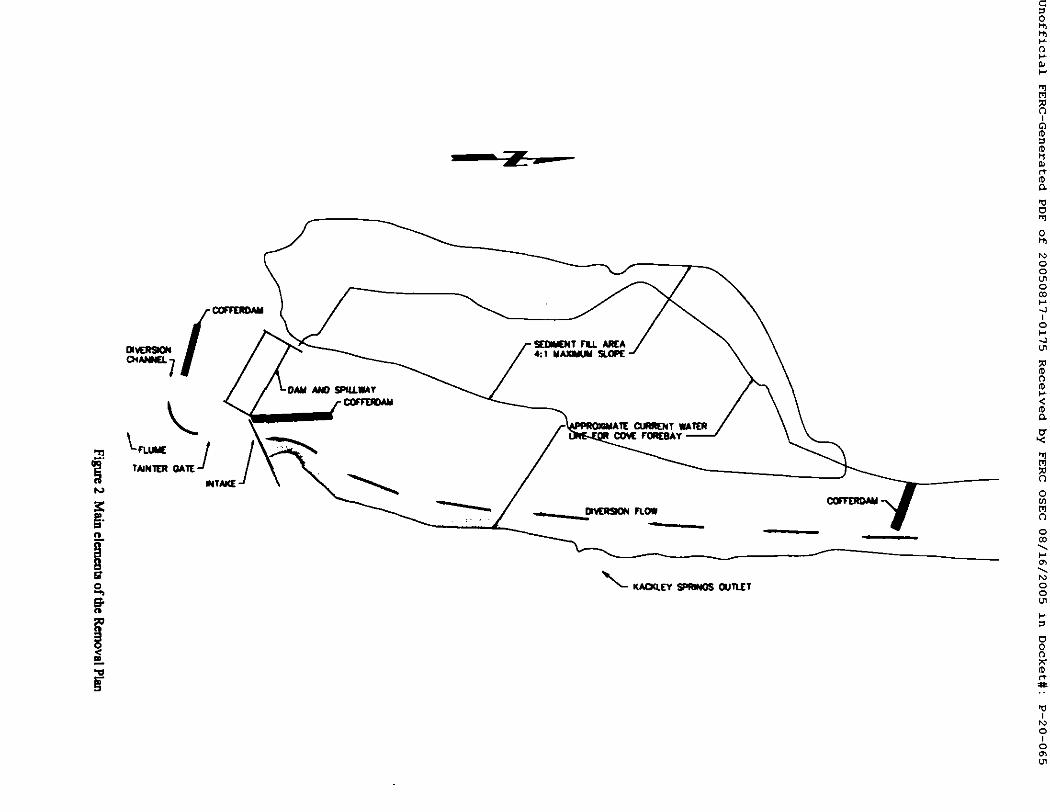
7
=,/-7 s ( o ~ , r ,u .s~ 4:1 M A , l a l ~
A11[ CUIRI~NT l A i R COY( F ~ ( S A Y -
m . /
0
f l
M
I
ro
ro
0
t~ Q Q
Q
i Q
ro f l ro
< ro
M
0
M
Q
t~ Q Q
0 f l
ro
I
0 I
0

Jnofflclal FERC-Generated PDF of 20050817-0175 Received by FERC OSEC 08/16/2005 in Docket#: P-20-065
Environmental Report: Cove Development Decommissioning
During this phase, two cofferdams or berms would be constzucted to direct all flows entering the forehay area into the eastern channel and hence through the intake structme and rote the river channel below the dam. One cofferdam would extend from the western bank of the upper forebay, below the Grace tailrace. The other would extend north from the Cove retake structure. Sediments from the exposed western portion of the forebay bed could then be excavated in the dry and be delx~ted and graded on the adjacent, western bank using draglme or track hoe equipment. Alternatively, the sediments from the forebay could be used to cover the demolished flume, thereby tmnimizing distm'bance to an established, deep-rootad shrub community on the steep western bank slopes. Temporary slope protection (e.g., turf matting) would be installed on the graded slope, and silt fencing would be constructed at the toe of the slope. A silt barrier would be staked along the edge of the sediment exposed on the eastern side oftbe forebay. This operation would establish the western portion of the new river channel.
At this point, the cofferdam at the head of the forebay would be shifted to block the eastern channel, allowing flows to shift to the new channel. This would leave the eastern part of the forehay dry. Similar to the process completed in the western portion, sediment would be pulled back to the eastern bank, rcgraded, and stabilized. A permanent security fence would be placed around the remaining east dam abutment, ensuring public safety.
The third phase of decommissioning would be demolition and lemovul of the Cove intake steel superstructure, flume, and pressure box. Heavy equipment similar to that used in dam removal would be utilized to complete this phase. All concrete and rubble associated with demolition of the structures would be buried in designated locations on site, where it would facilitate gredmg. The flume's remaining concrete, wood, and liner material would be buried in place within the flume footprint. All proU'uding metal would be cut-off flush with the ground's surface and removed fxom the site. Wetlands and drainages around the flume would be protected from damage and kept rice fi'om demoliliun and soil fll.
Decommissioning the Cove powerhouse would conclude facilities' modifications. The powerhouse building would remain intact. All safety precautions including securing windows, interior hatches and passagevmys as well as removal of all petroleum products would be taken to ensure public safety.
The final phase of decommissioning would be tevegetation of all disturbed areas, through hydroscedmg with an ~ approved seed mix and willow siil~. Temporary sediment control measures (e.g., silt fencing, membrane, and straw bales) installed before and during consu~tion would be left in plaoe until these areas were considered stable and vegetation established (Black and Veatch 2005).
3.1.20PEII,41"IONAL CIt,41VGE$ Dam l~-~rtoval would restore run-of-river flows to the Cove bypassed reach (about 1.4 miles of the Bear River channel below the dam site; see Figure 1). This action also proposes to reduce minimum flow requirements for the Grace bypassed reach (about 6.6 miles of the Bear River channel; see Figure 1) from 80 cfs to 63 cfs, plus leakage from the dam of about 2 cfs. This would provide PacifiCorp 17 cfs of additional flow for power generation at the Grace powerhouse that would partially offset the loss of Cove Development generation.
Ecological Solutions, LC 8 June 30, 2005

Jnofflclal FERC-Generated PDF of 20050817-0175 Received by FERC OSEC 08/16/2005 in Docket#: P-20-065
Environmental Report: Cove Development Decommissioning
3.1.3 MITIGATION MEASURES Consultation with the various agencies with regulatory authority over the decommissioning project (see Section 4.2 below) generated a number of conditions and requirements intended to mitigate potential adverse environmental effects of the decommissioning project. These are discussed under the following headings. This analysis identified several other mitigation measures, which are also discussed below, afier the agency requirements.
3.1.3.1 W~er Quality The consultation process for Section 401 of the Clean Water Act is described below (Section 4.2.1.2). This process identified specific conditions required by the Idaho Department of Environmental Quality ODEQ) prior to issuance of a 401 Water Quality Certificate. These conditions will mitigate potential water quality impacts.
This analysis indicated the need for the following mitigation m.eastm~. Appropriate steps will be taken to insure that the erosion control materials called for in the Removal Plan (e.g., silt fences, sediment barriers, turf reinforcement mats, and erosion control mats) meet the necessary specifications and are properly installed. A qualified erosiun-control specialist will determine the necessary specifications, instruct contractor personnel on proper installation techniques, and inspect the final installation.
3.1,.3,~ Wetlands This analysis indicated the need for the following mitigation mea.nn~. Prior to any efforts to ~ o v e or repair the Cove flume, jurisdictional wetlands along the flume corridor will be delineated with pin flags. No dredge or fill material will be discharged into the delineated areas. Where appropriate, silt fencing will be erected to prevent upland soil and debris from falling into delineated wedands.
3.1.33 Live~tock G ~ This analysis indicated the need for the following mitigation measure. Once the flume is removed, a fence will be constructed along the flume alignment to preclude cattle from grazing down into the riparian area and/or mixing with cattle from the other side of the river. This
is consistent with requirements of Project license Article 426.
3.1.3.4 Cuitcrgl Resoureu Impacts on cultural resom'cea would be mitigated through specific measures and protocols described in detail in the Historic Properties Management Plan for PacifiCorp's Bear Rtver Hydroelectric Project Section 6.8 (SWCA 2005).
3.2 ACTION ALTERNATIVES
3.2.1 GmAc£-Cot~ I~mCONNECT CAUW_L ALn~RNAn~ This alternative would channel water directly from the Grace tailrace to the Cove inUtke, making the Cove dam superfluous to the system and allowing its removal. Since the hydraulic capacity of the Grace powerhouse is 267 cfs less than that oftbe Cove powerhouse, a weir across the Bear River would be constructed to divert up to this amount from the river to the Interconnect Canal to allow maximum generation at the Cove powerhouse.
Cirrus Ecological Solutions, LC 9 June 30, 2005

Jnofflclal FERC-Generated PDF of 20050817-0175 Received by FERC OSEC 08/16/2005 in Docket#: P-20-065
Environmental Report: Cove Development Deconmussiomng
The Interconnect Canal Alternative would remit in connectivity of the Bear River through the current Cove m~ondmem area and improved fish passage while retaining the power generation capacity of the Cove Development. PacifiCorp would remove the Cove dam, construct a canal connecting the Grace tailrace and the Cove intake, and rehabilitate the Cove flume for continued power generation operations. The Cove dam would be removed prior to canal construction to allow for a dry construction site and to m'mimizc sediment transport. A temporary cofferdam would be constructed along the canal alignment to prevent norrc~l river flows from entering the canal construction area. A diversion weir would be constructed across the river to allow passage of the licensed instream flows and for diversion of the remaining flows for power generation. A fish ladder would also be constructed to allow passage of upstream migrant fish past the weir. Fish screens would be placed on the intake structure to avoid impingement of fingerling and migrant trout. Finally, a spillway with a 200-font-long concrete weir would be constructed to divert water from the Grace tailrace to the Bear River in the case of a Cove powerhouse outage.
This alternative would employ comparable equipment as well as similar construction, grading, and removal methods to those used under the Proposed Ac~on. All construction would require appropriate erosion control and sedimentation prevention measures.
3.2.2 MITIGANON MF.,a.$UItE$ Mfligstion requirements under this alternative would be the same as under the Proposed Action (Section 3.1.3), as applicable.
3.2.3 FIMI PAS~G£ AI . rE~ATII~ This alternative includes modifications of various elements of the Cove Development to improve fish passage through the existing system. A fish ladder at the Cove dam, intake fish screens, and tailrace barriers at Cove and at Grace would be constructed to fazilitate upstream passage of fish and to protect fingerlings. The Cove flume would be rehabilitated, and this alternative would retain power generation operations at the Cove Development.
A vertical-slot-type fish ladder would be constructed at the Cove dam to facili~te fish passage, providing 21 to 26 feet of tiff in 0.75-font steps. A ladder is curnmtly present but is inoperable and would be removed. Ladder design would reflect the licensed insweam flows in the Cove bypassed reach.
Fish screens would be placed at two locations in the Cove intake structure to keep fish from entering the flume. The fish screens would meet criteria accepted by the IDFG for fingerling trout. Because of its proximity to the Cove forebay, the screen would be considered exclusionary 0.e. no bypass syatem required).
Additionally, a barrier would be con~ructed at the confluence of the Gnu~e tailrace with the Bear Rivor/Cove forebay to prevent fish from entering the tailrace. A temporary, embankment type cofferdam would be required to fazilitate comCaucfion of the b~rier adjacent to the Bear River. An access road would also be provided to allow operation and ma'mtenance personnel to service the tailrace barrier structure. An additional 270-foot-lung tailrace barrier would be constructed at the confluence of the Cove tailrace with the Bear River. This would prevent fish migration up the tailrace allowing for continued upsUeam migration.
None of the existing Cove facilities would be removed under this alternative. Similar construction and erosion control measures would be employed under this alternative as are utilized under the Proposed Action.
Cirrus Ecological Sohaions, LC lO June 30, 2005

Jnofflclal FERC-Generated PDF of 20050817-0175 Received by FERC OSEC 08/16/2005 in Docket#: P-20-065
Environmental Report: Cove Developmem Decommissiomng
3.2.3.1 Mlfleation Measures Mitigation requirements under this alternative would be the same as under the Proposed Action (Section 3.1.3), as applicable.
3.2.4 No-AcFIoNALFEI~VATIVE
Under the No-Action Alternative, PacifiCorp would leave the Cove Development in place, commissioned as it currently is, with the same facilities and operating parameters. The Cove flume would be rehabilitated in accordance with the Project license and the development would resume operation with the current facility configuration and operating regime.
The planned renovation of the Cove flume would consist of repa'ning its concrete frames or n'bs (900+ ribs total to be either repa'n'ed or replaced), followed by the replacement of the wood box structure with new wood members, and spraying the fiume's interior with a impermeable membrane liner. The construction methods and equipment used would be those used with the Proposed Action.
3.2.4.1 Mttlgatie~ M ~ r e l Mitigation requlrerne:lts under this alternative would be the same as under the Proposed Action (Section 3.1.3), as applicable.
3.3 A L T E J ~ A ~ v ~ S CONSIDERED BUT ELIMINATED FROM DETAILED STUDY
PacifiCorp considered two additional alternatives to the Proposed Action that were dismissed fi'om further consideration because they did not meet the project% purpose and need. These included:
• Uncontrolled demolition of the Cove dam and its facilities.
This alternative was dismissed from further consideration because it would not include measmes to prevent or control sediment and possible contaminant transport into the lower Bear River reaches.
• Federal tske-over of the Cove Development.
Federal takeover and operation was determined not to be a reasonable altema~ve because it would requ'ne Congressional approval, and there is no evidence to indicate that Federal takeover should be recommended to Congress. No party has suggested Federal takeover would be appropriate, and no Federal agency has expressed an interest in operating the project.
3.4 SUMMARY AND COMPARISON OF IMPACTS
The analysis documented in Section 5 of this report indicates that implem~tation oftbe Proposed Ac'don or the alternatives addressed in detail would have no significant environmental impact. The impacts of the Proposed Action and alternatives are summarized and compar~ in Table I.
Cirrus Ecological Solutions, LC l 1 June 30, 2005

0 hh hh
Environn~nm.1 Report: Cove l)evelopm~m D e c o m m i ~ i o n / ~
T a b l e 1. S u m m a r y u d c o m p a r i s o n o f tmpaeta . I
W a t e r Q u a n t i t y a n d Q u a l i t y .
Proposed A~lom
Run-of-river flow~ tt'tumed to the Cov~ b y p ~ e rm~.
Initial m d i n ~ t mmsport ~om newly created ~ 1 in Cove forebey, to rand nmmining m new channel bed a~er gn~n~
~ of bedlo~ ~nd mu~pcr, d ~ nmerinl mmon~ to Cove bypmed math with nm-of-riv~ flow~
Mssnimde of sediment loads ~anspot~ed from C o ~ fo~e~y decn:mung with time and disUmce downsu~u~
Up to 3,600 ~1~ of sedim~t material tamponed downmmun d u ~ dam removal Cow~ p ~ c l e s d e p ~ ne*u'~ to tbe dam could mmmpmd ~ higher sprin8 rtmoff~
Some grovel mzl cobbk mmeria] from new chmnel ~ downmum m bedlcod dining high-flow
Sbe~-term mcreme in tmbidity levels dram 8 nmmvtl of Cove d a ~
Up to 66,600 kg of Tots] P edsoCoed to sedimmt U-a~pom~ downsm=~
Mercury and ~l=aium edsot'bed to mdimmt mmpomxl ~
Imtercouect Canal Alternative
Be~ River reconnected through the Cove byps~med rgach, but flows much low, m" than uo&~ P n ~ a x l Ac~on.
lnitisl sediment U'anport ~om newly crelted chmm¢l in Cove forebay, limited to mugl ten'mining m new channel bed after grading.
Tmmpo~ ofbedlo~ and suspended mamri~l re~omd to Cove bypmsed r~zh to m degree with rc~m~c~ed flows.
Magnitude of ~dimmt loads from Cove forebay
deercasing with lime and dimmce downstream.
Up to 3,6{)0 yd 3 of sediment material :r~poaed d o ~ dur~ dam removal Coane particles deposited ne~-er to flae dm~ could mm~md dm'ing higher spring runoffs.
Some gravel and cobble material from new channel tnmRxxted as bedloacl c h ~ high-flow events.
Short-term increase in turbidity levels produced during removal of Cove dam.
Up to 66,600 kg of Total P edtoCoed to sediment transported down~'~m~
Mev~'y and selenium adsorbed to sediment transported d ~ of Cove dam.
Fhb Passage Altenmtive
F,.xi~ing flow p~erns rtmam in Cove byl~sr~ reach.
No mm~m~ of ~mdimmt loads mmoci~ed with dm'n removal.
No added mmspo~ of bedloed
Tempmmy sediment loads and i ~ in turbidity to d o ~ reaches during coniffuctin¢l of cofferdam and fuEh ladder below Cove dam
No ~ r t of mercmy and selenium to down m'e~'n reaches as a result o f dam rernova].
N o - A c t i o n A l t e r n a t i v e
Exi~ng flow p~crns remain in Cove by,pros rea~.
No transport of sedimem loads associated wi~ darn removal.
No added u'ansport of bedload and suspended ~ a ] .
No tnmsport of mercury and seloaiurn to downstream reaches as a resuh of dam removal.
M ~0
I
t"v fO O.
~q
0 hh
t~ Q Q
Q
I Q
f0 O f0
f0
M
O
M
Q
t~ Q Q
O f l
f0 c~
I
¢D I
¢D Cirrus Ecological Solutions, LC 12 June 30, 2005 ~

Envimm'n,~tal Ib
W a t e r Quantity and QuaUty (cont'd)
i Flsherles and Aquatic Resources
tort: Cove Development Deconmdmdouix
Proposed Action
• Enlumced fith lamaSe.
• Habitat ~ in the Cow bypm~d read~
Enhanced potentiM trom q~wnm8 m md e q ~ c ~ e m b n ~ pmdec~on m focmer fofebly lind Cove ~ n:ad~
Temporary mcreme in ~ m~dim~It lo~l~ cltming ~ mlcl tbnudou of vl~iom bio~ tmcl habitat.
Potcmi~ W reduc~i~ in fmma in the Grace bypesaed reech due to dec~msed rain/hUm flow~
Potent~ incma~ in 8enetic divenuty.
Enlm'zed cold,-wtm" q~'ie* mignmon in the Co~ byp*med m~ch due to pomu~ temp~tur~ imlxovemes~
Impmv~l *cce~ to the ~ rt~chel for native fishes.
Increased polential for upltnmm colonization by mm-n~vc Wect~
Limitmioa o~ mmve specie, due to mcremed upetrcam mobility of weda~ry, warm and ceol-watef fishes.
ln tereeuee t Canal Fish Passage No-Action Altermaflve Alternative ARernative
• Dislxa'bance to the channel bottom near divt~'mo~ weir wo~ld pmdm:e limited tediment loadin8 m ~ river
Enhanced f i~ pmutg= , limited by EnMmced f i~ pesmge, limited by All fish passage effectively blocked ndnimum flow-., ban"lets and ndnimum flow's, by dam.
Enhmged potential trout spawning and aquatic invertebrate
production in former fort'bay.
Temporety increme in downslmtm tedimmt loath camdng mffocation and abr~on of variot~ biota mad habitats.
Increased pe~catud for ruth mortality o~ injury due to ladder and screent
Potential limits on BCT spawnin 8 and upetremn BCT ndgrmion due to tal~gture~ lind elevated water tempenme~
Improved acce~ to the ~ reaches for native fishes.
rammed ~am~md for ~aem'n ¢olonizmion by non-native species.
Lindtaficm on native species due to i ~ ~ mobility of predatory, warm and cool-water fishes.
Reduced peCemial for mi~fic~ and gptwning of BcYr and other cold-wat~ species due to mntinaed elevated wate~ tempemm~
Further aggradafion (tli~mg of the m'~nbed) ~ of the dam.
PolemiaJ limitation on fu~e BC'T r e a c t i o n effor~ due to stress end mortality caused by ladders end screcr~
Continued reduction of the abundance and divecsity of aquatic invertebrates.
Increased polem1~l for upstream colonization by non-native spe~c~
Limitation on native species due to increased ul~Ueam mobility of pnxlatow, wan'n/cool-water fishes.
Further aggradation (raising of the st~c~rnbed) upstream of the dam.
Limited sediments available to organisms downstream
Commued reduction of the abundance and diversity of aquatic invertebrates.
Blocked upst~..am movement of predatory, ~l/wan~water lpc~ie~
Interconnect Canal Fish Panmge No-Action Propmed Ac:flol
Alternative Alternative Alternative
Cirrus Ecological Solutions, LC 13 June 30, 2005
0
0
M
I
ro
ro
0
t~ Q Q
Q
i Q
ro 0 ro
< ro
M
0
M
Q
t~ Q Q
0 0
ro
I
0 I
O Oh U1

Environmental Re ~ort: Cove Developn~-~t Decommi~ionh
0
0
Wetland and Riparian Resources
Vegetation Resources
Wildltfe Resources
Wethmd fonc~om end values enlm~cod in the Cove forebay and b ~ ronch.
Wmland and ripm'isn and ve~c~fion along the Cove bypused reach improved.
Tha geaUm mea dimm.bcd and stu~ep~'ble to colonization by noxious weed~
Tha ~ e ~ t ueed for ~fuetiw ~ o n ~1 weed comml.
Deoemed use of the m by migrating wa~fowl due to elimir~on of the Coy= f o ~ y . A l t e r n ~ ne~ing ami fmaging habita~ available in the area.
Discontinued use offl~ project m'ea by wmer birds nxp~h~ open wm~, such u connonmu,, petica~, ond gr=bex
~ requkemm~ of Iocol shorebied species met, but mmlfl~ ~uoond forel~y no lonser available to mmsiem shorebirdt
No effect on peuc~nes or ueotmpico] migrmc~ bin:Is using adjacent mm~e~ and dpmhm m ~ due to dm'n m~l foret~y ~cmoval.
Some bonefit to bird specim ruing the Cove bylmsacd nmch don to inclined flows.
Short-tmn noi~ ~ due to consm~io~ demolition, and rehabilitation activitiea in the forebay and flume areat
Proposed Action
W(~I(md fuue~ora and valuta enha~c~ in the Cove forebay.
Wetland and r/p, man vegetation along the Cove bypassed reach unchanged.
Smaller met ~ and susceptible to colonization by noxious weeds.
SubsUmtial need for effective rcvegm~on and weal control.
Decreased use of the area by rroipat~ng waterfowl due to elimination of the Cove forebay. A]termttiv= nes~ng and foragin8 habitat available in the
Disconl/nued use of the project an~ by wa~ birds requinng open water, such u cormonm~, pelicans, and grebes.
Habitst r~lui~men~ of local shorebird species nwt, but mudflat axonnd forabay no longer available to lho~bini~
No effec~ on prostates or neouopical migratory birds usm 8 adjacent mm~es and riparinn mzu due to dam and fofel~y removal.
More short4mm noise disturbonce due to ~ o n , demolitim~ and n:habilitation *~ivitie~ in the forebay area than under the Propmed Action; mmiler disturbance in flume area due to rep~x
I n t e r e o u e e t Can*l Al t e rna t ive
• Wedand functions and value)
• Wetland 8~I ril~a-ian veSctstion along the Cove bYl~SSed ~cech unchanged.
Of action allem~ves, the leasX me* dismrbed m~l s u s ~ i b l e to colonization by noxious w~eds.
Of actions least need for effective revegetation and weed control.
None of the po~tial impacts on warn'fowl, shorebird*, or other water birds. All CmTmt habitats remain available.
Less short-term noise dislurhance due to comm'u~ion, demolition, and rehabilitation activitin$ in the forel~y m~ea than onder the Proposed Action and ]ntercoonect Canal Alterm~ve; mmil~ disturbance in flume
Fish Passage Alternat ive
• Wetland functions and values unchanged.
• Wetland and riparian vegetation along the Cove bypessed reach unchanged.
Only the flume corridor disturbed and susceptible to colonization by noxious weeds.
No ~klitional need for effective revege~ion and weed control.
None of the potential i n q ~ on waterfowl, shorabirds, or other water birds. All currcnt habitats remain available.
No short-term noise disturbance clue to conmu~ion, demolition, and rchabililalion activities in the ~ y area; similar d ~ c c in flume
No-Action Altermtflve
{'11
0 I
~0
(0
0
t~ Q Q
Q
I Q
fO 0 fO
fO
M
0
M
Q
t~ Q Q
0 0
fO c~
0 I
0 oh I.n
Cirrus Ecological Solutions, LC 14 June 30, 2005

F~vironmental 1~
Aesthetic Resources
Safety Issues
Recreation and Land Use~
)ort: Cove Development D¢conm~iomz
• TemPorm~ ¢omm~clion-r~Ja~t impmm on ~ quality.
• Retu~ lhe ixojccl m'=a to a more nmuna, pre-deve~opment app=mmce.
• R~nove mo~ vhma] evide~c= of hi~oric pm~
with safety p n ~ ¢ ~ included in the Removal Plan and PaciflCorp policies, no signiflcam mfe~ dsk associa~ wi~h comm'ucl~ra/demolition ac~v i~ or the Coy= pov~hou~
New n ~ i o o n ~ b~Umg oppommity crea~ed in lhe Cov~ bypmsed n~ch.
Tempcca, y a~us~ limimion during dam removal.
Wade-fudging -' the mmgh of Bla~ Cm~on mai~ due to d e c n ~ n~nin~un flows.
New 8~8]in8 o p p o t l ~ u s crut~l in the Cove bypas~d reach.
Incn~ed fishing opparnmities m new chmmel and Grace bypmscd reach due to improved t~h presage.
Po~tially d e c r e ~ cold-wmr fishing oppormmty due to up~remn nmvmrznt of pnxlmory fu~ spcc, es.
Lou of still-w~r fishing opportunity in fore~y.
• T ~ ~ o ~ = i n t e d ~ on v~s~ qu~i~.
More ns~und spp¢~nmce of fondmy and dmn an~ o lhmv~ hislo~ de~lo lnn~ re~ned as don~am visual theme.
More evidence of hislo~c pest (as con~0~ed with Pmpmed A~on)..
With s ~ e ~ pra~i~s incl~l~l in PacifiCorp policies, no ~gniflcant
co~m~m:lin~demolition activities or Ihe ~ canal.
Temporm'y access lirn~tafion durm~ dam removal and c~na] c o m n r u ~ and flume repay'.
Conlinued ca~e exclusion from the Cove bypassed reach's riparian area w/lh flume in place.
• Tempon~ com~ru~ion-rein~d impact8 on visua] quali W .
Historic development n~uned as doonmmt visual theme.
With safety practices included in • PacifiCorp policies, no significant s a f ~ dflc ~o¢.ia~l wilh cons~ction activities or added f~h passage facilities.
Tempon~ I ~ I ~ d ~ n • during comrm~on offish pmuge iml~ovemants and flume repair, u
Continued c~le exclusion from the Cove bypassed reach's ril~ian area with fltm~e in place.
• Tcmporary conso~/on-related impects on visual quality.
• Historic developmazt relaincd as dominant visual flu~n=.
With saf~y practices included in Pa~ifiCorp policies, no significant ~fe~y risk u~ociated with flume repot aclivities.
Tcmponuy access limitation during flume rep~r.
Continued cattle exclusion from the Cove bypassed reich's riparian m'ea with flume in place.
0
f l
M
I
fO
fO
0
t~ Q Q
Q
I Q
fO f l fO
fO
M
0
M
Q
t~ Q Q
0 f l
fO
Cirrus Ecological Solutiom, LC ]5 June 30, 2005
I k) O
I O

Environn~ntal Report:. Cove Development Decommissioning
0
(3
Soclo- economic Issues
Cultural Resources
Ocmie~ of slma..(mn employmem opporn~m dming conm~cUon, r~mbilimioa, end mmmumc~
Pot~fial n'dnm" reduc~m in loog4enn emPloymmt levels for the Bear Rive~ Hydroel~'ic Project ~ • whole.
Potential incrcme or decreme in PscifiCorp's tax conm'bufion to the Coenty due to differem woperty yahweh systc~
Integrity of the higtorical h3~koelectric d/sr/~ .M lunge elisfl)ility oftl~ individual buildup md muctur~ for the National Regiler affected.
Hi~orical bmdscapc and identity of Onge a f f e c ~
Potential disturbance of a~chaeological ~ md m i f ~ a d u n g excavmion.
Interconnect Canal Alternative
Creation of shon-~m employmem oppo~un~ d ~ ~ o n , rehabilitation, and n~/ntmance.
No change in PscifiCo~'s tax contribution to the Co~wy.
I ~ of the his~rical hydroelec~c dis~ct and future eligibility of the individua] b~ildinga and st~cture~ for the National Resister affected to a ] ~ desn~ ~an the Proposed Action.
Historical landscape and identity of Grace affected to a lesser degree than the Proposed Action.
Pocmtial ~ of archaeolog/cal sites end srt/fs~s dunng excavation.
PImge Alternative
• Creabon of short-ten~ employment opportunities dunng o0nsmmion, rehabilimio~, and maintenance.
• No change in PacifiCo~'s tax contribution Io the County.
• Integrity of the h~odcal hydroelect~ dis~c~ and futme eligibility of the individual buildings and structures for the National Rcsism" affected to a lesser degree than file Proposed Actioe and Interconnect Canal Altc~ative.
• H ~ I landscape and identity of Grace affected to I less~
and Interconnect Cm~]
• Potemial disturbance of a~.haeolosical sites and m i f a ~ dunng excavafim't.
No-Action Alternative
Creation of short-tt~n employment opportunities during flume roper and maintenance.
No change in PacifiCorp's tax contribution to the County.
M yO C~
I
OJ f-y (0
0
t~ Q Q
Q
I Q
fO 0 fO
fO
M
0
M
Q
t~ Q Q
0 (3
fO c~
Cirrus Ecological Solutions, LC ]6 June 30, 2005
I r~ o
I O

Jnofflclal FERC-Generated PDF of 20050817-0175 Received by FERC OSEC 08/16/2005 in Docket#: P-20-065
Environmental Report: Cove Development Deconnmssioning
4. CONSULTATION AND COMPLIANCE
Consultation with relevant regulatory agencies and with the public is a key aspect of Federal environmental review requirements. Further, a number of Federal and state laws bear on projects of this nature and require consultation. This section outlines the agency and public consultation activities undertaken m the course of this project and the efforts to comply with applicable Federal and state regulations.
4.1 CONSULTATION
4.L1 SCOPING Scoping is the process of soliciting input from other agencies and the public to determine the range of actions, a ~ t i v e s , and impacts to be considered m an environmental review document (40 CFR 1508.25). While no formal scoping meeting has been undertaken specifically for the proposed decommissioning of the Cove Development, active public and agency participation has been a hallmark of the recently completed relicensmg process and subsequent project implementation. As a result, environmental issues and concerns associated with the proposal have been solicited and are well doc~ted. Relevant agency and public involvement activities are outlined below, and the identified issues and concerns are listed in Section 4.1.3.
A forn~l scoping process was initiated by the FERC for relicensing the Bear River Hydroelectric Project, as described in the Bear River EIS. Scoping identified concerns regarding impacts on the following resources: (l) water use and quality, (2) aquatic resources, (3) terrestrial resources, (4) land use and aesthetic resources, (5) recreational resources, and (6) cultural resources. The EIS provides detailed discussion of these issues and is incorporated by reference in this report.
As discussed earlier in this report (Section 2.1) and below (Section 4.1/), the ECC has been the cenmfl forum for involvement by agencies and other stakeholder organizations m implementation of the Bear River Hydroelectric Project. This group brings together all signatories to the Bear River Settlement Agreement, which resolved all envu~nmental issues asso~ated with that project. As the Cove Development was rehoensed under that project, the issues tackled by the agencies and o ~ o n s comprising the ECC during and after the relicensing process remain relevant to the current proposal for the decommissioning of the Cove Devclopmcnt. ECC meetings ate conducted monthly and are open to the public. A record of ECC meetings, documents and related subject material are published on the PacifiCorp website (http-.//www.pacificorp.com/Ar ticle./Ar ticle43498 .html).
In March 2005, the ECC initiated three public informational meetings in Montpelier, Soda Springs, end Preston, Idaho, to inform area citizens regarding implementation of the Bear River Hydroelectric Project, including the proposed deonmmissinning the Cove Development. These meetings provided another opportunity for public in~t on impleng~ntation plans, including Cove decommissioning. Overall, the public's response has been mixed regarding decommismoning the Cove Development, although the public agency response has been supportive.
4.L2 I ~ . I VEN~ONS
As this report was prepared, the FERC had not circulated PacifiCorp's application for agency and public comment, so there has been no formal comment or interventions. However, the ECC comprises the mterveners in the preceding Bear River Hydroelectric Project. As called for in the
Cirrus Ecological Solutions, LC 17 June 30, 2005

Jnofflclal FERC-Generated PDF of 20050817-0175 Received by FERC OSEC 08/16/2005 in Docket#: P-20-065
Environmental Report: Cove Development Decomnussioning
Bear River Settlement Agreement (Section 4) and the new license (Article 402) this group plays a consultative role in post-licensing implementation activities, including monitoring and adaptive management planning. "Most uniquely, these activities include directing long-term changes for environmental protection and enhancement measures" (Project license, para. 17). The proposed decommissioning of the Cove Development is one of these enhancemont activities, and the ECC has had - and will retain - an active role in planning and implementing the decommissioning project. As a result, their role is appropriately noted here. The ECC comprises the following agencies and organizations:
• PacifiCorp. • U.S. Fish and Wildlife Service (FWS). • U.S. Bureau of Land Management (BLM). • National Park Service (NPS). • USDA Forest Service (FS). • Shoshone-Bannock Tn'bes (Tribes). • Idaho Department of Environmental Quality (IDEQ). • Idaho Departm~t of Fish and Game (IDFG). • Idaho Department of Parks and Recreation (IDPR). • Idaho Council of Trout Unlimited (lTd. • Idaho Rivets United 0RU). • Greater Yellowstone Coalition (GYC). • American Whitewates (AW).
4.L3 COMMEN~ ON rnE APPLICATION
As noted above, PacifiCorp's application had not been circulated for comment by the FERC at the time this report was prepared. However, environmental issues and concerns associated with the proposed decommissioning of the Cove Development have been solicited and ~ t e d through the consultation processes outlined above (Section 4.1) and through ECC deliberations. Issues that guided the analysis documented in this report (Section 5) are listed below, followed by issues considered but not carried into detailed analysis for the reasons provided (Section 4. 1.3.2).
4.1.3.1 Issues Al~yZed In Detail
Water Ouant//v and Oua//~
• Would flows in the Grace and Cove bypassed reaches be affected?
• Would dam ren~ovnl or other facility modification5 affect 8edim~t loading and water quality in downstream reaches7
Fisheries and Aouatic Resources
• Would the aquatic ecosystem be affected by modification of facilities or flows?
• Would BCT restoration efforts be affected?
• Would native fish species other than the BCT be affected?
Cim~ Ecological Solutions, LC 18 June 30, 2005

Jnofflclal FERC-Generated PDF of 20050817-0175 Received by FERC OSEC 08/16/2005 in Docket#: P-20-065
Env~onmcnml Rcpo.: Cove Development Decommissioning
• Would the upstream dispersal ofwalleyc and smallmouth bass be affected?
Wetland/Riparian Resources
• Would wetlands and riparian communities be affected by modification of facilities or flows?
Vegetqt~on Resource~
• Would the modifications to the Cove facilities influence the establishment of noxious weed species7
Wildlife Rgsources
• Would neo~'opical migratory birds and other passerine and non-passerine birds and their habitats be affected?
• Would waterfowl and shorebird use of the Cove forebay be affected?
Aesthetic Resources
• Would dam removal or other facilities modifications affect the visual quality and natural sct~ing of the project area?
• Would the public's safety be affected by decommissioning the Cove Development7
Recreation and Land Uses
• Would teercational boating opportunities be affected?
• Would fishing opportunities and fishing access be affected?
• Would livestock grazing management be affected?
Socioecp~mic Issues
• Would decommissioning the COw Developn~nt affect ~nploymcnt in the project area7
• Would decommissioning the Cove Development alter the county's tax base?
Cultural Resources
• Would historic, Native American, or paleontological values be impacted by modification of the facilities?
Cirrus Ecological Solutiom, LC 19 June 30, 2005

Jnofflclal FERC-Generated PDF of 20050817-0175 Received by FERC OSEC 08/16/2005 in Docket#: P-20-065
Environmental Report: Cove Development Decommissioning
4.1.3.2 lssuf~ Considered but Not Analyzed in Detail
Water Rights
• Would water rights be affected by decommissioning or modifying facilities of Cove?
This issue was considered but not carried into detailed analysis because the Proposed Action and the alternatives would not affect water fights. None of the a,~tions would alter the amount of water in the Bear River leaving the project area, as no consumptive use or other actions that would affect water quantity are proposed. The reduction in the minimum flow requirement under the Proposed Action (i.e., from 80 to 63 cfs) would affect only the Grace bypassed reach. The only diversion in the bypassed reach is the Gentile Valley irrigation canal. Since the canal company's water right is matched or exceeded by flows accumulating naturally through the bypassed reach, the reduction in minimum flow releases would not reduce the company's ability to meet their water right. Timing of flows would not be notably affected because the storage capacity of the Cove forehay is minimal (average residence time in the forabay is only about 1 hour). Storage fights would not be affected because no one other than PacifiCorp holds storage rights in the Cove forebay.
Threatened am/Em~ueered SoecM
• Would threatened or endangered species be affected by facilities modifications7
The FWS has d o c ~ t e d the presence of bald eagles (HaHaeetus leuco~halus), the possible oc~mrence of gray wolf (Canis lupis; an experimental, nonessential population) and one listed plant species, Ute ladies' tresses (Spiromhes diluvialis) in Caribou County, Idaho. Surveys decumented in the Bear River EIS concluded that the wildlife species are generally transient individuals in the project area, and that the plant does not occur in the project area. (FWS 2005a.)
Surveys for bald eagles were conducted in February 1997 by PacifiCorp to document use of the entire Bear River Hydroelectric Project area during the winter m/gratory season. Two bald eagles were documented in the Soda Project area: one adult bald eagle was observed on May 22, 1997, and a single juvenile eagle was observed multiple times during spring surveys. PacifiCorp also conducted a search oftbe bald eagle database through the USGS Biological Resources Division. The query revealed records of bald eagles for the Soda dam from 1980 to 1995. Population numbers ranged from 46 in 1991 to I m 1980 end 1984. There have been observations of two pairs of nesting bald eagles near the Soda dam (Paciflcorp 2005d). There are no dense populations of bald eagles in the project area. There are occasional sightinge during the winter months, but the area is not considered significant nesting habitat (FWS 2005b).
It has been determined that the gray wolf nmy Iravel through and around the project area but that no established packs or known den or rendezvous sites are presently docun~nted in the lower Bear River sub-basin (FERC 2003a), specifically the Cove Development project area.
Field surveys for the Ute ladies' ~ were conducted in 1997, but no populations were located in the Bear River drainage (FERC 2003a).
The Bear River Project EIS concluded that current and proposed project operatious would not affect any Federally listed or ¢~mdidate species. For proposes of this analysis, the FWS has confirmed that this conclusion holds (see Section 4.1.3.2).
Cirrus Ecological Solutions, LC 20 June 30, 2005

Jnofflclal FERC-Generated PDF of 20050817-0175 Received by FERC OSEC 08/16/2005 in Docket#: P-20-065
Envtronmental Report: Cove Development Decomnnssioning
Wild and Scenic Rivers
• Would decomrmssioning of the Cove Development affect the potential for designation ofthe Cove bypassed reach as a Wild and Scenic River?
The BLM administers a tract of land adjacent to the Cove project boundary located northwest of the Cove powerplant. Approximately 0.3 river miles of the Cove bypassed reach pass through the parcel which the BLM found to be eligible for Wild and Scenic River designation, based on recreational, geologic and hydrologic characteristics. The BLM has since condilcted a feas~ility study to determine if the reach could be classified under the Wild and Scenic Rivers Act. Until the BLM's Pocatello Field O~ee Resource Management Plan is finalized, it has been tentatively reconnnended that the reach is not suitable for Wild and Scenic River demgnation (BLM 2005).
PQg~r G~nera~o~
• Would decommissioning the Cove Development affect overall power generation capacity of the Bear River Hydroelectric Project?
As noted in Section 2.3, PaciflCorp conducted a customer benefit analysis comparing the benefits ofthe additional 17 cfs flow to the Grace powerhouse under the Proposed Action to the costs of repairing the Cove flume as part of the No-Action Alternative. The net loss in electrical production by the Bear River Hydroelec~c Project due to Cove decommissioning would be 6.7 percent. However, over 30 years, the additional power generation from Grace powerhouse would generate revenue that would corapensate for the $3.2 million estimated cost of decommissioning the Cove Development. Therefore, the Proposed Action would result in a net customer benefit.
4.2 COMPLIANCE
FERC regulations (18 CFR 4.38 and 16.8) require consultation with cooperating agencies and other entities to ensure that any action agency does not jeopardize the continued existence of listed species or critical habitats, water quality standards, wetlands, and/or cultural resources within the project area. Several of the agencies charged with protection of these resources, as well as other stakeholders, were actively involved in the relicen.sing process and, following issuance of the new license, were formally organized as the ECC (see Sections 2.1 and 4.1.2 above). Consultation on some issues revolved agencies not formally part of the ECC, including the U.S. Army Corps of Engineers (COE) and the Idaho State Historic Preservation Officer 0SHPO). Consultation specific to the Clean Water Act, the Federal Power Act, the Endangered Species Act, and the National Historic Preservation Act with ECC members and other agencies is discussed below.
4.2.1 Cz.~4N W,4rFJ AC"r The Clean Water Act (C'WA) is a 1977 amendment to the Federal Water Pollution Control Act of 1972, which set the basic structure for regulating discharges of pollutants to waters oftbe U.S. The CWA is administered by Environmental Protection Agency (FJ'A), but some permitting, administrative, and enforcement aspects of the law are delegated to other Federal and state agencies under various prosrams.
Two sections of the CWA are pertinent to the proposed decommissioning of the Cove Development, Section 404 and Section 401. In addition, states are provided under the CWA joint authority with Federal agencies to enforce and regulate water quality standards and permitting.
Cirrus Ecological Solutions, LC 21 June 30, 2005

Jnofflclal FERC-Generated PDF of 20050817-0175 Received by FERC OSEC 08/16/2005 in Docket#: P-20-065
Envu-onmental Report: Cove Developmem Decommissioning
Idaho's Stream Channel Protection Act provides the legal authority to ensure that stream altera~on activ/ties do not violate Idaho water quality standards.
Compliance with CWA Sections 401 and 404 and with Idaho's SUeam Channel Protection Act is discussed below.
4.2,1.1 CWA ,~,ectlon 404 Section 404 of the CWA establishes a program to regulate the discharge of dredged and fill material into waters of the U.S., including wetlands. Such discharges are not permitted if the nation's waters would be significantly degraded or if feasible alternatives exist that are less damaging to the aquatic environment. The EPA and the COE share jurisdiction over the permit program. Individual or Nationwide Permits (NWP) may be issued only when applicants have demonstrated that the activity is in the public interest, that no practicable alternative is available, that wetlands would be protected to the maximum extent possible, and that water quality would not be significantly impaired (see Section 4.2.1.2 below).
The NWP system was established to streamline the permitting process for minor activities that have been determined progran'anatically, on a nationwide basis, to comply with the criteria noted above. In regard to the Cove decommissioning, the COE has stated their mtent to issue a NWP No. 27, for wetland and riparian restoration and creation activities. This decision is based on the project's stated purpose and need (Section 2.2) to enhance aquatic resources, particularly by reconnecting the Bear Rivet through the Cove bypassed channel.
The COE imposed two conditions on thetr issuance of the NWP No. 27. First, a functional assessment of the project's impacts on the affected reach of the Bear Rivet was required to demonstrate that the anticipated wetland and riparian enhancement would in fact occur. The functional analysis was completed, as discussed in Section 5.3. Second, water quality certification under Section 401 of the CWA was required (see Section 4.2.1.2 below). With these conditions met, it is anticipated that the COE would issue a NWP No. 27 for the proposed decomm/ssioning of the Cove Development. With that permit in place, the project would comply with CWA Section 404.
4.2.J..2 C'WA Section 401 Any activity that requires a Federal permit or license under the CWA, including a Section dxedge and fill permit or a FERC hydroelectric license, requir~ a CWA Section 401 water quality certification. This certification states that the activity would not cause a violation of state water quality standards. The IDEQ uses the authority granted to them under Section 401 to activities that impact their water resources. IDEQ can waive the certification (either expressly or by taking no action), deny the certification, grant the certification, or grant the certification with conditions. Any conditions aasociated with the certification become conditions of the license or pamat
A 401 certification in Idaho also ensures that an activity complies with water quality improvement plans (Total Maximum Daily Load Study;, TMDL) developed for affected water bodies and that the activity does not adversely impact 303(d) listed s torms (streams that already do not meet water quality standards). While 401 certification is typically c~umtered a given when an NWP dredge and fill permit is issued, Idaho requires individual 401 certification ifttm waterbody in question is on the 303(d) list
Cirrus Ecological Solutions, LC 22 June 30, 2005

Jnofflclal FERC-Generated PDF of 20050817-0175 Received by FERC OSEC 08/16/2005 in Docket#: P-20-065
Environmental Report: Cove Development Decommmsioning
The Bear River in the reach affected by the proposed Cove decommissioning is included on the Idaho 2004 303(d) list as irapaired for phosphorous (P) and total suspended solids (TSS). A draft TMDL was completed for this reach in January 2005. As a result, IDEQ has required individual 401 certification for the Cove decommissioning project. Certification will be subject to conditions established by IDEQ and made part of FERC's requirements for amendment of the license for the Bear River Hydroelectric Project. Based on tim certification and adherence to the IDEQ conditions, the project would conform to CWA Section 401.
4,2.1.3 State of ][tlgh0 Stream Channel Prg~fction Act The SUeam Channel Protection Act (Title 42, Chapter 38, Idaho Code), requires a permit for any type of alteration work done inside the ordinary high-water marks of a continuously flowing stream to protect fish and wildlife habitat, aquatic life and water quality, recreation, and aesthetic values.
Following consultation with the Idaho Department of Water Resources (IDWR), it was determined that a stream alteration permit would be required to remove the dam. A Joint Stream Channel Alteration Permit application would be submitted initiating the IDWR and the COE 404 pernntfing process.
4,2.1.4 State Easements A permit or easement may be required by the Idaho Department of Lands (IDL) prior to obtaining a Stream Channel Alteration Permit for decommissioning work conducted on submerged, state- owned lands (Idaho Code Title 58, Chapters 1 and 6, and Article IX, Sections 7 and 8). The State of Idaho had not originally required an easement for the conslzucfion of the Cove Development and has not initiated proceedings to determine ownership oftbe bed and banks of the Bear River. Unless a determination is made that the state owns the riverbed beneath those portions of the proposed project constructed below the ordinary high water mark, IDL will not require a permit or easement.
4.2.2 FZDFJ~ P o ~ a A c r
The FPA provides for Federal development and regulation of water power and resources, authorizing the FERC to issue licenses for hydroelectric projects, including dams, reservoirs, and other projects to develop and improve navigation or to develop and use power.
The FPA requires that licenses contain certain conditions to adequately protect, mitigate and enhance fish and wildlife resomra:s including spawning grounds and habitat, as well as beneficial public uses, including irrigation, flood control, water supply, and recreation.
Sections 18, 4(e), 10(j), and 30(a) of the FPA are relevant to the Proposed Action and specifically refer to fishways, potential ~ t s to Federal lands, end the coordination of resouree agencies to enhance and lm3tect fish and wildlife ~ .
1 lrPA FPA Section 18 oftbe FPA states that FERC "shall require the construction, maintenance, and operation and maintenance by a licensee at its own expense of such fishways as may be prescribed by the Secretary of Interior or the Secretsty of Commerce, as appropriate," and provides the Secretary of the Interior the authorfly to prescribe fishways at FERC-licensod projects or specific conditions related to fish passage facilities at hydropower projects. The U.S. Department of Interior has reserved its authority to require the comtruction of fish passage facilities (Section 18 of the Project license, Para. 30).
Cirrus Ecological Solutions, LC 23 June 30, 2005
Jnofflclal FERC-Generated PDF of 20050817-0175 Received by FERC OSEC 08/16/2005 in Docket#: P-20-065
Environmental Report: Cove Development Decomnussionmg
4.2.2.2 FPA ~ectlen 4(e) FPA Section 4(e) establishes that FERC must give "equal consideration" to developmental and non-developmental values in its licensing decisions on a reservation only if it finds that the license would not interfere or be inconsistent with the purpose for which such reservation was created or acquired. Section 3(2) of the FPA defines reservations as mclud'mg lands and interests in lands owned by the U.S. Federal land-administer/rig agencies having authority under Section 4(e) to require "mandatory conditions" for projects located on Federal reservations under their jurisdiction.
There are no Federal reservations in the Cove Development project area.
4.2.2.3 FPA Section 100~ FPA Section 10(j) requires FERC to consider resource agency recommendations pursuant to the Fish and Wildlife Coordination Act to protect, mitigate damages to, and enhance fish and wildlife resources. It requires the FERC to include license conditions based on recommendations provided by the Federal and state fish and wildlife agencies.
As descn~l in this document, the state and Federal fish and wildlife agencies with authority to recommend terms and conditions under Section 10(j) are signatories of the comprehensive Bear River Settlement Agreement. These agencies agree that their final recommendations would be consistent with the relevant provisions of the settlement (FERC 2003a).
4.2.3 ENDANGERED SPECIE~ ACT The Endangered Species Act of 1973 (ESA) provides for the conservation of ecosystems upon which threatened and endangered species of fish, wildlife, and plants depend, both through Federal action and by encouraging the establishment of state programs. Under the ESA, the FWS must be cons~ltad ifa proposed action may adversely affect or jeopardize the continued existence of a threatened or endangered species. Such consultation is also required under the CWA Section 404(bX1) guidelines.
4.2.3.1 se,-q p 7 Uuder Section 7(a)(2) of the ESA, Federal agencies are required to consult with the FWS, as appropriate, to ensure that any Federal action is not likely to jeopardize the continued existence of any threatened or endangered species, or adversely modify critical habitat designated for those species. The potential occurrence of threatened and endangered species is detailed in Section 4.1~3.2. Based on this assessment, coupled with FWS participation in the ECC, the Proposed Action would not adversely impact any Federally listed species or critical habitat, and no further consultation is necessary.
4.2.4 NATIONAL HZS'To~c PmF.$F.~VAr1oN AcT
The National Historic Preservation Act (NHPA) is the primary Federal legislation for the protection of historic resources. Section 106 of the NHPA requires Federal agencies to take into account the effects of their undertakings, including permitting and licensing, on historic properties and to afford the Advisory Council on Historic Preservation (Advisory Council) a reasonable opporlxmity to comment "Historic Properties" are defined as any district, site, building, slructure, or object that is included in or elig1~ole for inclusion in the National Register of Historic Places (NRHP).
Cirrus Ecological Solutions, LC 24 June 30, 2005
Jnofflclal FERC-Generated PDF of 20050817-0175 Received by FERC OSEC 08/16/2005 in Docket#: P-20-065
Envtronmental Report: Cove Development Decormmssioning
4.2.4.1 NII]pA Section 106 NHPA Section 106 requires the development of a management plan to avoid or mitigate adverse effects on historic properties. The Section 106 review process consists of four steps: (1) identification and evaluation of historic properties; (2) assessment of effects of the undertaking; (3) consultation to resolve adverse effects; and, (4) comment by the Advisory Council. The NtIPA also provides for consultation with any Indian Tribe that attaches religious or cultural sigmficance to an historic property that rmy be affec~d by a project.
During development of the management plan, the applicant should consult with the FERC, the Shoshone-Bannock Tribes, the Advisory Council, the ISHPO, and any other consulting party that may be involved in the licensing process. In some cases, the management plan would be implemented by execution ofa progranmmtic agreement signed by the FERC, Advisory Council, ISHPO, and other consulting parties.
PaciflCorp has completed the Historic Properties Management Plan for PacifiCorp's Bear River Hydroelectric Project (HPMP; SWCA 2005), in consultation with the ISHPO, BLM, and the Shoshone-Bannock Tribes, identifying historic and traditional cultural sites within the Gna~- Cove Developments, and submitted the HPMP to the FERC. The HPMP is consistent with the FERC's "Guidelines for the Development of Historic Property Management Plans for FERC Hydroelectric Projects," issued in May 2002, and the NHPA implementing regulations (36 CFR Part 800, effective January 11, 2001; FERC 2003a). The HPMP defines and descn~ces the manner in which the historic properties would be protected, explains how effects on these properties would be mitigated over the term of the new license, and demonstrates how the project complies with the NHPA and its implementing regulations. The HPMP includes provis/ons for informational exhfoits or similar interpretive programs about the important history of hydmelectr/c production m the area.
Determination of the level and nature of mitigation for impacts to the historical Cove Development was made in consultation with the ISHPO. PacifiCorp will continue to consult with the ISHPO through/mplementation and will afford the ISHPO the opportunity to review and approve all mitigation materials prior to their finalization. Because PacifiCorp's plan for mitigation of impacts to the Cove Development includes docmm~tation to the level of the Historical American Engineering Record (HAER) program, the National Park Service's HAER Program office in Washington, D.C., will be consulted prior to and throughout the d o c ~ t s t i u n process to ensure adherence with the strict archival requirements of the program. Consistent with Section 3.5 of the Bear River Settlement ~ t , PacifiCorp intends to ensme that the cultural resources inventories it has conducted are sufficient to comply with the NHPA and its implementing regulations.
Since the components of the Grace-Cove Development are highly v/m%le throughout the community of Grace and form a significant visual component of the community's historical landscape, removal of Cove's historic properties will include consultation with other int~est~ parties, such as the Grace local guvemment and the residents of G-race.
Other laws, such as the American Indian Religious Freedom Act or the Native ~ c a n Graves Protection and Repatriation Act, may also apply if sacred areas or burials of Indian tn'bes are identified. These and other cultural resources with religious or cultural significance to a Native American Tribe can be considered as historic properties and addressed through the Section 106 process if they meet the criteria for eligibility.
Cirrus Ecological Solutions, LC 25 June 30, 2005

Jnofflclal FERC-Generated PDF of 20050817-0175 Received by FERC OSEC 08/16/2005 in Docket#: P-20-065
Environmental Report: Cove Development Decommissioning
5. ENVIRONMENTAL ANALYSIS
This section assesses the effects of the Proposed Action and alternatives (described in Section 2) on the environmental issues listed in Section 4.1.3.1. Discussion under each issue begins with a description of the affected envaxmment, then addresses and contrasts the direct and indirect effects of the Proposed Action and alternatives. In cases where more than one issue falls under a given resource heading, the issues are discussed sequentially in the description of the affected environment and under each alternative in the environmental consequences section. Discussion of the environmental consequences mcludes recommendations for mitigation to protect and enhance these resources.
Discussion of environmental effects under each resource discipline below concludes with an assessment of the cumulative effects of the Proposed Action and alternatives. The geographic scope of the cumulative effects assessment may vary for some resources and issues, but in general it is the project area. The ma'm cumulative action affecting the project area is implementation of the Bear River Hydroelectric Project, specifically any Project license articles that bear on the project area but have not yet been implemented. As a result, while other geographic areas and other actions factor into the cumulative effects analysis, discussion generally centers on implementation of Project license articles that bear on a given resourc~ of concern in this analysis.
5.1 WATER QUANTITY AND QUALITY The following water quantity and quality issues were determined to require detailed analysis in this report (Section 4.1.3):
• Wouldflows in the Grace and Co~e bypassed reaches be affected?
Flows m the Bear River are heavily managed for imgation and power generation purposes. Prior to implementation of the new Project license, the two bypassed reaches of the Bear River located in the project area had maintained minin~ flows or been completely dewatered at certa'm times of the year. Under the Proposed Action, the Cove dam would be removed and run-of-river flows restored to the lower bypassed reach. The minimum flow requirement for the Grace bypassed reach established by the Project license would also be reduced under the Proposed Action.
• Would dam removal or other facility modifications affect sediment loading and water quality in downstream reaches?
For close to a cento~, sediments transported from upper reaches of the Bear River have accumulated in the Cove fo~bay. Removing the dam and restoring the original stream channel could release trapped sediments to downstream reaches during a limited time period. Sediment in the Cove forebay could contain pollutants adsorbed to sediment particles that, if released, would further degrade water qua/ity in downstream reaches. Aeceptable levels of contaminants are based on State of Idaho standards associated with water quality UDAPA 58.01.02) and sediment (IDEQ 2004). Temlxa-ary or long-term releases of contaminants due to the project could violate water quality ~ in downstream reaches and be a factor in prolonged impa'u'ng'nt.
Cirrus Ecological Solutions, LC 26 June 30, 2005

Jnofflclal FERC-Generated PDF of 20050817-0175 Received by FERC OSEC 08/16/2005 in Docket#: P-20-065
Environmental Report: Cove Development Decommissioning
5.1.1 AFFECTED ENVIRONMENT
5.1.1.1 Fl?w Flows entering the Grace forebay and eventually Cove forebay are ultimately dependent upon upstream releases fi'om Alexander Reservoir which are subsequently influenced by irrigation denmnd, maintenance activities, winter operations, and electrical demand. Annual precipitation levels recorded in the Bear River Basin influence the volume and timing of water released during any given year by upstream storage reservoirs and dams including Alexander Reservoir (Soda dam) and even further upstream at Bear Lake (Stewart dam). After water is released from Soda dam, two irrigation diversions, owned by the Last Chance Canal Company, can divert up to 658 cfs for irrigation purposes before the Bear River enters the Grace forebay (FERC 2003a).
Annual inflow rates to the Grace forabay range from 324 cfs to 1,924 cfs, and average annual inflow is approximately 710 cfs (FERC 2003a). Annual inflow to the Cove forebay can be determined from a combination of monitoring data and estimates of dam leakage, spring discharge, and irrigation diversion amounts that occur along the Grace bypassed reach. A
of average monthly flows is provided below in Table 2. Although the annual hydrograph at each of the locations shown m Table 2 represent a pattern typical of river basins in the western U.S., monthly flow rates vary widely among years. This variation is represented by the standard deviations shown for each month, which in many instances exceed the average monthly flow rate. Variation among years is the result of annual precipitation amounts, irrigation demand, and longer-term drought cycles.
Average monthly flows in the Graze flowline range from 312 cfs to 720 cfs with the highest flows occurring May through August. Flows in the Bear River below the Grace forebay are substaatially altered by diversions that deliver water to the Gentile Valley Irrigation Co., Grace flowline, and the Cove flung. The Gentile Valley canal divermun can remove up to 35 cfs April 20 - Oct I of each water year (Peteraon 2005). The maximum diversion capacities oftbe Grace flowiine and Cove flume are 960 ¢fs and 1,227 cfs, respectively.
Flows in the Grace bypassed reach are the result of the minimum flow requirement, leakage at Graco dam, and discharge from five major springs in the bypassed reach. When Cove is operating, flows in the Cove bypassed reach are the result of the minimum flow requirement and leakage from Cove dam. However, since March 2003 flows at the lower end of the Cove bypassed have been equivalent to inflow into Cove forehay and discharge from three major springs. Overflow at the Grace and Cove dams generally occurs when forabay inflows exceed the amounts diverted to the Grace flowline or Cove flume. Flow diverted for power generation
generally includes all available water up to the design capacity of each ~ . An assessment of flow dm'ation curves for the Grace and Cove diversions indicates that inflows to the Grace forebay and Cove forehay exceed the design capacities of these structures 30 percent and 15 percent of the time, respectively (Black and Veatch 2004).
Cirrus Ecological Solutions, LC 27 June 30, 2005

Environmental Report: Cove Development Decommissioning
Table 2. Monthly average flows in the Project area (1981-2004). Bold text indicates minimum or maximum flow values for a particular segment of the Project area. Shaded rows indicate timing of the irrigation season when water is diverted to the Gentile Valley canal (May through
September). . . .
. .
Grace flowline Grace bypassed reach Inflow to Cove forebay Cove flume
Month January
February
March
Avg. (cfs) SD (cfs) 313 310
312 299
461 303
Upstream end
Avg. (cfs) SD (cfs) 78 181
90 213
160 327
Downstream end
Min (cfs) 108 120
190
M a x (cfs) 138 150
220
Min (cfs) Max (cfs) 426 459 437 470
656 689
Avg. (cfs) SD (cfs) 355 372
358 357
478 396
October . . . . . . . . . 317 . . . . . . 372 - 194 373 224 254 546 579 328 421
November 338 348 215 414 245 275 , 588 621 i 362 451
December 322 317 115 257 145 175 472 505 332 388
Annual monthly 455 302 182 358 212 242 658 691 474 386
average .. . . 1 .... t Note: Grace flowline: Values calculated from monthly averages of daily power generation at Grace powerhouse and known efficiency of turbine. Grace bypassed reach: Flow values at upstream end were measured at USGS Gage 10080000 - Bear River below Grace dam and include flows resulting from !leakage at Grace dam. Leakage from Grace dam is assumed to contribute an average flow of 10 cfs. Flow values at the downstream end of the Grace bypassed reach represent flow above the Gentile Valley canal diversion and include flow contributions of 30 - 60 cfs from spring discharge in this reach. Inflow to Cove forebag: Values shown represent the sum of discharge from the Grace flowline, flow at the downstream end of Grace bypassed reach, and discharge from Kackley Springs ( 5 - 8 cfs), minus 35 cfs diverted to the Gentile Valley canal during May through September (e.g. January min. inflow: 313 + 108 + 5 = 426 cfs, July max inflow' 720 + 291 - 35 + 8 = 984 cfs). Cove flume: Flow values calculated from monthly averages of daily power generation at Cove powerhouse and known efficiency of turbine.
0 CO
I-~ 0'~
bO 0 0 01
0 0
0
Cirrus Ecological Solutions, LC 28 June 30, 2005

Unofficial FERC-Generated PDF of 20050817-0175 Received by FERC OSEC 08/16/2005 in Docket#: P-20-065 ~
Environmental Report: Cove Development Decommissioning
As a result of the recent FERC relicensing effort, minimum flow releases from Grace dam and Cove dam have been implemented. These measures provide additional flow to the bypassed reaches when water is available in excess of irrigation demands. Article 408 of the Project license mandates that minimum flows released from Grace dam will not drop below 80 cfs or inflow, whichever is less, along with current estimated leakage from the Grace dam (2 cfs; FERC 2003a). Minimum flow releases for Cove dam include 10 cfs or inflow, whichever is less, from October through March, and 35 cfs or inflow from April through September (FERC 2003a).
5.1.1.2 Water Quality The most comprehensive water quality study completed to date in the project area is detailed in the Bear River/Malad Subbasin Assessment and Total Maximum Daily Load Plan (ERI 2005). This study was completed as a result of indications that the Bear River from Soda dam down to Oneida Reservoir were water-quality limited and not fully supporting coldwater aquatic life, primary contact recreation, and other beneficial uses. Waterbodies in this condition were included on the Idaho 2002/2003 303(d) list (IDEQ 2003). When this condition occurs, a water quality assessment must be completed to determine what pollutant is causing impairment, the source of pollution, and the capacity of the waterbody to assimilate pollutant loads while maintaining water quality standards. This type of assessment is referred to as a TMDL study.
Results of the TMDL indicated that the Bear River from Soda dam to Oneida Reservoir was not impaired for Total Suspended Solids (sediment) although existing loads approached the assimilative capacity of this reach during the summer season (EPd 2005). Sediment standards recommended in the TMDL during the runoff season are 80 mg/1 for river segments above receiving water bodies (reservoirs) and 60 mg/1 for all other river segments. The sediment standard for the remainder of the year is 60 mg/1 and 35 mg/1, respectively. Average sediment measurements collected from the Bear River between Soda dam and Oneida Reservoir ranged from 4 rag/1 to 48 mg/1 (Table 3). Peak sediment concentrations were measured during periods of upper basin runoff which typically occur during the late spring or early summer, when the mid-to- high elevation snowpack begins to melt. As mentioned previously, flows in this segment of the Bear River are highly regulated which serves to moderate peaks in flow and sediment that occur during spring snowmelt. Sediment loading from unregulated tributary streams to the Bear River between Soda dam and Oneida Reservoir likely contribute a significant portion of the sediment load during upper basin runoff. Additional sources of sediment include agriculture, livestock grazing, urban activities, ramping practices associated with power production and streambank erosion (ERI 2005). In general, sediment loading in the mainstem Bear River channel from Bear Lake to below Oneida Reservoir is believed to be reduced by the presence of reservoirs along this reach.
Measurement of Total Phosphorus (Total P) in water samples collected from the Bear River between Soda dam and Oneida Reservoir consistently exceeded levels recommended by IDEQ (Table 3). The state recommended standard for Total P is 0.05 mg/1 for river segments above a receiving water body and 0.075 mg/1 for all other fiver segments (IDAPA 58.01.02). The TMDL assessment indicated that existing Total P loads delivered to Oneida Reservoir must be reduced from a minimum of 7 kg/day (winter season) up to a maximum of 142 kg/day (late spring-early summer season). Total P loads exceeding the assimilative capacity determined in the TMDL could contribute to excessive algae growth, low dissolved oxygen levels, and eutrophication of Oneida Reservoir.
Cirrus Ecological Solutions, LC 29 June 30, 2005

Jnofflclal FERC-Generated PDF of 20050817-0175 Received by FERC OSEC 08/16/2005 in Docket#: P-20-065
Enviromz~ntal Report: Cove Developmem Decommissioning
5.1.1.3 Sediment Measurements of Bear River channel substrate in the Black Canyon area have recently been taken by the IDEQ (Mladenka and Van Every 2004). A total of 34 sites were surveyed to determine potential salmonid spawning habitat between Grace dam and the footbridge upstream from the Grace power plant. Eleven of the 34 rites had zero percent embeddedness, indicating a low potential for depth fines. No visual observations of turbidity were made during measmements of substrate depth, further indicating that little or no depth fmes have been deposited along this reach. At present, IDEQ believes that the Bear River channel downstream from the Cove dam appears to be "sediment starved" or exhibits a very low level of sediment deposition (Van Every 2005). Low sediment-substrate conditions in the Bear River channel below Grace dam and Cove clam are likely the result of flow diversions and settling that occurs in the forehay of each facility.
Sediment sampling completed in March 2005 in the Cove forebay indicated shallow sediment accumulations ranging from 0.33 feet to 5 feet. Sediment depths were measured at 10 locations in the Cove forebay. At six of the measurement sites, sediment depths were less than 1 font while sediment at three other sites measured between 1 and 2 feet deep. Sediment at one location ne~ the east shoreline measured approximately 5 feet deep. Sediment samples were collected at four of the 10 measurement locations on the forebay using a geoprobe that was pushed into the floor of the forebay until consolidated rock was encountered. These samples indicated the sediment was comprised of structureless, loose, fine to medium sand, dark brown m color and fully saturated CKleinfelder 2005). Geoteclmical testing performed on sediment samples indicated that sediment in the Cove forebay is primarily a non-plastic silty sand with high moisture contents ranging from 79 to 115 percent (Kleinfelder 2005). The potential exists for additional coarse material, such as large gravel or cobble, to be present below this sand layer that could not be penetrated by the geoprobe.
Contour intervals of the Cove forebay floor were mapped in March 2005. Bathymetric profiles indicate the steepest gradients are located parallel to the east shoreline of the forebay. This slope is likely a submerged terrace that confined the Bear River as it flowed out of Black Canyon, prior to construction of the Cove dam. The vertical difference between the Bear River channel as it enters the forebay and the lowest elevation of the forebay floor is approximately 15 feet.
5.1.1.4 Total Phe~ltorm Chemical testing of four seal/merit samples collected from the floor of the Cove forebay during March 2005 indicated the presence of phosphorus adsorbed to sediment particles. Results of these tests are included below in Table 4. Measurements of Total P from sediment samples indicated concentrations ranging from 8,000 mg/kg to 14,000 mg/kg. Soil phosphorus in the Bear River Basin originates from both anthropogemc and natm'al sources. Man-made sources of Total P between Soda dam and Oneida Reservoir include re'binary inflow from Densmore, Smith, Alder, Whiskey, Burton, and Trout creeks as well as the Grace wastewa~ treatment plant. Other possible pollutant sources include agriculture, livestock grazing, and urban activities (ERI 2005). Total P concentrations in soils normally range from 200 - 5,000 ms/k8 (Kuo 1996), and concenWations in sediments accumulated in the Cove forebay would be expected to be higher than those found in soils in the surrounding area. However, most Total P (estimates range from 8 0 - 98 percent) is chemically or physically bound up and thus not soluble or biologically active. In this aqueous environment, the percentage of P that is bound up is likely at the high end of the range.
Messmements of Total P taken from surface water samples collected by IDEQ during routine stream monitoring include both particulate and dissolved forms of phosphorus. Contributions of
Cirrus Ecological Solutions, LC 30 June 30, 2005

Jnofflclal FERC-Generated PDF of 20050817-0175 Received by FERC OSEC 08/16/2005 in Docket#: P-20-065
Environmental Report: Cove Development Decommissioning
particulate phosphorus to Total P measurements can result from sediment that is temporarily suspended in solution, particularly for free-textured material such as silt-clay or clay soils. Silty- sand or sand texture soils settle out of suspension much more quickly in comparison, and maintain a lower potential to contribute particulate phosphorus to Total P concentrations.
5.1.1.5 t~gu~mi,aats Four sediment samples were taken from the Cove forebay and analyzed for metals, pesticides, and polychlorinated biphenyls (PCBs). Results of concentrations of mercury and selenium are compared with the Idaho Initial DefauR Target Levels (I1DTLs) of the Idaho Risk Evaluation Maraud (IDEQ 2004XTable 4). Measured concentrations of mercury ranged flora less than 0.079 rng/kg to 0.19 mg/kg. Two of the four sediment samples had measured mercury concentrations that exceeded the HDTL standard of 0.005 mg/kg; however, the mean sample concentration of 0.12 mg/kg was less than the National Oceanic and Atmospheric Administration effects range low (ERL) of 0.15 mg/kg (Long et al. 1995). Concentrations of selenium measured from the four sediment samples ranged from 1.7 to 3.0 mg/kg, including three samples which exceeded the IIDTL standard of 2.03 mg/kg; however, the mean sample concentration of 2.4 mg/kg is near the 95% confidence limit (2.3 mg/kg) of background samples for the area-wide selenium investigation (Idaho Mining Assoc. 1999) conducted in the region. IIDTL standards are risk- based target levels and represent the lowest target levels for soil and groundwater associated with residential conditions (IDEQ 2004).
Natural background levels of selenium in the western U.S. are found primarily in marine sediment deposits. Average concentrations of selenium m surficial soils have been measured from < 0.01 mg/kg to 0.3 mg/kg in southeastern Idaho and up to 1.4 mg/kg in the western U.S. (Shacklette and Boerngen 1984). Thus the concentrations m Cove sediments are somewhat higher them normal in western U.S. soils. Selenium is known to be highly mobile and found in biologically available forms throughout arid regtons with alkaline soils. Anthropogenic sources of selenium in the western U.S. stem primarily from drain tile systems that move remove salt-laden groundwater from beneath irrigated lands. Under certain conditions, selenium can move through the food chain and bioaccumulate in aquatic or waterfowl species, creating toxic conditions.
Natural sources of elemental vnercury come from volcanic emissions, degassing from soils and volatilization from the ocean. Average concenU'ations of mercury in surficial soils have been measured at < 0.01 mg/kg to 0.061 mg/kg in southeast Idaho and up to 0.25 mg/kg in areas of the western U.S. (Shacidette and Boerngen 1984). Thus concentrations m the Cove sediments are somewhat higher than those measured in southeast Idaho but within the range defined as common for the western U.S. Anthropogenic seorces of nmmury corne primarily from borning of coal and municipal or medical wastes. Mer~u-y can enter the aquatic food chain through bacteria that metabolize the inorganic form of mercury to methylmercury, which can then be transferred upward, and bioaccumulate within other organlsnm.
Previous monitoring of ma'fac~ and groundwater resources along the Bear River between Soda dam and Oneida Reservoir has not identified concentrations of ~ or selenium in excess of IDEQ or IDTL standards (Van Every 2005). No aquatic advisories regulating fish consumption due to high selenium or mercury levels are currently recommended for the Bear River downstream of the Cove forebay.
Cin~ Ecological Solutions, LC 31 June 30, 2005

~;OOg '0~ ounf D~I 'suoimlos [eaI~oloa 3 srmID
0~'0 E60"O> ~60"0 000'! I
e a ~ a m y ;!m!q
~u!;aodo H (aq/am) sllnso~
9"Z; 0"~7 0~;'0 I80"0> 000'17I
I80"0
e a T / r o T ;!m!"l
Igu!laodo H 8-d o~,!S
0~;'0
(a~/'am) sllnsoH
! I 0 l~g0"0 000'8 ~;~
(~q/~lm) l!m!'l sllnsoH ~UllaodoH
£-d o~,!S qZ:-d oI!S
6I'0 OOL'g
(~/'am) sllnsoH
0~'0 6LO'O
l!m!"l l~up, aodo H
ql-d oils
~O'g ~00" VN d IelOZ
(~/am) '-l,l~(II
tun!ualoS
aolomga¢ d
"(d ImO£) snaoqdsoqd l~O~L aoj popuommoaoa s! pa~pu~s "LL(II ou l~q~ oloN "spa~pu~ls ('I£(II) 10AO"I 10~-il",L llnvJo(I oq~pl pooaxo l~ql SflO.IIL'JllI031103 so~ua!pu! lx0~ PlOfl "S00~ qaaul~ ~u!anp aoo B £uqoaoj 0AO D 0q~ moaj PO~aOllOa soldmus mom!pos anoj jo s~Insoa lUa!l£1uuu slulOl~ "¢ olqu£
gt'0"0 g g I ' 0 6 gg0"0 6g0"0 9 g g ' 0 I I 0II '0 {~i0il ......................... ; 9"dOO ~9 I0 8 LLO'O "Ct, O'-----O ~ 6 0 " 0 ~ 1~90"~0- ifi~O::O
/_Z___
0~00 690"0 9 L~O'O OS;O'------O ~ ; L O ' O ~ 090"~0- g9___O'O g90"O I g90"O OLO'-----O- O I I ' O ~ ~gO'---~ (II aas~g) ~sau ~~p-7 .~o o oo soo
VEO'O ~60"~ #'I g90"~ I~0"--------0- L60"O I ~ ggo'----~ ~~,:~~ m - ~ e - ~ ~ - - - ~ ~ ~ - ~ 8 • ~,r~ . x ~ ~ ~ . ~ ~ ~ .x~v~u:~a~ _ _ ~ ~ ..........................
i/i!::i:i~iii~i!i..i~ii:.iii ~Old os~fl aammn S jjounH a a a a ~
. . . . . . . (I/~m) snaoqdsoqd I~1O£
--~ ..... 9g__[ g ~ ~i!ii!iiii! 9!E i :!]i~!!ili~ii i!!!il iii!i!ii! ~i!!iiiiiii!}iii:~il] g ~ ~ - -~ - /_/1--, 9 I ~ [!:!~i~:~i!i ::i(iiii~iil!!i :~i[!~!:ilali!i!:!ili!ii!i!!~ii ii!!!Ji!!ii!ii~!!iiiiiii!ii!~i:ii!!iii!iiiii!ii:i!:i'!iilt ~ 8 8 17 m - -
• x ~ u "~AV i":,~-~N ,I!!!I: ~Ol~I osufl aommn S I l o u n H u~sl~l JOA~O'~
i : iiiii~iiiiiiiiiiiiii!i}i!~ii!iiii~i! iiiiiil i!l $~ "XA~H le ep.tau 0 aaoqe .taa!~ I .marl
A~ola q .taA~ a .marl OAOD ..... lLtl~[d.IoA~od 0A0~) Oh0ql~ .IOA.[~ .II~O~]
~ 09e.I{) .IeOLI .IOA.I~t .Ie0~t
........ uo-£--deD ~Iae[~t le 2aA!~I :marl . mep epo S ,~olo q 2OA!~ :marl
(I/~m) motu!po s
"u!svH aOA!H avolt oq~ u! sa!mvu~(p ~!lvnb ao~v~ puv ~oIJ oz!aoDv.~vqa ~vql spo!aod a!3OlOap~(q anoj 3u!anp polaOllOa oao~ u~oqs sluomoansvol~ "a!OAaOSOH vp!ou O
puv mvp vpos uoo~oq aOA.~ I aV0fl 0ql UO S01!S poDolOS 1~ snaoqdsoqd I~O£ puv (mom!pos) sp!lo S popuodsn S I~O£ jo smomoansvol~ "£ olqv£
~uIu°!ss!ttaIzo3oG luotudoloAO(I OAOD :l~oda~I [eluoumoI!Au'q

Jnofflclal FERC-Generated PDF of 20050817-0175 Received by FERC OSEC 08/16/2005 in Docket#: P-20-065
Environmental Report: Cove Development Deconmussioning
5.L2 ENVIRONMENTAL CONSEQUENCES
5.1.2.1 Prolmsed Action
5.1.2.1.1 Flow The Proposed Action would affect flows in the Grace bypassed reach by amending the minimum flow release established in the Project license from 80 to 63 cfs (plus dam leakage as well as additional spring diselmrge that accrues in the lower part of Black Canyon). It would affect flows in the Cove bypassed reach primarily by removing the dam and restoring run-of-river flows to the reach.
Flow in the Grace and Cove bypassed sections under the Proposed Action are characterized in Table 5. The asses.vment of differences in flow values between alternatives are based on the following assumptions:
1. Existing irrigation c o n ~ and water rights must be met prior to mal~g minimum flow releases fi'om Grace dam and Cove dam.
2. Minimum flow releases must be met before water can be diverted to the Grace flowline or Cove flume.
3. Release of whitewater flows (ranging from 700 cfs and 1,500 cfs) into the Grace bypassed reach would be identical between alternatives.
4. Grace dam leakage is 2 cfs; Cove dam leakage average leakage, when operating, is 6 cfs. 5. Five major springs located in Grace bypassed reach plus dam leakage produce a total flow
contn~oution of 40 - 70 cfs (FERC 2003a). This di~harge amount typically satisfies the 35cfs water right held by Gentile Valley Irrigation CO.
6. Three major springs located in Cove bypassed reach plus dam leakage produce a total flow contribution of 10 - 30 cfs (FERC 2003a).
7. Total discharge from Kackley Springs (5 - 8 cfs) and three major springs in the Cove bypassed reach is 9 - 32 cfs.
Minimum flows in the Grace and Cove bypassed reaches would be influenced by upstream water fights and drought conditions. Minimum flow releases from Grace dam would be 63 cfs and would combine with 40 - 70 cfs produced by leakage from Grace dam and discharge from five major springs in the Grace bypassed reach. A minimum flow release of 63 cfs is 17 cfs lower than the 80 cfs minimum flow release required trader the No-Action Alternative. The additional 17 cfs would be available for power generation by the Grace development and would help offset the loss of power produced by the decommissioned Cove development-
It should be noted that all monthly average flows shown for the upstream end oftbe Grace bypassed reach in Table 2 exceed 63 cfs. The standard deviation associated with monthly average flows exceeds the average for all months, indicating a high level of variance between years. A closer look at the flow data collected at this location from 1981 - 2004 indicates that 173 of 262 monthly average flow values, or 66 percent, ate below 63 cfs. Under the No-Action Alternative, 184 of 262 monthly average flow values, or 70 percent, are below the 80 cfs minimum flow release. This ~ t indicates that contn'butions from the Grace forebay to the Grace bypassed reach trader the Proposed Action would be slightly less than the No-Action Alternative. However, the 63 cfs minimum flow relesse associated with the Proposed Action is still much greater than the historical record when no minimum flow requirement was mandated in the Grace bypassed reach.
Cirr~ Ecologtcal Solutions, LC 33 June 30, 2005

Jnofflclal FERC-Generated PDF of 20050817-0175 Received by FERC OSEC 08/16/2005 in Docket#: P-20-065
Environmental Report: Cove Development Decomnnssiornng
PacifiCorp would divert water in excess of 63 cfs to the Grace flowlme up to the design capacity of this structure (960 cfs). In general, flows in excess of the minimum flow release (63 cfs) and the flowlme capacity (960 cfs) would spill into the Grace bypassed reach. A review of historical flow data indicates that inflow to the Grace flowline has exceeded the design capacity about 30 percent of the time, based on monthly averages (FERC 2003a).
Removal of the Cove dam would result in run-of-river flows in the Bear River channel below this point. Total flow in the Cove bypassed rev~h would be the total discharge from the Grace flowlme, the Grace bypassed reach (minus diversion to the Gentile Valley canal), Kackley Springs (5 - 8 cfs), and the three major springs in the Cove bypassed reach. A rough approximation of flows in the Cove bypassed reach following removal of Cove dam can be obtained by looking at the monthly average flow values shown in Table 2 for the Cove forebay. Additional flow would be added by Kackley Springs (5 - 8 cfs) and three major springs located in the Cove bypassed reach (approximately 4 - 24 cfs). Note again that monthly flow rates in the Cove bypassed reach vary widely betwcen years as represented by the standard deviations shown for each month. Flow variations between years are the result of annual precipitation amounts, irrigation demand and drought cycles.
5.1.2.1.2 Sediment The plan for decommissioning the Cove Development is a two-stage process that would take place during the fall season when fiver flows are the lowest. 1"his process is summarized in Section 3.1. The intent of this process is to drain the forebay, remove the dam and associated facilities, and to establish the new river channel with as little sediment transport as poss~le.
A typical process following dam removal involves incision of sediment previously trapped by the dam and formation of a new equihtn'ium channel passing though the old impoundment. The amount of incision and rate at which channel incision occur depends upon the height and grain size of sediment fill (Pizzuto 2002). Incision may not occur in sediment fill that is very thin and comprised of large gravel or cobble. In general, sediment fill comprised of sand, cohesive silt, or clay will continue to be incised even during low flow events, whereas incision of gravel materials occurs only during high flow events (Doyle et. al. 2002).
Sediment sampling in the Cove forebay has indicated that impounded material consists of structureless, loose, fine to medium sand with depths ranging from roughly 4 inches to 5 feet CKleinfelder 2005). 1"he deepest accumulation of this material appears to be located in the deep-water portion oftbe forebay near the dam and along the southeast shoreline of the fore.bay. The Bear River would likely begin to form a new channel during the second stage of dewatering the forebay, as water velomty mcressod at the floor of the forebay. If erosion of the new channel bed occuned below a certain critical depth, bank sloughing and bank erosion would result. This additional material would cause aggradafion of the channel bed and eventually develop into mature floodplain features. Some of the lxoceases normally observed during incision through thick sand deposits, such as liquefaction or nmss wasting, would likely be absent in the Cove forebay due to the limited depth of sediment. Channel incision would eventually stop or become nnnimal once the longitudinal profile in the old impoundment reached cquilibrium.
The length of time needed for incised clmnnels to achieve equih'brium without human influence is generally considered to span years or even decades. Channel stabilization following dam removal would likely take less time as a result of mechanical efforts to reduce bank sloughing or erosion and stabilize bank surfaces. It is likely that the initial channel formed in the Cove forebay following dam I~moval would develop in a fairly rapid manner as a result of the low cohesiveness of the accumulated sand deposits.
Cirrus Ecological Solutions, LC 34 June 30, 2005

Jnofflclal FERC-Generated PDF of 20050817-0175 Received by FERC OSEC 08/16/2005 in Docket#: P-20-065
Environmental Report: Cove Development Dccomnussionmg
A deteilcd description of dam removal, const1"uction of the new river channel, and grading of forebay sediments can be found in the Rernoval Plan. Surface grading would remove much of the sediment located in the new channel prior to receiving flows. Coarse gravel and cobble located beneath sand deposits would not be removed through grading in order to provide interstitial space nccdcd for spawning habitat. The ncwly graded channel bed would consist of a mixture of sand, coarse gravel and cobble. As a result, a certain amount of fine sand would likely remain after grading and be Wan.sported downstream during the initml passage of flow in the channel. Erosion of the new channel would continue at a much slower rate over time, until equilibrium had been reached for the entire river segment in the old impoundment.
Sediment transport could occur during two phases; durmg initial construction of the new river channel and over a longer period from new channel banks and upslopo areas. The total amount of sediment transported downstream would ultimately depend upon the correct application, installation and maintenance of the material and structures used to reduce erosion. A specific list of mitigation meammm used to minimize sediment transport under the Proposed Action can be found m the Rcrnoval Plan. These measures include silt fencing, tuff r e m f ~ t mats, erosion control mats, coffer dams, berms, and settling ponds. The effectiveness of such measures is largely dependent on selecting the right erosion control materiels then installing and ma'mta'ming them correctly. Mitigation suggested m Section 3.1.3.1 calls for specialist assistance in selecting, installing, and monitoring erosion control materials.
If proper precautions are taken during consh'uction of the new channel, including supervision of consu'uction procedures, erosion would be primarily limited to minor amounts of erosion from the new channel bed and sloughing as sediment barriers are moved back during the grad'rag process. The potential for longer term erosion exists if revegetation procedures are not successful along channel banks and upalopc areas. Prior to surface grading and removal of forebay sediments, existing topsoil layers covering upland areas west of the forebay would be removed and stockpiled, if required. Areas of gradod sediment on the floor of the forebay would then be covered with topsoil or forebay sediment in order to promote successful establishment of vegetation. The total amount of fine material available for sediment transport from the floor oftbe Cove forebay has been calculated at 18,000 cubic yards (Black and Vcateh 2005). Taking into account ell mitigation measures used to reduce sedinumt transport, a conservative estimate of sediment loss and transport under the Proposed Action would be 20 percent oftbe total available amount or 3,600 cubic yards of sediment.
The Bear River below Cove dam would respond to increased sediment loads dmdng dam removal, and the new flow regime which would restore transport of bedload and suspended material m the Cove bypassed reach. Two conceptoel models are generally used to explain patterns of sediment transport following introduction of a one-time sediment source, as would be seen following dam removal. The dispersion model suggests that the sediment source (previously contained by the dam) would decay in place, until the source is eventually zemoved and spread acnns downstream river segments. The translation model indicates that accumulated sediment would travel downstream in a wave without a decrease in amplitude (i.e. the bulk of sediment vohurte would be contained within a limited reach). A combination of both processes is also poss~le.
Recent studies have shown that the dispersion process should predominate (Lisle eL el. 2001). Dispersion of impounded sediment volumes in the Cove forebay would produce sediment impacts that decreased in severity in both time and distance downstream. The greatest impacts to Bear River molphology would occur in river reaches located immediately downstream from Cove dam. A river reach is generally considered to mntsin several riffle-pool sequences or roughly 10 - 30 channel widths in longth. Initial sediment accumulation would occur primarily in pools and the downstream end of riffles m the fall season following removal of Cove dam. Fine sediment particles would be carried further downstream before felling out of suspension than would coarse particles, which would be deposited nearer to the dam.
Cirrus Ecological Solulka~ LC 35 June 30, 2005

Jnofflclal FERC-Generated PDF of 20050817-0175 Received by FERC OSEC 08/16/2005 in Docket#: P-20-065
Environmental Report: Cove Development Decommissioning
It is likely that all sediment tnmsported from the forebay would be dspos~ted upstream of Oneida Reservoir, with much of the sediment remaining within a few miles of Cove dam_ Coarser sediments would become resuspended during higher spring runoff flows that occur each year with some loads eventually reaching Oneida Reservoir.
Disturbance of the Cove forebay floor would produce increased turbidity levels in the Bear River downstream of Cove darn. According to State regulations, any increase in turbidity as a result of activities associated with the Proposed Action, should not exceed background turbidity by more than 50 NTU on an mstantanenus basis or more than 25 NTU for more than 10 consecutive days (IDAPA 58 Title 1 Chapter 2 Section 250).
5.1.2.1.3 Total Phosphorus Total P adsorbed to sediment particles will be transported downstream during the activities descnl~l above associated with sediment erosion and transport. Assuming a maximum sediment load of 3,600 cubic yards, sediment bulk density of 2,295 pounds per cubic yard, and an average Total P concentration of 0.011 pound Total P per pound of sediment, the ~x imum Total P load to downstream reaches is estimated to be about 25 pounds of Total P per cubic yard of sediment or up to 91,000 pounds of Total P.
It/s unlikely that phosphorus would be released from sediment loads into a dissolved form that is readily available for algae uptake and use. Phosphorus is bound tightly to sediment during the adsorption process and is typically released only in a low pH environment. Conditions leading to phosphorus release from sed'unent are not present in the Bear River below Cove dam. However, a small portion of th/s load could potentially contribute particulate p b o s p ~ to measurements of Total P in surface water samples. The amount of conm~utinn would depend on how long sediment particles t~nained in suspension within the water coluron, which is in turn a function of water velocity and sediment particle size. Measurements of sediment texture indicate that the forebay floor consists pri_,mrily of fine to medium sand which would tend to settle out of suspension faster tiara sir or clay-sized particles.
As mentioned previously, the draft TMDL assessment recommends that existing Total P loads delivered to Oneida Reservoir be reduced from a minimum of 7 kg/day (winter season) up to a maximum of 142 kg/day (late spring-enrly sumaner season). Based on the nature of phosphorus adsorption to sediment particles, moderately coarse texture of forebay sediments, and distance between the Cove darn and Oneida Reservoir, it is anticipated that removal of the Cove dam under the Proposed Action would not exceed acceptable Total P loads to Oneida Reservoir.
5.1.2.1.4 Co~tamlmm~ Concentrations of mercury and selenium adsorbed to sediment particles in the Cove forebay would be tnmsported dowos~a~un during removal of the Cove dam and other activities leading to sediment erosion and transport. The anmunt transported would depend upon the extent of sediment loading that would occor onder the Pruposed Astion, as deson'bed above in Soction 5.1.2.1.2.
The ultimate location of transported sediments would be dependent upon flow velocity end sediment availability. Due to the antic/pared dispe~on of sediment and mixing with downstream Bear River flows, the spatial concentration of mercury and selenium downstream of Cove dam would be less than currently found in the Cove forebay floor. Existing sediment deposits in the Cove f i ~ y have accumulated through the history of the Cove dam. Following removal of the dam under the Proposed Action, run-of-fiver flows would be restored to the Cove bypass reach, allowing ~diment loads, along with adsorbed mercury and selenium, to be ~ downstreanx As mentioned previously, there are no existing fish consumption advisories for the Bear River downstream of Cove dam. As a result, it is anticipated that no adverse impacts would result fiem release of sediments during dam removal or long- term nupacts fzom u.ansport of ambient sediment loads and the constituents adsorbed to sediment particles.
Cirrus Ecological Solutiom, LC 36 June 30, 2005

Environmental R ~ . Cove Developnzm Deconnnmioning
Table 5. Flow characterization by alternative.
Location Proposed Action
Grace Bypam~d Reach
Gnce Flowline
Gentile Diversion
Cove Forebay
Minimum ~ flow of 63 cfa plus dam leakage. Spring discharge adds 30 cfs-60 cfs to mininmm flovm in tiffs reacl~ Flows m bypassed re=¢h =~e =qxz=~led by et~zeam w=ter rights and could drop below 63 cfa dUmB drought yem. Additio~ 17 cfs available for powe~ generation. No water diverted to flowline if inflow to Grace forebay is leu than 63 cfs. Inflows above 63 cfs can be diverted to flowline up to d e a n capacity of 960 cf~. Put records indicato design capacity exceeded 30% of the time, based on monthly averascm.
Same as No-Action Alternative
Forebay eliminated following removal of Cove dam and flume. Flows at this location would be rim-of-river.
No minimmn flow release, but ~r greater than other altenmatives due to irrigation flows coming dowm'iver, except in low flow conditons. Sprin 8
Interconnect Canal Alternative
Same as No-Action Alternative
Same as No-Action Alternative
Same as No-Action Alternative
Cove dam removed. Weir constructed to divert up to 267 cfs into I n ~ t canal No water diverted to canal until minimum flow release is met
Mimmum flow release of 10 cfz I (Oct.-Mar.) and 35 cf~ (Apr. -
sept) from weir.
Fish P m u g e Alternative
Same as No-Action Alternative
Same as No-Action Alternative
Same as No-Action Alternative
Fish ladders) comU'ucted around Cove dam to facilitate fish passage. Bamers comm~ed at Grace and Cove tailrace locations to prevent fish misration into tailrace.
N~-Actlon A l t e m f l v e
Minimum iostream flow of 80 cfs plus dam leakage. Spring discharge adds 30 - 60 cfs to minimum flows in this reach. Howa in bypassed reach are superceded by upsU'eam water rights and could drop below 80 cfs din'in 8 drousht years. No water diverted to flowline if inflow to Grace forebay is less than 80 cfs. Inflows above 80 cfs can be diverted to flowlme up to design capacity of 960 cfs.
Diversion up to 35 cfs April 20 = - Oct 1 =. Additional water would be released fzom Grace dam to meet water right durin~ droueht years. Existing faciliW configuration and operating regime of COve Project would remain the same. Cove darn would remain in place,
Minimum flow release of 10 cfa (October - March) and 35 cfs (April - September) from Cove dam. Dam
Cove Bypassed Reach
Cove Flume
discharge would provide about 9 - 32 cf~ beyond rim-of-river. Flows during irrigation season would be sum of discharge from Grace flowline, Bear R/ver flows below Gentile Diversion, and discharge from Kackley Springs and 3 major springs in Cove bypassed reach. Upeueam water rights could reduce flow to ~m~mg discharge ¢onm~tiom dm~ drousht yea~ Cove flume i l e c o n m ~ o n ~ no water diverted for power generation.
Flow in Cove flume delivered through interconnect canal The canal would receive water from Grace flowline and up to,
Same as No-Action Alternative
Same as No-Action Alternative
leakage plus spring discharge would conU/bute an additional I0 - 30 cfs. The I0 - 35 cf$ minimum flow release would
' be influenced by upstream water rights during drought yeats.
Cove flume rehabilitated in accordance with the Project license. No water diverted to flume if inflow to Cove forebay is less than minimum flow
Cirrus Ecological Solutions, LC 37 J ~ e 3 0 , 2 ~ 5
0
(3
M
I
fO
c~ fO
0
t~ Q Q
Q
I Q
fO 0 fO
fO
M
0
M
Q
t~ Q Q
0 (3
fO c~
I
0 I
0

Environmental Report: Cove Development Deconnn~ssionin8
267 cfs diverted by weir. No water diverted to canal until minimum flow release is met.
rcle~e, l~ows above minimum flow release can be diverted to flume up to design capacit~ of 1~227 cfs.
Cirrus Ecologk:al Solutions, LC 38 June 30, 2005
I
0 I
0

Jnofflclal FERC-Generated PDF of 20050817-0175 Received by FERC OSEC 08/16/2005 in Docket#: P-20-065
Environmental Report: Cove Development Decommissioning
5,1.2.2 Iuter~nnect Caugl Alternativf
5.1.2.2.1 Flow This alternative would affect flows between the Grace tailrace and the Cove intake, basically replacing the dam and forebay with an interconnect canal. It would not alter flows in the bypassed reaches
The hydraulic capazity of the Grace flowline is 960 cf8, less than the 1,227 cfs capacity of the Cove flume. To recapture the resulting potential loss in power generation by the Cove powerhouse, a small diversion weir would be constructed across the Bear River approximately 200 feet to 300 feet upstream from the Grace tailrace. This weir would divert up to 267 cfs to the interconnect canal for conveyance, with the 960 cfs from the Grace powerhouse, to the Cove powerhouse, equaling its maximum hydraulic capacity. The weir would be ~ in a manner to provide for minimum flow releases of 10 cfs and 35 cfs below this poinL A small forebay created by the diversion weir would have a water surface level at the weir crest to direct 10 cfs to an adjacent fish ladder, thus meeting the minimum flow release. The remaining flow, up to 267 cfs, would be diverted to the Cove retake structure fur power generation. During April-September when the 35 cfs minimum release is in effect, the forebay level would be allowed to rise and spill over the weir. A flow conuol gate located at the upstream end of the interconnect canal would insure that minimum flow releases were mat by contrullmg the level of the forebay.
Flow in the G-race bypassed reach would be identical to that found under the No- Action Alternative. The minimum flow release from Grace dam would be 80 cfs or inflow, whichever was less. This flow release would add to existing flow contn~vutions plus dam leakage in the Grace bypassed reach, which are estimated at 40 - 70 cfs (FERC 2003a). Flow in the Cove bypassed reach would also be identical to projections under the No-Actiun Alternative. Minimum flow release of 10 cfs (Oct-Mar.) and 35 cfs (Apr. - Sept) would occur from the weir described above.
5.1.3.3.2 Sedhnent This alternative would involve sediment impacts associated with removal of CoVe dam and consU'u~on of the weir providing inflows to the Cove flume. Sediment impacts associated with removal of Cove dam under this alternative would be similar to those listed above under the Proposed Action. The weir would be located approximately 200 - 300 feet upstream from the confluence of the Grace tailrace and the Bear River. It would be a 4-foot high, rock-filled structure spanning the Bear River channel (approximately 150 feet in length). Construction of the weir would disturb tim channel bottom at this location and produce a limited amount of sediment loading to river segments below Cove darn. Any increases in turbidity as a ~ of activities associated with this alternative would not exceed background turbidity by more than 50 WI'U on an msemtsnoous basis or more than 25 NTU for more than 10 consecutive days 0DAPA 58 Title 1 Chapter 2 Section 250).
No sediment impacts on the Bear River would be created during construction of the interconnect canal itself as this would occur in the dry after the forebay had been dawatered.
5.1.2.2.3 Total Phmphor~ Con~l~utions of Total P to the Bear River below the Cove forehay under the Interconnect Canal alternative would be similar to those descnl~ed above under the ~ Action. Dewatering the Cove forebay and removal of Cove dam would conln%ute sediment from the forebay floor and Total P adsorbed to these particles. Delivery of all Total P loads associated with the Interconnect Alternative would occur over a limited time period coinciding with the removal of Cove dam and cons~uction of the canal.
Cirrus Ecological Solutions, LC 39 June 30, 2005

Jnofflclal FERC-Generated PDF of 20050817-0175 Received by FERC OSEC 08/16/2005 in Docket#: P-20-065
Environmental Report: Cove Development Decomrrussionin 8
5.1.2.2.4 Contaminants Sediment loads generated fi'om the floor of the Cove forebay during dewatermg and removal of Cove dam would contain adsorbed mercury and selenium. Distn'bution of these loads and subsequent impacts would be similar to those described under the Proposed Action. Delivery of mercury and selenium associated with the Interconnect Alternative would occur over a limited time period coinciding with the removal of Cove dam and construction of the canal.
5.]L.2.3 Fish Pgssage Alternative
5.1.2.3.1 Flow This alternative would do noticing to affect flows in the project area. Flows in the Grace and Cove bypassed reaches would be the same as under the No-Action Alternative. Minimum flow released from Grace dam would be 80 cfs. Conslructiun of the fish ladder around Cove dam would be designed to provide a base flow of 10 cfs that would meet the mmimum flow release f~om October - March. During April - September, the remaining 25 cfs would be provided by an auxiliary water supply (AWS) to provide additional flow at the base of the larlder and meet the 35 ¢fs minimum release required through this period. Use of the AWS would reduce construction costs of the fish ladder and provide a means for meeting the minimum release when the fish ladder is out of service for maintenance. No alterations to flow in the Grace and Cove bypassed reaches would result from construction of any of the other developments associated with this alternative.
5.1.2.3.2 Sediment Construction of three temporary cofferdams would occur under this alternative to allow placement of tailrace barriers on the Grace flowline and Cove flume and a fish screen on the upstream end of the Cove flume intake. Placement of the cofferdams would occur in the wet, and each structure would be covered with a synthetic liner on the upstream end to provide a seepage barrier. Material used to create the cofferdams would provide a tempot-ary source of sediment loading to downstream segments of the Bear River. Sediment loads flora the cofferdam at the Grace tailrace and the Cove flume intake would be reduced slightly from dispersion and settl/ng as flows passed through the Cove forebay. Any i n ~ in turbidity as a result of construction and removal of the temporary cofferdams would not exceed background turbidity by more than 50 NTU on an instantaneous basis or more than 25 NTU for more than 10 consecutive days (IDAPA 58 Title l Chapter 2 Section 250).
5.1.2.3.3 Total Phosphorus No contributions of Total P from ~diments contained on the floor of the Cove forebay would occur under this alternative. Cove dam would remain in the current location and continue to trap a portion of the sediment material and adsorbed Total P transported by Bear River flows through the Grace bypass reach and discharge from the Grace flowline.
5.1.2.3.4 Coatamlnsn~ No contrt~outions of mercury or selenium adsorbed to sediment material from the Cove forebay floor would occur under this alternative. Cove dam would remain in the current location and continue to trap a portion of sediment material and adsorbed mercury and selenium trm~orted by inflows to the Cove forebay.
5,1,2.4 No-At'lion Alternative
5.1.2A.1 Flow Flow in the Grace bypassed reach would be supported by the minimum flow release ofS0 cfs from Grace dam or infow, whichever is less, as called for by the Project license. Additional flow of 40 - 70 cfs
Cirrus Ecological SoluUom, LC 40 June 30, 2005

Jnofflclal FERC-Generated PDF of 20050817-0175 Received by FERC OSEC 08/16/2005 in Docket#: P-20-065
Environmental Report: Cove Development Decommissioning
would be provided by dam leakage and discharge from five major springs. Flow in the Cove bypassed reach would be supplemented by the minimum flow release from Cove dam of 10 cfs or inflow, during October-March and 35 cfs or inflow, during April-September. Additional flow of 10 - 30 cfs in the Cove bypassed reach would be provided by dam leakage and discharge from three major springs. Achieving the minimum flow release to the Grace and Cove bypassed reaches during drought years would ultimately depend on the flow remaining after irrigation demands have been met.
5.1.2A.2 Sediment The Cove dam and forehay would remain in place under the No-Action Alternative. No additional sediment loading associated with construction and development would occur under this alternative. The Cove dam would continue to remove a minimal amount of sediment from inflowing waters. It is noted that the Cove forehay is not considered a good sediment Uap due to reservoirs upstream, subsuate in Black Canyon, and the briefresidence time of water m the reservoir (ECC 2005).
5.1.2A.3 Total Phosphorus No transport of Total P adsorbed to sediments from the Cove forebay to downstream reaches would occur under the No-Action Alternative.
5.1.2A.4 Contamlmmts No transport of mercury or selenium adsorbed to sediments from the Cove forebay to downstream reaches would occur under the No-Action Alternative.
5.1.2.5 Cumulative Effects Several activities have been identified as having potential cumulative effects to flow and water quality in the project area including the Bear River draft TMDL (ERI 2005) and certain agreements associated with the Project license. These activities include the following:.
The Bear River draft TMDL has reconnuended load reductions for the Bear River above Oneida Reservoir ranging from 7 kg/day (winter season) to 142 kg/day 0ate spring-early summer season). No specific time frame has been proposed for meeting these load reductions due to the uncertainty associated with modifying agency operations that influence water quality on public lands or voluntary cooperation from private landowners. However, the TMDL indicates that substantial progress toward water quality goals should be ewdent within 10 years.
• Article 405: Restoration of aquatic and riparian habitat for Bonneville cutthroat trout and other wildlife resources.
• Article 406: Acquisition of land and water fights in the project area.
• Article 408: Release of minimum flows from Grace dam and Cove dam in order to improve aquatic and riparian resources in the Grace bypassed reach and Cove bypassed reach.
• Article 410: Modification of discharge from Kackley Springs in order to benefit aquatic resources in the Bear River.
Article 413: Water quality monitoring at selected sites below Grace dam to investigate the effect of whitewater flow releases from Grace dam on channel substrate in Black Canyon. The effects of minimum flow releases on fish populauon composition and distn~bution will also be investigated.
Cin'us Ecological Solutions, LC 41 June 30, 2005

Jnofflclal FERC-Generated PDF of 20050817-0175 Received by FERC OSEC 08/16/2005 in Docket#: P-20-065
Environmental Report: Cove Development Decommissioning
• Article 416: Development of recreational facilities along the Grace bypassed reach associated with whitewater boating.
Article 419: Release of additional flows from Grace dam to enhance whitewater boating opportunities m Black Canyon. These flows will range from 700 cfs to 1,500 cfs depending on inflow forecasts by March 1 ofesch year.
Article 424, 425 and 426: Development of a Land Management Plan designed to reduce grazing impacts on aquatic and riparian resources through establishment of shoreline buffer zones on PacifiCorp lands including specific measures for the Cove bypass reach. PacifiCorp will contnl~ute to constn~on and maintenance of fence lines for all private landowners m the Cove bypass reach willing to pm~cipate in this program.
• Article 427: lrnprovement of public access for recreational purposes, including river access for fishing, boating, and picnicking.
Articles 406, 408, 410, and 419 would provide beneficial cumulative effects to flows in the Bear River in combination with removal of Cove Dam under the Proposed Action. These beneficial effects would be in the form of increased flows along the Grace and Cove bypassed reaches that would provide support to aquatic and riparum resources. Removal of Cove dam would provide run-of-river conditions in the Cove bypassed reach, allowing the fall benefn of increased flows to be experienced in this river segment.
The Bear River draft TMDL and Articles 405, 413, 424, 425, and 426 would provide beneficial cumulative effects on water quality in the Bear River. These improvements would come in the form of reduced non-point source loads delivered to segments of the Bear River upsueam, within, and downstream of the project area. Water quality monitoring recommended under Article 413 would provide on-going measurements of sediment and Total P above the Cove forebay area and would indicate if release of wb_itewater flows ptodt~e negative impacts in tenm of sediment delivery and stability of channel substrate.
Articles 416 and 427 would provide increased recreational access to portions of Black Canyon above the project area.
It is anticipated that overall, the cumulative effect of the activities listed above will be beneficial and serve to improve and stabilize the health of the Bear River corridor with respect to flow and water quality.
5.2 Ii'ISEIERIES AND AQUATIC RESOURCES The following fisheries and aquatic resource ~ were determined to require detailed analysis in this report (Section 4.13):
• Would the aquatic ecosystem be affected by modification offacilities or flows?
When the Cove Development is in operation, the river system is disconnected between the Cove dam and the Cove tailrace and flows are reduced in the bypassed reach. Th/s creates a berrier to the movement of aquatic species and limits the quality of aquatic habitat in the bypassed reach. In addition, dam removal and other facilities modifications could impact water quality, at least in the short term, and thereby affect the downstream aquatic ecosystcn~
Cir~s Ecolog/cal Solutions, LC 42 June 30, 2005

Jnofflclal FERC-Generated PDF of 20050817-0175 Received by FERC OSEC 08/16/2005 in Docket#: P-20-065
Environmental Report: Cove Development Decommissioning
• Would BCTrestoration efforts be affected?
The BCT, a native fish species in the Bear River system, is currently a state-listed "species of special concern." The Cove Development blocks BCT migration and spawning movement, and the bypassed reach could potentially support BCT. Restoring and enhancing the fish's habitat is a primary stipulation of the Bear River Settlement Agreement and of high priority to the stakeholders.
• Would native fish species other than the BCT be affected?
Other native, cold-water fish species in the project area other than the BCT are impacted by the lack of fiver connectivity. Modification of the Cove facilities could affect fish passage. In addition, alteration of fish habitat in the bypassed reach may affect native fish populations.
• Would the upstream dispersal of walleye and smallmouth bass be affected?
Walleye and smallmouth bass are known to occur below the Cove dam, which currently serves as a barrier to u p ~ dispersal. If this barrier to upstream reaches were removed, potential dispersal of non-native cool-water species could potentially undermine BCT restoration efforts and impact other native aquatic populations.
$.2.1 AFFECTED ENVIRONMENT
5.2.1.1 Aauafle Ecnsvstem The aquatic resources and ecosystem in the Bear River basin have been adversely affected by a variety of activities associated with settlement and development of the basin, including land use practices and water resource developments.
Agricultural diversions have affected the availability of coldwater habitat by reducing stream flows and contributing warm water from agricultural returns. Sediment inputs from agricultural sources, reductions in flushing flows caused by storage of irrigation water in Bear Lake, and interruption of sediment lransport caused by n ~ u s dams have reduced the availability of silt-free gravel substrates available for use by spawning salmonitls.
The primary effects of the Cove Development on aquatic t~-sourcea include inundation of riverine habitat, blockage of fish migrations, enU'ainment and turbine mortality, flow fluctuations associated with project operations and the delivery of irrigation water, mul reduced flows in the bypassed reaches.
At present, the waters in the Cove Development area support a mixture of species including non-native brown trout, rainbow trout, common carp, smallmouth bass, yellow perch, walleye, and mountain sucker. Native fishes include the Bonneville cutthroat trout, mountain whitefish, Utah sucker, redside shiner, mottled sculpin, and Paiute sculpin.
S.2.1.2 Bonneville Cutthroat Trout The BCT (Oncorhynchus c/ark/utah) is a coldwater fish native to the Bear River drainage. In general, declines of native cutthroat trout populations have been evident throughout the Intermountain West with only a few populations remaining. Factors that lead to these declines include habitat degradation, hybridization, and competition with non-native species (Bcimkc 1992). Nmmmms dams and divisions have blocked migration pahhs and caused losses through entrainment, which have reduced the abundance and curtsiled migratory life history strategies of BCT and other native fish species. Overharvest and
Citrus Ecological Solutions, LC 43 June 30, 2005

Jnofflclal FERC-Generated PDF of 20050817-0175 Received by FERC OSEC 08/16/2005 in Docket#: P-20-065
Environmental Report: Cove Development Decommissioning
mu.oductions of nun-native species of trout have also been identified as factors that conm~outcd to the decline of BCT.
Although the BCT is not currently federally listed by the USFWS under the Endangered Species Act, the American Fisheries Society (AFS) designated the native BCT as "threatened" throughout its range in 1979. This species was reclassified in 1989 as "endangered." The U.S. Forest Service has designated BCT as a sensitive species, and the State of ldaho considers it a "species of special concern".
The primary goal oftho conservation agreement and strategy for BCT is to ensure the long-term existence of this species within its historic range by coordinating conservation efforts among government agencies and interested parties. This strategy is organized so that jurisdictional and ecological boundaries can be recognized. Five Geographic Management Units (GMU) have been designated for BCT conservation. The Cove Development is located within the Bear River GMU (Lentsch et al 2000). Further, protection and restoration of the BCT are key issues to the Bear River Settlement Agreement and the Bonneville Cutthroat Trout Restoration Study Plan (ECC 2004).
The current distribution of BCT in the State of Idabo is limited to the Bear Rive~ drainage. This species occurs in many tn'butaries of the Bear River upstream of Soda dam and in Bear Lake. BCT is present in Cottonwood Creek (located upstream of the Oneida Project), Mink Creek (located downsmmm of the Oneida Project), and Birch Creek (a tributary of Mink Creek). This species is also known to occur in Dry, Foster, Sugar, and Maple creeks, and in the Cub River, in the section between Soda dam and the Utah border (FERC 2003a). PaciflCorp's studies have not documented the presence of BCT in the Cove Development area. However, this spectes may seasonally occur in the Grace bypassed and Cove reaches (the Cove reach is the segment of the Bear River that extends from the Cove powerhouse to the upstream end of the Oneida Reservoir;, FERC 2003a).
~.2.1.30t~l~" Native Fishes Mountain whitefish, a member of the salmon and trout family, is native to the western U.S. and western Canada. This species prefers cold mountain lakes and streams with high oxygen concentrations. Within the Cove project vicinity, this species is present in the Grace bypassed and the Cove reach (FERC 2003a).
The redside shiner is a minnow native to southwestern Canada and the western U.S. This species is native to the Bonneville basin. In Idaho, this species is found in all major river systems. It prefers ponds, lakes, ditches, springs, sloughs, and rivers where the current is slow or absent, the predominant substrate is sand or mud, and vegetation is abundanL Within the Cove Development area this species is found in the Cove forebay and the Ca-ace bypassed reach (FERC 2003a).
Also native to the Bonneville basin, the Utah sucker is capable of adapting to many different environmental conditions in streams and lakes. The presence of this species has been documented at the Grace and Cove forebays (FERC 2003a).
Mottled and Paiute sculpins ate native to parts of Idaho, Utah, and other western states. In Idaho, mottled sculpin are found in the Snake River and ml~ar i~ above Shoshone Falls, the Bear Rivet basin, and the Clearwater and Salmon rivers and some of their tributax/es. They prefer cool, clear streams with moderate to rapid current and are associated with rubble, gravel, or rocky bottoms. They seldom axe found in silted areas. Paiute sculpin is found in the Clearwater drainage, the Snake River above Shoshone Falls, the Bear River system, and the Big Lost River system. This species inhabits streams with slight to moderate current and is found in riffle areas among rubble or large gravel; it also occurs in lakes. Both species occur m the Ca'ace bypassed and Cove reaches (FERC 2003a).
Otrus Ecological Solutions, LC 44 June 30, 2005

Jnofflclal FERC-Generated PDF of 20050817-0175 Received by FERC OSEC 08/16/2005 in Docket#: P-20-065
Environmental Report: Cove Developmem Deconmassioning
5.2.1.4 Walleye, Smallmouth Bass and Other Non-Native Spefi¢$ Non-native fishes, in general, are currently known to occur throughout the Cove Development. The Cove forebay and Grace bypassed reach support common carp, yellow perch, brown trout, and rainbow trout populations (FERC 2003a). The Grace bypassed reach supports primarily adult and juvenile rainbow trout that are either stocked by 1DFG or escape into the reach fi'om a private trout farm. Relicensing studies indicated that most of the game fishes were located in the lower half of the reach, in the vicinity oftbe springs (FERC 2003a). However, beginning in May of 2005, IDFG decided to stock the entire reach by planting rainbow trout below Grace Dam, to create a fishery given the new minimum flows in the Grace bypass reach.
Sampling conducted by PacifiCorp in 2001 of the Cove bypassed reach found no game fish, but earlier studies documented the presence of smallmouth bass, brown trout, and rainbow trout (FERC 2003a). It is thought that since 2003, onregulated flows may result in smallmouth bass and walleye dispersal into the Cove bypassed reach and up to the Cove Dam (ECC 2005).
In general, exotic species are known to negatively affect native fish populations. Walleye, stmllmouth bass, and brown trout are largely piseivurous as adults (they eat other fish). For this reason, they can have negative impacts on native and non-native fish species. Walleye inhabit both rivers and lakes and tolerate cool to warm water ~ t u r e s . Rainbow trout directly and indirectly compete with native BCT. Brown trout are also more tolerant of warm wateT temperatures than Idaho's native trout species. Yellow perch can tolerate cool and warm water temperatures. In some systems perch provide both fishing opportunity for anglers and food for other larger fish species such as walleye. Common carp prefer warm, moderately shallow water of streams, rivers, natural lakes, and man-made irapoundments where aquatic vegetation is abundant. Carp tolerate turbid, polluted waters with low dissolved oxygen, and are generally considered undesirable because they disturb sediments while feeding, cause additional siltation, turbidity, and a negative impact on native fish species.
.5.2.2 ENFIRONMENTAL CONSEQUENCES
$.2.2.1 Protmsed Action The Proposed Action will reconnect over 1.5 miles of the Bear River from the Cove tailrace through the Grace tailrace, improving fish passage through the Bear River system. The Gentile Valley diversion will rema'm and continue to redirect up to 35 cfs into a canal just upstream of the Cove forebay, potentially inhibiting upstream migrants from continuing into the Black Camyon.
5.2.2.1.2 Aqltfle E c o s y ~ In general, impacts of dams on aquatic ecosystems include the altera~on of natural flow cycles, transformation of physical and biological chamcteris~cs of the river channel and the flood plain, and the fragnentation of the river continuRy. Ecological effects of dam removal include changes in the fluctuation and magnitude of stream flows, water tempe~ture, sediment mmspo~ and counectivity. Flows in impounded rivers generally experience short-term variations (i.e., daily, weekly) while long- term variations are reflected in the dampening of large or seasonal floods and the elevation of low flows due to variations in power or water consumption. Regulated flows have been associated with decreased aquatic diversity.
Slowing flow behind the dam leads to temperature changes within the reservoir and downstream. Temperature stratification can occur within the reservoir. Whether warm or cold water is released, changes m downstream temperatures eliminate or shift the composition of species adapted to natural water temperatures. Warm water temperatures can act as a thernml barrier to movement for species such as trout.
Cirrus Ecological Solut~om, LC 45 June 30, 2005

Jnofflclal FERC-Generated PDF of 20050817-0175 Received by FERC OSEC 08/16/2005 in Docket#: P-20-065
Environmental Report: Cove Development Decommissioning
Sediment transport is also affected by pooling or slowing flow behind the dam. Larger sediments settling in the inflow of the reservoir result in aggradation (raising of the streambed) upstream of the darn, while fine particles accumulate closer to the dam.. These processes of sediment retention man cause sediment- low water to be released downstream limiting the sediments, and in some cases nutrients, available for orgemsms. Fur.'r, dams fragment the river in several ways including the isolation of population and habitats, creation of physical and thermal obstructions for migrating and drifting organisms, and the disruption of terrestrial and aquatic interactions (see Bcdnarck 2001, Poffand Hard 2002).
Restoration of rim-of-river flows in ~ Cove bypassed reach (about 1.7 miles of the Bear River channel below the dam site) would occur with the implementation of the Proposed Action. Increases in seasonal flows and fluctuations could improve sediment transport and allow for silt-free gravel substrates. After the deconm~ss/oning activities are completed, fine sediments would be mobilized from the slow-moving reservoir and redistributed, exposing the larger substratcs (i.e., gravel, cobble, and boulders) from the previously impounded area. In the long term, this would enhance poterttial trout spawning areas and aquatic invertebrate production.
Substrate and spawning beds would potentially be affected by decreased minimum flows in the Grace bypassed reach (80 to 63 cfs). While there is curr~tly little empirical data, existing knowledge would suggest that a reduction in flows from 80 cfs to 63 cfs would not significantly impact aquatic resources (ECC 2005; IDEQ 2004). Physical data collected fi'om Black Canyon suggests that there should be an in,'ease in good habitat in the Cove reach due to full flow conditions. Currently, 10 or 35 cfs are required by the Project license (ECC 2005).
Removal of the dam couM temporarily increase downs~eam sediment loads, affecting substrates and fish habitat in the Cove bypassed reach. An increase in sediment supply downstream could be observed at a renzh scale (i.e., length of stream that contains several pool-riffle sequences). Increased sediment loads
cause suffocation and abrasion of various biota and habitat (Bednarek 2001). Other impacts may include disturbance of pools and riffles, burial of coast-grained riffles by finer sediment, and modification of bcdforms (Hart et al 2002, Pizzuto 2002). The rate and pattern of sediment transport can vary. Although short-term impacts from increased sediment loads are anticipated, the time frame for the relocation of sediments could range from months to years depending on the amount and type of sediment, channel slope, and flow magnitude (Bednarek 2001).
The principal effect of dam removal upstremn would be the biotic response related to the restoration of connectivity. Once the dam was removed, migratory fauna could colonize both the previously impounded area and ~ re~hes. This movement would allow nutrient transport and increase the pot~tial for genetic exchanges. The restoration of connectivity could also lead to the reduction of fauna that formerly occurred upstream from the impoundment (e.g., lentic species). Genmo~hic processes should be dominated by the evolution of the channel as it incises into the sediments trapped in the impoundment (l-lm't ct al 2002). In addition, the removal of the darn would eliminate the need for a fish passage stmctore, thus precluding the potential of fish mortality or injury in pauage mechanimr~ (i.e., fish ]adders). Und~ the Proposed Action, aquatic resources would not be significantly impacted.
5.2.2.1.2 It is unlikely that the temporary increase in sediment loads caused by decommlasioning activities would affect BUr populations. As stated above, BCT occur in m%utariea of the Bear River upstream of Soda darn and m Bear Lake. Although BUr are believed to use the mainstem of the Bear River seasonally, fish surveys have not documented the presence of this species in the section of the Bear River that flows through the Cove Development (FERC 2003a).
Cinus Ecological Solutions, LC 46 June 30, 2005

Jnofflclal FERC-Generated PDF of 20050817-0175 Received by FERC OSEC 08/16/2005 in Docket#: P-20-065
Envtrenmental Report: Cove Development Decomrmssionmg
Implementation of this alternative would enhance the potential of fish passage through this section of the Bear River. Lcntch et. al. (2000) stated that current efforts to recover BCT have been aimed toward the improvement of msu-esm conditions and the restoration of stream fragments, and highlighted the need to re-establish population connectivity to minimme risks to BCT over long temporal scales. This alternative would not only improve habitat and flow conditions in the section currently impounded and in downsmmm reaches, but would also enhancc connectivity to upstream reaches.
A biological limitation for BCT populations is the presence of exotic species. The occurrence of other salmonids (i.e., brown trout, rainbow trout) in the project area has been documented (FERC 2003a). These species may complete directly for food and space with BCT and limit success of restoration efforts. Further, species such as walleye and smallmouth bass that also occur in the project area not only arc adapted to cool/warm water tempcmtta'es but are also predators of salmonids in streams and lakes where they coexist (Baldwin ct. al. 2003, Fntts and Pesrsons 2004).
High summer water temperatures in this area (14 to 22 ~C) may not pose a limitation for the use of the mainstem section by adult BeT. Laboratory experiments have indicated that 24.2~C is the estimated 7-day incipient lethal temperature for this species, and that mortality occurs at temperature over 25eC (Johnstone and Rahel 2003). These ~ t s indicated that fish survived 7-day exposures to a diel cycle of 16 to 26°(2 despite a daily-6-hour exposure to temperatures higher than 24 °C. However, the recommended temperatures for culthroat trout spawning range from 6 to 17 °C. Elevated water tempenttures in the Cove Development area may limit the potential for BCT spawning. Further, high water temperatures could act as thermal barrier to upstream BCT migration if fish prefer to use tn%utaries that may present lower water temperatures. Based on this analysis, BCT would not be significantly affected by the Proposed Action.
5.2.2.1.3 Other Native Fhhes The temporary increase in sediment loads caused by decommissioning activities would not affect mountain whitefish, redside shiners, and mottled and Paiute sculpins that that are present above the Cove dam. However, this temponu7 d/storhance could affect mountain whitefish and sculpins that occur in the Cove reach. In the short term, implcmcntation of the Proposed Action would likely impact Utah suckers that are present in the Cove forehay. Utah suckers are capable of adapting to different types of environmental conditions and could persist aRer decommissioning activities were completed.
Utah suckers and mountain whitefish that may be present in the Cove teach could expand their habitat to upstream reaches following the renmvel of the dam. Similarly, other native species (i.e., mountain whitefish, redside shiners, and sculpins) that occur in the Grace bypassed reach could have access to the downstream reaches after decommissioning activi~es were completed. A potential limitation on these native species is the presence of walleye and smallmouth bass due to their predatory feeding behavior. However, decommissioning the Cove Development on the whole would not significantly impa~ non-
native fishes.
5.2.2.1.4 Walleye, Smallmoutk Bau and Other Nora-Native Species The short-term increase in sediment loads could affect non-native species such as walleye and smallmouth bass that may occur in downstream reaches. However, after decommissioning activities were completed end sediraents were relocated, the general shift from lcntic (stillwater) to lotic (flowing water) would h~ely benefit these species. It is possfolc that since 2003, unregulated flows have allowed smallmouth and walleye dispersal into the Cove bypassed reach and up to the Cove dam (ECC 2005). Implementation of the Proposed Action could allow these species to disperse into the Grace bypassed reach thus affecting native and stocked fish populations in this reach.
Chrus Ecological Solutions, LC 47 June 30, 2005

Jnofflclal FERC-Generated PDF of 20050817-0175 Received by FERC OSEC 08/16/2005 in Docket#: P-20-065
Envu'onmental Report: Cove Development Decommissioning
Common carp would likely be unaffected by increased sediment loads as this species tolerate high levels of turbidity. However, in the long term, improvements m flow, temperature, and sediment composition could lead to a reduction in the abundance and distribution of this species. Overall, the non-native fishes would not be significantly affected by the Proposed Action.
$.2.2.2 ]ncfrconnect C~tn~l Alternative This alternative would channel water directly from the Grace tailrace to the Cove intake allowing direct water flow between these structures. This connection would make the Cove dam superfluous to the system and would allow its removal.
5.2.2.2.1 Aquatic Ecosystem This alternative would result in connectivity of the Bear River through the current Cove L, npoundmem area and /reproved fish passage. However, while aqua|/c habitat m the stream sec~on currently impounded may improve over time with the implementation of this alternative, remaining flows through the reach (10-35 cfs minimum required by Project License) would not allow improvement at the scale of the proposed action the Proposed Action.
As with the implementation of the Proposed Action, removal of the Cove dam would temporarily increase sediment loads during the pemoval process. Increased sediment loads could affect substrate composition, invertebrate production, and fish habitat in lower reaches, particularly the Cove bypassed reach.
The interconnect canal would improve run-of-river flows to the Cove bypassed reach. Increases m seasonal flows and fluctuations, end improvements m sediment transportation would be expected. These improvements would contribute to the enlumcement of potential trout spawning areas and aquatic invertebrate production in downstream reaches. However, unlike the Proposed Action, implementation of this alternative would include the construction of a diversion weir across the Bear River that would likely pose a limitation to the transportation of larger sediment (i.e., gravel, cobble). A fish ladder would be provided at the left abuUnent of the diversion weir, consisting of a series of small concrete weirs with vertical slots sized to pass 10 cfs. It would have five pools with a 0.75-font step between pools. A diversion weir would divert available additional river flow to an intake structme located along the left bank of the river. An intake would include inclined fish screens suitable for screening fingerlmg trout providing an 0.8 fps approach velocity to the intake to avoid impingement of fmgerling trout on the fish screens. Some fish mortality or injury would be expected in the fish ladder, which in tm'n would reduce the odds of successful reproduction. In addition, the fish screens that would be required on the intake
would pose a threat to fingerling trout. On the whole, the aquatic ecosystem would not be significantly affected by the Interconnect Canal Altemativo.
5.2.2.2.2 BCT It is unlikely that the temporary increase in sediment loads caused by dam removal, canal constn~tio~ and relocation of sediments would affect BCT populations. As stated above, BCT occur in tn'butaries of the Ikar River upstream of Soda dam and in Bear Lake. Although BCT are beheved to use the mainstem of the Best River seasonally, fish mrveys havo not documented the lm:sence of this species in the section oftbe Bear River that flows through the Cove Development (FERC 2003a).
The implementation of this alternative would enhance the potential offish passage through this section of the Bear River. As with the Proposed Action, this alternative would not only improve habitat and flow conditions in the section currently impounded and in downstream reaches, but would also enhance connectivity to upstream reazhes. However, the construction of a fish ladder and the placement of fish screens on the intake su'ucture to avoid impingement of fingerling and migrant trout, could limit movement and lead to some mortality in juvcoiles and adult fish.
Cirrus Ecological Solutim~% LC 48 June 30, 2005

Jnofflclal FERC-Generated PDF of 20050817-0175 Received by FERC OSEC 08/16/2005 in Docket#: P-20-065
Envu'onmental Report: Cove Development Decommissioning
High summer water temperatures in this area (14 to 22 °C) may not pose a limitation on the use of the mainstem section by adult BCT. As stated above, the 7-day incipient lethal temperature for BCT is 24 (Johnstone and Rabel 2003). High water temperatures in the Cove Development area may continue to limit the potential for BCT spawning to the use of colder tributaries instead of the nminstem, but removal of the dam could potentially improve water temperature.
As with the Proposed Action, BCT restoration efforts could be limited by the presence of exotic species. Other salmonids (i.e., brown trout, rainbow trout) that occur in the project area tray have the competitive advantage. Fmlher, species such as walleye and smallmouth bass that are present below the Cove dam not only are adapted to the water temperatures present in the this area but also prey on salmonida (Baldwin et. al. 2003, Fritts and Pearsuns 2004). It is anticipated that this alternative would not significantly affect BCT.
5.2.2.2.3 Other Native Fishes The temporary increase in sediment loads caused by dam removal, canal construction, and relocation of sediments would not affect mountain whitefish, redside shiners, and mottled and Paiute sculpins that occur above the Cove dam. In the short-term, the temporary increase in sediment loads could impact mounta'm whitefish and sculpins that occur in the Cove reach. The magnitude of the impact and how soon these species would recover would depend on the sediment particle size, total sediment volume, and water velocity. Implementation of this allernafive wou]d ]ikely impact Utah suckers that are present in the Cove forebay. Utah suckers are capable of adapting to different types of anvironrncntal conditions, therefore populations would likely remain in the re-established channel. Increases in seasonal flows and fluctuations, and improvements in sedhnent transport that would result from the interconnect canal, would likely improve fish habitat in reaches located below the Cove darn. These long-m'm effects may improve habitat for whitefish, sculpins, and Utah suckers that occur in the Cove bypassed reach.
Utah suckers and moontam whitefish that may be present in the Cove reach could extend their movements through the system following removal of the dam and construction of the fish ladder. However, this fish passage structme could limit the movement of juvenile fish and could lead to injury and/or stress of adults. They could be exposed to higher risk of disease as a result.
Implementation of this alternative would allow the downslzeam movement of other native species (i.e., mountain whitefish, redside shiners, and sculpins) that occur in the Grace bypassed reach. The fish screens that would be placed in the intake structure could lead to an increased risk of injury and/or mortality of juveniles. F ~ , the potential occurrence of predatory fish (i.e., walleye and smallmouth bass) would pose a limitation for native species. However, based on this analysis, non-BCT native fishes would not be significantly affected by the Interconnect Canal.
5.2.2.2.4 Walleye, $mallmouth B a ~ n d OCher Non-Native Species The short-term increase in sediment loads due to darn removal, canal construction and sediment relocation could affect non-aative species such as walleye and smallmouth bass that may occur in downstream reaches. As stated above, it is posm~ble that unregulated flows since 2003 may have led to dispersal of these species into the Cove bypassed reach and up to the Cove dam (ECC 2005). Therefore, implcn~m~tion of this alternative could lead to the colonization of upsmuLm reaches by these species. Native and stocked fish populations that occur in the Grace bypassed reach could face detrimental effects due to the predatm-y behavior of both walleye and smallmouth bass.
Common carp would likely be unaffected by increased sediment loads as this species tolerates high levels of turbidity. However, in the long term, improvementa in flow, temperature, and sediment composition could lead to a reduction in the abundance and dismhltion of this species. The Interconnect Canal would not significantly impact walleye, smallmouth bass or other non-native fish species.
Cirrus Ecological Solutions, LC 49 June 30, 2005

Jnofflclal FERC-Generated PDF of 20050817-0175 Received by FERC OSEC 08/16/2005 in Docket#: P-20-065
Environmental Report: Cove Development Decommissioning
5.2.2.3 Fish Passage Alteraative Fish passage facilities included in this alternative would provide for upstream and downstream m o ~ t by fish in the Cove Development area. The barrier at the confluence of the Cove tailrace and the Bear River would stop migration of fish up the tailrace and assist in migration upstream_ The effectiveness of fish ladders in providing fish passage over the dam is uncertain.
5.2.2.3.1 Aquatic Ecosystem Because of the longevity oftbe dam, the channel and the species that occur in it are likely adjusted to the altered hydrologic and sediment transport regimes. The construction of the fish ladder would not constitute a major disturbance of this quasi-adjustcd fluvial systenL The physical obsu'uction of the dam would continue under this alternative. This obstruction would not allow the impounded section of the river to retom to its previous lotic (flowing water) condition; no shift from still water to flowing water would occur. Consequently, the effect of the dam on aquatic ecosystems would continue. Effects of the physical obstruction include the alteration of flow cycles, temperature changes, disruption of sediment movement, and the fragmentation of the river corridor. The constntction of a fish passage sUuctore could improve the potential for upstream fish migration but would not eliminate all the problems associated with fish passage and migration.
The dam would continue to slow flow behind the dam leading to temperature changes within the reservoir and downstream. Warm water temperatures would continue to reduce the potential for migration of cold water species. Larger sediments would likely continue to settle in the inflow ofthe reservoir resulting in further aggradation (raising of the streambec0 upstream of the dam. Fine particles would continue to accumulate in the Cove forebay. Sediment-low water would continue to be released downstream from the dam limiting the sediments available for organisnm (e.g., mvertclxams, fish). For these reasons, this alternative could pose limitations to potential future B u r restoration efforts, but would not significantly affect the aquatic ecosystem.
5.2.2.3.2 BCT One of the goals of BCT restoration efforts is to re-establish population connectivity in order to minimize risks to BCT over long temporal scales. The construction of a fish ladder at the Cove dam could improve the fish passage to upstream reaches. This structure could enhance migration of native BCT that are believed to use the Grace and Cove bypassed reaches seasonally. However, the effectiveness of this ladder in allowing fish passage is uncertain as stress and mortality can occur in these types of st~ctores.
This alternative would not lead to improvements in habitat, flow, temperature, and sedtment conditions. Increases in flow and flow fluctuations suitable for trout migration, spawning, and rearing would not be expected. High ~ water tempemtm~ would continue to pose a l imitation on the use of the Cove Development area by BCT as this species prefers cold water. Further, substrates that are required by this species for spawning and incubating ~ s would continue to be retained above the forebay. Silt and sand subgrates that are transported below the dam have no value for cover for fish, reduce fish production, and can reduce the abundance and diversity of aquatic invertebrates that fish consume.
The occurrence of other salmonids (i.e., brown trout, rainbow trout), walleye and smallmouth bass that tolerate or are adapted to cool to warm water conditions would continue to pose a threat to BC'T that may use the Cove Development area seasonally. However, the Fish Passage Alternative would not significantly affect BCT.
5.2.2.3.3 Other Native leahes As stated above, the river channel throughout the project ar~ and the species that occur in it are likely adjusted to the altered hydrologic and sediment transport regimes. The construction of the ladder would
Cirn~ Ecological Solutions, LC 50 June 30, 2005

Jnofflclal FERC-Generated PDF of 20050817-0175 Received by FERC OSEC 08/16/2005 in Docket#: P-20-065
Environmental Report: Cove Development Decommissioning
not constitute a major habitat disturbance. The construction of the ladder could allow connectivity of the Utah suckers and mountain whitefish that may occur above and below the Cove dam. Effects on mountain whitefish, redside shiners, and mottled and Paiute sculpins that that are present above the Cove dam could be limited to the potential predation by walleye and smallmouth bass that could gain access to upper reaches through the ladder. These piscivorous species could also affect the Utah suckers that occur in the Cove forebay. However, this alternative would not have significant impacts on other non-BCT native fishes.
5.2.2.3A Walleye, Smallmouth Bamh and Other Non-Native Species Implementation of this alternative could favor non-native species that are adapted to the current environmental conditions. Walleye and smallmouth bass, species adapted to cool-to-warm water temperatures, could continue to expand their range. The ladder could open reaches located above the Cove dam to colonization by these species. Colonization of the Grace bypassed reach by non-native species could impact native (e.g., mountain white fish) and introduced species (e.g., stocked rainbow trout) that occur above the dam. Carp would likely continue to thrive under the current low flows through the system and the reservoir environment in the Cove forebay. As noted above, this species can compete with native fish species and disturb habitat used by other natives, end it is likely that this alternative would not significantly affect the non-native fish species.
5.2.2.4 No-Actlon Alternative Under the no-action alternative the Cove dam would remain in place, and no modification to improve fish passage or other aspects of the aquatic environment would be made.
5.2.2A.1 Aquatic Ecosystem Implementation of this alternative would allow the continued alteration of flow cycles and transformation of the physical and biological characteristics of the river channel and its flood plato. Flow reductions behind the dam would continue to affect the water temperattae within the Cove forebay and downstream reaches. T ~ t u r e stratification could occur within the reservoir. Warm water temperatures could act as a thermal barrier to movement for species such as U'out. Sediment transport would also continue to be affected by pooling or slowing flow behind the dam. Larger sediments settling in the inflow of the reservoir could result in further aggradation (raising of the streambed) upstream of the dam, and forebay sedimentation would continue to limit the sediments available for organisms downstream. Fine particles would continue to accumulate near to dam and in low flow areas in downstream reaches. Further, this alternative would halt potential improvements in river connectivity, but would not significantly affect the aquatic ecosystem.
5.ZZ4.2 BCT Under this alternative, the potential seasonal use of the Cove bypass reach by BCT could be limited due to inadequate flow, substrate composition, and water temperature. Fish migrating upstream must have adequate stream water velocities and depths for successful upstream passage. Similarly, the potential for cutthroat spawning dqxmds, in part, on the availability of suitable substrate, water depth, velocity, and temperature. The reduction of flow behind the dam would result in the prolonged impact on water velocity, sediment retention, and higher downstream water ~ . These prolonged effects of the dam would continue to pose a threat to the potential use of the Cove development area by BCT and constitute a limitation to BCT restoration efforts.
Shnilar to the Proposed Action and other alternatives, a biological limitation for BCT populations is the presence of exotic species that have the competitive advantage. Piscivorous spec/es such as walleye and smallmouth bass that also occur in the project area could further limit BCT restoration efforts. Nevertheless, BCT would not be significantly affected by the No-Action Alternative.
Cin'us Ecological Solutions, LC 51 June 30, 2005

Jnofflclal FERC-Generated PDF of 20050817-0175 Received by FERC OSEC 08/16/2005 in Docket#: P-20-065
Environmental Report: Cove Development Decommissioning
5.2.2.4.3 Other Native Fishes Other native fishes in the Cove Development area, including Utah sucker, mountain whitefish, redside slfmer, and sculpins, are likely adjusted to the existing environmental conditions. It is anticipated that these species would not be significantly affected by the implementation of this alternative.
S.2.2.4.4 Walleye, Smallmouth Bass, and Other Non-Native Species R is unlikely that the implementation of this alternative would have a negative impact on non-native species that are adapted to the current environmental conditions. Walleye and smallmouth bass, species physiologically suited to live in cool to warm water temperatures, could continue to occur below the dam. However, the restoration of regulated flows in the Cove bypassed reach could limit the further dispersal and colonization by these species. In addition, the dam would continue to block the upstream movement of these species, precluding any potential impacts on native and stocked species that occur in the Grace bypassed reach.
Carp would likely continue to thrive under the current low flows through the system and the reservoir environment in the Cove forebay. As noted above, this species can compete with native fish species and disturb habitat used by other native species. However, based on this analysis, the No-Action Alternative would not significantly affect non-native fishes.
~.2.2.5 C'nm~dative Effec~ The implementation of the Proposed Action, interconnect canal, or fish passage alternatives would enhance connectivity between downstream and upstream reaches. However, at a larger spatial scale, the presence of other man-made barriers (e.g., Gentile Valley diversion, Grace Dam) would continue to pose limitations on fish movement and BCT restoration efforts.
The Bear River Settlement Agreement includes specific measures designed to enhance fishery resources along segments of the Bear River affecmd by the hydroelectric projects. Project license measures, in addition to improving fish passage at the Cove Development, are aimed toward land and water acquisition and restoration (Articles 405 and 406), development of a plan to minimize fish slrandmg (Article 409), specifying minimum flows and ran~ing rates to reduce impacts to fish resources downstream of Project facilities (Articles 408 and 412), and development of a plan to restore aquatic and riparian habitat (Article 405). Further, preparation of a monitoring plan that includes invertebrate sampling and creel surveys (Article 407), as well as water quality (Article 413) is also included.
Other Project license measures specific to the Bc'r include development of a comprehensive BCT restoration plan (Article 403), and development of a BCT "conservation hatchery" for stocking (Article 404). These measures, in conjunction to those stated above, would improve habitat conditions and enhance the restoration of BCT in the project area. On the whole, it is anticipated that the cumulative effects on aquatic resources would be positive, and that no signific~mt cumulative impact on BCT recovery would resulL
5.3 WETL 'v/Rn' RESOURCES
The following w¢tland/rip~an issue was determined to require detailed analysis in ~ report (Section 4.1.3):
• Would wetlands and riparian communltlea be affected by modification offacilities orflows?
A narrow riparian wetland community occurs along the fiver through most of the project area. In addition wetlands occur around springs typically located near the toe of slopes, around leaks in the
Cirrus Ecological Solutions, LC 52 June 30, 2005

Jnofflclal FERC-Generated PDF of 20050817-0175 Received by FERC OSEC 08/16/2005 in Docket#: P-20-065
Environmental Report: Cove Developmem Decomrmssioning
flume, and in a higher-lying areas south and west of the Cove forebay. Dam removal, other facilities modifications, and alteration of flows in the bypassed reaches could affect wetlands and riparian resources in the project area.
£3.1 AFFECTED ENVIRONMENT Several wetland studies were completed recently in the project area. In 2004 wetlands along the Cove flume were delineated (Cirrus 2004b). A second study identified wetlands on P~ifiCorp-owned lands in the Grace-cove area (Cirrus 2004a). Wetlands in the Grace and Cove bypassed reaches have not been mapped but have been described on field based observations. The following discussion is based on these reports, an additional on-site survey in March 2005, and other envtronmental reports prepared for the a r e a .
5.3.1.1 Riparian The term riparian has been defined as "plant communities contiguous to and affected by surface and subsurface hydrologic features of peretmial or mteTmittent lotic and lentic water bodies (rivers, streams, lakes, or drainage ways). Riparian areas have one or both of the following characteristics: (1) distinctively different vegetative species than adjacent areas, and (2) species similar to adjacent areas but e~l~iting more vigorous or robust growth forms. Riparian areas are usually transitional between wetland and upland" (FWS 1997).
In the project area, riparian c~rammifies are associated with the Bear River and associated snmll streams. Due to the confined nature of the Bear River channel, the riparian zone is typically limited to a narrow fringe. Where seeps occur along the river channel, the riparian community extends further upslope away from the river. Riparian communities are also associated with the spring complexes that occur throughout project are& Although riparian communities tray or may not also be classified as wetlands, depending on the species composition, hydrology, and soils of the specific instance, many in the project area are also wetlands.
~5.3.1.2 Wethmds Wetlands are "those areas that are inundated or saturated by surface or ground water at a frequency and duration sufficient to support, and that under normal ~cumstances do support, a prevalence of vegetation typically adapted for life in saturated soil conditions" (Federal Register 1982). Palustrine emergent wetlands are the most c o ~ wetland type in the project area, although palustrine scrub-shrub wetlands also occur along reaches of the river. The following major wetlands near proposed project a~ivities are desert'bed.
Kackley Springs is a group of springs that discharge water on a flat bench at the base of a lava bluff east of the Cove forebay. Water from these springs creates an etmfgent wetland complex dominated by cattails, brookgrass, and sedges. Most of the water discharged from Kackley Springs flows into the forebay via a poorly defined channel. Except as noted below, the forehay does not support wetlands along the shoreline, and only this discharge channel lies in the area of potential distmlmnce.
Two relatively large cattail-dominated wetlands occur south of the Cove dam and west of the forebay. The wetland west of the forebay is located on a bench above the forebay elevation and is apparently
by groundwater di~harge. This wetland drains to the forebay. The east side of the community extends down to the forebay, creating a linmetic fringe wetland. Likewise, the wetland south of the dam is located on a bench and appears to be supported by groundwater di~h~ge. Only the linmetic fringe of the wetland west of the forebay lies within the area of potential disturbence.
Cirrus Ecologic~d Solutions, LC 53 June 30, 2005

Jnofflclal FERC-Generated PDF of 20050817-0175 Received by FERC OSEC 08/16/2005 in Docket#: P-20-065
Environmental Report: Cove Developmem Decommissioning
Additional emergent wetlands occur along the Cove flume (Cirrus 2004b). Some of the wet areas are supported by water leaking from the flume (and are therefore not jurisdictional wetlands), and are characterized by redtop. Other true wetlands appear to be supported by ground or surface water and are better developed. They include species ranging from Nebraska sedge in wetlands that tend to be seasonally wet to brewer bittereress, fowl bluegrass, water speedwell, cattail, and spikerush in areas wet for longer periods.
Overall, about 2.5 acres of wetlands lie within the area of potential ground disturbance, of these, about 0.9 acres lie along the flume. The remamdsr is primarily associated with the fringe of the wetland west ofthe forebay.
The riparian zone along much of the Bear River includes a narrow fringe of wetlands. The width of the riparian wetland zone along the river varies depending on the source of the hydrology and the bank profile. Where the hydrology is dependent on the river, the riparian wetlands typically occur as a narrow fringe 10 to 20 feet wide. Where groundwater seepage is occurring along the bank, the zone tends to be wider, up to 50 feet. In the bypassed reach below the Cove dam, wider riparian wetlands areas associated with groundwater seeps occur along the east side of the river, while the west side of the river typically has the narrow fringe of wetlands. Palustrine emergent wetlands dominated by such species as cattails, sedges, and phragmites are the most corm-non type of wetland occurring in the riparian zone. Paluslrine scrub-shrub wetlands, characterized by species such as thinlenf alder, willow, red-osier dogwood, and coyote willow, also occur in specific reaches of the river.
The reach of river between the Cove dam and the Cove tailrace has been dewatered, with most of the river diverted to the Cove flume, until 3 years ago. This has undoubtedly affected the wetlands and riparian fringe along the river. However, enough water remains in the bypassed reach between high flows in the spring that are allowed to continue down the channel and seeps and springs below the dam (11 to 40 cfs from dam leakage and springs) to maintain the wetland and riparian fringe.
5.3.2 ENt71tOIVME~rrAL CON$£Qtt£JVC~
$.3.2.1 Prom~d Action Construction related disturbance in the Cove forehay due to removal of the Cove dam and associated infrastructure and re-establishment of the river chmmel through the area would have minimal Lmpact on wetlands due to the lack of wetlands mound the forebay, as noted above. The cattail wetland west of the forebay would be unaffected by removal oftbe dam. Once the consm~tion was complete, the Proposed Action would result in the restoration of approximately 1,600 feet of river channel and would likely allow a narrow riparian fringe to develop along the river.
Under the Proposed Action, the Cove flume would be demolished and the concrete and other materials would be buried on site. The Removal Plan indicates that existing drainages and wetlands occta'ring along the flume would be protected during this process and that flume material would not be buried within wetland or drainage fenttues. Assuming effective implementation of this provision, impacts to the wetlands along the flume are not expected. To mitigate potential impact, wetlands along the flume would be flagged, and sediment fencing would be installed to keep debris from spilling into wetlands.
Under the Proposed Action, the Cove Development would be deconumssioned and the dewatering of approxin-~tely 1.4 miles of Benr River channel between the Cove darn and the Cove tailrace would end. As noted above, the wetland and riparian fringe below the Cove dam has persisted despite the dewatermg of this reach due to flows that exceed the flume capacity and springs and seeps below the dam. Returning season-long run-of-fiver flows to this reach would benefit wetland and riparian vegetation.
Cirrus Ecological Solutions, LC 54 June 30, 2005

;nofflclal FERC-Generated PDF of 20050817-0175 Received by FERC OSEC 08/16/2005 in Docket#: P-20-065
Environmental Report: Cove Development Decommissionin 8
The Proposed Action would reduce the m i n i m u m flow releases in the Grace bypassed reach by 17 cfs, f rom 80 cfs to 63 cfs. This change m flows would be unlikely to result in a measurable effect on riparian and wetland vegetat ion along the edge o f the r iver channel. M i n i m u m flows are likely to occur during the late summer/fal l when they have less affect on riparian plants.
Wetland functions and values along the Bear River corridor m the Grace/Cove area were assessed us ing the Montana Wetland Assessment Method (Bers lund 1999). This method evaluated 12 wetland functions and values based on set criteria, as shown in Table 6. Based on this methodology, the overall rating for this wetland system is 6.4 points out of a total of 12 possible points, placing it as a Category H wetland.
Table 6. Decommlsslonlng based on the Mon~ma WeOandAssessment Method,
S u m m a r y a n d overa l l r a t i n g o f fune t tons a n d va lues o f C o v e D e v e l o p m e n t
Curr~ut Rat~g
Carrmt Actual
Fuscdoul Po~ts
Pu~b]e
P o ~
Functloul Rating C h u p due to Project
Implemeatatlen
F u u ~ l u & Value Variable*
Revised Functhmal
Podia
A. Limed/Proposed Low 0.5 1 No Change. 0.5 T&E Species Habitat B. Idaho Natural Low 0.1 1 Increase - Elimina~ 0.3 Heritase Program dam/bmrier to Bonneville Species Habitat cutthroat trout and water
deple~en in the Cove bylumed reach of the Bear Rivet'.
C. Genera] Wildlife High 0.9 I No Change. 0.9 Habitat D. General Modentte 0.5 I lncreme - Eliminate 0.6 Fish/Aquatic Habitat dam/'mtrie~ to aquatic species
end weter depleti~ in the Cove bypGm~ reach of the Bear Riven
E. Flood Attenuation Moderate 0.4 I No Clumse. 0.4 Moderate 0.6 I No Change. 0.6 F. Shot~ mlcl Long-
Term Surface Water Stomje G. Scdin~nt/Nutncnt/ Toxicant Removal
D e c r e m e - R e m o v a l o f C o v e dam would reduce sedimmt/nutrie~t,'toxkant retentiou ca t ty . No Change.
0.2 Low 0.1
H. Sediment/Shoreline High 0.9 1 0.9 StabilizaUo~ I. Production High 0.8 I No Change. 0.8 ~ o o d Chmn support J. Gmundwat~ High 1 I No Change. 1 l ~ e / R e c ~ u ~ K. Uniqueness Low 0.3 I lncr~me - Rc~oval of dam 0.4
and ahered wate~ ~.gime in the bylmsed reach would reduce dimurbace.
L.P.ecre~o~ Low 0.3 I ! Increase - Removal of dam 0.6 Education Potential ' and increased inmream flows
would benefit recreation. Totals: 6.5 12 7.1
Cirrus Ecological Soh~tions, LC 55 June 30, 2005
Jnofflclal FERC-Generated PDF of 20050817-0175 Received by FERC OSEC 08/16/2005 in Docket#: P-20-065
Environmental Report: Cove Development Decommissiomng
The Montana Wetland Assessment Method was also used to predict changes in functions and values of the Bear River wetlands in the Grace/cove area as a result of the implementation of the Proposed Action. As noted m Table 6, five of the functions would change due to the Proposed Action, four of which would increase and one of which would decrease. Specifically, the removal ofthe Cove dam as a barrier to fish migration would increase the functional value associated with Idaho Natural Heritage Species (cutthroat trout) and General Fish/Aquatic Habitat functions. In addition, the Uniqueness and Recreation/Education functions would increase due to reduced management of the systern. However, Sediment/NulnentflFoxicant Removal would decrease due to the removal of the Cove dam and forehay. The overall rating would increase from 6.4 to 7.1 under the Proposed Action. Based on this information, the Proposed Action would not significantly affect wetland and riparian resources.
5.3.2.2 lntrfrconnect ~gnal Alternative This alternative would have minimal wetland impacts. Ultimately, this alternative would also restore approximately 1,600 feet of Bear River channel and assoctated riparian wetlands through the former forehay. As described above under the Proposed Action, removal of the Cove dam and reconsU-uction of the river channel through the forebay would result in minimal impact on wetlands since wetlands in the forehay area are limited. Construction of the canal to connect the Grace tailrace with the Cove flume would likewise have minimal impact on wetlands.
The flows in the Cove bypassed reach would remain unchanged from the existing license conditions. This section of the stream would be largely dawetered as most of the flow is diverted into the flume. However, the minimum flow requirement, dam leakage, springs and seeps, and flows in excess of the flume capacity would maintain a minimal flow. This flow regtme appears to be sufficient to rmintam the riparian and wetland vegetation along this section of the river. The minimum flow release requ*uement for the Grace bypassed reach would also remain unchanged at 80 cfs. Wetlands and riparian resources would not be significantly impacted by this alternative.
5.3.2.3 Fish Pa~tge Alternative This alternative would leave the Cove development in place and in operation. It would improve fish passage by constructing a fish ladder at the Cove and would make improvements to the Grace and Cove powerhouses to benefit fisheries by installing intake fish screen and tailrace barriers. No impacts on wetlands and riparian resources are anticipated, and flow regimes in the bypassed reaches and effects on riperian vegetation would remain unchanged from the historic conditions. These flows appear to be sufficient to maintain the narrow fringe of riparian and wetland vegetation along this section of the river. Wetland and riparian communities wottld not be significantly affected by the Fish Passage Alternative.
~.3.2.4 No-Action Altmmtlv~ Under the No-Action Alternative, the Cove Flume would be rehabilitated e~l the Cove Development would continue operations. Since constmcfion/demolitiun would not be occurring in the forebay area, there would be no impact on wetland and riparian vegetation. Flow regimes in the bypassed reaches would remain unchanged from historic condi~ons. Minimum flow releases, leakage, springs and seeps, and flows in ~ of flume cepacity would maintain a minimal flow in the stream below the Cove dam, and the mininmm flow releases of 80 cfs below the Grace dam would continue. Therefore, this alternative would not significantly affect wetlands or riparian resources.
5.3.2.5 Cumalattve Effem A number of articles associated with Project license were identified as potential cumulative effects to wetland and riparian resources in the project area. These articles include:
CLrras Ecological Solutions, LC 56 June 30, 2005

Jnofflclal FERC-Generated PDF of 20050817-0175 Received by FERC OSEC 08/16/2005 in Docket#: P-20-065
Envwonraental Report: Cove Development Decommissioning
The release of minimum flows from each of the project developments to enhance resources in the impacted reaches of the Bear River (Article 408). This article would have a beneficial cumulative effect on the riparian and wetland resource functions and values along the river channel by maintaining the stream channel riparian corridor.
Revision of the project area boundary to encompass additional lands to ensure public access for recreational purposes (Article 427). This article would have a potential minor detrimental effect to the riparian and wetland vegetation by providing additional access to areas that at present experience less recreational use. Ctanulatively, this article could expand the area where trampling impacts occur assoctated with river access for fishing, boating, or picnicking. However, it would enhance the recreation function and value of the wetland.
Development of a plan to modify the discharge from Kackley Springs to benefit aquatic resources in the Bear River (Article 410). In the short term, implementation a plan developed under this article could be potentially d ~ t a l to the wetland coraplex that has established in the field around Kackley Springs if changes are made to the water regime that maintains these wetlands. However, in the long term, this article could be cumulatively beneficial if wetlands affected by the development of the Cove area are restored.
Preparation of a plan to restore aquatic and riparian habitat for the benefit oftbe Bonneville cutthroat trout as well as other wildlife resources (Article 405). Implementation of a plan developed under this article that would restore aquatic and riparian habitat would be cumulative and beneficial to the increased wetland functions noted above due to the decommissioning of the Cove hydroelectric project, particularly for Idaho Natural Heritage Program Species Habitat values.
Development of a plan to monitor water quality (Article 413). Monitoring water quality under a plan developed under this article would be unlikely to result in cumulative impacts on the riparian and wetland resources in the project area.
The release of whitewater boating flows in the Grace bypass reach for the enhancement of whitewater boating (Article 419). This article would have a beneficial cumulative effect on wetland functions and values. It would be beneficial to the physical wetland and riparian r~our~, providing additional hydrology to maintam riparian vegetation and function. In addition, it would enhance the value of the reoreation/education potential function of this section oftbe river.
The/mpleraentation of a land use tmnagong~t plan (Article 424), the establishnz-nt of a shoreline buffer zone (Article 425), and development of a fencing plan (Article 426) to improve management within the project area. These articles would have a beneficial cumulative effect on the wetland functions and values in the project, particularly in regard to better management of livestock grazing. This would allow for physical improvement in the riparian and wetland community and be reflected in increase wetland functions and values.
5.4 VEGETATION RESOURCF-~
The following vegetation issue was determined to require dstB11ed analysis in this report (Section 4.1.3):
• W~u~dthem~d~cati~nst~theCavefaci~.~qesin~uencetheestab~ishrne~t~fn~xi~usweed~?
Non-native, invasive weed species threaten native plant communities and the overall ecological integrity of the ecosysterrL Weed spemes are found throughout the project area. Further disturbance
Cirrus Ecological Solutions, LC 57 June 30, 2005

Jnofflclal FERC-Generated PDF of 20050817-0175 Received by FERC OSEC 08/16/2005 in Docket#: P-20-065
Environmental Report: Cove Development Decommissioning
during modification activities could introduce new species and contribute to the spread of species currently found in and around the project area.
5.4.1 AFFECTED ENVIRONMENT
Noxious weeds are non-native plant species that have been designated as weeds by law due to their potential to have detrimental effects on agriculture, commerce, or public health. They usually spread aggressively and are difficult to control. Disturbed sites, such as roadways and construction sites tend to be more prone to weed establishment. Some weeds are able to successfully establish and compete in relatively undisturbed areas and spread quickly over large geographic areas. These aggressive weed species are further classified as invaders.
Weeds are common in the Cove Development Area, occurring in both disturbed and relatively undisturbed sites. Weed species preumt include whitetop, musk thistle, bull thistle, Canada thistle, Scotch thistle, and honnd's tongue. Other common non-nativeYweedy species in the development area include phragmites, cheatgrass, bulbous bluegrass, and bur buttercup.
5.4.2 ENVII~ONMENTAL CONSEQU£NCES
5.4.2.1 Prooosed Action The Proposed Action would result in disturbance in the Cove forebay area associated with removal of the Cove dam and infrastructure and reconstruction of the river channel through the area. In addition, there would be distm'bance associated with the demolition of the Cove flume. Disturbed sites are particularly prone to weed establishment and would be subject to colonization by noxious weeds, which are already present in the project area. To reduce this nsk, the conUactor would use a weed-free, primarily native seed maxture to revegetate and stabilize disturbed areas along the river channel and flume right-of-way. Additionally, a hydro-seed m/xture with fibrous materials would be used to affix the mixture to the soil surface (tackifier) at a dispersal rate of up to 120 pounds per acre on slopes steeper than 2:1 or on actively eroding sites. R ~ i n g would occur during seasons when establishment would be most likely to be successful, and will likely need to be augmented until revegetation criteria are met.
The establishment of a vigorous plant community of desirable species would reduce the risk of noxious weeds colonizing disa.wbed areas. However, given the weeds that are present in the project area and their ability to invade relatively undisturbed communities, it is likely that they would establish on the construction sites and require subsequent trea~aent in order to control their populations. Nevertheless, it is anficipatod that the Proposed Action would not significantly affect the spread of noxious weeds.
5A.2.2 lntercolnet't Canal Alternative
Under this alternative, there would be less ~nstruction-related disturbance relative to the Proposed Action, as the flume would not be removed. As a result, there would be a reduced threat of noxious weed establishment in terms of amount of disturbed area more prone to weed establishment. However, given the weeds that are present in the project area and their ability to invade relatively u n d ' ~ ' conunonifies, it is likely that they would establish on the construction sites and that the weed problem already present in the area would continue, requiring ongoing trcaUnent. It is determined that the d'mm%ution of noxious weeds would not be significantly affected by this alternative.
~.4.23 Fish P a s s u e Alternative Under this alternative, cons~'uction-related disturbam= would be limited to the construction of fish ladders and intake/tailrace barriers. These projects would result in minimal ground disturbance. As a result, there would be little risk of increased weed establishment under this alternative. However, given the weeds that are present in the project area end thetr ability to invade relatively undisturbed
Cirrus Ecological Solutiom, LC 58 June 30, 2005

Jnofflclal FERC-Generated PDF of 20050817-0175 Received by FERC OSEC 08/16/2005 in Docket#: P-20-065
Environmental Report: Cove Development Decommissioning
communities, it is likely that the weed problem already present in the area would continue, requiring ongoing treatr~ent. The Fish Passage Alternative would not significantly affect the overall spread of noxious weeds.
~;.4.2.4 No-Acti?n Alternative Under this alternative, the Cove flume would be rehabilitated, creating construction-related disturbance and an increased risk of weeds in the flume corridor. In addition, the situation described above under Affected Environment would continue. Weeds are now present in the project area, in both existing disturbed areas and in relatively undisturbed sites, and would likely rema'm a management issue. Therefore, noxious weed spread would not be significantly affected by this alternative.
5.4.2.5 Omulafive Effects Cumulative actions potentially affecting the establishment of noxious weeds in the project area include the implernentation of a land use management plan (Article 424), the establisla'aent of a shoreline buffer zone (Article 425), and development of a fencing plan (Article 426) to improve management within the project area. These actions would have a beneficial effect on the establishment of noxious weeds in the project area. This benefR would be realized as these three management actions improve the management and subsequently the health of the plant con'xnunities. More healthy and vigorous plant communities would be more able to exclude noxious weed establishment
The revision of the project area boundary to encomp&ss additional lands to ensure public access for recreational purposes (Article 427) was also identified as a cumulative action potentially affecting the establishment of noxious weeds. The cumulative effect of this article would likely be detrimental in terms of noxious weeds establishmenL The dewimental effect would be due to potentially expanding the area affected by recreation-related disturbance and creating sites that would be more prone to weed establishment. In addition, recreational users would potentially serve as dispersal vectors for weed seeds.
5.5 WHJ)LII R SOURCFS
The following wildlife issues were determined to require detailed analysis in this report (Section 4.13):
• Wouldpasserines and neotropical migratory birds and their habitats be affected?
Passerines, most of which are also neotropical migratory bird species and a variety of other non- passerine birds utilize the area's diverse habitat types, particularly riparian communities. Breeding and migration habitats that support these populations could be disturbed during modification activities. Potential indirect impacts on wetlands and riparian areas resulting from the elimination of the Cove forebay and flow alterations in the bypassed reaches could also impact these species.
• Would waterfowl and slwrebird use of the Coveforebay be affected?
Waterfowl utilize the Cove forebay as a resting and feeding area, and shorebirds forage along the forchay shoreline. Dam removal and elimination of the forehay could preclude these acfiv/ties and affect waterfowl and shoreb/rd use of the project area.
5.5.1 AFFECTED ENVIRONMENT The main habitat types occorring in the project area include open water, riparian communities, wetlands, s a g e ~ steppe, scattered junipers, exposed rock and talus slopes, and agricultural areas (pastures/eropland). This analysis will focus on species using open water, riparian areas, and wetlands.
Cirrus Ecological Solutions, LC 59 June 30, 2005

Jnofflclal FERC-Generated PDF of 20050817-0175 Received by FERC OSEC 08/16/2005 in Docket#: P-20-065
Envwonmental Report: Cove Development Deconurassionmg
The other habitat types are abundant throughout southeastern Idaho and the very small portion of these habitats that may be disturbed during demolition of the dam, flume, and other structures is negligible in comparison with available habitat.
Riparian habitats cover only a small percentage of the land area in the western United States (less than 1 percent), but are used by more wildlife species than any other bah/tat (Knopf ct al. 1988). Because humans tend to settle and concentrate their activities near water, particularly m arid regions, many riparian areas have been lost or heavily modified by human activities. This makes remaining riparian communities even more important for wildlife. A majori W of migratory bird species use riparian areas during at least part of the year. Wetlands and open water are also relatively scarce in the Intermountam West, where water is a limiting resoume.
Riparian areas and wetlands provide nesting habitat for neotropical migrants and are also used as rest stops during migrations. Waterfowl usually nest in wetlands or m upland areas in the vicinity of water and forage m marshes, agricultural areas, or open water, if appropriate aquatic vegetation is presenL Open water is also used by waterfowl for resting, as a staging area during migrations, and as a refuge during moRmg, when they are unable to fly. Some waterfowl populations conduct molt-migratinns in the sun'aner, moving to molting areas away from their breeding areas. Shorebirds usually forage along the shores of water bodies, particularly in mudflats. A small mudflat is located on the northwest side of the Cove forehay. Wetlands and riparian communities occurring in the project area are described in Section 5.4.
PacifiCo~ conducted four surveys durmg the 1997 waterfowl nesting season to document species presence, habitat use, and nesting success for migratory waterfowl, mar~ birds, and shorebirds in the Grace/Cove area (PacifiCorp 1999). The study area included the Grace forebay, Grace bypassed reach, Cove forebay, Cove bypassed reach, and the Cove riverine reach downstream fi'om the powerhouse. Fourteen species of waterfowi, shorebirds, and marsh birds were recorded during these surveys. Of these, Canada goose and mallard were observed to nest within the study area. Additional bird species were observed mcidentally during the surveys. A total of 68 bird species were recorded in the vicinity of the Grace/Cove hydroelectric project in 1997, including 38 passerines (see Table 7.). Forty-three of these species are considered neoU-opical migrants, mostly passerines or raptors. Species marked with an asterisk in the table were also observed durmg a site visit by Cirrus personnel to the Cove forehay and bypass area on March 31, and May 1%18, 2005. Two addinonal species were observed in 2005, the cortarmn mipe and the Eastern kingbird, which had not been observed in 1997.
Passerine species using riparian communities m the study area include the western and Eastern kingbirds, black-billed magpie, black-capped chickadee, house wnm, Townsend's solitaire, American robin, cedar waxwing, western tanager, spotted towhee, chipping sparrow, song spermw, dark-eyed junco, lazuli bunting, Bullock's oriole, American goldfinch, five species of swallows, and three species of warblers (see Table 7.). Most of these species are neot~)pical migrants, with the exception of the magpie, black- capped chickadee, and starling, which are year-romut residents. Additionally, the Bear River provides foraging habitat for the American dipper, and the cattail-dominated wetlands located to the west and south of the Cove forebay provide habitat for the red-winged and yellow-headed blackbirds and the common yellowtlm3at. Raptors observed in the study area likely use a variety of habitats, such as pastures and agricultural areas, sagebrush, riparian areas, wcthmd& and rock/talus slopes.
Seven nesting pairs of Canada geese were recorded in the Grace forehay and two nesting pairs were observed along the west shore of the Cove forebay in 1997. An additional goose pair and nest were observed below the Cove powerhouse. All oftbe Canada goose nest sites were located on the ground m predominantly gras~shrub thickets, above the high-water mark (PacifiCorp 1999). In March 2005, an active goose nest was found m sagebrush to the south ofthe Cove dam, a goose pair was observed on the
Cim~ Ecological Solutions, LC 60 June 30, 2005

Jnofflclal FERC-Generated PDF of 20050817-0175 Received by FERC OSEC 08/16/2005 in Docket#: P-20-065
Environmental Report: Cove Development Decormmssioning
Cove forehay, and two additional pairs were observed m pastures on the west side of the Cove bypassed reach. Mallards were observed nesting throughout the Grace/Cove area in 1997, with the majority of pairs occurring near the Cove forebay and Cove bypass area (PacifiCorp 1999). Mallards were also observed in that area in March 2005.
Only two shorebird species were observed in 1997, the killdeer and the spotted sandpiper. Killdeer were also observed in 2005, along the forebay and near Kackley Springs. Both species use a variety of habitats, usually near water, and have adapted to human-modified environments, including agricultural and urban areas. The common snipe, observed in 2005, uses marshy areas and wet meadows.
5.£2 ENVIRONMENTAL CONSEQUENCES
5.5.2.1 Protmsed Action Impacts of the Proposed Action would include the elimination of the area of open water currently available to waterfowl in the Cove forebay, alteration of the shoreline in the forebay area, increasing flows in the Cove bypassed reach with associated effects on riparian vegetation, and poss~le disturbance of riparian and wetland communities and asso~atad bird populations during the dismantling and burial oftbe t ime structure.
The elimination of the forebay would likely result in a decrease in use of the area by waterfowl during spring and fall migration and during molting. Other water birds, such as cormorants, pelicans, and grebes, would likely stop using the area. However, the Cove forebay is fairly small (10 acres) and the amount of habitat lost is unlikely to impact populations of these species at the regional level. Larger bodies of water would still be available to these species along the Bear River, such as the Cnac~ forebay (38 acres, 5 miles to the northeast), Soda darn (1,100 acres, 9 nules to the northeast), and Oneida Narrows Reservoir (480 acres, 16 miles to the south).
Nesting sites would still be available to waterfowl along the Bear River after the Cove forebay was eliminated, and foraging habitat would still be available in shallow marshes associated with springs (such as Kackley Spring) for mallards and in pastures and agricultural areas for Canada geese. It is duubt~l that the Cove forebay currently provides much foraging habitat for waterfowl, due to the lack of aquatic vegetation. Spring-associated marshy areas located along the flume, which may provide foraging habitat for mallards, could be disturbed during demolition of the flume. However, efforts would be made to preserve these springs, and disturbance would be temporary. Wet areas resulting from flmme leakage would be eliminated but these non-jurisdictional habitats are fairly lionted in comparison with the true wetlands associated with the springs.
Shoreline alterations in the Cove forehay area may affect shorebird use of the area, particularly iftbe new shore does not include mudflats. However, none of the three shorebird species recorded in the Grace/cove area requite mudflats. The killdeer, spotted sandpiper, and common ~ are genemliat species using a variety of habitats and are not very sensitive to human disturbance. Killdeer would still be able to forage in pastures and spotted sandpipers could still forage along the shores of the Bear River. The springs and ~ i a t e d wetlands would also continue to provide habitat for both species and for the common snipe. Additional shorebird species that could potentially use the current mudilat during migrations would lose this opportunity if the new shoreline did not include mudflats.
The elimination of the forabay and changes in stream flow in the bypassed reaches could also impact riparian or wetland vegetation and bird species. However, the cattail-duminated wetlands located to the west and south oftbe Cove forebay do not depend on the Cove forebay as a source of water. As a result, bird species depending on these wetlands for cover, foraging, or nesting are mdikely to be affected by the
Cirrus Ecological Solutions, LC 61 June 30, 2005

Jnofflclal FERC-Generated PDF of 20050817-0175 Received by FERC OSEC 08/16/2005 in Docket#: P-20-065
Environmental Report: Cove Development Decommissioning
Proposed Action. The narrow fringe of riparian vegetation bordering the Grace bypassed reach already existed before minimum flows were established in this reach, so a reduction of minimum flow from 80 to 63 cfs is unlikely to affect this vegetation or the bird species usin 8 it. Flow in the currently bypassed reach between the Cove dam and power plant would be increased. This could have a positive effect on riparian vegetation and associated bird species. Birds using riverme habitat, such as the common merganser and the American dipper, could also benefit from the increased fow.
Disturbance of neotropical migrants and passerines using riparian areas along the Cove bypassed reach and adjacent springs could occur during demolition of the flung. However, these rtparian areas are located for the most part on adjacent non-PacifiCorp private and BLM lands, where no direct impacts are anticipated. Riparian vegetation on adjacent private and BI..M land would not be directly impacted by the Proposed Action. Impacts on springs crossing the path of the flume and on the associated riparian vegetation would be avoided as much as possible (see Section 5.4). Disturbance of birds would mostly result from the close proximity of humans and machinery, and associated noise. This would be a short- term impact. Removal of the dang bank grading, and revegetation activities would also result in short- term disturbance of bird species using the surrounding area. Overall, nentropical migrants, passerines, waterfowl and shorebirds would not be significantly affected by this alternative.
5_~2~ Interconnect Canal Alternative Potential impacts on migrating waterfowl, shorebirds, and other water birds resulting from the elimination of the forebay would also occur under this alternative (see Section 5.6.2.1). Disturbance in the forebay area during construction of the interconnect canal would be more extensive than under the Proposed Action.
The flume would not be dismantled but it would need to be repaired. This would require major work, including the replacement the wooden structure of the flume and some oftbe concrete supports. As under the Proposed Action, efforts would be made to avoid impacts on springs crossing the path of the flume and on the associated riparian vegetation, and disturbance of birds would mostly result from the close proximity of humans and machinery, and assocmted noise. This would be a short-term impact.
As under the Proposed Action, there would likely be no significant inxpact on the cattail marshes to the south and west ofthe Cove forebay or on the species depending on these marshes.
f,~,2.~ W~h Ppssaste Alternative Under this alternative, the forebay would not be eliminated and no long-term impacts on waterfowl, shorebirds, and other water birds would occur. Short-term distmbance might occur during the installation of the fish ladder, fish screens, and tailrace barriers. As under the Interconnect Canal Alternative, the flume would not be dismantled but would have to be repaired, which could result in short-term disturbance of paaserines and neotropical migants using the area (see section 5.6.2.2). However, these bird species would not be significantly impacted the Fish Passage Alternative.
5.5.2A IqQ-A¢ltOu ARernaflve Due to fhmm repair, inxpacta would be similar to those occurring under the fish passage alternative (see Section 5.6.2.3), with one exception. No fish ladd~, screen, or tailrace barriers would be installed and no short-term disturl~mce would occur in the forebay area. The No-Action Altenmtive would not significantly impact passerines, neotropical migrants, waterfowl or shorebirds.
Cirrus Ecological Solutions, LC 62 June 30, 2005

Jnofflclal FERC-Generated PDF of 20050817-0175 Received by FERC OSEC 08/16/2005 in Docket#: P-20-065
Environmental Report: Cove Development Decommissioning
5.5,2.5 Cumu~Ove Effects The only notable cumulative actions identified through this analysis are those associated with implementation of the Bear River Project. The Project license establishes various management directives that will directly or indirectly improve riparian habitats and wetlands:
• Article 405 requires the preparation of a restoration plan for aquatic and riparian habitats in the Action Area.
• Article 406 requires the development of a plan for acquiring land and water rights in the Action Area.
Article 424 requires the development of a Land Management Plan with messun~ to reduce adverse livestock grazing impacts, protect and improve riparian habitat and wetlands, and establish shoreline buffer zones on PacifiCorp lands (also see Articles 425 and 426).
Articles 425 and 426 require the preparation of a Shoreline Buffer Zone Plan and a Cove Bypass Reach Buffer Zone Plan, respectively, to provide for the exclusion of livestock from shorelines, wetlands, springs, and riparian areas. In addition to fencing the buffer zones on their own lands, PaeifiCorp will contribute 25 percent of the cost of fencing the buffer zone on other private lands in the Cove bypassed reach, and 100 percent of fence maintenance costs, for landowners willing to participate in this program
These measures will have positive impacts under any alternative. Land acquisition along the Bear River will inm'easc the amount of ril~rian/wetland habitat benefiting from conservation measures and will improve the continuity of riparian habitat along the Bear River corridor. Unmanaged grazing can damage riparian habitats and wetlands because cattle tend to concentrate near water. Livestock exclusion from these sensitive areas will improve habitat quality and will likely benefit various passea'mes and neolax~pical migratory bird species. It should also provide better nesting cover for waterfowl. Bird species diversity is likely to increase, due to increased habitat complexity. Grazed areas will still be available on pastures and rangelands outside the exclosores for species that prefer to forage in short vegetation, such as killdeer, waterfowl, cranes, and shorebirds.
The Project license also mils for development of recreational facilities (Article 416), including the addition of a gravel parking lot for 15 vehicles, a restroum, and gravel access to the river at the put-in ares located downstream from the Grace Dam, and improvement of the parking lot at the Black Canyon take- out anna. As mentioned in the 2003 Bear River EIS, the effects of this project include minor vegetation removal (mostly upland vegetation), short-term displacement of wildlife during constnctioth and potential long-terra disturbance of wildlife as a result of increased recreational use in these areas and along the Bear River. However, long-term iropacts should also be minor, because increased use will occur primarily during periods of whitcwater boating flow releases, which will be limited to 96 hours during 16 days per year.
Whitewater releases are addressed by Article 419 of the Project lieeme end will occur between April 1 and July 15. Such releases may potentially affect waterfowl and other ground-nesting birds due to the potential incn=se in disturbance from recreational activities. No flooding of waterfowl nests was observed in 1997 as a result of fluetuatinns in flow during normal power plant operalions, and none is expected to result from whitewater boating flows given that even the highest potential r~eases (1500 cfs) are still contained within the defined river channel, where no nests would be found (PaeiflCo~ 1999).
Cimm Ecologtcal Solutions, LC 63 June 30, 2005

Jnofflclal FERC-Generated PDF of 20050817-0175 Received by FERC OSEC 08/16/2005 in Docket#: P-20-065
Environmental Report: Cove Development Decommissioning
Overall, the management actions required by the Project license should have mostly beneficial cumulative effects, contributing to the general health of the Bear River ecosystem. Negative effects should be linuted to re'mot, short-duration disturbances associated with recreational facility development and increased ~ t i o n a l access, and potential impacts of whitewater releases.
Table 7. Bird species observed by PaciflCorp In the vicinity of Grace/Cove Hydroelectric Project in 1997. I
Common Name Scientific Name Neotropical ~ugmt
P a s ~ r i n m Say's phoebe Sayorms saya X Wtm~n kingbird l),rannus veraca/~ X Black-billed magpie* Pica hudsonia American crow* Corvus brachyrhynchos Common raven* Corvus corax Homed lark Eremophaa alpeatris X Tree swallow Tachycineto bicolor X Violet-green swallow Northern mush-winged swallow
Tachycineta thalasslna
Yellow-romped warbler*
Stelgtdopteryx serr/pennis X X
Cliff swallow Petrochelidon pyrrhonota X Barn swallow* HIrundo rustW.a X Black-capped chickadee* PoecUe aWicapUlus House wren l~oglodyte~ aedon X American dipper* Cinclus mexicanus Towmend's solitaire" Myade~tes townsendi X Ammcan robin* Turdm migrator/us X European starling* Snomus vu/gar/s Cedar waxwing Bombyci//a cedrorum X Orange-crowned warbler Vermivora celata X Yellow warbler* Dendroica petechia X
Dendro/ca coronata Geotmyp~ tr~ms X Pirtmga ludo~.iana X Pfpllo cMorurus X POilo macula~ X Sp~Za maset~'m X Sp~eUa brewm X Pooecaes graminem X Mdosptza melodla X Junco hyemalis X Passertna amoena X Agelaius phoeniceus X X a n t ~ l m l m x a ~ l m l u s X ~pJ~,m c y a , ~ p ~ X Smrnella neglecta X Molothrus ater X lcterus bullockii X Carduelis ~,istis
Common ye]lowthxoat Western tanager ~ i l e d towhee* Spotted towhee Chippins spmmw Brewer's sparrow VespeT sparrow Song spenow* Din-k-eyed jtmco Lazuli buming* Red-winged blackbird* Yellow-headed blackbird* Brewer's blackbird*
i Western meadowlark.* Brown-headed cowbird Northern or/ol©* American 8oldfinch X
Cirrus Ecological Solutions, LC 64 June 30, 2005

Jnofflclal FERC-Generated PDF of 20050817-0175 Received by FERC OSEC 08/16/2005 in Docket#: P-20-065
Environmental Report: Cove Development Decommissioning
Common Name Scientific Name Neotropical
Mig ran t Non-passerine birds Canada goose* Branta canadensis Gadwall* Anas strepera Mailed* Anas platyrh),nchos Civmunon teal Anas cyanoptera Common goldeneye Bucepha/a c/angola Conunon merganser* Mergus m~w¢~ans~r R/mg-r~cked pheasant* Phasianus colchicus S l ~ e d grouse Tympanuchus phasmnellus Clark's grebe Aechmophorus c/arkii American white pelican* Pelecanus erythrorhynchus Double-crested cormorant* Turkey vulture*
Pha/acrocorax auritus C a ~ h o ~ r a X
Osprey Pandton haliaetus X Northern harrier Orcus cyaneus X Cooper's hawk Accipaer cooperii X Swainson's hawk Buteo swainsoni X Red-ta/led hawk* B~eojama/cens/s X Rough-legged hawk Buteo/ago/ms Golden eagle Aquila chrysaetos X American kestlel* Falco sparverms X Prairie falcon Fa/co mexw.anus X Sandhill crane* Grus canade~sis Killdeer* Charadrius voctferus X Spotted sa~iper A c t ~ macu/anus Franklin's gull Larus pipixcan Ring-b ed gua Lavm de vem For,~c's lem Sternaforsteri Rock pigeon Co/umb/a//v/a Momning dove* ZenaMa macroura X
Co/aptes auratus Northern flicker* X ' Adapted from Table 3.2-5. of the 1999 CntcCCove H~ltoelectric lhoject ~ Applicttion (P~ifiCotp 1999). Common and glenfi~c names we~ upd~ed to conform to cta'rent A m ~ Ornitholigi~' Union (AOU) standards (AOU 2005). Neotropical mignttory status wag determined from Table 1 in Pan'/ab et al. (2002). Species tmtked with an uter/sk (*) were thto observed durin8 a field vimt by Chrus persom~i to the Cove forebay and bypuaed reach areas on Maxch 31 andMay 17-18, 2005. Two addflional species were seen chain8 that visit , the conmme s ~ e (Ga/I/nago ga//tJmgo) and the Eastern kingbird (Tyra~mus tyrannm).
5.6 AESTHETIC Rr.SOURC S
The following aesthetic resotu'ce ~ was determined to require detailed analysis in this report (Section 4.1.3):
• Would dam removal or other facilities mod~cations affect the visual quality and natural setting o f the project area?
Cmus Ecological Solutions, LC 65 June 30, 2005
Jnofflclal FERC-Generated PDF of 20050817-0175 Received by FERC OSEC 08/16/2005 in Docket#: P-20-065
Environmental Report: Cove Development Decomn'assioning
The Cove facilities were consU'ucted m the early 20 '~ century and have become a valued element of the landscape for some people. On the other hand, their removal would restore a more natural setting. In the short term, modification of facilities would require onsite consU'uction equipment and material, as well as disturbance of soil and vegetation, which could temporarily affect the visual aesthetics of the area.
5.6.1 AFFECTED ENVIRONMENI" The Cove facilities are an important historical element of the landscape and contribute to the setting's visual character. The presence of the Cove dam, flume and powerhouse are of cultural-historic significance. However, project operations have permanently altered the atea's natural environment mcloding ground and vegetation disturbances at the Cove forebay. While the historic development is undoubtedly aesthetically pleasing to some people, most techniques for assessing visual quality value natural settings higher than altered ones.
In 1997, PacifiCorp conducted a visual assessment of the Cove development features for the reliceasing using the BLM Visual Resource Assessment (VRA) as a guideline. The methodology aggregates
findings into a visual assessment classification on a scale of I (wilderness landscape) to IV (highly modified landscape). In general, the facilities of the Cove Development are the dominant features on the landscape, and the site is rated as a Class IV. (FERC 2003a.)
5.6.2 ENVIRONMENTAL CONSEQUENCES
5.6.2.1 ~.om~t~l Action Decommissioning the Cove Development would temporarily impact the visual quality oftbe project area. During the demolition and rehabilitation phases of the project, heavy equipment operations and ground disturbance would impact the area's visual quality. Following demolition, rehabilitation of disturbed areas would return the area along the new channel and former forebay to a more natural, pre-development appearance. Removing the Cove dam and its facilities would not significantly impact the visual quality of the project area but would rather reclaim the area's natural aesthetic. Some people would likely miss seeing the historic structures, but shifting to a more natural appearing landscape is generally viewed as an improvement in aesthetic quality. Overall, the Proposed Action would not significantly affect the area's visual aesthetic.
~;,~,2~2 Interconnect Cmml Alternative The Intercormect Canal Alternative would have temporary construction-related impacts similar to those of the Proposed Action. Long-term visual impacts would include dewatering the forebay and dam removal. Following the demolition ixoce~, the disturbed areas would be restotod to a mo~ natural condition. The addition of the canal to the project area would not significantly impact the visual quality of the area. Overall, this alternative would not significantly impact the site's highly modified character.
5.6.2.3 l ~ h P ~ e Alternative The Fish Passage Alternative would temptmn'fly affect the visual quality of the project area. Modifications of the development would include temporary ground disturbance from construction activities. Rehabilitation of the site would be required following modification activities to restore the site to pre-construction condition. None of the Cove facilities would be removed and power generation activities would continue. Human modifications would remain the dominant visual features. The Fish Passage Alternative would not significantly affect the visual quality of tbeso features.
Cirrus Ecological Solutions, LC 66 June 30, 2005

Jnofflclal FERC-Generated PDF of 20050817-0175 Received by FERC OSEC 08/16/2005 in Docket#: P-20-065
Environmental Report: Cove Development Decommissioning
5.6.2.4 No-Action Altfrnative Under this alternative, the Cove Development would return to power generation operations following upgrades to the Cove flume. The upgrades would temporarily impact the visual quality of the area and any disturbance would require site rehabilitation. While the upgrade-related activities would t c ~ l y affect the area's visual quality, continuation of operations at the Cove Development would not significantly impact the visual quality in the area, which would remain donunated by human modifications.
5.6.2.5 Cumulative Effects The Project license establishe~ specific management directives that either directly or indirectly would improve the aren's aesthetic value. Article 423 requires a Historic Properties Management Plan for assessing and monitoring the effects of project operations on historically significant properties. The plan would also implement protective measures for those historic properties, assuring the public's continued enjoyment of project facilities.
The site is also appealing to recreationists because of its natural setting. Article 416 (5) and (6) of the license requires a recreation plan for managing and enhancing recreational facilities and areas. The management objectives specified in the plan would increase the area's attractiveness to recreationists.
Further, the license requires implementation of a land management plan (Article 424) intended to minimize effects on natural resources and improve overall administration of land use in the project area. In the past, uses outside of the project area, including livestock grazing, have impacted the area's overall aesthetic quality. Grazing along the Cove bypassed reach and the forebay has heavily impacted shoreline vegetation. The Project license establishes a shoreline buffer zone (Article 425) and a fencing plan (Article 426) to ensure protection of important riparian and wetland areas, enhancing the aren's natural and visual quality.
5.7 SAFETY ISSUES
The following safety issue was determined to require detailed analysis in this report (Section 4.1.3):
• Would the public's safety be affected by decommissioning the Cove Development?
The project area is currently open to limited public access, and the existing facilities pose a minor public safety risk. During the demolition phase, consm~tion workers could be exposed to safety hazards. After decommissioning, the abandoned Cove powerhouse and the dam's east abutment could remain accesm~le, constituting a threat to public safety.
5. 7.1 AFFECTED ENVIRONMENT The Cove development's major facilities including the dam, powerhouse, penstock, and intake structures are currently fenced or locked to restrict public access. Other facilities, such as the Cove flume, have restricted public access. Signs are used in the project area to inform the public and prevent access to potentially un-safe areas.
Cirrus Ecologi~l Solutions, LC 67 June 30, 2005

Jnofflclal FERC-Generated PDF of 20050817-0175 Received by FERC OSEC 08/16/2005 in Docket#: P-20-065
Environmental Report: Cove Development Decommissiomng
.5. 7.2 ENVIRONMENTAL CONSEQUENCES
5.7,2.1 Proposed Action The Removal Plan outlines specific measures for appropriately managing potential safety hazards during and following decommissioning. Management of any potential safety hazards related to retaining the Cove powerhouse is also addressed.
Demolishing the Cove flume, darn, and retake structures would requ~-e the burial of wond, concrete, liner materials, and steel. Any proU'ud'mg metal would be cut-off flush with the ground surface. The flume wood would be tested to ensure that it did not contain contaminants that could affect human safety.
The Cove dam's associated components including the penstock, minter gates, and pressure box would be demolished. S~uctural renmants would be buried, and the disturbed area would be beck.filled and regraded in preparation for reclamation.
The powerhouse and the area around the intake structure would renmm intact. Fitting the windows with plywood covers and securing all interior batches and passageways with locks would minimize safety hazards. Any remaining petroleum products and station batteries would be removed from the powerhouse and appropriately disposed of. In addition, a permanent security fence would be constructed around the area of the intake structure and east dam abutment to restrict public access.
Additional safety provisions would be in place to e~ure the safety of the public and the construction crews during the decommissioning process. Structures that would be either demolished or affected by surrounding demolition activities would be provided with protective brazing and support devices. All solid waste would be disposed of properly to comply with environmental protection standards. Sanitary waste, sediment, debris, and other substances resulting from construction activities would be controlled to prevent pollution of drains and watercourses such as the Cove forebay. Vegetated areas would be protected against fire during exu'eme dry conditions. With these safety provisions in place, decomrmssioning the dam and its facilities would not significantly affect public safety.
5.7.2.2 ][n~rcennect Canal Alternative The Cove dam and flume would be removed and a canal would be constructed under the Interconnect Canal Alternative. Measures similar to those described above for the Proposed Action would be employed to manage putential safety hazards during and following the demolition and canal construction processes. Pe~lanent fencing would be placed along the east and west sides of the canal. Signage would be located along the top of the canal embankment to prevent the public from climbing the embankngnt or falling into the canal. The public would continue to have free access to the new river channel once occupied by the Cove forebay (PacifiCorp 2005c). With these safety measures in effect, the Interconnect Canal Alternative would not significantly impact public safety.
5~7.2.3 Fish [Jansane Alternative During construction of the fish passage irrtprovements, the safety provisions described under the Action would be in effect. After the improvements were completed, fencing would be placed around the structures to prevent public access and to e~ure public safety. The public would also be restricted from accessing the fish ladder and screen maintenance points. Similar to the preceding alternative~ sufficient safety precautions would ensure that public safety would not be sisnificantly impacted by this alternative.
Cirrus Ecological Solutions, LC 68 June 30, 2005

Jnofflclal FERC-Generated PDF of 20050817-0175 Received by FERC OSEC 08/16/2005 in Docket#: P-20-065
Environmental Report: Cove Development Decortumssioning
5.7.2.4 No-Action Alternative The Cove Development would continue to generate power under this alternative following flume upgrades. Safety measures similar to those described under the Proposed Action would be implemented. Public access would be restricted during construction. ~ the flume was repaired and Cove was operating, additional signs would be placed in the area to inform the public of the historical significance of the facilities. Under the No-Action Alternative, public safety would not be significantly affected.
~.7.2.5 Ccmnlattve Effects
The Project license outlines objectives for public access and safety management within the project boundary and on PacifiCotp-owned properties. Article 424 establishes a land numagnn'g'nt plan that specifies restricting public access to project facilities through improved signage and extensive security fencing and lighting. Any work related to project improvements must have approval from the Division of Dam Safety and Inspections of the FERC to assure that work is completed in a safe and environmentally sound wanner (Articles 302 - 306). With these provisions in place, the cumulative effects on safety would be positive and potential public safety hazards would be minimized.
5.8 RECREATION AND LAND USES
The following recreation and land use issues were determined to require detailed analysis in this report (Section 4.1.3):
• Would recreational boating opportunities be affected?
Whitewater boating currently occurs through the Black Canyon section of the Grace bypassed reach. The Bear River Settlement Agreement and Project license have mandated flows to support whitewater recreational opportunities consistent with BCT restoration goals. Dam removal and restoration of flows in the Cove bypassed reach may provide additional recreational boating opportunity through that section of the river.
• Wouldfishing opportunities andfishing access be affected?
Currently, public access to ahoreline fishing in the area is readily available. A formal parking area is located at the Black Canyon take out, approximately 0.5 mile upstream from the Grace powerhouse. Recreation access to the Cove forebay is also available. Dam rertmvat and elimin tiou of the forebay could alter the type of angling opportunity available. Currently, a new 80 cfs minimum flow provided for by the new license is in effect in the popular angling reach near the lower end of Black Canyon (Grace bypass reach).
• Would livestock g r a ~ g management be affected?
Livestock grazing occurs on some leased PacifiCorp property and on private lands adjacent to the project area. The Cove flume currently restricts most livestock from grazing in the riparian areas along the bypassed reach.
5.&l AFFECTED ENVIRONMENT
5.8.1.1 Recreatiemd BoatiaE Recreational boating opportunities in the Cove project area are limited because flows m the Bear River are diverted for power generation. Even with substantial inflow from springs, instream flows in Black
Cirrus Ecological Solutions, LC 69 Ju~ 30, 2005

Jnofficial FERC-Generated PDF of 20050817-0175 Received by FERC OSEC 08/16/2005 in Docket#: P-20-065
Environmental Report: Cove Developnmm Decomnussioning
Canyon are generally inadequate to provide for any type of recreational boating. The Grace bypassed reach (Black Canyon) has historically provided limited recreational boating opportunities, specifically whitewater kayaking and limited rafting in the canyon's difficult Class/V and V rapids. This opportunity has been infi'equent, dependent on spill (release of excess water) from the Grace dam_ Flows in the Cove bypassed reach are generally inadequate for recreational boating when the development is operating.
There are currently two semi-formal recreation sites that provide boater access to Black Canyon. A put-in area with parking was developed immediately downstream from the Grace dam to improve the primary boater access to the Black Canyon run. A take-out area is located approximately 0.5 miles upstream of the Grace powerhouse. This site accommodates about 30 cars and has a portable toilet and a footbridge across the river. Extension of the original FERC boundary includes the teke-out area to ensure public access for recreational purposes (Article 427).
The optimum flow level required for whitewater boating in Black Canyon depends on the boaters skill level and experience in Black Canyon, but averages around 1,000 cfs. A 1997 PaciflCorp sm-vey found that approxinmtely 50 percent of whitewater boaters considered the minimum bearable flow to be 700 cfsh and optimum flows to be approximately 1,200 cfs. However, based on lirmted spill events in 2003 and 2005, many boaters reported lower minimum flow requireng~ts (~500 cfs), as well as lower optLroum flows (800-900 cfs). Because of upstream water management practices on the Bear River, including diversion of much of the spring runoff into Bear Lake for storage, spill of 500-700 cfs at Grace dam is unusual. However, spill occurred in April of 2003 and 2005 due to flume maintenance, and whitewater test flow studies were conducted /11 April and May, 1997, as well as for 3 weeks in October and November of 1997, providing boating opportunities for the first time since 1986. During April and May, spilled flows only exceed 700 cfs in very wet years, yet recreational boating accounted for 54 percent and 70 percent respectively of total observed recreational use in 1997. The October and November spill never exceeded 700 cfs, but boaters accounted for approximately 20 percent of observed use in October and approximately 12 percent in Novemb~ (FERC 2003a).
Instream flows in the Cove bypassed reach reflect the amount of the combined volume of Black Canyon flows, discharge from the Gra~ powerplant, and spring inflows that is passed through the Cove dam. When the Cove Development is operating, the bypassed reach is often dry and almost never reaches boatable flows. For the past 3 years, when the Cove Development has been shut down, all flows collected in the forebay have been spilled into the bypassed reach. Flows m the Cove bypassed reach have not been gauged, but averaged 700-900 cfs during the irrigation seasons over the past three years, and considerably less outside of/rrigafion season.
An estimate of the amount of time the Cove bypassed reach is bearable was calculated based on Black Canyon flows, assuming that the Cove Development is not in opemtiou and all flows out of Black Canyon cootmue to the Cove bypassed reach. If 700 cfs is assumed to be the minimum boatable flow, as it is in Black Canyon, the Cove bypassed resch has been bearable, based on daily flow average values from October 1996 to Septerober 2004, an average of 1.3 percent of the time. It is assumed that the Cove bypassed reach could be boated in a canoe or kayak with as little as 250 cfs flow. However, little recreational boating has been observed on the bypassed reach during the 3-year period in which Cove has been out of operatiun. This is most likely due to the reach being relatively flat water, not the whitewater that draws boaters to Black Canyon. The dam also poses a barner between the Black Canyon rake-out, where boaters would logically put in, and the Cove bypassed reach. ARer floating the Cove bypassed reach, boaters could continue down the Bear River as far as Oneida Reservoir.
Aside from boating, fishing was the only recreational activity observed in PaciflCorp's 1997 survey. Of the 441 recreationists observed during this survey, 75 percent were anglers. During periods of low flow
Cirrus Ecological Solutions, LC 70 June 30, 2005

Jnofflclal FERC-Generated PDF of 20050817-0175 Received by FERC OSEC 08/16/2005 in Docket#: P-20-065
Environmental Report: Cove Development Decommissioning
that do not support boating, recreational angling generally comprises the vast majority of the ~ t i o n a l use of the Cove project area. Shoreline fishing and wading is currently available along calmer stretches of the river below Black Canyon, an area popular with local fly fishermen. Shoreline angling also occurs below the Grace and Cove power plants and at the Cove forebay. The primary species targeted by anglers are trout, though cool-water species are also caught and smallmouth bass and walleyes are thought to occur below the Cove tailrace. Private land along these stre~hes of the river severely restricts access and additional uses such as camping. The two public access points described above in Section 5.9.1.1 are also used by fishermen. The new 80 cfs minimum flows in Black Canyon apparently increase the difficulty of fishing this reach, compared to the historical flow regime that was often less than half of the new flows and comprised only of relatively clear spring water.
5.8.1.3 Livestock Grazimz Currently, livestock graze a large percentage of PacifiCorp land in the project area and adjacent private and BLM nmnaged lands. Under two active grazing leases until 2004, about 50 cattle combined grazed along the lower end of the Grace bypassed reach below Black Canyon and near the Grace powerhouse. Grazing ~ t on the leased parcels was generally very basic. Cattle were turned out in the spring and taken offin the fall, generally with little management in the interim.
However, beginning in 2005, cattle grazing was removed from the lease parcel on the west side of the river due to site conditions and cost of appropriate land management messmes, and cattle numbers were reduced by approximately half on the east side of the river due to changes in the lease boundaries. New land management plan (LMP) practices regarding grazing management and the development of specific- site plans have been implemented on all Pacificorp-owned parcels in the Cove project area. Cattle movements are controlled to some degree by fencing. PacifiCorp nmintains several segments of fence throughout the project area to delineate property lines and lease boundaries, control livestock, and res~-ict access to the river. Other barriers include the Cove flume, which currently serves to control livestock access to the river and to riparian areas, and to keep cattle on separate leases or other private or BLM administered parcels from mixing.
$.&2 ENVIRONMENTAL CONSEQUENCES
5.8.2.1 Prorogued Action
5.&2.1.1 Recreational Boating Wh'~-water boating opportunities in Black Canyon would not be affected by the decommissinnmg project. The only potential impact of the Proposed Action would be the reduction of minimum flow requirement for the Grace bypassed reach from 80 to 63 cfs. As discussed above, however, boating is not posm~le under minimum flow conditions, so this change would not affect boating opportunities in Black Canyon.
In regard to the Cove bypassed reach, the Proposed Action would create a new recreational boating opport~ty by restoring run-of-river flows and removing the barrier posed by the dam itself. The Gentile Valley Canal diversion would remain, forcing boaters putting in at the Black Canyon take-out to go over or around it. As discussed above, ron-of-river flows in the Cove bypassed reach exceed the threshold for boating used in this enalysis typically following spring spill events and during the irrigation season, given the throughput of the Grace turbines.. As a result, boating through and beyond the Cove bypassed reach would be possible, but would not be significantly affected.
Cirrus Ecological Solu~on.% LC 71 June 30, 2005

Unofficial FERC-Generated PDF of 20050817-0175 Received by FERC OSEC 08/16/2005 in Docket#: P-20-065 ~
Environmental Report: Cove Development Decommissioning
5.8.2.1.2 Fishing The Proposed Action could potentially affect fishing opportunities in the project area in a number of ways, several of which are discussed in more detail in Section 5.3, Fisheries and Aquatic Resources. First, the reduction in minimum flow requirements in the Grace bypassed reach could affect habitat in that reach. However, evidence indicates that this incremental change would have not noticeable impact (Section 5.3). It is interesting to note that anglers have commented that increased flows in the popular area below the mouth of Black Canyon make it more difficult to safely wade so this reduction in the minimum flow requirement could impact this issue positively.
Second, reconnecting the river would create new angling opportunities in the Cove bypassed reach and would improve the prospects for fish migration through the project area as a whole. Third, removal of the dam could result in smallmouth bass and walleye moving upstream into the project area and beyond, adding these species to the list available to anglers but potentially threatening other species, particularly trout. Fourth, during demolition activities, fishing access to the Cove forebay, the flume area, and the Cove powerplant would be temporarily limited. Access would be restored after the project was completed. Finally, elimination of the Cove forebay would change the type of fishing available there from a pond or still-water type to a river type. The fish species currently found in the forebay would likely remain in the river in the project area. Overall, the impact of the Proposed Action on angling opportunities in the project area and elsewhere in the Bear River system are anticipated to be positive.
5.8.2.1.3 Livestock Grazing The only notable, potential impact of the Proposed Action on livestock grazing would be the removal of the Cove flume. This would allow cattle that currently graze east of the flume to cross into the flume right of way, graze down into the riparian area along the Cove bypassed reach, and potentially mix with cattle grazing on the west side of the river. Removing the Cove flume would permit unimpeded cattle movement, allowing mixing and access to the new river channel and to the riparian areas. Construction of a fence along the flume right-of-way, as required in license Article 426, would eliminate this effect and preclude any significant impact on grazing or on the riparian area as a result of grazing. Such fencing is noted as mitigation in Section 3.1.3.3.
5.8.2.2 Interconnect Canal Alternative
5.8.2.2.1 Recreational Boating The Interconnect Canal Alternative would have no significant impact on whitewater boating in Black Canyon. It would create no new boating opportunity in the Cove bypassed reach, as the same amount of flow would be channeled to the Cove intake for power generation. On the rare occasion when flows exceed the amount diverted at the Cove intake, enough to make the Cove bypassed reach boatable, dam removal would make the reach more accessible from the Black Canyon take-out. Overall, this alternative would not significantly impact recreational boating positively or negatively.
5.8.2.2.2 Fishing This alternative would have the same affect on angling opportunities as the Proposed Action, with two exceptions. First, minimum flow requirements in the Grace bypassed reach would not be reduced so their impact on wading in the reach just below Black Canyon would not be reduced. Second, although the dam would be removed, flows in the Cove bypassed reach would remain minimal, as diversions would be resumed at the Cove intake. Minimal flows would constrain fish passage relative to the Proposed Action, and this reach would not likely provide notable fishing opportunity in itself. Overall, impacts on angling opportunities in the project area and elsewhere in the Bear River system are anticipated to be positive.
Cirrus Ecological Solutions, LC 72 June 30, 2005

Jnofflclal FERC-Generated PDF of 20050817-0175 Received by FERC OSEC 08/16/2005 in Docket#: P-20-065
Envimmnental Report: Cove Development Deconemssioning
5.8.2.2.3 Livestock Grazing This alternative would not significantly affect livestock grazing in the project area. Grazing would continue as described above under Affected Environment (Section 5.9.1.3). The flume would remain m place, keeping livestock out of the Cove bypassed reach's riparian area and keeping cattle from mixing.
5.8.2.13 Fish Pa.us2e Alternativ~
5.8.2.3.1 Recreational Boating This alternative would not significantly affect recreational boating opportunities in Black Canyon and would not create new opportunities in the Cove bypassed reach. The situation would remein generally as descn'bed above under Affected Env~mment (Section 5.9.1.1) prior m 2002 whe~ the Cove development was shut down.
5.8.2.3.2 Fishing This alternative would have the same affect on angling opportunities as the Proposed Action, with two exceptions. First, minimum flow requirements in the Grace bypassed reach would not be reduced so their impact on wading in the reach just below Black Canyon would not be reduced. Second, although the dam would be removed, flows in the Cove bypassed reach would remain minimal, as diversions would be resumed at the Cove intake. Minimal flows would conslzain fish passage relative to the Proposed Action, and this reach would not h~ely provide notable fishing opportunity in itself. Overall, impacts on angling opportunities in the project area and elsewhere in the Bear River system are anticipated to be positive.
5.8.2.3.3 Llvesteek Grazing This alternative would not significantly affect livestock gazing in the project area. Grazing would continue as described above under Affected Environment (Section 5.9.1.3). The flume would remain m place, keeping livestock out of the Cove bypassed reach's riparian area and keeping cattle from mixing.
5.8.2.4 No-Action Alternative
5.8.2.4.1 Recreational Boating This alternative would not significantly affect recreational boating opportuaities in Black Canyon and would not create new opportunities in the Cove bypassed reach. The situation would remain as described above under Affected Environment (Section 5.9.1.1) prior to 2002, when the Cove development was shut down.
5.8.2.4.2 l~hlng This alternative would have no significant impact on the angling opportunities currently provided by the project area, as described above under Affected Envirnoment (Section 5.9.1.2). Most importantly, the Bear River would not be reconnected through the Cove bypassed reach so the dam and the minimal flows through the reach would continue to block fish ~-*J~age.
S.&2.4.3 Grazing This alternative would not significantly affect livestock grazing in the project area. Gra2~g would continue as described above under Affected Environment (Section 5.9.1.3). The flume would remain in place, keeping livestock out of the Cove bypassed reach's riparian area and keeping cattle from mixing.
Cim~ Ecological Solutiom, LC 73 June 30, 2005

Jnofflclal FERC-Generated PDF of 20050817-0175 Received by FERC OSEC 08/16/2005 in Docket#: P-20-065
Environmental Report: Cove Development Deconamssiomng
5.8.2.4 ~umulative Effffts
5.8.2.4.1 Recreational Boating As required by the Project license Article 416(c), PacifiCorp has made improvements to the put-in and take-out access points for the Grace bypassed reach. Specifically, the put-in access at the Highway 34 bridge below Grace Dam was improved by developing a gravel parking lot for 15 vehicles, a portable or tmananont restroom, and graveled access to the launch site. PacifiCorp also provides a staffgsge near the put-in to indicate water level and a rating table to translate water level to flow. The parking lot at the take-out was improved by graveling.
The Project license (Article 419) provides for periodic, scheduled, whitewater releases into Black Canyon between April I and July 15. The details of the whitewater release program are specified in the license article. They reflect the importance of this recreational opportunity but call for an adaptive approach, msuring the compatibility of whitewater boating with ecologtcal values.
Kackley Springs was originally diverted into the Cove forebay for purposes of generating additional power. As required by the Project license (Article 410), the spring flows would be rediverted to below the Cove dam with the intent to benefit the river's aquatic resources. However, the Proposed Action would remove the dam and the forebay, and Kacidey Springs would then flow into the newly formed channel. Its flows would further benefit aquatic resources in the river but also provide some additional flow benefiting recreational boating.
5.8.2.$.2 Fishtag The Project license establishes the minimum flow requirem~ts (Article 408) under the Proposed Action and the action altonm~ves, and requh-es that recreational ~ and access facilities are improved as descn13od in detail above (see also Section 3.9/.5.1). In addition, the license calls for the development of a restoration plan for the BC'I" in the Bear River basin (Article 403). Under the Proposed Action or any action alternative, the minimum flow requirements would further enhance fish passage through the project area. On the other hand, facilitating the spread of predatory smallmouth bass and walleyes in the Bear River basin could be inconsistent with the goals of the BCT recovery plan. Overall, it is anticipated that the cumulative effects on fishing would be positive, and that no significant cumulative impact on BCT recovery would result. These issues are discussed in more detail in Section 5.2.
s~.$-~-~ Grazing Several articles of the Project license bear cumulatively on livestock grazing. The license requires preparation of land management plans (Article 424) that will specifically address grazing management on project-area leases and update those leases acc, ordingly. Other articles (425 and 426) require modifying grazing practices of lessees of PacifiCorp land, and fencing of buffers on PacifiCorp land along the Cove bypassed reach to prote~ sensitive areas from grazing impacts. Fencing along the flume right-of-way would serve the purpose of protecting riparian resoorces along the Cove bypassed reach, as well as preventing cattle from mixing.
In accordance with the Bear R i m Settlement Agreement, these license stipulations are intended to support continued grazing on the leasod parcels in a n'~nner that is consistont with the other objectives for management of PaciflCorp-owned lands. The cumulative impact on grazing would be nega~ve in some respects, positive in others. The acreage available for grazing in the project area would likely be reduced. However, effective implementation of improved management plans would help insure the future of grazing in the project area. Overall, significant cumulative impacts on livestock grazing are not anticipated.
Cirrus Ecological Solutions, LC 74 June 30, 2005

Jnofflclal FERC-Generated PDF of 20050817-0175 Received by FERC OSEC 08/16/2005 in Docket#: P-20-065
Environmental Report: Cove Development Decommissioning
5.9 SOCIOECONOMIC ISSUES
The following socioeconomic issues were determined to require detailed analysis in this report (Section 4.1.3):
• Would decommissioning the Cove Development affect employment in the project area?
Modification of the Cove facilities could have short- and long-term impacts on area employment opportuaities. There are currently 15 PaeifiCorp employees indirectly affiliated with the Cove Development. Decomnussioning Cove could eliminate long-term facility-related employment for up to one employee. However, construction and restoration activities could lead to a short-term increase in area employment opportunities.
• Would decommissioning the Cove Development alter the county's tax base?
PacifiCorp properties are assessed based on historic values and the assessed property taxes contn~bute to the Caribou County tax base. Decommissioning could affect the lax valuation thereby impacting PacifiCorp's contribution to the County.
5. 9. I AFFECTED ENVIRONMENT
5.9.1.1 Emuloyment The Cove Development is located in Caribou County, Idaho, approximately 38 miles north of the Utah border on the Bear River. The county has a population of approximatoly 7,300 people. Caribou County's workforce is approximately 3,400, and its unemployment rate is approximately 6.4 percent (Idaho Department of Commerce and Labor 2004). Currently, the aren's economy is largely agriculture-based and is supported by beef, dairy, potato, grain and hay farming as well as manufacturing and phosphate mining.
Historically, the area was settled gradually following the Lewis and Clark Expedition in the early 1800s. The discovery of gold in the mid-lg00s further stimulated population growth, and hydroelectric power was developed along the Bear River to support the demands of the mining mdus~ and the growing population.
Built in 1917, the Cove Development was one of the earliest of those hydmeleclric facilities. PacifiCorp, formerly Utah Power and Light, porchased Cove in 1929. Over the years, with increased capacity to generate electrical power from coal fired steam plants, the facility's contribution to the company's power generation has been reduced. Prior to the Cove Development going off-line in 2002, only about 6.7 percent of PacifiCorp's total electrical generation came from the Bear River Hydreelecu/c Project.
PacitCorp has been one of the major employers in the pmjezt area and at one time had 25-30 employees involved in Bear River Hydroelec~c operations. However, the system has been automated in rec~-nt years and the nornber of employees has been reducaxL Currently, PazifiCorp maintains a crew of about 15 individuals comprising the project-wide n'mntenance crew mad operators for all four Bear River Hydroelectric developments. There is no staffing assigned specifically to the Cove Development. However, a rmintenance crew or an individual employee performs daily, routine seconty checks on the project facilities, maintains roadways, and works on weed control.
Cirrus Ecological Solutions, LC 75 June 30, 2005

Jnofflclal FERC-Generated PDF of 20050817-0175 Received by FERC OSEC 08/16/2005 in Docket#: P-20-065
Environmental Report: Cove Development Decomm/ssioning
5.9.1.2 Prgperty Taxes Taxation of PacifiCorp's hydroelectric facilities is primarily in the form of county property taxes. Calculation of taxes for a given facility is complex but can be summarized as follows. Each state in which PacifiCorp has operating facilities calculates a gross value of the entire PacifiCorp system based on a variety of financial factors, including revenue generation. The state then determines what portion of that overall value resides in that state and calculates a property tax amount for that portion of Pacificorp's value. PacifiCorp then provides the state with a breakdown of historic value (i.e., purchase price) by location of specific properties and facilities. The state incorporates these historic values and locations to allocate the total tax amount among the counties where PacifiCorp operates. Each county then subrmts a property tax bill for all Pacificorp facilities in that county, reflecting all pertinent tax zones (e.g., water and sanitation, schools, c~meteries, e~.) to PacifiCorp.
This system obscures the property tax associated with any given facility in counties with more than one facility. However, for bookkeeping purposes, PacifiCorp internally apportions out a share of each county's total bill to each facility within that county. In this case, the property tax assigned to the Cove Development is $14,000 annually, paid to Can%ou County.
Cirrus Ecological Solutions, LC 76 June 30, 2005

Jnofflclal FERC-Generated PDF of 20050817-0175 Received by FERC OSEC 08/16/2005 in Docket#: P-20-065
Environmental Report: Cove Development Decommissioning
5. 9.2 ENVIRONMENTAL CONSEQUENCES
$,9.2.1 Prolmsfd Action
5.9.2.1.1 Employment Decommissioning Cove would create short-term employment opportunities and reduce long-term employment levels for the Bear River Hydroelectric Project as a whole.
Following the contracting process, the demolition and rehabilitation phases of the project would take approximately 11 months. It is anticipated that no more than 15 individuals at one time, including subcontractors' crews, would be required to complete the project. Those positions would be filled from either the immediate area, including the town of Grace, or from larger, outlier communities such as Soda Springs, Idaho, located 18 miles from Cove or Logan, Utah, 78 miles from Cove. PacifiCorp would provide on-site, employee housing for the duration of the decommissioning process. Therefore, it is anticipated that area businesses and services would not be notably impacted by the decommissinning activities.
Removing Cove could negate the need for up to one long-term PacifiCorp position systcmwide. After Cove was decommissioned, however, weed control, safety assunmcc, and general maintenance of the powerhouse would still be required at the Cove Development
Based on this reformation, decommissiunmg the Cove facilities would not significantly impact short-term or long-term employment conditions in the project area.
5.9.2.1.2 Property Taxes If the Cove Development were decommissioned, it would no longer be carried on PacifiCorp's books as a generation facility, and it would therefore not factor into the centrally assessed system of valuating the pooled facilities described in Section 5.10.11. Instead, it would fall back to Can'bou County's local assessment of property values end be taxed accordingly. It is imposm~ole to predict exactly how this would affect property taxes paid to the County because the system of valuation would be fundamentally changed. If Caribou County's local property valuation were higher than the figure resulting from the central ~ t , property taxes would Increase. If the local valuation were lower, taxes would fall. Given the role of the historic value (i.e., original purchase price) in the ccmtral assessment, and the fact that the property was purchased about a century ago, it is posm'ole that the local valuation end resulting property tax would be higher. In either case, decommissioning Cove is not anticipated to significantly affect or alter the county's tax base.
5.9.2,2 Interconnect C a u l Alternative
5.9.2.2.1 Employment Similar to the Proposed Action, employment opportunities would not be notably affected by the Interconnect Canal Alternative. The number of short-term, construction-related employees would be similar to those projected under the Proposed Action. The ~ t number of PacifiCorp employees would likely remain at 15, with individuals being placed permanently for the continued operation and maintenance of the Cove facilities, or additional employees could be hired to maintain the canal. Short- term and long-term employment opportunities would not be significantly impacted by this alternative.
Cirrus Ecological Solutions, LC 77 June 30, 2005

Jnofflclal FERC-Generated PDF of 20050817-0175 Received by FERC OSEC 08/16/2005 in Docket#: P-20-065
Environmental Report: Cove Development Decormnissiomng
5.9.2.2.2 Property Taxes The Interconnect Canal Alternative would provide for continued power-generation at the Cove Development. Property taxes would be similar to those discussed in Section 5.10.1.2, and thus PacifiCorp's contribution to the County would be similar.
5.9.2.3 Fish Passaee Alternative
5.9.2.3.1 Employment Construction of the Fish Passage Alternative would sustain current long-term employment levels. Temporary employment would be available for facilities modifications and for worksite rehabilitation. Power generation would continue, and only temporary construction employment would be necessary. Therefore, th'm alternative would not significantly affect employment opportunities in the area.
5.9.2.3.2 Preper/y Taxes The Cove Development and its power generation capabilities would continue. Property valuation would be similar to that discussed in Section 5.10.1.2, and PacifiCorp's contribution to the County would remain unchanged. The Fish Passage Alternative would not significantly affect the County's tax base.
5.9.2.4 No-Actl?~ Alternative
5.9.2.4.1 Employment Under the No-Action Alternative, no changes fi'om current long-term employment conditions are anticipated and only short-term employment opportunities would be made available. The Cove Development would return to power generation operations once flume repairs were complete as required by the Project license (Par& 45; FERC 2003b). Short-term employment opportunities would be related to repairing the Cove flume. The crew assigned to this project would be approximately 20-30 employees, employed for approximately 6 months (PacifiCorp 2005c). Therefore, this alternative would not significantly affect the area's employment conditions.
5.9.2A.2 Property Taxes Property valuation would not be altered under the No-Action Alternative. As a result, PaciflCorp's tax conh'ibution to the county would not be affected.
5.9.2.5 Cumalatlve Effects
5.9.2.5.1 Employmelt The Project license requires multiple enhancenamt and protection measures in and around the project area including fencing in the Cove bypassed reach (Article 425) and establishing heifer zones (Article 426), implementing a water quality monitoring plan (Article 413), and upgrading recreational facilities at the Black Canyon put-in and take-out (Article 416). These measures would provide short-term or temporary employment opportunities to area residents. These interim opportunities would cumulatively affect employment opportunities and offset any potential loss of a long-term, hydro operations job due to the Proposed Action.
5.9.2.5.2 Property Taxes It is anticipated that there will be no new developments in the area and land uses will not change markedly in the foreseeable future. Therefore it is likely that the Proposed Action and action alternatives would not have a significant cumulative effect on property taxes.
Cines Ecological Solutiom, LC 78 June 30, 2005

Jnofflclal FERC-Generated PDF of 20050817-0175 Received by FERC OSEC 08/16/2005 in Docket#: P-20-065
Environmental Report: Cove Development Deconm~ssioning
5.10 CULTURAL RESOURCES
The following cultural issues were determined to require detailed analysis in this report (Section 4.1.3):
• Would historic, Native American, or paleontological values be impacted by modification of the facilities?
Most of the facilities comprised by the Cove Development were built nearly 100 years ago and contribute to the area's historic character. The project area may also be important to Native Americans with cultural roots in the area, and it could be the site of paleontological resources. Facilities mcxtification and removal could impact these values.
5.10.1 AFF£CrF~ ENV~ONMENT As discussed in detail in the Bear River EIS (Section 4.3.6) and in the HPMP (Section 2.0), southern Idaho has a rich cultural history dating from as early as 14,000 B.P. (Paleo-indian Period), extending through early Euro-American settlement in the mid 19 e= century, and the subsequent hydroelectric developments from the early 20 e= century to the present
The Cove hydroelectric structures including the Cove dam, flume, powerhouse, and associated employees' facilities were constructed in 1917 and are located within an area of ancestral Iribal land important to the Shosbone-Bannock Trib(~, a party to the Bear River Settlement Agreement.
In compliance with the NHPA during relicensing of the Bear River Hydroelectric Project. contractors for PacifiCorp conducted an intensive survey in 1997 and 1998 to identify, record, end evaluate cultural resources in the Cove project area, among others. The survey included the area within the high-water zone oftbe Cove forehay, the area inm~iately surrounding the project facilities, both sides of the Bear River in the FERC project boundary, and the 100-foot-wide corridor along either side of the existing flume (FERC 2003a).
The historic structures end facilities documented during these earlier surveys of the project area weo~ found to collectively contribute to the eligibility of the Grace-Cove complex for listing on the National Register of Historic Places (National Register;, SWCA 2005). Those structures and facilities include: (1) the Cove Dam; (2) the Cove flume; (3) the Cove power plant complex including the superslructure and the tainter gate superstructure buildings; and, (4) the Cove power plant employees' residential community landscape CFERC 2003a). All of the Cove slructures or facilities are also eligible for listing in the Nat/onal Register as individual resources (SWCA 2005).
Those surveys found no paleontological t~sources in the Cove area, and no prehistoric sites were recorded. However, as noted in Section 4.2.5.1 of the HPMP (SWCA 2005), the Sbosbone-Bannock Tribes have identified culturally significant resources located within the general project area, though none have been identified within the specific area oftbe Cove Development.
A survey of the Cove bypassed reach has not been conducted, but its generally flat or gently rolling terrain is conducive to the presence of both prehistoric and historical sites (SWCA 2005).
Cirrus Ecological Solutiom, LC 79 June 30, 2005

lnofflclal FERC-Generated PDF of 20050817 -0175 Received by FERC OSEC 0 8 / 1 6 / 2 0 0 5 in Docket#: P - 2 0 - 0 6 5
Env/ronmental Report: Cove Development Decommissioning
5.10.2 ENVIRONMEATAL CONSzQVENCF.S
Deconm~ssionmg the Cove r~_. , exception of the ,-~velopment would i
Cove powerhouse d, .... rn/xact all of the associated ~-=.-- •
slructures and facilit/es would be removed: the dam, fthe following . . . . pressure box, and the flume ma te r i a l s : ' l ~ :P~ oP~ft'~ s- With the build/rigs, retake trash racks, and stoplogs; except the east abutment sect/on; the superstructure
bed would be exposed by water level reductions following the mamval of the dam, and it Would be regraded and revegetated, and the tainter Rate and bar screens. Addit/onally, the forebay
The removal of tbesc structures and facilities would have an adverse impact on the integrity of the historical hydroelectric distr/ct and Na~onal Reg/ster. The powm'house future cliglbility of the individual buildings and structures for the oth= area structure. Although lea i n ~ its histor/cal clearly exht~its the architeclma/stylinRa of its period than any the removal of Some or all the associated fealmes ~¢~ting and association Wou/d be comprom/sed by (SWCA 2005). ¢ollect/vely corapr/se the h/stor/cal complex
.The loss of build/rigs and mractares as a resu tmpact on the historical l a n d ¢ - , , . . . , L , I! ofdecormmssion/,o th- '~- - - •
~m mstoncal identi ~---.~.. ~ ~ove Uevej merit ,,la t.. ly of ~,. . op co,..u ,~ve an historical significance of the Cove Development, substantive mitigation of impacts on the COmplex,s nearby corrmmmty of Grace. Given the Current eligibility, and ~ /nd iv /d tml Components, future eligibility, Would be warranted.
PacifiCorp proposes to nnt/Rate this aspect landscape and conmmn/ty ide~t/ty by " I of.the decommissioning Program Would be de~. .J ,L . Imp ementing a public/n~------~. -/mpact on the broadcr h/storicej
• , ~ u mrougn conmlmt/on wi,h ,~- , , , ~ , ~ ' m u o n program. The --~- '~- - -
Development site or elsewhere m the communily at - "~ i ~ r u ~ end ~-- r , . " ~ - , ~ s o~this program is CmTently anticipated to Consist of interpretive signage "~ ~n'ace Cdy Council, but the locations placed either near the Cove
Would be placed as part of the overall Public interpretation program called for/n the HPMp. ' defined by the City Counc/l This signage The Thins have interest/n natural
~ , m ~ection 5.3 S u ~ .The impacts on BCT due to . . . in da, m and other structures COurt ~ . _ . . d L s ~ o m ~ and exc , - - ~ . ~ , o n m g Co~:e area . l ~ a ~ V e Al~f~t.~r,e.__ - - U ~ s u C h ~ a ' g t t U I l ~ d , ~ a Y M --,.~L . t
. . . . . , graves/~ are disturbed d .urces. /fpreviously .unlmoWo cuhund artifacts, incl • m/tiRate adverse impacts urm8 the --,,- , ~ , m u ~ removal ofthe • These are d/scussed in dem/l ' ~ e d A ~ o n , t h ~ ~ . . . ~ . . . . . . od/ng
spr/nRa tha,~1 may be tuRin-ally/mportan- si,- - - m ~ l.GuMp (Sect/on 6.7). ' ' ' ~ ' ' ~ ' s " putce to raft/Rate the ~-~m of " ", ,~ grmmo di In regard to project
d/sturhance to sm~m~ ~....~._ stmbance such as ,,-.~.- .... r ~ , - o.-. , muwr , r~. , ,4; , . . - • ~ a ~ g Will be avoid,~4, the project area to a more natural state, and help t o " " ~ ' ~ m any adjeoent d/stmbed ~-~su~.~l
~ e c t the Bear Riven Cons/stem with the Bear River Settlement Agreement, Tribes/n ident/fy/ng traditional • PacifiCorp would c~alinue to oo~mlt with the area. oultora/~ules or other values considered s/gnifitamt to them/n the project
In light of the m/tiRat/ve considerat/ons di~ussed above, d¢conm~ssioning the Cove Development is not anticipated to • •
s~gmfic~tly Impact the cullmal resources of U'~e projec~ area
~.I0.2~ l.nter,~__-_-_~_-~._ _ C a l m / A l ~ l ~ i ~ The Intereormect Canal Alterrmt/ve,
of the • • including removal of the Cove dam, could adversely affect eligibility historical complex and individually eligible resources for hsting on the National Register, but to a
Cirrus Ecological Solutions, LC 80
June 30, 2005

Jnofflclal FERC-Generated PDF of 20050817-0175 Received by FERC OSEC 08/16/2005 in Docket#: P-20-065
Environmental Report: Cove Development Decormmssionmg
lesser degree than the Proposed Action. Ground-disturbance and excavation associated with dam removal and installation of the diversion weir, the retake structure, the flow conveyance channel, and the canal could impact archaeological sites and artifacts. Otherwise, potential impacts on cultural resources would be similar to those discussed under the Proposed Action. Mitigation would also be similar, and no significant impacts are anticipated.
5.10.2.3 Fish Passmm Alternative Modification of the Cove Development to provide fish passage could adversely affect the eligibility oftbe historical complex and individually eligible resources for listing on the National Register, but to a lesser degree than the Proposed Action. Ground-disturbing activities associated with installation of the fish- passage e n h a n ~ t s , including constl'uction of the cofferdam for the fish screen located upstream of the Cove intake, could impact archaeological sites and artifacts. Mitigation requirements would be similar to those under the Proposed Action, and no significant impacts are anticipated.
5.10.2.4 No-Aeti?~ Alternative Continued operation of the Cove Development would maintain the current status of the historical hydroelectric complex and not jeopardize current or future eligibility for National Register listing, provided appropriate mitigation was associated with rebuilding the flume. Continued operation would maintain any existing impacts on Native American values (e.g., ma'mtenance ofthe altered landscape and fluctuating pool levels causing possible erosion of sites inundated by the forebay or along shorelines) but would not create new impacts. An exception would be ground-disturbing activities associated with repairs to the Cove flume and penstocks. Overall, with mitigation measures comprised by the HPMP in place, no significant impacts are anticipated.
5.10.2.5 Cumulative Effects The Project license would require the implementation of a land management plan (Article 424) detailing public access management, improvements to recreational access (Article 416) and the release of whitewater flows (Article 419). These actions would cumulatively increase both vehicle and foot traffic in the area. The requirements would provide improved access to the area and the Cove facilities, thereby increasing the potential for disturbance to area cultural resources. The Project license also requires that a Programmatic Agreement be implemented to ensure the protection of oultoral resources (Article 423). As a function of the Programmatic Agreement, education and outreach would mitigate these effects.
Cinxts Ecological Solutions, LC 81 June 30, 2005

Jnofflclal FERC-Generated PDF of 20050817-0175 Received by FERC OSEC 08/16/2005 in Docket#: P-20-065
Environmental Report: Cove Development Decommissioning
6. LIST OF PREPARERS
Contributor
Meal Arlz Cirrus Ecological Solutions, LC
Education & Experience
Ph.D. in Range Science; 21 years experience in natural
Anne Brown Cirrus Ecological Solutions, LC
Erne*flo de la Hoz Cirrus Ecological Solutions, LC
Eric Dufl'm Cirrus Ecological Solutions, LC
Joha Stewart Cirrus Ecological Solutions, LC
Kelll Taylor Cirrus Ecological Solutions, LC
Judith SeamoLs Cirrus Ecological Solutions, LC
~sourcc management, socioeconomic impact assessments, project management and technical wntm 8.
MSc. in Wildlife Ecology, and I0 years professional CX~l'icncc. MSc. in Aquatic Ecology, and 8 years professional experience.
MSc. in Watershed Science, and 10 years professional exp~iencc. B.S. m Range Science; 7 years as Botanical and Wetland Specialist MSc. in Bioregional Planning, and I0 years rcsom-cc management and planning; 4 years GIS.
B.S. in Home Economics; 6 years document production and desktop publishin[F experience.
Contribution
Project adrmnistration and management, NEPA oversight, quality control/quality assm-ancc.
Wildlife Resources analysis.
Fisheries and Aquatic R ~ analysis.
Water Quanl~ty and Quality analysis.
Wctland/Riparian Resources and Vegetation Resources analysis.
Project management assistance and GIS support; Aesthetic Resources, Safety Issues, Recreation and Land Uses, Socioeconomic Issues, and Cultural Resources analyses. Docuraent production and administrative assistance.
Cirrus Ecolol0cal Sohtiom, LC 82 June 30, 2005

Jnofflclal FERC-Generated PDF of 20050817-0175 Received by FERC OSEC 08/16/2005 in Docket#: P-20-065
Environmental Report: Cove Development Deconm'ussiomng
7. REFERENCES
AOU. (American Ornithologists' Union). 2005. List of the 2,038 bird species (with scientific and English names) known from the A.O.U. check-list area. http://www.aou.org/chcfkli~t/index.php3. Accessed on 04/05/2005.
Baldwin, C.M., McLellan, J.G., Polacek, M.C., and K. Underwood. 2003. Walleye predation in hatchery releases of kokanees and rainbow trout in Lake Roosevelt, Washington. North American Journal of Fisheries Management 23:660-676.
Bednarek, A.T. 2001. Undamming Rivers: a review of ecological impacts of dam removal. Environmental Management 27: 803-814.
Berglund, Jeff. 1999. MDT Montana Wetland Assessment Method. Prepared for the Montana Department of Transportation and Morrison-Maierte, Inc. Prepared by JeffBerglund, Western EcoTech.
Black and Vcatch Corporation. 2004. Cove Feas~ility Study. Prepared for PacifiCorp. Portland. June 2004.
Black and Veatch Corporation. 2005. Cove Decommissioning, C-race, Idaho, General Construction Spe~flcation 130683.70.0164, 50% Submittal Issue (Removal Plan). Prepared for Pacificorp. Portland. February 15.
Behnke, R. J. 1992. Native trout of western North America. American Fisheries Society, Momograph6, Bethesd& Maryland.
BLM. (Bureau of Land Management). 2005. Personal communication with Blame N ~ Outdoor Recreation Planner, Pocatello Field Office, Pocatello, ID. March 17, 2005.
Cirrus. (Cirrus Ecological Solutions). 2004a. Grace-Cove Development Wetland, Riparian, and Spring Survey. Prepared by Cirrus Ecological Solutions, Logan, UT for PasifiCorp. August.
Cirrus. 2004b. Wetland Delineation Report for Cove Flume Wetland Delineation Report for the Cove Flume Wetland Delineation. Prepared by Cirrus Ecological Solutions, Logan, UT for PacifiCorp. August.
Doyle M.W., E.H. Stmdey and J. M. Harbor. 2002. Assessing probable channel response to dam wmoval using geomorplfic analogies. Jomval of the American Water Resources Assooiation.
ECC. (Environmental Coordination Committee). 2004. Bonneville Cutthroat Trout Restoration Study Plan. Prepared by the ECC and PacifiCorp for FERC. Portland. July 2004.
ECC. 2005. Environmental Coordination Committee meeting notes. htto-//www.vacificoro.com/Article/Article43436.html. February 16, 2005.
ERI. 2005. Draft Bear River/Malad Subbasm Assessment and Total Maximum Daily Load Plan (for HUCs 16010102, 16010201, 16010202, 16010204). Prepared for Idaho I)eparlJrznt of Environmental Quality. Logan. January 2005.
Cirrus Ecological Solutiom, LC 83 June 30, 2005

Jnofflclal FERC-Generated PDF of 20050817-0175 Received by FERC OSEC 08/16/2005 in Docket#: P-20-065
Envirorur~ntal Report: Cove Development Decommissiomng
FERC. (Federal Energy Regulatory Commission). 2002. Guidelines for the development of historic properties management plans for FERC hydroelectric projects. FERC, Washington, DC. May 20, 2002.
FERC. 2003a. Final Environmental Impact Statement-Bear River (FERC Project Nos. 20, 2401, & 472). FERC, Washington, DC. April 2003.
FERC. 2003b. Order Approving Settlement Agreement and Issuing New License. FERC, Washington DC. December 22, 2003.
Federal Register. 1982. Title 33: Navigation and Navigable Waters; Chapter I1, Regulatory Programs of the Corps of Engineers, Vol. 47, No. 138, p. 31810, US Government Printing Office, Washington, D.C.
Fritts, A.L., and T.N., Pesrsons. 2004. Swatllmouth bass predation on hatchery and wild salmonids in the Yakinm Rivet, Washington. Transaction Dfthe American Fisheries Society 133:880-895.
FWS. (Fish and Wildlife Service). 1997. A System for Mapping Riparian Areas in the Western United States. 1997. htro://wedands.fws.~,ov/PubsRevorts/RiDafi~fflUoarian.htm.
FWS. 2005a. Letter fTom Debra Mignogno, United States Department of Interior, FWS Supervisor, Eastern Idaho Field Office to Cu'rus Ecological Solutions. March 3, 2005.
FWS. 2005b. Personal communication with Troy Swath, United State Department of Interior, FWS Biologist, Eastern Idaho Field Office. March 23, 2005.
Hart, D.D., Johnson, T.E., Bushaw-Newton, K.L., Horwits, R.J., Bednarek, A.T., Charles, D.F., Kreeger, D.A., and DJ. Velinsky. 2002. Dam removal: challenges and opportunities for ecological research and river restoration. BioScience 52:669-681.
Idaho Department of Commerce and Labor. 2004. http://www.iournalnetcom/articles/200d/12/12/news/l~al/news09.txt. December 12, 2004.
Idaho Department of Environmental Quality (IDEQ). 2003. Principles and Policies for the 2002/2003 Dra/~ Integrated (303(d)/305(b)) Report. State of Idaho Department of Environmental Quality 1410 N. Hilton, Boise, ID 83706.
Idaho DeparUnent of Environmental Quality (IDEQ). 2004. Bear River Black Canyon SubsUate Survey. Prepared for the ECC and PacifiCorp. December 2004.
Idaho Department of Lands (IDL). 2005. Personnel communication with Pat Brown. March 2005.
Idaho Mining Assoc. 1999. Final 1998 Regional Investigative Report. Southeast Id. Phosphate Res. Area. Selenium Proj.
Johnstone, H. C., and F. J. Rahel. 2003. Assessing temperature tolerance of Bonneville ~ t trout \ based on constant and cycling thermal regimes. Transactions of the American Fisheries Society 132:92-99.
Kleinfelder Inc. 2005. E n ~ t a l and G-eotechnical Report- Cove Pond Sediment Characterization Study, Can13ou County, Idaho. May 2005.
Cirrus Ecological Solutions, LC 84 June 30, 2005

Jnofflclal FERC-Generated PDF of 20050817-0175 Received by FERC OSEC 08/16/2005 in Docket#: P-20-065
Environmental Report: Cove Development Decommissioning
Knopf, F. L., R. R. Johnson, T. Rich, F. B. Samson, and R. C. Szaro. 1988. Conservation of riparian ecosystems in the United States. Wilson Bulletin 100:272-284.
Kuo, S. 1996. Soc. of Soil Scientists of America, Book series no. 5, Methods of SOil Science, Part 3, Chemical Methods, Ch. 32.
Lentsh, L.D., Toline, C.A., Kershner, D., Hudson, J.M., and J. Mizzi. 2000. Conservation agreement and strategy for Bonneville cutthroat trout (Oncorhynchus dawn" utah). Utah Diwsion of Wildlife Resources, Publication 00-19, Salt Lake City, Utah.
Lisle T.E., Y. Cui, G. Parker, J.E. Pizzuto and A.M. Dodd. 2001. The dominance of dispersion in the evolution of bed material waves in gravel-bed rivers. Earth Surface Processes and Landforms. 26:1409-1420.
Long, E.R., D.D. MacDonald, S.L. Smith, and F.D. Calder. 1995. Incidence of adverse biological effects within ranges of chemical concentrations in rratrine and estuarine sediments. Environ. Manage., Vol. 19(1). Pp 81-97.
Mladenka, G. and L. Van Every. 2004. Bear River Black Canyon Substrate Survey. Idaho Department of Environmental Quality. Prepared for PacifiCorp and the Envtronmental Coordinating Committee by Greg Mladenka and Lynn Van Every. [kgember 30, 2004.
PacifiCorp. 1999. Grac~dCove Hydroelectric Project, FERC Project No. 2401, Lic~mse Application, Volorne I. PacifiCorp, Portland, Oregon, September 1999.
PazifiCorp. 2003. Settlement Agreement: Resolving the Relicensmg of the Bear River Hydroelectric Projects. Prepared for FERC. Portland. August 2003.
PacifiCorp. 2005a. Settlement Agreement Concerning the Decommissioning of the Cove Development, Bear River Hydroelectric Project, FERC Project No. 20, Can~oon and Franklin Counties, Idaho. Prepared for FERC. May 2005.
PacifiCorp. 2005b. Consumer Benefit Analysis. Portland. February 2005.
PacifiCorp. 2005c. Personal communication with Robert Atwond. April 2005.
PacifiCo~. 2005d. Personal communication with Eve Davies. April 2005.
Parrish, J. R., F. P. Howe, and IL E. Norvell. 2002. Utah Partners in Flight Avian Conservation Strategy. Version 2.0. Utah Partners in Flight Program, Utah Division of Wildlife Resources Publication Number 02-27, Salt Lake City, Utah.
Peterson P. 2005. Watermaster, Gentile Valley Irrigation Company. Personal connnunication with E. Duffin, Watershed Scientist, Cirrus Ecological Solutions, Logan , Utah re. water diverted from the Bear River through the Gentile Valley Irrigation Diversion. April 2005.
Pizzuto, J. 2002. Effects of dam removal on river form and process. Bin Science 52:683-691. loft, N.L., and D.D. Hart. 2002. How dams vary and why it matters for the emerging science of dam removal. BioScience 52: 659-668.
Cimm Ecological Solutions, LC 85 June 30, 2005

Jnofflclal FERC-Generated PDF of 20050817-0175 Received by FERC OSEC 08/16/2005 in Docket#: P-20-065
Environmental Report: Cove Development Decommissioning
Poff, N.L., and D.D. Hart. 2002. How dams vary and why it matters for the emerging science ofdam removal. BioScience 52: 659-668.
Shacklcttc, H. and J. Bocrngen. 1984. Element Concentrations in Soils and Other Surficial Materials of the Conterminous United States. United States Geological Survey Professional Paper 1270. U.S. Government Printing Office, Washington D.C.
SWCA. (SWCA Environmental Consultants). 2004. Black Canyon Monitoring Plan. Prepared for the ECC and PacifiCorp. Salt Lake City. November 2004.
SWCA. 2005. Historic Properties Management Plan for PacifiCorp's Bear River Hydroclecaic Projects (Soda, Grace-Cove, and Oneida Developments, Franklin and Cantx)u Counties, Idaho). Prepared for PacifiCorp. Salt Lake City. March 2005.
Van Every, L. 2005. Water Quality Manager, Pocatello Regional Office, Idaho Department of Environmental Qual i ty . Personal communication with E. DuiTm, Watershed Scientist/Hydrologist, Cirrus Ecological Solutions, Logan, UT re. Bear River channel characteristics below Cove dam and water quality monitoring in Bear River Basin.
Cm'us Ecological Solutiom, LC 86 June 30, 2005

Jnofflclal FERC-Generated PDF of 20050817-0175 Received by FERC OSEC 08/16/2005 in Docket#: P-20-065
Appendix D

Jnofflclal FERC-Generated PDF of 20050817-0175 Received by FERC OSEC 08/16/2005 in Docket#: P-20-065
DRAFT Bear River 401 Certification Conditions 29 July 2005
Cove Dam Removal on Bear River, Caribou County, Idaho
PacifiCorp shall conduct the following monitoring, and adhere to the following conditions in conjunction with Cove Dam removal activities:
1. PacifiCorp shall develop a water quality monitoring plan ('Cove Dam Removal WQMP") to monitor turbidity, dissolved oxygen, suspended sediment concentration, total phosphorus, nitrate, and ammonia that meets the requirements set forth below. Pacificorp shall implement the Cove Dam Removal WQMP upon approval by the Idaho Depar~ent of Environmental Quality (IDEQ).
• The purpose of the Cove Dam Removal WQMP is to characterize water quality conditions above and below the project, determine the project's contribution to any violation of water quality criteria set forth in Idaho's Water Quality Standards and Wastewater Treatment Requirements, IDAPA 58. 01.02 (Water Quality Standards), and des,xibe what actions will be taken in the event that Water Quality Standards are violated during project activities. The Cove Dam Removal WQMP will provide for continuous (5 minute intervals) monitoring ofturbidity and dissolved oxygen in the Bear River for the duration of the project. Continuous turbidity monitoring shall occur upstream of the project below the Grace tailrace and downstream immediately below the Cove Hydroelectric PlanL Turbidity and dissolved oxygen data shall be monitored real time by a qualified on-site person whenever construction activities are taking place below the ordinary high water mark (in-channel activities).
• Concurrent with continuous monitoring at the two sites, PacifiCorp will collect two water samples each day when in-channel activities will occur. Samples shall be taken below the Grace tailrace and immediately below the Cove Hydroelectric Plant prior to commencing in-channel acrtivities and below the Cove Hydroelectric Plant 15-30 minutes following in-channel activities anticipated to create the highest turbidity for that day. Water samples shall be analyzed for suspended sediment concentration, total phosphorus, nitrate + ni~te, and ammonia. Following day one of in-channel ac~'tivities, water sample collection shall continue; however, daily water samples collected that day need not be analyzed if the greatest measured turbidity increase as shown by the continuous monitoring due to construction activities for that day is less than 10 NTU. The Water Quality Section in the Pocatello Regional Office ofthe IDEQ will make determinations wbether to allow a decrease in the number of analyses for samples taken at higher turbidities during the project
• Insm~entation utilized for continuous monitoring shall be ~ within ± 5 NTU for turbidity and ~: 0.2 mg/L for dissolved oxygen concentration.
• Water quality monitoring shall be conducted by an independent, qualified consultant.
2

Jnofflclal FERC-Generated PDF of 20050817-0175 Received by FERC OSEC 08/16/2005 in Docket#: P-20-065
Monitoring results shall be sent to the 1DEQ within 24 hours of of data collection. If, however, turbidity or dissolved oxygen standards are violated as shown by the continuous monitoring, IDEQ shall be notified on a same day basis or as soon as possible.
2. PacifiCorp must obtain IDEQ approval o f the WQMP prior to commencing dam removal activities. At a minimum, the WQMP shall comply with the requirements set forth in this certification and shall identify the sites for the monitoring, how background levels shall be established and the manner in which PacifiCorp shall collect and report the data, including QA/QC requirements.
3. Idaho's Water Quality Standards and Wastewater Treatment Requirements, IDAPA 58.01.02 (Water Quality Standards) provide a turbidity standard for surface water which reads that activity-related turbidity shall not exceed background levels by more than 50 NTU instantaneously or more than 25 NTU for more than ten (1O) consecutive days. Dissolved oxygen shall not be less than 6 mg/L. If Ua'bidity or dissolved oxygen standards are exceeded at any time due to project activities as shown by PacifiCorp's continuous monitoring, procedures in the approved WQMP shall be conducted to correct the situation causing excessive turbidity or insufficient dissolved oxygen prior to recommencing work.
4. IfIDEQ determines that monitoring results show elevated levels o f phosphorous, nitrates, ammonia or suspended sediment, IDEQ may require PacifiCorp take appropriate actions to prevent or minimize future water quality impacts.
5. To the maximum extent practicable, sediments will be removed from the anticipated new river channel within Cove forebay prior to darn removal.
6. Petroleum products, hazardous, toxic and/or deleterious materials shall not be stored, disposed or accumulated adjacent to or in the immediate vicinity of state waters unless adequate measures and controls are provided to ensure that those materials will not enter state waters as the result o f high water, precipitation runoff, wind, storage facility failure, accidents in operation, or unauthorized third party activities. Vegetable-based hydraulic fluid must be used on equipment operating in or directly adjacent to the channel.
7. This certification shall remain in effect for a perind of two (2) years from the date of issuance. If decommissioning activities are not begun within this 2 year period, the certification shall be void, and a new certification shall be required. If significant changes occur in the decomnfissiouing plan, IDEQ shall be notified and these permit conditions may be revised to address those changes.
8. Water quality certification provided herein may be revoked for failure of the permittee to comply with the conditions of the referenced permit and/or requirements contained herein. IDEQ shall provide notice of its intent to revoke, and provide an opportunity for a contested case, prior to revocagon.
3

Jnofflclal FERC-Generated PDF of 20050817-0175 Received by FERC OSEC 08/16/2005 in Docket#: P-20-065
Attachment B: Explanatory Statement for the July 20, 2005, Settlement Agr~..'~ment Concerning the Cove Development

Jnofflclal FERC-Generated PDF of 20050817-0175 Received by FERC OSEC 08/16/2005 in Docket#: P-20-065
EXPLANATORY STATEMENT
FOR THE SETTLEMENT AGREEMENT CONCERNING THE DECOMMISSIONING OF THE COVE DEVELOPMENT
AMONG PACIFICORP
UNITED STATES FISH AND WILDLIFE SERVICE UNITED STATES BUREAU OF LAND MANAGEMENT
UNITED STATES NATIONAL PARK SERVICE UNITED STATES FOREST SERVICE
SHOSHONE-BANNOCK TRIBES IDAHO DEPARTMENT OF ENVIRONMENTAL QUALITY
IDAHO DEPARTMENT OF FISH AND GAME IDAHO DEPARTMENT OF PARKS AND RECREATION
TROUT UNLIMITED IDAHO RIVERS UNITED
GREATER YELLOWSTONE COALITION AMERICAN WHITEWATER
DATED AUGUST 15, 2005
BEAR RIVER HYDROELECTRIC PROJECT FERC PROJECT NO. 20
CARIBOU AND FRANKLIN COUNTIES IDAHO
Seatfle-326..~834.l 0058~ 15,.00085

Jnofflclal FERC-Generated PDF of 20050817-0175 Received by FERC OSEC 08/16/2005 in Docket#: P-20-065
Explanatory Statement August I$, 2005
I. Introduction
On August 28, 2002, PacifiCorp executed a comprehensive settlement agreement ("the Relicensing Settlement Agreement") with sixteen state and federal resource agencies, Indian Tribes, and non-governmental organizations (collectively, "the Parties") | to resolve all issues regarding relicensing of the Bear River Hydroelectric Project ("the Project") and for the purpose o f obtaining a new Project license ("New License") from the Federal Energy Regulatory Commission ("the Commission"). 2 On September 26, 2002, PacifiCorp filed the Relicensing Settlement Agreement with the Commission, along with an Explanatory Statement and proposed license articles. On December 22, 2003, the Commission issued a New License adopting in large part the Relicensing Settlement Agreement and incorporating its terms into license articles.
Section 3.1.2.6 of the Relicensing Settlement Agreement requires PacifiCorp to conduct a feasibility study to evaluate methods to improve fish passage at Cove dam, with alternatives ranging fzom modification of existing facilities, to decommissioning of the Cove development. PacifiCorp complied with this requirement by providing the Parties with the Cove Feasibility Study (Black and Veatch 2004) on June 14, 2004. The Cove Feasibility Study assesses (1) the technical and economic feasibility of decommissioning and removing the Cove development; (2) interconnecting the Grace tailrace and Cove flume, and removing Cove dam; and (3) constructing a range o f f s h passage facilities to reduce the barrier effect of the current infrastructure.
On December 10, 2004, PacifiCorp, on behalf o f the Environmental Coordinating Committee ("ECC"), 3 submitted a letter to the Commission selecting Cove development decommissioning as the recommended alternative under Section 3.1.2.6 of the Relicensing Settlement Agreement. The Parties determined that Cove development decommissioning was consistent with the Parties' objectives for restoring river processes and improving water quality, while at the same time providing increased operational and economic certainty for PacifiCorp.
The Parties have now developed a comprehensive settlement agreement to decommission the Cove development ("the Agreement"). This Agreement modifies certain provisions of the Relic.ensing Settlement Agreement and New License as described below. In reaching an agreement to decommission the Cove development, the Parties have recognized the importance
I Parties to the Rel/ceming Setflemem Agreemem and this Agreen~nt include the United Smt~ Fish Wildlife Service ("USFWS"); United States Bureau of Land Management ("BLM"); United States N~ional Park Service ("NPS"); United States Forest Service ("USFS'); Shoshone-Bannock Tribes ("Tribes"); Idaho Department of Environmental Quality ("IDEQ"); Idaho Department of Fish and Game C'IDFG"); Idaho Depertmem of PaAs end Recreation ("IDPR'); Idaho Cotmcil of'IYout Unlimited ("ITU'); Idaho Rivers United ("IRU"); Greater Yellowstone Coalition ("GYC"); American Whitewater ~AW"), and other intervenm's.
2 The history of the Bear River Hydroelectric Project liceming proceeding is discussed in the Explanatory Statement accompanying the August 28, 2002, Relkeming Settlement Agreement, and the Commission's December 22, 2003, Order Approving Settlement Agreement and Issuing New License. See 105 FERC ¶ 62,207.
3 The ECC, organized under Set,on 4.1 of the Relicensing Settlement Agreement, consists of representatives from the Parties. Among other things, the ECC facilitates coordination and consultation between PacifiCotp and the other Parties on plan development and PM&E implementation.
1
Se*ttle-3265834.1 0038813-000~5

Jnofflclal FERC-Generated PDF of 20050817-0175 Received by FERC OSEC 08/16/2005 in Docket#: P-20-065
Explanatory Statement mgmt IS, 20O5
of clearly defining PacifiCorp's obligations to remove the Cove development, and providing contingencies to cease decommissioning in the event unforeseen permitting or other requirements materially alter the agreed-upon Cove development removal plan ("the Removal Plan"), attached as Appendix B to the Agreement.
Pursuant to the Commission's regulations at 18 C.F.R. § 385.602, PacifiCorp now submits this Explanatory Statement ("Statement") which provides the rationale for the protection; mitigation and enhancement ("PM&E") measures and decision-making provisions contained in this Agreement. Nothing in this Statement is intended to modify the terms of the Agreement.
The Parties submit that this Agreement is fair and reasonable and in the public interest within the meaning of Rule 602, 18 C.F.R. § 385.602(gX3), for the reasons set forth in this Statement. The Agreement resolves all issues regarding decommissioning ofthe Cove development for the purpose of obtaining a Commission order issuing to PacifiCorp amending the New License.
H. Background
A. The Bear River Project
The Bear River Project is located on the Bear River in Caribou and Franklin Counties, Idaho, and is partially located on United States lands administered by BLM. The Project generates approximately 84.5 megawatts of eleetricity.
The Soda facilities consist of: (1) the 103-foot-high and 433-foot-long concrete gravity Soda clam with a 114-foot-long spillway section; (2) the Soda reservoir with a surface area of 1,100 acres, and active storage capacity of 16,300 acre-feet, and a maximum water surface elevation of 5,720 feet; (3) the Soda powerhouse containing two units with a total installed capacity of 14 megawatts; and (4) other appurtenances.
The Grace/Cove facilities consist of the Grace and Cove developments. The Grace development consists of: (1) a 51-foot-high and 180-foot-long rock filled timber crib dam that creates a forebay; (2) a 26,000-foot-long towline and surge tanks; and (3) a powerhouse with three units with a total installed capacity of 33 megawatts. The Cove development consists of: (1) a 26.5-foot-high and 141-foot-long concrete dam and forebay;, (2) a 6,125-foot-long concrete and wood flume; (3) a 500-foot-long steel penstock; and (4) a powerhouse with a 7.5-megawatt unit.
The Oneida facilities consist of: (I) the 111-foot-high and 456-foot-long concrete gravity Oneida dam; (2) the Oneida reservoir with an active storage of 10,880 acre-feet and a surface area of 480 acres; (3) a 16-foot-diameter, 2,240-foot-long towline; (4) a surge tank; (5) three 12- foot-diameter, 120-foot-long steel penstocks; (6) the Oneida powerhouse with three units with a total installed capacity of 30 megawatts; and (7) other appurtenances.
Seattle-3.7.fi5834. I 0 0 5 8 8 1 5 - ~ 5
2

Jnofflclal FERC-Generated PDF of 20050817-0175 Received by FERC OSEC 08/16/2005 in Docket#: P-20-065
Explanatory Statement A~qls t 15, 2005
B. History of Cove Development Decommissioning Discussions
As described above, on December 10, 2004, PaciflCorp submitted a letter to the Commission selecting Alternative No. 1 of the Cove Feasibility Study (Decommissioning of the Cove development) as the Parties' recommended alternative. PacifiCmp indicated its intent to file with the Commission by April 2005, an amendment to the Relicensing Settlement Agreement specifically defming actions required to implement Alternative No. 1. Further, PacifiCorp indicated its intent to file with the Commission an application for a license amendment to incorporate Decommissioning actions contemplated by Alternative No. 1.
Between December, 2004, and June, 2005, the Parties developed a comprehensive settlement agreement to address decommissioning of the Cove development, including (1) a plan specifically outlining decommissioning measures (the "Removal Plan"); (2) a report analyzing the environmental impacts associated with the proposed action ("the Environmental Report"); and (3) proposed license articles implementing the terms of the Agreement. The Parties now submit these documents to the Commission in support of their collective recommendation to authorize Cove development decommissioning consistent with the terms of the Removal Plan.
m . Description of the Grace/Cove Project Facilities
The Grace/Cove facility consists of two hydroelectric developments (total capacity of 40.5 MW) located on the Bear River in Caribou County near the town of Grace, Idaho. The facility consists of the Grace and Cove diversion dams, forebays, flow lines, and powerhouses.
The Grace forebay covers 38 surface acres and has a total storage capacity of 320 acre- feet. At full pool, the forebay has an average depth ofabout 14 feet, and the surface elevation varies by about 0.3 foot in any one day and about eight feet over a typical operating year. The Grace bypass is a 6.6-mile long section of the Bear River that extends from the Grace dam to the Grace powerhouse. The Cove forebay covers about 10 surface acres and storage capacity of 60 acre-feet. At full pool, the forebay has an average depth of about seven feet and may vary by about 0.1 foot in any one day and about four feet over a typical operating year. The Cove bypass is a 13-mile long section of the Bear River that extends from Cove dam to Cove powerhouse. Currently fows in the Grace bypass reach (Black Canyon) is provided by the m'mimum flow requirement stipulated in the New License, leakage fi'om the dam, and natural springs in the lower end of the Grace bypass reach. The Cove Development has been out of operation since March 2003 and, thus, flows from the Grace tailrace and Grace bypass reach continue into the Cove bypass.
Cover types in the area of the Grace/Cove facility consist of cropland/pastureland, sagebrush steppe, and clif~rock/tallus. A small amount of emergent and scrub-shrub wetlands occur in the area, mostly associated with the Bear River upstream and downstream of Black Canyon and along the Cove Bypass. No Endangered Species Act-listed species are known to occur in the vicinity of these developments. The only sensitive wildlife species observed near these developments is the ferruginons hawk; suitable habitat for ferruginons hawk occurs above the ordinary high water and away from Grace/Cove facilities. Canada geese nest in the vicinity of the Grace and Cove forebays, and mallards have been observed nesting throughout the area.
3
SeaRle-3265834. I 00588154)00~5

Jnofflclal FERC-Generated PDF of 20050817-0175 Received by FERC OSEC 08/16/2005 in Docket#: P-20-065
Explanatory Statement Augmt lS, 20es
In addition to hydroelectric development, land use in the area includes agriculture crop production and livestock grazing.
Grace forebay is meso-eutrophic, or moderately enriched. Water quality in the forebay meets all water quality standards established by IDEQ to support designated uses for the forebay with the exception of dissolved oxygen ("DO") for cold water biota While in summer DO levels in the forebay are occasionally less than the established standard, levels rarely drop below 3.9 milligrams per liter (mg/1) and affect only the deepest areas of the forebay.
Cturently, flow in Grace Bypass is composed of the minimum flow release from Grace Dam, leakage from Grace Dam (approximately 2 cfs), and contributions from five major springs (ranging from 40 to 70 cfs, depending on the time of year and weather conditions) that enter Grace Bypass about three miles downstream of Grace Dam. Normal flow in Cove Bypass is composed of leakage from Cove Dam (ranging from 1 to 10 cfs, depending on time of year and weather conditions), and contributions from three major springs (ranging from 10 cfs to 30 cfs, depending on time of year and weather conditions). However, the Cove Development has been shut down since March 2003 and the Cove Bypass receives all flows from the Grace tailrace as well as Black Canyon.
Relicensing studies and the Environmental Report (PaciflCorp 2005a) indicate that in general, flows in Grace and Cove Bypasses meet all water quality standards established by IDEQ to support designated uses. Grace Bypass supports an IDFG-stocked fishery composed of juvenile and adult rainbow trout, primarily in the lower section of the bypass. Further, IDEQ is in the process of completing a TMDL for total phosphorus and total suspended solids throughout the Project reach.
IV. Studies and Existing Information
Relicensing studies were conducted between 1996 and 1998 to assess the effects of the presence and operation of the Bear River projects (PacifiCorp 1999a, b, c). Applications submitted to the Commission on September 27, 1999, and the Commission's final Environmental Impact Statement ("FEIS') for license issuance, document the results oftheso studies. In addition to these documents, PacifiCorp prepared an Environmental Report evaluating the environmental impacts of the proposed action and alternatives (PacifiCorp 2005a).
V. Summary of Decommissioning Measures
A. Minimum Flow Requirements (Seettona 5 and 6.4 of the Agreemen 0
Sections 5 and 6.4 of the Agreement provide for changes to Section 3.2 ofthe Relicensing Settlement Agreement and Article 408('o) of the New License by (1) eliminating minimum flow requirements at the Cove development in view of facility decommissioning;, and (2) reducing minimum flow levels in the Grace bypass to the lower of 63 efs or in_flow, in addition to current leakage from Grace Dam. Reducing minimum flow requirements in the Grace bypassed reach (about 6.6 miles of the Bear River channel) from 80 cfs to 63 cfs, plus leakage from the dam of about 2 cfs, would provide PacifiCorp with 17 cfs of additional flow for
4
Seattk-3265834. ! 005881 .~00085

Jnofflclal FERC-Generated PDF of 20050817-0175 Received by FERC OSEC 08/16/2005 in Docket#: P-20-065
Explan~t0~ Statement August 15, 2005
power generation at the Grace powerhouse that would partially offset the loss of Cove development generation.
As discussed in Section 6.4.1 of the Agrcmnent, on December 10, 2004, PaciflCorp flied an application with the Commission to temporarily amend Article 408('o) of the Bear River Project license consistent with the terms ofthe Agreement to permit the Parties to begin conducting baseline aquatic habitat surveys in Bear River in accordance with Section 3.1.6 of the Relic~'nsing Settlement Agreement (Black Canyon Monitoring Plan). On March 3, 2005, the Commission approved PaciflCorp's application, requiring PaciflCorp to implement the new minimum flow release upon the date of Pacificorp's filing of an application to decommission the Cove developmenL Section 6.4.1 ofthe Agrvcrnent also provides that upon the Commission's acceptance ofthe Agreement and issuance of a license amendment consistent with its terms, PacifiCorp shall permanently implement the new minimum flow rc~lUirements for the duration of the New License.
Section 6.4.2 ofthe Agreement provides a process whereby PacifiCorp will refund the economic benefit of minimum flow reductions to a mitigation account in the event PacifiCorp abandons Cove development decommissioning. This provision is intended to help ensure the Parties recoup the environmental benefits of the foregone minimum flows in the Grace bypassed reach in the event PaciflCorp is unable to complete Cove development decommissioning.
While substrate and spawning beds may be affected by decreased minimum flows in the Grace bypassed reach, the Parties agree that a reduction in flows from 80 cfs to 63 cfs in this reach is not expected to significantly impact aquatic resources (ECC 2005). Physical data collected from Black Canyon further suggests that there should be an increase in good habitat in the Cove reach due to increased flow conditions (PacifiCorp 2005a).
As discussed in the Cove Feasilibilty Study and the Agreement, the economic impact of Cove development decommissioning remains an important consideration in selection and implementation of this alternative. PacifiCorp has indicated its willingness to decommission the Cove development as described in the Removal Plan - the most desirable option in terms offish passage and habitat values - but believes the cost of such a measure would, on its own, be prohibitive. In view ofthese considerations, the Parties agree that the minimum flows in the Grace bypassed reach established in the new license (Article 408(b)) should be reduced from 80 cfs to 63 cfs in the event PaciflCorp decomm'msious the Cove development. The additional generation derived from the reduced flow requirements would partially offset both the decommissioning costs and the power generation lost by taking the Cove development out of service.
Although the proposed decommissioning of the Cove development would result in a net loss of power generation at the Project, the need for power was a consideration in developing the proposal. The Bear River Hydroelectric Project as a whole has historically produced 366,528 MWh/year (30-year net generation average). The Grace development has produced 148,353 MWh/year, and the Cove development 29,513 MWh/year. Elimination of the Cove development output would be partially offset by the addition of 17 cfs to the Grace powerhouse due to the reduced minimum flow requirement in the Grace bypassed reach included in the Proposed
5
S¢~1¢-3265834. I 005881 ~085

Jnofflclal FERC-Generated PDF of 20050817-0175 Received by FERC OSEC 08/16/2005 in Docket#: P-20-065
Exolanatorv S~tfm_ent Augtm l& 2no5
Action. This additional flow would result in approximately 4,721 MWh/year in generation by the Grace Development. This would equate to a net loss in system production of 24,792 MWh/year, or 6.7 percent.
Article 306 of the New License requires the rehabilitation of the Cove flume prior to resuming operation of the development, which has been out ofserv/ce since March, 2003. Prior to proposing Cove development decommissioning, PacifiCorp conducted a customer benefit analysis comparing Cove decommissioning with flume rehabilitation and resumed operation. To determine the value ofthe additional 17 cfs to be used for generation at the Grace Development under the decommissioning proposal, an incremental analysis compared the benefit of decommission/rig and associated proposed additional flows to the Grace Development over 30 years with • • the $3.2 nullmn in estimated decommissioning costs. The results of the analysis indicated a net customer benefit as a result ofdecommissioning, in addition, the analysis indicated that the return on generation potential would be equivalent, on a total Bear River Project basis, to compensation for the estimated decommissioning costs (Pacificorp 2005a).
B. Facility Deconstruetion and Removal (Sectfnas 6, 6.1, 6.2, 6.3, and Appendix B of the AgreemenO
Section 6 of the Agreement provides that PacifiCorp shall remove the Cove development consistent with the terms and schedule contained in the Removal Plan (PacifiCorp 2005a), attached as Appendix B to the Agreement. The Parties agree that in the event conflicts arise between the Agreement and the Removal Plan, the Removal Plan shall control.
Sections 6.1, 6.2, and 6.3 of the Agreement provide that if PacifiCorp is required to undertake additional or alternative measures beyond those included in the Removal Plan or Appendix D (draft 401 Certification conditions) prior to, during, or after Cove facifity removal, then PacifiCorp may, in its sole discretion, as permitted by law, suspend or abandon facility removal and seek to implemeat the terms of its original Project License. Section 6.5.1 further provides that if Pacificorp is unable to obtain acceptable conUaetor bids to conduct .decommiasioning measures, PacifiCorp may also cease decommissioning and resume mlplementation of the Project License and the Relicensing Sett/ement AgreemenL The purpose of these procedural requirements is to ensure the Parties are able to remove the Cove development consistent with intent and requirements ofthe Removal Plan.
Section 6.3 of the Agreement establishes a process whereby PacifiCorp will provide an accounting of costs incurred after December l, 2004, that are attributable to Cove development decommissioning ("Decommissionin 8 Costs"). Such Decommissioning Costs include those costs associated with PacifiCorp's internal administrative process undertaken in connection with the implementation of Cove Development Decommissioning, preparation of the Environmental Report and lioamse amendment submittals, and costs associated with permitting, 401
• . . . . . . .
Ccmficatmn conditions, nuhgatmn, des|gn, deconstn~tion, construction, demolition, removal, contraetor materials required to undertake this work, and implementation of Decommissioning Measures identified in the Removal Plan. Proposed license Article No. 2, attached as Appendix A to the Agreement, provides that if actual Decommissioning Costs are less than $2.5 million NPV, • • . then Pac|fiCorp will refund the difference to the ECC for use in mitigation projects.
6 SenSe-3265834.1 005881~00085

Jnofflclal FERC-Generated PDF of 20050817-0175 Received by FERC OSEC 08/16/2005 in Docket#: P-20-065
Explanatory Statement AggIMt 15, 2005
The principle effect of Cove dam removal would be related to the biotic response to the restoration of couneetivity (PaciflCorp 2005a). Removing the Cove development will result in the restoration of run-of-river flows in the Cove bypassed reach (about 1.7 miles of the Bear River channel below the dam site). Once the dam is removed, migratory fauna may colonize both the previously impounded area and upstream reaches. This movement would allow nutrient transport and increase the potential for genetic changes. The restoration of connectivity could also lead to the reduction of fauna that formerly occurred upstream from the impoundment. Geomorphic processes should be dominated by the evolution of the channel as it incises into the sediments trapped in the impoundment. In addition, the removal of the dam would eliminate the need for a fish passage structure, thus precluding the potential offish mortality or injury in passage mechanisms (i.e., fish ladders).
A concern associated with Cove development decommissioning is the potential suspension and transport of sediments accumulated in the Cove dam forebay when the darn is removed. Black and Veatch, the engineering firm that completed the Cove Feasibility Study, assessed a number of removal options in consultation with PacifiCorp and the ECC. The final result was documented in the Removal Plan, attached as Appendix B to the Agreement. The Removal Plan is intended to minimize the potential for sediment transport by:. (1) slowly draining of the forebay, decanting the water offthe top of the impoundment while leaving a majority of sediments as undisturbed as possible; (2) regrading remaining sediments "in the dry" using conventional equipment; (3) establishing a streambed and channel banks; and (4) stabilizing and revegetating disturbed areas as soon as possible after work is complete.
The process of removing the Cove dam and associated facilities is scheduled to commence in July, 2006, and continue through November, 2006. Cove development decommissioning involves two types of actions - facility changes and operational changes. Each of these actions is described below. Further, the Removal Plan includes a sequence of steps to accomplish the work. Figure 2 of the Environmental Report depicts the main elements of the Removal Plan (PaciflCorp 2005a).
All facility changes would take place within the 66-acre zone of potential disturbance shown in Figure 1 of the Environmental Report (PacifiCorp 2005a). While the following phases of decommissioning are currently scheduled for the period of July to November, 2006, demolition work in the Cove forebay area would be performed during October and November when river flows are typically low in order to minimize sediment transport potential.
The initial phase of decommissioning would be dewatering the forebay. The forebay would be decanted or incrementally emptied via the existing intake structure. Flows would be spilled into the fiver channel immediately below the dam rather than continuing through the flume to the Cove Powerhouse. Power generation flows to the intake structure have maintained a channel through the forebay to the intake, and this channel would contain most of the flow during initial dewatering. Controlling the river flow in staged releases is intended to minimize sedimentation.
Sesttlc-32658~.! 005881.5-~5
7

Jnofflclal FERC-Generated PDF of 20050817-0175 Received by FERC OSEC 08/16/2005 in Docket#: P-20-065
Explanatory Statement Augmt IS, 20o5
The second phase of work would be demolition of the Cove dam and relocation of sediment to form the new river channel. Once the forebay reached equilibrium (i.e., all free water had been drained), a cofferdam would be installed below the dam to divert the spilled flow away from the work area and provide a dry area for demolition activities. Initially, the dam's concrete wall would be "softened" using explosives to facilitate the removal process. Heavy mobile hydraulic equipment such as tracked excavators, bulldozers, dump trucks, and hydraulic hammers and shears would be used to break up concrete into smaller sizes suitable for handling. The concrete material would be either removed or buried on site. Any remaining concrete rubble would be excavated, and the area graded.
The third phase of decommissioning would be demolition and removal of the Cove intake steel superstructure, flume, and pressure box. Heavy equipment similar to that used in dam removal would be utilized to complete this phase. All concrete and rubble associated with demolition ofthe structures would be buried in designated locations on site, where it would facilitate grading. The flume's remaining concrete, wood, and liner material would be buried in place within the flume footprint. All protruding metal would be cut-offflush with the ground's surface and removed from the site. Wetlands and drainages around the flume would be protected from damage and kept free from demolition and soil fill.
Decommissioning the Cove powerhouse would conclude facility modifications. The powerhouse building would remain intact. All safety precautions including securing windows, interior hatches and passageways as well as removal of all petroleum products would be taken to ensure public safety.
The final phase of decommissioning would be revegetation of all disturbed areas, through hydro-seed'mg with an ECC approved seed mix and willow slips. Temporary sediment control measures (e.g., silt fencing, membrane, and straw bales) installed before and during construction would be left in place until these areas were considered stable and vegetation established (Black and Veatch 2005).
C. Permitting and Mitigation Requirements (Sections 6.1, 6.2, and 8 of the Agreement)
Sections 6.1, 6.2, and 8 ofthe Agreement recognize the need for PacifiCorp to obtain necessary authorizations and l~'rmits from regulatory agencies prior to commencing Cove facility deconstruedon. The Agreement provides that ifPacifiCorp is unable to obtain all necessary permits and authorizations required for Cove development decommissioning consistent with the Agreement and associated Removal Plan, PacifiCorp may discontinue work on Cove decommissioning and seek to continue implementing the terms of the Bear River Hydroelectric Project License issued on December 22, 2003.
Section 6.2 of the Agreement provides that in the event that (1) a license amendment issued by the Commission includes measures in addition to those identified in the Project Removal Plan; or (2) any final government permit, authorization, or approval includes measures in addition to those identified in the Removal Plan or appendix D (draft 401 Certification conditions), then PacifiCorp may provide notice of such new required measures to the ECC, and
8
Seattle-3265834.1 00588154)0085

Jnofflclal FERC-Generated PDF of 20050817-0175 Received by FERC OSEC 08/16/2005 in Docket#: P-20-065
Explanatory Statement A ~ m ts, 2005
the ECC shall meet to discuss options for entering into a cost-sharing agreenlont to share the costs of these now measures. Under the Agregment, neither PacifiCorp nor the ECC is required to enter into a cost-sharing agreoment. In the event PacifiCorp and the ECC are unable to execute a cost-sharing agrtmnent for now measures, PacifiCorp may, in its sole discretion, discontinue work on Cove decommissioning, and seek to continue implementing the terms of the Bear River Hydroelectric Project License as issued by the Commission on December 22, 2003.
Below we describe Clean Water Act ("CWA') permitting process~ and related requirements addressed by the Agreement. We also briefly summarize mitigation elements included in the Removal Plan.
I. Water Quality (401 ~ertlflcatton; Section 8 of the Agreement)
Section 8 of the Agreement describes the process whereby the IDEQ will address conditions necessary to protect water quality through the 401 certification process. As part of the Removal Plan, appropriate steps will be taken to ensure that the erosion control measures required in the Removal Plan (e.g., silt fences, sediment barriers, turf reinforcement mats, and erosion cont]'ol mats) meet the necessary specifications and are properly installed. A qualified erosion-control specialist will determine the necessary specifications, instruct conWactor personnel on proper installation techniques, and inspect the final installation.
Appendix D to the Agreement sets out draft 401 Certification conditions. As indicated in Section 8 of the Agreement, IDEQ intends that its 401 Certification conditions shall be consistent with the terms contained in Appendix D to the Agreement to the maximum extent practicable, and subject to IDEQ's consideration of public comment. IDEQ's final 401 Certification shall constitute final certification for any decommissioning order issued by the Commission, and for the CWA Section 404 Permit described below. Any inconsistency between final 401 Certification conditions and the Agreement will be addressed in accordance with the dispute resolution and other applicable provisions of Section 6 of the Agreement. The settlmnent agreement does not limit in any way IDEQ's exercise of its 401 Certification authority or predetermine the outcome of such proceeding. PtmifiCorp and IDEQ agree that nothing in the Agreement modifies the previous 401 Certification for the Bear River Projects issued by IDEQ on June 23, 2003, except as specified in Section 6.4 of the Agreement
2. Wetlands (404 PermltUn~ Reaulrements)
Secdons 6 and 8 ofthe Agremnent contemplate that PacifiCorp will obtain a Permit fzom tim U.S. Army Corp of Engineers ("USACE") under CWA Section 404. P~ifiCorp intends to seek coverage for the Cove decommissioning under a USACE CWA Section 404 Nationwide Permit. Any final water quality certification conditions and any regional conditions imposed by the USACE will be itmluded in the Section 404 Permit and be impi~ncntcd by PacifiCorp during the Cove I~commissioning consiatent with the terms of the Settlement Agrt~mcnL If the USACE determines that Nationwide Permit coverage is not available, PacifiCorp will seek coverage under an individual Section 404 Permit. PacifiCorp intends to obtain a Section 404 Permit fTom the USACE which authorizes any discharge during the Cove decommissioning well before July, 2006. Prior to commencing any efforts to remove or repair the Cove flume,
9
Satflc-3265834.1 005861 .~00085

Jnofflclal FERC-Generated PDF of 20050817-0175 Received by FERC OSEC 08/16/2005 in Docket#: P-20-065
Explanatory Statement August IS, 2005
jurisdictional wetlands along the flume corridor will be delineated with pin flags. No dredge or fill material will be discharged into the delineated areas. Where appropriate, silt fencing will be erected to prevent upland soil and debris from falling into delineated wetlands.
3. Livestock Grazing
After removal ofthe flume associated with the Cove facility, a fence will be constructed along the flume alignment to preclude cattle from grazing down into the riparian area and/or mixing with cattle from the other side of the river. This measure is consistent with requirements of Project license Article 426.
4. (~ultural Resources
Impacts on cultural resources would be mitigated through specific measures and protocols described in detail in the Historic Properties Management Plan for PacifiCorp's Bear River Hydroelectric Project Section 6.8 (SWCA 2005).
D. Selection of Contractors (Section 6.5 of the Agreement)
Section 6.5 of the Agreement provides that PacifiCorp shall select and retain all consultants and contractors required to facilitate Cove Development Decommissioning and to perform Decommissioning Measures. Such consultants and contractors shall serve at the discretion of PacifiCorp, and PacifiCorp shall coordinate and supervise all consultants and contractors. PaciflCorp may, in its sole discretion, reject any proposal or bid for consultant or contractor services for any reason, and such rejection shall not constitute a breach of the Cove Settlement AgreemenL The Parties agree that PacifiCorp, as the responsible licensee, must retain the fight to select, manage, and direct contractors working at its Project to ensure their compliance with all applicable laws and requirements.
E. Recycling Byproducts (Section 6.6 of the Agreement)
Section 6.6 of the Agreement provides that PacifiCorp may in its sole discretion recycle or otherwise dispose of conercte, wood, and metal byproducts associated with the Cove facility and in doing so, PacifiCorp may retain the economic benefit from any recycled byproducts. The Parties believe these provisions will encourage recycling of materials where appropriate.
VII. Conclusion
For the ~ n s set forth in this Statc~nent and in tim Agreement, the Parties believe that the Agreement is fair, reasonable, and in the public i n ~ and recommend that the Commission accept and incorporate without modification the Cove development decommissioning measures set forth in Appendix A of the Agreement as license articles in the New License.
S~e-3265834.1 005881S..GO~5
10
Jnofflclal FERC-Generated PDF of 20050817-0175 Received by FERC OSEC 08/16/2005 in Docket#: P-20-065
Explanatory Statement A u ~ IS, 2ees
VIH. Literature Cited
Black and Veatch. 2004. Cove Development Decommissioning Report.
Environmental Coordination Committee (ECC). 2005. Meeting notes from ECC meeting.
PacifiCorp. 1999a. Soda Hydroelectric Project License Application. FERC Project No. 2401. Portland, Oregon.
PaeifiCorp. 1999b. Grace/Cove Hydroelectric Project License Application. FERC Project No. 20. Portland, Oregon.
PacifiCorp. 1999c. Oneida Hydroelectric Project License Application. FERC Project No. 472. Portland, Oregon.
PacifiCorp. 2005a. Environmental Report for Cove Development Decommission'rag.
Sc8ttlc-3265834. I 0058815-0(~85
l l

Jnofflclal FERC-Generated PDF of 20050817-0175 Received by FERC OSEC 08/16/2005 in Docket#: P-20-065
At~chment C: Summary of November 9, 2004, Meeting Minutes, Idaho Water Resoturms Board

]nofflclal FERC-Generated PDF of 20050817-0175 Received by FERC OSEC 08/16/2005 in Docket#: P-20-065
IDAHO WATER RESOURCE BOARD
Dirk Kempthorne Governor
Jerry R. Rigby Chatrn~ Rexb~g At Lorge
Terry 7". Uhling Vice Chairman Boise District 2
Dick Wyatt Secretary LewLmm District I
Leonard Beck
District 3
Bob Graham Bonnets Ferry At Large
1. Claude Storer Idaho Falls District 4
Gary?,~ Clmmbedain Chan~ At Large
Joseph L. Jordan Boise At Large
MINUTES OF MEETING
MEETING NO. 11-04 Tuesday, NovembeT 9, 2004 8:30 am., MDT
Idaho Water Center, 322 E Front Street, Boise, ID 6 'h Hoot Conference Rooms
Mee~8 No. 11-04 of the Idaho Water Resmm~ Board was called to order by Chairman Je~ry Rigby in fl~e confe~nce room at lhe Idaho Water
Cer~r in Boise Idaho (One Recording Tape)
Agenda Item No. I, Roll Call
Jen-y Rigby, ~ Joe Jordan Leonard Beck
Board Members Present Claude Starer T e a y ~
Bob ~ Absent
Dick Wyatt- Sectary
Department o f Water Resources Staff Present H a l ~ A d m a ~ t o r B m ~ l ~ C l ~ ' f Crystal ~ AOmin. Asst. II Brim Patton, Staff E n ~ Karl ~ , Director Ivlkhael Keckler, PlO
Guests J~n Wdgicy, Wells FmBo Bank
~ w ~ no a ~ m d a ~
Agmda Item No. 2, Approval of Minutes
Motion: Joe Jordan moved to aplxove the minutes for meetin8 Nce. 09-04 and 10-04. Gary Chambedain sec(nJedthe modon.
Voice Vote: 6 Ayes, 0 Nays, 2 Absent. Motion passed.
1301 North Orchard Street, Boise., ID 83706 Tel: (208) 327-/900 Fax: (208) 327-7866

Jnofflclal FERC-Generated PDF of 20050817-0175 Received by FERC OSEC 08/16/2005 in Docket#: P-20-065
Agenda Item Ne. 3~ Public Commmt
There was no Imblic o m m m t made
Agenda Item No. 4t Dworuhak Hydroelectrk Project Status Report
Brain Patton, staff m g i n ~ , gaw the smms report of the Board's Dworshak H3Mmelectric Project Since ~ pmjea came onlim it l m produced ne~ly 90 million kwh of ek~icity whi~ was sokl to the ~ Power AdatirAmatk~ There have been no shut downs sime the last report It has operated at an average availability factor of 98 petx:ent. Dwotshak reservok was d m i ~ during Augu~ & S c p t m ~ r and is cun~stly 80 f ~ below ftlk On Janumy ft the power sales rate escalates 3% to 4.51¢ per kWh as a provision of the power sales ~ This win increase the grim t ~ n u e s by about by about $28#00. He reviewed the budget and expenses worksheet.
Mr. Rigby asked a lx~ the basis of the level of increase. Mr. Patton reslxmded it was based m c o ~ of Enginem study.
Mr. Uhling asked abom FERC expenditmes of $13,200.00 in fees against a budget item of $22,000.00- ls that it for the year?. Mr. Patton am, mm~ in the a~-mative. Mr. Rigby asked if this is this the fr, al bill? Mr. Pattm Ixdieves this is the Anrml b ~ The bin did mt imlude any fees for pest yeats that w~e not biUed by FERC. This is the fir~ tmptmse and billing we've received.
Mr. Beck asked if we would continue to .mpond back to them based on a no respome? Mr. Pattm's amwer was that his guess is that futme invoices wilh~-flect correct m Mr. Jordan commented on ~ to m f f for the operation of the ixogta~
Mr. Patton o ~ l u d e d his report
Agenda Item No, f~ IWRB FIn~clal Report
5L Status Rel~rt
Mr. Patton tt'viewed the f a m m l ptogram aooour~ t~viewed proje~M ~ requests and inoome sourc~, and briefod the Board on pending expmsea and complemd projecm. Mr. Panon ~ e t r ~ to vaxidmok insm'm and t~q~lainod that momy is ack,quam to meet cunt~ gram ~
Lava hot sednss is on seaedul~ Lbe-More Lake well has bem oorr~leted and is on-Fme Mr. Omin8 qeestin~ ~ W.J, ofbidd~ ttspo~ n ~ S a ~ ~ City of S0hit Lake
project. Mr. Patton reslxmded that there was no reslXmSe - The omtzmtms needed mote time. Mr. Uhlin8 raked about the status of Boise City Carol Comlm~ phase 2 commuaion. Mr. Pattm smed ~ e~-y a~ m ~ f ~ dean and pem~n8 #ase dght and ~ m c ~ a ~ with ACriD. He eXlxOed them to start in Januaw or Febma W . Mr. Patton omduded his t¢lxm tm the fmendal wogtam statu~
$b. Prem~Whtmey Irrtgaao. Conq~a~
Preston Whitney is nxluesttn8 grant mcmy in the ~ u n t of $7,500.00 to ccr~uct a ftma'bility study for the omwetsion of thdr q~en Fahwiew L a a ~ Carol to a closod gravity ~
- Referr~ to workbook reports showing mtit~bility and ~ f i o n for the $7,500 grant fimds to assist with that study.
IDWR Meeting No. 11-04

Jnofflclal FERC-Generated PDF of 20050817-0175 Received by FERC OSEC 08/16/2005 in Docket#: P-20-065
Motion: Mr. JoKlan moved to approve tlg resolution to grant the funds to Preston / Whitney Inigation Comt~y for $7,500.00 to conduct the study. Mr. Stomr seconded the motion.
Roll Call Vote: Beck, Aye; Chamberlain, Aye; Graham, Absent; Jordan, Aye; Stomr, Aye, Uhling, Aye; Wyatt, Absent; and Rig~, Aye. 6 Ayes, 0 Nays, 2 Absent. Mot/on passed.
5c. City o f RicAfield- Gram Request
The City of Richfr~ iocaed alc~ the Little Wood River in L'ugoln Com~, cmmntly supplies 213 homes, 6 budmsa~ and one indusaial plant with water. The City is m C l ~ $7,500 to uadertake a slady ofits wat~ syskan and it's ability to meet future demand~ N o ~ ~mt the IWRB had lacviomly decided m stop la~vidmg grams f~ mm6cil~ wat~ saalies ard replace with no-or-low int~rc~ loam, "lhe~ was some discussion at tl~ work session that this might be an ¢xoe a to mat decisio Mr. Oamberlain made a motion for ap~ovaL Mr. ~ordan seconded. Chaimam Rig~ asked for discmsion on the matt~. Mr. Chambedain s|ated, in sapCoa, the city has a hind time n6sing those rm~ds. Mr. Rigby asked if we had dealt with subdi "vmiom or ckveloptmnts ttmt ohXgrwi~ qualify under this policy hhat a~ equal to or larger than the City of Richfield? Mr. Patton n~ponded tl~t we haw dealt with cer~in sabdi "wsiom with more available ~ . Mr. Beck askod if the city wat~ rat~ we~ too high? Could they stmd a rate ~ on their own? Mr. Patton responded that their cummt rat~ stmctm~ is la~bably on Ii~ k)w end of av~ag~ and any imt vm ats lxr ably n lui a r m m aayway. Mr. Uhling aated that it alS~ears wc m&-w~d U'~is policy of nm graining to municipalities in Salmon and it is mclcar what I ~ clmgcd sino¢ tl~a? Mr. Joatan reiterated that we we~ ~ wtgtlgr the people of Richfieki w ~ able to ~y. Mr. Beck asked Mr. C h a ~ if he wouki consider a low intm~t loan instugi of a grant7 Mr. ~ stated that he would rather giw them tim gnmt. We wunt to help them ptepa~ for the futme expected growth. ~ the Boazd that the City would ~'11 rged to come up with
Motion: Mr. Chamberlain made a motion for aplavval of the gnmt Mr. Jordan seconded.
Roll Call Vote: Mr. Beck, Nay;, Mr. Chamberlain, Aye; Mr. Graham, Absent; Mr. Jotdmh Aye; Mr. Storur, Aye; Mr. biding, NaT, Mr. Wyatt, Abse~ ~ Rigby, Nay. 3 Ayes, 3 Nays, 2 Absent. Motion Denied.
Motloa: Mr. Chambeflain moved foramo6onofaiow-intm~est loanat4 %. Mr. Jordan secxnkd.
Roll Call Vote: Mr. Beck, Aye; Mr. ~ Aye; Mr. ~ Abs~t; Mr. Jordan, Aye; Mr. S~s'cr, Aye,, Mr. U h ~ Aye,; Mr. Wyatt, Absent; and Chairman Rigby, Aye. 6 Ayes, 0 Nays, 2 Abaent. Mm/on/m~ed.
"l~ete ws ~me discmsion .bout leens md gr~-a going to o~er communi~ md staying ~ ~ policics. It wu agxeed that d~ere ~hould be mo(e disms~m on the l~Cy, ,. a t~e when ~. ~ ~ Mr. Wyatt could be present Mr. Rigby asked that we addgss this at the next avml~ble thne and review the poli~ of ~ or gmmmg fum Mr. Andvrson stated that lg and Mr. Patton would put together some infommtion and add this to the next work session agenc~L
IDWR Mee~ng No, 11-04

Jnofflclal FERC-Generated PDF of 20050817-0175 Received by FERC OSEC 08/16/2005 in Docket#: P-20-065
Mr. Uhling asked when we needed to mmsfer fends from the Wate~ Managemmt AccotnS to the ~ D e ~ k ~ - . t A c c a ~ . Mr. Chambedain moved to a ~ o ~ ~ mms~r of f~ds of $7,500.00 - M~. U ~ g seco.ded ~ nxxi~
5d. Dworsludt Advance¢l Refundi~g
Mr. Wrigley addressed lhe board. He s~ated Itmt Wells Fargo is making some progress and woddn8 on new processes to sell bonds to tzeasurer. The ~fundin8 was t ~ i a t e d , a c c e p ~ ~ pn:pmd but because of an old statute that was found w h ~ limits funding spe~x~d]y to IWRB to 7 days we carmot prc~ed. The Tzcesm~ essured us he was unawme of the statute and ~ ~ super chans~ it d u r ~ ~ n=t ~ sessm
Mr. W ~ e y prem'm~l hendouts zeflecting c ~ e n t bonds md tl-~ir h ~ s t rate~ The numbers shown give examples of fixed intexest rate~ with no letter of credit and a n:se~e ~ t being self- funded and held by the boercL
There was some discussion about whether it would be ~ m wait un~ 2008 to zefund, lfthe Tt~sure~ will conanit in writing, then it woukl be in the bmrd's interest to wait ~ work on changing this statute with the ~ of the Secmmzy of State and State ~ t a r e .
Mr. U l d ~ wanted some becksmund on the besis for the statute befo~ asking to t ~ a l iL
5e. Arrowrock Power Plant lnducement Resolutton
IDWR Staff has not yet n x ~ x l any feam3~ility s~ l ies and clees not have mough technical i n f ~ n e ~ n to reconenend approval of the n~soluticc.
Mr. Rigby mmmented tl~t if the project has the finandal b e c k ~ that's been pn~nised then we have a duty to undemand it c o m p l e ~ before giving our approval, lfneeded, we will have a spedal confezence to make a deciskm on the resolutiorL The Bored does not want to be a cause for detay but needs rnore detailed ~
Sf. ESPA Water Right Purchase
Mr. Andezson reviewed matedals in the folder and items discussed at the work session. Deferred to Dizector Dreher for his penpect~.
Mr. Dreher setted that we aze et3,in8 to secure water under existing rishts such as water above ~ and with p r i o ~ l~ior to Swm FalB minimmn slxemn flow~ What is h~ the Ixx3ks is just a cha,q Strawnum end s~]l n~quiz~ extensive ~ x i i f i c a l ~ Refined to p& 2 anti some ~ e , w ~ e~t ~ x t s to be ~
Mr. Dreher went ov~ some of ~ e issues of what the State's role shotdd be with ~ - ~ t owners end the high power cx~s for I ~ h li~ lXnnl~ on the Snake River as welL He also talked about ~ n e other olXiom m d some of the mmequenc~ The ~ of the water right sales propos~ m d Fedend C c m = v a t m Reserve ~ Program (CREP) was discmed. Karl reminded the Bored that whm we solk'it OffeTS tO sell we'd have a betler ~ alxx~ how many me w~h18 to sell We want infuumlim on what righls may be avaflabte and how much rnar~ they m asicing f~'. Mr. D r d ~ tented about his mee~ng with ~ ~ to mak~ sum he was OK with it, md he was. We do intmd to finalize the plan this week and lx=rha ~ get it issued as early es next week.
The Goveznor wants it ckm that the rote will pmlk-ipete in the CREP lxogram. He e.lso wants to make sine eve~ye~ Imows that this is not the only op6on and the State is ~ ~ ~ e oe~er water b u d ~ adjusements.
Mr. l~eher discussed the ~ Snake Phtin Aquifer (ESPA)Straw Man Pmix3eaL The proposal was not Kad's - It was the product of Natund Resoun~e Interim Legishfive ~
IDWR Meeting No. 11-04

Jnofflclal FERC-Generated PDF of 20050817-0175 Received by FERC OSEC 08/16/2005 in Docket#: P-20-065
c o - ~ asking Clive Strong and Karl to help them put somee~g t n ~ h e r to show various o~ions that may be available.
Mr. D~her explained why and when: this agn:ement is necessaxy and how it will benefit the ma'~ity of water users and restated prior ~ m n e n t s on the necessity of n:du~ion in use.
Mr. Dn:her also ~ on e~e State's ~ in issuing too many w a ~ 68hts and pmnits when actually the State issued what was approlxi~ at the time of issuance when water w a s avagable for al:Vzopdafion... He clarified that several media articles stating that the State is seekin8 to buy beck junior rights is tmtn~. Karl confirmed to explain the details of the ESPA Strawnum ~ and the background, and went on to say we have to have the ESPA lined out ~ well as having the RFP process and the CREP ~ lined oct by December to go forward.
Karl talked about cover crops being used in the CREP program. 15 years b e i ~ the normal time lmds would be out of ixoducfio~ Moet woukl not put the land back into lxoduc6on either because they've found a d i f f c l ~ use or have left the Ag i n d . .
Mr. Beck eslmd what is a ballperk r ~ of money involved in acquifi~ the d c s i ~ watcr dghts? Mr. D t c ~ tespomled that at this time we don't kxmw and wouki not go imo speculating amoums so ss not to affect &e RFP process TS]s RFP is not a conm'dtmem m pmcbase; it is u~ intcn6on to ixu'chasc when an a ~ to scll c4m be t~achcd. We would m~ need to have appt-aisah and decide ffthe dghls axe a good value and then we may sWl choose to take an option ~ lease the water for one year. If the State gets a proposal to purchase a water right from a high li~ pumpe¢ and is sm¢ he's serious and an a t ~ shows it is a good v a h ~ wc ndght ~ ~ y ~ make an offer if the funding ~ is in p l a ~
Mr. Stocr asked what's going on in the Lost R]ve~, Mr. Dmhcr ~ that the pttwiom Dittotor made ~ t t~axdi~ n x l u i ~ mitigation for senior water hoklets that we have to t~dew because of the issues in that ezea. We me ~-viewing next year's sohtiom and woAing on pkms
Mr. Uh g had qeeUiom a et me RFP m to funding cor dera seth as benefits flora the Nez Pece SeWeme~ He would like to know more about the fimmcial pmtmaen ar<l thought it woeld be lX~lent to wait urdl we knew mo¢ deu~ls befo¢ givin8 ~ Board's approval.
Mr. Dmtm" stated that it's difScu]t to pmamt actual fig=zs in a public scttin~ The~ me several sommim we have laid out that we do not want in the public record at this time. We have not nded out accem to Ihe 8enend funds as wen as taxes cx fees flora the public.
Mr. U I d ~ ~ o0ncen~ with some of the wording in the dratt. Mr. Rigby stated tlmt the l ~ u d would warn to emure that omr own won:ling does not project
anye is nm in pub imm Mr. Dreher affmmed float he would addn~ Mr. Ukling's ~ and woniing concerns and
w~l provide a copy to Mr. Skinner, the Bcmd's bond cctmselor, for his mvisicc l~or to releasin8 ~ Mr. Andemon added that we have resembled a financing tcmn, which is wodang on the
isaues amociated with the financing of the RFP, f ~ n both tax and cnxlit sUmdpoh~
Ammda Item No, 6~ Ebmalnll S ta tm Report
Bill ~ refem~ to men~s included in the I x ~ d folde~ - Lower Bo'me River basin is undertaking a study of water use, We have developed a contract
with Becae of Sech atio The made the saJdy dung the work session and the next step woeld be to lxesent it to the users with the Boenl's q~ lxo~, One element we'ze s~lyin8 is ~ end n~ed water me dfidencies tn ~
The Water Transaction Program was lx~sented to Clearwater Watershed Focus Group. Based on feedback we don't expect to see a lot of use of the program them. We have sigxcd the 2005 conlxact, which provides for the same level of support that we've had for the last two years.
IDWR Meeting No. 11-04 %, ..... t.._~* .n, nrta t~._. t

Jnofflclal FERC-Generated PDF of 20050817-0175 Received by FERC OSEC 08/16/2005 in Docket#: P-20-065
t
Agenda Item No. 71 Minimum Streamt]ows
7a - Cocolalla Minimum Lake Level
Bin Caaham smxi tlmt we ~e seeing W~ lTab~ meefmgs whem w w~l be inc lud~ ~ and major water users in the Valley Creek, Lemhi and ~ as well m the Office of Sl~-ies Comervafim. We are p ~ i n g togeth~ l ira ofnmjor w a ~ users on the Peshimemi fixMr. Chambedain and will do the mine f~x Mr. Jonian for the Little Salmon River.
7 b - No, Perce Sheet Term negotiation
Bin C-mlmm n:fem:d to a map showing the Nez Pe~e Settlement Agreement sin:runs being m o ~ fzom the B lisz to the A list
Ncz Perce Sheet Term ncgofiatiom. He discussed the timeline included hi Board folders and v~ e~e still neso6atmg what slnm~m will go from the B list to the A list He w ~ pmvkle copies of the powe~ point IXesenlation and utxiate the map showing A and B lists as well.
Mr. Andcmon stated that we am setling up a place on our website where anyone will be able to see this i n f ennm~ at anythne in a map-based format.
Bill Graham added an item timt was not on the agenda and disctmsed the Elk Cnx~ Minimum Stream ~ Liceme, which was issued after the B(mni Folde~ had been tam'led.
Mr. Rigby asked Mr. Andenmn to ~ the issue of the Big Lost Mr. Amkrum harded out an email from Gray Spacknmn explaining what infornmtim is available on the Water Riglm that raay be available to put in to the War= Supply Bank to supply miti~fon mquiremems ~ some of the Gmxn~ Water Users.
Agenda Item No. 81 Direeter's Report
Mr. ~ stmxl that most of his report was discussed em'li~ d u l ~ the ESPA discusskms. He tefened to news articles about IDWR ~ to process al~ficatiom up north on the ~ Prairie. Some ~ in Washinstm wa~t us to issue a m on use h~ that tara h o ~ , we sun have a ~ respcem'bility to appmprime un-appropria~ water. Bear River is another example of ~ to m a m ~ water in o o o ~ with mh= states and oth~ water ag~scim...
Mr. Dreher also spoke briefly about the New Water Center featmes.
A g m d a I tem No. % Other Items
Mr. Jordan asked to review the Cove Project informatm that was discussed ta the work session. In the l ~ t the Board has intervened in projects m:l them was some concern ~ ~ ~ might object to the d e c c ~ n n ~ of the Cove project. It was agreed that the boeni has no objections.
Mr. ~ set a telephcc~ m e e ~ g date for December 17 ~h at 8.'00 am. Mr. Rigby asked to have someone h~ attend the Fann Bmeau Atmual M e e t ~ in Moscow -
Mr. and Mr. U] ing agreed to attmd. Banmck coumy were hopefully going to rev=se their opposition to
term sheet. Mr. UIding stated that he is unable to attend on behalf of the Boerd but he can address the
Farm Bmeau as part ofthe interested parties. Mr. Anderson was asked to call and make rare tlmt the Boerd was on the agenda.
IDWR Mec~n8 No. II-04

Jnofflclal FERC-Generated PDF of 20050817-0175 Received by FERC OSEC 08/16/2005 in Docket#: P-20-065
Mr. ~ sa~[ there wotdd be a similar meeting with the Idaho C.otmcil on Indusffies and F_.nvinmme~ on Nov. 23rd in Boi~ wilh the focus being lhe P t ~ and Cons of the Ne~ P e t e
Mr. Ulding will be ammding if U",~n; a~ no conflic(s to U~ schedule. Mr. Rigby ask,'d Mr. Jordan to am:rid on Nov 23~d to rep|'esent the Board ar|d support the
t~rn sheet
Mr. Rigby asked that we schedule next Beerd meeting for Jmmmy 24 & 25, 2005 tD coincide with iwu^ mea
Mr. Storer - Moron to adjourn Mr. Beck - Seconded
Meeting adjourned at 12:30 p.m.
Dated this 9th day of November 2004.
D. Richard Wyatt, SecreCy
c.a , Ad nt a ve
Board Actions
1. Mr. Jordan moved to approve [he n~olulion to grant the funds to Pre~on / Whilnt~y In~slion for $7,500.00 to conduc~ the ~udy. Mr. Sto~r seconded the molio~ Motion Passed.
2. Mr. C lmnbe r l~ nmde a mo6on for approval of a grant ~o the City of R i d ~ l d in ll~e ~ u n t of &7,500.00. Mr. Jordan seconded. Motion Denied
3. Mr. ChambeHnin moved f~x" a mo¢ic~ of a Iow-in~'est Iron at 4 % ~, fl'~e City of ~ h~ the amount of $7,500.00. Mr. Jontan ~onded . Motion Passed.
IDWR Meeling No. 11-04