Public Space, Public Memory: Conflicting Narratives in the Civic art of Victoria, British Columbia
22
Victoria was founded in 1843 as a Hudson’s Bay Company fort. It became the capital of a British Crown colony in 1858 and had a population of 500. The Songhees people briefly established a village immediately adjacent to the fort and then relocated across the harbour. In 1859, the village had a permanent population of 700 (with some estimates of the total Songhees population at 8500) and was a major trade hub for Aboriginal peoples from up and down the Pacific Coast.
Transcript of Public Space, Public Memory: Conflicting Narratives in the Civic art of Victoria, British Columbia
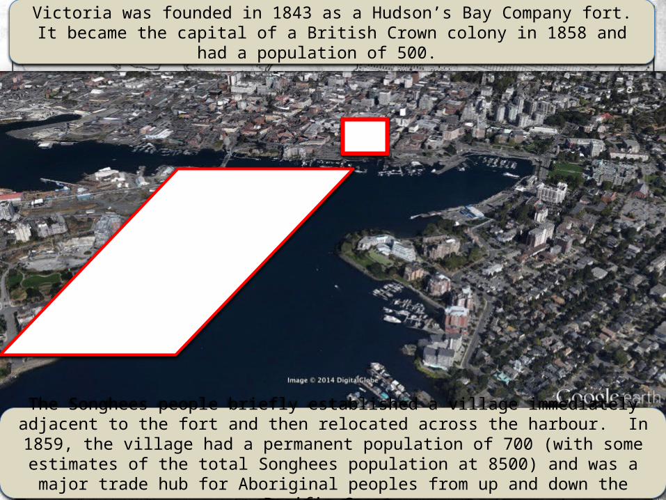
Victoria was founded in 1843 as a Hudson’s Bay Company fort. It became the capital of a British Crown colony in 1858 and
had a population of 500.
The Songhees people briefly established a village immediately adjacent to the fort and then relocated across the harbour. In 1859, the village had a permanent population of 700 (with some estimates of the total Songhees population at 8500) and was a major trade hub for Aboriginal peoples from up and down the
Pacific Coast.

The Songhees First Nation is a part of the Coast Salish ethnic group and descendants of the following family groups:
Kakyaakan (Beecher Bay Band), Teechamitsa (Esquimalt), Whyomilth (Esquimalt), Kosampsom (Esquimalt), Swenwhung
(Songhees), Chilcowitch (Songhees) and Chekonein (Songhees).
They speak a dialect of Coast Salish called Lekwungen. The different family descent groups were amalgamated into the Beecher Bay, Songhees and Esquimalt bands by the Department
of Indian Affairs.
These groups were all signatories to a series of treaties (the only treaties signed in British Columbia) known as the Douglas Treaties in 1850. For the Songhees, this meant that they were ensured of their village location in Victoria’s
inner harbour.
View of Songhees houses from Fort Victoria, 1851
View of Songhees houses with Victoria in the background, ca.1890

The completion of the Canadian Pacific Railway line into Vancouver in 1886 triggered the development of the James Bay section of the Inner Harbour, which had previously been an
inter-tidal zone characterized by mud flats. The original site of the BC Parliament Buildings was on the James Bay side and linked to the industrial part of the city by a pedestrian
bridge.

Empress Legislature
James Bay’s redevelopment led to the construction of the CPR’s steamship terminal and its Empress Hotel (designed by F.M. Rattenbury) as well as the new Legislature (also designed by
Rattenbury). This set the architectural parameters for today’s iconic Inner Harbour.
CPR steamship terminal

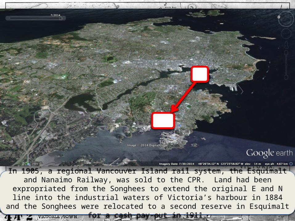
In 1905, a regional Vancouver Island rail system, the Esquimalt and Nanaimo Railway, was sold to the CPR. Land had been
expropriated from the Songhees to extend the original E and N line into the industrial waters of Victoria’s harbour in 1884
and the Songhees were relocated to a second reserve in Esquimalt for a cash pay-out in 1911.

The 1885 expropriation of Songhees land and the 1911 relocation of the village to Esquimalt occurred during
British Columbia’s worst period of treatment of First Nations people in the province. This was part of a wider policy of industrialization in Canada in which the Department of Indian Affairs assumed increasing control over all aspects of First
Nations’ lives. In addition to the relocation of the Songhees, the McKenna-McBride commission of 1912-1916 reduced
reserves sizes in BC.
Ceremonial regalia carefully laid out in a big house in
Fort Rupert for the visiting McKenna-
McBride commission, ca.1912
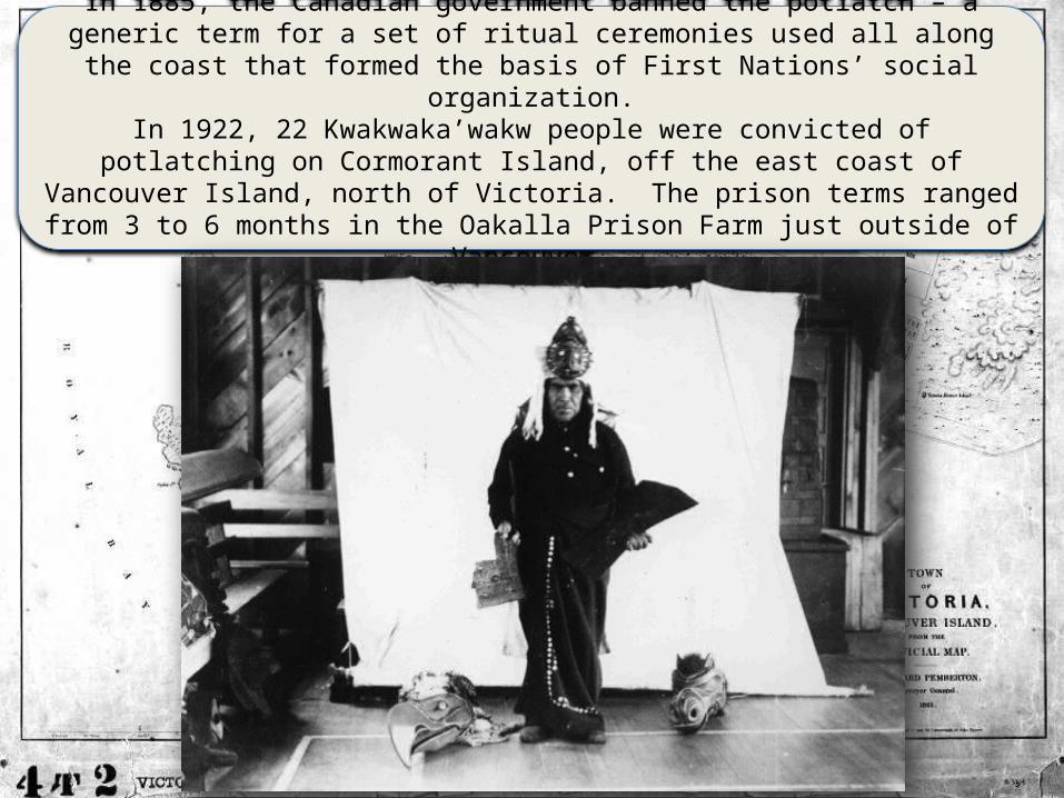
In 1885, the Canadian government banned the potlatch – a generic term for a set of ritual ceremonies used all along the coast that formed the basis of First Nations’ social
organization.In 1922, 22 Kwakwaka’wakw people were convicted of
potlatching on Cormorant Island, off the east coast of Vancouver Island, north of Victoria. The prison terms ranged from 3 to 6 months in the Oakalla Prison Farm just outside of
Vancouver.

One of the prisoners was Spruce Martin. His brother Mungo was considered the greatest of the Kwakwaka’wakw carvers by the 1940s. In 1951, the same year that the potlatch ban was
dropped from the Indian Act, he was hired by the Royal British Columbia Museum to carve replica totem poles of examples bought
or salvaged from around British Columbia. In 1953, Mungo hosted the first public potlatch since the Cranmer potlatch of
1921 to open his carving house, Wa’waditla, in Victoria’s Thunderbird Park.

Mungo Martin helped establish a carver-training program that still exists at the museum today. The work of his adopted sons Henry Hunt and Henry’s sons Richard and Tony began to spread out
through Victoria from 1950 through to the 1970s. Tony also established the commercial Arts of the Raven Gallery in downtown Victoria in 1970. Victoria became one of the best places to see
extant Kwakwaka’wakw monumental art.
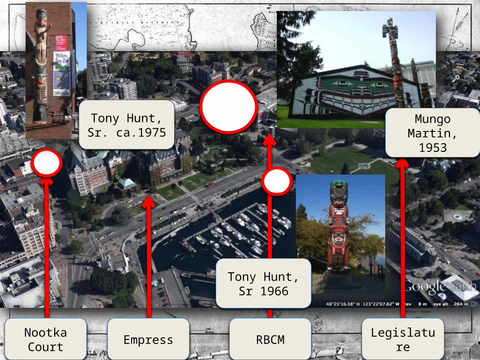
Nootka Court Empress RBCM Legislatu
re
Tony Hunt, Sr. ca.1975
Tony Hunt, Sr 1966
Mungo Martin, 1953

In 1958, on the province’s centennial,
British Columbia declared itself to be Totemland.
In addition to installing
Martin’s poles around the
province, they also hired his niece, Ellen Neel, to carve gift poles for visiting VIPs.
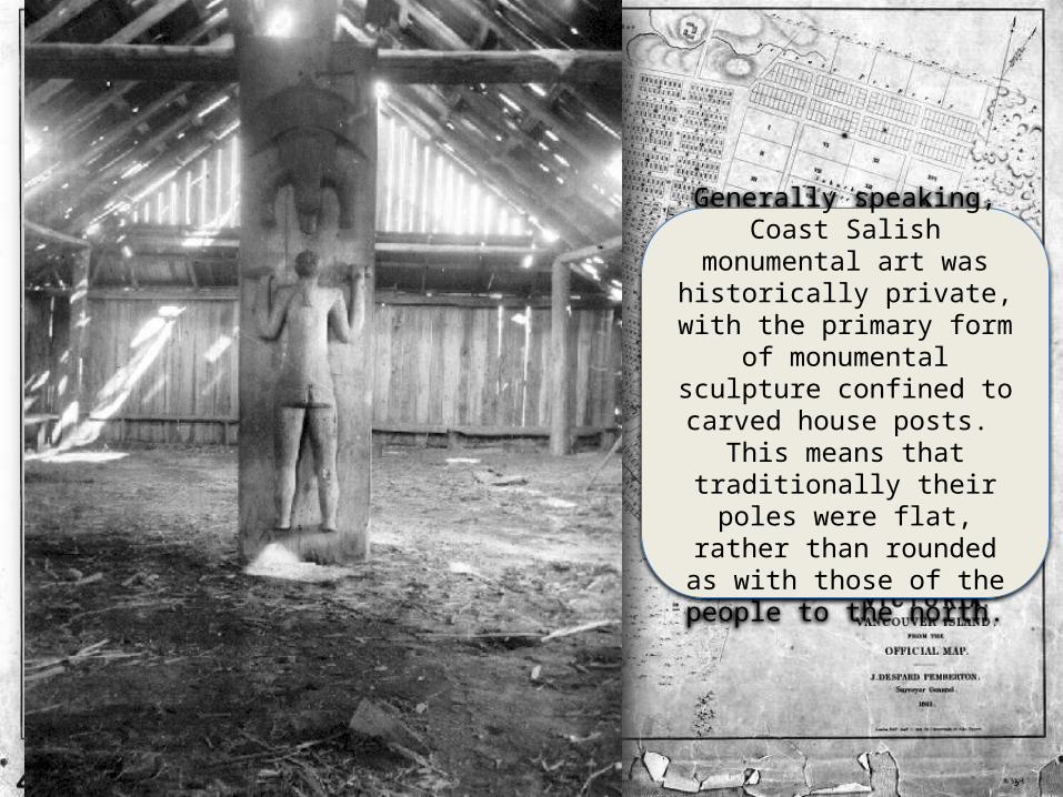
Generally speaking, Coast Salish
monumental art was historically private, with the primary form
of monumental sculpture confined to carved house posts.
This means that traditionally their poles were flat,
rather than rounded as with those of the people to the north.

A series of Coast Salish artistic
interventions into Victoria’s cityscape has been commissioned since 1990. These foreground Songhees territoriality, sovereignty and
political aspirations.
These link to a larger campaign to address what the Songhees and Esquimalt see as a series of government
breaches of the Douglas Treaties.
In 1995, the Songhees joined the Te'mexw Treaty Association.
In 2001, they filed a lawsuit against the
provincial and federal governments. A
preliminary settlement was signed in 2013.
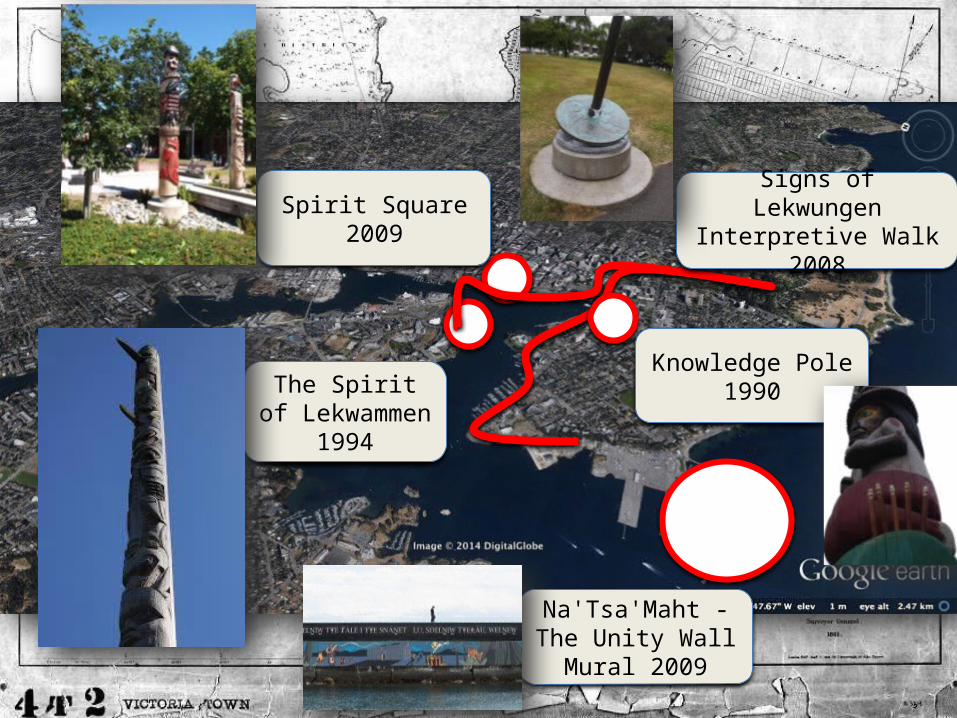
Na'Tsa'Maht - The Unity Wall
Mural 2009
Spirit Square 2009
Knowledge Pole 1990The Spirit
of Lekwammen 1994
Signs of Lekwungen
Interpretive Walk 2008

The Knowledge Pole was raised on the grounds of the provincial legislature as part of the closing ceremonies of the 1990
Commonwealth Games (in preparation for Victoria hosting the 1994 games). It was carved by August Cicero and his sons Darrell and
Dan August of the Cowichan. The loon, fisherman, bone game player and frog represent lessons of the past and hope for the
future.

The originally 120 foot Spirit of Lekwammen was raised on August 4, 1994 at Victoria, British Columbia, Canada prior to the Commonwealth Games taking place there. On August 26, 1997 the pole was partially dismantled for safety reasons and now stands 40 feet tall.
Through the initiative of the Songhees Nation, a totem pole was made to recognize the three major Native languages of Vancouver Island. the totem pole was raised during the opening of the 1994 Commonwealth games. the totem pole was dismantled in 1997 and reconfigured into four positions. Two positions of the totem pole will remain at Pallastsis Point and two portions at the Songhees Reserve. The Songhees Nation named the project "The Spirit of Nations" to acknowledge the unification of all visiting Nations. the totem pole symbolizes friendship between the Songhees and visiting Nations to the Lekwungen Territory. Pallastsis Point remains a scared meeting place for Nations to unite. May it always bring long life to Songhees Children.
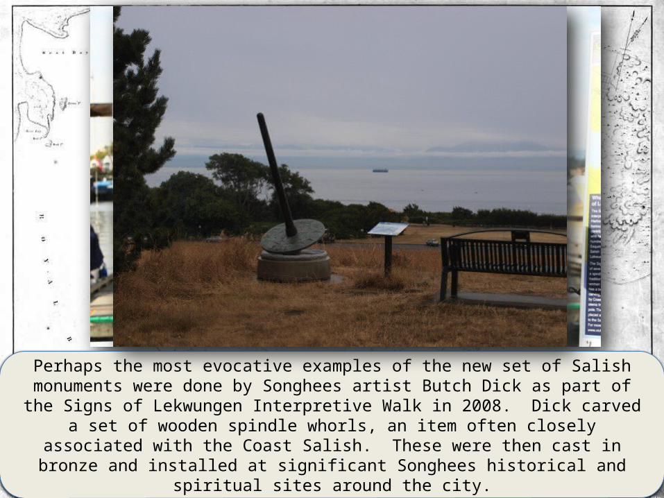
Perhaps the most evocative examples of the new set of Salish monuments were done by Songhees artist Butch Dick as part of the Signs of Lekwungen Interpretive Walk in 2008. Dick carved
a set of wooden spindle whorls, an item often closely associated with the Coast Salish. These were then cast in bronze and installed at significant Songhees historical and
spiritual sites around the city.

Accompanying brochures produced
by the city explain the intent
of the project:
“The development of a modern
city here makes it more
difficult to experience the
landscape that is home to the
Lekwungen. However, footprints
of traditional land use are all
around us, and this land is
inseparable from the lives,
customs, art and culture of
those who have lived here since
the beginning.
“The hills, creeks and
marshlands shaped the growth of
the city of Victoria. There are
messages in the landscape here;
oral histories, surviving
traditional place names, and
the soil itself are all ancient
stories waiting to be told.”
The entire work consists of seven individual, site-specific sculptural installations with an accompanying signboard that explains the significance of the site and its relationship to each of Dick’s different iconographic compositions. As the
promotional literature states: “To follow the markers and visit these traditional places is to learn about the land, its
original culture, and the spirit of its people. The traditions that were born here carry on today. “

12
3
4 56
7
The first sculpture in the interpretive walk is located at Songhees Point, the old location of the Songhees village moved in 1911: “PAH-lu-tsuss means “cradle-board.” Traditionally,
once infants had learned to walk, their cradles were placed at this sacred headland because of the spiritual power of the water here. More recently, there was a settlement here, and subsequently an Indian reserve, that traded with the fort on
the opposite shore. This place is also known as Songhees Point.” Iconography: Four Seasons of the Salmon Family The four
salmon families are represented: Sockeye, Coho, Chum and Spring.
Number 2 is the site of the original Fort Victoria: “An imposing wooden fort, called Fort Camosun (and later known as Fort
Victoria), was built here by the Lekwungen men and women in exchange for trade goods. This marked a drastic change in
traditional ways and traditional sustainable land use. A large forested area was destroyed to raise the fort.“ Iconography:
Walk in Two Worlds Recognizes colonization
Number 3 is located outside City Hall: ““Outside City Hall | skwc’әnj iłc skwu-tsu-KNEE-lth-ch, literally “bitter cherry tree.” Here, willow- lined berry-rich creeks and meadows meandered down to the ocean, and paths made by bark harvesters bordered the waterways. The imprints of these creeks can still be seen in the uneven ground of the Market Square area. This was a creek bed that led back to the food gathering areas now contained by Fort, View, Vancouver and Quadra streets. Bark from the bitter cherry was used to make a variety of household objects. “ Iconography: The eagle is the messenger of the sun (grandfather) and the moon (grandmother) who guides man, represented by the figure in the middle of the carving.
Number 4 is in the inner harbour just below the iconic Empress Hotel:
“whu-SEI-kum, “place of mud”, marked wide tidal mudflats and some of the best
clam beds on the coast. These flats were buried when the area was filled in to
construct the Empress Hotel. This place was also one end of a canoe portage. The
portage could be used to avoid the harbour entrance during heavy seas by cutting
through from the eastern side of what is now Ross Bay Cemetery. Along the route,
arrowheads and other stone tools are still found, reminding us that the lowlands
were rich for hunting. When housing development began, the lower elevations were
left for market gardens and nurseries until after the Second World War.” Carving theme: Four Directions of the Eagle Eagles are the
messengers of the sun (grandfather) and the moon (grandmother) and are far-sighted and strong.
Number 5 is the main civic park: Beacon Hill here “..called MEE-qan
which means “warmed by the sun”. This seaward slope was a popular
place for rest and play – a game similar to field hockey, called
Coqwialls, was played here. At the bottom of the hill was a small,
palisaded village that was occupied intermittently from 1,000 until
approximately 300 years ago. The settlement was here for defence
during times of war, and it was also important for reef net fishing.
The starchy bulbs of the wildflower, Camas, were an important food
source” Carving theme: The Cairns (rocks placed in circular patterns to signify ancient burial sites) Sea otters are the keepers of spiritual powers; "little people" are playful
spirits who assist others.
Number 6 is the location of the Royal British Columbia Museum and the central focus for tourists seeking to learn about First
Nations culture: “The objects, carvings and art of the Lekwungen people are unique. The Lekwungen have loaned many cultural objects from this area to the museum so that the
traditions can be shared as we share the land. Some of these objects are on display inside.” Icongraphy: Celebrate Diversity Three Nations on Vancouver Island: Kwakwaka'wakw, Nuu-chah-
nulth and Coast Salish.
Number 7 is at Laurel Point, located adjacent to many of the most expensive hotels in Victoria: “The carving here marks a nineteenth century First Nations burial ground. Small burial shelters with different carved mortuary figures, including human figures, were placed in front of the graves and stood here until the 1850s. No traditional name is known for this area.” Iconography: Laurel Point - Carving theme: Four Winds
Each wind carries a healing power and a song
Overall the project takes back the space of Songhees land by foregrounding the historical presence of the Songhees, their
economic practices and controlled guardianship of the landscape as well as renaming sites and making them available to the
general public in the Lekwungen language.

Dick was also involved in the 2009 erection of two poles as part of the reconstitution of Centennial Square at City Hall as
Spirit Square along with his sons Clarence and Bradley. Together they represent the Songhees and Esquimalt Nations and reference
Lekwungen creation myths.

Finally, Dick and Esquimalt artist, Darlene Gait, coordinated the 2009 Unity Wall mural at Ogden Point painted with both Aboriginal and non-Aboriginal youth. The site acts as a
breakwater for where the cruise lines dock and is thus the first site of land when these giant
ships arrive in Victoria.