
(Public Pack)Agenda Document for Planning Committee, 29 ...
104
1 NOTICE OF MEETING PLANNING COMMITTEE WEDNESDAY, 29 AUGUST 2018 AT 1.00 PM THE EXECUTIVE MEETING ROOM - THIRD FLOOR, THE GUILDHALL Telephone enquiries to Lisa Gallacher Local Democracy Officer 02392 834056 Email: [email protected] If any member of the public wishing to attend the meeting has access requirements, please notify the contact named above. Planning Committee Members: Councillors Hugh Mason (Chair), Judith Smyth (Vice-Chair), Ken Ellcome, Suzy Horton, Donna Jones, Steve Pitt, Lynne Stagg, Luke Stubbs, Claire Udy and 1 Vacancy Standing Deputies Councillors Jo Hooper, Frank Jonas BEM, Leo Madden, Gemma New, Scott Payter-Harris, Jeanette Smith, Gerald Vernon-Jackson CBE, Rob Wood and Tom Wood (NB This Agenda should be retained for future reference with the minutes of this meeting.) Please note that the agenda, minutes and non-exempt reports are available to view online on the Portsmouth City Council website: www.portsmouth.gov.uk Representations by members of the public may be made on any item where a decision is going to be taken. The request needs to be made in writing to the relevant officer by 12 noon of the working day before the meeting, and must include the purpose of the representation (eg. for or against the recommendations). Email requests to [email protected] or telephone a member of the Technical Validation Team on 023 9283 4916. A G E N D A 1 Apologies 2 Declaration of Members' Interests 3 Minutes of the previous meeting held on 25 July 2018 (Pages 7 - 14) RECOMMENDED that the minutes of the Planning Committee held on 25 July 2018 be agreed as a correct record and signed by the Chair. Public Document Pack
-
Upload
khangminh22 -
Category
Documents
-
view
0 -
download
0
Transcript of (Public Pack)Agenda Document for Planning Committee, 29 ...

1
NOTICE OF MEETINGPLANNING COMMITTEE
WEDNESDAY, 29 AUGUST 2018 AT 1.00 PM
THE EXECUTIVE MEETING ROOM - THIRD FLOOR, THE GUILDHALL
Telephone enquiries to Lisa Gallacher Local Democracy Officer 02392 834056Email: [email protected]
If any member of the public wishing to attend the meeting has access requirements, please notify the contact named above.
Planning Committee Members:
Councillors Hugh Mason (Chair), Judith Smyth (Vice-Chair), Ken Ellcome, Suzy Horton, Donna Jones, Steve Pitt, Lynne Stagg, Luke Stubbs, Claire Udy and 1 Vacancy
Standing Deputies
Councillors Jo Hooper, Frank Jonas BEM, Leo Madden, Gemma New, Scott Payter-Harris, Jeanette Smith, Gerald Vernon-Jackson CBE, Rob Wood and Tom Wood
(NB This Agenda should be retained for future reference with the minutes of this meeting.)
Please note that the agenda, minutes and non-exempt reports are available to view online on the Portsmouth City Council website: www.portsmouth.gov.uk
Representations by members of the public may be made on any item where a decision is going to be taken. The request needs to be made in writing to the relevant officer by 12 noon of the working day before the meeting, and must include the purpose of the representation (eg. for or against the recommendations). Email requests to [email protected] or telephone a member of the Technical Validation Team on 023 9283 4916.
A G E N D A
1 Apologies
2 Declaration of Members' Interests
3 Minutes of the previous meeting held on 25 July 2018 (Pages 7 - 14)
RECOMMENDED that the minutes of the Planning Committee held on 25 July 2018 be agreed as a correct record and signed by the Chair.
Public Document Pack
2
4 Updates on previous planning applications by the Assistant Director of City Development
Planning Applications
5 18/00280/PLANREG - 2 Raglan House 4 Clarence Parade Southsea (Pages 15 - 72)
Retrospective application for installation of replacement external staircase.
6 18/00791/FUL - 83 High Street Cosham Portsmouth
Change of use from bank (Use Class A2) to hot food takeaway (Use Class A5) together with minor external alterations.
7 18/00899/HOU - 7 Jubilee Terrace Southsea PO5 3AS
Installation of dormers to front and rear roof slopes.
8 18/00973/PLANREG - 444 London Road Hilsea Portsmouth
Retrospective application for the change of use from retail shop (Class A1) to hot food takeaway (Class A5) and external alterations to include the construction of a replacement shop front, extraction system and flue.
9 18/00991/FUL - 69 Wadham Road Portsmouth PO2 9ED
Change of use from Class C3 (dwellinghouse) to Class C4 (houses in multiple occupation) or Class C3 (dwellinghouse)
10 18/01131/FUL - D-Day Museum Clarence Esplanade Southsea PO5 3ST
Siting of Landing Craft Tank 7074 and construction of canopy protection with associated landscaping works (including relocation of eight Holm Oak trees); new access from the highway to the public car park and repositioning of one (listed) lamp post.
11 18/01132/LBC - D-Day Museum Clarence Esplanade Southsea PO5 3ST
Repositioning of one lamp post.
12 Exclusion of Press and Public
(NB the appendix to 16/02047/PAMOD - Request to modify legal agreements attached to planning permissions 10/01247/FUL and 08/01941/FUL being land adjacent to Queens Hotel Clarence Parade and Osborne Southsea - appeal
3
against non-determination is exempt so if members wish to discuss this, they will need to pass the resolution below)
That in the view of the contents of the following item on the agenda the committee is RECOMMENDED to adopt the following motions:
Firstly, in the event that the Committee wishes to open the appendix at the Committee meeting:
"That, under the provisions of Section 100A of the Local Government Act 1972 as amended by the Local Government (Access to Information) Act 1985, the press and public be excluded for the consideration of the following item on the grounds that the appendix contains information defined as exempt in paragraph 3, Part 1 of Schedule 12A to the Local Government Act 1972, and that paragraphs 8 and 9 of Part 1, Schedule 12A of the Local Government Act 1972 do not apply so as to prevent exemption, and, further, in all the circumstances the public interest in maintaining the exemption outweighs the public interest in disclosing the information"
Secondly, given the context of an appeal, it is considered expedient that the Committee receives legal advice attracting legal advice privilege:
"That, under the provisions of Section 100A of the Local Government Act 1972 as amended by the Local Government (Access to Information) Act 1985, the press and public be excluded for the purpose of receiving legally privileged information which defined as exempt in paragraph 5, Part 1 of Schedule 12A to the Local Government Act 1972, and that paragraphs 8 and 9 of Part 1, Schedule 12A of the Local Government Act 1972 do not apply so as to prevent exemption, and, further, in all the circumstances the public interest in maintaining the exemption outweighs the public interest in disclosing the information"
The public interest in maintaining the exemptions over the different types of information under paragraph 3 and paragraph 5 must be considered separately and then separately weighed against the public interest in disclosing the information.
In the event that the Committee wishes to review the appendix but finds that the public interest does not weigh in favour of maintaining the exemption under paragraph 3, it is RECOMMENDED that the item is deferred.
Under the Local Authorities (Executive Arrangements) (Meetings and Access to Information) England Regulations 2012, regulation 5, the reasons for exemption of the listed item is shown below. (NB the exempt appendix will contain information which is commercially, legally or personally sensitive and confidential and should not be divulged to third parties. Members are reminded of standing order restrictions on the disclosure of exempt information and are invited to return their exempt documentation to the Local Democracy Officer at the conclusion of the meeting for shredding).
Item Exemption Para Nos. *
4
13 - 16/02047/PAMOD- Request to modify legal agreements attached to planning permissions 10/01247/FUL and 08/01941/FUL, being land adjacent to Queens Hotel Clarence Parade and Osborne Southsea - appeal against non-determination - Exempt appendix
*3. Information relating to the financial or business affairs of any particular persons (including the authority holding that information).*5. Information in respect of which a claim to legal professional privilege could be maintained in legal proceedings.
13 16/02047/PAMOD- Request to modify legal agreements attached to planning permissions 10/01247/FUL and 08/01941/FUL, being land adjacent to Queens Hotel Clarence Parade and Osborne Southsea - appeal against non-determination (Pages 73 - 106)
A non-determination appeal has been received in relation to 16/02047/PAMOD- a request to modify legal agreement attached to planning permission 10/01247/FUL and 08/01941/FUL land adjacent to Queens Hotel Clarence Parade and Osborne Road Southsea. It is necessary for Portsmouth City Council to be able to advise the Planning Inspector as to how the application would have been determined if the Local Planning Authority had issued the decision.
The purpose of this report is to brief the Planning Committee to enable it to establish its position in relation to the recommendation of the application, so that a record can be provided as part of the planning appeal.
Members of the public are permitted to use both audio visual recording devices and social media during this meeting, on the understanding that it neither disrupts the meeting nor records those stating explicitly that they do not wish to be recorded. Guidance on the use of devices at meetings open to the public is available on the Council's website and posters on the wall of the meeting's venue.
Whilst every effort will be made to webcast this meeting, should technical or other difficulties occur, the meeting will continue without being webcast via the Council's website.
This meeting is webcast (videoed), viewable via the Council's livestream account at https://livestream.com/accounts/14063785

1
PLANNING COMMITTEE MINUTES OF THE MEETING of the Planning Committee held on Wednesday, 25 July 2018 at 1.00 pm in the The Executive Meeting Room - Third Floor, The Guildhall These minutes should be read in conjunction with the agenda and associated papers for the meeting.
Present
Councillors Hugh Mason (Chair) Judith Smyth (Vice-Chair) Ken Ellcome Suzy Horton Steve Pitt Luke Stubbs Claire Udy Frank Jonas (Standing Deputy) Scott Payter-Harris (Standing Deputy)
Welcome The chair welcomed members of the public and members to the meeting. Guildhall, Fire Procedure The Chair explained to all present at the meeting the fire procedures including where to assemble and how to evacuate the building in case of a fire.
83. Apologies (AI 1) Apologies for absence were presented for Councillor Donna Jones (whose Standing Deputy was Councillor Frank Jonas), Councillor Lynne Stagg and Councillor James Fleming (whose Standing Deputy was Councillor Scott Payter-Harris).
84. Declaration of Members' Interests (AI 2) There were no declarations of interest at the start of the meeting, however when plans relating to 92 Osborne Road were circulated Councillor Pitt announced that he knew the architect who had prepared the plans but had not known of his involvement so this was non prejudicial. Announcement - the late Chris Dale Councillor Hugh Mason, as Chair, wished to pay tribute to Chris Dale who had been the Administrative Manager for Development Control for many years and who had regularly attended Planning Committee meetings. The Chair was sad to announce that Chris had been involved in fatal road accident whilst cycling in Northern Road. The Chair felt that it was appropriate to remember Chris at this meeting and minute the upset caused to those who knew him by this untimely death, with sympathy for his family.
Page 5
Agenda Item 3

2
85. Minutes of the previous meeting held on 20 June 2018 (AI 3)
RESOLVED that the minutes of the Planning Committee held on 20 June 2018 be agreed as a correct record and signed by the Chair.
86. Updates on previous planning applications by the Assistant Director of City Development (AI 4) The Assistant Director of City Development reported that she would be bringing back a report detailing the decision on the appeal relating to Brunel House (on grounds of appearance) which had been allowed by the Inspector, although the application for costs had not been successful. She further updated the committee on national guidance relating to viability that would be shared with members at a training session. Planning Applications Deputations are not minuted in full as these are recorded as part of the web-cast of this meeting which can be viewed here: https://livestream.com/accounts/14063785/Planning-25Jul2018
87. 18/00837/FUL - 37 Wadham Road Portsmouth PO2 9ED - Change of use from purposes falling within a house in multiple occupation Class C4) to a 7 bedroom house in multiple occupation (sui generis) (amended description) (Report item 1) (AI 5) The Assistant Director of City Development's Supplementary Matters List reported the written deputation that Councillor Payter-Harris had submitted but which he would be making in person questioning the accuracy of the HMO database and notification procedure. The supplementary matters also reported four additional representations received following publication of the committee report, raising the following concerns: a) The development would impact upon parking - cannot rely on residents using public transport; b) Increased pressure for parking would lead to increased safety concerns for residents due to having to park a number of streets away from their homes; c) There are other unlawful HMOs in Wadham Road that have not been taken into account; d) The change of use could result in a potential occupation by up to 14 residents; e) The local authority is putting the rights of developers above the rights of residents; f) The change of use would increase noise levels within the property, impacting on neighbours. In relation to the concern about the number of occupants that could potentially be accommodated, it is noted that Condition 3 as set out in the Committee Report would place a limit on the number of occupants at 7. Whilst reference is made to other unlawful HMOs in the area, very little specific information has been provided within the representations to base further research
Page 6

3
on. However, Councillor Scott Payter-Harris has provided a list of suspected HMOs for the Local Planning Authority (LPA) to investigate. Of the properties to investigate, the ones that are within the 50m radius of this application site are No.60 Wadham Road and No.67 Oriel Road. The LPA has investigated these properties and deduced the following: 60 Wadham Road: No licensing history. No planning history. Council Tax records indicate the property is inhabited by 2 occupants with both the same surname. A site visit confirmed a family lived at the property 67 Oriel Road: No licencing history. No planning history. Council tax records indicate the property is owned by a Housing Association and a site visit determined that the property appeared to be in use as a care home. From the above research, there is insufficient evidence to suggest that either of the properties are in HMO use. Therefore, no further properties have been added to the HMO count and the percentage within the 50m radius remains at 1.4%. Councillor Scott Payter-Harris made a deputation to raise objections and then withdrew from the room as he was not part of the committee deciding this application. Members' Questions It was asked why there were no comments from the Highways Engineer; it was confirmed that they had raised standard advice in assessing parking for HMOs. In response to a query it was reported that means of fire escape would be a matter for Building Control but that this HMO did not require a fire escape. Members' Comments Members were mindful that a Planning Inspector would not accept parking as a grounds of refusal for this HMO use by 7 persons and could award costs against the authority. The 10% threshold for HMOs had not been breached. The communal space and provision of en-suite facilities met the required standards. The enforcement of occupancy was hard to administer but should be reported to private sector housing if there was evidence of over-occupation. RESOLVED that conditional permission be granted, subject to the conditions outlined in the Assistant Director of City Development's report.
88. 18/00280/PLAREG - 2 Raglan House 4 Clarence Parade Southsea PO5 3NU -Retrospective application for installation of replacement external staircase (Report item 2) (AI 6) The Assistant Director - City Development's Supplementary Matters List reported one further letter of support had been received from an occupier (leaseholder/co-freeholder) of Raglan House who had requested a deputation but is unable to attend the meeting. In comparing the existing and replacement staircase the following points were made: 1) Noise Replacement: Significant reduction in noise owing to soft treads and new material. Old staircase: Caused a great deal of clanging. My balcony is directly above the staircase and in the past the noise would rise. 2) Health and safety
Page 7

4
Replacement: Safer owing to a) non-slip treads, b) gradient less steep, c) new metal improving solidity. Old staircase: A potential danger to users and visitors as (a) it was rusty and corroded, (b) gradient far too steep. 3) Appearance Replacement: Less intrusive (paler colour). Old staircase: Dark metal, corroded, visible. Once again with 4 years' experience of the old staircase it is also highlighted that there are no changes in comparison with the old staircase in terms of the following: 1) Positioning and attachment to building. 2) Frequency of use by previous owners (garage to rear). 3) Privacy/overlooking - both the garden of Flat 2 and the courtyard of Flat 1 are overlooked by all those with access to rear upper storeys - my flat (Flat 3), as well as all flats located in the houses to the left and right of Raglan House which extend around the whole garden. A deputation of objection was read out by Mrs Godley on behalf of Mrs Patta who was the neighbour directly affected by the replacement staircase. Members' Questions Members asked if the change in tenure of the property impacted the application; the legal adviser Peter Baulf confirmed that this would not impact the consideration of planning issues. The use of staircase as a fire escape was examined and it was confirmed that there is a secondary entrance/exit to the rear of the property and this can be used as a secondary fire escape in the event of fire. It was also asked why the previous staircase had had to be replaced; this was due to health and safety reasons of steepness and rust and the new staircase was compliant with Building Regulations. The design of the new staircase with the balcony by the neighbour's window was raised. Members' Comments Members were conscious of the different requirements of Building Control and planning considerations which had meant that the replacement staircase met the safety requirements but had an unneighbourly impact. It was therefore asked that further consideration be given to the flexibility of the design and route of the staircase. RESOLVED that consideration be deferred so that further information could be sought regarding Building Regulations requirements and the route of the staircase.
89. 18/00292/FUL - 92 Osborne Road Southsea PO5 3LU - Change of use from a shop (Class A1) to a cafe/restaurant (Class A3); external alterations to include replacement extract duct to rear elevation (Report item 3) (AI 7) (Councillor Pitt declared that he knew the architect Carl Leroy Smith who had prepared the plans circulated at this point in the meeting but this was not prejudicial.) A deputation of objection was made by Mr Kitchen as a leaseholder in Raglan House, who also represented other residents from Osborne Road.
Page 8
5
Members' Questions In response to questions it was clarified that the need for landlord's consent and planning permission are separate things and there would be the need to get the landowner's permission to carry out alterations; this was a speculative application. There was further clarification given to the planning and licensing regimes for opening hours; if later licensing hours were granted there would be an application to vary the hours granted under the planning permission. Peter Baulf, as legal adviser, explained that the Licensing Committee would look at the premises being in an area of cumulative impact. The siting and handling of waste storage was queried at the rear of the site; this could be dealt with by a condition requiring details to be supplied. There was also examination of the layout of the premises with regard to means of escape in the event of fire. It was confirmed that the conditions suggested by Environmental Health were detailed in the report's recommendations. Members' Comments Members expressed concern at the fire escape descending into the kitchen which was the most likely source of a fire in a restaurant. More details regarding the size and siting of waste storage were required. RESOLVED that consideration of this application be deferred to allow further information to be provided on the environmental health implications, waste storage details and fire escape provision.
90. 18/00538/VOC - 19 Powerscourt Road Portsmouth PO2 7JE - Application to vary Condition 5 of planning permission 17/02007/FUL increasing the number of occupants to 8 persons (Report item 4) (AI 8) The presenting officer corrected the report to refer to the provision of 6 en suites and 1 shower. A deputation was made in support by the applicant Mr Venables regarding the quality of facilities provided. Member's Questions It was asked if the grounds of objection stated in the "representations" section were sustainable, which are not for an HMO application. It was confirmed that Building Regulations approval had been obtained. The applicant clarified that there was a second window giving natural light to the basement. Member's Comments Some of the members were familiar with the history of this property and there had been previous concerns regarding the layout of the basement and lack of natural light making it unsuitable for an additional bedroom. It was felt that this was an over-intensive use of the property and the communal space in the basement should be retained for the amenity of occupants. RESOLVED that permission be refused for the following reasons: In the opinion of the Local Planning Authority the variation of Condition 5 of 17/02007/FUL to allow the occupation of the property by up to 8 individuals would result in the loss of ground floor shared amenity space previously
Page 9

6
considered necessary to provide an appropriate standard of living accommodation for future occupiers. The remaining shared amenity space for the increased number of occupants would be situated solely at basement level which has limited access to natural light and ventilation. The inadequate shared amenity space at basement level would therefore, fail to provide an adequate standard of living accommodation for future occupiers and would represent an overly intensive use of the building. The proposal is contrary to Core Planning Principles of the National Planning Policy Framework, Policy PCS23 of the Portsmouth Plan and the revised House in Multiple Occupation Supplementary Planning Document (November 2017).
91. 18/00767/HOU - 5 Lealand Road Portsmouth PO6 1LY - Construction of single storey outbuilding (Report item 5) (AI 9) This application was brought to committee due to the applicant being a close relative of a planning officer (it was clarified that the officer was not one present at the meeting) and the Deputy Monitoring Officer confirmed that as far as he was aware this had been dealt with normally and in accordance with Paragraph 5.11 of the Code for members and officers in respect of Planning Matters. A question was raised regarding the route for vehicular access but no further comments were made. RESOLVED that conditional permission be granted in accordance with the conditions outlined in the Assistant Director of City Development's report.
92. 18/00991/FUL - 69 Wadham Road Portsmouth PO2 9ED - Change of use from Class C3 (dwellinghouse) to Class C4 (houses in multiple occupation) or Class C3 (dwellinghouse) (Report item 6) (AI 10) The Assistant Director of City Development's Supplementary Matters List reported the written deputation that Councillor Payter-Harris had submitted but which he would be making in person questioning the accuracy of the HMO database and notification procedure. The supplementary matters also reported 7 additional representations received following publication of the committee report, raising the following concerns: a) The development would impact upon parking - cannot rely on residents using public transport; b) Increased pressure for parking would lead to increased safety concerns for residents due to having to park a number of streets away from their homes; c) There are other unlawful HMOs in Wadham Road that have not been taken into account; d) The local authority is putting the rights of developers above the rights of residents; e) The change of use would increase noise levels within the property, impacting on neighbours. Unlawful HMOs: Whilst the representations make reference to other unlawful HMOs in the area, very little specific information has been provided to base further research on. Councillor Scott Payter-Harris has provided a list of suspected HMOs for the LPA to investigate. The possible HMOs located within the 50m radius in regards to 69 Wadham Road include: Nos. 56, 58, 66 & 74 Gladys Avenue; and, Nos. 60 & 75 Wadham Road.
Page 10

7
The LPA authority has investigated the above properties and deduced the following: 56 Gladys Avenue: No licensing history. No planning history. Council Tax records indicate the property is inhabited by 2 occupants with both the same surname. A site visit confirmed a family lived at the property. 58 Gladys Avenue: No licensing history. No planning history. Council Tax records indicate the property is inhabited by 2 occupants. There was no answer during the site visit and a calling card was left. 66 Gladys Avenue: No licensing history. Planning history indicated that a Certificate of lawfulness was granted for the existing use of ground and first floor to provide bedsitting room accommodation in October 2001 (ref.A*35739/AB). Council Tax records indicate the first floor flat is inhabited by 1 named occupant (but potentially 2). Council Tax records indicate that the ground floor flat is empty. A site visit confirmed there were 2 occupants living in the first floor flat and the Enforcement Team were informed the ground floor flat was empty. 74 Gladys Avenue: No licensing history. Planning history indicated that planning permission was granted in December 1985 for the conversion to form self-contained flat and maisonette (ref.B*29569/C). Council Tax records indicate that the ground floor flat has a single occupancy discount and the Maisonette has three names occupants (unrelated surnames). There was no answer during the site visit and a calling card was left. 60 Wadham Road: No licensing history. No planning history. Council Tax records indicate the property is inhabited by 2 occupants with both the same surname. A site visit confirmed a family lived at the property. 75 Wadham Road: No licensing history. No planning history. Council Tax records indicate the property is inhabited by 3 occupants (under description it states 'This property is a HMO'. There was no answer during the site visit and a calling card was left. Based on the above findings, the LPA considers that there are two additional HMOs (74 Gladys Avenue & 75 Wadham Road) which were not included in the initial data capture. Therefore, based on information held by the City Council and the above findings, of the 73 properties within a 50 metre radius of the application site, three (3) are considered to be in use as a HMO. Therefore, as the granting of planning permission would increase the proportion of HMOs to 4.11%, it is considered that the community is not already imbalanced by a concentration of HMO uses and this application would not result in an imbalance of such uses. NB. The above HMOs are currently being investigated by the Enforcement Team. HMO Count Data: The HMO Count Data for 69 Wadham Road was placed as sensitive on the Planning Register. This has now been made public (24.07.2018). Furthermore, the HMO Count Data and relevant information was emailed to the Nelson Ward Councillors on 09.07.2018 (it is noted that no further response was received). Publication and Neighbour Notification: Concerns have been raised regarding a lack of neighbour notification about the application. It is confirmed that letters were sent to the immediate adjoining properties and a site notice was displayed in accordance with the Council's consultation procedures. A Site Notice was displayed on the lamp post outside Nos.63-65 Wadham Road on the 14.06.2018 (see presentation for photo). Neighbour Notification Letters were sent to the following addresses: 67 Wadham Road, 71 Wadham Road, Flat Ground Floor 66 North End Avenue, Flat First Floor 55 North End Avenue, 68 North End Avenue, 70 North End Avenue, 86 Wadham Road, 88 Wadham Road and 90 Wadham Road
The presenting officer clarified that whilst the original report referred to 1 HMO, following the investigation of the 6 additional possible properties brought to her attention by Cllr Payter-Harris, 2 more had been identified bringing the total to 3, and a 4.11% total for the radius count.
Page 11

8
Deputations were then made: i) Mrs Lowe, objecting due to the impact on her adjacent property ii) Councillor Payter-Harris objecting and referring to the petition organised by
Mrs Lowe (he then withdrew from the room and was not part of the committee considering the application)
Members' Questions In response to queries on parking standards for HMOs the Assistant Director of City Development reported that a separate report on a Supplementary Planning Document for Parking would be taken to the forthcoming Planning, Regeneration and Economic Development (PRED) meeting. The accuracy and extent of information on the existence of HMOs in the north of the city was raised and it was noted that sewerage and drainage were Building Control matters. The potential of controlling noise attenuation was also raised. Members' Comments Members considered the availability of sustainable transport links to this location and whether there was the need for further checks to be undertaken on possible HMO properties in the vicinity as there was less information about these in the north of the city. RESOLVED that consideration of the application be deferred to allow further investigation of the HMO density within a 50m radius of the application site. The meeting concluded at 3.27 pm.
Signed by the Chair of the meeting Councillor Hugh Mason
Page 12
1
PLANNING COMMITTEE
29 AUGUST 2018
1 PM THE EXECUTIVE MEETING ROOM, FLOOR 3, GUILDHALL
REPORT BY THE ASSISTANT DIRECTOR - CITY
DEVELOPMENT ON PLANNING APPLICATIONS
ADVERTISING AND THE CONSIDERATION OF PLANNING APPLICATIONS
All applications have been included in the Weekly List of Applications, which is sent to City Councillors, Local Libraries, Citizen Advice Bureaux, Residents Associations, etc, and is available on request. All applications are subject to the City Councils neighbour notification and Deputation Schemes. Applications, which need to be advertised under various statutory provisions, have also been advertised in the Public Notices Section of The News and site notices have been displayed. Each application has been considered against the provision of the Development Plan and due regard has been paid to their implications of crime and disorder. The individual report/schedule item highlights those matters that are considered relevant to the determination of the application
REPORTING OF CONSULTATIONS
The observations of Consultees (including Amenity Bodies) will be included in the report by the Assistant Director - City Development if they have been received when the report is prepared. However, unless there are special circumstances their comments will only be reported VERBALLY if objections are raised to the proposals under consideration
APPLICATION DATES
The two dates shown at the top of each report schedule item are the applications registration date- ‘RD’ and the last date for determination (8 week date - ‘LDD’)
HUMAN RIGHTS ACT
The Human Rights Act 1998 requires that the Local Planning Authority to act consistently within the European Convention on Human Rights. Of particular relevant to the planning decisions are Article 1 of the First Protocol- The right of the Enjoyment of Property, and Article 8- The Right for Respect for Home, Privacy and Family Life. Whilst these rights are not unlimited, any interference with them must be sanctioned by law and go no further than necessary. In taking planning decisions, private interests must be weighed against the wider public interest and against any competing private interests Planning Officers have taken these considerations into account when making their recommendations and Members must equally have regard to Human Rights issues in determining planning applications and deciding whether to take enforcement action.
Web: http://www.portsmouth.gov.uk
Page 13
Agenda Item 5

2
INDEX Item No Application No Address Page
01 18/00280/PLAREG 2 Raglan House 4 Clarence Parade Southsea
PO5 3NU PAGE 3
02 18/00791/FUL 83 High Street Cosham Portsmouth PO6 3BA PAGE 8
03 18/00899/HOU 7 Jubilee Terrace Southsea PO5 3AS PAGE 16
04 18/00973/PLAREG 444 London Road Hilsea Portsmouth PO2 9LD PAGE 21
05 18/00991/FUL 69 Wadham Road Portsmouth PO2 9ED PAGE 28
06 18/01131/FUL D-Day Museum Clarence Esplanade Southsea
PO5 3ST PAGE 35
07 18/01132/LBC D-Day Museum Clarence Esplanade Southsea
PO5 3ST PAGE 56
Page 14
3
01
18/00280/PLAREG WARD:ST JUDE 2 RAGLAN HOUSE 4 CLARENCE PARADE SOUTHSEA PO5 3NU RETROSPECTIVE APPLICATION FOR INSTALLATION OF REPLACEMENT EXTERNAL STAIRCASE Application Submitted By: Mrs Karen Rule On behalf of: Mrs Karen Rule RDD: 15th February 2018 LDD: 27th June 2018 SUMMARY OF MAIN ISSUES Update The Planning Committee at its meeting of the 25th July 2018 deferred the application for further information relating to the purpose of the staircase and for information regarding Building Regulations requirements. The Building Control Partnership has confirmed that a Regularisation Application (PR/18/0060) was received in December 2018. Building Control has confirmed that if the stairs had been replaced 'like for like' then the works would not have required Building Regulations approval as the works would have treated as a replacement staircase. A 'like for like' replacement could have been carried out. However this is not the application that has been presented for consideration. Conversely, to change the material/design of the stairs would require an application. With the submission of such an application Building Control would have considered the construction and would have where possible tried to get compliance. In this instance the Building Regulations application was submitted after works had been completed (a Regularisation application). Building Control would have in this instance assessed purely that it was no worse than the existing. Building Control has confirmed that neither staircase would 'strictly' comply with Building Regulations due to the relationship with existing windows. However, given that an existing staircase was in place for many years, due weight must be given and BCP would not wish to raise concern regarding that matter. Whilst the information relating to Building Regulations requirements provides information to the planning Committee the planning application must be considered on its own merits. The Committee needs to consider the acceptability of the application before them and whether planning permission should be granted for this proposal. The staircase is a secondary means of access for the sole use of Flat 2 Raglan House, 4 Clarence Parade. This application is brought to the Planning Committee for determination following a deputation request from neighbouring resident, Flat 1 Raglan House, 4 Clarence Parade. The determining issues in this application are whether the design and appearance of the development is acceptable in relation to recipient building, 'The Seafront' Conservation Area
Page 15
4
(No10) and the setting of the adjoining heritage assets. Furthermore, consideration will be given to what impact the works will have upon the amenities of the adjoining occupiers. Site and proposal The application site relates to Flat 2 (ground & first floors), within a three storey (above basement) terraced property which is located to the north-east of Clarence Parade, facing onto the Grade II listed Southsea Common. The rear of the property abuts Auckland Road West and at present there are a number of garages accessed from this road together with a relatively large garden. An external staircase has been recently (December 2017) erected to the rear of the property. The current use of the building is for three separate residential units. The property is located within 'The Seafront' Conservation Area (No10). The surrounding area is characterised by similar buildings, the majority of which have been sub-divided into flats. The applicant seeks retrospective planning permission for the installation of a replacement external staircase. The staircase has a height of 2.5m and is finished with a handrail to the western side (outside edge) with a height of 1m. The staircase has a depth of 5.6m from the rear wall and is positioned to the west of a single-storey rear projection (Flat 1). Planning history A*18697/AA: Conversion to form 2 self-contained maisonettes and 1 self-contained flat, with construction of single storey extension and external staircase, and insertion of new window/door to rear elevation. Conditional permission (02.11.1994). A*18697/AB: Demolition of part wall to single storey rear projection to enable enlargement of window and part wall of rear elevation for insertion of new door. Conditional consent (02.11.1994). A*18697/B: Change of use to guest house. Conditional permission (30.03.1977). B*20807/B: Alterations to premises in order to form external means of escape in case of a fire. Conditional permission (18.01.1962). POLICY CONTEXT The relevant policies within the Portsmouth Plan would include: PCS23 (Design and Conservation), The aims and objectives of the NPPF would also be relevant in the determination of this application. The Seafront (No10) Guidelines for Conservation would also be a material consideration. CONSULTATIONS Contaminated Land Team Given the limited ground works, the Contaminated Land Team do not require conditions on this project. REPRESENTATIONS One representation has been received from Flat 1 Raglan House resident raising objection on the grounds of: (a) New staircase goes across bedroom window and has caused a loss of light; (b) Loss of outlook; (c) Loss of privacy;
Page 16
5
(d) Increase in noise from staircase due to close proximity to bedroom window and external wall; (e) There is no inside safety rail and as a result the bedroom window is left unprotected; (f) Increase in overlooking into courtyard and windows; and (g) Fence panels have been removed resulting in a further loss of privacy. One representation has been received from Flat 3 Raglan House in support of the application on the grounds of: (a) The new staircase is an improvement. COMMENT The determining issues in this application are whether the design and appearance of the development is acceptable in relation to recipient building, 'The Seafront' Conservation Area (No10) and the setting of the adjoining heritage assets. Furthermore, consideration will be given to what impact the works will have upon the amenities of the adjoining occupiers. Section 72 of the Listed Buildings and Conservation Areas Act 1990 (as amended) requires that LPAs pay special attention to the desirability of preserving or enhancing the character or appearance of a Conservation Area. Design Policy PCS23 of the Portsmouth Plan echoes the principles of good design set out within the National Planning Policy Framework which requires that all new development: will be of an excellent architectural quality; will function well and add to the overall quality of the area, not just for the short term but over the lifetime of the development; will establish a strong sense of place; will respond to local character and history, and reflect the identity of local surroundings and materials, while not preventing or discouraging appropriate innovation; relates well to the geography and history of Portsmouth and protects and enhances the city's historic townscape and its cultural and national heritage; and is visually attractive as a result of good architecture and appropriate landscaping. The site is occupied by a three storey (above basement) 19th century terraced property. The application property is located to the north-east of Clarence Parade, close to its junction with Auckland Road West. The building has a pitched roof and is finished in render with white uPVC windows. Historically the property has been sub-divided into three flats and as a consequence Flat 2 (ground and first floors) had an external cast iron staircase set to the rear elevation (reference no. A*18697/AA). The surrounding streetscene is residential in nature characterised by substantial terraced properties. The replacement staircase faces on to a single-storey rear projection and rear courtyard located to the west of the staircase. Given the building's siting in Conservation Area No10 ('The Seafront') suitable design precedents have been outlined in supplementary planning guidance produced by Portsmouth City Council and the proposed design compliments the key criteria outlined in this document and therefore does not pose any increased risk to the deterioration of the built heritage in the area. It is noted the property had a historic external staircase which was granted conditional permission in November 1994 (planning reference no. A*18697/AA for the: 'Conversion to form 2 self-contained maisonettes and 1 self-contained flat, with construction of single storey extension and external staircase, and insertion of new window/door to rear elevation'. Whilst the previous cast iron external staircase occupied a similar position and was of the same height as the replacement staircase, the depth of the original staircase was 4.4m and thus had a steeper gradient in comparison to the replacement staircase. The applicant seeks retrospective planning permission for the installation of a replacement external staircase. The new staircase has a height of 2.5m and is finished with a handrail to the western side (outside edge) with a height of 1m. The staircase has a depth of 5.6m from the rear
Page 17

6
wall and is positioned to the west of a single-storey rear projection (bedroom of Flat 1). The replacement external staircase has a 'stepped' gradient, which consists of a mid-way platform and thus the depth of the stair has increased by 1.2m to the rear (north-east). The replacement staircase is finished in galvanised steel. It is considered that the replacement external staircase is acceptable in design terms and relates appropriately to the recipient building. Given the property had a previous staircase which occupied a similar position for many years, it is considered the installation and replacement steel staircase preserves the character and appearance of 'The Seafront' Conservation Area (No10). Furthermore, it is noted there are similar external staircases located in close proximity to the site facing onto Auckland Road West. The replacement staircase is therefore, acceptable in design terms in accordance with policy PCS23 of the Portsmouth Plan. Amenity Policy PCS23 of the Portsmouth Plan includes, amongst other things, that new development should ensure the protection of amenity and the provision of a good standard of living environment for neighbouring and local occupiers as well as future residents and users of the development. Given there was an existing staircase located in a similar position and of a similar height, it is considered that extending the staircase in depth by 1.2m along the west elevation of an existing single-storey rear projection, does not lead to a significant increase in loss of light for the property below (Flat 1). Whilst, it is acknowledged the replacement external staircase is positioned across a bedroom (west facing) window belonging to Flat 1, it is noted that the bedroom window is obscure glazed, non-opening and not the sole window serving the bedroom. It is therefore considered, on balance, the extended staircase would not significantly reduce or take away light/outlook from the ground floor flat. Furthermore, whilst it is acknowledged the replacement staircase extends a further 1.2m across the western elevation of the single-storey rear extension, given the position of the previous staircase it is not considered that the replacement staircase significantly adds to increased levels of noise and disturbance in relation to Flat 1. In addition, given the previous levels of overlooking it is not considered that the scheme significantly adds to any real or perceived overlooking/loss of privacy to the neighbouring properties, in accordance with Policy PCS23 of the Portsmouth Plan. Other matters raised in representations The removal of fence panels is not a matter to be considered as part of this application and would be classed as a civil matter. Conclusion For the reasons stated above, the external staircase is considered acceptable in design and would preserve the character and appearance of 'The Seafront' Conservation Area and the setting of the adjoining heritage assets, in accordance with Policy PCS23 of the Portsmouth Plan.
RECOMMENDATION Conditional Permission
Conditions 1) Unless agreed in writing by the Local Planning Authority, the permission hereby granted shall be carried out in accordance with the following approved drawings - Drawing numbers: Location plan and block plan (WDD-104-101); block plan (Scan 1); elevations and plans (WDD-
Page 18

7
104-103); elevations and sections (ONE A); sections (12); sections (13); sections (15); sections 14); sections (11); sections (10); and, sections (25). The reasons for the conditions are: 1) To ensure the development is implemented in accordance with the permission granted. PRO-ACTIVITY STATEMENT Notwithstanding that the City Council seeks to work positively and pro-actively with the applicant through the application process in accordance with the National Planning Policy Framework, in this instance the proposal was considered acceptable and did not therefore require any further engagement with the applicant. NB This permission is granted in accordance with the provisions of Section 73 of the Town and Country Planning Act 1990, which makes provision for the retrospective granting of planning permission for development which has commenced and/or been completed.
Page 19

8
02
18/00791/FUL WARD:COSHAM 83 HIGH STREET COSHAM PORTSMOUTH PO6 3BA CHANGE OF USE FROM BANK (USE CLASS A2) TO HOT FOOD TAKEAWAY (USE CLASS A5) TOGETHER WITH MINOR EXTERNAL ALTERATIONS Application Submitted By: WYG FAO Miss Laura Grimason On behalf of: Mr Aman Virk Papa Johns (GB) Ltd. RDD: 4th May 2018 LDD: 20th July 2018 SUMMARY OF MAIN ISSUES This application is brought to the Planning Committee for determination following a deputation request from Councillor Mason. Site and proposal The application relates to a two-storey, end of terrace property, located to the east side of High Street, in-between the junctions of Magdala Road and Cosham Park Avenue. The ground and first floors comprise of a commercial unit, in A2 use as a bank (it is noted the commercial unit is currently vacant), with a large service yard to the rear accessed from Dorking Crescent. The site is located within the Cosham District Centre (Primary Area), as identified by Policy PCS8 of the Portsmouth Plan. The surrounding area is characterised by shops, restaurants and cafes on High Street (ground floor retail units with residential accommodation within the upper floors). The application seeks planning permission for the change of use from bank (Use Class A2) to hot food takeaway (Use Class A5) together with minor external alterations. Relevant planning history Advertisement consent was granted in May 2018 for the display of 1 internally illuminated fascia sign and 1 internally illuminated projecting sign, under planning reference No.18/00590/ADV. POLICY CONTEXT The relevant policies within the Portsmouth Plan would include: PCS8 (District centres), PCS17 (Transport), PCS23 (Design and Conservation), In addition to the National Planning Policy Framework, the relevant polices within the Portsmouth Plan would include: PCS8 (District Centres), PCS17 (Transport) and PCS23 (Design and Conservation). The Parking Standards Supplementary Planning Document would also be a material consideration.
Page 20

9
CONSULTATIONS Environmental Health Further to the above application there are no outright objections to the proposed change of use however I have some concerns regarding noise and odour emissions from the operation of the kitchen extract system and refrigeration condenser due to the proximity of the residential dwelling at first floor level in the neighbouring property. The submission includes a partial specification for the proposed extraction system, which includes an undertaking to install a silencer to reduce noise emissions and carbon filtration to achieve a dwell time of 0.2 seconds to control odour emissions. However it states the contractor is to be responsible for the final design of the system so there is no performance for the silencer and no idea what the external noise levels will actually be. In terms of odour control the specification states that carbon filters will be installed to provide a dwell time of 0.2 seconds, which should be appropriate for the proposed cuisine however dwell time will be dependent upon the volume flow rate of the fan and the number of filters, therefore we really need to see the final design for the system to ensure that it will achieve the quoted performance. Although there are a number of existing air conditioning condensers on the roof which previously served the bank these would only have operated during office hours. The proposed condenser will be for refrigeration plant and therefore likely to run 24 hours. I have visited site and the proposed location for the new condenser is directly under and within 1 metre of a bedroom window, consequently I do not feel the location is suitable for the equipment as noise from the operation is likely to impact upon anyone sleeping within the bedroom. Therefore if permission should be considered appropriate I would suggest the following conditions. 1 Prior to the commencement of the A5 use, a kitchen extraction system shall be installed to suppress and disperse odour and fumes. Details of the proposed equipment and associated maintenance programme shall be submitted to the local authority for approval. This shall include a risk assessment as per the method in Annexe C of "The Guidance on the control of odour and noise from commercial kitchen exhaust systems" DEFRA 2005. Approved equipment shall then be installed and maintained in accordance with the submitted schedule. 2 Prior to the installation of any fixed plant or equipment an assessment of noise from the operation of the plant shall be undertaken using the procedures within British Standard BS4142:2014 and a report submitted to the local authority for approval. Upon approval measures shall be implemented to mitigate any observed adverse effect levels identified by the assessment. Further comments were received on 18.07.2018 following on from additional information supplied by the agent. Please refer to further comments below from Environmental Health: There are no bedrooms in 83 but there is a window serving a bedroom at first floor level in number 85, (I believe the Postal address to be 85A). I have actually visited site and spoken with the tenant and established that this is a bedroom window (see below). The condenser is proposed to be located directly adjacent to this window. The parapet surrounding the plant area is no more than waist height so there will be very little barrier attenuation and very little distance attenuation.
Page 21

10
In terms of odour and noise control for the kitchen extract system I thought I had made it clear in my comments that the submission does not provide enough information to enable me to say that there will be no loss of amenity. The submission includes a partial specification for the proposed extraction system and states that the contractor will be responsible for the final design. It includes an undertaking to install a silencer to reduce noise emissions, however there are no predicted operational noise levels from the operation of either the extraction system or the condenser, no measured background levels and no assessment of the potential impact upon neighbouring properties. In terms of odour control the specification states that carbon filters will be installed to provide a dwell time of 0.2 seconds, which should be appropriate for the proposed cuisine, however dwell time will be dependent upon the volume flow rate of the fan and the number of filters, neither of which has been confirmed in the submission so we really need to see the final design for the system to ensure that it will achieve the quoted performance, which is why I suggested conditional permission as I believe it should be technically possible for a system to operate without having a significant impact but we currently have insufficient information to ensure the proposed system will achieve the required criteria. I would also suggest that in terms of the DEFRA Odour assessment this is unlikely to be a low risk establishment, it will be discharging 1m above eaves at a velocity of 10m/s, proximity of nearest receptor is close i.e. within 20m, size of kitchen: small takeaway, cooking type: Low odour and grease loading. Based on the Annex C Risk Assessment in the DEFRA Guidance document this would be a high risk so we need to ensure that the appropriate measures are employed. Whilst I am willing to accept the dwell time of 0.2 secs using carbon filtration I need to be sure that the appropriate number of filters will be installed for the proposed volume flow rate. Further comments were received between 19.07.2918 to 23.07.2018: Having read Paragraph 3.4.1 of the planning statement I was under the impression that deliveries would be serviced to the front of the building, the rear yard will be used for bin storage. However I have just noticed that this appears to be contradicted by paragraph 5.4.5 which states that servicing will be at the rear of the yard. Restricting pizza delivery service vehicles to the front of the building might be impractical during the daytime due to parking restrictions outside the premises in particular the proximity of the pedestrian crossing and associated zig zag lines. I would anticipate this activity would only be a potential issue at night i.e. after 23:00hrs and if the drivers were acting inconsiderately. I don't really see 17:30hrs as a particularly sensitive time of day and the proposed opening hours are only beyond this on a Saturday. The vehicle movements are unlikely to significantly raise the average daily or night time noise level so there is unlikely to be any impacts in terms of the significant observed adverse effect level required by the national planning policy framework. There are also no outdoor amenity areas likely to be affected as these are located to the rear of the dwellings in Dorking Crescent. The company has a noise management plan in Appendix 1 that includes the pizza delivery operation. The main issue with noise is likely to be if the vehicles are driven inconsiderately i.e. speeding and excessive use of throttle at low gear, particularly scooters. In which case it should be possible to use statutory nuisance legislation should it become a serious issue. I think the proposed opening hours are reasonable. However, I can foresee potential problems from noise associated with the food and drink deliveries to the rear of the premises unless they can also be restricted to ensure they do not take place before 07:30hrs and after 21:00hrs,
Page 22

11
particularly as deliveries will now be made 3 times a week using 10 tonne vehicles in Dorking Crescent. Highways Engineer I have reviewed the drawings and planning statement submitted in support of this application which proposes the change of use from bank (Use Class A2) to hot food takeaway (Use Class A5) together with minor external alterations and I would make the following observations: There are parking restrictions along the eastern side of High Street, immediately outside the site however car parking is available on the eastern side of the road. The nature of the use is such that I think it likely that collection customers will choose to park on street at the site frontage in contravention of the parking restrictions whilst they collect their orders. However I see little difference in the effect of this activity compared with the use of the cash point installed in the bank facade and do not believe that this proposal will materially impact on highway safety in this locale. I do not envisage the same issue with delivery vehicles as the planning statement explains that there is a large service yard to the rear of the property accessed form Dorking Crescent which will be used for delivery vehicle parking in association with the proposed use with delivery accounting for 60% of orders. The same staff parking arrangements as were available for the bank are retained for this proposal and I am satisfied that staff and visiting customer numbers are likely to be similar. As a consequence I would not wish to raise a highway objection to this application subject to a condition requiring that all delivery vehicles operate for the service yard at the rear of the property rather than from the High Street frontage REPRESENTATIONS Five representation have been received raising objection on the grounds of: (a) There are too many take-aways already in Cosham, High Street; (b) Promotes diabetes and obesity; (c) Over-concentration of non-shopping uses in the High Street; (d) Planning Statement (section 5.2.6) does not take account of A3 use and therefore gives a misleading picture of the High Street as a whole; (e) Late night opening hours will impact on residential amenity; (f) Car park and alleyway will be left open as a walk through; (g) Increase in noise from cars/scooters and increased comings and goings until the late evening will disrupt quiet residential area; (h) Planning statement does not mention what will happen to the hedging; (i) Noise from cars, scooters, rubbish collection vehicles, delivery vehicles and extract system; (j) Odours will have a negative impact on residents; (k) The outlet would not be a benefit to Cosham, High Street; (l) Increased pressure on current parking; and, (m) Increase in anti-social behaviour. These comments were noted on MIS on 20.07.2018 expiring on 27.07.2018. Subsequently, the application is brought to the Planning Committee for determination following a deputation request from Councillor Mason. COMMENT The determining issues are: (a) whether the principle of a change of use is acceptable in this location; (b) whether the design of any external alterations are appropriate in design terms to the recipient property and wider streetscene;
Page 23
12
(c) whether there would be a significant impact on residential amenity; (d) whether there would be an impact on the local highway/parking as a result of the change of use; and, (e) whether suitable provisions have been made in respect of refuse/recycling storage. Principle The site is located within the Cosham District Centre as identified in the Portsmouth Plan. More specifically it is located within Cosham High Street primary frontage. As a result, policy PCS8 applies. The policy states that this is a traditional centre with a partly pedestrianised core area dominated by shopping users. Cosham is highly accessible and serves the surrounding population with a mixture of local independent shops and national retailers. At least 55% of the primary frontages will be protected for shopping (A1) use in order to preserve this role. In this case, the existing premises has an A2 use, therefore the change to an A5 use would not alter the current percentage of A1 uses within the centre. A site visit determined that there were a number of A1 uses in the immediate vicinity of the site, including a newsagents, a patisserie, Peacocks, a clothes boutique, a charity shop and a hairdressers. On that basis, it is considered that the proposal would not result in an over-concentration of A5 uses within the locality and the proposal would see a vacant unit brought back into use to the benefit of the centre. The proposal for an A5 use within this context is therefore considered acceptable in principle. Design Policy PCS23 of the Portsmouth Plan echoes the principles of good design set out within the National Planning Policy Framework which requires that all new development: will be of an excellent architectural quality; will function well and add to the overall quality of the area, not just for the short term but over the lifetime of the development; will establish a strong sense of place; will respond to local character and history, and reflect the identity of local surroundings and materials, while not preventing or discouraging appropriate innovation; relates well to the geography and history of Portsmouth and protects and enhances the city's historic townscape and its cultural and national heritage; and is visually attractive as a result of good architecture and appropriate landscaping. On the front elevation, the existing shopfront would be replaced although its size in terms of height and width would remain unchanged. Noticeable changes would include horizontal panelling to divide the glass and the removal of an existing ATM. The shopfront would be formed with horizontal glazing frames, finished in green, powder coated aluminium with a single inward opening entrance door. It is considered that the proposed shopfront and alterations would be acceptable in design terms and would relate appropriately to the recipient building. Alterations to the rear would include the installation of external ductwork, grills and a condensing unit at first floor level. The proposed galvanised, flue ductwork would be affixed to the rear wall and would terminate 1m above the soffit. Although, this alteration would introduce a new feature to the rear elevation, the size of the flue is considered modest and due to the large rear yard, there is a significant separation distance from the rear of the building and the wider streetscene. Furthermore, it is noted that the proposed condensing unit and louvre grill would be positioned behind the parapet wall and would therefore not be visible from the public realm. It is therefore considered that due to the rear location and modest scale these additions would not be visually obtrusive or incongruous. For the reason stated above, the limited external alterations are considered to relate appropriately to the recipient property and wider area, in accordance with Policy PSC23 of the Portsmouth Plan.
Page 24

13
Amenity Policy PCS23 of the Portsmouth Plan includes, amongst other things, that new development should ensure the protection of amenity and the provision of a good standard of living environment for neighbouring and local occupiers as well as future residents and users of the development. The submitted details state that the premises would trade between 10:00 to 23:00 Sunday (and Bank Holidays) to Friday and 10:00 to 00:00 on Saturday. It is noted, a planning condition would be imposed to ensure the above operating hours strictly adhered to. Furthermore, it is acknowledged that this section of High Street surrounding the application site does have other late night/early morning food uses. With regards to the issues raised around increased noise and disturbance from delivery vehicles (delivering to customers), the Environmental Health team anticipate this activity would only be a potential issue at night i.e. after 23:00hrs and if the drivers were acting inconsiderately. The vehicle movements are unlikely to significantly raise the average daily or night time noise level so there is unlikely to be any impacts in terms of the significant observed adverse effect level required by the national planning policy framework. In addition, there are also no outdoor amenity areas likely to be affected as these are located to the rear of the dwellings in Dorking Crescent. The company has a noise management plan in Appendix 1 that includes the pizza delivery operation. The main issue with noise is likely to be if the vehicles are driven inconsiderately i.e. speeding and excessive use of throttle at low gear, particularly scooters. In which case it should be possible to use statutory nuisance legislation should it become a serious issue. However, the Environmental Health Officer does consider there is the potential for disturbance from food and drink deliveries (delivering to the commercial unit) to the rear of the property. As such, the Environmental Health Officer has advised that a condition should be imposed to control the hours of delivery. If a planning condition can be used to mitigate the impact of a development then planning permission should not be refused. Due to the proximity of the residential dwelling at first floor level in the neighbouring property, the Environmental Health Officer has raised concerns regarding noise and odour emissions from the operation of the kitchen extract system and refrigeration condenser. In order to mitigate the concerns raised, suitably worded planning conditions can be imposed, in the interests of aural amenity and to protect residential properties from unnecessary disturbance. The Environmental Health Officer is satisfied that these conditions are realistic and demonstrate that the proposed use can operate without significant impact, in accordance with Policy PCS23 of the Portsmouth Plan. Highways There are parking restrictions along the eastern side of High Street, immediately outside the site, however car parking is available on the eastern side of the road. The nature of the use is such that it is likely that collection customers will choose to park on street at the site frontage in contravention of the parking restrictions whilst they collect their orders. However, the Highways Engineer sees little difference in the effect of this activity compared with the use of the cash point installed in the bank facade and it is not believed that this proposal would materially impact on highway safety in this locale. The Highways Engineer does not envisage the same issue with delivery vehicles as the planning statement explains that there is a large service yard to the rear of the property accessed form Dorking Crescent which will be used for delivery vehicle parking in association with the proposed use with delivery accounting for 60% of orders.
Page 25

14
The same staff parking arrangements which were available for the bank are retained for this proposal and the Highways Engineer is satisfied that staff and visiting customer numbers are likely to be similar. As a consequence the Highways Engineer would not wish to raise a highway objection to this application subject to a condition requiring that all delivery vehicles operate for the service yard at the rear of the property rather than from the High Street frontage. Waste The submitted plans indicate an area to the rear of the property that would be made available for the storage and collection of refuse. Whilst no specific details have been submitted, these matters could be controlled by suitably worded planning condition and would not form a sustainable reason for refusal in this instance. Conclusion For the reasons stated above, the proposed change of use with minor external alterations is considered acceptable to the building and the wider area, in accordance with the aims and objectives of Policies PCS8, PSC17, PSC23 of the Portsmouth Plan and The Portsmouth Parking SPD.
RECOMMENDATION Conditional Permission
Conditions 1) The development hereby permitted shall be begun before the expiration of 3 years from the date of this planning permission. 2) Unless agreed in writing by the Local Planning Authority, the permission hereby granted shall be carried out in accordance with the following approved drawings - Drawing numbers: Location plan (PLAN01); Proposed floor plans and elevations (PJ/COS/02/C); Proposed elevation, sections and plans (PJ/COS/04); and, Proposed floor plans (PJ/COS/03). 3) The premises/hot food takeaway shall be closed to and vacated of customers as well as all external plant equipment associated with the kitchen extraction system turned off, outside of the following hours of operation:
Sunday to Friday and Bank Holidays 10:00 to 23:00; and,
Saturday 10:00 to 00:00. 4) No deliveries (supplying to the commercial unit) shall be carried out outside of the hours of 07:30 and 21:00 daily. 5) All delivery vehicles (delivering to both customers and the commercial unit) will operate from the service yard at the rear of the property. 6) Prior to the commencement of the A5 use, a kitchen extraction system shall be installed to suppress and disperse odour and fumes. Details of the proposed equipment and associated maintenance programme shall be submitted to the local authority for approval. This shall include a risk assessment as per the method in Annexe C of "The Guidance on the control of odour and noise from commercial kitchen exhaust systems" DEFRA 2005. Approved equipment shall then be installed and maintained in accordance with the submitted schedule. 7) Prior to the installation of any fixed plant or equipment an assessment of noise from the operation of the plant shall be undertaken using the procedures within British Standard
Page 26

15
BS4142:2014 and a report submitted to the local authority for approval. Upon approval measures shall be implemented to mitigate any observed adverse effect levels identified by the assessment. 8) Before the hot food take-away (Class A5) hereby permitted is first brought into use, refuse and recyclable materials storage facilities shall be provided in accordance with a detailed scheme to be submitted to and approved by the local planning authority in writing; and the approved facilities shall thereafter be retained for refuse/recyclable materials storage at all times. The reasons for the conditions are: 1) To comply with Section 91 of the Town and Country Planning Act 1990. 2) To ensure the development is implemented in accordance with the permission granted. 3) In the interests of protecting residential amenity from excessive noise and disturbance in accordance with policy PCS23 of the Portsmouth Plan. 4) To protect the amenities of the occupiers of neighbouring residential properties in accordance with policy PCS23 of the Portsmouth Plan. 5) To ensure an adequate amount of parking is provided to minimise the potential for parking on the highway to the detriment of highway safety in accordance with Polices PCS17 and PCS23 of the Portsmouth Plan. 6) In the interests of visual amenity and to protect residential properties from unnecessary disturbance in accordance with policy PCS23 of the Portsmouth Plan. 7) In the interests of aural amenity and to protect residential properties from unnecessary disturbance in accordance with policy PCS23 of the Portsmouth Plan. 8) To ensure that adequate provision is made for the storage of refuse and recyclable materials, in accordance with policy PCS23 of the Portsmouth Plan. PRO-ACTIVITY STATEMENT Notwithstanding that the City Council seeks to work positively and pro-actively with the applicant through the application process in accordance with the National Planning Policy Framework, in this instance the proposal was considered acceptable and did not therefore require any further engagement with the applicant.
Page 27

16
03
18/00899/HOU WARD:ST THOMAS 7 JUBILEE TERRACE SOUTHSEA PO5 3AS CONSTRUCTION OF DORMERS TO FRONT AND REAR ROOFSLOPES Application Submitted By: Ms Louise Webb On behalf of: Mr Jim Joudani RDD: 22nd May 2018 LDD: 18th July 2018 SUMMARY OF MAIN ISSUES This application is brought to the Planning Committee for determination following deputation requests from a neighbouring resident and Councillor Rob Wood. The determining issues in this application are whether the design and appearance of the development is acceptable in relation to recipient building, 'The Terraces' Conservation Area and the setting of the heritage assets. Furthermore, consideration will be given to what impact the works will have upon the amenities of the adjoining occupiers. Site and proposal This application relates to a two-storey mid-terrace dwelling, located on the east side of Jubilee Terrace close to its intersection with Hambrook Street, within a predominantly residential area. Jubilee Terrace forms one of the main routes out of the city and therefore experiences heavy traffic flow, on-street parking is available on both the near and far side of the road. The rear gardens of Jubilee Terrace face east, with a number of small garage/sheds at their furthest ends backing onto Nickel Street. There is a mix of housing styles in the area surrounding this 1950s terrace, comprising of blocks of flats and detached/semi-detached properties. The property is located within 'The Terraces' Conservation Area (No.6) and is set to the north of Nos.14 & 15 Jubilee Terrace, both of which are Grade II listed buildings. The Terraces Conservation Area Guidelines state that: 'This terrace mainly comprises modern two storey dwelling houses but the two southernmost buildings are original. No. 14 is a white, rendered three storey Georgian building with double bow windows on the ground and first floors painted in a pleasingly contrasting black. Adjacent to this is the Jubilee Tavern with a ground floor painted in red and upper floors rendered and coloured cream'. The application seeks planning permission for the construction of dormers to the front and rear roofslopes. The proposed front dormer would have a width of 2.7m, a height of 1.7m and a depth of 2.2m. The proposed rear dormer would have a width of 3.7m, a height of 1.7m and a depth of 2.3m. It is noted that the previous 'time expired' planning permissions relating to dormer extensions have not been implemented. In addition, the plans also detail the front chimney would be removed, however this part of the proposal could be carried out under 'permitted development'.
Page 28
17
It is noted that works have been carried out to the rear of the property, which have essentially 'squared off' an existing single-storey rear extension. The Planning Enforcement Team has investigated the works and it is concluded that these works were carried out under 'permitted development'. Planning History 17/01733/FUL: Change of use from house in multiple occupation (Class C4) to purposes falling within Class C3 (dwellinghouse) or Class C4 (house in multiple occupation). Conditional permission (06.12.2017). 06/00451/FULR: Construction of dormers to front and rear roofslopes (renewal of planning permission DA: E*16979/AC-1). Conditional permission (11.12.2006). E*16979/AC-1: Construction of dormers to front and rear roofslopes (renewal of planning permission DA: E*16979/AC). Conditional permission (18.10.2001). E*16979/AD: Removal of part of front and rear roofslopes to enable construction of dormers. Conditional consent (29.08.1996). E*16979/AC: Construction of dormers to front and rear roofslopes. Conditional permission (29.08.1996). E*16979/AB: Removal of part of front and rear roofslopes. Conditional permission (04.01.1991). E*16979/AA: Construction of dormer extensions to front and rear roofslopes. Permission (04.01.1991). E*16979/H: An extension to form W.C & conservatory. Permission (17.12.1970). A*16979/D: The erection of nine houses and nine private motor car garages. Conditional permission (28.11.1958). POLICY CONTEXT The relevant policies within the Portsmouth Plan would include: PCS23 (Design and Conservation), In addition to the above policies, the aims and objectives of the National Planning Policy Framework and 'The Terraces' Conservation Area guidelines are relevant. CONSULTATIONS None. REPRESENTATIONS One representation has been received from a neighbouring resident raising objection on the grounds of: (a) The design of this huge dormer will not preserve or enhance the conservation area in which it is sited; (b) There are no other rear dormers in this small terrace of houses and it will therefore set a precedent for other such applications; (c) It seems entirely inappropriate that this three bedroom family home should be so enlarged as to have six bedrooms presumably to accommodate students.
Page 29

18
COMMENT The determining issues in this application are whether the design and appearance of the proposed development is acceptable in relation to the recipient building, 'The Terraces' Conservation Area and the setting of the heritage assets. Furthermore consideration will be given to what impact the works will have upon the amenities of the adjoining occupiers. When determining planning applications the Local Planning Authority (LPA) must consider what impact the proposal would have on both designated and non-designated heritage assets. Section 66 of the Listed Buildings and Conservation Areas Act 1990 (as amended) places a duty on the LPA to have special regard to the desirability of preserving a Listed Building or its setting or any features of special architectural or historic interest which it possesses. The property is in close proximity to a number of designated heritage assets most notably: Nos. 14 & 15 Jubilee Terrace, which are both Grade II Listed. Therefore, the impact that the proposal would have on the Grade II listed buildings and the surrounding area will also be taken into consideration when determining the application. Section 72 of the Listed Buildings and Conservation Areas Act 1990 (as amended) requires that LPAs pay special attention to the desirability of preserving or enhancing the character or appearance of a conservation area. The proposal is located within the 'The Terraces' Conservation Area (No.6), so therefore the impact that the proposal could have on the Conservation Area will be considered when determining this application. Policy PCS23 of the Portsmouth Plan echoes the principles of good design set out within the National Planning Policy Framework which requires that all new development: will be of an excellent architectural quality; will function well and add to the overall quality of the area, not just for the short term but over the lifetime of the development; will establish a strong sense of place; will respond to local character and history, and reflect the identity of local surroundings and materials, while not preventing or discouraging appropriate innovation; relates well to the geography and history of Portsmouth and protects and enhances the city's historic townscape and its cultural and national heritage; and is visually attractive as a result of good architecture and appropriate landscaping. Procedural Amended plans have been received (17.07.2018) for the current application, following on from the advice of the Case Officer, which reduced the size of the rear dormer and improved the fenestration arrangement. In addition, the front dormer was altered to ensure it would match the existing front dormers located within the terrace row. The revised plans are considered to be more sympathetic to the host building and in-keeping with 'The Terraces' Conservation Area and to comply with Policy PSC23 of the Portsmouth Plan. Design The application seeks planning permission for the construction of dormers to the front and rear roofslopes. The proposed rear dormer would have a width of 3.7m, a height of 1.7m and a depth of 2.3m. The proposed rear dormer is shown to be set 1m from each common boundary and set back by approx. 1.5m from the eaves. Furthermore, the proposed rear dormer would sit 0.9m below the ridge line and would be finished with a flat roof. The proposed rear dormer (face and cheeks) would be tile hung, using materials appropriate in relation to the recipient building and would relate satisfactorily to the existing fenestration. A suitably worded planning condition would be imposed to ensure the materials used in the construction would match the existing materials. The principle of a flat roof dormer to the rear of the property within 'The Terraces' Conservation Area has been established by planning permissions post conservation area designation and a distance of 1m from each side boundary has been a consistent approach in ensuring that any new dormer is seen as an 'insertion' within the roofslope rather than a second floor extension. It
Page 30
19
is noted that front and rear dormer extensions were granted at the application site in December 2006, under planning reference no. 06/00451/FULR. The previous 'time expired' permission related to a rear dormer with a width of 3.7m, a height of 1.7m and a depth of 2.6m. The proposed front dormer would have a width of 2.7m, a height of 1.7m and a depth of 2.2m. The proposed front dormer is shown to be set approx. 1.5m from each common boundary and set back by approx. 0.5m from the eaves. Furthermore, the proposed front dormer would sit 0.9m below the ridge line and would be finished with a flat roof. The proposed front dormer cheeks would be clad in white uPVC to match the existing front dormers located at Nos.3 & 5 Jubilee Terrace. Furthermore, it is considered the proposed centrally located front dormer would relate satisfactorily to the existing fenestration. A suitably worded planning condition would be imposed to ensure an appropriate finish would be adhered to. The principle of a flat roof dormer to the front of the property within 'The Terraces' Conservation Area has been established by planning permissions post conservation area designation. It is noted that front and rear dormer extensions were granted at the application site in December 2006, under planning reference no. 06/00451/FULR. The previous 'time expired' permission related to a front dormer with a width of 2.5m, a height of 1.7m and a depth of 2.2m. In addition, it is noted that there are similar front dormer extension at Nos. 3 and 5 Jubilee Terrace which were granted in September 1966 (planning reference Nos. C*16979F and D*16979/G). Whilst, it is noted the Conservation Guidelines for 'The Terraces' state that: 'The City Council will discourage new dormers in front facing roofslopes and extensions to existing ones' and 'Extensions to roofs and dormers will not normally be allowed', it is acknowledged that similar front and rear dormers were granted in December 2006 (06/00451/FULR). In addition, the Guidelines detail that: 'The City Council will discourage the application of inappropriate finishes/materials to external walls, such as tiles, stone cladding, plastic, timber or heavily textured render'. In the case of the proposed front dormer and the use of white uPVC, it is considered that due to the existing white uPVC clad front dormers at Nos. 3 & 5 Jubilee Terrace, the use of a similar material would be acceptable, in order to achieve a similar appearance, so as not to disrupt the terrace row. In the particular and unusual circumstances of this site, it is considered the proposed dormers are set very comfortably within the roofslope leaving much of the original roof visible on both sides, above and below. As such the development is considered an appropriate addition to the recipient house, in terms of size, scale, position and materials and would preserve the character and appearance of 'The Terraces' Conservation Area. Furthermore, the proposed development is not considered to have a significant impact on the setting of the nearby Grade II listed buildings which are in close proximity to the application site. The proposed dormer extensions would therefore, be acceptable in design terms in accordance with the aims and objectives of the National Planning Policy Framework and Policy PCS23 of the Portsmouth Plan. Amenity Policy PCS23 of the Portsmouth Plan includes, amongst other things, that new development should ensure the protection of amenity and the provision of a good standard of living environment for neighbouring and local occupiers as well as future residents and users of the development. An appropriate separation distance would remain between the proposed front dormer and the property on the opposite side of Jubilee Terrace (No.8 Slingsby Close) to ensure that it would not give rise to any adverse impacts upon the amenities of adjoining occupiers by virtue of loss of light, overlooking or overbearing relationship. In addition, given the position of the windows at first floor level to the neighbouring properties, it is not considered that the front dormer would result in demonstrable harm to the levels of light received to these neighbouring properties or result in increased levels of overshadowing.
Page 31

20
The proposed dormer to the rear elevation features two 'east facing' windows, providing light to bedroom 5 and the shared bathroom. Given that the properties to the rear are set a sufficient distance apart from the site, it is not considered that any further harm would result to the amenities of neighbouring properties by way of overlooking or loss of privacy. In addition, given the position of the windows at first floor level to the neighbouring properties, it is not considered that the rear dormer would result in demonstrable harm to the levels of light received to these neighbouring properties or result in increased levels of overshadowing. Conclusion For the reasons stated above and subject to conditions, the proposed front and rear dormers are considered suitable additions to the building and 'The Terraces' Conservation Area. Furthermore, the proposed development is not considered to have a significant impact on the setting of the nearby Grade II listed buildings. It is therefore concluded that the proposed development would comply with the aims and objectives of the National Planning Policy Framework and Policy PCS23 of the Portsmouth Plan.
RECOMMENDATION Conditional Permission
Conditions 1) The development hereby permitted shall be begun before the expiration of 3 years from the date of this planning permission. 2) Unless agreed in writing by the Local Planning Authority, the permission hereby granted shall be carried out in accordance with the following approved drawings - Drawing numbers: Location plan (100047474); site plan (100047474); proposed elevations (JJ05/02C); and, proposed floor plans and elevations (JJ05/01C). 3) (a) The external wall materials used on the hereby approved rear dormer face and cheeks shall be tile hung, as shown on drawing no.JJ05/02C; (b) The external wall material used on the hereby approved front dormer cheeks shall be white uPVC cladding, as shown on drawing no.JJ05/01C; and, (c) The materials used in the construction of all other external surfaces of the development hereby permitted shall match, in type, colour and texture those on the existing building. The reasons for the conditions are: 1) To comply with Section 91 of the Town and Country Planning Act 1990. 2) To ensure the development is implemented in accordance with the permission granted. 3) In the interests of visual amenity and to preserve the character and appearance of 'The Terraces' Conservation Area and the setting of heritage assets, in accordance with policy PCS23 of the Portsmouth Plan. PRO-ACTIVITY STATEMENT In accordance with the National Planning Policy Framework the City Council has worked positively and pro-actively with the applicant through the application process, and with the submission of amendments an acceptable proposal has been achieved.
Page 32

21
04
18/00973/PLAREG WARD:HILSEA 444 LONDON ROAD HILSEA PORTSMOUTH PO2 9LD RETROSPECTIVE APPLICATION FOR THE CHANGE OF USE FROM RETAIL SHOP (CLASS A1) TO HOT FOOD TAKEAWAY (CLASS A5) AND EXTERNAL ALTERATIONS TO INCLUDE THE CONSTRUCTION OF A REPLACEMENT SHOP FRONT, EXTRACTION SYSTEM AND FLUE Application Submitted By: Mr Azad Hamma On behalf of: Mr Azad Hamma RDD: 5th June 2018 LDD: 1st August 2018 SUMMARY OF MAIN ISSUES The main issues in the determination of this application are whether the proposed use would be acceptable in principle, and whether the proposed use would have an adverse impact on the living conditions of adjoining and nearby residents Site and surroundings This application relates to the ground floor unit of No. 444 London Road. The application site forms part of a small block of six terraced properties predominately in use at ground floor for varying uses including retail and hot food takeaways with residential accommodation above. The site is located within the London Road North Local Centre as identified by Policy PCS18 of the Portsmouth Plan and is intersected by Merrivale Road to the south and Amberley Road to the north. The two flats located above the premises are accessed via a separate doorway located at ground floor adjacent to London Road. There is also access to the rear of the unit via a dropped kerb and shared alleyway located on Amberley Road. The rear curtilage of the property has previously been subdivided to create an area of amenity space to the rear of the flats whilst enabling access to the rear of the ground floor unit. Proposal Retrospective planning permission is sought for a change of use from retail shop (Class A1) to hot-food takeaway (Class A5) and external alterations to include the construction of a replacement shopfront, external extraction system and flue. A significant amount of the physical alterations to this property have already been completed, however it is understood that the hot-food takeaway use has not commenced subject to the outcome of this application. Planning history There is no planning history relevant to the determination of this application. POLICY CONTEXT The relevant policies within the Portsmouth Plan would include: PCS17 (Transport), PCS23 (Design and Conservation),
Page 33

22
In addition to the aims and objectives of the National Planning Policy Framework (NPPF) the relevant policies within the Portsmouth Plan would include;- PCS17 (Transport) and PCS23 (Design and Conservation). CONSULTATIONS Highways Engineer London Road is a strategic north-south route through the North End area of Portsmouth. The proposal site lies within a small district centre with a mix of shops and takeaways. There is some on-street parking to the front of the application site and also on the west side of the road. There is a bus lane with double yellow line restrictions immediately outside the site and adjacent to the parking bays; this bus lane forms part of a Bus Rapid Transit corridor. No transport assessment/statement has been submitted with the application. The proposed use as a takeaway will likely create more vehicular movements than the existing retail use especially if a delivery service is deployed. It is feasible that trips to the existing retail use would be linked in many cases given the nature of the area in which the applicant site is situated. A takeaway however is busiest in the evening after which many of the other shops in the area are closed resulting in many of the trips to the proposed takeaway being new trips or in the best case, relocated from another of the nearby takeaways. That said, in capacity terms I am satisfied that this proposal would not have a material impact on the local Highway network. The application does not and presumably cannot make parking provision available. The nearest on-street parking on London Road is outside the row of shops within which the application site is located. These parking bays are subject to limited wait parking restrictions which are suspended after 6pm and act as additional parking for the nearby residential roads that ordinarily experience parking demand in excess of the capacity available. I am therefore of the opinion that there is insufficient space on street to accommodate the likely parking demand associated with the proposed use at the peak time. It is therefore likely that existing issues of vehicles parking on double yellow lines will be exacerbated by takeaway customers stopping on double yellow lines close to the takeaway so to collect orders. Portsmouth's Parking standards do not give an expected number of cycle spaces for retail/commercial development rather it is required that it achieve 2 BREEAM credits relevant to the type of business. Whilst it is appreciated that the applicant may not be able to provide a suitable provision for customers owing to the physical constraints of the site, the applicant does not appear to have made any provision for staff cycle parking in what is a fairly large premises however this can be secured by condition. Whilst it is my opinion that there is insufficient space on street to accommodate the likely parking demand associated with the takeaway, it is my opinion that a refusal based on the assumption that customers will choose to park indiscriminately is unlikely to be upheld should the application be taken to appeal. Therefore, as the application stands I would not wish to raise a Highways objection however the following condition should be secured; -Details of cycle parking for staff should be submitted to and agreed by the LHA and provision installed prior to occupation of the development and thereafter retained. Environmental Health Further to the above application the submitted documents do not make it clear whether the extract will vent at high level. Owing to the location and style of cuisine I would suggest that the extraction system will need to discharge above roof height to ensure adequate dispersion. They are also proposing to install an ozone generator in the extraction system to control odours, which should be appropriate however the DEFRA guidance recommends that such systems should vent at high level due to health concerns with concentrations of low level ozone
Page 34

23
They have submitted details for the proposed fan and a silencer but no indication of the predicted noise levels or background noise levels in the locality. Provided the high level discharge can be achieved the development should be appropriate for the location but we will also require further information particularly in terms of noise control to ensure that there is no loss of amenity to nearby residential properties due to its operation. Therefore if the high level discharge is possible and the development should be considered appropriate I would suggest the following condition. Prior to the installation of any fixed plant or machinery an assessment of noise from the operation of the plant shall be undertaken using the procedures within British Standard BS4142:2014 and a report submitted to the local authority for approval. Appropriate measures shall be implemented to mitigate any identified observed adverse effect levels due to the operation of the plant. Crime Prevention Design Advisor No comments REPRESENTATIONS One representation has been received objecting to the development on the grounds of: (a) works including the construction of an extraction system and external flue were not included in the proposal; (b) new extraction flue blocks views and light into habitable room windows; (c) external alterations have had an impact on the internal walls of the shared hallway access. COMMENT The main issues for consideration are whether the use of the premises as a hot-food takeaway would be acceptable in the context of the London Road (north) Local Centre and whether, in the context of the Local Plan and NPPF, the proposal would have any significant adverse impact on the living conditions of the adjoining residential occupiers with particular regard to noise, disturbance and cooking fumes/odours and highways implications of the change of use. Principle of development Policy PCS18 (Local Shops and Services) of the Portsmouth Plan seeks to play a vital role in the provision of the day to day needs of those living nearby. Local Centres are often used as 'top-up' weekly shops and ensure that residents are able to access every day essentials over a short distance without the need to use a car. Implementing Policy PCS18 encourages development to help local centres to continue fulfilling their role and in doing so must meet the following criteria: -Shopping (A1) uses up to 500m2 will be encouraged throughout all of the local centres; Other town centre uses will be supported provided that: -The local centre would continue to provide for the local top-up shopping needs of nearby residents and there would not be an over-concentration of non-shopping uses in the local centre as a whole or in the vicinity of the proposed development; and -There is no unacceptable adverse impact on the amenity of adjoining or nearby residents, taking into account the cumulative impact of other similar uses nearby. Having regard to the balance of uses in the vicinity of the application site, it is noted that a Co-Operative retail (Class A1) shop is located to the north of the site at the intersection between
Page 35
24
London Road and Amberley Road. Other uses within the Local Centre include a broad range of Class A1 uses including a bakery, Convenience Store and a Florist. There are some Class A5 (Hot-Food Takeaway) uses located within this centre, however these have been spaced out at reasonable intervals. In light of the diverse mixture of uses within the Local Centre, it is considered that the change of use from Class A1 (Retail) to Class A5 (Hot-Food Takeaway) would not have an adverse impact on the ability of the Local Centre to provide the local top-up shopping needs of nearby residents, furthermore the proposal would not be considered to result in an over-concentration of non-shopping uses in the vicinity of the application site. In light of this, the proposed change of use would be considered to protect the vitality and viability of the Local Centre, and in principle the proposed change of use is considered to be acceptable subject to the caveat that there would be no unacceptable adverse impact on the amenity of adjoining or nearby residents, taking into account the cumulative impact of other similar uses nearby. Amenity Impact Policy PCS23 of the Portsmouth Plan includes, amongst other things, that new development should ensure the protection of amenity and the provision of a good standard of living environment for neighbouring and local occupiers as well as future residents and users of the development. This part of London Road is characterised by a mixed commercial frontage with residential uses at upper floor levels. Furthermore, there a number of Class A1, A3, and A5 uses within the locality that cumulatively can affect the standard of living environment for residents. Where any such adverse impacts on residential amenity cannot be adequately controlled and mitigated by planning conditions, such matters would outweigh the conclusion above that the proposal would be acceptable in principle. The most affected residential accommodation is located immediately above the premises at first/second floor level. Having conducted a site visit to the resident of the second floor flat, it is confirmed that the layout of this property includes a bedroom and living room orientated to the front (west) with a kitchen, bathroom and study to the rear (east). The kitchen to the restaurant is situated at ground floor level to the rear. The external extraction flue straddles a wall on the north facing elevation and has been fixed in a position between the bathroom and kitchen of this second floor flat. It is considered that an appropriately worded condition to secure a scheme of insulation against internal noise would adequately address the most direct amenity impact. Similarly, planning conditions in relation to the extraction system to mitigate odour and vibration together with restrictions on deliveries and the use of the rear doors would be sufficient to overcome other external environmental impacts. The representation received from the adjoining occupier refers to the loss of a view from upper floor windows and a prevailing loss of light. It is advised that a loss of view is not a material planning consideration and cannot be considered as a determining factor in this application. In regards to the impact of the external extraction flue in terms of a loss of light, given the orientation of the property and the location of existing three storey projections to the south of the application site (similar in height to the extraction flue) it is not considered that the proposed external alterations would have a significant impact in terms of a loss of natural light or a greater degree of overshadowing. With the imposition of safeguarding conditions it is concluded that the proposed change of use would comply with the requirements of Policy PCS23 of the Portsmouth Plan (2012) which, amongst other matters, requires that new development should ensure the protection of amenity and the provision of a good standard of living environment for neighbouring and local occupiers. In reaching this conclusion regard has been made to a recent appeal decision (18 May 2018) at No.17 Marmion Road (Appeal Ref: APP/Z1775/W/17/3191765) which related to a similar
Page 36

25
proposal in an area of Southsea Town Centre. In allowing the appeal the Inspector opined: 'Given the location of the appeal site within a fairly tight-knit town centre area comprising a mix of commercial, retail and residential uses there is the potential for the proposed use to have a detrimental effect, either by itself or cumulatively with other uses, on the amenity of local residents, particularly those living closest. That of course is not an uncommon concern in many town centre areas having a context of mixed commercial and residential uses in close proximity. In such circumstances, where any such adverse impacts on residential amenity cannot be adequately controlled and mitigated by planning conditions, planning permission should be withheld. I can understand the fear some local residents have articulated in detail in their correspondence that the proposed use would result in noise and disturbance, including cumulatively with other uses such as the PH opposite the appeal site. However, in this particular case I am satisfied that planning conditions to secure a scheme of insulation against noise for upper floor occupiers, and restriction of operating hours and delivery times, would be sufficient to curtail any noise and disturbance to within acceptable levels. A condition to secure an extraction system to control cooking fumes and odours would also adequately control and mitigate such emissions. In this regard I note that the Council's Environmental Health consultation came to the same conclusion having assessed the technical data submitted with the application. There is no convincing evidence or alternative assessment before me which leads me to conclude otherwise'. Other matters Other matters for consideration in this application are the design impact of the external alterations and the impact the proposal would have on the Local Highways Network. Policy PCS23 of the Portsmouth Plan echoes the principles of good design set out within the National Planning Policy Framework which requires that all new development: will be of an excellent architectural quality; will function well and add to the overall quality of the area, not just for the short term but over the lifetime of the development; will establish a strong sense of place; will respond to local character and history, and reflect the identity of local surroundings and materials, while not preventing or discouraging appropriate innovation; relates well to the geography and history of Portsmouth and protects and enhances the city's historic townscape and its cultural and national heritage; and is visually attractive as a result of good architecture and appropriate landscaping. Externally the applicant has replaced the old shopfront with a new grey aluminium framed shopfront and access door. The applicant has provided photographs of the previous shopfront which was dated and in a poor state of repair. These external alterations have helped to modernise the appearance of the ground floor unit and represent a good design quality. The applicant has installed an external extraction system to the rear elevation of the application site. This external flue is located within the rear lightwell and has been fixed to the north facing elevation. The flue measures 0.45m in width, 0.57m in depth and 6.7m in height. Whilst the scale and location of the external extraction system has a significant impact in terms of the appearance of the rear elevation, this alteration is virtually out of site for adjoining neighbouring occupiers by virtue of existing three storey projections to the rear of these properties. Furthermore the flue is not visible from the London Road frontage. Whilst external extraction flues of this scale represent a significant design intervention, it is not considered that the design impact of the proposal is so harmful to warrant a refusal in this case. In terms of the impact of the proposal on the Local Highways Network, the Highways Officer has advised that the proposed use as a takeaway will likely create more vehicular movements than the existing retail use and notes that a takeaway is busiest in the evening after which many of the other shops in the area are closed resulting in many of the trips to the proposed takeaway being new trips or in the best case, relocated from another of the nearby takeaways. In capacity terms the Officer was satisfied that the proposal would not have a material impact on the local Highway network.
Page 37
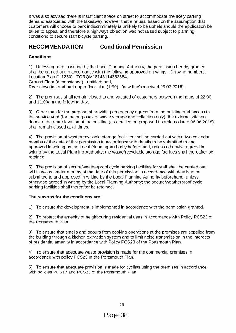
26
It was also advised there is insufficient space on street to accommodate the likely parking demand associated with the takeaway however that a refusal based on the assumption that customers will choose to park indiscriminately is unlikely to be upheld should the application be taken to appeal and therefore a highways objection was not raised subject to planning conditions to secure staff bicycle parking.
RECOMMENDATION Conditional Permission
Conditions 1) Unless agreed in writing by the Local Planning Authority, the permission hereby granted shall be carried out in accordance with the following approved drawings - Drawing numbers: Location Plan (1:1250) - TQRQM18143114353584; Ground Floor (dimensioned) - untitled; and, Rear elevation and part upper floor plan (1:50) - 'new flue' (received 26.07.2018). 2) The premises shall remain closed to and vacated of customers between the hours of 22:00 and 11:00am the following day. 3) Other than for the purpose of providing emergency egress from the building and access to the service yard (for the purposes of waste storage and collection only), the external kitchen doors to the rear elevation of the building (as detailed on proposed floorplans dated 06.06.2018) shall remain closed at all times. 4) The provision of waste/recyclable storage facilities shall be carried out within two calendar months of the date of this permission in accordance with details to be submitted to and approved in writing by the Local Planning Authority beforehand, unless otherwise agreed in writing by the Local Planning Authority; the waste/recyclable storage facilities shall thereafter be retained. 5) The provision of secure/weatherproof cycle parking facilities for staff shall be carried out within two calendar months of the date of this permission in accordance with details to be submitted to and approved in writing by the Local Planning Authority beforehand, unless otherwise agreed in writing by the Local Planning Authority; the secure/weatherproof cycle parking facilities shall thereafter be retained. The reasons for the conditions are: 1) To ensure the development is implemented in accordance with the permission granted. 2) To protect the amenity of neighbouring residential uses in accordance with Policy PCS23 of the Portsmouth Plan. 3) To ensure that smells and odours from cooking operations at the premises are expelled from the building through a kitchen extraction system and to limit noise transmission in the interests of residential amenity in accordance with Policy PCS23 of the Portsmouth Plan. 4) To ensure that adequate waste provision is made for the commercial premises in accordance with policy PCS23 of the Portsmouth Plan. 5) To ensure that adequate provision is made for cyclists using the premises in accordance with policies PCS17 and PCS23 of the Portsmouth Plan.
Page 38

27
PRO-ACTIVITY STATEMENT In accordance with the National Planning Policy Framework the City Council has worked positively and pro-actively with the applicant through the application process, and with the submission of amendments an acceptable proposal has been achieved. NB This permission is granted in accordance with the provisions of Section 73 of the Town and Country Planning Act 1990, which makes provision for the retrospective granting of planning permission for development which has commenced and/or been completed.
Page 39

28
05
18/00991/FUL WARD:NELSON 69 WADHAM ROAD PORTSMOUTH PO2 9ED CHANGE OF USE FROM CLASS C3 (DWELLINGHOUSE) TO CLASS C4 (HOUSES IN MULTIPLE OCCUPATION) OR CLASS C3 (DWELLINGHOUSE) Application Submitted By: Thorns Young Ltd FAO Mrs Carianne Wells On behalf of: Mr J Durai RDD: 7th June 2018 LDD: 3rd August 2018 SUMMARY OF MAIN ISSUES Update This application was deferred from the Planning Committee on 25 July 2018. The reason for deferral was to allow for further investigation of the HMO density within a 50m radius of the site. Following the deferral, the LPA has checked HMO licensing, planning history and council tax records of the 73 properties within the 50m radius of the site. In addition, further site visits were also carried out. As of a result of the further investigation the LPA have identified the following: Possible unauthorised HMOs 58 Gladys Avenue: No licensing history. No planning history. Council Tax records indicate the property is inhabited by 2 occupants. A site visit identified the property was in use as an HMO. Planning Enforcement Team are currently investigating. 60 Gladys Avenue: No licensing history. A site visit identified the property was in use as an HMO. Planning Enforcement are currently investigation. 75 Wadham Road: No licensing history. No planning history. Council Tax records indicate the property is inhabited by 3 occupants (under description it states 'This property is a HMO'. A site visit identified this property as an HMO. Owner has confirmed it is a 5 bed HMO and planning enforcement are currently investigating. Authorised HMOs 64 North End Road is a known HMO. Planning permission was granted in October 2016 for 'Change of use from dwelling house (Class C3) to purposes falling within Class C4 (house in multiple occupation) or Class C3 (dwelling house)', under planning reference no. 16/01407/FUL. In addition, the property has a HMO License. Based on the above findings, the LPA considers that there are three (3) additional HMOs (58 & 60 Gladys Avenue & 75 Wadham Road) which were not included in the initial data capture. It is not known if the identified properties are authorised HMOs or unauthorised and as such the Enforcement Team are investigating the matter. Therefore, based on information held by the City Council and the above findings, of the 73 properties within a 50 metre radius of the
Page 40
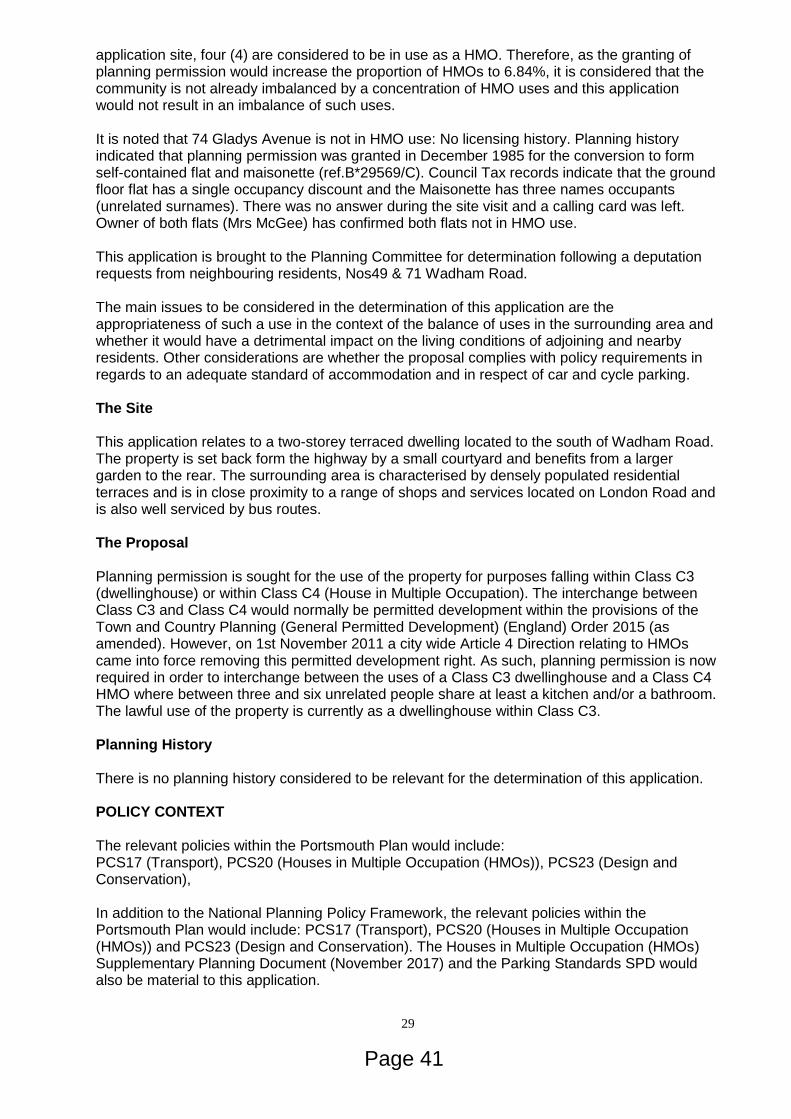
29
application site, four (4) are considered to be in use as a HMO. Therefore, as the granting of planning permission would increase the proportion of HMOs to 6.84%, it is considered that the community is not already imbalanced by a concentration of HMO uses and this application would not result in an imbalance of such uses. It is noted that 74 Gladys Avenue is not in HMO use: No licensing history. Planning history indicated that planning permission was granted in December 1985 for the conversion to form self-contained flat and maisonette (ref.B*29569/C). Council Tax records indicate that the ground floor flat has a single occupancy discount and the Maisonette has three names occupants (unrelated surnames). There was no answer during the site visit and a calling card was left. Owner of both flats (Mrs McGee) has confirmed both flats not in HMO use. This application is brought to the Planning Committee for determination following a deputation requests from neighbouring residents, Nos49 & 71 Wadham Road. The main issues to be considered in the determination of this application are the appropriateness of such a use in the context of the balance of uses in the surrounding area and whether it would have a detrimental impact on the living conditions of adjoining and nearby residents. Other considerations are whether the proposal complies with policy requirements in regards to an adequate standard of accommodation and in respect of car and cycle parking. The Site This application relates to a two-storey terraced dwelling located to the south of Wadham Road. The property is set back form the highway by a small courtyard and benefits from a larger garden to the rear. The surrounding area is characterised by densely populated residential terraces and is in close proximity to a range of shops and services located on London Road and is also well serviced by bus routes. The Proposal Planning permission is sought for the use of the property for purposes falling within Class C3 (dwellinghouse) or within Class C4 (House in Multiple Occupation). The interchange between Class C3 and Class C4 would normally be permitted development within the provisions of the Town and Country Planning (General Permitted Development) (England) Order 2015 (as amended). However, on 1st November 2011 a city wide Article 4 Direction relating to HMOs came into force removing this permitted development right. As such, planning permission is now required in order to interchange between the uses of a Class C3 dwellinghouse and a Class C4 HMO where between three and six unrelated people share at least a kitchen and/or a bathroom. The lawful use of the property is currently as a dwellinghouse within Class C3. Planning History There is no planning history considered to be relevant for the determination of this application. POLICY CONTEXT The relevant policies within the Portsmouth Plan would include: PCS17 (Transport), PCS20 (Houses in Multiple Occupation (HMOs)), PCS23 (Design and Conservation), In addition to the National Planning Policy Framework, the relevant policies within the Portsmouth Plan would include: PCS17 (Transport), PCS20 (Houses in Multiple Occupation (HMOs)) and PCS23 (Design and Conservation). The Houses in Multiple Occupation (HMOs) Supplementary Planning Document (November 2017) and the Parking Standards SPD would also be material to this application.
Page 41

30
CONSULTATIONS Private Sector Housing Definitions Dwelling and Flat: Housing Act 2004, Part 1, Chapter 1, Section 1 (5). "Dwelling" means a building or part of a building occupied or intended to be occupied as a separate dwelling. "Flat" means a separate set of premises (whether or not on the same floor) — (a) Which forms part of a building (b) Which is constructed or adapted for use for the purposes of a dwelling, and (c) Either the whole or a material part of which lies above or below some other part of the building. Proposal Change of use from Class C3 (dwellinghouse) to class C4 (house in multiple occupation) or Class C3 (Dwelling house) Summary - 5 bedrooms - 2 storeys Based on the layout and sizes provided there are no adverse comments to be made by Private Sector Housing. This property would not require to be licenced under Part 2, Housing Act 2004. REPRESENTATIONS Seventeen representations have been received raising objections on the grounds of: (a) Increase on parking pressure; (b) HMOs devalue existing properties; (c) there are too many HMOs already; (d) the HMO would impact negatively on the neighbourhood; (e) anti-social behaviour associated with HMOs; (f) increase in noise associated with HMOs; (g) sewage and drainage cannot support increase in population; (h) increased pressure on refuse collection; (i) loss of family homes; (j) families cannot afford to buy in the local area; (k) HMOs put strain on infrastructure, schools and local services); (l) application does not take into account the demographics of the community within the road; (m) front gardens are being paved over to make way for parking; (n) increase in dropped kerbs means less space available for on road parking; (o) increase in litter and waste associated with HMOs; and, (p) concerns have been raised regarding a lack of neighbour notification about the application. Deputation requests from Nos71 & 49 Wadham Road have been received (should the application be recommended for approval). A petition containing 86 no. signatures has also been received raising objection to the proposal. COMMENT The main issues to be considered in the determination of this application are the appropriateness of such a use in the context of the balance of uses in the surrounding area and whether it would have a detrimental impact on the living conditions of adjoining and nearby
Page 42

31
residents. Other considerations are whether the proposal complies with policy requirements in regards to an adequate standard of accommodation and in respect of car and cycle parking. Principle Permission is sought for the use of the property for purposes falling within Class C3 (dwellinghouse) or Class C4 (house in multiple occupation) (HMO), to enable the applicant the flexibility to change freely between the two use classes. The property currently has a lawful use as a dwellinghouse (Class C3). For reference, a Class C4 HMO is defined as a property occupied by between three and six unrelated people share who share basic amenities such as a kitchen or bathroom. Policy PCS20 of the Portsmouth Plan states that applications for the change of use to a HMO will only be permitted where the community is not already imbalanced by a concentration of such uses or where the development would not create an imbalance. The adopted Houses in Multiple Occupation SPD (HMO SPD) sets out how Policy PCS20 will be implemented and details how the City Council will apply this policy to all planning applications for HMO uses. Based on information held by the City Council, of the 73 properties within a 50 metre radius of the application site, one (1) is considered to be in lawful use as a HMO. Therefore, as the granting of planning permission would increase the proportion of HMOs to 2.74%, it is considered that the community is not already imbalanced by a concentration of HMO uses and this application would not result in an imbalance of such uses. Whilst this is the best available data to the Local Planning Authority (LPA) and is updated on a regular basis, there are occasions where properties have been included or omitted from the database in error or have lawfully changed their use away from Class C4 HMOs without requiring the express permission of the LPA. No additional properties have been brought to the attention of the LPA to investigate. Standard of Accommodation In terms of internal living conditions, the property benefits from the following: Area: Provided: Required Standard: (HMO SPD-NOV 2017) Bedroom 1 Inc. en-suite (Ground Floor) 15.25m2 7.5m2 Bedroom 2 Inc. en-suite (Ground Floor) 11.85m2 7.5m2 Bedroom 3 Inc. en-suite (First Floor) 20.09m2 7.5m2 Bedroom 4 Inc. en-suite (First Floor) 12.19.m2 7.5m2 Bedroom 5 Inc. en-suite (First Floor) 14.93m2 7.5m2 Combined Living Space (3 to 6 Persons) 28m2 24m2 Whilst it is acknowledged there is no separate bathroom or W.C provided, it is noted that each bedroom has an en-suite measuring 2.8m2. It is therefore considered that the proposed development would be acceptable and in accordance with the requirements outlined on pages 8 and 9 of the HMO SPD (November 2017). For the reasons stated above, in accordance with the requirements outlined on pages 8 and 9 of the HMO SPD (November 2017), the property is considered to provide an adequate standard of living accommodation to facilitate 3 to 6 persons sharing.
Page 43
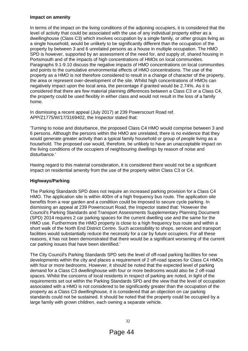
32
Impact on amenity In terms of the impact on the living conditions of the adjoining occupiers, it is considered that the level of activity that could be associated with the use of any individual property either as a dwellinghouse (Class C3) which involves occupation by a single family, or other groups living as a single household, would be unlikely to be significantly different than the occupation of the property by between 3 and 6 unrelated persons as a house in multiple occupation. The HMO SPD is however, supported by an assessment of the need for, and supply of, shared housing in Portsmouth and of the impacts of high concentrations of HMOs on local communities. Paragraphs 9.1-9.10 discuss the negative impacts of HMO concentrations on local communities and points to the cumulative environmental effects of HMO concentrations. The use of the property as a HMO is not therefore considered to result in a change of character of the property, the area or represent over-development of the site. Whilst high concentrations of HMOs can negatively impact upon the local area, the percentage if granted would be 2.74%. As it is considered that there are few material planning differences between a Class C3 or a Class C4, the property could be used flexibly in either class and would not result in the loss of a family home. In dismissing a recent appeal (July 2017) at 239 Powerscourt Road ref. APP/Z1775/W/17/3169402, the Inspector stated that: 'Turning to noise and disturbance, the proposed Class C4 HMO would comprise between 3 and 6 persons. Although the persons within the HMO are unrelated, there is no evidence that they would generate greater activity than a typical family household or group of people living as a household. The proposed use would, therefore, be unlikely to have an unacceptable impact on the living conditions of the occupiers of neighbouring dwellings by reason of noise and disturbance.' Having regard to this material consideration, it is considered there would not be a significant impact on residential amenity from the use of the property within Class C3 or C4. Highways/Parking The Parking Standards SPD does not require an increased parking provision for a Class C4 HMO. The application site is within 400m of a high frequency bus route. The application site benefits from a rear garden and a condition could be imposed to secure cycle parking. In dismissing an appeal at 239 Powerscourt Road, the Inspector stated that: 'However the Council's Parking Standards and Transport Assessments Supplementary Planning Document (SPD) 2014 requires 2 car parking spaces for the current dwelling use and the same for the HMO use. Furthermore the HMO property is close to a high frequency bus route and within a short walk of the North End District Centre. Such accessibility to shops, services and transport facilities would substantially reduce the necessity for a car by future occupiers. For all these reasons, it has not been demonstrated that there would be a significant worsening of the current car parking issues that have been identified.' The City Council's Parking Standards SPD sets the level of off-road parking facilities for new developments within the city and places a requirement of 2 off-road spaces for Class C4 HMOs with four or more bedrooms. However, it should be noted that the expected level of parking demand for a Class C3 dwellinghouse with four or more bedrooms would also be 2 off-road spaces. Whilst the concerns of local residents in respect of parking are noted, in light of the requirements set out within the Parking Standards SPD and the view that the level of occupation associated with a HMO is not considered to be significantly greater than the occupation of the property as a Class C3 dwellinghouse, it is considered that an objection on car parking standards could not be sustained. It should be noted that the property could be occupied by a large family with grown children, each owning a separate vehicle.
Page 44

33
Having regard to the considerations above and this appeal decision, it is not considered that an objection on highways grounds could be sustained. The submitted drawings do not indicate the provision of bicycle storage facilities in line with the Parking Standards SPD. However the rear yard is considered appropriate for the provision and retention of suitable bicycle storage facilities which can be required through a suitably worded planning condition Waste The storage of refuse and recyclable materials would remain unchanged and an objection of waste grounds would not form a sustainable reason for refusal. Matters Raised in Representations Representations refer to the potential increase in noise, disturbance and anti-social behaviour resulting from the use of the application dwelling as a HMO. It is however, generally considered that the level of activity associated with the use of any individual property as a Class C4 HMO is unlikely to be materially different to the use of a single household as a Class C3 dwellinghouse occupied by either a single family or other groups living as a single household. Indeed this issue has been considered in previous appeal decisions where Inspectors have taken the view that properties used as HMOs within Class C4 would be occupied by similar numbers of occupiers to a C3 use. In dismissing an appeal at 82 Margate Road (APP/Z1775/A/12/2180908 - 7th January 2013) the Inspector opined that "The level of activity generated by a large family would be comparable to that arising from the current proposal. Therefore, concerns over noise and disturbance would not justify rejection of the appeal. Other legislation is available to address concerns relating to anti-social behaviour." It is therefore considered that the proposed use of this individual property within Class C4 would not be demonstrably different from uses within Class C3 that make up the prevailing residential character of the surrounding area and an objection on the grounds of increased noise and disturbance or anti-social behaviour could not be sustained. Representations refer to the development having an impact on the neighbourhood character of Wadham Road. The Houses in Multiple Occupation SPD (November 2017) paragraph A2.1 states: "National planning policy guidance (PPS1 and PPS3) provides the context for local planning policy to ensure that mixed and balanced communities are developed in the future and to avoid situations where existing communities become unbalanced by the narrowing of household types towards domination by a particular type, such as shared housing (HMOs)." In respect of this, given the low percentage of lawful HMOs in the surrounding area (50m radius) it is considered that the proposed change of use would not create a situation where neighbourhood would become unbalanced and therefore the development would not be considered to have a detrimental impact on the sense of community in Wadham Road. In response to representations relating to undesirable behaviour, in addition to ensuring adequate size standards, sanitary facilities and fire safety, the City Council's Private Sector Housing Team can assist should the property not be managed in an appropriate manner. Concerns have been raised regarding a lack of neighbour notification about the application. It is confirmed that letters were sent to the immediate adjoining properties and a site notice was displayed in accordance with the Council's consultation procedures. Conclusion Having regards to all material consideration, raised representation and planning policy, it is concluded that the development is acceptable.
RECOMMENDATION Conditional Permission
Page 45
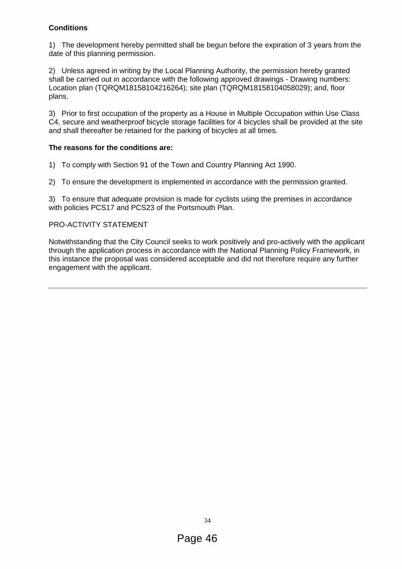
34
Conditions 1) The development hereby permitted shall be begun before the expiration of 3 years from the date of this planning permission. 2) Unless agreed in writing by the Local Planning Authority, the permission hereby granted shall be carried out in accordance with the following approved drawings - Drawing numbers: Location plan (TQRQM18158104216264); site plan (TQRQM18158104058029); and, floor plans. 3) Prior to first occupation of the property as a House in Multiple Occupation within Use Class C4, secure and weatherproof bicycle storage facilities for 4 bicycles shall be provided at the site and shall thereafter be retained for the parking of bicycles at all times. The reasons for the conditions are: 1) To comply with Section 91 of the Town and Country Planning Act 1990. 2) To ensure the development is implemented in accordance with the permission granted. 3) To ensure that adequate provision is made for cyclists using the premises in accordance with policies PCS17 and PCS23 of the Portsmouth Plan. PRO-ACTIVITY STATEMENT Notwithstanding that the City Council seeks to work positively and pro-actively with the applicant through the application process in accordance with the National Planning Policy Framework, in this instance the proposal was considered acceptable and did not therefore require any further engagement with the applicant.
Page 46

35
06
18/01131/FUL WARD:ST JUDE D-DAY MUSEUM CLARENCE ESPLANADE SOUTHSEA PO5 3ST SITING OF LANDING CRAFT TANK 7074 AND CONSTRUCTION OF CANOPY PROTECTION WITH ASSOCIATED LANDSCAPING WORKS (INCLUDING RELOCATION OF EIGHT HOLM OAK TREES); NEW ACCESS FROM THE HIGHWAY TO THE PUBLIC CAR PARK AND REPOSITIONING OF ONE (LISTED) LAMP POST Application Submitted By: Pritchard Architecture FAO Mr Giles Pritchard On behalf of: Jane Mee (PCC)/ Nick Hewitt (NMRN) Portsmouth City Council/National Museum of the Royal Navy RDD: 27th June 2018 LDD: 4th September 2018 SUMMARY OF MAIN ISSUES The main issue is whether this proposal would contribute to the achievement of sustainable development, in accordance with national and local planning policy. Key issues for consideration are the principle of the development including the loss of open space, flood risk/drainage, design/impact on heritage assets in a sensitive location, highways implications and ecology. Site and surroundings Covering an area of over 0.8ha, the site on Southsea Common (a Grade II registered park) forms a rectangular area of grass verge, planted with trees and other shrubs, which is intersected by paths. The strong verdant character is dominated by the presence of a Monterrey Cypress and semi-mature Holm Oak memorial trees that were planted to form an avenue as part of the D-Day 40th anniversary; they are amongst a total of 51 individual trees and 2 groups of trees surveyed within and adjacent to the D-Day Story (DDS) site. The site is located along the northern side of an historic wall enclosing the DDS car park and is bounded by Clarence Esplanade to the north where there is existing on-street echelon parking. The current vehicular access to the DDS car park would be closed off (for future use only by pedestrians) and a new entrance created to the west side of the site for vehicles entering and leaving the public car park. A section of the existing historic wall would have to be removed, formed by two of the recessed brick panels. There are a number of heritage assets affected by these proposals:
Southsea Castle (Scheduled Ancient Monument) (Scheduled November 1975);
'Seafront' Conservation Area (No.10) - (first designated 1971);
Southsea Common (Grade II registered June 2002);
Lamp Column(s) (Grade II listed 1999); and,
Wall - To north of D-day museum Car Park (Locally listed). The site is within the Indicative Floodplain (Flood Zone 3). The proposed relocation of trees is on the edge of Southsea Common, within high tide roost site P35 for Brent geese and waders associated with the nearby Solent Special Protection Areas.
Page 47

36
Proposal The proposal is for the siting and static display of a landing craft LCT 7074, to include:
Excavation of a basin to provide future access to the underside of the vessel to allow regular inspection and any necessary maintenance - to be covered by metal grille - the basin would not be accessible to the public;
Construction of a protective canopy to keep the worst of the weather off the vessel. The canopy would be supported by a series of 12 no. steel columns positioned along the south side of the LCT and north of the historic wall to the DDS car park;
Existing trees along Clarence Esplanade which were planted as a memorial to D-Day would require translocation.
LCT 7074 is the only surviving Landing Craft (Tank) from D-Day, and one of only three in the world. At nearly 60m long and 9.1m wide the scale of the LCT is substantial and would have considerable presence on Southsea Common. These vessels were built crudely and quickly to carry and put ashore tanks - LCT 7074 took 10 to Normandy on 6 June 1944 alone. This project proposes a sustainable future for this survivor by completing the conservation that began with salvage in 2014 and showcasing it outside as an integral part of the re-opened Portsmouth D-Day Story. In September 2017, The National Museum of the Royal Navy and Portsmouth City Council were awarded a Heritage Lottery Fund Grant for the project 'LCT 7074, Resurrecting a D-Day Hero'. LCT 7074 is designated as part of the National Historic Fleet (Certificate Number 713). This indicates it is of pre-eminent national or regional significance, spans the spectrum of UK maritime history, illustrates changes in construction or technology and merits a higher priority for long term conservation. Following the development of an options appraisal to investigate different locations for LCT, the chosen location is proposed to the south side of Clarence Esplanade adjacent to the historic wall selected as the most visible location for the ship and best connection to the DDS. Locations within the public car park were also considered but discounted by concerns about the impact on the scheduled ramparts, and the physical difficulties of moving the ship into this location - turning the ship from Clarence Esplanade into the car park would have required a significant section of the locally listed wall to be removed. The ship would be positioned over an excavated basin to provide future access to the underside of the ship to allow regular inspection and any necessary maintenance to be carried out. LCT 7074 would be supported on concrete blocking inside the basin connected by a sloping landscape walkway allowing visitor access via the bow ramp. The LCT and its future visitors would be protected by a cantilevered overhead canopy described as enhancing the visitor experience and improving sustainability as well as "…designed to be eye-catching, elegant and empathetic to the ship's sensitive surroundings, which include the Scheduled Ancient Monument and a Listed Park." The proposed protective canopy would keep the worst weather off the ship, helping to maintain it in a good condition and reduce the potential of further deterioration in the future. The canopy would be supported by a series of 12 no. columns adjacent to the wall, and the canopy would cantilever over the ship to provide clear uninterrupted views from the north side. The supporting columns are proposed to be constructed from steel and the canopy designed with a profiled metal deck above and a timber clad soffit visible underneath. Lighting would be installed in the canopy and the surrounding landscape to illuminate the ship. An access walkway would be created at the east end of the ship within the landscape, to allow visitors to enter the ship via the tank ramp. The ramp would be lowered when the ship is open to
Page 48
37
the public and lifted when it is closed. The substantial scale of the ship itself is considered to provide sufficient security to prevent unauthorised access. The area to the north of the ship would be re-landscaped using resin bound gravel and granite paving to match the recently re-landscaped areas outside the DDS. At the west end of the ship, a new metal railing would be installed to prevent visitors walking underneath the hull where it rises up towards the stern of the ship. The proposed location of LCT 7074 would impact on eight (of twelve) semi-mature Holm Oak trees that were planted to form an avenue as part of the D-Day 40th anniversary. The event was marked by the unveiling of a memorial stone with a plaque. The new entrance to the car park would also impact on other adjacent trees. Of the 51 individual trees and 2 groups at the site, a total of 30 individual trees and 1 group are proposed to be fully retained; 8 (of the 12) holm oak memorial trees are intended to be transplanted from their current location to a new location and 8 individual trees and the majority of 1 group of trees are to be removed to facilitate the proposal. There are 5 'U' grade trees that would be removed due to their poor quality for reasons of sound arboricultural management. The eight Holm Oak memorial trees would be moved to the north-west and located along the edge of the open Common. Four new Holm Oak trees would be planted to re-establish the memorial and the stone and plaque are proposed to be relocated adjacent. Six of the trees would be moved using a Tree Spade and the two largest trees would be moved using a rootball and frame method. To provide further mitigation, poor quality trees in this location are to be replaced and additional trees planted as well as wildflower meadow with various plants including poppies. Other supporting documents have been submitted as part of the planning application: Design and Access Statement; Heritage Assessment; Flood Risk Assessment; Transport Statement; Tree Survey/Arboricultural Statement; and, Phase 1 Ecological Survey. Planning history The most recent application on DDS was for a city council scheme for "Construction of two infill extensions" (ref 16/00276/CS3), permitted in April 2016. There is also a current related application seeking Listed Building Consent for "Repositioning of listed lamppost" (ref 18/01132/LBC), which will be the subject of a separate report. POLICY CONTEXT The relevant policies within the Portsmouth Plan would include: PCS9 (The seafront), PCS12 (Flood Risk), PCS13 (A Greener Portsmouth), PCS17 (Transport), PCS23 (Design and Conservation), and saved policy DC21 (Contaminated land) within the Portsmouth City Local Plan. Objective 3 of the Portsmouth Plan is sought to be achieved by "Providing tourist related facilities, including hotels, to support the visitor industry in the areas linked to the city's waterfront and maritime heritage" (para 2.13, p.15). Policy PCS9 (the seafront) also seeks, amongst other things, (i) to support uses/activities that will diversify the leisure and cultural offer without detracting from the open character of the seafront and (ii) protect the open nature of the area around the Common and other undeveloped areas, and improving the quality of the open spaces. National Planning Policy Framework Still at the heart of the revised NPPF (July 2018) is a presumption in favour of sustainable development which means approving development proposals that accord with development plan
Page 49

38
policies without delay (para 11). However, the presumption in favour of development does not apply where development requiring appropriate assessment under the Birds or Habitats Directives is being determined (para 177). The NPPF describes the purpose of the planning system is to contribute to the achievement of sustainable development and the three dimensions to achieving it: economic, social and environmental. The proposal should be assessed against development management policies in the NPPF and, in particular, the following paragraphs: 38 Core planning principles for decision making 54 Consider if otherwise unacceptable development made acceptable by conditions or planning obligations 80 Significant weight on the need to support economic growth through the planning system 95 Promote public safety, reduce vulnerability, increase resilience 97 Existing open space not to be built on unless surplus, replaced or benefits outweigh loss 103 Locate developments generating significant movement where need to travel minimised 104 Development designed for sustainable travel 109 Highways refusal only if an unacceptable impact on safety or road network severe 124 High quality buildings and places is fundamental to what planning should achieve 129 Make use of and have regard to recommendations made by design review panels 130 Refuse poor design that fails to improve the character and quality of an area 155 Avoid inappropriate development in areas at risk to flooding 174 Protect and enhance biodiversity 177 Presumption in favour of sustainable development (para 11) does not apply where AA required under Birds or Habitat Directives 178 Sites should be suitable for its proposed use where affected by contamination 180 Impacts of noise, air quality and light pollution should be mitigated and managed 189 Applicants should describe the significance and potential impact on any heritage assets 190 Lpa's should assess significance of any heritage asset, including its setting 193 Great weight should be given to conservation of heritage assets 194 Any harm to heritage assets (including setting) requires clear and convincing justification, should be exceptional [or] wholly exceptional for scheduled monuments/grade I listed buildings 195 Refuse consent for substantial harm to heritage assets unless substantial public benefits outweigh that harm 196 Less than substantial harm to heritage assets should be weighed against public benefits 197 Significance of non-designated heritage assets should be taken into account 199 Weight to non-designated heritage assets of archaeological interest (where significant) The Seafront Masterplan SPD (adopted April 2013) identifies DDS as a key attraction alongside Southsea Castle as "a jewel in Portsmouth's maritime history" and "an opportunity to improve the setting of the D-Day museum by 'opening up' its entrance in order to better connect it to the junction with Avenue de Caen and provide clearer access to the approach to the Castle." The SPD also includes, as part of its vision, for an enhanced role that the Seafront could play in the city's economy by new attractions that bring life to the area during the day and into the evening. Other Supplementary Planning Documents (SPD) also provide relevant policy guidance: Parking Standards and Transport Assessments SPD (July 2014) and Reducing Crime Through Design SPD (March 2006) CONSULTATIONS Landscape Group The following comments are offered with regards to the landscaping:
There are some concerns with regards to the scale/height of the canopy and its impact on to the neighbouring listed ancient monuments such as the West Battery and Southsea Castle a well as the Common. Alterations are also proposed to the locally listed wall behind, these
need to be well considered.
Page 50

39
There is doubt that the transplanting of 8No Holm Oaks from the site to the common would be successful as they have been in place for over 30years and have matured to a considerable size. The chances that trees of this size would successfully establish in the now location are
not very good.
Apart from 4 additional holm oaks, no proposed species or sizes are given for the 12 new trees to be planted on the common, we would also like to see more detail on any proposed planting along the locally listed wall.
The proposed hard surfacing material including Yorkstone, granite and resin bound gravel to continue from the recently completed D-Day Museum entrance scheme is appropriate. We would like to see levels for the approach ramp to ensure that adjacent graded grass banks are
not too steep in gradient as they can wear and become quickly unattractive.
Section AA shows a two of steps down to the base of the craft on the north side, these are not shown on plan, are they running along the entire length, what is the proposed material? More detail would need to be provided with regards to hazard warning or trip protection.
No detail is provided on the perforated steel grid around the base of the craft which is not shown on the site plan, how far does extend around the perimeter? Slip resistance will also have to be considered.
No details have been provided for the metal handrails to the approach ramp and steps, or the railings to the west end of the craft, given the location we would like to see drawings showing details and proposed materials.
The proposed new entrance to the car park requires re-arrangement of the car park layout, particularly immediately adjacent to the proposed new opening in the wall; we would expect these to be shown on plan.
Leisure/Arb Officer In order to make a fully informed opinion of the arboricultural and landscape aspects of this proposal, a landscaping scheme to include trees, wildflowers and other shrubs should be submitted to accompany the application. Additionally a method statement and management plan to ensure establishment are required for the proposed relocation of the 8 Holm Oaks, including responsibility for means of restraint and maintenance to establishment in the new location, by a suitably qualified specialist. There is concern that the Common is particularly exposed in this locality and this must be factored into the method statement for successful transplanting. Due to the risks presented by their increased wind loading, it is suggested the precise location of the transplanted Oaks is subject to review by the tree operations specialist upon appointment and prior to transplanting commencing. There should be allowance for the layout to be amended should this be necessary, based on specialist advice, and that this be to the satisfaction of the Parks Manager and Arboricultural Officer. All new trees will need to have suitably substantial staking. The proposed landscaping plan does not appear to extend any further west into the Common than the current planting line and therefore, should not cause conflicts over established use of this space that can be expected during the course of the year (events etc.) Wildflower planting of the scale shown is untested in this environment. Smaller pockets have been shown to struggle to survive prolonged dry spells on such free-draining subsoil and its success will largely be dependent on seed mix chosen and recommended maintenance regime. Recommendations: The applicant provide a detailed landscaping scheme and method statements as outlined above. Contaminated Land Team The Contaminated Land Team (CLT) has reviewed the application together with information held on its records and groundworks are occurring they are not dissimilar to horticultural works
Page 51
40
routinely carried out on this land. Land at the Pyramids was formerly owned by the MOD, much of which suffered bomb damage during World War II, and as such there is the potential for contamination or infilled land to exist in this area. CLT do not request planning conditions but as a precautionary measure require an informative be added to any approval:- In the event that any signs of pollution (visual, olfactory, or textural) such as poor plant growth, odour, oily, ashy, odorous or fibrous materials, staining or unusual colouration of the soil, asbestos fragments or fibres, inclusions of putrescible materials, plastics, any liquid other than clean soilwater, or actual remains from a past industrial use, are found in the soil at any time when carrying out the approved development it must be reported in writing within 14 days to the Local Planning Authority (LPA). The LPA will then consider if the findings have any impact upon the development. If the LPA considers it necessary then an assessment of the site must be undertaken in accordance with BS10175: 2011. Where remediation is deemed necessary a remediation scheme must be submitted to and approved in writing by the LPA and then implemented in accordance with the submitted details. Seafront Manager Fully support the proposal, from a seafront perspective, this brings added value to the existing seafront attraction in the form of the D Day Story. It is appropriate that this unique craft which played an essential role in the overarching D Day activity is located adjacent to the recently transformed D Day offer as it is all part of the unique heritage of Portsmouth. Locating this craft into this area also consolidates the story and enables Portsmouth to be the principal UK Hub for telling of this critical story. We are aware of the range of measures which are proposed to support its location on the seafront including the relocation of the holm oaks and consideration will also be needed in regards to the festoon lighting in this immediate area. Natural England Internationally and nationally designated sites: The application is in close proximity to the following designated sites: Solent and Dorset Coast potential Special Protection Area (p-SPA) Based on the plans submitted, Natural England considers that the proposed development will not have likely significant effects on the Solent and Dorset p-SPA and has no objection to the proposed development. To meet the requirements of the Habitats Regulations, we advise you to record your decision that a likely significant effect can be ruled out. Protected species - Natural England has produced standing advice to help planning authorities understand the impact of particular developments on protected species. We advise that the standing advice is interpreted for you by your district ecologist, or an equivalent independent party with the necessary expertise. Natural England will only provide bespoke advice on protected species where they form part of a SSSI or in exceptional circumstances. Environmental enhancement - Development provides opportunities to secure a net gain for nature and local communities, as outlined in paragraphs 9, 109 and 152 of the NPPF. NE advise you to follow the mitigation hierarchy as set out in paragraph 118 of the NPPF and firstly consider what existing environmental features on and around the site can be retained or enhanced or what new features could be incorporated into the development proposal. Where onsite measures are not possible, you may wish to consider off site measures, including sites for biodiversity offsetting. Opportunities for enhancement might include:
Planting trees characteristic to the local area to make a positive contribution to the local landscape.
Using native plants in landscaping schemes for better nectar and seed sources for bees and birds.
Designing lighting to encourage wildlife.
Adding a green roof to new buildings.
Page 52

41
Garden History Society The Gardens Trust is a Statutory Consultee on the proposal that affects Southsea Common, an historic designed landscape of national importance which is included by Historic England on the Register of Parks and Gardens of Special Historic Interest at Grade II. The Gardens Trust has considered the information provided in support of the application. On the basis of this, the Trust does not wish to comment on the proposals at this stage; however, it is emphasised that this does not signify either approval or disapproval of the proposals. Hampshire Garden Trust Hampshire Garden Trust has inspected the site and support this application, which will add to the attraction of the complex. The loss of mature landscaping in this area is regretted, however, the high quality replacement is commended. Eastern Solent Coastal Partnership No objection raised but the following comments and advice are offered. A Flood Risk Assessment (FRA) has been submitted by Scott White and Hookins LLP. The site lies within the Environment Agency's Flood Zone 3 and is therefore considered to be at high risk of experiencing a coastal flooding event. For note, there is ambiguity between section 5.1 of the FRA which states 'the development is indicated as being in Flood Zone 3 on the Environment Agency Flood Map and therefore has a low risk of flooding' and section 4.1 which states 'the site is considered to have a high risk of flooding'. The site is largely flat with levels varying from 3.30m AOD to 2.80m AOD. Levels fall to 2.56m AOD at the access junction. The present day 0.5% probability (1 in 200 year) extreme tidal level for Portsmouth Harbour is 3.2m AOD and the 0.5% probability extreme tidal level for this area in the year 2115 is 4.3m AOD. ESCP recommend that the museum signs up to the Environment Agency's Flood Warning Service if not already done so. Southsea Flood and Coastal Erosion Risk Management Scheme: On behalf of PCC, the ESCP are currently designing the next generation of coastal flood defences in Southsea. Subject to securing the required funding and consents, the construction of these new defences will significantly reduce the risk of coastal flooding in Southsea. Ecology Updated ecological information comprises a letter report presenting the revised mitigation planting location and consideration of impacts on high tide roost site P35 for Brent geese and waders associated with the nearby Solent Special Protection Areas - in this case, PCC vantage point surveys suggest that the site is associated with bird populations from Portsmouth Harbour Special Protection Area (SPA). The supplied information provides further justification for the relocation of mitigation planting, due primarily to impacts on the Scheduled Ancient Monument, buried services and amenity use. Further clarification has also been provided on the new mitigation planting area, within site P35. This clarifies that 18 trees within the location, of varying heights ranging from 1.5 to 10 metres and in poor condition or quality (Category U and C) will be removed and replaced by the translocated trees and new planting to a total of 29 trees, the tallest currently at 6 metres. The ecological information identifies that this is currently an area of rough grassland (which is sub-optimal for grazing birds) and this area will be maintained as existing, with wildflower seeding. Designated sites - Portsmouth Harbour Special Protection Area (SPA) Natural England have provided comments to PCC relating to this site, but have not acknowledged the presence of the high tide roost and associated SPA sites, instead only referring to the Solent and Dorset Coast potential Special Protection Area (p-SPA). On this basis they have advised that "Natural England considers that the proposed development will not have likely significant effects on the Solent and Dorset p-SPA and has no objection to the proposed development. To meet the requirements of the Habitats Regulations, we advise you to record
Page 53
42
your decision that a likely significant effect can be ruled out". As competent authority, Portsmouth City Council is able to come to a separate opinion when considering the Conservation of Habitats and Species Regulations 2017, as informed by recent case law and I believe that the advice provided by Natural England cannot be fully adopted as it is based on an erroneous understanding / presentation of the designated sites and ecological receptors for consideration. In this case, it is clear that any effect will be on SPA supporting habitat only, although works will take place and have a direct effect within this supporting habitat. The effects have been identified to be limited to disturbance and, as the trees are (in the main) replacements and smaller than existing trees, it is my opinion that the proposals do not constitute loss, damage or deterioration of the supporting habitat. It is therefore my opinion that Portsmouth City Council can conclude that there is no likely significant effect on the designated site in accordance with the Conservation of Habitats & Species Regulations 2017, in line with the advice received from Natural England for the p-SPA, but with clear consideration of all the designated sites potentially affected, notably Portsmouth Harbour Special Protection Area (SPA). The applicants ecologist has proposed an avoidance of works within the high tide roost site during the winter period (October-March inclusive) to avoid disturbance and it is recommended that this is secured by condition. Coastal And Drainage These comments relate to the FRA, surface water and groundwater elements of the proposal:
For areas of proposed permeable paving it must be confirmed that groundwater is over 1metre below the lowest level of construction. This could be undertaken within the suggestion of infiltration testing in Section 7.4 of the FRA
It must be confirmed that the levels are suitable for gravity flow from the canopy drainage to the infiltration sewer
It would be wise to undertake trial holes along the proposed gravity flow route to ensure that existing services are not affected. The northern footway is known to have existing services which were encountered when PCC installed the drainage system
Construction details for the proposed sewer must be confirmed and conform to SFA 7th edition standards, with associated cross sections
The should be an O&M manual for the proposed sewer, to include especially the pump sump arrangement and their construction details including pump housing and access
It is not clear where the pump arrangement is to be located. It should be in a safe accessible area, as far away from the busiest public walkway areas as possible.
Environment Agency No comments received. Archaeology Advisor The Heritage Statement submitted with the planning application makes a very good case for the significance of the craft and the appropriateness of the association with the D Day museum. In terms of the historical importance and implied association with the location the landing craft installation would be very much welcomed. Within the Heritage Statement the impact on below ground archaeological remains was a little vague as to the nature of the origin of 'made ground' at the location outside the walls and whether that implied any archaeological interests, but on balance the conclusion that the archaeological potential is limited is accepted and would not merit the burden of an archaeological condition. The impact of the installation, which is dominated by a large canopy, on the setting of the Southsea Castle military complex (the scheduled monument and the associated buildings including flanking walls) is not discussed. The emphasis of the Heritage Statement is on the
Page 54
43
impact on the 'fabric' of monuments not the 'setting' of monuments. In the matter of the setting of the adjacent built structures this would be appropriate to defer to your conservation officer, but the absence of a mature discussion despite the proximity of the large canopy to the historic complex is considered a significant weakness in the Heritage Statement. Highways Engineer Following review of the Transport Statement and associated supporting documents, the following comments are made: The site is located at Clarence Esplanade, a road following the southern coastline of Portsmouth. The site is located adjacent to the seafront and is mostly surrounded by public open space and historic structures, most notably Southsea Castle. The car park serves both the D-Day museum and Southsea castle and is the primary parking area for coaches in Portsmouth. Clarence Esplanade is a two-way road subject to a 30mph speed limit, on-street parking bays arranged in an echelon configuration border much of the site terminating at the existing vehicular access at the eastern end of the car park. The access arrangements for the car park are proposed to be changed relocating the entrance to the western end of the car park. The applicant has carried out traffic surveys and established an 85th percentile speed of 30.3mph with approximately 2700-2800 vehicles travelling along the road on a typical day. The applicant has applied guidance from Manual for Streets to determine the required visibility splay, I agree that this is appropriate however the visibility splay has been shown to the kerb line/centre line whereas guidance in MfS2 suggests that the visibility splay should be taken to the nearside vehicle track. The illustrative plan shows the visibility splay measured from a position in-line with the end of the echelon parking bays adjacent to the new entrance, I would agree that in practice vehicles would "creep" forward in order to see around parked vehicles and in doing so, adequate visibility is available; however this shall be formalised through the provision of buildouts in line with the echelon parking bays and relocation of the Give Way line. This would also provide further benefits to pedestrians with a narrower crossing over the entrance and potential provision of a more clearly defined uncontrolled crossing point from north-south across Clarence Parade. It should be noted however that a s278 agreement will be required before any works to the highway are carried out, the relocation/re-provision of ITS equipment (namely car park counter and associated VMS signs) will need to be included as part of the s278 works to reflect the new entrance arrangements. The Transport Statement does not assess potential traffic generation in any detail, it suggests at 3.10 that "Trip generation from the site is considered to remain the same as a result of the development proposals as the existing site given that there will be no change in the overall floor area of the site." I would in part agree with this however the proposals improve the offer of the museum which will likely induce a greater demand to view the new attraction. That said, in my opinion the uplift in interest will likely be temporary and the demand will level out as was seen when a new attraction was opened at the Historic Dockyard in recent years. I am therefore satisfied that an assessment of trip generation is not required. The new access arrangements will require the loss of some 45 car parking spaces; 18 of these would be on-street with 27 spaces lost from the existing car park. In order to justify the loss of these spaces, a parking survey was carried out both within the existing car park and on street within a 500m walking distance of the site. The surveys were carried out on a Saturday, Tuesday and Thursday during April to establish the available parking capacity in the area to accommodate the spaces that would be lost as a result of this proposal. The car park was found to have a maximum occupancy of just 32% on the Saturday surveyed, this was considerably lower on the Tuesday and Thursday at 9% and 22% respectively. The seafront is understandably an extremely seasonal attraction and parking occupancy is greatly dependent upon favourable weather. The days surveyed were not representative of a "peak" day and I would not accept that there is an average of 60-70% capacity in the car park on these days. Although not yet in the public domain, a survey carried out in relation to the development
Page 55

44
of the Southsea Coastal Defence scheme on a peak day (sunny bank holiday weekend) and found that the average occupancy was approx. 75%. I would be more comfortable with the assumption that at least 75% of the car park's spaces must be retained given the vast fluctuation between a "normal" week and peak days/weekends through the summer months. Presuming the figure of 27 spaces is correct, this would represent a loss of approx. 19% of the total car parking spaces in the car park (not including Coach bays). In my opinion, the car park layout shall be compromised by the relocation of the entrance and the internal layout should be reviewed to maximise the space available. I note that the plans show a large vacant space around the proposed access, the layout of the car parking spaces will need to be reviewed in order to ensure accessibility for cars and coaches and to ensure best use of the space available. That said, the car park area is not included within the redline area and following discussions with the consultant representing the applicant, there are no plans to alter the layout of the car park beyond the deletion of bays needed to facilitate the new access. Whilst the proposal will negatively affect the efficiency/operation of the car park, in planning terms this cannot be deemed severe and in any case, is not covered by the red edge. A further 18 spaces proposed to be lost on-street are presumed to be displaced elsewhere. The applicant has undertaken an on-street survey within 500m of the site to establish the available on-street provision. On the Saturday, a total 72% occupancy was observed across the study area; the majority of the available spaces were within pay & display areas with residential streets generally near capacity. This does suggest that there is space on-street to accommodate the displaced on-street spaces however as shown by the low occupancy recorded at the D-Day car park, the demand recorded is likely to be considerably lower than that experienced on "peak" days. The applicant has since confirmed that 4 spaces will be re-provided on street however I would expect that more spaces could be provided. The loss/re-provision of parking spaces on the Highway will require an alteration to the existing TRO, a fee of £2500 to cover this expense will be included within the relevant s278 fees. It is noted that the existing entrance is to be retained for use by pedestrians, whilst it cannot be required that additional cycle parking is provided, the existing provision is very well used in the summer months and therefore consideration should be given to make use of the reclaimed road space by adding further cycle parking spaces. A brief mention of how the landing craft will be transported to its new location is given within the Design & Access statement however the impact of manoeuvring it into position is not detailed. An intention to transport the vessel by sea is noted, however, significant disruption to the Highway is likely whilst the vessel is brought ashore and transported to its final location. Discussion with the applicant has determined the intended solution to relocate the vessel however not enough information is known at this stage in order to provide a framework Construction Traffic Management Plan. Given the size of the vessel, investigation as to the structure of the road/promenade will need to be carried out so as to ensure that the composition of the highway is not compromised during the transportation of the vessel. A detailed CTMP can be secured by condition however early engagement with the LHA is strongly recommended. No objection is raised to the application subject to the following conditions/obligations being secured:
Construction Traffic Management Plan to be submitted to and agreed by the LHA prior to commencement of construction
S278 agreement to be finalised and all relevant fees paid prior to works commencing on the highway
Highway works/layout to be submitted to and agreed by the LHA, these works to be completed prior to occupation of the development
Traffic Regulation Order relating to alteration to parking bays at Clarence Parade to be finalised prior to occupation of the development.
Page 56

45
Highways Contractor (Colas) Please contact Colas (Fred Willett/Verden Meldrum) for discussion on the moving of this Landing Craft since this will have to be coordinated very carefully through the streets of Portsmouth. Design Review Panel This item was presented by scheme architects Giles Pritchard and Jon Skipper (HCC architects) and a representative of the National Museum of the Royal Navy (NMRN) at pre-application stage. The panel recognised this as an unusual and interesting scheme, and it prompted a vigorous debate. Aspects of the proposal resulted in a division of opinion within the group. There was a broad consensus that an open sided canopy was the right structure for the craft and site. Its design was also thought to be elegant and well considered, and the use of a wave form visually appropriate for the location. It was also felt that the structure conveyed a desirable sense of permanence and solidity. It was suggested that the gap between the wall/canopy and the craft would need to be considered to avoid it becoming an undesirable 'dead space' that would be difficult to maintain. How this would be addressed, as well as the detailed design and choice of materials for the canopy require further work. The scheme was considered within the wider context not only of the series of siting options which were presented, but also the dimensions and scale of the craft itself. The suitability of the seafront as a location for the craft was questioned by some members of the panel. The rationale for the craft's currently proposed location notwithstanding the question of alternative nearby sites, which might better mitigate the impact of the craft was also discussed. Some members of the panel were surprised and troubled by the size and scale of the craft relative to its potential new surroundings. Concern was expressed at its impact on the setting of the adjacent locally listed wall, the listed common, the loss of existing memorial landscaping, and on east/west and other views towards and around the site. Whilst the interest and rarity of the structure were acknowledged, the strength of the case for locating such a large naval vessel on land in this particular location was questioned, as was the attractiveness of the craft itself. The panel were divided on the scale and siting of the structure, support for these aspects in particular being equivocal, despite this they did resolve to support the scheme. Recommendation of the panel was to support the scheme subject to the above comments. REPRESENTATIONS None received. COMMENT The main issue is whether this proposal would contribute to the achievement of sustainable development, in accordance with national and local planning policy. Key issues for consideration are the principle of the development including the loss of open space, flood risk/drainage, design/impact on heritage assets in a sensitive location, highways implications and ecology. Principle of the development/loss of open space The siting of the LCT and canopy over would be onto protected open space. The revised NPPF (para 97) states existing open space should not be built on unless, amongst other things, "c) the development is for alternative sports and recreational provision, the benefits of which clearly
Page 57

46
outweigh the loss of the current or former use". Local plan policy PCS13 seeks to protect open space by "refusing planning permission for proposals which would result in the net loss of existing areas of open space unless there are wider public benefits from the development which outweigh the harm." The introduction to the Design & Access Statement states "This will put LCT 7074 in the city's heart, potentially engaging 4.5 million annual users of Southsea Common with the story of the ship and her people; it puts her D-Day narrative - which uniquely links sea and land - in context for museum visitors. The project will create activity opportunities in Portsmouth and beyond, train apprentices and volunteers, and create a unique venue." In heritage terms, the applicants state "LCT 7074 is the last surviving WW2 Landing Craft (Tank) of over 800 which took part in the D-Day landings on 6 June 1944. She is a unique time capsule, of enormous importance to the history of D-Day, WW2, the Royal Navy, and British shipbuilding. Each LCT could carry up to ten tanks into battle. Huge seagoing craft nearly 60m in length and displacing some 650 tons, they were built crudely and quickly, so few survived beyond 1945." The applicants detail the project benefits at section 6.0 of their D&AS, as including:
- will bring 7074 into a proper inspection and care regime, managed by NMRN with support from the project partners, to secure the ship's long-term future;
- will be incorporated into the organisational structure of DDS, an established, successful visitor attraction, with support from NMRN, which has unmatched knowledge and expertise in the management of internationally important historic ships;
- Volunteers will be recruited/trained… to ensure a long term sustainable future for the ship… undertake a variety of roles including, research and exhibitions, oral history recording, conservation and maintenance of the LCT and delivering school sessions;
- DDS tanks will be protected by placing them under cover and in a more suitable display environment… in better context with scope to enlarge on the stories of tank crews in Normandy; - Two archives will be… accessible through NMRN's new Storehouse 12 facility in Portsmouth Historic Dockyard;
- protect the heritage significance of the ship and tanks by preventing further deterioration and stabilising the very vulnerable fabric;
- fully conserve the hull, superstructure and interior spaces, and provide appropriate public access to all areas. At present 7074's internal state is very poor and the ship's deterioration will undoubtedly accelerate if conservation work is not carried out;
- The visitor experience will be a vehicle for portraying the significant and largely overlooked story of Royal Navy landing craft and their crews at D-Day. The location alongside the new DDS will provide the ship with extraordinary context, allowing visitors to properly understand her place in the bigger picture of Operation Neptune;
- External interpretation, perhaps digital, will bring elements of the ship's story to potentially 4.5 million passing visitors to Southsea Common, at any time of day and night;
- the interpretive scheme and the community engagement and learning activity will ensure that two hidden archival collections will be brought to the attention of a diverse range of people. Diaries, letters and interviews inevitably contain a wide range of vivid testimony, encouraging empathy through their evocation of the fear, excitement, danger, humour and camaraderie which characterised service in the tiny crews of these ships;
- …will enhance the appeal of Southsea seafront… create a striking and exciting backdrop for a wide range of formal and informal activity on Southsea Common throughout the year… [and] will strengthen intellectual and physical ties between the Historic Dockyard and other city attractions;
Page 58

47
- …"D-Day75 Transforming the D-Day Museum" project was formally identified as a priority in the council's Culture and City Development Business Plan, delivering to the Strategic Objective: "A city with a distinctive culture established as a national and international destination." The introduction of LCT 7074 on open display at the new D-Day Story will further enhance the Southsea heritage offer, benefitting tourism and local businesses. LCT 7074 will be a further attraction for the 75,000+ people who will visit DDS each year. LCT 7074 and the associated collections will also be an important primary source for family historians, students and academics researching the Normandy Landings;
- By adding LCT to the DDS offer, visitors will have another reason to visit the city and be encouraged to stay longer and spend more. The relocation will add to the placemaking strategy for Southsea, building on an already healthy visitor economy.
To accord with national and local policy, existing open space should not be built on unless the recreational and wider public benefits outweigh the loss. At 60m in length, the striking impact of siting this substantial vessel onto protected public open space at Southsea Common (Listed Park) seems potentially likely to divide opinion and its attractiveness questioned but its interest and rarity to the history of D-Day, WW2, the Royal Navy and British shipbuilding, are fully accepted. The proposal would give rise to a degree of harm to heritage assets (to be addressed further in this report) but in terms of the principle of the development, the loss of open space is considered to be outweighed by the significant public benefits detailed above (described in Section 6.0 of the D&AS) of the enhancement that LCT 7074 would make to the attraction of the museum, the understanding of the D-Day Story and Southsea heritage offer. Flood risk/drainage A Flood Risk Assessment (prepared by Scott White and Hookins) confirms Floodplain mapping provided by the Environment Agency (EA) indicates that the site lies in Flood Zone 3. On this basis the site is considered to have a high risk of flooding. The development is, however, considered 'Less Vulnerable' and therefore does not have to pass the Exception Test. The FRA indicates that located within a flood risk area flood mitigation measures would be required. The Eastern Solent Coastal Partnership righting identify ambiguity in the FRA between section 5.1 that states 'the development is indicated as being in Flood Zone 3… and therefore has a low risk of flooding' and section 4.1 that states 'the site is considered to have a high risk of flooding'. The comments of the Drainage Team, as LLFA, raises matters of detail. It would be appropriate to secure the details of the drainage strategy by planning condition. Design/impact on heritage assets In relation to heritage assets, Section 66 of the Listed Buildings and Conservation Areas Act 1990 (as amended) places a duty on local planning authorities to have special regard to the desirability of preserving a Listed Building or its setting or any features of special architectural or historic interest. Furthermore, Section 72 of the same Act requires that an authority pay special attention to the desirability of preserving or enhancing the character and appearance of a conservation area. There is a strong presumption in favour of conservation. Paragraph 194 of the revised NPPF advises that any harm to a designated heritage asset, including its setting, requires clear and convincing justification, should be exceptional [or] wholly exceptional for scheduled monuments/grade I listed buildings etc and in paragraph 195 advises that consent should be refused unless the harm is necessary to achieve substantial public benefits that outweigh that harm. Paragraph 196 advises that where a development proposal will lead to less than substantial harm this needs to be weighed against the public benefits of the proposal. Furthermore, policy PCS23 of the Portsmouth Plan requires, inter alia, "Development that
Page 59

48
relates well to the geography and history of Portsmouth, particularly the city's conservation areas, listed buildings, locally listed buildings and scheduled ancient monuments". A Heritage Assessment (prepared by Conservation Plus) informs the potential impacts of the proposed structures associated with the static display of LCT 7074 on below ground archaeological deposits and on adjacent heritage assets. The desk-based assessment identifies that the site would not have any direct physical impacts on adjacent designated heritage assets with the exception of one of the listed lampposts which is located at the new entrance to the car park. This would require relocation to the side of the new entrance. There would also be a direct physical impact on a non-designated heritage asset. A section of the existing historic wall to the DDS car park would have to be removed, formed by two of the recessed brick panels. Any making good where the opening is formed would need to be undertaken using salvaged bricks and lime mortars to match the existing, which would be relevant to secure by planning condition. Their analysis of the historic development of Southsea Common and the fortifications and Southsea Castle provides evidence that the site has been subject to substantial changes in the 19th and 20th centuries. The geotechnical data is considered to support this, demonstrating just over 1m of made ground on the northern and southern sides of the boundary wall. The Heritage Assessment considers the site to have low potential for archaeological activity associated with Storm Beach Deposits. This potential is likely to be limited to isolated artefacts indicative of a landscape utilised during the Lower Palaeolithic period. It concludes that no further archaeological investigation would be required prior to development. The Council's Archaeology Advisor has assessed this matter and accepts, on balance, the conclusion of the Heritage Statement that the archaeological potential is limited and no condition is required. The applicant's Heritage Statement also makes reference at section 6.2.1 to the site's location within a Grade II Historic Park and Garden and within the Southsea Seafront Conservation Area. It states "…there will be impacts on the character and appearance of the Conservation Area (to be addressed by the accompanying Heritage Statement)…" but fails to provide any further details of the impact of the proposal on any designated heritage asset. LCT 7074 is large and would be sited in a prominent and highly visible location. It would have a significant impact on an array of designated heritage assets that includes Southsea Common as a registered park (Grade II), Seafront Conservation Area and one historic lamppost (Grade II listed) but also impact upon and effect the setting of Southsea Castle and ramparts (Scheduled Ancient Monument). - Southsea Castle (SAM) Any harm to the such an asset of the highest significance, including development within its setting, requires clear and convincing justification that should be wholly exceptional. The presence of the locally listed wall on its southern flank would screen much of LCT 7074 from the monument to a significant degree. The upper part of its superstructure and the sculptural element of the canopy over would, however, puncture the top of the wall and their height, scale and appearance would make them a conspicuous feature from the monument ramparts and car park. Despite the mitigating presence of the wall the level of harm that would result is considered to be 'medium'. - Historic lamp column The elaborate and ornate early 20th century twin headed lamp columns in this part of the seafront are the most imposing and attractive in the city. In the absence of evidence to the
Page 60

49
contrary, it is assumed they are sited in their original locations. It is good conservation practice to avoid re-siting historic (listed) structures from their original location. The removal of the feature from its original setting/context and establishes an undesirable precedent, should not be undertaken without an exceptional reason to do so (such as a genuine threat to the asset), and for these reasons would result in harm to the asset. This must be balanced against the short distance it would be necessary to move the column, the limited impact this would therefore have on its setting, and ultimately the retention of the structure (change would be limited to its re-siting rather than permanent removal or loss). Whilst re-siting should be a last resort option and is not ideal, since the new access/egress from the DDS car park appears genuinely unavoidable and provided a method statement is secured describing the intentions for careful removal and re-siting - in the same alignment and shortest possible distance west of its current position - then the resulting harm would be relatively modest. - Southsea Common (grade II registered park)/Seafront Conservation Area (No10) The Common is one of only three registered parks in the city (representing a rare class of asset in Portsmouth) and a major component of the larger conservation area, and the significance of, and impact on both assets is considered in combination. Both designations afford protection to an historic and key element of the city's unusual parkland/'pleasureground' waterfront. They have a high degree of aesthetic value and as shared and widely used resources have great communal importance. These factors give both assets a high degree of significance. One of the defining characteristics is the sense of openness they enjoy. In addition to the museum, the area surrounding the application site has been developed through the 20th century; the nature and scale of the interventions - skate park, aquarium, recreation area - varies, but is nevertheless significant, despite this their grain, scale and siting still afford this part of the seafront a relatively high degree of openness. The scale and height of LCT 7074 and its canopy over are broadly comparable with these nearby buildings/sites but it is clear the proposal would have a major impact on the grade II registered Common, the conservation area and their 'internal' setting. LCT 7074 is the last of its type present at the D-Day landings and its history undoubtedly has interest. It does not, however, possess a direct historical connection with the city (for example it was not constructed here). The museum, history and rarity does make the association credible and meaningful, lending weight to the choice as the most appropriate site in which to preserve the craft. The value of the story notwithstanding, having regard to the perceptions of the appropriateness its appearance to such a sensitive site, LCT 7074 is utilitarian in character and arguably lacks the visual appeal and 'charisma' of, for example, a larger 20th century warship or historic sailing vessel. Given the 60m length and its height that contribute the overall appearance of the craft, when considered alongside the form and material, it is also reasonable to suggest that the structure would appear quite alien in its proposed context. Whilst many Victorian parks contain memorials (sometimes large) and perhaps smaller commemorative structures (as the Common does), a structure of this scale and appearance might reasonably be considered to be extremely unusual. In addition to the appearance of LCT 7074, the loss of existing features that are historically appropriate and contribute to the verdant character of the assets must also be considered. The view of the site looking east along Clarence Esplanade forms the 'leading edge' of soft landscaping along the seafront. It is where the first sight of trees appear and also has extensive, well established, and dense soft landscaping by shrubs directly adjacent to the locally listed wall.
Page 61

50
Tree and other planting is to be expected in an historic park and has been a feature of the Common since the late 19th century. Historic mapping confirms that planting has contributed to the character of the application site since at least the mid 20th century and was therefore also present on designation of both the conservation area and the listing of the park (in 1971 and 2002 respectively). In light of this it is clear that this landscaping also has a heritage value and its quality and scale of planting ensure it makes an important contribution to the significance of the designated assets. The loss of the landscaping would denude the listed park and conservation area of a significant and attractive area of planting, replacing natural softening features with a hard artificial structure whose presence it would be impractical to mitigate with new planting. The selected site is particularly prominent. It is forward of the DDS, fully visible in approach views along Clarence Esplanade and, given its height, also in a wide arc to the north of the site. It would consciously announce the presence of the craft generating maximum exposure. It is not proposed to be hidden in the car park and with its protective canopy over intended to be celebrated. This places the scale and impact of the vessel at odds with the character of the park/conservation area and ensures any case for its siting remains far from overwhelming. For the reasons explored above LCT 7074 would give rise to a very high degree of harm to the significance of this part of the Common/conservation area. When considered in the context of both assets as a whole the impact of the proposal would be reduced (as a result of the size and scale of the Common and conservation area relative to the craft), but would nevertheless remain high. The impact of the vessel and its canopy goes beyond the normal expectations or limits of what might reasonably be considered acceptable in heritage terms. - Wall to DDS car park (locally listed) The wall is a remnant of a once longer structure that extended across the rear of Southsea Castle and its later ramparts. It is utilitarian in character but nevertheless has historic and evidential interest and in the context of the wider designations which affect the area, it makes an appreciable townscape contribution. These factors give the structure a moderate to intermediate degree of significance. Despite its non-statutory status the wall should be retained and any removal other than the limited vehicle opening under consideration would be resisted. Removal of a 10m section in the context of a 200m long wall (although already breached at the existing car park entrance) and by reason of the proximity of the vessel/canopy obscuring 60m in length, the wall would be an asset most directly and seriously affected by the current proposal (due to irreversible loss of actual fabric). The wall is currently perceptible through the adjacent soft landscaping. Although it would be retained, any view of the structure other than at close quarters would be eliminated by this proposal. Appreciation of the asset and the contribution of its northern aspect to the wider setting of the area would disappear and therefore equates to a high degree of harm. It would remain fully visible from the south. The new breach in the wall would expose/create a new framed view or passing glimpse of the scheduled ramparts that is currently not possible from Clarence Esplanade. The fate of the wall and lamp column are linked to one another in this proposal. Since the relocation of the car park entrance appears genuinely unavoidable and assuming any elements of fabric exposed by the removal of two wall panels would be made good with appropriate materials - salvaged bricks, lime mortar bedded flush to match existing - then the harm resulting from this particular aspect of the scheme would be moderate/medium. When these impacts are balanced against the lesser significance of the wall, the overall level of harm to the non-designated asset can reasonably be considered medium/high. - Conclusions to significance and impact on heritage assets
Page 62
51
In light of the identified harm to the various assets, it is considered that the impact of the proposal when considered in aggregate would equate to a high level of harm overall. From the appearance, scale and siting of the craft it is clear that it would represent a major, high impact intervention in the public realm, characterised by works that would be harmful across a range of heritage assets and dramatically changing its present verdant character. It is perhaps not without coincidence that the views expressed by the local Design Review Panel, in assessing the design merits, concluded "Some members of the panel were surprised and troubled by the size and scale of the craft relative to its potential new surroundings. Concern was expressed at its impact on the setting of the adjacent locally listed wall, the listed common, the loss of existing memorial landscaping, and on east/west and other views towards and around the site. Whilst the interest and rarity of the structure were acknowledged, the strength of the case for locating such a large naval vessel on land in this particular location was questioned, as was the attractiveness of the craft itself. The panel were divided on the scale and siting of the structure, support for these aspects in particular being equivocal, despite this they did resolve to support the scheme." The proposal is considered, on balance, to be capable of support in heritage/conservation terms placing significant weight of the benefits and unique circumstances detailed in this report of Heritage Lottery Fund support for enhancement to the attraction of the museum, the understanding of the D-Day Story and cultural offer to Southsea that LCT 7074 would contribute. Highways implications The supporting Transport Statement (TS) assesses the highway implications of the scheme that would involve the creation of a new vehicular access onto Clarence Esplanade and a resultant loss in on-street car parking in this location. The proposed access would be located approximately 105m west of its existing location. The existing point of access would be stopped up, to provide a separate pedestrian route into the site and 4 on-street parking bays capable of being reprovided onto Clarence Esplanade. The proposed access would be capable of accommodating two-way vehicle movements as well as providing access for larger vehicles associated with the development. Visibility splays have been demonstrated as achievable in accordance with recorded speeds of 30mph eastbound and 30.3mph westbound. The TS includes parking capacity surveys in the vicinity of the site carried out during the Easter Holiday period indicating an overall average of 21% of the DDS car parking spaces were occupied in this period. Within the wider area, Avenue De Caen was observed to have an average of 82% available parking capacity throughout the survey period. The TS provides evidence that there is significant capacity within the existing DDS car park and the wider area to accommodate any loss in parking as a result of the proposal. The views of the Local Highways Authority are set out in the consultation section of this report. In summary, no objection is raised subject to a planning condition for a Construction Traffic Management Plan and other detailed matters requiring S278 highways agreement, following revision to a Traffic Regulation Order relating to existing on-street parking provision, at the developers expense. Ecology An extended Phase 1 habitat survey was conducted in late January 2018 that identified the habitat on the site as amenity grassland, with introduced shrubs, scattered trees and hard standing. The proposed area for the siting of LCT 7074 is identified of low ecological value. An assessment of the area for protected and notable species concluded that the site had potential
Page 63

52
for breeding birds and common and widespread invertebrates. No further survey work was considered necessary, however, the assessment recommended the following is implemented. The existing trees to be relocated and additional new trees planted, along with a new wildflower landscaping scheme to the north west of the existing site, to provide continued shelter and feeding opportunities for birds. Initially no specific recommendations were identified with regard to waders and Brent Geese, simply precautions to be undertaken for nesting birds. Works to remove trees and shrubs should avoid the bird nesting season (March - August inclusive); if this is not possible, the area should be checked by a suitably experienced ecologist prior to the commencement of work, and if a bird's nest is found works in this area must cease until after the young have fledged. The habitat survey concludes the proposal to have a negligible impact on the botanical or ecological value of the site. The proposed location would result in the loss of habitats that are common and widespread, and are of most interest for the species they can potentially support. The extent of habitat loss is small, and the mitigation would be to relocate and plant new trees and provide a new landscaping scheme with wildflower planting. An addendum to the ecology advice confirm that "Works have the potential to impact Brent Geese within the P35 core area, reducing the area available as a grassland high tide roost, as tree planting and other landscaping make sites less suitable (Solent Waders and Brent Goose Strategy 2010) and through disturbance during works. Core areas are those that are considered essential to the continued function of the Solent waders and brent goose ecological network and have the strongest functional-linkage to the designated Solent SPAs in terms of their frequency and continuity of use by SPA features." In line with the advice received from Natural England for the p-SPA and from PCC's Ecologist, for all the designated sites potentially affected, notably Portsmouth Harbour Special Protection Area (SPA), it is concluded that that there is no likely significant effect on the designated site in accordance with the Conservation of Habitats & Species Regulations 2017, subject to a recommended condition. It is clear that any effect would be on SPA supporting habitat only, although works would take place and have a direct effect within this supporting habitat. The effects have been identified to be limited to disturbance and, as the trees are essentially replacements and smaller than existing trees, the proposals are not considered to constitute loss, damage or deterioration of the supporting habitat. It is considered reasonable and necessary to secure by planning condition an avoidance of works within the high tide roost site P35 during the winter period (October-March inclusive) to avoid disturbance.
RECOMMENDATION Conditional Permission
Conditions 1) The development hereby permitted shall be begun before the expiration of 3 years from the date of this planning permission. 2) Unless agreed in writing by the Local Planning Authority, the permission hereby granted shall be carried out in accordance with the following approved drawings - Drawing numbers: Existing Location Plan - A1002-100_A; Proposed Location Plan - A1002-105_A; Proposed Site Plan - A1002-210_A; Proposed Site Plan - A1002-211_A; Proposed Ground Floor Plan - A1002-212_A; Proposed Ship Plan - A1002-213_A; Proposed Reflected Ceiling Plan - A1002-214_A; Proposed Roof Plan - A1002-215_A; Proposed Tree Planting Plan - A1002-220_A; Proposed Section AA - A1002-310_A;
Page 64
53
Proposed North Elevation - A1002-312_A; Proposed South Elevation - A1002-313_A; Proposed East & West Elevation - A1002-314_A; Comparison to other buildings - A1002-350_A; Proposed Drainage Plan - 9081-51_P2; and, Outline Drainage Section - 9081-52_P2. 3) No development shall take place at the site until there has been submitted to and approved by the Local Planning Authority a scheme of landscaping which shall specify species, planting sizes, spacing and numbers of trees/shrubs to be planted in the positions shown on drawing no.A1002-220_A (or such other siting as may be submitted to and approved in writing by the Local Planning Authority beforehand). The transplanting of 8 no. Holm Oaks from the site shall be undertaken before construction of the basin works hereby approved and any other landscaping shall be carried out in the first planting and seeding seasons following the siting of LCT 7074. Any trees or plants which, within a period of 5 years from the date of planting, die, are removed or become seriously damaged or diseased shall be replaced in the next planting season with others of similar size and species. 4) No development shall take place at the site until a scheme for the safeguarding of all trees, shrubs and other natural features not scheduled for removal during the course of the site works and building operations has been submitted to and approved in writing by the Local Planning Authority. All trees, shrubs or features to be protected shall be fenced, along an alignment that shall have been submitted to and approved in writing by the Local Planning Authority, with: (a) 1.5 m high chestnut paling securely mounted on scaffold framing which is firmly secured in the ground and braced to resist impact; or (b) 2.4 m high heavy duty hoardings securely mounted on scaffold framing which is firmly secured in the ground and braced to resist impact. Such fencing shall be maintained during the course of the works on site. No unauthorised access or placement of goods, fuels or chemicals, soil or other materials shall take place inside the fenced area. 5) (a) No development shall take place at the site until a method statement for the translocation of 8 no. Holm Oak trees and management plan to ensure their re-establishment, including responsibility for means of restraint and future maintenance in the new location, has been submitted to and approved in writing by the Local Planning Authority, and (b) The approved method statement for the translocation of trees (as approved under the provisions of condition 5a) shall be implemented in full unless otherwise agreed in writing with the Local Planning Authority. 6) Notwithstanding drawing numbers 9081-51_P2 (Drainage Plan) and 9081-52_P2 (Outline Drainage Section), no development shall take place at the site until a detailed drainage scheme shall have been submitted to and approved in writing by the Local Planning Authority; and, the proposed development shall be brought into use until the drainage works have been carried out in accordance with the approved details (unless otherwise agreed in writing by the Local Planning Authority). 7) No development shall take place at the site until a detailed schedule of all external materials for the proposed canopy and hardsurface treatments (including the types/textures, colour finishes and samples as may be necessary) shall have been submitted to and approved in writing by the Local Planning Authority; and the development shall be carried out in accordance with the approved details and thereafter retained in such condition. 8) No works pursuant to this permission shall take place in the high tide roost site for waders and Brent Geese P35 (on Southsea Common) within the sensitive overwintering bird period (1 October to 31 March inclusive), unless otherwise agreed in writing with the Local Planning Authority.
Page 65

54
9) (a) No development shall take place at the site, unless otherwise agreed in writing with the Local Planning Authority, until a Construction Traffic Management Plan (to include construction vehicle routing, transportation by road of LCT 7074, the provision of loading / offloading areas, wheel wash facilities, site office and contractors parking area) has been submitted to and approved in writing by the Local Planning Authority, and (b) The approved Construction Traffic Management Plan (as approved under the provisions of condition 9a) shall be implemented and maintained until the development is complete unless otherwise agreed in writing with the Local Planning Authority. 10) No development shall take place at the site until a method statement for the removal and relocation of the historic (Grade II listed) lamppost shall have been submitted to and approved in writing by the local planning authority; and the removal and relocation of the historic lamppost shall be only be carried out in accordance with the approved method statement. 11) Any fabric to the existing historic wall (enclosing the D-Day public car park) exposed by the removal of two recessed panels shall be made good with salvaged materials and lime mortar bedded flush to match the existing wall. 12) The access, including the footway crossing shall be constructed before the development hereby permitted is first brought into use. 13) The existing access to the site shall be stopped up and the footway crossing reinstated before the development hereby permitted is first brought into use. The reasons for the conditions are: 1) To comply with Section 91 of the Town and Country Planning Act 1990. 2) To ensure the development is implemented in accordance with the permission granted. 3) To maintain the appearance of the site and its surroundings in the interests of visual amenity and to preserve the character and appearance of 'Seafront' Conservation Area/Southsea Common (Grade II registered park) and the setting of other heritage assets in accordance with policy PCS13 of the Portsmouth Plan and the aims and objectives of the revised NPPF. 4) To ensure that trees and other natural features to be retained are adequately protected from damage to health and stability throughout the construction period in the interests of amenity in accordance with policy PCS13 of the Portsmouth Plan. 5) To ensure that the translocated memorial trees to be retained are adequately protected from damage to health and stability in the interests of amenity and preserve the character and appearance of 'Seafront' Conservation Area/Southsea Common (registered park) in accordance with policy PCS13 of the Portsmouth Plan and the aims and objectives of the revised NPPF. 6) To reduce the risk of flooding by the proposed development, without increasing flood risk elsewhere, to accord with policy PCS12 of the Portsmouth Plan and the aims and objectives of the revised NPPF. 7) To secure the highest quality materials/finishes in the interests of visual amenity and to preserve the character and appearance of 'Seafront' Conservation Area/Southsea Common (Grade II registered park) and the setting of other heritage assets in accordance with policy PCS13 of the Portsmouth Plan and the aims and objectives of the revised NPPF. 8) To protect the conservation status of supporting habitat to the Solent Special Protection Area, in accordance with Policy PCS13 of the Portsmouth Plan and the aims and objectives of the NPPF.
Page 66

55
9) To minimise the potential for conflict with or hazard to existing users of the surrounding highway network, in accordance with policy PCS17 of the Portsmouth Plan. 10) To preserve the special architectural or historic interest of the (Grade II listed) structure in accordance with policy PCS23 of the Portsmouth Plan and the aims and objectives of the revised NPPF. 11) To minimise damage/harm to the existing wall (non-designated heritage asset, included on the list of locally important buildings/structures) in accordance with policy PCS23 of the Portsmouth Plan and the aims and objectives of the revised NPPF. 12) In order to re-provide satisfactory access in accordance with policy PCS17 and PCS23 of the Portsmouth Plan. 13) In the interests of highway safety in accordance with policy PCS17 and PCS23 of the Portsmouth Plan. PRO-ACTIVITY STATEMENT Notwithstanding that the City Council seeks to work positively and pro-actively with the applicant through the application process in accordance with the National Planning Policy Framework, in this instance the proposal was considered acceptable and did not therefore require any further engagement with the applicant.
Page 67

56
07
18/01132/LBC WARD:ST JUDE D-DAY MUSEUM CLARENCE ESPLANADE SOUTHSEA PO5 3ST REPOSITIONING OF ONE LAMP POST Application Submitted By: Pritchard Architecture FAO Mr Giles Pritchard On behalf of: Jane Mee (PCC)/ Nick Hewitt (NMRN) Portsmouth City Council/National Museum of the Royal Navy RDD: 27th June 2018 LDD: 4th September 2018 SUMMARY OF MAIN ISSUES The application site and its surroundings are described in detail in the report for a related planning application ref 18/01131/FUL on this agenda. Listed Building Consent is sought for repositioning of one lamppost, a Grade II listed structure. The relocation arises from the proposed new access to serve the D-Day Story car park necessitated by the proposal for siting of LCT 7074 north of an existing historic wall enclosing the public car park. The elaborate and ornate early 20th century twin headed lamp columns in this part of the seafront are the most imposing and attractive in the city. In the absence of evidence to the contrary, it is assumed they are sited in their original locations. POLICY CONTEXT The relevant policies within the Portsmouth Plan would include: PCS9 (The seafront), PCS23 (Design and Conservation), For the wider policy context, see the report for the related planning application ref 18/01131/FUL on this agenda. CONSULTATIONS Historic England No comments received. Ancient Monuments Society No comments received. Council For British Archaeology No comments received. SPAB No comments received.
Page 68

57
The Georgian Group No comments received. The Victorian Society No comments received. Twentieth Century Society No comments received. The Portsmouth Society No comments received. REPRESENTATIONS None received. COMMENT The determining issue is the impact on the special architectural or historic interest of the Grade II listed structure. Section 66 of the Listed Buildings and Conservation Areas Act 1990 (as amended) places a duty on local planning authorities to have special regard to the desirability of preserving a Listed Building or its setting or any features of special architectural or historic interest. In addition, Policy PCS23 of the Portsmouth Plan seeks to protect and enhance the city's historic townscape (requiring development that relates well to the geography and history of Portsmouth, particularly the city's conservation areas, listed buildings, locally listed buildings and scheduled ancient monuments). Paragraph 194 of the revised NPPF advises that any harm to a designated heritage asset, including its setting, requires clear and convincing justification, should be exceptional and in paragraph 195 advises that consent should be refused unless the harm is necessary to achieve substantial public benefits that outweigh that harm. Paragraph 196 advises that where a development proposal will lead to less than substantial harm this needs to be weighed against the public benefits of the proposal. The related planning application ref 18/01131/FUL comments on the proposed repositioning of the lamppost as follows: "It is good conservation practice to avoid re-siting historic (listed) structures from their original location. The removal of the feature from its original setting/context and establishes an undesirable precedent, should not be undertaken without an exceptional reason to do so (such as a genuine threat to the asset), and for these reasons would result in harm to the asset. This must be balanced against the short distance it would be necessary to move the column (the limited impact this would therefore have on its setting, and ultimately the retention of the structure (change would be limited to its re-siting rather than permanent removal or loss). Whilst re-siting should be a last resort option and is not ideal, since the new access/egress from the DDS car park appears genuinely unavoidable and provided a method statement is secured describing the intentions for careful removal and re-siting - in the same alignment and shortest possible distance west of its current position - then the resulting harm would be relatively modest." Repositioning of the lamppost is one component part of a wider project that is considered, on balance, to be capable of support in heritage/conservation terms placing significant weight of the benefits and unique circumstances for enhancement to the attraction of the museum, the understanding of the D-Day Story and cultural offer to Southsea that the siting of LCT 7074 would contribute.
RECOMMENDATION Conditional Consent
Page 69
58
Conditions 1) The development hereby permitted shall be begun before the expiration of 3 years from the date of this planning permission. 2) Unless agreed in writing by the Local Planning Authority, the permission hereby granted shall be carried out in accordance with the following approved drawings - Drawing numbers: Existing Location Plan - A1002-100_A; Proposed Location Plan - A1002-105_A; Proposed Site Plan - A1002-210_A; Proposed Site Plan - A1002-211_A; Proposed Ground Floor Plan - A1002-212_A; Proposed Ship Plan - A1002-213_A; Proposed Reflected Ceiling Plan - A1002-214_A; Proposed Roof Plan - A1002-215_A; Proposed Tree Planting Plan - A1002-220_A; Proposed Section AA - A1002-310_A; Proposed North Elevation - A1002-312_A; Proposed South Elevation - A1002-313_A; Proposed East & West Elevation - A1002-314_A; Comparison to other buildings - A1002-350_A; Proposed Drainage Plan - 9081-51_P2; and, Outline Drainage Section - 9081-52_P2. 3) No development shall take place at the site until a method statement for the removal and relocation of the historic (Grade II listed) lamppost shall have been submitted to and approved in writing by the local planning authority; and the removal and relocation of the historic lamppost shall be only be carried out in accordance with the approved method statement. The reasons for the conditions are: 1) To comply with Section 91 of the Town and Country Planning Act 1990. 2) To ensure the development is implemented in accordance with the permission granted. 3) To preserve the special architectural or historic interest of the (Grade II listed) structure in accordance with policy PCS23 of the Portsmouth Plan and the aims and objectives of the revised NPPF. PRO-ACTIVITY STATEMENT Notwithstanding that the City Council seeks to work positively and pro-actively with the applicant through the application process in accordance with the National Planning Policy Framework, in this instance the proposal was considered acceptable and did not therefore require any further engagement with the applicant.
Assistant Director of City Development
20th
August 2018
Page 70

1
www.portsmouth.gov.uk
Decision maker:
Planning Committee
Subject:
Appeal against non-determination 16/02047/PAMOD- Request to modify legal agreement attached to planning permission 10/01247/FUL and 08/01941/FUL land adjacent to Queens Hotel Clarence Parade and Osborne Road Southsea - appeal against non-determination
Report by:
Assistant Director City Development
Ward affected:
St Jude
Key decision (over £250k):
No
1. Purpose of report A non-determination appeal has been received in relation to 16/02047/PAMOD- a request to modify legal agreement attached to planning permission 10/01247/FUL and 08/01941/FUL land adjacent to Queens Hotel Clarence Parade and Osborne Road Southsea. It is necessary for Portsmouth City Council to be able to advise the Planning Inspector as to how the application would have been determined if the Local Planning Authority had issued the decision.
The purpose of this report is to brief the Planning Committee to enable it to establish its position in relation to the recommendation of the application, so that a record can be provided as part of the planning appeal.
2. Recommendation A copy of the officer's full assessment report is appended to this report as the
application was originally due to be considered by the Planning Committee at its meeting on the 10th January 2018. The application was not considered at that meeting as the agent for the application advised the local planning authority that they had lodged an appeal against non- determination.
The local planning authority has now received confirmation from the Planning
Inspectorate that the appeal has been accepted and confirmed a start date for the appeal.
The Development Appraisal submitted in support of the application was
assessed by the District Valuer as set out in the attached report. A second
Page 71
Agenda Item 13

2
www.portsmouth.gov.uk
assessment is now being carried out by a consultant, Dixon Searle, and the conclusion will be verbally confirmed at the meeting. The Committee is recommended to provide an explanation of how it would have decided this application with reference to the above officer's report, the District Valuer's report and the Dixon Searles report.
3. Background
An application was included on the agenda for the Planning Committee meeting held on 10 January. However, as the agent confirmed before the meeting that an appeal had been lodged the application could not be determined at the meeting. The effect of an appeal against non-determination is that the Local Planning Authority can no longer make a formal decision on the application. However, in order to inform the Inspector appointed to determine the appeal, the application is being reported back to committee for members to confirm how the matter would be determined if Portsmouth City Council were still empowered to determine the application.
4. Reason for recommendation To establish the Planning Committee's position in relation to the
recommendation of the application, so that a record can be provided as part of the planning appeal.
5. Equality impact assessment (EIA) None. 6. Head of legal services’ comments No comments required. 7. Head of finance’s comments No comments required. ……………………………………………… Signed by: Assistant Director of City Development.
Page 72

3
www.portsmouth.gov.uk
Appendices: Appendix 1 - copy of the Planning Committee and appendices of 10 January 2018 Plus one exempt appendix Background list of documents: Section 100D of the Local Government Act 1972 The following documents disclose facts or matters, which have been relied upon to a material extent by the author in preparing this report:
Title of document Location
Officer's report for planning application
16/02047/PAMOD
Planning Services
Page 73

This page is intentionally left blank

1 www.portsmouth.gov.uk
Appendix 1
Agenda item:
Decision maker:
Planning Committee
Subject:
16/02047/PAMOD- Request to modify legal agreements attached to planning permissions 10/01247/FUL and 08/01941/FUL, being land adjacent to Queens Hotel Clarence Parade and Osborne Southsea.
Report by:
Assistant Director of Culture & City Development
Wards affected:
St Jude
Key decision (over £250k): No
The Local Planning Authority is in receipt of an application to modify two legal agreements which relate to extant planning permissions at the Queens Hotel. The planning permissions are detailed below. At the time when the planning applications were made the intention was for the development to cross subsidise or help to fund the renovation and conversion of the Hotel. The proposal was for upper floors of the Hotel to be the subject to residential conversion, and that the Hotel to be refurbished. Between 2008 and 2010 the second scheme emerged which was to deliver a stand-alone apartment building fronting Clarence Parade with the intention being for the scheme to better help with the development economics for the site. The PAMOD was initially submitted with a single viability appraisal which brought together both of the permissions and undertook a comprehensive approach. However as this matter relates to two separate planning permissions the applicant was requested to undertake a separate appraisal for each of the permissions as they can be separately delivered, and the applicant has requested both section 106 agreements be amended suspending the affordable housing requirements. The two permissions are as follows: 08/01941/FUL - Construction of 7-storey building comprising health centre/retail unit at ground floor with 30 flats at 1st to 6th floor levels and associated cycle/refuse stores (after demolition of no.s 12-16 Osborne Road); conversion of 2nd,3rd and 4th floors of hotel to form 30 flats; construction of podium and two conservatories with undercroft parking to south elevation (Amended Plans). The demolition of the former nightclub on the site was lawful commencement and constituted implementation of the planning permission. This has been recognised and as such the site continues to benefit from the permission. 10/01247/FUL - Construction of eight-storey building comprising 38 apartments above extended landscaped podium level and associated car parking facilities.
Page 75

2
Earthworks which were undertaken on the site were also of a degree and scale to constitute implementation of the planning permission. This has been recognised and as such the site continues to benefit from the permission. Each planning permission is accompanied by an associated s106 Agreement, and each agreement has a set of planning obligations which the applicant makes the case limit the ability for the site to come forward due to development viability. Connection between both Schemes The 2008 planning permission was to secure 18 affordable housing units through the section 106. The planning permission if delivered in isolation would require the 18 affordable housing units be provided. When the planning application was made in 2010, the opportunity was taken to connect the affordable housing requirement of the 2008 permission along with the new development, and as such the 2010 section 106 secured a total of 30 affordable housing units, 18 of which were actually those required by virtue of the 2008 permission. This was considered at the time to be the best way of securing all of the affordable housing for the site in a single building which fronted Osborne Road. The following report undertakes a review of the viability information which has been submitted with this application and the conclusions of the District Valuer in terms of the scheme viability given the affordable housing requirement. The viability information has assessed each application on its own, as each development should be able to stand alone in terms of its planning obligations. This application is accompanied by financial information which is commercially sensitive. In addition to the detailed commercial information a statement prepared by Savills accompanies the application setting out the findings and proposing that both applications suspend the obligation for affordable housing on the grounds that the renovation of the Queens Hotel should be secured prior to the occupation of any residential units and that in the event the renovation is not secured a payment of £119,987 be made. 1 Application Proposal
The purpose of the report is to seek the agreement of the Planning Committee to vary the terms of the section 106 so as to suspend the requirement for affordable housing. The applicant proposes that this suspension of affordable housing be linked to the refurbishment of the Queens Hotel, thereby requiring the refurbishment be secured, and that in the event occupation of the first unit in the development takes place prior to the refurbishment being secured the owner shall pay Portsmouth City Council a sum. The application has been accompanied by a viability appraisal for both of the proposals with the 08/01941/FUL demonstrating that the hotel conversion and renovation consent which develops out 60 units and retains the hotel returns a deficit from the development of £1,408,336 without the provision of affordable housing on or off the site. The second viability appraisal demonstrates that the 10/01247/FUL proposal for 38 apartments provides a value of £119,987 with no affordable housing. This is the sum
Page 76
3
which the development viability indicates could be provided in the form of an off-site affordable housing commuted sum in the event that the Queens Hotel refurbishment is not secured prior to the occupation of the first unit. 2 Recommendation Having regarding for the DV appraisal and the applicant's submission the following recommendation is the preferred approach of the Local Planning Authority:
Agree to vary both of the s106 agreements suspending the requirement for affordable housing on the 2008 permission and securing an off-site affordable housing contribution of £332,043 for the 2010 permission.
The following assessment sets out the DV appraisal findings and the LPA key facts to be considered. 3 Review of the Development Appraisals The DV has undertaken an assessment of the Savills submitted appraisals, referring to the 2008 permission as Phase 1 and the 2010 permission as Phase 2. The areas where the DV identified differences between the applicant's submission and their assessment are as follows: 2008 - Phase 1 on all private basis displays a deficit of -£1,237,230
DV noted the applicants ground rent income of £250,000 however DV adopts a 5% ground rent capitalisation rate arriving at £300,000.
DV noted the applicants development program however adopts a revised sales period of 18 months, being 3 dwellings per month along with the expectation that some sales will be secured during the construction period.
DV reviewed the stamp duty land tax fee and while the applicant suggested this should be £200,974, the DV advises it should be £240,717.
2010 - Phase 2 on an all private basis shows a surplus of £332,043
DV noted the applicants ground rent income of £162,722.91 however DV adopts a 5% ground capitalisation rate arriving at £178,995.20
DV noted the applicants development program however adopts a revised sales period of 12 months with 3 dwellings sold every month.
Other Key Facts
At the time of securing planning permission for both schemes the site owners at the time did not look to examine the development viability of the proposals and as a consequence the subsequent owner / developer signed up to obligations which either reflected the policy position or what would have been expected. Development economics would have been left to the delivery stage. Legislation and policy provide the mechanism to enable applicants to seek to amend s106 agreements. The application has been made in accordance with these provisions on the basis that the requirement for affordable housing is unviable.
Page 77

4
While each of the planning permissions may be extant and open for implementation, the owner has indicated that the schemes as approved could not be delivered with the affordable housing. The cost of delivering the approved developments at the site and refurbishment of the hotel are such that affordable housing would not be secured.
Whether the developer delivers the 2008 or 2010 scheme, or both schemes combined there is not sufficient value in the scheme to provide the policy required affordable housing.
The application was supported by a professionally prepared viability appraisal, which was independently reviewed by the District Valuer, arriving at the conclusion that an all private scheme for the 2008 permission has a deficit of -£1,237,230 and the 2010 permission has a surplus of £332,043.
It is on this basis that the Local Planning Authority recommends the s106 agreement for the site be amended to suspend the requirement of affordable housing.
The applicant is seeking the certainty to invest into the refurbishment and redevelopment of the Hotel. Any obligations which give rise to uncertainty around the site value will prevent the scheme progressing and lead to a stall site.
In the event the Planning Committee decline to enter into a deed of variation, it is open to the applicant to appeal leading to the viability assessment being further scrutinised.
Options Going Forward It is open to the Planning Committee to: A Agree to vary both of the s106 agreements suspending the requirement for
affordable housing on the 2008 permission and securing an off-site affordable housing contribution of £332,043 for the 2010 permission.
B Decline to enter into a deed of variation for both planning permissions and in so
doing accept that (on the basis of the applicants submission) it is unviable to convert the Queens Hotel and construct the new build elements, and undertake the necessary improvements for it to operate at its full capacity.
Recommendation
Agree to vary both of the s106 agreements suspending the requirement for affordable housing on the 2008 permission and securing an off-site affordable housing contribution of £332,043 for the 2010 permission.
4 Representations
No comments have been received.
Page 78

5
5 Equality impact assessment (EIA)
This report relates to an application to enter into a deed of variation for a scheme. As this is not a policy matter or decision there is no requirement for an equality impact assessment.
6 Legal services’ comments
The City Solicitor is satisfied that it is within the City Council’s powers to approve the recommendation as set out. Duty to act reasonably Section 106A of the Town and Country Planning Act 1990 provides that the City Council may agree, with the other parties, to a change in the terms of an agreement. Importantly, the Council is bound to consider the request and any decision made is susceptible to judicial review. Accordingly, the Council is compelled to consider the request, whether the relevant obligation continues to serve a useful planning purpose and - if minded to refuse - to consider and to articulate the planning purpose to be served by such a refusal. Given that the passage of time since the entering into the planning obligation has exceeded 5 years, the applicant is entitled to seek a discharge or modification of the obligation.
7 Finance comments
There are no finance implications. ……………………………………………… Signed by: Appendices: Appendix 1 - Applicants covering letter and Output Full Development Appraisals for each scheme. Appendix 2 - District Valuers Review of applicants viability submission Background list of documents: Section 100D of the Local Government Act 1972
Title of document Location
Legal Agreements dated 18th January 2012 and 21st April 2010 Planning Obligations SPD (September 2008) National Planning Policy Framework (March 2012)
Planning Services
Page 79

6
Providing Affordable Housing in Portsmouth (May 2012) Planning Practice Guidance on viability (March 2015)
Page 80

Page 81

Page 82

HCA Development Apprasial Tool Printed 27/12/2017
Surplus (Deficit) from Input land valuation at 16/8/2017 £119,987HCA DEVELOPMENT APPRAISAL TOOL
SCHEMESite Address Queens Hotel Southsea 38 Unit Scheme all open marketDate of appraisal 16/08/2017Site Reference Net Residential Site Area (hectares)File Source All open market scheme Author & OrganisationScheme Description Registered Provider (where applicable)0Housing Mix (Affordable + Open Market)
Total Number of Units 38 unitsTotal Number of Open Market Units 38 unitsTotal Number of Affordable Units 0 unitsTotal Net Internal Area (sq m) 2,916 sq m% Affordable by Unit 0.0%% Affordable by Area 0.0%Density No Area input units/ hectareTotal Number of A/H Persons 0 PersonsTotal Number of Open Market Persons 0 PersonsTotal Number of Persons 0 PersonsGross site Area 0.00 hectaresNet Site Area 0.00 hectaresNet Internal Housing Area / Hectare - sq m / hectare
Average value (£ per unit) Open Market Phase 1: Open Market Phase 2: Open Market Phase 3:Open Market
Phase 4:Open Market
Phase 5: Total1 Bed Flat Low rise £179,813 £0 £0 £0 £02 Bed Flat Low rise £354,725 £0 £0 £0 £03 Bed Flat Low rise £0 £0 £0 £0 £04 Bed + Flat Low rise £0 £0 £0 £0 £01 Bed Flat High rise £0 £0 £0 £0 £02 Bed Flat High rise £0 £0 £0 £0 £03 Bed Flat High rise £0 £0 £0 £0 £04 Bed + Flat High rise £0 £0 £0 £0 £02 Bed House £0 £0 £0 £0 £03 Bed House £0 £0 £0 £0 £04 Bed + House £0 £0 £0 £0 £0Total Revenue £ £12,080,250 £0 £0 £0 £0 £12,080,250
�Net Area (sq m) 2,916 - - - - 2,916�Revenue (£ / sq m) £4,143 - - - -
CAPITAL VALUE OF OPEN MARKET SALES £12,080,250
Capital Value of Private RentalPhase 1 £0Phase 2 £0Phase 3 £0Phase 4 £0Phase 5 £0Total PR £0
CAPITAL VALUE OF OPEN MARKET HOUSING £12,080,250 £ 3,397 psqmBUILD COST OF OPEN MARKET HOUSING inc Contingency £6,717,060 £ 1,889 psqmCONTRIBUTION TO SCHEME COSTS FROM OPEN MARKET HOUSING £5,363,190
AH Residential ValuesAH & RENTAL VALUES BASED ON NET RENTS
Type of Unit Social RentedShared Ownership (all
phases)Affordable Rent (all
phases)Total
1 Bed Flat Low rise2 Bed Flat Low rise3 Bed Flat Low rise4 Bed + Flat Low rise1 Bed Flat High rise2 Bed Flat High rise3 Bed Flat High rise4 Bed + Flat High rise2 Bed House3 Bed House4 Bed + House
£0 £0 £0 £0£ psqm of CV (phase 1) - - -
CAPITAL VALUE OF ALL AFFORDABLE HOUSING (EXCLUDING OTHER FUNDING) £0RP Cross Subsidy (use of own assets) £0LA s106 commuted in lieu £0RP Re-cycled SHG £0Use of AR rent conversion income £0Other source of AH funding £0
OTHER SOURCES OF AFFORDABLE HOUSING FUNDING £0
CAPITAL VALUE OF ALL AFFORDABLE HOUSING (INCLUDING OTHER FUNDING) £0BUILD COST OF AFFORDABLE HOUSING inc Contingency £0 #DIV/0!CONTRIBUTION TO SCHEME COSTS FROM AFFORDABLE HOUSING £0
Car Parking
No. of Spaces Price per Space (£) Value- - £0
Value of Residential Car Parking £0Car Parking Build Costs £0Page 83

HCA Development Apprasial Tool Printed 27/12/2017
Ground rentCapitalised annual
ground rentSocial Rented £0Shared Ownership £0Affordable Rent £0
Open market (all phases) £162,723Capitalised Annual Ground Rents £162,723
TOTAL CAPITAL VALUE OF RESIDENTIAL SCHEME £12,242,973TOTAL BUILD COST OF RESIDENTIAL SCHEME £6,717,060TOTAL CONTRIBUTION OF RESIDENTIAL SCHEME £5,525,913
Non-ResidentialCost Values
Office £0 £0Retail £0 £0Industrial £0 £0Leisure £0 £0Community Use £0 £0Community Infrastructure Levy £0
CAPITAL VALUE OF NON-RESIDENTIAL SCHEME £0COSTS OF NON-RESIDENTIAL SCHEME £0CONTRIBUTION TO SCHEME COSTS FROM NON-RESIDENTIAL £0
GROSS DEVELOPMENT VALUE OF SCHEME £12,242,973TOTAL BUILD COSTS £6,717,060TOTAL CONTRIBUTION TO SCHEME COSTS £5,525,913
External Works & Infrastructure Costs (£) Per unit % of GDV per HectareBasement car park £1,440,000 37,895 11.8%Roads and Sewers £0Services (Power, Water, Gas, Telco and IT) £0Strategic Landscaping £0Off Site Works £0Public Open Space £0Site Specific Sustainability Initiatives £0Plot specific external works £0Other 1 £0Other 2 £0
£1,440,000 11.8%Other site costsFees and certification 7.0% £447,804 11,784 3.7%Other Acquisition Costs (£) £0
Site Abnormals (£)0 £00 £00 £00 £00 £00 £00 £0
£0
Total Site Costs inc Fees £1,887,804 49,679
Statutory 106 Costs (£)Education £0Sport & Recreation £0Social Infrastructure £0Public Realm £0Affordable Housing £0Transport £0Highway £0Health £0Public Art £0Flood work £0Community Infrastructure Levy £0Other Tariff £0s106 £71,889 1,892Carbon offset £0Other 3 £0Other 4 £0
£0Statutory 106 costs £71,889 1,892
Marketing (Open Market Housing ONLY) per OM unitSales/letting Fees 2.5% £302,006 7,948Legal Fees (per Open Market unit): £500 £19,000 500
Marketing (Affordable Housing) per affordable unitDeveloper cost of sale to RP (£) £0RP purchase costs (£) £0Intermediate Housing Sales and Marketing (£) £0
Total Marketing Costs £321,006
Total Direct Costs £8,997,759
Finance and acquisition costsLand Payment £1 0 per OM home #DIV/0! #DIV/0!Arrangement Fee £0 0.0% of interestMisc Fees (Surveyors etc) £0 0.00% of scheme valuePage 84

HCA Development Apprasial Tool Printed 27/12/2017
Agents Fees £0Legal Fees £0Stamp Duty £0Total Interest Paid £914,374
Total Finance and Acquisition Costs £914,375
Developer's return for risk and profit
ResidentialMarket Housing Return (inc OH) on Value 18.0% £2,174,445 57,222 per OM unitAffordable Housing Return on Cost 0.0% £0 per affordable unitReturn on sale of Private Rent 0.0% £0 #DIV/0! per PR unitNon-residentialOffice £0Retail £0Industrial £0Leisure £0Community-use £0 £0
Total Operating Profit £2,174,445(i.e. profit after deducting sales and site specific finance costs but before deducting developer overheads and taxation)
TOTAL COST £12,086,579
Surplus/(Deficit) at completion 1/8/2021 £156,394
Present Value of Surplus (Deficit) at 16/8/2017 £119,987
Scheme Investment MIRR 13.1% (before Developer's returns and interest to avoid double counting returns)
Site Value as a Percentage of Total Scheme Value 0.0% Peak Cash Requirement -£8,630,571
Site Value (PV) per hectare No area input per hectare No area input per acre
Page 85

This page is intentionally left blank

HCA Development Apprasial Tool Printed 27/12/2017
Surplus (Deficit) from Input land valuation at 30/8/2017 -£1,408,336HCA DEVELOPMENT APPRAISAL TOOL
SCHEMESite Address Queens Hotel Southsea 68 units retain existing hotel Date of appraisal 30/08/2017Site Reference Net Residential Site Area (hectares)File Source Author & Organisation Simon Corp S106 Affordable Housing LtdScheme Description Registered Provider (where applicable)0Housing Mix (Affordable + Open Market)
Total Number of Units 60 unitsTotal Number of Open Market Units 60 unitsTotal Number of Affordable Units 0 unitsTotal Net Internal Area (sq m) 4,049 sq m% Affordable by Unit 0.0%% Affordable by Area 0.0%Density No Area input units/ hectareTotal Number of A/H Persons 0 PersonsTotal Number of Open Market Persons 0 PersonsTotal Number of Persons 0 PersonsGross site Area 0.00 hectaresNet Site Area 0.00 hectaresNet Internal Housing Area / Hectare - sq m / hectare
Average value (£ per unit) Open Market Phase 1: Open Market Phase 2: Open Market Phase 3:Open Market
Phase 4:Open Market
Phase 5: Total1 Bed Flat Low rise £220,190 £0 £0 £0 £02 Bed Flat Low rise £284,269 £0 £0 £0 £03 Bed Flat Low rise £0 £0 £0 £0 £04 Bed + Flat Low rise £0 £0 £0 £0 £01 Bed Flat High rise £0 £0 £0 £0 £02 Bed Flat High rise £0 £0 £0 £0 £03 Bed Flat High rise £0 £0 £0 £0 £04 Bed + Flat High rise £0 £0 £0 £0 £02 Bed House £0 £0 £0 £0 £03 Bed House £0 £0 £0 £0 £04 Bed + House £0 £0 £0 £0 £0Total Revenue £ £15,710,478 £0 £0 £0 £0 £15,710,478
�Net Area (sq m) 4,049 - - - - 4,049�Revenue (£ / sq m) £3,881 - - - -
CAPITAL VALUE OF OPEN MARKET SALES £15,710,478
Capital Value of Private RentalPhase 1 £0Phase 2 £0Phase 3 £0Phase 4 £0Phase 5 £0Total PR £0
CAPITAL VALUE OF OPEN MARKET HOUSING £15,710,478 £ 3,881 psqmBUILD COST OF OPEN MARKET HOUSING inc Contingency £9,156,828 £ 2,262 psqmCONTRIBUTION TO SCHEME COSTS FROM OPEN MARKET HOUSING £6,553,650
AH Residential ValuesAH & RENTAL VALUES BASED ON NET RENTS
Type of Unit Social RentedShared Ownership (all
phases)Affordable Rent (all
phases)Total
1 Bed Flat Low rise2 Bed Flat Low rise3 Bed Flat Low rise4 Bed + Flat Low rise1 Bed Flat High rise2 Bed Flat High rise3 Bed Flat High rise4 Bed + Flat High rise2 Bed House3 Bed House4 Bed + House
£0 £0 £0 £0£ psqm of CV (phase 1) - - -
CAPITAL VALUE OF ALL AFFORDABLE HOUSING (EXCLUDING OTHER FUNDING) £0RP Cross Subsidy (use of own assets) £0LA s106 commuted in lieu £0RP Re-cycled SHG £0Use of AR rent conversion income £0Other source of AH funding £0
OTHER SOURCES OF AFFORDABLE HOUSING FUNDING £0
CAPITAL VALUE OF ALL AFFORDABLE HOUSING (INCLUDING OTHER FUNDING) £0BUILD COST OF AFFORDABLE HOUSING inc Contingency £0 #DIV/0!CONTRIBUTION TO SCHEME COSTS FROM AFFORDABLE HOUSING £0
Car Parking
No. of Spaces Price per Space (£) Value- - £0
Value of Residential Car Parking £0Car Parking Build Costs £0Page 87
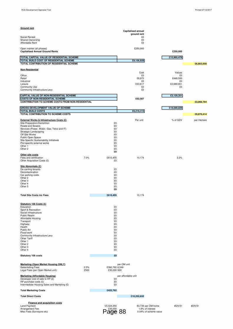
HCA Development Apprasial Tool Printed 27/12/2017
Ground rentCapitalised annual
ground rentSocial Rented £0Shared Ownership £0Affordable Rent £0
Open market (all phases) £250,000Capitalised Annual Ground Rents £250,000
TOTAL CAPITAL VALUE OF RESIDENTIAL SCHEME £15,960,478TOTAL BUILD COST OF RESIDENTIAL SCHEME £9,156,828TOTAL CONTRIBUTION OF RESIDENTIAL SCHEME £6,803,650
Non-ResidentialCost Values
Office £0 £0Retail £8,970 £448,500Industrial £0 £0Leisure £53,617 £2,680,851Community Use £0 £0Community Infrastructure Levy £0
CAPITAL VALUE OF NON-RESIDENTIAL SCHEME £3,129,351COSTS OF NON-RESIDENTIAL SCHEME £62,587CONTRIBUTION TO SCHEME COSTS FROM NON-RESIDENTIAL £3,066,764
GROSS DEVELOPMENT VALUE OF SCHEME £19,089,829TOTAL BUILD COSTS £9,219,415TOTAL CONTRIBUTION TO SCHEME COSTS £9,870,414
External Works & Infrastructure Costs (£) Per unit % of GDV per HectareSite Preparation/Demolition £0Roads and Sewers £0Services (Power, Water, Gas, Telco and IT) £0Strategic Landscaping £0Off Site Works £0Public Open Space £0Site Specific Sustainability Initiatives £0Plot specific external works £0Other 1 £0Other 2 £0
£0Other site costsFees and certification 7.0% £610,455 10,174 3.2%Other Acquisition Costs (£) £0
Site Abnormals (£)De-canting tenants £0Decontamination £0Car parking costs £0Other 2 £0Other 3 £0Other 4 £0Other 5 £0
£0
Total Site Costs inc Fees £610,455 10,174
Statutory 106 Costs (£)Education £0Sport & Recreation £0Social Infrastructure £0Public Realm £0Affordable Housing £0Transport £0Highway £0Health £0Public Art £0Flood work £0Community Infrastructure Levy £0Other Tariff £0Other 1 £0Other 2 £0Other 3 £0Other 4 £0
£0Statutory 106 costs £0
Marketing (Open Market Housing ONLY) per OM unitSales/letting Fees 2.5% £392,762 6,546Legal Fees (per Open Market unit): £500 £30,000 500
Marketing (Affordable Housing) per affordable unitDeveloper cost of sale to RP (£) £0RP purchase costs (£) £0Intermediate Housing Sales and Marketing (£) £0
Total Marketing Costs £422,762
Total Direct Costs £10,252,632
Finance and acquisition costsLand Payment £5,024,350 83,739 per OM home #DIV/0! #DIV/0!Arrangement Fee £35,000 1.9% of interestMisc Fees (Surveyors etc) £7,000 0.04% of scheme valuePage 88

HCA Development Apprasial Tool Printed 27/12/2017
Agents Fees £50,244Legal Fees £25,122Stamp Duty £200,974Total Interest Paid £1,871,166
Total Finance and Acquisition Costs £7,213,855
Developer's return for risk and profit
ResidentialMarket Housing Return (inc OH) on Value 18.0% £2,827,886 47,131 per OM unitAffordable Housing Return on Cost 6.0% £0 per affordable unitReturn on sale of Private Rent 0.0% £0 #DIV/0! per PR unitNon-residentialOffice £0Retail £80,730Industrial £0Leisure £482,553Community-use £0 £563,283
Total Operating Profit £3,391,169(i.e. profit after deducting sales and site specific finance costs but before deducting developer overheads and taxation)
TOTAL COST £20,857,656
Surplus/(Deficit) at completion 1/6/2021 (£1,767,827)
Present Value of Surplus (Deficit) at 30/8/2017 (£1,408,336)
Scheme Investment MIRR 8.0% (before Developer's returns and interest to avoid double counting returns)
Site Value as a Percentage of Total Scheme Value 26.3% Peak Cash Requirement -£15,773,681
Site Value (PV) per hectare No area input per hectare No area input per acre
Page 89

This page is intentionally left blank

Page 91
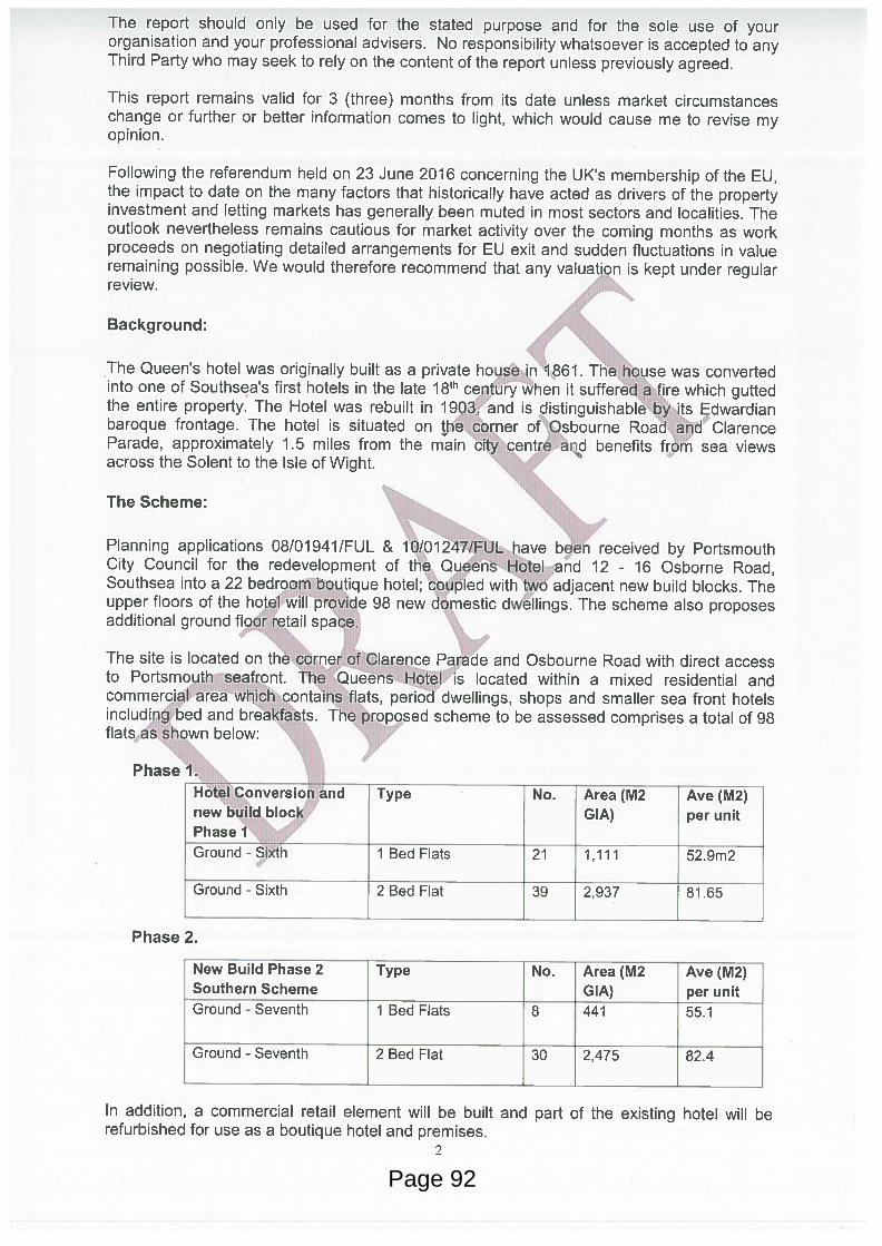
Page 92
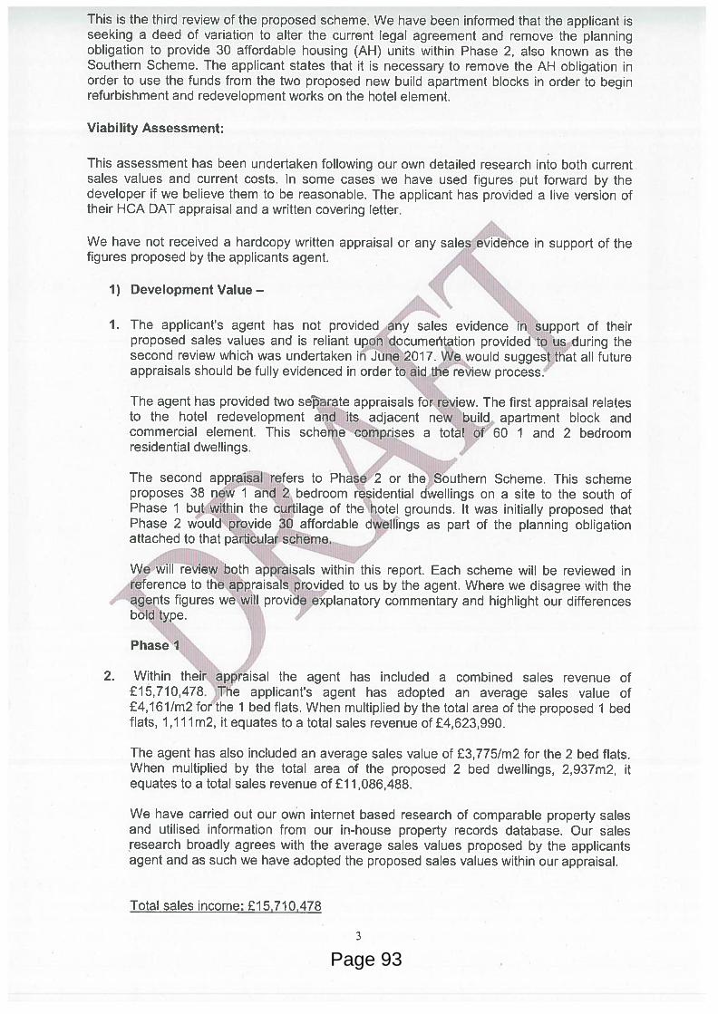
Page 93

Page 94

Page 95

Page 96

Page 97

Page 98

Page 99

Page 100
Page 101

Page 102

Page 103

This page is intentionally left blank