Public Hearing on Biological effects of ultraviolet radiation ...
Upload
khangminh22Category
view
0download
0
PUBLIC HEARING RECORD
Environmental Assessment Red River Bridge at Jimmie Davis Highway
Route LA 511 Bossier and Caddo Parishes State Project No. H.001779
Federal Aid Project No. STP-0800(507)
Prepared For:LOUISIANA DEPARTMENT OF
TRANSPORTATION AND DEVELOPMENT
MAY 14, 2015


ENVIRONMENTAL ASSESSMENT RED RIVER BRIDGE AT JIMMIE DAVIS HIGHWAY ROUTE LA 511 BOSSIER AND CADDO PARISHES
PUBLIC HEARING RECORD
Prepared for:
LOUISIANA DEPARTMENT OF TRANSPORTATION AND DEVELOPMENT
MAY 14, 2015

Page Left Intentionally Blank

1
July 2015 Jimmie Davis Bridge Environmental Assessment
INTRODUCTION
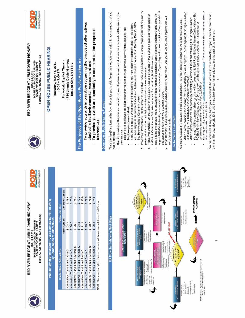
An open forum Public Hearing to present the Draft Environmental Assessment (EA) for the Red River Bridge at Jimmie Davis Highway (LA 511) was held on Thursday, May 14, 2015, at the Barksdale Baptist Church, 1714 Jimmie Davis Highway, Bossier City, Louisiana from 5:00 p.m. to 7:00 p.m.
The purpose of the hearing was to provide an opportunity for citizens to view displays, to ask questions, and to offer comments about the alternatives for this project. The alternatives presented included, in addition to the No Build Alternative, two Trail Build Alternatives and three Access Build Alternatives. Although two Bridge Build Alternatives were evaluated in this EA, Bridge Alternative 5, which proposed a new four-lane bridge, had been eliminated from consideration because it was not a feasible action as a result of the on-going project to rehabilitate the existing bridge. This is discussed in greater detail in Chapter 2.0 of the EA.
NOTIFICATION
Two legal advertisements were placed in the Shreveport Times and appeared in the circulations dated April 12 and May 13, 2015. Two legal advertisements also were placed in the Bossier Press-Tribune and appeared in the circulations dated April 15 and May 13, 2015. Earned media prior to the Hearing included articles in the Shreveport Times on April 17 and May 11, 2015, and reports on KTAL on May 11, 2015, and on KSLA in the morning of May 14, 2015. Copies of these notifications are found in Appendix A.
Notices of the Hearing were mailed to 264 stakeholders on April 27, 2015. On May 7, 2015, reminders were sent electronically to the 212 stakeholders that had provided their electronic addresses and to the local, state, and federal agency representatives and elected officials that were invited to the Agency Meeting on August 15, 2013. Information about the Hearing also was included in the letters that accompanied the distribution of the Draft EA document on April 7, 2015.
ATTENDANCE
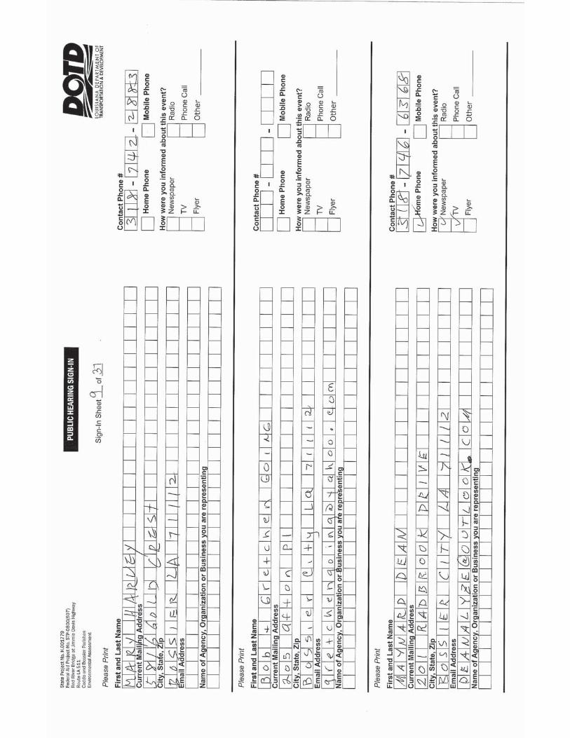
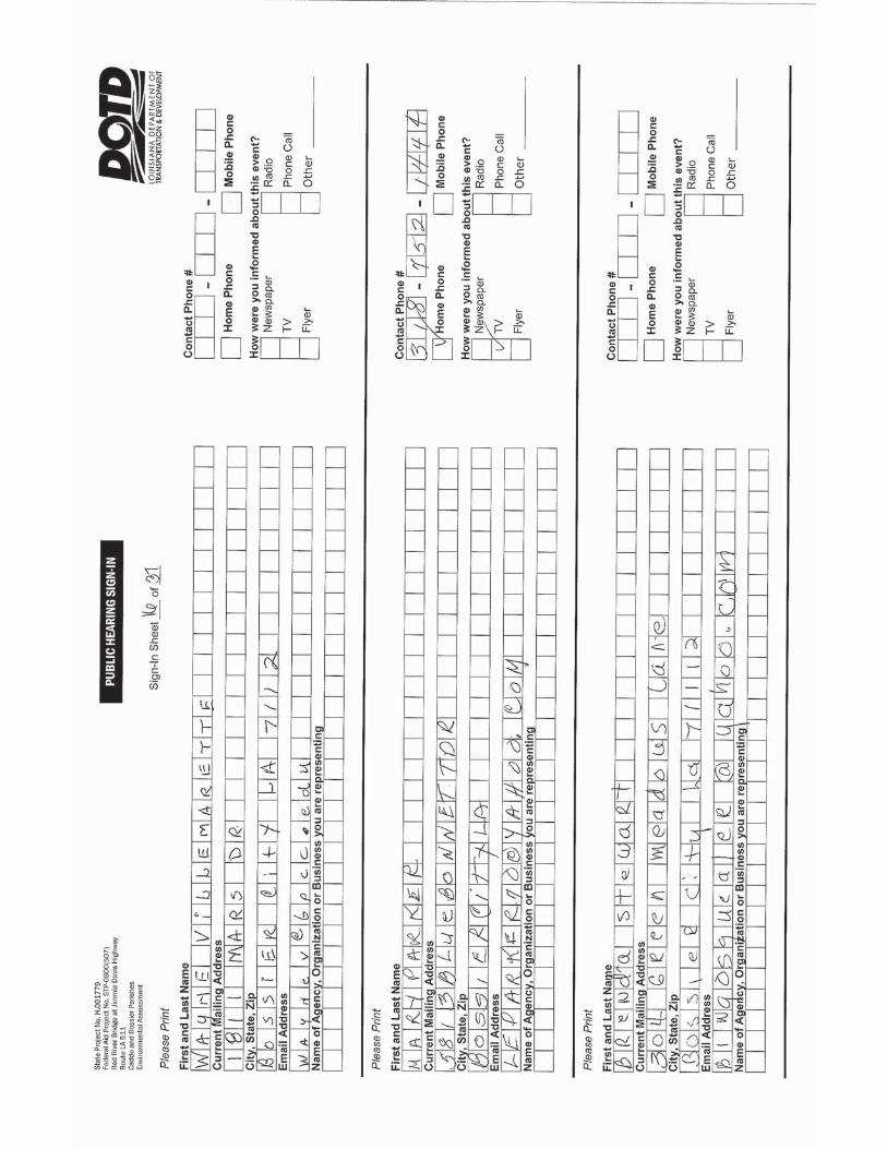
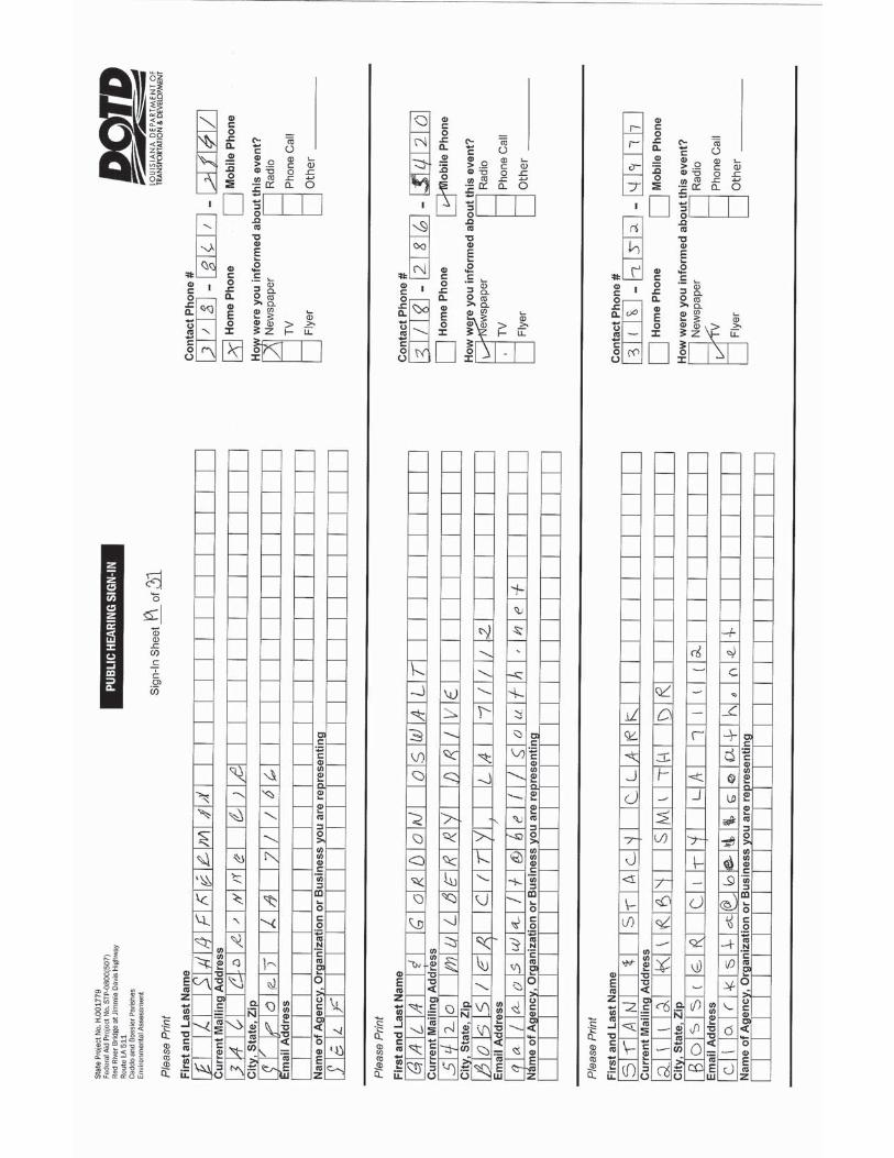
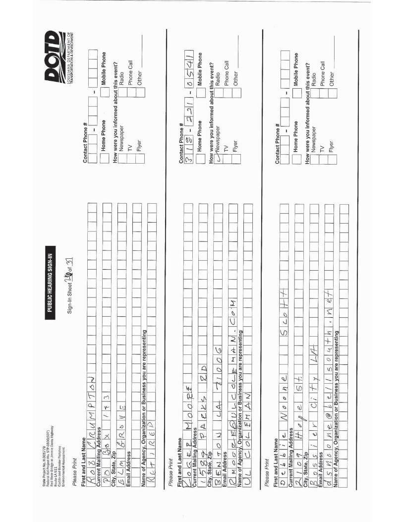
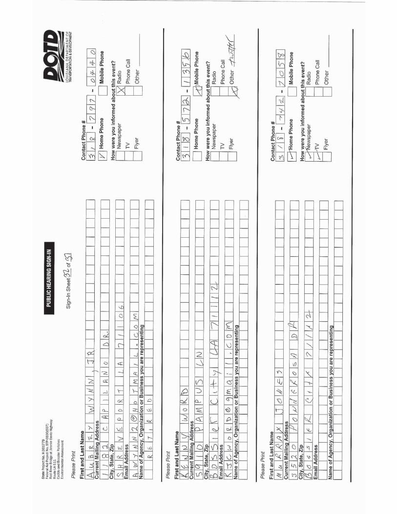
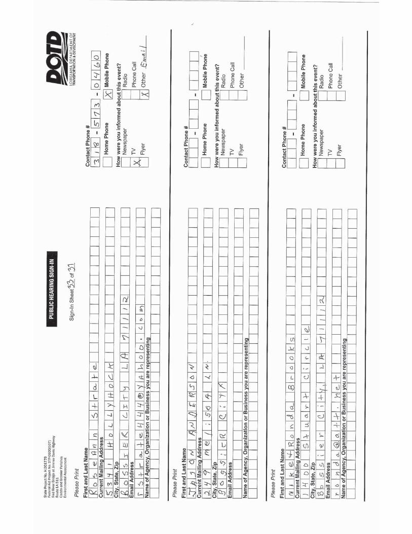
The sign in sheets indicate that 112 citizens attended the Hearing, including a member of the NLCOG staff and Senator Barrow Peacock who was the only attendee that identified himself as an elected official. Seven members of the DOTD project team and the DOTD District 04 staff and seven members of the consultant team were present to host the hearing. Copies of the sign-in sheets are found in Appendix B.
DISPLAYS
Several information displays were available for review and comment by the public. A Public Hearing handout and a comment form were presented to the attendees as they entered the meeting room, with extra copies available for attendees to share with other members of their community. Two video presentations were available for viewing on monitors. One presentation provided citizens with an overview of the project including both the alternatives and the environmental findings. The other presentation provided the simulation of traffic in 2036 for both the No Build Alternative and for one of the potential combinations of Build Alternatives, Bridge 7, Trail 1, and Access B. Attendees were encouraged to view the presentation, to circulate among the displays, and to participate in discussions concerning the alternatives. The DOTD and consultant staff members were available to assist in describing the alternatives and to answer questions. Copies of the displays and videos are found in Appendix C.
2
July 2015 Jimmie Davis Bridge Environmental Assessment
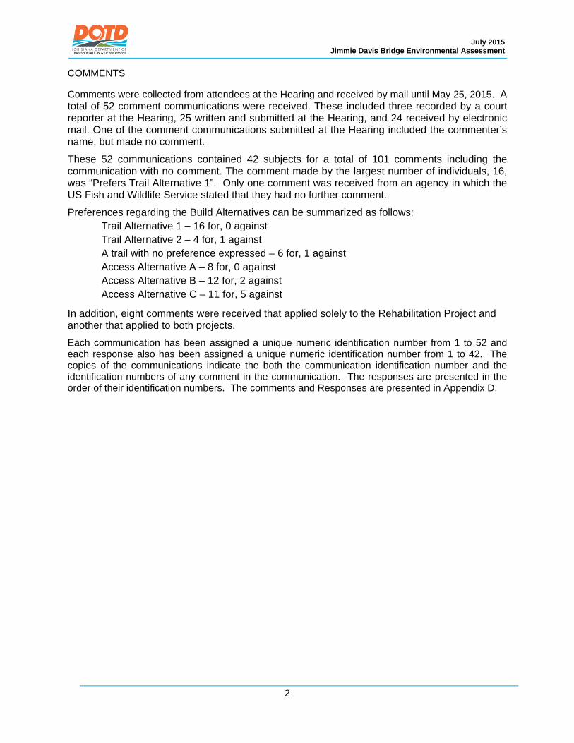
COMMENTS
Comments were collected from attendees at the Hearing and received by mail until May 25, 2015. A total of 52 comment communications were received. These included three recorded by a court reporter at the Hearing, 25 written and submitted at the Hearing, and 24 received by electronic mail. One of the comment communications submitted at the Hearing included the commenter’s name, but made no comment.
These 52 communications contained 42 subjects for a total of 101 comments including the communication with no comment. The comment made by the largest number of individuals, 16, was “Prefers Trail Alternative 1”. Only one comment was received from an agency in which the US Fish and Wildlife Service stated that they had no further comment.
Preferences regarding the Build Alternatives can be summarized as follows: Trail Alternative 1 – 16 for, 0 against Trail Alternative 2 – 4 for, 1 against A trail with no preference expressed – 6 for, 1 against Access Alternative A – 8 for, 0 against Access Alternative B – 12 for, 2 against Access Alternative C – 11 for, 5 against
In addition, eight comments were received that applied solely to the Rehabilitation Project and another that applied to both projects.
Each communication has been assigned a unique numeric identification number from 1 to 52 and each response also has been assigned a unique numeric identification number from 1 to 42. The copies of the communications indicate the both the communication identification number and the identification numbers of any comment in the communication. The responses are presented in the order of their identification numbers. The comments and Responses are presented in Appendix D.

Public Hearing Record – May 14, 2015 Jimmie Davis Bridge Environmental Assessment
APPENDIX A
NOTIFICATION


DISPLAY ADVERTISEMENTS

Page 12A | Sunday, April 12, 2015 shreveporttimes.com | The Times
is pleased to announce the affiliation of
Anil Chhabra, MD, FACC, FACPPierremont Cardiology
Dr. Chhabra accepts new patients and most insurance plans.
WK Pierremont Health Center1811 East Bert Kouns Industrial Loop,
Suite 110, Shreveport, LA 71105
(318) 212-3858pierremontcardiology.com
EVERY BOX HAS A
STORY
A.
B.
Celebrate her trendy style this Mother’s Day!Monogram pendants on 18” chains with
diamond bezel in sterling silver or gold plated.A. 25mm, $450 B. 20mm, $350
Orders must be placed by Thursday, April 16thto ensure Mother’s Day delivery.
SH-1000540430
planning firm Waggonner& Ball Architects andSmart Mobility Inc. — thatproduced a 2010 studyabout the restoration ofthe Claiborne Avenue cor-ridor in the Big Easy.
Much like the I-49 con-nector, construction of In-terstate 10, or the Clai-borne Avenue express-way, more than 50 yearsago brought with it thepromise of easy, high-speed access to would helpkeep inner city New Or-leans energized and vi-brant.
But when the state builtthe elevated 3.9-mile high-way in the 1960s throughthe Claiborne Avenue cor-ridor — a black commer-cial district described inreports, books and otherpublications as once beinglively and lined with oaks— the end result was a de-caying community.
Fumes and noise of carsmoving swiftly down an el-evated highway replacedshops and homes there.
Families and business-es left.
Claiborne Avenue had132 registered businessesin 1960, according to the2010 study. There were 114in 1965 and 64 registeredbusinesses in 1971. By2000, only 35 businesseswere located along the cor-ridor.
The oak trees were re-placed with the inter-state’s concrete columns,now painted with imagesof the same in a pale re-minder of the past.
Urban and cities plan-ners say what happened tothe Claiborne Avenue cor-ridor isn’t uncommon.Across the country, theconstruction of interstatesdestroyed neighborhoods
they sliced. The inner city connec-
tor would be an approxi-mately 3.6-mile highwayintersecting Shreveport toconnect I-49 at the existingI-20 interchange with I-49north near the I-220 inter-change.
Local business andtransportation and publicofficials have long charac-terized the proposed innercity connector project as amust that would bringdrivers into the Shreve-port’s inner city. The argu-ment has been that gas sta-tions, retail shops and fastfood restaurants wouldpop up along the inter-changes to help revitalizethe inner city.
The connector’s largeeconomic impact onShreveport makes it one ofthe most important issuesof today, said state Rep.Roy Burrell, a staunchsupporter of inner cityconnector.
Burrell said Shreve-port and surroundingareas stand to lose millionsif the connector or some-thing similar is not built.
Scott Martinez, presi-dent of the North Louisi-ana Economic Partner-ship, also supports routingthe connector throughShreveport.
“I’m in support of themost efficient route,which is through the innercity. That’s my personalview,” Martinez said.“Looking at the time itwould take to do it and justthe route, as far as effi-ciency and length and dis-tance involved, I thinkthat’s the best route I’veseen.”
Kent Rogers, executivedirector of the NorthwestLouisiana Council of Gov-ernments, said the currentformal environmental im-pact study also will havean economic component.
The study will deter-
mine how the connectionwill be made and evaluatefive possible routes for theconnector, Rogers said viaemail. A record of decisionwill be produced and willdescribe in detail the pre-ferred path of the connec-tor.
A“no build” option is in-cluded, he said. The Feder-al Highway Administra-tion and Louisiana Depart-ment of Transportationand Development are re-viewing the study docu-ments, Rogers said.
J. David WaggonnerIII, CEO and President ofWaggonner & Ball and sonof late Bossier Congress-man Joseph David Wag-gonner Jr., isn’t convincedof the proposed connec-tor’s benefits.
“So that’s the best placeto build a highway? Whereit’s already devastated,right? There’s a better useof land than highways,”said Waggonner, whose
firm is working on Shreve-port’s Cross Bayou Corri-dor redevelopment plan-ning project.
Norquist argues thatconstructing a four-lanestreet with sidewalks, es-tablishing a more efficientpermitting process and de-veloping infrastructurethat serves existingstreets would be more ben-eficial to Allendale thanthe connector.
Unlike the ClaiborneAvenue corridor in NewOrleans, which was pros-perous when the interstatesliced through, the Allen-dale of today is the resultof decades of deterio-ration.
Overgrown vacant lotsnext to boarded-up housescharacterize the area. It’svoid of major grocerystores and retail options.Crime and drugs stigma-tize it — so much so thatBrinson taught her chil-dren to not go there when
they were younger. Allendale once had
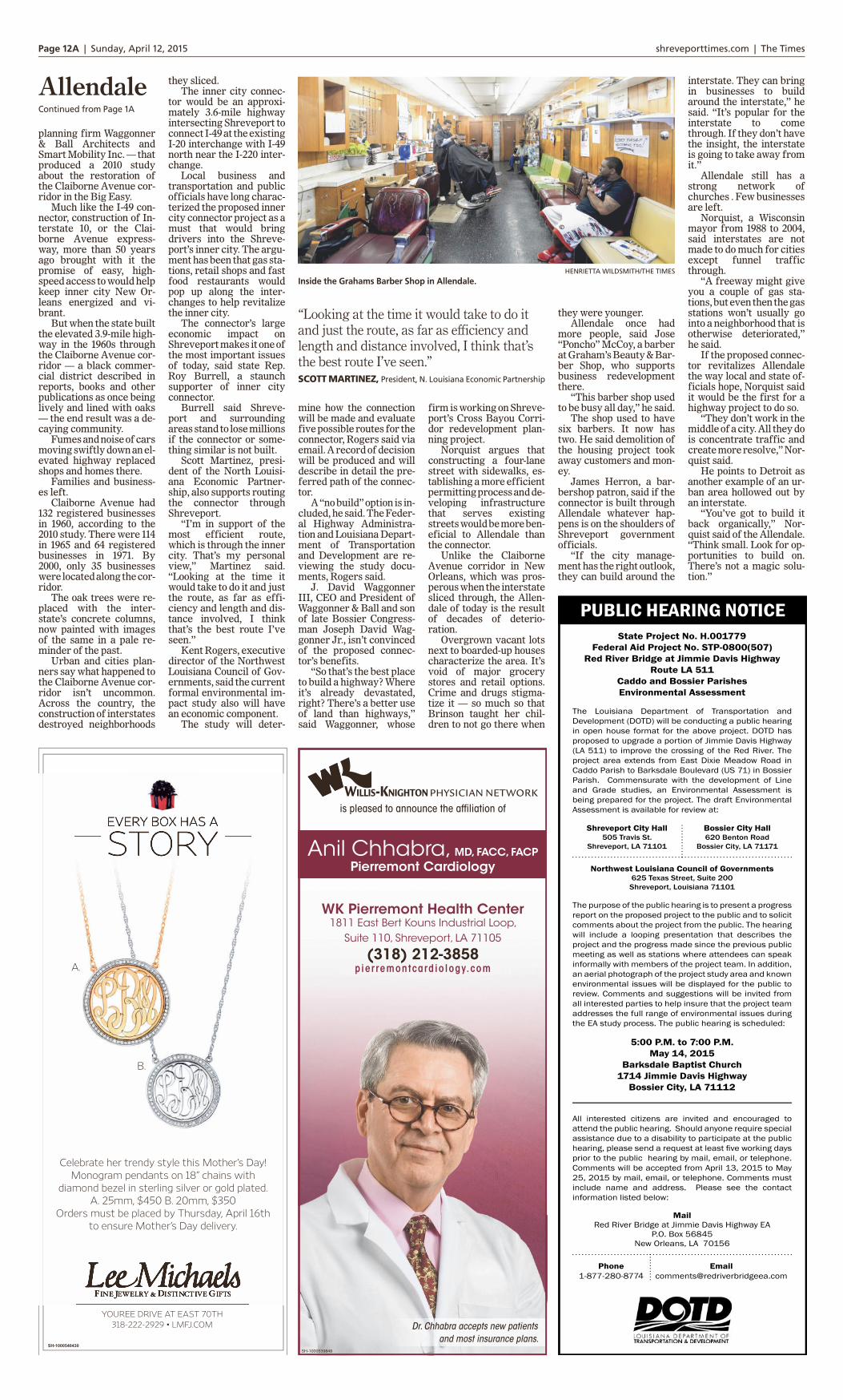
more people, said Jose“Poncho” McCoy, a barberat Graham’s Beauty & Bar-ber Shop, who supportsbusiness redevelopmentthere.
“This barber shop usedto be busy all day,” he said.
The shop used to havesix barbers. It now hastwo. He said demolition ofthe housing project tookaway customers and mon-ey.
James Herron, a bar-bershop patron, said if theconnector is built throughAllendale whatever hap-pens is on the shoulders ofShreveport governmentofficials.
“If the city manage-ment has the right outlook,they can build around the
interstate. They can bringin businesses to buildaround the interstate,” hesaid. “It’s popular for theinterstate to comethrough. If they don’t havethe insight, the interstateis going to take away fromit.”
Allendale still has astrong network ofchurches . Few businessesare left.
Norquist, a Wisconsinmayor from 1988 to 2004,said interstates are notmade to do much for citiesexcept funnel trafficthrough.
“A freeway might giveyou a couple of gas sta-tions, but even then the gasstations won’t usually gointo a neighborhood that isotherwise deteriorated,”he said.
If the proposed connec-tor revitalizes Allendalethe way local and state of-ficials hope, Norquist saidit would be the first for ahighway project to do so.
“They don’t work in themiddle of a city. All they dois concentrate traffic andcreate more resolve,” Nor-quist said.
He points to Detroit asanother example of an ur-ban area hollowed out byan interstate.
“You’ve got to build itback organically,” Nor-quist said of the Allendale.“Think small. Look for op-portunities to build on.There’s not a magic solu-tion.”
AllendaleContinued from Page 1A
HENRIETTA WILDSMITH/THE TIMES
Inside the Grahams Barber Shop in Allendale.
“Looking at the time it would take to do itand just the route, as far as efficiency andlength and distance involved, I think that’sthe best route I’ve seen.”SCOTT MARTINEZ, President, N. Louisiana Economic Partnership

Page 4A | Wednesday, May 13, 2015 shreveporttimes.com | The Times
Market highlights
Stocks of local interest
Dow industrials 18105.17 18068.23 -36.94Dow transports 8754.59 8649.87 -104.72Dow utilities 580.31 578.05 -2.26Dow 65 6383.42 6349.98 -33.44NYSE composite 11140.74 11113.17 -27.57S&P index 2105.33 2099.12 -6.21Bloomberg commod. 103.24 104.65 +1.41US Corp. bonds 3.08 3.17 +0.09
Prev. Close Close Chg.
GAINERS ($2 or more)
PainThera 2.62 +.68 +35.1PhoenxCos 21.61 +4.35 +25.2PhnxC32 20.48 +3.82 +22.9Cartesian 3.94 +.73 +22.7ImpacMtg 22.36 +4.05 +22.1
Last Chg. %Chg.
MOST ACTIVE ($1 or more)
S&P500ETF 1019928 209.98 -.63BkofAm 584855 16.43 -.06CSVLgCrde 460373 3.82 +.20Apple Inc s 454904 125.87 -.46AT&T Inc 407987 33.66 +.17SPDR Fncl 391036 24.58 -.09iShEMkts 359995 42.32 -.14B iPVixST 346680 21.05 -.07Vale SA 339395 7.37 -.29Cisco 313354 29.23 +.02
Vol. Last Chg.
LOSERS ($2 or more)
ITT Ed 2.27 -1.75 -43.5NorandaAl 2.08 -.92 -30.7NewLink 36.55 -15.59 -29.9BarrettB 35.01 -14.54 -29.3CambrC un 10.40 -3.59 -25.7
Last Chg. %Chg.
AFLAC 63.37 -.52AK Steel 5.58 +.05AOL 50.52 +7.93AT&T 33.66 +.17AlcatelLuc 3.75 -.04AEP 54.95 -.48AmExress 79.08 -.62Apache 63.64 +.51Apple Inc s 125.87 -.46ApldMatl 19.89 -.03ATMOS 52.94 -.67Axiall 37.39 -.41BP Pru 68.17 -1.38BcpSouth 24.49 +.14BkofAm 16.43 -.06BestBuy 36.80 -.17Boyd Gaming 13.81 +.10CalumetSp 27.01 +.30CapOne 82.91 -.40CenterPnt 20.04 -.46CenturyTel 35.00 +.60ChesEng 15.45 +.27Chevron 107.56 +.20Cintas 82.47 -.95Cisco 29.23 +.02ConAgra 37.68 +.31ConocoPhil 65.40 +.12DevonE 67.57 +1.11Dillards 127.91 -1.64DiscCmA s 32.02 +1.25EQT GP n 32.92 NCEnCana g 13.86 -.01Entergy 74.23 -1.03ExxonMbl 87.02 +.24Facebook 77.46 -.55FordM 15.56 -.09FrptMcM 22.73 -.24FrontierCm 5.70 -.14Gannett 34.72 -.42GE 27.03 +.11GenMotors 34.74 -.48GoodrPet 3.57 +.10Halliburton 47.49 +.30Havertys 21.04 +.03Hertz 19.87 -.78Home Depot 112.52 +.62
HmFdB LA 19.50 NCHoneywell 102.31 -.38Intel 32.25 -.44IBM 170.55 -.57IP 52.12 -.74IsleCapri 14.24 -.03JPMorgCh 65.36 -.09JanusCap 17.21 -.25KC Southn 98.64 -2.19Keycorp 14.72 -.02Kroger 71.34 -.50Libbey 40.66 -.16Lowes 73.67 +.45MGM Rsts 19.12 -.23MagellMid 82.20 +.71McDnlds 97.95 +.44MicronT 26.87 -.88Microsoft 47.35 -.02Monsanto 116.06 -1.94NCR Corp 28.07 -.03NorandaAl 2.08 -.92Office Depot 9.31 -.05PainThera 2.62 +.68PennNtnl 16.39 +.49Penney 8.88 +.13Pfizer 33.78 -.18PinnclEnt 37.06 +.42PlasmaTch 9.00 -.80Regions Fin 10.17 +.10Rite-Aid 7.83 -.11SM Energy 59.01 +1.13SandRdge 1.52 +.01Schlmbrg 92.47 +.70SeadrillLtd 14.54 +.71SearsHldgs 42.25 +.05SiriusXM 3.84 +.01Stein Mart 11.74 -.14SunEdison 27.61 -1.14Target 80.81 +.20Union Pacific 105.77 -.98VerizonCm 49.62 -.18Wal-Mart 78.96 +.86Wells Fargo 55.47 -.04Weyerhsr 31.95 -.43Xerox 11.16 -.08Zynga 2.93 +.03
Commodities
WHEATMay 15 479.25 +3Jul 15 480.50 -.50Sep 15 487.50 -.50
CORNMay 15 357 -1.25Sep 15 366 +.50Jul 15 361 +.50
OATSMay 15 240 +8Jul 15 242.75 +7.25Sep 15 248.75 +7.25
SOYBEANSJul 15 955.50 -18.50Aug 15 948 -18.50May 15 967 -16
GRAINS(cents per bushel)
LIVESTOCK(cents per pound)
METALS($ per troy oz.)
COTTON(cents per pound)Jul 15 65.02 -.37Oct 15 65.01 -.28Dec 15 64.83 -.45
Gold 1192.60 +9.40Silver 16.51 +.21
FUELSLT. SWEET CRUDE($ per barrel)Jun 15 60.75 +1.50Aug 15 62.25 +1.42Jul 15 61.74 +1.45NATURAL GAS($ per mm btu)Jun 15 2.897 +.095Jul 15 2.945 +.096Aug 15 2.969 +.099
LUMBER$ per 1,000 bd. feet)May 15 234.0 -3.6Jul 15 243.0 -3.0Sep 15 243.7 -3.3
CATTLEJun 15 151.47 +1.22Aug 15 149.65 +.85Oct 15 150.77 +.92
FEEDER CATTLEMay 15 217.70 +.93Aug 15 216.45 -.97Sep 15 215.32 -1.13
HOGS-LeanMay 15 81.30 +.60Jun 15 85.05 +.78Jul 15 84.95 +1.18
MARKET ROUNDUP
U.S. stocks closed slightly low-er after recouping much of anearly slump.
Investors are beginning to wor-ry about a global sell-off in gov-ernment bonds that has been driv-ing long-term borrowing costshigher. The benchmark U.S. bondyield touched its highest levelsince November.
The Dow Jones industrial aver-age lost 36 points, or 0.2 percent, to18,068 Tuesday.
The Standard & Poor’s 500 in-dex gave up six points, or 0.3 per-cent, to 2,099. The Nasdaq com-posite declined 17 points, or 0.4percent, to 4,976.
AOL soared 19 percent afterVerizon said it would buy the com-pany. Gap sank 4 percent aftersaying the strong dollar was hurt-ing its revenue.
NEW YORK — Driverswho have seen a steadyrise in the price of gaso-line can relax: They willalmost certainly be pay-ing far less for gas thissummer than they havein at least six years.
“It’s a cheap, cheap,cheap year,” says TomKloza, chief oil analyst atthe Oil Price InformationService.
The Energy Depart-ment said Tuesday that itexpects the price of gaso-line to average $2.55 be-tween April and Septem-ber, which would be thelowest since 2009. Overthe course of the year, atypical U.S householdcould save $675 in gaso-line prices compared tolast year.
The coming summerof cheap gas was set upby a collapse in oil pricesthat began last June at$107 a barrel and endedin mid-March at $43.That took gasoline pricesdown to $2.03 a gallon, alevel the nation hadn’tseen since it was deep inrecession in March 2009.
Since then the price ofcrude has risen nearly$20 a barrel to around$60, propelled by evi-dence in recent weeksthat drillers in the U.S.and around the worldhave sharply cut back onnew projects while de-mand for fuels has in-creased.
The rise in oil pushedgasoline prices higher,along with typical sea-sonal factors such as re-finery maintenance and
the switch from winter tosummer gasoline to meetclean-air rules. The na-tional average price ofgasoline reached $2.66per gallon, where it hasheld steady in recentdays. The price is 99cents cheaper than lastyear at this time, accord-ing to AAA, OPIS andWright Express.
But many believe thesurge in both oil and gas-oline prices is near anend. Supplies of crude oilremain extremely high,and drillers who havebeen waiting on the side-lines for higher prices
are ready to start pro-ducing more oil again.
“We think that pricesare now more likely tofall than to rise over theremainder of the year,”wrote Julian Jessop,head of commodities re-search at Capital Eco-nomics, in a recent re-port
William Thomas, CEOof EOG Resources, one ofthe country’s biggestshale drillers, told inves-tors in a recent call thathe expects drilling activ-ity to pick up if oil pricesstabilize near $65 a bar-rel or more.
Forecasts: Gas prices stilllook low for the summer JONATHAN FAHEYASSOCIATED PRESS
DON RYAN/AP
James Lewis pumps gas May 6 in Portland, Ore. Experts say theaverage price for gallon of regular should be $2.60 this summer.
KTBS 3/St. Jude Dream Home® Giveaway
1-800-724-2423 DREAMHOME.ORGKTBS.COM
Estim
ated
Value
$450,0
00
Proceeds benefit St. Jude Children’s Research Hospital® in Memphis, TN. Giveaway conducted by ALSAC/St. Jude Children’s Research Hospital. LA License # E0002959 ©2013 ALSAC/St. Jude Children’s Research Hospital (SBLA15-AD-2)
GET YOUR TICKET NOW!GIVEAWAY DATE: SUNDAY, AUGUST 16, 2015
2 P.M. ON KTBS 3
Reserve your ticket(s) by May 20 to be eligible to win a $5,000 Visa gift card!
Built by Rodgers Homes and Construction, Inc.in Lost River Estates in Benton, LA
NATIONAL SPONSORS:
LOCAL SPONSORS:Dr. Donald G. Mack, Chairman
mediaTIMESN e t w o r k
Homes & Construction
SH-1000536957
Computer Problems?MAC’s • PC’s • LaptopsAny Phone • Any Tablet
8682 Youree Dr., Shreveport(1/2 mile south of LSUS on right)
318-670-7428Hours: Mon-Fri 10-6
Pat Holden and Charles Gibson, owners of a computer repair shop located on Youree Drive in Shreveport, credit their success to great customer service, and a $99 T at fee (excluding the cost for parts) to U x any computer problem.Holden, a former restaurant and nightclub owner, has over 20 years of customer service experience. Gibson, who specializes in commercial and home networking, has been in the industry since 1996. Both say their backgrounds have let them create a customer base that has increased through the use of Facebook and word-of-mouth advertising. $99 price tag for services hasn’t hurt business either.“People have been getting ripped oV for too long,” Holden said. “We go beyond just U xing a problem. Every system that comes here gets a full tune-up. It’s a standard service we never deviate from.”
MAKING A DIFFERENCE
TWO LOCAL BOYS
Cautious consumers hold backUS household debt
U.S. household debt levels weremostly unchanged in the first three
months of this year, held back bytight mortgage credit standards andconsumer reluctance to borrowheavily.
Total household debt ticked up0.2 percent to $11.85 trillion in thefirst quarter, the Federal Reserve
Bank of New York said Tuesday.That’s a nearly flat reading after twoquarters of increases. Householddebt, which includes mortgages,student and auto loans, and creditcards, is still 6.5 percent below its2008 peak of $12.7 trillion.
IN BUSINESS


PRESS RELEASEAND
MEDIA ADVISORY


FOR IMMEDIATE RELEASE
May 11, 2015
CONTACT: Karimah Stewart 1-877-280-8774 [email protected]
DOTD to Conduct Public Hearing for Proposed Red River Bridge Improvements
The Louisiana Department of Transportation and Development (DOTD) will conduct a public hearing to receive comments from the public about a proposed future crossing of the Red River at Jimmie Davis Highway (LA 511). The proposed future crossing would provide a new 2-lane bridge paired with the existing bridge to provide a 4-lane crossing and would be constructed separately from the current rehabilitation project.
The hearing will be conducted in open house format on Thursday, May 14, 2015 from 5 p.m. to 7 p.m. at Barksdale Baptist Church, 1714 Jimmie Davis Highway in Bossier City. It will include a looping presentation that describes the project and the progress made since the last public meeting, an aerial photograph of the project study area, displays of known environmental issues, and stations where attendees can speak informally with members of the project team. All interested citizens are encouraged to attend the public hearing.
The project area extends from East Dixie Meadow Road in Caddo Parish to Barksdale Boulevard (US 71) in Bossier Parish. The presentation will include the proposed 4-lane crossing, a new shared use trail across the Red River, potential changes to Jimmie Davis Highway, and the findings of the Draft Environmental Assessment (EA). The EA document is available for review at the following locations:
Shreveport City Hall, 505 Travis St., Shreveport, LA 71101
Bossier City Hall, 620 Benton Road, Bossier City, LA 71171
Northwest Louisiana Council of Governments, 625 Texas St., Ste. 200, Shreveport, LA 71101
Comments and suggestions will be invited from all interested parties to help insure that the project team addresses the full range of environmental issues during the EA study process. Should anyone require assistance due to a disability to participate at the public hearing, please send a request at least five working days prior to the public hearing by mail, email, or telephone. Both verbal and written comments will be received at the public hearing. Comments must include name and address. In addition, comments will be accepted from April 13, 2015 to May 25, 2015 by mail, email, or telephone. The contact information is as follows:
Mail Red River Bridge at Jimmie Davis Highway EA
P.O. Box 56845 New Orleans, LA 70156
Email [email protected]
Phone 1-877-280-8774
FOR IMMEDIATE RELEASE
May 14, 2015
CONTACT: Karimah Stewart 1-877-280-8774 [email protected]
DOTD to Host Public Hearing for Proposed Red River Bridge Improvements
WHAT: A public hearing to receive comments from the public about a proposed future crossing of the Red River at Jimmie Davis Highway (LA 511). The proposed future crossing would provide a new 2-lane bridge paired with the existing bridge to provide a 4-lane crossing and would be constructed separately from the current rehabilitation project.
WHEN: May 14, 2015, 5 p.m. – 7 p.m.
WHERE: Barksdale Baptist Church, 1714 Jimmie Davis Highway, Bossier City, LA
WHO: Hosted by the Louisiana Department of Transportation and Development
MORE INFO: The public hearing will include a looping presentation that describes the project and the progress made since the last public meeting, an aerial photograph of the project study area, displays of known environmental issues, and stations where attendees can speak informally with members of the project team. A Draft Environmental Assessment (EA) has been prepared and is available for review at the following locations:
Shreveport City Hall, 505 Travis St. Shreveport, LA 71101 Bossier City Hall, 620 Benton Road, Bossier City, LA 71171
Northwest Louisiana Council of Governments, 625 Texas St., Ste. 200, Shreveport, LA 71101
Comments and suggestions will be invited from all interested parties to help insure that the project team addresses the full range of environmental issues during the EA study process. Should anyone require assistance due to a disability to participate at the public hearing, please send a request at least five working days prior to the public hearing by mail, email, or telephone. Both verbal and written comments will be received at the public hearing. Comments must include name and address. In addition, comments will be accepted from April 13, 2015 to May 25, 2015 by mail, email, or telephone. The contact information is as follows:
Mail Red River Bridge at Jimmie Davis Highway EA
P.O. Box 56845 New Orleans, LA 70156
Email [email protected]
Phone 1-877-280-8774
###

NEWS STORIES


shreveporttimes.com
Shreveport to host public hearing on Jimmie Davis Bridge staff report 4:57 p.m. CDT April 17, 2015
(Photo: Douglas Collier/The Times)
The Jimmie Davis Bridge was scheduled to close in January, but DOTD now says the bridge won’t be closed until at least the middle of the year.
The City of Shreveport is now receiving public input on an assessment of the Red River Bridge at Jimmie Davis Highway, according to a news release.
The City received a Draft Environmental Assessment of the bridge and opened the public process this week to allow citizens time for inspection, review and comments. Those willing to review the assessment should visit the City Engineers' Office at 505 Travis Street in Shreveport.
A public hearing will be held at 5 p.m. May 14 at the Barksdale Baptist Church, 1714 Jimmie Davis Highway in Bossier City. The public comment period will extend to May 25.
Cindy Dorfner, Louisiana Department of Transportation spokesman, said the public hearing isn't about the existing Jimmie Davis Bridge project.
"This public hearing is for adding additional capacity to the existing bridge, and is separate from the current rehabilitation project that is ongoing. The public hearing will outline the long term solution to handling increased traffic across the Red River at this location," Dorfner said.
For more information, please contact Robert Westerman at (318) 673-6000.

arklatexhomepage.com
DOTD invites you to public hearing for proposed Red River Bridge improvements
By Nikki Henderson | [email protected]
Published 05/11/2015 04:17PM
Updated 05/11/2015 04:18PM
BOSSIER CITY, LA
The Louisiana Department of Transportation and Development wants your input about a proposed future crossing of the Red River at Jimmie Davis Highway.
The proposed future crossing would provide a new 2-lane bridge paired with the existing bridge to provide a 4-lane crossing and would be constructed separately from the current rehabilitation project.
The hearing will be conducted in open house format from 5 p.m. until 7 p.m. Thursday, May 14 at Barksdale Baptist Church on 1714 Jimmie Davis Hwy.
It will include a looping presentation that describes the project and the progress made since the last public meeting, an aerial photograph of the project study area, displays of known environmental issues, and stations where attendees can speak informally with members of the project team.
The project area extends from East Dixie Meadow Rd. in Caddo Parish to Barksdale Blvd. in Bossier Parish.
The presentation will include the proposed 4-lane crossing, a new shared use trail across the Red River, potential changes to Jimmie Davis Hwy and the findings of the Draft Environmental Assessment.
The EA document is available for review at the following locations: Shreveport City Hall, 505 Travis St. Bossier City Hall, 620 Benton Rd. Northwest Louisiana Council of Governments, 625 Texas St., Ste. 200
If you require assistance due to a disability to participate at the public hearing, please send a request at least five working days prior to the public hearing by mail, email, or telephone.
Both verbal and written comments will be received at the public hearing. Comments must include name and address.
In addition, comments will be accepted until May 25 by mail, email, or telephone.
The contact information is as follows: Mail - Red River Bridge at Jimmie Davis Highway EA P.O. Box 56845 New Orleans, LA 70156 Email - [email protected] Phone - (877) 280-8774

shreveporttimes.com
Public hearing planned for Jimmie Davis bridge improvements
5:04 p.m. CDT May 11, 2015
(Photo: File/The Times)
The Louisiana Department of Transportation and Development (DOTD) will conduct a public hearing
to receive comments from the public about a proposed future crossing of the Red River at Jimmie
Davis Highway (LA 511). The proposed future crossing would provide a new two-lane bridge paired
with the existing bridge to provide a four-lane crossing and would be constructed separately from the
current rehabilitation project.
The hearing will be conducted in open house format on May 14 from 5 p.m. to 7 p.m. at Barksdale
Baptist Church, 1714 Jimmie Davis Highway in Bossier City. It will include a looping presentation
that describes the project and the progress made since the last public meeting, an aerial photograph
of the project study area, displays of known environmental issues, and stations where attendees can
speak informally with members of the project team. All interested citizens are encouraged to attend
the public hearing.
The project area extends from East Dixie Meadow Road in Caddo Parish to Barksdale Boulevard
(US 71) in Bossier Parish. The presentation will include the proposed four-lane crossing, a new
shared use trail across the Red River, potential changes to Jimmie Davis Highway, and the findings
of the Draft Environmental Assessment (EA). The EA document is available for review at the
following locations: Shreveport City Hall, 505 Travis St., Shreveport, at Bossier City Hall, 620 Benton
Road, Bossier City, and at Northwest Louisiana Council of Governments, 625 Texas St., Ste. 200,
Shreveport.

Comments and suggestions will be invited from all interested parties to help insure that the project
team addresses the full range of environmental issues during the EA study process. Should anyone
require assistance due to a disability to participate at the public hearing, please send a request at
least five working days prior to the public hearing by mail, email, or telephone. Both verbal and
written comments will be received at the public hearing. Comments must include name and address.
In addition, comments will be accepted from until May 25 by mail, email, or telephone. The contact
information is:
Mail:
Red River Bridge at Jimmie Davis Highway EA P.O. Box 56845 New Orleans, LA 70156
Email: [email protected]
Phone: 1-877-280-8774

ksla.com
Closure of Jimmie Davis bridge delayed, DOTD seeks input on expansion Posted: May 14, 2015 7:38 AM CDT/Updated: May 28, 2015 8:20 AM CDT
Posted by KSLA Staff
The Jimmie Davis Bridge was built in 1968 and serves approximately 21,500 motorists per day.
SHREVEPORT-BOSSIER CITY, LA (KSLA) -
Plans to close one of Shreveport-Bossier's busiest bridges for a year-long maintenance and painting project have been pushed back once again.
The Jimmy Davis Bridge was expected to be shut down at the beginning of the year, and then the work was supposed to begin in the spring.
Now, the Louisiana Department of Transportation says it won't close until later this summer because the because the contractor is wanting to work on the underside of the bridge for as long as possible without closing the bridge.
The DOTD is also seeking public input on plans to expand the future capacity of the bridge.
They are looking at expanding lanes to allow more traffic to cross over. Those wanting to review the assessment can do so at the City Engineers' Office at 505 Travis Street in Shreveport.
A public hearing on future bridge capacity will be held at 5 p.m. Thursday, May 14 at the Barksdale Baptist Church, located at 1714 Jimmie Davis Hwy.
The DOTD says the public will have until May 25 to comment on the project.

At the meeting, people will see a presentation that includes an aerial photograph of the project study area and a breakdown of the known environmental issues that have been studied.
Representatives of the DOTD project team will be on hand to answer questions.
The project area extends from East Dixie Meadow Road in Caddo Parish to Barksdale Boulevard in Bossier Parish and is expected to cost a little more than $20 million.
MORE
Purple on steel: See how selected shade will appear on Jimmie Davis Bridge
The actual shade of purple the Jimmie Davis Bridge as it will appear when it is repainted this summer has been revealed.
Thousands of voters chose purple as the new color for the bridge back in May from a selection of 8 colors.DOTD spokeswoman Cindy Dorfner provided a sample of the paint, known as Federal Standard Color - 37100, on a piece of steel Wednesday morning, demonstrating how the shade of purple will appear on the bridge itself.Dorfner says because the online paint swatch can look different, depending on individual's computer monitors, she wanted to get the color painted on a piece of metal, that way everyone can have a better idea of what the color will look like on the bridge.
If the company chooses to use the full period, the clock will start ticking on their 550 day construction period, though within that period the company is only granted 365 days to have the bridge completely shut down.
"But where they decide to close it within that 550 days, we don't have a good guess on that yet," Dorfner said, but explained the contractor will turn in a more concrete plan to the DOTD by mid-February.
The Jimmie Davis Bridge was built in 1968 and serves approximately 21,500 motorists per day. According to the Louisiana Department of Transportation, the rehabilitation is intended to improve ride quality and extend the life of bridge.

ktbs.com
DOTD and the Jimmie Davis Bridge Project Posted: May 14, 2015 9:48 PM CDT/Updated: May 14, 2015 9:48 PM CDT
By Jeff Beimfohr
Jimmie Davis Bridge Project
BOSSIER CITY, La - It will be painted purple and it will be closed for a year.
That's what one Bossier City resident said he learned at a public hearing held by the Department of Transportation and Development on Thursday May 14, 2015, at Barksdale Baptist Church. The meeting was held to answer concerns over the pending Jimmie Davis Bridge project.
The DOTD held the meeting to discuss several options on how to increase traffic flow across the Red River. The DOTD did clarify that the existing bridge will remain, with a new two lane span being built alongside.
The current bridge is 50 years old and nearly 30,000 cars travel across it every day. It's vital for commuters who travel in and out of Shreveport Bossier and drivers have asked for years why a second span has never been built.
Traffic does get congested around the Jimmy Davis Bridge. It's scheduled for painting and rehab starting probably in August and will be closed for a year. That will create lots of traffic problems—and that's a big concern.
The DOTD proposes building a new two lane span next to the Jimmie Davis—which will remain in place.
At the Thursday meeting displays and power point presentations answered questions from concerned residents. They drew lots of interest, including from state legislators.
“The fact people came out tonight to Barksdale Baptist Church,” said State Senator Barrow Peacock, “and expressed how important this is—sends a message to Baton Rouge and DOTD that we need this project in south Bossier.”
“Right now there is still a lot of confusion,” said Bossier City resident Gala Oswalt, “we have a lot of traffic accidents the way it is right now. We have a lot of congestion the way it is. It's a two lane bridge handling four lanes of traffic.”
“It's going to be another two lane structure next to this one,” said Virginia Pinkley, “but then they told us there's no money. So, this is just a proposal.”

“The closing of the bridge for a year is going to make major traffic problems at Shreveport-Barksdale trying to get across the bridge,” said Thomas Gayre, “and that or the I-20 Bridge downtown.”
And that seemed to be the major concern—most were hoping the new two lane span would be built before the closing of the Jimmie Davis Bridge.
Also to be decided—final configuration of a bike path that will be part of the bridge, and whether current bridge access will remain as is, or be expanded into a boulevard.
Cost for the entire project is projected at $75-80 million.
Public Hearing Record – May 14, 2015 Jimmie Davis Bridge Environmental Assessment
APPENDIX B
ATTENDANCE

SIGN-IN SHEETS


This page intentionally left blank

Public Hearing Record – May 14, 2015 Jimmie Davis Bridge Environmental Assessment
APPENDIX C
DISPLAYS


HANDOUT

8

Acce
ss A
ltern
ativ
e B
(Bou
leva
rd)
Acce
ss A
ltern
ativ
e B
with
Acc
ess A
ltern
ativ
e C
(Cen
tury
Lin
k M
odifi
catio
ns)
7
ACCE
SS A
LTER
NAT
IVE
B
Acce
ss A
ltern
ativ
e A
(5 L
ane)
Acce
ssAl
tern
ativ
e A
with
Acc
ess
Alte
rnat
ive
C (C
entu
ry L
ink
Mod
ifica
tions
)6
ACCE
SS A
LTER
NAT
IVE
A

Brid
ge A
ltern
ativ
e 7
and
Trai
l Alte
rnat
ive
1 Br
idge
Alte
rnat
ive
7 an
d Tr
ail A
ltern
ativ
e 2
45
JIMM
IE D
AVIS
BRI
DGE
EAPR
OJE
CT A
LTER
NAT
IVES

VIDEO PRESENTATIONS


1
Welcome to the Public Hearing on the Draft Environmental Assessment of the Red River Bridge on Jimmie Davis Highway, LA 511 in Bossier and Caddo Parishes.
This recorded presentation provides an overview of the Draft Environmental Assessment.
The purpose of this Hearing and the public comment period is to inform the public of the alternatives that have been developed and analyzed, and to receive public comments before a preferred alternative is selected .
The presentation lasts approximately 30 minutes.
2
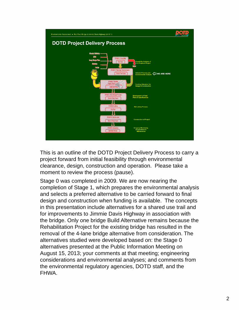
This is an outline of the DOTD Project Delivery Process to carry a project forward from initial feasibility through environmental clearance, design, construction and operation. Please take a moment to review the process (pause).
Stage 0 was completed in 2009. We are now nearing the completion of Stage 1, which prepares the environmental analysis and selects a preferred alternative to be carried forward to final design and construction when funding is available. The concepts in this presentation include alternatives for a shared use trail and for improvements to Jimmie Davis Highway in association with the bridge. Only one bridge Build Alternative remains because the Rehabilitation Project for the existing bridge has resulted in the removal of the 4-lane bridge alternative from consideration. The alternatives studied were developed based on: the Stage 0 alternatives presented at the Public Information Meeting on August 15, 2013; your comments at that meeting; engineering considerations and environmental analyses; and comments from the environmental regulatory agencies, DOTD staff, and the FHWA. Your comments regarding these alternatives will help DOTD make a selection of the preferred alternative.
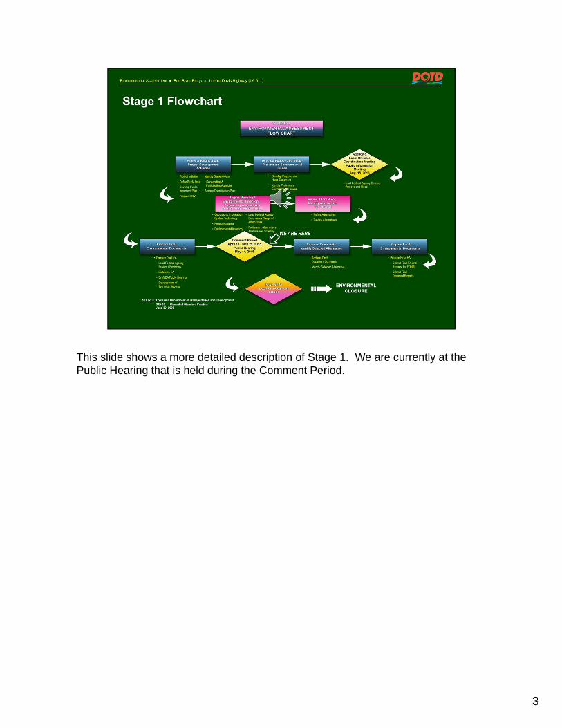
This slide shows a more detailed description of Stage 1. We are currently at the Public Hearing that is held during the Comment Period.
3

The Environmental Assessment tasks are intended to
Establish a Project Purpose and Need;
Forecast Traffic and Level of Service (LOS) for the implementation year (2016) and the Design Year (2036);
Investigate Design Concepts that support the Purpose and Need;
Conduct an Environmental Assessment in accordance with the National Environmental Policy Act (NEPA) to assure that there are no significant impacts; and
Estimate Probable Costs for Construction, Right-of-way, and professional fees.
These tasks have been completed and the findings are found in the Draft Environmental Assessment.
The remaining tasks include receiving your comments, and DOTD and FHWA selecting a Preferred Alternative.
4

5
The Project Area extends along LA 511 from its intersection with East Dixie Meadow Road in Caddo Parish, across the Red River, to its intersection with Barksdale Boulevard, US 71, in Bossier Parish.

A draft purpose and need statement was prepared during the Stage 0 Study. It was refined and presented for comment at the Public Information Meeting. This slide presents the Purpose that was established following that meeting, and approved by the Federal Highway Administration.
The following slides present the Needs for the project.
6

The existing bridge is a capacity constraint on the LA 511 corridor because it is a two lane link in what is otherwise a 5-lane roadway extending 5.35 miles from LA 523 to Barksdale Boulevard.
Also, Average Daily Traffic (ADT) is expected to increase from
27,955 in 2013 to 36,780 in 2036.
These conditions affect the LOS of trips across the river.
The table shows how traffic is qualitatively described using letters with LOS A being free flow and LOS F being gridlock.
7

In 2013, the LOS in both directions was LOS F during the AM peak and LOS E during the PM peak. In 2036, it is expected to be LOS F in both directions during both peak periods. To provide LOS C, two lanes in each direction are needed.
In 2013, the signalized intersection of Jimmie Davis Highway and CenturyLink Center Drive / Zach Avenue at the bottom of the east bridge approach had LOS C. In 2036, it is projected to have LOS D.
8

Regional and local plans support a connection of the Clyde Fant Trail andthe Arthur Ray Teague Trail to provide a river crossing for bicycles andpedestrians, including:
The Northwest Louisiana Long Range Transportation Plan Update 2009-2030 that describes this project as LA 511 (Jimmie Davis Highway) Red River crossing - New 4-lane bridge structure with Bicycle Pedestrian facilities.
The Bossier City Comprehensive Plan (2002) that calls for
A Pedestrian crossing over the Red River, and
To connect a bike trail over to Shreveport: Jimmie Davis Bridge
The Shreveport-Caddo 2030 Master Plan (2010) that calls for
A “Complete Streets” policy that provides roadway space for bicycles, pedestrians, automobiles and transit vehicles, and integrates greenway and off-road bicycle routes with the roadway system, and
Integrated pedestrian networks and bikeways in the development of public spaces and linking community destinations through on- and off-street facilities.
9

Two safety aspects apply to this project: structural and operating.
Structural safety is needed because:
The existing bridge is 45 years old and is showing signs of aging, including corrosion of steel members, erosion of the embankment, and cracks and spalling to the abutment walls and the deck.
Operating safety is needed because:
The existing 2-lane bridge does not have shoulders, sidewalks, or bicycle lanes.
10

The location of the CenturyLink Center near the east approach of the bridge, future transportation projects, and the following recently completed transportation projects are anticipated to increase traffic demand at the eastern approach, and have added to the need for this project since Stage 0 was completed:
• Construction of the 5-lane section along LA 511 from the bridge to Barksdale Boulevard,
• The extension of the Arthur Ray Teague Parkway to the intersection of Barksdale Boulevard and Sligo Road, and
• The exit ramps from both eastbound and westbound Jimmie Davis Highway to the Arthur Ray Teague Parkway.
11

The following slides discuss the proposed alignments of the alternatives.
Large-scale drawings are available here tonight for your review, and the planners and engineers are available to answer your questions.
12

The Alternatives studied in the EA include the No-Build Alternative and several Build Alternatives
The No-Build Alternative
serves as a benchmark to allow for the meaningful comparison of the magnitude of environmental effects associated with the Build Alternatives; and
assumes construction of all programmed projects in the project area, including the Jimmie Davis Bridge Rehabilitation, except for this project.
The programmed projects are those listed in the Northwest Louisiana Council of Governments (NLCOG) Short Range Program (Federal Fiscal Years 2013-2015) – Transportation Improvement Projects (TIP).
13

Under the No-Build Alternative, the existing Jimmie Davis Bridge will be rehabilitated to extend its useful life for 30 years, and it will continue to operate as a two-lane facility.
The other two projects will upgrade the project area network, but will not add capacity to LA 511.
14

The EA evaluated the following Build Alternatives:
Two Bridge Alternatives: 5 and 7.
Two Trail Alternatives: 1 and 2.
Four Access Alternatives: A without C, A with C, B without C, and B with C.
Initially, this resulted in 16 possible combinations of Build Alternatives.
As a result of adding the Rehabilitation Project to the No Build and as discussed on the next slide, 8 Build Alternatives remain for your consideration and comment at this Hearing.
15

The Build Alternatives evaluated in this EA, were based on agency and public comments on the Stage 0 Build Alternatives received by DOTD in August 2013.
Subsequently, in 2014, DOTD began the Jimmie Davis Bridge Rehabilitation Project to improve the existing bridge to extend its useful life for an estimated 30 years.
The rehabilitation project is the outcome of a separate study that was underway at the time that this EA was initiated. Due to the substantial investment being made through the rehabilitation project, it has been determined by FHWA and DOTD that Bridge Alternative 5 is no longer under consideration as an element of the Preferred Alternative under this NEPA action.
Bridge Alternative 5 was not removed from the EA to demonstrate that a full range of alternatives was developed, and to avoid any unnecessary delay in the completion of this NEPA process.
16

Therefore, as Bridge Alternative 5 is no longer being considered,
The Preferred Alternative, if a Build Alternative is selected, will be made up of:
Bridge Alternative 7,
one of the two Trail Alternatives, and
one of the four Access Alternatives.
The following slides and the display maps illustrate these alternatives.
17

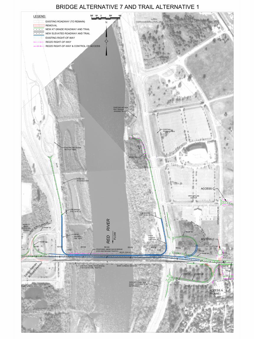
Bridge Build Alternative 7 calls for the construction of a new 2-lane westbound bridge north of the existing structure.
It would include:
• Improvements to the LA 511 interchange with the Clyde Fant Parkway,
• Development of a full LA 511 interchange with the Arthur Ray Teague Parkway in Bossier City, and
• The elevated portions of either Trail Alternative.
18

The slide shows a detail view of Bridge Build Alternative 7 in Caddo Parish combined with Trail Alternative 1.
19

The slide shows a detail view of Bridge Alternative 7 in Bossier Parish combined with Trail Alternative 1 and Access Alternative A.
20
21
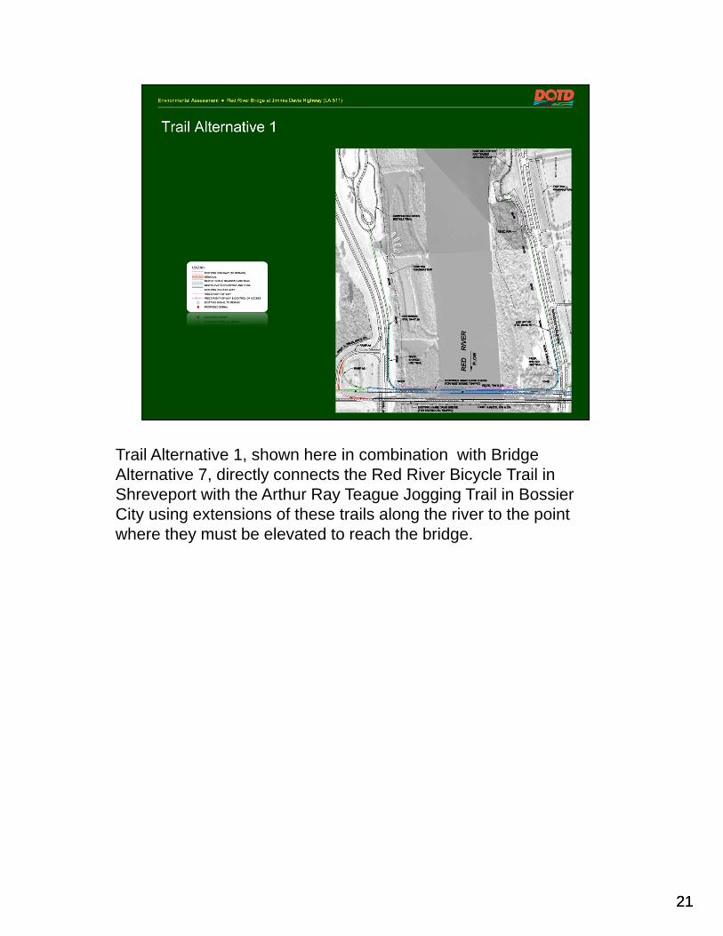
Trail Alternative 1, shown here in combination with Bridge Alternative 7, directly connects the Red River Bicycle Trail in Shreveport with the Arthur Ray Teague Jogging Trail in Bossier City using extensions of these trails along the river to the point where they must be elevated to reach the bridge.
21

22
Trail Alternative 2, shown here in combination with Bridge Alternative 7 also connects the Red River Bicycle Trail in Shreveport with the Arthur Ray Teague Jogging Trail in Bossier City by continuing the trail across the bridge until both reach grade. From these points, it then is extended at grade to join the existing trails on each side of the river.
22

23
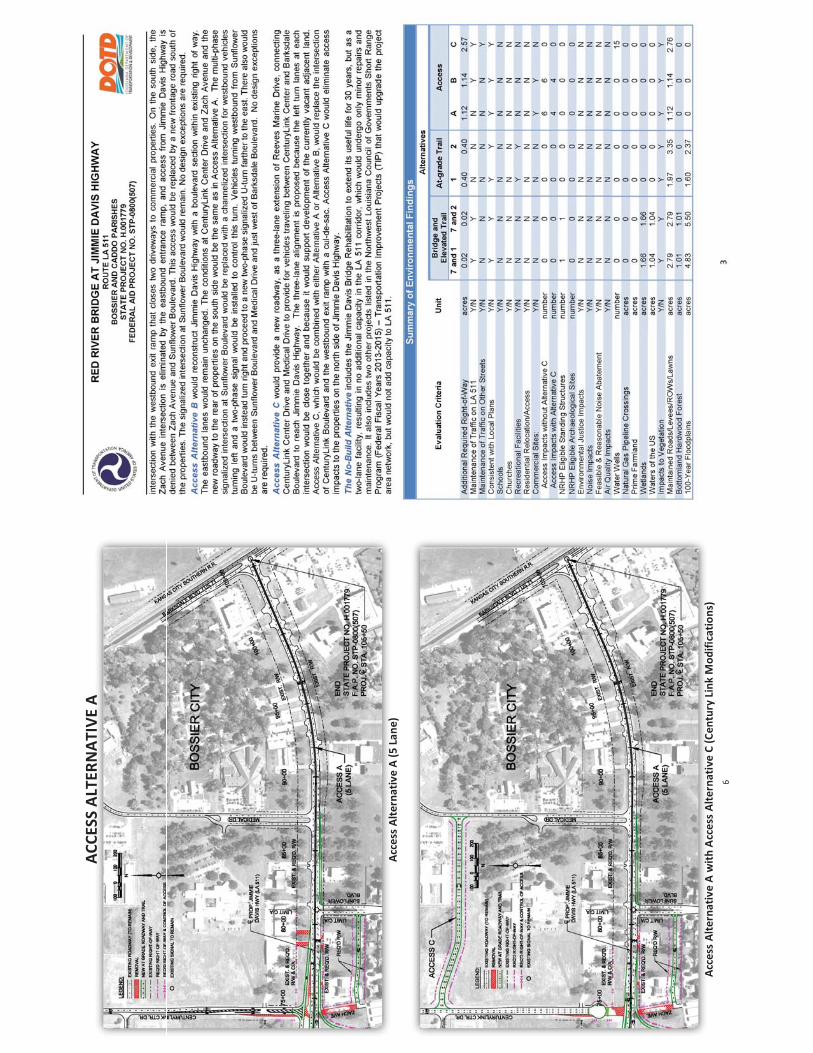
Access Alternative A maintains the existing 5-lane roadway of Jimmie Davis Highway from the bridge to Barksdale Boulevard.
On the south side of LA 511, it includes a new service road connected to Sunflower Boulevard to provide access to BLM Storage and avoid its relocation, and to provide access to the other properties between Zach Avenue and Sunflower Boulevard that would have no access without the service road. The existing uses on these properties could be relocated as a result of the eastbound entrance ramp from Arthur Ray Teague Parkway.
On the north side of LA 511, it would remove access from three properties as a result of the control of access required for the westbound exit ramp from LA 511 to the Arthur Ray Teague Parkway.
23

24
As described on the previous slide, Access Alternative A maintains the existing 5-lane roadway of Jimmie Davis Highway from the bridge to Barksdale Boulevard, and the same changes are found on the south side.
Alternative C has a different impact on the north side of LA 511. No access would be removed, because the exit ramp from LA 511 to the Arthur Ray Teague Parkway would be moved farther west. This would require closing the intersection of CenturyLink Center Drive with LA 511 and providing a new roadway to the north connecting CenturyLink Center Drive to Medical Drive at its intersection with Reeves Marine Drive.
24

25
Access Alternative B reconstructs the westbound roadway of Jimmie Davis Highway to create a boulevard section employing access management concepts with U-turns and J-turns from the bridge to Barksdale Boulevard.
It also includes the service road on the south side and also would have the same access impacts and potential relocation requirements as Alternative A.
25

26
As described on the previous slide, Access Alternative B develops a boulevard along Jimmie Davis Highway from the bridge to Barksdale Boulevard, and, on the south side of LA 511, it includes the same new service road connected to Sunflower Boulevard and has the same potential impacts as Alternative A.
Alternative C, as described in combination with Alternative A, has a different impact on the north side of LA 511. No access would be removed because the exit ramp from LA 511 to the Arthur Ray Teague Parkway would be moved farther west. This would require closing the intersection of CenturyLink Center Drive with LA 511 and providing a new roadway to the north connecting CenturyLink Center Drive to Medical Drive at its intersection with Reeves Marine Drive.
26

27
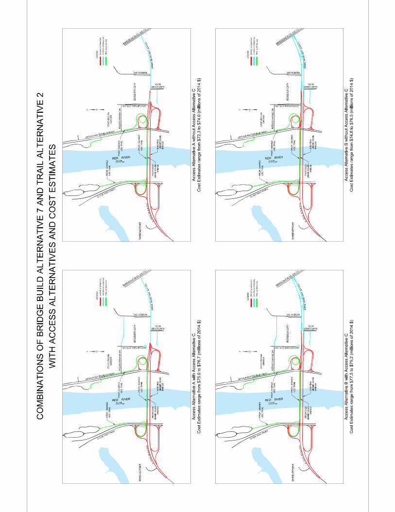
Project implementation costs were estimated for both steel and concrete construction options for the bridge resulting in 16 different costs are shown on the exhibits. This slide shows the most costly ( Bridge Alternative 7 in steel, Trail 1, Access B with C) and the least costly (Bridge 7 in concrete, Trail 2, Access A without C) combinations of alternatives and construction method.

28
The Environmental Assessment included detailed investigations of potential impacts to the environment.
No impacts were identified for :
• Land Use
• Environmental Justice
• Parks and Recreation
• Vegetation
• Significant Trees
• Wildlife
• Scenic Streams
• Coastal Zone
• Contaminated Material Sites
• Air Quality during Operation
• Traffic Noise during Operation, and
• Water Quality during Operation
29
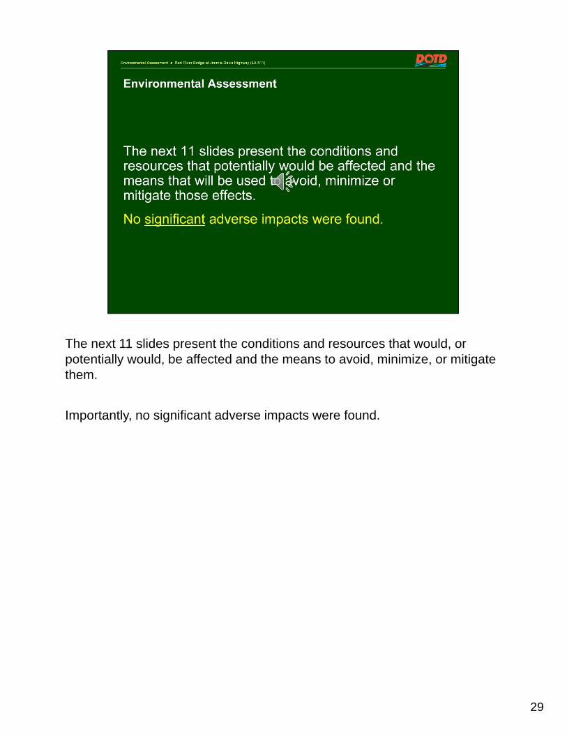
The next 11 slides present the conditions and resources that would, or potentially would, be affected and the means to avoid, minimize, or mitigate them.
Importantly, no significant adverse impacts were found.

30
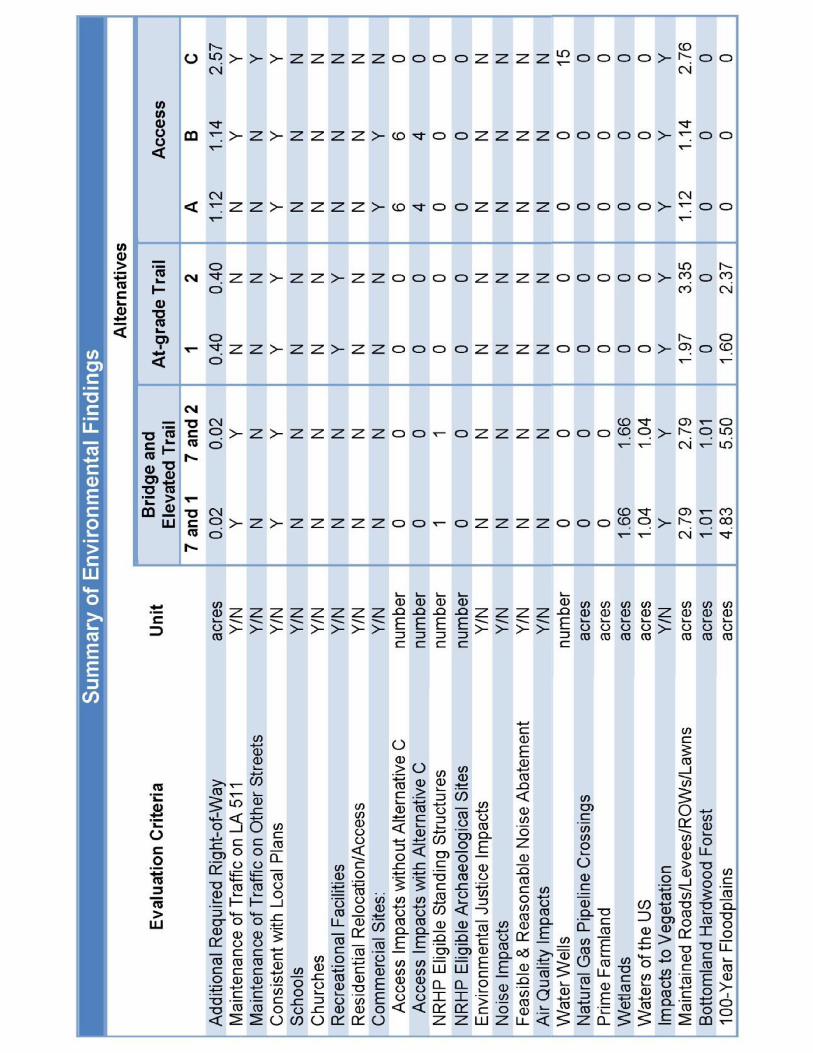
Most of the project footprint would be within existing DOTD highway right-of-way or transportation rights-of-way of local governments.
The acreage and estimated cost of right-of-way acquisition are shown in the table. The only substantial costs result from the construction of the Access Alternatives.

31
Access impacts leading to relocation potentially would affect these commercial properties.
Those in white cells would be impacted by all alternative combinations.
The others could be impacted depending on which alternative combination is selected.
Again, the Access Alternatives generate the majority of the effects.

32
These community facilities potentially would be affected by the alternatives and the effects would be minimized as shown below:
CenturyLink Center
Access Alternatives A and B would eliminate eastbound to northbound and southbound to eastbound turns at LA 511 and CenturyLink Center Drive. Access and egress to and from CenturyLink Center using these movements would be mitigated by completing the LA 511 / Arthur Ray Teague Parkway interchange, and, if constructed, Alternative C from Medical Drive.
Cornerstone Hospital and Barksdale Baptist Church
Access Alternative B results in changes in access, but no minimization is required.

33
The existing Jimmie Davis Bridge is the only historic property within the Study Area.
Bridge Alternative 7 would benefit from the rehabilitation of the existing bridge under the No-Build Alternative. Section 106 and Section 4(f) procedures relative to the existing bridge will be resolved through the implementation of the Rehabilitation project.
No archaeological resources would be affected by the project.
34
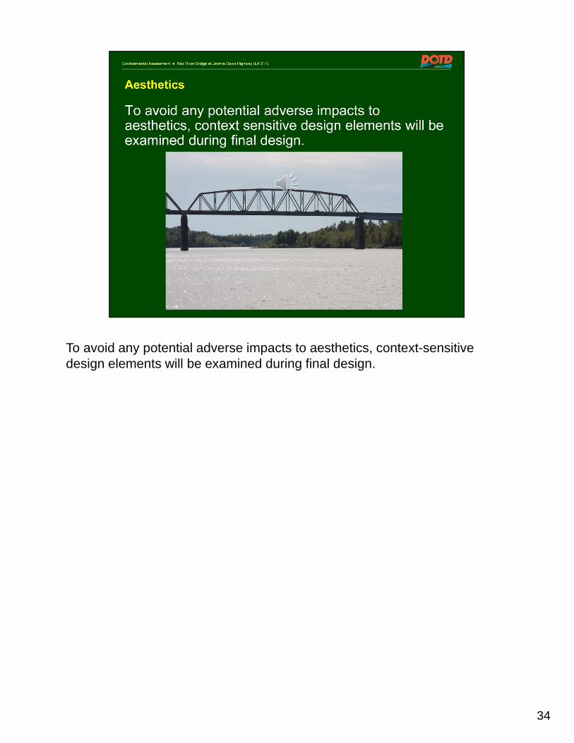
To avoid any potential adverse impacts to aesthetics, context-sensitive design elements will be examined during final design.

35
Impacts to wetlands and waters of the US would result from the construction of the Bridge and the Trail Alternatives.
The Access Alternatives would not impact these resources.
As shown in the table, the acreage impacted by each combination of alternatives for each resource is not great.
Mitigation requirements will be determined in conjunction with the Section 404 and Section 10 permit process.

36
Impacts to 100-year floodplains would result from the construction of the Bridge and Trail Alternatives.
The Access Alternatives would not impact this resource.
As shown in the table, the impacted acreage by each combination of alternatives is not great.
Mitigation requirements will be determined in conjunction with the local floodplain permit process.

37
Access Alternative B potentially would affect groundwater resources.
If it is selected, additional investigation will be undertaken during final design and any required avoidance, minimization or mitigation will be determined at that time.
All alternatives potentially would affect soils during and after construction if Best Management Practices (BMP) are not followed.
Adverse impacts will be avoided through BMP.

38
The Interior Least Tern and the Pallid Sturgeon potentially occur within the project area.
To minimize or mitigate the potential impacts, consultation will be undertaken with the Louisiana Natural Heritage Program (LNHP) if construction activities are scheduled during their breeding seasons:
Late April through August for the Interior Least Tern, and
May through August for the Pallid Sturgeon.

39
Indirect impacts are those that result from the project, but later in time or farther removed in distance.
Indirect impacts resulting from construction will be addressed through the permit process. Longer term indirect impacts may result from the future location of development in proximity to the project that would change travel patterns.
Cumulative impacts are those that result from the incremental impact of the project when added to other past, present, and foreseeable future actions.
Cumulative impacts will be addressed during final design. The only one identified at this time is the increase in impervious surfaces resulting from new roadways and from future development attracted by improved transportation.

40
The resources and conditions that are subject to temporary construction impacts will be avoided, minimized, and mitigated through: the development and implementation of plans to assure the use of BMP; a maintenance of traffic plan; and the permit process. Resources and conditions that potentially would be affected include:
Air Quality
Water Quality
Traffic and Construction Noise
Traffic Operations and
Navigation

Section 4(f) requires a Draft Evaluation of parks, publicly owned recreation facilities, and historic sites potentially affected by a project. This document, found in Chapter 5 of the EA, has a comment period coincident with the EA.
The recreational facilities in the project area include the Arthur Ray Teague Jogging Trail, the Red River Bicycle Trail, and the Charles and Marie Hamel Memorial Park.
The project would not constitute a 4(f) impact to these facilities.
The historic resource in the project area is the existing Jimmie Davis Bridge. In consultation with the SHPO, it has been determined that Bridge Alternative 7 would not affect this resource.
41

• Following this Public Hearing you have an opportunity to submit additional comments by mail or e-mail through the end of the comment period on January 25.
• After consideration of all comments, the DOTD and the FHWA will select a Preferred Alternative.
• A Final Environmental Assessment and a Finding of No Significant Impact (FONSI) will be prepared to conclude the NEPA process.
42

43
Read Slide

44
Read from slide

45
Again, thank you for you participation in this Public Meeting.
The presentation will repeat every 30 minutes

46

1
Environmental Assessment Red River Bridge at Jimmie Davis Highway (LA 511)
Traffic Simulation of Year 2036Red River Bridge at Jimmie Davis HighwayRoute LA 511Bossier and Caddo ParishesState Project No. H.001779Federal Aid Project No. STP-0800(507)
These 3 videos show the simulations of theafternoon (PM) peak traffic period of the No-Build alternative,
the morning (AM) peak traffic period for one of the combinations of Build Alternatives, and
the afternoon (PM) peak traffic period for the same Build Alternatives.
Environmental Assessment Red River Bridge at Jimmie Davis Highway (LA 511)
Simulation of Projected Traffic in Year 2036 PM Peak
No – Build
You are watching video 1 of 3

2
Environmental Assessment Red River Bridge at Jimmie Davis Highway (LA 511)
Simulation of Projected Traffic in Year 2036 AM Peak
Bridge Alt. 7 / Trail Alt. 2 / Access Alt. B
You are watching video 2 of 3
Environmental Assessment Red River Bridge at Jimmie Davis Highway (LA 511)
Simulation of Projected Traffic in Year 2036 PM Peak
Bridge Alt. 7 / Trail Alt. 2 / Access Alt. B
You are watching video 3 of 3

3
Environmental Assessment Red River Bridge at Jimmie Davis Highway (LA 511)
These 3 videos will play again in a moment
THANK YOU FOR WATCHING

This page intentionally left blank

PRESENTATION BOARDS

This page intentionally left blank


10+00
15+00
20+00
25+00
30+00
10+00
15+00
20+00
25+00
30+00
35+00
35+00 40+00 45+00 50+00 55+00 60+00 65+00
70+0075+00
RAMP A3
RAMP A4
EXIST. & REQ’D. R/W & C/A
CHURCH
RIVERPARK
PARK/
HAMEL’S
EXIST. & REQ’D. R/W & C/A
RAMP B2
RAMP B4
BICYCLE TRAIL
EXISTING RED RIVER
JOGGING TRAIL
RAY TEAGUE
EXISTING ARTHUR
ROADWAY R/W
EXISTING
USE TRAIL
SHARED
PROP.
REQ’D. R/W & C/A
EXIST. & REQ’D. R/W & C/A
CENTER
CENTURYLINK
CE
NT
UR
YLIN
K C
TR.
DR.
REQ’D R/W
ROADWAY R/W
EXISTING
RE
D
RIV
ER
FL
OW
(FOR WESTBOUND TRAFFIC)
PROPOSED JIMMIE DAVIS BRIDGE
(FOR EASTBOUND TRAFFIC)
EXISTING JIMMIE DAVIS BRIDGE
STA. 19+47.35
END BRIDGE
STA. 18+82.76
END BRIDGE
AR
TH
UR R
AY T
EA
GU
E P
KW
Y.E
XIS
T. R/W
BOSSIE
R P
ARIS
H
CAD
DO P
ARIS
H
EXIS
T. &
REQ’D. R/W &
C/A
CL
YD
E F
AN
T P
KW
Y.
DETERMINED
EXACT LOCATION TO BE
ASSUMED EXIST. R/W
USE TRAIL
SHARED
PROP.
RAMP B1
EXIST. & REQ’D.
R/W & C/A
RAMP B3
ZA
CH A
VE.
REQ’D. R/W
EXIST. &
R/W & C/A
REQ’D.
EXIST. &
BRIDGE ALTERNATIVE 7 AND TRAIL ALTERNATIVE 1
ACCESS C
ACCESS C
REMOVAL
LEGEND:
EXISTING ROADWAY (TO REMAIN)
NEW AT GRADE ROADWAY AND TRAIL
NEW ELEVATED ROADWAY AND TRAIL
REQ’D RIGHT-OF-WAY & CONTROL OF ACCESS
REQ’D RIGHT-OF-WAY
EXISTING RIGHT-OF-WAY
200 100 200 4000
(5 LANE)
ACCESS A

10+00
15+00
20+00
25+00
30+00
35+00
40+00
45+00
10+00
15+00
20+00
25+00
30+00
35+00
40+00
45+00
50+00
RE
D
RIV
ER
FL
OW
RAMP A3
RAMP A4
EXIST. & REQ’D. R/W & C/A
CHURCH
RIVERPARK
PARK/
HAMEL’S
EXIST. & REQ’D. R/W & C/A
RAMP B4
USE TRAIL
SHARED
PROP.
EXIST. & REQ’D. R/W & C/A
REQ’D. R/W & C/A
ROADWAY R/W
EXISTING
REQ’D R/W
BICYCLE TRAIL
EXISTING RED RIVER
JOGGING TRAIL
RAY TEAGUE
EXISTING ARTHUR
ROADWAY R/W
EXISTING
EXIS
T. R/W
DETERMINED
EXACT LOCATION TO BE
ASSUMED EXIST. R/W
CAD
DO P
ARIS
H
BOSSIE
R P
ARIS
H
REQ’D. R/W &
C/A
EXIS
T. &
CL
YD
E F
AN
T P
KW
Y.
USE TRAIL
SHARED
PROP.
CENTER
CENTURYLINK
AR
TH
UR R
AY T
EA
GU
E P
KW
Y.
EXIST. & REQ’D.
R/W & C/A
CE
NT
UR
YLIN
K C
TR.
DR.
RAMP B3
R/W & C/A
EXIST. & REQ’D.
RAMP B2RAMP B1
USE TRAIL
SHARED
PROP.
(FOR EASTBOUND TRAFFIC)
EXISTING JIMMIE DAVIS BRIDGE
(FOR WESTBOUND TRAFFIC)
PROPOSED JIMMIE DAVIS BRIDGE
ZA
CH A
VE.
REQ’D. R/W
EXIST. &
35+00 40+00 45+00 50+00 55+00 60+00 65+00
70+0075+00
BRIDGE ALTERNATIVE 7 AND TRAIL ALTERNATIVE 2
REMOVAL
LEGEND:
EXISTING ROADWAY (TO REMAIN)
NEW AT GRADE ROADWAY AND TRAIL
NEW ELEVATED ROADWAY AND TRAIL
REQ’D RIGHT-OF-WAY & CONTROL OF ACCESS
REQ’D RIGHT-OF-WAY
EXISTING RIGHT-OF-WAY
200 100 200 4000
(BOULEVARD)
ACCESS B


TRAVEL LANETRAVEL LANETRAVEL LANE TRAVEL LANE TRAVEL LANE
4:1 4:16:1
2.5%2.5%
2’-0" 11’-0" 11’-0" 11’-0"
5’-6"
2’-0"
EXISTING GROUND
EXISTING GROUND
11’-0"
55’-0"
11’-0"
EXISTING ROAD
PROJEC
RIGHT-OF-WAYEXISTING
RIGHT-OF-WAYEXISTING
78’-0"122’-0’
BA
RKS
DALE B
LV
D. / U
S 71
BOSSIER CITY
ME
DIC
AL D
R.
EXIST. & REQ’D. R/W
EXIST. & REQ’D. R/W
EXIST.
R/W
EXIST.
R/W
LIM
IT C/A
LIM
IT C/A
DAVIS HWY (LA 511)
L PROP. JIMMIEC
REQ’D R/W
R/W & C/A
EXIST. & REQ’D.
PROJ. L STA. 105+50
F.A.P. NO. STP-0800(507)
STATE PROJECT NO. H.001779
END
C
CE
NT
UR
YLIN
K C
TR.
DR.
KA
NS
AS CIT
Y S
OU
TH
ER
N R.R.
BL
VD.
SU
NF
LO
WE
R
ZA
CH A
VE.
75+00 80+00 85+00 90+00
95+00
100+
00
105+
00
REMOVAL
LEGEND:
EXISTING ROADWAY (TO REMAIN)
NEW AT GRADE ROADWAY AND TRAIL
EXISTING SIGNAL TO REMAIN
REQ’D RIGHT-OF-WAY & CONTROL OF ACCESS
REQ’D RIGHT-OF-WAY
EXISTING RIGHT-OF-WAY
(5 LANE)
ACCESS A
75+00 80+00 85+00 90+00
95+00
100+
00
105+
00
BA
RKS
DALE B
LV
D. / U
S 71
ME
DIC
AL D
R.
EXIST. & REQ’D. R/W
EXIST. & REQ’D. R/W
EXIST.
R/W
EXIST.
R/W
LIM
IT C/A
LIM
IT C/A
DAVIS HWY (LA 511)
L PROP. JIMMIEC
REQ’D R/W
R/W & C/A
EXIST. & REQ’D.
PROJ. L STA. 105+50
F.A.P. NO. STP-0800(507)
STATE PROJECT NO. H.001779
END
C
CE
NT
UR
YLIN
K C
TR.
DR.
KA
NS
AS CIT
Y S
OU
TH
ER
N R.R.
BL
VD.
SU
NF
LO
WE
R
ZA
CH A
VE.
BOSSIER CITY
REMOVAL
LEGEND:
EXISTING ROADWAY (TO REMAIN)
NEW AT GRADE ROADWAY AND TRAIL
EXISTING SIGNAL TO REMAIN
REQ’D RIGHT-OF-WAY & CONTROL OF ACCESS
REQ’D RIGHT-OF-WAY
EXISTING RIGHT-OF-WAY
(5 LANE)
ACCESS A
ACCESS C
ACCESS ALTERNATIVE A
100 50 100 2000
ACCESS ALTERNATIVE A WITH ACCESS ALTERNATIVE C
ACCESS ALTERNATIVE A
A
A
LA 511 - 5 LANE EXISTING ROADWAY
SECTION "A-A"
N.T.S.
A
A
100 50 100 2000

LEGEND
3 10" CLASS II BASE (STONE OR RECYCLED P.C.C.)
4
1 9" PORTLAND CEMENT CONCRETE PAVEMENT
2 4" MOUNTABLE CURB AND GUTTER
5
PAVEMENT MARKERS AND/OR STRIPING
SUPERPAVE ASPHALTIC CONCRETE BASE COURSE LEVEL 1 (2" THICK)
6
GEOTEXTILE FABRIC (CLASS D)
TRAVEL LANE TRAVEL LANETRAVEL LANETRAVEL LANE
2.5%
(43’-4" MIN. - 84’-2" MAX.)
11’-0" 11’-0" 2’-0"11’-0"11’-0"
24’-0"
2’-0"1’-0" 2’-0"
1’-0"
2’-0"
1’-0"
6LJ
6
EXISTING GROUND
3
7
22
54
1
3
EXISTING GROUND
TO BE REMOVED
EXISTING ROAD
EXISTING ROADWAY (TO REMAIN)
PROJEC
RIGHT-OF-WAYEXISTING
RIGHT-OF-WAYEXISTING
122’-0’ 78’-0"
VARIES 2.5% VARIES
MEDIAN VARIES
5’-6"
CE
NT
UR
YLIN
K C
TR.
DR.
ME
DIC
AL D
R.
EXIST. & REQ’D. R/W
EXIST.
R/W
EXIST.
R/W
DAVIS HWY (LA 511)
L PROP. JIMMIEC
PROJ. L STA. 105+50
F.A.P. NO. STP-0800(507)
STATE PROJECT NO. H.001779
END
C
REQ’D R/W
SIGNAL
NEW 2 PHASE
BA
RKS
DALE B
LV
D. / U
S 71
KA
NS
AS CIT
Y S
OU
TH
ER
N R.R.
LIM
IT C/A
R/W & C/A
EXIST. & REQ’D.
EXIST. & REQ’D. R/W
REQ’D R/W
LIM
IT C/A
SIGNAL
NEW 2 PHASE
BL
VD.
SU
NF
LO
WE
R
ZA
CH A
VE.
BOSSIER CITY
75+00 80+00 85+00 90+00
95+00
100+
00
105+
00
REMOVAL
LEGEND:
EXISTING ROADWAY (TO REMAIN)
NEW AT GRADE ROADWAY AND TRAIL
PROPOSED SIGNAL
EXISTING SIGNAL TO REMAIN
REQ’D RIGHT-OF-WAY & CONTROL OF ACCESS
REQ’D RIGHT-OF-WAY
EXISTING RIGHT-OF-WAY
100 100 2000
(BOULEVARD)
ACCESS B
CE
NT
UR
YLIN
K C
TR.
DR.
ME
DIC
AL D
R.
EXIST. & REQ’D. R/W
EXIST.
R/W
EXIST.
R/W
DAVIS HWY (LA 511)
L PROP. JIMMIEC
PROJ. L STA. 105+50
F.A.P. NO. STP-0800(507)
STATE PROJECT NO. H.001779
END
C
REQ’D R/W
SIGNAL
NEW 2 PHASE
BA
RKS
DALE B
LV
D. / U
S 71
KA
NS
AS CIT
Y S
OU
TH
ER
N R.R.
R/W & C/A
EXIST. & REQ’D.
EXIST. & REQ’D. R/W
REQ’D R/W
LIM
IT C/A
SIGNAL
NEW 2 PHASE
BL
VD.
SU
NF
LO
WE
R
ZA
CH A
VE.
BOSSIER CITY
LIM
IT C/A
75+00 80+00 85+00 90+00
95+00
100+
00
105+
00
REMOVAL
LEGEND:
EXISTING ROADWAY (TO REMAIN)
NEW AT GRADE ROADWAY AND TRAIL
PROPOSED SIGNAL
EXISTING SIGNAL TO REMAIN
REQ’D RIGHT-OF-WAY & CONTROL OF ACCESS
REQ’D RIGHT-OF-WAY
EXISTING RIGHT-OF-WAY
BOSSIER CITY
100 100 2000
(BOULEVARD)
ACCESS B
ACCESS C
ACCESS ALTERNATIVE B
ACCESS ALTERNATIVE B
N.T.S.
B
B
ACCESS ALTERNATIVE B WITH ACCESS ALTERNATIVE C
LA 511 - 4 LANE DIVIDED ROADWAY
SECTION "B-B"
B
B

This page intentionally left blank

Public Hearing Record – May 14, 2015 Jimmie Davis Bridge Environmental Assessment
APPENDIX D
COMMENTS


VERBAL AND WRITTEN COMMENTS


1
2
3
4
5
6
7
8
9
10
11
12
13
14
15
16
17
18
19
20
21
22
23
24
25
STATE PROJECT NO. H.001779 FEDERAL AID PROJECT NO. STP-0800(507)
RED RIVER BRIDGE AT JIMMIE DAVIS HIGHWAYROUTE LA 511
CADDO AND BOSSIER PARISHES ENVIRONMENTAL ASSESSMENT
* * * * * * * * * *
PUBLIC HEARING COMMENTS
* * * * * * * * * * *
PLACE OF HEARING: BARKSDALE BAPTIST CHURCH
1714 Jimmie Davis Highway
Bossier City, Louisiana 71112
DATE OF HEARING: MAY 14, 2015
TIME OF HEARING: 5:00 P.M. TO 7:00 P.M.
* * * * * * * * * * *
REPORTED BY:
Angela S. Arrington Certified Court Reporter CCR: 29032

1
2
3
4
5
6
7
8
9
10
11
12
13
14
15
16
17
18
19
20
21
22
23
24
25
2
PROCEEDINGS:
MR. SYAM DODLA:
I have only one comment. As we are proposing
to construct a new bridge, why do we have to close
the existing bridge for the renovation? I have
prepared some numbers that supports not closing the
existing bridge until construction of the new
bridge. If you close the existing bridge, it cost
a lot of impact on the people.
As per the DOTD, around twenty-one thousand
people use it every day. If they close this bridge
they have to drive six more miles every day causing
congestions at Barksdale and could cause lot more
problems. So I'm saying that we have to put
forward for constructing the new bridge, it's a
good idea. That's common sense to hold on to this
rehabitation project until we complete the new
project. If they make some - - if you close this
bridge, that leads to emission of sixty-one (61)
tons of carbon dioxide per day. That's equaling to
twenty-two thousand three hundred and six point
five (21,300.65) tons of CO2 per year, because you
are proposing for a one year closure. And people
will increase to 4 MIL dollars on their gasoline,
assuming gas will be around $3.00. And then they
lose at least forty-nine thousand (49,000) days per
year overall. And I did not calculate how much
Communication 1 See Responses 2, 27 & 29

1
2
3
4
5
6
7
8
9
10
11
12
13
14
15
16
17
18
19
20
21
22
23
24
25
3
of deterioration people will have in their health
because there is more pollution and what kind of
impact it could have on accidents and so many other
traffic, so many other issues. I am a scientist.
I just want to - - based upon my knowledge I just
want to let you know what I think is a good option.
Obviously, I feel that there is a need of new
bridge no matter what. And also I think there are
some ideas I have, but I'm not sure how the other
people like it. But, it's even okay if they say
there is no funding as of now, for me, even having
toll for the constructed bridge is fine. People
can pay $10.00 per month for the regular users and,
I don't know, occasional users could pay, I don't
know, $1.00 or $2.00 per use it. And it could
generate reasonable amount of money without causing
much trouble on the people who are using that
bridge. But if people - - if you make aware of the
people that they save at least a half an hour per
day and that they also save their health, I don't
think they hesitate to pay that toll.
Right now, I live on the East side of the
bridge, but I am soon moving to the West side of
the bridge and I have to drive everyday through the
bridge from my work. So, I'm willing to pay - -
I'm not saying that is the option - - but I'm
saying, you know, at least that will make more

1
2
3
4
5
6
7
8
9
10
11
12
13
14
15
16
17
18
19
20
21
22
23
24
25
4
sense than closing the bridge for one year, unless
it has some structural issues that needs to be
repaired right away. But just for repaving the
pavement and painting, I don't think it makes
sense. That's all of my comments.
MR. WAYNE BROWN:
My name is Wayne Brown, Brown Builders, 1619
Jimmie Davis Highway, Bossier City, Louisiana.
I am one of the owners for Brown Builders which
is located on 1619 Jimmie Davis Highway and we've
been very interested and certainly know of the need
first hand for an additional bridge over Red River.
Traffic situation is very difficult to - - at peak
times of the day to get in or out of our business.
It's not a very safe situation at times, so I would
like to encourage all of the public officials in
Baton Rouge that have a hand in this to find the
funding to move forward with the second bridge as
soon as possible. Our business is going to suffer
tremendously from the closing of the existing
bridge to rehab it and I am very disappointed that
the state didn't find the additional funds to build
a second bridge first before they closed the first
one. I think that works a hardship on businesses
and residents of south Bossier and south
Shreveport.
Communication 2 See Response 2

1
2
3
4
5
6
7
8
9
10
11
12
13
14
15
16
17
18
19
20
21
22
23
24
25
5
The economic impact on lost business,
additional travel by the residents of both sides of
the river because of the delay, is going to be a
hardship on passing public cost onto individual
residents, rather than the State taking care and
keeping the bridge open by closing the bridge, it's
going to cause economic hardship. I guess that's
already a done deal, but it's very disappointing
that we haven't found the funds in Baton Rouge to
build this two-lane, additional two-lane bridge
that has been needed for years. And I would hope
that there would be some way to expedite the
building this bridge. Thank you.
MS. GALA OSWALT:
My name is Gala Oswalt. I live at 5420
Mulberry Drive, Bossier City, LA 71112.
After listening to all the presentations about
the bridge and the different alternatives, I am
more looking at going with the Boulevard with the
Alternative C - - it's Access Alternative B with
Aaccess Alternative C, which is the cul-de-sac.
And my reasons for that, it does give different - -
more options of getting in and off of the Boulevard
in more of a safe manner. You can go up Medical
Drive, you can get off of the Access Road C or you
can back around to get to Barksdale Blvd. It's
just some different alternative ways to get to both
sides of the City with less stress down the road.
Communication 3 See responses 9

1
2
3
4
5
6
7
8
9
10
11
12
13
14
15
16
17
18
19
20
21
22
23
24
25
6
Businesses, some of this will have to worked out.
It's going to be pretty congested while the
building of the second bridge, which I think is a
great idea, but standing firm with Access
Alternative B with Access Alternative C.
END OF PUBLIC COMMENTS

1
2
3
4
5
6
7
8
9
10
11
12
13
14
15
16
17
18
19
20
21
22
23
24
25
7
CERTIFICATE
STATE OF LOUISIANA
PARISH OF OUACHITA
I, the undersigned reporter, do hereby certify
that the above and foregoing is a true and correct
transcription of the stenographic notes of the
proceedings herein, taken down by me and
transcribed under my supervision, at the time and
place hereinbefore noted, in the above entitled and
numbered cause(s).
I further certify that I transcribed this
hearing in my capacity as a Certified Court
Reporter for the State of Louisiana; that I am not
of counsel nor related to any of the counsel or any
of the parties, nor in the employ of any of them,
and that I have no interest in the outcome of this
action(s).
_____________________________
ANGELA S. ARRINGTON CERTIFIED COURT REPORTERCERTIFICATE NO. 29032PARISH OF OUACHITASTATE OF LOUISIANA

This document was submitted with Communication No. 1 from Syam Dodla

Communication 4 See Response 16

Communication 5 See Response 16

Communication 6 See Responses 10 & 16

Communication 7 See Response 1

Communication 8 See Response 1

Communication 9 See Responses 8 & 16

Communication 10 See Pesponses 12 & 23

Communication 11 See Response 31

Communication 12 See Responses 12 & 17

Communication 13 See responses 10, 13 & 16
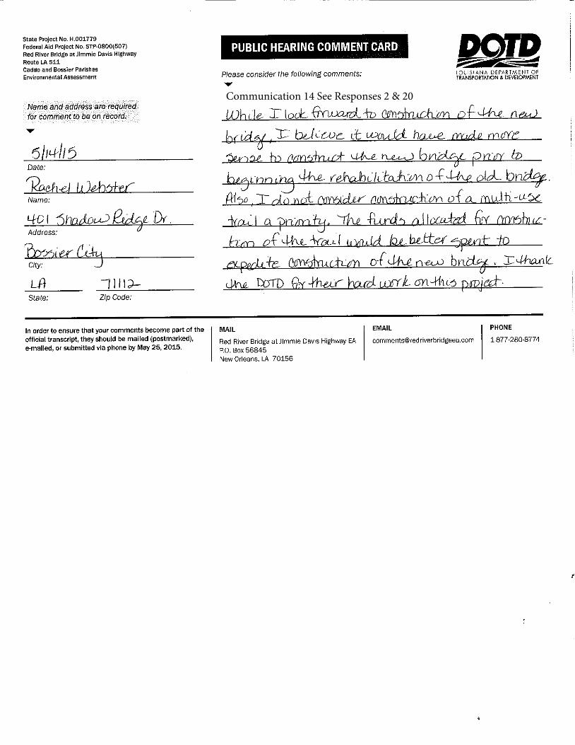
Communication 14 See Responses 2 & 20

Communication 15 See Responses 9, 16, & 35

Communication 16 See Response 2

Communication 17 See response 2

Communication 18 See Responses 9 & 16

Communication 19 See responses 9, 16 & 35

Communication 20 See Responses 8 & 16

Communication 21 See responses 24 & 25

Communication 22 See Responses 7, 16 & 27
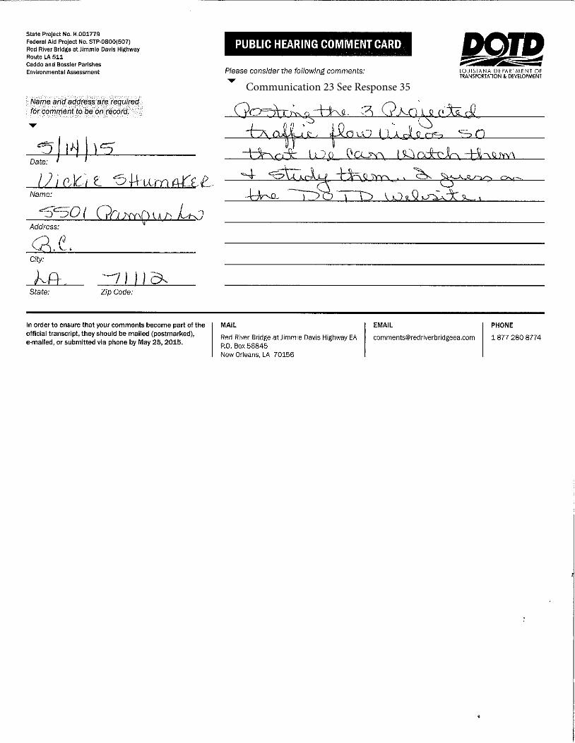
Communication 23 See Response 35

Communication 24 See Responses 7, 9 & 17

Communication 25 See Responses 35 & 36

Communication 26 See Responses 11 & 17

Communication 27 See Responses 5, 6, 16 & 18

Communication 28 See Response 41

Mr. Costa,
The U.S. Fish and Wildlife Service, Louisiana Ecological Services Office has reviewed the subject Draft EA. According to that Draft EA, our office responded to a June 17, 2013, Louisiana Department of Transportation and Development, Solicitation of Views for the Red River Bridge at Jimmie Davis Highway with a not likely to adversely affect Federal trust resources. The subject EA also states that the proposed project would have less than 3 acres of jurisdictional wetland impacts and less than 2 acres of impacts to waters of the U.S. For those reasons, we have no comment on the Red River Bridge at Jimmie Davis Highway Draft EA. If you have questions, feel free to contact me.
Thanks,
Joshua MarceauxU.S. Fish and Wildlife ServiceFish and Wildlife BiologistSouthwest Louisiana National Wildlife Refuge ComplexLacassine National Wildlife Refuge209 Nature RoadLake Arthur, LA 70549Ph: 337/774-5923Fx: 337/774-9913
Joshua Marceaux Apr 21
To
CC
[email protected] [email protected]
Noel Ardoin [email protected]
Red River Bridge At Jimmie Davis Highway Draft Environmental Assessment (EA)
Delete Move Spam More Compose
Inbox (2)
Drafts (1)
Sent
Spam (6)
Trash
Smart ViewsUnread
Starred
People
Social
Travel
Shopping
Finance
FoldersRecent
Search Mail Search Web ⌂ Home Steven ⚙Search
⌂ Home Mail Search News Sports Finance Weather Games Answers Screen Flickr Mobile Try Yahoo Mail on FirefoMore⋁
1
Page 1 of 1(2 unread) - [email protected] - Yahoo Mail
5/26/2015https://us-mg6.mail.yahoo.com/neo/launch?rdsc=100&rand=1249588276
Communication 29 See response 42

To Whom It May Concern:
I will be unable to attend the public hearing scheduled for May 14, 2015, but I wanted to voice my opinion concerning the proposed two-lane bridge to be built adjacent to the existing bridge across the Red River at East 70th Street and Jimmie Davis Highway (LA 511).
I cannot stress how much the additional bridge is needed at this time and location – it is long overdue. South Bossier and Southeast Shreveport have grown quickly during the past 20 years, and the traffic crossing the existing 2-lane bridge is horrendous during the peak traffic hours and other times during the day. With the addition of the “twin” bridge, it will allow continued access across the river during maintenance and repairs of the other bridge, in addition to occasions of unexpected accidents.
I do not know if the erection of the twin bridge is already approved and scheduled; but, if it is not, I strongly urge the DOTD to press on to make this project a reality for the Shreveport-Bossier area.
Thank you for your consideration in approving the project.
Cynthia L. Ashford10047 Raintree DriveShreveport, Louisiana [email protected]
Cindy Ashford May 12
Red River Bridge at Jimmie Davis Highway People
Delete Move Spam More Compose
Inbox (2)
Drafts (1)
Sent
Spam (6)
Trash
Smart ViewsUnread
Starred
People
Social
Travel
Shopping
Finance
FoldersRecent
Search Mail Search Web ⌂ Home Steven ⚙Search
⌂ Home Mail Search News Sports Finance Weather Games Answers Screen Flickr Mobile Try Yahoo Mail on FirefoMore⋁
1
Page 1 of 1(2 unread) - [email protected] - Yahoo Mail
5/26/2015https://us-mg6.mail.yahoo.com/neo/launch?rdsc=100&rand=1249588276
Communication 30 See response 1

I have a notice which was mailed to me saying there is another community meeting about the Red River Bridge on May 14th. I have already attended two meetings about the bridge and even participated in a vote where the community was allowed to select a choice for the bridge. Most everyone around me chose to have another bridge built, then have the other bridge redone. At no time were we told that there really wasn't any money to build a new bridge and all they could do was repair the original bridge, especially closing the bridge for approximately one year to rework that bridge. It is going to be a nightmare with traffic on Barksdale Blvd. and the Teague Parkway closing the Jimmy Davis Bridge.
No one every said anything about closing it down for repairs. I have talked to many people in stores, etc. around here about the bridge. Everyone is just sick thinking we would have to do without that bridge for one year. I realize that it does need to be redone, but why in the world wasn't anyone really truthful to the public about this delay of use for one year? Having meetings that faulty information put out to the community is a joke. You wasted your time and ours. I'm sure it was to look like the community had input into this, but they really didn't! Thanks for wasting our time.
Betty Nelson4901 Longstreet Pl.Bossier City, LA 71112 318-747-1544
Betty Nelson May 13
Red River Bridge Community Meeting People
Delete Move Spam More Compose
Inbox (2)
Drafts (1)
Sent
Spam (6)
Trash
Smart ViewsUnread
Starred
People
Social
Travel
Shopping
Finance
FoldersRecent
Search Mail Search Web ⌂ Home Steven ⚙Search
⌂ Home Mail Search News Sports Finance Weather Games Answers Screen Flickr Mobile Try Yahoo Mail on FirefoMore⋁
1
Page 1 of 1(2 unread) - [email protected] - Yahoo Mail
5/26/2015https://us-mg6.mail.yahoo.com/neo/launch?rdsc=100&rand=1249588276
Communication 31 See Responses 28 & 37

I cannot attend the meeting due to work but would like to add my voice to request a protected pedestrian/bike path on the new bridge. Thank you.
Karen Pearce1333 Coates Bluff Dr. #514Shreveport, LA 71104
Sent from my iPhone
Karen May 14
Bridge development People
Delete Move Spam More Compose
Inbox (2)
Drafts (1)
Sent
Spam (6)
Trash
Smart ViewsUnread
Starred
People
Social
Travel
Shopping
Finance
FoldersRecent
Search Mail Search Web ⌂ Home Steven ⚙Search
⌂ Home Mail Search News Sports Finance Weather Games Answers Screen Flickr Mobile Try Yahoo Mail on FirefoMore⋁
1
Page 1 of 1(2 unread) - [email protected] - Yahoo Mail
5/26/2015https://us-mg6.mail.yahoo.com/neo/launch?rdsc=100&rand=1249588276
Communication 32 See response 19
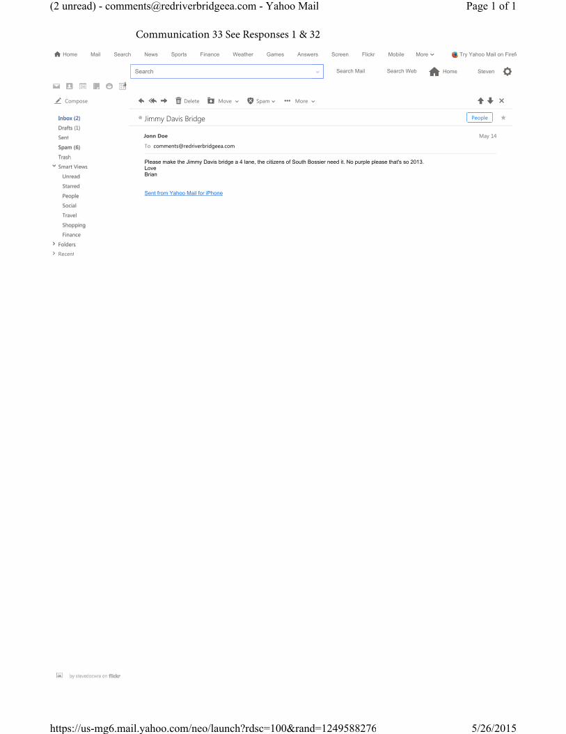
Please make the Jimmy Davis bridge a 4 lane, the citizens of South Bossier need it. No purple please that's so 2013. LoveBrian
Sent from Yahoo Mail for iPhone
Jonn Doe May 14
Jimmy Davis Bridge People
Delete Move Spam More Compose
Inbox (2)
Drafts (1)
Sent
Spam (6)
Trash
Smart ViewsUnread
Starred
People
Social
Travel
Shopping
Finance
FoldersRecent
Search Mail Search Web ⌂ Home Steven ⚙Search
⌂ Home Mail Search News Sports Finance Weather Games Answers Screen Flickr Mobile Try Yahoo Mail on FirefoMore⋁
1
Page 1 of 1(2 unread) - [email protected] - Yahoo Mail
5/26/2015https://us-mg6.mail.yahoo.com/neo/launch?rdsc=100&rand=1249588276
Communication 33 See Responses 1 & 32

Dear La DOTD officials -
I read that there is to be a public hearing tonight about proposed improvements to the Jimmy Davis Bridge connecting Caddo and Bossier Parishes across the Red River. I don’t know if I can attend the hearing, but I wanted to take this opportunity to plead with you to PLEASE find a way to make this bridge 4 lanes!
Everyone who uses this bridge regularly can attest that traffic routinely backs up during commuting times and also when any event is being held at the CenturyLink Arena.
Upgrading the bridge to FOUR LANES is an improvement that is long past being needed, and NOW is our opportunity!
Sincerely,
Katy Mayeaux217 Suzanne DriveShreveport, LA 71115
Katy May 14
Please 4-Lane the Jimmy Davis Bridge!
Delete Move Spam More Compose
Inbox (2)
Drafts (1)
Sent
Spam (6)
Trash
Smart ViewsUnread
Starred
People
Social
Travel
Shopping
Finance
FoldersRecent
Search Mail Search Web ⌂ Home Steven ⚙Search
⌂ Home Mail Search News Sports Finance Weather Games Answers Screen Flickr Mobile Try Yahoo Mail on FirefoMore⋁
1
Page 1 of 1(2 unread) - [email protected] - Yahoo Mail
5/26/2015https://us-mg6.mail.yahoo.com/neo/launch?rdsc=100&rand=1249588276
Communication 34 See Response 1

My name is Dina Utter my husband and I have two young children. We both are avid cyclist and would enjoy the ability to utilize the Red River Jimmy Davis HWY bridge as a pedestrian, cyclist and as a runner. The Red river trail is well utilized by outdoor enthusiast.
It would be such a blessing to the community to be able to utilize the bridge as a way for Shreveport and Bossier residents to enjoy both river front trails (the Bossier City one and the Shreveport trail). What an exceptional asset to the community! It would be a great way to encourage growth of both cities by listing the "Connected" trails in travel and tourism brochures.
I propose that there be two pedestrian lanes one for cyclist and one for pedestrians. Many large cities offer this for commuting and enjoyment of the great Louisianna outdoors.
Thank you,
Dina Utter550 Linden StShreveport, LA [email protected]
Dina Utter May 14
Red River Bridge at Jimmy Davis HWY People
Delete Move Spam More Compose
Inbox (2)
Drafts (1)
Sent
Spam (6)
Trash
Smart ViewsUnread
Starred
People
Social
Travel
Shopping
Finance
FoldersRecent
Search Mail Search Web ⌂ Home Steven ⚙Search
⌂ Home Mail Search News Sports Finance Weather Games Answers Screen Flickr Mobile Try Yahoo Mail on FirefoMore⋁
1
Page 1 of 1(2 unread) - [email protected] - Yahoo Mail
5/26/2015https://us-mg6.mail.yahoo.com/neo/launch?rdsc=100&rand=1249588276
Communication 35 See Responses 19 & 21

As a business owner located just half a mile from the bridge on E 70th, I am for any proposal that does not shut down the existing bridge until a new one can be built. We provide pediatric therapy services to the community and approximately half of our clients are from Barksdale AFB. Bringing their children to therapy two or sometimes three days per week, while serving in the Air Force, is challenging enough for our military families without having to find a new, more congested route to get to our facility.
There are other reasons to consider implementing a solution that does not cut off such vital access. It is with almost certainty that the increased traffic flow on the available alternate routes will result in an increase in traffic accidents as well. The positive, bustling development of south Bossier will be greatly impacted as well and could certainly give developers a pause before pursuing new projects. Event promoters may bypass CenturyLink Center as a viable venue if they feel the lack of access from south Shreveport could hamper turnout for their event.
While we can all agree that the current bridge needs renovation, let us not be so shortsighted as to only address the condition of the bridge and not the needs of the community. The current two lane bridge is a choke point for a heavily traveled highway that needs to be expanded.
Respectfully,Phillip Wardell, OwnerLittle Works in Progress Pediatric Therapy2522 E. 70th StreetShreveport, LA 71105
Phillip Wardell May 14
Bridge proposals People
Delete Move Spam More Compose
Inbox (2)
Drafts (1)
Sent
Spam (6)
Trash
Smart ViewsUnread
Starred
People
Social
Travel
Shopping
Finance
FoldersRecent
Search Mail Search Web ⌂ Home Steven ⚙Search
⌂ Home Mail Search News Sports Finance Weather Games Answers Screen Flickr Mobile Try Yahoo Mail on FirefoMore⋁
1
Page 1 of 1(2 unread) - [email protected] - Yahoo Mail
5/26/2015https://us-mg6.mail.yahoo.com/neo/launch?rdsc=100&rand=1249588276
Communication 36 See Responses 2 & 30

Please consider runners, pedestrians and cyclists too! If there was a crossing here and eventually a better one at the Texas St bridge that would say a lot about being progressive in our area!
Kathy Fontaine May 14
Jimmie Davis Bridge People
Delete Move Spam More Compose
Inbox (2)
Drafts (1)
Sent
Spam (6)
Trash
Smart ViewsUnread
Starred
People
Social
Travel
Shopping
Finance
FoldersRecent
Search Mail Search Web ⌂ Home Steven ⚙Search
⌂ Home Mail Search News Sports Finance Weather Games Answers Screen Flickr Mobile Try Yahoo Mail on FirefoMore⋁
1
Page 1 of 1(2 unread) - [email protected] - Yahoo Mail
5/26/2015https://us-mg6.mail.yahoo.com/neo/launch?rdsc=100&rand=1249588276
Communication 37 See Response 19

At the very least I think we need a second two-lane span for the crossing WITH a bike/pedestrian lane included!!! The traffic on the current span is an indicator of how much an additional span is needed. With a bike/ped lane included, the value of the project would be increased immeasurably!! Please consider this proposal!! It was discussed in our Shreveport Green board meeting today and it was overwhelmingly approved!!!
Donna Curtis, Executive DirectorShreveport Green
Donna Curtis May 14
Red River Bridge People
Delete Move Spam More Compose
Inbox (2)
Drafts (1)
Sent
Spam (6)
Trash
Smart ViewsUnread
Starred
People
Social
Travel
Shopping
Finance
FoldersRecent
Search Mail Search Web ⌂ Home Steven ⚙Search
⌂ Home Mail Search News Sports Finance Weather Games Answers Screen Flickr Mobile Try Yahoo Mail on FirefoMore⋁
1
Page 1 of 1(2 unread) - [email protected] - Yahoo Mail
5/26/2015https://us-mg6.mail.yahoo.com/neo/launch?rdsc=100&rand=1249588276
Communication 38 See Responses 1 & 19

To Whom It May Concern:
As a resident of Shreveport, I would like to voice my support for a shared-use trail in the plans for renovating the Jimmie Davis Bridge. This would serve as a connection between the Clyde Fant and Arthur Teague Parkway trails. This would benefit both communities of Shreveport and Bossier City. I am a regular user of both trails for walking, jogging, and cycling. This addition would improve safety and increase usage of both trails for both recreation and bike commuters between sides of the river.
Thank you for considering this valuable addition to the Shreveport-Bossier City community.
Sincerely,
Evelyn Scarborough
10032 Loveland CtShreveport, LA 71106
Evelyn Scarborough May 14
shared-use trail - Jimmie Davis bridge People
Delete Move Spam More Compose
Inbox (2)
Drafts (1)
Sent
Spam (6)
Trash
Smart ViewsUnread
Starred
People
Social
Travel
Shopping
Finance
FoldersRecent
Search Mail Search Web ⌂ Home Steven ⚙Search
⌂ Home Mail Search News Sports Finance Weather Games Answers Screen Flickr Mobile Try Yahoo Mail on FirefoMore⋁
1
Page 1 of 1(2 unread) - [email protected] - Yahoo Mail
5/26/2015https://us-mg6.mail.yahoo.com/neo/launch?rdsc=100&rand=1249588276
Communication 39 See Response 19
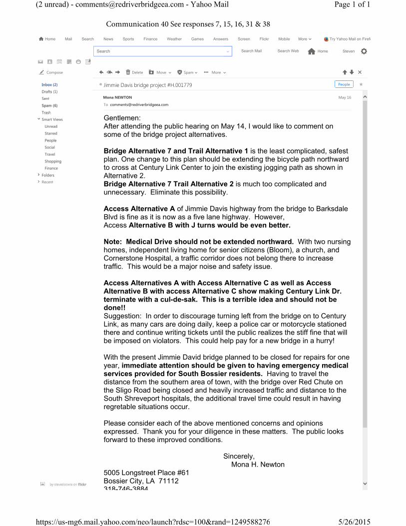
Gentlemen:After attending the public hearing on May 14, I would like to comment on some of the bridge project alternatives.
Bridge Alternative 7 and Trail Alternative 1 is the least complicated, safest plan. One change to this plan should be extending the bicycle path northward to cross at Century Link Center to join the existing jogging path as shown in Alternative 2.Bridge Alternative 7 Trail Alternative 2 is much too complicated and unnecessary. Eliminate this possibility.
Access Alternative A of Jimmie Davis highway from the bridge to Barksdale Blvd is fine as it is now as a five lane highway. However,Access Alternative B with J turns would be even better.
Note: Medical Drive should not be extended northward. With two nursing homes, independent living home for senior citizens (Bloom), a church, and Cornerstone Hospital, a traffic corridor does not belong there to increase traffic. This would be a major noise and safety issue.
Access Alternatives A with Access Alternative C as well as Access Alternative B with access Alternative C show making Century Link Dr. terminate with a cul-de-sak. This is a terrible idea and should not be done!!Suggestion: In order to discourage turning left from the bridge on to Century Link, as many cars are doing daily, keep a police car or motorcycle stationed there and continue writing tickets until the public realizes the stiff fine that will be imposed on violators. This could help pay for a new bridge in a hurry!
With the present Jimmie David bridge planned to be closed for repairs for one year, immediate attention should be given to having emergency medical services provided for South Bossier residents. Having to travel the distance from the southern area of town, with the bridge over Red Chute on the Sligo Road being closed and heavily increased traffic and distance to the South Shreveport hospitals, the additional travel time could result in having regretable situations occur.
Please consider each of the above mentioned concerns and opinions expressed. Thank you for your diligence in these matters. The public looks forward to these improved conditions.
Sincerely, Mona H. Newton
5005 Longstreet Place #61Bossier City, LA 71112318-746-3884
Mona NEWTON May 16
Jimmie Davis bridge project #H.001779 People
Delete Move Spam More Compose
Inbox (2)
Drafts (1)
Sent
Spam (6)
Trash
Smart ViewsUnread
Starred
People
Social
Travel
Shopping
Finance
FoldersRecent
Search Mail Search Web ⌂ Home Steven ⚙Search
⌂ Home Mail Search News Sports Finance Weather Games Answers Screen Flickr Mobile Try Yahoo Mail on FirefoMore⋁
1
Page 1 of 1(2 unread) - [email protected] - Yahoo Mail
5/26/2015https://us-mg6.mail.yahoo.com/neo/launch?rdsc=100&rand=1249588276
Communication 40 See responses 7, 15, 16, 31 & 38

Same format, same results.With all the experts in their fields present, how much better it would have been if they were heard either by our moving around and viewing the tentative plans and asking questions as we did prior to the talk or having them address the crowd covering their areas of expertise as opposed to a video presentation that couldn’t be read.Logic.....Why don’t the experts decide what plan works best taking all considerations into account and then try to get the money to DO IT !
May 17. 2015Nellygrace Stoll5007 Richland PlaceBossier City, LA 71112
[email protected] May 17
Presentation People
Delete Move Spam More Compose
Inbox (2)
Drafts (1)
Sent
Spam (6)
Trash
Smart ViewsUnread
Starred
People
Social
Travel
Shopping
Finance
FoldersRecent
Search Mail Search Web ⌂ Home Steven ⚙Search
⌂ Home Mail Search News Sports Finance Weather Games Answers Screen Flickr Mobile Try Yahoo Mail on FirefoMore⋁
1
Page 1 of 1(2 unread) - [email protected] - Yahoo Mail
5/26/2015https://us-mg6.mail.yahoo.com/neo/launch?rdsc=100&rand=1249588276
Communication 41 See response 40

1) Was there ever a plan to explore adding a pedestrian bridge to the existing bridge span? This should be studied, if only to rule out the possibility. 2) We have yet to be provided with a particular scope of work that will address the existing span – will this be provided prior to mobilization?3) The new bridge structure should be concrete to forego the obvious problem with metal fatigue, rust and deterioration.4) The new twolane bridge structure option will be a fantastic boon to our mobility and economic vitality, and is greatly needed.
Thank you
Roger Moore, AIA, NCARB
Project Manager / Architect
Description: ULCC_40 years
207 Milam Street, Suite C
Shreveport, Louisiana 71101
p: 318.221.0541
f: 318.221.0568
c: 318.780.7749
www.ulcoleman.com
This email and any files transmitted with it are properties of U.L. Coleman Companies and/or its affiliates, are confidential, and intended solely for the individual or entity to which this email is addressed. If you are not one of the named recipient(s) or otherwise have reason to believe you have received this message in error, please delete message immediately from your computer. Any other use, retention, dissemination, or forwarding, printing, or copying of this email is strictly prohibited.
Roger Moore May 19
This message contains blocked images. Show Images Change this setting
2 Attachments Download all
image001.jpg Downloadimage002.jpg Download
Jimmie Davis Bridge project
Delete Move Spam More Compose
Inbox (2)
Drafts (1)
Sent
Spam (6)
Trash
Smart ViewsUnread
Starred
People
Social
Travel
Shopping
Finance
FoldersRecent
Search Mail Search Web ⌂ Home Steven ⚙Search
⌂ Home Mail Search News Sports Finance Weather Games Answers Screen Flickr Mobile Try Yahoo Mail on FirefoMore⋁
1
Page 1 of 1(2 unread) - [email protected] - Yahoo Mail
5/26/2015https://us-mg6.mail.yahoo.com/neo/launch?rdsc=100&rand=1249588276
Communication 42 See Responses 1, 4, 22 & 33

1. I have enjoyed the open house public hearings concerning the Jimmie Davisbridge. They provide a way for the public to voice their concerns the renovation and modification of the bridge, and Jimmie Davis Highway.2. My recommendation concerning this project is; Bridge Alternative 7 and TrailAlternative 1. This makes for the best and effective bike path, cloverleaf entrances and exits of the highway on both sides of the river.3. My recommendation of the Jimmie Davis Highway in Bossier City is using:Access Alternative A (5 Lane). This provides for the best routing of the highway, access roads, entrances to businesses, housing developments, and churches. This leaves the existing highway superstructure as is, but with improved traffic flow.
Feedback provided on Monday, May 18, 2015Stanley R. Clark2112 Kirby Smith DriveBossier City, LA 71112(318) [email protected]
Stanley R. Clark May 18
Red River Bridge at Jimmie Davis Highway People
Delete Move Spam More Compose
Inbox (2)
Drafts (1)
Sent
Spam (6)
Trash
Smart ViewsUnread
Starred
People
Social
Travel
Shopping
Finance
FoldersRecent
Search Mail Search Web ⌂ Home Steven ⚙Search
⌂ Home Mail Search News Sports Finance Weather Games Answers Screen Flickr Mobile Try Yahoo Mail on FirefoMore⋁
1
Page 1 of 1(2 unread) - [email protected] - Yahoo Mail
5/26/2015https://us-mg6.mail.yahoo.com/neo/launch?rdsc=100&rand=1249588276
Communication 43 See responses 10, 16 & 39

May 19,2015
I attended the public meeting on Thursday, May 14,2015. After reviewing the alternatives offered, I believe Bridge Alternative 7 and Trail Alternative 1 is the best alternative.
Roxie Tabor1423 Magnolia Ridge Bossier City, Louisiana 71112
Sent from my iPad
Roxie Tabor May 19
Red River Bridge at Jimmie Davis Highway People
Delete Move Spam More Compose
Inbox (2)
Drafts (1)
Sent
Spam (6)
Trash
Smart ViewsUnread
Starred
People
Social
Travel
Shopping
Finance
FoldersRecent
Search Mail Search Web ⌂ Home Steven ⚙Search
⌂ Home Mail Search News Sports Finance Weather Games Answers Screen Flickr Mobile Try Yahoo Mail on FirefoMore⋁
1
Page 1 of 1(2 unread) - [email protected] - Yahoo Mail
5/26/2015https://us-mg6.mail.yahoo.com/neo/launch?rdsc=100&rand=1249588276
Communication 44 See Response 16

Add a sister span to the Jimmie Davis Bridge. Give it extra capacity for bicycles/pedestrians.
I’m also ready for the new I-69 Red River Bridge. Both are greatly needed.
Having the Jimmie Davis Bridge down for rehabilitation for a whole year will have devastating effects to the area. I wish there was a better solution.
Jason Dobbins
Jason Dobbins May 20 at 2:45 PM
Jimmie Davis Bridge Comment
Delete Move Spam More Compose
Inbox (2)
Drafts (1)
Sent
Spam (6)
Trash
Smart ViewsUnread
Starred
People
Social
Travel
Shopping
Finance
FoldersRecent
Search Mail Search Web ⌂ Home Steven ⚙Search
⌂ Home Mail Search News Sports Finance Weather Games Answers Screen Flickr Mobile Try Yahoo Mail on FirefoMore⋁
1
Page 1 of 1(2 unread) - [email protected] - Yahoo Mail
5/26/2015https://us-mg6.mail.yahoo.com/neo/launch?rdsc=100&rand=1249588276
Communication 45 See Responses 1, 19 & 30
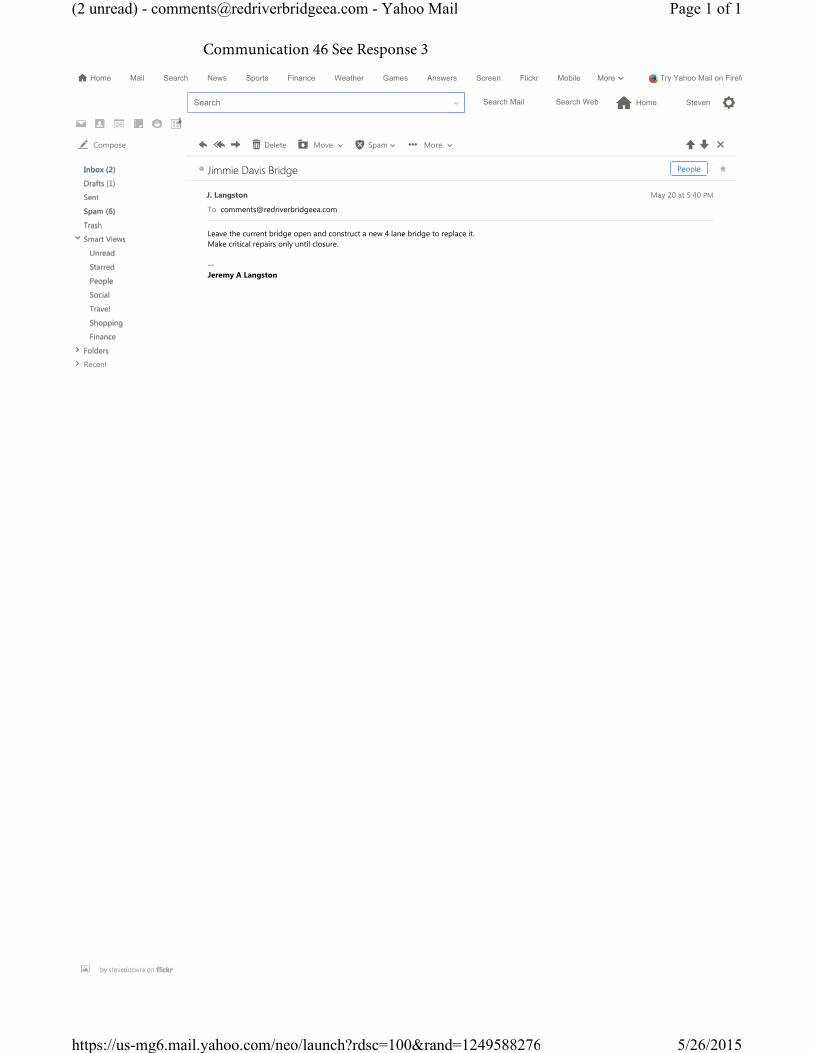
Leave the current bridge open and construct a new 4 lane bridge to replace it.Make critical repairs only until closure.
-- Jeremy A Langston
J. Langston May 20 at 5:40 PM
Jimmie Davis Bridge People
Delete Move Spam More Compose
Inbox (2)
Drafts (1)
Sent
Spam (6)
Trash
Smart ViewsUnread
Starred
People
Social
Travel
Shopping
Finance
FoldersRecent
Search Mail Search Web ⌂ Home Steven ⚙Search
⌂ Home Mail Search News Sports Finance Weather Games Answers Screen Flickr Mobile Try Yahoo Mail on FirefoMore⋁
1
Page 1 of 1(2 unread) - [email protected] - Yahoo Mail
5/26/2015https://us-mg6.mail.yahoo.com/neo/launch?rdsc=100&rand=1249588276
Communication 46 See Response 3

As a residential contractor in Shreveport Bossier and resident of South Bossier, I strongly agree with adding an additional bridge for access between Shreveport and Bossier. Most future development is limited to the north and south at this time. The main access from Shreveport to Bossier from the north is by I-20, I-220 or the Texas Street Bridge which seems to be able to accommodate the traffic at this time. With the commercial development in North Bossier, there is not a tremendous demand to travel from North Bossier to Shreveport for many reasons beyond employment. However, with the future residential development possibilities in South Bossier and the amount of commercial development in South Shreveport, there is a tremendous demand for travel to and from South Shreveport from South Bossier. Although North Bossier is an option, it is not a viable option due to the existing traffic issues on Airline Drive. Airline Drive is congested as it is, much less adding more traffic from South Bossier. With future residential development anticipated both in South Bossier and South Shreveport I can only see the traffic counts getting higher for the Jimmie Davis Bridge. Please strongly consider adding an additional bridge so that growth in the only areas that are left to develop in the south part of these towns can continue at the appropriate pace. Thanks for allowing our input.
Jeff Hudson3184559052
Jeff Hudson May 20 at 9:11 PM
Jimmie Davis bridge addition People
Delete Move Spam More Compose
Inbox (2)
Drafts (1)
Sent
Spam (6)
Trash
Smart ViewsUnread
Starred
People
Social
Travel
Shopping
Finance
FoldersRecent
Search Mail Search Web ⌂ Home Steven ⚙Search
⌂ Home Mail Search News Sports Finance Weather Games Answers Screen Flickr Mobile Try Yahoo Mail on FirefoMore⋁
1
Page 1 of 1(2 unread) - [email protected] - Yahoo Mail
5/26/2015https://us-mg6.mail.yahoo.com/neo/launch?rdsc=100&rand=1249588276
Communication 47 See Response 1

Trail alternative 1, please.
Thanks,
Jeremy Gilbert
Jeremy Gilbert May 21 at 9:33 PM
Jimmie Davis Bridge Project People
Delete Move Spam More Compose
Inbox (1)
Drafts (1)
Sent
Spam (6)
Trash
Smart ViewsUnread
Starred
People
Social
Travel
Shopping
Finance
FoldersRecent
Search Mail Search Web ⌂ Home Steven ⚙Search
⌂ Home Mail Search News Sports Finance Weather Games Answers Screen Flickr Mobile Try Yahoo Mail on FirefoMore⋁
1
Page 1 of 1(1 unread) - [email protected] - Yahoo Mail
5/26/2015https://us-mg6.mail.yahoo.com/neo/launch?rdsc=100&rand=1249588276
Communication 48 See response 16
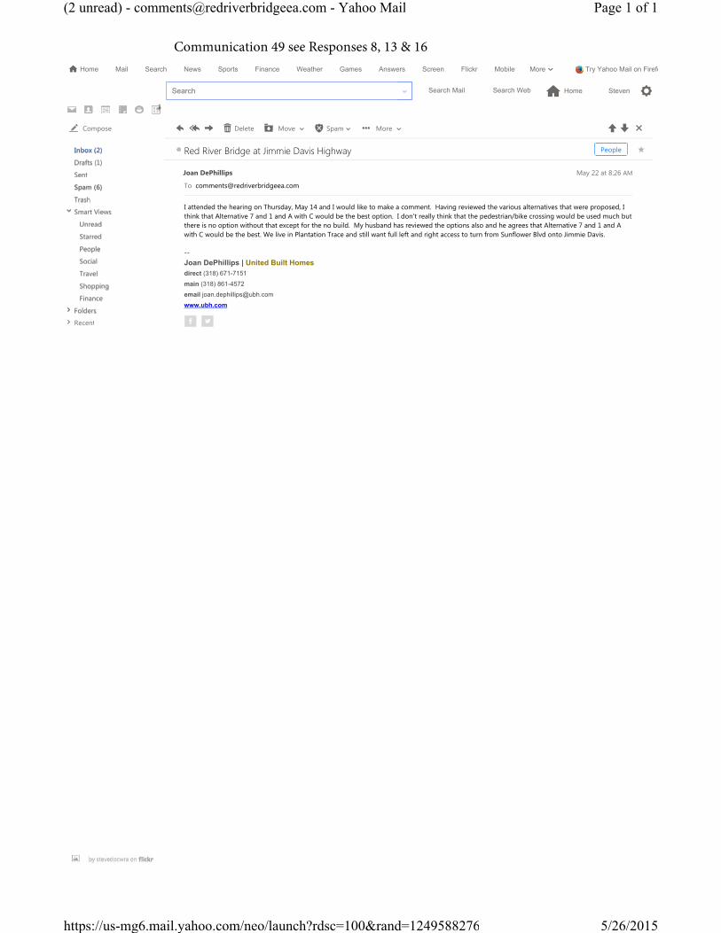
Joan DePhillips | United Built Homesdirect (318) 671-7151
main (318) 861-4572
email [email protected]
www.ubh.com
I attended the hearing on Thursday, May 14 and I would like to make a comment. Having reviewed the various alternatives that were proposed, I think that Alternative 7 and 1 and A with C would be the best option. I don't really think that the pedestrian/bike crossing would be used much but there is no option without that except for the no build. My husband has reviewed the options also and he agrees that Alternative 7 and 1 and A with C would be the best. We live in Plantation Trace and still want full left and right access to turn from Sunflower Blvd onto Jimmie Davis.
--
Joan DePhillips May 22 at 8:26 AM
Red River Bridge at Jimmie Davis Highway People
Delete Move Spam More Compose
Inbox (2)
Drafts (1)
Sent
Spam (6)
Trash
Smart ViewsUnread
Starred
People
Social
Travel
Shopping
Finance
FoldersRecent
Search Mail Search Web ⌂ Home Steven ⚙Search
⌂ Home Mail Search News Sports Finance Weather Games Answers Screen Flickr Mobile Try Yahoo Mail on FirefoMore⋁
1
Page 1 of 1(2 unread) - [email protected] - Yahoo Mail
5/26/2015https://us-mg6.mail.yahoo.com/neo/launch?rdsc=100&rand=1249588276
Communication 49 see Responses 8, 13 & 16

I'm Very pleased with the plans for a new bridge & access! I like the bridge alternative 7 and trail alternative 2. For the Access alternative I think the Boulevard plan B would be the best for ease of Flow and Please keep the century link access Open. Thank Yall for your hard work on these plans we Really Appreciate it!
victor Griffing May 23 at 11:06 AM
Jimmie Davis Bridge People
Delete Move Spam More Compose
Inbox (2)
Drafts (1)
Sent
Spam (6)
Trash
Smart ViewsUnread
Starred
People
Social
Travel
Shopping
Finance
FoldersRecent
Search Mail Search Web ⌂ Home Steven ⚙Search
⌂ Home Mail Search News Sports Finance Weather Games Answers Screen Flickr Mobile Try Yahoo Mail on FirefoMore⋁
1
Page 1 of 1(2 unread) - [email protected] - Yahoo Mail
5/26/2015https://us-mg6.mail.yahoo.com/neo/launch?rdsc=100&rand=1249588276
Communication 50 See Responses 7 & 17

In reference to the Jimmie Davis Hwy. Bridge Project over the Red River, I implore you to please consider any alternative that will not close the bridge entirely for any extended period of time.
As both a homeowner & owner of multiple businesses’ in S. Bossier I can tell you with absolute surety, with this bridge being the major of only 2 arteries to the area from the primary populace, any lengthy, complete closure would be disastrous.Not only would this cause severe financial difficulty for businesses in the area, many of which are already struggling, reversing any plans to increase the tax base, but would put an undue strain on other detour routes not designed for the traffic volume, causing many more issues in the future.I firmly believe the many issues, current & in the future, will far outweigh future benefit.
Thank you for your time.
Regards,
Sean H. McInnis205 Radbrook Dr.Bossier City, La. 71112(318) 549-3591
SMC-CLEANEST-
Sean H. Mc.Product Design & Development
M-CatMetrics Control Automation Technology Group, LLC.
A wholly-owned subsidiary of RMC P.C. & f, Inc.
P. (800) 523-4055P. (318) 747-0444F. (318) 747-0645E. [email protected]: www.issuu.com/RMCProcessControls
S.Mc. May 24 at 12:18 PM
This message contains blocked images. Show Images Change this setting
2 Attachments Download all
image005.jpg Downloadimage006.png Download
Red River at Jimmie Davis Hwy. EA Bridge Project People
Delete Move Spam More Compose
Inbox (2)
Drafts (1)
Sent
Spam (6)
Trash
Smart ViewsUnread
Starred
People
Social
Travel
Shopping
Finance
FoldersRecent
Search Mail Search Web ⌂ Home Steven ⚙Search
⌂ Home Mail Search News Sports Finance Weather Games Answers Screen Flickr Mobile Try Yahoo Mail on FirefoMore⋁
1
Page 1 of 1(2 unread) - [email protected] - Yahoo Mail
5/26/2015https://us-mg6.mail.yahoo.com/neo/launch?rdsc=100&rand=1249588276
Communication 51 See Responses 28 & 30

May 24, 2015
RE: Red River Bridge at Jimmie Davis HighwayRoute La 511
To whom it may concern:
Please see attached letter in response to the open house public hearing on May 14, 2005 in Bossier City, Louisiana.
Thank you,
Maynard Dean
M Dean May 24 at 7:19 PM
RED RIVER BRIDGE … .pdf DownloadView
Red River Bridge at Jimmie Davis Highway EA People
Delete Move Spam More Compose
Inbox (2)
Drafts (1)
Sent
Spam (6)
Trash
Smart ViewsUnread
Starred
People
Social
Travel
Shopping
Finance
FoldersRecent
Search Mail Search Web ⌂ Home Steven ⚙Search
⌂ Home Mail Search News Sports Finance Weather Games Answers Screen Flickr Mobile Try Yahoo Mail on FirefoMore⋁
1
Page 1 of 1(2 unread) - [email protected] - Yahoo Mail
5/26/2015https://us-mg6.mail.yahoo.com/neo/launch?rdsc=100&rand=1249588276
Communication 52 See Responses 8, 14, 26 & 34

May 24, 2015
RED RIVER BRIDGE AT JIMMIE DAVIS HIGHWAY EA PO Box 56845 New Orleans, La
RE: Open House Public Hearing May 14, 2015
To Whom It May Concern:
The 600 plus residents south of Hwy 511 mostly utilize Sunflower Blvd to access the Jimmie Davis Bridge. This is the only safe outlet for the 600 families. Sunflower Blvd at Hwy 511 Right Turn Only option would cause more residents to consider using the very hazardous crossing at Sunflower Road & Hwy 71. The Sunflower Road at Hwy 71 would need some type of safety improvements. Extending Sunflower Road to the parkway, although controversial, would provide additional traffic relief.
The first U-turn on Hwy 511 east of Sunflower Blvd. requires Sunflower Blvd. traffic to merge first into the right eastbound lane of Hwy 511, by that time they are halfway to the first U-turn and only have 3 or 4 seconds to merge into the left lane which may already be full of vehicles waiting for the U-turn signal. The motorist can then proceed to the second U-turn. This motorist will then be at the Hwy 71 intersection. This scenario will cause some motorist to consider using the Sunflower Road at Hwy 71 intersection since they end up at Hwy 71 anyway.
Unfortunately an improvement at Sunflower Road and Hwy 71 would most likely require another right turn only situation. This is not a full intersection so it most likely would not be given a signal.
Attempting to quickly merge across two lanes of traffic is not as safe as a signal crossing. The new standard of utilizing U-turns does enhance traffic flow, however in this situation the resultant safety issues must be proactively considered.
A left turn allowed traffic signal at Sunflower Blvd & Hwy 511 would impede traffic flow to and from the bridge. I support improvements to Hwy 511 that will enhance traffic flow as long as all safety concerns are addressed. I support the U-turn standard which if utilized, living in the Sunflower Place Subdivision I would travel less distance to the bridge by taking the Sunflower Road to Hwy 71 route. I would prefer to not take that route due to the safety of the intersection.
I support the following:
Bridge Alternative 7, Trail Alternative 1 Access Alternative B with Access Alternative C (Century Link Modifications)
Another item I would like to be considered is when this bridge is built please paint both bridges yellow. I voted for yellow on the existing bridge. I have seen yellow bridges and they look great. I voted for yellow to represent Jimmie Davis and his “You Are My Sunshine” song. The yellow can be called “Sunshine Yellow” in honor of Jimmie Davis. Purple unfortunately is not really a good color for a bridge. It is too gaudy and dark and would look black at night. Yellow would also light up nicely from the street lights.
Thank you,
Maynard H. Dean 201 Radbrook Drive Bossier City, La. 71112
Communication 52 continued

Communication 52 continued

This page intentionally left blank

CROSS-REFERENCE TABLES


1
Table C-1 Cross-reference of the Comment Communications to the Responses
Communication ID Number
Comment / Response ID
Number Comment Comment
Frequency
1 2 Build new bridge before closing existing bridge for rehabilitation.
6
27 Recommends/supports tolls 2 29 Cites potential adverse environmental impacts of
closing existing bridge prior to constructing new bridge
1
2 2 Build new bridge before closing existing bridge for rehabilitation.
6
3 9 Prefers Access Alternative B with Access Alternative C
5
4 16 Prefers Trail Alternative 1 16 5 16 Prefers Trail Alternative 1 16 6 10 Prefers Access Alternative A; no comment on
Access Alternative C 3
16 Prefers Trail Alternative 1 16 7 1 Support new bridge 98 1 Support new bridge 99 8 Prefers Access Alternative A with Access
Alternative C 4
16 Prefers Trail Alternative 1 16 10 12 Prefers Access Alternative C; no comment on
Access Alternatives A or B 2
23 Indicates that A or B without C would adversely impact his dental office.
1
11 31 Asks that attention be given to medical emergencies in light of bridge closure.
2
12 12 Prefers Access Alternative C; no comment on Access Alternatives A or B
2
17 Prefers Trail Alternative 2 4 13 10 Prefers Access Alternative A; no comment on
Access Alternative C 3
13 Opposes Access Alternative B 2 16 Prefers Trail Alternative 1 16
14 2 Build new bridge before closing existing bridge for rehabilitation.
6
20 Opposes Trail Alternatives 1 15 9 Prefers Access Alternative B with Access
Alternative C 5
16 Prefers Trail Alternative 1 16 35 Requests separate lanes for pedestrians and
bicycles. 1
16 2 Build new bridge before closing existing bridge for rehabilitation.
6
17 2 Build new bridge before closing existing bridge for rehabilitation.
6
18 9 Prefers Access Alternative B with Access Alternative C
5
16 Prefers Trail Alternative 1 16 19 9 Prefers Access Alternative B with Access 9

2
Communication ID Number
Comment / Response ID
Number Comment Comment
Frequency
Alternative C 16 Prefers Trail Alternative 1 16 35 Asks that VISSIM be posted on DOTD website 4
20 8 Prefers Access Alternative A with Access Alternative C
4
16 Prefers Trail Alternative 1 16 21 24 Complete the Arthur Ray Teague / Jimmie Davis
interchange with or without new bridge 1
25 Remove signals from Century Link Drive and Sunflower Boulevard
1
22 7 Prefers Access Alternative B without Access Alternative C
4
16 Prefers Trail Alternative 1 16 27 Recommends/supports tolls 2
23 35 Asks that VISSIM be posted on DOTD website 4 24 7 Prefers Access Alternative B without Access
Alternative C 4
9 Prefers Access Alternative B with Access Alternative C
5
17 Prefers Trail Alternative 2 4 25 35 Asks that VISSIM be posted on DOTD website 4
36 Asks that the VISSIM be e-mailed to him 1 26 11 Prefers Access Alternative B; no comment on
Access Alternative C 2
17 Prefers Trail Alternative 2 4 27 5 Prefers steel construction option 1
6 Prefers Access Alternative A without Access Alternative C
1
16 Prefers Trail Alternative 1 16 18 Finds Trail Alternative 2 to be contrary to ADA 1
28 41 No Message 1 29 42 USFWS has no comment. 1 30 1 Support new bridge 9 31 28 Opposes closing existing bridge for lengthy period
of time. 2
37 Objects to the time taken by meetings when there is no funding for project that is discussed.
1
32 19 Supports Trail Alternatives. 6 33 1 Support new bridge 9
32 Requests that bridge not be painted purple. 1 34 1 Support new bridge 9 35 19 Supports Trail Alternatives. 6
21 Requests separate lanes for pedestrians and bicycles.
1
36 2 Build new bridge before closing existing bridge for rehabilitation.
6
30 Cites potential adverse economic impacts of closing existing bridge prior to constructing new bridge
3
37 19 Supports Trail Alternatives. 6 38 1 Support new bridge 9
19 Supports Trail Alternatives. 6

3
Communication ID Number
Comment / Response ID
Number Comment Comment
Frequency
39 19 Supports Trail Alternatives. 6 40 7 Prefers Access Alternative B without Access
Alternative C 4
15 Opposes Access Alternative C. 1 16 Prefers Trail Alternative 1 16 31 Asks that attention be given to medical emergencies
in light of bridge closure. 2
41 40 Opposes open house format and use of video presentation for Hearing
41
42 1 Support new bridge 9 4 Prefers concrete construction option. 1 22 Asks that DOTD study the addition of a trail to
existing bridge. 1
33 Requests scope of work for existing bridge prior to project mobilization
1
43 10 Prefers Access Alternative A; no comment on Access Alternative C
3
16 Prefers Trail Alternative 1 16 39 Enjoys open house format 1
44 16 Prefers Trail Alternative 1 16 45 1 Support new bridge 9
19 Supports Trail Alternatives. 6 30 Cites potential adverse economic impacts of closing
existing bridge prior to constructing new bridge 3
46 3 Build new 4 lane bridge 1 47 1 Support new bridge 9 48 16 Prefers Trail Alternative 1 16 49 8 Prefers Access Alternative A with Access
Alternative C 4
13 Opposes Access Alternative B 2 16 Prefers Trail Alternative 1 16
50 7 Prefers Access Alternative B without Access Alternative C
4
17 Prefers Trail Alternative 2 4 51 28 Opposes closing existing bridge for lengthy period
of time. 2
30 Cites potential adverse economic impacts of closing existing bridge prior to constructing new bridge
3
52 8 Prefers Access Alternative A with Access Alternative C
4
14 Supports Access Alternative B, but has concern that U-turn from Sunflower to bridge will increase use of the Sunflower / US 71 intersection that is dangerous.
1
26 Prefers that both bridges be painted yellow. 1
34

4
Table C-2 Cross-reference of the Responses to the Comment Communications
Comment / Response ID
Number Communication
ID Number Comment Comment Frequency
1 7, 8, 30, 33, 34, 38, 42, 45, 47
Support new bridge 9
2 1, 2, 14, 16, 17, 36
Build new bridge before closing existing bridge for rehabilitation.
6
3 46 Build new 4 lane bridge 1 4 42 Prefers concrete construction option. 1 5 27 Prefers steel construction option 1 6 27 Prefers Access Alternative A without Access
Alternative C 1
7 22, 24, 40, 50 Prefers Access Alternative B without Access Alternative C
4
8 9, 20, 49, 52 Prefers Access Alternative A with Access Alternative C
4
9 3, 15, 18, 19, 24 Prefers Access Alternative B with Access Alternative C
5
10 6, 13, 43 Prefers Access Alternative A; no comment on Access Alternative C
3
11 4; 26 Prefers Access Alternative B; no comment on Access Alternative C
2
12 10, 12 Prefers Access Alternative C; no comment on Access Alternatives A or B
2
13 13, 49 Opposes Access Alternative B 2 14 52 Supports Access Alternative B, but has concern that
U-turn from Sunflower to bridge will increase use of the Sunflower / US 71 intersection that is dangerous.
1
15 40 Opposes Access Alternative C. 1 16 4, 5, 6, 9, 13, 15,
18;19; 20, 22; 27, 40, 43, 44, 48, 49
Prefers Trail Alternative 1 16
17 12, 24, 26, 50 Prefers Trail Alternative 2 4 18 27 Finds Trail Alternative 2 to be contrary to ADA 1 19 32, 35, 37, 38,
39, 45 Supports Trail Alternatives.
6
20 14 Opposes Trail Alternatives 1 21 35 Requests separate lanes for pedestrians and
bicycles. 1
22 42 Asks that DOTD study the addition of a trail to existing bridge.
1
23 10 Indicates that A or B without C would adversely impact his dental office.
1
24 21 Complete the Arthur Ray Teague / Jimmie Davis interchange with or without new bridge
1
25 21 Remove signals from Century Link Drive and Sunflower Boulevard
1
26 52 Prefers that both bridges be painted yellow. 1 27 1, 22 Recommends/supports tolls 2 28 31, 51 Opposes closing existing bridge for lengthy period
of time. 2

5
Comment / Response ID
Number
Communication ID Number Comment Comment
Frequency
29 1 Cites potential adverse environmental impacts of closing existing bridge prior to constructing new bridge
1
30 36,45, 51 Cites potential adverse economic impacts of closing existing bridge prior to constructing new bridge
3
31 11, 40 Asks that attention be given to medical emergencies in light of bridge closure.
2
32 33 Requests that bridge not be painted purple. 1 33 42 Requests scope of work for existing bridge prior to
project mobilization 1
34 52 Prefers that both bridges be painted yellow. 1 35 35, 19, 23, 25 Asks that VISSIM be posted on DOTD website 4 36 25 Asks that the VISSIM be e-mailed to him 1 37 31 Objects to the time taken by meetings when there is
no funding for project that is discussed. 1
38 40 Opposes northward extension of Medical Drive because of safety and noise impacts on adjacent land uses.
1
39 43 Enjoys open house format 1 40 41 Opposes open house format and use of video
presentation for Hearing 1
41 28 No Message 1 42 29 USFWS has no comment. 1

This page intentionally left blank

1
RESPONSES TO COMMENTS

2
Responses to Public Hearing Comments
Responses to Comments regarding the Proposed Build Alternatives
1. Support new bridge – Comment Noted.2. Build new bridge before closing existing bridge for rehabilitation. - This scenario is not
financially feasible; currently, funding for the new 2-lane bridge is not available and theconstruction contract for the Rehabilitation Project is underway.
3. Build new 4 lane bridge - The Build Alternatives evaluated in this EA were developedfollowing receipt in August 2013 of agency and public comments on the Stage 0 BuildAlternatives and were confirmed by DOTD in December 2013. Later, in 2014, DOTDinitiated State Project No. 010662, LA 511 Jimmie Davis Bridge Rehabilitation. It willimprove the existing bridge to extend its useful life for an estimated 30 years.
The rehabilitation project results from a separate study that was underway at the time thatthis EA was initiated. Because the viability and magnitude of the rehabilitation project hadnot yet been determined, the scope of this EA was to objectively evaluate the long termviability of the existing bridge; it was not to assume that, because it may be rehabilitated tosome extent, the DOTD was determined to retain the structure.
Due to the substantial investment into the existing bridge being made through therehabilitation project, FHWA and DOTD have determined that Bridge Build Alternative 5 isno longer under consideration under this NEPA action
4. Prefers concrete construction option. - Comment noted; the decision on the constructionoption will be made during final design.
5. Prefers steel construction option - Comment noted; the decision on the construction optionwill be made during final design.
6. Prefers Access Alternative A without Access Alternative C – Comment noted.7. Prefers Access Alternative B without Access Alternative C– Comment noted.8. Prefers Access Alternative A with Access Alternative C– Comment noted.9. Prefers Access Alternative B with Access Alternative C– Comment noted.10. Prefers Access Alternative A; no comment on Access Alternative C– Comment noted.11. Prefers Access Alternative B; no comment on Access Alternative C– Comment noted.12. Prefers Access Alternative C; no comment on Access Alternatives A or B– Comment noted.13. Opposes Access Alternative B– Comment noted.14. Supports Access Alternative B, but has concern that U-turn from Sunflower to bridge will
increase use of the Sunflower / US 71 intersection that is dangerous. - Access Alternative Bmeets the requirements of current geometric design criteria. – Comment noted.
15. Opposes Access Alternative C. – Comment noted.16. Prefers Trail Alternative 1– Comment noted.17. Prefers Trail Alternative 2– Comment noted.18. Finds Trail Alternative 2 to be contrary to ADA - Trail Alternative 2 is an integral element of
the roadway bridge. A sidewalk or trail constructed as an accessory use to a structure witha different primary purpose is normally exempt from the requirements of ADA.Notwithstanding this exemption, the trail would have a slope of 4.5 percent, which is withinthe permitted ADA limit of 5 percent. Without a specific example of the perceived conflict,no further response is possible.
19. Supports Trail Alternatives- Comment noted.20. Opposes Trail Alternatives - The inclusion of a trail is an integral element of the project
found in the Purpose and Need. It is incorporated in the transportation plans of both localjurisdictions and the regional transportation plan.
3
21. Requests separate lanes for pedestrians and bicycles. - This option may be considered during final design; however, it would add substantial construction cost to the project as it would increase the width of the trail.
22. Asks that DOTD study the addition of a trail to existing bridge. - This consideration would be outside the scope of this Environmental Assessment because all alternatives provided by the project Stage 0 Feasibility Study located the trail on a new bridge and because this requested concept was not raised during the information meeting comment period prior to the determination of the alternatives to be considered.
23. Indicates that A or B without C would adversely impact his dental office. - It is accurate that Access Alternative A or Access Alternative B without Access Alternative C, which is proposed to mitigate the impacts to the access to various properties including Dr. Culliton’s office.
24. Complete the Arthur Ray Teague / Jimmie Davis interchange with or without new bridge - Constructing the ramps that would provide the needed movements without additional capacity on the bridge may improve traffic operations. However, this construction would not be feasible as it would require that portions of the westbound entrance ramp to the bridge and from LA 511 to the Parkway would require demolition and reconstruction whenever a new bridge would be constructed.
25. Remove signals from Century Link Drive and Sunflower Boulevard - All 4 Access Alternatives proposed (A, A and C, B, and B and C) all remove the signal at Century Link Drive. Alternative B eliminates the signal at Sunflower for westbound traffic on LA 511. It would not be feasible to eliminate the signal entirely at that location.
26. Prefers that both bridges be painted yellow. - Comment noted; the decision on paint color will be made during final design
Responses to Comments regarding Funding
27. Recommends/supports tolls - This concept can be considered in the future, but would require additional study under NEPA.
Responses to Comments regarding the Rehabilitation Project
28. Opposes closing existing bridge for lengthy period of time. – This is outside the scope of this project.
29. Cites potential adverse environmental impacts of closing existing bridge prior to constructing new bridge. – This is outside the scope of this project.
30. Cites potential adverse economic impacts of closing existing bridge prior to constructing new bridge. – This is outside the scope of this project.
31. Asks that attention be given to medical emergencies in light of bridge closure. . – This is outside the scope of this project.
32. Requests that bridge not be painted purple. . – This is outside the scope of this project. 33. Requests scope of work for existing bridge prior to project mobilization. – This is outside the
scope of this project. 34. Prefers that both bridges be painted yellow. - This is outside the scope of this project relative
to the Rehabilitation project. . – This is outside the scope of this project.
Responses to Comments regarding Other Issues
35. Asks that VISSIM traffic simulation be posted on DOTD website - The VISSIM traffic simulation was placed on the DOTD site on May 28, 2015.
36. Asks that the VISSIM be e-mailed to their address - As the size of the file made this infeasible, the link to the DOTD website was sent to commenter.

4
37. Objects to the time taken by meetings when there is no funding for project that is discussed. - Public Meetings and Hearings are required steps under NEPA, which, itself, is a required step in project development if the use of federal funds, or the need for a federal permit, are anticipated.
38. Opposes northward extension of Medical Drive because of safety and noise impacts on adjacent land uses. - No northward extension of Medical Drive is proposed.
39. Enjoys open house format - Comment noted. 40. Opposes open house format and use of video presentation for Hearing - Comment noted. 41. No Message - No Response.
Agency Comments
42. USFWS has no comment. - Comment noted.

This page intentionally left blank
Copyright © 2022 FDOKUMEN