Public Comments on the Draft Prospectus of Panther Tyres ...
Upload
khangminh22Category
view
3download
0
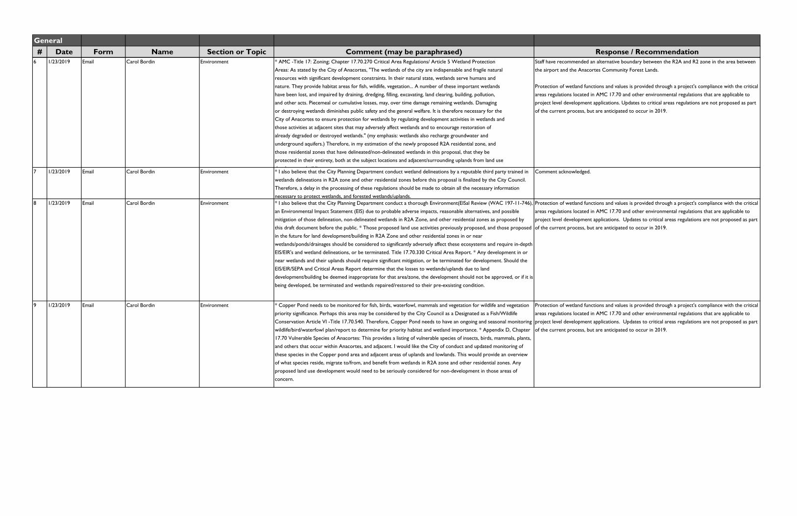
Public Comments on THIRD DRAFT Anacortes Muncipal Code Title 19Planning Commission / 3rd Draft Developoment Regulations made public on 12/18/2018
Note:The public comments within this document pertain to the 3rd Draft of the proposed development regulations update, and were received between December 18, 2018 and February 13, 2019.
Comments may be paraphrased or summarized for brevity.
Updated 4/2/19
General# Date Form Name Section or Topic Comment (may be paraphrased) Response / Recommendation
1 1/4/2019 Email Cynthia Richardson Generally In general, I would like to commend the staff and consultant team for incorporating many of the changes from the
previous draft that were requested by the Planning Commission or suggested by citizens. The sign section is much
simpler, and many specific concerns have been addressed. Putting illustrations such as setback diagrams right in the
definitions section so they're easy to find is helpful. Site Plan Review is a good addition to the code to assist early
planning of a project. Tables that have a column telling specifically which section to refer to for details and exceptions
are VERY useful. This saves a lot of searching around for the correct reference. Following are comments on specific
code issues that still remain unresolved or need fine tuning: [specific comments provided by author are located
elsewhere in the public comment matrix]
Comment acknowledged.
2 1/16/2019 Email Rosann Wuebbels Walkability and livability A liveable city can be denser but it also MUST be walkable, bikeable ( particularly if you are reducing off street parking
minimum) and room for some greenery. If we are truly addressing the affordable housing shortage, we NEED small
homes. I oppose huge house footprints on small lot sizes. No increase on maximum lot coverage. If folks need a
bigger house, they need a bigger lot to go with it. It's about time our local developers got creative and built some well
thought out small homes. Make accomadations for walkers and bicyclists. My final comment is the MJB property
should remain in a marine only zoning.
Comment acknowledged.
3 1/21/2019 PDF letter Brom Wikstrom Art museum proposal My wife and I purchased property next to the public library on 10th Street. I'm proposing the City consider
establishing an Art Museum to enhance the "Cultural Corridor" that exists with the nearby Playhouse and Historical
Museum. We hope to donate the property and our art collection to the City of Anacortes. Sucessful art museums
are often located outside the main urban centers and within scenic destinations, and are often embraced as an
economic driver among partnering business communities. The next link in this chain is in your hands. [Attached file is
prospectus for Art Museum of Puget Sound.]
Comment acknowledged. Staff have recommended removing museums from permitted uses in
residential zones.
4 1/22/2019 Scanned letter Dara Grotte Affordable housing When I moved here there was a mobile home park on Oaks. It was replaced by pricey houses. Now there are
complaints how about the lack of low cost housing. I used to be able to drive around without problem, now I dread
going out. Commercial is always wall to wall with cars. You used to find people, often elderly, going 25 mph on Oaks,
even in the area that used to be 40 mph. If you try doing that anymore you will get people riding your butt like mad.
You are pleasing newcomers at the expense of those that already live here. And you have changed the character of
Anacortes as a result. Houses in my neighborhood are selling for nearly half a million dollars. And my neighborhood
was low cost housing when I moved here. If I could afford to move I may well have been gone by now.
Comment acknowledged.
5 1/23/2019 Email Joe and Cindy Barnes Development proposal It is amazing that Ms. Farah Aly continues to propose zoning changes for a painfully obvious misbegotten suggested
usage. She continues to hope for some salvation from a bad investment that was made years ago. There are so many
reasons for the City to not approve this. Parking, traffic, DNR issues, and many others are just some of them, not to
mention that her proposals have never made economic sense from a business perspective and will with out a doubt
lead to a bankruptcy and failure which might require a City bailout. The upgrades, and removal of non-conforming
structure in DNR controlled waters, to the pier and surrounding structures and the necessity to provide better two
way access and probably fire truck and emergency vehicle access should be deal killers at the very least. One of the
previous proposals asked for the City to buy the property or otherwise have to finance the project, all to salvage this
white elephant. This proposal does not deserve even a preliminary review by the City, using more of our precious
tax dollars. I urge you to reject this proposal at the soonest. I understand the City has proven to be willing to do
almost anything to get the rights to the land for the Guemes Channel trail but this proposal is not worth it.
No changes recommended.
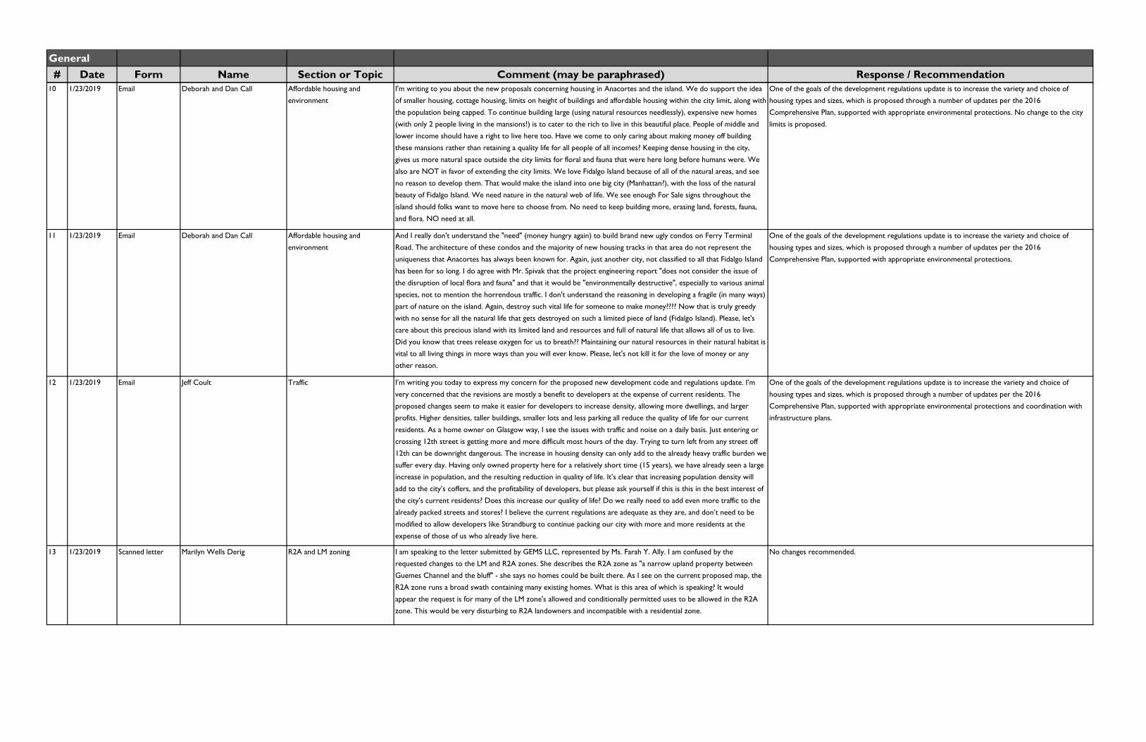
General# Date Form Name Section or Topic Comment (may be paraphrased) Response / Recommendation
6 1/23/2019 Email Carol Bordin Environment * AMC -Title 17: Zoning; Chapter 17.70.270 Critical Area Regulations/ Article 5 Wetland Protection
Areas: As stated by the City of Anacortes, "The wetlands of the city are indispensable and fragile natural
resources with significant development constraints. In their natural state, wetlands serve humans and
nature. They provide habitat areas for fish, wildlife, vegetation... A number of these important wetlands
have been lost, and impaired by draining, dredging, filling, excavating, land clearing, building, pollution,
and other acts. Piecemeal or cumulative losses, may, over time damage remaining wetlands. Damaging
or destroying wetlands diminishes public safety and the general welfare. It is therefore necessary for the
City of Anacortes to ensure protection for wetlands by regulating development activities in wetlands and
those activities at adjacent sites that may adversely affect wetlands and to encourage restoration of
already degraded or destroyed wetlands." (my emphasis: wetlands also recharge groundwater and
underground aquifers.) Therefore, in my estimation of the newly proposed R2A residential zone, and
those residential zones that have delineated/non-delineated wetlands in this proposal, that they be
protected in their entirety, both at the subject locations and adjacent/surrounding uplands from land use
d l b ildi
Staff have recommended an alternative boundary between the R2A and R2 zone in the area between
the airport and the Anacortes Community Forest Lands.
Protection of wetland functions and values is provided through a project's compliance with the critical
areas regulations located in AMC 17.70 and other environmental regulations that are applicable to
project level development applications. Updates to critical areas regulations are not proposed as part
of the current process, but are anticipated to occur in 2019.
7 1/23/2019 Email Carol Bordin Environment * I also believe that the City Planning Department conduct wetland delineations by a reputable third party trained in
wetlands delineations in R2A zone and other residential zones before this proposal is finalized by the City Council.
Therefore, a delay in the processing of these regulations should be made to obtain all the necessary information
necessary to protect wetlands, and forested wetlands/uplands.
Comment acknowledged.
8 1/23/2019 Email Carol Bordin Environment * I also believe that the City Planning Department conduct a thorough Environment(EISal Review (WAC 197-11-746),
an Environmental Impact Statement (EIS) due to probable adverse impacts, reasonable alternatives, and possible
mitigation of those delineation, non-delineated wetlands in R2A Zone, and other residential zones as proposed by
this draft document before the public. * Those proposed land use activities previously proposed, and those proposed
in the future for land development/building in R2A Zone and other residential zones in or near
wetlands/ponds/drainages should be considered to significantly adversely affect these ecosystems and require in-depth
EIS/EIR's and wetland delineations, or be terminated. Title 17.70.330 Critical Area Report. * Any development in or
near wetlands and their uplands should require significant mitigation, or be terminated for development. Should the
EIS/EIR/SEPA and Critical Areas Report determine that the losses to wetlands/uplands due to land
development/building be deemed inappropriate for that area/zone, the development should not be approved, or if it is
being developed, be terminated and wetlands repaired/restored to their pre-exsisting condition.
Protection of wetland functions and values is provided through a project's compliance with the critical
areas regulations located in AMC 17.70 and other environmental regulations that are applicable to
project level development applications. Updates to critical areas regulations are not proposed as part
of the current process, but are anticipated to occur in 2019.
9 1/23/2019 Email Carol Bordin Environment * Copper Pond needs to be monitored for fish, birds, waterfowl, mammals and vegetation for wildlife and vegetation
priority significance. Perhaps this area may be considered by the City Council as a Designated as a Fish/Wildlife
Conservation Article VI -Title 17.70.540. Therefore, Copper Pond needs to have an ongoing and seasonal monitoring
wildlife/bird/waterfowl plan/report to determine for priority habitat and wetland importance. * Appendix D, Chapter
17.70 Vulnerable Species of Anacortes: This provides a listing of vulnerable species of insects, birds, mammals, plants,
and others that occur within Anacortes, and adjacent. I would like the City of conduct and updated monitoring of
these species in the Copper pond area and adjacent areas of uplands and lowlands. This would provide an overview
of what species reside, migrate to/from, and benefit from wetlands in R2A zone and other residential zones. Any
proposed land use development would need to be seriously considered for non-development in those areas of
concern.
Protection of wetland functions and values is provided through a project's compliance with the critical
areas regulations located in AMC 17.70 and other environmental regulations that are applicable to
project level development applications. Updates to critical areas regulations are not proposed as part
of the current process, but are anticipated to occur in 2019.
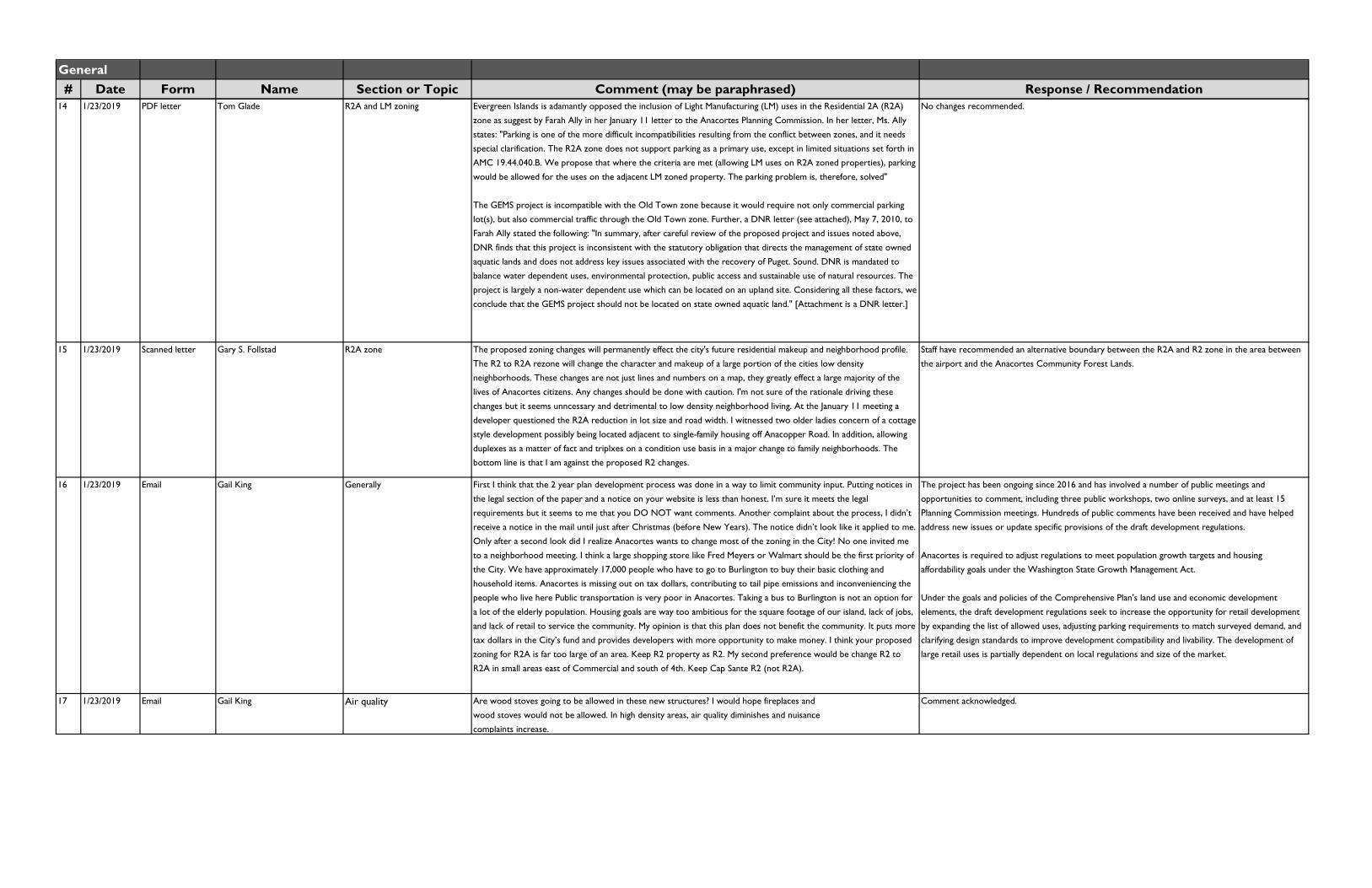
General# Date Form Name Section or Topic Comment (may be paraphrased) Response / Recommendation
10 1/23/2019 Email Deborah and Dan Call Affordable housing and
environment
I'm writing to you about the new proposals concerning housing in Anacortes and the island. We do support the idea
of smaller housing, cottage housing, limits on height of buildings and affordable housing within the city limit, along with
the population being capped. To continue building large (using natural resources needlessly), expensive new homes
(with only 2 people living in the mansions!) is to cater to the rich to live in this beautiful place. People of middle and
lower income should have a right to live here too. Have we come to only caring about making money off building
these mansions rather than retaining a quality life for all people of all incomes? Keeping dense housing in the city,
gives us more natural space outside the city limits for floral and fauna that were here long before humans were. We
also are NOT in favor of extending the city limits. We love Fidalgo Island because of all of the natural areas, and see
no reason to develop them. That would make the island into one big city (Manhattan?), with the loss of the natural
beauty of Fidalgo Island. We need nature in the natural web of life. We see enough For Sale signs throughout the
island should folks want to move here to choose from. No need to keep building more, erasing land, forests, fauna,
and flora. NO need at all.
One of the goals of the development regulations update is to increase the variety and choice of
housing types and sizes, which is proposed through a number of updates per the 2016
Comprehensive Plan, supported with appropriate environmental protections. No change to the city
limits is proposed.
11 1/23/2019 Email Deborah and Dan Call Affordable housing and
environment
And I really don't understand the "need" (money hungry again) to build brand new ugly condos on Ferry Terminal
Road. The architecture of these condos and the majority of new housing tracks in that area do not represent the
uniqueness that Anacortes has always been known for. Again, just another city, not classified to all that Fidalgo Island
has been for so long. I do agree with Mr. Spivak that the project engineering report "does not consider the issue of
the disruption of local flora and fauna" and that it would be "environmentally destructive", especially to various animal
species, not to mention the horrendous traffic. I don't understand the reasoning in developing a fragile (in many ways)
part of nature on the island. Again, destroy such vital life for someone to make money???? Now that is truly greedy
with no sense for all the natural life that gets destroyed on such a limited piece of land (Fidalgo Island). Please, let's
care about this precious island with its limited land and resources and full of natural life that allows all of us to live.
Did you know that trees release oxygen for us to breath?? Maintaining our natural resources in their natural habitat is
vital to all living things in more ways than you will ever know. Please, let's not kill it for the love of money or any
other reason.
One of the goals of the development regulations update is to increase the variety and choice of
housing types and sizes, which is proposed through a number of updates per the 2016
Comprehensive Plan, supported with appropriate environmental protections.
12 1/23/2019 Email Jeff Coult Traffic I’m writing you today to express my concern for the proposed new development code and regulations update. I’m
very concerned that the revisions are mostly a benefit to developers at the expense of current residents. The
proposed changes seem to make it easier for developers to increase density, allowing more dwellings, and larger
profits. Higher densities, taller buildings, smaller lots and less parking all reduce the quality of life for our current
residents. As a home owner on Glasgow way, I see the issues with traffic and noise on a daily basis. Just entering or
crossing 12th street is getting more and more difficult most hours of the day. Trying to turn left from any street off
12th can be downright dangerous. The increase in housing density can only add to the already heavy traffic burden we
suffer every day. Having only owned property here for a relatively short time (15 years), we have already seen a large
increase in population, and the resulting reduction in quality of life. It’s clear that increasing population density will
add to the city’s coffers, and the profitability of developers, but please ask yourself if this is this in the best interest of
the city’s current residents? Does this increase our quality of life? Do we really need to add even more traffic to the
already packed streets and stores? I believe the current regulations are adequate as they are, and don’t need to be
modified to allow developers like Strandburg to continue packing our city with more and more residents at the
expense of those of us who already live here.
One of the goals of the development regulations update is to increase the variety and choice of
housing types and sizes, which is proposed through a number of updates per the 2016
Comprehensive Plan, supported with appropriate environmental protections and coordination with
infrastructure plans.
13 1/23/2019 Scanned letter Marilyn Wells Derig R2A and LM zoning I am speaking to the letter submitted by GEMS LLC, represented by Ms. Farah Y. Ally. I am confused by the
requested changes to the LM and R2A zones. She describes the R2A zone as "a narrow upland property between
Guemes Channel and the bluff" - she says no homes could be built there. As I see on the current proposed map, the
R2A zone runs a broad swath containing many existing homes. What is this area of which is speaking? It would
appear the request is for many of the LM zone's allowed and conditionally permitted uses to be allowed in the R2A
zone. This would be very disturbing to R2A landowners and incompatible with a residential zone.
No changes recommended.
General# Date Form Name Section or Topic Comment (may be paraphrased) Response / Recommendation
14 1/23/2019 PDF letter Tom Glade R2A and LM zoning Evergreen Islands is adamantly opposed the inclusion of Light Manufacturing (LM) uses in the Residential 2A (R2A)
zone as suggest by Farah Ally in her January 11 letter to the Anacortes Planning Commission. In her letter, Ms. Ally
states: "Parking is one of the more difficult incompatibilities resulting from the conflict between zones, and it needs
special clarification. The R2A zone does not support parking as a primary use, except in limited situations set forth in
AMC 19.44.040.B. We propose that where the criteria are met (allowing LM uses on R2A zoned properties), parking
would be allowed for the uses on the adjacent LM zoned property. The parking problem is, therefore, solved"
The GEMS project is incompatible with the Old Town zone because it would require not only commercial parking
lot(s), but also commercial traffic through the Old Town zone. Further, a DNR letter (see attached), May 7, 2010, to
Farah Ally stated the following: "In summary, after careful review of the proposed project and issues noted above,
DNR finds that this project is inconsistent with the statutory obligation that directs the management of state owned
aquatic lands and does not address key issues associated with the recovery of Puget. Sound. DNR is mandated to
balance water dependent uses, environmental protection, public access and sustainable use of natural resources. The
project is largely a non-water dependent use which can be located on an upland site. Considering all these factors, we
conclude that the GEMS project should not be located on state owned aquatic land." [Attachment is a DNR letter.]
No changes recommended.
15 1/23/2019 Scanned letter Gary S. Follstad R2A zone The proposed zoning changes will permanently effect the city's future residential makeup and neighborhood profile.
The R2 to R2A rezone will change the character and makeup of a large portion of the cities low density
neighborhoods. These changes are not just lines and numbers on a map, they greatly effect a large majority of the
lives of Anacortes citizens. Any changes should be done with caution. I'm not sure of the rationale driving these
changes but it seems unncessary and detrimental to low density neighborhood living. At the January 11 meeting a
developer questioned the R2A reduction in lot size and road width. I witnessed two older ladies concern of a cottage
style development possibly being located adjacent to single-family housing off Anacopper Road. In addition, allowing
duplexes as a matter of fact and triplxes on a condition use basis in a major change to family neighborhoods. The
bottom line is that I am against the proposed R2 changes.
Staff have recommended an alternative boundary between the R2A and R2 zone in the area between
the airport and the Anacortes Community Forest Lands.
16 1/23/2019 Email Gail King Generally First I think that the 2 year plan development process was done in a way to limit community input. Putting notices in
the legal section of the paper and a notice on your website is less than honest. I’m sure it meets the legal
requirements but it seems to me that you DO NOT want comments. Another complaint about the process, I didn’t
receive a notice in the mail until just after Christmas (before New Years). The notice didn’t look like it applied to me.
Only after a second look did I realize Anacortes wants to change most of the zoning in the City! No one invited me
to a neighborhood meeting. I think a large shopping store like Fred Meyers or Walmart should be the first priority of
the City. We have approximately 17,000 people who have to go to Burlington to buy their basic clothing and
household items. Anacortes is missing out on tax dollars, contributing to tail pipe emissions and inconveniencing the
people who live here Public transportation is very poor in Anacortes. Taking a bus to Burlington is not an option for
a lot of the elderly population. Housing goals are way too ambitious for the square footage of our island, lack of jobs,
and lack of retail to service the community. My opinion is that this plan does not benefit the community. It puts more
tax dollars in the City’s fund and provides developers with more opportunity to make money. I think your proposed
zoning for R2A is far too large of an area. Keep R2 property as R2. My second preference would be change R2 to
R2A in small areas east of Commercial and south of 4th. Keep Cap Sante R2 (not R2A).
The project has been ongoing since 2016 and has involved a number of public meetings and
opportunities to comment, including three public workshops, two online surveys, and at least 15
Planning Commission meetings. Hundreds of public comments have been received and have helped
address new issues or update specific provisions of the draft development regulations.
Anacortes is required to adjust regulations to meet population growth targets and housing
affordability goals under the Washington State Growth Management Act.
Under the goals and policies of the Comprehensive Plan's land use and economic development
elements, the draft development regulations seek to increase the opportunity for retail development
by expanding the list of allowed uses, adjusting parking requirements to match surveyed demand, and
clarifying design standards to improve development compatibility and livability. The development of
large retail uses is partially dependent on local regulations and size of the market.
17 1/23/2019 Email Gail King Air quality Are wood stoves going to be allowed in these new structures? I would hope fireplaces and
wood stoves would not be allowed. In high density areas, air quality diminishes and nuisance
complaints increase.
Comment acknowledged.

General# Date Form Name Section or Topic Comment (may be paraphrased) Response / Recommendation
18 1/23/2019 Email Gail King Impact fees Impact fees and concurrency fees should be well defined and easy to locate on the City’s website. Costs can be
determined by the size of the dwelling (number of occupants or number of bedrooms). Those concurrency fees
and/or impact fees should be paid by the developer before a certificate of occupancy is issued. Who establishes the
minimum level of service the developers pay for? Should that standard be raised to what the City is currently paying
for and expecting? We have a lot of policemen, firemen, etc. many more than the minimum. So does that mean the
developer doesn’t pay their fair share for the current standard? Do they pay nothing because services are above an
established “minimum”?
Impact fees are covered by AMC Chapter 3.93, which is beyond the scope of this project.
19 1/23/2019 Scanned email Nancy Oemick General correspondance [General concerns about cottage housing in R2A zone, summary of comments previously submitted ] Comment appears to be scheduling/meeting correspondance to city staff, no recommendation.
20 1/23/2019 Scanned letter Hal Rooks LM and R2A zoning I urge the Planning Commission to not deal with the GEMs proposal, contained in a letter submitted in January 11,
2019. This was a complicated issue involving the Department of Natural Resources, and not simply an issue of
whether LM and R2 zoning are incompatible in the area below the bluff and along the shore. The Shoreline Master
Plan has jurisdiction over the first 200 feet landward above the ordinance high water mark, and its regulations differ at
points from the underlying zoning. One example of the complications is aquaculture, there are three pages covering it
in chapter 8.4 in the SMP. My suggestion is to not deal with this issue at this time.
No changes recommended.
21 1/23/2019 Email Janet Kowalski Affordable housing, views,
transportation
I understand that this letter is coming late in the process but I have only recently permanently moved here. It is with
disappointment that I draft this letter to you regarding the city’s proposed development code. Affordable housing
does not have to come with at the expense of our quality of life. Clearly the citizens will be paying for many of the
proposed changes, not the developers. I purchased my home here nearly 15 years ago, but was only recently able to
move here. As I have watched the city grow and change during that time, I have observed many lost opportunities for
the city to make Anacortes a beautiful and affordable place to live. As I now drive down Oaks Avenue to the ferry
terminal, I can no longer see the water from many places. The water view has been replaced by sidewalks that are
not used (we need bike paths), tall fences, trees growing even taller to block more views, and lots of utility poles and
wires because the city did not raise revenues to bury them when HWY 20 was repaved. Developers paid for trees
and sidewalks and took our views—while we stare at power lines and fences and add more cars to the road. Rich
folk are walled off from us and keep their views. Livable city? Gag me. We leave our bikes in the garage because it is
unsafe to ride them to the grocery store or library. We take our cars, adding traffic and parking needs. Pretty
sidewalks? The ferry terminal is 4 miles out of downtown. No one is walking to the store, not from the Anacopper
neighborhoods. Unsafe to bike and too far to walk. Downtown biking to the store? Rarely happens.
Comment acknowledged.
General# Date Form Name Section or Topic Comment (may be paraphrased) Response / Recommendation
22 1/23/2019 Email Janet Kowalski Affordable housing, views,
transportation
If parking restrictions are eased in the proposed high density areas, it will become even more unsafe to use a bike
there. Families, especially children who need to get to school must be able to ride their bikes safely and have it be a
pleasant experience. Currently, the proposed inadequate transportation planning makes using a car the most
probable alternative for people. More cars on streets? Another lost opportunity to draw tourists and their revenues.
Many cyclists come to bike the San Juans. Bike to the ferry? Unsafe and aesthetically unpleasing. Stop at the stores on
your way? Not when we offer combat biking. Cyclists will wait to get provisions after they leave our town. Now I
read that the city is proposing to allow narrower streets and more parking on the street near town to increase
density. Once again, we all pay for developers extra profits as they are allowed to build more structures without
regard to livability issues. Instead of easing onsite parking restrictions, I say we hold the developer’s feet to the fire
and require options such as central underground or parking garage options so the our town once again becomes a
beautiful and clean place to live, especially in the proposed mixed use marine district and high density family units.
Parking structures can be financed through developer levies and pooled to solve neighborhood parking issues. Who
wants to stare at cars instead of the water and mountains? If you really want affordable housing that people want to
live in, please do not build slums with pretty sidewalks. I loved the sign that was built to draw people into old
downtown. Where’s the pride now? Many of the proposed options for higher density houses such as cottage housing
sound promising. But don’t surround them with a situation on the street where cars must drive blocks to find a
parking place. Many lower income families have more cars per unit because more people must use them to get to
work every day. Easing parking restrictions is poor planning, environmentally degrading and just plain ugly. Don’t force
our lower income residents to battle a sea of cars, noise and traffic while our developers go to their walled off homes
where they no longer have to see us.
Comment acknowledged.
23 1/29/2019 Email Dan McCroskey Environment I'll begin with the issue of water absorption as a result of more roof lines and more driveways. These are real issues.
All that vacant land currently absorbs many, many, gallons of water before coming to rest in Copper Pond which is
directly south of our Copper Pond - Anacopper entrance. The water from Copper Pond flows under our Copper
Pond Road entrance and flows through the buffer zone in my Copper Pond Pl. backyard. We have individuals already
having issues with water flowing into there crawl spaces from the water run off on the south side of Copper Pond
Rd. This water must be coming from neighborhoods that are above our elevation as water tends to flow downhill. A
new development between Copper Pond HOA and Keystone will be above our elevation and exasperates the
problem! Secondly, the thought of possibly 90 plus cottage style homes, with automobiles to support the trips to go
to work and for shopping, etc., is a huge issue. Most people I know have two cars to support their family lifestyles.
That comes out to be 180 trips up and down Anacopper Road twice a day at least, with no help to enter onto Oakes
Ave. at ferry traffic time. The traffic that flows through this area now is already a huge problem/issue. The curves
around Tursi Park and down Pennsylvania Ave have led to some serious accidents. More traffic equals more
accidents. Lastly, I have a real concern about opening up another avenue of access to alleviate congestion at the
Pennsylvania Ave. round-about. Are there any plans or will there be to open up Oregon Ave to funnel vehicles
through the eastern part of Copper Pond HOA. The resident of our Copper Pond HOA would not be happy about
this increase of traffic through the quiet neighborhood they bought into many years ago. I believe this Planning session
is in its third draft and getting ready to be sent to The Mayor and The City Council for consideration. The plan has
been worked on for a couple of years, but many individuals didn't see the issues of this planning sessions until we
received a notice in the mail around the end of 2018. The first draft was presented in Nov of 2017. I have not seen
any plans, but I am aware that Strandberg has purchased the property between our two sub divisions. I'm sure it is
not for a park, which would be so cool!
This project is a citywide code update and is not addressing any specific development proposals.
Individual project-level review ensures consistency with adopted requirements for use, form and
intensity, community design, environmental protection, landscaping, tree preservation, parking, access,
and evaluation of infrastructure concurrency. For projects exceeding certain thresholds, project-level
SEPA review and public comment opportunities provide for identification and consideration of project-
specific environmental impacts, transportation concurrency, and neighborhood concerns.
General# Date Form Name Section or Topic Comment (may be paraphrased) Response / Recommendation
24 1/31/2019 Email Andrew Stewart Development, population
growth, environment
I am a small business owner/ operator repairing and building boats in the Industrial Zone, on 30th St. My business has
grown over the years to support 6 employees. Access to the water, a talented work force and local innovation have
been central to our success. I am active in our community: This year marks my 18th year on the Friends of the ACFL
board of directors (for many years and officer), I am a current board member of the Anacortes Waterfront Alliance
(formerly the ASBC), I serve on the COA LTAC committee and was a member of the 2016 Citizen’s Advisory
Committee to the City’s Comprehensive Plan. My wife and I currently reside at 3508 W 8th pl. but lived on 20th and
M for 17 years while our now adult children matriculated through the Anacortes school system. Ours is a special
place and I appreciate the enduring work and vision all who have come before, and those who work now, for our
common good. Thank you. First some history for the benefit of the public record. Forgive me if I am telling you things
you know and please understand that this recounting is from my own limited knowledge and involvement as so will
not be comprehensive: The 2016 Comp. plan process produced a useful document which shows how we collectively
considered many of the issues central to our town’s future and provides guidance as we move onward. A central
outcome of this process was that the City would accept and plan for the population allotment as determined by the
State GMA. This was a departure from the past when we adopted alternate strategies to abide by the law, such
trading its allotments to neighboring communities or expanding our city boundaries. The rationale for the change in
the City’s strategy was as follows: As per our Comp. Plan Vision Statement, the City should find ways to keep our
town economically vital while preserving our quality of life and our island’s natural heritage. Given that western
Washington is experiencing unprecedented population growth, and short of an economic or ecological disaster (God
forbid), people will continue to move here. We should therefore get ahead and plan for this reality, as best as
possible, especially considering that we are reaching build out of available lots and live in a time where the economy,
climate and demographics are changing rapidly. Concurrent to the demands of population growth there is a need to
keep our City economically vital as too many small cities have become bedroom and retirement communities to the
determent of their long-term futures and citizens health and happiness.
Comprehensive Plan policy LU-11.1 provides guidance to plan for accommodating growth within the
City limits to protect surrounding forest and parkland and to minimize sprawl. This includes
providing for residential infill development opportunities throughout the city, while focusing highest
intensity residential uses close to commercial and community services and transit.
25 1/31/2019 Email Andrew Stewart Development, population
growth, environment
The goal of the new development regulations is to increase the density in our Downtown core and neighborhoods,
as appropriate, to promote sufficient economic vitality for our town to remain viable while accommodating the
increase in our population. By consolidating growth within our existing urban boundaries, we mitigate the human
impacts on the natural places and non-human communities of Fidalgo Island. Two of the biggest challenges to the
higher density, urban strategy will be 1) the adequate protection and regeneration of critical areas and 2) the ability to
maintain and improve our infrastructure to meet the needs of a growing city. I think that the proposed changes to the
AMC code do not do enough to inform city staff and decision makers regarding challenges 1 and 2. My concern is
that, even as astute as the new design regulations and zoning changes are, they are primarily vehicles to facilitate
development. When the pressure for development conflicts with the community’s needs, the proposed code defaults
to “the discretion of the director”, and thus the internal culture and personalities at work in each department at a
given time. How well we, as a municipality, will be able rise to challenges 1 and 2 will depend on our ability to have on-
going assessment and dialogue regarding balancing the stated goals of the City’s’ Comprehensive Plan. My hope is to
encourage City leaders and citizens to make frequent use of that document. On a related note, until the day when
Washington State overhauls its tax code, each municipality will be revenue challenged and forced to rely on the
regressive strategies of property and sales taxes. This reality encourages private development at the expense of our
public good and environment.
Comment acknowledged.
26 1/31/2019 Email Andrew Stewart Climate change The new regulations should have a provision for adapting to disruptive climate change. Our natural world is changing
perhaps more quickly than the City’s Comp. plan review process.
Comment acknowledged.
27 2/4/2019 Email Jeff Mount (Planning
Commission)
Design standards generally I would reconsider several of the code stipulations that reflect personal aesthetic taste, such as the reference to
"repetition with variety" in 19.43.010. There are also several amenities included in the incentives for bonus heights
that are more ornamental than functional and that future citizens might not consider to be assets. In general, I would
scan the entire code for subjective terms, such as tasteful, excessive, and reasonable. If we all agreed on how to
define these terms, we wouldn't need a code.
The intent with such provisions is to promote design diversity to better help these housing types to
fit in with the character of existing neighborhoods (to help meet policies under Comprehensive Plan
Goal LU-2), but not go so far as to specifiy architectural styles, colors, materials, window shapes, or
other aesthetic preferences.
General# Date Form Name Section or Topic Comment (may be paraphrased) Response / Recommendation
28 2/4/2019 Email Jeff Mount (Planning
Commission)
Departures I would like to see a list of all the areas where departures are included in the code. For the most part, they strike me
as a loophole where a variance of sorts can be granted without following the normal process. Unless it can be
demonstrated that the concept of departures provides a level of flexibility that will benefit the city over time, I would
question why we do them at all.
An updated departures list has been provided to staff. Also see AMC 19.20.220 for provisions and
criteria for approving departures. Such departure provisions have proven to be a great tool in other
similar communities for integrating much needed flexibility (strategically) while providing the City with
the tools to say no if the proposal doesn't meet the criteria.
29 2/7/2019 Email Andrea Doll (Planning
Commission)
MMU zone, generally Will the MMU zone be developed all at once? What is the plan. Who lays out the streets, the widths, the design, how
do we know there is a space for a possible “recreation hall” or a community theatre and performing arts center?
Who does the construction? If there is a commercial spot for an ice cream store , for example, is that property up
for sale and an ice cream vendor buys it, and there are other commercial, retail stores in the area?
The central waterfront site will likely in phases by the property owner/applicant/developer. They will
decide uses based on both permitted uses in the zone and market conditions/demand. Chapter 19.61
includes regulatory guidance on the location and form of new streets at this location. The provisions
allow some flexibility to depart provided they meet intent/special criteria in the code.
Project-level review would go through the applicable review procedure identified in Table 19.20.030
based on the application type (subdivision, binding site plan, site plan, SEPA, etc.), including public
notice and a public hearing, if applicable. Each application would be reviewed for consistency with
applicable development regulations.
30 2/7/2019 Email Andrea Doll (Planning
Commission)
MMU zone, generally Please explain to me and others who also may not understand the language and concept of what Cynthia Richardson
wrote on Friday, January 4th , 3rd page. Vertical Mixed Use ground floor uses, regarding the 20 foot depth. By
designating a narrow strip for commercials, a developer could build 15 x as much space on the bonus floor”. I would
like an easel on the floor with someone explaining for those of us who are not architects or planners what this
means.
The definition of a "mixed-use" building has been updated for the purpose of the MMU zone. It is a
building with a least 50% of its ground floor frontage being designed for non-residential uses. Such
design includes a minimum 50 feet front-to-back depth and minimum 13 feet floor-to-ceiling height.
31 2/7/2019 Email Andrea Doll (Planning
Commission)
Generally What does she mean when she says the exact boundaries have-not been done? Comment unclear.
32 2/7/2019 Email Andrea Doll (Planning
Commission)
Streets, density Comments from John McGee, and the relationship between greater densities on existing streets and the width of the
street. I also respect his concern about what happens to his comments.
Comment acknowledged
33 2/7/2019 Email Andrea Doll (Planning
Commission)
Streets, density Tom Allen: I agree with his idea that we should have more to consider in terms of housing options than the
“subsidized housing model”
A number of updates are proposed to implement the Comprehensive Plan's land use and housing
policies related to affordable housing, and to address Anacortes' need for a wide range of housing
options. These include: Simplifying standards for accessory dwelling units (ADUs) to encourage
production (increasing housing supply for renters and income for homeowners); Encouraging small-
lot single family development with a variety of lot design options (which may have lower purchase
prices compared to typical large lot homes); Explicitly allowing cottage housing in most zones as a
small-scale detached living option; Explicitly allowing townhouses as a small-scale attached living
option; Explicitly defining duplex and triplex as attached living options and allowing a variety of
configurations on a single site; Providing design standards to these new housing types to ensure
livability and neighborhood compatibility; Providing flexibility for landscaping and lot coverage
standards for multifamily and townhouse development in high-density zones to increase their
economic feasibility; Explicitly allowing live-work development to support home-based business
owners; Expanding allowance of multifamily development to the MS zone and MMU zone (previously
CM and CM1); Raising base height limits in the CBD and C zones to increase residential (and non-
residential) development capacity; Establishing a new height bonus for the R4 zone related to small
and/or affordable units; Adjusting parking requirements for multifamily uses to reduce the costs of
construction (often passed on to tenants); Providing new bike parking standards to support residents
who cannot afford or choose not to own a car; Providing new standards for group living
developments to encourage their development and support seniors and people with disabilities who
are often on fixed incomes; Updating and streamlining permitting and processing provisions to
shorten development timelines and increase predictability for builders.
34 2/7/2019 Email Andrea Doll (Planning
Commission)
MMU zone, residential Regarding the MJB property: I don’t think we should have subsidized housing there. This property is one of a kind. At the direction of the Planning Commission, the MMU zone affordable housing bonus incentive is no
longer under consideration.

General# Date Form Name Section or Topic Comment (may be paraphrased) Response / Recommendation
35 2/8/2019 Email Cynthia Richardson Cottage housing, environment After hearing from several citizens from Rock Ridge, Keystone, and Copper Pond at the last Planning Commission
meeting and reading their written concerns about allowing cottage developments in their area, I would like to address
several issues mentioned in that testimony, to assist commissioners in their deliberations. During the Comprehensive
Plan process, we heard from many people who want an opportunity to live in a smaller, less costly home with less
yard to care for, but don’t want to live in an apartment or an old fixer-upper. So the Comp Plan directs that the
zoning regulations provide for cottage housing and accessory dwelling units (ADU’s) in all residential zones, with
duplexes and smaller lots in some areas. A small home can be just as good quality as a large one, but the smaller
home will be more affordable than a larger home of similar quality because it uses less land, labor, and materials. It is
not true that homes can be built in the wetland areas. The developer must pay for a professional wetland delineation
that will establish the wetland boundaries and the buffer setbacks – homes can only be built outside those buffers.
Anacopper Road definitely does need improvements, including sidewalks. Although these new houses will only add a
small percentage to the traffic from Rock Ridge, Skyline, and south Fidalgo, the new development could be a catalyst
for finally getting a comprehensive upgrade. As you can tell from my comments, I am an advocate for providing a
variety of types, sizes, and price ranges of housing in Anacortes to serve the entire range of incomes, ages, and
lifestyles of our citizens.
Comment acknowledged.
36 2/11/2019 Email Jeff D’Angelo Zoning Unlike the majority of my neighbors, I wanted to send along an email that states that I am against the attached letter
as drafted by our homeowners association. I support whatever the city would decide appropriate as they consider
the zoning change. [Form letter with blank identification information attached]
Comment acknowledged.
37 2/11/2019 Email Jim Portras Zoning I am a resident of the Rock Ridge development in Anacortes. I am deeply concerned about the proposal for rezoning
this area from R2 to R2A. The main concern I have regarding the impact of the zoning proposal is that it will
negatively impact:
Our environment, particularly the fragile Anacopper area wetlands and surrounding forests of Cranberry Lake
Traffic congestion, parking and safety in the neighborhood and on Anacopper Road
An environmental impact study needs to be included in the permitting process for land parcels that could impact
sensitive wetlands and possibly our community forest lands such as the property adjoining Rock Ridge along
Anacopper Mine Road. This study will help to determine required setbacks from these sensitive areas. No changes to
existing setbacks for garages, sidewalks, and property lines on building lots will help to conform to existing
surrounding communities. One part of the zoning proposal includes decreasing the building lot size from 7500 to
6000 sq. feet in this area which will increase traffic, congestion, and impact pedestrian safety in these areas. Keeping
current setback and lot size limitations will ensure minimized environmental, traffic and safety impacts for our
community.
Staff have recommended an alternative boundary between the R2A and R2 zone in the area between
the airport and the Anacortes Community Forest Lands.
The R2A zone is recommended in the Comprehensive Plan Future Land Use Map for the purpose of
low density residential development in established neighborhoods. The bulk of the area proposed for
R2A zoning has existing development with traditional large-lot single-family homes. Applicable
development proposals are subject to critical area and infrastructure concurrency standards.
General# Date Form Name Section or Topic Comment (may be paraphrased) Response / Recommendation
38 2/11/2019 Email Mark and Sharon Chandler Zoning I am a resident of the Rock Ridge development in Anacortes. I am deeply concerned about the proposal for rezoning
this area from R2 to R2A. The main concern I have regarding the impact of the zoning proposal is that it will
negatively impact:
Our environment, particularly the fragile Anacopper area wetlands and surrounding forests of Cranberry Lake
Traffic congestion, parking and safety in the neighborhood and on Anacopper Road
An environmental impact study needs to be included in the permitting process for land parcels that could impact
sensitive wetlands and possibly our community forest lands such as the property adjoining Rock Ridge along
Anacopper Mine Road. This study will help to determine required setbacks from these sensitive areas. No changes to
existing setbacks for garages, sidewalks, and property lines on building lots will help to conform to existing
surrounding communities. One part of the zoning proposal includes decreasing the building lot size from 7500 to
6000 sq. feet in this area which will increase traffic, congestion, and impact pedestrian safety in these areas. Keeping
current setback and lot size limitations will ensure minimized environmental, traffic and safety impacts for our
community.
Staff have recommended an alternative boundary between the R2A and R2 zone in the area between
the airport and the Anacortes Community Forest Lands.
The R2A zone is recommended in the Comprehensive Plan Future Land Use Map for the purpose of
low density residential development in established neighborhoods. The bulk of the area proposed for
R2A zoning has existing development with traditional large-lot single-family homes. Applicable
development proposals are subject to critical area and infrastructure concurrency standards.
39 2/11/2019 Email Steve and Kathleen Williams Zoning I am a resident of the Rock Ridge development in Anacortes. I am deeply concerned about the proposal for rezoning
this area from R2 to R2A. The main concern I have regarding the impact of the zoning proposal is that it will
negatively impact:
Our environment, particularly the fragile Anacopper area wetlands and surrounding forests of Cranberry Lake
Traffic congestion, parking and safety in the neighborhood and on Anacopper Road
An environmental impact study needs to be included in the permitting process for land parcels that could impact
sensitive wetlands and possibly our community forest lands such as the property adjoining Rock Ridge along
Anacopper Mine Road. This study will help to determine required setbacks from these sensitive areas. No changes to
existing setbacks for garages, sidewalks, and property lines on building lots will help to conform to existing
surrounding communities. One part of the zoning proposal includes decreasing the building lot size from 7500 to
6000 sq. feet in this area which will increase traffic, congestion, and impact pedestrian safety in these areas. Keeping
current setback and lot size limitations will ensure minimized environmental, traffic and safety impacts for our
community.
Staff have recommended an alternative boundary between the R2A and R2 zone in the area between
the airport and the Anacortes Community Forest Lands.
The R2A zone is recommended in the Comprehensive Plan Future Land Use Map for the purpose of
low density residential development in established neighborhoods. The bulk of the area proposed for
R2A zoning has existing development with traditional large-lot single-family homes. Applicable
development proposals are subject to critical area and infrastructure concurrency standards.
40 2/12/2019 Scanned letter John Hilburn Traffic I see the pressures of development bearing on our policy makers and potential degrades to life in my chosen
hometown. Of primary concern are building proposals which increase population density and vehicluar traffic on the
western end of Fidalgo Island, site of the San Juan ferry piers. These neighborhoods rely on Oakes Avenue/12th
Street connecting to the commercial center of town. Annual growth will have an often frustrating and sometimes
unsafe scenario presenting to both residents and ferry riders alike. Regulartory revisions have already shrunk single
family residential lot sizes to postage stamps; sub-postage stamp lots with multi-family dwellings and increased vertical
development are now in the offing. At what point do planners draw the final line? Anacortes still offers a unique
ambiance which continues to attract home purchasers. How far does the city want to go in cashing in its ambiance to
support aspiring residents?
Comment acknowledged.
41 2/12/2019 PDF letter Andrew Stewart Public comment I’m writing to request that when considering the proposed Title 19 zoning and land use changes, the City Council
include the opportunity for more public comment during their review. I believe that there are significant issues that
remain to be settled with in the code, such as ADU rules and the balance of uses in the new MMU zone. Increased
public input on the difficult issues, from a broader section of our citizens, will produce better results.
Comment acknowledged.
General# Date Form Name Section or Topic Comment (may be paraphrased) Response / Recommendation
42 2/12/2019 Email Nancy Oemick R2A rezone Regarding Development of Strandberg Property Adjoining Keystone & Copper Pond Developments
Submitted by Property Owners of: Keystone, Rock Ridge, and Copper Pond Developments
As stated in recent presentations made to the City of Anacortes Planning Commission on Jan 9, 2019 and Jan 23,
2019, the residents of this area are opposed to high density development on this parcel. This is a relatively new
neighborhood of Single Family Residences. People who purchased homes here did so thinking that additional
development would be SFR, in keeping with the existing neighborhood. High density development is completely at
odds with the values in this neighborhood. Further, Anacortes already has many older high density neighborhoods
which would be greatly improved by redevelopment. These areas, primarily located on the east side of town, already
have good access to shopping, schools, churches, transportation and medical facilities. Many of us are retirees who
moved here to escape high density communities. We feel this zoning change is being imposed on us without
considering our values or the motivation that led us to choose to live in this part of Anacortes. This area still offers a
feeling of open space and natural habitat, and we had hoped this would be preserved. We urge you to consider our
request to maintain these values by requiring SFR development on this parcel.
With regards to the specific property owned by Strandberg, we submit the following comments for your
consideration.
Comment acknowledged.
43 2/12/2019 Email Nancy Oemick R2A rezone (1) The City of Anacortes' website does not state that an environmental study has been done on this property. Until
this is complete, the environmental buffer around Copper Pond cannot be determined. It seems to make logical sense
that rezoning this area would be contingent on the environmental assessment, rather than imposing higher density
development before the environmental study is done. The Port of Anacortes recently purchased property which
adjoins the airport and lies just west of the subject parcel. An environmental impact study of the Port parcel
established a rating that requires a 100 ft. buffer around the drainage basin. The marshy areas/wetlands on the Port
parcel appear to be similar in nature to the Copper Pond parcel. We request a minimum buffer of 110 ft. for
residential construction on the Strandberg parcel. We also request that the City provide public updates once the
environmental study is initiated.
(2) Architectural design, to be compatible with the Craftsman style homes built in Keystone, in style and paint color
selections, so as to blend into the existing community. This is important to our neighborhood, because some of the
new high density contemporary condo developments currently proposed would be architecturally unsuitable for this
neighborhood -- i.e., the proposed new condo development near the ferry terminal.
(3) An open space buffer requiring that structures be at least 20 feet from the fence line which separates the
Keystone and Copper Pond developments from proposed Strandberg development.
(4) No changes to existing setbacks for garages and sidewalks. Setbacks should conform to existing setbacks in the
surrounding communities of Rock Ridge, Keystone and Copper Pond. Specifically, we are requesting that developers’
recent requests to reduce setbacks, thereby resulting in increased density, be denied.
Comments acknowledged. This project is a citywide development regulations update and does not
include the review of any specific development applications.
Staff have recommended an alternative boundary between the R2A and R2 zone in the area between
the airport and the Anacortes Community Forest Lands.
General# Date Form Name Section or Topic Comment (may be paraphrased) Response / Recommendation
44 (5) A requirement that there be only vehicle entry to the development, situated on the northeastern corner of the
Strandberg parcel. The existing access road into this parcel from Anacopper Mine Road is unsuitable because it
infringes on Copper Pond wetland drainage basin, and it should be restored to wetland status.
(6) Development on this parcel should be carefully weighed against the environmental impact to this highly sensitive
and fragile area. The Anacopper wetlands, including Copper Pond and the surrounding drainage basins need to be
protected and preserved. A thorough study should be completed before development is approved, and appropriate
buffers should be established to protect the wetlands. It is important to note our proximity to the forestlands of
Cranberry Lake, a true Anacortes treasure. Future development must be done with the least possible impact on this
irreplaceable natural habitat. The goal of achieving higher density should not be met at the expense of sacrificing
natural habitats and imposing negative environmental influences. Anacortes is an incredibly unique and special place,
and the push for higher density must not threaten to destroy everything we love about living here.
(7) Traffic congestion and pedestrian safety along Anacopper Road is a major concern for our neighborhood.
Anacopper Road runs right through the wetland, and actually intercepts the Copper Pond drainage basin. This road is
not safe for vehicular traffic or pedestrians … there is no sidewalk, and no shoulder where cars can safely pass
pedestrians. Pedestrian traffic is at risk going to and from Tursi Park, and this should be addressed before additional
development increases the problem.
(8) Environmental issues resulting from increased traffic volumes on Anacopper Road need to be addressed. Recent
development of Rock Ridge has resulted in a major increase in traffic through the Copper Pond basin. Residue from
automobile oil, and other vehicular by-products have a negative environmental impact on these sensitive wetlands.
Future development plans should focus on providing alternative access routes. Additional traffic should be directed
away from the Copper Pond drainage basin, rather than simply adding more traffic to Anacopper Road.
Comments acknowledged. This project is a citywide development regulations update and does not
include the review of any specific development applications.
Staff have recommended an alternative boundary between the R2A and R2 zone in the area between
the airport and the Anacortes Community Forest Lands.
45 2/13/2019 Email Sara Holahan Generally There are some good new ideas and clarifications in this code. However there is a degradation of the ability of
citizens to have input on how developments are impacting existing neighborhoods. The authority of the Planning
Commission seems to be getting diminished. There is no option for a citizen’s committee to give a wider perspective
on the application of designs, density and variances. When you have language like “departures” and “variances’” built
into the code, and the decision is left in the hands of one person (the director) there is bound to be problems,
inconsistencies and negative impacts to our neighborhoods, downtown and city overall.
Comment acknowledged
DIVISION 1 - General & Legislative Provisions; DIVISION 2 - Procedures; DIVISION 3 - Permits; DIVISION 7 - Environment; DIVISION 8 - Development Agreements# Date Form Name Section or Topic Comment (may be paraphrased) Response / Recommendation
2 1/7/2019 PDF copy of 3rd code
draft with comments and
track changes
Cynthia Richardson 19.12, Definitions Access corridor - Could this also be for more than one lot? Perhaps say "access to a lot or lots". Would this term
apply to the private roads in a cottage development, for instance?
Per the definition, this applies to a corridor in single private ownership providing access to a single flag
lot. Shared driveways are covered by AMC 19.53.040 and internal residential circulation is covered by
AMC 19.53.050.3 1/7/2019 PDF copy of 3rd code
draft with comments and
track changes
Cynthia Richardson 19.12, Definitions Development site - suggest changing "lot or lots" to property to account for unplatted land. Note that the definition of "lot" also includes "tracts or parcels". No change recommended.
4 1/7/2019 PDF copy of 3rd code
draft with comments and
track changes
Cynthia Richardson 19.12, Definitions Mixed-use - suggest term be "Mixed use development" and defining as "development OR BUILDING". In the definitions chapter this term is applied broadly. A more specific qualitification for the purposes
of the MMU zone has been drafted within 19.43.010(H)(3). No change recommended.
5 1/7/2019 PDF copy of 3rd code
draft with comments and
track changes
Cynthia Richardson 19.12, Definitions New term and definition suggested: "Mixed-use zone” means a zone that allows a variety of uses such as, but not
limited to, residential, office, retail, civic, dining, institutional, and industrial.
"Mixed-use zones" are specifically categorized and defined in 19.40.040. No change recommended.
6 1/7/2019 PDF copy of 3rd code
draft with comments and
track changes
Cynthia Richardson 19.20.230(G), Framework development plans If the covenants are recorded, and then the approval is denied or if the approval conditions are modified
(necessitating revising the covenants), then the recorded document would not be consistent with the approval. I
definitely agree with the requirement for the documents to be recorded, but recording them before Council
approval seems backwards. Adding an expiration deadline is an incentive to get them recorded. [See commenter's
document for suggested edits]
The section has been updated to require the recording prior to any building permit approval on the
site.
7 1/7/2019 PDF copy of 3rd code
draft with comments and
track changes
Cynthia Richardson 19.30.010(A), Site plan review Suggested striking "all" because City cannot assure compliance with ALL other laws. At the recommendation of the City Attorney, no change needed.
8 1/7/2019 PDF copy of 3rd code
draft with comments and
track changes
Cynthia Richardson 19.30.010(E), Site plan review Suggesting changing "optimal" to "suitable". What is optimal for the owner may not be optimal for the city or the
neighbors. Changing to "suitable" would allow the city to require a location that the owner might not consider
optimal, but meets other needs.
Change made as suggested.
9 1/7/2019 PDF copy of 3rd code
draft with comments and
track changes
Cynthia Richardson 19.30.030(C), Site plan review Suggest striking this subsection. Bad idea. Nearly all homes and buildings are over 30 ft. and might have to do this - at
extra cost. And what would it accomplish? There are no criteria on which the "visualization" would be judged to
determine whether the project is acceptable. Is this intended to be for view blockage, design standards, or what? On
what basis would decisions be made? Perhaps useful for buildings over 50 ft. in some areas, if criteria are specified.
Threshold updated to 40 feet and purpose is limited to determining compliance with applicable
building design standards (AMC Chapter 19.63).
10 1/7/2019 PDF copy of 3rd code
draft with comments and
track changes
Cynthia Richardson 19.30.040(A), Site plan review Suggested striking "all" because City cannot assure compliance with ALL other laws. At the recommendation of the City Attorney, no change needed.
11 1/7/2019 PDF copy of 3rd code
draft with comments and
track changes
Cynthia Richardson 19.32.050(A)(4)(b), Procedures for land division
review.
Suggest adding an approval expiration of 60 days. Long plats allow 120 days, which seems a little too long, but
whatever time is allowed, it is important to have a deadline.
Provision changed as suggested (change made in 19.32.050.C.5, which addresses both long and short
subdivisions).
12 1/7/2019 PDF copy of 3rd code
draft with comments and
track changes
Cynthia Richardson 19.32.050(D), Unit lot subdivisions Suggest adding a new subsection (10) regarding recording. [See commenter's document for details] Per 19.32.050(D)(1), Unit lot sudvisions follow the review procedures for short and long subdivisons,
depending on the number of lots. See 19.32.050(D)(1).
13 1/7/2019 PDF copy of 3rd code
draft with comments and
track changes
Cynthia Richardson 19.32.050(E)(3)(a), Binding site plans Suggest striking this subsection and adding a new subsection (4) regarding recording. Not just "submitted" must
actually be recorded. Need time limits.
Some changes made as suggested regarding recording procedures.
14 1/7/2019 PDF copy of 3rd code
draft with comments and
track changes
Cynthia Richardson 19.32.060, Final plat application requirements I still think these specifics should be in a separate document, referenced here. The fact that 12 changes were made
between draft 2 and 3 makes it clear that changes may need to be made from time to time. And that should be
possible by updating the reference document without changing the zoning code, just as it is, for example, with street
standards.
Staff direction has been to consolidate documents and standards for ease of reference for code users.
15 1/7/2019 PDF copy of 3rd code
draft with comments and
track changes
Cynthia Richardson 19.32.060(C)(11), Final plat application
requirements
Do we have impervious surface limitations? I thought those were rejected and lot coverage used instead. Correct, impervious surface limits were not recommended by the Planning Commission. Updated
with lot coverage.
16 1/7/2019 PDF copy of 3rd code
draft with comments and
track changes
Cynthia Richardson 19.34.050(B), Final approval and recording Suggest adding a new subsection (6) regarding recording. [See commenter's document for details] Per Table 19.28.020, an applicant has 1 year to record a BLA. No change recommended.
17 1/7/2019 PDF copy of 3rd code
draft with comments and
track changes
Cynthia Richardson 19.38.040(C), Variances Suggest editing (C) regarding recording. [See commenter's document for details] Per Table 19.20.020, an applicant has 5 years to establish the use for which a variance is granted. A
building permit will likely be required for whatever the variance is issued for.
18 1/22/2019 Email Tom Flanagan 19.12 Definitions Boarder - Should not the definition of Boarder read: “a patron of a boarding or rooming house who is provided
lodging, with or without meals, for compensation. [Emphasis on "lodging" and "meals"]
Definition corrected as suggested.
DIVISION 1 - General & Legislative Provisions; DIVISION 2 - Procedures; DIVISION 3 - Permits; DIVISION 7 - Environment; DIVISION 8 - Development Agreements# Date Form Name Section or Topic Comment (may be paraphrased) Response / Recommendation
19 1/22/2019 Email Tom Flanagan 19.12.080(E), Administrative interpretation I am not understanding the wording here. “Persuasive authority” (i.e. a suggestion?) and “not appealable” seem
incongruent.
This section means the interpretation can be used to support a future decision on a permit
application.20 1/22/2019 Email Tom Flanagan 19.22.030(B)(7), Concurrency exeptions How can it be exempt from ALL the requirements of the chapter? A variance (see chapter 19.38) is a specific exception to a dimensional regulation, typically processed
with an overarching development permit that would already be subject to this Concurrency chapter
(19.22).21 1/22/2019 Email Tom Flanagan 19.22.040(B) and 19.22.060(C), Concurrency
review and phased development
Who is responsible for following up in 6 years to verify conditions have been met? If improvements are needed to meet concurency standards for sewer, stormwater management, or
water, the permit will be conditioned to complete those improvements prior to occupancy. The
City's 6-year CFP identifies system improvements that are required to maintain the adopted level of
service for transportaiton, fire protection, police and parks. Impact fees based on the development's
proportionate share cost collected at time of permit issuance.
22 1/22/2019 Email Tom Flanagan 19.30.010(B), Site plan review …”as is reasonable and appropriate”. “Squishy” language (as coined by Gene Derig in his comments on the 2nd draft) The complete citation is: "Coordination, as is reasonable and appropriate, with other known or
anticipated development on private properties in the area and with known and anticipated right-of-
way and other public projects in the area." This is a purpose statement and is not a regulation.
Because every site plan and its context are unique, and thus have varying levels of need for
coordination with surrounding projects, no change is recommended.
23 1/22/2019 Email Tom Flanagan 19.30.040(A), Site plan review Conformance with all other applicable laws, ordinances and regulations. “all other” doesn’t exactly make sense to me
as it is followed by a listing of other AMC chapters, etc.
At the recommendation of the City Attorney, no change needed.
24 1/22/2019 Email Tom Flanagan 19.32.060(E), Final plat application requirements Likely there is a typo: “The surveyor must set monuments as” vs. at Corrected as suggested.
25 1/22/2019 Email Tom Flanagan 19.36.040(A)(9), Conditional use review criteria “Squishy” language again. Does it mean “anything can go” so long as the decision maker goes along with it? This provides the decision-maker the ability to consider other factors which are not listed. No
changes suggested at this time.26 1/23/2019 PDF copy of 3rd code
draft with comments and
track changes
Jimmy Blais 19.20.230(F)(4), Framework development plans Respectfully request that you add language stating that conditions imposed on a Framework Development Plan be
limited to the benefit provided above and beyond the base development regulations.
The provision has been updated (see underlined text) to emphasize that the conditions must in some
way be related to what's being proposed in an FDP: "In approving a framework development plan, the
decision-maker may impose, in addition to regulations and standards expressly specified in this code,
other conditions necessary to ensure compatibility with the review criteria associated with the
specific proposal(s)."27 1/23/2019 PDF copy of 3rd code
draft with comments and
track changes
Jimmy Blais Table 19.28.020, Permit terms and extensions Please extend the initial term or the length of extension for the Framework Development Plan to a total of 10 years.
Our 26 acre waterfront development will take at least this long to fully construct.
Updated to emphasize that there is no expiration unless specified in the FDP approval.
28 1/23/2019 PDF copy of 3rd code
draft with comments and
track changes
Jimmy Blais 19.30.030(C), Site plan review Please clarify which of the review criteria would have to be included in the three dimensional visualization. Details
such as building finishes, landscaping, internal layouts and other such details are extremely costly to model
Respectfully request that department solely have the ability to require massing or view models for buildings that
exceed 30’.
Threshold updated to 40 feet and purpose is limited to determining compliance with applicable
building design standards (AMC Chapter 19.63).
29 1/23/2019 Email Carol Bordin Division 7 and 8 In the Title 19 - Unified Development Code, Third Draft document, Division 7 Environment was missing in my copy.
Division 8 Development Agreements (Chapter 19.80) was as also missing in my copy. Division 7 contains vital
information on Critical Areas (Chapter 19.70) as it was "Reserved". Upon talking to Don Measamer by telephone he
advised me that it was reserved due to needing to be updated in approximately four months. I reviewed what I could
on the City of Anacortes website. The public needs to be informed of updates and/or proposed changes in the
Critical Areas, Environmental Protection Codes prior to continued, existing, or proposed land developments.
Comment acknowledged
30 1/31/2019 Email Andrew Stewart 19.20.230, Framework development plans There needs to be a provision for public input and Planning Commission endorsement of “Framework
Developments”. Apologies if it exists and I missed it.
Under Table 19.20.030, Framework development plans are proposed as a Type 4 City Council
decision. This does indeed include procedures like a pre-application neighborhood meeting, public
notice, and a Planning Commission recommendation.31 2/13/2019 Email Sara Holahan 19.20.030, Types of review In the matrix under pre-application neighborhood meeting, second column, it should say YES except for any items
not needing the meeting rather than starting with NO. It seems like there should be a meeting for all these important
decisions. Also, there is the confusing language “review at discretion of director”.
Cell updated to clarify the standard.
32 2/13/2019 Email Sara Holahan 19.32.050(C)(4), Review of final short subdivisions Final approval of short plats should allow for the public to comment on any oversights, incompleteness or errors in
the execution of the project. Final approval should not be the sole discretion of the director. Development in
Anacortes will increasingly be with short plats near existing neighborhoods, and this makes it even more important
that the public has the ability to ensure the goals of the comprehensive plans are being met. Overall
Per 19.20.020(B)(3), final approval of short subdivisions and subdivisions are exempt from the
procedural requirements of the Chapter 19.20. The procedures for reviewing final short subdivisions
and final long subdivisions are provided in AMC 19.32.050(C). No change recommended.
33 2/9/2019 PDF copy of 3rd code
draft with comments
inserted
Puget Soundkeepers Various Various See Attachment 1 to this document
DIVISION 4 - Zoning & Land Use# Date Form Name Section or Topic Comment (may be paraphrased) Response / Recommendation
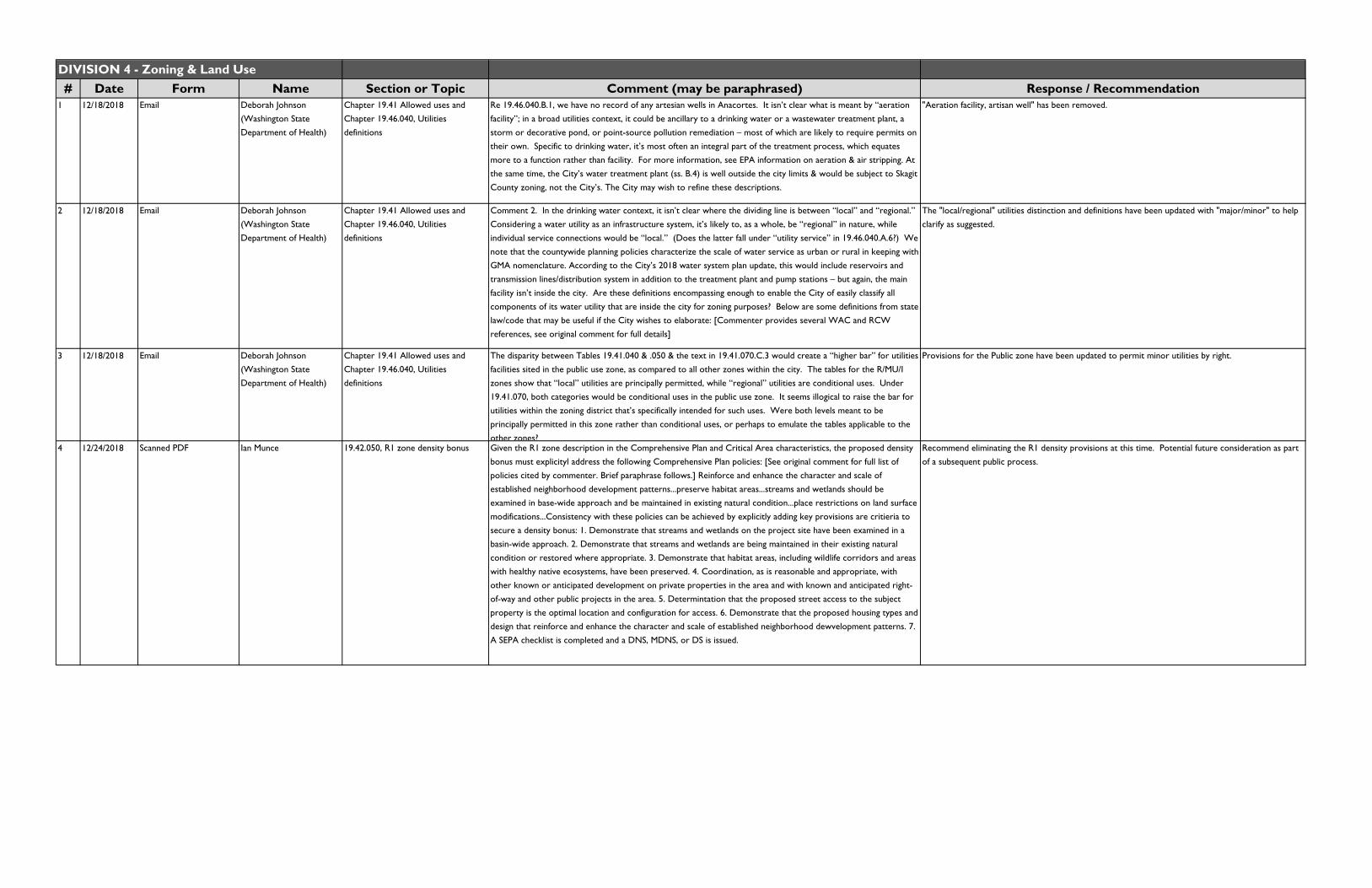
1 12/18/2018 Email Deborah Johnson (Washington State Department of Health)
Chapter 19.41 Allowed uses and Chapter 19.46.040, Utilities definitions
Re 19.46.040.B.1, we have no record of any artesian wells in Anacortes. It isn’t clear what is meant by “aeration facility”; in a broad utilities context, it could be ancillary to a drinking water or a wastewater treatment plant, a storm or decorative pond, or point-source pollution remediation – most of which are likely to require permits on their own. Specific to drinking water, it’s most often an integral part of the treatment process, which equates more to a function rather than facility. For more information, see EPA information on aeration & air stripping. At the same time, the City’s water treatment plant (ss. B.4) is well outside the city limits & would be subject to Skagit County zoning, not the City’s. The City may wish to refine these descriptions.
"Aeration facility, artisan well" has been removed.
2 12/18/2018 Email Deborah Johnson (Washington State Department of Health)
Chapter 19.41 Allowed uses and Chapter 19.46.040, Utilities definitions
Comment 2. In the drinking water context, it isn’t clear where the dividing line is between “local” and “regional.” Considering a water utility as an infrastructure system, it’s likely to, as a whole, be “regional” in nature, while individual service connections would be “local.” (Does the latter fall under “utility service” in 19.46.040.A.6?) We note that the countywide planning policies characterize the scale of water service as urban or rural in keeping with GMA nomenclature. According to the City’s 2018 water system plan update, this would include reservoirs and transmission lines/distribution system in addition to the treatment plant and pump stations – but again, the main facility isn’t inside the city. Are these definitions encompassing enough to enable the City of easily classify all components of its water utility that are inside the city for zoning purposes? Below are some definitions from state law/code that may be useful if the City wishes to elaborate: [Commenter provides several WAC and RCW references, see original comment for full details]
The "local/regional" utilities distinction and definitions have been updated with "major/minor" to help clarify as suggested.
3 12/18/2018 Email Deborah Johnson (Washington State Department of Health)
Chapter 19.41 Allowed uses and Chapter 19.46.040, Utilities definitions
The disparity between Tables 19.41.040 & .050 & the text in 19.41.070.C.3 would create a “higher bar” for utilities facilities sited in the public use zone, as compared to all other zones within the city. The tables for the R/MU/I zones show that “local” utilities are principally permitted, while “regional” utilities are conditional uses. Under 19.41.070, both categories would be conditional uses in the public use zone. It seems illogical to raise the bar for utilities within the zoning district that’s specifically intended for such uses. Were both levels meant to be principally permitted in this zone rather than conditional uses, or perhaps to emulate the tables applicable to the
other zones?
Provisions for the Public zone have been updated to permit minor utilities by right.
4 12/24/2018 Scanned PDF Ian Munce 19.42.050, R1 zone density bonus Given the R1 zone description in the Comprehensive Plan and Critical Area characteristics, the proposed density bonus must explicityl address the following Comprehensive Plan policies: [See original comment for full list of policies cited by commenter. Brief paraphrase follows.] Reinforce and enhance the character and scale of established neighborhood development patterns...preserve habitat areas...streams and wetlands should be examined in base-wide approach and be maintained in existing natural condition...place restrictions on land surface modifications...Consistency with these policies can be achieved by explicitly adding key provisions are critieria to secure a density bonus: 1. Demonstrate that streams and wetlands on the project site have been examined in a basin-wide approach. 2. Demonstrate that streams and wetlands are being maintained in their existing natural condition or restored where appropriate. 3. Demonstrate that habitat areas, including wildlife corridors and areas with healthy native ecosystems, have been preserved. 4. Coordination, as is reasonable and appropriate, with other known or anticipated development on private properties in the area and with known and anticipated right-of-way and other public projects in the area. 5. Determintation that the proposed street access to the subject
property is the optimal location and configuration for access. 6. Demonstrate that the proposed housing types and design that reinforce and enhance the character and scale of established neighborhood dewvelopment patterns. 7. A SEPA checklist is completed and a DNS, MDNS, or DS is issued.
Recommend eliminating the R1 density provisions at this time. Potential future consideration as part of a subsequent public process.
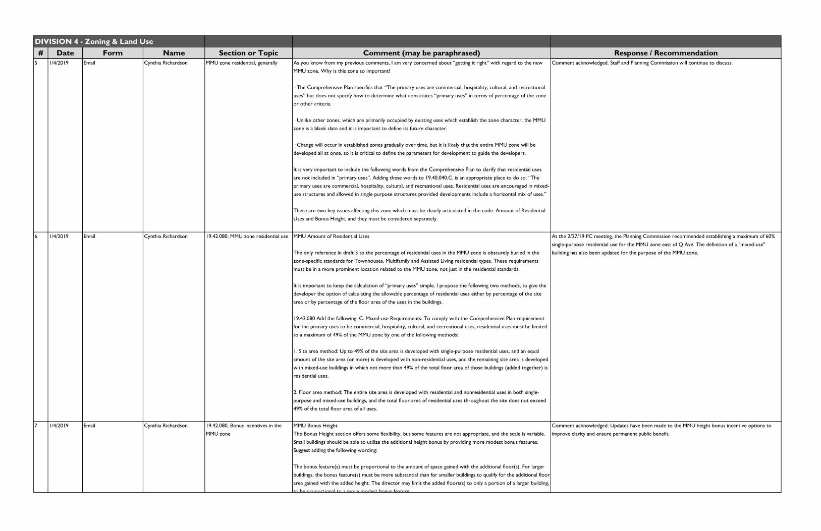
DIVISION 4 - Zoning & Land Use# Date Form Name Section or Topic Comment (may be paraphrased) Response / Recommendation
5 1/4/2019 Email Cynthia Richardson MMU zone residential, generally As you know from my previous comments, I am very concerned about “getting it right” with regard to the new MMU zone. Why is this zone so important?
· The Comprehensive Plan specifics that “The primary uses are commercial, hospitality, cultural, and recreational uses” but does not specify how to determine what constitutes “primary uses” in terms of percentage of the zone or other criteria.
· Unlike other zones, which are primarily occupied by existing uses which establish the zone character, the MMU zone is a blank slate and it is important to define its future character.
· Change will occur in established zones gradually over time, but it is likely that the entire MMU zone will be developed all at once, so it is critical to define the parameters for development to guide the developers.
It is very important to include the following words from the Comprehensive Plan to clarify that residential uses are not included in “primary uses”. Adding these words to 19.40.040.C. is an appropriate place to do so. “The primary uses are commercial, hospitality, cultural, and recreational uses. Residential uses are encouraged in mixed-use structures and allowed in single purpose structures provided developments include a horizontal mix of uses.”
There are two key issues affecting this zone which must be clearly articulated in the code: Amount of Residential Uses and Bonus Height, and they must be considered separately.
Comment acknowledged. Staff and Planning Commission will continue to discuss.
6 1/4/2019 Email Cynthia Richardson 19.42.080, MMU zone residential use MMU Amount of Residential Uses
The only reference in draft 3 to the percentage of residential uses in the MMU zone is obscurely buried in the zone-specific standards for Townhouses, Multifamily and Assisted Living residential types. These requirements must be in a more prominent location related to the MMU zone, not just in the residential standards.
It is important to keep the calculation of “primary uses” simple. I propose the following two methods, to give the developer the option of calculating the allowable percentage of residential uses either by percentage of the site area or by percentage of the floor area of the uses in the buildings.
19.42.080 Add the following: C. Mixed-use Requirements: To comply with the Comprehensive Plan requirement for the primary uses to be commercial, hospitality, cultural, and recreational uses, residential uses must be limited to a maximum of 49% of the MMU zone by one of the following methods:
1. Site area method: Up to 49% of the site area is developed with single-purpose residential uses, and an equal amount of the site area (or more) is developed with non-residential uses, and the remaining site area is developed with mixed-use buildings in which not more than 49% of the total floor area of those buildings (added together) is residential uses.
2. Floor area method: The entire site area is developed with residential and nonresidential uses in both single-purpose and mixed-use buildings, and the total floor area of residential uses throughout the site does not exceed
49% of the total floor area of all uses.
At the 2/27/19 PC meeting, the Planning Commission recommended establishing a maximum of 60% single-purpose residential use for the MMU zone east of Q Ave. The definition of a "mixed-use" building has also been updated for the purpose of the MMU zone.
7 1/4/2019 Email Cynthia Richardson 19.42.080, Bonus incentives in the
MMU zone
MMU Bonus Height
The Bonus Height section offers some flexibility, but some features are not appropriate, and the scale is variable. Small buildings should be able to utilize the additional height bonus by providing more modest bonus features. Suggest adding the following wording:
The bonus feature(s) must be proportional to the amount of space gained with the additional floor(s). For larger buildings, the bonus feature(s) must be more substantial than for smaller buildings to qualify for the additional floor area gained with the added height. The director may limit the added floors(s) to only a portion of a larger building, to be proportional to a more modest bonus feature
Comment acknowledged. Updates have been made to the MMU height bonus incentive options to
improve clarity and ensure permanent public benefit.
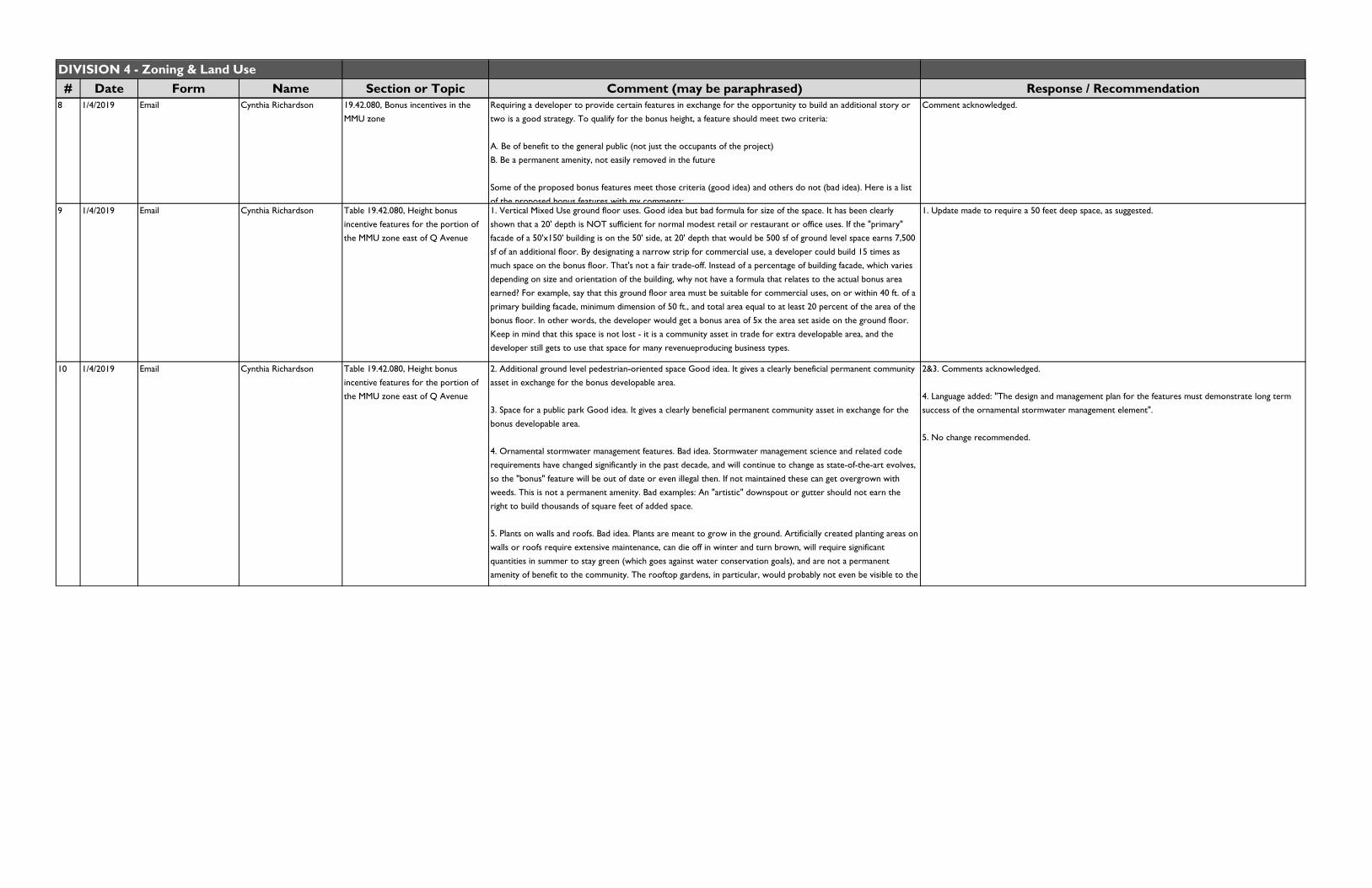
DIVISION 4 - Zoning & Land Use# Date Form Name Section or Topic Comment (may be paraphrased) Response / Recommendation
8 1/4/2019 Email Cynthia Richardson 19.42.080, Bonus incentives in the MMU zone
Requiring a developer to provide certain features in exchange for the opportunity to build an additional story or two is a good strategy. To qualify for the bonus height, a feature should meet two criteria:
A. Be of benefit to the general public (not just the occupants of the project)B. Be a permanent amenity, not easily removed in the future
Some of the proposed bonus features meet those criteria (good idea) and others do not (bad idea). Here is a list
of the proposed bonus features with my comments:
Comment acknowledged.
9 1/4/2019 Email Cynthia Richardson Table 19.42.080, Height bonus incentive features for the portion of the MMU zone east of Q Avenue
1. Vertical Mixed Use ground floor uses. Good idea but bad formula for size of the space. It has been clearly shown that a 20' depth is NOT sufficient for normal modest retail or restaurant or office uses. If the "primary" facade of a 50'x150' building is on the 50' side, at 20' depth that would be 500 sf of ground level space earns 7,500 sf of an additional floor. By designating a narrow strip for commercial use, a developer could build 15 times as much space on the bonus floor. That's not a fair trade-off. Instead of a percentage of building facade, which varies depending on size and orientation of the building, why not have a formula that relates to the actual bonus area earned? For example, say that this ground floor area must be suitable for commercial uses, on or within 40 ft. of a primary building facade, minimum dimension of 50 ft., and total area equal to at least 20 percent of the area of the bonus floor. In other words, the developer would get a bonus area of 5x the area set aside on the ground floor. Keep in mind that this space is not lost - it is a community asset in trade for extra developable area, and the developer still gets to use that space for many revenueproducing business types.
1. Update made to require a 50 feet deep space, as suggested.
10 1/4/2019 Email Cynthia Richardson Table 19.42.080, Height bonus incentive features for the portion of the MMU zone east of Q Avenue
2. Additional ground level pedestrian-oriented space Good idea. It gives a clearly beneficial permanent community asset in exchange for the bonus developable area.
3. Space for a public park Good idea. It gives a clearly beneficial permanent community asset in exchange for the bonus developable area.
4. Ornamental stormwater management features. Bad idea. Stormwater management science and related code requirements have changed significantly in the past decade, and will continue to change as state-of-the-art evolves, so the "bonus" feature will be out of date or even illegal then. If not maintained these can get overgrown with weeds. This is not a permanent amenity. Bad examples: An "artistic" downspout or gutter should not earn the right to build thousands of square feet of added space.
5. Plants on walls and roofs. Bad idea. Plants are meant to grow in the ground. Artificially created planting areas on walls or roofs require extensive maintenance, can die off in winter and turn brown, will require significant quantities in summer to stay green (which goes against water conservation goals), and are not a permanent amenity of benefit to the community. The rooftop gardens, in particular, would probably not even be visible to the
bli
2&3. Comments acknowledged.
4. Language added: "The design and management plan for the features must demonstrate long term success of the ornamental stormwater management element".
5. No change recommended.
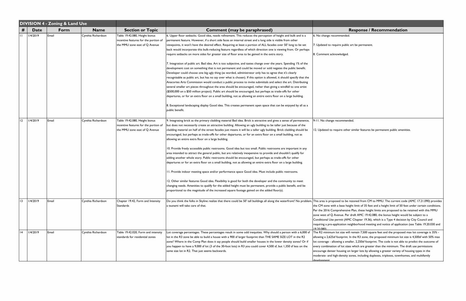
DIVISION 4 - Zoning & Land Use# Date Form Name Section or Topic Comment (may be paraphrased) Response / Recommendation
11 1/4/2019 Email Cynthia Richardson Table 19.42.080, Height bonus incentive features for the portion of the MMU zone east of Q Avenue
6. Upper floor setbacks. Good idea, needs refinement. This reduces the perception of height and bulk and is a permanent feature. However, if a short side faces an internal street and a long side is visible from other viewpoints, it won't have the desired effect. Requiring at least a portion of ALL facades over 50' long to be set back would incorporate this bulk-reducing feature regardless of which direction one is viewing from. Or perhaps require setbacks on more sides for greater size of floor area to be gained in the extra story.
7. Integration of public art. Bad idea. Art is too subjective, and tastes change over the years. Spending 1% of the development cost on something that is not permanent and could be moved or sold negates the public benefit. Developer could choose one big ugly thing (as worded, administrator only has to agree that it's clearly recognizable as public art, but has no say over what is chosen). If this option is allowed, it should specify that the Anacortes Arts Commission would conduct a public process to invite submittals and select the art. Distributing several smaller art pieces throughout the area should be encouraged, rather than giving a windfall to one artist ($500,000 on a $50 million project). Public art should be encouraged, but perhaps as trade-offs for other departures, or for an extra floor on a small building, not as allowing an entire extra floor on a large building.
8. Exceptional landscaping display Good idea. This creates permanent open space that can be enjoyed by all as a public benefit.
6. No change recommended.
7. Updated to require public art be permanent.
8. Comment acknowledged.
12 1/4/2019 Email Cynthia Richardson Table 19.42.080, Height bonus incentive features for the portion of the MMU zone east of Q Avenue
9. Integrating brick as the primary cladding material Bad idea. Brick is attractive and gives a sense of permanence, but does not necessarily create an attractive building. Allowing an ugly building to be taller just because of the cladding material on half of the street facades just means it will be a taller ugly building. Brick cladding should be encouraged, but perhaps as trade-offs for other departures, or for an extra floor on a small building, not as allowing an entire extra floor on a large building.
10. Provide freely accessible public restrooms. Good idea but too small. Public restrooms are important in any area intended to attract the general public, but are relatively inexpensive to provide and shouldn't qualify for adding another whole story. Public restrooms should be encouraged, but perhaps as trade-offs for other departures or for an extra floor on a small building, not as allowing an entire extra floor on a large building.
11. Provide indoor meeting space and/or performance space Good idea. Must include public restrooms.
12. Other similar features Good idea. Flexibility is good for both the developer and the community to meet changing needs. Amenities to qualify for the added height must be permanent, provide a public benefit, and be proportional to the magnitude of the increased square footage gained on the added floor(s).
9-11. No change recommended.
12. Updated to require other similar features be permanent public amenities.
13 1/4/2019 Email Cynthia Richardson Chapter 19.42, Form and Intensity Standards
Do you think the folks in Skyline realize that there could be 50' tall buildings all along the waterfront? No problem, a tsunami will take care of that.
This area is proposed to be rezoned from CM to MMU. The current code (AMC 17.21.090) provides the CM zone with a base height limit of 35 feet and a height limit of 50 feet under certain conditions.
Per the 2016 Comprehensive Plan, these height limits are proposed to be retained with this MMU zone west of Q Avenue. Per draft AMC 19.42.080, the bonus height would be subject to a Conditional Use permit (AMC Chapter 19.36), which is a Type 4 decision by City Council and
requiring a pre-application neighborhood meeting and notice of application (see Table 19.20.030 and 19.20.080).
14 1/4/2019 Email Cynthia Richardson Table 19.42.020, Form and intensity standards for residential zones
Lot coverage percentages. These percentages result in some odd inequities. Why should a person with a 6,000 sf lot in the R3 zone be able to build a house with a 900 sf larger footprint than THE SAME SIZE LOT in the R2 zone? Where in the Comp Plan does it say people should build smaller houses in the lower density zones? Or if you happen to have a 9,000 sf lot (3 of the 30-foot lots) in R3 you could cover 4,500 sf, but 1,350 sf less on the same size lot in R2. That just seems backwards.
The R2 minimum lot size will remain 7,500 square feet and the proposed max lot coverage is 35% - allowing a 2,625sf footprint. In the R3 zone, the proposed minimum lot size is 4,500sf with 50% max
lot coverage - allowing a smaller, 2,250sf footprint. The code is not able to predict the outcome of every combination of lot sizes which are greater than the minimum. The draft use permissions encourage denser housing on larger lots by allowing a greater variety of housing types in the moderate- and high-density zones, including duplexes, triplexes, townhomes, and multifamily development.
DIVISION 4 - Zoning & Land Use# Date Form Name Section or Topic Comment (may be paraphrased) Response / Recommendation
15 1/4/2019 Email Cynthia Richardson Rezoning R3A rezone area. I am dismayed that one of the concepts that was very important in the development of the Comprehensive Plan has been left out of the current draft of the zoning map. The R3 area generally between 12th and 22nd was intended to be a key part of the change to smaller lots because it is an area that historically has many houses on smaller lots, which has established the character of the neighborhood. It was understood that the exact boundaries would be designated on the final map as part of this update process. That has not been done, and I was told by staff that it would be done “later” as part of a separate process. It should be done now, to complete the transition of key areas to smaller lot sizes as specified in the Comprehensive Plan.
The R3A zone boundary identification will occur as part of a subsequent process.
16 1/5/2019 Email John McGee Table 19.42.020, Form and intensity standards for residential zones
"My name is John McGee, and I live at 1520 38th St. here in Anacortes. I received the subject notice (regarding Project File PLN-2016-1017) in the mail a couple of weeks ago. I have some questions that I hope you may answer.
1) Is the only impact for me the fact that the new zoning assignment for my street goes from R2 to R2A? Is this just an administrative change that requires no further code compliance issues on my end?
2) I take it that this zoning change effectively shrinks the minimum lot size for properties in my area from 7,500 sq. ft. to 6,000 sq. ft. Is that a correct reading of the posted online draft?
3) My only concern with this zoning change is that, should someone buy a large lot on my street, for example, then divide that lot per new zoning allowances, effectively making two (or more) properties where previously there was only one, the resident population could rise to a point where other city infrastructure would not be able to cope with the increase, specifically the street width may not be sufficient to manage the increased automobile presence (like on my 38th street, for example). I'd guess that there are many such narrow-ish roads in the ""new"" zoned area that might also potentially fall victim to this issue. If the city is not willing or able to widen the roads in areas where it is willing to allow more residential capacity, that sets the road infrastructure up for traffic failures (blockages, in particular). As of right now on 38th St., if only one car is parked on the side of the street it represents a traffic obstruction. If cars are parked on both sides of the street, then effectively you'd have a one-way street (and possibly a blocked street altogether, if the vehicles are large trucks). I would strongly recommend against such a situation that the new zoning proposal may make manifest.
4) Has the city considered this road infrastructure capacity issue alongside the potential for denser residential populations on existing streets? "
1) Correct, single-family homes are also permitted in the new R2A zone.
2) Correct, minimum lot size in the R2 zone is 7,500sf and 6,000sf in the R2A zone.
3&4) Much of the area proposed for the R2A zone is developed and such subdivisions are not likely to be numerous. Staff have recommended an alternative boundary between the R2A and R2 zone in the area between the airport and the Anacortes Community Forest Lands.
However, in any case the parking requirements of AMC Chapter 19.64 will require adequate off-street parking for new development. The Public Works department assists with on-street parking restrictions on a case-by-case basis. AMC Chapter 19.22 Concurrency also requires that new development be adequately supported by public infrastructure, which is guided by the City's capital improvement plans.
17 1/7/2019 PDF copy of 3rd code draft with comments and track changes
Cynthia Richardson 19.40.030(C), Marine Mixed Use zone established
Suggest adding purpose statement from Comprehensive Plan. It is very important to include these words from the Comprehensive Plan to clarify the primary uses.
Comment acknowledged.
18 1/7/2019 PDF copy of 3rd code draft with comments and track changes
Cynthia Richardson Table 19.41.040, Principal uses permitted in residential zones
Delete the R4A zone. It no longer applies, according to the proposed land use map. The R4A zone is proposed to remain in two areas in the city. No change recommended.
19 1/7/2019 PDF copy of 3rd code draft with comments and track changes
Cynthia Richardson Table 19.42.020, Form and intensity standards for residential zones.
Why different circle sizes for R3A, R4 and R4A? If 3000 sf lot is minimum size, shouldn't the same size minimum circle apply?
The lot width circle standards have been updated with consistent requirements.
20 1/7/2019 PDF copy of 3rd code
draft with comments and track changes
Cynthia Richardson Table 19.42.020, Form and intensity
standards for residential zones.
Change Old Town garage setback to 50 seet to be consistent with 19.42.180. AMC 19.42.180 applies to detached garages.
21 1/7/2019 PDF copy of 3rd code draft with comments and track changes
Cynthia Richardson Table 19.42.020, Form and intensity standards for residential zones.
Suggest changing setback name to "Interior side setback - above the first floor, minimum". In some cases, a house may have three floors.
AMC 19.42.140(D) notes that this measurement applies to the portion of the structure above the first floor.
22 1/7/2019 PDF copy of 3rd code draft with comments and
track changes
Cynthia Richardson Table 19.42.030, Form and intensity standards for mixed-use and industrial
zones
Minimum landscaped area for CBD zone - THIS DOES NOT MAKE SENSE FOR COMMERCIAL AVE IN CBD. Storefront designation requires 0 setback, and other sides allow 0 setback. A landscaped area between or behind
these buildings would not be seen or used. [See commenter's document for details]
AMC 19.65.030 regarding the applicability of minimum landscape area provides that "Developments on sites with a designated Storefront block frontage are exempt" - which applies to most of
Commercial Avenue in the CBD zone.23 1/7/2019 PDF copy of 3rd code
draft with comments and track changes
Cynthia Richardson Table 19.42.030, Form and intensity standards for mixed-use and industrial zones
In the CBD, C, and MMU zones - It's interesting that we require a 10' fence setback but not a building setback. AMC Chapter 19.66 does not have a required fence setback for mixed-use and industrial zones.

DIVISION 4 - Zoning & Land Use# Date Form Name Section or Topic Comment (may be paraphrased) Response / Recommendation
24 1/7/2019 PDF copy of 3rd code draft with comments and track changes
Cynthia Richardson 19.42.060(E), Bonus incentives in the R4 zone
What if I have a low income and buy or rent a unit, then next year I get a better job? Will I have to move? How does that work?
Tenant incomes will be subject to the affordability agreement, which will include monitoring arrangements as noted in AMC 19.42.060(H).
25 1/7/2019 PDF copy of 3rd code draft with comments and track changes
Cynthia Richardson 19.42.070(C)(1), Bonus incentives in the CM zone
What are the criteria to determine whether there is a ADVERSE impact? Every new building will have some impacts to traffic, views, etc. How are 3 sites selected? Can it block your view but not mine?
Provision is adjusted from existing CM height bonus provisions which allow the subject height increase by a vote of city council "upon demonstration that the excess height would not be adverse to the established policies, standards, and uses in the general vicinity and would enhance one or more of the policies or standards". The updated provision is subject to conditional use approval and
criteria set forth in 19.42.070(B) and (C).26 1/7/2019 PDF copy of 3rd code
draft with comments and track changes
Cynthia Richardson 19.42.080, Bonus incentives in the MMU zone
Suggest renaming section to "Bonus incentives and mixed-use requirements in the MMU zone" Comment acknowledged.
27 1/7/2019 PDF copy of 3rd code draft with comments and
track changes
Cynthia Richardson 19.42.080, Bonus incentives in the MMU zone
Suggest adding a new section (C) regarding mixed-use requirements. [See commenter's document for details] Comment acknowledged.
28 1/7/2019 PDF copy of 3rd code draft with comments and track changes
Cynthia Richardson 19.42.120(D), Density calculations Suggest adding to end of paragraph: "unless all portions of the resulting lots continue to meet the code requirements after the subdivision."
Suggested change made.
29 1/7/2019 PDF copy of 3rd code draft with comments and track changes
Cynthia Richardson 19.42.140(A)(5), Building height measurement
Edits suggested, including adding: "If any site alterations have taken place within the previous 10 years, the natural grade prior to those alterations shall be used considered the "natural or existing topography".
There are places where someone has done a substantial cut or fill on a lot, then the grass grows up and people assume that it's the "natural" grade when it really isn't. It wouldn't be fair to go all the way back to when the tidelands were filled to build Safeway, but it's also not fair to bring in a lot of fill, then a few months or years later claim that it's the natural grade. [See commenter's document for details]
Subsection (A)(5) already clarifies that "natrual or existing topography" is that immediately prior to any site preparation, grading, excavation, or filling. If the grading is permitted, the City will have a record of it including the pre-existing contours on which building height would be based.
30 1/7/2019 PDF copy of 3rd code
draft with comments and
track changes
Cynthia Richardson 19.42.140(C)(5)(a-b), Building height
modifications
Suggest striking "when oriented" in both cases. Even if the building is oriented in a different direction, the
maximum north-south facade should be limited.
Suggested change made.
31 1/7/2019 PDF copy of 3rd code draft with comments and
track changes
Cynthia Richardson 19.42.150(D), Setback types and measurements
Edits suggested to Interior side setback - second floor. [See commenter's document for details.] Edits have been made largely consistent with the suggestion.
32 1/7/2019 PDF copy of 3rd code draft with comments and track changes
Cynthia Richardson 19.42.160(C), Permitted projections into setbacks
Suggest limiting porch projections to 15 feet wide. No change recommended.
33 1/7/2019 PDF copy of 3rd code draft with comments and track changes
Cynthia Richardson 19.42.170(C), Setback modifications Suggested clarifications for Skyline #6 PUD setbacks. Changes accepted.
34 1/7/2019 PDF copy of 3rd code draft with comments and
track changes
Cynthia Richardson 19.43.010(D)(3)(h), Cottage housing standards
Regarding façade transparency - Does this mean all other walls can be blank walls? Technically yes, but unlikely to occur with typical single-family development
35 1/7/2019 PDF copy of 3rd code draft with comments and track changes
Cynthia Richardson 19.43.010(D)(3)(l)(vi), Cottage housing standards
Suggest adding the parking provisions as a departure opporunity. Current parking provisions provide relative flexibility (including a departure for garages adjacent to common open space) while providing important compatibility measures. No change recommended.
36 1/7/2019 PDF copy of 3rd code draft with comments and
track changes
Cynthia Richardson 19.43.010(G)(8), Townhouse design standards
Suggest edits to driveway standards, including requiring alley access when available. [See commenter's document for details]
The issue is addressed (and cross-referenced) in 19.53.030(B)(3).
37 1/7/2019 PDF copy of 3rd code
draft with comments and track changes
Cynthia Richardson 19.43.010(H)(5), Multifamily standards Suggest limiting MS zone residential to a single block. Do not dilute the primary purpose of the Manufacturing and
Shipping zone by allowing residential to creep in. That zone is surrounded by zones that allow residential, so there is no need for any there, except to preserve a historic residential use. [See commenter's document for details.]
Provision updated to only allow multifamily west of Commercial Avenue and south of 2nd Street.
38 1/7/2019 PDF copy of 3rd code draft with comments and track changes
Cynthia Richardson 19.43.010(J)(2)(d)(ii), Live-work retail depth
Suggest changing from 20 feet to 50 feet. It has been clearly shown that a 20' depth is NOT sufficient for normal commercial uses.
No change suggested. Live-work is an atypical commercial use and 50 feet is not feasibile for most types of residential units. Live-work arrangements are limited to office space, personal care, etc. that have low customer volume and limited inventory storage requirements.
DIVISION 4 - Zoning & Land Use# Date Form Name Section or Topic Comment (may be paraphrased) Response / Recommendation
39 1/7/2019 PDF copy of 3rd code draft with comments and track changes
Cynthia Richardson 19.43.020(E), Rooming house Edits suggested to definition. [See commenter's document for details.] Changes made to definition.
40 1/7/2019 PDF copy of 3rd code draft with comments and
track changes
Cynthia Richardson 19.44.060(B)(1), Parking use Suggest allowing parking as a principal use if supporting a public facility. [See commenter's document for details.] If the parking is on-site with the use its supporting in a normal arrangement, the parking is not considered a principal use. See AMC 19.64.020(G). No change recommended.
41 1/7/2019 PDF copy of 3rd code draft with comments and track changes
Cynthia Richardson 19.44.070, Passenger terminal Suggest adding marine uses to definition. [See commenter's document for details.] Change made as suggested. Passenger terminals also listed as permitted in LM zone to account for the Guemes ferry.
42 1/7/2019 PDF copy of 3rd code draft with comments and track changes
Cynthia Richardson 19.45.080(C), Water-oriented industrial
Does the synchro-lift fit in this definition of "boat launch facilities"? Yes, this would be considered a mechanical device which is included in the definition.
43 1/7/2019 PDF copy of 3rd code draft with comments and track changes
Cynthia Richardson 19.45.090(A)(1), Wholesale trade Mail-order house manufacturing - This wording implies that they are manufacturing mail order houses. Not sure what is intended. Is this a distribution center? A warehouse?
Term deleted as it is unlikely to be needed.
44 1/7/2019 PDF copy of 3rd code draft with comments and track changes
Cynthia Richardson 19.46.020(C)(2)(a), Special civic uses Why is a trade school subject to different rules than a branch of a community college which offers trade education?
Trade schools fall under office uses, which are permitted in nearly all non-residential/mixed-use districts, whereas colleges are not.
45 1/7/2019 PDF copy of 3rd code draft with comments and
track changes
Cynthia Richardson 19.47.030(C)(9), ADU entrances Suggest addition: Exception: If an ADU is created within an existing residence which already has more than one existing exterior door on the same side, an existing door may be utilized for the ADU.
Change made as suggested.
46 1/7/2019 PDF copy of 3rd code
draft with comments and track changes
Cynthia Richardson 19.47.050, Caretaker residences Suggest limiting caretaker residences to 2,500 square feet. [See commenter's document for details.] Caretaker residences are considered accessory uses, which must be subordinate in size and other
aspects to the principal use. No change recommended, but cross reference to AMC 19.47.010 added.
47 1/7/2019 PDF copy of 3rd code draft with comments and track changes
Cynthia Richardson 19.49.030(A) and 19.49.040, Nonconforming uses
It should be OK to do interior modifications to accommodate the needs of the business, improve the structural integrity, and upgrade the facilities, as long as no added area is created. [See commenter's document for suggested edits]
Changes made to clarify and facilitate safety modifications.
48 1/7/2019 Scanned PDF Tom Allen 19.42.060, Bonus incentives in the R4 zone, and affordable housing generally
There is a surprising lack of affordable housing options defined or supported in this draft. Mayor Gere's recent essay [copy attached to comment letter] cites need for affordable housing options for all residents, providing a wide range of housing opportunities, providing a variety of housing types and incentives, and supporting workforce development. I do not believe the current code draft represents these ideals. I attended the Affordable Housing study group sessions with the City and other local developers. The feedback was clear: the proposal for subsidized housing as a basis was unappealing would not likely generate meaningful invesetment. What is cleaer is the City's current regulations are not working, changes must be made to see progress on our mutual goal to provide quality housing. In addition to the subsidized housing model that requires government involvement, the City should encourage free market solutions such as: increase the building height limit in specific areas to encourage density and lower the average housing unit cost; encourage the option to provide smaller dwelling units by relaxing parking requirements in buildings near commercial areas and with access to public transport; consider that the
loss of an extra 15 feet of building height eliminates 1+ floors of workforce affordable housing that will never be recovered in buildings that are built, especially in the CBD and C zones; review what has been built in the past five years in Anacortes - if it does not match community aspirations, please make meaningful changes. I do not believe
government programs and subsidized housing alone will solve the challenges we face.
A number of updates are proposed to implement the Comprehensive Plan's land use and housing policies related to affordable housing, and to address Anacortes' need for a wide range of housing options. These include: Simplifying standards for accessory dwelling units (ADUs) to encourage production (increasing housing supply for renters and income for homeowners); Encouraging small-lot single family development with a variety of lot design options (which may have lower purchase prices compared to typical large lot homes); Explicitly allowing cottage housing in most zones as a small-scale detached living option; Explicitly allowing townhouses as a small-scale attached living option; Explicitly defining duplex and triplex as attached living options and allowing a variety of configurations on a single site; Providing design standards to these new housing types to ensure livability and neighborhood compatibility; Providing flexibility for landscaping and lot coverage standards for multifamily and townhouse development in high-density zones to increase their economic feasibility; Explicitly allowing live-work development to support home-based business
owners; Expanding allowance of multifamily development to the MS zone and MMU zone (previously CM and CM1); Raising base height limits in the CBD and C zones to increase residential (and non-residential) development capacity; Establishing a new height bonus for the R4 zone related to small and/or affordable units; Adjusting parking requirements for multifamily uses to reduce the costs of construction (often passed on to tenants); Providing new bike parking standards to support residents
who cannot afford or choose not to own a car; Providing new standards for group living developments to encourage their development and support seniors and people with disabilities who are often on fixed incomes; Updating and streamlining permitting and processing provisions to
shorten development timelines and increase predictability for builders.
49 1/7/2019 Email Frank Jaretzky 19.42.060, Bonus incentives in the R4 zone, and affordable housing generally
Great comments [responding to Tom Allen and Cynthia Richardson]. I plan to mention two examples of people looking for affordable housing / both don’t qualify for low income housing. A recently divorced father who works in anacortes and has kids here. Good income but starting over and doesn’t to leave town. Another example - new teacher or nurse.....too much income and wants their own place without roommates. Just 2 examples who would
love a 500 sq foot apartment
Comment acknowledged. See response to comment #48.
DIVISION 4 - Zoning & Land Use# Date Form Name Section or Topic Comment (may be paraphrased) Response / Recommendation
50 1/8/2019 Email Cynthia Richardson 19.42.080, MMU zone residential use I’d like to add to my previous comments regarding the uses in the MMU zone. The floor area method and site area method suggested below are useful and appropriate ways to achieve the Comprehensive Plan goal for primary uses in the development of a large parcel with many buildings. But for a small parcel with a small buildable area it is not reasonable to require the complexity of meeting the required percentage on the single site. The code should make an exception for a small site, and allow residential or non-residential or mixed-use buildings, with any percentage of uses. Adding the highlighted words below would achieve this. Here is my previous comment with proposed added wording for small sites:
MMU Amount of Residential Uses 19.42.080
Add the following [#3 highlighted in original comment]:
C. Mixed-use Requirements: To comply with the Comprehensive Plan requirement for the primary uses to be commercial, hospitality, cultural, and recreational uses, residential uses must be limited to a maximum of 49% of the MMU zone by one of the following methods:
1. Site area method: Up to 49% of the site area is developed with singlepurpose residential uses, and an equal amount of the site area (or more) is developed with non-residential uses, and the remaining site area is developed with mixed-use buildings in which not more than 49% of the total floor area of those buildings (added together) is residential uses.
2. Floor area method: The entire site area is developed with residential and nonresidential uses in both single-purpose and mixed-use buildings, and the total floor area of residential uses throughout the site does not exceed 49% of the total floor area of all uses.
3. Small site exception: A site of two acres or less is exempt from the residential percentage requirement, and the
Comment acknowledged. Note that clarification is recommended on what qualifies as a single-purpose residential versus a mixed-use building: Mixed-use buildings feature interior spaces designed for non-residential uses along at least 50% of the building's frontage (with 13' minimum floor to ceiling height and at least 50 feet deep).
51 1/9/2019 Scanned PDF Anna Nelson Table 19.41.040, Principal uses
permitted in residential zones
Permit triplexes in the R3 zone. The city is lacking attached and detached housing suitable for small households,
singles, and retirees. The requirement for a Conditional Use Permit in the R3 zone imposes additional cost and permit review delays. Permitting a triplex outright like a duplex or triplex an R3A zone can help incentivize infill housing that is compatiable existing development.
Recommendation is to retain CUP requirement for triplexes in the R3 zone.
52 1/9/2019 Scanned PDF Anna Nelson AMC 19.43.010(C)(3)(c)(i), Standards
for minimum useable open space for small alley-loaded lots.
We request revisions to clarify a contiguous uncovered patio or covered porch may be included in the
calculations for open space. [Commenter provides illustrated site plan and photographs, see original comment for graphics.] This calculation encourages the provision of patios and covered porches and meets the intent of this
design standard.
Provision has been updated as suggested.
53 1/9/2019 Scanned PDF Anna Nelson AMC 19.43.010(E) and (F), Standards for minimum useable open space for duplexes and triplex
The revised provisions for Duplex and Triplex open space remain problematic and will limit the creation of less-expensive housing. Duplex and Triplex buildings should not be expected to provide space that is more like single-family housing, particularly as a larger percentage of the lot is often dedicated to garage access as shown below
[commenter provides illustrated site plan, see original comment for graphics]. These home types appeal to a different demographic seeking options with less yard maintenance but still garages. More importantly, this is not a current code requirement and will only serve to deter the limited duplex development occuring the city.
Alternatively, the townhouse useable open space standards (AMC 19.43.010(G)(10) are more akin to these building types
The requirement has been modified to allow useable open space to be located in the front yard, which increases design flexibility.
54 1/9/2019 Scanned PDF Anna Nelson AMC 19.43.010(G)(10), Townhouse usable open space
These merit revision to encourage development. A minimum dimension of 10 feet (versus 12 feet) is appropriaate and will allow more flexible design of the space. Any fencing requirement for use of the setback should be deleted. The space can be clearly defined by the adjacent sidewalk, a fence adds to maintenance costs, and fences may not be desirable to all homeowners.
Comment acknowledged.
DIVISION 4 - Zoning & Land Use# Date Form Name Section or Topic Comment (may be paraphrased) Response / Recommendation
55 1/9/2019 PDF letter Nels Strandberg Table 19.42.020Form and intensity standards for residential zones, garage setbacks
Recommendation: leave garage setbacks the same as the underlying building setback in that zoning, there is no reason to further restrict setbacks with this new “Garage Setback condition”.
Or Alt. Recommendation: If the intent of the code is to modulate the front façade on new homes, then allow a 15ft front yard setback and in R2-R3A, and a 20ft garage setback. I would then increase the backyard setback to 25ft. Same buildable area and but useable space is increased.
•At minimum differentiate between setback for “Garage Doors” and Garage walls.
•What if the Garage is side loaded does the new increased setback to still apply?
•What if the structure is a multi family building with the entire lower floor as a “parking garage” does the NEW increased garage setback apply to the entire building, as written I believe it would? Or just the garage door?
Garage setback requirement reduced to 20 feet.
A similar question was raised in second draft and so this was clarified in the third draft in AMC 19.42.140(B)(3): "Street setbacks for garages apply to the front doors of individual private garages and do not apply to underground or aboveground parking structures shared by multiple residents or tenants."
56 1/9/2019 PDF letter Nels Strandberg Table 19.42.020Form and intensity standards for residential zones, lot coverage
Recommendation: Increase lot coverage by 5% to 40% in R2A, this would allow for a 2400 sqft of lot coverage. This would allow for a 1700 sqft home, with a 500 sqft garage and a 200 sqft deck all on one level.
Changed as suggested.
57 1/9/2019 PDF letter Nels Strandberg 19.42.120, Lot coverage exemptions 19.42.130 “I” and “#2. states that lot coverage in R4 can be increased to 75%, if 50% of the parking is under or with in structure. Recommendation: If the intent is to incent developers to build underground parking, please
include R4A. Why exclude just R4A?
Code reference is unclear. R4A is included in this exemption in the third draft, see 19.42.130(G)(3)(b) for townhouses 19.42.130(H)(7).
58 1/10/2019 Scan of handwritten note David and Mary Picht Rezoning As residents of the Cap Sante area we respectfully request this area not be rezoned to R2A; leave it R2. The area's character should remain as it is - smaller lots, denser building in no way will enhance our area; it's density now is quite adequate.
With the area being largely built out, the proposed rezoning would not change the character of the area in the near term. Over the long-term, the rezoning will support a greater variety of housing types at a scale consistent with existing single-family development as called for in the Comprehensive Plan.
59 1/11/2019 Email Catherine Houck Rezoning 1. R2 to R2a change. I do not approve of this change with permitting duplexes outright in this large, residential zone. Can you change R2a to permit duplexes conditionally (same as R2)? My concern is that duplexes can change the character of neighborhoods. Builders’ incentive is to maximize the profitability of infill building rather than add to the livability if a neighborhood. Allowing duplexes outright does not protect neighborhood character enough. Infilling and increasing density can happen, but with neighborhood input.
The R2A zone is recommended in the Comprehensive Plan Future Land Use Map for the purpose of low density residential development in established neighborhoods because of distance from commercial services. Most of the area proposed for the R2A zone is nearly built out with single-family
homes and streets, and so would see little change over the years - when development is proposed, traditional large-lot single-family housing will still be allowed, and the other options would still include duplexes (already conditionally allowed in the R2 zone) and which increase the range of pricing options and living arrangements to accommodate diverse family types and household incomes, as supported by housing goals and policies in the Comprehensive Plan. New design standards are proposed for all housing types (except for traditional large-lot single family homes) addressing issues such as setbacks, lot coverage, landscaping, parking, garage doors, roof slope, transparency, open space, sidewalks, and other issues to ensure future development is compatible with the character of existing neighborhoods.
Duplexes may be subject to public notice requirements if they utilize a binding site plan (see Table 19.20.030), providing an opportunity for public input.
60 1/11/2019 Scanned PDF Bill Stone Zoning map We have noticed the property owned by Anacortes Yacht Club [611 Rotary Park Lane] is split between zones R3 and CM. Split zoning creates confusion and complicates future development. The existing clubhouse was
remodeled under a conditional use permit. AYC is an essetnail park of the community and serves as Anacortes' premier recreational boating club. We request review of the zoning map and include the property as a commercial property zone consistent with the functioning of the club and long term plansby the Port of Anacortes.
This will require a Comprehensive Plan amendment to change the Future Land Use Map.

DIVISION 4 - Zoning & Land Use# Date Form Name Section or Topic Comment (may be paraphrased) Response / Recommendation
61 1/11/2019 PDF letter Farah Ally Zoning map I am part of GEMS, LLC, and we own the Sebastian & Stuart Pier at the end of B Avenue on Guemes Channel. Anacortes has a wonderful vision for its shoreline. Our vision for the Sebastian & Stuart Pier is to create an attractive, vibrant amenity for the City that fits well with the trail for the benefit of the city’s residents and tourists, alike. One key obstacle has been zoning. The existing zoning at the pier is split between Light Manufacturing (LM) and Residential (R2). The LM zoned property is mostly tidelands and aquatic lands. The R2 zoned property is the upland property, but it is very narrow and tucked in between Guemes Channel and the base of the bluff. The LM properties and the R2 properties are so intertwined that it is difficult to create a project without crossing zoning boundaries. Normally, crossing zoning boundaries would not be such a big problem, but LM zoning and R2 zoning are not terribly compatible. We understand that the R2 zone is being changed to R2A. However, upon review of the proposed R2A zone, we conclude that it is very similar to the old R2 zone. As a result, the proposed R2A zone will be similarly incompatible with the LM zone. We offer the following suggestions to the Update [see continued comment below]:
Comment acknowledged.
62 1/11/2019 PDF letter Farah Ally Table 19.41.050, Principal uses permitted in mixed-use and industrial zones, and AMC chapters 19.44-46
We offer the following suggestions to the Update:
• LM Zone – Aquaculture (AMC 19.46.010.C): Presently, aquaculture is a conditional use. For LM properties situated on the marine waters, aquaculture must be a permitted use.
• LM Zone – Marine Sales/Rental (AMC 19.44.130.C): For LM properties situated on the marine waters, marine sales/rental must be a permitted use. It would be cool to have a kayak rental shop along the trail.
• LM Zone – Dry Stack Boat Storage (AMC 19.45.080.B): Dry stacked boats storage is the only “Water-oriented Industrial Use” that is not permitted in the LM zone. Again, it makes sense to include it. We wouldn’t want a rack of kayaks on the upland area along Guemes Channel trail to be a violation of the zoning code.
• LM Zone – Retail Sales (AMC 19.44.120.A): The LM zone does not allow retail sales. If waterfront properties in the LM zone could have retail sales, even small establishments, the attractiveness of those areas would be greatly increased.
• LM Zone – Office (AMC 19.44.040.A): The LM zone does not allow offices. Similar to retail sales, a small allowance for offices would make these areas more attractive it increases flexibility in a project, too.
Comprehensive Plan policy LU-1.5 is applicable to this area, which says: "review and reconcile inconsistencies between zoning, shoreline designation and actual land uses along the Guemes Channel shoreline between Lovric's marina and Old Town area, as well as possible reuse of existing histoirc overwater structures in that area in a manner that minimizes impacts on the adjoining residential area on the uplands."
With the execption of the zoning clarificaiton at Lovrics/Gateway Marina (zone map error) staff recommends reviewing the rest of the shoreline as directed in LU-1.5 as part of a subsequent focused public process.
No changes recommended.
63 1/11/2019 PDF letter Farah Ally Table 19.64.040, Parking requirements
• Water – Oriented Service Use (AMC Table 19.64.040): There is a reference to “Wateroriented Service Use” in Table 19.64.040, which establishes parking requirements. Interestingly, that is the only reference to “Water-oriented Service Use” in the Update. Someone was thinking about this idea. It seems like there is an opportunity to expand this idea to create a group of permitted uses that could be applied to the LM zone (and other zones, for that matter) to allow the waterfront to do what waterfronts are intended to do –provide water-oriented
services to locals and tourists alike.
Comment acknowledged. No changes recommended.
DIVISION 4 - Zoning & Land Use# Date Form Name Section or Topic Comment (may be paraphrased) Response / Recommendation
64 1/11/2019 PDF letter Farah Ally Rezoning and Table 19.41.050, Principal uses permitted in mixed-use and industrial zones
R2A Zone: As mentioned above, the R2 property (to be zoned R2A following the Update) is narrow upland property sandwiched between Guemes Channel and the bluff. It is not really residential property. You simply cannot build a home on it. Instead, these properties are associated with the adjacent LM zoned properties. To avoid zoning conflicts and allow greater flexibility in a project, the residential properties should be rezoned to the LM zone (or some other zone more compatible with the LM zone). However, we understand that a rezone of these properties is not being considered through the Update. Well, the next best thing is to create more compatible zoning between the R2A zone and the LM zone by adding certain uses to the R2A zone. However, such uses in the R2A zone would only be allowed in certain situations. A similar type of additional regulation is being employed elsewhere in the Update. See AMC 19.44.120.C where, in certain situations (shown on Figure 19.44.120(C)), limited retails sales are allowed in the LMI and HM zones. Here, we propose that the uses in the LM zone, including those additions listed above, be allowed in the R2A zone when certain criteria are met. Such criteria could include (i) when the property is a certain distance to marine water (abutting the marine water would qualify) and (ii) when the use is adequately screened (being located at the bottom of the bluff would qualify). We could set up a framework, similar to that in AMC 19.44.120.C, which would overlay this additional regulation on the R2A zone, allowing the necessary flexibility in the LM zone.
Comment acknowledged
65 1/11/2019 PDF letter Farah Ally Parking, AMC 19.44.040 Parking (AMC 19.44.040): Parking is one of the more difficult incompatibilities resulting from the conflict between
zones, and it needs special clarification. The R2A zone does not support parking as a primary use, except in limited situations set forth in AMC 19.44.040.B. We propose that where the criteria are met (allowing LM uses on R2A zoned properties), parking would be allowed for the uses on the adjacent LM zoned property. The parking
problem is, therefore, solved.
Comment acknowledged. No changes recommended.
66 1/12/2019 Scanned PDF Arlene French Old Town zoning I attended the meeting at City Hall last Wednesday the 9th. It was so well attended; it was good to see people so
engaged about their neighborhoods. I was able to look at 19.41.040, 19.42.020, 19.42.170 and 19.53.030 , all of these replacing the Overlay for Old Town. I want to commend you for keeping the heart and soul of the OT Overlay alive in the new code language (19.42.180) and in the new Tables. To my layman’s eye, I think everything is included and I, for one, am very pleased with the 3rd Draft. Thank you for all of your hard work in this monumental task! I have some comments based on some of the other testimony that I heard at the meeting.
I agree with the speaker who asked why the homes on 3rd an 4th Streets in Old Town are not included in the Old Town Zone. They should be as they reflect how our City looked at the turn of the century when workers lived near their jobs in the canneries. I hope someday this boundary will be reexamined.
Also, I agree with Jimmy Glaze, in that if we really want to keep our downtown vibrant with small shops and restaurants, then there should not be a requirement for retail on the MJB, MMU, land. It’s time for residential, with some density, with perks for providing some “Affordable” units, not low income, but Affordable.
Lastly, I agree with the lady who spoke, who lives near the Tursi Park off Anacopper Rd. That area should not be high density but kept with the character of the existing homes, which seem to be small and affordable.
Comment acknowledged.
67 1/14/2019 Email Cynthia Richardson 19.42.060, Bonus incentives in the R4 zone, and affordable housing generally
I definitely agree with Tom and Pam Allen’s perspective on affordable housing. To the extent that the code can encourage smaller units they will add to the affordable housing stock because in a free market smaller units rent or sell for less. To the extent that developers and owners of those units are burdened with complying with the
minutiae of government-monitored programs they will have to rent or sell for more because someone will have to pay for the ongoing compliance effort for many years. Keep it simple.
Comment acknowledged. See response to comment #48.
68 1/14/2019 Email Jeff Mount (Planning Commission)
Affordable housing My first area of concern is with the comments by Tom Allen. Tom has been very prominent in efforts to create
affordable housing, and he is also a businessman. If he is telling us that our incentives to build affordable housing are not enough to change his business plan, we should listen. A code that adds complexity but doesn't motivate more affordable housing would be a worst-case scenario.
Comment acknowledged. See response to comment #48.
DIVISION 4 - Zoning & Land Use# Date Form Name Section or Topic Comment (may be paraphrased) Response / Recommendation
69 1/14/2019 Email Jeff Graff (Planning Commission)
Rezone I have 4 major items/concerns that I would like clarification and/or time with the PC for further discussion. These are 1. the R2 to R2A zone change; 2. the residential percentage proposed for the MMU zone; 3. Accessory Dwelling Units; and 4. Parking, specifically the feein- lieu fund. These came from my review of the comments made during the 1/9 PC meeting, observations and notes from previous meetings, and the various documents provided by Staff, particularly the .xls file summary of public comments provided by staff with comments. Below are my general thoughts and follow-up questions for discussion:
1. R2 to R2A: Depending on the neighborhood, the increased density allowance proposed for the R2A zone may
be/is of concern to current residents, particularly if/when cottage homes are proposed/permitted. Q: How will the City view each to ensure “neighborhood stability, property values, traffic density, and the character of the neighborhood” are not negatively impacted? Q: How will a cottage home development be viewed by the City in a neighborhood considered already “impacted” by current residents (i.e. Keystone residents)? From a Keystone resident – “…increase in density devalues quality of life for the current neighborhood…”
Staff have recommended an alternative boundary between the R2A and R2 zone in the area between the airport and the Anacortes Community Forest Lands.
The quoted language is from the purpose statements of the accessory dwelling unit provisions
(19.47.030). Staff recommends updating the purpose statement to more closely reflect comprehensive plan policies related to that housing type.
The Comprehensive Plan land use and housing goals and policies support the zoning change and encourage cottage housing in existing residential neighborhoods to increase homeownership options and housing to suit the needs of the City’s evolving demographics. Form and intensity provisions (setbacks, lot coverage, building height, etc.) and specific site and building design standards applicable to new development are intended to maintain compatibility between new and existing development and neighborhood character. Cottage housing provisions include limitations on building size and height, special cottage design standards, minimum common and private open space requirements, and orientation and screening standards that are intended to support compatibility with existing neighborhoods - standards which do not apply to tradiational large-lot single-family homes. Individual project-level review ensures consistency with adopted requirements for use, form and intensity, community design, environmental protection, landscaping, tree preservation, parking, access, and evaluation of concurrency. For projects exceeding certain thresholds, project-level SEPA review and public comment opportunities provide for identification and consideration of project specific environmental impacts and neighborhood concerns.
70 1/14/2019 Email Jeff Graff (Planning Commission)
19.42.080, MMU zone residential use 2. MMU Residential percentage: This requires further Planning Commission discussion; we should not send to the City Council such a broad range (49% to 60%).
Q: Medical Office uses - #28 from MJB: Has the PD/PC clarified this question?
Q: Townhome/Contiguous units – “Why 3?” from MJB – has the PD/PC clarified this?
The Planning Commission has recommended a maximum of 60% single-purpose residential use for the
MMU zone east of Q Avenue.
Per public comments and Planning Commission direction, in the MMU zone, medical uses (except a hospital) less than 10,000 GFA are shown as permitted outright; medical uses (except a hospital) 10,000-20,000 GFA are a conditional use.
Duplexes are provided for in the definitions, are allowed in most residential zones, and may be designed to function and appear similarly as townhouses. Duplexes are not listed as a permitted use in the MMU zone in order to promote development that meets transit-supportive density requirements
of at least 15 units per acre
DIVISION 4 - Zoning & Land Use# Date Form Name Section or Topic Comment (may be paraphrased) Response / Recommendation
71 1/14/2019 Email Jeff Graff (Planning Commission)
19.47.030, Accessory dwelling unit 3. ADUs: Q: Required Owner-occupancy – When did we vote to remove this requirement? If removed, how will this be enforced? How will “…otherwise segregated in ownership from the principal dwelling unit” be enforced?
Q: “Protect neighborhood stability, property values, and the character of the neighborhood.” – What does this mean? Who will decide these?
Q: Should we consider more specificity in defining a ADU and DADU for sf calculations? Consider Seattle Department of Construction and Inspection ADU/DADU definition and policy.
Q: “Entrance. The entrance of the ADU must not be on the same side of the structure as the entrance to the principal residence, except when the entrance is not visible from the street as determined by the Director.” – What is the reason for this reqmt?
Based on Planning Commission direction at the July 25, 2018 meeting, the owner-occupancy requirement was removed from Draft 3. It was brought up again at the 11/28 PC meeting, but the majority opinion was to maintain that decision. At the 2/27/19 PC meeting, PC decided to retain the owner-occupancy requirement, but to provide more flexibility in what constitutes owner-occupancy.
The language prohibiting segregation of ownership is intended to replace the current prohibition on “condominiumization” of an ADU and primary unit, which is outdated terminology. To enforce this provision, the City would not approve an application for a subdivision or binding site plan proposing to segregate ownership of the units.
This language is from the purpose statements in 19.47.030 Accessory dwelling units and is similar to various housing policies within the Comprehensive Plan. The development regulations following the purpose sections are intended to result in development that achieves the purposes. The City Council ultimately decides whether the development regulations implement the purpose and Comprehensive Plan policies. Project-level review ensures development meets the development regulations that are intended implement these policies.
The current method for defining ADU’s square footage has worked reasonably well in staff’s experience. If the Planning Commission would like to consider alternative methods of defining ADU square footage, it could direct staff to provide alternatives for consideration.
This applies to attached ADUs (not detached) and the purpose is to avoid the appearance of a duplex from the street.
72 1/14/2019 Email Jeff Graff (Planning
Commission)
19.64, Parking 4. Parking:
Q: Request more PC discussion regarding “Parking fee-in-lieu” policy.Q: Minimum guest parking ratios – How were these ratios calculated? “1 per 4 units” does not seem to be enough.
Funds are included in the biennial budget (2019-2020) to conduct a process that would identify
potential projects utilizing fees in lieu collected per this provision, as well as identification of appropriate fees to charge. The current draft policy is a placeholder until this process makes further recommendations.
The guest parking ratios were developed through research on similar communities and consideration of the base parking requirements for residential uses. A balance was sought between accomodating demand while not discouraging housing and infill development
73 1/16/2019 Email Cynthia Richardson MMU zone residential, generally [See original comment for full memo provided by commenter.] Attached is a memo regarding the conceptual site plan which MJB submitted on 8/8/18 in response to a request by the Planning Commission for clarification of their development plans. MJB deserves to have fair consideration given to this plan in a public discussion. The Planning
Commission discussion of the MMU zone has focused on the percentage of stand-alone residential vs. non-residential uses in this zone. They did not come to a consensus on the percentage and deferred that decision to the City Council. However, commissioners have not discussed MJB’s conceptual plan and how it may or may not meet the objectives of the Comprehensive Plan. Nor have they reached a conclusion on how the percentage of uses should be measured. These are important topics on which the commission should make a recommendation. Please allocate time in the January 23rd meeting for the commissioners to discuss these issues and make a recommendation to forward to Council.
Comment acknowledged. This project is a non-project-specific update to the development regulations.
74 1/16/2019 Email Jeff Mount (Planning Commission)
Affordable housing, MMU zone bonus Thanks for the well-thought considerations. My thoughts: The reality is that nobody is going to volunteer their neighborhood for more density, unless they are making money from it. If the Comp Plan calls for more affordable
housing, to be achieved by increased density, there will be people who are impacted. We can minimize the impact as best we can, but there is no way to eliminate it and abide by the Comp Plan. I agree that we should narrow down our range of options on the MMU area. We should also address several of Ms. Richardson's concerns, such as how the percentage is defined. I would also eliminate any of the bonus height incentives that are ornamental in nature. We have no idea how those will be perceived in ten years. I also agree that the statement about promoting neighborhood stability and property values is ill-conceived. Such subjective criteria are just fodder for more debates
Comment acknowledged. Updates have been made to the MMU height bonus incentive options to improve clarity and ensure permanent public benefit.
DIVISION 4 - Zoning & Land Use# Date Form Name Section or Topic Comment (may be paraphrased) Response / Recommendation
75 1/18/2019 Email S Barnes Landscaping I could not get to the hearing and I'm not sure if it was the right place to voice this concern. Builders are clear cutting douglas fir forests, other mature douglas firs, red cedars and other mature evergreen trees all over Anacortes. They may 'replace' them with shrubs and unattractive types of cheap small trees, but that is totally inadequate to preserve Anacortes the way it should be. Anacortes Land Use and Design should try to emulate, at least partially, the development of Shelter Bay. In my opinion our lovely Northwest city is being destroyed by the builders. The reasons people live here, move here and support our tourist industries are being seriously degraded.
Please protect our mature evergreens.
Comment acknowledged. While development is encouraged to retain significant existing vegetation, it is not required. Chapter 16.50 currently provides for tree preservation specifically for residential subdivisions.
76 1/18/2019 Email Ed and Connie McMillen R2A rezone and cottage housing Subject: Proposed zoning change from R2 to R2A allowing high density Cottage Style Housing development around our Keystone neighborhood. As outlined in the 2016 Comprehensive Plan, R2A zoning may help provide higher density, lower cost Cottage style developments for working first time home buyers and those wishing to down-size. We believe this group of potential owners would be better accommodated when located closer to existing service facilities East of D Avenue, which already has pedestrian friendly access to necessary services such as public transportation, schools, medical, shopping, and churches. The general consensus of our Keystone neighborhood is that traditional R2 zoning, which was important to existing home owners will remain equally important to achieve a balanced growth plan for our city and property values. It has also been noted that higher density housing would require some safety improvements to the walking and biking paths leading to the Tursi Neighborhood Park. An example would be the need to build sidewalks along Anacopper Mine Road which has existing wetlands on both sides of the road. There are currently 13 parcels totaling 16.12 acres of land surrounding our Keystone neighborhood, which could be developed with Cottage housing if rezoned as R2A. Since our neighborhood would be highly impacted by the increased density, we believe the area west of “D” Avenue should remain zoned as R2 for conventional single family home development. We also believe that if R2A zoning is considered OK for our area of town, why not also include the Skyline area. Thanks for your consideration,
Cottages are proposed to be allowed in both the R2 and R2A zones. The Comprehensive Plan land use and housing goals and policies support the zoning change and encourage cottage housing in existing residential neighborhoods to increase homeownership options and housing to suit the needs of the City’s evolving demographics. Form and intensity provisions (setbacks, lot coverage, building height, etc.) and specific site and building design standards applicable to new development are intended to maintain compatibility between new and existing development and neighborhood character. Cottage housing provisions include limitations on building size and height, special cottage design standards, minimum common and private open space requirements, and orientation and screening standards that are intended to support compatibility with existing neighborhoods. Individual project-level review ensures consistency with adopted requirements for use, form and intensity, community design, environmental protection, landscaping, tree preservation, parking, access, and evaluation of infrastructure concurrency. For projects exceeding certain thresholds, project-level
SEPA review and public comment opportunities provide for identification and consideration of project specific environmental impacts and neighborhood concerns.
77 1/18/2019 Email John Walker R2A Rezone I am opposed to the proposed zoning changes. Anacortes will be a much nicer place to live if our housing density remains as it now is. We already have too much traffic and no viable way ( thanx to the Cities lack of planning in the past) to improve both east/west and north/south traffic flow. I can't believe this wasn't identified as an unmitigated impact to the community. Need I mention crime impacts. How about less stable neighborhoods? It is clear to me that local politicians are more interested in enhancing and improving the existing Chamber of Commerce and realtor business prospects (think more people and more housing) than maintaining or enhancing small town quality of life. They have already saw to it that we will probably never get a big box store in town where one doesn't have to drive to Burlington for socks and underwear. Please stop this insane drive to accommodate more people with no regard for those of us who already live here.
The Washington State Growth Management Act requires muncipalities to plan for population growth and changing demographics through adequate zoning and provision of infrastructure. As directed by the 2016 Comprehensive Plan's land use and housing goals, the proposed development regulation updates accomodate for increased housing supply and variety, but also apply a number of new design regulations to ensure future development is compatible with existing neighborhoods. Current and proposed regulations also require infrastructure concurrency to support development.
Staff have recommended an alternative boundary between the R2A and R2 zone in the area between the airport and the Anacortes Community Forest Lands.
78 1/18/2019 Scanned letter Nancy Oemick Cottage housing, R2A rezoning Commenter provides history of the Keystone neighborhood, which has 14 lots intended for single-story homes suitable for retirees. Specifically concerned about the proposal for cottage housing on a nearby property ("Strandberg parcel"). Concerns include: impact to wetlands and natural habitat; lack of public transportation, schools, schopping, churches, libraries, and medical facilities; cottage housing is not in keeping with the character of Keystone and surrounding communities; and high density housing will decrease existing property values.
Current rezoning proposal is unfair and would force existing residents to abosrb a greater share of high density housing than other existing areas of Anacortes.
Cottages are proposed to be allowed in both the R2 and R2A zones. The Comprehensive Plan land use and housing goals and policies support the zoning change and encourage cottage housing in existing residential neighborhoods to increase homeownership options and housing to suit the needs of the City’s evolving demographics. Form and intensity provisions (setbacks, lot coverage, building height, etc.) and specific site and building design standards applicable to new development are intended to maintain compatibility between new and existing development and neighborhood
character. Cottage housing provisions include limitations on building size and height, special cottage design standards, minimum common and private open space requirements, and orientation and screening standards that are intended to support compatibility with existing neighborhoods. Individual project-level review ensures consistency with adopted requirements for use, form and intensity, community design, environmental protection, landscaping, tree preservation, parking, access, and
evaluation of infrastructure concurrency. For projects exceeding certain thresholds, project-level SEPA review and public comment opportunities provide for identification and consideration of project specific environmental impacts and neighborhood concerns.
Staff have recommended an alternative boundary between the R2A and R2 zone in the area between the airport and the Anacortes Community Forest Lands.
DIVISION 4 - Zoning & Land Use# Date Form Name Section or Topic Comment (may be paraphrased) Response / Recommendation
79 1/22/2019 PDF scan Jimmy Blais MMU zone residential, generally The Planning Commission is currently recommending a maximum of 49-60% residential use on MJB's MMU site. Our comments below specifically respond to comments submitted by Cynthia Richardson, who is an adovcate against residential on our site. Her arguement uses language in the 2016 Comprehensive Plan [quote from Comprehensive Plan provided, see original letter for details.] The debate lies in the semantics between "principal" and "primary". When writing the Comprehensive Plan, the intent was not to state that commercial, hospitality, cultural, and recrational uses were the primary uses based on size, location, or importance - but that they were allowed outrighted if incorporated into a vertical or horizontal mixed-use development. A 2014 workshop and 2015 recommendation by the Citizen Advisory Committee affirmed the public's support of residential uses on the site. There is no reason to be concerned impact of our proposed development on the city's residential or commercial real estate market and find that it would support the Comprehensive Plan growth targets and provide a variety of housing types to meet the demands of the city's demographics. The site would take at least 10 years to fully develop and it has not been developed yet because existing regulations - including requring ground floor commercial, special orientation standards, and master planning even for a single use - have not made development economically feasible. We request that you discount the preferences of one individual and listen to the collective vision of your citizens.
The Planning Commission has recommended a maximum of 60% single-purpose residential use for the MMU zone east of Q Avenue. The definition of a "mixed-use" building has been updated for the purpose of the MMU zone.
80 1/22/2019 Email Gene Derig 19.44.040(B), Residential parking My comments involve a letter in the packet by GEMS, submitted January 11, 2018. The information submitted appears to be problematic in several of its suggestions, so I will cite just one example from the last bullet point in the letter: "Parking is one of the more difficult incompatibilities resulting from the conflict between zones and it needs clarification. The R2A zone does not support parking as a primary use, except in limited situations set forth in AMC 19.44.040.B”. There is good reason to restrict certain types of parking where the regulations don’t allow it. R2A is residential, not “Residential Parking Lot”. I recall a very contentious situation a few years ago when GEMS pushed a project which would have allowed a hotel in the old, established neighborhood in the 10th and D Avenue area. The proposal included a parking lot which was judged out of compliance — it could have been about 1/3rd the size of the lot at our Safeway store. A review of the record will tell you all you need to know about that “heated” time. I thought that dust-up should have pretty well clarified matters. We urge you to reject the GEMS rezone requests.
Comment acknowledged. No changes recommended.
81 1/22/2019 Email Tom Flanagan 19.44.050, Overnight lodging In which category does “Boarding Home” fall? Boarding home would be considered the same as a Rooming house - see 19.43.020(E).82 1/22/2019 Email Tom Flanagan 19.46.010(D)(2) Following D 2 a, there is a capital “B” that likely should be a small “b” or a #3. Corrected.83 1/22/2019 Email Tom Flanagan 19.49, Nonconforming uses and
structuresA definition of “Nonconforming Uses and Structures”, with examples would be helpful. See the definition for "Nonconforming" in AMC 19.12.020.
DIVISION 4 - Zoning & Land Use# Date Form Name Section or Topic Comment (may be paraphrased) Response / Recommendation
84 1/22/2019 Email Constance Gibbons Cottage housing, R2A rezoning Just like those of us residing in Copper Pond, it is hard to imagine the possibility of 97 units being built between our subdivision and Keystone subdivision, severely impacting environmental life, travel and our lives on the small rural road bisecting the historic and protected Copper Pond itself. This area provides a vital link to community safety. This close knit section of community minded people would be in peril with the increasing traffic and resulting congestion where there is no allowable room, or significant environmental impact damage, for sidewalks much less two cars at the same time.The lifelong impact to the protected Wetlands which offer secluded habitat for wildlife would never recover. Existing traffic congestion is already at risk, as anyone who commutes to school or work in the morning, or to the Navy base can tell you, waiting for the long lines which form as a result of no
signal or roundabout at the intersection of Anacopper and Oakes. During the day and in the months when tourists further impact Anacortes, including increasing traffic to and from the little Airport, observers will regularly note the increasing numbers of walkers, bikers, strollers, and entire families making their way to or from the ferry terminal or Portales trailhead. Several years ago I contacted the City of Anacortes about installing, at the very least, a painted crosswalk to ensure greater safety for people crossing the street to disembark from the bus or walk to any other point crossing the street. I was told the need was not 'that great’ and the expense was. During winter months, it is a regular occurrence to be last on the list for deicing, making the drive down the long hill toward the water in the early morning, more risky. Imagine the traffic impact with drivers from 97 proposed Sandberg units, and their families perhaps, adding to this existing and dangerous mix. This is an area of rural Anacortes which cannot tolerate the enormous influx of residents which would inhabit 97 proposed “cottage’ houses, school buses, utility services, refuse and recycling vehicles, postal services and other deliveries or emergency services, and their visitors, between Copper Pond subdivision and Keystone neighborhood. Gosh…where would all those vehicles park in the coming years when it was time to resurface the roads of the 97 unit cottage neighborhood? Please kindly consider our concerns for the severe environmental and logistical impact from a development of this size and scope and reconsider to a more sizable single family home development on lot similar in size to those of the adjoining Copper Pond and Keystone developments and which would then allow for the strategically planned flow of water downhill though Copper Pond without additional impact of erosion, flooding, or otherwise loss.
This project is a citywide code update and is not addressing any specific development proposals. Individual project-level review ensures consistency with adopted requirements for use, form and intensity, community design, environmental protection, landscaping, tree preservation, parking, access, and evaluation of infrastructure concurrency. For projects exceeding certain thresholds, project-level
SEPA review and public comment opportunities provide for identification and consideration of project-specific environmental impacts, transportation concurrency, and neighborhood concerns.
85 1/22/2019 Email William Turner MMU zone residential When the Port of Anacortes owned this property in 70’s and 80’s there was considerable industrial/manufacturing
activity related mostly around the Alaska oil pipeline construction. That activity ended sometime after the price of oil collapsed in mid 80’s. The Port sold this property in early 90’s to MJB. In retrospect this was short sighted. The City of Anacortes experienced a considerable economic slowdown until mid 90’s partly due to the loss of jobs on that property. The MMU (MJB) industrially zoned property was created after WW II to use for high paying jobs, which we still need today. MJB has not built one building, or attempted to create any industrial or manufacturing use that might create good jobs. That is their right. Instead, they have returned to our City Council time after time to ask for zoning changes, changes that may have negative effects on our downtown, and effects that were never intended by the City for that property. In effect, if changed, doubling or tripling the value of that property for their benefit. Times have changed here in Anacortes for sure, but if you make radical zoning changes to this property, Anacortes may lose many advantages the current zoning holds for our citizens. In my opinion, the latest demographics here in Anacortes, are alarming. We are getting older at a fast clip, and are losing families who can afford to work here. Allowing more residential on this industrial property will only worsen that fact. A successful
community is a diverse community in age and culture. Please be careful with the extent of zoning changes on this property, as too rapid changes will be very difficult to foresee the consequences. Anacortes is a special place because it has been on the edge of rapid growth (changing slowly) which has allowed us to maintain that small
town feel. Good jobs are a big part of that. Let’s wait and see if we can get jobs on that property that a family can live on.
Comment acknowledged.
86 1/23/2019 PDF copy of 3rd code draft with comments and track changes
Jimmy Blais Table 19.41.050, Principal uses permitted in mixed-use and industrial zones
Request that you remove this condition from Multifamily, Townhouse and Live work uses in the MMU zone. Please see MJB’s previous comments and our subsequent comments in this document.
See response to comment #79.
DIVISION 4 - Zoning & Land Use# Date Form Name Section or Topic Comment (may be paraphrased) Response / Recommendation
87 1/23/2019 PDF copy of 3rd code draft with comments and track changes
Jimmy Blais Table 19.41.050, Principal uses permitted in mixed-use and industrial zones
Respectfully request that you allow medical uses up to 20,000 square feet in the MMU Zone if there is more than one medical practice in a single structure. For example under the code we could build two 6,000 square foot medical facilities (theoretically one vision center and another a dentist/orthodontist office) on the site but they could not be conjoined. If these facilities were combined they should be allowed to be built in a single structure
on the site.
Comment acknowledged. Requires further Planning Commission review.
88 1/23/2019 PDF copy of 3rd code draft with comments and track changes
Jimmy Blais Table 19.42.030, Form and intensity standards for mixed-use and industrial zones
A base height in the MMU zone of 45’ and a maximum with bonus of 65’ should be allowed. The Commission voted to allow 65’ outright before staff came back and showed them that the Comp Plan requires the bonus height to be achieved in this zone. All other zones have been given this bonus outright. All past Comp Plan presentations and recommendations showed the maximum height allowed in this area to be 65’. This includes the
Citizen Advisory Committee’s recommendations.
The central waterfront MMU zone indeed has a base height limit of 45 feet and a bonus height of 65 feet, per the Comprehensive Plan and Planning Commission recommendation. Refer to the (X) cross-reference which clarifies the lower height limits are for the MMU zone in the Skyline area.
89 1/23/2019 PDF copy of 3rd code draft with comments and track changes
Jimmy Blais Table 19.42.080, Height bonus incentive features for the portion of the MMU zone east of Q Avenue
MJB requests that you reduce this requirement to one feature in order to achieve 20’ in bonus height. This cost to install any one of these features is significant much less two for every building. The ability to build multifamily units is already economically constrained in the Anacortes market. Every additional block frontage regulation, landscaping requirement or bonus provision that is added decreases the likely hood of a building being able to pencil. Additional height limits help justify these building as they allow additional revenue for the same amount of infrastructure. However, the profit margins decrease with every additional floor you add due to construction complexity. Other commercial zones were given this height increase outright, why should the MMU zone be the only one that has to pay (and pay significantly) for the right to increase its height? We again respectfully request that you reduce these bonus incentives such that they are actually economical especially on a site
‐
wide basis.
Comment acknowledged.
90 1/23/2019 PDF copy of 3rd code draft with comments and track changes
Jimmy Blais 19.43.010(G)(3)(c), Townhouse MMU limits
MJB maintains that residential use are and should be principal permitted uses in the MMU Zone (See MJB’s response to Cynthia Richardson’s comment letter). Your citizens and advisory committee supported this through a public workshop and their recommendations. Please allow 60% single purpose residential buildings at a minimum.
Comment acknowledged.
91 1/23/2019 PDF copy of 3rd code draft with comments and track changes
Jimmy Blais 19.43.010(H)(3)(b), Multifamily MMU limits
MJB maintains that residential use are and should be principal permitted uses in the MMU Zone (See MJB’s response to Cynthia Richardson’s comment letter). Your citizens and advisory committee supported this through a public workshop and their recommendations. Please allow 60% single purpose residential buildings at a minimum.
The Planning Commission has recommended a maximum of 60% single-purpose residential use for the
MMU zone east of Q Avenue. The definition of a "mixed-use" building has been updated for the purpose of the MMU zone.
92 1/23/2019 PDF copy of 3rd code draft with comments and track changes
Jimmy Blais 19.43.020(C)(3)(b), Assisted living facility MMU limits
MJB maintains that residential use are and should be principal permitted uses in the MMU Zone (See MJB’s response to Cynthia Richardson’s comment letter). Your citizens and advisory committee supported this through a public workshop and their recommendations. Please allow 60% single purpose residential buildings at a minimum.
The Planning Commission has recommended a maximum of 60% single-purpose residential use for the
MMU zone east of Q Avenue. The definition of a "mixed-use" building has been updated for the purpose of the MMU zone.
93 1/23/2019 PDF copy of 3rd code draft with comments and track changes
Jimmy Blais 19.45.040(b), Research and development standards
Please allow for final assembly and transportation activities related to this use to be conducted outside in these zones. This is a reasonable request such that significant pieces could be assembled out of doors where they otherwise couldn’t due to building size constraints. For example the Americas Cup boat had to be assembled outside prior to testing as it was too large to be built completely indoors. Final assembly does not come with the
same noise, odor or visual impacts that are traditionally associated with this type of use.
New provision added: "In the MMU district, the use of outdoor areas for final product assembly and
transportation-related activities are permitted, provided that screening of such outdoor uses mitigates
the impacts of planned activities. Screening options include fencing (AMC Chapter 19.66) and Type A or B Landscaping (AMC 19.65.060)."
94 1/23/2019 PDF copy of 3rd code draft with comments and
track changes
Jimmy Blais 19.47.050(A), Caretaker residences Please also allow caretakers or security residences in the CM2 zone. Like the other zones listed, there are significant theft problems in the CM2 zone. A security residence would help alleviate these problems.
Change made as suggested.
DIVISION 4 - Zoning & Land Use# Date Form Name Section or Topic Comment (may be paraphrased) Response / Recommendation
95 1/23/2019 Email Carol Bordin Lot coverage, housing types * With development comes impervious surfaces and the problems with drainage and flooding. With the number of proposed duplexes, cottage style homes, and single family homes within or adjacent to wetlands (Copper Pond) and other non-delineated wetlands these structures and their accompanying utilities, parking, traffic, noise, and pollution would significantly and forever disrupt the ecology of these ecosystems in Anacortes. I am opposed to development in R2A and all other residential areas near or within any wetlands in Anacortes be they already delineated, or non-delineated at present. Thank you for seriously considering my comments and recommendations before you. One thing that is vitally important to me is saving wetlands and the wildlife that frequent them from destruction by land use activities.
The R2A zone is recommended in the Comprehensive Plan Future Land Use Map for the purpose of low density residential development in established neighborhoods because of distance from commercial services. Most of the area proposed for the R2A zone is nearly built out with single-family homes and streets, and so would see little change over the years - when development is proposed, traditional large-lot single-family housing will still be allowed, and the other options would still include duplexes (already conditionally allowed in the R2 zone) and cottage housing (small single-family homes) which will increase the range of pricing options and living arrangements to accommodate diverse family types and household incomes, as recommended by multiple housing goals and policies in the Comprehensive Plan. New design standards are proposed for all housing types (except for traditional large-lot single family homes) addressing issues such as setbacks, lot coverage, landscaping, parking, garage doors, roof slope, transparency, open space, sidewalks, and other issues to ensure future development is compatible with the character of existing neighborhoods.
This project is a citywide code update and is not addressing any specific development proposals. Individual project-level review ensures consistency with adopted requirements for use, form and intensity, community design, environmental protection, landscaping, tree preservation, parking, access, and evaluation of infrastructure concurrency. For projects exceeding certain thresholds, project-level
SEPA review and public comment opportunities provide for identification and consideration of project-
specific environmental impacts, transportation concurrency, and neighborhood concerns.
Staff have recommended an alternative boundary between the R2A and R2 zone in the area between the airport and the Anacortes Community Forest Lands.
96 1/23/2019 Email Gail King Table 19.42.020, Form and intensity standards for residential zones
DO NOT reduce lot size to 6,000 sq. ft. (Or 4,500 - 5,000 sq. ft.) unless it is a new development (no previous houses on the street) in a neighborhood that is already a multifamily high density area.
The Comprehensive Plan recommends reducing minimum lot size to 6,000sf east of Anacopper Mine Road. This would have no practical effect in the short term because most of this area (currently zoned R2) is large built out with tradiational large-lot single-family homes. When development is proposed, the lower lot size will help facilitate more affordable housing options.
97 1/23/2019 Email Gail King Table 19.41.040, Principal uses
permitted in residential zones
3, 4, 6 units should not be allowed in SFR neighbors where homes already exist. I would guess that MOST
residents would not want cottages, duplexes, triplexes, quadplexes, townhomes and accessory dwellings on their street. Do not change the character or impact of current neighbors.
Triplexes and multifamily (4+ units) are not proposed for the R2 or R2A zones. They are proposed to
be allowed in the R3 and R4 zones which are closer to commercial services and supported by appropriate public infrastructure, as recommended by Comprehensive Plan land use and housing goals and policies. New design standards are proposed for all housing types (except for traditional large-lot single family homes) addressing issues such as setbacks, lot coverage, landscaping, parking, garage doors, roof slope, transparency, open space, sidewalks, and other issues to ensure future development is compatible with the character of existing neighborhoods.
98 1/23/2019 Email Gail King Table 19.42.020, Form and intensity standards for residential zones
No matter what the lot size, the maximum building area should not exceed 35%. Any covered porch or accessory building should be included in that 35%. Setbacks should allow for breathing space between neighbors.
Maximum lot coverage is proposed to remain 35% in the R2 zone and change to 40% in the R2A zone to improve the feasibility of developing non-traditional and potentially more affordable housing types
such as duplexes and cottage housing. Side setbacks are not proposed to change, and a new upper story setback is proposed to increase space between taller structures.
99 1/23/2019 Email Gail King Table 19.42.020, Form and intensity
standards for residential zones
Maximum height for a SFR in a residential area (R2 or R2A) should be 2-3 stories. Maximum height in Anacortes
commercial should be 5 stories for larger parcels.The R2 and R2A height limit is proposed to remain unchanged at 35 feet, which allows for 2-3 story
homes. Following the Comprehensive Plan goals and policies, the Planning Commission has recommended 5-6 height limits in some commercial areas.
100 1/23/2019 Email Gail King Table 19.41.040, Principal uses permitted in residential zones
Cottage housing should NOT be allowed in R1, R2 or R2A zoned areas. Cottage housing is not proposed to be allowed in the R1 zone, per Planning Commission recommendation.
101 1/23/2019 Scanned letter Philip Steffen Table 19.42.020, Form and intensity standards for residential zones
I do not agree with restricting the garage setback to 25' from the street. There is no reason to further restrict setbacks. I understand the intent to break up the front face of a building. However, many houses are built with
small backyards and this would further decrease the rear yard sizes. From a family man perspective, it is much safe for children to play in the rear yard. If it is necessary to make the garage appear further from the street or deeper than the front of the house, I would recommended that you decrease the non-garage face setback to 15 feet.
Garage setback requirement reduced to 20 feet per Planning Commission recommendation.
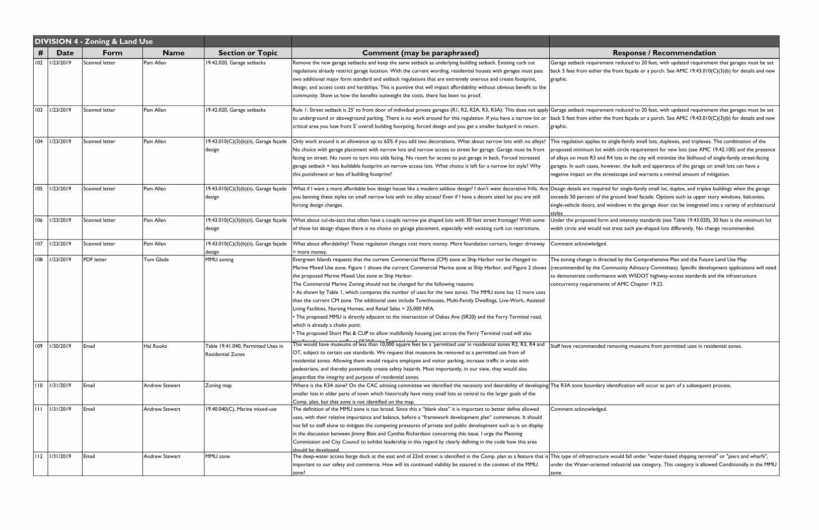
DIVISION 4 - Zoning & Land Use# Date Form Name Section or Topic Comment (may be paraphrased) Response / Recommendation
102 1/23/2019 Scanned letter Pam Allen 19.42.020, Garage setbacks Remove the new garage setbacks and keep the same setback as underlying building setback. Existing curb cut regulations already restrict garage location. With the current wording, residential houses with garages must pass two additional major form standard and setback regulations that are extremely onerous and create footprint, design, and access costs and hardships. This is punitive that will impact affordability without obvious benefit to the community. Show us how the benefits outweight the costs, there has been no proof.
Garage setback requirement reduced to 20 feet, with updated requirement that garages must be set back 5 feet from either the front façade or a porch. See AMC 19.43.010(C)(3)(b) for details and new graphic.
103 1/23/2019 Scanned letter Pam Allen 19.42.020, Garage setbacks Rule 1: Street setback is 25' to front door of individual private garages (R1, R2, R2A, R3, R3A): This does not apply to underground or aboveground parking. There is no work around for this regulation. If you have a narrow lot or critical area you lose front 5' overall building foorpting, forced design and you get a smaller backyard in return.
Garage setback requirement reduced to 20 feet, with updated requirement that garages must be set back 5 feet from either the front façade or a porch. See AMC 19.43.010(C)(3)(b) for details and new graphic.
104 1/23/2019 Scanned letter Pam Allen 19.43.010(C)(3)(b)(ii), Garage façade design
Only work around is an allowance up to 65% if you add two decorations. What about narrow lots with no alleys? No choice with garage placement with narrow lots and narrow access to street for garage. Garage must be front facing on street. No room to turn into side facing. No room for access to put garage in back. Forced increased garage setback = less buildable footprint on narrow access lots. What choice is left for a narrow lot style? Why this punishment or less of building footprint?
This regulation applies to single-family small lots, duplexes, and triplexes. The combination of the proposed minimum lot width circle requirement for new lots (see AMC 19.42.100) and the presence of alleys on most R3 and R4 lots in the city will minimize the liklihood of single-family street-facing garages. In such cases, however, the bulk and apperance of the garage on small lots can have a negative impact on the streetscape and warrants a minimal amount of mitigation.
105 1/23/2019 Scanned letter Pam Allen 19.43.010(C)(3)(b)(ii), Garage façade design
What if I want a more affordable box design house like a modern saltbox design? I don't want decorative frills. Are you banning these styles on small narrow lots with no alley access? Even if I have a decent sized lot you are still forcing design changes.
Design details are required for single-family small lot, duplex, and triplex buildings when the garage exceeds 50 percent of the ground level facade. Options such as upper story windows, balconies, single-vehicle doors, and windows in the garage door can be integrated into a variety of architectural
styles106 1/23/2019 Scanned letter Pam Allen 19.43.010(C)(3)(b)(ii), Garage façade
designWhat about cul-de-sacs that often have a couple narrow pie shaped lots with 30 feet street frontage? With some of these lot design shapes there is no choice on garage placement, especially with existing curb cut restrictions.
Under the proposed form and intensity standards (see Table 19.43.020), 30 feet is the minimum lot width circle and would not treat such pie-shaped lots differently. No change recommended.
107 1/23/2019 Scanned letter Pam Allen 19.43.010(C)(3)(b)(ii), Garage façade design
What about affordability? These regulation changes cost more money. More foundation corners, longer driveway = more money.
Comment acknowledged.
108 1/23/2019 PDF letter Tom Glade MMU zoning Evergreen Islands requests that the current Commercial Marine (CM) zone at Ship Harbor not be changed to
Marine Mixed Use zone. Figure 1 shows the current Commercial Marine zone at Ship Harbor, and Figure 2 shows the proposed Marine Mixed Use zone at Ship Harbor.The Commercial Marine Zoning should not be changed for the following reasons:• As shown by Table 1, which compares the number of uses for the two zones. The MMU zone has 12 more uses than the current CM zone. The additional uses include Townhouses, Multi-Family Dwellings, Live-Work, Assisted Living Facilities, Nursing Homes, and Retail Sales > 25,000 NFA.• The proposed MMU is directly adjacent to the intersection of Oakes Ave (SR20) and the Ferry Terminal road, which is already a choke point.• The proposed Short Plat & CUP to allow multifamily housing just across the Ferry Terminal road will also significantly increase traffic at SR20/Ferry Terminal road
The zoning change is directed by the Comprehensive Plan and the Future Land Use Map
(recommended by the Community Advisory Committee). Specific development applications will need to demonstrate conformance with WSDOT highway-access standards and the infrastructure concurrency requirements of AMC Chapter 19.22.
109 1/30/2019 Email Hal Rooks Table 19.41.040, Permitted Uses in Residential Zones
This would have museums of less than 10,000 square feet be a 'permitted use' in residential zones R2, R3, R4 and OT, subject to certain use standards. We request that museums be removed as a permitted use from all residential zones. Allowing them would require employee and visitor parking, increase traffic in areas with pedestrians, and thereby potentially create safety hazards. Most importantly, in our view, they would also
jeopardize the integrity and purpose of residential zones.
Staff have recommended removing museums from permitted uses in residential zones.
110 1/31/2019 Email Andrew Stewart Zoning map Where is the R3A zone? On the CAC advising committee we identified the necessity and desirability of developing smaller lots in older parts of town which historically have many small lots as central to the larger goals of the Comp. plan, but that zone is not identified on the map.
The R3A zone boundary identification will occur as part of a subsequent process.
111 1/31/2019 Email Andrew Stewart 19.40.040(C), Marine mixed-use The definition of the MMU zone is too broad. Since this a “blank slate” it is important to better define allowed uses, with their relative importance and balance, before a “framework development plan“ commences. It should
not fall to staff alone to mitigate the competing pressures of private and public development such as is on display in the discussion between Jimmy Blais and Cynthia Richardson concerning this issue. I urge the Planning Commission and City Council to exhibit leadership in this regard by clearly defining in the code how this area should be developed.
Comment acknowledged.
112 1/31/2019 Email Andrew Stewart MMU zone The deep-water access barge dock at the east end of 22nd street is identified in the Comp. plan as a feature that is important to our safety and commerce. How will its continued viability be assured in the context of the MMU zone?
This type of infrastructure would fall under "water-based shipping terminal" or "piers and wharfs", under the Water-oriented industrial use category. This category is allowed Conditionally in the MMU zone.

DIVISION 4 - Zoning & Land Use# Date Form Name Section or Topic Comment (may be paraphrased) Response / Recommendation
113 1/31/2019 Email Andrew Stewart Table 19.41.050, Principal uses permitted in mixed-use and industrial zones, Industrial category
Why has staff determined that uses proposed by Jimmy Blais in comment #31 of the 2nd draft be denied without further consideration? I understand the potential conflict with approved used in some cases but for the benefit of business and job creation some flexibility here could help. Our city needs new buildings 5K to 20k sq ft for business growth and incubation. Code changes that encourage that sort of construction should be encouraged.
[Note: Comment is referring to following requests from a public comment submitted on July 12, 2018:
"1. Allow Light industrial as a permitted use in the CM2 zone and a conditional use in the MMU zone.2. Allow light manufacturing as a permitted use in the MMU and CM2 Zones.3. Allow warehouse and distribution as a permitted use in the CM2 zone.4. Allow water-oriented industrial uses as permitted uses in the MMU zone."
Response recommendation was: "Given Comprehensive Plan policies and character of the zones, recommended to not to implement suggested changes 1, 2, and 3. Regarding suggestion #4, recommended to keep water-oriented industrial uses as conditional in MMU zone due to potential impacts on non-industrial uses."]
MMU zoneLight industrial: Changed from prohibited to conditional.
Light manufacturing: Recommend to retain as conditional to control for potential impacts on residential and commercial uses.
Water-oriented industrial: Recommend retaining as conditional to control for potential impacts on residential and commercial uses.
CM2 zone
Light industrial currently conditional. Recommend retaining as conditional. Water-oriented industrial is proposed to be permitted.
Light manufacturing: Recommend retaining as conditional.
Warehouse and distribution: Recommend retaining as conditional due to the marine-oriented intent
f h 114 1/31/2019 Email Andrew Stewart Zoning map Changing the part of CM1 Zone above the ferry terminal to MMU has broad implications. There are many factors to consider in this area, especially its proximity to Ship Harbor Reserve, its connectivity as a wildlife corridor and the large volume of traffic present in the area. Given the current undefined nature of MMU zoning, I am opposed to this re-zone. It may be that residential uses are precisely not what is best for this site. Again, the definition and balance of uses in the proposed MMU is too broad and should be better determined at this point in the process.
Comment acknowledged.
115 1/31/2019 Email Andrew Stewart MMU zone residential uses When discussing the nature of the MMU zone as it pertains to the area N of 22nd St., and the balance of uses within, I agree with the views of Mrs. Richardson regarding the importance measuring allowable housing as a proportion of building floor area, not site size. To suggest that tide lands and open space is enough public good by
its self to allow higher density housing willfully misses the point of mixed use.
Comment acknowledged.
116 1/31/2019 Email Andrew Stewart MMU zone residential uses When considering Jimmy Blais’ assertion that the community favors housing as a high priority on the MJB properties, I recall how the two hour forum, to which Mr. Blaise refers, was primarily a brain storming session. For those of us on the CAC and staff it was a good starting point for discussion. What it did not include was background information to the average person to inform them what impacts the choices made while in the charrette could have on the larger social, economic fabric of our community. We know that good paying jobs are an effective way to make housing affordable and keep our community vibrant. Therefore, the balance of uses in this MMU area favor business development and public amenities ahead of housing.
Comment acknowledged.
117 2/1/2019 Email Gene and Marilyn Derig Table 19.41.040, Permitted Uses in Residential Zones
There are permitted uses which can have the potential of bringing a host of problems if they are adopted. One of them is allowing museums of less than 10,000 sq. ft to be a permitted use in R2, R3, R4 and Old Town. According to Table 19.41.040, Permitted Uses in Residential Zones, such museums would be allowed. Along with them would come the usual package of collateral damage from their presence: increased traffic, pedestrians, employee
and visitor parking needs etc. This allowance threatens the very purpose and integrity of residential zoning.
A possible scenario which could occur if museums are allowed in the zones cited is this one: What if an entity wanted to put a museum out on a dock or at an old cannery location along the Guemes Channel or as an
attraction in Old Town? We believe this type of scenario is not far-fetched. If this use is allowed, someone will try
to take advantage of it. Once a thing is allowed and built it will be difficult or even impossible to have it removed--- to the detriment of those who bought in to those zones with the expectation that their zoning values would not be undermined.
Staff have recommended removing museums from permitted uses in residential zones.
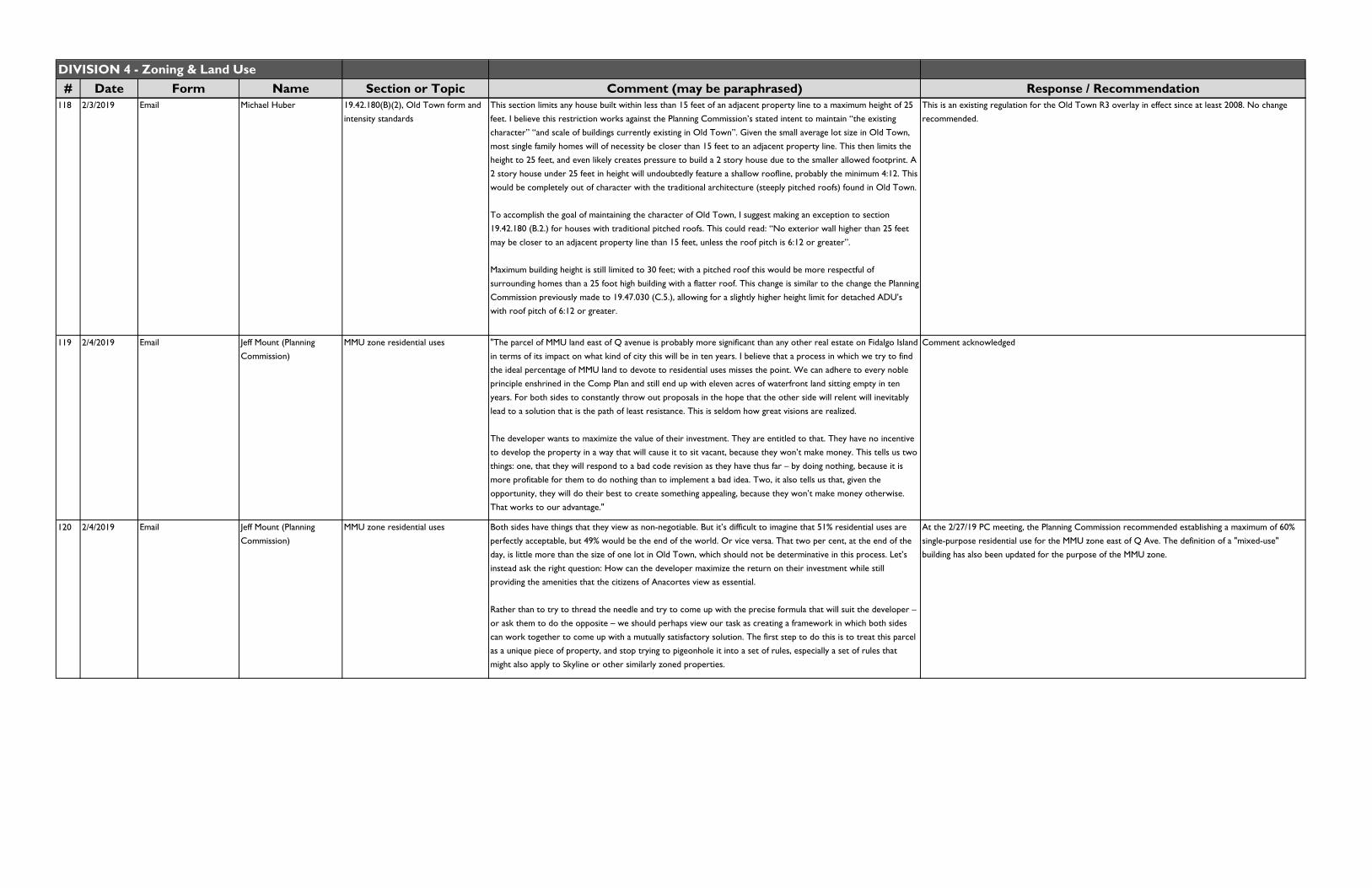
DIVISION 4 - Zoning & Land Use# Date Form Name Section or Topic Comment (may be paraphrased) Response / Recommendation
118 2/3/2019 Email Michael Huber 19.42.180(B)(2), Old Town form and intensity standards
This section limits any house built within less than 15 feet of an adjacent property line to a maximum height of 25 feet. I believe this restriction works against the Planning Commission’s stated intent to maintain “the existing character” “and scale of buildings currently existing in Old Town”. Given the small average lot size in Old Town, most single family homes will of necessity be closer than 15 feet to an adjacent property line. This then limits the height to 25 feet, and even likely creates pressure to build a 2 story house due to the smaller allowed footprint. A 2 story house under 25 feet in height will undoubtedly feature a shallow roofline, probably the minimum 4:12. This would be completely out of character with the traditional architecture (steeply pitched roofs) found in Old Town.
To accomplish the goal of maintaining the character of Old Town, I suggest making an exception to section 19.42.180 (B.2.) for houses with traditional pitched roofs. This could read: “No exterior wall higher than 25 feet may be closer to an adjacent property line than 15 feet, unless the roof pitch is 6:12 or greater”.
Maximum building height is still limited to 30 feet; with a pitched roof this would be more respectful of
surrounding homes than a 25 foot high building with a flatter roof. This change is similar to the change the Planning Commission previously made to 19.47.030 (C.5.), allowing for a slightly higher height limit for detached ADU’s with roof pitch of 6:12 or greater.
This is an existing regulation for the Old Town R3 overlay in effect since at least 2008. No change recommended.
119 2/4/2019 Email Jeff Mount (Planning Commission)
MMU zone residential uses "The parcel of MMU land east of Q avenue is probably more significant than any other real estate on Fidalgo Island in terms of its impact on what kind of city this will be in ten years. I believe that a process in which we try to find the ideal percentage of MMU land to devote to residential uses misses the point. We can adhere to every noble principle enshrined in the Comp Plan and still end up with eleven acres of waterfront land sitting empty in ten years. For both sides to constantly throw out proposals in the hope that the other side will relent will inevitably lead to a solution that is the path of least resistance. This is seldom how great visions are realized.
The developer wants to maximize the value of their investment. They are entitled to that. They have no incentive to develop the property in a way that will cause it to sit vacant, because they won’t make money. This tells us two things: one, that they will respond to a bad code revision as they have thus far – by doing nothing, because it is more profitable for them to do nothing than to implement a bad idea. Two, it also tells us that, given the opportunity, they will do their best to create something appealing, because they won’t make money otherwise. That works to our advantage."
Comment acknowledged
120 2/4/2019 Email Jeff Mount (Planning Commission)
MMU zone residential uses Both sides have things that they view as non-negotiable. But it’s difficult to imagine that 51% residential uses are perfectly acceptable, but 49% would be the end of the world. Or vice versa. That two per cent, at the end of the day, is little more than the size of one lot in Old Town, which should not be determinative in this process. Let’s instead ask the right question: How can the developer maximize the return on their investment while still providing the amenities that the citizens of Anacortes view as essential.
Rather than to try to thread the needle and try to come up with the precise formula that will suit the developer – or ask them to do the opposite – we should perhaps view our task as creating a framework in which both sides
can work together to come up with a mutually satisfactory solution. The first step to do this is to treat this parcel as a unique piece of property, and stop trying to pigeonhole it into a set of rules, especially a set of rules that might also apply to Skyline or other similarly zoned properties.
At the 2/27/19 PC meeting, the Planning Commission recommended establishing a maximum of 60% single-purpose residential use for the MMU zone east of Q Ave. The definition of a "mixed-use" building has also been updated for the purpose of the MMU zone.
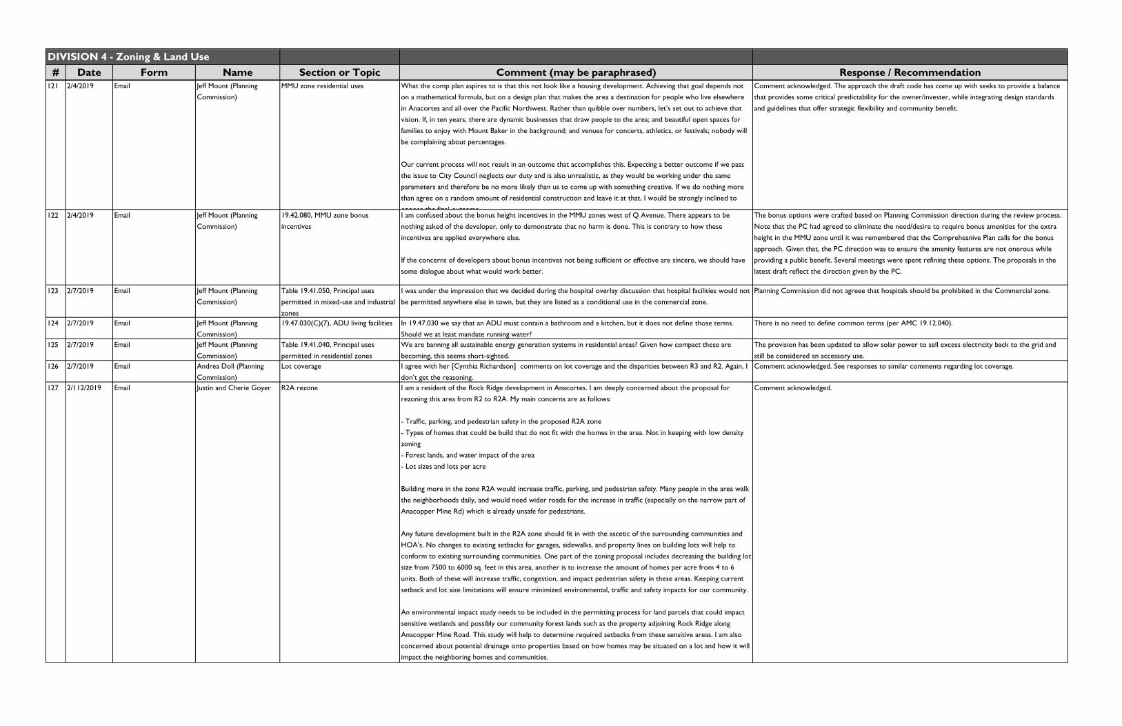
DIVISION 4 - Zoning & Land Use# Date Form Name Section or Topic Comment (may be paraphrased) Response / Recommendation
121 2/4/2019 Email Jeff Mount (Planning Commission)
MMU zone residential uses What the comp plan aspires to is that this not look like a housing development. Achieving that goal depends not on a mathematical formula, but on a design plan that makes the area a destination for people who live elsewhere in Anacortes and all over the Pacific Northwest. Rather than quibble over numbers, let’s set out to achieve that vision. If, in ten years, there are dynamic businesses that draw people to the area; and beautiful open spaces for families to enjoy with Mount Baker in the background; and venues for concerts, athletics, or festivals; nobody will be complaining about percentages.
Our current process will not result in an outcome that accomplishes this. Expecting a better outcome if we pass the issue to City Council neglects our duty and is also unrealistic, as they would be working under the same parameters and therefore be no more likely than us to come up with something creative. If we do nothing more than agree on a random amount of residential construction and leave it at that, I would be strongly inclined to
oppose the final outcome
Comment acknowledged. The approach the draft code has come up with seeks to provide a balance that provides some critical predictability for the owner/invester, while integrating design standards and guidelines that offer strategic flexibility and community benefit.
122 2/4/2019 Email Jeff Mount (Planning Commission)
19.42.080, MMU zone bonus incentives
I am confused about the bonus height incentives in the MMU zones west of Q Avenue. There appears to be nothing asked of the developer, only to demonstrate that no harm is done. This is contrary to how these incentives are applied everywhere else.
If the concerns of developers about bonus incentives not being sufficient or effective are sincere, we should have some dialogue about what would work better.
The bonus options were crafted based on Planning Commission direction during the review process. Note that the PC had agreed to eliminate the need/desire to require bonus amenities for the extra height in the MMU zone until it was remembered that the Comprehesnive Plan calls for the bonus approach. Given that, the PC direction was to ensure the amenity features are not onerous while providing a public benefit. Several meetings were spent refining these options. The proposals in the latest draft reflect the direction given by the PC.
123 2/7/2019 Email Jeff Mount (Planning Commission)
Table 19.41.050, Principal uses permitted in mixed-use and industrial
zones
I was under the impression that we decided during the hospital overlay discussion that hospital facilities would not be permitted anywhere else in town, but they are listed as a conditional use in the commercial zone.
Planning Commission did not agreee that hospitals should be prohibited in the Commercial zone.
124 2/7/2019 Email Jeff Mount (Planning
Commission)
19.47.030(C)(7), ADU living facilities In 19.47.030 we say that an ADU must contain a bathroom and a kitchen, but it does not define those terms.
Should we at least mandate running water?
There is no need to define common terms (per AMC 19.12.040).
125 2/7/2019 Email Jeff Mount (Planning
Commission)
Table 19.41.040, Principal uses
permitted in residential zones
We are banning all sustainable energy generation systems in residential areas? Given how compact these are
becoming, this seems short-sighted.
The provision has been updated to allow solar power to sell excess electricity back to the grid and
still be considered an accessory use.126 2/7/2019 Email Andrea Doll (Planning
Commission)Lot coverage I agree with her [Cynthia Richardson] comments on lot coverage and the disparities between R3 and R2. Again, I
don’t get the reasoning.Comment acknowledged. See responses to similar comments regarding lot coverage.
127 2/112/2019 Email Justin and Cherie Goyer R2A rezone I am a resident of the Rock Ridge development in Anacortes. I am deeply concerned about the proposal for rezoning this area from R2 to R2A. My main concerns are as follows:
- Traffic, parking, and pedestrian safety in the proposed R2A zone- Types of homes that could be build that do not fit with the homes in the area. Not in keeping with low density zoning- Forest lands, and water impact of the area- Lot sizes and lots per acre
Building more in the zone R2A would increase traffic, parking, and pedestrian safety. Many people in the area walk the neighborhoods daily, and would need wider roads for the increase in traffic (especially on the narrow part of Anacopper Mine Rd) which is already unsafe for pedestrians.
Any future development built in the R2A zone should fit in with the ascetic of the surrounding communities and HOA’s. No changes to existing setbacks for garages, sidewalks, and property lines on building lots will help to
conform to existing surrounding communities. One part of the zoning proposal includes decreasing the building lot size from 7500 to 6000 sq. feet in this area, another is to increase the amount of homes per acre from 4 to 6 units. Both of these will increase traffic, congestion, and impact pedestrian safety in these areas. Keeping current
setback and lot size limitations will ensure minimized environmental, traffic and safety impacts for our community.
An environmental impact study needs to be included in the permitting process for land parcels that could impact sensitive wetlands and possibly our community forest lands such as the property adjoining Rock Ridge along Anacopper Mine Road. This study will help to determine required setbacks from these sensitive areas. I am also concerned about potential drainage onto properties based on how homes may be situated on a lot and how it will impact the neighboring homes and communities.
Comment acknowledged.
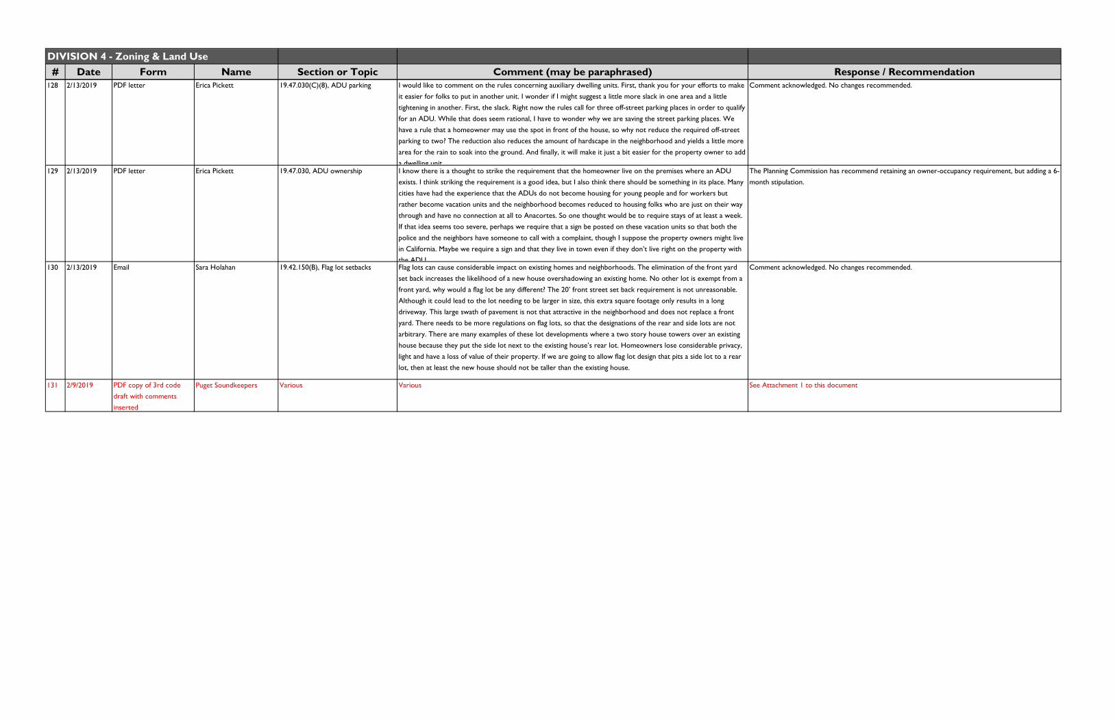
DIVISION 4 - Zoning & Land Use# Date Form Name Section or Topic Comment (may be paraphrased) Response / Recommendation
128 2/13/2019 PDF letter Erica Pickett 19.47.030(C)(8), ADU parking I would like to comment on the rules concerning auxiliary dwelling units. First, thank you for your efforts to make it easier for folks to put in another unit. I wonder if I might suggest a little more slack in one area and a little tightening in another. First, the slack. Right now the rules call for three off-street parking places in order to qualify for an ADU. While that does seem rational, I have to wonder why we are saving the street parking places. We have a rule that a homeowner may use the spot in front of the house, so why not reduce the required off-street parking to two? The reduction also reduces the amount of hardscape in the neighborhood and yields a little more area for the rain to soak into the ground. And finally, it will make it just a bit easier for the property owner to add
a dwelling unit.
Comment acknowledged. No changes recommended.
129 2/13/2019 PDF letter Erica Pickett 19.47.030, ADU ownership I know there is a thought to strike the requirement that the homeowner live on the premises where an ADU exists. I think striking the requirement is a good idea, but I also think there should be something in its place. Many cities have had the experience that the ADUs do not become housing for young people and for workers but rather become vacation units and the neighborhood becomes reduced to housing folks who are just on their way through and have no connection at all to Anacortes. So one thought would be to require stays of at least a week. If that idea seems too severe, perhaps we require that a sign be posted on these vacation units so that both the police and the neighbors have someone to call with a complaint, though I suppose the property owners might live in California. Maybe we require a sign and that they live in town even if they don’t live right on the property with
the ADU
The Planning Commission has recommend retaining an owner-occupancy requirement, but adding a 6-month stipulation.
130 2/13/2019 Email Sara Holahan 19.42.150(B), Flag lot setbacks Flag lots can cause considerable impact on existing homes and neighborhoods. The elimination of the front yard set back increases the likelihood of a new house overshadowing an existing home. No other lot is exempt from a front yard, why would a flag lot be any different? The 20’ front street set back requirement is not unreasonable. Although it could lead to the lot needing to be larger in size, this extra square footage only results in a long driveway. This large swath of pavement is not that attractive in the neighborhood and does not replace a front yard. There needs to be more regulations on flag lots, so that the designations of the rear and side lots are not arbitrary. There are many examples of these lot developments where a two story house towers over an existing house because they put the side lot next to the existing house’s rear lot. Homeowners lose considerable privacy, light and have a loss of value of their property. If we are going to allow flag lot design that pits a side lot to a rear lot, then at least the new house should not be taller than the existing house.
Comment acknowledged. No changes recommended.
131 2/9/2019 PDF copy of 3rd code draft with comments
inserted
Puget Soundkeepers Various Various See Attachment 1 to this document
DIVISION 5 - Community Design# Date Form Name Section or Topic Comment (may be paraphrased) Response / Recommendation
1 12/24/2018 Scanned PDF Ian Munce Table 19.53.040(B), Shared
driveways
To avoid new City streets serving a small number of lots, Table 19.53.040(B) should be amended for the
R1 zone to eliminate the 150' maximum length of a shared driveway, leaving this decision to the City Fire
Chief on a case by case basis.
Current draft standard was developed in cooperation with the Fire Department. No
change recommended.
2 1/7/2019 PDF copy of 3rd code draft
with comments and track
changes
Cynthia Richardson 19.51.020(A), Public street
improvements applicability
The way it's worded, it sound like "except for ... new non-residential or mixed-use development". This
would make it more clear. [See commenter's document for details.]
Applicability list updated to seperate residential and non-residential development for
clarity.
3 1/7/2019 PDF copy of 3rd code draft
with comments and track
changes
Cynthia Richardson Table 19.52.040(B), Low-volume
local street standards
Landscaped parking strips look very nice. But when on-street parking abuts a densely planted area it is
sometimes impossible for the passenger to get out of the car or even open the car door. Especially for
elderly folks, getting out of the car onto a stable sidewalk is much safer. Could it be an option to put the
sidewalk next to the pavement? Rock Ridge and other areas do this and it works just fine.
Planting area widths are recommended to support the benefits of street trees, buffer
pedestrians from traffic, and accomodate the wide variety of other uses and structures
that may also occur in this area and which need to be adjacent to the roadway,
including utility poles, stormwater infrastructure, mailboxes, trash pickup, etc.
4 1/7/2019 PDF copy of 3rd code draft
with comments and track
changes
Cynthia Richardson 19.53.040(B)(3), Residential
shared driveway landscaping
Suggest deleting first part of pargraph. most new shared driveways would be internal to an older
subdivision, not on the edge of another subdivision, so, as worded, this would not apply. Whether or not
the driveway is in the same subdivision, doesn't the adjacent neighbor deserve a buffer from the higher
traffic on a shared driveway? [See commenter's document for details]
No change recommended.
5 1/7/2019 PDF copy of 3rd code draft
with comments and track
changes
Cynthia Richardson 19.53.040(D), Residential shared
driveway eastments
Edits suggested for applicability for plat types. [See commenter's document for details.] Updated as suggested and to apply to all land division types.
6 1/7/2019 PDF copy of 3rd code draft
with comments and track
changes
Cynthia Richardson 19.54.030(A), Open space/parks Suggest editing accessibility requirements for open space/parks. [See commenter's document for details.] Updated as suggested.
7 1/7/2019 PDF copy of 3rd code draft
with comments and track
changes
Cynthia Richardson 19.54.040(B)(1), Lot design
standards
Suggest prohibiting alternative lot designs in Old Town, which could violate the Old Town setback
requirements.
Change made as suggested.
8 1/7/2019 PDF copy of 3rd code draft
with comments and track
changes
Cynthia Richardson 19.54.040(E)(1), Alley access lots Suggest allowing alley access lots where lots front onto Highway 20 Spur. There are quite a few of these
in the "west" blocks, where driveways onto the highway are undesirable and topography is steep. [See
commenter's document for details.]
No change recommended. These areas within city limits are already developed and
have local road access.
9 1/9/2019 PDF letter Nels Strandberg Chapter 19.52, Public street
design
Where is the Curb a curb is 18” wide on both sides of road. It is not calculated or shown and very
necessary.
• When we add parking which will have to happen, do we just eliminate the 6ft landscape area? Or do we
increase the ROW?
• Why 6ft sidewalks, standards are 5ft.
• Why 6ft planting area’s, 3 to 4ft is plenty.
• If you install parking on one side of road, and add for curb and gutter your ROW width is now plus 9ft
or 53 ft or 3ft larger then current standard. If you install two sides of parking your ROW is now 61ft,
with a paving width of 36ft?
• The current road standard has 50ft ROW with two lanes of parking, sidewalk both sides, and a 3ft
planter. This new design is not saving any space in my opinion, helping reduce stormwater, or saving any
trees.
I h d d d h h h
Updates have been made to AMC 19.52.040(B) to clarify where the curb and gutter are
counted in the standard street type layouts.
Updates have been made to the local street standard [Table 19.52.040(A)] to clarifty
how parking pockets may be implemented in coordination with landscaped area.
While 5 feet sidewalks meet minimum Americans with Disabilities Act (ADA)
accessibility standards, 6 feet or wider is recommended for developed areas and to
allow wheelchair use, pedestrian comfort, buffering from traffic, safety, and sidewalk
useability, etc.
Larger planting area widths are recommended to support the healthy growth of street
trees, buffer pedestrians from traffic, and accomodate the wide variety of uses and
structures that may also occur in this area, including utility poles, stormwater
infrastructure, mailboxes, trash pickup, etc.
DIVISION 5 - Community Design# Date Form Name Section or Topic Comment (may be paraphrased) Response / Recommendation
10 1/11/2019 Email Catherine Houck Chapter 19.52, Public street
design
2. Smaller roads, not “massive roads” will make neighborhoods more attractive and leas impervious area.
Mr. Strandberg testified at the public hearing that new design standards would create “massive roads”. Is
this true? If so, why? We should be reducing impervious area rather than increasing it. Please review the
requirements and total paved area.
Please see AMC Chapter 19.52, Public Street Design for the draft road standards. In
cooperation with the Public Works department, updated street design standards are
proposed with minimum landscaping and pedestrian sidewalk width. Proposed minimum
vehicle lanes are as low as 10 feet on local streets, compared to the typical minimum
width of 12 feet.11 1/22/2019 Email Tom Flanagan Table 19.52.040(A) through (E) Bike lanes not shown, as in prior table, where bike lanes are also marked affirmatively. Bike lanes are not required on every street and would only be implemented where
required by the Anacortes transportation plan.12 1/22/2019 Email Tom Flanagan 19.54.020(A)(3) and 19.54.030(E) Typo in last sentence: …..”public authority accepts an (vs. and) offer of dedication.” Corrected.
13 1/22/2019 Email Tom Flanagan 19.54.040, Lot design Typo: A. B. B. (vs. C) C. D. E. Corrected.
14 1/23/2019 PDF copy of 3rd code draft
with comments and track
changes
Jimmy Blais 19.53.050(C)(1)(b), Internal
circulation for residential
developments
Why are an extra two feet of width necessary on a sidewalk just because it’s next to a perpendicular or
angled parking space. What if the parking stalled are designed to be larger in length such that vehicles
don’t hang over the curb? What wheel stops are installed in the parking stall to prevent cars from
overhanging the curb?
This is a similar requirement for internal commercial parking lot pathways - see AMC
19.62.050(D)(3) - with the purpose of ensuring overhanging vehicles do not restrict the
useable width of the path. The exception for wheel stops has been added to both.
15 1/23/2019 PDF copy of 3rd code draft
with comments and track
changes
Jimmy Blais 19.53.050(C)(2), Internal
circulation for residential
developments
Why? This provision is unnecessary. Why can’t an internal sidewalk be connected to a building? Why
does there have to be 3’ of landscaping, this seems unnecessary and simply drives up development costs.
The provision is included to address both resident privacy and design character. The
following departure provision has been added: Departures will be considered provided
the location and design of the walkway and adjacent building elevation minimize privacy
impacts to building residents and enhances the character of the development."
16 1/23/2019 PDF copy of 3rd code draft
with comments and track
changes
Jimmy Blais 19.53.050(C)(3), Internal
circulation for residential
developments
Why do crosswalks have to be paved with a different material or have patterns added to them?
Crosswalk lines or painted surfaces work throughout the world, why not in Anacortes? These provisons
simply drive up costs with little or no benefit.
Contrasting materials assist low-vision individuals in identifying safe walking routes and
alert drivers to the potential presence of pedestrians, and elevate Anacortes design and
development apperance as envisioned by the Comprehensive Plan. No change
recommended.
17 1/25/2019 Email Gail King 19.52.040, Street geometric
design and streetscape
Streets in new developments should be as wide as 32nd street allowing for parking and bike lanes.
Sidewalks should be put in and alleys required.
Streets in new developments will be subject to the standards of their classification from
the Anacortes transportation plan and the Public Works Department. 32nd Street is
classified as "minor" (arterial) and most streets in Anacortes as classified as "local". Both
require sidewalks as proposed in Tables 19.52.040(A) through (E). Alley access lots are
allowed under 19.54.040(E).18 1/25/2019 Email Gail King 19.52.040, Street geometric
design and streetscape
If more than 20% of a street in developed into duplexes or higher density dwellings, the whole street
should be improved to the standards of 32nd St. at the developers cost. Allow for parking, bike lanes and
the width for 2 cars to drive down the street at the same time.
AMC 19.51.020 provides for the applicability of street improvements.
19 1/25/2019 Email Gail King Alleys, generally All over the city, alleys have been vacated. This is cheaper for the city and homeowner. If multi-family
units are put in, alleys need to be developed to AMC standards and the developer should pay for it, costs
should not come out of the road improvement sales tax approved by the voters. Current homeowners
should not be charged for alley improvements. Vacated alleys should not be sold to the developer so they
can use that land as part of their lot.
Alleys are an option for developments - in any case, driveway and service must be
considered and approved by the city. Current homeowners are not required to
provide alley improvements unless a development is subject to the draft applicability
requirements of AMC 19.51.020. Alley vacations are covered by AMC Chapter 12.50,
which is beyond the scope of this project.20 2/4/2019 Email Jeff Mount (Planning
Commission)
19.52.040, Street geometric
design and streetscape
I agree with those who say that the street design standards will create a huge amount of paved surface.
The six-foot sidewalks seem like the least useful part of this, but I would look at all aspects of this chapter
to verify that everything is essential.
The proposed street design standards were developed in close and careful coordination
with the Public Works department. Fpr sidewalks, 6 feet or wider is recommended for
developed areas and to allow wheelchair use, pedestrian comfort, buffering from traffic,
safety, and sidewalk useability, etc. AMC 19.51.060(C) provides for modifications on a
case-by-case basis.21 2/4/2019 Email Jeff Mount (Planning
Commission)
19.51.060, Modifications,
deferments, waivers, and
construction-in-lieu
In 19.51.060, it feels like there is a lot of overlap between the criteria for waivers and construction-in-
lieu. If the decision is left to the director every time a situation falls into this overlap, it could be (or be
perceived to be) applied unevenly. Why not just eliminate the waiver?
The waiver (section E) is applicable to all types of roadway improvements, while the
sidewalk construction-in-lieu program (section F) is applicable only to sidewalks.
DIVISION 5 - Community Design# Date Form Name Section or Topic Comment (may be paraphrased) Response / Recommendation
22 2/7/2019 Email Jeff Mount (Planning
Commission)
19.53, Private streets and access Does Chapter 19.53 apply to private streets? As worded, it does not seem to. The chapter is titled 19.53 - Private Streets and Access. Section 19.53.020 -
Applicability, states: All new or altered private driveways and private accesses onto a
city street (including temporary or construction accesses) must comply with this
chapter and the Anacortes Engineering Design Standards.23 2/9/2019 PDF copy of 3rd code draft
with comments insertedPuget Soundkeepers Various Various See Attachment 1 to this document

DIVISION 6 - Project Design# Date Form Name Section or Topic Comment (may be paraphrased) Response / Recommendation
1 12/27/2018 Email Steve Morris 19.64.060(D)(4), Modified parking requirements
If the owner of the building provides a car sharing vehicle with a designated space for all residence of the rental complex would that be the same as a space provided for a ride sharing provider?
We (Nicki and I) have a 17 unit at 1019 22nd st that I would like to add 4 units to besides the addition of 4 units at 1101 29th st - if we could reduce 5 parking spaces by providing a ride sharing vehicle or a ride sharing vehicle space - it would make the project that much more feasible and provide the city with more reasonably prices rental units.
The number of parking spaces reduced by car sharing - 5 on a 20 unit or above doesn't do a lot of good for many of the properties in Anacortes. We have 56 rental units combined in Anacortes but our largest would not qualify unless we could add 4 units to the 17 unit on 22nd st. Would it not be better to base it on a square footage of the overall rental complex like you did with Guest parking or a 25% reduction of parking spaces (4 on a 16 unit - 3 on a 12) not to exceed one ride sharing space per lot under 20 units. That could change in the future - car sharing is going to be big in the future to not only reduce the number of vehicles but the cost of vehicle purchase and maintenance are getting to be quite expensive.We don't have plans drawn up for 1019 22nd st addition of 4plex yet.
The provision is intended for third party "car-sharing providers". A definition has been added to AMC Chapter 19.12.
Subsection (D)(4) has been updated to apply to only new residential developments and the recommended threshold remains 20 dwelling units. In a such a building expansion in the R4 zone, the requirements of subsection (D)(1) for a parking study may allow for reduced parking requirements [see AMC 19.64.020(H)].
2 1/4/2019 Email Cynthia Richardson Chapter 19.61, Block Frontage Standards
Street Frontage Maps: The Planning Commission agreed that ALL STREET FRONTAGES SOUTH OF 17th should be UNDESIGNATED. Why do some still have other designations? Why was Map 1 changed to bring the mixed designation all the way to the corner instead of wrapping the storefront around (as in draft 1)? It would be odd to allow landscaped frontages to come to the corner (and the landscaped designation allows parking there). Since ground level spaces must be 50' deep, wrapping the storefront designation around the corner for 50' so the building must come to the sidewalk makes sense.
Maps corrected to remove Commercial Avenue designations south of 12th Street, per Planning Commission discussion at the 11/28/2018 meeting.
3 1/4/2019 Email Cynthia Richardson Chapter 19.61, Block Frontage Standards
Landscaping. Requiring landscaping DOES NOT MAKE SENSE FOR COMMERCIAL AVEIN CBD. Storefront designation requires 0 setback, and other sides allow 0 setback. Alandscaped area between or behind these buildings would not be seen or used.
AMC 19.65.030(A)(2) notes: "Developments on sites featuring a building or buildings meeting Storefront block frontage standards along the entire lot frontage are exempt." This applies to Commercial Avenue in the CBD zone.
4 1/4/2019 Email Cynthia Richardson Table 19.67.060(A), Sign types Pole signs. Table 19.67.060(A) restricts pole signs to HM and LM1. This must be changed . Pole signs are the primary sign type along Commercial Ave. with over 50 existing signs that would become non-conforming if this restriction isn't changed. Pole signs are practical, less massive than monument signs, and should be allowed. Treat pole signs the same as other freestanding signs. Restricting the height and size may be appropriate in some zones, but please give small businesses the option to have inexpensive pole signs visible to motorists.
Correct, existing pole signs outside the HM and LM1 zone would become nonconforming. Under the updated nonconforming signs standards of AMC 19.67.130, such existing signs would be allowed remain indefinitely and sign copy may be updated. Over the long-term, prohibition of pole signs along Commercial Avenue (the Commercial zone) is consistent with the landscaping and aesthetic policies of the South Commercial Avenue Corridor Plan (increased and continuous tree canopy and columnar/pyramidal-shaped tree species that will likely impede views of pole signs) and the Comprehensive Plan (Goal LU-7), which envisions a transition of the corridor to a more pedestrian-oriented streetscape.
5 1/7/2019 PDF copy of 3rd code draft with comments
and track changes
Cynthia Richardson 19.61.040(A)(2), Block frontage
designation maps
NO unauthorized person should alter the maps - period! [See commenter's document for detailed suggested edits.]
Changes made as suggested.
6 1/7/2019 PDF copy of 3rd code draft with comments
and track changes
Cynthia Richardson Figure 19.61.040(B) Map 1: Anacortes block frontage
designations map for the downtown area.
Why was Map 1 changed to bring the mixed designation all the way to the corner instead of wrapping the storefront around (as in draft 1)? It would be odd to allow landscaped frontages to come to the corner (and the
landscaped designation allows parking there). Since ground level spaces must be 50' deep, wrapping the storefront designation around the corner for 50' so the building must come to the sidewalk makes sense.
The change was made to simplify the map and allow extra flexibility on the side streets. Secondly, the variable widths of the parcels on the opposite sides of the side streets made it more problematic to map (it is preferred
to avoid splitting parcels). Also note AMC 19.61.150 clarifies how the standards are applied to corner properties.
7 1/7/2019 PDF copy of 3rd code draft with comments and track changes
Cynthia Richardson Figure 19.61.040(B) Map 1: Anacortes block frontage
designations map for the downtown area.
Suggest adding the high visibility street corner designation on 9th and 11th (by the arch) at Commercial, and 9th and 11th at Q because these two streets are key pedestrian routes between downtown and Cap Sante Marina.
The HVSC designation has been added to the intersection of Commercial Avenue and 11th Street by the arch due to the area's clear significance/importance.
8 1/7/2019 PDF copy of 3rd code draft with comments and track changes
Cynthia Richardson Figure 19.61.040(C) Map 2:
Block frontage designations map for central Commercial Avenue and Central Waterfront.
The Planning Commission agreed that ALL STREET FRONTAGES SOUTH OF 17th should be UNDESIGNATED.
Remove the mixed and storefront lines.
Maps corrected to remove Commercial Avenue designations south of 12th Street, per Planning Commission
discussion at the 11/28/2018 meeting.
DIVISION 6 - Project Design# Date Form Name Section or Topic Comment (may be paraphrased) Response / Recommendation
9 1/7/2019 PDF copy of 3rd code draft with comments and track changes
Cynthia Richardson Figure 19.61.040(C) Map 2: Block frontage designations map for central Commercial Avenue and Central
Waterfront.
Designating 20th at Commercial and Q/R as high visibility street corners makes no sense. 20th is narrow, and the street corners at Commercial are offset. Makes sense at 22nd, which has a light and is an arterial, but NOT at 20th.
20th Street has been identified as a key connection to the waterfront. No change recommended.
10 1/7/2019 PDF copy of 3rd code draft with comments and track changes
Cynthia Richardson Figure 19.61.040(C) Map 2: Block frontage designations map for central Commercial Avenue and Central
Waterfront.
The esplanade designation should continue north around the existing esplanade and marina so that as it is redeveloped over time the esplanade will be maintained.
Good comment. However, the frontage standards that apply to this designation would be a significant change from the current segment. Recommendation is to focus on the MMU site.
11 1/7/2019 PDF copy of 3rd code draft with comments
and track changes
Cynthia Richardson Table 19.61.070(B)Landscaped block frontage
standards.
Suggest clarifying that landscaping is required between the sidewalk and parking area. [See commenter's document for details.]
Change made as suggested.
12 1/7/2019 PDF copy of 3rd code draft with comments and track changes
Cynthia Richardson Table 19.61.100(B)Gateway block frontage standards.
Suggest adding landscape screening exception be added for low decorative walls up to 4 1/2 feet tall. [See commenter's document for details.]
Change made as suggested.
13 1/7/2019 PDF copy of 3rd code draft with comments
and track changes
Cynthia Richardson 19.61.110(B), Undesignated block frontage applicability
Suggest exempting industrial zones from the building entrance and transparency standards. [See commenter's document for details.]
The Industrial zone is exempt from the block frontage standards in AMC Chapter 19.61.
14 1/7/2019 PDF copy of 3rd code draft with comments and track changes
Cynthia Richardson 19.61.110(D), Undesignated block frontage departures
Suggest removing 50 percent reduction allowance for façade transparency. Except along R Ave or adjacent to a lower-intensity zone, blank walls should be allowed. Industrial type uses with large warehouse-type buildings often need to control light and don't want windows. Let's admit that it's OK for industrial buildings to be plain boxes when internal to the zone. Could require tall trees as part of the landscaping if the wall is blank - similar to WW
treatment plant or the DCI fab building.
The Industrial zone is exempt from the block frontage standards in AMC Chapter 19.61.
15 1/7/2019 PDF copy of 3rd code draft with comments and track changes
Cynthia Richardson 19.61.120, Trail block frontage standards
There are no trail designations in the MS zone. Change made as suggested.
16 1/7/2019 PDF copy of 3rd code draft with comments and track changes
Cynthia Richardson 19.61.150(D), Transparency for
corner sites
Edits suggested. What's the point of transparency standards if they can be cut in half just because it's on a corner? [See commenter's document for details.]
While transparency is ideal, the provision is intended to allow flexibility on these types of sites and the functional needs of the building should be considered. No change recommended.
17 1/7/2019 PDF copy of 3rd code draft with comments and track changes
Cynthia Richardson Figure 19.61.150, Clarifying block frontage standards on street corners
THERE ARE NO PLACES WHERE A STOREFRONT AND A LANDSCAPED DESIGNATION MEET. Change the text to Storefront/Mixed or Mixed/Landscaped
Graphic is an example and not specific to a Storefront-Landscaped designation intersection. No changes recommended.
18 1/7/2019 PDF copy of 3rd code draft with comments and track changes
Cynthia Richardson 19.62.030(B), Balcony standards Left half transparent, right half opaque? 4" open, 4" board, 4" open, 4" board? Top half opaque, bottom half transparent? Not really clear what this accomplishes.
All examples suggested would provide a measure of residential privacy, which is the purpose of the standard. No change recommended.
19 1/7/2019 PDF copy of 3rd code draft with comments and track changes
Cynthia Richardson 19.62.040(C), Usable commercial open space
THIS IS A CONFLICT. If buildings are required to come up to the sidewalk on storefront-designated streets, there is no room for open space. Setbacks are also not required on other sides, and it does not make sense to have pedestrian oriented spaces behind the buildings. Suggest adding: "Exception: Buildings fronting on
Commercial Avenue in the CBD are not required to provide pedestrian-oriented open space."
Storefront standards provide, "Additional setbacks are allowed for a widened sidewalk or pedestrian-oriented space [AMC 19.62.040(D)]." No change recommended.
20 1/7/2019 PDF copy of 3rd code draft with comments and track changes
Cynthia Richardson 19.62.040(D), Pedestrian-oriented open space
Suggest adding: "Where feasible, adjacent businesses are encouraged to locate their open spaces next to each other to create a larger contiguous area."
Comment acknowledged.
21 1/7/2019 PDF copy of 3rd code draft with comments and track changes
Cynthia Richardson 19.62.050(C)(1), Internal circulation
Suggest removing steep slope departure. There are no steep slopes in those zones. Change made as suggested.
22 1/7/2019 PDF copy of 3rd code
draft with comments and track changes
Cynthia Richardson 19.62.050(C)(3), Internal
circulation
Suggest deleting crosswalk requirement. If street crossings on highway 20 and normal arterials aren't marked, why
is this necessary? It's just an extra expense that reduces affordability. It is not needed for a low-volume internal street.
Comment acknowledged.
23 1/7/2019 PDF copy of 3rd code draft with comments and track changes
Cynthia Richardson 19.62.050(C)(6), Internal circulation and easements
Connection of pedestrian routes is desirable, but how can one know what will be built next door in the future? Provision removed as suggested due to lack of large applicable properties.
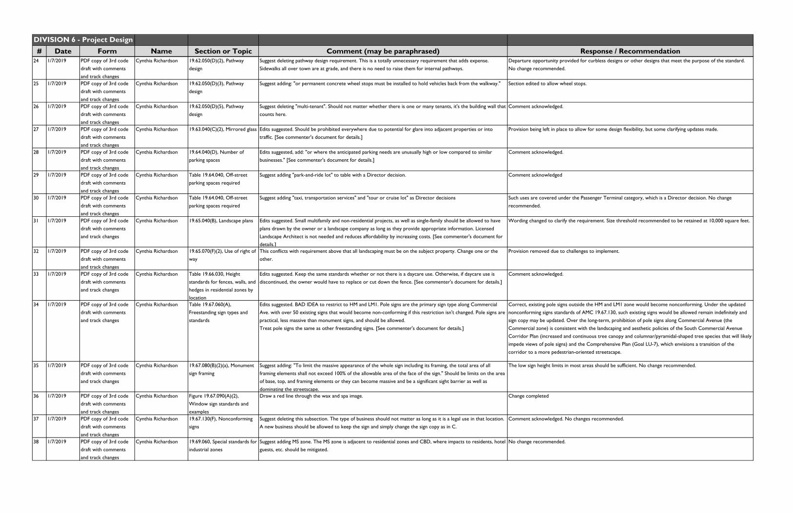
DIVISION 6 - Project Design# Date Form Name Section or Topic Comment (may be paraphrased) Response / Recommendation
24 1/7/2019 PDF copy of 3rd code draft with comments and track changes
Cynthia Richardson 19.62.050(D)(2), Pathway design
Suggest deleting pathway design requirement. This is a totally unnecessary requirement that adds expense. Sidewalks all over town are at grade, and there is no need to raise them for internal pathways.
Departure opportunity provided for curbless designs or other designs that meet the purpose of the standard. No change recommended.
25 1/7/2019 PDF copy of 3rd code draft with comments
and track changes
Cynthia Richardson 19.62.050(D)(3), Pathway design
Suggest adding: "or permanent concrete wheel stops must be installed to hold vehicles back from the walkway." Section edited to allow wheel stops.
26 1/7/2019 PDF copy of 3rd code draft with comments and track changes
Cynthia Richardson 19.62.050(D)(5), Pathway design
Suggest deleting "multi-tenant". Should not matter whether there is one or many tenants, it's the building wall that counts here.
Comment acknowledged.
27 1/7/2019 PDF copy of 3rd code draft with comments and track changes
Cynthia Richardson 19.63.040(C)(2), Mirrored glass Edits suggested. Should be prohibited everywhere due to potential for glare into adjacent properties or into traffic. [See commenter's document for details.]
Provision being left in place to allow for some design flexibility, but some clarifying updates made.
28 1/7/2019 PDF copy of 3rd code draft with comments and track changes
Cynthia Richardson 19.64.040(D), Number of parking spaces
Edits suggested, add: "or where the anticipated parking needs are unusually high or low compared to similar businesses." [See commenter's document for details.]
Comment acknowledged.
29 1/7/2019 PDF copy of 3rd code draft with comments and track changes
Cynthia Richardson Table 19.64.040, Off-street parking spaces required
Suggest adding "park-and-ride lot" to table with a Director decision. Comment acknowledged
30 1/7/2019 PDF copy of 3rd code draft with comments
and track changes
Cynthia Richardson Table 19.64.040, Off-street parking spaces required
Suggest adding "taxi, transportation services" and "tour or cruise lot" as Director decisions Such uses are covered under the Passenger Terminal category, which is a Director decision. No change recommended.
31 1/7/2019 PDF copy of 3rd code
draft with comments and track changes
Cynthia Richardson 19.65.040(B), Landscape plans Edits suggested. Small multifamily and non-residential projects, as well as single-family should be allowed to have
plans drawn by the owner or a landscape company as long as they provide appropriate information. Licensed Landscape Architect is not needed and reduces affordability by increasing costs. [See commenter's document for details.]
Wording changed to clarify the requirement. Size threshold recommended to be retained at 10,000 square feet.
32 1/7/2019 PDF copy of 3rd code
draft with comments
and track changes
Cynthia Richardson 19.65.070(F)(2), Use of right of
way
This conflicts with requirement above that all landscaping must be on the subject property. Change one or the
other.
Provision removed due to challenges to implement.
33 1/7/2019 PDF copy of 3rd code draft with comments and track changes
Cynthia Richardson Table 19.66.030, Height standards for fences, walls, and hedges in residential zones by
location
Edits suggested. Keep the same standards whether or not there is a daycare use. Otherwise, if daycare use is discontinued, the owner would have to replace or cut down the fence. [See commenter's document for details.]
Comment acknowledged.
34 1/7/2019 PDF copy of 3rd code draft with comments and track changes
Cynthia Richardson Table 19.67.060(A), Freestanding sign types and standards
Edits suggested. BAD IDEA to restrict to HM and LM1. Pole signs are the primary sign type along Commercial Ave. with over 50 existing signs that would become non-conforming if this restriction isn't changed. Pole signs are practical, less massive than monument signs, and should be allowed.Treat pole signs the same as other freestanding signs. [See commenter's document for details.]
Correct, existing pole signs outside the HM and LM1 zone would become nonconforming. Under the updated nonconforming signs standards of AMC 19.67.130, such existing signs would be allowed remain indefinitely and sign copy may be updated. Over the long-term, prohibition of pole signs along Commercial Avenue (the Commercial zone) is consistent with the landscaping and aesthetic policies of the South Commercial Avenue
Corridor Plan (increased and continuous tree canopy and columnar/pyramidal-shaped tree species that will likely impede views of pole signs) and the Comprehensive Plan (Goal LU-7), which envisions a transition of the corridor to a more pedestrian-oriented streetscape.
35 1/7/2019 PDF copy of 3rd code draft with comments and track changes
Cynthia Richardson 19.67.080(B)(2)(a), Monument sign framing
Suggest adding: "To limit the massive appearance of the whole sign including its framing, the total area of all framing elements shall not exceed 100% of the allowable area of the face of the sign." Should be limits on the area of base, top, and framing elements or they can become massive and be a significant sight barrier as well as dominating the streetscape.
The low sign height limits in most areas should be sufficient. No change recommended.
36 1/7/2019 PDF copy of 3rd code draft with comments and track changes
Cynthia Richardson Figure 19.67.090(A)(2),Window sign standards and examples
Draw a red line through the wax and spa image. Change completed
37 1/7/2019 PDF copy of 3rd code
draft with comments and track changes
Cynthia Richardson 19.67.130(F), Nonconforming
signs
Suggest deleting this subsection. The type of business should not matter as long as it is a legal use in that location.
A new business should be allowed to keep the sign and simply change the sign copy as in C.
Comment acknowledged. No changes recommended.
38 1/7/2019 PDF copy of 3rd code draft with comments and track changes
Cynthia Richardson 19.69.060, Special standards for industrial zones
Suggest adding MS zone. The MS zone is adjacent to residential zones and CBD, where impacts to residents, hotel guests, etc. should be mitigated.
No change recommended.

DIVISION 6 - Project Design# Date Form Name Section or Topic Comment (may be paraphrased) Response / Recommendation
39 1/8/2019 Email Cynthia Richardson Table 19.67.060(A), Freestanding sign types and standards
I would like to retract my comment #93 [second draft comments] suggesting that pole signs should have a maximum ht. of 15’ outside the HM and LM1 zones. Driving down south Commercial Ave. today, I observed that nearly all of the existing pole signs are quite a bit more than 15’ tall and they seem in reasonable scale with the existing small buildings. Future buildings are likely to be even taller. I suggest that all pole signs be allowed to be 30’ tall – or if measurements of the existing signs can be made, establish a limit that would allow at least 90% of
the existing signs to be within the legal limit.
See response to comment #4.
40 1/22/2019 Email Tom Flanagan Chapter 19.61, Block Frontage Standards
Starting in this chapter on page 233, 6 Standards are listed, and then 1-4 pages later, Departure Criteria are listed, weakening, perhaps even negating Standards. Is this appropriate?
Departures are only proposed/allowed where there is acknowledgement that certain standards can be met in different ways and where experience shows some flexibility is warranted. Many communities have demonstrated the sucess of this approach in providing negotiating power for city staff and high-quality results. In any request for a departure, the applicant must demonstrate that the purpose of the standards are being met and that the alternative design/proposal is equal or greater than the benefit of the base standard. See AMC 19.20.220 for
departures criteria41 1/22/2019 Email Tom Flanagan Chapter 19.62 aand 19.63 Use of Departures continues every 1-4 pages. Again, do these weaken the regulations? Departures are only proposed/allowed where there is acknowledgement that certain standards can be met in
different ways and where experience shows some flexibility is warranted. Many communities have demonstrated the sucess of this approach in providing negotiating power for city staff and high-quality results. In any request for a departure, the applicant must demonstrate that the purpose of the standards are being met and that the alternative design/proposal is equal or greater than the benefit of the base standard. See AMC 19.20.220 for
departures criteria42 1/23/2019 PDF copy of 3rd code
draft with comments and track changes
Jimmy Blais Figure 19.61.040(C), Map 2: Block frontage designations map for central Commercial Avenue and Central
Waterfront
This block frontage map was created by the City and Makers as a rough example. It was never intended to detail the final block frontage designations for MJB’s waterfront property. MJB was not involved in its development and highly objects to this map as the baseline. We agree that the extension of T/V ave, 20th street and 17th street should have block frontage designations. We disagree with any of the other designations until an actual street grid is developed for the site.
The map legend notes that dashed lines as conceptual, and the site is subject to an optional Framework Development Plan. 19.61.180(C)(2) notes that "Framework development plans may utilize any existing block frontage designations within or bordering the site, or include an alternative block frontage designation type or types, subject to master plan approval."
43 1/23/2019 PDF copy of 3rd code draft with comments and track changes
Jimmy Blais Table 19.61.060(B), Storefront block frontage standards
We strongly request that you reconsider this provision. There are numerous examples on our site that have already been discussed with the City, where the primary entrance will not face the street or where there will be multiple street frontages on parallel sides. For example, if a building is sited at 17th and Q, this requirement would designate the corner as the primary entrance, even though all parking and access would be on the other side of the building. Allow businesses to site their entrance were it makes sense such that they don’t have to design buildings with multiple entrances that will only lead to increased cost, staffing and theft.
The referenced area does not have a storefront designation. The subject site contains mostly "Marine" designations - which allows for some flexibility in building/parking lot locations. It is assumed that if the Marine designations don't work for the proposed development, that the owner/applicant can apply for a Framework Development Plan to propose alternative block frontage provisions.
44 1/23/2019 PDF copy of 3rd code draft with comments and track changes
Jimmy Blais Table 19.61.090(C)(3), Marine block frontage standards
On MJB’s site the vast majority of parking will have to be in the “front” of buildings due to layouts and the desire to not put parking along the waterfront. Should a departure, public tradeoffs, and significant mitigation factors really be required just because our site has a difficult layout and undefined “front?”
Comment acknowleged.
45 1/23/2019 PDF copy of 3rd code draft with comments and track changes
Jimmy Blais 19.62.040(B)(1), Useable residential open space
The open space requirements are incredibly burdensome. These provisions equate to more than 10% of the total square footage of a building. This amount of open space would drastically increase the cost of development. We respectfully request that you relax the space requirement and the below noted limitations.
Quality and well-sized open space is a critical component of livability for denser housing types. The multifamily open space standards have been developed through years of experience with similarly-sized communities and through reviewing buildings that have been developed under them. The square footage rates have been well-received and found to be reasonable, especially since multiple indoor, outdoor, and rooftop options (particularly for mixed-use buildings) are provided to meet the standards.
46 1/23/2019 PDF copy of 3rd code draft with comments and track changes
Jimmy Blais 19.62.040(B)(1)(b)(ii), Useable residential open space - private porches
This is overly prescriptive. Why require a 6’x6’ square at a minimum. Would a 8’x5’ outdoor space be any less desirable?
Comment acknowleged.
47 1/23/2019 PDF copy of 3rd code
draft with comments and track changes
Jimmy Blais 19.62.040(B)(1)(c) Useable
residential open space - balconies
Balconies should be allowed to be smaller and still qualify for open space. Larger balconies generally detract from
developments more than they add. They simply become storage facilities for bikes, boxes and grills.
Minimum balcony dimensions were previously reduced in size from previous drafts. Note that balconies are not
required, only one option to meet useable residential space requirements. No change recommended to ensure useability.
48 1/23/2019 PDF copy of 3rd code draft with comments and track changes
Jimmy Blais 19.62.040(B)(1)(d) Useable residential open space - Indoor recreation
Why only for mixed use buildings? Do stand alone residential buildings in a mixed use development qualify? Indoor space in no less valuable if its incorporated into a standalone residential building compared to a vertically mixed use building.
Comment acknowleged. The provision was structured to encourage more outdoor open spaces for residential uses, while offering more flexibility for mixed-use buildings.
49 1/23/2019 PDF copy of 3rd code draft with comments
and track changes
Jimmy Blais 19.62.040(B)(1)(d) Useable residential open space - Roof
decks
Why only the tops of buildings? There are plenty of multifamily developments that provide exterior open space on floors other than the roof.
Comment acknowleged. "Shared roof deck" provisions are specifically tailored to apply to those spaces on the top of buildings. But "shared open spaces" in subsection (B)(2) may apply to courtyards on top of parking or
other roof decks provided they meet the criteria therein.50 1/23/2019 PDF copy of 3rd code
draft with comments and track changes
Jimmy Blais 19.62.040(B)(1)(d) Useable residential open space - Roof decks
Why only for mixed use buildings? Do stand alone residential buildings in a mixed use development qualify? Indoor space in no less valuable if its incorporated into a standalone residential building compared to a vertically mixed use building.
Comment acknowleged. The intent is to encourage a mix of open spaces - while accommodating extra flexibility for mixed-use buildings.
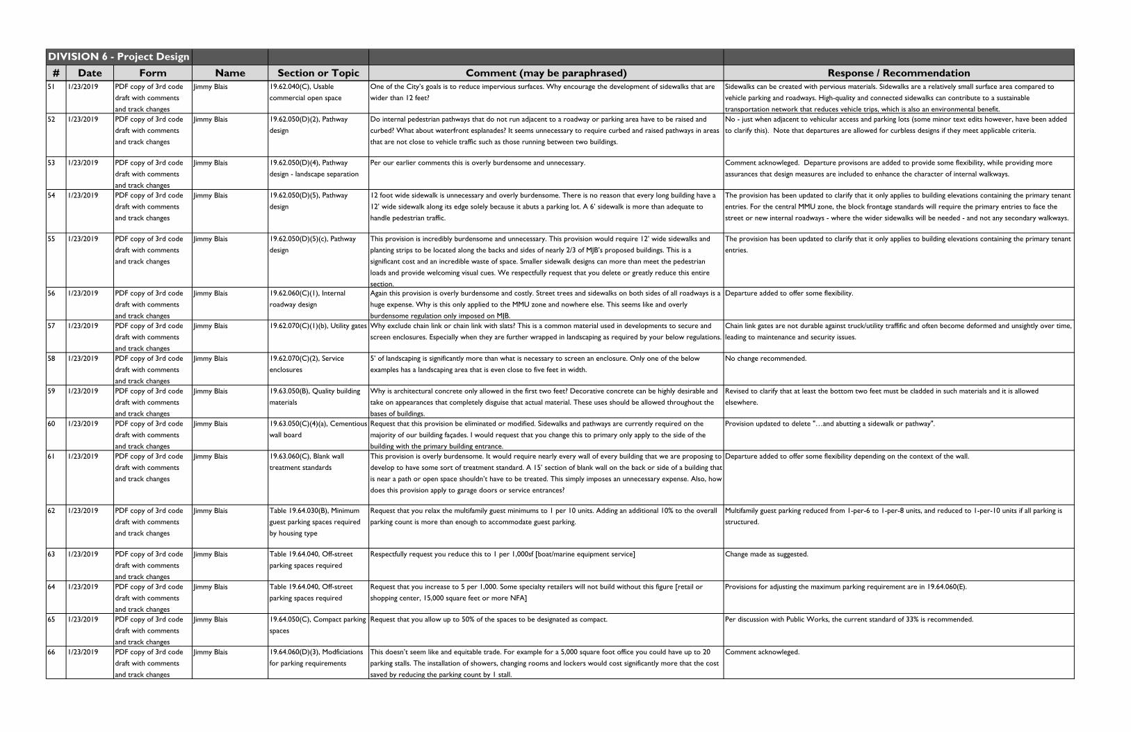
DIVISION 6 - Project Design# Date Form Name Section or Topic Comment (may be paraphrased) Response / Recommendation
51 1/23/2019 PDF copy of 3rd code draft with comments and track changes
Jimmy Blais 19.62.040(C), Usable commercial open space
One of the City’s goals is to reduce impervious surfaces. Why encourage the development of sidewalks that are wider than 12 feet?
Sidewalks can be created with pervious materials. Sidewalks are a relatively small surface area compared to vehicle parking and roadways. High-quality and connected sidewalks can contribute to a sustainable transportation network that reduces vehicle trips, which is also an environmental benefit.
52 1/23/2019 PDF copy of 3rd code draft with comments and track changes
Jimmy Blais 19.62.050(D)(2), Pathway design
Do internal pedestrian pathways that do not run adjacent to a roadway or parking area have to be raised and curbed? What about waterfront esplanades? It seems unnecessary to require curbed and raised pathways in areas that are not close to vehicle traffic such as those running between two buildings.
No - just when adjacent to vehicular access and parking lots (some minor text edits however, have been added to clarify this). Note that departures are allowed for curbless designs if they meet applicable criteria.
53 1/23/2019 PDF copy of 3rd code draft with comments and track changes
Jimmy Blais 19.62.050(D)(4), Pathway design - landscape separation
Per our earlier comments this is overly burdensome and unnecessary. Comment acknowleged. Departure provisons are added to provide some flexibility, while providing more assurances that design measures are included to enhance the character of internal walkways.
54 1/23/2019 PDF copy of 3rd code draft with comments and track changes
Jimmy Blais 19.62.050(D)(5), Pathway design
12 foot wide sidewalk is unnecessary and overly burdensome. There is no reason that every long building have a 12’ wide sidewalk along its edge solely because it abuts a parking lot. A 6’ sidewalk is more than adequate to handle pedestrian traffic.
The provision has been updated to clarify that it only applies to building elevations containing the primary tenant entries. For the central MMU zone, the block frontage standards will require the primary entries to face the street or new internal roadways - where the wider sidewalks will be needed - and not any secondary walkways.
55 1/23/2019 PDF copy of 3rd code draft with comments and track changes
Jimmy Blais 19.62.050(D)(5)(c), Pathway design
This provision is incredibly burdensome and unnecessary. This provision would require 12’ wide sidewalks and planting strips to be located along the backs and sides of nearly 2/3 of MJB’s proposed buildings. This is a significant cost and an incredible waste of space. Smaller sidewalk designs can more than meet the pedestrian loads and provide welcoming visual cues. We respectfully request that you delete or greatly reduce this entire section.
The provision has been updated to clarify that it only applies to building elevations containing the primary tenant entries.
56 1/23/2019 PDF copy of 3rd code draft with comments
and track changes
Jimmy Blais 19.62.060(C)(1), Internal roadway design
Again this provision is overly burdensome and costly. Street trees and sidewalks on both sides of all roadways is a huge expense. Why is this only applied to the MMU zone and nowhere else. This seems like and overly
burdensome regulation only imposed on MJB.
Departure added to offer some flexibility.
57 1/23/2019 PDF copy of 3rd code draft with comments
and track changes
Jimmy Blais 19.62.070(C)(1)(b), Utility gates Why exclude chain link or chain link with slats? This is a common material used in developments to secure and screen enclosures. Especially when they are further wrapped in landscaping as required by your below regulations.
Chain link gates are not durable against truck/utility traffific and often become deformed and unsightly over time, leading to maintenance and security issues.
58 1/23/2019 PDF copy of 3rd code
draft with comments
and track changes
Jimmy Blais 19.62.070(C)(2), Service
enclosures
5’ of landscaping is significantly more than what is necessary to screen an enclosure. Only one of the below
examples has a landscaping area that is even close to five feet in width.
No change recommended.
59 1/23/2019 PDF copy of 3rd code draft with comments
and track changes
Jimmy Blais 19.63.050(B), Quality building materials
Why is architectural concrete only allowed in the first two feet? Decorative concrete can be highly desirable and take on appearances that completely disguise that actual material. These uses should be allowed throughout the
bases of buildings.
Revised to clarify that at least the bottom two feet must be cladded in such materials and it is allowed elsewhere.
60 1/23/2019 PDF copy of 3rd code draft with comments and track changes
Jimmy Blais 19.63.050(C)(4)(a), Cementious
wall board
Request that this provision be eliminated or modified. Sidewalks and pathways are currently required on the majority of our building façades. I would request that you change this to primary only apply to the side of the building with the primary building entrance.
Provision updated to delete "…and abutting a sidewalk or pathway".
61 1/23/2019 PDF copy of 3rd code draft with comments and track changes
Jimmy Blais 19.63.060(C), Blank wall treatment standards
This provision is overly burdensome. It would require nearly every wall of every building that we are proposing to
develop to have some sort of treatment standard. A 15’ section of blank wall on the back or side of a building that is near a path or open space shouldn’t have to be treated. This simply imposes an unnecessary expense. Also, how does this provision apply to garage doors or service entrances?
Departure added to offer some flexibility depending on the context of the wall.
62 1/23/2019 PDF copy of 3rd code draft with comments and track changes
Jimmy Blais Table 19.64.030(B), Minimum guest parking spaces required by housing type
Request that you relax the multifamily guest minimums to 1 per 10 units. Adding an additional 10% to the overall parking count is more than enough to accommodate guest parking.
Multifamily guest parking reduced from 1-per-6 to 1-per-8 units, and reduced to 1-per-10 units if all parking is structured.
63 1/23/2019 PDF copy of 3rd code draft with comments
and track changes
Jimmy Blais Table 19.64.040, Off-street parking spaces required
Respectfully request you reduce this to 1 per 1,000sf [boat/marine equipment service] Change made as suggested.
64 1/23/2019 PDF copy of 3rd code
draft with comments and track changes
Jimmy Blais Table 19.64.040, Off-street
parking spaces required
Request that you increase to 5 per 1,000. Some specialty retailers will not build without this figure [retail or
shopping center, 15,000 square feet or more NFA]
Provisions for adjusting the maximum parking requirement are in 19.64.060(E).
65 1/23/2019 PDF copy of 3rd code draft with comments and track changes
Jimmy Blais 19.64.050(C), Compact parking spaces
Request that you allow up to 50% of the spaces to be designated as compact. Per discussion with Public Works, the current standard of 33% is recommended.
66 1/23/2019 PDF copy of 3rd code draft with comments and track changes
Jimmy Blais 19.64.060(D)(3), Modficiations for parking requirements
This doesn’t seem like and equitable trade. For example for a 5,000 square foot office you could have up to 20 parking stalls. The installation of showers, changing rooms and lockers would cost significantly more that the cost saved by reducing the parking count by 1 stall.
Comment acknowleged.
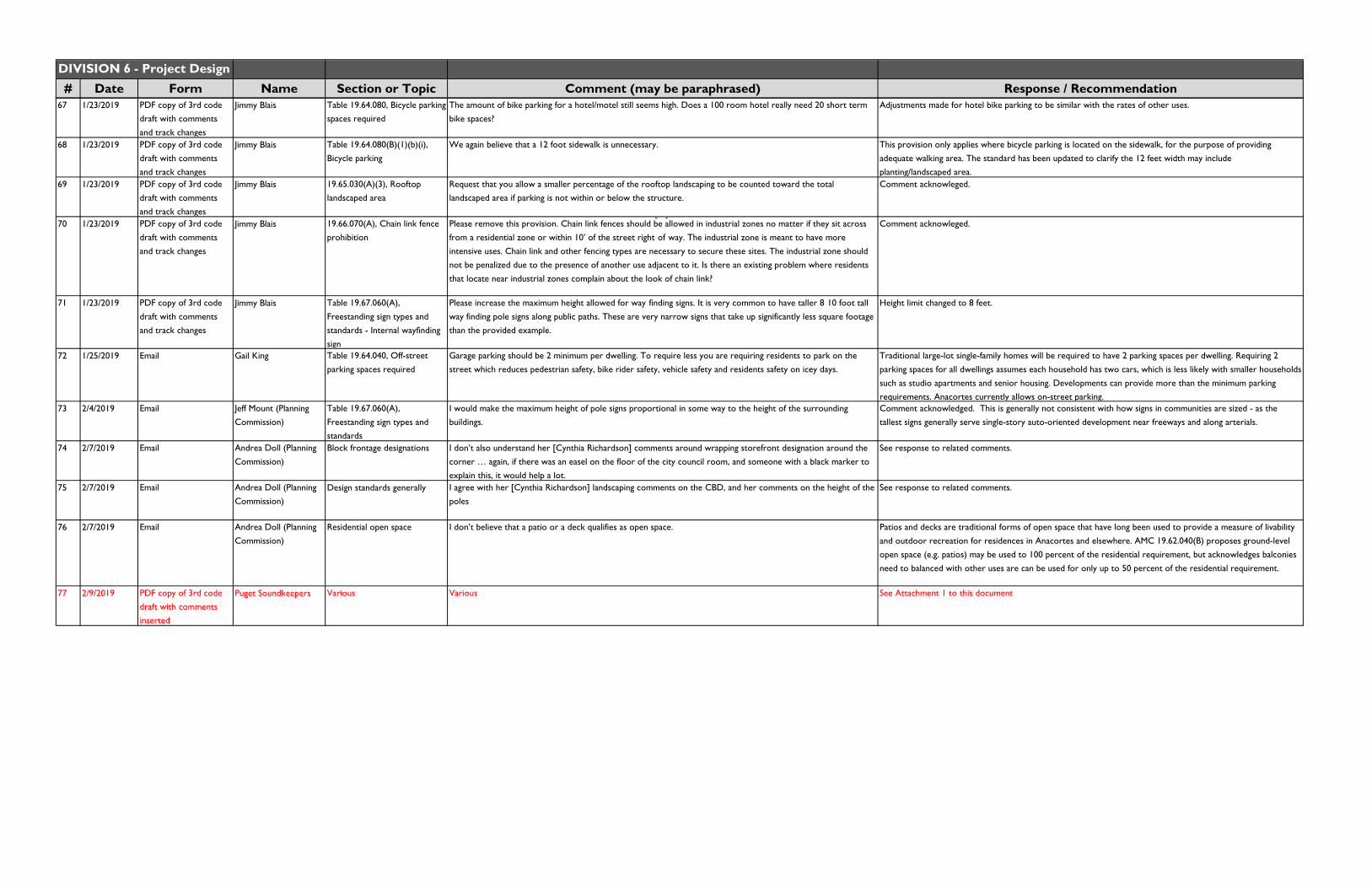
DIVISION 6 - Project Design# Date Form Name Section or Topic Comment (may be paraphrased) Response / Recommendation
67 1/23/2019 PDF copy of 3rd code draft with comments and track changes
Jimmy Blais Table 19.64.080, Bicycle parking spaces required
The amount of bike parking for a hotel/motel still seems high. Does a 100 room hotel really need 20 short term bike spaces?
Adjustments made for hotel bike parking to be similar with the rates of other uses.
68 1/23/2019 PDF copy of 3rd code draft with comments
and track changes
Jimmy Blais Table 19.64.080(B)(1)(b)(i), Bicycle parking
We again believe that a 12 foot sidewalk is unnecessary. This provision only applies where bicycle parking is located on the sidewalk, for the purpose of providing adequate walking area. The standard has been updated to clarify the 12 feet width may include
planting/landscaped area.69 1/23/2019 PDF copy of 3rd code
draft with comments and track changes
Jimmy Blais 19.65.030(A)(3), Rooftop landscaped area
Request that you allow a smaller percentage of the rooftop landscaping to be counted toward the total landscaped area if parking is not within or below the structure.
Comment acknowleged.
70 1/23/2019 PDF copy of 3rd code draft with comments and track changes
Jimmy Blais 19.66.070(A), Chain link fence prohibition
Please remove this provision. Chain link fences should be allowed in industrial zones no matter if they sit across from a residential zone or within 10’ of the street right
‐
of
‐
way. The industrial zone is meant to have more intensive uses. Chain link and other fencing types are necessary to secure these sites. The industrial zone should not be penalized due to the presence of another use adjacent to it. Is there an existing problem where residents that locate near industrial zones complain about the look of chain link?
Comment acknowleged.
71 1/23/2019 PDF copy of 3rd code draft with comments and track changes
Jimmy Blais Table 19.67.060(A), Freestanding sign types and standards - Internal wayfinding sign
Please increase the maximum height allowed for way finding signs. It is very common to have taller 8 10 foot tall way finding pole signs along public paths. These are very narrow signs that take up significantly less square footage than the provided example.
Height limit changed to 8 feet.
72 1/25/2019 Email Gail King Table 19.64.040, Off-street parking spaces required
Garage parking should be 2 minimum per dwelling. To require less you are requiring residents to park on the street which reduces pedestrian safety, bike rider safety, vehicle safety and residents safety on icey days.
Traditional large-lot single-family homes will be required to have 2 parking spaces per dwelling. Requiring 2
parking spaces for all dwellings assumes each household has two cars, which is less likely with smaller households such as studio apartments and senior housing. Developments can provide more than the minimum parking requirements. Anacortes currently allows on-street parking.
73 2/4/2019 Email Jeff Mount (Planning Commission)
Table 19.67.060(A), Freestanding sign types and standards
I would make the maximum height of pole signs proportional in some way to the height of the surrounding buildings.
Comment acknowledged. This is generally not consistent with how signs in communities are sized - as the tallest signs generally serve single-story auto-oriented development near freeways and along arterials.
74 2/7/2019 Email Andrea Doll (Planning Commission)
Block frontage designations I don’t also understand her [Cynthia Richardson] comments around wrapping storefront designation around the corner … again, if there was an easel on the floor of the city council room, and someone with a black marker to explain this, it would help a lot.
See response to related comments.
75 2/7/2019 Email Andrea Doll (Planning
Commission)Design standards generally I agree with her [Cynthia Richardson] landscaping comments on the CBD, and her comments on the height of the
poles
See response to related comments.
76 2/7/2019 Email Andrea Doll (Planning Commission)
Residential open space I don’t believe that a patio or a deck qualifies as open space. Patios and decks are traditional forms of open space that have long been used to provide a measure of livability and outdoor recreation for residences in Anacortes and elsewhere. AMC 19.62.040(B) proposes ground-level open space (e.g. patios) may be used to 100 percent of the residential requirement, but acknowledges balconies need to balanced with other uses are can be used for only up to 50 percent of the residential requirement.
77 2/9/2019 PDF copy of 3rd code draft with comments
inserted
Puget Soundkeepers Various Various See Attachment 1 to this document

Attachment 1 to Public Comment MatrixBelow is a summary of changes to the Draft based on comments received from Puget Soundkeepers
• Page 9: 19.12.020: Add the referenced definitions (as terms are defined in Permit, Appendix I, and the SWMWW);
• Page 58: 19.30.010: Add the following text: “F. To ensure that Low Impact Development (LID) principles and LID Best Management Practices (BMPs) are integrated into site design.”;
• Page 58: 19.30.020: Cross out the following text: “A. All non-subdivision development proposals will be subject to site plan review and approval except: repair, maintenance, grading below the minimum defined limits of this title, and interior remodeling.”; • Page 106: 19.42.050: Incorporate the suggestion to “[a]llow LID stormwater BMPs, like rain gardens, to count towards permanent open space requirements.”; • Page 111: Table 19.42.080: Add the following underlined text: “4. Integrate ornamental stormwater management features. Include creative and expressive techniques to celebrate stormwater management. The feature must be a significant visible design feature of the site and must include educational signage or a plaque explaining the incorporated stormwater management techniques, as determined and approved by the City; • Page 115: 19.42.100(A): Change the term “stormwater retention facility” to “stormwater facility,” which is a term found in the Permit;• Page 116: 19.42.120(A)(1): Change the term “stormwater retention or detention facilities” to “stormwater facilities,” which is a term found in the Permit;
• Page 131: 19.43.010(C)(3)(c): Incorporate clarification to address: “Note 1. Clarify where LID stormwater BMPs, like rain gardens, can be used to count towards usable open space requirements.”;
• Page 135: 19.43.010(D)(3)(h): Incorporate clarification to address: “Note 1. Clarify where LID stormwater BMPs, like rain gardens, can be used to count towards usable open space requirements.”;
• Page 141: 19.43.010(G)(10)(a): Incorporate clarification to address: “Note 1. Clarify where LID stormwater BMPs, like rain gardens, can be used to count towards usable open space requirements.”;
• Page 186: 19.51.030(D): Incorporate request for requiring (or encouraging) curb cuts or curbless streets;• Page 192: 19.52.040(C)(2): Incorporate request: “Also allow LID BMPs, such as bioretention.”; • Page 196: 19.52.050(D): Incorporate request: “Include landscape LID BMPs, like bioretention.”; • Page 203: 19.54.030: Incorporate request in Note 1 to allow projects to count LID techniques, such as bioretention areas, under open space requirements; • Page 216: 19.60.020: Aadd the definition of “new development” as this term is defined in Permit, Appendix I, and the SWMWW; • Page 255: 19.62.040(B)(1)(b): Incorporate request: “Can retained native vegetation or vegetated stormwater management facilities be used to meet open space requirements?”; • Page 256: 19.62.040(B)(2): Incorporate request: “Add retained native vegetation areas here.”; • Page 272: 19.62.070(E)(1): Incorporate request to add “rainwater re-use systems” as an exception; and• Page 305: 19.64.110(A): Change the term “drainage” to “stormwater management.”
Copyright © 2022 FDOKUMEN