Provincial geographies of India
248
•CD IN- BURMA HERBERT THIRKELL WHITE, KC1E PROVINCIAL GEOGRAPHIES OF INDIA tirnuirhmmmwhiimtmiinnin
-
Upload
khangminh22 -
Category
Documents
-
view
3 -
download
0
Transcript of Provincial geographies of India

•CDIN-
BURMAHERBERT THIRKELL WHITE,KC1E
PROVINCIAL GEOGRAPHIES OF INDIAtirnuirhmmmwhiimtmiinnin


Provincial Geographies of India
General Editor
Sir T. H. HOLLAND, K.C.S.I., K.C.I.E., D.Sc, LL.D., F.R.S.
BURMA

CAMBRIDGE UNIVERSITY PRESS
C. F. CLAY, Manager
LONDON : FETTER LANE, E.C. 4
NEW YORK : THE M ACMILLAN CO.
BOMBAY \
CALCUTTA[•
MACMILLAN AND CO., Ltd.
MAI IRAS j
TORONTO : THE MACMILLAN CO.
OF CANADA, Ltd.
TOKYO :MARUZEN-KABUSHI.KT-KAISHA
ALL RIGHTS RESERVED

BURMABY
Sir HERBERT THIRKELL WHITE, K.C.I.E.
LATE OF THE BENGAL CIVIL SERVICE
Oman res ipsa negat; contenia docerl
s>*
Cambridgeat the University Press
1923

PRINTED IN GREAT BRITAIN

EDITOR'S PREFACE
WAR conditions and consequent war service are re-
sponsible for the interruption of this series of Pro-
vincial Geographies. Subsequent reforms in the political
constitution of India necessitated further delay ; but, whether
the Government of Burma remains under the Governor-
General of India or becomes answerable direct to the King-
Emperor, the Province must necessarily remain a geo-
graphical and political, as it is a distinct ethnographical,unit—a Burmese nation.
For this, as for previous volumes of the same series, the
author has been chosen because his long and intimate ex-
perience of the Province enables him to present in true
perspective a thumb-nail sketch of the land and its people.
In this respect there are two living authorities who stand
in a class apart—Shwe Yoe (Sir George Scott), whose
writings have brought to the West a humanitarian picture
of the "Silken East," and the author of A Civil Servant in
Burma, whose service of 33 years brought him into intimate
touch with every phase of Burmese life and administra-
tion, from 1878, when the northern limit of British control
was restricted to the Province of Pegu, through the third
Burmese war of 1885, when King Thebaw's misrule of
Upper Burma was abruptly terminated, and the subse-
quent years of pacification and economic development, till
he retired as Lieutenant-Governor of the whole Province
in 1910.The Cambridge University Press is fortunate in finding
Sir Herbert Thirkell White with the leisure to review from
afar the land which he served with affection and recognizeddistinction.
T. H. HOLLAND.
November 22nd, 1922.

NOTE
Except where otherwise stated, rupees have been converted
into sterling at the conventional rate of i R. = 2s.
In the transliteration of Burmese words, the Government
system has been adopted. Every syllable is sounded. Conso-
nants have the same value as in English: gy = j', yw = yu.
The vowel sounds are:
a—generally as a in pa; but sometimes short as in at ;
e—as ey in grey ;
e—as e in pere, without any sound of r;
i—as ee in feet;
y—as a vowel always short ;
or 6—always long as oa in moan;u—as oo in boot;
ai—as i in pike ;
au—as on in lout;
aw—as aw in maw ;
ei—as a in maze.
Some proper names, such as Rangoon, Toungoo, have ac-
quired conventional spelling.
Special thanks are due to Dr E. H. Pascoe, Director of the
Geological Survey, who has most kindly written the chapter on
Geology and practically the whole of the chapter on Minerals,
and has collected the illustrations thereto. I have also grate-
fully to acknowledge valuable help and advice from Sir Thomas
Holland, Mr W. A. Hertz, Colonel G. H. Evans and Mr TawSein Ko. Most of the illustrations are from photographs by
my lamented friends, the late Major J. W. Alves, I.A. and
Mr Arthur Leeds, C.S. To other friends who have kindly con-
tributed photographs my best thanks are tendered. By per-
mission of His Majesty's Secretary of State for India, the1 .moral Map is reduced from the map attached to the General
Administration Report of Burma.
H. T. W.

CONTENTSCHAP.
I. General Description
II. Climate .
III. Rivers .
IV. Mountains and Hills
V. Islands .
VI. Lakes
VII. GeologyVIII. Minerals
IX. Forests and Flora
X. Fauna .
XI. History .
XII. Administration .
XIII.(i)
The People .
(ii) Languages .
XIV. Fields and GardensXV. Occupations of the People
XVI.(i) Trade and Commerce
(ii) Lighthouses
XVII. Canals and EmbankmentsXVIII. Railways and RoadsXIX. Chief TownsXX. Architecture and Antiquities
Bibliography
Appendixes
I. Rainfall from 1917 to 1920II. Administrative Divisions
III. List of the Shan and Karenni States
IV. Administration of the Shan States
V. Trade and Commerce
Glossary
Index
PAGE
I
16
23
38
44
46
48
63
75
85
99no125
139
141
147
155
160
162
166
171
201
210
212
213
214
215
216
217
219

LIST OF ILLUSTRATIONS AND MAPS
FIG
I.
2.
3-
4-
5-
6.
7-
8.
9-
io.
ii.
12.
13-
<4-
15-
16.
17-
18.
19.
20.
21.
22.
23-
2 4 .
2>'26.
27.
28.
29.
3°-
3i-
32.
33-
35-
Hertz)
A Burmese holiday (J. W. Alves)At the village tank (A. Leeds) .
Evening on the Irrawaddy (J. W. Alves)
Jungle folk (A. Leeds) ....Village Monastery (J. W. Alves)Burmese family (J. W. Alves) .
Deputy Commissioner's house, Putao (W. A.
Rustic bridge (J. W. Alves)
Mandalay Hill and water-lilies on the moatKalawA wayside stall (A. Leeds)Burmese cemetery (J. W. Alves)
Adung Valley, head waters of the Irrawaddy (W. AHertz)
On the Irrawaddy (J. W. Alves)Burmese girl (J. W. Alves)View north of Sagaing (J. \Y. Alves)Burmese boats (J. W. Alves)Boinu River (H. N. Tuck)Shwe Dagon Pagoda (J. W. Alves) .
The road to KalawSketch map of Putao (W. A. Hertz)
Royal Lake, Rangoon (J. \Y. Alves)
Geological map of the Northern Shan States
Ordovician Trilobites (F. R. Cooper Reed)Ordovician Brachiopods (F. R. Cooper Reed)Fault scarp at Pong Wo (T. D. La Touche)The Chindwin River
M1 Popa (K. A. K. Hallowes) .
"Mud volcano," Minbu (Sil f. H. Holland)Gold washing in the Chindwin River (J. M. Maclaren)Chinese furnaces at Bawdwin (T. D. La Touche) .
I In' Yenangyat Anticline (R. D. Oldham)Native oil well in process of construction (R. D. Oldham)The Yrnangyaung Oilfield (E. H. Pascoe)Burmese washing for rubies (H. H. Hayden)
PAGE
2
4
5
6
8
911
13
17
19
20
22
2426
28
30
32
36
39
41
42
46
49
3^
5^
54
5961
61
65
"7
69
70
7i
73

LIST OF ILLUSTRATIONS AND MAPS ix
FIG. PAGE
36. Forest-working elephants (A. Leeds) . . . . 78
37. Palms and Plantains (J. W. Alves) 81
38. Tamarind trees (A. Leeds) ......... 83
39. Bison (J. W. Alves) 87
40. Mithan (A. Leeds) 88
41. Bullocks with cart (A. Leeds) go
42. Burmese official (old style) (J. W. Alves) . . . 102
43. Burmese cannon (J. W. Alves) 104
44. Summer-house where King Thebaw surrendered (J. \Y.
Alves) 106
45. At the well (J. W. Alves) 113
46. A Myo-thugyi (C. S. Pennell) 114
47. A modern school-boy (J. W. Alves) 119
48. A village school (J. W. Alves) 120
49. Burmese boxing (J. W. Alves) 126
50. Monks (J. W. Alves) 127
51. Jungle boy (J. W. Alves) 129
52. Tattooing (J. W. Alves) 130
53. Padaung house (Sir J. G. Scott) 132
54. Nungs of the Taron valley (W. A. Hertz) . . . 135
55. Yang-sek women from the Shan Hills (Sir J. G. Scott) 13756. Tame Wa family (Sir J. G. Scott) 13857. Irrigation with water scoop (A. Leeds) .... 141
58. Burmese cheroot (J. W. Alves) 144
59. Weaving (J. W. Alves) 14960. Wood-carving (A. Leeds) 15161. A corner of the palace, Mandalay (J. W. Alves) . . 15262. Carving Buddhas (J. W. Alves) 153
63. The Obo canal (J. W. Alves) 163
64. A Railway Station (J. W. Alves) 16765. On the Southern Shan States Railway . . . . 168
66. On the road to Fort Hertz (W. A. Hertz) . . . 17067. Shwe Dagon Pagoda platform (J. W. Alves) . . . 17368. Shwe Dagon Pagoda platform (J. W. Alves) . . . 17469. Shwe Dagon Pagoda platform (J. W. Alves) . . . 17570. Moulmein (J. W. Alves) ." 17971. A Burmese family (J. W. Alves) 181
72. Burman at his devotions (A. Leeds) . . . . 18373. South Moat Gate, Mandalay (J. W. Alves) ... 18574. Between wall and moat, Mandalay (J. W. Alves) . 187

X LIST OF ILLUSTRATIONS AND MAPS
FIG.
75. The Palace Gardens (J. W. Alves) .
76. Queens' Monastery, Mandalay (J. W. Alves) .
77. Mingun Pagoda (J. W. Alves) ....78. Shrine at Amarapura (A. Leeds)
79. Ananda (Pagan) (Burma Archaeological Survey)80. Chinthes, figures at Pagoda entrance (A. Leeds)81. Pagodas at Sagaing (A. Leeds)82. Turtle tank, Arakan Pagoda (J. W. Alves)
83. Eindawya Pagoda (J. W. Alves)
84. Thein (A. Leeds)
85. Gaudama Buddha (J. W. Alves)General Map of Burma
PAGE
189
191
1941 90
199202
203
205206
207
209to face p. 226
"

CHAPTER I
GENERAL DESCRIPTION
Though politically and administratively included in the
Indian empire, Burma is definitely separated from India
geographically and its people differ from the people of
India in race, speech, religion and manners. It may almost
be said to be a part of India merely by accident. Separatedfrom the peninsula by the sea and by ranges of hills, it
comprises a distinct nation.
The remotest province of the Indian Empire, lying be-
tween 9 58' and 28 30' N. lat. and 92 n' and 101 91' E.
long., it comprises an area of 261,839 square miles, in
extent exceeding either France or Germany and far sur-
passing any other Indian Province. Its extreme length is
over 1200 miles; its utmost breadth 575 miles. The whole
territory is distributed into Burma proper, 164,411; Shan
States, 54,728; Chin Hills 1, 11,700; unadministered tracts
(estimated), 31,700 square miles 2. A convenient division,
in daily use, is into Upper and Lower Burma. The latter
embraces all the country annexed in 1826 and 1852, that
is to say, the Arakan and Tenasserim and the Pegu (nowthe Pegu and Irrawaddy) Divisions, including the whole of
the sea-coast. The rest of the Province, that part which
up to 1885 constituted the Burmese kingdom, is known as
Upper Burma.
Lying on the east of the Bay of Bengal, Burma stretches
from the borders of Tibet, Assam, Manipur and Chittagongon the north and north-west to the frontier of Siam. North-
ward from Victoria Point, the south-eastern extremity, the1 The largest section of the Chin Hills has recently been constituted
a district of the Sagaing Division; but they are sufficiently unlike other
parts of Burma to justify separate classification.3 The unadministered area has lately been reduced.
w. B. 1

<, KXkkAI. DESCRIPTION [CH.
eastern front marches successively with Siam, French Indo-
china, China.
Boundaries. A small section of the boundary in the extreme
south is the Pakchan river. North of this, hill and mountain
ranges mark the eastern frontier except where the rivers
Thaungyin, Salwecn and Mekong arc the dividing lines. With
China, the boundary was partially laid down by a joint Com-mission between 1897 and 1900 and was demarcated by
.V*.'^! -
I4
Fig. 1. A Burmese holiday.
masonry pillars, some erected in later years, as far north
as the head waters of the Akyang river in about 27 30' N.
The northern part of this boundary follows successivrlv
the Irrawaddy-Shweli and Irrawaddy-Salween watersheds.
The extremity of the eastern boundary and the northern
frontier facing Tibet, as yet undefined, are marked by loftymountain ranges. On the west, other mountain chains
separate Burma from Assam, Manipur and Chittagong as
far as the estuary of the Naaf. Thence, west and south, to
Victoria Point, the limit is the coast-line washed by the
waters of the Bay of Bengal, the Gulf of Martaban and the
Indian Ocean.

i]GENERAL DESCRIPTION 3
Geographically, without regard to administrative dis-
tribution, the Province may be regarded as consisting of
five main divisions :
(1) Central Burma, extending from the sea to Tibet;
(2) Tenasserim, exclusive of the western part of Toungoobut including Karenni;
(3) Arakan, omitting the northern Hill District;
(4) The Chin Hills, with Northern Arakan;
(5) The Shan country.
Central Burma. (1) Central Burma lies between the
Arakan Yoma 1,the Chin Hills, Manipur and Assam on the
west, and the Sittang river, the Shan States, and China on
the east. It is traversed throughout by the Irrawaddyriver, partially in the north by the Chindwin. It may be
sub-divided into the wet zone, the dry zone, and hill
country. It must not be supposed that these divisions are
marked distinctly like the squares on a chess board, but
roughly the distribution is sufficiently accurate.
In the south lies the Delta of the Irrawaddy and the
wide-stretching deltaic districts of Hanthawaddy, Insein,
Pegu and Tharrawaddy. This vast expanse of country is
a great alluvial plain. The true Delta includes all the
districts of the Irrawaddy division, Bassein, Pyapon, Ma-
u-bin, Myaungmya, Henzada, a flat country intersected
by countless rivers and creeks 2. On the sea board and
along the banks of streams and creeks are masses of man-
grove and dani palm forest, tidal and swamp vegetation,
elephant grass and savannah. In parts, as on the shore of
Bassein, the coast consists of a gently shelving sandy beach
but westward towards Cape Negrais, the one well-defined
promontory, it is rocky and difficult to approach. Exceptin the north-west of Bassein and towards the head of the
1 Yoma, hill ranges, in Pegu and Arakan, literally back-bone.2 A creek is not a small estuary but a stream, uniting larger branches,
not in itself part of a main river. The word is in daily use but not easyto define.

GENERAL DESCRIPTION < ii.
Delta in Henzada, where bordering on the Arakan Yomais a hilly tract, there is no high land in all this wide expanse.But here and there crop up narrow strips of dry sandy soil
Fig. 2. At the village tank.
from four to ten feet above the level of the plain, called
kondan, supposed to be remnants of old sea-beaches. Agreat part of the Delta is flooded in the rains and is un-
culturable. But here is some of the richest rice land, muchof it reclaimed and protected by embankments. The general
aspect, in the rainy season, of Myaungmya, a typical Delta

I] GENERAL DESCRIPTION
district, has been thus described by Mr S. Grantham in the
Settlement Report1
, published in 1921:
Along the edges of streams in the tidal area there is often
a fringe of mangrove vegetation in which the kyi (Barringtonia)is plentiful and the lamn tree {Sonneratia acida) is prominentby its long arms stretched out over the water and occasionally
• ' "' ~

GENERAL DESCRIPTION [CH.
screen are formed by dhani plantations, especially in the smaller
creeks. In other places again, cultivation has been carried to
the edge of the stream and the screen of mangroves is replaced
by a narrow ridge on which grass or paddy is seen growingabove the water. At neaptide, or later in the season when the
paddy has grown tall, the edge of the land is more marked, but
navigators are still glad to have posts and marks set up here
and there to mark the course of the stream through what is
apparently one great lake. The more northerly parts of the tidal
Fig. 4. Jungle folk.
area are now completely cultivated in wide continuous stretches
of paddy fields, broken up by streams with a fringe of jungle
along their banks but including no extensive uncultivated parts.
Travelling towards the south, the colonization becomes steadilymore recent, more and more uncultivated land is met until at
length cultivation is in rare isolated patches among almostcontinuous kanazo 1
jungle. Everywhere then, the background1 "The kanazo is essentially a mangrove; although it attains the
height of eighty to a hundred feet it stands upon soft tidal mud,supporting itself by wide-spreading roots, from which spring breatherswhich stand up above the surface of the ground and by means of their
large stomata enable the roots to obtain the air which they requirebut could not get in the water-logged mud in which they grow."

i] GENERAL DESCRIPTION 7
of the landscape is a high wall of kanazo growing along the
courses of small streams crossing the cultivated plains or formingone face of extensive patches of jungle in the less cultivated
parts, and in the south reaching often to the mangrove stripon the water's edge. Even in the cultivated and cleared por-tions odd trees often still remain as reminders of the kanazo
jungle which formerly covered the whole. The river bank, built
up by silt, is generally the highest land, but the streams swayto this side and to that as they erode their beds, and the bendstend to move along the course according to the ordinary fashion
of river-action; the high ridge is therefore missing in places,the middle levels being contiguous to the rivers. Here, if the
stream is large, the paddy suffers from the waves continuouslybeating upon it, and along the main rivers a fringe of junglehas commonly been left to break the force of the waves andscreen the cultivation behind. The cultivators' villages are
squeezed into small areas of land, which is uncovered at neaptide and sometimes at all ebb tides, and in lucky cases land is
found for the village which is hardly inundated at all; generallythese sites are along the banks of the smaller streams, the force
of waves on the main rivers being an objection to building there.
But commonly in the rainy season, and in the case of a largenumber for the whole year, the cultivators live in isolated hutsor in small groups of two or three houses out in the fields. The
highest available land is chosen and its level raised by layersof earth, and on that the house is built; and the whole familygroup of wife and dogs, cattle and children are accommodatedin the closest association. The man and his cattle go out to
plough; but except for an occasional journey to buy somethingto vary a diet of fish-paste and rice the wife may not leave for
months this small area of thirty or forty feet square in whichthe children too must build all their houses, wage all their warsand hold all their pwes and processions, romping with the dogsor dyeing the chickens in their leisure hours.
The whole of the Delta is infested with mosquitoes.
The people generally recognize different varieties of mosquito,but in some places the general view is that expressed by an old
Karen, who assured [Mr Grantham] there was only one kind
in his village, and on further enquiry with a view to identifyingthat kind explained that it was
"the biting kind." In the south

( ; ENERAL DESCRIPTION [CH.
and west the sand fly adds his bite to the other terrors of the
insect world, and some people compare these parts to Nga-ye
(hell), saying that the water is all salt, the country is always
submerged, and the mosquitoes and sand flics are the masters
and asking what further misery could be devised besides this
of revising the settlement.
Yet, improbable as it may seem, over some minds the Delta
exercises a singular fascination. Straggling villages, pa-
godas, monasteries, at rare intervals, vary the monotony
Fig. 5. Village Monastery.
of the outlook. As one floats on a broad river or a windingcreek with forest to the water's edge, at night with swarmsof fireflies lighting the banks, many an aspect of calm and
silent beauty is revealed.
East of the Delta are more vast stretches of rice-fields
broken only by spurs of the Pegu Yoma in Hanthawaddyand Insein and by the Yoma itself which borders Tharra-
waddy and traverses Pegu, clad with deciduous and ever-
green forests.

I]GENERAL DESCRIPTION
The climate of all this country is hot and moist with a
heavy rainfall. This is the busiest part of the Province with
the ports of Rangoon and Bassein and other thriving towns.
Negrais once regarded as a promising port has long been
abandoned.
North of the Delta and deltaic plains lies the part of
Toungoo west of the Sittang and the districts of Prome and
Fig. 6. Burmese family.
Thayetmyo approximately parallel with it. Toungoo is still
in the wet zone, with rainfall heavy in the south and morethan moderate in the north. Indeed, even the southern
part of Yamethin, the Pyinmana sub-division, adjacent to
Toungoo, has fairly abundant rain. But Prome and
Thayetmyo, on each side of the Irrawaddy, are distinctlyhot and dry. In Prome and Toungoo are stretches of plain,
as usual under rice cultivation. But a great part of these

io GENERAL DESCRIPTION [ch.
three districts consists of hilly country, spurs of the
Arakan Yoma, the Pegu Yoma and its offshoots, and other
less noticeable heights.
From the border of Thayetmyo up to about the latitude
of the Third Defile 1 of the Irrawaddy extends the dry zone
of Upper Burma. Between the Arakan Yoma and the
Chin Hills on the west and the Shan Hills on the east, it
includes the whole of the Magwe and Meiktila Divisions
(with the exception of the Pyinmana sub-division), the
Sagaing Division (except the Upper Chindwm district and
the Chin Hills) and the districts of Mandalay and Shwebo.
This tract includes wide areas of arid and sterile country
sparsely covered with stunted vegetation, broad undu-
lating table lands, rolling downs, barren plains cut up by
many deep ravines, with frequent isolated hills rising
abruptly from the plains. The Pegu Yoma begins in this
area and runs through it from north to south. Elsewhere
are other hill ranges. Pakokku, Lower Chindwm, and parts
of the Kyaukse and Mandalay districts are specially hilly
country.It must not be supposed that all this is a desert. Along
the rivers are alluvial plains. In Minbu and Kyaukse a
large irrigated area is under rice. Shwebo, formerly a dry
plain, is now a flourishing rice district. The rice plain of
Mandalay covers 700 square miles. On lands unsuitable
for rice, products of dry cultivation, millet, sesamum,
ground nuts, wheat, are largely grown. The hillsides are
often covered with luxuriant forest growth. Sagaing is the
only district altogether dry, without relief 2.
The great rivers Irraweddy and Chindwin, and their
numerous affluents, many of them mere beds of sand in
the dry season, occasionally rushing torrents in the rains,
as well as rivers of less volume in the east, traverse these
dry districts. Meiktila is the only district in Burma, exceptPutao in the north, with no navigable stream.
1Seep. 25
a Settlement Report, Sagaing. B. W. Swithinbank.

I] GENERAL DESCRIPTION ii
In this tract are the city of Mandalay and the towns of
Pakokku and Myingyan. Here also are the famous oil
wells of Yenangyaung. Of note for other reasons are the
multitudinous pagodas of Pagan, most renowned in this
land of Pagodas. Here the villages are more compact, each
surrounded by a stout fence, sometimes of bamboo, some-times of stiff cactus.
Though there are long dull stretches of river, with flat
banks, there are also scenes of singular beauty. In the
Fig. 7. Deputy Commissioner's house, Putao.
midst, the conspicuous double peaks of Popa are pic-
turesquely visible from the Irrawaddy for many miles.
On the western and eastern borders the hills are marshalledin bold outline.
North of the dry zone lies a land of mountains and hills.
Upper Chindwin on the west, with the Shan States of
Hsawnghsup and Singaling Hkamti, bordering on the ChinHills and Assam, bestriding the Chindwin river, is a massof forest clad hills. Parallel with it, on either side of the
Irrawaddy are Katha, Bhamo 1 and Myitkyina, with Putao1 By purists pronounced Ba-maw.

C2 GENERAL DESCRIPTION [ch.
in the extreme north. The part of Katha which lies on the
right bank of the river consists mostly of hills with inter-
vening valleys, but about Wuntho and northward from
Mo-hnyin are fertile plains. Three well-marked mountain
ranges traverse it and there are abundant forests. East
of the river are strips of plain country; in the basin of the
Shweli, the Shan State of Mongmit; and some sixty miles
inland among rugged mountains the world-renowned RubyMines. Save for level country on the edge of the river, andfor the plain of Hkamti Long in Putao, the Kachin Hills
compose the three northern districts on the borders of
China and Tibet. Stupendous mountain peaks and mag-nificent alpine scenery are characteristic of this remote
part of the province.Tenasserim and Karenni. (2) On the east and south-
east lies Tenasserim, added to the Empire after the First
Burmese War, nearly a hundred years ago. South-east are
the districts of Mergui and Tavoy, a narrow strip of plainland on the sea coast, backed by hills towards the Siamese
border; for the most part rugged and mountainous, covered
with dense forests. The mineral possibilities of this countryare great but lack of communications retards their develop-ment. North of Tavoy, Amherst consists of forest-clad
mountains with broad alluvial plains between the Taungnyoand Dawna ranges, watered by the Salween, Gyaing,Ataran and Thaungyin rivers. The wonderful scenery is
pictured in Crawfurd's vivid sketch of the view from Mar-
taban, opposite the port of Moulmein:
At sunset we reached Martaban, about twenty-seven miles
from the mouth of the rive- (Salween). The prospect which
opens itself upon the stranger here is probably one of the mostbeautiful and imposing that Oriental scenery can present
1. The
waters of three large rivers, the Salween, the Ataran, and the
Gyain meet at this spot, and immediately proceed to the sea
by two wide channels; so that, in fact, the openings of five
distincl rivers, are, as it were, seen in one view, proceeding like
1 Sir Richard Temple records a similar impression.

I] GENERAL DESCRIPTION 13
radii from a centre. The centre itself is a wide expanse of waters
interspersed with numerous wooded islands. The surrounding
country consists generally of woody hills, frequently crownedwith white temples. In the distance are to be seen the highmountains of Zingai and in favourable weather the more distant
and lofty ones which separate Martaban from the countries of
Lao and Siam 1.
Moulmein, the headquarters of the Division, is one of the
chief ports of the province. North of Amherst is Thaton,a plain country intersected by ranges of hills and half
covered by forests. Salween
is a maze of mountains and
woods, and so is Karenni, but
with a well-watered plain in
the north-west. The part of
Toungoo, east of the Sittang,
which completes this section,
is also a hill tract.
Arakan. (3) The western
part of Lower Burma is the
Arakan Division including
administratively the Hill
District of northern Arakanwhich is geographically partof the Chin Hills. The rest of the Division lies between
the Arakan Yoma and the Bay of Bengal. Arakan wasannexed at the same time as Tenasserim (1826). Border-
ing on Chittagong on the north, it has usually been
more readily subject to Indian influence than other
parts of the Province. Embracing the districts of Sando-
way, Kyaukpyu and Akyab, the Division consists of a
strip of level country along the coast, broadening out to
a wide plain in the north. Spurs of the Yoma fill the
inland area extending nearly to the sea in the two southern
districts. In the south is a rock-bound shore ; further north
Fig. 8. Rustic bridge.
1 Crawfurd, 361.

i 4 GENERAL DESCRIPTION [ch.
the coast is indented by tidal creeks fringed by the ever-
recurring mangrove and dani palm forests. North-east
lies broken, hilly country, covered with dense woods.
Kyaukpyu includes the large islands of Cheduba and
Ramree. Akyab, the headquarters of the Division, is one
of the principal ports of the Province with a magnificentharbour.
Chin Hills. (4) The Chin Hills include the district of that
name in the Sagaing Division, the Pakokku Chin Hills,
and the Arakan Hill District, covering an area of some
12,000 square miles. This country occupies the western
corner of Upper Burma, bounded on the north by Manipur,on the west by the Lushai Hills, on the south by Akyab,on the east by Upper Chindwin and Pakokku. It is a mass
of mountains intersected by deep valleys with no plain
country whatever. In the Chin Hills district and the
Pakokku Hills, the ranges run from north to south, varyingin height from 5000 to 9000 feet; the highest peak, MtVictoria, in the Pakokku Chin Hills, rises to 10,400 feet.
In the Arakan Tracts, the hills do not average more than
3000 to 3500 feet in height. The whole Chin country is
covered with dense forest, including pines and other trees
of temperate climes, and in places glowing with masses of
rhododendron. The savage mountaineers have been broughtinto subjection with much difficulty and are kept in order
by military police posts. The headquarters are at Falam.
Another principal post is Fort White, named after Sir
George White, famous as the defender of Ladysmith.The Shan States. (5) The great tract known as the ShanStates extends along the eastern border of Upper Burmafrom 19 20' to 24 9' N. and from 96 13' to 101 9' E.,
covering an area of 54,728 square miles. It stretches east-
ward across the Salween as far as the Mekong river to
China, French Indo-China and Siam. In the north it
marches with China;in the south with Lower Burma and
Karenni. Its general aspect is that of a high plateau rising

i] GENERAL DESCRIPTION 15
from 3000 to 4000 feet. The Myelat, bordering on the
Meiktila Division, consists of rolling downs, with scanty
growth of trees, intersected by ravines. East of the Myelatare hill ranges with intervening valleys; thence towards
the Salween a wide well-wooded plateau, broken by isolated
hills. East of the Salween is the great state of Kengtungand part of Manglun, the latter entirely hill country.
Kengtung is broken and mountainous, divided unequally
by the range which forms the watershed between the
Salween and the Mekong. Other trans-Salween areas are
the mountainous country of Kokang and the territory of
the Wa, a mere mass of hills. West of the Salween, in the
north, is the extensive plateau of North and South Hsenwiand Hsipaw. Hsenwi is partly and Tawngpeng further
north entirely hill country. The Salween runs through the
Shan States from north to south and the Myitnge throughthe Northern States from east to west. Of the people,climate and administration, description is given elsewhere.

CHAPTER II
CLIMATE
As already indicated, a country of such diverse physicalfeatures and of such vast extent naturally presents a rich
variety of climate. Rangoon and the maritime districts,
as well as the plain country up to about the latitude of the
northern limit of Henzada, are hot and moist. South of the
southern edge of Henzada and Tharrawaddy, the Delta
districts and the plains of the Pegu division have a meanannual rainfall of about ioo inches
; fairly evenfy distributed
locally and remarkably consistent, the average being, how-
ever, substantially exceeded in Pegu and Hanthawaddy.The sea board districts of Arakan and Tenasserim 1 have
torrential rains in even greater abundance. In the last four
years2
,the annual average of these districts has exceeded
200 inches, Kyaukpyu alone falling a little short of that
figure. The maximum average of those years was 253 inches
in Akyab; the highest recorded rainfall in 1920 being at
Palaw in Mergui, 279-17 inches. In this wet country, the
rains, brought by the south-west monsoon, last approxi-
mately from May to October; they have never been knownto fail to so dangerous a degree as to threaten the rice cropof Lower Burma. Welcomed at first as a relief after the
steamy heat of May, the rains soon become monotonous.
By the middle of August, with a rich growth of funguson one's boots, one begins to tire of them. But it does not
always rain day and night. On most days, either the morningor the evening is fine and gives opportunity for exercise.
Cyclones are not very frequent visitors. In 1902, early in
May, occurred one of great violence which, in Rangoon,1Akyab, Kyaukpyu, Sandoway, Thaton, Amherst, Tavoy and
Mergui.-
19] 7--20.

CH. II] CLIMATE 17
unroofed houses and magazines, swept boats high and dry,and blocked most of the roads in the Cantonment with
torn branches of trees. Some years later a fierce cyclone
ravaged Akyab.This part of the Province enjoys no really cold season,
but from November till the end of January there is a
sensible fall of temperature, the thermometer descending
*,: rSV
Fig. 9. Mandalay Hill, and water-lilies on the moat.
sometimes as low as 6o° F. From February to May, the
days are hot and oppressive, but the thermometer seldom
rises above ioo°. As a rule, the nights are not intolerablywarm. In Rangoon, which may be regarded as typical, the
average temperature, day and night, in January is nearly
77°, in May, 84 .
Further north, the climate changes gradually. Henzada,
Tharrawaddy and Toungoo, approaching the dry zone, are
almost level with rainfall of about 80 inches. Prome and
Thayetmyo drop to not much over 40. These districts are
W. B.

18 CLIMATE [ch.
extremely hot in the summer months and have a moderate
cool season.
The real dry zone, from the old frontier of Upper Burmato about 60 miles north of Mandalay, has, for the most
part, normally, an average annual rainfall of about 30inches. But from year to year, it varies capriciously. In
Pakokku, the driest district, the yearly total is not muchmore than 20 inches. Though Shwebo has the highestmean with 38 inches, in 1920 the actual rainfall wasunder 24. In this tract, in the plains, the soil is dryand bare; in Spring and early Summer, the tempera-ture rises to as high as 115 ; and there is good andseasonable cold weather from November to March, the
thermometer in the daytime falling to as low as 55 °. At
Mandalay, the annual rainfall is nearly 32 inches; the
average temperature in January 70 ,in May 8o°. Scanty
rainfall at times causes crops to fail on unirrigated lands
and has, occasionally, produced conditions of scarcity ap-
proaching famine. Although the Summer is distinctly hot
and parching there is no such fierce and fervent heat as in
the plains of Upper India. The nights are nearly alwaysbearable. And in Mandalay and Yamethin and other
places similarly situated, constant high winds, though
tiringly monotonous, are yet welcome as tempering the
excessive heat. In the hills of this area the extremes of
temperature are 90 and 32 .
North of about the latitude of the Third Defile 1,the
rainfall again becomes fairly abundant, rising from some
50 inches in Katha to 69 in Bhamo and 80 in Myitkyina,while the temperature, though hot in Summer, is cool and
pleasant in the winter months. In the Kachin and Chin
Hills, the heat is never excessive and at times the tempera-ture is very low, the range being between 85 and 25 . In
the high lands on the Chinese frontier, east of Bhamo, severe
frosts prevail for several weeks, producing solid blocks of
1 See p. 25.

II CLIMATE *9
ice to the astonishment of the Bnrman from the plains.
In the Chin Hills, the annual rainfall varies from 50 to noinches. The Shan plateau enjoys a temperate climate and
a consistent rainfall varying from 60 to 80 inches 1.
Hill Stations. In most parts of the Province, except the
true Delta and the plain country to the east thereof, are
to be found in the hills refuges from the severity of the
--&L M#
rt*
Fig. 10. Kalaw.
hot season. Maymyo, on the edge of the Northern Shan
States, though on a plateau only 3400 feet above the sea,
is yet comparatively cool in the warm months, cold but
not too cold in winter, wet but not too wet in the rains.
Kalaw, the Mussoorie of Burma, lying among pine-groves
on the border of the Myelat, is another popular summerresort. Toungoo has a comfortable hill station at Than-
daung and Bhamo the cool and healthy heights of Sinlum-
1 A table of rainfall is given in Appendix I.

20 CLIMATE [CH.
gaba. Mt Victoria and Kanpetlet in the Pakokku Chin
Hills, ideal summer resorts, are inaccessible. But Popa in
Myingyan offers cool days and nights to dwellers in the
parched plains of the central dry zone. Even as far south
as Henzada, Allantaung, on a peak of the Arakan Yoma,is cool and refreshing in the hot season. Jaded residents
of the Delta find here relief and recreation. A Commis-
Fig. ii. A wayside stall.
sioner's wife, Mrs Maxwell Laurie, has described Allantaungin the columns of the Indiaman:
A few feet short of the tcp is a cleared plateau which forms
a -pacious camping ground, shaded by great banyan trees. Tothe West lies a country of broken mountains and steep valleys
straight across which from the sea comes a breeze, salt, strong,
invigorating. To the North and South across a deep, green
valley there is a splendid vision of mountains, stretching out
range behind range, beyond the limits of sight. Simply to let
the imagination roam along the lovely, sweeping ridges satisfied

n] CLIMATE 21
and refreshed the soaring souls of persons accustomed to dwell
on a deltaic swamp....Far away to the East lie the plains, andover them, shining in sunlight luminous in the last rays of
evening, hangs the haze of an atmosphere almost solid with
dust.
Burma is usually regarded as an unhealthy country.The mental picture is of a land of dismal swamps and
deadly marshes, far different from the glowing reality. The
impression of unhealthiness is due to the hardships and
privations suffered by troops, police, and civil officers
during and after the three Burmese Wars. In unsuitable
conditions, much sickness and mortality were inevitable.
But on the mind of the visitor in ordinary times, who lived
in normal surroundings, the contrary impression was
stamped. Writing in 1795, Symes says: "The climate of
every part of the Burman Empire which I have visited
bore testimony to its salubrity1 ." It is true that his range
was limited to Rangoon and the country along the Irra-
waddy as far north as Ava. But his record is of interest
as indicating his experience in comparatively early times
before the dawn of sanitation. On the whole, his impressionwas accurate. Parts of Burma, such as Northern Arakan,
Salween, Katha, and all tracts lying at the foot of hills,
are notoriously unhealthy owing to the prevalence of
malarial fever. Cholera is never absent throughout a whole
year, though serious epidemics are far less frequent than
of yore. Plague has not been extirpated by the efforts of
seventeen years. But cholera and plague are accidents. Withthe more rigorous application of improved sanitary methods,these diseases as well as malarial fever should be banished.
Subject to these exceptions, the Province, as a whole, is
not unhealthy. In particular, the swamps of the Delta andthe great rice plains, though enervating, are not deadly.But it must be admitted that, everywhere, vitality once
impaired is not readily restored. The annual mortality is
1Symes, 322.

22 CLIMATE [CH. II
about 25 per thousand. But the statistics are not entirely
trustworthy. In 1918, owing to the epidemic of influenza,
the death of nearly 40 per thousand was recorded.
Fig. 12. Burmese cemetery.

CHAPTER III
RIVERS
Irrawaddy. The dominant physical feature of Burma is
the great river Irrawaddy, formed by the union of two
sister streams. The actual source of the Irrawaddy was
long regarded as almost the last unsolved geographical
mystery. It has, however, been ascertained that the
eastern and main branch, the 'Nmaikha 1 issues from the
Laguela Glacier 2,in about 29 N. on the mountain range
which separates Putao from Tibet;and traverses the Putao
district, in its earliest stage, as the Taron stream. The
western branch, the Malikha, rises in the hills surrounding
the Hkamti-long valley, in the Putao district. Both these
streams flow southward till, some 30 miles above Myitkyina,
boiling and surging over rugged rocks, they join at the
Confluence. Above this point, neither of these rivers nor
their affluents are navigable, being strewn with rocks,
cataracts and rapids. The Kampang falls into the Taron
with a sheer drop of 400 feet. From the Confluence, the
united river pursues its majestic course to the sea for nearly
a thousand miles. Above Myitkyina are rapids, mild and
innocuous, easily navigated by rafts and shallow boats.
Swift and clear as crystal, the Irrawaddy flows past
Myitkyina, its course unimpeded till it reaches Sinbo.
Between the rapids and Sinbo, the river is navigable bylaunches and light draught steamers throughout the year.
Just below Sinbo, in the wet season, swollen by rains and
melted snows, checked by a rampart of rocks, the stream
1 Kha, Kachin for stream; nan, the Shan equivalent. Thus Tabak-Kha and Nan-tabet are the same stream and the same word, with Kachintail and Shan head respectively. 'Nmaikha means "bad river"; the
meaning of Malikha is not known.2
J. Bacot, Le Tibet Revolte.

>>
IhIhl—l
0>
J3
43
>C
<
PO

ch. in] RIVERS 25
banks up into a high wall of waters. Piercing this rampart,the Irrawaddy enters the First Defile, a gloomy, savage,
rock-bound gorge, thirty-five miles in length. The Defile is
narrow, tortuous, romantically beautiful, in places of un-
fathomed depth. Rocks in mid-stream, sudden abrupt
curves, seething whirlpools, render navigation difficult and
hazardous. In the dry season, with care but without in-
superable risk, launches steam up and down the Defile,
their movements strictly regulated, under statutory sanction,
by the civil authorities at Bhamo in telegraphic communi-
cation with Sinbo. When the rains begin, the Defile, closed
to steam traffic, is traversed constantly by timber rafts,
sparingly by boats. Down stream, boats rush with more
speed than safety. Up stream, the voyage is laboriouslyeffected by towage from the bank. If the rope slips, the
toil of days is lost in a few minutes. Emerging at Pashaw,named by an illustrious visitor 1 the Ruby Gate of the
Irrawaddy, the river flows peaceably past Bhamo. A few
miles below that town lies the Second Defile, not so strait
and winding as the first but bound between beetling crags
and set with dangerous eddies and whirlpools. Less sternlysombre than the upper gorge, it is perhaps even more
picturesquely beautiful, with one most striking feature,
the towering Elephant Rock crowned by a tiny golden
pagoda. In spite of this narrow approach, steamers reach
Bhamo at all times of the year.
From the Second Defile the river issues just above the
charming village of Shwegu. Thence past Moda, Katha,
Tagaung, site of an ancient capital, Thabeik-kyin, Kyauk-myaung, it flows placidly on to Mandalay. Near Thabeik-
kyin, the port of the Ruby Mines, it is caught by the Third
Defile, deep and somewhat narrow, but not to be comparedwith the Defiles above either in hazard or in beauty. Astrong swimmer can cross from bank to bank. Leavingthe wharves and the Hard of Mandalay thronged by
1 Lord Kitchener.

26 RIVERS [CH.
steamers, launches and Burmese craft, the Irrawacldy
glides past Ava, renowned in history, Sagaing, a typical
Burmese town embosomed in tamarind groves, Myingyan,a busy port, Pakokku, a trade centre near the mouth of
the Chindwin river, Pagan, with its silent array of pagodas,
Yenangyaung, redolent of earth-oil, Magwe, Minbu, the
fort at Minhla, the old frontier pillars recalling memories
of Dalhousie, the great Governor-General, Thayetmyo,
Fig. 14. On the Irrawaddy.
Prome, another ancient capital, the sculptured bank at
Akauktaung, Myan-aung1
, Henzada, Danubyu, scene of
fierce conflict in the First War, thence into the Delta where
dividing into countless streams and creeks, it reaches the
Bay of Bengal. One great offshoot above Henzada, on
the right bank, forms the Ngawun, in its later course the
1
"Myan-aung, a very ancient city, stretching two miles along the
margin of the river;...a great variety of tall wide-spreading trees gavethe place an air of venerable grandeur." Symes, 233. Written in 1795.
.Myan-aung has now sunk to insignificance.

in] RIVERS 27
Bassein river. Another main channel finds the sea at China
Bakir, as the To or China Bakir. Other principal prongsof the Irrawaddy are the Pyawmalaw, the Shwelaung,later the Kyunpyat-that, the Yazudaing and the Kyaiklator Pyapon. The stream which reaches the sea as the
Irrawaddy flows through Myaungmya till in its lower
extremity it divides that district from Pyapon. On the
left, at Yandoon, the Panlang creek leaves the Irrawaddyand flows into the Rangoon river. Formerly navigable bysteamers of some size, of late years this creek has silted upand is now hardly practicable except by boats. Below
Bassein, the Rangoon creek, so called because it is the
route for steamers to Rangoon, re-unites the Bassein river
with the main stream. Similarly, below Rangoon is the
Bassein or Thakutpin creek, the beginning of the water-
way to Bassein, flowing from the "Rangoon river into the
Irrawaddy.Before the making of railways, the Irrawaddy was the
great commercial route from the sea to the heart of Burma.
On the unnumbered creeks and streams of the Delta, as
well as on the main river, were to be seen many a stately
Burmese boat, often adorned with rich carving, propelled
by long oars or wafted by brown sails as wind and tide
ordained, with high stern where the helmsman sat aloft.
Here, too, might be seen smaller boats carrying the peasantwith his farm produce to market, a score of brightly clad
laughing men, maids, and matrons to a pagoda festival,
a dozen monks on some religious mission ;and racing boats,
long and shallow, with crews of twenty or thirty shouting
paddlers. Most of these picturesque craft are softly and
silently vanishing away. Multitudes of launches now makethe sylvan creeks hideous with steam-whistles, the grinding
of screws, the churning of paddles. The sampan, an ugly
exotic, penetrates even to remote villages ; and the graceful
Burmese boats are being ousted from the carrying traffic
by squat barges and squalid lighters.

28 RIVERS [CH.
The Irrawaddy is still a valuable alternative to land
routes. On the main stream, the bulk of the trade is in the
hands of the Irrawaddy Flotilla Company. Their steamers,
of shallow draught, run from Rangoon, through the Bassein
creek, past Thongwa and Ma-u-bin, as far as Bhamo,
carrying passengers and cargo. The faster steamers run
single-handed, stopping only at important towns. Others,
known as cargo-steamers, have each a flat or barge attached
on either side. With them speed is not the object. Stoppingat every village and carrying on board a travelling bazaar
Fig. 15. Burmese girl.
or market, they present a microcosm of Burmese life in
many phases. Other steamer services ply in the Delta.
On the main river, steamers move only by day, anchoringor tying up to the bank at night. Elsewhere they rush,
day and night, through labyrinthine creeks, often crashing
into the mangrove forests on the margin.From the sea to Bhamo and two miles beyond, for a
distance of 689 miles, the Irrawaddy is navigable bysteamers at all times. But while in the rains it is a. deepand magnificent river, some two miles wide at Bhamo, in

in] RIVERS 29
the dry season its aspect changes. Then for a great partof its course, it is shallow, strewn with islands and with
sandbanks which shift from year to year, impeding navi-
gation and leaving riverine towns such as Bhamo and
Myingyan often miles from the water's edge. At this
season, only flat-bottomed vessels of very shallow draughtcan pick their way; sometimes even these are stranded.
Often at Prome and below Mandalay, rows of steamers
have been held fast for days. Elsewhere, steamers have
grounded and remained high and dry for months till re-
leased by the rise of the river. Meanwhile the vessel
becomes a stationary dwelling round which the caretaker
plants a little garden for profit and for pastime. In the
rains, high rises flood the banks to the destruction of
growing crops. At the same time, the silt deposited en-
riches the soil.
The scenery of the Irrawaddy has been often celebrated.
It is declared to be "as stately as it is beautiful; as pas-sionate as it is serene." From the Confluence to the sea, it
presents innumerable types of the picturesque, the rugged
grandeur of the defiles, the smooth stream flowing betweenstoried banks, the multitudinous mazes of the lower
reaches. Sir Henry Yule, who accompanied Sir Arthur
Phayre on his Mission to the Court of Ava in 1855 and whohas recorded his observations in a classic work of absorbinginterest, has drawn this brilliant picture of one gorgeousview:
The scene was one to be registered in the memory with somehalf dozen others which cannot be forgotten. Nothing on the
Rhine could be compared to it. At the point where the templestood, the Irrawaddy forms a great elbow, almost indeed a
right angle, coming down to us from the North, but here
diverted to the West. Northwards the wide river stretched,
embracing innumerable islands, till seemingly hemmed in andlost among the mountains. Behind us, curving rapidly roundthe point on which we stood, it passed away to the Westward,and was lost in the blaze of a dazzling sunset. Northward ran

G'3Ml
CO
oc
0)
bi

ch. in] RIVERS 31
the little barren, broken ridges of Sagaing, every point and spurof which was marked by some monastic building or pagoda.
Nearly opposite to us lay Amarapoora, with just enough haze
upon its temples and towers to lend them all the magic of an
Italian city. A great bell-shaped spire, rising faintly white in
the middle of the town, might well pass for a great Duomo.You could not discern that the domes and spires were all of
dead heathen masses of brickwork and that the body of the
city was bamboo and thatch. It might have been Venice, it
looked so beautiful. Behind it rose range after range of
mountains robed in blue enchantment. Between our station
and the river was only a narrow strip of intense green foliage,
mingled with white temples, spires, and cottage roofs. The greatelbow of the river below us, mirroring the shadows of the woodon its banks, and the glowing clouds above, had been like a lake,
were it not that the downward drift of the war-boats as theycrossed and recrossed, marked so distinctly the rapidity of the
kingly stream. The high bank of the river, opposite Sagaingeastward, was seen to be a long belt of island crowned with
glorious foliage (and there are no trees like those of Burma) ;
only here and there rose an unwooded crest, crowned with its
Cybeleian coronet of towers. Behind this were numerous other
wooded islands, or isolated villages, and temples, and monas-
teries, rising directly out of the flood waters. Southward, across
the river, was the old city of Ava, now a thicket of tangled
gardens and jungle, but marked by the remaining spires of
temples. On this side lay Sagaing quite buried in tamarind trees.
Affluents of the Irrawaddy. Stated in order from the
north, the principal tributaries of the Irrawaddy above
Bhamo, on the left bank, are the Nantabet, formed by the
junction of the Tabak and Paknoi, the Mole, and the
Taiping. Of these, the Taiping which flows westward out
of China is the only river of importance; the others are
mountain streams winding through the Kachin Hills. Onthe right bank is the Mogaung or Namkawng which de-
bouches at Sinbo, after passing Mogaung, the depot of the
jadeite industry, and after receiving there, its main tribu-
tary, the Namyin from Katha. Below Bhamo, on the left
bank, are the Sinkan and the Shweli, the latter a river of

32 RIVERS [CH.
some size risingin China; on the right bank, the Kauk-kwe,Mosit and Mcza, streams of no great volume or value.
Further south are the Madaya river known also as Chaung-
magyi or Nampi, which issues from the Northern Shan
States as the Mobye, above, and the Myitnge, Doktawadior Namtu, below, Mandalay. The Myitnge, though its namemeans "little river" as compared with the great river into
Fig. 17. Burmese boats.
which it merges, is of considerable size. It runs in a south-
westerly direction through the Shan States ; is much used
as a floating stream for timber; and is distinguished bythe Namsan waterfalls of singular beauty
1. The Myitnge
receives the waters of the Panlaung already joined by the
Samon and of the Zawgyi, both from the south.
1 These falls now provide power for electric works and their beautymay be marred.

in] RIVERS 33
The Mu 1river, pursuing a southerly course almost
parallel with the Irrawaddy, joins the main stream at
Myinmu below Sagaing on the right bank. It is largely
used for irrigation purposes and waters thousands of acres
of rice fields.
The greatest affluent of all is the Chindwin. Rising as
the Tanai in the Hukong valley, north-west of Myitkyina,it flows past the Shan States of Singaling Hkamti and
Hsawnghsup, through the two Chindwin districts, past
Kindat, Mawlaik, Mingin and Monywa, pursuing a windingcourse, with many a curve and many an eddy, till it enters
the Irrawaddy above Pakokku. It is navigable by light
draught steamers and launches as far as Kindat throughoutthe year and up to Homalin (330 miles) in the rains;
regular steamer services have long been established. Butits course is impeded by shallows and whirlpools. The
upper reaches flow through brilliantly picturesque, savage
country clouded by myths and legends. It is said that
above a certain point on the Chindwin though there are
snakes they are not venomous. Less easily credible is the
report of a village whereof the people can transform them-
selves into tigers. The main tributaries of the Chindwin
are the Yu, Myittha and Kyaukmyet from the west and
the Uyu from the east. Of these the most important is the
Myittha into which flow the Maw from the south and the
Manipur from the north.
Further south, on the right bank, the Irrawaddy receives
the Yaw, in Pakokku, the Salin, Mon and Man, in Minbu;on the left bank, the Pin which rises on Popa and joins
the main river above Yenangyaung, and the Yin which
runs for 120 miles from Yamethin through Magwe. Besides
the tributaries which have been specified, the Irrawaddyis fed by unnumbered mountain torrents of whose nomen-clature the tediousness shall not be inflicted on the
reader.
1 Pronounced like the note of the cow not of the cat.
w. B. 3

34 RIVERS [ch.
Rangoon River. The Rangoon river is important solely
on account of the port after which it is called. Rising in the
Prome district some 150 miles from its mouth, under the
name of Myitmaka it flows through Prome and Tharra-
waddy, taking further down the name of Hlaing, and
passes Rangoon, twenty-one miles from the sea. Not far
below Rangoon it is joined by the Pegu river which flows
for 180 miles, past the historic town of Pegu; and by the
Pazundaung river. The Panlang creek above Rangoon has
already been mentioned. A little below the town, a serious
obstacle to deep draught steamers, is the Hastings Shoal
which seems to resist the efforts of dredgers.
Bassein River. The Bassein or Ngawun river has been
mentioned as a branch of the Irrawaddy. Leaving the
main stream above Henzada, it flows for 200 miles, past
Nga-thaing-gyaung and Bassein to the sea at DiamondIsland. It is navigable for sea-going steamers as far as
Bassein. Its affluents are the Daga above, the Panmawadi
below, Bassein.
Salween. Almost parallel with the Irrawaddy and ex-
ceeding it in length is the Salween. Rising in remote
unvisited hills in China, it emerges in the Shan States
which it traverses for many miles, receiving among other
tributaries, the Nam-ting, Nam-kha, Nam-bin, on the left,
the Nampaung, Namtung (250 miles), Nam-pawn (300
miles), on the right bank. Thence it enters and intersects
Karenni and flows past the hill district of Papun or Salween
which it separates from Siam. On the edge of the Thatondistrict the Thaungyin, rising in the Dawna hills, joins it
from the south-east. Crossing Thaton and Amherst, after
receiving the waters of its main tributaries the Yonzalin
from the north and the Gyaing (formed by the union of the
Hlaingbwe and Haungtharaw) and Ataran from the south-
east, the Salween enters the Gulf of Martaban, 28 miles
below Moulmein, after a course of about 650 miles in British
territory. The Salween is a swift stream flowing for great

in] RIVERS 35
part of its course between steep rocky banks which rise
in places from 3000 to 5000 feet above the river level. Alittle below the junction with the Thaungyin, navigationis peremptorily checked by the impracticable rapids of
Hatgyi. Though many plans have been suggested, it seems
unlikely that means of utilizing the Salween for steamer
traffic will be devised. It is, however, of great value as a
timber floating stream, bringing to the depot at Kado above
Moulmein teak from the forests of the Shan States, Karenni,
Siam, Thaton and Amherst. The beauty of its scenery has
often been celebrated.
Mekong. Although the Burmese kingdom extended across
the Mekong, all territory to the east of that river has longbeen abandoned. The Mekong now forms part of the
boundary of the Shan States dividing Kengtung from
French Indo-China. After flowing for many miles parallel
to the Salween, it turns eastward and discharges its waters
into the China Sea.
Sittang. The Sittang or Paunglaung, a river of some
importance, rises in Yamethin and traverses the Tenasserim
Division from north to south, passing the towns of Toungooand Shwegyin and dividing Pegu from Thaton, pursuing a
course of 350 miles to the Gulf of Martaban. At uncertain
times, a bore or tidal wave runs up from the sea, at a heightof 9 feet and the rate of 12 miles an hour, with discon-
certing effect. This bore is well described by Caesar
Frederick. It is still as vigorous as ever and has cut
through the Sittang-Kyaikto canal which in consequencehas been abandoned.
Minor rivers in Tenasserim are the Great Tenasserim,
Lenya, and Pak-chan in Mergui; and the Tavoy river in
the district of that name.
In Arakan the only important river is the Kaladan whichrises in the Chin Hills as the Boinu. It follows a tortuous
course through the Chin country and the Lushai Hills;
thence more regularly southward through Northern Arakan
3—2

36 RIVERS [CH.
to the sea at Akyab, having a total length of about 300miles. In Akyab it is navigable by river steamers.
Fig. 18. Boinu River.
Lesser rivers in Arakan are the Lemru, Mayu and Naafin Akyab; the An and Dalet in Kyaukpyu; the Mai,

in] RIVERS 37
Tanlwe, Taimgup, Sandoway and Gwa in Sandoway; none
of any great importance.Besides rivers properly so called, multitudinous mountain
torrents, dry for months, suddenly swelling into rushingstreams and as rapidly subsiding, abound in all the hills
and adjacent plains. No useful purpose would be served
by an enumeration of these fleeting water courses, even
if an exhaustive catalogue could be compiled.

CHAPTER IV
MOUNTAINS AND HILLS
People who speak and write of Burma as a rule get their
impressions from the most highly developed, and therefore
most easily accessible, deltaic region and Irrawaddy valley.
But the land of plains and swamps is but a fraction of
Burma which is mainly a country of rugged hills and
mountains. Though the topmost heights are far below the
towering peaks of central Asia, there are many mountains
of quite respectable eminence.
East of the Irrawaddy, starting from the north, the
Eastern Kachin Hills run southward from Tibet occupyingthe eastern part of Putao, Myitkina and Bhamo and
dividing those districts from China, a maze of hills and
mountains some 30 to 35 miles in breadth, with peaks
3000, 7000 and 11,000 feet in height. South of these are
the hills of the Ruby Mines, with the outstanding peaks of
Taungme (7544 feet) and Shwe-u-daung (6231 feet). Ber-
nardmyo, hard by, is on a height of nearly 6000 feet and
Mogok, the centre of the ruby-mining industry, is about
4000 feet above the sea. The hills dividing Burma properfrom the Shan States rise to heights of 4700 feet in Man-
dalay, 5000 feet at Nat-teik in Kyaukse, and 6000 feet in
Yamethin. Rising from the plains of Myingyan are isolated
groups of hills. Popa (5000 feet) in the south-west of the
district, a double peak of volcanic origin, has already been
mentioned as a conspicuous landmark. It is also famous
as the haunt of nats 1 of great repute.In Yamethin rises the Pegu Yoma, running thence
southward approximately through the middle of LowerBurma and forming the watershed between the Irrawaddy
1 See p. 129.

CH. IV] MOUNTAINS AND HILLS 39
and the Sittang. Its heights are inconsiderable, hardly
exceeding 2000 feet. Gradually declining, it ends with the
hill crowned by the Shwe Dagon Pagoda at Rangoon.
i
Fig. 19. Shwe Dagon Pagoda.
To the' east, on the great Shan plateau, itself averagingin height from 3000 to 4000 feet, are countless hills and
many mountain chains. Dividing North and South Hsenwi

4o MOUNTAINS AND HILLS [ch.
is the Loi-Hpa-Tan range, with the high peak of Loi-sak
(6000 feet) ;in east Hsipaw, the Loi-Pan group, rising to
nearly 7000 feet; in South Hsenwi, Loi-Leng (9000 feet).
In Tawngpeng to the northward, a mass of hills, the loftiest
range rises to 7500 feet. East of the Salween, the hilly
tract of Kokang has heights of over 7000 feet; south of
this is a tangled maze of hills. In the Southern Shan States,
five separate ranges run approximately north and south
with many conspicuous peaks, Sindaung and Myinmati
(each 5000 feet) on the western border ; Ashe-myin-anauk-
myin in the Menetaung range ;Loi Maw and Loi Mai (each
8000 feet).
East of the Pegu Yoma, in Toungoo the Paunglaung and
Nattaung ranges rise above 5000 feet. The Paunglaungcontinues southward into Thaton. On the Siamese border
are the hills forming the Salween district, with heights
from 3000 to 5000 feet. Thaton and Amherst have the
Dawna range and the Taung-nyo range which ends as the
Martaban Hills; and in Thaton the Kelatha Hills take off
from the Paunglaung and attain heights of 3650 feet.
Further south, the inland parts of Tavoy and Merguiconsist of hill ranges extending eastward to the frontier
of Siam, in which the highest peaks are Myinmoletkut
(6800 feet) and Nwalabo (nearly 6000 feet).
West of the Irrawaddy, the Kinwun range runs from
Hkamti-long, east of Assam, culminating in the peak of
Shwe-daung-gyi (5750 feet) near Mogaung. South of Mo-
gaung are the Kauk-kwe Hills and the Loi-yet range.
Further south, Katha has many hills, the best defined
ranges being the Minwun which takes off from Taungthonlonfar to the north, with the height of Maing-thon (5450 feet)
and the Gangaw, parallel to the Irrawaddy, rising to
4400 feet.
In the extreme north, on the edge of Tibet, are superbchains of mountains culminating in a mighty peak, as yet
unnamed, 19,764 feet in height, at the limit of the Putao

IV] MOUNTAINS AND HILLS 4i
district. Other peaks in or on the borders of Putao attain
heights of 11,000, 12,000 and 14,000 feet. The district itself,
save for the plain of Hkamti-long, is a mass of hills andmountains. In the north-west, on the borders of Singaling
Fig. 20.. The road to Kalaw.
Hkamti, lofty hills separate Burma from Assam. Here is
Nwemauktaung or Saramati (12,557 feet), long regardedas the highest peak in Burma but now known to be dwarfed
by the giant of Putao. From this mass of hills branches the
Pondaung range, running southward through Upper andLower Chindwin and Pakokku, with heights from 2000 to

TIBETRima
PUTAOPutao District BoundaryOther District Boundaries-
Provincial Boundaries— -
Scale
196° 198°
Fig. 21. Sketch map of Putao.

ch. iv] MOUNTAINS AND HILLS 43
4000 feet. The hills forming the watershed between the
Irrawaddy and the Chindwin start in the extreme north
and run south-south-west, averaging not more than 1000
feet in height but rising to over 5000 feet in Taungthonlonin Upper Chindwin. Other ranges of moderate altitudes
traverse Lower Chindwin and Sagaing.The Chin Hills, bordering on Assam and Manipur, have
already been mentioned as nothing but a maze of mountains.
The main ranges run north and south, the principal beingthe Letta or Tang, the Inbuklang, and the Kong Klang,
varying from 5000 to 9000 feet in height. West of Pakokku,the southern part of the Chin Hills has heights from
5000 to 7000 feet, with the great peak of Mt Victoria
(10,400 feet). In the Arakan Hill Tracts, the heights dwindle
to 3000 and 3500 feet, but the best defined range, Kyauk-pan-daung, rises to 4500 feet. Taking off from the Chin
Hills, skirting Minbu, theArakan Yoma separates Arakanfrom the plains of Irrawaddy and ends at Cape Negrais.Other ranges in Arakan are the Mayu, between the Naafand Mayu rivers, and two ranges between the Kaladan and
Mayu.As pointed out in the chapter on Geology, the oro-
graphical relief of Burma is still a rough expression of
relatively young earth movements, although the rock folds,
since their formation, have been superficially scored andmutilated by recent weather action, and the undergroundstructure has thus been obscured, just as a description of
the country must necessarily be obscured by the use of
many unfamiliar names. The westward movement of the
solid block of old rocks forming the Shan plateau, meetingthe southerly creep towards India of the Tibetan plateau,has formed the sigmoidal curves of the Irrawaddy valley,the general north-south trend of the oil-fields, the Arakanand Chindwin ridges and even the western sea shore, all
features of relief roughly parallel to one another in direction
and at right angles to the great earth movements in which
they originated.

CHAPTER V
ISLANDS
In the seas surrounding Burma are innumerable islands,
for the most part of no great economic importance. Somewill be mentioned in the short account of lighthouses.
At the mouth of the Kaladan, off the coast of Arakan,are the Baronga Islands where oil wells have been worked
for many years with only moderate success. Further south,
forming great part of Kyaukpyu, are the large inhabited
islands of Ramree (800-900 square miles) and Cheduba
(220 square miles) and many smaller islands. Off the coast
of Sandoway is Foul Island. At the mouth of the Bassein
river are Haing-gyi or Negrais and Diamond Island where
countless turtles lay myriads of eggs.
For five months of the year, Diamond Island is swept bycyclones, blinded with prodigious rain; its little houses are
tethered with thick steel ropes against the assaults of tremendous
gales. But at the right season and in its own way DiamondIsland is perfection. During seven dry months its climate is
simply that of the Island Valley of Avilion. It is girded with
splendid sands, and in certain places low rocks project from the
edge of the sand into the sea....From the landing place a pathleads up a low cliff and runs across the island through park-like lawns and woods. Barking deer sport in its charmingglades....The grass is always green and the water brooks fail
not 1.
The serpent of this Eden is the deadly sea-snake of the
encircling waters.
Attached to the Hanthawaddy district for administra-
tive purposes are the Cocos, two islands of no great size
or importance, lying nearly due north of the Andamans 2.
1Marjorie Laurie.
2 The Andamans and Nicobars are not part of Burma.

ch. v] ISLANDS 45
The sea bordering on Tavoy is studded with small islets,
the most noticeable, the three groups of Moscos, unin-
habited save by builders of edible birds' nests ;the largest,
Tavoy Island. All along the coast of Mergui are the
multitudinous clusters of the famous Mergui Archipelago
hardly rivalled for picturesque beauty. Of these islands,
804 in number, the largest and almost the only one in-
habited by civilized people is King Island (170 square
miles) whereon is a rubber plantation. To enumerate others
would be merely to give a catalogue of names. Many of
these islands are the home of a strange people known as
Salon or Mawken, by some called sea-gypsies1
. Here are
pearl fisheries, mentioned elsewhere.
1 A full account of these people is given in The Sea Gypsies of
Malaya by Walter Grainge White, F.R.G.S.

CHAPTER VI
LAKES
The largest lake is Indawgyi in Myitkyina, covering an
area of 80 square miles. Surrounded on three sides by
Fig. 22. Royal Lake, Rangoon.
wooded hills, its placid waters present a scene of un-
surpassed loveliness. Seldom visited in former years, it
was a favourite theme of legend and romance. Fair
floating islands moved upon its bosom and the fabled
unicorn roamed on its grassy borders. These roseate visions
have vanished, but the perfect beauty of Indawgyi is not
a dream or myth.

ch. vi] LAKES 47
In the Shan State of Yawnghwe is the large and famousInle lake. Here are lake-dwellers, amphibious progenyof captive Tavoyans, who practise the curious art of
paddling, by holding the paddles with their legs.
Other lakes of note are Indaw (60 square miles) in Katha;
Shwepyi and Taungthaman in Mandalay; Mahananda,Halin, Kadu and Thamantha in Shwebo; Ye-myet in
Sagaing (10 miles by 3) ; the large artificial lake of Meiktila,
constructed under the orders and immediate supervisionof King Bodawpaya rather more than a hundred years ago ;
Inma in Prome (10 miles by 4) ; Inye in Bassein (7 miles in
circuit). In Rangoon, the Royal Lakes in Dalhousie Park,memorable for beauty and association, and the Victoria
Lake, a fine stretch of water, were both made by hands.
The Royal Lakes were made after the acquisition of Peguin 1852. The Victoria Lake, completed in 1884, had the
utilitarian obj ect of providing the water-supply of Rangoon.This does not render it less picturesque.
In most districts are to be found shallow meres, teemingin due season with water-fowl.

CHAPTER VII -
GEOLOGY
A study of the present-day topography of a country would
be incomplete without an enquiry into the steps by which
that topography had been produced. The contemplationof the coast-line, mountain ranges, valleys, river-systems,
fauna, flora and climate of any particular region awakes
in us a keen curiosity as to the various changes in con-
figuration and meteorological conditions which have made
up the past history of that region. No contemporaneousbrain has penned such a history, whose torn and disfigured
pages are the rocks from which we try to reconstruct former
conditions.
The first chapter of this most ancient book of Nature,
in the case of Burma, consists of a belt of gneiss, a quartz-
bearing rock which, under the influence of enormous
pressure and high temperature, has assumed a banded
streaky texture. This belt, commencing near Mandalay,extends northwards and north-westwards through the rubymines of Mogok into the country north of Bhamo and into
the Chinese province of Yunnan; above Mogok rangesformed of this gneiss culminate in the Taungme peak
(7544 feet above sea-level) . Folded up with the gneiss are
beds of limestone in which the celebrated Burmese rubies
and sapphires are found, but these pages of Burma's
geological history are so blotted and blurred that we cannot
decipher the conditions under which the limestones and
some of the gneiss were produced. The former may repre-
sent sediments laid down on an ancient sea-bed, or they
may be deposits formed after the consolidation of the
surrounding rocks by percolating solutions of carbonate of
lime. Some of the gneiss is solidified molten material, but


50 GEOLOGY [ch.
whether it solidified underground as bosses and dykes or
was ejected at the surface as volcanic matter it has not
yet been possible to say. Much of this gneiss has been
referred to the lowest horizons of the Archaean, the oldest
geological system known, whilst other different types, to-
gether with the ruby-bearing crystalline limestones, showdistinct resemblances to the Dharwar rocks of the Indian
peninsula, which are metamorphosed sedimentary depositsof later Archaean age. A similar gneiss was observed in the
Yamethin district, and it is surmised that a more or less
continuous belt of this rock extends from Yunnan to the
vicinity of Moulmein. Intersecting in every direction the
ancient Archaean gneisses are veins of granite which in a
molten state has been forced into fissures.
The next oldest rocks have so far yielded no fossils,
and must belong either to the Cambrian—i.e. the oldest
known fossil-bearing system—or to an intermediate system
between the Cambrian and the more ancient Archaean, or
to both. They comprise what has been called the Tawng-peng system in the Shan States and the Mergui beds of
Tenasserim. Whatever their precise age may be, their most
characteristic feature is the complete absence of lime, the
rocks consisting of schists, various altered forms of sand-
stone and clay, and an interesting series of lava flows and
volcanic ashes ejected from neighbouring vents. The lavas
in the Shan States strongly resemble similar lavas found in
the Malani district of the Jodhpur State in Rajputana andare of much the same age. Amidst the volcanic ashes and
lavas occur the important lead, silver, zinc and copper
deposits of Bawdwin. In Tenasserim the Mergui beds,
which probably form a more or less continuous belt with
those of the Shan States, are also associated with rich
mineral deposits, but in this case of wolfram and tin 1.
The Mergui beds are no greater in bulk than the granite
which has been intruded into them. This granite has been1 See p. 74.

vii] GEOLOGY 51
traced as far north as Yamethin and is very probablycontinuous with a broad belt of the same rock in the
Kyaukse district. A different kind of granite containing
the mineral tourmaline has been injected into the schists of
the Tawngpeng system in the Ruby Mines sub-division and
is also found associated with the Mergui beds of Tenasserim.
The Tawngpeng rocks formed a continuous floor on
which the fossiliferous sediments of the Palaeozoic ocean
were deposited. There is some interesting evidence bywhich it seems probable that the Tawngpeng rocks in the
Shan States area projected here and there above the surface
of this ocean in the form of islands, for some of the sedi-
ments of the Palaeozoic ocean thin out in a remarkable
way as they approach these islands, and frequently overlapolder sediments below. An example of one of these islands
is the mountain mass of Loi Leng.The records which follow thrill one with their clearness
and their absorbing interest. They are scored on rocks
which contain a rich fauna generally similar to that found
in the rocks of North Wales and on that account termed
the Ordovician system. The largest exposure of these
rocks is to be seen about 11 or 12 miles east of Mandalay.Their fauna includes specimens of the stalked, bud-like,
extinct animals known as cystids, many species of bra-
chiopods—bivalve shell-fish of which one shell covers the
back and the other the belly—
including more than one
identical with European forms, and many remains of the
curious, extinct, primitive crustaceans known as trilobites.
The earlier sediments of this system are homogeneous over
wide areas in the Shan States, and indicate an open sea
of uniform but no great depth, with a coast-line somewhereto the west. The later deposits are crowded with shell
fragments and the detached eyes of trilobites, and were
evidently laid down in a sea teeming with life. Perhapsthe most interesting point about the Burmese Ordovician,
however, is the relationship of its fauna to that of other
4—2

1 * 3&<fi*̂
J--^:
* • f M*. ~*x
II
IV
Fig. 24. Ordovician Trilobites from the Shan States; the third
specimen has been distorted by pressure.
r^
r
< a
mm
Fig. 25. Ordovician brachiopods from the Shan States.

ch. vii] GEOLOGY 53
Ordovician exposures. It is found that this fauna resembles
much more closely the Ordovician fauna of North Europe,
especially of the Baltic provinces, than it does that of the
central Himalaya. The Ordovician of the Himalaya in
Spiti and Kumaon contains no cystids and extremely few
trilobites, and its fauna generally resembles that of the
American beds of the same age. We are constrained, there-
fore, to make the interesting deduction that in Ordovician
times the Arctic sea which covered what is now Northern
Europe, extended into Burma as far south as latitude
21 N., and was separated from the sea which covered the
central Himalaya. The former sea spread over central andnorth-eastern China, but of its southern limit we know
nothing as yet.
Lying upon the Ordovician are shales, sandstones andlimestones of no less interest and importance. These beds,
from the character of their rich fauna, belong to a systemknown as the Silurian, after an area in South Wales in
which they were first studied. As in the Ordovician, trilo-
bites and brachiopods are common, but the occurrence
of most interest is that of the peculiar rod-like colonies of
animals known as graptolites; these were found for the
first time in Asia by Mr T. D. La Touche in December, 1899.The discrepancy between the Burmese fauna and that of
the central Himalaya and America, noted in the case of
the preceding system, is still more strongly marked in the
Silurian. About 87 per cent, of the Burmese forms are
identical with or allied to European forms, while only
35 per cent, are so related to America; only seven forms
are common to Burma and the central Himalaya, and these
are all ubiquitous forms. The Himalayan forms are allied
to American and European in practically equal proportions.The central Himalayan fauna includes no graptolites andis predominated by corals, most of which have markedAmerican affinities, while the Burmese fauna is charac-
terized by abundant graptolites, several of which are

54 GEOLOGY [CH.
identical with those of Great Britain, and only one coral.
We are justified in concluding, therefore, that the two
Ordovician oceans remained separate from each other
throughout Silurian times also. The southern extension of
Fig. 26. Fault Scarp at Pong Wo, Northern Shan States.
the Silurian ocean which covered the Shan States is not
yet known.
The uppermost Silurian beds pass up into a great lime-
stone system which has been termed the Plateau Lime-
stone from the fact that it forms the great undulating

vii] GEOLOGY 55
plateau of the Shan States. Visitors to Maymyo will be
familiar with the typical scenery belonging to this system,
rolling uplands covered by a thick mantle of poor red
clay soil on which the common bracken fern nourishes,
shallow valleys or precipitous gorges, and steep cliff-scarps
due to faulting. The limestone, when freshly broken, has,
like so many limestones, a foetid smell. It usually includes
a proportion of carbonate of magnesia, and in fact varies
from a pure lime carbonate to a true dolomite. The rock
is characterized by a network of calcite veins, which have
evidently filled an innumerable series of fissures, and givethe rock such an unstable texture that one blow from a
hammer will often shatter a small boulder into fragments,a quality much appreciated by those in quest of road-
metal or railway ballast; as the limestone has not been
excessively folded this peculiar fracture structure must be
regarded as the direct result of pressure, exerted after the
consolidation of the limestone and caused by the greatearth movements which commenced just before the Tertiary
period. Fossils are not frequent but from the small as-
semblage of forms so far collected, the great bulk of the
Plateau Limestone belongs to the Devonian system, and its
fauna, incomplete as it is, seems to have more in commonwith the Devonian of Europe than with that of America.
The Plateau Limestone in all probability extends con-
tinuously to Moulmein and Tenasserim, and similar lime-
stones have been described in Yunnan and other parts of
China. Mr La Touche concluded that the Plateau Lime-
stone was formed under conditions similar to those of
modern coral reefs, and that some of the ranges, such as
Loi Leng and the Loi Pan-Loi Twang range, may havebeen islands in the Devonian sea.
Here and there upon the plateau we find small patches of
a limestone which differs in many ways from the great bulk
of the beds below, and in some places contains abundantfossils. An examination of the latter shows that these

56 GEOLOGY [ch.
patches are younger than the underlying massive lime-
stone, and correspond to the middle and upper Permo-Carboniferous of the Salt Range in the Punjab and of the
Ural Mountains. Themost significant points are the identity
of many of the species with central Himalayan fossils, and
of a few with Malayan forms, and a closer resemblance of
the fauna to that of America. The Permo-Carboniferous
ocean of the Shan States seems to have been connected
in one direction with that of Malaysia, and in another
direction with that of the central Himalaya and America.
During the next phase the coral reefs of the Devonian
and Permo-Carboniferous, at least in the Shan States, were
raised by a gentle earth-movement, which caused the sea
to retreat leaving a land surface subject to the denuding
agencies of the atmosphere. This land phase in the Shan
States lasted throughout all but the lower part of the
Permian and all but the uppermost part of the Triassic
periods. Towards the end of this phase we find evidence of
sea along the west of Burma, occupying what are now the
Arakan Yoma and the Naga Hills, and to the north in
Yunnan where the presence of beds of salt and coal points
to shallow water conditions. After the coral-reef land of
the Shan States had been worn by rain, rivers and other
natural agencies into ridges and hollows, a gentle de-
pression of the whole caused an invasion of the sea, which
filled up the hollows with fine sediments. Some of these
hollows maintained a connection with the open sea while
others seem to have been more or less completely cut off
as salt lakes. The amenities of aquatic life, therefore,
varied considerably, and we find in some localities badly
developed, stunted forms typical of restricted conditions,
and in more salubrious spots well-favoured massive forms.
These fossils have been identified as belonging to the upper-
most Trias (Rhaetic stage), and a similar fauna has been
found to the north in Yunnan and to the south in the MalayStates and Sumatra.

vii] GEOLOGY 57
The Shan States remained part of a shallow sea ex-
tending into China throughout the next period, the
Jurassic, but was raised to dry land for the last time at
its close. The Jurassic sea probably extended westward,
covering the area now occupied by the Arakan Yoma and
Naga Hills, but seems to have had no connection with a
contemporaneous sea spreading at that time over the
central Himalaya and Cutch.
The period which follows the Jurassic is known as the
Cretaceous and precedes the Tertiary. During the Cre-
taceous period a widespread system of earth-movements
was initiated which lasted throughout the Tertiary and
does not appear to have quite ceased at the present day.The configuration of Asia was greatly affected thereby and
the present system of mountains and valleys in Burma is
entirely due to one of these corrugating movements. India,
before these movements took place, formed part of a vast
continent known as Gondwanaland which included a large
part of Africa. One portion of the coast-line of this con-
tinent coincided approximately with the present east coast
of India, but extended north-eastwards along the southern
margin of the Shillong plateau and Mikir Hills up to the
north-east corner of Assam, where it probably curved round' and joined the western margin of the Shan plateau, passingsouthwards in a sigmoidal curve close to Moulmein andthe present coast of Tenasserim and Malaysia. The sea
bordering this coast was in fact an enlarged precursor of
the present Bay of Bengal. At the same time another sea
covered Tibet and stretched as far eastwards as Sikkim.
Whether these two seas were ever connected is doubtful.
The only part of Burma which formed dry land at this time,
therefore, comprised Tenasserim, Karenni, the southern
and northern Shan States, and the Kachin country, con-
nected through Yunnan with the Gondwana continent of
India and Africa. The Chindwin valley, the whole of the
Irrawaddy valley excepting the uppermost portion, and

58 GEOLOGY [ch. vii
probably the whole of the Naga Hills and Arakan Yoma,as well as the Andaman and Nicobar Islands, were covered
by the sea which formed the ancient Bay of Bengal.Two of the earth-movements mentioned above have now
to be considered, one from the north and one from the east,
both advancing towards the centre of the Indian peninsula.
By the movement from the north the northern marginof the Gondwana continent was folded again and again into
the mighty mass of the Himalaya, the Tibetan sea re-
treating westwards until central Asia became dry land.
In front and along the foot of this mountain mass was a
deep trough, which at first formed a long gulf, but which
subsequently became filled up with river sediments, and
now coincides with the Ganges valley and portions of the
valleys of the Indus tributaries. There is some evidence to
show that behind the mountain mass was another less
pronounced trough separating the mountain range from
the Tibetan table-land, and that this was also occupied
successively by a gulf and a river. The movement fromthe east produced an almost exactly similar effect uponBurma. The Shan plateau may be looked upon as corre-
sponding to the lofty Tibetan table-land, the Arakan Yomaand Naga Hills take the place of the Himalaya, the Chind-
win-Irrawaddy valley is the smaller trough behind the
mountain mass, and the Arakan coast and the valley of
the Meghna river which originally stretched into UpperAssam represent the large trough in front. Each of the
two troughs, as in the case of the Himalayan troughs, was
occupied successively by a gulf and a river, the rivers beingthe Chindwin-Irrawaddy (for the Chindwin was originally
the head-waters of the main river) and the old Meghna.The point of interference between the two great move-
ments just described was the north-eastern corner of Assam ;
here the mountain ranges of the two systems veer round
till they confront one another in more or less parallel lines.
One small difference between the two areas is that, whereas

<v
>
c—I
a
<L>
H
bi)—

60 GEOLOGY [ch. vii
the Himalaya is a simple curve convex towards the
direction of the compressional force, the Naga Hills andArakan Yoma with the Andamans and Nicobars form a
well-marked double S-shaped curve.
It is difficult to say precisely when the Naga Hills andArakan Yoma first began to appear from beneath the waters
of the old Bay of Bengal, but the Meghna and Chindwin-
Irrawaddy gulfs seem to have been separated off from each
other early in the Tertiary period; in these two gulfs were
deposited the oil-bearing sediments which to-day are being
tapped at various spots along the Arakan coast and at
different localities in the Irrawaddy and Chindwin valleys.
The movement from the east corrugated the floors of the
gulfs and caused their silting up. A river in each case
succeeded them and its sediments also were folded by the
continued movement. This east-to-west movement is the
key to all the present topography of Burma, and is the
reason for the north-to-south sigmoidal direction of its
mountain ranges and valleys. The Andaman and Nicobar
Islands are an extension of the Arakan Yoma and are
connected with it by a submarine shelf or ridge. The
Chindwin river is thought to have been continuous at the
end of the Tertiary period with the Tsanpo or UpperBrahmaputra, which was subsequently captured by the
Assam Brahmaputra.At the close of the "gulfs" period several volcanoes
made their appearance, chief among which was the
mysterious and legend-haunted hill of Mt Popa, which
rises in lofty solitude from the plains of Myingyan. Its
earliest lava flows were covered by river sediments, but
subsequent ejections of lavas and ashes have piled a cone
marly 5000 feet above sea-level. Flows of a different typeoccurred from other vents in the immediate neighbourhood,and several craters, thought to have been produced bygigantic explosions, are to be seen along the banks of the
Lower Chindwin.

-*.\'2S2
Fig. 28. Mt Popa.
Fig. 29. "Mud volcano," Minbu.

62 GEOLOGY [ch. vii
The so-called "mud volcanoes" of Cheduba Island, Minbu
and other places are of a totally different category and
origin. They are not volcanoes in the correct sense of the
term, but mere ejections of salt mud thrown out by the
force of hydrocarbon gases and frequently accompanied
by petroleum. They are, in fact, nothing more than the
accompaniments of gas seepages, and are intimately as-
sociated with occurrences of oil. Through the stopping upof the vents, thesemud eruptions are sometimes of explosive
violence, and the friction of colliding stones with one
another may set fire to the inflammable gas, producing a
result still more closely resembling the fiery eruption of a
true volcano. This has happened more than once in the
case of the large "mud volcano" in the island of Cheduba
off the Arakan coast.
The Tertiary plateau, as well as the higher-lying Shan
plateau, is covered with a mantle of red clayey silt which
passes here and there into a deposit of gravel. The still
more recent clays and sands, which have produced and
are still producing the deltas of the Irrawaddy and Sittang,
constitute part of the last-written and still incomplete
chapter in the history of Burma. What the end of this
chapter will be and what other chapters will follow, whowould dare to say?

CHAPTER VIII
MINERALS
The very name of Burma is associated in our minds with
rubies and other precious stones, and yet the combined
value of the rubies, sapphires and spinels extracted from
the mines in 1919 was not half that of the tin, not a quarterthat of the tungsten or of the silver, less than a sixth of
the value of the lead output, and less than one-sixteenth
that of petroleum. Burma, although not a store-house to
the fabulous extent ordinarily believed of precious stones,
is undoubtedly the richest province in minerals of the
Indian empire. It is now proposed to give an account of
these minerals seriatim.
Burmese Amber varies in colour from a pale yellow to
a dull brown, and resembles a variety found in Sicily in
the possession of a peculiar fluorescence. It is heavier,
harder and tougher than that obtained on the Baltic coast.
It is conjectured that the resin from which it was formed
exuded from trees which flourished during the "gulfs"
period described in the preceding chapter (Miocene) . It is
found in the Hukong valley in the extreme north of Burma,where it is dug out of a blue clay at depths of from 20 to
40 feet below the surface. Mandalay absorbs most of the
material, which is sold in the form of rosaries, ear-cylinders
and other ornaments. When rubbed with a non-conductingcloth amber acquires a charge of electricity, our word for
the latter being derived from elektron, the Greek word for
amber. Its use for pipe, cigar and cigarette mouthpiecesis due to a belief of the Turks, whose custom it is to passthe pipe from one to another, that no infection can be
transmitted.
Antimony in the form of the sulphide, stibnite, is knownin the hills behind Moulmein, and also in the Southern Shan

64 MINERALS [ch.
States, but none of these deposits is rich. Stibnite is
used by oriental beauties for blackening the eye-brows.
Barytes, Heavy-spar or Sulphate of Barium, as it
is variously called, has been discovered in considerable
quantity at Bawdwin in the Northern Shan States, andis used as a flux in the smelting of the silver-lead ores.
Barytes can also be used as a white pigment and as a bodyfor certain kinds of paper and cloth.
Bismuth in small quantities is associated with the
antimony found in the hills opposite Moulmein, and occurs
in considerable amount at one spot in the mines of Bawdwin.
Compounds of the metal are employed for medicinal pur-
poses, and the metal itself is a constituent of certain alloyswith an unusually low fusibility.
Burma is well off in Building stones. Limestone in
almost unlimited quantity but of a somewhat brittle ten-
dency occurs in the vicinity of Moulmein ; another band of
good quality is known in the Bassein district. A chocolate-
coloured limestone has been quarried near Zibingyi between
Mandalay and Maymyo. A beautiful white marble comes
from the Sagyin Hills north of Mandalay, and is much used
in the manufacture of carved images of Buddha and for
ornamental purposes by the Burmans; a similar marble
occurs in large quantities at Kyaukse, south of Mandalay,and in the Ruby Mines sub-division. The "Plateau" lime-
stone of the Shan plateau is, most of it, only fit for road-
metal. Laterite is a rusty-red rock and derives its namefrom its quality of being easify cut up into rectangularblocks (Latin, later, "a brick"); the great bulk of the
Burma supply comes from the Irrawaddy valley. Yellow,
purple and pink sandstones are quarried near Toungoo.The granitoid gneiss from the Thaton quarries has been
largely used on the Burma railways and for land reclama-
tion in Rangoon. Lime is manufactured from limestone
at Tonbo, not far from Mandalay, at Zibingyi and at
Thayetmyo.

VIII] MINERALS 65
One mineral of which Burma has felt the lack most
acutely is good Coal. Coal of a kind is plentiful and
ubiquitous enough, but it is always a Tertiary lignite, with
low fixed carbon and high ash and water percentages. Thebest known seams occur in the Northern Shan States, in
'*''{ . \
tib***
Fig. 30. Gold washing in the Chindwin River.
the foothills of the Arakan Yoma in the Minbu and Hen-zada districts, and on the Kale river in the Upper Chindwindistrict. In the Shan States the Lashio and Namma fields
are the most important, the latter possessing very largereserves of a lignite of less inferior quality.
Rich Copper ore has been discovered in the silver-lead
W. B.

66 MINERALS [ch.
mines at Bawdwin. Little is known as to the quantityavailable but this is probably large.
Gold is found in a large number of the Burma rivers
and streams, but its extraction has not proved a lucrative
industry owing to lack of concentration. At the beginningof the present century dredging operations were com-
menced in the Irrawaddy and two of its branches in the
Myitkyina district, but although the total output reached
9041 ounces in 1909, the venture was recently abandoned.
A mine which promised good results was worked for sometime at Kyaukpazat in Katha, but in the end failed to proveremunerative.
Gypsum is a soft, white or transparent mineral from
which plaster of Paris is made. In the form of scattered
transparent flakes it is widely disseminated in the lower
Tertiary rocks of the Irrawaddy basin, but is not made use
of to any extent. Mixed with cement gypsum confers the
property of slow setting.
Iron ores, mostly of lateritic origin, are found and
worked on a small scale in many parts of the Province. At
Wetwin, near Maymyo, the deposits are comparativelyextensive and are being exploited and used for fluxing
purposes in the smelting of the Bawdwin silver-lead mines.
Similar deposits exist at Twin-nge.A mineral very closely resembling jade and known as
Jadeite has, for a very long time, been extracted in the
form of rounded boulders from a yellow or orange clay at
Tawmaw and Hweka, and from river mines at Mamon on
the Uyu, all in the Myitkyina district. It is derived from
dykes in serpentine which have been intruded therein
under great pressure. The working is still by primitivenative methods. The stone is exported in large blocks byway of Mogaung and Kindat where an ad valorem duty is
levied, the right of levying being farmed out by Govern-
ment. The farmer assesses the value of the stone; the owner
may either pay duty on the assessment or require the

VIII] MINERALS 67
farmer to buy the stone at his own valuation. In 1921,
3815 cwts. of jadeite were extracted. White, green andblood-red varieties are obtained, and most of the outputis sold to Chinese who attach magic properties to the stone.
The green variety is the best known 1.
The Lead-silver mine of Bawdwin in the NorthernShan States is one of the richest of its kind in the world.
Numerous old Chinese workings are to be seen scattered
Fig. 31. Chinese furnaces for the smelting of silver and lead
at Bawdwin.
round the neighbourhood, and, according to an old in-
scription, were being operated as long ago as 1412 a.d.,
during the Ming dynasty. The extensive lines of entrench-
ments still to be seen on the heights of the surroundinghills, testify to the tenacity with which these old mineswere held against invading Kachins from the north. Theore for the most part consists of a silver-bearing sulphide
1 "Green as the most translucent jade (which has a hue incomparably
fairer and sweeter than an emerald can show)." E. CE. Somerville andMartin Ross.
5—2

68 MINERALS [ch.
of lead or galena, containing also a considerable proportionof zinc. The objective of the Chinese smelters seems to havebeen the silver, for the lead slag was left in heaps to be
utilized ultimately by the Company at present working the
mine. Between \j\ and 54 ounces of silver to the ton are
obtainable from the ore. The ores owe their present hometo the compressional movement mentioned in the previous
chapter. This movement has produced a zone of fracture,
displacement and general disturbance along a north-to-
south line passing through Bawdwin. Into this zone of
broken rock mineral-bearing solutions have percolated andleft their valuable deposits, especially within some de-
composed and very ancient volcanic ash beds. The outputof refined lead from these mines in 192 1 was 33,717 tons,
of fine silver 3,555,021 ounces.
Similar old silver-lead mines worked by the Chinese are
described as occurring at Bhamo. Ore of this nature is
known in the Amherst and Mergui districts, in the Southern
Shan States, at Mt Pima in the Yamethin district, and in
the Yonzalin valley near the Salween.
The most valuable mineral Burma possesses is Petro-
leum, which is found in the Lower Tertiary beds of the
Irrawaddy basin on the one side and of the Arakan coast
on the other. These beds are, in fact, the "gulf" depositsmentioned in the chapter on Geology, and the formation
of petroleum within them, perhaps from some form of
vegetation, seems to be connected with the conditions
produced by the silting up of the gulf. The desiccation
caused the precipitation of gypsum and other sea-water
salts, and the saline conditions established are thought bysome to have directed the changes taking place in the de-
composing vegetation of that period, and to have induced
the formation of petroleum instead of lignite or coal.
Whatever the original material was, petroleum accumu-
lated in the porous sands of the Miocene period, and was
prevented from escaping at the surface by thick caps of

VI 1 1] MINERALS 69
impervious clay. Any part of the porous sands not filled
with petroleum or with the gas arising therefrom, was filled
with water, most of which contained salts such as sodium
sulphate, sodium chloride, magnesium sulphate, etc.; the
oil being lighter than water would tend to float on the
surface of the latter within the sands, and would alwaystake up a higher position than the water unless prevented.As the folding movement proceeded, these porous beds
.ininaw , ^..
XJU mat****** S*r- S :

70 MINERALS [CH. VIII
static pressure by the water in the adjacent troughs, so
that when the overlying clay-caps are pierced by the drill,
the oil is forced up to the surface and frequently ioo or
150 feet into the air. At Singu and Yenangyat, on the
Irrawaddy, some distance above Yenangyaung, the arch
is not symmetrical as it is in the latter locality, but is much
steeper on the eastern side than it is on the western. Twosmall fields, one in the Upper Chindwin and another at
Fig. 33. Native Oil Well in process of construction.
Minbu on the Irrawaddy, are yielding oil in small quan-tities. On the Arakan coast the production is more or less
negligible. From Burmese crude oil we get petrol, illumi-
nating oil, lubricating oil and wax for candles.
The most famous oil wells are at Yenangyaung, in Magwe.
They have attracted the notice of all travellers who passedthat way. Symes, who saw them in 1795, writes: "Thecelebrated wells of petroleum which supply the whole
(Burmese) Empire and many parts of India....The mouth

2
bJ5
C
C
C
H
CO

72 MINERALS [ch.
of the creek was covered with large boats, waiting to
receive a lading of oil." Long before that date, oil winningwas a flourishing industry. In Burmese times, the wells
were worked by crude native methods. They were owned
by the workers known as twinsas 1,who were bound to sell
the product at a stated price to the king's agent. In the
year 1888, scientific methods were introduced by a Com-
pany which acquired wells by purchase, obtained con-
cessions from Government, and sank many wells of their
own. Since then the industry has very largely developed.Extraction is strictly controlled by Government, andelaborate regulations to ensure safety are enforced. A pipeline conveys the crude oil to Syriam, below Rangoon. In
1921, the output of petroleum from the whole province,
principally from Yenangyaung, was 296-09 million gallons.
Gems. The greater part of the world's supply of Rubiescomes from the Mogok mines in Upper Burma. A few
rubies, sapphires and spinels have been found at Sagyinnear Mandalay, and at Nanyazeik in the Myitkyina district.
At Mogok rubies, many of the coveted pigeon-blood colour,
accompanied by large quantities of bright red spinel, a
few sapphires and occasionally beautiful blue crystals of
apatite, are quarried from a gem-bearing gravel occurringat some depth below the alluvial valley floor. The gemsare derived from lenticels of crystalline limestone closelyassociated with basic igneous rocks bands of which are
folded up with the ordinary gneiss. Some think the lime-
stone was derived from certain ingredients of the gneissand was deposited from percolating solutions some time
after the deposition or solidification of the gneisses. Othersthink that they were ordinary sedimentary limestones laid
down upon and subsequently folded up with the gneiss. Afew gems have been obtained from the limestone itself bydriving cuttings into the hill sides or by excavations in
fissures or hollows.
The ruby mines at and near Mogok, some sixty miles1
Literally, eater (i.e. possessor) of a well.

VIII] MINERALS 73
north of Mandalay, have been worked by native methods
from time immemorial. Caesar Frederick (1569 a.d.) notes
that the king "also is Lord of the Mines of Rubies, sapphiresand spinels
1 ." The rights of native miners have been pre-
served. But since 1886, the main work of extraction has
been done by a Company with all the aids of science. The
present plan is to wash and sift ruby earth (byon) till all
Fig. 35. Burmese washing for rubies.
foreign matter is eliminated and only rubies and spinels
remain.
Salt is manufactured from sea-water and also from the
numerous salt springs found in many parts of the country
especially in lower Tertiary beds. The Great War gave an
impetus to salt extraction, an industry which was dis-
couraged till recently. In 1919, about 70,000 tons were
extracted, but in 1921 the output had fallen to 43,000tons. It is doubtful whether, in normal times, the local
produce can compete with foreign salt.
1Hakluyt, n. 365.

74 MINERALS [ch. viii
The efflorescence known in India as "reh," which fre-
quently covers the exposed surface of the Tertiary beds,
is often found to contain a certain proportion of Carbonateof soda. This impure carbonate, contaminated with sandand mud, is known as "soap-sand
"and is used for washing
purposes by the Burmans.Steatite or Soapstone is found in several places in the
Arakan Yoma associated with serpentine ;the best known
mines are in the Minbu district.
The Burma Tin belt of Tenasserim and that of the
Federated Malay States are continuous, and together con-
stitute one of the world's greatest tin resources. The ore
is the oxide, cassiterite, and is found in the neighbourhoodof masses of intrusive granite. The greater part of the ore
won comes from alluvial deposits of gravelly clay derived
chiefly from the decomposition of the granite.A fine dark emerald-green Tourmaline is mined to a
small extent at Namon in Karenni, and pink, brown or
black types are obtained at Maingnin in Mongmit. The
pink variety known as Rubellite is also obtained from
the ruby mines.
Tungsten in the form of the oxide, Wolfram, has been
mined in both Tavoy and Mergui during the past ten yearsor so, and is found also in Southern Shan States, Karenni,and Thaton. Like tin it is closely connected with graniteand is found in the many quartz veins which traverse this
granite and the ancient sediments into which the latter has
been intruded. The chief use to which tungsten is put is
that of hardening steel. It differs from other hardening
agents such as chromium, vanadium, etc., in that scarcely
any diminution of hardness results from a rise in tempera-ture. For this reason it is an invaluable constituent of the
steel required for high-speed tools, which preserve their
cutting capacity in spite of the high temperature caused
by friction. The demand occasioned by the war greatlystimulated wolfram mining. In 1918-19, the out-turn
amounted to 4443 tons.

CHAPTER IX
FORESTS AND FLORA
The forests of Burma may be conveniently classified as
(i) Evergreen, comprising (i) littoral, (2) swamp, (3) tropical,
(4) hill or temperate; and (ii) Deciduous, comprising (1) open,
(2) mixed, (3) dry. The littoral forests are confined to Lower
Burma, as also are, practically, the true swamp forests, while
the dry deciduous forests mostly occur in the Upper province.The other classes are common to the whole of Burma. The mixeddeciduous forests yield most of the out-turn of teak. Largeareas covered entirely by teak are however not known and it
is rare even to find forests where teak is numerically the chief
species. As a rule it is scattered through forests composed of
the trees common to the locality. The in forests, so well knownon laterite formation, belong to the open deciduous sub-class,
while evergreen hill or temperate forests clothe a large pro-
portion of the uplands of the Shan States. A considerable forest
area in Burma is covered with a luxuriant growth of bamboo 1.
The forests are among the most valuable sources of the
wealth of the Province. They are administered by Govern-
ment through the agency of a skilled and highly trained
staff of Forest officers. The object of the administration is
the preservation of valuable trees, extraction on scientific
lines with due provision for reproduction so that the supplyof useful timber may not be exhausted, and the realization
of State dues. An elaborate Act and still more complexRules embody the principles of forest administration and
prescribe its methods.
Briefly, the theory is that all forest land and forest
produce belong to the State. But it is only over certain
land and in the case of certain produce that State rights
are fully enforced. There are two distinctions which mustbe understood in order that the situation in respect of
1Imperial Gazetteer of India—Burma, 1 70.

76 FORESTS AND FLORA [ch.
forests may be realized. The first distinction is between
ordinary public forest land and reserved forests. Thesecond is between reserved and unreserved trees. It will
be convenient briefly to deal first with the latter distinction.
Certain trees of species which have an economic value are
classed as reserved. These may not be cut on public forest
land except under license. Teak, most valuable of all trees,
is placed on a lonely eminence, its extraction being safe-
guarded by stringent rules. Wherever it is found, growingteak is the property of the State, and may not be cut downwithout permission. But, except in the case of teak andof trees in reserved forests, much liberty is allowed to the
people to use forest produce, even of reserved kinds, for
domestic purposes. For trade, reserved trees can be
utilized only under permit and on payment of forest dues.
Public forest land, which is estimated to cover 146,165
square miles, included at the end of 1919-20, 30,000 squaremiles of reserved forests. These reserved forests are tracts
set aside normally for the production of timber or fuel, or
in exceptional cases for protective reasons such as the
maintenance of the water-supply. The settlement of a
reserved forest is effected with extreme care. The intention
to constitute a reserve is publicly notified. In due course,
a civil officer, called the Forest Settlement officer, specially
appointed for the purpose, aided by a Forest officer as
adviser, makes a local investigation; hearing and adjudi-
cating on all objections and claims to rights and privileges
preferred by people living in or near the proposed reserve.
His orders are subject to appeal to a higher civil officer.
On the Forest Settlement officer's report, Government
finally determines whether or not the proposed reserve is
to be constituted. If the decision is in the affirmative, a
final notification is issued, declaring the reserve constituted,
defining its boundaries, and specifying any rights and
j^rivileges assigned to the neighbouring villagers. These
rights and privileges consist for the most part of rights of

ix] FORESTS AND FLORA 77
way, rights to extract definite quantities of forest produce,
rights of grazing fixed numbers of cattle. Subject to the
rights and privileges specified in the notification, a reserved
forest is the exclusive property of the State and is strictly
protected from injury and trespass. The extraction of
timber, principally teak, from reserves is regulated byelaborate working plans which provide for the exploitationof the forests by compartments and for due reproduction,so as to ensure a permanent supply. The extraction of
timber is effected partly by contractors working directlyunder Forest officers, partly by large firms who hold leases
of forests and pay royalty on the timber brought out.
Among the most important and valuable teak forests are
those on the slopes of the Dawna Hills and in the Thaungyinvalley in Tenasserim; on the sides of the Pegu Yoma; onthe hills east of the Sittang river; in Upper Chindwin,where thirty-three separate forests are recognized; in the
Yaw drainage; in Bhamo, Katha, and Mandalay; in the
Shan States and Karenni. The northern limit of teak is
about 24 30' N. lat.; the southern limit between 15 andi6°N.
Teak is so intimately associated with Burma and so
valuable a product that some space may be devoted to a
description of the method of its extraction. Before teak
can be extracted, the tree must be quite dead and dry.Almost always it has to be floated down streams; and
green teak does not float. Therefore, two or three yearsbefore a forest is to be worked, a Forest officer goes throughit, accompanied by a gang of coolies, and selects the trees
which he considers fit for felling, taking care to leave a fair
proportion of good seed-bearing trees for the purpose of
regeneration. Each tree selected is ringed or, as it is
technically called, girdled. The bark of the tree and the
sap-wood are cut out in a circle so as to expose the heart-
wood all round, the flow of sap being thus prevented. Thetrees are then left usually for three years till dry. Each of

78 FORESTS AND FLORA [CH.
these trees is carefully marked with a hammer, showing the
date of girdling, and a strict record of them is kept by the
Forest officer. The actual extraction is closely supervised
by that officer to whom accounts of extraction have to be
rendered. He also inspects from time to time and par-
ticularly, in the case of a leased forest, when the lessee
notifies that extraction is finished. It is part of his duty
t
I
Fig. 36. Forest-working elephants.
to satisfy himself that all girdled trees, if marketable, have
been extracted and that waste has not been committed in
logging them. It might seem to be quite easy to cut up a
tree into logs so as to ensure the greatest profit and the
least waste. But, as a matter of fact, logging is a difficult
operation and demands constant supervision by the Euro-
pean staff.
A forest is marked out into compartments. When work
is started one or two elephant camps are established in

ix] FORESTS AND FLORA 79
each compartment. Each camp has an average of eight
elephants, with a headman in charge. After being felled,
the trees are cut into logs on the spot, a whole tree beingtoo heavy for dragging. The logs are drawn by elephantsto the nearest creek along rough roads generally made byelephants dragging the first logs. On arrival at the bankof the creek, the logs are measured and classified by the
European staff and the result is reported to the lessee. Thecreeks which intersect the forest are very low in the cold
and hot weather but are filled in the rains by big rises.
After being measured and classified, the logs are launchedas soon as possible so as to be ready for the next rise.
Care must be taken not to crowd the logs, or they will jamat once, especially when, as is generally the case, the creek
is narrow and tortuous. Always after a rise, two or three
elephants are sent down the creek to put straight the logsand break up any jams. Unless the creek is exceptionally
big, it takes a good many rises to float the logs into the
main stream 1. Later on, when they have reached the great
river, the Irrawaddy, Salween, Chindwin, or Sittang, the
logs are formed into rafts and floated down to Rangoon or
Moulmein.
The Forest Department is administered on quasi-com-mercial lines and yields a substantial surplus. In the financial
year 1920-21, the receipts were approximately £2,200,000,the expenditure £890,000, leaving a profit of £1,310,000.
Besides teak, many other trees of various economic im-
portance abound. Pyingado (Xylia dolabriformis), harderthan and nearly as durable as teak and, on account of its
specific gravity, more difficult to extract, is used for railway
sleepers and house-building. Other house-building woods
arepyinma {Lagerstroemia Flos Reginae) ; kanyin-byu (Dip-
terocarpus alatus) ; thitya {Shorea obtusa) ; in (Dipterocarpus
tuberculatum) ; ingyin (Pentacme suavis) ; tauk-kyan {Termi-nalia tomentosa); and hnaw (Adina cordifolia). In also
1 Contributed by a worker in the forests.

80 FORESTS AND FLORA [ch.
yields resin. Another use of pyinma and kanyin-byu is for
boat-building, for which kokku (Albizia lebbeck), thingan
(Hopea odorata), and yamane (Gmelina arborea) are also in
request. Padauk (Pterocarpus macrocarpus) is widely dis-
tributed. Economically its principal use is for the makingof cart-wheels ; it is also much prized for gun-carriages andfor ordnance work generally. The roadside padauk (Ptero-
carpus indicus) is an introduced Malayan species not found
wild in the forests, a lovely tree, whose blossoms, when it
flowers three times just before the rains, fall in cataracts
of gold. Cutch or sha (Acacia Catechu) is common through-out the dry and comparatively dry districts and supportsa thriving industry. The wood is cut into chips, boiled, and
produces valuable tanning material. Than (Terminalia
Oliveri) and dahat (Tectona Hamiltoniana) are burnt for
charcoal. Extract of than has been used illegitimately for
adulteration of cutch. Pines (Pinus Khasya), best of resin-
producing trees, abound in the higher hills, notably in the
Chin country, the Shan States, the Ruby Mines, andSalween
;Pinus Merkusii is also found, mainly in the Shan
States and Salween. Lac, the excretion of the lac insect,
and Chinese varnish are produced in the Shan States. Oil
for torches is extracted from Kanyin (Dipterocarpus alatus
and D. loevis), black varnish from thitsi (Melanorrhoea
usitata). Of thitkado (Ccdrela Toona) are fashioned sheaths
of native swords and daggers.At the head waters of the Ngawchang, a tributary of the
'Nmaikha, is found a stately juniper from which the
Chinese make planks for coffins. It is described as a
magnificent tree, growing upwards of 150 feet in heightand over 20 feet in girth at the base 1
. The wood is white,
very fragrant, and smooth-grained2
. The seat of the coffin
plank industry is at Kangpawng in Putao 3.
1 In Farthest Burma. Captain Kingdon Ward, 113.- Handbook of Forest produce of Burma. A. Rodger.:< W. A. Hertz, C.S.I.

IX] FORESTS AND FLORA 81
A very beautiful tree is the Amherstia, thus pictured at
the time of its discovery. 'The only plant...which struck
us as remarkable was a tree twenty-four feet high, abound-
ing in long and pendulous pannicles of rich geranium-coloured blossoms, and long elegant lance-shaped leaves;
it is of the class and order Diadelphia Decandria and too
beautiful an object to be passed unobserved 1 ." Declared
Fig. 37. Palms and Plantains.
to be a new genus, it was named "Amherstia nobilis, in
compliment to the Countess of Amherst 1."
Palms of all kinds flourish in luxuriant abundance andare characteristic features of the scenery everywhere in
the plain country. Of these may be mentioned dani [Nipa
fruticans) and danon [Calamus arborescens), whose broad
leaves are used for thatching; tari or palmyra (Borassus
1 Crawfurd, 362.
w. B.

82 FORESTS AND FLORA [ch.
flabellifer) ,from the fruit of which is extracted a liquor,
pleasant and refreshing when newly drawn, highly in-
toxicant when fermented; coco-nut; and the small thin-
baung (Phoenixpaludosa) used for house-building. Bamboosfor which the Burman has a thousand uses, abound in
every district, the most notable species being myinwa(Dendrocalamus Strictus), thaikwa (Bambusa Tulda), Kya-thaung (Bambusa polymorpha), tinwa (Cephalostachyum
pergracile) . Among innumerable varieties of grasses, canes,
and reeds may be mentioned the fine thin reed (Phrynium
dichotomum) of which are woven the beautiful mats of
Danubyu; and thetke grass (Imperata arundinacea) ,com-
monly used for thatching. Valuable fibre is yielded byShaw (Sterculia spp.).
Trees of minor importance are kabaung (Strychnos nux-
vomica); thitka (Pentace burmannica) ; tanaung (Acacia
leucophloea) ; and kaunghmu (Parashorea stellata) . Theindia-rubber fig (Ficus elastica) is found in Myitkyina and
beyond the administrative border.
Of little present economic value are the vast mangrove,
swamp, and savannah jungles which thickly fringe the
coast and tidal streams, abounding in dense bushes,
creepers, elephant grasses, and reeds. The mangrove jungleof Hanthawaddy, which may be regarded as typical of the
Delta
is characterized specially by Bruguiera and RhizopJwra. Behindthese forests and along the borders of tidal channels are the
tidal forests, the most characteristic trees of which are Son-
neratia apetala and Avicennia tomentosa. These forests have a
thick scrubby growth, similar to that of the mangrove forests.
Nipa fruticans and Pandanus foetidus form dense bushes, andPhoenix paludosa is very common. Creepers and climbers
abound, including Acanthus volubilis, Flagellaria indica, etc. 1
The mangrove forests may have a prospective value in
supplying tan bark.
1Imperial Gazetteer of India—Burma, i. 2-12.

IX] FORESTS AND FLORA 83
Miscellaneous wild growths are cardamums, cinnamon,castor-oil, gamboge, camphor, the paper mulberry {Bronsso-netia papyrifera) from the bark of which Shan paper andBurmese parabaik are made, thanat in which is wrappedthe native-made cheroot. Letpan (Bombax malabaricum) ,
the silk cotton tree, is valued for its down. Characteristic
of the dry zone of Upper Burma is the cactus, an intro-
Fig. 38. Tamarind trees.
duced plant which has become naturalized, often used as
an impenetrable village fence.
Among wild growing fruit trees may be mentioned the
mango, of no great value in its uncultivated state, jack{Autocarpus integrifolia), Zi, the wild plum (Zizyphus Ju-juba),Zibyu (Phyllanthus Emblica) , Chinese date, tamarind,an introduced tree now widely spread.
In the hills orchids of countless varieties luxuriate in
splendid profusion. The Chin Hills are clothed with rich
masses of rhododendron, found also less abundantly else-
—2

84 FORESTS AND FLORA [ch. ix
where. On many mountain sides and upland plateaux arc
wild growths of temperate climes, oaks, yews, chestnuts,
walnuts, crab-apples, pears, cherries, oranges, lemons,
citrons, mulberries, figs, peaches, strawberries, roses, ivy,
mistletoe and holly.
Lichens, mosses, and ferns abound. Of flowering plants,
over 700 species are enumerated by General Collett, prin-
cipally in the Shan States; among them Ranunculus,
Clematis, Viola, Swertia, bushy Lespedeza, large flowering
Asters, and showy Ipomoea. Of special note are Schinia
Wallichii, with white camellia-like flowers;the wonderful
Rosa gigantea, "particularly conspicuous, climbing over
tall forest trees, from the top of which the long pendent
branches, covered with very large white flowers, hang down
in rich profusion"; Lonicera Hildcbrandiana, "a con-
spicuous shrub with large, dark, glossy leaves and fine
crimson flowers, seven inches long, and by far the largest
of any known species of honeysuckle"; a tall Lespedeza
Pranii, bearing "large dense panicles of fine blue flowers"
;
Codonopsis convolvulacea, with "beautiful dark blue con-
volvulus-like flowers"; Ipomoea nana, with flowers "large
of a beautiful deep purple"; Colquhounia elegans, most
beautiful of Labiatae with dark red and pale salmon-
coloured flowers 1.
Anemone, mimosa, geranium, delphinium, magnolia,
gardenia, campanula, primula, jasmine, gentians, lilies,
also adorn this Paradise.
1 General Collett. Journal of the Linnaean Society, xxviii.

CHAPTER X
FAUNA.
Mammalia. Ungulata. The fauna of Burma is singularlyrich and varied. In nearly every district wander herds of
elephants, from thirty to fifty, sometimes as many as a
hundred, together, very destructive to crops, eating muchand trampling down more. Except in the Shan States,
they are strictly preserved and, save in defence of human
beings or in protection of property, may not be shot
without a license. The capture of wild elephants with the
aid of tame elephants as decoys1 was practised by Burmans
probably from very ancient times, and certainly up to the
extinction of the Burmese monarchy in 1885. The vivid
account of kheddah 2operations at Pegu in 1569 a.d. by
the Venetian traveller, Caesar Frederick 3,
is an accurate
description of similar operations at Amarapura in the time
of the last king, more than three hundred years later. For
some short time after the annexation of Upper Burma, the
elephant-catching establishment was maintained. Later
the somewhat primitive native method was abandonedand the capture of elephants on a large scale was under-
taken by skilled and trained officers. Some years ago the
Government Kheddah Department was abolished and, at
present, the supply of elephants is left to private enter-
prise. The Burmese elephant is a useful beast, docile, and
believed, perhaps erroneously, to be sagacious. He is not
commonly used for riding and not at all on ceremonial
occasions. As a baggage animal and for dragging timber
1 ...as Indians with a femaleTame elephant inveigle the Male. Hudibras.
2 Kheddah—the stockaded enclosure into which the wild elephant is
decoyed.3Hakluyt, n. 362.
86 FAUNA [ch.
in the forest 1 he is exceedingly useful. When work is
finished, dragging elephants are hobbled, their forelegs
being tied together, and arc then let loose in the forest
to fend for themselves. Each has a wooden clapper roundhis neck to guide the riders when searching for them.
Elephants thus hobbled often go quite a long way in a
single night and are not at all impeded in their foraging.
Though mechanical appliances have almost displaced themfor this work, elephants are still used for piling teak logsin the timber yards of Rangoon and Moulmein and seemto display remarkable acuten'ess and intelligence. Fromtime immemorial, the kings of Burma set much store on
the possession of white elephants, regarding them as amongthe most honourable insignia of their royal state. Warswere waged for the possession of these precious beasts 2
.
So far as Burma is concerned, the cult of the white elephantis dead.
Rhinoceros are found in several districts in Lower Burmabut are not very common. The one-horned Javan (R. son-
daicus) is rare; the two-horned Sumatran (R. sumatrensis)is more frequently encountered. The gaur, by some called
the Indian bison (Bos gaurus), a handsome beast, standingas high as nineteen hands, is the largest of the wild oxen.
Gaur are generally seen in herds. Forest lovers, they
prefer hilly country. The banting or saing (B. sondaicus),the characteristic wild ox of Malay countries, is not un-
common in many parts of Burma. He is a very handsome
beast, finer than the Javan variety, and may even be a
distinct species. In habits he resembles the gaur but
chooses lighter and more open forest and the outlying
spurs of hills. Gaur have been found at heights above
5000 feet, saing not over 4000 feet. Of gaur and saing
solitary bulls carrying fine heads are most eagerly sought
by sportsmen. Both are often dangerous when wounded.The much discussed mithan (B. frontalis) is domesticated
1 See p. 79."See p. 101.

x] FAUNA 87
in the Chin Hills and is well known in Putao and elsewhere
in the Province. Wild buffaloes, once fairly plentiful, are
now nearly extinct. The curious serow (Nemorhoedus suma-
trensis), in appearance half donkey, half goat1
,is not very
c^** m /
Fig. 39. Bison.
common. The Burmans call him taw-seik, jungle goat, taw-
myin, jungle horse, or very inaptly ka-ba-kya, precipice
tiger2
. Serow are goat-antelopes. They generally inhabit
heavy cover near rocky and dangerous ground and often
1 Colonel G. H. Evans, CLE., C.B.E., V.D.2 But probably kya does not here mean tiger but has some connection
with kya, to fall.

88 FAUNA [CH.
lie out on cliffs under the shelter of rocks. They are very
wary and hard to approach. The Burmese serow differs
from the Himalayan tahr, also a serow, in having reddish,
instead of white, stockings. The goral (Urotragus evansi),
a small but true goat, has been identified in Upper Burmain comparatively recent years, but is not very common.Goral hang about precipitous ground and utter a peculiarwhistle when alarmed.
Fig. 40. Mithan.
Most strange of all is the rare takin {Budorcas taxicolor),
only lately encountered in Burma, though his horns were
found in a Kachin village thirty years ago. He has been
variously described as half goat, half buffalo; as lookinglike a small buffalo with curly or spiral horns; as a clumsilybuilt ruminant, standing about as high as a small mule; as
essentially a serow with affinities to the bovines throughthe musk-ox and other relationships to the sheep, goat, and

x] FAUNA 89
antelope1
. The first Englishman to shoot a takin was
Mr C. H. Mears, travelling in Tibet with the late Mr J. W.Brooke. Mr Fergusson's description is interesting:
This little known animal stands as high as a small bullock,
but is much more heavily built. Its legs are especially short and
thick, and its feet are shaped like those of a goat, only much
larger. I have seen some tracks as much as six inches in
diameter. They have Roman noses, black curved horns, andshort cut-off ears
;the hair of the cow is creamy white, but most
of the bulls have a reddish-grey coat, a short tail like a goat,
and to some extent resemble the musk ox 2.
One is almost disposed to identify him with the tarand,
"an animal as big as a bullock, having a head like a stag,
or a little bigger, two stately horns with large branches,
cloven feet, hair long like that of a furred Muscovite, I
mean a bear, and a skin almost as hard as steel armour."
Takin are found at high altitudes in the lofty mountain
ranges bordering on the north and east of the Putao district
and not elsewhere in Burma.
Deer of four well-known species are abundant. These are
Thamin (brow antlered deer, Cervus eldi), the handsome
typical stag of Burma 3;Sat (sambar, C. unicolor); Daye
(hog-deer, C. porcinus) ;and Gyi (barking deer, Cervulus
muntjac). There are also small mouse deer, or chevrotain,
of two kinds.
The tapir is rare, found only in Mergui, Tavoy, and
Amherst. Wild pig are fairly common in most forest tracts;
and do much damage to maize, millet, and other crops.
Some of the old boars have tushes 9! inches long. The
country is not suitable for pigsticking, which has never
been adopted as a form of sport in the Province. Burmanshave an ingenious method of getting rid of pigs damagingcultivation. At various parts of a field liable to incursion,
1 Game Animals of India. Lyddeker, 157-158. In Farthest Burma.
Kingdon Ward, 92.2 Adventure, Sport, and Travel on Tibetan Steppes. Fergusson, 140.3 Colonel G. H. Evans.

9o FAUNA [CH.
they place bamboo clappers, all attached to one long ropeor cane of which the watchman in his observation postholds the end. Where pigs are known to enter no clapperis laid, but bamboo spikes of various lengths are plantedwith points directed inwards. When the pigs are in the
field, the clappers are set in motion; the pigs rush to the
place where there is no clapper-noise and get wounded bythe bamboos. Next morning they can be tracked by dogs
1.
The so-called Burman pony is well known;a very useful,
Fig. 41. Bullocks with cart.
hardy animal, standing not more than 13! hands but
capable of much work. He comes from the Shan States.
Burmese oxen, of the zebu or humped kind, are robust
and sturdy beasts not differing in species (though probablya separate breed) from those in other parts of India, but
conspicuous by their excellent condition. They are treated
with great consideration, if not always with adequate
knowledge. As Burmans usually do not drink milk, the
calves get it all, much to their advantage. The normal
1 Colonel G. H. Evans.

x] FAUNA 91
colour of Burmese cattle is red with white patches on the
buttocks.
Carnivora. Tigers are to be found in all parts of the
country. Though numerous they are not nearly so muchin evidence as in many parts of India. This is perhaps due
to the abundance of game in the large forests. In general
Burmese tigers are more game than cattle killers. Theyhave been reported to attack full grown elephants, but
rarely. Man-eaters are by no means unknown. Within the
last fifty years, on two separate occasions, tigers were shot
in Rangoon, one in a crowded street 1,one on the side of
the great pagoda. They had obviously strayed from their
usual haunts and lost their way. Leopards or panthersare common in many parts of the province. They are muchmore inclined than tigers to hang about villages and human
dwellings and kill dogs, calves, goats, even ponies and small
oxen. Quite lately a leopard invaded Magwe, a small town
in Upper Burma, and wounded several people. This visita-
tion was a protest against the killing of cows, the worst
mauled victim being the butcher. Burmans who, theo-
retically, do not kill any animal, and Hindus who reverence
the cow, were ostentatiously spared. Black panthers have
been shot but are very rare. About a dozen kinds of wild
cats are described, of which the savage jungle cat and
several civets including one which the Burmans call
kyaung-myin or horse-cat (Viverra zibetha) and the clouded
cat sometimes called the clouded panther, may be men-
tioned. Mongooses are not common. Jackals, though rare
in most places, are plentiful enough in Akyab and have
been found elsewhere. Wild dogs are numerous and widelydistributed. They are found wherever there is game in a
forest, generally near salt licks. They live in rather small
packs and are excellent hunters, scaring away game to
the annoyance of sportsmen. Whether there are any wolves
in Burma is still a matter of controversy. Himalayan and1 This tiger was shot by Mr Arthur H. M. Middleton.

92 FAUNA [ch.
Malayan bears are met in many parts and in considerable
numbers. Martens and hog-badgers are also to be found.
Rodentia. Squirrels of many kinds, flying and others, are
abundant. So are rats and mice of half a dozen species.
Porcupines are seen and in many places hares are plentiful.
Primates. Monkeys of about a dozen varieties include the
white-handed and white-browed gibbon (the well-known
hoolook), the crab-eating species, and three or four sorts
of leaf-monkeys. The existence of any large ape in Burmais doubted.
Insectivora. Among Insectivora may be mentioned shrews
of several kinds, two species of gymnura, resembling large
shrews, moles, and the very curious flying lemur.
Cheiroptera. Flying foxes and about twenty species of
bats, haunting caves, hollow trees, ruined pagodas, and
other old buildings are exceedingly common. They dwell
in myriads in the caves near Moulmein and at Pagat in the
Amherst district.
Cetacea. The Irrawaddy porpoise is found in the Irra-
waddy as far north as Bhamo, and dolphins in tidal
waters.
Edentata. The Malay and Chinese pangolin, or scaly ant-
eaters, are specimens of this family.
Birds. Birds are of a myriad species, for a bare catalogueof which space cannot be found. Of game birds, most
characteristic of Burma is the snipe which, in the swampyplains of Lower Burma and in irrigated fields elsewhere
at the right season, abounds in unparalleled profusion.
Over a hundred couple have fallen to a single gun in one
day. The pintail and the fantail or common snipe of India
are about equally numerous. Cotton or goose teal, not
very plentiful, are widely distributed. The blue wingedcommon teal, large and small whistling ducks, pintail,
grey duck, pochard, and others frequent meres (jheels).
The Brahminy duck keeps generally to sandbanks in rivers ;
as also does the bar-headed goose ;while the grey lag goose

x] FAUNA 93
is found only on meres and marshes. Many kinds of
pheasants, silver, peacock, pie-back, crimson tragopan,Mrs Hume's, Anderson's silver, abound. The gorgeous
argus pheasant is very rare. The Chinese francolin, well
known by his call—" Have a drink Papa" —is the common
partridge of the country; bamboo partridges and other
kinds are also found. Pea fowl, jungle fowl, plover, goldenand stone as well as others, the Burmese lapwing, familiar
for its quaint call— "Did he do it?"—are plentiful. Button
quail are widely distributed but not very abundant. Wood-cock may be shot in divers places but are somewhat scarce.
Doves and pigeons, including imperial and many other
species of green pigeon, are common.
Many kinds of waders, sandpipers, stints, and the curlew
visit Burma in the winter months.
Of two or three kinds of vultures, the commonest are
the white-backed, which in large flocks hover over carrion.
Eagles are more rare but some half a dozen varieties havebeen seen, as well as harriers, goshawks, kites, sparrow-hawks, peregrines, kestrels, and ospreys. Cormorants of twoor three species are in some abundance. The darter or snake
bird is common and pelicans are noted in their season.
Herons, egrets, and bitterns are very abundant, the nightheron and the pond heron (paddy bird) being among the
best known. Adjutants or gigantic storks usually go in
pairs but are sometimes seen in flocks; other species of
storks and ibis frequent suitable localities.
Of birds of beautiful plumage may be specified the lovelyand charmingly named fairy blue bird; several bulbuls;
magpies ; bright coloured minivets, including the gorgeousscarlet minivet called by the Burmese the prince bird,
Hnget-mintha; half a dozen kinds of glowing orioles; the
Burmese paradise fly catcher; resplendent sun birds of
many species; broadbills; woodpeckers; blue jays; the
Burmese night jar; kingfishers. Flocks of gay parroquets
fly over fields and forests.

94 FAUNA [ch.
The house-crow, aptly called Corvus insolens, is ubi-
quitous; the jungle crow less abundant. Drongos are
common, the best known perhaps being the black drongoor king-crow and the racquet-tailed drongo.
Tits, babblers, nuthatches, warblers of nearly fifty
species, and a dozen kinds of shrikes are more or less
common.The Burmese talking myna, the Indian grackle, found
all over the Province, is not really a myna. Many starlings
and real mynas abound, the most familiar being the com-mon or house myna and the noisy Burmese pied myna.Chats, robins, ground- and rock-thrushes, fork-tails, ouzels
and other kindred species, include the pied bush chat, one
of the commonest birds in Burma. The magpie-robin, a
charming singer, is a familiar bird near houses and villages.
Another fine song bird frequenting the forest, rather like
a magpie but with a rufous breast, is the shama. Larks of
various species including the skylark are seen and heard.
Weaver-birds are of several kinds, some among the best
known birds in the country. The house-sparrow and the
tree-sparrow flourish everywhere; and many species of
swallows and martins, some migrant, others resident,
abound.
Swifts of some kinds are numerous. In the islands of the
Mergui Archipelago Collocalia francica, the little grey-
rumped swiftlet, builds the edible bird's nests of com-
merce.
The hoopoe and the common Indian bee-eater are
among the most familiar birds. The great hornbill abounds
in all dense forests. A dozan kinds of cuckoo are widely
spread. But the note of Cuculus canorus is heard only in
the hills. Of the same family is the Burmese concal or crow
pheasant. Of barbets, only the crimson-breasted, or copper-
smith, need be mentioned.
Owls include fish, hawk and barn owls. The Burmesesarus crane is not common or widely distributed. Gulls and

x] FAUNA 95
tern frequent the coasts. The little grebe or dab-chick may-close the list.
Snakes. Snakes of many kinds are unpleasantly and dan-
gerously abundant. Of deadly snakes, the largest and most
formidable is the hamadryad (Naia bungarus), one of the
few savage creatures which sometimes attack and pursuewithout provocation. There are authentic records of men
having been chased by this monster which attains the
length of thirteen feet. But ordinarily even the hamadryaddoes not attack unless provoked or alarmed. The cobra
(N. tripudians) ,the lurking krait {Bungarus coeruleus) ,
and
Russell's viper (Vipera Russellii) are also snakes whose
poison is almost invariably fatal. B. coeruleus is, however,
very rare. Its place is taken by B. fasciatus, the banded
or Burmese krait, fairly common but so inoffensive that
Burmans believe it not to be poisonous. It is sometimes
called the pongyi1 snake from its bright canary, alter-
nating with prune purple, bands, a very distinctive marking.The snake which does most damage and is by far the most
numerous and most troublesome is Russell's viper, mwe-bwe.
So dangerous and plentiful is he in dry districts such as
Magwe and Sagaing that, when reaping the fields or walkingafter dark, the country folk wear special boots, with palm-wood soles and matting or reed uppers, to protect them-
selves against his attack. They know about the height the
snake can strike. Most deadly of all are sea-snakes (Hydro-
pkidae) of which several varieties haunt coasts and estuaries.
Enormous pythons growing as long as twenty feet are often
seen. There are also many kinds of snakes which are quiteharmless.
Lizards. Lizards, great and small, of many varieties are
found everywhere; in forests and in human habitations.
Most interesting is Gecko verticillatus, the large tak-tu, so
called from its strange cry, a popular and almost domesti-
cated reptile. Though of somewhat formidable appearance,1 The dress of monks (pongyis) is the yellow robe.

96 FAUNA [ch.
it is quite harmless. It has been seen in successful conflict
with a snake, but this must be a rare occurrence. The tak-tu
and other lizards or geckos of smaller size frequent houses
and are constantly seen clinging to the walls and ceilings
of dwelling rooms.
Crocodiles. Crocodiles are found on the sea-coast and in
rivers. Three species are distinguished.
Turtles. Four principal kinds of turtle are green (Chelone
mydas), the edible variety; logger-head; hawk's-bill, yield-
ing the true tortoise-shell of commerce;and leathery. Many
other species of turtles and tortoises are also found. Themost famous turtle bank is at Diamond Island.
Some of the turtles are four feet long, and all are of a prodigiousthickness. It is interesting to see a dark, bulky form, wet and
glistening in the moonlight, emerge from the sea and toil slowly
up the sloping sands. Active enough in the water, the turtle
is a slow heavy mover on land. Laboriously she pushes herself
along with her short flappers until she finds a place whichsatisfies her meticulous, maternal instinct. She scoops out a
nest in the sand, some two feet deep, and lays her eggs, a coupleof hundred more or less. She then covers them up with sand
and leaves them to shift for themselves. It is just as well that
that is the last their parent knows about them, for the fate
that too frequently befalls them would break an affectionate
mother's heart. Generally they are dug up the following morn-
ing and despatched to the bazaars for the consumption of
Burmese epicures. If a nest is overlooked and the young are
hatched they have many other enemies. They run down to the
sea as fast as they can, but few reach sanctuary, for cormorants,
sea-gulls, and big fish lie in wait to slaughter the innocents 1.
Frogs and toads are of many species. And leeches infest
the forests to an incredible extent.
Fishes. Rivers and the sea abound in fish;fisheries are a
source of wealth and sustenance to the community and of
revenue to the State. The greatest fisheries are those of
the Irrawaddy Delta where definite sections of streams and
creeks are leased to master fishermen. In these areas, fish
1Marjorie Laurie.

x] FAUNA 97
are caught by means of weirs and traps fixed in the water.
In free river and in sea fisheries, also of considerable im-
portance, fees are levied on nets and fishing implements.On account of the destruction of life involved, the fisher-
man's occupation is regarded with disfavour by piousBuddhists. But the product of his industry is not rejected
or contemned. A great part of the produce of sea and river
fisheries is converted into ngapi, specially prepared fish
paste with an odour rivalling that of the durian 1,the most
popular condiment with all classes of Burmans."Cyprinidae and Siluridae compose the great mass of
fish in the fresh waters and estuaries of Burma 2." Colonel
F. D. Maxwell, who in 1904 prepared an exhaustive reporton the Delta fisheries, enumerates fifty-two kinds, the best
known being varieties of goby, butter-fish, carp, barbel,
perch, mango-fish, mullet, and pomfret. An extremelydelicate and fine-flavoured fish is hilsa (Clupea ilisha) , caughtin tidal rivers and, though rarely, in the Irrawaddy as far
north as Mandalay. The multitude of its bones is excessive.
In the upper reaches of the Irrawaddy, in the 'Nmaikhaand Mali-kha, and in hill streams elsewhere, mahseer are
abundant. In remote Putao is magnificent mahseer fishing.
The record for that district is a fish of 86 lbs.;the record
fish for Burma was caught at Myitkyina and weighed
96 lbs. To revert to the sea, sharks are fairly plentiful, but
attacks by sharks are comparatively rare.
Off the coast of Mergui, pearling was practised for manyyears by the Salon 3
. Since 1893 it has been pursued bymodern methods with mediocre success. A good manypearls are found, but the fishing does not rank high amongthe great pearl fisheries of the world. Other sea-fisheries
afford occupation to numbers of fishermen on this coast;
the yield being mainly prawns and shrimps for conversion
into ngapi. Green snails and sea-slugs (beche-de-mer) are
gathered and exported to China and the Straits.
1 See p. 145.2Day.
3 See p. 45.
w. b. 7

98 FAUNA [ch. x
Insects. Insect life is prodigious and almost spoils an
otherwise exquisite land. Mosquitoes, anopheles and others,
are endemic and ubiquitous, of great size and ferocity. In
the Irrawaddy Delta where, perhaps, they are most abun-
dant, cattle have to be kept under mosquito nets; and
European houses are "closed at sunset with mosquito-
proof shutters of fine wire gauze." Horseflies are ex-
ceedingly troublesome. They seem to have impressedFather Sangermano even more than mosquitoes. Gigantic
spiders festoon the forests with their webs and haunt the
houses of men; some of extravagantly hideous aspect.
Scorpions of many species are common. Cicadas fill the,
valleys with strident sound. White ants (so called) are
universal in their season, destructive of books and furniture
and house posts in one stage of their progress, vastly
annoying in another stage when they fly in myriads and
deposit clouds of wings and masses of pulpy bodies. True
ants of many kinds and of interesting habits, including"the notorious and vicious red ant," flourish in greatnumbers. Beetles, of many species, some of brilliant colour-
ing, some of amazing size, are as the sands of the sea for
multitude. Fireflies light up the banks of creeks, amongthe few bright spots in the insect world. Houseflies, gnats,
sand-flies, locusts, cockroaches, crickets, and innumerable
other pests, fly or creep, bite or sting, making life almost
intolerable, especially in the early rains. The Order Rhyn-chota is widely diffused. One green little flying monster of
this Order, probably Nezara viridula, has a peculiarly dis-
gusting and persistent odour which clings to all that it
touches and defies the perfumes of Araby. Another un-
mitigated nuisance is the mole cricket {Gryllotalpa Africa na)which swarms out of the ground in thousands and combines
all the unpleasing habits of flying, crawling and biting. Like
the hamadryad it charges unprovoked. It climbs to em-
barrassing heights and to wearers of skirts is a more legiti-
mate cause of terror than a mouse.

CHAPTER XI
HISTORY
Legends and myths, unprofitable to relate, fill the earlychronicles of Burma. In times of which there are noauthentic records, the Burmese, issuing from the highlandsof central Asia, drove into Lower Burma the Talaings, the
first inhabitants of whom we have any knowledge, and
occupied Upper Burma. They are said to have established
a kingdom with its capital at Tagaung in the 9th cen-
tury, B.C. *. Early in our era, Shans invaded and overspreadthe north of Burma and founded a dominion which enduredfor hundreds of years. The Burmans retreated to Pagan,below Myingyan, said to have been built in the 2nd cen-
tury, a.d. 2. Thus, for many centuries, in a welter of conflict,
Shans dominated the north and east; Burmans held the
middle country ; Talaings the south, part of which however
belonged to Siam. Arakan was independent. These are
merely approximate and to some extent conjectural gene-ralizations. It would be vain to assign limits to these
kingdoms or dates to events ; idle to record the names and
exploits of kings celebrated in native chronicles and ac-
cumulated legends. Of the Pyu there is nothing definite
to record except that they had their capital at Prome upto the time of Anawrata. A few Pyu inscriptions remain.The five kings worth remembering are Anawrata, Tabin
Shweti, Bayin Naung, Alaungpaya and Mindon Min.Serious history dawns with the reign of Anawrata whoruled at Pagan for over forty years (1010-52). This great
king extended his sway over the greater part of Burma.
1 At Tagaung, on the left bank of the Irrawaddy in the Katha district,can still be traced remains of a royal city.
2Pagan, of which remains exist, dates from 847 a.d.
7—2

ioo HISTORY [ch.
In the north he broke the Shan dominion, which had
already disintegrated into many independent States, and
subjugated the country as far as Bhamo 1. Thaton and
Pegu were taken and the Talaings reduced to subjection.
Arakan, which had been invaded and for a few years held
by Shans, became tributary. For some two centuries the
Pagan kingdom nourished. Marco Polo (1272-90) mentions
the King of Mien (Burma) as "a very puissant Prince, with
much territory, treasure, and people." But the traveller
saw these glories fade, this strength diminish. He describes
a battle at Yungchang between the Burmese and Kublai
Khan's army. The elephants on which the Burmese chieflyrelied were thrown into confusion and put to flight byTartar bowmen and the troops of the Great Khan won a
signal victory. Somewhat later (1284), Pagan itself wastaken and sacked and the Burmese kingdom was broken
to pieces. The next half century witnessed the rise and fall
of two Shan kingdoms, with capitals at Panya and Sagaing
respectively, extending as far south as Prome.
In 1364 Burmese supremacy was restored by Thadominwho claimed descent from the ancient kings of Tagaung.He erected his capital at Ava and he and his successors
conquered much of the country formerly ruled from Pagan,as far south as Prome but not including Pegu. Ava was
perpetually embroiled with the Shans who still dominated
the north; and for a time Shan kings from Mo-hnyin
occupied the throne.
Meanwhile Pegu, after regaining its independence, wasoverrun by Wareru who had set up a new Talaing kingdomat Martaban which eventually tore Tavoy and Tenasserim
from Siam. Later, in 1323, the capital was moved to Pegu.In the latter part of the 14th and first part of the 15th
century Ava and Pegu were seldom at peace with each
other.
1 The more remote Shan States, such as Mogaung and Mo-hnyin,retained their independence.

xi] HISTORY 101
Since the downfall of Pagan (1284), the small territoryof Toungoo, peopled by Burmans, had been practicallyuncontrolled. But it was not till 1470, nearly two cen-
turies later, that its independence was formally asserted.
The first notable event in its history is the accession (1530)of one of the most conspicuous figures in Burmese annals,
Tabin Shweti (1530-50), who claimed descent fromAnawrata. Extending his rule successively over Pegu(1538-39), whither he transferred his capital; Martaban;and Prome (1541-42) ; he defeated the Shan king of Ava
(1544) and occupied his territory as far as Pagan. After
his death, for a short time, the power of Pegu declined. It
was restored and enhanced by Tabin Shweti's famous
general, Bayin Naung (1551-81), who, after a short
interval, became king. This great soldier and ruler sub-
jugated Ava (1554) ; finally and effectively broke the Shandominion (1557-58), as relics whereof in Burma proper onlyisolated States survived; reduced all the Shan country as
far north as China and Assam, as far east as Chieng mai 1;
and ruled over the whole of Burma except Arakan and
presumably the remote hill tracts. Siam was twice invaded,
Ayuthia taken (1563-64), and three white elephants, the
ostensible object of the first expedition, carried off (1568-
69). Bayin Naung's tempestuous glorious reign ended as
he was planning operations against Arakan (1581). This
was the brightest epoch of Burmese civilization. Caesar
Frederick, whose description of Pegu (1569) is given else-
where 2,writes of Bayin Naung:
There is not a King on the earth that has more power or
strength than the King of Pegu, because he has twenty and six
Kings at his command. He can make in his camp a million anda half of men of warre in the field against his enemies....This
King of Pegu hath not any army or power by sea, but in the
land, for people, dominions, gold and silver, he far exceeds the
power of the great Turke in treasure and strength....Also heis Lord of the Mines of Rubies, Sapphires, and Spinels
3.
1 Now subject to Siam. 2p. 182. 3
Hakluyt, 11. 365.

102 HISTORY [CH.
Doubtless this report inspired Butler's reference to the
Burmese king1
.
After Bayin Naung the glory waned. Siam became in-
dependent. Pegu was taken and destroyed by invaders
from Toungoo and Arakan (1599), and a Talaing king wasset up at Martaban. By degrees the empire was partlyrestored and a king again ruled in Pegu (1634) • Some yearslater, the capital was transferred to Ava. In the next
hundred years, under feeble rulers, outlying districts were
lost and disastrous wars were
waged with China and with
Manipur. Finally, assisted byShans settled in Pegu (called
by the Burmese Gwe Shans) ,
the Talaings rebelled (1740).
They occupied Toungoo and
Prome and, after some yearsof desultory fighting, cap-tured and burnt Ava and
put an end to the dynastyof Bayin Naung (1752).
The ascendancy of the Tal-
aings was of brief duration.
Immediately after the fall of
Ava, revolt was initiated bya petty official, afterwards
known as' Aungzeya, the Vic-
torious, and evenmore widelyrenowned as Alaungpaya.His rise was more swift andmiraculous than Napoleon's.
<a
Fig. 42. Burmese official
(old style).
Early in 1752 he was a village
headman. Before the end of
1753 he was proclaimed king,received the submission of the northern Shan chiefs,
1 "Grave as the Emperor of Pegu." Hudibras, 1 ii. 155.

XI] HISTORY 103
established his capital at his native village, Shwebo, and
occupied the royal city of Ava. Continuing the war with
the Takings, Alaungpaya advanced as far as the Shwe
Dagon pagoda (1755), near which he laid out a new city
and called it Rangoon; took Syriam, the port of Peguand seat of European trade (1756) ;
and in the year of the
battle of Plassey occupied Pegu (1757). By this time his
rule extended over the whole of Burma except Arakan.
Siam was next invaded (1760) and Ayuthia invested.
But sickness forced Alaungpaya to retreat, and before
he reached the Salween the great conqueror was dead.
A contemporary account 1 describes him as of impressive
personality and overweening arrogance. Beyond doubt
his name is notable in the world's history.
Ten kings of Alaungpaya's race succeeded him:
1. Alaungpaya (1752-60)
3. SinbyuyinMintayagyi(1763-76)
4. Singu Mintayagyi(1776-81)
6. Bodawpaya(1781-1819)
Einshemin
(died before
his father)
2. NaungdawMintayagyi(1760-63)
5. PaunggaMin(reigned seven days
in 1781)
7. Bagyidawpaya(1819-38)
8. Shwebo Min (KingTharrawaddy) (1838-46)
I
9. Pagan Min
(1846-52)
10. Mindon Min
(1852-78)
11. Thebaw Min
(1878-85)
Sinbyuyin successfully repelled two formidable Chinese
invasions, annexed Manipur, and in war with Siam once
more destroyed Ayuthia. Bodawpaya conquered Arakan
(1784) and brought across the hills the famous statue of
1 By Captain Robert Baker, sent as an envoy by the East India
Company in 1755.

104 HISTORY [ch.
Gaudama Buddha, which still stands at Mandalay in the
Arakan pagoda1
. His successor, Bagyidaw, annexed Assam
(1821). This year saw the height of Burmese prosperityunder the House of Alaungpaya.Soon afterwards, Burmese incursions into Chittagong
brought about a conflict with the Indian Government andcaused the First Burmese War (1824). The Burmans put
up a stout resistance. Rangoon was occupied by General
AMBK &*
Fig. 43. Burmese cannon.
Sir Archibald Campbell about the middle of 1824. Laterin the year a large force under Maha Bandula made a
determined but unsuccessful attack on the town and sub-
urbs. Next year (1825), two British columns moved upthe river and Bandula was defeated and slain at Danubyu.The war was ended by a Treaty concluded at Yandabo,not far below Ava, by which Assam, Manipur, Arakan and
1 This image is said to have been cast in the reign of Chanda Surya,King of Arakan, who came to the throne in 146 a.d.

xi] HISTORY 105
Tenasserim were ceded by the Burmese (1826). A quarterof a century later Burmese oppression of English traders
occasioned the Second War (1852). The resistance offered
by the Burmese was far less strenuous than in the First
War; and General Godwin occupied Pegu and all the
country as far as Myede before the close of the year1
. Byproclamation of the Governor-General, all the territory
south of a line drawn east and west, six miles north of
Myede was annexed. Stone pillars marking the boundarywere erected, those on the banks of the Irrawaddy under
the personal supervision of Lord Dalhousie. Mindon Min
declined to sign away any part of his kingdom and no
treaty was concluded. But British occupation was not
challenged.
Friendly relations were maintained throughout the reignof Mindon Min, an astute and in some ways enlightened
monarch, of whom Sir Henry Yule wrote 2:
The King is, without doubt, a remarkable man for a Burman ;
but rather in moral than in intellectual character, though his
intelligence, also, is above the average....The Sovereign of
Burma is just and mild in temper, easy of access, hears or seeks
to hear everything for himself, is heartily desirous that his
subjects shall not be oppressed, and strives to secure their
happiness....As long as he lives and reigns, peace will probablybe maintained.
This prediction was fulfilled. But in the nerveless handsof Mindon Min's successor authority slackened and anarchysupervened. After the massacre of many members of the
Royal Family, for seven years King Thebaw and his
Ministers allowed Upper Burma to become the prey of
dacoits and corrupt officials. Finally misrule, oppressionof British traders, and attempts at intrigues with Europeanpowers, forced on the Third War (1885). King Thebawhad no standing army, no munitions of war, no money in
1Ensign Wolseley served in this war and was wounded at Danubyu.
2 The Court of Ava.

io6 HISTORY [CH.
his Treasury. With unprecedented celerity, a small but well-
equipped force of 10,000 men under General Sir Harry
Prendergast, V.C., crossed the frontier on 14th November;and after one not very serious encounter at Minhla, occu-
pied Mandalay within a fortnight. The king and queensurrendered and were sent to India where they remained
?
Fig. 44. Summer-house where King Thebaw surrendered.
till Thebaw's death, a few years ago. The remnant of the
Burmese kingdom was annexed and Burma once more
became an undivided nation.
The pacification1occupied the next four or five years.
At the outset Upper Burma was in a state of anarchy.Dacoit 2 bands infested the country-side. Chinese brigands
1 See Sir Charles Crosthwaite's book, The Pacification of Burma.2Technically, a dacoit is one of a body of five or more banded together
for purposes of robbery.

xi] HISTORY 107
penetrated as far as Bhamo. The Shan States were in
revolt. Hill men raided the plains and levied toll oncaravans. Gradually order was established in the plains
(1890). The Shan country was more easily brought to sub-
mission (1887), most of the chiefs accepting office and con-
tinuing in charge of their States. The names associated
with the settlement of the Shans are those of Mr A. H.Hildebrand and Sir George Scott. Eastern Karenni wassubdued (1889); its turbulent chief, Sawlapaw, fled andwas replaced by his nephew Sawlawi, who proved a capableand loyal ruler. The Chin Hills were not finally dominatedtill after operations lasting for four years (1888-91). For
nearly six years (1888-93) fighting continued in the KachinHills. The Chins gave some trouble recently; but order
has been restored.
Of the distinguished men who took part in the conquestand pacification of Upper Burma may be mentioned, besides
Sir Harry Prendergast, Lord Durferin, who, as Governor-
General, visited Mandalay and decreed the annexation;Lord Roberts, who, as Commander-in-Chief, spent sometime in Burma directing military operations; Sir Charles
Bernard, Chief Commissioner 1885-87; Sir Charles Cros-
thwaite, from 1887-90; Sir Herbert Macpherson, Com-mander-in-Chief of the Madras army, who died in Burma;and Sir Charles Arbuthnot who succeeded him
;Sir George
White 1 who commanded the forces for several years; Sir
William Penn Symons who did admirable work in the plainsand also in the Chin Hills
;Sir Edward Stedman, organizer
of the military police; Sir James Willcocks who spent in
the Province some months of his early service.
Early travellers. After Marco Polo (1272-90), who maypossibly have visited Burma, the earliest known Europeanin the country was Nicolo di Conti, a Venetian, whotravelled in Arakan and Ava (1430). Some years later
1 Afterward Commander-in-Chief in India and later the defender of
Ladysmith.

ioS HISTORY [ch.
(1496), Hieronymo da Santo Stephano, a Genoese, andLudovico Bartlema of Bologna, came to Pegu. The first
Portuguese was Ruy Nunez d'Acunha, early in the 16th
century. Next came the reputed liar 1,Fernan Mendez
Pinto, who says he was at sieges of Martaban and Promeand mentions the well-known names of Dalla (opposite
Rangoon), Dagon (the great pagoda), Danubyu, Henzada,and Myede. Later in the 16th century, Caesar Frederick,
a Venetian merchant (1569), and Ralph Fitch (1586), the
first Englishman in Burma, came to Pegu and have left
valuable records of their journeys.Relations with European countries. The Portuguese,the earliest European settlers, established factories at Mar-
taban and Syriam. Later (1519), Dutch settlements were
founded at Syriam, Negrais and even as far north as Bhamo.
Early in the 17th century, the British East India Companybegan to trade regularly with Burma and in process of
time set up agencies at Syriam, Prome, Ava and Bhamo.British merchants settled also at Mergui, then a Siamese
port. In the first years of the 17th century the Portuguesewere expelled and somewhat later all other foreigners were
driven out. The Portuguese and Dutch did not return. Butat the close of the century British factories were againestablished at Syriam, Bassein and Negrais. The French
also had an agency at Syriam till they were evicted byAlaungpaya. The British factory at Negrais was destroyedin 1759; but was rebuilt two years later. From that time,
the East India Company maintained uninterrupted com-
mercial relations with Burma.When first annexed (1826) the Divisions of Arakan and
Tenasserim were administered by Commissioners. The PeguDivision was constituted after the SecondWar (1853). Some
years later (1862) these three Divisions were amalgamatedinto the Province of British Burma, the first Chief Com-missioner being Sir Arthur Phayre, one of the most distin-
1Congreve.

xi] HISTORY 109
guished of British administrators. After the Third Warthe whole of Burma was formed into a Province (1886) ;
and in 1897, Sir Frederic Fryer became the first Lieutenant-
Governor.
Many towns have been mentioned as capitals of the
whole kingdom or of various parts. The House of Alaung-paya adopted the custom of moving the capital wheneverthe throne was occupied except by regular succession. The
capitals of the several kings of that dynasty were :
Alaungpaya Shwebo Bodawpaya AmarapuraNaungdaw Sagaing Bagyidaw AvaSinbyuyin "|
Shwebo Min 1 .
Singu Min V Ava Pagan Minj
AmaraPura
Paungga Min J Mindon Min) , T .
,
ThebawMinjM™^Y
Those kings who did not change their capital were all
deposed.

CHAPTER XII
ADMINISTRATION
The administration of Burma as a Province of the Indian
Empire is in a state of transition. The facts as they stand
must be recorded. But it should be remembered that,
following the new constitution which will be adopted in
the near future, some changes will be introduced in the
existing system.Civil. At the head of the administration is the Lieutenant-
Governor, directly responsible to the Government of India
and exercising all the powers of a Local Government, con-
trolling all departments of the public service except purely
imperial branches, military, post and telegraphs. At presentthere is no Executive Council. The Legislative Council is
composed (July 1922) of 29 members, exclusive of the
Lieutenant-Governor, of whom 13 are officials. Of the non-
official members, two are elected, by the Burma Chamber of
Commerce and the Rangoon Trades Association respec-
tively. The rest, official and non-official, are appointed bythe Local Government with the approval of the Govern-
ment of India. Among the non-official members are nine
Burmans, one Chinese, one Karen, one Mahomedan,and one Parsi. The Council enacts laws applicable to the
whole or any part of the Province, the Shan States included.
Members have the right of asking questions, of movingresolutions, and of discussing the budget. Laws passed bythe Council require the assent of the Lieutenant-Governor
and of the Governor-General.
Under the new constitution about to be established the
Lieutenant-Governor will become Governor; the Legisla-
tive Council will consist of 92 members of whom 60 percent, will be elected, and will have wide powers of con-
trolling the administration ;the system of dyarchy will be

ch. xii] ADMINISTRATION in
introduced. An Executive Council and responsible Ministers
will be appointed ; some branches will be administered bythe Governor in Council, the rest by the Governor on the
advice of his Ministers.
Upper Burma, exclusive of the Shan States, is a Scheduled
District, that is, a territory for which the Governor-
General has power to make Regulations without the aid
or intervention of a legislative body. In the early yearsafter the annexation, this power was freely exercised; but
since the establishment of a local Legislative Council it is
seldom needed. The law administered in other parts of
India prevails, generally, in Lower Burma. As in other
Provinces, there are local systems of land and revenue
administration and there is a special Village Law. UpperBurma, less sophisticated, enjoys many modifications and
simplifications of the general law applicable to British
India. This privilege is unlikely to endure.
The Province is parcelled into eight Divisions, each under
a Commissioner; Pegu, Irrawaddy, Arakan, and Tenasserim
with headquarters at Rangoon, Bassein, Akyab and Moul-
mein, respectively; and in Upper Burma, Mandalay,
Sagaing, Meiktila and Magwe, each named after its head-
quarter station 1. The Commissioner controls all branches
of the administration under the Local Government; in
Upper Burma and in Arakan, he is also Sessions Judge.There are 38 districts grouped as shown below:
Division District Division District
/Rangoon /Bassein
Pegu
Hanthawaddy. Ma-u-bin
J (Rangoon)2
Irrawaddy 4 PyaponJ
Insein Henzada
Tharrawaddy I Myaung-myaPegu
1Rearrangement of Divisions is in contemplation. See Appendix II.
2Except where indicated in brackets, each district takes its name from
its headquarter station.

112 ADMINISTRATION [CH.
Division
Sagaing
Mandalay
Meiktila
Magwe
District
Sagaing
|
Shweboi Lower Chindwin
(Mon-ywa)Upper Chindwin
(Maw-laik)Chin Hills (Falam)
fMeiktiia
| MyingyanI Yamethin
l_Kyaukse
fMagwe|Minbu
j
Pakokku
I^Thayetmyo
Division District
/ AkyabKyaukpyu
Arakan -t SandowayHill District of Arakan
(Paletwa)
/ Amherst (Moulmein)Thaton
Tenasserim { „ °
iavoyMerguiSalween (Papun)
, MandalayKatha 1
J Bhamo1 Myitkyina
(Putao (FortV Hertz)
2
Each district is in charge of a Deputy Commissioner, whoadministers all except the imperial departments. Here
again it must be noted that changes are impending whichwill seriously reduce the powers of the Deputy Commis-sioner. But in this sketch, the state actually existing mustbe described. In respect of public works, education, forests
and medical affairs, the Deputy Commissioner's control is
general and does not involve interference in technical
matters of detail. He is Collector and District Magistrate.
Except in the Arakan Hill Tracts and Salween, where a
police officer holds charge, he is always a member of whatis known as the Burma Commission or of the Burma Civil
Service. The Commission consists of Indian Civilians,
officers of the Indian army in civil employ, and officers
belonging to neither of these services but individually ap-
pointed with the sanction of the Secretary of State, or
selected by the Local Government from the Burma Civil
Service. The last-named service was formerly called the
Provincial Civil Service. It consists for the most part of1 The Ruby Mines, formerly a separate district with headquarters at
Mogok, has been merged into Katha2 Named after Mr W. A. Hertz, the first Deputy Commissioner.

XII] ADMINISTRATION ii3
Burmese officers. The employment of Burmans in chargesof responsibility has been much extended in recent years.
In 1908, the first tentative appointment of a Burman
(really an Arakanese) to the charge of a light district was
hazarded. In July, 192 1, four districts were in charge of
Burmans, including two important Lower Burma districts1 .
Quite recently (1922) District Councils and Circle Boards
V ;t;4S 4
/%'
Fig. 45. At the well.
have been established in most districts, for the purpose of
educating the mass of the people in self-government.Circle Boards control groups of village tracts ; their mem-bers are elected by popular vote, women having the
franchise. Members of District Councils are elected by Circle
Boards. Officials are not eligible for seats in either of these
assemblies; and official interference is jealously excluded.
These Councils and Boards are to administer vernacular
education, vaccination, hospitals, markets, veterinary dis-
1 In July, 1922, there were only two Burmese Deputy Commissioners.
8W. B.

ii4 ADMINISTRATION [CH.
pensarics, slaughter-houses, sanitation, roads, and water-
ways. They will impose taxation for local purposes.Most districts are partitioned into sub-divisions and these
again into townships. Many of the sub-divisional and prac-
tically all the township officers (Myo-oks) are natives of
• Fig. 46. A Myo-thugyi.
the country, the great majority of Burmese race. Formerlythere was a further territorial division; in Lower Burma,the circle {talk), in Upper Burma, the myo, each an aggre-
gate of village areas under a Taik-thugyi or a Myo-thugyi
respectively. These have for the most part disappeared,and the territorial unit is now the village. Consistent
efforts have been made to preserve and strengthen the

xii] ADMINISTRATION 115
village organization. Every village has its Headman, ap-
pointed by the Deputy Commissioner from among the
villagers. In the making of this appointment, so far as
possible, regard is paid to hereditary claims and also to the
wishes of the people. The Headman is the leading villager;
the village magistrate and judge, with power to try petty
criminal and civil cases, and the local revenue collector.
The elders have no legal power or status, but in practice
they exercise substantial influence. All villagers are bound
by law to assist the headman in the discharge of his public
duties ; and new comers cannot settle in a village without
his permission. On all residents is imposed joint respon-
sibility for peace and order. They are bound to keep the
village in a state of defence and to resist armed attack.
If an undetected crime is committed, or if stolen propertyis traced to its borders, the village is held responsible.
The Shan States are administered on special lines 1. The
Shan plateau, occupying an area of over fifty thousand
square miles, is distributed into a number of States varyingin size from a few acres to thousands of square miles, each
under its hereditary Chief. In the later times of Burmese
rule, the Chiefs were constantly fighting one another and a
country once prosperous was laid waste. Since our coming,
peace has been restored and excellent progress has been
made. The States are grouped into two main sections, the
Southern, with headquarters at Taung-gyi, the Northern,
with headquarters at Lashio, each under a Superintendent.These States are an integral part of British India, as theywere formerly of the Burmese kingdom, and are not on
the footing of native States in other parts of India. Theform of administration which prevailed under Burmese rule
has been preserved ; and each State is governed by its ownChief, entitled Sawbwa, Myosa, or Ngwe-kun-hmu. The
Imperial and Provincial 2Legislatures enact laws applicable
1 See Appendix IV.2Apparently the Provincial Legislature will no longer enact laws for
the Shan States. „

n6 ADMINISTRATION [ch.
to these States; and the enlightened Chief of Yawnghwewas long a member of the Provincial Legislative Council.
The internal affairs of each State are administered bythe Chief, subject to the supervision and guidance of
the Superintendents and their assistants. Gradually the
Chiefs have learnt to administer their revenues with care
and to take an interest in public works and other measures
for the benefit of their people. A good school for the sons
of Chiefs and notables flourishes at Taung-gyi. Modified
by rules to prohibit cruel and barbarous practices and to
prescribe a simple judicial procedure, the customary law
remains in force. Government reserves all rights to forests
and minerals and regulates the relations between the several
States. Order is maintained by comparatively small bodies
of military police and there are a few civil police. But the
Chiefs are responsible for peace and order in their ownterritories. The succession to any Chief is subject to the
approval of government. Each Chief on his accession
receives a Sanad or Order of appointment defining his
rights and privileges and prescribing his duties and limita-
tions. The principal States are Kengtfing, an extensive
territory east of the Salween; Yawnghwe, a western State,
wherein is situate the headquarters of the southern section;
Mongnai, to the east, but cis-Salween; Hsipaw and North
and South Hsenwi in the northern group1
.
Outside of the main sections are two other Shan States,
sole relics of Shan predominance in Upper Burma ; Hsawng-hsup (Thaungthut) and Singaling Hkampti, both on the
Chindwin subject to the Commissioner of Sagaing. Hkampti
Long, in the far north, is now practically part of the Putao
district. Mongmit, formerly under the Commissioner of
Mandalay, has lately been attached to the Northern Shan
States. The old States of Kale and Wuntho were absorbed
long ago into Upper Chindwin and Katha respectively.
Karenni, which lies to the north-east of Lower Burma,1 For a complete list of the Shan States, see Appendix III.

xii] ADMINISTRATION 117
between 18 and 20 N. and 97 and 99 E. with an area
of 7200 square miles, intersected by the Salween, consists
of a group of feudatory States, not an integral part of the
Province. It is administered, much on the lines of the Shan
States, by several Chiefs, mutually independent, with the
advice of an Assistant Superintendent stationed at Loikaw
and subordinate to the Superintendent of the Southern
Shan States. •
The Chin Hills on the north-west, adjoining Assam,
Manipur and Chittagong, are administered as a district
of the Sagaing division by a Deputy Commissioner whose
headquarters are at Falam, with assistants at Tiddim,Haka and Lotaw. The Chin chiefs, headmen of villages and
groups of villages, enjoy a large measure of independenceand there is as little interference as possible with local
customs. The laws in force are provided by Regulation and
other legislative enactment. The Pakokku Hill Tracts to
the south, under the control of a Superintendent with head-
quarters at Kanpetlet near Mt Victoria, form part of the
Magwe division.
The Kachin Hills on the north-east and north are in-
cluded in the Bhamo, Myitkyina and Putao districts. Herealso villages and groups of villages are controlled by head-
men (Duwa) . As much regard as possible is paid to local
customs and the ordinary law is modified by Regulation to
adapt it to the backward condition of these tracts.
To return to the settled districts of the Province, justice,
civil and criminal, is administered under the control of the
Chief Court in Lower Burma and of the Judicial Commis-sioner in Upper Burma 1
. Till the year 1900, a JudicialCommissioner was the head of the judicial administration
in Lower Burma. In that year, the Chief Court was estab-
lished, consisting of a Chief Judge and Judges of whom one
half at least must be barristers; all are appointed by the
Governor-General in Council. One of the puisne judges is a
1 A High Court for the whole Province has recently been established.

n8 ADMINISTRATION [ch.
Burman. This Court exercises all the powers of a High Courtand controls and supervises all branches of the judicial
system. It also tries all cases committed for trial bySessions or High Court in the town of Rangoon and exer-
cises exclusive jurisdiction over European British subjects
throughout the province. With this last-mentioned excep-
tion, in Upper Burma the Judicial Commissioner exercises
all the powers of a High Court. His sway does not extend
over the Shan States or the Kachin and Chin Hills, wherethe highest judicial authorities are the Superintendentsand Commissioners respectively. Officers of the Com-mission in the regular line usually exercise judicial as
well as executive powers, as do many members of the
Burma and Subordinate Civil Services. But there are
separate services, composed of divisional, sessions, district,
sub-divisional, and township judges, whose functions are
purely judicial. The bulk of the original judicial work is
done by Burmese magistrates and judges.
Police. Law and order are maintained by military andcivil police under an Inspector-General with several
Deputies. The military police were constituted after the
annexation of Upper Burma, being enlisted from the
martial races of India. Their duties are the maintenance
of order, the custody of the frontiers, the domination of
turbulent tribes; they have no concern with the detection
of crime. Besides Indians, Kachins, Chins, Karens, andmore recently Burmans, have been enrolled in the military
police. They are officered by Battalion Commandantsand Assistant Commandants, temporarily seconded from
the Indian army. From time to time, battalions of military
police have been converted into regular regiments.The civil police consists almost entirely of natives of the
Province chiefly under European senior officers. Their duties
are the prevention and detection of crime and the prosecu-tion of criminals. In recent years, natives of the Province
have been placed in charge of the police of several districts.

XII] ADMINISTRATION 119
Education. The important branch of education is ad-
ministered by a Department under a Director of Public
Instruction. As elsewhere indicated, the basis of primaryeducation of boys is the monastic school system. Besides
monastic schools, there are many others, some supportedfrom municipal and town funds, others by missions or
private teachers, very few directly by Government. Most
schools receive grants in aid
from provincial funds, subjectto inspection and observance of
prescribed courses of study.While elementary education is
very widely spread, higher edu-
cation is in a backward state.
Till recently, colleges in Burmawere affiliated to the Calcutta
University. In 1920, the Univer-
sity of Rangoon was established,
consisting of University College,maintainedbyGovernment, and
Judson College, maintained bythe American Baptist Mission Union.
Municipal. Municipal administration was introduced in
1874 and has since, from time to time, been largely ex-
tended. At present there are in Lower Burma 35, and in
Upper Burma 13, municipal towns. Many members of
municipal committees are elected and in some towns there
are non-official presidents and vice-presidents. The ten-
dency is to minimize official control and guidance. In
23 smaller towns committees with somewhat less extensive
powers manage local affairs.
Revenue System. Commissioners, deputy commissioners,sub-divisional and township officers, and village headmenare concerned in the revenue administration. At the headis the Financial Commissioner. In Lower Burma, the land
revenue system is comparatively simple. The State is the
Fig. 47. A modernschool-boy.

120 ADMINISTRATION [CH.
ultimate owner of all culturable land and levies revenue
upon it. Private persons hold by grant or lease from
Government or by occupation. Any person who occupiesculturable land, paying revenue in respect of it, for a con-
tinuous period of twelve years, acquires a permanentheritable and transferable title called landholder's right.
In practice, though not theoretically, this is indistin-
guishable from freehold tenure. A good deal. of land is
Fig. 48. A village school.
cultivated by tenants under landlords, many of whom are
not natives of the Province. The number of large grantsis comparatively small. Revenue is levied at varying rates
on all culturable land which produces a crop. The rates
are fixed at intervals generally of fifteen years by settle-
ment officers who, after elaborate enquiries, propose for
the sanction of government rates per acre on land under
rice and other cultivation. If land is left fallow, a nominal
rate of two annas (3d.) an acre is imposed. The State
is a liberal landlord. If crops fail, wholly or in part,

xii] ADMINISTRATION 121
remission of revenue is freely given after inspection and
enquiry.In Upper Burma the system is more complex. Here, as
in Lower Burma, the intention has been to maintain the
customs existing under Burmese rule. The two main
divisions of land are into State [ledaw) and hereditary
(bobabaing) . Ledaw is the property of the State and is
leased to cultivators. Under this head are grouped manytenures of interest, service (ahmudan) and others. In
Magwe, Katha and Bhamo, communal tenures still sub-
sist. In these cases, all culturable land in a village tract
is held in common and is assigned temporarily to indi-
viduals, the distribution being in the hands of the headman.
If a man has more land than he can properly cultivate, the
headman may resume part and allot it to another. Boba-
baing land is theoretically the private property of individual
cultivators and formerly was subject to no State dues. It
is now liable to revenue assessment, subject to adjustmentof thathameda 1
.
Land revenue is collected by village headmen who receive
a commission on the collections. In 1919-20, the gross land
revenue amounted to £3,037,600.The next great head of revenue in Lower Burma is the
capitation tax. This is a poll tax levied at a fixed rate on
all adult males. The normal rate is 5s. a year on bachelors
and 10s. on married men. Government servants, monks,
schoolmasters, and the aged and infirm, are exempt. In
poor districts, the rates are reduced. In 1919-20, the
receipts were £555,300. In recent years, income tax has
been imposed in Lower Burma; payers of income tax do
not pay capitation tax. In this way, the obvious inequityof the uniform capitation tax has been remedied.
The corresponding levy in Upper Burma is an impostinherited from native rule called thathameda
,a graduated
income tax. It is levied at varying rates, the highest being1 See below.

122 ADMINISTRATION [ch.
£i yearly on each household in a town or village. The rate
having been fixed, the gross amount due from any unit is
the rate multiplied by the number of households. But everyhousehold does not pay at the average rate. The distribu-
tion of the assessment is made by a committee of elders
(thamadi) who apportion payments according to the means
of the tax-payers. This is a very fair and simple arrange-
ment which, subject to supervision by district officers to
prevent malpractices, works well. In 1919-20, the receipts
from thathameda amounted to £400,000.
Opium and Excise. A substantial revenue, in 1921-22about £1,000,000, is derived from the sale of opium and from
excise duties on alcoholic liquor. It has long been recognizedthat for Burmans opium is exceedingly deleterious and de-
moralizing. The opinion of the better classes condemns its
consumption utterly and without reserve. They regard the
use of opium in any form as contrary to the teaching of
their religion and as destructive of the body and soul of
the consumer. For at least fift}^ years, the policy of Govern-
ment has been to discourage the use of opium without anyreference to the effect of its disuse on the revenue. But the
problem is not so simple as it might appear and cannot be
solved by a bare prohibition such as is theoretically in force
in China. Many Burmans, many Indians, many Chinese,
many Shans and hillmen, have long been habitual con-
sumers; all except Burmans without obviously ill effects.
To deprive all these of the drug to which they have become
accustomed would be a very drastic measure involving
widespread hardship and distress. Moreover, opium is
easily concealed and transported and the smuggling of
small quantities is a simple process. To enforce absolute
prohibition would necessitate the appointment of an armyof preventive officers. Faced with these difficulties, from
time to time Government has adopted many expedientsfor limiting facilities for procuring opium, for raising its
cost, and for preventing illicit traffic. The number of shops

xii] ADMINISTRATION 123
is strictly limited, as well as the quantity allowed to be sold
to any individual. In Upper Burma, in accordance with
what is believed to have been the rule in the king's time,
no Burman is allowed to possess opium. In Lower Burma,
only those Burmans may possess it who are registered as
consumers. Other races are less severely restricted in all
parts of the Province.
The excise administration is based on similar principles.
Burmans are discouraged by their religion from drinking
intoxicating liquors ;but the habit of drinking seems to be
increasing. Shops for the sale of liquors are licensed on
payment of annual fees. No new shop can be established
till the opinion of the people of the locality has been ascer-
tained. As much as is possible in a free country is done to
reduce the facilities for obtaining intoxicating drink and
to enhance the price.
Customs. As in other Provinces, customs duties for revenue
purposes are levied on imports of every description. There
is also an export duty on all rice exported elsewhere than
to India at the rate of 3d. a maund (about 80 lbs.). Econo-
mically, this duty appears to fall on the land and appreci-
ably to raise the incidence of taxation on rice-producing
areas. In 1921-22, the net receipts from Customs amounted
to £2,870,000.Fisheries and forests have already been mentioned. In
1919-20, the fishery revenue was £360,000.Other branches of administration are the Jail Depart-
ment and the Civil Medical Service. Hospitals and dis-
pensaries are not maintained by private charity but are
supported by the State or from municipal and town funds.
The first hospital was established in 1826 at Akyab. In
1865, there were 13 hospitals and dispensaries; in 1880, 20;
in 1890, 74; in 1900, 113; in 1910, 259; in 1921, 278. In
1865, Government spent on these institutions about £1800.
Last year, the expenditure amounted to £260,000, con-
tributed nearly equally by Provincial and by Municipal

124 ADMINISTRATION [ch. xii
and other local funds. In 1865, 3000 in and 20,000 out
patients were treated. Last year the total number of
patients was 1,900,000, of whom 1,200,000 were Burmans
and over 57,000 operations were performed. Lately
the Department of Public Health, under a Director,
has replaced the Sanitary Department. There is a com-
petent Veterinary Department. The Co-operative Credit
movement has been brilliantly successful in promoting
thrift and economy. In the year 1919-20, there were 4394
societies with 108,868 members.
Among comparatively new appointments may be men-
tioned the Development Commissioner and the Director of
Industries, whose duties are indicated by their titles. The
invaluable Agricultural Department has been briefly de-
scribed in another chapter.
Finance. Revenue and expenditure are distributed be-
tween central, provincial, and local funds. In the last-
mentioned are included municipal and district funds with
others of less note. In 1920-21, the gross revenue of the
province was £14,642,300, the expenditure £9,318,300.
For the year 1921-22 the income was estimated at
£16,039,000, expenditure at £11,886,300. Central receipts
were expected to be £5,886,600, outlay £1,020,000. For
provincial funds, the budget figures were : income £10,152,400,
expenditure £10,866,300. For many years complaints were
persistent that the province was badly treated in the
financial arrangements imposed by the Government of
India. Recently, a new and more liberal settlement has
been made, and it is hoped that in future sufficient funds
will be available for the proper supply of provincial needs
and the due development of provincial resources.

CHAPTER XIII
(I) THE PEOPLE
According to the preliminary figures of the census of 192 1,
the population of the province is 13,204,760, about a million
more than in 1911. The increase is common to all districts
except Prome, Magwe, and the Chin Hills.
Burmese. Inclusive of Arakanese and some minor classes,
Burmese in 19111 numbered nearly 8,000,000, or about
66 per cent, of the total population. They predominate in
the whole province except the Shan States, the Kachin and
Chin Hills, and Karenni. Of their character, manners andcustoms so much has been written 2 that a detailed de-
scription would be superfluous. But a sketch must be given.
Among Burmans, there is no caste and there are few
class distinctions. There are no privileged orders, except
perhaps officials, no landed aristocracy, no hereditary
superiors. Social distinctions, based on wealth and dignity,
do not exist. The comparative thinness of population and
the fertility of the soil in large areas prevent any serious
pressure on subsistence. If there are no great fortunes,
there is no grinding poverty.
Physically, short in stature but sturdy and muscular,with a strong superficial resemblance to the Gurkha, the
Burman in daily life is high-spirited, reckless, of a gay andboisterous humour. Delighting in fine clothes, in pwes(theatrical and other shows), pony races, boat races, and
pagoda festivals, he is at heart a gambler and bets on any-
thing. It is told that a Buddhist ecclesiastic came to settle
1 Details of the 1921 census not being yet available, except whereotherwise stated the figures in this chapter are those of the census of
1911.2 The Burman, by Shwe Yoe (Sir George Scott), is still the classical
authority.

126 THE PEOPLE [CH.
a serious religious dispute but declined to give a decision
when he found that the whole town was wagering on the
event 1. When necessary, Burmans work hard enough, but
they have no desire to work for the sake of working or to
amass riches. Their standard of living is reasonably high.
Their manners are really distinguished. The natural Burmanis of a singularly humane disposition. "Kindness to
-^Nv
"
Fig. 49. Burmese boxing.
strangers is equally the precept and the practice of Bur-
mans 2." Good treatment of animals is another pleasing
trait. One result is seen in the excellent sleekness of Bur-
mese oxen. Children are indulged and in return respecttheir parents.Women are not secluded but may be seen in their houses,
in the fields, in the streets, by the village well. Girls marryat a reasonable age and to please themselves. Polygamyis allowed and practised, but is by no means universal.
The Burman. Symes, 240.

XIII] THE PEOPLE 127
Divorce is easy and open to each sex on the same terms.
Most of the petty trade is carried on by women in bazaars
and markets." Women take part in all agricultural opera-
tions; they sow, transplant, reap, carry sheaves, thresh,
winnow, and in exceptional cases even plough and cut
weeds 1 ." As they may not enter monastic schools, all
women do not receive elementary education. But more are
literate than among most other eastern races. Now that
Witt ww
'
„
t+^J
Fig. 50. Monks.
representative institutions are to be established, it is under-
stood that women will have the vote from the outset. Theyare as well qualified as men to enjoy this privilege. Burmese
women commit practically no serious crimes. Their moral
standard is high.
In religion, Burmans are strict Buddhists, though manytraces of animism survive. Every village has its pagoda,its monastery (kyaung), its rest house (zayaf) for travellers
and pilgrims. The monastic Order is elaborately organized.
1 Myaungmya Settlement Report.

128 THE PEOPLE [ch.
At its head is the Thathanabaing1
;under him in succession
gaing-ok, gaing-dauk, and heads of monasteries. Monks, of
whom there are perhaps a quarter of a million, arc sup-
ported by voluntary offerings of the faithful, and are
bound by vows of poverty and chastity, which are not
irrevocable but may be renounced at any time. They exer-
cise no sacerdotal functions; there is no such person as
a Buddhist priest. They spend their lives in meditation,
in the study and exposition of the scriptures, and in
teaching young boys. Buddhist nuns are equally respect-
able but less numerous and conspicuous. They dwell apartin isolation, not in convents. While ordinary Burmans are
buried, monks of special sanctity are cremated with much
ceremony.
Every small Burman boy passes some time in a monas-
tery even if he has no intention of becoming a monk. There
he is taught to read and write and do simple sums ; he also
receives religious and moral instruction. The initiation of
a boy as a neophyte is celebrated with such splendour as
his family can afford, in a manner practised without
material change for many centuries.
In theory Buddhism seems a gloomy religion. Every
year nearly three months from July to October are set
aside as Wa or Lent, when monks and laymen are ex-
pected to practise special abstinence and austerity. Every
eighth day throughout the year is a day of rest and medita-
tion when monasteries and pagoda platforms are crowded
and sermons are preached by fervent monks. A Buddhist
is not an idolater. He worships neither the pagoda nor
the image of Buddha. These merely help to fix his mind on
the Buddha, the Law, and the Assembly. Telling the beads
of his rosary, he recites the formula, change, pain, illusion.
But he does not pray to any sentient or personal Deity.
The ethics of Buddhism are as high and pure as those of
any philosophy or creed.
1 His jurisdiction at present extends only over Upper Burma.

XIII] THE PEOPLE 129
Apart from Buddhism and in strictness discountenanced
by it is the prevalent practice of nat worship. Nats are
of two kinds, (1) the inhabitants of the six inferior heavens,
the "dewahs" of Hindu mythology; (2) spirits of nature,
the house, the air, the water, the forest 1. It is nats of the
second class who must be propitiated by offerings and
observances.
Burmans are as much addicted to crime as most people.
They are sudden and quick in quarrel and the use of knives
is deplorably common. Murders and crimes of violence,
dacoity, robbery, and cattle
theft are prevalent; and
dacoits and robbers often
treat their victims with
revolting barbarity. Thestandard of veracity and of
commercial morality is not
so high as could be wished.
Nor are the public services
yet free from the taint of
corruption, a heritage of
Burmese rule. In the past,
Burmans have been flighty
and unstable, impatient of
discipline and restraint.
Hence they have not been good soldiers or even good
policemen. During the Great War, renewed attempts were
made to foster a military spirit. Regiments of Burmans
were raised and for the first time Burmans were enlisted
in the military police. The Burmese regiments served with
credit. But it is too soon to estimate the success of the
experiment.
Owing to the custom of sending every boy for a time to a
monastery, elementary education is more widely spread in
Burma than in any country where it is not compulsory.1 The Barman.
Fig. 51. Jungle boy.
w. B.

130 THE PEOPLE [CH.
It is rare to find a man who cannot read and write. Highereducation is backward, though of late substantial advance
has been made.
The great majority of Burmans live in villages. ABurmese village normallyconsists of a single irregular
street of houses, thatched
buildings of wood, matting,or bamboo, raised from the
ground on posts. Exceptwhere the houses are widely
scattered, every village is
surrounded by a fence,
generally of split bamboo,sometimes of cactus. At each
end of the street is a gateclosed at night and supposedto be guarded by a watch-
man.
The dress of a man con-
sists of a large piece of silk
or cotton worn as a skirt.
The more voluminous gar-
ment is a paso, the less
ample a longyi. He wears
also a jacket and woundround his head a kerchief
called a gaungbaung. Thewomen wear skirts called tamein and white jackets. Theywear no head covering but a flower in the hair is often a
pleasing adornment. Burmese males are tattooed on their
thighs and frequently on other parts of the body. Often
tattoo marks are traced as charms against lethal weapons.Professional thieves frequently have a cat tattoed on each
thigh. One cat they pat on entering the house they are
about to burgle, the other on emerging with their booty.
Fig. 52. Tattooing.

xin] THE PEOPLE 131
Burmese women are not tattooed. All Burmans smoke andmost chew betel.
For more than a thousand years, the Burmese main-
tained unaltered the characteristics of their race. Writingof their customs in the 9th century of our era, a Chinese
annalist describes them as devout Buddhists, disliking to
take animal life;with many monasteries into which all boys
go at the age of seven years. The white elephant is picturedwith some exaggeration. The dress of men and women is
similar to that of the present day.'
The women twist their
hair high upon the crown of the head, and ornament it with
strings of pearls ; they wear a natural tinted female petti-
coat, and throw pieces of delicate silk over themselves;when walking they hold a fan 1 ." Ralph Fitch's descrip-tions of Burmese life in the 16th century might have been
written yesterday.
Among the mass of the people, the national type per-sists. But contact with the west has begun the process of
disintegration. Among the educated and semi-educated
classes, probably there has been more change in the last
ten years than in the preceding ten centuries. Till quite
lately, Burmans took no interest in politics and inclined
to prefer personal rule. There were periodical petty risings
headed by some real or pretended member of the RoyalHouse. But there was no constitutional agitation or desire
for representative government. Above all things, the Bur-
man abhorred the suggestion of Indian influence. Of late,
national aspirations have become loudly vocal, and clamourfor reforms insistent. Burmans have condescended to be
inspired by Indian agitators. Leagues and Associations for
political propaganda have been formed and the Press has
thrown off all restraint. These phenomena must be re-
corded. It would be premature and unbecoming to com-ment.
Karens. The next largest section of the population in-
1 Burma. E. H. Parker, 13.

132 THE PEOPLE [ch.
eludes Karens and kindred tribes, numbering rather morethan 1,100,000. Their home is Karenni, still occupied byBghai Karens and wild Padaung and Bre or Laku. The
Padaung are lemarkable for the practice adopted by the
women of wearing from five to five and twenty coils of
brass round their necks. Other Karens, Sgau and Pwo,have spread over the plain country of Tenasserim and the
Irrawaddy Delta. Formerly a backward, savage race, these
Fig- 53* 'Padaung house.
classes have come under the civilizing influence of Christian
missions and are now loyal, law-abiding, and progressive.
They are excellent farmers and, more readily subject to
discipline than Burmans, have for many years been trained
as military police and, to a less extent, as regular soldiers.
'There is an evident tendency for Karen women to be
more largely employed in fields than Burmans 1."
Taungthu. Taungthu, a Karen race, numbering 183,000,
originally came from Thaton in Lower Burma, and are still
1 Myaungyma Settlement Report.

xiii] THE PEOPLE 133
found in that district. But most of them are now in the
Myelat, the western borderland of the Southern Shan
States, and in the Shan State of Hsa-tung (Thaton) .
Shans. Shans come next with a population of nearly a
million. Closely akin to the Siamese, they now mainly
occupy the Shan plateau, though traces of their old
dominion still exist in Upper Burma, and there are Shan
settlements in the plain country. Shans are typically
traders rather than agriculturists. Their civilization is some-
what backward but they are making gradual progress. In
flapping straw hats and baggy trousers, they pose as pic-
turesque swashbucklers but are not nearly so fierce as theylook. They are even more ferociously tattooed than
Burmans. An interesting custom in the Shan country,
which prevails also further east but not among Burmans,is the holding of a bazaar or market every fifth day. Bazaar
day is not unlike market day in an English provincial town,
but more brilliant. From far and near in picturesque crowds
buyers and sellers flock to the meeting place. One of the
most famous of these bazaars is held at Kengtung, far to
the east across the Salween, where thousands congregate,
strange folk from the hills, La and Wa, and people of other
uncouth tribes, mingling with the predominant Shan. AtNamkham on the border of Bhamo, at Mogok, and at
Maymyo, also, notable bazaars are held.
Intha. A curious tribe in the Shan country is the Intha,
lake dwellers, who live in houses built over the Inle lake
in Yawnghwe. They are said originally to have come from
Tavoy in Lower Burma, brought as captives of war. The
custom by which they are best known is that of paddlinga boat in a curious wa}'. The paddlers stand in the boat and
propel it by their legs twisted round long paddles. A goodcrew paddling in the usual way will generally outpace an
equal number of leg paddlers.Danu and Kadu. Danu and Kadu, tribes of Shan origin,
still linger in Upper Burma, but are dying out.

134 THE PEOPLE [ch.
Chins, to the number of 300,000, hold the broken and
difficult country bordering on Assam, Manipur and Bengal.A barbarous, drunken, turbulent people, divided into manytribes and clans, their main occupation in former days was
raiding villages in the plains. Among the most importanttribes are Tashon, Yahow, Baungshe, Kanhow and Sokte.
Chins have given more trouble than any other of the border
races. Sir George White, who won the Victoria Cross in
Afghanistan, declared them to be the hardest enemy to see
and fight that he had ever met. Their subjugation, ren-
dered necessary by their predatory habits, was a laborious
work. Even in the last few years troops had to suppressa serious rising. During the war, Chins were recruited for
the army, and many went to France as members of a
Labour Corps. The southern clans, Chinbon and Chinbok,
on the Pakokku border, have a curious custom of tattooingthe faces of their women with closely set blue lines. This
quaint and disfiguring art was not practised by the martial
clans in the north. Apparently the feebler southern tribes
were subject to raids by the Burmese and women were
tattooed to render them less attractive and less liable to
be carried away. The custom seems to be dying out. TameChins in settled districts, principally Sandoway and Thayet-myo, are quiet friendly people, careful farmers, whose neat
and tidy villages compare favourably with the unkempthamlets of Burmans 1
.
Kachins. Far north are Kachins, a race of mountaineers,
hardy, brave, and intelligent, whose pressure on the plains
was checked only by our occupation. Numbering no more
than about 170,000, they inhabit the hill tracts of Bhamo,
Myitkyina, Putao, and Katha, and a substantial area in
the Northern Shan States. Their stockaded villages are
built on the crests of hills, the long, low, thatched houses
accommodating several families. Divided into two sections,
Chinpaw and Kha-ku, the five main tribes are Marip,1 A full account of the Chins is given in the Chin Gazetteer.

XIIl] THE PEOPLE 135
Lahtawng, Lepai, Nkhum, and Maran. Cognate tribes are
Sassan, Maru, Lashi, and Yawyin. In former times, villages
and village groups were either kumsa, under headmen
known as duwa, or kumlao, wherein no local head was
recognized and all tribesmen were free and equal. This
distinction has been abolished. All villages are now kumsa 1.
Under nominal Burmese rule, Kachins combined the
practice of rude agriculture with the levy of blackmail on
caravans passing between Burma and China and the ex-
action of tribute from protected villages at the foot of the
Fig. 54. Nungs of the Taron Valley.
hills. Now they have to live by their own industry. Order
is kept by military police posts which dominate the countryand at the same time afford employment to hillmen, com-
pensating the stoppage of lawless customs. For some years,
these wild tribes offered stubborn resistance. But after the
success of military operations, tact and sympathy and
honourable dealing prevailed and the new order was loyally
accepted. For more than twenty years Kachins have
1 For an account of Kachin manners and customs, see the MyitkyinaDistrict Gazetteer, W. A. Hertz.

r36 THE PEOPLE [ch.
served as military police and have done exceedingly well.
In the War, they provided recruits for the Indian army, and
it is hoped that before long at least one complete Kachin
battalion may be raised.
Of a curious and until recently unknown tribe are the
Nung or Khanung, neighbours of the Marus and resembling
them in appearance but speaking a different language and
more scantily clad. They are found only in the Putao dis-
trict, inhabiting the mountains on both sides of the
'Nmaikha northward from about lat. 27 ,and the moun-
tains about the headwaters of the Malikha, north, east and
west of the Hkamti Long valley. They have the same general
characteristics as the other wild tribes of the north-eastern
frontier, that is to say, they are dirty, dirtier even than
the Marus, treacherous, and worship nats. But they differ
from other tribes in being extremely shy and timid. Theylive in solitary huts and do not congregate in villages.
Formerly they were oppressed by the Shans of Hkamti
Long who captured them and kept them as slaves 1.
Talaings. Talaings, whose rise and fall have been re-
corded, have now dwindled to 320,000. They are not easily
distinguishable from Burmans in appearance, dress, and
manners. Many prominent persons among the official and
educated classes are of Talaing origin. The Talaing lan-
guage is still spoken; most commonly in parts of the
Amherst district. Multitudes of interesting Talaing in-
scriptions are extant.
Palaungs. Palaungs, timid, peaceable folk, to the number
of 144,000, are found principally in the Northern Shan
States and in the Katha district.
Many strange tribes dwell in the hills and are seen at
the Shan bazaars. Except in an ethnographic survey, it
would be fruitless to catalogue their names; and space is
wanting for a description of their peculiar manners and
customs. But one remarkable tribe may be mentioned,1 W. A. Hertz.

XIIl] THE PEOPLE 137
the Wa, who occupy a tract on the north-eastern frontier,
stretching for about a hundred miles along the Salween
and some fifty miles in breadth. The Wa country is "a
series of mountain ranges running north and south and
shelving rapidly down to narrow valleys from two to five
thousand feet deep. The villages are all on the slopes."
Every village is surrounded by a rampart of earth, six to
eight feet high and as many thick;round this is cut a deep
Fig- 55- Yang-sek women from the Shan Hills.
ditch. The only entrance is through a long tunnel. Inside
the rampart, from 100 to 300 houses raised on piles, are
built without order or design. Outside the village, is a line
of human skulls mounted on posts; for the best knowncharacteristic of the Wa is the practice of head-hunting.Heads are collected as a protection against evil spirits,
the idea being that the ghost of the owner of the head will
haunt the place and keep off intruders. The Wa never raid
outside their own country. To this may be attributed the

138 THE PEOPLE [CH.
immunity of their tract from hostile visitation and its con-
tinued freedom from administrative control. The Wa go
very lightly clad. They are industrious and, except for their
head-hunting proclivity, well behaved. Tame Wa, settled
Fig. 56. Tame Wa family.
in the Shan States on the Salween, have perforce abandoned
this barbarous practice1
.
The tolerant Burman welcomes strangers. Those from1 All that is known of the savage Wa has been recorded by Sir George
Scott, from whose description the bald summary in the text has been
abstracted. In the grip of the Wild Wa, by G. E. Mitton (Lady Scott),
contains a popular but quite accurate account of these curious people.

xni] LANGUAGES 139
the west, with good-natured contempt he calls kala (bar-
barians). Of many settlers, Indians from all parts of the
Peninsula are most numerous, principally .from Madras,
Bengal, and Chittagong, but the Pathan and the Sikh also
wander as far afield. Mahomedans number 417,290 ;more
than half in Rangoon and the Akyab district. Of all
Mahomedans, 59,729 are zerbadi, that is, of mixed Burmese
and Indian origin. Ten years ago there were 386,679
Hindus, of whom over 100,000 were in Rangoon. Indians
absorb much of the trade of the towns ; and Chetti money-lenders are encroaching on the land. Many Indian labourers
come annually for field work, returning after the harvest
has been gathered.Chinese. Chinese number 122,834, the population of this
race having doubled in ten years. Probably it has increased
substantially in the last decade. These settlers come from
the coast ports and from Yunnan which borders on UpperBurma. Chinese are good citizens and mingle freely with
the Burmese.
Europeans. The European population is scanty, amount-
ing only to 12,790, inclusive of the garrison. To these should
be added 11,107 Anglo-Indians.
(II) LANGUAGES
The languages of the Province are classified under the
Tibeto-Chinese ;Austro-Asiatic ;
and Malaya-Polynesianfamilies. To the first belong the Tibeto-Burman sub-family,
comprising Burmese, spoken by 8,317,842 with local vari-
ants such as Arakanese and Tavoyan; Chin (296,312);
Kachin (170,144) ;and other dialects of which the Lolo
group (165,548), spoken by some tribes on the north-
eastern frontier is numerically the most important; and
the Siamese-Chinese sub-family including Karen and Shan,
each spoken by about a million people. The Austro-Asiatic
family is represented by Mon-Hkmer languages, of which

140 LANGUAGES [ch. xiii
the most noticeable are Talaing (179,443) and Palaung
( 144, 139) . Of the Malaya-Polynesian family the only dialect
of interest is that spoken by Salon or Mawken 1;and even
of this the classification is doubtful. Malay is spoken bya few thousand immigrants frequenting the coast of Mergui.The Burmese language is monosyllabic and has three
accents, light, medium, and heavy. It has no inflections
and the grammar is generally simple. Of Karen and Shan
there are many dialects. The Shan language also is mono-
syllabic and has five or six tones by which the same word
acquires as many totally different meanings.
The principal alphabets of Burma, that is Pyu, Talaing,
Burmese, and Shan are, directly or indirectly, derived from the
old Telugu-Canarese alphabets of South India. The first two,
Pyu and Talaing, were derived directly, the former from the
Kadamba alphabet of Vanavasi in North Canara, to the west
of South India; the latter from the alphabet of the Pallavas
of Kaficipura in the east of South India....The Burmese andShan alphabets, though ultimately going back to old Telugu-Canarese have not been derived directly, but indirectly, andboth from the Mon or Talaing alphabet
2.
Of the many dialects spoken by hill tribes it would be
unprofitable to give a detailed list.
1 See p. 45.2Archaeological Survey Report (192 1). C. Duroiselle.

CHAPTER XIV
FIELDS AND GARDENS
Rice. Rice, the ordinary food of all classes, is the chief
staple of cultivation. Grown in every district, it absorbs
the energies of farmers and peasants in the flat region of
%A ''
•
Fig. 57.•
Irrigation with water scoop.
Lower Burma, converting it into what has been graphically
described as "a howling paddy plain." The main crop is
sown in nurseries (pyogin) at the beginning of the rains;
later, the young shoots are taken up and carefully planted,
one by one, at suitable intervals, in the sodden fields which
have been ploughed with the aid of buffaloes and bullocks.
But often rice is sown broadcast. Each field is separatedfrom its neighbours by a low mound (kazin) . Harvest comes
at the beginning of the cold weather. Of many varieties of

142 FIELDS AND GARDENS [ch.
rice, kauk-kyi, which supplies practically all the crop for
export is the most important. In Upper Burma, besides rice
grown on fields watered by rainfall, great quantities are
raised on irrigated land. In dry districts, a winter crop,
mayin, is sown in the cold season on the edges of meres
and on marshy depressions and reaped in the early rains.
In the hills is practised a wasteful form of cultivation knownas taungya. The trees and undergrowth are cut down andburnt in the dry weather and rice seed is dibbled in as soon
as the rains begin. After garnering the crop, the taungyacutter usually abandons the field and starts afresh next
year on another plot. The same ground is seldom cultivated
two years in succession and is not re-visited till at least
the undergrowth has sprung up again. It will be under-
stood that this practice may involve the destruction of
much valuable forest 1.
The area under rice cultivation is over 10,000,000 acres,
of which over 8,000,000 acres are in Lower Burma. The
principal rice-growing districts in Lower Burma are Pegu(868,987)
2; Hanthawaddy (789,385) ; Myaung-mya (701,563) ;
Bassein (697,572) ; Pyapon (660,948) ; Akyab (656,203) ;
Thaton (623,803) ;Insein (530,759) ; Tharrawaddy (529,224) ;
Henzada (527,361) ;Amherst (424,491) ; Toungoo (400,731) ;
Ma-u-bin (392,336); Prome (324,577). In Upper Burma,Shwebo (444,975) with a vast area under irrigation, alone
rivals these great rice-producing districts. Katha (183,771)
and Yamethin (176,686) come next but far behind.
The out-turn of rice is enormous and has been increasing
almost year by year. The estimated crop in 1921-22amounted to 6,900,000 tons of paddy. Of this quantity,it was expected that 4,000,000 tons of paddy, or 2,600,000
tons of cargo rice would be available for export.
Dry crops. Though rice is so vastly the most important,
1 But recently successful efforts have been made to utilize taungyacultivation for concentrated regeneration of forests.
2figures in brackets show the area in acres under rice in 1920-21.

xiv] FIELDS AND GARDENS 143
many other products are cultivated in fields, gardens, and
taungya. Wheat has long been cultivated in Upper Burma,but not so far back as the 9th century. San Germanoremarks that "the wheat of the Kingdom of Ava is most
excellent 1 ." Crawfurd "found that wheat was cultivated
in the vicinity of Ava in considerable quantity....We com-
pared the grain with the Patna wheat which we had alongwith us, and it was greatly superior both in size and colour2."
WT
heat is grown also in the Shan States with success. It is
perhaps surprising that a form of cultivation so long estab-
lished has not been more largely practised. Other cereals,
maize, gram, and millet, red and white, are grown in drydistricts. Millet suffers much from the ravages of a small
parasite plant called pwinbyu. Many varieties of peas and
beans are produced in all parts of the province. The dani
palm is cultivated in the Irrawaddy Delta.
Sesamum, grown on about 1,000,000 acres is a veryvaluable crop. About 300,000 acres, principally in Pakokku,
Magwe, and Myingyan, are devoted to ground-nuts of
which the out-turn reaches some 100,000 tons. The exten-
sion of this cultivation is comparatively recent.
Tea is the staple product of the Shan State of Tawnpengwhere it is grown to the annual value of about £200,000,for the purpose of being made into letpet, pickled tea, a
condiment of universal consumption. Many Europeans
profess to find the durian delicious and even ngapi has its
admireis. It is not on record that any one other than a
native of Burma has found letpet palatable. In Burmese
times, letpet was brought down by strings of bullocks to
the mart at Mandalay. The railway has now supersededthis primitive mode of transport. Tea for the Europeanmarket is not yet produced. Coffee has been grown byEuropeans at Toungoo and Bhamo but with only moderate
success. Its cultivation in the Northern Shan sub-State of
Hsumhsai is very promising,1 The Burmese Empire, 190.
2 Crawfurd, 101-2.

144 FIELDS AND GARDENS [CH.
Potatoes are cultivated in the Southern Shan States and
elsewhere, for instance in Putao. Sugar cane culture is
widely distributed.
In most parts of Burma, tobacco is grown on in all about
120,000 acres. The indigenous varieties are of no greatvalue commercially, perhapsbecause the processes of
curing are either imperfectlyunderstood or unskilfully
practised. Burmese cheroots
are well known, but for the
most part are made of
imported tobacco. Experi-ments with Virginia andHavana seed have been only
moderately successful. Butsome of the best Burmese
cigars are now made of
tobacco grown at Danubyufrom this seed and cured
locally. Very little tobacco is put into the large green andwhite cheroots, wrapped in thanat leaves, which are smoked
by every Burmese man and woman and by many children.
No doubt there is a great future for tobacco cultivation in
Burma; but it may be remote.
The betel-palm (Areca catechu), called by the Burmese
kun, is widely cultivated and also grows by nature. Fromassociation of name and use may here be mentioned the
betel vine {Piper betle) grown in dry districts and pro-
ducing betel leaves for chewing. This is a very valuable
product.Cotton is grown largely in Sagaing, Myingj^an, Meiktila,
Lower Chindwin, and Thayetmyo, to a less extent else-
where. The area under cotton is about 300,000 acres, the
annual out-turn about 12,000 tons.
Rubber is grown with success in plantations in Mergui,
Fig. 58. Burmese cheroot.

xiv] FIELDS AND GARDENS 145
Hanthawaddy, Amherst, Toungoo, and elsewhere. The first
experiments were made in Government plantations in Ara-
kan, Mergui and Rangoon. The Mergui plantation has been
acquired by a Company.Fruits. Fruits abound in rich and varied profusion. Most
widely distributed is the plantain (banana) which is culti-
vated everywhere. Plantains vary in quality; some kinds
are of excellent flavour; others are hardly fit to offer to a
pony. A somewhat similar judgement may be passed on
the mango, except that it is not offered to ponies. The
ordinary mango with a flavour of turpentine is worthless.
The best kind is one of the most delicious fruits. From the
extreme south come the durian {Durio Zibethinus) and the
mangosteen (Garcinia mangostana). So highly esteemed byBurmans is the durian that, in the king's time, as soon as
the fruit ripened, a steamer was chartered every year to
bring a cargo of the dainty for the Court at Mandalay. As
already mentioned, some Europeans profess a morbid
passion for this fruit. To others, its scent and taste alike
are inexpressibly loathsome. The mangosteen, by universal
consent, is the most delicate and exquisite of eastern fruits.
Coco-nuts abound; pine-apples, custard-apples (Anona
squamosa), pleasant but somewhat insipid, marian, jack
fruit, papaya (Carica papaya) of peptic virtue, guavas, and
pomegranates are plentiful. Allied to the custard-apple,the chirimoya of Peru {Anona cherimolia) has been intro-
duced and is cultivated but not to any great extent.
Oranges grow best in the Northern Shan States; less
successfully elsewhere, as in the Southern Shan States,
Chin Hills, and Amherst. Limes and citrons are culti-
vated in the hills. Mulberries are grown by Yabein 1 in
Magwe and Thayetmyo; but for the sake of the leaves
to feed silk-worms, not for the fruit. The bael tree, of
1 Yabein are of Burmese stock, dwellers on the western slopes of the
Pegu Yoma; despised on account of their practice of destroying silk-
worms in the course of their silk culture.
w. b. 10

146 FIELDS AND GARDENS [ch. xiv
which the fruit is valued for medicinal properties, is also
cultivated.
Of vegetables and miscellaneous products may be speci-
fied chillies, onions, capsicum, mustard, sweet potatoes
(Ipomoea batatas), yams (Dioscorea), brinjals (Solatium Me-
longena), tomatoes, turmeric, ginger, cinnamon, cucumbers,
melons, pumpkins.
Poppies grow luxuriantly in the Shan States and Kachin
Hills, where opium is consumed apparently without ill-
effects. The cultivation of the poppy in the Kachin Hills
has recently been declared illegal.
Department of Agriculture. The interests of agriculture
are committed to the charge of a special Department under
a Director and controlled by the Development Commis-
sioner. Among the aims of the Department are, the amelio-
ration of agricultural conditions, the encouragement of
experiments with new products, the introduction of modernscientific implements, the improvement of indigenous staples.
The Department is about to be strengthened and reorganized.
When thoroughly equipped, it will include 17 Imperial,
19 Provincial, and 188 subordinate officers. In a countrywhere the bulk of the population depends for subsistence
on fields, gardens, and orchards, the scope for the energies
of the Department is unlimited.

CHAPTER XV
OCCUPATIONS OF THE PEOPLE
The great majority of the people of Burma are farmers and
peasants, dwellers in villages. Out of a total populationof about 12,000,000 as enumerated in 191 1, only rather
more than a million were townsmen. The remainder con-
stituted the rural population of whom about 8,500,000 were
returned as occupied with pasture and agriculture or de-
pendent thereon. The main occupation, agriculture, is the
subject of the last chapter. Here we deal with other arts
and crafts.
Dependent on the supply of rice is the important rice-
milling industry which flourishes at Rangoon and the other
principal ports. This is not an indigenous occupation, beingdirected almost exclusively by European firms ; but it gives
employment to large numbers of workers, Burmans, and
immigrants. Other industries which owe their prosperityto foreign influences are oil-winning and oil-refining ; cotton-
ginning; and the conversion of timber at saw-mills. Theextent to which mining is pursued has been indicated in
the chapter on Minerals. Similarly, the extraction of timber
for local use and export, and cutch boiling, in both of which
many Burmans are employed, have been mentioned in the
pages devoted to forests.
Next to agriculture fishing is the greatest native industry.It is carried on mainly in the Delta of the Irrawaddy andon the sea coast. Dependent on this is the manufacture of
ngapi or fish paste.
Of indigenous handicrafts, boat-building, cart-makingand the fashioning of rude ploughs and other agricultural
implements, are widely spread. The making of byit (fringes)
of dani leaves for walls and roofs of houses is practised
10—2

148 OCCUPATIONS OF THE PEOPLE [ch. xv
where dani is cultivated. There are, it is hardly necessaryto say, Burmese carpenters and blacksmiths. But the best
carpenters are Chinese. The Burman puts up his own house
of bamboo, timber, mat and thatch; and Burmese masonsbuild pagodas and other sacred edifices.
Weaving etc. The home industries of cotton- and silk-
weaving were formerly universal. Every house had its
loom whereon the girls wove pasos and tameins, the skirts
worn by men and women respectively, and produced tex-
tures of bright and beautiful colours. Some of the elaborate
silken webs are of exquisite design. It is to be regrettedthat these have to a great extent been supplanted by im-
ported fabrics often of inferior kinds. Of late, there has
been a revival of this occupation. There is a small school
of silk-weaving at Amarapura; and silk weaving is now
practised with profit. Co-operative credit societies of
weavers have been formed and' '
the industry is regaininglost ground
1 ." Gay and graceful umbrellas are made. Fora time these were almost entirely displaced by common
ugly European articles. But this industry, also, is re-
viving2
. Kalaga (curtains) are made of cloth; some of the
applique work on them is of a high standard. Bags of
beautiful design, ornamented with bead patterns, are pro-duced in the Shan country. In the Chin and Kachin Hills
are woven saung, rough sheets, useful and of interesting
patterns.
Cheroot making is a home industry widely practised.Basket- and mat-weaving are important occupations yield-
ing pleasing and useful products. The delicate thin-by11
mats made at Danubyu on the Irrawaddy have long been
famous. More than a hundred years ago Symes wrote:
"Donabew... is... celebrated for its manufactory of mats,which are made here in beautiful variety, and superior in
1 Burmese village industries. Paper read by Mr A 1'. Morris before
the Royal Society of Arts, January 2nd, 1920.2 Ibid.

C—-
>

150 OCCUPATIONS OF THE PEOPLE [ch.
quality to what are fabricated in any other part of the
[Burmese] Empire1 ."
Pottery. Pottery attains the dignity of an art and be-
sides pans and jars of common use produces many articles
of ornate or grotesque design. Of the large Pegu jars,
Symes writes: "The jars of Pegu are in general estimation
throughout India, being remarkable for their size and ex-
cellence 2." 'The bulk of the glazed pottery work is done
by Talaings or in areas where the work has been started
by Talaings. Kyaukmyaung, the most important centre
in Upper Burma, was settled by Talaing captives3
.
' '
Bassein
and Twante used to be important centres of the pottery
industry but have declined. "Most of the Burma clays are
coloured, yellow predominating ;the chief colouring being
iron. When burned they give varying shades of red from
a bright brick red to an orange tint 4." But black and greenware also is made. Some articles are beaten into shape;others are turned on the potter's wheel. The glazing material
used is either galena or lead slag. The industry is of ancient
date, specimens having survived for over four hundred
years.
Workers in brass and iron are engaged in making bells
and gongs, images of the Buddha, and das (knives) of all
shapes and sizes. Burmese bells are notable for beauty of
tone and for graceful shape. The making of bronze statuettes
is a comparatively modern industry5
.
Silver-work. Even more than for crafts whose end is
utility, Burmans are renowned for art-work. Without, per-
haps, rivalling the idealism of China or Japan, Burmese
artists, subject to their limitations, attain a high standard
of excellence. Two of the most widely-practised and effective
arts are silver-work and wood-carving. At the capitals,
1Symes, 452.
2Symes, 91 n.
3 A. P. Morris. Journal of the Burma Research Society, vin. (in.),
1918).1 Ibid.5 A. P. Morris. Burmese village industries, ut sup.

xv] OCCUPATIONS OF THE PEOPLE 151
as might be expected, are assembled most of the silver
workers but many a smaller town has artists of local repute.
Bowls, betel and lime boxes, ornamented with figures of
men and animals, flowers, foliage, and scroll work of bold
yet delicate design, in high relief, are typical specimens of
Burmese silver ware. There is a risk that this rare andbeautiful art may be debased by western teaching and by
Fig. 60. Wood-carving.
misguided efforts at encouragement and improvement.Silver tea-pots and cigar cases, with Burmese ornamenta-
tion, can give no joy to cultured taste. Charming niello
work is done, chiefly at Prome. Gold work is less common;but ear-tubes, ear-rings, bracelets and necklaces, goldenchains of honour (shwe salwe) are made by native artists.
Sometimes the gold of ornaments is dyed red with tamarind
juice.
Wood-carving. As famous and as beautiful as silver-work

152 OCCUPATIONS OF THE PEOPLE [CH.
is the elaborate wood-carving of intricate pattern whichadorns monasteries and public buildings. Some of the mostbeautiful examples are at the Queen's Monastery at Man-
dalay ;but the finest are said to be at the Salin Monastery
in that town. Carved wooden figures, often grotesque, of
bilu (demons) and nats, are also characteristic; and boxes
adorned with carvings are common. Ivory-carving of great
Fig. 61. A corner of the palace, Mandalay.
delicacy and of exquisite finish, is produced, mostly at
Rangoon and Moulmein.
Lacquer-work. Lovely lacquer ware is made at Pagan,the most famous centre, as well as in the Lower Chindwin,at Laikha in the Southern Shan States, and elsewhere.
Lacquer workers are about 7000 in number; of whom some
1500 are at Pagan. Bowls, trays, betel-boxes, tables, andboxes for storing manuscripts, covered with rich pictures

XV] OCCUPATIONS OF THE PEOPLE 153
and designs, are among the many lacquered articles pro-
duced. For bowls, the framework is of very fine woven
bamboo, mingled in the best specimens with horse-hair.
On this are imposed successive layers of the exudation of
the thitsi tree. On the lacquer surface a pattern is worked
by successive incisions filled with colouring matter, orange,
yellow, red, black, or green. The process is painfully slow
Fig. 62. Carving Buddhas.
and laborious; the effect is admirable. The industry is said
to have been brought to Pagan in the middle of the nthcentury. A tube of lacquer work dated 1274 a.d. has been
found there in a pagoda1
.
Images of the Buddha, of conventional types, are carved
1 For an elaborate account of Burmese lacquer work see a paperby Mr A. P. Morris, Journal of the Burma Research Society, ix. i.
(1919)-

154 OCCUPATIONS OF THE PEOPLE [ch. xv
at Amarapura and elsewhere. The materials used are marble
and steatite.
In pictorial art, so far, Burmans have not attained a
high standard. But there are native frescoes and picturesmore quaint and grotesque than beautiful. Some frescoes
on the walls and ceilings of zayats (rest houses) near the
Shwe Dagon Pagoda, representing the torments of lost
souls, are realistically horrible. And there are many old
frescoes at Pagan. One thing a Burmese artist can do. Hecan draw an elephant. An art school has been opened at
Rangoon. It is possible that Burmese pictorial art has a
future.

CHAPTER XVI
(I) TRADE AND COMMERCE 1
(The figures in this section are generally approximate.
Except when otherwise stated they refer to the year 1920-21,called also "last year.")
With a people enjoying a comparatively high standard of
living and demanding many varied articles of subsistence,
luxury, comfort, and display; with a fertile country yield-
ing in great quantities products sought by other nations;
aided and stimulated by European and Indian capital and
enterprise, Burma ranks as a commercial country of some
importance. Its trade is of modern growth, sprung into
luxuriance from small beginnings, since the British occupa-tion of Pegu (1852).
Sea-borne trade. Rangoon, admirably situated as the
collecting depot for provincial produce and as the dis-
tributing centre for imports, absorbs the greatest part of
the sea-borne trade with India and with British and foreign
ports, its share approximating to nine-tenths of the total.
Of the minor ports, Bassein, Akyab, and Moulmein, each
claims from 2 to 3 per cent, of the foreign2 and from 4 to
6 per cent, of the Indian trade. Mergui and Tavoy have
a small foreign and Indian trade, but with Sandoway and
Kyaukpyu they take a moderate share of inter-provincial
coasting trade, Mergui's portion approaching one-fifth of
the whole. Victoria Point, the remote port of Tenasserim,
has a small import traffic, almost exclusively with the
Straits Settlements; and a little export trade with the
United Kingdom, the Straits Settlements, and Siam. Last
year the value of the sea-borne trade with foreign and Indian
1 See Appendix V.2Except where otherwise stated, "foreign" includes all trade except
Indian and inter-provincial.

156 TRADE AND COMMERCE [ch.
ports reached the respectable total of over £100,000,000,the highest recorded in the history of the Province.
Imports. Although Burma produces all that is necessaryto support life in health and to maintain a reasonably
high standard of comfort, goods to the value of over
£44,000,000 were imported. Most freely sent by foreign
countries and India are cotton, twist and yarn, and manu-
factured; into Rangoon alone these imports were valued
at over £7,500,000 (foreign) and over £5,250,000 (Indian).
Imported piece goods from Europe and Japan compete
successfully with local manufactures. Silk to the value of
over £800,000 came chiefly, in the raw state, from China,
manufactured, from Japan. The revival of silk-weavingincreases the demand for raw silk which the local pro-duction is insufficient to supply. Woollen goods, mostlymanufactured, came to the value of over £600,000 ; about
four-fifths from the United Kingdom, Japan and Holland
being the next large contributors. India sent jute manu-factures to the value of nearly £2,000,000.
Liquors have always been poured in profusely ; probablytheir use among the native population is increasing. In the
year before the War, over 1,600,000 gallons were imported;then naturally the quantity declined; but there has been
a gradual revival; and last year 760,463 gallons of all kinds
of alcoholic liquors, mostly ale, beer, and porter, valued at
nearly £600,000 came to Rangoon.Metals, principally iron and steel, but including also
zinc, brass, copper, tin and lead, were imported to the
value of over £4,000,000; while machinery, mill workand hardware came in to the value of over £3,000,000.Motor cars have become very popular; over 1200,
valued at above £830,000, were imported. America sends
most of these, but cars of English make come in rising
numbers.
Other imports include salt, grain and pulse, coal, tobacco,
mineral oils, earthenware, glass, matches, soap, and um-

xvi] TRADE AND COMMERCE 157
brellas. But it will be understood that many other mis-
cellaneous goods appear in the trade returns.
Exports. Burma has valuable products to exchange for
imports and finds markets in all quarters of the globe.
Last year the value of the private export trade amounted
to nearly £53,000,000, showing a substantial balance in
favour of the province. Rice is scattered over the world
in lavish profusion. Besides all parts of the British Empire,more than twenty foreign countries compete in this trade.
In a good year the quantity exported rises to 2\ millions
of tons. Last year it was somewhat less, but the value
amounted to £31,679,200. In years of scarcity, India takes
a large proportion, sometimes more than half of the
total. Ceylon, the Straits Settlements, and the United
Kingdom are the largest foreign buyers.Next in order, but at a long interval, are mineral oils
and associated products,, Of mineral oils, some 160 million
gallons; of paraffin wax some 25,000 tons; of candles some
five million pounds, are exported yearly to the aggregatevalue of about £7,250,000. There are, it need hardly be said,
fluctuations. Last year the quantity of oils andwax exportedwas less than usual, while there was a decrease which maybe permanent in the export of candles. By far the largest
quantity of mineral oils is absorbed by India; practically
all the kerosine and nearly half the benzine and petrol.
Teak has long been a staple export. Last year the
quantity sent out of the Province amounted to 227,297cubic tons valued at over £3,750,000. In other years, the
quantity has barely exceeded 100,000 tons. Large exportsto India to some extent accounted for the high figures of
last year.
When the potential mineral resources of the country are
remembered, the trade in metals is disappointing. The
export of tin does not greatly exceed in value £100,000;wolfram was exported during the War to the value of over
£1,000,000 a year, but hardly more than £12,000 worth

158 TRADE AND COMMERCE [ch.
was sent out in 1921-22. Last year the export of lead rose
1o nearly 25,000 tons valued at about £1,000,000 and 3000tons of zinc, valued at £22,600, were sent to Belgium. All the
jadeite, nearly 4500 cwt., valued at £164,000, goes to China.
During the War and for a year or two after there was
a brisk trade in hides and skins. But of late there has been
a serious decline. In 1920-21, the value was only about
£250,000 as compared with over £1,000,000 in the preceding
year. There was a further decline in 1921-22.From 7000 to 14,000 tons of raw cotton are exported
yearly, the quantity varying with the haivest. Last year
only 9000 tons, valued at £1,125,000, were exported from
Rangoon. Most of the cotton goes to the United Kingdombut Japan is an intermittent purchaser, taking 33 tons in
1916-17, 6461 tons in 1919-20, and 2889 tons in 1920-21.China took 1200 tons by sea and rather more overland.
Of agricultural products other than rice, ground nuts and
their subsidiaries are important, though the export trade
is not nearly so good as before the War. Last year, of the
estimated crop of 117,630 tons, hardly 5000 tons were ex-
ported, mostly to the United Kingdom. Of ground-nut oil
the exports vary in a surprising way from year to year.
For example, Rangoon exported to foreign ports in 1919-20 over 600,000 gallons valued at £230,000 ; last year, less
than 50,000 gallons worth about £17,000. Similarly the
quantity and value of ground-nut oil-cake (30,000 tons and
£300,000) were far less than in previous years. In beans,
there is still, in spite of a recent fall, a large trade, muchmore nourishing than before the War. In 1919-20, over
100,000 tons, valued at nearly £2,000,000, were sent to
foreign countries. Last year, the quantity was only about
33,000 tons and the value not much over £400,000. But
India also takes substantial quantities.
Among other miscellaneous articles of export may be
mentioned rubber (about 1800 tons.) ; cutch; and lac.
The British Empire still contributes the bulk of the im-

xvi] TRADE AND COMMERCE 159
ports, over 60 per cent. The latest figures indicate that
this superiority may be maintained or even increased. Last
year from the United Kingdom alone imports to the value
of £16,250,000 came to Rangoon; from the Empire,
£18,000,000. The United States contributed £3,500,000
worth. European countries sent goods to the value of
nearly £3,000,000; Holland coming first with nearly
£1,000,000; followed by Germany with £600,000; and
Belgium with £323,000. Asian imports were valued at
£3,300,000, of which Japan contributed more than
£2,600,000.The British Empire is also by far the best customer, and
appears to be regaining ground lost temporarily during the
War, absorbing last year 80 per cent, of the export trade
of Rangoon. The United Kingdom, Ceylon, and the Straits
Settlements take the largest proportion. The share of other
European countries is only about 10 per cent, of the total;
Germany coming first with £750,000 from Rangoon alone;
Belgium and Italy following with about £300,000. Japan is
a fairly constant customer to the extent of over £1,000,000.
With the United States the export trade fluctuates in a
rather remarkable way. Averaging £372,700 in thiee pre-
vious years, rising to £542,100 in 1919-20, the value fell
to £109,800 last year.
With India, the total trade in recent years has varied
from £21,000,000 to £42,000,000; Bengal, Bombay and
Madras, in that order dividing almost the whole.
It may be interesting to give a paragraph to Germantrade. Before the War many German firms were estab-
lished in Rangoon and the other ports, competing on equalterms and successfully with British merchants. Naturally,
these firms disappeared at the outbreak of war. The latest
returns show, however, that Germany has begun again to
trade with Burma. Last year, from that country came
shipments of hardware (£73,000), machinery and mill-work
(over £100,000), salt (over £100,000), beer (58,000 gallons),

160 TRADE AND COMMERCE [ch.
woollen goods (over £20,000). Germany was by far the
largest foreign (as distinct from British) buyer of rice,
taking 50,000 tons, valued at £780,000. Besides a small
quantity of rice bran and teak, she also took nearly 10,000
tons of beans. In imports to Burma from Europe (ex-
clusive of the United Kingdom) , as already noted, Germanywas second only to Holland and in exports was easily first.
But only two German vessels came to Rangoon last year.
Overland trade. Overland trade is carried on with
western China and Siam, in about equal proportions. The
volume of trade is comparatively small, approaching in
value £2,000,000 a year each way. Trade is registered at
frontier stations. As there is no railway communication,caravans of mules and pack bullocks are the principal
means of transport. The only imports of interest are raw
silk from China and elephants from Siam. Except jadeite
of which about 600 cwt. goes to China, exports are some-
what dull, raw cotton, twist, and yarn, and piece goods
being the only articles of any note.
For statistical purposes, trade with unadministered
Kachin country, the Shan States, and Karenni is registered
at many stations. The imports of interest are lead from the
Bawdwin mines, letpet (pickled tea), potatoes, thanatpct
(for cigar wrappers) and oranges. From Karenni comes a
fair quantity of wolfram. Piece goods are practically the
only articles sent in exchange.
(II) LIGHTHOUSES
The coast of Burma is sufficiently well lighted. The
entrance to the harbour of Akyab is marked by a light-
house on Savage Island. Fifteen miles away is OysterIsland. South of Cape Negrais are Alguada and China
Bakir, at the mouth of the China Baku or To River.
Eastern Grove marks the east entrance of the RangoonRiver. In the Bay of Bengal, two miles from the Cocos, is

xvi] LIGHTHOUSES 161
Table Island. Off the Amherst coast are Double Island,
twelve miles south of Amherst and seven miles from land ;
and Green Island, near Amherst Point. At the entrance
of the Tavoy river is the light on Reef Island.
The oldest lighthouse is Savage Island, built in 1842;
the newest Green Island in 1903. The first lighthouse on
Oyster Reef was destroyed by a cyclone in 1884.
There are also lightships off the Baragua Flats and
Krishna Shoal, south of the mouths of the Irrawaddy; and
at the entrance to the Rangoon River.
W. B. II

CHAPTER XVII
CANALS AND EMBANKMENTS
(I) Canals
Navigation. For navigation, the only important arti-
ficial waterway is the Twante canal, which rims for 22
miles from the Rangoon River by way of the Kanaungtocreek to the Irrawaddy at Twante. When first constructed
it was practicable only by boats and shallow-draughtlaunches with which, in the busy season, it was over-
crowded. Recently it has been deepened and widened ; nowits breadth is 300 feet, except at the chord cut from the
Kanaungto creek to the Rangoon river which has a breadth
of only 180 feet; and its depth is 6 feet below the level of
ordinary Spring tides. Except the largest steamers all river
craft adopt this alternative route instead of the Bassein
creek 1. Tolls are levied on all vessels using this canal. In
1920-21, the gross revenue amounted to £53,350.In the Pegu district, the Pegu-Sittaing canal connects
the Pegu and Sittaing rivers. A small canal in Thaton,from the Sittang to the town of Kyaikto, as already noted,
has been ruined by the bore of the Sittang. In Mandalaythe Obo canal may also be mentioned.
Irrigation. From time immemorial, the dry tracts of
Upper Burma have been watered by irrigation systems
planned by native engineers, often with considerable in-
genuity. Under the slack rule of Burmese kings many of
these decayed or deteriorated. Very soon after the an-
nexation, the attention of highly skilled officers of the
Indian Irrigation Department was devoted to the improve-ment of native systems and the initiation of fresh projects
on scientific lines. The Mandalay canal was first completed.1 See p. 27.

Guo
O0)
H
II—2

164 CANALS AND EMBANKMENTS [ch.
Thirty-nine miles in length, constructed at the cost of
£570,000 and finished in the year 1902, it waters an area
of 62,000 acres and returns annually 6 per cent, on the
capital outlay.
The Shwebo canal, which draws its supplies from the
Mu river, has converted 170,000 acres of Shwebo from drydesert to fertile rice fields. It cost £600,000, and its annual
return is 8*3 per cent. The Ye-u canal is under construction
on the right bank of the Mu and was partly opened in 1918-
19. It will irrigate 109,000 acres at the cost of £572,300.In Minbu the Mon, Man, and Salin canals have been
completed, with much difficulty, at the cost of £566,800,
and have brought under cultivation some 60,000 acres.
Most, if not all, of these projects are based on old native
works, vastly improved.The total area irrigated from major canals in 1920-21
was 329,000 acres producing crops estimated in value at
£1,275,000.
Many minor irrigation works have been adapted from
Burmese originals. Of these, the most important is the
network of canals in Kyaukse by which almost the whole
district is watered. It has not been found practicable to
utilize the Irrawaddy or the Chindwin for irrigation on a
large scale.
Formerly the dry districts of Upper Burma were subject
to recurring seasons of scarcity. In Shwebo, for instance,
in about one year in three, the rains failed and the able-
bodied population migrated for field work to the rich plains
of Lower Burma, sending due part of their earnings for
the support of their families left behind. But the Burman
clings to his home and back went the migrants after har-
vest, hoping for a better season next year. Now, in most
of the arid tracts, irrigation, extension of dry cultivation,
and improved communications have dispelled fear of
famine.

xvii] CANALS AND EMBANKMENTS 165
(II) Embankments
Embankments. On the right bank of the Irrawaddy a
series of embankments has been constructed for the pro-tection of culturable land from floods caused by the rise
of the river in the rains. Starting from Kyangin, the em-
bankments run past Myanaung and Henzada to the mouthof the Pantanaw creek in Ma-u-bin for 122 miles. Other
embankments, nearly 80 and 40 miles respectively in length
protect Ma-u-bin and Thongwa Islands. On Ma-u-bin
Island alone the protected area is over 120,000 acres. Alongthe Nagwun (Bassein) river runs yet another embankmentfor 76 miles. These works bring under cultivation a large
expanse of rich rice land to the estimated extent of over
800,000 acres yielding a great return to the people in cropsand to Government in revenue. The value of the rice crop on
the reclaimed area was estimated in 1920-21 at £3,300,000.Yandoon Island is to be protected by an embankmentestimated to cost £103,870, to reclaim 70,000 acres, andto yield a return of 12 per cent.
After long discussion, it was decided many years ago not
to embank the left bank of the Irrawaddy, the effect of
confining on both sides so large a river being feared. Latelythis question has been re-opened and a project for pro-
tecting the left bank has been sanctioned. This work is
expected to cost £620,000, to safeguard 500,000 acres, andto yield 20 per cent, on the outlay. A similar scheme, the
Gyaing-Ataran-Salween embankment and reclamation, near
Moulmein, is under consideration.

CHAPTER XVIII
RAILWAYS AND ROADS
Railways. Partly because of its unrivalled waterways,
partly because in the dry season the ordinary Burmese
springless bullock cart, often on solid wheels, can be driven
over the reaped fields, mostly because for many yearsBurma was hardly treated by the Imperial Governmentand allowed a share of its revenues too scant to provide
adequately for its development, the Province is still in-
sufficiently equipped in the matter of land communication.
It was not till 1877, more than fifty years after the acqui-sition of Tenasserim and Arakan, a quarter of a centuryafter the conquest of Pegu, that the first railway from
Rangoon to Prome, 161 miles in length, was opened. In
the next seven or eight years a line was built from Rangoonto Pegu and extended to Toungoo which, at a distance of
about 160 miles, had up to that time been more than a
week's journey from the capital. Owing entirely to the
insistence of Sir Charles Bernard, the continuation of this
line to Mandalay was taken in hand in the first year of the
occupation of Upper Burma. The country being flat and
engineering difficulties few, the whole length to Mandalay(384 miles) was completed and opened for traffic early in
1889. From Mandalay a line runs through Maymyo to
Lashio, the headquarters of the Northern Shan States
(180 miles). From the foot of the hills to the Maymyoplateau the line zigzags up the side of the cliffs, with the
inevitable corkscrew. The intention was to continue the
line as far as the Salween at Kunlon Ferry, with the designof piercing China and reaching Talifu. But doubts were
cast on the commercial possibilities of the project, and the
line remains suspended in mid-air at Lashio. One of its

ch. xviii] RAILWAYS AND ROADS 167
most striking features is the famous viaduct at Gok-teik.
In length 1620 feet, this stands 325 feet over a natural
bridge of rock, itself some 500 feet above the bottom of the
gorge which it spans. Far below are a torrent and caves
hung with stalactites. From the railway are seen the lovely
waterfalls of the Myitnge. A branch runs to the lead mines
at Bawdwin.
"*¥
j£
Fig. 64. A Railway Station.
From Mandalay a short line runs to Amarapura, linked
by a steam ferry with Sagaing whence starts the railwayto Myitkyina in the far north, 724 miles from Rangoon.This line passes through Shwebo, the old land-locked Shan
State of Wuntho, and Mogaung, the jadeite depot, sendinga branch from Naba to the river at Katha. A daily ferry
service connects Katha with Bhamo. Branch lines run
from Thazi on the Mandalay railway, through Meiktila to

H,S RAILWAYS AND ROADS [CH.
Myingyan on the Irrawaddy ;from Sagaing to Alon on the
Chindwin; from Pegu through Thaton to Martaban, op-
posite Moulmein. A line connects Bassein with Henzada
and Kyangin on the Irrawaddy; and Henzada connects
Fig. 65. On the Southern Shan States Railway.
with a branch of the Prome line by a railway ferry. So one
can travel by rail from Rangoon to Bassein, Bhamo, and
Myitkyina, but in each case with the aid of a ferry service.
Some day the long projected bridge over the Irrawaddyat Sagaing will be accomplished and unbroken railway

xviii] RAILWAYS AND ROADS 169
communication between Rangoon and Myitkyina will be
established.
From Thazi, already mentioned, starts a line to the
Southern Shan States. It has been completed only as far
as Heho in the State of Yawnghwe, part of the work havingbeen done by Turkish prisoners of war. An extension
towards the Yawnghwe valley is being surveyed.The total length of railways, all on the metre gauge, is
1605 miles, quite inadequate for so large a country. Arakan
has one very small line, a few miles in length ; Mergui and
Tavoy have no railways. Lines from Pyinmana to Taungd-
wingyi; from Alon to Saingbyin in the direction of Yeu;from Moulmein to Ye in Tavoy, are to be built immediatelyout of profits made by Government from rice control
during the War.
Projects for linking Burma with China, with India, and
with Siam have long been under discussion. In process of
time, a railway will no doubt be built from Chittagong
through the Arakan Division to, or near to, Akyab, andthence to the Irrawaddy opposite Prome, where the river
may be bridged. With China, but perhaps not for manyyears, railway communication, when established, will con-
nect Bhamo with Tengyiieh, Talifu, and Yunnanfu. Thedifficulties of this route have been ascertained not to be
insuperable.The lines to Prome and to Mandalay have yielded hand-
some returns from the outset. Burmans take kindly to
railway travelling and on an average the whole populationtravels by rail twice a year. Except in the neighbourhoodof Rangoon, trains do not run very frequently. In some
places, there is only one train a day in each direction; in
others, there are not more than two or three trains a week.
The easy-going Burman sits contentedly on the platformfor half the day awaiting the arrival of the fire-carriage
(mi-yata) .
Roads. The total length of metalled roads is 1972 miles.

170 RAILWAYS AND ROADS [ch. xviii
Of unmetalled roads, 10,570 miles are reckoned. Many of
these are merely rough tracks, clouded with dust in the
dry weather, soaked with mud in the rains. The principalmetalled roads are those from Rangoon to Prome; from
Sft
Fig. 66. On the road to Fort Hertz.
Rangoon to Pegu ;from Mandalay to Maymyo ; from Thazi
to Taung-gyi; from Thabeik-kyin to Mogok. The three
roads last mentioned wind along hill sides, between lofty
cliffs and sheer precipices, with many curves. They are
quite practicable for motor traffic. The road from Myitkyinato Fort Hertz (Putao) is a mule-track.

CHAPTER XIX
CHIEF TOWNS
Lower Burma
Rangoon. Rangoon is still the capital of Burma and the
headquarters of the Local Government. Although it is onlysince the British conquest of Pegu that the city has risen
to great importance, it was long a place of some note 1.
The dawn of its history is in the year 585 B.C., when the
first Shwe Dagon Pagoda was built, and round it sprang
up a village or small town. It was not till 1755 a.d. that
it acquired its present name. In that year Alaungpaya laid
out a new town on the river bank and called it Yan-gon,the end of strife. Not long after, the East India Companyestablished a factory and 1796 saw the appointment of a
British Resident or Agent. At the time of Captain Symes'visit in 1794, Rangoon was a busy trading port, with some
twenty-five to thirty thousand inhabitants, extending for
about a mile along the river and about a third of a mile
in depth. Inland, the square city {my6), characteristic of
Burmese royal towns, was enclosed by a wooden stockade.
The houses were raised from the ground on posts, some of
bamboo, some of wood. Pigs roamed the streets and acted
as scavengers. The description is strangely familiar to those
who saw Mandalay in 1885. Later on, the town languished,
probably on account of Burmese misrule, and in 1826 its
population had dwindled to about 8000. It was a miserable
place in a dismal swamp. After the First Burmese War,it began to revive. In 1841, King Tharrawaddy built a
new stockaded city near the great Pagoda, and part of the
1 For an admirable and interesting account of "Old Rangoon," byProf. W. G. Fraser, see Journal of the Burma Research Society, x. ii.

172 CHIEF TOWNS [ch.
town was transferred to the new site. By the time of the
Second War (1852), the town was about as populous as in
1794. After the annexation of Pegu, it was laid out byColonel Fraser on a definite and well-conceived plan
allowing for further expansion.The present city stands on the Rangoon River, twenty-
one miles from the sea. It is the fourth town in India, in
point of population. In the last thirty or forty years, it
has entirely changed its character. In 1881 the populationwas 134,176, the larger proportion consisting of Buddhists.
In 191 1 the inhabitants numbered 293,316, ofwhom 108,350
were Hindus, 97,467 Buddhists, and 54,634 Mahomedans.
In 1921 the population had increased to 341,962. Rangoonis now a cosmopolitan city, full of men of strange races and
many tongues. The business part of the town lies along the
north side of the river, stretching from Kemmendine and
Alon on the west to Pazundaung on the east. Here are
great rice mills, timber and oil depots, warehouses of im-
ported goods, wharves and jetties, banks, shops, printing
presses, offices. On the opposite bank is the busy industrial
suburb of Dalla, a place of note before Rangoon was
founded. The prosperity of Rangoon is mainly due to
British, and, to a minor extent, Indian, commercial enter-
prise. The Burmese have had no part in it. The principal
public buildings, the Secretariat, the Law Courts, the
General Hospital, the Railway Station, are all worthy of
the great city which they adorn. The Jail, alas ! is one of
the most populous in the world. Among buildings de-
serving special mention is the Roman Catholic cathedral,
designed and built by a priest who was an architect and
builder of taste and skill. Less conspicuous, but still of
sufficient dignity, is the Anglican cathedral.
On the only eminence in or near Rangoon, on a spacious
platform, rises the golden splendour of the Shwe DagonPagoda, famous among Buddhist shrines, covering relics
of the four last Buddhas, the filter or water-strainer of

XIX] CHIEF TOWNS mKrakuchanda, the staff of Kasyapa, the bathing-robe of
Konagamana, and eight hairs of Gaudama. Fitch (1586)
describes it in glowing words' :
It... is of a wonderful bigness, and all gilded from the foot
to the top. And there is a house by it wherein the tallipoies,
which are their priests, do preach. The house is five and fifty
paces in length and has three pawnes, or walks in it, and forty
great pillars, gilded, which stand between the walks; and it is
Ef#^.
mmw4
r*w£
Mipiws
Fig. 67. Shwe Dagon Pagoda platform.
open on all sides with a number of small pillars, which be like-
wise gilded. It is gilded with gold within and without. Thereare houses very fair round about for the pilgrims to lie in, and
many goodly houses for the tallipoies to preach in, which are
full of images, both of men and women, which are all gildedover with gold. It is the fairest place, as I suppose, that is in
the world: it standeth very high, and there are four ways to it,
which are all along set with trees of fruits, in such wise that
a man may go in shade about two miles in length. And whentheir feast day is, a man can hardly pass, by water or by land,

Fig. 68. Shwe Dagon Pagoda platform.

CH. XIX] CHIEF TOWNS 175
for the great press of people; for they come,from all places of
the Kingdom of Pegu thither at their feast 1.
The Pagoda consists of a solid mass of brickwork, 312
feet in height from the platform. A great part of the fabric
is covered with gold plates renewed from time to time. The
whole is crowned by a ti, a metal framework studded with
jewels, presented by King Mindon in 1871. The platform
Fig. 69. Shwe Dagon Pagoda platform.
is crowded with smaller pagodas, zayats (rest-houses),
tagundaing (poles adorned with streamers), subsidiary
shrines, and other sacred buildings. Here is a great bell
which the British essayed to remove by sea after the
Second War. Unluckily, while it was being shipped, it fell
into the river and all the king's horses and all the king's
men failed to get it up again. In reply to their request,
1Hakluyt, 11. 393.

176 CHIEF TOWNS [ch.
the Burmese were told contemptuously that, if they could
recover it, they might keep it. So they took a bit of
bamboo and fished up the bell and replaced it on the
pagoda platform where it still hangs. If you take the deer's
horn which lies handy for the purpose, first strike the earth,
then strike the bell three times, your wish shall be granted.
Approached by a long flight of steps, fringed on either side
by rows of stalls where cheroots, toys, candles, and manyvarieties of miscellaneous goods, are offered for sale, the
Pagoda attracts pilgrims and worshippers from all parts of
the Province and sigh-seers from distant lands. Any day,one may see pious men and women telling their beads and
murmuring their aspirations, acknowledging the misery of
this transitory life, burning candles before holy images. Asin Fitch's time, on sabbaths and feast days, the platformis crowded with Burmans of all ages, clad in gay silks of
many colours, in the best possible temper. The Pagoda is
in the custody of trustees who receive the offerings of the
faithful and ensure the maintenance in good order of the
shrine and its precincts. In too close proximity is an
arsenal.
On the border of the city, approximately on the site
of King Tharrawaddy's myo, lies the cantonment, a wide
expanse, including the pagoda, where there are barracks,
parade grounds, residences of military and civil officers.
Formerly open and picturesque, it is gradually becomingcrowded with houses. Presently it will be removed to a
distance and the space will be given up to the expansionof the town. On its outskirts, in a well-wooded park,stands Government House, a building of some pretension.
Beyond the cantonment lie the Royal Lakes, surrounded byDalhousie Park, a worthy memorial of the great Governor-
General who dedicated it to public use for ever. Nature,
skilfully aided by art, has made of its sloping lawns, fairy
glades, and winding paths, adorned with flowers in gay and
gallant profusion, a scene of almost incomparable beaut)7
.

xix] CHIEF TOWNS 177
Rangoon is administered as a separate district. Local
affairs are managed by the Municipal Corporation of the
City of Rangoon, constituted in 1922 by an elaborate Act
recently passed. The Corporation at present consists of 34Councillors, the maximum number being 40. Of the Coun-
cillors, 29 are elected, the rest nominated by the Local
Government. Ten are elected by the Burmese community ;
five by Europeans; four each by Mahomedans and Hindus;two by Chinese; one each by the Port Commissioners, the
Chamber of Commerce, the Trades Association, and the
Development Trust. The Corporation elects its own Presi-
dent and appoints as its Chief Executive Officer a Com-missioner who may be a Government servant. Subject to
slight control by the Local Government, the Corporation is
empowered to deal exhaustively with all details of muni-
cipal administration. The municipal income is about half a
million sterling. The town and cantonment are lit by electric
light and there is an ample water supply.One Deputy Commissioner is District Magistrate and
controls the administration of criminal justice; a second is
Collector. The police of the city is administered by a Com-missioner, directly responsible to the Local Government.The rank and file of the police are mostly Indians
;but there
is a sprinkling of Burmans as well as a small but effective
body of mounted European sergeants and constables. The
city of Rangoon constitutes a Sessions Division wherein the
Chief Court exercises jurisdiction. Trials before the Chief
Court are held with the aid of juries, Rangoon and Moul-
mein, being, except as regards European British subjects,the only places in Burma where the jury system prevails.
Large projects for the development of the town are in
contemplation. The Rangoon Development Trust, consti-
tuted for this purpose, came into being in February, 192 1.
Rangoon is the third port in the Indian Empire, surpassedin volume of trade only by Calcutta and Bombay. "Naturehas liberally done her part to render Rangoon the most
W. B. 12

178 CHIEF TOWNS [ch. xix
flourishing sea-port of the Eastern world1 ." Much progresshas been made in recent years. The whole of the importtrade is now conducted alongside niodern deep-waterwharves lighted by electricity and equipped with hydrauliccranes and spacious sheds. Extensive accommodation has
been provided for the inland vessels trade, and the mooringaccommodation has been doubled. Some years ago, the
existence of the port was in imminent danger. The deep-water channel above Rangoon was being diverted further
away from the foreshore on the left bank of the river on
which Rangoon stands. At the same time, extensive erosion
of the river bed on the left bank threatened to undermine
the wharves and jetties. It was decided to build a training
wall, two miles long, to force the river back to its former
course. This important work was completed early in the
year 1914, at the cost of £920,ooo2
. The wall is constructed
of rubble stone deposited on a foundation of brushwood
mattresses ; the top consists of slabs of reinforced concrete3 .
The scheme appears to be completely successful.
A project of building an entirely new port at Dawbon,below the Pazundaung creek, is under consideration. One
advantage will be the avoidance of the Hastings shoal, at
present a serious impediment to the entrance of the har-
bour. The new port, if established, will be equipped with
docks for which no room can be found in existing circum-
stances.
In 1921-22, the total value of the sea-borne trade
amounted to £89,000,000; to which exports contributed
£53,000,000 and imports £36,000,000. The affairs of the
port are administered by a Board of Commissioners, most
of the members being ex-officio or nominated by Govern-
ment. In 1919-20, the revenue of the port was £523,049,the expenditure £449,593. There was a debt of £2,986,200.
1Symes, 217.
2 Re = 15. qd.3 These details are abstracted from accounts by Sir George Buchanan,
K.C.I.E., under whose direction the works were executed.

12—2

180 CHIEF TOWNS [ch.
Moulmein. Moulmein (61,301)1
,a port of some note, is the
oldest British town in Burma, having been established as
divisional headquarters in 1827. Situated on the Salween,
twenty-eight miles from the sea, within sight of the junctionof that river with the Gyaing and Ataran, it commandsviews of romantic beauty, unsurpassed for picturesqueeffect2 . On the ridge above the town are two famous
pagodas, Kyaikthanlan (875 a.d.), Uzima or Kyaikpadaw,said to have been built by Asoka. These are celebrated not
only for their sanctity but also for the incomparable land-
scape spread out beneath them. Near Moulmein are well-
known caves, haunted by innumerable bats. Commerciallyand economically, except as the depot of a large timber
trade, Moulmein is not of great importance.Bassein. Bassein (42,503), known to early writers some-
times as Cosmin, sometimes as Persaim, on both sides of
the Bassein river, some 60 miles from the sea, is a flourishing
port. It was early the seat of a British commercial factory.A centre of the rice trade of the Irrawaddy Delta, it has
many rice mills. Bassein is connected with Rangoon by rail,
the Irrawaddy being crossed by a ferry at Henzada; and
also by a line of river steamers plying through the creeks.
Akyab. Akyab (36,569), the fourth port, is the chief town,and the only town of any size, in the Arakan Division. Built
on an island in the Bay of Bengal, in very picturesque sur-
roundings, with an excellent harbour, it is a place of note.
Its importance will be greatly enhanced when, in due
course, it is connected with India by rail.
Prome. Prome (26,067) stands on the Irrawaddy 161 miles
from Rangoon, the northern terminus of the first railwaybuilt in Burma. Before the annexation of Upper Burmait was a station on the quickest route to Mandalay. In
mediaeval times the capital of a kingdom and the scene
of many conflicts, it is now only an ordinary provincial
1Except where otherwise stated, the figures in brackets give the
population according to the census of 1921.2 See p. 12.

XIX] CHIEF TOWNS 181
town. It has two famous pagodas, Shwesandaw and Shwe-
nattaung. Among the many bells on the platform of
Shwesandaw is a beautiful specimen removed by General
Godwin in 1852 and after nearly seventy years restored in
1920 by his grandson, Colonel H. H. Godwin-Austen,F.R.S. 1
HHH^B^HHBMH
Fig. 71. A Burmese family.
Tavoy. Tavoy (27,480), in the Tenasserim Division, on the
Tavoy river, is one of the minor ports and the headquartersof a district.
Henzada. Henzada (23,651) on the Irrawaddy is a countrytown connected with Bassein by rail and with Rangoon bycombined river and rail.
1 The celebrated naturalist and explorer.

182 CHIEF TOWNS [ch.
Toungoo. Toungoo (19,332), on the Sittaing river, 166
miles from Rangoon, is famous as the early capital of the
conqueror, Tabin Shweti. Before the annexation, it wasa place of arms on the frontier ; and before the building of
the railway it was quite remote, the journey to Rangoonoccupying many days.
Pegu. Pegu (18,769), on the Pegu river, 47 miles from
Rangoon on the railway to Martaban, is a somewhat
melancholy relic of ancient splendour. In 1569, in the time
of the great King Bavin Naung, it is thus described byCaesar Frederick:
By the help of God we came safe to Pegu, which are two
cities, the old and the new: in the old city are the Merchant
strangers, and Merchants of the country, for there are the
greatest doings and the greatest trade. This City is not very
great, but it hath very great suburbs. Their houses be madewith canes and covered with leaves, or with straw; but the
Merchants have all one House or Magason, which house theycall godon
1,which is made of brickes, and there they put all
their goods of any value, to save them from the often mis-
chances that happen to houses made of such stuff. In the new
City is the Palace of the King, and his abiding-place with all his
barons and nobles and other gentlemen ;and in the time I was
there they finished building the new city : it is a great City very
plain and flat, and four square, walled round about, and with
ditches that compass the walls about with water, in whichditches are many Crocodiles. It hath no Drawbridges, yet it
hath twenty gates, five for every square ; on the walls there are
many places made for Sentinels to watch, made of wood, andcovered or gilt with gold. The streets thereof are the fairest
that I have seen, they are as straight as a line from one gateto another, and standing at one gate you may discern the other,
and they are as broad as ten or twelve men may ride abreast
in them: and those streets that be thwart are fair and large;these streets both on the one side and the other are plantedat the doors of the houses with nut-trees of India, which makea very commodious shadow: the houses be made of wood, andcovered with a kind of tiles in form of cups, very necessary for
1 Godown, a store room, is a word still commonly used.
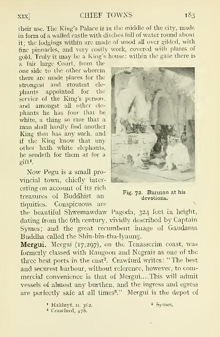
XIX] CHIEF TOWNS 183
their use. The King's Palace is in the middle of the city, made
in form of a walled castle with ditches full of water round about
it ;the lodgings within are made of wood all over gilded, with
fine pinnacles, and very costly work, covered with plates of
gold. Truly it may be a King's house : within the gate there is
a fair large Court, from the
one side to the other wherein
there are made places for the
strongest and stoutest ele-
phants appointed for the
service of the King's person,and amongst all other ele-
phants he has four that be
white, a thing so rare that a
man shall hardly find another
King that has any such, and
if the King know that anyother hath white elephants,he sendeth for them as for a
gift1
-
Now Pegu is a small pro-
vincial town, chiefly inter-
esting on account of its rich
treasures of Buddhist an-
tiquities. Conspicuous are
the beautiful Shwemawdaw Pagoda, 324 feet in height,
dating from the 6th century, vividly described by Captain
Symes; and the great recumbent image of GaudamaBuddha called the Shin-bin-tha-lyaung.
Mergui. Mergui (17,297), on the Tenasserim coast, was
formerly classed with Rangoon and Negrais as one of the
three best ports in the east2. Crawfurd writes: "The best
and securest harbour, without reference, however, to com-
mercial convenience is that of Mergui....This will admit
vessels of almost any burthen, and the ingress and egress
are perfectly safe at all times3." Mergui is the depot of
Fig. 72. Burman at his
devotions.
1Hakluyt, n. 362.
3 Crawfurd, 478.
Symes.

i,S| CHIEF TOWNS [ch.
the pearling industry and has some trade in tin, but is
otherwise undistinguished. Notwithstanding its natural
advantages, its value as a port is small as it leads nowhither
and has no hinterland.
Thaton. Thaton (15,091), an inland town in the Tenas-
serim division, was formerly a Talaing capital and also a
seaport. Anawrata destoyed it in the nth century, and the
retrogression of the sea has long left it high and dry. It
is on the railway line between Rangoon and Martaban.
Insein. Insein (14,308) is a flourishing and rising railway
town, ten miles from Rangoon. Near it are the golf links of
Mingaladon, said to be almost the best course in the East.
Yandoon. Yandoon (12,50c)1
,at the junction of the Irra-
waddy and the Panlang creek, 60 miles from Rangoon, was
formerly a trading town of some importance. It is now one
of the few towns with a dwindling population.
Paungde. Paungde (14,154) is a railway town in the Prome
district, 130 miles from Rangoon.
Thayetmyo. Thayetmyo (10,768), "the city of slaughter,"
is on the Irrawaddy, a few miles below the old frontier of
Upper Burma. Formerly, it was strongly garrisoned, but
since the annexation it has sunk into comparative insig-
nificance.
Syriam. Syriam (15,193), not far from Rangoon, was once
a provincial capital and, as already noted, the seat of the
earliest commercial settlements. It has grown rapidly in
recent years, its population in 1891 being under 2000. Nowit is the centre of a thriving oil-refining industry.
Upper Burma
Mandalay. In the year 1857, Mindon Min, following the
traditional custom of his House when the throne was filled
otherwise than by regular succession, decreed the removal
of his court from Amarapura to Mandalay where, in con-
sequence, a populous town arose. The new capital was
1 In 1911.

XIX] CHIEF TOWNS 185
occupied in 1859. The site chosen was on the left bank of
the Irrawaddy, in latitude 20 59' N., at a place con-
venient as a centre of trade with the Northern Shan
country. It is not clear that it had any other ad-
vantage.The present town, city, and cantonment occupy an area
of 25 square miles. In 1885, Mandalay was the most
populous city in Burma, and so it remained for a few years,
~-<i*^-w«& --lr-
,<res-r ,-«v-_-3j
Fig. 73. South Moat Gate, Mandalay.
the population in 1891 being returned at 188,815, while
that of Rangoon was only 182,080. By 1911, the inhabi-
tants of Mandalay had fallen to 138,299. But in the next
ten years there was a revival and the number is now
148,917. Mandalay is still essentially a Burmese town, the
Buddhist element largely prevailing. Situated 386 miles
from Rangoon it is connected with the capital of the pro-vince by rail and by river.
The type of Burmese royal city has remained unaltered

186 CHIEF TOWNS [ch.
for ages. Caesar Frederick's description of Pegu1might be
adopted almost word for word for Mandalay, save that
there were no crocodiles in the moat and there was no ditch
round the palace. The commercial and trading quartersextend along the river bank without a break to Amarapura.This low-lying area is protected from inundation by a
double embankment built partly for that purpose and
partly as a safeguard against hostile attack from the river.
In 1886, at the height of the rains, the embankment gave
way and the water poured through, flooding the lower partof the town. Boats and launches plied as far as the Zegyo,the great bazaar. In 1885, most of the houses were flimsystructures of wood and bamboo. The greater number of
these were destroyed by frequent fires which raged at the
end of the hot weather of the following year. Now there
are many masonry buildings. Although not a commercial
centre of importance, all industries characteristic of the
country are practised at Mandalay. A specially flourishing
trade is the making of sacred images in marble and steatite.
In the middle of the town is the Zegyo, one of the finest
covered bazaars in the East, where silks and jewels and
miscellaneous goods are displayed in lavish abundance.
Some three miles from the river, stands the Myo or city,
encompassed by a moat, 225 feet wide, once covered with
lilies, and by battlemented walls, 27 feet high. Each face
of the square enclosure is about a mile and a quarter in
length. The walls are pierced by twelve gates, each ap-
proached by a bridge over the moat, and each surmounted
by a pyathat or terraced spire, not used, I think, as sentryboxes. Between these are studded other pyathats making
forty-eight in all. One of these surmounts GovernmentHouse which, being designed in Burmese style, does not
outrage aesthetic sensibility. In the middle of the squarestill stands the Palace. When Mandalay was occupied in
1885, the area around the Palace was crowded with houses1 See p. 182.

XIX] CHIEF TOWNS 187
of ministers, officers of State, and other Government ser-
vants (ahmudan). Each of the more important mansions,
mostly built of timber, stood in the midst of its own win,
compound, or garden. After the occupation the walled city
became a place of arms, the main part of the cantonment
which was named Fort Dufferin to commemorate the
Governor-General by whom Upper Burma was added to
the Empire. In process of time, the whole of the land within
Fig. 74,, Between wall and moat, Mandalay.
the walls was acquired by Government and all the inhabi-
tants were compensated and expropriated. The space thus
cleared was filled with barracks, parade grounds, recrea-
tion fields, houses of military and civil officers; and so it
remains to this day.The palace of King Mindon and King Thebaw was built
so recently as 1845 by Shwebo Min and was transported
bodily from Amarapura to Mandalay. It was surrounded
by a teak wood stockade and two inner encircling walls.

188 CHIEF TOWNS [ch.
On a raised masonry and boarded platform was piled an
irregular maze of buildings, mostly in Burmese style, but
mingled with some of modern design. East and west, with
gilded roofs upheld by lofty pillars of teak, were spaciousaudience halls, each with its golden throne; for the most
exalted ceremonies, in the east, the Lion Throne; in the
west, where the ladies of the court paid obeisance, the LilyThrone. Seven other thrones were used on various oc-
casions. Towering above the eastern hall was the famous
tapering nine-storeyed spire. Between the two halls were
the royal apartments, quarters for princes and princesses,
courtiers, maids of honour and pages, offices for ministers,
the State Theatre, the Treasury. At the south-eastern
corner stood a wooden tower of recent date. Near the
eastern gate, beyond the outer wall, was the turret on
which was placed the bohozin, the great drum sounded to
mark the hours and to give assurance that the king wasin his palace. Between the inner wall and the main buildingstood a small gilded monastery and opposite it the Hlntdaw
or Council Chamber where also was the Record Office. Notfar away was the shed of the white elephant
1. The orna-
mentation of the buildings on the platform was tawdry and
barbaric; even the wood-carving was not of special dis-
tinction. As a whole, the palace is more curious and
interesting than beautiful. But the central pyathat is a
model of grace and the pillared halls have a majestic dignity.
Within the enclosure, like Kubla Khan's pleasure-dome,the palace was surrounded by lovely gardens, bright with
sinuous rills, where blossomed many an incense-bearingtree and gorgeous tropical flowers, with here a graceful
bridge, there a gay pavilion. Here was the summer house
where King Thebaw surrendered to General Prendergast.Afterwards this little house acquired even a better title to
respect as the temporary abode of Lord Roberts. It has
now disappeared.1 This loyal beast declined to survive the downfall of his sovereign.

XIX] CHIEF TOWNS 189
The palace has been carefully preserved. At first, after
the occupation, it was filled with offices and quarters ;the
western hall became a club house, the eastern hall a church.
'!'„,;;
Fig* 75' The Palace Gardens.
Club and church have long since been evicted as well as all
residents;and now the lizard and the swarthy daywan
1keep
the empty halls where King Thebaw rioted and revelled.
The stockade has been replaced by neat post and rails.
Watchman.

igo CHIEF TOWNS [ch.
The Hlutdaw has crumbled away. But most of the buildings
on the platform still stand as in the time of the Burmese
monarchy.To the north is Mandalay Hill, 950 feet high, whereon
stood an upright image of the Buddha, with arm out-
stretched, the Palladium of the city. The image, destroyed
by fire some years ago, has been replaced. On a spur of
the hill has been built a temple to receive relics of Gaudamarecovered from a pagoda near Peshawar erected by the
Emperor Kanishka. East are the Shan Hills and in the
middle distance the isolated little hill of Yankintaung, the
hill of peace.
Mandalay is studded with pagodas and monasteries, for
the most part modern. South of the town is the Arakan
Pagoda or rather Temple (Yakaing Paya), enshrining the
great Mahamuni image, cast in the second century of our
era, and brought from Arakan in 1784. Here also are six
antique and much dilapidated bronze images, two men,three lions, and a three-headed elephant. The corridors
leading to the shrine are adorned with frescoes. In a small
lake or pond are tame tortoises fed by the pious. Here,
for the present, are kept the relics from Peshawar.
Some other pagodas may be mentioned. Kyauktawgyicovers an image of the Buddha made in marble under the
orders of Mindon Min. At Sandemani are the graves of the
Einshemin (heir apparent), and the Sagu and Malun princes,
killed in the abortive rising of the Myingun prince in 1866.
Kuthodaw, not far from the foot of Mandalay Hill, is one
of the most remarkable. In the midst is a graceful pagoda ;
around it are 729 stone slabs on which are inscribed the
whole of the Tripataka or Buddhist scriptures. Setkyathila
covers a bronze image of the Buddha cast under the orders
of King Bagyidaw. One of the finest specimens of Burmese
art, the image is somewhat fancifully regarded as of sinister
omen. Its casting at Ava in 1823 was followed by the First
War in 1824; its removal to Amarapura in 1849 by the

XIX] CHIEF TOWNS 191
Second War in 1852; its final transfer to Mandalay in 1884
by the Third War in the following year. Eindawya, built
by Pagan Min in 1847, is of conspicuous merit; MenaungYawana, built in 1881, may commemorate King Thebaw.
The Atumashi, or Incomparable, a large and beautiful
temple covered with white stucco, enshrining a great imageof the Buddha, was destioyed by fire in 1890. Paya-ni, the
Red Pagoda, dates from 1092. Attached to it are two
«
•».
Fig. 76. Queens' Monastery, Mandalay.
images, Naungdaw and Nyidaw, of the time of Anawrata.
In its present form, Shwekyimyin dates only from 1852but was superimposed on an old pagoda of 1104. It covers
a great brazen image of Gaudama as well as other sacred
images, notably one, Shwelinbin, representing Gaudama in
royal robes, said to have been moved from capital to
capital since the time of King Narapati-sithu of Pagan
(nth century). A small nameless pagoda was built byShinbome, a famous beauty, who, with the necessary varia-

192 CHIEF TOWNS [ch.
tion almost equalling the exploits of Henry VIII, married
five kings in succession.
Many monasteries, built by kings, queens and courtiers,
adorn the town. The best known is the Queen's Monastery,finished by Supayalat just before the Third War. At the
time of the annexation its gold was fresh and gleaming.
Shwenandaw, built by King Thebaw in 1880, and Salin,
by Salin Supaya, a favourite child of Mindon Min,
daughter of the Limban queen, as well as the Queen's
Monastery, are all remarkable for beautiful wood-carving,that on Salin being probably the finest in Burma. San-
gyaung was built in 1859 by Mindon Min. Taiktaw is the
official residence of the Thathanabaing1
.
Pakokku. Pakokku (19,507), on the right bank of the
Irrawaddy, near its junction with the Chindwin, is de-
scribed by Crawfurd as
"a place of considerable extent and population. The in-
habitants" he writes "poured out on the banks to see the
steam-vessel, and formed such a concourse as we had nowhereseen unless at Prome. [Pakokku] is a place of great trade, anda kind of emporium for the commerce between Ava and the
lower country ; many large boats which cannot proceed to the
former in the dry season, taking in their cargoes at this place.We counted one hundred and fifty trading vessels, of which
twenty one were of the largest size of Burman merchant-boats2."
But in 1889 the population was estimated at no more than
8000. Since then Pakokku has thriven and is now againa busy industrial and trading centre and an importanttimber depot.
Myingyan. Myingyan (18,931), on the left bank of the
Irrawaddy, about 80 miles below Mandalay, connected bya branch line from Thazi with the Rangoon-Mandalayrailway, is an industrial and trading town of some note,
the seat of busy cotton mills. It suffers from being cut off
from the river in the dry season by sandbanks.
1 See p. 128. 2 Crawfurd, 74.

xix] CHIEF TOWNS 193
Pyinmana. Pyinmana (14,886), on the Mandalay railway,
226 miles from Rangoon, derives its importance from its
proximity to valuable teak forests. It was one of the first
inland towns occupied at the time of the invasion of UpperBurma in 1885.
Maymyo. Maymyo (16,558), already mentioned as the
summer capital, is situated on the border of the Shan sub-
State of Hsum-sai 1(Thonze) ,
east of Mandalay, on a wide
plateau some 3500 feet above the sea. Built on the site
of the village of Pyin-u-lwin and named after its first
Commandant, Colonel May of the Indian army, Maymyoowes its prosperity entirely to British occupation. Whenfirst visited towards the end of 1886, Pyin-u-lwin consisted
of about fifty houses, a monastery, a market place, and
a gambling ring. Now the railway from Mandalay to
Lashio passes through it and there is also connection with
Mandalay by a good motor road. Besides being the seat
of Government in the hot season, it is the military head-
quarters of Burma, and the resort of many visitors from
the plains. There is ample room for a race-course, golf
links, polo, cricket and football grounds, a club, barracks,
private houses with delicious gardens, and public offices.
Carriage drives and good roads for motoring have been laid
out. To Sir Hugh Barnes, the second Lieutenant-Governor,is due the provision of some 60 miles of rough rides throughthe forest on the outskirts. Maymyo is singularly unlike
typical eastern places; it has been described as more like
a corner of Surrey. The only conspicuous native feature is
the bazaar or market, held after Shan fashion every five
days, where strange people from the hills in picturesqueattire mingle with Europeans and Shans and Burmans.
Mogok. Mogok (n.,069)2 was from 1887 to 1920 the head-
quarters of the Ruby Mines district, recently absorbed into
Katha. Picturesquely situated amid lofty hills, at an eleva-
tion of about 4000 feet, connected with the Irrawaddy at
1 Absorbed in Hsipaw.2 In 191 1.
W. B. 13

T94 CHIEF TOWNS [CH.
Thabeik-kyin by a motor road 60 miles in length, it is
important solely as the centre of the ruby mining industry.It has always been a wealthy town where, in the bazaar
Fig. 77. Mingun Pagoda.
in 1887, copper coins were unknown. A few miles away,at a greater height, is Bernard-myo, commemorating Sir
Charles Bernard, the distinguished officer who was the first
Chief Commissioner in Upper Burma.
Sagaing. Sagaing (11,737), one of many ancient capitals,

xix] CHIEF TOWNS 195
is a typical Burmese town, embowered in tamarind groves,
on the right bank of the Irrawaddy a few miles below
Mandalay. It is the southern terminus of the railway to
Myit-kyi-na and is also connected by rail with Monywaand Alon on the Chindwin. From Mandalay, a steam ferry
plies several times a day in connection with the railway.
Except as the headquarters of a Division and District,
Sagaing has no special importance but it has many associa-
tions and notable neighbours. Nearly opposite on the left
bank of the river stood the ancient and famous city of Ava,now in ruin and decay. A little to the north is the greatbell of Mingun, the largest hung bell in the world. Cast
in 1790, it weighs 80 tons, with a height of 12 feet and a
diameter at the mouth of 16 feet. It was re-hung a few
years ago. Close by, at Mingun, is a vast uncompleted
pagoda planned by Bodawpaya to be of unapproacheddimensions, but abandoned after it had been split by an
earthquake in 1839. With a base of 450 feet square and
height of 162 feet, it enjoys the unromantic distinction of
being the greatest mass of solid brick work extant. Hard
by is Sinbyushin, a beautiful terraced pagoda, dating from
the 14th century. To the north the hills along the river
are crowned with white pagodas in picturesque disorder;
hollowed out of the hills are cave dwellings of hermits.
Shwebo. Shwebo (10,605), an inland town on the Myit-
kyina railway, is noted as the birth-place of Alaungpayaand the capital of his kingdom. Traces of the royal citystill remain. In Burmese times Shwebo was often the seed-
plot of rebellion.
Bhamo. Bhamo (7741), an ancient town on the left bankof the Irrawaddy, 687 miles from the sea, is an emporiumof the caravan trade with China. It is one of the placesto which European traders first penetrated. Among its
inhabitants are a fair sprinkling of Chinese from Yunnanand some from Canton; its most conspicuous building is
an elaborately ornamented Chinese temple Bhamo is im-
13—2

196 CHIEF TOWNS [CH.
portant as a frontier garrison town, having been occupiedimmediately after the taking of Mandalay.Amarapura. Amarapura (7866) \ a decaying town, prac-
tically a suburb of Mandalay, is chiefly notable as a former
capital. It still has someeconomic importance, with
an exceedingly useful silk-
weaving institute and with
many carvers of images.Here used to be the kheddah,the enclosure into which wild
elephants were enticed in the
king's time and in our early
years. Here are many famouspagodas ; the Shwegyetyet
group, 600 years old; Pato-
dawgyi, a very large and
beautiful pagoda decorated
with glazed tiles, the workof King Bagyidaw in 1818;
and Kyauktawgyi built byPagan Min in 1847 on the model of the Ananda at Pagan,its porches adorned with frescoes.
Pagan. Pagan (6254)2
> on the left bank of the Irrawaddy,below Myingyan, is one of the most remarkable places in
the world. The most renowned of ancient Burmese capitals,
it is still a wonder-house of archaeological relics. So long
ago as the 2nd century of our era, a city was built on this
site. But Pagan, of which the ruins are extant, was founded
by King Pyinbya in 847 a.d. In 1057 Anawrata, most
renowned of Burmese kings, destroyed the kingdom of
Thaton and brought to his capital King Manuha and manyTalaing captives. From this date begins the epoch of
pagoda-building at Pagan, lasting till the sack of the city
by the Mongols and Chinese of Kublai Khan in 1284, and
Fig. 78. Shrine at Amarapura.
1 In^ign.2 In 1901.

xix] CHIEF TOWNS 197
embracing the reigns of Anawrata, Kyansittha, Alaung-sithu, Narapati-sithu, and Talokpye Min. For miles alongthe river bank are still standing some 5000 pagodas andBuddhist temples, Pagan itself extending for five miles
with a breadth of two miles; but the area occupied bysacred buildings at Pagan and in the vicinity is about 100
square miles 1. Shortly before the Mongol invasion, Marco
Polo describes Pagan which he calls Amien, the capital cityof the province of that name, as "a very great and noble
city2."
"And in this city," he writes," there is a thing so rich and rare
that I must tell you about it. You see there was in former daysa rich and puissant King in this city and when he was about to
die he commanded that by his tomb they should erect twotowers (one at each end), one of gold and the other of silver,
in such fashion as I shall tell you. The towers are built of fine
stone; and the one of them has been covered with gold, a good
finger in thickness, so that the tower looks as if it were all of
solid gold; and the other is covered with silver in like mannerso that it seems to be all of solid silver. Each tower is of a goodten paces in height and of breadth in proportion. The UpperPart of these towers is round, and girt all along with bells, the
top of the gold tower with gilded bells and the silver tower withsilvered bells, insomuch that whenever the wind blows amongthese bells they tinkle. The King caused these towers to beerected to commemorate his magnificence and for the good of
his soul, and really they do form one of the finest sights in the
world; so exquisitely finished are they, so splendid and costly."
Unhappily no remains of these exquisite buildings can be
traced, but many worthy compeers survive. In the classical
description of the antiquities of Pagan, Sir Henry Yulethus summarizes the several styles of architecture :
The bell-shaped pyramid of dead brickwork in all its varieties ;
the same raised over a square or octagonal cell, containing an
image of the Buddha; the bluff, knob-like dome of the CeylonDagobahs, with the square cap which seems to have charac-
1 Taw Sein Ko, CLE. Archaeological Notes on Pagan.2 Marco Polo, n. 109.

193 CHIEF TOWNS [ch. xix
terized the most ancient Buddhist chaityas, as represented in
the sculptures at Sanchi, and in the ancient model pagodasfound near Buddhist remains in India; the fantastic boo-payah,or pumpkin pagoda, which seemed rather like a fragment of
what we might conceive the architecture of the moon than
anything terrestrial, and many variations of these types. Butthe predominant and characteristic form is that of the cruciform
vaulted temple1
.
Ananda. The most famous temple is the Ananda, of Jain
architecture, with vaulted chambers and corridors, built
in the year 1091 and still standing almost untouched bytime. It contains stone sculptures representing scenes of
Gaudama's life and terra cotta tiles picturing events of his
former existences, as well as images of the founder KingKyansittha and of the last four Buddhas of the present
cycle.
Tha-byin-nyu, another magnificent temple, built byAlaung-sithu in 1244 after models of temples in Northern
India, is thus described:
...The form of the temple is an equilateral quadrangle,
having on each side four large wings, also of a quadrilateralform. In these last are the entrances, and they contain the
principal images of Gautama. Each side of the temple measures
about two hundred and thirty feet. The whole consists of four
stages, or stories, diminishing in size as they ascend. The groundstory only has wings. The centre of the building consists of a
solid mass of masonry : over this, and rising from the last storyof the building, is a steeple, in form not unlike a mitre, endingin a thin spire, which is crowned with an iron umbrella, as in
the modern temples. Round each stage of the building is anarched corridor, and on one side a flight of steps leads all the
way to the last story.... Perhaps the most remarkable feature
of this temple, as well as of almost all the other buildings of
Pagan, is the prevalence of the arch. The gate ways, the doors,
the galleries, and the roofs of all the smaller temples, are in-
variably formed by a well-turned Gothic arch2.
Other notable temples of Indian types and giving evidence
of Indian influence are Maha Bodi, a copy of the shrine at
1 The Court of Ava, 35.2 Crawfurd, 63-4.

"safe'
c3
c
C<

200 CHIEF TOWNS [ch. xix
Buddha Gaya in Bengal and Gawdapalin, built by Nara-
pati-sithu in the 12th century. Of a small unnamed temple,Crawfurd writes: "within the chamber were two good
images in sandstone, and sculptured in high relief. Oneof these was Vishnu or Krishna, sitting on his Garuda
; andthe other Siwa, the destroying power, with his trisula, or
trident, in one hand and a mallet in the other 1 ." The first
temple built by Anawrata enshrines hairs of the Buddha;the corners of the lowest terrace are guarded by images of
Brahma, Vishnu, and Siwa.
Specially deserving of mention are Shwegugyi, built byAlaungsithu in the 12th century; Tilomile, a two-storeyed
building, dating from 1218; and Shwezigon, one of the
oldest buildings in Pagan.
A few hundred yards South of [Shwezigon] lies ensconced
amid green verdure and ruins, Kyansittha's Onhmin or the Cave
Temple of King Kyansittha (1084-1112 a.d.). It is a brick
building of unpretentious dimensions, and is almost hidden
from view because its site has been scooped out of a sand-dune.
As the Ananda temple is the store-house of the finest statuaryin stone in Burma, so this Cave Temple contains the best
collection of exquisite frescoes illustrating Burmese civilization,
probably before the nth century a.d. Such Cave Temples are
numerous in the neighbourhood2
.
Dhammayazaka temple, built by King Narapatisithu,1 1 96, contains images of the five Buddhas of the present
cycle including Arimetteyya who is still to appear.Besides temples and pagodas, many in good preservation,
ruined monasteries abound in great numbers and of various
types3
. Enough has been cited to indicate the extreme
wealth of Pagan in archaeological treasures to the examina-
tion of which much labour has been devoted in recent years.
The flourishing and unique lacquer industry has alreadybeen described.
1 Crawfurd, 69.2 Taw Sein Ko, Burmese Sketches, 11. 303.
3 Cf. Captain W. B. Sinclair's "The Monasteries of Pagan." Journalof the Burma Research Society, x. i.

CHAPTER XXV ARCHITECTURE AND ANTIQUITIES
All that is characteristic in Burmese architecture is em-
bodied in buildings sacred to the Buddhist religion. Exceptthe palace at Mandalay, there were, in recent Burmese
times, literally no secular buildings of beauty, grandeur,or importance. The houses of even the highest officers of
State were wooden structures, raised from the ground on
wooden posts, situated in the midst of a spacious win
(compound or enclosure) in which around the central
buildings were scattered the smaller houses of retainers.
Humbler dwellings, in town or village, were of similar typeand in rural parts these conditions still prevail. In towns
a good many masonry houses have been built. In Mandalay,there were some of these, but not many, in Burmese times.
Pagodas. Pagodas abound all over the country. The
typical Burmese pagoda is well described by the early
traveller, Fitch:
They be made round like a sugar loaf ;some are as high as a
church, very broad beneath;some a quarter of a mile in com-
pass; within they be all earth, done about with stone... theybe all gilded aloft ; and many of them from the top to the bottom ;
and every ten or twelve years they must be new gilded, because
the rain consumeth off the gold; for they stand open abroad 1.
The description holds good in the present day. But the
great majority of pagodas, elsewhere than in large towns,
are not gilded but simply covered with white stucco. Every
village has its pagoda; and many are built in waste places,
and on the tops of hills. The supreme work of merit is the
building of a pagoda; the highest unofficial title of respect,
paya-taga, pagoda-builder. The more pretentious pagodas1Hakluyt, II. 393.

202 ARCHITECTURE AND ANTIOUITIES [ch.
are built on raised platforms whereon are crowded shrines,
zayats (rest-houses), images, altars for lights and flowers,
bells, tagundaing (posts decorated with streamers), water-
stands, images of the Buddha.
Pagodas at Rangoon, Mandalay, Pagan, and elsewhere
have already been described. A long list of other pagodas
might be compiled and an account of Burma would be in-
complete without mention of the most notable. When great
Fig. 80. Chinthes, figures at Pagoda entrance.
age is assigned to a pagoda, it must not be supposed that
it was built originally of its present height and splendour.The first building was probably small and insignificant,
magnified by later accretions superimposed.In the midst of Rangoon stands the Sule Pagoda, of
venerable antiquity, but overshadowed by the dominance
of Shwe Dagon. In Thaton are Zingyaik (nth century)and a pagoda said to have been built by King Dhammacheti

xx] ARCHITECTURE AND ANTIQUITIES 203
in the 15th century; and at Kyaikkatha in that district
are the remains of a thousand pagodas.
Most famous among the small pagodas is the Kyaik-htee-
yoh1insignificant in size, but unique from its position. The hill
on which it stands takes its name from the payah, and is over
three thousand five hundred feet in height. On its summitare numbers of granitoid boulders, many of them balanced in
Fig. 81. Pagodas at Sagaing.
a most extraordinary way, and all the more striking surmounted
by little shrines. The Kyaik-htee-yoh stands on a huge boulder,
which itself rests on a projecting rock, separated from the rest
of the hills by a chasm, fathomless to the eye, and reaching, so
say the villagers, far below the depth of the hill. The boulder
hangs on the extreme verge of the bare rock, and hangs over
it as if a gust of wind or a few extra pounds added would makeit topple over and crash down the giddy height far away into
the green valley below. To this shrine people from all parts of
1 Also in the Thaton district.

204 ARCHITECTURE AND ANTIQUITIES [ch.
the country but more especially the Talaings, come in the monthof February, and cast jewellery and precious stones into the
yawning rift, and, clambering up the rock by the aid of a
bamboo ladder, cover the payah with flowers and small lighted
candles, making it look like a new nebulous constellation fromthe far off plains. Inquirers are told with the utmost confidence
that the pagoda is five thousand years old. It certainly has
been there time out of mind, and the boulder has solely been
kept in its place by the hair buried under the shrine, and givento a hermit by the great Budh himself when he returned from
Tawa-dehutha, the second heaven of the Nat-dewahs, on the
occasion of his preaching the law to his mother....The view
from the pagoda is superb; bounded on the east by the blue
Martaban hills, fading away into the dim peaks of Siam; and
extending southward over tangled jungle and yellow paddylands to the bright waves of the Gulf of Martaban, while to
the west the jewelled speck of the pagoda at Pegu almost
leads one to imagine the stately bulk of the Shway Dagohnbeyond
1.
Bilugyun in Amherst has sixty pagodas of venerable age.
At Amherst Point is Yele, within a hundred feet of which
no woman may tread. Sandaw, in the same district, claims
to be as old as Shwe Dagon. At a very famous pagoda, Shin-
mokti, in Tavoy, is an image which floated miraculouslyacross the Bay of Bengal. Other shrines of great antiquityin Tavoy and Mergui are merely names.
In Arakan, the most interesting archaeological remains
are at. Mrohaung, the capital from 1430 to 1782.
The largest and best monuments and sculptures of Mrohaungbelong to the 15th and 16th centuries. Their interest lies in the
fact that some of them are unlike in style to anything seen in
the rest of Burma; they were temples as well as forts at the
same time. Another interesting feature, very rare in Burma,and even in Pagan itself, is that stone was very largely used
for building.... Solid or cylindrical pagodas... are completelybuilt of stone and are generally among the best preservedmonuments at Mrohaung
2.
1 The Burman, 167-168.2Archaeological Survey Report, Burma, 1920-21.

xx] ARCHITECTURE AND ANTIQUITIES 205
In the architecture as well as in the subjects of some of the
stone carvings are many traces of Hindu influence.
The Shittaung temple, with its hundred images of Buddha, the
Dakkan-thein, a temple fortress, the An-daw or Tooth-relic
Temple, the Ratanabon Pagoda, a quaint structure of the solid
cylindrical type, the Lemyethna Temple, the Rata-man-aungPagoda
]
are among the principal shrines. At Vesali, the site of a
*«*3*f**:
'
Fig. 82. Turtle tank, Arakan Pagoda.
more ancient capital, near Mrohaung, are also interestingrelics.
Thayetmyo has Shwemyindin or Shwe-sut-taung-byi (the
golden shrine of prayers granted) dating from the first
century of our era. Shwezettaw (the golden footprint) in
Minbu commemorates a visit of Gaudama Buddha. Anaw-rata is reputed to have built Taung-gyi-swe-daw opposite
Pagan and Sut-taung-byi in Madaya (Mandalay district),
the latter to celebrate victories over China. Shwezayun,on the Myitnge, is famous for its tame fish which come for
1Archaeological Survey Report, ut sup.

206 ARCHITECTURE AND ANTIQUITIES [ch.
food when called and are decorated with gold leaf byvisitors at the pagoda festival. In Sagaing is the celebrated
Kaunghmudaw, built by Thalun Mintayagyi, King of
Ava, in 1636. Two others date from the 10th century. In
Kyaukse, Asoka built at least one and Anawrata manypagodas which still exist
;and here is Shwemoktaw, built
Fig. 83. Eindawya Pagoda.
by a king more than two thousand years ago. Meiktila has
two pagodas of Anawrata and of Narapatisithu. An in-
teresting shrine in Myingyan is Kyauk-ku, the rock-cave
pagoda, under and near which are caves where hermits
dwell. Shwegu near Bhamo, "is a perfect forest of Pa-
godas1 ."
1 The Burman, ij^.

xx] ARCHITECTURE AND ANTIQUITIES 207
In the Shan States are many renowned pagodas ; amongwhich may be mentioned Mwedaw at Bawgyo in Hsipaw ;
Kaunghmu Mwedaw Manloi in South Hsenwi, built on
the spot where Gaudama died in one of his earlier incar-
nations as a parrot; Kaunghmu Kawmong at Manhpai,illuminated by nats on dark nights; Anteng and Than-
daung in Yawnghwe said to have been built by Asoka and
repaired by Anawrata.
;&-.
Figo 84. Thein.
Besides pagodas, Burmese sacred buildings include mon-
asteries, thein 1,and zayat
2. Some of the more notable
monasteries have already been described. Every village
has its monastery, a one-storeyed building, where the monkand his acolytes reside, absorbed in meditation or engagedin teaching young boys.
Inscriptions. "Burma is one of the very richest countries
in Indo-China in lithic inscriptions. The least religious
1 Halls for the ordination of monks.2 Rest-houses for travellers and pilgrims.

208 ARCHITECTURE AND ANTIQUITIES [ch.
foundation, benefaction, or dedication of land, slaves, or
fruit trees was generally recorded on stone." But hardly
any inscriptions have been found earlier than the middleof the nth century a.d. 1
Images. Some famous images have been mentioned. At
Pagat, on the Salween, is a notable collection. Here are
the famous caves where besides countless numbers at the
entrance are myriads of statues within.
In the words of a bye-gone traveller:—"(The cave) is of
vast size, chiefly in one apartment, which needs no humanart to render it sublime. The eye is confused, and the heart
appalled....Everywhere, on the floor, overhead, on the jut-
ting points, and on the stalactite festoons of the roof, are
crowded together images of Gautama—the offerings of suc-
cessive ages. Some are perfectly gilded; others encrusted withcalcareous matter; some fallen, yet sound; others mouldered;others just erected. Some of these are of stupendous size; somenot larger than one's finger; and some of all the intermediate
sizes—marble, stone, wood, brick, and clay. Some even of
marble, are so time-worn though sheltered from change of
temperature, that the face and fingers are obliterated. Hereand there are models of temples, kyoungs
2, etc., some not larger
than half a bushel, and some ten or fifteen feet square, absolutelyfilled with small idols, heaped promiscuously one on the other.
As we followed the path, which wound among the groups of
figures and models, every new aspect of the cave presented newmultitudes of images
3."
Another remarkable group exists at Akauktaung, on the
edge of the Irrawaddy, at the extreme north of the Henzadadistrict.
Here the right bank rises proudly to a lofty cliff, overhungwith evergreen forest, and this cliff is made holy and glorious
by hundreds and hundreds of images of the Buddha, each in its
separate shrine, sculptured tier above tier out of the solid rock.
The Buddhas sit royally enthroned, a splendid company, looking1
Archaeological Survey Report, ut sup.-Kyaimg, a monastery.
3 Cited from a chapter of The Silken East (xxxm.), which containsan admirable description of the caves and their vicinity.

xx] ARCHITECTURE AND ANTIQUITIES 209
down upon the river, watching the great steamers pass andlittle canoes freighted with laughing children; listening to the
song of the Irrawaddy and to the little bells on the tiny white
pagoda on the edge of the cliff. Transfigured in sunlight, the
Buddhas glow in their dark frame of forest, under shimmering
daylight skies. Radiant, unearthly, they gleam in the witcheryof Eastern moonlight.
Fig. 85. Gaudama Buddha.
It seems as if the whole wonderful group must have arisen
in a single moment at the bidding of a divinity, so ethereal, so
harmonious is the impression it makes upon the mind. Yet each
image owes its existence to the piety of some simple husband-
man, spending with royal largesse the proceeds of his harvest.
The Burman, no wise calculator, gives all he can and knows not
ignoble thrift 1.
1Marjorie Laurie.
w. B. 14

BIBLIOGRAPHYReports
General Administration.
Upper Burma Administration (1886).
Archaeological Survey.
Myaungmya Settlement (1916-1919).
Sagaing Settlement (1915-1918).Trade and Navigation.Maritime Trade and Customs.
Overland Trade.
Census (191 1).
Gazetteers
Imperial Gazetteer of India—Burma.
Upper Burma. Sir George Scott.
Chin Hills. Sir B. S. Carey and Mr H. N. Tuck.
Myitkyina District. Mr W. A. Hertz.
Marco Polo. Ed. Yule and Cordier.
Hakluyt's Voyages. Ed. 1810.
Embassy to the Court of Ava (1795). Captain M. Symes.
Embassy to the Court of Ava (1827). J. Crawfurd.
Mission to the Court of Ava (1855). Sir Henry Yule.
History of Burma. Sir Arthur Phayre.The Pacification of Burma. Sir Charles Crosthwaite.
Our Burmese Wars. Colonel W. F. B. Laurie.
The Story of Burma. Mr G. G. Harmer.The Burman. Shway Yoe (Sir George Scott).
The Burmese Empire. Father Sangermano.Burma under British Rule. J. Nisbet.
Burma. Mr E. H. Parker.
The Soul of a People. H. Fielding.The Silken East. Mr V. C. Scott O'Connor.
Mandalay, etc. Mr V. C. Scott O'Connor.
In Farthest Burma. Captain Kingdon Ward.Burmese Sketches. Mr Taw Sein Ko.
Journal of the Burma Research Society.L'Architecture Hindoueen Extreme—Orient. General L. de Beylie.
Le Tibete Revolte. J. Bacot (translation).
Shans at Home. Mrs Leslie Milne.
Fauna of British India.
Poisonous Snakes of India. Sir Joseph Fayrer.
Report on Fisheries. Colonel F. D. Maxwell.

BIBLIOGRAPHY 211
Adventure, Sport and Travel, on Tibetan Steppes. W. N. Fer-
gusson.
Big game shooting in Upper Burma. Colonel G. H. Evans.Game animals of India. R. Lyddeker.Birds of British Burma. E. W. Oates.
Journal of the Bombay Natural History Society (Vol. vn).Flora of British Burma. Kurz.
Handbook of Forest products of Burma. Mr A. Rodger.Journal of the Linnaean Society (Vol. xxvin).Records of the Botanical Survey of India (Vol. in).
The Commercial Products of India. Sir George Watt.The Sea-Gypsies of Malaya. Walter Grainge White.A Civil Servant in Burma.
14-

APPENDIX I
AVERAGE ANNUAL RAINFALL from
1917 to 1920 (inclusive)
(See pp. 16-19)
MerguiTavoyMoulmein ...
Thaton
Toungoo ...
PapunPeguRangoon ...
Insein
Hanthawaddy (Kyauktan)TharrawaddyPromeMaubin
PyaponBassein
MyaungmyaHenzada ...
ThayetmyoMagweMinbuPakokku ...
Kampetlet ...
Yamethin ...
Pyinmana ...
Meiktila
Myingyan ...
Kyaukse ...
Lower Chindwin ...
Upper Chindwin ...
SagaingShwebo ...
Mandalay ...
KathaBhamo
81-40 1920
149-03. 1920 Palaw 279-17
217-65
204-03
214-62
|Thandaung 184-20
(Yedashe 47- 17
113-41
125-42
94-61
87-I5
in-3484-83
43-00
97-92
94-18
103-87
96-33
84-32
45-79
28-78
34-7 1
20-66. 1920 Gangaw 52-63
93-°9
33-52; 1920, 23-69
40-47
32-34
29-25; 1920, 23-95
32-93; 1920, 23-80
27-18; 1920, 18-14
55-48
32-14
38-08; 1920, 23-64
31-57. 51-70; 1920, 36-81. 68-77


214 APPENDIX
APPENDIX III
LIST OF THE SHAN AND KARENNI STATES
(See pp. 115-17)
(I)
Northern Shan States


216 APPENDIX
An Advisory Council of Chiefs, constituted to discuss matters
of general interest to the States will consist of ten Chiefs of
the Southern and five of the Northern States, with four repre-
sentatives of minor Chiefs of the Southern States. The Com-missioner and Superintendents will be members of this Council
which will not have any legislative powers.The Federation will be financed by contributions from indi-
vidual States, by rents from the Government of Burma, byrevenue from forests and mineral royalties, and will assume
responsibility for certain expenditure.
APPENDIX VTRADE AND COMMERCE
(See p. 155)
Statistics of trade for the year 1921-22 were not available
till these pages were passing through the press. They do not
materially affect the statements in the text. A few points maybe noted.
There was a substantial decline in imports and more than
an equivalent rise in exports which were valued at nearly
£65,000,000. Imports of woollen, silk, and cotton goods con-
tinued to fall; and only 318 motor cars were imported from
abroad, mostly from America.
Somewhat less rice was exported but the value rose to
£37,000,000. The export of wolfram almost ceased.
The British Empire maintained its position as contributingthe greater part of the imports, though the actual value de-
creased. Though still the best customer, it absorbed a some-
what smaller percentage of the exports.German trade continued to expand ; though the value of the
imports was less. The decrease in the import of salt from
Germany was specially marked. But she took exported goodsfrom Rangoon to the value of £3,290,000, an enormous increase
over the figure of the preceding year. No less than 217,000tons of rice, valued at £3,750,000 went to Germany from all
ports. This is a surprising fact, especially when it is noted that
in the five years before the War, the average annual export of
rice to that country amounted to 326,000 tons valued at
£3,110,000.
Eighteen German vessels came to Rangoon.

GLOSSARY
Ahmudan, office bearer; soldier.
Atumashi, incomparable.
Bilu, demon.
Bobabaing, ancestral land.
Bohozin, drum beaten to tell the
hours at Mandalay Palace.
Byit, fringe made of dani leaves.
Bydn, ruby earth.
Chinthe, a fabulous beast.
Da, knife, sword
Daye, hog deer.
Duwa, Kachin village headman.
Einshemin, heir apparent to the
throne.
Gaing-dauk, assistant to a Gaing-6k.
Gaing-6k, head of a group of
monasteries.
Gyi, (i) great; (2) barking deer.
Hlut-daw, council chamber.
Hnget-mintha, prince bird.
Kaba-kya, rock jumper (?)
Kala, western foreigner.
Kalaga, curtain.
Kazin, low mound between fields.
Kha, river (Kachin).
Kheddah, enclosure into which wild
elephants are enticed.
Kondan, ridge of slightly elevated
land in alluvial tract.
Kumlao, (village) without a head-man (Kachin).
Kumsa, (village) with a headman(Kachin).
Kun, betel-nut.
Kyaung, monastery.Kyaung-myin, horse-cat.
Ledaw, State land.
Letpet, pickled tea.
Min, king, lord.
Mi-yata, railway train.
Mwe-bwe, Russell's viper.
Myit, river (Burmese).Myo, city, town, township, circle
(Upper Burma).Myo-6k, township officer.
Myosa, ruler (lit. eater) of a myo;Shan chief of the second rank.
Nan, river (Shan).
Nats, intermediate spirits.
Ngapi, fish paste.
Ngaye, hell.
Ngwe kun hmu, Shan chief of the
third rank.
Paddy, unhusked rice.
Parabark, a black substance usedin lieu of writing paper.
Paso, a man's skirt.
Paya, (1) Lord; (2) pagoda.Paya-taga, pagoda builder.
Pongyi, a Buddhist monk.
Pwe, a theatrical performance;also other assemblies, such as a
pony race, a durbar.
Pyathat, a terraced spire.
Pyogin, nursery of rice seedlings.
Salwe, chain.
Sat, sambar.
Saung, Kachin shawl or bed-
spread.
Sawbwa, Shan chief of first rank.
Shwe, golden.
Tagundaing, post adorned with
streamers.
Taik, circle.
Tamein, a woman's skirt.
Taung, hill.
Taung ya, hill cultivation.
Taw-myin, jungle horse.
Taw-seik, jungle goat.
14—5

2l8 GLOSSARY
Thamadi, assessor of thathameda.
Thamin, brow-antlered deer.
Thathameda, a graduated income-tax.
Thathanabaing, head of Buddhist
hierarchy.
Thein, Buddhist ordination hall.
Thugyi, headman.
Ti, umbrella; the crown of a pa-goda.
Twinsa, owner (lit. eater) of a well.
Wa, Buddhist Lent.
Win, enclosure, compound.
Yoma, lit. backbone; mountain
ranges in Pegu and Arakan.
Zayat, rest-house.
Zerbadi, Mahomedan-Burmese.

INDEX
Acunha, Ruy Nunez d', 108
Administration, no et seq.
Agriculture, 141 et seq.— Department of, 146Akauktaung, 26, 208
Akyab, 13, 16, in, 123, 155, 169,
180, 213— district, 13, 112, 213Akyang, 2
Alaungpaya, 99, 102, 103, 108, 171,
195- House of, 103
Allantaung, 20Alon (Lower Chindwin), 169— (Rangoon), 172Alphabets, 140Amarapura, 31, 85, 109, 148, 154,
167, 184, 196Amber, 62
America, 156Amherst district, 12, 34, 68, 112,
204, 213Amherstia, 81
Ananda, 198, 200Anawrata, 99, 184, 196, 205, 206
Antiquities, 201
Apatite, 72Arakan division, 1, 3, 13, 68, 104,
108, 112, 169, 204, 213— Hill District, 3, 13, 14, 112, 213— kingdom, 99, 101, 103— Pagoda, 190- Yoma, 3, 4, 10,. 13, 20, 43, 56,
57, 58, 60, 65, 74Arakanese, 125— dialect, 139Arbuthnot, Sir Charles, 107Archaean age, 50Archipelago, Mergui, 45Architecture, 201Art work, 150 et seq.
Assam, 1, 2, n, 40, 41, 101, 104Ataran, 12, 34, 180
Atumashi, 191Austro-Asiatic family, 139Ava, 26, 31, 100, 101, 103, 104, 108,
109, 143, 195Ayuthia, 101, 103
Bags, Shan, 148Bagyidawpaya, 103, 104, 109
Bamboos, 82
Bandula, 104Banting, 86
Barium, Sulphate of, 64Barking deer, 89Barnes, Sir Hugh, 193
Barytes, 64Basket-making, 148Bassein, 3, 9, 34, 108, in, 150,
155, 168, 180, 213— creek, 27- district, 3, 64, 111, 213- river, 27, 34, 165
Bats, 92, 180
Bawdwin, 50, 64, 66, 67, 167
Bayin Naung, 99, 101, 182
Beans, 143, 158, 160
Bears, 92Beer, 159Belgium, 158, 159Bells, 150, 175, 176, 181, 195, 197
Bengal, Bay of, 1, 2, 13, 57Benzine, 157Bernard, Sir Charles, 107, 166, 194
Bernard-myo, 194Betel palm, 144— vine, 144Bhamo, 25, 195— district, 11, 68, 77, 99, 108, 112,
213Bibliography, 210
Birds, 92 et seq.— nests, edible, 45, 94Bismuth, 64Bison, 86
Boats, 27, 32Bodawpaya, 47, 103, 109, 195Boinu, 35, 36Boronga, 44Boundaries, 2
Brass, 150, 156British Burma, 108— Empire, 158, 216Bronze, 150Brow-antlered deer, 89Buddha, Gaudama, images of, 153,
182, 190, 191, 197, 198, 208, 209- relics of, 158— Gaya, 200Buddhas, 172, 198, 200Buddhist monks, 128

220 INDEX
Buddhist nuns, 128—religion, 128
Buffaloes, 87Building stones, 64Burma, area, dimensions and dis-
tribution, 1— boundaries, 2— British, 108— Central, 3— geographical divisions, 3— Lower, 1, 13, 99, in, 142, 171— Upper, 1, 10, 14, 99, 106, in,
142, 184Burmese, 99, 124 et seq.— language, 139
Cactus, n, 83Csesar Frederick, 73, 85, 101, 108,
182, 186
Cambrian, 50Campbell, Sir Archibald, 104Canals, 162 et seq.
Candles, 70, 157Cape Negrais, 3
Capitals, 109
Capitation tax, 121
Carnivora, 91, 92Casserite, 74Cats, 91Cetacea, 92
Ceylon, 157, 159Chaungmagyi, 32Cheduba, 14, 44, 62
Cheiroptera, 92Cheroots, 148Chief Court, 117, 177Chiengmai, 101
Chin Hills, 1, 3, 10, n. 13, 14, 43,
80, 83, 87, 107, 112, 117, 21-3— Pakokku, 14, 117,213- language, 139— tribes, 134
China, 2, 12, 14, 101, 102, 158, 160,
166, 169, 195— Bakir, 27Chindwm, 3, 10, n, 33, 60, jn— Lower, district, 10, 112, 152,213
-Upper, district, 10, n, 14, 65,
70, 112, 116, 213—valley, 58, 60
Chinese, 139— varnish, 80
Chittagong, 1, 2, 13, 104, 169
Circle, 114— Boards, 113
Climate, 16 et seq.— of Delta, 9Coal, 56, 65, 156Cobra, 95Cocos, 44Coffee, 143Cofhnwood tree, 80
Commerce, 155 et seq., 216
Commissioner, ill, 213, 215— Chief, 107, 108, 194— Deputy, 112, 213— Financial, 119—Judicial, 117, 118
Confluence, 23Conti, Nicolo di, 107
Co-operative Credit, 124
Copper, 50, 65, 156
Corporation of Rangoon, 177-
Cosmin, 180
Cotton, 144, 156, 158, 160, 216—
ginning, 147— weaving, 148Court, Chief, 117, 177Crawfurd, J., 12, 13, 81, 143, 183,
192, 198, 200
Creeks, 3, 14Cretaceous period, 57Crocodiles, 96Crosthwaite, Sir Charles, 106, 107Customs administration, 123
Cutch, 80, 158
Cyclones, 16, 44
Da, 150Daga, 34Dalhousie, Lord, 26, 105— Park, 1 76Dalla, 108, 172Dani, 6, 14, 143
• —fringes, 147
Danu, 133Danubya, 26, 82, 104, 108, 148Dawbon, 178Dawna, 12, 34, 77
Daye, 89Deer, 89Defile, First, 25— Second, 25— Third, 10, 25Delta, of Irrawaddy, 3, 4 et seq.,
26, 62, 96, 97Diamond island, 34, 44District Councils, 113Districts, in, 112, 213Divisions, geographical, 3

INDEX 221
Divisions, civil, in, 112, 213Dogs, wild, 91Doktawadi, 32Dry cultivation, 10, 142Dry zone, 3, 10, 11, 17, 83Dufferin, Lord, 107, 187— Fort, 187Durian, 145Dutch, 108
Earthenware, 156East India Company, 108, 170Edentata, 92Education, 119— monastic, 128, 129
Elephants, 78, 79, 85-86, 160— white, 87, 101, 183, 188
Embankments, 165Europeans, 139Excise, 123Exports, 157, 216
Falam, 14, 112, 117Fauna, 85 et seq.—
geological, 51, 53, 56Finance, 124Fish, 96 et seq.
Fisheries, 96Fishing, 146Fitch, Ralph, 108, 131, 173, 201
Flora, 75Flowers, 84Flying foxes, 92Forest administration, 75Forests, 75 et seq.Fort White, 14French Indo-China, 2, 14, 35Frescoes, 154, 190', 196, 200
Fruits, 145Fryer, Sir Frederic, 109
Gaur, 86
Gems, 72
Geology, 48 et seq.
Germany, 159, 100, 216
Glossary, 217Gneiss, 48, 50, 72—
granitoid, 64Godwin, General, 105Godwin-Austen, Colonel, 181
Gok-teik, 167Gold, 66-— work, 151Gondwana, 57, 58Goral, 88
Granite, 50, 51, 74Ground-nut oil, 158Ground-nut oil cake, 158Ground-nuts, 10, 143, 158Gulfs period, 60, 63Gyaing, 12, 34, 180
Gyi, 89Gypsum, 66
Haing-gyi, 44Haka, 117Hamadryad, 95Hanthawaddy, 3, 8, ill, 213Hardware, 156, 159Hastings Shoal, 34, 178Hatgyi, 35Haungtharaw, 34Headman, Village, 115
Heavy spar, 64Heho, 169Henzada, 26, 108, 168, 181— district, 3, 4, 65, 11 1, 213Hertz, Fort, 112, 170Hildebrand, A. H., 107Hill district, Northern Arakan, 3,
13, 14, 35, 112, 213— stations, 19Hilsa, 97Hindus, 139History, 99 et seq.
Hkamti-Long, 12, 23, 116—Singaling, 11, 33, 116
Hlaing, 34Hlaingbwe, 34Hog deer, 89Holland, 156, 159, 160
Homalin, 33Hospitals, 123Hsawnghsup, 11, 33, 116
Hsenwi, North, 15, 116— South, 15, 116
Hsipaw, 15, 116
Hukong valley, 33, 63
Imports, 155-6, 216Income-tax, 121
Indaw, 47Indawgyi, 46India, 1, 156, 157, 158, 159, 169India-rubber fig, 82Indian Empire, 1— influence, 13, 131, 198— Ocean, 2
Inle, 47Inscriptions, 207-8

222 INDEX
Insectivora, 92Insects, 98Insein, 184— district, 3, 8, ill, 213Intha, 133Iron, 65, 150, 156Irrawaddy division, 1, 3, 58, 68,
70, in, 213— Delta of, 3 el seq., 26- river, 3, 9, 10, 11, 23 et seq., 66,
162, 165, 168, 169— tributaries of, 31 et seq.— valley of, 58, 60, 64Irrigation, 162, 164Islands, 14, 44-5, 160-1
Italy, 159Ivory carving, 152
Jadeite, 66, 158, 160
Japan, 156, 159Jars, Pegu, 150Judicial administration, 117-8— Commissioner, 117, 118
Jurassic period, 57
Jute, 156'
Kachin Hills, 12,31,38.57, 107, 117— language, 139— tribes, 134Kado, 35Kadu, 133Kaladan, 35Kalaw, 19, 215Kale, 65, 116
Kanaungto, 162
Kanpetlet, 20, 117Karen language, 139— tribes, 1.3 1-2
Karenni, 3, 12, 13, 14, 34, 57, 74,
77, 107, 116-7, 215Katha, 25, 167— district, n, 12, 66, 77, 112, 116,
213Kaunghmudaw, 206
Kemmendine, 172Kengtung, 15, 35, 116, 133, 214Khanung, 136Kheddah, 85, 196Kindat, 33, 66
King island, 45Kokang, 15Krait, 95Kublai Khan, 100, 196Kunlon, 166
Kuthodaw, 190
Kyaik-htee-yoh, 203-4Kyangin, 165, 168
Kyauk-myaung, 25, 150Kyaukpazat, 66
Kyaukpyu, 155— district, 13, 16, 11.2, 213Kyaukse, 10, 61, 112, 206, 213
Lac, 80, 158Lacquer ware, 152Laika, 152Lakes, 46-7Languages, 139-40Lashio, 65, 115, 167, 215Laterite, 64Lead, 50, 67, 68, 156, 157, 160
Legislative Council, noLetpet, 143, 160
Lieutenant-Governor, noLighthouses, 160-1
Lignite, 65Lime, 64Limestone, 53, 54, 55, 64, 72— Plateau, system, 54Liquors, 156Loikaw, 117Loilem, 215Lolo, 139Lotaw, 117Lower Burma, 1, 13, 14Lower Chindwin, 10, 112, 152, 213Lushai hills, 14
Macpherson, Sir Herbert, 107Madaya, 32Magwe, 26— district, 33, 69, 70, 112, 213— division, 10, 11 1-2
Mahomedans, 139Mahseer, 97Maize, 143Malaya-Polynesian family, 139-40Malikha, 23, 97Mammalia, 85 et seq.Man Canal, 164Mandalay, 10, 18, 25, 106, 109, 166,
167, 169, 184 et seq.— canal, 162-3— district, 10, 77, 112, 205— division, in—112Mangliin, 15, 214Mangosteen, 145Mangrove, 3, 5, 6, 14, 82
Manipur, 1, 2, 3, 14, 102, 103, 104— Viver, 33

INDEX 223
Marble, 64, 154Marco Polo, 100, 107, 197Martaban, 12, 100, 102, 108, 168— Gulf of, 2, 34Mat-weaving, 148Ma-u-bin, 3, in, 213Mawken, 45, 140Mawlaik, 33, 112
Maymyo, 19, 55, 133, 166, 170,
193Meiktila, 167—-district, 10, 112, 213— division, 10, 15, in, 112— lake, 47Mekong, 2, 15, 35Mergui, 108, 155, 183—
archipelago, 45— beds (geological), 50— district, 12, 15, 68, 74, 97, 112,
169, 204, 213Metals, imports of, 156— exports of, 157-8Millet, 10, 143Minbu, 26— district, 65, 70, 74, 112Mindon Min, 103, 105, 184, 190Mineral oils, 156, 157Minerals, 63 et seq.
Mingaladon, 184Mingin, 33Mingun, 195Minhla, 26, 106
Mithan, 86
Mogaung, 66, 100, 167— river, 31Mogok, 38, 72, 133, 170, 193Mo-hnyin, 12, 100Mon canal, 164Mon-Hkmer, 139Monasteries, 190, 192, 207Mongmit, 12, 74, 116, 214Mongnai, 116, 214Monkeys, 92Monywa, 33, 112
Moscos, 45Mosquitoes, 7, 98Motor cars, 156, 216Moulmein, 13, 34, 64, 92, in, 112,
152, 155, 168, 178, 180, 213Mount Victoria, 14, 20, 43, 117Mountains, 11, 12, 14, 38Mouse-deer, 89Mrohaung, 204Mu, 33, 164Municipalities, 119
Myanaung, 26, 165Myaungmya, 4, 1 11, 213Myede, 105, 108
Myelat, 15
Myingyan, 11, 26, 168, 192— district, 60, 112, 206, 213Myinmu, 33Myitkyina, 23, 97, 167, 168— district, 11, 66, 112, 213Myitnge, 15, 32Myit-tha, 33Myo, 114—• sa, 115—
thugyi, 114
Naaf, 2
Naba, 167Namkham, 133Nanyaseik, 72Nats, 129Naung, Bayin, 99, 101, 182
Negrais, Cape, 3— island, 44— Port, 9, 108
Ngapi, 97, 143, 147Ngathaing-gyaung, 34Nga-wun, 26, 34, 165Ngwe-kun-hmu, 115Niello work, 151'Nmaikha, 23, 97North East Frontier division, 213,
215North West Frontier division,
213. 215Nung, 136Nwemauktaung, 41
Obo canal, 162-3Occupations, 147 et seq.
Oil, 60, 62, 68— ground nut, 158— mineral, 157—refining, 146— winning, 146
Opium, 122Ordovician system, 51Oxen, 90
Padauk, 80
Padaung, 132Paddy, 5, 142Pagan, 12, 26, 99, 100, 152-3, 196
et seq.— Min, 103, 109Pagat, 92, 208

224 INDEX
Pagodas, 8, u, 26, 127, 128, 180,
183, 190, 195, 196 etseq., 200 etseq.
Pakchan, 2
Pakokku, 11, 26, 192— Chin Hills, 14, 117, 213— district, 10, 112, 213Palace, Mandalay, 187 et seq.
Palaung, 136— language, 139Paletwa, 112
Palms, 81-2
Panlang, 27, 34, 184
Papun, 34, 112Paraffin wax, 157Pashaw, 25Paungde, 184Pazundaung, 172— creek, 34, 178Pearls, 97Pegu, 34, 100, 101, 102, 103, 105,
166, 168, 182— district, 3, 8, 111, 213— division, 1, 108, in, 213— kingdom, 100 et seq.— river, 34— Yoma, 8, 10, 38, 40, 77
Sittang Canal, 162
Periods, geological, 56, 57, 60
Permian period, 56Permo-Carboniferous, 56Persaim, 180
Petrol, 70, 157Petroleum, 68 et seq.
Phayre, Sir Arthur, 108
Pig, wild, 89, 90Pines, 14, 80
Pinto, Fernan Mendez, 108
Plantains, 145Plaster of Paris, 66Plateau limestone system, 54— Shan, 14, 39, 43, 55. 57. 58, 64,
115Police, civil, 118—
military, 14, 116, 118
Ponies, 90Popa, 11, 20, 33, 60
Poppies, 146Population, 125Portuguese, 108
Pottery, 150Prendergast, Sir Harry, 106, 107,
188
Primates, 92Prome, 26, 99, 100, 102, 166, 168,
180, 213
Prome, district, 9, 17, inPutao, 11, 12, 23, 38, 40, 41, 80, 87,
97, 112, 170, 213Pwe, 125Pyapon, 3, 27, in, 213Pyingado, 79Pyinmana, 169, 193— sub-division, 9, 10
Pyinulwin, 193
Pyu, 99, 140
Queen's Monastery, 152, 191, 192
Railways, 166-9Rainfall, 16 et seq., 212
Ramree, 14, 44Rangoon, 9, 34, 103, 104, 108, in,
154. 155. 1 5^. 159. 160, 166, 168,
169, 170, 171 et seq., 202, 213,216— creek, 27— district, in, 213— division, 213— river, 27, 34, 161, 162
Reserved forests, 76— trees, 76Revenue system, 119Rhaetic stage, 56Rhinoceros, 86
Rhododendron, 14, 83Rice, 4, 9, 10, 141-2, 157, 160, 216—
milling, 146Rivers, 23 et seq.
Roads, 142Roberts, Lord, 107, 188
Rodentia, 92Royal Lakes, 47, 176Rubber, 82, 158Rubellite, 74Rubies, 48, 72-3Ruby Mines, 12, 63, 72-3, 74, 8o,
112Russell's viper, 95
Sagaing, 26, 30, 31, 109, 167, 168,
194. 2I 3—-district, 10, 112, 206, 213— division, 10, 14, 11 1-2
Sagyin, 64, 72
Saing, 86
Saingbyin, 169Salin canal, 164- monastery, 152, 192
Salon, 43, 97, 140Salt, 56, 73, 156, 159, 216

INDEX 225
Salween district, 13, 34,80,112,213— river, 2, 12, 14, 34, 68, 79, 116,
165, 180— tributaries of, 34Sambar, 89Sandoway, 154— district, 13, 16, 112, 213Sandstones, 53, 64Sapphires, 48, 72Saramati, 41Saung, 148Sawbwa, 115Saw-mills, 146Serow, 87-8Serpentine, 74Sesamum, 10, 143Shales, 53Shan hills, 10—- bazaars, 133— kingdoms, 99, 100— language, 139—
plateau, 14, 39, 43, 55, 57, 58,
64, 115— States, 1, 2, 12, 14, 32, 34, 57,
65, 77, 80, 84, 100, 107, 1 15-6,
207/213, 214-5— Federation, 217— Northern, 64, 65, 115, 166, 214,
215— Southern, 40, 63, 68, 74, 115,
169, 214-5Shans, 99, 100, 102, 133Shwebo, 103, 109, 167, 195— canal, 164— district, 10, 112, 164, 213Shwe Dagon Pagoda, 39, 103, 108,
154, 171-6Shwegu, 25, 206 •
Shweli, 12, 31Shweti, Tabin, 99, 101
Siam, 1, 13, 14, 35, 99, 100, 101,
102, 103, 155, 160, 169Siamese-Chinese, 139Silk, 145, 156, 216— weaving, 148Silurian system, 53Silver, 50, 67-8— work, 1 50-1Sinbo, 22
Sinbyuyin, 103, 109Singaling Hkamti, n, 33, 215Singu, 70Sittang, 3, 13, 35, 39, 77, 79, 162, 181
Snakes, 33, 95-6Soapstone, 74
Soda, carbonate of, 74
Spinels, 72-3Steatite, 74Stedman, Sir Edward, 107Stibnite, 63-4Straits Settlements, 155, 157, 159Sub-divisions, 114
Symes, Colonel Michael, 21, 26, 70,
126, 150, 177, 183
Symons, Sir W. Penn, 107
Syriam, 103, 108, 184
Tabin Shweti, 99, 101, 182
Tagaung, 25, 99, 100
Taiping, 31Takin, 88-9Tak-tu, 95-6Talaing alphabet, 140— kingdom, 99, 100, 102— language, 146Talaings, 99, 100, 102, 136Talifu, 166, 169Tamarind, 83Tanai, 33Taron, 23Taungdwingyi, 169
Taung-gyi, 115. 170, 215
Taungme, 38, 48Taungnyo, 12
Taungthu, 132
Tavoy, 155, 169, 181, 204— district, 12, 15, 74, 112, 169, 204,
213— island, 45Tavoyan, 139Tawngpeng, 15, 40, 143— system, 50- r
Tea, 143Teak, 62, 77-79, 157, 160
Temperature, 17 et seq.
Temple, Sir Richard, 12
Tenasserim, 1, 3, 12-13, 35, 50, 74
77, 105, 108, 112, 213Tengyiieh, 169
Tertiary, 65— beds, 68, 73—period, 57, 60, 62—plateau, 62
Thabeik-kyin, 25, 170Thamin, 89Thandaung, 19
Tharrawaddy district, 3,8,111,213— King, 103, 170, 176Thathameda, 12 1-2
Thathanabaing, 128, 192

226 INDEX
Thaton, ioo, 168, 184— district, 13, 34, 64, 74, 112, 184,
213Thaungyin, 2, 12, 34Thayetmyo, 26, 64, 184— district, 9-10, 112, 205, 213Thazi, 167, 169Thebaw Min, 103, 105, 106, 187,
188, 189Thein, 207Thugyi, Myo, 114— Taik, 114Tibet, 1, 2, 12, 40, 57Tibeto-Burman, 139— Chinese, 139Tiddim, 117Tigers, 33, 91Tin, 50, 74, 156, 157Tobacco, 144, 156Tonbo, 64Toungoo, 64, 166, 1 8 1-2— district, 3, 9, 13, 112, 213— kingdom, 101
Tourmaline, 51, 74
Townships, 114Trade, seaborne, 155 et seq., 216— overland, 160Triassic period, 56Tungsten, 74Turtles, 96Twante, 150— canal, 162
Twin-nge, 65
Umbrellas, 148, 150
Ungulata, 84 et seq.
United Kingdom, 155, 156, 157,
158, 159. 160United States, 159University, 119
Upper Burma, 1, 10, 14, 184
Upper Chindwin, 10, 11, 14, 65,
70, 112, 1 16, 213
Vesall, 203Victoria Lake, 47
Mount, 14, 20, 43, 117- Point, 1, 2, 154
Village Headman, 115, 119
Villages, 130Volcanoes, 60— mud, 62
Wa, 15, 137War, First, 104— Second, 105, 108- Third, 105-106, 109
Wareru, 100
Wax, paraffin, 157Wetwin, 66Wet zone, 3
Wheat, 10, 143White, Fort, 14— Sir George, 14, 107, 134Willcocks, Sir James, 107Wolfram, 50, 74, 157, 160, 216
Wolseley, Lord, 105Women, 126-7Wood-carving, 13 1-2Woollen goods, 156, 160, 216
Wuntho, 12, 116, 167
Yamethin, 9, 18, 33, 35, 68, 112,
213Yandabo, Treaty of, 104Yandoon, 27, 165, 184Yankintaung, 190Yawnghwe, 115, 116, 169Ye, 169Yenangyat, 70Yenangyaung, 11, 26, 33, 69, 70-71Ye-u, 169— canal, 164Yoma, Arakan, 3, 4, 10, 13, 20, 43,
56, 57. 58, 60, 65, 74— Pegu, 8, 10, 38, 40, 77Yonzalin, 34Yule, Sir Henry, 29, 105, 197Yunnan, 48, 56-7, 139, 195Yiinnanfu, 169
Zayat, 207Zegyo, 186
Zerbadi, 139Zibingyi, 64Zinc, 50, 68, 156, 158Zone, dry, 3, 10, 17, 18— wet, 3

CAMBRIDGE: PRINTED BYTHE SYNDICS OF THE PRESS
AT THE UNIVERSITY PRESS


. ft!G to
B to
O05
S3
aQ
EH
HHauo-2 y
o
University of Toronto
Library
Acme Library Card PocketUnder Pat. "Ref. Index Fll*"
Made by LIBRARY BUREAU