Proposed Expansion Area to the
146
Finding of Necessity SEOPW Expansion Area Page 1 FINDING OF NECESSITY REPORT Proposed Expansion Area to the SOUTHEAST OVERTOWN/PARK WEST COMMUNITY REDEVELOPMENT AREA February 2009 Prepared by Olmedillo X5, Inc. LAND USE AND PLANNING CONSULTANTS
-
Upload
khangminh22 -
Category
Documents
-
view
3 -
download
0
Transcript of Proposed Expansion Area to the

Finding of Necessity SEOPW Expansion Area Page 1
FINDING OF NECESSITY REPORT Proposed Expansion Area to the
SOUTHEAST OVERTOWN/PARK WEST COMMUNITY REDEVELOPMENT AREA
February 2009
Prepared by Olmedillo X5, Inc. LAND USE AND PLANNING CONSULTANTS

Finding of Necessity SEOPW Expansion Area Page 2
TABLE OF CONTENTS
Section: Page: Section 1. Executive Summary Section 2. Introduction
2.1 Location…………………………………………………………….….. 6 2.2 Finding of Necessity……………………………………………….…. 8 2.3 “Slum” Defined…………………………….………………….…….…. 8 2.4 “Blight” Defined………………………………………………………... 8
Section 3. Existing Characteristics of the Study Area 3.1 Aerial Overview of the Study Area……………………………....… 10 3.2 Site and Structural Deterioration…………………………….……... 16 3.3 Vacant Buildings and Lots…………………………………....….…. 25 3.4 Property Violations…………………………………………….….…. 29 3.5 Unsanitary and Unsafe Conditions Due to Environmental Contamination……………………………….……... 33
Section 4. Transportation
4.1 Adverse Impact of Interstate Highway System…………………... 34 4.2 Faulty Street Layout…………………………………………………. 37 4.3 Public Transportation and Parking Facilities………………….….. 41
Section 5. Incompatible Land Use…………………………………………………….… 42 Section 6. Socio-Economic Conditions
6.1 Demographic Characteristics………………………………………. 45 6.2 Housing Characteristics………………………………………….…. 48 6.3 Economic Conditions………………………………………………... 48 6.4 Real Estate Values ……………………………………………….…. 51 6.5 Crime……………………………………………………………...….... 56 6.6 Public Health……………………………………………..…………… 58
Section 7. Conclusion……………………………………………………………………... 60 Section 8. Appendix………………………………………………………………………. 61 Section 9 Reference……………………………………………………………………… 62

Finding of Necessity SEOPW Expansion Area Page 3
Section 1. EXECUTIVE SUMMARY This Finding of Necessity report seeks to document evidence of slum and blight conditions throughout the neighborhood immediately west of interstate I-95 and north of I-395 in support of the inclusion of these areas within the Southeast Overtown/Park West Community Redevelopment Area. The Finding of Necessity is an assessment of an area, supported by data and analysis, that provides evidence of slum and blight as defined in Section 163.355, Florida Statutes. The Finding of Necessity report is used as a planning resource by government entities to identify areas of need within their jurisdiction that may impose an onerous burden to the entity, decrease the tax base, reduce tax revenues, and which constitutes a serious and growing menace, injurious to the public health, safety, morals, and welfare of residents. The proposed expanded area (“Study Area”) is approximately 392 acres, and is generally defined as the eastern edge of the Interstate 95 Right-of-Way and NW 1st Place to the east; NW 22nd Street to the North; NW 7th Avenue to the West and NW 5th Street to the South. (Figure 1 Location Map.) This report focused on the existence of the following conditions:
• Predominance of defective or inadequate street layout, parking facilities, roadways, and public transportation facilities;
• Faulty lot layout in relation to size, adequacy, accessibility, or usefulness; • Unsanitary or unsafe conditions due to environmental contamination; • Deterioration of site and other improvements; • Aggregate assessed values of real property in the area for ad valorem tax purposes
failing to show any appreciable increase over the five (5) years prior to the finding of such conditions;
• Crime; • Physical and economic conditions conducive to disease, infant mortality, poverty and
crime because of the predominance of dilapidated, deteriorating, antiquated and obsolescent buildings and the existence of conditions that endanger life and property by fire and other causes.
Predominance of Defective Street Layout and Roadways. The layout of streets should aid in the determination of land use to support lot layouts. The street layout within the Study Area presents several defects resulting mainly from the construction of the Interstate Highway System through Overtown in the 1960s. The right-of-way acquisition process utilized approximately “… 200 acres or 42% of the land….”1 and divided the Overtown neighborhood into four isolated areas and disrupted street continuity. Although there are throughway connections that run underneath the I-95 and I-395 expressways, the areas are dark, ominous, and not pedestrian-friendly. The portion of the Study Area north of I-395 contains a number of jogged intersections and dead-end streets, known to be a safety hazard to motorists and pedestrians. In addition, multi-lane one-way directional roads prevalent in the western section of the Study Area are equally hazardous, in that such roadways promote speeding.
1 Integrating Land Use and Transportation in a GIS Visualization Tool (July 2001)
Finding of Necessity SEOPW Expansion Area Page 4
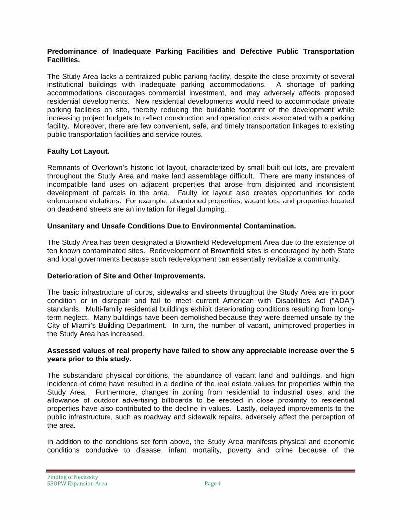
Predominance of Inadequate Parking Facilities and Defective Public Transportation Facilities. The Study Area lacks a centralized public parking facility, despite the close proximity of several institutional buildings with inadequate parking accommodations. A shortage of parking accommodations discourages commercial investment, and may adversely affects proposed residential developments. New residential developments would need to accommodate private parking facilities on site, thereby reducing the buildable footprint of the development while increasing project budgets to reflect construction and operation costs associated with a parking facility. Moreover, there are few convenient, safe, and timely transportation linkages to existing public transportation facilities and service routes. Faulty Lot Layout. Remnants of Overtown’s historic lot layout, characterized by small built-out lots, are prevalent throughout the Study Area and make land assemblage difficult. There are many instances of incompatible land uses on adjacent properties that arose from disjointed and inconsistent development of parcels in the area. Faulty lot layout also creates opportunities for code enforcement violations. For example, abandoned properties, vacant lots, and properties located on dead-end streets are an invitation for illegal dumping. Unsanitary and Unsafe Conditions Due to Environmental Contamination. The Study Area has been designated a Brownfield Redevelopment Area due to the existence of ten known contaminated sites. Redevelopment of Brownfield sites is encouraged by both State and local governments because such redevelopment can essentially revitalize a community. Deterioration of Site and Other Improvements. The basic infrastructure of curbs, sidewalks and streets throughout the Study Area are in poor condition or in disrepair and fail to meet current American with Disabilities Act (“ADA”) standards. Multi-family residential buildings exhibit deteriorating conditions resulting from long-term neglect. Many buildings have been demolished because they were deemed unsafe by the City of Miami’s Building Department. In turn, the number of vacant, unimproved properties in the Study Area has increased. Assessed values of real property have failed to show any appreciable increase over the 5 years prior to this study. The substandard physical conditions, the abundance of vacant land and buildings, and high incidence of crime have resulted in a decline of the real estate values for properties within the Study Area. Furthermore, changes in zoning from residential to industrial uses, and the allowance of outdoor advertising billboards to be erected in close proximity to residential properties have also contributed to the decline in values. Lastly, delayed improvements to the public infrastructure, such as roadway and sidewalk repairs, adversely affect the perception of the area. In addition to the conditions set forth above, the Study Area manifests physical and economic conditions conducive to disease, infant mortality, poverty and crime because of the

Finding of Necessity SEOPW Expansion Area Page 5
predominance of dilapidated, deteriorating, antiquated and obsolescent buildings and the existence of conditions that endanger life and property by fire and other causes. Conclusion The Finding of Necessity report presents conclusive evidence of the existence of slum and blight conditions within the Study Area, and if left unattended, will persist and undoubtedly extend to and beyond the boundaries of the Southeast Overtown/Park West Redevelopment Area. These conditions will lead to an economic and social liability to the City of Miami and could consume additional County and municipal resources to address the myriad of issues outlined above, while reducing the local tax base.

Finding of Necessity SEOPW Expansion Area Page 6
SECTION 2. INTRODUCTION
2.1 Location The Study Area consists of approximately 392 acres and is generally defined as north of NW 3rd and 5th Streets, west of Interstate 95 and NW 1st Place; south of NW 22nd Street, and east of NW 7th Avenue. The legal description of the Study Area is physically defined as beginning near the southeast corner of Lummus Park; at the southwest corner of the intersection of NW 2nd Street and NW 3rd Court; continue north to the north side of NW 5th Street; then west along the north side of NW 5th Street to the east side of NW 7th Avenue; then north along the east side of NW 7th Avenue to the north side of NW 22nd Street; then east along the north side of NW 22nd Street to the east side of NW 5th Avenue; then south on the east side of NW 5th Avenue to the North Side of NW 22nd Street; then east on the north side of NW 22nd Street to the west side of NW 2nd Avenue; then north on the west side of NW 2nd Avenue to the north side of NW 22nd Street; then east on the north side of NW 22nd Street to the east side of NW 1st Place; then south on the east side of NW 1st Place to the north side of NW 14th Street; then east on the north side of NW 14th Street to the southern edge of the I-395 ROW; then following the southern edge of the I-395 ROW west to the eastern edge of the I-95 ROW; then continuing south along the eastern edge of the I-95 ROW to the north side of NW 2nd Street; then west along the north side of NW 2nd Street to the western side of NW 3rd Court.

Finding of Necessity SEOPW Expansion Area Page 7

Finding of Necessity SEOPW Expansion Area Page 8
2.2 Finding of Necessity On December 31, 2007, the City of Miami, Miami-Dade County, the Southeast Overtown/Park West Community Redevelopment Agency (“CRA”), and Omni Redevelopment District Community Redevelopment Agency entered into an Interlocal Agreement to provide for, among other things, the expansion of the Southeast Overtown/Park West Redevelopment Area and the extension of the CRA’s life. Pursuant to the Interlocal Agreement, the parties agreed that the CRA would cause a Finding of Necessity report to be prepared in which the conditions of slum and blight within the Study Area would be documented.
2.3 “Slum” Defined Section 163.340(7), Florida Statutes, defines “slum area” as an area having physical or economic conditions conducive to disease, infant mortality, juvenile delinquency, poverty, or crime because there is a predominance of buildings or improvements, whether residential or nonresidential, which are impaired by reason of dilapidation, deterioration, age, or obsolescence, and exhibiting one or more of the following factors:
(a) Inadequate provision for ventilation, light, air, sanitation, or open spaces;
(b) High density of population, compared to the population density of adjacent areas within the county or municipality; and overcrowding, as indicated by government-maintained statistics or other studies and the requirements of the Florida Building Code; or
(c) The existence of conditions that endanger life or property by fire or other causes.
2.4 “Blight” Defined Section 163.340(8), Florida Statutes, defines “blighted area” as an area in which there are a substantial number of deteriorated or deteriorating structures, in which conditions, as indicated by government-maintained statistics or other studies, are leading to economic distress or endanger life or property, and in which two or more of the following factors are present:
(a) Predominance of defective or inadequate street layout, parking facilities, roadways, bridges, or public transportation facilities;
(b) Aggregate assessed values of real property in the area for ad valorem tax purposes have failed to show any appreciable increase over the 5 years prior to the finding of such conditions;
(c) Faulty lot layout in relation to size, adequacy, accessibility, or usefulness;
(d) Unsanitary or unsafe conditions;
(e) Deterioration of site or other improvements;
(f) Inadequate or outdated building density patterns;
(g) Falling lease rates per square foot of office, commercial, or industrial space compared to the remainder of the county or municipality;
(h) Tax or special assessment delinquency exceeding the fair value of the land;
(i) Residential and commercial vacancy rates higher in the area than in the remainder of the county or municipality;

Finding of Necessity SEOPW Expansion Area Page 9
(j) Incidence of crime in the area higher than in the remainder of the county or municipality;
(k) Fire and emergency medical service calls to the area proportionately higher than in the remainder of the county or municipality;
(l) A greater number of violations of the Florida Building Code in the area than the number of violations recorded in the remainder of the county or municipality;
(m) Diversity of ownership or defective or unusual conditions of title which prevent the free alienability of land within the deteriorated or hazardous area; or
(n) Governmentally owned property with adverse environmental conditions caused by a public or private entity.
However, the term “blighted area” also means any area in which at least one of the factors identified in paragraphs (a) through (n) are present and all taxing authorities subject to Section 163.387(2)(a) agree, either by Interlocal agreement or agreements with the agency or by resolution that the area is blighted. Such agreement or resolution shall only determine that the area is blighted.

Finding of Necessity SEOPW Expansion Area Page 10
Section 3. EXISTING CHARACTERISTICS OF THE STUDY AREA
3.1 Aerial Overview of the Study Area For clarity, this report has divided the Study Area as follows:
Area A is industrial in nature and subdivided as follows: Area A-1 (west of I-95) is generally characterized by industrial and government-owned property, with a high concentration of vacant land. Area A-1 (east of I-95) is comprised of government-owned multi-family residential buildings and owner-occupied single family homes. Area A-2 is essentially government-owned multi-family residential buildings and commercial properties, with vacant lots scattered throughout the area.
Area B is comprised of a mix of owner occupied single family homes and condominium units, as well as government-owned multi-family residential buildings and institutional and commercial properties. Area B-1 consists primarily of owner-occupied single family homes and older low-density privately owned multi-family residential buildings. Area B-2 consists of low density government-owned multi-family residential buildings, with a small number of owner-occupied townhomes. Area C is the area beneath the I-395 and I-95 elevated expressways. The section of the expressways south of the Study Area has recently been improved to accommodate public parking and community parks. However, Area C is dark, desolate, and not pedestrian-friendly.

Finding of Necessity SEOPW Expansion Area Page 11

Finding of Necessity SEOPW Expansion Area Page 12
AREA A-1
WEST OF I-95 The area west of I-95, from NW 22nd Street to NW 17th Street, is zoned industrial but maintains a strip of residential properties running parallel to the expressway on NW 6th Place. The area south of NW 20th Street is the proposed site for the relocation of Camillus House and the new University of Miami Medical Center. NW 7th Avenue, also known as State Road 441, is a four lane, two-way major roadway with auto body and light industry businesses, as well as an abundance of vacant and underutilized properties. NW 7th Avenue is utilized as an alternate route to I-95 by commuters traveling to and from Downtown Miami. In turn, this route has become increasingly congested. In order to maintain Miami-Dade County’s level of service for road capacity, the addition of two traffic lanes would be required. Such an addition would utilize available right-of-way and eliminate on-street parking.

Finding of Necessity SEOPW Expansion Area Page 13
AREAS A-1 AND B-1
EAST OF I-95
The area north of I-395 from NW 17th Street to NW 22nd Street is primarily residential. The aerial image shows Town Park, a series of residential condominium developments, Villas of St. Agnes, a single-family residential development, several government-owned multi-family residential buildings, and older owner-occupied single-family homes and duplexes. Williams Park is also depicted along with Saint Agnes Episcopal Church and Paul Laurence Dunbar Elementary School. There is a strip of commercial properties on the east side of NW 3rd Avenue from NW 17th Street to NW 18th Street.

Finding of Necessity SEOPW Expansion Area Page 14
AREA A-2 WEST OF I-95
The area west of I-95 and south of I-395 between NW 14th Street to NW 10th Street is comprised of institutional and residential properties. Residents primarily live in government-owned multi-family residential buildings, with the sole owner-occupied units being the Culmer Villas development. The aerial image depicts Booker T. Washington Senior High School, the Women’s Detention Center, the historic Black Police Precinct, and the Jefferson Reeves Senior Health Center. There also two major Florida Power & Light (FPL) transformer pads located adjacent to residential homes. Miami-Dade County and the Miami-Dade County School Board own the majority of the land within this section of the Study Area.

Finding of Necessity SEOPW Expansion Area Page 15
AREA B-2 WEST OF I-95
The area west of I-95 between NW 11th Street and NW 5th Street consists generally of low density government-owned multi-family residential buildings occupied by residents with low to moderate household incomes.

Finding of Necessity SEOPW Expansion Area Page 16
3.2 Site and Structural Deterioration Site Deterioration The Study Area suffers from the presence of dilapidated buildings and structures, neglected properties, and a deteriorated public right-of-way. Evidence of site deterioration within the Study Area includes: broken, chipped, unleveled, or cracked sidewalks; missing sidewalks; swales in need of repair; roadways in need of repair or striping; damaged structural features, such as broken steps, porches or entryways; dilapidated or incomplete fences; vehicular entrances no longer in use; improperly sealed utility facilities; obsolete or missing signage; overgrown foliage encroaching in the public right-of-way; foreign material protruding from ground; and unusual topography. These conditions present a safety hazard to pedestrians and motorists, and project a negative perception of the Study Area. In turn, this perception adversely discourages private investment in the area. These conditions present a safety hazard to pedestrians and motorists, while projecting a negative perception of the Study Area. In turn, this perception adversely affects private investment in the area .
Roadway with missing sidewalk at NW 6th Avenue and NW 20th Street (Area A1)
Chipped sidewalk, at NW 8th Street between NW 3rd Court and NW 4th Avenue (Area B2)
Broken steps (Area B2) Unleveled sidewalk poses a “trip” hazard (Area B2)

Finding of Necessity SEOPW Expansion Area Page 17
Damaged fencing (Area B1) Foliage encroaching onto streets (Area B2)
Damaged public fixtures (Area B2) Obsolete signage (Area B2)
Cracked sidewalks (Area B2) Trees interfering with utility lines (Area B2)

Finding of Necessity SEOPW Expansion Area Page 18
Missing sidewalk resulting from lack of tree maintenance (Area A1)
Loose wire protruding from utility pole (Area B2) Unmaintained right of way (Area B2)
Foreign material protruding from ground (Area A1)
Blocked signage poses a safety hazard (Area B2) Broken sidewalk at utility pole stabilization line (Area B2)

Finding of Necessity SEOPW Expansion Area Page 19
Lack of sidewalk maintenance (Area B2)
Trucks parked on the sidewalk (Area A1)
Lack of property maintenance (Area A1)
Non-functional sidewalk, and illegal barbed- wire fence (Area A1)
Lank of landscaping (Area B2) Incomplete fence (Area B2)

Finding of Necessity SEOPW Expansion Area Page 20

Finding of Necessity SEOPW Expansion Area Page 21
Structural Deterioration Evidence of structural deterioration is significant within the Study Area, and reflects an immediate visual appearance of neglect, has a profound contributory impact on the decline in real estate values, and generally discourages private investment. Examples of structural deterioration within the Study Area include: damaged building facades, including significant peeling or fading of exterior paint, and corrosion of metal features; dilapidated, and antiquated structures that appear structurally unsound; abandoned and boarded properties; and properties with broken windows. Residential and commercial properties generally have an economic lifespan of 27.5 to 39 years. The map entitled, “Age of Buildings” on pg 20, shows that the majority of the properties within the Study Area were constructed prior to the 1940s. Structural deterioration of properties within the Study Area is further exacerbated by the inclement weather experienced during the annual hurricane season. Several properties located in the western section of the Study Area are located in a flood zone area. (See map entitled, “Flood Zones” on page 24). It should be noted that the additional cost for flood insurance for an area where the average household earns less than $15,000 annually may prove to be a financial burden.
Improperly sealed utility pole (Area B2) Missing street signage (Area A1)
Incomplete site cleanup after demolition (Area B2) Non-functional vehicular gateway (Area B2)

Finding of Necessity SEOPW Expansion Area Page 22
1950’s building at 406-08 NW 8th Street with wall openings, fading and peeling of exterior paint and boarded windows (Area B2)
Building at 158 NW 14th Street with siding needing repair (Area B1)
Property at 2075 NW 6th Place with barred windows; built in 1923. (Area A1)
Property at 521 NW 7th Street with boarded garage and peeling paint; built in 1920 (Area B2)
Dilapidated structure at 2061 NW 6th Place with damaged garage, roof, and sidings; built in 1924 (Area A1)
Dilapidated structure at 2047 NW 7th Avenue with roof damage, sagging floors and siding in need of repair; built in 1936 (Area A1)

Finding of Necessity SEOPW Expansion Area Page 23
Commercial property at 1701 NW 7th Avenue with gaping holes in wall and peeling exterior paint (Area A1)
Vacant property at 570 NW 22nd Street with significant structural damage, boarded windows, and damaged roof; built in 1924 (Area A1 east of I-95)
Commercial property at 634 NW 22nd Street ,adjacent to residential property, with barbed fence. (Area A1 west of I-95)
Property at 2195 NW 7th Avenue with damaged roof and siding. (Area A1 west of I-95)
Property at 1501 NW 7th Avenue (Area A1 west of I-95)
Vacant property with graffiti, broken storefront window, and in need of exterior painting, (Area A1)

Finding of Necessity SEOPW Expansion Area Page 24

Finding of Necessity SEOPW Expansion Area Page 25
3.3 Vacant Buildings and Lots Vacant Buildings Vacant boarded buildings, or buildings that appear to be vacant or abandoned, are visual signs of physical blight and disinvestment in the neighborhood. The Property Characteristics Report (see Appendix 1) confirms that a significant number of the structures in the Study Area are vacant. Such buildings generally constitute a hazard because they normally lack maintenance and, oftentimes, have become structurally unsound. Moreover, vacant buildings have become the site for illegal drug activities and serve to attract homeless individuals looking for shelter. Industrially zoned properties along NW 7th Ave impart a sense of desolation due to the design and size of the structures. The frontage of these properties does not open out towards NW 7th Avenue and business activities take place on the side streets. Further, the exterior of these properties appear plain, with limited or no signage on site. Many of the properties maintain grilled windows and doors or have had the windows and doors sealed off.
Vacant multi-family residential building at 1633 NW 3 Avenue (Area A1)
Vacant property at 1501 NW 7th Avenue (Area A1 west of I-95)
Vacant building at 2222 NW 5th Avenue (Area A1_

Finding of Necessity SEOPW Expansion Area Page 26
Property perceived to be vacant at 2035 NW 7th Avenue (Area A1)
Property on NW 7th Avenue is perceived to be vacant due to design. (Area A1)
The property at 1773 NW 7 Avenue is open for business, but the property is perceived to be vacant. (Area A1)
Property at 1701 NW 7th Avenue is perceived to be vacant (Area A1)
Property at 2055 NW 7th Avenue with partially boarded up windows to the site and stained (Area A1)
The design and size of the property at 1603 NW 7th Avenue suggests the property is vacant. (Area A1)

Finding of Necessity SEOPW Expansion Area Page 27
Vacant Lots The Study Area has an abundance of vacant lots that break the continuity of the street facade and disrupt the street wall, which provides a safe pedestrian street environment. Vacant lots generate significant code violations and invite illegal activities, such as trash dumping, to occur. In turn, vacant lots contribute to the decline of real estate values for properties in the area.
Lot at 462 NW 8th Street (Area B2)
Lots at 721 and 729 NW 6th Avenue (Area B2) Vacant lot (Folio No. 01-4137-041-0030). (Area B2)
Vacant lot at NW 17th Street and NW 7th Avenue (Folio No. 01-3136-035-0315) (Area A1)

Finding of Necessity SEOPW Expansion Area Page 28
Vacant lot at 633 NW 4th Avenue littered with trash. (Area Vacant lot at 615 NW 4th Avenue littered with trash. (Area B2)
Vacant lot at 301 NW 17th Street littered with trash. (Area Vacant lot at 2071 NW 6th Place littered with trash. (Area A1)
I-95 right of way at NW 10th Street used to discard furniture. (Area C)
Vacant lot at 2177 NW 6th Place littered with trash and discarded furniture. (Area A1)

Finding of Necessity SEOPW Expansion Area Page 29
3.4 Property Violations
On October 16, 2008, the Miami City Commission adopted Ordinance No. 13032, which amended the Code of the City of Miami by creating procedures to regulate vacant, blighted, unsecured and abandoned structures throughout the City. The passage of Ordinance No. 13032 was a direct response to the increasing number of these types of structures throughout the City and the onerous burden they posed to the City’s resources. The Commission found that these structures perpetuate a nuisance to the public because of their susceptibility to fire safety hazards; temporary occupancy by transients; and criminal activity such as drug trafficking, drug use, prostitution, vandalism and other serious crimes. There are a number of properties within the Study Area that exhibit code violations for conditions, such as: parking/storage of inoperable vehicles; use of barbed wire adjacent to residential properties; failure to maintain a building or structure in a safe condition; failure to conduct a business within a completely enclosed building; failure to secure building and equipment; and illegally maintaining or depositing junk or trash (See map entitled, “Code Violations” on page 32).
Illegal dumping along NW 20th Street (Area B-1) Vacant property at NW 6th Street (Area B-2)
Property at NW 6th Place with crumbling foundation, boarded windows and facade damage. (Area A1)
Inoperable vehicle parked at NW 18th Street and NW 7th Avenue. (Area A1)

Finding of Necessity SEOPW Expansion Area Page 30
Vacant, unsecured property at NW 8th Street with damaged garbage enclosure. (Area B2)
Business at 1953 NW 7th Avenue conducted in open view. Vehicles are parked in the public right of way. (Area A1)
Property at 646 NW 22nd Street maintains trash on public right of way. (Area A1)
Building at 2027 NW 7th Avenue (built in 1936) with extended structure with missing roof and equipment stored outside. (Area A1)
Business at 1953 NW 7th Avenue with damaged and missing signage (Area A1)

Finding of Necessity SEOPW Expansion Area Page 31
Property at 634 NW 22nd Street with barbed wire adjacent to residential property (Area A1)
Commercial vehicle operated by the business at 2195 NW 7 Avenue stores vehicles and material within the public right-of-way. (Area A1)

Finding of Necessity SEOPW Expansion Area Page 32

Finding of Necessity SEOPW Expansion Area Page 33
3.5 Unsanitary and Unsafe Conditions Due to Environmental Contamination
The City of Miami’s Economic Development Department conducted a presentation, entitled “Status of Brownfields & Land Revitalization in the City of Miami,” which assessed properties surrounding known facilities that have released hazardous materials into the environment. The assessment resulted in the designation of large sections of the City as Brownfield Redevelopment Areas with over 400 known contaminated sites. Brownfield sites are characterized as any property that has been abandoned or underused due to a real or perceived environmental problem. State and local governments generally seek to encourage Brownfield redevelopment because such redevelopment improves the environment, places properties back on the tax rolls, encourages economic investment, fosters the creation of jobs and operates to revitalize a community.
The entire Study Area is currently designated as a Brownfield Redevelopment Area with ten known contaminated sites. While the City of Miami experienced Brownfield redevelopment success in projects such as Wynwood, Wagner Square and Midtown Miami, the Study Area has not seen similar results. Despite incentives offered by the State and local governments for the redevelopment of Brownfield Areas, the Study Area has remained untouched due to the lack of capital investment by financial institutions and the significant costs associated with highly regulated environmental oversight. With the City’s initiative to revamp and simplify its Zoning Code using “smart growth” principles under Miami 21, the City is expected to provide additional incentives towards the redevelopment of Brownfield sites.

Finding of Necessity SEOPW Expansion Area Page 34
Section 4. TRANSPORTATION
4.1 Adverse Impact of Interstate Highway System The construction of the Interstate Highway System had a detrimental impact on the Study Area by disrupting and fragmenting the residential neighborhood. A study entitled, Integrating Land Use and Transportation in a GIS Visualization Tool (July 2001) was commissioned by the Metropolitan Planning Organization for Miami-Dade County. The study found that the “. . . construction of the I-95/I-395/SR836 highway interchange and Urban Renewal. . . displaced the residents and commercial activities, [thereby] weakening the economic base and employment centers within and near Overtown.”
“The freeway divided the community into four quadrants, separating a primarily residential area from the business corridors and the important educational institution, Booker T. Washington High School, and used up about 200 acres, or 42 percent of the land in Overtown. Businesses, cut off from the population center, declined rapidly. The Urban Renewal projects displaced about 7,500 residents (2,400 families) and all of the businesses on the west side of NW 3rd Avenue. Several years passed before new structures were built, resulting in vast amounts of vacant tracts of land that were eventually turned into standardized, monotonous housing in large single-use plots.
The damage that these public projects did to the Overtown community might have been reduced had mitigation and reinvestment taken place immediately after the impacts were apparent or had strategies been developed in response to the problems that they caused. However, no public intervention was created in these years, and the initial decline escalated due to the lack of investment. The final phase, taking place over the last thirty-odd years, is characterized by disinvestment and lack of revitalization that has created a fragmented, impoverished, distressed neighborhood. Public efforts to improve the neighborhood, due to their sporadic, inconsistent, and uncoordinated character, have fallen far short of attracting the level of private capital necessary to help the community recover. An increasing amount of land has been acquired by churches; community based organizations, and the government through housing development efforts, condemnation through code enforcement, and taking properties that had liens against them.”2
2 Integrating Land Use and Transportation in a GIS Visualization Tool (July 2001), page 4

Finding of Necessity SEOPW Expansion Area Page 35
In addition to the physical and economic disruption caused by the Interstate Highway System, the expressway right-of-way serves as a significant hazard due to the relative ease by which the public can access this area. Site visits to the expressway right-of-way revealed five highway access gates along NW 20th Street, NW 22nd Street and NW 10th Street that had been breached. The gate openings along NW 20th Street appeared particularly dangerous due to the presence of school-aged children traversing along this major roadway. Moreover, the expressway right-of-way is used by homeless individuals and drug users as a place to congregate away from the public view.
42 acres of prime land acquired to construct Interstates 95 and 395
Drug users beneath I-95 at NW 10th Street.

Finding of Necessity SEOPW Expansion Area Page 36
Gateway at Interstate 95 and NW 10th Street (Area C)
Gateway at Interstate 95 and NW 20th Street (Area C)
Gateway at NW 22nd Street and NW 20th Street (Area C)

Finding of Necessity SEOPW Expansion Area Page 37
4.2 Faulty Street Layout
Generally, the layout of streets should provide the framework that connects the various elements of land use to support individual lot uses, lot layouts, and future developments. Additionally, proper street layout reduces traffic congestion, minimizes safety hazards to motorists and pedestrians, and unifies neighborhoods. Within residential areas, the street network should be designed with multiple connections and direct routes to preserve the quiet character of a local residential street, while providing convenient and safe access for emergency service vehicles. Along commercial corridors, the street layout should support the local business community by leading residents and visitors to their destination, easing traffic congestion, encouraging public spaces, and inspiring architectural designs of buildings that open towards the public right-of-way. In contrast, many streets located in the Study Area, west of I-95, are multi-lane one directional roadways that flank residential complexes and public facilities. These one-way streets are conducive to speeding due to the lack of street calming features such as stop signs and medians. In the example below, NW 10th Street, which runs eastwardly in front of the Culmer Villas residential complex, Henry Reeves Park, and the Jefferson Reeves Senior Health Center, which are highly patronized facilities.
The Culmer Villas complex, Henry Reeves Park, and the Jefferson Reeves health clinic generate significant pedestrian traffic along The busy NW 10th Street which runs eastwardly. The hazardous conditions created by multi-lane one directional roadways are best evidenced by the frequency of traffic accidents. From June 2008 to January 2009, forty-nine (49) traffic accidents occurred in the southwestern portion of the Study Area. (See Appendix 2). For example, although prohibited, residents and patrons of the aforementioned facilities park their vehicles on both sides of the street, and are at risk of injury upon entering or exiting their vehicles.

Finding of Necessity SEOPW Expansion Area Page 38
In addition to the multi-lane one directional roadways, the existence of dead-end streets is another indicator of faulty street layout. The dead-end streets attract illegal dumping of trash, and impact the delivery of emergency services.
Dead end road at NW 6th Place at NW 21st Street

Finding of Necessity SEOPW Expansion Area Page 39
Additionally, there are sections of the Study Area that exhibit remnants of a period in Overtown’s history where streets were blocked off to prevent and reduce criminal activities from spilling over into adjacent neighborhoods. In 1990, Miami City Commissioners in an active measure to protect employment centers in the Wynwood neighborhood approved Resolution No. 90-546 which permanently prohibited vehicular access on NW 5th Avenue at NW 22nd Street. According to Resolution No. 90-546 and the Wynwood, the barrier was installed to “change the physical environment and reduce the perception, incidence and fear of crime in the area.”
Property at NW 15th Street east of NW 7th Avenue (Area A1)
Property at NW 18th Street east of NW 7th Avenue (Area A1)
Barrier separating Wynwood from Overtown at NW 22nd Street and NW 5th Avenue

Finding of Necessity SEOPW Expansion Area Page 40
Many of the dead-end streets located within the Study Area came about as a result of the construction of the Interstate Highway System as seen in the diagram below.
The red dots highlight where the street continuity is interrupted.
Evidence of faulty street layout can also be found in the existence of jogged intersections. . For example, NW 22nd Street seems to end at NW 5th Avenue. However, NW 22nd Street appears again just south of where it reached NW 5th Avenue. Such a layout causes confusion to motorists and pedestrians attempting to locate a particular location. Confusion can also arise in the case of short or midblock streets, as seen with NW 9th Street.

Finding of Necessity SEOPW Expansion Area Page 41
4.3 Public Transportation and Parking Facilities The Study Area is primarily served by Miami-Dade County’s Metrobus system and Miami-Dade County’s Metrorail system via the Culmer Station located at NW 7th Avenue and NW 11th Street, and the Historic Overtown/Lyric Theater Station located within the existing Southeast Overtown/Park West Redevelopment Area at NW 8th Street and NW 1st Avenue. Residents of the Study Area rely significantly on the public transportation systems. However, there are issues with the public transportation system that needs to be addressed. A close examination of the Study Area revealed that access points to these transportation systems were not convenient for residents. For example, while the Metrobus system operates throughout Miami-Dade County, bus stops located within the Study Area were not situated with bus shelters to shield patrons from inclement weather or seating to accommodate elderly patrons. In addition to the lack of bus shelters, convenient linkages to the public transportation systems are limited or simply do not exist leaving residents with few options to timely arrive at their destination. In order to access these transportation interchanges, residents must utilize the Metrobus system, or small commuter services, such as Jitney vans, which holds approximately ten to twelve passengers which may be off schedule because they travel on the congested roads and are subject to those delays. And as previously noted above, waiting on the Metrobus, by way of the bus stops, may not always be convenient. Furthermore, the Study Area lacks centralized public parking facilities to serve workers and visitors traveling by vehicle. The absence of parking facilities discourages patronage of businesses in the area by making it inconvenient to make unplanned visits to the area. Also, future development in the Study Area may be adversely affected by the lack of parking facilities. In an effort to provide parking options to residents in the Study Area, new developments would be forced to accommodate private parking facilities on site, thereby reducing the buildable footprint of the project, and increasing the cost of the development to account for the construction and operational costs associated with the parking garage component. In addition, areas, like the Study Area, which is comprised of mostly low to moderate income residents, benefit greatly from transit-oriented developments (“TODs”), in that, residents living within a TODs would realize reduced commuting expenses. TODs can be commercial in nature as well promoting convenient transportation access to the workplace. Successful TODs contemplate the inclusion of public transportation systems, parking facilities and related infrastructure. The creation of TODs would revitalize the Study Area by establishing convenient travel options for residents and visitors of the Study Area.
Bus stop at NW 20t Street and NW 7th Avenue. Ideal bus shelter.

Finding of Necessity SEOPW Expansion Area Page 42
Section 5. LAND USE The lot layout found throughout the Study Area reflects the history of Overtown’s development and growth. During Overtown’s early years when segregation was commonplace, city blocks were closely subdivided to accommodate the housing needs of residents who were confined to living in a designated area of the City of Miami. In contrast to blocks located in other sections of the City, a city block within the Study Area can consist of up to thirty-seven (37) individual lots. Such a diversity of ownership can pose a significant challenge to redevelopment, in that the land acquisition process can involve several property owners on one block.
There are additional factors that impact the land use policy for the Study Area. For example, lots that once housed structures that have since been demolished must now meet current zoning regulations and comply with current lot size standards, setbacks, parking requirements, and Floor Area Ratios (FAR). Due to the historic lot layout, some of these subdivided lots are essentially unbuildable, unless they are adjoined to adjacent lots. The difficulty and cost associated with land acquisition has encouraged property owners to retain their existing structures in their as-is conditions, even those that may be structurally unsound buildings, to the detriment of the community. In turn, these buildings exacerbate the visual blight conditions of the area because they usually have multiple code violations due to obsolescence or lack of routine maintenance and repairs. Defective lot layout has also caused an abundance of land uses throughout the Study Area. With the adverse economic impact of the construction of the Interstate Highway System, many former residential property owners sold their property to investors who converted the property’s land use designation in order to maximize the financial return on their investment. These land use changes were approved without a consistent and coherent area-wide vision. The most

Finding of Necessity SEOPW Expansion Area Page 43
compelling example of incompatible uses within the Study Area can be found by visiting the electrical substations adjacent to residential homes and complexes.
Electrical substation next to residential properties at NW 16th Street and NW2nd Avenue.
Electrical substations next to residential properties at NW 11th Street and NW 5th Avenue
Aerial view of transformer pad at NW 11th Street and NW 5th Avenue.

Finding of Necessity SEOPW Expansion Area Page 44
The transformer pad and cellular tower are located on NW 6th Place within a historically residential neighborhood currently zoned industrial.

Finding of Necessity SEOPW Expansion Area Page 45
Section 6. Socio-Economic Conditions
6.1 Demographic Characteristics Census tract data was used to identify the demographic characteristics of the Study Area. Census 2000 statistics and the 2006 American Community Survey are the most recent official publications of data available as a resource in assessing the conditions within the Study Area. The Study Area is encompassed within the boundaries of census tracts 31, 34 and 36.01.

Finding of Necessity SEOPW Expansion Area Page 46
As summarized in the table below, the data for Study Area depicts an environment plagued with high unemployment levels, and an abundance of low income households, with approximately 50% of families living below the federal poverty level. The demographic characteristics of the Study Area portray a population of residents that require, not only redevelopment of the surrounding physical environment, but also major revitalization efforts for the socio-economic conditions that predominate.
(Source: 2006 AMERICAN COMMUNITY SURVEY)
The purchase of a home usually signals a long-term investment by purchaser in the community. In turn, large percentages of owner-occupied homes suggest a more stabilized environment. The data assessed for this report demonstrates that this is not necessarily the case within the Study Area. The data reviewed for the Study Area also reveals a significantly low percentage of residents own their homes. At 11.6%, census tract 31 contained the highest percentage of owner-occupied dwelling units. This, in addition to the data on household income, depicts the Study Area to be predominantly inhabited by low income renters. The small percentage of owner-occupied dwellings and the median household income also explains why the maintenance and upgrades to these owner-occupied properties has not occurred, thereby resulting several deteriorating sites, as discussed in Section 3.2 of this report.
TRACT NUMBER
EMPLOYED OVER 16 YEARS OF AGE
MEDIAN HOUSEHOLD
INCOME
EARNING LESS THAN $10,000/YR.
FAMILIES BELOW
POVERTY LEVEL
OWNER OCCUPIED DWELLING
UNITS
31 29.6% $11,330.00 45.5% 49.3% 11.6%
34 30.6% $11,006.00 43.8% 49.3% 6.6% 36.01 17.2% $7,595.00 61.2% 50.1% 7.5%
Size of Family
Unit
2008 Poverty
Guidelines
125 Percent
1 $10,400 $13,000
2 $14,000 $17,500
3 $17,600 $22,000
4 $22,200 $26,500
5 $24,800 $31,000
6 $28,400 $35,500
7 $32,000 $40,000
8 $35,600 $44,500

Finding of Necessity SEOPW Expansion Area Page 47

Finding of Necessity SEOPW Expansion Area Page 48
6.2 Housing Characteristics
Generally, the development pattern of the residential areas within the Study Area consist of a mix of single family units, duplexes, and low to moderate density residential buildings. Such housing seems contrary to the surrounding areas, including Downtown Miami, Brickell Business District, and the Healthcare District. Additionally, the development potential for many of the residential properties in the Study Area has not been fully realized, in that these properties would allow for more density than what is currently in place.
Symbol Title
R-1 Single-Family Residential, with maximum density of 9 units per acre
R-2 Duplex Residential, with maximum density of 18 units per acre
R-3 Multi-family Medium-Density Residential, with maximum density of 65 units per acre
R-4 Multi-family High-Density Residential, with maximum density of 150 units per acre
Miami Zoning Code, Section 400 When there is a discrepancy between zoning capacity and existing development, some owners retain their properties until market conditions allow them to realize a higher financial return on their initial investment, while neglecting to conduct requisite maintenance and upgrades. The Study Area has a significant number of absentee owners who follow this business model, adding to the continuous deterioration of residential buildings.
6.3 Economic Conditions
An estimated forty-two (42) acres of land that housed residential homes and flourishing businesses were acquired for the highway construction. Businesses, such as Jill’s Corner, formerly at 402 NW 8th Street, closed and left behind an empty building that since remained vacant. A substantial number of commercial businesses that were displaced employed many local residents. Today, there are visual signs echoing the dismal conditions of the Study Area’s local economy. For sale signs can be seen nailed onto commercial buildings and installed onto many of the vacant parcels. The current economy further worsened the economic
condition for businesses within the Study Area. Lending from the private financial institutions is not a viable option. In turn, businesses have sought financial assistance from local governments, which has strained their resources over time. With insufficient capital to acquire
Post office at 366 NW 7 Street A (Area B2) was demolished. The site is now unimproved vacant land. (Area B2)

Finding of Necessity SEOPW Expansion Area Page 49
inventory, maintain payroll, and continue operations, businesses are more likely to default on the payment of property taxes and/or local business tax receipts, thus reducing income to local governments. today consists of an abundance of vacant land or vacant buildings.
Jill’s Corner - circa 1960 Former site of Jill’s Corner 2008
The lack of economic opportunities has led some property owners to leasing their properties to outdoor advertising companies. While most residents in the City of Miami have tried to prevent billboard advertising within their residential neighborhoods, Overtown, specifically the Study Area, has attracted several advertisers seeking inexpensive access to commuters traveling along I-95 and I-395. For example, on NW 22nd Street there stands a billboard adjacent to several single-family homes. The monthly income received from leasing property to billboard advertisers is substantial and serves as a disincentive to maintain or rehabilitate the property. There were a total of
five billboards parallel to I-95 and at least three properties retrofitted to serve as billboard advertisement sites.
Billboard at 566 NW 20th Street
Vacant, unimproved lands at NW 20th Street and NW 7th Avenue. Income generating billboard advertising poles are situated on the lots. (Area A1)

Finding of Necessity SEOPW Expansion Area Page 50
As a means of attracting long term private investment in the Study Area, the basic infrastructure currently in place must be substantially improved. In August 2008, Post, Buckley, Schuh & Jernigan, Inc. prepared an Infrastructure Conceptual Cost Estimate Report for the Southeast Overtown/Park West Redevelopment Area and the Study Area that which identified infrastructure, such streets and roadways, which required upgrading in order to accommodate capacity needs for future development. The report estimated that the infrastructure improvements for the Study Area would cost approximately $134 million with a projected completion date of 2024.
Vacant Multi-family residential building at 1360 NW 1 Court; built in 1953; appears only to be used solely for advertising. (Area B1)

Finding of Necessity SEOPW Expansion Area Page 51
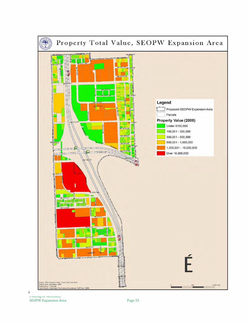
6.4 Real Estate Values Real estate values of properties have declined in part due to current market conditions. However, even during Miami’s real estate “boom” between 2000 and 2005, real estate values of improved properties in the Study Area did not substantially increase. With the Study Area in close proximity to Downtown Miami, owners of unimproved properties hold onto properties until they are able to gain their desired financial return, while still neglecting to maintain their properties, to detriment of the neighborhood. For example, land speculators artificially drove up the market value of vacant land from approximately $6 per square foot to $30-$60 per square foot on properties west of Interstate 95 (Area B2). This artificial market was spurred on due to location and the zoning designations allowed for the property. The map entitled, “Property Total Value,” on page 55 illustrates that the majority of the properties within the Study Area are severely undervalued with an average assessed value below $100,000. Some sections of the Study Area have not seen any increase in property valuations. For example, industrial zoned properties parallel to Interstate 95 (Area A1) as recent as 2005 commanded $4.50 per square foot. A 2,250 square feet residential property (Folio No. 01-3125-035-2710) on NW 6th Place sold for $10,000 in 1985. Twenty-four (24) years later, in 2006, a vacant lot similarly sized and zoned (Folio No. 01-3125-035-2740) located just two lots north sold for $10,000. A multi-family building (Folio No. 01-3125-035-2820) sold in 1996 for $14,500. These low property valuations can be partially attributed to the site-specific changes in zoning from residential to industrial.
Residential property built in 1922 at 2073 NW 6 Place in area zoned industrial. Property resold in 2006 for $19,500 or $29.64 per square foot. (Area A1)
Industrial property at 2065 NW 7th Avenue directly adjacent to residential properties fronting NW 6th Place. (Area A1)

Finding of Necessity SEOPW Expansion Area Page 52

Finding of Necessity SEOPW Expansion Area Page 53

Finding of Necessity SEOPW Expansion Area Page 54
A review of Miami-Dade County’s Property Appraiser’s assessed valuation for properties uncovers significant discrepancies depending on the location of the parcels within the Study Area and the current use of the property. The table below provides a sampling of Area A1 east of Interstate 95.
The data shows that properties within a residential neighborhood that obtained a change in zoning from residential to industrial use has an adverse impact on the remaining residential properties. Additionally, the data shows that vacant lots are worth more than a non-conforming zoned residential building in an area that is primarily zoned industrial. Additional factors that contribute to the decline of real estate values in the Study Area include:
• An abundance of vacant land; • Lots with illegally dumped trash and garbage; • Homeless individuals sleeping at door fronts or picking through trash bins; • Vacant structures with boarded windows and doors; • Abandoned and vandalized buildings or lots; • Non-functional fences; the presence of illegal
barbed wire; and chain link fences in disrepair;
• Poorly maintained buildings; • Overgrown lots and parking lots; • Broken driveways; • Lack of adequate street lighting; • Inadequate parking facilities; • Incompatible land uses of adjacent
properties; and • Inadequate property design features.
Price per Square Foot
Current Land Use Current Primary Zoning Designation
Most recent purchase transaction (YR)
$16 (Assessed value of most recent new construction)
Multi-family building for elderly
R3 Multi-family 2008
$86 Vacant Land R1 Single Family 2007 $38.72 Vacant land on historic
residential street Industrial 2007
$90.29 Townhouse R3 Multi-family 2007 $25.68 46 unit multi-family
building Industrial 2004
$23.73 Duplex Industrial 2001 $13.33 Single family unit R2 Duplex 1980
The design of this property allow personal clothing to be viewed from the street realm (Area B2)
Finding of Necessity SEOPW Expansion Area Page 55

Finding of Necessity SEOPW Expansion Area Page 56
6.5 Crime
Crime has been one of the major contributors to the decline of the Study Area, and in turn, poses a challenge to revitalization. Sale of narcotics, the illegal use of firearms, burglaries, robberies, and automobile thefts are a few of the ongoing issues faced by law enforcement in patrolling the Study Area. The current physical environment of the Study Area is conducive for the commission of crimes, such as the sale and use of narcotics. As previously discussed, the Study Area has an abundance of vacant lots and structures that lend themselves to being used as “crack houses” or locations where narcotics for sale are stored. Additionally, public facilities like Williams Park, have also served as locations for such activities. The decline in legitimate job opportunities and the false sense of economic benefit have partially influence the occurrence of criminal incidences. As one study noted, the narcotics industry in Overtown is a “symptom of the community’s disenfranchisement and desperation.”3
Drug sales occur in highly visible forms in Overtown, [constituting] a reflection of the community’s plight in two ways. On one hand, participation in drug marketing can provide some income to the higher level (crew boss) personnel. Lower level personnel tend to exchange services for drugs, which they either sell or consume. On the other hand, drug consumers living in the neighborhood have a convenient place in which to buy drugs or to convert their willingness to take risks (as lookouts, runners, [etc]) into quid pro quo exchanges. In all likelihood, proceeds of drug sales in Overtown account for very little of the personal income earned by [the] residents. . . . Even though drug dealing is a highly visible activity in certain parts of Overtown, it is unlikely that it contributes appreciably to the wealth of individuals there. Rather, it exists as another symptom of the community’s disenfranchisement and desperation.4
Due to the large presence of criminal activity, many of the owners of buildings and structures within the Study Area have undertaken measures to secure their properties. Commercial storefront windows and doors are equipped with bars to prevent illegal entry. Many property walls have barbed wire protruding from the top. While these means of protection are seen as necessary by the owners of buildings and structures, often times such measures contribute to the declining conditions of the Study Area. The City of Miami and community organizations have spearheaded several initiatives aimed at reducing the level of crime in Overtown, and restoring a better quality of life for its residents. For example, the “Hotspot Campaign,” launched in late 2007, was a collaborative effort by the City of Miami, the Overtown Community Oversight Board, and People United to Lead the Struggle for Equality (P.U.L.S.E.). This initiative sought to stress the importance of the community’s participation in criminal investigations without fear of retribution. Residents who saw illegal activity occurring were encouraged to anonymously report it to the Police by completing a reporting card that could be mailed, or dropped off at the nearest City of Miami Neighborhood Enhancement Team office. Despite such efforts, many residents still fear that they will become a victim themselves if they cooperate with law enforcement. 3 Jefferson Reaves Senior Health Center Community Rapid Assessment, Response & Evaluation Report to Public Policymakers (February 2005), at pg. 52. (“RARE Report”). 4 RARE Report at pg. 52.

Finding of Necessity SEOPW Expansion Area Page 57
During July 2008 through January 2009, the City of Miami Police Department received over 2000 calls for service for the Study Area alone. “Calls for service” are generally defined as a call from the public to the police dispatcher. Upon obtaining relevant information from the caller, the dispatcher instructs police in the field to respond to the location given by the caller. The majority of the calls for service made during the aforementioned eight month period were in response to incidences involving narcotics.
Service Calls Number of Incidents(Reporting Area 162)
Number of Incidents (Reporting Area 157)
Special Information 175 139 Direct Arrests 43 36 Information Report 12 12 Backup/Assist 17 21 DUI 0 2 Accident 13 10 Accident, Minor 18 2 Traffic Violations 77 164 Hit and run 2 1 Stolen decal 0 1 Stolen tag 0 2 Stolen vehicle 7 4 False alarm 17 12 Burglary 12 15 Larceny 3 10 Larceny, motor vehicle 6 5 Robbery 9 12 Robbery, snatch 0 3 Shots fired in air 11 27 Simple assault or battery 22 27 Aggravated assault 3 10 Sex offense 0 2 Disturbance 264 306 Alcohol related 25 4 Missing persons 7 9 Suspicious car 3 4 Suspicious person 16 14 Arrests ref previous 4 4 Arrests based on warrant 13 29 Sick/injured persons 2 2 Special detail 2 4 Attempted suicide 1 3 Death, apparent natural 2 3 Death, unclassified 1 1 Off duty detail 6 12 Directed patrol 10 38 Worthless doc 3 2 Domestic violence 20 28 Crisis intervention 17 11 Narcotics related 98 157 Vandalism 10 0

Finding of Necessity SEOPW Expansion Area Page 58
In addition to calls for service, the City of Miami Police Department has undertaken an abundance of direct arrests in the Study Area. “Direct arrests” are arrests effectuated by a law enforcement officer upon observing the commission of a crime. The table below reflects the number of direct arrests made in during the aforementioned eight month period
Basis for Direct Arrest Number of Incidents(Reporting Area 162)
Number of Incidents (Reporting Area 157)
Traffic Violations 19 32 Simple Assault or Battery 3 4 Aggravated Assault 2 4 Alcohol Related Incident 25 30 Arrests based on Warrant 13 Domestic Violence 7 8 Narcotics Related 98 155 DUI 0 2 Burglary 0 1 Robbery 0 1
6.6 Public Health
In 2005, the Jefferson Reaves Senior Health Center, a Miami-Dade County tax-supported clinic, published a report entitled, “Rapid Assessment, Response & Evaluation Report to Public Policymakers” (“RARE Report”). The RARE Report examined the Overtown area, including the Study Area and sought to assess health disparities and identify health risks within the area. The RARE Report identified the following as necessary improvements to the health center’s delivery of services to Overtown residents: access; new model of care; enhanced integrated services; coordination; and communication. The RARE Report concluded that “the people of Overtown remain a marginalized community with poor health outcomes and significant cultural barriers to the use of the health center” and stated that residents who do not or cannot tolerate the inconvenience of attending the health center for routine checkups, “take care of themselves with prayer, self-medicate with prescription from friends or underground pharmacies, street-drugs, and/or herbs, and finally resort to emergency care as a safety net.”5 The report further confirmed that while the Health Center was established to meet the needs of Overtown residents and was strategically located within the Overtown community, it was mostly utilized by people throughout the County.
Source: Selected Socio-Economic and Public Health Indicators Report prepared by Miami-Dade County, February 2008 In 2008, Miami-Dade County published a report entitled, “Selected Socio-Economic and Public Health Indicators Report,” which compiled data on various socio-economic factors, such as population, race, household types and size, income, and poverty status. The County’s report also indicated that portions of the Study Area had a higher percentage of cardiovascular and
5 RARE Report at pg. 1.
ZIP CODE
% UNINSURED CARDIO-VASCULAR MORTALITY RATE/1000
PERCENT IN MEDICAID
INFANT MORTALITY RATE/1000 BIRTHS
33127 30.3 2.7 31.1 12.0 33136 29.5 3.7 30.6 26.2 33128 33.0 6.6 43.1 10.2 MIAMI-DADE TOTAL
28.7 2.7 17.9 6.5

Finding of Necessity SEOPW Expansion Area Page 59
infant mortality rates when compared to rates for all of Miami-Dade County. It also noted that residents in this same area were more like to be uninsured and enrolled in Medicaid than residents countywide.

Finding of Necessity SEOPW Expansion Area Page 60
Section 7. Conclusion The data and analysis presented in this Finding of Necessity report documents the existence of slum and blight conditions, as defined in Sections 163.340(7) and (8) Florida Statutes, and further supports the inclusion of the Study Area within the existing Southeast Overtown/Park West Redevelopment Area. The catalyst for the Study Area’s physical and socio-economic decline is found to have been the construction of the Interstate Highway System. This major endeavor transformed a vibrant area into a divided and disrupted community. The affects of Interstates 95 and 395 on the Area’s residents have manifested in both the physical environment as well as the social and economic issues faced by the residents. Physical conditions such a faulty street and lot layout, deterioration of structures and infrastructure, as well as the abundance of vacant lots and buildings readily project an image of neglect, despair, and abandonment. As a result, many of the socio-economic conditions prevalent throughout the Study Area are causally connected and arise from the surrounding physical environment. For example, the decline in real estate values is significantly attributed to the poor care and maintenance of properties throughout the Study Area. The negative public perception of the Study Area resulting from the ongoing incidences of crime discourages long-term private investment, and dissuades visitors from patronizing local businesses. As one study noted, the overall current picture of Overtown, including the Study Area, is one of hopelessness.
The once-proud center of Black Culture in Miami is now the home to many dilapidated buildings, vacant lots, many homeless, mentally ill, disabled and unemployed people and open air drug markets. It is dominated and divided by the intersecting overpasses of the north-south I-95 expressway and the east-west State Road 836, also known as the Dolphin Expressway. The overpasses add to the sense of blight through poor maintenance and through their attractiveness as shelter for homeless people. The highways bring exhaust and pollution from cars, but do not provide much service to the community. For example, there is no entrance from Overtown onto the Dolphin to head to Miami Beach. Even so, most people in Overtown don’t own cars, but rather walk, ride bicycles, ride wheelchairs, or take public transportation. There is a strong feel of community among many residents of Overtown. “Towner for Life” is a popular slogan. This slogan is lamented by some . . ., since it implies a sense of resignation to ongoing marginalization and exclusion. Long-time residents have lived through segregation, the displacements of the highway and rail projects and urban renewal, riots, the de-institutionalization (turned to homelessness) of the chronically mentally ill, drug wars (and prison for many) and the AIDS epidemic. There is a sense that those who remain are survivors, albeit isolated survivors6.
6 RARE Report at pg. 33

Finding of Necessity SEOPW Expansion Area Page 61
REFERENCES
Brown, D., Page, J., Hernandez, A., et al. (2005) Jefferson Reaves Sr. Health Center Community, Rapid Assessment, Response & Evaluation Report to Public Policymakers prepared by University of Miami, Florida International University Miller School of Medicine, DuMonde Conservancy, African New world Studies, et al. February, 2005
Zhao,F., , Li,M., Strube,J., and Ordaz, F. (2001) Integrating Land Use and Transportation in a GIS Visualization Tool ( Final Report), prepared by the Lehman Center for Transportation Research, Florida International University, Metropolitan Center at Florida International University and the School of Urban Planning at Florida Atlantic University, for the Metropolitan Planning Organization (MPO) of Miami-Dade County. July 2001.
The 2008 HHS Poverty Guidelines. The Department of Health and Human Services. http://aspe.hhs.gov/poverty/08Poverty.shtml . Accessed February 27, 2009.
Southeast Overtown/Park West CRA: Overtown Area Economic Programming. Submitted to: SEOPW Community Redevelopment Agency, Miami Florida. Submitted by: ZHA, Inc. Annapolis, Maryland. May 2003.
Miami 21. City of Miami. http://www.miami21.org . Accessed January 2, 2009.
Miami’s Zoning History. City of Miami. http://www.miami21.org/Miami_Zoning_History.asp . Accessed January 2, 2009.
A History of Overtown. Vibrant Early Life Followed by Social and Physical Deterioration. The Overtown Collaborative. http://www.floridacdc.org/members/overtown/hist-his.htm. Accessed March 2, 2009.

Finding of Necessity SEOPW Expansion Area Page 62
APPENDIX
1. Property Characteristics Report for the Study Area
2. American Community Survey, 2006 for Census Tracts 31, 34 and 36.01,
3. Miami-Dade County (2008) Selected Socio-Economic and Public Health Indicators Report for the SEOPW and Omni Community Redevelopment Areas. Prepared by the Office of Strategic Business Management and Office of Countywide Health Care Planning, Miami-Dade County. February 2008.
4. City of Miami (2005). Status of Brownfields and Land Revitalization in the City of Miami, City of Miami Asset Management Department
5. City of Miami Code Enforcement Liens report (January 2008 to December 31, 2008)
6. Crime Analysis Request for Direct Arrests (June 1, 2008 to February 12, 2009) for reporting area 157 and 162, prepared by City of Miami Police Department.

Finding of Necessity SEOPW Expansion Area Page 63
Appendix 1

Finding of Necessity SEOPW Expansion Area Page 64
PROPERTY CHARACTERISTICS REPORT.
The following pages contain the Property Characteristics Report which identifies all parcels within the Study Area by folio number, and provides supplementary property information to support the Findings of Necessity report.
The Folio Number uniquely identifies each property.
The Property Address provides the exact location of a property corresponding to the assigned folio number. Within the Property Characteristics Report, there are several instances where the property address is not listed because a property address was not assigned by the City of Miami Department of Zoning.
The Owner’s Address is utilized to determine the number of properties owned by an entity or individual. With regards to residential properties, the Owner’s Address is utilized to determine whether a dwelling unit is owner occupied or non-owner occupied.
The Use category lists the present utilization of the property.
The Zoning category provides the current zoning designation of the property as established by the City of Miami and depicted in the City of Miami’s Zoning Atlas. .
The Year Built provides information on the age of a property’s structure.
The Building Size provides information on the adjusted square footage of a property’s structure.
The Lot Size provides the square footage of the land and is helpful in determining Floor to Area (FAR) ratios when analyzing redevelopment build out scenarios.
The Tax category provides the 2007 assessed property taxes for each property.
The Maintenance column identifies the degree to which properties have been maintained. The criteria used are defined below:
GOOD: Sound structure in good conditions with visual evidence of regular upkeep such as regular exterior painting of building, maintained landscaping features, and no trash or debris on site.
FAIR: Sound structure with some landscaping. No trash or debris on site. Property is in need of exterior painting and regular upkeep of landscaping features.
POOR: Structure is deteriorating or dilapidated and shows visual signs of aging. There are little or no landscaping and evidence of trash and debris on site. Poor conditions include any of the following:
• Boarded up windows or doors; • Exterior of building in need of painting • Bowed walls, un-aligned windows, doors, or other element that
demonstrate sagging structures;

Finding of Necessity SEOPW Expansion Area Page 65
• Worn roofing materials; • Property has code violations;
DERELICT: Structure is deteriorated and structurally unsafe. Property is improperly secured and can be accessed by the general public. Trash and debris is maintained on site or stored improperly in an open container. Property may be abandoned or vacant. Derelict conditions exist with two or more of the following:
• Damaged roof in need of repair, unrepaired roof trim and gutters; • Overgrown landscape or non-existent landscape • Property is functionally obsolete compared to adjacent property uses; • Abandoned or unusable vehicles on premises; • Property has repeat code violations;
VACANT: Property consists solely of unimproved land in need of general maintenance including removal of trash and debris and regular grass cutting.

Finding of Necessity SEOPW Expansion Area Page 66
SOUTHEAST OVERTOWN PARK WEST PROPOSED CRA EXPANSIONPROPERTY CHARACTERISTICS APRIL 2008
A-1FOLIO PROPERTY ADDRESS OWNER'S ADDRESS USE ZONING YEAR BUILT BLDG. SIZE LOT SIZE TAXES 2007 MAINTENANCE
01 31250352820 2151 NW 6 PL 6835 SW 112 ST RESIDENTIAL INDUSTRIAL 1940 1,466 2,250 SQ FT 2,289.09$ POOR 01 31250352810 2085 NW 6 PL 6835 SW 112 ST VACANT INDUSTRIAL 2,250 SQ FT 548.34 $ VACANT01 31250352800 2081 NW 6 PL 6835 SW 112 ST VACANT INDUSTRIAL 2,250 SQ FT VACANT01 31250352790 2077 NW 6 PL 2077 NW 6 PL RESIDENTIAL INDUSTRIAL 1930 1,020 4,500 SQ FT 2,515.31$ POOR 01 31250352780 2075 NW 6 PL P O BOX 6176 RESIDENTIAL INDUSTRIAL 1923 1,023 2,250 SQ FT 325.00 $ POOR 01 31250352770 2073 NW 6 PL 8300 BISCAYNE BLVD RESIDENTIAL INDUSTRIAL 1922 658 2,250 SQ FT 1,127.33$ POOR 01 31250352760 2071 NW 6 PL 20414 SW 5 ST VACANT INDUSTRIAL 2,250 SQ FT 548.34 $ VACANT01 31250352750 2067 NW 6 PL 2067 NW 6 PL VACANT INDUSTRIAL 2,250 SQ FT 332.32 $ VACANT01 31250352740 2065 NW 6 PL 2065 NW 6 PL VACANT INDUSTRIAL 2,250 SQ FT 332.32 $ VACANT01 31250352730 2061 NW 6 PL 2061 NW 6 PL RESIDENTIAL INDUSTRIAL 1924 757 2,250 SQ FT 1,224.80$ POOR 01 31250352720 2051 NW 6 PL 2027 NW 6 PL VACANT INDUSTRIAL 2,250 SQ FT 1,096.69$ VACANT01 31250352710 2041 NW 6 PL 2027 NW 6 PL VACANT INDUSTRIAL 2,250 SQ FT 1,096.69$ VACANT01 31250352690 2027 NW 6 PL 2027 NW 6 PL RESIDENTIAL INDUSTRIAL 1979 1,744 4,500 SQ FT 1,106.90$ POOR 01 31250352680 2025 NW 6 PL 2025 NW 6 PL RESIDENTIAL INDUSTRIAL 1940 956 2,250 SQ FT 1,365.79$ POOR 01 31250352670 2015 NW 6 PL P O BOX 770727 RESIDENTIAL INDUSTRIAL 1951 2,573 4,500 SQ FT 4,612.17$ POOR 01 31250352500 643-45 NW 20 ST 2901 NW 7 AVE RETAIL INDUSTRIAL 1968 1,573 6,225 SQ FT 5,214.86$ POOR 01 31250352840 NA 2091 NW 7 AVE VACANT INDUSTRIAL 11,124 SQ FT 5,421.97$ VACANT01 31250352850 NA 2055 NW 7 AVE VACANT INDUSTRIAL 22,500 SQ FT 9,222.05$ VACANT01 31250352860 NA 2055 NW 7 AVE VACANT INDUSTRIAL 10,908 SQ FT 4,470.85$ VACANT01 31250352830 2010 NW 6 PL 2027 NW 7 AVE VACANT INDUSTRIAL 2,075 SQ FT 1,149.29$ VACANT01 31250350260 2003 NW 7 AVE 2027 NW 7 AVE VACANT INDUSTRIAL 6,210 SQ FT 3,439.58$ VACANT01 31250350250 2007 NW 7 AVE 2007 NW 7 AVE RESIDENTIAL INDUSTRIAL 1926 3,202 4,954 SQ FT 1,847.21$ FAIR01 31250350240 2027 NW 7 AVE 310 NW 24 ST INDUSTRIAL INDUSTRIAL 1936 6,401 15,200 SQ FT 13,709.59$ FAIR01 31250350230 2035 NW 7 AVE 3302 OTTAWA LN COOPER CITY INDUSTRIAL INDUSTRIAL 1939 7,475 7,600 SQ FT 5,004.04$ FAIR01 31250350220 2039 NW 7 AVE 3302 OTTAWA LN COOPER CITY VACANT INDUSTRIAL 7,450 SQ FT 3,053.52$ VACANT01 31250350210 2047 NW 7 AVE 8204 SW 174 TERR RESIDENTIAL INDUSTRIAL 1936 1,190 3,600 SQ FT 2,689.76$ FAIR01 31250350200 2055 NW 7 AVE 3302 OTTAWA LN COOPER CITY INDUSTRIAL INDUSTRIAL 1938 11,528 11,600 SQ FT 8,336.04$ FAIR01 31250350190 2065-73 NW 7 AVE 3302 OTTAWA LN COOPER CITY INDUSTRIAL INDUSTRIAL 1930 14,655 15,200 SQ FT 12,304.38$ FAIR01 31250350180 2081 NW 7 AVE 1050 NW 21 ST INDUSTRIAL INDUSTRIAL 1928 8,335 7,600 SQ FT 7,164.71$ FAIR01 31250350170 2097 NW 7 AVE 2091 NW 7 AVE INDUSTRIAL INDUSTRIAL 1930 6,336 15,200 SQ FT 9,577.39$ FAIR

Finding of Necessity SEOPW Expansion Area Page 67
FOLIO PROPERTY ADDRESS OWNER'S ADDRESS USE ZONING YEAR BUILT BLDG. SIZE LOT SIZE TAXES 2007 MAINTENANCE
01 31360350370 1991 NW 7 AVE 1100 LOUISIANA HOUSTON TX SERVICE STATION- INDUSTRIAL 1956 3,360 14,021 SQ FT 8,305.08$ POOR01 31360350360 1971 NW 7 AVE 7725 NE 8 AVE COMMERCIAL INDUSTRIAL 1925 2,694 2,940 SQ FT 2,798.70$ POOR01 31360350350 1953 NW 7 AVE 7725 NE 8 AVE SERVICE STATION- INDUSTRIAL 1925 541 9,384 SQ FT 3,621.78$ POOR01 31360350291 NA 3900 COMMONWEALTH BLVD TALL. GOVERNMENTAL COMMERCIAL 218,595 SQ FT -$ VACANT01 31360350430 1745 NW 6 PL 800 NW 28 ST INDUSTRIAL INDUSTRIAL 23,760 SQ FT -$ VACANT01 31360350450 665 NW 17 ST 800 NW 28 ST RESIDENTIAL INDUSTRIAL 1950 15,808 22,455 SQ FT -$ POOR01 31360350300 1701 NW 7 AVE 1701 NW 7 AVE INDUSTRIAL INDUSTRIAL 1972 9,975 18,260 SQ FT 17,797.09$ POOR01 31360350301 1767 NW 7 AVE P O BOX 144366 VACANT INDUSTRIAL 4,800 SQ FT 1,595.17$ VACANT01 31360350310 1773 NW 7 AVE 1773 NW 7 AVE INDUSTRIAL INDUSTRIAL 1925 4,732 5,600 SQ FT 3,584.18$ POOR
FOLIO PROPERTY ADDRESS OWNER'S ADDRESS USE ZONING YEAR BUILT BLDG. SIZE LOT SIZE TAXES 2007 MAINTENANCE
01 31360350500 1669 NW 6 PL 5800 NW 77 CT VACANT INDUSTRIAL 17,496 SQ FT 3,876.26$ VACANT01 31360350490 687 NW 16 ST 5800 NW 77 CT VACANT INDUSTRIAL 4,639 SQ FT 1,027.77$ VACANT01 31360350480 1504 NW 6 PL 205 EDGEMONT DR ALLENHURST NJ VACANT INDUSTRIAL 6,143 SQ FT 952.69$ VACANT01 31360350330 662 NW 20 ST 3600 W BROAD ST RICHMOND VA RAILROAD INDUSTRIAL 71,450 SQ FT -$ VACANT01 31360410011 444 SW 2 AVE VACANT GOVERNMENTAL 1,778 SQ FT -$ VACANT01 31360600010 1603-27 NW 7 AVE UNIVERSITY OF MIAMI P O BOX 248106 EDUCATIONAL INDUSTRIAL 1936 35,440 53,300 SQ FT -$ VACANT01 31360350140 1525 NW 7 AVE 3600 YACHT CLUB DR APT 802 VACANT INDUSTRIAL 2,500 SQ FT 830.84$ VACANT01 31360350130 1515 NW 7 AVE 3600 YACHT CLUB DR APT 802 VACANT INDUSTRIAL 2,500 SQ FT 830.84$ VACANT01 31360350120 1501 NW 7 AVE 3600 YACHT CLUB DR APT 802 COMMERCIAL INDUSTRIAL 1925 1,190 5,000 SQ FT 2,197.84$ POOR01 31360350110 1483 NW 7 AVE 2937 SW 27 AVE STE 202 COMMERCIAL INDUSTRIAL 1941 6,634 7,893 SQ FT 2,733.69$ POOR
01 31360350040 1421 NW 7 AVE 2525 NW 62 ST GOVERNMENT GOVERNMENT 1977 100 25,892 SQ FT -$ GOOD01 31360350010 1401 NW 7 AVE 2525 NW 62 ST GOVERNMENT GOVERNMENT 1976 NOT AVAILABLE 10,000 SQ FT -$ GOOD01 31360350460 655 NW 15 ST 2525 NW 62 ST GOVERNMENT INDUSTRIAL 13,520 SQ FT -$ VACANT01 31360316290 1416 NW 6 CT 2525 NW 62 ST GOVERNMENT INDUSTRIAL 1,390 SQ FT -$ VACANT01 31360316250 665 NW 14 ST 2525 NW 62 ST GOVERNMENT GOVERNMENT 4,622 SQ FT -$ VACANT01 31360316270 655 NW 14 ST 2525 NW 62 ST GOVERNMENT GOVERNMENT 1,375 SQ FT -$ VACANT01 31360316731 635 NW 14 ST 2525 NW 62 ST GOVERNMENT GOVERNMENT 3,283 SQ FT -$ VACANT01 31360316750 625 NW 14 ST 2525 NW 62 ST GOVERNMENT GOVERNMENT 1,032 SQ FT -$ VACANT

Finding of Necessity SEOPW Expansion Area Page 68
A2FOLIO PROPERTY ADDRESS OWNER'S ADDRESS USE ZONING YEAR BUILT BLDG. SIZE LOT SIZE TAXES 2007 MAINTENANCE
01 31250620010 2000-94 NW 5 PL 2038 NW 5 PL MIAMI FL RESIDENTIAL RESIDENTIAL 1969 38,971 115,870 SQ FT -$ FAIR01 31250620020 555 NW 20 ST 1450 NE 2 AVE GOVERNMENT RESIDENTIAL 91,912 SQ FT -$ VACANT01 31250620030 505 NW 20 ST 1450 NE 2 AVE GOVERNMENT RESIDENTIAL 1950 75,896 175,982 SQ FT -$ FAIR01 31250620040 515 NW 20 ST 1450 NE 2 AVE GOVERNMENT RESIDENTIAL 80,586 SQ FT -$ VACANT
01 31360830001 479 NW 19 ST 479 NW 19 ST RESIDENTIAL RESIDENTIAL 1973 169 UNITS NA 301,665.00$ FAIR
01 31360730010 500-530 NW 19 ST 1401 NW 7 ST MIAMI-DADE COUNTY GOVERNMENT RESIDENTIAL 1983 16,694 62,783 SQ FT -$ FAIR01 31360660001 1780 NW 5 AVE 1780 NW 5 AVE RESIDENTIAL RESIDENTIAL 1971 117UNITS NA -$ FAIR
01 31360670001 1520 NW 4 AVE 1520 NW 4 AVE RESIDENTIAL RESIDENTIAL 152 UNITS NA -$ FAIR01 31360620020 1686 NW 4 AVE 444 SW 2 AVE STE #325 PARKS PARKS 37,580 SQ FT -$ FAIR01 31360620040 1682 NW 4 AVE 9401 BISCAYNE BLVD ARCHDIOCESE PARKS RESIDENTIAL 1981 1,963 43,413 SQ FT 325.00$ FAIR01 31360620030 1684 NW 4 AVE 9401 BISCAYNE BLVD ARCHDIOCESE RELIGIOUS PARKS 1938 12,876 47,236 SQ FT -$ FAIR
A1FOLIO PROPERTY ADDRESS OWNER'S ADDRESS USE ZONING YEAR BUILT BLDG. SIZE LOT SIZE TAXES 2007 MAINTENANCE
01 31250620010 2000-94 NW 5 PL 2038 NW 5 PL MIAMI FL RESIDENTIAL RESIDENTIAL 1969 38,971 115,870 SQ FT -$ FAIR01 31250620020 555 NW 20 ST 1450 NE 2 AVE GOVERNMENT RESIDENTIAL 91,912 SQ FT -$ VACANT01 31250620030 505 NW 20 ST 1450 NE 2 AVE GOVERNMENT RESIDENTIAL 1950 75,896 175,982 SQ FT -$ FAIR01 31250620040 515 NW 20 ST 1450 NE 2 AVE GOVERNMENT RESIDENTIAL 80,586 SQ FT -$ VACANT
01 31360830001 479 NW 19 ST 479 NW 19 ST RESIDENTIAL RESIDENTIAL 1973 169 UNITS NA 301,665.00$ FAIR
01 31360730010 500-530 NW 19 ST 1401 NW 7 ST MIAMI-DADE COUNTY GOVERNMENT RESIDENTIAL 1983 16,694 62,783 SQ FT -$ FAIR01 31360660001 1780 NW 5 AVE 1780 NW 5 AVE RESIDENTIAL RESIDENTIAL 1971 117UNITS NA -$ FAIR
01 31360670001 1520 NW 4 AVE 1520 NW 4 AVE RESIDENTIAL RESIDENTIAL 152 UNITS NA -$ FAIR01 31360620020 1686 NW 4 AVE 444 SW 2 AVE STE #325 PARKS PARKS 37,580 SQ FT -$ FAIR01 31360620040 1682 NW 4 AVE 9401 BISCAYNE BLVD ARCHDIOCESE PARKS RESIDENTIAL 1981 1,963 43,413 SQ FT 325.00$ FAIR01 31360620030 1684 NW 4 AVE 9401 BISCAYNE BLVD ARCHDIOCESE RELIGIOUS PARKS 1938 12,876 47,236 SQ FT -$ FAIR

Finding of Necessity SEOPW Expansion Area Page 69
B-1FOLIO PROPERTY ADDRESS OWNER'S ADDRESS USE ZONING YEAR BUILT BLDG. SIZE LOT SIZE TAXES 2007 MAINTENANCE
01 31360840020 440 NW 20 ST 440 NW 20 ST RESIDENTIAL RESIDENTIAL 80 UNITS 1,351.46$ GOOD
01 31360730020 420-430 NW 19 ST 1401 NW 7 ST MIAMI-DADE COUNTY RESIDENTIAL RESIDENTIAL 1983 12,582 52,647 SQ FT -$ FAIR01 31360730050 400-02 NW 19 ST 1401 NW 7 ST MIAMI-DADE COUNTY RESIDENTIAL RESIDENTIAL 1983 10,485 38,564 SQ FT -$ FAIR01 31360730040 1811 NW 4 CT 1811 NW 4 CT RELIGIOUS RESIDENTIAL 1936 3,427 9,997 SQ FT -$ FAIR01 31360650030 330-36 NW 19 ST 1800 SW 1 ST MIAMI-DADE COUNTY RESIDENTIAL GOVERNMENT 72,931 SQ FT -$ GOOD01 31360650050 1750 NW 3 AVE PO BOX 2943 RELIGIOUS RESIDENTIAL 1935 21,675 44,445 SQ FT -$ FAIR01 31360650060 1736 NW 3 AVE PO BOX 2943 RELIGIOUS RESIDENTIAL 46,537 SQ FT -$ FAIR01 31360650070 301-09 NW 17 ST 1800 SW 1 ST MIAMI-DADE COUNTY VACANT RESIDENTIAL 60,412 SQ FT -$ GOOD01 31360650080 1717 NW 5 AVE 444 SW 2 AVE CITY OF MIAMI PARKS PARKS 1971 5,642 219,124 SQ FT -$ GOOD
01 31360640020 1600 NW 3 AVE 1401 NW 7 ST MIAMI-DADE COUNTY PARKS PARKS 302,850 SQ FT -$ GOOD01 31360640010 1490 NW 3 AVE 444 SW 2 AVE CITY OF MIAMI PARKS PARKS 1983 33,455 93,900 SQ FT -$ GOOD
01 31250390330 222 NW 22 ST 1023 NW 3 AVE RESIDENTIAL COMMERCIAL 1958 16,650 6,750 SQ FT 20,855.76$ POOR01 31250390350 236 44 NW 22 ST 7255 NW 19 CT RESIDENTIAL RESIDENTIAL 1925 2,928 14,000 SQ FT 7,135.70$ POOR01 31250390360 2191 NW 3 AVE 1023 NW 3 AVE RESIDENTIAL RESIDENTIAL 1956 15,130 12,691 SQ FT 19,019.35$ POOR01 31250420110 2101 NW 3 AVE 1023 NW 3 AVE RESIDENTIAL RESIDENTIAL 1953 18,196 14,065 SQ FT 25,702.32$ POOR01 31250420100 255 NW 21 ST 1023 NW 3 AVE RESIDENTIAL RESIDENTIAL 1953 14,453 14,500 SQ FT 8,153.08$ POOR01 31250420160 2055 NW 3 AVE P O BOX 015344 VACANT RESIDENTIAL 25,220 SQ FT -$ VACANT01 31250420150 240 NW 21 ST 1023 NW 3 AVE RESIDENTIAL RESIDENTIAL 1953 22,137 19,500 SQ FT 9,428.05$ POOR01 31250420140 224 NW 21 ST 111 NW 1 ST STE 2460 MIAMI-DADE CTY. VACANT RESIDENTIAL 6,500 SQ FT -$ POOR01 31250420130 220 NW 21 ST 1831 NW 115 ST INDUSTRIAL COMMERCIAL 1953 5,300 6,500 SQ FT 7,193.74$ POOR01 31250420180 233 NW 20 TERR 1023 NW 3 AVE RESIDENTIAL COMMERCIAL 1958 22,432 19,500 SQ FT 31,296.90$ POOR01 31250420170 255 NW 20 TERR P O BOX 015344 VACANT COMMERCIAL 13,000 SQ FT VACANT01 31250420260 295 NW 20 ST 237 NW 20 ST COMMERCIAL COMMERCIAL 1989 2,959 25,906 SQ FT 27,206.98$ POOR

Finding of Necessity SEOPW Expansion Area Page 70
FOLIO PROPERTY ADDRESS OWNER'S ADDRESS USE ZONING YEAR BUILT BLDG. SIZE LOT SIZE TAXES 2007 MAINTENANCE
01 31360270020 246 NW 20 ST 111 NW 1 ST STE 2460 MIAMI-DADE CTY. VACANT RESIDENTIAL 7,500 SQ FT -$ VACANT01 31360270030 1950 NW 2 CT 10305 NW 41 ST SUITE 215 RESIDENTIAL RESIDENTIAL 1953 4,941 7,500 SQ FT 10,372.51$ POOR01 31360270060 1948 NW 2 CT 9600 NW 25 ST #2A RESIDENTIAL RESIDENTIAL 1959 4,119 7,500 SQ FT 8,409.90$ POOR01 31360270070 1942 NW 2 CT 13899 BISCAYNE BLVD #148 VACANT RESIDENTIAL 7,500 SQ FT 6,168.37$ VACANT01 31360270100 1940 NW 2 CT 1940 NW 2 CT RESIDENTIAL RESIDENTIAL 1982 1,224 7,500 SQ FT 504.64$ GOOD01 31360270110 1938 NW 2 CT 1938 NW 2 CT RESIDENTIAL RESIDENTIAL 1982 1,451 7,500 SQ FT 968.94$ GOOD01 31360270140 1936 NW 2 CT 1936 NW 2 CT RESIDENTIAL RESIDENTIAL 1982 1,451 7,500 SQ FT 984.77$ GOOD01 31360270141 1932 NW 2 CT 12110 NE MIAMI CT RESIDENTIAL RESIDENTIAL 1982 1,224 7,500 SQ FT 7,231.72$ GOOD01 31360270170 1928 NW 2 CT 12110 NE MIAMI CT RESIDENTIAL RESIDENTIAL 1982 1,451 7,500 SQ FT 7,649.00$ GOOD01 31360270180 1924 NW 2 CT 1924 NW 2 CT RESIDENTIAL RESIDENTIAL 1982 1,265 7,500 SQ FT 878.49$ GOOD01 31360270210 1920 NW 2 CT 6420 LEJEUNE RD RESIDENTIAL RESIDENTIAL 1982 1,224 7,500 SQ FT 6,528.43$ GOOD01 31360270220 1910 NW 2 CT 6420 LEJEUNE RD VACANT RESIDENTIAL 7,000 SQ FT 3,123.20$ VACANT01 31360270250 1900 NW 2 CT 1023 NW 3 AVE VACANT RESIDENTIAL 9,198 SQ FT 5,709.79$ VACANT01 31360280230 1917 NW 3 AVE 375 HAMPTON LN KEY BISCAYNE RESIDENTIAL RESIDENTIAL 1982 1,224 6,950 SQ FT 6,882.72$ GOOD01 31360280220 1921 NW 3 AVE PO BOX 54 FLINTSTONE GA RESIDENTIAL RESIDENTIAL 1982 1,224 6,950 SQ FT 761.91$ GOOD01 31360280210 1927 NW 3 AVE 1927 NW 3 AVE RESIDENTIAL RESIDENTIAL 1982 1,451 6,950 SQ FT 3,636.60$ GOOD01 31360280200 1933 NW 3 AVE 1933 NW 3 AVE RESIDENTIAL RESIDENTIAL 1982 1,224 6,950 SQ FT 805.59$ GOOD
01 31360280190 1937 NW 3 AVE 15519 MARTINEAU ST HOUSTON TX
RESIDENTIAL RESIDENTIAL 1982 1,451 6,950 SQ FT 915.39$ GOOD01 31360280180 1941 NW 3 AVE 1941 NW 3 AVE RESIDENTIAL RESIDENTIAL 1982 1,224 7,100 SQ FT 761.91$ GOOD01 31360280090 1945 NW 3 AVE PO BOX 013304 RESIDENTIAL RESIDENTIAL 1982 1,224 6,850 SQ FT 761.12$ GOOD01 31360280080 1953 NW 3 AVE 1953 NW 3 AVE RESIDENTIAL RESIDENTIAL 1982 1,224 6,850 SQ FT 903.53$ GOOD01 31360280070 1957 NW 3 AVE 1957 NW 3 AVE RESIDENTIAL RESIDENTIAL 1982 1,224 6,850 SQ FT 914.61$ GOOD01 31360280050 1965 NW 3 AVE 1965 NW 3 AVE RESIDENTIAL RESIDENTIAL 1982 1,224 6,850 SQ FT 930.04$ GOOD01 31360280040 1969 NW 3 AVE 1969 NW 3 AVE RESIDENTIAL RESIDENTIAL 1982 1,798 6,850 SQ FT 1,251.00$ GOOD01 31360280020 1975 NW 3 AVE 1975 NW 3 AVE RESIDENTIAL RESIDENTIAL 1982 1,229 12,285 SQ FT 851.74$ GOOD
01 31360290270 1844 NW 2 CT 1844 NW 2 CT RESIDENTIAL RESIDENTIAL 1936 3,393 12,508 SQ FT 9,287.97$ FAIR01 31360290210 1744 NW 2 CT 1747 NW 3 AVE VACANT RESIDENTIAL 4,450 SQ FT 2,761.98$ VACANT01 31360290200 1740 NW 2 CT 1044 NW 53 ST RESIDENTIAL RESIDENTIAL 1960 2,400 4,450 SQ FT 6,961.35$ POOR01 31360290190 1732 NW 2 CT 1723 NW 3 AVE VACANT RESIDENTIAL 3,300 SQ FT -$ VACANT01 31360290180 1726 NW 2 CT 1723 NW 3 AVE VACANT RESIDENTIAL 3,115 SQ FT -$ VACANT01 31360290170 1720 NW 2 CT 1723 NW 3 AVE VACANT RESIDENTIAL 2,848 SQ FT -$ VACANT01 31360290150 1718 NW 2 CT 1497 NW 7 ST RESIDENTIAL RESIDENTIAL 1956 4,111 6,000 SQ FT 5,326.30$ POOR01 31360290160 225 NW 17 ST PO BOX 901856 RESIDENTIAL COMMERCIAL 1926 4,645 6,150 SQ FT 7,008.92$ POOR01 31360290380 241 NW 17 ST 1723 NW 3 AVE RESIDENTIAL COMMERCIAL 1941 3,774 6,100 SQ FT 5,944.62$ POOR01 31360290370 1701 NW 3 AVE 1723 NW 3 AVE VACANT COMMERCIAL 7,128 SQ FT -$ VACANT01 31360290360 1723 NW 3 AVE 1723 NW 3 AVE RELIGIOUS RESIDENTIAL 1950 6,987 6,048 SQ FT -$ POOR01 31360290350 1729 NW 3 AVE 1723 NW 3 AVE VACANT RESIDENTIAL 6,401 SQ FT 3,971.79$ VACANT01 31360290340 1737 NW 3 AVE 1723 NW 3 AVE RESIDENTIAL RESIDENTIAL 1952 5,547 6,754 SQ FT 10,066.78$ POOR01 31360290330 1747 NW 3 AVE 1747 NW 3 AVE RELIGIOUS RESIDENTIAL 1952 6,751 7,106 SQ FT -$ GOOD01 31360290320 1749 NW 3 AVE 1747 NW 3 AVE RESIDENTIAL RESIDENTIAL 6,237 SQ FT 3,867.49$ POOR01 31360290310 1813 NW 3 AVE 1813 NW 3 AVE RESIDENTIAL RESIDENTIAL 1932 1,793 6,955 SQ FT 7,142.78$ POOR01 31360290300 1829 NW 3 AVE 1829 NW 3 AVE RESIDENTIAL RESIDENTIAL 1936 3,194 14,918 SQ FT 11,646.64$ POOR01 31360290290 1833 NW 3 AVE 1833 NW 3 AVE RESIDENTIAL RESIDENTIAL 2005 1,350 7,746 SQ FT 325.00$ GOOD01 31360290280 1837 NW 3 AVE 1030 NE 203 LN RESIDENTIAL RESIDENTIAL 1961 7,578 8,215 SQ FT 12,495.79$ FAIR

Finding of Necessity SEOPW Expansion Area Page 71
FOLIO PROPERTY ADDRESS OWNER'S ADDRESS USE ZONING YEAR BUILT BLDG. SIZE LOT SIZE TAXES 2007 MAINTENANCE
01 31360211800 1651 NW 3 AVE 1151 NW 50 ST COMMERCIAL COMMERCIAL 1953 1,854 1,872 SQ FT -$ POOR01 31360211791 1653 NW 3 AVE 244 NE 1 AVE COMMERCIAL COMMERCIAL 1959 3,215 3,588 SQ FT 4,982.88$ POOR01 31360211790 240 NW 17 ST P O BOX 530767 RESIDENTIAL COMMERCIAL 1959 4,766 5,250 SQ FT 7,698.51$ POOR01 31360211780 234 NW 17 ST 234 NW 17 ST RESIDENTIAL RESIDENTIAL 2004 1,214 5,250 SQ FT 3,093.07$ POOR01 31360211770 232 NW 17 ST 232 NW 17 ST RESIDENTIAL RESIDENTIAL 2004 1,425 5,250 SQ FT 1,928.48$ POOR01 31360211760 222 NW 17 ST 10421 NW 28 ST D-110 VACANT RESIDENTIAL 5,250 SQ FT 3,257.24$ POOR01 31360211750 200 NW 17 ST 10285 SW 16 ST RESIDENTIAL RESIDENTIAL 1953 6,855 10,000 SQ FT 13,086.94$ POOR01 31360211860 207 NW 16 TERR 1261 NW 68 TERR RESIDENTIAL RESIDENTIAL 1954 3,337 11,000 SQ FT 10,432.39$ POOR01 31360211850 215 NW 16 TERR 3020 MIDLAND PLACE MIRAMAR FL RESIDENTIAL RESIDENTIAL 1951 3,228 5,250 SQ FT 7,281.50$ POOR01 31360211840 223 NW 16 TERR 223 NW 16 TERR RESIDENTIAL RESIDENTIAL 2004 1,399 5,250 SQ FT 1,860.37$ POOR01 31360211810 1649 NW 3 AVE 19850 NW 9 DR PEMBROKE PINES FL COMMERCIAL COMMERCIAL 1922 4,013 10,350 SQ FT 9,444.15$ POOR01 31360211820 1635 NW 3 AVE 101 CRANDON BLVD #175 VACANT COMMERCIAL 2,750 SQ FT 1,194.14$ VACANT01 31360211812 245 NW 16 TERR 19850 NW 9 DR PEMBROKE PINES FL VACANT COMMERCIAL 2,860 SQ FT 1,774.18$ VACANT
01 31360211690 1633 NW 3 AVE 1633 NW 3 AVE COMMERCIAL COMMERCIAL 1941 5,389 5,100 SQ FT 6,870.08$ POOR01 31360211680 239 NW 16 ST 22425 SW 182 AVE RESIDENTIAL RESIDENTIAL 1951 6,503 10,500 SQ FT 9,950.31$ POOR01 31360211670 220 NW 16 TERR 17330 NW 53 CT RESIDENTIAL RESIDENTIAL 1964 5,453 10,500 SQ FT 10,644.49$ POOR01 31360211660 212 NW 16 TERR 212 NW 16 TERR RESIDENTIAL RESIDENTIAL 2003 1,422 5,250 SQ FT 3,347.95$ POOR01 31360211650 200 NW 16 TERR 200 NW 16 TERR RESIDENTIAL RESIDENTIAL 2004 1,214 5,250 SQ FT 2,820.92$ POOR01 31360211740 201 NW 16 ST 201 NW 16 ST RESIDENTIAL RESIDENTIAL 2003 1,422 5,250 SQ FT 3,347.95$ POOR01 31360211730 213 NW 16 ST 213 NW 16 ST RESIDENTIAL RESIDENTIAL 2003 1,422 5,250 SQ FT 3,347.95$ POOR01 31360211720 219 NW 16 ST 1480 NW 203 ST RESIDENTIAL RESIDENTIAL 1958 3,010 5,250 SQ FT 5,667.36$ POOR01 31360211710 225 NW 16 ST 410 CAMILO AVE CORAL GABLES FL RESIDENTIAL RESIDENTIAL 1954 3,202 5,250 SQ FT 6,680.62$ POOR01 31360211700 1611 NW 3 AVE 444 SW 2 AVE CITY OF MIAMI VACANT COMMERCIAL 16,320 SQ FT -$ VACANT
01 31360210910 1537 NW 3 AVE 19850 NW 9 DR PEMBROKE PINES COMMERCIAL COMMERCIAL 1941 1,393 1,924 SQ FT 2,459.44$ POOR01 31360210911 1525 NW 3 AVE 90 ALMERIA AVE COMMERCIAL COMMERCIAL 1941 2,592 3,536 SQ FT 3,967.31$ POOR01 31360210901 244 NW 16 ST 1023 NW 3 AVENUE VACANT COMMERCIAL 5,250 SQ FT 3,256.82$ VACANT01 31360210900 236 NW 16 ST P O BOX 420709 VACANT RESIDENTIAL 5,250 SQ FT -$ VACANT01 31360210890 226 NW 16 ST 217 NW 15 ST RESIDENTIAL RESIDENTIAL 1953 3,164 5,250 SQ FT -$ POOR01 31360210880 220 NW 16 ST 610 NW 108 AV RESIDENTIAL RESIDENTIAL 1957 3,642 5,250 SQ FT 7,521.10$ POOR01 31360210870 210 NW 16 ST 210 NW 16 ST RESIDENTIAL RESIDENTIAL 1952 3,121 5,250 SQ FT 6,536.42$ POOR01 31360210860 1540 NW 2 AVE 1540 NW 2 AVE RESIDENTIAL RESIDENTIAL 1963 2,545 5,250 SQ FT 6,535.51$ POOR01 31360210980 1514 NW 2 AVE PO BOX 016392 RESIDENTIAL RESIDENTIAL 1959 5,368 5,250 SQ FT 9,011.41$ POOR01 31360210970 211 NW 15 ST 455 GRAND BAY DR #PHIB VACANT RESIDENTIAL 5,250 SQ FT 3,257.24$ VACANT01 31360210960 217 NW 15 ST 455 GRAND BAY DR #PHIB RESIDENTIAL RESIDENTIAL 1956 5,438 5,250 SQ FT 9,154.38$ POOR01 31360210950 229 NW 15 ST 455 GRAND BAY DR #PHIB RESIDENTIAL RESIDENTIAL 1924 1,037 5,250 SQ FT 5,492.51$ POOR01 31360210940 237 NW 15 ST 1115 NW 107 ST VACANT RESIDENTIAL 5,250 SQ FT 3,257.24$ VACANT01 31360210930 1507 NW 3 AVE 10101 COLLINS AVE #9A VACANT COMMERCIAL 5,355 SQ FT 3,321.95$ VACANT01 31360210920 1515 NW 3 AVE 1321 SW 57 AVE VACANT COMMERCIAL 5,355 SQ FT 3,203.31$ VACANT

Finding of Necessity SEOPW Expansion Area Page 72
FOLIO PROPERTY ADDRESS OWNER'S ADDRESS USE ZONING YEAR BUILT BLDG. SIZE LOT SIZE TAXES 2007 MAINTENANCE
01 31360210770 1451-95 NW 3 AVE 411 WASHINGTON AVE MIAMI BEACH RESIDENTIAL COMMERCIAL 1956 6,049 10,710 SQ FT 6,865.42$ POOR01 31360210760 230 NW 15 ST 1261 NW 68 TERR VACANT RESIDENTIAL 5,250 SQ FT 3,256.82$ VACANT01 31360210810 225 NW 14 TERR 225 NW 14 TERR RELIGIOUS RESIDENTIAL 1950 2,983 10,500 SQ FT -$ POOR01 31360210740 220 NW 15 ST PO BOX 510174 RESIDENTIAL RESIDENTIAL 1961 2,544 5,250 SQ FT 5,343.65$ POOR01 31360210730 212 NW 15 ST P O BOX 01-6392 RESIDENTIAL RESIDENTIAL 1954 2,476 5,250 SQ FT 3,547.22$ POOR01 31360210720 1448 NW 2 AVE 9140 NW LITTLE RIVER DR VACANT RESIDENTIAL 5,250 SQ FT 3,257.24$ VACANT01 31360210850 1520 NW 2 AVE PO BOX 01-6392 VACANT/RELIGIOUS RESIDENTIAL 5,250 SQ FT -$ VACANT01 31360210840 205 NW 14 TERR PO BOX 01-6392 VACANT/RELIGIOUS RESIDENTIAL 2,625 SQ FT -$ VACANT01 31360210830 213 NW 14 TERR PO BOX 01-6392 VACANT/RELIGIOUS RESIDENTIAL 2,625 SQ FT VACANT01 31360210820 219 NW 14 TERR 219 NW 14 TERR RESIDENTIAL RESIDENTIAL 1936 2,446 5,250 SQ FT 1,589.54$ POOR01 31360210800 233-35 NW 14 TERR 235 NW 14 TERR RESIDENTIAL RESIDENTIAL 1925 2,054 5,250 SQ FT 3,811.06$ POOR01 31360210790 1433 NW 3 AVE 3300 N 29 AVE STE 102 RESIDENTIAL RESIDENTIAL 1939 4,162 5,610 SQ FT 6,695.00$ POOR01 31360210780 1447 NW 3 AVE 411 WASHINGTON AVE RESIDENTIAL RESIDENTIAL 1949 1,627 5,100 SQ FT 3,657.37$ POOR
01 31360210070 244 NW 14 TERR 3300 N 29 AVE STE 102 VACANT COMMERCIAL 749 SQ FT 290.42$ VACANT01 31360210050 222 NW 14 TERR PO BOX 01-6392 RESIDENTIAL RESIDENTIAL 1952 2,434 5,600 SQ FT 6,165.88$ POOR01 31360210040 218 NW 14 TERR 218 NW 14 TERR RESIDENTIAL RESIDENTIAL 1961 2,845 4,756 SQ FT 4,533.43$ POOR01 31360210030 1420 NW 2 AVE 9460 SW 134 STE VACANT RESIDENTIAL 5,250 SQ FT 3,257.24$ VACANT01 31360210010 204 NW 14 TERR 7001 SW 97 AVE VACANT RESIDENTIAL 2,500 SQ FT 1,553.16$ VACANT01 31360210020 1418 NW 2 AVE 7001 NW 4 CT VACANT RESIDENTIAL 2,750 SQ FT 1,708.47$ VACANT01 31360210130 111 NW 1 ST STE 2460 VACANT RESIDENTIAL 2,214 SQ FT -$ VACANT
01 31360090580 130 NW 14 ST 186 NW 86 ST COMMERCIAL COMMERCIAL 1935 3,046 NA 2,695.60$ POOR01 31360090590 122 NW 14 ST 122 NW 14 ST COMMERCIAL COMMERCIAL 1957 2,997 3,456 SQ FT 4,432.08$ POOR01 31360090570 120 NW 14 ST 11041 SW 128 AVE VACANT COMMERCIAL 1,728 SQ FT 669.98$ VACANT01 31360090430 102 NW 14 ST 102 NW 14 ST RESIDENTIAL RESIDENTIAL 1951 7,073 7,180 SQ FT 9,160.24$ POOR01 31360090440 1348 NW 1 AVE 1497 NW 7 ST COMMERCIAL RESIDENTIAL 1957 14,655 10,000 SQ FT 12,414.98$ POOR01 31360090540 1337 NW 1 CT 1111 BRICKELL AVE #2920 VACANT COMMERCIAL 8,467 SQ FT 6,565.56$ VACANT01 31360090460 1332 NW 1 AVE 12000 BISCAYNE BLVD #302 VACANT COMMERCIAL 10,000 SQ FT 6,646.53$ VACANT01 31360090470 1324 NW 1 AVE 1415 SUNSET HARBOR DR #603 VACANT COMMERCIAL 4,382 SQ FT 332.32$ VACANT
01 31360100010 158 NW 14 ST P O BOX 144366 COMMERCIAL COMMERCIAL 1940 2,400 2,500 SQ FT 3,638.70$ POOR01 31360100020 1357 NW 1 PL P O BOX 144366 VACANT COMMERCIAL 3,590 SQ FT 1,670.28$ VACANT01 31360090600 1360 NW 1 CT 67 SUMMIT AVE SUMMIT NJ RESIDENTIAL COMMERCIAL 1953 10,090 11,924 SQ FT 17,216.17$ POOR01 31360090610 1348 NW 1 CT 111 NW 1 STREET STE 2460 VACANT COMMERCIAL 1,658 SQ FT -$ VACANT/GOVERNMENT

Finding of Necessity SEOPW Expansion Area Page 73
B-2FOLIO PROPERTY ADDRESS OWNER'S ADDRESS USE ZONING YEAR BUILT BLDG. SIZE LOT SIZE TAXES 2007 MAINTENANCE01 01010001040 675 NW 11 ST 1401 NW 7 ST MIAMI-DADE COUNTY COMMERCIAL GOVERNMENT 15,360 SQ FT -$ VACANT
01 01010001020 653 NW 11 ST 1401 NW 7 ST MIAMI-DADE COUNTY GOVERNMENT COMMERCIAL 10,000 SQ FT -$ VACANT01 01010001011 611 NW 11 ST 4865 NW 4 ST WAREHOUSE COMMERCIAL 1948 7,200 11,959 SQ FT 3,803.46$ FAIR01 01010001010 601 NW 11 ST 4865 NW 4 ST WAREHOUSE COMMERCIAL 1948 11,964 11,291 SQ FT 5,707.00$ FAIR01 31370310200 531 NW 11 ST 1401 NW 7 ST MIAMI-DADE COUNTY GOVERNMENT COMMERCIAL 35,000 SQ FT -$ VACANT01 31370310190 521 NW 11 ST PO BOX 14000 VACANT COMMERCIAL 11,902 SQ FT 2,636.90$ VACANT
01 31370200010 652 NW 11 ST 652 NW 11 ST RESIDENTIAL RESIDENTIAL 1977 1,344 1,995 SQ FT 1,997.31$ FAIR01 31370200020 650 NW 11 ST 650 NW 11 ST RESIDENTIAL RESIDENTIAL 1977 1,344 1,995 SQ FT 2,384.36$ FAIR01 31370200030 648 NW 11 ST 648 NW 11 ST RESIDENTIAL RESIDENTIAL 1977 1,344 1,995 SQ FT 325.00$ FAIR01 31370200040 646 NW 11 ST 646 NW 11 ST RESIDENTIAL RESIDENTIAL 1977 1,344 1,995 SQ FT 665.04$ FAIR01 31370200050 644 NW 11 ST 644 NW 11 ST RESIDENTIAL RESIDENTIAL 1977 1,344 1,995 SQ FT 738.94$ FAIR01 31370200060 642 NW 11 ST 642 NW 11 ST RESIDENTIAL RESIDENTIAL 1977 1,344 1,995 SQ FT 325.00$ FAIR01 31370200070 640 NW 11 ST 640 NW 11 ST RESIDENTIAL RESIDENTIAL 1977 1,344 1,995 SQ FT 325.00$ FAIR01 31370200080 638 NW 11 ST 638 NW 11 ST RESIDENTIAL RESIDENTIAL 1977 1,344 1,995 SQ FT 1,183.17$ FAIR01 31370200090 630 NW 11 ST 20840 SAN SIMEON WAY RESIDENTIAL RESIDENTIAL 1977 925 2,000 SQ FT 1,878.42$ FAIR01 31370200100 632 NW 11 ST 632 NW 11 ST RESIDENTIAL RESIDENTIAL 1977 925 2,000 SQ FT 325.00$ FAIR01 31370200110 634 NW 11 ST 634 NW 11 ST RESIDENTIAL RESIDENTIAL 1977 925 2,000 SQ FT 1,878.42$ FAIR01 31370200120 636 NW 11 ST 636 NW 11 ST RESIDENTIAL RESIDENTIAL 1977 925 2,000 SQ FT 325.00$ FAIR01 31370200150 624 NW 11 ST 624 NW 11 ST RESIDENTIAL RESIDENTIAL 1977 1,344 1,995 SQ FT 2,938.25$ FAIR01 31370200140 626 NW 11 ST 626 NW 11 ST RESIDENTIAL RESIDENTIAL 1977 1,503 1,995 SQ FT 1,230.18$ FAIR01 31370200130 628 NW 11 ST 628 NW 11 ST RESIDENTIAL RESIDENTIAL 1977 1,344 1,995 SQ FT 829.68$ FAIR01 31370200210 612 NW 11 ST 612 NW 11 ST RESIDENTIAL RESIDENTIAL 1977 1,503 1,995 SQ FT 1,230.18$ FAIR01 31370200220 610 NW 11 ST 610 NW 11 ST RESIDENTIAL RESIDENTIAL 1977 1,503 1,995 SQ FT 735.70$ FAIR01 31370200200 614 NW 11 ST 614 NW 11 ST RESIDENTIAL RESIDENTIAL 1977 1,503 1,995 SQ FT 2,938.25$ FAIR01 31370200190 616 NW 11 ST 616 NW 11 ST RESIDENTIAL RESIDENTIAL 1977 1,503 1,995 SQ FT 2,938.25$ FAIR01 31370200180 618 NW 11 ST 618 NW 11 ST RESIDENTIAL RESIDENTIAL 1977 1,503 1,995 SQ FT 325.00$ FAIR01 31370200170 620 NW 11 ST 620 NW 11 ST RESIDENTIAL RESIDENTIAL 1977 1,503 1,995 SQ FT 1,230.18$ FAIR01 31370200160 622 NW 11 ST 16275 SW 88 ST #214 RESIDENTIAL RESIDENTIAL 1977 1,503 1,995 SQ FT 3,026.63$ FAIR01 31370200230 600 NW 11 ST 600 NW 11 ST RESIDENTIAL RESIDENTIAL 1978 1,368 3,600 SQ FT 325.00$ FAIR01 31370200240 602 NW 11 ST 602 NW 11 ST RESIDENTIAL RESIDENTIAL 1978 1,503 2,100 SQ FT 735.70$ FAIR01 31370200250 604 NW 11 ST 604 NW 11 ST RESIDENTIAL RESIDENTIAL 1978 925 1,800 SQ FT 325.00$ FAIR01 31370200260 606 NW 11 ST 606 NW 11 ST RESIDENTIAL RESIDENTIAL 1978 1,503 2,100 SQ FT 348.48$ FAIR01 31370200270 608 NW 11 ST 608 NW 11 ST RESIDENTIAL RESIDENTIAL 1978 1,368 3,600 SQ FT 325.00$ FAIR01 31370200600 601 NW 10 ST 536 NW 11 ST RESIDENTIAL RESIDENTIAL 1978 1,368 3,600 SQ FT 1,259.96$ FAIR01 31370200610 603 NW 10 ST 603 NW 10 ST RESIDENTIAL RESIDENTIAL 1978 1,503 2,100 SQ FT 2,079.50$ FAIR01 31370200620 605 NW 10 ST 605 NW 10 ST RESIDENTIAL RESIDENTIAL 1978 1,503 2,100 SQ FT 352.16$ FAIR01 31370200630 607 NW 10 ST 607 NW 10 ST RESIDENTIAL RESIDENTIAL 1978 1,503 2,100 SQ FT 2,479.37$ FAIR01 31370200640 609 NW 10 ST 609 NW 10 ST RESIDENTIAL RESIDENTIAL 1978 1,368 3,600 SQ FT 3,046.86$ FAIR01 31370200680 617 NW 10 ST 617 NW 10 ST RESIDENTIAL RESIDENTIAL 1978 925 2,000 SQ FT 341.09$ FAIR01 31370200670 615 NW 10 ST 615 NW 10 ST RESIDENTIAL RESIDENTIAL 1978 925 2,000 SQ FT 556.41$ FAIR01 31370200660 613 NW 10 ST 613 NW 10 ST RESIDENTIAL RESIDENTIAL 1978 925 2,000 SQ FT 341.09$ FAIR01 31370200650 611 NW 10 ST 611 NW 10 ST RESIDENTIAL RESIDENTIAL 1978 925 2,000 SQ FT 352.16$ FAIR01 31370200690 619 NW 10 ST 625 NW 10 ST RESIDENTIAL RESIDENTIAL 1978 1,344 1,995 SQ FT 1,183.17$ FAIR01 31370200700 621 NW 10 ST 14751 SO BISCAYNE RIVER DR RESIDENTIAL RESIDENTIAL 1978 1,344 1,995 SQ FT 2,938.25$ FAIR01 31370200710 623 NW 10 ST 623 NW 10 ST RESIDENTIAL RESIDENTIAL 1978 1,344 1,995 SQ FT 665.04$ FAIR01 31370200720 625 NW 10 ST 625 NW 10 ST RESIDENTIAL RESIDENTIAL 1978 1,344 1,995 SQ FT 350.95$ FAIR01 31370200730 627 NW 10 ST 627 NW 10 ST RESIDENTIAL RESIDENTIAL 1978 1,344 1,995 SQ FT 377.57$ FAIR

Finding of Necessity SEOPW Expansion Area Page 74
01 31370200740 629 NW 10 ST 629 NW 10 ST RESIDENTIAL RESIDENTIAL 1977 1,409 3,600 SQ FT 412.72$ FAIR01 31370200750 631 NW 10 ST 631 NW 10 ST RESIDENTIAL RESIDENTIAL 1977 1,344 2,100 SQ FT 2,944.86$ FAIR01 31370200760 633 NW 10 ST 633 NW 10 ST RESIDENTIAL RESIDENTIAL 1977 983 1,800 SQ FT 325.00$ FAIR01 31370200770 635 NW 10 ST 635 NW 10 ST RESIDENTIAL RESIDENTIAL 1977 1,503 2,100 SQ FT 688.56$ FAIR01 31370200780 637 NW 10 ST 637 NW 10 ST RESIDENTIAL RESIDENTIAL 1977 925 2,500 SQ FT 506.12$ FAIR01 31370200790 1001 NW 7 AVE 1001 NW 7 AVE RESIDENTIAL RESIDENTIAL 1977 925 2,375 SQ FT 1,902.05$ FAIR01 31370200800 1003 NW 7 AVE 1003 NW 7 AVE RESIDENTIAL RESIDENTIAL 1977 925 2,375 SQ FT 352.16$ FAIR01 31370200810 1005 NW 7 AVE 6515 SW 20 CT RESIDENTIAL RESIDENTIAL 1977 925 2,375 SQ FT 1,902.05$ FAIR01 31370200820 1007 NW 7 AVE 1007 NW 7 AVE RESIDENTIAL RESIDENTIAL 1977 925 2,375 SQ FT 352.16$ FAIR01 31370200830 1009 NW 7 AVE 1009 NW 7 AVE RESIDENTIAL RESIDENTIAL 1977 983 1,800 SQ FT 1,093.64$ FAIR01 31370200840 1011 NW 7 AVE 1011 NW 7 AVE RESIDENTIAL RESIDENTIAL 1977 983 1,800 SQ FT 593.23$ FAIR01 31370200850 1013 NW 7 AVE 1013 NW 7 AVE RESIDENTIAL RESIDENTIAL 1977 983 1,800 SQ FT 1,899.30$ FAIR01 31370200280 528 NW 11 ST PO BOX 010986 RESIDENTIAL RESIDENTIAL 1978 1,368 3,600 SQ FT 325.00$ FAIR01 31370200290 530 NW 11 ST 530 NW 11 ST RESIDENTIAL RESIDENTIAL 1978 1,503 2,100 SQ FT 3,033.26$ FAIR01 31370200300 532 NW 11 ST 532 NW 11 ST RESIDENTIAL RESIDENTIAL 1978 925 1,800 SQ FT 325.00$ FAIR01 31370200310 534 NW 11 ST 534 NW 11 ST RESIDENTIAL RESIDENTIAL 1978 1,503 2,100 SQ FT 3,033.26$ FAIR01 31370200320 536 NW 11 ST 536 NW 11 ST RESIDENTIAL RESIDENTIAL 1978 1,368 3,600 SQ FT 325.00$ FAIR01 31370200330 526 NW 11 ST 526 NW 11 ST RESIDENTIAL RESIDENTIAL 1978 1,503 1,995 SQ FT 736.66$ FAIR01 31370200340 524 NW 11 ST 524 NW 11 ST RESIDENTIAL RESIDENTIAL 1978 1,503 1,995 SQ FT 334.57$ FAIR01 31370200350 522 NW 11 ST 522 NW 11 ST RESIDENTIAL RESIDENTIAL 1978 1,503 1,995 SQ FT 325.00$ FAIR01 31370200360 520 NW 11 ST 520 NW 11 ST RESIDENTIAL RESIDENTIAL 1978 1,503 1,995 SQ FT 325.00$ FAIR01 31370200370 518 NW 11 ST 518 NW 11 ST RESIDENTIAL RESIDENTIAL 1978 1,503 1,995 SQ FT 325.00$ FAIR01 31370200380 516 NW 11 ST 516 NW 11 ST RESIDENTIAL RESIDENTIAL 1978 1,503 1,995 SQ FT 3,026.63$ FAIR01 31370200390 514 NW 11 ST 514 NW 11 ST RESIDENTIAL RESIDENTIAL 1978 1,503 1,995 SQ FT 348.48$ FAIR01 31370200400 500 NW 11 ST 500 NW 11 ST RESIDENTIAL RESIDENTIAL 1978 1,503 1,995 SQ FT 348.48$ FAIR01 31370200410 502 NW 11 ST 502 NW 11 ST RESIDENTIAL RESIDENTIAL 1978 1,503 1,995 SQ FT 337.41$ FAIR01 31370200420 504 NW 11 ST 504 NW 11 ST RESIDENTIAL RESIDENTIAL 1978 1,503 1,995 SQ FT 1,997.31$ FAIR01 31370200430 506 NW 11 ST 506 NW 11 ST RESIDENTIAL RESIDENTIAL 1978 1,503 1,995 SQ FT 325.00$ FAIR01 31370200440 508 NW 11 ST 508 NW 11 ST RESIDENTIAL RESIDENTIAL 1978 1,503 1,995 SQ FT 1,986.23$ FAIR01 31370200450 510 NW 11 ST 510 NW 11 ST RESIDENTIAL RESIDENTIAL 1978 1,503 1,995 SQ FT 348.48$ FAIR01 31370200460 512 NW 11 ST 512 NW 11 ST RESIDENTIAL RESIDENTIAL 1978 1,503 1,995 SQ FT 3,026.63$ FAIR01 01010201010 1040 NW 5 AVE PO BOX 14000 JUNO BEACH FL UTILITY RESIDENTIAL 1972 3,052 25,000 SQ FT 18,562.84$ FAIR01 31370200470 501 NW 10 ST 501 NW 10 ST RESIDENTIAL RESIDENTIAL 1978 1,344 1,995 SQ FT 2,938.25$ FAIR01 31370200480 503 NW 10 ST 503 NW 10 ST RESIDENTIAL RESIDENTIAL 1978 1,344 1,995 SQ FT 348.48$ FAIR01 31370200490 505 NW 10 ST 505 NW 10 ST RESIDENTIAL RESIDENTIAL 1978 1,344 1,995 SQ FT 325.00$ FAIR01 31370200500 507 NW 10 ST 507 NW 10 ST RESIDENTIAL RESIDENTIAL 1978 1,344 1,995 SQ FT 346.42$ FAIR01 31370200510 509 NW 10 ST 509 NW 10 ST RESIDENTIAL RESIDENTIAL 1978 1,344 1,995 SQ FT 377.57$ FAIR01 31370200520 511 NW 10 ST 511 NW 10 ST RESIDENTIAL RESIDENTIAL 1978 1,344 1,995 SQ FT 665.04$ FAIR01 31370200530 513 NW 10 ST 513 NW 10 ST RESIDENTIAL RESIDENTIAL 1978 1,344 1,995 SQ FT 346.42$ FAIR01 31370200540 515 NW 10 ST 515 NW 10 ST RESIDENTIAL RESIDENTIAL 1978 1,344 1,995 SQ FT 377.57$ FAIR01 31370200550 517 NW 10 ST 517 NW 10 ST RESIDENTIAL RESIDENTIAL 1978 1,368 3,600 SQ FT 3,046.86$ FAIR01 31370200560 519 NW 10 ST 519 NW 10 ST RESIDENTIAL RESIDENTIAL 1978 1,503 2,100 SQ FT 741.83$ FAIR01 31370200570 521 NW 10 ST 521 NW 10 ST RESIDENTIAL RESIDENTIAL 1978 925 1,800 SQ FT 352.16$ FAIR01 31370200580 523 NW 10 ST 523 NW 10 ST RESIDENTIAL RESIDENTIAL 1978 1,503 2,100 SQ FT 3,033.26$ FAIR01 31370200590 525 NW 10 ST 525 NW 10 ST RESIDENTIAL RESIDENTIAL 1978 1,368 3,600 SQ FT 747.08$ FAIR

Finding of Necessity SEOPW Expansion Area Page 75
01 31360810010 480 NW 11 ST 444 SW 2 AVE GOVERNMENT GOVERNMENT 1950 6,646 26,572 SQ FT -$ GOOD01 31360810020 1009 NW 5 AVE 444 SW 2 AVE GOVERNMENT GOVERNMENT 1997 27,698 71,003 SQ FT -$ GOOD
01 01010102030 800 NW 5 AVE 1401 NW 7 ST RESIDENTIAL RESIDENTIAL 1975 163,448 594,860 SQ FT -$ GOOD01 01010102020 528 NW 10 ST 444 SW 2 AVE GOVERNMENT GOVERNMENT 1976 6,329 149,846 SQ FT -$ GOOD
01 01020801040 472 NW 10 ST 1497 NW 7 ST RESIDENTIAL RESIDENTIAL 1954 3,264 7,500 SQ FT 7,893.19$ FAIR01 01020801030 464 NW 10 ST 464 NW 10 ST RESIDENTIAL RESIDENTIAL 1925 885 2,500 SQ FT 2,842.53$ POOR01 01020801020 460 NW 10 ST 460 NW 10 ST RESIDENTIAL RESIDENTIAL 1953 1,094 7,500 SQ FT 6,017.95$ POOR01 01020801012 440 NW 10 ST 1111 BRICKELL AVE #2920 VACANT RESIDENTIAL 23,250 SQ FT 14,422.97$ VACANT01 01020801010 420 NW 10 ST PO BOX 331056 RESIDENTIAL RESIDENTIAL 1953 14,787 21,750 SQ FT 35,689.66$ POOR01 01020801011 410 NW 10 ST 1111 BRICKELL AVE#2920 VACANT RESIDENTIAL 2,050 SQ FT 1,271.70$ POOR01 01020801080 415-39 NW 9 ST 111 SW 5 AVE SUITE #103 RESIDENTIAL RESIDENTIAL 1950 43,407 52,500 SQ FT 64,424.00$ POOR01 01020801070 461 NW 9 ST 9100 S DADELAND BLVD STE 1607 RESIDENTIAL RESIDENTIAL 1954 4,017 7,500 SQ FT 9,526.33$ POOR01 01020801060 475 NW 9 ST 111 NW 1 ST STE 2460 VACANT RESIDENTIAL 10,000 SQ FT -$ VACANT01 01020801050 925 NW 5 AVE 11340 NW 21 COURT VACANT RESIDENTIAL 5,000 SQ FT 3,101.71$ VACANT01 01020801049 939 NW 5 AVE 1111 BRICKELL AVE#2920 VACANT RESIDENTIAL 5,000 SQ FT 3,101.71$ VACANT
01 01030301030 457 NW 8 ST 1111 BRICKELL AVE STE 2920 VACANT RESIDENTIAL 49,500 SQ FT 30,706.98$ VACANT01 01030301050 813 NW 5 AVE 2050 CORAL WAY #205 VACANT COMMERCIAL 4,500 SQ FT 1,495.48$ VACANT01 01030301060 467-69 NW 8 ST 111 SW 5 ST STE 103 COMMERCIAL COMMERCIAL 1950 6,598 6,000 SQ FT 6,977.68$ GOOD01 01030301020 430 NW 9 ST 111 NW 1 ST STE 2460 VACANT RESIDENTIAL 30,000 SQ FT -$ GOOD01 01030301070 439 49 NW 8 ST 500 W FLAGLER ST RESIDENTIAL RESIDENTIAL 1949 13,966 15,000 SQ FT 19,666.23$ POOR01 01030301080 419 29 NW 8 ST 500 W FLAGLER ST RESIDENTIAL RESIDENTIAL 1949 13,966 15,000 SQ FT 19,726.42$ POOR01 01030301010 850 NW 4 AVE 8034 SW 199 TERR RESIDENTIAL RESIDENTIAL 1966 27,467 30,000 SQ FT 28,247.77$ POOR01 01030401090 845 NW 4 AVE 3510 BISCAYNE BLVD STE 200 RESIDENTIAL RESIDENTIAL 4,935 SQ FT -$ POOR01 01030401100 833 NW 4 AVE 175 W 58 TERR RESIDENTIAL RESIDENTIAL 1959 7,100 6,825 SQ FT 5,725.76$ POOR01 01030401110 365 NW 8 ST 2288 FOXHOUND PARKWAY GA RESIDENTIAL RESIDENTIAL 1960 22,782 15,000 SQ FT 17,087.21$ POOR
01 01050001060 650 NW 8 ST 255 ALHAMBRA CIRCLE PARKING COMMERCIAL 16,643 SQ FT 10,806.15$ GOOD01 01050001050 650 NW 8 ST 255 ALHAMBRA CIRCLE COMMERCIAL COMMERCIAL 1937 28,866 45,000 SQ FT 33,808.28$ GOOD01 01050001010 734 NW 6 AVE 255 ALHAMBRA CIRCLE COMMERCIAL COMMERCIAL 1965 31,092 30,000 SQ FT 38,041.40$ GOOD01 01050001090 601 NW 7 ST 255 ALHAMBRA CIRCLE VACANT COMMERCIAL 52,500 SQ FT 53,280.43$ VACANT01 01050001080 649 NW 7 ST 255 ALHAMBRA CIRCLE PARKING COMMERCIAL 7,500 SQ FT 4,814.59$ GOOD01 01050001070 685 NW 7 ST 255 ALHAMBRA CIRCLE UTILITY COMMERCIAL 31,881 SQ FT 20,623.37$ GOOD

Finding of Necessity SEOPW Expansion Area Page 76
01 01040901130 570 NW 8 ST 255 ALHAMBRA CIRCLE PARKING COMMERCIAL 5,000 SQ FT 3,305.35$ POOR01 01040901110 566 NW 8 ST 255 ALHAMBRA CIRCLE PARKING COMMERCIAL 5,000 SQ FT 3,369.80$ POOR01 01040901120 729 NW 6 AVE 1111 BRICKELL AVE #2920 VACANT COMMERCIAL 5,000 SQ FT 2,215.51$ VACANT01 01040901150 721 NW 6 AVE 1111 BRICKELL AVE #2920 VACANT COMMERCIAL 5,000 SQ FT 2,215.51$ VACANT01 01040901140 711 NW 6 AVE 217 HILL CREST LAKELAND FL OFFICE COMMERCIAL 1958 5,387 10,000 SQ FT -$ POOR01 41370410030 444 SW 2 AVE 2ND F VACANT COMMERCIAL 37,497 SQ FT -$ VACANT/GOVERNMENT01 01040901080 542 NW 8 ST 6640 SW 43 ST RESIDENTIAL RESIDENTIAL 1957 6,874 7,500 SQ FT 13,161.01$ POOR01 41370410040 528 NW 8 ST 444 SW 2 AVE VACANT RESIDENTIAL 22,497 SQ FT -$ VACANT/GOVERNMENT01 01040901190 535 NW 7 ST PO BOX 557471 RESIDENTIAL RESIDENTIAL 1959 6,348 7,500 SQ FT 9,002.92$ POOR01 01040901050 518 NW 8 ST 518 NW 8 ST COMMERCIAL COMMERCIAL 1946 3,000 11,250 SQ FT 3,838.59$ POOR01 01040901030 736 NW 5 AVE 1321 SW 57 AVE VACANT COMMERCIAL 3,750 SQ FT 872.35$ VACANT01 01040901041 510 NW 8 ST 510 NW 8 ST VACANT COMMERCIAL 3,375 SQ FT 785.15$ VACANT01 01040901020 746 NW 5 AVE 518 NW 8 ST RESIDENTIAL COMMERCIAL 1956 3,001 4,125 SQ FT 2,854.88$ POOR01 01040901220 714 NW 5 AVE 712-714 NW 5 AVE COMMERCIAL COMMERCIAL 1982 3,235 11,250 SQ FT 6,916.39$ POOR01 01040901210 521 NW 7 ST 521 NW 7 ST RESIDENTIAL RESIDENTIAL 1920 1,625 3,750 SQ FT 828.86$ POOR01 01040901240 702 NW 5 AVE 3 GROVE ISLE DR #1507 COMMERCIAL COMMERCIAL 1947 6,431 7,500 SQ FT 5,113.86$ POOR
01 01040802060 749 NW 5 AVE PO BOX 531187 VACANT COMMERCIAL 5,000 SQ FT 1,175.46$ VACANT01 01040802070 741 NW 5 AVE 1261 NE 152 ST VACANT COMMERCIAL 5,000 SQ FT 1,163.14$ VACANT01 01040802080 731 NW 5 AVE 444 SW 2 AVE STE #325 VACANT COMMERCIAL 5,000 SQ FT -$ VACANT/GOVERNMENT01 01040802090 721 NW 5 AVE 444 SW 2 AVE STE #325 VACANT COMMERCIAL 5,000 SQ FT -$ VACANT/GOVERNMENT01 01040802100 711 NW 5 AVE 925 NW 2 CT RESIDENTIAL COMMERCIAL 1957 4,661 5,000 SQ FT 5,291.46$ POOR01 01040802110 701 NW 5 AVE 701 NW 5 AVE COMMERCIAL COMMERCIAL 1912 1,573 5,000 SQ FT 2,749.83$ POOR01 01040802050 462 NW 8 ST 410 W 49 ST #101-104 VACANT RESIDENTIAL 7,500 SQ FT 4,652.58$ VACANT01 01040802120 451 NW 7 ST 6646 N MONTICEUO IL RESIDENTIAL RESIDENTIAL 1952 8,411 15,000 SQ FT 18,154.14$ POOR01 31370330160 434 NW 8 ST 434 NW 8 ST RESIDENTIAL RESIDENTIAL 1988 1,226 3,590 SQ FT 1,477.46$ FAIR01 31370330150 432 NW 8 ST 432 NW 8 ST RESIDENTIAL RESIDENTIAL 1988 1,226 2,550 SQ FT 205.22$ FAIR01 31370330140 430 NW 8 ST PO BOX 310042 RESIDENTIAL RESIDENTIAL 1988 1,144 2,550 SQ FT 195.21$ FAIR01 31370330130 428 NW 8 ST 428 NW 8 ST RESIDENTIAL RESIDENTIAL 1988 1,226 3,075 SQ FT 528.63$ FAIR01 31370330120 426 NW 8 ST 426 NW 8 ST RESIDENTIAL RESIDENTIAL 1988 1,226 3,100 SQ FT 773.34$ FAIR01 31370330110 424 NW 8 ST 424 NW 8 ST RESIDENTIAL RESIDENTIAL 1988 1,226 2,550 SQ FT 503.58$ FAIR01 31370330100 422 NW 8 ST 422 NW 8 ST RESIDENTIAL RESIDENTIAL 1988 1,144 2,550 SQ FT 1,800.10$ FAIR01 31370330090 420 NW 8 ST 420 NW 8 ST RESIDENTIAL RESIDENTIAL 1988 1,226 2,550 SQ FT 1,965.83$ FAIR01 31370330080 418 NW 8 ST 418 NW 8 ST RESIDENTIAL RESIDENTIAL 1988 1,226 2,984 SQ FT 524.26$ FAIR01 31370330070 415 NW 7 ST 415 NW 7 ST RESIDENTIAL RESIDENTIAL 1988 1,226 3,683 SQ FT 557.56$ FAIR01 31370330060 417 NW 7 ST 417 NW 7 ST RESIDENTIAL RESIDENTIAL 1988 1,226 2,550 SQ FT 503.58$ FAIR01 31370330050 419 NW 7 ST 419 NW 7 ST RESIDENTIAL RESIDENTIAL 1988 1,144 2,550 SQ FT 1,800.10$ FAIR01 31370330040 421 NW 7 ST 421 NW 7 ST RESIDENTIAL RESIDENTIAL 1988 1,226 2,550 SQ FT 479.02$ FAIR01 31370330030 423 NW 7 ST 423 NW 7 ST RESIDENTIAL RESIDENTIAL 1988 1,226 2,550 SQ FT 503.58$ FAIR01 31370330020 425 NW 7 ST 425 NW 7 ST RESIDENTIAL RESIDENTIAL 1988 1,226 2,550 SQ FT 288.33$ FAIR01 31370330010 427 NW 7 ST 427 NW 7 ST RESIDENTIAL RESIDENTIAL 1988 1,226 3,967 SQ FT 571.06$ FAIR01 01040801010 402-06 NW 8 ST 402-06 NW 8 ST COMMERCIAL COMMERCIAL 1950 3,404 5,000 SQ FT 2,702.53$ POOR01 31370280010 734 NW 4 AVE 9179 NO BAYSHORE DR VACANT COMMERCIAL 5,000 SQ FT 2,215.51$ VACANT01 31370280020 728 NW 4 AVE 1546 NE QUAYSIDE TERR VACANT COMMERCIAL 5,000 SQ FT 2,215.51$ VACANT01 31370280030 720 NW 4 AVE 1111 BRICKELL AVE #2920 VACANT RESIDENTIAL 3,000 SQ FT 1,863.08$ VACANT01 31370280040 714 NW 4 AVE 444 SW 2 AVE STE #325 VACANT RESIDENTIAL 3,000 SQ FT -$ VACANT/GOVERNMENT01 31370280050 708 NW 4 AVE 708 NW 4 AVE RESIDENTIAL RESIDENTIAL 1953 3,362 4,000 SQ FT 5,865.47$ POOR01 31370280060 706 NW 4 AVE 706 NW 4 AVE RESIDENTIAL RESIDENTIAL 1930 428 2,000 SQ FT 1,993.77$ POOR01 01040801070 700 NW 4 AVE 700 NW 4 AVE RESIDENTIAL RESIDENTIAL 1954 2,632 3,000 SQ FT 2,501.93$ POOR

Finding of Necessity SEOPW Expansion Area Page 77
01 01040701120 378 NW 8 ST 1546 NE QUAYSIDE TERR VACANT COMMERCIAL 3,750 SQ FT 872.35$ VACANT01 01040701110 374 NW 8 ST 1546 NE QUAYSIDE TERR VACANT COMMERCIAL 1,250 SQ FT 290.78$ VACANT01 01040701100 733 NW 4 AVE 2931 NW 70 TERR RESIDENTIAL COMMERCIAL 1954 1,064 2,500 SQ FT 2,071.09$ POOR01 01040701080 729 NW 4 AVE 9179 N BAYSHORE DR RESIDENTIAL COMMERCIAL 1955 1,237 2,500 SQ FT 2,466.08$ POOR01 01040701090 725 NW 4 AVE 9179 N BAYSHORE DR VACANT COMMERCIAL 2,500 SQ FT 906.57$ VACANT01 01040701130 715 NW 4 AVE 1546 NE QUAYSIDE TERR VACANT COMMERCIAL 3,500 SQ FT VACANT01 01040701140 375 NW 7 ST 1546 NE QUAYSIDE TERR VACANT COMMERCIAL 11,500 SQ FT 3,821.76$ VACANT01 01040701060 350 NW 8 ST 1546 NE QUAYSIDE TERR COMMERCIAL COMMERCIAL 1994 3,954 17,518 SQ FT 10,389.78$ POOR01 01040701150 361 NW 7 ST 1820 JAMES AVE #6F MIAMI BCH RESIDENTIAL COMMERCIAL 1950 7,331 7,500 SQ FT 8,589.26$ POOR01 01040701160 353 NW 7 ST 8375 NW 15 AVE RESIDENTIAL COMMERCIAL 1940 2,281 7,500 SQ FT 4,508.92$ POOR
01 01050301060 645 NW 5 AVE 645 NW 5 AVE COMMERCIAL COMMERCIAL 1956 4,845 7,500 SQ FT 2,395.17$ POOR01 01050301080 635 NW 5 AVE 645 NW 5 AVE VACANT COMMERCIAL 3,000 SQ FT 697.90$ VACANT01 01050301070 631 NW 5 AVE 645 NW 5 AVE VACANT COMMERCIAL 3,000 SQ FT 697.90$ VACANT01 01050301050 458 NW 7 ST 1840 W 49 ST STE 100 RESIDENTIAL RESIDENTIAL 1952 4,100 7,500 SQ FT 7,713.32$ POOR01 01050301040 448 NW 7 ST 1840 W 49 ST STE 100 RESIDENTIAL RESIDENTIAL 1951 4,085 7,500 SQ FT 6,390.47$ POOR01 01050301030 444 NW 7 ST 1111 BRICKELL AVE #2920 VACANT RESIDENTIAL 7,500 SQ FT 4,154.10$ VACANT01 01050301020 432 NW 7 ST 1111 BRICKELL AVE #2920 VACANT RESIDENTIAL 7,500 SQ FT 4,154.10$ VACANT01 01050301010 400 NW 7 ST 11 ISLAND AVE. RESIDENTIAL RESIDENTIAL 1965 25,890 30,000 SQ FT 41,652.41$ POOR01 41010010010 401 NW 6 ST 401 NW 6 ST RESIDENTIAL RESIDENTIAL 1982 1,655 5,255 SQ FT 703.24$ FAIR01 41010010020 403 NW 6 ST 403 NW 6 ST RESIDENTIAL RESIDENTIAL 1982 1,677 3,539 SQ FT 861.94$ FAIR01 41010010030 405 NW 6 ST 405 NW 6 ST RESIDENTIAL RESIDENTIAL 1982 1,655 4,542 SQ FT 1,706.43$ FAIR01 41010010040 407 NW 6 ST 407 NW 6 ST RESIDENTIAL RESIDENTIAL 1982 1,655 4,542 SQ FT 770.71$ FAIR01 41010010050 409 NW 6 ST P O BOX 450129 RESIDENTIAL RESIDENTIAL 1982 1,677 3,540 SQ FT 1,840.07$ FAIR01 41010010060 411 NW 6 ST PO BOX 310265 RESIDENTIAL RESIDENTIAL 1982 1,677 3,540 SQ FT 1,840.07$ FAIR01 41010010070 413 NW 6 ST 8750 SW 120 ST RESIDENTIAL RESIDENTIAL 1982 1,655 4,543 SQ FT 1,706.50$ FAIR01 41010010080 415 NW 6 ST PO BOX 9343 RESIDENTIAL RESIDENTIAL 1982 1,655 4,544 SQ FT 1,706.56$ FAIR01 41010010090 417 NW 6 ST 417 NW 6 ST RESIDENTIAL RESIDENTIAL 1982 1,655 3,541 SQ FT 861.94$ FAIR01 41010010100 419 NW 6 ST 419 NW 6 ST RESIDENTIAL RESIDENTIAL 1982 1,677 3,541 SQ FT 861.94$ FAIR01 41010010110 421 NW 6 ST 421 NW 6 ST RESIDENTIAL RESIDENTIAL 1982 1,655 4,544 SQ FT 483.65$ FAIR01 41010010120 423 NW 6 ST P O BOX 14493 RESIDENTIAL RESIDENTIAL 1982 1,655 4,545 SQ FT 714.30$ FAIR01 41010010130 425 NW 6 ST 295 NE 82 ST RESIDENTIAL RESIDENTIAL 1982 1,677 3,542 SQ FT 1,840.18$ FAIR01 41010010140 427 NW 6 ST 427 NW 6 ST RESIDENTIAL RESIDENTIAL 1982 1,655 5,258 SQ FT 703.24$ FAIR

Finding of Necessity SEOPW Expansion Area Page 78
01 01050402060 633 NW 4 AVE 1111 BRICKELL AE #2920 VACANT RESIDENTIAL 8,970 SQ FT 4,968.29$ VACANT01 01050402050 366 NW 7 ST 1111 BRICKELL AE #2920 VACANT RESIDENTIAL 4,140 SQ FT 2,293.05$ VACANT01 01050402040 360 NW 7 ST 1111 BRICKELL AE #2920 VACANT RESIDENTIAL 4,140 SQ FT 2,293.05$ VACANT01 01050402030 350 NW 7 ST 1111 BRICKELL AE #2920 VACANT RESIDENTIAL 8,280 SQ FT 4,586.12$ VACANT01 01050402020 348 NW 7 ST 1023 NW 3 AVE VACANT RESIDENTIAL 4,140 SQ FT 2,293.05$ VACANT01 01050402010 342 NW 7 ST PO BOX 01 0968 VACANT RESIDENTIAL 4,822 SQ FT 2,670.81$ VACANT01 01050401060 343 NW 6 ST 901 NE 2 AVE VACANT RESIDENTIAL 6,900 SQ FT 3,821.76$ VACANT01 01050401050 353 NW 6 ST 140 NE 8 ST VACANT RESIDENTIAL 13,800 SQ FT 7,643.51$ VACANT01 01050401040 365 NW 6 ST 140 NE 8 ST VACANT RESIDENTIAL 6,900 SQ FT 3,821.76$ VACANT01 01050401030 615 NW 4 AVE 140 NE 8 ST VACANT RESIDENTIAL 6,900 SQ FT 3,821.76$ VACANT
01 01060802080 451 NW 5 ST 1401 NW 7 ST RESIDENTIAL RESIDENTIAL 1984 32,121 112,740 SQ FT -$ GOOD01 31370300060 429 NW 6 ST 1401 NW 7 ST RESIDENTIAL RESIDENTIAL 1984 4,345 4,103 SQ FT -$ GOOD01 31370300050 428 NW 6 ST 1401 NW 7 ST RESIDENTIAL RESIDENTIAL 1936 1,427 2,379 SQ FT -$ FAIR01 31370300040 426 NW 6 ST 1401 NW 7 ST RESIDENTIAL RESIDENTIAL 1984 5,432 2,512 SQ FT -$ GOOD01 31370300030 561 NW 4 CT 1401 NW 7 ST VACANT RESIDENTIAL 10,012 SQ FT -$ VACANT01 31370300020 416 NW 6 ST 1401 NW 7 ST RESIDENTIAL RESIDENTIAL 1959 1,974 2,512 SQ FT -$ FAIR01 31370300010 410 NW 6 ST 1401 NW 7 ST VACANT RESIDENTIAL 2,498 SQ FT VACANT
01 31370290090 364 NW 6 ST 140 NE 8 ST VACANT RESIDENTIAL 3,750 SQ FT 2,658.61$ VACANT01 31370290100 537 NW 4 AVE 140 NE 8 ST VACANT RESIDENTIAL 3,750 SQ FT 2,658.61$ VACANT01 31370290110 533 NW 4 AVE 111 NW 1 ST STE 2460 VACANT RESIDENTIAL 3,750 SQ FT -$ VACANT01 01060701190 529 NW 4 AVE 111 NW 1 ST STE 2460 VACANT RESIDENTIAL 3,750 SQ FT -$ VACANT01 31370290080 358 NW 6 ST 140 NE 8 ST VACANT RESIDENTIAL 6,000 SQ FT 4,253.77$ VACANT01 31370290070 350-52 NW 6 ST 140 NE 8 ST VACANT RESIDENTIAL 6,000 SQ FT 4,253.77$ VACANT01 31370290020 348 NW 6 ST 140 NE 8 ST VACANT RESIDENTIAL 2,000 SQ FT 1,417.92$ VACANT01 31370290030 330 NW 6 ST 140 NE 8 ST VACANT RESIDENTIAL 2,000 SQ FT 1,417.92$ VACANT01 31370290040 540 NW 3 CT 140 NE 8 ST VACANT RESIDENTIAL 2,000 SQ FT 1,417.92$ VACANT01 31370290050 534 NW 3 CT 140 NE 8 ST VACANT RESIDENTIAL 2,000 SQ FT 1,417.92$ VACANT01 31370290060 530 NW 3 CT 140 NE 8 ST VACANT RESIDENTIAL 4,000 SQ FT 2,835.85$ VACANT01 01060702060 335 NW 5 ST 111 NW 1 ST STE 2460 VACANT RESIDENTIAL 6,500 SQ FT -$ VACANT01 01060702010 351 NW 5 ST 111 NW 1 ST STE 2460 YMCA COMMERCIAL 1993 27,424 32,000 SQ FT -$ GOOD

Finding of Necessity SEOPW Expansion Area Page 79
Appendix 2

Finding of Necessity SEOPW Expansion Area Page 80
SOCIO-ECONOMIC CHARACTERISTICS FOR CENSUS TRACTS 31; 34 AND 36.01 CENSUS TRACT 31 includes the area between NW 15th Street to NW 22nd Street; between the Florida East Coast right-of-way and NW 7th Avenue.
Source: American Community Survey, 2006
Subject Number Percent
EMPLOYMENT STATUS
Population 16 years and over 2,896 100.0In labor force 1,053 36.4
Civilian labor force 1,053 36.4Employed 857 29.6Unemployed 196 6.8
Percent of civilian labor force 18.6 (X)Armed Forces 0 0.0
Not in labor force 1,843 63.6 Source: American Community Survey, 2006
INCOME IN 1999 Number PercentHouseholds 1,405 100.0
Less than $10,000 639 45.5$10,000 to $14,999 161 11.5$15,000 to $24,999 193 13.7$25,000 to $34,999 152 10.8$35,000 to $49,999 110 7.8$50,000 to $74,999 66 4.7$75,000 to $99,999 42 3.0$100,000 to $149,999 38 2.7$150,000 to $199,999 4 0.3$200,000 or more 0 0.0Median household income (dollars) 11,334 (X)$200,000 or more 0 0.0Median household income (dollars) 11,334 (X)
Source: American Community Survey, 2006
POVERTY STATUS IN 1999 (below poverty level) Number Percent Families 436 (X)
Percent below poverty level (X) 49.3With related children under 18 years 357 (X)
Percent below poverty level (X) 55.0With related children under 5 years 127 (X)
Percent below poverty level (X) 54.7

Finding of Necessity SEOPW Expansion Area Page 81
Source: American Community Survey, 2006 Subject
Number Percent
OCCUPANCY STATUS
Total housing units 2,030 100.0Occupied housing units 1,406 69.3Vacant housing units 624 30.7
TENURE
Occupied housing units 1,406 100.0Owner-occupied housing units 163 11.6Renter-occupied housing units 1,243 88.4
VACANCY STATUS
Vacant housing units 624 100.0For rent 336 53.8For sale only 40 6.4Rented or sold, not occupied 99 15.9For seasonal, recreational, or occasional use 6 1.0For migratory workers 0 0.0Other vacant 143 22.9
CENSUS TRACT 34 includes the eastern portion of the Study Area, from NW 15th Street to NW 15th and 7th Streets; between the Florida East Coast right-of-way and NW 5thand NW7th Avenues.
Source: American Community Survey, 2006 Subject Number Percent
EMPLOYMENT STATUS
Population 16 years and over 1,933 100.0In labor force 866 44.8
Civilian labor force 866 44.8Employed 591 30.6Unemployed 275 14.2
Percent of civilian labor force 31.8 (X)Armed Forces 0 0.0
Not in labor force 1,067 55.2
Source: American Community Survey, 2006
INCOME IN 1999 Number Percent Households 1,088 100.0
Less than $10,000 476 43.8$10,000 to $14,999 252 23.2$15,000 to $24,999 169 15.5$25,000 to $34,999 72 6.6$35,000 to $49,999 31 2.8$50,000 to $74,999 40 3.7$75,000 to $99,999 24 2.2$100,000 to $149,999 12 1.1$150,000 to $199,999 12 1.1$200,000 or more 0 0.0Median household income (dollars) 11,006 (X)

Finding of Necessity SEOPW Expansion Area Page 82
Source: American Community Survey, 2006 POVERTY STATUS IN 1999 (below poverty level) Number Percent
Families 318 (X)Percent below poverty level (X) 54.3
With related children under 18 years 275 (X)Percent below poverty level (X) 68.1
With related children under 5 years 142 (X)Percent below poverty level (X) 74.0
Source: American Community Survey, 2006
Subject
Number Percent
OCCUPANCY STATUS
Total housing units 1,521 100.0Occupied housing units 1,068 70.2Vacant housing units 453 29.8
TENURE
Occupied housing units 1,068 100.0Owner-occupied housing units 71 6.6Renter-occupied housing units 997 93.4
VACANCY STATUS
Vacant housing units 453 100.0For rent 411 90.7For sale only 3 0.7Rented or sold, not occupied 6 1.3For seasonal, recreational, or occasional use 1 0.2For migratory workers 0 0.0Other vacant 32 7.1
CENSUS TRACT 36.01 includes the southwestern portion of the Study Area, from NW 7th Street to NW 15th Street between NW 5th and NW 7th Avenue. A very small portion of this tract includes a 5-block area of the Study Area. The tables below have been included, however, since the census information cannot be obtained at the block level, the data portraits the socio-economic characteristics of a much larger area.
Source: American Community Survey, 2006
Subject Number Percent
EMPLOYMENT STATUS
Population 16 years and over 1,393 100.0In labor force 304 21.8
Civilian labor force 304 21.8Employed 239 17.2Unemployed 65 4.7
Percent of civilian labor force 21.4 (X)Armed Forces 0 0.0
Not in labor force 1,089 78.2

Finding of Necessity SEOPW Expansion Area Page 83
Source: American Community Survey, 2006 INCOME IN 1999 Number Percent
Households 902 100.0Less than $10,000 552 61.2$10,000 to $14,999 111 12.3$15,000 to $24,999 140 15.5$25,000 to $34,999 59 6.5$35,000 to $49,999 20 2.2$50,000 to $74,999 5 0.6$75,000 to $99,999 5 0.6$100,000 to $149,999 0 0.0$150,000 to $199,999 10 1.1$200,000 or more 0 0.0Median household income (dollars) 7,595 (X)
Source: American Community Survey, 2006
POVERTY STATUS IN 1999 (below poverty level) Number PercentFamilies 170 (X)
Percent below poverty level (X) 50.1With related children under 18 years 119 (X)
Percent below poverty level (X) 62.3With related children under 5 years 63 (X)
Percent below poverty level (X) 80.8
OCCUPANCY STATUS Number Percent
Total housing units 1,045 100.0Occupied housing units 880 84.2Vacant housing units 165 15.8
TENURE
Occupied housing units 880 100.0Owner-occupied housing units 66 7.5Renter-occupied housing units 814 92.5
VACANCY STATUS
Vacant housing units 165 100.0For rent 102 61.8For sale only 12 7.3Rented or sold, not occupied 1 0.6For seasonal, recreational, or occasional use 1 0.6For migratory workers 0 0.0Other vacant 49 29.7

Finding of Necessity SEOPW Expansion Area Page 84
Appendix 3


Finding of Necessity SEOPW Expansion Area Page 85
Appendix 4


Finding of Necessity SEOPW Expansion Area Page 86
Appendix 5

Finding of Necessity SEOPW Expansion Area Page 87
City of Miami Code Enforcement Liens (January 2008-December 31, 2008)
Case Number Folio Customer
ID Address Violation Code Violation Description
CE2004039020 0101020801030 325440 464 NW 10 ST 1504
WORK PERFORMED WITHOUT A FINALIZED PERMIT. "Senior Citizens are exempt from the payment of permit fees under certain circumstances to encourage the issuance of building permits, to achieve compliance with the Florida Building Code per ORD#12834."
CE2004039020 0101020801030 325440 464 NW 10 ST 1561 Illegally maintaining or depositing junk or trash,OR USING TRAILERS FOR STORAGE IN UNAUTHORIZED ZONING DISTRICT.
CE2005018354 0101020801040 325441 472 NW 10 ST 1512 Boat in front yard and/or major recreational vehicle Parked on the rear of lot without proper documentation.
CE2004001057 0101030301060 321855 467‐69 NW 8 ST 1510 No Certificate of Use.
CE2004001057 0101030301060 321855 467‐69 NW 8 ST 1551 Failure to have a valid occupational license.
CE2004001057 0101030301060 321855 467‐69 NW 8 ST 1571 FAILURE TO MAINTAIN EXTERIOR OF COMMERCIAL OR RESIDENTIAL PROPERTY.
CE2004001057 0101030301060 321855 467‐69 NW 8 ST 1561 Illegally maintaining or depositing junk or trash,OR USING TRAILERS FOR STORAGE IN UNAUTHORIZED ZONING DISTRICT.
CE2007019716 0101030401100 309307 833 NW 4 AV 4434 Failure of commercial property to have sufficient service.
CE2005026557 0101040701080 309304 729 NW 4 AV 1553 Failure to maintain lot in a safe, clean condition; not allowing accumulation of debris, trash or dense growth of grass.(including swale area)
CE2005026655 0101040701090 406320 725 NW 4 AV 1553 Failure to maintain lot in a safe, clean condition; not allowing accumulation of debris, trash or dense growth of grass.(including swale area)
CE2005026562 0101040701110 417258 374 NW 8 ST 1553 Failure to maintain lot in a safe, clean condition; not allowing accumulation of debris, trash or dense growth of grass.(including swale area)
CE2005026560 0101040701120 419626 378 NW 8 ST 1553 Failure to maintain lot in a safe, clean condition; not allowing accumulation of debris, trash or dense growth of grass.(including swale area)
CE2005026555 0101040701130 417259 715 NW 4 AV 1553 Failure to maintain lot in a safe, clean condition; not allowing accumulation of debris, trash or dense growth of grass.(including swale area)
CE2006011712 0101040701150 318066 361 NW 7 ST 1510 No Certificate of Use.
CE2005016494 0101040701150 318066 361 NW 7 ST 4412 Dumping, littering on public rights‐of‐way/alleys/sidewalks or on private property.
CE2005013330 0101040701160 318065 353 NW 7 ST 4412 Dumping, littering on public rights‐of‐way/alleys/sidewalks or on private property.
CE2005008184 0101040801070 309301 700 NW 4 AV 4412 Dumping, littering on public rights‐of‐way/alleys/sidewalks or on private property.
CE2005019543 0101040801070 309301 700 NW 4 AV 1510 No Certificate of Use.
CE2005019547 0101040801070 309301 700 NW 4 AV 1510 No Certificate of Use.

Finding of Necessity SEOPW Expansion Area Page 88
CE2007021070 0101040802100 312331 711 NW 5 AV 1504
WORK PERFORMED WITHOUT A FINALIZED PERMIT. "Senior Citizens are exempt from the payment of permit fees under certain circumstances to encourage the issuance of building permits, to achieve compliance with the Florida Building Code per ORD#12834."
CE2007021070 0101040802100 312331 711 NW 5 AV 1571 FAILURE TO MAINTAIN EXTERIOR OF COMMERCIAL OR RESIDENTIAL PROPERTY.
CE2007021070 0101040802100 312331 711 NW 5 AV 1561 Illegally maintaining or depositing junk or trash,OR USING TRAILERS FOR STORAGE IN UNAUTHORIZED ZONING DISTRICT.
SW2008022268 0101040802120 318081 451 NW 7 ST 4405 Failure to have garbage/small trash containerized or bundled.
CE2005026490 0101040901041 432143 510 NW 8 ST 1553 Failure to maintain lot in a safe, clean condition; not allowing accumulation of debris, trash or dense growth of grass.(including swale area)
CE2007020252 0101040901080 321858 542 NW 8 ST 4401 Commercial container violation (Construction, placement, accessibility, not screened, from public view).
CE2007015292 0101040901080 321858 542 NW 8 ST 1504
WORK PERFORMED WITHOUT A FINALIZED PERMIT. "Senior Citizens are exempt from the payment of permit fees under certain circumstances to encourage the issuance of building permits, to achieve compliance with the Florida Building Code per ORD#12834."
CE2007015293 0101040901080 321858 542 NW 8 ST 4434 Failure of commercial property to have sufficient service.
CE2008016347 0101040901110 417262 566 NW 8 ST 1580 Failure to maintain lot in a safe, clean condition; not allowing accumulation of debris, trash or dense growth of grass.
CE2008016357 0101040901130 422135 570 NW 8 ST 1580 Failure to maintain lot in a safe, clean condition; not allowing accumulation of debris, trash or dense growth of grass.
CE2005018401 0101040901210 318084 521 NW 7 ST 1577 Abandoned property on private property in the city.
CE2004001283 0101040901240 414441 702 NW 5 AV 1571 FAILURE TO MAINTAIN EXTERIOR OF COMMERCIAL OR RESIDENTIAL PROPERTY.
CE2004001283 0101040901240 414441 702 NW 5 AV 1526 Failure to display address.
CE2004001283 0101040901240 414441 702 NW 5 AV 1502 Parking/storage of inoperable/untagged vehicles.
BB2007015462 0101050001010 416084 734 NW 6 AV 7604 Buildings or Structures that are Unsafe, Unsanitary, or Deficient, Constitute a Fire or Windstorm Hazard or are Otherwis
FF2007020009 0101050201050 318082 540 NW 7 ST 0610
FIRE ALARM SYSTEM NOT PROVIDED APARTMENT BUILDINGS WITH MORE THAN THREE STORIES OR WITH MORE THAN 11 LIVING UNITS SHALL BE PROVIDED WITH A FIRE ALARM SYSTEM IN ACCORDANCE WITH SECTION 9‐6, NFPA #101, 2000 EDITION. EXCEPTION:(AS PERMITTED BY SECTION 31.3.4
FF2007020009 0101050201050 318082 540 NW 7 ST 0611
SINGLE STATION SMOKE ALARMS REQUIRED IN LIVING UNITS. APPROVED SINGLE STATION SMOKE ALARMS SHALL BE INSTALLED IN ACCOR‐ ‐DANCE WITH SECTION 9.6.2.10 OUTSIDE EVERY SLEEPING AREA IN THE IMMEDIATE VICINITY OF THE BEDROOMS AND ON ALL LEVELS OF THE DWELL ING U

Finding of Necessity SEOPW Expansion Area Page 89
FF2007020001 0101050201080 318083 560 NW 7 ST 0610
FIRE ALARM SYSTEM NOT PROVIDED APARTMENT BUILDINGS WITH MORE THAN THREE STORIES OR WITH MORE THAN 11 LIVING UNITS SHALL BE PROVIDED WITH A FIRE ALARM SYSTEM IN ACCORDANCE WITH SECTION 9‐6, NFPA #101, 2000 EDITION. EXCEPTION:(AS PERMITTED BY SECTION 31.3.4
CE2005005323 0101050201080 318083 560 NW 7 ST 4405 Failure to have garbage/small trash containerized or bundled.
FF2007020005 0101050301010 318069 410 NW 7 ST 0610
FIRE ALARM SYSTEM NOT PROVIDED APARTMENT BUILDINGS WITH MORE THAN THREE STORIES OR WITH MORE THAN 11 LIVING UNITS SHALL BE PROVIDED WITH A FIRE ALARM SYSTEM IN ACCORDANCE WITH SECTION 9‐6, NFPA #101, 2000 EDITION. EXCEPTION:(AS PERMITTED BY SECTION 31.3.4
CE2001009729 0131250350200 317328 2055 NW 7 AV 6644 Working without a permit, building, roofing, mechanical, electrical, or plumbing.
CE2008011198 0131250350200 317328 2055 NW 7 AV 4444 FAILURE TO MAINTAIN PUBLIC RIGHT OF WAY UP TO THE EDGE OF THE PAVEMENT OF ANY PUBLIC STREET.
CE2001009308 0131250350200 317328 2055 NW 7 AV 6644 Working without a permit, building, roofing, mechanical, electrical, or plumbing.
CE2008021998 0131250351110 312833 2150 NW 5 CT 1553 Failure to maintain lot in a safe, clean condition; not allowing accumulation of debris, trash or dense growth of grass.(including swale area)
CE2008022000 0131250351120 312835 2160 NW 5 CT 1553 Failure to maintain lot in a safe, clean condition; not allowing accumulation of debris, trash or dense growth of grass.(including swale area)
CE2005018085 0131250351120 312835 2160 NW 5 CT 1580 Failure to maintain lot in a safe, clean condition; not allowing accumulation of debris, trash or dense growth of grass.
CE2005004641 0131250351140 313187 2185 NW 5 PL 1580 Failure to maintain lot in a safe, clean condition; not allowing accumulation of debris, trash or dense growth of grass.
CE2008021993 0131250351140 313187 2185 NW 5 PL 1553 Failure to maintain lot in a safe, clean condition; not allowing accumulation of debris, trash or dense growth of grass.(including swale area)
CE2008019239 0131250351170 417834 2165 NW 5 PL 1553 Failure to maintain lot in a safe, clean condition; not allowing accumulation of debris, trash or dense growth of grass.(including swale area)
CE2008017061 0131250351470 420375 2150 NW 5 PL 1553 Failure to maintain lot in a safe, clean condition; not allowing accumulation of debris, trash or dense growth of grass.(including swale area)
CE2005004622 0131250351470 420375 2150 NW 5 PL 1580 Failure to maintain lot in a safe, clean condition; not allowing accumulation of debris, trash or dense growth of grass.
CE2008016710 0131250351480 420472 2154 NW 5 PL 1553 Failure to maintain lot in a safe, clean condition; not allowing accumulation of debris, trash or dense growth of grass.(including swale area)
CE2005004624 0131250351490 417836 2160 NW 5 PL 1580 Failure to maintain lot in a safe, clean condition; not allowing accumulation of debris, trash or dense growth of grass.
CE2008015589 0131250351500 417837 2174 NW 5 PL 1553 Failure to maintain lot in a safe, clean condition; not allowing accumulation of debris, trash or dense growth of grass.(including swale area)
CE2005004639 0131250351510 417838 2178 NW 5 PL 1580 Failure to maintain lot in a safe, clean condition; not allowing accumulation of debris, trash or dense growth of grass.

Finding of Necessity SEOPW Expansion Area Page 90
CE2008015867 0131250352370 417841 2167 NW 5 CT 1553 Failure to maintain lot in a safe, clean condition; not allowing accumulation of debris, trash or dense growth of grass.(including swale area)
CE2008022010 0131250352380 312838 2169 NW 5 CT 1553 Failure to maintain lot in a safe, clean condition; not allowing accumulation of debris, trash or dense growth of grass.(including swale area)
CE2005004645 0131250352390 406392 2175‐77 NW 5 CT 1580 Failure to maintain lot in a safe, clean condition; not allowing accumulation of debris, trash or dense growth of grass.
CE2008017055 0131250352390 406392 2175 NW 5 CT 1553 Failure to maintain lot in a safe, clean condition; not allowing accumulation of debris, trash or dense growth of grass.(including swale area)
CE2005000315 0131250352790 315715 2077 NW 6 PL 1504
WORK PERFORMED WITHOUT A FINALIZED PERMIT. "Senior Citizens are exempt from the payment of permit fees under certain circumstances to encourage the issuance of building permits, to achieve compliance with the Florida Building Code per ORD#12834."
CE2005000315 0131250352790 315715 2077 NW 6 PL 1525 Keeping vacant‐unsecured structure.
CE2005000315 0131250352790 315715 2077 NW 6 PL 1561 Illegally maintaining or depositing junk or trash,OR USING TRAILERS FOR STORAGE IN UNAUTHORIZED ZONING DISTRICT.
CE2003001047 0131250420150 342196 240 NW 21 ST 7602 Working without a permit, building, roofing, mechanical, electrical, or plumbing.
FF2008012048 0131250420150 342196 240 NW 21 ST 0610
FIRE ALARM SYSTEM NOT PROVIDED APARTMENT BUILDINGS WITH MORE THAN THREE STORIES OR WITH MORE THAN 11 LIVING UNITS SHALL BE PROVIDED WITH A FIRE ALARM SYSTEM IN ACCORDANCE WITH SECTION 9‐6, NFPA #101, 2000 EDITION. EXCEPTION:(AS PERMITTED BY SECTION 31.3.4
CE2005011244 0131250420180 419094 233 NW 20 TERR 4412 Dumping, littering on public rights‐of‐way/alleys/sidewalks or on private property.
CE2005032785 0131250480400 303685 2021 NW 2 AV 1551 Failure to have a valid occupational license.
CE2005030479 0131250480410 341023 199 NW 20 ST 4401 Commercial container violation (Construction, placement, accessibility, not screened, from public view).
CE2005026280 0131250480410 341023 199 NW 20 ST 4410 Failure to keep property/adjoining public areas, easements, alleys, waterways free of industrial bulky waste, garbage, trash
CE2008009300 0131250480410 341023 199 NW 20 ST 4406 Failure of commercial property to have adequate solid waste contract for service.
CE2008009301 0131250480410 341023 199 NW 20 ST 4405 Failure to have garbage/small trash containerized or bundled.
CE2005015006 0131250480860 417101 1798 NW 1 PL 1553 Failure to maintain lot in a safe, clean condition; not allowing accumulation of debris, trash or dense growth of grass.(including swale area)
CE2005001488 0131250480870 301132 1760 NW 1 PL 4401 Commercial container violation (Construction, placement, accessibility, not screened, from public view).
CE2001016805 0131250481280 301120 1646 NW 1 PL 1504
WORK PERFORMED WITHOUT A FINALIZED PERMIT. "Senior Citizens are exempt from the payment of permit fees under certain circumstances to encourage the issuance of building permits, to achieve compliance with the Florida Building Code per ORD#12834."

Finding of Necessity SEOPW Expansion Area Page 91
CE2001016805 0131250481280 301120 1646 NW 1 PL 1550 Failure to have a valid occupational license for the type of business being conducted.
CE2001016805 0131250481280 301120 1646 NW 1 PL 1546 Eliminating or reducing required offstreet parking spaces.
CE2001016805 0131250481280 301120 1646 NW 1 PL 1591 No Certificate of Use.
CE2008013286 0131250481810 303662 1453 NW 2 AV 1553 Failure to maintain lot in a safe, clean condition; not allowing accumulation of debris, trash or dense growth of grass.(including swale area)
CE2008013285 0131250481820 301103 1452 NW 1 PL 1553 Failure to maintain lot in a safe, clean condition; not allowing accumulation of debris, trash or dense growth of grass.(including swale area)
CE2008013283 0131250481830 301102 1446 NW 1 PL 1553 Failure to maintain lot in a safe, clean condition; not allowing accumulation of debris, trash or dense growth of grass.(including swale area)
CE2008013281 0131250481840 301101 1440 NW 1 PL 1553 Failure to maintain lot in a safe, clean condition; not allowing accumulation of debris, trash or dense growth of grass.(including swale area)
CE2008013282 0131250481850 303661 1445 NW 2 AV 1553 Failure to maintain lot in a safe, clean condition; not allowing accumulation of debris, trash or dense growth of grass.(including swale area)
CE2007003788 0131250481860 301100 1434 NW 1 PL 1504
WORK PERFORMED WITHOUT A FINALIZED PERMIT. "Senior Citizens are exempt from the payment of permit fees under certain circumstances to encourage the issuance of building permits, to achieve compliance with the Florida Building Code per ORD#12834."
CE2007003788 0131250481860 301100 1434 NW 1 PL 1513 Illegal units.
CE2007003788 0131250481860 301100 1434 NW 1 PL 1522 Encroaching in required yards/open space.
CE2007003788 0131250481860 301100 1434 NW 1 PL 1561 Illegally maintaining or depositing junk or trash,OR USING TRAILERS FOR STORAGE IN UNAUTHORIZED ZONING DISTRICT.
CE2007003788 0131250481860 301100 1434 NW 1 PL 1571 FAILURE TO MAINTAIN EXTERIOR OF COMMERCIAL OR RESIDENTIAL PROPERTY.
CE2000015024 0131250510060 303698 2121 NW 2 AV 1571 FAILURE TO MAINTAIN EXTERIOR OF COMMERCIAL OR RESIDENTIAL PROPERTY.
CE2000015024 0131250510060 303698 2121 NW 2 AV 1589 Reserved
CE2005025892 0131250510090 303696 2085 NW 2 AV 4406 Failure of commercial property to have adequate solid waste contract for service.
CE2008013429 0131360210010 332202 204 NW 14 TER 1553 Failure to maintain lot in a safe, clean condition; not allowing accumulation of debris, trash or dense growth of grass.(including swale area)
CE2005015012 0131360210070 418159 244 NW 14 TERR 1553 Failure to maintain lot in a safe, clean condition; not allowing accumulation of debris, trash or dense growth of grass.(including swale area)
CE2005015009 0131360210130 418160 1406 NW 2 AV 1553 Failure to maintain lot in a safe, clean condition; not allowing accumulation of debris, trash or dense growth of grass.(including swale area)
CE2006018576 0131360210740 333216 220 NW 15 ST 4434 Failure of commercial property to have sufficient service.
SW2008023093 0131360210860 303664 1540 NW 2 AV 4434 Failure of commercial property to have sufficient service.

Finding of Necessity SEOPW Expansion Area Page 92
CE2007001178 0131360210870 334353 210 NW 16 ST 4433 Failure of commercial property to have service contract with City permitted hauler.
CE2007003618 0131360210870 334353 210 NW 16 ST 4401 Commercial container violation (Construction, placement, accessibility, not screened, from public view).
CE2006001237 0131360210870 334353 210 NW 16 ST 1591 No Certificate of Use.
CE2006007125 0131360210880 334354 220 NW 16 ST 4434 Failure of commercial property to have sufficient service.
CE2006007127 0131360210880 334354 220 NW 16 ST 4439 Failure to keep construction/buildingsite clean.
CE2006008479 0131360210880 334354 220 NW 16 ST 4412 Dumping, littering on public rights‐of‐way/alleys/sidewalks or on private property.
CE2006010298 0131360210880 334354 220 NW 16 ST 4410 Failure to keep property/adjoining public areas, easements, alleys, waterways free of industrial bulky waste, garbage, trash
CE2007003606 0131360210880 334354 220 NW 16 ST 4405 Failure to have garbage/small trash containerized or bundled.
CE2005038102 0131360210890 334355 226 NW 16 ST 4434 Failure of commercial property to have sufficient service.
CE2006008977 0131360210890 334355 226 NW 16 ST 4434 Failure of commercial property to have sufficient service.
CE2006015919 0131360210910 414740 1539 NW 3 AV 4434 Failure of commercial property to have sufficient service.
CE2006013316 0131360211680 334361 239 NW 16 ST 1504
WORK PERFORMED WITHOUT A FINALIZED PERMIT. "Senior Citizens are exempt from the payment of permit fees under certain circumstances to encourage the issuance of building permits, to achieve compliance with the Florida Building Code per ORD#12834."
CE2008016378 0131360211690 415547 1633 NW 3 AV 1571 FAILURE TO MAINTAIN EXTERIOR OF COMMERCIAL OR RESIDENTIAL PROPERTY.
CE2007006976 0131360211710 334360 225 NW 16 ST 4434 Failure of commercial property to have sufficient service.
BP2007001365 0131360211710 334360 225 NW 16 ST 7635 Unlawfull Discharge
CE2008013008 0131360211760 336568 222 NW 17 ST 1553 Failure to maintain lot in a safe, clean condition; not allowing accumulation of debris, trash or dense growth of grass.(including swale area)
CE2001024248 0131360211790 336571 240 NW 17 ST 6651 Failure to remove debris, equipment, materials or sheds.
CE2001024248 0131360211790 336571 240 NW 17 ST 7688 Failure to maintain a building or structure in a safe condition; failure to maintain devices or safeguards in good worki
CE2008006586 0131360211810 306692 1649 NW 3 AV 1504
WORK PERFORMED WITHOUT A FINALIZED PERMIT. "Senior Citizens are exempt from the payment of permit fees under certain circumstances to encourage the issuance of building permits, to achieve compliance with the Florida Building Code per ORD#12834."
CE2007005731 0131360270060 304324 1948 NW 2 CT 4405 Failure to have garbage/small trash containerized or bundled.
CE2008012679 0131360270070 304323 1942 NW 2 CT 1553 Failure to maintain lot in a safe, clean condition; not allowing accumulation of debris, trash or dense growth of grass.(including swale area)
CE2006015923 0131360270070 304323 1942 NW 2 CT 4412 Dumping, littering on public rights‐of‐way/alleys/sidewalks or on private property.

Finding of Necessity SEOPW Expansion Area Page 93
FF2008012052 0131360270090 304343 1969 NW 2 CT 0610
FIRE ALARM SYSTEM NOT PROVIDED APARTMENT BUILDINGS WITH MORE THAN THREE STORIES OR WITH MORE THAN 11 LIVING UNITS SHALL BE PROVIDED WITH A FIRE ALARM SYSTEM IN ACCORDANCE WITH SECTION 9‐6, NFPA #101, 2000 EDITION. EXCEPTION:(AS PERMITTED BY SECTION 31.3.4
CE2005029786 0131360270090 304343 1969 NW 2 CT 4412 Dumping, littering on public rights‐of‐way/alleys/sidewalks or on private property.
CE2006009859 0131360270150 406485 1933 NW 2 CT 1570 Failure to provide proper surface for parking area.
CE2006009859 0131360270150 406485 1933 NW 2 CT 1502 Parking/storage of inoperable/untagged vehicles.
CE2006009859 0131360270150 406485 1933 NW 2 CT 1544 Illegal shed, encroachment into required yards.
CE2006009859 0131360270150 406485 1933 NW 2 CT 1571 FAILURE TO MAINTAIN EXTERIOR OF COMMERCIAL OR RESIDENTIAL PROPERTY.
CE2005029429 0131360270230 304335 1907 NW 2 CT 4412 Dumping, littering on public rights‐of‐way/alleys/sidewalks or on private property.
CE2005018378 0131360280210 306710 1927 NW 3 AV 1503 Illegally parking commercial vehicle in a residential zone.
BB2008015001 0131360290010 304333 1835 NW 2 CT 7604 Buildings or Structures that are Unsafe, Unsanitary, or Deficient, Constitute a Fire or Windstorm Hazard or are Otherwis
CE2006001532 0131360290010 304333 1835 NW 2 CT 1510 No Certificate of Use.
CE2006001532 0131360290010 304333 1835 NW 2 CT 1571 FAILURE TO MAINTAIN EXTERIOR OF COMMERCIAL OR RESIDENTIAL PROPERTY.
CE2006000449 0131360290010 304333 1835 NW 2 CT 4412 Dumping, littering on public rights‐of‐way/alleys/sidewalks or on private property.
CE2007005704 0131360290010 304333 1835 NW 2 CT 4405 Failure to have garbage/small trash containerized or bundled.
FF2008012053 0131360290020 304332 1829 NW 2 CT 0610
FIRE ALARM SYSTEM NOT PROVIDED APARTMENT BUILDINGS WITH MORE THAN THREE STORIES OR WITH MORE THAN 11 LIVING UNITS SHALL BE PROVIDED WITH A FIRE ALARM SYSTEM IN ACCORDANCE WITH SECTION 9‐6, NFPA #101, 2000 EDITION. EXCEPTION:(AS PERMITTED BY SECTION 31.3.4
CE2005016855 0131360290020 304332 1829 NW 2 CT 4412 Dumping, littering on public rights‐of‐way/alleys/sidewalks or on private property.
CE2005007494 0131360290020 304332 1829 NW 2 CT 4405 Failure to have garbage/small trash containerized or bundled.
CE2004018093 0131360290030 304331 1821 NW 2 CT 1571 FAILURE TO MAINTAIN EXTERIOR OF COMMERCIAL OR RESIDENTIAL PROPERTY.
CE2005005568 0131360290080 304328 1801‐05 NW 2 CT 4405 Failure to have garbage/small trash containerized or bundled.
CE2005022106 0131360290080 304328 1801‐05 NW 2 CT 4412 Dumping, littering on public rights‐of‐way/alleys/sidewalks or on private property.
CE1999004923 0131360290100 304327 1755 NW 2 CT 1571 FAILURE TO MAINTAIN EXTERIOR OF COMMERCIAL OR RESIDENTIAL PROPERTY.
CE2006006791 0131360290160 336572 225 NW 17 ST 4434 Failure of commercial property to have sufficient service.
CE2006009306 0131360290160 336572 225 NW 17 ST 4401 Commercial container violation (Construction, placement, accessibility, not screened, from public view).
CE2001003464 0131360290230 306703 1767 NW 3 AV 1571 FAILURE TO MAINTAIN EXTERIOR OF COMMERCIAL OR RESIDENTIAL PROPERTY.
CE2001003464 0131360290230 306703 1767 NW 3 AV 1561 Illegally maintaining or depositing junk or trash,OR USING TRAILERS FOR STORAGE IN UNAUTHORIZED ZONING DISTRICT.

Finding of Necessity SEOPW Expansion Area Page 94
CE2001003464 0131360290230 306703 1767 NW 3 AV 1502 Parking/storage of inoperable/untagged vehicles.
CE2001003464 0131360290230 306703 1767 NW 3 AV 1591 No Certificate of Use.
CE2001003464 0131360290230 306703 1767 NW 3 AV 1550 Failure to have a valid occupational license for the type of business being conducted.
CE2008016377 0131360290380 336574 241 NW 17 ST 1571 FAILURE TO MAINTAIN EXTERIOR OF COMMERCIAL OR RESIDENTIAL PROPERTY.
CE2008009306 0131360350120 317303 1501 NW 7 AV 4434 Failure of commercial property to have sufficient service.
CE2007011306 0131360350360 317315 1971 NW 7 AV 1511 Failure to Obtain a valid certificate of use for the type of business being conducted.
CE2007011356 0131360350360 317315 1971 NW 7 AV 1550 Failure to have a valid occupational license for the type of business being conducted.
CE2003014623 0131360510190 334351 190 NW 16 ST 7688 Failure to maintain a building or structure in a safe condition; failure to maintain devices or safeguards in good worki
CE2006001539 0131360510190 334351 190 NW 16 ST 4405 Failure to have garbage/small trash containerized or bundled.
CE2006015887 0131360510200 301114 1540 NW 1 PL 4434 Failure of commercial property to have sufficient service.
SW2008021132 0131360510200 301114 1540 NW 1 PL 4406 Failure of commercial property to have adequate solid waste contract for service.
CE2007003745 0131360660710 312380 1738 NW 5 AV 1667 Tree removal/trimming/root prunning without permit.
BB2007017409 0131360670130 413935 550 NW 17 ST 7604 Buildings or Structures that are Unsafe, Unsanitary, or Deficient, Constitute a Fire or Windstorm Hazard or are Otherwis
CE2005006086 0131370200140 326759 626 NW 11 ST 1526 Failure to display address.
CE2005006086 0131370200140 326759 626 NW 11 ST 1504
WORK PERFORMED WITHOUT A FINALIZED PERMIT. "Senior Citizens are exempt from the payment of permit fees under certain circumstances to encourage the issuance of building permits, to achieve compliance with the Florida Building Code per ORD#12834."
CE1996022491 0131370200140 326759 626 NW 11 ST 1504
WORK PERFORMED WITHOUT A FINALIZED PERMIT. "Senior Citizens are exempt from the payment of permit fees under certain circumstances to encourage the issuance of building permits, to achieve compliance with the Florida Building Code per ORD#12834."
CE1996022491 0131370200140 326759 626 NW 11 ST 1572 Illegally operating a business in a residential zone.
CE1996022491 0131370200140 326759 626 NW 11 ST 1585 Illegal use of residentially zoned private property
CE1997018573 0131370200160 326757 622 NW 11 ST 1577 Abandoned property on private property in the city.
CE2006020388 0131370200170 326756 620 NW 11 ST 1504
WORK PERFORMED WITHOUT A FINALIZED PERMIT. "Senior Citizens are exempt from the payment of permit fees under certain circumstances to encourage the issuance of building permits, to achieve compliance with the Florida Building Code per ORD#12834."

Finding of Necessity SEOPW Expansion Area Page 95
CE2007005886 0131370200190 326754 616 NW 11 ST 1524 Tree removal/trimming/root prunning without a permit. (Any required mitigation must be completed prior to permit being finalised) (resident).
CE2007005418 0131370200330 326740 526 NW 11 ST 1667 Tree removal/trimming/root prunning without permit.
CE2005029527 0131370200360 326737 520 NW 11 ST 1502 Parking/storage of inoperable/untagged vehicles.
CE1997018570 0131370200370 326736 518 NW 11 ST 1502 Parking/storage of inoperable/untagged vehicles.
CE2003017878 0131370200400 326727 500 NW 11 ST 1504
WORK PERFORMED WITHOUT A FINALIZED PERMIT. "Senior Citizens are exempt from the payment of permit fees under certain circumstances to encourage the issuance of building permits, to achieve compliance with the Florida Building Code per ORD#12834."
CE2003017878 0131370200400 326727 500 NW 11 ST 1521 Carport, awning and/or canopy without permit.
CE2003017878 0131370200400 326727 500 NW 11 ST 1563 Maintaining a structure encroaching in required setbacks.
CE2005035997 0131370310190 418195 521 NW 11 ST 1553 Failure to maintain lot in a safe, clean condition; not allowing accumulation of debris, trash or dense growth of grass.(including swale area)
CE2007004834 0141010010010 315764 401 NW 6 ST 1667 Tree removal/trimming/root prunning without permit.
CE2007004832 0141010010020 315765 403 NW 6 ST 1667 Tree removal/trimming/root prunning without permit.

Finding of Necessity SEOPW Expansion Area Page 96
Appendix 6