Using HF radar coastal currents to correct satellite altimetry
Upload
independentCategory
view
0download
0
Progress in Coastal Altimetry: the experience of the COASTALT Project
Paolo Cipollini (NOCS, UK), Christine Gommenginger (NOCS, UK), Henrique Coelho (Hidromod, Portugal), Joana Fernandes (U Porto, Portugal),
Jesus Gómez-Enri (U Cádiz, Spain), Cristina Martin-Puig (Starlab, Spain), Stefano Vignudelli (CNR, Italy), Philip Woodworth (POL, UK),
Salvatore Dinardo (ESA/ESRIN, Italy), Jérôme Benveniste (ESA/ESRIN, Italy)
+ the whole COASTALT crew!

COASTALT - a Coastal Zone Product Study
• At end of 2007 ESA launched an ITT for a research and development activity in Coastal Altimetry
• Winning proposal is COASTALT lead by NOCS, with CNR-IBF/Pisa, NERC/POL, Univ. of Cadiz, Starlab, Univ. Porto and HIDROMOD Lisbon
• COASTALT started in Jan 2008, will last until late 2009
• It is done in coordination with CNES which is funding a parallel study in France, named PISTACH. – PISTACH consortium lead by CLS
www.coastalt.eu

COASTALT - objectives • COASTALT aims to lead to the definition, specification
and prototyping of a new pulse-limited radar altimetry coastal zone product.
• In COASTALT this is done over a number of study regions: – NW Mediterranean (incl Corsica Channel) – West Britain – Portugal Coast
• The new product is eventually destined to become operationally processed by ESA – including the reprocessing of all the ESA Radar Altimetry archive
(ERS-1, ERS-2, ENVISAT) – exploitation of CryoSat and Sentinel-3 over the coastal zone – PISTACH focuses on NASA/CNES Jason-1, Jason-2 instead

COASTALT - structure
Six Work Packages: 1. user requirements for a pulse-limited radar altimetry
product (user survey) • Completed and issued recommendations – available on web
site 2. improvement of corrections 3. development of ad-hoc retracking model and processor
prototyping 4. specification of Level 2 output coastal product format
and contents, and a product user handbook, 5. validation and performance assessment, 6. outreach.
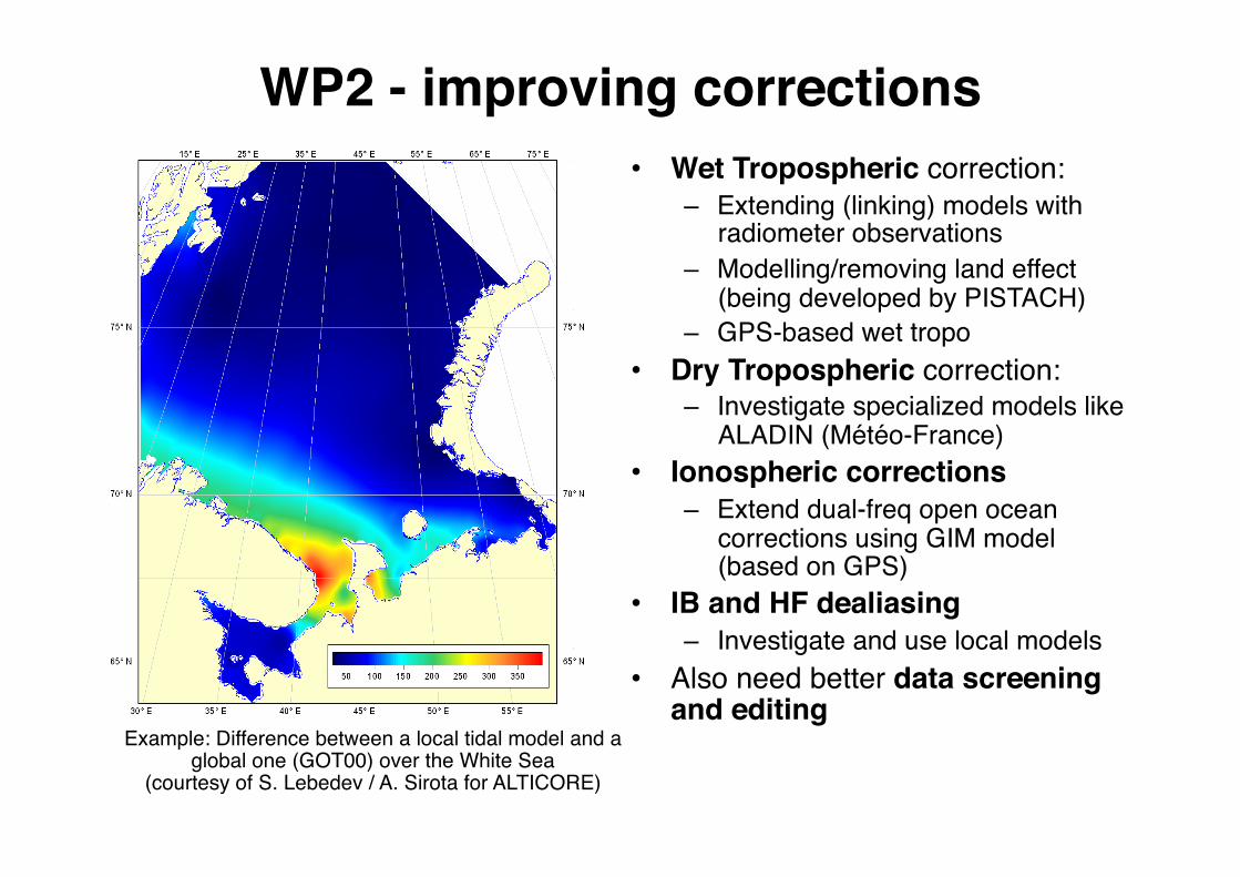
WP2 - improving corrections • Wet Tropospheric correction:
– Extending (linking) models with radiometer observations
– Modelling/removing land effect (being developed by PISTACH)
– GPS-based wet tropo • Dry Tropospheric correction:
– Investigate specialized models like ALADIN (Météo-France)
• Ionospheric corrections – Extend dual-freq open ocean
corrections using GIM model (based on GPS)
• IB and HF dealiasing – Investigate and use local models
• Also need better data screening and editing
Example: Difference between a local tidal model and a global one (GOT00) over the White Sea
(courtesy of S. Lebedev / A. Sirota for ALTICORE)

Example - Wet Tropospheric correction
S Africa
S Africa
J.MainaMbuiforALTICORE‐Africa

Wet Tropo Model
UPorto(Fernandes/Nunes/Lazaro/Pires)

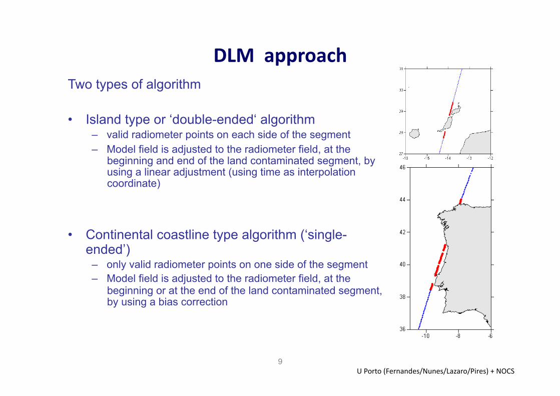
Linking radiometer and model: DLM approach
• DLM = ‘Dynamically Linked Model’ • Simple method requiring only GDR fields:
– Radiometer and NWM derived wet corrections – MWR flags (LAND flag + MWR QUAL flag for Envisat)
• Optional information: distance to land
• Data are split into segments • In each segment identifies “land contaminated zones”
• Identification of “land contaminated zones” – Flags only – Flags + distance to land
UPorto(Fernandes/Nunes/Lazaro/Pires)
DLMapproach
9
Two types of algorithm
• Island type or ‘double-ended‘ algorithm – valid radiometer points on each side of the segment – Model field is adjusted to the radiometer field, at the
beginning and end of the land contaminated segment, by using a linear adjustment (using time as interpolation coordinate)
• Continental coastline type algorithm (‘single-ended’)
– only valid radiometer points on one side of the segment – Model field is adjusted to the radiometer field, at the
beginning or at the end of the land contaminated segment, by using a bias correction
UPorto(Fernandes/Nunes/Lazaro/Pires)+NOCS

Model DLM
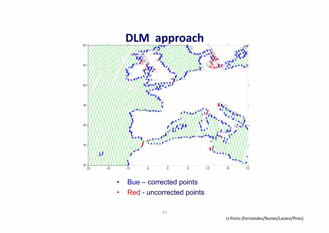
DLMapproach
11
• Bue – corrected points • Red - uncorrected points
UPorto(Fernandes/Nunes/Lazaro/Pires)

GPD Approach: Determination of Tropospheric Path Delays at GNSS stations
12
SoEwareandprocessingstrategies:• GAMIT:allowsesMmaMonofZWDfromGNSSSTD
• Vienna‐1MappingFuncMons:ECMWF‐based‘slant’to‘zenith’delays
• Networkdesign:regional(EPN)+global(IGS)
• DatareducMontosealevel:separatecorrecMonsforZWDandZHD
h=803m26(21+5)cm
)E(mfZWD)E(mfZHD)E(STD wh ×+×=
UPorto(Fernandes/Nunes/Lazaro/Pires)

Analysis of GNSS derived tropospheric fields and corresponding altimeter fields
13
MaximumcorrelaMon(leE)andstaMonwithmaximumcorrelaMon(right)betweenGNSS‐derivedandalMmeterMWRwetcorrecMon
PeriodA:September2002toAugust2005UPorto(Fernandes/Nunes/Lazaro/Pires)

Analysis of GNSS derived tropospheric fields and corresponding altimeter fields
14
Mean(leE)andstandarddeviaMon(right)ofthedifferencebetweenGNSS‐derivedandalMmeterMWRwetcorrecMon
PeriodA:September2002toAugust2005UPorto(Fernandes/Nunes/Lazaro/Pires)

Analysis of GNSS derived tropospheric fields and corresponding altimeter fields
15
MaximumcorrelaMon(leE)andstaMonwithmaximumcorrelaMon(right)betweenGNSS‐derivedandalMmeterECMWFdrycorrecMon
PeriodA:September2002toAugust2005UPorto(Fernandes/Nunes/Lazaro/Pires)

WP 3 - Retracking
• WP3.1 Coastal waveform analysis (UCadiz, NOCS)
• WP3.2 Software Processor Design and Development (NOCS, UCadiz)
• WP3.3 Validation Plan (UCadiz, NOCS) • WP3.4 Software Testing & Validation (Starlab,
NOCS, UCadiz) • WP3.5 Innovative Retracking (NOCS)

The COASTALT Processor - Coding • Coded in C and Fortran • I/O in C
– Read L2 SGDR files – Generate netcdf output files
• NAG fitting in Fortran – Least-square fitting (weighted or unweighted) – Brown, Specular and Mixed waveform models
• Open-source/GSL fitting in C
• Output in NetCDF – Now being tested/validated, will be made available via
web pages in near future

Brown retracker behaviour
Orbit 357

Brown retracker behaviour
Orbit 080 W. Britain

Brown retracker behaviour Ku-band
S-band still needs adjustment (we’re working on it)
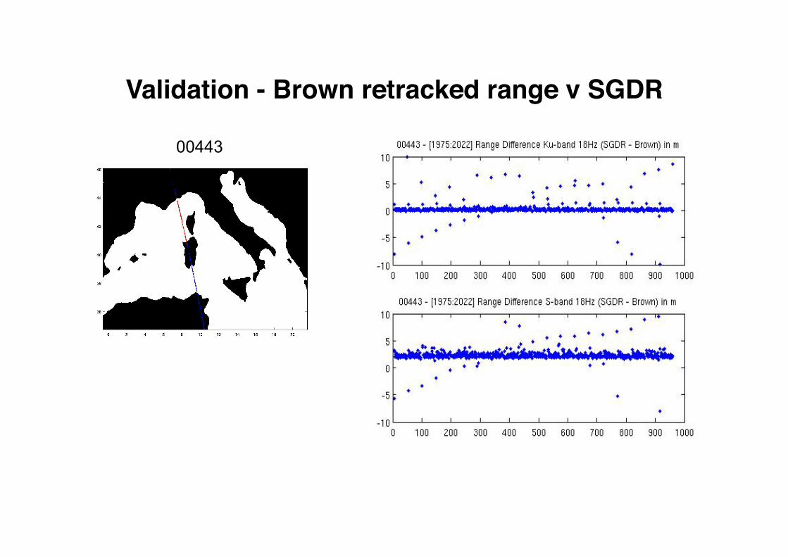
Validation - Brown retracked range v SGDR
00443

SWH Validation: Descending Track Number 00080 (West Britain): [49.0º N – 57.0º N]
Cycles analyzed: 26 – 39
18-04-2004 / 17-07-2005
SWHCoastalt>2.7 and SWHSGDR<2.0
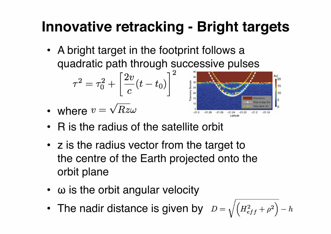
Innovative retracking - Bright targets • A bright target in the footprint follows a
quadratic path through successive pulses
• where • R is the radius of the satellite orbit • z is the radius vector from the target to
the centre of the Earth projected onto the orbit plane
• ω is the orbit angular velocity • The nadir distance is given by

Tracking Bright Targets
• The bright targets can confuse conventional retrackers
• Because we know the form of the hyperbola (the speed of the satellite) we can accurately predict its position across a set (batch) of waveforms
• ʻDarkʼ targets (e.g. rain cells) can be handled similarly
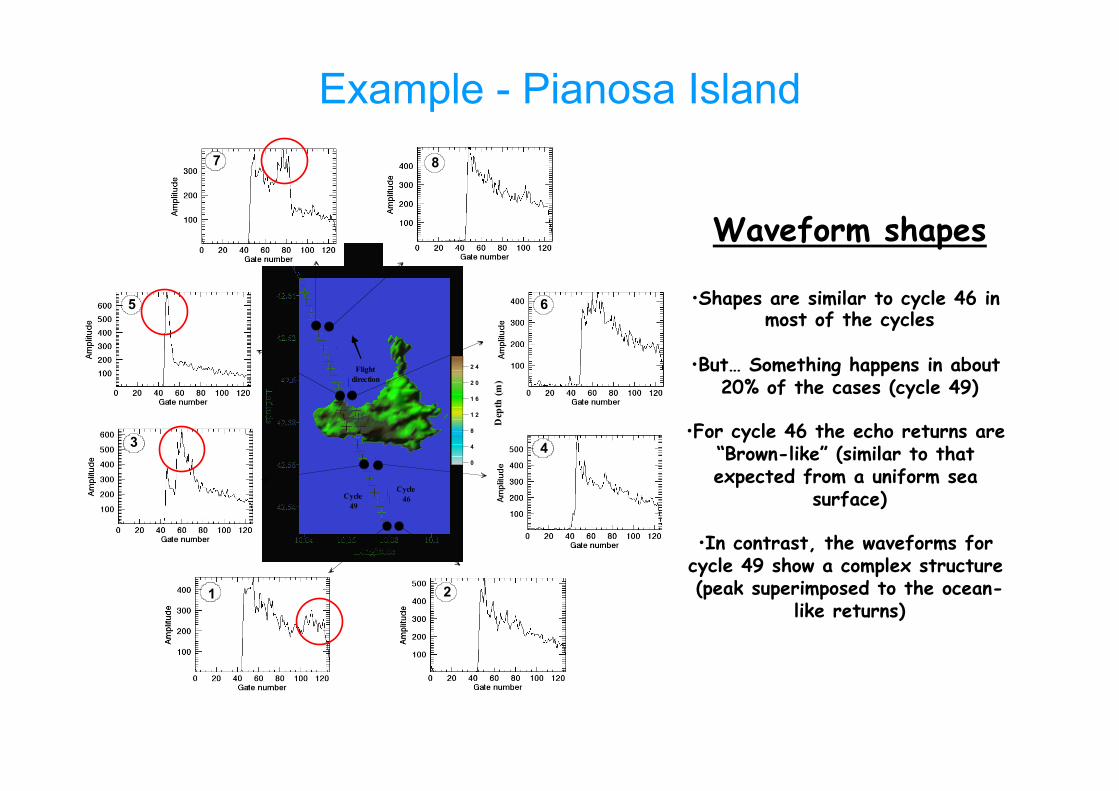
Example - Pianosa Island
3.73 km
0
4
8
1 2
1 6
2 0
2 4
3
1
4
5 6
7
Dep
th (m
)Cycle 49
Cycle 46
Flightdirection
2
8
Waveform shapes
• Shapes are similar to cycle 46 in most of the cycles
• But… Something happens in about 20% of the cases (cycle 49)
• For cycle 46 the echo returns are “Brown-like” (similar to that expected from a uniform sea
surface)
• In contrast, the waveforms for cycle 49 show a complex structure (peak superimposed to the ocean-
like returns)
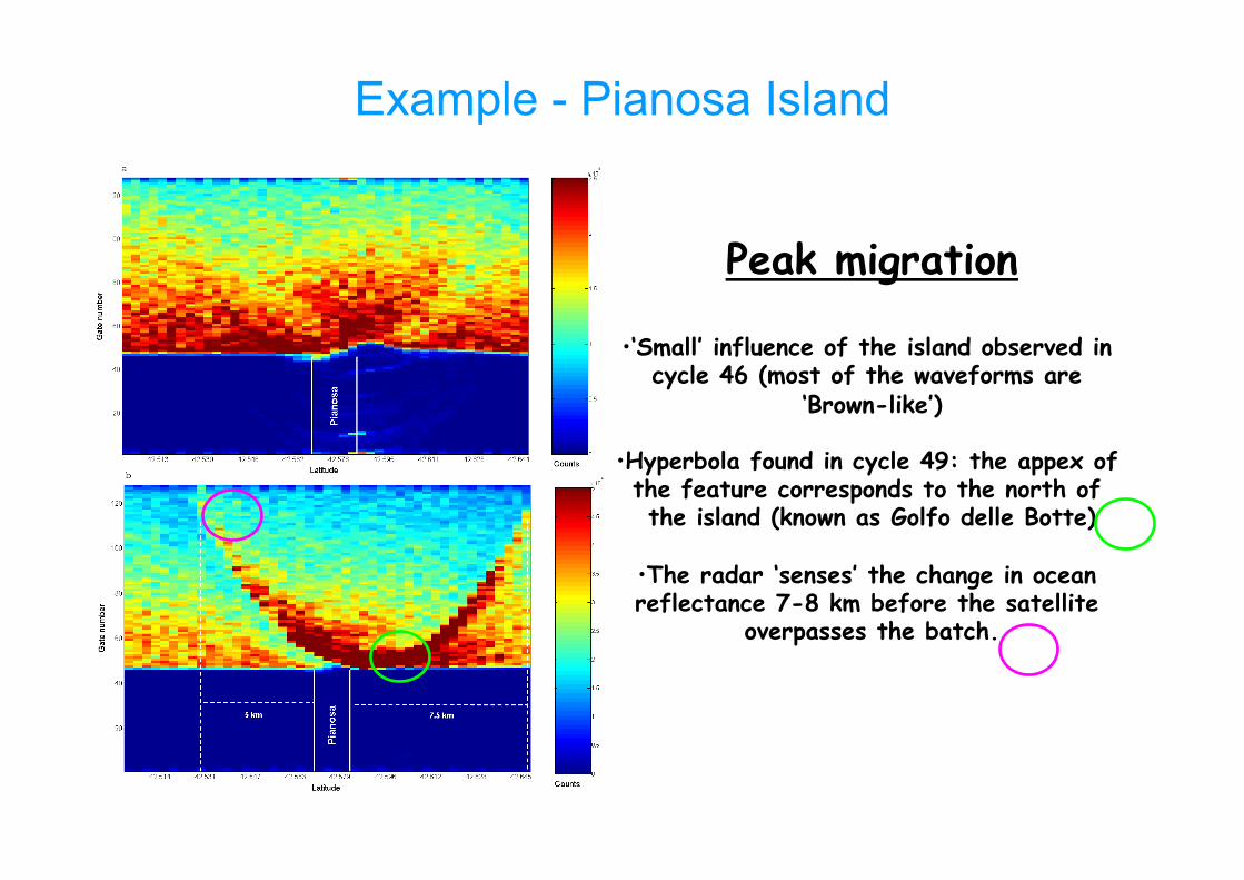
Example - Pianosa Island
Peak migration
• ‘Small’ influence of the island observed in cycle 46 (most of the waveforms are
‘Brown-like’)
• Hyperbola found in cycle 49: the appex of the feature corresponds to the north of the island (known as Golfo delle Botte)
• The radar ‘senses’ the change in ocean reflectance 7-8 km before the satellite
overpasses the batch.

Example - Pianosa Island
Envisat Ascending track
128
3 km
observed
simulated
Flight direction
Gat
e no
. In cycle 49, bright target due to wave sheltering in NW bay (Golfo della Botte)

Retracking Summary • The presence of exposed sandbanks, coastal flats
and calm waters act as reflectors (bright targets), although the return from the open water portion is still Brown-like.
• These bright targets usually contaminate the shape of the waveforms in the Coastal zone and complicate the retracking of the waveforms.
• If these effects can be tracked and modeled and then removed during the re-tracking fitting process, the accuracy in the retrieval of geophysical parameters should improve.
Summary • There is ample scope for developing altimetry in the coastal
zone (users, many applications, etc) • Space Agencies (ESA, CNES) are funding R&D in field • COASTALT: development of an Envisat RA Coastal Product
(to be extended to other ESA missions) • Significant work done on user requirements (WP1) and
corrections (WP2), with recommendations – Innovative approach to Wet Tropo correction: GPD
• Now working on development of prototype processor, including Brown, specular and mixed retrackers
• Also pioneering innovative retracking techniques, that account for migration of targets in sequential echoes
• Bottom line: with projects like COASTALT and PISTACH, coastal altimetry should be accepted widely as a legitimate component of coastal observing systems
Copyright © 2022 FDOKUMEN