Preliminary Investigation of Sloss Quarters at Sloss Furnaces National Historic Landmark (1-Je-488),...
43
-
Upload
ua-birmingham -
Category
Documents
-
view
0 -
download
0
Transcript of Preliminary Investigation of Sloss Quarters at Sloss Furnaces National Historic Landmark (1-Je-488),...


Cover art: “Sloss House”
By Catrina Callhan University of Alabama at Birmingham
2013

January 1, 2014 PRELIMINARY INVESTIGATION OF SLOSS QUARTERS
1
TABLE OF CONTENTS LIST OF FIGURES 2 ABSTRACT 4 ACKNOWLEDGEMENTS 5 PART I: INTRODUCTION 6
Project Statement of Purpose and Scope of Work 6 Description of the Study Area and Area of Potential Effects (APE) 6
PART II: LITERATURE AND DOCUMENT SEARCH 9 A Brief Overview of Sloss Quarters 9 Summary of Previous Research within the Study Area 10 Historic Maps and Photographs of the Study Area 11
2012 Aerial Photograph 11 1887-88 Beers, Ellis and Company Map 12 1911 Sanborn Map 12 1929 Sanborn Map 12 1950 Sanborn Map 12 1951 Downtown Birmingham Aerial 13 1956 Avondale Aerial 13 1967 Avondale Aerial 13 1970 Downtown Birmingham Aerial 13 Sloss Quarters Timeline 14 PART III: FIELD METHODS 14 Pre-excavation Preparations 14 Archaeological Units 16 PART VI: LABORATORY METHODS AND CURATION
ARRANGEMENT 17 PART V: RESULTS 17
Shovel Tests 17 Archaeological Units 18
Unit 1, Level 1 (U1L1) 18 Unit 1, Level 2 (U1L2) 19 Unit 1, Level 3 (U1L3) 22 Unit 1 Profile 24 Unit 2, Level 1 (U2L1) 24 Unit 2, Level 2 (U2L2) 25 Unit 2, Level 3 (U2L3) 26
Unit 2 Profile 28
Unit 3/4 28 Unit 3/4, Level 1 (U3/4L1) 29 Unit 3/4, Level 2 (U3/4L2) 29 Unit 3/4, Level 3 (U3/4L3) 30 Unit 3/4 Profile 31 Backfilling of Units 32 Artifact Analysis 32
Spatial Distribution of Recovered Artifacts 32 Materials and Material Weights 32 Faunal Analysis 33
Historical Context 34 1942 Penny 34 Clorox Bottle 34 Walter J. Fallon Dog Tag 34 Cornelius Harris Dog Tag 35 “Mission Dry Corp" Bottle 35
Ceramic with Triumph Design 35 Owen-Illinois Glass Company Bottle 36 Owen-Illinois Glass Company Bottle Featuring New
Trademark 36 Knox Bottle Company Hot Sauce Bottle 37
Date-range for Level 2 37 The Inhabitance of Sloss Quarters 37
PART VI: RECOMMENDATIONS 37 The Need for an Archaeological Plan 38 Open Area Located North of the 2012 Study Area 38 Standardization of Methodology 38
REFERENCES CITED 38 APPENDIX 1: Toxicity results for soil samples taken from
ST#1 and ST#2 39 APPENDIX 2: Spatial distribution of artifacts by material 40
APPENDIX 3: Spatial distribution of artifacts by weight 41
APPENDIX 4: Database of faunal material 42
APPENDIX 5: 1-Je-488 artifact database *
APPENDIX 6: 1-Je-488 artifact photos *
On the DVD at the end of this report.

PRELIMINARY INVESTIGATION OF SLOSS QUARTERS January 1, 2014
2
LIST OF FIGURES Figure 1: The 2012 ANTH 492/692-VT summer field crew 5 Figure 2: Location of the study area 7 Figure 3: Master site map 8 Figure 4: The front of the vault as seen from 32nd Street
North 8 Figure 5: The side of the commissary as seen from 32nd
Street North 8 Figure 6: The front of the doctor's office as seen
from underneath the 1st Ave. N. viaduct 9 Figure 7: Workers paving the corner of 1st Ave. N.
and 32nd Street, taken ca. 1920 9 Figure 8: The location of ground disturbing activities
performed by Bergstresser (1995) 10 Figure 9: 2012 aerial photograph of the study area 11 Figure 10: 1887-88 Beers, Ellis and Company map of the
study area 11 Figure 11: 1911 Sanborn map of the study area 12 Figure 12: Close-up of the 1911 Sanborn map of the study
area 12 Figure 13: 1929 Sanborn map of the study area 12 Figure 14: 1950 Sanborn map of the study area 12 Figure 15: 1951 aerial photograph of the study area 13 Figure 16: 1956 aerial photograph of the study area 13 Figure 17: 1967 aerial photograph of the study area 13 Figure 18: 1970 aerial photograph of the study area 13 Figure 19: General location of the site datum 15 Figure 20: The site datum 15 Figure 21: City of Birmingham engineering marker 15 Figure 22: Shovel test locations 15 Figure 23: Location of 5 x 5 foot units 16 Figure 24: Three distinct layers within Shovel Test 1 18 Figure 25: Shovel Test 2 18 Figure 26: Tree tapping spile recovered from Unit 1,
Level 1. Artifact 12.1.624 18 Figure 27: An intact bottle recovered from Unit 1,
Level 1. Artifact 12.1.841 19 Figure 28: Military dog tag recovered from Unit 1,
Level 1. Artifact 12.1.186 19 Figure 29: Painted Japanese ceramic artifact from Unit 1,
Level 2. Artifact 12.1.1127 19 Figure 30: Example of a painted ceramic sherd from
Unit 1, Level 2. Artifact 12.1.1760 19 Figure 31: A glass beauty bottle from Unit 1, Level 2.
Artifact 12.1.128 19 Figure 32: Example of a glass medicine bottle from Unit 1,
Level 2. Artifact 12.1477 20 Figure 33: Example of a glass beauty bottle from Unit 1,
Level 2. Artifact 12.1781 20 Figure 34: Example of a glass soda bottle from Unit 1,
Level 2. Artifact 12.1.839 20 Figure 35: A glass Zimba Cola soda bottle from Unit 1,
Level 2. Artifact 12.1.977 20 Figure 36: A metal measuring cup from Unit 1,
Level 2. Artifact 12.1.973 20 Figure 37: A bone button recovered from Unit 1,
Level 2. Artifact 12.1.1056 20 Figure 38: A metal spoon from Unit 1, Level 2.
Artifact 12.1.1372 21 Figure 39: A glass marble from Unit 1, Level 2.
Artifact 12.1.1756 21 Figure 40: A metal tube of dental crème from Unit 1,
Level 2. Artifact 12.1.1757 21 Figure 41: Examples of nails recovered from Unit 1,
Level 2. Artifact 12.1.2124 21 Figure 42: Examples of glass fragments recovered from
Unit 1, Level 2. Artifact 12.1.538 21 Figure 43: A military dog tag recovered from Unit 1,
Level 2. Artifact 12.1.1656 21 Figure 44: Photograph and line drawing of the base of
Unit 1, Level 2, facing west 22 Figure 45: Photograph and line drawing of the base of
Unit 1, Level 3, facing west 22 Figure 46: Close-up line drawing of the base of the
excavated section of Unit 1, Level 3 23 Figure 47: Plate fragment recovered from Unit 1,
Level 3. Artifact 12.1.972 23 Figure 48: Butchered cow atlas vertebra recovered from
Unit 1, Level 3. Artifact 12.1.2232 23 Figure 49: Butchered cow atlas vertebra recovered from
Unit 1, Level 3. Artifact 12.1.2230 23 Figure 50: Glass shards recovered from Unit 1, Level 3.
Artifact 12.1.1899 23 Figure 51: Rusty nails recovered from Unit 1, Level 3.
Artifact 12.1.1901 24 Figure 52: West wall profile of Unit 1 24 Figure 53: Rusty nails recovered from Unit 2, Level 1.
Artifact 12.1.263 24 Figure 54: A glass lid from a Ball jar recovered from
Unit 2, Level 1. Artifact 12.1.479 25 Figure 55: A rusty bastard file recovered from Unit 2,
Level 1. Artifact 12.1.479 25 Figure 56: Medicine bottle recovered from Unit 2,
Level 2. Artifact 12.1.232 25 Figure 57: Medicine bottle and lid recovered from Unit 2,
Level 2. Artifact 12.1.1128 25 Figure 58: Medicine bottle recovered from Unit 2,
Level 2. Artifact 12.1.1709 25 Figure 59: Cow calcaneus recovered from Unit 2,
Level 2. Artifact 12.1.736 26 Figure 60: Hot sauce bottle recovered from Unit 2,
Level 2. Artifact 12.1.974 26 Figure 61: Base of a soda bottle recovered from Unit 2,
Level 2. Artifact 12.1.2306 26 Figure 62: Glazed stoneware fragment recovered from
Unit 2, Level 2. Artifact 12.1.473 26 Figure 63: Brick fragment recovered from Unit 2,
Level 2. Artifact 12.1.473 26 Figure 64: Photograph of the base of Unit 2, Level 2 27

January 1, 2014 PRELIMINARY INVESTIGATION OF SLOSS QUARTERS
3
Figure 65: Photograph and line drawing of the base of Unit 2, Level 3 27
Figure 66: Intact Vicks bottle recovered from Unit 2, Level 3. Artifact 12.1.861 27
Figure 67: Glass marble recovered from Unit 2, Level 3. Artifact 12.1.349 27
Figure 68: Button recovered from Unit 2, Level 3. Artifact 12.1.1215 27
Figure 69: West wall profile of Unit 2 28 Figure 70: 1929 Sanborn Map of Sloss Quarters overlain
with the location of Feature 1 and the estimated location of the corner pier targeted within this investigation 28
Figure 71: A galvanized nail recovered from Unit 3/4, Level 1. Artifact 12.1.2050 29
Figure 72: A plastic shelf bracket recovered from Unit 3/4, Level 1. Artifact 12.1.2048 29
Figure 73: A brick recovered from Unit 3/4, Level 2. Artifact 12.1.533 29
Figure 74: A glass marble recovered from Unit 3/4, Level 2. Artifact 12.1.715 29
Figure 75: A porcelain light fixture recovered from Unit 3/4, Level 2. Artifact 12.1.2181 29
Figure 76: Domestic faunal material recovered from Unit 3/4, Level 2. Artifact 12.1.2213 30
Figure 77: A recent roofing nail recovered from Unit 3/4, Level 2. Artifact 12.1.697 30
Figure 78: Unidentified plastic objects recovered from Unit 3/4, Level 3. Artifact 12.1.536 30
Figure 79: Glass bottle recovered from Unit 3/4, Level 3. Artifact 12.1.1129 30
Figure 80: Faunal material recovered from Unit 3/4, Level 3. Artifact 12.1.1383 30
Figure 81: Brick fragment recovered from Unit 3/4, Level 3. Artifact 12.1.1486 31
Figure 82: Painted glass fragments recovered from Unit 3/4, Level 3. Artifact 12.1.1596 31
Figure 84: Photograph and line drawing of the base of Unit 3/4, Level 3 31
Figure 83: Button recovered from Unit 3/4, Level 3. Artifact 12.1.1711 31
Figure 85: West wall profile of Unit 3/4 32 Figure 86: Spatial distribution of recovered faunal remains 33 Figure 87: Example of cut marks on the surface of a
pig bone. Artifact 12.1.1389 33 Figure 88: Example of a butchered pig bone.
Artifact 12.1.1389 33 Figure 89: A 1942 penny recovered from Unit 2,
Level 2. Artifact 12.1.942 34 Figure 90: A Clorox pint bottle recovered from Unit 1,
Level 2. Artifact 12.1.1399 34 Figure 91: WWII dog tag belonging to Walter J. Fallon.
Artifact 12.1.86 35 Figure 92: The gravestone of Walter J. Fallon in Bay
Pines National Cemetery in Pinellas County, Florida 35 Figure 93: WWII dog tag belonging to Cornelius
Harris recovered from Unit 1, Level 2. Artifact 12.1.1656 35
Figure 94: 1948 “Mission Dry Corp” bottle recovered from Unit 1, Level 2. Artifact 12.1.839 35
Figure 95: A plate fragment with distinct Triumph design recovered from Unit 1, Level 2. Artifact 12.1.879 36
Figure 96: A complete Zimba Kola bottle recovered from Unit 1, Level 2. Artifact 12.1.977 36
Figure 97: Bottle base fragment recovered from Unit 2, Level 2. Artifact 12.1.1813 36
Figure 98: Bottle base fragment recovered from Unit 1, Level 2. Artifact 12.1.1877 36
Figure 99: Bottle featuring the new Owen-Illinois Glass Company trademark, recovered from Unit 2, Level 2. Artifact 12.1.1813 37
Figure 100: Knox Bottle Company hot sauce bottle recovered from Unit 2, Level 2. Artifact 12.1.1813 37

PRELIMINARY INVESTIGATION OF SLOSS QUARTERS January 1, 2014
4
ABSTRACT
During the summer of 2012, the Department of Anthro-pology at the University of Alabama at Birmingham, in con-junction with McWane Science Center in Birmingham, con-ducted a three week preliminary field investigation at Sloss Quarters, the site of the former worker housing at Sloss Furnaces National Historic Landmark (site 1-JE-488), in Birmingham, Alabama. Historic Sanborn maps indicate a number of “shotgun-style” houses once resided at Sloss Quarters, largely inhabited by the former workers of the iron furnace.
A preliminary survey of historical maps and aerial photographs indicated the presence of temporary structures within the study area as early as 1888. Nearly all of these temporary structures were removed from the site at some point between 1951 and 1956.
Ground disturbing activities within this investigation included the targeted excavation of two shovel tests and three 5 x 5 foot units. Excavated to an average depth of 18 inches, these units revealed a largely undisturbed occupational layer at a depth of six to 12 inches below the surface. Two brick, stone, and concrete features were uncovered and recorded during this investigation. These features represent the remains of two of the support piers from one of the former shotgun houses.
A total of 4989 artifacts were recovered during this study. Analyses of these artifacts suggest the uncovered occupational layer dates from the late 1940’s to early 1950’s. These artifacts
also corroborate historical records that indicate Sloss Quarters was inhabited not only by the furnace workers, but also their families. Faunal remains recovered from the site suggest the diet of these residents consisted of both domestic meat and wild game. The recovery of tree tapping spiles suggests at least some residents were tapping trees for sap. The recovery of two WWII dog tags suggests Sloss Furnaces may have offered a favorable place of employment for military veterans. The large number of intact glass artifacts recovered, including cosmetic, medicinal, and soda bottles, suggest these products were readily available to workers. There is a strong possibility many of these items were obtained by residents from the commissary and doctor’s office. These brick and stone structures still stand on the property today.
The results of this preliminary investigation strongly suggest that Sloss Quarters is not only and intact site, but is one that also has great research potential. With intact features, ample and well preserved artifacts, and minimal surface disturbance, this site potentially offers a rare glimpse into the lives of the furnace workers and their families during the late 1940’s and early 1950’s. There is also potential that future excavations to greater depths at may reveal evidence from earlier periods of occupation.
Artifacts recovered during this study were curated at McWane Science Center and are currently housed at Sloss Furnaces National Historic Landmark in Birmingham. Site records created during this investigation are on file at both McWane Science Center and Sloss Furnaces.

January 1, 2014 PRELIMINARY INVESTIGATION OF SLOSS QUARTERS
5
ACKNOWLEDGEMENTS
We wish to thank the following individuals and institutions who were instrumental in helping us carry out this invest-igation. First, we wish to thank Karen Utz, Curator and Historian at Sloss Furnaces, and Dr. Robert Rathburn, Director of Sloss Furnaces, for allowing this investigation of Sloss Quarters to take place. We also thank Ms. Utz for her assistance in providing us with preliminary historical data, maps, and previous reports on the site. We thank McWane Science Center (MSC), Bizzoco and Associates, LLC., and the Department of Anthropology at the University of Alabama at Birmingham (UAB) for providing us with the necessary equipment for this investigation. We are also indebted to MSC for providing the necessary space for the laboratory portion of this course. We a thank Dr. Karen Moore who graciously confirmed soil toxicity levels and Christel Carlisle, UAB graduate student, who kept
track of all field documentation while serving as the Research Assistant on this investigation. We also thank Stacye Hathorn, State Archaeologist, and Elizabeth Ann Brown, Deputy State Historic Preservation Officer, both of the Alabama Historical Commission, who worked to make sure all the paper work was in order at the state level. Also, we thank the following individuals who freely gave their time to provide “field lectures” to the students: Dr. Cali Fidopiastis, Department of Physical Therapy, UAB; Rebecca Dobrinski, Birmingham Museum of Art; and Dr. Graham Boettcher, Curator of American Art at the Birmingham Museum of Art. Finally, we thank the nine graduate and undergraduate students who participated in ANTH 492/692-VT Advanced Historical Arch-aeology and survived weekly tests as well as the heat and bugs of an Alabama summer (Fig. 1): Brenna Battle, Catrina Callahan, Richard Crabb, Jade Delisle, Timothy McDonald, Brian Nichols, Ryan Nordness, Jeremiah Rastegar, and Katelyn Reed.
Figure 1: The 2012 ANTH 492/692-VT summer field crew. Top, from left to right: Jun Ebersole (MSC), Timothy McDonald, Jeremiah Rastegar, Jade Delisle, Bruce Bizzoco (MSC), and Richard Crabb. Bottom, from left to right: Christel Carlisle (UAB), Brian Nichols, Ryan Nordness, Brenna Battle, Katelyn Reed, and Catrina Callhan.

PRELIMINARY INVESTIGATION OF SLOSS QUARTERS January 1, 2014
6
PART I: INTRODUCTION
During the summer of 2012, the Department of Anthro-pology at the University of Alabama at Birmingham (UAB), in conjunction with McWane Science Center (MSC), conducted a preliminary field investigation at the site of the former worker housing at Sloss Furnaces National Historic Landmark (Sloss), in Birmingham, Alabama. This investigation was part of a full credit-granting class (ANTH 492/692-VT: Advanced Historical Archaeology) with a limited number of undergraduate and graduate students participants who successfully completed the UAB course, ANTH 106: Introduction to Archaeology. Dr. Sharyn Jones, archaeologist and Chair of the Department of Anthropology at UAB, served as Principle Investigator and Adjunct Instructors and archaeologists, Mr. Jun Ebersole and Dr. Bruce Bizzoco (both of MSC), oversaw the everyday field and laboratory activities. This field school was offered as a “split level” course through the Department of Anthropology at UAB with both graduate and undergraduate students enrolling for either three or six credit hours. From June 4 – 22, 2012, nine students, one research assistant, and two archaeologists (Ebersole and Bizzoco) participated in a three week field investigation of Sloss Quarters. On-site Monday through Friday from 10AM to 3PM, daily activities included lectures and practical application of archaeological field techniques. Seven of the nine students enrolled in the course for six credit hours which allowed them to participate in an additional three week archaeological laboratory course which took place in the Alabama Collections Center at MSC from June 25 – July 16, 2012. Lab activities included the cleaning, conservation, cataloging, accessioning, and interpretation of archaeological artifacts recovered during the Sloss Quarters excavation.
Project Statement of Purpose and Scope of Work This summer investigation concentrated on a plot of land located adjacent to Sloss known as “Sloss Quarters,” the site of the former worker housing for the furnace. Early Sanborn maps and aerial photographs indicate a number of temporary (shotgun-style) structures formerly existed on this plot dating back as early as 1888 (see Part II: Literature and Document search). Notable structures and features visible on early Sanborn maps and photographs include a series of shotgun-style duplex houses, which served as worker housing; large, single shot-gun houses, likely representing housing for Sloss management personnel; garages, alleyways, and walkways; and three permanent structures known as the vault, commissary, and doctor’s office. By 1956, only three of the reported 48 temporary dwellings were still present at the location. The last of these temporary structures was likely removed in the mid-to-late 1970’s. The overall goal of this preliminary investigation was to determine if any subsurface evidence still remains of any of these former dwellings. The objectives of this field school were as follows:
1. Investigate the data potential for the site. 2. Define the site boundaries. 3. Locate any existing features. 4. Recover and curate any cultural material. 5. Provide the students with a set of real-world skills that they
can use in pursuing a career in archaeology. The scope of this project was kept to a minimum due to the limited time in the field (three weeks, June 4 – 22) and an emphasis on teaching students proper excavation techniques rather than simply “moving dirt.” With Sanborn maps indicating the location of former structures, the need for a Phase 1 shovel test investigation within the study area was minimal (a total of two shovel test pits were excavated). These test pits were excavated for the purpose of examining the subsurface stratigraphy (see Results) and to collect soil samples for toxicity testing (see Appendix 1). The remainder of this project concentrated on a preliminary Phase II investigation of the study area with the excavation of three 5 x 5 foot units excavated to an average depth of 18 inches. The purpose of this Phase II investigation was to see a larger view of the subsurface in order to determine if the study area: 1) was or was not disturbed; 2) preserved cultural remains; 3) contained intact features; and 4) had further research potential.
Description of the Study Area and Area of Potential Effects (APE)
Ground disturbing activities during this investigation took place on a 0.5 acre plot adjacent to Sloss Furnaces National Historic Landmark (Sloss), located on the northeast corner of 32nd Street North and 1st Avenue North in Birmingham in Jefferson County, Alabama (Fig. 2). The study area is located in Sec. 30, T17S, R2W on the 7.5 minute Birmingham North quadrangle map and the center of the study area is located at Lat/Long 33d29’52”N – 83d48’29”W. At present, three brick and stone buildings exist on this plot. All constructed between 1911 and 1929, these three structures are informally referred to as the vault, commissary, and doctor’s office (Figs 3, 4-6). Aside from these three structures, the study area consists of a grass and dirt plot intermixed with a series of paved walking paths. The site is surrounded on two sides by a chain-link fence and a parking lot makes up the northeastern boundary. A sidewalk currently lines the southwestern edge of the property and the southeastern edge falls nearly under the adjacent 1st Avenue North viaduct. The study area, deeded to Sloss in 2005 by U.S. Pipe and Foundry, Inc., is adjoined by a similar-sized grass plot located to the northwest. Ground disturbing activities during this investigation were limited to two locations within the Sloss property – to the northeast of the doctor’s office and to the southwest of the commissary. One shovel test was placed at each of these locations with three 5 x 5 foot archaeological units located in the area adjacent to the doctor’s office (Fig.3).

January 1, 2014 PRELIMINARY INVESTIGATION OF SLOSS QUARTERS
7
The three existing structures located on the Sloss plot were not impacted as part of this investigation. Instead, this study focused on locating evidence for structures that are no longer
present. This history of the three existing structures, however, was investigated in order to place the entirety of Sloss Quarters in proper historical context.
Figure 2: Location of the study area (indicated by the blue circle). The study area is located in Sec. 30, T17S, R2W on the 7.5
minute Birmingham North quadrangle map.

PRELIMINARY INVESTIGATION OF SLOSS QUARTERS January 1, 2014
8
Figure 4: The front of the vault as seen from 32nd
Street North.
Figure 1: The side of the commissary as seen from 32nd Street North.
Figure 3: Master Site Map. This survey maps shows the plot of land deeded to Sloss Furnaces by U.S. Pipe and
Foundry, Inc. The red line indicates Sloss Furnaces property.
January 1, 2014 PRELIMINARY INVESTIGATION OF SLOSS QUARTERS
9
Part II: LITERATURE AND DOCUMENT SEARCH
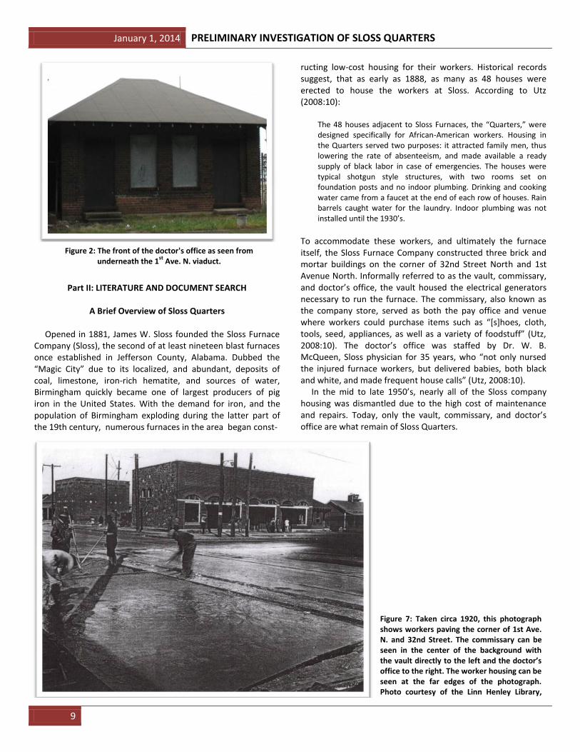
A Brief Overview of Sloss Quarters Opened in 1881, James W. Sloss founded the Sloss Furnace Company (Sloss), the second of at least nineteen blast furnaces once established in Jefferson County, Alabama. Dubbed the “Magic City” due to its localized, and abundant, deposits of coal, limestone, iron-rich hematite, and sources of water, Birmingham quickly became one of largest producers of pig iron in the United States. With the demand for iron, and the population of Birmingham exploding during the latter part of the 19th century, numerous furnaces in the area began const-
ructing low-cost housing for their workers. Historical records suggest, that as early as 1888, as many as 48 houses were erected to house the workers at Sloss. According to Utz (2008:10):
The 48 houses adjacent to Sloss Furnaces, the “Quarters,” were designed specifically for African-American workers. Housing in the Quarters served two purposes: it attracted family men, thus lowering the rate of absenteeism, and made available a ready supply of black labor in case of emergencies. The houses were typical shotgun style structures, with two rooms set on foundation posts and no indoor plumbing. Drinking and cooking water came from a faucet at the end of each row of houses. Rain barrels caught water for the laundry. Indoor plumbing was not installed until the 1930’s.
To accommodate these workers, and ultimately the furnace itself, the Sloss Furnace Company constructed three brick and mortar buildings on the corner of 32nd Street North and 1st Avenue North. Informally referred to as the vault, commissary, and doctor’s office, the vault housed the electrical generators necessary to run the furnace. The commissary, also known as the company store, served as both the pay office and venue where workers could purchase items such as “*s+hoes, cloth, tools, seed, appliances, as well as a variety of foodstuff” (Utz, 2008:10). The doctor’s office was staffed by Dr. W. B. McQueen, Sloss physician for 35 years, who “not only nursed the injured furnace workers, but delivered babies, both black and white, and made frequent house calls” (Utz, 2008:10). In the mid to late 1950’s, nearly all of the Sloss company housing was dismantled due to the high cost of maintenance and repairs. Today, only the vault, commissary, and doctor’s office are what remain of Sloss Quarters.
Figure 2: The front of the doctor's office as seen from underneath the 1
st Ave. N. viaduct.
Figure 7: Taken circa 1920, this photograph shows workers paving the corner of 1st Ave. N. and 32nd Street. The commissary can be seen in the center of the background with the vault directly to the left and the doctor’s office to the right. The worker housing can be seen at the far edges of the photograph. Photo courtesy of the Linn Henley Library, Birmingham, Alabama.

PRELIMINARY INVESTIGATION OF SLOSS QUARTERS January 1, 2014
10
Summary of Previous Research within the Study Area In 1995, archaeologist Jack Bergstresser of UAB conducted a nearby Phase 1 investigation of two plots along 1st Avenue North, located on the other side of 32nd Street North from the present study area (Fig. 8). At the time, The Village Committee of Sloss wished to relocate a number of recently acquired shotgun-style houses onto the plots in an attempt to reconstruct and commemorate the old Sloss Quarters. Bergstresser’s subsequent investigation revealed the “scant remnants” of a Sloss Quarter’s house consisting of “a small concentration of deteriorated brick rubble and mortar, charred wood, broken window glass, a few round nails” (Bergstresser, 1995: 1). Cultural material discovered at this particular location was recovered beneath five feet of iron ore, slag, and other industrial debris, suggesting the area was later used as an industrial dumping site. Due to the amount of disturbed overburden, a backhoe was used to complete the investigation. Bergstresser’s (1995) investigation led to the approval to relocate temporary shotgun houses to the area as it was determined that doing so would have little effect on the integrity of the site (Bergstresser, 1995). Copies of Bergstresser’s report on his investigation can be found in the Sloss archives, and in 1995, Bergstresser completed and
submitted an Alabama State Site File form, designating the site 1-Je-488. The artifacts recovered as part of this excavation are currently housed in the UAB Josselyn Archaeological Collection within Heritage Hall in Birmingham, Alabama. At the time, Bergstresser (1995) did not perform any ground disturbing activities at the current study area as, at the time, this 0.5 acre lot was property of U.S. Pipe and Foundry, Inc. (U.S. Pipe). However, ten years later in 2005, this plot was deeded to Sloss by U.S. Pipe and is now managed by personnel at the historical landmark. In 2003, in preparation for this deed of sale, Joseph Spransy of U.S. Pipe hired the environmental firm, Gallet and Associates, Inc. (Gallet) to perform a Phase I Environmental Site Assessment (ESA) of the current 0.5 acre study area (Hughes et al. 2003). Gallet’s environmental assessment of the area found no known environmental issues within the area, but did recommend an asbestos survey be conducted before any ground disturbing activities take place (Hughes et al. 2003). Over the decades, several archaeological investigations are known to have taken place at various locations at Sloss Furnaces. This preliminary study, however, represents the first known archaeological investigation into this particular section of Sloss Quarters.
Figure 3: The location of ground disturbing activities performed by Bergstresser (1995). The star indicates the current area of
investigation. Modified from Bergstresser (1995, p. 4).

January 1, 2014 PRELIMINARY INVESTIGATION OF SLOSS QUARTERS
11
Historic Maps and Photographs of the Study Area As noted by Bergstresser (1995), a relative paucity of documentation is available regarding the historical develop-ment of Sloss Quarters. However, both Bergstresser (1995) and Hughes et al. (2003) made use of early aerial photography and maps that are available for the current study area. Below are the results of an examination of these available resources which provide a rough chronology of the development of the study area as well as the placement of temporary structures. The historical aerial imagery examined was courtesy of the Alabama Map Library in the Department of Geography at the University of Alabama, Tuscaloosa, while Sanborn and other maps were courtesy of the same institution as well as the Linn Henley Library in Birmingham. 2012 Aerial Photograph (Fig. 9) – This 2012 aerial photograph shows the current state of the area of study. Just below the center of the photograph, the vault, commissary, and doctor’s office are clearly seen. No temporary structures are present on the property, however paved walking paths and large parking lots can be seen to the right of the three existing structures. 1887-88 Beers, Ellis and Company Map (Fig. 10) – The earliest known map of the study area is the Beers, Ellis and Company map printed in 1887-88. The property owned by Sloss, which opened in 1881, can clearly be seen blanketing the bottom half of the map. As of 1888, the location of the current study area, as highlighted in red, was property of W. Dobbins and was presumably purchased by Sloss a short time after. Never-theless, as many as five temporary structures can be seen within the current area of study. Bergstresser’s 1995 study focused on locating the remains of structures on Sloss property, which are seen just below the current study area.
Figure 4: 2012 aerial photograph of the study area. Photograph courtesy of Google Earth.
Figure 10: 1887-88 Beers, Ellis and Company map of the study area (indicated in red). Map courtesy of the Linn Henley Library, Birmingham.

PRELIMINARY INVESTIGATION OF SLOSS QUARTERS January 1, 2014
12
1911 Sanborn Map (Figs 11, 12) – Early Sanborn maps illustrating the Sloss property are available from the years 1885, 1888, 1891, and 1902. Unfortunately, the maps from these years do not show the current area of study. Of the available Sanborn maps, the current area of investigation first appears on the 1911 Sanborn. On this map, 32nd Street North can be seen at the bottom while 1st Avenue North can be seen on the far right. Between 1st and 3rd avenues along 32nd street, a total of 11 duplex houses appear with porches facing 32nd street. An elongated structure appears on the corner of 1st Ave and 32nd St., in the location of the modern commissary, but is not the current brick and stone building. This structure is marked with an “S” on the map indicating it is a store. Two rows of duplex houses can be seen on and between 2nd and 3rd avenues. Six additional duplex houses can be seen along 1st avenue. These structures are all marked with a “D” indicating they are frame building dwellings. None of the present permanent structures, the vault, commissary, and doctor’s office, appears on this map. This indicates they were constructed after 1911.
1929 Sanborn Map (Fig. 13) – In this map, 1st Ave. N. appears at the bottom and 32nd St. N. appears to the left. The commissary appears at the intersection of these two streets and is marked with an “S” indicating it is a store. Connected to the commissary are two offices (marked “OFF”), one to the left and one to the right. The office to the right is the doctor’s office. Directly above the commissary is the vault with a caption that reads: “vault, fire proof.” Behind the vault are three private garages or “auto houses” marked with an “A.” Structures marked with a “D” are present across the study area, with the “D” indicating a frame dwelling. Most appear to be duplex dwellings, with a few single units and at least one triple unit. Several of these structures have porches indicated.
1950 Sanborn Map (Fig. 14) – With the exception of the loc-ation of a few dwellings and garages, the 1950 Sanborn shows little change from the Sanborn of 1929.
Figure 11: 1911 Sanborn map of the study area. Map courtesy
of the Map Library at the University of Alabama.
Figure 12: Close-up of the 1911 Sanborn of the study area.
Map courtesy of the Map Library at the University of Alabama.
Figure 13: 1929 Sanborn map of the study area. Map
courtesy of the Linn Henley Library, Birmingham.
Figure 14: 1950 Sanborn map of the study area. Map courtesy of the Linn Henley Library, Birmingham, Alabama.
January 1, 2014 PRELIMINARY INVESTIGATION OF SLOSS QUARTERS
13
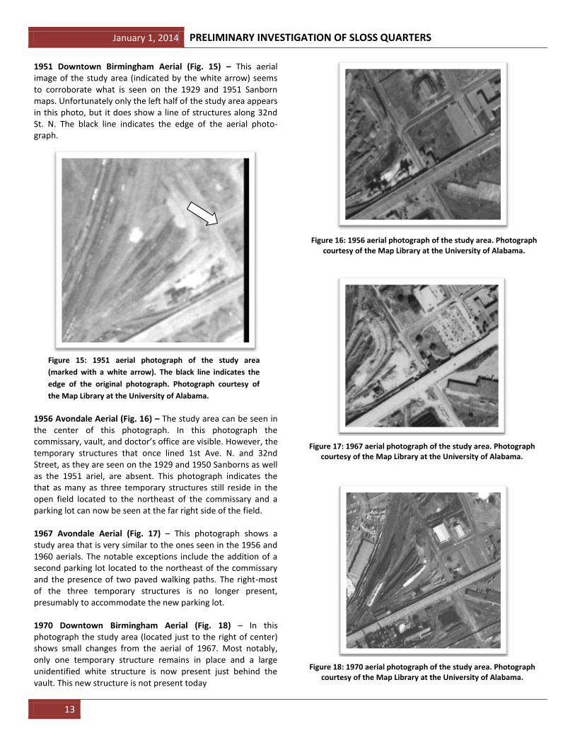
1951 Downtown Birmingham Aerial (Fig. 15) – This aerial image of the study area (indicated by the white arrow) seems to corroborate what is seen on the 1929 and 1951 Sanborn maps. Unfortunately only the left half of the study area appears in this photo, but it does show a line of structures along 32nd St. N. The black line indicates the edge of the aerial photo-graph.
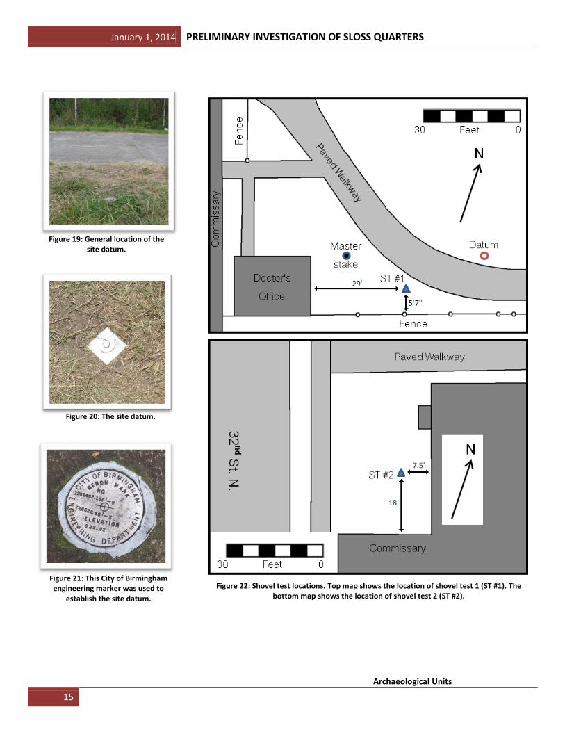
1956 Avondale Aerial (Fig. 16) – The study area can be seen in the center of this photograph. In this photograph the commissary, vault, and doctor’s office are visible. However, the temporary structures that once lined 1st Ave. N. and 32nd Street, as they are seen on the 1929 and 1950 Sanborns as well as the 1951 ariel, are absent. This photograph indicates the that as many as three temporary structures still reside in the open field located to the northeast of the commissary and a parking lot can now be seen at the far right side of the field. 1967 Avondale Aerial (Fig. 17) – This photograph shows a study area that is very similar to the ones seen in the 1956 and 1960 aerials. The notable exceptions include the addition of a second parking lot located to the northeast of the commissary and the presence of two paved walking paths. The right-most of the three temporary structures is no longer present, presumably to accommodate the new parking lot. 1970 Downtown Birmingham Aerial (Fig. 18) – In this photograph the study area (located just to the right of center) shows small changes from the aerial of 1967. Most notably, only one temporary structure remains in place and a large unidentified white structure is now present just behind the vault. This new structure is not present today
.
Figure 15: 1951 aerial photograph of the study area
(marked with a white arrow). The black line indicates the
edge of the original photograph. Photograph courtesy of
the Map Library at the University of Alabama.
Figure 16: 1956 aerial photograph of the study area. Photograph courtesy of the Map Library at the University of Alabama.
Figure 17: 1967 aerial photograph of the study area. Photograph courtesy of the Map Library at the University of Alabama.
Figure 18: 1970 aerial photograph of the study area. Photograph courtesy of the Map Library at the University of Alabama.

PRELIMINARY INVESTIGATION OF SLOSS QUARTERS January 1, 2014
14
Sloss Quarters Timeline
Utilizing the data from these maps and aerial photographs, it was possible to piece together the following chronological development of the study area: 1888 – The study area is owned by W. Dobbins. Temporary structures are present along 1st Ave. N. and 32nd street.
1911 – By this time, Sloss owns the study area. Multiple duplex dwellings now appear in the study area along with an elongated structure that appears in the location of the commissary. Labeled as a store, this early amenity would later be replaced by the current, permanent, commissary. It is unclear whether or not any of the dwellings present are the same as those seen on the 1887-88 Beers map when the property was owned by W. Dobbins. 1911 to 1929 – The commissary, vault, and doctor’s office are constructed on the corner of 1st Ave. N. and 32nd Street. To make room for these structures, several duplex dwellings are either removed or relocated. Additional duplex and single dwellings are added to the study area in various locations. 1929 to 1951 – Very little has changed during this time. Dwellings appear to be in the same locations in 1929 as they do in 1951. The only notable changes are the relocation of a couple of duplex dwellings in the middle of the study area and the addition and subtraction of a few garages. Before 1950, 1st Ave. N. is elevated. 1951 to 1956 – By 1956, all but three temporary structures remain on the study area, the rest having been removed or relocated. The commissary, vault, and doctor’s office are still present. A parking lot has been added to the far end of the field located to the northeast of the commissary. 1956 to 1960 – The parking lot to the northeast of the commissary has been expanded and now has two entrances from 2nd Ave. N. Three temporary structures are still present within the study area. The commissary, vault, and doctor’s office remain unchanged. 1960 to 1967 – Only two of the three temporary structures remain in the study area. The third has been removed to accommodate the expansion of the parking lot located to the northeast of the commissary. The two existing paved walking paths are constructed within the study area. The commissary, vault, and doctor’s office remain unchanged. 1967 to 1970 – Only one of the original temporary structures resides within the study area. The commissary, vault, and doctor’s office remain unchanged, however, a new unidentified structure is built behind the vault.
2005 to Present – No temporary structures are present within the study area. The commissary, vault, and doctor’s office are all that remain of Sloss Quarters.
PART III: FIELD METHODS
Pre-excavation Preparations The following four tasks were completed prior to the Phase II investigation of Sloss Quarters: 1. Alabama-811, a free service in the Birmingham-metro area,
was contacted to locate and mark the subsurface utilities. This service clearly marked, with a combination of spray paint and flags, all subsurface water, gas, electrical, and data lines within the study area.
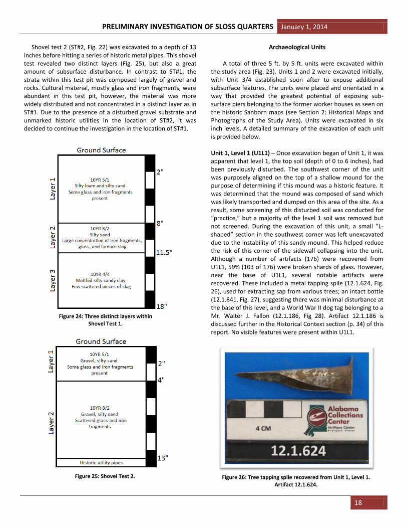
2. A site datum was established within the study area (Figs. 2,
19-22). This datum was shot in using a standard transit and stadia rod from a City of Birmingham Engineering Depart-ment marker (Fig. 21) located approximately 100 yards due south of the established site datum. The datum remains on site today as a 12 inch steel stake which has been driven into the ground through a galvanized steel plate (Fig. 20). The following coordinates and elevation of the datum point have been etched into the steel plate with a Dremel.
GPS Coordinates of datum: N33d31’365”; W86d47’327”
Elevation of datum: 619.92 ft. above sea level
3. Two 30” shovel tests (ST #1, ST #2) were dug at two locations within the study area (Fig. 22). Bergstresser’s (1995) investigation along 1st Ave. N. revealed that five feet of industrial overburden overlay what was determined to be an occupation layer. The purpose of these two shovel tests was to determine whether or not this same overburden existed within the current study area. Furthermore, Hughes et al.’s (2003) report recommend an asbestos survey be conducted before any ground disturbing activities take place within the study area. Following this recommend-dation, three soil samples were taken from various depths within Test Pit 1 and two samples from Test Pit 2 (see Results). Soil samples were sent to the Soil Testing Laboratory at Auburn University where results showed no harmful levels of any substance such as asbestos, mercury, lead, and arsenic within the soils (see Appendix 1 for complete results).
4. The study area was cleaned. Litter was collected and
discarded, the grass was cut, and excessive vegetation was either cut back or removed
January 1, 2014 PRELIMINARY INVESTIGATION OF SLOSS QUARTERS
15
Archaeological Units
Figure 19: General location of the
site datum.
Figure 20: The site datum.
Figure 21: This City of Birmingham engineering marker was used to
establish the site datum.
Figure 22: Shovel test locations. Top map shows the location of shovel test 1 (ST #1). The
bottom map shows the location of shovel test 2 (ST #2).

PRELIMINARY INVESTIGATION OF SLOSS QUARTERS January 1, 2014
16
Due to the directional layout of the existing historic struc-tures within the study area (see Fig. 2), the units excavated during this investigation were aligned parallel to the buildings and the property boundaries as opposed to the more traditional NSEW, or magnetic, layout. This alignment allowed the units to be mapped more easily in relation to the existing structures and allowed for better surface coverage in the restricted space available within the chosen area of ground disturbing activities. In total, three 5 x 5 ft. units were excavated as part of this investigation (labeled Units 1, 2, and 3/4). According to historic Sanborn maps, a number of shotgun- style houses once lined both 1st Ave. N. and 32nd St. N. (See Section 2: Historic Maps and Photographs of the Study Area). Since the houses that once stood along 32nd St. N. were outside of the study area and beyond the property boundary deeded to Sloss, this investigation targeted a small plot of land located northeast of the existing doctor’s office along 1st Avenue North (Fig 23). The units established during this investigation were placed in locations that offered the best potential of revealing any existing brick and stone support piers left by these former structures. The alignment of these three units was determined by establishing a baseline of 246 degrees within the study area. Along this established baseline, a wooden stake, known here as the “master stake,” was placed in the ground approximately 47 feet from the datum on a transect of 156 degrees (Fig. 23). The northwest corner stake of Unit 1 was established approx-imately 14 feet off the main stake using the baseline angle of 246 degrees. Using the established transect and baseline angles, the remaining corner stakes for Units 1 and 2 were established adjacent, in an easterly direction, to each other to increase the potential of revealing subsurface piers, the corners of which are indicated on the Sanborn maps (see Part II: Historic Maps and Photo-graphs of the Study Area). Standard 5 x 5 ft. units were chosen for this study to not only reveal a good amount of the subsurface, but to also maximize a number of students that could excavate within a single unit. It was decided to excavate Units 1 and 2 with a six inch balk separating the units to ensure students did not accidently mix cultural materials. Units were excavated largely with trowels, however one additional unit, Unit 3/4, was partially excavated with flat-head shovels in order to remove a section of unnatural overburden that covered a portion of the unit. All units were excavated in six inch levels and level forms were recorded at each six inch interval. Artifacts exposed at the base of any level were pedestaled and left in place until level forms for that level were completed. Units 2 and 3/4 were excavated to a depth that exposed large, collapsed, stone and brick pier features. These features prevented the units from being excavated any further. Unit 1, however, was only partially impacted by this feature. Therefore, in order to determine the depth of sterile soils, Unit 1 was quartered and only a partial portion of the unit was excavated to greater depths. Although only a quarter of Unit 1 was taken to sterile
soils, level forms were still recorded at each six inch interval. Any in situ artifacts exposed in the side walls were left in place until the walls could be profiled. Once all level and profile forms had been completed for a unit, all in situ and pedestaled artifacts were collected. Digital photographs were taken of each level and profile for each unit. Each photograph was taken with a photo-board, scale, and directional indicator. Quarter inch screens were used to screen all back dirt. However, within Unit 1, small pockets of micro-faunal remains were uncovered. To recover these remains, a one-eighth inch screen was used. All dirt was screened on tarps and all back dirt piles were located at least three feet from the edge of each unit. Any artifacts recovered were bagged and labeled with appropriate provenience information (i.e. unit number, level number, date, collector). Artifact bags were individually numbered and recorded in a log book. Artifacts deemed to be of special significance (by Ebersole and Bizzoco) were given a Field Specimen (FS) number and were bagged and recorded separately. All recovered artifacts were bagged and labeled with their appropriate unit and level numbers. At the conclusion of each field day, the recovered artifacts were transported to MSC’s archaeological laboratory for processing. For educational purposes, each student was required to fill out level and profile forms as well as keep an accurate field notebook. PDF scans were made of all documentation and field books before they were returned to students. Copies of all field documentation can be found in MSC’s archaeological laboratory and as well as in the Sloss archives.
Figure 23: Location of 5 x 5 foot units.

January 1, 2014 PRELIMINARY INVESTIGATION OF SLOSS QUARTERS
17
PART IV: LABORATORY METHODS AND CURATION ARRANGEMENT
At the completion of each day of the field investigation, all recovered artifacts were transported in a cushioned metal case to MSC’s archaeological laboratory for processing. During rainy days and the second three-week portion of this course, students were introduced to archaeological laboratory methodology and worked to process the artifacts recovered from the Sloss excavation. Every artifact was processed in a consistent manner following these nine steps: 1) washing; 2) sorting; 3) numbering; 4) labeling; 5) identification; 6) weighing; 7) cataloging; 8) photographing; and 9) archival storage. All artifacts such as glass, plastic, aluminum, and stone/ brick, were washed using clean water and soft brushes. Rusty metal objects were not washed; rather they were gently wire brushed to remove loose dirt and rust particles. Fragile artifacts, such as bone and bottles with painted labels, were carefully dry brushed. All cleaned artifacts were placed on a drying rack with associated labels designating provenience. Once dried, associated artifacts (i.e. same unit/ level) were sorted by material (glass, metal, brick, etc.) and placed into archival bags so they could be itemized and individually labeled. Only in the following scenarios were artifacts bagged together: 1) when there were associated pieces from the same artifact (i.e. glass pieces from the same bottle); and 2) when there were large numbers of non-diagnostic artifacts of the same material (i.e. unidentified rusty metal objects; unidentified bone fragments; non-diagnostic clear glass fragments), that were all from the same unit and level. Each bag was given an individual label which captured the following data: Accession Number; Preliminary Identification; Site Number; Unit Number; Level Number; Date Collected; Collector; and Notes (a field for miscellaneous information, for example, FS number). All preliminary artifact identifications were made by students, however all were verified or amended by archaeologists Ebersole and Bizzoco. All bagged artifacts were given a unique three-part accession number using the following format: 2012.0001.2132. In this system, the first set of numbers represents the year collected (in this example, the year 2012). The second set of numbers represents a lot number, in this case, all the artifacts recovered from site 1-Je-488 in the summer of 2012. The third set of numbers represents the unique itemized number for that particular object, in this example, the 2132nd artifact recorded within this particular lot. In certain cases, this itemized number was further subdivided in order to account for pieces associated with the same artifact. For example, if four pieces of glass were determined to be from the same bottle, they were bagged together and given an accession number such as 2012.0001.2131.1-4. In this example the “.1-4” indicates there are four pieces associated with artifact 2131. All data record sheets and artifact labels were printed on archival with data recorded using archival ink.
Once bagged and labeled, all artifacts were weighed (in grams) and cataloged in an Excel spreadsheet database. In this database, the following fields were recorded for each artifact: Accession Number; Identification; Material (i.e. glass); Locality (site number and unit number); County; State; Horizon (level number); Weight (grams, recorded to one decimal place, i.e. 7.1g); Quantity; Collector; Date Collected; Inventoried By; and Notes. This Excel database has been saved on archival DVD’s, a copy of which is provided at the end of this report (Appendix 5). All artifacts were individually photographed in a consistent manner within an MK Digital Direct Photo Light Box using a Cannon PowerShot A630 digital camera. Artifacts which were too large to fit within the photo box were photographed using a copy-stand. All artifacts were photographed with consistent lighting on a navy blue back-ground, each with a centimeter photo scale and photo label listing the artifact’s accession number. The file name of each digital photograph for each artifact was renamed to its associated accession number and all photographs have been saved on archival DVD’s. After the execution of all aforementioned steps, the artifacts were bagged in groups of ten into larger archival bags and stored in numerical order in archival boxes for permanent storage. At the completion of the drafting of this report, all artifacts were transported from MSC to Sloss for permanent storage within the Duncan House on the property.
PART V: RESULTS
Shovel Tests
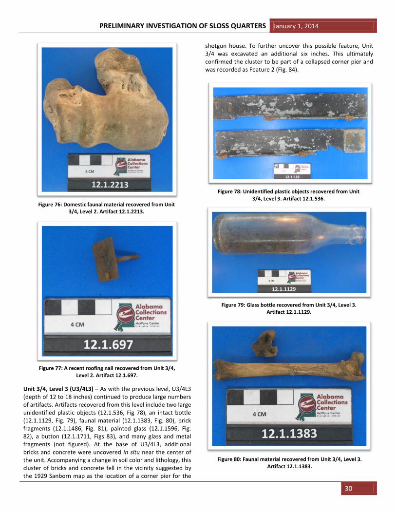
Two 30 inch shovel tests were excavated within the study area (see Fig. 22) for the purpose of examining the subsurface stratigraphy, to verify the presence or absence of industrial overburden, and to collect soil samples for toxicity testing. Shovel test 1 (ST#1, Fig. 22) was excavated to a depth of 18 inches to what was interpreted to be sterile soils. The following three distinct stratigraphic layers were apparent within the pit (Fig. 24): • Layer 1: Depth of 1 to 8 inches. 10YR 5/1, silty loam and silty sand. This layer contained some cultural materials including glass and iron fragments. • Layer 2: Depth of 8 to 11.5 inches. 10YR 8/2, silty sand. This layer is interpreted to be a cultural layer based on the large concentration of cultural materials. Although only 3.5 inches thick, this layer contained a noticeable concentration of iron fragments, glass, and furnace slag. • Layer 3: Depth of 11.5 to 18 inches. 10YR 4/4, Mottled silty sandy clay. This layer contained a few scattered pieces of furnace slag near the upper portion. The lower half of the layer was absent of cultural material and interpreted to be sterile.
PRELIMINARY INVESTIGATION OF SLOSS QUARTERS January 1, 2014
18
Shovel test 2 (ST#2, Fig. 22) was excavated to a depth of 13 inches before hitting a series of historic metal pipes. This shovel test revealed two distinct layers (Fig. 25), but also a great amount of subsurface disturbance. In contrast to ST#1, the strata within this test pit was composed largely of gravel and rocks. Cultural material, mostly glass and iron fragments, were abundant in this test pit, however, the material was more widely distributed and not concentrated in a distinct layer as in ST#1. Due to the presence of a disturbed gravel substrate and unmarked historic utilities in the location of ST#2, it was decided to continue the investigation in the location of ST#1.
Archaeological Units
A total of three 5 ft. by 5 ft. units were excavated within the study area (Fig. 23). Units 1 and 2 were excavated initially, with Unit 3/4 established soon after to expose additional subsurface features. The units were placed and orientated in a way that provided the greatest potential of exposing sub-surface piers belonging to the former worker houses as seen on the historic Sanborn maps (see Section 2: Historical Maps and Photographs of the Study Area). Units were excavated in six inch levels. A detailed summary of the excavation of each unit is provided below. Unit 1, Level 1 (U1L1) – Once excavation began of Unit 1, it was apparent that level 1, the top soil (depth of 0 to 6 inches), had been previously disturbed. The southwest corner of the unit was purposely aligned on the top of a shallow mound for the purpose of determining if this mound was a historic feature. It was determined that the mound was composed of sand which was likely transported and dumped on this area of the site. As a result, some screening of this disturbed soil was conducted for “practice,” but a majority of the level 1 soil was removed but not screened. During the excavation of this unit, a small ”L-shaped” section in the southwest corner was left unexcavated due to the instability of this sandy mound. This helped reduce the risk of this corner of the sidewall collapsing into the unit. Although a number of artifacts (176) were recovered from U1L1, 59% (103 of 176) were broken shards of glass. However, near the base of U1L1, several notable artifacts were recovered. These included a metal tapping spile (12.1.624, Fig. 26), used for extracting sap from various trees; an intact bottle (12.1.841, Fig. 27), suggesting there was minimal disturbance at the base of this level, and a World War II dog tag belonging to a Mr. Walter J. Fallon (12.1.186, Fig 28). Artifact 12.1.186 is discussed further in the Historical Context section (p. 34) of this report. No visible features were present within U1L1.
Figure 24: Three distinct layers within Shovel Test 1.
Figure 25: Shovel Test 2.
Figure 26: Tree tapping spile recovered from Unit 1, Level 1.
Artifact 12.1.624.

January 1, 2014 PRELIMINARY INVESTIGATION OF SLOSS QUARTERS
19
Unit 1, Level 2 (U1L2) – U1L2 (depth of 6 to 12 inches) produced more artifacts (1980) than any level within any of the three units. A majority being glass (1219, 62% of the total artifacts from U1L2), a large number of metal fragments (558, 28%) including numerous nails, were also recovered. As with U1L1, no features were visible, however, there was a distinct change in soil color from the overlying topsoil (see the Unit Profile, Fig. 52). Coinciding with soil change was the recovery of a number of noteworthy artifacts including: ample faunal material (see Faunal Analysis, p. 33); painted ceramics (12.1.1127; 12.1.1760; Figs. 29-30); medicine and beauty bottles (12.1.128; 12.1.1477, 12.1.1781; Figs. 31-33); soda bot-tles (12.1.839; 12.1.977; Figs. 34, 35); a metal measuring cup (12.1.973; Fig. 36); a bone button (12.1.1056; Fig. 37); a metal spoon (12.1. 1372, Fig. 38); a marble (12.1.1756; Fig. 39); a tube of dental crème (12.1.1781; Fig. 40); hundreds of nails
(12.1.2124; Fig. 41) and broken pieces of glass (12.1.538; Fig. 42); and a second military dog tag (12.1.1656; Fig. 43), this one belonging to Cornelius Harris.
Figure 27: An intact bottle recovered from Unit 1, Level 1. Artifact 12.1.841.
Figure 28: Military dog tag recovered from Unit 1, Level 1.
Artifact 12.1.186.
Figure 29: Painted Japanese ceramic artifact from Unit 1, Level 2.
Artifact 12.1.1127.
Figure 30: Example of a painted ceramic fragment from Unit 1,
Level 2. Artifact 12.1.1760.
Figure 31: A glass beauty bottle from Unit 1, Level 2.
Artifact 12.1.128.

PRELIMINARY INVESTIGATION OF SLOSS QUARTERS January 1, 2014
20
Figure 33: Example of a glass beauty bottle from Unit 1, Level 2.
Artifact 12.1781).
Figure 32: Example of a glass medicine bottle from Unit 1, Level 2.
Artifact 12.1477.
Figure 34: Example of a glass soda bottle from Unit 1, Level 2.
Artifact 12.1.839.
Figure 35: A glass Zimba Cola soda bottle from Unit 1, Level 2.
Artifact 12.1.977.
Figure 36: A metal measuring cup from Unit 1, Level 2.
Artifact 12.1.973.
Figure 37: A bone button recovered from Unit 1, Level 2.
Artifact 12.1.1056.

January 1, 2014 PRELIMINARY INVESTIGATION OF SLOSS QUARTERS
21
Figure 38: A metal spoon from Unit 1, Level 2.
Artifact 12.1.1372.
Figure 39: A glass marble from Unit 1, Level 2.
Artifact 12.1.1756.
Figure 40: A metal tube of dental crème from Unit 1,
Level 2. Artifact 12.1.1757.
Figure 41: Examples of nails recovered from Unit 1,
Level 2. Artifact 12.1.2124.
Figure 42: Examples of glass fragments recovered from Unit 1, Level 2. Artifact 12.1.538.
Figure 43: A military dog tag recovered from Unit 1, Level 2. Artifact 12.1.1656.

PRELIMINARY INVESTIGATION OF SLOSS QUARTERS January 1, 2014
22
At the base of U1L2, an intact brick was discovered in the southwestern corner alongside several pieces of in situ glass shards (see Fig. 44). With the discovery of this brick, the decision was made to excavate the southeastern corner of the unit with the hopes of uncovering a brick support pier.
Unit 1, Level 3 (U1L3) – U1L3 (depth of 12 to 18 inches) consisted of the excavation of a 2.5 x 3 foot section within the southeastern corner of Unit 1 (see Fig. 45). U1L3 was excavated in this manner with hopes of uncovering a brick support pier that would have once supported the base of one of the former
shotgun houses. During the excavation of U1L3, artifacts were noticeably clustered within this corner. Noteworthy artifacts recovered include a large plate fragment (12.1.972; Fig. 47), butchered cow bones (12.1.2232; Fig. 48), an intact snuff bottle (12.1.2230; Fig. 49), and many glass shards and rusted nails (12.1.1899 and 12.1.1901; Figs. 50-51).
Figure 44: Top – Photograph of the base of Unit 1, Level 2, facing west. Bottom: Line drawing of the base of Unit 1, Level 2, facing west. A = Brick; B = Rectangular glass base; C = Glass fragment; D = In situ Soda bottle fragment within the east-facing wall; E = Circular grass fragment.
Figure 45: Top – Photograph of the base of Unit 1, Level 3, facing west. Bottom – Line drawing of the base of Unit 1, Level 3, facing west.

January 1, 2014 PRELIMINARY INVESTIGATION OF SLOSS QUARTERS
23
At the base of U1L3, two metal pipes were uncovered in situ that were extruding from the north and east side walls of the section excavated (Fig. 46 A-B). These pipes were not recovered as they extended a great depth into the side walls. Also uncovered at the base of this level was a small scattering of bricks, stones (Fig. 46 C-G), and bone fragments (Fig. 46 H-J), as well as a large shard of glass (Fig. 46 K). While intriguing, we could not consider this grouping a feature as the remainder of this unit was not excavated to this depth (18 inches) and a larger context was not discernable from what was visibly uncovered.
Figure 46 (Top): Close-up line drawing of the base of the excavated section of Unit 1, Level 3, facing west. A-B = Metal pipes; C-G = Brick and stone fragments; H-J = Bone fragments; K = Glass shard.
Figure 47: Plate fragment recovered from Unit 1, Level 3. Artifact 12.1.972.
Figure 48: Butchered cow atlas vertebra recovered from Unit 1, Level 3. Artifact 12.1.2232.
Figure 49: An intact snuff bottle recovered from Unit 1, Level 3. Artifact 12.1.2230.
Figure 50: Glass shards recovered from Unit 1, Level 3. Artifact 12.1.1899.

PRELIMINARY INVESTIGATION OF SLOSS QUARTERS January 1, 2014
24
Unit 1 Profile – Unit 1 was excavated to a depth of 18 inches which revealed three distinct stratigraphic layers. As illustrated in the west wall profile (Fig. 52), the northern 2/3rds of the ground surface of Unit 1 slopes roughly seven degrees to the north to where the northwest corner sits nearly 6 inches lower than the southwest corner of the unit. This change in topography is a result of the aforementioned sand pile. Each of the visible subsurface strata was distinguished by their clear change in soil color and composition (see Fig. 52). As seen in ST #1 (Fig. 24), the three distinct strata in Unit 1 were as follows:
Stratum 1: 10YR 5/1 – Grass, topsoil, disturbed silty loam and silty sand.
Stratum 2: 10YR 8/2 – Silty sand.
Stratum 3: 10YR 4/4 – Mottled silty sandy clay.
Unit 2, Level 1 (U2L1) – Separated by a bulk, Unit 2 was established directly east of Unit 1 (Fig. 23) and excavated in parallel. Much like Level 1 of Unit 1, the top level (depth of 0 to 6 inches) of Unit 2 showed similar signs of surface disturbance. As a result, U2L1 was removed, artifacts were collected, but most of the topsoil was not screened. Noteworthy artifacts recovered from U2L1 include rusty nails (12.1.263, Fig. 53), a glass lid from a Ball jar (12.1.479, Fig. 55), and a rusty bastard file (12.1.261, Fig. 55).
Figure 51: Rusty nails recovered from Unit 1, Level 3. Artifact 12.1.1901.
Figure 52: West wall profile of Unit 1. Grid increment = 6 inches.
Figure 53: Rusty nails recovered from Unit 2, Level 1. Artifact 12.1.263.

January 1, 2014 PRELIMINARY INVESTIGATION OF SLOSS QUARTERS
25
Unit 2, Level 2 (U2L2) – Much like U1L2, the second level within this unit (depth of 6 to 12 inches) also produced a large number of artifacts. Clusters of artifacts were noticeable beginning at a depth of 10 to 11 inches, with concentrations of artifacts visible beyond the base of this level. Notable artifacts recovered include intact medicine bottles (12.1.232, 12.1.1128, and 12.1.1709; Figs. 56-58), faunal material (i.e. 12.1.736, Fig. 59), an intact hot sauce bottle (12.1.974, Fig. 60), soda bottles (i.e. 12.1.2306, Fig. 61), glazed stoneware fragments (i.e. 12.1.473, Fig. 62), brick fragments (i.e. 12.1.1539, Fig. 63), dozens of rusty nails and iron fragments (not figured), and hundreds of fragments of glass of various colors. During the course of the excavation of this level, several artifacts were pedestaled with the thought they could be part of a larger feature.
Figure 54: A glass lid from a Ball jar recovered from Unit 2, Level 1. Artifact 12.1.479.
Figure 55: A rusty bastard file recovered from Unit 2, Level 1. Artifact 12.1.479.
Figure 56: Medicine bottle recovered from Unit 2, Level 2. Artifact 12.1.232.
Figure 57: Medicine bottle and cap recovered from Unit 2, Level 2. Artifact 12.1.1128.
Figure 58: Medicine bottle recovered from Unit 2, Level 2. Artifact 12.1.1709.

PRELIMINARY INVESTIGATION OF SLOSS QUARTERS January 1, 2014
26
At the base of U2L2, two articulated bricks (Fig. 65A) were uncovered alongside a cluster of stone and mortar fragments within the southeast quadrant of the unit (Fig. 64). This scattering of brick and stone appeared to be the remains of a pier which would have been used to support one of the former shotgun houses. This cluster of artifacts was recorded as the first true feature (Feature 1) uncovered at the site.
Unit 2, Level 3 (U2L3) – In an attempt to uncover more of the aforementioned Feature 1, the southwest quadrant of Unit 2 was excavated an additional six inches (depth of 12 to 18 inches). The excavation of U2L2 did indeed reveal more of Feature 1 including four large stones and a scatter of smaller stone and brick fragments (Fig 65). This unit also produced a noticeably large amount of faunal material as well as noteworthy artifacts such as a Vicks bottle (12.1.861, Fig. 66), a glass marble (12.1.349, Fig. 67), a button (12.1.1215, Fig. 68), and ample iron and glass fragments (not figured).
Figure 59: Cow calcaneus recovered from Unit 2, Level 2. Artifact 12.1.736.
Figure 60: Hot sauce bottle recovered from Unit 2, Level 2. Artifact 12.1.974.
Figure 61: Base of a soda bottle recovered from Unit 2, Level 2. Artifact 12.1.2306.
Figure 62: Glazed stoneware fragment recovered from Unit 2, Level 2. Artifact 12.1.473.
Figure 63: Brick fragment recovered from Unit 2, Level 2. Artifact 12.1.473.

January 1, 2014 PRELIMINARY INVESTIGATION OF SLOSS QUARTERS
27
Figure 64: Facing west, this photograph shows the base of Unit 2, Level 2, revealing the top of the brick and stone pier feature in the southeast corner of the unit.
Figure 65: Top – Photograph of the base of Unit 2, Level 3, facing west. Bottom – Line drawing of Feature 1 (a pier) uncovered at the base of Levels 2 and 3 within Unit 2, facing west. A = Articulated bricks. B = In situ piece of rebar.
Figure 66: Intact Vicks bottle recovered from Unit 2, Level 3. Artifact 12.1.861.
Figure 67: Glass marble recovered from Unit 2, Level 3. Artifact 12.1.349.
Figure 68: Button recovered from Unit 2, Level 3. Artifact 12.1.1215.

PRELIMINARY INVESTIGATION OF SLOSS QUARTERS January 1, 2014
28
Unit 2 Profile – Unit 2 was excavated to a depth of 20 inches which revealed the same three stratigraphic layers present in Unit 1. Unlike Unit 1, however, Unit 2 was placed a good distance from the dumped sand pile, so less of this disturbed soil was present. As illustrated in the west wall profile (Fig. 69), the surface of Unit 2 slopes to the south to where the southwest corner sits just over 4 inches below the northwest corner of the unit. As with Unit 1, each of the visible subsurface strata was distinguished by their clear change in soil color and lithology. The distinct strata exposed in this unit were as follows:
Stratum 1: 10YR 5/1 – Grass, topsoil, disturbed silty loam and silty sand.
Stratum 2: 10YR 8/2 – Silty sand. Abundant artifacts present.
Stratum 3: 10YR 4/4 – Mottled silty sandy clay. Visible feature present.
Unit 3/4 – Shortly after the discovery of Feature 1, its location was plotted on the 1929 Sanborn map. After doing so, it became apparent that the uncovered feature was more than likely the center pier of the duplex shotgun house located directly to the east of the Doctor’s office (Fig. 70). With this in mind, the decision was made to open an additional five foot by five foot unit directly west of Unit 1 (Fig. 23) in an attempt to uncover the adjoining corner pier from the same structure. Using the 1929 Sanborn, it was estimated that the corner pier of the structure was located approximately 15 feet west of
Feature 1 (Fig. 70). Originally, two additional five foot by five foot units (Units 3 and 4) were laid out directly west of Unit 1 (Fig. 23). However, because the estimated location of the corner pier fell right on the mid-line of the two newly established units, the decision was made to excavate a five by five foot unit directly in the middle of Units 3 and 4, thusly called Unit 3/4. However, the mid-line separating Units 3 and 4 was retained allowing artifacts to be recorded as to which side of Unit 3/4 they were recovered.
Unit 3/4, Level 1 (U3/4L1) – Due to time constraints, the soil within Unit 3/4 was “skimmed” using flat-head shovels and screened. Once the sod cap was removed, it had become evident that U3/4L1 (depth of 0 to 6 inches) was disturbed as a layer of sand was revealed which became gradually thicker towards the east wall of the unit. Being inconsistent in color and lithology from the Level 1 soils removed from Units 1 or 2, it was concluded that this sand was likely dumped in this location in a pile, the center of which was bisected by the southeast corner of Unit 3/4. Artifacts recovered from this sandy layer, such as galvanized nails (12.1.2050, Fig. 70) and plastic shelf brackets (12.1.2048, Fig. 71), suggest they are more recent in origin.
Figure 70: 1929 Sanborn Map of Sloss Quarters overlain with (A) the location of Feature 1 and (B) the estimated location of the corner pier targeted within this investigation.
Figure 69: West wall profile of Unit 2. Grid increment = 6 inches.

January 1, 2014 PRELIMINARY INVESTIGATION OF SLOSS QUARTERS
29
Unit 3/4, Level 1 (U3/4L2) – Due to time constraints, parts of Unit 3/4 was excavated with flathead shovels. Level 1 of this unit (depth of 0 to 6 inches) showed the same subsurface disturbance of Units 1 and 2 as the northeast corner of the Unit 3/4 cut through the center of the same sand pile documented in Unit 1. Although disturbed, the sand from this level was screened and artifacts were recovered. Several of these artifacts, including a galvanized nail (12.1.2050, Fig. 71) and a plastic shelf bracket (12.1.2048, Fig. 72), further suggest that the sand pile was more recent in origin and likely deposited after the occupation of Sloss Quarters.
Unit 3/4, Level 2 (U3/4L2) – During the excavation of U3/4L2, it was observed that the top of this level showed a slight change in soil color, however the presence of large amounts of sand suggested this level was previously disturbed. The soil color and lithology changed again the base of this level, and artifacts were more plentiful. Noteworthy artifacts recovered from the base of U3/4L2 include an intact brick (12.1.533, Fig. 73), a glass marble (12.1.715. Fig 74), a porcelain light fixture (12.1.2181, Fig. 75), faunal material (12.1.2213, Fig. 76), and large numbers of rusty nails and broken glass (not figured). Artifacts recovered from the top of this level, such as roofing
nails of modern design (12.1.697), further suggest the top of this level was disturbed.
Figure 71: A galvanized nail recovered from Unit 3/4, Level 1. Artifact 12.1.2050.
Figure 72: A plastic shelf bracket recovered from Unit 3/4, Level 1. Artifact 12.1.2048.
Figure 73: A brick recovered from Unit 3/4, Level 2. Artifact 12.1.533.
Figure 74: A glass marble recovered from Unit 3/4, Level 2. Artifact 12.1.715.
Figure 75: A porcelain light fixture recovered from Unit 3/4, Level 2. Artifact 12.1.2181.
PRELIMINARY INVESTIGATION OF SLOSS QUARTERS January 1, 2014
30
Unit 3/4, Level 3 (U3/4L3) – As with the previous level, U3/4L3 (depth of 12 to 18 inches) continued to produce large numbers of artifacts. Artifacts recovered from this level include two large unidentified plastic objects (12.1.536, Fig 78), an intact bottle (12.1.1129, Fig. 79), faunal material (12.1.1383, Fig. 80), brick fragments (12.1.1486, Fig. 81), painted glass (12.1.1596, Fig. 82), a button (12.1.1711, Figs 83), and many glass and metal fragments (not figured). At the base of U3/4L3, additional bricks and concrete were uncovered in situ near the center of the unit. Accompanying a change in soil color and lithology, this cluster of bricks and concrete fell in the vicinity suggested by the 1929 Sanborn map as the location of a corner pier for the
shotgun house. To further uncover this possible feature, Unit 3/4 was excavated an additional six inches. This ultimately confirmed the cluster to be part of a collapsed corner pier and was recorded as Feature 2 (Fig. 84).
Figure 76: Domestic faunal material recovered from Unit 3/4, Level 2. Artifact 12.1.2213.
Figure 77: A recent roofing nail recovered from Unit 3/4, Level 2. Artifact 12.1.697.
Figure 78: Unidentified plastic objects recovered from Unit 3/4, Level 3. Artifact 12.1.536.
Figure 79: Glass bottle recovered from Unit 3/4, Level 3. Artifact 12.1.1129.
Figure 80: Faunal material recovered from Unit 3/4, Level 3. Artifact 12.1.1383.

January 1, 2014 PRELIMINARY INVESTIGATION OF SLOSS QUARTERS
31
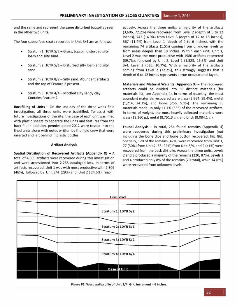
Unit 3/4 Profile (Fig. 85) – Unit 3/4 was excavated to a depth of 24 inches which revealed a total of three stratigraphic layers. Stratum 1 was composed of a disturbed layer of silty sand which gradually blended with Stratum 2, which was very similar in color and lithology. Stratum 3 showed a distinct change in color and lithology and also contained a majority of the artifacts within the unit as well as the top of Feature 2. Stratum 4, while also a different color and lithology, produced few artifacts aside from the aforementioned brick and concrete cluster that made up Feature 2. The Unit 3/4 profile differs slightly than those recorded in Units 1 and 2 as four layers of subsurface strata were observed as opposed to three. However, although Strata 1 and 2 differed slightly in color, they were lithologically very similar. These two units are likely one
Figure 81: Brick fragment recovered from Unit 3/4, Level 3. Artifact 12.1.1486.
Figure 82: Painted glass fragments recovered from Unit 3/4, Level 3. Artifact 12.1.1596.
Figure 83: Plastic button recovered from Unit 3/4, Level 3. Artifact 12.1.1711.
Figure 84: Top – Photograph of the base of Unit 3/4, Level 3, facing west. Bottom – Line drawing of Feature 2 (a corner pier) uncovered at the base of Level 3 within Unit 3/4, facing west. A = In situ piece of rebar. B = Articulated tiles.
PRELIMINARY INVESTIGATION OF SLOSS QUARTERS January 1, 2014
32
and the same and represent the same disturbed topsoil as seen in the other two units. The four subsurface strata recorded in Unit 3/4 are as follows:
Stratum 1: 10YR 5/2 – Grass, topsoil, disturbed silty loam and silty sand.
Stratum 2: 10YR 5/1 – Disturbed silty loam and silty sand.
Stratum 2: 10YR 8/2 – Silty sand. Abundant artifacts and the top of Feature 2 present.
Stratum 3: 10YR 4/4 – Mottled silty sandy clay. Contains Feature 2.
Backfilling of Units – On the last day of the three week field investigation, all three units were backfilled. To assist with future investigations of the site, the base of each unit was lined with plastic sheets to separate the units and features from the back fill. In addition, pennies dated 2012 were tossed into the lined units along with notes written by the field crew that were inserted and left behind in plastic bottles.
Artifact Analysis
Spatial Distribution of Recovered Artifacts (Appendix X) – A total of 4,989 artifacts were recovered during this investigation and were accessioned into 2,268 cataloged lots. In terms of artifacts recovered, Unit 1 was with most productive with 2,309 (46%), followed by Unit 3/4 (29%) and Unit 2 ( 24.6%), resp-
ectively. Across the three units, a majority of the artifacts (3,606, 72.2%) were recovered from Level 2 (depth of 6 to 12 inches), 742 (14.9%) from Level 3 (depth of 12 to 18 inches), 567 (11.4%) from Level 1 (depth of 0 to 6 inches), with the remaining 74 artifacts (1.5%) coming from unknown levels or from areas deeper than 18 inches. Within each unit, Unit 1, Level 2 was the most productive with 1980 artifacts recovered (39.7%), followed by Unit 2, Level 2 (1,323, 26.5%) and Unit 3/4, Level 3 (536, 10.7%). With a majority of the artifacts coming from Level 2 (72.2%), this strongly suggests that a depth of 6 to 12 inches represents a true occupational layer. Materials and Material Weights (Appendix X) – The recovered artifacts could be divided into 38 distinct materials (for materials list, see Appendix 4). In terms of quantity, the most abundant materials recovered were glass (2,964, 59.4%), metal (1,214, 24.3%), and bone (256, 5.1%). The remaining 35 materials made up only 11.1% (555) of the recovered artifacts. In terms of weight, the most heavily collected materials were glass (13,360 g.), metal (8,751.3 g.), and brick (8,084.1 g.). Faunal Analysis – In total, 254 faunal remains (Appendix 4) were recovered during this preliminary investigation (not including the bone dice and bone button recovered; Fig. 86). Spatially, 120 of the remains (47%) were recovered from Unit 1, 77 (30%) from Unit 2, 55 (22%) from Unit 3/4, and 2 (>1%) were recovered from the back dirt pile. Across the three units, Levels 2 and 3 produced a majority of the remains (220, 87%). Levels 1 and 4 produced only 8% of the remains (20 total), while 14 (6%) were recovered from unknown levels.
Figure 85: West wall profile of Unit 3/4. Grid increment = 6 inches.

January 1, 2014 PRELIMINARY INVESTIGATION OF SLOSS QUARTERS
33
Unit 1 Unit 2 Unit 3/4 Unknown Total
Level 1 3 1 1 NA 5
Level 2 57 35 14 2 108
Level 3 48 26 38 NA 112
Level 4 NA 15 NA NA 15
Unknown 12 NA 2 NA 14
Total 120 77 55 2 254
A preliminary analysis of the faunal material was undertaken by the lead author (Ebersole) with the following 16 taxa being identified. All of the identified taxa (in bold) are listed in terms of number of identified specimens, NISP: Aves (Bird) = 9 Passeriformes Turdidae
cf. Turdus migratorius (American robin) = 2
Galliformes Phasianidae Gallus gallus domesticus
(Chicken) = 3 Mammalia (Mammal) = 132
Artiodactyla Bovidae Bos taurus (Cow) = 15 Cervidae Odocoileus virginianus
(White-tail deer) = 18 Suidae Sus scrofa (Pig) = 21 Carnivora Canidae cf. Vulpes sp. (Fox) = 1 Mustelidae Martes pennanti (Fisher) = 3 Cingulata Dasypodidae cf. Dasypus novemcinctus
(Nine-banded armadillo) = 1 Lagomorpha (Rabbit or Hare) = 3 Leporidae Sylvilagus sp. (Cottontail) = 2 Rodentia (Rodent – medium sized) = 9 Castoridae Castor canadensis (Beaver) = 1 Rodentia (Rodent – small) = 21 Muridae Rattus norvegicus (Norway rat) = 2 Reptilia (Reptile) = 1 Testudines (Turtle) = 2 Unknown = 4 Total = 254
All faunal material was examined for the presence of cut/ butcher, teeth, and burn marks, as well as for spiral fracturing.
Of these taphonomic agents, 26% percent (NISP = 65) showed physical evidence of cut or butcher marks, one specimen showed potential evidence of spiral fracturing, two specimens showed signs of being burned, while none exhibited any visible teeth marks. The cut and butcher marks are present in two forms: 1) as “scratches” on the bone produced during the removal of meat (Fig. 87); and 2) as “slices” where bone has been completely cut in half during the butchering of a animal (Fig. 88).
The diversity of taxa identified from the site suggests the diet of the residents at Sloss Quarters regularly included both domestic animals and wild game. The presence of the remains of animals such as a turtle and fisher, animals that are not found in the vicinity of Sloss Furnaces, suggests residents may
Figure 87: Example of cut marks on the surface of a pig bone. Artifact 12.1.1389.
Figure 88: Example of a butchered pig bone. Artifact 12.1.1389.
Figure 86: Spatial distribution of recovered faunal remains.
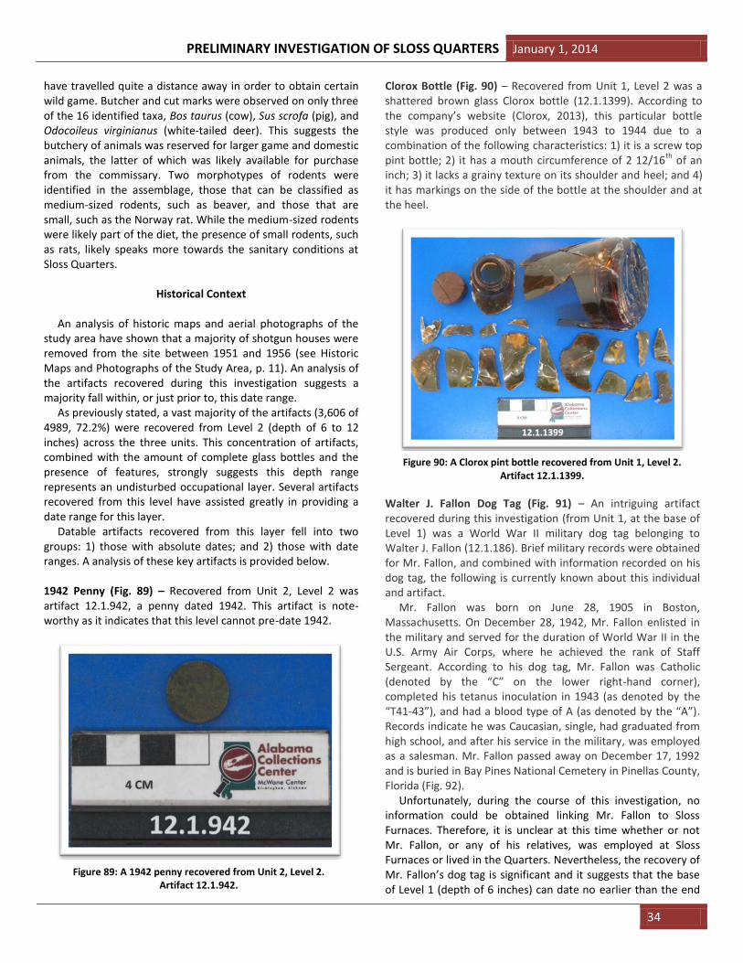
PRELIMINARY INVESTIGATION OF SLOSS QUARTERS January 1, 2014
34
have travelled quite a distance away in order to obtain certain wild game. Butcher and cut marks were observed on only three of the 16 identified taxa, Bos taurus (cow), Sus scrofa (pig), and Odocoileus virginianus (white-tailed deer). This suggests the butchery of animals was reserved for larger game and domestic animals, the latter of which was likely available for purchase from the commissary. Two morphotypes of rodents were identified in the assemblage, those that can be classified as medium-sized rodents, such as beaver, and those that are small, such as the Norway rat. While the medium-sized rodents were likely part of the diet, the presence of small rodents, such as rats, likely speaks more towards the sanitary conditions at Sloss Quarters.
Historical Context
An analysis of historic maps and aerial photographs of the study area have shown that a majority of shotgun houses were removed from the site between 1951 and 1956 (see Historic Maps and Photographs of the Study Area, p. 11). An analysis of the artifacts recovered during this investigation suggests a majority fall within, or just prior to, this date range. As previously stated, a vast majority of the artifacts (3,606 of 4989, 72.2%) were recovered from Level 2 (depth of 6 to 12 inches) across the three units. This concentration of artifacts, combined with the amount of complete glass bottles and the presence of features, strongly suggests this depth range represents an undisturbed occupational layer. Several artifacts recovered from this level have assisted greatly in providing a date range for this layer. Datable artifacts recovered from this layer fell into two groups: 1) those with absolute dates; and 2) those with date ranges. A analysis of these key artifacts is provided below. 1942 Penny (Fig. 89) – Recovered from Unit 2, Level 2 was artifact 12.1.942, a penny dated 1942. This artifact is note-worthy as it indicates that this level cannot pre-date 1942.
Clorox Bottle (Fig. 90) – Recovered from Unit 1, Level 2 was a shattered brown glass Clorox bottle (12.1.1399). According to the company’s website (Clorox, 2013), this particular bottle style was produced only between 1943 to 1944 due to a combination of the following characteristics: 1) it is a screw top pint bottle; 2) it has a mouth circumference of 2 12/16
th of an
inch; 3) it lacks a grainy texture on its shoulder and heel; and 4) it has markings on the side of the bottle at the shoulder and at the heel.
Walter J. Fallon Dog Tag (Fig. 91) – An intriguing artifact recovered during this investigation (from Unit 1, at the base of Level 1) was a World War II military dog tag belonging to Walter J. Fallon (12.1.186). Brief military records were obtained for Mr. Fallon, and combined with information recorded on his dog tag, the following is currently known about this individual and artifact. Mr. Fallon was born on June 28, 1905 in Boston, Massachusetts. On December 28, 1942, Mr. Fallon enlisted in the military and served for the duration of World War II in the U.S. Army Air Corps, where he achieved the rank of Staff Sergeant. According to his dog tag, Mr. Fallon was Catholic (denoted by the “C” on the lower right-hand corner), completed his tetanus inoculation in 1943 (as denoted by the “T41-43”), and had a blood type of A (as denoted by the “A”). Records indicate he was Caucasian, single, had graduated from high school, and after his service in the military, was employed as a salesman. Mr. Fallon passed away on December 17, 1992 and is buried in Bay Pines National Cemetery in Pinellas County, Florida (Fig. 92). Unfortunately, during the course of this investigation, no information could be obtained linking Mr. Fallon to Sloss Furnaces. Therefore, it is unclear at this time whether or not Mr. Fallon, or any of his relatives, was employed at Sloss Furnaces or lived in the Quarters. Nevertheless, the recovery of Mr. Fallon’s dog tag is significant and it suggests that the base of Level 1 (depth of 6 inches) can date no earlier than the end
Figure 89: A 1942 penny recovered from Unit 2, Level 2. Artifact 12.1.942.
Figure 90: A Clorox pint bottle recovered from Unit 1, Level 2. Artifact 12.1.1399.

January 1, 2014 PRELIMINARY INVESTIGATION OF SLOSS QUARTERS
35
of WWII in 1945 (since Mr. Fallon served for the duration of the war).
Cornelius Harris Dog Tag (Fig. 93) – A second military dog tag (12.1.1656), this one belonging Cornelius Harris, was recovered from Unit 1, Level 2. Unfortunately, Mr. Harris’ military records could not be obtained, however, his dog tag indicates his blood type was “O” and he was Protestant. Mr. Harris’ tag also indicates he received his tetanus shot in 1944, meaning, like Mr. Fallon, he also served in World War II. At this time it is unclear whether or not Mr. Harris was employed at Sloss Furnaces or had family that lived in the Quarters. However, with his dog tag recovered within the same unit as Mr. Fallon’s,
this could suggest that these two military veterans may have shared this residence.
“Mission Dry Corp” Bottle (Fig. 94) – This bottle (12.1.839), recovered from Unit 1, Level 2, exhibits the distinct trademark on its bottom side consisting of a diamond superimposed over an oval over an “I.” This trademark indicates the bottle was manufactured by the Owens-Illinois Glass Company. To the left of this trademark is the number “9” indicating the bottle was produced in the Streator, Illinois factory and the number “48” imprinted to the right of the logo indicates the year of manufacture, in this case 1948 (Glass Bottle Marks, 2013).
Ceramic with Triumph Design (Fig. 95) – Artifact 2012.1.879 (recovered from Unit 1, Level 2), a ceramic plate fragment, was identified by Dr. Graham Boettcher, Curator of American Art at the Birmingham Museum of Art, as having a distinct Triumph design. Produced by the company American Limoges, this
Figure 91: WWII dog tag belonging to Walter J. Fallon recovered from the base of Unit 1, Level 1. Artifact 12.1.86.
Figure 92: The gravestone of Walter J. Fallon in Bay Pines National Cemetery in Pinellas County, Florida. Photograph
courtesy of Catrina Callahan.
Figure 93: A WWII dog tag belonging to Cornelius Harris recovered from Unit 1, Level 2. Artifact 12.1.1656.
Figure 94: 1948 “Mission Dry Corp.” bottle recovered from Unit 1, Level 2. Artifact 12.1.839.

PRELIMINARY INVESTIGATION OF SLOSS QUARTERS January 1, 2014
36
design was said to be very popular and affordable in the United States in the early 1950’s (Boettcher, pers. comm., 2012).
Owen-Illinois Glass Company Bottles (Figs. 96-98) – Artifact 12.1.839 was not the only bottle recovered that was produced by the Toledo, Ohio-based Owen-Illinois Glass Company. Others include 12.1.977, a complete Zimba Kola bottle (Fig. 96); 12.1.1813, a bottle base (Fig. 97); and 12.1.1877, a bottle base with painted logo on the side (Fig. 98). All recovered from Level 2, all three exhibit the same “diamond superimposed over an oval over and I” trademark. According to the company’s history (Glass Bottle Marks, 2013), this particular combination of symbols was used after 1940 until the mid-to late 1950’s and glass bearing this trademark is very common in trash dumps dating from the 1930’s, 1940’s, and 1950’s.
Owen-Illinois Glass Company Bottle Featuring New Trademark (Fig. 99) – Beginning in 1954, the Owen-Illinois Glass Company began to phase out their old trademark. Over the course of four to five years, the diamond was phased out of the trademark leaving simply and “I” within and “O” (Glass Bottle Marks, 2013). An artifact bearing this trademark, 12.1.841, was recovered from Unit 1, Level 1. This suggests this bottle was manufactured between 1954 and 1959. The slightly later year
Figure 95: A plate fragment with distinct Triumph design recovered from Unit 1, Level 2. Artifact 12.1.879.
Figure 96: A complete Zimba Kola bottle recovered from Unit 1, Level 2. Artifact 12.1.977.
Figure 97: Bottle base fragment recovered from Unit 2, Level 2. Artifact 12.1.1813.
Figure 98: Bottle base fragment recovered from Unit 1, Level 2. Artifact 12.1.1877.

January 1, 2014 PRELIMINARY INVESTIGATION OF SLOSS QUARTERS
37
for this bottle is consistent with the fact that it was recovered from the overlying Level 1 (depth of 0 to 6 inches).
Knox Bottle Company Hot Sauce Bottle (Fig. 100) – A glass hot sauce bottle, 2012.1.974, was recovered from Unit 2, Level 2 that featured a distinct “J in a keystone” trademark. This particular trademark belongs to the Knox Bottle Company of Jackson, Mississippi who manufactured glass bottles from 1932 to 1953 (Glass Bottle Marks, 2013).
Date-range for Level 2 – The ten aforementioned artifacts suggest that all the material recovered from Level 2 across all three units likely date to the late 1940’s to early 1950’s. This date range is consistent with the historical aerial photographs obtained for the site (see Historic Maps and Photographs of the Study Area, p. 11) indicating the majority of the shotgun houses were removed from the study area between the years of 1951 and 1956. This would suggest that the artifacts recovered from Level 2 all date from the final years Sloss Quarters was inhabited.
The Inhabitance of Sloss Quarters From the artifact assemblage recovered during this invest-tigation, the following can be inferred about the residents of Sloss Quarters:
As the historical records indicate, Sloss Quarters was inhabited not only by the Sloss workers, but also by their families. Artifacts such as dice and marbles could certainly suggest the presence of children. Household items such as plates, measuring cups, and spoons certainly suggest a domestic lifestyle.
The notable quantity of medicine bottles recovered suggests such remedies could have been readily available from the doctor’s office or commissary. This also may indicate that Sloss workers were well treated in the event of injury or illness.
Historical records make mention that a number of everyday items and goods were available for purchase from the commissary. Direct evidence for this can be seen by the diversity of soda bottles and other household goods recovered from the site.
The presences of not one, but two military dog tags suggest Sloss Furnaces may have been a good venue for employment for veterans returning from war.
Recovered faunal material suggests the residents at Sloss Quarters had a varied diet that included both domestic animals and wild game. While butchered meat from domestic animals was likely available for purchase from the commissary, residents also appeared to hunt or trap wild game such as deer, fox, and rabbit. Some remains, such as those identified from turtles and fishers, suggest residents may have traveled quite a distance to hunt or trap these animals. This wild game may have also been bartered or swapped.
The recovery of two tree tapping spiles may suggest at least some residents may have been collecting tree sap, perhaps to make turpentine (from pine trees) or syrup (from Southern Sugar Maples).
PART VI: RECOMMENDATIONS
Research Potential
This investigation has shown that the study area contains a largely undisturbed site with great research potential. This research potential can be summarized by the following conclusions:
1. The site shows minimal signs of disturbance. Although some sand dumping has occurred, this disturbance is limited to the top six inches of the site. The recovery of such a large number of intact bottles and other fragile artifacts suggests the shotgun houses were not bulldozed, but instead removed (and relocated) or
Figure 99: Bottle featuring the new Owen-Illinois Glass Company trademark, recovered from Unit 2, Level 2. Artifact 12.1.1813.
Figure 100: Knox Bottle Company hot sauce bottle recovered from Unit 2, Level 2. Artifact 12.1.1813.

PRELIMINARY INVESTIGATION OF SLOSS QUARTERS January 1, 2014
38
dismantled, leaving only their corner and support piers behind.
2. The discovery of two support piers in this investigation assisted in verifying the accuracy of the historic Sanborn maps. For future investigations, the Sanborn maps can be used as a tool to locate additional structures. Dozens of additional structures appear on the Sanborn maps that still are in need of investigation. These structures include additional worker houses as well as those belonging to site managers.
3. A clear cultural layer exists at the site between 6 and 12 inches below the site surface. The sheer number of artifacts recovered during this investigation provides a mere glimpse into the concentration of cultural materials that lies just below the soil surface.
4. The depths of excavation in this investigation were limited due to time restrictions. However, during this study, a definitive cultural layer was discovered that dates from the late 1940’s to early 1950’s. Early maps of the study area indicate structures existed within the study area as far back as 1888, suggesting additional occupational layers may exist at greater depths.
The Need for an Archaeological Plan
As the Sloss complex grows, it is recommended that a comprehensive archaeological plan be in place to guide and assist the planning process. This plan should address the following areas:
Building Complex – The vault, commissary, and doctor’s office are, at present, subject to further deterioration from the elements and efforts should be in place to prevent further loss. The first step in this process is to see if any of the structures are eligible for listing in the National Register of Historic Places (N.R.H.P.). The N.R.H.P. will provide guidelines for their reconditioning. If the structures do not meet the eligibility criteria for the listing on the N.R.H.P., they can still be rehabilitated and repurposed to fit in with the needs of the Sloss. These buildings are the only remaining physical presence of auxiliary structures that reflect the non-working environ-ment of the employees and represent an important page in the history of Sloss. Every effort should be made to preserve them.
Open Area Located North of the 2012 Study Area – This open area is not as empty as the surface would seem to indicate. The excavations of 2012 confirmed that the Sanborn maps can be interpreted with some accuracy. The discovery of foundation structures and other associated features strongly suggests many more features remain intact and undisturbed. While much is known about Sloss Furnaces and its function, little is known about the social/economic conditions of the workers. If construction is anticipated in this area, it is recommended, at minimum, that time be allotted for an archaeological invest-
igation to take place that would target select locations. A series of excavations that would recover a larger sample of artifacts from the foundations would be preferred.
Standardization of Methodology – For any future archaeo-logical investigations on the Sloss property, it is recommended that a standard set of methodology be utilized. These pro-cedures should include:
1. Standard unit sizes. 2. Standard levels. 3. Standard excavation forms for levels, profiles,
features, and field specimen numbers. 4. A master site datum for all of Sloss Furnaces. 5. Standard baseline and transect angles for all ground
disturbing activities. 6. A master archaeological map for Sloss that will
encompass any old or new excavations as well as assist with future planning.
7. A master archaeological plan to govern all future investigations of the site.
REFERENCES CITED
Hughes,A. E., S. Howard, and T. W. Rippstein. 2003. Phase I site
assessment former Sloss commissary building parcel 32nd
Street North and 1
st Avenue North Birmingham, Jefferson
County, Alabama. Project No.: 03BHUSP0301E. Report prepared by Gallet and Associates, Inc. for U.S. Pipe and Foundary Company, Inc., Birmingham, Alabama, August 4, 2003. 104 pp. Report on file at Sloss Furnaces National Historic Landmark, Birmingham, Alabama.
Bergstresser, J. R. 1998. Preliminary Archaeological Testing, Sloss Worker Housing Sloss Furnaces National Historic Landmark. Prepared at: The Anthropology Research Laboratory, The University of Alabama at Birmingham, January 22, 1998. 36 pp. Report on file at Sloss Furnaces National Historic Landmark, Birmingham, Alabama.
Clorox, 2013. Clorox company history. http://www.the cloroxcompany.com. Accessed 10/29/13.
Glass Bottle Marks, 2013. http://www.glassbottlemarks.com. Accessed 11/4/13.
Utz, K. R. 2008. Sloss Furnaces: National Historic Landmark, Birmingham, Alabama. R. L. Ruehrwein, The Creative Company, Lawrenceburg, IN. 24 pp.

January 1, 2014 PRELIMINARY INVESTIGATION OF SLOSS QUARTERS
39
APPENDIX 1: Toxicity results for soil samples taken from ST#1 and ST#2. Soil tests were performed by the Soil Testing Laboratory at Auburn University, Auburn, Alabama.

PRELIMINARY INVESTIGATION OF SLOSS QUARTERS January 1, 2014
40
APPENDIX 2: Spatial distribution of artifacts by material.

January 1, 2014 PRELIMINARY INVESTIGATION OF SLOSS QUARTERS
41
APPENDIX 3: Spatial distribution of materials by weight.
![Some Critics on Maps Concerning on Studies of the Red Seal Ship Trade and the Japanese Quarters in Vietnam [In Japanese]](https://static.fdokumen.com/doc/165x107/63295c196442da5b350b1026/some-critics-on-maps-concerning-on-studies-of-the-red-seal-ship-trade-and-the-japanese.jpg)