advancing rainwater harvesting systems to help mitigate the ...
Experiences of Rainwater Harvesting for Agricultural Production in
the Semi-Arid Marigat District, Kenya
WANJALA WANYONYI NASIREMBE 1 , PETER KUNDU MUSUYA2, CYRIAQUE RUFIN NGUIMALET3
1Kenya Agricultural Research Institute, P.O. Box 100, Molo,[email protected]
2Egerton University, PO Box 536, Njoro, Kenya, [email protected] of Bangui, Bangui, Central African Republic,
This Paper will be an oral Presentation in the area of,
“Strategies for coping with climate change”.

Abstract:
The region around Lake Baringo is inhabited by semi-nomadic
pastoralists of the Njemps Tugen, Turkana and Pokot ethnic groups
which mainly depend on livestock for their livelihood(Kaimba et
al.,2011). However, some crop production takes place. Rainfall is
erratic with an average of about 650mm/year. The main rainy
season starts from March to June. This study was conceived with
the idea of demonstrating various soil and water conservation for
crop development techniques which could be of value in combating
desertification and improving the economic base of the population
of this semi-arid region. Being on the lower side of Kamasia
hills, it is also faced by floods due to runoff and backflow from
Lake Baringo as the lake has no outlet. River Perkerra, which
feeds the lake, receives its water from East Mau Escarpment. The
experiment was set up neart the Marigat Airstrip Field belonging
to Kenya Agricultural Research Institute. In this study the
different water harvesting techniques for crop production were
put in use. Methods that were employed during the study were;
External catchment system, that gently delivered water to a
series of conservation structures; cropped basin, contour ridges,2

semi-circular loops and tied ridges under which pigeon peas,
cowpeas, wheat, and sorghum were tested for productivity. In the
completely randomized block design, the main plot was rain fed
and supplemental moisture source through a cut off drain. The
sub-plot was type(s) of water conservation structures and the
sub-sub plot were the crop types. Although some technically
promising results were obtained, there are still many
constraints. Inhabitants of the study area who should benefit
from this study generally did not accept the recommended
techniques as they were alien to their own experiences or culture
apart from the land ownership system that existed during the
study.
Keywords: Semi-nomadic pastoralists, water harvesting,
agricultural productivity, Marigat District, semi-arid Kenya.
Introduction
The Site near Marigat town lies 0.40N 360 E. It is elevated at
about 980-1200m above sea level. The area has a population of
6 661 (2009) which is projected to 7 259 today (Kenya National
Bureau of Statistics, 2009). The prevailing agro-ecological zone
is IV (Wetangula, et al., 2010) which gets severe as one approach
3

Marigat from Nakuru. The area is served by one perennial river,
Perkerra, Chemeron and two seasonal ones; Endao and Arabel (Fig.
1). The area also hosts the Chemeron dam, a project that has not
met its objectives (KVDA, 2004), due to siltation that has been
attributed to the storms, poor vegetation cover, stock type,
density and mode of livestock rearing. The area is inhabited by
semi-nomadic pastoralists of Pokot, Turkana, Tugen and Njemps
ethnic groups who all depend on livestock for their livelihood.
The soils have been described as young and fragile (Mwasi, 2001).
However, in places where runoff Strategies for coping with
climate change.is not destructive, soil conditions are favorable
for crop cultivation. Rainfall is erratic with an average of
about 650mm/year. The mean annual evaporation is estimated at 2,020
mm per year (JICA/MOARD, 1999).The main rain season is from March
to June. The rest of the year remains dry and windy drying the
ground bare though this situation has been partially mitigated by
the controversial prosopis trees (juliflora and gelinsis)
(Pasiecznik et al., 1995), withstands extreme aridity and goat
browsing in the Republic of Cape Verde. Nitrogen Fixing Tree Research
Reports, 13: 186-188.. The introduction of prosopis was meant to
alleviate livestock feed problem but the residents have seen more
hazards from it than benefits.
In many dry regions of the world, runoff farming was already an
important means of securing sufficient water for agricultural
crops or pasture areas two to three millennia ago. The runoff can
either be diverted directly and spread on the fields or collected4

Lake B aringo
Endao R iver
Lake BogoriaLake b aringo catchm rent.R iversshp.Lakes.Island.
200 0 200 400 K ilom eters
Study AreaK E N Y A
M arigat
S
N
EW
Lake B aringo C atchm ent w here M arigat lies
in some way to be used at a later time (Rosegrant et al., 2001).
The higher the aridity of an area, the larger is the required
catchment area in relation to the cropping area for the same
water yield (Prinz ,2002). On flat land 0-2% together with the
aridity of the location determines the catchment to the cropping
ratio (CCR), which varies from 1:1 to 5:1 Examples are given from
India (Vijayalakshmi et al., 1982) and the USA (Frasier 1994)
(Prinz 1996).The size of the catchment can be (in the case of
micro-catchment) rather small, in the case of macro-catchment and
floodwater it is relatively large and measures must be taken to
route the runoff to the collection area and to prevent
significant infiltration losses.
The statistical analysis revealed that when a suitable crop is
chosen and an appropriate water harvesting system applied under a
fence, yield can increase by up to 300%(1.53t/ha) though still
low compared to those from high potential areas(>5t/ha) in the
case of maize, can keep away food aid. This is one of the areas
in Kenya that have received food aid every year. The study was
conceived with the intention of demonstrating various soil and
5

Lake B aringo
Endao R iver
Lake BogoriaLake b aringo catchm rent.R iversshp.Lakes.Island.
200 0 200 400 K ilom eters
Study AreaK E N Y A
M arigat
S
N
EW
Lake B aringo C atchm ent w here M arigat lies
Figure Lake Baringo Catchment, Marigat and study area
water conservation practices for crop establishment in order to
mitigate desertification effects improve food security and
increase economic power of the local community. Unpredictable
extreme drought and flood in the area has necessitated great
interest in the context of climate change because most of African
communities would need to share those experiences for adoption in
the same conditions. Since land has not been extensively
adjudicated, livestock and crop interference often causes
conflict over meager natural resources. Ostriches for instance
often damage young crops.
Problem
Concerns of food security and water scarcity in the wake of
climate change are global and real particularly in Marigat, arid
areas of Kenya and the sub-Saharan Africa as a whole. As
communities struggle to adapt to the challenges of food
insecurity caused by climate change they are also sensitive to
the diminishing and management problems of resources. It is
anticipated that African countries in particular will endure some
6

of the worst effects of climate change by 2080 causing stress on
water resources and food production (CCAA, 2006).
Water sources in Marigat are rain, river and borehole. Water
scarcity for human and livestock consumption is a common problem
in the district. This is caused by prolonged droughts,
unpredictable rainfall patterns overstocking and uncoordinated
use of existing natural resources. The only perennial river is
Perkerra with a high discharge fluctuation capacity. During dry
periods, its water does not reach Lake Baringo. The little water
that crosses Marigat bridge is diverted and treatment for
domestic use within town and the environs. A significant portion
of the developed scheme farmland has been abandoned due to water
scarcity leading to poor crop performance. Perkerra river bank
erosion; the ever increasing meandering of the river just below
Marigat Bridge has adversely eroded the river banks thus
threatening the scheme intake works and the fields.
Materials and Methods
7

Two hectares of land near Marigat Airstrip were fenced off by a
chain link and divided into two parts, A and B. Tillage was done
before four water conservation structures were constructed. One
plot was rain fed only, the other had an external supplemental
water supply from a cut off drain which was graded at ≈2% so as
to reduce the effects of erosion. Treated seeds were planted
before the onset of rains. With identical experimental layout,
the two fields were planted with Maize, Pigeon peas, sorghum,
Cowpeas and Wheat. The crops were replicated four times in both
plots in a Completely Randomized Block Design under four
different moisture conservation structures. The amount of runoff
flow was controlled by a free board to allow excess water non-
destructive exit to protected area against erosion. The runoff
was trained to fill basins, straight ridges; tied ridges and
finally the semi-circular loops in that order. Effective rainfall
that occurred by physiological maturity of crops was 445mm with
60% as runoff. The rest of the rain occurs during a small peak in
August to October which accounts for the 200mm.
8

The wall wings of the semi-circular loops are constructed on the
same spirit level so as to balance the forces of water being held
by the loop while allowing it opportunity to infiltrate.
Table 1 Experimental layout
WaterRetentionStructure
Supplemented by cutoff runoff (Plot
A)Rain fed only (Plot B)
Basin Maize Sorghum
Cowpea
Pigeonpea
Wheat Maize Sorghu
mCowpea
Pigeonpea
Wheat
StraightRidges
Cowpea
Pigeonpea
Wheat
Sorghum
Maize
Cowpea
Pigeonpea
Wheat
Sorghum
Maize
TiedRidges
Pigeon pea
Cowpea
Maize
Sorghum
Wheat
Pigeon pea
Cowpea
Maize
Sorghum
Wheat
Semi-circularloops
Maize Sorghum
Wheat
Pigeonpea
Cowpea Maize Sorghu
mWheat
Pigeonpea
Cowpea
Weeding was every two weeks. Harvesting started after 2⅓ months
with wheat. In the case of cow pea, only the edible grains were
harvested and mass determined in each plot. Since several crops
were tested and had different values to the consumers, each was
analyzed against the water conservation structure without regard
to interactions.
9

Crops grown in the Basin bed
5m
10cm
3m
Basin
Basins used were mulched depressions dug into the earth 10cm deep
and used to receive water from the diversion drain for ponding to
offer opportunity for infiltration and make it available for
crops. Basins work best on a flat landscape as this allows for an
non destructive runoff (Figure2).
Contour Ridges
The main advantage of ridges is the greater accumulation of
rainwater within the furrows due to the retention of potential
runoff, Figure 3a and 3b.
10
Figure 1 Water Pans

Crops grown here
3-5m
3-5m
Concentration of water in the furrows encourages deeper
percolation, but for this to be useful to a crop, the soil's
available water holding capacity (AWC) must be sufficient to
retain the accumulated water within root zones (Optimizing Soil
Moisture for plant production). Sandy soils with a low AWC may permit a
large
proportion of the rainwater to drain beyond the zone penetrated
by the roots.
Thick clay loams of alluvial origin are found around Marigat and
are very erosive.
11
Figure 3a Contour ridges
Figure 3b Tied Contour ridges

Results and discussions
Table 1. Mean Crop Yield tons/ha
Cut off and rainfed
maize
maize
maize
pigeonpeas
pigeonpeas
pigeonpeas
sorghum
sorghum
sorghum
Cow peas
Cowpeas
Cowpeas
wheat
wheat
wheat
Basin
1.5
3
1.5
2
1.5
6
1.7 1.5 1.9 1 0.8 1.2 0.
1
0.1
2
0.1
5
1.3 1.4 1
Straightridges
0.7 0.8 1.1 1.2 1.2 1.5 1.9 2.3 1.5 0.
23
0.3
2
0.3
1
0.4 0.5 0.
6
Tiedridges
1.2 1.1 1.1 2 2.1 1.8 0.9 0.8 1.2 0.
19
0.1
9
0.2
1
0.8 0.7 0.
9
Semi-circularloops
1.3 1 1.4 2.8 2.7 3.2 2.1 2 1.4 0.
4
0.6 0.5 1.5 1.9 1.
4
Rain fed onlyBasin
1.1 0.8 1.1 0.6 0.7 0.9 0.4 0.4 0.8 0.
8
0.7 0.9 0.7 0.8 0.
9
Straight
0.6 0.5 0.6 0.7 0.9 0.8 1.3 1.7 1.4 0. 0.1 0.1 0.1 0.1 0.
12
Figure 4 Semi-circular loops

ridges
12 3 4 2 7 15
Tiedridges
0.8 0.9 0.7 0.9 0.8 0.8 0.8 0.9 1.1 0.
15
0.1
9
0.1
7
0.4 0.5 0.
6
Semi-circularloops
0.5 0.6 0.4 1.2 1.4 0.9 0.3 0.2 0.4 0.
25
0.2
3
0.3
5
0.1
6
0.1
9
2.
1
The data was found not to be normally distributed. It was also
found not to be homogenous. In this case, the effect of soil and
water conservation structures was analyzed per crop also yields
for different crops could not be compared using yield alone.
A two-way ANOVA was used separately to identify the differences
between cutoff systems and its interactions with different
conservation structures. It was observed that there existed a
significant difference between rain fed and runoff supplemented
field by water from a cut off drain at p≤0.05 in total yield.
Table 2 Effect of source of water to crop yield
13
Source of water
Yield t/Ha
Cut off Drain
1.161A
Rain fed 0.677B

Means with the same letter are not significantly different at
p≤0.05 using lsd.
Difference in means could be attributed to the infiltration rate
which may have inhibited more storage of moisture in the root
zone, supplemented plot or the evaporation rate was too high,
taking away the advantage of diverted runoff.
Conservation methods
It was found that they had no significant effect on the yield at
p≤0.05. The systems varied marginally in the order of Semi
circular loops (1.06t)> Basin(0.93t)> Tied contour ridges
(0.888t)> Contour ridges(0.806t).
Table 3. The effect of conservation structures on mean totalyield t/ha
Conservationstructure
Cutoff
Rainfed
Basin 1.08A 0.76 B
Semi Circular loops
1.46 A 0.67 B
Contour ridges
0.99 A 0.62 B
Tied ContourRidges
1.1 A 0.65B
14
Means with the same letter are not significantly different at
p≤0.05 using lsd.
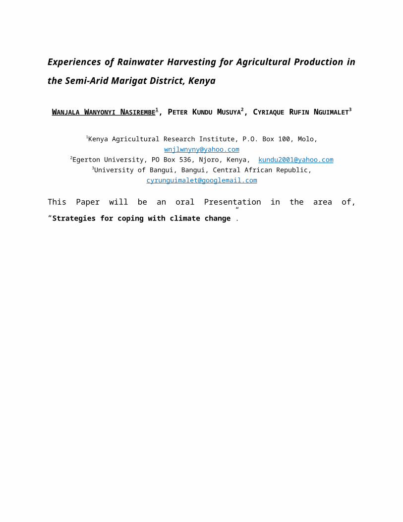
Cow Pea
There was no significant yield difference in cowpeas under rain
fed and supplemented systems at p≤0.05. It could be due to the
factors of infiltration and evaporation as earlier mentioned.
Table 4 Effect of source of water to cow pea yield t/ha
Means with the same letter are not
significantly different at p≤0.05 using lsd.
Water conservation structures were found to have a significant
effect of yield in cowpea production. This could be attributed to
the rooting system and drought tolerance. The height of the crop
could also have been reason for significant performance because
of the lower total biomass at maturity.
Table 5 Effect of conservationstructures on cow pea mean yield t/ha
15
Source of water
Yield t/Ha
Cut off Drain
0.344A
Rain fed 0.277A
Conservation structure
Meant/Ha
Basin 0.456A
Semi Circular loops
0.389B
Contour ridges
0.215C
Tied Contour ridges
0.178C

Means with the same letter are not significantly different at
p≤0.05 using lsd.
Maize
In maize, it was found that the supplemental system from a cut
off and the rainfed type had a significant effect on the maize
yield at p≤0.05. The reason could be the rooting system of maize.
Table 6 Effect of source of water to Maize yield t/ha
Means with the same letter are not
significantly different at p≤0.05 using lsd.
Individual conservation structures had significant effects on the
yield of maize where the basin system was outstanding, yielding
1.26t/ha compared to contour ridges with 0.72t/ha.
16
Source of water
Yield t/Ha
Cut off Drain
1.186A
Rain fed 0.717B

Table 7 Effect of conservation structures on Maize mean yieldt/ha
Means with the same letter are not
significantly different at p≤0.05
using lsd.
Pigeon Pea
It was found that supplemental system and the rain fed only had a
significant effect on the yield at p≤0.05. The reason could be
the rooting system of and the duration of flowering which is
normally longer than annual crops. The crop showed high
adaptability to the harsh conditions.
Table 8 Effect of source of water to Pigeon pea yield t/ha
17
Conservation structure
Meant/Ha
Basin 1.256A
Semi Circular loops
0.967B
Contour ridges
0.867BC
Tied Contour ridges
0.717C
Source of water
Yield t/Ha
Cut off Drain
1.863A
Rain fed 0.950B
Means with the same letter are not significantly different at
p≤0.05 using lsd.
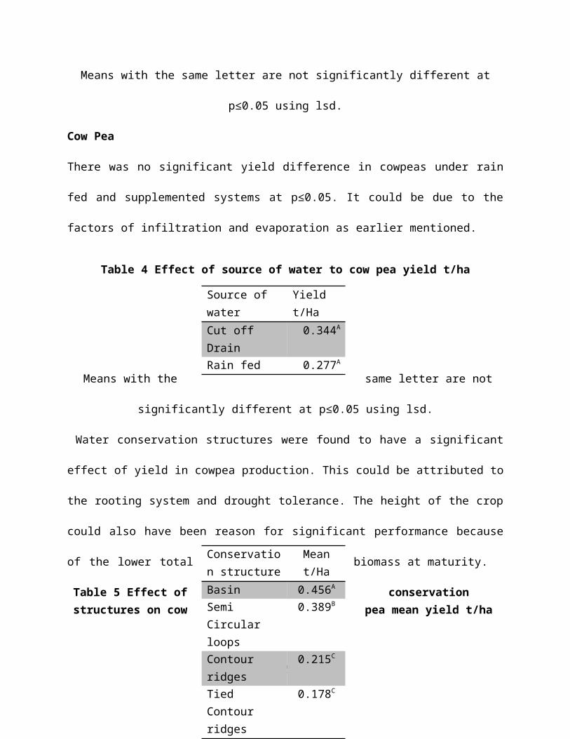
Individual conservation structures had no significant effects on
the yield of pigeon pea where in the semi-circular loops system
the yield was 1.783t/ha compared to contour ridges with 1.1t/ha.
Specific conservation structures that were used to test the crop
did not have a significant effect on the yield of pigeon pea. The
exceptional performance by the pea can be attributed to the
physiological set up of the crop.
Table 9 Effect of conservation structures on Pigeon Pea meanyield t/ha
18
Conservation structure
Meant/Ha
Basin 1.783A
Semi Circular loops
1.650A
Contour ridges
1.133A
Tied Contour ridges
1.100A

Means with the same letter are not significantly different at
p≤0.05 using lsd.
Sorghum
In sorghum, it was found that the supplemental system from a cut
off and the rain fed type had a significant effect on yield at
p≤0.05. The crop responded to supplemental water that increased
the yield by about 50% as compared to the rain fed crop.
Table 10 Effect of source of water to Pigeon pea yield t/ha
Means with the same letter are not
significantly different at p≤0.05 using lsd.
There was significant effects on the yield of sorghum among
conservation structures where in the contour ridges the yield was
1.683t/ha compared to the basin system with 0.767t/ha. This crop
seems to be susceptible to water logging since all three systems
have a tendency to pond other than contour ridges. There was no
significant difference in yield of sorghum in the three water
ponding systems.
19
Source of water
Yield t/Ha
Cut off Drain
1.425A
Rain fed 0.809B

Table 11 Effect of conservation structures on Sorghum mean yield
t/ha
Means with the same letter are not
significantly different at p≤0.05
using lsd.
Wheat
Wheat generally a temperate crop performs well at high altitudes.
Marigat is at below 1500m amsl. This may have been the reason why
the rain fed and supplemental systems did not have a significant
difference in yield at p≤0.05.
Table 12 Effect of source of water to Wheat yield t/ha
20
Conservation structure
Meant/Ha
Contour ridges
1.683A
Semi Circular loops
1.066B
Tied Contour ridges
0.950B
Basin 0.767B
Source of water
Yield t/Ha
Cut off Drain
1.033A
Rain fed 0.566A

Means with the same letter are not significantly different at
p≤0.05 using lsd.
Soil and water conservation structures had a significant effect
on the yield in wheat at p≤0.05. Semi-circular loops had a yield
of 1.206t/ha as compared to that of contour ridges of
0.323t/ha.
Conclusion
These experiences of water harvesting (rainfall, river, borehole,
traditional wells etc) for agricultural production combined with
the appropriate selection of a high yielding crop and
conservation method in the studied area is a technique for
mitigating climate change impacts in Africa as most of the
population are farmers and pastoralists, who solely depend on
arable land rain water, and pastures for subsistence livelihood.
21

References1. CCAA (2006). Climate change adaptation in Africa. Research
and capacity development programme., p 18-19
2. Pasiecznik et al., 199), N.M., Vera Cruz, M.T. & Harris,
P.J.C. 1995. Prosopis juliflora
3. Optimizing Soil Moisture for plant production, The Significance of soil
porosity, p 51
4. Frasier, G. W. 1994, Water Harvesting/Runoff Farming Systems
for Agricultural Production. In: FAO, Water Harvesting For
Improved Agricultural Production. Expert Consultation,
Cairo, Egypt 21-25 Nov. 1993, p. 57-73, FAO, Rome.
5. Kenya National Bureau of Statistics report, 2009
6. KVDA, Kerio Valley Strategic Plan 2005-2010, p 24
7. Murray Roberts and Dr Elizabeth Meyerhoff, 2001. RAE
Charitable Trust, PO Box 1051, Nakuru, Kenya; Phone: (254)
328-51418.
8. Mwasi B (2001). Land use conflicts resolution in a fragile
ecosystem using multi-criteria evaluation (MCE) and a GIS-
based decision support system (DSS).Technical papers.
Proceedings of International Conference on Spatial
22

Information for Sustainable Development held in Nairobi,
Kenya in October 2–5, 2001 (TS14.2).p1
9. Prinz, D. 1994, Water Harvesting and Sustainable Agriculture
in Arid and Semi-arid Regions. In: Lacirignola, C. and A.
Hamdy (eds). Proceedings, CIHEAM Conference "Land and Water
Resources Management in the Mediterranean Region" 04. - 08.
September, 1994, Valencano (Bari), Vol. III, p. 745-762.
10. Prinz, D. 1996, Water Harvesting: Past and Future. In:
Pereira, L. S. (ed.), Sustainability of Irrigated
Agriculture. Proceedings, NATO Advanced Research Workshop,
Vimeiro, 21- 26.03.1994, Balkema, Rotterdam, 135-144
11. Rosegrant, M.W.; Cai, X.; Cline, S. and Nakagawa, N.
2001, The Role of Rainfed Agriculture in the Future of
Global Food Production, Gutachten im Auftrag des
Bundesministeriums für wirtschaftliche Zusammenarbeit und
Entwicklung, Bonn, German Development Institute (GDI) and
International Food Policy Research Institute (IFPRI).P 166-
167
23

12. Pasiecznik, N.M., Vera Cruz, M.T. & Harris,
P.J.C. 1995. Prosopis juliflora withstands extreme aridity and
goat browsing in the Republic of Cape Verde. Nitrogen Fixing Tree
Research Reports, 13: 186-188.
13. Vijayalakshmi, K.; Vittal, K. P. R. and Singh, L. R. P.
1982, Water Harvesting and Re-use. In: ICAR. A Decade of
Dryland Agricultural Research in India 1971-1980, p. 103-
119. New Delhi, India.
14. Wetang’ula B.M., Kubo1 and J.O. Were., 2010.
environmental baseline study for geothermal developments:
case study arus-bogoria geothermal prospects, Kenya UNU-GTP,
GDC and KenGen, at Lake Bogoria and Lake Naivasha, Kenya,
Oct. 29 – Nov. 19, 2010 KVDA strategic plan 2005-2010. P. 9
15. Kaimba George Kinyua, Guliye Abdi Yakub , Njehia
Bernard Kamau, and Hillary Kiplangat Bett. International
Journal of Agricultural Management & Development (IJAMAD)
Available online on: www.ijamad.com, p 124.
24
Copyright © 2022 FDOKUMEN