
PORT GEOGRAPHE VILLAGE CENTRE - City of Busselton
20
Local Planning Policy No. 3.7 PORT GEOGRAPHE VILLAGE CENTRE 1 1. HEAD OF POWER This Policy has been adopted pursuant to Planning and Development (Local Planning Schemes) Regulations 2015, Schedule 2 (Deemed Provisions), Clause 4 and applies to development across the whole of the City. 2. PURPOSE The purpose of this policy is to - a) Ensure the Village Centre precinct is developed in an aesthetically pleasing and cohesive manner, exhibiting high quality and well integrated development. b) The facilities to be designed reflect the marine nature of the site, have a nautical character and maximise opportunities to relate to the waterfront. c) The various proposed land uses relate well to each other in terms of architectural theme, building height, built form, and colour, tone and texture of materials. 3. INTERPRETATION N/A 4. POLICY STATEMENT These guidelines apply to development which forms part of the Port Geographe Village Centre Precinct as identified on the Village Centre Precinct Plan. The guidelines supplement the provisions of the City of Busselton Local Planning Scheme, the Residential Design Codes (R-Codes) and clause 9.2(ix) of the City of Busselton Local Planning Scheme. The erection on a lot of a single house, and any incidental development, requires the planning approval of the local government within the area affected by this Local Planning Policy. They apply to all development within the Village Centre. Reference should also be made to the Port Geographe Landscape Master Plan. These guidelines do not have precedence over any statutory act or any ordinance or regulation of any government instrumentality or statutory authority. However, they do provide guidance as to when discretion under the R-Codes should be applied to achieve the objectives for the Village Centre. Adherence to the guidelines will ensure that facilities built within the Village Centre Precinct reflect a maritime location whilst having their own character. The Village Centre Precinct Plan provides an opportunity for a wide range of uses to be established. The guidelines provide a design framework which will ensure that conflicts between activities are avoided and the mix of uses creates a sense of vitality, movement and colour. The guidelines will be implemented by the City of Busselton, under the Local Planning Scheme. The guidelines were updated in July 2003, February 2005 July 2008 and January 2015 to reflect revisions to the Village Centre Precinct Plan. No changes to the guidelines are proposed outside the area subject to the
-
Upload
khangminh22 -
Category
Documents
-
view
1 -
download
0
Transcript of PORT GEOGRAPHE VILLAGE CENTRE - City of Busselton

Local Planning Policy No. 3.7 PORT GEOGRAPHE VILLAGE CENTRE
1
1. HEAD OF POWER
This Policy has been adopted pursuant to Planning and Development (Local Planning Schemes) Regulations2015, Schedule 2 (Deemed Provisions), Clause 4 and applies to development across the whole of the City.
2. PURPOSE
The purpose of this policy is to -
a) Ensure the Village Centre precinct is developed in an aesthetically pleasing and cohesive manner,exhibiting high quality and well integrated development.
b) The facilities to be designed reflect the marine nature of the site, have a nautical character andmaximise opportunities to relate to the waterfront.
c) The various proposed land uses relate well to each other in terms of architectural theme, buildingheight, built form, and colour, tone and texture of materials.
3. INTERPRETATION
N/A
4. POLICY STATEMENT
These guidelines apply to development which forms part of the Port Geographe Village Centre Precinct asidentified on the Village Centre Precinct Plan.
The guidelines supplement the provisions of the City of Busselton Local Planning Scheme, the ResidentialDesign Codes (R-Codes) and clause 9.2(ix) of the City of Busselton Local Planning Scheme. The erection on alot of a single house, and any incidental development, requires the planning approval of the local governmentwithin the area affected by this Local Planning Policy.
They apply to all development within the Village Centre. Reference should also be made to the PortGeographe Landscape Master Plan. These guidelines do not have precedence over any statutory act or anyordinance or regulation of any government instrumentality or statutory authority. However, they do provideguidance as to when discretion under the R-Codes should be applied to achieve the objectives for the VillageCentre.
Adherence to the guidelines will ensure that facilities built within the Village Centre Precinct reflect a maritimelocation whilst having their own character. The Village Centre Precinct Plan provides an opportunity for a widerange of uses to be established. The guidelines provide a design framework which will ensure that conflictsbetween activities are avoided and the mix of uses creates a sense of vitality, movement and colour.
The guidelines will be implemented by the City of Busselton, under the Local Planning Scheme.
The guidelines were updated in July 2003, February 2005 July 2008 and January 2015 to reflect revisions tothe Village Centre Precinct Plan. No changes to the guidelines are proposed outside the area subject to the
Local Planning Policy No. 3.7 PORT GEOGRAPHE VILLAGE CENTRE
2
revised Precinct Plan other than to reflect land use changes or development proposals that have occurred or are imminent, since the guidelines were first prepared
4.1 DESIRED CHARACTER
A unified architectural theme should be defined and created by each designer of developments within the Village Centre. In the public realm, elements which tie together the overall maritime theme will create an appropriate seafront vernacular incorporating a variety of materials and finishes. These will tie in with boardwalks around buildings to provide public pedestrian access to the waterfront.
Elements of the local vernacular include but are not limited to limestone, weatherboard/timber and corrugated iron roofing.
Consistency balanced with variety is to be achieved through roof forms, use of materials and landscape treatments. The use of outdoor spaces is to be maximised to enhance a relaxed atmosphere.
The guidelines allow for flexibility in design so that each development will have its own identity while still relating to the overall architectural principles of the Village Centre.
4.2 SITE CHARACTERISTICS
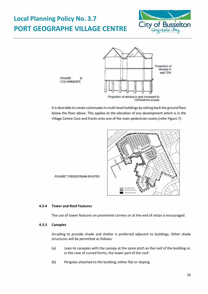
This section will deal with each of the following sites within the Village Centre Precinct. 4.2.1. Village Centre Core. 4.2.2. Grouped/Multiple Dwellings. 4.2.3. Tourist Accommodation 4.2.4. Tourist Accommodation 4.2.5. Resort and Retirement Village (Now excluded from the Village Centre Precinct) 4.2.6. Boat Launching Area 4.2.7. Marina Facility 4.2.8. Residential 4.2.9. View Corridor 4.2.10. Core Grouped Dwellings and Tourist/Residential Lots 4.2.11. Mixed Use Development
Local Planning Policy No. 3.7 PORT GEOGRAPHE VILLAGE CENTRE
3
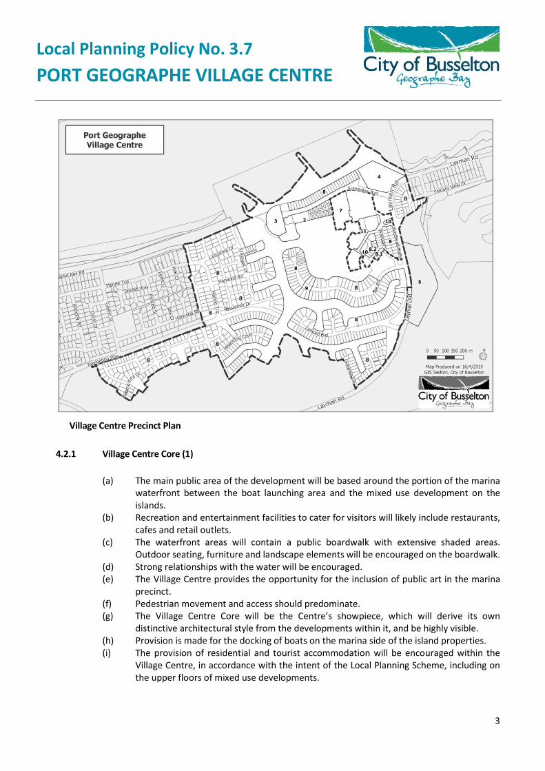
Village Centre Precinct Plan
4.2.1 Village Centre Core (1)
(a) The main public area of the development will be based around the portion of the marinawaterfront between the boat launching area and the mixed use development on theislands.
(b) Recreation and entertainment facilities to cater for visitors will likely include restaurants,cafes and retail outlets.
(c) The waterfront areas will contain a public boardwalk with extensive shaded areas.Outdoor seating, furniture and landscape elements will be encouraged on the boardwalk.
(d) Strong relationships with the water will be encouraged.(e) The Village Centre provides the opportunity for the inclusion of public art in the marina
precinct.(f) Pedestrian movement and access should predominate.(g) The Village Centre Core will be the Centre’s showpiece, which will derive its own
distinctive architectural style from the developments within it, and be highly visible.(h) Provision is made for the docking of boats on the marina side of the island properties.(i) The provision of residential and tourist accommodation will be encouraged within the
Village Centre, in accordance with the intent of the Local Planning Scheme, including onthe upper floors of mixed use developments.

Local Planning Policy No. 3.7 PORT GEOGRAPHE VILLAGE CENTRE
4
(j) Buildings located between car parks and waterways should be double-fronted, facingboth the car park and the waterfront area but allowance will be made for servicing areasto be located facing the car park. These must be enclosed.
4.2.2 Grouped/Multiple Dwellings (2)
(a) Tourist accommodation is to form the northern and north-western boundaries to themarina fronting onto the boats pens.
(b) Private boat jetties are to be located adjacent to the dwellings.(c) Buildings are to create a strong frontage to the marina.(d) Buildings are to provide a modulated frontage to the marina with an articulated façade
and using elements such as verandahs, balconies, awnings, dormers and windowprojections to provide visual interest and to establish a fine grained scale to development.
(e) Buildings should be double-fronted in their architectural treatment with an appropriateresponse to both the marina and the street.
(f) Building heights will be subject to clause 47 of The City’s Planning Scheme, which generallyallows for an average height of 7.5 metres for land within 150 metres of the mean highwater mark and a maximum height of 10 metres in all other areas, unless the merits ofthe design warrant an increased height which can be approved by The City under theScheme. The reference to the mean high water mark means the mean high water mark ofGeographe Bay and not of the canals within the Port Geographe estate.
(g) Buildings should have their own architectural character which should be identifiablyrelated to the Village Centre architectural theme.
4.2.3 Tourist Accommodation (3)
(a) This site establishes a waterborne entry statement for the whole of the Port Geographedevelopment and should therefore create a distinctive presence onto the harbour entrychannel.
(b) Opportunity is available for extensive views to the waterway and across Geographe Bay.(c) Vehicle parking and access is to be provided from the east.(d) The building design is to emphasise the curved form of the shoreline.(e) The building design should not dominate the adjoining beach area by either casting
shadows or presenting an unarticulated profile.(f) The building design should address the termination of the vista along the approach road.(g) Building heights will be subject to clause 47 of The City’s Planning Scheme, which generally
allows for an average height of 7.5 metres for land within 150 metres of the mean highwater mark and a maximum height of 10 metres in all other areas, unless the merits ofthe design warrant an increased height which can be approved by The City under Clause5.8 of the Scheme. The reference to the mean high water mark means the mean highwater mark of Geographe Bay and not of the canals within the Port Geographe estate.
4.2.4 Tourist Accommodation (4)
(a) Direct access is available from the entry road off Spinnaker Boulevard.(b) An area of public car parking has been established as a buffer between this site and the
single residential area.
Local Planning Policy No. 3.7 PORT GEOGRAPHE VILLAGE CENTRE
5
(c) A foreshore conservation reserve has been retained between the site and the beach toprevent a direct relationship between the site and the foreshore. Pedestrian access to theforeshore will be via the dual use path.
(d) The development may comprise several components, each of which should have its ownarchitectural character, identifiably related to each other and the Village Centrearchitectural theme.
(e) The beach resort should provide a significant architectural or landscape statementadjacent to the junction, or terminating the vistas along Layman Road.
(f) The design should not dominate the adjacent beach area by either casting shadows orpresenting an unarticulated profile.
(g) Integrated and complementary arrangements for access and car parking should beconsidered for any individual developments within the broader site.
(h) Building heights will be subject to Scheme clauses, which generally allows for an averageheight of 7.5 metres for land within 150 metres of the mean high water mark and amaximum height of 10 metres in all other areas, unless the merits of the design warrantan increased height which can be approved by the City under the Scheme. The referenceto the mean high water mark means the mean high water mark of Geographe Bay and notof the canals within the Port Geographe estate.
4.2.5 Resort and Retirement Village (5)
Modifications in 2004 to the Village Centre Precinct Plan amended the Precinct boundaries to exclude this site. Prior to its exclusion, the following guidelines for development applied:
(a) Access is to be from Layman Road.(b) Good pedestrian links are to be provided within the site and from development on the
site to the Village Centre Core.(c) The development should have an architectural character which is identifiably related to
the Village Centre architectural theme.(d) Building heights will be subject the Scheme, which generally allows for an average height
of 7.5 metres for land within 150 metres of the mean high water mark and a maximumheight of 10 metres in all other areas, unless the merits of the design warrant an increasedheight which can be approved by the Scheme. The reference to the mean high water markmeans the mean high water mark of Geographe Bay and not of the canals within the PortGeographe estate.
4.2.6 Boat Launching Area (6)
(a) The boat launching area provides public access to the water for launching trailable boats.(b) The use of perimeter landscaping should be maximised to help screen the parking areas.(c) Vehicular access is directly off the peninsula distributor road, or via the Village Centre car
parking area off Layman Road.
Local Planning Policy No. 3.7 PORT GEOGRAPHE VILLAGE CENTRE
6
4.2.7 Marina Facility (7)
(a) The site provides direct access to the marina pens from the marina building and adjacentcar parking area.
(b) The entrance to the marina pens creates a single security point.(c) The marina facility will allow for boat maintenance, dry standing and refuelling.(d) Water quality protection measures will be essential.(e) Buildings within the marina site should reflect the character of the Village Centre buildings
and not have an industrial aesthetic.(f) The marina pens and boat maintenance compound will generally not be accessible by the
public to ensure security.(g) Building heights will be subject to the Scheme, which generally allows for an average
height of 7.5 metres for land within 150 metres of the mean high water mark and amaximum height of 10 metres in all other areas, unless the merits of the design warrantan increased height which can be approved by The City under the Scheme. The referenceto the mean high water mark means the mean high water mark of Geographe Bay and notof the canals within the Port Geographe estate.
(h) The provision of a feature flag mast on the extremity opposite the Village Centre is to beencouraged.
4.2.8 Residential (8)
In order to establish a distinct architectural hierarchy to the Village Centre Precinct, all residential development within the area of the Village Centre Precinct Map requires planning approval, pursuant to cl.9.2(b)(ix) of the City of Busselton Local Planning Scheme 21.
In principle, development should conform with the following;
(a) The Residential Design Codes of Western Australia (R-Codes) apply with exception of items(b) to (l) where, in the event of any conflict with the R – Codes, these items will prevail.
(b) Ground floor walls should be of masonry construction.(c) Upper level walls should be of masonry construction or a rendered cement appearance
with the use of lightweight (e.g. timber) cladding or feature panels or elements for up to50% of the upper level wall surface.
(d) Garages, carports and outbuildings should be consistent in construction and finish withthe ground floor of the house.
(e) Garages and cross overs should make up no more than 50% of the width of the frontageof the site, or 7m in width where the frontage is less than 12m in width.
(f) Roofs should be of clay or concrete tile, or Colorbond metal with feature details in timberor fibrous cement sheet.
(g) Roofs to garages, carports and outbuildings should be consistent in roof pitch andmaterials with the house.
(h) Building heights will be subject to clause 5.8 of the City of Busselton Local Planning Scheme21. The reference to the mean high water mark means the mean high water mark ofGeographe Bay.
(i) Uniform fencing of limestone material or similar is to be provided at the POS interface.(j) The underside of any decks, at ground floor level, should be enclosed.
Local Planning Policy No. 3.7 PORT GEOGRAPHE VILLAGE CENTRE
7
(k) Retaining walls, facing the canal should be terraced with no face, greater than 1.2m highbetween steps. Any storage lockers should not protrude above the terrace or ground level.
(l) Side fencing should not protrude forward of the building setback from a public road.
4.2.8.1 Guidelines for Lots 21 – 24 (Public Open Space Lots 8.1)
(a) Development shall be in accordance with the R30 provisions of the R-Codes.(b) All buildings should achieve front and rear setbacks in accordance with the R-
Codes with the rear boundary being the boundary with the Public Open Space(POS).
(c) Nil setbacks to side boundaries are encouraged, or are otherwise in accordancewith the R-Codes.
(d) Quality uniform fencing, of limestone material or similar, is to be provided at thePOS interface.
(e) Where possible, and particularly for dwellings greater than single storey, buildingsconstructed on these lots should either be double-fronted, facing both the streetand the POS area, or have their main outlook fronting the open space.
4.2.8.2 Guidelines for Lots 31 to 37 (Waterfront Lots 8.2)
(a) Development shall be in accordance with the R30 provisions of the R-Codes.(b) The rear setback is to be calculated from the waterfront lot boundary.(c) Structures adjoining the waterfront are to meet any additional setback
requirements that may result from the specific structural engineeringrequirements of the walls to the water body.
(d) Nil setbacks to side boundaries are encouraged.(e) Quality fencing of limestone material or similar, is to be provided at the POS
interface of Lot 37.
(f) Where possible, and particularly for dwellings greater than single storey, buildingsconstructed on these lots should either be double-fronted, facing both the streetand the water, or have their main outlook fronting development on the islands.
4.2.9 View Corridor (9)
To enhance the perception of the marina bay and the Village Centre from Layman Road and canal lots within Port Geographe, restrictions will be applied to a limited number of single residential lots.
These are as follows:
(a) Lots Nos. 529, 530, 531, 551, 552 and 553 will be limited to single storey development.(b) On Lot Nos. 550 to 554 no development will be permitted within 6 metres of the canal
wall and fencing will be limited to open fencing no more than 1 metre high within thisarea.
4.2.10 Core Grouped Dwellings and Tourist/Residential Lots (10)
Local Planning Policy No. 3.7 PORT GEOGRAPHE VILLAGE CENTRE
8
Grouped dwelling lots and tourist accommodation on the islands are to be developed as per the Residential Design Codes of Western Australia requirements. Building heights will be subject to Clause 5.8 of The City’s Planning Scheme, which generally allows for an average height of 7.5 metres for land within 150 metres of the mean high water mark and a maximum height of 10 metres in all other areas, unless the merits of the design warrant an increased height. The reference to the mean high water mark means the mean high water mark of Geographe Bay and not of the canals within the Port Geographe estate.
The Tourist/Residential lots (Lots 38 – 39) have the same R40 coding as the grouped dwelling lots (Lots 11 and 30). Residential lots (Lots 40 – 44) have an R60 coding.
4.2.10.1 Guidelines for Lot 11
(a) As Lot 11 is surrounded on all sides by roads, careful attention will need to begiven to the design of development on it. No access is permitted from LaymanRoad and access should be restricted from Starboard Road and Port Lane. Primaryaccess should therefore be off the new subdivisional road adjoining Lots 10 and12 with internal rear parking to dwellings which front Layman Road, StarboardRoad and Port Lane encouraged.
(b) Quality uniform fencing, of limestone material or similar, is to be provided alongall boundaries of the site and feature walling encouraged at the intersection ofLayman Road and Starboard Road.
(c) Dwellings should be constructed with facades to as much of the adjoining roadsas possible, and particularly to Layman Road and Starboard Road.
(d) Setbacks are as per the R-Codes but street setbacks should reflect reducedsecondary road frontages. Nil street setbacks to Starboard Road are encouraged,subject to achieving satisfactory sight line requirements.
4.2.10.2 Guidelines for Lot 30
(a) Development on this site should maximise the outlook to the water whilstpresenting a suitable façade to Port Lane given its location at the entrance to theheart of the Village Centre.
(b) The number of access points to Port Lane should be restricted to a singleaccessway, with internal rear parking to dwellings which front Port Lane and thewaterway encouraged.
(c) The minimum R-Code setback to Port Lane is required, unless it can bedemonstrated that a reduced setback will produce a better interface to the mixeduse area opposite.
(d) All structures must be setback to meet any structural setback requirements fromthe wall to the stinger free pool.
(e) Nil setbacks will be permitted to the rear access to Lot 31 subject to achieving asatisfactory design outcome having regard to the small size of adjoining lots.
(f) Quality fencing of limestone material or similar is to be provided along the PortLane frontage.
4.2.10.3 Guidelines for Lots 38 – 44
Local Planning Policy No. 3.7 PORT GEOGRAPHE VILLAGE CENTRE
9
(a) Development on Lots 38 and 39, whether for tourist and/or residentialdevelopment is to comply with R40 provisions of the R-Codes.
(b) Development on Lots 40 to 44, whether for tourist and/or residentialdevelopment is to comply with R60 provisions of the R-Codes.
(c) Lots 40 – 44 can comprise up to 5 freehold lots capable of strata developmentwhich can be accessed via an accessway comprising adjoining battleaxe legs withreciprocal rights of access for each lot as required. Front setbacks to any suchaccessway can therefore be reduced at The City’s discretion, subject to a qualitydesign outcome.
(d) Setbacks shall be in accordance with the R-Codes, unless it can be demonstratedthat a reduced setback will produce a better interface to adjacent development.Setbacks must however meet all design requirements associated with thestructural design requirements of canal walls and any City policies in this regard.
(e) Nil setback to the POS on Lot 39 and to side boundaries are encouraged subjectto meeting amenity requirements under the R-Codes.
(f) Development for solely residential purposes should be capable of conversion fortourist uses in the future if required.
(g) Quality fencing of limestone material or similar is to be provided at the POSinterface of Lot 39.
(h) The architectural style of development is to reflect and/or respect thearchitectural style and scale of the adjoining mixed use development.Development on Lots 40-44 is to be cognisant of the visual prominence of thesesites when viewed from the marina, other waterfront lots and the Public OpenSpace areas.
(i) The number and size of lots on the islands are indicative only. A variation to thenumber or configuration of lots, for example, to create larger sites, is not opposedproviding quality development results.
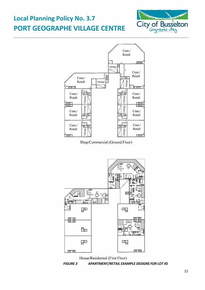
4.2.11 Mixed Use
Mixed use developments (also referred to as “shop-houses”) are intended to provide ground floor commercial tenancies and upper storey residential accommodation. Examples of such developments are found in Figures 1 and 2. All development should comply with the Mixed Use provisions of the R-Codes and be subject to the following guidelines:
Coding: A density of up to R60 is considered appropriate reflecting the mixed use character of development, the proximity to commercial facilities, the elevated and water aspects, and the desire to provide a range of residential densities in the Village Centre.
Use: All development on Lots 45 and 46 is to contain a mixture of development, and not comprise solely residential accommodation. Ground floor commercial tenancies should directly interface with, and open onto, the boardwalk. Partial use of the boardwalk associated with any development will be considered on its merits providing public use of the boardwalk is not unreasonably compromised.
Local Planning Policy No. 3.7 PORT GEOGRAPHE VILLAGE CENTRE
10
Setbacks: Nil setbacks are permitted to the service road and the boardwalk, subject to no building being closer than 6m to a canal wall, and an appropriate interface between the development and the public realm. Nil site setbacks to adjoining buildings will also be permitted on common boundaries subject to achieving an appropriate architectural interface with adjacent development.
Open space: A balcony with a minimum area of 10m² is to be provided for each upper floor apartment. No additional open space is required other than provision of uniform waterfront boardwalks which accommodates public access.
Height: The Scheme permits a maximum height of 10m (3 storeys). Exceptions to this height may be granted for strategic architectural features and for landmark developments within the Village Centre.
Roof angle: The roof pitch is to be preferably 25 degrees or greater with gable forms.
Parking: Two parking spaces are to be provided for each dwelling for residential use. Commercial parking is to be discouraged from the islands and is to be provided adjoining Lot 46. This parking should also be available for resident visitor parking after hours.
Lot Sizes: The number and size of lots within the mixed use areas of the Village Centre are indicative only. A variation to the number or configuration of lots, for example, to create larger sites, is not opposed providing a quality mixed use development results on the lots created.

Local Planning Policy No. 3.7 PORT GEOGRAPHE VILLAGE CENTRE
11
Below is an example of the floor layout of mixed use development for Lot 46:
FIGURE 2 EXAMPLE DESIGN FOR LOT 46
Local Planning Policy No. 3.7 PORT GEOGRAPHE VILLAGE CENTRE
12
FIGURE 3 APARTMENT/RETAIL EXAMPLE DESIGNS FOR LOT 45

Local Planning Policy No. 3.7 PORT GEOGRAPHE VILLAGE CENTRE
13
4.3 ARCHITECTURAL PRINCIPLES AND BUILDING FORM
This section is applicable in its entirety to all development within the Village Centre Precinct, other than for single lot residential development which is subject to the provisions outlined in section 4.8 of this document.
A maritime theme is intended in the Village Centre related to the spatial layout. It is important that each developer within the Village Centre acknowledges and adopts a definite theme to ensure a cohesive development that relates well to the site and the adjoining residential areas.
The main feature of the Village Centre precinct is the marina water body, which provides opportunities to view the waterside buildings from a wide range of vantage points. It is therefore essential that careful attention is paid to the three dimensional design of the buildings.
The features of the overall architectural character envisaged are:
(a) A variety of materials in each development. Limestone or rammed earth is encouragedbut not mandatory;
(b) A preference for two storey buildings with provision for up to three storeys (or highersubject to a quality design outcome). A variety of roofing, including corrugated iron, witha defined form and overhanging eaves;
(c) Steeply pitched roofs (25 degrees or greater) with hip and gable roof forms;(d) Use of the space within the roof;(e) Open upper level balconies and dormer windows;(f) Extensive use of glass;(g) Buildings connected with timber pergolas where practicable;(h) Shading by free standing shade structures;(i) Encouragement of the use of lightweight (e.g. timber) cladding or feature panels or
elements at upper levels of buildings;(j) The use of colonnades;(k) A considered use of proportions; and(l) The use of buildings to frame public spaces.
The following design features should also be considered:
(a) Pedestrian access around the buildings is most important and is to be a feature of theVillage Centre core area.
(b) The use of open balcony railings, sail-like shade structures and street furniture with anautical character is encouraged to help to emphasise the maritime location of the site.
(c) Passive solar design techniques for energy efficiency and human comfort should beemployed wherever possible.
(d) Buildings are to address the waterfront as well as the land, presenting a facade whichprovides visual interest and establishes a fine scale to the development.
Local Planning Policy No. 3.7 PORT GEOGRAPHE VILLAGE CENTRE
14
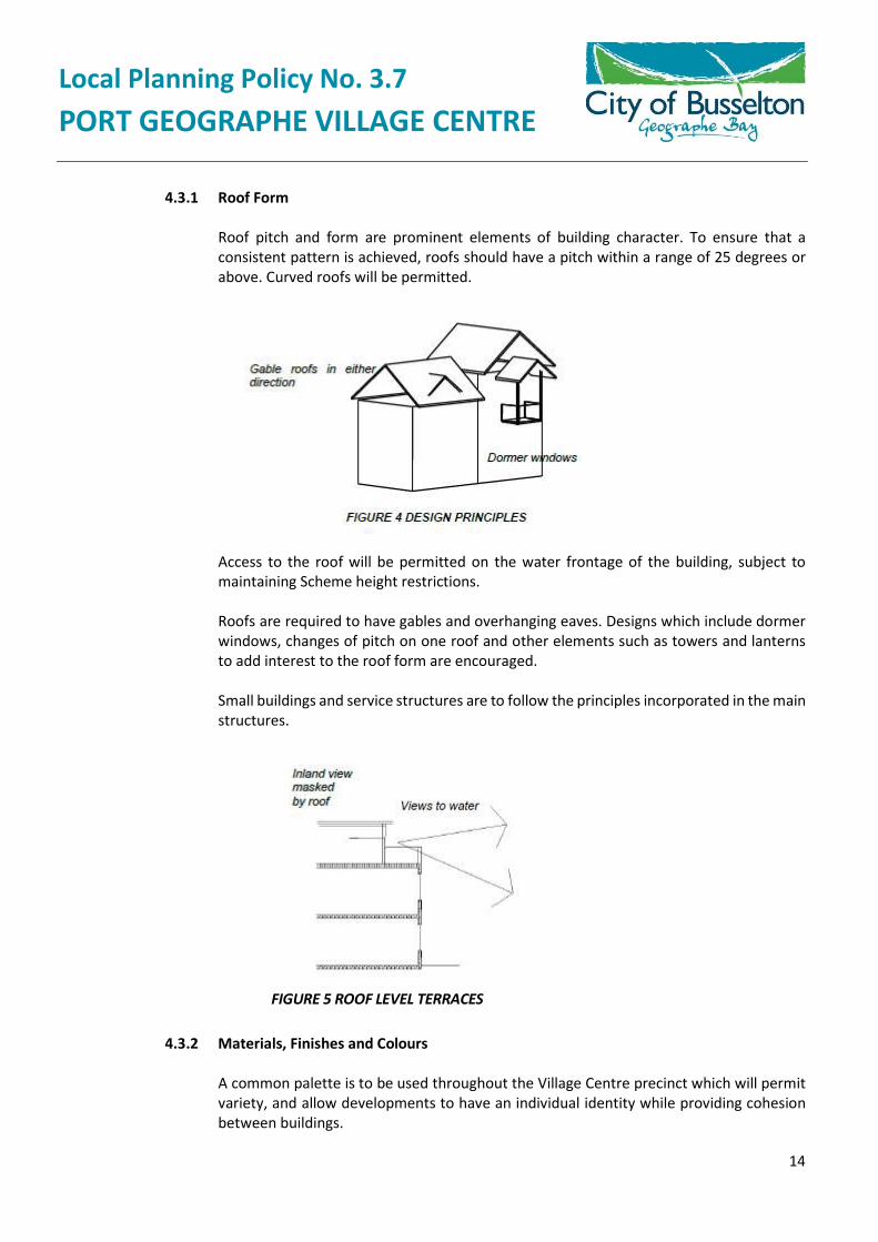
4.3.1 Roof Form
Roof pitch and form are prominent elements of building character. To ensure that a consistent pattern is achieved, roofs should have a pitch within a range of 25 degrees or above. Curved roofs will be permitted.
Access to the roof will be permitted on the water frontage of the building, subject to maintaining Scheme height restrictions.
Roofs are required to have gables and overhanging eaves. Designs which include dormer windows, changes of pitch on one roof and other elements such as towers and lanterns to add interest to the roof form are encouraged.
Small buildings and service structures are to follow the principles incorporated in the main structures.
FIGURE 5 ROOF LEVEL TERRACES
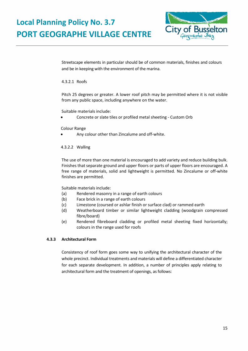
4.3.2 Materials, Finishes and Colours
A common palette is to be used throughout the Village Centre precinct which will permit variety, and allow developments to have an individual identity while providing cohesion between buildings.
Local Planning Policy No. 3.7 PORT GEOGRAPHE VILLAGE CENTRE
15
Streetscape elements in particular should be of common materials, finishes and colours and be in keeping with the environment of the marina.
4.3.2.1 Roofs
Pitch 25 degrees or greater. A lower roof pitch may be permitted where it is not visible from any public space, including anywhere on the water.
Suitable materials include: Concrete or slate tiles or profiled metal sheeting - Custom Orb
Colour Range Any colour other than Zincalume and off-white.
4.3.2.2 Walling
The use of more than one material is encouraged to add variety and reduce building bulk. Finishes that separate ground and upper floors or parts of upper floors are encouraged. A free range of materials, solid and lightweight is permitted. No Zincalume or off-white finishes are permitted.
Suitable materials include: (a) Rendered masonry in a range of earth colours(b) Face brick in a range of earth colours(c) Limestone (coursed or ashlar finish or surface clad) or rammed earth(d) Weatherboard timber or similar lightweight cladding (woodgrain compressed
fibre/board)(e) Rendered fibreboard cladding or profiled metal sheeting fixed horizontally;
colours in the range used for roofs
4.3.3 Architectural Form
Consistency of roof form goes some way to unifying the architectural character of the whole precinct. Individual treatments and materials will define a differentiated character for each separate development. In addition, a number of principles apply relating to architectural form and the treatment of openings, as follows:
Local Planning Policy No. 3.7 PORT GEOGRAPHE VILLAGE CENTRE
16
It is desirable to create colonnades in multi-level buildings by setting back the ground floor below the floor above. This applies to the elevation of any development which is in the Village Centre Core and fronts onto one of the main pedestrian routes (refer Figure 7).
4.3.4 Tower and Roof Features
The use of tower features on prominent corners or at the end of vistas is encouraged.
4.3.5 Canopies
Arcading to provide shade and shelter is preferred adjacent to buildings. Other shade structures will be permitted as follows:
(a) Lean-to canopies with the canopy at the same pitch as the roof of the building or,in the case of curved forms, the lower part of the roof.
(b) Pergolas attached to the building; either flat or sloping.
Local Planning Policy No. 3.7 PORT GEOGRAPHE VILLAGE CENTRE
17
(c) Free-standing structures not attached to the building, such as sail canopies, canbe attached.
Wall hung flat canopies and bullnose canopies will generally not be permitted.
4.3.6 Balconies
Balconies are desirable elements to break down the perceived bulk of buildings, create articulated elevations and provide outdoor spaces to enhance a relaxed holiday atmosphere. Balcony balustrades should be open; either timber or metal. Solid side enclosures may be permitted if they can be justified to provide privacy for adjoining properties.
4.3.7 Plant and Service Areas
Mechanical plant and service areas should be screened from public view. Roof level plant must be contained within the roof space or designed as a part of the roofscape; for instance in a dormer or lantern feature. Mechanical plant at ground level and service areas shall be screened from public view with enclosures at least 1500mm high.
TV aerials and satellite dishes are permitted on the roof, but should not be located so as to be visually intrusive.
4.3.8 Building Height
The City of Busselton Local Planning Scheme No. 21 permits a maximum of 3 storeys or 10m above natural ground level; reduced to 2 storeys (or 7.5 metres) for land within 150 metres of the Mean High Water Mark of Geographe Bay. Exceptions to this height may be granted for strategic architectural features or based on the merits of a design.
Building height is determined from the perpendicular distance from a building’s highest point to the natural ground level of the land on which it is to be erected.
4.4 SIGNAGE
Directional, identifying and advertising signage for the Village Centre precinct must have regard to the character of the particular site and promote a maritime theme throughout the precinct. In this regard, a detailed signage strategy, including thematic designs, is to be submitted for approval with the first development application for the mixed use lots.
Free standing advertising signage will not be permitted. Signs attached to buildings shall be designed as an integral part of the building, either recessed into the facade, contained within a frame, or hanging from an awning, verandah or colonnade.
Directional signage in public spaces is to be consistent in design throughout the Village Centre precinct.
Local Planning Policy No. 3.7 PORT GEOGRAPHE VILLAGE CENTRE
18
Details of proposed site signage, including construction characteristics, should be included when plans are submitted for development approval. All signs require a sign licence and a sign licence application form must be lodged with the City of Busselton.
4.5 LIGHTING
It is important that consideration be given to good night lighting that provides adequate illumination for safe access which will aid in passive security while not creating a loss of amenity for the surrounding residential properties.
The lighting of buildings and open space should enhance the appearance and amenity of the precinct. In particular, illumination should be considered to increase safety and inhibit anti-social behaviour.
The following issues need to be addressed when designing lighting and details should be included when applying for development approval:
(a) The provision of adequate illumination of open areas for public safety;
(b) The provision of lighting to inhibit anti-social behaviour;
(c) Feature lighting structures should be designed to complement precinct lighting themes;
(d) Spilt light to surrounding properties, roadways, pedestrian paths, etc, should beminimised.
(e) Ensuring that parking areas and open space on private property, which may be subject tonight time use, has lighting; and
(f) To define pedestrian accessways.
4.6 PEDESTRIAN FACILITIES
The pedestrian streetscape is a vital link between the different buildings and activity areas within the Village Centre precinct. Extensive use of waterfront boardwalks is proposed.
Pedestrian facilities should be consistent in detailing for all the sites within the Village Centre and should delineate the boundaries between the site and the public domain. It is therefore important that:
(a) All fittings must be safe and durable;
(b) Access throughout the Village Centre precinct should have minimal level changes to allowwheelchair access to all facilities;
(c) Pedestrian areas should provide shade and shelter and contain adequate street furniture(benches, bins, etc.) located in areas attractive to resting and visible from adjacentbuildings and roadways; and
Local Planning Policy No. 3.7 PORT GEOGRAPHE VILLAGE CENTRE
19
(d) Public space should be well lit and convey safe usage with passive surveillance possiblefrom adjoining buildings.
4.7 FENCING
Boundary fencing will be permitted to provide security and privacy for residents whilst not dominating the public space. Where fences are used they should be compatible in scale, detailing and materials with the building(s) on the lot. High front walls should be avoided; rather, low walls and landscaping or semi-transparent fences should define boundaries while allowing surveillance and security.
Other than for single residential lots which do not adjoin waterways or POS, fences and walls should be of an open nature and be of masonry construction. All walls should be constructed using materials, styles and colours that are similar to their respective building(s). Fibrous cement or colorbond metal fencing is not encouraged within the Village Centre precinct.
Boundary fencing on the water edge is to be avoided as far as possible. Fencing within 6m of the water edge is to be open and no more than 1m high. No fencing is to be constructed within 1m of a canal wall.
For full details of requirements for fencing, and for specific requirements relating to retaining walls, refer to the City of Busselton Local Planning Scheme No. 21.
4.8 LANDSCAPING
The Port Geographe area provides an opportunity for a variety of landscaped public areas, planted boulevards, beachfronts and parklands. These areas will be planted using primarily native plants according to the Port Geographe Landscape Master Plan.
The landscaping theme uses local vegetation varieties to blend Port Geographe into the Busselton region, ensuring the success of plantings, and enhancing the existing coastline vegetation whilst creating a distinct identity for the locality.
For specific guidance on landscaping, reference should be made to the Port Geographe Landscape Master Plan and Guidelines.
4.9 ANCILLARY BUILDINGS
The architectural themes established in this document for development in the Village Centre precinct should be continued for ancillary buildings in respect to their form, colours, details and materials, to ensure the cohesion of the development as a whole. Ancillary buildings may include public toilets, amenity kiosks and bus shelters.
4.10 APPROVALS PROCEDURE
Prior to the commencement of any building or site works (including the removal of existing trees and vegetation and/or the construction of dwellings, outbuildings, fencing or any other

Local Planning Policy No. 3.7 PORT GEOGRAPHE VILLAGE CENTRE
20
structures), information describing the proposed works in respect to that development is to be submitted the City of Busselton.
Applications for development should be submitted in accordance with Part 2 of the City of Busselton’s Local Planning Scheme No. 21 and demonstrate compliance with these guidelines.
5. REVIEW DETAILS
Review Frequency 2 yearly Council Adoption 12/8/2015 C1508/221 Previous Adoption
10/3/2010 C1003/069
* Policy number changed from LPP 4B to LPP 3.7 on the 11th May 2020. The change is administrative only, no resolution by Council required.