Plans for the Historic Centre of Isola Vicentina, Italy. Issues with Urban Morphology
10
Civil Engineering and Architecture 2(1): 42-51, 2014 http://www.hrpub.org DOI: 10.13189/cea.2014.020105 Plans for the Historic Centre of Isola Vicentina, Italy Issues with Urban Morphology Enrico Pietrogrande * , Adriano Rabacchin, Alessandro Dalla Caneva Department of Civil, Environmental and Architectural Engineering, University of Padova, 35131 Padova, via Marzolo 9, Italy *Corresponding Author: [email protected] Copyright © 2014 Horizon Research Publishing All rights reserved. Abstract The work concerns the recomposition of public spaces in the historic centre of Isola Vicentina, an ancient town near Vicenza, that presents significant alterations occurred during last century. It is part of a more general research about the urban structure in the little cities of Veneto region, in the North-East of Italy. The method adopted is based on studying the history of the place to understand the urban morphology of it. The physical specificity of the urban form is explored with the aim of elaborating a design process to reinforce the public space as a reference point for the community. Fundamental for the succeeding in the design process is the analyzing of the direct relation between a architectonic scale and a urban one. Isola Vicentina was one of the subjects the students on the course of Architectural and Urban Composition 2 at the Department of Civil, Environmental and Architectural Engineering of the University of Padova specifically investigated as an opportunity to redesign the unity of the historic centre of this town that had previously been lost. Keywords Identity of the Community, Memory, History as a Tool for the Project, Public Space, City Centre 1. Introduction Isola Vicentina is a small town with a population of ten thousand to the north of Vicenza – the city of Palladio – on provincial road 46 that leads to Schio and Thiene [1]. The centre of the built-up area, where the local community has a lively social and economic life, presents marked incoherence mainly due to disproportionate architecture built at different times in the last century and the heavy vehicular traffic that runs along the provincial road. The urban fabric of Isola Vicentina has unresolved problems in its form in the area between the town hall and the church. Fortunately, enough traces of the previous physical reality remain and allow to recognize and read the morphology that underpinned the urban evolution. With our students on the course of Architectural and Urban Composition 2 at the University of Padua (regular professor Enrico Pietrogrande, coworkers Adriano Rabacchin and Alessandro Dalla Caneva, academic year of 2012-13) we adopted a method to recompose the unresolved condition of this public space based on analyzing the history of the town to understand its urban morphology. This is an indispensable tool in discovering the underlying reasons for the development of the urban structure, which forms an indelible reminder made in the image of the community. The idea that the transformation and the protection of the urban landscape can occur according to a unitary process is the basis of the teaching experience described below. The assumption is in line with the main contribution of the most advanced teachers in Italy on this subject at the University Institute of Architecture in Venice during the second half of the twentieth century, the so-called School of Venice [2]. According to them, the relationship between a city and architecture, referring to the city’s scale in the study of architecture, is the fundamental fact that is at the origin of an effective theory on the project, which defines a synthesis between analysis and design, architecture and urban planning. Giuseppe Samonà, founder of the school, turned his attention to the "history of the architectural object, analysed and reconstructed using both ex cathedra lectures and exercises” [3], expressing an interest in the pragmatism of history in terms of doing things. Egle Renata Trincanato accompanied students on site in Venice to investigate the buildings, explaining the reasons for “they had patently to be in that place and at time”, and studying with students the building themselves to determine the means for future designs [4]. Saverio Muratori’s teaching was rooted in the history too. He wrote that students must first learn that “the study of a building begins with understanding its environment” [5]. Aldo Rossi, Muratori’s assistant in Venice, insisted on the absolute correspondence between the analysis of building and urban analysis, emphasizing the importance of finding precise relationship between architectural and urban structures [6]. His fundamental 1960s studies about typological analysis were published in 1966 in the book L’architettura della città [7], in which the spatial aspects and formal image of the transformations in the city are studied as
Transcript of Plans for the Historic Centre of Isola Vicentina, Italy. Issues with Urban Morphology

Civil Engineering and Architecture 2(1): 42-51, 2014 http://www.hrpub.org DOI: 10.13189/cea.2014.020105
Plans for the Historic Centre of Isola Vicentina, Italy Issues with Urban Morphology
Enrico Pietrogrande*, Adriano Rabacchin, Alessandro Dalla Caneva
Department of Civil, Environmental and Architectural Engineering, University of Padova, 35131 Padova, via Marzolo 9, Italy *Corresponding Author: [email protected]
Copyright © 2014 Horizon Research Publishing All rights reserved.
Abstract The work concerns the recomposition of public spaces in the historic centre of Isola Vicentina, an ancient town near Vicenza, that presents significant alterations occurred during last century. It is part of a more general research about the urban structure in the little cities of Veneto region, in the North-East of Italy. The method adopted is based on studying the history of the place to understand the urban morphology of it. The physical specificity of the urban form is explored with the aim of elaborating a design process to reinforce the public space as a reference point for the community. Fundamental for the succeeding in the design process is the analyzing of the direct relation between a architectonic scale and a urban one. Isola Vicentina was one of the subjects the students on the course of Architectural and Urban Composition 2 at the Department of Civil, Environmental and Architectural Engineering of the University of Padova specifically investigated as an opportunity to redesign the unity of the historic centre of this town that had previously been lost.
Keywords Identity of the Community, Memory, History as a Tool for the Project, Public Space, City Centre
1. Introduction Isola Vicentina is a small town with a population of ten
thousand to the north of Vicenza – the city of Palladio – on provincial road 46 that leads to Schio and Thiene [1]. The centre of the built-up area, where the local community has a lively social and economic life, presents marked incoherence mainly due to disproportionate architecture built at different times in the last century and the heavy vehicular traffic that runs along the provincial road. The urban fabric of Isola Vicentina has unresolved problems in its form in the area between the town hall and the church.
Fortunately, enough traces of the previous physical reality remain and allow to recognize and read the morphology that underpinned the urban evolution. With our students on the course of Architectural and Urban Composition 2 at the University of Padua (regular professor Enrico Pietrogrande,
coworkers Adriano Rabacchin and Alessandro Dalla Caneva, academic year of 2012-13) we adopted a method to recompose the unresolved condition of this public space based on analyzing the history of the town to understand its urban morphology. This is an indispensable tool in discovering the underlying reasons for the development of the urban structure, which forms an indelible reminder made in the image of the community.
The idea that the transformation and the protection of the urban landscape can occur according to a unitary process is the basis of the teaching experience described below. The assumption is in line with the main contribution of the most advanced teachers in Italy on this subject at the University Institute of Architecture in Venice during the second half of the twentieth century, the so-called School of Venice [2]. According to them, the relationship between a city and architecture, referring to the city’s scale in the study of architecture, is the fundamental fact that is at the origin of an effective theory on the project, which defines a synthesis between analysis and design, architecture and urban planning.
Giuseppe Samonà, founder of the school, turned his attention to the "history of the architectural object, analysed and reconstructed using both ex cathedra lectures and exercises” [3], expressing an interest in the pragmatism of history in terms of doing things.
Egle Renata Trincanato accompanied students on site in Venice to investigate the buildings, explaining the reasons for “they had patently to be in that place and at time”, and studying with students the building themselves to determine the means for future designs [4].
Saverio Muratori’s teaching was rooted in the history too. He wrote that students must first learn that “the study of a building begins with understanding its environment” [5].
Aldo Rossi, Muratori’s assistant in Venice, insisted on the absolute correspondence between the analysis of building and urban analysis, emphasizing the importance of finding precise relationship between architectural and urban structures [6]. His fundamental 1960s studies about typological analysis were published in 1966 in the book L’architettura della città [7], in which the spatial aspects and formal image of the transformations in the city are studied as
Civil Engineering and Architecture 2(1): 42-51, 2014 43
a premise on which to base the design of the new architecture.
At the Institute of Architecture in Venice, with the passing of the years and teachers, the analytical study of architecture consolidates interest in the city, starting with the examination of its urban fabric [8,9]. The same reference to pre-existing environmental and historical artefacts is believed as a founding value of teaching by the authors of this article, especially in the present day, marked by key issues of sustainability, and underpins the teaching experience described in the following pages. In the opinion of the authors the theme of the architectural modification of the historic city has not been enriched since the 1960s by other crucial contributions such as the ones from the Venice School.
In the teaching experience presented in this article the first phase of the project the students had to elaborate was composed of analyzing land registry survey maps and written, pictorial, photographic records, in order to acquire informations about the past of the city centre and study the relationship between architecture and urban order.
2. Context Once called Isola di Malo [10], the town lies on one bank
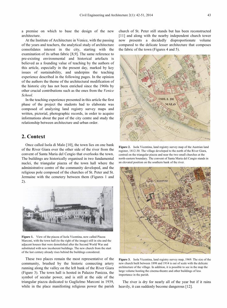
of the River Giara over the other side of the river from the convent of Santa Maria del Cengio that overlooks the town. The buildings are historically organised in two fundamental nuclei, the triangular piazza of the town hall where the administrative centre of the community developed, and the religious pole composed of the churches of St. Peter and St. Jermaine with the cemetery between them (Figures 1 and 2).
Figure 1. View of the piazza of Isola Vicentina, now called Piazza Marconi, with the town hall (to the right of the image) still in situ and the adjacent houses that were demolished after the Second World War and substituted with new incoherent buildings. The new church from the start of the last century already rises behind the buildings considered.
These two places remain the most representative of the community, brushed by the historic connecting artery running along the valley on the left bank of the River Giara (Figure 3). The town hall is hosted in Palazzo Panizza, the symbol of secular power, and is still at the side of the triangular piazza dedicated to Guglielmo Marconi in 1939, while in the place manifesting religious power the parish
church of St. Peter still stands but has been reconstructed [11] and along with the nearby independent church tower now presents a decidedly disproportionate volume compared to the delicate lesser architecture that composes the fabric of the town (Figures 4 and 5).
Figure 2. Isola Vicentina, land registry survey map of the Austrian land register, 1812-30. The village developed to the north of the River Giara, centred on the triangular piazza and near the two small churches at the north-eastern boundary. The convent of Santa Maria del Cengio stands in an elevated position on the southern bank of the river.
Figure 3. Isola Vicentina, land registry survey map, 1969. The size of the new church built between 1898 and 1914 is out of scale with the delicate architecture of the village. In addition, it is possible to see in the map the large volume hosting the cinema-theatre and other buildings of less importance in the parish.
The river is dry for nearly all of the year but if it rains heavily, it can suddenly become dangerous [12].

44 Plans for the Historic Centre of Isola Vicentina, Italy Issues with Urban Morphology
Figure 4. The new parish church of Saint Peter completed in 1914 with the small oratory of Saint Jermaine that was demolished a few years later, in 1925.
Figure 5. Model of the current state of the fragmented space between the triangular piazza of the town hall and St. Peters church. From the work of the student Paola Vecelli.
2.1. Isola Vicentina as an Urban Place
The appearance of the two nuclei in the town changed in the 20th century due to a series of transformations.
The religious nucleus began to be considered a problem towards the end of the 19th century for at least two reasons connected to the larger of the churches, the 17th century parish church of St. Peter the Apostle. One problem was the nature of the road network since the provincial road running through Isola Vicentina passed right in front of the sacred building and was forced to make a double bend to go round the church. Another problem was the capacity of St. Peters which was too small to seat all the faithful. Consequently, it was decided to demolish the old parish church and build a larger building set back from the road but only a little. The new church was built between 1898 and 1914 and was
accompanied by the demolition of the historic church of St. Jermaine in 1925. The façade of the new St. Peters was designed by the architect Gerardo Marchioro who wanted it to be very decorative in order to remedy the lack of visual perspective. The imposing church tower by the side of the church was planned in 1827 and built between 1828 and 1837 where the town cemetery used to be found before it was moved following the issuing of the Napoleonic laws.
The townspeople already identified with the municipal piazza through the previous centuries as testified to by a writer at the end of the 19th century according to whom Isola Vicentina “Has a triangular piazza surrounded by blocks of houses in the middle of which stood an elegant fountain spouting perennial water” [13]. The town hall was at the start of the 19th century an isolated building in the middle of this piazza, but the administration later moved to its current premises, the old house of the Panizza family, when the first building was demolished. The historic fountain in the middle of the piazza was recently restored in the same place.
2.2. Morphological and Typological Elements
With regard to the general characteristics of the buildings in the town, which arose out of the work culture and construction skills in the place, the houses are above all arranged in rows of terraces along the roads that structure the town, being articulated in the form of courtyards and rights of way for thoroughfares. Consequently many detached houses recently built, particularly in the outskirts, are extraneous to the historic construction methods, their autonomous disposition revealing an indifference by their planner to the traditions in the locality. The continuity of the façades and stone walled enclosure follows the direction of the roads and separate private from public property.
On the one hand these are simple and measured façades with windows arranged in orderly lines but which on the other hand are quite rich in architectural elements when they overlook the internal courtyards rather than the street. On the rear there are service spaces for the vegetable gardens and the orchards on which the volumes of secondary structures, whose form is enriched by verandas, are articulated.
Of the two main public spaces in the town, the longest side of the triangle of the piazza with the town hall is determined by the provincial road. The architecture that encloses the piazza on this side was made possible by moving the bed of the river slightly so that the open space required to serve the families at the back of their houses could be obtained.
It is extraordinary that the parish church of St. Peter is not in the main piazza of the town but is in its own independent area. In particular, the façade of the church in the case of Isola Vicentina does not have an empty space in front of it as is usually present in front of a church and fundamental for ritual ceremonies. The façade of St. Peter is not seen from the front by those who travel along the provincial road but from the side.

Civil Engineering and Architecture 2(1): 42-51, 2014 45
2.3. Critical Aspects
The various critical elements are distinct but convergent cases in the lack of coherence between the historic urban fabric and the unresolved area of study lying between the town hall and the church. So the students were required to submit planning observations and reflections on this area.
First of all, a critical aspect is the unusual position of the parish church of St. Peters whose church square, a space in front of the church for religious functions, actually coincides with the axis of the road. The free space to the side on which stood the historic small church of St. Jermaine resulting from the demolition of the church in 1925 has never found a specific land use designation and is currently used for parking. Furthermore, the increased size of the rebuilding of St. Peters church set back from the road leading to the disappearance of the line of houses at the back of the religious pole, which were demolished to make way for the new sacred building. The area lying behind the church, which includes an abandoned garden and private house, has remained unresolved up to the present day. On the other hand, the parish sports fields to the north of the church need to be reorganised since the current position, sandwiched between roads, is not fit for the purpose. The sports fields will have to be moved internally, where is available an area that is not so exposed to traffic, is greener, and can be easily connected to the buildings in the parish.
Palazzo Panizza, housing the town council offices, has kept the appearance it has always had through the course of the centuries and remains the only historic building on the north side of the triangular piazza (Figure 6). The others that followed one another on its side were demolished and rebuilt after the war, with a rather incoherent finish for the historic context of the town and higher than the town hall itself (figure 7) that used to be the most imposing building in the piazza, but now looks oppressed by the adjacent new volumes.
Figure 6. View of the town hall façade of Palazzo Panizza facing the triangular piazza of the town. Current condition. The recomposition of the confused space between the back of Palazzo Panizza and St. Peters church is the theme illustrated in these pages. Photo by the student Luca Costa.
The continuity of the built land area behind the church was lost completely with the development of these new buildings.
Among the new buildings on the north side of the piazza, the parish cinema-theatre is of particular importance. It was built in 1957 at the junction with provincial road 46. Other construction bodies, also in service of the parish, were built around the cinema-theatre. The choice of position turned out to be a mistake both because the building complex is suffocated by constant traffic on the provincial road (Figures 8 and 9) and because it is difficult to identify a true façade for the theatre in the piazza due to a marked lack of coherence with the nearby historic buildings.
In addition to this, the centre is exposed to noise and fumes from the passing traffic. The historic triangular piazza is used as a car park, and so too is the entirely tarmacked area beside the Church. In spite of the town being surrounded by agricultural countryside, it lacks green spaces and relaxing peace and quiet in its heart. In fact the development of Isola Vicentina has been uncontrolled through the course of the recent years.
Returning to the area of greatest lack of definition that lies between the town hall and the church, the two monumental buildings are only connected by two narrow passages, one of which can be used by traffic, and this obstructs the continuity of spaces. All of the recognisable places between the two poles starting with the one near the church are unresolved. In particular, the space between the church and the cinema-theatre has no specific use.
In conclusion, the heart of Isola Vicentina is the fruit of all the inhomogeneous transformations whose total product is an area lacking organic unity so that it is impossible to identify a clearly prevalent reason for the incoherence found both in terms of visual use and functionality of the physical connections between the two most important poles in the town.
Figure 7. View of the northern side of the piazza with the new post-war buildings aligned beside the town hall (a part of which appears on the edge of the image). Current condition. Note the dissonant façade of the parish theatre on the left in correspondence with the bell tower. Photo by the student Luca Costa.
46 Plans for the Historic Centre of Isola Vicentina, Italy Issues with Urban Morphology
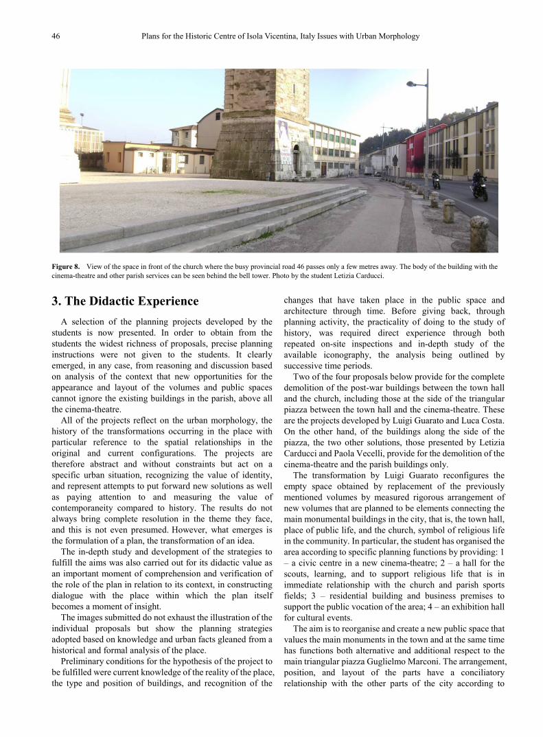
Figure 8. View of the space in front of the church where the busy provincial road 46 passes only a few metres away. The body of the building with the cinema-theatre and other parish services can be seen behind the bell tower. Photo by the student Letizia Carducci.
3. The Didactic Experience A selection of the planning projects developed by the
students is now presented. In order to obtain from the students the widest richness of proposals, precise planning instructions were not given to the students. It clearly emerged, in any case, from reasoning and discussion based on analysis of the context that new opportunities for the appearance and layout of the volumes and public spaces cannot ignore the existing buildings in the parish, above all the cinema-theatre.
All of the projects reflect on the urban morphology, the history of the transformations occurring in the place with particular reference to the spatial relationships in the original and current configurations. The projects are therefore abstract and without constraints but act on a specific urban situation, recognizing the value of identity, and represent attempts to put forward new solutions as well as paying attention to and measuring the value of contemporaneity compared to history. The results do not always bring complete resolution in the theme they face, and this is not even presumed. However, what emerges is the formulation of a plan, the transformation of an idea.
The in-depth study and development of the strategies to fulfill the aims was also carried out for its didactic value as an important moment of comprehension and verification of the role of the plan in relation to its context, in constructing dialogue with the place within which the plan itself becomes a moment of insight.
The images submitted do not exhaust the illustration of the individual proposals but show the planning strategies adopted based on knowledge and urban facts gleaned from a historical and formal analysis of the place.
Preliminary conditions for the hypothesis of the project to be fulfilled were current knowledge of the reality of the place, the type and position of buildings, and recognition of the
changes that have taken place in the public space and architecture through time. Before giving back, through planning activity, the practicality of doing to the study of history, was required direct experience through both repeated on-site inspections and in-depth study of the available iconography, the analysis being outlined by successive time periods.
Two of the four proposals below provide for the complete demolition of the post-war buildings between the town hall and the church, including those at the side of the triangular piazza between the town hall and the cinema-theatre. These are the projects developed by Luigi Guarato and Luca Costa. On the other hand, of the buildings along the side of the piazza, the two other solutions, those presented by Letizia Carducci and Paola Vecelli, provide for the demolition of the cinema-theatre and the parish buildings only.
The transformation by Luigi Guarato reconfigures the empty space obtained by replacement of the previously mentioned volumes by measured rigorous arrangement of new volumes that are planned to be elements connecting the main monumental buildings in the city, that is, the town hall, place of public life, and the church, symbol of religious life in the community. In particular, the student has organised the area according to specific planning functions by providing: 1 – a civic centre in a new cinema-theatre; 2 – a hall for the scouts, learning, and to support religious life that is in immediate relationship with the church and parish sports fields; 3 – residential building and business premises to support the public vocation of the area; 4 – an exhibition hall for cultural events.
The aim is to reorganise and create a new public space that values the main monuments in the town and at the same time has functions both alternative and additional respect to the main triangular piazza Guglielmo Marconi. The arrangement, position, and layout of the parts have a conciliatory relationship with the other parts of the city according to
Civil Engineering and Architecture 2(1): 42-51, 2014 47
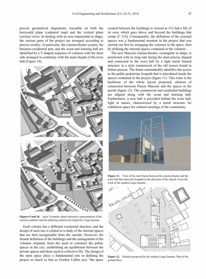
precise geometrical alignments, traceable on both the horizontal plane (cadastral map) and the vertical plane (section view). In dealing with an area trapezoidal in shape, the various parts of the project are arranged according to precise axiality. In particular, the cinema-theatre system, the business-residential part, and the scout and learning hall are identified by a T-shaped sequence of volumes with the short side arranged in continuity with the main façade of the town hall (Figure 10).
Figures 9 and 10. Isola Vicentina: planivolumetric representation of the current condition and the planning solution developed by Luigi Guarato.
Each volume has a different vocational function, and the design of each one is related to a study of the internal spaces that are then recognisable from the outside. However, the formal definition of the buildings and the arrangement of the volumes originate from the need to construct the public spaces in the city, establishing an equilibrium between the private spaces and those used in collective life. The design of the open space plays a fundamental role in defining the project so much so that as Gordon Cullen says “the space
created between the buildings is viewed as if it had a life of its own, which goes above and beyond the buildings that create it” [14]. Consequently, the definition of the external spaces was a fundamental moment in the project that was carried out first by arranging the volumes in the space, then by defining the internal spaces contained in the volumes.
The new Marconi cinema-theatre, rectangular in shape, is positioned with its long side facing the main piazza, aligned and connected to the town hall by a light metal framed structure in a style reminiscent of the old towers found in Italian piazzas. The frame unmistakably identifies the access to the public pedestrian footpath that is articulated inside the spaces contained in the project (figure 11). This route is the backbone of the whole layout proposed, element of connection between Piazza Marconi and the spaces in the parish (figure 12). The commercial and residential buildings are aligned along with the scout and learning hall. Furthermore, a new hall is provided behind the town hall, light in nature, characterised by a metal structure for exhibition space for cultural meetings of the community.
Figure 11. View of the steel frame between the cinema-theatre and the town hall that starts the footpath in the direction of the church. From the work of the student Luigi Guarato.
Figure 12. Solution proposed by the student Luigi Guarato. Plan of the ground floor.

48 Plans for the Historic Centre of Isola Vicentina, Italy Issues with Urban Morphology
The succession of new buildings is characterised by the presence of a continuous wall that separates a small piazza behind the town hall and the new church square, planned at the side of the church. The latter public space defines a second polarity supporting the historic Piazza Marconi where the town hall and main public buildings in Isola Vicentina are located.
The proposal by the student Letizia Carducci also draws on the desire to reorganise the public space between the town hall and St.Peters Church, and on the formulation of new relationships connecting with historic Piazza Marconi.
Analysis of the history of the city identifies the incoherent building development and legitimises the theoretical removal of small temporary residential buildings behind Piazza Marconi and the old Marconi cinema-theatre whose position is considered to be dissonant with the aggregation logic of the urban fabric. In this case the two buildings in the piazza between the old cinema-theatre and the town hall are retained.
Figure 13. (to the side) Solution proposed by the student Letizia Carducci, project planivolumetric plan. A new piazza has been designed in place of the old cinema-theatre, on the bend in the regional road, filtered by wooden posts radiating out. The new cinema-theatre is arranged behind the town hall. The car park and the sports facilities, now situated respectively to the north side of the church and behind it, are exchanged to make the sports facilities more protected and integrated.
Inside the empty space obtained, the project arranges new buildings refinding continuity and coherence with the urban fabric of the town, proposing a logic in the arrangement of the parts in close relationship with the main pre-existing buildings. In particular, a logical arrangement follows the alignment given by the church tower and the perimeter wall
east of the demolished cinema-theatre. Consequently, the position of the new cinema-theatre has been chosen and the body of the scout and learning hall.
According to this logic, the position of the volumes forms the basis of the definition of the new spatial hierarchies. In particular, the new piazza on which the new cinema-theatre is arranged is identified, characterised by seven radiating wooden posts delimiting and separating the piazza itself from the provincial road that runs through the town (Figures 13 and 14). Furthermore, this new piazza also gives the church and its tower centrality and dignity as they were previously constrained inside a restricted and consequently inadequate space. In fact, the figure of the church tower enters fully inside the wide piazza with an effect of reciprocal exaltation. So the piazza is dignified, reminiscent of piazzas in the best Italian tradition characterised by a vertical element, often a civic or religious tower.
Figure 14. View of the plan for the main piazza delimited by the church, new cinema-theatre, and the regional road that runs through the village. The fan of the wooden posts can be seen, which in originating from the position of the bell tower, gives the piazza autonomy. From the work of the student Letizia Carducci.
The bell tower acquires new visibility and centrality inside a space characterised by being more restful. Then small public courtyards are organised along which the new bodies of buildings dialogue with and are a comparison with the old buildings. These intimate courtyards are crossed by the public footpath that connect Piazza Marconi with the new sports area and with the green space planned around the sides of St. Peters Church. The parking, that now has an exedra design behind the church, is moved to the north of the church itself in a background position, visually separated from the new public spaces by the large bulk of the sacred building, but easily reachable.
The public footpath forms a real and true backbone on which the buildings in the project are grafted using a spatial succession built according to the principle of variation (Figure 15). As such both the buildings and the spaces have different proportions and forms, each provided with its own atmosphere and formal recognisability. Consequently, the footpath does not pass through a monotonous succession or

Civil Engineering and Architecture 2(1): 42-51, 2014 49
series of repeated forms but is conscious of a picturesque arrangement of parts that places the observer in a situation of sometimes discovering different situations with surprising effect. In particular, the succession of the narration is composed of different actors, the new cinema-theatre and the smaller building for the scout and learning hall.
Figure 15. View of the plan for the footpath between the new sports facilities situated behind the church and the new piazza to the side of the church. The footpath goes between the new cinema-theatre to the left and part of the church on the right with the bell tower. From the work of the student Letizia Carducci.
The cinema-theatre no longer has the position it now has, behind the road, but is set back in a more internal and discrete position. In this new position the volume is planned as a sculpture in the middle of a free space and so has a new identity characterized by a specific plastic effect.
This building has two accesses, one from the south through the alleyway that leads from Piazza Marconi to the area lying behind the church and one from the car park to the north. The access from the north has a high wall running alongside it and a sheet of water that differentiates the pertinent area of the theatre from that of the building for the scouts and learning. The latter is a two-storey building arranged perpendicular to the cinema-theatre and encloses the green courtyard on the northern side, separating it from the sports area behind the church.
The third proposal presented here is that of Paola Vecelli that aims to reorganise the area between the town hall and St. Peters church by establishing the main side of the new cinema-theatre on the regional road starting from the church tower. The existing footpath that from the triangular Piazza Marconi, alongside the town hall, goes to the church is strengthened as a sign by a low continuous wall that delimits the heart of the proposed project (Figure 16), integrated by new parking on the opposite side. So a new centrality is defined between the low wall of the old footpath, the church, and the planned cinema-theatre aligned along the regional road, a new centrality that expresses the vocation of urban cultural pole. So, related to the rest of the city, the low wall delimits an open courtyard like a public garden able to enhance the space next to the existing buildings, a specific
space of relevance to the cinema-theatre.
Figure 16. View from the north-east of the area subject to investigation with the new cinema-theatre in the centre aligned along the road between the bell tower and the buildings confirmed in Piazza Marconi. From the work of the student Paola Vecelli.
The volume of the theatre is arranged in an apparently free way but actually according to alignments that lead to the edge of the line made by the road (Figure 17). Furthermore, in the planimetry it is also proportioned to relate to the bell tower, the church, and the public space provided for parking behind the town hall. Planned as a monolithic body, many-sided, and shaped differently in order to enhance the new public space with its statuesque shape, the volume of the theatre is composed of the joining of two portions organised according to various hierarchies and rotated to reconfigure the public spaces in Isola Vicentina. The entrance and the service areas are clearly identified in the smaller body, that is in strict relationship with the space around them. The larger body hosts the public hall, reached via a series of ramps designed as a real and true architectural promenade that dialogue with the outside, offering progressively different views (Figure 18).
Figure 17. Isola Vicentina. The low wall that identifies the area of connection between the church and Piazza Marconi with the new cinema-theatre. From the work of the student Paola Vecelli.

50 Plans for the Historic Centre of Isola Vicentina, Italy Issues with Urban Morphology
Figure 18. Isola Vicentina. The planning model with the new cinema-theatre aligned along the regional road between Piazza Marconi and the church. From the work of the student Paola Vecelli.
The space between the side of the church and the cinema-theatre is oriented and proportioned so that it defines an intimate L-shaped environment on which the main entrance to the public hall opens. A brick screen built between the bell tower and the church protects this place that in addition to being the entrance to the theatre, functions as a new church square for St. Peters church, albeit lateral.
The project of the student Luca Costa is based on the expectation of a new centrality through a recreational building such as a dance and variety show theatre, and another with a hospitality vocation such as a new hotel. The planivolumetric plan is defined by the arrangement of the two new buildings that are placed in relationship with the surrounding volumes.
In particular, the proposed arrangement aims at defining new hierarchies on the outside for new urban spaces dedicated to community life. It is appropriate to remember how much the working method adopted by the student, in line with the course aims, particularly emphasises the study of the external spaces, favouring the study of volumes in the space rather than the resolution of the internal spaces, certainly important, but neither definitive nor sufficient. This attitude agrees with Aldo Rossi when he states that how a project endures with the passage of time depends on its form and not its function [5].
The volume hosting the dance and variety show theatre takes its form from the cadastral map in the shape of a square on which is inserted a rotated rectangular shape. The rectangular part is aligned in continuity with the façade of the town hall. On the other hand, the square-shaped part is arranged so that it has one side parallel with the main side of the church in order to make a new piazza between the same church and the theatre, delimited towards the road by the bell tower.
The cuboid body of the new hotel is based on a square map in which the technical rooms and the staircase are at
the centre and the bedrooms at the edge. The building at the back is aligned with the town hall, characterising and concluding the forth side of the new piazza. Another façade of the hotel delimits a play area positioned behind St. Peters church.
Consequently, the two new volumes are not placed freely but respect specific alignments while attempting to define urban spaces or fixed scenes appropriate to community life.
The new theatre has a duel role: firstly, a theatre and secondly, a dance school equipped with a gym and rehearsals room. The part facing the Piazza Marconi and in continuity with the town hall, recognisable by shape, is to be a restaurant and have recreational activities in close relationship with the theatre.
This project also rethinks the historic footpath connecting Piazza Marconi to the space behind St. Peters church where are the car park and sports facilities. This route is now strengthened by the insertion of the two main volumes that together with the church and the bell tower provide the new piazza with its form.
Figure 19. Map of the ground floor according to the project connecting the centre of Isola Vicentina developed by the student Luca Costa.
Civil Engineering and Architecture 2(1): 42-51, 2014 51
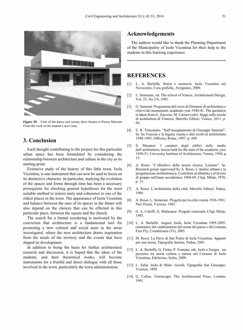
Figure 20. View of the dance and variety show theatre in Piazza Marconi. From the work of the student Luca Costa.
3. Conclusion Each thought contributing to the project for this particular
urban space has been formulated by considering the relationship between architecture and culture in the city as its starting point.
Extensive study of the history of this little town, Isola Vicentina, is one instrument that can now be used to focus on its distinctive character. In particular, studying the evolution of the spaces and forms through time has been a necessary prerequisite for checking general hypotheses for the most suitable method to restore unity and coherence to one of the oldest places in the town. The appearance of Isola Vicentina and balance between the uses of its spaces in the future will also depend on the choices that can be effected in this particular place, between the square and the church.
The search for a formal reordering is motivated by the conviction that architecture is a fundamental tool for promoting a new cultural and social asset in the areas investigated, where the new architecture draws inspiration from the needs of the territory and the events that have shaped its development.
In addition to being the basis for further architectural research and discussion, it is hoped that the ideas of the students, and their theoretical works, will become instruments for a fruitful and direct dialogue with all those involved in the town, particularly the town administration.
Acknowledgements The authors would like to thank the Planning Department
of the Municipality of Isola Vicentina for their help to the students in this learning experience.
REFERENCES [1] L. A. Berlaffa. Storia e memoria. Isola Vicentina nel
Novecento, Cora grafiche, Arzignano, 2000.
[2] L. Semerani, ed. The school of Venice, Architectural Design, Vol. 55, No.5/6, 1985.
[3] G. Samonà. Programma del corso di Elementi di architettura e rilievo dei monumenti, academic year 1940-41. The quotation is taken from G. Zucconi, M. Carraro (eds). Saggi sulla scuola di architettura di Venezia, Marsilio Editori, Venice, 2011, p. 68.
[4] E. R. Trincanato. “Sull’insegnamento di Giuseppe Samonà”. In: Su Venezia e la laguna veneta e altri scritti di architettura 1948-1993, Officina, Rome, 1997, p. 449.
[5] S. Muratori. I caratteri degli edifici nello studio dell’architettura, lesson held for the start of the academic year 1950-51, University Institute of Architecture, Venice, 1950, p. 13.
[6] A. Rossi. “L’obiettivo della nostra ricerca. Lezione”. In: Research group suprevised by A. Rossi. L’analisi urbana e la progettazione architettonica. Contributi al dibattito e al lavoro di gruppo nell'anno accademico 1968-69, Clup, Milan, 1970, p. 15.
[7] A. Rossi. L’architettura della città, Marsilio Editori, Padua, 1966.
[8] A. Rossi, L. Semerani. Progetti per la città veneta 1926-1981, Neri Pozza, Vicenza, 1982.
[9] G. A. Caleffi, G. Malacarne. Progetti veneziani, Clup, Milan, 1985.
[10] L. A. Berlaffa. Auguri, Isola. Isola Vicentina 1905-2005, centenario del cambiamento del nome del paese e del comune, Free Fly, Costabissara (Vi), 2005.
[11] M. Rossi. La Pieve di San Pietro di Isola Vicentina. Appunti per una storia, Tipografia Sartore, Padua, 2001.
[12] L. A. Berlaffa, G. Fietta, P. Fontana, eds. Isola e l'acqua : un percorso tra storia cultura e natura nel Comune di Isola Vicentina, Edelweiss, Schio, 2009.
[13] L. Salin. Isola di Malo: ricordi, Tipografia San Giuseppe, Vicenza, 1898.
[14] G. Cullen. Townscape, The Architectural Press, London, 1961.