Potentials for planning support: a planning-conceptual approach
Upload
khangminh22Category
view
3download
0
PLANNING MANUALJune 2015 / DRAFT
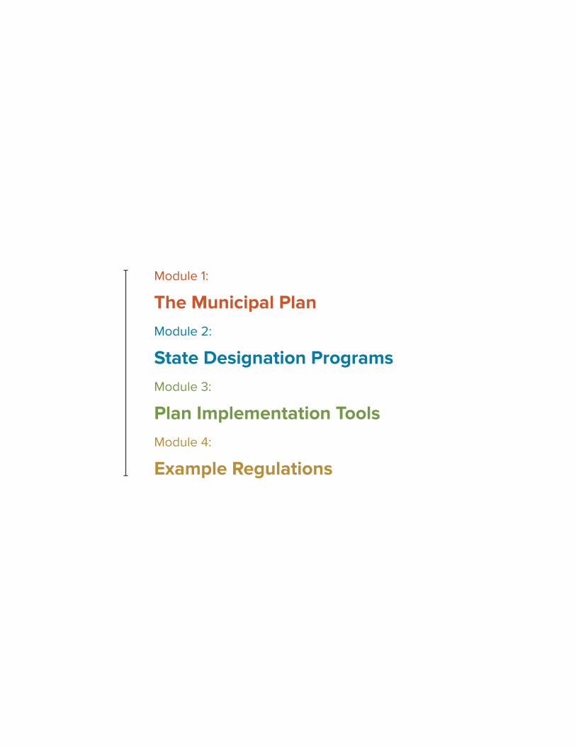
Module 1:
The Municipal Plan Module 2:
State Designation ProgramsModule 3:
Plan Implementation ToolsModule 4:
Example Regulations
PLAnnInG MAnuAL June 2015
The Municipal Plan
Module 1:
DRAFT
DRAFT
Acknowledgments
Id mintusant ant porrum as reptaquis amus sam quunt quis discil eate volentiur sae excepedist eos que porunti oresser spellam volut ea ducipsum, vitis molorum quat officiam reperum voluptam volupti busanit mo quis iliquam sandicia dicilia nobitatur, ut quistrum intius dio comnia nis et modipsant vendestiur, tem esentus, tor minum consequi voluptur modicabores aut veliquidus ex earum quae idis quas modit, qui te nis as ilia con coriatur re officiisim non consed ut labores tiissitasped quist, ut volorep erest, occus prem es autem hicti quundia et eum reri aceperi aectio illab ipicitaque parum vent accaboribus, quia coressi berit, con nos nam quate eossim et accaectorpos am esto quo eic temporro bea quod mi, nos dolor sim et, sus excessi od mi, nitiorit acculpa voloritatur modit modiciunt de libus, ab ipsa vellorepero ipidist, qui ut adi cum erum inum simin pora nim seditae sit, temporerum reperio esti doloruptat aut venis doluptas everfernate pel maiorit, occae rectene culland eliquiam, seditiossint unt odignih itent, quidis aut maiorrum ut id ut quo quam aut qui acernam, que pliqui cus dicit et aut excerisi aut pelitatur?
Hitate dolo dolectium velis sin eos dolent ium velleceribus doluptam hillabor re vel ipsusam sed ullabo. Idessus, imi, cus consedi quaeribus, illoriat acia quiaeri tatquis delitem poriatquunt harias mos maximet plabo. Voles alit quiam auditio nsecab is modi dis sum qui aut doluptaest, volores sequid que quodipsanda ellabo. Ut enima nost aut res

DRAFT
IntroductionWhy Plan?
What is a Municipal Plan?
Regional Plans and State Planning
The Planning Process
The Five StepsStep 1 - Community Assessment
Step 2 - Develop A Shared Community Vision
Step 3 - Identify Community Goals And Development Strategy
Step 4 - Mapping Out The Vision And Future Land use
Step 5 - Making It Happen
Appendix 1Planning Law
Roles
Boards, Commissions and Committees
Preparation and Adoption of the Plan
Worksheets and ChecklistsCreating a Work Plan
Community Assessment Worksheet
Required Plan elements and example Goals and Objectives
State Planning Goals & Regional Plan Conformance
Plan Implementation example Table
existing Plan Assessment
Adoption Procedure
23
4
6
8
1112
20
27
36
46
5050
51
53
58
65
66
67
68
69
70
71
2 THe MunICIPAL PLAn / INTrodUcTIoN DRAFT PLAnnInG MAnuAL June 2015
IntroductionThis edition of the Vermont Planning Manual:
• Helps communities make plans that are user-friendly and concise;
• Recognizes and respects that most plans are created by volunteer commissions and
• Focuses on what matters most – creating a shared vision and identifying the actions that will turn your vision into a reality.
BeTHeL
‘WE ALrEAdY HAVE A PLAN…’
81% of communities in Vermont already have plans and are not starting from scratch. This manual recognizes that and provides useful information whether you are doing a complete overhaul or minor amendment – we’ve even included a tool to help evaluate your existing plan.

3THe MunICIPAL PLAn / INTrodUcTIoN DRAFT PLAnnInG MAnuAL June 2015
Why Plan? Local volunteers in Vermont play an essential role in determining the future of over $90 billion dollars’ worth of existing property and all future investment. While often not recognized, , plans play a significant role in whether or not communities attract residents, businesses and the best and brightest workers from around the region and the country. Both people and businesses are attracted to vibrant communities that are 1) willing to develop a shared community vision, 2) build great places, 3) place an emphasis on promoting transparent and predictable policies, and 4) make wise investment of community dollars and exhibit sound fiscal management.
Four reasons to plan:
1. Develop a Shared Community Vision
Residents and businesses in a community want to understand what direction their community is headed. They want to know if the community is planning on staying a predominately rural place with a small village or if the community vision calls for building complete neighborhoods around an energized town center or some combination of both. Developing this shared vision allows people to come together and set goals and measures to work towards.
2. Make Places
Increasingly, households are becoming more and more mobile. Many choose where they want to live and find a job once they get there. They are looking for places that focus on providing a high quality of life through the built and natural environment. They are choosing walkable neighborhoods and authentic places over poorly planned “anywhere USA” development patterns of many auto-oriented suburbs. Ultimately, many households are looking to invest and live in complete communities and not just a subdivision.
3. Establish Transparent, Consistent and Predictable Policy
When new businesses or residents relocate and invest in a Vermont community they should be able to look at the community’s plan and know in advance exactly what is expected of them. They should be able to quickly tell where they can locate, what they can build, how they can build and, if necessary, what steps they must follow if they want to deviate from the rules. A clear vision and plan can help erase this uncertainty by clearly establishing the foundation for land use rules everyone must play by.
4. Set Foundation for Wise Investment of Community Dollars and Sound Fiscal Management
Vermonters want both affordable taxes, quality public services and a high quality of life. When a community lacks a vision and plan, it often develops into a pattern of sprawling, low-density residential development (1/2- to 5-acre lots). Over time this pattern, even though it may feel rural and low maintenance, will require significant expenditures to extend and maintain sewers, water, utilities, streets, emergency medical response, police and fire protection and other expected services to these sparsely settled portions of the community. This expenditure of public dollars often results in one of two things: higher taxes and fees; or lower investment in things like parks, landscaping, streetscapes, bicycle and pedestrian facilities, and other assets that give a community character, charm and generally make it a desirable place to live.
There are many other good reasons to plan, some of which are covered in this next section of the manual answering the question ‘what is a municipal plan?’
4 THe MunICIPAL PLAn / INTrodUcTIoN DRAFT PLAnnInG MAnuAL June 2015
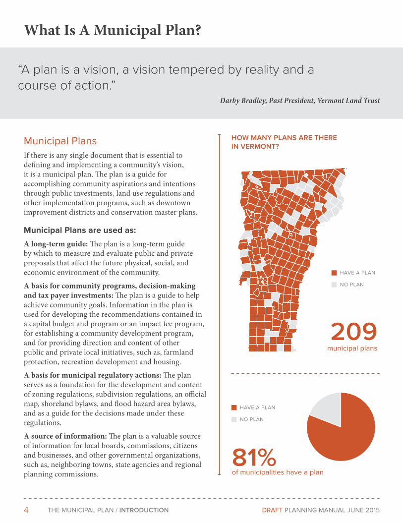
What Is A Municipal Plan?
Municipal PlansIf there is any single document that is essential to defining and implementing a community’s vision, it is a municipal plan. The plan is a guide for accomplishing community aspirations and intentions through public investments, land use regulations and other implementation programs, such as downtown improvement districts and conservation master plans.
Municipal Plans are used as:
A long-term guide: The plan is a long-term guide by which to measure and evaluate public and private proposals that affect the future physical, social, and economic environment of the community.
A basis for community programs, decision-making and tax payer investments: The plan is a guide to help achieve community goals. Information in the plan is used for developing the recommendations contained in a capital budget and program or an impact fee program, for establishing a community development program, and for providing direction and content of other public and private local initiatives, such as, farmland protection, recreation development and housing.
A basis for municipal regulatory actions: The plan serves as a foundation for the development and content of zoning regulations, subdivision regulations, an official map, shoreland bylaws, and flood hazard area bylaws, and as a guide for the decisions made under these regulations.
A source of information: The plan is a valuable source of information for local boards, commissions, citizens and businesses, and other governmental organizations, such as, neighboring towns, state agencies and regional planning commissions.
“A plan is a vision, a vision tempered by reality and a course of action.”
Darby Bradley, Past President, Vermont Land Trust
HoW MANY PLANS ArE THErE IN VErMoNT?
209 municipal plans
81% of municipalities have a plan
HAVe A PLAn
nO PLAn
HAVe A PLAn
nO PLAn
5THe MunICIPAL PLAn / INTrodUcTIoN DRAFT PLAnnInG MAnuAL June 2015
A source for strategic planning and studies: Few plans can address every issue in sufficient detail. Therefore, many plans often recommend further studies to develop policies or strategies to meet a specific need.
A source for community standards in regulatory proceedings at state and regional levels: Act 250, the state land use law, and other state regulatory processes identify the municipal plan as a standard for review of applications. Municipal plans are important to the development of intermunicipal, regional and state agency plans and programs.
Successful Municipal Plans1. Document a community’s shared vision
2. Are meaningful and accurate representations of the desires of the community.
3. Establish the guiding principles and policies for how a community chooses to change or adapt going forward
4. Serve as the guide for decisions made by the community, including local officials and governing bodies
5. Identify priority implementation steps, projects and actions action items over the short-term (1 to 2 years), mid-term (3 to 5 years), and long-term (6+ years) to achieve goals and objectives.
dId YoU KNoW THAT EVEN BUELS GorE HAS A PLAN?
With two roads, eight houses and a population ranging between 4 and 20 (depending on the day), even the tiny unincorporated Buel’s Gore has an adopted plan. If you are a small town debating whether or not you can undertake this process, take inspiration from these Vermonter’s who have had a plan since 1998 Being small can have some advantages, like holding your meetings on someone’s porch in town and letting you barbecue during your public hearings.
FIVE YEAr PLAN, TWENTY YEAr VISIoN
Plan for what you want your community to be in 20 years! A municipal plan should be more than just a description of what the municipality is like today. Many municipal plans have a very thorough inventory of what the present looks like, but they do not address adequately what the municipality should be like in twenty years, nor do they state specific policies or programs to help residents make their desired future a reality.
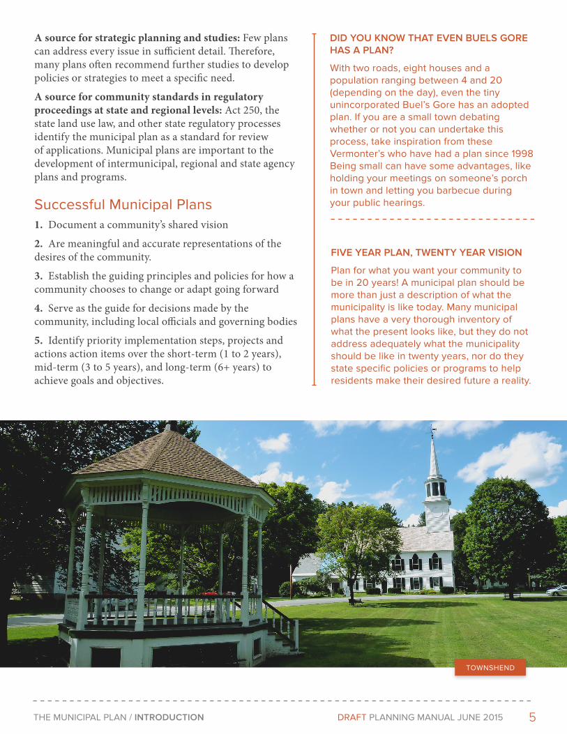
TOWnSHenD

6 THe MunICIPAL PLAn / INTrodUcTIoN DRAFT PLAnnInG MAnuAL June 2015
Regional PlansVermont law enables a municipality to adopt a regional plan or a portion of a regional plan as its municipal plan. The regional plan must have been prepared and adopted by the regional planning commission before it can be adopted by a municipality. The adoption procedures are the same as for a plan prepared by a local planning commission. 24 V.S.A. §4349.
State Planning Goals & Designation Program Vermont’s legislature has outlined 14 different planning goals for the state and Municipal plans should further progress towards these goals. While these goals are integrated throughout module 1 of the manual, this checklist includes all the goals in one place and can help you make note of how your plan is compatible with the state planning goals. [Link to Appendix / 24 V.S.A. §4302.]
The State’s primary land use goal is “To plan development so as to maintain the historic settlement pattern of compact village and urban centers separated by rural countryside.”
Regional Plans and State Planning
Municipal plans in Vermont are necessary to:
Empower Local Decision Making
• Allows you to adopt Zoning Regulations
• Allows you to adopt Subdivision Regulations
• Allows you to adopt Flood Hazard and other free-standing regulations
• Allows you to charge Impact Fees*
Influence State Regulatory Proceedings
• Act 250 applications must conform to your municipal plan
• Your plan will be considered in Section 248 certificate of pubic good applications (more details are included on page xx)
Become Eligible and Receive Priority for Certain State and Federal Funds and Programs
• Municipal Planning Grants*
• State Designation Programs*
• Downtown & Village Tax Credits (and other benefits of designation)*
• Bicycle and Pedestrian facilities funding
• Brownfield Redevelopment Funds
• Community Development and Affordable Housing Funds
*Requires a Confirmed Planning Process that includes approval of the Municipal Plan by the Regional Planning Commission
7THe MunICIPAL PLAn / INTrodUcTIoN DRAFT PLAnnInG MAnuAL June 2015
Downtowns
Downtown Designation provides communities with the help and resources they need to make downtown revitalization a community effort.
Growth Centers
The Growth Center program designates areas that are planned for new development in keeping with historic development patterns.
New Town Centers
Some Vermont communities developed without a strong central core and this program supports the creation of an area that functions as a new downtown or village center.
Neighborhood Development Areas
The program offers incentives to create compact, walkable neighborhoods that attract more people and business to our existing community centers.
Village Centers
Village Center Designation supports small town revitalization with a variety of benefits to the 100+ participating communities.
Vermont’s landscape of compact centers surrounded by rural land is integral to our economy, community spirit and what makes our state the distinctive place it is. Accordingly, Vermont has established a framework of “state designations” to provide incentives to encourage communities to maintain this land use pattern. These programs are also designed to help align our environmental, housing, and transportation policies, programs, regulations, and public investments to maintain and enhance the landscape cherished by Vermonters and visitors alike. While many communities may give local ‘designation’ to areas, such as growth centers, please note that the ‘state designations’ require applying to and receiving approval from a state board. Module 2 of this manual is dedicated to explaining how these state designation programs work and how to apply for them. Communities that complete and adopt a plan become eligible to apply for these designations and to receive benefits.
The Five State Designations
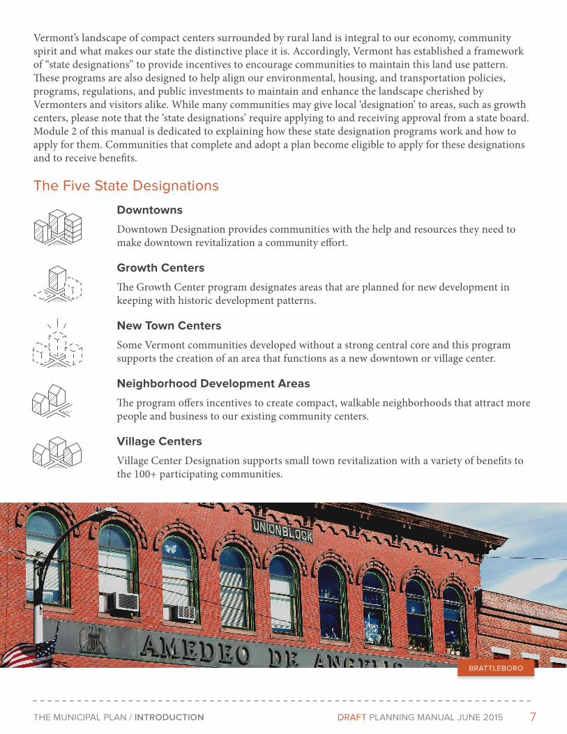
BRATTLeBORO
8 THe MunICIPAL PLAn / INTrodUcTIoN DRAFT PLAnnInG MAnuAL June 2015
The Planning ProcessThe Planning CommissionThe planning commission is responsible for preparing the plan, distributing the plan, holding public hearings on the plan, and submitting it to the legislative body for consideration. The specific requirements for preparation of the plan are set forth in 24 V.S.A. §4384. (Appendix A.)
Like a selectboard or city council, the planning commission is soliciting public input, weighing options and recommending policy decisions, some of which will chart the future of the community and which may eventually have the force and effect of law. Planning commission
members must always act in the public interest and put the general welfare of the community above any personal interests.
The Legislative BodyAccording to the statute, the legislative body (either the selectboard, city council or board of trustees) is responsible for reviewing the plan, holding public hearings on the plan, and adopting the plan. The legislative body may make changes to the plan in accordance with provisions of Chapter 117. (Appendix A.) 24 V.S.A. §4385.
The CommunityThe community’s involvement throughout the planning process is essential in creating a plan that will have support for implementation.
ETHIcAL PrINcIPLES IN PLANNING
The American Planning Association has produced a guide outlining ethical principles that should apply to anyone participating in the planning process: https://www.planning.org/ethics/ethicalprinciples.htm
The ethical principles derive both from the general values of society and from the planner’s special responsibility to serve the public interest.
WHAT’S A ProFESSIoNAL PLANNEr?
Professional planners help create a broad vision for the community. They also research, design, and develop programs; lead public processes; perform technical analyses; manage; and educate. Some planners focus on just some of these roles, such as transportation planning, but most will work at many kinds of planning throughout their careers.
Planners develop a plan through analysis of data and identification of goals for the community or the project. Planners help the community and its various groups identify their goals and form a particular vision.
In the creation of a plan, planners identify the strategies by which the community can reach its goals and vision. Planners are also responsible for the implementation or enforcement of many of the strategies, often coordinating the work of many groups of people.
Did you know there is a Vermont Planner’s Association? If you are on a planning commission, you should consider joining. The Association maintains a useful e-mail listserv that highlights various resources and issues specifically for planners in Vermont.
“When it comes to planning, if you’re not doing it with people- they think you are doing it to them.”
Roger Millar, PE, AICP, Director of National Complete Streets Coalition Former Manager of the City of Portland, OR

9THe MunICIPAL PLAn / INTrodUcTIoN DRAFT PLAnnInG MAnuAL June 2015
All members of your community have the right to participate in planning decisions and the creation of a municipal plan. Planning commissions and local legislative bodies must strive to give community members (including those who lack formal organization or influence) full, clear and accurate information on planning issues and the opportunity to have a meaningful role in the development of the municipal plan.
Key elements of success
1. Willing leadership
Any public planning initiative is only as good as the level of support that it receives from the community’s leadership. If the leaders of a community do not share the vision established by the public, then it will be difficult to implement. There are many decisions that need to be made when mapping, customizing and adopting the plan. The community will be asked to carefully balance what is in their best interest and what is in any given property owner’s best interest. It will take strong leaders who understand the importance of having these discussions and making the difficult decisions to effectively keep the process on track.
2. A Planning Commission made up of dedicated individuals representative of the larger community
Much of the “heavy lifting” of making the plan reflect the community’s values will come from the community itself. The role of the Planning Commission is to provide community outreach, create or review various maps and drafts of the plan that will be produced and serve as a sounding board for public input and whether or not the ideas fit the community.
The Planning Commission should be made up of a diverse group of citizen stakeholders. Members should be people from all walks of life with various backgrounds including real estate, planners, architects, developers, attorneys, bankers, business owners and engineers, as well as community and neighborhood representatives. Members should come from different areas of the community and come from different economic backgrounds. Diverse membership helps ensure that all areas of the community receive ample representation.
3. Public Participation and Engagement
Widespread community engagement and buy in is absolutely critical for the long-term success of any plan. Holding a few public meetings advertised in the local paper is not enough, the process of creating a plan needs to involve individuals across the community and incorporates their ideas, thoughts and concerns. When people feel like they are listened to and are part of the final product it becomes easier to get political support for implementation.
rPc’S ArE THErE To HELP!
If your community is lacking one or more of these components, your Regional Planning Commission (RPC) may be able to help. RPC’s have experience planning in a variety of settings and understand what is required to get the plans adopted and implemented in your community. They may be able to help you think through possible solutions or find the resources necessary to get started.
10 THe MunICIPAL PLAn / INTrodUcTIoN DRAFT PLAnnInG MAnuAL June 2015
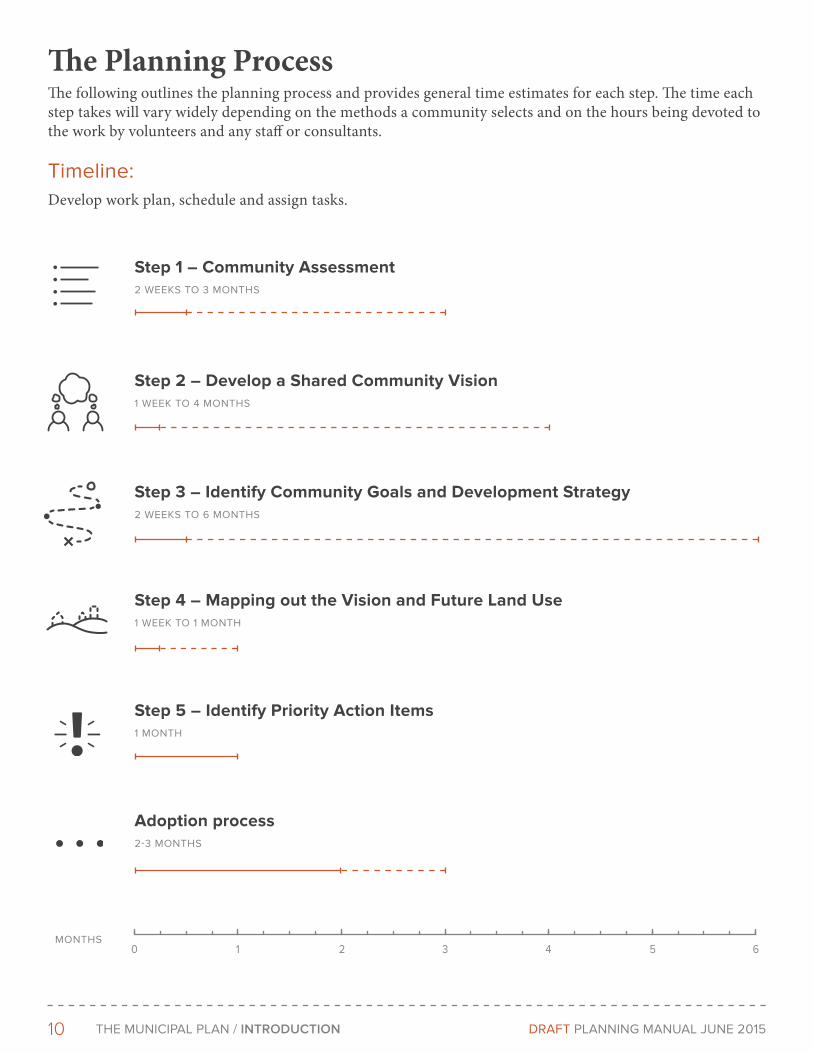
The Planning ProcessThe following outlines the planning process and provides general time estimates for each step. The time each step takes will vary widely depending on the methods a community selects and on the hours being devoted to the work by volunteers and any staff or consultants.
Timeline:Develop work plan, schedule and assign tasks.
1 2 3 4 5 60
Step 1 – Community Assessment2 WeeKS TO 3 MOnTHS
Step 2 – Develop a Shared Community Vision1 WeeK TO 4 MOnTHS
Step 3 – Identify Community Goals and Development Strategy2 WeeKS TO 6 MOnTHS
Step 4 – Mapping out the Vision and Future Land Use1 WeeK TO 1 MOnTH
Step 5 – Identify Priority Action Items1 MOnTH
Adoption process2-3 MOnTHS
MOnTHS

11THe MunICIPAL PLAn / THE FIVE STEPS DRAFT PLAnnInG MAnuAL June 2015
The Five StepsThere are many different approaches to creating a plan. This section of the module outlines a five step method designed to meet Vermont’s statutory plan requirements and present a simple process that focuses on the most important aspects of the plan. While following the five steps will get you all the pieces you need for your plan, the actual structure and content of the plan need not be presented in the same order as the steps.
ForMAT oF THE PLAN
Format of the Plan. Communities use different formats to in their Town Plans. For example, see Stowe [LInK] vs. Brattleboro [LInK]. There is no right or wrong plan format and communities should select a format that is the best fit.
SPRInGFIeLD
12 THe MunICIPAL PLAn / THE FIVE STEPS DRAFT PLAnnInG MAnuAL June 2015
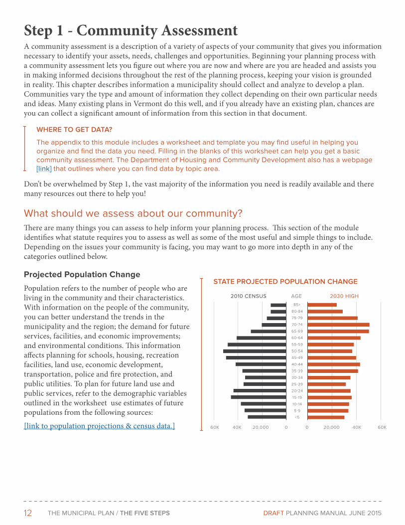
STATE ProJEcTEd PoPULATIoN cHANGE
2010 CenSuS 2030 HIGHAGe
0 20,000 40K 60K020,00040K60K
85+
80-84
75-79
70-74
65-69
60-64
55-59
50-54
45-49
40-44
35-39
30-34
25-29
20-24
15-19
10-14
5-9
<5
Step 1 - Community AssessmentA community assessment is a description of a variety of aspects of your community that gives you information necessary to identify your assets, needs, challenges and opportunities. Beginning your planning process with a community assessment lets you figure out where you are now and where are you are headed and assists you in making informed decisions throughout the rest of the planning process, keeping your vision is grounded in reality. This chapter describes information a municipality should collect and analyze to develop a plan. Communities vary the type and amount of information they collect depending on their own particular needs and ideas. Many existing plans in Vermont do this well, and if you already have an existing plan, chances are you can collect a significant amount of information from this section in that document.
Don’t be overwhelmed by Step 1, the vast majority of the information you need is readily available and there many resources out there to help you!
What should we assess about our community? There are many things you can assess to help inform your planning process. This section of the module identifies what statute requires you to assess as well as some of the most useful and simple things to include. Depending on the issues your community is facing, you may want to go more into depth in any of the categories outlined below.
Projected Population Change
Population refers to the number of people who are living in the community and their characteristics. With information on the people of the community, you can better understand the trends in the municipality and the region; the demand for future services, facilities, and economic improvements; and environmental conditions. This information affects planning for schools, housing, recreation facilities, land use, economic development, transportation, police and fire protection, and public utilities. To plan for future land use and public services, refer to the demographic variables outlined in the worksheet use estimates of future populations from the following sources:
[link to population projections & census data.]
WHErE To GET dATA?
The appendix to this module includes a worksheet and template you may find useful in helping you organize and find the data you need. Filling in the blanks of this worksheet can help you get a basic community assessment. The Department of Housing and Community Development also has a webpage [link] that outlines where you can find data by topic area.

13THe MunICIPAL PLAn / THE FIVE STEPS DRAFT PLAnnInG MAnuAL June 2015
Economy
An economy consists of the production, distribution and consumption of good and services in a given location.
The term, as used in community planning, refers to jobs, production, income, resources, and activities in the municipality and in the region. The economy has a direct influence on the well-being of the residents, the community facilities and services, and the environment of the municipality. Economic planning can help: businesses and organizations create jobs commensurate with the skills and aims of residents; establish a balanced tax base to meet the needs of the community; protect economic resources; and identify necessary services and products. A poorly planned economy can adversely affect the environmental quality of the community; strain municipal facilities; provide excessive or unnecessary services and products; and cause regional dislocations of businesses and industries.
Your plan is required to describe present economic conditions. Begin by inventorying the municipality’s economic base—its natural resource production, industry, and commerce. Collect information on the number, type, and location of businesses; the number of persons employed in town and the location of their residences; the products created; the taxes contributed; and the facilities and services used.
Analyze the information collected in the inventory by comparison with population trends, labor force characteristics, regional economic conditions, natural resource production potential, public services, utilities, transportation, and land availability. The analysis should point out problems, opportunities, and needs. These might include the decline of farming, insufficient wastewater treatment capacity, the misuse or contamination of resources, a lack of well-serviced commercial or industrial sites, or an emerging pattern of strip commercial development.
Many small communities will have little or no commercial and industrial activity. Their residents may be occupied in agricultural or forestry production, home occupations, construction, seasonal businesses, or industries outside the community. Economic planning in these communities will focus on protection of natural resources and farm related businesses, regional economic trends, off-season activities, and suitability of sites and areas for the introduction of new commerce or industry if desired.
More rapidly growing municipalities may be in the process of developing a commercial or industrial base. They may face declining farm and forest production, growing numbers of commuters to regional employment centers, heavy seasonal activity, increasing demands for services, and strip development. These communities will want to consider the availability of well-serviced and suitably located industrial and commercial sites. They will need to decide the extent to which productive natural resources are to be utilized, what types of industry would be desirable, and how economic growth in the community will affect established businesses and employment centers in the region. They will have to consider the availability of adequate municipal services for accommodating growth. Finally, they will want to examine how to reinforce existing town centers and what the effect will be on the quality of the environment in the town.
MAd rIVEr VALLEY ANNUAL dATA rEPorT
The Towns of Fayston, Waitsfield and Warren joined together to create the Mad River Valley Planning District in 1985. The district collects economic data and produces an annual report to help inform their planning efforts. Read the 2013 report here:
http://www.mrvpd.org/MRVDataReport.php
In 2014 the planning district made economic development a priority and used a Municipal Planning Grant [hyperlink] to hire consultants to study the issue more in depth. This project focused on understanding and quantifying the Valley’s economic profile and economic health by assessing relevant data and interviews, identifying industry sectors of strategic importance, establishing a MRV economic baseline, and exploring initiatives that support our economic future. Check out their work here:
http://www.mrvpd.org/Vitality.php
14 THe MunICIPAL PLAn / THE FIVE STEPS DRAFT PLAnnInG MAnuAL June 2015
Housing
A clear understanding of your current housing stock and future housing needs is important for many parts of your plan. You should compare trends in housing supply with the population projections and characteristics. Population characteristics that should be examined include average household size, income levels, and age of residents. Based on this information, determine what type and number of housing units are required for future populations. Also, study trends in population growth and housing supply in the region to determine what the municipal share of the region’s housing needs should be. Compare the projections on housing units with trends in housing supply, including the type and price of units. Identify any gaps likely to occur in meeting future housing needs. Housing that is inadequate to meet the demand in the community or region can strain adjacent municipalities and prevent people from living close to their jobs.
Capacity of Infrastructure and Community Facilities:
Community facilities and services are provided by the municipality (or available within the municipality) for the health, benefit, safety, and enjoyment of the general public.
They include transportation, schools, parks and recreation facilities, libraries, public water supply and waste disposal systems, solid waste management, utilities and energy, police and fire protection, health and human services, and general administrative services. Community facilities and services have a significant effect on the municipality’s ability to grow in an orderly and healthy way.
Adequate, well-maintained, and efficient services will enable homes, businesses, and public places to be accessible and have safe water supplies, sanitary waste disposal, and necessary governmental services.
If the facilities are at capacity, further development may strain them, causing financial burdens and environmental problems. If facilities are inadequate, they may prevent the municipality from adequately meeting existing needs and accommodating desirable growth. If they are oversized and underutilized, they may encourage unplanned growth and higher tax burdens on residents and businesses.
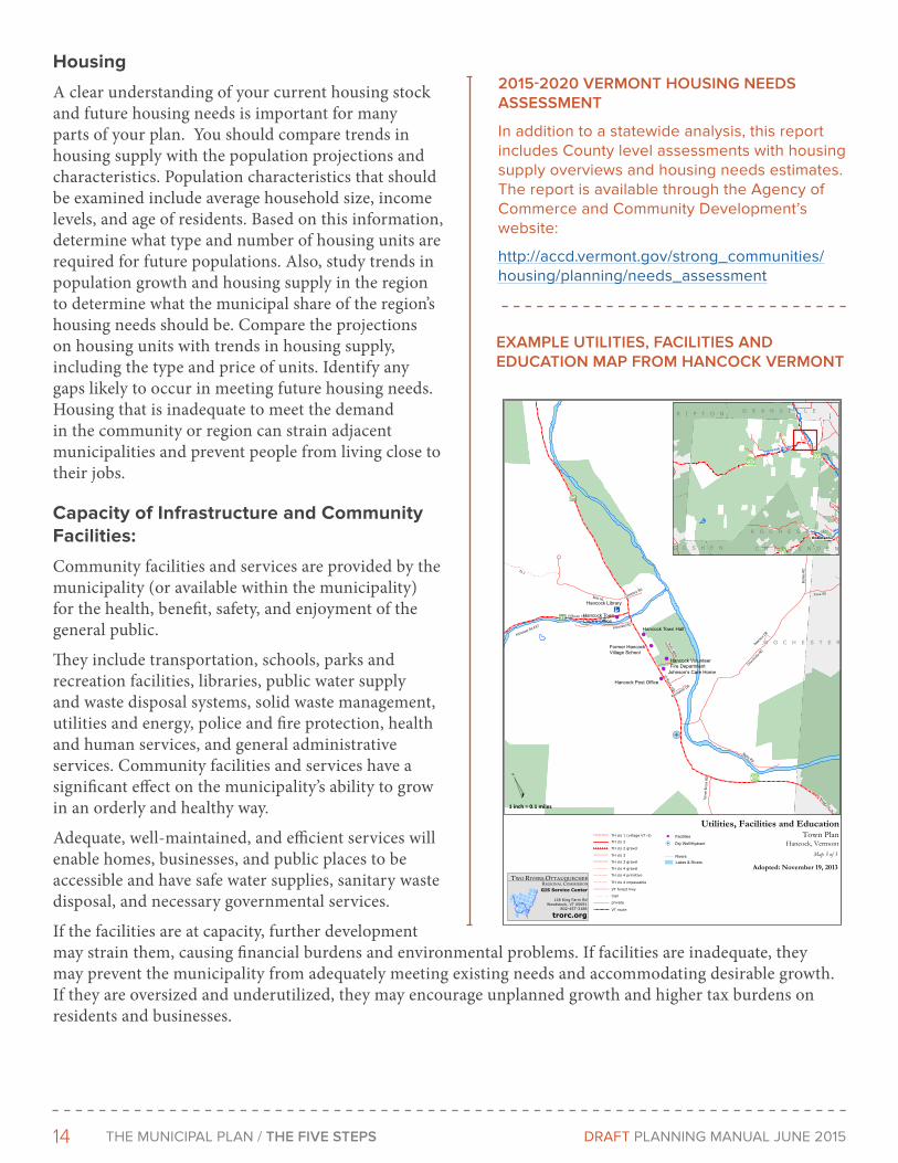
EXAMPLE UTILITIES, FAcILITIES ANd EdUcATIoN MAP FroM HANcocK VErMoNT
R O C H E S T E R
100
125
Vt Route 100
Buttl
es R
D
Churchvill
e RD
Th 7
Bettis RD
Vt Route 125
Blair HL
Killooleet RD
Killooleet Rd EXT
Fiske RD
Vt Route 100 N
Tunn
el B
rook
RD
Taylor MDW
Cemetery RD
Isaacso
n DR
Recreation DR
1 inch = 0.1 miles
Hancock, Vermont
Utilities, Facilities and EducationTown Plan
Map 3 of 3
VT route
private
trail
VT forest hwy
TH cls 4 impassable
TH cls 4 primitive
TH cls 4 gravel
TH cls 3 gravel
TH cls 3
TH cls 2 gravel
TH cls 2
TH cls 1 (village VT rt)
Hancock Branch
WesR O C H E S T E R
R I P T O N G R A N V I L L E
G O S H E N C H I T T E N D E N
Robinson
Hancock Library
Hancock Town Hall
Former HancockVillage School
Johnson’s Care Home
Hancock TownClerk’s Office
Hancock Post Office
Hancock VolunteerFire Department
Adopted: November 19, 2013
128 King Farm RdWoodstock, VT 05091
802-457-3188
trorc.org
TWO RIVERS-OTTAUQUECHEEREGIONAL COMMISSION
GIS Service Center
Lakes & RiversRivers
Facilities
Dry Well/Hydrant
2015-2020 VErMoNT HoUSING NEEdS ASSESSMENT
In addition to a statewide analysis, this report includes County level assessments with housing supply overviews and housing needs estimates. The report is available through the Agency of Commerce and Community Development’s website:
http://accd.vermont.gov/strong_communities/housing/planning/needs_assessment
15THe MunICIPAL PLAn / THE FIVE STEPS DRAFT PLAnnInG MAnuAL June 2015
ANr NATUrAL rESoUrcES ATLAS
The natural Resources Atlas provides user-friendly geographic information about environmental features and sites that the Vermont Agency of natural Resources manages, monitors, permits, or regulates. In addition to standard map navigation tools, the site allows you to link from sites to documents where available, generate reports, export search results, import data, search, measure, mark-up, query map features, and print PDF maps. In addition, the Atlas displays all of Vermont’s designated village center and downtown boundaries. For questions and comments, please contact erik engstrom, AnR GIS Project Supervisor.
http://anrmaps.vermont.gov/websites/anra/
Take inventory of all community facilities and services and important facilities and services available to the municipality elsewhere in the region. The inventory should include all community facilities and services owned and operated by public agencies; federal, state, and local bodies; and entities such as town and village school districts, fire precincts and other special purpose districts.
Evaluate these facilities and services in terms of their quality; ability to deliver services; capacity to meet future needs based on population, economic, and land use trends; their effect on orderly and efficient municipal and regional development; and other standards the municipality and region may set. An evaluation should consider not only the needs of permanent residents, businesses, and industries, but also, where applicable, the needs of seasonal residents and transients.
This component of the community analysis is more complex than other parts, as the information you need is from a variety of locations. The worksheet [link] and community assessment data webpage [link] can help you figure out where to find the information and data you need.
At a minimum, your plan is required to have:
1. A statement of present and projected uses and the local public school system
2. A map and statement of present and prospective community facilities and public utilities showing existing and proposed educational, recreational and other public sites, buildings and facilities, including hospitals, libraries, power generating plants and transmission lines, water supply, sewage disposal, refuse disposal, storm drainage, and other similar facilities and activities
3. A map and statement of present and prospective transportation and circulation facilities, including parking facilities, transit routes, terminals, bicycle paths and trails, scenic roads, airports, railroads, and port facilities, and other similar facilities or uses.
4. An analysis of energy resources, needs, scarcities, costs and problems within the municipality
Natural Resources and Physical Conditions
These resources have significant implications for change in a community because they indicate opportunities and constraints for development. In addition, they indicate areas that must be protected to avoid hazards to the public health, safety, and welfare and to maintain valuable scientific, scenic, and productive resources.
The Agency of Natural Resources has created a ‘Town Plan’ theme that maps out some of the resources you should map out.
Water Resources
An understanding of the community’s water resources is critical to planning for future land use and community facilities and services. Both groundwater and surface water provide domestic and commercial water supplies, recreation opportunities and serve important ecological functions. They are also unique
16 THe MunICIPAL PLAn / THE FIVE STEPS DRAFT PLAnnInG MAnuAL June 2015
and fragile ecosystems that need to be properly used, managed, and protected.
Surface waters include lakes, ponds, reservoirs, rivers, streams, and water contained in pores of soil materials. These waters are valuable as sources of water supply; recreation areas; absorption areas for flood waters; habitats for wildlife, waterfowl, and vegetation; and aesthetic enjoyment. The value of surface waters can be diminished through pollution, alteration, and overuse.
Identifying areas susceptible to damage from flooding and erosion is an important step towards making an informed decision about where a community wants to focus development and investments. Encouraging the wrong kind of development in the wrong place can lead to serious safety issues and major private and public costs.
The most cost-effective way to moderate flooding is to protect the natural systems that are already in place. Identifying and protecting the natural flood protection assets that your community depends on is the most inexpensive and effective way to increase the flood resilience of your community.
The Agency of Natural Resources has created a useful website to help you identify where are safer locations for the future development of the community, what buildings and infrastructure are at risk of flood damage and other critical information.
Your plan is required to identify flood hazard and fluvial erosion hazard areas, based on river corridor maps provided by the Secretary of Natural Resources.
Wetlands are another important water resource that should be identified in your plan, as they are areas of the state that are inundated by surface or ground water with a frequency sufficient to
BIoFINdEr
BioFinder is a map and database identifying Vermont’s lands and waters supporting high priority ecosystems, natural communities, habitats, and species. The most comprehensive assessment of its kind in Vermont, BioFinder was developed by the Agency of natural Resources and partners to further our collective stewardship and conservation efforts.
http://biofinder.vt.gov/
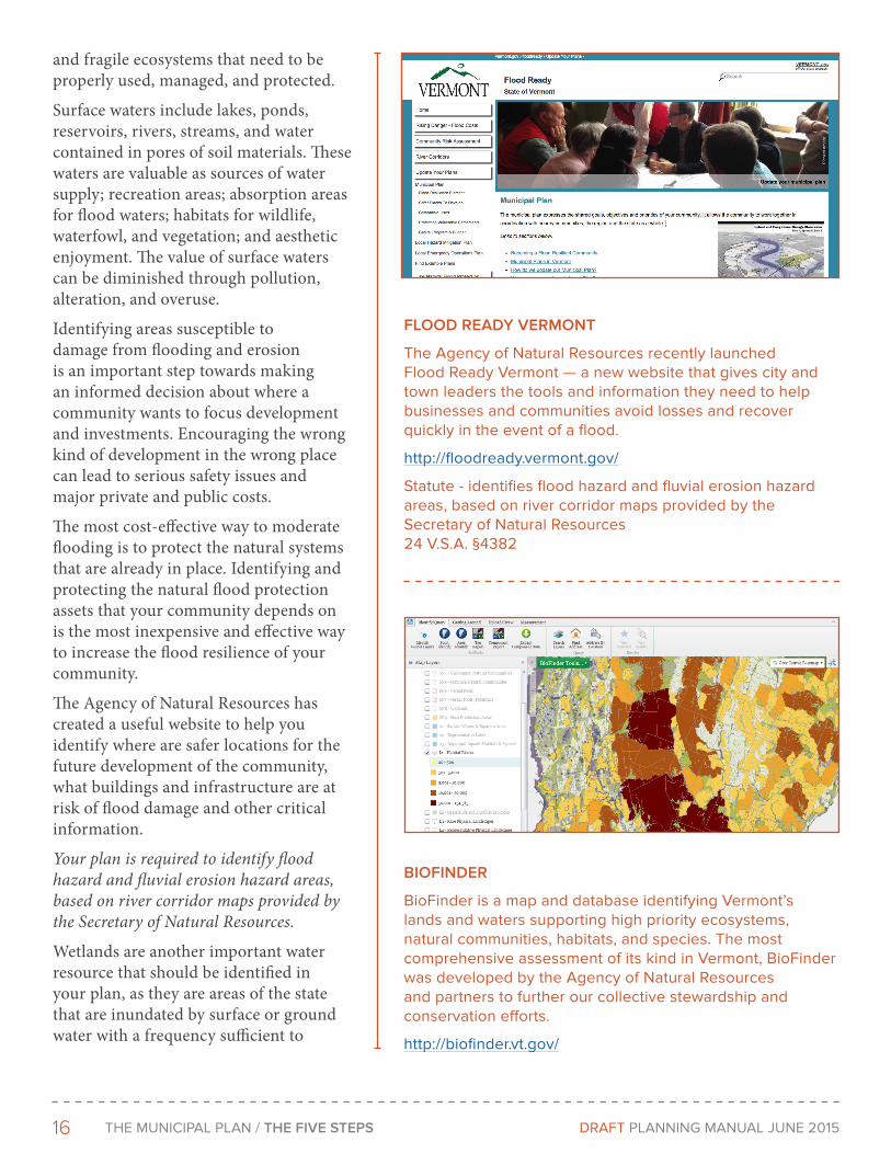
FLood rEAdY VErMoNT
The Agency of natural Resources recently launched Flood Ready Vermont — a new website that gives city and town leaders the tools and information they need to help businesses and communities avoid losses and recover quickly in the event of a flood.
http://floodready.vermont.gov/
Statute - identifies flood hazard and fluvial erosion hazard areas, based on river corridor maps provided by the Secretary of natural Resources 24 V.S.A. §4382

17THe MunICIPAL PLAn / THE FIVE STEPS DRAFT PLAnnInG MAnuAL June 2015
support significant vegetation or aquatic life that depend on saturated or seasonally saturated soil conditions for growth and reproduction. Wetlands may include marshes, swamps, sloughs, potholes, fens, river and lake overflows, mud flats, bogs, and ponds, but they do not include areas on which food or crops are grown. Wetlands are important because they provide important wildlife, waterfowl, and vegetative habitat, improve water quality, and provide recreation values and scenic beauty.
Natural Areas and Wildlife Habitat
In most communities there are places that are quite unusual because of their wildlife, plants, or geological features. Often remote, quiet, or beautiful, such places have been known and frequented for generations by local townspeople and outside visitors alike. Many of these areas provide food and conditions necessary for the survival of a diverse array of flora and fauna. Our increasing ecological awareness and the accelerating pace of land development during the last 50 years have made these natural areas more critical than ever before.
The Agency of Natural Resources have developed the ‘Biofinder’ tool to provide you with a tool to explore the distribution and richness of Vermont’s biodiversity and help secure our natural heritage for future generations.
Topography
Vermont’s topography has influenced its pattern of land use, both in the past and in the present. A landscape of hills and valleys has shaped transportation routes, provided the settings for villages, farms and forests.
A topographic map shows heights of land (peaks, hilltops, plateaus, and ridgelines), river valleys, streams, low-lying areas, and plains. Steep slopes are also evident where contour lines are close together, indicating a large change in elevation over a small distance.
Topographic information is important for planning future land use, transportation, and public facilities and services. Topography will influence accessibility, will provide natural boundaries between areas, and will often determine land
BrATTLEBoro WILFLIFE SUITABILITY MAP
LEAST SUITABLE WILDLIFE HABITAT
MOST SUITABLE WILDLIFE HABITAT
GEorGIA STEEP SLoPES MAP
SLOPES 15%
SLOPES 25%
18 THe MunICIPAL PLAn / THE FIVE STEPS DRAFT PLAnnInG MAnuAL June 2015
use. For example, steep mountainous areas may only be suitable for recreation, conservation, or forestry management, while valleys and plains may be most appropriate for development, farming, and transportation corridors. Topographic features, such as peaks or gorges, often have symbolic and historic importance to a community and may be highlighted in the plan for special protection.
Slopes of 15%, 20% and over 25% are depicted on the Agency of Natural Resources Atlas.
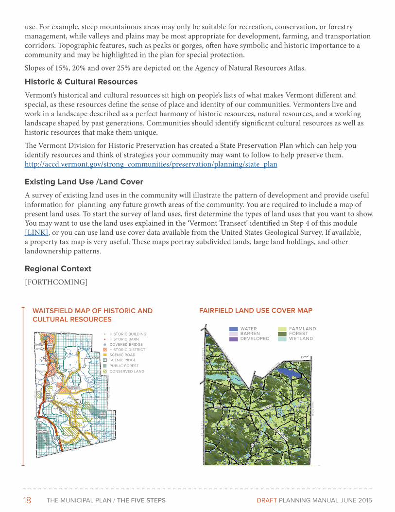
Historic & Cultural Resources
Vermont’s historical and cultural resources sit high on people’s lists of what makes Vermont different and special, as these resources define the sense of place and identity of our communities. Vermonters live and work in a landscape described as a perfect harmony of historic resources, natural resources, and a working landscape shaped by past generations. Communities should identify significant cultural resources as well as historic resources that make them unique.
The Vermont Division for Historic Preservation has created a State Preservation Plan which can help you identify resources and think of strategies your community may want to follow to help preserve them. http://accd.vermont.gov/strong_communities/preservation/planning/state_plan
Existing Land Use /Land Cover
A survey of existing land uses in the community will illustrate the pattern of development and provide useful information for planning any future growth areas of the community. You are required to include a map of present land uses. To start the survey of land uses, first determine the types of land uses that you want to show. You may want to use the land uses explained in the ‘Vermont Transect’ identified in Step 4 of this module [LINK], or you can use land use cover data available from the United States Geological Survey. If available, a property tax map is very useful. These maps portray subdivided lands, large land holdings, and other landownership patterns.
Regional Context
[FORTHCOMING]
WAITSFIELd MAP oF HISTorIc ANd cULTUrAL rESoUrcES
N o
r t h
f i e
l d
W a r r e n
F a
y s t
o n
M o r e t o w n
Bridge St
Joslin Hill R
d
East Warren Rd
Common Rd
East Rd
North Rd
N Fayston Rd
Airport Rd
Center Fayston Rd
Bragg Hill Rd
Bridge St
Joslin Hill R
d
East Warren Rd
Common Rd
East Rd
North Rd
N Fayston Rd
Airport Rd
Center Fayston Rd
Bragg Hill Rd
Rural HistoricDistrict
Historic District
VillageHistoricDistrict
ScragMunicipal
Forest
Camel’s HumpState Forest
Rural HistoricDistrict
Historic District
VillageHistoricDistrict
ScragMunicipal
Forest
Camel’s HumpState Forest
HISTORIC BUILDINGHISTORIC BARNCOVERED BRIDGEHISTORIC DISTRICTSCENIC ROADSCENIC RIDGE
PUBLIC FOREST
CONSERVED LAND
FAIrFIELd LANd USE coVEr MAP
S WA
NT O
N
FA
IRF
AX
E N O S B U R G
SH
EL
DO
N
FL
ET
CH
ER
ST .
AL B
AN
ST O
WN
B A K E R S F I E L D
36
North R dSouth R d
Chester A Arthur Rd
89
36
0 1 2 3 40.5
miles
BARRENDEVELOPED
WATERFORESTWETLAND
FARMLAND
19THe MunICIPAL PLAn / THE FIVE STEPS DRAFT PLAnnInG MAnuAL June 2015
CRAFTSBuRY
How do we use this assessment information?Once you have assembled and examined information on your population, housing, local economy, physical conditions and community facilities and services, this information should be consolidated and presented in a format that accessible to the public and those participating in the community visioning process and future steps of the planning process.
Making the assessment information widely available and accessible is essential. You may want to put it into a digital format, post it on your town website and distribute the link through front porch forum [link], Facebook, send it to municipal committee e-mail lists and invite people to distribute. Having paper copies available front and center at your library and town offices is also advisable. Talk to teachers in your community and see if the assessment might fit into their classes. Writing an article in your local paper outlining the process timeline, providing community assessment highlights, giving a link to more information and inviting people to participate in the visioning is a great idea. Creating a brief a presentation with key findings to lead off any visioning meetings is also smart thing to do, as not everyone will take the time to read the assessment, not matter how well distributed it is.
Remember, the point of the assessment is assist you and the community in making informed decisions throughout the rest of the planning process, and to keeping your vision is grounded in reality.
Don’t forget to download this worksheet [link] and template to help you organize and find the data you need. Your Regional Planning Commission is a great resource their to help you and the Department of Housing and Community Development also has a webpage [link] that outlines where you can find data by topic area.

20 THe MunICIPAL PLAn / THE FIVE STEPS DRAFT PLAnnInG MAnuAL June 2015
Step 2 - Develop a Shared Community VisionCreating a shared community vision is the most critical step in the comprehensive planning process. It may sound like something fluffy, or a step you can skip – but it is essential.
Having a clear shared community vision is key to guiding future decisions and will allow you to focus on how to implement your plan later on. If your vision is missing or unclear it becomes much harder know if your implementation actions are appropriate or adequate to meet your community’s needs. Additionally, the lack of a clear vision can lead to future conflict when individuals have different ideas of what the community wants and people begin working towards conflicting goals.
There are a number of different methods for develop¬ing a vision and community visions can be articulated and depicted in a wide variety of ways. Below are some examples of what your vision can look like and several approaches to creating the vision are highlighted. At the beginning of or prior to any visioning process make sure to present your community assessment. It is important that there exists a firm, fact-based understanding of the existing conditions of the community such as housing needs, economic needs and demographic projections of anticipated population change. The information from your community assessment will go a long way toward keeping the public discussion firmly rooted in real possibilities.
What does a vision look like?Ultimately, there is no absolute right answer so long as your vision is easily identified and it is reinforced by the planning document. One productive way to articulate a vision is to map out the degree of change people would like to see throughout their community and identify the community’s core values and priorities. The next couple pages of this module outline what this approach can look like.
“It’s about discovering what your community cares about – its shared values – and building a vision for the future based on those shared values. Activities in this phase focus on bringing a broad mix of people into the process to help identify these values. Telling personal stories about local experiences is a key engagement strategy in this phase, bringing people together and helping them to find common ground.”
Community Heart & Soul Field Guide, Orton Family Foundation
“If you aren’t inclusive in this step of the process, you will fail. Fail terribly.”
Authors of Planning Manual

21THe MunICIPAL PLAn / THE FIVE STEPS DRAFT PLAnnInG MAnuAL June 2015
Identify what your community wants to maintain, evolve and transform
All communities want a healthy environment, safe neighborhoods, adequate housing choices and affordable taxes. Simply stating this may not be particularly helpful. One helpful way to depict part of your vision is to identify which areas in your community that you want to 1) maintain 2) evolve and 3) transform. Identifying the degree of change a community has in mind for different areas can be a helpful way to identify places that may need detailed planning and targeted investment.
Maintain: It’s likely that you would like to ‘maintain’ most areas in your town. Municipalities often identify the working landscape and important natural features as areas they would like to maintain and would like to see limited change. Existing desirable neighborhoods are also places most communities would like to maintain, often with the addition of some additional housing opportunities that are well designed appropriate and compatible with the existing character.
Evolve: Many parts of our municipalities are places we would like to see build on their underlying strengths and character, such as our Village Centers and Downtowns. Identifying an area that you would like to evolve might mean it is a place the community wants infill development, redevelopment and streetscape improvements.
Transform: There may be parts of your town or city that are appropriate for complete transformation. Many residents tend to identify strip development and underutilized or contaminated sites as areas that they would like to see transformed. It’s possible that undeveloped areas within walking distance of the community center are suitable for transformation into a new neighborhood. Areas selected to ‘evolve’ or ‘transform’ may benefit from specific area planning. [SEE IMPLEMENTATON TOOLS] Priority areas targeted for change should be identified and may action items highlighted later in the planning process may proscribe in-depth master plans.
Maintain
Evolve
Transform

22 THe MunICIPAL PLAn / THE FIVE STEPS DRAFT PLAnnInG MAnuAL June 2015
Gathering information about where your community wants to evolve, transform and change could be done a variety of ways, such as through focus groups, open houses, workshops, or online tools (more details regarding these options are available under the ‘What’s the best way for my community to create vision?’ section.) When you are gathering people at a meeting or event you should consider: 1) giving a brief presentation of the overall workplan and timeline for the creation of the plan, 2) describing the goal of creating the shared vision and giving clear instructions on how to participate in the meeting, 3) breaking up into smaller groups to allow people to express themselves and have discussions, 4) providing people with large maps and materials such as stickers and markers for people to put there ideas on paper and 5) bringing the groups back together to share what their groups thought.
You will likely find that there is a lot of consensus about the overall vision for different parts of your community. Try to resolve conflicting ideas with dialogue and look for areas of mutual agreement. If there are some highly controversial areas or ideas, you may want to deal with them separately and revisit later on in order to keep your momentum going.
Areas selected to ‘evolve’ or ‘transform’ may benefit from specific area planning. [SEE IMPLEMENTATON TOOLS] Priority areas targeted for change should be identified and addressed in Step 5 of this module where recommendations on how to implement the vision are made. . Identifying areas your community wants to maintain, evolve and transform will also make it easier to create a land use map later on in the process, as you will have guidance on where the community would like to see more change and areas it would like to preserve.
Use Photographs and Images
Community visions need to convey a picture of what the future will look like – and there is no better way to convey this picture than with the use of photographs and images. Invite people to submit annotated photos and images showing what they like about their community and showing what they might like their community to become. If you do collect photos from others that you plan on using in the final plan document, make sure that it’s okay to use the photo and give credit to the photographer.
nORTHFIeLD

23THe MunICIPAL PLAn / THE FIVE STEPS DRAFT PLAnnInG MAnuAL June 2015
1
8
3
5 7
62
4
6
1: Maintain
Protect rural character and opportunities for agricultural enterprises.
2: Maintain
Preserve historic character of neighborhood while allowing for some more housing.
3: Transform
Cleanup and engage downtown waterfront.
4: Maintain
Keep up maintenance on this cherished park!
5: Evolve
Encourage second story housing and make improvements to Main Street.
6: Evolve
Promote infill housing and add bicycle lanes and sidewalks connecting to downtown.
7: Transform
Cleanup brownfield and establish new industrial park
8: Maintain
Preserve river corridor and mitigate downstream flooding.
1
8
3
5 7
62
4
6
1
8
3
5 7
62
4
6
1
8
3
5 7
62
4
6MAInTAIn eVOLVe TRAnSFORM
Example Concept Map: Maintain Evolve Transform
24 THe MunICIPAL PLAn / THE FIVE STEPS DRAFT PLAnnInG MAnuAL June 2015
Create a Vision StatementA vision statement captures what community members value most about their community, and the shared overall image of what they want their community to become. It inspires community members to work together to achieve the vision. An effective Vision Statement will convey what changes are preferred to create the desired future of the community. The vision statement describes the desired situation as if it exists today. Write in the present tense. While crafting the statement, remember that you’re describing the dream of your communities’ highest potential.
Vision statements can vary in length, but should strive to be short and to the point! Here are some good examples of community vision statements.
What is the best way for my community to create a vision?There are a variety of methods and tools that can help. Spend some time exploring different approaches and find one that is best suited to your community.
Communities have found design charrettes, public workshops, town hall meetings and public polling to be effective ways to get the public participation that is essential for this step. A combination of methods may be best. What is important is that the entire process be as transparent as possible and reach as many people willing to participate as possible. Getting widespread participation in your process will require a creative and multi-pronged approach. Your efforts to reach out to people may include: writing articles in your local paper, using front porch forum, personally calling community leaders, using social media, including notes in utility bills, printing promotional material on beer coasters and giving them to restaurants. Get creative and make sure you are reaching out to all types of people.
It is recommended that the public input piece of the visioning process be undertaken on a compressed timeframe. Concentrating your efforts into one or a couple big events and working to get widespread participation and discussion will be more effective than a year of public meetings that risk giving people ‘meeting fatigue’ and being dominated by the usual meeting go-ers. Get people excited and get them to participate – but be mindful of their time and recognize that many people are busy!
In order to give you a feel for what a visioning process might looking like, we’ve outlined two scenarios on the next page.
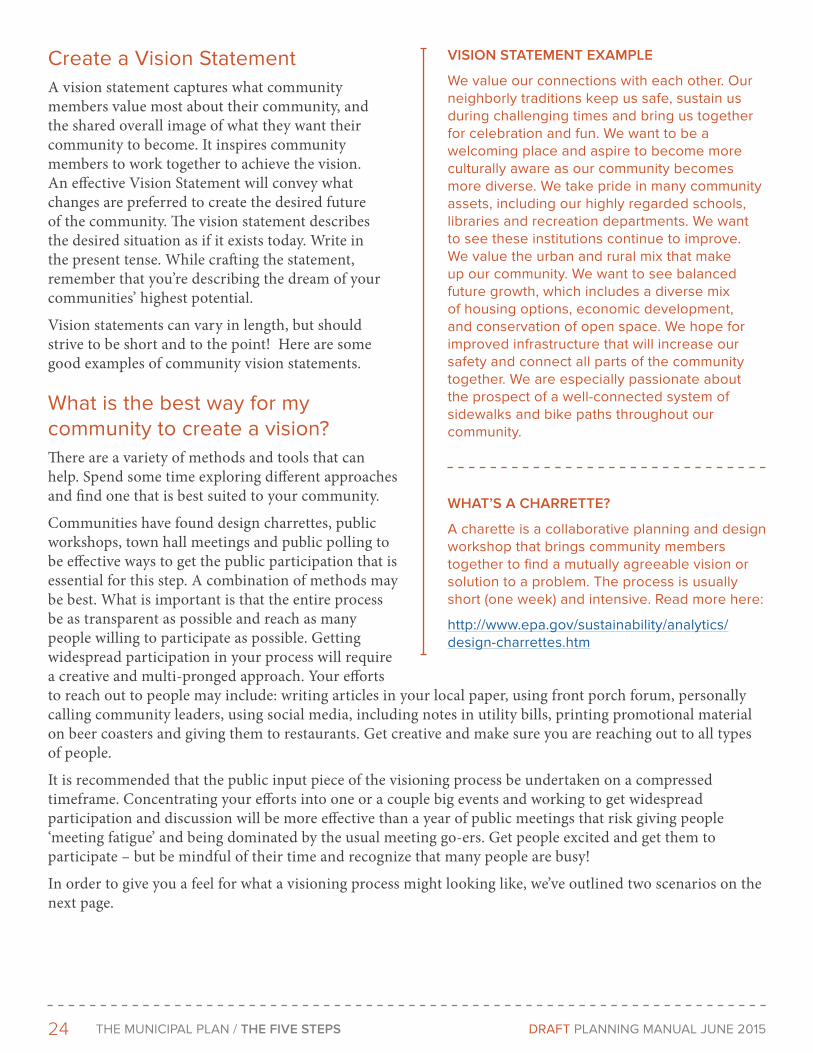
VISIoN STATEMENT EXAMPLE
We value our connections with each other. Our neighborly traditions keep us safe, sustain us during challenging times and bring us together for celebration and fun. We want to be a welcoming place and aspire to become more culturally aware as our community becomes more diverse. We take pride in many community assets, including our highly regarded schools, libraries and recreation departments. We want to see these institutions continue to improve. We value the urban and rural mix that make up our community. We want to see balanced future growth, which includes a diverse mix of housing options, economic development, and conservation of open space. We hope for improved infrastructure that will increase our safety and connect all parts of the community together. We are especially passionate about the prospect of a well-connected system of sidewalks and bike paths throughout our community.
WHAT’S A cHArrETTE?
A charette is a collaborative planning and design workshop that brings community members together to find a mutually agreeable vision or solution to a problem. The process is usually short (one week) and intensive. Read more here:
http://www.epa.gov/sustainability/analytics/design-charrettes.htm
25THe MunICIPAL PLAn / THE FIVE STEPS DRAFT PLAnnInG MAnuAL June 2015
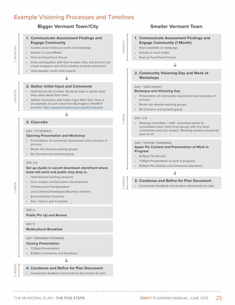
example Visioning Processes and Timelines
1. Communicate Assessment Findings and Engage Community
• Create social media accounts and webpage
• Articles in Local Media
• Post on Front Porch Forum
• Invite participation with flyer in water bills, and print on ice cream wrappers and drink coasters at local restaurants
• Hold speaker series with experts
2. Gather Initial Input and Comments• Hold School Art Contest. Students draw or photo what
they value about their town.
• Gather Comments with Public Input Web Tool. Here is an example of such a tool from Burlington’s PlanBTV process. http://www.burlingtonvt.gov/public/map.php
2 M
On
TH
S1
MO
nT
H
3. Charrette
DAY 1 (TueSDAY)
Opening Presentation and Workshop• Presentation of community assessment and overview of
process
• Break into diverse working groups
• Re-Convene and present group
DAY 2-6
Set up studio in vacant downtown storefront where team will work and public may drop in.• Hold themed working sessions:
• Civic leaders and economic Development
• Infrastructure/Transportation
• Land Owners/Developers/Business Owners
• environmental Concerns
• Arts, Culture and Creativity
DAY 4
Public Pin Up and Review
DAY 5
Multicultural Breakfast
DAY 7 (MOnDAY eVenInG)
Closing Presentation• 7:00pm Presentation
• 8:30pm Comments and Questions
4. Condense and Refine for Plan Document• Incorporate feedback and produce documents for plan
1 W
ee
K2
We
eK
S
1. Communicate Assessment Findings and Engage Community (1 Month)
• Have available on webpage
• Articles in local media
• Post on Front Porch Forum
2. Community Visioning Day and Week of Workshops
1 M
On
TH
DAY 1 (SATuRDAY) Barbeque and Visioning Day• Presentation of community assessment and overview of
process
• Break into diverse working groups
• Re-Convene and present group
DAY 2-6
• Steering committee / staff / consultant works to consolidate input. Hold focus groups with any local committees and civic leaders. Working sessions should be open to all.
DAY 1 (FRIDAY eVenInG) Apple Pie Contest and Presentation of Work in Progress• 6:45pm Pie Served
• 7:00pm Presentation of work in progress
• 8:00pm Pie Awards and Comments Questions
3. Condense and Refine for Plan Document• Incorporate feedback and produce documents for plan
1 W
ee
K2
We
eK
S
Bigger Vermont Town/City Smaller Vermont Town

26 THe MunICIPAL PLAn / THE FIVE STEPS DRAFT PLAnnInG MAnuAL June 2015
Contact your Regional Planning Commission to help with this task and to provide you with data and information to inform your visioning process.
Here are several useful resources related to different approaches to visioning.
Community Heart & Soul Field Guide, Orton Family Foundation 2014, Helpful guide that outlines a detailed process on focused on widespread community participation in enhancing a community’s identity and ‘heart and soul’.
Community Visioning and Strategic Planning Handbook, The National Civic League, 2000 - Still useful guide lays out the framework of the successful community planning processes used by the National Civic League and others across the country
Community Visioning Handbook: How to Imagine - and Create - a Better Future, Maine State Planning Office, 2003 - Particularly thoughtful visioning guide. Nice explanation of “why vision?” useful “how to” steps and public workshop instructions, tips and exercises
The New Oregon Model - Envision - Plan - Achieve, by Steve Ames, Journal of Futures Studies, November 2010 - Good brief about the classic Oregon visioning model
Planning for the Future: A Handbook on Community Visioning, 3rd ed., The Center for Rural Pennsylvania, An agency of the Pennsylvania General Assembly, 08/21/2006 - Well organized guide outlines a suggested process, elements of success, and lessons learned. Also provides sample workshop agendas, announcements, checklists and other materials -
The Power of Visioning in Strategic Planning: If you don’t work to shape your future, someone else will, Institute for Law and Justice, 2002 - Brief discussion of the power and key characteristics of visioning
Shaping Washington’s Growth Management Future: Citizen Participation and Community Visioning Guide, Washington State Department of Community trade and Economic Development (now Department of Commerce), 06/2008 - Part B briefly describes visioning approaches and four Washington local government examples
WATeRBuRY
27THe MunICIPAL PLAn / THE FIVE STEPS DRAFT PLAnnInG MAnuAL June 2015
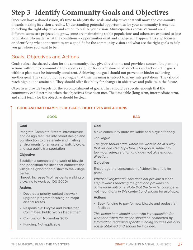
Step 3 -Identify Community Goals and ObjectivesOnce you have a shared vision, it’s time to identify the goals and objectives that will move the community towards making its vision a reality. Understanding potential opportunities for your community is essential to picking the right objectives and action to realize your vision. Municipalities across Vermont are all different; some are projected to grow, some are maintaining stable populations and others are expected to lose population. No matter what the conditions – opportunities exist and change will happen. This step focuses on identifying what opportunities are a good fit for the community vision and what are the right goals to help you get where you want to be.
Goals, Objectives and ActionsGoals reflect the shared vision for the community, they give direction to, and provide a context for, planning actions within the community. They serve as a guide for establishment of objectives and actions. The goals within a plan must be internally consistent. Achieving one goal should not prevent or hinder achieving another goal. They should not be so vague that their meaning is subject to many interpretations. They should reach high but be attainable. They should offer flexibility for changes in objectives and policies in the future.
Objectives provide targets for the accomplishment of goals. They should be specific enough that the community can determine when the objectives have been met. The time table (long term, intermediate term, and short term) for the objective should be clear.
Goal
Integrate Complete Streets infrastructure and design features into street design and construction to create safe and inviting environments for all users to walk, bicycle, and use public transportation
Objective
establish a connected network of bicycle and pedestrian facilities that connects the village neighborhood district to the village center. (Target: Increase % of residents walking or bicycling to work by 10% 2020)
Actions
• Develop a priority-ranked sidewalk upgrade program focusing on major arterial routes
• Responsible: Bicycle and Pedestrian Committee, Public Works Department
• Completion: november 2015
• Funding: not applicable
Goal
Make community more walkable and bicycle friendly
Too vague.
The goal should state where we want to be in a way that we can clearly picture. This goal is subject to too much interpretation and does not give enough direction.
Objective
encourage the construction of sidewalks and bike paths.
Where? Everywhere? This does not provide a clear step towards reaching the goal and provides no achievable outcome. Note that the term ‘encourage’ is not meaningful in this context and should be available.
Actions
• Seek funding to pay for new bicycle and pedestrian facilities
This action item should state who is responsible for what and when the action should be completed by. Information regarding specific funding sources are also easily obtained and should be included.
Good ANd BAd EXAMPLES oF GoALS, oBJEcTIVES ANd AcTIoNS
Good BAd
28 THe MunICIPAL PLAn / THE FIVE STEPS DRAFT PLAnnInG MAnuAL June 2015
While the focus of Step 3 is to identify your goals and objectives, take some time during this step to brainstorm plausible action items that support your goals and objectives. The community should generally support the actions included in this list, however you should not spend time evaluating them yet and think of these items as ideas to consider later. Later on, in step five, you will revisit and evaluate these action items and select the best ones to be included in a prioritized implementation plan.
At a minimum, goals and objectives need to be identified for the list of topics presented on the following pages The level of detail under each section will vary depending on the issues is a community is facing. Some places may need to focus on flood resiliency and protecting their river corridors while others need to address a housing shortage. Every community has different priorities and faces their own set of issues so focus on what matters most to implement your shared vision.
Organized by topic area the manual highlights relevant state land use goals and basic statutory requirements. Rather than crafting new language and concepts, your community can opt to use the same language as the statewide goals or regional plan goals where appropriate.
The appendix includes a table that lists examples of typical goals, objectives and recommended actions.
economic Development The economy is the primary driver of population change and the economic future of your community should be integral to your shared vision. Whether you are a small rural town looking to maintain your farming and forest industry or a mostly urban small city looking to attract businesses, setting the right goals and objectives can help you realize your vision. Use the assessment data from Step 1 and the shared community vision to help get you started.
The State’s economic development goal is ‘To provide a strong and diverse economy that provides satisfying and rewarding job opportunities and that maintains high environmental standards, and to expand economic opportunities in areas with high unemployment or low per capita incomes.’
Your plan is required to describe the location, type, and scale of desired economic development, and identifies policies, projects, and programs necessary to foster economic growth;
The following is an example of an economic development related goal, objective and actions. See the table of examples [insert link] for more examples.
Goal
Pursue local economic development strategies to increase economic opportunity and jobs downtown, particularly in the technology sector.
Objective
Strengthen and enhance state designated village center to increase number of businesses, encourage more mixed use (where appropriate). Target: Lower vacancy rate to 10% and add 400 new jobs by 2020.
Actions
• Complete a Master Plan for the downtown (2016)
• Revise the Unified Development Bylaw to allow for more development of commercial and mixed use development (2017)
• Revise the Unified Development Bylaw to eliminate parking requirements (2017)
• Establish an incubator space for startup businesses (2018)
• Evaluate the possibility of creating a form based code
29THe MunICIPAL PLAn / THE FIVE STEPS DRAFT PLAnnInG MAnuAL June 2015
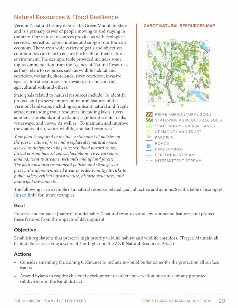
cABoT NATUrAL rESoUrcES MAP
natural Resources & Flood ResilienceVermont’s natural beauty defines the Green Mountain State and is a primary driver of people moving to and staying in the state. Our natural resources provide us with ecological services, recreation opportunities and support our tourism ecomony. There are a wide variety of goals and objectives communities can take to ensure the health of their natural environment. The example table provided includes some top recommendation from the Agency of Natural Resources as they relate to resources such as wildlife habitat and corridors, wetlands, shorelands, river corridors, invasive species, forest resources, stormwater, erosion control, agricultural soils and others.
State goals related to natural resources include,‘To identify, protect, and preserve important natural features of the Vermont landscape, including significant natural and fragile areas; outstanding water resources, including lakes, rivers, aquifers, shorelands and wetlands; significant scenic roads, waterways, and views.’ As well as, ‘To maintain and improve the quality of air, water, wildlife, and land resources.’
Your plan is required to include a statement of policies on the preservation of rare and irreplaceable natural areas, as well as designate to be protected: flood hazard zones, fluvial erosion hazard zones, floodplains, river corridors, land adjacent to streams, wetlands and upland forests. The plan must also recommend policies and strategies to protect the aforementioned areas in order to mitigate risks to public safety, critical infrastructure, historic structures, and municipal investments.
The following is an example of a natural resource related goal, objective and actions. See the table of examples [insert link] for more examples.
Goal
Preserve and enhance [name of municipality]’s natural resources and environmental features, and protect these features from the impacts of development
Objective
Establish regulations that preserve high priority wildlife habitat and wildlife corridors. (Target: Maintain all habitat blocks receiving a score of 5 or higher on the ANR Natural Resources Atlas.)
Actions
• Consider amending the Zoning Ordinance to include no-build buffer zones for the protection all surface waters
• Amend bylaws to require clustered development or other conservation measures for any proposed subdivisions in the Rural district.
9
9
Mollys Falls Pond
Mollys Pond
Coits Pond
West Hi ll Pond
Mollys Brook
Joes Brook
Kidder Brook
Win
oosk
i Riv
er
Ie
Aý
Aû
IeAû
MARSHFIELD
PE
AC
HA
MD
AN
VIL
LE
WALDEN
WO
OD
BU
RY
US R
OU
TE 2
RO
UTE
215
N
S W
ALD
EN R
D
URBAN RD
CO
ITS
PO
ND
RD
LAST RD
ROU
TE 2
15 S
DANVILLE HILL RD
DUCHAR
ME RD
CABOT PLA
INS R
D
W SHORE RD
MAIN S
T
LOVELY RD
CH
UR
CH
ILL
RD
WH
EELE
R R
D
DU
BR
AY R
D
MACK MTN RD
W HILL POND RD
ELM ST
SM
ITH
RD
WHITTIER HILL RD
LANGONE RD
BLODGETT RD
THISTLE HILL RD
WH
ITE
RD
WAL
BRID
GE
RD
CABOT RD
HOUSTON HILL RD
BOTHFELD HILL RDGLINKA RD
HOUGHTON RD
ME
NA
RD
RD
JUG
BRO
OK RD
TAYLOR RD
BAYLEY-HAZEN RD
MOLLY R
D
SAW MILL RD
HO
OK
ER
VIL
LE R
D
PRAN
SKY
RD
COW HILL RD
TEB
BE
TTS
RD
MCKINSTRY RD
BRICKETTS CROSSING RD
TH 57
BOLTON RD
DEEP
ER R
UTS R
D
OLD
CE
NTE
R R
D
TETREAULT RD
TH 63
CROSS RD
PORTER RDCARPENTER RD
CATHY RD
GARN
EY R
D
TH 54
SANDY BEACH RD
KEENE RD
CHATOT RD
TH 34
TH 5
5
TH 64
TH 47
TH 3
0
STO
NE
FAR
M R
D
TH 1
1
MCCARTY RD
DINGMAN RD
MEADOW LN
GYM RD
Legend
Prime Agricultural Soils
Prime
Statewide
Conserved Lands
State and Municipal Lands
Vermont Land Trust
Parcels
Roads
Lakes/Ponds
Stream/River
Perennial Stream
Intermittent Stream
0
1
2Miles
¹
Data Sets:
Surface Waters: VHD, VCGI 2008
Roads: 1:5,000 VTrans Roads 2009
Parcels: Cabot 2008, CVRPC
Vermont Land Trust: VLT 2010
Public Lands: UVM 2009
Rare, Threatened and Endangered
Species & Significant Communities: VT ANR 2010
Deer Yards: VT ANR 1994
Wetlands: VSWI, VT ANR 2005
Contours: VCGI 2010
Slopes: CVRPC 2009
Prime Ag.: V
T NRCS
Map Created 8/31/2010 by CVRPC
N:/Towns/Cabot/Natural_Resources_11x17.mxd
Data is only as accurate as the original sources.
This map is for planning purposes only.
This map may contain errors and omissions.
Map 2b: Natural Resources
9
9
Mollys Falls Pond
Mollys Pond
Coits Pond
West Hi ll Pond
Mollys Brook
Joes Brook
Kidd
er Bro
ok
Win
oosk
i R
iver
Ie
Aý
Aû
Ie
Aû
MARSHFIELD
PE
AC
HA
M
DA
NV
ILLE
WALDEN
WO
OD
BU
RY
US
RO
UT
E 2
RO
UTE
215
N
S W
AL
DE
N R
D
URBAN RD
CO
ITS
PO
ND
RD
LAS
T RD
RO
UT
E 2
15 S
DANVILLE HILL RD
DUCHARME RD
CABOT PLAINS RD
W SHORE RD
MAIN ST
LOV
ELY
RD
CH
UR
CH
ILL
RD
WH
EE
LER
RD
DU
BR
AY R
D
MA
CK
MT
N R
D
W HILL POND RD
ELM ST
SMIT
H R
D
WH
ITTIER H
ILL RD
LANGONE RD
BLODGETT RD
THIS
TLE
HILL R
D
WH
ITE
RD
WA
LBR
IDG
E R
D
CA
BO
T RD
HO
US
TON
HILL R
D
BOTHFELD HILL RD
GLIN
KA
RD
HOUGHTON RD
MEN
ARD
RDJUG BROOK RD
TAYLOR RD
BAY
LEY-H
AZ
EN
RD
MOLLY RD
SAW MILL RD
HOO
KER
VIL
LE R
D
PRAN
SKY RD
COW
HILL RD
TEB
BE
TTS
RD
MCKINSTRY RD
BR
ICK
ET
TS C
RO
SS
ING
RD
TH 57
BOLTON RD
DEEPER RUTS RD
OLD
CE
NTE
R R
D
TETREAULT RD
TH 63
CROSS RD
PORTER RD
CA
RP
EN
TE
R R
D
CATHY RD
GARNEY RD
TH 54
SA
ND
Y B
EA
CH
RD
KE
EN
E R
D
CHATOT RD
TH
34
TH 55
TH 64
TH 47
TH 30
STON
E FA
RM R
D
TH 1
1
MCCARTY RD
DIN
GM
AN
RD
ME
AD
OW
LN
GYM RD
LegendPrime Agricultural Soils
Prime
Statewide
Conserved LandsState and Municipal Lands
Vermont Land Trust
Parcels
Roads
Lakes/Ponds
Stream/River
Perennial Stream
Intermittent Stream0 1 2
Miles
¹Data Sets:Surface Waters: VHD, VCGI 2008Roads: 1:5,000 VTrans Roads 2009Parcels: Cabot 2008, CVRPCVermont Land Trust: VLT 2010Public Lands: UVM 2009Rare, Threatened and Endangered Species & Significant Communities: VT ANR 2010Deer Yards: VT ANR 1994Wetlands: VSWI, VT ANR 2005Contours: VCGI 2010Slopes: CVRPC 2009Prime Ag.: VT NRCS
Map Created 8/31/2010 by CVRPCN:/Towns/Cabot/Natural_Resources_11x17.mxd
Data is only as accurate as the original sources.This map is for planning purposes only.This map may contain errors and omissions.
Map 2b: Natural Resources
9
9
Mollys Falls Pond
Mollys Pond
Coits Pond
West Hi ll Pond
Mollys Brook
Joes Brook
Kidd
er Bro
ok
Win
oosk
i R
iver
Ie
Aý
Aû
Ie
Aû
MARSHFIELD
PE
AC
HA
M
DA
NV
ILLE
WALDEN
WO
OD
BU
RY
US
RO
UT
E 2
RO
UTE
215
N
S W
AL
DE
N R
D
URBAN RD
CO
ITS
PO
ND
RD
LAS
T RD
RO
UT
E 2
15 S
DANVILLE HILL RD
DUCHARME RD
CABOT PLAINS RD
W SHORE RD
MAIN ST
LOV
ELY
RD
CH
UR
CH
ILL
RD
WH
EE
LE
R R
D
DU
BR
AY R
D
MA
CK
MT
N R
D
W HILL POND RD
ELM ST
SM
ITH
RD
WH
ITTIE
R H
ILL RD
LANGONE RD
BLODGETT RD
TH
IST
LE
HIL
L R
D
WH
ITE
RD
WA
LB
RID
GE
RD
CA
BO
T RD
HO
US
TON
HILL R
D
BOTHFELD HILL RD
GL
INK
A R
D
HOUGHTON RD
ME
NA
RD
RDJUG BROOK RD
TAYLOR RD
BA
YL
EY
-HA
ZE
N R
D
MOLLY RD
SAW MILL RD
HO
OK
ER
VIL
LE R
D
PRAN
SKY RD
COW
HILL RD
TEB
BE
TTS
RD
MCKINSTRY RD
BR
ICK
ET
TS C
RO
SS
ING
RD
TH 57
BOLTON RD
DEEPER RUTS RD
OLD
CE
NTE
R R
D
TETREAULT RD
TH
63
CROSS RD
PORTER RD
CA
RP
EN
TE
R R
D
CATHY RD
GARNEY RD
TH 54
SA
ND
Y B
EA
CH
RD
KE
EN
E R
D
CHATOT RD
TH
34
TH 55
TH 64
TH
47
TH 30
STO
NE
FAR
M R
D
TH
11
MCCARTY RD
DIN
GM
AN
RD
ME
AD
OW
LN
GYM RD
LegendPrime Agricultural Soils
Prime
Statewide
Conserved LandsState and Municipal Lands
Vermont Land Trust
Parcels
Roads
Lakes/Ponds
Stream/River
Perennial Stream
Intermittent Stream0 1 2
Miles
¹Data Sets:Surface Waters: VHD, VCGI 2008Roads: 1:5,000 VTrans Roads 2009Parcels: Cabot 2008, CVRPCVermont Land Trust: VLT 2010Public Lands: UVM 2009Rare, Threatened and Endangered Species & Significant Communities: VT ANR 2010Deer Yards: VT ANR 1994Wetlands: VSWI, VT ANR 2005Contours: VCGI 2010Slopes: CVRPC 2009Prime Ag.: VT NRCS
Map Created 8/31/2010 by CVRPCN:/Towns/Cabot/Natural_Resources_11x17.mxd
Data is only as accurate as the original sources.This map is for planning purposes only.This map may contain errors and omissions.
Map 2b: Natural Resources
PRIME AGRICULTURAL SOILS
STATEWIDE AGRICULTURAL SOILS
STATE AND MUNICIPAL LANDS
VERMONT LAND TRUST
PARCELS
ROADS
LAKES/PONDS
PERENNIAL STREAM
INTERMITTENT STREAM
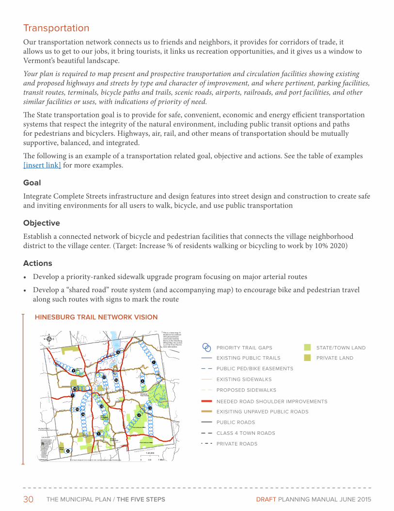
30 THe MunICIPAL PLAn / THE FIVE STEPS DRAFT PLAnnInG MAnuAL June 2015
TransportationOur transportation network connects us to friends and neighbors, it provides for corridors of trade, it allows us to get to our jobs, it bring tourists, it links us recreation opportunities, and it gives us a window to Vermont’s beautiful landscape.
Your plan is required to map present and prospective transportation and circulation facilities showing existing and proposed highways and streets by type and character of improvement, and where pertinent, parking facilities, transit routes, terminals, bicycle paths and trails, scenic roads, airports, railroads, and port facilities, and other similar facilities or uses, with indications of priority of need.
The State transportation goal is to provide for safe, convenient, economic and energy efficient transportation systems that respect the integrity of the natural environment, including public transit options and paths for pedestrians and bicyclers. Highways, air, rail, and other means of transportation should be mutually supportive, balanced, and integrated.
The following is an example of a transportation related goal, objective and actions. See the table of examples [insert link] for more examples.
Goal
Integrate Complete Streets infrastructure and design features into street design and construction to create safe and inviting environments for all users to walk, bicycle, and use public transportation
Objective
Establish a connected network of bicycle and pedestrian facilities that connects the village neighborhood district to the village center. (Target: Increase % of residents walking or bicycling to work by 10% 2020)
Actions
• Develop a priority-ranked sidewalk upgrade program focusing on major arterial routes
• Develop a “shared road” route system (and accompanying map) to encourage bike and pedestrian travel along such routes with signs to mark the route
! !!
!
!!!!
!
!
!!
!!
!
! !
!!
!!
!!
!!
!!
!!
!!
!!
!!
!!
!!
!
!!
! !! !
!!
!
!
!!
!!
!!
!
! !
!!
!!
!!
!
!
!
!
!!
!!
!
!
!!
!!
!!
!!
!!
!!
!!
!!
!!
! !
!!
!
!
!!
!
!
! !
!!
!!
!!
!!
!!
!!
!!!!
!!!!
!!!!
!!!!
! !! !
!!
!!
!!
!
!
!!
!!
!!
!!
!
!
!!
!!
!!
!!
!!
!!
!
!!
!
!!
!!
!!
!!
!
!!
! !
!!
!!
!!
!!
! !
!!
!!
!!
!!!!
!!
!
!!
!
!!
!!
!!
!!
!!
!!
!!
!!
!!
!!
!!
!!
! ! ! !! !
!!
!!
!!
!
! !
!!
!
!
!!
!
!!
!!
!!
!
!!
! !
!!
!!
!!
!!
!!!
!!
!
!
!!
!!
! !
!!
!!
!!
!!
!!
!!
!!
!!
! !! !
! !! !
! !!
!
!!
!!
!!
!!
!!
!!
!!
! !! !
! !
!!
!
! !!
!
!
!!
!!
!!
!!
!!
!!
!!
!!
!!
!!
!!
!!
!!
!
!
!!
!!
!!
!!
!!
!
!
! !
! !! !
!!
!!
!!
!!
!!
!
!
!
!!! !
!!
!!
!
!
!!
!!
!
!
!!
! ! !!
!!
!!
!
!
!
!!
!
!!
!!
!!
!!
!!
!!
!!
!!!!!
!
! !! !
!!
!!
!!
!!
!
!!
!
!
!!
!!
!!
!!
!!!
!
!
!!
!!
!
!!
! !
!!
!!
!!
!!
!!
!!
! !
!
!!
!!
!!
!!
!!
! !
! !
!!!!
!
!
!!
!!
!!
! !
!
!!
!!
!!
!!
!!
!!
!!
!!
!!
!
!
!! !
! !
! !
!
!
! !
!!
!!
!!
!!
!!
!!
!!
!
!!
!
!!
!
!
!!
!!
!
!!
!!
!!
!!
!!
!
!
! !
! !
!!
!!!!
!!
!!
!!
!!
!!
!!
! !
!!
!!
!!
!!
!!
!!
!!
!
!
!!
! !
! !
!!
! !!!
!
!!
!
!!
!!
!
!
!!!!!
!
!!
!!
!!
!!
!!
!!
!!
!!
!!
!!
!
!!
!!
!!
!!
!!
!!
!!
! !
!
!
! !
!!
!
!
!!
!!
! !
!
!
!!
!!
!!!!
!!
!!
!!
!!
!!
!!
!
!
!
!! !!
!!
!
!!
!!
!!
!!
!!
!
!
!!
!!
!!
!!
!!
!!
!!
!!
!!
!!!!
!!
!!
!!
! !
!!
!!
!!
!
!
!!
!
!
!
!
!!
!!
!!
!!
!!
!
!
!
!
!!!!
!!
!!
!!!!
!!
!!
!!
!!
!
!!
!
!
!
!!
!!
!!
!!
!!
!!
!!
!!
! !
!
!
!
!
!!
!
!
!
!
! !
! ! !
!!
! !
!!
!!!!
! !
!!
!
!
!!!!
!!!!
!
!
! !
!!
! !
!!
!!
!!
!!
!!
!!
!!
! !
!!
!!
!!
!!
!!
!!!!
!!
!
!
!!
!!
!!
!
!!
!!
!!
!!
!!
!!
!!
!
!
!!
!!
!!
! !!
!! !
!!
!
! ! ! !!
!!
!!
!
!
! !
! !
!!
!
!
!
!!
!!
!!
!!
!
!
!!
!!
! !
! !! !
! !
!!
!!
!!
!!
! ! ! !! !
!!
!!
!!!
!
!!
! !!
!
!
!
!
! !
!
!
!!
!!
!!
!!
!!
!!
! !
!
!
!!
!!
ôôôôôôôôôôôôôôôôôôôôôôôô
ôô
ôôôôôôôô
ôôôôôôôôôôôôôôôôôôôô
ôôôôôôôôôôôôôôôôôôôôôô
ôôôôôô
ôôôô
ôôôô
ôôôôôôôôôôôôôôôô
ôôôôôôôôôôôô
ôôôô
ôôôôôôôôôô
ôôôôôôôôôôôô
ôôôôôôôôôôôô
ôôôôôôôôôôôôôôôôôôôô
ôôôôôôôôôôôôôôôôôôôôôôôôôôôô
ôôôôôôôô
SunsetLake
rs116
S H E L B U R N ES H E L B U R N E
S T . G E O R G ES T . G E O R G E
R I C H M O N DR I C H M O N D
HU
NT
I NG
TO
NH
UN
TI N
GT
ON
ST
AR
KS
BO
RO
ST
AR
KS
BO
RO
A D D I S O N C O U N T YA D D I S O N C O U N T Y
M O N K T O NM O N K T O N
CH
AR
LO
TT
EC
HA
RL
OT
TE
Lake Iroquois
ROUTE 116
SILV
ER
NO
RTH
RD
HOLLOW RD
PON
D R
D
RICH
MO
ND R
D
CHARLOTTE RD
SHELBURNE FALLS RD
C V U RD
ME
CH
AN
ICSV
ILLE
RD
TYLER BRIDGE RD
BALD
WIN
RD
GILM
AN R
D
TEXAS HILL RD
LINCOLN HILL RD
O'NEIL RD
MAGEE HILL RD
HAYDEN HILL RD W
LEWIS CREEK RD
BURRITT RD
ISHAM RD
POND BROOK RD
HINES RD
TUR
KEY
LN
BUCK HILL RD W
BEECHER HILL RD
DRINKWATER RD
SWAMP RD
HAYDEN HILL RD E
LAVIGN
E HILL R
D
BUCK HILL RD E
LEAVENSWORTH RD
PLACE RD W
OLD
RO
UTE
116
LAG
OO
N R
D
PIETTE RD
PALM
ER R
D
BIRC
HW
OO
D D
R
BOU
TIN R
D
CATCHAPAW RD
!14
!1
!4
!13!3
!9
!8
!11!12
!10
!2
!15
!5
!6
!7
Map 13:Trail Network Vision:
Existing Routes and GapsTown of Hinesburg
4
LOCATION
VERMONT
1:45,000
0 10.5 Mile
Map date 5/5/2011by Hinesburg Planning & Zoning
H:\aweinhagen\Files\...\map13_trail_vision_050511.mxdThis map is designed to be viewed in color, and is available at www.hinesburg.org
GepragsPark
HCS
LaPlatteHeadwatersTown Forest
HinesburgTown Forest
Fred Johnson WMA
Fred Johnson WMA
GillepsieCopp-Welch
RavenRidge
1. Hinesburg Town Forest - HaydenHill Rd East - Texas Hill Rd -potentially Sleepy Hollow Trails -Magee Hill Rd/Swamp Rdintersection.
2. Hinesburg Town Forest – TexasHill Rd.
3. Hinesburg Town Forest –Lincoln Hill Rd. – Hollow Rd. -Fred Johnson WMA.
4. Hinesburg Town Forest –Lincoln Rill Rd. – Fred JohnsonWMA – Hines Rd.
5. Copp-Welch – Isham Rd.
6. Baldwin Rd. – Raven RidgePreserve.
7. Baldwin Rd. – Leavensworth Rd.
(move Charlotte Rd.?).
8. Boutin OR O’Neil Rd. – GepragPark.
9. Place Rd. E – Pond Brook Rd. –Richmond Rd.
10. Village – Leavensworth Rd.
11. Mechanicsvill Rd. – cemetery –Red Pine Rd. – Lavigne Hill Rd.
12. Richmond Rd. – Buck Hill Rd.
13. Hinesburg Community School –LaPlatte Headwaters Town Forest.
14. Isham Rd. – existing privatetrails? – Charlotte Rd.
15. Burritt Rd. – north of wetland -14.
Legend
ôôôô ôôPriority Trail Gaps
Existing Public Trails
Existing Sidewalks
Proposed Sidewalks
Trails & Sidewalks
Public Ped/BikeEasements
Roads
Public Roads
!
!
! !
!
!
! !!
! Private Roads
Needed RoadShoulderImprovementsExisting UnpavedPublic Rds
Class 4 Town Rds
Priority Trail Gaps:
State & Town Owned Land
Private Conserved Lands
Public & Conserved Lands
This is a vision map. Itshould not be confusedwith planned/futurecommunity facilitiesshown on the HinesburgOfficial Map. See section5.4 of the Town Plan formore information. PRIORITY TRAIL GAPS
EXISTING PUBLIC TRAILS
PUBLIC PED/BIKE EASEMENTS
EXISTING SIDEWALKS
PROPOSED SIDEWALKS
NEEDED ROAD SHOULDER IMPROVEMENTS
EXISITING UNPAVED PUBLIC ROADS
PUBLIC ROADS
CLASS 4 TOWN ROADS
PRIVATE ROADS
STATE/TOWN LAND
PRIVATE LAND
HINESBUrG TrAIL NETWorK VISIoN
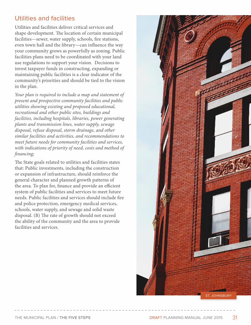
31THe MunICIPAL PLAn / THE FIVE STEPS DRAFT PLAnnInG MAnuAL June 2015
utilities and facilities Utilities and facilities deliver critical services and shape development. The location of certain municipal facilities—sewer, water supply, schools, fire stations, even town hall and the library—can influence the way your community grows as powerfully as zoning. Public facilities plans need to be coordinated with your land use regulations to support your vision. Decisions to invest taxpayer funds in constructing, expanding or maintaining public facilities is a clear indicator of the community’s priorities and should be tied to the vision in the plan.
Your plan is required to include a map and statement of present and prospective community facilities and public utilities showing existing and proposed educational, recreational and other public sites, buildings and facilities, including hospitals, libraries, power generating plants and transmission lines, water supply, sewage disposal, refuse disposal, storm drainage, and other similar facilities and activities, and recommendations to meet future needs for community facilities and services, with indications of priority of need, costs and method of financing;
The State goals related to utilities and facilities states that: Public investments, including the construction or expansion of infrastructure, should reinforce the general character and planned growth patterns of the area. To plan for, finance and provide an efficient system of public facilities and services to meet future needs. Public facilities and services should include fire and police protection, emergency medical services, schools, water supply, and sewage and solid waste disposal. (B) The rate of growth should not exceed the ability of the community and the area to provide facilities and services.
ST. JOHnSBuRY
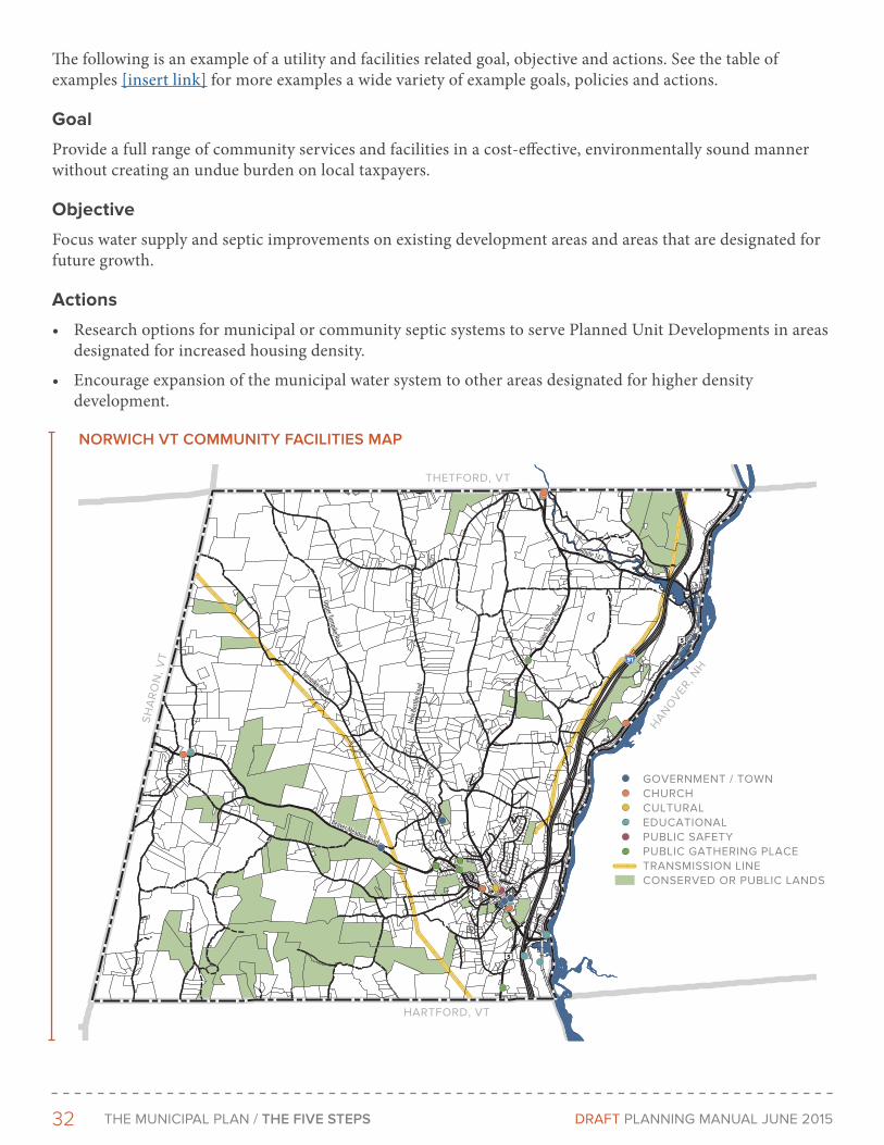
32 THe MunICIPAL PLAn / THE FIVE STEPS DRAFT PLAnnInG MAnuAL June 2015
The following is an example of a utility and facilities related goal, objective and actions. See the table of examples [insert link] for more examples a wide variety of example goals, policies and actions.
Goal
Provide a full range of community services and facilities in a cost-effective, environmentally sound manner without creating an undue burden on local taxpayers.
Objective
Focus water supply and septic improvements on existing development areas and areas that are designated for future growth.
Actions
• Research options for municipal or community septic systems to serve Planned Unit Developments in areas designated for increased housing density.
• Encourage expansion of the municipal water system to other areas designated for higher density development.
Beaver Meadow Road
Turnpike Road
Upper Turnpike Road
New
Bosto
n Roa
d
Union
Villa
ge Ro
adRoute 132
Main Street
Beaver Meadow Road
Turnpike Road
Upper Turnpike Road
New
Bosto
n Roa
d
Union
Villa
ge Ro
adRoute 132
Main Street
SH
AR
ON
, VT
HARTFORD, VT
HAN
OVER
, NH
THETFORD, VT
GOVERNMENT / TOWNCHURCHCULTURALEDUCATIONALPUBLIC SAFETYPUBLIC GATHERING PLACETRANSMISSION LINECONSERVED OR PUBLIC LANDS
NorWIcH VT coMMUNITY FAcILITIES MAP
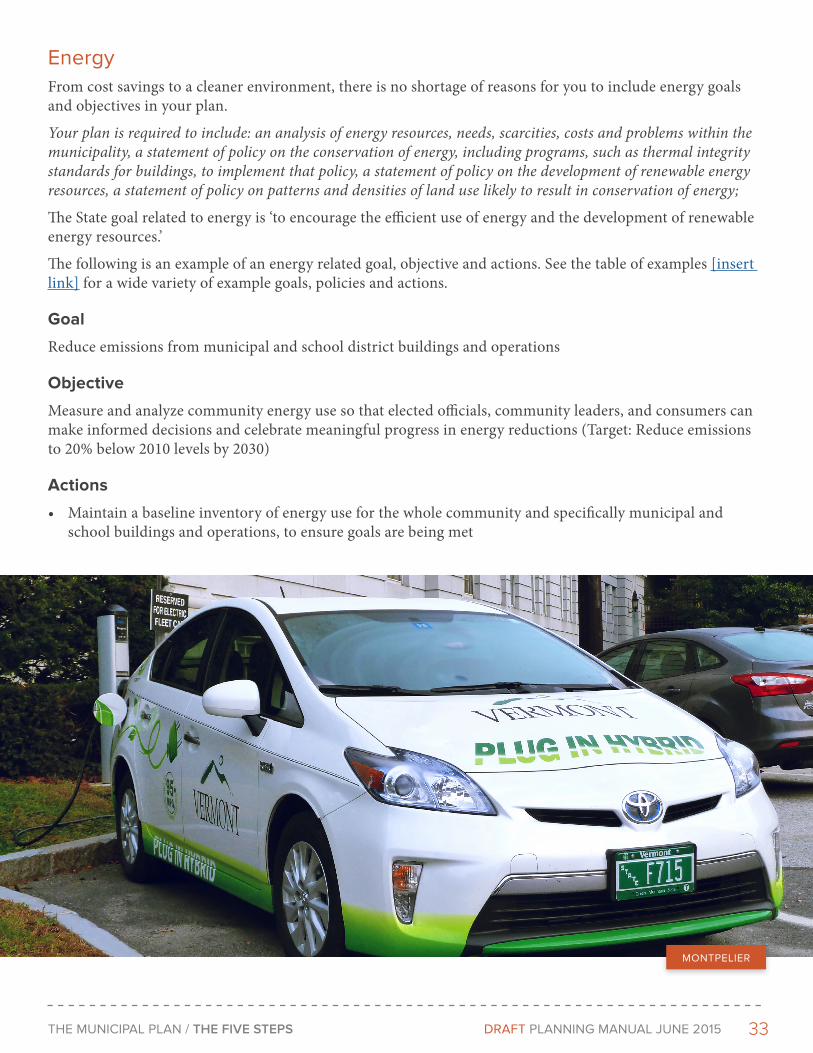
33THe MunICIPAL PLAn / THE FIVE STEPS DRAFT PLAnnInG MAnuAL June 2015
energyFrom cost savings to a cleaner environment, there is no shortage of reasons for you to include energy goals and objectives in your plan.
Your plan is required to include: an analysis of energy resources, needs, scarcities, costs and problems within the municipality, a statement of policy on the conservation of energy, including programs, such as thermal integrity standards for buildings, to implement that policy, a statement of policy on the development of renewable energy resources, a statement of policy on patterns and densities of land use likely to result in conservation of energy;
The State goal related to energy is ‘to encourage the efficient use of energy and the development of renewable energy resources.’
The following is an example of an energy related goal, objective and actions. See the table of examples [insert link] for a wide variety of example goals, policies and actions.
Goal
Reduce emissions from municipal and school district buildings and operations
Objective
Measure and analyze community energy use so that elected officials, community leaders, and consumers can make informed decisions and celebrate meaningful progress in energy reductions (Target: Reduce emissions to 20% below 2010 levels by 2030)
Actions
• Maintain a baseline inventory of energy use for the whole community and specifically municipal and school buildings and operations, to ensure goals are being met
MOnTPeLIeR

34 THe MunICIPAL PLAn / THE FIVE STEPS DRAFT PLAnnInG MAnuAL June 2015
Historic ResourcesVermont’s historic resources aren’t preserved by accident! Our distinctive character of working landscapes, villages and small cities results from community wide efforts to preserve these important resources.
Your plan is required to include policies on the preservation of rare and irreplaceable historic features and resources;
The State historic preservation goal is to identify, protect, and preserve important natural and historic features of the Vermont landscape including: important historic structures, sites, or districts, archaeological sites, and archaeologically sensitive areas.
The following is an example of a historic resources related goal, objective and actions. See the table of examples [insert link] for a wide variety of example goals, objectives and actions.
Goal
Recognize and protect the significant historic, architectural, and cultural heritage
Objective
Encourage the adaptive reuse of historic properties in the Village Center (Target: Increase value of grand list in Village by 10% by 2020.)
Actions
• Promote tax incentives, loans, and grant programs to encourage the adaptive reuse of historic structures to meet community and market needs
HA
RD
WI
CK
U
UU
2
1
9
8
7
6
5
43
1615
14
13
1211
10
1
mile
SOURCES:HISTORIC SITES: Digitized by LCPC, 2007.
POLITICAL BOUNDARIES: 1:24000 USGS Quadrangles, VCGI, 1991.
ROADS: 1:5000 E-911 Road Data, 2004.
SURFACE WATER: On-screen digitized from 1:5000 digital orthophotosusing USGS 7 1/2' quadrangles and 1:20000 color infrared aerialphotography as additional source material, VCGI for VHD-USGS, 2001.
Wolcott Village Historic District
Wolcott School Street Historic District
2019
1817
Wolcott Village Inset
See Inset
1,400
Feet
Historic Resources Map
Town PlanWolcott, Vermont
Tranverse Mercator,VT State Plane,Meters, NAD83
For planning purposes only.Not for regulatory interpretation.
LCPC632 LaPorte Road
Morrisville, VT 05661802.888.4548 f 802.888.6938
[email protected] 8/7/2007
Municipal PlanningGIS Service Center
Lamoille CountyPlanning Commission
Historic Site*See town plan for more info
Historic District
HISTORIC SITE
HISTORIC DISTRICT
WoLcoTT HISTorIc rESoUrcES MAP

35THe MunICIPAL PLAn / THE FIVE STEPS DRAFT PLAnnInG MAnuAL June 2015
HousingHousing, particularly as it relates to affordability affects many other parts of our community, ranging from the ability to attract businesses and young people to energy and transportation demands.
Your plan is required to recommended program for addressing low and moderate income persons’ housing needs as identified by the regional planning commission pursuant to subdivision 4348a(a)(9) of this title. The program should account for permitted accessory dwelling units.
State housing goals are: ‘To ensure the availability of safe and affordable housing for all Vermonters. (A) Housing should be encouraged to meet the needs of a diversity of social and income groups in each Vermont community, particularly for those citizens of low and moderate income. (B) New and rehabilitated housing should be safe, sanitary, located conveniently to employment and commercial centers, and coordinated with the provision of necessary public facilities and utilities. (C) Sites for multi-family and manufactured housing should be readily available in locations similar to those generally used for single-family conventional dwellings.(D) Accessory apartments within or attached to single-family residences which provide affordable housing in close proximity to cost-effective care and supervision for relatives, elders, or persons who have a disability should be allowed.’
The following is an example of a housing related goal, objective and actions. See the table of examples [insert link] for a wide variety of example goals, objectives and actions.
Goal
Increase the supply of housing opportunities to serve residents of all income levels, age groups, and special needs
Objective
Encourage new residential development within a ½ mile of the village center to areas where services are readily available and efficient, and cost effective. Avoid adding residential development in areas vulnerable to natural hazards such as flooding and/or with limited access. (Target: 100 new units with ½ mile of village center by 2020.)
Actions
• Rezone village center to permit more mixed use development, allowing for apartments above shops
• Eliminate parking requirements
MOnTPeLIeR
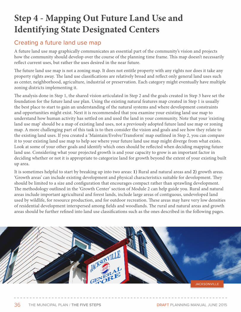
36 THe MunICIPAL PLAn / THE FIVE STEPS DRAFT PLAnnInG MAnuAL June 2015
Step 4 - Mapping Out Future Land Use and Identifying State Designated CentersCreating a future land use mapA future land use map graphically communicates an essential part of the community’s vision and projects how the community should develop over the course of the planning time frame. This map doesn’t necessarily reflect current uses, but rather the uses desired in the near future.
The future land use map is not a zoning map. It does not entitle property with any rights nor does it take any property rights away. The land use classifications are relatively broad and reflect only general land uses such as center, neighborhood, agriculture, industrial or preservation. Each category might eventually have multiple zoning districts implementing it.
The analysis done in Step 1, the shared vision articulated in Step 2 and the goals created in Step 3 have set the foundation for the future land use plan. Using the existing natural features map created in Step 1 is usually the best place to start to gain an understanding of the natural systems and where development constraints and opportunities might exist. Next it is recommended that you examine your existing land use map to understand how human activity has settled on and used the land in your community. Note that your ‘existing land use map’ should be a map of existing land uses, not a previously adopted future land use map or zoning map. A more challenging part of this task is to then consider the vision and goals and see how they relate to the existing land uses. If you created a ‘Maintain/Evolve/Transform’ map outlined in Step 2, you can compare it to your existing land use map to help see where your future land use map might diverge from what exists. Look at some of your other goals and identify which ones should be reflected when deciding mapping future land use. Considering what your projected growth is and your capacity to grow is an important factor in deciding whether or not it is appropriate to categorize land for growth beyond the extent of your existing built up area.
It is sometimes helpful to start by breaking up into two areas: 1) Rural and natural areas and 2) growth areas. ‘Growth areas’ can include existing development and physical characteristics suitable for development. They should be limited to a size and configuration that encourages compact rather than sprawling development. The methodology outlined in the ‘Growth Center’ section of Module 2 can help guide you. Rural and natural areas include important agricultural and forest lands, include large areas of contiguous, undeveloped land used by wildlife, for resource production, and for outdoor recreation. These areas may have very low densities of residential development interspersed among fields and woodlands. The rural and natural areas and growth areas should be further refined into land use classifications such as the ones described in the following pages.
JACKSOnVILLe

37THe MunICIPAL PLAn / THE FIVE STEPS DRAFT PLAnnInG MAnuAL June 2015
Example of land use classifications to include in the land use map are:Conservation: The Conservation area is intended to conserve and protect natural, open, or environmentally sensitive land.
Working Lands / Rural: The Working Lands/Rural area consists of sparsely settled lands in open, forested or cultivated states. Lots sizes are typically large. Typical buildings are farmhouses, agricultural structures, and camps. Limited agricultural and rural services may be located in specifically designated rural districts.
Suburban: The Suburban area consists of low-density, primarily residential areas, typically located at the fringes of a city or within commuting distance of the city center. Single family detached housing is predominant with some opportunities for multifamily attached housing. Pedestrians and bicyclists are accommodated but many people continue to rely on automobiles for transportation. It is difficult to manage growth efficiently when large areas of suburban are mapped, therefore, this context should be used sparingly. Consider this district in areas where the current pattern is suburban in nature and is anticipated to remain that way.
Neighborhood: The neighborhood area consists of medium-density development with both residential and commercial uses typically located within a city or town. Residential buildings may include both single-family detached and multifamily attached types such as row houses and apartments. Commercial activity is concentrated along major roadways and at neighborhood nodes and is encouraged to be mixed use. There immoderate pedestrian, bike and transit activity.
Center (Village & Downtown): The Center area consists of the highest density areas of a city or town that includes a variety of building types. Buildings are typically mixed use. Residential attached housing types include row houses and apartments. Civic, cultural, commercial, retail and office uses are often present.
Special: The Special area consists of large scale civic, institutional, and industrial areas. Typically, these uses take up large lots or extensive tracts of land. They typically have multiple buildings in a form that does not fit easily into other contexts. Certain uses such as heavy industrial should be well separated from adjacent contexts in order to protect more sensitive uses. In smaller scale occurrences uses typically considered a ‘Special area may be embedded in other districts. Zoning districts in these areas may be further refined into district such as industrial, institutional, airport, etc.
CONSERVATION WORKING LANDS SUBURBAN NEIGHBORHOOD CENTER SPECIAL
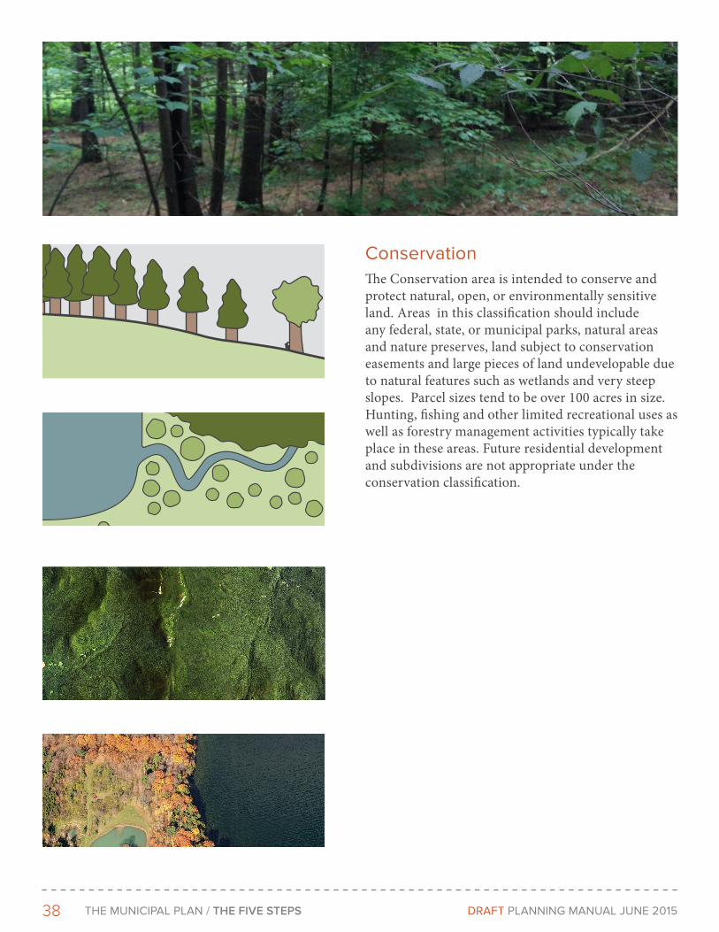
38 THe MunICIPAL PLAn / THE FIVE STEPS DRAFT PLAnnInG MAnuAL June 2015
ConservationThe Conservation area is intended to conserve and protect natural, open, or environmentally sensitive land. Areas in this classification should include any federal, state, or municipal parks, natural areas and nature preserves, land subject to conservation easements and large pieces of land undevelopable due to natural features such as wetlands and very steep slopes. Parcel sizes tend to be over 100 acres in size. Hunting, fishing and other limited recreational uses as well as forestry management activities typically take place in these areas. Future residential development and subdivisions are not appropriate under the conservation classification.

39THe MunICIPAL PLAn / THE FIVE STEPS DRAFT PLAnnInG MAnuAL June 2015
Working LandsThe Working Lands/Rural area consists of sparsely settled lands in open, forested or cultivated states. Lots sizes are generally over 40 acres in size.
Typical buildings are farmhouses, agricultural structures, farmworker housing and camps. Limited agriculturaland rural services may be located in specifically designated rural districts. Agricultural enterprises, such as wineries and farmstands are also increasingly common in rural districts. Areas of your community that people would like to stay ‘rural in character’ and are not classified as conservation should fall under this category. Anticipated residential growth in this area is limited and municipal water and sewer should not extend here. Maintaining large tracts of land under single ownership has the added benefit of preserving rural character while providing viable economic opportunity for Vermont residents looking to earn a living in the agricultural, forestry and recreation sectors of the economy. Balancing property rights and rural preservation can be challenging in this district and communities must find the right balance for them. Several municipalities in Vermont have enabled residential development in this district while attempting to maintain rural character by allowing clustered development on a small portion, 10% to 20% of a property, while requiring the remainder to be conserved for agriculture or forestry.
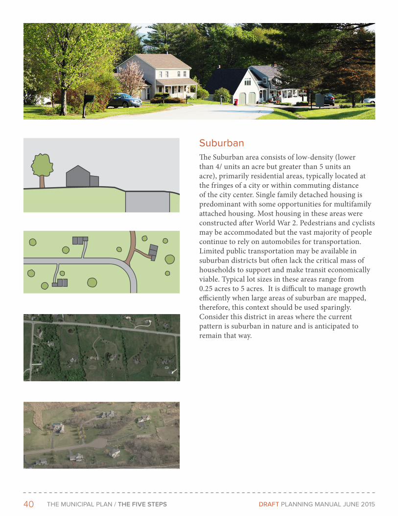
40 THe MunICIPAL PLAn / THE FIVE STEPS DRAFT PLAnnInG MAnuAL June 2015
SuburbanThe Suburban area consists of low-density (lower than 4/ units an acre but greater than 5 units an acre), primarily residential areas, typically located at the fringes of a city or within commuting distance of the city center. Single family detached housing is predominant with some opportunities for multifamily attached housing. Most housing in these areas were constructed after World War 2. Pedestrians and cyclists may be accommodated but the vast majority of people continue to rely on automobiles for transportation. Limited public transportation may be available in suburban districts but often lack the critical mass of households to support and make transit economically viable. Typical lot sizes in these areas range from 0.25 acres to 5 acres. It is difficult to manage growth efficiently when large areas of suburban are mapped, therefore, this context should be used sparingly. Consider this district in areas where the current pattern is suburban in nature and is anticipated to remain that way.
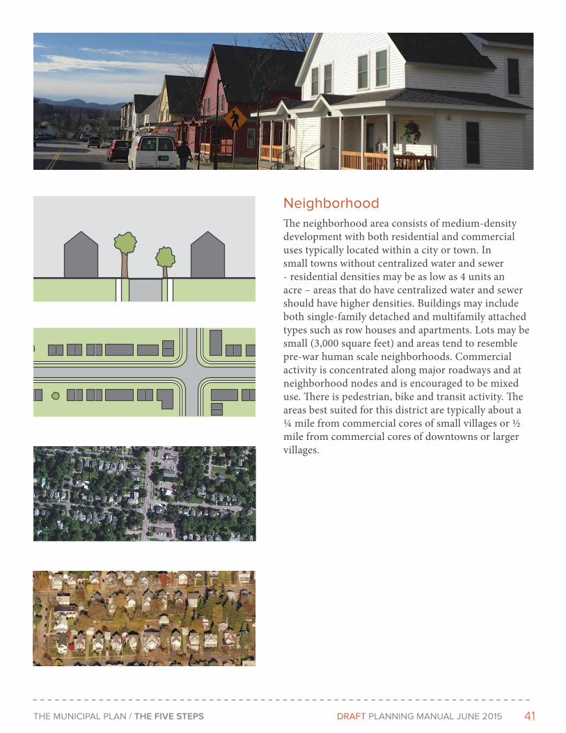
41THe MunICIPAL PLAn / THE FIVE STEPS DRAFT PLAnnInG MAnuAL June 2015
neighborhoodThe neighborhood area consists of medium-density development with both residential and commercial uses typically located within a city or town. In small towns without centralized water and sewer - residential densities may be as low as 4 units an acre – areas that do have centralized water and sewer should have higher densities. Buildings may include both single-family detached and multifamily attached types such as row houses and apartments. Lots may be small (3,000 square feet) and areas tend to resemble pre-war human scale neighborhoods. Commercial activity is concentrated along major roadways and at neighborhood nodes and is encouraged to be mixed use. There is pedestrian, bike and transit activity. The areas best suited for this district are typically about a ¼ mile from commercial cores of small villages or ½ mile from commercial cores of downtowns or larger villages.
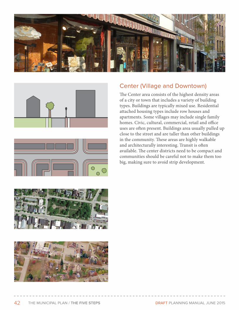
42 THe MunICIPAL PLAn / THE FIVE STEPS DRAFT PLAnnInG MAnuAL June 2015
Center (Village and Downtown)The Center area consists of the highest density areas of a city or town that includes a variety of building types. Buildings are typically mixed use. Residential attached housing types include row houses and apartments. Some villages may include single family homes. Civic, cultural, commercial, retail and office uses are often present. Buildings area usually pulled up close to the street and are taller than other buildings in the community. These areas are highly walkable and architecturally interesting. Transit is often available. The center districts need to be compact and communities should be careful not to make them too big, making sure to avoid strip development.

43THe MunICIPAL PLAn / THE FIVE STEPS DRAFT PLAnnInG MAnuAL June 2015
SpecialThe Special area consists of large scale civic, institutional, and industrial areas. Typically, these uses take up large lots or extensive tracts of land, although they can vary greatly in size. They typically have multiple buildings in a form that does not fit easily into other contexts. Certain uses such as heavy industrial should be well separated from adjacent contexts in order to protect more sensitive uses. Light industrial may be suitable in close proximity to other uses. Primary office and retail uses are generally not suitable for most special areas, such as industrial parks. In smaller scale occurrences uses typically considered a ‘Special area’ may be embedded in other districts. These special districts may be further refined into areas such as industrial, institutional, airport, etc.
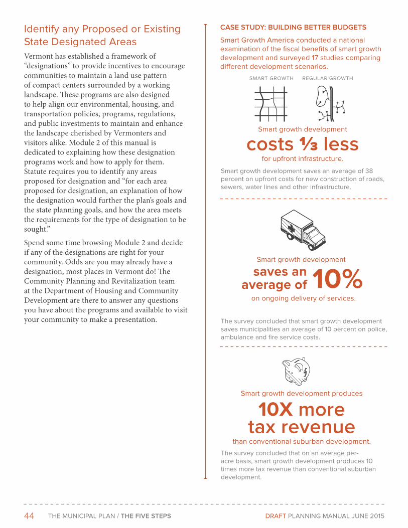
44 THe MunICIPAL PLAn / THE FIVE STEPS DRAFT PLAnnInG MAnuAL June 2015
Identify any Proposed or existing State Designated AreasVermont has established a framework of “designations” to provide incentives to encourage communities to maintain a land use pattern of compact centers surrounded by a working landscape. These programs are also designed to help align our environmental, housing, and transportation policies, programs, regulations, and public investments to maintain and enhance the landscape cherished by Vermonters and visitors alike. Module 2 of this manual is dedicated to explaining how these designation programs work and how to apply for them. Statute requires you to identify any areas proposed for designation and “for each area proposed for designation, an explanation of how the designation would further the plan’s goals and the state planning goals, and how the area meets the requirements for the type of designation to be sought.”
Spend some time browsing Module 2 and decide if any of the designations are right for your community. Odds are you may already have a designation, most places in Vermont do! The Community Planning and Revitalization team at the Department of Housing and Community Development are there to answer any questions you have about the programs and available to visit your community to make a presentation.
cASE STUdY: BUILdING BETTEr BUdGETS
Smart Growth America conducted a national examination of the fiscal benefits of smart growth development and surveyed 17 studies comparing different development scenarios.
Smart growth development
costs ⅓ less for upfront infrastructure.
Smart growth development
Smart growth development produces
10X more tax revenue
than conventional suburban development.
Smart growth development saves an average of 38 percent on upfront costs for new construction of roads, sewers, water lines and other infrastructure.
saves an average of 10%
on ongoing delivery of services.
The survey concluded that smart growth development saves municipalities an average of 10 percent on police, ambulance and fire service costs.
The survey concluded that on an average per-acre basis, smart growth development produces 10 times more tax revenue than conventional suburban development.
SMART GROWTH ReGuLAR GROWTH
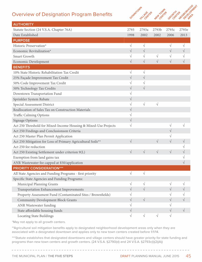
45THe MunICIPAL PLAn / THE FIVE STEPS DRAFT PLAnnInG MAnuAL June 2015
Overview of Designation Program Benefits
AUTHorITYStatute Section (24 V.S.A. Chapter 76A) 2793 2793a 2793b 2793c 2793eDate Established 1998 2002 2002 2006 2013PUrPoSEHistoric Preservation* √ √ √ √Economic Revitalization* √ √ √ √Smart Growth √ √ √ √ √Economic Development √ √ √ √ √BENEFITS10% State Historic Rehabilitation Tax Credit √ √25% Façade Improvement Tax Credit √ √50% Code Improvement Tax Credit √ √50% Technology Tax Credits √ √Downtown Transportation Fund √Sprinkler System Rebate √Special Assessment District √ √ √Reallocation of Sales Tax on Construction Materials √Traffic Calming Options √Signage Options √Act 250 Threshold for Mixed-Income Housing & Mixed-Use Projects √ √ √Act 250 Findings and Conclusionson Criteria √Act 250 Master Plan Permit Application √Act 250 Mitigation for Loss of Primary Agricultural Soils** √ √ √ √Act 250 fee reduction √Act 250 Existing Settlement under criterion 9(L) √ √ √ √ √Exemption from land gains tax √ANR Wastewater fee capped at $50/application √PrIorITY coNSIdErATIoN***All State Agencies and Funding Programs - first priority √ √Specific State Agencies and Funding Programs: Municipal Planning Grants √ √ √ √ Transportation Enhancement Improvements √ √ √ √ Property Assessment Fund (Contaminated Sites / Brownfields) √ √ √ Community Development Block Grants √ √ √ √ ANR Wastewater funding √ √ State affordable housing funds √ √ √ Locating State Buildings √ √ √ √
*May not apply to all growth centers.
**Agricultural soil mitigation benefits apply to designated neighborhood development areas only when they are associated with a designated downtown and applies only to new town centers created before 1/1/14.
***Statute establishes that designated downtowns and village centers should have greater priority for state funding and programs than new town centers and growth centers. (24 V.S.A. §2790(d) and 24 V.S.A. §2793c(i)(2)(A))
doWNToW
N
VILLAGE
cENTEr
NEW ToW
N
cENTEr
GroWTH
cENTEr
NEIGBorHood
dEVELoPM
ENT
ArEA
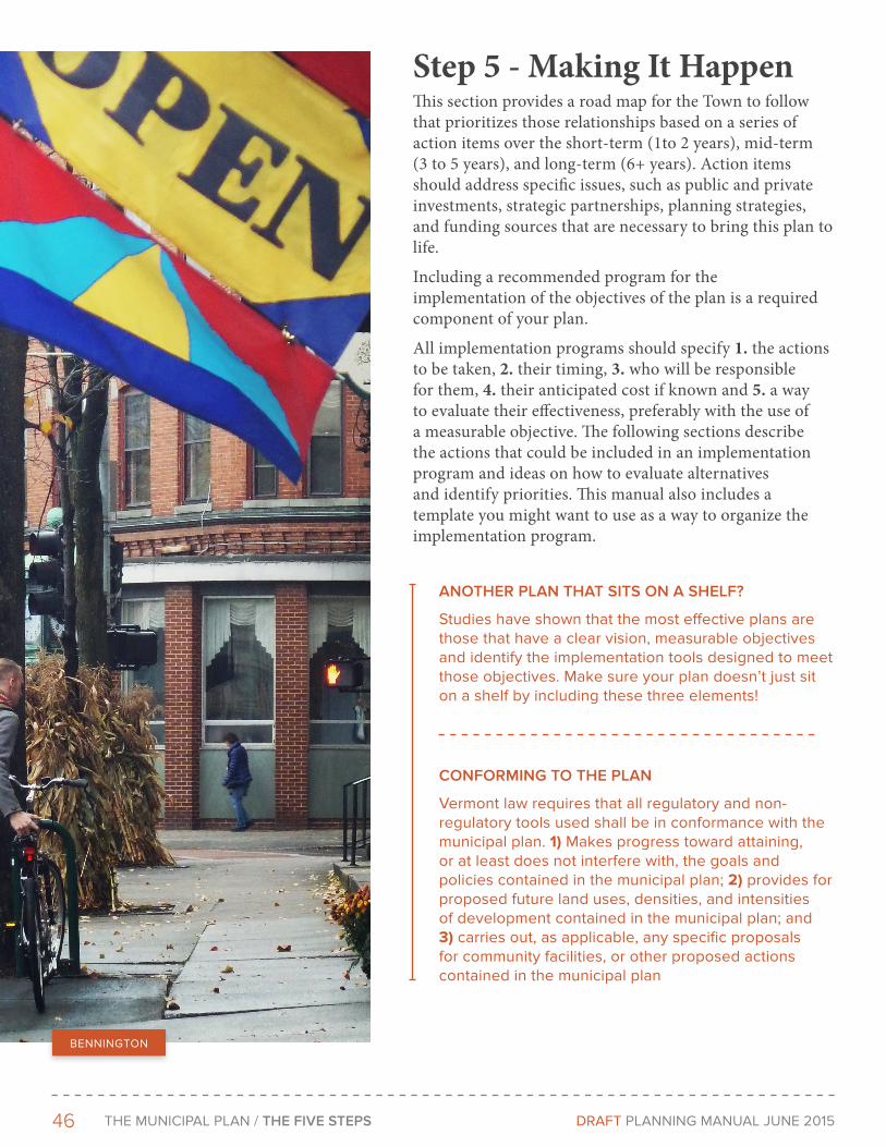
46 THe MunICIPAL PLAn / THE FIVE STEPS DRAFT PLAnnInG MAnuAL June 2015
Step 5 - Making It HappenThis section provides a road map for the Town to follow that prioritizes those relationships based on a series of action items over the short-term (1to 2 years), mid-term (3 to 5 years), and long-term (6+ years). Action items should address specific issues, such as public and private investments, strategic partnerships, planning strategies, and funding sources that are necessary to bring this plan to life.
Including a recommended program for the implementation of the objectives of the plan is a required component of your plan.
All implementation programs should specify 1. the actions to be taken, 2. their timing, 3. who will be responsible for them, 4. their anticipated cost if known and 5. a way to evaluate their effectiveness, preferably with the use of a measurable objective. The following sections describe the actions that could be included in an implementation program and ideas on how to evaluate alternatives and identify priorities. This manual also includes a template you might want to use as a way to organize the implementation program.
BennInGTOn
ANoTHEr PLAN THAT SITS oN A SHELF?
Studies have shown that the most effective plans are those that have a clear vision, measurable objectives and identify the implementation tools designed to meet those objectives. Make sure your plan doesn’t just sit on a shelf by including these three elements!
coNForMING To THE PLAN
Vermont law requires that all regulatory and non-regulatory tools used shall be in conformance with the municipal plan. 1) Makes progress toward attaining, or at least does not interfere with, the goals and policies contained in the municipal plan; 2) provides for proposed future land uses, densities, and intensities of development contained in the municipal plan; and 3) carries out, as applicable, any specific proposals for community facilities, or other proposed actions contained in the municipal plan
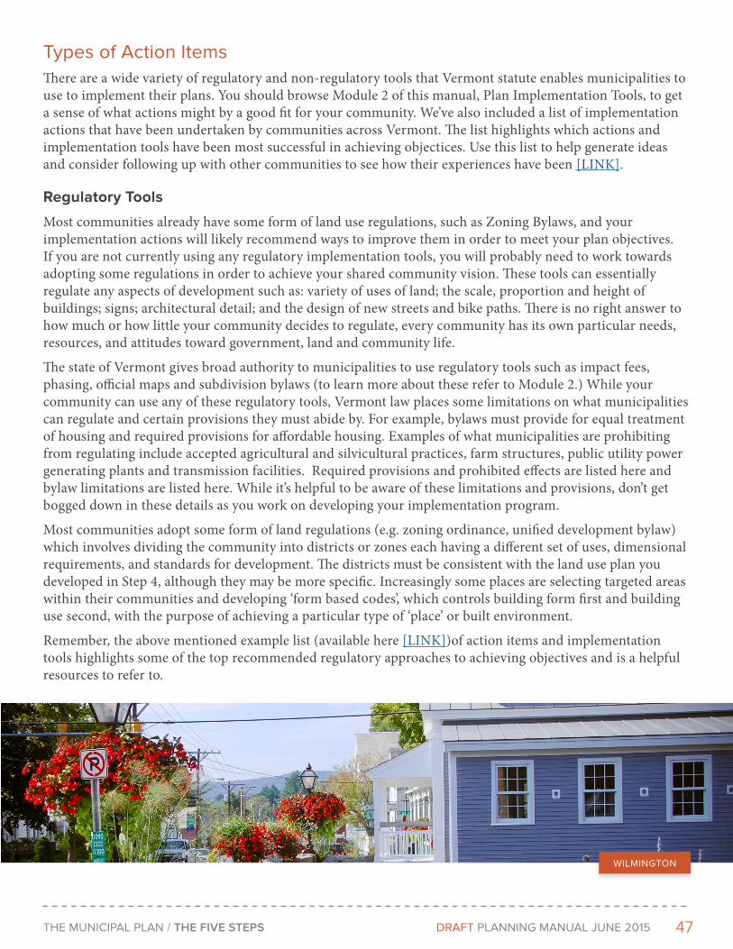
47THe MunICIPAL PLAn / THE FIVE STEPS DRAFT PLAnnInG MAnuAL June 2015
Types of Action Items There are a wide variety of regulatory and non-regulatory tools that Vermont statute enables municipalities to use to implement their plans. You should browse Module 2 of this manual, Plan Implementation Tools, to get a sense of what actions might by a good fit for your community. We’ve also included a list of implementation actions that have been undertaken by communities across Vermont. The list highlights which actions and implementation tools have been most successful in achieving objectices. Use this list to help generate ideas and consider following up with other communities to see how their experiences have been [LINK].
Regulatory Tools
Most communities already have some form of land use regulations, such as Zoning Bylaws, and your implementation actions will likely recommend ways to improve them in order to meet your plan objectives. If you are not currently using any regulatory implementation tools, you will probably need to work towards adopting some regulations in order to achieve your shared community vision. These tools can essentially regulate any aspects of development such as: variety of uses of land; the scale, proportion and height of buildings; signs; architectural detail; and the design of new streets and bike paths. There is no right answer to how much or how little your community decides to regulate, every community has its own particular needs, resources, and attitudes toward government, land and community life.
The state of Vermont gives broad authority to municipalities to use regulatory tools such as impact fees, phasing, official maps and subdivision bylaws (to learn more about these refer to Module 2.) While your community can use any of these regulatory tools, Vermont law places some limitations on what municipalities can regulate and certain provisions they must abide by. For example, bylaws must provide for equal treatment of housing and required provisions for affordable housing. Examples of what municipalities are prohibiting from regulating include accepted agricultural and silvicultural practices, farm structures, public utility power generating plants and transmission facilities. Required provisions and prohibited effects are listed here and bylaw limitations are listed here. While it’s helpful to be aware of these limitations and provisions, don’t get bogged down in these details as you work on developing your implementation program.
Most communities adopt some form of land regulations (e.g. zoning ordinance, unified development bylaw) which involves dividing the community into districts or zones each having a different set of uses, dimensional requirements, and standards for development. The districts must be consistent with the land use plan you developed in Step 4, although they may be more specific. Increasingly some places are selecting targeted areas within their communities and developing ‘form based codes’, which controls building form first and building use second, with the purpose of achieving a particular type of ‘place’ or built environment.
Remember, the above mentioned example list (available here [LINK])of action items and implementation tools highlights some of the top recommended regulatory approaches to achieving objectives and is a helpful resources to refer to.
WILMInGTOn
48 THe MunICIPAL PLAn / THE FIVE STEPS DRAFT PLAnnInG MAnuAL June 2015
Non-Regulatory Tools
A wide variety of non-regulatory implementation tools, such as capital improvement programs, housing programs and open space funds are available at your disposal to help implement your plan. Broadly speaking, these are tools that do not regulate development in your community. Many of these tools have been broadly applied throughout Vermont and beyond, and are highlighted in Module 2 and the example list included in this document. That said, you shouldn’t feel limited by these examples and you have an opportunity to get creative and tailor solutions to your communities need.
One of the more essential tools you have to meet your community vision and objectives is your capital budget and program. The capital budget and program provides an approach for municipalities to select, schedule, and finance their capital projects. The program sets forth the capital projects to be funded each year; it identifies the source of funding for each project. The program makes clear when public facilities will be in place to accommodate change in your community.
Coordination of public and private actions can be another effective way of insuring that your vision and objectives are carried out. How this coordination will take place should be spelled out in the implementation program. For example, a municipal decision to upgrade roads should be consistent with any plans for future growth. Any sewer line extension approvals through the public works department should adhere to land use policies on where growth is to be encouraged. If there are plans to replace aging infrastructure and to add streetcape inmprovements, like sidewalks or bump outs, see if you can schedule them together to minimize disruption and lower costs.
The private sector engages in a variety of development and conservation activities, including construction of homes, businesses, and industry; land preservation; and the use of land for recreation and agriculture. Partnerships between the public and private sector can bring together the talents and resources to develop innovative solutions to common problems.
Your community may wish to develop cooperative relationships with individuals in the private sector whose lands and plans might have a significant impact on community values. Contact these individuals early on to learn their intentions and to inform them about the process and vision if they haven’t been involved yet. By working together in a cooperative atmosphere, public and private entities can avoid adversarial relations and detrimental development.
Examples of individuals who can be contacted include:
• owners of significant resource lands, such as farmland and scenic areas
• major employers
• owners of major recreation facilities, such as a ski area
• landowners in an area targeted for new development
• developers and subdividers active in the community
Communities may also wish to coordinate their implementation programs with various non-profit corporations working in areas such as housing or economic development. For example, most parts of Vermont are served by regional development corporations (RDCs) whose purpose is to assist private sector businesses expand current facilities, access training programs for employees, access financing for business expansion, or to help new businesses find locations for stores, plants, or warehouses. They can also help communities with their own economic development programs, or with other steps to encourage development.
49THe MunICIPAL PLAn / THE FIVE STEPS DRAFT PLAnnInG MAnuAL June 2015
evaluating Alternatives and Identifying Priorities The implementation recommendations should be arrived at after evaluating the alternatives for meeting a particular objective. To evaluate the alternatives, consider the following criteria:
a. the availability of necessary financial resources to accomplish the task
b. the need for and availability of staff to carry out the work
c. the appropriateness of the action given public values and sentiment
d. the timeliness of the action given other priorities in the community
e. the compatibility of the action with other proposed actions
f. the effectiveness of the action in meeting the shared community vision and public goals.
You may want to set up a two tier process to evalute your alternative action items where only the best of the alternatives need more in depth consideration and evaluation.
One key to a successful implementation program is making sure you have community buy-in for what is being proposed. Make sure you are being as transparent as possible and demonstrate how the proposed actions are specifically implementing the shared community vision developed in Step 2. Once you have a draft of your implementation program you should invite all of those who participated in earlier steps to a community meeting so you can present the progress on the plan and so that they can comment on the proposals. Implementation can’t happen without them, and if they aren’t on board, you risk setting yourself up for failure. As with the other steps described in this module, there are a variety of ways you can get public participation at this stage in the process and you should select the method that is the best fit for your community. Getting widespread community input can also help identify the best alternatives and priorities when there are competing ideas that both make sense on paper.
Moving from Plan to ActionNow that you have your shared community vision, your goals and objectives and your implementation plan laid out, it’s time to begin moving from plan to action. Once all the components of your plan are packaged up, it’s time to start the formal adoption process. The adoption process is clearly described in the appendix of this module and the Department of Housing and Community Development has created a few useful ‘cheat sheets’ to help you along the way.
The process can result in changes to a document over which you have labored long and hard. However, if in the process of developing the plan, there has been broad and open public discussion of the vision and implementation priorities the changes usually will be minimal.
If you are reading this and you’ve completed Steps 1 through 5 – congratutions! Remember that your plan isn’t meant to sit on a shelf (or the depths of your Town website) and the time has come to start taking action to make sure your shared community vision is realized. Move onto Module 3 to help get you focused on implementation.
HoW do WE FUNd THIS IMPLEMENTATIoN ProGrAM?
Inevitably, some of the tools and actions you select will require financial resources. The Department of Housing and Community Development maintains a list of resources, including grants and loan funds that may help make parts of your vision possible. See the list here. [HYPeRLInK]
50 THe MunICIPAL PLAn / APPENdIX 1 DRAFT PLAnnInG MAnuAL June 2015
Appendix 1Guidance and Information for Planning Commissions
This appendix to the Planning Manual is intended to serves as guidance to Planning Commissions around the state.
Planning in VermontIn his Very Short History of Planning in Vermont, Paul Gillies makes the case that Vermont’s first Town Plans were found in charter, issued by New Hampshire Governor Benning Wentworth, before Vermont was a state. For example, the 1754 charter of Grafton states that:
1. Every Grantee his heirs or assigns shall Plant or Cultivate five Acres of Land within the Term of five years for every fifty Acres Contained in his or their Share or Proportion of land in the Said Township and Continue to Improve & Settle
3. Before any Division of the Said Land be made to and Amoungst the Grantees A Tract of Land as near the Center of the Township as the Land will admit of Shall be reserved and marked out for Town Lotts one of which Shall be Allotted to each Grantee of the Contents of one Acre.
Indeed, the topography, transportation technology of the time and the choices made in the 18th century have lasted for generations and set the foundation for Vermont’s settlement pattern of compact villages and downtowns surrounded by a working landscape. [INSERT Orwell Plat.]
Today, over 5,000 volunteers and 90% of Vermont’s cities and towns are engaged in a planning process to address problems and opportunities and to meet goals.
Planning LawTwo major pieces of legislation have established the current framework for planning in Vermont. The first is 24 V.S.A. chapter 117, the Municipal and Regional Planning and Development Act, also known as the Vermont Planning and Development Act or Chapter 117. The second is 10 V.S.A. chapter 151, known as Act 250, which regulates land use and development projects.
Chapter 117
Chapter 117 was originally enacted in 1967. It permitted the establishment of municipal and regional planning commissions, and set forth general purposes to guide them. Municipalities were given the option to develop plans and implement them through regulations and a capital budget and program. The standards and procedures to which municipalities must adhere in their planning programs were prescribed. The law has been amended over the years, and in 1988 significant amendments were enacted that are popularly known as “Act 200.”
Municipalities still have the option to plan or not plan, however, they are all members of regional planning commissions. Regional planning commissions have to prepare a regional plan.
The Vermont Municipal and Regional Planning and Development Act provides the framework for municipalities to achieve orderly development in accordance with duly adopted plans. Chapter 117 specifies the process, requirements, and guidelines by which municipal plans are to be developed, reviewed, and

51THe MunICIPAL PLAn / APPENdIX 1 DRAFT PLAnnInG MAnuAL June 2015
adopted. The Act includes guidelines and requirements for the content of plans, timelines, and adoption and amendment procedures. Chapter 117 enables the establishment of municipal planning commissions and sets forth their terms, method of appointment, powers, and duties. Communities that have prepared and adopted plans are authorized to adopt bylaws that conform with the plans. Chapter 117 spells out precise procedures for bylaw adoption, administration, and enforcement. It enables the adoption of capital budgets and programs for communities that have adopted facilities and services plans. Finally, it authorizes the establishment of regional planning commissions and the adoption of regional plans.
The criteria for regional review for approval are listed in 24 V.S.A. §4350(b). In order to approve a municipal plan, the regional planning commission must find that it is consistent with the state planning goals established in 24 V.S.A. §4302(b), that it is compatible with the regional plan, that it is compatible with approved plans of other municipalities in the region, and that it contains all the elements included in 24 V.S.A. §4382(a)(1)-(10). The process of this review for approval is discussed further in Section 2.4.7 of this manual.
As the source of the enabling authority for municipal planning actions, Chapter 117 is an indispensable guide and tool for the development of municipal plans.
Act 250
Act 250 (officially, Vermont’s Land Use and Development Law) requires that certain kinds of development and subdivision plans first obtain a state land use permit prior to construction. To obtain a permit, developers or landowners apply to the District Environmental Commission administering the law in that particular district.
Projects meeting the definition of ‘development’ or ‘subdivision’, are subject to review and under ten.
The District Commission reviews each application carefully, then either grants a permit, generally with conditions, or denies it. The Commission can also make specific findings of fact and conclusions of law that explain its decision in detail. The Commission must base its review and decision on Act 250’s ten criteria. Primarily, these focus on the development or subdivision’s projected impacts on air and water quality, water supplies, traffic, educational and municipal services, and historic and natural resources, including scenic beauty and necessary wildlife habitat. Developments must also conform to local and regional land-use plans. By law, parties to an Act 250 hearing include the applicant, the municipality and its planning commission, the regional planning commission, and affected state agencies. The District Commission may also grant party status to adjoining property owners, and to other persons or groups who qualify under Environmental Board rules. [NRB]
Roles
The State
The State of Vermont through its legislative and executive branches establishes the authority for local and regional planning, sets forth planning policies and guidelines, and undertakes its own planning for state capital investments, transportation, housing, social services, economic development, and environmental protection.
The Vermont legislature adopts the laws under which municipalities are authorized to plan. Chapter 117, described above, is the primary law guiding local and regional planning.
Municipalities operating under charters may also be authorized to undertake planning or planning-related actions by legislative approval or charter amendments. The legislature also adopts laws that affect local and regional planning. Act 250 (the State Land Use and Development Law), environmental protection laws, taxation laws, and authorizations for grant and loan programs are examples of legislation that affect land

52 THe MunICIPAL PLAn / APPENdIX 1 DRAFT PLAnnInG MAnuAL June 2015
use planning. These statutes may contain standards, policies, and guidelines that affected or participating municipalities must follow.
The executive branch of the state government is responsible for the development of the capital budget for state investments. These investments—including road improvements, municipal water pollution control and water supply facilities, local and state recreation land acquisition and development, and government buildings, such as courthouses, administrative offices and jails— affect both the way municipalities grow and the nature and pattern of their development.
Regional Planning Commissions
There are eleven regional planning commissions in Vermont. These commissions provide a continuing program for comprehensive and functional area-wide planning. The powers and duties of regional planning commissions include, but are not limited to:
• promotion of intermunicipal cooperation and coordinated development provision of technical assistance to municipalities for the preparation and maintenance of plans, studies, bylaws, and other implementation activities
• preparation of and amendments to regional plans
• preliminary planning and engineering studies
• preparation of studies and recommendations on land development, hazard mitigation, brownfield mitigation, transportation, scenic preservation, and conservation of energy
• implementation of programs in cooperation with municipalities for appropriate development, improvement, protection and preservation of the region’s physical and human resources
Regional Planning Commission’s help municipalities plan by providing background data and maps; suggested planning goals, objectives, and policies; techniques for implementing plans; assistance in program development and administration; and information on regional trends, development patterns, and issues. Therefore, the regional planning commissions can and do play an important role in the municipal planning process.
Municipalities
Any municipality may undertake a comprehensive planning program including related preliminary planning and engineering studies, and prepare, maintain and implement a plan within its jurisdiction in accordance with this chapter. 24 V.S.A. §4381(a).
Regional planning commission’s help municipalities plan by providing background data and maps; suggesting planning goals, objectives, and policies; techniques for implementing plans; assistance in program development and administration; and information on regional trends, development patterns, and issues. Therefore, the regional planning commissions can and do play an important role in the municipal planning process.
53THe MunICIPAL PLAn / APPENdIX 1 DRAFT PLAnnInG MAnuAL June 2015
Boards, Commissions And Committees
Planning Commissions
Membership
A planning commission, consisting of three to nine voting members, may be created at any time by the legislative body of the municipality. A majority of the members must be residents of the municipality. There are two ways that members may be selected. Usually, the legislative body (selectboard, city council, aldermen, or trustees) appoints all members and fills all vacancies on the planning commission. The 1990 amendments to Chapter 117 permit the voters in a municipality to choose to elect planning commission members. If the commissioners are elected, the legislative body may still fill a vacancy until the next municipal election, or a special election may be held. By unanimous vote, the legislative body may remove appointed commissioners, but it may not remove elected planning commission members. However members are selected, they should represent all geographic areas of the municipality, should express a variety of interests and bring a range of skills to the commission. The interests of any single group should not be favored. 24 V.S.A. §§4321, 4322 and 4323.
Terms of the commission members are established by 24 V.S.A. §4323. The terms of appointment in a municipal charter prevail over the provisions for appointment set forth in Chapter 117 provided that the charter specifies the precise terms for the planning commission members.
Role of the Planning Commission
As leaders of the community on planning matters, the members of the planning commission have many important roles. One significant role is to represent all members and interests of the community. In this capacity, the commission should seek the maximum feasible participation by other public officials, interest groups, civic groups, and citizens to discuss joint and competing interests. The commission must be willing to listen to ideas and to solicit comments. The commission must be cautious in weighing the comments of those who are active in the planning process with the interests of those who do not participate. Above all, members must put the general welfare of the community above any personal interests.
The planning commission is responsible for looking out for the general welfare of the community and for bringing a long-term perspective to short-term strategies and day-to-day decision making.
The planning commission must be careful not to devote all of its time to regulatory review when long-range planning and broader community interests also require its attention. The planning commission also has a responsibility to educate the public about the purposes of planning and to publicize and seek comment on specific recommendations to address local planning issues. This educational process occurs through public hearings and informational meetings, through discussions with permit applicants, through coordination with other local officials, through written materials and newspaper articles, and through day-to-day contact with the public. To be effective, commissioners must be well informed about the community, the content of planning documents, and the rationale for plans, implementation strategies, and regulatory decisions.
In addition, the planning commission has a technical role in proposing courses of action, including the comprehensive plan.
The commission also must review and recommend actions on specific proposals put forth by public interest groups and the private sector. To carry out this role effectively, commission members need to inform themselves about the planning process, organize themselves, take advantage of training programs offered to them, and seek technical advice to further their understanding.
Finally, the planning commission has a regulatory role in its quasi-judicial review of project applications.

54 THe MunICIPAL PLAn / APPENdIX 1 DRAFT PLAnnInG MAnuAL June 2015
Chapter 117 delegates the responsibility of conducting site plan, design, and subdivision review to the planning commission, unless a development review board has been created by the municipality to carry out those regulatory functions. In carrying out this role, the planning commission must be very careful to follow the proper rules of procedure to maintain the integrity of the process and to avoid costly legal challenges.
The planning commission’s regulatory role includes party status in the Act 250 process as well, and as such may testify on projects under review and may appeal decisions. 10 V.S.A §§6084(a) and 6085.
Powers and Duties of the Planning Commission
The powers and duties of the planning commission are set forth in 24 V.S.A. §4325. These powers include major responsibilities such as of preparing and implementing the municipal plan, as well as the authority necessary to carry out activities related to these responsibilities, including undertaking studies, entering upon land, and hiring technical assistance. The planning commission is specifically authorized to do the following:
• prepare, maintain, and amend the municipal plan and bylaws
• administer the subdivision regulations
• undertake reviews under the zoning regulations, including site plan review, planned unit and planned residential development plans, design review, and approval of rights-of way for parcels not having frontage on public roads
• participate in the review of applications under Act 250
• prepare and annually update a capital budget and program
• review adjacent municipal plans, the regional plan, and state agency plans for compatibility with their own municipal plan
• conduct studies and make recommendations on land development, urban renewal, transportation, community development, beautification, design, historic and scenic preservation, conservation of energy, and development of renewable energy resources
• participate in regional planning programs
• retain staff and consultant assistance
• recommend codes and standards, including building, plumbing, fire, electrical and housing codes, and specifications for streets and related public improvements
• recommend fees to the legislative body
• hold public meetings
• enter upon land to make site inspections
Organization and Procedures of the Planning Commission
OFFICERS
The planning commission is required to elect a chairperson and a clerk. The chairperson is responsible for the overall organization and conduct of the commission. The clerk is typically responsible for minutes of meetings, filing of public notices, notification of applicants, and distribution of proposed documents in accordance with the provisions of Chapter 117. 24 V.S.A. §4323(b).
RULES
The planning commission is required to adopt rules for the performance of its function. These rules are to be adopted at the commission’s organizational meeting by a majority vote of the members present. If a
55THe MunICIPAL PLAn / APPENdIX 1 DRAFT PLAnnInG MAnuAL June 2015
commission does not have a set of rules, it should adopt them as soon as possible. They are necessary to insure the smooth operation of the commission. Model rules are available from the Secretary of State, but each municipality should carefully adapt them to suit local needs. 24 V.S.A. §4323(b).
Planning commission rules should cover the following:
• powers and duties of the planning commission
• responsibilities of the officers
• procedures for scheduling and conducting regular commission meetings
• procedures for scheduling and conducting public hearings
• public notice for commission meetings and public hearings
• preparation of findings of fact for permit applications
• notification of applicants
• conflicts of interest
• minutes of meetings
• record-keeping
• handling of expenses
• annual reports
• voting procedures
Except for the vote required for adopting rules, planning commissions must follow 1 V.S.A. §172, which states that a majority of all of the commissioners—rather than a majority of those present—must approve any action.
MEETINGS
All meetings of the planning commission are open to the public. The commission must inform the public when and where the meetings will occur. A schedule of regular planning commission meetings must be posted in a public place. Any changes to this schedule, or notice of special meetings other than public hearings, require posting in a public place of the time, date, and place of the meeting at least 24 hours in advance. All public hearings must follow the notice requirements of 24 V.S.A. §4447.
Planning commissions are subject to Vermont’s Open Meeting Law, 1 V.S.A. §310-314. Every planning commission should be familiar with these provisions. It is especially important for a planning commission to understand that it may hold an executive session only to consider specific issues that are set out in 1 V.S.A. §313. Planning commission members should read that section carefully each time they consider holding an executive session.
Planning commission meetings, like all public meetings, must comply with the Americans with Disabilities Act (ADA), as required by both state and federal law. Meetings, as well as written materials, must be accessible upon demand to all persons with disabilities. This means that a handicapped person must be able to enter the building and the meeting room, and have the use of a rest room. On request, people with hearing, speech and visual impairments, as well as mobility difficulties, must not be denied participation in a planning commission meeting or hearing.
RECORDS
In most municipalities the development review board functions as the quasi-judicial body that approves and disapproves development applications. Some places in Vermont continue to operate with a zoning
56 THe MunICIPAL PLAn / APPENdIX 1 DRAFT PLAnnInG MAnuAL June 2015
board of adjustment, which reviews variances, conditional uses and appeals of the zoning administrator. In municipalities with zoning boards, the planning commission does serve as a quasi judicial body that reviews subdivisions and site plans. Planning commission that serve a development review function must keep accurate records of evidence presented at hearings, resolutions of the commission, and findings of fact on which the decisions are based. The record must also include any conditions that are required in a decision. [Link to decision examples]
In most instances municipalities the development review board functions the quasi-judicial body that approves and disapproves development applications. Some places in Vermont continue to operate with a zoning board of adjustment, which reviews variances, conditional uses and appeals of the zoning administrator. In municipalities with zoning boards, the planning commission does serve as a quasi judicial body that reviews subdivisions and site plans. Planning commission that serve a development review function must keep accurate records of evidence presented at hearings, resolutions of the commission, and findings of fact on which the decisions are based. The record must also include any conditions that are required in a decision. [Link to decision examples]
ANNUAL REPORT
Every planning commission must make an annual report to the municipality. This report should summarize the commission’s activities for the year, including current issues, trends, and needs for future action. These reports are often circulated to the residents through the town, village, or city annual report. The commission should produce a complete and informative statement. 24 V.S.A.§4326.
TECHNICAL ASSISTANCE
Because a municipal planning commission usually is composed of lay people, preparation of a plan and implementation of the bylaws often requires the assistance of others: professional staff, regional planning commission staff, or private consultants who work under the commission’s direction. Assistance may also be obtained from federal, state, county, and regional organizations and from educational institutions. Chapter 4 of this manual describes the sources for technical assistance in preparing the plan.
EXPENSES
A planning commission may incur costs for the “necessary and reasonable” expenses of its members, for professional assistance, and for meeting notices and mailings. To cover these costs, the municipality is authorized to appropriate funds for the planning commission.
Many municipalities use permit application fees to cover costs for processing applications. The planning commission also may accept funds from federal or state governments and from private sources. 24 V.S.A. §§4322 and 4326. [Expand to explain how fees need to correspond to town expenses incurred and the selectboard involvement in appropriating fees.]
Development Review Boards
A development review board is a single board which can be created to perform all the regulatory review functions for the town. It replaces the zoning board of adjustment and takes over the subdivision and site plan review role of the planning commission. This permits the planning commission to focus on its planning function as a drafter of the town plan and land use regulations. 24 V.S.A. §4461
Zoning Board of Adjustment
While most towns no longer have zoning boards of adjustment, some continue to. The zoning board of adjustment is responsible for the review of applications for conditional use approval, appeals from actions or decisions of the zoning administrator, and associated variance requests [see 24 V.S.A. §4461].
57THe MunICIPAL PLAn / APPENdIX 1 DRAFT PLAnnInG MAnuAL June 2015
Conservation Commissions
In 1977 Vermont passed legislation enabling towns to establish conservation commissions. 24 V.S.A §4501. Conservation commissions are local boards that are empowered to protect natural resources within their communities, but do not have regulatory powers. Commission projects include: restoration, conservation, education, policy development, land management, proposed development review, and natural resource inventory and monitoring. Conservation commissions often participate in drafting municipal plans and, prior to the creation of a large number of energy committees over the past decade, could be expected to help shape the energy plan. The involvement of conservation commissions can be especially useful on energy issues that overlap with other plan considerations, such as forest and farm land conservation, renewable energy development in undeveloped high elevation locations, and bicycle and pedestrian path planning. [VNRC, energy guide]
Municipal Energy Committee
24 V.S.A §4433 authorizes municipalities to establish “advisory committees” to assist the planning commission and selectboard with “preparing, adopting and implementing the municipal plan.” There are many types of advisory committees, with conservation commissions and energy committees being the most popular in the state. The energy committee provides an important mechanism for involving more people in the planning process and providing an opportunity for citizens with special skills or interests in energy policies and programs to focus their attention on those topics. Advisory committees may be formed by either a vote of the municipality, via a charter, or by action or resolution of a selectboard. The resolution, vote, or charter should contain a mission statement that defines the scope of the committee’s work and guides its actions. An advisory energy committee may consist of no fewer than three members, all of whom must be residents of the municipality. The selectboard, in its resolution, should determine how many members to appoint and their terms. The selectboard retains the authority to set term lengths, and to appoint and remove members. As a public body, advisory committees must comply with the open meeting law and public records law.
Other Advisory Commissions and Committees
A community may create advisory commissions or committees to assist with the preparation of municipal plans and bylaws, and to act in an advisory capacity to local review boards and applicants in local regulatory proceedings. Examples include: historic preservation commissions, design review committees, bicycle and pedestrian committees and housing commissions. Advisory commissions or committees may be assigned a role in development review proceedings, as specified in the bylaw or by a resolution of the legislative body. Their function, however, is strictly advisory – they do not serve in a quasi-judicial capacity, nor may their recommendations be directly appealed to court [see 24 V.S.A. §§4433 and 4464(d)].
Rules of Ethics and Conflicts of Interest
All of the above mentioned boards, commissions and committees should adopt conflict of interest policies. Conflict of interest policies have long been a best practice for managing conflicts. In small towns, where everybody knows everybody, conflict of interest policies can be particularly useful for ascertaining whether a conflict exists and, if necessary, mitigating or eliminating the conflict.
58 THe MunICIPAL PLAn / APPENdIX 1 DRAFT PLAnnInG MAnuAL June 2015
Conflicts of interest can be broken down into four basic categories:
1. those where a board member has a personal interest in a proceeding;
2. those where a board member has a financial interest in a proceeding;
3. those where a board member has exhibited bias or prejudice prior to hearing a case;
4. and those where a board member has failed to disclose and/or rectify ex parte communications.
Powerful forces are at play in local zoning proceedings, such as constitutional rights and individual and community values regarding private property and environmental protection. With these issues on the table, transparency is crucial for maintaining public trust. Disclosure of a conflict (or a potential conflict) is one of the best ways to achieve that goal of transparency.
After disclosing a real or perceived conflict, a member may either choose to recuse him or herself or may choose to continue in the proceeding, provided the member provides a statement of why he or she is still able to act fairly, objectively, and in the public interest.
For more information, refer to:
Preparation And Adoption Of The Plan
Proper Adoption Procedures
Responsibility of the Planning Commission
The planning commission is responsible for preparing the plan, distributing the plan, holding public hearings on the plan, and submitting it to the legislative body for consideration. The planning commission must comment or prepare a report on any changes proposed by the legislative body. The planning commission must follow the specific requirements for preparation of the plan set forth in 24 V.S.A. §4384.
Responsibility of the Legislative Body
Chapter 117 spells out the official role of the legislative body in developing and adopting the plan. According to the statute, the legislative body is responsible for reviewing the plan, holding public hearings on the plan, and adopting the plan. The legislative body may make changes to the plan in accordance with provisions of Chapter 117. (See Figure 2.2 and Appendix A.) 24 V.S.A. §4385.
Adoption by Australian Ballot
If the voters of a municipality choose, either at a regular meeting, such as Town Meeting, or at a specially warned meeting, the municipality may adopt or amend its plan by Australian ballot. Once the town has decided to use this method of adoption, it must be used every time unless it is rescinded by the voters. Again, the meeting to rescind, either at a regular meeting or at a special one, must be properly warned according to 17 V.S.A. chapter 55.
In order for adoption by Australian ballot to be effective, the selectboard and planning commission should take some precaution. Particular care must be made to include the public throughout the planning process so that the voters are informed of all the issues and impacts of the plan. In addition, remember that adoption by Australian ballot is a two-step process: the voters cannot vote on whether to adopt the plan until they have first chosen, as described above, to use this method of adoption.
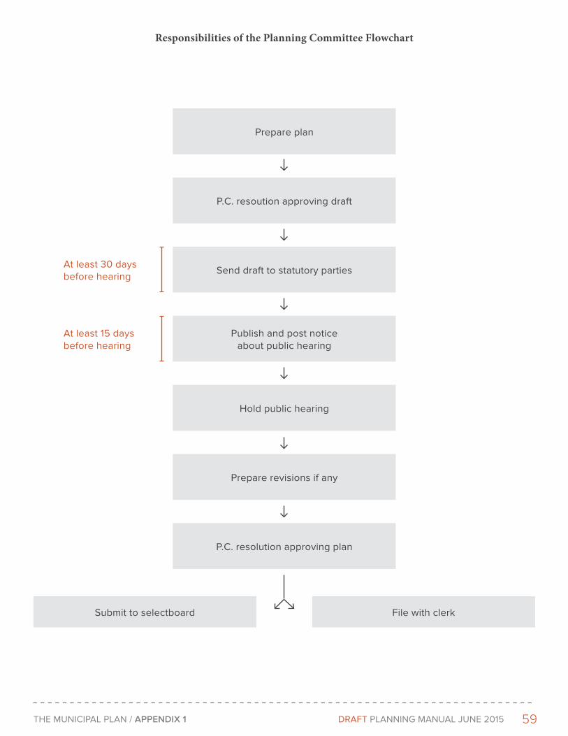
59THe MunICIPAL PLAn / APPENdIX 1 DRAFT PLAnnInG MAnuAL June 2015
Prepare plan
P.C. resoution approving draft
Send draft to statutory parties
Publish and post notice about public hearing
Hold public hearing
Prepare revisions if any
P.C. resolution approving plan
Submit to selectboard File with clerk
Responsibilities of the Planning Committee Flowchart
At least 30 days before hearing
At least 15 days before hearing
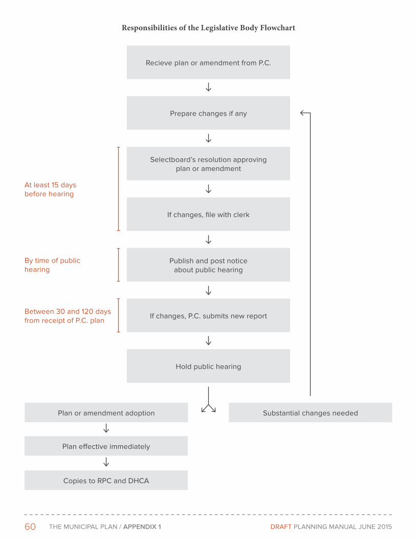
60 THe MunICIPAL PLAn / APPENdIX 1 DRAFT PLAnnInG MAnuAL June 2015
Recieve plan or amendment from P.C.
Prepare changes if any
Selectboard’s resolution approving plan or amendment
If changes, file with clerk
Publish and post notice about public hearing
If changes, P.C. submits new report
Hold public hearing
Plan or amendment adoption Substantial changes needed
Responsibilities of the Legislative Body Flowchart
By time of public hearing
At least 15 days before hearing
Plan effective immediately
Copies to RPC and DHCA
Between 30 and 120 days from receipt of P.C. plan

61THe MunICIPAL PLAn / APPENdIX 1 DRAFT PLAnnInG MAnuAL June 2015
Public Participation
Vermont law requires that at least two public hearings (a planning commission hearing and a legislative body hearing) be held to ensure public involvement in developing plans before they are adopted. Larger municipalities must hold at least three hearings. In addition, to generate support and understanding throughout the planning process, more active community participation is essential.
Chapter 117 discusses citizen participation in two places. In 24 V.S.A. §4302(b)(2), citizen participation is encouraged at all levels of the planning process. Section 4384(a) directs the planning commission to solicit participation of local citizens and organizations at the outset of the planning process, as well as throughout the process, by holding informal working sessions.
Citizen participation is vital for assisting planning commission decisions concerning the plan and for promoting community understanding of planning needs and issues. Citizens who are not well informed can present obstacles to the implementation of the plan through bylaw rejection and non-support of local programs. Developing a good plan requires a well-thought-out process for public participation. Chapter 4 of this manual contains a discussion on ways to involve the public in developing the plan
Effective Date
The plan becomes effective immediately upon adoption by the legislative body or voters. 24 V.S.A. §4385.
Municipal Plan Approval
If a municipality wishes to have its plan reviewed by the regional planning commission for consistency with the statewide goals and compatibility with the regional plan and approved municipal plans within the region, it may submit the plan to the regional planning commission after the last hearing by the legislative body, either before or after it is adopted. Review for approval is NOT required, but there are certain benefits a municipality can receive if its plan has been approved. A town must have an approved plan to be confirmed. Confirmation is required for a town to receive state planning funds or levy impact fees.
The law spells out the criteria under which the regional planning commission will conduct the review, and a time frame for its completion. The regional planning commission must hold a public hearing before rendering its decision. (See Figure____.)
If the plan is approved or disapproved, the municipality’s legislative body has three choices:
1. They can modify the plan, based on recommendations, and resubmit it to the regional planning commission for review. If the plan was already adopted, it would have to go through the complete amendment process described in 24 V.S.A. §§4384 and 4385; if it had not been adopted, it would need to go through only the stage described in §4385, OR
2. They can ignore the decision and adopt the plan anyway, if not already adopted, OR
An adopted plan that has not been approved by the regional planning commission is still a valid plan. It can be used as a basis for bylaw development or amendment; it can be used to guide municipal decisions, and it has standing in an Act 250 hearing, unless the project has significant regional impact (see Section 2.6.3 of this manual).
Maintenance and Amendments
The planning commission is responsible for the maintenance and amendment of the plan. The plan automatically expires five years after the date of adoption. Before the plan expires, the planning commission must review and update the information on which the plan is based. Using this information, the planning commission must then decide whether the plan is still applicable or is in need of major change. If the plan is
62 THe MunICIPAL PLAn / APPENdIX 1 DRAFT PLAnnInG MAnuAL June 2015
still applicable, the municipality may wish to readopt it rather than develop a new one. The readopted plan needs to include the updated data and must go through the same adoption procedures as a new plan. 24 V.S.A. §4387.
During the five years that the plan is in effect, the planning commission may decide to make adjustments to the plan in its findings, base data, and implementation strategies. These adjustments are called amendments. Usually, overall policies guiding the future direction of growth in the community should not require amendment during this time. When a plan is amended, the planning commission holds a public hearing on the proposed amendment, not the whole plan. Whether the amendment is adopted or not, the plan as a whole remains in effect. The expiration date of the plan is not extended with the adoption of an amendment, and the amendment expires with the plan; it does not have its own five-year lifespan. The expiration date is extended another five years only when the whole plan is readopted or a new one is adopted.
Municipal planners should keep in mind that an expired plan cannot be amended. It must either be readopted or a new plan developed and adopted. Although the municipal bylaws continue in effect after the plan expires, they cannot be amended until the plan is readopted or a new one is adopted. 24 V.S.A. §4387.
Amendments proposed by other parties
Persons or bodies other than the planning commission may propose amendments to the plan. The planning commission has the option to decide whether to hold a hearing on an amendment and can make changes to the amendment—except when the amendment is supported by a petition signed by 5 percent or more of the registered voters.
In cases where the amendment is supported by such a petition, the planning commission must proceed promptly to hold a hearing on the amendment, to prepare a report on the amendment, to distribute copies of the amendment, and to submit the amendment to the legislative body in accordance with Chapter 117. The planning commission may not alter the amendment except to correct technical deficiencies, such as, grammar, spelling and punctuation. The legislative body must also hold a hearing on the amendment but is under no obligation to adopt the amendment. 24 V.S.A. §§4384, 4385.
Written Reports on Amendments
Chapter 117 requires the planning commission to prepare a written report on any proposed amendment. This report must address how consistent the amended plan is with the statewide goals found in 24 V.S.A. §4302. (See figures 1.1 and 1.2 for a copy of the goals.) When a land use change is involved, the report must cover probable impact of the change on the surrounding area, long-term cost or benefit, amount of vacant land available for the proposed purpose, suitability of the area in question, and appropriateness of the size and boundaries of the proposed area. Chapter 117 describes the details of each point the report must cover. 24 V.S.A. §4384.
Readoption and Amendment Procedures
To readopt or amend a plan, the municipality follows the procedures already outlined in Section 2.4 of this manual for adoption of the plan.
Proper Adoption Procedures
If the plan is to remain in effect and withstand legal challenges, the municipality must follow the adoption procedures for the plan set forth in Chapter 117. Plans have been invalidated by courts because municipalities have failed to follow these procedures. To avoid such challenges, municipalities should carefully review the provisions of 24 V.S.A. §§4384, 4385, and 4387. To determine how time is to be computed, refer to §4303a. Municipalities should utilize the clerk’s certification of adoption or amendment in Appendix A to record the steps taken. A good record of adoption actions, including careful minutes of resolutions adopted and actions taken, will minimize the threat of legal challenges.
63THe MunICIPAL PLAn / APPENdIX 1 DRAFT PLAnnInG MAnuAL June 2015
Foundation for Municipal Regulations and Programs
To adopt or amend zoning regulations, subdivision regulations, an official map, a capital budget and program, and impact fees, Vermont municipalities must adopt and have in effect a municipal plan. According to Vermont law, plans are the basis for bylaws and bylaws must be consistent with the plan and must have the purpose of implementing the plan. 24 V.S.A. §4401(a).
Because of this requirement, it is important that the plan contain a good foundation for the specific provisions the municipality wants to include in its bylaws. The data in the plan, the analysis of the issues, and the plan goals, objectives, and policies must provide a clear and logical basis for regulatory steps the community will take.
For a community to adopt a capital budget and program, the utilities and facilities element of the plan must describe current facilities, expected needs, and recommendations for meeting future needs. 24 V.S.A. §4404a.
If a municipality does not have a solid basis in the plan for the regulations it puts into effect, these regulations can be challenged in court. The municipality must be able to demonstrate how its actions relate to an integrated, coordinated, and coherent plan for the community’s future.
Adoption of Regional Plan by Municipality
Chapter 117 enables a municipality to adopt a regional plan or a portion of a regional plan as its municipal plan. The regional plan must have been prepared and adopted by the regional planning commission before it can be adopted by a municipality. The adoption procedures are the same as for a plan prepared by a local planning commission. 24 V.S.A. §4349.

DRAFT
PHOTOS
Richard Amore
Julian Kelly
Copyright © 2022 FDOKUMEN