Peter et al 2007 Finlayson Lake VMS district
38
Peter, J.M., Layton-Matthews, D., Piercey, S., Bradshaw, G., Paradis, S., and Boulton, A., 2007, Volcanic-hosted massive sulphide deposits of the Finlayson Lake District, Yukon, in Goodfellow, W.D., ed., Mineral Deposits of Canada: A Synthesis of Major Deposit-Types, District Metallogeny, the Evolution of Geological Provinces, and Exploration Methods: Geological Association of Canada, Mineral Deposits Division, Special Publication No. 5, p. 471-508. VOLCANIC-HOSTED MASSIVE SULPHIDE DEPOSITS OF THE FINLAYSON LAKE DISTRICT , YUKON JAN M. PETER 1 , DANIEL LAYTON-MATTHEWS 2,3 , STEPHEN PIERCEY 4 , GEOFFREY BRADSHAW 5,6 , SUZANNE P ARADIS 7 , AND AMY BOLTON 8,9 1. Geological Survey of Canada, 601 Booth Street, Ottawa, Ontario K1A OE8 2. Department of Geology, University of Toronto, 22 Russell Street, Toronto, Ontario M5S 3B1 3. Present address: Department of Geological Sciences and Geological Engineering, Queen's University, Kingston, Ontario K7L 3N6 4. Department of Earth Sciences and Mineral Exploration Research Centre, Laurentian University, Ramsey Lake Road, Sudbury, Ontario P3E 2C6 5. Department of Earth and Ocean Sciences, University of British Columbia, 6339 Stores Road, Vancouver, British Columbia V6C 1Z4 6. deceased 7. Geological Survey of Canada, 4718 – 9860 Saanich Road, Sidney, British Columbia V8L 4B2 8. School of Earth and Ocean Sciences, P.O. Box 3055, University of Victoria, Victoria, British Columbia V8W 3P6 9. Present address: School of Chemical Engineering and Analytical Science, University Manchester, P.O. Box 88, Sackville Street, Manchester, M60 1QD, UK Corresponding author’s email: [email protected] Abstract The Finlayson Lake District (FLD) is a crescent-shaped 300 km long, and 50 km wide area within southeastern Yukon Territory. It comprises part of the Yukon-Tanana Terrane, one of the innermost terranes of the Canadian Cordillera that underlies much of the central Yukon and parts of Alaska and British Columbia, and part of the Slide Mountain Terrane. The FLD is consists of several fault- and unconformity-bound groups and formations of early Mississippian to early Permian metamorphosed plutonic, volcanic, and sedimentary rocks. The rocks were formed in a variety of tectonic settings, including rifted frontal arc, continental back-arc, and oceanic back-arc that range in age from 365 to 275 Ma.The FLD hosts numerous base metal sulphide deposits that collectively contain in excess of 30 Mt. The Fyre Lake Cu-Co is a Besshi-type deposit containing 15.4 Mt grading 1.2% Cu, 0.8% Co, and 0.46 g/t Au that occurs at the transition from mafic volcanic rocks to overlying turbiditic sedimentary rocks in a fore-arc setting. The Kudz Ze Kayah Zn-Pb-Cu and GP4F Zn-Pb Kuroko-type deposits are hosted by felsic volcanic and volcaniclastic rocks in the immediate footwall whereas the Wolverine Zn-Pb-Cu deposit is hosted by graphitic shales and felsic volcanic and volcaniclastic rocks and is best classified as a volcanic-sediment-hosted massive sulphide (VSHMS) deposit. These lat- ter three deposits are thought to have formed in ensialic back-arc rift or back-arc basin environments. The deposits have strongly hydrothermally altered rocks in the stratigraphic footwalls, with alteration styles varying from chlorite (Fyre Lake, Kudz Ze Kayah, Wolverine, Ice), sericite (Kudz Ze Kayah, GP4F, Wolverine), silica/quartz (Kudz Ze Kayah, Wolverine), carbonate (Wolverine) and albite (Kudz Ze Kayah). Feeder zones/stringer veins are present at the Fyre Lake, Kudz Ze Kayah, Wolverine and Ice deposits. Hanging-wall alteration is present at Fyre Lake (weak chlorite) and Wolverine (weak sericite). Wolverine has a laterally extensive (>10 km strike length) chemical exhalative sedimentary iron formation horizon in the hanging wall that is not present at Kudz Ze Kayah or GP4F. Much of the Kudz Ze Kayah deposit likely formed as a mound on the seafloor, as did at least some of the Wolverine deposit. However, subsurface replacement was important at Wolverine, and likely was entirely responsible for the formation of GP4F. The Kudz Ze Kayah deposit contains an inferred geological resource of 13 Mt at 5.55% Zn, 1.00% Cu, 1.30% Pb, 125 g/t Ag, and 1.2 g/t Au. GP4F contains an inferred resource of 1.5 Mt grading 6.4% Zn, 3.10% Pb, 0.10% Cu, 89.7 g/t Ag, and 2.0 g/t Au. Wolverine has measured and indicated reserves of 4.51 Mt grading 12.04% Zn, 1.15% Cu, 1.57% Pb, 351.5 g/t Ag, and 1.68 g/t Au; with an additional inferred resource of 1.69 Mt grading 12.16% Zn, 1.23% Cu, 1.74% Pb, 385.1 g/t Ag, and 1.71 g/t Au. The Ice Cyprus-type deposit is hosted by mafic volcanic rocks at the transition from underly- ing brecciated pillow basalt to overlying massive basalt and is thought to have formed in a back-arc basin/ocean basin setting. The geological resource at Ice is 4.56 Mt grading 1.48% Cu; some intervals contain about 1% Zn, but a Zn resource has not been calculated. There are numerous other showings and prospects that require additional exploration work. The relatively nascent level of exploration in the FLD suggests that prospecting, coupled with traditionally successful exploration methods, such as surficial geochemistry, and airborne and ground geophysics (magnetics, EM) focused on the prospective rock units, are likely to result in new discoveries in the coming years. Résumé Le district de Finlayson Lake (DFL) est une étendue falciforme longue de 300 km et large de 50 km dans la partie sud-est du Yukon. Elle se compose d’un segment du terrane de Yukon-Tanana, l’un des plus intérieurs des terranes de la Cordillère canadienne qui s’étend à une bonne partie du centre du Yukon et à des parties de l’Alaska et de la Colombie-Britannique, et d’un segment du terrane de Slide Mountain. Le DFL comprend plusieurs groupes et forma- tions limités par des failles ou des discordances qui se composent de roches plutoniques, volcaniques et sédimentaires métamorphisées datant du Mississippien précoce au Permien précoce. Ces roches se sont formées entre 365 et 275 Ma dans toute une gamme de cadres tectoniques, dont des arcs frontaux en distension, des arrière-arcs continentaux et des arrière-arcs océaniques. Le DFL recèle de nombreux gisements de sulphures de métaux communs qui renferment
Transcript of Peter et al 2007 Finlayson Lake VMS district

Peter, J.M., Layton-Matthews, D., Piercey, S., Bradshaw, G., Paradis, S., and Boulton, A., 2007, Volcanic-hosted massive sulphide deposits of the FinlaysonLake District, Yukon, in Goodfellow, W.D., ed., Mineral Deposits of Canada: A Synthesis of Major Deposit-Types, District Metallogeny, the Evolution ofGeological Provinces, and Exploration Methods: Geological Association of Canada, Mineral Deposits Division, Special Publication No. 5, p. 471-508.
VOLCANIC-HOSTED MASSIVE SULPHIDE DEPOSITS OF THE
FINLAYSON LAKE DISTRICT, YUKON
JAN M. PETER1, DANIEL LAYTON-MATTHEWS2,3, STEPHEN PIERCEY4, GEOFFREY BRADSHAW5,6, SUZANNE PARADIS7, AND AMY BOLTON8,9
1. Geological Survey of Canada, 601 Booth Street, Ottawa, Ontario K1A OE82. Department of Geology, University of Toronto, 22 Russell Street, Toronto, Ontario M5S 3B1
3. Present address: Department of Geological Sciences and Geological Engineering, Queen's University, Kingston, Ontario K7L 3N6
4. Department of Earth Sciences and Mineral Exploration Research Centre, Laurentian University, Ramsey Lake Road,Sudbury, Ontario P3E 2C6
5. Department of Earth and Ocean Sciences, University of British Columbia, 6339 Stores Road, Vancouver, British Columbia V6C 1Z4
6. deceased 7. Geological Survey of Canada, 4718 – 9860 Saanich Road, Sidney, British Columbia V8L 4B2
8. School of Earth and Ocean Sciences, P.O. Box 3055, University of Victoria, Victoria, British Columbia V8W 3P69. Present address: School of Chemical Engineering and Analytical Science, University Manchester, P.O. Box 88,
Sackville Street, Manchester, M60 1QD, UKCorresponding author’s email: [email protected]
Abstract
The Finlayson Lake District (FLD) is a crescent-shaped 300 km long, and 50 km wide area within southeasternYukon Territory. It comprises part of the Yukon-Tanana Terrane, one of the innermost terranes of the CanadianCordillera that underlies much of the central Yukon and parts of Alaska and British Columbia, and part of the SlideMountain Terrane. The FLD is consists of several fault- and unconformity-bound groups and formations of earlyMississippian to early Permian metamorphosed plutonic, volcanic, and sedimentary rocks. The rocks were formed in avariety of tectonic settings, including rifted frontal arc, continental back-arc, and oceanic back-arc that range in agefrom 365 to 275 Ma.The FLD hosts numerous base metal sulphide deposits that collectively contain in excess of 30 Mt.The Fyre Lake Cu-Co is a Besshi-type deposit containing 15.4 Mt grading 1.2% Cu, 0.8% Co, and 0.46 g/t Au thatoccurs at the transition from mafic volcanic rocks to overlying turbiditic sedimentary rocks in a fore-arc setting. TheKudz Ze Kayah Zn-Pb-Cu and GP4F Zn-Pb Kuroko-type deposits are hosted by felsic volcanic and volcaniclastic rocksin the immediate footwall whereas the Wolverine Zn-Pb-Cu deposit is hosted by graphitic shales and felsic volcanic andvolcaniclastic rocks and is best classified as a volcanic-sediment-hosted massive sulphide (VSHMS) deposit. These lat-ter three deposits are thought to have formed in ensialic back-arc rift or back-arc basin environments. The deposits havestrongly hydrothermally altered rocks in the stratigraphic footwalls, with alteration styles varying from chlorite (FyreLake, Kudz Ze Kayah, Wolverine, Ice), sericite (Kudz Ze Kayah, GP4F, Wolverine), silica/quartz (Kudz Ze Kayah,Wolverine), carbonate (Wolverine) and albite (Kudz Ze Kayah). Feeder zones/stringer veins are present at the FyreLake, Kudz Ze Kayah, Wolverine and Ice deposits. Hanging-wall alteration is present at Fyre Lake (weak chlorite) andWolverine (weak sericite). Wolverine has a laterally extensive (>10 km strike length) chemical exhalative sedimentaryiron formation horizon in the hanging wall that is not present at Kudz Ze Kayah or GP4F. Much of the Kudz Ze Kayahdeposit likely formed as a mound on the seafloor, as did at least some of the Wolverine deposit. However, subsurfacereplacement was important at Wolverine, and likely was entirely responsible for the formation of GP4F. The Kudz ZeKayah deposit contains an inferred geological resource of 13 Mt at 5.55% Zn, 1.00% Cu, 1.30% Pb, 125 g/t Ag, and1.2 g/t Au. GP4F contains an inferred resource of 1.5 Mt grading 6.4% Zn, 3.10% Pb, 0.10% Cu, 89.7 g/t Ag, and 2.0g/t Au. Wolverine has measured and indicated reserves of 4.51 Mt grading 12.04% Zn, 1.15% Cu, 1.57% Pb, 351.5 g/tAg, and 1.68 g/t Au; with an additional inferred resource of 1.69 Mt grading 12.16% Zn, 1.23% Cu, 1.74% Pb, 385.1g/t Ag, and 1.71 g/t Au. The Ice Cyprus-type deposit is hosted by mafic volcanic rocks at the transition from underly-ing brecciated pillow basalt to overlying massive basalt and is thought to have formed in a back-arc basin/ocean basinsetting. The geological resource at Ice is 4.56 Mt grading 1.48% Cu; some intervals contain about 1% Zn, but a Znresource has not been calculated.
There are numerous other showings and prospects that require additional exploration work. The relatively nascentlevel of exploration in the FLD suggests that prospecting, coupled with traditionally successful exploration methods,such as surficial geochemistry, and airborne and ground geophysics (magnetics, EM) focused on the prospective rockunits, are likely to result in new discoveries in the coming years.
Résumé
Le district de Finlayson Lake (DFL) est une étendue falciforme longue de 300 km et large de 50 km dans la partiesud-est du Yukon. Elle se compose d’un segment du terrane de Yukon-Tanana, l’un des plus intérieurs des terranes dela Cordillère canadienne qui s’étend à une bonne partie du centre du Yukon et à des parties de l’Alaska et de laColombie-Britannique, et d’un segment du terrane de Slide Mountain. Le DFL comprend plusieurs groupes et forma-tions limités par des failles ou des discordances qui se composent de roches plutoniques, volcaniques et sédimentairesmétamorphisées datant du Mississippien précoce au Permien précoce. Ces roches se sont formées entre 365 et 275 Madans toute une gamme de cadres tectoniques, dont des arcs frontaux en distension, des arrière-arcs continentaux et desarrière-arcs océaniques. Le DFL recèle de nombreux gisements de sulphures de métaux communs qui renferment
Introduction
The discovery of a number of volcanic-hosted massivesulphide (VHMS) deposits in the Finlayson Lake District(FLD) within a relatively short timespan since 1995 facili-tated the need to understand the stratigraphy and tectonichistory of the region. Until recently, the age, stratigraphy andtectonic settings of the known VHMS deposits were poorlyconstrained, and this hindered exploration efforts in this partof the North American Cordillera. Recent work has providedmuch new information on the geology (Murphy andTimmerman, 1997; Murphy, 1998, 2001; Murphy andPiercey, 1998, 1999a,b,c, 2000a,b, 2002; Piercey andMurphy, 2000, 2001; Murphy et al., 2002, 2006), paleotec-tonic settings and metallogeny (Piercey, 2001; Piercey et al.,1999, 2001a,b,c, 2002a,b, 2003, 2004, 2006, in press), andthe geology and origin of VHMS deposits (Bradshaw et al.,2001, in press; Layton-Matthews et al., 2001, in press;Boulton, 2002; Bradshaw, 2003; Layton-Matthews, 2005).This paper summarizes current knowledge of the massivesulphide deposits since the seminal in-depth report of Hunt(2002). The paper focuses discussion of the five largest andbest known deposits in the area: 1) Fyre Lake, 2) Kudz ZeKayah, 3) GP4F, 4) Wolverine, and 5) Ice.
Tectonic Setting
Pericratonic terranes contain elements of the continentalmargin that are of uncertain paleogeography (Wheeler andMcFeely, 1991). Until a few years ago, the belt of pericra-tonic terranes, which lies between autochthonous miogeocli-
nal strata of ancestral North America and oceanic and island-arc terranes that were accreted during the Mesozoic, was oneof the most poorly understood elements of the NorthAmerican Cordillera. These pericratonic terranes span theentire length of the Cordillera, from Mexico to Alaska, andrecord contrasting depositional and tectonic evolutionaryhistories along different segments of the orogen (Colpron etal., 2006a; Nelson et al., 2006). In places, the pericratonicterranes are depositionally tied to ancestral North America(Colpron and Price, 1995).
One of these pericratonic terranes, the Yukon-TananaTerrane is one of the innermost terranes of the CanadianCordillera and underlies much of central Yukon, and parts ofAlaska and British Columbia (Colpron et al., 2006a). TheYukon-Tanana Terrane is bounded to the northeast by rocksof the Slide Mountain Terrane, with the latter separating theYukon-Tanana Terrane from North American continentalmargin rocks (Nelson et al., 2006) (Fig. 1). The Yukon-Tanana Terrane consists of polydeformed metamorphosedsedimentary, volcanic, and plutonic rocks derived from avariety of igneous and sedimentary protoliths of LateDevonian to Early Permian age (Mortensen and Jilson, 1985;Mortensen, 1992b; Colpron et al., 2006a). The Yukon-Tanana Terrane contains pre-Devonian continental base-ment, the Snowcap assemblage (Colpron et al., 2006a), andis the product of periodic continental arc and rift magma-tism. The Yukon-Tanana Terrane has isotopic and prove-nance ties to Proterozoic cratonic source regions, suggestingthat it evolved, at least in part, in proximity with the ances-
J.M. Peter, D. Layton-Matthews, S. Piercey, G. Bradshaw, S. Paradis, and A. Boulton
472
ensemble plus de 30 Mt de minerai. Le gisement de Cu-Co de Fyre Lake est un gîte de type Besshi renfermant 15,4 Mtde minerai titrant 1,2 % de Cu, 0,8 % de Co et 0,46 g/t de Au. Ce gisement se présente à la transition entre un empile-ment de roches volcaniques mafiques et une succession sus-jacente de roches sédimentaires turbiditiques dans un cadred’avant-arc. Les gisements de Zn-Pb-Cu de Kudz Ze Kayah et de Zn-Pb de GP4F, des gîtes de type Kuroko, sont encais-sés dans des roches volcaniques et volcanoclastiques felsiques tout au sommet de l’empilement volcanique, alors quele gisement de Zn-Pb-Cu de Wolverine est encaissé dans des shales et des roches volcaniques et volcanoclastiques fel-siques et s’insère mieux dans la catégorie des gîtes de sulfures massifs dans des roches volcano-sédimentaires. On penseque ces trois derniers gisements se sont formés dans des milieux ensialiques de rift d’arrière-arc ou de bassin d’arrière-arc. Ils présentent aux épontes stratigraphiques inférieures des roches ayant subi une intense altération hydrothermale,dont les styles variés sont caractérisés par la présence de chlorite (Fyre Lake, Kudz Ze Kayah, Wolverine, Ice), deséricite (Kudz Ze Kayah, GP4F, Wolverine), de silice/quartz (Kudz Ze Kayah, Wolverine), de carbonates (Wolverine)et d’albite (Kudz Ze Kayah). Des zones nourricières/filoniennes sont présentes aux gisements de Fyre Lake, de KudzZe Kayah, de Wolverine et d’Ice. Il y a altération dans l’éponte supérieure aux gisements de Fyre Lake (faible chloriti-sation) et de Wolverine (faible séricitisation). Le gisement de Wolverine présente dans son éponte supérieure un hori-zon latéralement étendu (>10 km d’étendue longitudinale) de formation de fer chimique d’origine exhalative qui estabsent des gisements de Kudz Ze Kayah et de GP4F. Le gisement de Kudz Ze Kayah s’est en grande partie vraisem-blablement formé sous la forme d’un monticule sur le fond marin, comme, à tout le moins en partie, le gisement deWolverine. Cependant, le remplacement en subsurface a été important au gisement de Wolverine et il est vraisem-blablement entièrement responsable de la formation du gisement de GP4F. Le gisement de Kudz Ze Kayah renfermeraitdes ressources présumées de 13 Mt titrant 5,55 % de Zn, 1,00 % de Cu, 1,30 % de Pb, 125 g/t de Ag et 1,2 g/t de Au.Au gisement de GP4F, les ressources présumées s’élèveraient à 1,5 Mt renfermant 6,4 % de Zn, 3,10 % de Pb, 0,10 %de Cu, 89,7 g/t de Ag et 2,0 g/t de Au. Au gisement de Wolverine, les ressources mesurées et indiquées s’établissent à4,51 Mt titrant 12,04 % de Zn, 1,15 % de Cu, 1,57 % de Pb, 351,5 g/t de Ag et 1,68 g/t de Au, avec des ressources pré-sumées additionnelles s’élevant à 1,69 Mt renfermant 12,16 % de Zn, 1,23 % de Cu, 1,74 % de Pb, 385,1 g/t de Ag et1,71 g/t de Au. Le gisement d’Ice, de type Chypre, est encaissé dans des roches volcaniques mafiques à la transitionentre une succession inférieure de basalte en coussins bréchifié et une succession supérieure de basalte massif, et il seserait formé dans un cadre de bassin d’arrière-arc/bassin océanique. Au gisement d’Ice, les ressources minérales sontde 4,56 Mt renfermant 1,48% de Cu; certains intervalles renferment environ 1% de Zn, mais les ressources en Zn n’ontpas été calculées.
De nombreux autres indices minéralisés et prospects doivent faire l’objet de travaux d’exploration additionnels. Leniveau d’exploration relativement embryonnaire du DFL suggère que la prospection associée aux méthodes classiqueséprouvées d’exploration comme la géochimie des matériaux superficiels et les levés géophysiques aériens et au sol(magnétiques, EM) focalisés sur les unités lithologiques prometteuses permettront vraisemblablement de nouvellesdécouvertes au cours des années à venir.

Volcanic-Hosted Massive Sulphide Deposits of the Finlayson Lake District, Yukon
473
tral margin of North America (Paradis et al., 1998; Nelson etal., 2002, 2006; Colpron et al., 2006a; Mortensen et al.,2006; Piercey et al., 2006). It has been suggested that theYukon-Tanana Terrane was perhaps at one time linked toother similar terranes found in the Cordillera, such as theKootenay Terrane in south central British Columbia, as partof an extensive single arc and arc/basement assemblage,which has now been broken apart and displaced by transcur-rent faults such as the Tintina Fault (Mortensen, 1992b;Colpron et al., 2006a; Nelson et al., 2006).
The Slide Mountain Terrane in the FLD comprisesMississippian to Lower Permian basinal clastic rocks, andchert and mafic and felsic volcanic rocks of theCarboniferous Fortin Creek Group that have been depositedon oceanic crust in the Yukon-Tanana Terrane back-arcregion. These rocks are cut by ca. 273 to 274 Ma intrusionsthat are likely comagmatic with Campbell Range Formationvolcanic rocks. Basalt and chert of the Lower PermianCampbell Range Formation, assigned to the Slide MountainTerrane, unconformably overlap rocks of the Yukon-TananaTerrane, the Fortin Creek Group, and the terrane boundarybetween Yukon-Tanana Terrane and Slide Mountain Terrane.The FLD is juxtaposed against Proterozoic and Paleozoicstrata of the ancient North American continental margin
along the Tintina Fault to the southwest, and to the northeastthe Inconnu Thrust separates the combined Yukon-Tananaand Slide Mountain terranes from North America(Mortensen and Jilson, 1985; Plint and Gordon, 1996, 1997;Tempelman-Kluit, 1979; Fig. 2).
Geology of the Finlayson Lake District
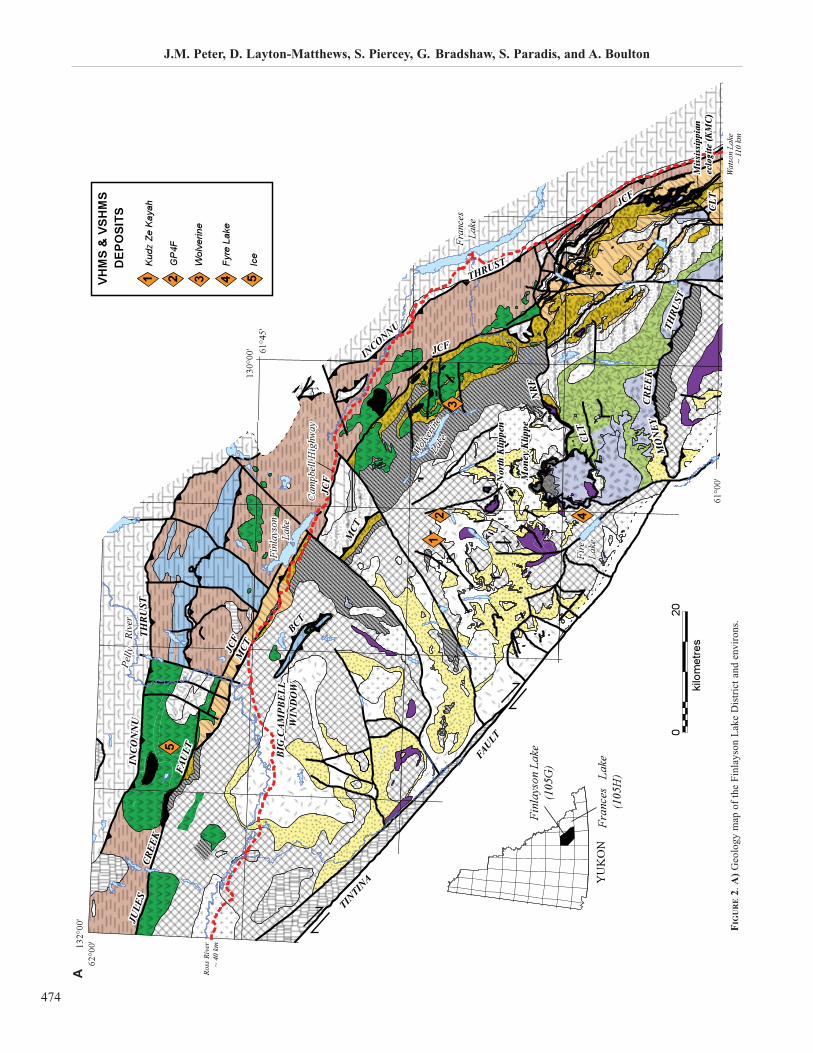
StratigraphyThe FLD forms a crescent-shaped area approximately
300 km long and 50 km wide that extends from Ross Riverin the north to Watson Lake in the south (Fig. 1), and com-prises Devonian-Mississippian volcanic, intrusive, and sedi-mentary rocks. The FLD is juxtaposed against Proterozoicand Paleozoic strata of the ancient North American conti-nental margin along the Tintina Fault to the southwest, andto the northeast the Inconnu Thrust separates the combinedYukon-Tanana and Slide Mountain terranes from NorthAmerica (Mortensen and Jilson, 1985; Plint and Gordon,1996, 1997; Tempelman-Kluit, 1979; Fig. 2). The JulesCreek Fault separates the Yukon-Tanana Terrane from theSlide Mountain Terrane in the FLD. The FLD is contiguouswith the main part of the Yukon-Tanana Terrane, whichunderlies most of west central Yukon, after restoration of 425
128°W
59°N
140°W
67°N
160°W
56°N
124°W124°W124°W
Tintina
Kaltag
Denali
Ak
Ak
Yuko
n
B.C.
B.C
.
YukonN
WT
Yukon
Wh
FbFbFb
WL
PacificOcean
limitlimitlimit ofofof
Cordilleran
Cordilleran
Cordilleran
easterneasterneastern
deformation
deformation
deformation
ST +
CC
eeee
EE
EE
EEEE
EEEE
bb
bb Finlayson Lake
Delta
Bonnifield
Ambler
Gataga
Tulsequah
Macmillan Pass
CC AA NN AA DD AAC A N A D A0 300
km
Scale
PALEOZOIC PERICRATONICASSEMBLAGES
CONTINENT MARGINASSEMBLAGES
Devonian - Permian Stikine assemblage
Devonian - Jurassicoceanic assemblages
PermianKlondike SchistPennsylvanian - Permian Klinkit Devonian - Mississippianarc assemblages
Neoproterozoic - Devonian basinal facies
Neoproterozoic - Miss.rift and basinal facies
Proterozoic - Devonian platformal faciesNeoproterozoic - Paleozoicother cont. margin assembl.
Devonian - Mississippian mineral districts
Yukon-Tanana terrane
FIGURE 1. Late Paleozoic to early Mesozoic tectonic assemblages of the northwestern North American Cordillera. The Finlayson Lake District and other min-eral areas are indicated with black stars. b=blueschist, age unknown; CC=Cache Creek Terrane; D=Dawson; E=Permian ecologite; e=Mississippian ecolog-ite; Fb=Fairbanks, Alaska; ST=Stikinia Terrane, Wh=Whitehorse; WL=Watson Lake (modified from Murphy et al., 2006).
J.M. Peter, D. Layton-Matthews, S. Piercey, G. Bradshaw, S. Paradis, and A. Boulton
474
12
3
4
VHM
S &
VSH
MS
DEP
OSI
TS
Kud
z Ze
Kay
ah
Fyre
Lak
e
Wol
verin
e
Ice
GP
4F5
020
kilometres
132°00
'62
°00'
130°00
'
61°00'
61°45'
INC
ON
NU
IN
CO
NN
U
INC
ON
NU
MCT
MCT
MCT
MCT
MCT
MCT
BIG
CA
MPB
ELL
BIG
CA
MPB
ELL
WIN
DO
WW
IND
OW
BIG
CA
MPB
ELL
WIN
DO
W
JCF
JCF
JCF
JCFJCFJCF
JCFJCFJCF
JCF
JCF
JCF
BCTBCT
FAU
LTFA
ULT
CREE
KCR
EEK
JULE
SJU
LES
NRF
NRF
NRF
CLT
CLT
CLT
CLT
CLT
CLT
THR
UST
TH
RU
ST
THR
UST
INCONNU
INCONNU
INCONNU
THRUST THRUST THRUST
THRU
ST
THRU
ST
MO
NEY
M
ON
EY
CR
EE
KC
RE
EK
THRU
ST
MO
NEY
C
RE
EK
Pelly
Pelly
Pelly
Rive
rRi
ver
Rive
r
Finl
ayso
nFi
nlay
son
Lake
La
keFi
nlay
son
Lake
Fran
ces
Fran
ces
Lake
Lake
Fran
ces
Lake
Wolver
ine
Wolver
ine
Lake
La
ke
Wolver
ine
Lake
Fire
Fire
Lake
Lake
Fire
Lake
Cam
pbel
l Hig
hway
Cam
pbel
l Hig
hway
Cam
pbel
l Hig
hway
YUKON
Finl
ayso
n La
ke(1
05G
)
Fran
ces
Lak
e(1
05H
)
Ross
Riv
er~
40 k
m
Wat
son
Lake
~ 11
0 km
TINTIN
A
FAULT
Mis
siss
ippi
anec
logi
te (K
MC
)M
issi
ssip
pian
eclo
gite
(KM
C)
Nor
th K
lippe
nN
orth
Klip
pen
Mon
ey K
lippe
Mon
ey K
lippe
1 2 3 4 5
Pete
ret
alFi
gu
re2a
FIG
UR
E2.
A)
Geo
logy m
ap o
f th
e F
inla
yso
n L
ake
Dis
tric
t an
d e
nvir
ons.
A
Volcanic-Hosted Massive Sulphide Deposits of the Finlayson Lake District, Yukon
475
km of Late Cretaceous right-lateral, strike-slip movement onthe Tintina Fault (e.g. Mortensen, 1992b).
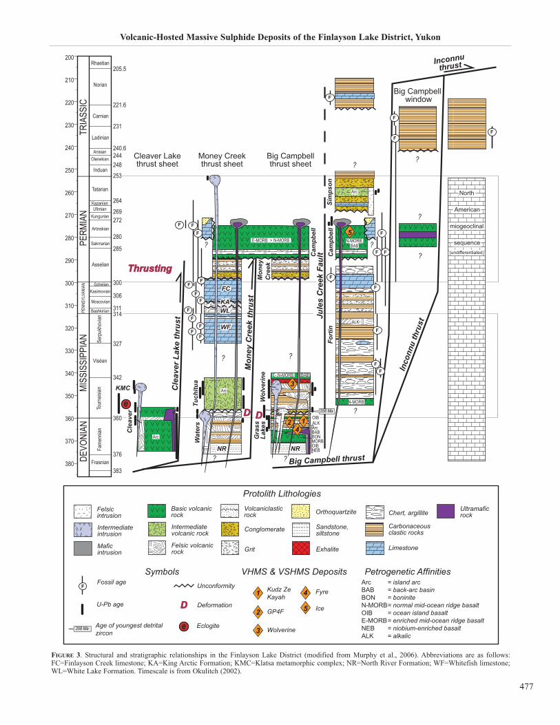
Rocks of the FLD comprise several fault- and unconfor-mity-bound groups and formations of early Mississippian toEarly Permian metamorphosed plutonic, volcanic, and sedi-mentary rocks (i.e. Cleaver Lake, Money Creek, and BigCampbell thrust sheets; Murphy et al., 2006; Fig. 3).Massive sulphide deposits occur solely within the BigCampbell thrust sheet (Fig. 2) (with one exception, the IceCu-Au-Co deposit, which is hosted by metabasalts of theCampbell Range Formation of the Slide Mountain Terrane).Rocks of the Big Campbell thrust sheet include Pre-LateDevonian quartz-rich metasedimentary rocks of the NorthRiver Formation, which are the structurally deepest rocks ofthe Yukon-Tanana Terrane; mafic and felsic volcanic, andcarbonaceous metaclastic rocks of the Upper DevonianGrass Lakes Group; Late Devonian to Early Mississippiangranitic metaplutonic rocks of the Grass Lakes plutonicsuite; carbonaceous metaclastic and mafic and felsic vol-canic rocks of the Lower Mississippian Wolverine LakeGroup; and carbonaceous metaclastic rocks and chert of theLower Permian Money Creek Formation (Murphy et al.,2006) (Fig. 3).
The Grass Lakes Group consists of strongly foliated andlineated layered metasedimentary and volcanic rocks thatcrop out in a roof setting above and between bodies of EarlyMississippian granitic orthogneiss and weakly foliated mid-Cretaceous granite (Murphy, 1998). The Grass Lakes Group
has been subdivided into three formations, from oldest toyoungest, the Fire Lake, Kudz Ze Kayah, and Wind Lake for-mations. The Upper Devonian (ca. 365 Ma) Fire LakeFormation is a mafic volcanic sequence composed mainly ofchloritic phyllite with some carbonaceous phyllite and raremuscovite-quartz phyllite of probable felsic volcanic pro-tolith. Intrusions and sills of mafic and serpentinized ultra-mafic metaplutonic rocks occur within the Fire LakeFormation. Stratigraphically overlying the Fire LakeFormation is the Kudz Ze Kayah Formation, which is a LateDevonian (ca. 360-356 Ma) sequence dominated by felsicvolcanic and volcaniclastic and sedimentary rocks. It con-sists predominantly of feldspar-muscovite-quartz phylliteand augen phyllite of probable felsic volcanic and volcani-clastic origin, and lesser fine-grained carbonaceous and sili-ciclastic sedimentary rocks. The Wind Lake Formation formsthe uppermost unit of the Grass Lakes Group and consists ofcarbonaceous phyllite, quartzite, and chloritic phyllite ofprobable alkalic mafic volcanic and intrusive protolith.
Coeval with the Kudz Ze Kayah and Wind Lake forma-tions are the peraluminous meta-plutonic granitoids of theGrass Lakes Suite. These granitoids are the subvolcanicintrusive equivalents to the felsic volcanic host rocks to theKudz Ze Kayah deposit, and are as old as 363 ± 3.3 Ma(Mortensen, 1992b). These plutonic rocks are deformed andwere themselves re-intruded by younger, late-kinematic plu-tonic rocks before deposition of the Wolverine Lake Group.
ultramafic and mafic intrusions
polymictic conglomerate, sandstone,siltstone, mafic and felsic volcanic rocks,limestone
basalt and varicoloured chert
dark phyllite and chert, varicolouredchert, chert-pebble conglomerate,sandstone, limestone, felsic and maficmetavolcanic rocks
YUKON-TANANA TERRANE
YUKON-TANANA TERRANE
POST - YTT / SMTAMALGAMATION
SLIDE MOUNTAIN TERRANE
SLIDE MOUNTAIN TERRANELEGEND
INTRUSIVE ROCKS
INTRUSIVE ROCKS
SIMPSON LAKE GROUP
Campbell Range Formation
Early Permian
granite, quartz monzoniteaugen granite
Late Devonian to Early Mississippian
Lower Permian
granite, quartz monzonite,granodiorite
SIMPSON RANGE PLUTONIC SUITE
GRASS LAKES PLUTONIC SUITE
ultramafic and mafic intrusions,Big Campbell and Cleaver Lake thrust sheets
FORTIN CREEK GROUP Carboniferous to Permian?
undifferentiated intrusions
undifferentiated volcanic rocks
Mesozoic and Cenozoic
grey shale, siltstone, and limestone
Triassic
Permian - Triassic
dark shale, siltstone and limestone
Triassic
NORTH AMERICANCONTINENTAL MARGIN
undifferentiated formations of SelwynBasin, McEvoy Platform, Earn Groupand Mt. Christie Formation
Paleozoic
limestone and quartzite
LAYERED ROCKS
Gatehouse Formation Lower to Middle Permian
dark phyllite and sandstone, chert,chert-pebble conglomerate, diamictite
LAYERED ROCKS
Money Creek Formation Lower Permian
massive bioclastic limestoneFinlayson Creek limestone
Mid-Pennsylvanian to Lower Permian
massive bioclastic limestoneWhitefish limestone
Upper Mississippian
intermediate, felsic and mafic volcanicrocks, sandstone, chert, limestone
Tuchitua River Formation Lower Mississippian
undifferentiated mafic and felsic volcanic rocks and dark clastic rocksof the Fire Lake, Kudz Ze Kayah, andWind Lake formations
GRASS LAKES GROUP
calc-alkaline basalt, rhyolite, chert,and volcanic-derived sandstone
Cleaver Lake Formation
North River Formation
felsic to intermediate metavolcanicrocks and carbonaceous phyllite
Waters Creek Formation
Upper Devonian to Lower Mississippian
Pre-Upper Devonian
quartzose metaclastic rocks, marbleand non-carbonaceous pelitic schist
undifferentiated mafic and felsic volcanic rocks and dark clastic rocks
WOLVERINE LAKE GROUP
green and pink chert, limestone, sandstone, conglomerate, mafic metavolcanic rocks
undifferentiated White Lake and King Arctic formations Upper Mississippian to mid-Pennsylvanian
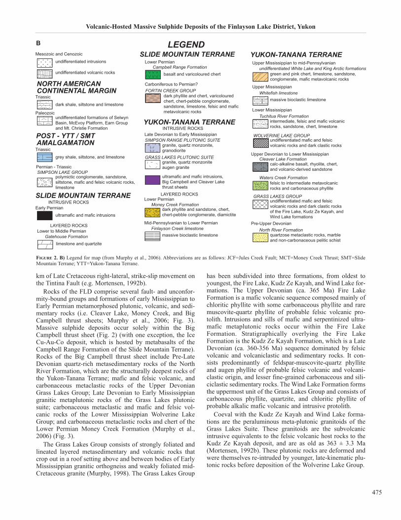
FIGURE 2. B) Legend for map (from Murphy et al., 2006). Abbreviations are as follows: JCF=Jules Creek Fault; MCT=Money Creek Thrust; SMT=SlideMountain Terrane; YTT=Yukon-Tanana Terrane.
B
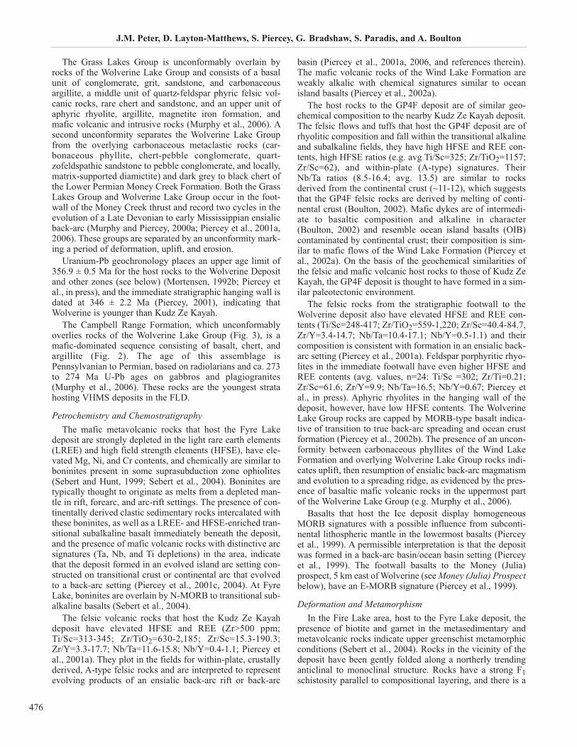
The Grass Lakes Group is unconformably overlain byrocks of the Wolverine Lake Group and consists of a basalunit of conglomerate, grit, sandstone, and carbonaceousargillite, a middle unit of quartz-feldspar phyric felsic vol-canic rocks, rare chert and sandstone, and an upper unit ofaphyric rhyolite, argillite, magnetite iron formation, andmafic volcanic and intrusive rocks (Murphy et al., 2006). Asecond unconformity separates the Wolverine Lake Groupfrom the overlying carbonaceous metaclastic rocks (car-bonaceous phyllite, chert-pebble conglomerate, quart-zofeldspathic sandstone to pebble conglomerate, and locally,matrix-supported diamictite) and dark grey to black chert ofthe Lower Permian Money Creek Formation. Both the GrassLakes Group and Wolverine Lake Group occur in the foot-wall of the Money Creek thrust and record two cycles in theevolution of a Late Devonian to early Mississippian ensialicback-arc (Murphy and Piercey, 2000a; Piercey et al., 2001a,2006). These groups are separated by an unconformity mark-ing a period of deformation, uplift, and erosion.
Uranium-Pb geochronology places an upper age limit of356.9 ± 0.5 Ma for the host rocks to the Wolverine Depositand other zones (see below) (Mortensen, 1992b; Piercey etal., in press), and the immediate stratigraphic hanging wall isdated at 346 ± 2.2 Ma (Piercey, 2001), indicating thatWolverine is younger than Kudz Ze Kayah.
The Campbell Range Formation, which unconformablyoverlies rocks of the Wolverine Lake Group (Fig. 3), is amafic-dominated sequence consisting of basalt, chert, andargillite (Fig. 2). The age of this assemblage isPennsylvanian to Permian, based on radiolarians and ca. 273to 274 Ma U-Pb ages on gabbros and plagiogranites(Murphy et al., 2006). These rocks are the youngest stratahosting VHMS deposits in the FLD.
Petrochemistry and ChemostratigraphyThe mafic metavolcanic rocks that host the Fyre Lake
deposit are strongly depleted in the light rare earth elements(LREE) and high field strength elements (HFSE), have ele-vated Mg, Ni, and Cr contents, and chemically are similar toboninites present in some suprasubduction zone ophiolites(Sebert and Hunt, 1999; Sebert et al., 2004). Boninites aretypically thought to originate as melts from a depleted man-tle in rift, forearc, and arc-rift settings. The presence of con-tinentally derived clastic sedimentary rocks intercalated withthese boninites, as well as a LREE- and HFSE-enriched tran-sitional subalkaline basalt immediately beneath the deposit,and the presence of mafic volcanic rocks with distinctive arcsignatures (Ta, Nb, and Ti depletions) in the area, indicatethat the deposit formed in an evolved island arc setting con-structed on transitional crust or continental arc that evolvedto a back-arc setting (Piercey et al., 2001c, 2004). At FyreLake, boninites are overlain by N-MORB to transitional sub-alkaline basalts (Sebert et al., 2004).
The felsic volcanic rocks that host the Kudz Ze Kayahdeposit have elevated HFSE and REE (Zr>500 ppm;Ti/Sc=313-345; Zr/TiO2=630-2,185; Zr/Sc=15.3-190.3;Zr/Y=3.3-17.7; Nb/Ta=11.6-15.8; Nb/Y=0.4-1.1; Piercey etal., 2001a). They plot in the fields for within-plate, crustallyderived, A-type felsic rocks and are interpreted to representevolving products of an ensialic back-arc rift or back-arc
basin (Piercey et al., 2001a, 2006, and references therein).The mafic volcanic rocks of the Wind Lake Formation areweakly alkalic with chemical signatures similar to oceanisland basalts (Piercey et al., 2002a).
The host rocks to the GP4F deposit are of similar geo-chemical composition to the nearby Kudz Ze Kayah deposit.The felsic flows and tuffs that host the GP4F deposit are ofrhyolitic composition and fall within the transitional alkalineand subalkaline fields, they have high HFSE and REE con-tents, high HFSE ratios (e.g. avg Ti/Sc=325; Zr/TiO2=1157;Zr/Sc=62), and within-plate (A-type) signatures. TheirNb/Ta ratios (8.5-16.4; avg. 13.5) are similar to rocksderived from the continental crust (~11-12), which suggeststhat the GP4F felsic rocks are derived by melting of conti-nental crust (Boulton, 2002). Mafic dykes are of intermedi-ate to basaltic composition and alkaline in character(Boulton, 2002) and resemble ocean island basalts (OIB)contaminated by continental crust; their composition is sim-ilar to mafic flows of the Wind Lake Formation (Piercey etal., 2002a). On the basis of the geochemical similarities ofthe felsic and mafic volcanic host rocks to those of Kudz ZeKayah, the GP4F deposit is thought to have formed in a sim-ilar paleotectonic environment.
The felsic rocks from the stratigraphic footwall to theWolverine deposit also have elevated HFSE and REE con-tents (Ti/Sc=248-417; Zr/TiO2=559-1,220; Zr/Sc=40.4-84.7,Zr/Y=3.4-14.7; Nb/Ta=10.4-17.1; Nb/Y=0.5-1.1) and theircomposition is consistent with formation in an ensialic back-arc setting (Piercey et al., 2001a). Feldspar porphyritic rhyo-lites in the immediate footwall have even higher HFSE andREE contents (avg. values, n=24: Ti/Sc =302; Zr/Ti=0.21;Zr/Sc=61.6; Zr/Y=9.9; Nb/Ta=16.5; Nb/Y=0.67; Piercey etal., in press). Aphyric rhyolites in the hanging wall of thedeposit, however, have low HFSE contents. The WolverineLake Group rocks are capped by MORB-type basalt indica-tive of transition to true back-arc spreading and ocean crustformation (Piercey et al., 2002b). The presence of an uncon-formity between carbonaceous phyllites of the Wind LakeFormation and overlying Wolverine Lake Group rocks indi-cates uplift, then resumption of ensialic back-arc magmatismand evolution to a spreading ridge, as evidenced by the pres-ence of basaltic mafic volcanic rocks in the uppermost partof the Wolverine Lake Group (e.g. Murphy et al., 2006).
Basalts that host the Ice deposit display homogeneousMORB signatures with a possible influence from subconti-nental lithospheric mantle in the lowermost basalts (Pierceyet al., 1999). A permissible interpretation is that the depositwas formed in a back-arc basin/ocean basin setting (Pierceyet al., 1999). The footwall basalts to the Money (Julia)prospect, 5 km east of Wolverine (see Money (Julia) Prospectbelow), have an E-MORB signature (Piercey et al., 1999).
Deformation and MetamorphismIn the Fire Lake area, host to the Fyre Lake deposit, the
presence of biotite and garnet in the metasedimentary andmetavolcanic rocks indicate upper greenschist metamorphicconditions (Sebert et al., 2004). Rocks in the vicinity of thedeposit have been gently folded along a northerly trendinganticlinal to monoclinal structure. Rocks have a strong F1schistosity parallel to compositional layering, and there is a
J.M. Peter, D. Layton-Matthews, S. Piercey, G. Bradshaw, S. Paradis, and A. Boulton
476
Volcanic-Hosted Massive Sulphide Deposits of the Finlayson Lake District, Yukon
477
FIGURE 3. Structural and stratigraphic relationships in the Finlayson Lake District (modified from Murphy et al., 2006). Abbreviations are as follows:FC=Finlayson Creek limestone; KA=King Arctic Formation; KMC=Klatsa metamorphic complex; NR=North River Formation; WF=Whitefish limestone;WL=White Lake Formation. Timescale is from Okulitch (2002).
? ?
383
376
342
311
360
327
314
306
GzhelianKasimovian
Moscovian
Bashkirian
Frasnian
Fame
nnian
DEVO
NIAN
MISS
ISSI
PPIA
NPE
NNSY
LVAN
IAN
380
370
360
350
340
330
320
310
300
290
Viséan
Tour
naisi
anSe
rpuk
hovia
n
PERM
IAN
TRIA
SSIC
280
270
260
250
240
230
220
210
Asselian
Tatarian
Sakmarian
Artinskian
Kungurian
KazanianUfimian
285
280
272269264
300
253
200
Induan
OlenekianAnisian
248
Ladinian
Carnian
Norian
Rhaetian
240.6244
231
221.6
205.5
?e
Mon
ey C
reek
Inconnuthrust
Inco
nnu
thru
st
Big Campbell thrust
Cle
aver
Lak
e th
rust
thru
st
358 Ma
Cam
pbel
l
Cam
pbel
l
Gra
ssLa
kes
Fort
in
Mon
eyC
reek
Cle
aver
Wat
ers
Tuch
itua
WFWF
KMC
NRNR NRNR
KAKAWLWL
FCFC
Sim
pson
Wol
verin
e
?
? ?
?
??
?
?
DD
ThrustingThrusting
DD
Jule
s C
reek
Fau
lt
Big Campbell window
North
American
miogeoclinal
sequence(undifferentiated)
Big Campbellthrust sheet
Money Creekthrust sheet
Cleaver Lakethrust sheet
N-MORBE-MORB >
Arc
N-MORB,
N-MORB
BABBAB
E-,N-MORB BAB
ArcALK
ALKALK
BAB
OIB
OIB
Arc
Arc
MORBBON
NEB
4
4
1
1
2
2
3
3
5
5
F
F
F
FF
F
F
F
F
F
F
F
F
FFF
F
F
F
FF
F
F
F
Protolith LithologiesFelsicintrusion Chert, argillite
Intermediateintrusion
Basic volcanic rock
Intermediate volcanic rock
Volcaniclasticrock
Conglomerate
Orthoquartzite
Sandstone, siltstone
Carbonaceous clastic rocks
LimestoneMaficintrusion
Felsic volcanic rock Grit
Ultramaficrock
Exhalite
SymbolsFossil age
U-Pb age
Age of youngest detritalzircon
Unconformity
Deformation
Kudz ZeKayah
GP4F
Wolverine
Fyre
Ice
Eclogite
DD
e358 Ma
ArcBABBONN-MORBOIBE-MORBNEBALK
= island arc= back-arc basin = boninite= normal mid-ocean ridge basalt= ocean island basalt= enriched mid-ocean ridge basalt= niobium-enriched basalt= alkalic
Petrogenetic AffinitiesVHMS & VSHMS DepositsF
strong L1 mineral lineation trending 120 to 140º and plung-
ing shallowly to the southeast in the plane of the F1 foliation.The host rocks and the Fyre Lake deposit have beendeformed in Permian, Cretaceous, and Mississippian times.
At Kudz Ze Kayah, the rocks and mineralization haveundergone upper greenschist to lower amphibolite faciesmetamorphism and have been intensely deformed. At leastthree phases of deformation are recognized (Murphy andTimmerman, 1997). The deposit lies within an F1 fold, hasbeen thickened by F2 folds, and imbricated by F3 deforma-tion. D1 deformation was intense and penetrative, resultingin an S0-S1 composite fabric (Schultze, 1996). F1 folds areisoclinal and recumbent, and accompanied by attendant limbthrust faulting.
At GP4F, the mineralization and all host rocks, except themafic dykes, have been metamorphosed to upper greenschistfacies, as evidenced by the presence of garnet, biotite, chlo-rite, albite, and titanite. However, the sulphides at GP4F aresignificantly less recrystallized than at Kudz Ze Kayah dueto a lower metamorphic overprint. The GP4F deposit con-tains trace to minor gahnite, and this mineral is believed tohave formed by desulphidation of sphalerite during meta-morphism (Spry and Scott, 1986) A major deformation eventin the region has obliterated most primary volcanic and sed-imentary features in the rocks. The sequence is strongly foli-ated with one dominant S2 foliation (MacRobbie andHolroyd, 2000).
The immediate host rocks to the Wolverine deposit areless strongly metamorphosed and deformed than those atKudz Ze Kayah, and metamorphic grades at Wolverine aremiddle greenschist based on the mineral assemblage of acti-nolite, albite, chlorite, and biotite. A major deformationalevent is recorded as a prominent S1 foliation that trendsnorthwest and dips gently to the northeast. F1 folds in thevicinity of the deposit verge to the southwest, indicating thatthe Wolverine deposit is on the eastern limb of an open,upright antiform. Deformation has resulted in extensivegouge zones in ductile rocks such as argillite and intensefracturing in brittle rocks including rhyolite.
Volcanic-Hosted Massive Sulphide Deposits
Grade and TonnageTo date, forty-one VHMS deposits and occurrences have
been discovered at different stratigraphic levels within theFLD, and about 34 Mt of massive sulphides have been delin-eated since the district was recognized in the mid-1990s. Thecombined resource of Kudz Ze Kayah, Wolverine, andGP4F, the polymetallic massive sulphide deposits with thegreatest economic potential, is 21.5 Mt grading 8.2 % Zn,0.97 % Cu, 1.7 % Pb, 203 g/t Ag, and 1.6 g/t Au.
The Fyre Lake deposit has resources of 15.4 Mt at 1.2% Cu, 0.8% Co, and 0.46 g/t Au using the kriging methodand a cut off of 0.5 % Cu, or 8.2 Mt at 2.1 % Cu, 0.11 % Co,and 0.73 g/t Au using a sectional block method and cut off of
J.M. Peter, D. Layton-Matthews, S. Piercey, G. Bradshaw, S. Paradis, and A. Boulton
478
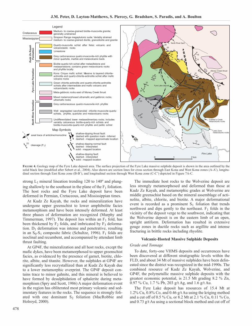
FIGURE 4. Geology map of the Fyre Lake deposit area. The surface projection of the Fyre Lake massive sulphide deposit is shown in the area outlined by thesolid black line (modified after Sebert et al., 2004). Also shown are section lines for cross section through East Kona and West Kona zones (A-A’), longitu-dinal section through East Kona zone (B-B’), and longitudinal section through West Kona zone (C-C’) depicted in Figure 7A-C.
axial trace of anticline/monoclineshallow-dipping thrust fault:dashed with question mark - inferreddashed - mapped approximate location
shallow-dipping normal fault:dashed - interpretedsolid - mapped location
shallow-dipping fault:dashed - interpretedsolid - mapped location
cleavage (F1)
Map Symbols
Legend

Volcanic-Hosted Massive Sulphide Deposits of the Finlayson Lake District, Yukon
479
1.0 % Cu that have been delineated within the East and WestKona zones (Columbia Gold Mines Ltd., 1999).
The Kudz Ze Kayah deposit contains an inferred resourceof 13 Mt grading 5.55% Zn, 1.00% Cu, 1.30% Pb, 125 g/tAg, and 1.2 g/t Au within the ABM zone (Schultze, 1996),including an open pit mineable resource of 11.1 Mt at 5.61%Zn, 0.85% Cu, 1.56% Pb, 136.9 g/t Ag, and 1.33 g/t Au(Expatriate Resources Ltd., 2000). Another zone, the FaultCreek zone, intersected in 8 drillholes, contains a furtherinferred resource of 50,000 tonnes at 7.1% Zn, 1.0% Pb, 4.7% Cu, 130 g/t Ag, and 2.0 g/t Au (Expatriate ResourcesLtd., 2000; Hunt, 2002).
The GP4F deposit contains an inferred resource of 1.5 Mtgrading 6.4% Zn, 3.10% Pb, 0.10% Cu, 89.7 g/t Ag, and 2.0 g/t Au (MacRobbie and Holroyd, 2000), as outlined innine drillholes.
At the end of the 1997, 71 drillholes had intersected min-eralization at the Wolverine deposit and a geological resource of 6.237 Mt grading 12.66% Zn, 1.33% Cu, 1.55%Pb, 370.9 g/t Ag, and 1.76 g/t Au was reported (Tucker et al.,1997). Measured and indicated reserves have subsequentlybeen revised to incorporate new drilling to give 4.51 Mtgrading 12.04% Zn, 1.15% Cu, 1.57% Pb, 351.5 g/t Ag,and1.68 g/t Au, with an additional inferred resource of 1.69 Mt grading 12.16% Zn, 1.23% Cu, 1.74% Pb, 385.1 g/tAg, and 1.71 g/t Au (Yukon Zinc Corporation, 2006a).
The discovery hole at the Sable Zone (see below) inter-sected 0.6 m of exceptionally high-grade massive sulphidesgrading 13.3% Zn, 0.8% Pb, 0.8% Cu, 416 g/t Ag, and 1.9 g/tAu, similar to that at the periphery of the Wolverine deposit.However, there is currently no calculated resource for thisoccurrence.
In late 2004, Yukon Zinc Corporation drilled two holesinto the Fisher zone (see below), and drillhole WV95-06intersected 2.2 m of massive sulphide with an average gradeof 2.8% Zn, 1.4% Pb, 0.12% Cu, 62 g/t Ag, and 0.14 g/t Au.However, a resource has not been calculated for this zone.
The Ice deposit has an indicated resource of 4.56 Mt grad-ing 1.48 % Cu, including 3.4 Mt open pittable mineralizationat 1.48% Cu (Expatriate Resources Ltd., 1999). The massivesulphide body is overlain by Cu-oxide mineralization forwhich there is insufficient data to estimate a geologicalresource; however, 2.7 Mt of this fall within the open pittableresources (Expatriate Resources Ltd., 1999; Hunt, 2002,Yukon Zinc Corporation, 2006b). There are also some Zn-rich (~1%) massive sulphide zones, but the Zn resource hasnot been quantified.
The Skyblaze zone on the Goal Net North property con-tains 16 m of greater than 1% Zn and 0.73 m of semi-mas-sive sulphide mineralization grading 3.0 % Zn, 1.85 % Pb,0.14% Cu, 63 g/t Ag and 0.2 g/t Au (Yukon Zinc Corporation,2005). There are currently too few drillholes to calculate aresource. Although a resource for the Thunderstruck zonehas not been calculated, drill intercepts over a thickness of0.30 m reportedly grade 13.4% Zn, 5.07% Pb, 0.34% Cu,40.7 g/t Ag, and 0.04 g/t Au with low Se contents (YukonZinc Corporation Ltd., 2004b, 2005).
Geological Settings and Deposit DescriptionsIn the FLD, VHMS deposits are hosted in Late Devonian
to Early Mississippian arc and back-arc successions of theYukon-Tanana Terrane and the Slide Mountain Terrane,northeast of the Tintina Fault and southwest of the InconnuThrust (Hunt, 2002; Murphy et al, 2006). Prior to the dis-covery of Kudz Ze Kayah, GP4F, Wolverine, and Ice in theFLD in the mid-1990s, VHMS deposits were not a widelyrecognized and significant deposit type in Yukon.
The major (significant) massive sulphide deposits of thedistrict occur at different stratigraphic levels within the FLDstratigraphy (Fig. 3; Murphy and Piercey, 1999a,b,c, 2000b;Hunt, 2002). Below are descriptions of each of these VHMSdeposits.
Fyre Lake Deposit
The Fyre Lake deposit (also referred to as Kona) islocated about 160 km northwest of Watson Lake and 140 kmsoutheast of Ross River. The Fyre Lake deposit occurswithin the ca. 365 Ma Fire Lake Formation of the GrassLakes Group (Fig. 4). The Fire Lake Formation consists of ametamorphosed volcanic sequence composed mainly ofchloritic phyllite with some carbonaceous phyllite, and raremuscovite-quartz phyllite of probable felsic volcanic origin(Figs. 4, 5). The Fire Lake Formation lies on clastic rocks ofthe North River Formation (Fig. 5).
The immediate host rocks to the deposit are chlorite-quartz and chlorite-actinolite-quartz schists (mafic volcanicand volcaniclastic rocks; Fig. 6A), and turbiditic sedimen-tary rocks form the immediate stratigraphic hanging wall(Fig. 6B). The metamorphosed sedimentary rocks are pre-dominantly finely laminated carbonaceous phyllite and theseoverlie the volcanic rocks (Figs. 4, 5). Intercalated quartz-biotite schists (mafic volcaniclastic) and chlorite-mica-
Money Creek thurst
North River fault
Outfitter’s Creek metavolcanic rocks
transition metasedimentary rocks
Fyre Lakemineralization
Lake Zonemetavolcanic rocks
FIGURE 5. Generalized stratigraphic section of the Fyre Lake deposit areadepicting the spatial relationships of the major rock units (from Sebert etal., 2004); legend as in Figure 4.
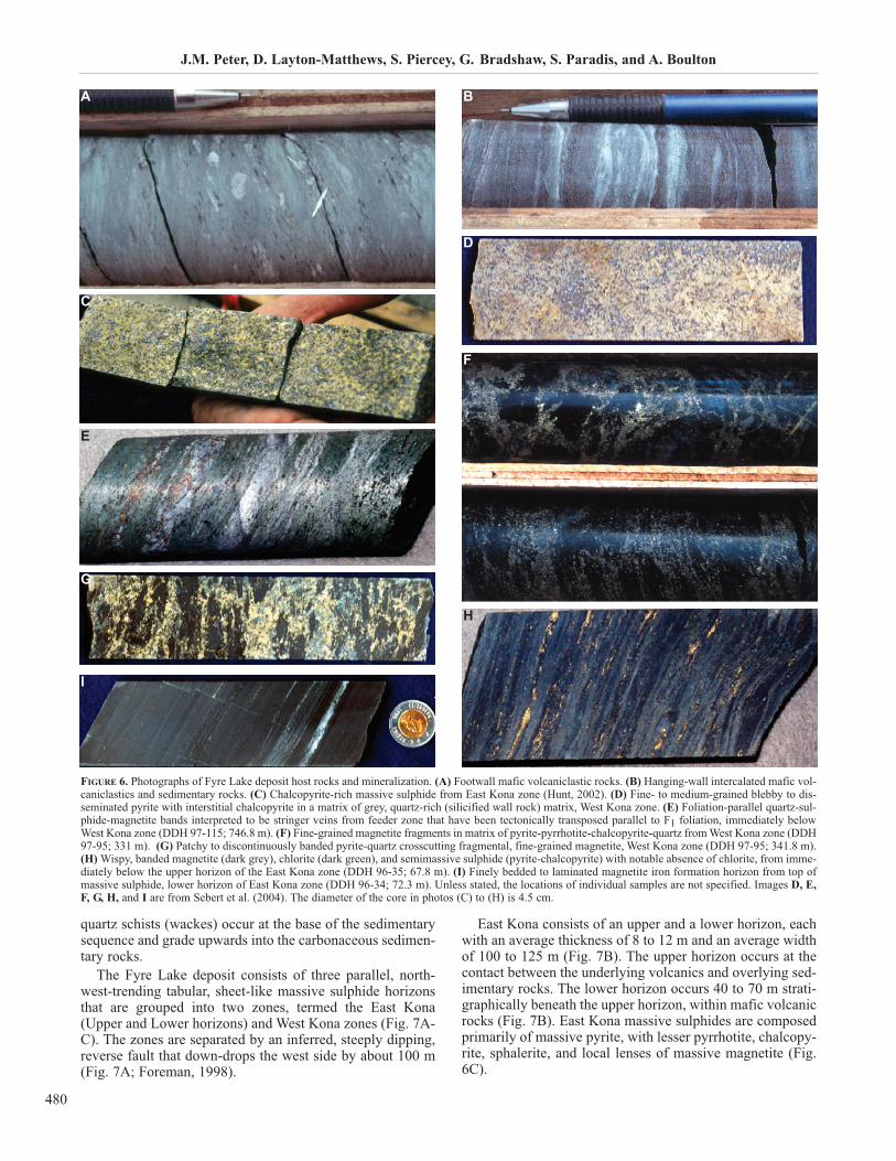
quartz schists (wackes) occur at the base of the sedimentarysequence and grade upwards into the carbonaceous sedimen-tary rocks.
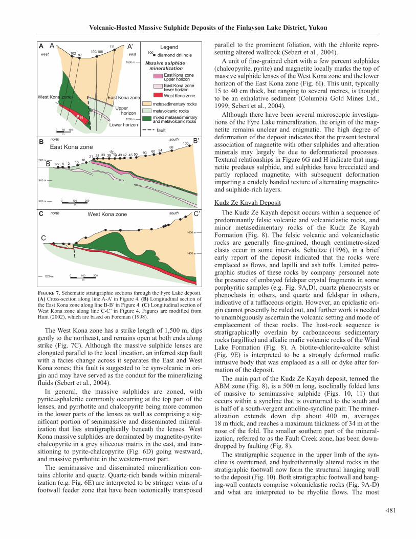
The Fyre Lake deposit consists of three parallel, north-west-trending tabular, sheet-like massive sulphide horizonsthat are grouped into two zones, termed the East Kona(Upper and Lower horizons) and West Kona zones (Fig. 7A-C). The zones are separated by an inferred, steeply dipping,reverse fault that down-drops the west side by about 100 m(Fig. 7A; Foreman, 1998).
East Kona consists of an upper and a lower horizon, eachwith an average thickness of 8 to 12 m and an average widthof 100 to 125 m (Fig. 7B). The upper horizon occurs at thecontact between the underlying volcanics and overlying sed-imentary rocks. The lower horizon occurs 40 to 70 m strati-graphically beneath the upper horizon, within mafic volcanicrocks (Fig. 7B). East Kona massive sulphides are composedprimarily of massive pyrite, with lesser pyrrhotite, chalcopy-rite, sphalerite, and local lenses of massive magnetite (Fig.6C).
J.M. Peter, D. Layton-Matthews, S. Piercey, G. Bradshaw, S. Paradis, and A. Boulton
480
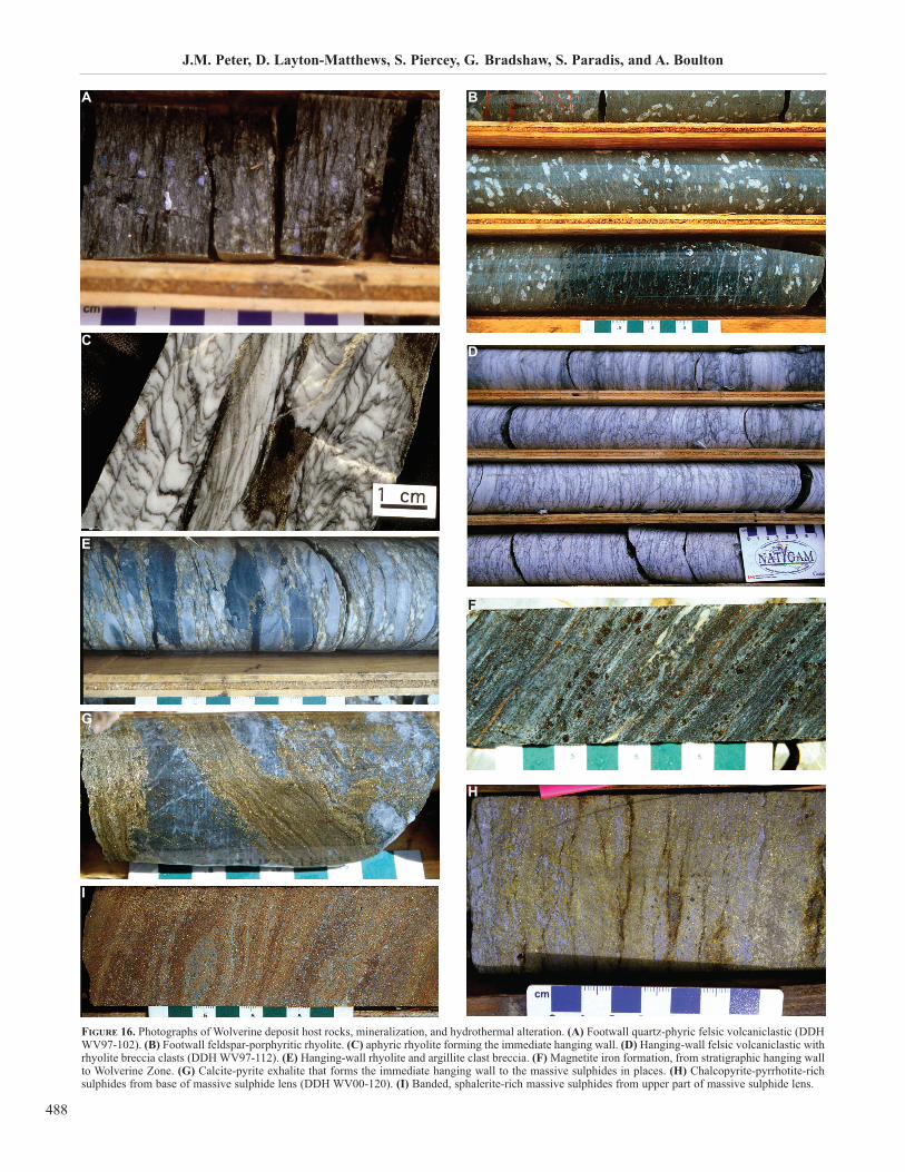
FIGURE 6. Photographs of Fyre Lake deposit host rocks and mineralization. (A) Footwall mafic volcaniclastic rocks. (B) Hanging-wall intercalated mafic vol-caniclastics and sedimentary rocks. (C) Chalcopyrite-rich massive sulphide from East Kona zone (Hunt, 2002). (D) Fine- to medium-grained blebby to dis-seminated pyrite with interstitial chalcopyrite in a matrix of grey, quartz-rich (silicified wall rock) matrix, West Kona zone. (E) Foliation-parallel quartz-sul-phide-magnetite bands interpreted to be stringer veins from feeder zone that have been tectonically transposed parallel to F1 foliation, immediately belowWest Kona zone (DDH 97-115; 746.8 m). (F) Fine-grained magnetite fragments in matrix of pyrite-pyrrhotite-chalcopyrite-quartz from West Kona zone (DDH97-95; 331 m). (G) Patchy to discontinuously banded pyrite-quartz crosscutting fragmental, fine-grained magnetite, West Kona zone (DDH 97-95; 341.8 m). (H) Wispy, banded magnetite (dark grey), chlorite (dark green), and semimassive sulphide (pyrite-chalcopyrite) with notable absence of chlorite, from imme-diately below the upper horizon of the East Kona zone (DDH 96-35; 67.8 m). (I) Finely bedded to laminated magnetite iron formation horizon from top ofmassive sulphide, lower horizon of East Kona zone (DDH 96-34; 72.3 m). Unless stated, the locations of individual samples are not specified. Images D, E,F, G, H, and I are from Sebert et al. (2004). The diameter of the core in photos (C) to (H) is 4.5 cm.
BA
C
D
E
F
G
H
I
Volcanic-Hosted Massive Sulphide Deposits of the Finlayson Lake District, Yukon
481
The West Kona zone has a strike length of 1,500 m, dipsgently to the northeast, and remains open at both ends alongstrike (Fig. 7C). Although the massive sulphide lenses areelongated parallel to the local lineation, an inferred step faultwith a facies change across it separates the East and WestKona zones; this fault is suggested to be synvolcanic in ori-gin and may have served as the conduit for the mineralizingfluids (Sebert et al., 2004).
In general, the massive sulphides are zoned, withpyrite±sphalerite commonly occurring at the top part of thelenses, and pyrrhotite and chalcopyrite being more commonin the lower parts of the lenses as well as comprising a sig-nificant portion of semimassive and disseminated mineral-ization that lies stratigraphically beneath the lenses. WestKona massive sulphides are dominated by magnetite-pyrite-chalcopyrite in a grey siliceous matrix in the east, and tran-sitioning to pyrite-chalcopyrite (Fig. 6D) going westward,and massive pyrrhotite in the western-most part.
The semimassive and disseminated mineralization con-tains chlorite and quartz. Quartz-rich bands within mineral-ization (e.g. Fig. 6E) are interpreted to be stringer veins of afootwall feeder zone that have been tectonically transposed
parallel to the prominent foliation, with the chlorite repre-senting altered wallrock (Sebert et al., 2004).
A unit of fine-grained chert with a few percent sulphides(chalcopyrite, pyrite) and magnetite locally marks the top ofmassive sulphide lenses of the West Kona zone and the lowerhorizon of the East Kona zone (Fig. 6I). This unit, typically15 to 40 cm thick, but ranging to several metres, is thoughtto be an exhalative sediment (Columbia Gold Mines Ltd.,1999; Sebert et al., 2004).
Although there have been several microscopic investiga-tions of the Fyre Lake mineralization, the origin of the mag-netite remains unclear and enigmatic. The high degree ofdeformation of the deposit indicates that the present texturalassociation of magnetite with other sulphides and alterationminerals may largely be due to deformational processes.Textural relationships in Figure 6G and H indicate that mag-netite predates sulphide, and sulphides have brecciated andpartly replaced magnetite, with subsequent deformationimparting a crudely banded texture of alternating magnetite-and sulphide-rich layers.
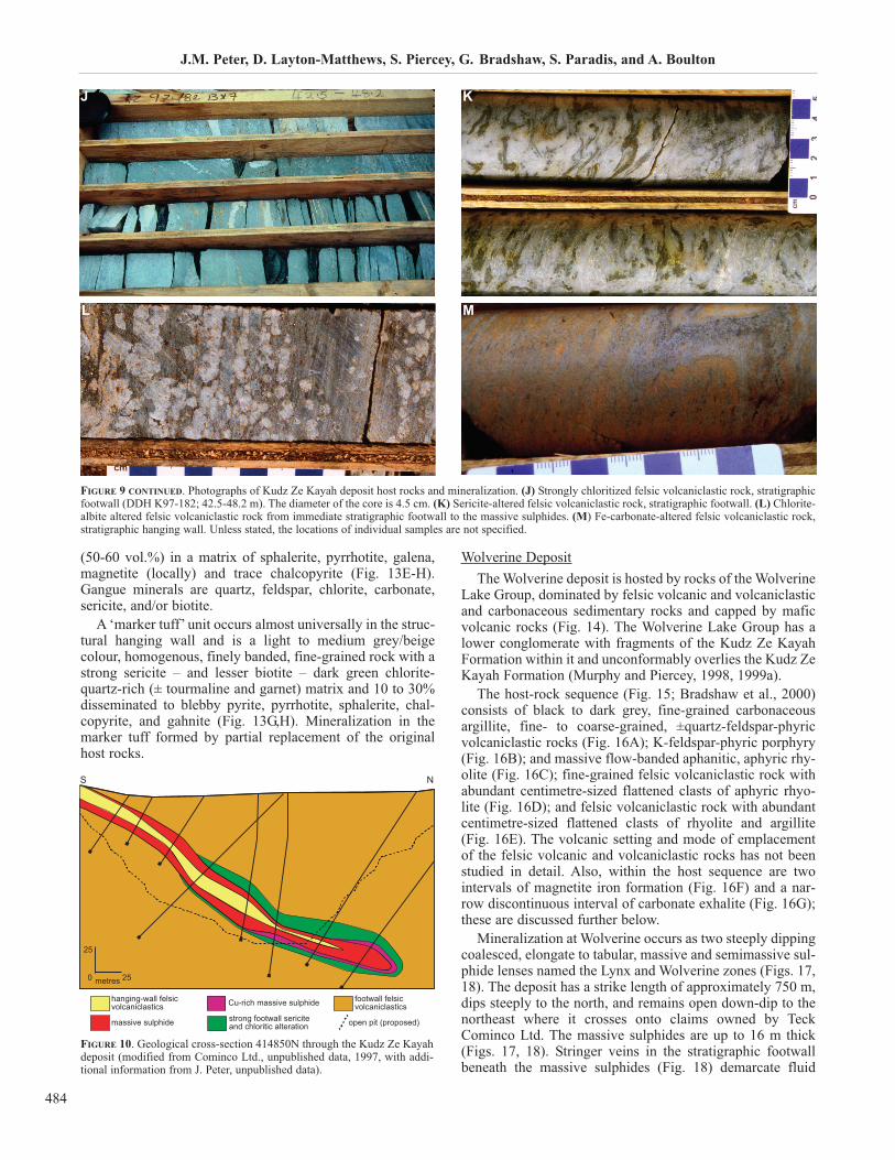
Kudz Ze Kayah Deposit
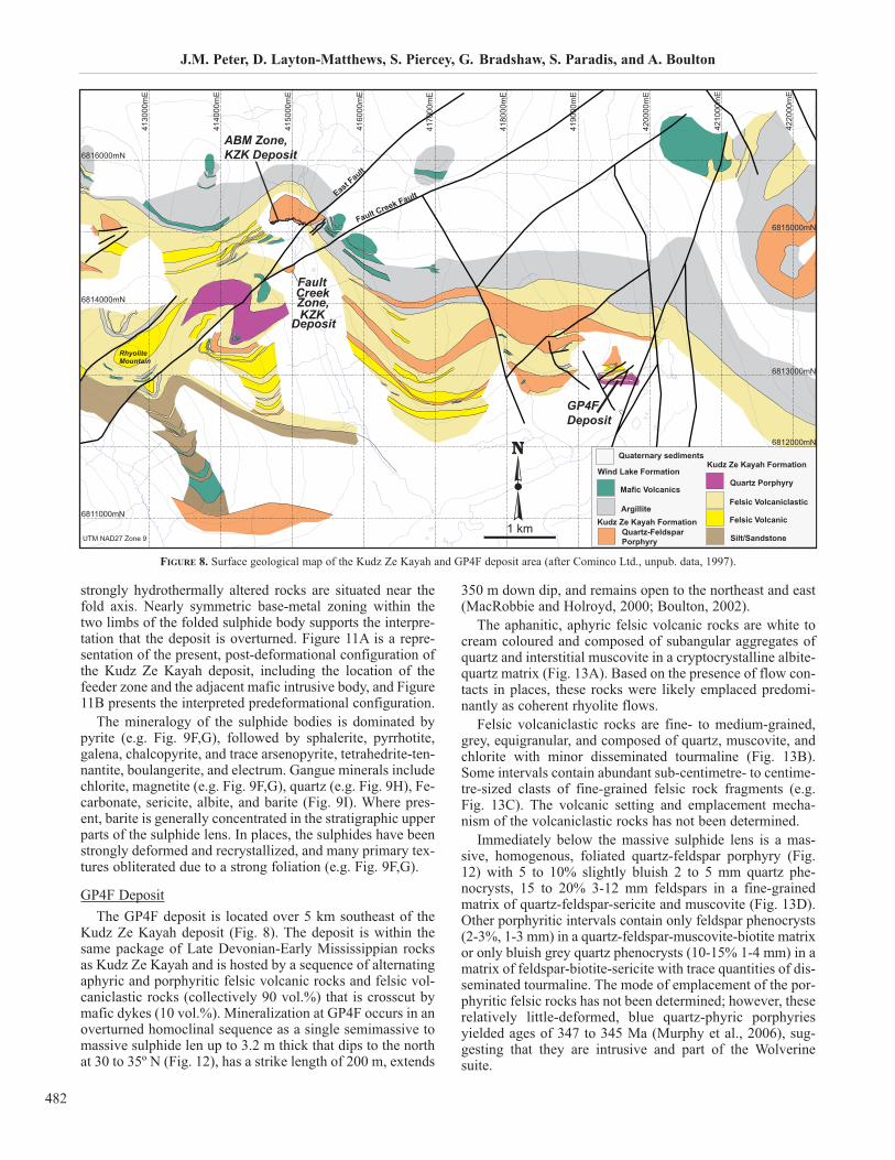
The Kudz Ze Kayah deposit occurs within a sequence ofpredominantly felsic volcanic and volcaniclastic rocks, andminor metasedimentary rocks of the Kudz Ze KayahFormation (Fig. 8). The felsic volcanic and volcaniclasticrocks are generally fine-grained, though centimetre-sizedclasts occur in some intervals. Schultze (1996), in a briefearly report of the deposit indicated that the rocks wereemplaced as flows, and lapilli and ash tuffs. Limited petro-graphic studies of these rocks by company personnel notethe presence of embayed feldspar crystal fragments in someporphyritic samples (e.g. Fig. 9A,D), quartz phenocrysts orphenoclasts in others, and quartz and feldspar in others,indicative of a tuffaceous origin. However, an epiclastic ori-gin cannot presently be ruled out, and further work is neededto unambiguously ascertain the volcanic setting and mode ofemplacement of these rocks. The host-rock sequence isstratigraphically overlain by carbonaceous sedimentaryrocks (argillite) and alkalic mafic volcanic rocks of the WindLake Formation (Fig. 8). A biotite-chlorite-calcite schist(Fig. 9E) is interpreted to be a strongly deformed maficintrusive body that was emplaced as a sill or dyke after for-mation of the deposit.
The main part of the Kudz Ze Kayah deposit, termed theABM zone (Fig. 8), is a 500 m long, isoclinally folded lensof massive to semimassive sulphide (Figs. 10, 11) thatoccurs within a syncline that is overturned to the south andis half of a south-vergent anticline-syncline pair. The miner-alization extends down dip about 400 m, averages 18 m thick, and reaches a maximum thickness of 34 m at thenose of the fold. The smaller southern part of the mineral-ization, referred to as the Fault Creek zone, has been down-dropped by faulting (Fig. 8).
The stratigraphic sequence in the upper limb of the syn-cline is overturned, and hydrothermally altered rocks in thestratigraphic footwall now form the structural hanging wallto the deposit (Fig. 10). Both stratigraphic footwall and hang-ing-wall contacts comprise volcaniclastic rocks (Fig. 9A-D)and what are interpreted to be rhyolite flows. The most
FIGURE 7. Schematic stratigraphic sections through the Fyre Lake deposit.(A) Cross-section along line A-A’ in Figure 4. (B) Longitudinal section ofthe East Kona zone along line B-B’ in Figure 4. (C) Longitudinal section ofWest Kona zone along line C-C’ in Figure 4. Figures are modified fromHunt (2002), which are based on Foreman (1998).
B
A
C
strongly hydrothermally altered rocks are situated near thefold axis. Nearly symmetric base-metal zoning within thetwo limbs of the folded sulphide body supports the interpre-tation that the deposit is overturned. Figure 11A is a repre-sentation of the present, post-deformational configuration ofthe Kudz Ze Kayah deposit, including the location of thefeeder zone and the adjacent mafic intrusive body, and Figure11B presents the interpreted predeformational configuration.
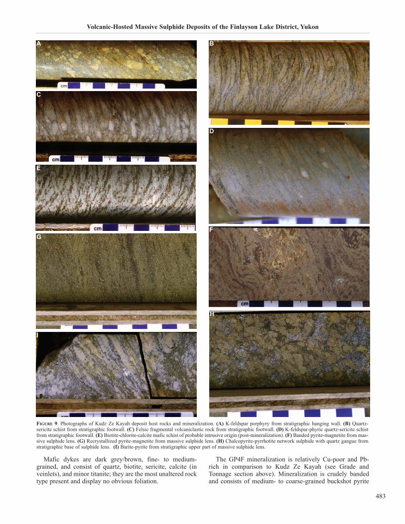
The mineralogy of the sulphide bodies is dominated bypyrite (e.g. Fig. 9F,G), followed by sphalerite, pyrrhotite,galena, chalcopyrite, and trace arsenopyrite, tetrahedrite-ten-nantite, boulangerite, and electrum. Gangue minerals includechlorite, magnetite (e.g. Fig. 9F,G), quartz (e.g. Fig. 9H), Fe-carbonate, sericite, albite, and barite (Fig. 9I). Where pres-ent, barite is generally concentrated in the stratigraphic upperparts of the sulphide lens. In places, the sulphides have beenstrongly deformed and recrystallized, and many primary tex-tures obliterated due to a strong foliation (e.g. Fig. 9F,G).
GP4F Deposit
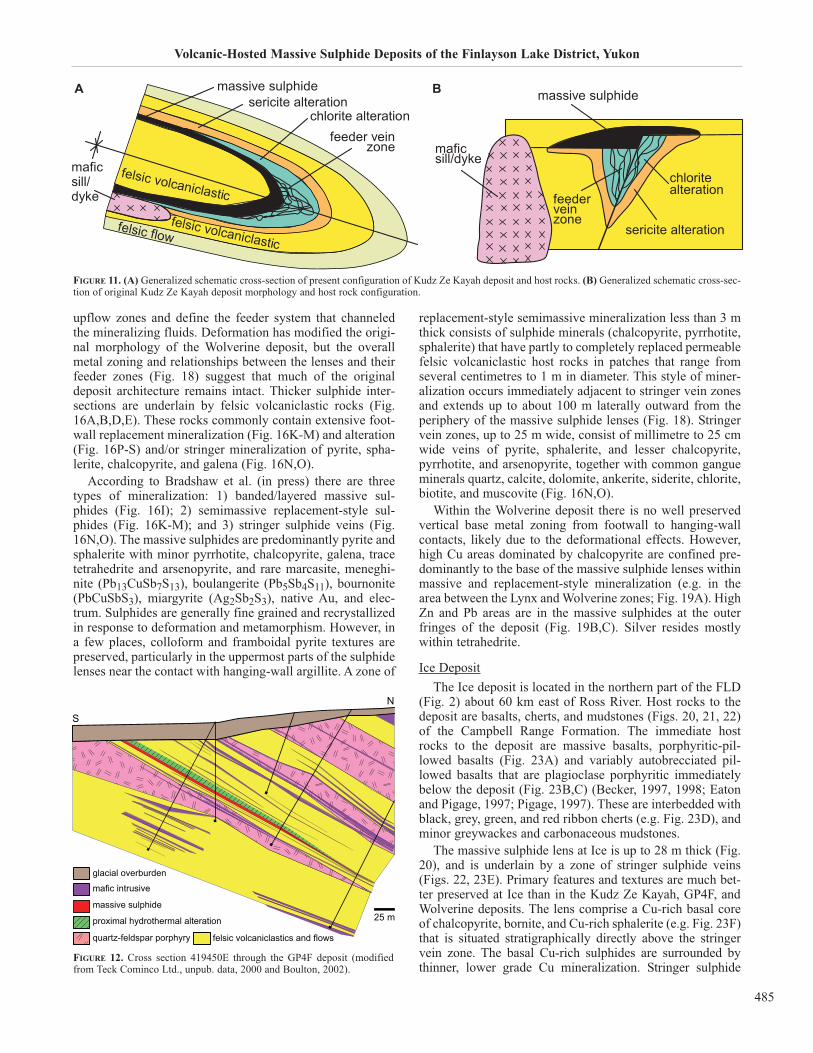
The GP4F deposit is located over 5 km southeast of theKudz Ze Kayah deposit (Fig. 8). The deposit is within thesame package of Late Devonian-Early Mississippian rocksas Kudz Ze Kayah and is hosted by a sequence of alternatingaphyric and porphyritic felsic volcanic rocks and felsic vol-caniclastic rocks (collectively 90 vol.%) that is crosscut bymafic dykes (10 vol.%). Mineralization at GP4F occurs in anoverturned homoclinal sequence as a single semimassive tomassive sulphide len up to 3.2 m thick that dips to the northat 30 to 35º N (Fig. 12), has a strike length of 200 m, extends
350 m down dip, and remains open to the northeast and east(MacRobbie and Holroyd, 2000; Boulton, 2002).
The aphanitic, aphyric felsic volcanic rocks are white tocream coloured and composed of subangular aggregates ofquartz and interstitial muscovite in a cryptocrystalline albite-quartz matrix (Fig. 13A). Based on the presence of flow con-tacts in places, these rocks were likely emplaced predomi-nantly as coherent rhyolite flows.
Felsic volcaniclastic rocks are fine- to medium-grained,grey, equigranular, and composed of quartz, muscovite, andchlorite with minor disseminated tourmaline (Fig. 13B).Some intervals contain abundant sub-centimetre- to centime-tre-sized clasts of fine-grained felsic rock fragments (e.g.Fig. 13C). The volcanic setting and emplacement mecha-nism of the volcaniclastic rocks has not been determined.
Immediately below the massive sulphide lens is a mas-sive, homogenous, foliated quartz-feldspar porphyry (Fig.12) with 5 to 10% slightly bluish 2 to 5 mm quartz phe-nocrysts, 15 to 20% 3-12 mm feldspars in a fine-grainedmatrix of quartz-feldspar-sericite and muscovite (Fig. 13D).Other porphyritic intervals contain only feldspar phenocrysts(2-3%, 1-3 mm) in a quartz-feldspar-muscovite-biotite matrixor only bluish grey quartz phenocrysts (10-15% 1-4 mm) in amatrix of feldspar-biotite-sericite with trace quantities of dis-seminated tourmaline. The mode of emplacement of the por-phyritic felsic rocks has not been determined; however, theserelatively little-deformed, blue quartz-phyric porphyriesyielded ages of 347 to 345 Ma (Murphy et al., 2006), sug-gesting that they are intrusive and part of the Wolverinesuite.
J.M. Peter, D. Layton-Matthews, S. Piercey, G. Bradshaw, S. Paradis, and A. Boulton
482
1 km
ABM Zone,KZK Deposit
FaultCreekZone,KZK
Deposit
GP4FDeposit
Quartz-Feldspar Porphyry
Felsic Volcaniclastic
Felsic Volcanic
Mafic VolcanicsQuartz Porphyry
Argillite
Kudz Ze Kayah FormationWind Lake Formation
Kudz Ze Kayah Formation
Quaternary sediments
Silt/Sandstone
East Fault
Fault Creek Fault
RhyoliteMountain
6814000mN
6813000mN
6812000mN
4140
00m
E
6811000mN
UTM NAD27 Zone 9
6815000mN
6816000mN41
3000
mE
4150
00m
E
4160
00m
E
4170
00m
E
4180
00m
E
4190
00m
E
4200
00m
E
4210
00m
E
4220
00m
E
FIGURE 8. Surface geological map of the Kudz Ze Kayah and GP4F deposit area (after Cominco Ltd., unpub. data, 1997).
Volcanic-Hosted Massive Sulphide Deposits of the Finlayson Lake District, Yukon
483
Mafic dykes are dark grey/brown, fine- to medium-grained, and consist of quartz, biotite, sericite, calcite (inveinlets), and minor titanite; they are the most unaltered rocktype present and display no obvious foliation.
The GP4F mineralization is relatively Cu-poor and Pb-rich in comparison to Kudz Ze Kayah (see Grade andTonnage section above). Mineralization is crudely bandedand consists of medium- to coarse-grained buckshot pyrite
FIGURE 9. Photographs of Kudz Ze Kayah deposit host rocks and mineralization. (A) K-feldspar porphyry from stratigraphic hanging wall. (B) Quartz-sericite schist from stratigraphic footwall. (C) Felsic fragmental volcaniclastic rock from stratigraphic footwall. (D) K-feldspar-phyric quartz-sericite schistfrom stratigraphic footwall. (E) Biotite-chlorite-calcite mafic schist of probable intrusive origin (post-mineralization). (F) Banded pyrite-magnetite from mas-sive sulphide lens. (G) Recrystallized pyrite-magnetite from massive sulphide lens. (H) Chalcopyrite-pyrrhotite network sulphide with quartz gangue fromstratigraphic base of sulphide lens. (I) Barite-pyrite from stratigraphic upper part of massive sulphide lens.
BA
C
D
E
F
G
H
I
J.M. Peter, D. Layton-Matthews, S. Piercey, G. Bradshaw, S. Paradis, and A. Boulton
484
(50-60 vol.%) in a matrix of sphalerite, pyrrhotite, galena,magnetite (locally) and trace chalcopyrite (Fig. 13E-H).Gangue minerals are quartz, feldspar, chlorite, carbonate,sericite, and/or biotite.
A ‘marker tuff’ unit occurs almost universally in the struc-tural hanging wall and is a light to medium grey/beigecolour, homogenous, finely banded, fine-grained rock with astrong sericite – and lesser biotite – dark green chlorite-quartz-rich (± tourmaline and garnet) matrix and 10 to 30%disseminated to blebby pyrite, pyrrhotite, sphalerite, chal-copyrite, and gahnite (Fig. 13G,H). Mineralization in themarker tuff formed by partial replacement of the originalhost rocks.
Wolverine Deposit
The Wolverine deposit is hosted by rocks of the WolverineLake Group, dominated by felsic volcanic and volcaniclasticand carbonaceous sedimentary rocks and capped by maficvolcanic rocks (Fig. 14). The Wolverine Lake Group has alower conglomerate with fragments of the Kudz Ze KayahFormation within it and unconformably overlies the Kudz ZeKayah Formation (Murphy and Piercey, 1998, 1999a).
The host-rock sequence (Fig. 15; Bradshaw et al., 2000)consists of black to dark grey, fine-grained carbonaceousargillite, fine- to coarse-grained, ±quartz-feldspar-phyricvolcaniclastic rocks (Fig. 16A); K-feldspar-phyric porphyry(Fig. 16B); and massive flow-banded aphanitic, aphyric rhy-olite (Fig. 16C); fine-grained felsic volcaniclastic rock withabundant centimetre-sized flattened clasts of aphyric rhyo-lite (Fig. 16D); and felsic volcaniclastic rock with abundantcentimetre-sized flattened clasts of rhyolite and argillite(Fig. 16E). The volcanic setting and mode of emplacementof the felsic volcanic and volcaniclastic rocks has not beenstudied in detail. Also, within the host sequence are twointervals of magnetite iron formation (Fig. 16F) and a nar-row discontinuous interval of carbonate exhalite (Fig. 16G);these are discussed further below.
Mineralization at Wolverine occurs as two steeply dippingcoalesced, elongate to tabular, massive and semimassive sul-phide lenses named the Lynx and Wolverine zones (Figs. 17,18). The deposit has a strike length of approximately 750 m,dips steeply to the north, and remains open down-dip to thenortheast where it crosses onto claims owned by TeckCominco Ltd. The massive sulphides are up to 16 m thick(Figs. 17, 18). Stringer veins in the stratigraphic footwallbeneath the massive sulphides (Fig. 18) demarcate fluid
FIGURE 9 CONTINUED. Photographs of Kudz Ze Kayah deposit host rocks and mineralization. (J) Strongly chloritized felsic volcaniclastic rock, stratigraphicfootwall (DDH K97-182; 42.5-48.2 m). The diameter of the core is 4.5 cm. (K) Sericite-altered felsic volcaniclastic rock, stratigraphic footwall. (L) Chlorite-albite altered felsic volcaniclastic rock from immediate stratigraphic footwall to the massive sulphides. (M) Fe-carbonate-altered felsic volcaniclastic rock,stratigraphic hanging wall. Unless stated, the locations of individual samples are not specified.
hanging-wall felsicvolcaniclastics
massive sulphide
Cu-rich massive sulphide
strong footwall sericite and chloritic alteration
footwall felsic volcaniclastics
open pit (proposed)
metres
S N
0
25
25
FIGURE 10. Geological cross-section 414850N through the Kudz Ze Kayahdeposit (modified from Cominco Ltd., unpublished data, 1997, with addi-tional information from J. Peter, unpublished data).
KJ
L M
Volcanic-Hosted Massive Sulphide Deposits of the Finlayson Lake District, Yukon
485
upflow zones and define the feeder system that channeledthe mineralizing fluids. Deformation has modified the origi-nal morphology of the Wolverine deposit, but the overallmetal zoning and relationships between the lenses and theirfeeder zones (Fig. 18) suggest that much of the originaldeposit architecture remains intact. Thicker sulphide inter-sections are underlain by felsic volcaniclastic rocks (Fig.16A,B,D,E). These rocks commonly contain extensive foot-wall replacement mineralization (Fig. 16K-M) and alteration(Fig. 16P-S) and/or stringer mineralization of pyrite, spha-lerite, chalcopyrite, and galena (Fig. 16N,O).
According to Bradshaw et al. (in press) there are threetypes of mineralization: 1) banded/layered massive sul-phides (Fig. 16I); 2) semimassive replacement-style sul-phides (Fig. 16K-M); and 3) stringer sulphide veins (Fig.16N,O). The massive sulphides are predominantly pyrite andsphalerite with minor pyrrhotite, chalcopyrite, galena, tracetetrahedrite and arsenopyrite, and rare marcasite, meneghi-nite (Pb13CuSb7S13), boulangerite (Pb5Sb4S11), bournonite(PbCuSbS3), miargyrite (Ag2Sb2S3), native Au, and elec-trum. Sulphides are generally fine grained and recrystallizedin response to deformation and metamorphism. However, ina few places, colloform and framboidal pyrite textures arepreserved, particularly in the uppermost parts of the sulphidelenses near the contact with hanging-wall argillite. A zone of
replacement-style semimassive mineralization less than 3 mthick consists of sulphide minerals (chalcopyrite, pyrrhotite,sphalerite) that have partly to completely replaced permeablefelsic volcaniclastic host rocks in patches that range fromseveral centimetres to 1 m in diameter. This style of miner-alization occurs immediately adjacent to stringer vein zonesand extends up to about 100 m laterally outward from theperiphery of the massive sulphide lenses (Fig. 18). Stringervein zones, up to 25 m wide, consist of millimetre to 25 cmwide veins of pyrite, sphalerite, and lesser chalcopyrite,pyrrhotite, and arsenopyrite, together with common gangueminerals quartz, calcite, dolomite, ankerite, siderite, chlorite,biotite, and muscovite (Fig. 16N,O).
Within the Wolverine deposit there is no well preservedvertical base metal zoning from footwall to hanging-wallcontacts, likely due to the deformational effects. However,high Cu areas dominated by chalcopyrite are confined pre-dominantly to the base of the massive sulphide lenses withinmassive and replacement-style mineralization (e.g. in thearea between the Lynx and Wolverine zones; Fig. 19A). HighZn and Pb areas are in the massive sulphides at the outerfringes of the deposit (Fig. 19B,C). Silver resides mostlywithin tetrahedrite.
Ice Deposit
The Ice deposit is located in the northern part of the FLD(Fig. 2) about 60 km east of Ross River. Host rocks to thedeposit are basalts, cherts, and mudstones (Figs. 20, 21, 22)of the Campbell Range Formation. The immediate hostrocks to the deposit are massive basalts, porphyritic-pil-lowed basalts (Fig. 23A) and variably autobrecciated pil-lowed basalts that are plagioclase porphyritic immediatelybelow the deposit (Fig. 23B,C) (Becker, 1997, 1998; Eatonand Pigage, 1997; Pigage, 1997). These are interbedded withblack, grey, green, and red ribbon cherts (e.g. Fig. 23D), andminor greywackes and carbonaceous mudstones.
The massive sulphide lens at Ice is up to 28 m thick (Fig.20), and is underlain by a zone of stringer sulphide veins(Figs. 22, 23E). Primary features and textures are much bet-ter preserved at Ice than in the Kudz Ze Kayah, GP4F, andWolverine deposits. The lens comprise a Cu-rich basal coreof chalcopyrite, bornite, and Cu-rich sphalerite (e.g. Fig. 23F)that is situated stratigraphically directly above the stringervein zone. The basal Cu-rich sulphides are surrounded bythinner, lower grade Cu mineralization. Stringer sulphide
FIGURE 11. (A) Generalized schematic cross-section of present configuration of Kudz Ze Kayah deposit and host rocks. (B) Generalized schematic cross-sec-tion of original Kudz Ze Kayah deposit morphology and host rock configuration.
N
S
25 m
mafic intrusive
massive sulphide
proximal hydrothermal alteration
quartz-feldspar porphyry felsic volcaniclastics and flows
glacial overburden
FIGURE 12. Cross section 419450E through the GP4F deposit (modifiedfrom Teck Cominco Ltd., unpub. data, 2000 and Boulton, 2002).
BA

J.M. Peter, D. Layton-Matthews, S. Piercey, G. Bradshaw, S. Paradis, and A. Boulton
486
vein mineralization is locally present within the footwall-brecciated, porphyritic basalt. Stringer veins are predomi-nantly pyrite-quartz-chalcopyrite and specular hematite. Themassive sulphides are largely overlain by a thin (~5 cm -0.5 m) siliceous hematitic chert unit that passes upwards intoa hanging wall of massive basalt flows and interlayered chert.The massive sulphide mineralization consists of low Pb, andvery low As, Sb, Hg, and Se contents, consistent with a set-ting dominated by mafic volcanic host rocks.
Secondary mineralization is confined to the zone of nearsurface weathering that typically ranges between 5 and 50 m
below surface, and extends to almost 80 m depth along frac-tures. Secondary mineralogy includes minerals that havewholly or partially replaced primary sulphide minerals andothers that were precipitated from groundwater.
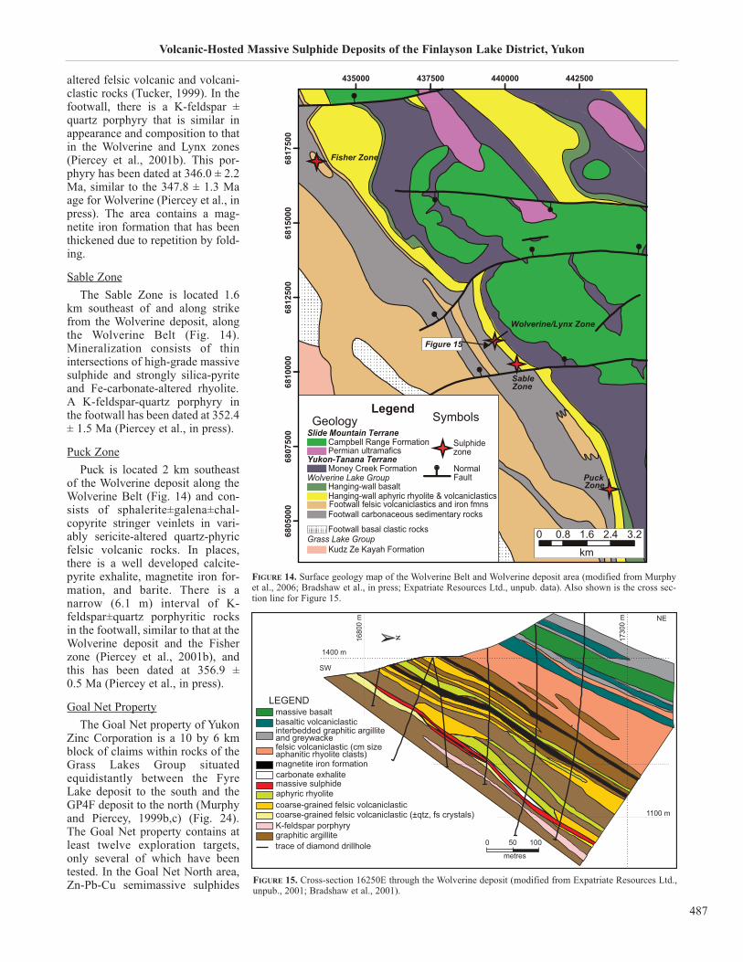
Fisher Zone
The Fisher Zone, discovered in 1995 by WestminResources Ltd., is located some 8 km northwest of theWolverine deposit, and on the same apparent stratigraphichorizon, referred to as the Wolverine Belt (Fig. 14). TheFisher zone consists of numerous narrow bands or lenses ofsphalerite-pyrite-galena within sericite-quartz±chlorite
FIGURE 13. Photographs of GP4F deposit host rocks and mineralization. (A) Rhyolite flow (DDH GP4F98-193; 81.3 m). (B) Fragmental rhyolite volcani-clastic rock. (C) Fragmental rhyolite volcaniclastic rock. (D) Quartz-feldspar porphyry (DDH GP4F98-188; 92.3 m). (E) Sphalerite-rich ‘buckshot’ pyritemassive sulphide (DDH K98-188; 77.6 m). (F) Pyrite-rich ‘buckshot’ massive sulphide (DDH K98-188; 78.5 m). (G) Sphalerite-rich replacement mineral-ization with fine-grained chlorite and sericite (DDH GP4F98-193; 174.8 m). (H) Sphalerite-rich replacement mineralization with fine-grained chlorite andsericite (DDH K98-189; 84.4 m). Unless stated, the locations of individual samples are not specified. Scales are in centimetres.
BA
C
D
E
F
G
H
Volcanic-Hosted Massive Sulphide Deposits of the Finlayson Lake District, Yukon
487
altered felsic volcanic and volcani-clastic rocks (Tucker, 1999). In thefootwall, there is a K-feldspar ±quartz porphyry that is similar inappearance and composition to thatin the Wolverine and Lynx zones(Piercey et al., 2001b). This por-phyry has been dated at 346.0 ± 2.2Ma, similar to the 347.8 ± 1.3 Maage for Wolverine (Piercey et al., inpress). The area contains a mag-netite iron formation that has beenthickened due to repetition by fold-ing.
Sable Zone
The Sable Zone is located 1.6km southeast of and along strikefrom the Wolverine deposit, alongthe Wolverine Belt (Fig. 14).Mineralization consists of thinintersections of high-grade massivesulphide and strongly silica-pyriteand Fe-carbonate-altered rhyolite.A K-feldspar-quartz porphyry inthe footwall has been dated at 352.4± 1.5 Ma (Piercey et al., in press).
Puck Zone
Puck is located 2 km southeastof the Wolverine deposit along theWolverine Belt (Fig. 14) and con-sists of sphalerite±galena±chal-copyrite stringer veinlets in vari-ably sericite-altered quartz-phyricfelsic volcanic rocks. In places,there is a well developed calcite-pyrite exhalite, magnetite iron for-mation, and barite. There is a narrow (6.1 m) interval of K-feldspar±quartz porphyritic rocksin the footwall, similar to that at theWolverine deposit and the Fisherzone (Piercey et al., 2001b), andthis has been dated at 356.9 ± 0.5 Ma (Piercey et al., in press).
Goal Net Property
The Goal Net property of YukonZinc Corporation is a 10 by 6 kmblock of claims within rocks of theGrass Lakes Group situatedequidistantly between the FyreLake deposit to the south and theGP4F deposit to the north (Murphyand Piercey, 1999b,c) (Fig. 24).The Goal Net property contains atleast twelve exploration targets,only several of which have beentested. In the Goal Net North area,Zn-Pb-Cu semimassive sulphides
435000 437500 440000 442500
6805
000
6807
500
6810
0 00
6 812
500
6815
000
6817
500
Fisher Zone
Wolverine/Lynx Zone
SableZone
PuckZone
0 0.8 1.6 2.4 3.2
km
LegendGeology
Campbell Range Formation Sulphidezone
Slide Mountain Terrane
Yukon-Tanana Terrane
Wolverine Lake Group
Kudz Ze Kayah Formation
Permian ultramafics
Money Creek Formation
Hanging-wall basalt
Footwall carbonaceous sedimentary rocksFootwall felsic volcaniclastics and iron fmnsHanging-wall aphyric rhyolite & volcaniclastics
Footwall basal clastic rocksGrass Lake Group
NormalFault
Symbols
Figure 15
FIGURE 14. Surface geology map of the Wolverine Belt and Wolverine deposit area (modified from Murphyet al., 2006; Bradshaw et al., in press; Expatriate Resources Ltd., unpub. data). Also shown is the cross sec-tion line for Figure 15.
1730
0 m
1680
0 m
1100 m
1400 m
SW
NE
carbonate exhalitemassive sulphideaphyric rhyolite
massive basaltbasaltic volcaniclasticinterbedded graphitic argillite and greywacke
coarse-grained felsic volcaniclastic
metres
coarse-grained felsic volcaniclastic (±qtz, fs crystals)
felsic volcaniclastic (cm size aphanitic rhyolite clasts)
graphitic argilliteK-feldspar porphyry
magnetite iron formation
LEGEND
trace of diamond drillhole 0 50 100
FIGURE 15. Cross-section 16250E through the Wolverine deposit (modified from Expatriate Resources Ltd.,unpub., 2001; Bradshaw et al., 2001).
J.M. Peter, D. Layton-Matthews, S. Piercey, G. Bradshaw, S. Paradis, and A. Boulton
488
FIGURE 16. Photographs of Wolverine deposit host rocks, mineralization, and hydrothermal alteration. (A) Footwall quartz-phyric felsic volcaniclastic (DDHWV97-102). (B) Footwall feldspar-porphyritic rhyolite. (C) aphyric rhyolite forming the immediate hanging wall. (D) Hanging-wall felsic volcaniclastic withrhyolite breccia clasts (DDH WV97-112). (E) Hanging-wall rhyolite and argillite clast breccia. (F) Magnetite iron formation, from stratigraphic hanging wallto Wolverine Zone. (G) Calcite-pyrite exhalite that forms the immediate hanging wall to the massive sulphides in places. (H) Chalcopyrite-pyrrhotite-richsulphides from base of massive sulphide lens (DDH WV00-120). (I) Banded, sphalerite-rich massive sulphides from upper part of massive sulphide lens.
BA
CD
E
F
G
H
I
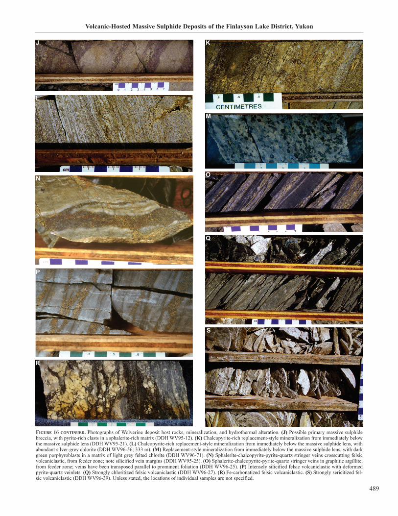
Volcanic-Hosted Massive Sulphide Deposits of the Finlayson Lake District, Yukon
489
FIGURE 16 CONTINUED. Photographs of Wolverine deposit host rocks, mineralization, and hydrothermal alteration. (J) Possible primary massive sulphidebreccia, with pyrite-rich clasts in a sphalerite-rich matrix (DDH WV95-12). (K) Chalcopyrite-rich replacement-style mineralization from immediately belowthe massive sulphide lens (DDH WV95-21). (L) Chalcopyrite-rich replacement-style mineralization from immediately below the massive sulphide lens, withabundant silver-grey chlorite (DDH WV96-56; 333 m). (M) Replacement-style mineralization from immediately below the massive sulphide lens, with darkgreen porphyroblasts in a matrix of light grey felted chlorite (DDH WV96-71). (N) Sphalerite-chalcopyrite-pyrite-quartz stringer veins crosscutting felsicvolcaniclastic, from feeder zone; note silicified vein margins (DDH WV95-25). (O) Sphalerite-chalcopyrite-pyrite-quartz stringer veins in graphitic argillite,from feeder zone; veins have been transposed parallel to prominent foliation (DDH WV96-25). (P) Intensely silicified felsic volcaniclastic with deformedpyrite-quartz veinlets. (Q) Strongly chloritized felsic volcaniclastic (DDH WV96-27). (R) Fe-carbonatized felsic volcaniclastic. (S) Strongly sericitized fel-sic volcaniclastic (DDH WV96-39). Unless stated, the locations of individual samples are not specified.
KJ
L
M
NO
P
Q
R
S
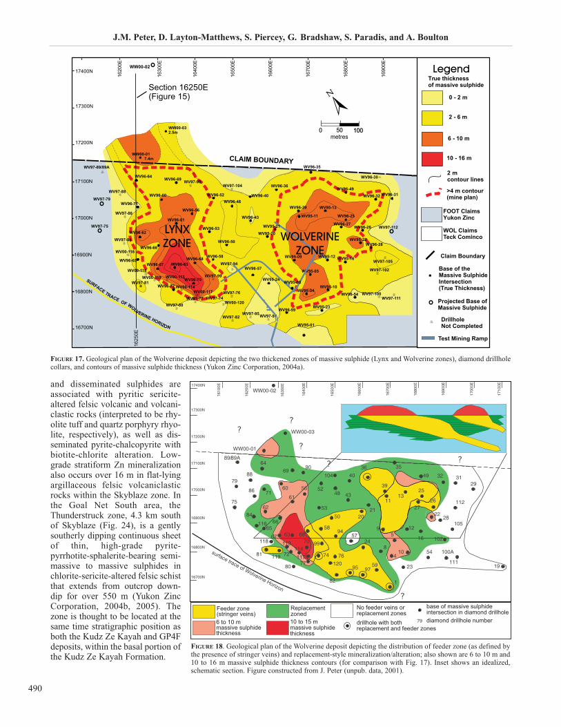
J.M. Peter, D. Layton-Matthews, S. Piercey, G. Bradshaw, S. Paradis, and A. Boulton
490
and disseminated sulphides areassociated with pyritic sericite-altered felsic volcanic and volcani-clastic rocks (interpreted to be rhy-olite tuff and quartz porphyry rhyo-lite, respectively), as well as dis-seminated pyrite-chalcopyrite withbiotite-chlorite alteration. Low-grade stratiform Zn mineralizationalso occurs over 16 m in flat-lyingargillaceous felsic volcaniclasticrocks within the Skyblaze zone. Inthe Goal Net South area, theThunderstruck zone, 4.3 km southof Skyblaze (Fig. 24), is a gentlysoutherly dipping continuous sheetof thin, high-grade pyrite-pyrrhotite-sphalerite-bearing semi-massive to massive sulphides inchlorite-sericite-altered felsic schistthat extends from outcrop down-dip for over 550 m (Yukon ZincCorporation, 2004b, 2005). Thezone is thought to be located at thesame time stratigraphic position asboth the Kudz Ze Kayah and GP4Fdeposits, within the basal portion ofthe Kudz Ze Kayah Formation.
17300N
Section 16250E(Figure 15)
1625
0E
16800N
16900N
17000N
17100N
17200N
17400N
1620
0E
1630
0E
1 640
0E
E
800 E
6 75 0
E
6700
E
16800
1650
0E
1660
0E
16900
1680
0E
1670
0E
1690
0E
16700N
FOOT ClaimsYukon Zinc
WOL ClaimsTeck Cominco
0 - 2 m
2 - 6 m
6 - 10 m
10 - 16 m
Claim Boundary
Base of theMassive SulphideIntersection(True Thickness)
Projected Base ofMassive Sulphide
DrillholeNot Completed
True thicknessof massive sulphide
0 50metres
100100
CLAIM BOUNDARY
SURFACE TRACE OF WOLVERINE HORIZON
LYNXZONE
WW00-02
WW00-017.4m
WW00-032.5m
WV00-114WV00-117
WV00-120
WV00-113WV00-118
WV00-116
WV97-89/89A
WV97-75
WV97-79
WV97-112
WV97-111
WV97-102
WV96-31
WV96-30
WV96-25WV95-11
WV95-22
WV95-13
WV96-35
WV96-39
WV96-49WV96-32
WV96-59
WV95-16
WV96-27
WV95-09
WV95-05
WV95-10
WV95-23
WV95-01
WV96-54
WV96-26
WV96-28
WV97-105
WV97-100WV95-04
WV95-24
WV97-97
WV97-99
WV97-74
WV96-58
WV97-80WV97-77
WV96-72WV96-70
WV96-68WV96-63
WV97-95
WV97-94
WV97-82
WV97-76
WV96-36
WV95-20WV96-53
WV96-50
WV96-56
WV96-43
WV96-48WV96-40WV96-52
WV97-104
WV96-61
WV97-84
WV97-86
WV97-90WV96-69
WV97-88
WV96-64
WV96-60
WV96-71
WV96-62
WV96-66
WV96-65WV96-67
WV97-81WV00-119
Legend
Test Mining Ramp
WOLVERINEZONE
WV95-12
WV95-21
WV96-57
WV95-08
2 mcontour lines
>4 m contour(mine plan)
FIGURE 17. Geological plan of the Wolverine deposit depicting the two thickened zones of massive sulphide (Lynx and Wolverine zones), diamond drillholecollars, and contours of massive sulphide thickness (Yukon Zinc Corporation, 2004a).
Feeder zone(stringer veins)6 to 10 mmassive sulphidethickness
10 to 15 mmassive sulphidethickness
Replacementzoned
No feeder veins orreplacement zones
base of massive sulphide intersection in diamond drillholediamond drillhole numberdrillhole with both
replacement and feeder zones
FIGURE 18. Geological plan of the Wolverine deposit depicting the distribution of feeder zone (as defined bythe presence of stringer veins) and replacement-style mineralization/alteration; also shown are 6 to 10 m and10 to 16 m massive sulphide thickness contours (for comparison with Fig. 17). Inset shows an idealized,schematic section. Figure constructed from J. Peter (unpub. data, 2001).
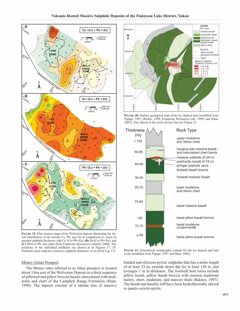
Volcanic-Hosted Massive Sulphide Deposits of the Finlayson Lake District, Yukon
491
Money (Julia) Prospect
The Money (also referred to as Julia) prospect is locatedabout 5 km east of the Wolverine Deposit in a thick sequenceof pillowed and pillow breccia basalts intercalated with mud-stone and chert of the Campbell Range Formation (Hunt,1998). The deposit consists of a tabular lens of massive
banded and siliceous pyritic sulphides that has a strike lengthof at least 53 m, extends down dip for at least 130 m, andaverages 1 m in thickness. The footwall host rocks includepillow basalt, pillow basalt breccia with maroon mudstonematrix, chert, mudstone, and maroon shale (Baknes, 1997).The basalt and basaltic tuff have been hydrothermally alteredto quartz-sericite-pyrite.
diamonddrillhole
metres0 50 100
diamonddrillhole
metres0 50 100
diamonddrillhole
metres0 50 100
FIGURE 19. Plan contour maps of the Wolverine deposit illustrating the lat-eral distribution of the metals Cu, Pb, and Zn in comparison to zones ofgreatest sulphide thickness: (A) Cu/ (Cu+Pb+Zn). (B) Zn/(Cu+Pb+Zn); and(C) Pb/(Cu+Pb+Zn) (data from Expatriate Resources Limited, 2000). Thepositions of the individual drillholes are shown as in Figures 17, 18.Outlined zones indicate a massive sulphide thickness >6 m (from Fig. 17).
massive basaltporphyritic basaltbasalt brecciabrecciated, coarse-grained basaltribbon chert
strike and dipgeological contactsfaults
Massive SulphideThickness Contours (m)
>10 ≤ 28
Symbols
≥ 5 < 10 ≥ 3 < 5≥ 1 < 3
≥ 0.1 < 1Figure 22cross-sectionline
FIGURE 20. Surface geological map of the Ice deposit area (modified fromPigage, 1997; Becker, 1998; Expatriate Resources Ltd., 1999; and Hunt,2002). Also shown is the cross-section line for Figure 22.
FIGURE 21. Generalized stratigraphic column for the Ice deposit and hostrocks (modified from Pigage, 1997 and Hunt, 2002).
A
B
C
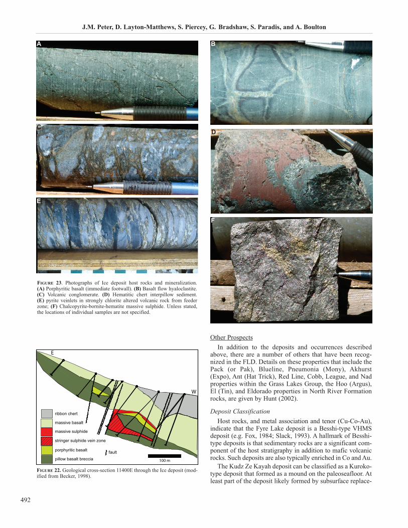
J.M. Peter, D. Layton-Matthews, S. Piercey, G. Bradshaw, S. Paradis, and A. Boulton
492
Other Prospects
In addition to the deposits and occurrences describedabove, there are a number of others that have been recog-nized in the FLD. Details on these properties that include thePack (or Pak), Blueline, Pneumonia (Mony), Akhurst(Expo), Ant (Hat Trick), Red Line, Cobb, League, and Nadproperties within the Grass Lakes Group, the Hoo (Argus),El (Tin), and Eldorado properties in North River Formationrocks, are given by Hunt (2002).
Deposit ClassificationHost rocks, and metal association and tenor (Cu-Co-Au),
indicate that the Fyre Lake deposit is a Besshi-type VHMSdeposit (e.g. Fox, 1984; Slack, 1993). A hallmark of Besshi-type deposits is that sedimentary rocks are a significant com-ponent of the host stratigraphy in addition to mafic volcanicrocks. Such deposits are also typically enriched in Co and Au.
The Kudz Ze Kayah deposit can be classified as a Kuroko-type deposit that formed as a mound on the paleoseafloor. Atleast part of the deposit likely formed by subsurface replace-
FIGURE 23. Photographs of Ice deposit host rocks and mineralization. (A) Porphyritic basalt (immediate footwall). (B) Basalt flow hyaloclastite. (C) Volcanic conglomerate. (D) Hematitic chert interpillow sediment. (E) pyrite veinlets in strongly chlorite altered volcanic rock from feederzone; (F) Chalcopyrite-bornite-hematite massive sulphide. Unless stated,the locations of individual samples are not specified.
E
100 m
ribbon chert
massive basalt
massive sulphide
stringer sulphide vein zone
porphyritic basalt
pillow basalt brecciafault
W
FIGURE 22. Geological cross-section 11400E through the Ice deposit (mod-ified from Becker, 1998).
BA
CD
E
F
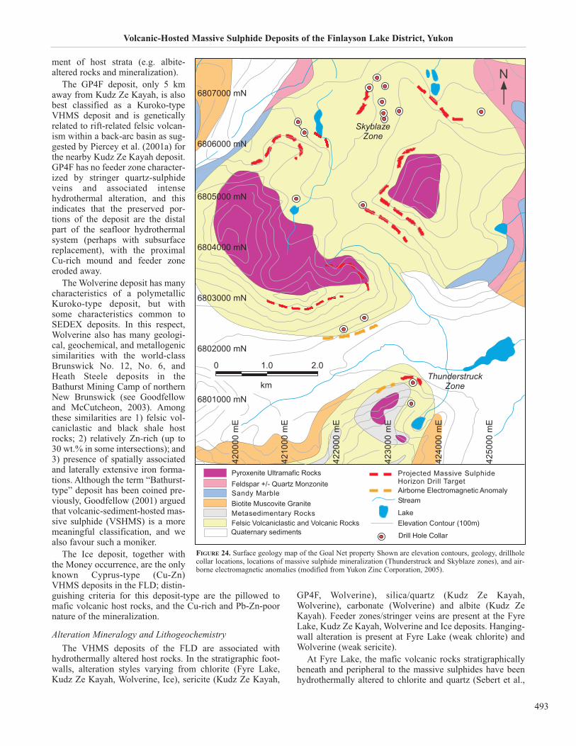
Volcanic-Hosted Massive Sulphide Deposits of the Finlayson Lake District, Yukon
493
ment of host strata (e.g. albite-altered rocks and mineralization).
The GP4F deposit, only 5 kmaway from Kudz Ze Kayah, is alsobest classified as a Kuroko-typeVHMS deposit and is geneticallyrelated to rift-related felsic volcan-ism within a back-arc basin as sug-gested by Piercey et al. (2001a) forthe nearby Kudz Ze Kayah deposit.GP4F has no feeder zone character-ized by stringer quartz-sulphideveins and associated intensehydrothermal alteration, and thisindicates that the preserved por-tions of the deposit are the distalpart of the seafloor hydrothermalsystem (perhaps with subsurfacereplacement), with the proximalCu-rich mound and feeder zoneeroded away.
The Wolverine deposit has manycharacteristics of a polymetallicKuroko-type deposit, but withsome characteristics common toSEDEX deposits. In this respect,Wolverine also has many geologi-cal, geochemical, and metallogenicsimilarities with the world-classBrunswick No. 12, No. 6, andHeath Steele deposits in theBathurst Mining Camp of northernNew Brunswick (see Goodfellowand McCutcheon, 2003). Amongthese similarities are 1) felsic vol-caniclastic and black shale hostrocks; 2) relatively Zn-rich (up to30 wt.% in some intersections); and3) presence of spatially associatedand laterally extensive iron forma-tions. Although the term “Bathurst-type” deposit has been coined pre-viously, Goodfellow (2001) arguedthat volcanic-sediment-hosted mas-sive sulphide (VSHMS) is a moremeaningful classification, and wealso favour such a moniker.
The Ice deposit, together withthe Money occurrence, are the onlyknown Cyprus-type (Cu-Zn)VHMS deposits in the FLD; distin-guishing criteria for this deposit-type are the pillowed tomafic volcanic host rocks, and the Cu-rich and Pb-Zn-poornature of the mineralization.
Alteration Mineralogy and LithogeochemistryThe VHMS deposits of the FLD are associated with
hydrothermally altered host rocks. In the stratigraphic foot-walls, alteration styles varying from chlorite (Fyre Lake,Kudz Ze Kayah, Wolverine, Ice), sericite (Kudz Ze Kayah,
GP4F, Wolverine), silica/quartz (Kudz Ze Kayah,Wolverine), carbonate (Wolverine) and albite (Kudz ZeKayah). Feeder zones/stringer veins are present at the FyreLake, Kudz Ze Kayah, Wolverine and Ice deposits. Hanging-wall alteration is present at Fyre Lake (weak chlorite) andWolverine (weak sericite).
At Fyre Lake, the mafic volcanic rocks stratigraphicallybeneath and peripheral to the massive sulphides have beenhydrothermally altered to chlorite and quartz (Sebert et al.,
FIGURE 24. Surface geology map of the Goal Net property Shown are elevation contours, geology, drillholecollar locations, locations of massive sulphide mineralization (Thunderstruck and Skyblaze zones), and air-borne electromagnetic anomalies (modified from Yukon Zinc Corporation, 2005).

J.M. Peter, D. Layton-Matthews, S. Piercey, G. Bradshaw, S. Paradis, and A. Boulton
494
2004). The hanging-wall mafic volcanic rocks have alsobeen weakly chloritized (Sebert et al., 2004). In general,Sebert et al. (2004) indicate that there is a greater Mg con-tent in altered rocks relative to unaltered rocks.
At the Kudz Ze Kayah deposit, structural hanging-wall(stratigraphic footwall) rocks have been hydrothermallyaltered to sericite, chlorite, and albite, and distributed in dis-crete zones; hydrothermal alteration intensity increases withproximity to sulphides. The most proximal alteration at theimmediate base of the massive sulphides is dominated byalbite (Fig. 9L), presumably because of intense replacementof detrital sedimentary and volcaniclastic rocks. This givesway to Fe chlorite-dominated alteration (Fig. 9J) that is com-monly associated with chalcopyrite and pyrrhotite blebs anddisseminations, and pyrrhotite±chalcopyrite±pyrite±spha-lerite±galena veins in the feeder zone. This, in turn givesway to a more distal sericite-dominated (±disseminatedpyrite and/or pyrrhotite) alteration in the outermost zones
(Fig. 9K). Silicification is developed only locally in a fewplaces in the chlorite zone associated with sulphide replace-ment and feeder veins. Ankerite and siderite are ubiquitouslydeveloped in almost all of the host rocks in and around thedeposit and occurs as Fe carbonate disseminations that havepreferentially replaced felsic clasts in volcaniclastic rocks(Fig. 9M). Structural footwall (stratigraphic hanging-wall)rocks, however, are not visibly hydrothermally altered.
At GP4F, there is a narrow zone of sericite-chloritehydrothermal alteration within felsic rocks immediatelyadjacent to (structurally above) the massive sulphides in thestratigraphic footwall (so-called marker tuff) (Boulton,2002). The alteration intensity is weaker than is observed atKudz Ze Kayah and is characterized by the destruction offeldspars. Quartz-feldspar porphyry occurs (with one excep-tion) structurally below or stratigraphically above the mas-sive sulphide lens. Stratigraphically below the lens, feldsparsphenocrysts in porphyritic rocks have been completely
3
33
1675
0E
1650
0E
16750N
1625
0E
WOLVERINEZONE
LYNXZONELYNXZONE
WOLVERINEZONE
Carbonate Alteration
0 50metres
diamonddrillhole100
FIGURE 25. Plan maps of the distribution of hydrothermally altered rock in the Wolverine deposit. Contours represent the true thickness of altered rocks indrill core that contain greater than 5 vol.% alteration minerals, as determined by visual estimation. (A) Footwall carbonate alteration; contoured areas con-tain calcite or ankerite in the footwall to the massive sulphide lenses (contour interval = 1 m). Carbonate alteration minerals occur only in the Lynx zone andare associated with relatively thin zones of sericite altered rock. (B) Footwall chlorite alteration; contoured areas contain a thickness of at least 3 m of chlo-rite-altered rock (contour interval = 3 m). The thickest zones of chlorite altered rock are generally associated with zones of ‘replacement-style’ semimassivesulphide. (C) Footwall sericite alteration; contoured areas include a thickness of at least 5 m of sericite-altered rock (contour interval = 5 m). The thickestzones of sericite-altered rock occur on the edges of the Wolverine zone, lateral to the thickest zones of chlorite-altered rock. (D) Hanging-wall sericite alter-ation; contoured areas include a thickness of at least 1 m of sericite-altered rock (contour interval = 1 m). Sericite-altered rock in the hanging wall occurs onthe edges of the deposit and generally correlates with sericite altered rock in the footwall. Red coloured areas (the Wolverine and Lynx zones) indicate a truethickness of massive sulphide greater than 6 m (from Fig. 17).
3
LYNXZONE
WOLVERINEZONE
15
15
3
1675
0E
1650
0E
1625
0E
16750N
Chlorite Alteration
0 50metres
diamonddrillhole100
3015
15
30
1650
0E
16750N
1625
0E
WOLVERINEZONE
LYNXZONELYNXZONE
WOLVERINEZONE
Footwall Sericite Alteration
0 50metres
diamond drillhole100
3
3
3
6
WOLVERINE ZONE
LYNX ZONE
16750N
1625
0E
1650
0E
WOLVERINE ZONE
LYNX ZONE
Hanging-wall Sericite Alteration
0 50metres
diamond drillhole100
BA
DC
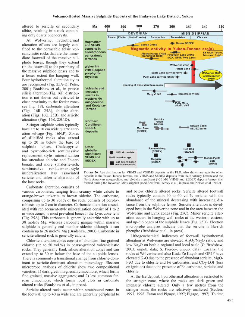
Volcanic-Hosted Massive Sulphide Deposits of the Finlayson Lake District, Yukon
495
altered to sericite or secondaryalbite, resulting in a rock contain-ing only quartz phenocrysts.
At Wolverine, hydrothermalalteration effects are largely con-fined to the permeable felsic vol-caniclastic rocks that are the imme-diate footwall of the massive sul-phide lenses, though they extend(in the footwall) to the periphery ofthe massive sulphide lenses and toa lesser extent the hanging wall.Four hydrothermal alteration stylesare recognized (Fig. 25A-D; Peter,2001; Bradshaw et al., in press):silicic alteration (Fig. 16P; distribu-tion is not shown but restricted toclose proximity to the feeder zone-see Fig. 18), carbonate alteration(Figs. 16R, 25A), chlorite alter-ation (Figs. 16Q, 25B), and sericitealteration (Figs. 16S, 25C,D).
Stringer sulphide veins typicallyhave a 5 to 10 cm wide quartz alter-ation selvage (Fig. 16N,P). Zonesof silicified rocks also extend up to 20 m below the base of sulphide lenses. Chalcopyrite- and pyrrhotite-rich semimassivereplacement-style mineralizationhas attendant chlorite and Fe-car-bonate, and more sphalerite-rich,semimassive replacement-stylemineralization has associatedsericite and ankerite alteration ofthe host rocks.
Carbonate alteration consists ofvarious carbonates, ranging from creamy white calcite toorange-brown ankerite to brown siderite. The carbonate,comprising up to 30 vol.% of the rock, consists of porphy-roblasts up to 2 cm in diameter. Carbonate alteration associ-ated with replacement-style mineralization consist of 1 to 2m wide zones, is most prevalent beneath the Lynx zone lens(Fig. 25A). This carbonate is generally ankeritic with up to38 mole% Mg, whereas carbonate gangue within massivesulphide is generally end-member siderite although it cancontain up to 26 mole% Mg (Bradshaw, 2003). Carbonate insericite-altered rock is generally calcite.
Chlorite alteration zones consist of abundant fine-grainedchlorite (up to 50 vol.%) in coarse-grained volcaniclasticrocks. They generally flank silicic alteration zones and canextend up to 30 m below the base of the sulphide lenses.There is commonly a transitional change from chlorite-dom-inant to sericite-dominant alteration mineralogy. Electronmicroprobe analyses of chlorite show two compositionalvarieties: 1) dark green magnesian clinochlore, which formsfine-grained, massive aggregates; and 2) less common fer-roan clinochlore, which forms local clots in carbonatealtered rocks (Bradshaw et al., in press).
Sericite altered rocks occur within stratabound zones inthe footwall up to 40 m wide and are generally peripheral to
and below chlorite altered rocks. Sericite altered footwallrocks typically contain 40 to 60 vol.% sericite, with theabundance of the mineral decreasing with increasing dis-tance from the sulphide lenses. Sericite alteration is devel-oped best in the Wolverine zone and in the area between theWolverine and Lynx zones (Fig. 25C). Minor sericite alter-ation occurs in hanging-wall rocks at the western, eastern,and up-dip edges of the sulphide lenses (Fig. 25D). Electronmicroprobe analyses indicate that the sericite is Ba-richphengite (Bradshaw et al., in press).
Lithogeochemical indicators of footwall hydrothermalalteration at Wolverine are elevated Al2O3/Na2O ratios, andlow Na2O on both a regional and local scale (G. Bradshaw,2003, unpub. data; S. Piercey, unpub. data). Locally, therocks at Wolverine and also Kudz Ze Kayah and GP4F haveelevated K2O due to the presence of abundant sericite, MgO-FeO due to chlorite and Fe carbonates, and CO2-LOI (losson ignition) due to the presence of Fe-carbonate, sericite, andchlorite.
At the Ice deposit, hydrothermal alteration is restricted tothe stringer zone, where the rocks are dark green andintensely chlorite altered. Only a few metres from thestringer zone, the rocks are relatively unaltered (Becker,1997, 1998; Eaton and Pigage, 1997; Pigage, 1997). To date
MISS ISS IPP IANVi s e a nTournaisianFammenianFrasnianEifelianEmsian Givetian
DEVONIAN
Magmatismand VHMSdeposits inallochthonouspericratonicterranes
WolverineVHMS depositporphyriticrhyolites
Magmatic activity in Yukon-Tanana arc(s)MagmatiMagmatic activitactivity in Yukon-ukon-Tanannana arc(sarc(s)Alaska Range VHMS(Bonnifield, Delta) Finlayson Lake VHMS
(KZK, GP4F, Fyre Lake)
SE Yukon-Tanana,Tulsequah Chief
Nasina SEDEX
330340350360370380390400Ma
Volcanic andintrusiveevents inwestern NAmiogeoclineand KootenayTerrane
Othergloballysignificant
SEDEXVHMS and
Opening of Slide Mountain ocean
Homestake VHMSMarg VHMS
Pelly Mtns.alkalic VMS
NorthernCordilleranSEDEXdeposits
Selwyn BasinSEDEX bariteMac Pass
(SEDEX)
KechikaTroughSEDEX
Red Dog(SEDEX)
Iberian PyriteBelt
(VHMS)
Rammelsberg(SEDEX)
Meggen(SEDEX)
U-Pb zircon date
conodont age
age determination(method uncertain)
Ecstall VHMS
Fisher ZoneWolverine BeltMineralization
Event
Sable Zone early porpyry
Wolverine Zone
Puck Zone early porphyry
FIGURE 26. Age distribution for VHMS and VSHMS deposits in the FLD. Also shown are ages for otherdeposits in the Yukon-Tanana Terrane, and VHMS and SEDEX deposits from the Kootenay Terrane and theNorth American miogeocline, and globally significant (>50 Mt) VHMS and SEDEX deposits/camps thatformed during the Devonian-Mississippian (modified from Piercey et al., in press and Nelson et al., 2002).
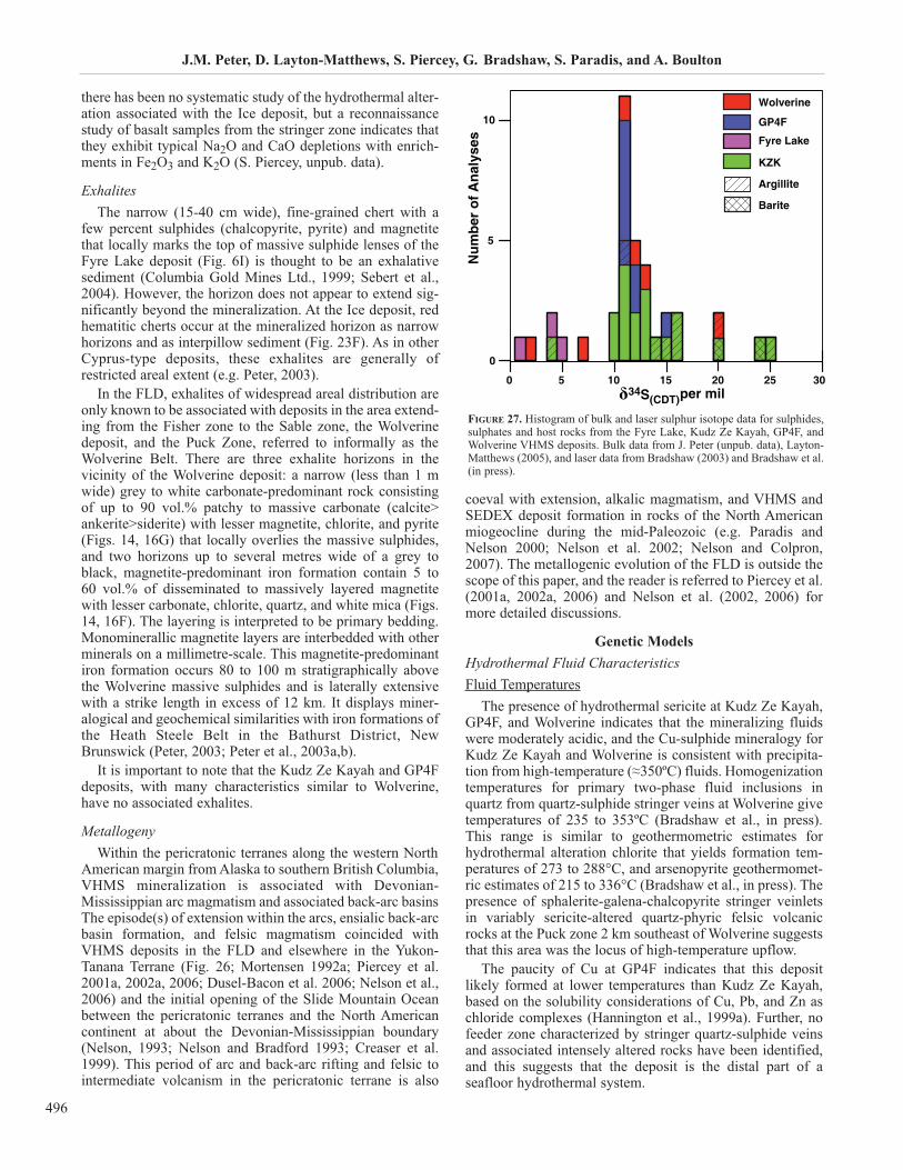
J.M. Peter, D. Layton-Matthews, S. Piercey, G. Bradshaw, S. Paradis, and A. Boulton
496
there has been no systematic study of the hydrothermal alter-ation associated with the Ice deposit, but a reconnaissancestudy of basalt samples from the stringer zone indicates thatthey exhibit typical Na2O and CaO depletions with enrich-ments in Fe2O3 and K2O (S. Piercey, unpub. data).
ExhalitesThe narrow (15-40 cm wide), fine-grained chert with a
few percent sulphides (chalcopyrite, pyrite) and magnetitethat locally marks the top of massive sulphide lenses of theFyre Lake deposit (Fig. 6I) is thought to be an exhalativesediment (Columbia Gold Mines Ltd., 1999; Sebert et al.,2004). However, the horizon does not appear to extend sig-nificantly beyond the mineralization. At the Ice deposit, redhematitic cherts occur at the mineralized horizon as narrowhorizons and as interpillow sediment (Fig. 23F). As in otherCyprus-type deposits, these exhalites are generally ofrestricted areal extent (e.g. Peter, 2003).
In the FLD, exhalites of widespread areal distribution areonly known to be associated with deposits in the area extend-ing from the Fisher zone to the Sable zone, the Wolverinedeposit, and the Puck Zone, referred to informally as theWolverine Belt. There are three exhalite horizons in thevicinity of the Wolverine deposit: a narrow (less than 1 mwide) grey to white carbonate-predominant rock consistingof up to 90 vol.% patchy to massive carbonate (calcite>ankerite>siderite) with lesser magnetite, chlorite, and pyrite(Figs. 14, 16G) that locally overlies the massive sulphides,and two horizons up to several metres wide of a grey toblack, magnetite-predominant iron formation contain 5 to 60 vol.% of disseminated to massively layered magnetitewith lesser carbonate, chlorite, quartz, and white mica (Figs.14, 16F). The layering is interpreted to be primary bedding.Monominerallic magnetite layers are interbedded with otherminerals on a millimetre-scale. This magnetite-predominantiron formation occurs 80 to 100 m stratigraphically abovethe Wolverine massive sulphides and is laterally extensivewith a strike length in excess of 12 km. It displays miner-alogical and geochemical similarities with iron formations ofthe Heath Steele Belt in the Bathurst District, NewBrunswick (Peter, 2003; Peter et al., 2003a,b).
It is important to note that the Kudz Ze Kayah and GP4Fdeposits, with many characteristics similar to Wolverine,have no associated exhalites.
Metallogeny Within the pericratonic terranes along the western North
American margin from Alaska to southern British Columbia,VHMS mineralization is associated with Devonian-Mississippian arc magmatism and associated back-arc basinsThe episode(s) of extension within the arcs, ensialic back-arcbasin formation, and felsic magmatism coincided withVHMS deposits in the FLD and elsewhere in the Yukon-Tanana Terrane (Fig. 26; Mortensen 1992a; Piercey et al.2001a, 2002a, 2006; Dusel-Bacon et al. 2006; Nelson et al.,2006) and the initial opening of the Slide Mountain Oceanbetween the pericratonic terranes and the North Americancontinent at about the Devonian-Mississippian boundary(Nelson, 1993; Nelson and Bradford 1993; Creaser et al.1999). This period of arc and back-arc rifting and felsic tointermediate volcanism in the pericratonic terrane is also
coeval with extension, alkalic magmatism, and VHMS andSEDEX deposit formation in rocks of the North Americanmiogeocline during the mid-Paleozoic (e.g. Paradis andNelson 2000; Nelson et al. 2002; Nelson and Colpron,2007). The metallogenic evolution of the FLD is outside thescope of this paper, and the reader is referred to Piercey et al.(2001a, 2002a, 2006) and Nelson et al. (2002, 2006) formore detailed discussions.
Genetic Models
Hydrothermal Fluid CharacteristicsFluid Temperatures
The presence of hydrothermal sericite at Kudz Ze Kayah,GP4F, and Wolverine indicates that the mineralizing fluidswere moderately acidic, and the Cu-sulphide mineralogy forKudz Ze Kayah and Wolverine is consistent with precipita-tion from high-temperature (≈350ºC) fluids. Homogenizationtemperatures for primary two-phase fluid inclusions inquartz from quartz-sulphide stringer veins at Wolverine givetemperatures of 235 to 353ºC (Bradshaw et al., in press).This range is similar to geothermometric estimates forhydrothermal alteration chlorite that yields formation tem-peratures of 273 to 288°C, and arsenopyrite geothermomet-ric estimates of 215 to 336°C (Bradshaw et al., in press). Thepresence of sphalerite-galena-chalcopyrite stringer veinletsin variably sericite-altered quartz-phyric felsic volcanicrocks at the Puck zone 2 km southeast of Wolverine suggeststhat this area was the locus of high-temperature upflow.
The paucity of Cu at GP4F indicates that this depositlikely formed at lower temperatures than Kudz Ze Kayah,based on the solubility considerations of Cu, Pb, and Zn aschloride complexes (Hannington et al., 1999a). Further, nofeeder zone characterized by stringer quartz-sulphide veinsand associated intensely altered rocks have been identified,and this suggests that the deposit is the distal part of aseafloor hydrothermal system.
0 5 10 15 20 25 30δ34S(CDT)
0
5
10
Nu
mb
er o
f A
nal
yses
per mil
Wolverine
GP4F
Fyre Lake
KZK
Argillite
Barite
FIGURE 27. Histogram of bulk and laser sulphur isotope data for sulphides,sulphates and host rocks from the Fyre Lake, Kudz Ze Kayah, GP4F, andWolverine VHMS deposits. Bulk data from J. Peter (unpub. data), Layton-Matthews (2005), and laser data from Bradshaw (2003) and Bradshaw et al.(in press).
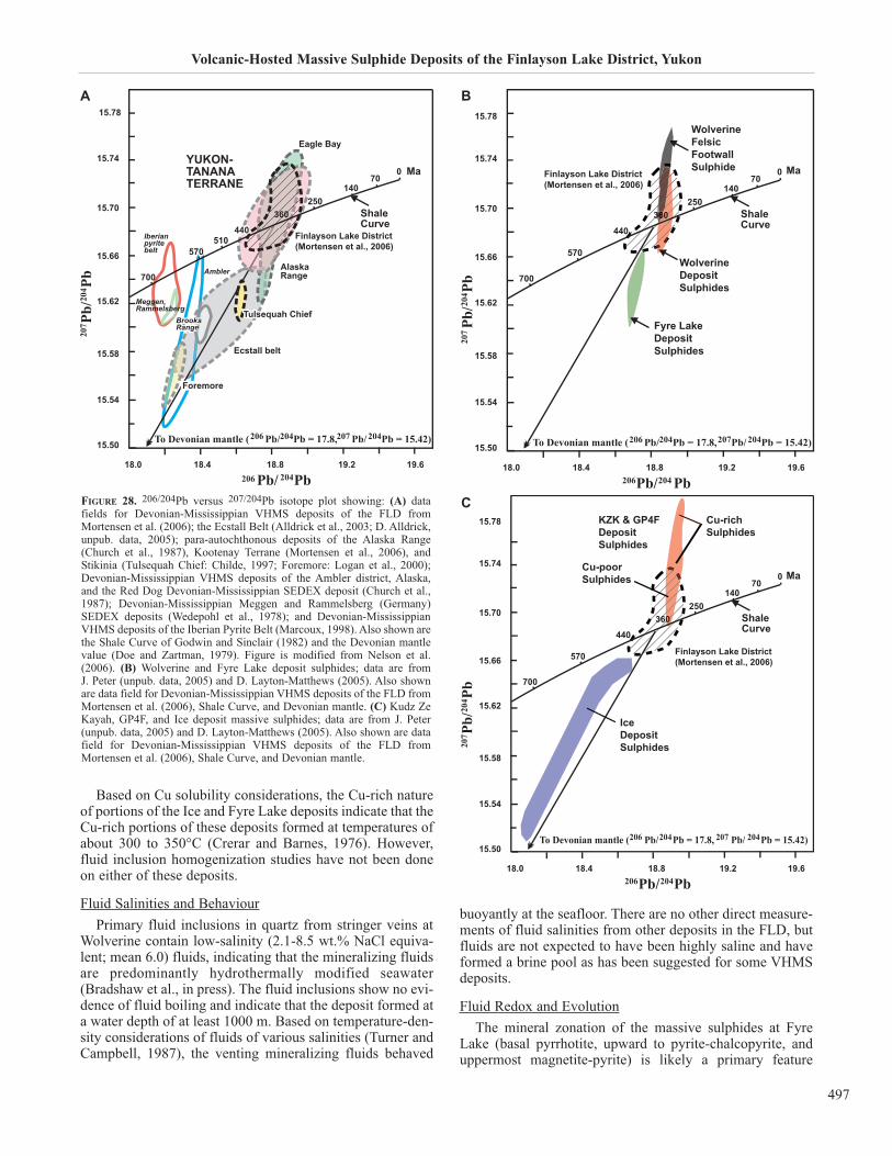
Volcanic-Hosted Massive Sulphide Deposits of the Finlayson Lake District, Yukon
497
Based on Cu solubility considerations, the Cu-rich natureof portions of the Ice and Fyre Lake deposits indicate that theCu-rich portions of these deposits formed at temperatures ofabout 300 to 350°C (Crerar and Barnes, 1976). However,fluid inclusion homogenization studies have not been doneon either of these deposits.
Fluid Salinities and Behaviour
Primary fluid inclusions in quartz from stringer veins atWolverine contain low-salinity (2.1-8.5 wt.% NaCl equiva-lent; mean 6.0) fluids, indicating that the mineralizing fluidsare predominantly hydrothermally modified seawater(Bradshaw et al., in press). The fluid inclusions show no evi-dence of fluid boiling and indicate that the deposit formed ata water depth of at least 1000 m. Based on temperature-den-sity considerations of fluids of various salinities (Turner andCampbell, 1987), the venting mineralizing fluids behaved
buoyantly at the seafloor. There are no other direct measure-ments of fluid salinities from other deposits in the FLD, butfluids are not expected to have been highly saline and haveformed a brine pool as has been suggested for some VHMSdeposits.
Fluid Redox and Evolution
The mineral zonation of the massive sulphides at FyreLake (basal pyrrhotite, upward to pyrite-chalcopyrite, anduppermost magnetite-pyrite) is likely a primary feature
Meggen,Rammelsberg
Ambler
206 Pb/ 204Pb18.0 18.4 18.8 19.2 19.6
15.74
15.70
15.66
15.62
15.58
15.54
15.50
700
570570510
440440
360250
14070
0
Finlayson Lake District (Mortensen et al., 2006)
Eagle Bay
AlaskaRange
Tulsequah ChiefTulsequah Chief
Foremore
Ecstall belt
BrooksRangeBrooksRange
Iberianpyritebelt
ShaleCurve
YUKON-TANANATERRANE
15.78
Ma
207 P
b/20
4 Pb
To Devonian mantle (206 Pb/204Pb = 17.8,207 Pb/ 204Pb = 15.42)
FIGURE 28. 206/204Pb versus 207/204Pb isotope plot showing: (A) datafields for Devonian-Mississippian VHMS deposits of the FLD fromMortensen et al. (2006); the Ecstall Belt (Alldrick et al., 2003; D. Alldrick,unpub. data, 2005); para-autochthonous deposits of the Alaska Range(Church et al., 1987), Kootenay Terrane (Mortensen et al., 2006), andStikinia (Tulsequah Chief: Childe, 1997; Foremore: Logan et al., 2000);Devonian-Mississippian VHMS deposits of the Ambler district, Alaska,and the Red Dog Devonian-Mississippian SEDEX deposit (Church et al.,1987); Devonian-Mississippian Meggen and Rammelsberg (Germany)SEDEX deposits (Wedepohl et al., 1978); and Devonian-MississippianVHMS deposits of the Iberian Pyrite Belt (Marcoux, 1998). Also shown arethe Shale Curve of Godwin and Sinclair (1982) and the Devonian mantlevalue (Doe and Zartman, 1979). Figure is modified from Nelson et al.(2006). (B) Wolverine and Fyre Lake deposit sulphides; data are from J. Peter (unpub. data, 2005) and D. Layton-Matthews (2005). Also shownare data field for Devonian-Mississippian VHMS deposits of the FLD fromMortensen et al. (2006), Shale Curve, and Devonian mantle. (C) Kudz ZeKayah, GP4F, and Ice deposit massive sulphides; data are from J. Peter(unpub. data, 2005) and D. Layton-Matthews (2005). Also shown are datafield for Devonian-Mississippian VHMS deposits of the FLD fromMortensen et al. (2006), Shale Curve, and Devonian mantle.
Finlayson Lake District (Mortensen et al., 2006)
206Pb/204 Pb18.0 18.4 18.8 19.2 19.6
15.74
15.78
15.70
15.66
15.62
15.58
15.54
15.50
700
570570
440440
360250
14070
0
ShaleCurve
WolverineDepositSulphides
Ma
WolverineFelsic FootwallSulphide
Fyre LakeDepositSulphides
207Pb
/204 P
b
363666
To Devonian mantle (206 Pb/204Pb = 17.8,207Pb/ 204Pb = 15.42)
Finlayson Lake District (Mortensen et al., 2006)
Cu-poorSulphides
Cu-richSulphides
Ma
KZK & GP4FDepositSulphides
IceDepositSulphides
206Pb/204Pb18.0 18.4 18.8 19.2 19.6
15.74
15.78
15.70
15.66
15.62
15.58
15.54
15.50
700
570570
440440
360250
14070
0
To Devonian mantle (206 Pb/204Pb = 17.8, 207 Pb/ 204Pb = 15.42)
ShaleCurve
207 P
b/20
4 Pb
BA
C
related to redox variations attendant with the evolution of theprimary sulphide mound in response to zone refining, withthe magnetite deposited late in the paragenetic history of thedeposit as the (originally reduced) fluids became more oxi-dizing. This interpretation, however, contradicts that ofSebert et al. (2004) who suggest that the intercalations ofmagnetite and sulphides are the result of multiple cycles offluid evolution from oxidizing to reducing.
The coexistence of pyrite, pyrrhotite, and chalcopyriteand the preservation of Fe-rich sphalerite near the bases ofthe massive sulphide lenses in the Kudz Ze Kayah, GP4Fand Wolverine deposits indicates a predominantly low andnarrow range of log fO2 (-35 to -43) and log fS2 (-8 to -13)conditions within the sulphide mounds and replacementzones (Toulmin and Barton, 1964; Barton and Toulmin,1966; Helgeson, 1969; Barton, 1978; Barton et al., 1979;Bowers et al., 1985; Hannington et al., 1999a). The absenceof pyrrhotite and chalcopyrite, and the presence of Fe-poorsphalerite near the tops of the polymetallic sulphide depositmounds in the FLD suggest a somewhat higher log fO2 (-35
to -30) and lower depositional temperatures (<250ºC).
The presence of magnetite-bearing exhalite (Fig. 16F)along the Wolverine Belt, extending from the Fisher to thePuck zones (a distance of over 14 km; Fig. 14) indicates thatthese rocks are largely the product of hydrothermal plumefallout and widespread settling on the seafloor. However,geochemical data indicate that these rocks were formed fromlower temperature fluids than the massive sulphides (Peter,2003), following massive sulphide deposition.
At the Ice deposit, field identification of parageneticsequences (L. Pigage and S.J. Piercey, unpub. data) and pre-liminary reflected light microscopy (S.J. Piercey, unpub.data) show complex paragenetic relationships between sul-phide minerals and a changing fluid history through the evo-lution of the deposit. The deposit was likely formed as apyrite-rich mound on the seafloor, but zone refining duringfluid circulation through the mound and venting of high-tem-perature hydrothermal fluids resulted in the replacement ofthe core of the mound pyrite by chalcopyrite (and quartz),and finally bornite-sphalerite (±magnetite). The presence ofspecular hematite within the stringer veins also indicates thatthe hydrothermal fluids from which the massive sulphideswere precipitated evolved from reducing and high tempera-ture, to oxidizing and lower temperature (Barton, 1984).
Duration of Hydrothermal Activity
The age and composition of igneous rocks suggest thathigh heat flow existed within the greater FLD from 365 to346 Ma, a 19 million year time span (e.g. Piercey et al.,2006). Zircon saturation temperatures indicate that the foot-wall porphyritic rhyolites at Wolverine were the products ofhigh temperature (>900°C) partial melting of continentalcrust (Piercey et al., in press) and this high heat flow wasresponsible for initiating and maintaining the Wolverinedeposit hydrothermal circulation system. Magmatic heat waspresent beneath the basin during formation of the Wolverinedeposit from at least 352 to 346 Ma (Piercey et al., in press).
Because of the low sedimentation rate for graphitic shales(e.g. 0.4-13 cm per 1,000 years; Goodfellow and Jonasson,1987; Goodfellow and Turner, 1989) that form the immediate
hanging wall to massive sulphides in parts of Wolverine (e.g.see Fig. 15), the cessation of hydrothermal activity is esti-mated to be on the order of 400,000 to several million yearsafter Wolverine was formed and prior to resumption ofhydrothermal activity marked by the iron formations.
Sources of Sulphur, Lead, Selenium, and Other ConstituentsSulphur Isotopes
Sulphur isotope values (δ34S) have been used extensivelyto discern the source(s) of S in sulphides and sulphates inVHMS deposits (e.g. Ohmoto, 1996, and references therein).Possible sources include 1) abiogenic S reduced from sea-water, whose S isotope composition varies through time, butis strongly positive, e.g., ≈20 per mil at present (Claypool etal., 1980); 2) igneous rocks - close to 0‰ for MORB to -8‰for rhyolite (Ohmoto and Rye, 1979); 3) biogenicallyreduced from seawater - typically strongly negative (Saelenet al., 1993). In most modern seafloor sulphide deposits, sea-water is entrained, downdrawn and heated, and seawater sul-phur is largely removed by precipitation of anhydrite in thesubsurface (Seyfried and Bischoff, 1981), such that vent flu-ids largely contain minimal seawater sulphate (Shanks andSeyfried, 1987). In sedimented seafloor hydrothermal envi-ronments, biogenic reduction of seawater sulphate can be amajor source of S, and this process can cause strong excur-sions in the isotopic composition of the ambient seawatersulphate, particularly in restricted anoxic basins (Saelen etal., 1993).
To date, there are 37 bulk S isotope analyses of bulk sul-phide, barite, and host lithologies from the Fyre Lake, KudzZe Kayah, GP4F, and Wolverine deposits. The data for sul-phides range from δ34SCDT 0.5 to 25‰ (Fig. 27; Layton-Matthews, 2005; J. Peter, unpublished data). Additionally,there is a dataset of 86 laser spot analyses of sulphides from15 samples from the Wolverine deposit (Bradshaw, 2003;Bradshaw et al., in press) obtained using the technique ofBeaudoin and Taylor (1994); however, these are not shownin Figure 27.
Fyre Lake deposit sulphides range from δ34SCDT 0.5 to5.1‰ (n=3). These values reflect derivation of S largelyfrom igneous sources, likely by leaching of magmatic sul-phides within the host mafic volcanic rocks, together with asmall amount of reduced seawater sulphate.
The GP4F deposit exhibits a relatively narrow range formassive sulphides and host rocks of δ34SCDT 11.1 to 14.6‰(n=8). For the Kudz Ze Kayah deposit, there is a much wideroverall range of 9.8 to 25.0‰, with the sulphides rangingfrom 9.8 to 13.0‰ (n=11), barite within the massive sul-phide ranging from 23.7 to 20.0‰ (n=2); barite from thestratigraphic upper part of Kudz Ze Kayah has a δ34SCDTvalue of 21.9‰ (n=1), and argillite ranges from 13.6 to25.0‰ (n=5), with one outlier of 3.8‰. At the time of for-mation of Kudz Ze Kayah in the lower Mississippian(Tournaisian), the S isotopic composition of seawater is esti-mated to have been ≈22‰ (Claypool et al., 1980), and theanalyses of Kudz Ze Kayah barite are in close agreementwith this value. The ranges for GP4F and Kudz Ze Kayahsulphides are relatively narrow and suggest derivation of Sfrom partial reduction of seawater sulphate and S leachedfrom volcanic rocks (e.g. Ohmoto and Goldhaber, 1997).
J.M. Peter, D. Layton-Matthews, S. Piercey, G. Bradshaw, S. Paradis, and A. Boulton
498

Volcanic-Hosted Massive Sulphide Deposits of the Finlayson Lake District, Yukon
499
Sulphur isotope compositions ofsulphides (bulk and laser) fromWolverine give δ34SCDT values of -4.9 to 18.4‰. Black shale from theSable prospect located along strikeand to the west of Wolverine has abulk δ34SCDT value of 20.4‰, sim-ilar to estimates for seawater at thattime (Claypool et al., 1980).However, Bradshaw (2003) andBradshaw et al. (in press), foundthat pyrite within hanging-wallargillite analyzed by laser has anegative value (-5.7‰). This indi-cates that the heavy bulk value mayreflect hydrothermal modifica-tion/introduction and may not be ofsedimentary (likely negative) ori-gin through biogenic sulphatereduction (e.g. Ohmoto andGoldhaber, 1997). However, in situmicroanalyses of isolated pyritegrains can give unrepresentativeanalyses, and more work needs tobe done to resolve these questions.Nevertheless, the wide range ofsulphur isotope compositions forWolverine mineralization, withlighter values from the tops of the lenses, and heavier valuesin the lower parts and in the stringer veins indicates multiplesources. Sulphur in sulphides from the tops of the lenses waslikely derived mainly from bacterial reduction of seawatersulphate, whereas sulphur in the stringer veins and at thebase of the lenses was likely derived from the inorganicreduction of seawater sulphate in the subsurface.
Lead Isotopes
Lead isotopes have long been used as a tracer of Pb and,by inference other metals, in VHMS deposits (e.g. Doe andZartman, 1979). The small size of VHMS circulation cellsand total fluid fluxes (in comparison to SEDEX deposits)dictates that the Pb isotopic ratios of the sulphides are sensi-tive to the isotopic compositions of the various lithologies inthe subsurface reaction zone. There are three possiblesources of Pb in the FLD VHMS deposits: 1) mantle andmantle-derived mafic rocks (basalts, gabbros); 2) sedimen-tary rocks; and 3) crustally-derived volcanic and igneousrocks.
Mortensen et al. (2006) report four Pb isotope analyses foreach of the Fyre Lake and Ice mafic-hosted VHMS deposits,and one and two analyses for each of the felsic-hostedWolverine and Kudz Ze Kayah VHMS deposits, respec-tively. Layton-Matthews (2005), Layton-Matthews et al. (inpress), and J. Peter (unpub. data) provide data for GP4F andhave conducted additional Pb isotope analyses for the FyreLake, Kudz Ze Kayah, and Wolverine deposits to examinewithin-deposit Pb isotope variability. Figure 28A-C presentsthe lead isotope analyses for the Fyre Lake, Wolverine, KudzZe Kayah, and GP4F deposits, and the data of Mortensen etal. (2006) for the Ice deposit. For comparison the shalegrowth curve of Godwin and Sinclair (1982) is given. Figure
28A plots the lead isotope compositions in 207Pb/204Pb ver-sus 206Pb/204Pb space for FLD sulphides determined byMortensen et al. (2006) and various other SEDEX andVHMS deposits from the northern Cordillera of similar age(see figure caption for details).
The Fyre Lake deposit gives the least radiogenic ratios incomparison to the felsic-hosted VHMS deposits (Fig. 28B).The mafic volcanic rocks that host the Fyre Lake deposit areinterpreted to be derived by partial melting of the mantle(Piercey et al., 2001c), and the low Pb isotopic ratios for thesulphides reflect a mixed source of mantle-derived mag-matic and crustal Pb (either from sedimentary rocks in thesubsurface, or magmatic rocks that have been contaminatedby continental crust) (Layton-Matthews, 2005). The Iceanalyses range from very non-radiogenic (n=2), reflectingmantle-derived lead, to more radiogenic values (n=2) (Fig.28C; Mortensen et al., 2006). The deposit and its host vol-canic rocks are interpreted to have formed in a back-arcbasin that developed between the Yukon-Tanana Terrane andthe North American Miogeocline (Murphy et al., 2006), butthis basin is thought to have been geographically close tosources of continent-derived detritus from the Yukon-TananaTerrane on the west (Patchett and Gehrels, 1998; Murphy etal., 2006; Nelson et al., 2006; Piercey et al., 2006).Therefore, Mortensen et al. (2006) concluded that at least aminor amount of Pb in the sulphides was derived from rela-tively Pb-rich continental sediments, and the Pb isotopiccompositions of Ice mineralization reflect a mixing linebetween primitive mantle and a much more radiogenicYukon-Tanana Terrane.
Lead isotope ratios of Wolverine sulphides lie on the shalegrowth curve at ca. 350 Ma and trend toward much moreradiogenic values than the field for felsic-hosted VHMS
01-
Ma
0 01+
δ 43 ‰S TDC
02+ 03+ 04+
evruCSretawaeS)setiropavEeniraM()0891,.lateloopyalC(
ciozoretorP
nairbmaC
naicivodrOnairuliS
nainoveDnaippississiMnainavlysnneP
naimrePcissairT002
003
004
005
006
007
008
U
U
U
M
M
ML
L
L
deifitartsnmulocretaWsretawcixonahtiw
Ice
Fyre LakeKZK, GP4FWolverine
evruCetiraBnisaBnywleS)4891,nossanoJdnawollefdooG(
evruCetiryPnisaBnywleS,nossanoJdnawollefdooG(
)7891,.latesknahS;4891
FIGURE 29. Secular variation in δ34S in seawater sulphur in the northern Cordillera, as indicated by theSelwyn Basin pyrite and barite curves (Goodfellow and Jonasson, 1984; Goodfellow, 1987; Shanks et al.,1987), and for global seawater sulphate (Claypool et al., 1980). The Wolverine deposit, and perhaps also KudzZe Kayah and GP4F, and some other VHMS and SEDEX deposits in the northern Cordillera and elsewherein the World occur at one of the largest δ34S excursions in Earth’s history suggesting the importance of anoxic
ocean conditions in their genesis. Figure is modified from Goodfellow et al. (1993).
deposits of the FLD (Mortensen et al., 2006; hatched fieldshown in Fig. 28A,B). This likely reflects Pb derived fromvolcanic and intrusive rocks that originated from the meltingof old radiogenic crustal rocks at Wolverine. For the KudzZe Kayah and GP4F deposits, the Pb isotopic data do notintersect the shale curve but form a cluster over a wide rangeof 207Pb/204Pb and narrow 206Pb/204Pb that falls above theshale curve. As pointed out by Layton-Matthews (2005) andLayton-Matthews et al. (in press), the differences betweenthe highest 207Pb/204Pb ratios for Wolverine and Kudz ZeKayah are statistically significant and outside analyticalerror. This is likely due to sourcing of greater amounts ofradiogenic lead from sedimentary rocks that are present inabundance in the vicinity of Kudz Ze Kayah and GP4F.
Modeling of the Kudz Ze Kayah and GP4F data using atwo-stage growth curve of Stacey and Kramers (1975) indi-cates a µ value of 11 and extraction ages of 3.14 Ga. Thisimplies that the Pb in these deposits is very old and waslikely sourced from intrusive and extrusive felsic rocks thatformed by partial melting of 3.1 Ga crust. Detrital zircons ofthis or similar age (3.34 Ga) have been noted in the CoastMountains of southeastern Alaska, rocks that are thought tobe the basement for Yukon-Tanana Terrane (Gehrels andKapp, 1998; Gehrels, 2002). Also, Devine et al. (2006) havefound 2.82 Ga inherited zircon ages in the Klatsa metamor-phic complex (Yukon-Tanana Terrane), about 50 km south ofKudz Ze Kayah. Further, Archean Nd-Hf depleted mantlemodel ages for the Snowcap assemblage that underlies andforms the basement to the Yukon-Tanana Terrane (Pierceyand Colpron, unpublished data) indicate Archean age crustthat is likely of detrital origin and derived from the Slavecraton.
Similar modeling for Wolverine suggests a different andless radiogenic reservoir (µ=12, extraction age of 1.7 Ga;Layton-Matthews, 2005; Layton-Matthews et al., in press).Thus, hydrothermal fluids predominantly sourced Pb fromyounger, ca. 1.7 Ga rocks. These results are in agreementwith detrital zircon ages for rocks thought to represent theYukon-Tanana Terrane basement (e.g. Gehrels and Kapp,1998; Gehrels, 2002) and with the detrital zircon attributesof Yukon-Tanana Terrane (Colpron et al., 2006b; Murphy etal., 2006), with a main peak at ca. 1.8 to 1.7 Ga Wopmay age,and lesser peaks at older ages. Additionally, Nd model agesof granites and felsic rocks are largely Paleoproterozoic (ca.1.8-1.6 Ga; Piercey et al., 2003) also indicating melting of amixed 1.8 Ga crust and Archean sedimentary basement.
Selenium
The three polymetallic deposits (Kudz Ze Kayah, GP4Fand Wolverine) are variably enriched in Se, with Wolverinebeing the most enriched (1,100 ppm average), Kudz ZeKayah having intermediate enrichments (210 ppm weightedaverage), and GP4F (8 ppm average) having the lowest con-tents (Layton-Matthews, 2005; Layton-Matthews et al., inpress). This attribute is relatively uncommon for VHMSdeposits (e.g. Huston et al., 1995; Hannington et al., 1999b;Layton-Matthews et al., in press). Selenium in these depositsis resident within clausthalite (PbSe), galena, chalcopyrite,sphalerite, pyrite, and pyrrhotite.
Selenium isotope ratios (δ82/76SeMERCK) for Kudz ZeKayah, GP4F, and Wolverine sulphides indicate that Se orig-
inated by magmatic degassing of SeO4, rapid reduction toH2Se, entrainment in the mineralizing fluid, mixing with Seleached from felsic volcanic rocks (for Kudz Ze Kayah) andgraphitic shales (for Wolverine), and deposition at high tem-peratures (≈350ºC) (Layton-Matthews, 2005). Selenium inthe deposits is mobilized and transported under high-temper-ature conditions as H2Se and concentrated in the Cu-rich por-tions of deposits; mixing of high-temperature fluids withambient seawater in the brecciated margins of the moundscauses ore fluid oxidation and can also result in aclausthalite-pyrite-barite and Se-rich matrix to the brecciaclasts at Kudz Ze Kayah. Recrystallization of pre-existingmineralization during zone refining by a high Se/S ore fluidresults in increased selenium tenor of all sulphides.Generally, with decreasing ore fluid temperature, there is adecrease in ΣSe/ΣS and Se concentration in the ore fluid.Mass balance considerations indicate that the Kudz Ze Kayahand Wolverine deposits require a large Se reservoir in addi-tion to that from magmatic degassing and the felsic volcanicrocks, and this Se was probably provided by leaching fromcontemporaneous volcanic rocks and graphitic shales hostingthe Kudz Ze Kayah and Wolverine deposits, respectively.
Ambient Seafloor EnvironmentThe FLD VHMS deposits show a wide variety of charac-
teristics reflective of deposition under widely different redoxconditions. The relatively low δ34S values for Fyre Lake sul-phides, together with the presence of abundant disseminatedmagnetite of likely primary origin in the mineralization indi-cate that this deposit was formed under oxic ambient condi-tions. Similarly, the presence of a narrow hematite-quartzrock immediately overlying the mineralization at Ice indi-cates that this deposit was formed under similarly oxic ambi-ent conditions.
The presence of black carbon-rich graphitic shales sug-gest that the ambient bottom water in the basin in which theWolverine deposit formed may have been anoxic. Heavy sul-phur isotopic values of the Wolverine mineralization and ofgraphitic shales (argillite) far away from the influence of themineralizing processes (Fig. 27) provide supporting evi-dence that anoxic bottom waters at the site of massive sul-phide deposition may have controlled the sulphur isotopiccomposition of the sulphides (Eastoe and Gustin, 1996).Seawater sulphate was organically reduced to sulphide in thewater column and this was then fixed with venting metals.
Throughout Paleozoic time, there are several periods oftime where the World’s oceans were anoxic. H2S in areduced water column has been shown to be a criticalrequirement for the formation of SEDEX deposits (Fig. 29;e.g., Goodfellow and Jonasson, 1984; Goodfellow, 1987;Shanks et al., 1987; Goodfellow et al., 1993) and someVSHMS (e.g. some deposits in the Bathurst Mining Camp,northern New Brunswick: Goodfellow and Peter, 1996). Ofnote is the close relationship of other so-called VSHMS toperiods of global anoxia (e.g. Iberian Pyrite Belt, Spain andPortugal). Wolverine, and perhaps Kudz Ze Kayah andGP4F, was also formed within a period of global anoxia, andthe relatively heavy sulphur isotope compositions of the sul-phides (Fig. 27) might be explained by such a source.
Further evidence for anoxia comes from the iron forma-tions at the Wolverine deposit. The absence of bedded barite
J.M. Peter, D. Layton-Matthews, S. Piercey, G. Bradshaw, S. Paradis, and A. Boulton
500
Volcanic-Hosted Massive Sulphide Deposits of the Finlayson Lake District, Yukon
501
and the occurrence of Ba in carbonates, stilpnomelane,sericite, and biotite in laminated iron formations that overlieand are lateral to massive sulphides (J. Peter, unpub. data)indicate that Ba was introduced into the basin by hydrother-mal fluids but was not precipitated as barite. Since Ba formsan insoluble sulphate (Blount, 1977), the lack of barite prob-ably reflects very low sulphate contents in the ambient sea-water at the site of venting. Such a low-sulphate environ-ment may represent ambient marine conditions where bacte-rial sulphate reduction went to completion, or a low-sulphateenvironment.
Graphitic shales are not present in the immediate footwallto the Kudz Ze Kayah and GP4F deposits, but they are pres-ent in the hanging wall at the former where they are part ofthe Wind Lake Formation. The strongly positive sulphur iso-tope values for mineralization at Kudz Ze Kayah and GP4Fwould also suggest that anoxia may have played an impor-tant role in the mineralizing processes there also.
Deposit Morphologies and ArchitectureThe sulphide lens morphologies together with mineral
textures at Kudz Ze Kayah, GP4F, Ice, and Fyre Lake indi-cate that these deposits were principally formed as discretemounds on the paleoseafloor. Some mineralization occurs asreplacements of volcaniclastics rocks in the shallow subsur-face in and around the fluid upflow zones (e.g. Kudz ZeKayah, GP4F, and Wolverine). The Fyre Lake, Wolverine,Kudz Ze Kayah, and Ice deposits have well preservedthough deformed feeder vein zones (e.g. Figs. 6E, 16N,O,23E). At Wolverine, the distribution of these veins, as well asreplacement style mineralization, indicate that the Lynx andWolverine zones likely represent two coalesced seafloormounds (Fig. 18, inset). At Wolverine, in thinner mineralizedintersections on the fringes of the Lynx and Wolverine zones,carbonaceous argillite forms the immediate footwall (Fig.15), implying either contemporaneous onlapping by sulphidemass wasting, hydrothermal plume fallout over a protractedperiod of sedimentation, or subseafloor replacement(Bradshaw et al., in press). The semimassive replacementstyle mineralization is thought to have formed very near thepaleoseafloor where the fluids were unfocused and where therocks were not indurated.
Exploration MethodsHistorical
The Fyre Lake deposit was discovered by CassiarAsbestos Corporation in 1960 during follow-up work tolocate the source of massive sulphide float boulders.Exploration efforts have included prospecting, geologicmapping, horizontal loop (Max-Min) and ground magneticsand electromagnetic (EM) surveys, and soil and silt geo-chemistry. Twenty-three shallow packsack (224 m) and 20 AX (1423 m) drillholes were completed between 1960and 1991 by various companies. In 1996 and 1997, PacificRidge Explorations Ltd. (formerly Columbia Gold MinesLtd.) drilled 115 holes (23,200 m), upon which the currentresource is based.
The Fetish claims were staked in the Wolverine depositarea in 1973 by the Finlayson Joint Venture (ChevronCanada Ltd., Union Oil Company of Canada Ltd., andMarietta Resources International Ltd.). The exploration syn-
dicate discovered numerous multi-element geochemicalanomalies in soils over a gossanous area during a grid soilsampling survey, and conducted mapping and trenching thatyear. The company drilled 2 short holes and intersected low-grade Cu and Zn-sulphide mineralization. However, theseclaims lapsed in 1982, whereupon they were restaked byArcher, Cathro, and Associates (1981) Ltd., and furtherground magnetic and Max-Min EM surveys were conductedthat year.
In 1993, Equity Engineering Ltd. conducted explorationin the Wolverine deposit area (Fig. 14) after concluding thatthe region held promise for hosting VHMS-style mineraliza-tion. On behalf of Atna Resources Ltd., Equity staked claimsover the Fetish sulphide mineralization and carried out anexploration program that consisted of geological mapping,prospecting, and rock/soil geochemistry. In 1995, the prop-erty was optioned from Atna by Westmin Resources Ltd. andby the end of that year Westmin had earned a 60% interest inthe project and entered into a joint venture with Westmin asoperator. The latter undertook an exploration program ofdetailed geological mapping, systematic grid soil geochem-istry, and diamond drilling. This fieldwork led to the identi-fication of several additional multi-element geochemicalanomalies, and the intersection of massive sulphide mineral-ization in the Wolverine Zone. The first follow-up drillholeintersected 8.4 m of massive sulphide grading 7.63 g/t Au,1,358.3 g/t Ag, 0.56% Cu, 3.45% Pb, and 14.22% Zn. Thiswas followed by additional drilling in the period 1995through 1997.
In 1996, Westmin carried out metallurgical testing on theWolverine deposit. Results confirmed the presence of unusu-ally high levels of Se (average of 1035 ppm Se, ExpatriateResources Ltd., 2000, unpub. data), a deleterious contami-nant that could significantly impact the value of mineral con-centrates. In 1997, recognition of hydrothermal alteration indrill core led to the discovery of the Sable Zone 1.6 km to thesoutheast of Wolverine. In early 1998, Boliden Ltd. acquiredthe assets of Westmin Resources Ltd. and, following thetakeover, Expatriate concluded a letter of agreement to pur-chase Boliden’s interests in the Wolverine Project; by June1999 a new Wolverine Joint Venture (Expatriate ResourcesLtd. and Atna Resources Ltd.) conducted metallurgical andmarketing investigations of the ore. Drilling programs byExpatriate in 2000 expanded the existing resource and fur-ther defined the known mineralization on the Wolverineproperty. In 2005, Expatriate Resources (now Yukon ZincCorporation) constructed a decline into the massive sul-phides and undertook a test mining program. Further, theycompleted an infill drilling program on the Wolverinedeposit. Currently, the company intends to bring the depositinto production in the near future.
Cominco Ltd. originally carried out a surficial geochemi-cal survey in the vicinity of the Kudz Ze Kayah deposit in1977 and anomalous base metal anomalies in a subsequentGeological Survey of Canada regional geochemistry silt sur-vey (Hornbrook and Friske, 1988) attracted their attention.Prospecting by Cominco led to the discovery of a cobble oflayered massive sulphide. A subsequent UTEM geophysicalsurvey in 1993 identified an EM feature in an area with soilgeochemical anomalies, and the presence of polymetallicsulphide float and felsic volcanic rocks. In 1994, the geo-
physical anomaly was drilled and the first hole intersected22.5 m of massive sulphides in two zones. This outlinedmineralization at Kudz Ze Kayah was named the ABM zonein recognition of A.B. Mawer, the discoverer of the mineral-ized cobble. That year, Cominco completed 52 diamonddrillholes (8500 m) and flew 15,000 km of airborne geo-physical surveys. In 1995, intensive exploration was done,which included 15,000 m of diamond drilling in 120 holes,engineering and environmental studies, and the constructionof an approximately 20 km long access road to the RobertCampbell Highway. During 1996 and 1997, Cominco drill-tested airborne geophysical targets in the Kudz Ze Kayaharea. To the end of 1997, 168 exploration drillholes, totaling24,663 m, were drilled. In 1998, Cominco carried out geo-logical work and diamond drilling in and around Kudz ZeKayah. In 1994 a number of geophysical anomalies wereidentified during a regional airborne geophysical survey.Follow-up drilling in 1998 of geophysical anomaly ‘4F’ ledto the discovery of the GP4F deposit.
The Ice deposit was the first to be discovered in theCampbell Range Formation. High-grade oxide Cu mineral-ization was discovered in 1996 and claims were staked byArcher, Cathro, and Associates Ltd. Geological mapping,grid and reconnaissance soil geochemistry, and airborne andground magnetic and electromagnetic surveys were con-ducted in 1996 and 1997. Thirty-four diamond drillholes(2,704 m) were completed in 1996 and 87 holes (7,880 m)were completed in 1997. No exploration work has been car-ried out since 1997. The deposit is now owned by YukonZinc Corporation.
In the Goal Net North area, soil geochemical surveys byExpatriate Resources Ltd. in 1998 and 1999 identified local-ized strong multi-element anomalies that coincided withinduced polarization chargeability anomalies. Semimassivesulphides were discovered in 1999 in surface pits and thisdiscovery was followed up by diamond drilling in 2000 and2001 that helped to delineate the extent of mineralization.Further drilling in 2004 identified massive sulphide mineral-ization of the Skyblaze zone. The Thunderstruck zone in theGoal Net South area was discovered by Yukon ZincCorporation, the successor to Expatriate Resources Ltd., dur-ing property mapping.
The Money prospect was discovered by the recognition offerricrete and Cu-Zn-Au-Ag-bearing massive sulphide boul-ders in creeks.
ProspectingThe geological and regional stratigraphic framework has
been vastly improved over the last few years through thework of Murphy and coworkers (e.g. Murphy et al., 2006,and references therein), and this will enable effectiveprospecting and exploration on a regional scale outside ofthe known areas of mineralization. Much exploration forVHMS deposit in the FLD remains to be done by prospect-ing for outcropping mineralization or associated hydrother-mally altered rock. This is because the area has received rel-atively little exploration attention to date in comparison tothe mature base metal mining camps of Canada. The initialstaking rush in the mid 1990s generated by the discovery ofthe Kudz Ze Kayah deposit resulted in relatively few com-
panies staking large blocks of ground. The limited resourcesavailable to these companies caused them to focus theirefforts on property scale exploration, and grassroots workwas curtailed. Grassroots exploration should utilize litho-geochemical methods to recognize geochemicallyfavourable volcanic rocks (petrochemistry and chemostratig-raphy), hydrothermally altered volcanic, volcaniclastic andsedimentary rocks, and exhalites.
Petrochemistry and ChemostratigraphyVHMS deposits of then FLD are known to occur at litho-
logical contacts between rocks of markedly different charac-ter (e.g. volcanic and sedimentary facies) or composition(e.g. rhyolite basalt). Within the FLD, rocks favourable forhosting VHMS deposits include those formed within an arcrift, back-arc rift, or at the transition from arc to back-arcmagmatism.
Exploration for Cyprus- and Besshi-type deposits shouldbe focussed on areas of high-temperature mafic magmatismas defined by lithogeochemistry. In the FLD, the presence ofboninitic rocks is an indication of a depleted mantle sourcetypical of nascent to back-arc regimes (e.g. Piercey et al.,2001c). Such rocks require high-temperature melting that iscapable of initiating a stable, long-lived hydrothermal sys-tem. Boninites of the Fire Lake Formation are host to theFyre Lake deposit in the FLD. Depleted arc tholeiites, mid-ocean ridge basalts, (MORB) and back-arc basin basalts(BABB) are also favourable high-temperature mantle melttargets (Swinden 1991, 1997; Syme et al., 1999; Wyman etal., 1999; Piercey et al., 2004). MORB can form not only atmid-ocean ridges but also in back-arc basins, and these rockshave flat REE patterns with low Nb and Th contents (Ewartet al., 1994; Hawkins and Allan, 1994; Hawkins, 1995).BABB are chemically similar to MORB but have minor neg-ative Nb anomalies (Ewart et al., 1994; Hawkins and Allan,1994; Hawkins, 1995) and are formed within back-arc basins.
For the polymetallic Kuroko-type VHMS and VSHMSdeposits, the felsic magmas emplacement at high levels inthe crust provided the magmatic heat source that initiatedhydrothermal convective circulation, making high-tempera-ture felsic volcanic rocks the best targets. Such rocks typi-cally fall in the within-plate, A-type fields on discriminationplots and are characterized by very high HFSE (Nb, Zr > 300 ppm, Y), REE, high Zr/Sc, and negative chondrite-nor-malized Eu anomalies: (La/Yb)n < 7, (Gd/Yb)n < 2, and Y/Zr< 7. They also have higher Zr saturation temperatures thanrhyolites that are not associated with the VHMS deposits(e.g. Barrie, 1995) (FLD range 750-1000ºC; mean 899ºC;n=55 (Piercey et al., 2001a, 2006; S. Piercey, unpub. data,2002).
Felsic or felsic-sedimentary rock sequences underlain bycontinental crust typically have alkalic and MORB maficrocks associated with felsic volcanic rocks. Although theVHMS deposits are commonly hosted by the high-tempera-ture felsic and sedimentary rocks, they are usually overlainby alkalic basalts and MORB. Such an evolution from felsicto mafic magmatism is attributed to the onset of decompres-sion melting of the mantle following thinning, rifting, andpartial melting of the overlying crust (e.g. Piercey et al.,2002a). Alkalic basalts have high Nb, Th, and LREE, and are
J.M. Peter, D. Layton-Matthews, S. Piercey, G. Bradshaw, S. Paradis, and A. Boulton
502

Volcanic-Hosted Massive Sulphide Deposits of the Finlayson Lake District, Yukon
503
the product of lithospheric mantle melting induced by rift-ing, whereas MORB formed from upwelling asthenospheredue to basin opening. Within the FLD, alkalic rocks of theWind Lake Formation crosscut and overlie the Kudz ZeKayah and GP4F deposits (Piercey et al., 2002a). Similarly,at the Wolverine deposit, rocks of the uppermost part of theWolverine Lake Group are basaltic flows and sills with E-MORB to BABB affinities (Piercey et al., 2002b).
Hydrothermal AlterationThe recognition of proximal focused hydrothermal
upflow-related siliceous, chloritic, and sericitic alterationcan further focus exploration. Both regional and localhydrothermal alteration effects can be recognized using min-eral assemblage identification by X-ray diffraction, short-wavelength infrared spectrometry, conventional whole rocklithogeochemistry, and oxygen isotope mapping.
Hydrothermally altered rocks generally have high LOI,H2O, and CO2 contents, due to the presence of hydrated alter-ation minerals such as chlorite and sericite, and/or carbonates.The formation of alteration minerals typically involves reac-tions in which Al2O3 is conserved, whereas other elementssuch as Na2O are lost to the hydrothermal fluids (e.g. Date etal., 1983). Unaltered rocks typically have Na2O contents of 2 to 5 wt.%, and those with less than 2 wt.% are altered byfeldspar destruction; those with more than 5 wt.% Na2O arecharacterized by albite or paragonite alteration and Na2Oaddition (e.g. Giorgetti et al., 2003). For these reasons, theAl2O3/Na2O index of Spitz and Darling (1978) is an effectiveindicator of hydrothermal alteration in a sample. Typically,rocks that have been strongly hydrothermally altered rockshave very high Al2O3/Na2O ratios (>50-100) and indicate aloss of alkali elements and a residual gain in Al2O3; unalteredrocks have ratios that are typically less than 10. Anomalouslyhigh MgO, Fe2O3, and FeO contents in felsic rocks com-monly reflect the addition of these elements via chlorite andpyrite alteration (e.g. Hajash and Chandler, 1981). A usefulgraphical tool to recognize hydrothermal alteration in rocks isthe alteration box plot of Large et al. (2001), because this plotindicates where least altered rocks should plot and also pro-vides fields and vectors for altered variants. The presence ofhigh contents of metals (Cu, Pb, Zn, Au, Ag, Co, Se, etc.) inrocks relative to unaltered equivalents suggest that the rocksare hydrothermally altered.
ExhalitesDistal hydrothermal sediments (exhalites) composed of
finely layered quartz, magnetite, chlorite, carbonate, andtrace sulphides are direct products of seafloor hydrothermalactivity (e.g. Spry et al., 2000; Peter, 2003). These rocks aretypically formed during the nascent and/or waning stages ofhydrothermal venting in ancient hydrothermal systems andcan be used as vectors toward mineralization (e.g. Peter andGoodfellow, 1996, 2003). Some exhalites display miner-alogical and geochemical zonation around known associatedVHMS deposits (see Peter, 2003, and references therein).Minerals indicative of close proximity to mineralizationinclude magnetite, siderite, ankerite, calcite, dolomite, stilp-nomelane, apatite, and pyrite. Elements that are indicative ofclose proximity to mineralization include Fe, Mn, Cu, Pb,Zn, Ag, Au, As, Bi, Cd, Se, Hg, Sb, Sn, In, and Tl, and oth-
ers. Certain elements (e.g. Ti, Al) are indicative of detritalinput, and the ratio of hydrothermal to detrital element (e.g.Fe/Ti) can provide a simple indicator of proximity to ahydrothermal vent. High hydrothermal:detrital ratios signal aclose proximity to the vent. Combinations of these elements,perhaps given different weightings of importance, can bearranged to give an index that may be more effective thanindividual elements or ratios (e.g. Peter, 2003; Peter andGoodfellow, 2003).
GeophysicsThe high magnetic susceptibility of some massive sul-
phide deposits (e.g. Fyre Lake - abundant pyrrhotite; Ice -abundant magnetite), imparted by the presence of pyrrhotiteand magnetite indicates that ground and airborne electro-magnetics would be highly effective exploration methods inthe FLD. The Kudz Ze Kayah deposit is indicated by both astrong magnetic and electromagnetic anomaly (Holroyd andKlein, 1998) although the Wolverine deposit does not have astrong magnetic response. However, the iron formations thatextend from the Fisher zone southeast to Wolverine andbeyond have a strong magnetic signature that is readily iden-tified by airborne surveys (Yukon Zinc Corp., unpub. data,2000; R. Shives, pers. comm., 2007). Further, altered hang-ing-wall rocks at Wolverine are identified by radiometrictechniques. The disseminated to massive nature of the sul-phides suggests that induced polarization methods should beeffective.
Surficial GeochemistryThe original Fetish claims (now the Wolverine deposit)
and the Fisher Zone were found using soil geochemistry, andthe Kudz Ze Kayah deposit area was outlined by a streamsediment Pb-Zn anomaly in a geochemical survey under-taken by the GSC (Hornbrook and Friske, 1988). The GP4Fdeposit has been metamorphosed to higher metamorphicgrade and is known to contain gahnite that probably haveformed by desulphidation of sphalerite during metamor-phism (Spry and Scott, 1986). Drift prospecting for gahniteand other diagnostic minerals may therefore be effective infocusing exploration efforts in the FLD. A regional till geo-chemistry survey and Quaternary geology investigations byBond and Plouffe (2002) showed ice flow patterns duringglacial maxima in the FLD trend towards the west-north-west. Basal till is widespread across plateau surfaces andglaciofluvial sand and gravel dominate in low-lying areas.Multi-element anomalies are present in till near known min-eralized zones, and till down-ice from the Kudz Ze Kayah isenriched in Pb and Zn. In addition, they found base metalanomalies northwest of Wolverine Lake and southwest ofFinlayson Lake where no mineral occurrences are known.
Knowledge Gaps
Although there has been a plethora of new knowledgegained on the tectonic setting, geological setting, and gene-sis of the VHMS deposits of the FLD, there are a number ofunresolved questions. 1) What are the volcanic and sedi-mentary settings of the deposits? Detailed reconstructions ofthe volcanic stratigraphy are needed. 2) What is the exactnature of the long time span between Kudz Ze Kayah agedmineralization (ca. 362 Ma) and Wolverine aged mineraliza-
tion (ca. 346 Ma)? Recent age dating in the Wolverine areaindicates that hydrothermal circulation was active duringthis time span within a condensed stratigraphic section(Piercey et al., in press). 3) What role did anoxia play in theformation of the polymetallic VHMS and VSHMS depositsof the FLD? 4) What role did magmatic fluids and volatilesplay in the development of these deposits? Did they con-tribute metals to the ore-forming system? 5) Additionalinformation is needed on the nature and extent of regionalscale hydrothermal alteration in the FLD, particularlydetailed studies of alteration associated with the hydrother-mal upflow zones associated with different VHMS deposits.An understanding of the three-dimensional distribution andtiming of alteration is needed along with the isotopic andgeochemical attributes of this alteration. 6) What is the exactnature and distribution of Se enrichment in polymetallicVHMS deposits in FLD, and how does this relate to suchevents responsible for the enrichment of Se in base metaldeposits in the Selwyn Basin (e.g. Wolf deposit)? 7) Finally,the applicability and effectiveness of unconventional surfi-cial methods (e.g. heavy minerals in tills, mobile metal ions,enzyme leaches, and partial extractions) in exploration needto be evaluated.
AcknowledgementsFunding came from Geological Survey of Canada (GSC)
Proposal Approval System Project 1017; GSC project X15of the CCGKN Program and project TG6007 of the TargetedGeoscience Initiative III Program are also gratefullyacknowledged for time and resources to write this manu-script. Discussions with Wayne Goodfellow and DonMurphy are gratefully acknowledged. Ingrid Kjarsgaardconducted some of the mineralogical and microprobe analy-ses summarized herein. Constructive reviews were providedby Fernando Tornos, Thomas Monecke, and the Editor,Wayne Goodfellow. This is GSC Contribution Number20060409. DLM gratefully acknowledges financial supportfrom NSERC and the Mineralogical Association of Canadathrough postgraduate scholarships. Steve Piercey’s researchin the FLD has been funded by the Yukon GeologicalSurvey, the Geological Survey of Canada, Yukon ZincCorporation, Atna Resources Ltd., and a Natural Sciencesand Engineering Research Council of Canada DiscoveryGrant. Bradshaw, Peter, and Layton-Matthews also thankExpatriate Resources Ltd., Yukon Zinc Corporation, andTeck Cominco Ltd. for their generous logistical and/or finan-cial support.
References
Abbott, J.G., and Turner, R.J.W., 1991, Character and paleotectonic settingof Devonian stratiform sediment-hosted Zn, Pb, Ba deposits,Macmillan fold belt, Yukon, in Abbott, J.G., and Turner, R.J.W., eds.,Mineral Deposits of the Northern Canadian Cordillera, Yukon,Northeastern British Columbia (Field Trip 14): Geological Survey ofCanada, Open File 2169, p. 99-136.
Alldrick, D., Nelson, J.L., Gabites, J.E., and Childe, F., 2003, Lead isotopesfrom the Ecstall greenstone belt, Coast Mountains, northwest BritishColumbia - significance for global VMS exploration and crustal evolu-tion of the Yukon-Tanana Terrane: Geological Association ofCanada/Mineralogical Association of Canada, Program with Abstracts,v. 28, abstract 620.
Baknes, M., 1997, Money, in Yukon Exploration and Geology 1996:Whitehorse, Yukon, Yukon Geology Program, p. 38-40.
Barrie, C.T., 1995, Zircon thermometry of high-temperature rhyolites nearvolcanic-associated massive sulfide deposits, Abitibi subprovince,Canada: Geology, v. 23, p. 169-172.
Barton, P.B., Jr., 1978, Ore textures involving sphalerite from the Furutobemine, Akita Prefecture, Japan: Mining Geology, v. 28, p. 293-300.
Barton, P.B., Jr., 1984, Redox reactions in hydrothermal fluids, in Henley,R.W., Truesdell, A.H., and Barton, P.B., Jr., eds., Fluid-MineralEquilibria in Hydrothermal Systems: Economic Geology, Reviews inEconomic Geology, v. 1, p. 99-113.
Barton, P.B., Jr., and Toulmin, P., III, 1966, Phase relations involving spha-lerite in the Fe-Zn-S system: Economic Geology, v. 61, p. 815-849.
Barton, P.B., Jr., Skinner, B.J., and Barnes, H.L., 1979, Sulfide mineral sta-bilities, in Barnes, H.L., ed., Geochemistry of Hydrothermal OreDeposits, 2nd edition: John Wiley and Sons, p. 278-403.
Becker, T.C., 1997, Geological mapping, prospecting, soil geochemistry,and airborne geophysical surveys on the Ice property: AssessmentReport 093839 written for Expatriate Resources. Ltd.
——— 1998, Assessment report describing geological mapping, prospect-ing, soil geochemistry, and diamond drilling on the Ice property in theWatson Lake Mining District, Yukon Territory: Assessment Report093869 written for Expatriate Resources. Ltd.
Beaudoin, G., and Taylor, B.E., 1994, High precision and spatial resolutionsulfur isotope analysis using miles laser microprobe: Geochimica etCosmochimica Acta, v. 58, p. 5055-5063.
Blount, C.N., 1977, Barite solubilities and thermodynamic properties up to300°C and 1400 bars: American Mineralogist, v. 62, p. 942-957.
Bond, J.D., and Plouffe, A., 2002, Finlayson Lake Targeted GeoscienceInitiative (southeastern Yukon). Part 2: Quaternary geology and tillgeochemistry, in Emond, D.S., Weston, L. H., and Lewis, L.L., eds.,Yukon Exploration and Geology 2001: Yukon Region, Indian andNorthern Affairs Canada, p. 209-228 plus 10 fold-out maps.
Boulton, A., 2002, GP4F polymetallic volcanic-hosted massive sulphide(VHMS) deposit, Finlayson Lake District, Yukon Territory: B.Sc.Thesis, University of Victoria, Victoria, British Columbia, 56 p.
Bowers, T.S., Von Damm, K.L., and Edmond, J.M., 1985, Chemical evolu-tion of mid-ocean ridge hot springs: Geochimica et CosmochimicaActa, v. 49, p. 2239-2252.
Bradshaw, G.D., 2003, Geology and Genesis of the Wolverine PolymetallicVolcanic Rock-Hosted Massive Sulphide (VHMS) Deposit, FinlaysonLake District, Yukon, Canada: M.Sc. Thesis, University of BritishColumbia, Vancouver, British Columbia, 181 p.
Bradshaw, G.D., Tucker, T., Peter, J.M., Paradis, S., and Rowins, S.M.,2001, Geology of the Wolverine polymetallic volcanic-hosted massivesulphide deposit, Finlayson Lake district, Yukon Territory, Canada, inEmond, D.S., and Weston, L.H., eds., Yukon Exploration and Geology2000: Indian and Northern Affairs Canada, p. 269-287.
Bradshaw, G.D., Rowins, S.M., Peter, J., and Taylor, B., in press, Genesis ofthe Wolverine deposit, Finlayson Lake district, Yukon Territory:Mineralogical, mineral chemical, fluid inclusion, and sulfur isotopicevidence: Economic Geology.
Childe, F., 1997, Timing and Tectonic Setting of Volcanogenic MassiveSulphide Deposits in British Columbia: Constraints from U/PbGeochronology, Radiogenic Isotopes and Geochemistry: Ph.D. thesis,University of British Columbia, Vancouver, British Columbia, 298 p.
Church, S.E., Gray, J.E., Delevaux, M.H., and LeHuray, A.P., 1987, Pb-iso-tope signatures of Devonian-Mississippian massive sulphide depositsin Alaska and their significance to mineral exploration, in Elliott, I.L.,and Smee, B.W., eds., Geoexpo/86-Exploration in the North AmericanCordillera: Rexdale, Ontario, Association of Exploration Geochemists,p. 132-141.
Claypool, G.E., Holser, W.T., Kaplan, I.R., Sakai, H., and Zak, I., 1980, Theage curves of sulfur and oxygen isotopes in marine sulfate and theirmutual interpretation: Chemical Geology, v. 28, p. 199-260.
Colpron, M., and Price, R.A., 1995, Tectonic significance of the Kootenayterrane, southeastern Canadian cordillera: an alternative model:Geology, v. 23, p. 25-28.
Colpron, M., Nelson, J.L., and Murphy, D.C., 2006a, A tectonostratigraphicframework for the pericratonic terranes of the Northern Cordillera, inColpron, M., and Nelson, J., eds., Paleozoic Evolution and Metallogenyof Pericratonic Terranes at the Ancient Pacific Margin of NorthAmerica: Geological Association of Canada, Special Publication 45, p. 1-24.
J.M. Peter, D. Layton-Matthews, S. Piercey, G. Bradshaw, S. Paradis, and A. Boulton
504
Volcanic-Hosted Massive Sulphide Deposits of the Finlayson Lake District, Yukon
505
Colpron, M., Mortensen, J.K., Gehrels, G.E., and Villeneuve, M., 2006b,Basement complex, Carboniferous magmatism and Paleozoic deforma-tion in Yukon-Tanana Terrane of central Yukon: Field, geochemical andgeochronological constraints from Glenlyon map area, in Colpron, M.,and Nelson, J., eds., Paleozoic Evolution and Metallogeny ofPericratonic terranes at the Ancient Pacific Margin of North America:Geological Association of Canada, Special Publication 45, p. 131-152.
Columbia Gold Mines Ltd., 1999, Fyre Lake Project: Joint venture partici-pation sought: unpublished internal report and news release No. 99-02,March 1, 1999.
Crerar, D.A., and Barnes, H.L., 1976, Ore solution chemistry V. Solubilitiesof chalcopyrite and chalcocite assemblages in hydrothermal solution at200°C to 350°C: Economic Geology, v. 71, p. 772-794.
Creaser, R.A., Goodwin, B.J.A.S., and Erdmer, P., 1999, Geochemical andNd isotopic constraints for the origin of eclogite protoliths, northernCordillera; implications for the Paleozoic tectonic evolution of theYukon-Tanana Terrane: Canadian Journal of Earth Sciences, v. 36, p. 1697-1709.
Date, J., Watanabe, Y., and Saeki, Y., 1983, Zonal alteration around theFukazawa Kuroko deposits, Akita Prefecture, northern Japan:Economic Geology, Monograph 5, p. 365-386.
Devine, F., Carr, S.D., Murphy, D.C., Davis, W.J., Smith, S., andVilleneuve, M., 2006, Geochronological and geochemical constraintson the origin of the Klatsa metamorphic complex: Implications forEarly Mississippian high-pressure metamorphism within Yukon-Tanana Terrane, in Colpron, M., and Nelson, J., eds., PaleozoicEvolution and Metallogeny of Pericratonic terranes at the AncientPacific Margin of North America: Geological Association of Canada,Special Publication 45, p. 107-131.
Doe, B.R., and Zartman, R.E., 1979, Plumbotectonics I, the Phanerozoic, inBarnes, H. L., ed., Geochemistry of Hydrothermal Ore Deposits, 2ndedition: John Wiley and Sons, p. 22-69.
Dusel-Bacon, C., Hopkins, M.J., Mortensen, J.K., Dashevsky, S.S.,Bressler, J.R., and Day, W.C., 2006, Paleozoic tectonic and metallo-genic evolution of the pericratonic rocks of east-central Alaska andadjacent Yukon, in Colpron, M., and Nelson, J., eds., PaleozoicEvolution and Metallogeny of Pericratonic Terranes at the AncientPacific Margin of North America: Geological Association of Canada,Special Publication 45, p. 25-74.
Eastoe, C.J., and Gustin, M.M., 1996, Volcanogenic massive sulfidedeposits and anoxia in the Phanerozoic oceans: Ore Geology Reviews,v. 10, p. 179-197.
Eaton, D., and Pigage, L.C., 1997, Geological mapping, prospecting, soilgeochemistry, geophysical surveys and diamond drilling on the Iceproperty: unpublished internal report for Archer, Cathro and Associates(1981) Ltd.
Ewart, A., Bryan, W.B., Chappell, B.W., and Rudnick, R.L., 1994, Regionalgeochemistry of the Lau-Tonga arc and backarc systems, in Hawkins,J.W., Parson, L.M., Allan, J.F., Abrahamsen, N., Bednarz, U., Blanc, G.,Bloomer, S.H., Boe, R., Bruns, T.R., Bryan, W.B., Chaproniere, G. C.H., Clift, P.D., Ewart, A., Fowler, M.G., Hergt, J.M., Hodkinson, R.A.,Lavoie, D.L., Ledbetter, J.K., MacLeod, C.J., Nilsson, K., Nishi, H.,Pratt, C.E., Quinterno, P.J., Reynolds, R.R., Rothwell, R.G., Sager, W.W., Schoeps, D., Soakai, S., and Styzen, M.J., eds., Proceedings of theOcean Drilling Program: Scientific Results, v. 135, p. 385-425.
Expatriate Resources Limited, 1999, Ice deposit resource estimate, newsrelease, November 30, 1998, 2 p.
Expatriate Resources Limited, 2000, Expatriate acquires Kudz Ze Kayahand creates major new zinc-silver exploration and development project.News release, March 21, 2000, 5 p., available at: http://www.yukonz-inc.com/Pa037848.pdf.
Foreman, I., 1998, The Fyre Lake project 1997: Geology and mineralizationof the Kona massive sulphide deposit, Yukon Exploration and Geology,1997: Indian and Northern Affairs Canada, p. 105-113.
Fox, J.S., 1984, Besshi-type volcanogenic sulphide deposits - a review:Canadian Institute of Mining and Metallurgy Bulletin, v. 77, p. 57-67.
Gehrels, G.E., 2002, Detrital zircon geochronology of the Taku Terrane,Southeast Alaska: Canadian Journal of Earth Sciences, v. 39, p. 921-931.
Gehrels, G.E., and Kapp, P.A., 1998, Detrital zircon geochronology andregional correlation of metasedimentary rocks in the coast mountains,southeastern Alaska: Canadian Journal of Earth Sciences, v. 35, p. 269-279.
Giorgetti, G., Monecke, T., Kleeberg, R., and Herzig, P.M., 2003,Intermediate sodium-potassium mica in hydrothermally altered rocks
of the Waterloo Deposit, Australia; a combined SEM-EMP-XRD-TEMstudy: Contributions to Mineralogy and Petrology, v. 146, p. 159-173.
Godwin, C.I., and Sinclair, A.J., 1982, Average lead isotope growth curvesfor shale-hosted zinc-lead deposits, Canadian Cordillera: EconomicGeology, v. 77, p. 675-690.
Goodfellow, W.D., 1987, Anoxic stratified oceans as a source of sulphur insediment-hosted stratiform Zn-Pb deposits (Selwyn Basin, Yukon,Canada): Chemical Geology, v. 65, p. 359-382.
——— 2001, Genesis of massive sulphide deposits in the Bathurst MiningCamp, northern New Brunswick, Canada: North Atlantic MineralsSymposium, Extended Abstracts Volume, p. 51-57.
Goodfellow, W.D., and Jonasson, I.R., 1984, Ocean stagnation and ventila-tion defined by δ34S secular trends in pyrite and barite, Selwyn Basin,Yukon: Geology, v. 12, p. 583-586.
——— 1986, Environment of formation of the Howards Pass (XY) Zn-Pbdeposit, Selwyn Basin, Yukon, in Morin, J. A., ed., Mineral Deposits ofNorthern Cordillera: Canadian Institute of Mining and Metallurgy,Special Volume 37, p. 19-50.
Goodfellow, W.D., and McCutcheon, S.R., 2003, Geologic and geneticattributes of volcanic sediment-hosted massive sulfide deposits of theBathurst Mining Camp, northern New Brunswick - a Synthesis, inGoodfellow, W.D., McCutcheon, S.R., and Peter, J.M., eds., MassiveSulfide Deposits of the Bathurst Mining Camp, New Brunswick, andnorthern Maine: Economic Geology, Monograph 11, p. 245-310.
Goodfellow, W.D., and Peter, J.M., 1996, Sulphur isotope composition ofthe Brunswick No. 12 massive sulphide deposit, Bathurst MiningCamp, New Brunswick: implications for ambient environment, sulphursource, and ore genesis: Canadian Journal of Earth Sciences CanadianJournal of Earth Sciences, v. 33, p. 231-251.
Goodfellow, W.D., and Turner, R.J.W., 1989, Sulfur isotope variability insediment-hosted massive sulphide deposits as determined using the ionmicroprobe SHRIMP: 1. An example from the Rammelsberg orebody -a discussion: Economic Geology, v. 84, p. 451-452.
Goodfellow, W.D., Lydon, J.W., and Turner, R.J.W., 1993, Geology andgenesis of stratiform sediment-hosted (SEDEX) zinc-lead-silver sul-phide deposits, in Kirkham, R.V., Sinclair, W.D., Thorpe, R.I., andDuke, J.M., eds., Mineral Deposit Modeling: Geological Association ofCanada, Special Paper 40, p. 201-251.
Hajash, A, and Chandler, G.W. 1981, An experimental investigation of high-temperature interactions between seawater and rhyolite, andesite, basaltand peridotite. Contributions to Mineralogy and Petrology, v. 78, p.240-254.
Hannington, M.D., Bleeker, W., and Kjarsgaard, I., 1999a, Sulfide mineral-ogy, geochemistry, and ore genesis of the Kidd Creek Deposit; Part I,North, Central and South orebodies: Economic Geology, Monograph10, p. 163-224.
Hannington, M.D., Bleeker, W., and Kjarsgaard, I., 1999b, Sulfide mineral-ogy, geochemistry, and ore genesis of the Kidd Creek Deposit; Part II,The bornite zone: Economic Geology, Monograph 10, p. 225-266.
Hawkins, J.W., 1995, Evolution of the Lau Basin - Insights from ODP Leg135, in Taylor, B., and Natland, J., eds., Active Margins and MarginalBasins of the Western Pacific: American Geophysical Union,Geophysical Monograph, v. 88, p. 125-173.
Hawkins, J.W., 1994, Petrologic evolution of Lau Basin sites 834 through839, in Allan, J.F., Hawkins, J.W., Parson, L.M., Allan, J.F.,Abrahamsen, N., Bednarz, U., Blanc, G., Bloomer, S.H., Boe, R.,Bruns, T.R., Bryan, W.B., Chaproniere, G.C.H., Clift, P.D., Ewart, A.,Fowler, M.G., Hergt, J.M., Hodkinson, R.A., Lavoie, D.L., Ledbetter,J.K., MacLeod, C.J., Nilsson, K., Nishi, H., Pratt, C.E., Quinterno, P.J.,Reynolds, R.R., Rothwell, R.G., Sager, W.W., Schoeps, D., Soakai, S.,and Styzen, M.J., eds., Proceedings of the Ocean Drilling Program,Scientific Results: v. 135, p. 427-470.
Helgeson, H.C., 1969, Thermodynamics of hydrothermal systems at ele-vated temperatures and pressures: American Journal of Science, v. 267,p. 729-804.
Holroyd, R.W., and Klein, J., 1998, Geophysical aspects of the Kudz ZeKayah massive sulfide discovery, southeastern Yukon, in Walton, G.,and Jambor, J., eds., Pathways 98: Yukon Chamber of Mines andSociety of Economic Geologists Inc., Extended Abstracts Volume, p.181-184.
Hornbrook, E.H.W., and Friske, P.W.B., 1988, Regional Stream and WaterGeochemical Reconnaissance Data, southeastern Yukon: GeologicalSurvey of Canada, Open File 1648, 70 p.
Hunt, J.A., 1998, The setting of volcanogenic massive sulphide deposits inthe Finlayson Lake district, in Yukon Exploration and Geology 1997, p. 99-104.
Hunt, J.A., 2002, Volcanic-associated massive sulphide (VMS) mineraliza-tion in the Yukon-Tanana Terrane and coeval strata of the NorthAmerican miogeocline, in The Yukon and Adjacent Areas: Indian andNorthern Affairs Canada, Bulletin 12, 107 p.
Huston, D.L., Sie, S.H., Suter, G.F., Cooke, D.R., and Both, R.A., 1995,Trace elements in sulfide minerals from eastern Australian volcanic-hosted massive sulfide deposits: 1. Proton microprobe analyses ofpyrite, chalcopyrite, and sphalerite, and 2. Selenium levels in pyrite:Comparison with delta S-34 values and implications for the source ofsulfur in volcanogenic hydrothermal systems: Economic Geology, v. 90, p. 1167-1196.
Large, R.R., Gemmell, J.B., Paulick, H., and Huston, D.L., 2001, The alter-ation box plot: A simple approach to understanding the relationshipbetween alteration mineralogy and lithogeochemistry associated withvolcanic-hosted massive sulfide deposits: Economic Geology, v. 96,p. 957-971.
Layton-Matthews, D., 2005, Genesis of Se in Volcanic-Hosted MassiveSulfide Systems: Wolverine, Kudz Ze Kayah, and GP4F VMSDeposits, Finlayson Area, Yukon, Canada: Ph.D. Thesis, University ofToronto, Toronto, Ontario, 247 p.
Layton-Matthews, D., Peter, J.M., Scott, S.D., Paradis, S., Tucker, T.L., andBradshaw, G.D., 2001, Distribution of Se and other trace elements inmassive sulphides of the Wolverine Zn-Pb-Cu-Ag-Au volcanic-hostedmassive sulphide deposit, Finlayson Lake district, Yukon, Canada:Geological Association of Canada/Mineralogical Association ofCanada Joint Annual Meeting, St John’s, Newfoundland, May 2001,Abstracts with Program, v. 26, p. 83.
Layton-Matthews, D., Peter, J.M., Scott, S.D., Leybourne, M.I., andParadis, S., in press, Selenium in sulfide minerals from the Kudz ZeKayah, Wolverine, and GP4F volcanogenic massive sulfide deposits:Distribution and implications for deposit genesis: Economic Geology.
Logan, J.M., Drobe, J.R., and McClelland, W.C., 2000, Geology of theForrest Kerr-Mess Creek Area, northwestern British Columbia: BritishColumbia Ministry of Energy and Mines, Bulletin 104, 164 p.
MacRobbie, P., and Holroyd, R.W., 2000, 1998 and 1999 Year End Report,TAG Property (KZK Project). Cominco Ltd. Exploration Canada:unpublished Internal Report, 41 p.
Marcoux, E., 1998, Lead isotope systematics of the giant massive sulphidedeposits in the Iberian Pyrite Belt: Mineralium Deposita, v. 33, p. 45-58.
Mortensen, J.K., 1992a, New U-Pb ages for the Slide Mountain Terrane insoutheastern Yukon Territory, in Radiogenic and Isotopic Studies,Report 5 (91-2: Geological Survey of Canada p. 167-173.
——— 1992b, Pre-mid-Mesozoic tectonic evolution of the Yukon-TananaTerrane, Yukon and Alaska: Tectonics, v. 11, p. 836-853.
Mortensen, J.K., and Jilson, G.A., 1985, Evolution of the Yukon-TananaTerrane; evidence from southeastern Yukon Territory: Geology, v. 13, p. 806-810.
Mortensen, J.K., Dusel-Bacon, C., Hunt, J., and Gabites, J., 2006, Lead iso-topic constraints on the metallogeny of middle and late Paleozoic syn-genetic base-metal occurrences in the Yukon-Tanana and SlideMountain/Seventymile terranes and adjacent portions of the NorthAmerican miogeocline, in Colpron, M., and Nelson, J., eds., PaleozoicEvolution and Metallogeny of Pericratonic Terranes at the AncientPacific Margin of North America: Geological Association of Canada,Special Publication 45, p. 261-279.
Murphy, D.C., 1997, Preliminary geology map of Grass Lakes area, PellyMountains, southeastern Yukon (105G/7): Yukon Geology ProgramOpen File, v. 1997-3.
Murphy, D.C., 1998, Stratigraphic framework for syngenetic mineral occur-rences, Yukon-Tanana Terrane south of Finlayson Lake: a progressreport, Yukon Exploration and Geology 1997: Indian and NorthernAffairs Canada, p. 51-58.
——— 2001, Yukon-Tanana Terrane in southwestern Frances Lake area,southeastern Yukon, in Yukon Exploration and Geology 2000: Indianand Northern Affairs Canada, p. 217-233.
Murphy, D.C., and Piercey, S.J., 1998, Preliminary geological map of north-ern Wolverine Lake area, Pelly Mountains, southeastern Yukon (NTS105G/8, north half): Indian and Northern Affairs Canada, Open File1998-4, 1:50,000 scale.
——— 1999a, Finlayson Project: Geological evolution of Yukon-TananaTerrane and its relationship to Campbell Range belt, northernWolverine Lake map area, southeastern Yukon, in Roots, C. F., andEmond, D. S., eds., Yukon Exploration and Geology 1998: Indian andNorthern Affairs Canada, p. 47-62.
——— 1999b, Geological map of Wolverine Lake area (105G/8), PellyMountains, southeastern Yukon: Indian and Northern Affairs Canada,Open File 1999-3 (1:50 000 scale).
——— 1999c, Geological map of Finlayson Lake area, southeast quarter(105G/7, 8 and parts of 1,2 and 9), southeastern Yukon: Indian andNorthern Affairs Canada, Open File 1999-4 (1:100 000 scale).
——— 2000a, The Money Creek Thrust, Yukon-Tanana Terrane, south-eastern Yukon; intra-terrane shortening by thrust re-activation of a syn-depositional fault, in Abstracts with Programs: Geological Society ofAmerica, Cordilleran Section and associated societies, 96th annualmeeting; Geological Society of America, v. 32, p. 57.
——— 2000b, Syn-mineralization faults and their re-activation, FinlaysonLake massive sulphide belt, Yukon-Tanana Terrane, southeasternYukon, in Emond, D.S., and L.H. Weston, eds., Yukon Exploration andGeology 1999: p. 55-66.
Murphy, D.C., and Timmerman, J.R.M., 1997, Preliminary geology of thenortheast third of Grass Lakes map area (105G/7), Pelly Mountains,southeastern Yukon, in Yukon Exploration and Geology 1996: p. 62-73.
Murphy, D.C., Colpron, M., Roots, C.F., Gordey, S.P., and Abbott, J.G.,2002, Finlayson Lake Targeted Geoscience Initiative (southeasternYukon), Part 1: Bedrock geology, in Emond, D.S., Weston, L.H., andLewis, L.L., eds., Yukon Exploration and Geology 2001: Indian andNorthern Affairs Canada, p. 189-207.
Murphy, D.C., Mortensen, J. K., Piercey, S. J., Orchard, M. J., and Gehrels,G. E., 2006, Mid-Paleozoic to early Mesozoic tectonostratigraphic evo-lution of Yukon-Tanana and Slide Mountain terranes and affiliatedoverlap assemblages, Finlayson Lake massive sulphide district, south-eastern Yukon, in Colpron, M., and Nelson, J., eds., PaleozoicEvolution and Metallogeny of Pericratonic Terranes at the AncientPacific Margin of North America: Geological Association of Canada,Special Publication 45, p. 75-106.
Nelson, J.L., 1993, The Sylvester Allochthon: upper Paleozoic marginal-basin and island-arc terranes in northern British Columbia: CanadianJournal of Earth Sciences, v. 30, p. 631-643.
Nelson, J., and Colpron, M., 2007, Tectonics and metallogeny of the BritishColumbia, Yukon and Alaskan Cordillera, 1.8 Ga to present, inGoodfellow, W. D., ed., Mineral Deposits of Canada: A Synthesis ofMajor Deposit-types, District Metallogeny, the Evolution of GeologicalProvinces, and Exploration Methods: Special Publication 5, MineralDeposits Division, Geological Association of Canada, p.755-791.
Nelson, J.L., and Bradford, J., 1993, Geology of the Midway-Cassiar area,northern British Columbia (104O, 104P): Ministry of Energy, Minesand Petroleum Resources Bulletin 83, 94 p.
Nelson, J.L., Paradis, S., Christensen, J., and Gabites, J., 2002, CanadianCordilleran Mississippi valley-type deposits; a case for Devonian-Mississippi back-arc hydrothermal origin: Economic Geology, v. 97, p. 1013-1036.
Nelson, J.L., Colpron, M., Piercey, S.J., Dusel-Bacon, C., Murphy, D.C.,and Roots, C.F., 2006, Paleozoic tectonic and metallogenetic evolutionof pericratonic terranes in Yukon, northern British Columbia and east-ern Alaska, in Colpron, M., and Nelson, J., eds., Paleozoic Evolutionand Metallogeny of Pericratonic Terranes at the Ancient Pacific Marginof North America: Geological Association of Canada, SpecialPublication 45, p. 323-360.
Ohmoto, H., 1996, Formation of volcanogenic massive sulfide deposits: theKuroko perspective: Ore Geology Reviews, v. 10, p. 135-177.
Ohmoto, H., and Rye, R.O., 1979, Isotopes of Sulfur and Carbon, in Barnes,H.L, ed., Geochemistry of Hydrothermal Ore Deposits, 2nd edition:John Wiley and Sons, Inc. p. 509-567.
Ohmoto, H., and Goldhaber, M.B., 1997, Sulfur and carbon isotopes, inBarnes, H.L., ed., Geochemistry of Hydrothermal Ore Deposits, 3rdedition: John Wiley and Sons, Inc., p. 517-611.
Okulitch, A.V., 2002, Geological time chart, 2002: Geological Survey ofCanada, Open File 3040.
Paradis, S., and Nelson, J.L., 2000, The Devonian-Mississippian metalloge-netic history of Western Canada, from leading plate margin to continentinterior, in Gemmell, J.B., and Pongratz, J. eds., Volcanic Environmentsand Massive Sulfide Deposits; Program and Abstracts: International
J.M. Peter, D. Layton-Matthews, S. Piercey, G. Bradshaw, S. Paradis, and A. Boulton
506
Volcanic-Hosted Massive Sulphide Deposits of the Finlayson Lake District, Yukon
507
Conference and Field Meeting (3), University of Tasmania, Hobart,Australia, p. 139.
Paradis, S., Nelson, J.L., and Irwin, S.E.B., 1998, Age constraints on theDevonian shale-hosted Zn-Pb-Ba deposits, Gataga district, northeasternBritish Columbia, Canada: Economic Geology, v. 93, p. 184-200.
Patchett, P.J., and Gehrels, G.E., 1998, Continental influence on CanadianCordilleran terranes from Nd isotopic study, and significance for crustalgrowth processes: Journal of Geology, v. 106, p. 269-280.
Peter, J.M., 2001, Brief notes on alteration mapping of the Wolverinedeposit: Unpublished report to Expatriate Resources Ltd., 3 p.
Peter, J.M., 2003, Ancient iron-rich metalliferous sediments (iron forma-tions): their genesis and use in the exploration for stratiform base metalsulphide deposits, with examples from the Bathurst Mining Camp, inLentz, D.R., ed., Geochemistry of Sediments and Sedimentary Rocks:Secular Evolutionary Considerations to Mineral Deposit-FormingEnvironments: Geological Association of Canada, GEOtext v. 4, p. 145-173.
Peter, J.M., and Goodfellow, W.D., 1996, Mineralogy, bulk and rare earthelement geochemistry of massive sulphide-associated hydrothermalsediments of the Brunswick Horizon, Bathurst Mining Camp, NewBrunswick: Canadian Journal of Earth Sciences, v. 33, p. 252-283.
——— 2003, Hydrothermal sedimentary rocks of the Heath Steele Belt,Bathurst Mining Camp, New Brunswick. 3. Application of hydrother-mal sediment mineralogy and mineral and bulk composition to theexploration for concealed massive sulfide mineralization, inGoodfellow, W.D., McCutcheon, S.R., and Peter, J.M., eds., MassiveSulphide Deposits of the Bathurst Mining Camp, New Brunswick, andNorthern Maine: Economic Geology, Monograph 11, p. 417-433.
Peter, J.M., Kjarsgaard, I.M., and Goodfellow, W.D., 2003a, Hydrothermalsedimentary rocks of the Heath Steele Belt, Bathurst Mining Camp,New Brunswick: Part 1. Mineralogy and mineral chemistry, inGoodfellow, W.D., McCutcheon, S.R., and Peter, J.M., eds., MassiveSulphide Deposits of the Bathurst Mining Camp, New Brunswick, andNorthern Maine: Economic Geology, Monograph 11, p. 361-390.
Peter, J.M., Goodfellow, W.D., and Doherty, W., 2003b, Hydrothermal sed-imentary rocks of the Heath Steele Belt, Bathurst Mining Camp, NewBrunswick: Part 2. Bulk and rare earth element geochemistry andimplications for origin, in Goodfellow, W. D., McCutcheon, S. R., andPeter, J. M., eds., Massive Sulphide Deposits of the Bathurst MiningCamp, New Brunswick, and Northern Maine: Economic Geology,Monograph 11, p. 391-415.
Piercey, S.J., 2001, Petrology and Tectonic Setting of Felsic and MaficVolcanic and Intrusive Rocks in the Finlayson Lake Volcanic-HostedMassive Sulphide (VHMS) District, Yukon, Canada; A record of Mid-Paleozoic Arc and Back-Arc Magmatism and Metallogeny: Ph.D.Thesis, University of British Columbia, Vancouver, British Columbia,305 p.
Piercey, S.J., and Murphy, D.C., 2000, Stratigraphy and regional implica-tions of unstrained Devono-Mississippian volcanic rocks in the MoneyCreek thrust sheet, Yukon-Tanana Terrane, Southeastern Yukon, inEmond, D. S., and Weston, L. H., eds., Yukon Exploration and Geology1999: Indian and Northern Affairs Canada, p. 67-78.
Piercey, S.J., and Murphy, D.C., 2001, Contrasting arc and non-arc maficvolcanic rocks in the Fyre Lake unit, Yukon-Tanana Terrane, FinlaysonLake region, Yukon: Slave-Northern Cordilleran LithosphericExperiment (SNORCLE) Newsletter, v. 79, p. 261-266.
Piercey, S.J., Murphy, D.C., Mortensen, J.K., and Hunt, J.A., 1999,Geochemistry of metavolcanic rocks from the Yukon-Tanana Terraneand Campbell Range Belt, Finlayson Lake Region, southeastern YukonTerritory: preliminary results: Slave-Northern Cordillera LithosphericExperiment (SNORCLE) Newsletter, v. 69, p. 312.
Piercey, S.J., Paradis, S., Murphy, D.C., and Mortensen, J.K., 2001a,Geochemistry and paleotectonic setting of felsic volcanic rocks in theFinlayson Lake volcanic-hosted massive sulfide district, Yukon,Canada: Economic Geology, v. 96, p. 1877-1905.
Piercey, S.J., Peter, J.M., Bradshaw, G.D., Tucker, T., and Paradis, S., 2001b,Geological characteristics of high-level subvolcanic porphyritic intru-sions associated with the Wolverine Zn-Pb-Cu volcanic-hosted massivesulphide deposit, Finlayson Lake District, Yukon, Canada, in Emond,D.S., and Weston, L.H., eds., Yukon Exploration and Geology 2000:Indian and Northern Affairs Canada, p. 335-346.
Piercey, S.J., Murphy, D.C., Mortensen, J.K., and Paradis, S., 2001c,Boninitic magmatism in a continental margin setting: Geology, 29, p. 731-734.
Piercey, S.J., Mortensen, J.K., Murphy, D.C., Paradis, S., and Creaser, R.A.,2002a, Geochemistry and tectonic significance of alkalic mafic mag-matism in the Yukon-Tanana Terrane, Finlayson Lake region, Yukon:Canadian Journal of Earth Sciences, v. 39, p. 1729-1744.
Piercey, S.J., Paradis, S.J., Peter, J.M., and Tucker, T.L., 2002b,Geochemistry of basalt from the Wolverine volcanic-hosted massive-sulphide deposit, Finlayson Lake District, Yukon Territory: GeologicalSurvey of Canada, Current Research, 2002-A3, 11 p.
Piercey, S.J., Mortensen, J.K., and Creaser, R.A., 2003, Neodymium isotopegeochemistry of felsic volcanic and intrusive rocks from the Yukon-Tanana Terrane in the Finlayson Lake region, Yukon, Canada: CanadianJournal of Earth Sciences, v. 40, p. 77-97.
Piercey, S.J., Murphy, D.C., Mortensen, J.K., and Creaser, R.A., 2004, Mid-Paleozoic initiation of the northern Cordilleran marginal backarc basin;geologic, geochemical, and neodymium isotope evidence from the old-est mafic magmatic rocks in the Yukon-Tanana Terrane, Finlayson LakeDistrict, southeast Yukon, Canada: Geological Society of AmericaBulletin, v. 116, p. 1087-1106.
Piercey, S.J., Nelson, J.L., Colpron, M., Dusel-Bacon, C., Simard, R.-L.,and Roots, C. F., 2006, Paleozoic magmatism and crustal recyclingalong the ancient Pacific margin of North America, northern Cordillera,in Colpron, M., and Nelson, J., eds., Paleozoic Evolution andMetallogeny of Pericratonic Terranes at the Ancient Pacific Margin ofNorth America: Geological Association of Canada, Special Publication45, p. 261-280.
Piercey, S.J., Peter, J.M., Mortensen, J.K., Paradis, S., Murphy, D.C., andTucker, T.L., in press, Geological, geochemical and U-Pb age con-straints on the origin of footwall porphyritic rhyolites from theWolverine volcanic-hosted massive sulfide (VHMS) deposit, FinlaysonLake District, Yukon, Canada: Economic Geology.
Pigage, L., 1997, Mapping and stratigraphy at Ice: Unpublished internalreport, Expatriate Resources Ltd., 5p.
Plint, H.E., and Gordon, T.M., 1996, Structural evolution and rock types ofthe Slide Mountain and Yukon-Tanana terranes in the Campbell Range,southeastern Yukon Territory: Geological Survey of Canada, CurrentResearch, 1996-A, p. 19-28.
——— 1997, The Slide Mountain Terrane and the structural evolution ofthe Finlayson Lake Fault Zone, southeastern Yukon: Canadian Journalof Earth Sciences, v. 34, p. 105-126.
Saelen, G., Raiswell, R., Talbot, M.R., Skei, J.M., and Bottrell, S.H., 1993,Heavy sedimentary sulfur isotopes as indicators of super-anoxic bot-tom-water conditions: Geology, v. 21, p. 1091-1094.
Schultze, H.C., 1996, Summary of the Kudz Ze Kayah project, volcanichosted massive sulphide deposit, Yukon Territory, in Yukon Explorationand Geology, 1995: Indian and Northern Affairs Canada, p. 29-31.
Sebert, C., and Hunt, J.A., 1999, A note on preliminary lithogeochemistryof the Fire Lake area, Yukon, in Exploration and Geology 1998:Whitehorse, Yukon Geology Program, p. 139-142.
Sebert, C., Hunt, J.A., and Foreman, I.J., 2004, Geology andLithogeochemistry of the Fyre Lake Copper-Cobalt-Gold Sulphide-Magnetite Deposit, southeastern Yukon: Yukon Geological Survey,Open File 2004-17, 46 p.
Seyfried, W.E., Jr., and Bischoff, J.L., 1981, Experimental seawater-basaltinteraction at 300°C and 500 bars: chemical exchange, secondary min-eral formation, and implications for the transport of heavy metals:Geochimica et Cosmochimica Acta, v. 45, p. 135-147.
Shanks, W.C., III and Seyfried, W.E., Jr., 1987, Stable isotope studies ofvent fluids and chimney minerals, southern Juan de Fuca Ridge;sodium metasomatism and seawater sulfate reduction: Journal ofGeophysical Research, v. 92, p. 11387-11399.
Shanks, W.C., III, Woodruff, L.G., Jilson, G.A., Jennings, D.S., Modene, J.S., and Ryan, B.D., 1987, Sulfur and lead isotope studies of stratiformZn-Pb-Ag deposits, Anvil Range, Yukon: Basinal brine exhalation andanoxic bottom-water mixing: Economic Geology, v. 82, p. 600-634.
Slack, J. F., 1993, Descriptive and grade-tonnage models for Besshi-typemassive sulphide deposits, in R.V. Kirkham, W.D. Sinclair, R.I. Thorpeand J.M. Duke, eds., Mineral Deposit Modeling: GeologicalAssociation of Canada, Special Paper 40, p. 343-371.
Spitz, G., and Darling, R., 1978, Major and minor element lithogeochemicalanomalies surrounding the Louvem copper deposit, Val d'Or, Quebec:Canadian Journal of Earth Sciences, v. 15, p. 1161-1169.
Spry, P.G., and Scott, S.D., 1986, The stability of zincian spinels in sulphidesystems and their potential as exploration guides for metamorphosedmassive sulphide deposits. Economic Geology, v. 81, p. 1146-1163.
Spry, P.G., Peter, J.M., and Slack, J.F., 2000, Meta-exhalites as explorationguides to ore, in Spry, P.G., Marshall, B., and Vokes, F.M. eds.,Metamorphosed and Metamorphogenic Ore Deposits: EconomicGeology, Reviews in Economic Geology, v. 11, p. 163-201.
Stacey, J.S., and Kramers, J.D., 1975, Approximation of terrestrial lead iso-tope evolution by a two-stage model: Earth and Planetary ScienceLetters, v. 26, p. 207-221.
Swinden, H.S., 1991, Paleotectonic settings of volcanogenic massive sul-phide deposits in the Dunnage Zone, Newfoundland Appalachians:
——— 1997, The application of volcanic geochemistry to the metallogenyof volcanic-hosted sulfide deposits in central Newfoundland, inWyman, D.A., ed., Trace Element Geochemistry of Volcanic Rocks:Applications for Massive Sulfide Exploration: Geological Associationof Canada, Short Course Notes, v. 12, p. 329-358.
Syme, E.C., Lucas, S.B., Bailes, A.H., Stern, R.A., and Lucas, S.B., 1999,Contrasting arc and MORB-like assemblages in the PaleoproterozoicFlin Flon Belt, Manitoba, and the role of intra-arc extension in localiz-ing volcanic-hosted massive sulphide deposits: Canadian Journal ofEarth Sciences, v. 36, p. 1767-1788.
Tempelman-Kluit, D.J., 1979, Transported cataclasite, ophiolite and gran-odiorite in Yukon: evidence for arc-continent collision: GeologicalSurvey of Canada, Paper 79-14, p. 27.
Toulmin, P., III and Barton, P.B., Jr., 1964, A thermodynamic study of pyriteand pyrrhotite: Geochimica et Cosmochimica Acta, v. 28, p. 641-671.
Tucker, T.L., 1999, Summary report on the geological, geochemical, geo-physical, geotechnical, metallurgical, environmental and diamonddrilling surveys on the Wolverine property, Yukon Territory, Canada:Expatriate Resources Ltd., 67 p.
Tucker, T.L., Turner, A.J., Terry, D.A., and Bradshaw, G.D., 1997,Wolverine massive sulfide project, Yukon, in Yukon Exploration andGeology 1996: p. 53-55.
Turner, J.S., and Campbell, I.H., 1987, Temperature, density and buoyancyfluxes in "black smoker" plumes, and the criterion for buoyancy rever-sal: Earth and Planetary Science Letters, v. 86, p. 85-92.
Wedepohl, K.H., Delevaux, M.H., and Doe, B.R., 1978, The potential sourceof lead in the Permian Kupferschiefer Bed of Europe and some selectedPaleozoic mineral deposits in the Federal Republic of Germany:Contributions to Mineralogy and Petrology, v. 65, p. 273-281.
Wheeler, J.O., and McFeely, P., 1991, Tectonic assemblage map of theCanadian Cordillera: Geological Survey of Canada Map 1712A.
Wyman, D.A., 1999, Paleoproterozoic boninites in an ophiolite-like setting,Trans-Hudson Orogen, Canada: Geology, v. 27, p. 455-458.
Wyman, D.A., Bleeker, W., and Kerrich, R., 1999, A 2.7 Ga komatiite, lowTi tholeiite, arc tholeiite transition, and inferred proto-arc geodynamicsetting of the Kidd Creek Deposit; evidence from precise trace elementdata, in Hannington, M. D., and Barrie, C. T., eds., The Giant KiddCreek Volcanogenic Massive Sulfide Deposit, Western AbitibiSubprovince, Canada: Society of Economic Geologists, Monograph 10,p. 511-528.
Yukon Zinc Corporation Limited, 2004a, Annual Report-2004, 16 p..Available at: http://www.yukonzinc.com/documents/2004YukonZincAnnualReport-s.pdf.
——— 2004b, news release, September 8, 2004. Available at:http://www.yukonzinc.com/ news_archive.cfm
——— 2005, news release, January 7, 2005. Available at:http://www.yukonzinc.com/documents/YZC%20NR% 202005-01-07.pdf.
——— 2006a, Yukon Zinc Corporation confirms Wolverine depositresources, news release, 4 p. Available at:http://www.yukonzinc.com/documents/YZC-NR-2006-01-10.pdf
——— 2006b, Ice deposit (website). Available at: http://www.yukonzinc.com/ice.htm
J.M. Peter, D. Layton-Matthews, S. Piercey, G. Bradshaw, S. Paradis, and A. Boulton
508