
Pengeri Area in Tinsukia District under PMLs namely Mechak
295
The business of sustainability Onshore Oil & Gas Development drilling and production in Dumduma- Pengeri Area in Tinsukia District under PMLs namely Mechaki PML, Borhapjan PML , Dumduma PML and Digboi PML Tinsukia District, Assam Final EIA Report 10 February 2021 Project No. 0426932 www.erm.com NABET Certificate No.: NABET/EIA/1922/RA 0177 dated August 31, 2020 and valid upto October 30, 2022
-
Upload
khangminh22 -
Category
Documents
-
view
1 -
download
0
Transcript of Pengeri Area in Tinsukia District under PMLs namely Mechak

The business of sustainability
Onshore Oil & Gas Development drilling and production in Dumduma-Pengeri Area in Tinsukia District under PMLs namely Mechaki PML, Borhapjan PML , Dumduma PML and Digboi PML
Tinsukia District, Assam
Final EIA Report
10 February 2021
Project No. 0426932
www.erm.com
NABET Certificate No.: NABET/EIA/1922/RA 0177 dated August 31, 2020 and
valid upto October 30, 2022

www.erm.com Client: Oil India Limited Project No.: 0426932 10 February 2021 Page 2
Document details The details entered below are automatically shown on the cover and the main page footer.
PLEASE NOTE: This table must NOT be removed from this document.
Document title Onshore Oil & Gas Development drilling and production in Dumduma-Pengeri Area in
Tinsukia District
Document subtitle Final Report
Project No. 0426932
Date 10 February 2021
Version 1.0
Author Salil Das and Team of FAEs
Client Name Oil India Limited

www.erm.com Client: Oil India Limited Project No.: 0426932 10 February 2021 Page 3
Signature page
10 February 2021
Onshore Oil & Gas Development drilling and production in Dumduma-Pengeri area in Tinsukia District under PMLs namely Mechaki PML, Borhapjan PML, Dumduma PML and Digboi PML
Tinsukia District, Assam
Final Environmental Impact Assessment Report
Name: Salil Das
Job title: EIA Coordinator
Name: Debanjan Bandyopadhyay
Job title: Partner
ERM India Private Limited
Building 10 I Tower A I 4th Floor I
DLF Cyber City I
Gurgaon I INDIA - 122002
+91 124 4170 300 (switchboard)
© Copyright 2021 by ERM Worldwide Group Ltd and / or its affiliates (“ERM”).
All rights reserved. No part of this work may be reproduced or transmitted in any form,
or by any means, without the prior written permission of ERM

www.erm.com Client: Oil India Limited Project No.: 0426932 10 February 2021 Page 4
Declaration by expert contributing to the EIA Report for Onshore Oil & Gas development drilling and
production in Dumduma-Pengeri area in Tinsukia District under PMLs namely Mechaki PML,
Borhapjan PML, Dumduma PML and Digboi PML.
EIA Coordinator
I, hereby, certify that I was a part of the EIA team in the following capacity that developed the above
EIA. I also confirm that the prescribed ToR have been complied with and that the data submitted is
factually correct.
EIA Coordinator: Salil Das
Signature and Date
Period of involvement: October 2017--Ongoing
Contact Information : ERM India Private Limited, Building No.10, Tower B, 3rd Floor,
DLF Cyber City
Gurgaon -122002 India,Tel:+91-124-4170300; Fax: +91-124-
4170301
Functional Area Experts (FAEs)
S.N Functional Area
Name of the Expert
Involvement Signature
1 EIA Coordinator
Salil Das Coordination with experts;
compilation of EIA report.
QA/QC of the EIA report.
(October 2017-ongoing)
2 Air Pollution Dr. Debanjan
Bandyopadhyay
Selection of air quality monitoring stations, discussion with client on various air pollution control aspects, inputs for impact assessment from the proposed project and
development of EMP.
(October 2017-ongoing)
3 Water Pollution
Dhritiman Ray Selection of water monitoring stations, interpretation of analysis results, , inputs for impact assessment and development of EMP. (October 2017-ongoing)
4. Air Quality Modelling
Dr. Indrani Ghosh
Modelling.
Model input data related to emissions and micrometeorology interpretation of modelling results and development of EMP

www.erm.com Client: Oil India Limited Project No.: 0426932 10 February 2021 Page 5
S.N Functional Area
Name of the Expert
Involvement Signature
5. Noise Quality Dr. Indrani Ghosh Undertaking Noise Quality Modelling; Selection of noise sampling locations for baseline monitoring, model input data, interpretation of modelling results and development of
EMP.
(October 2017-ongoing)
7. Socio-
economic environment
Tufail Khan
Support for socio economic baseline, stakeholder consultations and impact
assessment.
(October 2017-ongoing)
8. Ecology and Biodiversity
Dr. Abhishek Roy
Goswami
Ecological survey and assessment of flora and fauna and related impact assessment
and development of EMP.
(October 2017-ongoing)
9. Land use Dr. Karunakaran Nagalingam
Assessment of land use impacts (October 2017-ongoing)
Dibyendu Chakraborty
Preparation of all maps
including LU/LC and impact
assessment.
(October 2017-ongoing)
10. Risk Assessment
Debanjan Bandyopadhyay
Conducting risk assessment including frequency analysis, consequence analysis; development of Disaster Management Plan. (October 2017-ongoing)
I, Neena Singh, hereby, confirm that the above mentioned experts prepared the EIA Study for EIA
Study for Onshore Oil & Gas development drilling and production in Dumduma-Pengeri Area in
Tinsukia District under PMLs namely Mechaki PML, Borhapjan PML, Dumduma PML and Digboi
PML. I also confirm that the consultant organization shall be fully accountable for any misleading
information mentioned in this statement.
Signature:
Name: Neena Singh
Designation: Managing Director
Name of the EIA consultant organization: ERM India Private Limited
NABET Certificate No. & Issue Date: NABET/EIA/1922/RA 0177 valid upto 30th October 2020.

www.erm.com Client: Oil India Limited Project No.: 0426932 10 February 2021 Page 6
Compliance of Approved Terms of Reference (ToR) for EIA Study
The terms of reference (ToR) for conduct of EIA study as approved by EAC of MoEF&CC are
included in Annexure 1.1. The ToR requirements and their inclusion in the EIA study have been
described in Table 0.1.
Table 0.1 ToR Compliance
Sl
No.
ToR Point Compliance Reference Section
in the EIA Report
Standard ToR
1. Executive summary of a
project.
Incorporated at the beginning of the report. -
2. Project description, project
objectives and project
benefits.
Project Description- Drilling of 26 onshore exploratory
and developmental wells, 3 nos. of production
installations and laying of interconnecting pipelines in
Dumduma-Pengri Area (DPA).
The land required for the well sites and production
facility will be procured from the local villagers
through direct purchase. Generally, OIL will procure
the required land through private negotiation. In few
cases, OIL may request district authority to acquired
land under LARR act 2013, if private negotiation is
not successful. Land procurement will be done
including crop compensation. No physical
displacement will occur.
Site Preparation & Construction of Drill site
Site preparation will involve levelling, filling and
consolidation of the site for staging equipment and
machinery. Individual sites will be duly fenced.
Preparation and construction of drill sites and
production facilities will involve top soil scraping and
storage for future use, elevating the drill platform by
excavated material from the site and material brought
from authorized quarry area. Reinforced Cement
Concrete (RCC) will be used for the construction of
foundation system. For making foundations of the
main rig structure, cast in-situ bored under- reamed
piles of specified lengths will also be used.
Drilling & Testing
The wells will be drilled upto 3900 m using a standard
land rig or a “Mobile Land Rig” with standard water
based drilling fluid treatment system.
During drilling operations, drilling fluid (or ‘mud’) is
pumped through the drill string down to the drilling bit
and returns between the drill pipe–casing annulus up
to surface back into the circulation system after
separation of drill cuttings /solids through solids
control equipment.
Project Description:
Refer Chapter 2

www.erm.com Client: Oil India Limited Project No.: 0426932 10 February 2021 Page 7
Sl
No.
ToR Point Compliance Reference Section
in the EIA Report
Drill cuttings and wash wastewater generated will be
stored on-site in HDPE lined pits. There will be other
ancillary facilities like Drilling mud system, Effluent
Treatment System (ETP), Cuttings disposal, Drill
Cementing, equipment etc. and utilities to supply
Power (DG sets), water, fuel (HSD) to the drilling
process and will be set up as a part of the project.
Logging operations will be undertaken to provide
information on the potential type and quantities of
hydrocarbons present in the target formations.
Production Installations
Three Production installations are planned within the
Dumduma-Pengeri Area. The production installation
will include Oil Collection System (OCS), Gas
Compressor Station (GCS), Field Group Gathering
Station (FGGS) or Early Production System (EPS).
Project Objectives-
To explore and produce hydrocarbons’ safely
To augment national production of oil and gas
Project Objectives-
Refer Section 2.2
Project benefits-
Provision of more royalty to Assam Government
and more cess to Govt. of India
Provision of more employment opportunity to
local people
Development of infrastructure (roads, culverts,
bridges, schools etc.) in the area
Increase in business opportunity for the local
people
Energy security for the country
Project benefits-
Refer Chapter 8
3. Cost of project and period
of completion.
Total cost of the project would be Indian Rupees
1109.40 crore.
Drilling of a well at each location is expected to take
three to four months. After development phase the
wells if converted to production wells will continue till
the life of the well. The production facilities are
permanent facilities. The developmental drilling,
construction of production facilities and pipelines
would be conducted within 7 years.
The cost of Project is
provided in Section
2.12.
Project timeline is
provided in Section
2.11.
4. Site details within 1 km of
the each proposed well,
any habitation, any other
installation/activity, flora
and fauna, approachability
to site, other activities
including agriculture/land,
satellite imagery for 10 km
area. All the geological
Site Details within 1 km of wells and production
installations were identified interpretation of satellite
imagery, 1: 50000 SoI toposheet and site surveys.
Among the 26 wells, 4 wells are located in agricultural
land, 8 wells located in homestead plantation area
and 14 wells are located in tea garden. All three
production facilities are located in tea garden area.
Site details provided
in Section 2.4.
Floral/Faunal species
recorded/reported in
proximity to the
proposed locations
and production
facilities are

www.erm.com Client: Oil India Limited Project No.: 0426932 10 February 2021 Page 8
Sl
No.
ToR Point Compliance Reference Section
in the EIA Report
details shall be mentioned
in the Tope sheet of
1:40000 scale,
superimposing the well
locations and other
structures of the projects.
Topography of the project
site.
presented in Section
3.4.
NH 37, NH38 and NH 52 B are the main connecting
roads of the block. Apart from that Digboi-Pengeri
road, Phillobari – Pengeri road, Pengeri – Bordumsa
road and Pengeri- Margherita road are also present in
this block for transportation.
Accessibility map of
DPA is provided in
Figure 2.4
The DPA Block with proposed well locations
superimposed on Toposheet and Satellite Imagery
are presented in Figure 2.2 and Figure 2.3
respectively.
Refer Section 2.3
Land Use and Land Cover (10 km study area)-
The land-use and land-cover of the Dumduma-
Pengeri Area has been interpreted from the satellite
data, toposheet of the area, and subsequently by
ground truthing during field surveys.
Settlement with homestead plantation covers 29.22%
of the total area of Dumduma-Pengeri followed by
reserve forest (28.93%), agricultural land (19.51%)
and tea gardens (15,57%). Unclassified forest areas
cover 2.68% of the total area. River, streams and
waterbodies approximately 2% of the total area.
Land use and land
cover within DPA is
presented in Section
3.3.2.
Topography-
Topography of the site is relatively flat. From
southwest to northeast elevation profile varies
between 205m-155m. From northwest to southeast
the elevation profile varies between 143-227m. There
is a ridge at the southwestern corner of the block
which is included under the Upper Dihing R.F.
5. Details of sensitive areas
such as National Park,
Wildlife sanctuary and any
other ecosensitive area
along with map indicating
distance.
The ecological sensitive areas in proximity to DPA are
enquired from Assam forest department website and
ENVIS website (http://www.wiienvis.nic.in).
Details of sensitive
areas such as
Wildlife sanctuary
and any other
ecosensitive areas
along with maps are
provided in Figure
3.17.
Details are presented
in Section 2.4.1
Environmental
Setting of the
Dumduma-Pengri
Area.
6. Approval for the forest land
from the State/Central
Govt. under Forest
(Conservation) Act, 1980
as project involves forest
land.
Forest areas within the DPA were identified from
Survey of India (SoI) 1:50000 scale toposheet and
discussion with forest department officials.
Refer Section 2.4

www.erm.com Client: Oil India Limited Project No.: 0426932 10 February 2021 Page 9
Sl
No.
ToR Point Compliance Reference Section
in the EIA Report
All wells are plotted in 1:50000 toposheet scale (nos.
83M10, 83M11, 83M14, 83M15) and it is found that
no well is located within forest land.
7. Recommendation of
SCZMA/CRZ Clearance as
per CRZ Notification,
dated 6th January 2011 (if
applicable)
Not Applicable -
8. Distance from nearby
critically/severely polluted
area as per Notification, if
applicable. Status of
moratorium imposed on
the area.
There is no critically/severely polluted area within 10
km of the Dumduma-Pengri Area.
-
9. Does proposal involve
rehabilitation and
resettlement? If yes,
details thereof.
The drill sites will be located in agricultural land,
homestead plantation, tea garden areas and forest
area and will not involve displacement of people.
Hence, the proposal does not involve any
rehabilitation and resettlement.
Refer Section 2.6.2
10. Environmental
considerations in the
selection of the drilling
locations for which
environmental clearance is
being sought. Present any
analysis suggested for
minimizing the foot print
giving details of drilling and
development options
considered.
Environmental considerations for selection of the drill
sites are stated below:
Outside the boundary of National Park/Wildlife
Sanctuary
Beyond 10 km from any National Park or Wildlife
Sanctuary
Non-forest area
Area with low vegetation;
Away from organized human habitats;
Easy access to area of interest.
Refer Section 2.6.1
for Environmental
considerations for
selection of the drill
sites
11. Baseline data collection for
air, water and soil for one
season leaving the
monsoon season in an
area of 10 km radius with
centre of Oil Field as its
centre covering the area of
all proposed drilling wells.
Baseline data has been collected for the winter and
pre-monsoon seasons (January-March 2019).
Ambient air-8 locations for one season, noise at 8
locations, surface water at 4 locations, groundwater at
4 locations and soil at 5 locations.
Air Quality: Refer to point 12 of ToR Compliance table
Groundwater and Surface water Quality: Refer point
13 of ToR Compliance table
Soil Quality: Refer point 14 of ToR Compliance table
The data has been
provided in Section
3.3.
12. Climatology and
Meteorology including
wind speed, wind direction,
temperature, rainfall
relative humidity etc.
Baseline data has been collected for winter and pre-
monsoon seasons (January-March 2019).
The maximum and minimum temperature reported
during the study period was 30.3°C and 10.1°C. The
average relative humidity was 70.20% during the
study period. Total rainfall recorded during the study
period was 38.18 mm. Pre-dominant wind direction
Refer Section 3.3.4.

www.erm.com Client: Oil India Limited Project No.: 0426932 10 February 2021 Page 10
Sl
No.
ToR Point Compliance Reference Section
in the EIA Report
was from the North-East with an average speed of 1.3
m/s. Long term IMD data on climatology is also
presented.
13. Details of Ambient Air
Quality monitoring at 8
locations for PM2.5, PM1o,
S02, NOx, CO, VOCs,
Methane and non-methane
HC.
Baseline data has been collected for the winter and
pre-monsoon seasons (January-March 2019).
Ambient air quality was monitored at eight locations
within the Block. Average PM10 values varied from
76.17 to 80.57 μg/m3; PM2.5 varies from 37.46 to
40.11 μg/m3. PM10, PM2.5 and other gaseous
parameters like SO2, NOx, CO were observed to be
well within the levels specified in the National Ambient
Air Quality Standards (NAAQS) for industrial,
residential and other areas. The average total
methane hydrocarbon concentration in the study area
ranged between 1.57 and 1.93 ppm. All the values for
non-methane hydrocarbons were recorded to be
below detection limits (<0.1 ppm). Almost all the
values for VOCs were recorded to be below detection
limits (<4.2 µg/m3) for all the samples.
Refer Section 3.3.5.
14. Soil sample analysis
(physical and chemical
properties) at the areas
located at 5 locations.
Baseline data has been collected for the winter and
pre-monsoon seasons i.e. January-March 2019 from
five locations spread across different types of land
cover.
Soil samples were collected from five locations
spread across different types of land cover such as
agricultural field, homestead plantation, tea garden
and forest land. The soil samples were found to be
clay loam, sandy clay loam and clayish in nature with
acidic pH. The macronutrient contents viz.
phosphorous and potassium values of the soil
samples were found to be low. Heavy metals
contamination has not been observed in soil samples.
Refer Section 3.3.3.
15. Ground and surface water
quality in the vicinity of the
proposed wells site.
Baseline data was collected for the winter and pre-
monsoon seasons i.e. January-March 2019.
Groundwater Quality: The concentration of all the
parameters analysed were within the acceptable limit
of IS: 10500, 2012 standard. Absence of coliform
indicates that, the water is safe to consume for
drinking purpose.
Ground quality-Refer
Section 3.3.8
Surface Water Quality: Surface water samples were
analyzed from Dibru River, Burhi Dihing River, Dibru
River near Sandang T.E.and Nala within Upper
Dihing R.F. The analyzed values reveal that all the
samples were in compliance to the CPCB Class B i.e.
Propagation of Wild life and Fisheries.
Surface water quality-
Refer Section 3.3.10
16. Measurement of Noise
levels within 1 km radius of
the proposed wells.
Baseline data was collected for the winter and pre-
monsoon seasons i.e. January-March 2019.
Refer Section 3.3.6.

www.erm.com Client: Oil India Limited Project No.: 0426932 10 February 2021 Page 11
Sl
No.
ToR Point Compliance Reference Section
in the EIA Report
The ambient noise was monitored at 8 locations
within the Block. The equivalent noise level as
measured at the residential areas range from 40.1 to
53.2dB(A) at day time and from 37.5 to 46.9 dB(A) at
night time. The equivalent day time noise values in all
the locations were in compliance to the day time
standard of 55 dB(A) for residential areas.
17. Vegetation and land use;
flora/fauna in the block
area with details of
endangered species, if
any.
Vegetation-
Vegetation type in the region are primarily of Tropical
Evergreen Forest and Tropical Semi-Evergreen
Forest. Forest within the DPA include the reserve
forests viz. Buridihing RF, Duarmara RF, Tarani RF,
Dumduma RF, Nalani RF, Phillobari, RF, Takowani
RF, Kakojan RF, Digboi RF, Bogapani RF and Upper
Dihing RF. Habitat wise general tree species resented
below:
Forest area
Dipterocarpus macrocarpus, Amoora wallichii,
Terminalia myriocarpa, Artocarpus chaplasha etc.
Middle canopy is dominated by Mesua ferrea,
Terminalia belerica, Terminalia chebula, Myrsine
capitellata, Osbeckia Laportea creanulata, Phrynium
placentarium, Alpinea allughas, etc.
Roadside Plantation: Alstonia scholaris, Aegle
mermelos, Melia azedarach, Bombax ceiba, Ficus
religiosa, Lagerstroemia speciosa.
Village Woodlot: Mangifera indica, Bambusa sp.,
Delonix regia, Ficus benghalensis, Ailanthus grandis,
Ficus religiosa, Syzygium cumini, Gmelina arborea,
etc.
Tea Garden: Albizia sp. Cassia siamea, Shonka
arvenis etc.
Riparian Vegetation: Syzygium cumini Anthocephalus
sinensis, Alstonia scholaris, Bombax ceiba, Ficus
hispida etc.
Information on flora
and fauna has been
provided in Section
3.4.
Land Use and Land Cover (10 km study area)-
Settlement with homestead plantation covers 29.22%
of the total area of Dumduma-Pengeri followed by
reserve forest (28.93%), agricultural land (19.51%)
and tea gardens (15.57%). Unclassified forest areas
cover 2.68% of the total area. River, streams and
waterbodies approximately 2% of the total area.
Land use and land
cover has been
provided in Section
3.3.2.
Flora and fauna-
253 numbers of plant species was reported from the
area, which includes 129 species of trees, 68 species
Information on flora
and fauna has been
provided in Section
3.4.

www.erm.com Client: Oil India Limited Project No.: 0426932 10 February 2021 Page 12
Sl
No.
ToR Point Compliance Reference Section
in the EIA Report
of shrubs and herbs, 8 species of climbers, 16
species of grasses and 32 species of epiphytes.
Secondary information and primary surveys revealed
presence of thirty six of Schedule I animals which
includes 6 species of reptiles, 19 species of birds and
11 species of mammals.
18. Incremental GLC as a
result of DG set operation,
flaring etc.
In order to predict the Ground Level Concentrations
(GLCs) for the air pollutants (particulate matter, SO2,
NO2, hydrocarbons etc.) at various distances from the
source (generator sets, flaring etc.) at the drill
sites/production installations, an air modelling
exercise using AERMOD-ISC ST3 was undertaken.
Pollutants
Predicted maximum GLC (µg/m3)
Incremental Maximum Concentration
Distance from well
/production
facility(m)
Direction
DG Set +Flaring (Well testing)
NOx 15.38 685 W
PM 0.07 611 W
HC 0.1 626 W
SO2 0.18 610 W
Flare Stack and GG Set (Production facility)
NOx 3.78 620 W
HC 0.16 610 W
Refer Section 4.2.5
19. Potential environmental
impact envisaged during
various stages of project
activities such as site
activation, development,
operation/ maintenance
and decommissioning.
Air Quality: The operation of DG sets, movement of
vehicles and machineries during construction and
drilling at drill sites, flaring etc. will result in the
generation of air pollutants viz. PM, NOx and SOx
which may affect the ambient air quality temporarily.
Detailed impact assessment included in Section 4.2.
Noise Quality: Operation of rig and associated
equipments, vehicular movement will result in
generation of noise. Detailed impact assessment
included in Section 4.2.6.
Soil Quality: Stripping of top soil will affect the soil
fertility of the well sites temporarily. Potential adverse
impacts on soil quality may also result from improper
storage and handling of fuel, lubricants, drilling mud
and drill cuttings. Detailed impact assessment
included in Section 4.2.3
Water Quality and Hydrogeology: All wastewater from
the drilling operations will be treated in the Effluent
Treatment Plant (ETP) and will be reused. As the
treated water will be recycled, no impact is anticipated
in the surrounding water bodies.
Biological Environment: Noise, light generated from
drilling operations and vehicular movement within the
Refer Section 4.2.

www.erm.com Client: Oil India Limited Project No.: 0426932 10 February 2021 Page 13
Sl
No.
ToR Point Compliance Reference Section
in the EIA Report
drill sites and approach roads is likely to affect the
fauna adversely and may result in their moving away
from the project area for a temporary period.
Biological Environment: The existing vegetation at the
proposed drill sites, production installations, approach
roads and RoU of the pipeline will be felled for site
development. Noise generated from drilling
operations and vehicular movement within the drill
sites, production facilities and approach roads may
affect the reptiles, birds and mammals adversely and
may result in their moving away from the project area
for a temporary period. Surface runoff from the drill
sites and production facilities contaminated with
sediment, may reach surface water channels and
increase the suspended solids load of the channel
water. Increase of suspended solid will increase the
turbidity of river water that ultimately will adversely
affect the DO level in the water. The turbid water and
lower DO may affect the primary productivity of the
impacted areas of the streams and rivers. The
process effluent will be adequately treated in the ETP
to meet the industrial effluent discharge standards
and will be reused. Detailed impact assessment
included in Section 4.2.11 and 4.2.12.
Socio-Economic Environment: In the proposed project
activity. However, local level disruption of
infrastructure, dis-comfort due to dust and noise to
adjoining communities, influx of people are likely to
occur. Detailed impact assessment included in
Section 4.2.13.
20. Actual source of water and
'Permission' for the drawal
of water from the
Competent Authority.
Detailed water balance,
wastewater generation and
discharge.
Water is planned to be withdrawal from groundwater.
During the drilling operations, water requirement at a
drill site is expected to be include 39 m3 per day fresh
water. Approximately 20 m3 per day water is required
for the operation of production installations.
Application for groundwater withdrawal submitted to
CGWA.
Drilling and Wash wastewater: 13.8 m3 per day per
well. The wastewater will be adequately treated in an
ETP and will be reused
Domestic wastewater: 8.0 m3 per day from drilling
site. Disposal through septic tank followed by soak
pit.
Section 2.10.3 covers
source and quantity
of water required for
each drill site.
Water balance have
been provided in
Figure 2.11. The
volume of The
volume of wastewater
generation and
recycle options are
provided in Section
2.10.3.
21. Noise abatement
measures and measures
to minimize disturbance
Siting of drilling rig and facilities away from sensitive
receptors viz. schools, settlements
Installing acoustic enclosures and muffler on engine
exhaust of DG sets.
Measures to mitigate
light and noise
related disturbances
are given in Section

www.erm.com Client: Oil India Limited Project No.: 0426932 10 February 2021 Page 14
Sl
No.
ToR Point Compliance Reference Section
in the EIA Report
due to light and visual
intrusions.
Measurement of source noise. Measurement of noise
at the receptor areas.
4.2.1 and 4.2.6
respectively.
22. Details on wastewater
generation, treatment and
utilization /discharge for
produced water/ formation
water, cooling
waters, other
wastewaters, etc.
during all project phases.
Details provided in the table below :
Waste Type Quantity Disposal Method
Drilling and Wash wastewater discharge from wells
13.8 m3 per day well
The wastewater will be adequately treated in a mobile ETP and reused.
Domestic wastewater discharge from labour camp
8 m3
per day
Septic tank followed by soak pit
Formation Water
Unquantified Will be stored temporarily and treated in ETP and will be reused.
Volume of
wastewater
generation is
provided in Section
2.10.3. Water
balance have been
provided in Figure
2.11.
23. Details on solid waste
management for drill
cuttings, drilling mud and
oily sludge, produced
sand, radioactive
materials, other hazardous
materials, etc. including its
disposal options during all
project phases.
Details provided in the table below
Waste Type Quantity Disposal
Kitchen Waste 10 – 20 kg per day
Will be disposed in compost pits on daily basis that will be buried during site closure.
Drill Cuttings 350-400 m3/ well
Will be disposed at onsite HDPE lined pit
Waste Drilling Mud (Fluid)
900-1200 m3 / well
Will be tested for hazardous contaminants and disposed at onsite HDPE lined pit
Acid – Lead Batteries
2 – 3 Batteries / well
Will be recycled through the vendors
Oily waste- used oil & spent Oil
0.5 m3
5-10 Kg
Will be collected in metal drums & disposed through approved used oil recycling facility
Recyclables viz. packaging wastes, paper, plastic
Depending on usage
Storage of recyclable waste in designated bins onsite. Recyclables will be periodically sold to local waste recyclers.
Refer Table 2.9 and
Section 10.1.7 Waste
Management Plan.
24. Disposal of spent oil and
lube.
Spent oil to be stored in properly labelled and covered
bins and periodically sent to Pollution Control Board
of Assam (PCBA) registered recyclers.
Refer Section 10.1.7
25. Storage of chemicals and
diesel at site. Hazardous
material usage, storage
and accounting.
OIL has central chemical storage facility at Duliajan.
Some chemicals and diesel will also be stored at
paved and bunded areas within the drill site.
Chemicals and diesel to be stored in paved and
bunded areas having proper spill control measures
and containment facilities.
Refer Section 10.1.7

www.erm.com Client: Oil India Limited Project No.: 0426932 10 February 2021 Page 15
Sl
No.
ToR Point Compliance Reference Section
in the EIA Report
26. Commitment for the use of
water based mud (WBM)
only
Water based mud will only be used. However, eco-
friendly polymer based mud will also be used if
required for deeper sections after providing intimation
to the Pollution Control Board.
Refer Section 2.5.2
27. Oil spill emergency plans
for recovery/ reclamation.
All chemicals will be stored in designated areas
away from drainage channels;
The flooring of the area would be impervious
(paved or HDPE lining) and bunding to be
provide on all sides of the chemical storage
areas to ensure containment of the any spill.;
In case of any spill incident has occurred, identify
the chemical involved and check hazardous
property of the chemical from the Material Safety
Datasheet (MSDS);
Person wearing required PPE will apply
necessary absorbent like saw dust for a liquid
spill to ensure that the spill does not spread over
a wide area;
Thereafter, the substance will be properly
collected, stored and disposed in accordance
with Hazardous and Other Wastes (Management
and Transboundary Movement) Rules, 2016.
Refer Section 10.1.8
28. H2S emissions control.
Earlier explorations show the absence of H2S in the
area. However, If hydrogen sulfide is found then
appropriate measures will be taken in accordance to
Industrial Best Practice. H2S detector and self-
containing breathing apparatus will be available at the
drilling site of OIL.
Refer Section 10.1.1
29. Produced oil/gas handling,
processing and
storage/transportation.
Three production facilities are planned to be
established within the Dumduma-Pengri Area. The
production installation will include Oil Collection
System (OCS), Gas Compressor Station (GCS), Field
Group Gathering Station (FGGS) or Early Production
System (EPS).
Refer Section 2.7 for
production
Installations
Two production tanks (795 KL capacity) are planned
for storage of crude oil. Height of the tanks are
approximately 10 m with safe storage height of 5.7 m.
Crude is generally stored at 1 atmospheric pressure
and at 60°C.
Refer Section 2.8 -
Interconnected
Pipelines
30. Details of control of air,
water and noise pollution
during production phase.
Air Quality Management Plan
Vehicles delivering raw materials like fine
aggregates will be covered.
Sprinkling of water on earthworks, material
haulage and transportation routes will be done 2-
3 times per day at site and unpaved approach
road during dry season.
Flare stacks and DG stacks (7m) of adequate
height would be provided.
Periodic monitoring of DG set stack emission
Section 10.1.1 Air
Quality Management
Plan
Noise Management Plan
Selection and use of low noise generating
equipment with in-built engineering controls viz.
mufflers, silencers, etc.
Section 10.1.2 Noise
Quality Management
Plan

www.erm.com Client: Oil India Limited Project No.: 0426932 10 February 2021 Page 16
Sl
No.
ToR Point Compliance Reference Section
in the EIA Report
DG sets would be provided with acoustic
enclosures.
All vehicles utilized in transportation of raw
materials and personnel will have valid Pollution
under Control Certificates (PUC).
Water Quality Management Plan
Levelling and grading operations will be
undertaken with minimal disturbance to the
existing site contours thereby maintaining the
general slope and topographical profile of the
sites.
Sediment filters and oil-water separators will be
installed to intercept run-off and remove
sediment before it enters watercourses.
Domestic wastewater generated from drill site will
be treated through septic tank and soak pit
system and then reused.
Process wastewater would be treated in Effluent
Treatment Plant (ETP) at drill sites.
OIL committing to the use of primarily water
based mud and eco-friendly polymer based mud
(will also be used if required for deeper sections
after providing intimation to the Pollution Control
Board), the drill cuttings and waste drilling mud
generated are likely to be non-hazardous in
nature.
The drill cutting along with spent mud will be
stored in HDPE lined pit.
Section 10.1.5
Surface water Quality
Management Plan
Section 10.1.6
Groundwater Quality
Management Plan
31. Measures to protect
ground water and shallow
aquifers from
contamination.
Proper casing and cementing plan while drilling will
protect the contamination of shallow aquifers.
Formation water will be stored in HDPE lined pits that
will be treated in onsite ETP and will be reused.
Domestic wastewater generated from drill site will be
treated through septic tank and soak pit system and
will be reused.
Periodic groundwater monitoring near the well sites
Section 10.1.6
Groundwater Quality
Management Plan
32. Whether any burn pits
being utilized for well test
operations.
Burn pits will not be utilized for well test operations. -
33. Risk assessment and
disaster management plan
for independent reviews of
well designed construction
etc. for prevention of blow
out. Blowout preventer
installation.
Potential hazards identified
Blowouts leading to uncontrolled well flow, jet
fires, pool fires;
Hydrocarbon leaks due to loss of containment
while drilling;
Non-process fires / explosions, release of a
dangerous substance or any other event
resulting from work activity resulting in death or
serious injury to people within the site; and
Any event which may result in major damage to
the structure of the rig.
Risk assessment include
Blow Outs/Loss of Well Control
Hydrocarbons Leaks due to Loss of Containment
while Drilling & Testing
Chapter 7 Risk
assessment and at
Annexure 7.1.

www.erm.com Client: Oil India Limited Project No.: 0426932 10 February 2021 Page 17
Sl
No.
ToR Point Compliance Reference Section
in the EIA Report
Hydrocarbon Pipeline Rupture
OCS Tank Failure
A disaster management plan has been devised for
safe, timely, effective response by the Onsite
Emergency Response Team for prevention of blow
out.
Necessary active barriers (e.g., Well-designed
Blowout Preventer) be installed to control or contain a
potential blowout.
Weekly blow out drills be carried out to test reliability
of BOP and preparedness of drilling team.
Installation of hydrocarbon detectors.
Periodic monitoring and preventive maintenance be
undertaken for primary and secondary barriers
installed for blow out prevention, including third party
inspection & testing
A disaster management plan has been devised for
safe, timely, effective response by the Onsite
Emergency Response Team for prevention of blow
out.
Necessary active barriers (eg. Well-designed
Blowout Preventer) be installed to control or
contain a potential blowout.
Weekly blow out drills be carried out to test
reliability of BOP and preparedness of drilling
team.
Installation of hydrocarbon detectors.
Periodic monitoring and preventive maintenance be
undertaken for primary and secondary barriers
installed for blow out prevention, including third party
inspection & testing
34. Environmental
management plan.
The EMP is an overview document that will guide
environmental management of all aspects of OIL’s
activities i.e. construction of well sites and, well
drilling, construction and operation of productions
facilities and pipeline in DPA. The EMP is backed up
by more specific Environmental Action Plans,
Procedures and Bridging Documents.
Air Quality Management Plan,
Water Quality Management Plan ,
Noise Management Plan presented in Point no. 30 of
the ToR compliance table
Refer Chapter 10.
Soil Quality Management Plan
Drip trays to be used during vehicular/equipment
maintenance and during re-fuelling operations.
Spill kits will be made available at all fuel and
lubricant storage areas. All spills/leaks contained,
reported and cleaned up immediately.
Dedicated paved storage area will be identified
for the drilling chemicals, fuel, lubricants and oils
within the drill sites and production facilities.

www.erm.com Client: Oil India Limited Project No.: 0426932 10 February 2021 Page 18
Sl
No.
ToR Point Compliance Reference Section
in the EIA Report
1.5 mm HDPE lined pits will be considered for the
disposal of unusable drilling mud cuttings.
Waste Management Plan
Use of low toxicity chemicals for the preparation
of drilling fluid.
Management of drill cuttings, waste drilling mud,
waste oil and domestic waste, wastewater in
accordance with Standards for Emission or
Discharge of Environmental Pollutants from Oil
Drilling and Gas Extraction Industry of CPCB as
modified in 2005. The waste water will be treated
in an ETP and will be reused.
The hazardous waste (waste and used oil) will be
managed in accordance with Hazardous Waste
(Management, Handling & Transboundary
Movement) Rules, 2016.
The kitchen waste will be disposed in nearest
municipal/village dumping site on a daily basis
through approved waste handling contractors.
The sewage generated will be treated through
septic tank and soak pit system.
Used batteries will be recycled through the
vendors supplying lead acid batteries as required
under the Batteries (Management & Handling)
Rules, 2001.
The drill cuttings pit will be bunded and kept
covered using tarpaulin sheets during monsoon.
Blowout Prevention Management Plan covers
installation of Well-designed Blowout Preventer to
control or contain a potential blowout. Weekly blow
out drills be carried out to test reliability of BOP and
preparedness of drilling team. In case of blowout,
OIL will engage its own resource along with hired
services from organizations of national repute to
minimize impacts. A number of actions planned by
OIL to mitigate the impacts which include:
i) Environmental and vibration assessment,
ii) Spillage cleaning and bio-remediation,
iii) Picking up of spilled oil manually and by turbo
pump,
iv) Assessment of environmental contamination
caused,
v) Assessment of impact/ damage to the
biodiversity,
vi) Assessment of Health Hazards,
vii) Damage assessment, corrective actions,
remediation and compensation for damages.
Greenbelt Plan
The peripheral area of the production
installations will be used for greenbelt plantation.
Selection of plant species will be done based on
their adaptability to the existing geographical
conditions and the vegetation composition of the
topography of the region.

www.erm.com Client: Oil India Limited Project No.: 0426932 10 February 2021 Page 19
Sl
No.
ToR Point Compliance Reference Section
in the EIA Report
In the present case an area of about 25% (1.75
ha.) of the total area of each production
installation (7 ha. each) has been allocated for
development of the green belt.
Approximately 1600 saplings will be planted per
hectare of land. Total number of saplings to be
planted is 2800 nos. per production installation
Wildlife Conservation Plan
Contributing to Forest Departments habitat
improvement program
Contribution to forest department for tracking of
elephant movement
Capacity building of forest department staffs
Awareness Generation Meetings at villages
• Engaging a NGO for Identification of Hoolock
Gibbon roosting sites and vulture nests.
Road Safety & Traffic Management Plan
The condition of roads and bridges identified for
movement of vehicles and drilling rig will be
assessed and if required strengthened by OIL to
ensure their safe movement.
Precautions will be taken by the contractor to
avoid damage to the public access routes
including highways during vehicular movement.
Traffic flows will be scheduled wherever
practicable during period of increased commuter
movement.
Occupation Health & Safety Management Plan
All machines to be used in the construction will
conform to the relevant Indian Standards (IS)
codes, will be kept in good working order, will be
regularly inspected and properly maintained as
per IS provisions and to the satisfaction of the
site Engineer.
Hazardous and risky areas, installations,
materials, safety measures, emergency exits,
etc. shall be appropriately marked.
35. Total capital and recurring
cost for environmental
control measures.
EMP Budget includes budget for Public Hearing
Action Plan, Wildlife Conservation Plan, Greenbelt
Budget and Budget for Environmental Conservation
Measures. Budget for Public Hearing Action Plan for
socioeconomic development is planned to be INR
177.5 lakhs for 7 years. Budget for Greenbelt Plan will
be INR 5.25 lakhs. Budget for Wildlife Conservation
Plan for Schedule-I species for 7 year will be INR 58
lakhs. Environmental Control measures for each well
would be 14.645 lakhs and for each production
installation per year would be INR 6.43 lakhs. Capital
cost of EMP would be INR 104 lakhs and recurring
cost for EMP would be approximately INR 93.41 lakhs
per annum.
The capital and
recurring costs are
presented in Section
10.4
36. Emergency preparedness
plan.
Emergency Preparedness Plan:
Identification of coordinators and their role.
Communication of the crisis down the line to
concerned personnel.
Refer Section 7.1.6.

www.erm.com Client: Oil India Limited Project No.: 0426932 10 February 2021 Page 20
Sl
No.
ToR Point Compliance Reference Section
in the EIA Report
Setting up of control rooms.
Action plan for rescue, relief, salvage, repair and
restoration taking the assistance from all the
people including Mutual Aid from nearly
industries.
OIL Team onsite and offsite emergency team-
HSE department
Emergency Response Plan
Drilling rig and related equipment to be used for
drilling will conform to international standards
specified for such equipment.
Blow-out preventers and related well control
equipment shall be installed, operated,
maintained and tested generally in accordance
with internationally recognized standards.
Appropriate gas and leak detection system will
be made available at each of the drill sites and
production facilities.
Adequate fire-fighting equipment shall be
provided at each drilling site.
37. Decommissioning and
restoration plans.
Dismantling of rig, associated equipment, and
transporting it out of the project area.
All concrete structures to be broken up, debris
disposed as per regulatory requirements.
Solid and liquid wastes will be disposed in
accordance to the CPCB guidelines and Hazardous
and Other Wastes (Management and Transboundary
Movement) Rules, 2016
All pits will be backfilled and closed out.
After decommissioning of site, it will be de-compacted
and stored top soil will be overlain on the de-
compacted site with certain moisture conservation
measures and seeding of leguminous plant for
restoration soil nutrient level.
Site will be reclaimed and planted with vegetation
before it is abandoned.
Refer Section 10.1.4.
38. Documentary proof of
membership of common
disposal facilities, if any.
Common disposal facility does not exist in Assam.
-
39. Details of environmental
and safety related
documentation within the
company including
documentation and
proposed occupational
health and safety
Surveillance Safety
Programme for all
personnel at site. This
shall also include
monitoring programme for
the environmental.
Regular health check-up of OIL personnel conducted
as per OIL HSE Policy.
Drilling activity contractor- how OIL manages
Surveillance safety programs carried at regular
intervals and documented.
Refer Section 10.3
40. A copy of Corporate
Environment Policy of the
The Environment Policy of OIL attached.
Refer to Boxes 10.1,
in Chapter 10

www.erm.com Client: Oil India Limited Project No.: 0426932 10 February 2021 Page 21
Sl
No.
ToR Point Compliance Reference Section
in the EIA Report
company as per the
Ministry's O.M. No. J-
11013/41/2006-IA.II(I)
dated 26th April, 2011
available on the
Ministry's website.
41. Any litigation pending
against the project and or
any direction/order passed
by any court of law against
the project. If so details
thereof.
No litigation is pending against the project.
Additional ToR
42. Public Hearing to be
conducted Public Hearing (PH) for the project was conducted by
Pollution Control Board of Assam (PCBA) at Tinsukia
district of Assam on 13.03.20. The local stakeholders
were informed about the public hearings through
advertisements in Assamese and English
newspapers. People from nearby villages and
representative from Civil Society attended the PH
meetings at Dibrugarh district. Major concerns and
issues discussed in the PH was related to;
Protection of ecology and environment
Development activities - improvement of
infrastructure in schools, health initiatives, social
initiatives
Funds for construction of toliets
Refer Section 7.2

www.erm.com Client: Oil India Limited Project No.: 0426932 10 February 2021
EXECUTIVE SUMMARY
Introduction
Oil India Ltd. (OIL) is currently planning for drilling of 26 onshore developmental wells and 3 nos. of
production installations and assorted Oil & Gas flowlines/delivery lines (from 50mm to 300mm NB) of
total length 100km at Dumduma-Pengeri Area of Tinsukia Districts of Assam.
During the ToR application stages OIL applied for 27 wells and 3 production installations are planned
as part of the Project. Out of 27 wells, 1 well (XA) is located in forest areas hence as part of this
proposal the XA well is dropped and the current proposal includes 26 wells and 3 production
installations.
The exploration of oil and gas is included under activities has been categorized as “A” level project in
EIA Notification, 2006 that requires an Environmental Clearance (EC) from the Ministry of Environment,
Forests and Climate Change (MoEF&CC). MoEF&CC has issued an approved ToR vide No. J-
11011/1251/2007 - IA II (I) dated 1st June, 2018 to OIL for conducting the EIA study.
The scope of the EIA study will be to establish the likely effect of drilling and production activities in
Dumduma-Pengeri Area on the physical, social and biological environment of the surrounding areas.
The scope of the EIA is delineated in line with the approved Terms of Reference (ToR) received from
MoEF&CC.
Project Description
Location and Accessibility
The Dumduma-Pengeri Oil and Gas Field is located in Tinsukia District, Assam. Total area of
Dumduma-Pengeri Oil and gas Field is 876 sq. km. NH 38 and NH 52B, being the most prominent
road in this region. Nearest town is Tinsukia, 26.6 km from the proposed area. Nearest railway station
to Dumduma-Pengeri Area is Tinsukia Junction Railway station, which is almost 24.9 km from the
proposed location. Nearest commercial airport is Dibrugarh airport, 64.2 km.
Environmental Settings of Dumduma-Pengeri Area
The Dumduma – Pengeri Area is spreads over 876 sq. km and is located in Tinsukia district of
Assam. Geomorphologically most of the area is within Brahmaputra river plain between the two large
river systems viz., the Burhi Dihing towards south east and the Noa Dihing towards the northeast. The
project area covers agricultural land/ tea gardens/ Katha Reserve Forest (RF), Burihiding RF,
Duarmara RF, Tarani RF, Dumduma RF, Nalani RF, Philobari RF, Takowani RF, Kakojan RF, Digboi
RF, Bogapani RF and Upper Dihing RF. No national park/wildlife sanctuary/eco-sensitive area are
located within 10 km radius of the drilling locations and production installations.
Environment setting of the Well sites and Production Facilities
Among the 26 wells, 4 wells are located in agricultural land, 8 wells located in homestead plantation
area and 14 wells are located in tea garden area. Among the three production facilities all three (3)
are located in tea garden.

www.erm.com Client: Oil India Limited Project No.: 0426932 10 February 2021
Project Activities
Land Lease
The land required for the well sites and production facilities will be procured from agricultural lands,
homestead plantation areas and tea garden areas. The land required for the well sites and production
facility will be procured from the local villagers through direct purchase. Generally, OIL will procure the
required land through private negotiation. In few cases, OIL may request district authority to acquired
land under LARR act 2013, if private negotiation is not successful. Land will be procured in a way that
physical displacement will not occur and the crop compensation will be included during procurement.
Land from the tea garden would be taken on long-term lease from the tea garden authority.
Construction of Access road
Majority of the proposed wells are located adjacent to the existing road; the distance of the proposed
well pad will be of 100- 200 m (maximum) from existing road. Construction of site access road will not
involve displacement of any household. As far as possible, existing roads will be used. Cutting of
trees will be avoided. If necessary, existing road will be developed by widening, etc. Culverts and
drainage channel will be maintained during site preparation.
Site Preparation & Construction of Drill site
Site preparation will involve levelling, filling and consolidation of the site for staging equipment and
machinery. Individual sites will be duly fenced to a height of about 2 m using jingle wired fencing or
Xpm fencing.
Preparation and construction of drill sites and production facilities will involve top soil scraping and
storage for future use, elevating the site by excavated material from the site and material brought from
authorized quarry area. Reinforced Cement Concrete (RCC) will be used for the construction of
foundation system at drill sites. For making foundations of the main rig structure, cast in-situ bored
under- reamed piles of specified lengths will also be used.
Drilling & Testing
The exploitation of hydrocarbons requires the construction of a conduit between the surface and the
reservoir. This is achieved by the drilling process. The exploration wells will be drilled using a
standard land rig or a “Mobile Land Rig” with standard water based drilling fluid treatment system.
This rig will be suitable for deep drilling up to the desired depth of 3900 metres as planned for the
project.
During drilling operations, a fluid known as drilling fluid (or ‘mud’) is pumped through the drill string
down to the drilling bit and returns between the drill pipe –casing annulus up to surface back into the
circulation system after separation of drill cuttings /solids through solids control equipment. Drilling
fluid is essential to the operation and helps in controlling down hole pressure, lift soil/rock cuttings to
the mud pit, prevent cuttings from settling in the drill pipe, lubricate, cool and clean the drill bit.
Drill cuttings generated will be collected and separated using a solid control system and temporarily
stored on-site in HDPE lined pits. Drilling and wash wastewater generated will also be stored at an
onsite HDPE lined pit. The water will be adequately treated in a mobile ETP to ensure conformance to
the S No. 72 A (ii) Schedule I - Standards for Emission or Discharge of Environmental Pollutants from
Oil Drilling and Gas Extraction Industry of CPCB and will be reused.

www.erm.com Client: Oil India Limited Project No.: 0426932 10 February 2021
There will be other ancillary facilities like drilling mud system, Effluent Treatment System (ETP),
Cuttings disposal, Drill Cementing, equipment etc. and utilities to supply Power (DG sets), water, fuel
(HSD) to the drilling process and will be set up as a part of the project.
Between drilling operations for different zones, logging operations will be undertaken to provide
information on the potential type and quantities of hydrocarbons present in the target formations.
Well Site decommissioning
On completion of activities, the wells will be either plugged and connected with flow lines or
suspended. In the event of a decision to suspend the well, it will be filled with a brine solution
containing very small quantities of inhibitors to protect the well. After the activities, the well will be
sealed with a series of cement plugs, all the wellhead equipment will be removed leaving the surface
clear of any debris and site will be restored.
Production Installations
Three Production installations are planned within the Dumduma-Pengeri Area. The production
installation may include Oil Collection System (OCS), Gas Compressor Station (GCS), Field Group
Gathering Station (FGGS) or Early Production System (EPS).
Utilities and Resource Requirements
Power: The power requirement for each drill site construction will be met through the 100 KW/125
kVA DG Sets. During drilling, DG sets of 1000KW/1250 KVA KW capacities, will be used to meet the
power requirement for drilling. Lighting and other power requirements at drill sites will met through
200KW/250 KVA DG sets. It is estimated that 3.5 KLD of diesel will be required during drilling phase.
Power requirement for the production installations will be met through Gas Generator (GG) sets of
216 KW capacity.
Water: During the drilling operations, water requirement at a drill site is expected to be 39 m3 per day
fresh water and 11 m3 per day recycled water. The water requirement at the drilling sites during
construction and drilling phase will be met groundwater after obtaining necessary permission.
Potable water requirement at site will be met through packaged drinking water. In addition, a water
storage pit of around 1000 m3 is proposed to store water for fire water supply the likely source being
surface water. For production facility approximately, 5 m3 per day water will be required for
construction and 3 m3 per day for workers during construction phase. Approximately 20 m3 per day
water is required during the operation of the production installations. The water requirement will be
met groundwater after obtaining necessary permission.
Manpower: The estimated employment would be approximately 80 un-skilled temporary workers
during the peak construction phase that will be primarily sourced from nearby villages. Additionally, 20
permanent OIL employees will supervise the construction phase. The drilling rig will be operated by
approximately 40-50 persons on the rig at any particular time. Approximately 10 persons per shift will
be hired during operation phase of production facility. Production facilities are operated in three shifts
with approximately 10 persons operating per shift. Personnel involved in a production facility include
the Installation Manager, supervisors and other technical staffs.
Pollution Sources
Air emissions: Point source air emissions will be generated from DG/GG sets. Fugitive emissions
will occur from vehicles involved in the drilling operations and from windblown dust from storage
and staging areas within the drill sites and production facilities.

www.erm.com Client: Oil India Limited Project No.: 0426932 10 February 2021
Noise & Vibrations: Noise and vibration will be generated due to operation of drilling rig, DG/GG
sets and vehicles.
Liquid wastes: During the drilling phase, wastewater generation will be approximately 6.8 m3 per
day as a result of rig wash and dewatering of spent mud and washing of drill cuttings. The
wastewater will be treated in an Effluent Treatment System (ETP) at site. The treated water
would be reused. Domestic wastewater approximately 8 m3 per day will be generated from the drill
sites would be treated in septic tanks and soak pits. In production facilities, produced formation
water will be reused after necessary treatment; surface Runoff after treatment through Oil Water
Separator (OWS) and sedimentation tank will be reused.
Drill cuttings & spent mud: Approximately 350-400 m3 of drill cuttings and 900-1200 m3 of spent
mud will be generated per site. Drill cuttings and spent mud will be disposed off in a well-
designed pit lined with impervious liner located on site.
Baseline Environmental Status
Land use and land cover: The land-use and land-cover of the Dumduma-Pengeri Area has been
interpreted from the satellite data, toposheet of the area, and subsequently by ground truthing during
field surveys.
Settlement with homestead plantation covers 29.22% of the total area of Dumduma-Pengeri followed
by reserve forest (28.93%), agricultural land (19.51%) and tea gardens (15,57%). Unclassified forest
areas cover 2.68% of the total area. River, streams and waterbodies approximately 2% of the total
area.
Soil Quality: Soil samples were collected from five locations spread across different types of land
cover such as agricultural field, homestead plantation, tea garden and forest land. The soil samples
were found to be clay loam, sandy clay loam and clayish in nature with acidic pH. The macronutrient
contents viz. phosphorous and potassium values of the soil samples were found to be low. Metal
contamination has not been observed in soil samples.
Climate and Meteorology: The study area experiences a sub-tropical to temperate climate. The
maximum and minimum temperature reported during the study period was 30.3°C and 10.1°C. The
average relative humidity was 70.2% during the study period. Relative humidity ranged between
30.9% and 97.8% during the study period. Rainfall occurred on few days of the study period. Total
rainfall recorded during the study period was 38.18 inch. Only 1 rainy day (rainfall>2.5 mm/day) was
recorded during the study period. Hourly micro-meteorological data collected during the post
monsoon season reveal that the pre-dominant wind direction is from the north-east with an average
speed of 1.3 m/s.
Air Quality: Ambient air quality was monitored at eight locations within the Block. Average PM10 values
varied from 76.17 and 80.57 μg/m3; PM2.5 varies from 37.46 and 40.11 μg/m3. Other gaseous
parameters like SO2, NOx, CO were observed to be well within the levels specified in the National
Ambient Air Quality Standards (NAAQS) for industrial, residential and other areas. The average total
methane hydrocarbon concentration in the study area ranged between 1.57 and 1.93 ppm. All the
values for non-methane hydrocarbons were recorded to be below detection limits (<0.1 ppm). Almost
all the values for VOCs were recorded to be below detection limits (<4.2 µg/m3) for all the samples.
Noise Quality: The ambient noise was monitored at 8 locations within the Block. The equivalent noise
level as measured at the residential areas range between 40.1-53.2dB(A) at day time and between
37.5-46.9 dB(A) at night time. The equivalent day time noise values in all the locations were in
compliance to the day time standard of 55 dB(A) for residential areas.

www.erm.com Client: Oil India Limited Project No.: 0426932 10 February 2021
Groundwater Quality: The concentration of all the parameters analysed were within the acceptable
limit of IS: 10500, 2012 standard. Absence of coliform indicates that, the water is safe to consume for
drinking purpose.
Surface Water Quality: Surface water samples were analyzed from Dibru River, Burhi Dihing River,
Dibru River near Sandang T.Eand Nala within Upper Dihing R.F. The analyzed values reveal that all
the samples were in compliance to the CPCB Class B i.e. Propagation of Wild life and Fisheries.
Biological Environment: A significant part of the study area falls within the Upper Dihing Reserved
forest. Three Elephant Corridors between Upper Dihing R. F. East and West Blocks at Bogapani and
Golai-Powai and Kotha-Buridihing are located within the Dumduma Pengeri Area. Apart from the
protected areas tea garden plantation covers huge tracts of land within the study Area as well as in
the surrounding region. 253 numbers of plant species was reported from the area. Secondary
information and primary surveys revealed presence of thirty six of Schedule I animals which includes
6 species of reptiles, 19 species of birds and 11 species of mammals. Dehing Patkai National Park is
located at the south west corner of the Block; however, no well or production installation located
within 10 km of Dehing Patkai National Park.
Socioeconomic Environment: Twenty one villages lie within 1 km of proposed well locations and
production facilities. Major population in the study area villages either are cultivators or tea garden
workers. Water requirement is catered through household bore well/tube well facility in the village
areas whereas tap water supply present in 13 of the study area villages. Almost every village has a
primary school; however, percentage of students pursuing higher education is comparatively less.
Four primary health centres and 10 Community Health centers are present in the influenced area
villages.
Impact Assessment
The potential impacts arising due to the construction and operation of the drilling activities are given
below:
Air Quality: The operation of DG/GG sets, movement of vehicles and machineries during construction
and drilling at drill sites and production operations will result in the generation of air pollutants viz. PM,
NOx and SOx that may affect the ambient air quality temporarily.
Noise Quality: Operation of heavy machinery/equipment and vehicular movement during site
preparatory and road strengthening/construction activities may result in the generation of increased
noise levels. Operational phase noise impacts are anticipated from the running of drilling rig and
ancillary equipment viz. shale shakers, mud pumps and diesel generators, gas generators etc.
Soil Quality: Stripping of top soil will affect the soil fertility of the well sites temporarily. Potential
adverse impacts on soil quality may also result from improper storage and handling of fuel, lubricants,
drilling mud and drill cuttings.
Water Quality and Hydrogeology: All wastewater discharged from the drilling and production
operations will be treated in the ETP and reused in drilling operations. All the treated water from ETP
will be recycled. As no water will be discharged is small, it will not increase the pollution load of
different surface waterbodies. Uncontrolled surface runoff from the drill sites and production facilities
may compose of waste fluids or storm water mixed with oil and grease and may pollute the surface
water quality. However, the surface runoff will be treated with sedimentation tank and oil water
separator at site and will be reused.

www.erm.com Client: Oil India Limited Project No.: 0426932 10 February 2021
Biological Environment: The existing vegetation at the proposed drill sites, production installations,
approach roads and RoU of the pipeline will be felled for site development. Noise generated from
drilling operations and vehicular movement within the drill sites, production facilities and approach
roads may affect the reptiles, birds and mammals adversely and may result in their moving away from
the project area for a temporary period. Surface runoff from the drill sites and production facilities
contaminated with sediment, may reach surface water channels and increase the suspended solids
load of the channel water. Increase of suspended solid will increase the turbidity of river water that
ultimately will adversely affect the DO level in the water. The turbid water and lower DO may affect the
primary productivity of the impacted areas of the streams and rivers. The process effluent will be
adequately treated in the ETP and will be reused.
Socio-Economic Environment: Approximately 3 ha. land would be required for each well and 7 ha . land
would be required for each production facility and 10m RoU for pipelines. New land will be leased from
forest department for the proposed drilling and production activity. The land is also used by locals as
agriculture, tea plantation areas and settlement area however, no physical displacement due to land
lease is envisaged at drill site and production facility installation. Additionally, land will also be procured
for construction of 100-200 m approach road to the drill sites and production facilities from existing
roads. Anticipated number of families directly impacted would be limited to 2-5 nos. for each of the drill
sites. The dependency of the landowner in case of generation of livelihood is limited as the land is
classified as monocropped agricultural land.
OIL/its contractors would endeavour to provide maximum employment to the local people; however,
certain percentage of semi-skilled and highly skilled migrant labour would be used by contractors for
manning technical activities. It is anticipated that occasional conflicts would arise with the local
community over the recruitment of migrant workers. Discomfort due to dust and noise to adjoining
communities, influx of people are likely to occur.
The construction phase of the project is likely to generate both direct and indirect opportunities for
employment. The estimated direct employment would be approximately 50 un-skilled workers during
the peak construction phase that will primarily source from nearby areas. Indirect employment would
be primarily in the supply chain as vendors, which are anticipated to be set up to support the
construction.
Impact on Community Health & Safety: Community health and safety of inhabitants residing close to
the proposed well sites and production facilities stand to get affected from frequent heavy vehicular
movements along village access roads and due to noise from drilling rig operations, movement of
heavy vehicles during construction etc.
Environment Monitoring Program
Environmental monitoring Program for each well will include the following
Ambient Air Quality Monitoring – at 3 monitoring location; once during construction, twice during
drilling and once during site decommissioning phase
Stack emission monitoring at 3DG sets during drilling
Ambient Noise Monitoring – 3 locations, once during construction, twice during drilling and once
during site decommissioning phase
Workplace noise monitoring -5 locations, twice during drilling
Surface Water Quality Monitoring- 2 locations, once during construction, once during drilling and
once during site decommissioning phase
Treated water -2 from ETP and 1 from oil/water separator- once each during drilling phase

www.erm.com Client: Oil India Limited Project No.: 0426932 10 February 2021
Ground Water Quality Monitoring, three location, once during drilling phase
Soil Quality Monitoring - three locations, once each during pre-construction, drilling and post
drilling phase
At the production facilities ambient air, stack emission monitoring from GG sets, ambient and
workplace noise monitoring, surface and groundwater quality monitoring, treated wastewater
monitoring and soil quality monitoring would be conducted twice a year.
Risk Assessment and Mitigation
Risk Assessment (RA) aims to provide a systematic analysis of the major risks that may arise as a
result of drilling and production activities in Dumduma-Pengeri Area. The RA process outlines rational
evaluations of the identified risks based on their significance and provides the outline for appropriate
preventive and risk mitigation measures.
Three major categories of hazards that can be associated with proposed Project which includes:
Blowouts leading to uncontrolled well flow, jet fires, pool fires;
Hydrocarbon leaks due to loss of containment while drilling;
Non-process fires / explosions, the release of a dangerous substance or any other event resulting
from a work activity which could result in death or serious injury to people within the site; and
Any event which may result in major damage to the structure of the rig.
Risk assessment results
Blow Outs/Loss of Well Control
The blow out frequency for the proposed project for oil and gas wells have been at 2.35 X 10⁻⁴ and
1.94 X 10⁻⁴ per well drilled per year respectively i.e. the likelihood of its occurrence is identified to be
as “Not Likely”
The probability of ignition of blow out releases of hydrocarbons for the proposed development project
for both oil and gas is computed to be around ~0.0021% and 0.0017% respectively and can be
considered to be as negligible.
Hence for a worst case scenario (10kg/s) the flammable vapour cloud zone/flame pockets’ resulting
from accidental release of natural gas will be covering a radial zone of 77m from source with the
flammable gas concentration within this zone being 26,400 ppm.
Hydrocarbons Leaks due to Loss of Containment while Drilling & Testing
For a worst case scenario (50 mm leak) the ignition of natural gas release will be resulting in
generation of thermal radiation which will be lethal within a maximum radius of 10m within 1 minute of
its occurrence.
Hydrocarbon Pipeline and GCS Rupture
The worst hazard for release and ignition of natural gas from 300mm dia pipeline rupture will be
experienced to a maximum radial distance of 41m from the source with potential lethal effects within 1
minute.
OCS Tank Failure

www.erm.com Client: Oil India Limited Project No.: 0426932 10 February 2021
The worst hazard for release and ignition of crude oil from storage tank leak (300mm) will be
experienced to a maximum radial distance of 67m from the source with potential lethal effects within 1
minute.
Risk Reduction Measures
Blow Out Risk reducing measures include:
Kick simulation training for personnel;
Presence of well-trained engineers;
Appropriate well design;
Good well control procedures;
Appropriate mud weight formulations;
Installation of primary and secondary blow out preventors; and
Trained and skilled operation staff.
Accidents related to leaks from equipment can be minimised by:
Ensuring that equipment is designed, installed and maintained as per international standards;
Implementing a robust preventive maintenance system of all safety critical equipment; and
Efficient test separator;
Risk from storage areas can be minimized by;
Proper preventive maintenance and robust safety management and security systems.
For the storage tank, secondary containment to be provided.
Other risk management can be achieved by;
A hydrocarbon gas detection system with suitable alarm system will be provided at the drilling
sites and production facilities.
Management of Oil Spills/Leaks and Soil contamination
Public Hearing
Public Hearing (PH) for the project was conducted by Pollution Control Board of Assam (PCBA) at
Tinsukia district of Assam on 13.03.20. The local stakeholders were informed about the public
hearings through advertisements in Assamese and English newspapers. People from nearby villages
and representative from Civil Society attended the PH meetings at Dibrugarh district. Major concerns
and issues discussed in the PH was related to;
Protection of ecology and environment
Development activities - improvement of infrastructure in schools, health initiatives, social
initiatives
Funds for construction of toilets.

www.erm.com Client: Oil India Limited Project No.: 0426932 10 February 2021
OIL will earmark INR 177.5 lakhs for Social Development in Tinsukia district for Dumduma Pengri
Area in line with the comments and suggestions made by the local public during Public Hearing.
Project Benefits
Provision of more royalty to Assam Government and more cess to Govt. of India;
Provision of more employment opportunity to local people;
Development of infrastructure (roads, culverts, bridges, schools etc.) in the area;
Increase in business opportunity for the local people;
Energy security for the country;
Environmental Management Plan
Air Quality Management Plan
Vehicles delivering raw materials like fine aggregates will be covered to prevent fugitive
emissions.
Sprinkling of water on earthworks, material haulage and transportation routes on a regular basis
during construction and decommissioning phase of the wells.
Storage and handling of construction material and debris to be carefully managed to prevent
generation of fugitive dust;
All vehicles utilized in transportation of raw material and personnel will have valid Pollution under
Control Certificate (PUC). Vehicular exhaust will be complying with the CPCB specified emission
norms for heavy diesel vehicles;
The top soil generated from site clearance activities will be stored in designated area and
stabilized to prevent fugitive dust emissions;
Flare stacks of adequate height would be provided.
DG/GG set stacks would have adequate height, as per statutory requirements, to be able to
adequately disperse exhaust gases
Periodic monitoring of DG/GG set stack emission will be carried out in accordance with the
Environmental Monitoring Plan to assess compliance with CPCB DG set exhaust standards.
Noise Management Plan
Selection and use of low noise generating equipment with in-built engineering controls viz.
mufflers, silencers, etc.
All DG/GG sets would be provided with acoustic enclosures.
Appropriate PPEs (e.g. ear plugs) will be used for by workers while working near high noise
generating equipment.
All vehicles utilized in transportation of raw materials and personnel will have valid Pollution
under Control Certificates (PUC).
All high noise generating equipment will be identified and subjected to periodic preventive
maintenance.
Use of noise barriers

www.erm.com Client: Oil India Limited Project No.: 0426932 10 February 2021
Soil Quality Management Plan
Drip trays to be used during vehicular/equipment maintenance and during re-fuelling operations.
Spill kits will be made available at all fuel and lubricant storage areas. All spills/leaks contained,
reported and cleaned up immediately.
Fuel and lubricant storage areas will be paved and properly bunded. Bunded areas will be
designed to accommodate 110% of the volume of spilled material;
Dedicated paved storage area will be identified for the chemicals, fuel, lubricants and oils within
the drill sites and production facilities.
1.5 mm HDPE lined pits will be considered for the disposal of unusable drilling mud cuttings.
Surface Water Quality Management Plan
Levelling and grading operations will be undertaken with minimal disturbance to the existing site
contours thereby maintaining the general slope and topographical profile of the site.
Construction work close to the streams will be avoided during monsoon;
During site preparation and construction, surface water run-off will be channelized through
appropriately designed drainage system.
Sediment filters and oil-water separators will be installed to intercept run-off and remove
sediment before it enters water courses.
Domestic wastewater generated from drill sites and production facilities will be treated through
septic tank and soak pit system.
Process wastewater would be treated in Effluent Treatment Plant (ETP) at drill sites and
production facilities.
Ground Water Quality Management Plan
Water based mud would be used as a drilling fluid for the proposed project.
Eco-friendly synthetic based mud if required for deeper sections, will be used after providing
intimation to the Pollution Control Board;
The drill cutting along with spent mud will be stored in HDPE lined pit.
Waste Management Plan
Use of low toxicity chemicals for the preparation of drilling fluid.
Management of drill cuttings, waste drilling mud, waste oil and domestic waste, wastewater in
accordance with Standards for Emission or Discharge of Environmental Pollutants from Oil
Drilling and Gas Extraction Industry of CPCB as modified in 2005. The waste water will be treated
in an ETP and will be reused.
The hazardous waste (waste and used oil) will be managed in accordance with Hazardous Waste
(Management, Handling & Transboundary Movement) Rules, 2016.
The kitchen waste will be disposed in nearest municipal/village dumping site on a daily basis
through approved waste handling contractors.
The sewage generated will be treated through septic tank and soak pit system.
Used batteries will be recycled through the vendors supplying lead acid batteries as required
under the Batteries (Management & Handling) Rules, 2001.
The drill cuttings pit will be bunded and kept covered using tarpaulin sheets during monsoon.

www.erm.com Client: Oil India Limited Project No.: 0426932 10 February 2021
Greenbelt Plan
The peripheral area of the production installations will be used for greenbelt plantation.
Selection of plant species will be done on the basis of their adaptability to the existing
geographical conditions and the vegetation composition of the topography of the region.
In the present case an area of about 25% (1.75 ha.) of the total area of each production
installation (7 ha. each) has been allocated for development of the green belt.
Approximately 1600 saplings will be planted per hectare of land. Total number of saplings to be
planted is 2800 nos. per production installation
Wildlife Conservation Plan
Contributing to Forest Departments habitat improvement program
Contribution to forest department for tracking of elephant movement
Capacity building of forest department staffs
Awareness Generation Meetings at villages
Engaging a NGO for Identification of Hoolock Gibbon roosting sites and vulture nests.
Road Safety & Traffic Management Plan
The condition of roads and bridges identified for movement of vehicles and drilling rig will be
assessed and if required strengthened by OIL to ensure their safe movement.
Precautions will be taken by the contractor to avoid damage to the public access routes including
highways during vehicular movement.
Traffic flows will be scheduled wherever practicable during period of increased commuter
movement.
Occupation Health & Safety Management Plan
All machines to be used in the construction will conform to the relevant Indian Standards (IS)
codes, will be kept in good working order, will be regularly inspected and properly maintained as
per IS provisions and to the satisfaction of the site Engineer.
Hazardous and risky areas, installations, materials, safety measures, emergency exits, etc. shall
be appropriately marked.
Emergency Response Plan
Drilling rig and related equipment to be used for drilling will be conformed to international
standards specified for such equipment.
Blow-out preventers and related well control equipment shall be installed, operated, maintained
and tested generally in accordance with internationally recognized standards.
Appropriate gas and leak detection system will be made available at each of the drill sites and
production facility.
Adequate fire-fighting equipment shall be provided at each site.

www.erm.com Client: Oil India Limited Project No.: 0426932 10 February 2021
Project Cost
Based on OILs previous experience of drilling in the area, cost for drilling of 26 wells (including drilling
rates, consumables and well accessories etc.) and three production facilities is approximately INR
1109.40 crores.
EMP Budget includes budget for Public Hearing Action Plan, Wildlife Conservation Plan, Greenbelt
Budget and Budget for Environmental Conservation Measures. Budget for Public Hearing Action Plan
for socioeconomic development is planned to be INR 177.5 lakhs for 7 years. Budget for Greenbelt
Plan will be INR 5.25 lakhs. Budget for Wildlife Conservation Plan for Schedule-I species for 7 year
will be INR 58 lakhs. Environmental Control measures for each well would be 14.645 lakhs and for
each production installation per year would be INR 6.43 lakhs. Capital cost of EMP would be INR 104
lakhs and recurring cost for EMP would be approximately INR 93.41 lakhs per annum.

www.erm.com Client: Oil India Limited Project No.: 0426932 10 February 2021
Onshore Oil & Gas Development drilling and production in Dumduma-
Pengeri Area in Tinsukia District
Final Report
CONTENTS
CONTENTS
1. INTRODUCTION .................................................................................................................. 1
1.1 Background ........................................................................................................................... 1 1.2 Objective of the EIA Study .................................................................................................... 1 1.3 Scope of the Study ............................................................................................................... 1 1.4 Limitations............................................................................................................................. 2 1.5 Layout of the Report ............................................................................................................. 2
2. PROJECT DESCRIPTION ................................................................................................... 4
2.1 Overview of the Project ......................................................................................................... 4 2.2 Project objectives .................................................................................................................. 4 2.3 Area Location and Accessibility ............................................................................................ 4
2.3.1 Area Location ....................................................................................................... 4 2.3.2 Accessibility ......................................................................................................... 7
2.4 Environmental Setting ......................................................................................................... 10
2.4.1 Dumduma-Pengeri Area .................................................................................... 10 2.4.2 Wells and Production Facilities .......................................................................... 12
2.5 Existing Activities in the Area .............................................................................................. 12 2.6 Well Drilling ......................................................................................................................... 12
2.6.1 Pre-drilling Activity ............................................................................................. 13 2.6.2 Drilling Activity.................................................................................................... 16 2.6.3 Well Decommissioning ....................................................................................... 20
2.7 Production Installations ....................................................................................................... 20
2.7.1 Field Group Gathering System (FGGS) ............................................................. 20 2.7.2 Oil Collection Station (OCS) .............................................................................. 20 2.7.3 Gas Compressor Station (GCS)......................................................................... 22
2.8 Interconnecting Pipelines .................................................................................................... 23 2.9 Utilities and Resource Requirements .................................................................................. 23
2.9.1 Power requirement and generation .................................................................... 23 2.9.2 Fuel Consumption, Supply and Storage ............................................................ 24 2.9.3 Water Requirements .......................................................................................... 24 2.9.4 Manpower .......................................................................................................... 25
2.10 Pollution Sources and Characterization .............................................................................. 26
2.10.1 Noise .................................................................................................................. 26 2.10.2 Air Emissions ..................................................................................................... 27 2.10.3 Liquid wastes ..................................................................................................... 28 2.10.4 Solid and Hazardous Waste Streams ................................................................ 30 2.10.5 Drilling Hazards .................................................................................................. 30
2.11 Project Timeline .................................................................................................................. 31 2.12 Project Cost ........................................................................................................................ 31
3. DESCRIPTION OF THE ENVIRONMENT ......................................................................... 32
3.1 Study Area .......................................................................................................................... 32 3.2 Study Period ....................................................................................................................... 32 3.3 Physical Environment ......................................................................................................... 32
3.3.1 Topography ........................................................................................................ 32 3.3.2 Land use and Land Cover .................................................................................. 34 3.3.3 Soil Quality ......................................................................................................... 36 3.3.4 Climate and Meteorology ................................................................................... 40 3.3.5 Ambient Air Quality ............................................................................................ 43 3.3.6 Ambient Noise Quality ....................................................................................... 50 3.3.7 Hydrogeology ..................................................................................................... 51

www.erm.com Client: Oil India Limited Project No.: 0426932 10 February 2021
Onshore Oil & Gas Development drilling and production in Dumduma-
Pengeri Area in Tinsukia District
Final Report
CONTENTS
3.3.8 Groundwater Quality .......................................................................................... 51 3.3.9 Drainage ............................................................................................................ 53 3.3.10 Surface Water Quality ........................................................................................ 55 3.3.11 Road and Traffic Analysis .................................................................................. 58 3.3.12 Natural Disaster ................................................................................................. 59
3.4 Biological Environment ....................................................................................................... 60
3.4.1 Introduction ........................................................................................................ 60 3.4.2 Objectives .......................................................................................................... 60 3.4.3 Methodology ...................................................................................................... 60 3.4.4 Terrestrial Ecosystem ........................................................................................ 62 3.4.5 Aquatic Ecosystem ............................................................................................ 72 3.4.6 Schedule-I Species ............................................................................................ 73
3.5 Socioeconomic Environment .............................................................................................. 74
3.5.1 Area of Influence ................................................................................................ 75 3.5.2 Methodology ...................................................................................................... 75 3.5.3 General Socioeconomic Profile .......................................................................... 75 3.5.4 Basic Amenities and Infrastructure .................................................................... 76
4. IMPACT ASSESSMENT AND MITIGATION MEASURES ................................................ 79
4.1 Impact Assessment Methodology and Approach ................................................................ 79
4.1.1 Identification of Potential Impact ........................................................................ 79 4.1.2 Impact Assessment Methodology ...................................................................... 79
4.2 Assessment of Impact ........................................................................................................ 86
4.2.1 Potential Impact Aesthetic and Visual ................................................................ 86 4.2.2 Potential Impact on Land Use ............................................................................ 88 4.2.3 Potential Impact on Soil Quality ......................................................................... 89 4.2.4 Potential Impact on Topography & Drainage ..................................................... 91 4.2.5 Potential Impact on Air Quality ........................................................................... 91 4.2.6 Potential Impact on Noise Quality .................................................................... 102 4.2.7 Potential Impact on Road & Traffic .................................................................. 105 4.2.8 Potential Impact on Surface Water Quality ...................................................... 106 4.2.9 Potential Impact on Ground Water Resource .................................................. 108 4.2.10 Potential Impact on Ground Water Quality ....................................................... 109 4.2.11 Potential Impact Terrestrial Ecology ................................................................ 110 4.2.12 Impact on Aquatic Ecology .............................................................................. 116 4.2.13 Potential Impact on Socio-economic Environment ........................................... 119 4.2.14 Potential Impact on Occupational Health & Safety........................................... 121 4.2.15 Potential Impact on Community Health and Safety .......................................... 123 4.2.16 Cumulative Impacts ......................................................................................... 125
5. ANALYSIS OF ALTERNATIVES ..................................................................................... 130
5.1 Background ....................................................................................................................... 130 5.2 Alternatives of Developmental Wells & Production Facilities ............................................ 130
5.2.1 Selection of Sites for Drilling of Developmental Wells ...................................... 130 5.2.2 Selection of Sites for Production Facilities ....................................................... 130 5.2.3 Selection of Camp Sites ................................................................................... 130 5.2.4 Selection of Routes of Rig Movement .............................................................. 130
5.3 Options for Use of Drilling Mud & Disposal of Drilling Wastes .......................................... 131
5.3.1 Selection of Drilling Fluids ................................................................................ 131 5.3.2 Selection of Sites for Disposal of Inert Drilling Wastes .................................... 131
5.4 Alternatives for Pipelines .................................................................................................. 131 5.5 No Project Scenario .......................................................................................................... 131
6. ENVIRONMENTAL MONITORING PROGRAMME ......................................................... 133

www.erm.com Client: Oil India Limited Project No.: 0426932 10 February 2021
Onshore Oil & Gas Development drilling and production in Dumduma-
Pengeri Area in Tinsukia District
Final Report
CONTENTS
7. ADDITIONAL STUDIES ................................................................................................... 138
7.1 Risk Assessment .............................................................................................................. 138 7.2 Objectives of the RA Study ............................................................................................... 138 7.3 Risk Assessment Methodology ......................................................................................... 139
7.3.1 Hazard Identification ........................................................................................ 139 7.3.2 Frequency Analysis .......................................................................................... 140 7.3.3 Consequence Analysis .................................................................................... 141 7.3.4 Risk Evaluation ................................................................................................ 142
7.4 Identified Project Hazards ................................................................................................. 143
7.4.1 Blow Outs/Loss of Well Control........................................................................ 143 7.4.2 Hydrocarbons Leaks Due to Loss of Containment While Drilling & Testing ..... 155 7.4.3 Interconnecting Hydrocarbon Pipeline Network ............................................... 159 7.4.4 OCS Tank Failure ............................................................................................ 170 7.4.5 Hazardous Material Releases or Mishaps ....................................................... 176 7.4.6 External Hazards ............................................................................................. 176
7.5 Disaster Management Plan............................................................................................... 177
7.5.1 Emergency Identified ....................................................................................... 177 7.5.2 Emergency Classification ................................................................................. 177 7.5.3 Preventive and Mitigation Measures for Blow Outs .......................................... 179 7.5.4 Preventive Measures for Handling of Natural Gas ........................................... 180 7.5.5 Preventing Fire and Explosion Hazards ........................................................... 180 7.5.6 Preventive Measures for Interconnecting Pipeline Risk Management ............. 181 7.5.7 Preventing Fire and Explosion Hazards ........................................................... 181 7.5.8 General Health and Safety ............................................................................... 182 7.5.9 Personal Protective Equipment ........................................................................ 183 7.5.10 First Aid ............................................................................................................ 183
7.6 Public Hearing .................................................................................................................. 183
8. PROJECT BENEFITS ...................................................................................................... 192
9. ENVIONMENTAL COST BENEFIT ANALYSIS .............................................................. 193
9.1 OVERVIEW ...................................................................................................................... 193 9.2 PROJECT COSTS ............................................................................................................ 193 9.3 ENVIRONMENTAL AND SOCIAL COSTS ....................................................................... 193 9.4 ENVIRONMENTAL AND SOCIAL BENEFITS .................................................................. 194
9.4.1 Provision of more royalty to Assam Government and more cess to Govt. of
India ................................................................................................................. 194 9.4.2 Provision of more employment opportunity to local people .............................. 194 9.4.3 Development of infrastructure in the area ........................................................ 194 9.4.4 Increase in business opportunity for the local people ...................................... 194 9.4.5 Energy security for the country ........................................................................ 195
9.5 Overall Assessment .......................................................................................................... 195
10. ENVIRONMENTAL MANAGEMENT PLAN .................................................................... 196
10.1 Introduction ....................................................................................................................... 196 10.2 Specific Management Plans ............................................................................................. 198
10.2.1 Air Quality Management Plan .......................................................................... 198 10.2.2 Noise Management Plan .................................................................................. 199 10.2.3 Soil Quality Management Plan ......................................................................... 201 10.2.4 Site Closure Plan ............................................................................................. 202 10.2.5 Surface Water Quality Management Plan ........................................................ 203 10.2.6 Ground Water Quality Management Plan ........................................................ 204 10.2.7 Waste Management Plan ................................................................................. 205 10.2.8 Spill Management Plan .................................................................................... 208

www.erm.com Client: Oil India Limited Project No.: 0426932 10 February 2021
Onshore Oil & Gas Development drilling and production in Dumduma-
Pengeri Area in Tinsukia District
Final Report
CONTENTS
10.2.9 Blowout Management Plan .............................................................................. 208 10.2.10 Greenbelt Plan ................................................................................................. 213 10.2.11 Wildlife Conservation Plan ............................................................................... 216 10.2.12 Road Safety & Traffic Management Plan ......................................................... 225 10.2.13 Occupational Health & Safety Management Plan ............................................ 226
Monitoring and Evaluation .............................................................................................................. 231 10.3 OIL Environment Management Policy and System ........................................................... 232
10.3.1 Environmental Management Organisation ....................................................... 232 10.3.2 Training and Awareness .................................................................................. 232 10.3.3 Inspection & Monitoring ................................................................................... 233 10.3.4 Compliance Auditing ........................................................................................ 233 10.3.5 Corrective Action .............................................................................................. 234
10.4 EMP BUDGET .................................................................................................................. 234
11. SUMMARY AND CONCLUSION ..................................................................................... 239
11.1 Project Description ............................................................................................................ 239
Land Procurement ............................................................................................................ 239 Project Activities ............................................................................................................... 239 Project Utilities and Resource Requirements.................................................................... 240 Pollution Sources .............................................................................................................. 240 Project Cost ...................................................................................................................... 241
11.2 Baseline Environmental Status ......................................................................................... 241 11.3 Anticipated Environmental Impacts and Mitigation Measures ........................................... 242 11.4 Environment Monitoring Program ..................................................................................... 243 11.5 Additional Studies ............................................................................................................. 243
11.5.1 Risk Assessment and Mitigation ...................................................................... 243 11.5.2 Public Hearing.................................................................................................. 244
11.6 Project Benefits ................................................................................................................. 244 11.7 Environmental Management Plan ..................................................................................... 245
Air Quality Management Plan ........................................................................................... 245 Noise Management Plan................................................................................................... 245 Soil Quality Management Plan .......................................................................................... 245 Surface Water Quality Management Plan ......................................................................... 245 Ground Water Quality Management Plan ......................................................................... 246 Waste Management Plan.................................................................................................. 246 Greenbelt Plan .................................................................................................................. 246 Wildlife Conservation Plan ................................................................................................ 246 Road Safety & Traffic Management Plan .......................................................................... 246 Occupation Health & Safety Management Plan ................................................................ 247 Emergency Response Plan .............................................................................................. 247
12. DISCLOSURE OF CONSULTANTS ................................................................................ 248
12.1 ERM’s Accreditation as EIA Consultant ............................................................................ 248 12.2 EIA Team .......................................................................................................................... 248

www.erm.com Client: Oil India Limited Project No.: 0426932 10 February 2021
Onshore Oil & Gas Development drilling and production in Dumduma-
Pengeri Area in Tinsukia District
Final Report
CONTENTS
List of Tables
Table 1.1 Content of the Report ....................................................................................................... 2
Table 2.1 Details of Coordinates of Dumduma Pengri Area ............................................................ 4
Table 2.2 Environmental Setting of the Wells and Production Installations .................................. 12
Table 2.3 Salient features of a typical well..................................................................................... 19
Table 2.4 Water Requirement per Well .......................................................................................... 25
Table 2.5 Potential Noise Generation and Control Measures during Construction Phase ............ 26
Table 2.6 Potential Noise Generation and Control Measures during Drilling Phase ..................... 26
Table 2.7 Potential Noise Generation and Control Measures during operation of Production
facilities 27
Table 2.8 Source of Air Emissions and Embedded Controls ......................................................... 27
Table 2.9 Wastewater generated and it’s management ................................................................ 29
Table 2.10 Waste streams generated during drilling and their disposal .......................................... 30
Table 3.1 Distribution of Land use-Land Cover of Dumduma-Pengeri Area ................................. 34
Table 3.2 Summary of Micro-Meteorological Data ........................................................................ 42
Table 3.3 Summary of Ambient Air Quality Monitoring Results ..................................................... 49
Table 3.4 Traffic Values observed in the Project study area ......................................................... 58
Table 3.5 Species Richness and diversity within Study Area ........................................................ 65
Table 3.6 Plankton Recorded from the Study Area ....................................................................... 73
Table 3.7 Scheduled Animal Species in the Study Area ............................................................... 73
Table 4.1 Impact Identification Matrix ............................................................................................ 81
Table 4.2 Input Parameters Considered for Modelling .................................................................. 93
Table 4.3 Predicted GLC for Air Pollutants .................................................................................... 94
Table 4.4 Projected Air Quality Concentrations at ambient air quality monitoring location ......... 101
Table 4.5 Critical Levels for NO2 .................................................................................................. 111
Table 4.6 Impact Significance Matrix without Mitigation Measures ............................................. 126
Table 4.7 Impact Significance Matrix with Mitigation Measures .................................................. 128
Table 6.1 Proposed Monitoring Program ..................................................................................... 134
Table 7.1 Frequency Categories and Criteria .............................................................................. 141
Table 7.2 Severity Categories and Criteria .................................................................................. 142
Table 7.3 Risk Matrix ................................................................................................................... 143
Table 7.4 Risk Criteria and Action Requirements ........................................................................ 143
Table 7.5 Blow Out Cause Distribution for Failures - Drilling Operations .................................... 145
Table 7.6 Pool Fire Modelling Scenario ....................................................................................... 147
Table 7.7 Pool Fire Diameter & Steady State Burning Scenario ................................................. 148
Table 7.8 Thermal Radiation Intensity Threshold Values Impact Criterion ................................. 148
Table 7.9 Distance to Thermal Radiation Threshold Levels ........................................................ 149
Table 7.10 Natural Gas Release/Flammable Vapour Cloud Formation Modelling Scenario from
Blow Outs 149
Table 7.11 Zone of Flammable Vapour Cloud-Natural Gas Release Scenarion ........................... 154
Table 7.12 Thermal Radiation Zone -Natural Gas Release Scenario during Well Testing ........... 158
Table 7.13 Primary Gas Pipeline Failure Frequency ..................................................................... 160
Table 7.14 Primary Failure Frequency based on Diameter Class (1970-2013) ............................ 161
Table 7.15 Interconnecting Pipeline - Failure Frequency .............................................................. 162
Table 7.16 Interconnecting Pipeline – Ignition & Jet Fire Probability ............................................ 162
Table 7.17 Interconnecting Pipeline Risk Modelling Scenarios ..................................................... 164
Table 7.18 Tank Failure Frequency ............................................................................................... 170
Table 7.19 OCS Storage Tank – Risk Modelling Scenarios .......................................................... 172
Table 7.20 Public Hearing for the Dumduma Pengeri Area ........................................................... 183
Table 7.21 Public Hearings Notice in Newspapers ........................................................................ 184
Table 7.22 Public Hearing Action Plan and budgetary allocation .................................................. 185

www.erm.com Client: Oil India Limited Project No.: 0426932 10 February 2021
Onshore Oil & Gas Development drilling and production in Dumduma-
Pengeri Area in Tinsukia District
Final Report
CONTENTS
Table 9.1 Crude Oil, LNG and Petroleum Product Import Cost in India ...................................... 195
Table 10.1 Suitable Plant Species for Greenbelt Plantation .......................................................... 214
Table 10.2 Conservation Plan for Schedule- I species .................................................................. 217
Table 10.3 Budget for Wildlife Conservation Plan ......................................................................... 225
Table 10.4 Environmental Management Organisation Roles and Responsibilities ....................... 232
Table 10.5 Tentative Budget for EMP Implementation for Well Drilling ......................................... 234
Table 10.6 Tentative Budget for EMP Implementation for Production Installations ...................... 237
Table 12.1 Professionals Engaged for the EIA Study .................................................................... 248
List of Figures
Figure 2.1 Regional Setting Map of the Dumduma-Pengeri Area..................................................... 5
Figure 2.2 Proposed well locations and production facilities on Toposheet ........................................ 6
Figure 2.3 Proposed locations and production facilities on Imagery ................................................... 7
Figure 2.4 Accessibility Map.............................................................................................................. 9
Figure 2.5 Environmental Setting of Dumduma-Pengeri Area ........................................................ 11
Figure 2.6 Process flow chart-Drilling ............................................................................................. 13
Figure 2.7 Tentative Site Layout ..................................................................................................... 16
Figure 2.8 Cross Section of Typical Drilling Rig .............................................................................. 17
Figure 2.9 Drilling Waste Management ........................................................................................... 18
Figure 2.10 Process Description of OCS .......................................................................................... 22
Figure 2.11 Line Diagram of GCS ..................................................................................................... 23
Figure 2.12 Water Balance Diagram for Drilling................................................................................ 25
Figure 2.13 Layout of Effluent Treatment Plant ................................................................................ 29
Figure 3.1 Topography Map ............................................................................................................ 33
Figure 3.2 Distribution of land use land cover of Dumduma-Pengeri Area ..................................... 35
Figure 3.3 Soil, Groundwater and Surface water Monitoring Locations ......................................... 39
Figure 3.4 Average Rainfall in Tinsukia .......................................................................................... 41
Figure 3.5 Annual Wind Rose at Dibrugarh, Assam ....................................................................... 42
Figure 3.6 Wind rose of Study Area during Study Period ............................................................... 43
Figure 3.7 Air, Noise, Met and Traffic Monitoring Locations ........................................................... 44
Figure 3.8 Concentration of Particulate Matter (PM10) in the Study Area ....................................... 45
Figure 3.9 Concentration of Particulate Matter (PM2.5) in the Study Area ...................................... 46
Figure 3.10 Concentration of Sulfur Dioxide (SO2) within Study Area .............................................. 46
Figure 3.11 Concentration of Nitrogen Dioxide (NO2) in the Study Area .......................................... 47
Figure 3.12 Concentration of Carbon Monoxide (CO) in Study Area ............................................... 48
Figure 3.13 Ambient Noise Monitoring Results ................................................................................. 50
Figure 3.14 Drainage in the study area ............................................................................................. 54
Figure 3.15 Pictures of Primary Environmental Monitoring in Dumduma-Pengeri Area ................... 57
Figure 3.16 Contribution of Different Type of Vehicles ..................................................................... 59
Figure 3.17 Photographs of Different Type of Habitats in the Study Area ........................................ 63
Figure 3.18 Sensitive Ecological Habitat Map ................................................................................... 70
Figure 3.19 Hoolock gibbon habitat in Tinsukia and Dibrugarh districts .......................................... 71
Figure 4.1 Impact Assessment Process .......................................................................................... 80 Figure 4.2 Predicted Incremental Concentration of NOx - operation of DG sets and Test Flaring of
Well 95
Figure 4.3 Predicted Incremental Concentration of PM -operation of DG sets and Test Flaring of
Well 96
Figure 4.4 Predicted Incremental Concentration of HC -operation of DG sets and Test Flaring of
Well 97

www.erm.com Client: Oil India Limited Project No.: 0426932 10 February 2021
Onshore Oil & Gas Development drilling and production in Dumduma-
Pengeri Area in Tinsukia District
Final Report
CONTENTS
Figure 4.5 Predicted Incremental Concentration of SO2 - operation of DG sets and Test Flaring of
Well 98
Figure 4.6 Predicted Incremental Concentration of NOx- Flaring from production Facility and
operation of GG ..................................................................................................................................... 99
Figure 4.7 Predicted Incremental Concentration of HC - Flaring from production Facility and
operation of GG ................................................................................................................................... 100
Figure 4.8 Predicted Noise Pressure Levels at Receptor Points (with & without barrier) ............. 105
Figure 7.1 Risk Assessment Methodology .................................................................................... 139
Figure 7.2 Ignition Probability Vs Release Rate ........................................................................... 146
Figure 7.3 Scenario I: Risk Contour Map ...................................................................................... 151
Figure 7.4 Scenario II: Risk Contour Map ..................................................................................... 152
Figure 7.5 Scenario III: Risk Contour Map .................................................................................... 153
Figure 7.6 Scenario IV: Risk Contour Map .................................................................................... 154
Figure 7.7 Scenario III (Worst Case) – Overpressure Risk Modelling .......................................... 155
Figure 7.8 Overpressure Risk Modelling – Well Releases during drilling ..................................... 156
Figure 7.9 Thermal Radiation Distances of Jet Flame due to Leak of 25 mm size ...................... 157
Figure 7.10 Thermal Radiation Distances of Jet Flame due to Leak of 50 mm size ...................... 158
Figure 7.11 Gas Pipeline Failure – Distribution of Incident & Causes ............................................ 161
Figure 7.12 Natural Gas Release – Potential Consequences ........................................................ 163
Figure 7.13 Threat Zone Plot – 50mm dia pipeline complete rupture ............................................. 165
Figure 7.14 Threat Zone Plot – 300mm dia pipeline leak (75mm dia) ............................................ 166
Figure 7.15 Threat Zone Plot – 300mm dia pipeline rupture .......................................................... 167
Figure 7.16 Threat Zone Plot –200mm dia pipeline leak (50mm dia) ............................................. 168
Figure 7.17 Threat Zone Plot –200mm dia pipeline rupture ........................................................... 169
Figure 7.18 Scenario III: Risk Contour Map .................................................................................... 171
Figure 7.19 Threat Zone Plot – OCS Storage Tank Leak (50mm dia) ........................................... 173
Figure 7.20 Threat Zone Plot – Diesel Storage Tank Leak (100mm dia) ....................................... 174
Figure 7.21 Threat Zone Plot – OCS Storage Tank Leak (300mm dia) ......................................... 175
Figure 7.22 Emergency Classification "Decision Tree" ................................................................... 178
Figure 7.23 Picture of Public Hearing in Balijan .............................................................................. 184
Figure 12.1 ERM's Accreditation from NABET ............................................................................... 250
List of Boxes
Box 3.1 Dehing Patkai National Park .......................................................................................... 66
Box 3.2 Elephant Corridors within Dumduma-Pengri Area ......................................................... 67
Box 7.1 Primary Causes of Blow Outs ...................................................................................... 144
Box 10.1 OIL Corporate Environment Policy .............................................................................. 197

www.erm.com Client: Oil India Limited Project No.: 0426932 10 February 2021
Onshore Oil & Gas Development drilling and production in Dumduma-
Pengeri Area in Tinsukia District
Final Report
CONTENTS
Acronyms and Abbreviations
ALARP As Low as Reasonably Possible
BOD Biochemical Oxygen Demand
CER Corporate Environmental Responsibility
CGWB Central Ground Water Board
COD Chemical Oxygen Demand
CPCB Central Pollution Control Board
CSR Corporate Social Responsibility
DG Diesel Generator
DNV Det Norske Veritas
DPA Dumduma Pengeri Area
DPNP Dehing Patkai National Park
DPWLS Dehing Patkai Wildlife Sanctuary
DO Dissolved Oxygen
EC Environmental Clearance
EGIG European Gas Pipeline Incident Data Group
EIA Environmental Impact Assessment
EMP Environment Management Plan
ICAR Indian Council of Agricultural Research
IMD Indian Meteorological Department
ITOPF International Tanker Owners Pollution Federation Limited
IUCN International Union for Conservation of Nature
KLD Kilo Liter per Day
LEL Lower Explosive Limit
MoEF&CC Ministry of Environment, Forest and Climate Change
MoPNG Ministry of Petroleum and Natural Gas
MSDS Material Safety Data Sheet
MWP Minimum Work Programme
NAAQS National Ambient Air Quality Standards
NABET National Accreditation Board for Education and Training
NABL National Accreditation Board for Testing and Calibration Laboratories
NH National Highway
NOx Oxides of Nitrogen
OGP International Association of Oil & Gas Producers
OIL Oil India Limited
OISD Oil Industry Safety Directorate
PEL Petroleum Exploration License

www.erm.com Client: Oil India Limited Project No.: 0426932 10 February 2021
Onshore Oil & Gas Development drilling and production in Dumduma-
Pengeri Area in Tinsukia District
Final Report
CONTENTS
PM Particulate Matter
PPE Personnel Protective Equipment
PSC Production Sharing Contract
PUC Pollution Under Control
QCI Quality Council of India
QPS Quick Production System
RA Risk Assessment
RCC Reinforced Cement Concrete
RF Reserved Forest
SO2 Sulphur Dioxide
SPCB State Pollution Control Board
TDS Total Dissolved Solids
TSS Total Suspended Solids
UEL Upper Explosive Limit

www.erm.com Client: Oil India Limited Project No.: 0426932 10 February 2021 Page 1
Onshore Oil & Gas Development drilling and production in Dumduma-
Pengeri Area in Tinsukia District
Final Report
INTRODUCTION
1. INTRODUCTION
1.1 Background
Oil India Limited (OIL), a Government of India Navaratna Enterprise, is engaged in carrying out
exploration and development activities for hydrocarbon in its operational areas of Upper Assam,
Arunachal Pradesh and Mizoram in the north-eastern part of India. OIL has significant presence in
pan-India and overseas.
Govt. of India and Assam has awarded Petroleum Mining Lease (PML) for exploration and
development of oil & gas namely Mechaki, Borhapjan, Dumduma (Block – B & C), Digboi and
adjoining areas to Oil India Limited in Tinsukia district of Assam.
Earlier, OIL obtained Environmental Clearance (EC) from MoEF&CC for drilling of one well within Dumduma-Pengry Area vide letter no. F. No. J-11011/1251/2007 - IA II (I) dated 1st November 2011. The Environmental Clearance is presented in Annexure 1.1.
During the ToR application stages OIL applied for 27 wells and 3 production installations are planned
as part of the Project. Out of 27 wells, 1 well (XA) is located in forest areas hence as part of this
proposal the XA well is dropped and the current proposal includes 26 wells and 3 production
installations.
Oil intends to drill 26 (twenty six) onshore exploratory and developmental wells, 3 Nos. of production installations and laying of interconnecting pipeline at Dumduma-Pengeri Area of Tinsukia Districts [hereinafter referred as the proposed expansion Project or the Project].
1.2 Objective of the EIA Study
The exploration/development of oil and gas is included under activities specified in Schedule (Activity
1b) of the Environmental Impact Assessment (EIA) Notification dated 14th September 2006 and
amended hereafter and categorized as “A” level project that requires an Environmental Clearance
(EC) from the Ministry of Environment, Forests and Climate Change (MoEF&CC).
OIL had submitted application for issue of Terms of Reference (ToR) to MoEF&CC conducting EIA
study on 20th April, 2018. MoEF&CC has issued an approved ToR vide No. J-11011/1251/2007 - IA II
(I) dated 1st June, 2018. The approved ToR is attached as Annexure 1.2.
ERM India Pvt Ltd., a NABET-QCI accredited (NABET/EIA/1922/RA 0177) EIA consultant
organization, has been entrusted with the task of conducting an EIA study and assisting OIL in
appraisal of the proposed expansion Project for obtaining clearance from MoEF&CC.
1.3 Scope of the Study
The scope of the EIA study considers the impact assessment due to drilling of 26 onshore
developmental wells, construction & operation of 3 nos. of production installations and laying of
interconnecting pipelines in Dumduma-Pengeri Area on physical, biological and socioeconomic
environment of the surrounding areas as per the MoEF&CC approved ToR. The objectives of the EIA
study are as follows:
Establish the prevailing environmental, biological and socio-economic condition of the area;

www.erm.com Client: Oil India Limited Project No.: 0426932 10 February 2021 Page 2
Onshore Oil & Gas Development drilling and production in Dumduma-
Pengeri Area in Tinsukia District
Final Report
INTRODUCTION
Assess environmental, biological and socioeconomic impacts arising out of the proposed
exploratory and development activities;
Recommend appropriate preventive and mitigation measures to eliminate or minimize pollution,
environmental and social disturbances during the preparatory and drilling phase of the project,
ensuring compliance with environmental laws and regulation as applicable;
Identify and propose management plans in terms of good practices that may help in abating
adverse environmental, biological or socio-economic impacts due to the Project.
1.4 Limitations
This EIA study is based on certain scientific principles and professional judgment to certain facts with
resultant subjective interpretation. Professional judgment expressed herein is based on the available
data and information.
This report has been developed based on the Project related information provided by OIL. If
information to the contrary is discovered, the findings in this EIA may need to be modified accordingly.
The impact assessment for the Project is based on the project configuration as described in Section 2
on Project Description.
ERM is not engaged in the impact assessment and reporting for the purposes of advertising, sales
promotion, or endorsement of any client's interests, or other publicity purposes. The client
acknowledges that any report prepared by ERM are for the exclusive use of the client and agrees that
ERM's reports or correspondence will not be used or reproduced in full or in part for such promotional
purposes, and may not be used or relied upon in any prospectus or offering circular for commercial
purposes.
1.5 Layout of the Report
The report has been structured as per guidelines stated in EIA Notification, 2006 and its amendments
thereof. The following sections form part of the report:
Table 1.1 Content of the Report
Sl. No. Section Brief Description
Executive Summary
Executive Summary of EIA report.
1. Introduction
This section covers project background; regulatory requirement and
overview of the project.
2. Project Description
Presents a Description of the Existing and proposed expansion
Project.
3. Environmental Baseline Study
Includes a description of existing environmental, biological and
socio-economic baseline conditions prevailing within and
surrounding the PML areas.
4. Impact Assessment and
Mitigation Measures
Includes impact identification through scoping, assessment of
impacts, mitigation measures and evaluation of significance of
residual impacts.
5. Analysis of Alternatives
This section includes analysis of alternatives analysis with respect
to site and technology
6. Environmental Monitoring
Program
The environmental monitoring to be scheduled during construction
and operation phase is provided

www.erm.com Client: Oil India Limited Project No.: 0426932 10 February 2021 Page 3
Onshore Oil & Gas Development drilling and production in Dumduma-
Pengeri Area in Tinsukia District
Final Report
INTRODUCTION
Sl. No. Section Brief Description
7. Additional studies
Risk assessment and Emergency Response Plan of the plant.
Stakeholder assessment as per primary consultation and Public
hearing related issues.
8. Project Benefits Benefits arising due to the proposed Project.
9. Environmental Cost Benefit
Analysis
Assessment of environmental costs and benefits associated with
the Project
10. Environmental Management
Plan
This section covers introduction and elements of EMP i.e. planning, implementation, checking and management review.
11. Summary and Conclusion
Presents the overall findings of the EIA study and includes overall justification for implementation of the Project and provides explanation of how, adverse effects have been mitigated.
12. Disclosure of Consultants
Provides brief information about ERM and professionals who were engaged for completion of this study.
Annexure (Volume 2) Annexure to EIA study

www.erm.com Client: Oil India Limited Project No.: 0426932 10 February 2021 Page 4
Onshore Oil & Gas Development drilling and production in Dumduma-
Pengeri Area in Tinsukia District
Final Report
PROJECT DESCRIPTION
2. PROJECT DESCRIPTION
2.1 Overview of the Project
Oil India Limited is presently producing crude oil and gas from the Dumduma Pengeri Area, which is
under Tinsukia district of Assam. In order to enhance further production activities in the said area OIL
proposes to drill additional 26 locations along with construction of production facilities covering
Borhapjan Dumduma PMLs under Tinsukia districts covering a project area of around 876 sq. km. In
the event of successful completion of drilling of the additional wells, it is expected to further augment
the production of crude oil from the said block by around 700 Mbbl per year. Accordingly, the state of
Assam will also be benefitted in terms of Royalty payment from Oil India Limited. Further, OIL is planning
to construct associated production installations such as Field Gas Gathering Stations (FGGS) and gas
Compressor Systems (GCS) for processing and storing oil and gas and interconnecting pipelines (of
sizes varying from 6” to 30”). Laying of gas pipelines for the transportation of oil and gas in Dumduma-
Pengeri Areas will be considered as part of this project.
2.2 Project objectives
The project will ultimately cater to fulfil the energy requirement of India. The dependency of India on
import of crude oil will be lessened to an extent. Additionally, the project will benefit people living in
neighbouring villages in relation to direct & indirect employment associated with various project
activities and will boost the local economy.
The specific objective of the project is as follows:
To explore, develop, process and produce hydrocarbon’s safely; and
To augment National Production of oil and gas.
2.3 Area Location and Accessibility
2.3.1 Area Location
The Dumduma – Pengeri Area is defined by the geographical co-ordinates 95⁰35’00” - 95⁰53’00” N
Longitude and 27⁰20’00” - 27⁰37’00” E Latitude and spreads over 876 sq. km and is located in
Tinsukia districts of Assam. Geomorphologically most of the area is within Brahmaputra river plain
between the two large river systems viz., the Burhi Dihing towards south east and the Noa Dihing
towards the northeast. The project area covers agricultural land/ tea gardens/ Katha Reserve Forest
(RF), Buri Dihiing RF, Duarmara RF, Tarani RF, Dumduma RF, Nalani RF, Philobari RF, Takowani
RF, Kakojan RF, Digboi RF, Bogapani RF and Upper Dihing RF. Newly located Dehing Patkai
National Park (DPNP) is located at the south west corner of the Block however, no well or production
installation is located within 10 km of the DPNP. Regional Setting map of the Dumduma-Pengeri Area
is presented in Figure 2.1. Location of the proposed wells and associated production facilities on
toposheet (nos. 83M10, 83M11, 83M14, 83M15; scale 1:50000) and satellite imagery is shown in
Figure 2.2 and Figure 2.3.
Table 2.1 Details of Coordinates of Dumduma Pengri Area Point Latitude Longitude
A 27°37'40.296"N 95°35'50.892"E
B 27°37'12.00"N 95°47'34.800"E
B’ 27°24'46.800"N 95°52'22.800"E
C 27°19'19.812"N 95°52'6.528"E
D 27°19'59.988"N 95°35'60.024"E
Note: Points b to b’ follows Assam –Arunachal Pradesh State boundary.

www.erm.com Client: Oil India Limited Project No.: 0426932 10 February 2021 Page 5
Onshore Oil & Gas Development drilling and production in Dumduma-
Pengeri Area in Tinsukia District
Final Report
PROJECT DESCRIPTION
Figure 2.1 Regional Setting Map of the Dumduma-Pengeri Area

www.erm.com Client: Oil India Limited Project No.: 0426932 10 February 2021 Page 6
Onshore Oil & Gas Development drilling and production in Dumduma-
Pengeri Area in Tinsukia District
Final Report
PROJECT DESCRIPTION
Figure 2.2 Proposed well locations and production facilities on Toposheet

www.erm.com Client: Oil India Limited Project No.: 0426932 10 February 2021 Page 7
Onshore Oil & Gas Development drilling and production in Dumduma-
Pengeri Area in Tinsukia District
Final Report
PROJECT DESCRIPTION
Figure 2.3 Proposed locations and production facilities on Imagery

www.erm.com Client: Oil India Limited Project No.: 0426932 10 February 2021 Page 8
Onshore Oil & Gas Development drilling and production in Dumduma-
Pengeri Area in Tinsukia District
Final Report
PROJECT DESCRIPTION
Road: NH 37, NH38 and NH 52 B are the main connecting roads, connecting the Block with rest of
Assam and Arunachal Pradesh. Apart from that Digboi-Pengeri road, Phillobari – Pengeri road, Pengeri
– Bordumsa road and Pengeri- Margherita road are also present in this block for transportation.
Motorable village roads are available which may require further re-enforcement prior to preparation of
well area and carrying out of operational activities. Some of the roads are crossing nallahs, rivulets etc.
which will need construction activity to access the identified drilling locations and to make it suitable for
mobilization of drilling rig & its associated service packages.
Railways: Nearest railway junction station is Digboi Railway station which is located within the Block.
Digboi is a major station at the Tinsukia-Ledo railway line. Tinsukia Junction Railway station which is
almost 24.9 km from the proposed block.
Airport: Dibrugarh Airport will be around 64.2 km from Digboi town and around 86 km form Pengeri.
The accessibility to the study area of PMLs in Dumduma-Pengeri Area is presented in Figure 2.4.

www.erm.com Client: Oil India Limited Project No.: 0426932 10 February 2021 Page 9
Onshore Oil & Gas Development drilling and production in Dumduma-
Pengeri Area in Tinsukia District
Final Report
PROJECT DESCRIPTION
Figure 2.4 Accessibility Map

www.erm.com Client: Oil India Limited Project No.: 0426932 10 February 2021 Page 10
Onshore Oil & Gas Development drilling and production in Dumduma-
Pengeri Area in Tinsukia District
Final Report
PROJECT DESCRIPTION
2.4 Environmental Setting
2.4.1 Dumduma-Pengeri Area
The environmental settings of the Dumduma-Pengeri Area are presented below:
Geomorphologically most of the area is within Brahmaputra river plain between the two large river
systems viz., the Burhi Dihing towards south east and the Noa Dihing towards the northeast.
At least two topographic levels are perceptible in the area as shown by the difference in elevation,
degree of oxidation and degree of erosional dissection. The higher levels are formed by slightly
oxidized older alluvium at elevation of 1-2 m above the alluvial plain and rarely inundated by
floodwater. Traditionally the higher level is extensively used for tea cultivation while the intervening
lower levels are used for kharif and rabi cultivation.
Reserve forest areas within the Block include Katha Reserve Forest (RF), Buridihing RF, Duarmara
RF, Tarani RF, Dumduma RF, Nalani RF, Phillobari, RF, Takowani RF, Kakojan RF, Digboi RF,
Bogapani RF and Upper Dihing RF.
The landscape is mostly rural in nature comprising of settlements with homestead plantation,
agricultural lands etc.
NH 38 and NH 52B, Digboi-Pengeri road, Phillobari – Pengeri road, Pengeri – Bordumsa road and
Pengeri- Margherita roads are the major road within the Dumduma Pengeri Area.
Environmental setting of Dumduma-Pengeri Area is presented in Figure 2.5.

www.erm.com Client: Oil India Limited Project No.: 0426932 10 February 2021 Page 11
Onshore Oil & Gas Development drilling and production in Dumduma-
Pengeri Area in Tinsukia District
Final Report
PROJECT DESCRIPTION
Figure 2.5 Environmental Setting of Dumduma-Pengeri Area

www.erm.com Client: Oil India Limited Project No.: 0426932 10 February 2021 Page 12
Onshore Oil & Gas Development DRILLING AND PRODUCTION IN
DUMDUMA-PENGERI AREA IN TINSUKIA DISTRICT
Final Report
PROJECT DESCRIPTION
2.4.2 Wells and Production Facilities
26 wells to be drilled at the Dumduma-Pengeri area and 3 production installation will be installed. The
wells are spread across Dumduma-Pengeri Area in Tinsukia district. The wells are located in
agricultural land (2 nos.), homestead plantation (4 nos.) and tea garden site (20 nos.). The production
facilities are located in tea gardens. Environmental setting of the wells and associated production
facilities are summarised in Table 2.2 and detailed environmental settings are presented in Annexure
2.1.
Table 2.2 Environmental Setting of the Wells and Production Installations
Type of Land use Number Area (ha.) Well/Production Facility Names
Agricultural 2 6 (approx. 3 ha. per
well)
836, 835,
Homestead
Plantation
4 12 (approx. 3 ha.
per well)
829, N2, 819, 818
Tea Garden 20 60 (approx. 3 ha.
per well)
N1, 831, 825, N4, 821, 830, 832, 820, 827, 826,
828, 834, 817, 833, N5, 824, N3, 822, 823, 837,
Production Facilities
Tea Garden 3 21 (approx. 7 ha.
per production
facility)
Installation -1, Installation -2 , Installation-3
2.5 Existing Activities in the Area
The proposed project is located within the Dumduma-Pengeri Area, and located in the northern part of
OIL'S operational area at Buri-Dihing basin, in Assam. The area covers with unconsolidated alluvium
composed of sand, silt and clay in various proportions at different topographic levels. Oil exploration
was started in Digboi area in this block long back. Well No. Digboi-1 was drilled in 1889 and oil was
discovered commercially in this well first in Asia at about 202 m from the surface. Since then the field
was developed and so far 1008 wells have been drilled in this block. In 1969, Well No. Duarmara-1 was
drilled down to 4297 m under Dumduma PML. Hydrocarbon gas was established in this well (43,000
SCUMD) with 16 KLPD condensate in Tipam Formation. During mid-eighties another two wells viz.
Duramara-2 and Duarmara-3 were drilled. However, due to low gas price market and evacuation facility,
the same could not be monetized. This area (8.9 Sq.km, a part of Dumduma PML area was carved out
and offered by MoPNG during Discovered Field Round 2016.
2.6 Well Drilling
The lifecycle of project drilling activities for the proposed project has been divided into distinct steps
and each is described in detail in the subsequent sections and will take approximately three to four
months to complete drilling and testing activity at each well site. The project lifecycle has been
classified into three different phases:
Pre-drilling activity;
Drilling activity; and
Decommissioning.
The process description of drilling presented in the Figure 2.6.

www.erm.com Client: Oil India Limited Project No.: 0426932 10 February 2021 Page 13
Onshore Oil & Gas Development DRILLING AND PRODUCTION IN
DUMDUMA-PENGERI AREA IN TINSUKIA DISTRICT
Final Report
PROJECT DESCRIPTION
Figure 2.6 Process flow chart-Drilling
2.6.1 Pre-drilling Activity
The pre-drilling phase will comprise of the following sub-phases:
2.6.1.1 Site selection
The sub-surface locations were selected by OIL on the basis of available geological data. The
environmental considerations for selection of surface locations of the drill sites are as follows:
■ Outside the boundary of National Park or Wildlife Sanctuary;
■ Beyond 10 km from any National Park or Wildlife Sanctuary
■ Non-forest area and area with low vegetation;
■ Away from organized human habitats;
■ Easy access to area of interest.
2.6.1.2 Land Lease
As mentioned in Table 2.2 land would be procured from private owners viz. agricultural lands,
homestead plantation areas and tea garden areas for the development of the proposed wells and
production facilities. Approximately 3 ha. land would be required for each well and 7 ha. land would be

www.erm.com Client: Oil India Limited Project No.: 0426932 10 February 2021 Page 14
Onshore Oil & Gas Development DRILLING AND PRODUCTION IN
DUMDUMA-PENGERI AREA IN TINSUKIA DISTRICT
Final Report
PROJECT DESCRIPTION
required for each production facility. 4 wells are located in agriculture land, 8 wells are located in
homestead plantation areas and 14 wells located in tea garden areas. Apart from that 3 production
facilities are located in tea garden. There will be requirement of additional land of 99 ha for 26
development wells and 3 production facilities.
However, no physical displacement during land procurement is anticipated, hence, the Project will not
involve any rehabilitation and resettlement.
Generally, OIL will procure the required land through private negotiation. In few cases, OIL may
request district authority to acquired land under LARR act 2013, if private negotiation is not
successful. Land procurement will be done including crop compensation. Land from the tea garden
would be taken on long-term lease from the tea garden authority.
2.6.1.3 Access Road and Site Construction.
Construction of Access Road
The distance of the proposed well locations and production facilities would be in proximity to the
existing roads; however, approach road varying from 100m to 200 m would be constructed to connect
with the existing roads to reach the proposed locations. In some cases the existing roads would also
need to be widened or strengthened for the movement of heavy vehicles for drilling and other
production facilities.
Construction of site access road will not require any forestland or involve displacement of any
household. As far as possible, existing roads will be used. Cutting of trees will be avoided as far as
possible. If necessary, existing road will be developed by widening, etc. Culverts and drainage
channel will be maintained during site preparation.
Drill Site Construction
The topography is relatively flat. Site construction will begin with clearance of existing vegetation on
the site. After clearance of vegetation, top soil of the proposed drill site scraped and stored for future
use. Once the top soil is removed, levelling and compaction will be done with the help of graders and
mechanical rollers. Drill sites may require filling of earth to elevate the drilling platform based on local
topography and High Flood Level (HFL). Quantity of fill material required for each drill sites depend
upon the site elevation and HFL. Fill material will be met from excavated material for pit required for
drill site and balance amount will be sourced from nearby authorized quarry area.
An area of 3 ha (approximate) will be required for each drill site to facilitate drilling activity. Reinforced
Cement Concrete (RCC) will be used for the construction of foundation system. For making
foundations of the main rig structure, cast in-situ bored under- reamed piles of specified lengths will
also be used. For the construction of a drill site, a total of about 2500 kg of cement, 5000 kg of sand,
500m3 of earth/fill material, 200 kg steel and 1000m3 of aggregate will be required. A backhoe will be
used for all excavation and cutting activities (for construction of pits) on site. Subsequently, the
proposed well sites and production facilities will be duly fenced to a height of about 2 m using jingle
wired fencing.
Site preparation will also involve the following:
Construction of cellar pit, 1.85m X 2.15 m X 1.5 m for installation of well head and BOP;
Construction of HDPE lined pit of ~800m3 at well site for temporary storage and disposal of drill
cutting;

www.erm.com Client: Oil India Limited Project No.: 0426932 10 February 2021 Page 15
Onshore Oil & Gas Development DRILLING AND PRODUCTION IN
DUMDUMA-PENGERI AREA IN TINSUKIA DISTRICT
Final Report
PROJECT DESCRIPTION
Construction of HDPE lined pit of 3030 m3 for temporary storage and disposal of drilling wash
water and waste mud (800 m3); and
Septic tanks and soak pits to dispose the domestic wastewater at the drill site.
Spares, chemicals and other materials will be required for Drill Site construction will be received from
the warehouse located at Duliajan. Materials will be intermittently supplied from warehouse to the
drilling site, during operations; a provision will be kept for temporary storage of materials at the drilling
site itself.
Vegetation clearance and site development will not be required for the wells that will be drilled from
the existing sites.
Additionally, there will be other ancillary facilities like Drilling mud system, Effluent Treatment System
(ETP), Cuttings disposal, Drill Cementing, equipment etc. and utilities to supply Power (DG sets),
water, fuel (HSD) to the drilling process and will be set up as a part of the project.
Tentative site layout is provided in Figure 2.7.

www.erm.com Client: Oil India Limited Project No.: 0426932 10 February 2021 Page 16
Onshore Oil & Gas Development drilling and production in Dumduma-
Pengeri Area in Tinsukia District
Final Report
PROJECT DESCRIPTION
Figure 2.7 Tentative Site Layout
2.6.1.4 Rig Mobilization and Rigging up
A rig building process will follow the site preparation activities. This process involves transport of rig
including auxiliary equipment and camp facilities, assembling of various rig parts and equipment to
drill a well. The rig including auxiliary equipment and camp facilities will comprise of around 100
truck/trailer loads. Once the drilling rig is assembled, thorough rig inspection will be carried out to
check equipment working capability and quality standards. The rig will have various allied equipment
like mud tanks, mud pumps, compressors, fuel tank, DG sets etc.
2.6.1.5 Use and Storage of Chemicals and Diesel
Chemicals required for the preparation of drilling fluid will be centrally stored in Duliajan. Additionally,
some chemicals will also be stored in the drill site. The storage area will be paved and bunded and
will be provided with a shed. Diesel will also be stored in tankers at site within paved and bunded
areas.
2.6.2 Drilling Activity
The exploitation of hydrocarbons requires the construction of a conduit between the surface and the
reservoir, which is achieved by the drilling process. The exploration and development wells will be
drilled using a standard land rig or a “Mobile Land Rig” with standard water based drilling fluid
treatment system. This rig will be suitable for deep drilling up to the desired depth of 3900 m as
planned for the project.

www.erm.com Client: Oil India Limited Project No.: 0426932 10 February 2021 Page 17
Onshore Oil & Gas Development drilling and production in Dumduma-
Pengeri Area in Tinsukia District
Final Report
PROJECT DESCRIPTION
2.6.2.1 Initial Well Construction
Spudding-in well is the start of drilling activity. Top-hole section will be drilled to a desired depth based
on well design. After drilling top-hole section, it will be cased with a pipe called “Casing”. Casing
provides support to hole wall and secures hole section. Other than that, it isolates problematic hole
sections such as loss zones, shale sections, over pressurized formations, etc. After running casing,
space between hole wall and “Casing” will be cemented. This process of drilling and casing the hole
section continues until the final well depth (target) is achieved.
Lengths and diameters of each section of the well are determined prior to drilling and are dependent
on the geological conditions through which the well is to be drilled. Once each section of the well is
completed, the drill string is lifted and protective steel pipe or casing lowered into the well and
cemented into place.
Cross section of the typical drilling rig is presented in Figure 2.8.
Figure 2.8 Cross Section of Typical Drilling Rig
2.6.2.2 Mud Systems and Cuttings
Drilling fluid is essential to the operation and helps in controlling downhole pressure, lift soil/rock
cuttings to the mud pit, prevent cuttings from settling in the drill pipe, lubricate, cool and clean the drill
bit amongst other functions.
It has been decided that a uniform water-based mud system will be used in all the proposed wells.
Unlike an oil-based mud system, usage of water-based mud will not pose higher risk of contamination
to subsurface formations, but disposal of the fluid and cuttings will be less problematic. Because of
the anticipated borehole instability problems, it may be necessary to introduce a base salt, such as
Sodium Formate (HCOONa) into the system. Typical composition of drilling mud is presented in
Annexure 2.2.

www.erm.com Client: Oil India Limited Project No.: 0426932 10 February 2021 Page 18
Onshore Oil & Gas Development drilling and production in Dumduma-
Pengeri Area in Tinsukia District
Final Report
PROJECT DESCRIPTION
Mud used during the operation will flush out formation cuttings from the well hole. These cuttings will
be separated from the drilling mud using a solids-control and waste management package. Cuttings
will then be stored in the HDPE lined pits (of approximately 800 m3 capacity) and after completion of
the drilling activities, cuttings will be tested for hazardous nature and based on nature of the drill
cuttings, final disposal pathway will be finalized by OIL. The total amount of cuttings produced during
the entire drilling period is projected to be about 350-400 m3.
Once the cuttings have been separated, the drilling fluid will be reused or processed after further
treatment in a Chemically Enhanced Dewatering (CED) system designed to remove suspended solids
that are too fine for mechanical separation in solids control package producing inlet particles called
‘flocs’. The flocs will be removed in the decanting centrifuges and the resultant sludge disposed off in
High Density Polyethylene (HDPE) lined pits (of approximately 800 m3 area) for each well. The
cleaned wastewater will also be stored in HDPE lined pits and disposed of, after testing and any
necessary treatment, to meet the regulatory requirements.
The whole process by which the drilling fluid will be reused during the drilling operation is commonly
known as a “closed loop system”. This system is ideal for drilling operations in sensitive environments
as it cuts down immensely on the total water consumption for the formulation of drilling mud and
saves on the consumption of chemicals. Figure 2.9 shows the schematic layout of the drilling waste
management. Various components of the drilling mud will be selected carefully to be able to provide
desired properties to the mud. Mud chemicals will be added to the uniform mud system to adjust the
mud properties and ensure fluid loss control/circulation, lubricity, shale inhibition, pH control and
pressure control in the well during drilling.
Chemicals required for the preparation of drilling fluid will be centrally stored in Duliajan. Additionally,
some chemicals will also be stored in the drill site. The storage area will be paved and bunded and
provided with a shed.
Figure 2.9 Drilling Waste Management

www.erm.com Client: Oil India Limited Project No.: 0426932 10 February 2021 Page 19
Onshore Oil & Gas Development drilling and production in Dumduma-
Pengeri Area in Tinsukia District
Final Report
PROJECT DESCRIPTION
2.6.2.3 Cementing Programme
Cementing is a necessary aspect of drilling oil and gas wells. Cementing is done for the following:
Secure/support casing strings
Isolate zones for production purposes
Solve various hole problems
Cementing generally utilizes Portland cement (API Class G Oil Well Cement) with various additives in
small quantities as accelerators/retarders, density adjusters, dispersants, fluid loss additives, anti-gas
migration additives, etc.
2.6.2.4 Well Testing
Between the drilling operations for different zones, logging operations are undertaken to provide
information on the potential type and quantities of hydrocarbons present in the target formations.
Technicians employed by a specialist Logging Service will be entrusted with the job of undertaking
well logging. Logging instruments (sensors) will be attached to the bottom of a wire line and lowered
to the bottom of the well. They are then slowly brought back. The device records data in graphical
form as it passes through each formation. This data is then interpreted by geologist, geophysicist and
drilling engineer. There are no emissions to the environment associated with wire line logging
operations, however additional precautions will be undertaken for use of radioactive material, high
voltage and explosives. The excess hydrocarbon will be flared.
Salient Features of Wells
The water consumption, generation of drill cuttings and drilling fluid is determined by depth and type
of well as presented in Table 2.3.
Table 2.3 Salient features of a typical well
Depth of Well Water Consumption Drill Cutting Drilling Fluid
3900 m 3600-4800m3 350-400m3 900-1200m3
2.6.2.5 Blowout Preventer
A blowout preventer (BOP) is a large valve or series of valves that can seal off an oil or natural gas well
being drilled or worked on. If underground pressure forces oil or gas into the wellbore, operators can
close the valve remotely (usually via hydraulic actuators) to forestall a blowout, and regain control of
the wellbore. Once this is accomplished, often the drilling mud density within the hole can be increased
until adequate fluid pressure is placed on the influx zone, and the BOP can be opened for operations
to resume. BOPs are fitted with hardened steel shearing surfaces that can actually cut through drill pipe
and tool strings, if all other barriers fail.
To ensure that it is safe to drill ahead, a leak-off test will be performed immediately after drilling out of
the casing shoe. The next section of hole is drilled to the required depth, cleaned out and the
intermediate casing is run and cemented. If required, drilling may continue to greater depths by drilling
a next hole and running and cementing casing. Details of Blowout Preventer has been provided in
Annexure 2.3.

www.erm.com Client: Oil India Limited Project No.: 0426932 10 February 2021 Page 20
Onshore Oil & Gas Development drilling and production in Dumduma-
Pengeri Area in Tinsukia District
Final Report
PROJECT DESCRIPTION
2.6.3 Well Decommissioning
2.6.3.1 Well Abandonment
On completion of activities, if the production of the well is commercially viable, the development wells
will be either plugged and connected with flow lines or suspended. In the event of a decision to
suspend the well, it will be filled with a brine solution containing very small quantities of inhibitors to
protect the well. The well will then be sealed with cement plugs and few wellhead equipment (Blind
Flange) left on the surface (Cellar). All the wellhead equipment will be removed leaving the surface
clear of any debris and site will be restored. It is expected that demobilization phase will last about 10-
15 days and will involve the transportation of materials, equipment and other materials from site to
bring it back to original condition. It is estimated that about 60 truckloads will be transported out of site
during this period. Subsequently, following steps will be typically involved to restore and rehabilitate
the area:
The wellhead and all casing string will be cut off to a minimum depth of 3 m (10 ft.) below ground
level;
Drill cuttings and drill mud will be treated as per G.S.R 546 (E) dated 30th August 2005 to render
them harmless;
Drilling wastewater including drill cuttings wash water shall be collected in HDPE lined disposal
pit, evaporated, treated, and shall comply with the S No. 72, Schedule I-Standards for Emission
or Discharge of Environmental Pollutants from various industries and will be reused;
All fencing and access gates will be removed;
All pits whose contents will show regulatory compliance for on-site disposal, at the time of site
closure, will be backfilled and closed out as per Hazardous and other Waste (Management and
Transboundary Movement) Rules, 2016; and
Restoration of unusable portion of the access track, removal of pilings.
2.7 Production Installations
Three production facilities are planned to be established within the Dumduma-Pengeri Area. The
production installation may include Oil Collection System (OCS), Gas Compressor Station (GCS),
Field Group Gathering Station (FGGS) or Early Production System (EPS). The land required for each
facility will range from 4 ha to 7 ha. The brief description of the processes of each facility is provided
below.
2.7.1 Field Group Gathering System (FGGS)
In a particular field, a FGGS is set up which accommodates multiple Oil Collection Centre (OCS) and
Gas Compressor Station (GCS) in a single facility. A brief description of OCS is provided below.
2.7.2 Oil Collection Station (OCS)
Considering the size of the oil field and the number of oil / gas wells in the area, it is necessary to
have certain facilities at various central locations to collect and handle oil / gas coming from the wells
before pumping them to the Central Tank Farm (CTF) / Central Processing Facility (CPF) for storage
and processing of hydrocarbons. OCS’s are built to serve the above purpose. An OCS also facilitates
to monitor the flow of oil / gas from wells and the conditions of wells and the flow-lines.

www.erm.com Client: Oil India Limited Project No.: 0426932 10 February 2021 Page 21
Onshore Oil & Gas Development drilling and production in Dumduma-
Pengeri Area in Tinsukia District
Final Report
PROJECT DESCRIPTION
2.7.2.1 Process Description
An OCS has a number of oil / gas wells connected to it depending upon the oil / gas handling capacity
of the OCS and techno-economics of laying flow-lines from the well to the OCS. Fluid from the wells
enters the LP manifold and passes through the steam jacket to the Three Phase Separator (TPS).
Gas, oil and free water (if any) are separated here. Then the wet crude is taken to the Emulsion
Treater (ET). In the Emulsion Treater, the wet crude is heated up to 600oC and a chemical called ‘Oil
Soluble Demulsifier is added to it continuously. In this process oil and water are separated from each
other. Oil from the Emulsion Treater is then taken to the Stabilizer and from the stabilizer it goes to the
crude oil storage tanks. The stored crude oil is dispatched to CTF from time to time with the help of
reciprocating pump. Water is collected in formation water storage tanks, treated in ETP and there
after it is disposed in water disposal wells with the help of centrifugal pumps. Natural Gas is sent to
the Gas Compressor Station for further processing, compression and disposal. Crude oil is sent to the
CTF for pumping out to the pump station of the pipeline. Sedimentation tank with oil water separator
will be provided with storm water drains. Gas separated in TPS and ET goes to the 30 psi Low
Pressure Master Separator (LPMS) and then to Booster suction at GCS. The excess gas is flared in
the flare pit. Gas separated in the Stabilizer goes to the 10 psi Low Pressure Master Separator
(LPMS) from where it is flared in the flare pit. Process description of an OCS is presented in the
Figure 2.10 below.
2.7.2.2 Storage Facilities
In general following storage facilities are provided at the OCS1
Two production tanks (795 KL capacity) for storage of crude oil. Height of the tanks are
approximately 10 m with safe storage height of 5.7 m. Crude is generally stored at 1 atmospheric
pressure and at 60°C.
One test tank (160 KL capacity) for storage of hydrocarbons at the time of testing
Two formation water tanks (160 KL and 40 KL) for storage of formation water (produced water)
One skimming tank (40 KL capacity).
Process description of OCS presented in Figure 2.10.
1The details provided here are obtained from operating Jorajan OCS of OIL. These are standard figures for OCS of OIL.
However, the storage facilities may vary on the basis of specific requirement of OCS and its receiving wells.

www.erm.com Client: Oil India Limited Project No.: 0426932 10 February 2021 Page 22
Onshore Oil & Gas Development drilling and production in Dumduma-
Pengeri Area in Tinsukia District
Final Report
PROJECT DESCRIPTION
Figure 2.10 Process Description of OCS
ET- Emulsion Treater; LPMS- Low Pressure Master Separator; HPMS- High Pressure Master Separator; CTF-
Central Tank Farm; Fw- Formation Water;
2.7.3 Gas Compressor Station (GCS)
Associated / non-associated gas is collected from the fields through OCSs / Gas Production
installations in two pressure streams LP & HP. In order to transport it to consumers, the gas needs to
be further compressed to a certain high pressure, depending upon the distance, type of use like LPG
extraction etc. Gas Compressor Stations, GCS houses a number of compressors along with allied
facilities & pipelines. The compressed gas from GCS is sent to
LPG Plant for extraction of Propane & Butane, main content of LPG.
To downstream consumers through Assam Gas Corporation Ltd. (AGCL), Gas Authority of India
Ltd. (GAIL).
A fraction of the gas is dehydrated and compressed to higher pressure for use in Gas Lift system. The
GCS constructed in the field is also used to pump compressed gas into the sick wells to augment their
production. Schematic diagram of a GCS is presented at the Figure 2.11 below.

www.erm.com Client: Oil India Limited Project No.: 0426932 10 February 2021 Page 23
Onshore Oil & Gas Development drilling and production in Dumduma-
Pengeri Area in Tinsukia District
Final Report
PROJECT DESCRIPTION
Figure 2.11 Line Diagram of GCS
Source: The details provided here are obtained from operating GCS V of OIL. These are standard figures for
OCS of OIL. However, the storage facilities may vary on the basis of specific requirement of OCS and its
receiving wells
LPB- Low Pressure Booster Pumps
In case of generation of formation water during dehydration, the water is disposed in water disposal
wells with the help of centrifugal pumps.
2.8 Interconnecting Pipelines
Subsequent to completion of the well, a well head will be available to which pipelines will be
connected to flow the well to nearby production installation. It is proposed to construct pipelines of
different diameters. There is no plan for laying of trunk pipeline from production installations to
receptor facility. Layout of the pipeline route is not finalized yet. Pipeline will be developed at a later
stage and necessary FC will be obtained prior to commencement of site construction activities.
2.9 Utilities and Resource Requirements
The drilling programme will require few common facilities that have been described in the subsequent
sections.
2.9.1 Power requirement and generation
2.9.1.1 Drilling
The drilling process requires movement of drill bit through the draw works. The power requirements at
the site preparation and construction phase for the drill site will be met by 100 KW DG Sets. Although
drilling operations will be continuous, power requirement will vary depending on activities being

www.erm.com Client: Oil India Limited Project No.: 0426932 10 February 2021 Page 24
Onshore Oil & Gas Development drilling and production in Dumduma-
Pengeri Area in Tinsukia District
Final Report
PROJECT DESCRIPTION
carried out. It is anticipated that DG sets with a power rating of 1000 KW (2 working + 1 standby) will
be required for drilling of a well. Lighting and other power requirements at drill sites will be met
through a 200 KW DG set at the drilling site.
2.9.1.2 Production Installations
Power requirement of production installations will be met through Gas Generator (GG) sets. Natural
gas for the GG sets are supplied from the field itself. In general, a 216 KW GG set will be used for
power supply at each production facilities.
2.9.2 Fuel Consumption, Supply and Storage
2.9.2.1 Drilling
Fuel consumed during the drilling phase will mainly be diesel used for various equipment and vehicles
operating to transport goods and supplies to site. It is estimated that about 1 KLD diesel will be
required to power the off-road construction equipment and vehicles during site preparation phase.
During the drilling phase, there will be consumption of ~3.5 KLD of High Speed Diesel (HSD). Fuel
will be supplied onsite by local supplier through mobile tankers. OILO will store a contingency of 3
days (approximately 10 KL) in a tank at a drill site. Out of this, a major part comprising about 85% will
be consumed for drilling operations at the rig and about 15% will be required for the campsite.
2.9.2.2 Production Installations
Gas for the GG sets are supplied through pipelines from the production field of OIL. Natural gas
consumption for the GG sets would be 1500 Standard Cubic Meter (SCUM) per day.
2.9.3 Water Requirements
2.9.3.1 Drill sites
Approximately, 5 m3 per day water will be required for construction and 3 m3 per day for domestic use
during construction phase. Water consumption during drilling and testing of wells will be 50 m3 per
day. Total 39 m3 per day water fresh water and 11 m3 per day recycled water will be required for
drilling activities.10 m3 per day freshwater will be used for domestic purposes including drinking,
washings and domestic use.
2.9.3.2 Production Installations
Approximately, 5 m3 per day water will be required for construction and 3 m3 per day for workers
during construction phase. Approximately 20 m3 per day water is required for the operation of
production installations.
2.9.3.3 Water Source and Permission
Water for drilling and production facilities will be sourced from groundwater after obtaining necessary
permission. In case of availability of surface water nearby, sourcing of water usage will be done
accordingly. The water requirement per well is shown in Table 2.4.

www.erm.com Client: Oil India Limited Project No.: 0426932 10 February 2021 Page 25
Onshore Oil & Gas Development drilling and production in Dumduma-
Pengeri Area in Tinsukia District
Final Report
PROJECT DESCRIPTION
Table 2.4 Water Requirement per Well
Description Quantity
Total Water Requirement for Drilling Phase (m3) 4500
No. of Days on well 90
Water required for drilling (m3 /day)-Freshwater 39
Water required for drilling (m3 /day)-Recycled Water 11
A provision for storage of about 250 m3 per day of water (5 days water requirement during peak
period) will be made at the drilling site. Potable water requirement at site will be met through
packaged drinking water. In addition, a water storage pit of around 1000 m3 is proposed to store water
for fire water supply the likely source being surface water.
The water balance diagram is provided in Figure 2.12.
Figure 2.12 Water Balance Diagram for Drilling
2.9.4 Manpower
The estimated employment would be approximately 80 un-skilled temporary workers during the peak
construction phase that will be primarily sourced from nearby villages. Additionally, 20 permanent OIL
employees will supervise the construction phase. The drilling rig will be operated by approximately 40-
50 persons on the rig at any particular time. The manpower will operate in two shifts with continuous
operations on the rig. This will include technical experts (including expats), who will be responsible for
various drilling related activities and some local workers who will be hired from nearby villages for the
entire duration of the Project. Technical staff will be housed in the Drilling Camp Site that will be
adequately supported by facilities like kitchen, washrooms, laundry etc. This camp will be preferably
located at the outskirts of the closest towns.

www.erm.com Client: Oil India Limited Project No.: 0426932 10 February 2021 Page 26
Onshore Oil & Gas Development drilling and production in Dumduma-
Pengeri Area in Tinsukia District
Final Report
PROJECT DESCRIPTION
2.10 Pollution Sources and Characterization
2.10.1 Noise
2.10.1.1 Construction of Drill sites and Production Facilities
The potential noise emission from the construction activities are as follows:
Table 2.5 Potential Noise Generation and Control Measures during Construction Phase
Activity/ Source Noise level Proposed Control Measures
Construction equipment
like loaders, tippers, bull
dozers,
DG set.
Construction vehicles
Site development- 60-65
dB (A)
Erection of rig- 80-85
dB(A)
Well maintained equipment and
vehicles will be used;
DG set would be provided with
acoustic enclosures; and
Appropriate PPEs (e.g. ear
plugs) will be used by workers
while working near high noise
generating equipment.
Note: * DG sets will be encased in acoustic enclosure
2.10.1.2 Drilling Operation
During drilling operation source of noise emission, expected noise level and control measures are as
follows:
Table 2.6 Potential Noise Generation and Control Measures during Drilling Phase
Activity/ Source Noise level dB(A) Proposed Control
Measures
Drilling rig
DG set.
Mud pump
Shale shakers
Desander & Desilter
Miscellaneous sources
Drilling rig -100
DG set- 75-85
Mud pump- 90
Shale shakers- 75
Desander & Desilter -80
Miscellaneous sources- 80
to 85
Well maintained equipment
will be used;
DG set would be provided
with acoustic enclosures; and
Appropriate PPEs (e.g. ear
plugs) will be used by
workers while working near
high noise generating
equipment.
2.10.1.3 Operation of Production facilities
The source of noise emission and control measures for operation of production facilities is presented
in the following table.

www.erm.com Client: Oil India Limited Project No.: 0426932 10 February 2021 Page 27
Onshore Oil & Gas Development drilling and production in Dumduma-
Pengeri Area in Tinsukia District
Final Report
PROJECT DESCRIPTION
Table 2.7 Potential Noise Generation and Control Measures during operation of Production facilities
Activity/ Source Noise level dB(A) Proposed Control Measures
Gas Generator
Different pumps
Miscellaneous sources
Flaring operation
Gas Generator- 75 to 85
Different pumps: 80-90
Miscellaneous sources: 80-85
Flaring operation: 70-75
Gas generator set would be
provided with acoustic
enclosures;
2.0 m peripheral wall around the
production installations;
Development of greenbelt along
the periphery of the production
installation
Elevated flare stack
2.10.2 Air Emissions
Air emissions expected from different phases of the project and embedded control measures are
presented at the table below:
Table 2.8 Source of Air Emissions and Embedded Controls
Source/Activity Pollutants Control Measures
Construction activities
Earth work for filling levelling,
compaction, construction water
and waste storage pits.
Foundation work for Production
Installations
Particulate matter (PM) Water sprinkling in earthen site
access road;
Use of excavated earth for site
levelling and immediate
compaction.
Transport of construction
materials and machineries and
equipments (100 truck load for
each drill site.
Vehicular emission during
transportation
Handling of construction
materials (storage and use)
Particulate matter (PM)
PM, SO2, CO, NO2, HC
Construction material will be
transported through covered
truck;
Use of PUC vehicles and its
proper maintenance
Covered storage area/ facility of
machineries & vehicles
Operation of diesel operated
machineries, vehicle and back up
DG set (135 KVA)
PM, SO2, CO, NO2, HC Appropriate stack height for back
up DG set.
Drilling
Operation of DG sets PM, SO2, CO, NOx, HC Stack height of the DG sets will
be maintained as per CPCB
norms;
DG sets will be periodically
maintained/overhauled
Flaring of gases during well testing
operations
PM, SO2, CO, NOx, HC Emissions from flaring activity
will be limited to well testing
operations
Fugitive emission from cement
and other drilling chemicals
PM and fumes of chemicals Stored in covered storage facility
and sealed containers

www.erm.com Client: Oil India Limited Project No.: 0426932 10 February 2021 Page 28
Onshore Oil & Gas Development drilling and production in Dumduma-
Pengeri Area in Tinsukia District
Final Report
PROJECT DESCRIPTION
Source/Activity Pollutants Control Measures
Operation of diesel operated
machineries, vehicle
PM, SO2, CO, NO2, HC Use of PUC vehicles and
maintenance of machineries &
vehicles
Production Installation
GG set missions NOx, HC Using GG sets conforming to
CPCB norms
GG sets to be provided with
stacks of appropriate height
Flaring NOx, HC Elevated flaring will be erected;
flaring stacks of appropriate height
will be provided
Re-entrainment of dust from
movement of vehicles
PM Water sprinkling at unpaved roads
Hydrogen sulfide is generally not encountered during the previous drilling activities in the area.
However, if hydrogen sulfide is found then appropriate measures will be taken as outlined in the
safety protocol and in accordance to Industrial Best Practice.
2.10.3 Liquid wastes
During drilling, drilling wastewater generation will be approximately 13.8 m3 per day as a result of rig
wash and dewatering of spent mud and washing of drill cuttings will be treated, reused, and recycled.
Effluents from, floor washings, pump, seal leakages, spillages will comprise of chemical ingredients of
drilling fluid thereby rendering effluent to be polluted. The characteristics of drilling and wash
wastewater will be primarily dependent on type and composition of drilling fluid used for drilling. OIL
committing to the use of primarily water based mud and eco-friendly polymer based mud (will also be
used if required for deeper sections after providing intimation to the Pollution Control Board), the drill
cuttings and waste drilling mud generated are likely to be non-hazardous in nature. The drilling
wastewater will contain spent drilling fluid generated as a result of washings. The rig wash water and
drilling wastewater generation is proposed to be collected in a wastewater pit (constructed at the
drilling site). Domestic wastewater generation of about 8.0 m3 per day for the drilling camp will be
treated through a septic pit/soak tank arrangement. The quantities of the liquid wastes, their
characteristics and anticipated disposal methods are given in Table 2.9.
The drilling wastewater (around 270-360 m3) will be generated during the entire drilling period from rig
wash and dewatering of spent drilling mud. To ensure that effluent from the project comply with the
waste water discharge standards as mentioned in the S No. 72 A (ii) Schedule I Standards for
Emission or Discharge of Environmental Pollutants from Oil Drilling and Gas Extraction Industry of
CPCB, a mobile Effluent Treatment Plant will be installed. Proposed installed capacity of ETP would
be 50 KLD. Domestic wastewater generated (about 8.0 m3/ day for the drilling camp) will be treated
through a septic tank/soak pit arrangement and then the water will be reused. Formation water
generated during drilling activities will be disposed at underground structures at depth below 1000-
1500 m. Layout of ETP presented in Figure 2.13.

www.erm.com Client: Oil India Limited Project No.: 0426932 10 February 2021 Page 29
Onshore Oil & Gas Development drilling and production in Dumduma-
Pengeri Area in Tinsukia District
Final Report
PROJECT DESCRIPTION
Figure 2.13 Layout of Effluent Treatment Plant
2.10.3.1 Production Installation
Produced formation water is stored in formation water tanks will be disposed to the abandoned wells
of OIL after necessary treatment. Separated water from phase separation system will be treated in an
ETP and will be reused.
Table 2.9 Wastewater generated and it’s management
Waste Type Quantity Disposal Method
Drill Site
Drilling and Wash wastewater
discharge from wells
13.8 m3 per day
well
The wastewater will be adequately treated in a
mobile ETP and will be recycled.
Domestic wastewater discharge
from labour camp
8 m3 per day Septic tank followed by soak pit
Formation Water Unquantified Will be stored temporarily and treated in ETP and
then injected into abandoned wells.
Wastewater generated from
testing of pipeline
Unquantified The wastewater will be treated in modular ETP
and reused in drilling operation.
Production Installation
Formation Water Unquantified Will be stored temporarily and treated in ETP and
then injected into abandoned wells.
Produced water Unquantified The water will be adequately treated in an ETP
and reused
Source –OIL

www.erm.com Client: Oil India Limited Project No.: 0426932 10 February 2021 Page 30
Onshore Oil & Gas Development drilling and production in Dumduma-
Pengeri Area in Tinsukia District
Final Report
PROJECT DESCRIPTION
2.10.4 Solid and Hazardous Waste Streams
The different solid and hazardous waste streams generated during drilling and their disposal
methodology has been presented in Table 2.10.
Table 2.10 Waste streams generated during drilling and their disposal
Waste Type Quantity Characteristics Disposal
Drill Site
Kitchen Waste 10 – 20 kg per day/well
Organic waste (Non HW)
Will be disposed in compost pits on daily basis that will be buried during site closure.
Drill Cuttings 350-400 m3/ well
Mainly Inert material Consisting of shales, sands and clay; about 1% of drilling mud. (Non HW)
Drill cuttings will be disposed in a well-designed pit lined with impervious liner located on site as per S No. 72 C.1.a Schedule I Standards for Emission or Discharge of Environmental Pollutants from Oil Drilling and Gas Extraction Industry of CPCB as modified in 2005.
Waste Drilling Mud (Fluid)
900-1200 m3/well
Barite, Bentonite and Traces of Heavy metals (Non-HW)*
The mud will be tested for hazardous contaminants and will be disposed as per S No. 72 C.1.a Schedule I Standards for Emission or Discharge of Environmental Pollutants from Oil Drilling and Gas Extraction Industry of CPCB as modified in 2005
Acid – Lead Batteries
2 – 3 / well
Lead – Acid (HW) Will be recycled through the vendors supplying acid – lead batteries as required under the Batteries (Management & Handling) Rules, 2001.
Oily waste- used oil & spent Oil
0.5 m3/well 5-10 Kg/well
Used & Waste oil Will be collected in metal drums kept in secured dyked area & disposed through approved used oil recycling facility
Recyclables viz.
packaging wastes, paper, plastic
Depending on usage
- Proper segregation and storage of recyclable waste in designated bins onsite. Recyclables will be periodically sold to local waste recyclers.
Production Installation
Kitchen Waste 4.5-5 kg
per day
Organic waste (Non HW)
Will be stored in compost pits on daily basis.
Oily waste-
used oil & spent oil and loose
Quantity could not be ascertained at present
Used & Waste oil Will be collected in metal drums kept in secured dyked area & disposed as per Used Oil rules in approved used oil recycling facility
Recyclables viz. packaging wastes, paper, plastic, packaging wastes
Depending on usage
- Proper segregation and storage of recyclable waste in designated bins onsite. Recyclables will be periodically sold to local waste recyclers.
In case OBM is used, DC should meet MOEFCC criteria of oil content less than 10 g/kg and aromatic content
less than 1%.
2.10.5 Drilling Hazards
Loss of well control / blow-out, fire, explosion and oil spills are the major potential hazards associated
with drilling for oil and gas. Effective response plans to foreseeable emergencies will be developed by
OIL and communicated to the project teams. A risk assessment has been carried out as part of this
EIA that includes identification of hazards, risks and formulating management plans for emergency
response, blowout, oil spills.

www.erm.com Client: Oil India Limited Project No.: 0426932 10 February 2021 Page 31
Onshore Oil & Gas Development drilling and production in Dumduma-
Pengeri Area in Tinsukia District
Final Report
PROJECT DESCRIPTION
2.11 Project Timeline
Drilling of each well location is expected to take three to four months. After development phase, the
wells if converted to production wells will continue till the life of the well.
Construction of production facility will require approximately 2 years. The production facility would be
permanent.
The overall timeline for developmental drilling, construction of production facility and pipelines would
be conducted within 7 years. . Operation of the production facility will be approximately for 20 years.
2.12 Project Cost
Based on OILs previous experience of drilling in the area, cost for drilling of 26 wells (including drilling
rates, consumables and well accessories etc.) and three production facilities is approximately INR
1109.40 crores.

www.erm.com Client: Oil India Limited Project No.: 0426932 10 February 2021 Page 32
Onshore Oil & Gas Development drilling and production in Dumduma-
Pengeri Area in Tinsukia District
Final Report
DESCRIPTION OF THE ENVIRONMENT
3. DESCRIPTION OF THE ENVIRONMENT
The baseline data is collected through primary survey or from secondary sources with reference to the
project specific approved ToR provided by Ministry of Environment Forest and Climate Change
(MOEF&CC). This data has been collected through the following:
Reconnaissance Survey and Field Visits;
Primary monitoring of key environmental components like air, (including noise and meteorology),
surface and groundwater and soil;
Survey of flora and fauna;
Stakeholder consultations with local people, government departments such as Forest,
Panchayats, etc.; and
Review of secondary literatures available on public domain
3.1 Study Area
Dumduma-Pengeri Area within which the facilities (wells and production facilities) are proposed is
spread across 876 sq. km and is a large geographical expanse. Hence, rather than considering 10 km
radius around each facility the whole Block was considered to be the Study Area.
3.2 Study Period
The baseline study was conducted between January-March 2019 for collecting information on
physical environment, biological environment and socio-economic environment. Mitra SK Pvt. Ltd., a
NABL certified laboratory was engaged for conducting primary monitoring for meteorology, air, noise,
soil, surface water, groundwater, traffic for the EIA study. The NABL certificate is attached as
Annexure 3.1. The primary monitoring data was collected under the supervision of different
Functional Area Experts of ERM. The monitoring locations for conducting primary baseline monitoring
is presented in Annexure 3.2.
3.3 Physical Environment
3.3.1 Topography
Topography of the site is relatively flat. From southwest to northeast elevation profile varies between
205m-155m. From northwest to southeast the elevation profile varies between 143-227m. The
topography map is presented in Figure 3.1. There is a ridge at the southwestern corner of the block
which is included under the Upper Dihing R.F.

www.erm.com Client: Oil India Limited Project No.: 0426932 10 February 2021 Page 33
Onshore Oil & Gas Development drilling and production in Dumduma-
Pengeri Area in Tinsukia District
Final Report
DESCRIPTION OF THE ENVIRONMENT
Figure 3.1 Topography Map

www.erm.com Client: Oil India Limited Project No.: 0426932 10 February 2021 Page 34
Onshore Oil & Gas Development drilling and production in Dumduma-
Pengeri Area in Tinsukia District
Final Report
DESCRIPTION OF THE ENVIRONMENT
3.3.2 Land use and Land Cover
The land use of the study area has been interpreted utilising Survey of India (SoI) Toposheet and
multispectral satellite imagery (LANDSAT 8) and World Imagery dated 12th December, 2016 along
with ground truthing surveys undertaken during site reconnaissance.
The land use-land cover distribution of the Dumduma-Pengeri Area as interpreted from satellite
Imagery is presented in Table 3.1.
Table 3.1 Distribution of Land use-Land Cover of Dumduma-Pengeri Area
Landuse Category Area in sq. km Percentage
Settlement with Homestead Plantation 255.95 29.22
Reserve Forest 253.42 28.93
Agriculture Land 170.92 19.51
Tea Garden 136.39 15.57
Unclassified Forest 23.48 2.68
River and streams 13.43 1.53
Waterbody 4.21 0.48
Open Scrub 5.62 0.64
Grassland 4.77 0.54
Road Network 4.23 0.48
Industry 1.37 0.16
Defence Installation 1.12 0.13
Brick Kiln 0.52 0.06
Parks and gardens 0.44 0.05
Railway Track 0.10 0.01
Under Construction Road 0.05 0.01
Total 876.02 100.00
Settlement with homestead plantation covers 29.22% of the total area of Dumduma-Pengeri followed
by reserve forest (28.93%), agricultural land (19.51%) and tea gardens (15.57%). Unclassified forest
areas cover 2.68% of the total area. River, streams and waterbodies approximately 2% of the total
area.
Land use land cover map of Dumduma-Pengeri Area as interpreted from Survey of India Toposheet
and Satellite Imagery is presented in Figure 3.2.

www.erm.com Client: Oil India Limited Project No.: 0426932 10 February 2021 Page 35
Onshore Oil & Gas Development drilling and production in Dumduma-
Pengeri Area in Tinsukia District
Final Report
DESCRIPTION OF THE ENVIRONMENT
Figure 3.2 Distribution of land use land cover of Dumduma-Pengeri Area

www.erm.com Client: Oil India Limited Project No.: 0426932 10 February 2021 Page 36
Onshore Oil & Gas Development drilling and production in
Dumduma-Pengeri Area in Tinsukia District
Final Report
DESCRIPTION OF THE ENVIRONMENT
3.3.3 Soil Quality
Soil quality in Tinsukia district can be classified as below:
Newer alluvial soil: Flood plain areas of River Brahmaputra and the tributaries in the Northern
part are characterised by light grey clay with sand and silt;
Older alluvial soil: Occurs mainly in the central part with limonite yellow to reddish yellow clay;
and
Soil cover in forest and hilly areas: It is deep reddish in colour and occurs over the older
geological formations in the southernmost part of the Tinsukia District1.
Qualitatively, the soil of Tinsukia District is mainly acidic. Micronutrients, especially Zinc (Zn), Boron
(Bo), Molybdenum (Mo) and Copper (Cu), etc. were found to be available in almost all parts of the
District.
Primary Soil Monitoring
Soil was monitored from five different locations in the study area. An effort was made to represent the
major land uses present in the study area such as agricultural field, homestead plantation, tea garden
and forest land and soil assess the quality. The details of the soil monitoring locations are provided in
Annexure 3.2 and the soil locations have been shown in Figure 3.12. Soil analysis data is presented
in Annexure 3.3.
Soil Monitoring Results
pH
Soil acidity has a correlation with the availability of nutrients in terms of their deficiency and toxicity. A
soil having pH less than 6.5 is considered as acidic. The soil in the study area was found to be
extremely acidic to moderately acidic as the pH ranged between 4.45 and 5.97.
Texture and Electrical Conductivity
Texture is an expression to indicate the coarseness or fineness of the soil as determined by the
relative proportion of the various sized primary particles in the soil mass. The textures of the collected
soil samples were found to be clay loam, sandy clay loam and clayish in nature.
The EC values for the soils monitored at the study area range between 43.4 and 215 µs/cm. For a
productive soil, the electrical conductance (EC) should be < 1000µs/cm.
Permeability
Soil permeability is the property of the soil to transmit water and air. The permeability of the soils
samples varied from 0.17 cm/hr to 1.9 cm/hr. The permeability value of the soils indicates slow to
moderately slow class of soil2. The permeability values also indicate clay to loam texture for soil.
1
https://dirhorti.assam.gov.in/sites/default/files/swf_utility_folder/departments/horticulture_medhassu_in_oid_5/menu/document/
District%20Irrigation%20Plan%2C%20Tinsukia_0.pdf
2 FAO- Soil permeability classes for agriculture and conservation

www.erm.com Client: Oil India Limited Project No.: 0426932 10 February 2021 Page 37
Onshore Oil & Gas Development drilling and production in
Dumduma-Pengeri Area in Tinsukia District
Final Report
DESCRIPTION OF THE ENVIRONMENT
Infiltration Capacity
The infiltration capacity indicates movement of water into the soil. The infiltration rate of the soil
samples varied from 3.6 to 15 mm/hr. The texture of the soil is also a key factor in determining the
infiltration capacity of soil. The infiltration capacity for soil with clay texture varied from 1 to 5 mm/hr,
for soil with clay loam texture varied from 5 to 10 mm/hr and for soil with loam texture varies from 10
to 20 mm/hr.1 The highest infiltration capacity was found in sample SQ3 and the lowest infiltration
capacity was found in sample SQ4.
Porosity and Moisture Content
Porosity of the soil samples varied from 48.4% to 50.8%. The moisture content of the soil samples
varied from 24% to 37%.
Macronutrients
Nutrient status of the soil samples can be determined from the concentration of N, P, K and organic
carbon in soil samples. Standard rating chart for soil nutrients is provided in Annexure 3.4.
Nitrogen contents in the soil samples ranged between 381-414 mg/kg (170.26-185 kg/ha),
phosphorus content in the soil samples were <3 mg/kg (1.34 kg/ha) and potassium contents ranges
between 51-121 mg/kg (22.79-54.07 kg/ha). With comparison to the rating chart nitrogen status is
better, phosphorus values are very less and potassium values are very less.
Permeability
Soil permeability is the property of the soil to transmit water and air. The permeability of the soils
samples varied from 0.17 cm/hr to 2.9 cm/hr. The permeability value of the soils indicates very slow to
slow class of soil2. The permeability values also indicate clay, loam and sandy loam texture for soil.
Infiltration Capacity
The infiltration capacity indicates movement of water into the soil. The infiltration rate of the soil
samples varied from 3.6 to 18 mm/hr. The texture of the soil is also a key factor in determining the
infiltration capacity of soil. The infiltration capacity for soil with clay texture varied from 1 to 5 mm/hr3,
for clay loam 5-10 mm/hr2 and for loam 1—20 mm/hr2. The highest infiltration capacity was found in
sample SQ3 and the lowest infiltration capacity was found in sample SQ4.
Porosity and Moisture Content
Porosity of the soil samples varied from 44.4% to 51.4%. The moisture content of the soil samples
varied from 24% to 37%.
Metals
Heavy metals such as Copper (8.0-15.0 mg/kg), Lead (3.0 – 28.0 mg/kg) and Zinc (34-67 mg/kg) were
detectable in the soil of the study area. Cadmium (<2mg/kg) and Mercury (<0.1mg/kg) concentrations
were found to be below detection limit. The concentration of copper, lead and in the soil sample was
much below the soil remediation intervention values specified in Dutch Soil Remediation Circular
(Refer Annexure 3.5).
1 FAO- Basic infiltration rates for various soil types
2 FAO- Soil permeability classes for agriculture and conservation 3 FAO- Basic infiltration rates for various soil types

www.erm.com Client: Oil India Limited Project No.: 0426932 10 February 2021 Page 38
Onshore Oil & Gas Development drilling and production in
Dumduma-Pengeri Area in Tinsukia District
Final Report
DESCRIPTION OF THE ENVIRONMENT
Conclusion
Soil samples were found to be clay, clay loam, sandy clay loam in texture with extremely acidic to
moderately acidic pH. The infiltration capacity of the soil samples also suggest clay to loam texture.
The porosity of the soil samples are high due to presence relatively high clay content. Macronutrient
contents viz. phosphorous and Potassium values of the soil samples were found to be very less
whereas Nitrogen content of soils were better. The EC values of the samples are found to be below
1000 µs/cm. The SAR value of the soil samples also indicates absence sodicity hazard. Heavy metals
such as copper, lead and zinc are present in soil samples but concentration are much below the soil
remediation intervention values specified in Dutch Soil Remediation Circular. Overall the soil in the
area found to be productive.

www.erm.com Client: Oil India Limited Project No.: 0426932 10 February 2021 Page 39
Onshore Oil & Gas Development drilling and production in
Dumduma-Pengeri Area in Tinsukia District
Final Report
DESCRIPTION OF THE ENVIRONMENT
Figure 3.3 Soil, Groundwater and Surface water Monitoring Locations

www.erm.com Client: Oil India Limited Project No.: 0426932 10 February 2021 Page 40
Onshore Oil & Gas Development drilling and production in
Dumduma-Pengeri Area in Tinsukia District
Final Report
DESCRIPTION OF THE ENVIRONMENT
3.3.4 Climate and Meteorology
The study area falls under the humid sub-tropical climate zone with warm seasons.
3.3.4.1 Seasons
There are four well defined seasons as shown below:
Pre-monsoon : March-May
Monsoon : June- September
Post-monsoon: October- November
Winter : December- February
The meteorological data of IMD station at Dibrugarh has been used for interpretation of longer-term
temperature profile, rainfall pattern, relative humidity and wind speed and wind direction in the study
area.
Temperature
The mean monthly maximum and mean monthly minimum recorded over a period of 1961 to 1990
shows that mean monthly maximum temperature is experienced in April (33.5°C) and the mean
monthly minimum temperature is experienced in January (9.9°C). The variation in daily temperature
is observed to be maximum in January (a difference of 15°C).
Rainfall
Normal annual rainfall at Tinsukia district is 2323 mm and about 65 percent rain is received during
monsoon1. Monthly rainfall in Tinsukia district ranges between 6.2 mm in November and 556.2 in
September for the year 2012. Higher rainfall was observed during the monsoon months (June-
September) while lower rainfall was recorded between November-February. Similar results were
reported by the district mean rainfall values where the monsoon month’s report of the highest rainfall
and November to February are drier months. Monthly rainfall in Tinsukia district for 2012 compared to
mean rainfall is presented in Figure 3.4.
1 Ground Water Information Booklet Tinsukia District, Assam. CGWB.

www.erm.com Client: Oil India Limited Project No.: 0426932 10 February 2021 Page 41
Onshore Oil & Gas Development drilling and production in
Dumduma-Pengeri Area in Tinsukia District
Final Report
DESCRIPTION OF THE ENVIRONMENT
Figure 3.4 Average Rainfall in Tinsukia
Source: http://ecostatassam.nic.in/reports/SHB2013.pdf
Relative Humidity
Relative humidity values measured twice daily at 0830 hrs and 1730 hrs at the Dibrugarh IMD station
for 2009 revealed high average monthly relative humidity values ranging from 54.68%-87.65%.
Maximum monthly average relative humidity values were observed in monsoon months of June to
August. The average humidity values recorded for these months during both 0830 hrs and 1730 hours
generally varied between 85.97% – 87.65% and 72.67% – 78.71% respectively.
Wind Speed and Wind Direction
The wind speed and wind direction of an area influences the dispersal of pollutants from a point and
non-point sources. As the proposed drilling and testing activities involve the operation of both point
(DG sets) and non-point pollutant emissions sources, analysis of wind speed and direction data is
considered important for predicting the air quality impacts based on pollutant dispersion.
Wind rose data for Dibrugarh prepared from daily surface wind data recorded at 3:00am from 1971-
2000 indicates that 65% of the year, the wind blows from northeast.

www.erm.com Client: Oil India Limited Project No.: 0426932 10 February 2021 Page 42
Onshore Oil & Gas Development drilling and production in
Dumduma-Pengeri Area in Tinsukia District
Final Report
DESCRIPTION OF THE ENVIRONMENT
Figure 3.5 Annual Wind Rose at Dibrugarh, Assam
Source: IMD
Primary Micrometeorology
An automatic micro-meteorological station was installed at Padumoni Gaon. The parameters
monitored included wind speed, wind direction, ambient temperature, relative humidity, rainfall. The
result of primary meteorological monitoring is presented in the subsequent section.
Temperature: The maximum and minimum temperature reported during the study period was 30.3°C
and 10.1°C. The average temperature was in the range of 19.9°C during the study period.
Relative humidity: The average relative humidity was 70.2% during the study period. Relative humidity
ranged between 30.9% and 97.8% during the study period.
Rainfall: Rainfall occurred on few days of the study period. Total rainfall recorded during the study
period was 38.18 inch. Only 1 rainy day (rainfall>2.5 mm/day) was recorded during the study period.
Summary of meteorological data is presented in Table 3.2. The detail monitoring results is presented
in Annexure 3.6.
Table 3.2 Summary of Micro-Meteorological Data
Particulars Temperature (°C) Relative Humidity
(%)
Wind Speed (m/s) Rainfall (inch)
Maximum 30.3 97.8 5.0 -
Minimum 10.1 30.9 0.0 -
Average 19.9 70.2 1.3 -
Total - - - 38.18
Source: ERM Primary Monitoring

www.erm.com Client: Oil India Limited Project No.: 0426932 10 February 2021 Page 43
Onshore Oil & Gas Development drilling and production in
Dumduma-Pengeri Area in Tinsukia District
Final Report
DESCRIPTION OF THE ENVIRONMENT
Wind Speed and Direction: The average wind speed in the study period was 1.3 m/s. The maximum
wind speed was 5.0 m/s. On average 10.64% of the study period, wind speed was at calm. The
predominant wind direction during the study period was from East. The wind rose for the study period
is shown in Figure 3.6.
Figure 3.6 Wind rose of Study Area during Study Period
Source: ERM Primary Monitoring
3.3.5 Ambient Air Quality
The study area resembles a pre-dominantly rural landscape with villages interspersed between
plantations, agricultural lands and natural forests. Major industrial sources of air emission at the
Dumduma-Pengeri Area are from hydrocarbon exploration and production of OIL and gas, Digboi
refinery, transportation of vehicles, emission from tea garden factories etc.
Major sources of air emissions due to the proposed drilling and producing activities would be exhaust
gases generated from operation of DG sets, GG sets project related vehicular movements and flaring
from production facilities etc.
Primary Air Quality Monitoring
Ambient air quality was monitored at eight locations across the study area during January-March
2019. The parameters studied were Particulate Matter (PM10 and PM2.5), Oxides of Nitrogen (NOx),
Sulfur dioxide (SO2), Carbon Monoxide (CO), Hydrocarbon (Methane and Non-methane) and Volatile
Organic Carbons (VOCs). Air quality monitoring locations were selected in residential areas. The
monitoring locations were selected upwind, downwind and crosswind directions with respect to the
surface locations within the study area to understand the baseline air environment in the study area.
The monitoring location details are given in Annexure 3.2. The air monitoring locations have been
provided in Figure 3.7.

www.erm.com Client: Oil India Limited Project No.: 0426932 10 February 2021 Page 44
Onshore Oil & Gas Development drilling and production in
Dumduma-Pengeri Area in Tinsukia District
Final Report
DESCRIPTION OF THE ENVIRONMENT
Figure 3.7 Air, Noise, Met and Traffic Monitoring Locations

www.erm.com Client: Oil India Limited Project No.: 0426932 10 February 2021 Page 45
Onshore Oil & Gas Development drilling and production in
Dumduma-Pengeri Area in Tinsukia District
Final Report
DESCRIPTION OF THE ENVIRONMENT
Interpretation of Monitoring Results
The result of the parameters monitored has been discussed in context of compliance to National
Ambient Air Quality Standards (NAAQS)1 of residential, commercial and industrial area. The station
wise summary results are Table 3.3. The in-detail results are provided in Annexure 3.7.
Particulate Matter (PM10)
The average concentration of PM10 in the Study Area ranged between 76.17 and 80.57 µg/m3. The
average concentration of PM10 values at all stations were found to be in compliance to the NAAQS
value of 100 µg/m3. Variation of PM10 values in at the monitoring stations are presented in the figure
below.
Figure 3.8 Concentration of Particulate Matter (PM10) in the Study Area
Source; Primary Monitoring
Maximum and minimum PM10 values at the monitored stations were found to be 110.7 µg/m3 and 46.8
µg/m3 respectively. Maximum PM10 values were higher than NAAQS for one time at four stations out
of the 24 samples collected at each station. Higher particulate values could be attributed to generation
of re-entrained dust from plying of vehicles through dilapidated roads within the block.
Particulate Matter (PM 2.5)
The average concentration of Particulate Matter 2.5 (PM 2.5) in the study area ranged between 37.46
and 40.11 µg/m3. The average concentration was within the stipulated standard of 60 µg/m3. Variation
of PM2.5 values in at the monitoring stations are presented in the figure below. The lower values
recorded at the station were primarily due to rural set up of study area.
1 http://www.moef.nic.in/sites/default/files/notification/Recved%20national.pdf

www.erm.com Client: Oil India Limited Project No.: 0426932 10 February 2021 Page 46
Onshore Oil & Gas Development drilling and production in
Dumduma-Pengeri Area in Tinsukia District
Final Report
DESCRIPTION OF THE ENVIRONMENT
Figure 3.9 Concentration of Particulate Matter (PM2.5) in the Study Area
Source: Primary Monitoring
Maximum and minimum PM2.5 values at the monitored stations were found to be 55.8 µg/m3and 30
µg/m3 respectively. The maximum values were also within the NAAQS limits.
Sulfur Dioxide (SO2)
The average concentration of Sulfur Dioxide (SO2) in the study area ranged between 7.56 and 8.19
µg/m3. The average concentration reported across all the eight monitoring locations were below the
NAAQS value of 80 µg/m3. Variation of SO2 values in at the monitoring stations are presented in the
figure below. Low values of SO2 can be attributed to the primarily rural setting of the study area.
Figure 3.10 Concentration of Sulfur Dioxide (SO2) within Study Area
Source; Primary Monitoring

www.erm.com Client: Oil India Limited Project No.: 0426932 10 February 2021 Page 47
Onshore Oil & Gas Development drilling and production in
Dumduma-Pengeri Area in Tinsukia District
Final Report
DESCRIPTION OF THE ENVIRONMENT
Maximum and minimum SO2 values at the monitored stations were found to be 10.5 µg/m3 and less
than 6 µg/m3 respectively. The maximum values were also within the NAAQS limits.
Nitrogen Dioxide (NO2)
The average concentration of NO2 in the study area ranged between 21.72 and 24.11 µg/m3. The
average concentration reported across all the eight monitoring locations were below the NAAQS
value of 80 µg/m3. Variation of NO2 values in at the monitoring stations are presented in the figure
below. Low values of NO2 can be attributed to the primarily rural setting of the study area.
Figure 3.11 Concentration of Nitrogen Dioxide (NO2) in the Study Area
Source: Primary Monitoring
Maximum and minimum NO2 values at the monitored stations were found to be 36.7 µg/m3and 13.4
µg/m3 respectively. The maximum values were also within the NAAQS limits.
Carbon Monoxide
The 8-hour average concentration of Carbon Monoxide in the study area ranged between 0.44 and
0.55 mg/m3. The 8-hour average concentration of CO reported across monitoring locations were in
compliance the NAAQS value of 2mg/m3. Variations of CO values in at the monitoring stations are
presented in the figure below.

www.erm.com Client: Oil India Limited Project No.: 0426932 10 February 2021 Page 48
Onshore Oil & Gas Development drilling and production in
Dumduma-Pengeri Area in Tinsukia District
Final Report
DESCRIPTION OF THE ENVIRONMENT
Figure 3.12 Concentration of Carbon Monoxide (CO) in Study Area
Source: Primary Monitoring
Maximum and minimum CO values at the monitored stations were found to be 0.95 mg/m3and 0.15
mg/m3 respectively. The maximum values were also within the NAAQS limits.
Hydrocarbons-Methane
The average methane concentration in the study area ranged between 1.57 and 1.93 ppm. There is
no standard value for Methane in NAAQS.
Hydrocarbons-Non-Methane
All values for non-methane hydrocarbons were recorded to be below detection limits (<0.1 ppm)..
Volatile Organic Carbons (VOCs)
All the values for VOCs were recorded to be below detection limits (<4.2 µg/m3) for all the samples.
Conclusion
The study area represents primarily rural environmental setting. The source of emission to air include
emission from plying of vehicles at the dilapidated roads within the study area and operation of few
drilling sites, operation of Digboi refinery etc. Lower values for the pollutant levels at all the stations
could be attributed to the rural setting in the study area.

www.erm.com Client: Oil India Limited Project No.: 0426932 10 February 2021 Page 49
Onshore Oil & Gas Development drilling and production in
Dumduma-Pengeri Area in Tinsukia District
Final Report
DESCRIPTION OF THE ENVIRONMENT
Table 3.3 Summary of Ambient Air Quality Monitoring Results
PM10 (μg/m3) PM2.5
(μg/m3)
SO2
(μg/m3)
NO2
(μg/m3)
CO
(mg/m3)
VOCs
(μg/m3)
HC as
methane
(ppm)
HC as
non-
methane
(ppm)
Balijan
Minimum 65.6 30.0 7.71 16.4 0.3 - 1.5 -
Maximum 100.4 46.9 <6.0 30.7 0.95 <4.2 2.96 <0.1
Average 77.28 38.00 9.80 23.22 0.51 - 1.91 -
98 Percentile 96.40 46.12 9.63 30.56 0.89 - 2.82 -
Molayabari
Minimum 68.4 30.7 7.96 16.6 0.25 - 1.06 -
Maximum 100.6 52.9 <6.0 31.4 0.84 <4.2 2.01 <0.1
Average 80.57 39.17 9.40 22.72 0.48 - 1.57 -
98 Percentile 98.25 50.97 9.37 30.99 0.80 - 1.06 -
Pengri Tiniali
Minimum 60 30.7 7.80 13.4 0.25 - 1.18 -
Maximum 110.7 55.8 <6.0 36.7 0.87 <4.2 2.79 <0.1
Average 78.17 38.95 9.30 23.04 0.44 - 1.86 -
98 Percentile 105.41 53.41 9.23 34.40 0.83 - 1.18 -
Tingrai
Minimum 66.5 31 7.64 16.8 0.15 - 1.19 -
Maximum 105.4 46.2 <6.0 29.8 0.95 <4.2 2.4 <0.1
Average 76.17 38.29 10.40 21.72 0.55 - 1.71 -
98 Percentile 98.64 45.92 10.00 28.37 0.90 - 1.19 -
Golai Gaon
Minimum 64.2 30.2 7.83 17.5 0.28 - 1.32 -
Maximum 92.7 50.7 <6.0 35.5 0.89 <4.2 2.8 <0.1
Average 76.54 38.04 9.70 23.94 0.53 - 1.93 -
98 Percentile 91.78 47.85 9.70 33.89 0.87 - 1.32 -
Near Bebejia
Minimum 65.4 30.5 7.66 16.8 0.27 - 1.16 -
Maximum 92.2 46.6 <6.0 29.6 0.88 <4.2 2.83 <0.1
Average 76.61 37.46 9.50 22.37 0.51 - 1.76 -
98 Percentile 91.23 46.19 9.39 28.27 0.87 - 1.16 -
Duwarmara Singpho Gaon
Minimum 46.8 30.7 7.56 15.7 0.25 - 1.03 -
Maximum 95.7 48.2 <6.0 34.7 0.78 <4.2 2.36 <0.1
Average 77.81 39.32 8.80 24.11 0.48 - 1.77 -
98 Percentile 92.80 46.96 8.80 33.04 0.78 - 1.03 -
Tokowari No. 2
Minimum 64.8 30.7 8.19 15.8 0.16 - 0.97 -
Maximum 98.3 50.1 <6.0 31.2 0.84 <4.2 2.68 <0.1
Average 78.14 40.11 10.50 22.45 0.45 - 1.72 -
98 Percentile 97.01 47.62 10.44 30.83 0.81 - 0.97 -
Source: Primary Monitoring

www.erm.com Client: Oil India Limited Project No.: 0426932 10 February 2021 Page 50
Onshore Oil & Gas Development drilling and production in
Dumduma-Pengeri Area in Tinsukia District
Final Report
DESCRIPTION OF THE ENVIRONMENT
3.3.6 Ambient Noise Quality
Ambient noise monitoring was conducted at 8 stations within the study area. All locations are included
within the residential area. The location of the ambient noise monitoring stations have been presented
in Annexure 3.2 and shown in Figure 3.7.
The 24-hour baseline noise monitoring was conducted by using the portable sound meter (Lutron, SL-
0423SD, unit: dB(A). Noise level (LAeq) were measured and recorded at a ten-minute interval and
averaged at an hourly and daily (i.e. 24-hour) interval using the following formula:
LAeq = 10*Log 10 (Average (10^ ((X)/10))) where X is measured noise in dB(A). Sound pressure level
(SPL) measurements in dB(A) was recorded for 24 hours with the equivalent noise values computed
as Leq (Daytime) and Leq (Night time) for each location. Daytime is considered between 06:00 to
22:00 hours and night from 22:00 hours to 06:00 hours. The results so obtained were compared with
ambient noise standards specified for respective category under the Noise Pollution (Regulation &
Control) Rules, 2000.
Interpretation of Primary Monitoring Results
The equivalent noise level as measured at the residential areas ranges between 40.1-53.2 dB(A)
at day time and between 37.5-46.9 dB(A) at night time.
The equivalent day time noise values at all the 8 stations were in compliance to the day time
standard of 55 dB(A) for residential areas.
The equivalent night time noise values at seven locations viz. were in compliance to the night
time standard of 45 dB(A) for residential areas. At one location viz. Tingrai, the equivalent night
time noise levels were found to be exceeding the nighttime noise standards. This could be
primarily due to the vehicular noise generating from the plying of vehicles at the NH-38 during
nighttime.
The result in detail is provided in Annexure 3.8.
Figure 3.13 Ambient Noise Monitoring Results
Source: ERM Primary Monitoring

www.erm.com Client: Oil India Limited Project No.: 0426932 10 February 2021 Page 51
Onshore Oil & Gas Development drilling and production in
Dumduma-Pengeri Area in Tinsukia District
Final Report
DESCRIPTION OF THE ENVIRONMENT
3.3.7 Hydrogeology1
As reported in Central Groundwater Board (CGWB) report for Tinsukia District, the district can be
divided into two broad hydrogeological units viz. (1) Tertiary Group of Semi-consolidated rocks (2)
Quaternary alluvium of Unconsolidated sediments.
Tertiary group of sedimentary rocks are confined to the southernmost part of the district where ground
water occurs in the shallow weathered zone and this may be developed through large diameter open
wells. Ground water occurs in deeper aquifer consisting of Tipam sandstone and in boulders and
gravel beds of Dihing group that are suitable for development through deep tube wells.
In alluvial plain areas, ground water occurs in regionally extensive aquifers down to explored depth of
250 m with reportedly very good yield prospect. The aquifers consist of sands of various grades and
are suitable for both shallow and deep tube wells. Ground water rests at shallow depth and in major
part of the district, depth to water level varies from 2 to 5 m bgl during pre-monsoon period and from
1.68 to 4.5 m bgl during post monsoon period. Long term water level trend study conducted by CGWB
has shown that there has been no significant change of water level in the last 10 years.
The shallow tube wells tapping aquifers within 50 m depth are capable of yielding 20 – 50 m3/hr at
drawdown of less than 3 m. Medium to heavy duty tube wells constructed down to 100 – 150 m depth
tapping 25 – 30 m of granular zones are yielding 50 – 100 m3/hr.
Tinsukia District has been categorized as non-notified and none of the Blocks are Over-Exploited or
Critical. Qualitatively, there is high concentration of iron in some localities.
3.3.8 Groundwater Quality
In order to establish the groundwater quality in the study area, monitoring was conducted at 4 stations
during the study period. The ground water sampling has been conducted from tube wells adjacent to
the project site to capture the existing quality of the ground water that can be used as a reference for
future studies during construction and operation phase. The location of the groundwater monitoring
stations has been presented in Figure 3.3.
Groundwater Quality Results
The result of groundwater quality as sampled in the study area has been provided in Annexure 3.9.
Interpretation of Monitoring Results of Groundwater Quality
The results of the groundwater quality have been discussed with reference to Drinking water Standard
IS:10500;2012:
pH of the groundwater samples were recorded in the range of 6.36-8.07. The values were in
compliance to the IS: 10500, 2012 drinking water standard of 6.5 to 8.5.
Turbidity values of the groundwater samples of three sites were <1.0 NTU, only in GW2 the
turbidity was 1 NTU. The values of all the samples were in compliance to the permissible limit of
IS: 10500, 2012 drinking water standard of 5 NTU.
Total Dissolved Solids –Concentration of dissolved solids in groundwater ranges between 44-132
mg/l. The values are lower than the acceptable limit of 500mg/l.
1 Ground Water Information Booklet Tinsukia District, Assam. CGWB.

www.erm.com Client: Oil India Limited Project No.: 0426932 10 February 2021 Page 52
Onshore Oil & Gas Development drilling and production in
Dumduma-Pengeri Area in Tinsukia District
Final Report
DESCRIPTION OF THE ENVIRONMENT
Total hardness (as CaCO3) –The values of total hardness ranges between 18 and 100 mg/l. The
values in compliance to the desirable limit of 200 mg/l.
Chlorides – The concentration of chlorides ranged between 7.3 and 20 mg/l. All the stations
revealed chloride concentrations in compliance to the acceptable limit of 250 mg/l.
Alkalinity as CaCO3–The alkalinity of the water samples monitored at study area ranged between
18 and 115 mg/l. Alkalinity were reportedly in compliance with the acceptable limit (200 mg/l) at
all the locations.
Fluoride-Fluoride levels in the groundwater samples were found to be ranged between 0.12-0.15
mg/l. The samples were found to be in compliance to the acceptable limit of 1.0 mg/l.
Sulphate-Sulphate concentrations in the groundwater samples monitored at study area ranged
between <1.0 and 3.8 mg/l. Sulphate concentrations in all the samples were found to be within
the acceptable sulphate concentration limit of 200 mg/l.
Nitrate-Nitrate concentrations in the groundwater samples monitored at study area ranged
between <0.5 and 1.8 mg/l. Nitrate concentrations in all the samples were found to be within the
acceptable nitrate concentration limit of 45 mg/l.
Iron- The concentration of iron, monitored at 4 locations ranges between <0.05 and 0.09 mg/l and
were in compliance to the permissible limit of 0.3 mg/l. The concentration of Fe beyond 0.3 mg/l
affects the taste/appearance, has adverse effect on domestic uses and water supply structures
Calcium- The concentration of calcium ranged between 6.2 and 19 mg/l in the study area.
Calcium levels at all stations were found to be in compliance to the acceptable limit of 75 mg/l.
Magnesium – The concentration of magnesium was observed to be in the range of 0.6 and 16
mg/l. Magnesium levels at all stations were found to be incompliance to the acceptable limit of 30
mg/l.
Levels of cyanide (<0.01 mg/l), mineral oil (<0.01 mg/l), phenolic compounds (<0.001 mg/l),
anionic detergents (<0.02 mg/l), were found to be below detection limits in all the groundwater
samples.
Pesticides levels in the collected samples were found to be below detection limits
Concentrations of metals Cd, Cu, Hg, Pb, Mn were found to be below permissible limits in the
groundwater samples.
The presence of Total coliform bacteria is not likely to cause illness, but their presence indicates
that the water supply may be vulnerable to contamination by more harmful microorganisms.
Escherichia coli (E. coli) are the only member of the total coliform group of bacteria that is found
only in the intestines of mammals, including humans. The presence of E. coli in water indicates
recent faecal contamination and may indicate the possible presence of disease-causing
pathogens, such as bacteria, viruses, and parasites. Total coliform and faecal coliforms were not
detected in all four locations in the study area.
Conclusion
The concentration of all the parameters analysed were within the acceptable limit of IS: 10500, 2012
standard. Absence of coliform indicates that, the water is safe to consume for drinking purpose.

www.erm.com Client: Oil India Limited Project No.: 0426932 10 February 2021 Page 53
Onshore Oil & Gas Development drilling and production in
Dumduma-Pengeri Area in Tinsukia District
Final Report
DESCRIPTION OF THE ENVIRONMENT
3.3.9 Drainage
The Dumduma-Pengeri Area lies in the catchment of Buri Dihing River and Noa Dehing River. Buri
Dihing is the main river in the Dumduma Pengeri Area which flows at the south east corner of the area
from south east to south direction. The river meets with Brahmaputra River near Dibrugarh Town.
The course of the Noa Dehing River flows outside the Block from west of south east. Other major
streams in the Dumduma-Pengeri area include Dumduma River. The major and minor rivers, their
tributaries draining through the study area is provided in Figure 3.14.

www.erm.com Client: Oil India Limited Project No.: 0426932 10 February 2021 Page 54
Onshore Oil & Gas Development drilling and production in
Dumduma-Pengeri Area in Tinsukia District
Final Report
DESCRIPTION OF THE ENVIRONMENT
Figure 3.14 Drainage in the study area

www.erm.com Client: Oil India Limited Project No.: 0426932 10 February 2021 Page 55
Onshore Oil & Gas Development drilling and production in
Dumduma-Pengeri Area in Tinsukia District
Final Report
DESCRIPTION OF THE ENVIRONMENT
3.3.10 Surface Water Quality
Surface water has been monitored at 4 locations within the study area. The sampling locations have
been designed to capture the water quality of the water bodies within the study area that could be
impacted due to the proposed drilling at the designated surface locations. The surface water
monitoring locations in detail has been provided in Annexure 3.2 and the locations are shown in
Figure 3.3.
Water sampling and analysis1 was done during November 2018 following CPCB standard guidelines
for physical, chemical and bacteriological parameters. Field parameters viz. temperature, pH,
dissolved oxygen were analysed at the site. The results of the samples collected from the ponds in
the study area have been discussed below with respect to CPCB’s Water Use Criteria as provided in
Annexure 3.10.
Surface water Monitoring Results
The surface water primary monitoring results have been provided in Annexure 3.11.
Interpretation of Surface water Monitoring Results
Results of the water quality sampled in Buri Dihing River, Dibru River etc. are discussed below:
pH – The pH value of the samples collected from varied between 6.8-7.6;
Dissolved Oxygen (DO)–DO concentrations of water samples ranged between 6.2 mg/l and 6.8
mg/l;
Biochemical Oxygen Demand (BOD) – The concentration of BOD for surface water samples were
ranged between <2.0 mg/l – 2.8 mg/l;
Chemical Oxygen Demand (COD) – The concentration of COD for the all the samples ranged
between 5.6 to 10.6 mg/l;
Free Ammonia - The concentration of Free Ammonia were found to be less than 0.1 mg/l for all
the samples.
Boron- Boron concentrations for all samples were found to be less than 0.5 mg/l.
Sodium Absorption Ratio (SAR) - Sodium absorption ratio for the samples varied between 0.13
(Burhi Dihing River) and 0.40 (Nala of Upper Dihing RF).
Concentrations of phenol (<0.001 mg/l), were found to be below detection limit for all the samples
Concentration of metals like lead (<0.005 mg/l), mercury (<0.001 mg/l), cadmium (<0.001 mg/l),
total chromium (<0.01mg/l) were found to be below detection limits for all the samples.
Arsenic – The concentration of Arsenic were found to be less than 0.005 mg/l.
Oil and grease – The concentration of oil and grease at all the water samples were found to be
less than 1.4mg/l.
Concentrations of phenol (<0.001 mg/l), were found to be below detection limit for all the samples
Concentration of metals like lead (<0.005 mg/l), mercury (<0.001 mg/l), cadmium (<0.001 mg/l),
total chromium (<0.01mg/l) were found to be below detection limits for all the samples.
1
http://www.cpcb.nic.in/latest/guidelines-water.doc

www.erm.com Client: Oil India Limited Project No.: 0426932 10 February 2021 Page 56
Onshore Oil & Gas Development drilling and production in
Dumduma-Pengeri Area in Tinsukia District
Final Report
DESCRIPTION OF THE ENVIRONMENT
Total Coliform – The load of total coliform was reported highest in Dibru River (50MPN/100 ML);
followed by Burhi Dihing River (34MPN/100ML). Total coliform levels at Nala with Upper Dihing
river and Dibru river near Samdang TE were reported 33MPN/100ML and 30 MPN/100 ML
respectively. Faecal coliform was detected at all the surface water samples.
The river water in the area is used for the purpose of bathing and washing clothes (Class B of
Designated Best Use Category of CPCB) and also for catching fish. Due to presence of Total Coliform
Organisms in numbers less than 50 MPN/100 ml, the Buri Dihing river water sample is found to
suitable for “A” Drinking without treatment. However, drinking of river water is not practiced by the
locals. The analyzed values also complies with “B” class of water, i.e. outdoor bathing.
Pictures of primary environmental monitoring conducted in Dumduma-Pengeri Area is presented in
Figure 3.15.

www.erm.com Client: Oil India Limited Project No.: 0426932 10 February 2021 Page 57
Onshore Oil & Gas Development drilling and production in
Dumduma-Pengeri Area in Tinsukia District
Final Report
DESCRIPTION OF THE ENVIRONMENT
Figure 3.15 Pictures of Primary Environmental Monitoring in Dumduma-Pengeri Area
Air
Surface Water

www.erm.com Client: Oil India Limited Project No.: 0426932 10 February 2021 Page 58
Onshore Oil & Gas Development drilling and production in
Dumduma-Pengeri Area in Tinsukia District
Final Report
DESCRIPTION OF THE ENVIRONMENT
Groundwater
Soil
3.3.11 Road and Traffic Analysis
As discussed in Section 2.3.2., surface locations can be accessed through NH-38, Digboi-Pengeri
Road. The traffic monitoring station was selected at Bogapani at the NH-38 and at Pengeri town for
Digboi-Pengeri Road. Traffic survey were conducted continuously for 24 hours, one time during the
study period. The traffic survey was done for both way movement of vehicles and categorized as
heavy motor vehicles (truck, bus, dumper, tanker and trailer), light motor vehicle (car, jeep, van,
matador, tractor, tempo and mini bus), two/three wheelers (scooter, motor cycle, auto, moped) and
non-motorized vehicles (bicycle, tricycle). Summary of traffic observed in the study area is presented
in Table 3.4, detail result is provided in Annexure 3.12.
Table 3.4 Traffic Values observed in the Project study area
Description Digboi-Pengeri Road
near Pengeri
NH-38 near Bogapani
Heavy Motor Vehicles (in Number), 24 hours 232 474
Light Motor Vehicle (in Number), 24 hours 433 548
Two/Three Wheelers (in Number), 24 hours 505 615
Non-motorized Vehicles 156 118
Total PCU (Nos.)/24 Hours (To & From) 2200 3380
Average PCU Flow/Hr 92 141
Max PCU (Nos)/Hr 227 290
Min PCU (Nos)/Hr 0 2
Minimum PCU Hours 01:00 – 02:00 14:00-15:00
Maximum PCU Hours 11:00-12:00 03:00-04:00

www.erm.com Client: Oil India Limited Project No.: 0426932 10 February 2021 Page 59
Onshore Oil & Gas Development drilling and production in
Dumduma-Pengeri Area in Tinsukia District
Final Report
DESCRIPTION OF THE ENVIRONMENT
Interpretation of Traffic Survey Results
Total 2200 PCU was recorded at the traffic monitoring at Pengeri station and 3380 PCU was recorded
at Bogapani station. As per observation made for traffic density, on an average 227 PCU was
recorded per hour at Pengeri and 290 PCU per hour was recorded at Bogapani station.
It was also noticed that major contributor (nearly 38%) of the vehicular traffic at Pengeri was two/three
wheelers followed by light motor vehicles (33%). Heavy motor vehicles (truck, bus, dumper, tanker
and trailer) contribute 17% and non-motorized vehicles contribute 12% of the total vehicles.
At Bogapani station major contributor (nearly 47%) of the vehicular traffic was two/three wheelers
followed by light motor vehicles (33%). Heavy motor vehicles contribute 6% and non-motorized
vehicles contribute 14% of the total vehicles.
Figure 3.16 illustrates contribution of different type of vehicles towards total vehicular traffic at Talap.
Figure 3.16 Contribution of Different Type of Vehicles
Digboi-Pengeri Road near Pengeri NH-38 near Bogapani
3.3.12 Natural Disaster
Assam is prone to natural hazards such as earthquake, flood and cyclone.
Earthquakes
Assam lies in Zone V, the most severe seismic zone (as per Bureau of Indian Standards (BIS) 2000).
The region has experienced a large number of earthquakes of tectonic origin. The risk probabilities of
earthquake are less over the entire Brahmaputra valley. Two major earthquakes of magnitude 8.7
(occurred in 1897) and 8.6 (occurred in 1950) causing large scale damage to lives and properties in
this region.
Flood
In Tinsukia district, the areas near the Brahmaputra River are Flood Prone. The locations in
Dumduma-Pengeri area are reportedly in flood prone areas.

www.erm.com Client: Oil India Limited Project No.: 0426932 10 February 2021 Page 60
Onshore Oil & Gas Development drilling and production in
Dumduma-Pengeri Area in Tinsukia District
Final Report
DESCRIPTION OF THE ENVIRONMENT
3.4 Biological Environment
3.4.1 Introduction
The State of Assam is located in the Bio-geographic zone of both 9A: Brahmaputra Valley and 9B-
North-East Hills and is extremely rich in bio-diversity. Situated in the Indian sub-region of Oriental
Zoo-geographic region, local flora and fauna bear a very close affinity and resemblance with floral and
faunal components of Indo-Malayan and Indo-Chinese sub-regions.
3.4.2 Objectives
Primary ecological surveys were conducted as a part of this EIA with the following objectives:
Flora
Identification of floral species (terrestrial and aquatic), sensitive habitats, endangered species and
forest land falling within the Dumduma-Pengeri Area;
Classification of flora for any endangered or protected species or endemic floral species
prevailing in the Block based on field surveys;
Identification of areas protected under international conventions, national or local legislation for
their ecological, landscape, cultural or other related value; and
Identification of aquatic flora in the water bodies falling in the study area.
Fauna
Identification of fauna (specifically amphibians, birds, mammals and reptiles);
Identification and classification of any species recognized as threatened (in accordance with
International Union for the Conservation of Nature [IUCN] Red List ver. 2020-3), or according to
the schedules of the Wildlife (Preservation) Act 1972 and amendments);
Identification of areas which are important or sensitive for ecological reasons including their
breeding, nesting, foraging, resting, over wintering areas including wildlife migratory corridors
/avian migratory routes; and
Identification and assessment of aquatic ecological resources within the study area.
3.4.3 Methodology
Desktop Review & Secondary Data Collection
A desktop review (published document, etc.) was conducted to determine the forest area (Toposheet
and Satellite imagery), vegetation type (Champion and Seth, 1968), floral and faunal assemblage in
the study area.
Secondary baseline data regarding sensitive ecological habitat (National Park, Sanctuary, Ecological
Sensitive Area, Migratory Corridor, etc.), flora & fauna in the study area, forest cover was collected for
Forest Working Plans; and other publish and unpublished documents. Stakeholder consultations
(Forest Department, Local People etc.) were also carried out to understand the major flora & fauna in
the study area, pressure on forest resources, presence of any Schedule I species.

www.erm.com Client: Oil India Limited Project No.: 0426932 10 February 2021 Page 61
Onshore Oil & Gas Development drilling and production in
Dumduma-Pengeri Area in Tinsukia District
Final Report
DESCRIPTION OF THE ENVIRONMENT
Primary Biological Environment Surveys
Biological environment survey was carried out to determine the existing ecological conditions and was
designed to fill any data gaps, and to facilitate an adequate assessment of the Project related adverse
impacts upon ecology and the development of appropriate mitigation measures. Baseline survey was
conducted during December 2017 for habitat survey, flora & faunal assemblage within Dumduma
Pengeri Area.
Biological environment survey also included the targeted study area for habitats (terrestrial and
aquatic), identification of floral and faunal species (terrestrial and aquatic) and related sensitivities i.e.,
within i.e. within 1 km of the proposed well sites and production facilities.
Floral Analysis
Twenty (20) sample plots were studied covering various habitats within Dumduma-Pengeri Area
which include 4 plots each in all the five major habitats viz. in tea garden areas, homestead plantation
areas, riparian vegetation areas, agricultural lands and forest areas.
Quantitative data was collected using standard quadrate methods of sample plot size 10 m x 10 m for
trees, 5 m x 5 m for shrubs and 1 m x 1 m for herbs and grasses. Frequency, Density, Abundance
and IVI were calculated. Sample plot is described in Annexure 3.13.
Species diversity was calculated based on Shannon Weiner Index(1) for the trees, shrubs and herbs.
Phyto-sociological Analysis
Phytosociology provides frequency, abundance, density and Important Value Index (IVI) of plant
species. Formulae used for calculating IVIs are provided in Annexure 3.14.
Faunal Analysis
Faunal species from the study area were recorded based on direct sightings, indirect evidences such
as dung, droppings, scats, pugmarks, scratch signs, burrows, nests etc. and consultation with Forest
Department officials and local community. During consultation with communities, pictorial
representations of species were used in form of field guides.
Herpetofauna: Sampling for reptiles was conducted during early morning hours and at night, while
sampling for amphibians was conducted along edges of water bodies, primarily in the dusk hours.
Night drives were undertaken in search of reptiles and amphibians on the road. Standard, updated
literature was used to identify the reptiles and amphibians in the field2.
Avifauna: Birds were surveyed at fixed locations in the forest areas, scrub land and agricultural
habitats, and at waterbodies in the study area. Binoculars and standard field guides were used3.
Mammals: Mammal surveys were conducted along motorable roads and trails, near waterbodies
using both direct and indirect (pellets, tracks and scats) sources of evidence. Discussion with local
villagers and forest department officials was also conducted to obtain information on mammalian
species in the study area. Standard literature was used to identify the mammals4. Forest Working
Plan was also consulted for determination of prevailing mammalian fauna in the area.
(1) Shannon CE & W Weaver 1949 The Mathematical Theory of Communication. University of Illionis Press. Urbana, IL USA. 2 Daniels J.C. The Book of Indian Reptiles and Amphibians. 3 Grimmet, R. Inskipp, C. and Inskipp, T. 2013. Birds of the Indian Subcontinent - Second Edition. Published by Christopher Helm, 49-51 Bedford
Square, London. 4 Menon, V. 2003. A field guide to Indian Mammals. Dorling Kindersley (India) Ltd. New Delhi, 201 p

www.erm.com Client: Oil India Limited Project No.: 0426932 10 February 2021 Page 62
Onshore Oil & Gas Development drilling and production in
Dumduma-Pengeri Area in Tinsukia District
Final Report
DESCRIPTION OF THE ENVIRONMENT
Fish: Fish species of commercial and livelihood importance were assessed based on discussion with
local fishermen and from published literatures1.
Plankton: Planktonic samples were collected by using plankton net of 60 micron mesh size by filtering
50 L water. Samples were then preserved in formalin (5% concentration) for laboratory analysis of
species diversity and load (Number/litre). Plankton were identified following Edmondson (1992)2,
Eaton et al. (2005)3, Michael and Sharma (1990)4 and Battish (1992)5.
3.4.4 Terrestrial Ecosystem
3.4.4.1 Forest Resources
The Dumduma-Pengeri Area is located in Tinsukia district. Tinsukia district has 1536 sq. km under the
forest cover, i.e. 40.53 percent of its total geographical area (State of Forest Report 2011, FSI). The
notified reserve forest area falling within the Block are area are the Upper Dehing Reserve Forest,
Digboi Reserve Forest, Doomdooma RF, Tarani R.F, Nalani R. F, Takauni R. F., Burhi Dihing R.F.,
Kotma R.F., Duarmara R. F., Korapani R. F. etc.
OIL will drill 26 onshore wells, 3 Nos. of production installations and assorted Oil & Gas flowlines
/delivery lines (from 50mm to 300mm NB) of total length 100km. in Dumduma-Pengeri Area.
3.4.4.2 Flora
Forest Vegetation
Owing to the climate of the region, vegetation type present in the study area is described below.
1/3/3C/C3b East Himalayan moist mixed deciduous forests: This forest is mainly characterized by a
tall more or less closed forest in which the individual trees often of quiet large size. Community is
mostly well mixed but there is a dominance of deciduous species that grows on well drained soil.
There is an abundant undergrowth of mostly shrubs but no grass unless burnt. With burning grass
many become abundant with coarse tufted species absent. This type of forest can be found in
Reserve Forests in Doomdooma tehsil. Some of the species that can be found in this forest are
Lagerstroemia sp., Terminalia bellerica, Amoora sp. etc.
Floral Diversity
Due to diverse physiography, edaphic and climatic condition, Assam boasts of profuse diversity of floristic elements.
1 Deori D.J., Abujam S. and Biswas S.P. 2015. Fish diversity and habitat ecology of Dihing River - A tributary of Brahmaputra River. International
Journal of Fisheries and Aquatic Studies 2015; 2(4): 190-197 2 Edmondson, W.T. (1992). Fresh water Biology (Ward and Whipple). International Books and Periodicals Supply Service, New Delhi. 3 Eaton, A.D., Clesceri, L. S. & Greenberg, A. E. (1995). Standard Methods of the Examination of Water and Wastewater. American Public Health Association. Washington D.C. 4 Michael, R. J. & Sharma, B.K. (1988). Fauna of India and adjacent countries, Indian Cladocera (Crustacea: Brachiopoda: Cladocera). The
Technical & General Press, India, Calcutta. 5 Battish, S.K. (1992). Freshwater Zooplankton of India, Oxford and IBH publishing Co, Pvt. Ltd., New Delhi.

www.erm.com Client: Oil India Limited Project No.: 0426932 10 February 2021 Page 63
Onshore Oil & Gas Development drilling and production in
Dumduma-Pengeri Area in Tinsukia District
Final Report
DESCRIPTION OF THE ENVIRONMENT
Man Made Forest and Non-Forest Vegetation:
Vegetation was also recorded in the non-forest area of the Dumduma-Pengeri Area. Tree species in
these sites are mostly planted and few are natural. The village woodlot, road side plantation and
riparian vegetation are recorded in the study area, these are as follows:
Road side Plantation: Trees planted along the major roads in the study area. Some important tree
species are Alstonia scholaris, Aegle mermelos, Melia azedarach, Bombax ceiba, Ficus religiosa,
Lagerstroemia speciosa.
Village Woodlot: Naturally or planted trees on community or private land. Bamboo and timber woods
are planted in this area. Some important tree species are Mangifera indica, Bambusa sp., Delonix
regia, Ficus benghalensis, Ailanthus grandis, Ficus religiosa, Syzygium cumini, Gmelina arborea, etc.
Tea Garden &Shade Tree: Most of the tea gardens have shade trees and plantation along the
garden roads. These are mostly nitrogen fixing plant species, viz. Albizia sp. Cassia siamea, Shonka
arvenis etc.
Riparian Vegetation: Vegetation along river bank, major plant species are Syzygium cumini
Anthocephalus sinensis, Alstonia scholaris, Bombax ceiba, Ficus hispida, etc.
Figure 3.17 Photographs of Different Type of Habitats in the Study Area
Homestead Plantation Tea Estate
Riparian Vegetation Agricultural Land

www.erm.com Client: Oil India Limited Project No.: 0426932 10 February 2021 Page 64
Onshore Oil & Gas Development drilling and production in
Dumduma-Pengeri Area in Tinsukia District
Final Report
DESCRIPTION OF THE ENVIRONMENT
Forest Areas
Floral Diversity
Floral diversity in the study area is moderately rich although natural vegetation is prominently
disturbed by human interferences. 253 numbers of plant species was reported from the area, which
includes 129 species of trees, 68 species of shrubs and herbs, 8 species of climbers, 16 species of
grasses and 32 species of epiphytes. The detailed listing of floral species recorded in the study area
is given in Annexure 3.15.
Endemic, Threatened & Endangered Floral Species
The Wildlife (Protection) Act 1972 prohibits picking, uprooting, damaging, destroying, acquiring or
collecting six species of plants from forest land and any area specified, by notification, by the Central
Government [Clause 17A of Chapter IIIA (Protection of Specified Plants), page 346 of Handbook Vol.
1]. The six species are: Beddome’s cycad (Cycas beddomei), Blue Vanda (Vanda coerulea), Kuth
(Sassurea lappa), Ladies slipper orchids (Paphiopedilum spp.), Pitcher plant (Nepenthes khasiana),
Red Vanda (Rananthera imshootiana). None of these species is recorded in the forests of the study
area during the EIA.
Phytosociological Analysis
Trees:
Out of the total 5 enumerated tree species from Tea plantation maximum relative density and IVI
values were observed for Albizia lebbeck (RD-30.0/IVI-78.6), followed by Albizia chinensis (RD-
16.4/IVI-38.4) .
Out of the total 15 enumerated tree species from homestead plantation maximum relative density and
was observed for Areca catechu (RD-16.13), followed by Musa sp. (RD-12.90), and Melia azedarach
(RD-12.90). Highest IVI value was recorded for Ficus religiosa (IVI-40.7), followed by Melia azedarach
(IVI-27.9) and Musa sp. (IVI-22.8)
Out of the total 5 enumerated tree species from Riparian vegetation maximum relative density and IVI
values were observed for Syzygium cumini (RD-30.0/IVI-64.6).
Out of the total 7 enumerated tree species from agricultural land maximum relative density and IVI
values were observed for Bombax ceiba (RD-23.08/IVI-49.9) followed by Ailanthus grandis (RD-
23.08/IVI-45.0) and Dillenia indica (RD-14.0/IVI-30.4).

www.erm.com Client: Oil India Limited Project No.: 0426932 10 February 2021 Page 65
Onshore Oil & Gas Development drilling and production in
Dumduma-Pengeri Area in Tinsukia District
Final Report
DESCRIPTION OF THE ENVIRONMENT
Out of the total 10 enumerated tree species from Forest area maximum relative density and IVI values
were observed for Bombax ceiba (RD-17.86/IVI-44.2) followed by Dipterocarpus macrocarpus (RD-
14.29/IVI-33.0) and Mesua ferrea (RD-14.29/IVI-23.4).
The list of tree species and their ecological parameters are given in Annexure 3.16.
Shrubs:
Shrubs in the study area were represented by 17 species. Camelia sinensis was found to be the most
dominant species having highest relative density as recorded at Tea Plantation. Lantana camara had
the highest relative density and RVI values in riparian and agricultural habitats. Clerodendron
odoratum had the highest RVI value for homestead plantation. Clerodendron viscosum and Nerium
indicum had the highest density and RVI values for forest areas.
The list of shrub species and their ecological parameters are given Annexure 3.16.
Herbs and Grass:
Herbs and grass species in the study area are represented by 18 species. Dryopteris filix-mas was
found to be the most dominant herb species in agricultural land and forest areas. Colocasia esculenta
was found to be the most dominant species in tea gardens, Solanum indicum in homestead plantation
and Eupatorium odoratum in riparian vegetation areas.
The list of herbs and grass species and their ecological parameters are given in Annexure 3.16.
Species Richness
The species richness of the different habitats were calculated based on total number of species.
Species richness was highest for forest (36 plant species) followed by homestead plantation (34 plant
species). Species richness was lowest for tea plantation with 11 plant species.
Species Diversity
The species diversity (1) is calculated based on Shannon Weiner Index (H’). The H’ values calculated
for different habitat types are presented in Table 3.5. Highest diversity value was observed for
Homestead plantation (H’=3.34) followed by Forest (H’=3.24), Riparian vegetation (H’=2.52),
Agricultural land (H’=2.49), and while Tea plantation (H’=1.10) showed the minimum value.
Table 3.5 Species Richness and diversity within Study Area
S
No.
Habitat Type Total no. of plots
studied
Species Richness Shannon Weiner Index (H’)
1 Tea Plantation 4 11 1.10
2 Homestead Plantation 4 34 3.34
3 Riparian Vegetation 4 14 2.52
4 Forest 4 36 3.24
4 Agricultural land 4 15 2.49
The Importance Value Index gives an overall estimate of the influence of importance of a plant
species in the community. All the habitat types showed high H’ values except the tea plantation area
which indicate diverse plant communities.
(1) On the diversity scale, biologically r3ealistic H’ values range from 0 (only one species present with no uncertainty as to what species each
individual will be) to about 4.5 (high uncertainty as species are relatively evenly distributed). In theory, the H’ value can be much higher than 4.5,
although most real world estimates of H’ range from 1.5 to 3.5

www.erm.com Client: Oil India Limited Project No.: 0426932 10 February 2021 Page 66
Onshore Oil & Gas Development drilling and production in
Dumduma-Pengeri Area in Tinsukia District
Final Report
DESCRIPTION OF THE ENVIRONMENT
Fauna
Wildlife Habitat
A significant part of the study area falls within the newly designated Dehing Patkai National Park.
which includes Dehing Patkai Wildlife Sanctuary and Upper Dehing Reserve Forest. Dehing Patkai
National Park is located at the south western corner of the Block, However, the nearest well is located
11.0 km from Dehing Patkai National Park (refer Box. 3.3). Two Elephant Corridors between Upper
Dihing R. F. East and West Blocks at Bogapani and Golai-Powai and also the Kotha-Buridihing
Elephant Corridor are located within the Dumduma Pengeri Area (details provided in Box. 3.2). Apart
from the protected areas tea garden plantation covers huge tracts of land within the study Area as
well as in the surrounding region. As tea gardens have very low human population density and
settlement within them are isolated and patchy, tea gardens acts as wildlife movement corridor
between isolated protected areas, as well as habitat for huge diversity of avian fauna and even large
cats like leopards. Four Important Bird Areas (IBA) are also located within the Dumduma Pengri Area.
The eco-sensitive map of study area along is shown at Figure 3.18.
Box 3.1 Dehing Patkai National Park
The Sanctuary with an area of 234.26 sq. km. is located in Dibrugarh and Tinsukia districts and is famous for
Assam Valley Tropical Wet Evergreen Forests bordering Arunachal Pradesh. It includes part of Jeypore RF,
Upper Dihing RF and is part of the Dihing-Patkai Elephant Reserve. The Dehing Patkai forms the largest
stretch of tropical low-land rainforests in India.
The different trees of this four layered rainforest are laden with many exotic species of orchids. There is an
abundance of ferns, epiphytes, Wild Banana, orchids, Arums, climbers and lianas in this humid forest habitat.
Some of the importance tree species found in this forest area are – Hollang, Mekai, Dhuna, Udiyam, Nahar,
Samkothal, Bheer, Hollock, Nahor, Au – tenga (elephant apple), different species of Dimoru etc. The towering
Hollong tree which is also the state tree of Assam dominates the emergent layer of this rainforest. The forests
are wet tropical evergreen Assam valley forests. The important species of overwood are Dipterocarpus
mncrocarpus, Mesua ferrea, Castanopsis indica, Shorea assamica, Vatica lanceaefolia, Amoora wallichii,
Dysoxylum hinectiferum etc. The other species found in under storey are Garcinia lanceaefolia, Michelia muni,
Baccaureu supida, Bischqfia javanica, Myristica limifolia etc. The shrub and herb layer has Glochidion spp.,
Alpinia spp., Mallotus philippinensis, Wild Banana, Tree fern, Pepper etc. The ground cover mainly has
Melanstoma, Leea and other species. So far, 101 species of orchids within 45 genera have been recorded
there. Of these, 79 are epiphytic, 21 are terrestrial and 1 species is a saprophyte. Eight of the species found
here are critically endangered, 15 species are endangered, 5 species are near threatened and 28 species are
in the vulnerable category.
Huge diversity of Mammals of Oriental as well as Malayan origin can be found in this WLS, like Chinese
pangolin, Flying fox, Slow loris, Stump-tailed macaque, Assamese macaque, Rhesus macaque, Capped
langur, Hoolock gibbon, Malayan Sun bear, Hog –badger Wild pig, Sambar, Barking deer, Gaur, Serow,
Malayan giant squirrels, Porcupine, Pig-tailed macaque 1etc. More over recent camera trapping in Dehing
Patkai WLS have confirmed the co existence of seven wild cats in the forest of this region, namely clouded
leopard (Neofelis nebulosa), marbled cat (Pardofelis marmorata), and golden cat (Catopuma temminckii), tiger
(Panthera tigris), leopard (Panthera pardus), leopard cat (Prionailurus bengalensis), and jungle cat (Felis
chaus).
Birds like Lesser Adjutant Stork, White Winged Wood duck, White-backed Vulture, Slender-billed Vulture,
White cheeked Hill Partridge, Khaleej Pheasant, Grey Peacock-Pheasant, Rufus necked Hornbill, Wreathed
Hornbill, Great Pied Hornbill, Beautiful Nuthatch, Black-browed Leaf Warbler, Green Imperial Pigeon, Purple
wood or Pale capped Pigeon etc. can be found in this forest.
Source: A study on the road-kill herpetofauna of Jeypore Reserve Forest, Assam NeBIO I An international journal of environment and biodiversity Vol. 5, No. 1, February 2014, 78-83 ISSN 2278-2281(Online Version) Mazedul Islam and Prasanta Kumar Saikia
1 Dehing Patkai Wildlife Sanctuary, Department of Environment & Forests, Govt. of Assam

www.erm.com Client: Oil India Limited Project No.: 0426932 10 February 2021 Page 67
Onshore Oil & Gas Development drilling and production in
Dumduma-Pengeri Area in Tinsukia District
Final Report
DESCRIPTION OF THE ENVIRONMENT
Elephant Corridor
Dehing Patkai Elephant Reserve – Dehing Patkai Elephant reserve1 falls within the Eastern South
Bank Landscape of Elephant range in India. The Eastern South Bank occupy about 4500 sq. km of
forest on the Southern bank of Brahmaputra River. 937 sq. km of forest land within Tinsukia and
Dibrugarh district adjoining Arunachal Pradesh and Nagaland was declared Dehing Patkai Elephant
Reserve on 17th April 2003. The Elephant reserve gets its name from the two most dominant
geographical features in the landscape, the Buri Dehing River and the Patkai Hills. Dehing Patkai Wild
life Sanctuary, Upper Dehing West and East Block Reserve Forest and Digboi Reserve Forest are
part of the Dehing Patkai Elephant Reserve. According to the 2005 elephant population census, 295
elephants were found in the Dehing Patkai Elephant Reserve. Elephants from Digboi Forest Divisions
move to forest areas of Changlang district of Arunachal Pradesh near Buri Dihing River. Movement
between Upper Dihing East and West block takes place mainly through tea gardens and agricultural
land. There are two elephant corridors between Upper Dehing East Block and Upper Dehing West
Block viz. Bogapani and Golai Powai located at the western side of the Dumduma-Pengeri Area.
Apart from that another elephant corridor viz. Kotha-Buridihing is located at the eastern part of
Dumduma-Pengeri Area. Description of the corridors from Right of Passage (2017)2 is presented in
Box. 3.2.
Box 3.2 Elephant Corridors within Dumduma-Pengri Area
Elephant Corridor- Upper Dihing East-Upper Dihing West Block at Bogapani: This corridor is in Digboi
Forest Division. Elephants move through Bogapani Tea Gardens, agricultural fields and human habitations
once they have crossed NH 38 and the railway track near Ramnagar village. This railway track along with the
national highway, is a major impediment to elephant movement in the corridor. The length and width of the
corridor is 2.5-3.0 km and 0.5-1 km respectively. The frequency of usage of the corridor by elephant is
Regular (Seasonal; September to February).
Elephant Corridor- Upper Dihing East-Upper Dihing West Block between Golai-Powai: This corridor
facilitates elephant movement between the Upper Dihing East and West blocks. The length and width of the
corridor is 3 km and 0.5 km respectively. The frequency of usage is regular but minimised (Bulls and herds). A
boundary wall had been constructed for the Indian Oil Corporation (IOC) terminal adjacent to the corridor. The
wall inside the corridor area was later demolished to facilitate elephant movement after the state and central
governments, locals and NGOs raised objections.
Elephant Corridor- Kotha-Buridihing: This corridor connects the Kotha Reserve Forest (Digboi Forest
Division) and adjacent elephant populations of Changlang district of Arunachal Pradesh with the Burihiding
Reserve Forest (Doomdooma Forest Division), thereby maintaining a linkage with the Terai Reserve Forest,
Kakojan Reserve Forest and Nalani Reserve Forest. Elephants cross the Burihiding River near the Kotha
Kakharani settlement and pass through small tea gardens and agricultural land to enter Burihiding Reserve
Forest. The length and width of the corridor is 3 km and 1-1.5 km respectively. The frequency of usage of the
corridor by elephant is occasional.
The mammalian species recorded during primary survey or reported by the local villagers and forest
department personnel from within 1 km of the proposed drill sites and production installations are
presented at Annexure 3.17 along with detailed list of mammalian species of the study area.
1 The report of the Elephant Task Force, Ministry of Environment and Forests, August 31, 2010.
2 Right of Passage (2017).Elephant Corridors of India [2nd Edition]. Menon, V, Tiwari, S K, Ramkumar, K, Kyarong, S, Ganguly,
U and Sukumar, R (Eds.). Conservation Reference Series No. 3.WIldlife Trust of India, New Delhi.

www.erm.com Client: Oil India Limited Project No.: 0426932 10 February 2021 Page 68
Onshore Oil & Gas Development drilling and production in
Dumduma-Pengeri Area in Tinsukia District
Final Report
DESCRIPTION OF THE ENVIRONMENT
Important Bird Areas
Upper Dihing (East) Complex Important Bird Area
This IBA is located at the central portion of the Dumduma-Pengeri Area. Upper Dihing (East) Complex
includes four reserve forests, namely Upper Dihing (East Block) RF including the area leased to oil
fields (13,168 ha), Kakojan RF (2,345 ha), Duarmara RF (653 ha), and Torani RF (2,040 ha). The
Upper Dihing (East Block), Kakojan, and Digboi Oil Field areas are contiguous, while Torani and
Duarmara are isolated areas some distance away. These are among the last remaining patches of
Tropical Evergreen Forest of some significance in Assam. The IBA area consists of slightly undulating
plains. Dibru, the main river, flows through the Upper Dihing and Kakojan Reserve Forests. Many
small perennial streams criss-cross the area, notably Kharjan River. Small pools and natural or
artificial swampy areas are also present in the forest. These forests are globally important, as a
sizeable number of the White-winged Duck (Asarcornis scutulata) is found here (Choudhury 1996,
1998). The vegetation of the site is mainly Tropical Wet Evergreen Rain Forest type. About 300
species of birds are reported from the site. Mammalian fauna includes Asian Elephant (Elephas
maximus), Leopard (Panthera pardus), Western Hoolock Gibbon (Hoolock hoolock), Capped Langur
(Trachypithecus pileatus), Rhesus Macaque (Macaca mulatta), Pig-tailed Macaque (M. nemestrina),
Slow Loris (Nycticebus bengalensis), Malayan Giant Squirrel (Ratufa bicolor), Common Giant Flying
Squirrel (Petaurista petaurista), Barking Deer or Indian Muntjac (Muntiacus muntjak).
Upper Dihing (West) Complex Important Bird Area
Section of this IBA is located within the western part of Dumduma-Pengeri Area. This complex
includes six Reserve Forests and three proposed Reserve Forests, all contiguous. The areas
constituting this IBA are Upper Dihing (c. 22,000 ha), Joypur (c. 8,870 ha), Dilli (3,030 ha),
Makumpani including additions (538 ha), Desali (200 ha), and Digboi (West Block) (929 ha). Together
with the adjacent Dihing-Patkai Wildlife Sanctuary, they form the largest contiguous tropical rainforest
area extant in the whole of Brahmaputra Valley. Burhi-Dihing is the main river flowing through the site.
Other notable rivers are Disang or Dilli, Namsang, and Digboi. Many small perennial streams criss-
cross the area; noteworthy among them are the Janglu and Pawoi nullahs. The forests, especially
Upper Dihing (West Block), have the largest known population of the globally Endangered
Whitewinged Duck. This area is also rich in primates. The vegetation of the site is mainly Tropical Wet
Evergreen Rain Forest type. About 300 species of birds are reported from the site.
Tirap-Burhidihing Important Bird Area
Section of this IBA is located within the eastern part of Dumduma-Pengeri Area. The reserve
forests are Burhidihing North and South Block (2,295 ha), Kotha (1,130 ha), Namphai (2,100 ha),
Tinkopani (3,030 ha), Tirap (1,454 ha), Tipong (445 ha), and additions to Tirap and Tipong (4, 995
ha). All these areas bear tropical rainforest and are known strongholds of the Endangered White-
winged Duck. The Masked Finfoot (Heliopais personatus) has been reported. These forests are also
rich in primates and other wildlife.
Dum Duma, Dangori & Kumsong Reserved Forest Important Bird Area (IBA)
Three reserve forests in Tinsukia district, in eastern Assam, Dum Duma (2,880 ha), Dangori (920 ha),
and Kumsong (2,250 ha), constitute this IBA. Partially this IBA is located at the northern portion of the
Dumduma Pengri Area. Rainforest dominated by Hollong (Dipterocarpus macrocarpus) on flat plains.
All these areas are surrounded by tea gardens and human settlements. These forests are known for
their population of Endangered (IUCN v2020-3) White-winged Duck (Asarcornis scutulata), but are
also important for other wildlife, especially primates. This site has been selected as an IBA as it is one
of the most important areas for the long-term protection of the White winged Duck. The site is
important for rainforest birds. More than 100 species have been recorded, but more are likely to occur

www.erm.com Client: Oil India Limited Project No.: 0426932 10 February 2021 Page 69
Onshore Oil & Gas Development drilling and production in
Dumduma-Pengeri Area in Tinsukia District
Final Report
DESCRIPTION OF THE ENVIRONMENT
(A.U. Choudhury, pers. comm. 2002). Mammalian fauna includes Leopard (Panthera pardus),Western
Hoolock Gibbon (Hoolock hoolock), Capped Langur (Trachypithecus pileatus), Rhesus Macaque
(Macaca mulatta), Pig-tailed Macaque (M. nemestrina), Slow Loris (Nycticebus bengalensis), Malayan
Giant Squirrel (Ratufa bicolor), Common Giant Flying Squirrel (Petaurista petaurista), Barking Deer or
Indian Muntjac (Muntiacus muntjak).

www.erm.com Client: Oil India Limited Project No.: 0426932 10 February 2021 Page 70
Onshore Oil & Gas Development drilling and production in
Dumduma-Pengeri Area in Tinsukia District
Final Report
DESCRIPTION OF THE ENVIRONMENT
Figure 3.18 Sensitive Ecological Habitat Map

www.erm.com Client: Oil India Limited Project No.: 0426932 10 February 2021 Page 71
Onshore Oil & Gas Development drilling and production in
Dumduma-Pengeri Area in Tinsukia District
Final Report
DESCRIPTION OF THE ENVIRONMENT
Mammals
Primate Habitat: The tropical wet evergreen forests provide an ideal habitat for primate species.
Within the study area Hoolock gibbon (Hoolock hoolock) population is present within the Dehing
Patkai WLS, Upper Dehing reserve Forest areas. In the Reserve Forest and Wildlife Sanctuary other
primates like Assamese macaque (Macaca assamensis), Pig tailed macaque (Macaca nemestrina),
Rhesus macaque (Macaca mulatta), Capped Langur (Presbytis pileatus), are also reported. Species
which are not strictly confined to top canopy like Rhesus macaque and Assamese Macaque can be
found throughout the study area, including in proximity to the settlements.
Figure 3.19 Hoolock gibbon habitat in Tinsukia and Dibrugarh districts
Carnivores: The lesser carnivores like, Leopard Cat (Prionailurus bengalensis), Jungle Cat (Felis
chaus), Large Indian Civet (Viverra zibetha), Small Indian Civet (Viverricula indica), Indian Fox
(Vulpes bengalensis), Common Mongoose (Herpestes edwardsi), small Indian Mongoose (Herpestes
auropunctatus) etc. has been reported in the Forest Working Plan and reported by the locals. Larger
carnivore like Leopard (Panthera pardus) has been also reported by the locals during consultation
and recorded at the Forest Working Plan. A large portion of the study area is under tea garden
plantation. These large tea garden plantations also act as leopard habitat. Leopards prefer residing in
surrounding tea gardens where prey in the form of dogs and livestock is available.
Herbivores: Elephants are herbivores that favour bamboo, berries, mangoes, bananas, shrubs, fruits
etc. They prefer thick forests with abundant food and shade. They also like muddy areas and
swamps. The DPNP including the Dehing Patkai Wildlife Sanctuary and it surrounding reserve forest
areas have a substantial population of the Asiatic Elephant (Elephas maximus). The Dihing Patkai
Elephant Reserve with total area of 937 sq. km. and a total of 295 wild elephants. There was
evidence of regular movement of elephant herds in the Upper Dihing Reserved forest of the Field.

www.erm.com Client: Oil India Limited Project No.: 0426932 10 February 2021 Page 72
Onshore Oil & Gas Development drilling and production in
Dumduma-Pengeri Area in Tinsukia District
Final Report
DESCRIPTION OF THE ENVIRONMENT
Checklist of mammalian species reported by forest department and recorded/reported during primary
survey is presented in Annexure 3.17.
Birds
Assam harbours a highly diverse bird life. Choudhury (2000)1 has listed 820 bird species from the
State, which include some 280 migrants from the northern latitudes. This richness and diversity in bird
species is due to the fact that the northeast India and Assam in particular, is a meeting place of two
zoogeographic sub regions, the Indian and the Indo-Chinese, within the framework of the Oriental (or
Indo-Malayan) Zoogeographic Region (Choudhury 2000).
Primary survey within 1 km of the proposed well sites recorded 58 avian species. The list include five
Schedule I species viz. Shikra (Accipiter badius), Black Kite (Milvus migrans), Black-winged Kite
Common Kestrel (Falco tinnunculus) and Hill Myna (Gracula religiosa).
The checklist of avifauna recorded during primary survey from the study area is given in Annexure
3.18.
Checklist of avifauna reported from the Dumduma Forest division is presented in Annexure 3.18.
Herpetofauna
Secondary sources2 3 4 indicate presence of 11 species of amphibians and 33 species of reptiles from
the study area. The latter group includes species of conservation concern such as the Burmese
Python, Assam Roofed Turtle. Most of the freshwater turtle species were reported from Brahmaputra
River. The checklist of herpetofauna from the study area is given in Annexure 3.19.
3.4.5 Aquatic Ecosystem
Aquatic Habitat
The Dumduma-Pengeri Area lies in the catchment of Buri Dihing and Noa Dihing River. Other
drainage channels within the area include Dumduma River.
Following aquatic ecological groups has been studied.
Macrophytes
Seasonal wetlands and marshy lands are suitable habitat for aquatic macrophytes. The most
dominant macrophytes encountered during the survey are Eichhornia Crassipes, Polygonum
hydropiper, Ranunculus sceleratus, Azolla pinnata, Cleome hassleriana, Pistia stratiotes, Ipomoea
fistulosa, Trrapa natans, Salvinia perpusilla, Phragmites karka,. A total of 13 species of aquatic
macrophytes were recorded from these aquatic ecosystems.
Plankton
For the study of plankton, 50 L water was filtered through plankton net. The water sample then
preserved by adding formaldehyde solution and transferred to 100ml vial for microscopic analyses.
Plankton genera/species recorded from the study area during primary survey is presented at the table
below.
1 Anwaruddin Choudhury.2000. The Birds of Assam. Gibbon Books. WWF North East Regional Office. 2 Ahmed MF, Das A, Dutta SK. Amphibians and Reptiles of North East India.
3 The Working Plan of Doom Dooma Division.
4 Ahmed MF, Das A, Tortoises and Turtles of North East India: Saving them from Extinction. 2010.

www.erm.com Client: Oil India Limited Project No.: 0426932 10 February 2021 Page 73
Onshore Oil & Gas Development drilling and production in
Dumduma-Pengeri Area in Tinsukia District
Final Report
DESCRIPTION OF THE ENVIRONMENT
Table 3.6 Plankton Recorded from the Study Area
S No Monitoring
Location
Code
Monitoring
Location
Name
Phytoplankton
recorded
Zooplankton recorded
1 SW1 Dibru river Nitzschia sp.,
Brachionus angularis,
Keratella cochlearis, Moina micrura,
2 SW2 Burhi Dihing
river
Navicula sp.,
Coscinodiscus sp.
Keratella cochlearis, Filinia longiseta,
Mesocyclops leuckarti
3 SW3 Dibru river
near sanding
TE.
Phacus sp., Chlorella
sp.,
Keratella cochlearis, Moina micrura,
Mesocyclops leuckarti
4 SW4 Nala within
upper Dihing
RF
Navicula sp., Chlorella
sp., Phacus sp.,
Spirodella sp.
Keratella cochlearis, Mesocyclops leuckarti,
Source: ERM Primary Survey
Fish & Fisheries: Due to its unique topography and ecological conditions, Assam harbours a diverse
ichthyofaunal resource. About 20 fish species have been reported from this area. The fish species
recorded from the study area are shown in the checklist in Annexure 3.20. Deori et al. (2015)1
reported 50 fish species from Buri Dehing River. The list of fish species reported are presented in
Annexure 3.2o.
Aquatic Birds
12 species of aquatic birds were recorded from the study area. The lists includes Pond Heron
(Ardeola grayi), Cattle Egret (Bubulcus ibis), White breasted Kingfisher (Halcyon smynensis), White
Wagtail (Motacilla alba), Red wattled Lapwing (Vanellus indicus), Black-winged Stilt (Himantopus
himantopus), Little Cormorant (Phalacrocorax niger), Common Sandpiper (Actitis hypoleucos), River
Tern (Sterna aurentia), White breasted Waterhen (Amaurornis phoenicurus), Bronze Winged Jacana
(Metopidius indicus), Little Egret (Egretta garzetta).
Aquatic Mammals
One aquatic mammal, Eurasian otter (Lutra lutra) was reported from the study area.
3.4.6 Schedule-I Species
The non- forest area and forest areas form the habitat of some threatened species which are listed in
the Schedule I of the Indian Wildlife (Protection) Act, 1972 and amendment in 1991. Secondary
information and primary surveys revealed presence of thirty six of Schedule I animals which includes
6 species of reptiles, 19 species of birds and 11 species of mammals. List of the Schedule I species is
presented at the table below.
Table 3.7 Scheduled Animal Species in the Study Area
1 Dibya Jyoti Deori, Santoshkumar Abujam and Shyama Prasad Biswas (2015). Fish diversity and habitat ecology of Dihing
river - A tributary of Brahmaputra river. International Journal of Fisheries and Aquatic Studies 2015; 2(4): 190-197
Sl. No. Scientific Name Common Name IUCN Category
(ver, 2020-3)
A.1: Reptiles
1. Python molurus Asiatic Rock Python Near Threatened
2. Python bivittatus Burmese Python Vulnerable
3. Varanus bengalensis Indian Monitor Lizard Least Concern
4. Varanus flavescens Yellow monitor lizard Least Concern

www.erm.com Client: Oil India Limited Project No.: 0426932 10 February 2021 Page 74
Onshore Oil & Gas Development drilling and production in
Dumduma-Pengeri Area in Tinsukia District
Final Report
DESCRIPTION OF THE ENVIRONMENT
EN- Endangered; VU- Vulnerable; NT-Near Threatened, LC-Least Concern, (IUCN Version 2020-3); NE- Not
Evaluated
3.5 Socioeconomic Environment
This section deals with the baseline socio-economic environment of the following
26 well drilling activity in Tinsukia district
3 Production Installations.
The following section discusses the methodology used for the socio-economic assessment. The
subsequent sections discuss the baseline profile of the districts and the villages within the study area.
The information provided has been primarily derived from the secondary sources (Census of India). In
addition primary information was also collected during the discussions at the villages with the local
community members. The village wise secondary data (obtained from Census, 2011) has been taken
into consideration for analysing the socio-economic profile in a comparative manner for the three oil
well.
5. Lissemys punctata Indian Flapshell Turtle Least Concern
6. Nilssonia gangeticus Indian Softshell Turtle Vulnerable
A.2 : Birds
7. Anthracoceros albirostris Oriental pied hornbill Least Concern
8. Bucerus bicornis Great pied hornbill Near Threatened
9. Gyps bengalensis White-rumped Vulture Critically Endangered
10. Asarcornis scutalata White-winged Wood duck Endangered
11. Gracula religiosa Common Hill Myna Least Concern
12. Gyps tenvirostris Slender-billed Vulture Critically Endangered
13. Accipiter badius Shikra Least Concern
14. Elanus caeruleus Black-winged Kite Least Concern
15. Falco tinnunculus Common Kestrel Least Concern
16. Milvus migrans Black Kite Least Concern
17. Gyps indicus Indian vulture Critically Endangered
18. Lophura leucomelanos Kaleej Pheasant Least Concern
19. Polyplectron bicalcaratum Grey Peacock Pheasant Least Concern
20. Spilornis cheela Crested Serpent Eagle Least Concern
21. Accipiter nisus Eurasian Sparrowhawk Least Concern
22. Accipiter trivirgatus Crested Goshawk Least Concern
23. Circus melanoleucos Pied Harrier Least Concern
24. Anorrhinus tickelli Brown Hornbill Near Threatened
25. Aceros undulates Wreathed Hornbill Not Evaluated
A.3 : Mammals
26. Elephas maximus Asian Elephant Endangered
27. Prionailurus bengalensis Leopard Cat Least Concern
28. Hoolock hoolock Western Hoolock Gibbon Endangered
29. Panthera pardus Common Leopard Near Threatened
30. Babalus arnee Wild Asian Buffalo Endangered
31. Trachypithecus pileatus Capper langur Endangered
32. Panthera tigris Tiger Endangered
33. Manis pentadactyla Chinese Pangolin Critically Endangered
34. Melursus ursinus Sloth Bear Vulnerable
35. Pardofelis marmorata Marbled Cat Near Threatened
36. Catopuma temmincki Asiatic Golden Cat Near Threatened

www.erm.com Client: Oil India Limited Project No.: 0426932 10 February 2021 Page 75
Onshore Oil & Gas Development drilling and production in
Dumduma-Pengeri Area in Tinsukia District
Final Report
DESCRIPTION OF THE ENVIRONMENT
3.5.1 Area of Influence
The study area for detail socio economic assessment and community consultations was limited in the
villages located within 1 km radius around the proposed wells and production facility as these are the
villages which are directly or indirectly most impacted by the project. These villages are primarily
selected based on reconnaissance surveys, census data information, toposheet maps, understanding
of the project and professional judgment. Total 14 villages located in Dumduma Circle of Tinsukia
District.
3.5.2 Methodology
The social assessment was primarily based on the analysis of the secondary data obtained from the
census survey 2011 and Community consultations. Following tools were used for gathering
information and validating secondary data after considering nature of project operation and
understanding the demographic characteristic of the area.
Secondary Data Analysis
To evaluate socio-economic environment in the study area, secondary information from the 2011
Census handbook has been referred to and details pertaining to habitations in the study area have
been extracted and assessed.
Stakeholder Identification
At the beginning of the EIA process, the ERM team conducted a preliminary identification of probable
stakeholders. An inventory of actual / potential stakeholders, including local groups and individuals,
villages which may be directly or indirectly affected by the project or with interest in the development
activities of the region was made.
Stakeholder Consultations
Consultations with community are a continuous process that was carried in the EIA process and
would be continued during the construction and operation phases of the project. Issues like land and
resource damage, social disturbance, severance and increased congestion, noise and air pollution,
employment opportunities, need for development of basic infrastructure, safe drinking water,
sanitation facilities in the villages located in 1 km periphery were discussed during the consultations
so that they can be adequately addressed through the environment management plans. The
consultations also helped in developing preliminary understanding of the requirement of social
development initiatives, which are required in the project villages in proximity to the well sites.
3.5.3 General Socioeconomic Profile
The demographic profile in terms of total population, household size and sex ratio of the above-
mentioned selected villages in the block has been summarized in the sections below, while the
detailed demographic profile of the study area villages has been provided in Annexure 3.21.
Population and Household Size
Digboi (TC) (21736) has the highest population among the study area villages followed by
Pengerigarh Grant No.93 (4378). The lowest populations was recorded in Pengeri Garh N.C. with a
total population of 100. The household size of the study area villages generally ranged within 5.85 to
3.67 with an average household size of 4.84.Population and household of those villages summarized
in the Annexure 3.21.

www.erm.com Client: Oil India Limited Project No.: 0426932 10 February 2021 Page 76
Onshore Oil & Gas Development drilling and production in
Dumduma-Pengeri Area in Tinsukia District
Final Report
DESCRIPTION OF THE ENVIRONMENT
Sex Ratio
The average sex ratio of the area of influence is 962 and it is higher than the state averages of Assam
(958) as well as the country average (943). The highest sex ratio is recorded in Pengeri Garh N.C
(1128) followed by Balijan (1079) and the lowest sex ratio was been recorded at Sakreting Wl No-8
(669). Detail is summarized in Annexure 3.21.
Scheduled Caste (SC) & Scheduled Tribes (ST)
The overall demographic data of study area villages shows 4.62% of the population to be under ST
category whereas 1.40% population belongs to scheduled caste category. Highest schedule tribe
(44.52%) and schedule cast (6.96%) population was observed in Dhekiajan Forest Village No.1 and
Borbil Gaon No.1 respectively. There was no schedule tribe population recorded in 6 of the study area
villages. Details of SC and ST population are given in Annexure 3.21.
Education & Literacy
The study of the literacy profile in the region is relevant in order to have an understanding whether the
proposed project can utilize skilled human resources available within the area.
According to 2011 census data, the literacy rate in Tinsukia district is 69.66%, which is lower than the
state literacy rate of Assam (73.18%). But the average literacy rate of area of influence observed as
62.56% which is below the state and district literacy rate. The highest literacy rate was observed in
Sakreting Wl No-8 (85.10%) and the lowest in Bebejia N.C. (36.78%). Average male and female
literacy rate in the study area was recorded at 71.47% and 53.27%, which is comparatively lower than
the district average of 77.19% and 61.73% respectively. Details are given in Annexure 3.22.
Economic Activity & Livelihood Pattern
The relevance of economic activity and livelihood pattern is important in the context of the study since
depending on the existing situation one can predict the impact of the project activity on the economy of the
region.
The total working population in the study area villages varies from 67.00% to 30.01%. Of the total
workforce, Pengeri Garh N.C. revealed the highest percentage of workforce with 67.00% workers
while Panbari Forest Village revealed the lowest workforce percentage (30.01%). Village wise details
are incorporated in Annexure 3.23.
Major population in the study area villages involved in cultivation or work in tea garden. The study
area mainly comprises of mono-cropped land with paddy being the major agricultural produce. Apart
from paddy cultivation, inhabitants of study area villages are also involved in tea cultivation in their
homestead land. Some fraction of the study area population is also reported working in Govt. and
Private sector at Tinsukia, Dum duma etc.
3.5.4 Basic Amenities and Infrastructure
Drinking Water facilities
The Census data reveals that drinking water facility exits in most of the villages. There are different
types of drinking water facility available in study area. The Tube wells are present in all study area
villages whereas tap water supply present in 13 of the study area villages.

www.erm.com Client: Oil India Limited Project No.: 0426932 10 February 2021 Page 77
Onshore Oil & Gas Development drilling and production in
Dumduma-Pengeri Area in Tinsukia District
Final Report
DESCRIPTION OF THE ENVIRONMENT
Other than drinking water people also depends on the above mention facility for their daily activity.
Villagers resides near river also use river water for their domestic purpose. Other than river or stream,
surface water body in the villages is very less in number.
Medical Facilities
In Tinsukia district, there are three sub divisional hospitals, 4 Primary Health Centers and 10
Community Health Centers. In the villages considered for the study, none have medical facilities
within the villages barring one Community Health centre in Borbil Gaon No.3 and one Primary Sub-
Health Centre in Obhatajan T.E.293 Nlr and 2 Hospitals in Digboi (TC).
Educational Facilities
As per census 2011, all selected villages have the provision of educational facilities. Primary schools
are present in most of the identified villages (18); on the other hand, middle schools are present in
thirteen villages. However, secondary school is present in five of the study area villages and 1 senior
secondary school in Digboi (TC). College are present in Digboi and Doom Dooma area, which is more
than 10 km away from the selected villages.
Transport & Communication
Assam Trunk Road (AT Road) i.e. NH-37 is the major road connecting the study area with Tinsukia
town and is being used by the local people as a route of transportation. Pucca paved road is present
in almost every village. The public transport system is yet to reach its highest efficacy since there is
no public transport system in most of the sampled villages. Villagers depend on the private auto or
jeep.
Power Supply
Electricity is available in all study area villages adequate for domestic, agricultural and other
purposes.
Post and Telecommunication
Access to mobile phone is within every bodies reach. All villages from sample study area have the
access to post- office and other private courier services.
Community Consultation
Public consultation was carried out with the objective of finding out about people's views and opinion
on issues relating to the project, its operations and also to the peripheral development. In this
backdrop, extensive public consultations were conducted during the socio-economic assessment as
part of EIA study. Suggestions were also received from participants on managing of project functions
so that it does not have any adverse impacts on the community living in the area adjoining the project,
better targeting community development programs, ensuring community involvement and cooperation
in the operation of the project. The feedback from the continued consultation will facilitate the project
in developing strategies to address these issues in consensus with the communities residing around
the project.
Community consultations in this project are mainly carried out the village located in 1 km periphery of
proposed development well location in Dumduma-Pengeri Area.
The summary findings of the consultations carried out have been discussed below:

www.erm.com Client: Oil India Limited Project No.: 0426932 10 February 2021 Page 78
Onshore Oil & Gas Development drilling and production in
Dumduma-Pengeri Area in Tinsukia District
Final Report
DESCRIPTION OF THE ENVIRONMENT
Majority of the people in the area are cultivators and paddy is the major agricultural produce.
Apart from paddy cultivation, people also work in the tea garden areas. Household tea cultivation
is also common in the area. Few people are engaged in public and private organizations in the
urban areas of Tinsukia, Dum Duma etc.
Water requirement is catered through tap water and household borewell/tube well facility in the
village areas.
It was reported during consultations that all parents send their children to the primary school.
Almost every village has a primary school; however, percentage of students pursuing higher
education is comparatively less.
During the public consultations, the household members expressed their concern about the
health facilities. As Primary health centers is not present, patients were taken to hospitals at
Tinsukia.
The local communities at the tea garden mentioned about the facilities they receive from the tea
estates like hospitals and ambulance services, incentives during marriages for the family
members and other infrastructure like utensils etc., subsidized LPG for cooking.

www.erm.com Client: Oil India Limited Project No.: 0426932 10 February 2021 Page 79
Onshore Oil & Gas Development drilling and production in
Dumduma-Pengeri Area in Tinsukia District
Final Report
IMPACT ASSESSMENT AND MITIGATION
MEASURES
4. IMPACT ASSESSMENT AND MITIGATION MEASURES
This section identifies and assesses the potential impacts in the environment that could be expected
from the proposed oil & gas development drilling and construction and operation of production
facilities in Dumduma-Pengeri Area. The Project activities will affect the physical, social and
ecological environment in three distinct phases:
a. Pre-drilling
b. Drilling
c. Decommissioning of drilling activities
d. Construction of associated production facilities
e. Operation of associated production facilities
f. Laying of interconnecting pipeline
Impacts are identified and predicted based on the analysis of the information collected from the
following:
Project information (as outlined in Chapter 2);
Baseline information (as outlined in Chapter 3).
The identification of likely impacts during all phases of the Project including drilling of development
wells, construction of production facilities and operation of production facilities has been carried out
based on likely activities having their impact on physical, biological and socio-economic components
of the environment. The impact assessment of the Project entire life cycle is worked out in the following
sections.
4.1 Impact Assessment Methodology and Approach
4.1.1 Identification of Potential Impact
The potential impacts have been identified through a systematic process whereby the activities (both
planned and unplanned) associated with the Project have been considered with respect to their
potential to interact with physical, biological and social resources and or receptors. The impact
identification matrix is presented in Table 4.1.
4.1.2 Impact Assessment Methodology
Impact identification and assessment starts with scoping and continues through the remainder of the
impact assessment process (IAP). The principal impact assessment (IA) steps are summarized in
Figure 4.1. Detailed Impact Assessment Methodology is presented in Annexure 4.1.

www.erm.com Client: Oil India Limited Project No.: 0426932 10 February 2021 Page 80
Onshore Oil & Gas Development drilling and production in
Dumduma-Pengeri Area in Tinsukia District
Final Report
IMPACT ASSESSMENT AND MITIGATION
MEASURES
Figure 4.1 Impact Assessment Process

www.erm.com Client: Oil India Limited Project No.: 0426932 10 February 2021 Page 81
Onshore Oil & Gas Development drilling and production in
Dumduma-Pengeri Area in Tinsukia District
Final Report
IMPACT ASSESSMENT AND MITIGATION
MEASURES
Table 4.1 Impact Identification Matrix
Physical Environment
Biological
Environment Socio-economic Environment Project
Activity
Aspect
Aesth
etics &
Vis
ual
impa
cts
Air Q
ualit
y
Nois
e Q
ualit
y
Lan
d u
se
Soil
Qu
alit
y
Local D
rain
age
&
Physio
gra
phy
Surf
ace w
ate
r
qualit
y
Gro
un
d w
ate
r
Reso
urc
es
Gro
un
d w
ate
r
qualit
y
Road
& T
raffic
Te
rre
str
ial H
abita
t
& F
lora
Wild
life h
abitat
&
Fa
una
Aquatic H
abita
t &
flora
,
Aquatic w
ildlif
e
habitat &
fa
una
Influx o
f P
op
ula
tion
Com
mo
n P
rop
ert
y
Reso
urc
es
Job &
Econ
om
ic
Opp
ort
unity
Econo
my &
Liv
elih
oo
d
Conflic
t w
ith
local
peo
ple
Occu
pation
al
Health &
Sa
fety
Com
mu
nity H
ealth
& S
afe
ty
A. Pre-Drilling and Construction of Production Facilities A.1 Land procurement for drill and production facilities
A.1.1
Procurement of land
X
X
X
A.2 Clearance of vegetation
A.2.1
Removal of vegetation X
X
A.2.2
Generation of dust X X
X
X X
A.3 Site filling, grading & levelling
A.3.1
Loss of top soil
X
A.3.2
Raising of site with earth material
X
A.3.3
Compaction of soil
X
A.3.4
Generation of dust X X
X
X X
A.3.5
Surface runoff from construction site
X
X X
A.4 Earth Work for construction of waste pits cellar pit
A.4.1
Storage of earth and fugitive emission
during dry season
X X
X
X X
A.4.2
Surface runoff from excavated material
storage area into land/stream
X
X
X
A.6 Transport of fill materials, construction material, equipment
& manpower
A.6.1 Exhaust emission and fugitive from fill
materials, construction materials
X X X X
A.6.2
Generation of noise
X
X
X
A.6.3
Generation of reintrained dust X X
X
X X
A.6.4
Plying of vehicle through narrow access
road
X
A.6.7
Road accident
X
A.8 Storage and handling of construction material
A.8.1
Generation of fugitive dust X X
X
X X
A.8.2
Surface runoff from construction material
storage area into nearby land/stream
X
X
X X
A.9 Storage & handling of fuel, lubricants, paints & other
chemicals, etc.

www.erm.com Client: Oil India Limited Project No.: 0426932 10 February 2021 Page 82
Onshore Oil & Gas Development drilling and production in
Dumduma-Pengeri Area in Tinsukia District
Final Report
IMPACT ASSESSMENT AND MITIGATION
MEASURES
Physical Environment
Biological
Environment Socio-economic Environment Project
Activity
Aspect
Aesth
etics &
Vis
ual
impa
cts
Air Q
ualit
y
Nois
e Q
ualit
y
Lan
d u
se
Soil
Qu
alit
y
Local D
rain
age
&
Physio
gra
phy
Surf
ace w
ate
r
qualit
y
Gro
un
d w
ate
r
Reso
urc
es
Gro
un
d w
ate
r
qualit
y
Road
& T
raffic
Te
rre
str
ial H
abita
t
& F
lora
Wild
life h
abitat
&
Fa
una
Aquatic H
abita
t &
flora
,
Aquatic w
ildlif
e
habitat &
fa
una
Influx o
f P
op
ula
tion
Com
mo
n P
rop
ert
y
Reso
urc
es
Job &
Econ
om
ic
Opp
ort
unity
Econo
my &
Liv
elih
oo
d
Conflic
t w
ith
local
peo
ple
Occu
pation
al
Health &
Sa
fety
Com
mu
nity H
ealth
& S
afe
ty
A.9.1
Spillage of oil, lubricant, etc. from storage &
handling
X
X
X
A.9.2
Surface runoff from spillage area into
nearby land/stream
X
X
X
X
A.10 Operation of heavy machineries & equipment
A.10.1
Exhaust emission
X
X
X
A.10.2
Generation of noise
X
X
X
A.10.3
Spillage of oil
A.10.4
Discharge of machineries wash water into
open soil & river
X
X
X X
A.11 Souring of construction water
A.11.1
Sourcing of ground water for construction
activity
X
X
A.12 Generation & disposal of construction waste
A.12.1
Storage construction waste on open soil
X
X
X
A.12.2 Disposal of construction waste in non-
designated area
X X X X
A.12.3
Spillage of used oil from storage area
X
X
X
A.12.4
Surface runoff from construction waste
storage area
X
X
X X
A.13 Sourcing of construction workers
A.13.1 Engagement of local person for construction
work
X + + X
A.13.2
Hiring of construction workers from outside
X
A.14 Operation of labour camp
A.14.1
Sourcing of ground water for potable use
X
X
A.14.2
Generation of MSW, storage & disposal of
open soil
X
X
X
X
A.14.3
Generation of domestic waste water &
discharge without treatment
X
X
A.14.4
Interaction with local community
X
B Drilling of wells
B.1 Physical presence of drilling facility
B.1.1
Illumination from facility X

www.erm.com Client: Oil India Limited Project No.: 0426932 10 February 2021 Page 83
Onshore Oil & Gas Development drilling and production in
Dumduma-Pengeri Area in Tinsukia District
Final Report
IMPACT ASSESSMENT AND MITIGATION
MEASURES
Physical Environment
Biological
Environment Socio-economic Environment Project
Activity
Aspect
Aesth
etics &
Vis
ual
impa
cts
Air Q
ualit
y
Nois
e Q
ualit
y
Lan
d u
se
Soil
Qu
alit
y
Local D
rain
age
&
Physio
gra
phy
Surf
ace w
ate
r
qualit
y
Gro
un
d w
ate
r
Reso
urc
es
Gro
un
d w
ate
r
qualit
y
Road
& T
raffic
Te
rre
str
ial H
abita
t
& F
lora
Wild
life h
abitat
&
Fa
una
Aquatic H
abita
t &
flora
,
Aquatic w
ildlif
e
habitat &
fa
una
Influx o
f P
op
ula
tion
Com
mo
n P
rop
ert
y
Reso
urc
es
Job &
Econ
om
ic
Opp
ort
unity
Econo
my &
Liv
elih
oo
d
Conflic
t w
ith
local
peo
ple
Occu
pation
al
Health &
Sa
fety
Com
mu
nity H
ealth
& S
afe
ty
B.1.2
Drill Rig, DG Set, Pota cabins, machineries X
B.2 Operation of Drilling rig & associate machineries
B.2.1
Noise generation from rig, mud pump, etc.
X
X X
B.2.2
Cutting of ground water table
X
B.2.3
Accidental leakage of drill mud in ground
water
X
X
B.3 Storage and disposal of drill cuttings & spent mud
B.3.1
Improper disposal of drill cuttings & spent
mud from waste pits
X
X
X
B.3.2
Accidental leakage of spent mud and
leachate from waste pit
X
X
X
B.3.3
Surface runoff from waste pit
X
X
X X
B.4 Storage, treatment and discharge of process waste water
B.4.1
Accidental discharge of untreated waste
water into nearby land, stream
X
X
X
X X
B.4.2
Overflow of untreated waste water from
waste pit
X
X
X
X X
B.5 Storage and handling of oil, lubricant, chemical, etc.
B.5.1
Spillage on open soil
X
X
B.5.2
Surface runoff from spillage site
X
X
X
X X
B.6 Storage, handling and disposal of waste oil and other
hazardous waste
B.6.1
Spillage on open soil
X
X
B.6.2
Surface runoff from spillage site
X
X
X
X X
B.6.3
Disposal on non-designated site
X
X
B.7 Operation DG sets
B.7.1
Exhaust emission
X
X
B.7.2
Generation of noise
X
X X
B.8 Transport of chemical, oil & lubricant, equipment &
manpower
B.8.1
Exhaust emission from transport vehicles
X
X
B.8.2
Generation of noise
X
X X
B.8.3
Generation of reinterned dust X X
X

www.erm.com Client: Oil India Limited Project No.: 0426932 10 February 2021 Page 84
Onshore Oil & Gas Development drilling and production in
Dumduma-Pengeri Area in Tinsukia District
Final Report
IMPACT ASSESSMENT AND MITIGATION
MEASURES
Physical Environment
Biological
Environment Socio-economic Environment Project
Activity
Aspect
Aesth
etics &
Vis
ual
impa
cts
Air Q
ualit
y
Nois
e Q
ualit
y
Lan
d u
se
Soil
Qu
alit
y
Local D
rain
age
&
Physio
gra
phy
Surf
ace w
ate
r
qualit
y
Gro
un
d w
ate
r
Reso
urc
es
Gro
un
d w
ate
r
qualit
y
Road
& T
raffic
Te
rre
str
ial H
abita
t
& F
lora
Wild
life h
abitat
&
Fa
una
Aquatic H
abita
t &
flora
,
Aquatic w
ildlif
e
habitat &
fa
una
Influx o
f P
op
ula
tion
Com
mo
n P
rop
ert
y
Reso
urc
es
Job &
Econ
om
ic
Opp
ort
unity
Econo
my &
Liv
elih
oo
d
Conflic
t w
ith
local
peo
ple
Occu
pation
al
Health &
Sa
fety
Com
mu
nity H
ealth
& S
afe
ty
B.8.4
Plying of vehicle through narrow access
road
X
X
B.8.5
Road accident
X
B.9 Storage and Disposal of MSW
B.9.1
Spillage of MSW from storage bin
X
X
B.9.2
Disposal in non-designated site X
X
X
B.10 Sourcing of process water
B.10.1
Souring from ground water
X
X
B.11 Sourcing of construction workers
B.11.1
Engagement of local person for drilling work
+ +
B.11.2
Hiring of construction workers from outside
X
B.13 Flaring during testing
B.13.1
Emission from flare stack
X
X
C. Decommissioning of Wells
C.1 Dismantling of rig and production facilities
C.1.1
Noise generation during dismantling of rigs
and associate facilities
X
X
X
C.1.2
Improper capping of waste pits and
generation of leachate
X
X
C.2 Transport of drilling rigs, machineries & equipment and fill
materials
C.2.1
Exhaust emission from transport vehicles
X
X
C.2.2
Generation of noise
X
X
X X
C.2.3
Generation of reinterned dust
C.2.4
Plying of vehicle through narrow access
road
X
X
C.2.5
Road accident
X
D Operation of Production Facility
D.1 Flaring of excess gas
D.1.1 Emission of pollutants X
D.2 Separation of oil and gas from formation water
D.2.1 Discharge of formation water X X
D.3 Spillage of oil X
E Laying of pipeline

www.erm.com Client: Oil India Limited Project No.: 0426932 10 February 2021 Page 85
Onshore Oil & Gas Development drilling and production in
Dumduma-Pengeri Area in Tinsukia District
Final Report
IMPACT ASSESSMENT AND MITIGATION
MEASURES
Physical Environment
Biological
Environment Socio-economic Environment Project
Activity
Aspect
Aesth
etics &
Vis
ual
impa
cts
Air Q
ualit
y
Nois
e Q
ualit
y
Lan
d u
se
Soil
Qu
alit
y
Local D
rain
age
&
Physio
gra
phy
Surf
ace w
ate
r
qualit
y
Gro
un
d w
ate
r
Reso
urc
es
Gro
un
d w
ate
r
qualit
y
Road
& T
raffic
Te
rre
str
ial H
abita
t
& F
lora
Wild
life h
abitat
&
Fa
una
Aquatic H
abita
t &
flora
,
Aquatic w
ildlif
e
habitat &
fa
una
Influx o
f P
op
ula
tion
Com
mo
n P
rop
ert
y
Reso
urc
es
Job &
Econ
om
ic
Opp
ort
unity
Econo
my &
Liv
elih
oo
d
Conflic
t w
ith
local
peo
ple
Occu
pation
al
Health &
Sa
fety
Com
mu
nity H
ealth
& S
afe
ty
E.1 Site clearance and soil removal X X X
E.1.1 Removal of vegetation and top soil
E.2 Trenching
E.2.1 Generation of dust
E.3 Transportation and Transfer of pipes to construction site X
E.3.1 Exhaust emission
E.4 Workforce engagement X
E.4.1 Generation of domestic solid waste &
disposal
E.5 Testing of pipeline X
E.5.1 Wastewater discharge

www.erm.com Client: Oil India Limited Project No.: 0426932 10 February 2021 Page 86
Onshore Oil & Gas Development drilling and production in
Dumduma-Pengeri Area in Tinsukia District
Final Report
IMPACT ASSESSMENT AND MITIGATION
MEASURES
4.2 Assessment of Impact
Based on the Impact Identification Matrix (Annexure 4.2) for project activities and likely impacted
resources/ receptors from construction and operational phases of the proposed Project, the potential
impacts are discussed in the following sections:
4.2.1 Potential Impact Aesthetic and Visual
Source of Impact: Aesthetics and visual impacts from different phases of the project activities can result from:
Pre-drilling Phase and Construction of Associated Facilities and laying of pipeline:
- Removal of vegetation from the land required for the drilling of wells and production facilities;
- Emission of fugitive dust and deposition on vegetation and property;
- Storage of construction materials;
- Storage and disposal of construction waste, municipal waste etc.
Drilling Phase:
- Physical presence of rig and associated equipment;
- Emission of fugitive dust and deposition on vegetation and property;
- Disposal of MSW.
Decommissioning:
- Unplanned disposal of decommissioning waste materials in the vicinity of the well sites;
- Emission of fugitive dust and deposition on vegetation and property.
Presence of production facilities:
- Operation of flare stacks
Embedded Control Measures: ■ Storage facility for construction materials will be provided within the proposed well sites and
production facility;
■ Labour camp with sanitation facility, solid waste collection facilities will be set up in nearby
another site proposed for drilling of a well or setting up of production facility not in active use.
Assessment of Impact: The potential impact due to above-mentioned activities has been discussed in
following section.
Removal of vegetation: The proposed development well sites will be temporarily developed to house
the drill pad, storage facilities, drilling facility, site office etc. Few of the development wells have been
proposed at places (homestead settlements) where vegetation exists. The clearance of vegetation is
likely to cause visual and aesthetic impacts at surrounding localities. It has been estimated that
approximately 3 ha of land will be required for the well sites, 7 ha for the proposed production facilities
and 10m RoU for pipelines. As the drilling site/production facilities will be low in size, non-contiguous
(except for pipelines), the affected area will be scattered, less in size and hence the aesthetic and
visual impact will be low due to removal of vegetation.
Storage of construction & fill materials: The construction materials will be stored in the covered shed
as well in open stack within the proposed well sites/production facilities. The fill materials for additional

www.erm.com Client: Oil India Limited Project No.: 0426932 10 February 2021 Page 87
Onshore Oil & Gas Development drilling and production in
Dumduma-Pengeri Area in Tinsukia District
Final Report
IMPACT ASSESSMENT AND MITIGATION
MEASURES
land development will be stored temporarily on the existing well sites. Improper storage of these
materials is likely to cause visual and aesthetic impacts on surrounding localities.
Fugitive dust emission: Fugitive dust emission will happen during well site preparation, drilling
phase of the proposed project. There are households within 0.1 km of the proposed well sites and
production facilities. The dust will be deposited in the nearby vegetation and property and likely to
cause medium visual and aesthetic impacts on surrounding localities.
Disposal of MSW: The villages near the project site have no municipal solid waste disposal site; as
practice most of the organic waste is disposed within the homestead land for manure and other
wastes are either recycled or disposed in their own premises. MSW will be generated from the drill
sites and production facilities during all phases. The disposal of MSW in open area around the village
is likely to cause visual and aesthetic impacts at surrounding localities.
Disposal of decommissioning waste: The waste material will be generated during site
decommissioning phase. If these materials stored within the site or disposed in non-designated area,
this is likely to cause visual and aesthetic impacts at surrounding localities.
Physical presence of rig and associated equipment: The setting up of rig, DG set and other
machineries will create an impression of an industrial setup at the drill sites. The drill sites are all
located in rural settings. The industrial setup is likely to cause visual and aesthetic impacts at
surrounding localities. The drill site would have bright illumination arrangements. The physical
presence and illumination at the project facilities is likely to cause visual and aesthetic impacts at
surrounding localities of the area.
Flare stack at Production Installations: The illumination from flare stack through all night may be
source of visual discomfort for the local people or fauna. The flare stack in the proposed production
installation will be an additional source of visual disturbance to the villagers of located within 1 km of
the production installations. However, the settlements are surrounded with plantations and hence
away from the line of sight.
Laying of interconnected pipelines: The route of the pipeline will be close to RoU of existing road
for minimum disturbance. To avoid, densely populated area, the pipeline will be routed through
agricultural land. The trenching activity, the storage of soil on the RoU (10m) of the pipeline and the
temporary storage of pipelines will create visual disturbance and will be aesthetically displeasing.
Removal of vegetation, generation and deposition of fugitive dust, storage of materials and wastes,
presence of rig and equipment at drill site, illumination from production installation and noise
generated from the drill sites may cause visual and aesthetic impact however, the same can be easily
revert to earlier stage with mitigation; so the scale of impact is medium. The visual impact can be
noticed by the nearby people; i.e. within 0.5 km from the project site- so the extent of impact is local.
The above-mentioned activities can occur only in phase of drilling life cycle of 3 to 4 months per site;
however, vegetation removal and setting up of six additional and three existing production facilities
will have long-term impact. Hence, the impact magnitude is medium.
The environmental setting of the area reveals that the study area has a typical rural setting - flat
terrain with agricultural land, villages with homestead plantation and tea garden. The people in the
area have experienced drilling activity. The receptor sensitivity can be categorized as medium.
The aesthetics and visual impact is assessed to be moderate (Refer to Table 4.6: Impact
Significance Matrix without mitigation).

www.erm.com Client: Oil India Limited Project No.: 0426932 10 February 2021 Page 88
Onshore Oil & Gas Development drilling and production in
Dumduma-Pengeri Area in Tinsukia District
Final Report
IMPACT ASSESSMENT AND MITIGATION
MEASURES
Mitigation Measures: The mitigation measures to minimize the above-mentioned impacts are as follows:
All the construction activities will be restricted within the designated site;
Fugitive dust will be suppressed with periodic water sprinkling;
Appropriate shading of lights to prevent scattering;
On completion of work all temporary structures, surplus materials and wastes will be completely
removed from site and disposed at a designated area;
Construction wastes, decommissioning waste and municipal solid waste temporarily stored at the
sites will be transported to the designated disposal site/facility at regular intervals;
Flare stack of production installations will be provided with Chinese hat;
The pipelines once laid will be covered with burrowed soil and levelled as per the surrounding
land;
The boundary wall of the production facilities will be covered with creepers to blend with the
surrounding.
Greenbelt would be developed and maintained at the production well sites and production
facilities
Residual Impact: Considering the implementation of above-mentioned mitigation measures the
residual impact is assessed to be minor (Refer to Table 4.7: Impact Significance Matrix with
mitigation)
4.2.2 Potential Impact on Land Use
Source of impact: The sources land use impacts can result from:
Procurement of land for wells (~3 ha), production facilities (~7 ha).
Assessment of Impact: Land will be required for proposed wells and the production installations. The
drilling wells and production facilities are located in private land (agricultural land, homestead
plantation, tea gardens etc.). The current oil and gas drilling and production activities will lead to
conversion of land use from private land to industrial land. Land use change may lead to impact on
income and livelihood; this has been discussed in socio-economic impact section.
As discussed (Ref. Section 2.6.1 land procurement process), OIL usually procures land through
negotiated purchase from private owners. OIL does not plan to reinstate the land after drilling activity;
hence, the land use change is permanent impact. As per preliminary assessment, approximately 63
ha. of tea garden land, 12 ha. of agricultural land, 24 ha. of homestead plantation will be required for
this project.
The project will involve conversion is 0.07% for total agricultural land within Dumduma Pengeri Area,
0.09% for total homestead plantation area within Dumduma Pengeri Area and 0.46% for total tea
garden areas within Dumduma Pengeri Area. Hence, the scale of impact is low. The impact will be
limited to the local since the land belongs to people living in and around the proposed sites, however
the duration will be long term. The magnitude will be small. The resource sensitivity is medium since
the maximum land impacted will be of homestead plantation, tea garden and agricultural land. The

www.erm.com Client: Oil India Limited Project No.: 0426932 10 February 2021 Page 89
Onshore Oil & Gas Development drilling and production in
Dumduma-Pengeri Area in Tinsukia District
Final Report
IMPACT ASSESSMENT AND MITIGATION
MEASURES
impact on land use is assessed to be minor (Refer Table 4.7: Impact Significance Matrix without
mitigation).
Some mitigation will include provision of green belt around the land parcels to be acquired. Areas
within Dumduma Pengeri Area will be identified for carrying out plantations drive to make area
greener. For the land parcels to be acquired for the Project will result in long term change of land, for
which adequate compensations will be dispensed to the landowners from whom land is taken on
lease or acquired for drill/production sites or taken for right of use for pipelines laying.
4.2.3 Potential Impact on Soil Quality
Source of Impact: Soil quality impacts can result from:
Pre-drilling Phase and construction of production facilities and laying of pipelines:
- Removal of top soil from the land procured;
- Compaction of soil;
- Disposal of construction waste/ MSW in non-designated area;
- Spillage of chemical/oil on open soil;
- Surface runoff from material & waste storage areas and oil spillage area.
Drilling Phase:
- Spillage of chemical, spent mud, hazardous waste etc.;
- Surface runoff from waste storage area and spillage area.
Decommissioning Phase:
- Disposal of decommissioning waste materials in open soil.
Embedded Control Measures: The project embedded control measures are as follows:
■ Construction waste generated from the drill site will be utilized for backfilling within the site itself;
■ MSW generated from the labour camp and construction site will be transferred to the waste disposal
site at Dumduma or Digboi in consultation with the authorities;
■ Dedicated paved storage area will be identified for the drilling chemicals, fuel, lubricants and oils within
the drill sites;
■ HDPE lined pits will be considered for the disposal of unusable drilling mud cuttings and drilling
wastewater etc.
Assessment of Impact: The potential impact due to above mentioned activities has been discussed in following section.
Removal of top soil: The wells will be drilled at agricultural lands, homestead plantation, tea garden
areas. Before site development activity, the top soil of the site if not properly stripped and stored for
future use, the entire volume of top soil will be permanently lost or fertility/soil characteristics will be
changed.
Handling of oil, chemical and waste: The drilling chemicals, cement for mud preparation, fuel &
lubricants will be stored on dedicated paved storage areas within drill sites. The hazardous waste
(spent oil & used oil), batteries, e-waste and municipal waste will be stored within the drill sites before
final disposal. Thus, the contamination of soil can happen only due to accidental spillage of fuel,
lubricants and paints from storage areas and during the transfer of fuels and chemicals. The

www.erm.com Client: Oil India Limited Project No.: 0426932 10 February 2021 Page 90
Onshore Oil & Gas Development drilling and production in
Dumduma-Pengeri Area in Tinsukia District
Final Report
IMPACT ASSESSMENT AND MITIGATION
MEASURES
contamination of soil with fuel, lubricants and paints may affect the soil microbes and bacterial growth
and can affect the soil quality, which in turn may contaminate subsurface groundwater.
Storage and disposal of drill cuttings and spent mud: It is estimated that nearly about 350-400m3
drill cuttings and 900-1200 m3 spent drilling mud is likely to be generated from each drilling operation.
The project design takes into account construction of a HDPE lined impervious pits for storage of drill
cuttings, drilling mud and drilling fluid respectively and their disposal in accordance with “CPCB Oil &
Extraction Industry Standard – Guidelines for Disposal of Solid Wastes” in their planning stage. The
flooding history of the area and rainfall intensity will be taken into account while designing the depth of
the pits. It can be stated here as high flood levels taken into considerations for the previous drilling
programmes at the drill sites, the same considerations would also be undertaken here. Further with
OIL committing to the use of primarily water based mud and eco-friendly polymer mud system will
also be used if required for deeper sections (after providing intimation to the Pollution Control Board),
the drill cuttings and waste drilling mud generated are likely to be non-hazardous in nature. Spillage of
drill cuttings and spent mud on nearby open soil may lead to change of soil characteristics due to
chemical contamination.
Surface runoff during monsoon season from disturbed construction site, construction material & waste
storage area and spillage area have the potential to degrade soil quality due to deposition of foreign
materials, hydrocarbon and other hazardous waste.
Primary monitoring results of soil quality results shows that there is no contamination of heavy metals
in the nearby agricultural land, homestead plantation or tea garden areas (Refer Section 4.5.5) hence
the resource sensitivity is termed as medium.
Contamination of soil from wastes, contaminated surface runoffs from the drill sites may cause
perceptible changes of the soil quality hence, the scale of impact is considered to be medium. The
above mentioned soil quality impacts will be localized within the project site or immediate vicinity
hence the extent of impact would be local. The duration of impact will spread across phases of the
project life cycle hence duration is considered as medium term. The magnitude of the impact is
assessed to be medium.
The significance of impact on soil quality is assessed to be moderate (Ref. Table 4.6: Impact
Significance Matrix without mitigation). Mitigation Measures: The mitigation measures to minimize the above-mentioned impacts are as follows:
Properly stripping of top soil and conserve it for future use;
The top soil will be stored in mound form;
The height of the mound should not be more than 2m;
The slope angle should not be more than 30˚;
A jute mat will be overlaid on the mound to contain the erosion of top soil;
Restricted project and related activities during monsoon season;
Restrict movement of vehicles within the site only to designated areas to prevent any compaction
of soil;
Drainage system at site is to be provided with sedimentation tank and oily-water separator to
prevent contaminants, especially oil and grease, from being carried off by surface runoff;
Manage spills of any contaminants on soil using spill kits;

www.erm.com Client: Oil India Limited Project No.: 0426932 10 February 2021 Page 91
Onshore Oil & Gas Development drilling and production in
Dumduma-Pengeri Area in Tinsukia District
Final Report
IMPACT ASSESSMENT AND MITIGATION
MEASURES
Storage of construction waste/ MSW in designated areas within drill sites;
Adopt best practices e.g. use pumps and dispensing nozzle for transfer of fuel, use drip trays etc.
Testing of drill cutting to determine if they are hazardous in nature and accordingly planning for
their disposal.
Residual Impact: Considering the implementation of above mentioned mitigation measures, impact on
soil quality is assessed to be minor (Refer to Table 4.7 Impact Significance Matrix with mitigation).
4.2.4 Potential Impact on Topography & Drainage
Potential impact on drainage and topography viz. alteration of drainage pattern and water logging are
anticipated during well site preparation and raising of the well site and access road. The sites will be
raised to a height of one and half a meter above the high flood level of past 10-20 years. This may
lead to alteration of onsite micro-drainage pattern leading to potential problems of water logging in the
agricultural land and settlements abutting the drill site. This problem is likely to be further aggravated
due to heavy rainfall experienced by the area throughout the year. Approach roads have to be
constructed for few proposed sites. The length of the site approach road will vary between 100 to
250m only. Approach road may interfere with the drainage of surface run-off during rainfall.
Similar to the proposed well sites, the site of the proposed production facilities will be raised to a
height of one and a half meters above the high flood level of past 10-20 years. The raising of the
height of the construction site above the surrounding land may lead to waterlogging of the adjacent
land or disrupt the existing drainage pattern.
The extent of the impact will be local, i.e. within the site and immediate vicinity; duration will be long
term, as OIL will purchase the land and retain the sites and scale will be medium as the damage
would be irreversible but drainage can be corrected to existing flow patterns with mitigations in place.
The magnitude will be medium. The sensitivity will be medium, as human receptors in the vicinity may
experience the impact, the impact significance is assessed to be moderate (Refer Table 4.7: Impact
Significance Matrix without mitigation)
Mitigation Measures: The mitigation measures to minimize the above-mentioned impacts are as follows:
Levelling and grading operations will be undertaken with minimal disturbance to the existing
contour, thereby maintaining the general slope of site;
Development of garland drains along the periphery of the drilling and production facilities
connected to existing flow patterns; and
Construction of cross drainage structures underneath approach road for runoff drainage.
Residual Impact: The implementation of the above mitigation measures will help mitigate the impacts
on topography and drainage however, the residual impact significance will reduce to minor (Refer to
Table 4.8: Impact Significance Matrix with mitigation).
4.2.5 Potential Impact on Air Quality
Source of Impact: Potential impact on ambient air quality during different phase of the project could
arise due to:

www.erm.com Client: Oil India Limited Project No.: 0426932 10 February 2021 Page 92
Onshore Oil & Gas Development drilling and production in
Dumduma-Pengeri Area in Tinsukia District
Final Report
IMPACT ASSESSMENT AND MITIGATION
MEASURES
Predrilling phase, construction of production facilities:
- Site development;
- Operation of vehicles and construction machinery;
- Transportation, storage, handling of construction material, disposal of construction waste;
- Operation of diesel generator (DG) sets.
Drilling phase:
- Operation of DG set;
- Emissions from temporary flare stack for 24-48 hours during well testing;
- Transport of drilling chemical and manpower etc.
Decommissioning phase:
- Decommissioning and soil work;
- Transport of de-mobilized rigs and machineries.
Operation of production facility
- Emission from flare stacks
Embedded Control Measures: Project embedded control measures are as follows:
■ Vehicle, equipment and machinery used for drilling would conform to applicable emission norms;
■ Drilling chemical and materials would be stored in covered areas to prevent fugitive emissions;
■ DG set stacks would have adequate height, as per statutory requirements, to be able to
adequately disperse exhaust gases; and flare stacks of adequate height to be provided.
Assessment of Impact: The potential impact due to above mentioned activities has been discussed in
following section.
Fugitive emission: Fugitive dust emissions due to the proposed project will be principally associated
with emissions of dust during the site preparation. The dust generated would be primarily from the
handling and transportation of fill material and re-entrainment of dust during movement of the vehicles
on unpaved roads. However, generation of such fugitive dust is likely to be governed by micro-
meteorological conditions (wind speed and direction). Effects of dust emissions are heightened by dry
weather and high wind speeds and effectively reduced to zero when soils and/or ambient conditions
are wet. However, dust generated from the site development and construction activity will generally
settle down on the adjacent areas (i.e. < 500 m from the source) within a short period due to its larger
particle size.
Emissions from Vehicles/Equipment: The pre-drilling, drilling and decommissioning operations
would involve movement of diesel operated vehicles and operation of machineries and equipment.
Heavy vehicles will be particularly intense during site preparation and decommissioning phases.
Gaseous pollutants such as NOx, SO2, CO and hydrocarbons are likely to be emitted from operation
of vehicles and machineries.
Impacts from Operation of DG/GG sets and Flaring: The proposed project will involve the
operation of two diesel driven 1000 KW generators for drilling of each development wells; additionally
one 200 KW generator will be required to meet power demand of the residential camp and other
emergency requirements. Moreover, power at the production installation would be sourced through
216 KW GG sets.

www.erm.com Client: Oil India Limited Project No.: 0426932 10 February 2021 Page 93
Onshore Oil & Gas Development drilling and production in
Dumduma-Pengeri Area in Tinsukia District
Final Report
IMPACT ASSESSMENT AND MITIGATION
MEASURES
Combustion of fuel in a DG sets typically happens at high temperatures resulting in generation of
considerable amounts of NOx. The SO2 concentration in emissions is dependent on the sulphur
content in fuel burnt and particulate matter consisting of unburnt carbon particles. The emissions from
the DG set will be discharged into the atmosphere through a stack of height about 7 m from ground
level and will be dispersed into the surrounding atmosphere.
Flaring of gases primarily during the drilling testing phase will contribute to additional air pollution.
Flaring will involve high temperature oxidation process to burn combustible gases that may be
generated from the proposed well sites. Emissions from flaring will include CO2, carbon particles
(soot), unburnt hydrocarbons, CO and other partially burned or altered hydrocarbons, NOx. Since
sour gas1 and mercaptans are not expected, so SO2 would not be considered as a priority pollutant.
The flaring will only be intermittent and will last for 24 to 48 hours.
Combustion of natural gas in GG sets at production installations will primarily generate CO2, unburnt
hydrocarbons, NOx etc. Elevated flaring (30m) will be done during operation of production Installation
to burn the excess gas vented from the process vessels. NOx emission is associated with the flaring
activity.
In order to predict the Ground Level Concentrations (GLCs) at various distances from the source, of
the above mentioned pollutants, an air modelling exercise AERMOD-ISC ST3 has been undertaken
and is discussed in the impact prediction section below. The following input parameters (Refer to
Table 4.2) have been considered in the impact prediction modelling undertaken using AERMOD ISC-
ST-3.
Table 4.2 Input Parameters Considered for Modelling
Emission sources
Stack height (m)
Stack dia. (m)
Stack gas temp. (K)
Stack gas velocity m/s)
Fuel Consumption (kg/hr)
Emission Rate (g/s)
PM NO2 HC SO2
1250 KVA DG
7 0.3 749.4 17 206.48 0.007 1.836 0.004 0.001147
250 KVA DG
3 0.3 708.7 17 46.25 0.003 0.188 0.008 0.00026
Flare Stack (Well testing)
9 0.5 1273 20 Data not available
- 0.149 - -
Flaring Stack (production installation)
30 0.5 1273 20 273.15 - 0.07 - -
216 KW GG sets
3 0.457 700 20 Data not available
- 0.2117 0.0029 -
Though, AERMOD-ISCST3 is a refined model, the model run was carried out based on micro-
meteorology to predict air quality impacts for an average 24 hr period that may be caused by peak
power utilization at the drill site. The model was run for operation of 2 no. of 1000 KW DG
(approximately 1250 KVA each) set and one 200 KW (approximately 250 KVA) DG sets at drill sites
and also 216 KW GG sets at production installations. AERMOD-ISCST3 model considers wind
towards the direction of flow.
To predict the incremental concentrations of the pollutants due to the proposed project activities, the
concentration values for these pollutants estimated during the baseline monitoring at different
monitoring locations was also taken into account (refer Table 4.4). Figure 4.2, Figure 4.3, Figure 4.4
1sulphur-containing materials such as hydrogen sulphide (sour gas) or mercaptans

www.erm.com Client: Oil India Limited Project No.: 0426932 10 February 2021 Page 94
Onshore Oil & Gas Development drilling and production in
Dumduma-Pengeri Area in Tinsukia District
Final Report
IMPACT ASSESSMENT AND MITIGATION
MEASURES
and Figure 4.5 represent the isopleths of distribution of maximum 24-hours average NOx, PM, HC
and SO2 concentrations respectively due to operation of DG sets at drill sites. Figure 4.6 and Figure
4.7 shows the isopleth of distribution of NOx and HC due to flaring at production facilities and
operation of GG sets.
Table 4.3 Predicted GLC for Air Pollutants
Pollutants
Predicted maximum GLC (µg/m3)
Incremental Maximum Concentration
Distance from well
/production facility(m) Direction
DG Set +Flaring (Well testing)
NOx 15.38 685 W
PM 0.07 611 W
HC 0.1 626 W
SO2 0.010 610 W
Flare Stack and GG Set (Production facility)
NOx 3.78 620 W
HC 0.16 610 W

www.erm.com Client: Oil India Limited Project No.: 0426932 10 February 2021 Page 95
Onshore Oil & Gas Development drilling and production in
Dumduma-Pengeri Area in Tinsukia District
Final Report
IMPACT ASSESSMENT AND MITIGATION
MEASURES
Figure 4.2 Predicted Incremental Concentration of NOx - operation of DG sets
and Test Flaring of Well

www.erm.com Client: Oil India Limited Project No.: 0426932 10 February 2021 Page 96
Onshore Oil & Gas Development DRILLING AND PRODUCTION IN
DUMDUMA-PENGERI AREA IN TINSUKIA DISTRICT
Final Report
IMPACT ASSESSMENT AND MITIGATION
MEASURES
Figure 4.3 Predicted Incremental Concentration of PM -operation of DG sets
and Test Flaring of Well

www.erm.com Client: Oil India Limited Project No.: 0426932 10 February 2021 Page 97
Onshore Oil & Gas Development DRILLING AND PRODUCTION IN
DUMDUMA-PENGERI AREA IN TINSUKIA DISTRICT
Final Report
IMPACT ASSESSMENT AND MITIGATION
MEASURES
Figure 4.4 Predicted Incremental Concentration of HC -operation of DG sets
and Test Flaring of Well

www.erm.com Client: Oil India Limited Project No.: 0426932 10 February 2021 Page 98
Onshore Oil & Gas Development DRILLING AND PRODUCTION IN
DUMDUMA-PENGERI AREA IN TINSUKIA DISTRICT
Final Report
IMPACT ASSESSMENT AND MITIGATION
MEASURES
Figure 4.5 Predicted Incremental Concentration of SO2 - operation of DG sets
and Test Flaring of Well
The predicted Ground Level Concentrations (GLC) for PM, NOx, SO2 and HC at different locations
where air monitoring was conducted is provided in Table 4.3.

www.erm.com Client: Oil India Limited Project No.: 0426932 10 February 2021 Page 99
Onshore Oil & Gas Development DRILLING AND PRODUCTION IN
DUMDUMA-PENGERI AREA IN TINSUKIA DISTRICT
Final Report
IMPACT ASSESSMENT AND MITIGATION
MEASURES
Figure 4.6 Predicted Incremental Concentration of NOx- Flaring from
production Facility and operation of GG

www.erm.com Client: Oil India Limited Project No.: 0426932 10 February 2021 Page 100
Onshore Oil & Gas Development drilling and production in
Dumduma-Pengeri Area in Tinsukia District
Final Report
IMPACT ASSESSMENT AND MITIGATION
MEASURES
Figure 4.7 Predicted Incremental Concentration of HC - Flaring from production Facility and operation of GG
The predicted Ground Level Concentrations (GLC) for PM, NOx, SO2 and HC at different locations
where air monitoring was conducted is provided in Table 4.3.

www.erm.com Client: Oil India Limited Project No.: 0426932 10 February 2021 Page 101
Onshore Oil & Gas Development drilling and production in
Dumduma-Pengeri Area in Tinsukia District
Final Report
IMPACT ASSESSMENT AND MITIGATION
MEASURES
Table 4.4 Projected Air Quality Concentrations at ambient air quality monitoring location
Monitoring Location Drill Sites Production Facilities
DG+Test Flaring -NOx
DG+Test Flaring –PM# DG+Test Flaring –HC* DG+Test Flaring –SO2 Flaring +operation of GG sets HC* Flaring +operation of GG sets Nox
Incre
men
tal
co
nce
ntr
atio
n
(µg
/m3)
Ba
se
line
Con
ce
ntr
ation
(µg
/m3)
Incre
men
ted
Con
ce
ntr
ation
(µg
/m3)
Incre
men
tal
co
nce
ntr
atio
n
(µg
/m3)
Ba
se
line
Con
ce
ntr
ation
(µg
/m3)
Incre
men
ted
Con
ce
ntr
ation
(µg
/m3)
Incre
men
tal
co
nce
ntr
atio
n
(µg
/m3)
Ba
se
line
Con
ce
ntr
ation
(µg
/m3)
Incre
men
ted
Con
ce
ntr
ation
(µg
/m3)
Incre
men
tal
co
nce
ntr
atio
n
(µg
/m3)
Ba
se
line
Con
ce
ntr
ation
(µg
/m3)
Incre
men
ted
Con
ce
ntr
ation
(µg
/m3)
Incre
men
tal
co
nce
ntr
atio
n
(µg
/m3)
Ba
se
line
Con
ce
ntr
ation
(µg
/m3)
Incre
men
ted
Con
ce
ntr
ation
(µg
/m3)
Incre
men
tal
co
nce
ntr
atio
n
(µg
/m3)
Ba
se
line
Con
ce
ntr
ation
(µg
/m3)
Incre
men
ted
Con
ce
ntr
ation
(µg
/m3)
AAQ-1 31.340 23.220 54.560 0.010 77.280 77.290 0.011 1241.5 1241.511
0.0015 9.8 9.80145
0.000 1241.5 1241.500 0.000 23.220 23.220
AAQ-2 21.433 22.720 44.153 0.004 80.570 80.574 0.005 1020.5 1020.505
0.0007 9.4 9.40066
0.000 1020.5 1020.500 0.000 22.720 22.720
AAQ-3 4.558 23.040 27.598 0.002 78.170 78.172 0.003 1209 1209.003
0.0003 9.3 9.30026
0.011 1209 1209.011 0.050 23.040 23.090
AAQ-4 9.055 21.720 30.775 76.170 76.170 0.003 1111.5 1111.503
0.0004 10.4 10.40037
0.031 1111.5 1111.531 0.260 21.720 21.980
AAQ-5 0.000 23.940 23.940 0.000 76.540 76.540 0.000 1254.5 1254.500
0 9.7 9.7
0.000 1254.5 1254.500 0.000 23.940 23.940
AAQ-6 4.634 22.370 27.004 0.001 76.610 76.611 0.001 1144 1144.001
0.0002 9.5 9.50015
0.013 1144 1144.013 0.080 22.370 22.450
AAQ-7 8.756 24.110 32.866 0.002 77.810 77.812 0.003 1150.5 1150.503
0.0003 8.8 8.80031
0.009 1150.5 1150.509 0.050 24.110 24.160
AAQ-8 15.687 22.450 38.137 0.003 78.140 78.143 0.004 1118 1118.004
0.0004 10.5 10.50043
0.064 1118 1118.064 0.460 22.450 22.910
# PM10 values have been considered* Baseline values for total hydrocarbon only considered

www.erm.com Client: Oil India Limited Project No.: 0426932 10 February 2021 Page 102
Onshore Oil & Gas Development drilling and production in
Dumduma-Pengeri Area in Tinsukia District
Final Report
IMPACT ASSESSMENT AND MITIGATION
MEASURES
Mitigation Measures: The proposed mitigation measures are as follows:
To minimise emission of fugitive dusts the following measures would be adopted:
Carry out regular water sprinkling at the site during dry season especially during the construction
and decommissioning activities;
Efforts would be made to maintain the stockpile against the wall or obstruction so that it works as
a windbreak and the fugitive emissions by strong winds can be avoided;
The trucks used for transport of fill material during the site preparation and debris transport during
the decommissioning shall be provided with impervious sheeting;
During construction, the approach road will be kept clean, free from mud and slurry to prevent
any entrainment of dust;
Waste from construction site will not be burned;
Location of construction materials will be away from nearby worker’s camps;
Proper handling of materials to ensure minimal emission of dust.
To minimise emission from the vehicles, equipment and machinery the following measures would be
adopted:
Movement of construction vehicles will be minimised and a speed of 20 km/hr will be enforced
along the access and approach roads;
All diesel-powered equipment will be regularly maintained and idling time reduced to minimise
emissions;
Low sulphur diesel (S < 50 mg/kg i.e., 0.005%) will be used in diesel powered equipment and
best management practices would be adhered to;
Vehicle / equipment air emissions will be controlled by good practice procedures (such as turning
off equipment when not in use); and
Vehicle / equipment exhausts observed emitting significant black smoke in their exhausts would
be serviced/replaced.
To minimise the adverse impacts of flaring the following measures should be adopted:
Proper engineering controls to ensure complete combustion of gas;
No cold venting will be resorted instead flaring will be done with combustion efficient elevated
flare tip; and
Location of flare stacks to be chosen considering the sensitive receptors adjoining the site.
Residual Impact: Considering the implementation of above mentioned mitigation measures, the
residual impact on ambient air quality is assessed to be minor (Refer Annexure 4.3 Impact
Significance Matrix with mitigation).
4.2.6 Potential Impact on Noise Quality
Source of Impact: The potential impacts on noise quality may arise out of the following:

www.erm.com Client: Oil India Limited Project No.: 0426932 10 February 2021 Page 103
Onshore Oil & Gas Development drilling and production in
Dumduma-Pengeri Area in Tinsukia District
Final Report
IMPACT ASSESSMENT AND MITIGATION
MEASURES
Pre-drilling phase, Associated facilities and pipeline laying:
- Operation of machineries & equipment;
- Vehicular traffic;
- Operation of DG sets.
Drilling phase:
- Operation of DG sets and drilling rig
- Operation of machineries & equipment;
- Vehicular traffic.
Decommissioning phase:
- Demobilization activity
- Vehicular traffic.
Embedded Control Measures: The project embedded control measures are as follows:
■ Well maintained equipment and vehicles will be used;
■ All DG sets would be provided with acoustic enclosures; and
■ Appropriate PPEs (e.g. ear plugs) will be used for by workers while working near high noise generating
equipment.
Assessment of Impact: The potential impact due to above-mentioned activities has been discussed in
following section.
Operation of construction machinery/equipment: The construction activities such as transportation
of raw materials for civil works, operation of heavy equipment and construction machinery are likely to
cause increase in the ambient noise levels in and around the drill sites. The noise generated from the
above mentioned activities likely to be attenuated within 500m from the drill sites. The noise
generated from drill sites may cause discomfort for the villagers within 500m.
Noise from Vehicular Traffic: As vehicles supplying, material and manpower to the site will pass
through site access and approach road, it will result in increase in traffic density (compared to existing
traffic) in the approach road and resultant significant increases in noise levels in the settlements
immediate adjacent to the road. The impact will be more significant for residents living adjacent to the
approach road where houses are located very close to the road. The noise pressure level caused by
movement of a heavy truck, at a distance of about 5 m from the road, has been measured to be as
high as 75- 80 dB(A) though it gets averaged out when expressed in Leq terms. This may cause
considerable incremental noise disturbances to residents near site approach roads.
Operation of drilling rig and ancillary equipment: Operational phase noise impacts are anticipated
from operation of drilling rig and ancillary equipment viz. shale shakers, mud pumps and diesel
generators. Studies indicate that noise generated from operation of drilling rig generally varies in the
range of 88-103 dB(A). Other contributors of high noise level at the well site include shale shakers,
mud pumps and diesel generators. The average equivalent noise levels of drilling rig and ancillary
equipment is estimated to 95 dB(A).
Further, considering drilling to be a continuous operation, noise generated from aforesaid equipment
has the potential to cause discomfort to the local communities residing in proximity (within 500m) of
the rig facility. Occupational health and safety impacts viz. Noise Induced Hearing Loss (NIHL) is also
anticipated for personnel working close to such noise generating equipment until they are wearing
appropriate personnel protective equipment.

www.erm.com Client: Oil India Limited Project No.: 0426932 10 February 2021 Page 104
Onshore Oil & Gas Development drilling and production in
Dumduma-Pengeri Area in Tinsukia District
Final Report
IMPACT ASSESSMENT AND MITIGATION
MEASURES
Noise Level Prediction
A noise modelling exercise has been undertaken based on standard noise attenuation equations to
predict noise levels from drilling rig near sensitive receptors. A noise attenuation plot has been
developed considering natural attenuation by distance with noise level predictions only expected to
help in planning and decision-making. The equivalent noise level as measured at the residential areas
ranges between 40.1-53.2 dB(A) at day time and between 37.5-46.9 dB(A) at night time. The
equivalent day time noise values at all the 8 stations were in compliance to the day time standard of
55 dB(A) for residential areas. The equivalent night time noise values at seven locations viz. were in
compliance to the night time standard of 45 dB(A) for residential areas. The cumulative noise
generated from rig, mud pump, DG sets and shale shakers was calculated to be 95.0 dB(A). Noise
attenuation equations (without any noise barrier) show that the normal attenuated noise at any
receptor points located at a distance of about 100 m and 200 m from the fence-line of the rig, will be
in the range of about 75.0dB(A) and 69.0 dB(A) respectively. In the absence of an acoustic barrier,
the predicted noise levels were found to exceed the daytime noise standard of i.e. 55dB (A) which
may lead to discomfort to neighbouring communities of villages that are present within 250m of the
proposed locations.
The scale of impact of the above mentioned activities is considered to be high as the changes of
baseline noise level the immediate vicinity of the drill sites are likely to regularly exceed the standard
regularly. The extent of impact is considered as local as noise would be attenuated within 0.5 km of
the drill sites. The duration of impact is also considered as medium-term spread across several
phases of the project lifecycle. The magnitude of impact assessed to be medium. The sensitivity of
the receptors is high as human receptors are present within 0.25 km of all the proposed locations
and. The impact on ambient noise level assessed to be major (Refer to Table 4.6: Impact
Significance Matrix without mitigation measures).
Mitigation Measures: With the introduction of a noise barrier such as a screen at the fence-line with a
height of 4 m the noise level may be reduced. This control measure will reduce the noise levels near
sensitive receptors at 50m to about 65.98 dB (A). The noise level can further be reduced by usage of
screen that has absorptive surfaces such as vinyl sound insulating sheets1. These surfaces would
help absorb the noise and reduce it to acceptable levels. However, a detailed noise modelling
exercise to look at option of noise reductions will be conducted at the design stage to determine the
barrier specifications. The noise attenuation plot with and without acoustic barrier is presented in
Figure 4.8.
1 https://www.indiamart.com/proddetail/armacell-armasound-barrier-e-acoustic-insulation-19849575333.html

www.erm.com Client: Oil India Limited Project No.: 0426932 10 February 2021 Page 105
Onshore Oil & Gas Development drilling and production in
Dumduma-Pengeri Area in Tinsukia District
Final Report
IMPACT ASSESSMENT AND MITIGATION
MEASURES
Figure 4.8 Predicted Noise Pressure Levels at Receptor Points (with & without barrier)
The additional mitigation measures as proposed are as follows:
Maintenance of vehicles and machineries;
Provide portable metal noise barriers (screens) at fence line facing nearby receptors and areas
surrounding drilling equipment generating high noise levels;
Provide Personnel Protective Equipment (PPE) like ear plugs/muffs to workers at site;
Restriction of unnecessary use of horns by trucks and vehicles near settlement areas; and
Provide noise barrier in sensitive locations.
Residual Impact: Considering the implementation of above mentioned mitigation measures, the
residual impact on noise quality is assessed to be moderate (Refer to Table 4.7 Impact Significance
Matrix with mitigation).
4.2.7 Potential Impact on Road & Traffic
Source of Impact: The source of impact is additional traffic load during:
Predrilling Phase, production installations and laying of pipeline
- Transportation of construction materials and manpower;
- Transportation of drilling rig and machineries;
Drilling phase
- Transportation of drilling chemical and fuel
- Transportation of manpower
Decommissioning phase

www.erm.com Client: Oil India Limited Project No.: 0426932 10 February 2021 Page 106
Onshore Oil & Gas Development drilling and production in
Dumduma-Pengeri Area in Tinsukia District
Final Report
IMPACT ASSESSMENT AND MITIGATION
MEASURES
- Transportation of drilling rigs and machineries.
Assessment of Impact: Total 2200 PCU was recorded at the traffic monitoring at Pengeri station and
3380 PCU was recorded at Bogapani station. As per observation made for traffic density, on an
average 227 PCU was recorded per hour at Pengeri and 290 PCU per hour was recorded at
Bogapani station.
Approximately, 100 trucks/trailers (350 PCU) load materials will be transported to drill site during
construction phase which will be approximately 15.91% and 10.65% of the traffic load respectively for
Digboi-Pengeri road and NH-38. During drilling activity 5-7 trucks/trailers (18-25 PCU) load materials
will be transported to drill site; additionally, 10 to 15 (22-33 PCU) vehicles will be required for transport
of site workers.
It is noted that NH-38 and Digboi-Pengeri road will be the main road for transportation of construction
material and drilling rig and machineries.
The increase of traffic during construction phase will not cause perceptible changes in the existing
road traffic, for Digboi-Pengeri road and NH-38, however, movement of 100 trucks/trailers within the
site access roads passing through the villages may cause impact to the existing road infrastructure.
The increase of traffic may cause community health and safety of the nearby villagers and sensitive
man-made habitat like schools. Impact on community health & safety discussed in following section.
The scale of impact of traffic movement due to the proposed project is considered to be medium as
the increase of traffic during construction phase will cause changes in the existing road traffic within
the villages access roads (however, no perceptible change to the existing traffic load is expected
during operation phase). The extent of impact is considered as local as impact would be on the
access and approach roads to the site. The duration of impact is also considered as medium-term
spread across several phases of the project lifecycle. The magnitude of impact assessed to be
medium. The sensitivity of the receptors is medium as human receptors are present adjacent the
access routes and likely to be affected by the project. The potential impact on road and traffic due to
operational traffic is assessed to be moderate (Ref. Table 4.6: Impact Significance Matrix without
mitigation).
Mitigation Measures: Precautions as mentioned will be taken to minimize impact on road and traffic:
Avoid the traffic movement during school hours and market times;
Avoid traffic movement during night time in proximity to the forest areas;
Regular maintenance of the access roads;
Deploying traffic supervisors at important road junctions and near sensitive receptors (eg.
schools) for maintenance of project traffic.
Residual Impact: Considering the implementation of above mentioned mitigation measures, the
residual impact disturbance/ discomfort to local people due to increase of traffic is assessed to be
minor (Refer to Table 4.7 Impact Significance Matrix with mitigation).
4.2.8 Potential Impact on Surface Water Quality
Source of Impact: Potential impact on surface water quality could arise due to the following activities;

www.erm.com Client: Oil India Limited Project No.: 0426932 10 February 2021 Page 107
Onshore Oil & Gas Development drilling and production in
Dumduma-Pengeri Area in Tinsukia District
Final Report
IMPACT ASSESSMENT AND MITIGATION
MEASURES
Predrilling phase, construction of production installations and laying of pipeline:
- Surface runoff from construction site, spill area;
Drilling phase:
- Surface runoff from drill sites;
- Accidental discharge from waste pit.
Decommissioning phase:
- Surface runoff from site.
Operation of production installations
- Surface runoff
Embedded Control Measures: The embedded control measures are as follows:
■ Septic tanks and soak pits have been considered in the design of the OIL’s camps for treatment of the
domestic black water;
■ Process wastewater would be treated in mobile Effluent Treatment Plant (ETP) at drill sites.
Assessment of Impact: The potential impact due to above-mentioned activities has been discussed in
following section.
Surface run-off from the site: The site development activity viz. site clearance and stripping of top
soil during site construction may result in increase in soil erosion that might lead to an increased silt
load in the surface run-off. The surface run off from drilling waste (cuttings and drilling mud) storage
areas, hazardous waste (waste oil, used oil, etc.) storage areas and chemical storage areas is likely
to be contaminated. To prevent these run-offs, waste pits (dimensions given in Section 2.8.3), storm
water drains and tankers (that will regularly carry the treated water) will be provided during drilling
phase. Further, the boundaries of the waste pits will be raised to prevent any runoff. All the proposed
locations are located within 500m of a stream that drains into either Buri Dihing River, Dumduma
River.
Any accidental runoff from drill sites and production installations will create an adverse impact upon
the receiving streams. This situation is likely to be more pronounced considering high rainfall received
in these areas. The surface run offs may contain high sediment load, oil residues, organic wastes, etc.
The higher value of suspended solid and organic rich sediment load may affect the lowering of DO
levels and affect the aquatic ecology. Impact on aquatic ecology discussed in ecological impact
assessment Section 4.2.12.
The Burhi Dihing River, Dumduma River are ecologically sensitive in terms of fish habitat, breeding
and nursing ground for fishes. The water quality of the river is fit for outdoor bathing (CPCB Use Class
Category B) and also no major contamination was recorded (Refer to Section 3.3.8).
Surface run-off, from drill site can cause reversible damage to water quality but likely to easily revert
to earlier stage with mitigation, hence, scale of impact is medium. The duration of impact will be
short term; i.e. surface runoff may get accidentally discharged at the time of rainfall and formation
water may get discharged accidentally. The extent of impact is regional as treated surface run-off
may reach beyond 0.5 km from the drill sites. The impact magnitude is assessed to be small.
The Burhi Dihing River, Dumduma River are ecologically sensitive in terms of fish habitat, breeding
and nursing ground for fishes. Hence the sensitivity of the habitat is assessed to be medium.

www.erm.com Client: Oil India Limited Project No.: 0426932 10 February 2021 Page 108
Onshore Oil & Gas Development drilling and production in
Dumduma-Pengeri Area in Tinsukia District
Final Report
IMPACT ASSESSMENT AND MITIGATION
MEASURES
The potential impact on surface water quality is assessed to be minor (Refer to Table 4.6: Impact
Significance Matrix without mitigation).
Mitigation Measures: The mitigation measures are as follows:
Construction activities viz. stripping, excavation etc., during monsoon season will be restricted to
the extent possible;
Channelize all surface runoff from the construction site through storm water drainage system and
provide adequate size (of minimum one hour retention time) double chambered sedimentation
tank;
All chemical and fuel storage areas, process areas will have proper bunds so that contaminated
run-off cannot escape into the storm-water drainage system;
An oil-water separator will be provided at the storm water drainage outlet, to prevent
contaminated run-off;
Spill kits to be used for removal of any oil or chemical spillage on site;
Additional storage area to be provided to store formation water within the drill site.
Residual Impact: Considering the implementation of above mentioned mitigation measures, the
residual impact on surface water quality due to above mentioned activity is still assessed to be minor
(Refer to Table 4.7 Impact Significance Matrix with mitigation).
4.2.9 Potential Impact on Ground Water Resource
Source of Impacts: Potential impact on ground water resource could arise due to:
Predrilling phase
- Approx. 8 m3/day (5 m3/day for construction activity and 3 m3/day for domestic use) for a
period one month.
Drilling phase
- Approximately 50 m3/day per well (39 m3/day freshwater and 11 m3/day recycled water) will
be required,
- Generation of formation water during drilling activity.
Operation of Production facilities
- Approximately 20 m3/day will be required for the entire operation period,
Embedded Controls
Use of mostly water based mud for drilling
Proper engineering controls for the drilling and cementing operations
Impervious storage area to be provided especially for fuel & lubricant, chemical, hazardous waste
etc.
Assessment of Impact: The potential impact on groundwater resource has been discussed in
following section.

www.erm.com Client: Oil India Limited Project No.: 0426932 10 February 2021 Page 109
Onshore Oil & Gas Development drilling and production in
Dumduma-Pengeri Area in Tinsukia District
Final Report
IMPACT ASSESSMENT AND MITIGATION
MEASURES
Abstraction of ground water: The required water of 39 m3/day freshwater for drilling activities will be
sourced from ground water. As per CGWB ground water resource estimation the district is reported
under “safe” category. Net groundwater availability of Tinsukia district net groundwater availability in
the district is 1590.6 mcm while annual ground water draft is 166.97 mcm. Drilling is a temporary
activity (approx 90 days) hence; impact on ground water resource will be low if OIL abstains from
drawing water from the groundwater aquifers from which local people draw water.
Ground water cutting during drilling activity: The estimated depth of the drilling is 3900 m. During
drilling activity, different aquifer will be intersected. The intersected ground water (formation water) will
come out to surface with drill cuttings and mud. However, the well will be immediately protected by
providing casing and cementing. This will prevent the mixing of ground water from different aquifers. It
is estimated that 7-10 m3/day of formation water may be discharged during the drilling activity which
will be treated in ETP and will be reused.
This quantity of formation water and abstracted water is very low compared to likely potential yields of
aquifers hence the scale of impact is low. The geographical extent of potential impact due to
withdrawal of water is anticipated to be regional, impact duration is expected to be medium term i.e.
across some phases during the entire duration of the project. The sensitivity is low, as the water
resource is categorized as safe by CGWB. The impact on ground water resources is assessed to be
minor (Refer to Table 4.6: Impact Significance Matrix without mitigation).
4.2.10 Potential Impact on Ground Water Quality
Source of Impact: Potential impact on ground water quality could arise due to contamination from fuel
& chemical storage, hazardous waste storage, cutting and waste mud storage.
Embedded Control Measures: The project embedded control measures are as follows:
The drill cutting along with spent mud will be stored in HDPE lined pit.
After the drilling activity, this waste pit will be capped by HDPE liner and soil will be put over it.
Impervious storage area to be provided especially for fuel & lubricant, chemical, hazardous waste etc.
Impact Assessment: The potential impact on groundwater quality is discussed below:
Contamination from fuel, lubricant & chemical storage areas, drill cutting & waste mud storage
and disposal area: Fuels, chemical lubricant etc., would be stored at a designated paved area within
drill site. Thus, contamination of groundwater can happen due to accidental spillage of fuel, lubricants
and chemicals from storage areas and during the transfer of fuels and chemicals.
The drill cutting and the spent mud would be stored in HDPE lined pits at site. Improper lining system
or any puncture in the liner system can lead to the potential leakage of chemical like cadmium,
mercury, etc. (present of mud chemical) and has potential to contaminate soil and subsequently
ground water. Leachate will be generated, if the rainwater percolates into waste disposal area. This
leachate can pass through the any puncture in the liner system and will have potential to contaminate
the ground water.
Contamination during drilling of wells: The other impact on the groundwater quality will be due to
the drilling activity. Water based mud will only be used as discussed in Section 2.7. However, eco-
friendly polymer mud system will also be used if required for deeper sections after providing intimation
to the Pollution Control Board. Possibility of contamination of subsurface and unconfined aquifers may
also exist if the casing and cementing of the well is not carried out properly leading to infiltration or
seeping of drilling chemicals or mud into porous aquifer region.

www.erm.com Client: Oil India Limited Project No.: 0426932 10 February 2021 Page 110
Onshore Oil & Gas Development drilling and production in
Dumduma-Pengeri Area in Tinsukia District
Final Report
IMPACT ASSESSMENT AND MITIGATION
MEASURES
Considering project embedded control measures, the scale of impact is considered to be low. The
geographical extent of potential impact due to above activity is anticipated is local; however, impact
duration of impact is considered to be long-term- contamination may spread beyond lifecycle of the
project. The impact magnitude is assessed to be low. The sensitivity is high, as the water is
unpolluted and provides services as drinking water, domestic uses and irrigation for the area. The
impact on ground water quality assessed to be moderate. (Refer to Table 4.6: Impact Significance
Matrix without mitigation).
Mitigation Measures: The proposed mitigation measures are as follows:
Prevent & mitigate spill of paint/fuel within the construction site;
Conduct all the fuel transfer operations in paved areas;
Regularly monitoring the ground water quality in the vicinity of the well sites.
Residual Impact: Considering the implementation of above mentioned mitigation measures, impact on
ground water quality is assessed to be minor (Refer to Table 4.7 Impact Significance Matrix with
mitigation).
4.2.11 Potential Impact Terrestrial Ecology
Potential Impact on Terrestrial Flora
Source of Impact: The potential impacts on terrestrial ecology may arise due to:
Vegetation clearance;
Fugitive dust emission and deposition on vegetation;
Laying of pipeline.
Embedded Control Measures: The control measures are as follows:
■ Water sprinkling for dust suppression; ■ Engineering control measures to minimise the noise level from construction machineries and
equipment.
Impact Assessment: The potential impact on terrestrial ecology is discussed below:
Vegetation Clearance: The existing vegetation (if any) at the proposed drill sites and production
facilities, approach roads and RoU of the pipeline will be felled for site development.
The ecological survey in the study area reveals that the vegetation species composition non-forest
areas include planted species in agricultural lands, homestead plantation and tea garden areas. In
these habitats the cleared vegetation can be brought back to near original condition with plantation
programme. No facility is planned within forest area. The scale of impact can be considered as low.
Clearance of vegetation would happen in area of approximately 3 ha per well site, for each production
facilities, up to 7 ha, clearance of vegetation will be required. Pipelines will be laid in 10 m RoU for
interconnected pipelines. Extent of impact will be within the scattered project sites; hence, extent of
impact will be regional. The clearance of vegetation and change of land use hence, duration of
impact is long term. Impact magnitude will be medium.

www.erm.com Client: Oil India Limited Project No.: 0426932 10 February 2021 Page 111
Onshore Oil & Gas Development drilling and production in
Dumduma-Pengeri Area in Tinsukia District
Final Report
IMPACT ASSESSMENT AND MITIGATION
MEASURES
The vegetation in the non-forest areas where the proposed facilities are planned comprise of planted
species and the habitat cannot be considered as sensitive hence, the resource sensitivity would be
low.
Overall impact significance would be minor.
Fugitive Emission: The fugitive emissions are likely to be generated during site construction and
decommissioning phases. Due to relatively large particulate matter sizes associated with the fugitive
emission from construction site and the relatively short release height of the pollutants, such negative
impacts are usually confined in relatively small areas; estimated to be 100 to 200 m from the
construction site. The deposited particulate matter in non-forest areas may smother the plant leaf
surfaces reducing photosynthesis levels within 100 – 200 m from the proposed project sites. The
major vegetated areas of project sites include the homestead plantations, tea garden and agricultural
land. However, few wells are in proximity to the forest areas where the emitted dust may impact the
forest vegetation, requiring additional mitigation measures.
Air Emission: The major pollutant from the operation of DG sets is NOx. The baseline average NOx
level in the area varies from 21.72 μg/m3 to 24.11 μg/m3. The operation of DG sets will also contribute
NOx emissions. The predicted concentration of NOx from DG sets (baseline concentration +
incremental concentration) will be 23.94 μg/m3 to 54.56 μg/m3.
Flare sets
Nitrogen-containing air pollutants can affect vegetation indirectly, via chemical reactions in the
atmosphere, or directly after being deposited on vegetation, soil or water. The critical level (CLE) is
the concentration in the atmosphere above which these is direct adverse effects on receptors, such
as plants, ecosystems may occur. The Critical Levels for NO2 is cited in ‘Effects of nitrogen containing
air pollutants: critical levels; Air Quality Guidelines – Second Edition1’.
Table 4.5 Critical Levels for NO2
Concentration (µg/m3) Exposure Time Remarks
95 4 hours The incremental value of NO2 in
ambient air during the current
drilling programme clearly indicates
that concentration will be below
critical level.
30 Annual mean
800 1 hour
60 Growing season
40 Winter
Source: WHO. 2000. Effects of nitrogen containing air pollutants: critical levels; Air Quality Guidelines – Second
Edition
With respect to critical level value, the NO2 levels in ambient air during the current drilling and
production programme is expected to be low. Hence, the proposed drilling activity is not envisaged to
cause damage to the vegetation in the area and the scale of impact will be low. Duration of impact
will be long term i.e. during the entire drilling phase and extent of impact will be regional as emission
from DG sets may reach a distance of 2-3 km (refer Table 4.3). The impact magnitude is assessed to
be medium. The tree species present in the area are common and not under any threatened
category hence the resource sensitivity would be small. Overall impact on vegetation due to air
emissions is assessed to be minor.
The tree species present in the agricultural lands, tea plantation and homestead plantation are
common and does not represent any ecosensitive habitat hence the resource sensitivity would be
1 http://www.euro.who.int/__data/assets/pdf_file/0005/123098/AQG2ndEd_11no2level.pdf?ua=1

www.erm.com Client: Oil India Limited Project No.: 0426932 10 February 2021 Page 112
Onshore Oil & Gas Development drilling and production in
Dumduma-Pengeri Area in Tinsukia District
Final Report
IMPACT ASSESSMENT AND MITIGATION
MEASURES
low;. Overall impact on terrestrial flora is assessed to be minor (Refer to Table 4.6: Impact
Significance Matrix without mitigation).
Mitigation Measures
A range of measures will be adopted to mitigate potential impacts on the terrestrial flora including the
following.
The working area which has to be disturbed will be kept minimum at all times;
Sourcing of timber and fuel wood from forest area will be prohibited;
Regular maintenance of vehicles and machineries to control noise and air pollutant emission;
All diesel-powered equipment will be regularly maintained and idling time reduced to minimize
emissions;
Low sulphur diesel (S<0.005%) will be used in diesel powered equipment and best management
practices would be adhered to;
Vehicle / equipment exhausts observed emitting significant black smoke in their exhausts will be
serviced/ replaced;
Fugitive dust will be suppressed with periodic water sprinkling.
Residual Impact: Considering the above mentioned mitigation measures, the residual impact on
terrestrial flora is assessed to be minor (Refer to Table 4.7 Impact Significance Matrix with
mitigation).
4.2.11.1 Potential Impact on Terrestrial Fauna
Source of Impact: The potential impacts on terrestrial fauna may arise due to:
Vegetation clearance;
Illumination from site;
Drilling activities resulting in fugitive particulate emissions and noise & vibrations; and
Laying of pipeline.
Embedded Control Measures: The control measures are as follows:
Water sprinkling for dust suppression;
Engineering control measures to minimise the noise level from construction machineries and
equipment.
Impact Assessment: The potential impact on terrestrial fauna is discussed below:
Vegetation Clearance: Vegetation clearance from the drill sites, access roads and pipeline RoU and
production facilities will cause loss of habitat for the terrestrial fauna. There will be 14 wells & 3
production installations in the tea garden areas, 8 wells in homestead plantation areas and 4 wells in
agricultural lands, with very low/scattered vegetation hence vegetation clearance is not expected to
cause habitat fragmentation for the faunal species. Moreover, the IUCN threatened species found at
the non-forest areas are Asian Elephant and Common Leopard.
Clearance of vegetation would not disturb the species composition of the area and clearance would
happen in small area (approximately 3 ha. for each well; 7 ha for production facilities and 10 m RoU

www.erm.com Client: Oil India Limited Project No.: 0426932 10 February 2021 Page 113
Onshore Oil & Gas Development drilling and production in
Dumduma-Pengeri Area in Tinsukia District
Final Report
IMPACT ASSESSMENT AND MITIGATION
MEASURES
for interconnected pipelines). The scale of impact can be considered as small for non-forest areas
and the habitat can be easily regenerated through plantation. Extent of impact will be within the
project site; hence, extent of impact will be local. The clearance of vegetation will present long term
impact as the vegetation could not be recovered easily. Impact magnitude will be small.
The sensitivity of species at the non-forest areas would be high as few Schedule I species and IUCN
Endangered species (Asian elephant) may experience the impact. There is proximity of Dehing Patkai
National Park and other sensitive reserve forest areas within the Block. Also there are two Elephant
corridors (Bogapani and Golai-Powai) at the western portion of the Block where seasonal movement
of elephants take place.
Overall impact significance would be moderate.
Noise Emission & Illumination: The proposed wells and production installations are located in rural
settings and tea garden areas. Noise generated from various operational activities from the proposed
locations during the drilling phase in presence of fence line barrier (refer Potential Impact on Noise
Quality Section 4.2.6) is expected to get attenuated to baseline levels within 200-300 m from the
drilling locations. As there is no natural wildlife habitat within 300 m of proposed drill sites and
production facilities the incremental noise levels is not expected to cause significant disturbance to
faunal species. However, few wells are located in proximity to the forest areas where, noise levels
from the drill sites may cause disturbance for the forest fauna.
In the present study identified impacts on the herpetofauna, birds and mammals particularly on
threatened and Schedule-I species of the landscape is presented below.
Impacts on Herpetofauna
Monitor lizards and pythons are often hunted or killed out of fear by local people. Therefore, it is
recommended that during construction and operation phases, no workers shall be involved in killing of
such species. It is recommended that prior to clearing vegetation from proposed project area; if the
species is found in the construction area, then OIL should ensure safe rehabilitation of this species in
to surrounding safe habitats. Local forest officials should be consulted in rehabilitating these
individuals from project area to forest area.
There is also change of road kill of these species due to the movement of Project related vehicles.
Islam and Saikia (2014)1 , however, in their study had not reported road kill of these species from
Jeypore RF area. However, maintenance of speed of vehicles in proximity to the forest areas and
vegetated homestead plantation area to be followed.
Impacts on Avifauna
Degradation of air, soil and water quality would lead to degradation of vegetation and habitats of
birds. Increased noise levels, light and disturbance levels would result in their displacement from the
drill site and its immediate surroundings.
Sound or vocal signals (call, song) play a significant role in avian communication system2 3 4 that
includes partner selection, pair maintenance, parent-offspring interaction, cohesiveness among flock
or family, alarm call and many more. Vocal communication is even effective over distance where
communication through visual signalling is not possible. In their environment birds must be able to
1 Mazedul Islam and Prasanta Kumar Saikia. 2014. A study on the road-kill herpetofauna of Jeypore Reserve Forest, Assam
NeBIO. Vol. 5, No. 1, 78-83 2 Kumar A. Acoustic Communication in Birds. Resonance. June 2003.
3 J Podos and D L Moseley. Vocal Communication in Birds. 2009.
4 Kroodsma DE, Byers BE. The Function(S) of Bird Song. 1991

www.erm.com Client: Oil India Limited Project No.: 0426932 10 February 2021 Page 114
Onshore Oil & Gas Development drilling and production in
Dumduma-Pengeri Area in Tinsukia District
Final Report
IMPACT ASSESSMENT AND MITIGATION
MEASURES
discriminate their own song’s and those of other species apart from any background noise1. Birds can
tolerate continuous (e.g., up to 72 hours) exposure to noises up to 110 dB(A) without experiencing
hearing damage or permanent threshold shift. A Permanent Threshold Shift (PTS), or permanent
hearing loss, occurs if the intensity and duration of the noise is sufficient to damage the delicate inner
ear sensory hair cells. At continuous noise levels below 110 dB(A) down to about 93 dB(A), birds can
experience a temporary threshold shift. Temporary Threshold Shift (TTS) lasts from seconds to days
depending on the intensity and duration of the noise to which the animal was exposed.
Noisy environment may result in displacement of avian species. Studies carried out on impact of
Highway noise2 (Reijnen and Foppen 1994, 19953; Reijnen et al. 1995a, b; reviewed in Reijnen et al.
1995c) (Stone, 2000)4, indicate lower breeding and less density near the source of sound (Highway).
Operation of drill sites will contribute to the higher illumination levels in the area. Light from the drill
sites could be perceived by the animals either directly within direct line of sight, or as sky glow. Sky
glow is the diffused glow caused from the light that is screened from view, but through reflection and
refraction, the light creates a glow in the atmosphere. Sky glow is affected by cloud cover and other
particles in the air. Clouds and particles reflect light adding to sky glow.
Studies were referred on artificial lighting’s contribution to avian mortality due to disorientation5.
Illumination effects include temporal niche partitioning; altered repair and recovery of physiological
function; interference with detection of predators and environmental resources, signalling, and
camouflage; changes in reproductive behaviour; and alterations in circadian rhythms6.
It is often noticed, that construction workers engage in hunting of birds. Therefore, it is recommended
that OIL should put in place all pollution control measures during construction, drilling and production
phases which would not result in degradation of air, soil, water qualities of the surrounding area. It is
also recommended that construction workers shall be strictly instructed so that they don’t engage in
hunting of birds. As vultures are reported in the area discussion should be undertaken with the local
villagers to identify any vulture nests are found close to the drill sites or production facilities.
Impacts on Mammalian Fauna
Occurrences of mammals in the study area are mainly due to the overall ecological condition which
provides them suitable habitats where they feed, rest and breed in the region. Degradation of air, soil
and water quality would lead to degradation of vegetation and the overall quality of their habitats.
Increased noise, light and disturbance levels would also result in their displacement from the Project
sites and immediate surroundings. The major sources of noise pollution from the project activity
include operation and movement of equipment and vehicles, operation of generator sets, drilling
operation etc. The noise pollution could be a direct disturbance that may scare or frighten the wild
1 Dooling, R.J. 1982. Auditory perception in birds. In: Acoustic communication in birds (volume 1):95-129. Academic Press,
New York 2 Reijnen et al., supra note 29; R. Foppen & R. Reijnen, The Effects of Car Traffic on Breeding Bird Populations in Woodland.
II. Breeding Dispersal of Male Willow Warblers (Phylloscopus trochilus) in Relation to the Proximity of a Highway, 31 J. Applied Ecology 95–101 (1994). 3 Reijnen, R., and Foppen, R. (1995). The effects of car traffic on breeding bird populations in woodland. IV. Influence of
population size on the reduction of density close to the highway. J. Appl. Ecol. 32, 481-491 4 Stone, E. (2000). Separating the noise from the noise: a finding in support of the Niche Hypothesis, that birds are influenced
by human-induced noise in natural habitats. Anthrozoos. 13, 225-231. 5 Cabrera-Cruz SA, Smolinsky JA & Buler JJ (2018) Light pollution is greatest within migration passage areas for nocturnally-
migrating birds around the world. Nature Scientific Reports 8:e3261. 6 Rodríguez A, Holmes ND, Ryan PG, Wilson K-J, Faulquier L, Murillo Y, Raine AF, Penniman J, Neves V, Rodríguez B, Negro
JJ, Chiaradia A, Dann P, Anderson T, Metzger B, Shirai M, Deppe L, Wheeler J, Hodum P, Gouveia C, Carmo V, Carreira GP, Delgado-Alburqueque L, Guerra-Correa C, Couzi F-X, Travers M & Le Corre M (2017) A global review of seabird mortality caused by land-based artificial lights. Conservation Biology 31:986-1001.

www.erm.com Client: Oil India Limited Project No.: 0426932 10 February 2021 Page 115
Onshore Oil & Gas Development drilling and production in
Dumduma-Pengeri Area in Tinsukia District
Final Report
IMPACT ASSESSMENT AND MITIGATION
MEASURES
animals, restriction on movement of wildlife, artificial lighting at drill sites and production installation
may pose serious impacts during breeding season as it may lead to stress.
The sense of hearing is highly developed and specialized in the mammals relative to other tetrapods
(Stebbins 1978 1; Harrison 1984 2). Earlier studies have indicated that sound levels above about 90
dB are likely to be aversive to mammals3 and are associated with a number of behaviours such as
retreat from the sound source, freezing, or a strong startle response.
Operation of drill sites will contribute to the higher illumination levels in the area. Light from the drill
sites could be perceived by the animals either directly within direct line of sight, or as sky glow.
Activity periods of animals were generally classified into four categories: diurnal (day-time), nocturnal
(night-time), crepuscular (twilight), and cathemeral (day and night time). A study conducted for light
impacts on animals in Manas Nation Park, Assam4 classified faunal species into the following
categories
Diurnal: Martes flavigula, Lutrogale perspicillata, Herpestes urva, Herpestes auropunctatus,
Herpestes edwardsii, Cuon alpinus, Elephas maximus, Sus scrofa, Terrestrial birds (Gallus gallus,
Lophura leucomelanos, Pavo cristatus) and primates (Macaca mulatta, Macaca assamensis,
Trachypithecus pileatus).
Nocturnal: Prionailurus bengalensis, Viverra zibetha, Viverricula indica, Neofelis nebulosa, Lepus
nirgicolis, Caprolagus hispidus and Hystrix brachyura.
Cathemeral: Paradoxurus hermaphroditus, Panthera tigris, Panthera pardus and Ursus
thibetanus, Bos gaurus, Bubalus arnee, Muntiacus muntjak, Hyelaphus porcinus, Rusa unicolor
Aschoff (1960)5 referred that nocturnal species decrease activity in constant light while diurnal species
increase their activity. The activity patterns of particularly the nocturnal animals would likely to be
impacted due to the illumination at drill sites. Illumination effects include temporal niche partitioning;
altered repair and recovery of physiological function; interference with detection of predators and
environmental resources, signalling, and camouflage; changes in reproductive behaviour; and
alterations in circadian rhythms6.
The drill site would be illuminated with artificial lighting as drilling is conducted continuously for 24
hours and thus may cause significant alternation of existing illumination levels in the area and may
disturb the local fauna as well as the fauna (particularly birds and mammals).
Taking presence of sensitive ecological habitats, IUCN Threatened and few Schedule I species into
account, in proximity to the proposed well sites, the sensitivity of ecological habitat is considered as
high.
The scale of impact is considered to be medium as disturbance to fauna may occur due to
illumination from the drill site may affect the faunal species. The extent of impact is considered to be
regional i.e. within 5 km of the proposed drill sites and production facilities. The duration of impact
1 Stebbins, W.C. 1978. Comparative biology of hearing in the mammals. (Abstract only). J. Acoust. Soc. Am. 64(Suppl, 1):15.
2 Harrison, J.M. 1984. The functional analysis of auditory discrimination. J. Acoust. Soc. Am. 75:1845-1854.
3 Effect of Aircraft Noise and Sonic Boom on Domestic Animals and Wildlife: A Literature Synthesis. 1988. Engineering and
Services Center US Air force. Fish and Wildlife Service, US Department of the Interior. 4 Bhatt U.M, Habib B, Sarma H.K & Lyngdoh S.L. 2018.Catch me if you can: Species interactions and moon illumination effect
on mammals of tropical semi-evergreen forest of Manas National Park, Assam, India, doi: http://dx.doi.org/10.1101/449918. 5 Aschoff, J. Exogenous and Endogenous Components in Circadian Rhythms. Cold Spring Harb. Symp. Quant. Biol. 25, 11–28
(1960). 6 Rodríguez A, Holmes ND, Ryan PG, Wilson K-J, Faulquier L, Murillo Y, Raine AF, Penniman J, Neves V, Rodríguez B, Negro
JJ, Chiaradia A, Dann P, Anderson T, Metzger B, Shirai M, Deppe L, Wheeler J, Hodum P, Gouveia C, Carmo V, Carreira GP, Delgado-Alburqueque L, Guerra-Correa C, Couzi F-X, Travers M & Le Corre M (2017) A global review of seabird mortality caused by land-based artificial lights. Conservation Biology 31:986-1001.

www.erm.com Client: Oil India Limited Project No.: 0426932 10 February 2021 Page 116
Onshore Oil & Gas Development drilling and production in
Dumduma-Pengeri Area in Tinsukia District
Final Report
IMPACT ASSESSMENT AND MITIGATION
MEASURES
will be medium-term during the entire drilling phase only. The magnitude of the ecological impact
would be medium. The impact significance on terrestrial ecology is thus assessed to be major.
Mitigation Measures
A range of measures will be adopted to mitigate potential impacts on the terrestrial ecology and
biodiversity, including the following.
The working area which has to be disturbed will be kept minimum at all times;
Sourcing of timber and fuel wood from natural vegetated area will be prohibited;
Regular maintenance of vehicles and machineries to control noise and air pollutant emission;
All diesel-powered equipment will be regularly maintained and idling time reduced to minimise
emissions;
Low sulphur diesel (S<0.005%) will be used in diesel powered equipment and best management
practices would be adhered to;
Vehicle / equipment exhausts observed emitting significant black smoke in their exhausts will be
serviced/ replaced;
Restrict all noise generating operations, except drilling, to daytime;
Fugitive dust will be suppressed with periodic water sprinkling;
Provide portable noise barriers high noise generating areas and along the fence line adjoining
sensitive locations;
Appropriate shading of lights to prevent scattering;
The movement of construction vehicles will be minimised and a speed of 20 km/hr will be
enforced along the access and approach roads.
Drilling of wells in proximity to the elephant corridors (Well 822, 835, 836) to avoid the seasonal
elephant movement months September-February.
Residual Impact: Considering the above mentioned mitigation measures, the residual impact on
ecology and biodiversity is assessed to be negligible for impact due to air emissions and moderate
for impacts due to noise and illumination (Refer to Table 4.7 Impact Significance Matrix with
mitigation).
4.2.12 Impact on Aquatic Ecology
Source of Impact: Impacts to the aquatic habitat during construction phase may happen due to:
Untreated surface runoff from site; and
Subsurface contamination leading to nearby water body.
Embedded Control Measures: The control measures are as follows:
■ Treatment of domestic waste water through septic tank and soak pit;
■ Storage of diesel, lubricant and waste oil on paved surface with secondary containment;
■ Treatment of process effluent and re-use in the process.

www.erm.com Client: Oil India Limited Project No.: 0426932 10 February 2021 Page 117
Onshore Oil & Gas Development drilling and production in
Dumduma-Pengeri Area in Tinsukia District
Final Report
IMPACT ASSESSMENT AND MITIGATION
MEASURES
Impact Assessment:
Surface Runoff: Surface runoff from the drill sites contaminated with sediment, site may reach Buri
Dihing River, Dumduma River through small drainage channels and increase the suspended solids
load of the river water. Increase of suspended solid will increase the turbidity of river water that
ultimately will adversely affect the Dissolved Oxygen (DO) level in the water. The turbid water and
lower DO will affect the primary productivity of the impacted areas of the rivers.
During site development and drilling activities, operation of machineries and vehicles will take place at
site. For the operation of construction machineries and vehicle, oil (diesel) and lubricant will be
utilised; accidental spillage and leakage of oil and lubricant is likely to be mixed up with surface runoff.
Runoff water contaminated with oil and grease has the potential to impact water quality of the
receiving waterbody. The degradation of water quality will affect the primary productivity of Burhi
Dihing River, Dumduma River etc.
In case of any discharge of oil/condensate from the well sites in case of any unprecedented incident
like blowout the oil/condensate will affect the aquatic habitat and species of the surrounding areas.
The probable impacts are described below;
There are several classes of molecular hydrocarbons present in oil and natural gas. One group, the
aromatics including Polynuclear Aromatic Hydrocarbons (PAH) poses a significant threat to wildlife
because of toxic and mutagenic effects (Akcha et al. 20031). PAHs are some of the last components
of oil to degrade and can persist in the environment for many years, even where oil is no longer
visually apparent (Mendelssohn et al. 20122). In order for hydrocarbon metabolites to have a direct
biological effect on terrestrial vertebrates, they must enter the individual, typically via ingestion,
inhalation, or absorption (Smith et al. 20073). For most organisms, the primary route of PAH exposure
in oil-affected habitats is through the ingestion of contaminated soils, sediments, and diet items.
Biotransformation of PAHs in aquatic organisms occurs to varying degrees depending on a number of
factors, including the rate of uptake, metabolic capability, physical condition, feeding strategy, and
age (James, 19894; Cerniglia & Heitkamp 19895). Consequently, species that feed heavily on sed-
iment-associated invertebrates tend to be at greater risk of PAH exposure relative to higher-order
consumers (Brooks et al. 20096). In aquatic organisms, exposure to PAHs can occur through dermal
exposure, respiration, or consumption of contaminated prey (e.g., annelids, molluscs) or sediment
(Cerniglia & Heitkamp 1989). Molluscs generally have lower PAH-metabolizing capability compared to
certain species of polychaetes, crustaceans, and fish (Meador et al., 19957).
Fish - In contrast PAHs are readily metabolized by teleost fish. As a result of this rapid metabolism
and elimination in fish, concentrations of parent PAHs are negligible in muscle and other tissues.
1 Akcha F, Burgeot T, Narbonne JF, Garrigues P. 2003. Metabolic activation of PAHs: Role of DNA adduct formation in induced
carcinogenesis. Pages 65–80 in Douben PE, ed. PAHs: An Ecotoxicological Perspective. Wiley. 2 Lin Q, Mendelssohn IA. 2012. Impacts and recovery of the Deepwater Horizon oil spill on vegetation structure and function of
coastal salt marshes in the northern Gulf of Mexico. Environmental Science and Technology 46: 3737–3743 3 Smith PN, Cobb G, Godard-Codding C, Hoff D, McMurry S, Rainwater T, Reynolds K. 2007. Contaminant exposure in
terrestrial vertebrates. Environmental Pollution 150: 41–64. 4 James, M. O. (1989). Biotransformation and deposition of PAH in aquatic invertebrates. In Metabolism of Polycyclic Aromatic
Hydrocarbons in the Aquatic Environment (ed. U. Varanasi), pp. 69–91. Boca Raton, FL: CRC Press. 5 Cerniglia, C. E. and Heitkamp, M. A. (1989). Microbial degradation of polycyclic aromatic hydrocarbons (PAH) in the aquatic
environment. In Metabolism of Polycyclic Aromatic Hydrocarbons in the Aquatic Environment (ed. U. Varanasi), pp. 41–68. Boca Raton, FL: CRC Press. 6 Brooks AC, Gaskell PN, Maltby LL. 2009. Importance of prey and preda¬tor feeding behaviors for trophic transfer and
secondary poisoning. Environmental Science and Technology 43: 7916–7923 7 Meador, J. P., Stein, J. E., Reichert, W. L. and Varanasi, U. (1995). Bioaccumulation of polycyclic Aromatic hydrocarbons by
marine organisms. In Reviews of Environmental Contamination and Toxicology (ed. G. Ware), pp. 79–165. New York: Springer

www.erm.com Client: Oil India Limited Project No.: 0426932 10 February 2021 Page 118
Onshore Oil & Gas Development drilling and production in
Dumduma-Pengeri Area in Tinsukia District
Final Report
IMPACT ASSESSMENT AND MITIGATION
MEASURES
While the reproductive toxicity of PAHs in female fish is well established (e.g., Johnson et al., 19981,
20082; Anderson et al., 19963; Ridgway et al., 19994), less information is available on the effects of
PAHs on reproductive function in male fish, as most of the results are contradictory. But reduced
female fertility will always lead to reduced reproductive rate. More over PAH are associated with
endocrine disruption in fish, disruption in embryonic and larval development5.
Amphibians - Uptake through the skin is particularly important in amphibians (Smith et al. 2007),
especially in the presence of ultraviolet light, which may increase PAH toxicity (Malcolm & Shore
20036). PAH is generally associated with alterations in healthy metamorphosis timelines and
development outcomes (e.g. physical mutations) (Hersikorn & Smits. 20117). Studies conducted on
Frog eggs from Rana sp. were severely affected (higher mortality rate) by hydrocarbon (naphthalene
(two rings), phenanthrene (three rings) and pyrene (four rings) exposure (Marquis et al. 20068).
Turtles - Aquatic reptiles such as turtles have been studied in relation to PAH toxicity. Findings from a
study aiming to determine the impact of oil pollution within the Nigerian Delta, Nigeria, showed that
50% of turtle species were absent following an oil spill and a strong decline in the numbers of turtles
for those species which were able to survive the catastrophic pollution event was observed (Luiselli &
Akani 20039). Reasons for these decreases are attributed to either migration of the turtle species to
more pristine areas or death due to being smothered with oil leading them not being able to regulate
their body temperatures, breathe, see, swim efficiently or reproduce10.
The extent of impact will be regional as surface run-off from the drill sites might reach Buri Dihing
River, Dumduma River through small streams. The duration of impact will be medium term; i.e.
mainly during monsoon season. Oil and chemicals present in the surface runoff will be lower in
volume and diluted after reaching Buri Dihing River, Dumduma River. Oil and chemical may be
deposited at the benthic ecosystem of the rivers hence the scale of the impact would be medium.
The impact magnitude is assessed to be medium.
The Buri Dihing River, Dumduma River are ecologically sensitive in terms of fish habitat, breeding and
nursing ground for fishes. Hence the sensitivity of the habitat is assessed to be medium.
The potential impact on aquatic ecology due to above mentioned activity is assessed to be moderate.
Mitigation Measures:
A range of measures will be adopted to mitigate potential impacts on the ecology and biodiversity,
including the following:
1 Johnson, L. L., Landahl, J. T., Kubin, L. A., Horness, B. H., Myers, M. S., Collier, T. K. and Stein, J. E. (1998). Assessing the effects of anthropogenic stressors on Puget Sound flatfish populations. Journal of Sea Research 39, 125–137. 2 Johnson, L. L., Arkoosh, M. R., Bravo, C. F., Collier, T. K., Krahn, M. M., Meador, J. P.,Myers, M. S., Reichert, W. L. and Stein, J. E. (2008). The effects of polycyclic aromatic hydrocarbons in fish from Puget Sound Washington. In The Toxicology of Fishes (eds. R. T. DiGiulio and D. E. Hinton), pp. 874–919. Boca Raton, FL: CRC Press. 3Anderson, M. J., Miller, M. R. and Hinton, D. E. (1996). In vitro modulation of 17-b-estradiolinduced vitellogenin synthesis: effects of cytochrome P4501A1 inducing compounds on rainbow trout (Oncorhynchus mykiss) liver cells. Aquatic Toxicology 34, 327–350. 4Ridgway, L. L., Chapleau, F., Comba, M. E. and Backus, S. M. (1999). Population characteristics and contaminant burdens of the white sucker (Catostomus commersoni) from the St. Lawrence River near Cornwall, Ontario and Massena, New York. Journal of Great Lakes Research 25, 567–582. 5 Collier TK Arkoosh MR, Dietrich J, Incardona J. Effects on Fish of Polycyclic Aromatic Hydrocarbons (PAHs) and Naphthenic
Acid Exposures. 2013. 6 Malcolm HM, Shore RF. 2003. Effects of PAHs on terrestrial and freshwater birds, mammals, and amphibians. Pages 225–242 in Douben PE, ed. PAHs: An Ecotoxicological Perspective. Wiley 7 Hersikorn BD, Smits JEG (2011) Compromised metamorphosis and thyroid hormone changes in wood frogs (Lithobates sylvaticus) raised on reclaimed wetlands on the Athabasca oil sands. Environ Poll 159:596–601 8 Marquis O, Millery A, Guittonneau S, Miaud C (2006) Toxicity of PAHs and jelly protection of eggs in the common frog Rana
temporaria. Amphibia-Reptilia 27:472–475 9 Luiselli L, Akani GC (2003) An indirect assessment of the effects of oil pollution on the diversity and functioning of turtle
communities in the Niger Delta, Nigeria. Animal Biodivers Cons 26(1):57–65 10
Ball A, Truskewycz A. Polyaromatic Hydrocarbon Exposure: An Ecological Impact Ambiguity. 2013.

www.erm.com Client: Oil India Limited Project No.: 0426932 10 February 2021 Page 119
Onshore Oil & Gas Development drilling and production in
Dumduma-Pengeri Area in Tinsukia District
Final Report
IMPACT ASSESSMENT AND MITIGATION
MEASURES
Earth works and other construction activities during heavy rains to be avoided;
Sedimentation tank and oil-water separator will be installed at peripheral drains developed along
the well pad sites to control any accidental discharge before it reaches any surface water body;
Spill kits to be used for removal of any oil or chemical spillage on site;
Additional storage area to be provided to store formation water within the drill site;
Proper monitoring of indicator species will be carried out and compared to baseline conditions to
understand any negative impacts.
Oil booms, sorbents, dispersants will be kept on site to contain any oil spill to the nearest
receiving waterbody.
Residual Impact: The residual impact on aquatic ecology and biodiversity with mitigation measures
will be low in scale, hence magnitude will be small which with medium sensitivity will be result in
minor impact significance (Refer to Table 4.7: Impact Significance Matrix with mitigation).
4.2.13 Potential Impact on Socio-economic Environment
A socio economic impact assessment facilitated an understanding of the needs, demands,
preferences, capacities, constraints of and benefits to the people in the vicinity of the Project
operation. It was undertaken primarily to enhance the understanding of other relevant factors such as
social organizations and networks, livelihood patterns, social infrastructure etc. The assessment
attempts to predict and evaluate future impacts of project upon people, their physical and
psychological health and well-being, their economic facilities, cultural heritage, lifestyle and other
value system.
The assessment of socio-economic impacts due to the proposed drilling and production activity have
considered the following context and project activities:
Non-forest lands will be also procured from locals and tea garden authorities for drill sites and
production facilities in agriculture lands, homestead plantation areas and tea garden areas.
However, no physical displacement due to land lease is envisaged at drill site and production
facility installation
There will be incremental change in the workforce during construction and operations phase. A
majority of the workforce is likely to be from the local areas.
Source of Impact
Loss of livelihood/income to the locals
Conflict with local people
Embedded Control Measures
As non-forest land that are to be procured, OIL will discuss with them and provide compensation
to them;
OIL organize continuous consultation with the local people and also timely disclosure of project
activities;
OIL has established grievance redressal process to deal with conflict with local communities.

www.erm.com Client: Oil India Limited Project No.: 0426932 10 February 2021 Page 120
Onshore Oil & Gas Development drilling and production in
Dumduma-Pengeri Area in Tinsukia District
Final Report
IMPACT ASSESSMENT AND MITIGATION
MEASURES
Assessment of Impacts
Loss of livelihood /income: As discussed in Section 4.2.1; 26 developmental wells will be drilled and
3 production facilities and with associated road infrastructure will be constructed in different location
within Dibrugarh districts. Approximately 3 ha. land would require for drilling and 7 ha for production
facilities which will be purchased from local communities. Discussion with OIL officials reveals that
mostly agricultural, tea garden and homestead plantation land will be selected and no physical
displacement during land procurement is anticipated. Affected landowners will be adequately
compensated for the land parcels, any assets over the land and for the standing crop.
Community consultation reveals that the dependency of the landowner in case of generation of
livelihood is limited as most of the agricultural land in this region is classified as mono-cropped
agricultural land hence the resource sensitivity is medium. As discussed, only 3 ha land for a drill site
and 7 ha. land for a production facility will be procured from different location within the Tinsukia
districts hence extent of impact would be local. Land procurement will cause permanent change of
land use hence the scale of impact would be high and duration would be permanent. Impact
magnitude is assessed to be medium. As the land parcels to be acquired will be 3 ha each for 26
drilling sites and up to 7 ha each for three production facilities, there will be diverse receptors for
individual land parcels who will be adequately compensated, therefore receptors sensitivity would be
medium. The impact significance would be moderate.
Conflict with Local People: Consultations in the neighbouring villages indicate that the people in the
area look forward to new employment to be generated by the Project. Even though OIL/its contractors
would endeavour to provide maximum employment to the local people, there would be constraints
due to the lack of required technical skills and expertise in the local population. So, certain percentage
of semi-skilled and highly skilled migrant labour would be used by contractors for manning these
activities. It is anticipated that occasional conflicts would arise with the local community over the
recruitment of migrant workers.
Conflict with local people may also arise due to different Project activities viz. movement of vehicles,
generation of dust and noise due to Project activities, use and damage of common property resources
etc. The receptor sensitivity would be high as drill site and access road is near habitat area. The
scale of the impact would be medium as people in this region are familiar with the oil and gas-drilling
activities. Apart from that, OIL also has structured grievance redressal procedure to deal with the
community conflicts. The extent of the impact would be local as it would be limited to immediate
vicinity of the sites selected for drilling activity and production facility and access roads. The duration
of the impact would be short term as conflict may arise at any point of time during the project activity;
however, the same is expected to be addressed through active grievance redressal system of OIL.
The magnitude of impact is assessed to be small. The significance of impact would be moderate
(Refer to Table 4.6 Impact Significance Matrix without mitigation).
Mitigation Measures
Communication in the nearby villagers during the construction phase and the installation of an
effective grievance redressal mechanism;
Migrant labours would be provided training on local culture and traditions;
Labours to be provided with proper sanitation facilities.
Implement effective social development programmes for people living surrounding the Project
sites.
Residual Impact: Considering the above-mentioned mitigation measures the residual impact will
remain same, i.e. moderate (Refer to Table 4.7 Impact Significance Matrix with mitigation).

www.erm.com Client: Oil India Limited Project No.: 0426932 10 February 2021 Page 121
Onshore Oil & Gas Development drilling and production in
Dumduma-Pengeri Area in Tinsukia District
Final Report
IMPACT ASSESSMENT AND MITIGATION
MEASURES
4.2.13.1 Loss of Livelihood and Fragmentation of Land Due to Pipeline Laying
Maximum 10 meter RoU will be required for laying of oil pipeline and as per planning majority of the
pipeline will be routed through agricultural land and tea garden areas. However, the land required for
RoU of the pipeline will not be purchased and it will remain with the land owner for future agricultural
use. Parcels of land along the proposed RoU for laying of oil pipeline may get fragmented due to the
linear nature of the oil/gas pipeline. This may either lead to partial loss of cultivable land or even
creation of orphan lands which may be rendered too small or unviable for cultivation for agriculture.
However, all the agricultural land in this area are mono cropped in nature i.e. the agricultural activity is
limited to three to four month in a year. Moreover, laying of pipeline would take 3-4 months only and
land could be used for agriculture after the laying of the pipelines with restricted use. The landowners
will be compensated as per the provisions of the Petroleum and Minerals Pipelines (Acquisition of
Right of User in Land Act, 1962 as amended up to 2012 hence the receptor sensitivity will be
medium.
As this impact is limited to the oil pipeline laying site hence the impact extent will be regional and
duration will be short-term as it is limited to construction period. It is understood that landowner can
use this land for agriculture purpose once the construction activity will be over hence the scale of the
impact will be medium and the magnitude will be small and with receptors medium sensitivity
significance of the impact will be minor.
Benefit to Local Enterprises
The project is likely to influence development of entrepreneurs in the area. The local enterprises,
particularly involved in production and sale of construction materials are expected to be potential
benefactors of the civil works to be undertaken for the project. Similarly, local transporters of
construction materials will also benefit from the project.
Employment Generation
The construction phase of the project is likely to generate both direct and indirect opportunities for
employment. The estimated direct employment would be approximately 50 un-skilled workers during
the peak construction phase that will primarily sourced from nearby villages. Indirect employment
would be primarily in the supply chain as vendors, which are anticipated to be set up to support the
construction. The local people are expected to be having options for such indirect employment, even
if they are not directly involved as construction labour. Overall construction activity would have
positive impact on the socio-economic conditions in general and employment scenario in particular in
the study area.
4.2.14 Potential Impact on Occupational Health & Safety
Construction Phase
Source of Impact: Occupational health and safety impacts during construction phase are anticipated
primarily from:
Operation of construction machineries/equipment;
Exposure to high noise generation areas.
Embedded Control Measures: The project embedded control measures are as follows:

www.erm.com Client: Oil India Limited Project No.: 0426932 10 February 2021 Page 122
Onshore Oil & Gas Development drilling and production in
Dumduma-Pengeri Area in Tinsukia District
Final Report
IMPACT ASSESSMENT AND MITIGATION
MEASURES
■ Provision of proper PPEs for the contractor workers onsite;
■ Provision of drinking water facility, sanitation and cooking facilities.
Assessment of Impacts:
Impact on occupational health and safety of contractor workers is anticipated from exposure to high
noise generated from operation of heavy machineries/equipment and fugitive dust generated from
material stockpiles, earth works and vehicular emission. It is estimated that about 40-50 workers will
be deployed by the contractor at each drill site and 10 workers in the production facility. The
outstation project workforce will be housed in labour camp located within the drill site. Continuous
exposure of workers to high noise levels and fugitive dust and inadequate facilities and unhygienic
conditions at such camps may lead to adverse health impacts viz. headache, asthma, allergy, hearing
loss etc. indicating a high receptor sensitivity. However, extent of the impact is limited to the well site
and production facility only hence the impact will be local. Also considering the temporary nature of
the construction phase activities, intermittent operation of machineries/equipment duration will be
short term and with provision of proper PPEs and training for the workers scale of the impact will be
low. Hence, the impact magnitude for occupation health and safety due to above mentioned
construction activities is assessed to be medium and significance would be moderate (Refer to
Table 4.6 Impact Significance Matrix without mitigation).
Mitigation Measures: The mitigation measures are as follows:
Provision of healthy living conditions will be ensured in the contractor labour camp as per
National Policy on Safety, Health & Environment at Work Place;
Exposure of workers operating near high noise generating sources will be reduced to the extent
possible;
Health surveillance of contractor workforce will be conducted;
Occupational health and safety of contractor workforce will be assured through the formulation of
an “Occupational Health & Safety Management Plan”.
Residual Impact: Considering the implementation of abovementioned mitigation measures, impact on
occupational health and safety is assessed to be minor (Refer to Table 4.7 Impact Significance
Matrix with mitigation).
Operational Phase
Source of Impact: The source of occupational health and safety could arise from:
Operation of rig and machineries,
Exposure in high noise generation area.
Embedded control measures: The control measures are as follows:
All potential occupational health hazards will be identified;
Permit to work system to be in place;
Provision of PPE’s to all workers.

www.erm.com Client: Oil India Limited Project No.: 0426932 10 February 2021 Page 123
Onshore Oil & Gas Development drilling and production in
Dumduma-Pengeri Area in Tinsukia District
Final Report
IMPACT ASSESSMENT AND MITIGATION
MEASURES
Assessment of Impact:
Major occupational health risks encountered in proposed drilling activity include noise from drilling
activity, operation of heavy vehicles and machinery, handing of chemicals etc. both in drill site and
production facility.
Drilling Activity: Continuous exposure of workers involved in drill activity to high noise levels may
lead to adverse health impacts viz. headache, hearing loss etc. which indicates a high receptor
sensitivity. It is understood that extent of the impact is limited to the well site only hence the impact will
be local. As the drilling activity will be continues maximum up to 3 months and intermittent operation
of machineries/equipment duration will be short term and with provision of proper PPEs and training
of the workers scale of the impact will be low and magnitude of the impact would be small. Hence, the
impact significance of occupation health and safety due to above mentioned construction activities is
assessed to be moderate (Refer to Table 4.6 Impact Significance Matrix without mitigation).
Production Facility: Main impact on occupational health safety in production facility will be limited to
operation of heavy vehicles and machinery, handing of chemicals etc. However, involved of the
personal in a production facility per shift is maximum upto 10 person and it is understood that they will
be trained. Hence, the resource sensitivity will be medium. As all the activity of production facility will
be carried out within secure premise extent of impact will be local. In an oil and gas site production
installation will be permanent in nature and continues is operation up to 20 years hence the impact
will be permanent in nature. As the risk level of a production facility is high as it is handling highly
inflammable hydrocodone embedded control of any production facility is very strong so the scale of
the impact will be medium. Hence, the magnitude of the impact will be medium and significant of the
impact is assessed to be moderate (Refer to Table 4.6 Impact Significance Matrix without mitigation).
Mitigation measures: The mitigation measures are as follows:
Regular onsite surveillance to be conducted so that the workers use the designated PPEs all the
time;
Health surveillance will be conducted of personnel working in the aforesaid areas;
Regular health and safety training to be provided to workers.
Residual Impact: Considering the implementation of above mentioned mitigation measures, impact on
occupational health and safety is assessed to be minor (Refer to Table 4.7 Impact Significance
Matrix with mitigation).
4.2.15 Potential Impact on Community Health and Safety
Source of Impact: The community health and safety impacts may arise due to:
Changes in environmental quality,
Influx of non-resident workers to the area;
Movement of project traffic.
Embedded Control Measures: The embedded control measures are as follows: ■ Engineering control measures to minimize the noise level from construction machineries; ■ Dust suppression measures.

www.erm.com Client: Oil India Limited Project No.: 0426932 10 February 2021 Page 124
Onshore Oil & Gas Development drilling and production in
Dumduma-Pengeri Area in Tinsukia District
Final Report
IMPACT ASSESSMENT AND MITIGATION
MEASURES
Assessment of Impact
Dust and Noise Discomfort: Proposed project site is surrounded by several rural settlements.
Inhabitants residing close to site and access roads will get affected due to noise and dust generated
from vehicular movements, site preparation operation of machineries, construction activities etc. The
construction noise level will be attenuated within 200 m from the construction site. Incremental noise
level will remain within the ambient noise quality standard for residential area. The scale of impact is
assessed to be low.
Influx of non-residential workers: Approximate 50 workers will be employed during the construction
phase of the project and it is anticipated that about 50% of the workers would be non-locals. The
influx of workers to the community may cause impacts to public health, especially an increase in
prevalence of diseases. Influx of migrant labours during construction can cause mixing of the migrant
workforce with the local people. This mixing of the groups may cause some adverse impacts to public
health in the neighbouring villages with the potential for spread of infectious diseases such as AIDS.
Improper sanitation facilities and disposal of municipal solid waste from the construction labour camps
can also trigger vector borne diseases. Measures such as proper collection, storage and disposal of
wastes, construction of septic tanks to prevent contamination of water resources from sanitary
effluents generated from labour camps will be implemented. Taking these measures into account, the
scale of impact is assessed to be low.
Traffic Movement in site approach road: An increase in traffic during the peak construction
activities and may create public safety issues for residents. Potential impacts may include blocking
access, congestion and traffic accidents along the approach road. With mitigation measures as speed
control in place the scale of impact to communities from heavy vehicular movement is assessed to be
low.
As mentioned above that most of the well site, production facility and access road will be located
adjacent to the habitation area hence the receptor sensitivity will be high. However all the drill site
and production facility will be stand alone and any impact arises from the facility will be affect the
nearby area of the drill site hence the extent of the impact will be local. It is understood that all the
impact will be limited to the construction phase and affect will be over after completion of the
construction hence the duration of the impact will be short term. It can also be anticipated that with
proper embedded control all the impact will be very limited hence, the scale of the impact will be
medium. Then the impact magnitude on community health and safety due to above mentioned
activities is assessed to be medium and significance of impact will be moderate (Refer to Table 4.6
Impact Significance Matrix without mitigation).
Mitigation Measures: The following mitigation measures will be put in place to reduce impacts to
community to as low as reasonably practicable:
Emphasizing safety aspects among drivers, particularly with regard to safe driving speeds;
Ensuring that only licensed drivers are employed by the project;
Avoiding peak hours for heavy vehicles movement where possible;
Regular maintenance of vehicles and use of manufacturer approved parts to minimize potentially
serious accidents caused by equipment malfunction or premature failure;
Collaboration with local communities and responsible authorities to improve signage, visibility and
awareness of traffic and pedestrian safety.

www.erm.com Client: Oil India Limited Project No.: 0426932 10 February 2021 Page 125
Onshore Oil & Gas Development drilling and production in
Dumduma-Pengeri Area in Tinsukia District
Final Report
IMPACT ASSESSMENT AND MITIGATION
MEASURES
Residual Impact: Considering the above mentioned mitigation measures, the residual impact on
community health and safety is assessed to be minor (Refer to Table 4.7 Impact Significance Matrix
with mitigation).
4.2.16 Cumulative Impacts
Cumulative impacts are incremental impacts that are caused on resources or receptors together with
other third party planned or reasonably defined developments (that are known at the time of risks or
impacts identification process is conducted) and that take place simultaneously in time and space
within the same area of influence (study area) of a project under consideration. Thus, the cumulative
impacts are combined effects together with other past, present and reasonably foreseeable future
projects.
Impacts of all existing oil and gas drilling activities of OIL in the area having common study areas on
physical, biological and social components of environment have been captured through baseline data
collected for this EIA.
Impacts of all existing oil and gas drilling activities of OIL in the area as well of other third parties
projects having common study areas on physical, biological and social components of environment
have been captured through baseline data collected for this EIA.
New projects proposed for OIL in the area includes oil and gas exploratory and developmental
activities in the following blocks;
1. Naharkatia-Deohal-Bogapani-Nagajan Area
2. Mechaki Block
3. West Mechaki Block
OIL has limited number of rigs for drilling operation in the entire Upper Assam Area. As per general
drilling practice of OIL, one well is drilled at a time in a Block the duration of drilling activity at each
location is expected to take 1.5-2.0 months. At any given time, it is unlikely that drilling of two wells are
drilled simultaneously in the same locality in a Block. Similarly, as per general practice of OIL drilling is
not conducted at overlapping areas of two adjacent blocks simultaneously. Hence, cumulative impacts
of drilling of wells in Dumduma-Pengeri Area are not anticipated.
Moreover, after the drilling either the drilled well is put to production or abandoned. For wells put in
production with mitigation measures and pollution treatment facilities in place environmental impacts
of the operational activities comply with the prescribed norms of MoEF&CC and State Pollution
Control Board. So, it is unlikely that there would be any significant cumulative impacts caused
because of the drilling activities being planned in the Dumduma-Pengeri Area and other Oil and Gas
exploration and development Blocks of OIL in areas adjacent to Dumduma-Pengeri Area.

www.erm.com Client: Oil India Limited Project No.: 0426932 10 February 2021 Page 126
IMPACT ASSESSMENT AND MITIGATION
MEASURES
Onshore Oil & Gas Development DRILLING AND PRODUCTION IN
DUMDUMA-PENGERI AREA IN TINSUKIA DISTRICT
Final Report
Table 4.6 Impact Significance Matrix without Mitigation Measures
Impact Nature Type Duration Extent Scale Magnitude Sensitivity Significance
Negative
Positiv
e
Neutr
al
Direct
Indirect
Induced
Shor
term
Me
diu
m term
Long t
erm
Local
Regio
nal
Natio
nal
Low
Me
diu
m
Hig
h
Positiv
e
Neglig
ible
Sm
all
Me
diu
m
Larg
e
Low
Me
diu
m
Hig
h
Neglig
ible
Min
or
Mo
dera
te
Ma
jor
Aesthetic & visual
Land Use
Soil Quality
Topography and Drainage
Air Quality
Noise Quality
Road & Traffic
Surface Water Quality
Ground water resource
Ground Water Quality
Terrestrial Flora
Terrestrial Fauna
Aquatic Ecology

www.erm.com Client: Oil India Limited Project No.: 0426932 10 February 2021 Page 127
IMPACT ASSESSMENT AND MITIGATION
MEASURES
Onshore Oil & Gas Development DRILLING AND PRODUCTION IN
DUMDUMA-PENGERI AREA IN TINSUKIA DISTRICT
Final Report
Impact Nature Type Duration Extent Scale Magnitude Sensitivity Significance
Negative
Positiv
e
Neutr
al
Direct
Indirect
Induced
Shor
term
Me
diu
m term
Long t
erm
Local
Regio
nal
Natio
nal
Low
Me
diu
m
Hig
h
Positiv
e
Neglig
ible
Sm
all
Me
diu
m
Larg
e
Low
Me
diu
m
Hig
h
Neglig
ible
Min
or
Mo
dera
te
Ma
jor
Livelihood & Income generation
Conflict with local people
Benefit to Local Enterprises
Employment Generation
Occupational health & safety
Community health & safety

www.erm.com Client: Oil India Limited Project No.: 0426932 10 February 2021 Page 128
IMPACT ASSESSMENT AND MITIGATION
MEASURES
Onshore Oil & Gas Development DRILLING AND PRODUCTION IN
DUMDUMA-PENGERI AREA IN TINSUKIA DISTRICT
Final Report Table 4.7 Impact Significance Matrix with Mitigation Measures
Impact Nature Type Duration Extent Scale Magnitude Sensitivity Significance
Negative
Positiv
e
Neutr
al
Direct
Indirect
Induced
Shor
term
Me
diu
m term
Long t
erm
Local
Regio
nal
Natio
nal
Low
Me
diu
m
Hig
h
Positiv
e
Neglig
ible
Sm
all
Me
diu
m
Larg
e
Low
Me
diu
m
Hig
h
Neglig
ible
Min
or
Mo
dera
te
Ma
jor
Aesthetic & visual
Land Use
Soil Quality
Topography and Drainage
Air Quality
Noise Quality
Road & Traffic
Surface Water Quality
Ground water resource
Ground Water Quality
Terrestrial Flora
Terrestrial Fauna
Aquatic Ecology
Livelihood & Income generation

www.erm.com Client: Oil India Limited Project No.: 0426932 10 February 2021 Page 129
IMPACT ASSESSMENT AND MITIGATION
MEASURES
Onshore Oil & Gas Development DRILLING AND PRODUCTION IN
DUMDUMA-PENGERI AREA IN TINSUKIA DISTRICT
Final Report Impact Nature Type Duration Extent Scale Magnitude Sensitivity Significance
Negative
Positiv
e
Neutr
al
Direct
Indirect
Induced
Shor
term
Me
diu
m term
Long t
erm
Local
Regio
nal
Natio
nal
Low
Me
diu
m
Hig
h
Positiv
e
Neglig
ible
Sm
all
Me
diu
m
Larg
e
Low
Me
diu
m
Hig
h
Neglig
ible
Min
or
Mo
dera
te
Ma
jor
Conflict with local people
Benefit to Local Enterprises
Employment Generation
Occupational health & safety
Community health & safety

www.erm.com Client: Oil India Limited Project No.: 0426932 10 February 2021 Page 130
Onshore Oil & Gas Development drilling and production in
Dumduma-Pengeri Area in Tinsukia District
Final Report
ANALYSIS OF ALTERNATIVES
5. ANALYSIS OF ALTERNATIVES
This section provides an analysis of alternatives in relation to the conception and planning phase of
the project. This includes the following:
5.1 Background
Analysis of alternatives has been carried out considering the technical and operational feasibility of the
proposed oil and gas developmental Project. For the proposed development following alternatives have
been discussed: Selection of sites for drilling of developmental wells, setting up of production facilities and camp
sites,
Options available on use of drilling mud and sites for disposal of related wastes,
Options on selection of route of pipelines connecting developed wells with production facilities, and
Methodologies used for pipelines laying.
Implications to physical environment and social conditions were also considered as part of these
assessments to the extent possible. The following alternatives to the proposed project were analysed
to minimise and or prevent any potential environmental and social impacts.
5.2 Alternatives of Developmental Wells & Production Facilities
The proposed project being an expansion within PMLs in Dumduma-Pengeri there are no alternatives
considered for location of PMLs. OIL has a commitment to the Government of India to undertake a
development work program within a specified timeframe to assess the petroleum potential within
contracted to ensure energy security in the country.
5.2.1 Selection of Sites for Drilling of Developmental Wells
Sites selection within PMLs for developmental wells drilling are identified based on hydrocarbon
prospects available in Dumduma-Pengeri and ensuring to have minimal adverse impact on
environmental and social footprints, with aim to maximise the hydrocarbons recovery from within PMLs.
Utmost care has been taken up in selecting drilling sites to minimize impact on forest resources
prevailing within the Dumduma-Pengeri.
5.2.2 Selection of Sites for Production Facilities
The selection of sites for three production facilities is based on best possible way to tap hydrocarbon
resources from development wells sites within PMLs.
5.2.3 Selection of Camp Sites
To minimize impact on existing environmental and social resources prevailing within Dumduma-
Pengeri, camp sites for the drilling crew will be set up within sites selected for another nearby drilling
location which is not going to be used immediately. No additional sites will be selected for camp sites.
5.2.4 Selection of Routes of Rig Movement
In general, it is intended to make as much as possible use of the existing infrastructure. Where this
infrastructure is considered inadequate for rig mobilisations, OIL may find suitable alternative routes
and or upgrade the available infrastructure. OIL will intimate to local administration before

www.erm.com Client: Oil India Limited Project No.: 0426932 10 February 2021 Page 131
Onshore Oil & Gas Development drilling and production in
Dumduma-Pengeri Area in Tinsukia District
Final Report
ANALYSIS OF ALTERNATIVES
mobilization/demobilization about rig movement to ensure minimum disturbance is caused to existing
traffic flow and general public.
5.3 Options for Use of Drilling Mud & Disposal of Drilling Wastes
The options available on use of drilling mud include water-based drilling mud (including polymer-
based mud) (WBM) and non – aqueous drilling muds i.e., synthetic based mud (SBM) and oil-based
mud (OBM).
To make drilling safe and environmentally acceptable, drilling mud selection depends upon conditions
of well bore, geological formation, gas hydrates, mud density etc.
5.3.1 Selection of Drilling Fluids
Water based muds are safe for enviornment as it conforms to the requirement laid down in the EP
Rules, 1986 defining use of drilling fluids (WBM, SBM or OBM) under GSR # 546 of 2005. The
chemcial additives used for preparation of drilling fluids should have low toxicity i.e., 96 hours LC50 >
30,000 mg/litre as per mysid toxicity or toxicity test conducted on locally available sensitive sea
species. The chemicals used (maining organic constituents) should be biodegradable.
OIL proposes to use WBM for drilling of all the 68 developmental wells. A typical WBM consist of
75% of water, 15% barite, 7% bentonite and remaining salts and additives.
5.3.2 Selection of Sites for Disposal of Inert Drilling Wastes
In absence of availability of secured landfill available within Assam State, all inert drill cuttings and
spent water-based drilling mud will be disposed of in HDPE lined (impervious) pits capped with HDPE
liner and covered with soil and provided with leachate collection system as per prior approval of State
Pollution Control Board before it is abandoned onsite as per requirements included in the EPA Rules,
1986 GSR # 546 of 2005.
5.4 Alternatives for Pipelines
The Project includes laying of 6 inches to 30 inches diameter pipelines for conveying of oil/gas
pipelines connecting production wells with the production facilities. No major alternatives are available
as the Project requires conveying of hydrocarbon resources from selected production wells sites to
planned production facilities.
The location of new pipelines will be laid by ensuring minimum risks to existing homestead,
ecologically sensitive locations and existing infrastructure. Thus, pipelines routings shall be optimized
to have least interference with existing resources and receptors.
5.5 No Project Scenario
The no project scenario has been analysed to understand what would be reasonably expected to
occur in the near future if the proposed drilling and production of hydrocarbon are not conducted in
the area. In such a scenario, there would not be any pressure on use of local resources and
infrastructure, and no adverse effect on local ecology or incremental pollution to baseline
environmental components (air, water and noise levels). At the same time, there would not be any
positive impact on socioeconomic status of the area resulting from direct and indirect economic
benefits that such a project can provide.

www.erm.com Client: Oil India Limited Project No.: 0426932 10 February 2021 Page 132
Onshore Oil & Gas Development drilling and production in
Dumduma-Pengeri Area in Tinsukia District
Final Report
ANALYSIS OF ALTERNATIVES
Oil and gas exploration, development and production activities will lead to exploration and
development of new hydrocarbon reserves in the country leading to energy security for the country;
provision of more royalty to Assam and Government of India; increase in employment and business
opportunity for the local people; development of infrastructure (roads, culverts, bridges, schools etc.)
in the area.
In case of no project scenario, there would not be any production of the untapped hydrocarbon
reserves of Dumduma-Pengeri Area. There would also be no opportunity of employment and induced
development associated with the drilling and production of hydrocarbons in the area.
Thus, the proposed Project scenario involving the drilling and production of hydrocarbons is a
preferred scenario compared to no project scenario.

www.erm.com Client: Oil India Limited Project No.: 0426932 10 February 2021 Page 133
ENVIRONMENTAL MONITORING
PROGRAMME Onshore Oil & Gas Development drilling and production in
Dumduma-Pengeri Area in Tinsukia District
Final Report
6. ENVIRONMENTAL MONITORING PROGRAMME
Monitoring is one of the most important components of a management system. Monitoring needs to
be carried out to determine performance of implementation of proposed mitigation measures and to
show case compliance of the regulatory requirements during the cycle of project implementation.
Monitoring indicators have been developed for each of the activity considering the mitigation
measures proposed. Indicators have been developed for ascertaining the environmental quality and
performance of the EMP implementation through Environmental Quality Indicators (EQI’s) and
Environmental Performance Indicators (EPI’s) respectively which focus not only on quantifying or
indexing activity-environment interactions that may potentially impact the environment but at the same
time also help in comparing different components of environmental quality against previously
established baseline values. Monitoring results will be documented, analyzed and reported internally
to GM – Safety & Environment of Safety and Environment (S&E) department of OIL. Monitoring
requirements have been described in the following Table 6.1. Frequency of monitoring and
responsibility of carrying out the monitoring have also been presented in the table below.

www.erm.com Client: Oil India Limited Project No.: 0426932 10 February 2021 Page 134
ENVIRONMENTAL MONITORING
PROGRAMME Onshore Oil & Gas Development drilling and production in
Dumduma-Pengeri Area in Tinsukia District
Final Report
Table 6.1 Proposed Monitoring Program
A) Environmental Performance Monitoring
EPI
No.
Environmental
Performance Indicator
(EPI)
Monitoring Parameter
Location
A. Design & Planning Stage
A.1 Proximity of sensitive environmental habitat
Maintain safe distance between the drill site and sensitive environmental habitat
Site
A.2 Proximity of nearest habitation
Maintain safe distance between the drill site and nearest habitation
Site
A.3 Flood History Maintain site elevation above HFL at site considering return period of major floods
Site
A.4 Location and land required Number of affected landowners are adequately compensated for the area procured for drill/production sites (Ha)
Site
A.5
Approval / Authorization of quarries
Validity of the Approval / Authorization Quarry
A.6
Land use Land use type – ensure no forest or sensitive site is affected
Quarry/ Borrow Area
A.7 Haul Routes Distance of quarry / borrow area from project site Ensure good condition of haul road
Quarry / Borrow Area
B. Site Development
B.1 Topsoil stripping and storage Storage of collected topsoil be at planned site as per defined procedures
Site
B.2 Local drainage pattern Ensure cross drainage structures are constructed to actual number of cross drainage structures designed
Site
B.3 Fugitive emission of dust during site preparation
Ensure fugitive dust control measures are in place. Make visual observations of dust in air by haziness
Site & approach roads
B.4 Air emissions from vehicles and machinery
PM2.5, PM10, NOx, SO2, CO, HC, VOC based on emission factors Visual observation of emissions (black signifying more pollution) % of vehicles possessing valid PUC Certificates
Exhausts
B.5 Noise emissions from vehicles and machinery
Sound pressure level in dB(A) at fenceline and nearby receptors
Site & approach road
B.6 Accident reporting
Number of casualties / Number of fatalities
Site & Haul Routes
B.7 Fugitive emission of dust during material handling and storage
Ensure fugitive dust control measures are in place. Make visual observations of dust in air by haziness
Near stockpiles and storages
C. Drilling & Testing
C.1 Gaseous pollutant emissions from DG Set
Pollutant concentrations in gaseous emissions and maintenance parameters (air, fuel filters & air-fuel ratio) of DG sets influencing air emissions Visual observation of exhaust smoke characteristics
DG Stack
C.2 Noise emission from DG Sets
Sound pressure level in dB(A) Near noise sources (5m)
C.3 Noise emission from rig
Sound pressure level in dB(A) Number of cases of workers not using PPE
On the rig floor Near noise sources (5m) Site

www.erm.com Client: Oil India Limited Project No.: 0426932 10 February 2021 Page 135
ENVIRONMENTAL MONITORING
PROGRAMME Onshore Oil & Gas Development drilling and production in
Dumduma-Pengeri Area in Tinsukia District
Final Report
EPI
No.
Environmental
Performance Indicator
(EPI)
Monitoring Parameter
Location
C.4 Accident reporting
Number of casualties / Number of fatalities
Site
C.5 Spilled Chemicals/Oil Area of Spill / Quantity Spilled / Severity of Spill / Characterization of Spilled Substances for Contaminants (Heavy Metals, Toxics, etc.)
Site
C.6 Fugitive emission of cement dust during handling and storage
Visual observation of cement dust in air by haziness
Near stockpiles and storages
C.7 Runoff from temporary storage areas
Supervision of functioning of conduits / drains, channels
Site
C.8 Emissions from Flaring Ensure no cold venting is done. Flaring should not give black soot. Total CO, total hydrocarbon, Non-Methane Hydrocarbons, NOx emission estimates based on emission factors
Flare Stack
C.9 Drill cutting storage and disposal
Total volume generated Concentration of hazardous constituents as per Hazardous Waste Management and Handling Rules CPCB Onshore discharge standards for Oil & Gas Extraction Industry
At storage location
D. Decommissioning/ Site Closure
D.1 Sound Noise pressure level in dB(A)
Measure sound pressure levels at fenceline and nearby receptors
Site & Approach road
D.2 Air emissions from vehicles Standards of vehicular emission Visual observation of emissions (black signifying more pollution)
Exhausts
D.3 Fugitive emission of dust during transport of drilling facilities
Ensure fugitive dust control measures are in place. Make visual observations of dust in air by haziness
Near stockpiles and storages
E. Operation of Production facilities
E.1 Gaseous pollutant emissions
from GG Set
Pollutant concentrations in gaseous emissions of GG sets
GG Stack
E.2 Noise Emission Measure sound pressure levels in dB(A) at equipment source, fenceline and nearby receptors
High noise generating equipment
B) Environmental Quality Monitoring
EQI
No.
Environmental
Performance
Indicator (EQI)
Monitoring Parameter
Location Period &
Frequency
Responsibility
A. Site Development for Wells, Production facilities and Pipelines
A1 Soil Fertility Fertility parameters like pH, NPK ratio, Total Carbon, etc.
Site & adjacent areas- three locations
Once before site preparation
OIL/Contractor
A2 Quality of water Analysis of Parameters as per CPCB Use-class
Natural drainage channel receiving run-off; 1-2 location, based on availability
Once during site works
OIL/Contractor
A4 Ambient Air Quality Measurement of PM10, PM2.5, NOx, SO2, CO, HC using ambient air sampler
At Surrounding receptor points; three
Once during site works
OIL/Contractor

www.erm.com Client: Oil India Limited Project No.: 0426932 10 February 2021 Page 136
ENVIRONMENTAL MONITORING
PROGRAMME Onshore Oil & Gas Development drilling and production in
Dumduma-Pengeri Area in Tinsukia District
Final Report
EQI
No.
Environmental
Performance
Indicator (EQI)
Monitoring Parameter
Location Period &
Frequency
Responsibility
A5 Ambient noise quality
Hearing / perception Measurement of Noise Pressure Level in dB(A)
At surrounding receptor points – three locations
Once during site works
OIL/Contractor
A6 Soil Contamination Analysis for suite of contaminants (heavy metals, TPH, organics, pesticides).
Site, adjacent areas and Waste disposal site
In event of spills over an area of 10 sq.m
OIL/Contractor
B. Drilling & Testing
B1 Ambient Air Quality Measurement of PM10, PM2.5, NOx, SO2, CO, HC using ambient air sampler
At Surrounding receptor points– three locations
Twice during drilling and testing
OIL/Contractor
B2 Stack Emission Monitoring
Measurement of PM10, PM2.5, NOx, SO2, CO, HC
At three DG sets within drill site
Once during drilling
OIL/Contractor
B3 Ambient noise quality
Hearing / perception Measurement of Sound Pressure Level in dB(A)
At surrounding receptor points- three locations
Twice during drilling and testing
OIL/Contractor
B4 Workplace Noise Monitoring
Hearing / perception Measurement of Noise Pressure Level in dB(A)
5 locations within drill site
Twice during drilling and testing
OIL/Contractor
B5 Soil Contamination Analysis for suite of contaminants (heavy metals, TPH, organics, pesticides).
Site, adjacent areas and Waste disposal site
In event of spills over an area of 10 sq.m; once after drilling
OIL/Contractor
B6
Quality of water Analysis of Parameters as per CPCB Use-class
Natural drainage channel receiving run-off– 3 locations
Once during drilling & testing
OIL/Contractor
B7 Treated water quality
Analysis of Parameters as per CPCB Discharge Standards for Oil and Gas Industry
Two from ETP and one from oil water separator
Once during drilling & testing
OIL/Contractor
B8 Groundwater Quality
Analysis of Parameters as per IS:10500, 2012
At surrounding receptor points- three locations
Once during drilling & testing
OIL/Contractor
C. Decommissioning / Closure
C1 Ambient noise quality
Hearing / perception Measurement of Noise Pressure Level in dB(A)
At surrounding receptor points- three locations
Once during decommissioning
OIL/Contractor
C2
Quality of water
Analysis of Parameters as per CPCB Use-class
Natural drainage channel receiving run-off
Once after decommissioning
OIL/Contractor
C3 Ambient Air Quality Measurement of PM10, PM2.5, NOx, SO2, CO, HC , using ambient air sampler
At Surrounding receptor points– three locations
Once during decommissioning
OIL/Contractor
C4 Soil Fertility Fertility parameters like pH, NPK ratio, Total Carbon, etc.
Site & adjacent areas- three locations
Once after site restoration
OIL/Contractor
D. Operation of Production facilities
D.1 Ambient noise quality
Hearing / perception Measurement of Noise Pressure Level in dB(A)
At surrounding receptor points within 1 km- three locations
Once every six months
OIL/Contractor
D.2 Workplace Noise Monitoring
Hearing / perception Measurement of Noise Pressure Level in dB(A)
5 locations within drill site
Once every six months
OIL/Contractor

www.erm.com Client: Oil India Limited Project No.: 0426932 10 February 2021 Page 137
ENVIRONMENTAL MONITORING
PROGRAMME Onshore Oil & Gas Development drilling and production in
Dumduma-Pengeri Area in Tinsukia District
Final Report
EQI
No.
Environmental
Performance
Indicator (EQI)
Monitoring Parameter
Location Period &
Frequency
Responsibility
D.3 Ambient Air Quality Measurement of PM10, PM2.5, NOx, SO2, CO, HC , using ambient air sampler
At Surrounding receptor points– three locations
Once every six months
OIL/Contractor
D.4 Quality of water
Analysis of Parameters as per CPCB Use-class
Natural drainage channel receiving run-off
Once every six months
OIL/Contractor
D.5 Groundwater Quality
Analysis of Parameters as per IS:10500, 2012
At surrounding receptor points- three locations
Once every six months
OIL/Contractor
D.6 Soil Fertility Fertility parameters like pH, NPK ratio, Total Carbon, etc.
Site & adjacent areas- three locations
Once every six months
OIL/Contractor
D.7 Treated water quality
Analysis of Parameters as per CPCB Discharge Standards for Oil and Gas Industry
Two from ETP and one from oil water separator
Once every six months
OIL/Contractor

www.erm.com Client: Oil India Limited Project No.: 0426932 10 February 2021 Page 138
ADDITIONAL STUDIES Onshore Oil & Gas Development drilling and production in
Dumduma-Pengeri Area in Tinsukia District
Final Report
7. ADDITIONAL STUDIES
7.1 Risk Assessment
This section on Risk Assessment (RA) aims to provide a systematic analysis of the major risks that
may arise 26 nos. of onshore drilling wells, 03 nos. of production installations and laying of oil and gas
pipelines. The RA process outlines rational evaluations of the identified risks based on their
significance and provides the outline for appropriate preventive and risk mitigation measures. Results
of the RA provides valuable inputs into the overall project planning and the decision making process
for effectively addressing the identified risks. This will ensure that the project risks stay below As Low
As Reasonably Practicable (ALARP) levels at all times during project implementation. In addition, the
RA will also help in assessing risks arising from potential emergency situations like a blow out and
develop a structured Emergency Response Plan (ERP) to restrict damage to personnel, infrastructure
and the environment.
The risk study for the onshore drilling and testing activities has considered all aspects of operation of
the drilling rig and other associated activities during the development phase. Loss of well control /
blow-out and process/pipeline leaks constitute the major potential hazards that may be associated
with the proposed onshore development and production of oil and natural gas at the identified well
locations within the Dumduma-Pengeri Area.
The following section describes objectives, methodology of the risk assessment study and then
presents the assessment for each of the potential risk separately. This includes identification of major
hazards, hazard screening and ranking, frequency and consequence analysis for major hazards. The
hazards have subsequently been evaluated through a criteria based risk evaluation matrix. Risk
mitigation measures to reduce significant risks to acceptable levels have also been recommended as
a part of the risk assessment study.
7.2 Objectives of the RA Study
The overall objective of this RA with respect to the proposed project involves identification and
evaluation of major risks, prioritizing risks identified based on their hazard consequences and
formulating suitable risk reduction/mitigation measures in line with the ALARP principle. Hence in
order to ensure effective management of any emergency situations (with potential individual and
societal risks) that may arise during the exploration and development drilling activities, following
specific objectives need to be achieved.
Identify potential risk scenarios that may arise out of proposed development well drilling,
operation of oil and gas pipelines and associated equipment’s, mud chemicals storage and
handling etc.
Analyse the possible likelihood and frequency of such risk scenarios by reviewing historical
accident related data for onshore oil and gas industries.
Predict the consequences of such potential risk scenarios and if consequences are high,
establish the same by through application of quantitative simulations.
Recommend feasible preventive and risk mitigation measures as well as provide inputs for
drawing up of Emergency Response Plan (ERP) for the Project.

www.erm.com Client: Oil India Limited Project No.: 0426932 10 February 2021 Page 139
ADDITIONAL STUDIES Onshore Oil & Gas Development drilling and production in
Dumduma-Pengeri Area in Tinsukia District
Final Report
7.3 Risk Assessment Methodology
The risk assessment process is primarily based on likelihood of occurrence of the risks identified and
their possible hazard consequences particularly being evaluated through most probable and worst
case accident scenarios. With respect to the proposed Project, the methodology adopted for risk
assessment is summarized in Figure 7.1.
Figure 7.1 Risk Assessment Methodology
7.3.1 Hazard Identification
Hazard identification for the purposes of this RA comprised of a review of the Project and associated
activity related information provided by OIL. In addition, guidance provided by knowledge
platforms/portals of the upstream oil & gas industry including OGP, ITOPF, EGIG and DNV,
Norwegian Petroleum Directorate etc. are used to identify potential hazards that can arise out of
proposed Project activities. Considering the applicability of different risk aspects in context of the
development drilling operations to be undertaken in the identified well locations, there are three major
categories of hazards that can be associated with proposed Project. These includes:
Blowouts leading to uncontrolled well flow, jet fires, flash fire from flammable cloud, pool fires;
Non-process fires / explosions, the release of a dangerous substance or any other event resulting
from a work activity which could result in death or serious injury to people within the site;

www.erm.com Client: Oil India Limited Project No.: 0426932 10 February 2021 Page 140
ADDITIONAL STUDIES Onshore Oil & Gas Development drilling and production in
Dumduma-Pengeri Area in Tinsukia District
Final Report
Leaks from interconnecting pipeline network pipeline leading to jet fire; and
Any event which may result in major damage to the structure of the rig
Well control incident covers a range of events which have the potential of leading to blow-outs but are
generally controlled by necessary technological interventions. Hence, such incidents are considered
of minor consequences and as a result not well documented. Other possible hazard scenarios like
mud chemical spills, falls, etc. has also not been considered for detailed assessment as preliminary
evaluation has indicated that the overall risk that may arise out of them would be low. In addition, it is
understood that, causative factors and mitigation measures for such events can be adequately taken
care of through exiting safety management procedures and practices of OIL.
It must also be noted here that many hazards identified are sometimes interrelated with one hazard
often having the ability to trigger off another hazard through a domino effect. For example, a large oil
spill in most instances is caused by another hazardous incident like a blowout or process leak. This
aspect has been considered while drawing up hazard mitigation measures and such linkages
(between hazards) has also been given due importance for managing hazards and associated risks in
a composite manner through OIL’s Health, Safety & Environmental Management System (HSEMS)
and through the Emergency Response Plan, if a contingency situation so arises.
Other risks associated with the projects (i.e. apart from blowout) including environment security,
drilling and associated activities, and handling & storage of drilling fluid and chemicals along with their
mitigation measures has been provided in Annexure 7.1.
7.3.2 Frequency Analysis
Frequency analysis involves estimating the likelihood of each of the failure cases identified during the
hazard identification stage. The analysis of frequencies of occurrences for the key hazards that has
been listed out is important to assess the likelihood of such hazards to unfold during the lifecycle of
the Project. The frequency analysis approach for the proposed Project is based primarily on historical
accident frequency data, event tree analysis and judgmental evaluation. Major oil and gas industry
information sources viz. statistical data, historical records and global industry experience were
considered during the frequency analysis of the major identified risks1.
For RA for the proposed Project, various accident statistics and published oil industry databases have
been consulted for arriving at probable frequencies of identified hazards. However, taking into
account the absence of representative historical data/statistics with respect to onshore operations2,
relevant offshore accident databases have been considered in the frequency analysis of identified
hazards. The same has been recommended in the “Risk Assessment Data Directory” published by
the International Association of Oil & Gas Producers (OGP). Key databases/reports referred as part of
the RA study includes Worldwide Offshore Accident Databank (WOAD), Outer Continental Shelf
(OCS) Reports, Norwegian Petroleum Directorate Directives, Offshore Reliability Data (OREDA)
Handbook, HSE Offshore Incident Database, SINTEF Offshore Blowout Database etc.
Based on the range of probabilities arrived at for different potential hazards that may be encountered
during the proposed well development activities, following criteria for likelihood rankings have been
drawn up as presented in the Table 7.1.
1It is to be noted that the frequency of occurrences are usually obtained by a combination of component probabilities derived on
basis of reliability data and /or statistical analysis of historical data. 2Although Alberta Energy & Utilities Board (EUB) maintains a database for onshore incidents for the period 1975-1990 the
same has not been considered in the context of the present study as the Alberta wells are believed to be sour with precaution being taken accordingly to minimize the likelihood of release

www.erm.com Client: Oil India Limited Project No.: 0426932 10 February 2021 Page 141
ADDITIONAL STUDIES Onshore Oil & Gas Development drilling and production in
Dumduma-Pengeri Area in Tinsukia District
Final Report
Table 7.1 Frequency Categories and Criteria
Likelihood Ranking Criteria Ranking (cases/year) Frequency Class
5 >1.0 Frequent
4 >10-1 to <1.0 Probable
3 >10-3 to <10-1 Occasional/Rare
2 >10-5 to <10-3 Not Likely
1 >10-6 to <10-5 Improbable
7.3.3 Consequence Analysis
In parallel to frequency analysis, hazard prediction / consequence analysis exercise assesses
resulting effects in instances when accidents occur and their likely impact on project personnel,
infrastructure and environment. In relation to the proposed Project, estimation of consequences for
each possible event has been based either on accident experience, consequence modelling or
professional judgment, as appropriate.
Given the high risk perception associated with blow outs in context of offshore drilling operation, a
detailed analysis of consequences has been undertaken for blow outs considering physical factors
and technological interventions. Consequences of such accidental events on the physical, biological
and socio-economic environment have been studied to evaluate the potential of the identified
risks/hazards. In all, the consequence analysis considers the following aspects:
Nature of impact on environment and community;
Occupational health and safety;
Asset and property damage;
Corporate image
Timeline for restoration of environmental and property damage
Restoration cost for environmental and property damage
The following criterion for consequence rankings (Table 7.2) is drawn up in context of the possible
consequences of risk events that may occur during proposed well drilling and development activities:

www.erm.com Client: Oil India Limited Project No.: 0426932 10 February 2021 Page 142
ADDITIONAL STUDIES Onshore Oil & Gas Development drilling and production in
Dumduma-Pengeri Area in Tinsukia District
Final Report
Table 7.2 Severity Categories and Criteria
Consequence Ranking Criteria Definition
Catastrophic 5 ■ Multiple fatalities/Permanent total disability to more than 50 persons
■ Severe violations of national limits for environmental emission
■ More than 5 years for natural recovery
■ Net negative financial impact of >10 crores
■ Long term impact on ecologically sensitive areas
■ International media coverage
■ National stakeholder concern and media coverage
Major 4 ■ Single fatality/permanent total disability to one or more persons
■ Major violations of national limits for environmental emissions
■ 2-5 years for natural recovery
■ Net negative financial impact of 5 -10 crores
■ Significant impact on endangered and threatened floral and faunal species
■ Loss of corporate image and reputation
Moderate 3 ■ Short term hospitalization & rehabilitation leading to recovery
■ Short term violations of national limits for environmental emissions
■ 1-2 years for natural recovery
■ Net negative financial impact of 1-5 crores
■ Short term impact on protected natural habitats
■ State wide media coverage
Minor 2 ■ Medical treatment injuries
■ 1 year for natural recovery
■ Net negative financial impact of 0.5 - 1 crore
■ Temporary environmental impacts which can be mitigated
■ Local stakeholder concern and public attention
Insignificant 1 ■ First Aid treatment with no Lost Time Incidents (LTIs)
■ Natural recovery < 1year
■ Net negative financial impact of <0.5 crores.
■ No significant impact on environmental components
■ No media coverage
7.3.4 Risk Evaluation
Based on ranking of likelihood and frequencies, each identified hazard has been evaluated based on
the likelihood of occurrence and the magnitude of consequences. Significance of risks is expressed
as the product of likelihood and consequence of the risk event, expressed as follows:
Significance = Likelihood X Consequence
The Table 7.3 below illustrates all possible product results for five likelihood and consequence
categories while the Table 7.4 assigns risk significance criteria in four regions that identify the limit of
risk acceptability. Depending on the position of intersection of a column with a row in the risk matrix,
hazard prone activities have been classified as low, medium and high thereby qualifying a set of risk
reduction / mitigation strategies.

www.erm.com Client: Oil India Limited Project No.: 0426932 10 February 2021 Page 143
ADDITIONAL STUDIES Onshore Oil & Gas Development drilling and production in
Dumduma-Pengeri Area in Tinsukia District
Final Report
Table 7.3 Risk Matrix C
on
se
qu
en
ce
→
Likelihood →
Frequent Probable Remote Not Likely Improbable
5 4 3 2 1
Catastrophic 5 25 20 15 10 5
Major 4 20 16 12 8 4
Moderate 3 15 12 9 6 3
Minor 2 10 8 6 4 2
Insignificant 1 5 4 3 2 1
Table 7.4 Risk Criteria and Action Requirements
Risk Significance Criteria Definition & Action Requirements
High (16 - 25) “Risk requires attention” – Project HSE Management need to ensure that
necessary mitigation are adopted to ensure that possible risk remains within acceptable limits
Medium (10 – 15) “Risk is tolerable” – Project HSE Management needs to adopt necessary
measures to prevent any change/modification of existing risk controls and ensure implementation of all practicable controls.
Low (5 – 9) “Risk is acceptable” – Project related risks are managed by well-established
controls and routine processes/procedures. Implementation of additional controls can be considered.
Very Low (1 – 4) “Risk is acceptable” – All risks are managed by well-established controls and
routine processes/procedures. Additional risk controls need not to be considered
7.4 Identified Project Hazards
A comprehensive risk assessment study has been undertaken to assess and evaluate significance of
identified risks in terms of severity of consequences and likelihood of occurrence. Three major
categories of risks are identified in relation to proposed development Project as summarized below:
7.4.1 Blow Outs/Loss of Well Control
Blow out is an uncontrolled release of well fluid (primarily hydrocarbons viz. oil and/or gas and may
also include drilling mud, completion fluid, water etc.) from an exploratory or development well. Blow
outs are the result of failure to control a kick and regain pressure control and are typically caused by

www.erm.com Client: Oil India Limited Project No.: 0426932 10 February 2021 Page 144
ADDITIONAL STUDIES Onshore Oil & Gas Development drilling and production in
Dumduma-Pengeri Area in Tinsukia District
Final Report
equipment failure or human error. The possible blow out cause events occurring in isolation or in
combination have been listed below:
Formation fluid entry into well bore;
Loss of containment due to malfunction (viz. wire lining);
Well head damage (e.g., by fires, storms, dropped object etc.); and
Rig forced off station (e.g., by anchor failure) damaging Blow Out Preventer (BOP) or wellhead.
The most common cause of blow out can be associated with the sudden/unexpected entry/release of
formation fluid into well bore that may arise as a result of the following events as discussed in the Box
7.1 below:
Box 7.1 Primary Causes of Blow Outs
Source: A Guide to Quantitative Risk Assessment for Offshore Installations; John Spouge – DNV Technical
Publication 99/100a
For better understanding, causes of blow outs have been systematically defined in terms of loss of
pressure control (failure of primary barrier), uncontrolled flow of fluid or failure of secondary barrier
(BOP). The blow out incidents resulting from primary and secondary failures as obtained through
Shallow gas
In shallow formations there may be pockets of shallow gas. In these instances, there is often insufficient
mud density in the well and no BOP is in place. If the hole strikes shallow gas the gas may be released on
the drilling rig very rapidly. Typical geological features which suggest the presence of shallow gas can then
be detected. Historically, striking of shallow gas has been one of the most frequent causes of blowouts in
drilling.
Swabbing
As the drill pipe is pulled upwards during trips out of the hole or upward movement of the drill string, the
pressure in the hole beneath the drill bit is reduced, creating a suction effect. Sufficient drilling mud must be
pumped down-hole to compensate for this effect or well fluids may enter the bore. Swabbing is also a
frequent cause of drilling blowouts.
High formation pressure
Drilling into an unexpected zone of high pressure may allow formation fluids to enter the well before mud
weight can be increased to prevent it.
Insufficient mud weight
The primary method of well control is the use of drilling mud; in correct operation, the hydrostatic pressure
exerted by the mud prevents well fluids from entering the well bore. A high mud weight provides safety
against well fluids in-flows. However, a high mud weight reduces drilling speed, therefore, mud weight is
calculated to establish weight most suitable to safely control anticipated formation pressures and allows
optimum rates of penetration. If the required mud weight is incorrectly calculated, then well fluid may be able
to enter the bore.
Lost Circulation
Drilling mud circulation can be lost if mud enters a permeable formation instead of returning to the rig. This
reduces the hydrostatic pressures exerted by the mud throughout the well bore and may allow well fluids
from another formation to enter the bore.
Gas cut mud
Drilling fluids are denser than well fluids; this density is required to provide the hydrostatic pressure which
prevents well fluids from entering the bore. If well fluids mix with the mud, then its density will be reduced.
As mud is circulated back to surface, hydrostatic pressure exerted by the mud column is reduced. Once gas
reaches surface it is released into the atmosphere.

www.erm.com Client: Oil India Limited Project No.: 0426932 10 February 2021 Page 145
ADDITIONAL STUDIES Onshore Oil & Gas Development drilling and production in
Dumduma-Pengeri Area in Tinsukia District
Final Report
comprehensive root cause analysis of the Gulf Coast (Texas, OCS and US Gulf of Mexico) Blow
Outs1 during 1960-1996 have been presented in the Table 7.5 below.
Table 7.5 Blow Out Cause Distribution for Failures - Drilling Operations
Sl. No. Causal Factors Blow Out Incidents (Nos.)
A. Primary Barrier
1 Swabbing 77
2 Drilling Break 52
3 Formation breakdown 38
4 Trapped/expanding gas 09
5 Gas cut mud 26
6 Low mud weight 17
7 Wellhead failure 05
8 Cement setting 05
B. Secondary Barrier
1 Failure to close BOP 07
2 Failure of BOP after closure 13
3 BOP not in place 10
4 Fracture at casing shoe 03
5 Failure to stab string valve 09
6 Casing leakage 06
Thus, underlying blowout causes as discussed in the above table can be primarily attributed to
swabbing as the primary barrier failure which is indicative of insufficient attention given to trip margin
and controlling pipe movement speed. Also, it is evident from the above table that lack of proper
maintenance, operational failures and absence of BOPs as secondary barrier contributed to majority
of blowout incidents (approx. 30 nos.) is recorded.
Blowout Frequency Analysis
Blow out frequency estimates is obtained from a combination of incident experience and associated
exposure in an area over a given period. For the purpose of calculation of blow out frequency analysis
in context of the present study involving developmental drilling, blow out frequencies per well drilled
have been considered.
For onshore operations, comparable data were not found hence offshore data presented here, the
fraction of subsea releases compiled by DNV have been considered for frequency analysis. Based on
the given frequency and information provided by OIL on the proposed project drilling program the
blow out frequency for the proposed Project has been computed as follows:
1 “Trends extracted from 1200 Gulf Coast blowouts during 1960-1996” – Pal Skalle and A.L Podio

www.erm.com Client: Oil India Limited Project No.: 0426932 10 February 2021 Page 146
ADDITIONAL STUDIES Onshore Oil & Gas Development drilling and production in
Dumduma-Pengeri Area in Tinsukia District
Final Report
No of wells to be drilled per year = 9(A)
Blow out frequency for drilling (oil) = 2.62 X 10⁻⁵ per well drilled (B)
Blow out frequency for drilling (gas) = 2.16 X 10⁻⁵ per well drilled (C)
Frequency of blow out occurrence for (oil) = (A X B) = 9 X 2.62 X 10-5
= 2.35 X 10⁻⁴ per well drilled
Frequency of blow out occurrence for development (gas) = (A X C) = 9 X 2.16 X 10-5
= 1.94 X 10⁻⁴ per well drilled
Thus, the blow out frequency for the proposed project for oil and gas wells have been at 2.35 X 10⁻⁴
and 1.94 X 10⁻⁴ per well drilled per year respectively i.e., the likelihood of its occurrence is
identified to be as “Not Likely”.
7.4.1.1 Blowout Ignition Probability
Review of SINTEF database indicates that a rounded ignition probability of 0.3 has been widely used
for the purpose of risk analysis arising from blow outs. As per this database generally ignition
occurred within first 5 minutes in approximately 40% of the blowouts leading to either pool and/or jet
fire. Blow out leading to flammable gas release has a greater probability of ignition compared to liquid
releases1 (Figure 7.2).
Figure 7.2 Ignition Probability Vs Release Rate
An alternative to the blowout ignition probabilities given by the UKOOA look-up correlations can be
obtained from Scandpowers’s interpretation of the blowout data provided by SINTEF 2. The most
significant category is that for deep blowouts which indicates an early ignition probability of 0.09. For
the purpose of the RA study this can be taken as occurring immediately on release and calculation
provided below:
1Fire and Explosion – Fire Risk Analysis by Daejun Change, Division of Ocean System and Engineering

www.erm.com Client: Oil India Limited Project No.: 0426932 10 February 2021 Page 147
ADDITIONAL STUDIES Onshore Oil & Gas Development drilling and production in
Dumduma-Pengeri Area in Tinsukia District
Final Report
No of wells to be drilled per year = 9 (A)
Blow out frequency for drilling (oil) = 2.62 X 10⁻⁵ per well drilled (B)
Blow out frequency for drilling (gas) = 2.16 X 10⁻⁵ per well drilled (C)
Blow out ignition probability = 0.09 (D)
Probability of Blow out ignition for drilling (oil) = (A X B X D) = 9 X 2.62 X 10-5 X 0.09
= 2.12 X 10-5= ~ 0.0021%
Probability of Blow out ignition for drilling (gas) = (A X C X D) = 9 X 2.16 X 10-5 X 0.09
= 1.74 X 10-5= ~ 0.0017%
Hence based on the aforesaid calculation the probability of ignition of blow out releases of
hydrocarbons for the proposed development project for both oil and gas is computed to be around
2.12 X 10⁻⁵ (~0.0021%) and 1.74 X 10⁻⁵ (0.0017%) and can be “Not Likely”.
7.4.1.2 Blowout Consequence Analysis
Blow out from a hydrocarbon development wells may lead to the following possible risk
consequences:
Jet fires resulting from ignited gas blow outs; and
Oil slicks resulting from un-ignited oil pools.
Pool fire
A pool fire is a turbulent diffusion fire burning above a pool of vaporizing hydrocarbon fuel where the
fuel vapour has negligible initial momentum. The probability of occurrence of pool fires for oil and gas
exploration is high due to continuous handling of heavy hydrocarbons. The evaporation of
hydrocarbons from a pool forms a cloud of vapour above the pool surface which, on ignition, leads to
generation of pool fire.
For the purpose of consequence modelling for pool fires resulting from blow outs, following
hypothetical scenarios in terms of hydrocarbon (particularly crude oil) release rates (Table 7.6) have
been considered based on DNV Technica’s FLARE program.
Table 7.6 Pool Fire Modelling Scenario
Scenario Release Rate (kg/s) Release Type
Scenario - I 1 Small
Scenario - II 10 Medium
Scenario – III (Worst Case) 50 Large
The release rates as specified for the aforesaid scenarios have been utilized in the computing the
pool fire diameter utilizing the following equation and input parameters:
D = √4Q/πb Where D = pool diameter (m)
Q = release rate (kg/s)

www.erm.com Client: Oil India Limited Project No.: 0426932 10 February 2021 Page 148
ADDITIONAL STUDIES Onshore Oil & Gas Development drilling and production in
Dumduma-Pengeri Area in Tinsukia District
Final Report
b = burning rate (kg/m2s)
The mass burning rate for crude oil has been considered to be 0.05 kg/m2s
Based on above equation, the pool fire diameter and the steady study burning areas computed for
various release types have been presented in the Table 7.7 below.
Table 7.7 Pool Fire Diameter & Steady State Burning Scenario
Scenario Release Rate
(kg/s)
Release Type Pool fire diameter
(m)
Steady State Burning
Area (m2)
Scenario - I 1 Small 5.05 6.37
Scenario - II 10 Medium 15.96 63.69
Scenario - III 50 Large 35.69 318.47
The impact zone for long duration fires is conveniently described by thermal radiation contours and its
effects on the people who are exposed to such radiation levels for one minute (60sec). The thermal
radiation threshold values (measured in kilowatts per square meter) defined for crude oil pool fire
consequence modelling is provided in Table 7.8 below:
Table 7.8 Thermal Radiation Intensity Threshold Values Impact Criterion
Threshold Radiation
Intensity
Threat
Zone
Impact Criterion
5.0 kW/m2 Green ■ Escape actions within one minute.
■ Cause second degree burns within 60 sec.
12.5 kW/m2 Blue ■ Escape actions lasting for few seconds.
■ Cause second degree burns within 40 sec.
37.5 kW/m2 Red ■ Results in immediate fatality.
■ Pain threshold is instantaneous leading to second degree burns within 8 sec.
For estimating the distance to a pool fire heat radiation level that could cause second degree burns
and fatality for a maximum exposure of 60 sec the following EPA equation and input parameters are
utilized.
))T - (T C (H 5000
A0.0001 H X
ABpvc
Where:
X = distance to the heat radiation level (m)
HC = heat of combustion of the flammable liquid (joules/kg)
HV = heat of vaporization of the flammable liquid (joules/kg)
A = pool area (m2)
CP = liquid heat capacity (joules/kg-ºK)
TB = boiling temperature of the liquid (ºK)
TA = ambient temperature (ºK)
For crude oil HC = 42600000 joules/kg; HV = 957144 joules/kg; CP = 1892 joules/kg-ºK; TB = 633
ºK and TA = 300 ºK. The following input parameter along with pool area (m2) computed for blow out

www.erm.com Client: Oil India Limited Project No.: 0426932 10 February 2021 Page 149
ADDITIONAL STUDIES Onshore Oil & Gas Development drilling and production in
Dumduma-Pengeri Area in Tinsukia District
Final Report
risk scenarios provided the distance to the threshold heat radiation levels for the threat zones and
have been presented in Table 7.9 below:
Table 7.9 Distance to Thermal Radiation Threshold Levels
Release Type Pool fire
diameter (m)
Pool fire area
(m2)
Distance to
5.0 kW/m2 (m)
Distance to
12.5 kW/m2 (m)
Distance to
37.5 kW/m2 (m)
Small 5.05 6.37 6.81 4.31 2.49
Medium 15.96 63.69 21.54 13.62 7.86
Large 35.69 318.47 48.16 30.46 17.59
The worst hazard for release and ignition of crude oil at a rate of 50kg/s for a thermal radiation
intensity of 37.5 kW/m2 is likely to be experienced to a maximum distance of 17.59m from the source
with potential lethal effects experienced within 8 sec.
Risk Ranking – Blowout Pool Fire (Worst Case Scenario)
Likelihood ranking 3 Consequence ranking 4
Risk Ranking & Significance = 12 i.e. “Medium” i.e. Risk is Tolerable and can be managed through
adoption of necessary controls.
Ignition of Flammable Gas Release leading to Jet Fire
Jet fires are burning jet of gas or sprays of atomized liquids resulting from gas and condensate
release from high pressure equipment and blow outs. Jet fires may also result in the release of high
pressure liquid containing dissolved gas due to gas flashing off and turning the liquid into a spray of
small droplets. In context of the present study, formation of jet fires can be attributed by the high
pressure release and ignition of natural gas if encountered during exploration of block hydrocarbon
reserves.
Natural gas as recovered from underground deposits primarily contains methane (CH4) as a
flammable component, but it also contains heavier gaseous hydrocarbons such as ethane (C2H6),
propane (C3H8) and butane (C4H10). Other gases such as CO2, nitrogen and hydrogen sulfide (H2S)
are also often present. Methane is typically 90 percent, ethane 5-15 percent, propane and butane, up
to 5 percent. Thus, considering higher percentage of methane in natural gas, the thermo-chemical
properties of the same has been utilized in the jet fire blow out consequence modelling. The following
risk scenarios (Table 7.10) have been considered for nature gas release consequence modelling:
Table 7.10 Natural Gas Release/Flammable Vapour Cloud Formation Modelling Scenario from Blow Outs
Scenario Release Rate (kg/s) Release Type
Scenario - I 1 Small
Scenario - II 5 Medium
Scenario – III 10 Large
Scenario – IV 310 Worst Case
The modelling of nature gas releases has been carried out using ALOHA. A Flammable Level of
Concern approach has been utilized for assessing safety risk associated with the release of
flammable gases (here methane) from well blow outs. In ALOHA, a flammable Level of Concern

www.erm.com Client: Oil India Limited Project No.: 0426932 10 February 2021 Page 150
ADDITIONAL STUDIES Onshore Oil & Gas Development drilling and production in
Dumduma-Pengeri Area in Tinsukia District
Final Report
(LOC) is a threshold concentration of fuel in the air above which a flammability hazard may exist.
While modelling the release of a flammable gas that may catch fire—but which is not currently
burning—ALOHA can predict the flammable area of the vapour cloud so that flammability hazard can
be established.
The flammable area is the part of a flammable vapor cloud where the concentration is in the
flammable range, between the Lower and Upper Explosive Limits (LEL and UEL). These limits are
percentages that represent the concentration of the fuel (that is, the chemical vapor) in the air. If the
chemical vapor comes into contact with an ignition source (such as a spark), it will burn only if its fuel-
air concentration is between the LEL and the UEL—because that portion of the cloud is already pre-
mixed to the right mixture of fuel and air for burning to occur. If the fuel-air concentration is below the
LEL, there is not enough fuel in the air to sustain a fire or an explosion—it is too lean. If the fuel-air
concentration is above the UEL, there is not enough oxygen to sustain a fire or an explosion because
there is too much fuel—it is too rich.
When a flammable vapor cloud is dispersing, the concentration of fuel in the air is not uniform; there
will be areas where the concentration is higher than the average and areas where the concentration is
lower than the average. This is called concentration patchiness. Because of concentration patchiness,
there will be areas (called pockets) where the chemical is in the flammable range even though the
average concentration has fallen below the LEL. Because of this, ALOHA's default flammable LOCs
are each a fraction of the LEL, rather than the LEL itself. ALOHA uses 60% of the LEL as the default
LOC for the red threat zone, because some experiments have shown that flame pockets can occur in
places where the average concentration is above that level. Another common threat level used by
responders is 10% of the LEL, which is ALOHA's default LOC for the yellow threat zone. The
flammable LOC threat zones for methane release are as follows:
Red : 26,400 ppm = 60% LEL = Flame Pockets
Yellow: 4,400 ppm = 10% LEL
Well site risk contour maps for worst case scenario prepared based on ALOHA modelling of natural
gas releases for flammable vapour cloud has been presented in Figures 7.3-7.5 below.

www.erm.com Client: Oil India Limited Project No.: 0426932 10 February 2021 Page 151
ADDITIONAL STUDIES Onshore Oil & Gas Development drilling and production in
Dumduma-Pengeri Area in Tinsukia District
Final Report
Figure 7.3 Scenario I: Risk Contour Map
THREAT ZONE:
Threat Modelled: Flammable Area of Vapor Cloud
Model Run: Gaussian
Red : 25 meters --- (26,400 ppm = 60% LEL = Flame Pockets)
Note: Threat zone was not drawn because effects of near-field patchiness make dispersion
predictions less reliable for short distances.
Yellow: 60 meters --- (4,400 ppm = 10% LEL)

www.erm.com Client: Oil India Limited Project No.: 0426932 10 February 2021 Page 152
ADDITIONAL STUDIES Onshore Oil & Gas Development drilling and production in
Dumduma-Pengeri Area in Tinsukia District
Final Report
Figure 7.4 Scenario II: Risk Contour Map
THREAT ZONE:
Threat Modeled: Flammable Area of Vapor Cloud
Model Run: Gaussian
Red : 55 meters --- (26,400 ppm = 60% LEL = Flame Pockets)
Yellow: 131 meters --- (4,400 ppm = 10% LEL)

www.erm.com Client: Oil India Limited Project No.: 0426932 10 February 2021 Page 153
ADDITIONAL STUDIES Onshore Oil & Gas Development drilling and production in
Dumduma-Pengeri Area in Tinsukia District
Final Report
Figure 7.5 Scenario III: Risk Contour Map
THREAT ZONE:
Threat Modelled: Flammable Area of Vapor Cloud
Model Run: Gaussian
Red : 77 meters --- (26,400 ppm = 60% LEL = Flame Pockets)
Yellow: 183 meters --- (4,400 ppm = 10% LEL)

www.erm.com Client: Oil India Limited Project No.: 0426932 10 February 2021 Page 154
ADDITIONAL STUDIES Onshore Oil & Gas Development drilling and production in
Dumduma-Pengeri Area in Tinsukia District
Final Report
Figure 7.6 Scenario IV: Risk Contour Map
THREAT ZONE:
Threat Modelled: Flammable Area of Vapour Cloud
Model Run: Gaussian
Red : 148 meters --- (50000 ppm = LEL)
Orange : 214 meters --- (30000 ppm = 60% LEL = Flame Pockets)
Yellow: 774 meters --- (5000 ppm = 10% LEL)
The zone of flammable vapour cloud calculated for hypothetical natural gas release under risk
scenarios discussed in the earlier sections have been presented in the Table 7.11 below.
Table 7.11 Zone of Flammable Vapour Cloud-Natural Gas Release Scenarion
Release Type Release Rate
(kg/s)
Red -60% LEL (m) Orange Yellow -10% LEL (m)
Small 1
25 65
Medium 5
55 131
Large 10
77 183
Worst Case 310
148 (LEL) 214 (60% LEL) 774

www.erm.com Client: Oil India Limited Project No.: 0426932 10 February 2021 Page 155
ADDITIONAL STUDIES Onshore Oil & Gas Development drilling and production in
Dumduma-Pengeri Area in Tinsukia District
Final Report
Hence for a worst case scenario the flammable vapour cloud zone/flame pockets’ resulting from
accidental release of natural gas due to blow out will be resulting in LEL concentration of 50,000 ppm
at 148 m from source with the flammable gas concentration within this zone being 50,000 ppm i.e.
LEL. For methane, the explosive limit ranges from 5% volume i.e. LEL to 15% by volume (which is
the upper explosive limit). In the present worst case scenario modelled, the explosive range falls
within 57 to 148 m.
Based on the flammable vapour cloud concentration modelled for the worst case scenario an effort
was made to establish the overpressure (blast force zone) that may result from delayed ignition of
vapour cloud generated from any such accidental release. For overpressure risk modelling using
ALOHA a delayed ignition time of 5 minutes was considered of the vapour cloud mass. However the
threat modelled revealed that Level of Concern (LOC) was never exceeded that may possibly lead to
damage to property or life within the blast radius. The results have been provided in Figure 7.7 below.
Figure 7.7 Scenario III (Worst Case) – Overpressure Risk Modelling
The risk significance for the potential blow out scenario resulting from development drilling has been
presented below. For calculating the risk significance, the likelihood ranking is considered to be “2” as
the frequency analysis for blow outs incidents is computed at “~ 10-5” whereas the consequence
ranking has been identified to be as “4” given the worst case scenario modelling (blast overpressure)
indicates that the LOC was never exceeded leading to multiple fatalities (For criteria ranking please
refer to Table 7.1 & 7.2).
Risk Ranking – Blowout Natural Gas Release Overpressure (Worst Case Scenario)
Likelihood ranking 2 Consequence ranking 4
Risk Ranking & Significance = 8i.e. “Low” i.e. Risk is Acceptable and are managed by well-established
controls and routine processes/procedures. Implementation of additional controls can be considered,
as may be required.
7.4.2 Hydrocarbons Leaks Due to Loss of Containment While Drilling & Testing
The releases of hydrocarbons that may be isolated from reservoir fluids include gas releases in the
mud return area during drilling. The consequences of gas releases are described in this section.
ALOHA model has been used to model the releases from failure of the test separator.
7.4.2.1 Frequency Analysis
Review of the hydrocarbon release database (HCRD) of 2003 for One North Sea Platform indicates
the process gas leak frequencies for large releases (>10 kg/s) to be about 6.0 x 10⁻³ per year. The

www.erm.com Client: Oil India Limited Project No.: 0426932 10 February 2021 Page 156
ADDITIONAL STUDIES Onshore Oil & Gas Development drilling and production in
Dumduma-Pengeri Area in Tinsukia District
Final Report
same frequency has been considered for potential release from leaks due to loss of containment
while drilling.
7.4.2.2 Gas Releases during Drilling
a) Flash Fire
If gas is entrained in the mud then it could be released from the mud pits or shakers. The amount of
gas returned is unlikely to be so great that a jet fire could occur, but the gas could build up into a
flammable vapour cloud in the mud pit area. If the cloud then ignites it will result in a flash fire or
vapour cloud explosion. Again, there is also the potential for a toxic cloud to be present if the release
is during a period when sour crude is a possibility. The mud return typically contains around 50%
water this means it cannot be ignited in liquid form so there is no danger of pool fires. Liquid mud
fires are therefore not considered further.
The mud - gas separator can be other source that contains both flammable liquid and gas.
A well test separator rupture could result in release of gas when a gas cloud will form, initially located
around the release point. If the release is ignited immediately then a fireball will be formed. If this
cloud is not immediately ignited, then a vapour cloud will form, which will disperse with the wind and
diluted as a result of air entrainment. The principal hazard arising from a cloud of dispersing
flammable material is its subsequent (delayed) ignition, resulting in a flash fire. Large-scale
experiments on the dispersion and ignition of flammable gas clouds show that ignition is unlikely when
the average concentration is below the lower flammability limit (LFL).
As in the case for blow outs,) an effort was made to establish the overpressure (blast force zone) that
may result from delayed ignition of vapour cloud generated from any such accidental release. For
overpressure risk modelling using ALOHA a delayed ignition time of 5 minutes was considered of the
vapour cloud mass. However the threat modelled revealed that Level of Concern (LOC) was never
exceeded that may possibly lead to damage to property or life within the blast radius. The results
have been provided in Figure 7.8.
Figure 7.8 Overpressure Risk Modelling – Well Releases during drilling
b) Jet Fire
The term jet fire is used to describe the flame produced due to the ignition of a continuous
pressurised leakage from the pipe work. Combustion in a jet fire occurs in the form of a strong
turbulent diffusion flame that is strongly influenced by the initial momentum of the release. Flame
temperatures for typical jet flames vary from 1600°C for laminar diffusion flames to 2000°C for
turbulent diffusion flames. The principal hazards from a jet fire are thermal radiation and the potential

www.erm.com Client: Oil India Limited Project No.: 0426932 10 February 2021 Page 157
ADDITIONAL STUDIES Onshore Oil & Gas Development drilling and production in
Dumduma-Pengeri Area in Tinsukia District
Final Report
for significant knock-on effects, such as equipment failure due to impingement of the jet fire. The
thermal radiations distances due to Jet Flame are shown in Figure 7.9 and Figure 7.10 below.
Figure 7.9 Thermal Radiation Distances of Jet Flame due to Leak of 25 mm size
THREAT ZONE:
Threat Modeled: Thermal radiation from jet fire
Model Run: Gaussian
Red: < 10 meters --- (10.0 kW/(sq m) = potentially lethal within 60 sec)
Orange: < 10 meters --- (5.0 kW/(sq m) = 2nd degree burns within 60 sec)
Yellow: 14 meters --- (2.0 kW/(sq m) = pain within 60 sec)

www.erm.com Client: Oil India Limited Project No.: 0426932 10 February 2021 Page 158
ADDITIONAL STUDIES Onshore Oil & Gas Development drilling and production in
Dumduma-Pengeri Area in Tinsukia District
Final Report
Figure 7.10 Thermal Radiation Distances of Jet Flame due to Leak of 50 mm size
THREAT ZONE:
Threat Modeled: Thermal radiation from jet fire
Model Run: Gaussian
Red : 10 meters --- (10.0 kW/(sq m) = potentially lethal within 60 sec)
Orange: 12 meters --- (5.0 kW/(sq m) = 2nd degree burns within 60 sec)
Yellow: 19 meters --- (2.0 kW/(sq m) = pain within 60 sec)
The zone of thermal radiation calculated for hypothetical release and ignition of natural gas during
well testing have been presented in the Table 7.12 below.
Table 7.12 Thermal Radiation Zone -Natural Gas Release Scenario during Well Testing
Release Type Red (kW/sqm) Orange (kW/sqm) Yellow (kW/sqm)
Leak of 25 mm size <10 <10 14
Leak of 50 mm size 10 12 19
Hence for a worst case scenario (50 mm leak) the ignition of natural gas release will be resulting in
generation of thermal radiation which will be lethal within a maximum radius of 10m within 1 minute of
its occurrence.
The risk significance for the potential well release scenario resulting from development drilling has
been presented below. For calculating the risk significance, the likelihood ranking is considered to be

www.erm.com Client: Oil India Limited Project No.: 0426932 10 February 2021 Page 159
ADDITIONAL STUDIES Onshore Oil & Gas Development drilling and production in
Dumduma-Pengeri Area in Tinsukia District
Final Report
“3” as the frequency analysis for pipeline leak from jet fire is computed at “6.0 X 10⁻³” whereas the
consequence ranking has been identified to be as “4” given the worst case scenario modelling (blast
overpressure)/jet fire indicates that the LOC was never exceeded leading to multiple fatalities (For
criteria ranking please refer to Tables 7.1 and 7.2).
Risk Ranking – Jet Fire/Blast Overpressure from Well Releases (Worst Case Scenario)
Likelihood ranking 3 Consequence ranking 4
Risk Ranking & Significance = 12 i.e. “Medium” i.e. Risk is Tolerable and can be managed through
adoption of necessary controls and technologies.
7.4.3 Interconnecting Hydrocarbon Pipeline Network
As discussed in the project description section, the project involves laying of 100 km long assorted oil
& gas flow lines/ delivery lines in Dumduma-Pengeri Area under Tinsukia district of Assam. Some of
the key hazard likely to be associated with same has been presented below
Jet fires associated with pipework failures;
Vapour cloud explosions; and
Flash fires.
Each of these hazards has been described below.
Jet Fire
Jet fires result from ignited releases of pressurized flammable gas or superheated/pressurized liquid.
The momentum of the release carries the material forward in a long plume entraining air to give a
flammable mixture. Jet fires only occur where the natural gas is being handled under pressure or
when handled in gas phase and the releases are unobstructed.
Flash Fire
Vapour clouds can be formed from the release of vapour of pressurized flammable material as well as
from non-flashing liquid releases where vapour clouds can be formed from the evaporation of liquid
pools or leakage/rupture of pressurized pipelines transporting flammable gas.
Where ignition of a release does not occur immediately, a vapour cloud is formed and moves away
from the point of origin under the action of the wind. This drifting cloud may undergo delayed ignition if
an ignition source is reached, resulting in a flash fire if the cloud ignites in an unconfined area or
vapour cloud explosion (VCE) if within confined area.
Vapour Cloud Explosion
If the generation of heat in a fire involving a vapour-air mixture is accompanied by the generation of
pressure then the resulting effect is a
vapour cloud explosion (VCE). The amount of overpressure produced in a
VCE is determined by the reactivity of the gas, the strength of the ignition source, the degree of
confinement of the vapour cloud, the number of obstacles in and around the cloud and the location of
the point of ignition with respect to the escape path of the expanding gases.

www.erm.com Client: Oil India Limited Project No.: 0426932 10 February 2021 Page 160
ADDITIONAL STUDIES Onshore Oil & Gas Development drilling and production in
Dumduma-Pengeri Area in Tinsukia District
Final Report
However, in the case of the interconnecting gas pipeline network jet fire has been identified as the
most probable hazard.
7.4.3.1 Pipeline Frequency Analysis
An effort has also been made to understand the primary failure frequencies of pressurised gas/oil to be
transported through the interconnecting pipeline network. Based on the European Gas Pipeline Incident
Data Group (EGIG) database the evolution of the primary failure frequencies over the entire period and
for the last five years has been provided in Table 7.13.
Table 7.13 Primary Gas Pipeline Failure Frequency
Period No. of Incidents Total System Exposure
(km.yr)
Primary failure frequency
(1000 km.yr)
1970-2007 1173 3.15.106 0.372
1970-2010 1249 3.55.106 0.351
1970-2013 1309 3.98.106 0.329
1970-2016 1366 4.41.106 0.310
1970-2019 1411 4.84.106 0.292
1980-2019 1050 4.36.106 0.241
1990-2019 663 3.63.106 0.183
2000-2019 388 2.64.106 0.147
2010-2019 184 1.42.106 0.129
2015-2019 90 0.71.106 0.126
Source: 11th EGIG Report
As referred in the above table the overall failure frequency (0.33) of the entire period (1970-2013) is
slightly lower than the failure frequency of 0.35 reported in the 8th EGIG report (1970-2010). The failure
frequency of the last 5 years was found to be 0.16 per 1000km.year, depicting an improved performance
over the recent years.
Incident Causes
Gas pipeline failure incidents can be attributed to the following major causes viz. external interference,
construction defects, corrosion (internal & external), ground movement and hot tap. The distribution of
incidents with cause has been presented in Figure 7.11.

www.erm.com Client: Oil India Limited Project No.: 0426932 10 February 2021 Page 161
ADDITIONAL STUDIES Onshore Oil & Gas Development drilling and production in
Dumduma-Pengeri Area in Tinsukia District
Final Report
Figure 7.11 Gas Pipeline Failure – Distribution of Incident & Causes
Source: 11th EGIG Report
The interpretation of the aforesaid figure indicated external interference as the major cause of pipeline
failure contributing to about 48.4% of the total failure incidents followed by construction defects (16.7%)
and corrosion related problems (16.1%). Ground movement resulting from seismic disturbance,
landslides, flood etc. contributed to only 7.4% of pipeline failure incident causes.
Review of the 11th EGIG report indicates that primary failure frequency varies with pipeline diameter,
and the same has been presented in Table 7.14.
Table 7.14 Primary Failure Frequency based on Diameter Class (1970-2013)
Nominal Diameter (inch) Primary failure frequency (per km.yr)
Pinhole/Crack Hole Rupture
diameter < 5'' 4.45 X 10⁻⁴ 2.68 X 10⁻⁴ 1.33 X 10⁻⁴
5" ≤ diameter < 11" 2.80 X 10⁻⁴ 1.97 X 10⁻⁴ 6.40 X 10⁻⁵
11" ≤ diameter < 17" 1.27 X 10⁻⁴ 0.98 X 10⁻⁴ 4.10 X 10⁻⁵
17" ≤ diameter < 23" 1.02 X 10⁻⁴ 5.00 X 10⁻⁵ 3.40 X 10⁻⁵
23" ≤ diameter < 29" 8.50 X 10⁻⁵ 2.70 X 10⁻⁵ 1.20 X 10⁻⁵
29" ≤ diameter < 35" 2.30 X 10⁻⁵ 5.00 X 10⁻⁶ 1.40 X 10⁻⁵
35" ≤ diameter < 41" 2.30 X 10⁻⁵ 8.00 X 10⁻⁶ 3.00 X 10⁻⁶
41" ≤ diameter < 47" 7.00 X 10⁻⁶ - -
diameter ≥ 47" 6.00 X 10⁻⁶ 6.00 X 10⁻⁶ 6.00 X 10⁻⁶
Source: 9th EGIG Report
The pipeline failure frequency viz. leaks or rupture for the natural gas pipeline has been computed
based on the aforesaid table. Considering the interconnecting gas pipeline to be laid is likely to have
the following diameters - 50mm (1.96 inches), 200mm (7.87 inches) to 300mm (11.81 inches), the
failure frequency has been presented in Table 7.15.

www.erm.com Client: Oil India Limited Project No.: 0426932 10 February 2021 Page 162
ADDITIONAL STUDIES Onshore Oil & Gas Development drilling and production in
Dumduma-Pengeri Area in Tinsukia District
Final Report
Table 7.15 Interconnecting Pipeline - Failure Frequency
Sl.
No
Pipeline
Failure
Case
EGIG Failure
Frequency
(per km.year)
Pipeline
Dia (mm)
Avg. Pipeline
Length (km)
Project Pipeline
Failure
Frequency (per
year)
Frequency
1 Pipeline Rupture
1.33 x 10⁻⁴ 50 10 1.33 x 10⁻³ Occasional/Rare
2 Pipeline Leak
4.45 x 10⁻⁴ 50 10 4.45 x 10⁻³ Occasional/Rar
e
3 Pipeline Rupture
6.40 X 10⁻⁵ 200 180 11.52 x 10⁻³ Occasional/Rar
e
4 Pipeline Leak
2.80 X 10⁻⁴ 200 180 5.04 x 10⁻² Occasional/Rar
e
5 Pipeline Rupture
4.10 X 10⁻⁵ 300 10 4.10 x 10⁻⁴ Not Likely
6 Pipeline Leak
1.27 X 10⁻⁴ 300 10 1.27 x 10⁻³ Occasional/Rare
Thus the probability of pipeline leak and rupture with respect to the interconnecting hydrocarbon pipeline
network is identified to be as “Occasional/Rare”.
Pipeline Failure – Ignition Probability
The ignition probability of natural gas pipeline failure (rupture & leaks) with respect to the proposed
expansion project is derived based on the following equations as provided in the IGEM/TD/2 standard
P ign = 0.0555 + 0.0137pd2; for 0≤pd2≤57
(For pipeline ruptures)
P ign = 0.81; for pd2>57
P ign = 0.0555 + 0.0137(0.5pd2); for 0≤0.5pd2≤57
(For pipeline leaks)
P ign = 0.81; for 0.5pd2>57
Where:
P ign = Probability of ignition
p = Pipeline operating pressure (bar)
d = Pipeline diameter (m)
The ignition and jet fire probability of natural gas release from a leak/rupture of interconnected pipeline
network is calculated based on the above equations and presented in Table 7.16 below.
Table 7.16 Interconnecting Pipeline – Ignition & Jet Fire Probability
Sl.
No
Pipeline
Failure Case
Pipeline Dia
(mm)
Project Pipeline
Failure Frequency
(per year)
Ignition
Probability
Jet Fire Probability
1 Pipeline Rupture
50 1.33 x 10⁻³ 0.056 7.46 x 10⁻⁵
2 Pipeline Leak 50 4.45 x 10⁻³ 0.055 2.48 x 10⁻⁴
3 Pipeline Rupture
200 11.52 x 10⁻³ 0.064 7.48 x 10⁻⁴
4 Pipeline Leak 200 5.04 x 10⁻² 0.060 3.03 x 10⁻³

www.erm.com Client: Oil India Limited Project No.: 0426932 10 February 2021 Page 163
ADDITIONAL STUDIES Onshore Oil & Gas Development drilling and production in
Dumduma-Pengeri Area in Tinsukia District
Final Report
Sl.
No
Pipeline
Failure Case
Pipeline Dia
(mm)
Project Pipeline
Failure Frequency
(per year)
Ignition
Probability
Jet Fire Probability
5 Pipeline Rupture
300 4.10 x 10⁻⁴ 0.076 3.14 x 10⁻⁵
6 Pipeline Leak 300 1.27 x 10⁻³ 0.066 0.83 x 10⁻⁴
Hence from the above table it can be concluded that ignition probability of natural gas that may be
released from the trunk and assorted pipelines due to any accidental event is mostly considered to be
“Not likely”.
7.4.3.2 Consequence Analysis – Pipelines & GCS
Pipelines generally contains large inventories of oil or gas under high pressure; although accidental
releases from them are remote they have the potential of catastrophic or major consequences if related
risks are not adequately analysed or controlled. The consequences of possible pipeline failure is
generally predicted based on the hypothetical failure scenario considered and defining parameters such
as meteorological conditions (stability class), leak hole & rupture size and orientation, pipeline pressure
& temperature, physicochemical properties of chemicals released etc.
In case of pipe rupture containing highly flammable natural gas, an immediate ignition will cause a jet
fire. Flash fires can result from the release of natural gas through the formation of a vapour cloud with
delayed ignition and a fire burning through the cloud. A fire can then flash back to the source of the leak
and result in a jet fire. Flash fires have the potential for offsite impact as the vapour clouds can travel
considerable distances downwind of the source. Explosions can occur when a flammable gas cloud in
a confined area is ignited; however where vapour cloud concentration of released material is lower than
Lower Flammability Limit (LFL), consequently the occurrence of a VCE is highly unlikely. VCE, if occurs
may result in overpressure effects that become more significant as the degree of confinement increases
(Refer Figure 7.12).Therefore, in the present study, only the risks of jet fires for the below scenarios
have been modelled and calculated.
Figure 7.12 Natural Gas Release – Potential Consequences
[Source: “Safety risk modelling and major accidents analysisof hydrogen and natural gas releases:
Acomprehensive risk analysis framework” - Iraj Mohammadfam, Esmaeil Zarei]
Based on the above discussion and frequency analysis as discussed in the earlier section, the
following hypothetical risk scenarios (Refer Table 7.17) have been considered for consequence
analysis of the interconnecting pipelines.

www.erm.com Client: Oil India Limited Project No.: 0426932 10 February 2021 Page 164
ADDITIONAL STUDIES Onshore Oil & Gas Development drilling and production in
Dumduma-Pengeri Area in Tinsukia District
Final Report
Table 7.17 Interconnecting Pipeline Risk Modelling Scenarios
Scenario Source Pipeline dia
(mm)
Accident Scenario Design
Pressure
(bar)
Temperature Potential
Risk
1 Pipeline 50 Complete rupture 17.23 24°C Jet Fire
2 Pipeline 300 Leak of 75mm dia 17.23 24°C Jet Fire
3 Pipeline 300 Complete rupture 17.23 24°C Jet Fire
4 Pipeline 200 Leak of 50mm dia 17.23 24°C Jet Fire
5 Pipeline 200 Complete Rupture 17.23 24°C Jet Fire
The pipeline failure risk scenarios have been modeled using ALOHA and interpreted in terms of Thermal
Radiation Level of Concern (LOC) encompassing the following threshold values (measured in kilowatts
per square meter) for natural gas (comprising of ~95% methane1) to create the default threat zones:
Red: 10 kW/ (sq. m) -- potentially lethal within 60 sec;
Orange: 5 kW/ (sq. m) -- second-degree burns within 60 sec; and
Yellow: 2 kW/ (sq. m) -- pain within 60 sec.
For vapour cloud explosion, the following threshold level of concern has been interpreted in terms of blast overpressure as specified below:
Red: 8.0 psi – destruction of buildings;
Orange: 3.5 psi – serious injury likely; and
Yellow: 1.0 psi – shatters glass
The risk scenarios modelled for pipeline failure has been presented below:
Scenario 1: 50mm dia Pipeline Complete Rupture
The jet fire threat zone plot for release and ignition of natural gas from 50 mm dia pipeline ruputre is
represented in Figure 7.13 below.
1 https://www.naesb.org//pdf2/wgq_bps100605w2.pdf
http://www.google.co.in/url?sa=t&rct=j&q=&esrc=s&source=web&cd=18&ved=0ahUKEwjF7MiDttPRAhVCMI8KHd7aD6cQFghrMBE&url=http%3A%2F%2Fwww.springer.com%2Fcda%2Fcontent%2Fdocument%2Fcda_downloaddocument%2F9781848828711-c1.pdf%3FSGWID%3D0-0-45-862344-p173918930&usg=AFQjCNEaJklfYKl3fRUdi6xiRYeW-FJb2A

www.erm.com Client: Oil India Limited Project No.: 0426932 10 February 2021 Page 165
ADDITIONAL STUDIES Onshore Oil & Gas Development drilling and production in
Dumduma-Pengeri Area in Tinsukia District
Final Report
Figure 7.13 Threat Zone Plot – 50mm dia pipeline complete rupture
Source: ALOHA
THREAT ZONE:
Threat Modeled: Thermal radiation from jet fire
Red : 10 meters --- (10.0 kW/ (sq. m) = potentially lethal within 60 sec)
Orange: 10 meters --- (5.0 kW/ (sq. m) = 2nd degree burns within 60 sec)
Yellow: 13 meters --- (2.0 kW/ (sq. m) = pain within 60 sec)
The worst hazard for release and ignition of natural gas from the 50m dia pipeline rupture will
be experienced to a maximum radial distance of 10m from the source with potential lethal effects
within 1 minute.
Scenario 2: 300mm dia Pipeline Leak (75mm dia)
The jet fire threat zone plot for release and ignition of natural gas from 300mm dia pipeline leak of 75mm
dia is represented Figure 7.14.

www.erm.com Client: Oil India Limited Project No.: 0426932 10 February 2021 Page 166
ADDITIONAL STUDIES Onshore Oil & Gas Development drilling and production in
Dumduma-Pengeri Area in Tinsukia District
Final Report
Figure 7.14 Threat Zone Plot – 300mm dia pipeline leak (75mm dia)
Source: ALOHA
THREAT ZONE:
Threat Modeled: Thermal radiation from jet fire
Red : 21 meters --- (10.0 kW/ (sq. m) = potentially lethal within 60 sec)
Orange: 29 meters --- (5.0 kW/ (sq. m) = 2nd degree burns within 60 sec)
Yellow: 45 meters --- (2.0 kW/ (sq. m) = pain within 60 sec)
The worst hazard for release and ignition of natural gas from 300m dia pipeline leak of 75mm
dia will be experienced to a maximum radial distance of 21m from the source with potential lethal
effects within 1 minute.
Scenario 3: 300mm dia Pipeline Rupture
The jet fire threat zone plot for release and ignition of natural gas from 300m dia pipeline rupture is
represented Figure 7.15.

www.erm.com Client: Oil India Limited Project No.: 0426932 10 February 2021 Page 167
ADDITIONAL STUDIES Onshore Oil & Gas Development drilling and production in
Dumduma-Pengeri Area in Tinsukia District
Final Report
Figure 7.15 Threat Zone Plot – 300mm dia pipeline rupture
Source: ALOHA
THREAT ZONE:
Threat Modeled: Thermal radiation from jet fire
Red : 41 meters --- (10.0 kW/ (sq. m) = potentially lethal within 60 sec)
Orange: 61 meters --- (5.0 kW/ (sq. m) = 2nd degree burns within 60 sec)
Yellow: 96 meters --- (2.0 kW/ (sq. m) = pain within 60 sec)
The worst hazard for release and ignition of natural gas from 300mm dia pipeline rupture will be
experienced to a maximum radial distance of 41m from the source with potential lethal effects
within 1 minute.
Scenario 4: 200mm dia Pipeline Leak (50mm dia)
The jet fire threat zone plot for release and ignition of natural gas from 200mm dia pipeline leak of 50mm
dia is represented Figure 7.16.

www.erm.com Client: Oil India Limited Project No.: 0426932 10 February 2021 Page 168
ADDITIONAL STUDIES Onshore Oil & Gas Development drilling and production in
Dumduma-Pengeri Area in Tinsukia District
Final Report
Figure 7.16 Threat Zone Plot –200mm dia pipeline leak (50mm dia)
Source: ALOHA
THREAT ZONE:
Threat Modeled: Thermal radiation from jet fire
Red : 15 meters --- (10.0 kW/ (sq. m) = potentially lethal within 60 sec)
Orange: 21 meters --- (5.0 kW/ (sq. m) = 2nd degree burns within 60 sec)
Yellow: 31 meters --- (2.0 kW/ (sq. m) = pain within 60 sec)
The worst hazard for release and ignition of natural gas from 200mm dia pipeline leak of 50mm
dia will be experienced to a maximum radial distance of 15m from the source with potential lethal
effects within 1 minute.

www.erm.com Client: Oil India Limited Project No.: 0426932 10 February 2021 Page 169
ADDITIONAL STUDIES Onshore Oil & Gas Development drilling and production in
Dumduma-Pengeri Area in Tinsukia District
Final Report
Scenario 5: 200mm dia Pipeline Rupture
The jet fire threat zone plot for release and ignition of natural gas from 200mm dia pipeline rupture is
represented in Figure 7.17.
Figure 7.17 Threat Zone Plot –200mm dia pipeline rupture
Source: ALOHA
THREAT ZONE:
Threat Modeled: Thermal radiation from jet fire
Red : 28 meters --- (10.0 kW/ (sq. m) = potentially lethal within 60 sec)
Orange: 38 meters --- (5.0 kW/ (sq. m) = 2nd degree burns within 60 sec)
Yellow: 60 meters --- (2.0 kW/ (sq. m) = pain within 60 sec)
The worst hazard for release and ignition of natural gas from 200mm dia pipeline rupture will be experienced to a maximum radial distance of 28m from the source with potential lethal effects within 1 minute.

www.erm.com Client: Oil India Limited Project No.: 0426932 10 February 2021 Page 170
ADDITIONAL STUDIES Onshore Oil & Gas Development drilling and production in
Dumduma-Pengeri Area in Tinsukia District
Final Report
For VCE modelled for catastrophic failure of interconnecting pipeline the LOC level was never exceeded
THREAT ZONE:
Threat Modeled: Overpressure (blast force) from vapour cloud explosion
Type of Ignition: ignited by spark or flame
Level of Congestion: uncongested
Model Run: Heavy Gas
Red : LOC was never exceeded --- (8.0 psi = destruction of buildings)
Orange: LOC was never exceeded --- (3.5 psi = serious injury likely)
Yellow: LOC was never exceeded --- (1.0 psi = shatters glass)
For calculating the risk significance of natural gas pipeline, the likelihood ranking is considered to be
“3” as the probability of pipeline rupture is computed to be ~10-4 per year; whereas the consequence
ranking has been identified to be as “3” as given for a worst case scenario (rupture) lethal effects is
likely to be limited within a radial zone of ~41m. Further as discussed in the earlier section, adequate
number of gas leak and fire detection system of appropriate design will be provided for the
interconnecting pipeline network including GCS to prevent for any major risk at an early stage of the
incident.
Risk Ranking – Pipeline Rupture (Worst Case Scenario)
Likelihood ranking 3 Consequence ranking 3
Risk Ranking & Significance =9 i.e. “Low” i.e. Risk is Acceptable and can be managed through use of
existing controls with the option for installation of additional controls, if necessary.
7.4.4 OCS Tank Failure
This section assesses the risks resulting from the storage of crude oil at the OCS in two production
tanks of 795 KL capacity each.
7.4.4.1 Frequency Analysis
The most credible scenario of a storage tank will be pool fire. In order to determine the probability of a
pool fire occurring, the failure rate needs to be modified by the probability of the material finding an
ignition source. The probability of a pool fire occurring in the event of a release is therefore equal to
the product of the failure rate and the probability of ignition. The frequency of the release scenarios
identified in the earlier section is represented in Table 7.18 below. The ignition probability is
dependent on a number of factors including the type of site, the release rate and the type of material
released.
Table 7.18 Tank Failure Frequency
Sl. No Type of Release Failure Rate (per vessel
per year)
Frequency
1 Catastrophic tanks failure 5.0 x 10⁻⁶ Remote
2 Small bund fire 9.0 x 10⁻⁵ Remote

www.erm.com Client: Oil India Limited Project No.: 0426932 10 February 2021 Page 171
ADDITIONAL STUDIES Onshore Oil & Gas Development drilling and production in
Dumduma-Pengeri Area in Tinsukia District
Final Report
Sl. No Type of Release Failure Rate (per vessel
per year)
Frequency
3 Large bund fire 6.0 x 10⁻⁵ Remote
Source: OGP Risk Assessment Data Directory Report No 434 – 3, March 2010, Section 2 – Summary of
Recommended Data
7.4.4.2 Event Tree Analysis
Event tree analysis (ETA) is used to model the evolution of an event from the initial release through to
the final outcome such as jet fire, fireball, flash fire etc. This may depend on factors such as whether
immediate or delayed ignition occurs, or whether there is sufficient congestion to cause a vapour
cloud explosion. The event tree for fire and explosion for an oil storage tank is shown in Figure 7.18.
Figure 7.18 Scenario III: Risk Contour Map
Source: Fuzzy Fault Tree Analysis for Fire and Explosion in Crude Oil Tanks – Daqing Wang, Peng Zhang and Liqiong Chen, Journal of Loss Prevention in the Process Industries
7.4.4.3 Consequence Analysis – Tankages
The main hazards associated with the storage and handlings of crude oil are pool fires resulting from
the ignition of released material as well as explosions and Flash fires resulting from the ignition of a

www.erm.com Client: Oil India Limited Project No.: 0426932 10 February 2021 Page 172
ADDITIONAL STUDIES Onshore Oil & Gas Development drilling and production in
Dumduma-Pengeri Area in Tinsukia District
Final Report
flammable cloud formed in the event of tank overfilling. The hazards may be realised following tank
overfilling and leaks/failures in the storage tank and ancillary equipment such as transfer pumps,
metering equipment, etc. all of which can release significant quantities of flammable material on
failure.
Bulk Storage Tank Scenarios
In addition to overfill, the scenarios considered for the crude oil storage tanks were partial/local
failures and cold catastrophic failures. Factors that have been identified as having an effect on the
integrity of tanks are related to design, inspection, maintenance, and corrosion1. The following
representative scenarios for the tanks were considered (Refer Table 7.19).
Table 7.19 OCS Storage Tank – Risk Modelling Scenarios
Scenario Tank Tank
Diameter
(m)
Tank
Height (m)
Tank Volume (KL) Accident Scenario
1 OCS Storage
Tank
10.0 10.0 795 50mm leak
2 10.0 10.0 795 100mm leak
3 10.0 10.0 795 300mm leak (worst
case)
The OCS storage tank failure risk scenarios have been modeled using ALOHA for n-decane which
best represent the properties of crude oil and interpreted in terms of Thermal Radiation Level of
Concern (LOC) encompassing the following threshold values (measured in kilowatts per square
meter) to create the default threat zones:
Red: 10 kW/ (sq. m) -- potentially lethal within 60 sec;
Orange: 5 kW/ (sq. m) -- second-degree burns within 60 sec; and
Yellow: 2 kW/ (sq. m) -- pain within 60 sec
1 AEA Technology, HSE Guidance Document

www.erm.com Client: Oil India Limited Project No.: 0426932 10 February 2021 Page 173
ADDITIONAL STUDIES Onshore Oil & Gas Development drilling and production in
Dumduma-Pengeri Area in Tinsukia District
Final Report
Scenario 1: OCS Storage Tank Leak (50mm dia.)
The pool fire threat zone plot for release and ignition of crude oil from a storage tank leak of 50mm dia
is represented in Figure 7.19 below.
Figure 7.19 Threat Zone Plot – OCS Storage Tank Leak (50mm dia)
Source: ALOHA
THREAT ZONE:
Threat Modeled: Thermal radiation from pool fire
Red : 15 meters --- (10.0 kW/ (sq. m) = potentially lethal within 60 sec)
Orange: 20 meters --- (5.0 kW/ (sq. m) = 2nd degree burns within 60 sec)
Yellow: 28 meters --- (2.0 kW/ (sq. m) = pain within 60 sec)
The worst hazard for release and ignition of crude oil from storage tank leak (50mm) will be
experienced to a maximum radial distance of 15m from the source with potential lethal effects
within 1 minute.

www.erm.com Client: Oil India Limited Project No.: 0426932 10 February 2021 Page 174
ADDITIONAL STUDIES Onshore Oil & Gas Development drilling and production in
Dumduma-Pengeri Area in Tinsukia District
Final Report
Scenario 2: OCS Storage Tank Leak (100mm dia)
The pool fire threat zone plot for release and ignition of crude oil from a storage tank leak of 100mm
dia is represented in Figure 7.20 below.
Figure 7.20 Threat Zone Plot – Diesel Storage Tank Leak (100mm dia)
Source: ALOHA
THREAT ZONE:
Threat Modeled: Thermal radiation from pool fire
Red : 26 meters --- (10.0 kW/ (sq. m) = potentially lethal within 60 sec)
Orange: 38 meters --- (5.0 kW/ (sq. m) = 2nd degree burns within 60 sec)
Yellow: 54 meters --- (2.0 kW/ (sq. m) = pain within 60 sec)
The worst hazard for release and ignition of crude oil from OCS storage tank leak (100mm) will
be experienced to a maximum radial distance of 26m from the source with potential lethal
effects within 1 minute.

www.erm.com Client: Oil India Limited Project No.: 0426932 10 February 2021 Page 175
ADDITIONAL STUDIES Onshore Oil & Gas Development drilling and production in
Dumduma-Pengeri Area in Tinsukia District
Final Report
Scenario 3: OCS Storage Tank Leak (300mm dia)
The pool fire threat zone plot for release and ignition of crude oil from a storage tank leak of 300mm
dia (worst case) is represented in Figure 7.21 below.
Figure 7.21 Threat Zone Plot – OCS Storage Tank Leak (300mm dia)
Source: ALOHA
THREAT ZONE:
Threat Modeled: Thermal radiation from pool fire
Red : 67 meters --- (10.0 kW/ (sq. m) = potentially lethal within 60 sec)
Orange: 93 meters --- (5.0 kW/ (sq. m) = 2nd degree burns within 60 sec)
Yellow: 145 meters --- (2.0 kW/ (sq. m) = pain within 60 sec)
The worst hazard for release and ignition of crude oil from storage tank leak (300mm) will be
experienced to a maximum radial distance of 67m from the source with potential lethal effects
within 1 minute.

www.erm.com Client: Oil India Limited Project No.: 0426932 10 February 2021 Page 176
ADDITIONAL STUDIES Onshore Oil & Gas Development drilling and production in
Dumduma-Pengeri Area in Tinsukia District
Final Report
For calculating the risk significance of crude oil storage failure, the likelihood ranking is considered to
be “2” as the failure probability for such failure is computed to be ~5 x10⁻⁶ per year. With respect to
consequence ranking, for the aforesaid incident it has been identified to be as “4” given for a worst
case scenario lethal effects is likely to be experienced within a maximum radial zone ~67 meters.
However, considering that isolated crude oil storages will be equipped appropriate state of the art
process and fire safety controls in consistent with OISD-117 requirements, the risk is likely to be less
significant.
Risk Ranking – OCS Tank Failure (Worst Case Scenario)
Likelihood ranking 2 Consequence ranking 4
Risk Ranking & Significance =8 i.e. “Low” i.e. Risk is Acceptable and can be managed through use of
existing controls with the option for installation of additional controls, if necessary.
7.4.5 Hazardous Material Releases or Mishaps
Release of following materials are not considered as major accidents and therefore are not quantified
in terms of frequency, consequence and the resulting risk.
Diesel fuel;
Lubricants;
Mud Chemicals;
Explosives.
Exposure to such hazards would be occupational rather than major hazards.
7.4.6 External Hazards
External hazards which may impair the safety of the rig include the following:
Severe weather conditions;
Earthquake or ground movement; and
Security breaches.
Extreme weather conditions are primarily lightening, cyclones and high winds and heavy rains. They
may result in injury (through slips trips of personnel) or equipment damage. Cyclones and high winds
may damage the rig structure. There are potential hazards to workers from direct impact of the
structure i.e. falling equipment and any subsequent hydrocarbon releases caused by equipment
damage. However, no fatalities are expected from such conditions i.e. the risk to workers is low,
providing:
Reliable weather forecasts are available;
Work or rig move is suspended if conditions become too severe;
Design and operational limits of the rig structure are known and not exceeded.
Other natural hazards, such as earthquake are predominant in the region.
The risk of external hazards causing blowouts has been considered in the frequency estimation of oil
and gas blowouts in the earlier sections.

www.erm.com Client: Oil India Limited Project No.: 0426932 10 February 2021 Page 177
ADDITIONAL STUDIES Onshore Oil & Gas Development drilling and production in
Dumduma-Pengeri Area in Tinsukia District
Final Report
7.5 Disaster Management Plan
Disaster Management is a process or strategy that is implemented when any type of catastrophic
event takes place. The Disaster Management Plan envisages the need for providing appropriate
action so as to minimize loss of life/property and for restoration of normalcy within the minimum time
in event of any emergency. Adequate manpower, training and infrastructure are required to achieve
this.
The objectives of Disaster Management Plan are as follows:
Rapid control and containment of the hazardous situation;
Minimising the risk and impact of occurrence and its catastrophic effects;
Effective rehabilitation of affected persons and prevention of damage to Property and
environment;
To render assistance to outside the factory.
The following important elements in the disaster management plan (DMP) are suggested to effectively
achieve the objectives of emergency planning:
Reliable and early detection of an emergency and careful response;
The command, co-ordination, and response organization structure along with efficient trained
personnel;
The availability of resources for handling emergencies;
Appropriate emergency response actions;
Effective notification and communication facilities;
Regular review and updating of the DMP;
Proper training of the concerned personnel.
7.5.1 Emergency Identified
Emergencies that may arise:
Such an occurrence may result in on-site implications like :
- Fire or explosion;
- Leakage of natural gas; and
- Oil spillage and subsequent fire.
Incidents having off-site implications can be:
- Natural calamities like earthquake, cyclone, lightening, etc.
Other incidents, which can also result in a disaster, are :
- Agitation / forced entry by external group of people;
- Sabotage.
7.5.2 Emergency Classification
Due consideration is given to the severity of potential emergency situation that may arise as a result
of accident events as discussed in the Risk Analysis (RA) study. Not all emergency situations call for

www.erm.com Client: Oil India Limited Project No.: 0426932 10 February 2021 Page 178
ADDITIONAL STUDIES Onshore Oil & Gas Development drilling and production in
Dumduma-Pengeri Area in Tinsukia District
Final Report
mobilization of same resources or emergency actions and therefore, the emergencies are classified
into three levels depending on their severity and potential impact, so that appropriate emergency
response procedures can be effectively implemented by the Emergency Response Team. The
emergency levels/tiers defined with respect to this project based on their severity have been
discussed in the subsequent sections with 'decision tree' for emergency classification being depicted
in Figure 7.22.
Figure 7.22 Emergency Classification "Decision Tree"
The emergency situations have been classified in three categories depending upon their magnitude
and consequences. Different types of emergencies that may arise at the project site can be broadly
classified as:
7.5.2.1 Level 1 Emergency
The emergency situation arising in any section of one particular plant / area which is minor in nature,
can be controlled within the affected section itself, with the help of in-house resources available at
any given point of time. The emergency control actions are limited to level 1 emergency organization
only. But such emergency does not have the potential to cause serious injury or damage to property /
environment and the domino effect to other section of the affected plant or nearby plants/ areas.
EMERGENCY
Activate Disaster Management
Plan
Mobilization of equipment/human
resources available onsite is
sufficient to contain the emergency
Containment of emergency requires
involvement of additional resources
and local emergency responder
group’s viz. local police, fire brigade
etc
NO
YES LEVEL 1
EMERGENCY
YES LEVEL 2
EMERGENCY
Management of emergency requires
the involvement of District/State
Disaster Management Team
NO
YES LEVEL 3
EMERGENCY

www.erm.com Client: Oil India Limited Project No.: 0426932 10 February 2021 Page 179
ADDITIONAL STUDIES Onshore Oil & Gas Development drilling and production in
Dumduma-Pengeri Area in Tinsukia District
Final Report
7.5.2.2 Level 2 Emergency
The emergency situation arising in one or more plants / areas which has the potential to cause
serious injury or damage to property / environment within the affected plant or to the nearby plants /
areas. This level of emergency situation will not affect surrounding community beyond the facility. But
such emergency situation always warrants mobilizing the necessary resources available in-house
and/or outsources to mitigate the emergency. The situation requires declaration of On – Site
emergency.
7.5.2.3 Level 3 Emergency
The emergency is perceived to be a kind of situation arising out of an incident having potential threat
to human lives and property not only within the facility but also in surrounding areas and environment.
It may not be possible to control such situations with the resources available within OIL facility. The
situation may demand prompt response of multiple emergency response groups as have been
recognized under the off-site district disaster management plan of the concerned district(s).
7.5.3 Preventive and Mitigation Measures for Blow Outs
In case of a blowout Fire service team from OIL and other Mutual Aid partners will report at site and will
start spraying water continuously from all directions to disperse the formation of any explosive mixture
in and around the well head area and keep the well head area cool to avoid any fire incident. The
Disaster Control Room will be activated and information will be sent to all Disaster Management
Coordinators of Mutual Aid partners. The Oil and Natural Gas Corporation Ltd. (ONGCL), Crisis
Management Team (CMT) will be contacted for their expertise and support to control the situation.
International Blowout control agencies will also be engaged for blowout control as necessary.
Proposed action plan control blowout of hydrocarbon prior to fire incident
Creation of facilities for pumping water to the blowing well.
Infrastructure arrangement for capping the well.
Pumping of sufficient water through the well annulus to make the flowing gas wet, thereby
reducing gas condensate spread to the nearby areas.
Adequate water spraying through Fire Service pumps and nozzles/ monitors.
Taking all adequate HSE measures.
Continuous gas testing for LEL level around the well plinth area.
To clear all equipment’s and debris from site.
Arrange adequate drilling mud and pumping infrastructure
To complete the fabrication of hydraulically operated mechanized structure (for moving/ placing
Blow out Preventer (BOP)) at OIL’s workshop, incorporating all the points identified in the mock
drill.
Place fabricated mechanized structure 20-25 m from the wellhead
Move BOP to well mouth hydraulically. Splash water continuously
Cap the well by placing BOP on the wellhead
Subdue the well by pumping drilling mud immediately.
Proposed action plan to extinguish the fire in case of blowout
Heat shielding of the working areas by suitable means.

www.erm.com Client: Oil India Limited Project No.: 0426932 10 February 2021 Page 180
ADDITIONAL STUDIES Onshore Oil & Gas Development drilling and production in
Dumduma-Pengeri Area in Tinsukia District
Final Report
To clear all debris and damaged rig package & equipment from site.
Arrange water and pumping infrastructure.
Arrange adequate drilling mud and pumping infrastructure.
Special tools and equipment’s used for controlling well under fire to be mobilized from various
sources nationally and internationally.
Arranging to cap the well by placing BOP with the help of special tools (Athey wagon) after
creating a continuous water umbrella.
Subdue the well by pumping drilling mud & kill the well immediately.
Bring the well under control.
7.5.4 Preventive Measures for Handling of Natural Gas
Leak detection sensors to be located at areas prone to fire risk/ leakages;
All safety and firefighting requirements as per OISD norms to be put in place;
High temperature and high pressure alarm with auto-activation of water sprinklers as well as
safety relief valve to be provided;
Flame proof electrical fittings to be provided for the installation;
Periodical training/awareness to be given to work force at the project site to handle any
emergency situation;
Periodic mock drills to be conducted so as to check the alertness and efficiency and
corresponding records to be maintained;
Signboards including emergency phone numbers and ‘no smoking’ signs should be installed at all
appropriate locations;
Plant shall have adequate communication system;
Pipeline route/equipment should be provided with smoke / fire detection and alarm system. Fire
alarm and firefighting facility commensurate with the storage should be provided at the unloading
point;
‘No smoking zone’ to be declared at all fire prone areas. Non sparking tools should be used for
any maintenance; and
Wind socks to be installed to check the wind direction at the time of accident and accordingly
persons may be diverted towards opposite direction of wind.
7.5.5 Preventing Fire and Explosion Hazards
Proper marking to be made for identification of locations of flammable storages;
Provision of secondary containment system for all fuel and lubricating oil storages;
Provision of fire and smoke detectors at potential sources of fire and smoke;
Storing flammables away from ignition sources and oxidizing materials;
Providing specific worker training in handling of flammable materials, and in fire prevention or
suppression;
Equipping facilities with fire detectors, alarm systems, and fire-fighting equipment;
Fire and emergency alarm systems that are both audible and visible;

www.erm.com Client: Oil India Limited Project No.: 0426932 10 February 2021 Page 181
ADDITIONAL STUDIES Onshore Oil & Gas Development drilling and production in
Dumduma-Pengeri Area in Tinsukia District
Final Report
For safety of people the building, regulations concerning fire safety to be followed. Some of the
requirements include:
Installation of fire extinguishers all over the building;
Provision of water hydrants in operative condition;
Emergency exit;
Proper labelling of exit and place of fire protective system installation;
Conducting mock drills;
Trained personnel to use fire control systems.
7.5.6 Preventive Measures for Interconnecting Pipeline Risk Management
Design all pipes and vessels to cope with maximum expected pressure;
Install pressure transmitters that remotely monitor high- and low-pressure alarms;
Design equipment to withstand considerable heat load;
Conduct regular patrols and inspections of pipeline easements;
Fit pumps with automatic pump shutdown or other safety devices;
Minimise enclosed spaces where flammable gas may accumulate;
Where necessary, automate emergency shutdown systems at production facilities;
Consider installing flow and pressure instrumentation to transmit upset conditions and plant
shutdown valves status;
Install fire and gas detection systems;
Implement security controls;
Install emergency shutdown buttons on each production facility;
Bury gathering lines at a minimum depth of 600 mm and where above ground, maintain a clear
area;
Implement management of change processes; and
Conduct pressure testing and inspection of equipment and pipelines.
7.5.7 Preventing Fire and Explosion Hazards
Proper marking to be made for identification of locations of flammable storages;
Provision of secondary containment system for all fuel and lubricating oil storages;
Provision of fire and smoke detectors at potential sources of fire and smoke;
Storing flammables away from ignition sources and oxidizing materials;
Providing specific worker training in handling of flammable materials, and in fire prevention or
suppression;
Equipping facilities with fire detectors, alarm systems, and fire-fighting equipment;

www.erm.com Client: Oil India Limited Project No.: 0426932 10 February 2021 Page 182
ADDITIONAL STUDIES Onshore Oil & Gas Development drilling and production in
Dumduma-Pengeri Area in Tinsukia District
Final Report
Fire and emergency alarm systems that are both audible and visible;
For safety of people the building, regulations concerning fire safety to be followed. Some of the
requirements include:
Installation of fire extinguishers;
Provision of water hydrants in operative condition;
Emergency exit;
Proper labelling of exit and place of fire protective system installation;
Conducting mock drills;
Trained personnel to use fire control systems.
7.5.8 General Health and Safety
The facility will adopt a total safety control system, which aims to prevent the probable accidents
such as fire accidents or chemical spills.
Firefighting system, such as sprinklers system, portable extinguishers (such as CO2) and
automated fire extinguishers shall be provided at strategic locations with a clear labelling of the
extinguisher so the type of the extinguisher is easily identifiable. Also a main hydrant around the
buildings will be available. On all floors an automated fire detection system will be in place.
The site operations manager will take steps to train all emergency team members and shall draw
up an action plan and identify members. The appointed emergency controller shall act as the in-
charge at the site of the incident to control the entire operation.
The staff shall be trained for first-aid and firefighting procedures. The rescue team shall support
the first-aid and firefighting team.
A first-aid medical centre will be onsite to stabilise the accident victim. The emergency team will
make contact with a nearby hospital for further care, if required.
A training and rehearsal of the emergency response by emergency team members and personnel
on site will be done regularly.
A safe assembly area will be identified and evacuation of the premises will be practised regularly
through mock drills.
In case an emergency is being declared, the situation shall be reported to the authorities such as
local police, the chief inspector of factories and the state pollution control board as per rules and
regulation of law of the land.
Safety manual for storage and handling of Hazardous chemicals shall be prepared.
All the personnel at the site shall be made aware about the hazardous substance stored and risk
associated with them.
Personnel engaged in handling of hazardous chemicals shall be trained to respond in an unlikely
event of emergencies.
A written process safety information document shall be compiled for general use and summary of
it shall be circulated to concerned personnel.
MSDS shall be made available and displayed at prominent places in the facility. The document
compilation shall include an assessment of the hazards presented including (i) toxicity information

www.erm.com Client: Oil India Limited Project No.: 0426932 10 February 2021 Page 183
ADDITIONAL STUDIES Onshore Oil & Gas Development drilling and production in
Dumduma-Pengeri Area in Tinsukia District
Final Report
(ii) permissible exposure limits. (iii) Physical data (iv) thermal and chemical stability data (v)
reactivity data (vi) corrosivity data (vii) safe procedures in process.
Safe work practices shall be developed to provide for the control of hazards during operation and
maintenance
In the material storage area, hazardous materials shall be stored based on their compatibility
characteristics.
Near miss and accident reporting system shall be followed and corrective measures shall be
taken to avoid / minimize near miss incidents.
Safety measures in the form of DO and Don’t Do shall be displayed at strategic locations.
Safety audits shall be conducted regularly.
Firefighting system shall be tested periodically for proper functioning.
All hydrants, monitors and valves shall be visually inspected every month.
Disaster Management Plan shall be prepared and available with concerned personnel
department.
7.5.9 Personal Protective Equipment
In certain circumstances, personal protection of the individual maybe required as a supplement to
other preventive action. It should not be regarded as a substitute for other control measures and must
only be used in conjunction with substitution and elimination measures. PPEs must be appropriately
selected individually fitted and workers trained in their correct use and maintenance. PPEs must be
regularly checked and maintained to ensure that the worker is being protected.
7.5.10 First Aid
First aid procedures and facilities relevant to the needs of the particular workforce should be laid
down and provided in consultation with an occupational physician or other health professional.
Health assessment should form a part of a comprehensive occupational health and safety strategy.
Where employees have to undergo health assessment, there should be adequate consultation prior to
the introduction of such program. Medical records should be kept confidential. Site should be able to
relate employee health and illness data to exposure levels in the workplace.
7.6 Public Hearing
Public Hearing (PH) for the project was conducted by Pollution Control Board of Assam (PCBA) at
Tinsukia district of Assam. Details of the Public Hearing is presented in Table 7.20.
Table 7.20 Public Hearing for the Dumduma Pengeri Area
Sl
No
Date Venue Chaired By No of people
attended
District
1 13.03.20 Sambawana Khetra,
Digboi under Digboi
Forest Division (JFMC)
Assam
Additional Deputy
Commissioner, Tinsukia
district
117 Tinsukia

www.erm.com Client: Oil India Limited Project No.: 0426932 10 February 2021 Page 184
ADDITIONAL STUDIES Onshore Oil & Gas Development drilling and production in
Dumduma-Pengeri Area in Tinsukia District
Final Report
The local stakeholders were informed about the public hearings through advertisements in national
and local newspapers. Details provided in Table 7.21.
Table 7.21 Public Hearings Notice in Newspapers
Sl No Date Name of the Newspaper Language
1 10.02.2020 Assam Tribune English
People from nearby villages and representative from Civil Society attended the PH meetings at
Tinsukia district.
Issues discussed during the Public Hearing by the locals and clarifications provided by the project
proponent and action plans have been presented in Table 7.22 for the public hearing held at Tinsukia
district.
The minutes of both the public hearings issued by PCBA has been provided in Annexure 7.2.
Figure 7.23 Picture of Public Hearing in Balijan

www.erm.com Client: Oil India Limited Project No.: 0426932 10 February 2021 Page 185
ADDITIONAL STUDIES Onshore Oil & Gas Development drilling and production in
Dumduma-Pengeri Area in Tinsukia District
Final Report
Table 7.22 Public Hearing Action Plan and budgetary allocation
S.
No
Raised by
Public
Comments/Suggestion by
Public
Response
/Commitment
of OIL as Project
Proponent
Action Items Respon-
sibility
Tentative Budget
(INR)
Reference
Plan
Draft
Timeline
for
Completion
1. Mr. Rajen
Das, a
resident of
Balijan
Complained about the
publicity of M/S OIL regarding
this public hearing as he
expected more people to
gather in this hearing.
All the
advertisements
are published in
Dainik
Janmabhumi in
Assamese and in
Assam Tribune in
English one month
prior to the public
hearing by PCBA.
- - - -
2. Expressed concern about the
safety of the existing gas
gathering centre in the
Balijan.
OIL has conducted
risk assessment
study to take all the
safety required. OIL
also follows all the
guidelines of PCBA
and MoEF&CC.
OIL has dedicated
team for
management of
pipeline
operations.
Regular patrols
and inspections of
pipelines
conducted.
Pressure testing
and inspection of
equipment and
pipelines
conducted
regularly.
CGM-
Safety&
Environment
Only management
time required
- 7 years
(2021-22 to
2027-28)
3. Complained the land mining
done by M/S OIL in forest
areas for various purpose.
OIL also follows all
the guidelines of
- - - - -

www.erm.com Client: Oil India Limited Project No.: 0426932 10 February 2021 Page 186
ADDITIONAL STUDIES Onshore Oil & Gas Development drilling and production in
Dumduma-Pengeri Area in Tinsukia District
Final Report
S.
No
Raised by
Public
Comments/Suggestion by
Public
Response
/Commitment
of OIL as Project
Proponent
Action Items Respon-
sibility
Tentative Budget
(INR)
Reference
Plan
Draft
Timeline
for
Completion
PCBA and
MoEF&CC.
4. Hoped for the proper
implementation of M/S OIL’s
CSR activities, like
developmental works in
Health Services and Schools
of the local area.
Mr. Gaganath
Cheti, an official of
M/S OIL, said that
M/S OIL is not only
a co-operation /
Ltd. but also a
responsible PSU.
OIL is always ready
for developments in
areas where
projects are laid.
OIL is responsible
for the cultural,
economic and
social development
of the people.
Certain CSR
activities
sanctioned M/s OIL
does take some
time but it finally
takes place. He
hoped for people’s
co-operation to
point out certain
specific areas
where M/S OIL
could contribute.
M/s OIL has
developed a 7
years
developmental
plan for the area.
GM-CSR As per PH action plan
following activities are
planned in the area
Health Initiatives
Mobile health services= Rs. 2 lakhs per year for 7 years= Total 14 lakhs Educational Initiatives
Providing scholarships to economically backward students for pursuing higher education Rs. 0.1 lakh per student x 20 students per year x 7 years= Total Rs. 14 lakhs
Infrastructure improvement work across schools in 20 schools Rs. 1 lakh per school x 20 schools= Total Rs. 20 lakhs
Livelihood initiatives
Training support for skill development
PH Action
Plan
7 years
(2021-22 to
2027-28)

www.erm.com Client: Oil India Limited Project No.: 0426932 10 February 2021 Page 187
ADDITIONAL STUDIES Onshore Oil & Gas Development drilling and production in
Dumduma-Pengeri Area in Tinsukia District
Final Report
S.
No
Raised by
Public
Comments/Suggestion by
Public
Response
/Commitment
of OIL as Project
Proponent
Action Items Respon-
sibility
Tentative Budget
(INR)
Reference
Plan
Draft
Timeline
for
Completion
among women Rs.1 lakh per training program x 1 training program in a year x 7 years= Total Rs. 7 lakhs Industrial training for students Rs. 0.5 lakh per student x 5 selected students per year x 7 years= Rs. 17.5 lakhs Social Initiatives
Sponsoring for local sports and cultural events Rs. 1 lakh per year for 7 years= Total Rs. 7 lakhs Drinking water facilities Rs. 0.2 lakh per hand pump x 80 pumps= Total Rs. 16 lakhs Plantation Initiatives
Plantation at Tea Gardens Rs. 2 lakh per year for 7 years= Total Rs. 14 lakhs Other Initiatives
Repair of local roads=Rs. 20 lakhs

www.erm.com Client: Oil India Limited Project No.: 0426932 10 February 2021 Page 188
ADDITIONAL STUDIES Onshore Oil & Gas Development drilling and production in
Dumduma-Pengeri Area in Tinsukia District
Final Report
S.
No
Raised by
Public
Comments/Suggestion by
Public
Response
/Commitment
of OIL as Project
Proponent
Action Items Respon-
sibility
Tentative Budget
(INR)
Reference
Plan
Draft
Timeline
for
Completion
Provision for Street
light in the area Rs. 2
lakhs per year for 7
years= Total 14 lakhs
5. Praised M/S OIL for its
service rendered to the
country and the people and
also hoped for its longevity.
- - - - - -
6. Asked M/S OIL to take
adequate measures to
balance the ecology and
environment of the locality.
OIL will prepare an
action plan and will
try to implement as
far as possible to
protect the
environment.
OIL is committed
to preserve the
natural resource
and environment.
OIL has dedicated
team for
management
environment. OIL
has prepared a
detailed EMP to
protect the
environment. OIL
also follows all the
necessary
guidelines from
PCBA and
MoEF&CC.
OIL will also
implement
conservation plan
CGM-S&E Budget for
environmental control
measures presented
in Table 10.6 of EIA
report
Budget for Wildlife
Conservation plan
presented in Table
10.2 of EIA report
Budget for greenbelt
plantation in
production
installations
presented in Section
10.2.10-Greenbelt
Plan
Environmental
Management
Plan
Wildlife
Conservation
Plan
Greenbelt
Plan
7 years
(2021-22 to
2027-28)

www.erm.com Client: Oil India Limited Project No.: 0426932 10 February 2021 Page 189
ADDITIONAL STUDIES Onshore Oil & Gas Development drilling and production in
Dumduma-Pengeri Area in Tinsukia District
Final Report
S.
No
Raised by
Public
Comments/Suggestion by
Public
Response
/Commitment
of OIL as Project
Proponent
Action Items Respon-
sibility
Tentative Budget
(INR)
Reference
Plan
Draft
Timeline
for
Completion
for protection of
wildlife in the area.
Greenbelt
plantation will also
be undertaken in
the production
installations.
7. Mrs. Trisna
Phukan
Boiragi,
President
of Gaon
panchayat,
Balijan
Requested M/S OIL to
contribute for Swachcha
Bharat Abhiyan in this
locality.
OIL will prepare an
action plan and will
try to implement as
far as possible for
development of
societies. OIL will
provide funds in the
CER budget for
Swachcha Bharat
Abhiyan in the
area.
OIL will provide
funds for toilet
development
GM-CSR Renovation of toilets in schools-Rs. 1 lakh per school x 20 schools= Total Rs. 20 lakhs
Providing fund to
locals villagers for
construction of
household latrines
Rs. 0.1 lakh per unit X
20 units per year for 7
years= Rs. 14 lakhs
PH Action
Plan
8. Asked for development in
local area through CSR
activities like roadways,
school development and
unskilled employment of the
locals.
Refer Sl. No. 4 of
this table.
Refer Sl. No. 4 of
this table
Refer Sl.
No. 4 of this
table
Refer Sl. No. 4 of this
table
Refer Sl. No.
4 of this table
Refer Sl.
No. 4 of this
table

www.erm.com Client: Oil India Limited Project No.: 0426932 10 February 2021 Page 190
ADDITIONAL STUDIES Onshore Oil & Gas Development drilling and production in
Dumduma-Pengeri Area in Tinsukia District
Final Report
S.
No
Raised by
Public
Comments/Suggestion by
Public
Response
/Commitment
of OIL as Project
Proponent
Action Items Respon-
sibility
Tentative Budget
(INR)
Reference
Plan
Draft
Timeline
for
Completion
9. ADC,
Tinsukia
District
ADC told the public about the
public hearing held in
public/community hall,
Baghjan TE, Baghjan on
12.03.2020, there were large
public gathering. He expected
the same even in today’s
hearing but is unhappy as
only a few public gathering
today. He informed that public
hearing is necessary as per
EIA Notification, 2006 for
acquiring Environmental
clearance from MoEF&CC.
He stressed in his speech the
degradation of Environment
and Ecosystem in recent
years. He wanted each
citizen to be responsible to
preserve and maintain
tranquillity with nature.
OIL is committed
to preserve the
natural resource
and environment.
OIL has dedicated
team for
management
environment. OIL
has prepared a
detailed EMP to
protect the
environment. OIL
also follows all the
necessary
guidelines from
PCBA and
MoEF&CC.
OIL will also
implement
conservation plan
for protection of
wildlife in the area.
Greenbelt
plantation will also
be undertaken in
the production
installations.
CGM-S&E Budget for
environmental control
measures presented
in Table 10.6 of EIA
report
Budget for Wildlife
Conservation plan
presented in Table
10.2 of EIA report
Budget for greenbelt
plantation in
production
installations
presented in Section
10.2.10-Greenbelt
Plan
Environmental
Management
Plan
Wildlife
Conservation
Plan
Greenbelt
Plan
7 years
(2021-22 to
2027-28)

www.erm.com Client: Oil India Limited Project No.: 0426932 10 February 2021 Page 191
ADDITIONAL STUDIES Onshore Oil & Gas Development drilling and production in
Dumduma-Pengeri Area in Tinsukia District
Final Report
S.
No
Raised by
Public
Comments/Suggestion by
Public
Response
/Commitment
of OIL as Project
Proponent
Action Items Respon-
sibility
Tentative Budget
(INR)
Reference
Plan
Draft
Timeline
for
Completion
10. He urged Mrs. Trishna
Phukan Boiragi, president
Gaon Panchayat of Balijan to
create awareness to plant
trees and seeks any help
necessary from M/S OIL.
OIL is always ready
for developments in
areas where
projects are laid.
- - - - -
11. He also requested Mrs.
Trishna Phukar Boiragi also
to create an awareness camp
regarding Coronavirus. He
urged M/S OIL Authorities to
provide necessary help to
such measures initiated by
public.
- - - - - -
Budget for Socioeconomic Development as part of Public Hearing Action Plan is INR 1.775 crores for 7 years. Environmental issues of the Public Hearing
Action Plan and budget are presented in Section 10.3 EMP Budget.

www.erm.com Client: Oil India Limited Project No.: 0426932 10 February 2021 Page 192
PROJECT BENEFITS Onshore Oil & Gas Development drilling and production in
Dumduma-Pengeri Area in Tinsukia District
Final Report
8. PROJECT BENEFITS
Oil and Natural gas produced from the location will ultimately cater to fulfil the energy requirement of
India. The dependency of India on other countries will be lessened to an extent. Additionally, the
Project will benefit people living in neighbouring villages in relation to direct & indirect employment
associated with various project activities, The benefits of the project are listed below;
Provision of more royalty to Assam Government and more cess to Govt. of India
Provision of more employment opportunity to local people
Development of infrastructure (roads, culverts, bridges, schools etc.) in the area
Increase in business opportunity for the local people
Energy security for the country
Programs related to livelihood generation, health improvement programs.

www.erm.com Client: Oil India Limited Project No.: 0426932 10 February 2021 Page 193
ENVIRONMENTAL MANAGEMENT PLAN Onshore Oil & Gas Development DRILLING AND PRODUCTION IN
DUMDUMA-PENGERI AREA IN TINSUKIA DISTRICT
Final Report
9. ENVIONMENTAL COST BENEFIT ANALYSIS
9.1 OVERVIEW
An Environmental Cost Benefit Analysis (ECBA) is primarily aimed at considering environmental and
social externalities. These positive and negative impacts are converted into monetary values so that
these can be accounted in the project costing. This means proposed mitigation and management
costs can properly be included in the project budget. Similarly, environmental benefits can help better
justify investment to the project. The main purpose of the proposed Project is to explore, develop,
and produce hydrocarbon from the Block to augment National Production of oil and gas.
9.2 PROJECT COSTS
The Project cost will include the following:
(i) Capital expenditure of drilling of 26 wells and three production facilities (includes land
procurement, site development, drilling and inbuilt environmental control measures) is
approximately INR 1109.40 crores.
(ii) Operational and maintenance costs (fuel, maintenance material, security, office, etc.) for
seven production facilities;
(iii) Personnel costs (including consultants); and
(iv) Health, Safety and Environment management costs.
9.3 ENVIRONMENTAL AND SOCIAL COSTS
The Project may result in environmental impacts such as (i) soil quality due to scraping of top soil for
site development, contamination of soil due to accidental spillage of oil & lubricant and hazardous
waste; (ii) air quality due to fugitive emission during site development & decommissioning and
emission from DG sets and flaring; (iii) noise quality- operation machineries, equipment and vehicles
(iv) surface and ground water quality due to surface run-off and accidental spillage of oil & grease and
hazardous waste.
The socio-economic impacts may arise due to procurement of private land, conflict with local
community related to job opportunity. The impact on community health and safety may arise due to
movement of heavy vehicles and machineries through site access road passing through the
settlements, discomfort due to noise generation from the drill sites.
Based on the impact assessment results, impacts during drilling phase are expected to be more
significant compared to impacts during production phase. The most of these impacts are assessed to
be local extent and low to medium in scale.
It is also to be noted that the land required for the well sites and production facilities will be procured
from private land owners; these are mostly agricultural lands, homestead plantation areas and tea
garden areas. Generally, OIL will procure the required land through private negotiation. In few cases,
OIL may request district authority to acquired land under LARR act 2013, if private negotiation is not
successful. Land will be procured in a way that physical displacement will not occur and the crop
compensation will be included during procurement. Land from the tea garden would be taken on long-
term lease from the tea garden authority. So, no social cost is expected due to land procurement for
the project.

www.erm.com Client: Oil India Limited Project No.: 0426932 10 February 2021 Page 194
ENVIRONMENTAL MANAGEMENT PLAN Onshore Oil & Gas Development DRILLING AND PRODUCTION IN
DUMDUMA-PENGERI AREA IN TINSUKIA DISTRICT
Final Report
The environmental and social costs refer to costs that will be incurred to mitigate and manage of
potential impacts. A detailed EMP has been prepared for the project which include all the mitigation
measures required for the project. The budget for EMP is highlighted in Section 10.4 of this EIA
Report. The significance of most of the impacts is assessed to be minor with mitigation measures.
Based on the perceived significance of these potential impacts, the financial resources needed to
mitigate these impacts from planned activities are expected to be rather small in comparison to the
investment costs.
9.4 ENVIRONMENTAL AND SOCIAL BENEFITS
Oil and Natural gas produced from the location will ultimately cater to fulfil the energy requirement of
India. The dependency of India on other countries will be lessened to an extent. Additionally, the
project will benefit people living in neighbouring villages in relation to direct & indirect employment and
business opportunity associated with various project activities and will boost the local economy. The
benefits of the project are listed below:
9.4.1 Provision of more royalty to Assam Government and more cess to Govt. of India
Petroleum (also called crude oil) is the most traded commodity in the international market and
economic drive of many countries71. Apart from its primary use as a source of energy, crude oil is
considered the mother of all commodities because it is an important raw material for wide varieties of
materials72. The objective of the project is expected to further augment the production of crude oil
from the area by around 700 Mbbl per year. The augmented production will generate more royalty to
Assam Government and more cess to Govt. of India which will be utilized for the development of the
country.
9.4.2 Provision of more employment opportunity to local people
The construction phase of the project is likely to generate both direct and indirect opportunities for
employment. The estimated direct man-power requirement would be approximately 80 un-skilled
workers, for each drill site during the peak site development stage that will primarily sourced from
nearby villages. The estimated man-power requirement during drilling phase would be 40-50 persons
per shift. Indirect employment would be primarily in the supply chain as vendors, which are anticipated
to be set up to support the construction. The local people are expected to be having options for such
indirect employment, even if they are not directly involved as construction labour.
9.4.3 Development of infrastructure in the area
OIL will earmark 177.5 lakhs for Social Development in the area in line with the comments and
suggestions made by the local public during Public Hearing.
9.4.4 Increase in business opportunity for the local people
The project is likely to influence development of entrepreneurs in the area. The local enterprises,
particularly involved in production and sale of civil construction materials for site development are
expected to be potential benefactors of the civil works to be undertaken for the project. Similarly, local
transporters of construction materials will also benefit from the project.
71
Cao S, Chen L, Liu Z (2007) Disharmony between society and environmental carrying capacity: a historical review, with an
emphasis on China. Ambio 36: 409-415. 72
Iledare OO, Pulsipher A (1999) The State of the Global E&P Industry: is the World Running out of Oil? J Pet Technol 51: 44-
48.

www.erm.com Client: Oil India Limited Project No.: 0426932 10 February 2021 Page 195
ENVIRONMENTAL MANAGEMENT PLAN Onshore Oil & Gas Development DRILLING AND PRODUCTION IN
DUMDUMA-PENGERI AREA IN TINSUKIA DISTRICT
Final Report
9.4.5 Energy security for the country
Petroleum or crude oil is a source of raw materials for the wide variety of chemicals available today. It
is a major source of benzene and benzene is a source of many important chemical compounds such
as toluene, phenol (used to make resins and adhesives), aniline, naphthalene, styrene (used to make
polymers and plastics) and anthracene. In the 1950s, increase demand of benzene especially from
the growing plastic industry necessitated the production of benzene from petroleum (a larger source
than coal) and today, most benzene come from petroleum73. Small quantity of benzene is used to
manufacture drugs, rubbers, lubricants, detergents, dyes, explosives, pesticides and napalm74.
The drilling and production activities in Dumduma-Pengri block is expected to contribute 700 Mbbl oil
and save crores of foreign currency per annum of our country towards crude oil imports.
The oil and gas sector is among the eight core industries in India and plays a major role in influencing
decision making for all the other important sections of the economy. Oil imports rose sharply to US$
87.37 billion in 2017-18 from US$ 70.72 billion in 2016-17. India retained its spot as the third largest
consumer of oil in the world in 2017. India was the fourth-largest Liquefied Natural Gas (LNG)
importer in 2017 after Japan, South Korea and China. LNG imports increased to 26.11 bcm in 2017-
18 from 24.48 bcm in 2016-1775. The importing cost of crude oil, natural gas and other petroleum
product for 2017-18 and 2016-17 in India is given in Table 9.1.
Table 9.1 Crude Oil, LNG and Petroleum Product Import Cost in India
2016-17 2017-18 Increase
Quantity
(MMT)
Value (in
Crore)
Quantity
(MMT)
Value (in
Crore)
Quantity Value
Crude Oil 213.93 470159 220.43 565951 3.04% 20.37%
LNG 18.63 40804 19.87 49938 6.65% 22.39%
Petroleum Product 36.29 71566 35.89 86946 1.09% 21.49%
Total 583129 702835 20.52%
Source: Ministry of Petroleum and Natural Gas (2018-19)
Towards reducing India’s energy imports by 10 percent by 2022, the Indian government, in the recent
years, has taken multiple steps in the upstream oil and gas sector to promote exploration and
production activities in the country. The proposed project will augment the oil and gas production of
India thus the project will reduce the importing cost for oil and gas in the country.
9.5 Overall Assessment
The Project may result in environmental and social impacts, most of which are assessed to be of
minor significance with mitigation measures. The implementation of the project will involve financial
resources, including actual investment cost, operational cost, environmental and the socio-economic
costs.
On the other hand, the benefits of the project will be more evident in a longer term and could provide
significant positive external cost, including the contribution for economic growth through the
augmentation oil and gas production in the area, local employment. Overall, in the longer run, the
benefits of the project would outweigh environmental and social costs for the proposed project.
73
Al-Jarri AS, Startzman RA (1997) Worldwide Petroleum-Liquid Supply and Demand. J Pet Technol 1329-1338. 74
Medifacts (2011) Uses of Benzene. 75
https://www.ibef.org/industry/oil-gas-india.aspx

www.erm.com Client: Oil India Limited Project No.: 0426932 10 February 2021 Page 196
ENVIRONMENTAL MANAGEMENT PLAN Onshore Oil & Gas Development DRILLING AND PRODUCTION IN
DUMDUMA-PENGERI AREA IN TINSUKIA DISTRICT
Final Report
10. ENVIRONMENTAL MANAGEMENT PLAN
10.1 Introduction
This Environmental Management Plan and Monitoring Framework is a site-specific document for the
drilling activity that has been developed to ensure that OIL can implement the project in an
environmentally conscious manner and where all contractors, understand the potential environmental
risks arising out of the proposed project and take appropriate actions to properly manage such risk.
This EMP will be an overview document that will guide environmental management of all aspects of
OIL’s activities i.e. construction and operation of drilling wells, productions facilities and pipeline in
Dumduma-Pengeri Area. This EMP will be backed up by more specific Environmental Action Plans,
Procedures and Bridging Documents with the progress of the site preparation, developmental drilling,
well testing, construction of production facilities, construction of pipeline, operation of production
facilities and pipeline and site decommissioning activities.
The EMP describes the actions to be adopted in terms of:
National Policies and Regulations;
Best Practices and guides; and
Local Environmental and Social Sensitivities.
The Environment Policy of OIL is presented at Box 10.1.

www.erm.com Client: Oil India Limited Project No.: 0426932 10 February 2021 Page 197
ENVIRONMENTAL MANAGEMENT PLAN Onshore Oil & Gas Development DRILLING AND PRODUCTION IN
DUMDUMA-PENGERI AREA IN TINSUKIA DISTRICT
Final Report
Box 10.1 OIL Corporate Environment Policy
The environmental mitigation measures and plans are presented in form of a matrix according to the
sequential flow of activities in the project life cycle. The matrix focuses on strategies to be adopted for
safe guard of the environment from possible impacts resulting out of the project activities. The
strategies have further been detailed out as management procedures and programmes in subsequent
sections. These measures would be further updated by OIL during the implementation of the EMP.
The EMP helps establish the linkage between the activities environmental impacts and mitigation
measures and presents the monitoring framework i.e. the Environmental Performance Indicator (EPI)
No. as well as the Environmental Quality Indicator (EQI).

www.erm.com Client: Oil India Limited Project No.: 0426932 10 February 2021 Page 198
ENVIRONMENTAL MANAGEMENT PLAN Onshore Oil & Gas Development DRILLING AND PRODUCTION IN
DUMDUMA-PENGERI AREA IN TINSUKIA DISTRICT
Final Report
10.2 Specific Management Plans
The specific management plans to address the impacts have been described in the sections below:
10.2.1 Air Quality Management Plan
Scope
The Air Quality Management Plan (AQMP) is applicable for and encompasses both construction and
operational phase activities for the proposed project that has the potential to adversely affect ambient
air quality due to the proposed project.
Purpose
The AQMP establishes specific measures and guidelines aimed at effectively addressing and
mitigating the air quality impacts that may arise as result of construction of well sites, production
facilities and pipelines, drilling operations, operation of production facilities and decommissioning/site
closure of well sites. The plan also details out roles and responsibilities of OIL and the contractors to
ensure effective implementation of the plan.
General
Mitigation Measures –Construction
Designing, Planning & Procurement
Vehicles delivering raw materials like fine aggregates will be covered to prevent fugitive
emissions;
Storage and handling of construction material and debris to be carefully managed to prevent
generation of fugitive dust;
All vehicles utilized in transportation of raw material and personnel will have valid Pollution under
Control Certificate (PUC). Vehicular exhaust will be complying with the CPCB specified emission
norms for heavy diesel vehicles;
The top soil generated from site clearance activities will be stored in designated area and
stabilized to prevent fugitive dust emissions;
Adequate stack height to be provided to DG sets in accordance CPCB standards.
Earlier explorations show the absence of H2S in these Study areas. However, H2S detector and
self-containing breathing apparatus is available with OIL.
Dust Suppression
Sprinkling of water on earthworks, material haulage and transportation routes on a regular basis.
Monitoring
Periodic ambient air quality monitoring will be conducted in accordance with the Environment
Monitoring Program.

www.erm.com Client: Oil India Limited Project No.: 0426932 10 February 2021 Page 199
ENVIRONMENTAL MANAGEMENT PLAN Onshore Oil & Gas Development DRILLING AND PRODUCTION IN
DUMDUMA-PENGERI AREA IN TINSUKIA DISTRICT
Final Report
Mitigation Measures- Drilling, Operation of Production Facilities
Operation of Machineries, Vehicle & Drilling Rig
Exhausts of diesel generators will be positioned at a sufficient height to ensure dispersal of
exhaust emissions; engines will not be left running unnecessarily;
Vehicles involved in the transportation of project personnel will have valid PUC Certificate and will
be subjected to periodic preventive maintenance;
An efficient test flare burner head equipped with an appropriate combustion enhancement system
will be selected to minimize incomplete combustion, black smoke and hydrocarbon fallout;
OIL never encountered H2S and no such evidence exists in the field of operation of OIL in
Dumduma-Pengeri Area. However, action is being initiated to develop a contingency plan for H2S
release. H2S detector and self containing breathing apparatus will be made available to drill sites
and production facilities.
Regular Maintenance of Machineries and Vehicles
Preventive maintenance of DG sets will be undertaken as per manufacturers schedule to ensure
compliance with CPCB specified generator exhaust;
Flaring will be undertaken in accordance with the CPCB Guidelines for Discharge of Gaseous
Emissions for Oil & Gas Extraction Industry;
Maintenance of diesel engines which are to be used as prime movers for mainline & fire water
pumps, instrument air compressors and emergency generators will be carried out in accordance
with OISD Standard “OISD-STD-121- Inspection of Turbines & Diesel Engines”;
Periodic monitoring of DG set stack emission will be carried out in accordance with the
Environmental Monitoring Plan to assess compliance with CPCB DG set exhaust standards.
Monitoring
Periodic monitoring of ambient air quality and equipment emission will be conducted in
accordance with the Environment Monitoring Program.
Mitigation Measures- Decommissioning/Site Closure
Mitigation measures to address the air quality impacts resulting from vehicular movement, operation
of heavy construction machinery and material handling are similar to those discussed above.
10.2.2 Noise Management Plan
Scope
The noise control plan is applicable for construction of well sites, production facilities and pipelines,
drilling operations, operation of production facilities and decommissioning/site closure of well sites.
Purpose
The noise control plan to ensure specific measures to minimize noise level in the project site 75 dB(A)
as per CPCB Noise rules. The plan also outlines roles and responsibilities of both OIL and the
contractors involved in the implementation of the plan.

www.erm.com Client: Oil India Limited Project No.: 0426932 10 February 2021 Page 200
ENVIRONMENTAL MANAGEMENT PLAN Onshore Oil & Gas Development DRILLING AND PRODUCTION IN
DUMDUMA-PENGERI AREA IN TINSUKIA DISTRICT
Final Report
Mitigation Measures –Construction
Planning, Designing & Procurement
Selection and use of low noise generating equipment equipped with engineering controls viz.
mufflers, silencers etc.;
All vehicles utilized in transportation of raw material and personnel will have valid PUC
Certificate;
All high noise generating equipment will be identified and subjected to periodic preventive
maintenance;
Night time operation of vehicles and construction activities will be restricted;
Site personnel will be trained in the proper use and maintenance of tools and equipment,
including the positioning of machinery on site to reduce noise related to neighbouring
communities.
Maintenance of Machineries & Equipment
Periodic preventive maintenance of DG sets and vehicles will be carried out as per
manufacturer’s schedule to ensure compliance with noise limits specified by CPCB for vehicles
and DG sets.
Monitoring
Periodic monitoring of ambient noise quality will be conducted in accordance with the
Environment Monitoring Program.
Mitigation Measures- Drilling, Operation of Production Facilities
Operation and maintenance of machineries
Installing acoustic enclosures and muffler on engine exhaust of DG sets to ensure compliance
with generator noise limits specified by CPCB;
Undertaking preventive maintenance of the mainline and booster pumping units in accordance
with guidelines and schedule referred in the OISD Standard- “OISD-STD-119 –Inspection of
Pumps”;
Relevant guidelines/standards viz. API 615--Sound Control of mechanical equipment etc. will be
followed in controlling noise generated from mechanical equipment and machineries.
Provide portable metal noise barriers (screens) at fence line facing nearby receptors and areas
surrounding drilling equipment generating high noise levels
Restriction of unnecessary use of horns by trucks and vehicles near settlement areas; and
Provide noise barrier in sensitive locations.
Monitoring
Periodic monitoring of ambient noise quality will be conducted in accordance with the
Environment Monitoring Program.

www.erm.com Client: Oil India Limited Project No.: 0426932 10 February 2021 Page 201
ENVIRONMENTAL MANAGEMENT PLAN Onshore Oil & Gas Development DRILLING AND PRODUCTION IN
DUMDUMA-PENGERI AREA IN TINSUKIA DISTRICT
Final Report
Mitigation Measures- Decommissioning/Site Closure
Management measures to address noise impacts with respect to operation of heavy
equipment/machinery and movement of vehicles during decommissioning/site closure phase are
similar to those discussed in the “Construction Phase” of this section.
10.2.3 Soil Quality Management Plan
Scope
Topsoil is generally defined as the top, fertile layer of material on the land surface that is capable of
supporting plant growth. It contains the seed bank and is therefore an essential component of the re-
vegetation programme. Maintenance of topsoil quality, particularly its structure and the integrity of its
seed bank, is vital to both bio-restoration work and erosion control.
The Soil Quality Management Plan is applicable for construction of well sites, production facilities and
pipelines, drilling operations, operation of production facilities and decommissioning/site closure of
well sites that has the potential to adversely impact the soil quality.
Mitigation Measures-Construction Phase
Stripping of top soil
At the commencement of site preparation activities, the topsoil of the new land acquired for the project
will be carefully stripped to its full depth and stored separately. Topsoil will not be stripped from areas
that will only be used for storing topsoil and reclamation of drill sites. Topsoil will be stored where it
will not be compacted by vehicles or contaminated and will be stored in a manner that will minimise its
loss and/or degradation. Topsoil will not be mixed with subsoil or any other inert material during the
entire drilling activity.
Subsequently, the topsoil will be stored in a stockpile within the site premises in a heap not more than
2m high with side slopes < 45°, drained with open ditches. The surface of the stockpile will be lightly
compacted to reduce rainfall penetration but not enough to promote anaerobic conditions. The
stockpiles will be selected away from natural drainage channel. Vegetation will be grown on the
topsoil stacks in the form of grass and herbs to prevent erosion during monsoon. The stockpiles will
have peripheral drains and same will be connected with sedimentation tank.
Prevention of soil contamination
Drip trays to be used during vehicular/equipment maintenance and during re-fuelling operations;
Fuel and lubricant storage areas will be paved and properly bunded. Bunded areas will be
designed to accommodate 110% of the volume of spilled material;
Spill kits will be made available at all fuel and lubricant storage areas. All spills/leaks contained,
reported and cleaned up immediately;
Monitoring
Periodic monitoring of soil quality monitoring will be conducted in accordance with the
Environment Monitoring Program.

www.erm.com Client: Oil India Limited Project No.: 0426932 10 February 2021 Page 202
ENVIRONMENTAL MANAGEMENT PLAN Onshore Oil & Gas Development DRILLING AND PRODUCTION IN
DUMDUMA-PENGERI AREA IN TINSUKIA DISTRICT
Final Report
Mitigation Measures- Drilling, Operation of Production Facilities
Prevention of soil contamination
In case of a spill, the spilled soil is to be removed and stored in hazardous waste storage area in
each facility;
Management of drill cuttings, waste drilling mud, waste oil and domestic waste will be made in
accordance with “Waste Management Plan”.
Mitigation Measures- Decommissioning/Site Closure.
During decommissioning/site closure phase, the management measures will be similar to those
discussed in the “Construction Phase” of this section.
Monitoring
The soil would be tested for fertility as per the standard procedure of ICAR and compared to the
fertility values done during the Pre Project Baseline Environment Assessment in accordance with the
Environment Monitoring Program.
10.2.4 Site Closure Plan
The site closure plan for will identify all the activities which would be performed during the restoration
of a particular site after the drilling activity. Along with the well site, the approach road connecting the
wells will be restored accordingly.
Chronological inventory of activities which would be performed during the closure of the site are
detailed in this section.
Well sites
The following activities have been considered in the closure plan for well sites:
Plugging & Abandonment of well: Close the wellhead properly to prevent any further leakage:
Decommissioning Phase : Removal of the materials form the site;
Waste/mud pit closure and reclamation;
Plugging & Abandonment of well
As and when the well will be declared as non-productive, plugging of the well will be performed to
close and abandon the well to prevent any leakage of oil or gas.
Decommissioning
The decommissioning phase includes activities dismantling and removal of surface facilities from the
well site and storage in the Material Dumping Area. The activities which are envisaged during this
phase are:
Waste Management: clean up the site and remove all waste materials e.g. HDPE liners, any
waste material etc. The waste will be dumped in the designated area as per the guidelines of
local pollution control board;

www.erm.com Client: Oil India Limited Project No.: 0426932 10 February 2021 Page 203
ENVIRONMENTAL MANAGEMENT PLAN Onshore Oil & Gas Development DRILLING AND PRODUCTION IN
DUMDUMA-PENGERI AREA IN TINSUKIA DISTRICT
Final Report
Waste and mud pit closure and reclamation
Following decommissioning and abandonment of the well site the waste and mud pits will be subject
to closure through onsite burial of solids in accordance with local, state and national regulations.
10.2.5 Surface Water Quality Management Plan
Scope
The Surface Water Quality Management Plan is applicable during construction of well sites,
production facilities and pipelines, drilling operations, operation of production facilities and
decommissioning/site closure of well sites that has the potential to adversely affect the surface water
quality.
Purpose
The surface water is the important resources for the local community, as surface water has been
utilized for domestic purposes and also for catching fish. The Surface Water Quality Management
Plan establishes specific measures and guidelines aimed at effectively addressing and mitigating the
surface water quality impacts that may arise at different phases of the project. The effective surface
water quality management plan will mitigate the potential impact on surface water quality from the
proposed activity.
Mitigation Measures- Construction Phase
Planning, designing & procurement
Levelling and grading operations will be undertaken with minimal disturbance to the existing
contour thereby maintaining the general slope of site;
Minimize clearing and construction activities during monsoon season (as far as practicable);
Construction work close to the streams will be avoided during monsoon;
During site preparation and construction, surface water run-off will be channelized through
integrated drainage system to an ETP for treatment and will be reused;
Sediment filters and oil-water separators will be installed to intercept run-off and remove
sediment before it enters water courses;
Fuel and lubricant drums will be stored in bunded and lined area equipped with proper spill
control equipment;
The water will be subjected to adequate treatment (if required) to ensure compliance with CPCB
“General Standards for Discharge of Environmental Pollutants – Inland Surface Water” and will
be reused;
Wastewater generated during hydrotesting of pipelines to be treated in ETP and will be reused.
Monitoring
Periodic monitoring of treated runoff will be conducted in accordance with the Environment
Monitoring Program;

www.erm.com Client: Oil India Limited Project No.: 0426932 10 February 2021 Page 204
ENVIRONMENTAL MANAGEMENT PLAN Onshore Oil & Gas Development DRILLING AND PRODUCTION IN
DUMDUMA-PENGERI AREA IN TINSUKIA DISTRICT
Final Report
Regular monitoring of surface water quality will be conducted in accordance with the Environment
Monitoring Program.
Mitigation Measures- Drilling, Operation of Production facilities
Site runoff control, produced water and domestic water
Construction activities viz. stripping, excavation etc., during monsoon season will be restricted to
the extent possible;
Channelize all surface runoff from the construction site through storm water drainage system and
provide adequate size (of minimum one hour retention time) double chambered sedimentation
tank;
An oil-water separator will be provided at the storm water drainage outlet, to prevent discharge of
contaminated run-off;
Spill kits to be used for removal of any oil or chemical spillage on site;
Drip trays will be used during preventive maintenance of vehicles and machinery;
All chemical and fuel storage areas, process areas will have proper bunds so that contaminated
run-off cannot escape into the storm-water drainage system;
Hazardous chemicals and fuel drum will be stored in bunded and lined area equipped with proper
spill control equipment;
Waste water generated from the drilling activity will be treated through ETP and will be reused at
the drilling site;
Domestic wastewater generated from camp area will be treated through septic tank and soak pit;
Produced water generated at the production facilities will be treated in an ETP and will be reused.
Additional storage area to be provided to store formation water within the drill site.
Monitoring
Periodic monitoring of treated runoff, treated wastewater will be conducted in accordance with the
Environment Monitoring Program;
Periodic monitoring of surface water quality of local streams will be conducted in accordance with
the Environment Monitoring Program.
Mitigation Measures- Decommissioning/Site Closure
No significant impacts to surface water quality can be associated with activities during
decommissioning/site closure phase. Any possible impacts that may arise due to surface run-off will
be mitigated in manner similar to that discussed during construction phase activities.
10.2.6 Ground Water Quality Management Plan
Scope
The Ground Water Quality Management Plan is applicable for construction of well sites and
production facilities, drilling operations, operation of production facilities and decommissioning/site
closure of well sites that has the potential to adversely affect the ground water quality.

www.erm.com Client: Oil India Limited Project No.: 0426932 10 February 2021 Page 205
ENVIRONMENTAL MANAGEMENT PLAN Onshore Oil & Gas Development DRILLING AND PRODUCTION IN
DUMDUMA-PENGERI AREA IN TINSUKIA DISTRICT
Final Report
Mitigation Measures- Construction Phase
No significant impact on the ground water/potable water quality can be associated with the
construction phase activities.
Mitigation Measures- Drilling
Planning, designing & procurement
Water based mud will only be used as discussed in Section 2.7. However, eco-friendly polymer
mud system may also be used if required for deeper sections after providing intimation to the
Pollution Control Board.
Selection of low toxicity chemicals/additives in the preparation of water based/ eco-friendly
polymer mud system.
Prevention of Contamination
Proper casing and cementing of well will be done to prevent contamination of sub-surface
aquifers;
Drip trays will be used during preventive maintenance of vehicles and machinery;
Hazardous chemicals and fuel drum will be stored in bunded and lined area equipped with proper
spill control equipment;
Storage and disposal of drill cutting and waste mud to be made in accordance with “Solid &
Hazardous Waste Management Plan”;
Monitoring
Periodic monitoring of ground water quality will be conducted in accordance with the Environment
Monitoring Program
10.2.7 Waste Management Plan
Scope
The Waste Management Plan (WMP) is applicable for all process and non-process waste streams
that are generated during various phases of OIL’s proposed drilling and production activities at the
Dumduma-Pengeri Area. The major waste streams covered under this plan includes drill cuttings,
waste drilling mud, wash water, kitchen waste and sewage. In addition, waste oil and lead acid
batteries generated from the proposed project operations have also been dealt in this plan.
Purpose
The WMP establishes specific measures to ensure proper collection, storage, treatment and disposal
of the identified process and non-process waste streams in accordance with the applicable national
regulations and guidelines and also to ensure compliance with OIL’s corporate HSE Policy. The plan
also outlines roles and responsibilities of both OIL and the contractors involved in the implementation
of the plan.

www.erm.com Client: Oil India Limited Project No.: 0426932 10 February 2021 Page 206
ENVIRONMENTAL MANAGEMENT PLAN Onshore Oil & Gas Development DRILLING AND PRODUCTION IN
DUMDUMA-PENGERI AREA IN TINSUKIA DISTRICT
Final Report
Mitigation Measures- Drilling Waste (cuttings, spent mud and wash water), used oil
and spent oil
As discussed in Chapter 2 earlier, the drilling project is likely to generate a considerable amount (350-
400 m3) of drill cuttings that may be non-hazardous in nature. However, OIL has planned to
management the drilling waste to minimize the contamination of soil, surface water and ground water.
Planning, designing & procurement
Use of water based mud primarily for drilling of wells; eco-friendly polymer mud system may also
be used if required for deeper sections after providing intimation to the Pollution Control Board.;
Use of low toxicity chemicals for the preparation of drilling fluid
Barite used in the preparation of drilling fluid shall not contain Hg>1mg/kg and Cd>3 mg/kg;
Protection of the surrounding environment of a drilling waste (cutting & spent mud) storage and
disposal site can be effectively achieved by using an impermeable liner on the base and sides to
prevent contamination soil and groundwater;
The liner system for the proposed waste pit has been designed based on recommendation of the
MoEF&CC for construction of a non-permeable lining system at the base and wall of waste
disposal site area. The liner will have, at a minimum, a composite barrier having HDPE geo-
membrane.
Design aspects of the impervious waste disposal pit will be communicated/ shared by OIL with
Assam State Pollution Control Board.
The drilling cuttings pit will be bunded and kept covered using tarpaulin sheets during monsoon.
Prevention of Contamination during Drilling Period
Drill cuttings separated from drilling fluid will be adequately washed and temporarily stored and
disposed in an impervious pit lined by HDPE
Drilling wastewater will be stored in HDPE lined pit and will be treated and reused
Recycling of drilling mud will be ensured to the maximum extent possible
Temporary storage of drilling fluid and wash waste water will be done in an impervious pit lined
with HDPE
Drilling wash water will be reused after treatment through onsite ETP/ mobile ETP and will be
reused
The waste pit after it is filled up will be covered with impervious liner over which a thick layer of
native top soil with proper top slope will be provided.
Monitoring
Periodic monitoring and analysis of drill cuttings will be undertaken to establish its nature and
characteristics.
Storage and Disposal of Used oil & Spent Oil
The hazardous waste (waste and used oil) will be managed in accordance with Hazardous and
Other Wastes (Management and Transboundary Movement) Rules, 2016;

www.erm.com Client: Oil India Limited Project No.: 0426932 10 February 2021 Page 207
ENVIRONMENTAL MANAGEMENT PLAN Onshore Oil & Gas Development DRILLING AND PRODUCTION IN
DUMDUMA-PENGERI AREA IN TINSUKIA DISTRICT
Final Report
The hazardous waste will be stored in properly labelled and covered bins located in paved and
bunded area;
Necessary spill prevention measures viz. spill kit will be made available at the hazardous material
storage area;
Storage details of onsite hazardous waste generated will be maintained and periodically updated;
Adequate care will be taken during storage and handling of such waste viz. use of proper PPEs
by personnel;
The hazardous waste so stored to be accounted and to be periodically sent to Assam PCB
registered used and/or waste oil recyclers/ facilities;
Proper manifest as per Hazardous and Other Wastes (Management and Transboundary
Movement) Rules, 2016 to be maintained during storage, transportation and disposal of
hazardous waste.
Storage and Disposal of Lead Acid Batteries
Will be recycled through the vendors supplying lead acid batteries as required under the Batteries
(Management & Handling) Rules, 2001 and Batteries (Management & Handling) Amendment
Rules 2010;
Proper manifest will be maintained as per Batteries (Management & Handling) Rules, 2001.
Mitigation Measures- Domestic Waste (Kitchen Waste, Sewage)
Storage & Disposal of Kitchen Waste
The waste will be segregated and stored in designated waste bins;
All such waste bins will be properly labelled and covered;
The kitchen waste will be disposed in nearest dumping site available; on a daily basis. Discussion
with the local panchayat/municipality authorities in this aspect would be conducted.
Treatment of Domestic Waste Water
The sewage generated will be treated in a combination of septic tank and soak pit;
Regular supervision will be undertaken for the domestic waste treatment system to report any
overflows, leakage, foul odour etc.
In addition to the management measures specified for the major waste stream, OIL will prepare and
update periodically a waste management inventory of all waste streams identified for the proposed
project. Necessary measure will also be taken by OIL to incorporate appropriate waste management
and handling procedures in the contractor work document and conduct periodic training of personnel
involved in waste handling onsite to ensure proper implementation of the WMP. In this regard,
necessary inspection, record keeping, training program and monitoring procedures will be established
by OIL and made operational to achieve proper management of all wastes generated on site.

www.erm.com Client: Oil India Limited Project No.: 0426932 10 February 2021 Page 208
ENVIRONMENTAL MANAGEMENT PLAN Onshore Oil & Gas Development DRILLING AND PRODUCTION IN
DUMDUMA-PENGERI AREA IN TINSUKIA DISTRICT
Final Report
10.2.8 Spill Management Plan
A number of chemicals and fuel (high-speed diesel) will be stored on site, improper handling or
accidents are likely to result in spills that have a potential for contaminating the environment. OIL
would develop and educate the Contractors/personnel working to prevent such spills and develop a
proper spill response and management plan.
Planning, Designing and Procurement
As best practices to avoid/contain any spill, OIL would ensure:
All chemicals will be stored in designated area and to an extent possible all such areas would
away from drainage channels;
The flooring of the area would be impervious (paved or HDPE lining) and bunding to be provide
on all sides of the chemical storage areas;
The chemical storage area to be covered to ensure it has the minimum runoff;
All transfers of chemicals to be done with proper care and under the supervision of the Store
Supervisor;
Preventive and Mitigative Measures
OIL’s spill management plan would aim to control the spill to a limited area and take necessary
mitigative actions. The following additional measures will be implemented for spill management:
Once a spill incident has occurred, identify the chemical involved and check hazardous property
of the chemical from the Material Safety Datasheet (MSDS);
Person wearing required PPE will apply necessary absorbent like saw dust for a liquid spill to
ensure that the spill does not spread over a wide area or reach any surface water body or
drainage channels;
Thereafter, the substance will be properly collected and stored in a separate labelled container
marked “hazardous waste – do not burn”; and dispose in accordance with Hazardous and Other
Wastes (Management and Transboundary Movement) Rules, 2016.
10.2.9 Blowout Management Plan
10.2.9.1 Blow out Preventive Measures
In view of the recent blowout OIL have taken the following measures, which will help in preventing
recurrence of such incidents.
1. Standard Operating Procedures: Oil India has been following Good Petroleum Industry Practices
and has Standard Operating Procedures for its activities with respect to all operations directly or
indirectly related to Drilling, Workover, Production of oil & gas including maintenance, Logging or
any other related services. The Blowout incident at well Baghjan-5 has necessitated a review of
the existing SOPs and also add relevant ones for further improvement and operational excellence.
The Standard Operating Procedures (SOPs) for various activities in the oil & gas installations as
well as for other service departments in Oil India Limited have been reviewed (over 1000
activities). All SOPs will be reviewed after every 2 years. However, in case of change or
upgradation in equipment/ system or adoption of any new system, the relevant SOP will be
reviewed/ added as and when required.

www.erm.com Client: Oil India Limited Project No.: 0426932 10 February 2021 Page 209
ENVIRONMENTAL MANAGEMENT PLAN Onshore Oil & Gas Development DRILLING AND PRODUCTION IN
DUMDUMA-PENGERI AREA IN TINSUKIA DISTRICT
Final Report
A programme will also be implemented for periodic visits of various levels of senior officials to
different work centres with proper checklists so that these points are checked during each visit and
proper records of such visits are maintained for periodic review by the HoDs, Group Heads, RCE
and concerned Directors.
2. Structural change: OIL had earlier shifted to an asset based structure for the Main Producing
Area under Fields Headquarter with an objective of increasing production through focussed
attention to the matured acreages covered by the Mining Leases in Assam and Arunachal
Pradesh. The Asset based structure has proved to be effective and the G&R teams have now
been reorganised in alignment with the Assets to provide focused support. However, it is perceived
that there is scope for improvement in the structure especially in areas of drilling and workover
operations. The present processes seem to lead to a blurred state of responsibilities and a lack of
single point control. Thus the current system requires a complete overhaul and the systems,
processes and reporting hierarchy require an immediate change.
With the above in view certain structural changes are being brought in in the following areas:
a. Work flow for custody transfer of well in different phases of its lifecycle.
b. Restructuring of Organogram for Workover activities in Main Producing Area (MPA)
Under the above initiative, WO Section, which is currently a part of Drilling Services and reports to
Director (E&D) will be brought under Director (Operations) along with the rig resources, allied services
and personnel on 'as is where is basis'. This will ensure more job focus and single point responsibility
in work-over operations.
3. Mines Structure: The above will also necessitate restructuring of the Mines Structure. Accordingly
actions will be taken to reassign Mines Owner, Mines Agent, Deemed Agent, Mines Manager etc.,
in line with the new operational structure at Fields Headquarter.
4. Crisis Management Team (CMT): Oil India currently has a CMT. However, in effect this
department has not been empowered in its true sense. The department will now be strengthened
with adequate numbers of engineers and staff. All CMT persons will be trained up in relevant areas
(International Well Control Forum-IWCF /International Association of Drilling Contractors- IADC
etc.) and will also be engaged in routine maintenance activities of heavy duty equipment.
Frequency of mock drills will be increased to keep the members in full readiness at all times.
5. Safety Audits: Presently OIL has a robust system of safety audits with following audits carried out
in every Drilling/ Workover location:
i. Pre- Spud in audits in Drilling Rigs before starting the operation.
ii. Pre-Workover audits in Workover Rigs before starting the operation.
iii. Surprise Safety audit during Drilling & Workover operations
iv. Multidisciplinary Audit in all operating drilling rigs and workover rigs annually during Internal Safety
Week observance.
10.2.9.2 Environment Management in case of blowout
Efforts will be undertaken by OIL by engaging its own resources and hired services from organizations
of national repute to minimize impacts on the environment in case of a blowout. The following
organizations will be involved for the purpose mentioned above, apart from the District Administration.
i. Accredited Environment Management Consultants for Impact Assessment study
ii. National Level Govt. Institutes for Bioremediation
iii. National Agricultural University
iv. CSIR Institute for subsidence study

www.erm.com Client: Oil India Limited Project No.: 0426932 10 February 2021 Page 210
ENVIRONMENTAL MANAGEMENT PLAN Onshore Oil & Gas Development DRILLING AND PRODUCTION IN
DUMDUMA-PENGERI AREA IN TINSUKIA DISTRICT
Final Report
An oil spill due to Well Blow out is possible during Drilling activities when wells are drilled to meet
exploration, development or production requirement. Well Blow out is also possible during any
subsequent “Well Intervention” of existing wells for Work - Over activities. In the event of an
unfortunate well blow out, the situation will call for the immediate services of Well Control specialists.
But, adherence to established drilling procedures which includes proper use of BOPs of rated
pressures will adequately control the oil spill risk due to well blow outs.
The actions planned for execution by OIL to mitigate the impacts on the environment is briefed below.
(A) Environmental Assessment: A National Level Accredited environmental management consultant
will be engaged to assess the site surroundings and affected area around the well location based on
site observations, environmental and ecological monitoring and stakeholder consultations.
(B) Spillage cleaning and Bio-remediation: Bio-remediation is a process of recuperating the
original properties of oil contaminated soil and water by treating with oil consuming bacteria. A
reputed National Level Institute will be engaged with the objective to recuperate the original properties
of whatever soil and water are contaminated with oil spillage incident.
(C) Picking up of spilled oil manually and by turbo pump: After the incident of blowout, several
bunds will be constructed around the area of blowout to arrest the spilled oil flowing to the nearby
water bodies. The oil arrested inside the bundhs will be picked up by manual efforts in drums and
transferred to nearest production facility of OIL. Turbo pumps driven by water jet will also be used for
lifting spilled oil.
Following Steps will be taken to collect the oil:
1. Using Oil Booms: The use of oil booms is a very simple and popular method of controlling oil
spills. Equipment called containment booms acts like a fence to prevent the oil from further spreading
or floating away. Booms float on the water surface and have three parts –
A ‘freeboard’ is the part that rises above the water surface, containing the oil and preventing it from
splashing over the top
A ‘skirt’ is placed below the surface and keeps the oil from being squeezed under the booms and
escaping
A kind of cable or chain that connects the parts to strengthen and stabilize the boom. Connected
sections of the boom are placed around the area of the oil spill until it is totally surrounded and
contained.
2. Using Sorbents: Sorbents are materials that soak up liquids by either absorption (pulling in
through pores) or adsorption (forming a layer on the surface). Both these properties make the process
of clean-up much easier. Materials commonly used as oil sorbents are hay, peat moss, straw or
vermiculite.
3. Using Dispersants: When the spilled oil cannot be contained by using booms, the only option left
is to accelerate the disintegration of oil. Dispersal agents, such as Corexit 9500, are chemicals that
are sprayed upon the spill with the help of boats, which aid the natural breakdown of oil components.
They allow the oil to chemically bond with water by increasing the surface area of each molecule. This
ensures that the slick does not travel over the surface of the water, and is easier to degrade by
microbes
4. Using Manual Labour: The method requires hand-held tools and manual labour to clean up the
contaminants. It involves the use of manual means like hands, rakes, shovels etc. to clean the surface
oil and oily debris and place them in special containers to be removed from the spilled area.

www.erm.com Client: Oil India Limited Project No.: 0426932 10 February 2021 Page 211
ENVIRONMENTAL MANAGEMENT PLAN Onshore Oil & Gas Development DRILLING AND PRODUCTION IN
DUMDUMA-PENGERI AREA IN TINSUKIA DISTRICT
Final Report
(D) Assessment of Environmental contamination: This will involve monitoring of air, soil,
groundwater, surface water, sediment to detect impacts due to hydrocarbon contamination.
(E) Assessment of impact/ damage to the biodiversity: An assessment of biodiversity including
the flora & wildlife in the affected area caused due to the blowout & fire. Competent authority of
experts will assess damage to the Crops/Tree/Plants (Paddy/tea/Fruit/Vegetation) in the area likely to
be affected by the blow out and subsequent fire
(F) Assessment of Health Hazard to Public: An assessment of health hazard to public in the
affected area caused due to the blowout & fire.
(G) Damage Assessment for Compensation: The District Administration of will constitute
committees to assess the damage caused to the crops, livestock, houses, fishery etc. as per the
guidelines of District Disaster Management Manual.
(H) Assessment of Vibration: CSIR- North East Institute of Science and Technology (NEIST) will be
requested to assess alleged vibration of the locality.
10.2.9.3 Additional mitigation measures to be adopted by OIL
Recommendations provided by Director General of Mine Safety (DGMS) with respect to safety
precautions will be undertaken in respect of any Workover Oil/Gas well in operation by OIL for to
prevent the chances of accident in an OIL facility.
1. It shall be ensured that person(s) deployed in the workover area within 30m from any tank,
separator, oil well, oil/gas manifold at the installation including in Zone -2 hazardous area, do not
carry/possess mobile phones, any electronic device, cigar, cigarette, biri/other smoking apparatus
or any match or kind which is capable of producing a light, flame or spark, excepting intrinsically
safe apparatuses or such devices which are housed in a flame proof enclosure.
2. Before employing any person at the installation, it shall be ensured that such persons have
undergone adequate and appropriate training under the Mines Vocational Training Rules, 1966
on safe conduct of various operations. Such persons may also be imparted requisite training on
behavioural safety.
3. It shall be ensured that no person is permitted to enter into any place in the workover area which
is likely to contain dangerous levels of hydrocarbon gases, without wearing suitable fire-proof
whole-body vests/jackets, to protect from sudden fire.
4. Whenever any operation connected to the conduct of workover are carried out, continuous
presence of an official/Installation Manager shall be ensured at site for the purpose of proper
management, control, supervision and direction of all workover operations.
5. Before commencement of operation at the installation, it shall be ensured by the Manager that a
thorough Job Safety Analysis is carried out and various attendant issues arising thereof are
addressed in accordance with law.
6. There shall be provided a system for effective handling, conduit and/or safe disposal of
hydrocarbon gases through a properly constructed and maintained flare stack, thereby preventing
accumulation and discharge into atmosphere.
7. A system of continuous monitoring and detection for hydrocarbon gases at all pre-defined
locations by the Manager for the purpose, shall be provided in addition to monitoring by portable
spot gas detection systems on hourly basis or at shorter intervals as may be decided by the
Manager. A record of such monitoring/detection by portable spot gas detection systems shall be
kept in a register kept for the purpose and shall be signed and dated by the person making the
measurement. In case of the continuous monitoring and detection system, the measured readings
may be kept in non-editable electronic form.
8. It shall be ensured that suitable protective systems such as Automatic Fire Detection and
Suppression System (AFDSS), engine coolant temperature sensors, engine oil pressure gauge,

www.erm.com Client: Oil India Limited Project No.: 0426932 10 February 2021 Page 212
ENVIRONMENTAL MANAGEMENT PLAN Onshore Oil & Gas Development DRILLING AND PRODUCTION IN
DUMDUMA-PENGERI AREA IN TINSUKIA DISTRICT
Final Report
over-heating tripping system and exhaust manifold & turbo charger guards, are provided and
maintained on every internal-combustion (IC) engine. It shall also be ensured that the exhaust of
every IC engine including exhaust pipe, muffler/silencer, are adequately insulated/protected to
prevent contact with inflammable fluids.
9. It shall be ensured that every Draw Works is provided with a Fail-Safe braking system so as to get
automatically applied in case of any pneumatic/hydraulic component failure.
10. It shall be ensured that equipment maintenance shall be carried out as per the procedure and
schedule as per OEM guidelines/recommendations.
11. It shall be ensured that the entire workover area is kept under effective CCTV surveillance to
monitor all operations closely.
12. Care shall be taken to ensuring that various SOPs made in connection with workover operations
shall be in accordance with OMR 2017 and relevant OISD guidelines issued from time to time.
(Source: DGMS Technical Circular No. 01 of 2019)
Testing and maintenance of BOP in line with the OISD Guidelines (OISD-GDN-182) will be followed
by OIL for safe operations at a drill site. The guidelines in this respect are provided below;
a. Function Test
i. Blowout preventer function test should be performed on each round trip (but not more than once per day) or once a week whichever is earlier.
ii. The test BOP pipe ram should be conducted when the production string is inside casing. iii. Pipe ram preventers should be function tested and closing time should be recorded. iv. Blind/Shear ram should be operated for function test while string is out of hole. v. All the tests results & problems observed during testing and any actions taken to remedy the
problem should be documented
b. Pressure Testing
i. All blowout prevention components that may be exposed to well pressure should be tested first to a low pressure of 200 to 300 psi and then to a high pressure i.e. at the rated working pressure of BOP or to the rated working pressure of the wellhead on which BOP is installed on, whichever is lower. When performing the low pressure test, do not apply a higher pressure and bleed down to the low test pressure. The higher pressure could initiate a seal that may continue to seal after the pressure is lowered and therefore misrepresenting a low pressure condition.
ii. The initial high pressure test on components that could be exposed to well pressure (BOP stack) should be to the rated working pressure of the ram BOPs or to the rated working pressure of the wellhead that the stack is installed on, whichever is lower. Initial pressure tests are defined as those tests that should be performed on location before the well is spudded or before the equipment is put into operational service.
iii. Each low pressure & high pressure tests must hold required pressure for 5 minutes. iv. There may be instances when the available BOP stack and / or the wellhead have higher
working pressures than are required for the specific well bore conditions due to equipment availability. Special conditions such as these should be covered in the site-specific well control pressure test program.
v. If the equipment does not hold the required pressure during a test , remedy the problem and retest the effected component
vi. Test BOP using cup tester or test plug or tubing hanger. vii. Clear water should be used as test fluid. viii. All pressure tests on well control equipment should be conducted at least
- Immediately upon installation.
- After the disconnection or repair of any pressure containment seal in BOP but limited to the
affected component.
- Not exceeding 21 days ix. All the tests results & problems observed during testing and any actions taken to remedy the
problem should be documented.

www.erm.com Client: Oil India Limited Project No.: 0426932 10 February 2021 Page 213
ENVIRONMENTAL MANAGEMENT PLAN Onshore Oil & Gas Development DRILLING AND PRODUCTION IN
DUMDUMA-PENGERI AREA IN TINSUKIA DISTRICT
Final Report
c. BOP drills
i. BOP drills should be conducted at unschedule times when operations and hole conditions permit.
ii. Drills must be conducted weekly (subject to BOP is installed on wellhead) to familiarize all personnel engaged in well completion /workover operations with appropriate safety measures.
iii. All Crew members shall be instructed in the operation of BOP system and their responsibility in the event of Blow out
iv. Total time taken to complete the drill should not be more than 2 minutes. The deficiencies/ delay in response be discussed for further improvement.
The drills should be documented in DPR.
10.2.10 Greenbelt Plan
Scope
Afforestation activities not only serve as foreground and background landscape features resulting in
harmonizing and amalgamating the physical structures of production installations with the surrounding
environment, but also contribute to the overall improvement in the environment. In addition to this
plants have an in-built mechanism to absorb a wide variety of pollutants.
Purpose
The main purpose of the plan are:
Enhancing the vegetation cover for increasing the biodiversity of the region;
Providing aesthetic value to the production facilities;
Enhancing the ecological equilibrium of the area and
Attenuate dust emission and noise.
Demarcation of plantation area
The peripheral area of the production installations will be used for greenbelt plantation.
Selection of Plant Species
Selection of plant species is to be done on the basis of their adaptability to the existing geographical
conditions and the vegetation composition of the topography of the region. The selection of tree
species suitable for plantation shall be governed by guiding factors as stated below:
Selection of the plant species to be done on the basis of their adaptability to the existing
geographical conditions and the vegetation composition of the vegetation type of the region;
During the development of the greenbelt within the project area, special attention would be given
to species having nitrogen fixing capability, ornamental values, and species of very fast growth
with good canopy cover.
The tree should be tolerant to air pollutants present in the area.
The tree should be able to grow and thrive on soil of the area, be evergreen, inhabitant, having
minimum of leaf fall.
Plants with more than 10 m height, fair amount of canopy cover shall be preferred so that these
plants can effectively reduce the pollution load as well as provide maximum amount of shade.
Since the tree trunks are normally devoid of foliage (up to 3 m), it would be appropriate to have
shrubs in front of such trees to give coverage to such portions.

www.erm.com Client: Oil India Limited Project No.: 0426932 10 February 2021 Page 214
ENVIRONMENTAL MANAGEMENT PLAN Onshore Oil & Gas Development DRILLING AND PRODUCTION IN
DUMDUMA-PENGERI AREA IN TINSUKIA DISTRICT
Final Report
The tree should be fast growing and indigenous and should maintain ecological, land and
hydrological balance of the region.
Recommendation of Species for Plantation
Following is a suggestive list of the plants, which could be considered for pollution abatement:
Table 10.1 Suitable Plant Species for Greenbelt Plantation
Sl no Species Composition Percentage
A. Trees
1. Albizia procera 5
2. Aegle marmelos 7
3. Ailanthus grandis 5
4. Albizia lebbeck 5
5. Alstonia scholaris 5
6. Artocarpus heterophyllus 5
7. Dillenia indica 10
8. Dalbergia sissoo 5
9. Mangifera indica 10
10. Mesua ferrea 10
11. Polyalthia longifolia 8
12. Syzygium cumini 5
13. Terminalia arjuna 5
14. Cassia siamea 5
15. Bischofia javanica 5
16. Casuarina sp. 5
B. Shrubs
17. Adhatoda vasica 20
18. Nerium indicum 20
19. Bougainvillea spectabilis 20
20. Vitex negundo 20
21. Lawsonia inermis 20
Spacing and Plantation density
Tree Plantation
The spacing and pit size would be varying according to the choice of species and compatibility of
various species to grow together in a niche. Small spread would be planted at a distance of 2.5m x
2.5m apart, while tall varieties with spread would be planted at a spacing of 3m x 3m. The pit size
would be 30cm x 30cm x 30cm for cylindrical whereas for the broadleaf species the size of 45cm x
45cm x 45cm need to be adopted. Approximately 1600 saplings will be planted per hectare of land.
Pit Preparation
Adequate quantity of soil and manure mixture @ 4:1 is necessary for each pit. The soil mixture is to
be filled in each pit and watered well to form a puddle before the actual transplantation

www.erm.com Client: Oil India Limited Project No.: 0426932 10 February 2021 Page 215
ENVIRONMENTAL MANAGEMENT PLAN Onshore Oil & Gas Development DRILLING AND PRODUCTION IN
DUMDUMA-PENGERI AREA IN TINSUKIA DISTRICT
Final Report
Fencing and Closure
A minimum block plantation would be undertaken by providing barbed wire fencing including watch
and ward for assuring protection from biotic interference.
The Planting Scheme
The peripheral area of the production installations will be utilized for greenbelt development. For the
purpose of pollution attenuation, the green belt shall be developed in three tiers as stated below:
First Tier – Consists of shrub species having good levels of air pollution tolerance limits which is
referred to as Tolerance zone.
Broken or interrupted: Trees shall be planted in between the shrub species at regular intervals in
the first tier. The branching pattern and canopy formation of these species is not uniform.
Drooping canopy: Trees shall be planted in between the shrubs in the first tier. The branches and
leaves of these species droop downwards e.g. Polyalthia longifloia.
Second Tier - consists of trees having fast growth potential with conical canopy identified as
Dispersion Zone.
Rotund type: The shape of the crown is more or less rounded; branches and leaves are closely
arranged. These tree species are suitable for the second and third tiers.
Flat topped canopy: The branches of the crown are uniformly shaped flat-topped crown and the
spread of the crown is wide to cover a large area e.g. Cassia siamea. These tree species are
suitable for the second and third tiers.
Third Tier - Trees having hairy leaves with thick and round canopy referred to as the Absorption Zone.
Cylindrical type: The branches and leaves form a close network and give the longitudinal spread
e.g. Dalbergia sp. These tree species are appropriate in between the trees in the third tier.
Chimney type: The branches give the appearance of long chimney. These tree species are used
for the outer rows of the third tier.
Conical type: The growth of main stem and horizontal branches appear in the form of a cone. e.g.
Casuarina sp. These tree species are suitable in the peripheral rows of the third tier.
Area Allocated
A detailed survey was conducted with respect to existing vegetation types, vegetation diversity, etc. in
the project area for development of greenbelt around project components. The greenbelt plan has
been formulated considering the parameters such as climate, soil types etc. and applicable norms. In
the present case an area of about 25% (1.75 ha.) of the total area of the production installation (7 ha.)
has been allocated within the site for development of the green belt. Approximately 1600 saplings will
be planted per hectare of land. Total number of saplings to be planted is 2800 nos. per site.
Maintenance of Plantation
The desired saplings for plantation will be obtained from the nearest Forest Department Nursery.
Necessary steps to be taken for better results are as follows:
One/two years old seedlings will be planted for plantation
Regular de-weeding, mulching of seedlings and application of oil cakes and organic manure
should be carried out to boost up growth potential
Watering of the plantation during dry season to avoid water loss

www.erm.com Client: Oil India Limited Project No.: 0426932 10 February 2021 Page 216
ENVIRONMENTAL MANAGEMENT PLAN Onshore Oil & Gas Development DRILLING AND PRODUCTION IN
DUMDUMA-PENGERI AREA IN TINSUKIA DISTRICT
Final Report
10.2.10.1 Cost of Implementation
Total implementation of greenbelt for 7 years would be INR 5.25 lakhs (@ INR 1 lakh per hectare) for
three production installations.
10.2.11 Wildlife Conservation Plan
The protected species recorded in the study area, their habitat, threats and conservation measures
proposed has been presented in Table 10.2.

www.erm.com Client: Oil India Limited Project No.: 0426932 10 February 2021 Page 217
ENVIRONMENTAL MANAGEMENT PLAN Onshore Oil & Gas Development DRILLING AND PRODUCTION IN
DUMDUMA-PENGERI AREA IN TINSUKIA DISTRICT
Final Report
Table 10.2 Conservation Plan for Schedule- I species
Sn. Species Habitats within Study
Area
Threats Broad Conservation Actions Responsibilities Actions Required
Reptilian Fauna 1. Bengal Monitor
(Varanus bengalensis)
Monitor lizards can be
found in variety of
habitats depending upon
their food resource. In the
study area the species
was predominantly found
in the forest habitats and
homestead plantation
areas
Threats within the study
area is identified as
hunting and road kills
Identify basking sites of the
species and enhance protection
of these sites through village
communities.
Awareness campaigns to be
carried out among village
communities, focusing on local
schools for protection of the
species
While laying approach road,
measures will be taken to keep
natural drainage unhindered, by
construction of culverts, which will
provide crossing points for
reptiles and minimize risk of road
kill.
Project proponent shall comply
with all the pollution control and
other conditions imposed in the
environmental clearance by
statutory authorities. Apart from
pollution control measures, it is
also important to inform the
workers about the presence of
the species.
OIL with
assistance from
Forest
Department
Awareness
campaigns to be
conducted for
conservation of
Schedule I species,
their ecosystem
and values.
Pollution Control
measures to be
implemented
Contributing to
Forest
Department’s
habitat
improvement and
species
conservation
programs
2. Yellow monitor
(Varanus flavescens)
Monitor lizards can be
found in variety of
habitats depending upon
their food resource. In the
study area the species
was predominantly found
in the forest habitats and
homestead plantation
areas
3. Asiatic Rock Python
(Python molurus)
Primarily within the forest
areas
Primary threat in the area
is hunting and pollution
Awareness campaigns to be
carried out among village
OIL with
assistance from
Awareness
campaigns to be

www.erm.com Client: Oil India Limited Project No.: 0426932 10 February 2021 Page 218
ENVIRONMENTAL MANAGEMENT PLAN Onshore Oil & Gas Development DRILLING AND PRODUCTION IN
DUMDUMA-PENGERI AREA IN TINSUKIA DISTRICT
Final Report
Sn. Species Habitats within Study
Area
Threats Broad Conservation Actions Responsibilities Actions Required
4. Burmese Python
(Python bivattus)
Primarily within the forest
areas
communities, focusing on local
schools
While laying approach road,
measures will be taken to keep
natural drainage unhindered, by
construction of culverts, which
will provide crossing points for
reptiles and minimize risk of
road kill.
OIL will comply with all the
pollution control and other
conditions imposed in the
environmental clearance by
statutory authorities. Apart from
pollution control measures, it is
also important to inform the
workers about the presence of
the species.
Forest
Department
conducted for
conservation of
Schedule I species,
their ecosystem
and values.
Pollution Control
measures to be
implemented
Contributing to
Forest
Department’s
habitat
improvement and
species
conservation
programs
5. Indian Flapshell Turtle
(Lissemys punctata)
Primarily within the
aquatic habitats
Primary threat in the area
is hunting and pollution
Awareness campaigns to be
carried out among village
communities, focusing on local
schools for protection of turtle
species
OIL will take onsite pollution
control measures viz. use of
sedimentation tanks, oil water
separator, treatment of drilling
washwater and reusing etc.
Spill kits will be placed at site for
controlling of onsite spills
OIL with
assistance from
Forest
Department
Awareness
campaigns to be
conducted for
conservation of
Schedule I species,
their ecosystem
and values.
Pollution Control
measures to be
implemented
Contributing to
Forest
Department’s
habitat
6. Indian Softshell Turtle
(Nilssonia gangeticus)
Primarily within the
aquatic habitats
Primary threat in the area
is hunting and pollution

www.erm.com Client: Oil India Limited Project No.: 0426932 10 February 2021 Page 219
ENVIRONMENTAL MANAGEMENT PLAN Onshore Oil & Gas Development DRILLING AND PRODUCTION IN
DUMDUMA-PENGERI AREA IN TINSUKIA DISTRICT
Final Report
Sn. Species Habitats within Study
Area
Threats Broad Conservation Actions Responsibilities Actions Required
improvement and
species
conservation
programs
Avifauna
7. White backed Vulture
(Gyps bengalensis) Covering all terrestrial
habitats within the study
area
The anthropogenic
threats to these species
is hunting, loss of habitat.
Project activities resulting
in air, water and noise
pollution, degradation of
vegetation could
potentially affect the
habitat of these bird
species and their
population in the study
area.
The villagers, school children,
industry workers working in the
vicinity are to be made aware
about the importance of wildlife,
its habitat, importance of
conservation etc.
OIL will also conduct awareness
campaigns at the village level to
make the locals aware about
the protected species in the
area; their behaviour, habitat,
ecology, breeding/nesting
seasons, threats to habitats and
species, laws regarding
protection of species.
Awareness generation
campaigns will include
preparation of brochures in local
language, film shows and
display of posters, etc.
OIL would support the Forest
Department for habitat
improvement program.
Workshops on forestry and
biodiversity to be arranged for
OIL with
assistance from
Forest
Department
Contributing to
habitat
improvement
activity as planned
by Forest Dept.
Awareness
campaigns to be
conducted for
conservation of
Schedule I species,
their ecosystem
and values.
Workshops on
forestry and
biodiversity to be
arranged for the
forest department
staffs
Pollution Control
measures to be
implemented
Identification of
vulture nesting
sites, if any, in
8. Black-winged Kite
(Elanus caereleus)
Covering all terrestrial
habitats within the study
area 9. Common Kestrel
(Falco tinnunculus) Covering all terrestrial
habitats within the study
area 10. Oriental Pied Hornbill
(Anthracoceros
albrostris)
Primarily within the forest
areas
11. Black Kite (Milvus
migrans)
Covering all terrestrial and
aquatic habitats within the
study area specially in
proximity to the settlement
areas 12. Great Pied Hornbill
(Buceros bicornis)
Primarily within the forest
areas 13. White-winged Wood
duck (Asarcornis
scutalata)
Aquatic habitats within
study area
14. Common Hill Myna
(Gracula religiosa)
Covering all terrestrial
habitats within the study
area

www.erm.com Client: Oil India Limited Project No.: 0426932 10 February 2021 Page 220
ENVIRONMENTAL MANAGEMENT PLAN Onshore Oil & Gas Development DRILLING AND PRODUCTION IN
DUMDUMA-PENGERI AREA IN TINSUKIA DISTRICT
Final Report
Sn. Species Habitats within Study
Area
Threats Broad Conservation Actions Responsibilities Actions Required
15. Slender-billed Vulture
(Gyps tenuirostris)
Covering all terrestrial
habitats within the study
area
the forest department staffs for
capacity building. External
experts to be engaged for
coordinating the workshops.
Lightings of within the project
area could potentially deter the
species presence. Therefore,
OIL will ensure that minimum
illumination comes out from the
project area. This can be done
by adjusting the angles of the
light sources and using low
intensity focused bulbs inside
the project area.
Special care to be taken for
identification of vulture nests, if
any, and maintain distance from
the nests.
OIL will take utmost care in
controlling air, water, noise and
soil pollution in line with the
requirement of Environmental
Clearance.
proximity to the
project area
Contributing to
Forest
Department’s
habitat
improvement and
species
conservation
programs
16. Shikra
(Accipiter badius)
Covering all terrestrial
habitats within the study
area 17. Indian vulture (Gyps
indicus)
Covering all terrestrial
habitats within the study
area 18. Kaleej Pheasant
(Lophura leucomelanos
Primarily within the forest
areas 19. Grey Peacock Pheasant
(Polyplectron
bicalcaratum)
Primarily within the forest
areas
20. Crested Serpent Eagle
(Spilornis cheela)
Primarily within the forest
areas 21. Eurasian Sparrowhawk
(Accipiter nisus)
Covering all terrestrial
habitats within the study
area 22. Crested Goshawk
(Accipiter trivirgatus)
Primarily within the forest
areas 23. Pied Harrier (Circus
melanoleucos)
Covering all terrestrial
habitats within the study
area 24. Brown Hornbill
(Anorrhinus tickelli
Primarily within the forest
areas 25. Wreathed Hornbill
(Aceros undulates)
Primarily within the forest
areas
Mammals
26. Common Leopard
(Panthera pardus)
The distribution of
Common Leopard is
within the reserve forest
The primary threats to
Leopards are habitat
fragmentation through
OIL would support the Forest
Department for habitat
improvement program.
OIL with
assistance from
Contributing to
Forest
Department’s

www.erm.com Client: Oil India Limited Project No.: 0426932 10 February 2021 Page 221
ENVIRONMENTAL MANAGEMENT PLAN Onshore Oil & Gas Development DRILLING AND PRODUCTION IN
DUMDUMA-PENGERI AREA IN TINSUKIA DISTRICT
Final Report
Sn. Species Habitats within Study
Area
Threats Broad Conservation Actions Responsibilities Actions Required
areas and tea gardens
within the study area
degradation of forest
habitats, reduced prey
base and conflict with
livestock and game
farming
Movement of vehicle,
presence of human,
direct noise, vibrations
and illuminations could
cause disturbance to the
species and affect their
movements if any in the
proximity of the project
site.
Awareness campaign will be
carried out in local villages, on
conservation of leopards and
their ecosystem services and
values.
OIL will take utmost care in
controlling air, water, noise and
soil pollution
Forest
Department
habitat
improvement and
species
conservation
programs
Awareness
campaigns to be
conducted for
conservation of
Schedule I species,
their ecosystem
and values.
Workshops on
forestry and
biodiversity to be
arranged for the
forest department
staffs
Pollution Control
measures to be
implemented
27. Western Hoolock
Gibbon (Hoolock
hoolock)
The distribution of the
species is primarily
confined to reserve forest
areas
The primary threats are
habitat fragmentation
through degradation of
forest habitats and
Movement of vehicle,
presence of human,
direct noise, vibrations
and illuminations could
cause disturbance to the
species.
Special care to be taken for
identification of roosting sites for
Hoolock Gibbon and maintain
distance from the roosting site
OIL would support the Forest
Department for habitat
improvement program.
Awareness campaign will be
carried out in local villages, on
conservation of the species,
their ecosystem services and
values. 28. Asian Elephant
(Elephas maximus)
Asian Elephant
movement is primarily
reported within the Upper
Dihing RF, Kotha RF,
Buridihing RF
The primary threats are
habitat fragmentation
through degradation of
forest habitats; blockage
of movement corridors
OIL would support the Forest
Department for habitat
improvement program and also
in other programs for
conservation of elephants

www.erm.com Client: Oil India Limited Project No.: 0426932 10 February 2021 Page 222
ENVIRONMENTAL MANAGEMENT PLAN Onshore Oil & Gas Development DRILLING AND PRODUCTION IN
DUMDUMA-PENGERI AREA IN TINSUKIA DISTRICT
Final Report
Sn. Species Habitats within Study
Area
Threats Broad Conservation Actions Responsibilities Actions Required
Awareness campaign will be
carried out in local villages, on
conservation of the species,
their ecosystem services and
values.
Drilling of wells in proximity to
the elephant corridors (Well
822, 835, 836) to avoid the
seasonal elephant movement
months September-February. 29. Leopard Cat
(Prionailurus
bengalensis)
The distribution of the
species is primarily
confined to the reserve
forest areas
The primary threats to
are habitat fragmentation
through degradation of
forest habitats, reduced
prey base and conflict
with livestock
OIL would support the Forest
Department for habitat
improvement program.
Awareness campaign will be
carried out in local villages, on
conservation of leopard cats
and their ecosystem services
and values. 30. Capped langur
(Presbytis pileatus)
The distribution of the
species is primarily
confined to the reserve
forest areas
The primary threats are
habitat fragmentation
through degradation of
forest habitats
Movement of vehicle,
presence of human,
direct noise, vibrations
and illuminations could
cause disturbance to the
species.
Special care to be taken for
identification of roosting sites.
OIL would support the Forest
Department for habitat
improvement program.
Awareness campaign will be
carried out in local villages, on
conservation of the species,
their ecosystem services and
values
OIL will take utmost care in
controlling air, water, noise and
soil pollution
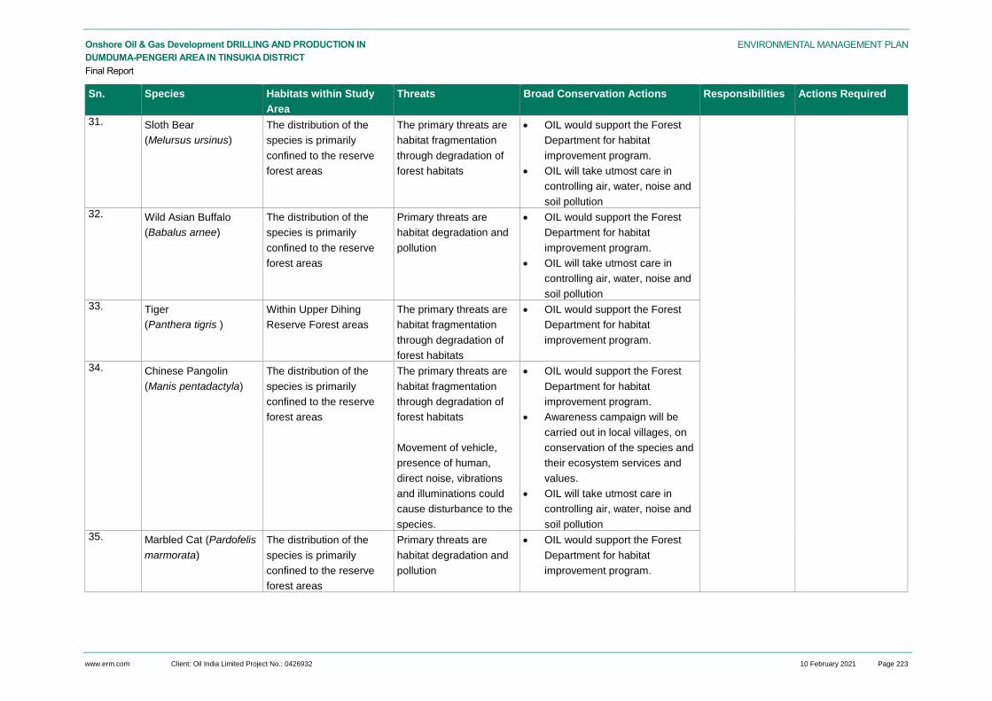
www.erm.com Client: Oil India Limited Project No.: 0426932 10 February 2021 Page 223
ENVIRONMENTAL MANAGEMENT PLAN Onshore Oil & Gas Development DRILLING AND PRODUCTION IN
DUMDUMA-PENGERI AREA IN TINSUKIA DISTRICT
Final Report
Sn. Species Habitats within Study
Area
Threats Broad Conservation Actions Responsibilities Actions Required
31. Sloth Bear
(Melursus ursinus)
The distribution of the
species is primarily
confined to the reserve
forest areas
The primary threats are
habitat fragmentation
through degradation of
forest habitats
OIL would support the Forest
Department for habitat
improvement program.
OIL will take utmost care in
controlling air, water, noise and
soil pollution 32. Wild Asian Buffalo
(Babalus arnee)
The distribution of the
species is primarily
confined to the reserve
forest areas
Primary threats are
habitat degradation and
pollution
OIL would support the Forest
Department for habitat
improvement program.
OIL will take utmost care in
controlling air, water, noise and
soil pollution 33. Tiger
(Panthera tigris )
Within Upper Dihing
Reserve Forest areas
The primary threats are
habitat fragmentation
through degradation of
forest habitats
OIL would support the Forest
Department for habitat
improvement program.
34. Chinese Pangolin
(Manis pentadactyla)
The distribution of the
species is primarily
confined to the reserve
forest areas
The primary threats are
habitat fragmentation
through degradation of
forest habitats
Movement of vehicle,
presence of human,
direct noise, vibrations
and illuminations could
cause disturbance to the
species.
OIL would support the Forest
Department for habitat
improvement program.
Awareness campaign will be
carried out in local villages, on
conservation of the species and
their ecosystem services and
values.
OIL will take utmost care in
controlling air, water, noise and
soil pollution 35. Marbled Cat (Pardofelis
marmorata)
The distribution of the
species is primarily
confined to the reserve
forest areas
Primary threats are
habitat degradation and
pollution
OIL would support the Forest
Department for habitat
improvement program.

www.erm.com Client: Oil India Limited Project No.: 0426932 10 February 2021 Page 224
ENVIRONMENTAL MANAGEMENT PLAN Onshore Oil & Gas Development DRILLING AND PRODUCTION IN
DUMDUMA-PENGERI AREA IN TINSUKIA DISTRICT
Final Report
Sn. Species Habitats within Study
Area
Threats Broad Conservation Actions Responsibilities Actions Required
OIL will take utmost care in
controlling air, water, noise and
soil pollution 36. Asiatic Golden Cat
(Catopuma temmincki)
The distribution of the
species is primarily
confined to the reserve
forest areas
Primary threats are
habitat degradation and
pollution
OIL would support the Forest
Department for habitat
improvement program.
OIL will take utmost care in
controlling air, water, noise and
soil pollution

www.erm.com Client: Oil India Limited Project No.: 0426932 10 February 2021 Page 225
ENVIRONMENTAL MANAGEMENT PLAN Onshore Oil & Gas Development drilling and production in
Dumduma-Pengeri Area in Tinsukia District
Final Report
Implementation of Conservation Measures
The budgetary provision for implementation of wildlife conservation measures for 7 years of working
period for the Dumduma Pengeri area has been provided in Table 10.3.
Table 10.3 Budget for Wildlife Conservation Plan
S. No. Action Item Details Budget (INR in
Lakh)
A. Species Conservation Programs
A.1 Cost of Habitat Improvement (Contributing
Forest Departments habitat improvement
program)
Partial Assistance to forest
department from OIL (@ INR 5 lakh
per year x 7 years)
35.00
A.2 Cost of capacity building of forest
department staffs (Engagement of external
expert; Logistic cost for arrangement of
workshop; Cost of development of IEC
Material)
Assistance towards capacity building
training program (@ INR 1 lakh per
year x 2 years)
2.00
A.3 Awareness Generation Meetings at villages
(Development of Brochure; Arrangement of
Meeting; Development of Posters)
Awareness program – @ 0.50 lakh
per year x 7 years
3.50
A.4 Engaging a NGO for Identification of Hoolock
Gibbon Roosting sites and Vulture Roosting
sites
@ INR 1 lakh per year x 7 years 7.00
A.5. Providing fund to forest department for
engaging trackers to monitor elephant
movement in the area
@ INR 1 lakh per year x 7 years 7.00
B. Monitoring & Reporting budget
B.1 Monitoring & Reporting budget Hiring of Third Party Consultant for
annual monitoring & Reporting @
Rs. 0.5 lakh x 7 years
3.50
Total Budget 58.00
Monitoring & Reporting
OIL will engage a third party monitoring Agency (working in the wildlife conservation) for annual
monitoring and review of wildlife conservation program. This agency will review the proposed wildlife
action plans, likely benefits and will provide an annual report. The annual Monitoring report will be
submitted to the Forest Department.
10.2.12 Road Safety & Traffic Management Plan
Scope
The Road Safety & Traffic Management Plan is applicable to all operation pertaining to OIL and
contractor vehicular movement viz. vehicle involved in the transportation of raw materials, project and
contractor personnel, drilling rig and heavy equipment transportation to well sites and production
facilities.

www.erm.com Client: Oil India Limited Project No.: 0426932 10 February 2021 Page 226
ENVIRONMENTAL MANAGEMENT PLAN Onshore Oil & Gas Development drilling and production in
Dumduma-Pengeri Area in Tinsukia District
Final Report
Purpose
The Road Safety & Traffic Management Plan outlines specific measures to be adopted and
implemented by OIL to mitigate any potential impact on community health and safety that may arise
out of movement of vehicles and transportation of drilling rig and other heavy equipment during
construction, drilling, operation of production facilities and decommissioning of well sites.
Mitigation Measures
Project vehicular movement will be restricted to defined access routes to be identified in
consultation with locals and concerned authorities;
Proper signage will be displayed at important traffic junctions along the predefined access routes
to be used by construction and operational phase traffic. The signage will serve to prevent any
diversion from designated routes and ensure proper speed limits are maintained near village
residential areas;
Precautions will be taken to avoid damage to the public access routes including highways during
vehicular movement;
Safe and convenient passage for vehicles, pedestrians, tea garden workers and livestock to and
from side roads and property accesses connecting the project road will be provided;
Parking of project vehicles along village access roads prohibited;
Traffic flows will be scheduled wherever practicable during period of increased commuter
movement;
Personnel will be deployed at major traffic intersection for control of traffic;
Clear signs, flagmen & signal will be set up at major traffic junctions and near sensitive receptors
viz. schools in discussion with Gram Panchayat and local villagers;
Movement of vehicles during nighttime will be restricted. Speed limits will be maintained by
vehicles involved in transportation of raw material and drilling rig;
A Journey Management Plan will be formulated and implemented to control construction and
operational phase traffic;
Routine maintenance of project vehicles will be ensured to prevent any abnormal emissions and
high noise generation.
Adequate training on traffic and road safety operations will be imparted to the drivers of project
vehicles. Road safety awareness programs will be organized in coordination with concerned
authorities to sensitize target groups viz. school children, commuters on traffic safety rules and
signage.
10.2.13 Occupational Health & Safety Management Plan
10.2.13.1 Purpose
The Occupational Health and Safety procedure is a procedure developed to address the occupational
health and safety related impacts that may arise from proposed project activities viz. construction of
well sites, production facilities and pipelines, drilling and testing, operation of construction
machinery/equipment, storage and handling of fuel and chemicals, operation of drilling rig and
associated equipment. The implementation of this procedure is intended to promote health check-ups
of Operational workers, thereby maintaining a healthy working life. The purpose of this procedure is to
represent the design of a program to ensure usual medical care followed by treatment to Operational

www.erm.com Client: Oil India Limited Project No.: 0426932 10 February 2021 Page 227
ENVIRONMENTAL MANAGEMENT PLAN Onshore Oil & Gas Development drilling and production in
Dumduma-Pengeri Area in Tinsukia District
Final Report
workers. This Procedure will be monitored, reviewed and updated where a change in conditions or
requirements occur.
10.2.13.2 Scope
The Occupation Health & Safety Management Procedure (OHSMP) is applicable for all project
operations that have the potential to adversely affect the health and safety of contractors’ workers and
onsite OIL personnel.
10.2.13.3 Roles & Responsibilities
Authorized Medical Attendant (AMA) – It includes Medical Officers or Specialist who is a direct
employee of OIL or Medical Officers or Specialist who is under employment of OIL (a professionally
qualified registered medical practitioner working under state/ central government or nominated by
OIL). AMA is responsible for conducting pre-employment and periodic medical check-ups of
Operational workers, issuing fitness certificates and maintaining a health register76.
HSE Officer – HSE officer is responsible for:
Monitoring and reviewing the implementation of the procedure;
Advise the manager on measures necessary to prevent dangerous situations;
Either at site or in office to maintain stock of PPE, Stationeries, registers, Formats, Signboards,
Display boards etc. required for installation; prepare requisitions/ reservations for
procurement/stock-withdrawal of the same and issuance of the same as per prevailing practices
of OIL or as per advice of Oil authorities;
Imparting Training to the responsible person/workers executing the procedure; and
Collecting and recording information on performance indicators identified as part of this
procedure77.
Medical Relief Coordinator − Medical Relief Coordinator is responsible for:
Organizes First Aid at the site of incidence.
Arranges Ambulance Services.
Medical relief camp in Oil Hospital and arranges extended services under Mutual aid scheme with
the Neighboring Industries and Civil Hospitals78.
Administrative & Welfare Coordinator − Coordinates for security arrangements and Liaises with
Police and District Civic authorities, HEAD (MS) & GM(ER) for Rescue, Shelter and Medical relief
operations. Officer also informs the voluntary organizations to assist for rescue and relief operations.
Employee Relations & Welfare Coordinator - Responsibilities include:
To participate in rescue and relief operations.
To contact relatives of affected persons and provide Food/ Beverage etc. at relief camp.
Contacts Union Officials.
76
Oil India Limited Employees Medical Attendance Rules, 2018 77
http://www.oil-india.com/Document/Career/Advertisement-for-engagement-of-HSE-Officer-on-contract-basis-19072014.pdf 78
On Site Emergency Response Plan, Oil India Limited, Duliajan

www.erm.com Client: Oil India Limited Project No.: 0426932 10 February 2021 Page 228
ENVIRONMENTAL MANAGEMENT PLAN Onshore Oil & Gas Development drilling and production in
Dumduma-Pengeri Area in Tinsukia District
Final Report
Contractors - Contractor are responsible for
Establish and maintain an occupational H&S Policy and safe system of work;
Every person deployed by the contractor in a Factory must wear safety gadgets to be provided by
the contractor;
Prepare and Follow SOP79.
10.2.13.4 Management Measures
Fitness for Duty
At the time of engagement, all employees including contractor workers to undergo a medical
assessment to ensure they are medically fit to perform their role.
Whilst working onsite, employees and contractors must advise their supervisor of any pre-existing
injury or illness which may affect their performance, or has the potential to impact on safety and health
in the workplace. A medical assessment may also be required to determine associated risks or
limitations with records for the same to be maintained.
No person having congenital deformity, uncontrolled disease or communicable disease should be
allowed to work. A person suffering from a disease or taking medicine for such a disease that may put
him or his co-workers at risk should not be declared medically fit.
Health Surveillance
OIL has its own Medical Attendance Rules (Oil India Limited Employees Medical Attendance Rules,
2018). It includes all the hospitals / dispensaries held by company and company empanelled hospitals
and nursing homes. The rules clearly states the employee benefits80. OIL has its own hospital in
Duliajan and Digboi.
Apart from that, all the employees working must undergo PME (Periodical Medical Examination) by
approved medical officers / Hospital at fixed interval as per the company policy. Results of the
examination are recorded. The frequency of periodic medical examinations should be every five years
for the workers below 45 years of age and every three years for workers of above 45 years of age. If
any worker fails to pass the annual medical tests, then he/she will be advised to take further medical
treatments. After completion of the treatment, the worker may be allowed to resume work at the site
after obtaining medical fitness certificate from the site physician.
Apart from the periodical medical check-ups, if any worker reports of any physical discomfort, the
medical officer will ensure proper medical treatment to the worker and if necessary, he/she will be
referred to nearby specialized medical or hospital facility by the Site Physician. This record will be
maintained in the workers’ health register.
Worksite Assessment
HSE officer inspects, as often as may be necessary, drilling site, pipeline installation and other
facilities with a view to identify the dangers which may cause bodily injury or impair health of any
person or environment and advise the manager on measures necessary to prevent dangerous
situations.
HSE officer will enquire into the circumstances and causes of all accidents whether involving persons
or not and advise the manager on measures necessary to prevent recurrence of such accidents. HSE
officer will Collect, compile and analyse information in respect of accidents and dangerous
occurrences with a view to promote safe practices and improvement of working environment.
Organize regular safety education programmes and safety campaigns to promote safety awareness
79
https://www.oil-india.com/pdf/tenders/national/Doc_CGI1234P20.pdf 80
Oil India Limited Employees Medical Attendance Rules, 2018

www.erm.com Client: Oil India Limited Project No.: 0426932 10 February 2021 Page 229
ENVIRONMENTAL MANAGEMENT PLAN Onshore Oil & Gas Development drilling and production in
Dumduma-Pengeri Area in Tinsukia District
Final Report
amongst persons employed. Ensure that all new workers and workers transferred to new jobs receive
adequate safety firefighting and first aid training81.
Ergonomics
All personnel and contractors must consider ergonomics when designing or arranging workstations,
products and systems so that they fit the personnel who use them. Management shall ensure that
where ergonomic hazards are identified and pose a threat to personal safety, a risk assessment is
completed by a competent person. Personnel and workers shall be informed of the risks, and
provided with the necessary equipment and information to reduce the risk.
Special consideration should be given to ergonomics in confined spaces, awkward or difficult to
access spaces, using heavy or awkward tools and equipment, and using repetitive or high force
actions.
First Aid Boxes
At all the drilling site and production installation first aid boxes are present as per the instructions of
the Medical Relief Coordinator. Senior HSE Officer are responsible for first-aid training programme for
all the new employees for immediate action. The first aid box should contain the followings:
05 small sterilised dressings
05 medium size sterilised dressings
05 large size sterilised dressings
05 large size sterilised burn dressings
10 (15 mg) packets of sterilised cotton wool
1 pair of scissors
Ointment for burns (e.g. silver sulfadiasine)
Antiseptic ointment (e.g. Neosporin, soframycin)
A bottle of a suitable surgical antiseptic solution ((e.g. Savlon / Dettol)
12 roller bandages ten cms. Wide
12 roller bandages five cms. Wide
10 Adhesive band aids
6 triangular bandages
packets of safety pins
1 supply of suitable splints
1 copy of the first aid leaflet
List of first aiders
List of nearby hospitals with contact numbers
Contractor Engagement
Contractors engaged by OIL, are responsible to fulfil all the legal formalities with respect to the
Health, Safety and Environmental aspects of the entire job (namely; the person employed by him,
the equipment, the environment, etc.) under the jurisdiction of the district of that state where it is
operating. Contractors have to ensure that all sub-contractors hired by him comply with the same
requirement as the contractor himself and shall be liable for ensuring compliance all HSE laws by
the sub or sub-sub-contractors.
81
http://www.oil-india.com/Document/Career/Advertisement-for-engagement-of-HSE-Officer-on-contract-basis-19072014.pdf

www.erm.com Client: Oil India Limited Project No.: 0426932 10 February 2021 Page 230
ENVIRONMENTAL MANAGEMENT PLAN Onshore Oil & Gas Development drilling and production in
Dumduma-Pengeri Area in Tinsukia District
Final Report
Every person deployed by the contractor must wear safety gadgets to be provided by the
contractor. The Contractor shall provide proper Personnel Protective Equipment as per the
hazard identified and risk assessed for the job and conforming to statutory requirement and
company PPE schedule. Safety appliances like protective footwear, Safety Helmet and Full Body
harness has to be DGMS approved. Necessary supportive document shall have to be submitted
as proof. If the Contractor fails to provide the safety items as mentioned above to the working
personnel, the Contractor may apply to the Company (OIL) for providing the same. OIL will
provide the safety items, if available. However, it will be the Contractors sole responsibility to
ensure that the persons engaged by him use the proper PPE while at work. All the safety gears
mentioned above are to be provided to the working personnel before commencement of the work.
The Contractor shall prepare written Safe Operating Procedure (SOP) for the work to be carried
out, including an assessment of risk, wherever possible and safe methods to deal with it/them.
The contractor shall provide a copy of the SOP to the Supervisor. The health check-up of
contractor's personnel is to be done by the contractor in authorized Health Centres as per OIL's
requirement & proof of such test(s) is to be submitted to OIL. The frequency of periodic medical
examinations should be in every three years.
All persons deployed by the contractor for working in a Factory must undergo Vocational Training,
Initial Medical Examination, and Periodical Medical Examination. They should be issued cards
stating the name of the service provider and the work and its validity period, indicating status VT,
IME and PME.
The contractor should be submitted to Factory returns indicating name of his firm, Registration
number, Name and address of person heading the firm, Nature of work, type of deployment of
work persons, Number of work persons deployed, how many work persons hold Vertigo Test
Certificate, how many work persons undergone IME and type of medical coverage given to the
work persons.
It will be entirely the responsibility of the contractor/his supervisor/representative to ensure strict
adherence to all Safety, Health and Environment measures and statutory rules during operation in
OIL’s installations and safety of workers engaged by him. The crew members will not refuse to
follow any instruction given by company’s installation Manager/ Safety Officer/ Engineer/Official/
Supervisor/ Junior Engineer for safe operation.
The contractor should have to report all incidents including near miss to Installation Manager/
Departmental representative of the concerned department of OIL. The contractor has to keep a
register of the persons employed by him/her. The contractor’s supervisor shall take and maintain
attendance of his men every day for the work, punctually.
If the company arranges any safety or other class/training for the working personnel at site
(company employee, contractor worker, etc) the contractor should not have any objection for such
training provided to his personnel.
The health check-up of contractor’s personnel is to be done by the contractor in authorized Health
Centers as per OIL’s requirement and proof of such test(s) is to be submitted to OIL. The
frequency of periodic medical examinations should be every five years for the workers below 45
years of age and every three years for workers of above 45 years of age.
Records of daily attendance, accident report etc. are to be maintained in applicable form (as per
Factory Act 1948) by the contractor. Also this is entirely the contractor’s responsibility to maintain
all registers as per statutory norms.
A contractor’s worker must, while at work, take reasonable care for the health and safety of
people who are at the worker, place of work and who may be affected by the worker act or
omissions at work.
A contractor’s personnel must, while at work, co-operate with his or her employer or other
persons so far as is necessary to enable compliance with any requirement under the act or the

www.erm.com Client: Oil India Limited Project No.: 0426932 10 February 2021 Page 231
ENVIRONMENTAL MANAGEMENT PLAN Onshore Oil & Gas Development drilling and production in
Dumduma-Pengeri Area in Tinsukia District
Final Report
regulations that is imposed in the interest of safety, health and welfare of the personnel or any
other person82.
10.2.13.5 Training
All personnel responsible for implementation of the procedure are subjected to training and records
maintained. OIL also organizes refresher trainings for the employees. All the new employees must
complete First-Aid training after joining.
10.2.13.6 Monitoring and Evaluation
The successful implementation of Management Plans and Policies greatly depend upon the
adaptability by the employees, who are the prime movers of the progress of company. Maintaining
their health is very much vital for productivity & effectiveness. To promote the health of employees,
OIL has made a structured Occupational Health Monitoring system so as to have scientific basis for
decisions aimed at protection of employee’s health from any possible adverse consequences of
exposure to occupational health hazards. Following systems are followed in OIL towards providing
Occupational Health Services83.
An OHS (Occupational Health Service) Centre is established at Duliajan.
Various activities coordinated are pre-employment, periodical and pre-retirement medical
examination.
Administering special tests like Lung Function Test, Audiometry Test and Vision Test etc. for
identified target groups.
Conducting First Aid Training & other awareness programme related to Occupational Health
Hazards & remedial measures.
OHS in peripheral areas are provided through dispensaries located in Oil fields at Moran, Jorhat
and Sonapur etc.
The scope of Occupational Health Services will be widened in due course to encompass all the
dimensions of health services.
Apart from above, OIL review the occupational health indicators on an annual basis to assess the
overall occupational health performance of the project. These performance indicators are monitored
and communicated to personnel and contractors through regular meeting forums and in writing.
Detailed Environmental Management Matrix is presented in Annexure 10.1.
Monitoring and Evaluation
Like the other project components, OIL shall ensure that the stakeholders should have no issues with
the project and in case there are any concerns, they should be adequately addressed as per the
mandate. In order to keep track on the effectiveness of CER Plan, it is the responsibility of the OIL’s
CSR team to compile and maintain database on grievances for periodic review. The mechanism shall
be based on two components, (i) internal monitoring and reporting and (ii) external monitoring and
reporting which shall run simultaneously. Mostly this shall be aligned with simultaneous process
monitoring rather than doing it separately all the time.
The CSR team shall track and report the following aspects in its annual report submitted to the senior
management;
82
https://www.oil-india.com/pdf/tenders/national/Doc_CGI1234P20.pdf 83
https://oilweb.oilindia.in/sne/downloads/sop/SOP_Vol2.pdf

www.erm.com Client: Oil India Limited Project No.: 0426932 10 February 2021 Page 232
ENVIRONMENTAL MANAGEMENT PLAN Onshore Oil & Gas Development drilling and production in
Dumduma-Pengeri Area in Tinsukia District
Final Report
Adherence to the agreed mechanism of grievance resolution – grievance categorisation, time for
grievance resolution and communication of the status of the grievance to the aggrieved;
Status of resolution of the registered grievances within the defined timeline;
Status on expenditure of the annual budgetary allocation for CER;
Achievements made vis-à-vis the targets set for each CER intervention;
List of beneficiaries under each CER intervention and the criteria used for selecting the
beneficiaries;
Mechanism adopted for and current status of engagement with institutional stakeholders for
implementing CER interventions; and
Feedback of beneficiaries/ local communities concerning the CER programme of OIL. Excerpts of
interviews and FGDs (focus group discussion) undertaken as part of the feedback process may
also be included in the Report.
The report should be used by the OIL’s senior management to evaluate the overall effectiveness of
the CER programme of OIL on an annual basis. Deficiencies in the CER programme should be
identified and recommendations to overcome them should be proposed at the end of the report.
10.3 OIL Environment Management Policy and System
10.3.1 Environmental Management Organisation
OIL is committed to providing resources essential to the implementation and control of the EMP.
Resources includes the appropriate human resources and specialised skills. The structure for the
organisation responsible for environmental and social management and implementation of the EMP is
depicted in Table 10.4.
Table 10.4 Environmental Management Organisation Roles and Responsibilities
Position Responsibility
Basin Manager Oversee and coordinate all activities pertaining to the Project; ultimately responsible for
environmental and social issues. Ensure delivery by the asset of its environmental,
social and operational targets. Ensure effective communication with all stakeholders.
Chief General
Manager (Drilling)
Ensuring that the Project and subcontractors operate in accordance with applicable
regulatory environmental and social requirements and plans. Monitor implementation of
environmental and social protection measures, and assist with technical input into oil
spill response requirements.
CSR Manager Liaise with local communities, farmer and government regulators on the project’s behalf.
Implement environmental and social awareness and education programmes with
communities.
10.3.2 Training and Awareness
OIL will identify, plan, monitor, and record training needs for personnel whose work may have a
significant adverse impact upon the environment or social conditions. The Project recognises that it is
important that employees at each relevant function and level are aware of the Project’s environmental
and social policy; potential effects of their activities; and roles and responsibilities in achieving

www.erm.com Client: Oil India Limited Project No.: 0426932 10 February 2021 Page 233
ENVIRONMENTAL MANAGEMENT PLAN Onshore Oil & Gas Development drilling and production in
Dumduma-Pengeri Area in Tinsukia District
Final Report
conformance with the policy and procedures. This will be achieved through a formal training process.
Employee training will include awareness and competency with respect to:
Environmental and social impacts that could potentially arise from their activities;
Necessity of conforming to the requirements of the EIA and EMP, in order to avoid or reduce
those impacts; and
Roles and responsibilities to achieve that conformity, including with regard to change
management and emergency response.
The Chief General Manager (Drilling) is responsible for coordinating training, maintaining employee-
training records, and ensuring that these are monitored and reviewed on a regular basis. The Chief
General Manager (S&E) will also periodically verify that staff is performing competently through
discussion and observation. Employees responsible for performing site inspections will receive
training by drawing on external resources as necessary. Training will be coordinated by the General
Manager (Learning and Development) prior to Project’s implementation.
Similarly, the Project will require that each of the contractors institute training programmes for its
personnel. Each contractor is responsible for site HSE awareness training for personnel working on
the job sites. The contractors are also responsible for identification of any additional training
requirements to maintain required competency levels.
The contractor-training program will be subject to approval by the Project and it will be audited to
ensure that:
Training programs are adequate;
All personnel requiring training have been trained; and
Competency is being verified.
10.3.3 Inspection & Monitoring
HSE inspections will be conducted by subcontractors on a daily basis. The results of the inspection
and monitoring activities will be reported to OIL on a weekly basis or more frequently if requested by
the Chief General Manager (Drilling).
Monitoring will be conducted to ensure compliance with regulatory requirements as well as to evaluate
the effectiveness of operational controls and other measures intended to mitigate potential impacts.
10.3.4 Compliance Auditing
Beyond the routine inspection and monitoring activities conducted, compliance audits will be carried
out internally by OIL to ensure compliance with regulatory requirements as well as their own HSE
standards and policies. Audits to be conducted will also cover the subcontractor self-reported
monitoring and inspection activities. The audit shall be performed by qualified staff and the results
shall be communicated to the Basin Manager and management board.
The audit will include a review of compliance with the requirements of the EIA and of this EMP and
include, at minimum, the following:
Completeness of EHS documentation, including planning documents and inspection records;
Conformance with monitoring requirements;

www.erm.com Client: Oil India Limited Project No.: 0426932 10 February 2021 Page 234
ENVIRONMENTAL MANAGEMENT PLAN Onshore Oil & Gas Development drilling and production in
Dumduma-Pengeri Area in Tinsukia District
Final Report
Efficacy of activities to address any non-conformance with monitoring requirements; and
Training activities and record keeping.
There will be a cycle of audits into specific areas of the Project such as waste management, and
effectiveness of local content plans and discharge controls.
The frequency of audits will be risk based and will vary with the stage of the project (more frequent
during construction and in the early stages of the project) and will depend on the results of previous
audits.
10.3.5 Corrective Action
Impacts will be identified and associated risks addressed before an incident occurs. Investigating a
‘near miss’ or actual incident after it occurs can be used to obtain valuable lessons and information
that can be used to prevent similar or more serious occurrences in the future.
OIL will implement a formal non-compliance and corrective action tracking procedure for investigating
cause and identifying corrective actions in response to accidents or environmental or social non-
compliances. The Chief General Manager (Drilling) will be responsible for keeping records of
corrective actions and for overseeing the modification of environmental or social protection
procedures and/or training programs to avoid repetition of non-conformances and non-compliances.
10.4 EMP BUDGET
EMP Budget includes budget for Public Hearing Action Plan, Wildlife Conservation Plan, Greenbelt
Budget and Budget for Environmental Conservation Measures. Budget for Public Hearing Action Plan
for socioeconomic development is planned to be INR 177.5 lakhs for 7 years (refer Table 7.22). PH
action plan budget related to environmental issues have been included in the budget for
environmental conservation measures (in Table 10.5 and Table 10.6). Budget for Greenbelt Plan will
be INR 5.25 lakhs. Budget for Wildlife Conservation Plan for Schedule-I species for 7 year will be INR
58 lakhs (refer Table 10.3). Environmental Control measures for each well would be 14.645 lakhs and
for each production installation per year would be INR 6.43 lakhs. Detail of cost breakup of EMP
Budget is provided at the Table 10.5 and Table 10.6. Capital cost of EMP would be INR 104 lakhs
and recurring cost for EMP would be approximately INR 93.41 lakhs per annum.
Table 10.5 Tentative Budget for EMP Implementation for Well Drilling
Sl. No.
Particulars of Work Budget for 1 well (in lakh Rs.)
Cumulative Budget for 26 wells
1 Air Quality Management Plan
a. Dust suppression through water sprinkling in the internal unpaved roads Cost of water sprinkling
- One truck hiring charge (Rs. 1,00,000 per month X 9 months=Rs. 9,00,000);
- Diesel charge (50 km travel per day @ Rs. 35/km X 270 days = Rs. 4,72,500);
- Total cost for one year Rs.13,72,500 Total cost for 7 years= Rs. 96,07,500
4.575
96.08
b. Maintenance of paved internal road and transport route (budgetary provision is included in operational cost of drilling)
0.00 0.00

www.erm.com Client: Oil India Limited Project No.: 0426932 10 February 2021 Page 235
ENVIRONMENTAL MANAGEMENT PLAN Onshore Oil & Gas Development drilling and production in
Dumduma-Pengeri Area in Tinsukia District
Final Report
Sl. No.
Particulars of Work Budget for 1 well (in lakh Rs.)
Cumulative Budget for 26 wells
c. Ambient Air Quality Monitoring -3 monitoring locations x 2 weeks per location x Once during site development, twice during drilling and once during decommissioning (@ Rs.7500 x 24 samples )
1.8 46.8
d. Stack emission monitoring (@ Rs. 5000 per sample x 3 DG sets x twice during drilling)
0.3 7.8
2 Noise Management Plan
a. Ambient Noise Monitoring – 3 locations, once during site development, twice during drilling and once during decommissioning (@Rs. 2500 X 12 samples)
0.3 7.8
b. Workplace noise monitoring -5 locations per well, twice during drilling (@Rs.2500 per location x 5 locations x 2 times)
0.25 6.5
c. All DG sets would be provided with acoustic enclosures (All DG sets will be procured with in-built acoustic enclosures budget included in drilling budget)
0.00 0.00
d. Erection of noise barrier at drill sites (Budget for erection of noise barrier included in drilling budget)
0.00 0.00
3 Water Quality Management Plan
a. Construction and maintenance of double chambered sedimentation tank and oily-water separator ETP (Budget included in drilling budget)
0.00 0.00
b. Surface Water Quality Monitoring (@ Rs. 8000 x 4 samples from natural drainages once during site construction, once during drilling, once after decommissioning)
0.96 24.96
c.. Ground Water Quality Monitoring (@ Rs. 8000 x 3 sites, once during site construction, once during drilling, once after decommissioning)
0.72 18.72
d. ETP Treated water quality (@ Rs. 8000 x 2 samples of ETP treated water per month for 3 months)
0.48 12.48
e. Sample from Oily water separator(@Rs. 5000 per sample X 1 sample after drilling)
0.05 1.3
4 Soil Quality Management Plan
a. Soil quality monitoring(@ Rs. 8000 x 2 samples x once before site preparation; once after decommissioning/restoration)
0.32 8.32
b. Procurement of spill kits at drill sites (Rs 20,000 per kit X 3 spill kits per site)
0.6 15.6
5 Road Safety & Traffic Management
a. Signage in the transport route & its maintenance (@Rs. 100,000 + Rs. 10,000 )
1.1 28.6
b. Deployment of traffic personnel in sensitive area – 5 persons (@ Rs. 6000 per month x 6 months )
1.8 46.8
6 Surface Runoff & Soil Erosion Control
a. Two chamber sedimentation tank at each drill site (Budgetary provision is already included in the infrastructure development cost)
0.00 0.00
7 Municipal Solid Waste 0
a. Provision of two chambered covered collection bins at well site – 2 nos
0.2 5.2

www.erm.com Client: Oil India Limited Project No.: 0426932 10 February 2021 Page 236
ENVIRONMENTAL MANAGEMENT PLAN Onshore Oil & Gas Development drilling and production in
Dumduma-Pengeri Area in Tinsukia District
Final Report
Sl. No.
Particulars of Work Budget for 1 well (in lakh Rs.)
Cumulative Budget for 26 wells
b. Transport arrangement of waste from well sites to dumping area 0.25 6.5
8 Hazardous waste management
a. Construction of dedicated hazardous storage area and record maintenance (construction included under project cost; only maintenance included in this budget)
0.1 2.6
b. Drill Cutting, waste mud and wash water pits; HDPE lined (budgetary provision in operation cost of drilling)
0.00 0.00
c. Analysis of drill cutting and waste drilling mud 0.3 7.8
(Drill cutting @Rs. 5000 per sample x 1 sample per month x 3 months drilling time;
Waste drilling mud @Rs. 5000 per sample x 1 sample per month x 3 months drilling time)
9 Surface and Ground Water Protection and Management
a. Surface runoff control measures for chemical storage area, fuel storage area (budgetary provision is already taken care in earlier section)
0.00 0.00
b. Paved /impervious storage area for chemical storage area, fuel & lubricant storage area (Budgetary provision is already included in the infrastructure development cost)
0.00 0.00
c. Domestic waste water treatment facility through septic tank & soak pits at the drill sites (budgetary provision in operation cost of drilling)
0.00 0.00
10 Occupational Health & Safety Management
a. Provision of appropriate PPE to all workers and its maintenance (budgetary provision is included in operational cost of drilling)
0.00 0.00
b. Provision of drinking water, sanitation facility for all workers (budgetary provision is included in operational cost of drilling)
0.00 0.00
c Provision First aid facility (budgetary provision is included in operational cost of drilling)
0.00 0.00
d Provision of Ambulance facility OIL has its own ambulance facility)
0.00 0.00
e Regular health checkup facility provided by OIL for workers) 0.00 0.00
f Regular occupational health & safety training (@ 1 lakh per year for 7 years)
0.27** 7
g. Safety related training for OIL drivers (@ 1 lakh per year for 7 years)
0.27** 7
Total Cost of Implementation of EMP 14.645 380.73
** Budget is for overall drilling programme for 26 wells in the Block. Budget for 1 well has been calculated from the cumulative budget for 26 wells

www.erm.com Client: Oil India Limited Project No.: 0426932 10 February 2021 Page 237
ENVIRONMENTAL MANAGEMENT PLAN Onshore Oil & Gas Development drilling and production in
Dumduma-Pengeri Area in Tinsukia District
Final Report
Table 10.6 Tentative Budget for EMP Implementation for Production Installations
Sl. No. Particulars of Work Budget (in lakh Rs.) per installation per year
Budget (in lakh Rs.) for 3 production installation for 7 years
1 Air Quality Management Plan
a. Dust suppression through water sprinkling in the internal unpaved roads (Budget at the drilling budget)
0.00 0.00
b. Maintenance of paved internal road and transport route (budgetary provision is included in operational cost of production installations)
0.00 0.00
c. Ambient Air Quality Monitoring -3 monitoring locations x twice per week x 2 weeks per location x 2 times per year (@ Rs.7500 x 24 samples )
1.8 37.8
d. Stack emission monitoring (@ 5000 per sample x 2 GG sets x twice a year) @5000 X 4 samples
0.2 4.2
2 Noise Management Plan
a. Ambient Noise Monitoring – 3 locations, 2 times a year (@Rs. 2500 X 6 samples)
0.15 3.15
b. Workplace noise monitoring -5 locations per facility, twice a year (@Rs.2500 per location x 5 locations x 2 times)
0.25 5.25
c. All GG sets would be provided with acoustic enclosures (budget included in production budget)
0.00 0.00
3 Water Quality Management Plan
a. Surface Water Quality Monitoring (@ Rs. 8000 x 3 samples from natural drainages twice a year)
0.48 10.08
b. Ground Water Quality Monitoring (@ Rs. 8000 x 3 samples from local villages twice a year)
0.48 10.08
c. Treated water quality (@ Rs. 8000 x 2 samples of ETP treated water ; @ Rs. 5000 one sample from oily water separator; twice a year)
0.42 8.82
4 Soil Quality Management
a. Soil Quality Monitoring (@Rs. 8000 x 3 samples x twice a year) 0.48 10.08
b. Procurement of spill kits (@Rs. 20000 per kit x 3 spill kit per year)
0.6 12.6
6 Surface Runoff & Soil Erosion Control 0
a. Two chamber sedimentation tank at each facility (Budgetary provision is already included in the infrastructure development cost)
0.00 0.00
7 Municipal Solid Waste
a. Provision of two chambered covered collection bins at each site – 2 nos.
0.2 4.2
b. Transport arrangement of waste from production installation to dumping area
1.0 21
8 Hazardous waste management
a. Construction of dedicated hazardous storage area and record maintenance (construction included under project cost; only maintenance included in this budget)
0.1 2.1

www.erm.com Client: Oil India Limited Project No.: 0426932 10 February 2021 Page 238
ENVIRONMENTAL MANAGEMENT PLAN Onshore Oil & Gas Development drilling and production in
Dumduma-Pengeri Area in Tinsukia District
Final Report
Sl. No. Particulars of Work Budget (in lakh Rs.) per installation per year
Budget (in lakh Rs.) for 3 production installation for 7 years
9 Surface and Ground Water Protection and Management
a. Surface runoff control measures for chemical storage area, fuel storage area (budgetary provision is already taken care in earlier section)
0.00 0.00
b. Paved /impervious storage area for chemical storage area, fuel & lubricant storage area (Budgetary provision is already included in the infrastructure development cost)
0.00 0.00
c. Domestic waste water treatment facility through septic tank & soak pits at the production sites (budgetary provision in operation cost of operations)
0.00 0.00
10 Occupational Health & Safety Management
a. Provision of appropriate PPE to all workers and its maintenance (budgetary provision is included in operational cost of operation)
0.00 0.00
b. Provision of drinking water, sanitation facility for all workers (budgetary provision is included in operational cost of operation)
0.00 0.00
c Provision First aid facility (budgetary provision is included in operational cost of operation)
0.00 0.00
d Provision of Ambulance facility OIL has its own ambulance facility)
0.00 0.00
e Regular health checkup facility provided by OIL for workers) 0.00 0.00
f Regular occupational health & safety training (@ 1 lakhs per year for 7 years)
0.27** 7
Total cost of implementation of EMP 6.43 136.36
** Budget is for overall programme for 7 years for 3 production installations. Budget for 1 production installation has been calculated from the cumulative budget.
Additionally, OIL will allocate budget for CSR activities as per Govt. norms.

www.erm.com Client: Oil India Limited Project No.: 0426932 10 February 2021 Page 239
ENVIRONMENTAL MANAGEMENT PLAN Onshore Oil & Gas Development drilling and production in
Dumduma-Pengeri Area in Tinsukia District
Final Report
11. SUMMARY AND CONCLUSION
11.1 Project Description
Oil India Ltd. (OIL) is currently planning for drilling of 26 onshore exploratory & developmental wells, 3
nos. of production installations and laying of interconnecting pipeline at Dumduma-Pengeri Area of
Tinsukia District of Assam.
Land Procurement
The land required for the well sites and production facilities will be procured from agricultural lands,
homestead plantation areas and tea garden areas. Generally, OIL will procure the required land
through private negotiation. In few cases, OIL may request district authority to acquired land under
LARR act 2013, if private negotiation is not successful. Land will be procured in a way that physical
displacement will not occur and the crop compensation will be included during procurement. Land
from the tea garden would be taken on long-term lease from the tea garden authority.
Project Activities
Construction of Access road
Majority of the proposed wells are located adjacent to the existing road; the distance of the proposed
well pad will be of 100- 200 m (maximum) from existing road. Construction of site access road will not
involve displacement of any household. As far as possible, existing roads will be used. Cutting of
trees will be avoided. If necessary, existing road will be developed by widening, etc. Culverts and
drainage channel will be maintained during site preparation.
Site Preparation & Construction Drill site
Site preparation will involve levelling, filling and consolidation of the site for staging equipment and
machinery. The proposed well sites and production facilities will be duly fenced to a height of about 2
m.
Preparation and construction of drill sites and production facilities will involve top soil scraping and
storage for future use, elevating the drill platform by excavated material from the site and material
brought from authorized quarry area. Reinforced Cement Concrete (RCC) will be used for the
construction of foundation system at drill sites. For making foundations of the main rig structure, cast
in-situ bored under- reamed piles of specified lengths will also be used.
Drilling & Testing
The exploration wells will be drilled using a standard land rig or a “Mobile Land Rig” with standard water
based drilling fluid treatment system. This rig will be suitable for deep drilling up to the desired depth of
3900 metres as planned for the project.
Drill cuttings generated will be collected and separated using a solid control system and temporarily
stored on-site in HDPE lined pits. Drilling and wash wastewater generated will also be stored at an
onsite HDPE lined pit. The water will be adequately treated in a mobile ETP to ensure conformance to
the S No. 72 A (ii) Schedule I - Standards for Emission or Discharge of Environmental Pollutants from
Oil Drilling and Gas Extraction Industry of CPCB and will be reused.

www.erm.com Client: Oil India Limited Project No.: 0426932 10 February 2021 Page 240
ENVIRONMENTAL MANAGEMENT PLAN Onshore Oil & Gas Development drilling and production in
Dumduma-Pengeri Area in Tinsukia District
Final Report
Well Site decommissioning
On completion of activities, the wells will be either plugged and connected with flow lines or suspended.
In the event of a decision to suspend the well, it will be filled with a brine solution containing very small
quantities of inhibitors to protect the well and well will be sealed with cement plugs.
Project Utilities and Resource Requirements
Power: It is anticipated that two DG sets with a power rating of 1000 KW/1250 KVA each will be
required for drilling purposes of and another one will be kept standby. Lighting and other power
requirements at drill sites will be met through 200 KW/250 KVA DG sets. Power requirement for the
production facilities will be met through GG Sets (216 KW).
Fuel: It is estimated that 3.5 KLD of diesel will be required during drilling phase and about 1 KLD
diesel will be required during site preparation phase. Oil will store a contingency of 3 days in a tank at
the drill site. Natural Gas consumption would be 1500 SCUM per day for GG sets.
Water: Approximately, 5 m3 per day water will be required for construction and 3 m3 per day for
workers during construction phase. During the drilling operations, Average drilling water consumption
per day is 50 m3 per day of which freshwater requirement would be 39 m3 per day and recycled water
would be 11 m3 per day. A provision for storage of about 250 m3 per day of water will be made at the
drilling site. Potable water requirement at site will be met through packaged drinking water.
Approximately 20 m3 per day water is required for the operation of production installations.
Manpower: The estimated employment would be approximately 80 un-skilled temporary workers
during the peak construction phase that will be primarily sourced from nearby villages. Additionally, 20
permanent OIL employees will supervise the construction phase. The drilling rig will be operated by
approximately 40-50 persons on the rig at any particular time. Approximately 10 persons per shift will
be hired during operation phase of production facility.
Pollution Sources
Air emissions: Point source air emissions will be generated from DG sets. Fugitive emissions will
occur from vehicles involved in the drilling operations and from windblown dust from storage and
staging areas within the drill sites and production facilities.
Noise & Vibrations: Noise and vibration will be generated due to operation of drilling rig, DG/GG
sets and vehicles.
Liquid wastes: During the drilling phase, wastewater will be generated as a result of rig wash and
dewatering of spent mud and washing of drill cuttings. During construction and operation of GCS,
waste water will be generated. The wastewater will be treated in an ETP at site. The treated
water would be reused. Domestic wastewater will be generated from the drill sites would be
treated in septic tanks and soak pits. In production facilities, produced formation water will be
disposed to the shallow wells after necessary treatment; surface Runoff after treatment through
OWS and sedimentation tank will be recycled.
Drill cuttings & spent mud: Approximately 350-400 m3 of drill cuttings and 900-1200 m3of spent
mud will be generated per site. Drill cuttings and spent mud will be disposed off in a well-
designed pit lined with impervious liner located on site.

www.erm.com Client: Oil India Limited Project No.: 0426932 10 February 2021 Page 241
ENVIRONMENTAL MANAGEMENT PLAN Onshore Oil & Gas Development drilling and production in
Dumduma-Pengeri Area in Tinsukia District
Final Report
Project Cost
Based on OILs previous experience of drilling in the area, cost for drilling of 26 wells (including drilling
rates, consumables and well accessories etc.) and three production facilities is approximately INR
1109.40 crores.
EMP Budget includes budget for Public Hearing Action Plan, Wildlife Conservation Plan, Greenbelt
Budget and Budget for Environmental Conservation Measures. Budget for Public Hearing Action Plan
for socioeconomic development is planned to be INR 177.5 lakhs for 7 years. Budget for Greenbelt
Plan will be INR 5.25 lakhs. Budget for Wildlife Conservation Plan for Schedule-I species for 7 year
will be INR 58 lakhs. Environmental Control measures for each well would be 14.645 lakhs and for
each production installation per year would be INR 6.43 lakhs. Capital cost of EMP would be INR 104
lakhs and recurring cost for EMP would be approximately INR 93.41 lakhs per annum.
11.2 Baseline Environmental Status
Land use and land cover: Settlement with homestead plantation covers 29.22% of the total area of
Dumduma-Pengeri followed by reserve forest (28.93%), agricultural land (19.51%) and tea gardens
(15.57%). Unclassified forest areas cover 2.68% of the total area. River, streams and waterbodies
approximately 2% of the total area.
Soil Quality: Soil samples were collected from five locations spread across different types of land
cover such as agricultural field, homestead plantation, tea garden and forest land. The soil samples
were found to be clay loam, sandy clay loam and clayish in nature with acidic pH. The macronutrient
contents viz. phosphorous and potassium values of the soil samples were found to be low. Metal
contamination has not been observed in soil samples.
Climate and Meteorology: The study area experiences a sub-tropical to temperate climate. The
maximum and minimum temperature reported during the study period was 30.3°C and 10.1°C. The
average relative humidity was 70.2% during the study period. Relative humidity ranged between
30.9% and 97.8% during the study period. Rainfall occurred on few days of the study period. Hourly
micro-meteorological data collected during the post monsoon season reveal that the pre-dominant
wind direction is from the north-east with an average speed of 1.3 m/s.
Air Quality: Average values of all the monitored parameters like particulate matter, SO2, NOx, CO
were observed to be within the levels specified in the NAAQS.
Noise Quality: The ambient noise was monitored at 8 locations within the Block. The equivalent
noise level as measured at the residential areas range between 40.1-53.2 dB(A) at day time and
between 37.5-46.9 dB(A) at night time. The equivalent day time noise values in all the locations were
in compliance to the day time standard of 55 dB(A) for residential areas.
Groundwater Quality: The concentration of all the parameters analysed were within the acceptable
limit of IS: 10500, 2012 standard. Absence of coliform indicates that, the water is safe to consume for
drinking purpose.
Surface Water Quality: Surface water samples were analyzed from Dibru River, Burhi Dihing River,
Dibru River Near Sandang T.E.and Nala Within Upper Dihing R.F. The analyzed values reveal that all
the samples were in compliance to the CPCB Class B i.e. Propagation of Wild life and Fisheries.

www.erm.com Client: Oil India Limited Project No.: 0426932 10 February 2021 Page 242
ENVIRONMENTAL MANAGEMENT PLAN Onshore Oil & Gas Development drilling and production in
Dumduma-Pengeri Area in Tinsukia District
Final Report
Biological Environment: A significant part of the study area falls within the Upper Dihing Reserved
forest. Also part of Dehing Patkai National Park is located within the Block. Three Elephant Corridors
between Upper Dihing R. F. East and West Blocks at Bogapani and Golai-Powai and Kotha-
Buridihing are located within the Dumduma Pengeri Area. Apart from the protected areas tea garden
plantation covers huge tracts of land within the study Area as well as in the surrounding region. 253
numbers of plant species was reported from the area. Secondary information and primary surveys
revealed presence of thirty six of Schedule I animals which includes 6 species of reptiles, 19 species
of birds and 11 species of mammals.
Socioeconomic Environment: Twenty one villages lie within 1 km of proposed well locations and
production facilities. Major population in the study area villages either are cultivators or tea garden
workers. Water requirement is catered through household bore well/tube well facility in the village
areas whereas tap water supply present in 13 of the study area villages. Almost every village has a
primary school; however, percentage of students pursuing higher education is comparatively less.
Four primary health centres and 10 Community Health centers are present in the influenced area
villages.
11.3 Anticipated Environmental Impacts and Mitigation Measures
The potential impacts arising due to the construction and operation of the drilling activities are given
below:
Air Quality: The operation of DG/GG sets, movement of vehicles and machineries during
construction and drilling at drill sites and production operations will result in the generation of air
pollutants viz. PM, NOx and SOx that may affect the ambient air quality temporarily.
Noise Quality: Operation of heavy machinery/equipment and vehicular movement during site
preparatory and road strengthening/construction activities may result in the generation of increased
noise levels. Operational phase noise impacts are anticipated from the running of drilling rig and
ancillary equipment viz. shale shakers, mud pumps and diesel generators, gas generators etc.
Soil Quality: Stripping of top soil will affect the soil fertility of the well sites temporarily. Potential
adverse impacts on soil quality may also result from improper storage and handling of fuel, lubricants,
drilling mud and drill cuttings.
Water Quality and Hydrogeology: All wastewater discharged from the drilling and production
operations will be treated in the ETP and reused in drilling operations. All the treated water from ETP
will be recycled. As no water will be discharged is small, it will not increase the pollution load of
different surface waterbodies. Uncontrolled surface runoff from the drill sites and production facilities
may compose of waste fluids or storm water mixed with oil and grease and may pollute the surface
water quality. However, the surface runoff will be treated with sedimentation tank and oil water
separator at site and will be reused.
Biological Environment: The existing vegetation at the proposed drill sites, production installations,
approach roads and RoU of the pipeline will be felled for site development. Noise generated from
drilling operations and vehicular movement within the drill sites, production facilities and approach
roads may affect the reptiles, birds and mammals adversely and may result in their moving away from
the project area for a temporary period. Surface runoff from the drill sites and production facilities
contaminated with sediment, may reach surface water channels and increase the suspended solids
load of the channel water. Increase of suspended solid will increase the turbidity of river water that
ultimately will adversely affect the DO level in the water. The turbid water and lower DO may affect the
primary productivity of the impacted areas of the streams and rivers. The process effluent will be
adequately treated in the ETP to meet the industrial effluent discharge standards and will be reused.

www.erm.com Client: Oil India Limited Project No.: 0426932 10 February 2021 Page 243
ENVIRONMENTAL MANAGEMENT PLAN Onshore Oil & Gas Development drilling and production in
Dumduma-Pengeri Area in Tinsukia District
Final Report
Socio-Economic Environment: OIL/its contractors would endeavour to provide maximum
employment to the local people, however, certain percentage of semi-skilled and highly skilled migrant
labour would be used by contractors for manning technical activities. It is anticipated that occasional
conflicts would arise with the local community over the recruitment of migrant workers. Discomfort due
to dust and noise to adjoining communities, influx of people are likely to occur.
Impact on Community Health & Safety: Community health and safety of inhabitants residing close
to the proposed well sites and production facilities will be affected from frequent heavy vehicular
movements along village access roads and due to noise from drilling rig operations, movement of
heavy vehicles during construction etc.
11.4 Environment Monitoring Program
Environmental monitoring Program for each well will include the following
Ambient Air Quality Monitoring – at 3 monitoring location; once during construction, twice during
drilling and once during site decommissioning phase
Stack emission monitoring at 3DG sets during drilling
Ambient Noise Monitoring – 3 locations, once during construction, twice during drilling and once
during site decommissioning phase
Workplace noise monitoring -5 locations, twice during drilling
Surface Water Quality Monitoring- 2 locations, once during construction, once during drilling and
once during site decommissioning phase
Treated water -2 from ETP and 1 from oil/water separator- once each during drilling phase
Ground Water Quality Monitoring, three location, once during drilling phase
Soil Quality Monitoring - three locations, once each during pre-construction, drilling and post
drilling phase
At the production facilities ambient air, stack emission monitoring from GG sets, ambient and
workplace noise monitoring, surface and groundwater quality monitoring, treated wastewater
monitoring and soil quality monitoring would be conducted twice a year.
11.5 Additional Studies
11.5.1 Risk Assessment and Mitigation
Risk Assessment (RA) aims to provide a systematic analysis of the major risks that may arise as a
result of drilling and production activities in Dumduma-Pengeri Area. The RA process outlines rational
evaluations of the identified risks based on their significance and provides the outline for appropriate
preventive and risk mitigation measures.
Three major categories of hazards that can be associated with proposed Project, which includes:
Blowouts leading to uncontrolled well flow, jet fires, pool fires;
Hydrocarbon leaks due to loss of containment while drilling;
Non-process fires / explosions, the release of a dangerous substance or any other event resulting
from a work activity which could result in death or serious injury to people within the site; and
Any event which may result in major damage to the structure of the rig.

www.erm.com Client: Oil India Limited Project No.: 0426932 10 February 2021 Page 244
ENVIRONMENTAL MANAGEMENT PLAN Onshore Oil & Gas Development drilling and production in
Dumduma-Pengeri Area in Tinsukia District
Final Report
Risk Reduction Measures
Blow Out Risk reducing measures include:
Kick simulation training for personnel;
Presence of well-trained engineers;
Appropriate well design;
Good well control procedures;
Appropriate mud weight formulations;
Installation of primary and secondary blow out preventers; and
Trained and skilled operation staff.
Accidents related to leaks from equipment can be minimised by:
Ensuring that equipment is designed, installed and maintained as per international standards;
Implementing a robust preventive maintenance system of all safety critical equipment; and
Efficient test separator;
Risk from storage areas can be minimized by;
Proper preventive maintenance and robust safety management and security systems.
For the storage tank, secondary containment to be provided.
Other risk management can be achieved by;
A hydrocarbon gas detection system with suitable alarm system will be provided at the drilling
sites and production facilities.
Management of Oil Spills/Leaks and Soil contamination
11.5.2 Public Hearing
Public Hearing (PH) for the project was conducted by Pollution Control Board of Assam (PCBA) at
Tinsukia district of Assam on 13.03.20. The local stakeholders were informed about the public
hearings through advertisements in Assamese and English newspapers. People from nearby villages
and representative from Civil Society attended the PH meetings at Dibrugarh district. Major concerns
and issues discussed in the PH was related to;
Protection of ecology and environment
Development activities - improvement of infrastructure in schools, health initiatives, social
initiatives
Funds for construction of toilets
OIL will earmark INR 177.5 lakhs for Social Development in Tinsukia district for Dumduma Pengri
Area in line with the comments and suggestions made by the local public during Public Hearing.
11.6 Project Benefits
Provision of more royalty to Assam Government and more cess to Govt. of India;
Provision of more employment opportunity to local people;

www.erm.com Client: Oil India Limited Project No.: 0426932 10 February 2021 Page 245
ENVIRONMENTAL MANAGEMENT PLAN Onshore Oil & Gas Development drilling and production in
Dumduma-Pengeri Area in Tinsukia District
Final Report
Development of infrastructure (roads, culverts, bridges, schools etc.) in the area;
Increase in business opportunity for the local people;
Energy security for the country;
Programs related to livelihood generation, health improvement programmes.
11.7 Environmental Management Plan
Air Quality Management Plan
Vehicles delivering raw materials like fine aggregates will be covered to prevent fugitive
emissions.
Sprinkling of water on earthworks, material haulage and transportation routes on a regular basis
during construction and decommissioning phase of the wells.
Flare stacks of adequate height would be provided.
DG/GG set stacks would have adequate height, as per statutory requirements, to be able to
adequately disperse exhaust gases
Periodic monitoring of DG/GG set stack emission will be carried out in accordance with the
Environmental Monitoring Plan to assess compliance with CPCB DG set exhaust standards.
Noise Management Plan
Selection and use of low noise generating equipment with in-built engineering controls viz.
mufflers, silencers, etc.
All DG/GG sets would be provided with acoustic enclosures.
Appropriate PPEs (e.g. ear plugs) will be used for by workers while working near high noise
generating equipment.
All vehicles utilized in transportation of raw materials and personnel will have valid Pollution
under Control Certificates (PUC).
Use of noise barriers
Soil Quality Management Plan
Drip trays to be used during vehicular/equipment maintenance and during re-fuelling operations.
Spill kits will be made available at all fuel and lubricant storage areas. All spills/leaks contained,
reported and cleaned up immediately.
Dedicated paved storage area will be identified for the chemicals, fuel, lubricants and oils within
the drill sites and production facilities.
1.5 mm HDPE lined pits will be considered for the disposal of unusable drilling mud cuttings.
Surface Water Quality Management Plan
During site preparation and construction, surface water run-off will be channelized through
appropriately designed drainage system.
Sediment filters and oil-water separators will be installed to intercept run-off and remove
sediment before it enters water courses.
Domestic wastewater generated from drill sites and production facilities will be treated through
septic tank and soak pit system.

www.erm.com Client: Oil India Limited Project No.: 0426932 10 February 2021 Page 246
ENVIRONMENTAL MANAGEMENT PLAN Onshore Oil & Gas Development drilling and production in
Dumduma-Pengeri Area in Tinsukia District
Final Report
Process wastewater would be treated in Effluent Treatment Plant (ETP) at drill sites and
production facilities.
Ground Water Quality Management Plan
Water based mud would be used as a drilling fluid for the proposed project.
Eco-friendly synthetic based mud if required for deeper sections, will be used after providing
intimation to the Pollution Control Board;
The drill cutting along with spent mud will be stored in HDPE lined pit.
Waste Management Plan
Use of low toxicity chemicals for the preparation of drilling fluid.
Management of drill cuttings, waste drilling mud, waste oil and domestic waste, wastewater in
accordance with CPCB Standards.
The hazardous waste (waste and used oil) will be managed in accordance with Hazardous Waste
(Management, Handling & Transboundary Movement) Rules, 2016.
The kitchen waste will be disposed in nearest municipal/village dumping site on a daily basis
through approved waste handling contractors.
The sewage generated will be treated through septic tank and soak pit system.
Used batteries will be recycled through the vendors supplying lead acid batteries as required
under the Batteries (Management & Handling) Rules, 2001.
The drill cuttings pit will be bunded and kept covered using tarpaulin sheets during monsoon.
Greenbelt Plan
The peripheral area of the production installations will be used for greenbelt plantation.
Selection of plant species will be done on the basis of their adaptability to the existing
geographical conditions and the vegetation composition of the topography of the region.
In the present case an area of about 25% (1.75 ha.) of the total area of each production
installation (7 ha. each) has been allocated for development of the green belt.
Approximately 1600 saplings will be planted per hectare of land. Total number of saplings to be
planted is 2800 nos. per production installation
Wildlife Conservation Plan
Contributing funds to Forest Departments habitat improvement program
Contributing funds to Forest Department for tracking the movement of elephant
Capacity building of forest department staffs
Awareness Generation Meetings at villages
Engaging a NGO for Identification of Hoolock Gibbon Roosting sites and vulture nests
Road Safety & Traffic Management Plan
The condition of roads and bridges identified for movement of vehicles and drilling rig will be
assessed and if required strengthened by OIL to ensure their safe movement.
Precautions will be taken by the contractor to avoid damage to the public access routes including
highways during vehicular movement.

www.erm.com Client: Oil India Limited Project No.: 0426932 10 February 2021 Page 247
ENVIRONMENTAL MANAGEMENT PLAN Onshore Oil & Gas Development drilling and production in
Dumduma-Pengeri Area in Tinsukia District
Final Report
Traffic flows will be scheduled wherever practicable during period of increased commuter
movement.
Occupation Health & Safety Management Plan
All machines to be used in the construction will conform to the relevant Indian Standards (IS)
codes, will be kept in good working order, will be regularly inspected and properly maintained as
per IS provisions and to the satisfaction of the site Engineer.
Hazardous and risky areas, installations, materials, safety measures, emergency exits, etc. shall
be appropriately marked.
Emergency Response Plan
Drilling rig and related equipment to be used for drilling will be conformed to international
standards specified for such equipment.
Blow-out preventers and related well control equipment shall be installed, operated, maintained
and tested generally in accordance with internationally recognized standards.
Appropriate gas and leak detection system will be made available at each of the drill sites and
production facility.
Adequate fire-fighting equipment shall be provided at each site.

www.erm.com Client: Oil India Limited Project No.: 0426932 10 February 2021 Page 248
DISCLOSURE OF CONSULTANTS Onshore Oil & Gas Development drilling and production in
Dumduma-Pengeri Area in Tinsukia District
Final Report
12. DISCLOSURE OF CONSULTANTS
Environmental Resources Management (ERM) is the world’s leading provider of environmental,
health, safety, risk, social consulting and sustainability related services. With a history that spans
more than four decades, ERM today has a global footprint of 160 offices in 40 counties, employing
more than 5000 best-in-class professionals. In the last three years, ERM has worked with more than
50% of the Global Fortune 500 Companies.
ERM India Private Limited (ERM India) was formally established in 1995 with its headquarters in Delhi
and regional office in Mumbai (Maharashtra), Bangalore (Karnataka), Ahmadabad (Gujarat) and
Kolkata (West Bengal). The contact address of ERM India is as follows:
ERM India Private Limited
Building No.10
Tower A, 4th Floor
DLF Cyber City
Gurgaon -122002 India
Tel:+91-124-4170300; Fax: +91-124-4170301
12.1 ERM’s Accreditation as EIA Consultant
ERM has been accredited as EIA consultant for various sectors including Offshore and Onshore Oil
and Gas Exploration Development and Production National Accreditation Board for Education and
Training (NABET) of Quality Council of India (QCI) under the Accreditation Scheme for EIA
Consultant Organisation as per the requirement of MoEF&CC.
12.2 EIA Team
Experts contributing to the EIA Study for Onshore Oil & Gas development drilling and production in
Dumduma-Pengeri Area in Tinsukia District under PMLs namely Mechaki PML, Borhapjan PML,
Dumduma PML and Digboi PML is presented in Table 12.1.
Table 12.1 Professionals Engaged for the EIA Study
S.N Functional Area Name of the Expert Involvement
1 EIA Coordinator Salil Das Coordination with experts; compilation of EIA
report. QA/QC of the EIA report
2 Air Pollution Dr. Debanjan
Bandyopadhyay
Selection of air quality monitoring stations, discussion with client on various air pollution control aspects, inputs for impact assessment from the proposed project and development of
EMP.
3 Water Pollution Dhritiman Ray Selection of water monitoring stations, interpretation of analysis results, , inputs for impact assessment and development of EMP.
4. Air Quality Modelling Dr. Indrani Ghosh
Modelling.
Model input data related to emissions and micrometeorology interpretation of modelling results and development of EMP
5. Noise Quality Dr. Indrani Ghosh Undertaking Noise Quality Modelling; Selection of noise sampling locations for baseline monitoring, model input data, interpretation of modelling results and
development of EMP.

www.erm.com Client: Oil India Limited Project No.: 0426932 10 February 2021 Page 249
DISCLOSURE OF CONSULTANTS Onshore Oil & Gas Development drilling and production in
Dumduma-Pengeri Area in Tinsukia District
Final Report
S.N Functional Area Name of the Expert Involvement
7. Socio-economic
environment
Tufail Khan
Support for socio economic baseline, stakeholder consultations and impact
assessment.
8. Ecology and Biodiversity
Dr. Abhishek Roy Goswami
Ecological survey and assessment of flora and fauna and related impact assessment and
development of EMP.
9. Land use Dr. Karunakaran Nagalingam
Assessment of land use impacts
Dibyendu Chakraborty Preparation of all maps including LU/LC and
impact assessment.
10. Risk Assessment Debanjan Bandyopadhyay Conducting risk assessment including frequency analysis, consequence analysis; development of Disaster Management Plan
Name of the EIA consultant organization: ERM India Private Limited
NABET Certificate No. & Issue Date: NABET/EIA/1922/RA 0177 dated August 31, 2020 and valid
upto October 30 2022 (Figure 12.1).

www.erm.com Client: Oil India Limited Project No.: 0426932 10 February 2021 Page 250
DISCLOSURE OF CONSULTANTS Onshore Oil & Gas Development drilling and production in
Dumduma-Pengeri Area in Tinsukia District
Final Report
Figure 12.1 ERM's Accreditation from NABET

The business of sustainability
ERM has over 160 offices across the following
countries and territories worldwide
Argentina
Australia
Belgium
Brazil
Canada
China
Colombia
France
Germany
Hong Kong
Hungary
India
Indonesia
Ireland
Italy
Japan
Kazakhstan
Kenya
Malaysia
Mexico
The Netherlands
New Zealand
Panama
Peru
Poland
Portugal
Puerto Rico
Romania
Russia
Singapore
South Africa
South Korea
Spain
Sweden
Taiwan
Thailand
UAE
UK
US
Vietnam
ERM India Private Limited
Building 10A
4th Floor, DLF Cyber City
Gurgaon, NCR – 122002
Tel: 91 124 417 0300
Fax: 91 124 417 0301
www.erm.com

Certificate of Plagiarism Check
Title of EIA Report: Onshore Oil & Gas Development drilling and production in Dumduma-Pengeri Area in Tinsukia District under PMLs namely Mechaki PML, Borhapjan PML , Dumduma PML and Digboi PML
Name of Accredited Organization: ERM India Private Limited
Unique Identification Number: ORG000631
Name of the EIA Co-ordinator (EC): Salil Das
Name of the software: Plagiarism Checker X
Date of Check: 21.06.2021
Time of Check: 18:00 hrs
Declaration by the accredited consultant organization authorized person
I hereby certify that this EIA report has been evaluated using online software viz.
Plagiarism Checker X. The report produced has been analyzed by the system and based on it, I
certify that the EIA report produced in accordance with good scientific practice.
Date and Sign of EIA Coordinator
21.06.2021
Name
Salil Das
Designation
Principal Consultant, ERM
Date and Sign of authorized person
Dr. Debanjan Bandyopadhyay, Partner 21.06.2021
Name of the EIA consultant organization
ERM India Private Limited
NABET Certificate No. & Issue date
Certificate No.: NABET/EIA/1922/RA 0177
Issue Date: 31.08.2020