baijnath-paprola planning area kangra district ... - TCP-HP
190
-
Upload
khangminh22 -
Category
Documents
-
view
0 -
download
0
Transcript of baijnath-paprola planning area kangra district ... - TCP-HP


Development Plan - 2035 Baijnath – Paprola Planning Area
Town and Country Planning Department, Himachal Pradesh Page | i
DEVELOPMENT PLAN
BAIJNATH-PAPROLA PLANNING AREA KANGRA DISTRICT, HIMACHAL PRADESH
Prepared by:
Town and Country Planning Department
Government of Himachal Pradesh
Mission Statement: “Shaping Future”


Development Plan - 2035 Baijnath – Paprola Planning Area
Town and Country Planning Department, Himachal Pradesh Page | ii
Table of Content Table of Content ................................................................................................................................. ii
List of Figures ..................................................................................................................................... ix
List of Tables ...................................................................................................................................... xi
Executive Summary .......................................................................................................................... xiii
1 INTRODUCTION: BAIJNATH PAPROLA PLANNING AREA PROFILE ................................................... 1
1.1 Introduction ............................................................................................................................ 1
1.2 Planning Area......................................................................................................................... 3
1.3 Administrative Set up............................................................................................................ 4
1.4 Regional Linkages and Connectivity .................................................................................... 4
1.4.1 By Air ............................................................................................................................... 5
1.4.2 By Rail .............................................................................................................................. 5
1.4.3 By Road ........................................................................................................................... 5
1.5 History and Spatial Growth .................................................................................................. 6
1.6 Geographical Setting ............................................................................................................. 7
1.6.1 Geology ........................................................................................................................... 7
1.6.2 Physiography ................................................................................................................... 7
1.6.3 Climate ............................................................................................................................ 8
1.6.4 Soil Character .................................................................................................................. 8
1.7 Resources .............................................................................................................................. 11
1.7.1 Mineral Resources ........................................................................................................ 11
1.7.2 Forest Resources ........................................................................................................... 11
1.7.3 Flora and Fauna ............................................................................................................. 11
1.7.4 Water Resources ........................................................................................................... 11
1.7.5 Hydro Power ................................................................................................................. 11
2 DEMOGRAPHY AND URBANIZATION ............................................................................................ 12
2.1 Demographic Profile ........................................................................................................... 12
2.1.1 Household Size .............................................................................................................. 12
2.1.2 Population Density ........................................................................................................ 12
2.1.3 Population Growth ........................................................................................................ 13
2.1.4 Sex Ratio ........................................................................................................................ 13
2.1.5 Literacy Rate.................................................................................................................. 13
2.1.6 Scheduled Caste and Scheduled Tribe Distribution ...................................................... 14
2.2 Population Projection ........................................................................................................... 14
2.1 Settlement Pattern ............................................................................................................... 15
2.1.1 Rural Settlement ........................................................................................................... 15

Development Plan - 2035 Baijnath – Paprola Planning Area
Town and Country Planning Department, Himachal Pradesh Page | iii
2.2 Existing Settlement Pattern .................................................................................................. 15
2.3 Proposed Settlement Pattern ............................................................................................... 19
3 ECONOMIC BASE, EMPLOYMENT AND WORK AREAS .................................................................. 22
3.1 Economic Base ...................................................................................................................... 22
3.1.1 Work Participation Rate (WPR) ..................................................................................... 22
3.2 Occupational Pattern ............................................................................................................ 22
3.2.1 Main and Marginal Workers ......................................................................................... 22
3.2.2 Economic Sectors .......................................................................................................... 23
3.2.3 Regional Economy ......................................................................................................... 23
3.2.4 Sector wise analysis ...................................................................................................... 24
3.3 Employment Generation ....................................................................................................... 27
3.4 Proposed Work Areas ........................................................................................................... 28
3.4.1 Government Services .................................................................................................... 28
3.4.2 Light and Service Industries .......................................................................................... 29
3.4.3 Informal Sector ............................................................................................................. 29
4 HOUSING ....................................................................................................................................... 30
4.1 Housing Status ...................................................................................................................... 30
4.2 Ownership of Housing ........................................................................................................... 30
4.3 Type of Structure .................................................................................................................. 30
4.4 Use of Buildings ..................................................................................................................... 32
4.5 Household Size and Dwelling Rooms .................................................................................... 32
4.6 Housing Shortage and Housing Need ................................................................................... 32
4.7 Issues and Concerns .............................................................................................................. 33
5 TRAFFIC AND TRANSPORTATION .................................................................................................. 34
5.1 Road Network ....................................................................................................................... 34
5.2 Road Inventory ...................................................................................................................... 35
5.3 Vehicle Growth ..................................................................................................................... 35
5.4 Parking Facility ...................................................................................................................... 36
5.5 Pedestrain Pathways ............................................................................................................. 36
5.6 Public Transport .................................................................................................................... 36
5.6.1 Road ways ..................................................................................................................... 36
5.6.2 Railways ........................................................................................................................ 37
5.7 Black Spots and Accidents ..................................................................................................... 38
5.8 Average Daily Traffic (ADT) ................................................................................................... 39
5.8.1 Daily Variation of ADT ................................................................................................... 39
5.8.2 Hourly Variation of ADT ................................................................................................ 39

Development Plan - 2035 Baijnath – Paprola Planning Area
Town and Country Planning Department, Himachal Pradesh Page | iv
5.9 Traffic Growth Rates ............................................................................................................. 41
5.10 Traffic Forecast...................................................................................................................... 41
5.11 Observations and Recommendations ................................................................................... 41
5.11.1 Transit Facilities............................................................................................................. 43
5.11.2 Parking Management .................................................................................................... 43
5.11.3 Upgradation of Pedestrian Facilities ............................................................................. 43
5.11.4 Safety Issues .................................................................................................................. 44
5.11.5 Road Signs ..................................................................................................................... 44
5.12 Future Urban Structure and its Impact on Trip Characteristics ............................................ 44
5.13 Strategic Recommendations ................................................................................................. 45
6 PHYSICAL INFRASTRUCTURE ......................................................................................................... 46
6.1 Water Supply ......................................................................................................................... 46
6.1.1 Existing Situation and Demand Estimation ................................................................... 46
6.1.2 Service Level Benchmarking .......................................................................................... 47
6.1.3 Key Issues and Challenges ............................................................................................. 47
6.1.4 Development Strategies ................................................................................................ 48
6.1.5 Proposed Water Supply Projects .................................................................................. 48
6.2 Sewerage System .................................................................................................................. 49
6.2.1 Existing Situation and Demand Estimation ................................................................... 49
6.2.2 Service Level Benchmarking .......................................................................................... 49
6.2.3 Key Issues and challenges ............................................................................................. 50
6.2.4 Development Strategies ................................................................................................ 50
6.2.5 Proposed Sewerage System Projects ............................................................................ 50
6.3 Storm Water Drainage Network ........................................................................................... 50
6.3.1 Existing Situation and Demand Estimation ................................................................... 50
6.3.2 Service Level Benchmarking .......................................................................................... 51
6.3.3 Key Issues and challenges ............................................................................................. 52
6.3.4 Development Strategies ................................................................................................ 52
6.3.5 Proposed Projects ......................................................................................................... 53
6.4 Solid Waste Management ..................................................................................................... 53
6.4.1 Existing Situation and Demand Estimation ................................................................... 53
6.4.2 Bio Medical Waste ........................................................................................................ 54
6.4.3 Projected SWM Generation and Gap Assessment ........................................................ 54
6.4.4 Service Level Benchmarking .......................................................................................... 54
6.4.5 Issues and Concerns ...................................................................................................... 55
6.4.6 Strategies and Recommendations ................................................................................ 55

Development Plan - 2035 Baijnath – Paprola Planning Area
Town and Country Planning Department, Himachal Pradesh Page | v
6.4.7 Private Sector Participation in SWM at Urban Local Body Level .................................. 56
6.4.8 Proposed Solid Waste Management Projects .............................................................. 56
6.5 Power .................................................................................................................................... 56
6.5.1 Existing Situation ........................................................................................................... 56
6.5.2 Electricity Demand Forecasting .................................................................................... 57
6.5.3 Key Assumptions in Demand Forecasting Study ........................................................... 57
6.5.4 Expansion Proposal ....................................................................................................... 58
6.5.5 Planning Criteria ............................................................................................................ 58
6.5.6 Saety Clearances ........................................................................................................... 58
6.5.7 Design Assumptions ...................................................................................................... 59
6.5.8 External Illumination System ........................................................................................ 59
6.6 Telecommunication System .................................................................................................. 59
7 SOCIAL INFRASTRUCTURE ............................................................................................................. 61
7.1 Educational Facilities ............................................................................................................. 61
7.2 Health Facilities ..................................................................................................................... 62
7.3 Recreation and Open Space .................................................................................................. 65
7.3.1 Proposed Open Space, Playgrounds, Indoor Stadiums and Community Centers ......... 65
7.4 Community Facilities ............................................................................................................. 65
7.4.1 Community Halls ........................................................................................................... 65
7.4.2 Community Grounds/ Play grounds .............................................................................. 65
7.4.3 Cattle Shelter (Goshala) ................................................................................................ 65
7.4.4 Cremation ground ......................................................................................................... 65
7.5 Other Social Infrastructural Facilities .................................................................................... 65
8 ENVIRONMENT AND DISASTER MANAGEMENT ........................................................................... 68
8.1 Forest Cover .......................................................................................................................... 68
8.1.1 Conclusion and Recommendations ............................................................................... 68
8.2 Air Quality ............................................................................................................................. 70
8.2.1 Conclusions and Recommendations ............................................................................. 70
8.3 Noise Impact ......................................................................................................................... 70
8.3.1 Conclusions and Recommendations ............................................................................. 70
8.4 Water Bodies ......................................................................................................................... 70
8.4.1 Conclusions and Recommendations ............................................................................. 71
8.4.2 River Pollution ............................................................................................................... 71
8.4.3 Conclusions and Recommendations ............................................................................. 72
8.5 Disaster Vulnerability Profile ................................................................................................ 72
8.6 Disaster Prone Areas in Kangra District ................................................................................ 75

Development Plan - 2035 Baijnath – Paprola Planning Area
Town and Country Planning Department, Himachal Pradesh Page | vi
8.7 Key Issues .............................................................................................................................. 75
8.7.1 Social and GovernanceIssues ........................................................................................ 75
8.7.2 Physical Issues ............................................................................................................... 75
8.7.3 Financial Issues .............................................................................................................. 75
8.8 Measures for Disaster Management .................................................................................... 76
9 HERITAGE AND TOURISM ............................................................................................................. 77
9.1 Introduction .......................................................................................................................... 77
9.2 Conservation of Heritage Structures .................................................................................... 77
9.3 Tourist Destinations in and around the Planning Area ......................................................... 77
9.4 Tourism ................................................................................................................................. 79
9.5 Tourism Infrastructure .......................................................................................................... 80
9.5.1 Hotel and Lodges........................................................................................................... 80
9.5.2 Issues and Concerns ...................................................................................................... 81
9.5.3 Tourist Forecast ............................................................................................................ 81
9.5.4 Tourist Accommodation ................................................................................................ 82
9.5.5 Recommendations and Strategies ................................................................................ 83
10 SWOT ANALYSIS ........................................................................................................................ 87
10.1 SWOT Analysis ....................................................................................................................... 87
11 DEVELOPMENT PROPOSALS...................................................................................................... 89
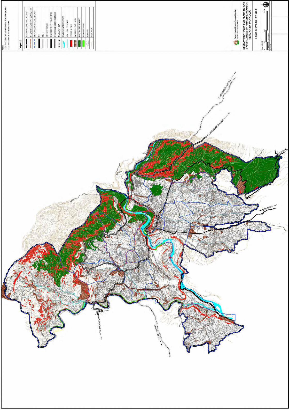
11.1 Land Suitability Analysis ........................................................................................................ 89
11.2 Development Proposals ........................................................................................................ 90
12 LANDUSE PLAN .......................................................................................................................... 94
12.1 Landuse Classification ........................................................................................................... 94
12.2 Existing Landuse Distribution ................................................................................................ 95
12.3 Land Allocation Mechanism .................................................................................................. 98
12.4 Proposed Landuse Plan ......................................................................................................... 98
a) Residential Use ...................................................................................................................... 99
b) Commercial Use .................................................................................................................... 99
c) Mixed use .............................................................................................................................. 99
d) Public and Semi-Public Use ................................................................................................... 99
e) Parks and Open Spaces Use ................................................................................................ 100
f) Transportation Use ............................................................................................................. 100
g) Special Area ......................................................................................................................... 100
h) Primary Activities ................................................................................................................ 100
i) Protected and restricted areas ........................................................................................... 100
13 LANDUSE ZONING AND DEVELOPMENT CONTROL REGULATION .......................................... 102

Development Plan - 2035 Baijnath – Paprola Planning Area
Town and Country Planning Department, Himachal Pradesh Page | vii
13.1 Zoning Regulations .............................................................................................................. 102
13.2 Use Zones Designated ......................................................................................................... 102
13.3 Development Control Regulations (DCR) ............................................................................ 109
13.4 Jurisdiction of Regulations .................................................................................................. 109
13.5 Applicability of Regulations................................................................................................. 109
13.6 Part Contruction .................................................................................................................. 110
13.6.1 Re-construction ........................................................................................................... 110
13.6.2 Existing approved buildings ........................................................................................ 110
13.7 Development Permission .................................................................................................... 110
13.8 Building Permission ............................................................................................................. 110
13.8.1 Building Permission ..................................................................................................... 110
13.9 Grant, Refusal and Deemed to be Sanctioned .................................................................... 111
13.10 Already Permitted Buildings ........................................................................................... 111
13.11 Procedure for Obtaining Permission ............................................................................... 111
13.11.1 Application and Fee ................................................................................................ 111
13.11.2 Documents Required .............................................................................................. 112
13.12 General Regulations ........................................................................................................ 113
13.13 Sub-Division of Land Regulations .................................................................................... 120
13.14 Regulations for Each Land Use Zone ............................................................................... 121
13.14.1 Residential Zone ...................................................................................................... 121
13.14.2 Commercial Zone .................................................................................................... 122
13.14.3 Industrial Zone ........................................................................................................ 123
13.14.4 Public and Semi Public Zone ................................................................................... 124
13.14.5 Traffic and Transportation ...................................................................................... 125
13.15 Risk Based Classification of Buildings .............................................................................. 125
13.16 Other Regulations ........................................................................................................... 127
13.16.1 Fire and Life Safety .................................................................................................. 127
13.16.2 Relaxations .............................................................................................................. 127
13.16.3 Parks and Open Spaces ........................................................................................... 127
13.16.4 Agriculture............................................................................................................... 127
13.16.5 Heritage cum Conservation areas ........................................................................... 127
14 PLAN IMPLEMENTATION......................................................................................................... 129
14.1 Introduction ........................................................................................................................ 129
14.2 Development Proposals ...................................................................................................... 129
14.3 Costing ................................................................................................................................ 131
14.4 Financing ............................................................................................................................. 131
Development Plan - 2035 Baijnath – Paprola Planning Area
Town and Country Planning Department, Himachal Pradesh Page | viii
14.5 Implementation .................................................................................................................. 132
14.5.1 Implementation Arrangements .................................................................................. 133
BIBLIOGRAPHY .................................................................................................................................... 135
ANNEXURES ........................................................................................................................................ 137
Household Survey Format ............................................................................................................... 137
Traffic Volume Count Survey Format .............................................................................................. 145
Origin Destination Survey Format ................................................................................................... 146
Traffic Projections ........................................................................................................................... 147
Survey Point I – Tashi Chowk ........................................................................................................... 147
Survey Point II – SDM Complex ....................................................................................................... 149
Survey Point III – Majehrna Road .................................................................................................... 151
Survey Point IV – Mandi Road ......................................................................................................... 153
Average Daily Traffic - Classified Traffic Volume Count Survey ....................................................... 155
Survey Point I – Tashi Chowk ........................................................................................................... 155
Survey Point II – SDM Complex ....................................................................................................... 157
Survey Point III – Majehrna Road .................................................................................................... 159
Survey Point IV – Mandi Road ......................................................................................................... 161

Development Plan - 2035 Baijnath – Paprola Planning Area
Town and Country Planning Department, Himachal Pradesh Page | ix
List of Figures Figure 1-1: Baijnath Paprola Planning Area .......................................................................................... 1
Figure 1-2: Location of Baijnath-Paprola Planning Area ........................................................................ 2
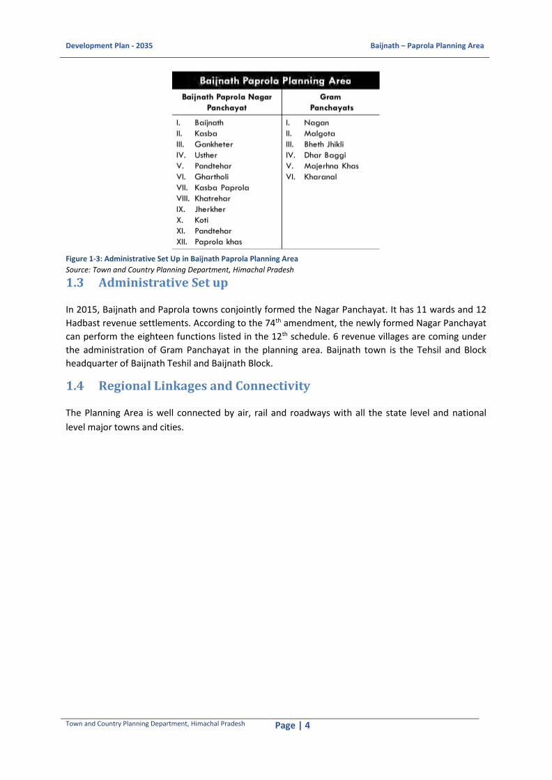
Figure 1-3: Administrative Set Up in Baijnath Paprola Planning Area .................................................... 4
Figure 1-4: Regional Linkage ................................................................................................................ 5
Figure 1-5: Pattern of Growth of two Urban Centres ............................................................................ 6
Figure 1-6: Elevation Analysis .............................................................................................................. 9
Figure 1-7: Slope Analysis .................................................................................................................. 10
Figure 2-1: Population Growth Ratein Baijnath-Paprola Planning Area ............................................... 13
Figure 2-2: Literacy Rate in Baijnath Paprola Planning Area ................................................................ 13
Figure 2-3: Population Projection ...................................................................................................... 14
Figure 2-4: Existing Settlement Pattern in the Planning Area .............................................................. 18
Figure 2-5: Proposed Settlement Pattern in the Planning Area ........................................................... 21
Figure 3-1Distribution of Main and Marginal workers ........................................................................ 22
Figure 3-2 Workers Distribution ......................................................................................................... 23
Figure 3-3: Male Female Sectorial Distribution ................................................................................... 23
Figure 3-4: Area under Cultivation in the Planning Area ..................................................................... 25
Figure 3-5Production of Horticultural Crops in the Planning Area, (2011-12 to 2015-16) ...................... 26
Figure 3-6Important Activities in Tertiary Sector ................................................................................ 27
Figure 4-1 Condition of Houses in Baijnath-Paprola Planning Area ...................................................... 30
Figure 4-2 Ownership Status of the households in Baijnath-Paprola Planning Area ............................. 30
Figure 4-3 Type of Structures in Baijnath-Paprola Planning Area ......................................................... 30
Map 4-4 Existing Settlements in the Planning Area ............................................................................ 31
Figure 5-1 Road Networkin the Planning Area .................................................................................... 34
Figure 5-2 Vehicle Growth in Baijnath Subdivision ............................................................................. 35
Figure 5-3 Vehicle Classes in the Planning Area .................................................................................. 36
Figure 5-4: Existing Public Transport Routes in the Planning Area ....................................................... 38
Figure 5-5: Location of the Black Spots ............................................................................................... 39
Figure 5-6: Traffic Composition near Tashi Chowk at Survey Point I .................................................... 40
Figure 5-7: Traffic Compositions near SDM Complex at Survey Point II ................................................ 40
Figure 5-8: Traffic Compositions on Majehrna Road at Survey Point III ............................................... 40
Figure 5-9: Traffic Compositions on Mandi Road at Survey Point IV .................................................... 40
Figure 6-1: Intensity-Duration Curve .................................................................................................. 51
Map 7-1 Existing Healthcare facilities in Baijnath-Paprola Planning Area ............................................ 64
Map 7-2 Existing Public and Semi-Public facilities in Baijnath-Paprola Planning Area .......................... 67
Map 8-1 Forest area under Baijnath-Paprola Planning Area ................................................................ 69
Figure 8-2Water Quality Assessment in Discharge of Binwa Khad, 2013-15 ......................................... 71
Figure 8-3Overall Vulnerability Map of Himachal Pradesh .................................................................. 72
Figure 8-4Earthquake Hazard Vulnerability map of Himachal Pradesh ................................................ 73
Figure 8-5 Land Slide prone area within the Planning Area ................................................................ 74
Figure 9-1Places of Interest in and around Baijnath Town .................................................................. 77
Figure 9-2Baijnath Temple................................................................................................................. 78
Figure 9-3Tashi Jong Monastery ........................................................................................................ 78
Figure 9-4 Sherab Ling Monastery ...................................................................................................... 79
Figure 9-5 Bir Biling Paragliding Site ................................................................................................... 79

Development Plan - 2035 Baijnath – Paprola Planning Area
Town and Country Planning Department, Himachal Pradesh Page | x
Figure 9-6Tourist Arrivals, Kangra District .......................................................................................... 80
Figure 9-7 Projections for Domestic Tourist Traffic for Kangra District – 2015 to 2035 ......................... 82
Figure 9-8 Projections for Foreign Tourist Traffic for Kangra District – 2015 to 2035 ............................ 82
Figure 9-9 Camping Site ..................................................................................................................... 84
Figure 9-10Viewing Deck ................................................................................................................... 84
Figure 11-1 Development Limitations in Baijnath-Paprola Planning Area ............................................ 89
Figure 12-1 Existing Land Use Map of Baijnath-Paprola Planning Area ................................................ 97
Figure 12-2 Proposed Landuse Map 2035 of Baijnath-Paprola Planning Area .................................... 101
Figure 14-1: Institutions involved in Implementation activities ......................................................... 134

Development Plan - 2035 Baijnath – Paprola Planning Area
Town and Country Planning Department, Himachal Pradesh Page | xi
List of Tables Table 1-1: Planning Area Profile...................................................................................................................... 3
Table 1-2: Distance of Major Towns and Cities from Planning Area (PA) ....................................................... 6
Table 2-1 Population Distribution of Baijnath-Paprola Planning Area ......................................................... 12
Table 2-2 CAGR for Population Projection of Baijnath-Paprola Planning Area ............................................ 15
Table 2-3 Year wise Projected Population of Baijnath-Paprola Planning Area ............................................. 15
Table 2-5 Distribution of Rural Settlements in the Planning Area by Population Size, 1991, 2001, 2011
and 2035 ....................................................................................................................................................... 15
Table 2-6: Functional Index and Rankings of the villages in the Planning Area ........................................... 16
Table 2-7: Proposed Growth Centres............................................................................................................ 19
Table 2-8: Proposed Settlement Hierarchy and Proposed Facilities in Baijnath-Paprola Planning Area
– 2035 ........................................................................................................................................................... 19
Table 3-1 Production of Horticultural Crops in the Planning Area, (2011-12 to 2015-16) ........................... 26
Table 3-2 Proposed Occupational Classification of Baijnath-Paprola ........................................................... 28
Table 3-3 Proposed Employment generated by various activitiesin the Planning Area ............................... 28
Table 4-1 Projected Population and Housing Need ...................................................................................... 32
Table 4-2 Housing Need for Five Years ......................................................................................................... 32
Table 5-1 Road Length in the Planning Area ................................................................................................. 35
Table 5-2: Peak Hour Details ......................................................................................................................... 40
Table 5-3: Final Traffic Growth rates (%) ...................................................................................................... 41
Table 5-4: Projected Normal/Total Traffic AADT (PCU) ................................................................................ 41
Table 6-1: Total Water Demand and Gap ..................................................................................................... 46
Table 6-2: Water Treatment Demand ........................................................................................................... 47
Table 6-3: Service Level Benchmarking for Water Supply System................................................................ 47
Table 6-4: Sewerage Generation and Gap .................................................................................................... 49
Table 6-5: Service Level Benchmarking for Sewerage and Sanitation (2015-2035) ..................................... 49
Table 6-6: Service Level Benchmarking for Storm water Drainage System .................................................. 52
Table 6-7: Solid Waste Generation and Gap ................................................................................................. 54
Table 6-8: Service Level Benchmarking for Solid Waste Management (2016-2035) .................................... 54
Table 6-9: Existing Power Distribution in Baijnath-Paprola Planning Area ................................................... 57
Table 6-10: Maximum Power Demand in Baijnath-Paprola Planning Area .................................................. 57
Table 6-11: Projected Load Forecasting of Baijnath-Paprola Town over the next 20 years......................... 58
Table 6-12: Safety Clearances ....................................................................................................................... 58
Table 6-13: Technical Details of Road Lighting System ................................................................................. 59
Table 7-1URDPFI Guidelines and Gap Analysis for Educational Facilities ..................................................... 61
Table 7-2 Recommended Guidelines for Educational Facilities .................................................................... 61
Table 7-3 URDPFI Norms and Gap Analysis for Healthcare Facilities in Hilly Area ...................................... 63
Table 7-4Gap Analysis of Public and Semi-Public Facilities in Baijnath-Paprola Planning Area based on
URDPFI Guidelines ........................................................................................................................................ 66
Table 8-1 Classification of Forest and its area under Baijnath Range and Baijnath-Paprola Planning
Area ............................................................................................................................................................... 68
Table 8-2Mean and Standard Deviation for Water Quality Assessment of Binwa khad in Baijnath-
Paprola Planning Area during April, 2013- March, 2015 .............................................................................. 70
Table 8-3: Showing overall Vulnerability of District Kangra to Various Hazards .......................................... 75
Table 9-1Existing Tourist Infrastructure in Baijnath and Bir ......................................................................... 80

Development Plan - 2035 Baijnath – Paprola Planning Area
Town and Country Planning Department, Himachal Pradesh Page | xii
Table 9-2 Projections for Tourist Traffic – 2011 to 2021 .............................................................................. 81
Table 12-1: Land use Classification ............................................................................................................... 94
Table 12-2 Existing Landuse Distribution and Proposed Land Uses ............................................................. 95
Table 13-1: Land Use Zones and Activities Permitted under each Zone .................................................... 102
Table 14-1: Phasing of Different Projects ................................................................................................... 130
Table 14-2: Block Cost ................................................................................................................................. 132
Table 14-3: Project Implementation Arrangement .................................................................................... 133

Development Plan - 2035 Baijnath – Paprola Planning Area
Town and Country Planning Department, Himachal Pradesh Page | xiii
Executive Summary Project Context
Himachal Pradesh is one of the leading hill States in India with a population of 68,64,602 persons as
per 2011 Census. There are 54 Urban Local Bodies and 59 census towns in the State. Apart from
these, there are 33 Planning Areas and 34 Special Areas notified under the provisions of the
Himachal Pradesh Town and Country Planning Act, 1977.
In the wake of rapid urbanisation and economic growth, the Government of Himachal Pradesh
(GoHP) intends to regulate the development process in its urban settlements, to ensure that these
urban settlements continue to serve their purpose without causing inconveniences and difficulties to
the population, and the administration. To achieve the same, the Department of Town and Country
Planning has prepared this Development Plan.
Planning Area Profile
Baijnath Paprola is a notified Planning Area in Baijnath Tehsil of Kangra district of Himachal Pradesh
state. The Planning Area is dissected by Binwa River, a tributary of Beas River. Chamba district
borders with the Northern boundary of Baijnath Tehsil. Palampur Tehsil is located at the Western
side and Jaisinghpur is located at South Western side of the Baijnath Tehsil. Multhan Tehsil borders
the North-Eastern boundary and South Eastern side is bordered by Mandi District. Baijnath Paprola
Planning Area is situated at the central portion of Baijnath Tehsil. The Baijnath Paprola Planning Area
has 18 revenue villages out of which Baijnath and Paprola are considered as the urban centres which
have been upgraded to Nagar Panchayat in 2015 consisting 12 revenue villages. The Planning Area
has a population (2011) of 20521 which is distributed over an area of 1823 hectare.
Baijnath is famous for its 13th-century temple dedicated to Shiva which attracts a large number of
tourists and pilgrims from all over India and abroad throughout the year. Makara Sankranti, Maha
Shiv Ratri, Vaisakha Sankranti, Shravana Mondays, etc. are celebrated.
Baijnath-Paprola Planning Area is well connected by air, railways and roadways. The Planning Area is
located just 50-60 km. away from the Gaggal airport. Baijnath is also connected with Pathankot and
Jogindernagar through narrow gauge on the Kangra Valley railway line. The bus connectivity is good.
HRTC buses and private buses run from Baijnath to all the major towns of Himachal and to National
Capital Delhi as well.
Demographic Characteristics
The total population of Baijnath-Paprola Planning Area reside in the rural areas according to Census
of India, 2011. There was no urban settlement in the planning area up to 2015. The Baijnath Nagar
Panchayat has now been formed in 2015 which gives it a statutory urban character. Almost 45% of
the total population in the Planning Area reside in Baijnath-Paprola Nagar Panchayat Area. The
average household size of the planning area is 4.4, which is almost same as that of the district and
state averages of 4.3 persons and 4.6 persons in 2011. The Planning Area has a decadal population
growth of 6.90 % in the 2001-2011, a sex ratio of 976 females per 1000 males and literacy rate of 87
% as per Census 2011. The Planning Area constitutes of 23 % population belonging to Schedule
Caste.

Development Plan - 2035 Baijnath – Paprola Planning Area
Town and Country Planning Department, Himachal Pradesh Page | xiv
According to the Census of India, Baijnath-Paprola Planning Area had a population of 19,197 in 2001
which rose to 20,521 in 2011 registering a decadal growth rate of 6.90 % in 2001-11.
The projection method followed to forecast the probable increase of population in Baijnath-Paprola
Planning Area up to target year 2035 is Compound Annual Growth Rate (CAGR). The Phase Years
have been taken on a gap of 5 years i.e., 2016, 2021, 2026, 2031 and 2035. Hence the projected
population for Baijnath Paprola Planning Area for the year of 2035 is 28,553.
Economic Profile
The Work Participation Rate of the Planning Area is 37 % with most of the workers (70 %) engaged in
tertiary sector, 25 % engaged in primary sector and only 5 % works engaged in secondary or
industrial sector. The workforce constitutes of 70 % male and 30 % female workers as per Census
2011. The percentage of women participation has decreased from 37 % in 2001 to 30 % in 2011 with
65 % women participation in the primary sector. There are 69 % main workers whereas 31 %
marginal workers in the Planning Area according to 2011 Census. The percentage of marginal
workers have increased from 26 % in 2001 to 31 % in 2011.
Paddy (90 %) and wheat (85 %) are major food crop cultivated during Kharif and Rabi seasons. The
main horticultural crops in the region include oranges, lemons, mangoes and apples (initiation
phase).
Traffic and Transportation
Baijnath is connected by NH-154 and two MDRs i.e. MDR-56 and MDR-43. NH-154 connects Baijnath
with Dharamshala and Mandi/Manali via Palampur and Jogindernagar. MDR 56, connects
Jogindernagar with Baijnath via Thara, Yol Settlements and MDR 43, connects Neri with Baijnath via
Ustehar, Kunsal settlements. The NH-154 serves as the primary road network in the Planning Area
covering a length of about 7.15 km in the Planning Area and serves 34 % population in the Planning
Area directly. The MDR-43 and MDR-56 serves the secondary road network of about 2.50 km and
about 5.63 km respectively in the Planning Area and serve 38 % population in the Planning Area. The
tertiary road network consists of the village roads which connect the rest of the settlements like
Malgota, Kharanal, Paprola Khas, Beth Jhikli, Nagan, Kothi and Majehrna Khas with a network of 40
km of road length inside the Planning Area and serve 38 % population directly and rest of the people
indirectly in the Planning Area.
The average vehicular annual growth rate is 5 % from 2011 to 2015. The highest growth rate was
experienced in 2014. The maximum registered vehicles are mainly the two wheelers (63 %) and cars
(26 %). The LMV vehicle share is 6 % out of the total vehicles registered in the area. Rest of the 5 %
share includes buses, three wheelers, tractors and MGVs.
There are two designated off-street parking spaces available in Baijnath town viz., one adjacent to
Baijnath temple of 530 sq. m. area with a capacity of 19 cars and another near the PWD rest house
beside the Sub-divisional post office of Baijnath of about 850 sq. m. with a capacity of 30. As per the
norms of URDPFI guidelines 710 sq. m. area is required for parking area for the temple.
There are no designated pathways for the pedestrian movement in the town. The carriage way of
NH-154 is used by the pedestrians mainly. The walkways are required as most of the people
commute by walking inside the Planning Area.

Development Plan - 2035 Baijnath – Paprola Planning Area
Town and Country Planning Department, Himachal Pradesh Page | xv
Baijnath Temple, a very famous ancient temple of Lord Shiva, attracts a large number of tourists
and pilgrims from all over India and abroad throughout the year for which there will be increase
in vehicular as well as pedestrian traffic in that area.
Paprola and Baijnath is a highly dense built-up area which generate high local traffic movement
(vehicles and pedestrian both).
Agro Based Industries, R&D Institute and Skill Development centres have been proposed in the
planning area which will further increase vehicle and pedestrian traffic in that local area.
The alignment of the proposed Bypass is from Pandtehar Village near proposed bus and truck
terminals to Gankheter Village near rail crossing; connecting Paprola Khas, Kharanal and
Malgota Village.
Housing
The overall condition of houses in Baijnath-Paprola Planning Area is good. A significant section of the
households is the owner of their structures and have permanent structure. Most of the temporary
structures can be seen in villages that are situated along the railway line or along the bank of Binwa
River. Total housing need for 2035 would be 2784. Different settlements are distributed in a
dispersed mannerwith low population density. These traditional settlements appear to have the
‘colour of the land’ and are vernacular in character. The landscape, materials, techniques of making,
all contribute to a common formal language of settlements in Himachal Pradesh. The location of
various settlements in the Baijnath-Paprola Planning Area.
Physical and Social Infrastructure
Both surface water and groundwater are utilised to meet the water demand of the people of
Baijnath Paprola Planning Area. The estimated water demand for the Planning Area will be 15.46
MLD in 2035 and the sewage generation will be 11.88 MLD. Proper waste management for 13.97
Ton per day of the Planning Area would be required for 2035. The cluster based approach can be
adopted for the waste disposal. Presently, in Baijnath-Paprola Planning Area, there is one fire station
adjacent to SDM office at Baijnath. The projected population of Baijnath-Paprola Planning Area is
28,553 for the year 2035. Hence, current provision for fire services in Baijnath-Paprola Planning Area
are sufficient to cater the needs.
In Baijnath-Paprola Planning Area, the primary and secondary education facilities are more than the
requirement. The population for opening a college is lower than the population requirement under
the URDPFI Guidelines, considering the population and availability of colleges in the surrounding
areas, these are adequate with reference to the distance range prescribed by URDPFI norms.
There is a need to give priority on skill based training institutes. The citizens of Baijnath-Paprola
Planning Area avail higher education in science and other streams at Palampur, which is located at a
distance of about 17 km from the Planning Area.
Though there is a gap in the existing number of dispensaries and sub-centres but the existing
number of primary health centres and hospitals are fulfilling the healthcare demand in the Planning
Area as they are existing more than required by the URDPFI guidelines. Hence, the healthcare
facilities in Baijnath-Paprola Planning Area are adequate to cater the healthcare demand.

Development Plan - 2035 Baijnath – Paprola Planning Area
Town and Country Planning Department, Himachal Pradesh Page | xvi
The multi speciality speciality hospitals are located at Palampur and Dharmashala which come under
the about 50 km radius of the Palnning Area.
There is acute deficiency of open spaces in the Planning Area. One cow shed, two cremation
grounds, two play grounds and one community hall are located in the Planning Area which are
concentrated in the Nagar Panachayat boundary. Disaster management centre and fire station are
aslo located in the Planning Area.
Environment and Disaster Management
In the Planning area 29 % area comes under the forest cover out of which 21 % is Demarcated
Protected Forest, 30 % is Un-Demarcated Protected Forest and rest of the 49 % is Unclassed Forest.
The nearest Air Quality Monitoring Stations are at Dharamshala and Sundarnagar which are located
beyond 50 km radius, hence the data on air quality could not be procured for Baijnath-Paprola
Planning Area. The major source of noise in the Planning Area is roadway traffic. Roadway noise
levels vary with traffic volume and speed, types of vehicles on the roadway and the type of roadway.
For densely populated areas of Baijnath-Paprola, where residential uses line the roadways, few noise
mitigation options exist. In Baijnath-Paprola Planning Area, the concentration of pH, Dissolved
Oxygen and Biochemical Oxygen Demand is under the permissible limits and the quality of water
falls in Class-A.
The area adjoining the river Binwa bank starting from Binwa Bridge to Kheer Ganaga ghats is
vulnerable to natural land slide disaster during raiy season. This area is approximately 27800 sq.m
which is nearly 500 m in length. This area shall be considered as non-developable land and no-
construction activity should be allowed here. In order to sustain the existing structures adjoining this
area, the Development Plan recommends to have retaining walls along the sliding and sinking area
and to grow vegetation and trees in this area so as to avoid soil erosion.
Heritage and Tourism
In terms of cultural and historical importance, Baijnath-Paprola Planning Area is endowed with a
number of heritage and architecturally magnificent structures of religious as well as national
importance. These include the Baijnath Temple, Sidhnath temple, Tashi Jong Monastery, Sherab Ling
Monastery, Bir-Biling Paragliding site, Kangra Valley Railways and Binwa River. Baijnath-Paprola
Planning Area falls on the Dhauladhar Circuit. This circuit covers Delhi - Chintpurni - Jawalamukhi -
Kangra - Dalhousie - Khajjiar - Chamba - Dharamshala - Chamunda - Palampur - Jogindernagar -
Delhi. Baijnath-Paprola is situated in between Palampur and Jogindernagar and is a major religious
destination. Baijnath needs more attention to make it visible on the existing tourist circuit.
The tourism recommendations are: Identification of tourist destinations and preparation of Tourism
Master Plan and Mobility Plan for the Planning Area. The tourism department in co-ordination with
the private sector should develop these circuits towards making tourism an important economic
sector. Promote responsible tourism that will be welcomed as both preferred employer and
community industry. Use Tourism as a means of providing new employment opportunities in rural,
tribal and remote areas of the Planning Area. Increase private sector participation in tourism, both
as means of generating employment and providing new infrastructure. During mela period the
demand for basic physical infrastructure increases for which the plan recommends to have mobile
toilets and additional water supply system in the mela ground. These toilets should be connected to

Development Plan - 2035 Baijnath – Paprola Planning Area
Town and Country Planning Department, Himachal Pradesh Page | xvii
septic tanks that are suggested to be constructed within the mela ground. ASI norms to be followed
for Baijnath and Sidhnath temples. Eco-tourism though a relatively new concept can be developed
around the tea gardens and factory in Ustehar. Tea garden shall be promoted and activities like tea
tasting, visit to tea factory, tea plucking and processing can be encouraged. Camping sites to be
developed along with viewing decks in the Planning Area, one towards the North at Bheth Jhikli and
the other at Dhar Baggi.

Development Plan - 2035 Baijnath – Paprola Planning Area
Town and Country Planning Department, Himachal Pradesh Page | 1
1 INTRODUCTION: BAIJNATH PAPROLA PLANNING AREA PROFILE
1.1 Introduction
Baijnath Paprola is a notified Planning Area in Kangra district of Himachal Pradesh state. Baijnath-
Parola Planning Area is situated in Baijnath Tehsil of Kangra district. It is located at a distance of
about 50 km from Dharamshala, the district headquarters and about 217 km from Shimla, the state
capital. Baijnath Tehsil shares its boundary with Chamba district in the North, Palampur Tehsil in the
North-West, Jaisinghpur Tehsil in the South-West, Mandi district in the South, Multan tehsil in the
East (Refer Figure 1-1: Baijnath Paprola Planning Area).
Baijnath and Paprola are twin towns situated on the opposite banks of Binwa River. Baijnath is
famous for its 13th-century temple dedicated to Lord Shiva which attracts a large number of tourists
and pilgrims from all over India and abroad throughout the year. Makara Sankranti, Maha Shiv Ratri,
Vaisakha Sankranti, Shravana Mondays, etc. festivals are celebrated with great zeal and brilliance. A
five-day state level function is held in the Baijnath during Maha Shiv Ratri every year. A famous
Ayurveda College and hospital, named Rajiv Gandhi Government Ayurvedic Collegeis located at
Paprola town.
Figure 1-1: Baijnath Paprola Planning Area Source: Google Earth and Primary Survey

De
velo
pm
en
t P
lan
- 2
03
5
Bai
jnat
h –
Pa
pro
la P
lan
nin
g A
rea
Tow
n a
nd
Co
un
try
Pla
nn
ing
Dep
artm
ent,
Him
ach
al P
rad
esh
P
age
| 2
Fi
gure
1-2
: Lo
cati
on
of
Ba
ijnat
h-P
apro
la P
lan
nin
g A
rea
So
urc
e: N
oti
fica
tio
n p
rovi
ded
by
Tow
n a
nd
Pla
nn
ing
Dep
art
men
t, H
P

Development Plan - 2035 Baijnath – Paprola Planning Area
Town and Country Planning Department, Himachal Pradesh Page | 3
1.2 Planning Area In exercise of the powers conferred by sub-section-(1) of Section- 13 of the Himachal Pradesh Town
and Country Planning Act, 1977 (Act No.12 of 1977), the Governor of the state has constituted
“Baijnath-Paprola Planning Area” on 7th July, 2014 which is comprised of following Revenue Villages:
Table 1-1: Planning Area Profile
Sl. No.
Name of Revenue Village Hadbast No. Area (Hectares) Population (2011 Census)
1 Kasba (NP) 871 88 1861
2 Baijnath (NP) 870 70 2349
3 Gankheter (NP) 869 68 721
4 Ghartholi (NP) 1023 97 1956
5 Pandtehar (NP) 872 80 696
6 Ustehar (NP) 875 98 909
7 Paprola Khas (NP) 820 46 860
8 Kasba Paprola (NP) 822 58 19791
9 Nagan 826 64 835
10 Koti (NP) 823 142 1698
11 Jherkher (NP) 825 9 774
12 Khatrehar (NP) 829 22 958
13 Kharanal 819 123 660
14 Malgota 827 84 613
15 Pandtehar (NP) 821 65 688
16 Bheth Jhikli 817 318 1715
17 Dhar Baggi 1025 273 233
18 Majehrna Khas 779 118 1016
Total 1823 205212 Source: Town and Country Planning Department, Himachal Pradesh
The Baijnath Paprola Planning Area has 18 revenue villages out of which Baijnath and Paprola are
considered as the urban centres which have been upgraded to Nagar Panchayat in 2015 as per
Notification No. UD-A(1)-1/2012, dated 28.5.2014 having 12 Revenue mohals (11Wards) . The
Exisiting land use of Baijnath-Paprola Planning Area has been adopted vide Notice No.
HIM/TP/PJT/PA-Baijnath-Paprola/2013/Vol-1/-3896-3923, dated 03.08.2017. The Planning area has a
population of 20,521 which is distributed over an area of 1823 hectare.
1 Note: The Population of Kasba Paprola as per Notification No. TCP-F (5)-1/2014 dated 07-07-2014 is 822 whereas the actual population is 1979 according to 2011 Census. 2 Actual Population of the Planning Area as per Census of India, 2011
Development Plan - 2035 Baijnath – Paprola Planning Area
Town and Country Planning Department, Himachal Pradesh Page | 4
Figure 1-3: Administrative Set Up in Baijnath Paprola Planning Area
Source: Town and Country Planning Department, Himachal Pradesh
1.3 Administrative Set up
In 2015, Baijnath and Paprola towns conjointly formed the Nagar Panchayat. It has 11 wards and 12
Hadbast revenue settlements. According to the 74th amendment, the newly formed Nagar Panchayat
can perform the eighteen functions listed in the 12th schedule. 6 revenue villages are coming under
the administration of Gram Panchayat in the planning area. Baijnath town is the Tehsil and Block
headquarter of Baijnath Teshil and Baijnath Block.
1.4 Regional Linkages and Connectivity
The Planning Area is well connected by air, rail and roadways with all the state level and national
level major towns and cities.

Development Plan - 2035 Baijnath – Paprola Planning Area
Town and Country Planning Department, Himachal Pradesh Page | 5
Figure 1-4: Regional Linkage
Source: Google Earth and Primary Survey
1.4.1 By Air
The nearest air connectivity is at Gaggal Airport in Dharamshala (the district head quarter) which is
located at a distance of about 55km and flights are available every alternate day, to-and-from Delhi,
the national capital.
1.4.2 By Rail
Baijnath and Paprola towns are connected by a railway line and have 2 separate narrow gauge
railway stations. The narrow-gauge line connects Pathankot with Jogindernagar via Paprola and
Baijnath.The next nearest railway station is in Kangra which is about 50 km from the Planning Area.
The nearest broad-gauge railway stations are located at Amb (120 km) and Pathankot (130 Km).
1.4.3 By Road
Baijnath is well connected by roadways through NH – 154, MDR – 56 and MDR - 43. Public bus
service is available from Baijnath Paprola to the major cities.

Development Plan - 2035 Baijnath – Paprola Planning Area
Town and Country Planning Department, Himachal Pradesh Page | 6
The district Head quarter Dharamshala is located at a distance of about 50 km from Baijnath town
whereas Shimla (the state head quarter) is located at a distance of 217 km. Chandigarh is located at a
distance of about 270 km whereas Delhi is at a distance of about 507 km.
Table 1-2: Distance of Major Towns and Cities from Planning Area (PA)
Sl. No. Towns/Cities Distance from PA (in km.)
1 Palampur 17
2 Dharamshala 50
3 Gaggal Airport 55
4 Shimla 217
5 Chandigarh 270
6 Delhi 507 Source: Calculations from the Google Map
1.5 History and Spatial Growth
The existence of Baijnath town seems to be from 13th century A.D., this is evident from the presence
of famous Lord Shiva temple in Baijnath. The Baijnath temple has been continuously under worship
ever since its construction in 1204 A.D. The present temple is a beautiful example of the early
medieval north Indian Temple architecture known as Nagara style of temples. The whole temple is
enclosed by a high wall with entrances in the south and north. The outer walls of the temple have
several niches with images of gods and goddesses. Numerous images are also carved in the walls.3
Figure 1-5: Pattern of Growth of two Urban Centres
Source: Google Map and Primary Survey
3Source: http://baijnathtemple.com/archaeology.htm, and http://himachaltourism.gov.in/temple.php

Development Plan - 2035 Baijnath – Paprola Planning Area
Town and Country Planning Department, Himachal Pradesh Page | 7
Baijnath town has grown around the temple in an organic way. The temple area has formed the core
area of Baijnath town. The town has shown spatial growth towards south (refer Figure 1-5: Pattern of
Growth of two Urban Centres). The twin town Paprola has grown along the NH-154 and Binwa River
in a linear form. The Town is famous for the Ayurveda College and Hospital. Paprola has grown in
Western and North-Western direction towards Palampur town. These urban areas have particular
linear spatial form along the roads and highway. The pilgrimage tourism has facilitated the
development of huge commercial centre along the highway.
1.6 Geographical Setting
1.6.1 Geology
Kangra district has Quaternary, Tertiary and Precambrian deposits which are basically made of
sedimentary and igneous rocks. The valley fills are composed of recent Alluvium, Shivalik hills are
made up of rocks such as sandstone, shale and clay that came into existence during the Eocene,
Miocene and Pliocene period. The rocks of southern portion of Baijnath Tehsil is of upper Shivalik
group. The middle portion of the Tehsil is formed of Kullu formation that consistsof sandstone and
granite rocks. These porous geological formations form have facilitated for potential ground water
reserves.
1.6.2 Physiography
Baijnath-Paprola Planning Area in Kangra district is situated on the southern slope of the Himalayas.
The entire area of the district is traversed by the varying altitude of the Shivalik, Dhauladhar and the
Himalayas from North-West to South-East. The area is categorised as the hilly area.4
1.6.2.1 Elevation
The entire Planning Area is characterised by mountainous undulating terrain. The elevation in the
area ranges from a minimum of 850m near the Binwa valley to a maximum of 1400m near Tashi Jong
Monastery. Baijnath-Paprola Planning Area is situated at an average elevation of 1314 m above mean
sea level. About 95% of the settlements are located within an elevation of 1100m. The elevation
increases from south western part to north eastern and south-eastern sides. High altitude areas
having forest cover. (Refer Figure 1-6: Elevation Analysis)
1.6.2.2 Slope Analysis
Baijnath Paprola Planning Area has moderate (western side) to steep slope (eastern side). Almost
68 % of area, in the central, western and southern parts of the Planning Area, has gentle slope of less
than 27 % i.e. suitable for development or any construction. Almost 24 % area falls under moderate
to semi-steep slope categories, ranges from 27 to 58 %, located in north eastern and south-eastern
fringes. Rest 8 % of the planning area, falls under steep slope category i.e. more than 58 % slope.
Areas with more than 27 % slope are mostly under forest cover and along the river. Any sort of
constructions is refrained in this zone. Hence, areas coming under semi-steep and steep slope have
4 Source: Ground Water Information Booklet, Kangra District, Himachal Pradesh

Development Plan - 2035 Baijnath – Paprola Planning Area
Town and Country Planning Department, Himachal Pradesh Page | 8
been marked as the eco-sensitive zones while preparing the development plan.5 (Refer Figure 1-7:
Slope Anlysis)
1.6.3 Climate
The climate of the district varies from wet sub-tropical climate to sub-humid in lower areas and
temperate towards the higher areas. Winter extends from December to February and summer
extends from March to June while July to September is the rainy season called monsson. The average
annual rainfall of the district is 1751 mm, out of which 83% occurs during July to Sept. Snowfall, is
also received at northern parts around Dharamshala, Palampur and Baijnath Tehsil areas. The
temperature ranges from 2.9°C in January to 32.9°C in May.6
1.6.4 Soil Character
Five types of soils are found in Kangra district viz., 1. Histosols (Snow field, Peaty and Saline Peaty), 2.
Ultisols (Brown red and yellow), 3. Alfisols (Sub Mountain), 4. Ardisols (Grey Brown), 5. Entisols
(Younger alluvium).
The pre-dominant soil type of Baijnath-Paprola is Alfisol. "Alf" refers to aluminium (Al) and iron (Fe).
Because of their productivity, the Alfisol represents one of the important soil orders for food and
fodder production.7
5Source: URDPFI Guidelines and http://www.sappi.com/regions/sa/SappiSouthernAfrica/Sappi%20Forests/Tree%20Farming%20Guidelines/Part%203_Forest%20Engineering_Chapter%207_Terrain%20Classification.pdf 6 Source: Statistical Handbook, Kangra District (2014-15) and Human Development Report, Kangra District 7 Source: Ground Water Information Booklet, Kangra District, Himachal Pradesh

Development Plan - 2035 Baijnath – Paprola Planning Area
Town and Country Planning Department, Himachal Pradesh Page | 9
Figure 1-6: Elevation Analysis Source: Analysis from the Satellite Image

Development Plan - 2035 Baijnath – Paprola Planning Area
Town and Country Planning Department, Himachal Pradesh Page | 10
Figure 1-7: Slope Analysis
Source: Analysis from the Satellite Image

Development Plan - 2035 Baijnath – Paprola Planning Area
Town and Country Planning Department, Himachal Pradesh Page | 11
1.7 Resources The existing available resources in and around the Planning Area are as follows:
1.7.1 Mineral Resources
Kangra district is well endowed with varied kind of mineral resources such as clay, coal, glass sand
from soft quartzite, iron ore, limestone, dolomites, mineral water, rock salt, slates etc. Extraction of
mineral resources has been increased 5 times from 1975-76 to 2005-06.8
1.7.2 Forest Resources
Out of the total area of Kangra district, 49.5 % (2842 sq.km.) area is under forest cover. Baijnath
block has 63 % area under forest cover. The pre-dominant forest types range from sub-tropical
evergreen forest to Himalayan moist temperate forest. In Baijnath-Paprola Planning Area, 36 % area
is under forest cover.9
1.7.3 Flora and Fauna
The major species available in the Planning area are Khair, Cheed etc. The sub-tropical pine trees
grow on the semi-steep to steep slopes in the planning area. In forest areas, commonly found
animals are leopard, hare, wild boar, jackal, kakar, monkey and sambhar. Various bird species like
crows, wild hens, grey partridge etc. are found in the area.10
1.7.4 Water Resources
Binwa River, one of the tributaries of Beas flows through Baijnath-Paprola Planning area. This is one
of the major surface water sources in the area. The area is dissected by different types of khads and
khuls (specifically natural streams). These are the main sources of surface water. Pun khad is one of
the important sources of potable water after Binwa River. The khad flows along the western
boundary of the planning area and joins Binwa River downstream.11
1.7.5 Hydro Power
A set of micro scale hydro power projects of 5 MW, 4 MW and 1.5 MW capacity under the Binwa
Hydel Project have been set up about 20-25 km upstream of Baijnath Planning Area on the Binwa
River.12
8 Source: MSME Report 9Source: Forest Range Office and Human Development Report, Refer to Chapter 9, Environment 10 Source: Forest Range Office, Baijnath and District Disaster Management Report, Kangra 11 Source: Field Survey 12 Source: HIMURJA Website

Development Plan - 2035 Baijnath – Paprola Planning Area
Town and Country Planning Department, Himachal Pradesh Page | 12
2 DEMOGRAPHY AND URBANIZATION
2.1 Demographic Profile
The population distribution of Baijnath-Paprola Planning Area is as follows-
According to the Census of India 2011, Baijnath Paprola Planning Area has a total population of
20,521 out of which 10384 are male (51%) and 10,137 are female (49 %). The Population in the
Planning Area accounts for only 1.36 % of the total population of Kangra district in 2011. The
population share of the planning area to the district population increased from 1.34 % in 1991 to
1.43 % in 2001 but then decreased to 1.36 % in 2011.
In 2011, the population of the planning area contribute to about 22 % of the total population in
Baijnath Tehsil, which however has decreased from 23 % in 2001. The decline in population can be
due to factors such as migration.
According to 2011 Census, 100 % of the population resided in rural areas as there was no urban
settlement in the planning area13. However, after delineation of the Nagar Panchayat area, almost 75
% of the total population of the Planning area reside in Baijnath-Paprola Nagar Panchayat Area.
Table 2-1 Population Distribution of Baijnath-Paprola Planning Area
Year 2001 2011
Area Total Population
Households Average HH Size
Total Population
Households Average HH Size
India 102.86 Cr 19.35 Cr 5.3 121.08 Cr 24.95 Cr 4.9
HP 60.77 Lakh 12.21 Lakh 5.0 68.64 Lakh 14.83 Lakh 4.6
Kangra District 13.39 Lakh 2.72 Lakh 4.9 15.10 Lakh 3.38 Lakh 4.5
Baijnath-Paprola Planning Area
19,197 4,177 4.6 20,521 47,07 4.4
Source: Census of India, 2001 and 2011
2.1.1 Household Size
In 2011, the average household size of the Planning Area is 4.4 persons per household which is the
same as that of the district average of 4.5 persons and less than the state average of 4.6 persons per
household.
2.1.2 Population Density
The average population density of the Planning Area is 19 persons per hectare in 2011 which is more
than the district average i.e. 3 persons per hectare. The population density has marginally increased
from 9 persons per hectare in 1991 to 11 persons per hectare in 2001 to 19 persons per hectare in
2011.
13Baijnath – Paprola Nagar Panchayat was formed in 2015

Development Plan - 2035 Baijnath – Paprola Planning Area
Town and Country Planning Department, Himachal Pradesh Page | 13
2.1.3 Population Growth
Baijnath-Paprola Planning Area has a decadal growth rate of 6.90 % which is less compared to the
district average of 12.77 % in 2011. The Planning Area has experienced a sharp fall of growth rate
from 22 % in 2001 to 7 % in 2011. The growth rate of the Kangra district has decreased from 14 % in
2001 to 12.77 % in 2011.
Figure 2-1: Population Growth Ratein Baijnath-Paprola Planning Area Source: Census of India, 1991, 2001 and 2011
2.1.4 Sex Ratio
There are 976 females per 1000 males in Baijnath-Paprola Planning Area which is lesser than the
district average i.e. 1012 females per 1000 males in 2011 and is more than the state average (972
females/1000 males in 2011). The sex ratio has increased from 937/1000 males in 1991 to 976/1000
males in 2001. In 2011, the sex ratio in the Planning Area remained the same as that of 2001 i.e. 976
females per 1000 males.
2.1.5 Literacy Rate
The overall literacy rate in the Planning Area is 83 % which is lower than the district average i.e. 85 %
in 2011. The male literacy rate is 88 % whereas the female literacy rate is 78 % according to the
Census of India, 2011. There is a significant increase in literacy rate in the Planning area from 62 % in
1991 to 82 % in 2001 to 83 % in 2011.
Figure 2-2: Literacy Rate in Baijnath Paprola Planning Area
Source: Census of India, 2001 and 2011
1991-2001 2001-2011
Baijnath Paprola PA 21.79 6.90
Kangra District 14.05 12.77
0.00
5.00
10.00
15.00
20.00
25.00
Gro
wrh
Rat
e

Development Plan - 2035 Baijnath – Paprola Planning Area
Town and Country Planning Department, Himachal Pradesh Page | 14
2.1.6 Scheduled Caste and Scheduled Tribe Distribution
Out of the total population, about 23 %of the population is from Scheduled Caste category in 2011
which is more than the district average (i.e. 21 % in 2011). The share of SC people remained almost
constant over the last two decades. (Minimal decrease from 25 % in 1991 to 24 % in 2001 to 23 % in
2011).
In case of Scheduled Tribe population in 2001, there are very few persons from Scheduled Tribe (ST)
category Gankheter and Khatrehar with 15 and 1 perosns from Scheduled Tribe Category
respectively. In 2011 there is a significant increase of ST population in all revenue villages of the
planning area. The share of ST population in the Planning Area is 13 % in 2011, which is more than
the district average (5.60 %).
2.2 Population Projection
For all practical purposes, the size of the present and future population is a key input in an urban
planning exercise. Since the last Census was conducted in 2011, population projection up totarget
year starting from 1991 has been calculated. In this exercise, the future population distribution is
more than a mere population projection of the past trends or past behaviour of the demographic
variables. Such allocation depends majorly on development programmes envisaged or decided upon
in the respective areas.
According to the Census of India, Baijnath-Paprola Planning Area had a population of 19,197 in 2001
which rose to 20,521 in 2011 registering a decadal growth rate of 6.90 % in 2001-11.
The projection method followed to forecast the probable increase of population in Baijnath-Paprola
Planning Area up to target year 2035 is Compound Annual Growth Rate (CAGR). The Phase Years
have been taken on a gap of 5 years i.e., 2016, 2021, 2026, 2031 and 2035.Hence the projected
population for Baijnath-Paprola Planning Area for the year of 2035 is 28553.
Figure 2-3: Population Projection Source: Calculations based on the previous Census data
20000
22000
24000
26000
28000
30000
2016 2021 2026 2031 2036
Po
pu
lati
on
(n
um
be
r)
Arithmatical IncrementalCompound Average Growth Rate Geometric

Development Plan - 2035 Baijnath – Paprola Planning Area
Town and Country Planning Department, Himachal Pradesh Page | 15
Table 2-2 CAGR for Population Projection of Baijnath-Paprola Planning Area
Population CAGR 1991-2011
1991 2001 2011
15763 19197 20521 1.33 Source: Calculations based on the previous Census data Table 2-3 Year wise Projected Population of Baijnath-Paprola Planning Area
Sl. No. Year Population
1 2016 21920
2 2021 23414
3 2026 25010
4 2031 26715
5 2035 28553
Source: Calculations based on the previous Census data
2.1 Settlement Pattern
As per Census 2011, Baijnath-Paprola Planning Area comprises of all Class VI settlements.
2.1.1 Rural Settlement
Baijnath-Paprola Planning Area comprises of 18 revenue villages. As per Census of India 2001, the
rural population in the Planning Area is 19,197 residing in 18 villages. In 2011, the rural population
increased to 20,521in the Planning Area. Table 2-4 Distribution of Rural Settlements in the Planning
Area by Population Size, 1991, 2001, 2011 and 2035.
Table 2-5 Distribution of Rural Settlements in the Planning Area by Population Size, 1991, 2001, 2011 and 2035
Sl. No. Range (Population) No. of villages (1991)
No. of villages (2001)
No. of villages (2011)
No. of villages (2035)
1 <100 0 1 0 0
2 100 - 500 6 0 1 1
3 500 - 1000 5 8 10 4
4 1000 - 1500 4 5 1 7
5 1500 - 2000 2 3 5 0
6 2000 - 2500 1 1 1 2
7 >2500 0 0 0 4
Total 18 18 18 18 Source: Village Directory, Census of India, 1991, 2001 and 2011
2.2 Existing Settlement Pattern
To find out the existing settlement pattern of Baijnath-Paprola Planning Area, ranking method has
been adopted, which is based on certain physical and social infrastructure indicators which are:
1. Availabilityof Physical Infrastructure facilities
a) Black Topped (pucca) Road
b) Tap Water supply-treated and protected
c) Sewer Network- all whether drain water is discharged directly into sewer plant
d) Covered Drainage System
e) Solid Waste Management- Community waste disposal system after house to house collection
f) Power supply for domestic use
2. Hierarchy of Educational facilities

Development Plan - 2035 Baijnath – Paprola Planning Area
Town and Country Planning Department, Himachal Pradesh Page | 16
a) Degree College
b) Senior Secondary School
c) Secondary School
d) Middle School
e) Primary School
f) Pre-Primary School (Nursery/LKG/UKG)
3. Hierarchy of Health facilities
a) Hospital (Allopathic)
b) Dispensary
c) Maternity and Child Welfare Centre
d) Primary Health Centre
e) Family Welfare Centre
f) Veterinary Hospital
g) TB Clinic
h) Mobile Health Clinic
4. Availability of Communication facilities
a) Mobile Phone Coverage
b) Post Office
c) Internet Cafes /Common Service Centre
d) Telephone (landlines)
e) Private Courier Facility
The data of each above indicators has been analysed from Village Directory of District Census
Handbook (Kangra District) from Census of India 2011. These indicators (i.e. the Physical, Social and
Communication facilities) have been weighed based on their availability within the settlements. The
villages having the highest availability/hierarchy of infrastructure have been given the highest rank
and the villages having the lowest availability of infrastructure have been given the lowest rank.
Table 2-6: Functional Index and Rankings of the villages in the Planning Areashows the functional
index and the rankings of the villages as per their facilities and services availability. Settlement
planning at the sub-regional level shall be linked with on-going development process in the region
and shall focus on integration with socio-economic development. Growth strategies can help these
rural settlements achieve their goals for growth and development.
Table 2-6: Functional Index and Rankings of the villages in the Planning Area
Village Population (2011 Census)
Physical Infrastructure
Index
Health Facilities
Index
Educational Facilities
Index
Communication Facilities
Index
Total Functional Index
Ranking
Baijnath 2349 15 33 50 15 113 1
Kasba 1861 9 4 38 11 62 2
Paprola Khas
860 12 12 36 2 62 3
Majehrna Khas
1016 12 5 30 11 58 4
Kothi 1698 6 7 31 7 51 5
Ghartholi 1956 12 10 15 11 48 6
Kasba Paprola
1979 6 0 26 12 44 7

Development Plan - 2035 Baijnath – Paprola Planning Area
Town and Country Planning Department, Himachal Pradesh Page | 17
Village Population (2011 Census)
Physical Infrastructure
Index
Health Facilities
Index
Educational Facilities
Index
Communication Facilities
Index
Total Functional Index
Ranking
Bheth Jhikli
1715 6 11 20 5 42 8
Ustehar 909 15 0 16 11 42 9
Khatrehr 958 6 3 18 8 35 10
Pandtehr 696 15 3 10 7 35 11
Gankheter 721 9 0 3 11 23 12
Pandtehr 688 12 0 3 3 18 13
Kharanal 660 6 0 3 6 15 14
Malghota 613 6 0 6 2 14 15
Nagan 835 6 0 0 7 13 16
Dhar Bagi 233 6 0 0 7 13 17
Jherkar 774 6 0 3 2 11 18
Source: Village Directory, District Census Handbook (Kangra District), Census of India 2011

Development Plan - 2035 Baijnath – Paprola Planning Area
Town and Country Planning Department, Himachal Pradesh Page | 18
Figure 2-4: Existing Settlement Pattern in the Planning Area Source: Calculation from Village Directory, District Census Handbook (Kangra District), Census of India 2011

Development Plan - 2035 Baijnath – Paprola Planning Area
Town and Country Planning Department, Himachal Pradesh Page | 19
2.3 Proposed Settlement Pattern
The identified urban centres in the Planning Area are Baijnath, Kasba, Kasba Paprola, Jherkher and
Khatrehar. These settlements are attributed to become the urban centres for the whole Planning
Area. With Baijnath-Paprola as a centre, Pandtehar and Ghartholi with projected population after 20
years (957 and 2722) respectively, will become a part of the urban agglomeration as they are in the
vicinity of Baijnath town. Some more growth centres like Pandtehar (968) and Paprola Khas (1197)
will also grow after 20 years as they are located along NH-154.
1) Baijnath-Paprola with Urban Extension
Urban Extension is the first order hierarchy settlements. This urban area would cater to the rural
hinterland as agro-service centre in the collection and distribution of agricultural goods and services.
These areas would work, as a nodal centre of resource based activity centre, trade and commerce,
administration, etc. The centre would have adequate infrastructure facilities with adequate
resources in quantity and quality.
Hence the proposed urban area in the Baijnath-Paprola Planning area will consist of Baijnath, Kasba,
Kasba Paprola, Jherkher and Khatrehar.
2) Growth Centres
Growth Centres are the higher order village having central location and potential for development
within its catchment area, with relatively better services and facilities in terms of education, health,
communication, accessibility. Table 2-7: Proposed Growth Centres
S. No. Proposed Growth Centres
1 Ustehar
2 Pandtehar
3 Ghartholi
4 Kothi
5 Pandtehar
6 Paprola Khas
Source: Calculation and Analysis from the Village Directory Database
3) Basic Village
All other villages have been identified as basic villages and will be provided with basic facilities like
link roads, water supply, electricity and some basic social infrastructure.
Table 2-8: Proposed Settlement Hierarchy and Proposed Facilities in Baijnath-Paprola Planning Area – 2035
Level Settlement Level
Catchment range in km
from the Settlement
Average total
population to be
served by each centre
Education Facility
Health Recreation Shopping Transport-Road
Connectivity
1 Baijnath-Paprola with Urban Extension
10 to 15 10,000-50,000
Vocational training/ Polytechnic
Maternity and Family Welfare Centre
Recreational spaces/ Play grounds
Shopping centre/ Community welfare centre
Road connectivity to other villages and Growth centres
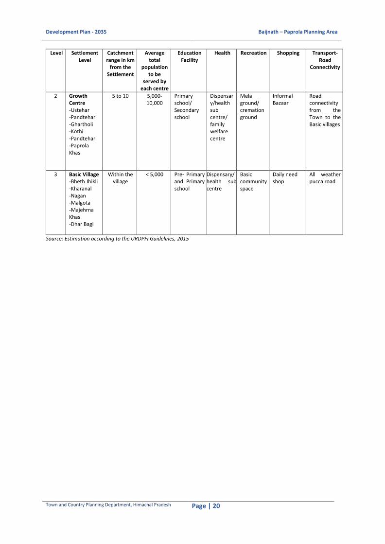
Development Plan - 2035 Baijnath – Paprola Planning Area
Town and Country Planning Department, Himachal Pradesh Page | 20
Level Settlement Level
Catchment range in km
from the Settlement
Average total
population to be
served by each centre
Education Facility
Health Recreation Shopping Transport-Road
Connectivity
2 Growth Centre -Ustehar -Pandtehar -Ghartholi -Kothi -Pandtehar -Paprola Khas
5 to 10 5,000-10,000
Primary school/ Secondary school
Dispensary/health sub centre/ family welfare centre
Mela ground/ cremation ground
Informal Bazaar
Road connectivity from the Town to the Basic villages
3 Basic Village -Bheth Jhikli -Kharanal -Nagan -Malgota -Majehrna Khas -Dhar Bagi
Within the village
< 5,000 Pre- Primary and Primary school
Dispensary/ health sub centre
Basic community space
Daily need shop
All weather pucca road
Source: Estimation according to the URDPFI Guidelines, 2015

Development Plan - 2035 Baijnath – Paprola Planning Area
Town and Country Planning Department, Himachal Pradesh Page | 21
Figure 2-5: Proposed Settlement Pattern in the Planning Area Source: Calculation from Village Directory, District Census Handbook (Kangra District), Census of India 2011

Development Plan - 2035 Baijnath – Paprola Planning Area
Town and Country Planning Department, Himachal Pradesh Page | 22
3 ECONOMIC BASE, EMPLOYMENT AND WORK AREAS
3.1 Economic Base
The following section would endeavour at unwinding the salient features of the existing local
economy. It would also address the key areas of concern through physical, spatial and policy level
proposals.
3.1.1 Work Participation Rate (WPR)
In the Planning Area the Work Participation Rate is 37 % which is lower than the district average i.e.
45 % in 2011. The WPR has significantly increased from 29 % in 1991 to 35 % in 2001 to 37 % in 2011.
The increase of WPR in the Planning area in the last decade i.e. 3 % is more than the increase of WPR
at the district level i.e. 1 % (44% in 2001 to 45 % in 2011).
3.2 Occupational Pattern
3.2.1 Main and Marginal Workers
In case of Baijnath-Paprola Planning Area, there are 69 % main workers whereas 31 % marginal
workers. The percentage of marginal workers have increased from 26 % in 2001 to 31% in 2011
indicating an increase in informal economy. However, in a rural population base, the number of
marginal workers increase over the period of time.14
Figure 3-1Distribution of Main and Marginal workers Source: Census of India, 2001 and 2011
14 Levels, Trends and Structure of Workforce in India: Census Based Study 1981-2001, International Institute for Population Sciences Govandi Station Road, Deonar Mumbai 400088, 2008
2001 2011
Marginal 1732 2376
Main 5066 5235
0%
10%
20%
30%
40%
50%
60%
70%
80%
90%
100%
Pe
rce
nta
ge
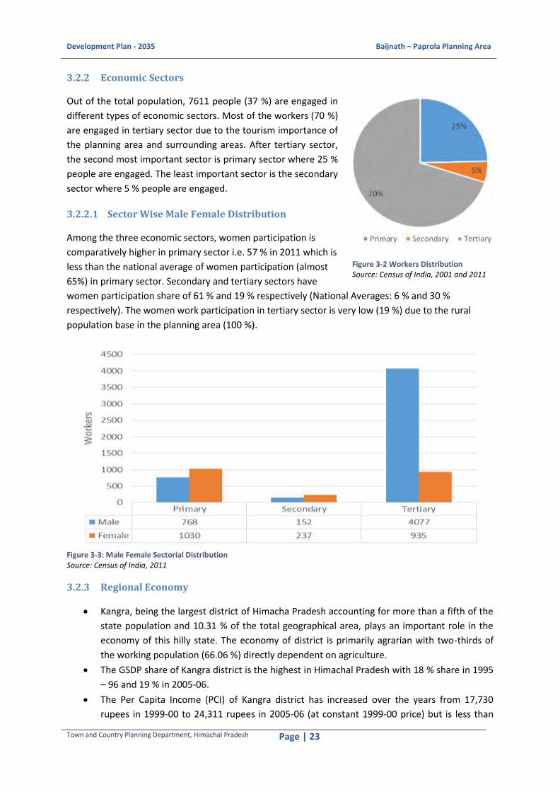
Development Plan - 2035 Baijnath – Paprola Planning Area
Town and Country Planning Department, Himachal Pradesh Page | 23
3.2.2 Economic Sectors
Out of the total population, 7611 people (37 %) are engaged in
different types of economic sectors. Most of the workers (70 %)
are engaged in tertiary sector due to the tourism importance of
the planning area and surrounding areas. After tertiary sector,
the second most important sector is primary sector where 25 %
people are engaged. The least important sector is the secondary
sector where 5 % people are engaged.
3.2.2.1 Sector Wise Male Female Distribution
Among the three economic sectors, women participation is
comparatively higher in primary sector i.e. 57 % in 2011 which is
less than the national average of women participation (almost
65%) in primary sector. Secondary and tertiary sectors have
women participation share of 61 % and 19 % respectively (National Averages: 6 % and 30 %
respectively). The women work participation in tertiary sector is very low (19 %) due to the rural
population base in the planning area (100 %).
Figure 3-3: Male Female Sectorial Distribution Source: Census of India, 2011
3.2.3 Regional Economy
Kangra, being the largest district of Himacha Pradesh accounting for more than a fifth of the
state population and 10.31 % of the total geographical area, plays an important role in the
economy of this hilly state. The economy of district is primarily agrarian with two-thirds of
the working population (66.06 %) directly dependent on agriculture.
The GSDP share of Kangra district is the highest in Himachal Pradesh with 18 % share in 1995
– 96 and 19 % in 2005-06.
The Per Capita Income (PCI) of Kangra district has increased over the years from 17,730
rupees in 1999-00 to 24,311 rupees in 2005-06 (at constant 1999-00 price) but is less than
Figure 3-2 Workers Distribution Source: Census of India, 2001 and 2011

Development Plan - 2035 Baijnath – Paprola Planning Area
Town and Country Planning Department, Himachal Pradesh Page | 24
the state average of 24,924 in 1999-00 to 31,414 in 2005-06. The PCI has increased to 1.37
times in a span of seven years which is slightly higher than the state increase of 1.26 times.
This is due to the huge share of population of the district to the overall population of the
state.
3.2.4 Sector wise analysis
Out of the total population, 7306 people (39 %) are engaged in different economic sectors. Most of
the workers (70 %) are engaged in the tertiary sector i.e. in business and public administrations etc.
Almost 25 % are engaged in the primary sector i.e. the agricultural and cultivation activities. The hilly
undulating terrain of the area makes it unsuitablefor extensive commercial cultivation. The share of
secondary sector is minimal with 5 %, which is mainly due to the limited number of small and micro
scale industrial workers.
3.2.4.1 Primary Sector
The primary sector is the second most contributing economic sector in the Planning Area with 25 %
work participation rate. It is also the second important sector in terms of the GDDP share during the
last decade.
3.2.4.1.1 Agriculture
Out of the total primary workers in the Planning Area, 87 % are engaged in agricultural activities. The
main cultivated crops are paddy (90 %) during Kharif season and wheat duringRabi season (85 %).15
The total irrigated area to total cultivated area is 74 %, which is more than the district average (43.82
%16). The main irrigation source is the Binwa River and Awa khad.17
it is evident that the agricultural lands are distributed uniformly in the entire planning area. Most of
the cultivable land parcles are found near the Pun khad and Binwa River as the soil at those places
are lose and porous and hence is suitable for cultivation.
In terms of production and trade, paddy is the main crop and is largely produced in the area and in
the district as well. The maize production has increased from almost 46 quintals per hectare in 2011
to almost 60 quintals per hectare in 2015. Simultaneously, the production of wheat has also been
increased from 41 quintals per hectare in 2011 to 46 quintals per hectare in 2015.18
The total cultivable land available in the Planning Area is 856.26 ha which accounts to almost 47 % of
the total land of Baijnath-Paprola Planning Area. Out of which 766.18 ha i.e. 90 % is under
agricultural use and 45.22 ha i.e. 5 % is under tea plantation and rest 44.86 ha i.e. 5 % under
horticultural use.
15 Source: Agriculture Department, Block Development Office, Baijnath Block, Baijnath 16 Source: Human Development Report, Kangra District 17 Source: Agriculture Department, Block Development Office, Baijnath Block, Baijnath 18Source: Agriculture Department, Block Development Office, Baijnath Block, Baijnath

Development Plan - 2035 Baijnath – Paprola Planning Area
Town and Country Planning Department, Himachal Pradesh Page | 25
Figure 3-4: Area under Cultivation in the Planning Area Source: Extract from the Satellite Image

Development Plan - 2035 Baijnath – Paprola Planning Area
Town and Country Planning Department, Himachal Pradesh Page | 26
3.2.4.1.2 Horticulture
The main horticultural crops in the region are mangoes, apples and citrus fruits like oranges, lemons,
litchi etc. Out of the total cultivable area in Baijnath-Paprola Planning Area, only 6 % area is under the
horticultural use. Area under horticultural use in Baijnath block is 2000 ha. approximately, out of
which 45.79 ha. i.e. 2.28 % is inside the Planning Area shows the horticultural production in the
Planning Area.
The production of horticulture crops in the Planning area is showing an upward trend from 2011-12
to 2015-16. There is almost 5 % growth from 2011-12 to 2015-16 in the block. The amount of
production of horticulture crops in the Planning Area is 1.13 Mt/ha. which is almost same with the
district average.
Apple cultivation has newly been introduced in this area; however, the state has good cultivation of
apples in other areas.19
Table 3-1 Production of Horticultural Crops in the Planning Area, (2011-12 to 2015-16)
Sl. No. Year Production (in tons)
1 2011 - 12 43
2 2012 - 13 45
3 2013 - 14 48
4 2014 - 15 49
5 2015 – 16 52 Source: Horticulture Department, Block Development Office, Baijnath Block, Baijnath
Figure 3-5Production of Horticultural Crops in the Planning Area, (2011-12 to 2015-16) Source: Horticulture Department, Block Development Office, Baijnath Block, Baijnath
3.2.4.2 Secondary Sector
Secondary sector contributes minimal to the economy in Baijnath-Paprola Planning Area in terms of
work participation rate and GDDP share. From 2005-06 the share of secondary sector in total GDDP
has decreased from 8 % to 7 % in 2009-10. This drop of share in district’s GDDP amount clearly
19Source: Horticulture Department, Block Development Office, Baijnath Block, Baijnath
0
10
20
30
40
50
60
2011 - 12 2012 - 13 2013 - 14 2014 - 15 2015 – 16
Pro
du
ctio
n in
to
nn
es
Year

Development Plan - 2035 Baijnath – Paprola Planning Area
Town and Country Planning Department, Himachal Pradesh Page | 27
indicates that the sector lags behind the other sectors in the district. In case of Baijnath and Paprola,
some of the micro scale units are functioning at local level.
3.2.4.3 Tertiary Sector
The non-agriculture sector in the district also has great potential to influence economic and social
well-being of the people. Tertiary sector or the service sector is the most important sector in the
Planning Area in terms of work participation rate and share in GDDP amount. The recent upsurge in
all types of connectivity has facilitated this transformation in a big way.
In 2000-01, the share was 68 % of the total GDDP of Kangra district, which have increased to 71 % in
2005-06 and to 75 % in 2009-10. This indicates that tertiary sector is the most important sector in
terms of its annual growth in GDDP share and work participation rate. The main tertiary sector
activities are constructions (39 %), trade and hotels (17 %), banking facilities (8 %), public
administration (9 %), Real estate (6 %) and Transportation (6 %) including railways. There are other
services as well whichaccounts 14 % of the total GDDP share.
Figure 3-6Important Activities in Tertiary Sector Source: Economic Survey of Himachal Pradesh, 2005-06
The potentials areas for service industry in the Planning Area are-
Repairing of Electrical/Electronic goods
Repairing of Agriculture Implements
Designer Boutique
Beauty and Health Care
Coaching Centre
Transportation
Mobile Repairing
TV/Cable/DTH Services
3.3 Employment Generation
Creating jobs is a keystone of any development plan making process. Considering that the
Development Plan - 2035 will boost the economic activities within the planning area and create more
opportunities for work, the planning area will have a substantially higher WPR i.e. 40 % till 2035.

Development Plan - 2035 Baijnath – Paprola Planning Area
Town and Country Planning Department, Himachal Pradesh Page | 28
Thus, the worker population in 2035 will be 11,421 considering an additional 1 % as floating
population the total workforce of planning area will be 14,276.
A break-up of the projected employment generation in each sector has been worked out in the
following table.
Table 3-2 Proposed Occupational Classification of Baijnath-Paprola
Sector Occupation Baijnath-Paprola (%)
Primary sector Agriculture, Forestry and Fishing 25 25
Secondary Sector
Light Industries and Composite Use Zone
2 5
Agro- based Industries 1
Construction Industry 2
Tertiary Sector Government Offices 9 70
Institutional Areas 17
CBD 20
Wholesale Trade (Integrated Freight Complex)
1
Transportation Hub 6
Retail Sector 17
Table 3-3 Proposed Employment generated by various activitiesin the Planning Area
Sl. No. Activity/Use Zone Number of Employees Percentage
1 Agricultural 3569 25
2 Agro- based IndustriesandLight Industries 714 5
3 Tourism Industry 714 5
4 Government Offices 1428 10
5 Institutional areas 2141 15
6 CBD 2854 20
7 Wholesale Trade (Integrated Freight Complex) 143 1
8 Transport Hub and Construction 572 4
9 Retail Sector 2141 15
Total 14,276 100
3.4 Proposed Work Areas
The employment preference of the planning area reveals that people prefer to work in tertiary
sector; they also prefer employment activities close to their home, e.g., agriculture, forestry and
fishing etc. Thus employment opportunities close to their residences would generate interest in the
local population.
3.4.1 Government Services
About 9 % of the people are engaged in the Government offices and it is projected that it will
increase in the near future hence there will be a requirement for employment generation in this
sector.
The existing Government Offices and the Civic corridor in village Ustehar form the important
employment generating area. Proposed Government Offices will be developed surrounding these
existing offices.

Development Plan - 2035 Baijnath – Paprola Planning Area
Town and Country Planning Department, Himachal Pradesh Page | 29
3.4.2 Light and Service Industries
The city needs an industrial base. Baijnath-Paprola broad region would provide skilled, unskilled and
semi-skilled labour for the proposed based industries and Tourism Hub. Industries like Agro-based,
Wellness Tourism, Furniture, Engineering Products/Repair and Maintenance, Real Estate,
Horticulture etc. are the sectors which is proposed to increase the Economy of the Planning Area.
3.4.3 Informal Sector
Service sector largely dominated by religious tourism, trade and commercial activities. Trade activity
includes purchasing and selling of all commodities whether produced domestically, imported or
exported. Tourism is another important sector that contributes significantly towards the tertiary
sector in the planning area. The growth in tertiary sector has spurred indirect employment demand
in certain unorganized sectors like security services and facilities management.
The informal sector trade and services are scattered within the Planning area. The informal sector
units locate themselves strategically near work centers, commercial areas, outside the boundaries of
schools, colleges and hospitals, transport nodes and near large housing clusters. It is proposed to
integrate the informal sector in trade and services in the planned development. This would be
appropriately incorporated in the following developments-
Community Centre
Neighborhood Shopping Centre
Convenient Shopping Centre
Homestays and Resorts
Travel Trade
Herbal Products
Warehousing and Packaging
Bus Terminal/Depot

Development Plan - 2035 Baijnath – Paprola Planning Area
Town and Country Planning Department, Himachal Pradesh Page | 30
4 HOUSING
4.1 Housing Status
The condition of houses20 in India is divided into three
categories, i.e. good, liveable and dilapidated. In
Baijnath-Paprola planning area, approximately 83 % of
the houses are in good condition and 16 % in liveable
condition whereas only 1 % houses are in dilapidated
condition. (Refer Figure 4-1 Condition of Houses in
Baijnath-Paprola Planning Area).
In most of the revenue villages of Baijnath-Paprola
Planning Area, the houses are in good condition but
only in three villages i.e. Khatrehar, Pandtehar, Bheth Jhikli, the number of liveable houses are
exceeding the number of good houses and i.e. Kasba
Paprola (5 %), Pandtehar (4 %), Majherna Khas (2 %)
and Paprola Khas (1 %) have some percentage of
houses in dilapidated condition.
4.2 Ownership of Housing
In the planning area, more than 75 % of the
households’ own houses (refer Figure 4-2 Ownership
Status of the households in Baijnath-Paprola Planning
Area) and the villages located along or near the
national highway and the railway line shows around
10% of rented houses.
4.3 Type of Structure
Houses are classified as permanent, semi-permanent
and temporary based on the type of material used in
construction of building, wall and roof. On an
average, 64 % of the houses in Baijnath-Paprola
Planning Area are permanent structures followed by
35 % households with semi-permanent structures and
only 1 % are temporary structures.
The temporary structures seem to be the
encroachments that occurred along the railway line, major roads and Binwa River.
20Government of India, 2011, Meta Data, Census of India 2011, Office of the Registrar General and Census Commissioner, Ministry of Home Affairs, India, p.6-7.
Figure 4-1 Condition of Houses in Baijnath-Paprola Planning Area Source: Housing Table HH-14, Census of India, 2011
Figure 4-2 Ownership Status of the households in Baijnath-Paprola Planning Area Source: Housing Table HH-14, Census of India, 2011
Figure 4-3 Type of Structures in Baijnath-Paprola Planning Area Source: Housing Table HH-14, Census of India, 2011
83%
16%
1%
Good
Livable
Dilapidated
Owned76%
Rented 10%
Any Other1% None
13%
64%
35%
1%
Permanent
Semi-Permanent
Temporary

Development Plan - 2035 Baijnath – Paprola Planning Area
Town and Country Planning Department, Himachal Pradesh Page | 31
Map 4-4 Existing Settlements in the Planning Area Source: Extract from the Satellite Image
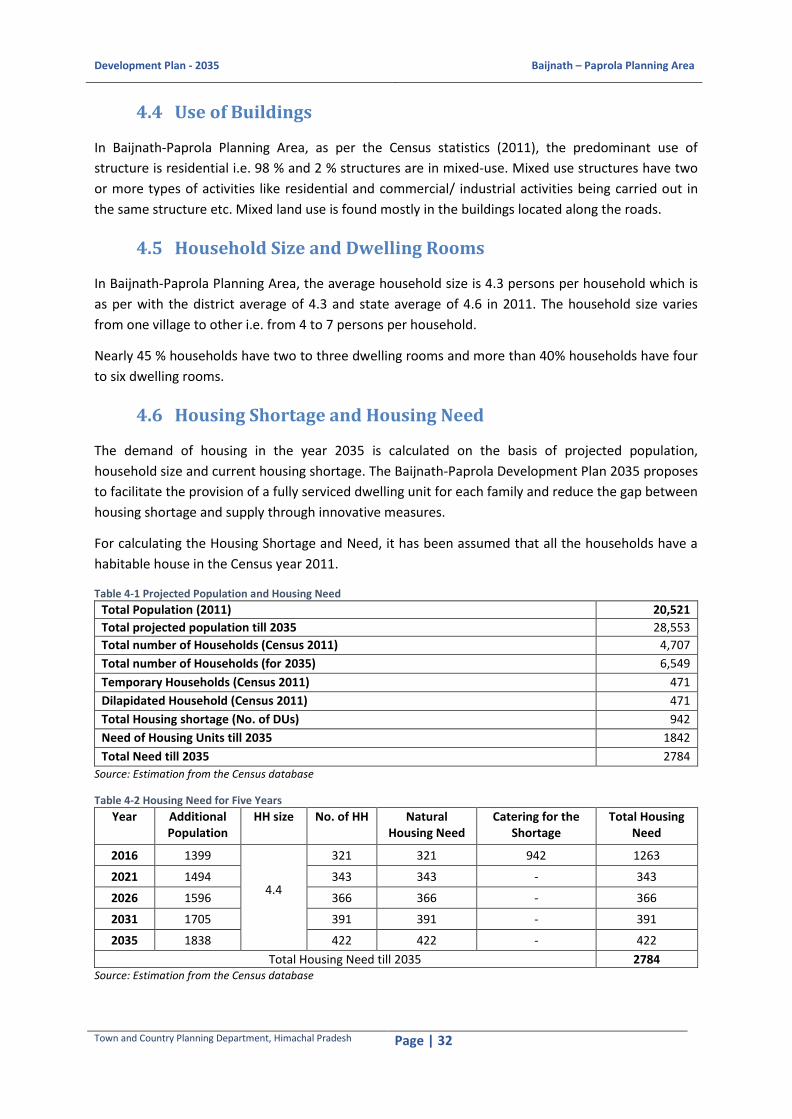
Development Plan - 2035 Baijnath – Paprola Planning Area
Town and Country Planning Department, Himachal Pradesh Page | 32
4.4 Use of Buildings
In Baijnath-Paprola Planning Area, as per the Census statistics (2011), the predominant use of
structure is residential i.e. 98 % and 2 % structures are in mixed-use. Mixed use structures have two
or more types of activities like residential and commercial/ industrial activities being carried out in
the same structure etc. Mixed land use is found mostly in the buildings located along the roads.
4.5 Household Size and Dwelling Rooms
In Baijnath-Paprola Planning Area, the average household size is 4.3 persons per household which is
as per with the district average of 4.3 and state average of 4.6 in 2011. The household size varies
from one village to other i.e. from 4 to 7 persons per household.
Nearly 45 % households have two to three dwelling rooms and more than 40% households have four
to six dwelling rooms.
4.6 Housing Shortage and Housing Need
The demand of housing in the year 2035 is calculated on the basis of projected population,
household size and current housing shortage. The Baijnath-Paprola Development Plan 2035 proposes
to facilitate the provision of a fully serviced dwelling unit for each family and reduce the gap between
housing shortage and supply through innovative measures.
For calculating the Housing Shortage and Need, it has been assumed that all the households have a
habitable house in the Census year 2011.
Table 4-1 Projected Population and Housing Need
Total Population (2011) 20,521
Total projected population till 2035 28,553
Total number of Households (Census 2011) 4,707
Total number of Households (for 2035) 6,549
Temporary Households (Census 2011) 471
Dilapidated Household (Census 2011) 471
Total Housing shortage (No. of DUs) 942
Need of Housing Units till 2035 1842
Total Need till 2035 2784
Source: Estimation from the Census database
Table 4-2 Housing Need for Five Years
Year Additional Population
HH size No. of HH Natural Housing Need
Catering for the Shortage
Total Housing Need
2016 1399
4.4
321 321 942 1263
2021 1494 343 343 - 343
2026 1596 366 366 - 366
2031 1705 391 391 - 391
2035 1838 422 422 - 422
Total Housing Need till 2035 2784 Source: Estimation from the Census database

Development Plan - 2035 Baijnath – Paprola Planning Area
Town and Country Planning Department, Himachal Pradesh Page | 33
4.7 Issues and Concerns
Temporary structures are encroaching the NH, railway line and Binwa river.
Building maintenance system is not prevalent in the area.
Areas of high built up density in the planning area need to be decongested.
The traditional style of construction is getting lost and often the new construction lacks any
definite character. A hybrid style has developed over time. Thus, a detailed study to identify
the style and nature of construction that is better suited to Baijnath-Paprola is required.
Different settlements are distributed in a dispersed mannerwith low population density. These
traditional settlements appear to have the ‘colour of the land’ and are vernacular in character. The
landscape, materials, techniques of making, all contribute to a common formal language of
settlements in Himachal Pradesh. The location of various settlements in the Baijnath-Paprola
planning area is shown in Map 4-4 Existing Settlements in the Planning Area.
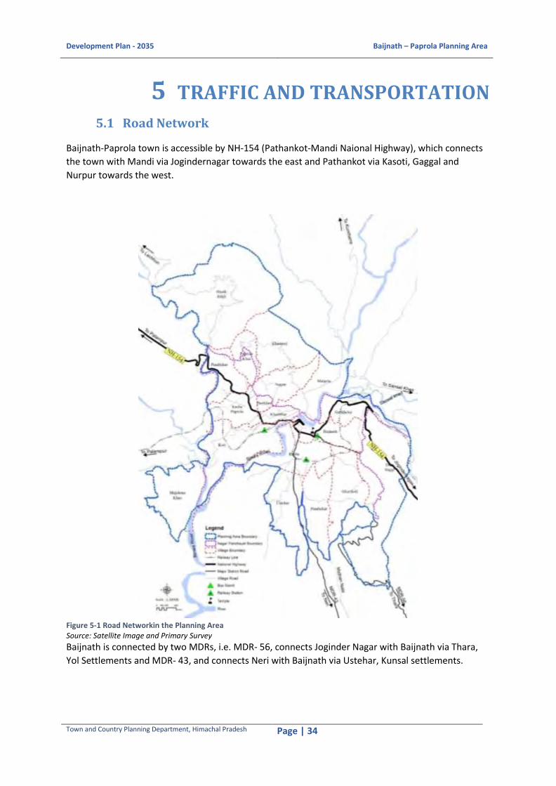
Development Plan - 2035 Baijnath – Paprola Planning Area
Town and Country Planning Department, Himachal Pradesh Page | 34
5 TRAFFIC AND TRANSPORTATION
5.1 Road Network
Baijnath-Paprola town is accessible by NH-154 (Pathankot-Mandi Naional Highway), which connects
the town with Mandi via Jogindernagar towards the east and Pathankot via Kasoti, Gaggal and
Nurpur towards the west.
Figure 5-1 Road Networkin the Planning Area Source: Satellite Image and Primary Survey
Baijnath is connected by two MDRs, i.e. MDR- 56, connects Joginder Nagar with Baijnath via Thara,
Yol Settlements and MDR- 43, and connects Neri with Baijnath via Ustehar, Kunsal settlements.

Development Plan - 2035 Baijnath – Paprola Planning Area
Town and Country Planning Department, Himachal Pradesh Page | 35
5.2 Road Inventory
The total length of the existing road network is about 54.84 km which includes National Highway 154,
MDR 43, MDR 56 and village roads at different revenue villages in the Planning Area. The length of
NH-154 passing through the Planning Area is about 7.15 km. The NH is two lane undivided road in the
Planning Area with 1.5-2m shoulders on both sides. The ROW of the NH in the Planning Area is of
10m out of which 7m is used as the carriage way and 3m as the shoulders (earthen) at both sides.
Within Baijnath town shoulders are not available at the edges of carriage ways of NH-154. The
structures have been built right from the edge of the carriage way without any setback. The length of
MDR-43 and MDR-56 is passing through the Planning Area are 2.49 km and 5.63 km respectively.
These are double lane road with 6-7 m carriage way and 1m earthen shoulder at both ends.
From the road inventory analysis, it is evident that NH-154 forms the primary road network (The
Trunk road) in the Planning Area connecting the district head quarter and other administratively
important towns/settlemets whereas the MDR-43 and 56 form the secondary road network
connecting the second order settlemets with Planning Area. The village roads form the third order
road netrowk which facilitate the intra Planning Area movement.
Table 5-1 Road Length in the Planning Area
Sl. No. Road Hierarchy Length (KM) Width (M)
1 National Highway 7.15 10.00
2 Major District Road (MDR) 8.12 7-9.00
3 Village Road 39.57 3-6.00 Source: Estimation from Satellite Imagery
Both of the MDRs are maintained by the PWD. The village roads and other link roads are maintained
by PWD and respective Gram Panchayats. Village roads, maintained by PWD are entirely metalled
roads. Out of the total road length maintained by PWD in the Planning Area, 9 km is upgraded under
Pradhan Mantri Gram Sadak Yojana in 2014-15 Financial Year. Three road stretches connecting
Paprola with Beth Jhikli via Pandtehar, connecting Paprola with Koti and connecting Baijnath with
Bhattu village have been identified and upgraded under PMGSY.
5.3 Vehicle Growth
Figure 5-2 Vehicle Growth in Baijnath Subdivision Source: SDM Office, Baijnath

Development Plan - 2035 Baijnath – Paprola Planning Area
Town and Country Planning Department, Himachal Pradesh Page | 36
Figure 5-2 Vehicle Growth in Baijanth Tehsil
depicts the average annual growth rate is 5 %
from 2011 to 2015. The highest growth rate was
experienced in 2014. After that, there is a steady
fall in overall vehicle growth till 2015.
The maximum registered vehicles are mainly the
two wheelers (63 %) and cars (26 %). The LMV
vehicle share is 6 % out of the total vehicles
registered in the area. Rest of the 5 % share
includes buses, three wheelers, tractors and
MGVs. This clearly illustrates the local roads get
the maximum volume of two wheelers and cars
(Refer Figure 5-3 Vehicle Classes in the Planning
Area).
5.4 Parking Facility
There are 2 designated off street parking spaces available in Baijnath town viz., one adjacent to
Baijnath temple about 530 Sqm. area with a capacity of 19 cars and another near the PWD rest house
beside the Sub-divisional post office of Baijnath of 850 Sqm. with a capacity of 30 cars. The parking
area near Baijnath Temple is used as taxi stand by the local taxi owners.
The available parking spaces cannot cater to the number of vehicles arriving during festival as almost
1 lakh people (nearly 22,000 families) come per day during weeklong festival out of which 1.3 %
families have cars (national average21) which is estimated to be 285 cars per day enter in the town.
For these many cars, sufficient parking space is not available. There is no provision of other means of
public transport, and for designated on street parking in the Town.
As per the norms of Town and Country Planning Department, Himachal Pradesh, one floor should be
provided for parking in all land uses. The ground coverage of the temple is about 1240 Sqm. hence a
parking area of 1240 Sqm. is required for Baijnath Temple, out of which 530 Sqm. is already available.
Additional 710 Sqm. area is required for parking area as per the norms.
5.5 Pedestrain Pathways
There is no designated pathways for the pedestrian movement in the town except a small stretch of
100 m from the edge of the public toilet block towards Baijnath ITI. The carriage way of NH-154 is
used by the pedestrians. The walkways are required as most of the people commute by walking
inside the Planning Area.
5.6 Public Transport
5.6.1 Road ways
Bus is the main mode of public transport in Baijnath Planning Area. The Planning Area is well-
connected with important towns and centres within and outside state by the roadways. The State
Govt. (Himachal Road Transport Corporation) and private buses do operate from the Baijnath Bus
terminal. Compared to other same sized towns in Himachal Pradesh, Baijnath has a designated bus
21 Source: GOI and MoRTH
Figure 5-3 Vehicle Classes in the Planning Area Source: SDM Office, Baijnath

Development Plan - 2035 Baijnath – Paprola Planning Area
Town and Country Planning Department, Himachal Pradesh Page | 37
terminus. Many of the buses terminates at Baijnath bus terminal and go to a distance of more than
500 km. Almost 80 % of the Planning Area comes under the catchment area of the public transport
facility and it serves 88 % population in the Planning Area.
Buses are available at every 10 to 15 minutes frequency for the neighbouring towns, located within
50 km. like Palampur, Bir, Mahakal, Chamunda, Dharamshala, Kangra etc. Towns located within 100
km, have bus connectivity in every 30 to 40 minutes. Towns sited beyond 100 km. have bus services
twice or thrice from the town.
Baijnath Planning Area has efficient intercity public transportation system in terms of the accessibility
(catchment area) and connectivity. Other than the bus, autos also run within the Planning Area.
Autos have a catchment radius of about 5 km, catering Baijnath town.
Taxi service is also available in Baijnath town. The local people or tourist can easily hire the taxi from
Baijnath Taxi stand.
5.6.2 Railways
Kangra Valley Railway is a narrow-gauge railway line connecting Pathankot with Jogindernagar via
Jwalamukhi, Kangra, Palampur and Baijnath-Paprola. Seven trips are made each day from Pathankot
to Jogindernagar out of which five trips terminate at Baijnath station.

Development Plan - 2035 Baijnath – Paprola Planning Area
Town and Country Planning Department, Himachal Pradesh Page | 38
Figure 5-4: Existing Public Transport Routes in the Planning Area Source: Primary Survey
5.7 Black Spots and Accidents
There are 4 black spots identified by the Police Thana Baijnath, located along NH-154 in the Planning
Area viz., Tashi Jong Chowk, Binwa Bridge, Gankheter Bhattu Chowk and Awahi temple chowk.
According to the SHO, Baijnath, the probable reasons of these accident prone black spots are as
follows:
1. The faulty designs of the junctions at different chowks.
2. No signage mentioning about the blind curves on the roads.
3. Obstruction in the drivers vision due to hills at one side of the roads.
4. Constructing of semi-permanent structures near junctions which blocks the vision.
5. Over speeding of vehicles along NH-154.
6. Not availing pre cautionary measures during driving (like wearing helmets or seat belts).

Development Plan - 2035 Baijnath – Paprola Planning Area
Town and Country Planning Department, Himachal Pradesh Page | 39
7. Frequent land slide near the Binwa Bridge.
Figure 5-5: Location of the Black Spots Source: Police Station, Baijnath
5.8 Average Daily Traffic (ADT) The summary of ADT, in terms of each class, vehicles and PCUs at the 4 count stations are done. ADT
(PCU) of 12 hours is 8068 near Tashi Chowk Survey Point (I), 3303 near SDM Complex at Survey Point
(II), 1973 on Majehrna Road at Survey Point (III) 5330 on Mandi Road at Survey Point (IV).
5.8.1 Daily Variation of ADT The variation from average is ranging from -26.00 % to +18.95 % near Tashi Chowk at Survey Point (I),
-10.08 % to +18.89 % near SDM Complex at Survey Point (II), -5.97 % to +3.52 % on Majehrna Road at
Survey Point (III) and -1.55 % to +2.81 % on Mandi Road at Survey Point (IV).
5.8.2 Hourly Variation of ADT Analysis has been carried out to understand hourly variation and peak hour traffic characteristics. The Peak Hour Factor and Peak hour PCUs details of each location are given in Table 5-2.

Development Plan - 2035 Baijnath – Paprola Planning Area
Town and Country Planning Department, Himachal Pradesh Page | 40
Table 5-2: Peak Hour Details
Location Peak Hour Peak Hour Factor (%) Peak Hour PCU
Near Tashi Chowk on Baijnath-Palampur Road, (Survey Point I)
5:00 PM-6:00 PM 10.27 804
Near SDM Complex on Mahakal-Baijnath Road (Survey Point II)
10:00 AM-11:00 AM 11.28 368
On Majehrna Road connecting Baijnath to Panchrukhi (Survey Point III) 10:00 AM-11:00 AM 11.05 221
On Mandi road connecting Mandi to Palampur (Survey point IV)
5:00 PM-6:00 PM 9.55 495
Source: Traffic Survey Analysis by Voyants 2016, Gurugram
5.8.2.1 Directional Distribution
Directional distribution of traffic has been analysed. The analysis reveals that there are no tidal flows on the roads in the project area. The directional distribution observed is 50:50 at all the survey locations except near Tashi Chowk at Survey Point I where it was found to be 60:40.
5.8.2.1.1 Traffic Composition
Analysis has been carried out to find out the composition of traffic and the results are illustrated in Figure 5-14 to 5-16. Cars and Two Wheelers contribute the most in traffic composition at all the
locations.
Figure 5-8: Traffic Compositions on Majehrna Road at
Survey Point III Source: Traffic Survey Analysis
Figure 5-9: Traffic Compositions on Mandi Road at Survey Point IV
Source: Traffic Survey Analysis
Figure 5-6: Traffic Composition near Tashi Chowk at Survey Point I
Source: Traffic Survey Analysis
Figure 5-7: Traffic Compositions near SDM Complex at Survey Point II
Source: Traffic Survey Analysis
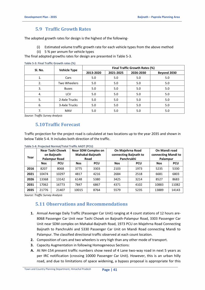
Development Plan - 2035 Baijnath – Paprola Planning Area
Town and Country Planning Department, Himachal Pradesh Page | 41
5.9 Traffic Growth Rates
The adopted growth rates for design is the highest of the following-
(i) Estimated volume traffic growth rate for each vehicle types from the above method (ii) 5 % per annum for vehicle types
The final adopted growths rates for design are presented in Table 5-3.
Table 5-3: Final Traffic Growth rates (%)
Sl. No. Vehicle Type Final Traffic Growth Rates (%)
2013-2020 2021-2025 2026-2030 Beyond 2030
1. Cars 5.0 5.0 5.0 5.0
2. Two Wheelers 5.0 5.0 5.0 5.0
3. Buses 5.0 5.0 5.0 5.0
4. LCV 5.0 5.0 5.0 5.0
5. 2-Axle Trucks 5.0 5.0 5.0 5.0
6. 3-Axle Trucks 5.0 5.0 5.0 5.0
7. MAV 5.0 5.0 5.0 5.0
Source: Traffic Survey Analysis
5.10 Traffic Forecast
Traffic projection for the project road is calculated at two locations up to the year 2035 and shown in
below Table 5-4. It includes both direction of the traffic.
Table 5-4: Projected Normal/Total Traffic AADT (PCU)
Year
Near Tashi Chowk on Baijnath-
Palampur Road
Near SDM Complex on Mahakal-Baijnath
Road
On Majehrna Road connecting Baijnath to
Panchrukhi
On Mandi road connecting Mandi to
Palampur
Nos PCU Nos PCU Nos PCU Nos PCU
2016 8207 8068 3775 3303 2103 1973 5235 5330
2021 10474 10297 4817 4216 2684 2518 6681 6803
2026 13368 13142 6148 5380 3425 3214 8527 8683
2031 17062 16773 7847 6867 4371 4102 10883 11082
2035 21776 21407 10015 8764 5579 5235 13889 14143
Source: Traffic Survey Analysis
5.11 Observations and Recommendations
1. Annual Average Daily Traffic (Passenger Car Unit) ranging at 4 count stations of 12 hours are-
8068 Passenger Car Unit near Tashi Chowk on Baijnath-Palampur Road, 3303 Passenger Car
Unit near SDM complex on Mahakal-Baijnath Road, 1973 PCU on Majehrna Road Connecting
Baijnath to Panchrukhi and 5330 Passenger Car Unit on Mandi Road connecting Mandi to
Palampur. The classified directional traffic observed at each count location.
2. Composition of cars and two wheelers is very high than any other mode of transport.
3. Capacity Augmentation in following Homogeneous Sections:
A. At NH-154 present traffic numbers show need of 4 Lane two-way road in next 5 years as
per IRC notification (crossing 10000 Passenger Car Unit). However, this is an urban hilly
road, and due to limitations of space widening, a bypass proposal is appropriate for this
Development Plan - 2035 Baijnath – Paprola Planning Area
Town and Country Planning Department, Himachal Pradesh Page | 42
area. Reasons for proposing bypass are given below-
i. Traffic forecast indicates crossing 10,000 Passenger Car Unit in next 5 years (in year
2021).
ii. Near Tashi Chowk present traffic is 8617 Passenger Car Unit and Near Railway
Crossing at Gankheter present traffic is 5497 Passenger Car Unit. This shows that
approximate 5000 Passenger Car Unit is through traffic and 3000 Passenger Car Unit is
local traffic for that available carriage way, which seems to be not sufficient for
future planning.
iii. Baijnath Temple, a very famous ancient temple of Lord Shiva, attracts a large
number of tourists and pilgrims from all over India and abroad throughout the year
for which there will be increase in vehicular as well as pedestrian traffic in that area.
iv. Paprola and Baijnath is a highly dense built-up area which generate high local traffic
movement (vehicles and pedestrian both).
v. Agro Based Industries, R&D Institute and Skill Development centres have been
proposed in the planningarea which will further increase vehicle and pedestrian
traffic in that local area.
vi. High volume through traffic will create issues of traffic congestion and accident
prone zone) in local area which can be avoided.
vii. The alignment of the proposed Bypassis from Pandtehar Village near
proposedbusand truck terminals to Gankheter Village near rail crossing; connecting
Paprola Khas, Kharanal and Malgota Village.
B. Near SDM Office at Ustehar at MDR-43 the entire area is administrative area and also
developing as residential area in future. Present traffic analysis on this road needs
atleast 2 Lane two-way road. So, proposal of a 12m wide 2 lane road is to be considered
for future traffic activities.
C. From tourism point of view a Tourism Hub has been proposed at Malgota village where
camping, jungle safari, etc facilities have been proposed for tourists. From there a
Nature’s Trail has been proposed directly to Baijnath Temple for congestion-free
movement of pedestrian.
D. However typical cross-section for the study area can be adopted from the IRC code for
hilly area.
4. Present traffic on Majehrna Road in Koti Village is 2072 Passenger Car Unit. Following points are considered and accordingly proposals of this area has been given below-Existing carriageway of road is 7m which is building to building distance.
i. This area is proposed for Commercial Cultivation which will generate the additional
traffic in this area majorly goods vehicular traffic.
ii. The goods vehicular traffic will continue utilizing NH-154 and generate issues like
increasing congestion, accident prone spots etc.
iii. To avoid these issues, a proposal of 12m wide direct link from Ayurveda College Gate
connecting to NH-154 has been proposed at Pandtehar Village near proposed Bus
Terminal.

Development Plan - 2035 Baijnath – Paprola Planning Area
Town and Country Planning Department, Himachal Pradesh Page | 43
5.11.1 Transit Facilities
Private two-wheelers are the most common form of transit in the planning area. Access to public
transit facilities is mostly by walking. Passenger loading/unloading from these vehicles as well as
parking takes place within the carriageway – obstructing the vehicular traffic in most cases.
At present, the operation is in the hand of private operators which prefer routes where trip density is
favourable and transit patronage is high.
Looking at the future development of residential and non-residential use, there is a urgent need to
expand and augment the public transport facilities. Active intervention of public sector may be
needed along some of the non-profitable routes, primarily-
To increase the transit frequency and to reduce dependency on private modes.
To make new areas of development accessible to all section of people.
To protect local environment from further deterioration (particularly from vehicular
pollution).
5.11.2 Parking Management
High vehicle ownership pattern, dense mixed-use pattern along the road, high tourism potential and
excessive reliance on private mode of transport, i.e., two-wheelers and cars exert huge parking
demand. As most of the parking demand is met by on-street parking due to negligible provision of
off-street parking, this is perhaps the biggest contributor to traffic congestion in the Core Area.
The parking areas have been proposed along the NH-154 to cater the existing and increasing parking
needs. One Multi Level car parking area is proposed near the Baijnath Chowk. Two parking areas
have also been identified in Paprola.
Apart from parking of cars, significant numbers of taxi, jeep, LCV and trucks are found to be parked
along some of the links. Idle bus parking should be restricted to dedicated bus stands. Taxi parking
should be encouraged only at certain location where its parking will not interfere much with the
vehicular flow. The stretch from Choubin chwok to Railway Crossing at Gankheter will be notified as
the No Parking Zone.
5.11.3 Upgradation of Pedestrian Facilities
Certain measures listed below must be adopted along road links to improve the pedestrian
movement condition.
1. Adequate walkways commensurate to the pedestrian traffic volume on both sides of the
carriageway for safety of people. The stretch has intermittent footpaths should be converted
to continuous stretches as far as possible.
2. Complete restriction of on-street parking on pedestrian pathways – even if they are lying
empty.
3. Integration of steps with walkways to create an efficient system of pedestrian network for
fast movement, particularly within the core area.
4. Improvement of surface condition for steps with due attention to riser/tread width as well as installation of railings and intermediate landing facilities to facilitate pedestrian movement

Development Plan - 2035 Baijnath – Paprola Planning Area
Town and Country Planning Department, Himachal Pradesh Page | 44
and safety.
5. Provision of alternate pedestrian route to the temple for managing the pilgrim’s movement during the peak season.
5.11.4 Safety Issues
Most of the accidents recorded take place along the highways and regional linkages. Basic reasons
are difficult road alignment, poor road geometry, bad road surface conditions, unstable road
pavements and frequent landslides. The land slide prone area near the Binwa Bridge, should be
stabilised with the retaining wall.
Most of the links do not have adequate footpaths on both sides to accommodate the high pedestrian
volume – forcing them to move along the carriageway. Low traffic speed within the city significantly
reduces the probability of accident in spite of very high level of pedestrian vehicular conflict. Steps,
which helps to reduce travel distances for pedestrians are often in bad condition. The major
deficiencies are: -
i) Inadequate/irregular riser and tread.
ii) Uneven surface condition.
iii) Poor illumination.
iv) Insufficient railing and landing facilities for long flight of steps.
5.11.5 Road Signs
Presently, the absence of the propoer road signages cause fatal and other accidents in the Planning
Area. Appropriate road signs are to be provided along the major roads where ever needed.
5.12 Future Urban Structure and its Impact on Trip Characteristics
The allocation of future population in the Planning Area reveals that most of the new population in
the coming years will be accommodated on the South-Western and Southern sides of the existing
urban structure. This will have significant impact on the travel characteristics of the city.
This will invariably reduce share of pedestrian trip and increase vehicular trip. At present, a
significant portion of the trips are short distance and pedestrian in nature.
Available modes of transport in town, offers limited choice to people and higher reliance on private
modes is observed, especially two-wheelers. Lack of appropriate facilities and rising income will
increase number of private vehicle and travel trips by private vehicles.
Vehicle ownership is already quite high – nearly 63 % of households’ own two-wheelers and 26 %
own four wheelers.22 The income and people’s affordability of vehicle ownership, is also high. This
will further increase vehicular traffic on already congested urban road network unless commensurate
augmentation of network capacity is not undertaken.
There is a need for creation of an expanded road network not only for creating access to the planning
zones with new development activities but to relieve congestion from the core area. A significant
22 Source: Primary Survey

Development Plan - 2035 Baijnath – Paprola Planning Area
Town and Country Planning Department, Himachal Pradesh Page | 45
share of the through traffic which is borne by the existing North-South corridor can be diverted to
more direct links across Planning zones within Baijnath-Paprola.
5.13 Strategic Recommendations
There is an urgent need to restructure the transport management mechanism to meet the future
demand with satisfactory level of service.
For effectively implementing the provisions of Himachal Pradesh Transport Policy 2014, a committee
headed by the Transport Minister should be notified that will hold meetings on quarterly basis and
review the implementation of this policy. Evaluation studies should be undertaken in various
segments of the transport operation to guide the implementing agencies on various options and
their possible outcomes.
Comprehensive and holistic approach to transport management is needed to cope with the growing
complexity of the transport sector as well as its inter-dependence with other urban sectors.
Creation of an Urban Transport Management Authority as an organization to undertake this task has
been widely acclaimed as the appropriate solution. The salient tasks of this authority will be-
1. To co-ordinate actions of various public and private agencies providing transport infrastructure and services.
2. To arrive at a regulatory frame work for operations of various service providers, particularly transit and parking facilities.
3. Planning for future transport demand and supply management taking proposed land use into consideration.
4. To monitor the environmental and socio-economic impact of the existing transport system and for future investments.
5. To effectively control vehicle ownership and dependence through a set of fiscal and regulatory controls.
6. Capacity building, both managerial and technical, for institutions under its umbrella.

Development Plan - 2035 Baijnath – Paprola Planning Area
Town and Country Planning Department, Himachal Pradesh Page | 46
6 PHYSICAL INFRASTRUCTURE
6.1 Water Supply
6.1.1 Existing Situation and Demand Estimation
Baijnath-Paprola Planning Area utilizes both surface water (River and Spring) and ground water to
cater to its water supply needs. The total water supply in the Planning Area is 1.274 MLD out of which
1.171 MLD is supplied through piped water supply and 0.103 MLD is through community hand
pumps. The water supply in Baijnath – Paprola Planning Area is majorly catered through water supply
schemes; 92 % Piped Water Supply (PWS) and 8 % is through hand pumps i.e. through ground water.
The Planning Area has 10 piped water supply schemes supplied to around 18642 users (as per 2011
Census), out of which 8 are through spring sources while the rest 2 are from river source. 5 of the
water supply schemes supply water at the rate of 70 lpcd, which is the standard service level as per
the CPHEEO Manual – 2000 for non-sewered areas, while remaining 5 supply water in the range of
40-50 lpcd.
CPHEEO Manual, norms are adopted for calculating water demand for base year, intermediate year
and target year 2035.
Water supply should be increased to 135 lpcd for residential purposes and for other purposes,
consumption rate as mentioned in CPHEEO Manual.
Table 6-1: Total Water Demand and Gap
Description Year
2016 2026 2035
Total Domestic Population 21920 25010 28553
Total Domestic Water Demand (MLD) 2.96 3.38 3.85
Commercial Demand (MLD) 0.25 0.28 0.32
Industrial Demand (MLD) 0.05 0.06 0.06
Institutional Demand (MLD) 0.12 0.13 0.15
Estimated Tourist 10329 21684 47153
Estimated Domestic 9426 18630 36821
Estimated Foreign 902 3054 10332
Water Demand for Tourist (MLD) 1.86 3.90 8.49
Floating Population 5323 6075 6924
Floating Demand (MLD) 0.24 0.27 0.31
Total Water Demand (MLD) 5.47 8.02 13.19
15% losses (UFW) (MLD) 0.82 1.20 1.98
Sub Total (MLD) 6.29 9.23 15.17
2% Fire Fighting (MLD) 0.12 0.18 0.30
Grand Total of Water Demand (MLD) 6.41 9.41 15.46
Existing Supply (MLD) 1.27 1.27 1.27
Gap (MLD) 5.14 8.13 14.19 Source: Calculated as per CPHEEO Manual
The total water demand for base year 2016, intermediate year 2026 and target year 2035 is 6.41
MLD, 9.41 MLD and 15.46 MLD respectively. At present, water supply does not take into account the
floating population and fire fighting requirement. Hence to bridge the supply gap, water supply
system needs to be augmented to meet out water demand at different stages of development.

Development Plan - 2035 Baijnath – Paprola Planning Area
Town and Country Planning Department, Himachal Pradesh Page | 47
6.1.1.1 Water Sources and Treatment
The existing water sources can be used to meet up water demand for the planning area. Presently,
existing water treatment plant is required to be augmented as per demand estimation.
Table 6-2: Water Treatment Demand
Sl. No. Description Year
2016 2026 2035
1 Total Water Demand (MLD) 6.41 9.41 15.46
2 WTP Capacity Required (MLD) 7.34 10.78 17.71
3 Existing WTP Capacity (MLD) 1.17 1.17 1.17
4 Augmentation required (MLD) 6.17 9.60 16.54 Source: Calculated as per CPHEEO Manual
6.1.1.2 Fire Stations and other Fire-Fighting Facilities
Presently, in Baijnath-Paprola Planning Area, there is one fire station adjacent to SDM office at
Baijnath. The projected population of Baijnath-Paprola Planning Area is 28,553 for the year 2035.
Hence, current provision for fire services in Baijnath-Paprola Planning Area are sufficient to cater the
needs.
6.1.2 Service Level Benchmarking
Service level benchmarkings have been formulated by the MoUD, with a view to achieve all-round
sustainability including environmental sustainability.
Table 6-3: Service Level Benchmarking for Water Supply System
Sl. No.
Services Ultimate Benchmark as per MoUD, GoI Guidelines
Present Status (%)
Aim to achieve in Long Term
1 Coverage of Water Supply connections
100 90 100
2 Per Capita Supply of Water in Project area
135 lpcd 70 lpcd 135 lpcd
3 Extent of Non-revenue Water 15 NA 15
4 Extent of Metering 100 NA 100
5 Continuity of Water supplied 24 Hours NA 24 Hours
6 Efficiency in redressal of customer complaints
80 NA 80
7 Quality of Water Supplied 100 NA 100
8 Cost Recovery 100 NA 100
9 Efficiency in collection of Water charges
90 NA 90
Source: Based on NMSH, MoUD, GoI, 2014
6.1.3 Key Issues and Challenges
The existing water supply system for the study area is not sufficient to cater even the existing
water demand of the area-
Intermittent water supply system
Water losses
Consumers lack awareness for consumption of water
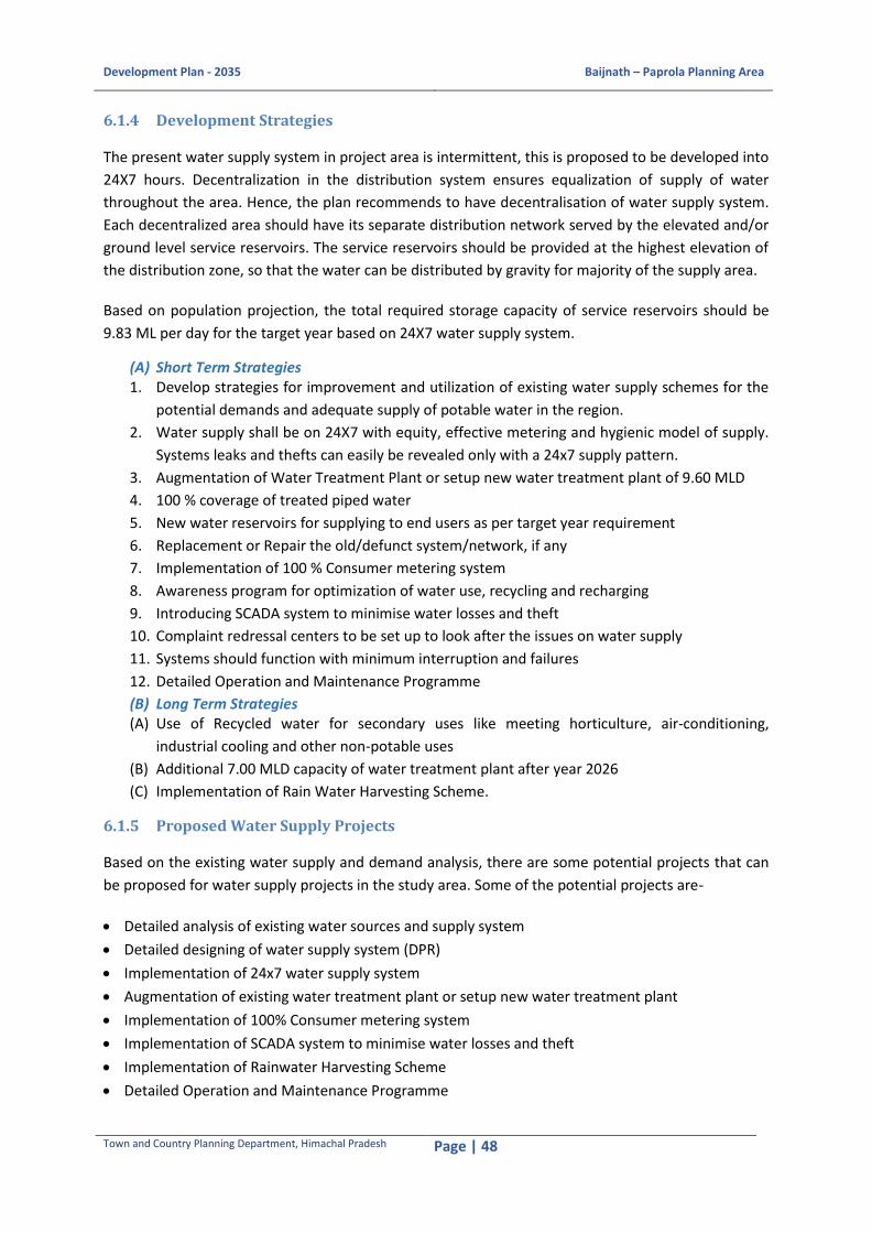
Development Plan - 2035 Baijnath – Paprola Planning Area
Town and Country Planning Department, Himachal Pradesh Page | 48
6.1.4 Development Strategies
The present water supply system in project area is intermittent, this is proposed to be developed into
24X7 hours. Decentralization in the distribution system ensures equalization of supply of water
throughout the area. Hence, the plan recommends to have decentralisation of water supply system.
Each decentralized area should have its separate distribution network served by the elevated and/or
ground level service reservoirs. The service reservoirs should be provided at the highest elevation of
the distribution zone, so that the water can be distributed by gravity for majority of the supply area.
Based on population projection, the total required storage capacity of service reservoirs should be
9.83 ML per day for the target year based on 24X7 water supply system.
(A) Short Term Strategies 1. Develop strategies for improvement and utilization of existing water supply schemes for the
potential demands and adequate supply of potable water in the region.
2. Water supply shall be on 24X7 with equity, effective metering and hygienic model of supply.
Systems leaks and thefts can easily be revealed only with a 24x7 supply pattern.
3. Augmentation of Water Treatment Plant or setup new water treatment plant of 9.60 MLD
4. 100 % coverage of treated piped water
5. New water reservoirs for supplying to end users as per target year requirement
6. Replacement or Repair the old/defunct system/network, if any
7. Implementation of 100 % Consumer metering system
8. Awareness program for optimization of water use, recycling and recharging
9. Introducing SCADA system to minimise water losses and theft
10. Complaint redressal centers to be set up to look after the issues on water supply
11. Systems should function with minimum interruption and failures
12. Detailed Operation and Maintenance Programme
(B) Long Term Strategies (A) Use of Recycled water for secondary uses like meeting horticulture, air-conditioning,
industrial cooling and other non-potable uses
(B) Additional 7.00 MLD capacity of water treatment plant after year 2026
(C) Implementation of Rain Water Harvesting Scheme.
6.1.5 Proposed Water Supply Projects
Based on the existing water supply and demand analysis, there are some potential projects that can
be proposed for water supply projects in the study area. Some of the potential projects are-
Detailed analysis of existing water sources and supply system
Detailed designing of water supply system (DPR)
Implementation of 24x7 water supply system
Augmentation of existing water treatment plant or setup new water treatment plant
Implementation of 100% Consumer metering system
Implementation of SCADA system to minimise water losses and theft
Implementation of Rainwater Harvesting Scheme
Detailed Operation and Maintenance Programme

Development Plan - 2035 Baijnath – Paprola Planning Area
Town and Country Planning Department, Himachal Pradesh Page | 49
6.2 Sewerage System
The components of sewerage system are the house connection, conveyance network, pumping
system, the treatment facility and the disposal strategy. The conveyance is by gravity and the
treatment facility is located at the lowest point.
6.2.1 Existing Situation and Demand Estimation
At present, Baijnath – Paprola Planning Area does not have any central sewage network. The
planning area being situated in a hilly terrain, utilises individual septic tanks for sewage disposal.
Taking 80 % of total water supply and 10 % infiltration as per CPHEEO Manual, future sewage
generation projected is as follows:
Table 6-4: Sewerage Generation and Gap
Sl. No. Description Year
2016 2026 2035
1. Sewage Generation (MLD) 4.84 7.16 11.88
2. Total Sewage Generation including infiltration (MLD) 5.33 7.88 13.07
3. STP Capacity (MLD) 5.59 8.27 13.73
4. Existing STP Capacity (MLD) 0.00 0.00 0.00
5. Augmentation required (MLD) 5.59 8.27 13.73 Source : Calculated as per CPHEEO Manual
6.2.1.1 Sewage Treatment and Disposal
Currently, the planning area generates 5.33 MLD of sewage. Projected sewage generation for 2035
will be 13.70 MLD and there is no facility for centralised/decentralized collection, treatment and
disposal of the sewage generated.
6.2.2 Service Level Benchmarking
The following table explains the existing and proposed service level benchmarks of Sewerage and
Sanitation of the planning area.
Table 6-5: Service Level Benchmarking for Sewerage and Sanitation (2015-2035)
Sl. No. Services Ultimate Benchmark as per MoUD, GoI Guidelines (%)
Present Status (%)
Aim to achieve in Long Term
1 Coverage of Toilets 100 86 100
2 Coverage of Sewerage Network Services
100 0 100
3 Collection Efficiency of Sewerage Network
100 0 100
4 Adequacy of Sewage Treatment capacity
100 0 100
5 Quality of Sewage Treatment
100 0 100
6 Extent of reuse and recycling of sewage
20 0 20
7 Efficiency in redressal of customer complaints
80 0 80
8 Extent of cost recovery in sewage management
100 0 100

Development Plan - 2035 Baijnath – Paprola Planning Area
Town and Country Planning Department, Himachal Pradesh Page | 50
9 Efficiency in collection of sewerage charges
90 0 90
Source : Based on NMSH, MoUD, GoI, 2014
6.2.3 Key Issues and challenges
Nonexistence of the centralized sewerage network
Open defecation
Discharge of domestic sewage, rotten food materials and vegetation into natural drains and water
bodies
6.2.4 Development Strategies
As per the gap and deficiencies identified in the existing sewerage system of the study area, an
integrated approach is required to cater to the sustainable solution.
1. To develop a proper sewage collection and treatment system.
2. To recycle/reuse of waste water to incorporate in the Planning Area to reduce the burden on
water supply system. All the household/community septic tanks to be connected to the
sewer network.
3. It is to be ensured that Sewage flows through gravity minimizing the use of energy for
pumping.
4. Reuse options for Treated Wastewater 5. Treated water from STP should be recycled as per URDPFI Guidelines and sludge can be used
as manure for agriculture and plantation. The plan CPHEEO aims should be aimed to achieve 100% coverage of sewerage connections to every household.
6.2.5 Proposed Sewerage System Projects
Based on the existing system and demand analysis, there are some potential projects proposed for
sewerage system in the study area. Some of the potential projects are-
Detailed analysis of existing system
Detailed designing of sewerage system (DPR)
Implementation of decentralized collection, treatment and disposal of the sewage generated
Sewerage Treatment Plant
Construction of adequate public toilets complex at public places
Recycle and use of treated sewage
Detailed Operation and Maintenance Programme
6.3 Storm Water Drainage Network
6.3.1 Existing Situation and Demand Estimation
Baijnath-Paprola Planning Area has topography and natural drainage slope pattern from North-East
South-East to South-West direction. The highest elevation is in the North with more than 1400m
above the sea level and the lowest is towards the south with less than 1000m above sea level. The

Development Plan - 2035 Baijnath – Paprola Planning Area
Town and Country Planning Department, Himachal Pradesh Page | 51
Planning Area has one natural water body, the Binwa River, which runs along the North-Eastern to
South-Western side. The surface run-off is from North-East to South-West.
In addition, there are various nalas and khads in the Planning Area which have their outfall into the
Binwa River. The Sansal Khad and Kheer ganga connects the Binwa River on the North-East and also
the Pun Khad on the South-West. The river caters to the discharge from these drains and khads in the
surrounding areas. Also, there are small water channels in Baijnath Area have their run-off towards
the South.
As per PWD, presently, Baijnath – Paprola Planning Area has a road length of about 19.45 kms out of
which 53 % have storm water drains i.e. for a length of about 10.57 kms. Hence, there is a gap of 8.88
kms of road length without storm water drains in the Planning Area.
Based on the gap, an integrated approach is proposed, some of the drains will run alongside the
roads (Roadside Drains) and others may follow natural slope (Cross Drain).
Rainfall intensity calculated from monthly rainfall data of last 11 years comes out to be 92.05 mm/hr.
considering once in 5 years as storm frequency and 30 minutes as Time of concentration.
Figure 6-1: Intensity-Duration Curve
Source: Calculated based on CPHEEO Manual
The Planning Area is broadly divided into 99 catchments, which is further divided into smaller sub-
catchments. All the major Catchments discharge into major streams/water bodies. Key feature of the
network, is use of natural streams, to minimize the drain section. Several outfalls are proposed in
order to enable safe conveyance of runoff discharge. Two major streams flowing through the project
area receives run off through major catchment basin. The total runoff generated for entire study area
is 303.077 Cubic metre per second.
6.3.2 Service Level Benchmarking
Service level benchmarking have been formulated by the MoUD with a view to achieving all-round
sustainability including environmental sustainability.
322.64
198.61
149.53122.26
104.58
92.0575.26
69.30
64.38 56.66 46.33 39.63
0
50
100
150
200
250
300
350
0 10 20 30 40 50 60 70 80 90 100Rai
n F
all I
nte
nsi
ty (
I) in
mm
/h
r
Duration (T) in min

Development Plan - 2035 Baijnath – Paprola Planning Area
Town and Country Planning Department, Himachal Pradesh Page | 52
Table 6-6: Service Level Benchmarking for Storm water Drainage System
Sl. No. Services Ultimate Benchmark as per MoUD, GoI Guidelines (%)
Present Status (%)
1 Coverage of storm water drainage network 100 53
2 Incidence of water logging 0 NA
3 Construction of new drains and conversion of Katcha drains (earthen, natural drains) into Pucca drains with additional provision to carry 20 % discharge.
100 NA
4 Cleaning of drains twice in a year 100 NA
5 Incidence of people affected in vulnerable areas and property damaged during flooding.
0 NA
6 Rejuvenation of water bodies once in two years.
100 NA
7 Provision of pumping arrangement in low lying areas/water logging areas.
100 NA
8 Extent of rain water harvesting in buildings etc.
100 NA
9 Incidence of sewage mixing in the drains 0 NA
Source: Projections based on NMSH, MoUD, GoI, 2014
6.3.3 Key Issues and challenges The existing system has problems, which are as follows:
a) In absence of regular solid waste collection, wastes dumped into the drains, kuls which leads
to choking and overflowing of drains.
b) The natural storm water is mixed with garbage which creates environmental pollution and
public health concerns
c) Most of the areas within planning area are not provided with a proper and planned drainage
system
d) The city has poor capacity for effective periodic maintenance of the drains in terms of
cleaning and de-silting
6.3.4 Development Strategies
The drains will run along the roads, either one side or both side as per road camber. Wherever the
drain is proposed to be covered, it will be necessary to provide a horizontal/vertical entry into the
drain at the same time not obstructing free passage for the pedestrians or vehicles. Hence, wherever
road width is more than 10 m, kerb opening inlets can be proposed at every 50 m interval to provide
horizontal entry into the drain. Since the road width is less than 10 m Kerb Inlets cannot be
accommodated, Perforated Cover Slabs are proposed at every 50 m interval.
All the primary and secondary drains should be covered. These covers will protect the storm drains
from disposal of garbage, debris, etc. and also may serve as walkway for pedestrian in narrow roads.
a) Storm Water Drainage (SWD) system should be designed as a separate system to carry storm
water by gravity for the entire project area. Storm water drains shall be designed with proper
gradient, which will create a self-cleansing velocity, as these drains will carry storm water
along with grit, silt and other impurities. All the primary storm water drains should be
designed to have a capacity to carry the total discharge of all secondary and tertiary storm
water drains.

Development Plan - 2035 Baijnath – Paprola Planning Area
Town and Country Planning Department, Himachal Pradesh Page | 53
b) Existing nallahs running through the study area should be improved to increase the efficiency
of natural channels. Improvement works shall consist of desilting of channel, development of
edge of drains/ nallahs, improvement of side slopes and development of green belt around
the nallahs and provision of culverts at road crossings.
c) Detailed Operation and Maintenance Programme
d) Detailed Hydrological study for further proper flood management plan
6.3.4.1 Flood Management
It is proposed to rejuvenate the river and detailed study of the existing condition of culverts and
bridges to improve their hydraulic capacity. There is a need to improve the natural drainage by de-
silting the natural drains and removing the blockages. The existing storm network along the roads
needs to be strengthened in terms of coverage and capacity. A hydrology model should be developed
for flood management.
There would be a requirement of estimation of flood generated from each stream with objective of
protection from flood and uninterrupted communication for the town. To achieve this, the extent of
flood and its duration shall be noted down at critical locations so that the formation levels/plinth
levels of the infrastructure can be finalised keeping in mind the flood levels at flood prone areas, for
culverts, stream/river bank protection works etc.
6.3.4.2 Rainwater Harvesting
Water level declines as a result of injudicious exploitation of groundwater resource. Some of these
problems are reduced well yields, low water level and leakage into the aquifer of highly mineralised
water. In order to over-come these serious environmental implications, rain water harvesting is
proposed.
6.3.5 Proposed Projects
Based on the existing system and gap analysis, there are some potential projects can be proposed in
the development plan.
a) Detailed Master Plan for Storm Water Drainage system for further detailed assessment and
solution of drainage proposal
b) Detailed Hydrological study of existing nallahs/ canals/ river for proper flood management
plan and to improve efficiency to cater storm water from outfalls.
c) Detailed designing of storm water system (DPR)
d) Proper outfall structures
e) Rainwater harvesting system
f) Detailed Operation and Maintenance Programme
6.4 Solid Waste Management
6.4.1 Existing Situation and Demand Estimation
At present, there is no solid waste management system in Baijnath – Paprola Planning Area. Garbage
is being openly dumped in large quantities along roads and streams. Apart from open dumping, solid

Development Plan - 2035 Baijnath – Paprola Planning Area
Town and Country Planning Department, Himachal Pradesh Page | 54
waste is also burned by the people outside their household premises. There is a Solid waste landfill
site in Paprola town, however it is not in use now.
6.4.2 Bio Medical Waste
The bio medical waste generated from hospitals in the Planning Area is disposed by a private agency,
M/s Bio-medical Waste Treatment Plant Pvt. Ltd. located in Pathankot, Punjab. The treatment plant
has an incinerator of 200 Kg/hr., an Autoclave and a Shredder and it caters for the collection and
transportation of the bio medical waste generated on a weekly basis.
6.4.3 Projected SWM Generation and Gap Assessment The number of waste generating inhabitants as well as collection is assumed to rise to a higher
percentage of the total population. With passing time as a consequence of ameliorated collection
systems the percentages are due to rise in coverage from 0 in 2016 to 100 % in 2035. The daily waste
production is estimated to increase from 4.57ton/day to 41.74ton/day with population growth rate
of 1.33 % pa.
The following table (Table 6-7: Solid Waste Generation and Gap) gives estimated solid waste
generated in the Planning Area at the end of the plan period (2035) and the estimated waste
reaching the land fill site.
The following assumptions were considered:
Waste generated per day: 0.3 kg per capita per day
Solid waste growth factor: 1.33 % per annum (ministry of urban development standard)
Quantity of solid waste reaching landfill: 39 % of total waste (based on national average)
Table 6-7: Solid Waste Generation and Gap
Sl. No. Description 2016 2026 2035
1 Population 21,920 25,010 28,553
2 Solid Waste Generation Annual (tons/day) 4.57 8.12 13.97
3 Existing Treatment Facility (tons) Nil Nil Nil
4 Infrastructure required Solid waste segregation, collection, transportation and treatment and landfill site for disposal are required
Source : Calculated as per CPHEEO Manual and MoUD Standard
6.4.4 Service Level Benchmarking
Table 6-8: Service Level Benchmarking for Solid Waste Management (2016-2035)
Sl. No. Services Ultimate Benchmark as
per MoUD, GoI Guidelines (%)
Present Status (%)
Aim to be achieved in Long
Term
1 Household level coverage of SWM services through door-to-door collection of waste
100 0 100
2 Collection Efficiency of Solid waste 100 0 100
3 Extent of segregation of waste 100 0 100
4 Extent of MSW Recovered 80 0 80

Development Plan - 2035 Baijnath – Paprola Planning Area
Town and Country Planning Department, Himachal Pradesh Page | 55
Sl. No. Services Ultimate Benchmark as
per MoUD, GoI Guidelines (%)
Present Status (%)
Aim to be achieved in Long
Term
5 Extent of scientific disposal of waste of landfill sites
100 0 100
6 Efficiency in redressal of customer complaints
80 0 80
7 Extent of cost recovery for ULB/NP/Authorized agency in SWM services
100 0 100
8 Efficiency in collection of SWM charges
90 0 90
Source : Projections based on NMSH, MoUD, GoI, 2014
6.4.5 Issues and Concerns
The analysis of existing solid waste management practices of study area indicates that it has no
structured primary and secondary collection, disposal arrangements. Solid waste management for
study area requires the use of various instruments for improved service delivery.
Awareness levels in terms of importance of solid waste management have a huge scope for
improvement. Installation of community bins and regular collection and transportation of domestic
and roadside wastes to the identified dumping site (near kothi village) need to be done.
There is no segregation of waste at source. The range of issues that need to be addressed are listed
below:
Effectiveness of awareness building or direct community involvement
No provision of user charges
No provision of proper collection and treatment of solid waste
Need of Institutional strengthening and human resources development.
6.4.6 Strategies and Recommendations
Studies on solid waste composition need to be carried out for study area. Proper segregation at
source, collection and transportation system needs to be developed. A landfill site near the Koti
village has already been identified.
An effective waste management system is recommended, with following componenets:
100 % Waste collection and proper transportation to the landfill site and/or shifting
stations
Segregation of Solid Waste at source
Resource recovery through sorting and recycling of materials
Resource recovery through waste processing by using composting or waste to energy
approaches
Waste minimization by reducing volume, toxicity or other physical/chemical properties of
waste to make it safe for final disposal
Disposal of waste in an environmentally safe and sustainable manner through land filling
Recycling of Solid waste
Commissioning of landfilling site
Integrated management of Solid waste
Development Plan - 2035 Baijnath – Paprola Planning Area
Town and Country Planning Department, Himachal Pradesh Page | 56
Incineration for treatment of biomedical waste
Awareness generation for reduce, re-use and recycling of Solid waste
Other than the landfill site, cluster based approach can be adopted as one of the ways of
solid waste management.
6.4.7 Private Sector Participation in SWM at Urban Local Body Level
Given the lack of in-house capability of municipal authorities and paucity of financial resources, it is
desirable to outsource certain services and resort to private sector/NGO participation in providing
SWM services.
Experience the world over has shown that private sector participation (PSP) results in cost savings
and improvement in efficiency and effectiveness in service delivery mainly due to financial and
managerial autonomy and accountability in private sector operations. Besides, it brings in new
investment and better technologies. In developed countries the private sector manages most of the
SWM services.
In India, by and large, municipal authorities are providing solid waste management services
departmentally. Resistance from labour unions and interpretations of labour laws have discouraged
city administrations from contracting out services to private operators. Of late, some experiments to
privatize certain SWM services have demonstrated improvement in the level of services in a cost-
effective manner.
6.4.8 Proposed Solid Waste Management Projects For achieving the goal and implementing the strategies various initative/projects need to be
undertaken. Some of the proposed projects are-
Preparartion of the Solid Waste Management Plan and Planning Area sanitation plan
Provision of separate bins for bio-degradable and non-bio-degradable waste
Provision of waste collection and sorting centres
Provision of required number of vehicels and other equipments for collection, transportation of waste
6.5 Power
6.5.1 Existing Situation
Hydroelectricity is the main source of power supply for HPSEB as well as HPSEB exports power
through major transmission lines to various parts in India.
Power is supplied in Baijnath – Paprola Planning Area by the Himachal Pradesh StateElectricity Board
Limited (HPSEBL). The organisation has two sub-divisions within the Planning Area, one in Baijnath
and the other in Paprola.
The power supply of Baijnath town is being managed by 33/11kV Baijnath Substation feeded from
Bassi Power House (Generation station).
Four no's 11kVFeeder, emanating from Baijnath 33/11kV Substation feeds the Baijnath Town area.
The details of existing power infrastructures are as follows:

Development Plan - 2035 Baijnath – Paprola Planning Area
Town and Country Planning Department, Himachal Pradesh Page | 57
Table 6-9: Existing Power Distribution in Baijnath-Paprola Planning Area
A. Basic Information
Sl. No. Particular Unit Details
1 Name of the Project Area Baijnath
2 District Kangra
3 Total Population (as per 2011 census) No. 20521
B. Asset Information
Sl. No. Particular Unit Details
1 Total Number of 33/11 kV Sub-stations feeding the Project Area
Numbers 1
2 Number and capacity of Power Transformers Numbers/MVA *Not Available
3 Total Number 11 kV Feeders feeding the Project Area
Numbers 4
4 Total Length of 11 kV Feeders km *Not Available
5 Total Number of Distribution Transformers Numbers 53
6 Total Capacity of Distribution Transformers MVA 8.65
C. Details of 11kv Feeders in the Project Area
Sl. No. Name of 11kV Feeders No. of Distribution Transformers
Capacity
Nos. (kVA)
1 Baijnath 23 3995
2 Paprola 20 3689
3 Majehrna 8 838
4 Allulal 2 126 Source : HPSEB, Baijnath and Paprola
6.5.2 Electricity Demand Forecasting
The key factors which can affect the load forecast for the Baijnath town for the next twenty years are
as follows:
a) Estimation of suppressed demand
b) High level of unmetered sale
c) High transmission and distribution losses
6.5.3 Key Assumptions in Demand Forecasting Study
(A) Base Year and Forecast Horizon
Base year for forecasting has been considered as 2016. The forecast has been carried out from year
2016 to 2035.
(B) Power Demand for Projected Population
With reference to the 4th Annual Administrative Report of Himachal Pradesh State Electricity Board
Limited for year 2014, the per capita power consumption/year was 1099kWh; service level of power
is 3.01 KWH per capita per day and assuming 8Hours power supply per day per household.
Considering these parameters, the historical annual growths of Maximum demand are tabulated
below to understand the growth rate of power demand-
Table 6-10: Maximum Power Demand in Baijnath-Paprola Planning Area
Sl. No. Particulars Power Demand Projection
FY-2016 -2021 FY-2021 - 2026 FY-2026 - 2031 FY-2031 - 2035
1 Total Population (Nos.) 23,420 25,019 26,728 28,553
2 Power Demand (kW) 8811.6 9413.4 10,056.2 10,743.0
3 Power Demand (MW) 8.81 9.41 10.06 10.74

Development Plan - 2035 Baijnath – Paprola Planning Area
Town and Country Planning Department, Himachal Pradesh Page | 58
Source : Estimation considering standards
6.5.4 Expansion Proposal
Based upon the per capita power consumption, the projected load forecasting of Baijnath-Paprola
town over the next 20 years is given below table-
Table 6-11: Projected Load Forecasting of Baijnath-Paprola Town over the next 20 years
Years FY-2016 -2021 FY-2021 - 2026 FY-2026 - 2031 FY-2031 - 2035
Power Demand (MW) 8.81 9.41 10.06 10.74
Source : Estimation considering standards
The estimated power requirement of Baijnath Town till 2035 is 10.74MW. But as per the data
received from HPSEBL, the total capacity of secondary distribution transformers for this area is
8648kVA. To meet the additional power requirement till 2035, addition or augmentation of
secondary distribution sub-station with addition / upgradation of subsequent distribution networks.
As per data received from HPSEBL, one number 33/11kV Substation is already proposed in Baijnath -
Paprola area. Proposed 33/11kV Paprola Sub-station will fulfil the demand gap for the next 20 Years.
6.5.5 Planning Criteria The power infrastructure development (renovation, modernization and upgradation) of Baijnath-
Paprola town is proposed with HVDS system by extension of 11 kV Network and potential reduction
in Low Voltage Network. For implementation of HVDS system, new 11kV feeder will be created
including augmentation and bifurcation of existing 11 kV feeders to improve the quality of power
supply and Reduction in distribution losses. All the consumers are to be fed through energy meters,
with a futuristic view for implementation of SCADA.
The planning has been optimized to minimize the overall cost. This optimization considers the
numbers of circuits requirement, it`s capacity of distribution and also the location, timing and
additional capacity of the proposed network during operation. The optimization includes an
assessment of cost for Over Head distribution network considering the impact of projected load
growth.
The following critical areas also need to be attended to improve the energy efficiency-
Introduction of energy audits and design of energy efficient buildings
Aggregate Technical and Commercial (AT&C) losses reduction
Load management techniques and energy accounting
Promotion of new and renewable sources of energy
Replacement of low efficiency incandescent lamp with CFL/LED
6.5.6 Saety Clearances Table 6-12: Safety Clearances
Sl. No. Description 33 kV 11 kV
1 Safety Working Clearance (m) 2.8 2.6
2 Clearance to ground (m)
3 - Across street 6.1 5.8 4 - Along street 5.8 5.5 5 - Other areas 5.2 4.6 6 Clearance to Buildings (m)
7 - Vertical Clearance 3.7 2.5
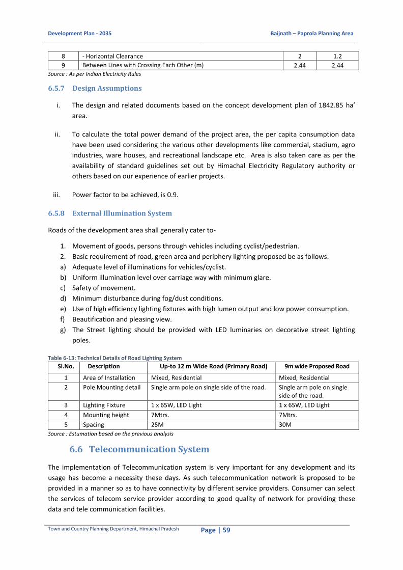
Development Plan - 2035 Baijnath – Paprola Planning Area
Town and Country Planning Department, Himachal Pradesh Page | 59
8 - Horizontal Clearance 2 1.2
9 Between Lines with Crossing Each Other (m) 2.44 2.44 Source : As per Indian Electricity Rules
6.5.7 Design Assumptions
i. The design and related documents based on the concept development plan of 1842.85 ha’
area.
ii. To calculate the total power demand of the project area, the per capita consumption data
have been used considering the various other developments like commercial, stadium, agro
industries, ware houses, and recreational landscape etc. Area is also taken care as per the
availability of standard guidelines set out by Himachal Electricity Regulatory authority or
others based on our experience of earlier projects.
iii. Power factor to be achieved, is 0.9.
6.5.8 External Illumination System
Roads of the development area shall generally cater to-
1. Movement of goods, persons through vehicles including cyclist/pedestrian.
2. Basic requirement of road, green area and periphery lighting proposed be as follows:
a) Adequate level of illuminations for vehicles/cyclist.
b) Uniform illumination level over carriage way with minimum glare.
c) Safety of movement.
d) Minimum disturbance during fog/dust conditions.
e) Use of high efficiency lighting fixtures with high lumen output and low power consumption.
f) Beautification and pleasing view.
g) The Street lighting should be provided with LED luminaries on decorative street lighting
poles.
Table 6-13: Technical Details of Road Lighting System
Sl.No. Description Up-to 12 m Wide Road (Primary Road) 9m wide Proposed Road
1 Area of Installation Mixed, Residential Mixed, Residential
2 Pole Mounting detail Single arm pole on single side of the road. Single arm pole on single side of the road.
3 Lighting Fixture 1 x 65W, LED Light 1 x 65W, LED Light
4 Mounting height 7Mtrs. 7Mtrs.
5 Spacing 25M 30M
Source : Estumation based on the previous analysis
6.6 Telecommunication System
The implementation of Telecommunication system is very important for any development and its
usage has become a necessity these days. As such telecommunication network is proposed to be
provided in a manner so as to have connectivity by different service providers. Consumer can select
the services of telecom service provider according to good quality of network for providing these
data and tele communication facilities.

Development Plan - 2035 Baijnath – Paprola Planning Area
Town and Country Planning Department, Himachal Pradesh Page | 60
a) Telecom Services today are of the following types-
b) Landline operations requiring a telecom cable and junction box space in utility corridor.
c) Wireless services on GSM / CDMA platform requiring tower at stipulated radii.
d) Broad band Services requiring a cable corridor and distribution chambers.
e) Short Coverage Wi-Fi networks.
To achieve it, Optical fibre cables are used to provide and connect various service providers for
telecom as well as broadband services to the users through the optical fibre network. To run the
cabling, the provision for laying the conduit and chamber in front of all the plots has been proposed
in ROW planning.

Development Plan - 2035 Baijnath – Paprola Planning Area
Town and Country Planning Department, Himachal Pradesh Page | 61
7 SOCIAL INFRASTRUCTURE 7.1 Educational Facilities
Recommendation for educational facilities is based on the analysis of the current situation. In
Baijnath-Paprola Planning Area, more than 50% of the schools are run by the private authorities and
remaining schools are run by the government. It is observed that the government is focusing more
on providing the basic education to the children and above primary level, educational facilities
provided by the private authorities is exceeding the facilities provided by the government. In
Baijnath-Paprola Planning Area, the schools are evenly distributed and catering to the entire
population of the planning area.
Table 7-1URDPFI Guidelines and Gap Analysis for Educational Facilities
Source: Urban and Regional Development Plans Formulation and Implementation (URDPFI) Guidelines, 2015 and Voyants
analysis based on VD-02024, Village Directory, Census of India, 2011
Table 7-2 Recommended Guidelines for Educational Facilities
Sl. No.
Level of Education Population per Facility
Distance in Km Recommended Area (in
hectares)
Minimum Maximum
1 Primary 4,000 1-2 0.2 0.3
2 High + Higher Secondary 16,000 5-7 0.3 0.6
3 College 30,000 8-12 2.0 3.0
4
Industrial training Centre/ Polytechnic
50, 000 /at least one in
each Planning
Zone
8-12 0.3 0.6
5 Engineering College - - 60 -
6 Medical College - - 15 -
Source: Urban and Regional Development Plans Formulation and Implementation (URDPFI) Guidelines, 2015 and Voyants
proposal
In Baijnath-Paprola Planning Area, the primary and secondary education facilities are more than the
requirement (Refer Table 7-1URDPFI Guidelines and Gap Analysis for Educational Facilities). The
population for opening a college is lower than the population requirement under the URDPFI
Guidelines, considering the population and availability of colleges in the surrounding areas, these are
adequate with reference to the distance range prescribed by URDPFI norms.
Sl. No.
Revised URDPFI Norms No. of Existing Facilities
Requirement Gap Facility Population
Distance between two facilities
1 Pre-Primary School 2,500 1 km 16 8 -
2 Primary School 4,000 1 to 2 km 32 5 -
3 Middle School - 2 to 3 km 24 - -
4 Secondary School - 3 to 5 km 20
5 Senior Secondary School 15,000 5 to 7 km 14 1 -
6 College 30,000 8 to 12 km 1 1 -
7 Professional College 30,000 8 to 12 km 4 1 -
Development Plan - 2035 Baijnath – Paprola Planning Area
Town and Country Planning Department, Himachal Pradesh Page | 62
There is a need to give priority on skill based training institutes. The citizens of Baijnath-Paprola
Planning Area avail higher education in science and other streams at Palampur, which is located at a
distance of 17 km from the Planning Area.
7.2 Health Facilities
In Baijnath-Paprola Planning Area, there is hierarchy in terms of healthcare facilities i.e. dispensary,
sub-centre, primary health centre, community health centre, hospital and veterinary centre.
A) Dispensary: As per the norms, , existing dispensaries are lesser than the requirement as
there is a gap for 3 (no)sub-centres in the Planning Area.
B) Sub-Centre: The number of sub-centres in the Planning Area is less than the requirement
with reference to the URDPFI guidelines. There are 5 (no)sub-centres existing in the Planning
Area and the total requirement is 7 (no), hence, there a gap of 2 (no)sub-centres.
C) Primary Health Centre: There are total three Primary Health Centres (PHC) in Baijnath-
Paprola Planning Area. The PHCs are located at Baijnath, Paprola Khas and Majehrna Khas.
There is a total strength of 4 (no.) doctors in PHCs and all the 4 (no) doctors are in position at
these PHCs. As per the URDPFI norms, there should be one PHC at a population of 20,000.
Hence, the facility of PHCs in the Planning Area more than the requirement with reference to
the planning standards.
D) Community Health Centre: In Baijnath-Paprola Planning Area, there is no Community Health
Centre but the existing PHCs and hospitals are exceeding the required number of healthcare
facilities, hence there is no need for a community health facility.
E) Hospital: There is one allopathic hospital in Baijnath, namely, Civil Hospital and an Ayurveda
hospital, namely, Rajiv Gandhi Government Post Graduate Ayurvedic College & Hospital
located at Paprola. There are 60 beds in Civil Hospital with a total strength of 8 (no) doctors.
Besides, there are 9 number staff nurses and 3 (no) sisters and 1 (no) Dai in Civil Hospital at
Baijnath. Apart from this, there are two private hospitals, DTIL Private Hospital at Baijnath
and Johal Private Hospital in Paprola. The Civil hospital receives 250 to 300 patients every
day and it has a catchment area of around 10-15 km. Hospital follows a proper process for
disposing the bio-medical waste as prescribed in the Bio-Medical Waste (Management and
Handling) Rules, 1998. A medical waste collection van comes every week to the Civil Hospital
for collecting the medical waste and the waste is then transported to Pathankot where a
private Bio-Medical Waste Treatment Plant is located.
According to the URDPFI standards, there should be one hospital for a population of 80,000.
Therefore, the availability of hospitals in Baijnath-Paprola Planning Area is sufficient to cater
the current as well as future population demand up to the target year 2035.
Veterinary Centre/Hospital23: There are 4 veterinary hospitals in the Planning Area located at
Baijnath, Ghartholi, Pandtehar and Khatrehar. The total number of doctors posted at these
hospitals are 4. The existing veterinary hospitals in Baijnath-Paprola Planning Area are
adequate as per URDPFI guidelines/ norms.
23URDPFI norms are available only for veterinary centres but not for Veterinary Hospitals.
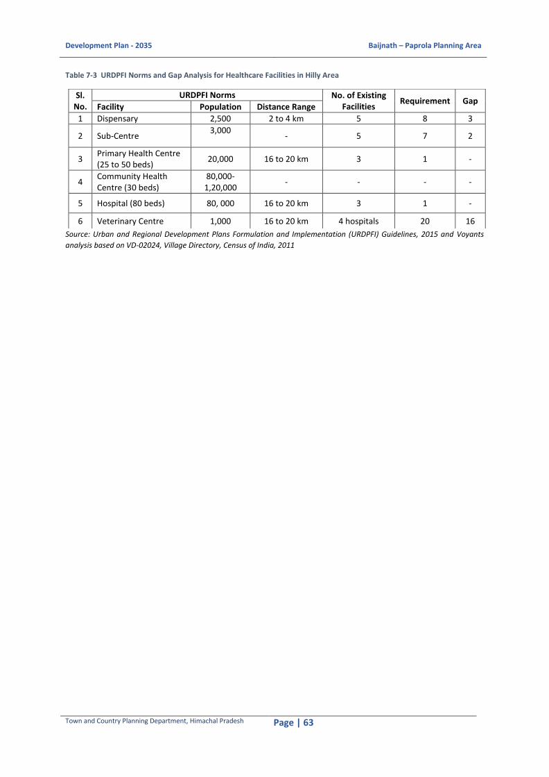
Development Plan - 2035 Baijnath – Paprola Planning Area
Town and Country Planning Department, Himachal Pradesh Page | 63
Table 7-3 URDPFI Norms and Gap Analysis for Healthcare Facilities in Hilly Area
Source: Urban and Regional Development Plans Formulation and Implementation (URDPFI) Guidelines, 2015 and Voyants
analysis based on VD-02024, Village Directory, Census of India, 2011
Sl. No.
URDPFI Norms No. of Existing Facilities
Requirement Gap Facility Population Distance Range
1 Dispensary 2,500 2 to 4 km 5 8 3
2 Sub-Centre 3,000
- 5 7 2
3 Primary Health Centre (25 to 50 beds)
20,000 16 to 20 km 3 1 -
4 Community Health Centre (30 beds)
80,000-1,20,000
- - - -
5 Hospital (80 beds) 80, 000 16 to 20 km 3 1 -
6 Veterinary Centre 1,000 16 to 20 km 4 hospitals 20 16

Development Plan - 2035 Baijnath – Paprola Planning Area
Town and Country Planning Department, Himachal Pradesh Page | 64
Map 7-1 Existing Healthcare facilities in Baijnath-Paprola Planning Area Source: Prepared by Voyants on the basis of Google Map, 2016
Though there is a gap in the existing number of dispensaries and sub-centres but the existing number
of primary health centres and hospitals are fulfilling the healthcare demand in the planning area as
they are existing more than required by the URDPFI guidelines. Hence, the healthcare facilities in
Baijnath-Paprola Planning Area are adequate to cater the healthcare demand.
The multi speciality speciality hospitals are located at Palmpur and Dharmashala which come under
the 50-km radius of the Palnning Area.

Development Plan - 2035 Baijnath – Paprola Planning Area
Town and Country Planning Department, Himachal Pradesh Page | 65
7.3 Recreation and Open Space
In terms of Recreational facilities, one designated open space is available at the Baijnath temple
premises. Otherwise, there is acute deficit of neighbourhood level parks, gardens and open spaces in
the Planning Area
7.3.1 Proposed Open Space, Playgrounds, Indoor Stadiums and Community Centers
Six parks are already proposed at different areas in the Planning Area out of which, the plan for four
parks have already been approved. As per the URDPFI guidelines, there should be six community
level parks for 30,000 population. As per the population projection, six parks are required which have
already been proposed at Paprola, Ustehar (near SDM office) and Pandtehar.
7.4 Community Facilities
7.4.1 Community Halls
A community hall is located in Paprola. As per URDPFI guidelines, one community hall/room of 660
Sqm. is suggested for every 5000 persons. There is a requirement of at least two community halls
with higher capacity and augmented facilities at Baijanth and Paprola towns. The community hall in
Paprola is proposed to be upgraded with all the modern facilities.
7.4.2 Community Grounds/ Play grounds
There are two Community grounds/ play grounds, located at Paprola and Baijnath. The Community
ground at Paprola is locally termed as the Mela Ground and used for organising local fairs. The Play
ground at Baijnath side is located near to the SDM complex and used for organising local level sports
competition and other gatherings.
7.4.3 Cattle Shelter (Goshala)
One cattle shelter is located near the Binwa Bridge in Baijnath Town which serves the entire Planning
Area.
7.4.4 Cremation ground
The Cremation ground is located on the banks of Kheer Ganga. It caters to the entire Planning Area.
As per URDPFI guidelines, one cremation ground is required for a large size town. The site should not
be located at in proximity to residential areas and preferably in urban extensions.
7.5 Other Social Infrastructural Facilities
The public and semi-public facilities include anganwadi, community hall, police station, fire station,
disaster management cell, banking facility, commercial facility, post office and telecommunication
facility and recreational facility.

Development Plan - 2035 Baijnath – Paprola Planning Area
Town and Country Planning Department, Himachal Pradesh Page | 66
Table 7-4Gap Analysis of Public and Semi-Public Facilities in Baijnath-Paprola Planning Area based on URDPFI Guidelines
Source: Urban and Regional Development Plans Formulation and Implementation (URDPFI) Guidelines, 2014 and Voyants
analysis One botanical garden and one recreational centre including a zoological park are proposed for a
town like Baijnath Paprola.
Sl. No.
URDPFI Norms No. of Existing Facilities
Requirement Gap Facility Population Distance Range
1 Anganwadi 5,000 - 4 4 -
2 Police Station 15,000 5 to 10 km 1 - -
3 Fire Station 50,000 - 1 1 -
4 Disaster Management Centre
20,000 5 to 10 km 1 1 -
5 Banking Facility 10,000 16 to 20 km 4 2 -
6 Commercial Facility
10,000 - 2 2 -
7 Post Office 10,000 5 to 7 km 7 2 -
8 Community Centres
10,000 5 to 10 km 9 2 -
9 Housing Area Park
5,000 - - 4 4
10 Neighbourhood Park
10,000 - 1 2 1
11 Botanical Garden 1 for every
town - 0 1 1
12 Recreational Complex Including Zoo
1 for every settlement with tourist potential
- 0 1 1

Development Plan - 2035 Baijnath – Paprola Planning Area
Town and Country Planning Department, Himachal Pradesh Page | 67
Map 7-2 Existing Public and Semi-Public facilities in Baijnath-Paprola Planning Area Source: Prepared on the basis of Google Maps, 2016
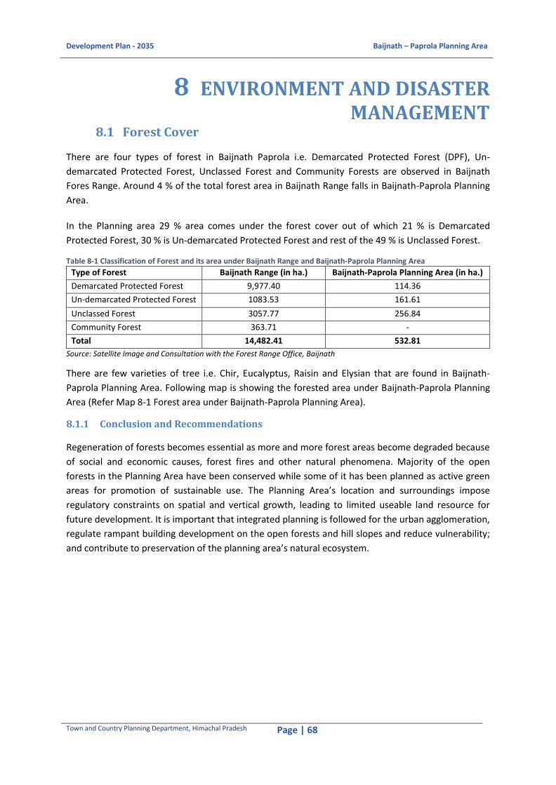
Development Plan - 2035 Baijnath – Paprola Planning Area
Town and Country Planning Department, Himachal Pradesh Page | 68
8 ENVIRONMENT AND DISASTER MANAGEMENT
8.1 Forest Cover
There are four types of forest in Baijnath Paprola i.e. Demarcated Protected Forest (DPF), Un-
demarcated Protected Forest, Unclassed Forest and Community Forests are observed in Baijnath
Fores Range. Around 4 % of the total forest area in Baijnath Range falls in Baijnath-Paprola Planning
Area.
In the Planning area 29 % area comes under the forest cover out of which 21 % is Demarcated
Protected Forest, 30 % is Un-demarcated Protected Forest and rest of the 49 % is Unclassed Forest.
Table 8-1 Classification of Forest and its area under Baijnath Range and Baijnath-Paprola Planning Area
Type of Forest Baijnath Range (in ha.) Baijnath-Paprola Planning Area (in ha.)
Demarcated Protected Forest 9,977.40 114.36
Un-demarcated Protected Forest 1083.53 161.61
Unclassed Forest 3057.77 256.84
Community Forest 363.71 -
Total 14,482.41 532.81
Source: Satellite Image and Consultation with the Forest Range Office, Baijnath
There are few varieties of tree i.e. Chir, Eucalyptus, Raisin and Elysian that are found in Baijnath-
Paprola Planning Area. Following map is showing the forested area under Baijnath-Paprola Planning
Area (Refer Map 8-1 Forest area under Baijnath-Paprola Planning Area).
8.1.1 Conclusion and Recommendations
Regeneration of forests becomes essential as more and more forest areas become degraded because
of social and economic causes, forest fires and other natural phenomena. Majority of the open
forests in the Planning Area have been conserved while some of it has been planned as active green
areas for promotion of sustainable use. The Planning Area’s location and surroundings impose
regulatory constraints on spatial and vertical growth, leading to limited useable land resource for
future development. It is important that integrated planning is followed for the urban agglomeration,
regulate rampant building development on the open forests and hill slopes and reduce vulnerability;
and contribute to preservation of the planning area’s natural ecosystem.

Development Plan - 2035 Baijnath – Paprola Planning Area
Town and Country Planning Department, Himachal Pradesh Page | 69
Map 8-1 Forest area under Baijnath-Paprola Planning Area Source: Satellite Image and Consultation with the Forest Range Office, Baijnath

Development Plan - 2035 Baijnath – Paprola Planning Area
Town and Country Planning Department, Himachal Pradesh Page | 70
8.2 Air Quality
The nearest Air Quality Monitoring Stations are at Dharamshala and Sundarnagar which are located
beyond 50 km radius, hence the data on air quality could not be procured for Baijnath-Paprola
Planning Area.
8.2.1 Conclusions and Recommendations
In order to maintain air quality of Planning Area, following are the recommendations:
1. Land use and transportation pattern that discourage single occupancy vehicle travel
2. Encourage the use of alternative fuel are two most important components for achievement of better air quality standards.
3. Alternative forms of transportation like solar battery-operated car.
4. Promoting car-pooling and van pooling. These measures will also contribute to the reduction of energy resource consumption required in energy act.
8.3 Noise Impact
The major source of noise in the planning area is roadway traffic. Roadway noise levels vary with
traffic volume and speed, types of vehicles on the roadway and the type of roadway. For densely
populated areas of Baijnath-Paprola, where residential uses line the roadways, few noise mitigation
options exist.
8.3.1 Conclusions and Recommendations
New residential development or redevelopment of land adjacent to a major roadway should consider
noise- compatible site design as the first priority for noise abatement. These measures include,
placement of parking lots, open spaces, garages, recreation areas and other non-habitable uses of
the property in the noise affected area between the noise source and the residential unit. Site
design, which orients the front of a row of single family attached dwellings towards and parallel to
the roadway, provides a barrier to noise at the deck or patio level behind the unit. Acoustical
treatment of external façade, particularly windows and doors, landscaped berms can also be more
effective, but often have aesthetic impact on building façade.
8.4 Water Bodies
In Baijnath-Paprola Planning Area, water discharge is monitored at the Binwa khad discharge station.
The data from 2013-2015 has been considered to assess the water quality in the Planning Area.
Table 8-2Mean and Standard Deviation for Water Quality Assessment of Binwa khad in Baijnath-Paprola Planning Area during April, 2013- March, 2015
Value pH Dissolved Oxygen (DO)
Mean 7.81 7.90
Standard Deviation ± 0.58 ± 0.90
Source: Himachal Pradesh Pollution Control Board (April 2013- March 2015)
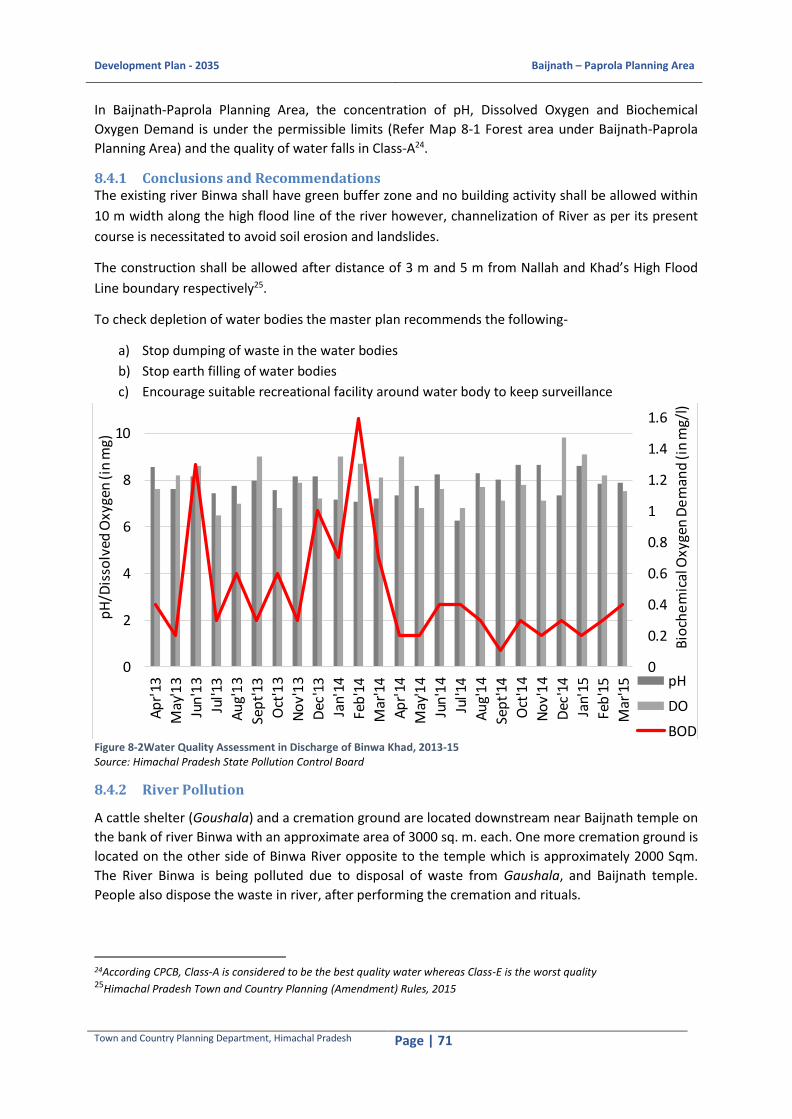
Development Plan - 2035 Baijnath – Paprola Planning Area
Town and Country Planning Department, Himachal Pradesh Page | 71
In Baijnath-Paprola Planning Area, the concentration of pH, Dissolved Oxygen and Biochemical
Oxygen Demand is under the permissible limits (Refer Map 8-1 Forest area under Baijnath-Paprola
Planning Area) and the quality of water falls in Class-A24.
8.4.1 Conclusions and Recommendations The existing river Binwa shall have green buffer zone and no building activity shall be allowed within
10 m width along the high flood line of the river however, channelization of River as per its present
course is necessitated to avoid soil erosion and landslides.
The construction shall be allowed after distance of 3 m and 5 m from Nallah and Khad’s High Flood
Line boundary respectively25.
To check depletion of water bodies the master plan recommends the following-
a) Stop dumping of waste in the water bodies
b) Stop earth filling of water bodies
c) Encourage suitable recreational facility around water body to keep surveillance
Figure 8-2Water Quality Assessment in Discharge of Binwa Khad, 2013-15 Source: Himachal Pradesh State Pollution Control Board
8.4.2 River Pollution
A cattle shelter (Goushala) and a cremation ground are located downstream near Baijnath temple on
the bank of river Binwa with an approximate area of 3000 sq. m. each. One more cremation ground is
located on the other side of Binwa River opposite to the temple which is approximately 2000 Sqm.
The River Binwa is being polluted due to disposal of waste from Gaushala, and Baijnath temple.
People also dispose the waste in river, after performing the cremation and rituals.
24According CPCB, Class-A is considered to be the best quality water whereas Class-E is the worst quality 25Himachal Pradesh Town and Country Planning (Amendment) Rules, 2015
0
0.2
0.4
0.6
0.8
1
1.2
1.4
1.6
1.8
0
2
4
6
8
10
12
Ap
r'13
May
'13
Jun
'13
Jul'1
3
Au
g'1
3
Sep
t'13
Oct
'13
No
v'1
3
Dec
'13
Jan'
14
Feb
'14
Mar
'14
Ap
r'14
May
'14
Jun
'14
Jul'1
4
Au
g'1
4
Sep
t'14
Oct
'14
No
v'1
4
Dec
'14
Jan'
15
Feb
'15
Mar
'15
Bio
che
mic
al O
xyge
n D
em
and
(in
mg/
l)
pH
/Dis
solv
ed O
xyge
n (i
n m
g)
pH
DO
BOD

Development Plan - 2035 Baijnath – Paprola Planning Area
Town and Country Planning Department, Himachal Pradesh Page | 72
8.4.3 Conclusions and Recommendations
The Development Plan recommends to allocate approximately 100 Sqm. land for constructing Bio-gas
Plant (Gobar Gas Plant) near the existing cowshed, such that waste coming out of cowshed should
not be discharged directly into the river and can be used for creating clean fuel.
The Plan also advises to construct small pond of around 100 Sqm. adjoining the cremation grounds
for performing rituals so that the river can be saved from being polluted due to religious activitie
8.5 Disaster Vulnerability Profile
The disaster vulnerability data and information is not available at Planning Area level, hence, the
district level information has been
studied to draw the micro level
consclusions. District Kangra is
prone to various hazards both
natural and manmade. In the
district the geological hazard,
mainly earthquakes, landslides and
soil erosion are most critical, the
flash flood, cloud burst, drought
and forest fire is also hydro
metrological hazard. Road
accidents, wind storms, epidemics
and domestic fire could also occur
but cause damage locally only.The
main disasters to which Baijnath-
Paprola Planning Area is vulnerable
includes earthquake, cloud bursts
leading to flash floods and narrow
roads and access, pathways;
making it vulnerable for stampede
during mass gatherings near
temples.
1. Earthquake: Entire Kangra district is vulnerable to earthquakes of severe intensity and the
Baijnath-Paprola Planning Area falls in Seismic Zone V of earthquake (Refer Figure 8-4Earthquake
Hazard Vulnerability map of Himachal Pradesh). In the following map, the epicentre of various
earthquakes that had hit the region in the past are shown along with their intensity on Richter
scale. The population at the risk of earthquake has also been shown with the buffer along the
thrust and fault line. It shows that Baijnath-Paprola Planning Area falls under zone V and has a
substantial population that is at risk from earthquake. Majority of the earthquakes that had
shaken Kangra district are of the intensity ranging between 6.1 to 8 on the Richter Scale. This plan
suggests that all new development should comply strictly with National building code on
earthquake resistant building code and Development Control Regulations of Development Plan.
Figure 8-3Overall Vulnerability Map of Himachal Pradesh Source: HP State Council for Environment Science and Technology

Development Plan - 2035 Baijnath – Paprola Planning Area
Town and Country Planning Department, Himachal Pradesh Page | 73
Figure 8-4Earthquake Hazard Vulnerability map of Himachal Pradesh Source: SEEDS India, Himachal Pradesh Vulnerability Atlas, 2009, European Union and Christian Aid. Available on http://www.hpsdma.nic.in/ResourceList/Maps/VulneabilityAtlasStateHPlow.pdf
2. Flash Floods: Baijnath-Paprola Planning Area is rich in water resources i.e. there is Binwa
River which is a tributary of Beas River flowing through the centre of the Planning Area
dividing Baijnath and Paprola. Apart from this, Neugal, Awa, Binwa, Naker, Gaj and Dehar
are few khads that are falling under Baijnath-Paprola Planning Area. The khads and Rivers
are snow fed and perennial in nature. The Northerly flowing tributaries ‘çhoes’ are
temporary and result in flash floods during monsoon.
During the night of 29th and 30th July, 2001, a flash flood occurred in Binwa khad and its
tributaries that had disrupted the normal life of people by causing extensive damage to life
and property in Baijnath.
3. Stampede: Himachal is popularly known as ‘Devbhoomi’26 (Land of the Gods). In Baijnath-
Paprola Planning Area, there is a popular ancient temple, namely, Baijnath temple and in
the vicinity of the Planning Area, there are places of religious importance i.e. Mahakal
temple (5 km), Mukutnath temple (8 km) and Sherab Ling Monastery (8 km).
Such religious places draw several thousand devotees a day. In hilly regions, the approach
roads or stairs are very narrow which sometimes lead the devotees to a vulnerable
situation which is commonly known as ‘stampede’. Human stampedes often occur during
mass gathering events or at the places of mass gathering such as temple sites, resulting in
loss of innoscent human lives.
26PHD Chamber, 2012, Tourism in Himachal Pradesh and the way ahead, KPMG Network, p.6. Available at http://www.kpmg.com/IN/en/IssuesAndInsights/ThoughtLeadership/Tourism-in-himachal-pradesh.pdf
Baijnath-Paprola Planning Area
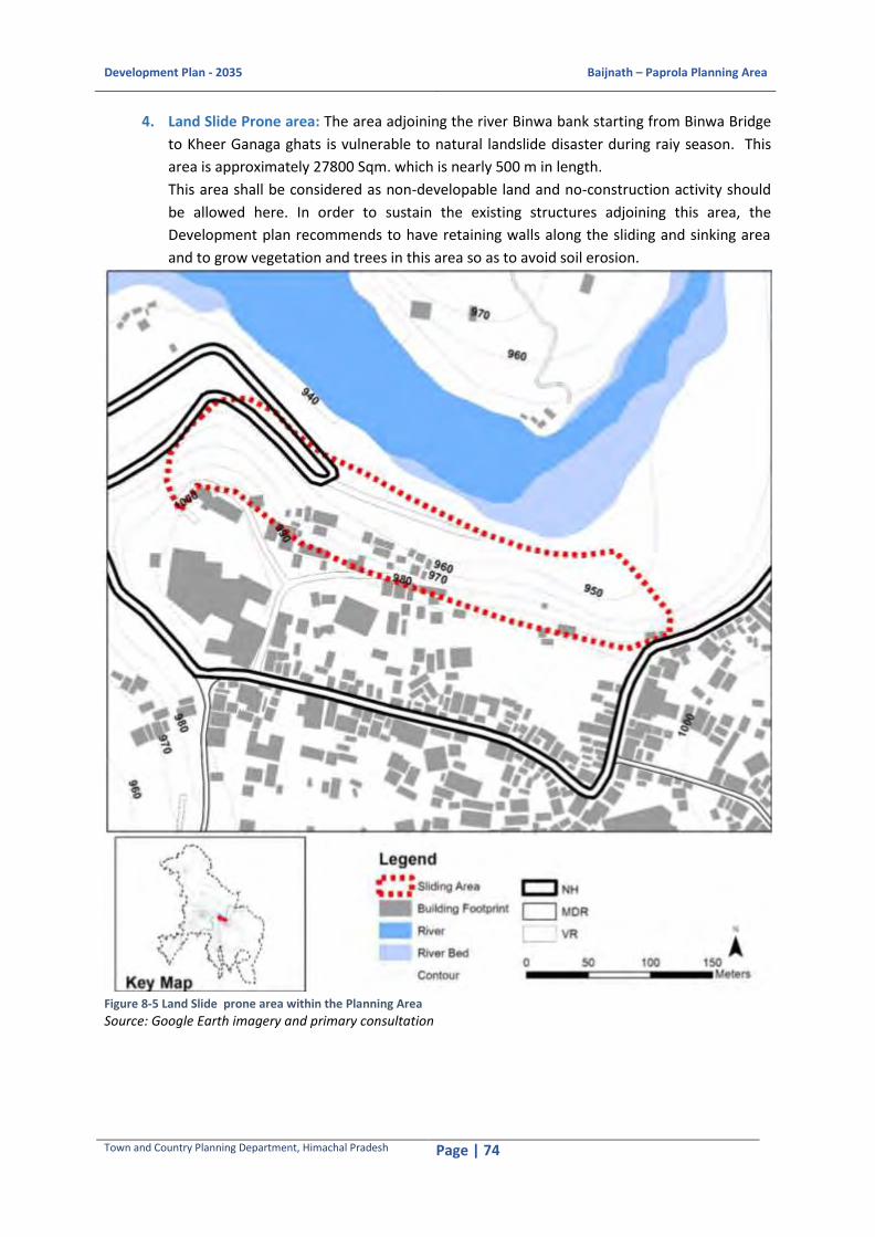
Development Plan - 2035 Baijnath – Paprola Planning Area
Town and Country Planning Department, Himachal Pradesh Page | 74
4. Land Slide Prone area: The area adjoining the river Binwa bank starting from Binwa Bridge
to Kheer Ganaga ghats is vulnerable to natural landslide disaster during raiy season. This
area is approximately 27800 Sqm. which is nearly 500 m in length.
This area shall be considered as non-developable land and no-construction activity should
be allowed here. In order to sustain the existing structures adjoining this area, the
Development plan recommends to have retaining walls along the sliding and sinking area
and to grow vegetation and trees in this area so as to avoid soil erosion.
Figure 8-5 Land Slide prone area within the Planning Area
Source: Google Earth imagery and primary consultation

Development Plan - 2035 Baijnath – Paprola Planning Area
Town and Country Planning Department, Himachal Pradesh Page | 75
8.6 Disaster Prone Areas in Kangra District
Table 8-3: Showing overall Vulnerability of District Kangra to Various Hazards
Elements at Risk
Degree of Vulnerability to Various Hazards
Earthquake
Landslide
Flash floods/ GLOF
Snow avalanc
he
Drought Forest Fires
Domestic
Fires
Dam Faliure
Road Accide
nts
Community Very high
High Very high Low High High Very high
High High
Infrastrutre Very high
Very high
Very high Low Moderate
Moderate
Low High Low
Houses Very high
Very high
High Low Low Low Very high
High Nil
Social Sector Very high
High Moderate
Low Moderate
Moderate
Very high
Low High
Livelihood sector
Very high
High Moderate
Low Very high High High High Low
Environment Very high
Very high
Very high Low Very high Very high
Very high
Very high
Low
Source: District Disaster Management Plan, Kangra (H. P.) – 2012
From theTable 8-3: Showing overall Vulnerability of District Kangra to Various Hazards,it is evident
that the vulnerability of the district to various hazards is high to very high. The district being situated
in undulating terrain and earthquake zone 4 and 5, the area is prone to flood, land slide and
earthquake.
8.7 Key Issues
8.7.1 Social and GovernanceIssues
Lack of pre-planning to deal with any disaster at local level
Require trained people at village and town level
Unavailability of strong mechanism for Early Warning System
Participation of local NGOs/SHGs and other local bodies
Unplanned development and no integration of planning processes and programmes
Lack of holistic approach for planning in pre-disaster period
Lack of clarity of roles of various Govt. departments and stakeholders
8.7.2 Physical Issues
Lack of earthquake resistance buildings
Presence of dilapidated buildings in populated areas
Congested pedestrian pathways/ areas and road
Community Facility Buildings e.g. hospital, school, community centres etc are not planned to
handle any emergency/ disaster Communication – land and mobile based communication
only
The district control room is not equipped and no trained manpower to handle it
8.7.3 Financial Issues
Lack of fund at district level

Development Plan - 2035 Baijnath – Paprola Planning Area
Town and Country Planning Department, Himachal Pradesh Page | 76
No efforts have been taken to transfer the risk by way of insurance etc
Unavailability of insurance foragriculture procedure and losses
8.8 Measures for Disaster Management
The adverse effects of disasters can be minimized if mitigation policies, plans, and projects are
undertaken. The following measures would help in dealing with disasters in the district:27
Preparation of Disaster Management Plans at District and Local Level
Implementing of Disaster Management Plans
Holding regular meetings at District and Sub-Division level to reviewing the readiness of the
administrative machinery to deal with disasters
Constitution of Relief Committees at all levels
Regular training programmes of Government functionaries, PRIs, ULBs and other
stakeholders in various facets of disaster management
Public awareness and education in disaster management
Community training and empowerment
Taking preventive and mitigation measures for the identified hazards
Integration of Disaster Risk Reduction (DRR) into on-going development programmes of all
departments
Establishing effective early warning system for the vulnerable areas and communities
Improving the response capacities of the search and rescue teams
Conducting regular mock drills
27 District Disaster Management Plan, Kangra (H. P.) – 2012, Prepared by: - District Disaster Management Authority (DDMA) Kangra under The Government of India - UNDP Disaster Risk Reduction (DRR) Programme (2009-12)
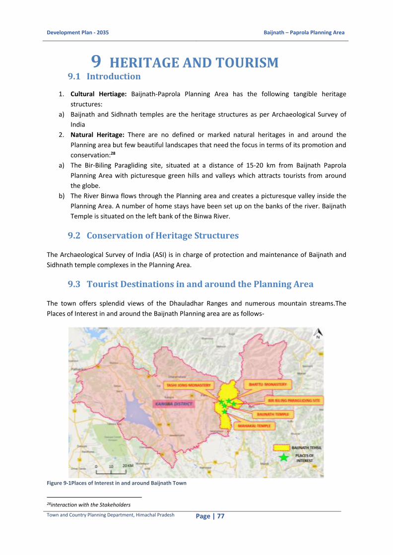
Development Plan - 2035 Baijnath – Paprola Planning Area
Town and Country Planning Department, Himachal Pradesh Page | 77
9 HERITAGE AND TOURISM 9.1 Introduction
1. Cultural Hertiage: Baijnath-Paprola Planning Area has the following tangible heritage
structures:
a) Baijnath and Sidhnath temples are the heritage structures as per Archaeological Survey of
India
2. Natural Heritage: There are no defined or marked natural heritages in and around the
Planning area but few beautiful landscapes that need the focus in terms of its promotion and
conservation:28
a) The Bir-Biling Paragliding site, situated at a distance of 15-20 km from Baijnath Paprola
Planning Area with picturesque green hills and valleys which attracts tourists from around
the globe.
b) The River Binwa flows through the Planning area and creates a picturesque valley inside the
Planning Area. A number of home stays have been set up on the banks of the river. Baijnath
Temple is situated on the left bank of the Binwa River.
9.2 Conservation of Heritage Structures
The Archaeological Survey of India (ASI) is in charge of protection and maintenance of Baijnath and
Sidhnath temple complexes in the Planning Area.
9.3 Tourist Destinations in and around the Planning Area
The town offers splendid views of the Dhauladhar Ranges and numerous mountain streams.The
Places of Interest in and around the Baijnath Planning area are as follows-
Figure 9-1Places of Interest in and around Baijnath Town
28interaction with the Stakeholders

Development Plan - 2035 Baijnath – Paprola Planning Area
Town and Country Planning Department, Himachal Pradesh Page | 78
Source: Google Earth Image and Primary Consultation
Baijnath Temple
Figure 9 3 Sidhnath Temple
Source: Field Survey
Baijnath town has derived its name from
famous Baijnath Temple. The temple re-built during the 13th Century has a large number of images
of great beauty and iconographic importance. The temple is heavily ornamented with floral and
geometrical designs along with the images of various gods and goddesses, including a unique
composite of Lord Vishnu and Goddess Lakshmi. Lord Shiva’s vahan Nandi rests outside the temple
on the compound, sculpted out of just one piece of stone. The temple attracts tourists from different
parts of India and overseas. The temple has a great historical value due to which more than lakhs of
devotees gather every year on the day of Shiv Ratri in the town for giving their offerings to lord Shiva.
Large/big fair is organised during the shiv Ratri days for seven days which generates substantial
employment opportunities for the local people. Throughout the year the temple receives large
number of pilgrims.
Sidhnath Temple
The temple is also situated in Baijnath. The monument is of national importance according to ASI.
The temple is located in a very dense commercial zone along the edge of NH-154.
Mahakal Temple
Mahakal temple of Himachal Pradesh is one of the famous Shiv temples in India which is located at
Mahakal Town at a distance of 7km from Baijnath Town.
Tashi Jong Monastery
Tashi Jong is famous for its rich history
among the Buddhists, located at a distance
of 4km from Baijnath Town. It is located
adjacent to the Planning Area boundary
neighbouring Beth Jhikli village in
Dhauladhar range. It provides education
courses on different Buddhistphilosophies.
There are approximately three hundred
people and one hundred monks living
together in the Tashi Jong community a
Figure 9-2Baijnath Temple Source: Filed Survey
Figure 9-3Tashi Jong Monastery Source: Field Surevy

Development Plan - 2035 Baijnath – Paprola Planning Area
Town and Country Planning Department, Himachal Pradesh Page | 79
“Little Island of Tibetan Culture" surrounded by its Indian neighbours. It houses village level micro
scale units of clothing and food items made by the monks and local village people.
Sherab Ling Monastery
SherabLing Monastery situated in the
foothills of Kangra Valley is Palpung
SherabLing Monastery the seat of the XIIth
Kenting Tai Stupa in India. The monastery
is located in Bhattu, near Bir village which
is 7km away from Baijnath town. The
monastery is also known as Bhattu
Monastery. It offers periodic courses on
Buddhist Meditation and Philosophy. The
monastery has shrine halls with a very
beautiful Buddhist shrine which attracts
pilgrims from around the globe, a monastic
college, a school, a library, a museum, an
exhibition hall and a dispensary, and all these are nestled deep inside the pine forest. The inner hall is
beautifully decorated in golden hue. The monastery was the venue of inauguration ceremony of
Paragliding world cup in 2015 which brought it on the international tourist map.
Bir Biling
Known as the ‘Paragliding Capital of India’, the
towns of Bir and Billing are extremely popular
places for adventure sports and other
attractions. Bir is the take-off site while Billing
is the landing spot. Bir is situated 15 km uphill
of Baijnath town. Bir is famous for its Tibetan
colony and various Buddhist monasteries. The
Tibetan colony is one of the earliest Tibetan
refugee settlements in India and was
established in 1962. The Deer Park Institute is
a famous centre for the study of classical
Indian wisdom traditions which was
established by Dzongsar Khyentse Rinpoche.29
9.4 Tourism
Baijnath is located at a trategic location in between two tourist circuits marked by Himachal Pradesh
Tourism Department viz., the Dhauladhar circuit and Beas circuit.
29 Source: http://travel.india.com/kangra/places-to-visit/adventure-bir-billing/
Figure 9-4 Sherab Ling Monastery Source: Field Survey
Figure 9-5 Bir Biling Paragliding Site Source: Field Survey

Development Plan - 2035 Baijnath – Paprola Planning Area
Town and Country Planning Department, Himachal Pradesh Page | 80
Figure 9-6Tourist Arrivals, Kangra District Source: Tourism Office, Dharamshala, Kangra
The touris statistics for the planning area is not available readily, hence the data at the district level is
used. Kangra district receives a significant percentage of foreign and national tourists every year. The
above graph shows that national and domestic tourist arrivals in the district have increased from
22,75,864 in 2008 to 50,87,879 in 2014. Kangra district receives almost 28 % and 44 % of the total
Indian and foreign tourists arriving in Himachal Pradesh.
Baijnath area receives almost 40-45 % of the total tourists of Kangra district. Out of the total tourist
arrival in Baijnath, 75% to 80% tourists are mainly the through tourists and other 20 % stay in town
for half days or one day. The average duration of stay is one day in this town.
Tourists prefer to stay in Baijnath during the Shiv Ratri festival only which is celebrated in the town
for five days30. Rest of the year Baijnath receives the through tourist traffic going to Mandi or
Manali.31
The key tourism activity is the pilgrimage tourist attributed by the Shiv Temple which attracts a vast
number of pilgrims every year during the Shiv Ratri Festival. Other places such as Mahakal Temple
and Tashi Jong monastery also attract few pilgrim tourists.
9.5 Tourism Infrastructure
9.5.1 Hotel and Lodges
Baijnath is a town with limited number of hotels and lodges. There are few hotels in the town which
offer general accommodation to the pilgrims. There is no star category hotels in the Planning area. A
PWD Rest House is located near the temple which provides accommodation in a very reasonable and
economical rate. There are few homestays in Baijnath which offer fair to good accommodation
within the planning area in reasonable price.32
Table 9-1Existing Tourist Infrastructure in Baijnath and Bir
Sl. No. Accommodation Baijnath-Paprola Planning Area
1 No. of hotels 7
2 Rest houses 1
30 Source: http://www.baijnathtemple.com/fairs.html 31 Source: Official Records, Tourism Department Office, Dharamshala, 2016 32 Source: Himachal Pradesh Tourism Department and Field Visit

Development Plan - 2035 Baijnath – Paprola Planning Area
Town and Country Planning Department, Himachal Pradesh Page | 81
3 Number of homestays 3
4 Restaurants 5 Source: Field Survey
There are few budget hotels within a radius of 500 m from the main Shiv Temple in Baijnath. There
are two homestays located near the Petrol Pump in Baijnath and one at Kothi village.
At regional level, good number of the star category hotels and homestays are available at Palampur
town and Bir village.
9.5.2 Issues and Concerns
The following issues and concerns need the focus from the concerned authorities:
1. The heritage structures are not promoted appropriately, hence, the tourist footfall is very
less in Baijnath
2. Out of the total tourists, mostly (60 %) are through tourists
3. No designated parking area is available for tourist vehicle. The parking near the temple is
used by the local taxi owners. It has become a taxi stand than a vehicle parking stand
4. Parking demand increases manifolds during Mahashivratri festival and Mela period (fair)
5. The 52 and 62 seat tourist buses face problems to turn inside the town due to the low
turning radius of the main road inside the town
6. Fair to Good and reasonable accommodations are available either at Palampur, 18 km away
from Baijnath town or at Bir Biling villages which is about 12-13 km far
7. The planning area is not properly maintained and promoted on the existing Dhauladhar
Tourist Circuit
8. Tourism industry of the planning area suffers from seasonality factor
9. Inadequate tourist infrastructure
In spite of the excellent facilities available to the tourists the number of foreign visitors to Himachal
state is almost negligible compared to domestic tourists.33 The major reason for this is inadequate
marketing. It is the same case in Baijnath-Paprola town which receives a dismal number of foreign
tourists. One of the main reasons for this poor performance is lack of effective marketing strategy.
9.5.3 Tourist Forecast
Tourist traffic follows a seasonal trend in Baijnath-Paprola.Kangra districtregistered 34,40,526
domestic tourists and 3,29,396 foreign tourists during the year 2015.
The estimation of future tourist arrivals is mainly based upon an analysis of the past trends in tourist
arrivals (both domestic and foreign).
Table 9-2 Projections for Tourist Traffic – 2011 to 2021
Kangra District Indian Foreign Total
CAGR (2011) 3% 8% -
2011 12,93,893 96,439 13,90,332
CAGR (2021) 2% 5% -
2021 30,25,118 2,94,506 33,19,624
33Source: Article on Tourism Promotion in Himachal Pradesh: An Opinion Survey of Foreign Tourists, Sushma Rewal Chugh, Associate Professor, M.T.A. Dept., H.P.University, Shimla.

Development Plan - 2035 Baijnath – Paprola Planning Area
Town and Country Planning Department, Himachal Pradesh Page | 82
Source: Final report on 20-Year Perspective Plan for Sustainable Tourism Development in Himachal Pradesh Part I March 2003, Department of Tourism Market Research Division, Ministry of Tourism and Culture Government of India.
The CAGR for the period 2011 to 2021 for Domestic and Foreign tourists are 2 % and 5 %
respectively. There is an expectation of an approximate drop of 50 % of tourist traffic because of the
saturation on infrastructure in the main locations, and even in some secondary locations.
Considering average CAGR for the period 2016 to 2035 for Domestic and Foreign tourists 5 % and 9 %
respectively in Kangra district, the tourist influx has been explained in the following graphs.
Figure 9-7 Projections for Domestic Tourist Traffic for Kangra District – 2015 to 2035
Source: Estimation based on the trend database
Figure 9-8 Projections for Foreign Tourist Traffic for Kangra District – 2015 to 2035 Source: Estimation based on the trend database
Among the total number of tourist visit to Kangra district for the period 2015 to 2035, it is envisaged
about 30 % of the tourists will visit Baijnath Paprola planning area.
9.5.4 Tourist Accommodation
Based on the future tourist forecast, the future capacity requirement in accommodation has been
worked out for Kangra district. The existing demand supply gaps and future peak time capacity
requirements for accommodation for Kangra district for the state has been worked out.
Bed requirements during peak season considering duration of stay and desirableoccupancy rate have
been worked out on the following assumptions as given by hotel interviews-
0
2000000
4000000
6000000
8000000
10000000
12000000
14000000
16000000
2016 2021 2026 2031 2036
No
. of
Do
me
stic
To
uri
sts
Years
0
500000
1000000
1500000
2000000
2500000
3000000
3500000
4000000
2016 2021 2026 2031 2036
No
. of
Fore
ign
To
uri
sts
Years

Development Plan - 2035 Baijnath – Paprola Planning Area
Town and Country Planning Department, Himachal Pradesh Page | 83
Average stay of foreign tourist and domestic tourist centers as 3 nightsand 2 nights per
district respectively.
Domestic peak season lasts for 90 days.
Thus by the year 2035 an additional capacity of 1,48,696 beds needs to be created in Kangra district.
Among the total number of beds required for Kangra district for the period 2015 to 2035, out of
which about 30 % of the beds is required for the Planning Area.
9.5.5 Recommendations and Strategies
Given that such large amount of additional capacity needs to be added in ashort period, in addition
to the standard forms of accommodation facilities (hotels and paying guests), accommodation in the
form of camping sites could be developed as they are relatively easier to set up and would also be a
more economical alternative.34
People undertake travel and tourism activity to have a change from the day-to-day monotonous
routine so that they can rejuvenate themselves. The tourist has to select a destination, which can be
any place in the world. Here comes the role of marketing of tourism.
(A) The Strategic Action Plan will cover the following areas-
Marketing and Branding of tourism
Development of new circuits/destinations
Creation of new tourism products
Employ trained personnel in hospitality and tourism
Tourism to be considered as a means for area development
Creation of tourism relevant infrastructure
Exploring opportunities to increase Tourism Revenues
Make the programs which act as catalyst in investments by private sector
Propounding projects and programs at the national level
(B) The recommendations for tourism development in the planning area are as follows:
Identification of tourist destinations and preparation of Tourism Master Plan and Mobility
Planfor the planning area
The tourism department in co-ordination with the private sector should develop these
circuits towards making tourism an important economic sector
Promote responsible tourism that will be welcomed as both preferred employer and
community industry
Use Tourism as a means of providing new employment opportunities in rural, tribal and
remote areas of the planning area
Increase private sector participation in tourism, both as means of generating employment
and providing new infrastructure
During mela period the demand for basic physical infrastructure increases for which the plan
34Source: Final report on 20-Year Perspective Plan for Sustainable Tourism Development in Himachal Pradesh Part I March 2003, Department of Tourism Market Research Division, Ministry of Tourism and Culture Government of India.

Development Plan - 2035 Baijnath – Paprola Planning Area
Town and Country Planning Department, Himachal Pradesh Page | 84
recommends to have mobile toilets and additional water supply system in the mela ground.
These toilets should be connected to septic tanks that are suggested to be constructed
within the mela ground
ASI norms to be followed for Baijnath and Sidhnath temples
Eco-tourism though a relatively new concept can be developed around the tea gardens and
factory in Ustehar. Tea garden shall be promoted and activities like tea tasting, visit to tea
factory, tea plucking and processing can be encouraged.
Camping sites to be developed along with viewing decks in the Planning Area, one towards
the north at Bheth Jhikli and the other at Dhar Baggi.
Figure 9-9 Camping Site Figure 9-10Viewing Deck
A botanical garden and recreational complex including zoo is also proposed adjoin the forest
areas near Tashi Jong Monastery to promote the recreational tourism.
Nature’s trail is proposed to be developed connecting the camping sites, viewing decks,
zoological park, monastery area, temple complex etc.
Efforts are needed to step up measures to promote adventure tourism more aggressively, so as to
tap its potential to the maximum.
Devote special attention to the promotion of religious tourism. Development of Hindu
Temple Destinations - Jwalamukhi - Brajeshwari - Chintpurni - Naina Devi -BaijnathTemple -
Manimahesh-Chaurasi Temples and Buddhist Circuits. These destinationsneed to be created,
branded and promoted.
(C) Identified tourist destinations in and around the planning area are-
Destinations within Proximity(10-15km Radius)
1. Baijnath Shiv Temple
2. Mahakaal Temple
3. Sidhnath Temple
4. Mukut Nath Temple
5. Khir Ganga Ghats
6. Bir-Billing
7. Tashi Jong Monastery
8. Sherab Ling Monastery

Development Plan - 2035 Baijnath – Paprola Planning Area
Town and Country Planning Department, Himachal Pradesh Page | 85
9. Shobha Singh Art Gallery
10. Mahavatar Baba Ji Meditation Centre
11. Binwa Hydro-Electric Project
12. Baijnath Tea Garden
Regional Destinations (within 100 km radius)
1. Kangra Fort
2. Billing Paragliding
3. Masroor Rock Cut Temple
4. Brajeshwari Devi Temple
5. Jawali Ji Temple
6. Baglamukhi Temple
7. Bhagshunath Temple
8. Kareri Lake
9. Kangra Art Museum
10. Tibet Museum
11. Mcleodganj - Dharamsala
12. Taragarh Palace
13. Maharana Pratap Sagar
14. Dhauladhar National Park
15. Indrahar Pass
16. Tatwani Hot Spring
17. Chamunda Devi Temple of Devi
18. Kaleshwar Mahadev Temple
19. Hanumanji Ka Tiba
20. Judge's Court, Pragpur
Undertake industry training and man-power development to achieve excellence in quality of
services.
Collaborate with government in the promotion and marketing of destinations.
Promotion and development of handicrafts and setting up of infrastructure to promote
handicraft at various tourist destinations.
There is an increasing demand for Health tourism products in the market. Developing Health
tourism may be a worthwhile endeavor as it helps diversify tourism product. As a part of
promoting this concept Health tourism can be promoted in various forms, they include-

Development Plan - 2035 Baijnath – Paprola Planning Area
Town and Country Planning Department, Himachal Pradesh Page | 86
1. Ayurvedic and Tibetan Health Clinics
2. Health Spas
3. Yoga and Medication Centres
Development of tourism in the Planning Area can be achieved by further enhancing the existing
Tourist Circuits and by creating /developing new circuits along with promotion of lesser-known
places in the Planning Area.
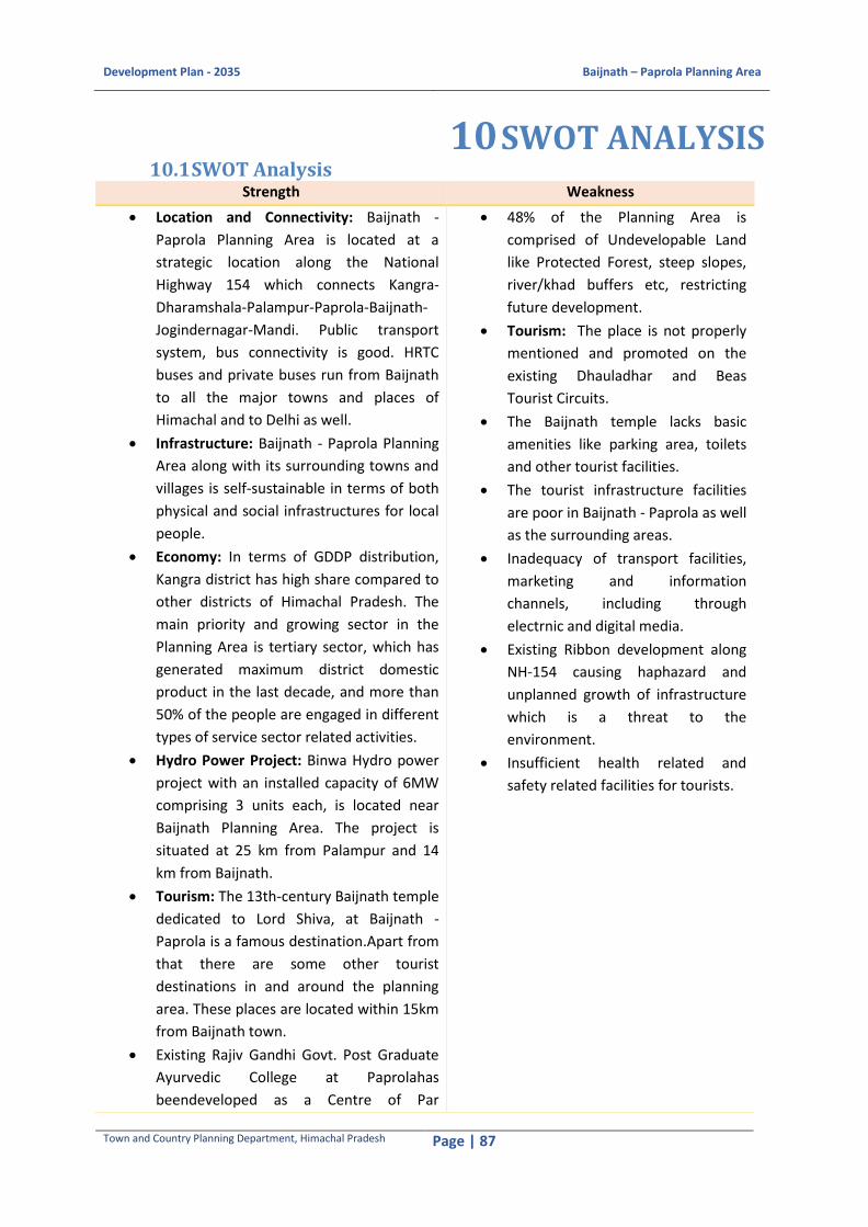
Development Plan - 2035 Baijnath – Paprola Planning Area
Town and Country Planning Department, Himachal Pradesh Page | 87
10 SWOT ANALYSIS 10.1 SWOT Analysis
Strength Weakness
Location and Connectivity: Baijnath -
Paprola Planning Area is located at a
strategic location along the National
Highway 154 which connects Kangra-
Dharamshala-Palampur-Paprola-Baijnath-
Jogindernagar-Mandi. Public transport
system, bus connectivity is good. HRTC
buses and private buses run from Baijnath
to all the major towns and places of
Himachal and to Delhi as well.
Infrastructure: Baijnath - Paprola Planning
Area along with its surrounding towns and
villages is self-sustainable in terms of both
physical and social infrastructures for local
people.
Economy: In terms of GDDP distribution,
Kangra district has high share compared to
other districts of Himachal Pradesh. The
main priority and growing sector in the
Planning Area is tertiary sector, which has
generated maximum district domestic
product in the last decade, and more than
50% of the people are engaged in different
types of service sector related activities.
Hydro Power Project: Binwa Hydro power
project with an installed capacity of 6MW
comprising 3 units each, is located near
Baijnath Planning Area. The project is
situated at 25 km from Palampur and 14
km from Baijnath.
Tourism: The 13th-century Baijnath temple
dedicated to Lord Shiva, at Baijnath -
Paprola is a famous destination.Apart from
that there are some other tourist
destinations in and around the planning
area. These places are located within 15km
from Baijnath town.
Existing Rajiv Gandhi Govt. Post Graduate
Ayurvedic College at Paprolahas
beendeveloped as a Centre of Par
48% of the Planning Area is
comprised of Undevelopable Land
like Protected Forest, steep slopes,
river/khad buffers etc, restricting
future development.
Tourism: The place is not properly
mentioned and promoted on the
existing Dhauladhar and Beas
Tourist Circuits.
The Baijnath temple lacks basic
amenities like parking area, toilets
and other tourist facilities.
The tourist infrastructure facilities
are poor in Baijnath - Paprola as well
as the surrounding areas.
Inadequacy of transport facilities,
marketing and information
channels, including through
electrnic and digital media.
Existing Ribbon development along
NH-154 causing haphazard and
unplanned growth of infrastructure
which is a threat to the
environment.
Insufficient health related and
safety related facilities for tourists.
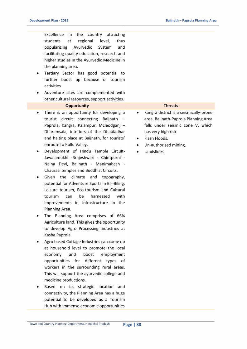
Development Plan - 2035 Baijnath – Paprola Planning Area
Town and Country Planning Department, Himachal Pradesh Page | 88
Excellence in the country attracting
students at regional level, thus
popularizing Ayurvedic System and
facilitating quality education, research and
higher studies in the Ayurvedic Medicine in
the planning area.
Tertiary Sector has good potential to
further boost up because of tourism
activities.
Adventure sites are complemented with
other cultural resources, support activities.
Opportunity Threats
There is an opportunity for developing a
tourist circuit connecting Baijnath –
Paprola, Kangra, Palampur, Mcleodganj –
Dharamsala, interiors of the Dhauladhar
and halting place at Baijnath, for tourists’
enroute to Kullu Valley.
Development of Hindu Temple Circuit-
Jawalamukhi -Brajeshwari - Chintpurni -
Naina Devi, Baijnath - Manimahesh -
Chaurasi temples and Buddhist Circuits.
Given the climate and topography,
potential for Adventure Sports in Bir-Biling,
Leisure tourism, Eco-tourism and Cultural
tourism can be harnessed with
improvements in infrastructure in the
Planning Area.
The Planning Area comprises of 66%
Agriculture land. This gives the opportunity
to develop Agro Processing Industries at
Kasba Paprola.
Agro based Cottage Industries can come up
at household level to promote the local
economy and boost employment
opportunities for different types of
workers in the surrounding rural areas.
This will support the ayurvedic college and
medicine productions.
Based on its strategic location and
connectivity, the Planning Area has a huge
potential to be developed as a Tourism
Hub with immense economic opportunities
Kangra district is a seismically-prone
area. Baijnath-Paprola Planning Area
falls under seismic zone V, which
has very high risk.
Flash Floods.
Un-authorised mining.
Landslides.

Development Plan - 2035 Baijnath – Paprola Planning Area
Town and Country Planning Department, Himachal Pradesh Page | 89
11 DEVELOPMENT PROPOSALS 11.1 Land Suitability Analysis
The development plan for Baijnath-Paprola Planning Area has been proposed on the basis of Land
Suitability analysis. The following indicatros have been selected for land suitability analysis:
Steep Slope greater than 300
Elevation and Contours
Forest Areas
Existing Landuse
River and Stream Buffers (10 m buffer at both banks)
Availablity of Government Land
The study attempts to introduce decision support system used for site suitability analysis. Geographic
Information System (GIS) has been applied to select suitable sites for proposed development. For this
purpose, various thematic layers such as Slope, Elevation, Drainage Catchment, Land Use/Land Cover
(LU/LC), Population Density and Geomorphology maps have been generated in ArcGIS. Highly
suitable areas for urban development is either agricultural and open forest type and the low suitable
areas is mostly areas having slope greater than 300, river and stream buffers and existing residential
areas. Total government land available in the Planning Area is 292 ha. Out of this 180.65 ha. fall
under open forest and 61.21 ha. fall under steep slope greater than 300 leaving only 50.14 ha. as
developable.
Figure 11-1 Development Limitations in Baijnath-Paprola Planning Area
Source: Analysis based on the Satellite Imagery
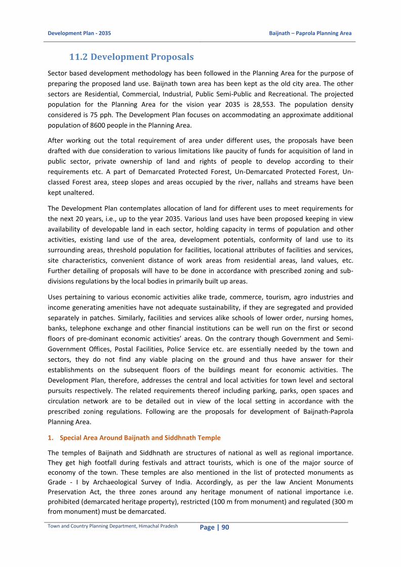
Development Plan - 2035 Baijnath – Paprola Planning Area
Town and Country Planning Department, Himachal Pradesh Page | 90
11.2 Development Proposals
Sector based development methodology has been followed in the Planning Area for the purpose of
preparing the proposed land use. Baijnath town area has been kept as the old city area. The other
sectors are Residential, Commercial, Industrial, Public Semi-Public and Recreational. The projected
population for the Planning Area for the vision year 2035 is 28,553. The population density
considered is 75 pph. The Development Plan focuses on accommodating an approximate additional
population of 8600 people in the Planning Area.
After working out the total requirement of area under different uses, the proposals have been
drafted with due consideration to various limitations like paucity of funds for acquisition of land in
public sector, private ownership of land and rights of people to develop according to their
requirements etc. A part of Demarcated Protected Forest, Un-Demarcated Protected Forest, Un-
classed Forest area, steep slopes and areas occupied by the river, nallahs and streams have been
kept unaltered.
The Development Plan contemplates allocation of land for different uses to meet requirements for
the next 20 years, i.e., up to the year 2035. Various land uses have been proposed keeping in view
availability of developable land in each sector, holding capacity in terms of population and other
activities, existing land use of the area, development potentials, conformity of land use to its
surrounding areas, threshold population for facilities, locational attributes of facilities and services,
site characteristics, convenient distance of work areas from residential areas, land values, etc.
Further detailing of proposals will have to be done in accordance with prescribed zoning and sub-
divisions regulations by the local bodies in primarily built up areas.
Uses pertaining to various economic activities alike trade, commerce, tourism, agro industries and
income generating amenities have not adequate sustainability, if they are segregated and provided
separately in patches. Similarly, facilities and services alike schools of lower order, nursing homes,
banks, telephone exchange and other financial institutions can be well run on the first or second
floors of pre-dominant economic activities’ areas. On the contrary though Government and Semi-
Government Offices, Postal Facilities, Police Service etc. are essentially needed by the town and
sectors, they do not find any viable placing on the ground and thus have answer for their
establishments on the subsequent floors of the buildings meant for economic activities. The
Development Plan, therefore, addresses the central and local activities for town level and sectoral
pursuits respectively. The related requirements thereof including parking, parks, open spaces and
circulation network are to be detailed out in view of the local setting in accordance with the
prescribed zoning regulations. Following are the proposals for development of Baijnath-Paprola
Planning Area.
1. Special Area Around Baijnath and Siddhnath Temple
The temples of Baijnath and Siddhnath are structures of national as well as regional importance.
They get high footfall during festivals and attract tourists, which is one of the major source of
economy of the town. These temples are also mentioned in the list of protected monuments as
Grade - I by Archaeological Survey of India. Accordingly, as per the law Ancient Monuments
Preservation Act, the three zones around any heritage monument of national importance i.e.
prohibited (demarcated heritage property), restricted (100 m from monument) and regulated (300 m
from monument) must be demarcated.

Development Plan - 2035 Baijnath – Paprola Planning Area
Town and Country Planning Department, Himachal Pradesh Page | 91
An integrated heritage management plan for the Baijnath and Sidhhnath temple is in need which will
suggests detailed proposals and regulations addressing movement, activities and buildings with in
the impact region of the temple of national importance, still the regulations and proposals to be
followed with in the region of the temple’s restricted and regulated area are mentioned accordingly.
To improve connectivity along with facilitating and encouraging the pedestrian movement in
and around the temple area, a pedestrian bridge connecting the paprola railway station to
the river bed downhill of Baijnath temple on the opposite side is proposed. This bride will
help mitigate congestion issues during peak festivals decreasing the possibilities of casualties
and stampede.
The river bed area below temple cliff is proposed as open cultural activity area/ mela ground
with Ghats etc.
Within the demarcated region around temples of national importance activities, built use and
landuse must be regulated depending upon the primary religious tourism character of the
place. Native and old residential, if any needs to identified and restored, activities generating
heavy vehicular traffic must be moved out, a low rise tourist centric economies must be
promoted.
2. Strengthening Agro based Informal Sectors
Baijnath region has a long cultural lineage for agriculture, sericulture, floriculture and medicinal plantation. Presence of several Ayurvedic institutes and research centers in the region responds to this local potential. To further explore the possibilities in order to generate revenue for locals, a structure to promote this agriculture of specific type is proposed. Both the sides of Biswa river crossing Baijnath – paprola planning g boundary is retained and further restricted for special agriculture where the land use cannot be changed. A government based storing, packaging, loading and unloading centre is also proposed in koti village towards south west of village and a road connecting this area starting from the Ayurvedic institute towards truck terminal/ wholesale market/ tourism centre/ shopping area (multi-functional district) and further connecting NH-154 outside the town. This newly proposed road adjacent to railway line has mixed use belt to promote residential based small and medium scale agro based industries. The overall proposal will certainly strengthen the local economy. 3. Decongestion of Core Town
The NH - 154 crossing through Baijnath and Paprola Planning Area boundary is the primary connectivity of the town with surrounding areas. As Baijnath and Paprola lies on comparatively flatter terrain, still major linear/ribbon development along the road sides can be seen in the towns. These roads get more congested during annual and regional festivals. A restructuring of road network system is proposed to further improve the movement and liveability of the town. First proposed road connects Ayurvedic institute to NH - 154 along the railway line. Second proposed road acts as a bypass to the town, most importantly used during festivals to control high footfall in the town. This bypass also limits the town growth by retaining agriculture and fertile land further to towards the north of town. Also, the road is strategically planned after the proposed truck terminal to avoid heavy vehicle congestion with in the town. 4. Ribbon development along the roads, especially on the fringes
Ribbon development especially in hilly regions is a very common phenomenon. It is considered as
haphazard in nature and grows incrementally adjacent to major roads radiating outside the city
core/centre. If kept unplanned it is certain to put additional pressure over the infrastructure and
generate numerous conflict zones. To convert this “ribbon development” in to an asset a detailed

Development Plan - 2035 Baijnath – Paprola Planning Area
Town and Country Planning Department, Himachal Pradesh Page | 92
area based planning is in need. Although, the generic development regulations catering to this type
of development are as follows:
i. Polycentric nodes and their hierarchy
Development needs to be considered curbing the haphazard ribbon development on the
road edges along National highway.
ii. Access
At 500 m and 300 m offset
iii. Existing land use along the belt
(Based on the mentioned case references.)
iv. Buffer zone/ green belt
(Based on the mentioned case references)
v. Service road
(Based on the mentioned case references)
Case 1:
Case 2:
Case 3:
Case 4:
The identified stretches (3
no’s) in Baijnath-Paprola

Development Plan - 2035 Baijnath – Paprola Planning Area
Town and Country Planning Department, Himachal Pradesh Page | 93
radiating outside the city core with in the planning boundary are as follows:
Stretch 1: NH - 154 from Paprola railway station towards Paprola municipal boundary in
North-West of town has scattered edge development on both sides. The development is
majorly mixed use and residential with patches of agriculture transforming frequently. A
special consideration for curbing ribbon development is required in the stretch after
proposed bypass road junctionon NH - 154 leading towards Palampur.
Stretch 2: NH - 154 which connects Baijnath to Bir - Billing and Jogindarnagar towards South-
East has sparse edge development and is under continuous transformation.
Stretch 3: State Highway which connects Baijnath to Neri has a regional character and needs to be retained for nodal development. This major city road is on a flatter and wider terrain and caters one of the most important institutions and public functions of the town.
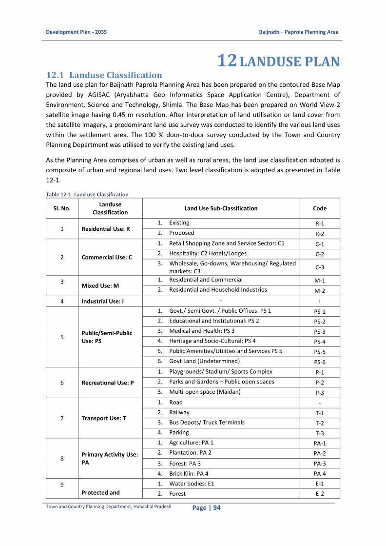
Development Plan - 2035 Baijnath – Paprola Planning Area
Town and Country Planning Department, Himachal Pradesh Page | 94
12 LANDUSE PLAN 12.1 Landuse Classification The land use plan for Baijnath Paprola Planning Area has been prepared on the contoured Base Map
provided by AGISAC (Aryabhatta Geo Informatics Space Application Centre), Department of
Environment, Science and Technology, Shimla. The Base Map has been prepared on World View-2
satellite image having 0.45 m resolution. After interpretation of land utilisation or land cover from
the satellite imagery, a predominant land use survey was conducted to identify the various land uses
within the settlement area. The 100 % door-to-door survey conducted by the Town and Country
Planning Department was utilised to verify the existing land uses.
As the Planning Area comprises of urban as well as rural areas, the land use classification adopted is
composite of urban and regional land uses. Two level classification is adopted as presented in Table
12-1.
Table 12-1: Land use Classification
Sl. No. Landuse
Classification Land Use Sub-Classification Code
1 Residential Use: R 1. Existing R-1
2. Proposed R-2
2 Commercial Use: C
1. Retail Shopping Zone and Service Sector: C1 C-1
2. Hospitality: C2 Hotels/Lodges C-2
3. Wholesale, Go‐downs, Warehousing/ Regulated markets: C3
C-3
3
Mixed Use: M 1. Residential and Commercial M-1
2. Residential and Household Industries M-2
4 Industrial Use: I - I
5 Public/Semi-Public Use: PS
1. Govt./ Semi Govt. / Public Offices: PS 1 PS-1
2. Educational and Institutional: PS 2 PS-2
3. Medical and Health: PS 3 PS-3
4. Heritage and Socio-Cultural: PS 4 PS-4
5. Public Amenities/Utilities and Services PS 5 PS-5
6. Govt Land (Undetermined) PS-6
6 Recreational Use: P
1. Playgrounds/ Stadium/ Sports Complex P-1
2. Parks and Gardens – Public open spaces P-2
3. Multi‐open space (Maidan) P-3
7 Transport Use: T
1. Road -
2. Railway T-1
3. Bus Depots/ Truck Terminals T-2
4. Parking T-3
8 Primary Activity Use: PA
1. Agriculture: PA 1 PA-1
2. Plantation: PA 2 PA-2
3. Forest: PA 3 PA-3
4. Brick Klin: PA 4 PA-4
9
Protected and
1. Water bodies: E1 E-1
2. Forest E-2

Development Plan - 2035 Baijnath – Paprola Planning Area
Town and Country Planning Department, Himachal Pradesh Page | 95
Sl. No. Landuse
Classification Land Use Sub-Classification Code
Undevelopable Use: E
3. Green Belt/Buffer: E3 E-3
10 Special Area - S
Source: Based on URDPFI Guidelines
12.2 Existing Landuse Distribution Baijnath-Paprola Planning Area is 1823 ha., out of this total land only 395.39 ha. i.e., 22 % is
developed and remaining 1428.18 ha. i.e., 78 % is non-developable. Of the total developed land,
about 78.03 % is residential area. Transportation, which includes roads, parking areas, bus terminal,
bus stands, railway lines and railway stations, constitutes an area of 45.04 ha. i.e. 11.40 % of the total
area. The commercial area and public and semi-public area in Baijnath-Paprola Planning Area account
for nearly 3.47 % of total developed area of Baijnath-Paprola Planning Area. The developed area of
Baijnath-Paprola Planning Area has nearly 2.54 ha. under recreational green i.e. 0.64 % of the total
developed land. Table 12-2 shows the existing land use distribution and Proposed land uses for
Baijnath-Paprola Planning Area.
Table 12-2 Existing Landuse Distribution and Proposed Land Uses
Land Use Categories
Hill Towns Standards
Tourism Towns
Standards
Existing Area (Ha)
Existing %
Additional Area
Requirement (Ha)
% of Additional
Area in comparison to Existing
Area
Proposed Area in Hactare
Proposed %
Residential 50-55 35-40 308.53 78.03 1.73 2.96 310.3 68.38
Commercial and Mixed 2-3 5-7
13.71 3.47
5.23 8.96
1.6 0.34
Mixed Use 0.00 17.4 3.83
Public & Semi-Public 8-10 10-12
25.53 6.46 -1.47 -2.52 24.1 5.30
Industrial 3-4 4-5 0.00 0.00 0.00 0.00
0.00
Recreational 15-18 10-12 2.54 0.64 1.78 3.05 4.3 0.95
Transportation 5-6 12-14 45.08 11.40 51.08 87.54 96.2 21.19
Total (A) 395.39 100.00 58.35 100.00 453.7 100.00
Undevelopable Area (B)
619.58 33.99
Water Bodies 39.12 2.74 39.1 2.86
Agriculture and Open Area
808.03 56.60 738.4 53.92
No construction
Zone or Buffer Areas
0.00 0.00 35.4 2.58
Forest 532.71 37.31 508.6 37.15
Tea Garden 40.70 2.85 40.7 2.98
Special Area 7.1 0.49 7.1 0.51
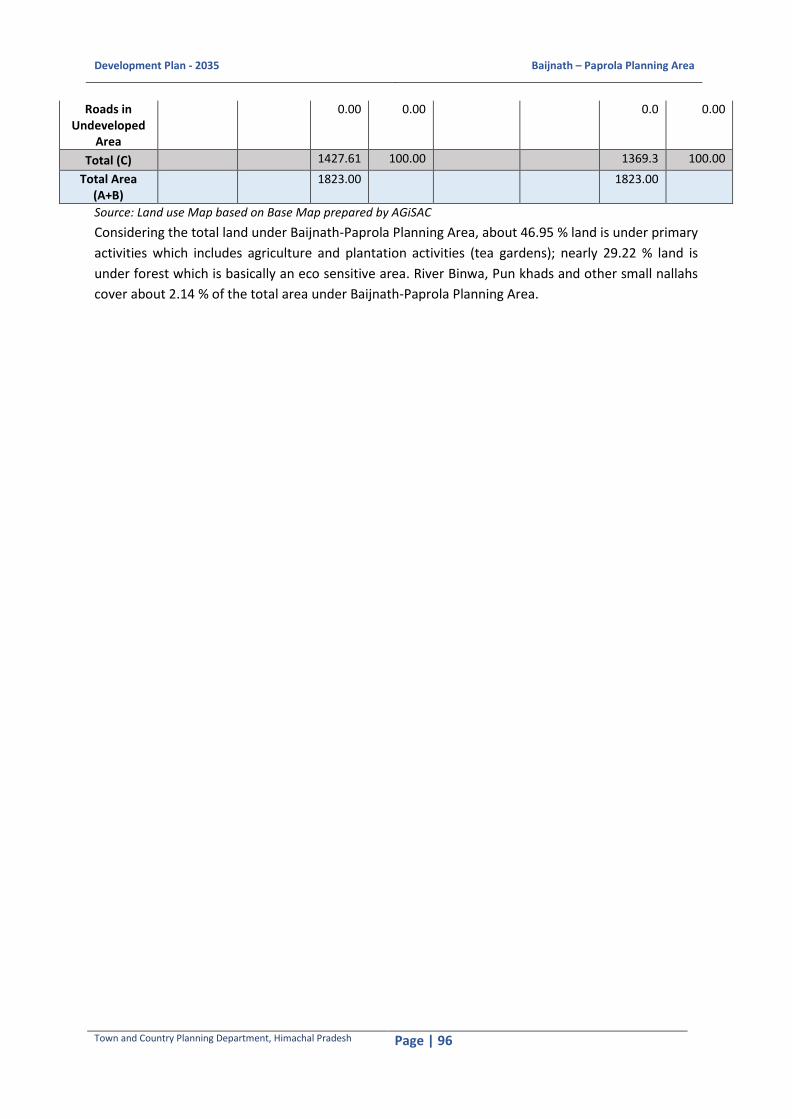
Development Plan - 2035 Baijnath – Paprola Planning Area
Town and Country Planning Department, Himachal Pradesh Page | 96
Roads in Undeveloped
Area
0.00 0.00 0.0 0.00
Total (C) 1427.61 100.00 1369.3 100.00
Total Area (A+B)
1823.00 1823.00
Source: Land use Map based on Base Map prepared by AGiSAC
Considering the total land under Baijnath-Paprola Planning Area, about 46.95 % land is under primary
activities which includes agriculture and plantation activities (tea gardens); nearly 29.22 % land is
under forest which is basically an eco sensitive area. River Binwa, Pun khads and other small nallahs
cover about 2.14 % of the total area under Baijnath-Paprola Planning Area.

Development Plan - 2035 Baijnath – Paprola Planning Area
Town and Country Planning Department, Himachal Pradesh Page | 97
Figure 12-1 Existing Land Use Map of Baijnath-Paprola Planning Area

Development Plan - 2035 Baijnath – Paprola Planning Area
Town and Country Planning Department, Himachal Pradesh Page | 98
12.3 Land Allocation Mechanism
Allocation of developable land for different uses to meet with the requirements for the next 20
years i.e. upto the year 2035 is made and proposed land-use structure devised accordingly.
As the Government land is scarce almost entire infrastructural development including roads,
commercial activities, residential activities, has to take place on private land in accordance with
population of the area, topographical conditions and potentials and propensities of land. The land
owners, however, resist for any sort of proposal for community uses and compel the authorities
to change the proposals. Therefore, approach of negotiated proposals has, been envisaged in the
Development Plan. Further detailing of proposals will have to be done in accordance with
prescribed zoning and sub-divisions regulations by the local bodies in primarily built up areas, the
Revenue Department and the development agency through limited land acquisition, land pooling
reconstitution mechanism involving land owners in the new areas.
Uses pertaining to various economic activities like trade, commerce, tourism, industries and
income generating amenities if, segregated and provided separately in patchesare
unsustainability. Similarly, facilities and services like schools, nursing homes, banks, telephone
exchange and other financial institutions also needs to be close proximity of the habitation. On
the contrary, Government and Semi-Government Offices, Postal Facilities, Police Service etc. are
essentially town level facilities which can be at a central location away from the habitation as
well. The Development Plan, therefore, addresses the central and local activities for town
level/regional and sectoral pursuits respectively. The related requirements thereof including
parking, parks, open spaces and circulation networks are to be detailed out in view of the local
setting in accordance with the prescribed zoning regulations.
12.4 Proposed Landuse Plan
The vision behind this proposed Development Plan right from its conception to the present day is
that there will be an intense and close interrelationship between the Town Area and the outside
rural area, including the demarcated open forest, which will be of a synergical nature. Each would
complement the other, and support the activities in the 'urban' and 'rural' sectors, thus reducing
the urban and rural divide that has crept into urban planning so far, and encouraging a rural -
urban continuum.
The new built-up area, consisting of buildings and developments for Residential, Manufacturing,
Commercial, Public Semi-Public and Utility Uses and Open Spaces, would evolve around the old
twin towns of Baijnath and Paprola.
The largely unbuilt part consisting of agricultural uses, demarcated protected forests, river,
drains, channels and a number of green activities linked to the promotion of sustainable
development, wouldencircle thisnew development and act as interface between the town and its
bio-region. However, the proposals for road widening have taken some areas that are already
under forest, public and semi-public land uses. The existing land use has considered commercial
and mixed and use under same head where as while preparing the proposed plan the two were
considered as different land uses.

Development Plan - 2035 Baijnath – Paprola Planning Area
Town and Country Planning Department, Himachal Pradesh Page | 99
a) Residential Use
Based on the analysis and population projections the future requirements for residential area has
been calculated. The existing overall population density is approximately 51.9 pph which is on the
lower side. Considering an increase of approximately 20 percent in the population density for
target year it is recommended to plan for 63 pph which is within the standard range
recommended for Hilly towns by URDPFI guidelines. On the basis of residential density of 63
persons per hectare, maximum living space per person has been proposed by redensification of
the existing towns of Nagan, Paprola Khas, Koti, Pandteher, Kharanal, Ghartholi, Ustehar,
Pandtahar and Gankheter has been proposed. The residential areas are proposed to be
developed in and in the surroundings of the Nagar Panchayat Areas around the existing
settlements. The remaining area has been allocated for the natural growth of the village abadis.
The local activities of cluster level such as nursery and primary schools, dispensaries, parks, toilets
etc. form an integral part of the residential areas and are to be detailed out during the course of
preparation of Sectoral Plans and Schemes. 310.3 ha. of residential area has been proposed in the
Development Plan.
b) Commercial Use
A total area of 1.6 Ha has been proposed for Commercial Use. Most of the commercial facilities
have been proposed within the urbanisable area in order to carter to the residing population.
Shopping centres are proposed to be developed alongwith sizeable shops and requisite
infrastructure, along the NH-154. Moreover, the Development Plan envisages to prepare
improvement schemes for the existing shopping centre to ensure improvement in environmental
quality.
c) Mixed use
A total area of 17.4 Ha has been proposed under mixed use development along the NH-154, MDR
- 43 and other major transit roads. Two types of mixed uses have been proposed,
i) residential with commercial (M-1) which is to be developed along the transi corridors and
ii) residential with household industries (M-2) which is to be developed along the proposed road
in Kothi connecting the Agro-Industrial Unit with the proposed truck terminal at Paprola Khas.
d) Public and Semi-Public Use
The Public and Semi-Public Use includes utilities, facilities, services, Government and Semi
Government offices and Institutions. The Utilities i.e. water supply, sewerage, drainage,
electricity, telephone establishments, garbage disposal etc. and facilities like education, health,
postal, police, fire fighting, banking etc. besides Government and semi Government offices etc
have been given due consideration for allocation of land for this purpose in the Development
plan. These Institutions have extraneous influence zone beyond the immediate hinterland. These
institutions are proposed to be developed through their own mechanism by the respective
authorities. Accordingly, 24.1 ha. of land is propose under Public and Semi-Public use in the
Planning Area by the year 2035.

Development Plan - 2035 Baijnath – Paprola Planning Area
Town and Country Planning Department, Himachal Pradesh Page | 100
e) Parks and Open Spaces Use
An area of 4.3 Ha has been proposed for organised parks and open spaces. The parks and gardens
are proposed at different villages in the Planning Area. Besides, Botanical Garden and Zoological
Park have also been proposed near Bheth Jhikli village. Conservation of open spaces within the
Planning Area will be promoted.
f) Transportation Use
Transport influences economic development, population distribution, the shape of towns/cities,
energy consumption, access to markets and quality of life. As the town has grown along National
Highway 154, there is a lot of regional traffic on these narrow roads for which improvement in
road network is proposed in the shape of bye-pass road. Parking areas have been proposed along
NH-154 near to the Choubin Chowk and Paprola petrol pump. The Bus and truck terminal at
Paprola Khas has also been proposed to ease the movement of the trucks.
The Development Plan envisages to provide parking lots and road widening, by-pass also an
additional bridge over the River Binwa to meet the requirements of increasing traffic volume on
major entry points to already congested town. An area of 96.2 Ha has been proposed for Traffic
and Transportation Use.
g) Special Area
The special area has been demarcated around the Baijnath temple complex. The special
comprises of the Baijnath Temple, Kheer Ganga ghat, Siddhnath temple and the old bazar area.
This area should be planned properly and proposed to be developed as the restrictive zone in
terms of parking, construction etc. An area of 7.1 Ha has been demarcated as the Special Area.
h) Primary Activities
The area under primary activities comprises of agricultural land and plantation areas, specifically
the tea gardens. An area of 738.4 Ha is proposed to be as agricultural lands. The agricultural land
is subject to land use change for residential purpose. An area of 40.7 Ha is to be retained as the
tea garden. The tea garden is subject to no land use change policy.
i) Protected and restricted areas
Protected and restricted areas include the forest areas, water bodies, river buffer areas. These
conjointly form an area of 584.7 Ha which should be demarcated as the protected area and no
development works and no constructions would be promoted on these lands.

Development Plan - 2035 Baijnath – Paprola Planning Area
Town and Country Planning Department, Himachal Pradesh Page | 101
Figure 12-2 Proposed Landuse Map 2035 of Baijnath-Paprola Planning Area
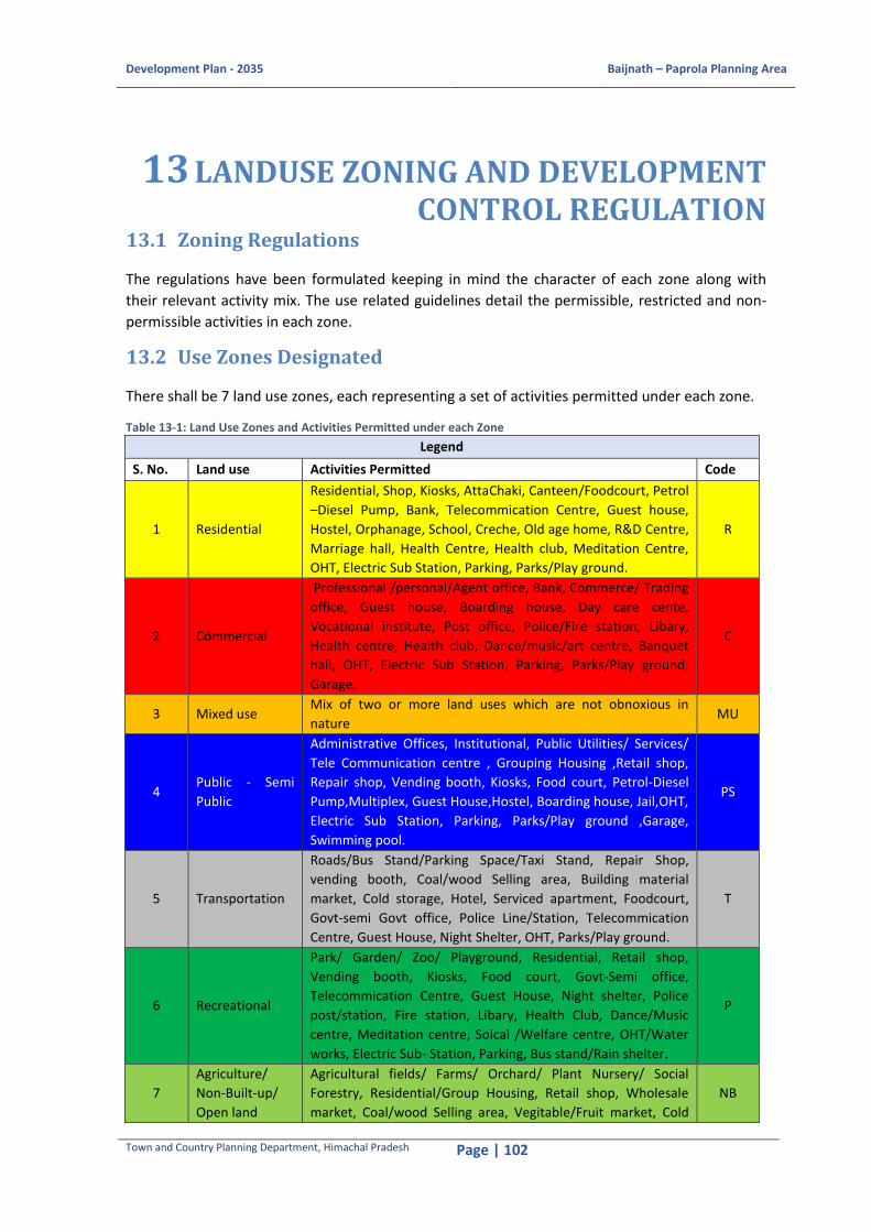
Development Plan - 2035 Baijnath – Paprola Planning Area
Town and Country Planning Department, Himachal Pradesh Page | 102
13 LANDUSE ZONING AND DEVELOPMENT CONTROL REGULATION
13.1 Zoning Regulations
The regulations have been formulated keeping in mind the character of each zone along with
their relevant activity mix. The use related guidelines detail the permissible, restricted and non-
permissible activities in each zone.
13.2 Use Zones Designated
There shall be 7 land use zones, each representing a set of activities permitted under each zone.
Table 13-1: Land Use Zones and Activities Permitted under each Zone
Legend
S. No. Land use Activities Permitted Code
1 Residential
Residential, Shop, Kiosks, AttaChaki, Canteen/Foodcourt, Petrol
–Diesel Pump, Bank, Telecommication Centre, Guest house,
Hostel, Orphanage, School, Creche, Old age home, R&D Centre,
Marriage hall, Health Centre, Health club, Meditation Centre,
OHT, Electric Sub Station, Parking, Parks/Play ground.
R
2 Commercial
Professional /personal/Agent office, Bank, Commerce/ Trading
office, Guest house, Boarding house, Day care cente,
Vocational institute, Post office, Police/Fire station, Libary,
Health centre, Health club, Dance/music/art centre, Banquet
hall, OHT, Electric Sub Station, Parking, Parks/Play ground,
Garage,
C
3 Mixed use Mix of two or more land uses which are not obnoxious in
nature MU
4 Public - Semi
Public
Administrative Offices, Institutional, Public Utilities/ Services/
Tele Communication centre , Grouping Housing ,Retail shop,
Repair shop, Vending booth, Kiosks, Food court, Petrol-Diesel
Pump,Multiplex, Guest House,Hostel, Boarding house, Jail,OHT,
Electric Sub Station, Parking, Parks/Play ground ,Garage,
Swimming pool.
PS
5 Transportation
Roads/Bus Stand/Parking Space/Taxi Stand, Repair Shop,
vending booth, Coal/wood Selling area, Building material
market, Cold storage, Hotel, Serviced apartment, Foodcourt,
Govt-semi Govt office, Police Line/Station, Telecommication
Centre, Guest House, Night Shelter, OHT, Parks/Play ground.
T
6 Recreational
Park/ Garden/ Zoo/ Playground, Residential, Retail shop,
Vending booth, Kiosks, Food court, Govt-Semi office,
Telecommication Centre, Guest House, Night shelter, Police
post/station, Fire station, Libary, Health Club, Dance/Music
centre, Meditation centre, Soical /Welfare centre, OHT/Water
works, Electric Sub- Station, Parking, Bus stand/Rain shelter.
P
7
Agriculture/
Non-Built-up/
Open land
Agricultural fields/ Farms/ Orchard/ Plant Nursery/ Social
Forestry, Residential/Group Housing, Retail shop, Wholesale
market, Coal/wood Selling area, Vegitable/Fruit market, Cold
NB

Development Plan - 2035 Baijnath – Paprola Planning Area
Town and Country Planning Department, Himachal Pradesh Page | 103
Legend
S. No. Land use Activities Permitted Code
Stroage, Petrol-Diesel Pump, Gas Godown, Sugar/Rice/Floor
mill, Milk Collection centre, School, Health Centre, STP,
OHT/water works, Compost plant, Tele communication tower,
Religious, Golf/racecourse, Recreational club/Swimming pool,
Botanical /Zoological garden, Shooting range.
For each zone, besides the activities permitted, there will be certain activities/utilities which shall
be prohibited or conditionally permitted as per the criteria stated below:
Uses Permitted
Activities/ utilities which are ancillary to the Main Land Use are planned and permitted. A. Conditionally Permitted
Activities/ utilities planned and permitted under certain terms and conditions. The terms and conditions are as follows:
1. Residential area on the upper floors except the ground floor
2. 5 percent of the total planning area (maximum 5 percent of the total planning area)
3. On minimum 5m road
4. On minimum 7m road
5. On minimum 9m road
6. On minimum 12m road
7. On minimum 9m road for maximum up to 20 bed health facility
All the above seven listed conditions may be over ruled on special ground/ under special
circumstances by the Director, Town and Country Planning Department.
B. Specially Permitted
These activities will be planned or permitted after specific permission of the Authority keeping in
view the infrastructure and their environmental impact on the surrounding area etc. i.e. on the
basis of the merits and demerits each case. The required terms and conditions are further
exemplifies in the zoning matrix (Table 14-2).
C. Uses Prohibited
These activities will not be permitted in the designated Land Use Zone. The details of regulations
regarding uses permitted, permitted conditionally, specialy permitted and uses prohibited are
stated through the index table below and Land Use Matrix.
Index
Use Permitted P. Specially Permitted** SP
Conditionally Permitted* 1 to 7 Uses prohibited*** NP
* Refer point A
** Refer point B
*** Refer point C
Each use zone is sub-divided into use premises and permission of use premises in each use zone
at the time of layout preparation will be governed by the matrix below.
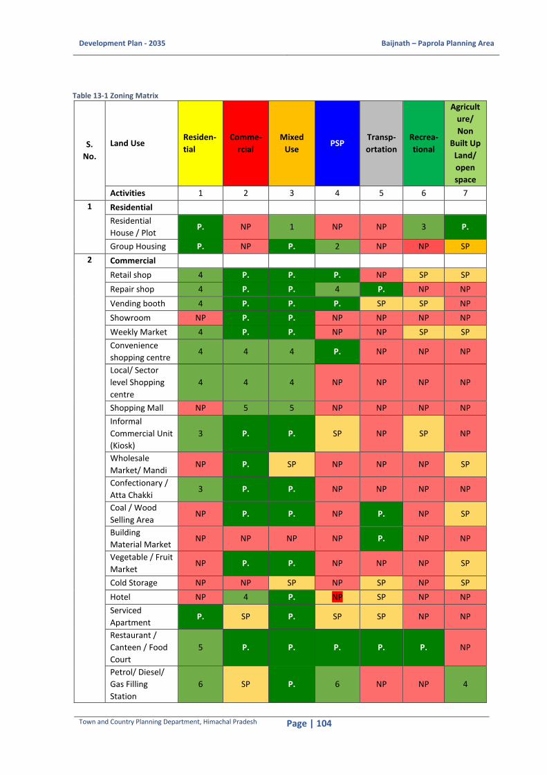
Development Plan - 2035 Baijnath – Paprola Planning Area
Town and Country Planning Department, Himachal Pradesh Page | 104
Table 13-1 Zoning Matrix
S.
No.
Land Use Residen-
tial
Comme-
rcial
Mixed
Use PSP
Transp-
ortation
Recrea-
tional
Agricult
ure/
Non
Built Up
Land/
open
space
Activities 1 2 3 4 5 6 7
1 Residential
Residential
House / Plot P. NP 1 NP NP 3 P.
Group Housing P. NP P. 2 NP NP SP
2 Commercial
Retail shop 4 P. P. P. NP SP SP
Repair shop 4 P. P. 4 P. NP NP
Vending booth 4 P. P. P. SP SP NP
Showroom NP P. P. NP NP NP NP
Weekly Market 4 P. P. NP NP SP SP
Convenience
shopping centre 4 4 4 P. NP NP NP
Local/ Sector
level Shopping
centre
4 4 4 NP NP NP NP
Shopping Mall NP 5 5 NP NP NP NP
Informal
Commercial Unit
(Kiosk)
3 P. P. SP NP SP NP
Wholesale
Market/ Mandi NP P. SP NP NP NP SP
Confectionary /
Atta Chakki 3 P. P. NP NP NP NP
Coal / Wood
Selling Area NP P. P. NP P. NP SP
Building
Material Market NP NP NP NP P. NP NP
Vegetable / Fruit
Market NP P. P. NP NP NP SP
Cold Storage NP NP SP NP SP NP SP
Hotel NP 4 P. NP SP NP NP
Serviced
Apartment P. SP P. SP SP NP NP
Restaurant /
Canteen / Food
Court
5 P. P. P. P. P. NP
Petrol/ Diesel/
Gas Filling
Station
6 SP P. 6 NP NP 4

Development Plan - 2035 Baijnath – Paprola Planning Area
Town and Country Planning Department, Himachal Pradesh Page | 105
S.
No.
Land Use Residen-
tial
Comme-
rcial
Mixed
Use PSP
Transp-
ortation
Recrea-
tional
Agricult
ure/
Non
Built Up
Land/
open
space
Activities 1 2 3 4 5 6 7
Gas Godown NP NP SP NP NP NP SP
Cinema/
Multiplex NP 5 5 SP NP NP NP
3 Industrial
Small/ Light
Industry NP NP 4 NP NP NP NP
Suger Mill, Rice
rollers / Flour
Mill
NP NP NP NP NP NP SP
Milk
Pasteurization
and collection
centre
NP NP NP NP NP NP SP
4 Offices
Govt. / Semi
Govt. / Public
Undertaking/
Local Body
Office
4 NP P. P. P. SP NP
Professional/
Personal/ Agent
Office
P. P. P. P. P. NP NP
Bank SP 4 P. P. P. NP NP
Commerce /
Trading Offices 4 P. P. P. P. NP NP
Labour Welfare
Centre NP NP SP P. P. NP NP
P.A.C. / Police
Lines NP NP SP P. SP NP NP
Satellite/Wireles
s/
Telecommunicat
ion Centre
SP NP SP P. SP P. NP
5 Public Semi
Public
Guest House/
Lodging SP SP P. P. P. P. NP
Boarding House
/ Night Shelter 3 SP P. SP P. P. NP
Hostel 3 NP P. SP NP NP NP
Reformatory SP NP P. NP NP NP NP
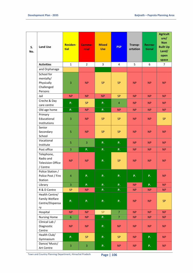
Development Plan - 2035 Baijnath – Paprola Planning Area
Town and Country Planning Department, Himachal Pradesh Page | 106
S.
No.
Land Use Residen-
tial
Comme-
rcial
Mixed
Use PSP
Transp-
ortation
Recrea-
tional
Agricult
ure/
Non
Built Up
Land/
open
space
Activities 1 2 3 4 5 6 7
and Orphanage
School for
mentally/
Physically
Challenged
Persons
3 NP SP SP NP NP NP
Jail NP NP NP SP NP NP NP
Creche & Day
care centre P. SP P. 4 NP NP NP
Old age home P. NP P. NP NP NP NP
Primary
Educational
Institutions
3 NP SP SP NP NP SP
Senior
Secondary
School
5 NP SP SP NP NP NP
Vocational
Institute 5 3 P. P. NP NP NP
Post office 3 P. P. P. NP NP NP
Telephone,
Radio and
Television Office
/ Centre
NP NP P. SP NP NP NP
Police Station /
Police Post / Fire
Station
4 P. P. P. P. P. NP
Library 3 P. P. P. NP P. NP
R & D Centre SP NP P. P. NP NP NP
Health Centre/
Family Welfare
Centre/Dispensa
ry
P. P. P. P. NP NP SP
Hospital NP NP SP 7 NP NP NP
Nursing Home 6 NP P. 7 NP NP NP
Clinical Lab /
Diagnostic
Centre
NP NP P. NP NP NP NP
Health Club/
Gymnasium P. SP P. SP NP P. NP
Dance/ Music/
Art Centre 3 3 P. NP NP P. NP
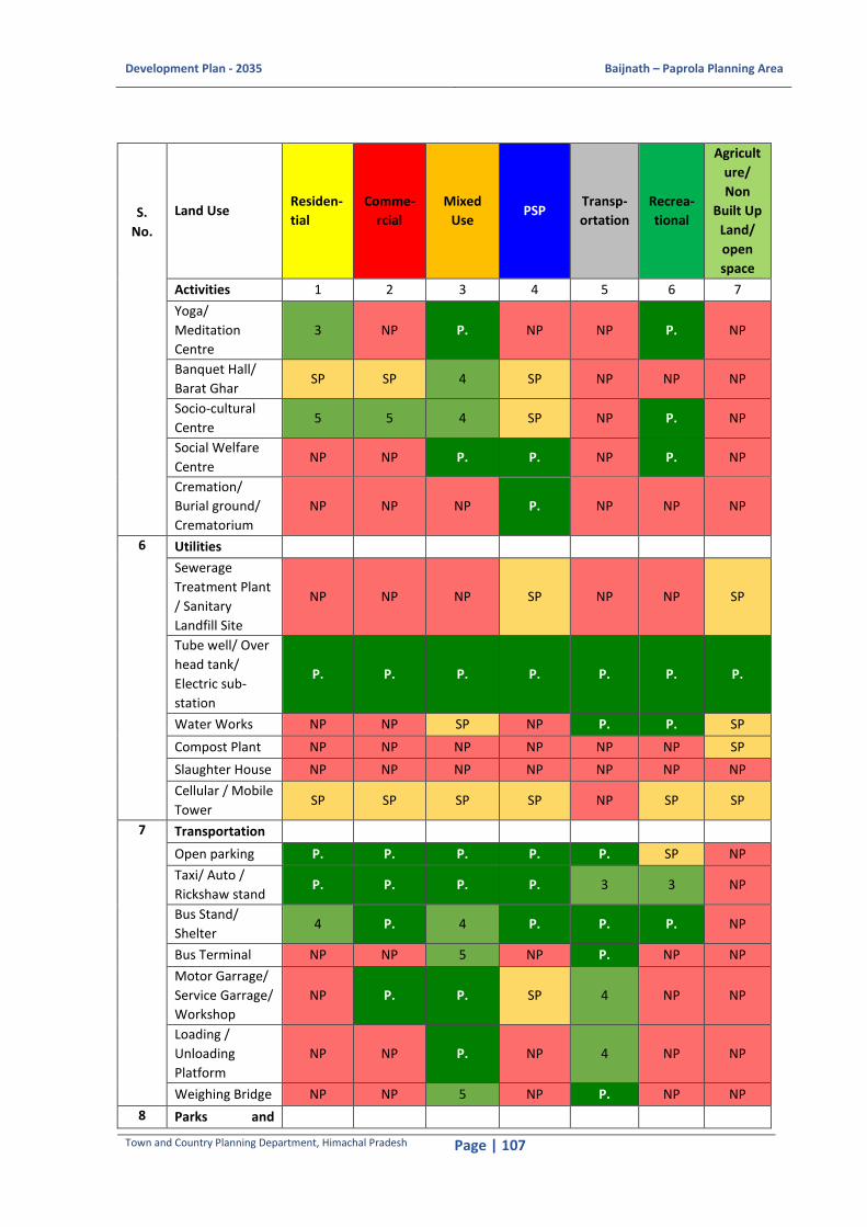
Development Plan - 2035 Baijnath – Paprola Planning Area
Town and Country Planning Department, Himachal Pradesh Page | 107
S.
No.
Land Use Residen-
tial
Comme-
rcial
Mixed
Use PSP
Transp-
ortation
Recrea-
tional
Agricult
ure/
Non
Built Up
Land/
open
space
Activities 1 2 3 4 5 6 7
Yoga/
Meditation
Centre
3 NP P. NP NP P. NP
Banquet Hall/
Barat Ghar SP SP 4 SP NP NP NP
Socio-cultural
Centre 5 5 4 SP NP P. NP
Social Welfare
Centre NP NP P. P. NP P. NP
Cremation/
Burial ground/
Crematorium
NP NP NP P. NP NP NP
6 Utilities
Sewerage
Treatment Plant
/ Sanitary
Landfill Site
NP NP NP SP NP NP SP
Tube well/ Over
head tank/
Electric sub-
station
P. P. P. P. P. P. P.
Water Works NP NP SP NP P. P. SP
Compost Plant NP NP NP NP NP NP SP
Slaughter House NP NP NP NP NP NP NP
Cellular / Mobile
Tower SP SP SP SP NP SP SP
7 Transportation
Open parking P. P. P. P. P. SP NP
Taxi/ Auto /
Rickshaw stand P. P. P. P. 3 3 NP
Bus Stand/
Shelter 4 P. 4 P. P. P. NP
Bus Terminal NP NP 5 NP P. NP NP
Motor Garrage/
Service Garrage/
Workshop
NP P. P. SP 4 NP NP
Loading /
Unloading
Platform
NP NP P. NP 4 NP NP
Weighing Bridge NP NP 5 NP P. NP NP
8 Parks and
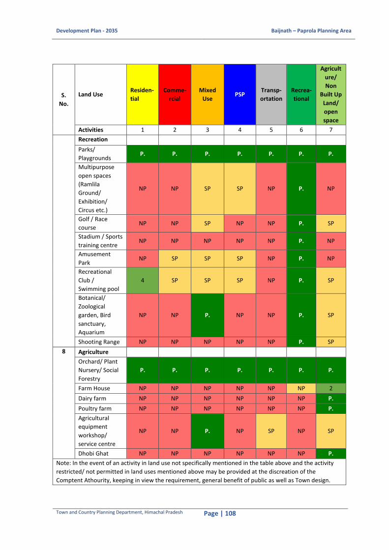
Development Plan - 2035 Baijnath – Paprola Planning Area
Town and Country Planning Department, Himachal Pradesh Page | 108
S.
No.
Land Use Residen-
tial
Comme-
rcial
Mixed
Use PSP
Transp-
ortation
Recrea-
tional
Agricult
ure/
Non
Built Up
Land/
open
space
Activities 1 2 3 4 5 6 7
Recreation
Parks/
Playgrounds P. P. P. P. P. P. P.
Multipurpose
open spaces
(Ramlila
Ground/
Exhibition/
Circus etc.)
NP NP SP SP NP P. NP
Golf / Race
course NP NP SP NP NP P. SP
Stadium / Sports
training centre NP NP NP NP NP P. NP
Amusement
Park NP SP SP SP NP P. NP
Recreational
Club /
Swimming pool
4 SP SP SP NP P. SP
Botanical/
Zoological
garden, Bird
sanctuary,
Aquarium
NP NP P. NP NP P. SP
Shooting Range NP NP NP NP NP P. SP
8 Agriculture
Orchard/ Plant
Nursery/ Social
Forestry
P. P. P. P. P. P. P.
Farm House NP NP NP NP NP NP 2
Dairy farm NP NP NP NP NP NP P.
Poultry farm NP NP NP NP NP NP P.
Agricultural
equipment
workshop/
service centre
NP NP P. NP SP NP SP
Dhobi Ghat NP NP NP NP NP NP P.
Note: In the event of an activity in land use not specifically mentioned in the table above and the activity
restricted/ not permitted in land uses mentioned above may be provided at the discreation of the
Comptent Athourity, keeping in view the requirement, general benefit of public as well as Town design.
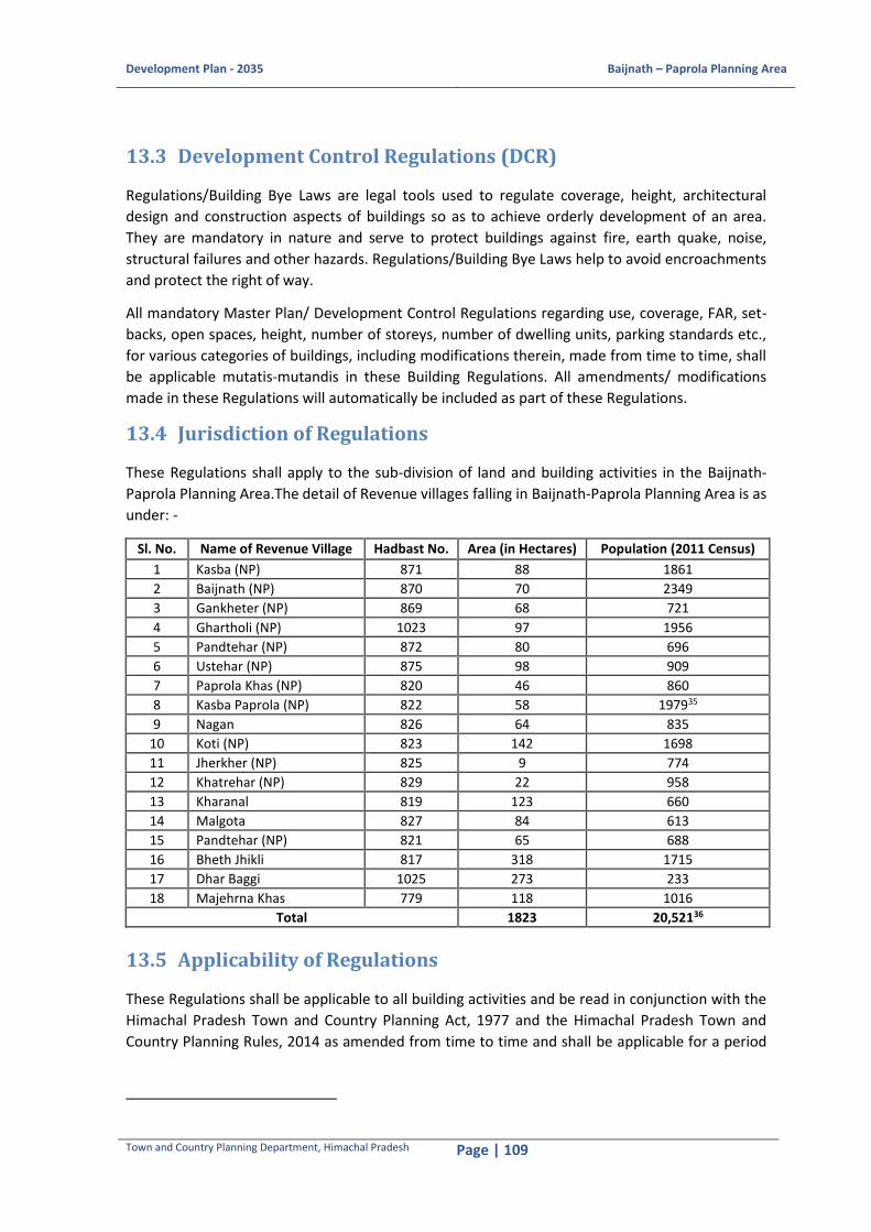
Development Plan - 2035 Baijnath – Paprola Planning Area
Town and Country Planning Department, Himachal Pradesh Page | 109
13.3 Development Control Regulations (DCR)
Regulations/Building Bye Laws are legal tools used to regulate coverage, height, architectural
design and construction aspects of buildings so as to achieve orderly development of an area.
They are mandatory in nature and serve to protect buildings against fire, earth quake, noise,
structural failures and other hazards. Regulations/Building Bye Laws help to avoid encroachments
and protect the right of way.
All mandatory Master Plan/ Development Control Regulations regarding use, coverage, FAR, set-
backs, open spaces, height, number of storeys, number of dwelling units, parking standards etc.,
for various categories of buildings, including modifications therein, made from time to time, shall
be applicable mutatis-mutandis in these Building Regulations. All amendments/ modifications
made in these Regulations will automatically be included as part of these Regulations.
13.4 Jurisdiction of Regulations
These Regulations shall apply to the sub-division of land and building activities in the Baijnath-
Paprola Planning Area.The detail of Revenue villages falling in Baijnath-Paprola Planning Area is as
under: -
Sl. No. Name of Revenue Village Hadbast No. Area (in Hectares) Population (2011 Census)
1 Kasba (NP) 871 88 1861
2 Baijnath (NP) 870 70 2349
3 Gankheter (NP) 869 68 721
4 Ghartholi (NP) 1023 97 1956
5 Pandtehar (NP) 872 80 696
6 Ustehar (NP) 875 98 909
7 Paprola Khas (NP) 820 46 860
8 Kasba Paprola (NP) 822 58 197935
9 Nagan 826 64 835
10 Koti (NP) 823 142 1698
11 Jherkher (NP) 825 9 774
12 Khatrehar (NP) 829 22 958
13 Kharanal 819 123 660
14 Malgota 827 84 613
15 Pandtehar (NP) 821 65 688
16 Bheth Jhikli 817 318 1715
17 Dhar Baggi 1025 273 233
18 Majehrna Khas 779 118 1016
Total 1823 20,52136
13.5 Applicability of Regulations
These Regulations shall be applicable to all building activities and be read in conjunction with the
Himachal Pradesh Town and Country Planning Act, 1977 and the Himachal Pradesh Town and
Country Planning Rules, 2014 as amended from time to time and shall be applicable for a period

Development Plan - 2035 Baijnath – Paprola Planning Area
Town and Country Planning Department, Himachal Pradesh Page | 110
for which this Development Plan has been prepared, after which these shall be reviewed. Till such
time the reviewed Regulations are notified, these will continue to be in force.
13.6 Part Contruction
In case of part construction, where the whole or part of a building is demolished or altered or re-
constructed, except where otherwise specifically stipulated, these Regulations shall apply only to
the extent of the work involved.
13.6.1 Re-construction
The re-construction in whole or part of a building which has ceased to operate due to fire, natural
collapse or demolition having been declared unsafe, or which is likely to be demolished, as the
case may be, these Regulations shall apply.
13.6.2 Existing approved buildings
Nothing in these Regulations shall require the removal, alteration or abandonment, nor prevent
continuance of the lawfully established use or occupancy of an existing approved building unless,
in the opinion of the Competent Authority, such a building is unsafe or constitutes a hazard to the
safety of adjacent property or to the occupants of the building itself.
13.7 Development Permission
Development or re-development shall carry out including sub-division on any plot or land (not
forming part of any approved layout plan or scheme) after obtaining approval for the layout plan
from the Competent Authority only.
13.8 Building Permission
13.8.1 Building Permission
Any person intending to erect, re-erect or make addition/ alterations in any building or cause the
same to be done shall first obtain appropriate building permission for each such building from the
Competent Authority.
The following item of works are exempted from the above Regulation:
i) Plastering/cladding and patch repairs, except for the Heritage Buildings where Heritage Conservation Committee’s permission is required.
ii) Re-roofing or renewal of roof including roof of intermediate floor at the same height. iii) Flooring and re- flooring. iv) Opening windows, ventilators and doors opening within the owners’ plot. v) Rehabilitation/repair of fallen bricks, stones, pillars, beams etc. vi) Construction or re- construction of sunshade not more than 0.45 Metre in width within
one’s own land and not overhanging over a public street. vii) Construction or re-construction of parapet and also construction or reconstruction of
boundary walls as permissible under Bye Laws. viii) White washing, painting etc. including erection of false ceiling in any floor at the
permissible clear height provided the false ceiling in no way can be put to use as a loft /mezzanine floor etc.

Development Plan - 2035 Baijnath – Paprola Planning Area
Town and Country Planning Department, Himachal Pradesh Page | 111
ix) Reconstruction of portions of buildings damaged by storm, rains, fire, earthquake or any other natural calamity to the same extent as existed prior to the damage as per sanctioned plan, provided the use conforms to provisions of Development Plan.
x) Erection or re-erection of internal partitions provided the same are within the preview of the Bye-laws.
xi) For erection of Lifts in existing buildings unless it does not affect the free movement. xii) Change/ Installation/ re-arranging/ relocating of fixtures or equipments without
hindering other’s property/ public property shall be permitted. xiii) Landscaping xiv) Toilet/Washroom, Security Room, up to a maximum area of 9.00 M2 only (permitted
within setback area, provided it does not obstruct fire vehicles movement) in plot more than 3000 M2.
xv) A Porta cabin up to 4.50 M2 permitted within setback area, provided it does not obstruct fire vehicles movement.
13.9 Grant, Refusal and Deemed to be Sanctioned
If within the time limit stipulated in the Himachal Pradesh Town and Country Planning Act, 1977
as amended from time to time for various categories of buildings specified therein or the
Competent Authority fails to intimate in writing to the person, who has applied for permission of
its refusal or sanction or any intimation, the application with its plans and statements shall be
deemed to have been sanctioned;
Provided that the fact is immediately brought to the notice of the Competent Authority in writing
by the person; and
Subject to the conditions mentioned in these Bye-laws, nothing shall be constructed to authorize
any person to do anything in contravention or against the terms of lease or titles of the land or
against any other Regulations, Bye-laws or Ordinance operating on the site of the work.
In case the Competent Authority rejects the application due to any reasons, the applicant can re-
submit the building plan along with fees and with compliances.
13.10 Already Permitted Buildings
Building permission issued by the Competent Authority before these Regulations come in to
effect and where construction is in progress and has not been completed within the specified
period from the date of such permission, the said permission shall be deemed to be valid and
shall only be eligible for re-validation thereunder. Accordingly, where the validity of permission
has expired, such construction shall be governed by the provisions of these Regulations. If the
validity of permission has not expired and construction has not been started such applicants may
revise the layout plan as per these regulations.
13.11 Procedure for Obtaining Permission
13.11.1 Application and Fee
The application for development of land to be undertaken on behalf of the Union or State
Government under Section 28 and under Section 29 by a Local Authority or any Authority
specially constituted under the Himachal Pradesh Town and Country Planning Act, 1977 as
amended from time to time shall be accompanied by such documents as prescribed under Rule-

Development Plan - 2035 Baijnath – Paprola Planning Area
Town and Country Planning Department, Himachal Pradesh Page | 112
14 of the Himachal Pradesh Town and Country Planning Rules, 2014. The application for
development of land to be undertaken under Section 30 by any person not being the Union or
State Government, Local Authority or any Authority specially constituted under the Himachal
Pradesh Town and Country Planning Act, 1977 shall be in such form along with the Specifications
Sheet and Schedule attached with these forms and containing such documents and with such fee
as prescribed under Rule 16 of the Himachal Pradesh Town and Country Planning Rules, 2014. All
the applications shall be made online.
13.11.2 Documents Required
Apart from above, the applicant shall furnish the following additional documents namely:
i) Location Plan in the Scale of 1:1000, showing North direction indicating the land in question, main approach roads, important physical features of the locality/area, important public buildings like School, Hospital, Cinema, Petrol Pump, existing land uses /building uses surrounding the land.
ii) Site Plan in the scale of 1:200, showing North direction indicating the proposed site, approach road, adjoining buildings, the existing drainage and sewerage showing the built up and open area clearly. Site must tally with the shape and dimensions of plot shown in the Tatima or as per actual at site duly verified by the competent authority.
iii) Building plan, showing elevation and section in the scale of 1: 100.The architectural drawings duly signed by the applicant and licensed/registered Architect/ Planner/ Engineer/ Draftsman along with his/ her address and Registration number.
iv) Recommended notation for colouring of plans: The site and building plans shall be coloured as specified in the table given below. Where items of work are not identified, the colouring notation used shall be indexed.
Colouring of Plans
i) A copy of Treasury Challan Form/ receipt vide which requisite fee has been deposited shall be uploaded online after approval of the case in principle by the department.
ii) Ownership documents, i.e. latest original Jamabandi. iii) Latest original Tatima showing Khasra number of land in question, adjoining Khasra
numbers from all sides of plot and approach path with dimensions. iv) In the Site Plan, the distance of electricity line, from development as per Indian Electricity
Rules, in case any electricity line is passing over or nearby the proposed site be shown. v) A certificate from the Nagar Panchayat or Gram Panchayat or Development Authority or
Local Authority, as the case may be, shall be enclosed to claim compensatory benefit in support of taking over the land surrendered for development in public interest such as
Sl. No. Item Site/ Building Plan
1. Plot lines Yellow
2. Road/ Street/ Path Black
3. Proposed building line Red
4. Existing work (Outline) Green
5. Work proposed to be demolished Orange
6. Sewerage Dark Brown
7. Water Supply/ RWH System Sky Blue
8. Drainage Dark Blue
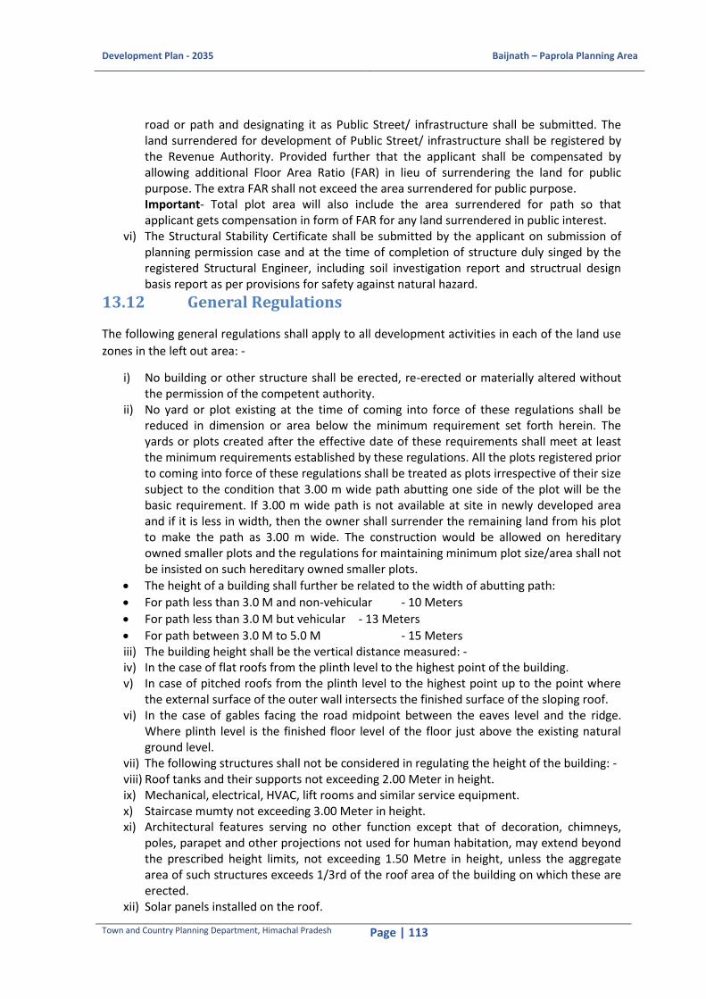
Development Plan - 2035 Baijnath – Paprola Planning Area
Town and Country Planning Department, Himachal Pradesh Page | 113
road or path and designating it as Public Street/ infrastructure shall be submitted. The land surrendered for development of Public Street/ infrastructure shall be registered by the Revenue Authority. Provided further that the applicant shall be compensated by allowing additional Floor Area Ratio (FAR) in lieu of surrendering the land for public purpose. The extra FAR shall not exceed the area surrendered for public purpose. Important- Total plot area will also include the area surrendered for path so that applicant gets compensation in form of FAR for any land surrendered in public interest.
vi) The Structural Stability Certificate shall be submitted by the applicant on submission of planning permission case and at the time of completion of structure duly singed by the registered Structural Engineer, including soil investigation report and structrual design basis report as per provisions for safety against natural hazard.
13.12 General Regulations
The following general regulations shall apply to all development activities in each of the land use
zones in the left out area: -
i) No building or other structure shall be erected, re-erected or materially altered without the permission of the competent authority.
ii) No yard or plot existing at the time of coming into force of these regulations shall be reduced in dimension or area below the minimum requirement set forth herein. The yards or plots created after the effective date of these requirements shall meet at least the minimum requirements established by these regulations. All the plots registered prior to coming into force of these regulations shall be treated as plots irrespective of their size subject to the condition that 3.00 m wide path abutting one side of the plot will be the basic requirement. If 3.00 m wide path is not available at site in newly developed area and if it is less in width, then the owner shall surrender the remaining land from his plot to make the path as 3.00 m wide. The construction would be allowed on hereditary owned smaller plots and the regulations for maintaining minimum plot size/area shall not be insisted on such hereditary owned smaller plots.
The height of a building shall further be related to the width of abutting path:
For path less than 3.0 M and non-vehicular - 10 Meters
For path less than 3.0 M but vehicular - 13 Meters
For path between 3.0 M to 5.0 M - 15 Meters iii) The building height shall be the vertical distance measured: - iv) In the case of flat roofs from the plinth level to the highest point of the building. v) In case of pitched roofs from the plinth level to the highest point up to the point where
the external surface of the outer wall intersects the finished surface of the sloping roof. vi) In the case of gables facing the road midpoint between the eaves level and the ridge.
Where plinth level is the finished floor level of the floor just above the existing natural ground level.
vii) The following structures shall not be considered in regulating the height of the building: - viii) Roof tanks and their supports not exceeding 2.00 Meter in height. ix) Mechanical, electrical, HVAC, lift rooms and similar service equipment. x) Staircase mumty not exceeding 3.00 Meter in height. xi) Architectural features serving no other function except that of decoration, chimneys,
poles, parapet and other projections not used for human habitation, may extend beyond the prescribed height limits, not exceeding 1.50 Metre in height, unless the aggregate area of such structures exceeds 1/3rd of the roof area of the building on which these are erected.
xii) Solar panels installed on the roof.
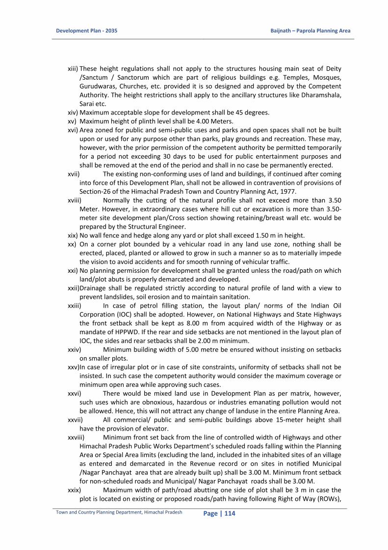
Development Plan - 2035 Baijnath – Paprola Planning Area
Town and Country Planning Department, Himachal Pradesh Page | 114
xiii) These height regulations shall not apply to the structures housing main seat of Deity /Sanctum / Sanctorum which are part of religious buildings e.g. Temples, Mosques, Gurudwaras, Churches, etc. provided it is so designed and approved by the Competent Authority. The height restrictions shall apply to the ancillary structures like Dharamshala, Sarai etc.
xiv) Maximum acceptable slope for development shall be 45 degrees. xv) Maximum height of plinth level shall be 4.00 Meters. xvi) Area zoned for public and semi-public uses and parks and open spaces shall not be built
upon or used for any purpose other than parks, play grounds and recreation. These may, however, with the prior permission of the competent authority be permitted temporarily for a period not exceeding 30 days to be used for public entertainment purposes and shall be removed at the end of the period and shall in no case be permanently erected.
xvii) The existing non-conforming uses of land and buildings, if continued after coming into force of this Development Plan, shall not be allowed in contravention of provisions of Section-26 of the Himachal Pradesh Town and Country Planning Act, 1977.
xviii) Normally the cutting of the natural profile shall not exceed more than 3.50 Meter. However, in extraordinary cases where hill cut or excavation is more than 3.50-meter site development plan/Cross section showing retaining/breast wall etc. would be prepared by the Structural Engineer.
xix) No wall fence and hedge along any yard or plot shall exceed 1.50 m in height. xx) On a corner plot bounded by a vehicular road in any land use zone, nothing shall be
erected, placed, planted or allowed to grow in such a manner so as to materially impede the vision to avoid accidents and for smooth running of vehicular traffic.
xxi) No planning permission for development shall be granted unless the road/path on which land/plot abuts is properly demarcated and developed.
xxii) Drainage shall be regulated strictly according to natural profile of land with a view to prevent landslides, soil erosion and to maintain sanitation.
xxiii) In case of petrol filling station, the layout plan/ norms of the Indian Oil Corporation (IOC) shall be adopted. However, on National Highways and State Highways the front setback shall be kept as 8.00 m from acquired width of the Highway or as mandate of HPPWD. If the rear and side setbacks are not mentioned in the layout plan of IOC, the sides and rear setbacks shall be 2.00 m minimum.
xxiv) Minimum building width of 5.00 metre be ensured without insisting on setbacks on smaller plots.
xxv) In case of irregular plot or in case of site constraints, uniformity of setbacks shall not be insisted. In such case the competent authority would consider the maximum coverage or minimum open area while approving such cases.
xxvi) There would be mixed land use in Development Plan as per matrix, however, such uses which are obnoxious, hazardous or industries emanating pollution would not be allowed. Hence, this will not attract any change of landuse in the entire Planning Area.
xxvii) All commercial/ public and semi-public buildings above 15-meter height shall have the provision of elevator.
xxviii) Minimum front set back from the line of controlled width of Highways and other Himachal Pradesh Public Works Department’s scheduled roads falling within the Planning Area or Special Area limits (excluding the land, included in the inhabited sites of an village as entered and demarcated in the Revenue record or on sites in notified Municipal /Nagar Panchayat area that are already built up) shall be 3.00 M. Minimum front setback for non-scheduled roads and Municipal/ Nagar Panchayat roads shall be 3.00 M.
xxix) Maximum width of path/road abutting one side of plot shall be 3 m in case the plot is located on existing or proposed roads/path having following Right of Way (ROWs),

Development Plan - 2035 Baijnath – Paprola Planning Area
Town and Country Planning Department, Himachal Pradesh Page | 115
the front setback shall be left as under: - Sl. No. Proposed Right of Way (m) Front Setback (m) from Acquired line of road
1 18 8.00
2 15 5.00
3 12 5.00
4 09 3.00
5 07 3.00
6 05 3.00
i) Construction other than as is permissible under the Himachal Pradesh Road Side Control Act, 1972 would not be allowed on the controlled width of National Highway Authority of India (NHAI) or Himachal Pradesh Public Works Department (HPPWD).
ii) In open area of permissible set backs (other than controlled width) small temple, porch, garage, swimming pools, detached toilet/ store, septic tanks, other services/stairs would be permissible.
iii) Sky view impression on the ground should be such that nothing including projections and appendages such as AC outdoor units/sign boards etc. should project on the streets/roads/other's land.
iv) Water, sludge and sewage should also not trickle on the streets or roads. Septic Tank and provision to lay our sewerage service line or connecting with the existing sewerage lines shall be mandatory.
v) Every building should have a clear means of access from a street or road. The competent authority may require the provisions of an access lane or access road within the site of any new building. Where for the purpose of this Regulation, it is necessary to determine the width of any road or street, the same shall be determined by the competent authority.
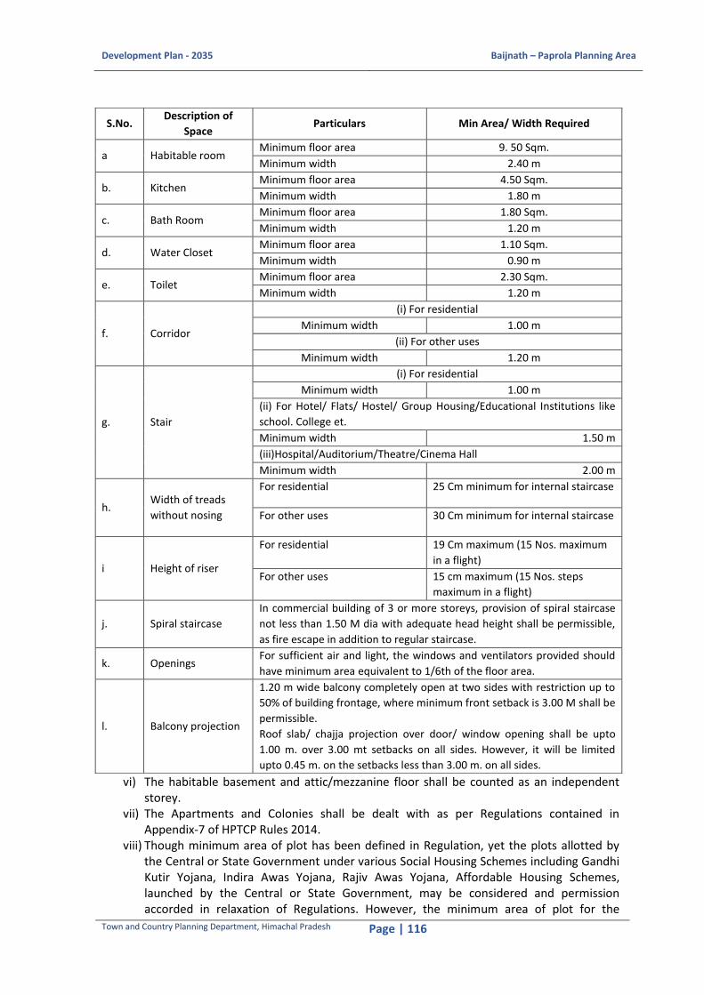
Development Plan - 2035 Baijnath – Paprola Planning Area
Town and Country Planning Department, Himachal Pradesh Page | 116
vi) The habitable basement and attic/mezzanine floor shall be counted as an independent storey.
vii) The Apartments and Colonies shall be dealt with as per Regulations contained in Appendix-7 of HPTCP Rules 2014.
viii) Though minimum area of plot has been defined in Regulation, yet the plots allotted by the Central or State Government under various Social Housing Schemes including Gandhi Kutir Yojana, Indira Awas Yojana, Rajiv Awas Yojana, Affordable Housing Schemes, launched by the Central or State Government, may be considered and permission accorded in relaxation of Regulations. However, the minimum area of plot for the
S.No. Description of
Space Particulars Min Area/ Width Required
a Habitable room Minimum floor area 9. 50 Sqm.
Minimum width 2.40 m
b. Kitchen Minimum floor area 4.50 Sqm.
Minimum width 1.80 m
c. Bath Room Minimum floor area 1.80 Sqm.
Minimum width 1.20 m
d. Water Closet Minimum floor area 1.10 Sqm.
Minimum width 0.90 m
e. Toilet Minimum floor area 2.30 Sqm.
Minimum width 1.20 m
f. Corridor
(i) For residential
Minimum width 1.00 m
(ii) For other uses
Minimum width 1.20 m
g. Stair
(i) For residential
Minimum width 1.00 m
(ii) For Hotel/ Flats/ Hostel/ Group Housing/Educational Institutions like
school. College et.
Minimum width 1.50 m
(iii)Hospital/Auditorium/Theatre/Cinema Hall
Minimum width 2.00 m
h. Width of treads
without nosing
For residential 25 Cm minimum for internal staircase
For other uses 30 Cm minimum for internal staircase
i Height of riser
For residential 19 Cm maximum (15 Nos. maximum
in a flight)
For other uses 15 cm maximum (15 Nos. steps
maximum in a flight)
j. Spiral staircase
In commercial building of 3 or more storeys, provision of spiral staircase
not less than 1.50 M dia with adequate head height shall be permissible,
as fire escape in addition to regular staircase.
k. Openings For sufficient air and light, the windows and ventilators provided should
have minimum area equivalent to 1/6th of the floor area.
l. Balcony projection
1.20 m wide balcony completely open at two sides with restriction up to
50% of building frontage, where minimum front setback is 3.00 M shall be
permissible.
Roof slab/ chajja projection over door/ window opening shall be upto
1.00 m. over 3.00 mt setbacks on all sides. However, it will be limited
upto 0.45 m. on the setbacks less than 3.00 m. on all sides.

Development Plan - 2035 Baijnath – Paprola Planning Area
Town and Country Planning Department, Himachal Pradesh Page | 117
persons belonging to the Economically Weaker Sections and Low Income Groups of society should not be less than 45 M² and 80 M² respectively.
ix) The following shall not be included in covered area of FAR calculations:
Machine room for lift on top floor as required for the lift machine installation.
Rockery, lift/lift well, escalator well and well structures, plant nursery, water pool at any level (if uncovered), platform around a tree, water tank, fountain, bench, chabutra with open top and/or unenclosed sided by walls, open ramps, compound wall, gate, slide swing door, fire staircase, fire towers, refuse area, fire control room, overhead water tank or top of building/open shafts, cooling towers.
Mumty over staircase on top floor maximum 3.00 M height.
Watch and ward cabins of total area not more than 4.50 sqm. and 6.00 sqm. with W/C each at entry and exit, within the property line having plot area not less than 500 sqm. and front setback not less than 5.00 m.
Entrance porch, canopies, pergolas, sunshade elements and balconies.
Plinth steps.
Area of all staircase(s), Fire Exit(s).
Service floor having services like HV AC(Heating, Ventilation and Air Conditioning), MEP installation, Janitor rooms, AHU Room, Electric room, LT room, CCTV room, laundry, Meter Room with HT/LT panel, DG Room, AC Plant room, CCTV room/ Control room, Fire control room or any other similar services shall be considered free from FAR.
Building service shafts like electrical shafts, communication shafts, fire shafts MRP and HVAC shall not be counted in FAR.
Common toilets served by a public corridor shall be free from FAR. x) Parking floor shall not be counted in FAR. However, twin parking floors shall also be
excluded from FAR in Public & Semi- public and commercial buildings. Maximum height of parking floor shall be 3.00 Meters for residential use and 4.00 Metres for other uses. Shear walls shall be constructed on all the three sides of parking floor, so that it does not behave as a soft storey. In case, space as per requirement for parking is available in open, over and above the set backs, condition of parking floor shall not be insisted. Fee for parking floor(s) shall have to be payable in all cases.
xi) Every room used or intended to be used for the purpose of an office or for habitation in any building shall have a height of minimum 2.75 Meters. The chimneys, elevators, poles, tanks and other projections not used for human occupancy may extend above the prescribed height limits. The cornices and window sills may also project into any required Set Backs.
xii) The outer facade of the building should be in conformity to the Hill Architecture. xiii) Sloping roof shall be mandatory which may be CGI, GI sheet or slate roof with facia. The
roof shall be painted with post office red or forest green or natural roofing material such as slates. Height of sloping roof zero at eaves and maximum 2.75 Meters at centre shall be permissible. The Dormer at suitable distance on either side of the roof shall be permissible subject to the condition that the ridge of Dormer shall be below the ridge line of main roof. Roof top @ 12 M² per 1 Kilo Watt peak (KWp) shall be used for Solar Photo voltaic (PV) installations.
xiv) Construction in terraces shall be allowed to have a provision of storeys as permissible subject to fulfillment of FAR provision.
xv) 1/3rd area of the top floor shall be permissible as open terrace. xvi) The applicants shall not be insisted for submission of No Objection Certificate (NOC) from
National Highway Authority of India (NHAI) or Himachal Pradesh Public Works Department (HPPWD) authorities. However, applicant will submit his layout plan with clearly demarcated acquired and controlled width etc.

Development Plan - 2035 Baijnath – Paprola Planning Area
Town and Country Planning Department, Himachal Pradesh Page | 118
xvii) Distance from Electric Lines :- The distance in accordance with the Central Electricity Authority (Measures Relating to Safety and Electric Supply) regulations, 2010 as amended from time to time and as defined in National Building Code of India, 2016 is to be provided between the building and overhead electric supply line as under :-
Clearances from Electric Supply Lines
Sl. No. Type of Supply Line Vertical Clearance Horizontal Clearance
1 Voltage lines and service lines
not exceeding 650V
2.50 Metre
1.20 Metre
2 High voltage lines above 650
Volts and including 11,000 Volts
3.70 Metre upto and
including 33KV
1.20 Metre
3
High voltage lines above
11,000 Volts and upto and including 33,000 Volts
3.70 Metre 2.00 Metre
4 Extra high voltage lines
additional 33,000 Volts
3.70 Metre plus 0.30 Metre
for every additional 33,000
Volts or part thereof
2.00 Metre plus 0.30 Metre for every additional 33,000 Volts or part thereof
xviii) Building shall not be put to use prior to issue of Completion Certificate by the competent authority.
xix) Issuance of No Objection Certificate (NOC) for water supply and electricity connections shall be as under: -
a) Temporary at plinth level b) Permanent on completion of dwelling unit/floor/whole of the building
xx) Any subsequent deviations made in the building constructed after getting the plan approved and after grant of No Objection Certificate (NOC) issued by the Department shall entail the entire building unauthorized and NOC so issued shall be withdrawn and the services shall be disconnected.
xxi) No construction shall be allowed within a radius of 5.00 m from the Forest/Green belt boundary and within a radius of 2.00 m from an existing tree. The distance shall be measured from the circumference of the tree.
xxii) Reconstruction shall be permissible on old lines. The plinth area and number of storeys shall remain the same as existing before reconstruction. Any addition, if required, shall be allowed to the extent of 20% of existing built up area of ground floor subject to fulfillment of other planning regulations.
xxiii) The provision for Rain Harvesting Tank shall be proposed in the plan @20 litre per sqm. of the roof top area for those buildings having roof top area more than 200 sqm.
xxiv) Construction on sandwiched vacant plots falling within built up areas shall be permissible as per existing building line irrespective of the width of path/road abutting the site, provided existing buildings are authorized.
xxv) In the proposals for 3 and more dwelling units on plots of more than 200.00 Sqm. an adequate fire safety measures, provisions of an additional fire escape stair case and rain water harvesting shall be made.
xxvi) The construction shall be allowed at distance of 3.00 Metre, 5.00 Metre and 10.00 Metre (after HFL) of Nallah, Khud and river respectively.
xxvii) Construction of cellar shall not be counted as a storey and should be constructed within the prescribed setbacks and prescribed building lines and subject to maximum coverage on floor i.e. entrance floor and may be put for following uses:-

Development Plan - 2035 Baijnath – Paprola Planning Area
Town and Country Planning Department, Himachal Pradesh Page | 119
Storage of household or other goods of ordinarily combustible material; Minimum width of path/road abutting one side of plot shall be 5.00 M.
Strong rooms, bank cellars etc;
Air conditioning equipment and other machines used for services and utilities of the building; and parking spaces.
The cellar shall have following requirements: -
All the walls shall be kept dead and below the natural ground level except the portion kept for ventilation purpose
Every cellar shall be, in every part, at least 2.40 M in height from the floor to the underside of the roof slab or ceiling
Adequate ventilation shall be provided for the cellar and any deficiency in ventilation requirements may be met by providing mechanical ventilation in the form of blowers, exhaust fans and air conditioning system etc
The minimum height of the ceiling of any cellar shall be 0.90 M and the maximum 1.20 M above the average surrounding ground level
Adequate arrangements shall be made such that surface drainage does not enter the cellar
The walls and floors of the cellar shall be watertight and be so designed that the effects of the surrounding soil and moisture if any, are taken into account in design and adequate damp proofing treatment is given
The access to the cellar shall be separate from the main and alternative staircase providing access and exit from higher floor. Where the staircase is continuous in the case of buildings served by more than one staircase, the same shall be enclosed type, serving as a fire separation from the cellar floor and higher floors. Open ramps shall be permitted, if they are constructed within the building line subject to the provision of clause (v) above
In case partition in the cellars is allowed by the Authority, no compartment shall be less than 50.00 M² in area and each compartment shall have proper ventilation provision and the cellar partition shall however, conform to the norms laid down by the Fire Services
In no circumstances, construction of Toilet, Bath, and Kitchen etc. shall be allowed in the cellar
xxviii) Minimum permissible distance between two Blocks constructed on a plot shall be 5.00 m. xxix) Every development proposal shall have explicit mention of sewage disposal. xxx) No permission shall be granted in areas notified by the Archaeological Survey of India as
protected monuments or areas, without prior clearance from the competent authority as prescribed for the purpose.
xxxi) Structural Stability Certificate should be submitted along with the project drawings and report for obtaining building permission. The structure should be vetted by a qualified structural engineer having experience of building designs in hilly and earthquake sensitive areas.
xxxii) No Development permission shall be allowed in the sliding zone. However, in exceptional case of larger public interest development permission shall be granted by the Competent Authority only after taking Soil Investigation Report as per Form -15 of HPTCP Rules, 2014.
xxxiii) No development permission shall be granted on the land having “Forest” classification in the revenue record until and unless specific clearance is granted by the competent authority i.e. Forest Department. However, the recreational activities shall be allowed after mandatory permission from the competent authority.

Development Plan - 2035 Baijnath – Paprola Planning Area
Town and Country Planning Department, Himachal Pradesh Page | 120
13.13 Sub-Division of Land Regulations
i) The Sub-Division of land into plots amounts to ‘Development’ under the Himachal Pradesh Town and Country Planning Act, 1977; as such no person will sub-divide the land unless permitted by the competent authority.
ii) Similarly, no Registrar or the Sub-Registrar will register any deed or documents of any sub-division of land, unless the sub-division of land is duly approved by the competent authority, as provided under Section 16 of the Himachal Pradesh Town and Country Planning Act, 1977 and the Sub-Division of Land Regulations as prescribed herein.
iii) The application for sub-division of land shall be submitted as per the procedure provided under Para 14.10. These shall be kept in view while permitting sub-division of land.
iv) The sub-division of land shall be permitted in accordance with natural profile/ topography as shown on the contoured map along with drainage of land, access, road orientation, wind direction and other environmental requirements and according to prescribed Land Use in the Development Plan. Natural flora and fauna shall be preserved. Unless site conditions prohibit, plots shall be permitted at right angle to the road with proper shape and dimension, so that optimum use of the land is ensured.
v) Development proposal for a part of land or khasra no. shall be considered. However, proposal for complete land holding/khasra No. shall be submitted even if planning permission is required for part of the land provided further that atleast one ROW of adequate width in view of total area of complete land holding/khasra No. shall have to be proposed to ensure access for balance area.
vi) The development of land shall not be permitted in area where basic services like paved roads, water supply, drainage, sewerage disposal, electricity, street lighting etc. do not exists or unless the applicant undertakes that these services shall be provided at his own cost. i Minimum width of pedestrian links to smaller cluster of
plots, not exceeding 5 in number. 3.00 M.
ii Minimum width of vehicular access, if number of plots is
above 5.
5.00 M (with cul-de-sac) at
the end.
iii Minimum area for open/green space for the scheme having
more than 5 plots 10%
iv Minimum area for soak pit etc. (irrespective of number of
plots).
5% of the scheme area/
Individual septic tank and
soak pit can be proposed in
each plot also.
v Orientation of the plots shall be provided in such a manner
so as to be in conformity with the integration of existing
plots/infrastructure, wind direction, natural flow of surface
drainage to allow un-obstructed rain water discharge.
_
vi Layout of plots shall be governed by easy access having
acceptable grades minimum 1 in 15 and which may not
obstruct view or vista.
_
i) The minimum width of road for sub-division shall be 7.00 m. However, in view of geographical constraints, width of road/ path may be relaxed to 3.00 m for maximum plot upto 5 in number. The minimum width of path/ road abutting one side of plot shall be 5.00 m to cluster of plots from 6 to 10 in number. For group of plots between 11 to 20 in number (2000 to 4000 Sqm.) on one particular access, the minimum vehicular access shall be 7.00 m wide. In case of plots exceeding 20 in number (more than 4000 Sqm.) the minimum width of road of road shall be 9.00 m.

Development Plan - 2035 Baijnath – Paprola Planning Area
Town and Country Planning Department, Himachal Pradesh Page | 121
ii) In case of plots or land abutting the existing or proposed roads/paths, width of the same shall be increased to meet with the requirements of this Development Plan.
iii) Average slope gradient for regional roads shall have to be 1:20 However, local roads in town may be allowed with slope gradient up to 1:10 and additional width of carriageway shall be provided on curves for ensuring smooth flow of vehicular traffic, which may not obstruct view or vista.
iv) Minimum area of plot for detached house shall not be less than 150 Sqm. v) Semi-detached house construction shall be allowed on plots upto max. 250 Sqm and row
housing on plots upto 120 Sqm. Subject to maximum number of such plots do not exceed 8 in row after with a gap of 7.00 m shall be left. Although minimum size of plot for construction in a row with two common walls, has been kept as 90 Sqm, yet in exceptional circumstances, considering economic/site conditions the minimum size of plots in a row, with two common walls, up to 60 Sqm for houses may be allowed so as to provide smallest possible residential construction in a planned manner for the benefit of economically weaker sections of the society.
vi) The plots allotted by the Government under Gandhi Kutir Yojna, Indira Awas Yojna, Economically Weaker Section (EWS) Schemes etc. may be considered and permission accorded in relaxation to regulations to accommodate the target groups.
vii) The minimum area for open or green space in a Scheme having more than 5 plots (1000.00 Sqm) shall be 10% of the scheme area. Where a sub-division of land involving plots exceeding 10 in number (2000 Sqm) by individual colonizer or any society is proposed, the provisions of parks or tot-lots and open spaces shall be made on a centre suitable location in the scheme. Such parks cannot be built upon and sold in any manner in future. Provision shall also have to be made for education, medical, firefighting, religious, socio-cultural and other community facilities, based on actual requirements, in the cases of sub-division of land in accordance with prescribed norms and standards. The ownership of such land shall be transferred/ surrendered to the Development Authority or Local Authority for its development and future maintenance. In case, basic educational facilities are available within walkable distance, reservation of area shall not be mandatory.
viii) While carving out the plots, orientation of the plots shall be provided in such a manner, so as to be in conformity with the integration of existing plots, infrastructure, wind direction and natural flow of surface drainage to allow un-obstructed rain water discharge.
ix) Minimum area for septic tank and soak pit irrespective of number of plots shall be 5% of the scheme area. However, the same can also be proposed within boundary of each plot.
x) Provision for rain water harvesting for surface run off other than that of structures shall have to be ensured to ease the water supply problem.
xi) Provision for decomposition of biodegradable waste shall have to be made in accordance with requirements of particular sub-division of land by earmarking space at suitable location.
13.14 Regulations for Each Land Use Zone
The following Regulations shall apply to each of the Land Use Zones as specified below: -
13.14.1 Residential Zone
The General Regulation as laid down under para 13.10 shall be kept in view while permitting any
development in this Zone.
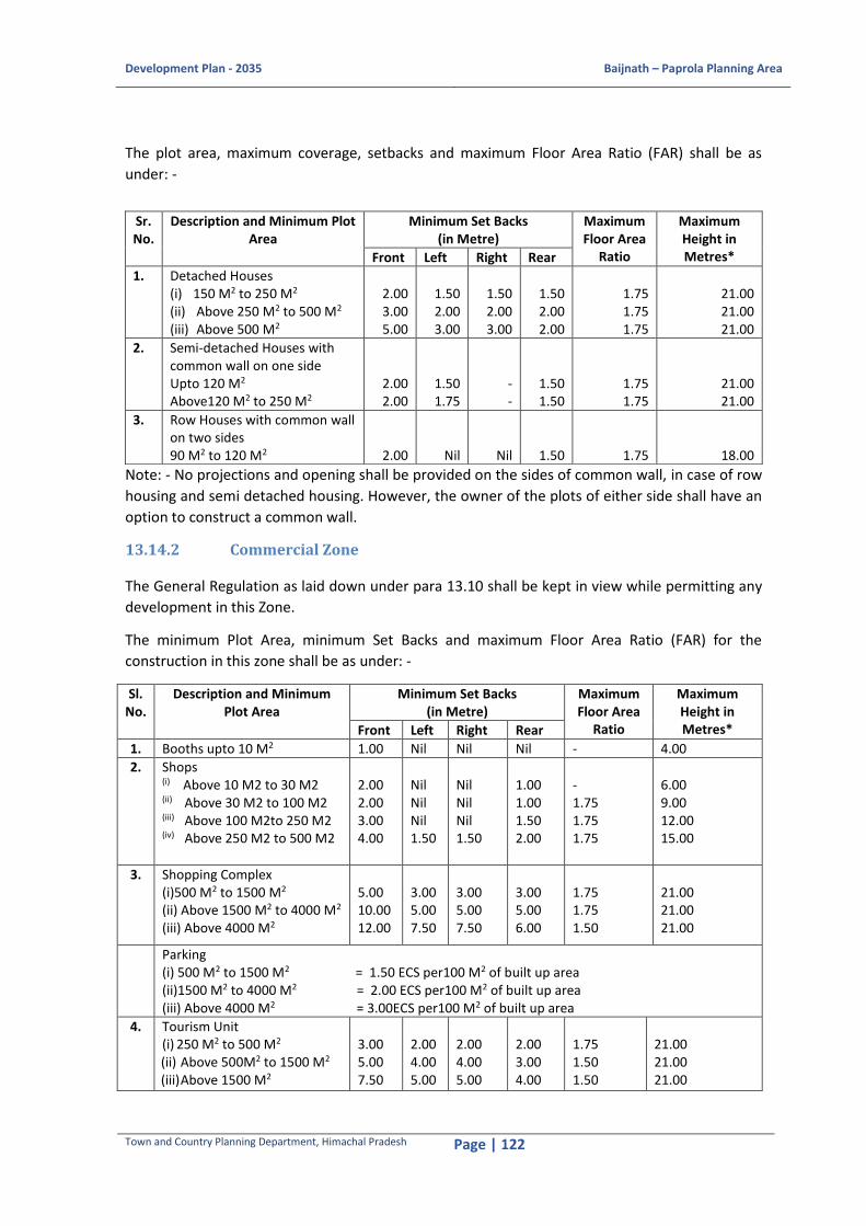
Development Plan - 2035 Baijnath – Paprola Planning Area
Town and Country Planning Department, Himachal Pradesh Page | 122
The plot area, maximum coverage, setbacks and maximum Floor Area Ratio (FAR) shall be as
under: -
Note: - No projections and opening shall be provided on the sides of common wall, in case of row
housing and semi detached housing. However, the owner of the plots of either side shall have an
option to construct a common wall.
13.14.2 Commercial Zone
The General Regulation as laid down under para 13.10 shall be kept in view while permitting any
development in this Zone.
The minimum Plot Area, minimum Set Backs and maximum Floor Area Ratio (FAR) for the
construction in this zone shall be as under: -
Sl. No.
Description and Minimum Plot Area
Minimum Set Backs (in Metre)
Maximum Floor Area
Ratio
Maximum Height in Metres* Front Left Right Rear
1. Booths upto 10 M2 1.00 Nil Nil Nil - 4.00
2. Shops (i) Above 10 M2 to 30 M2 (ii) Above 30 M2 to 100 M2 (iii) Above 100 M2to 250 M2 (iv) Above 250 M2 to 500 M2
2.00 2.00 3.00 4.00
Nil Nil Nil 1.50
Nil Nil Nil 1.50
1.00 1.00 1.50 2.00
- 1.75 1.75 1.75
6.00 9.00 12.00 15.00
3. Shopping Complex (i)500 M2 to 1500 M2 (ii) Above 1500 M2 to 4000 M2 (iii) Above 4000 M2
5.00 10.00 12.00
3.00 5.00 7.50
3.00 5.00 7.50
3.00 5.00 6.00
1.75 1.75 1.50
21.00 21.00 21.00
Parking (i) 500 M2 to 1500 M2 = 1.50 ECS per100 M2 of built up area (ii)1500 M2 to 4000 M2 = 2.00 ECS per100 M2 of built up area (iii) Above 4000 M2 = 3.00ECS per100 M2 of built up area
4.
Tourism Unit (i) 250 M2 to 500 M2 (ii) Above 500M2 to 1500 M2 (iii) Above 1500 M2
3.00 5.00 7.50
2.00 4.00 5.00
2.00 4.00 5.00
2.00 3.00 4.00
1.75 1.50 1.50
21.00 21.00 21.00
Sr. No.
Description and Minimum Plot Area
Minimum Set Backs (in Metre)
Maximum Floor Area
Ratio
Maximum Height in Metres* Front Left Right Rear
1. Detached Houses (i) 150 M2 to 250 M2 (ii) Above 250 M2 to 500 M2 (iii) Above 500 M2
2.00 3.00 5.00
1.50 2.00 3.00
1.50 2.00 3.00
1.50 2.00 2.00
1.75 1.75 1.75
21.00 21.00 21.00
2. Semi-detached Houses with common wall on one side Upto 120 M2 Above120 M2 to 250 M2
2.00 2.00
1.50 1.75
- -
1.50 1.50
1.75 1.75
21.00 21.00
3. Row Houses with common wall on two sides 90 M2 to 120 M2
2.00
Nil
Nil
1.50
1.75
18.00

Development Plan - 2035 Baijnath – Paprola Planning Area
Town and Country Planning Department, Himachal Pradesh Page | 123
Sl. No.
Description and Minimum Plot Area
Minimum Set Backs (in Metre)
Maximum Floor Area
Ratio
Maximum Height in Metres* Front Left Right Rear
Parking (i) 250 M2 to 500 M2= 1.00ECS per 100 M2 of built up area. (ii) Above 500 M2 to 1500 M2= 1.50ECS per 100 M2 of built up area. (iii) Above 1500 M2= 2.00 ECS per 100 M2 of built up area. (iv) Tourism Units, can be known by the name of Hotel or Guest House or Eco-Tourism or by any
other name. (v) In existing built up areas like Bazaars, the building line can be maintained.
5. Cinema / Cineplex 4000 M2 and above
15.00
7.50
7.50
6.00
1.50
21.00
Parking (i) 3.00 ECS per 100 M2 of built up area (ii) Other Regulations as per Cinematography Act shall also apply.
6. Multiplexes 4000 M2 and above
15.00
9.00
9.00
9.00
1.50
21.00
Parking (i) Permissible within the complex. (ii) Parking space to be provided within Multiplex @ 3 ECS for every 100 M2 of built up area. (iii) Other Regulations as per Cinematography Act shall also apply. (iv) Multiplex complex shall mean an integrated entertainment and shopping centre/ complex
having at least 2 Cinema Halls. The minimum area on which this use shall be permitted should not be less than 4000 M2. Apart from Cinema Halls, the Multiplexes may also have Restaurant, Fast Food, Outlet, Pubs, Health Spas/ Centers, Hotels and other Re-creational activities. The shopping center may have Retail Outlet, Video Games, Parlours, Bowling Alleys, Health Centers, Shopping Malls, Office space.
Note:- 1.00 ECS (Equivalent Car Space) shall mean as under:- (i) For parking in open = 23 M2
(ii) For parking in stilts or ground floor = 28 M2
(iii) For parking in basement floor = 32 M2
7. Multi-level parking (i) 500 M2 to 1500 M2 (ii)Above 1500 M2 to 4000 M2 (iii) Above 4000 M2
5.00 10.00 12.00
3.00 5.00 7.50
3.00 5.00 7.50
3.00 5.00 6.00
1.75 1.75 1.50
21.00 21.00 21.00
*Note.—The Maximum height of building further be depicted by the General Regulation
clause No 2.
The Hotels/Guest Houses shall be permitted provided following regulations: -
1. The proposed Guest Houses/Hotels must have a vehicular access at least with a width of not less than 3.00 M.
2. Each suit shall have an attached independent toilet. 3. If a commercial building/plot abuts on two or more streets (path/road building/ plot shall
be deemed for the purpose of this regulation to phase upon the street (path/road) that has greater width.
13.14.3 Industrial Zone
The General Regulation as laid down under para 13.10 shall be kept in view while permitting any
development in this Zone.

Development Plan - 2035 Baijnath – Paprola Planning Area
Town and Country Planning Department, Himachal Pradesh Page | 124
Type of Industry, minimum Plot Area, minimum Set Backs, maximum Floor Area Ratio (FAR) and
maximum height of building: -
Sl. No.
Type of Industry and Minimum Plot Area
Minimum Set Back in Metres Maximum
FAR
Maximum Height in Metres from Mean Sea Level above 1000M
Front Left Right Rear
1. Small Scale Industries 250 M2 to 500 M2
3.00 2.00 2.00 2.00 1.75 12.00
2. Service/ Light scale Industries Above 500 M2 to 1000 M2
5.00 2.00 2.00 3.00 1.50 12.00
3. Medium Scale Industries Above 1000 M2 to 5000 M2
10.00 5.00 5.00 5.00 1.25 15.00
4. Large and Heavy Scale Industries Above 5000 M2
15.00 7.50 7.50 7.50 1.00 15.00
Note: -
1. Service area required for pharmaceutical units or such type of Industries under requirement of Goods Manufacturing Practice (G.M.P) shall not be included for calculation of FAR, provided it is only used for utilities and services but not in any case for production.
2. For ancillary uses like security post/room shall be allowed in setback area i.e. one wall shared with the boundary wall and shall be counted in the FAR.
13.14.4 Public and Semi Public Zone
The General Regulation as laid down under para 13.10 shall be kept in view while permitting any
development in this Zone.
i. Minimum area of plot
The minimum area of plot shall depend on the specific requirements; however it should not be
less than 150.00 Sqm.
ii. Maximum number of storeys
For public and semi-public buildings, maximum number of storeys shall be 4+1 mandatory
parking floor. The short fall in parking, if any, shall be met out in open area, over land above the
setbacks.
iii. Maximum height of building.
The maximum height of public and semi-public buildings shall be 18.80 m (including 2.50 m
maximum height of sloping roof and 2.70 m height of compulsory for parking floor).
The maximum coverage, setbacks and FAR shall be as under: -
Sl. No. Description Maximum
Coverage
Minimum Setback (M) Maximum
FAR Front Left Right Rear
1 Educational Buildings 40% 8.00 2.50 2.50 2.50 2.00

Development Plan - 2035 Baijnath – Paprola Planning Area
Town and Country Planning Department, Himachal Pradesh Page | 125
Sl. No. Description Maximum
Coverage
Minimum Setback (M) Maximum
FAR Front Left Right Rear
2 Police Station, Fire
Station Buildings 40% 8.00 2.50 2.50 2.50 2.00
3 Medical Buildings 40% 8.00 2.50 2.50 2.50 2.00
4 Community Hall 40% 8.00 2.50 2.50 2.50 2.00
5 Library/Religious
Buildings 40% 8.00 2.50 2.50 2.50 2.00
6 Government-Semi
Government Offices
Buildings
40% 8.00 2.50 2.50 2.50 2.00
Note: -
i) Up to 50% of open area shall be utilized for open parking and rest shall be landscaped. ii) In case of petrol/diesel filling stations, the layout plan/norms prescribed for setbacks etc.
by the Indian Oil Corporation (IOC) shall be adopted. However, on National Highway and State Highways the front setback shall be kept 8.00 m If rear and side setbacks are not mentioned on the layout plan of (IOC), then the sides and rear setbacks shall be kept as 2.00 m
iii) In the case of godowns for Liquefied Petroleum Gas (LPG) cylinders. The norms as prescribed by the Oil and Natural Gas Commission (ONGC) shall be adopted. However, on National Highway and State Highways the front setback shall be kept 8.00 m from acquired width of the Highway. If the rear and side setbacks are not mentioned on the layout plan of (ONGC), then the side and rear setbacks shall be kept as 2.00 m
iv) In case of existing institutional buildings, Government and Semi-Government Office buildings in Zones, other than this Zone, the permission on special grounds may be given by the Competent Authority, to construct such institutional buildings according to the requirements and Regulations of that particular Zone.
v) Every plot should have minimum vehicular access of 5.00 m 13.14.5 Traffic and Transportation
The General Regulation as laid down under para 13.10 shall be kept in view while permitting any
development in this Zone.
In case of construction of any building incidental to traffic and transportation use, such as,
convenient shopping, hotel/ dhabas, ware-housing, waiting hall, etc. the Regulations as
applicable to Commercial Zone shall also be applicable to this Zone.
13.15 Risk Based Classification of Buildings
In order to mitigate any disasters, risk based buildings have been classified in three categories
namely -
i. High Risk Buildings ii. Moderate Risk Buildings
iii. Low Risk Buildings
Risk Based Classification of Buildings
Sl. No. Risk Buildings Planning Permission
Time *
1. Residential Buildings

Development Plan - 2035 Baijnath – Paprola Planning Area
Town and Country Planning Department, Himachal Pradesh Page | 126
Sl. No. Risk Buildings Planning Permission
Time *
(a) High Group Housing Schemes, above 3 Storey
buildings, buildings on slopes more than 30º, any
building raised on landfill, reclaimed land,
buildings2.00 M abovetheHighest Flood Level
(HFL) upto a distance of 10.00 Metre, buildings
with communication towers and buildings falling
under the corridor of HT/LT lines.
Within 60 days.
(b) Moderate All 2-3 storey buildings, buildings on slopes above
15º and upto 30º.
Within 30 days.
(c) Low Single Storey Buildings Constructed On Slope Less
than 15º.
Within 20 days.
2. Commercial Buildings
(a) High Commercial Shopping Complexes, Multiplexes,
Tourism Units, Marriage palaces, Automobile
Showrooms, any building raised on landfill,
reclaimed land, buildings within the minimum
setback from HFL as prescribed in respective DPs,
buildings with communication towers and
buildings falling under the corridor of HT/LT lines.
Within 60 days.
(b) Moderate Double storey shops Within 30 days.
(c) Low Single storey shops Within 20 days.
3. Industrial Buildings
(a) High Buildings above two storeys, any building above
10 meters height, any building raised on landfill,
reclaimed land, buildings within the minimum
setback from HFL as prescribed in respective DPs,
buildings with communication towers and
buildings falling under the corridor of HT/LT lines.
Within 60 days.
(b) Low Single storey buildings of 10 meters or less than
10 meters’ height.
Within 20 days.
4. Public and Semi-Public
(a) High All buildings except for the buildings mentioned
under Low Risk category
Within 60 days.
b) Low Toilets, rain shelters, pump houses and
crematoriums.
Within 20 days.
5. Mixed Land Use Buildings
(a) High All buildings. Within 60 days.
As amended from time to time by the State Govt.
Note:-
(i) The High Risk category of constructions will be supervised by the Registered Private
Professionals and the Structural Safety Certificate & Design will be submitted by the
Registered Structural Engineers.
(ii) The Moderate Risk and Low Risk Category buildings would be given fast track approval.

Development Plan - 2035 Baijnath – Paprola Planning Area
Town and Country Planning Department, Himachal Pradesh Page | 127
13.16 Other Regulations
Regulations for Solar Passive Building Design, for Development of Barrier Free Environment for
the Persons with Disabilities in Public and Semi Public Building & Re-creational Areas within the
limits of Economic Capacity, for collection of Rain Water Harvesting, for Development of
Apartments and Colonies in Real Estate Projects and for Installation for Communication Towers
shall be as prescribed in the Himachal Pradesh Town and Country Planning Rules, 2014.
13.16.1 Fire and Life Safety
The provisions of fire and life safety as enshrined in the National Building Code of India, 2016
shall be applicable to buildings having height of 15.00 Meter or above and having floor area more
than 500 M2 on any one or more floors and in case of Institutional Buildings it shall be applicable
to the buildings having height of 9.00 Meter and above.
13.16.2 Relaxations
In the public interest and in the interest of town design or any other material consideration the
Competent Authority may relax minimum size of plot, setbacks and Floor Area Ratio (FAR). The
decision of the Competent Authority shall be final.
13.16.3 Parks and Open Spaces
The General Regulations as laid down under para 13.10 shall be kept in view while permitting any
development in this Zone.
In case of construction of any building incidental to parks and open spaces use, such as, public
toilets, fast food kiosks, stadium, sports room etc. the Regulations as applicable to the Public and
Semi-Public Zone as envisaged under Regulation 13.12.4 shall also be applicable to this Zone.
13.16.4 Agriculture
The General Regulation as laid down under para 13.10 shall be kept in view while permitting any
development in this Zone.
i. Sub-Division of land in this Zone shall be allowed only for agriculture purposes and for the purposes incidental to agriculture use.
ii. The predominant landuse will remain agriculture. However, mixed landuse shall be permitted on special grounds by the competent authority.
13.16.5 Heritage cum Conservation areas
I. The temples of Baijnath and Siddhnath are structures of national as well as regional importance. These temples are also mentioned in the list of protected monuments as Grade-I by Archaeological Survey of India. Accordingly, as per the law Ancient Monuments Preservation Act, the three zones around any heritage monument of national importance i.e. prohibited (demarcated heritage property), restricted (100 m from monument) and regulated (300 m from monument) must be demarcated.
II. If any construction/addition/alteration which is necessary required to be undertaken in the premises of heritage areas, it should follow the architectural style of such features. Adequate setbacks and open spaces should be left around the heritage features.
III. As far as possible Hill Architecture imperatives shall have to be ensured and incorporated

Development Plan - 2035 Baijnath – Paprola Planning Area
Town and Country Planning Department, Himachal Pradesh Page | 128
in the designs in terms of facades, sloping roof, windows, doors etc. in hilly areas. IV. Other Regulations and instructions as issued by the Government from time to time shall
be adhered strictly.

Development Plan - 2035 Baijnath – Paprola Planning Area
Town and Country Planning Department, Himachal Pradesh Page | 129
14 PLAN IMPLEMENTATION 14.1 Introduction
The Development Plan contains provision for a projected population of 28,553 which is anticipated to
reside in Baijnath Paprola Planning Area by the end of year 2035 through period of 20 years. The
total area covered within Baijnath Paprola Planning Area is 1823 ha. The 532.71 ha of land covered
under forest and 39.12 ha under Water Bodies has been retained as such. An acute shortage of funds
for acquisition of land for public purposes is a great challenge to the administration to ensure a
sustainable integrated development pattern. It has, therefore, been proposed to adopt a people's
participatory approach for an optimum accomplishment. It will only be possible with the joint efforts
of Nagar Panchayat and the Gram Panchayats included in the Baijnath Paprola Planning Area and the
Department of Town and Country Planning which is nodal agency for planning in the State.
Out of 1823 ha of the Planning Area, area required for various uses up to the year 2035 works out to
be 453.7 ha. Though Phasing, costing and implementation of Development Plan is to be
contemplated by integrating it as part of Five Year Plans and keeping in view development priorities
to meet needs of growing population, yet in view of socio-economic dynamics likely to persist after
the course of five years on one hand and in consonance with the national policy of preparation of
rolling plans on the other. The programme for implementation of each successive phase has to be
worked out in view of reviewing at interval of 5 years’ time frame i.e. after each phase. For
implementation of Development Plan, services land have necessarily to be developed in view of
planning provisions to the channelized growth of the town according to the Development Plan. In
implementation of this Development Plan, Nagar Panchayat Baijnath Paprola and Gram Panchayats
are proposed to play an instrumental role for bulk services, however, the State Govt. has to make
allocation either to the Department of Town and Country Planning or to Infrastructural Departments.
14.2 Development Proposals
The Development Plan is a regulatory instrument to guide the development through 20 years. Since
it is not possible to clearly foresee the entire scenario with reference to the financial aspects that is
likely to emerge over such a long period, therefore, the Development Plan is considered to be a long
term policy document which is to serve as a guide for development and must be reviewed after every
five years to incorporate all the changes on priorities. The first phase is very important as it gives lead
to the development pattern that is to be followed in subsequent phases.
To implement the proposals made in previous chapter in a phased manner, following phases have
been proposed: -
Phase I 2016-2021
Phase II 2021-2026
Phase III 2026-2031
Phase IV 2031-2035

Development Plan - 2035 Baijnath – Paprola Planning Area
Town and Country Planning Department, Himachal Pradesh Page | 130
Details of activities to be undertaken in each phase is given below
Table 14-1: Phasing of Different Projects
Sl. No.
Activities/Use Phase I 2016-21
Phase II 2021-26
Phase III 2026-31
Phase IV 2031-36
1 Commercial
a Hotels and Restaurants
b Service Sector Repair shops
2 R&D Centres and Industrial Development
a Skill Development centre near Dhar Baggi
b R&D Institute for Agro based Industries
c Agro-processing Industries at Kasba Paprola
Development of land for Agriculture and Horticulture purposes at Koti
3 Traffic and Transportation
a Proposed Bypass Road to NH-154
b Widening of NH-154 to 12m
c Junction Improvements
d Tehsil level Mandi at Paprola Khas
e Relocation of Bus Terminal near to proposed mandi
f Widening of existing roads
g Parking at strategic locations
h Taxi Stand at Old Bus Stand Area
i Basement Parking at Temple complex
4 Tourism
a Baijnath Temple Area upgradation
b Wellness Tourism hub at Baijnath (near Binwa River)
c Upgradation of surrounding areas of Tashi Jong Monastery
d Binwa Riverfront beautification
e Nature’s Trail from Malgota to Bheth Jhikli
f Camping sites at Malgota
g Viewing deck and allied infrastructure along the nature’s trail
h Tourism Resort for high end tourists at Majehrna Khas
5 Facilities
a Veterinary Centre
b Banquet Hall
6 Recreational Spaces
a Housing Area Park
b Neighbourhood Park
c Botanical Garden
d Zoological Garden
7 Infrastructure
a Water supply
b Sewerage
c Strom water drains
d Solid Waste Management
e Power and Telecommunication
Source: Based on the previous analysis
Development Plan - 2035 Baijnath – Paprola Planning Area
Town and Country Planning Department, Himachal Pradesh Page | 131
14.3 Costing
The Plan envisages that the residential development is to be ensured by the land owners by sub-
divisions and Nagar Panchayat and Gram Panchayats through mechanism of 'Land Pooling and
Reconstitution'.In case the "Land Pooling and Reconstitution" mechanism does not succeed, the land
has to be acquired for implementation of the Development Plan.
Roads with width 6.00 metres and less are to be developed by Nagar Panchayats and Gram
Panchayat by raising funds from the beneficiaries. Roads with a width of 9.00 metres and 12.00
metres are to be implemented by the PWD by raising development charges through implementation
and realization of remunerative uses in the activity zones. However, the cost of arterial roads (18.00
metres) including bye passes, bulk water and electric supply is to be borne by obtaining funds
through plan allocation from the State Government and the same is to be realized subsequently
from the beneficiaries.
The cost of various infrastructure projects envisaged in the Development Plan accounts of about 111
crores. This includes-
1. Construction of new roads and road widening on proposed roads. 2. Construction of storm-water drains along the roads. 3. Construction of Water Treatment Plan and laying of water supply distribution network. 4. Construction of Sewerage Treatment Plant and laying of sewer network. 5. Augmentation of existing electric sub-station and laying of over-head electrical lines. 6. Street-lighting and telecommunication networking. 7. Solid waste management.
14.4 Financing The cost of residential development including road network, sewerage, drainage, electrification,
parks, open spaces, parking, local convenient shopping etc., is to be borne by the land owners either
themselves in respect of their land holdings or by way of land pooling and reconstitution mechanism
in respect of small irregular holdings of different owners. The benefits likely to occur by way of sale
of plots by virtue of enhancement of land values due to planned efforts would be more than
sufficient to meet with the cost of development. On the basis of demarcation of plots in view of duly
approved sub-division land pooling and reconstitution scheme by the Director, Town and Country
Planning Department. Himachal Pradesh. The land owner may get advance from the likely
purchasers for development purposes.
Wellness Tourism hub of 3.25 ha will be resourced by HP Tourism Department in collaboration with
Forest Department. The revenue income will be shared between two departments for the O&M
purpose.
The Freight Complex with 5.1 ha is to be developed by the Nagar Panchayat/Gram Panchayat/PWD
by raising funds from the beneficiaries in due course of time, by charged parking.
The HP Department of Industries/HP State Industrial Development Corporation will be responsible
for development of agro based industries. R&D centre and ITI will be resourced and set up by HP
Directorate of Higher Education.
Similarly, the respective Departments/Government undertaking by raising resources from the
beneficiaries will be responsible for development of utilities, facilities and services including water
supply, sewerage, drainage, electrification, telephone etc. in Planning Area.

Development Plan - 2035 Baijnath – Paprola Planning Area
Town and Country Planning Department, Himachal Pradesh Page | 132
The Government and Semi-Govt. offices are to be developed by the respective Departments either
by raising their own resources or by obtaining funds from the Government.Town and sector level
parks may be developed by the Nagar Panchayat and Gram Panchayat by arranging land for the
purpose.
Table 14-2: Block Cost
Sl.No. Description Unit Rate Total
Quantity Total Amount
1 Roads and Pathway
1A Asphalt Carriage Way Sq.m 3,300 66976 22,10,20,130
1B Minor Bridges (RCC) Sq.m 80,000 924 7,39,20,000
Sub Head Total 22,10,20,130
2 Storm Water Drainage
2A Drains Meter 21,000 19136 40,18,54,782
3B Culverts (RCC) Big Meter 70,00,000
2B Culverts (RCC) Road Crossings Each 20,000 970 1,94,08,000
Sub Head Total 42,12,62,782
3 Water Supply
3A Potable Water Supply Distribution Network
Meter 3,500 9568 3,34,87,899
3B WTP MLD 3,00,00,000 6.90 20,70,00,000
Sub Head Total 3,34,87,899
4 Sewerage
4A Waste Water network Meter 5,750 9568 5,50,15,833
4B STP MLD 3,50,00,000 5.00 17,50,00,000
Sub Head Total 23,00,15,833
5 Solid Waste Management TPD 3,00,000 200.00 6,00,00,000
6 Power and Telecommunications
6A 11kV OH Network (renovation, modernization and upgradation)
km 381145 3.00 11,43,435
6B New 11kV OH Network km 602557 7.60 45,79,433
6C L.V Network with Pole Mounted Distribution Transformers
km 918298 7.20 66,11,746
6D Street lighting on the existing OH Infrastructure
km 500000 9.03 45,15,000
6E Telecommunications / Data Network Conduiting
km 250000 6.65 16,62,500
Sub Head Total 1,85,12,114
Total 98,42,98,758
Add for Misc.and unforeseen items 5% 4,92,14,938
Escalation (per annum) 7% 7,23,45,959
Total (Cost as On 2016) 1,10,58,59,654
Totalin Crore 110.59
14.5 Implementation
Besides landowners, Nagar Panchayat, and Gram Panchayats shall be responsible for creation of
services land. However, overall control on implementation of proposals of Development Plan in
terms of landuse, zoning and sub-division regulations shall vest with the Director, Town and Country
Planning Department, Himachal Pradesh. To assess achievements of each phase and to orient the

Development Plan - 2035 Baijnath – Paprola Planning Area
Town and Country Planning Department, Himachal Pradesh Page | 133
Development Plan according to changing needs as well as to cater for unforeseen factors, it is
envisaged to review this Plan after the completion of period of each phase.
In order to ensure inter-departmental coordination, a committee under the chairmanship of SDM,
Baijnath is hereby recommended. It shall have following members:
a. S.D.M, Baijnath, Chairman b. Tehsildar, Baijnath c. Executive Engineer (B&R), H.P.PWD, Baijnath d. Assistant Engineer (I&PH), Baijnath e. Assistant Engineer (HPSEB), Baijnath and Paprola f. DFO, Baijnath g. Pradhan, Nagar Panchayat, Baijnath Paprola h. Executive Officer, Nagar Panchayat, Baijnath Paprola i. Regional Manager, HRTC, Palampur j. Pradhans, Gram Panchayats in Baijnath Paprola Planning Area k. Executive Engineer (NH) l. Three Key NGO’s or public representatives m. Town and Country Planner, Kangra Member Secretary
The Committee may meet at least twice in a year and devise ways and means to ensure
implementation of development plan proposals.
14.5.1 Implementation Arrangements The implementation of the Development Plan will be undertaken by the Local Authorities and allied
line departments guided by the Department of Town and Country Planning and Special Area
Development Authorities. Table 14-3 shows the institutional arrangement responsible for different
sectors in the Development Plan:
Table 14-3: Project Implementation Arrangement
Sl. No
Sector Competent Authority Project Implementation framework
1 Land Tehsildar, Sub – Divisional Magistrate (SDM)
All land acquisition, land pooling and land utilization processes will be as per the Act after approval from the Sub-Divisional Magistrate
2 Built Up Town and Country Planning Department (TCPD)
All building construction and land use pattern will be as per the Development Control Regulations drafted in the Himachal Pradesh Town and Country Planning Rules, 2014
3 Water Supply
Himachal Pradesh Irrigation and Public Health Department (HPIPH)
Laying of new water lines and improvement of water infrastructure will be as per the approval of the HPIPH
4 Power Supply
Himachal Pradesh State Electricity Board (HPSEB)
Laying of new transmission lines and improvement of power infrastructure will be as per the approval of the HPSEB
5 Transportation
Public Works Department (PWD)
Construction of new roads and provision of drainage infrastructure is as per the approval from the PWD
6 Education Department of Higher Education (DHE), Himachal Pradesh
Construction of new schools will be as per the approval of the DHE although Universities and college approval is done by

Development Plan - 2035 Baijnath – Paprola Planning Area
Town and Country Planning Department, Himachal Pradesh Page | 134
Sl. No
Sector Competent Authority Project Implementation framework
the State Education Board
7 Health Health and Family Welfare Department (HFW), Himachal Pradesh
Construction of new health centers and improvement of health service infrastructure is as per the approval of the state HFW
8 Tourism Department of Tourism and Civil Aviation (DTCA), Himachal Pradesh
Proposal for new tourism products or improvement in tourism infrastructure will be as per the approval of the DTCA
Figure 14-1: Institutions involved in Implementation activities Source: Field Survey and Stakeholder’s consultation
Roads and drainage
Preparation of Development Plan for Various Planning and
Special Area of Himachal Pradesh
Public Works Department
Electricity and Power Supply
Himachal Pradesh State Electricity Board
Vehicle Registration
Sub-Divisional Magistrate Office
Education facilities, Schools and Colleges
District Level Education Department
Land-use, Land Tenure and Ownership
Tehsildar Office
Irrigation and Water Supply
Himachal Pradesh Irrigation and Public Health Department
Cultivation and Socio -Economic
Block Development Office
Health and Medical facilities
Block Medical Office and Civil Hospital
Urban Level Services and Facilities
Village level Services and Facilities
Panchayat
Nagar Panchayat
Local Government
Line Departments
Data Collected
Development Plan - 2035 Baijnath – Paprola Planning Area
Town and Country Planning Department, Himachal Pradesh Page | 135
BIBLIOGRAPHY 74th Amendment, 1994, 12th Schedule
Brief Industrial Profile of Kangra District, MSME (2012). Available at
dcmsme.gov.in/dips/DIP%20Kangra.pdf.
Contingency Plan for the District, Kangra, Himachal Pradesh (2012). Available at
http://agricoop.nic.in/Admin_Agricoop/Uploaded_File/HP4-Kangra-31.12.2012.pdf.
Department of School Education and Literacy, School Location Mapping, Ministry of Human
Resource Development, Government of India seen on 19th April, 2016 (available at
http://schoolgis.nic.in/index.html)
District Census Handbook, Kangra, Himachal Pradesh (2011) Village and Town Wise Primary Census
Abstract (PCA). Available at www.censusofindia.com.
District Disaster Management Plan, Kangra, Himachal Pradesh (2012). Available at DC office, Kangra
district.
District Human Development Report, Kangra, Himachal Pradesh; Department of Agricultural
Economics, CSK Himachal Pradesh University; Planning Commission; UNDP; Planning Department,
Himachal Pradesh (2007). Available at http://hpplanning.nic.in/HDR-Kangra.pdf.
District Statistical Handbook, Kangra, Himachal Pradesh (2014-15). Available at District Statistics
Office, Kangra.
Economic Survey, Himachal Pradesh (2014-15).
Government of India, 2011, Meta Data, Census of India 2011, Office of the Registrar General and
Census Commissioner, Ministry of Home Affairs, India, p.6-7.
Government of India, 2011, Metadata on Houselisting and Housing Census, Census of India 2011,
Office of the Registrar General and Census Commissioner, Ministry of Home Affairs, India, p.5-6
Government of India, 2012, District Disaster Management Plan: District Kangra, Himachal Pradesh,
the Government of India-UNDP Disaster Risk Reduction (DRR) Programme (2009-12), UNDP.
Government of India, Water Quality Assessment Authority, seen on 16th April, 2016, available at
http://wqaa.gov.in/Content/History.aspx
Ground Water Information Booklet, Kangra District, Himachal Pradesh (2013). Available at
www.cgwb.gov.in/District_Profile/HP/Kangra.pdf.
http://www.tribuneindia.com/2008/20080804/main1.htm
Mann, M., Kumar, J., 2008,146 die in Naina Devi stampede, 4th August, 2008, The Tribune. Available
on National Rural Drinking Water Programme (NRDWP), Ministry of Drinking Water and Sanitation
(MoDWS), Available at
http://indiawater.gov.in/imisreports/NRDWPMain.aspx?aspxerrorpath=/IMISReports/Reports/BasicI
nformation/rpt_ListofHabitationSources_List.aspx
Development Plan - 2035 Baijnath – Paprola Planning Area
Town and Country Planning Department, Himachal Pradesh Page | 136
PHD Chamber, 2012, Tourism in Himachal Pradesh and the way ahead, KPMG Network, p.6.
Available at http://www.kpmg.com/IN/en/IssuesAndInsights/ThoughtLeadership/Tourism-in-
himachal-pradesh.pdf
Sharma, D.D., 2006, Floods and Flash in Himachal Pradesh: A Geographical Analysis, p.8 available on
http://nidm.gov.in/idmc/proceedings/flood/b2-%206.pdf
Socio Economic Indicators of Himachal Pradesh, Department of Economics and Statistics, Shimla,
Himachal Pradesh (2013). Available at State Statistical Office, Shimla.
State Environment Report, Himachal Pradesh (2012).
State-wise status of Common Bio-Medical Waste Treatment Facilities (CBMWTFs) - As per the
information provided by the SPCBs/PCCs for the Year 2008 – Central Pollution Control Board.
Available at http://www.cpcb.nic.in/wast/bioimedicalwast/CBWTF_Status_2008.pdf
Urban and Regional Development Plan Formulation and Implementation Guidelines (2015).
Village and Town Directory, Kangra District (1991, 2001 and 2011). Available at Census of India
Office, New Delhi
World Health Organization, 2007, Risk reduction and emergency preparedness: WHO six-year
strategy for the health sector and community capacity development, WHO Document Production
Services, Geneva, Switzerland p.9. (Available at
http://www.who.int/hac/techguidance/preparedness/emergency_preparedness_eng.pdf)

Development Plan - 2035 Baijnath – Paprola Planning Area
Town and Country Planning Department, Himachal Pradesh Page | 137
ANNEXURES Household Survey Format
Development Plan for Planning/Special Areas of Himachal Pradesh
Department of Town and Country Planning, Shimla
Household Survey
NAME OF SURVEYOR: ……………………………………………………………. DATE: ………………..………… DAY:
……………………..…………
NAME OF RESPONDENT: ………………………………………………………… AREA SURVEYED:
……………………………………………….…
1. HOUSEHOLD PROFILE
1.1 Housing typology □ Plotted □ Flats □ Others, specify ………………
1.2 No. of floors □ G □ G+1 □ G+2 □ G+3 □ Others, specify …………………
1.3 When was this house built? □ 0-10years □ 10-20years □ More than 20years
1.4 House ownership □ Owned □ Rented □ Govt. allotted
1.5 If rented, Monthly Rental Rs
…………………………………………………………………………………………………………….
Relationship
with the
Respondent
Age Sex
Education
a. Illiterate
b. Literate
b. Primary
c. Higher
Secondary
d. Graduate
e. Post-
Graduate
f. Others
(please specify)
Occupation
a. Student
b. Business
c. Government
Service
d. Private
professional
e. Retired
f. Home maker
g. others
(please specify)
Monthly
Income
a. <5000
b. 5000-10000
c. 10000-
20000
d. 20000-
30000
e. 30000-
40000
f. 40000-
50000
g. >50000
Work
Places
Education
Institute
Mode of
transport
a. Walk
b. Cycle
c. Two-
Wheeler
d. Car
e. Taxi/Aut
o
f. Bus
g. Tractors
h. Others
sL.
No
. a. Within Village
b. In urban areas (planning
area)
c. Within planning area
d. Outside planning area
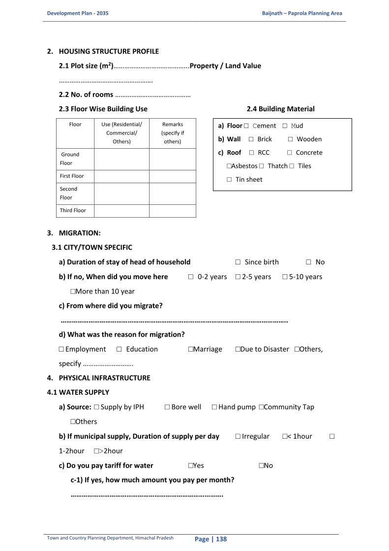
Development Plan - 2035 Baijnath – Paprola Planning Area
Town and Country Planning Department, Himachal Pradesh Page | 138
2. HOUSING STRUCTURE PROFILE
2.1 Plot size (m2)…………………………………...Property / Land Value
…………………………………………….
2.2 No. of rooms ……………………………………
2.3 Floor Wise Building Use 2.4 Building Material
Floor Use (Residential/
Commercial/
Others)
Remarks
(specify if
others)
Ground
Floor
First Floor
Second
Floor
Third Floor
3. MIGRATION:
3.1 CITY/TOWN SPECIFIC
a) Duration of stay of head of household □ Since birth □ No
b) If no, When did you move here □ 0-2 years □ 2-5 years □ 5-10 years
□More than 10 year
c) From where did you migrate?
…………………………………………………………………………………………………………..
d) What was the reason for migration?
□ Employment □ Education □Marriage □Due to Disaster □Others,
specify ……………………….
4. PHYSICAL INFRASTRUCTURE
4.1 WATER SUPPLY
a) Source: □ Supply by IPH □ Bore well □ Hand pump □Community Tap
□Others
b) If municipal supply, Duration of supply per day □ Irregular □< 1hour □
1-2hour □>2hour
c) Do you pay tariff for water □Yes □No
c-1) If yes, how much amount you pay per month?
……………………………………………………………………….
a) Floor □ Cement □ Mud
b) Wall □ Brick □ Wooden
c) Roof □ RCC □ Concrete
□Asbestos □ Thatch □ Tiles
□ Tin sheet
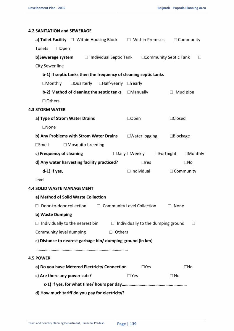
Development Plan - 2035 Baijnath – Paprola Planning Area
Town and Country Planning Department, Himachal Pradesh Page | 139
4.2 SANITATION and SEWERAGE
a) Toilet Facility □ Within Housing Block □ Within Premises □ Community
Toilets □Open
b)Sewerage system □ Individual Septic Tank □Community Septic Tank □
City Sewer line
b-1) If septic tanks then the frequency of cleaning septic tanks
□Monthly □Quarterly □Half-yearly □Yearly
b-2) Method of cleaning the septic tanks □Manually □ Mud pipe
□ Others
4.3 STORM WATER
a) Type of Strom Water Drains □Open □Closed
□None
b) Any Problems with Strom Water Drains □Water logging □Blockage
□Smell □ Mosquito breeding
c) Frequency of cleaning □Daily □Weekly □Fortnight □Monthly
d) Any water harvesting facility practiced? □Yes □No
d-1) If yes, □ Individual □ Community
level
4.4 SOLID WASTE MANAGEMENT
a) Method of Solid Waste Collection
□ Door-to-door collection □ Community Level Collection □ None
b) Waste Dumping
□ Individually to the nearest bin □ Individually to the dumping ground □
Community level dumping □ Others
c) Distance to nearest garbage bin/ dumping ground (in km)
…………….……………………………………………………………
4.5 POWER
a) Do you have Metered Electricity Connection □Yes □No
c) Are there any power cuts? □ Yes □ No
c-1) If yes, for what time/ hours per day……………………………………….…………
d) How much tariff do you pay for electricity?

Development Plan - 2035 Baijnath – Paprola Planning Area
Town and Country Planning Department, Himachal Pradesh Page | 140
□ per unit………………………………………… □ per month…………………………………
e) Do you have access to solar power? □ Yes □ No
e-1) If yes, for what purpose you use? □ Lighting □ Solar Heating system
□ Cooking □ Other, specify……………….
4.6 TRANSPORT
a) Vehicle ownership
Type 4-wheeler 2-wheeler Cycle Other None
No.
b) Details of Household trips
Sl.No. Gender Mode of
Transport
a. Walk
b. Cycle
c. Two-Wheeler
d. Car
e. Taxi/Auto
f. Bus
Origin Destination Travel
Purpose
Travel
Time
Travel Cost

Development Plan - 2035 Baijnath – Paprola Planning Area
Town and Country Planning Department, Himachal Pradesh Page | 141
Sl.No. Gender Mode of
Transport
a. Walk
b. Cycle
c. Two-Wheeler
d. Car
e. Taxi/Auto
f. Bus
Origin Destination Travel
Purpose
Travel
Time
Travel Cost
b-1) Are you satisfied with the frequency of bus service in your area? □ Yes □ No
b-1.1) If no,
why?......................................................................................................................... .....
5. SOCIAL INFRASTRUCTURE
Social Services/Infrastructure
Location
e. Within village
f. In urban areas
(planning area)
g. Within planning
area
h. Outside
planning area
Frequency of use
a. Daily
b. Twice a week
c. Weekly
d. Rarely
Satisfaction
Unsatisfied - 0-3
Fair - 4-5
Good - 6-7
V.Good - 8-10
(A) Health
Dispensary/ Clinic
Hospital
(B) Shopping
Convenience Shopping
Weekly Market
Local Shopping
Others, specify
(C) Services
Community Hall
Post Office
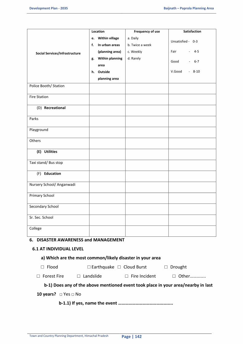
Development Plan - 2035 Baijnath – Paprola Planning Area
Town and Country Planning Department, Himachal Pradesh Page | 142
Social Services/Infrastructure
Location
e. Within village
f. In urban areas
(planning area)
g. Within planning
area
h. Outside
planning area
Frequency of use
a. Daily
b. Twice a week
c. Weekly
d. Rarely
Satisfaction
Unsatisfied - 0-3
Fair - 4-5
Good - 6-7
V.Good - 8-10
Police Booth/ Station
Fire Station
(D) Recreational
Parks
Playground
Others
(E) Utilities
Taxi stand/ Bus stop
(F) Education
Nursery School/ Anganwadi
Primary School
Secondary School
Sr. Sec. School
College
6. DISASTER AWARENESS and MANAGEMENT
6.1 AT INDIVIDUAL LEVEL
a) Which are the most common/likely disaster in your area
□ Flood □ Earthquake □ Cloud Burst □ Drought
□ Forest Fire □ Landslide □ Fire Incident □ Other…………..
b-1) Does any of the above mentioned event took place in your area/nearby in last
10 years? □ Yes □ No
b-1.1) If yes, name the event ………………………………………..

Development Plan - 2035 Baijnath – Paprola Planning Area
Town and Country Planning Department, Himachal Pradesh Page | 143
b-1.2) Date of the event ………………………………………….
b-1.3) Impact □ Devastating □Moderate □Mild
c) If your family prepared to face disaster?□ Yes □ No
c-1) If yes, what steps will you take to mitigate the impact
…………………………………………………………………….
6.2 AT COMMUNITY LEVEL
a) Did you receive any mock drill on any of the disaster event at community level in your
area? □ Yes □ No
a-1) If yes, on what event? …………………………………….
a-2) Who organized it? …………………………………….
a-3) Frequency of such drills? □Monthly □Quarterly □Half-yearly □Yearly
7. Problems and Prospects
i. What are the basic problems that the housing area faces, example, drainage, water
supply, waste disposal, safety and security?
……………………………………………………………………………………………………………………………………
………………………………………..…………………………………………………………………………………………
…………………………………………………………………………
ii. Who is responsible for the management of the housing area? What major works
have they done in the past?
……………………………………………………………………………………………………………………………………
………………………………………..…………………………………………………………………………………………
………………………………………………………………………….
iii. What are the benefits of living in the area, for example connectivity, accessibility
to facilities, etc
……………………………………………………………………………………………………………………………………
………………………………………..…………………………………………………………………………………………
………………………………………………………………………….
iv. Do you suggest some changes that could help improve the housing area?
……………………………………………………………………………………………………………………………………
………………………………………..…………………………………………………………………………………………
…………………………………………………………………………
v. What kind of improvements and development are you expecting in your area?

Development Plan - 2035 Baijnath – Paprola Planning Area
Town and Country Planning Department, Himachal Pradesh Page | 144
……………………………………………………………………………………………………………………………………
………………………………………..…………………………………………………………………………………………
…………………………………………………………………………
8. What are your priorities for Improvement?
□ Security □ Health □ Water □ Employment □ Roads
□ Education □ Housing □ Sanitation □ Electricity

De
velo
pm
en
t P
lan
- 2
03
5
Bai
jnat
h –
Pa
pro
la P
lan
nin
g A
rea
Tow
n a
nd
Co
un
try
Pla
nn
ing
Dep
artm
ent,
Him
ach
al P
rad
esh
P
age
| 1
45
Tra
ffic
Vo
lum
e C
ou
nt
Su
rve
y F
orm
at
TRA
FFIC
VO
LUM
E C
OU
NT
SUR
VEY
FO
RM
AT
Nam
e o
f En
um
erat
or:
……
……
……
……
……
……
……
……
……
……
……
……
....
....
...
Dat
e /
Tim
e: …
……
……
……
……
……
……
……
……
……
……
.……
……
……
Nam
e o
f R
oad
/ L
oca
tio
n: …
……
……
……
……
……
……
……
……
……
……
……
……
…
Dir
ecti
on
of
Traf
fic:
……
……
……
……
……
……
……
……
……
……
……
….
2
Wh
eele
r
LMV
HM
V
LM
V
HM
V
Trac
tor
No
n –
Mo
tori
zed
Ve
hic
les
Tim
e
Per
iod
(P
asse
nge
r)
(Pas
sen
ger)
(G
oo
ds)
(G
oo
ds)
C
ar
3 W
4
W
Min
i B
us
Stan
dar
d
3 W
4 W
Tr
uck
W
ith
Wit
ho
ut
Cyc
le
Ric
k-
Shaw
Han
d-
cart
B
ullo
ck
cart
Oth
ers
Bu
s
Trai
ler
Tr
aile
r

De
velo
pm
en
t P
lan
- 2
03
5
Bai
jnat
h –
Pa
pro
la P
lan
nin
g A
rea
Tow
n a
nd
Co
un
try
Pla
nn
ing
Dep
artm
ent,
Him
ach
al P
rad
esh
P
age
| 1
46
Ori
gin
De
stin
ati
on
Su
rve
y F
orm
at
OR
IGIN
– D
ESTI
NA
TIO
N S
UR
VEY
FO
RM
AT
Nam
e o
f En
um
erat
or:
……
……
……
……
……
……
……
……
……
……
……
……
....
....
...
D
ate
/ Ti
me:
……
……
……
……
……
……
……
……
……
……
……
….…
……
…
Nam
e o
f R
oad
/ L
oca
tio
n:
……
……
……
……
……
……
……
……
……
……
……
……
……
Dir
ecti
on
of
Traf
fic:
……
……
……
……
……
……
……
……
……
……
……
….
Tim
e
Veh
icle
P
asse
nge
r O
rigi
n
(Pla
ce/D
istr
ict/
St
ate
)
Des
tin
atio
n
(Pla
ce/D
istr
ict/
St
ate)
Pu
rpo
se
No
. of
Typ
e o
f N
o. o
f Tr
ips
(in
day
s/ w
eek
s/
mo
nth
s)
No
. of
wo
rkin
g d
ays
(in
day
s/ w
ee
ks/
mo
nth
s)
Ro
ute
mo
stly
p
refe
rre
d o
r ad
op
ted
Pe
rio
d
typ
e
or
Go
od
s o
f Tr
ip
Pas
sen
gers
G
oo
ds

De
velo
pm
en
t P
lan
- 2
03
5
Bai
jnat
h –
Pa
pro
la P
lan
nin
g A
rea
Tow
n a
nd
Co
un
try
Pla
nn
ing
Dep
artm
ent,
Him
ach
al P
rad
esh
P
age
| 1
47
Traf
fic
Pro
ject
ion
s
Surv
ey P
oin
t I –
Tas
hi C
how
k
PC
U
1.0
1
.0
0.5
1
.0
1.5
3
.0
1.0
1
.0
3.0
1
.5
4.5
0
.5
2.0
6
.0
3.0
1
.0
3.0
1
.5
3.0
GR
(%
) 5
Year
Car/ Jeep/Van
Utility Vehicles
Two wheeler
3wh(pass)
Minibus
Standard Bus
3wh(Goods)
LCV
Trucks
Tractor
Tractor with
Trailer
Cycle
Cycle Rickshaw
Animal cart
Others
Toll
exe
mp
ted
ve
hic
le
Total Vehicles
Total PCU
Remarks
Car/Jeep
Bus
LCV
Truck
20
16
3
32
2
66
7
30
64
1
6
34
3
51
1
01
3
32
2
83
2
2
6
1
0
0
8
0
0
0
0
82
07
8
06
8
2 L
ane
20
17
3
48
8
70
0
32
17
1
7
36
3
69
1
06
3
49
2
97
2
2
7
1
0
0
9
0
0
0
0
86
17
8
47
2
20
18
3
66
3
73
5
33
78
1
8
38
3
87
1
12
3
66
3
12
2
2
9
1
0
0
9
0
0
0
0
90
48
8
89
5
20
19
3
84
6
77
2
35
46
1
8
40
4
06
1
17
3
85
3
27
3
3
0
1
0
0
10
0
0
0
0
9
50
1
93
40
20
20
4
03
8
81
0
37
24
1
9
42
4
27
1
23
4
04
3
43
3
3
2
1
0
0
10
0
0
0
0
9
97
6
98
07
20
21
4
24
0
85
1
39
10
2
0
44
4
48
1
29
4
24
3
61
3
3
3
1
0
0
11
0
0
0
0
1
04
74
1
02
97
20
22
4
45
2
89
3
41
05
2
1
46
4
70
1
36
4
45
3
79
3
3
5
1
0
0
11
0
0
0
0
1
09
98
1
08
12
20
23
4
67
4
93
8
43
11
2
2
48
4
94
1
43
4
68
3
98
3
3
7
1
0
0
12
0
0
0
0
1
15
48
1
13
53
20
24
4
90
8
98
5
45
26
2
4
50
5
19
1
50
4
91
4
17
3
3
8
1
0
0
13
0
0
0
0
1
21
25
1
19
20
20
25
5
15
4
10
34
4
75
3
25
5
3
54
5
15
7
51
6
43
8
3
40
1
0
0
1
3
0
0
0
0
12
73
2
12
51
7
20
26
5
41
1
10
86
4
99
0
26
5
6
57
2
16
5
54
1
46
0
4
42
1
0
0
1
4
0
0
0
0
13
36
8
13
14
2
20
27
5
68
2
11
40
5
24
0
27
5
8
60
0
17
3
56
8
48
3
4
44
1
0
0
1
4
0
0
0
0
14
03
7
13
79
9
20
28
5
96
6
11
97
5
50
2
29
6
1
63
0
18
2
59
7
50
7
4
47
1
0
0
1
5
0
0
0
0
14
73
9
14
48
9
20
29
6
26
4
12
57
5
77
7
30
6
4
66
2
19
1
62
7
53
3
4
49
1
0
0
1
6
0
0
0
0
15
47
5
15
21
4
20
30
6
57
7
13
20
6
06
6
32
6
8
69
5
20
1
65
8
55
9
4
52
1
0
0
1
7
0
0
0
0
16
24
9
15
97
5
20
31
6
90
6
13
86
6
36
9
33
7
1
73
0
21
1
69
1
58
7
5
54
1
0
0
1
8
0
0
0
0
17
06
2
16
77
3
20
32
7
25
2
14
55
6
68
7
35
7
5
76
6
22
1
72
5
61
7
5
57
1
0
0
1
8
0
0
0
0
17
91
5
17
61
2

De
velo
pm
en
t P
lan
- 2
03
5
Bai
jnat
h –
Pa
pro
la P
lan
nin
g A
rea
Tow
n a
nd
Co
un
try
Pla
nn
ing
Dep
artm
ent,
Him
ach
al P
rad
esh
P
age
| 1
48
PC
U
1.0
1
.0
0.5
1
.0
1.5
3
.0
1.0
1
.0
3.0
1
.5
4.5
0
.5
2.0
6
.0
3.0
1
.0
3.0
1
.5
3.0
GR
(%
) 5
Year
Car/ Jeep/Van
Utility Vehicles
Two wheeler
3wh(pass)
Minibus
Standard Bus
3wh(Goods)
LCV
Trucks
Tractor
Tractor with
Trailer
Cycle
Cycle Rickshaw
Animal cart
Others
Toll
exe
mp
ted
ve
hic
le
Total Vehicles
Total PCU
Remarks
Car/Jeep
Bus
LCV
Truck
20
33
7
61
4
15
28
7
02
2
37
7
8
80
5
23
2
76
2
64
8
5
60
1
0
0
1
9
0
0
0
0
18
81
1
18
49
3
4 L
ane
20
34
7
99
5
16
04
7
37
3
38
8
2
84
5
24
4
80
0
68
0
5
63
1
0
0
2
0
0
0
0
0
19
75
1
19
41
7
20
35
8
39
5
16
85
7
74
1
40
8
6
88
7
25
6
84
0
71
4
6
66
2
0
0
2
1
0
0
0
0
20
73
9
20
38
8
20
35
8
81
4
17
69
8
12
9
42
9
1
93
1
26
9
88
2
75
0
6
69
2
0
0
2
2
0
0
0
0
21
77
6
21
40
7
20
37
9
25
5
18
57
8
53
5
44
9
5
97
8
28
2
92
6
78
7
6
72
2
0
0
2
4
0
0
0
0
22
86
4
22
47
8
20
38
9
71
8
19
50
8
96
2
47
1
00
1
02
7
29
6
97
2
82
7
7
76
2
0
0
2
5
0
0
0
0
24
00
8
23
60
2
20
39
1
02
04
2
04
8
94
10
4
9
10
5
10
78
3
11
1
02
1
86
8
7
80
2
0
0
2
6
0
0
0
0
25
20
8
24
78
2
20
40
1
07
14
2
15
0
98
80
5
1
11
0
11
32
3
27
1
07
2
91
1
7
84
2
0
0
2
7
0
0
0
0
26
46
8
26
02
1
20
41
1
12
50
2
25
8
10
37
4
54
1
16
1
18
9
34
3
11
25
9
57
8
8
8
2
0
0
29
0
0
0
0
2
77
92
2
73
22
20
42
1
18
12
2
37
1
10
89
3
57
1
21
1
24
8
36
0
11
82
1
00
5
8
92
2
0
0
3
0
0
0
0
0
29
18
1
28
68
8
20
43
1
24
03
2
48
9
11
43
8
60
1
28
1
31
1
37
8
12
41
1
05
5
8
97
2
0
0
3
2
0
0
0
0
30
64
0
30
12
2
20
44
1
30
23
2
61
4
12
01
0
62
1
34
1
37
6
39
7
13
03
1
10
8
9
10
2
2
0
0
33
0
0
0
0
3
21
72
3
16
29
20
45
1
36
74
2
74
4
12
61
0
66
1
41
1
44
5
41
7
13
68
1
16
3
9
10
7
2
0
0
35
0
0
0
0
3
37
81
3
32
10
20
46
1
43
58
2
88
1
13
24
1
69
1
48
1
51
7
43
8
14
36
1
22
1
10
1
12
3
0
0
3
7
0
0
0
0
35
47
0
34
87
1
20
47
1
50
76
3
02
5
13
90
3
72
1
55
1
59
3
46
0
15
08
1
28
2
10
1
18
3
0
0
3
8
0
0
0
0
37
24
4
36
61
4
20
48
1
58
29
3
17
7
14
59
8
76
1
63
1
67
3
48
3
15
84
1
34
6
11
1
24
3
0
0
4
0
0
0
0
0
39
10
6
38
44
5
20
49
1
66
21
3
33
6
15
32
8
80
1
71
1
75
6
50
7
16
63
1
41
4
11
1
30
3
0
0
4
2
0
0
0
0
41
06
1
40
36
7
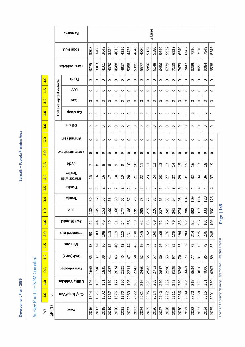
De
velo
pm
en
t P
lan
- 2
03
5
Bai
jnat
h –
Pa
pro
la P
lan
nin
g A
rea
Tow
n a
nd
Co
un
try
Pla
nn
ing
Dep
artm
ent,
Him
ach
al P
rad
esh
P
age
| 1
49
Surv
ey P
oin
t II –
SDM
Co
mp
lex
PC
U
1.0
1
.0
0.5
1
.0
1.5
3
.0
1.0
1
.0
3.0
1
.5
4.5
0
.5
2.0
6
.0
3.0
1
.0
3.0
1
.5
3.0
GR
(%
) 5
Year
Car/ Jeep/Van
Utility Vehicles
Two wheeler
3wh(pass)
Minibus
Standard Bus
3wh(Goods)
LCV
Trucks
Tractor
Tractor with
Trailer
Cycle
Cycle Rickshaw
Animal cart
Others
Toll
exe
mp
ted
ve
hic
le
Total Vehicles
Total PCU
Remarks
Car/Jeep
Bus
LCV
Truck
20
16
1
54
4
14
6
16
65
3
5
33
9
8
42
1
38
5
0
2
15
7
0
0
0
0
0
0
0
3
77
5
33
03
2 L
ane
20
17
1
62
1
15
3
17
48
3
7
34
1
03
4
4
14
5
52
2
1
6
8
0
0
0
0
0
0
0
39
63
3
46
8
20
18
1
70
2
16
1
18
35
3
9
36
1
08
4
6
15
3
55
2
1
6
8
0
0
0
0
0
0
0
41
61
3
64
2
20
19
1
78
7
16
9
19
27
4
1
38
1
13
4
9
16
0
58
2
1
7
8
0
0
0
0
0
0
0
43
70
3
82
4
20
20
1
87
6
17
7
20
24
4
3
40
1
19
5
1
16
8
60
2
1
8
9
0
0
0
0
0
0
0
45
88
4
01
5
20
21
1
97
0
18
6
21
25
4
5
42
1
25
5
4
17
7
63
2
1
9
9
0
0
0
0
0
0
0
48
17
4
21
6
20
22
2
06
9
19
6
22
31
4
7
44
1
31
5
6
18
6
67
2
2
0
10
0
0
0
0
0
0
0
5
05
8
44
26
20
23
2
17
2
20
5
23
42
5
0
46
1
38
5
9
19
5
70
2
2
1
10
0
0
0
0
0
0
0
5
31
1
46
48
20
24
2
28
1
21
6
24
60
5
2
49
1
45
6
2
20
5
73
2
2
2
11
0
0
0
0
0
0
0
5
57
7
48
80
20
25
2
39
5
22
6
25
83
5
5
51
1
52
6
5
21
5
77
3
2
3
11
0
0
0
0
0
0
0
5
85
6
51
24
20
26
2
51
4
23
8
27
12
5
7
53
1
60
6
9
22
6
81
3
2
4
12
0
0
0
0
0
0
0
6
14
8
53
80
20
27
2
64
0
25
0
28
47
6
0
56
1
68
7
2
23
7
85
3
2
5
13
0
0
0
0
0
0
0
6
45
6
56
49
20
28
2
77
2
26
2
29
90
6
3
59
1
76
7
6
24
9
89
3
2
7
13
0
0
0
0
0
0
0
6
77
9
59
32
20
29
2
91
1
27
5
31
39
6
7
62
1
85
7
9
26
1
94
3
2
8
14
0
0
0
0
0
0
0
7
11
8
62
28
20
30
3
05
6
28
9
32
96
7
0
65
1
94
8
3
27
4
98
3
2
9
15
0
0
0
0
0
0
0
7
47
3
65
40
20
31
3
20
9
30
4
34
61
7
3
68
2
04
8
7
28
8
10
3
3
31
1
5
0
0
0
0
0
0
0
78
47
6
86
7
20
32
3
37
0
31
9
36
34
7
7
72
2
14
9
2
30
2
10
9
4
32
1
6
0
0
0
0
0
0
0
82
39
7
21
0
20
33
3
53
8
33
5
38
16
8
1
75
2
25
9
6
31
7
11
4
4
34
1
7
0
0
0
0
0
0
0
86
51
7
57
0
20
34
3
71
5
35
1
40
06
8
5
79
2
36
1
01
3
33
1
20
4
3
6
18
0
0
0
0
0
0
0
9
08
4
79
49
20
35
3
90
1
36
9
42
07
8
9
83
2
48
1
06
3
50
1
26
4
3
7
19
0
0
0
0
0
0
0
9
53
8
83
46

De
velo
pm
en
t P
lan
- 2
03
5
Bai
jnat
h –
Pa
pro
la P
lan
nin
g A
rea
Tow
n a
nd
Co
un
try
Pla
nn
ing
Dep
artm
ent,
Him
ach
al P
rad
esh
P
age
| 1
50
PC
U
1.0
1
.0
0.5
1
.0
1.5
3
.0
1.0
1
.0
3.0
1
.5
4.5
0
.5
2.0
6
.0
3.0
1
.0
3.0
1
.5
3.0
GR
(%
) 5
Year
Car/ Jeep/Van
Utility Vehicles
Two wheeler
3wh(pass)
Minibus
Standard Bus
3wh(Goods)
LCV
Trucks
Tractor
Tractor with
Trailer
Cycle
Cycle Rickshaw
Animal cart
Others
Toll
exe
mp
ted
ve
hic
le
Total Vehicles
Total PCU
Remarks
Car/Jeep
Bus
LCV
Truck
20
35
4
09
6
38
7
44
17
9
4
87
2
60
1
12
3
67
1
32
4
3
9
19
0
0
0
0
0
0
0
1
00
15
8
76
4
20
37
4
30
1
40
7
46
38
9
8
91
2
73
1
17
3
86
1
39
5
4
1
20
0
0
0
0
0
0
0
1
05
16
9
20
2
20
38
4
51
6
42
7
48
70
1
03
9
6
28
7
12
3
40
5
14
5
5
43
2
1
0
0
0
0
0
0
0
11
04
2
96
62
20
39
4
74
1
44
8
51
13
1
08
1
01
3
01
1
29
4
25
1
53
5
4
5
23
0
0
0
0
0
0
0
1
15
94
1
01
45
4 L
ane
20
40
4
97
8
47
1
53
69
1
14
1
06
3
16
1
36
4
47
1
60
5
4
8
24
0
0
0
0
0
0
0
1
21
73
1
06
52
20
41
5
22
7
49
4
56
37
1
19
1
11
3
32
1
42
4
69
1
68
6
5
0
25
0
0
0
0
0
0
0
1
27
82
1
11
85
20
42
5
48
9
51
9
59
19
1
25
1
17
3
48
1
50
4
92
1
77
6
5
3
26
0
0
0
0
0
0
0
1
34
21
1
17
44
20
43
5
76
3
54
5
62
15
1
32
1
23
3
66
1
57
5
17
1
86
6
5
5
27
0
0
0
0
0
0
0
1
40
92
1
23
31
20
44
6
05
1
57
2
65
26
1
38
1
29
3
84
1
65
5
43
1
95
7
5
8
29
0
0
0
0
0
0
0
1
47
97
1
29
48
20
45
6
35
4
60
1
68
52
1
45
1
35
4
03
1
73
5
70
2
05
7
6
1
30
0
0
0
0
0
0
0
1
55
37
1
35
95
20
46
6
67
2
63
1
71
95
1
52
1
42
4
23
1
82
5
98
2
15
7
6
4
32
0
0
0
0
0
0
0
1
63
13
1
42
75
20
47
7
00
5
66
3
75
55
1
60
1
49
4
45
1
91
6
28
2
26
8
6
7
33
0
0
0
0
0
0
0
1
71
29
1
49
89
20
48
7
35
5
69
6
79
33
1
68
1
56
4
67
2
00
6
60
2
37
8
7
1
35
0
0
0
0
0
0
0
1
79
86
1
57
38
20
49
7
72
3
73
0
83
29
1
76
1
64
4
90
2
10
6
93
2
49
8
7
4
37
0
0
0
0
0
0
0
1
88
85
1
65
25

De
velo
pm
en
t P
lan
- 2
03
5
Bai
jnat
h –
Pa
pro
la P
lan
nin
g A
rea
Tow
n a
nd
Co
un
try
Pla
nn
ing
Dep
artm
ent,
Him
ach
al P
rad
esh
P
age
| 1
51
Surv
ey P
oin
t III
– M
ajeh
rna
Ro
ad
PC
U
1.0
1
.0
0.5
1
.0
1.5
3
.0
1.0
1
.0
3.0
1
.5
4.5
0
.5
2.0
6
.0
3.0
1
.0
3.0
1
.5
3.0
GR
(%
) 5
Year
Car/ Jeep/Van
Utility Vehicles
Two wheeler
3wh(pass)
Minibus
Standard Bus
3wh(Goods)
LCV
Trucks
Tractor
Tractor with
Trailer
Cycle
Cycle Rickshaw
Animal cart
Others
Toll
exe
mp
ted
ve
hic
le
Total Vehicles
Total PCU
Remarks
Car/Jeep
Bus
LCV
Truck
20
16
8
06
2
8
99
2
3
18
5
4
30
6
6
70
4
3
1
0
0
0
0
0
0
0
0
21
03
1
97
3
2 L
ane
20
17
8
47
3
0
10
42
3
1
9
57
3
1
70
7
3
4
32
0
0
0
0
0
0
0
0
2
20
8
20
72
20
18
8
89
3
1
10
94
3
2
0
60
3
3
73
7
7
4
34
0
0
0
0
0
0
0
0
2
31
8
21
75
20
19
9
33
3
3
11
49
3
2
1
63
3
4
77
8
1
4
36
0
0
0
0
0
0
0
0
2
43
4
22
84
20
20
9
80
3
4
12
06
3
2
2
66
3
6
81
8
5
4
37
0
0
0
0
0
0
0
0
2
55
6
23
98
20
21
1
02
9
36
1
26
7
3
23
6
9
38
8
5
89
5
3
9
0
0
0
0
0
0
0
0
26
84
2
51
8
20
22
1
08
1
38
1
33
0
4
25
7
2
40
8
9
94
5
4
1
0
0
0
0
0
0
0
0
28
18
2
64
4
20
23
1
13
5
40
1
39
6
4
26
7
6
42
9
3
98
5
4
3
0
0
0
0
0
0
0
0
29
59
2
77
6
20
24
1
19
1
42
1
46
6
4
27
8
0
44
9
8
10
3
5
46
0
0
0
0
0
0
0
0
3
10
7
29
15
20
25
1
25
1
44
1
54
0
4
28
8
4
46
1
03
1
08
6
4
8
1
0
0
0
0
0
0
0
32
62
3
06
1
20
26
1
31
3
46
1
61
7
4
30
8
8
48
1
08
1
14
6
5
0
1
0
0
0
0
0
0
0
34
25
3
21
4
20
27
1
37
9
48
1
69
7
5
31
9
2
51
1
13
1
20
6
5
3
1
0
0
0
0
0
0
0
35
96
3
37
5
20
28
1
44
8
51
1
78
2
5
33
9
7
53
1
19
1
26
7
5
5
1
0
0
0
0
0
0
0
37
76
3
54
3
20
29
1
52
1
53
1
87
1
5
35
1
02
5
6
12
5
13
2
7
58
1
0
0
0
0
0
0
0
3
96
5
37
20
20
30
1
59
7
56
1
96
5
5
36
1
07
5
9
13
1
13
8
7
61
1
0
0
0
0
0
0
0
4
16
3
39
07
20
31
1
67
6
59
2
06
3
6
38
1
12
6
2
13
8
14
5
8
64
1
0
0
0
0
0
0
0
4
37
1
41
02
20
32
1
76
0
61
2
16
6
6
40
1
18
6
5
14
5
15
3
8
67
1
0
0
0
0
0
0
0
4
59
0
43
07
20
33
1
84
8
65
2
27
5
6
42
1
24
6
8
15
2
16
0
8
71
1
0
0
0
0
0
0
0
4
81
9
45
22
20
34
1
94
1
68
2
38
8
6
44
1
30
7
1
15
9
16
8
9
74
1
0
0
0
0
0
0
0
5
06
0
47
48
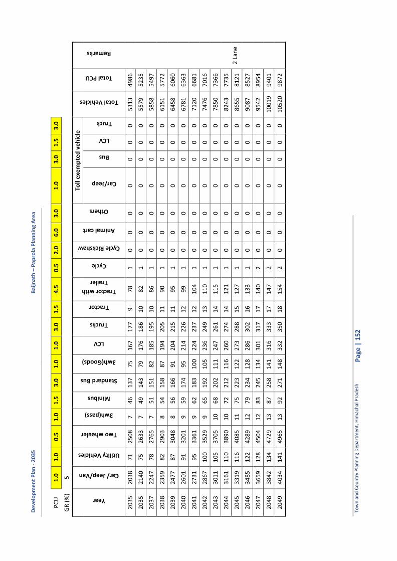
De
velo
pm
en
t P
lan
- 2
03
5
Bai
jnat
h –
Pa
pro
la P
lan
nin
g A
rea
Tow
n a
nd
Co
un
try
Pla
nn
ing
Dep
artm
ent,
Him
ach
al P
rad
esh
P
age
| 1
52
PC
U
1.0
1
.0
0.5
1
.0
1.5
3
.0
1.0
1
.0
3.0
1
.5
4.5
0
.5
2.0
6
.0
3.0
1
.0
3.0
1
.5
3.0
GR
(%
) 5
Year
Car/ Jeep/Van
Utility Vehicles
Two wheeler
3wh(pass)
Minibus
Standard Bus
3wh(Goods)
LCV
Trucks
Tractor
Tractor with
Trailer
Cycle
Cycle Rickshaw
Animal cart
Others
Toll
exe
mp
ted
ve
hic
le
Total Vehicles
Total PCU
Remarks
Car/Jeep
Bus
LCV
Truck
20
35
2
03
8
71
2
50
8
7
46
1
37
7
5
16
7
17
7
9
78
1
0
0
0
0
0
0
0
5
31
3
49
86
2 L
ane
20
35
2
14
0
75
2
63
3
7
49
1
43
7
9
17
6
18
6
10
8
2
1
0
0
0
0
0
0
0
55
79
5
23
5
20
37
2
24
7
78
2
76
5
7
51
1
51
8
2
18
5
19
5
10
8
6
1
0
0
0
0
0
0
0
58
58
5
49
7
20
38
2
35
9
82
2
90
3
8
54
1
58
8
7
19
4
20
5
11
9
0
1
0
0
0
0
0
0
0
61
51
5
77
2
20
39
2
47
7
87
3
04
8
8
56
1
66
9
1
20
4
21
5
11
9
5
1
0
0
0
0
0
0
0
64
58
6
06
0
20
40
2
60
1
91
3
20
1
9
59
1
74
9
5
21
4
22
6
12
9
9
1
0
0
0
0
0
0
0
67
81
6
36
3
20
41
2
73
1
95
3
36
1
9
62
1
83
1
00
2
24
2
37
1
2
10
4
1
0
0
0
0
0
0
0
71
20
6
68
1
20
42
2
86
7
10
0
35
29
9
6
5
19
2
10
5
23
6
24
9
13
1
10
1
0
0
0
0
0
0
0
7
47
6
70
16
20
43
3
01
1
10
5
37
05
1
0
68
2
02
1
11
2
47
2
61
1
4
11
5
1
0
0
0
0
0
0
0
78
50
7
36
6
20
44
3
16
1
11
0
38
90
1
0
72
2
12
1
16
2
60
2
74
1
4
12
1
1
0
0
0
0
0
0
0
82
43
7
73
5
20
45
3
31
9
11
6
40
85
1
1
75
2
23
1
22
2
73
2
88
1
5
12
7
1
0
0
0
0
0
0
0
86
55
8
12
1
20
46
3
48
5
12
2
42
89
1
2
79
2
34
1
28
2
86
3
02
1
6
13
3
1
0
0
0
0
0
0
0
90
87
8
52
7
20
47
3
65
9
12
8
45
04
1
2
83
2
45
1
34
3
01
3
17
1
7
14
0
2
0
0
0
0
0
0
0
95
42
8
95
4
20
48
3
84
2
13
4
47
29
1
3
87
2
58
1
41
3
16
3
33
1
7
14
7
2
0
0
0
0
0
0
0
10
01
9
94
01
20
49
4
03
4
14
1
49
65
1
3
92
2
71
1
48
3
32
3
50
1
8
15
4
2
0
0
0
0
0
0
0
10
52
0
98
72
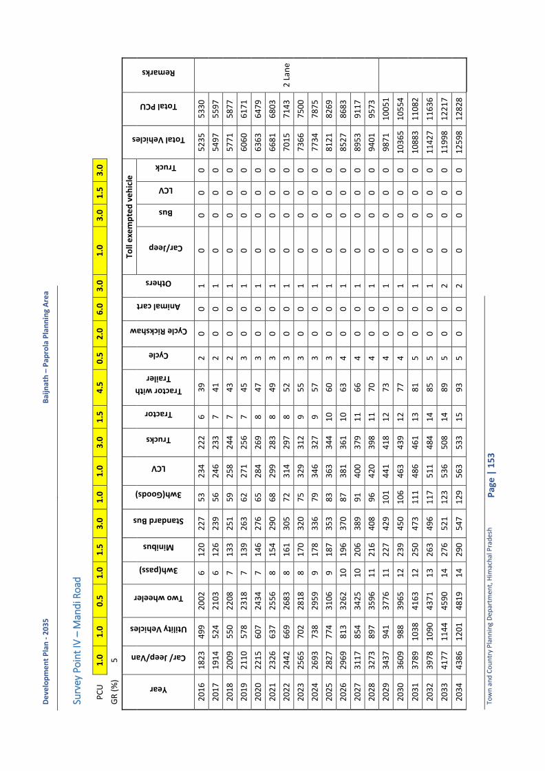
De
velo
pm
en
t P
lan
- 2
03
5
Bai
jnat
h –
Pa
pro
la P
lan
nin
g A
rea
Tow
n a
nd
Co
un
try
Pla
nn
ing
Dep
artm
ent,
Him
ach
al P
rad
esh
P
age
| 1
53
Surv
ey P
oin
t IV
– M
and
i Ro
ad
PC
U
1.0
1
.0
0.5
1
.0
1.5
3
.0
1.0
1
.0
3.0
1
.5
4.5
0
.5
2.0
6
.0
3.0
1
.0
3.0
1
.5
3.0
GR
(%
) 5
Year
Car/ Jeep/Van
Utility Vehicles
Two wheeler
3wh(pass)
Minibus
Standard Bus
3wh(Goods)
LCV
Trucks
Tractor
Tractor with
Trailer
Cycle
Cycle Rickshaw
Animal cart
Others
Toll
exe
mp
ted
ve
hic
le
Total Vehicles
Total PCU
Remarks
Car/Jeep
Bus
LCV
Truck
20
16
1
82
3
49
9
20
02
6
1
20
2
27
5
3
23
4
22
2
6
39
2
0
0
1
0
0
0
0
5
23
5
53
30
2 L
ane
20
17
1
91
4
52
4
21
03
6
1
26
2
39
5
6
24
6
23
3
7
41
2
0
0
1
0
0
0
0
5
49
7
55
97
20
18
2
00
9
55
0
22
08
7
1
33
2
51
5
9
25
8
24
4
7
43
2
0
0
1
0
0
0
0
5
77
1
58
77
20
19
2
11
0
57
8
23
18
7
1
39
2
63
6
2
27
1
25
6
7
45
3
0
0
1
0
0
0
0
6
06
0
61
71
20
20
2
21
5
60
7
24
34
7
1
46
2
76
6
5
28
4
26
9
8
47
3
0
0
1
0
0
0
0
6
36
3
64
79
20
21
2
32
6
63
7
25
56
8
1
54
2
90
6
8
29
9
28
3
8
49
3
0
0
1
0
0
0
0
6
68
1
68
03
20
22
2
44
2
66
9
26
83
8
1
61
3
05
7
2
31
4
29
7
8
52
3
0
0
1
0
0
0
0
7
01
5
71
43
20
23
2
56
5
70
2
28
18
8
1
70
3
20
7
5
32
9
31
2
9
55
3
0
0
1
0
0
0
0
7
36
6
75
00
20
24
2
69
3
73
8
29
59
9
1
78
3
36
7
9
34
6
32
7
9
57
3
0
0
1
0
0
0
0
7
73
4
78
75
20
25
2
82
7
77
4
31
06
9
1
87
3
53
8
3
36
3
34
4
10
6
0
3
0
0
1
0
0
0
0
81
21
8
26
9
20
26
2
96
9
81
3
32
62
1
0
19
6
37
0
87
3
81
3
61
1
0
63
4
0
0
1
0
0
0
0
8
52
7
86
83
20
27
3
11
7
85
4
34
25
1
0
20
6
38
9
91
4
00
3
79
1
1
66
4
0
0
1
0
0
0
0
8
95
3
91
17
20
28
3
27
3
89
7
35
96
1
1
21
6
40
8
96
4
20
3
98
1
1
70
4
0
0
1
0
0
0
0
9
40
1
95
73
20
29
3
43
7
94
1
37
76
1
1
22
7
42
9
10
1
44
1
41
8
12
7
3
4
0
0
1
0
0
0
0
98
71
1
00
51
20
30
3
60
9
98
8
39
65
1
2
23
9
45
0
10
6
46
3
43
9
12
7
7
4
0
0
1
0
0
0
0
10
36
5
10
55
4
20
31
3
78
9
10
38
4
16
3
12
2
50
4
73
1
11
4
86
4
61
1
3
81
5
0
0
1
0
0
0
0
1
08
83
1
10
82
20
32
3
97
8
10
90
4
37
1
13
2
63
4
96
1
17
5
11
4
84
1
4
85
5
0
0
1
0
0
0
0
1
14
27
1
16
36
20
33
4
17
7
11
44
4
59
0
14
2
76
5
21
1
23
5
36
5
08
1
4
89
5
0
0
2
0
0
0
0
1
19
98
1
22
17
20
34
4
38
6
12
01
4
81
9
14
2
90
5
47
1
29
5
63
5
33
1
5
93
5
0
0
2
0
0
0
0
1
25
98
1
28
28
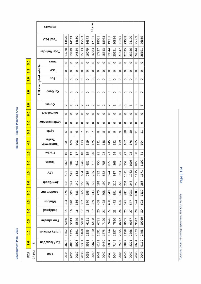
De
velo
pm
en
t P
lan
- 2
03
5
Bai
jnat
h –
Pa
pro
la P
lan
nin
g A
rea
Tow
n a
nd
Co
un
try
Pla
nn
ing
Dep
artm
ent,
Him
ach
al P
rad
esh
P
age
| 1
54
PC
U
1.0
1
.0
0.5
1
.0
1.5
3
.0
1.0
1
.0
3.0
1
.5
4.5
0
.5
2.0
6
.0
3.0
1
.0
3.0
1
.5
3.0
GR
(%
) 5
Year
Car/ Jeep/Van
Utility Vehicles
Two wheeler
3wh(pass)
Minibus
Standard Bus
3wh(Goods)
LCV
Trucks
Tractor
Tractor with
Trailer
Cycle
Cycle Rickshaw
Animal cart
Others
Toll
exe
mp
ted
ve
hic
le
Total Vehicles
Total PCU
Remarks
Car/Jeep
Bus
LCV
Truck
20
35
4
60
6
12
62
5
06
0
15
3
04
5
74
1
35
5
91
5
60
1
6
98
6
0
0
2
0
0
0
0
1
32
28
1
34
70
4 L
ane
20
35
4
83
6
13
25
5
31
3
16
3
20
6
03
1
42
6
21
5
88
1
7
10
3
6
0
0
2
0
0
0
0
13
88
9
14
14
3
20
37
5
07
8
13
91
5
57
9
16
3
36
6
33
1
49
6
52
6
17
1
7
10
8
6
0
0
2
0
0
0
0
14
58
4
14
85
0
20
38
5
33
1
14
60
5
85
8
17
3
52
6
65
1
56
6
84
6
48
1
8
11
3
7
0
0
2
0
0
0
0
15
31
3
15
59
3
20
39
5
59
8
15
33
6
15
1
18
3
70
6
98
1
64
7
19
6
81
1
9
11
9
7
0
0
2
0
0
0
0
16
07
9
16
37
3
20
40
5
87
8
16
10
6
45
8
19
3
89
7
33
1
72
7
55
7
15
2
0
12
5
7
0
0
2
0
0
0
0
16
88
3
17
19
1
20
41
6
17
2
16
91
6
78
1
20
4
08
7
70
1
81
7
92
7
50
2
1
13
1
8
0
0
2
0
0
0
0
17
72
7
18
05
1
20
42
6
48
0
17
75
7
12
0
21
4
28
8
08
1
90
8
32
7
88
2
2
13
8
8
0
0
2
0
0
0
0
18
61
3
18
95
3
20
43
6
80
4
18
64
7
47
6
22
4
50
8
49
2
00
8
74
8
27
2
3
14
5
8
0
0
2
0
0
0
0
19
54
4
19
90
1
20
44
7
14
5
19
57
7
85
0
23
4
72
8
91
2
10
9
17
8
69
2
4
15
2
9
0
0
3
0
0
0
0
20
52
1
20
89
6
20
45
7
50
2
20
55
8
24
2
24
4
96
9
36
2
20
9
63
9
12
2
6
15
9
9
0
0
3
0
0
0
0
21
54
7
21
94
1
20
46
7
87
7
21
58
8
65
5
25
5
21
9
82
2
31
1
01
1
95
8
27
1
67
1
0
0
0
3
0
0
0
0
22
62
5
23
03
8
20
47
8
27
1
22
66
9
08
7
27
5
47
1
03
1
24
3
10
62
1
00
5
28
1
76
1
0
0
0
3
0
0
0
0
23
75
6
24
19
0
20
48
8
68
4
23
79
9
54
2
28
5
74
1
08
3
25
5
11
15
1
05
6
30
1
85
1
1
0
0
3
0
0
0
0
24
94
4
25
39
9
20
49
9
11
9
24
98
1
00
19
3
0
60
3
11
37
2
68
1
17
1
11
09
3
1
19
4
11
0
0
3
0
0
0
0
2
61
91
2
66
69

De
velo
pm
en
t P
lan
- 2
03
5
Bai
jnat
h –
Pa
pro
la P
lan
nin
g A
rea
Tow
n a
nd
Co
un
try
Pla
nn
ing
Dep
artm
ent,
Him
ach
al P
rad
esh
P
age
| 1
55
Ave
rage
Dai
ly T
raff
ic -
Cla
ssif
ied
Tra
ffic
Vo
lum
e C
ou
nt
Surv
ey
Surv
ey P
oin
t I –
Tas
hi C
how
k
Ave
rage
of
Seve
n D
ays
Tim
e
inte
rval
Car/
Jeep/Van
Utility
Vehicles
Two
wheeler
3wh(pass)
Minibus
Standard
Bus
3wh(Goods)
LCV
Trucks
Tractor
Tractor with
Trailer
Cycle
Cycle
Rickshaw
Animal cart
Others
Passenger
Vehicles
Freight
Vehicles Total Fast
Moving
Vehicles Total Slow
Moving
Vehicles Total
Vehicles
Total PCU
8:0
0-9
:00
1
28
3
5
12
0
9
9
17
5
1
1
11
-
1
- -
- -
31
7
28
3
45
-
34
5
34
7
9:0
0-1
0:0
0
26
8
41
2
43
1
5
3
7
12
3
6
31
0
2
-
- -
2
59
4
84
6
78
-
67
8
70
4
10
:00
-11
:00
3
13
6
2
29
0
1
1
41
1
1
34
1
9
- 2
-
- -
0
70
7
67
7
74
-
77
4
75
9
11
:00
-12
:00
3
12
6
2
28
2
1
1
20
1
2
27
2
5
0
3
- -
- 1
6
78
6
8
74
6
- 7
46
7
07
12
:00
-1:0
0
29
3
79
2
96
2
1
2
7
10
2
5
32
-
4
- -
- 1
6
98
7
2
77
0
- 7
70
7
55
1:0
0-2
:00
2
71
8
9
24
6
0
3
37
7
5
8
32
-
2
- -
- -
64
6
99
7
45
-
74
5
76
8
2:0
0-3
:00
3
16
7
0
29
2
- 4
3
7
17
2
4
27
-
2
- -
- 1
7
19
7
1
79
0
- 7
90
7
83
3:0
0-4
:00
3
19
5
1
26
2
1
6
34
9
3
2
24
0
3
-
- -
1
67
3
70
7
42
-
74
2
74
3
4:0
0-5
:00
2
93
4
6
27
6
1
1
31
8
2
3
19
1
2
-
- -
0
64
8
53
7
00
-
70
0
67
1
5:0
0-6
:00
3
47
6
9
33
3
1
1
30
4
2
6
26
-
4
1
- -
1
78
2
61
8
43
1
8
43
8
04
6:0
0-7
:00
2
72
3
7
24
8
- 2
2
4
4
20
2
2
0
1
- -
- 1
5
84
4
8
63
1
- 6
31
6
05
7:0
0-8
:00
1
90
2
6
17
4
- 1
1
7
2
14
1
5
0
0
- -
- 0
4
09
3
3
44
2
- 4
42
4
24
8:0
0-9
:00
-
- -
- -
- -
- -
- -
- -
- -
- -
- -
- -
9:0
0-1
0:0
0
- -
- -
- -
- -
- -
- -
- -
- -
- -
- -
-
10
:00
-11
:00
-
- -
- -
- -
- -
- -
- -
- -
- -
- -
- -
11
:00
-12
:00
-
- -
- -
- -
- -
- -
- -
- -
- -
- -
- -
12
:00
-1:0
0
- -
- -
- -
- -
- -
- -
- -
- -
- -
- -
-
1:0
0-2
:00
-
- -
- -
- -
- -
- -
- -
- -
- -
- -
- -
2:0
0-3
:00
-
- -
- -
- -
- -
- -
- -
- -
- -
- -
- -
3:0
0-4
:00
-
- -
- -
- -
- -
- -
- -
- -
- -
- -
- -
4:0
0-5
:00
-
- -
- -
- -
- -
- -
- -
- -
- -
- -
- -
5:0
0-6
:00
-
- -
- -
- -
- -
- -
- -
- -
- -
- -
- -
6:0
0-7
:00
-
- -
- -
- -
- -
- -
- -
- -
- -
- -
- -

De
velo
pm
en
t P
lan
- 2
03
5
Bai
jnat
h –
Pa
pro
la P
lan
nin
g A
rea
Tow
n a
nd
Co
un
try
Pla
nn
ing
Dep
artm
ent,
Him
ach
al P
rad
esh
P
age
| 1
56
Tim
e
inte
rval
Car/
Jeep/Van
Utility
Vehicles
Two
wheeler
3wh(pass)
Minibus
Standard
Bus
3wh(Goods)
LCV
Trucks
Tractor
Tractor with
Trailer
Cycle
Cycle
Rickshaw
Animal cart
Others
Passenger
Vehicles
Freight
Vehicles Total Fast
Moving
Vehicles Total Slow
Moving
Vehicles Total
Vehicles
Total PCU
7:0
0-8
:00
-
- -
- -
- -
- -
- -
- -
- -
- -
- -
- -
Tota
l 3
32
2
66
7
30
64
1
6
34
3
51
1
01
3
32
2
83
2
2
6
1
0
0
8
74
54
7
53
8
20
6
1
82
07
8
06
8
Dai
ly W
ise
Bo
th D
irec
tio
n
Time interval
Car/ Jeep/Van
Utility Vehicles
Two wheeler
3wh(pass)
Minibus
Standard Bus
3wh(Goods)
LCV
Trucks
Tractor
Tractor with Trailer
Cycle
Cycle Rickshaw
Animal cart
Others
Passenger Vehicles
Freight Vehicles
Total Fast Moving
Vehicles
Total Slow Moving
Vehicles
Total Vehicles
Total PCU
Dat
e: 1
3/0
2/2
01
6
26
33
3
65
1
72
0
9
33
2
87
9
3
27
2
26
0
1
11
2
0
0
0
5
04
8
63
6
56
82
2
5
68
4
59
71
Dat
e:1
4/0
2/2
01
6
37
55
6
71
3
56
1
9
26
3
36
9
2
29
6
27
1
3
32
0
0
0
8
8
35
8
70
2
90
60
0
9
06
0
86
37
Dat
e:1
5/0
2/2
01
6
35
78
9
64
3
90
9
30
4
4
43
1
11
9
43
0
31
6
3
35
0
0
0
1
7
89
56
9
21
9
87
7
0
98
77
9
59
7
AD
T (B
aijn
ath
to
Pal
amp
ur)
1
35
8
26
6
11
45
3
2
0
15
2
48
1
52
1
33
2
1
1
0
0
0
6
29
46
3
52
3
29
7
0
32
97
3
35
6
AD
T (P
alam
pu
r to
Bai
jnat
h)
19
64
4
01
1
91
8
13
1
4
19
9
53
1
80
1
50
0
1
5
0
0
0
3
45
09
4
01
4
90
9
0
49
09
4
71
2
AD
T
33
22
6
67
3
06
4
16
3
4
35
1
10
1
33
2
28
3
2
26
1
0
0
8
7
45
4
75
3
82
06
1
8
20
7
80
68
AA
DT
3
32
2
66
7
30
64
1
6
34
3
51
1
01
3
32
2
83
2
2
6
1
0
0
8
74
54
7
53
8
20
6
1
82
07
8
06
8

De
velo
pm
en
t P
lan
- 2
03
5
Bai
jnat
h –
Pa
pro
la P
lan
nin
g A
rea
Tow
n a
nd
Co
un
try
Pla
nn
ing
Dep
artm
ent,
Him
ach
al P
rad
esh
P
age
| 1
57
Surv
ey P
oin
t II –
SDM
Co
mp
lex
Ave
rage
of
Seve
n D
ays
Tim
e in
terv
al
Car/ Jeep/Van
Utility Vehicles
Two wheeler
3wh(pass)
Minibus
School Bus
3wh(Goods)
LCV
Trucks
Tractor
Tractor with
Trailer
Cycle
Cycle Rickshaw
Animal cart
Others
Passenger
Vehicles
Freight
Vehicles Total Fast
Moving
Vehicles Total Slow
Moving
Vehicles
Total Vehicles
Total PCU
8:0
0-9
:00
9
8
16
9
0
5
7
9
2
7
4
0
- 3
-
- -
22
8
13
2
38
3
2
41
2
24
9:0
0-1
0:0
0
16
6
13
1
50
4
1
1
2
5
18
2
-
2
0
- -
- 3
45
2
7
37
2
0
37
2
33
0
10
:00
-11
:00
1
78
8
2
02
1
1
1
1
3
14
6
-
3
- -
- -
40
1
25
4
26
-
42
6
36
8
11
:00
-12
:00
1
50
1
3
19
2
10
7
5
3
1
2
6
- 1
0
-
- -
37
8
22
4
00
0
4
00
3
34
12
:00
-1:0
0
12
5
13
1
58
3
4
1
1
3
9
3
0
1
2
- -
- 3
15
1
7
33
0
2
33
1
28
7
1:0
0-2
:00
1
23
1
4
14
2
2
2
5
2
17
6
-
1
- -
- -
28
9
27
3
17
-
31
7
27
4
2:0
0-3
:00
1
23
8
1
25
0
2
8
4
7
5
-
0
- -
- -
26
7
16
2
83
-
28
3
24
9
3:0
0-4
:00
1
39
1
7
14
8
2
5
9
6
12
2
-
1
0
- -
- 3
21
2
1
34
2
0
34
2
29
6
4:0
0-5
:00
1
40
1
5
15
4
2
1
11
7
1
4
7
0
2
1
- -
- 3
24
3
1
35
4
1
35
5
32
1
5:0
0-6
:00
1
26
1
3
15
0
3
1
7
4
16
5
1
2
1
-
- -
30
1
27
3
28
1
3
28
2
86
6:0
0-7
:00
1
03
1
0
90
1
2
6
2
7
2
-
1
- -
- -
21
2
12
2
24
-
22
4
19
7
7:0
0-8
:00
7
2
7
63
1
1
4
1
5
1
-
0
- -
- -
14
8
8
15
7
- 1
57
1
38
8:0
0-9
:00
-
- -
- -
- -
- -
- -
- -
- -
- -
- -
- -
9:0
0-1
0:0
0
- -
- -
- -
- -
- -
- -
- -
- -
- -
- -
-
10
:00
-11
:00
-
- -
- -
- -
- -
- -
- -
- -
- -
- -
- -
11
:00
-12
:00
-
- -
- -
- -
- -
- -
- -
- -
- -
- -
- -
12
:00
-1:0
0
- -
- -
- -
- -
- -
- -
- -
- -
- -
- -
-
1:0
0-2
:00
-
- -
- -
- -
- -
- -
- -
- -
- -
- -
- -
2:0
0-3
:00
-
- -
- -
- -
- -
- -
- -
- -
- -
- -
- -
3:0
0-4
:00
-
- -
- -
- -
- -
- -
- -
- -
- -
- -
- -
4:0
0-5
:00
-
- -
- -
- -
- -
- -
- -
- -
- -
- -
- -
5:0
0-6
:00
-
- -
- -
- -
- -
- -
- -
- -
- -
- -
- -
6:0
0-7
:00
-
- -
- -
- -
- -
- -
- -
- -
- -
- -
- -
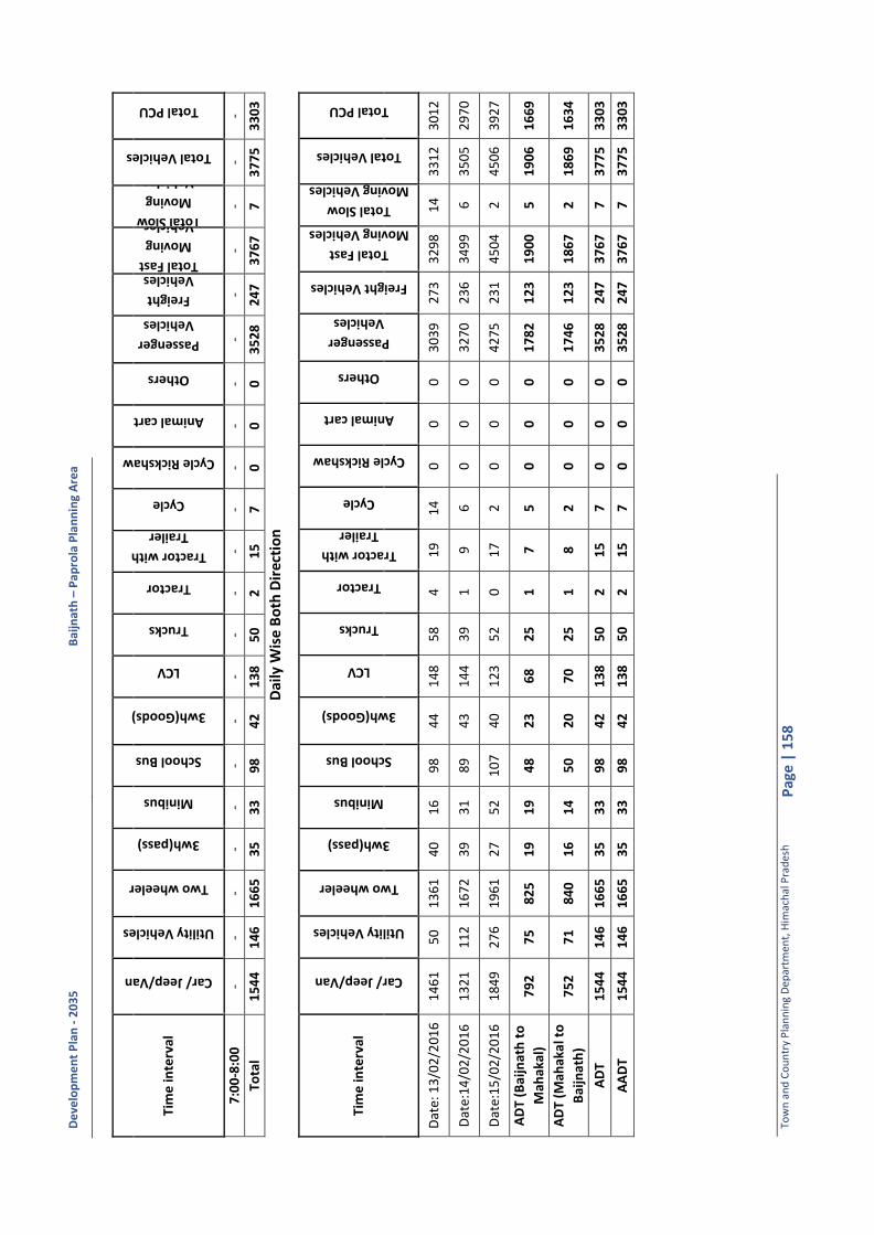
De
velo
pm
en
t P
lan
- 2
03
5
Bai
jnat
h –
Pa
pro
la P
lan
nin
g A
rea
Tow
n a
nd
Co
un
try
Pla
nn
ing
Dep
artm
ent,
Him
ach
al P
rad
esh
P
age
| 1
58
Tim
e in
terv
al
Car/ Jeep/Van
Utility Vehicles
Two wheeler
3wh(pass)
Minibus
School Bus
3wh(Goods)
LCV
Trucks
Tractor
Tractor with
Trailer
Cycle
Cycle Rickshaw
Animal cart
Others
Passenger
Vehicles
Freight
Vehicles Total Fast
Moving
Vehicles Total Slow
Moving
Vehicles
Total Vehicles
Total PCU
7:0
0-8
:00
-
- -
- -
- -
- -
- -
- -
- -
- -
- -
- -
Tota
l 1
54
4
14
6
16
65
3
5
33
9
8
42
1
38
5
0
2
15
7
0
0
0
3
52
8
24
7
37
67
7
3
77
5
33
03
Dai
ly W
ise
Bo
th D
irec
tio
n
Tim
e in
terv
al
Car/ Jeep/Van
Utility Vehicles
Two wheeler
3wh(pass)
Minibus
School Bus
3wh(Goods)
LCV
Trucks
Tractor
Tractor with
Trailer
Cycle
Cycle Rickshaw
Animal cart
Others
Passenger
Vehicles
Freight Vehicles
Total Fast
Moving Vehicles
Total Slow
Moving Vehicles
Total Vehicles
Total PCU
Dat
e: 1
3/0
2/2
01
6
14
61
5
0
13
61
4
0
16
9
8
44
1
48
5
8
4
19
1
4
0
0
0
30
39
2
73
3
29
8
14
3
31
2
30
12
Dat
e:1
4/0
2/2
01
6
13
21
1
12
1
67
2
39
3
1
89
4
3
14
4
39
1
9
6
0
0
0
3
27
0
23
6
34
99
6
3
50
5
29
70
Dat
e:1
5/0
2/2
01
6
18
49
2
76
1
96
1
27
5
2
10
7
40
1
23
5
2
0
17
2
0
0
0
4
27
5
23
1
45
04
2
4
50
6
39
27
AD
T (B
aijn
ath
to
Mah
akal
) 7
92
7
5
82
5
19
1
9
48
2
3
68
2
5
1
7
5
0
0
0
17
82
1
23
1
90
0
5
19
06
1
66
9
AD
T (M
ahak
al t
o
Bai
jnat
h)
75
2
71
8
40
1
6
14
5
0
20
7
0
25
1
8
2
0
0
0
1
74
6
12
3
18
67
2
1
86
9
16
34
AD
T
15
44
1
46
1
66
5
35
3
3
98
4
2
13
8
50
2
1
5
7
0
0
0
35
28
2
47
3
76
7
7
37
75
3
30
3
AA
DT
1
54
4
14
6
16
65
3
5
33
9
8
42
1
38
5
0
2
15
7
0
0
0
3
52
8
24
7
37
67
7
3
77
5
33
03

De
velo
pm
en
t P
lan
- 2
03
5
Bai
jnat
h –
Pa
pro
la P
lan
nin
g A
rea
Tow
n a
nd
Co
un
try
Pla
nn
ing
Dep
artm
ent,
Him
ach
al P
rad
esh
P
age
| 1
59
Surv
ey P
oin
t III
– M
ajeh
rna
Ro
ad
Ave
rage
of
Seve
n D
ays
Tim
e in
terv
al
Car/ Jeep/Van
Utility Vehicles
Two wheeler
3wh(pass)
Minibus
School Bus
3wh(Goods)
LCV
Trucks
Tractor
Tractor with
Trailer
Cycle
Cycle Rickshaw
Animal cart
Others
Passenger
Vehicles
Freight Vehicles
Total Fast Moving
Vehicles
Total Slow Moving
Vehicles
Total Vehicles
Total PCU
8:0
0-9
:00
4
0
3
63
-
3
2
2
3
4
- 2
-
- -
- 1
11
1
1
12
2
- 1
22
1
13
9:0
0-1
0:0
0
63
2
1
11
1
1
5
1
1
0
7
1
4
0
- -
- 1
83
2
4
20
6
0
20
7
19
0
10
:00
-11
:00
9
5
1
10
7
0
0
6
4
7
7
1
4
- -
- -
20
9
23
2
32
-
23
2
22
1
11
:00
-12
:00
9
6
4
10
4
1
2
7
6
6
5
- 2
-
- -
- 2
13
1
9
23
2
- 2
32
2
12
12
:00
-1:0
0
84
4
9
8
1
0
4
3
6
5
- 3
-
- -
- 1
90
1
7
20
8
- 2
08
1
86
1:0
0-2
:00
7
4
2
89
-
- 5
2
5
7
0
4
-
- -
- 1
71
1
8
18
9
- 1
89
1
83
2:0
0-3
:00
7
0
3
62
-
3
3
3
5
6
- 3
-
- -
- 1
41
1
7
15
9
- 1
59
1
59
3:0
0-4
:00
6
7
3
77
0
3
5
1
6
5
1
2
-
- -
- 1
55
1
5
17
0
- 1
70
1
60
4:0
0-5
:00
7
1
1
81
-
5
3
3
6
7
0
2
- -
- -
16
2
18
1
80
-
18
0
16
7
5:0
0-6
:00
5
9
2
88
-
1
5
2
5
9
- 3
-
- -
- 1
55
1
9
17
4
- 1
74
1
71
6:0
0-7
:00
5
1
2
66
-
- 5
1
5
5
-
1
- -
- -
12
4
11
1
36
-
13
6
12
5
7:0
0-8
:00
3
6
1
46
-
- 4
1
3
3
-
0
- -
- -
87
8
9
5
- 9
5
87
8:0
0-9
:00
-
- -
- -
- -
- -
- -
- -
- -
- -
- -
- -
9:0
0-1
0:0
0
- -
- -
- -
- -
- -
- -
- -
- -
- -
- -
-
10
:00
-11
:00
-
- -
- -
- -
- -
- -
- -
- -
- -
- -
- -
11
:00
-12
:00
-
- -
- -
- -
- -
- -
- -
- -
- -
- -
- -
12
:00
-1:0
0
- -
- -
- -
- -
- -
- -
- -
- -
- -
- -
-
1:0
0-2
:00
-
- -
- -
- -
- -
- -
- -
- -
- -
- -
- -
2:0
0-3
:00
-
- -
- -
- -
- -
- -
- -
- -
- -
- -
- -
3:0
0-4
:00
-
- -
- -
- -
- -
- -
- -
- -
- -
- -
- -
4:0
0-5
:00
-
- -
- -
- -
- -
- -
- -
- -
- -
- -
- -
5:0
0-6
:00
-
- -
- -
- -
- -
- -
- -
- -
- -
- -
- -

De
velo
pm
en
t P
lan
- 2
03
5
Bai
jnat
h –
Pa
pro
la P
lan
nin
g A
rea
Tow
n a
nd
Co
un
try
Pla
nn
ing
Dep
artm
ent,
Him
ach
al P
rad
esh
P
age
| 1
60
Tim
e in
terv
al
Car/ Jeep/Van
Utility Vehicles
Two wheeler
3wh(pass)
Minibus
School Bus
3wh(Goods)
LCV
Trucks
Tractor
Tractor with
Trailer
Cycle
Cycle Rickshaw
Animal cart
Others
Passenger
Vehicles
Freight Vehicles
Total Fast Moving
Vehicles
Total Slow Moving
Vehicles
Total Vehicles
Total PCU
6:0
0-7
:00
-
- -
- -
- -
- -
- -
- -
- -
- -
- -
- -
7:0
0-8
:00
-
- -
- -
- -
- -
- -
- -
- -
- -
- -
- -
Tota
l 8
06
2
8
99
2
3
18
5
4
30
6
6
70
4
3
1
0
0
0
0
19
02
2
00
2
10
2
0
21
03
1
97
3
Dai
ly W
ise
Bo
th D
irec
tio
n
Tim
e in
terv
al
Car/ Jeep/Van
Utility Vehicles
Two wheeler
3wh(pass)
Minibus
School Bus
3wh(Goods)
LCV
Trucks
Tractor
Tractor with Trailer
Cycle
Cycle Rickshaw
Animal cart
Others
Passenger Vehicles
Freight Vehicles
Total Fast Moving
Vehicles
Total Slow Moving
Vehicles
Total Vehicles
Total PCU
Dat
e: 1
3/0
2/2
01
6
77
2
11
9
24
3
1
1
48
3
8
66
8
5
5
18
1
0
0
0
1
77
0
21
2
19
81
1
1
98
2
18
55
Dat
e:1
4/0
2/2
01
6
84
8
5
11
23
3
8
5
7
34
4
0
60
2
4
1
0
0
0
0
20
44
1
77
2
22
1
0
22
21
2
04
3
Dat
e:1
5/0
2/2
01
6
79
9
69
9
30
2
3
6
57
1
7
93
6
6
4
33
0
0
0
0
1
89
3
21
2
21
05
0
2
10
5
20
21
AD
T (P
anch
rukh
i
to P
apro
la)
38
3
25
5
15
1
6
2
8
14
3
8
34
3
1
7
0
0
0
0
95
8
10
5
10
62
0
1
06
3
99
1
AD
T (P
apro
la t
o
Pan
chru
khi)
4
23
4
4
78
2
1
2
26
1
6
28
3
6
1
14
0
0
0
0
9
45
9
5
10
40
0
1
04
0
98
1
AD
T
80
6
28
9
92
3
1
8
54
3
0
66
7
0
4
31
0
0
0
0
1
90
2
20
0
21
02
0
2
10
3
19
73
AA
DT
8
06
2
8
99
2
3
18
5
4
30
6
6
70
4
3
1
0
0
0
0
19
02
2
00
2
10
2
0
21
03
1
97
3
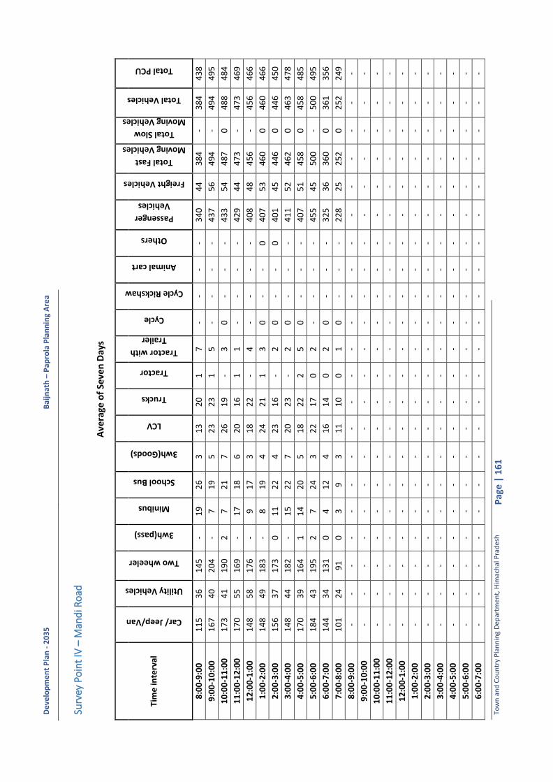
De
velo
pm
en
t P
lan
- 2
03
5
Bai
jnat
h –
Pa
pro
la P
lan
nin
g A
rea
Tow
n a
nd
Co
un
try
Pla
nn
ing
Dep
artm
ent,
Him
ach
al P
rad
esh
P
age
| 1
61
Surv
ey P
oin
t IV
– M
and
i Ro
ad
Ave
rage
of
Seve
n D
ays
Tim
e in
terv
al
Car/ Jeep/Van
Utility Vehicles
Two wheeler
3wh(pass)
Minibus
School Bus
3wh(Goods)
LCV
Trucks
Tractor
Tractor with
Trailer
Cycle
Cycle Rickshaw
Animal cart
Others
Passenger
Vehicles
Freight Vehicles
Total Fast
Moving Vehicles
Total Slow
Moving Vehicles
Total Vehicles
Total PCU
8:0
0-9
:00
1
15
3
6
14
5
- 1
9
26
3
1
3
20
1
7
-
- -
- 3
40
4
4
38
4
- 3
84
4
38
9:0
0-1
0:0
0
16
7
40
2
04
-
7
19
5
2
3
23
1
5
-
- -
- 4
37
5
6
49
4
- 4
94
4
95
10
:00
-11
:00
1
73
4
1
19
0
2
7
21
7
2
6
19
-
3
0
- -
- 4
33
5
4
48
7
0
48
8
48
4
11
:00
-12
:00
1
70
5
5
16
9
- 1
7
18
6
2
0
16
1
1
-
- -
- 4
29
4
4
47
3
- 4
73
4
69
12
:00
-1:0
0
14
8
58
1
76
-
9
17
3
1
8
22
-
4
- -
- -
40
8
48
4
56
-
45
6
46
6
1:0
0-2
:00
1
48
4
9
18
3
- 8
1
9
4
24
2
1
1
3
0
- -
0
40
7
53
4
60
0
4
60
4
66
2:0
0-3
:00
1
56
3
7
17
3
0
11
2
2
4
23
1
6
- 2
0
-
- 0
4
01
4
5
44
6
0
44
6
45
0
3:0
0-4
:00
1
48
4
4
18
2
- 1
5
22
7
2
0
23
-
2
0
- -
- 4
11
5
2
46
2
0
46
3
47
8
4:0
0-5
:00
1
70
3
9
16
4
1
14
2
0
5
18
2
2
2
5
0
- -
- 4
07
5
1
45
8
0
45
8
48
5
5:0
0-6
:00
1
84
4
3
19
5
2
7
24
3
2
2
17
0
2
-
- -
- 4
55
4
5
50
0
- 5
00
4
95
6:0
0-7
:00
1
44
3
4
13
1
0
4
12
4
1
6
14
0
2
0
-
- -
32
5
36
3
60
0
3
61
3
56
7:0
0-8
:00
1
01
2
4
91
0
3
9
3
1
1
10
0
1
0
-
- -
22
8
25
2
52
0
2
52
2
49
8:0
0-9
:00
-
- -
- -
- -
- -
- -
- -
- -
- -
- -
- -
9:0
0-1
0:0
0
- -
- -
- -
- -
- -
- -
- -
- -
- -
- -
-
10
:00
-11
:00
-
- -
- -
- -
- -
- -
- -
- -
- -
- -
- -
11
:00
-12
:00
-
- -
- -
- -
- -
- -
- -
- -
- -
- -
- -
12
:00
-1:0
0
- -
- -
- -
- -
- -
- -
- -
- -
- -
- -
-
1:0
0-2
:00
-
- -
- -
- -
- -
- -
- -
- -
- -
- -
- -
2:0
0-3
:00
-
- -
- -
- -
- -
- -
- -
- -
- -
- -
- -
3:0
0-4
:00
-
- -
- -
- -
- -
- -
- -
- -
- -
- -
- -
4:0
0-5
:00
-
- -
- -
- -
- -
- -
- -
- -
- -
- -
- -
5:0
0-6
:00
-
- -
- -
- -
- -
- -
- -
- -
- -
- -
- -
6:0
0-7
:00
-
- -
- -
- -
- -
- -
- -
- -
- -
- -
- -

De
velo
pm
en
t P
lan
- 2
03
5
Bai
jnat
h –
Pa
pro
la P
lan
nin
g A
rea
Tow
n a
nd
Co
un
try
Pla
nn
ing
Dep
artm
ent,
Him
ach
al P
rad
esh
P
age
| 1
62
Tim
e in
terv
al
Car/ Jeep/Van
Utility Vehicles
Two wheeler
3wh(pass)
Minibus
School Bus
3wh(Goods)
LCV
Trucks
Tractor
Tractor with
Trailer
Cycle
Cycle Rickshaw
Animal cart
Others
Passenger
Vehicles
Freight Vehicles
Total Fast
Moving Vehicles
Total Slow
Moving Vehicles
Total Vehicles
Total PCU
7:0
0-8
:00
-
- -
- -
- -
- -
- -
- -
- -
- -
- -
- -
Tota
l 1
82
3
49
9
20
02
6
1
20
2
27
5
3
23
4
22
2
6
39
2
0
0
1
4
68
0
55
5
52
33
2
5
23
5
53
30
Dai
ly W
ise
Bo
th D
irec
tio
n
Tim
e in
terv
al
Car/ Jeep/Van
Utility Vehicles
Two wheeler
3wh(pass)
Minibus
School Bus
3wh(Goods)
LCV
Trucks
Tractor
Tractor with Trailer
Cycle
Cycle Rickshaw
Animal cart
Others
Passenger Vehicles
Freight Vehicles
Total Fast Moving
Vehicles
Total Slow Moving
Vehicles
Total Vehicles
Total PCU
Dat
e: 1
3/0
2/2
01
6
18
52
4
96
1
71
7
1
11
0
21
9
67
2
79
2
33
8
3
7
0
0
0
0
43
94
6
22
5
01
7
0
50
17
5
24
8
Dat
e:1
4/0
2/2
01
6
18
55
4
79
2
26
5
4
15
4
22
1
43
1
95
2
26
5
4
1
3
0
0
2
49
80
5
12
5
48
9
3
54
92
5
48
0
Dat
e:1
5/0
2/2
01
6
17
62
5
23
2
02
5
13
9
8
24
3
51
2
29
2
06
6
3
8
4
0
0
0
46
66
5
29
5
19
2
4
51
96
5
26
3
AD
T (P
alam
pu
r to
Man
di)
9
12
2
39
9
62
3
7
0
11
3
27
1
09
1
04
3
1
8
1
0
0
1
23
00
2
62
2
56
1
1
25
62
2
61
5
AD
T (M
and
i to
Pal
amp
ur)
9
10
2
60
1
04
0
3
50
1
15
2
6
12
5
11
8
3
20
1
0
0
0
2
38
0
29
3
26
72
1
2
67
3
27
15
AD
T
18
23
4
99
2
00
2
6
12
0
22
7
53
2
34
2
22
6
3
9
2
0
0
1
46
80
5
55
5
23
3
2
52
35
5
33
0
AA
DT
1
82
3
49
9
20
02
6
1
20
2
27
5
3
23
4
22
2
6
39
2
0
0
1
4
68
0
55
5
52
33
2
5
23
5
53
30