Pavas-Escazu, Inequity and Opportunity
10
Escazu-Pavas Inequity and Opportunity Urban Growth and Density: the political dimension Ivan Delgado Universidad Veritas, Costa Rica http://www.arkosis.com [email protected] Abstract Satellite images of western San Jose, Costa Rica, show River Tiribi and Prospero-Fernandez Highway dividing the Pavas District to the north and San Rafael de Escazu to the south. The most evident differences in the sectors closest to the riverbanks are the geometries of the urban layout, the densities, and even from that altitude, the sizes and material qualities of the buildings. At ground level the socioeconomic differences become undeniable. It is tempting to ask why such disparate phenomena occur in areas that share essentially the same geographic definition. Although it would be important to unveil the historical reasons that explain why these two communities grew so differently from small towns to become part of the conurbated San Jose, making each sector a case worthy of separate studies, it is far more interesting to understand why they keep attracting different types of suburbanites and why the way they construct space and social relationships seems to be perpetuated. Can this suggest the possibility of an academic exercise in which the finding of particularities, regarded as challenges and opportunities could be exchanged across the river in symbolic gestures ? Keywords. Socioanalysis; cartography; interculturalism; territory; symbolic power. Introduction The author proposes to borrow from Sociology by means of Pierre Bourdieu´s concepts on social phenomena, who defines effects of a place as the way that the social structures define physical and social space, thus making a reflection on how space is constructed mimetically to economic and class structures. The participants, two groups of the same Urban Theory course at Veritas University, adjacent in time and space, each one assigned one of the neighborhoods, will define a collaborative methodology for the exercise using Bourdieu as a common ground, empirical observations and statistical data collected by means of alternative techniques in order to produce cartographic representations of how class structure internalization can affect everything from demeanor and attitudes towards living space to the arrangement of the territory, ultimately affecting land value. The author will act in tandem with a sociology professor as moderators in what is expected to become a fruitful debate between the two teams, with the defense of their findings as the material for further negotiation and exchange. An acquired conciousness regarding the membership to
Transcript of Pavas-Escazu, Inequity and Opportunity

Escazu-Pavas Inequity and Opportunity Urban Growth and Density: the political dimension
Ivan Delgado Universidad Veritas, Costa Rica
http://www.arkosis.com
Abstract Satellite images of western San Jose, Costa Rica, show River Tiribi and
Prospero-Fernandez Highway dividing the Pavas District to the north and San Rafael de Escazu to the south. The most evident differences in the sectors closest to the riverbanks are the geometries of the urban layout, the densities, and even from that altitude, the sizes and material qualities of the buildings. At ground level the socioeconomic differences become undeniable.
It is tempting to ask why such disparate phenomena occur in areas that share essentially the same geographic definition.
Although it would be important to unveil the historical reasons that explain why these two communities grew so differently from small towns to become part of the conurbated San Jose, making each sector a case worthy of separate studies, it is far more interesting to understand why they keep attracting different types of suburbanites and why the way they construct space and social relationships seems to be perpetuated. Can this suggest the possibility of an academic exercise in which the finding of particularities, regarded as challenges and opportunities could be exchanged across the river in symbolic gestures ? Keywords. Socioanalysis; cartography; interculturalism; territory; symbolic power.
Introduction
The author proposes to borrow from Sociology by means of Pierre Bourdieu´s concepts on social phenomena, who defines effects of a place as the way that the social structures define physical and social space, thus making a reflection on how space is constructed mimetically to economic and class structures. The participants, two groups of the same Urban Theory course at Veritas University, adjacent in time and space, each one assigned one of the neighborhoods, will define a collaborative methodology for the exercise using Bourdieu as a common ground, empirical observations and statistical data collected by means of alternative techniques in order to produce cartographic representations of how class structure internalization can affect everything from demeanor and attitudes towards living space to the arrangement of the territory, ultimately affecting land value. The author will act in tandem with a sociology professor as moderators in what is expected to become a fruitful debate between the two teams, with the defense of their findings as the material for further negotiation and exchange. An acquired conciousness regarding the membership to

greater structures in which a designer is often a victim of immanent forces can lead to a redefinition of the designer’s role as a critical actor in society.
The paper will take the form of a narrative, in an attempt to make a detailed account of the events that shaped the academic experience in 10 sessions with the students. The studies will be structured in 3 main sections: the definition of a methodology for the investigation, focusing on tools for collecting sensible information; the diagnosis, as a characterization of the social phenomena encountered on site and the development of an argument; and the operations, consisting of tactical maneuvers with implication on the territory seeking coherence between challenges and opportunities, a course of action based on the previous argument. Each section will begin with an introductory reading with direct implication on the work to be done, but as an open question or incitement for further development. General comments will be made on the findings made by the groups as a whole, noteworthy results will be highlighted and discussed in more detail.
The first sessions, defining methods for (socio)analysis
Our work begins with the definition of the areas of interest for the field work, prior to this the students have been given two reference books: La Distincion, Bourdieu (1979) and Diferentes, Desiguales, Desconectados, García-Canclini (2004) . The first Urban Theory group (afternoon class, 23 students) is assigned Pavas, as a highlight one of the students was a elementary school teacher in one of the poorest areas for 5 years. The second group (night class with 23 students as well) starts to work with Escazu, interestingly 5 of those students live in this area. From the beginning the task at hand seems at the same time difficult and exciting, as the participants recurrently start the conversations by referring to the inhabitants of those towns by making clear distinctions between “us and them”, or talking about “those people”, as the work progresses language itself is modified. Each group is divided into 4 sub-groups, corresponding to the same number of sectors, the sectors chosen have loosely defined borders because there are potential overlaps that are expected and, these first approaches are largely based on the conjecture that the social phenomena that are expected to be unveiled cannot be explained from within a strictly defined political division of the territory. The sectors are in Pavas: Lomas del Río, Pavas Industrial, Pavas Centro and La Libertad, in Escazú: Bello Horizonte, Los Laureles, Guachipelín and Trejos-Montealegre The work is developed in 3 sessions, with an intermediate session and a final seminar with all participants and the invited Sociology professor Wendy Molina. Three of the eight experiences will be summarized as follows:
Lomas del Río in Pavas
There are 71 384 inhabitants in 9.34 km2 in Pavas, making it one of the most populated and dense districts in the country. It is surrounded by other sectors which contrast greatly in the typologies and land value, such as high profile commercial and industrial areas, Escazu being the most prominent one. The students focus on Pierre Bourdieu´s Sociology of Culture, for which, despite the fact that its basic problems are not “cultural”, they are instrumental in understanding social differences. For this it is important to study culture as it is acquired at schools and in particular this neighborhood has one of the largest schools in impoverished communities in Costa Rica, Lomas del Río Elementary School. The group understand the school years as a crucial age to gain the notion of referential

space both at home and at urban scale, the distances walked from school to their houses being the first ventures into a larger communal network, but also their vocabulary, eating habits the way they shape their relations with others (and how discrimination may start to take effect) and many other social components will be formed during these years, in other words it is perhaps the most important stage of the formation of the habitus, Bourdieu (1972). It is inferred by the students after talking to the children at school that the condition of the school accepted as “normal” even though it is in mostly deplorable conditions means that the references for quality of space have been formed. The methodology is proposed as a series of steps, namely an initial immersion into the site, the account of impressions, the creation of a hypothesis, the confirmation or rejection of the hypothesis through the use of a tool (in this case a survey applied to students and teachers at the School ) and the formulation of a diagnosis or conclusions. The hypothesis elaborates on the newly acquired knowledge of a large population of students attending the schools and accepting or enduring disadvantageous conditions both at home (socioeconomical) and at school (spatial) in favor of an education perceived as preferential. The survey consisted of about 150 consultations between students and teachers and it shows how the target population perceive their learning environment, their living conditions ( houses and open spaces ) and the relation of income to quality of life, ( eating habits, access to basic needs ) and also the origin of family income.
The diagnosis centers on the notion that even though the children are exposed to tangible social risk, the expectations of the population of Lomas del Rio as a whole represented the children attending school are set high in relation to what can be expected of similar impoverished communities and a decisive participation of mothers as the most enthusiastic participants in the formal education of their children, therefore some of the most active users of public space.
Zona Industrial in Pavas
The areas of interest deal with the coexistence of several strong interests in this relatively small area that have an effect on land value. It can be defined as the adjacency of several actors that create a sense of friction and richness at the same time, however the most evident result is that the original inhabitants are being paradoxically affected by the appreciation of their otherwise inexpensive land, for which the taxes increase accordingly, which in turn places them in the dilemma of continuing to be attached to land that is deeply rooted in their notion of neighborhood or having to sell it. The latter is perhaps the most tempting response as a demand for offices turns houses into private offices with relative The method used is a combination of surveys, of particular interest are the responses of the older inhabitants; the mapping of land use / land value and and the mapping of “noise islands” with the use of decibel meters as a way to make evident the segregation of the residential areas by activity related to heavy industry that affects living conditions in areas that can no longer be read as continuous (figure 1). The diagnosis for Zona Industrial deals with the notion of lost balance or coherence in what could be a rich neighborhood that benefits from the relationship with industry, in intermediate states between residential and less aggressive services-related land use. An unwanted and uncontrolled mixture of uses has led to a difficulty to read the neighborhood and to a feeling of uneasiness derived from not “knowing who your neighbor is any more, and not being able to take out the garbage in your pajamas”, as one citizen puts it.

Figure 1 Land value and “noise islands” in Zona Industrial, Pavas.
Bello Horizonte-Los Anonos, Escazu
The sub-group finds that a diverse social conglomerate inhabits this neighborhood, again adjacent, contrasting realities where the boundaries between “low class” and “high class” are visible and the effects of sybolic violence become tangible. The boundaries, however, are in constant change when lots on the impoverished side are bought and converted into gated communities, thus increasing the land value of an area that while being part of Escazu, one of the richest counties in Costa Rica, still lacks basic infrastructure. Blank perimeter walls are erected against multi-family dwellings of very low material quality, unfinished condominium units add to the informal atmosphere of the neighborhood. The students describe a precarious balance where both sides need each other, and “taste” is disseminated, many of the informal dwellings display compositional similarities with their richer counterparts, one difference worth noticing is the increased quantity of windows related to the rich outdoor life and the associated need for control. Also, cultural identifiers are proudly shown through these windows, posters favorite singers and soccer clubs decorate living rooms. The community has an intricate network of roads because of its origins as a group of coffee farms on the outskirts of San Jose, the navigation of this newly consolidated urban is complex. The students intuit that the phenomena described above in combination with the town´s morphology must be reflected in unique mental maps, in order to capture these phenomena the students carried out 2 activities:
• perceptual maps: inhabitants from the Bello Horizonte and Los Anonos sectors were asked to draw their surroundings in a routinary movement from their houses to a place of interest, they are representative of the way the level of instruction permeates the detail in the maps (in Bello Horizonte the maps are more intricate and detailed), also how priorities are shown on the map (public
transportation and basic needs in the case of Los Anonos, commerce and distances reachable by car in Bello Horizonte).
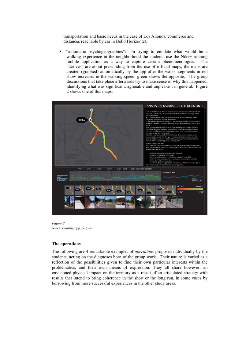
• “automatic psychogeographies”: In trying to emulate what would be a walking experience in the neighborhood the students use the Nike+ running mobile application as a way to capture certain phenomenologies. The “derives” are about prescinding from the use of official maps, the maps are created (graphed) automatically by the app after the walks, segments in red show increases in the walking speed, green shows the opposite. The group discussions that take place afterwards try to make sense of why this happened, identifying what was significant: agreeable and unpleasant in general. Figure 2 shows one of this maps.
Figure 2 Nike+ running app, outputs
The operations
The following are 4 remarkable examples of operations proposed individually by the students, acting on the diagnoses born of the group work. Their nature is varied as a reflection of the possibilities given to find their own particular interests within the problematics, and their own means of expression. They all share however, an envisioned physical impact on the territory as a result of an articulated strategy with results that intend to bring coherence in the short or the long run, in some cases by borrowing from more successful experiences in the other study areas.

Marianela Soto - Lomas del Río, Pavas
The proposal elaborates on the potentials and limitations of young housewives as promoters of their children´s education and who are subject to chauvinism and the lack of an income of their own. The paper presents a discussion of whether or not architecture and urbanism can take part in preventive rather than restrictive actions to reduce negative effects in the community that originate during the school years of the population. By learning from more generous urban equipment in Escazu for instance, such as ampler sidewalks, ramps, benches, shade; gender oriented design can make conditions easier for the most active users of these public spaces, the women who take their children to school and at the same time push strollers, run errands and withstand discrimation. Also, by reactivating otherwise underused communal places women can be trained for running small businesses and gain economic independence.
Antonio Cersosimo - Zona Industrial, Pavas
The paper invites readers to discuss if urban conscience is affected by migration through a process of perception, in the case of Zona Industrial as described in the aforementioned group analysis. It is proposed that beyond the mere incorporation of residential properties to industry and non-inclusive types of business, the identity of the neighbors themselves (who are becoming part of the agents or outsiders, according to the paper) is being absorbed by a generalization, evidenced in the daily routines of wearing uniforms and the use mass transportation. The short brakes and strenuous day shifts at the industrial facilities turn public and private transportation into a time-consuming obsession. It is stated that social conscience exists and it is manifested as politic ideology, juridical conscience, and moral, religious, scientific, artistic and philosophic conscience. The author argues that Zona Industrial has acquired such an amorphous state that the transit from houses to work does not provide any significant information to the agents nor does it encourage the creation of criteria or perceptual reflexes, this due to 3 characteristics defined by the author as:
• Programmatic Transition: the formation of programs that are inserted into well-defined architectural typologies, making it impossible to discern the limits of the established programmatic blocks.
• Programmatic Disconnection: in this case the transit of agents becomes very specific when they are associated to specific types of programs, regulated by internal ecological (biologic-social) structures that define people´s priorities, manifested as basic needs (hunger, sleep) or complex ones (consumerism and work). Heuristic rules take hold when disconnection and transition act together hindering the communication between agent-agent, agent-publicity and agent-space.
• Programmatic Zoning: As a consequence of the prior characteristic (disconnection), generic programs and specific programs become isolated allowing the emergence of less important secondary programs (including transitional programs), which by are by nature do not seek high densities of agents.
At this stage a critical point in which the users acquire conscience is proposed, a return to a critical status, a status of opinion and of conscience by re-activating their cognitive reflexes and reorganizing their priorities system. The proposed strategy to achieve the critical point would happen at Municipal levels in the form of policies:
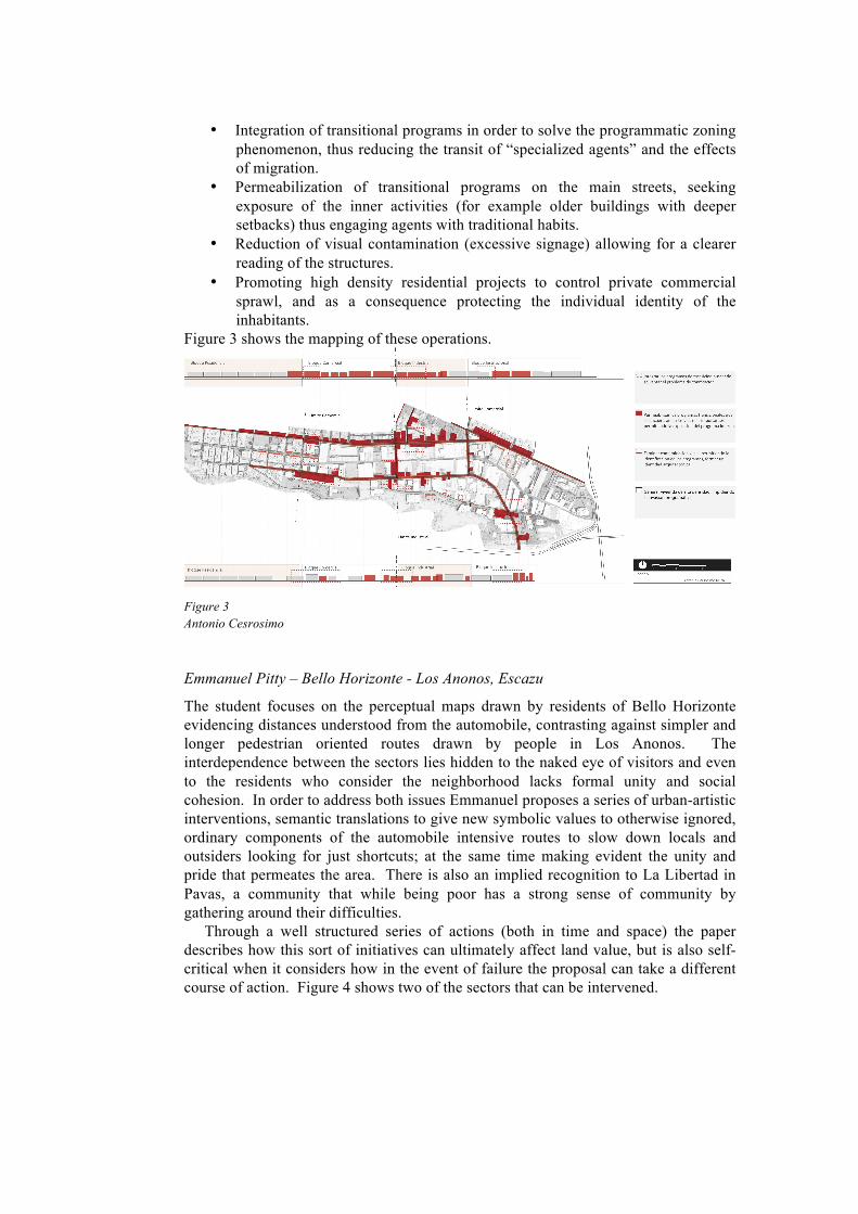
• Integration of transitional programs in order to solve the programmatic zoning
phenomenon, thus reducing the transit of “specialized agents” and the effects of migration.
• Permeabilization of transitional programs on the main streets, seeking exposure of the inner activities (for example older buildings with deeper setbacks) thus engaging agents with traditional habits.
• Reduction of visual contamination (excessive signage) allowing for a clearer reading of the structures.
• Promoting high density residential projects to control private commercial sprawl, and as a consequence protecting the individual identity of the inhabitants.
Figure 3 shows the mapping of these operations.
Figure 3 Antonio Cesrosimo
Emmanuel Pitty – Bello Horizonte - Los Anonos, Escazu
The student focuses on the perceptual maps drawn by residents of Bello Horizonte evidencing distances understood from the automobile, contrasting against simpler and longer pedestrian oriented routes drawn by people in Los Anonos. The interdependence between the sectors lies hidden to the naked eye of visitors and even to the residents who consider the neighborhood lacks formal unity and social cohesion. In order to address both issues Emmanuel proposes a series of urban-artistic interventions, semantic translations to give new symbolic values to otherwise ignored, ordinary components of the automobile intensive routes to slow down locals and outsiders looking for just shortcuts; at the same time making evident the unity and pride that permeates the area. There is also an implied recognition to La Libertad in Pavas, a community that while being poor has a strong sense of community by gathering around their difficulties. Through a well structured series of actions (both in time and space) the paper describes how this sort of initiatives can ultimately affect land value, but is also self-critical when it considers how in the event of failure the proposal can take a different course of action. Figure 4 shows two of the sectors that can be intervened.

Figure 4 Emmanuel Pitty, Bello Horizonte
Pamela Reyes, Lucila Ortíz – Bello Horizonte - Los Anonos, Escazu.
Learning from global facts, moving on to regional (Central American) and local phenomena (Escazu), it is demonstrated that inequity in Central American cities and lately in Costa Rica is reflected in an increase by 1/3 in marginal urban neighborhoods in which 40% of the population live under the extreme poverty line. This is more dramatic when upscale neighborhoods coexist side by side. These peripheries develop sporadically in proximity to sources of work, generating cultural clashes and deficient urban experiences of its inhabitants. Key to understanding their proposal is the following text by Karen C. Seto (Yale), and William Solecki and Peter Marcotullio (Hunter College): “Cities are places. Urbanization is a process, one of simultaneous transformation of places, built environments that create an urban society. Despite a panoply of researchers studying cities, research on urbanization has not focused on the process and its intersection with other environmental systems”. As part of these other environmental systems the students include digital social media, as an ever expanding way of how groups of persons understand the city and obtain information from it. The paper is rich in references and images, it has been synthetized due to the limited space, in essence they propose to create a platform for communal interaction, a way to democratize the use and creation of public space, by gathering apparently dissimilar people around key issues for the neighborhood, moving from virtual to physical encounters. Those issues have been captured in the previous group work and have been sensibly turned into opportunities, for example understanding of subtle similarities and constrasts in the appearance of houses they propose competitions as joint ventures with commercial entities in order to enhance the “curb appeal” of residences, a direct interaction between the virtual and physical objects; a similar case is a way to organize car pooling, creating potential encounters and reducing wasted car trips (figure 5)
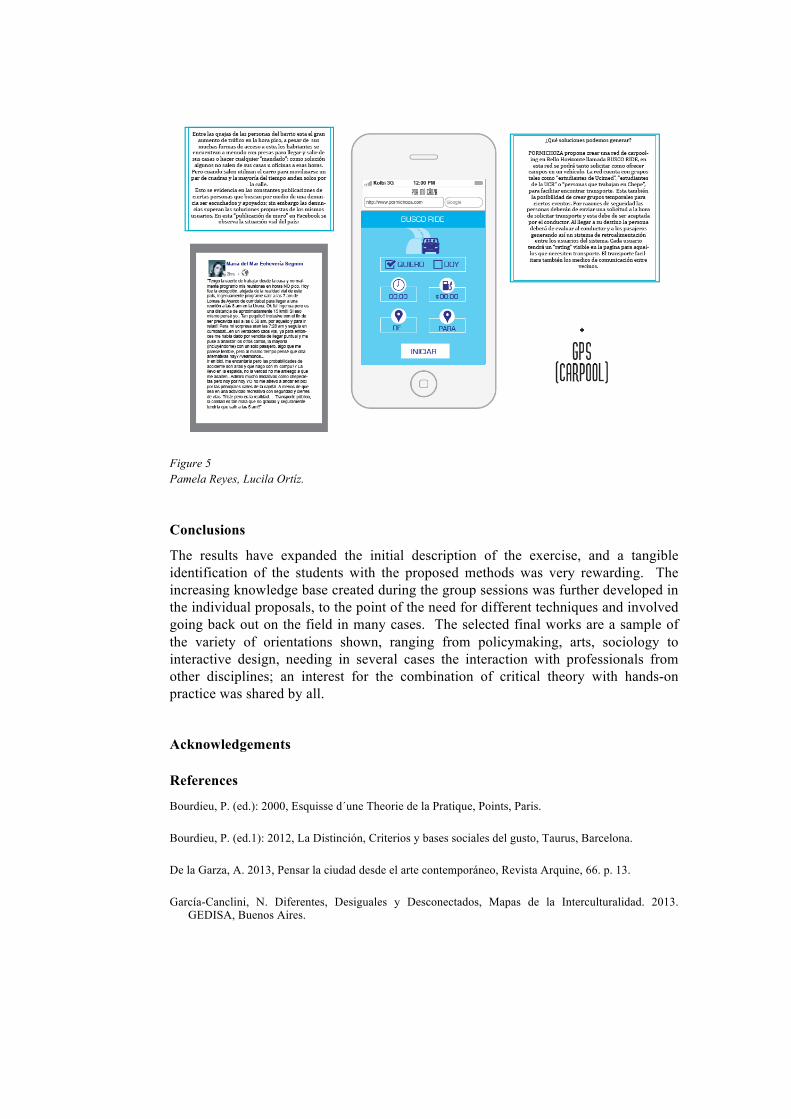
Figure 5 Pamela Reyes, Lucila Ortíz.
Conclusions
The results have expanded the initial description of the exercise, and a tangible identification of the students with the proposed methods was very rewarding. The increasing knowledge base created during the group sessions was further developed in the individual proposals, to the point of the need for different techniques and involved going back out on the field in many cases. The selected final works are a sample of the variety of orientations shown, ranging from policymaking, arts, sociology to interactive design, needing in several cases the interaction with professionals from other disciplines; an interest for the combination of critical theory with hands-on practice was shared by all. Acknowledgements
References
Bourdieu, P. (ed.): 2000, Esquisse d´une Theorie de la Pratique, Points, Paris. Bourdieu, P. (ed.1): 2012, La Distinción, Criterios y bases sociales del gusto, Taurus, Barcelona. De la Garza, A. 2013, Pensar la ciudad desde el arte contemporáneo, Revista Arquine, 66. p. 13. García-Canclini, N. Diferentes, Desiguales y Desconectados, Mapas de la Interculturalidad. 2013.
GEDISA, Buenos Aires.