Path Loss Predictions in the VHF and UHF Bands Within ...
15
Received May 7, 2019, accepted June 3, 2019, date of publication June 6, 2019, date of current version June 26, 2019. Digital Object Identifier 10.1109/ACCESS.2019.2921411 Path Loss Predictions in the VHF and UHF Bands Within Urban Environments: Experimental Investigation of Empirical, Heuristics and Geospatial Models NASIR FARUK 1 , SEGUN I. POPOOLA 2,3 , NAZMAT T. SURAJUDEEN-BAKINDE 4 , ABDULKARIM A. OLOYEDE 1 , ABUBAKAR ABDULKARIM 4 , LUKMAN A. OLAWOYIN 1 , MAARUF ALI 5 , CARLOS T. CALAFATE 6 , AND ADEREMI A. ATAYERO 3 1 Department of Telecommunication Science, University of Ilorin, Ilorin 1515, Nigeria 2 School of Engineering, Manchester Metropolitan University, Manchester M15 6BH, U.K. 3 Department of Electrical and Information Engineering, Covenant University, Ota 1023, Nigeria 4 Department of Electrical Engineering, Ahmadu Bello University, Samaru Zaria PMB 1044, Nigeria 5 International Association of Educators and Researchers (IAER), Kemp House, London, U.K. 6 Department of Computer Engineering (DISCA), Universitat Politècnica de València (UPV), 46022 Valencia, Spain Corresponding author: Segun I. Popoola ([email protected]) This work was supported jointly by the funding received from IoT-Enabled Smart and Connected Communities (SmartCU) Research Cluster and the Center for Research, Innovation and Discovery (CUCRID) of Covenant University, Ota, Nigeria. ABSTRACT Deep knowledge of how radio waves behave in a practical wireless channel is required for effective planning and deployment of radio access networks in urban environments. Empirical propagation models are popular for their simplicity, but they are prone to introduce high prediction errors. Different heuristic methods and geospatial approaches have been developed to further reduce path loss prediction error. However, the efficacy of these new techniques in built-up areas should be experimentally verified. In this paper, the efficiencies of empirical, heuristic, and geospatial methods for signal fading predictions in the very high frequency (VHF) and ultra-high frequency (UHF) bands in typical urban environments are evaluated and analyzed. Electromagnetic field strength measurements are performed at different test locations within four selected cities in Nigeria. The data collected are used to develop path loss models based on artificial neural network (ANN), adaptive neuro-fuzzy inference system (ANFIS), and Kriging techniques. The prediction results of the developed models are compared with those of selected empirical models and field measured data. Apart from Egli and ECC-33, the root mean squared error (RMSE) produced by all other models under investigation are considered acceptable. Specifically, the ANN and ANFIS models yielded the lowest prediction errors. However, the empirical models have the lowest standard deviation errors across all the bands. The findings of this study will help radio network engineers to achieve efficient radio coverage estimation; determine the optimal base station location; make a proper frequency allocation; select the most suitable antenna; and perform interference feasibility studies. INDEX TERMS ANFIS, artificial neural networks, backpropagation, path loss, Kriging, radio propagation. I. INTRODUCTION A study of the characteristics of radio waves in different propagation environments is needed for an effective network planning, and for the deployment of wireless communication systems [1], [2]. The magnitude and direction of electro- magnetic waves in a practical wireless channel is usually The associate editor coordinating the review of this manuscript and approving it for publication was Mauro Tucci. random and highly unpredictable [3]. Meanwhile, a good understanding of this phenomenon is needed to guarantee good Quality of Service (QoS) and high data transmission rate in radio access networks. The efficiency of a wireless communication system depends on the physical constituents of the propagation environment. The presence of buildings, mountains, bill boards, foliage, vehicles and other physical objects in a prac- tical propagation environment usually obstructs the direct VOLUME 7, 2019 2169-3536 2019 IEEE. Translations and content mining are permitted for academic research only. Personal use is also permitted, but republication/redistribution requires IEEE permission. See http://www.ieee.org/publications_standards/publications/rights/index.html for more information. 77293
-
Upload
khangminh22 -
Category
Documents
-
view
0 -
download
0
Transcript of Path Loss Predictions in the VHF and UHF Bands Within ...
Received May 7, 2019, accepted June 3, 2019, date of publication June 6, 2019, date of current version June 26, 2019.
Digital Object Identifier 10.1109/ACCESS.2019.2921411
Path Loss Predictions in the VHF and UHF BandsWithin Urban Environments: ExperimentalInvestigation of Empirical, Heuristicsand Geospatial ModelsNASIR FARUK1, SEGUN I. POPOOLA 2,3, NAZMAT T. SURAJUDEEN-BAKINDE4,ABDULKARIM A. OLOYEDE1, ABUBAKAR ABDULKARIM4, LUKMAN A. OLAWOYIN1,MAARUF ALI5, CARLOS T. CALAFATE 6, AND ADEREMI A. ATAYERO 31Department of Telecommunication Science, University of Ilorin, Ilorin 1515, Nigeria2School of Engineering, Manchester Metropolitan University, Manchester M15 6BH, U.K.3Department of Electrical and Information Engineering, Covenant University, Ota 1023, Nigeria4Department of Electrical Engineering, Ahmadu Bello University, Samaru Zaria PMB 1044, Nigeria5International Association of Educators and Researchers (IAER), Kemp House, London, U.K.6Department of Computer Engineering (DISCA), Universitat Politècnica de València (UPV), 46022 Valencia, Spain
Corresponding author: Segun I. Popoola ([email protected])
This work was supported jointly by the funding received from IoT-Enabled Smart and Connected Communities (SmartCU) ResearchCluster and the Center for Research, Innovation and Discovery (CUCRID) of Covenant University, Ota, Nigeria.
ABSTRACT Deep knowledge of how radio waves behave in a practical wireless channel is required foreffective planning and deployment of radio access networks in urban environments. Empirical propagationmodels are popular for their simplicity, but they are prone to introduce high prediction errors. Differentheuristic methods and geospatial approaches have been developed to further reduce path loss predictionerror. However, the efficacy of these new techniques in built-up areas should be experimentally verified.In this paper, the efficiencies of empirical, heuristic, and geospatial methods for signal fading predictionsin the very high frequency (VHF) and ultra-high frequency (UHF) bands in typical urban environmentsare evaluated and analyzed. Electromagnetic field strength measurements are performed at different testlocations within four selected cities in Nigeria. The data collected are used to develop path loss modelsbased on artificial neural network (ANN), adaptive neuro-fuzzy inference system (ANFIS), and Krigingtechniques. The prediction results of the developed models are compared with those of selected empiricalmodels and fieldmeasured data. Apart fromEgli and ECC-33, the root mean squared error (RMSE) producedby all other models under investigation are considered acceptable. Specifically, the ANN and ANFIS modelsyielded the lowest prediction errors. However, the empirical models have the lowest standard deviation errorsacross all the bands. The findings of this study will help radio network engineers to achieve efficient radiocoverage estimation; determine the optimal base station location; make a proper frequency allocation; selectthe most suitable antenna; and perform interference feasibility studies.
INDEX TERMS ANFIS, artificial neural networks, backpropagation, path loss, Kriging, radio propagation.
I. INTRODUCTIONA study of the characteristics of radio waves in differentpropagation environments is needed for an effective networkplanning, and for the deployment of wireless communicationsystems [1], [2]. The magnitude and direction of electro-magnetic waves in a practical wireless channel is usually
The associate editor coordinating the review of this manuscript andapproving it for publication was Mauro Tucci.
random and highly unpredictable [3]. Meanwhile, a goodunderstanding of this phenomenon is needed to guaranteegood Quality of Service (QoS) and high data transmissionrate in radio access networks.
The efficiency of a wireless communication systemdepends on the physical constituents of the propagationenvironment. The presence of buildings, mountains, billboards, foliage, vehicles and other physical objects in a prac-tical propagation environment usually obstructs the direct
VOLUME 7, 20192169-3536 2019 IEEE. Translations and content mining are permitted for academic research only.
Personal use is also permitted, but republication/redistribution requires IEEE permission.See http://www.ieee.org/publications_standards/publications/rights/index.html for more information.
77293

N. Faruk et al.: Path Loss Predictions in the VHF and UHF Bands Within Urban Environments
line-of-sight (LOS) of radio signal transmission. Hence,transmitted radio signals often reach targeted receiversthrough different propagation mechanisms in non-line-of-sight (NLOS) scenarios.Refraction occurs when the transmit-ted electromagnetic waves move from onemedium to anothermedium whose refraction index is different from that of theformer [4]. Diffraction of radio signals takes place whenthe transmission path is obstructed by large objects, causingthe bending of the radio wave [4]. Radio signal gets reflectedwhen it collides with an object whose dimension is largerelative to the wavelength of the radiated signal [4]. Thesereflecting objects include the metallic surfaces of windowframes and building rooftops. Also, a radio signal is saidto have experienced scattering when the object’s dimensionis far less than the wavelength of the radio signal. In thiscase, radiated electromagnetic waves are reflected towardsdifferent directions. Scattering may be due to: precipitation(drizzle, rain, sleet, snow and hail); suspensions (fog andmist) and dust particles. Radio signals could also be absorbedwhen it passes through dense materials like walls or floors,trees and foliage.
The propagation of electromagnetic waves is usually influ-enced by the atmospheric conditions of the propagation envi-ronment [4]. Electromagnetic waves of higher frequencies,having wavelengths of just a few millimeters, get attenu-ated easily as the size of the transmitted wavelength tendstowards the size of the atmospheric agents, which may be raindroplets, dust, snow or fogs. At Very Low Frequency (VLF),Low Frequency (LF) and Medium Frequency (MF) bands,radio waves propagate for a considerable distance close tothe surface of the Earth. This mode of propagation is adoptedin Amplitude Modulation (AM) broadcasting, which uses theMF band. At High Frequency (HF) bands, the ground wavestend to be absorbed by the Earth.
In practical urban propagation environment, differentcopies of transmitted radio wave arrive at the receiverby means of various propagation mechanisms. This phe-nomenon is known as multipath propagation and this causessignal fading at the receiver [4]. Considering a situationwhere the magnitude of the received signal strength changesfrequently within a short duration, given that the distanceremains relatively unchanged, such attenuation of signal issaid to be of small-scale [5]. For large-scale fading, the meanreceived signal strength will significantly reduce as the dis-tance increases [6]. This earlier concept is also referred toas path loss. Several propagation models have been devel-oped for path loss estimations under different propagationscenarios. Radio network engineers depend on these mod-els to: achieve efficient radio coverage estimation; determinethe optimal base station location; make a proper frequencyallocation; select the most suitable antenna and; performinterference feasibility studies.
Traditionally, each of the radio propagation modelsreported in the literature is regarded as either deterministic,semi-deterministic or empirical, depending on the model-ing technique employed. A path loss model is said to be
deterministic if the resulting mathematical equations arederived from the theoretical laws and principles ofphysics [6]. Virtual simulation tools have been developedfor implementation of deterministic models towards accuratepath loss predictions [7]–[9]. These tools do not requirein-depth of the propagation environment and have beenproven to be efficient when deployed within its constraints.Even if site-specific data about the propagation terrain isavailable, the use of deterministic models does not alwaysguarantee accurate predictions [6]. One of the major chal-lenges encountered in the use of deterministic models is thecomputation complexity; deterministic models require toomany and well-detailed input information that may not beeasily obtained. On the contrary, empirical models such asHata model [10] and COST 231 model [11] require lesscomputation resources during implementation. They are veryeasy to use but the prediction accuracy may not be as highwhen compared to deterministic models. Other than theeffects of distance and other network parameters such asfrequency of transmission and antenna heights, the impactof environmental constituents on radio wave propagation arenot be adequately captured in most empirical models [12].The effectiveness of these models was tested in a diverse setof environments and across several bands.
In some instances, some of these models were tuned toimprove prediction accuracy. Hejselbæk et al. [13] presentedelectromagnetic field strength measurements at 917.5 MHzin forest terrain for device-to-device (D2D) communications.The measured loss was compared with some empirical pathloss models. The dominant path of propagation was throughthe foliage, which resulted in high loss levels. However, it wasfound that, at distances exceeding 1000 m, the measuredsignal strength follows the fourth-power law. In [14], single-slope path loss models were found to have deficiencies inaccurately capturing the effect of physical environments. Forthis reason, the performance of multi-slope path loss mod-els were investigated and compared with different path lossmodels. García et al. [15] optimized the RecommendationITU-R.P.1812-4 path loss models to improve accuracy inpropagation path loss prediction for DTT systems in outdoorenvironments of Caracas city, Venezuela. Other works arefound in [16], [17]. The common findings are inconsistenciesin the performance of existing models, and high predictionerrors. Therefore, it is important to explore better ways ofachieving simple path loss prediction models without com-promising the required efficiency in terms of accuracy.
Recently, different ANN approaches were introduced topredict signal path loss in wireless communication networks.Ayadi et al. [18] developed a new method for multi-bandheterogeneous wireless network scenario using ANN tech-nique. In [19], Multilayer Perceptron (MLP) neural modelwas developed to predict path losses when radio signals aretransmitted at frequencies within Global System for Mobilecommunications (GSM) band. The developed neural net-work model predicts path loss based on three input vari-ables namely: distance, transmit power and terrain elevation.
77294 VOLUME 7, 2019

N. Faruk et al.: Path Loss Predictions in the VHF and UHF Bands Within Urban Environments
The three-layered neural network (input, hidden, output)was trained with field measured data based on Levenberg-Marquardt (LM) learning rules. In order to ensure best-suitednetwork architecture, the number of hidden neurons wasiterated between 31 and 39. Themodel proved to bemore effi-cient than the empirical models (Hata, Egli, COST-231 andEricsson) in terms of RMSE. Sotiroudis et al. [20] proposeda model for urban environment and their findings showedthat ANN-based path loss model will perform efficiently, pro-vided that the size of the neural network is correctly chosen.In [21], a three-stage approach was employed to develop anANN model for the GSM band. The model used 33 neu-rons in the hidden layer and a tansig (hyperbolic tangentsigmoid) transfer activation functionwas also used. Similarly,Ostlin et al. [22] evaluated the applicability of ANNmodels torural propagation environments in Australia. The training andtesting datasets were obtained from a commercial Code Divi-sionMultiple Access (CDMA) network. The developed ANNmodel’s accuracy and its ability to generalize well surpassedthose of traditional path loss models. Authors in [23] adoptedan ANFIS method to predict path loss within selected built-up areas in Habiye, Istanbul. The frequency of transmissioncovered in this study was limited to GSM 900 band. Theresults obtained showed an increase in prediction accuracyby 15% over Bertoni-Walfish model.
Geostatistical approach is another useful tool for predic-tions of path loss in radio access networks. It can be usedto correct residual errors that are inherent in deterministicmodels [24]. A geostatistical procedure named Kriging Inter-polation Method (KIM) was introduced in [25]. In KIM,an optimal interpolation is achieved in space following thetheory of ‘moving average’. KIM provides a good oppor-tunity to minimize the challenges encountered during dataclustering. The concept of KIM is also popularly referred toas Wiener-Kolmogorov [26]. In [27], a spatial interpolationtechnique was applied to the measurement data. The Krigingmethod consistently provided better predictions when com-pared with empirical methods. In [28], an ‘Energy-EfficientMap Interpolation for Sensor Fields’ was produced based onKriging technique. Furthermore, the authors in [29] investi-gated the ability of some propagation models to determinereceived signal strengths of radio signals propagated at TVfrequencies, considering multiple transmitter scenario in anurban area.
Despite the inherent potential of Kriging methods in han-dling prediction applications, as reported in the literature,the capability of this technique for distance-based path losspredictions in VHF/UHF bands has not yet been well investi-gated. Moreover, the response of the heuristics and geospatialmethods to diverse environments has not been established,neither have they been compared to empirical models. Fur-thermore, to the best of our knowledge, there is no singlework found in the literature that attempted to compare theeffectiveness of these approaches with the prediction accura-cies of popular empirical models across different frequencybands and locations. Therefore, this present study seeks to
conduct an experimental investigation that compares the effi-ciencies of empirical, heuristic and geospatial models forpath loss predictions in VHF/UHF bands. Models that aredeveloped accept numerical value of distance (in km) asinput variable to produce a corresponding path loss valueas an output. The performance of the developed models isevaluated based on Mean Error (ME), RMSE and StandardDeviation (SD) of the predicted path loss values relative tothe corresponding field measured path loss values. At the endof the study, we found that the performance of the differentmethods varied with the performance metrics used. It wasfound that, in the VHF bands, across cities, the heuristicmethods (i.e. ANFIS and ANN) provide the lowest mean pre-diction error. The overall average MPE across all bands androutes were of:−0.00000819 dB (ANFIS), 0.660 dB (ANN),3.09 dB (KRIGING), −7.02 dB (COST 231), 0.512 dB(HATA),−11.74 dB (EGLI) and 15.54 dB (ECC-33). A simi-lar trendwas observed for the UHF transmitters. However, theKriging method showed very high errors at some measure-ment points. These errors could be as high as 105.04 dB – thiswas due to the spacing between the path loss measurements.Kriging method uses the concept of moving averages toprovide optimal interpolation across space based on spatialdistance, against observed values of neighboring data points.
The rest of the paper is organized as follows: Section IIexplains the radio signal measurement and data collectionprocedures. Also, the methodology associated with the modeldevelopment are presented in detail. Section III presents theperformance evaluation metrics used in this work. The resultsand discussions are then presented in Section IV. Finally,Section V concludes the paper.
II. METHODOLOGY AND DATA COLLECTIONIn this section, the radio signal measurement procedure anddata collection method are presented. In addition to this, rele-vant theoretical background of the heuristic methods, geospa-tial methods and selected empirical path loss propagationmodels are provided. Finally, the model development processof each of the methods was well described.
A. MEASUREMENTS AND DATA COLLECTION PROCEDURELarge-scale radio signal measurements were performedwithin typical urban propagation terrains in four major citiesin Nigeria. The measurement campaigns were carried outwithin selected urban areas of Ilorin (Latitude 8.4799◦ N,Longitude 4.5418◦ E) in Kwara State, Osogbo (Latitude7.7827◦ N, Longitude 4.5418◦ E) in Osun State, Kano (Lati-tude 12.0022◦ N, Longitude 8.5920◦ E) in Kano State, andAbuja (Latitude 9.0765◦ N, Longitude 7.3986◦ E) in theFederal Capital Territory of Nigeria. The measurement loca-tions are described using geographic map of Nigeria shownin Figure 1. The locations are indicated with an arrow sign.Pictorial views of Ilorin and Abuja are shown in Figure 1(b)and Figure 1(c). The radio signal propagation terrain for bothIlorin and Abuja are shown in Figure 2. The magnitude of thestrengths of radio signals received from 10 Base Transceiver
VOLUME 7, 2019 77295

N. Faruk et al.: Path Loss Predictions in the VHF and UHF Bands Within Urban Environments
FIGURE 1. Radio signal measurement locations.
FIGURE 2. Radio signal measurement locations (a) Radio signalpropagation in urban scenario. (b) Urban propagation terrain in Ilorin,Kwara State, Nigeria. (c) Urban propagation terrain in Abuja, FCT, Nigeria.
Stations (BTS) and seven TV broadcast transmitters weremeasured and recorded in log files. Five out of the 10 BTStransmitters operate at Global System for GSM frequencies(900 MHz and 1800 MHz) while the remaining five BTStransmitters operate at Wideband Code Division MultipleAccess (WCDMA) frequency of 2100 MHz. Three of thebroadcast transmitters operate at frequencies within the VHFband, while the remaining four broadcast transmitters operateat frequencies within the UHF band.
The routes considered in the four cities were characterizedby a large number of diffraction scatters and the average dis-tance between buildings range from 30 to 40m. The buildingswithin the measurement locations are mostly concentratedalong the road. The terrain of Kano city is relatively flat whencompared with Ilorin or Osogbo. The land distance betweenKano and Osogbo is 639 km.
Path losses in radio signal transmission from five GSMtransmitters located in Kano and five WCDMA transmitterslocated in Abuja were measured and recorded. The operat-ing frequencies of the GSM transmitters and the WCDMAtransmitters are 1800 MHz and 2112.4 MHz respectively.The measurement set-up consists of a dual band W99 Sony
Ericson mobile receiver, a Global Positioning System (GPS)and a probe Dongle. These auxiliary devices were connectedto aWindows operating system laptop via its Universal SerialBoard (USB) ports. A Huawei Genex Probe, Genex sharedrive testing software v6.0 and MapInfo professional, wereinstalled on the laptop, which was placed inside a car. Thecar moved at mean velocity of 40 km per hour along pre-defined routes. This velocity was chosen to reduce Dopplereffects. All drive tests were conducted within each of thecities under investigation.While driving, the receiver was pre-set to establish and sustain calls to a specific telephone line.The duration of a call session was 30 seconds. At the endof a call session, the next call session is initiated after fewseconds. When each drive test routine is completed, logs offield measured radio signal path loss data were retrieved fromthe radio networkmeasurement software and theywere storedin an external memory device for further processing. Thedata include the geographical information, BCCH receivedsignal strength (RSS), Absolute Radio Frequency ChannelNumber (ARFCN), and scrambling codes (for 3G transmit-ters). The mean values of the receiver height (hr ) and thebase station height (hb) are 1.5 m and 30 m respectively.The maximum transmitter and receiver antenna separationdistance was about 2 km. Radio signals that emanated fromthe transmitting antennas were only measured in the far fieldregion (distances greater than 100 m).
Signal losses in radio transmission from seven TV broad-cast transmitters were measured using Agilent N9342C spec-trum analyzer. The radio equipment was used as a receiverand it has a Displayed Average Noise Level (DANL) of−164 dBm per Hz. An omnidirectional antenna was con-nected to the spectrum analyzer to facilitate radio signalreception. A GPS was used to determine the location of thereceiver relative to the position of the transmitter. The GPSwas placed on top of the roof of themoving vehicle to enhanceline of sight with the geographic satellite. The logs of dataobtained were stored in an external memory device with highstorage capability.
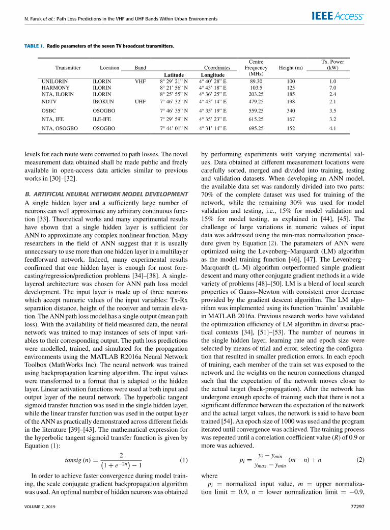
Three of the seven broadcast transmitters were located inIlorin, Kwara State, Nigeria. These include Unilorin FM,Harmony FM, and NTA Ilorin transmitters and their fre-quencies of transmission are 89.30 MHz, 103.5 MHz and203.25 MHz respectively. The broadcast transmitters are infixed locations with coordinates A (lat. 8◦ 29’ 21’’ N, long.4◦ 40’ 28’’ E), B (lat. 8◦ 21’ 56’’ N, long. 4◦ 43’ 18’’ E)and C (lat. 8◦ 25’ 55’’ N, long. 4◦ 36’ 25’’ E) respectively.Three routes (i.e. routes 1 to 3) were visited. Three measure-ments routes (i.e. routes 4 – 6) were also visited in Osogbo,Osun State, Nigeria. The four UHF broadcast transmitters inOsogbo are: NDTV, NTA Ile-Ife, OSBC and NTA Osogbo.These transmitters radiate at frequencies of 479.25 MHz,615.25 MHz, 559.25 MHz and 695.25 MHz respectively.Also, all the transmitters were deployed at fixed locations,being that details about their coordinates, heights and powerlevels can be found in Table 1. The number of measured sam-ples was reduced to only 500 across all the routes. The RSS
77296 VOLUME 7, 2019
N. Faruk et al.: Path Loss Predictions in the VHF and UHF Bands Within Urban Environments
TABLE 1. Radio parameters of the seven TV broadcast transmitters.
levels for each route were converted to path losses. The novelmeasurement data obtained shall be made public and freelyavailable in open-access data articles similar to previousworks in [30]–[32].
B. ARTIFICIAL NEURAL NETWORK MODEL DEVELOPMENTA single hidden layer and a sufficiently large number ofneurons can well approximate any arbitrary continuous func-tion [33]. Theoretical works and many experimental resultshave shown that a single hidden layer is sufficient forANN to approximate any complex nonlinear function. Manyresearchers in the field of ANN suggest that it is usuallyunnecessary to use more than one hidden layer in a multilayerfeedforward network. Indeed, many experimental resultsconfirmed that one hidden layer is enough for most fore-casting/regression/prediction problems [34]–[38]. A single-layered architecture was chosen for ANN path loss modeldevelopment. The input layer is made up of three neuronswhich accept numeric values of the input variables: Tx-Rxseparation distance, height of the receiver and terrain eleva-tion. TheANNpath loss model has a single output (mean pathloss). With the availability of field measured data, the neuralnetwork was trained to map instances of sets of input vari-ables to their corresponding output. The path loss predictionswere modelled, trained, and simulated for the propagationenvironments using the MATLAB R2016a Neural NetworkToolbox (MathWorks Inc). The neural network was trainedusing backpropagation learning algorithm. The input valueswere transformed to a format that is adapted to the hiddenlayer. Linear activation functions were used at both input andoutput layer of the neural network. The hyperbolic tangentsigmoid transfer function was used in the single hidden layer,while the linear transfer function was used in the output layerof the ANN as practically demonstrated across different fieldsin the literature [39]–[43]. The mathematical expression forthe hyperbolic tangent sigmoid transfer function is given byEquation (1):
tansig (n) =2(
1+ e−2n)− 1
(1)
In order to achieve faster convergence during model train-ing, the scale conjugate gradient backpropagation algorithmwas used. An optimal number of hidden neuronswas obtained
by performing experiments with varying incremental val-ues. Data obtained at different measurement locations werecarefully sorted, merged and divided into training, testingand validation datasets. When developing an ANN model,the available data set was randomly divided into two parts:70% of the complete dataset was used for training of thenetwork, while the remaining 30% was used for modelvalidation and testing, i.e., 15% for model validation and15% for model testing, as explained in [44], [45]. Thechallenge of large variations in numeric values of inputdata was addressed using the min-max normalization proce-dure given by Equation (2). The parameters of ANN wereoptimized using the Levenberg–Marquardt (LM) algorithmas the model training function [46], [47]. The Levenberg–Marquardt (L–M) algorithm outperformed simple gradientdescent and many other conjugate gradient methods in a widevariety of problems [48]–[50]. LM is a blend of local searchproperties of Gauss–Newton with consistent error decreaseprovided by the gradient descent algorithm. The LM algo-rithm was implemented using its function ‘trainlm’ availablein MATLAB 2016a. Previous research works have validatedthe optimization efficiency of LM algorithm in diverse prac-tical contexts [34], [51]–[53]. The number of neurons inthe single hidden layer, learning rate and epoch size wereselected by means of trial and error, selecting the configura-tion that resulted in smaller prediction errors. In each epochof training, each member of the train set was exposed to thenetwork and the weights on the neuron connections changedsuch that the expectation of the network moves closer tothe actual target (back-propagation). After the network hasundergone enough epochs of training such that there is not asignificant difference between the expectation of the networkand the actual target values, the network is said to have beentrained [54]. An epoch size of 1000 was used and the programiterated until convergence was achieved. The training processwas repeated until a correlation coefficient value (R) of 0.9 ormore was achieved.
pi =yi − yminymax − ymin
(m− n)+ n (2)
wherepi = normalized input value, m = upper normaliza-
tion limit = 0.9, n = lower normalization limit = −0.9,
VOLUME 7, 2019 77297

N. Faruk et al.: Path Loss Predictions in the VHF and UHF Bands Within Urban Environments
ymin = least numeric value of the input variable and ymax =highest numeric value of the input variable.
C. ADAPTIVE NEURO-FUZZY INFERENCESYSTEM MODEL DEVELOPMENTIn this work, ANFIS model is made up of five layers withfixed or adaptive nodes. First-order Sugeno-Fuzzymodel wasadopted as explained in [55]. The node in the first layer isadaptable and it is defined by L1k = µAk (m) ; where k = 1,2; m is the input to k−th node, Ak is the alterable languagerelated to this node and the membership function of Ak isµAk (m), normally taken as;
µAk (m) =1
1+[(
m−fkdk
)2]ek (3)
{dk , ek , fk} forms a set called the antecedent parametersset. TheMembership Function (MF),µ, is the degree or gradeof membership of an element in a fuzzy set, which must varybetween 0 and 1. Eqn. (3) represents the generalised bellmembership function. This was maintained, as it is the mostwidely used one [55], and it has also performed quite wellin our previous works [56], [57]. The second and third layersare fixed, while, the fourth layer is adaptable, details of eachof these layers could be found in [56]. The output of the fifthlayer is the summation of all the incoming signals based onthe rule defined in [55], given by:
L5i = zp =∑2
i=1wifi = (w1x) p1 + (w1y) q1 + (w1) r1+ (w2x) p2 + (w2y) q2 + (w2)r2 (4)
where zp is the network predicted output. The optimizationmethod used for training the network in this work is thehybrid method, which combines both the backpropagationgradient descent algorithm and least square error estimates;these are used to establish the input and output parameters,respectively. The output (consequent) parameters pi, qi andri are adjusted first using the least squares algorithm andthose of the input (antecedent) parameters di, ei, and fi byback propagating the faults from the output using the gradientdescent method until the training is completed. The leastsquares estimate algorithm is obtained by rewriting Eqn. (5),as shown at the bottom of this page, in the matrix form [56],where n is the total number of training data (input/output)pairs and z(n)p are the network predicted outputs. The errorsbetween the desired and predicted outputs are propagatedbackwards from the output layer to the input layer using
the backpropagation algorithm, so as to update the synapticweights:
The weight update for the input layer is given by Eqn. (6):
w(k)i (M + 1) =
{w(k)i (M)+ wi(k)
w(k)i (M)+ wi(k)
(6)
where k is the input/output training pair and M representseach layer starting from the output backwards.
The structure of ANFIS models can be generated by threeFuzzy Inference Systems (FIS), namely grid partition, sub-tractive clustering, and fuzzy c-means (FCM). In this study,we applied the subtractive clustering method to classify theinput data and to make the ANFIS model rules as the numberof rules employed in this method is relatively low. This makesit convenient for using in real application problems [58].
D. KRIGING MODEL DEVELOPMENTAn ordinary Kriging interpolation algorithm was utilized inthis work. The study area was divided into the desired numberof meshes and the position coordinates (x, y) were computedfor each of the corresponding mesh points. Let u denote apoint in which the path loss is unknown and let V (u) ={1, . . . ,Nu} denote the set of points in the surrounding pointu such that value of the path loss is known at each point.A neighborhood of point u in the (x, y) plane was definedand the surveyed points in this neighborhood were mapped tothe sampled path loss data based on the number of data. Thepredicted path loss was calculated as a linear combination ofthe weight (Wi) and the neighborhood (known) path loss (Zi)using Equation (7). Equation (8) is a constraint that ensuresthat the set of weights minimizes the error variance and thatthe mean error is zero under unbiased conditions. The lagdistances (h) and the semi-variogram (γi,j) were computedfor a range of lags using Equations (9) and (10), respectively.The variogram model type is the only discrete parameter, andthe three commonly used basic variogram models includespherical, exponential and Gaussian. The spherical variogramyielded good results in [59]. The semivariogram was fittedwith the spherical model using Equation (11). This model waschosen because it is the least complex and most generally uti-lized variogrammodel [16]. Amesh grid size of 500 was usedas it provides optimal interpolation across themesh grid basedon a spatial lag (distance) relationship or regression withrespect to the observed path losses of the neighboring pathloss points. The minimum variance method was employedin calculating the weights and the optimal weights were
z(1)pz(2)p...
z(n)p
=
w1(1)x
(1)w1
(1)y(1)
w1(1)
w1(2)x
(2)w1
(2)y(2)
w1(2)
......
...
w1(n)x
(n)w1
(n)y(n)
w1(n)
w2(1)x
(1)w2
(1)y(1)
w2(1)
w2(2)x
(2)w2
(2)y(2)
w2(2)
......
...
w2(n)x
(n)w2
(n)y(n)
w2(n)
p1q1r1p2q2r2
(5)
77298 VOLUME 7, 2019

N. Faruk et al.: Path Loss Predictions in the VHF and UHF Bands Within Urban Environments
calculated with respect to Equation (12). Finally, the Krigingvariance was estimated using Equation (13):
Zu =∑
i∈V (u)WiZi (7)
where∑i∈V (u)
Wi = 1 (8)
h =(xj,yj
)− (x i,yi) (9)
γi,j = γ(hi,j)=
12N (h)
∑(Z (xi,yi)−Z (xj,yj))2 (10)
γ (hi,j) =
0, hi,j = 0
C0+C1
[3h2R −
12
( hR
)3], 0 < hi,j < R
C0 + C1, hi,j ≥ R
(11)
W1Wnλ
= γ (h1,1) γ (h1,Nu ) 1γ (hNu,1) γ (hNu,Nu ) 1
1 1 0
−1 γ (h1,u)γ (hNu,Nu )
1
(12)
σ 2zu=
∑i∈V (u)
Wiγ(hi,u
)+ λ (13)
where h is the distance between two path loss points,C0 represents the Nugget effect parameter, R denotesrange and C0 + C1 represents the Sill parameter. Moreover,γ(hi,j)denotes a semivariogram as a function of a lag dis-
tance. The Lagrange parameter λ, λwas introduced to reducethe Kriging error. The measured path losses for each routeacross all the bands were used to compare with the predictedpath losses obtained with ANN, ANFIS and Kriging andEmpirical path loss models. The empirical path loss propaga-tion models considered in this work are: the Okumura-Hata,COST 231, Egli and ECC-33 [30]. Thesemodels were chosenas they are the commonly and widely used empirical modelstoday for path loss prediction in the VHF and UHF bandsunder study.
E. PERFORMANCE EVALUATION METRICSPrediction Error, Mean Prediction Error, Maximum Error,Standard Deviation Error, and Root Mean Square Error arethe metrics used for the performance analysis of the modelsrelative to the measured loss. Acceptable values for RMSEare 6–7 dB for urban areas, 10–15 dB for suburban and ruralareas, while the best fit for all the considered metrics arefor values that are closer to 0 [4]. The Kernel DistributionEstimate (KDE), which is a non-parametric way of estimatingthe probability density function of a random variable, wasequally used to gauge the performances of all the models.Using this metric, the model has to firstly, follow a normaldistribution curve, and secondly, the error counts close to 0 dBwould dominate the frequency counts.
III. RESULTS AND DISCUSSIONSIn this section we present the performance evaluation resultsof the three methods used in predicting path losses. Foreach route visited, we compared the measured loss with thepredictions of the ANN, ANFIS, Kriging, Hata, COST 231,Egli and ECC-33 models.
FIGURE 3. Path loss with distance for Unilorin Route 1.
FIGURE 4. Path loss with distance for NTA_Ilorin Route 1.
FIGURE 5. Path loss with distance for Hamony Route 1.
Figs. 3 to 5 show the graphical depiction of the measuredand predicted path losses as a function of distance for theUnilorin, NTA, and Harmony transmitters along route 1.
VOLUME 7, 2019 77299
N. Faruk et al.: Path Loss Predictions in the VHF and UHF Bands Within Urban Environments
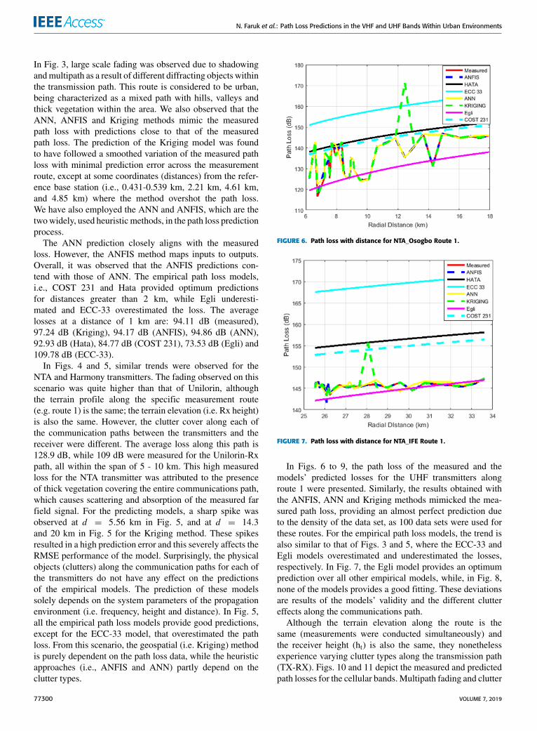
In Fig. 3, large scale fading was observed due to shadowingandmultipath as a result of different diffracting objects withinthe transmission path. This route is considered to be urban,being characterized as a mixed path with hills, valleys andthick vegetation within the area. We also observed that theANN, ANFIS and Kriging methods mimic the measuredpath loss with predictions close to that of the measuredpath loss. The prediction of the Kriging model was foundto have followed a smoothed variation of the measured pathloss with minimal prediction error across the measurementroute, except at some coordinates (distances) from the refer-ence base station (i.e., 0.431-0.539 km, 2.21 km, 4.61 km,and 4.85 km) where the method overshot the path loss.We have also employed the ANN and ANFIS, which are thetwowidely, used heuristic methods, in the path loss predictionprocess.
The ANN prediction closely aligns with the measuredloss. However, the ANFIS method maps inputs to outputs.Overall, it was observed that the ANFIS predictions con-tend with those of ANN. The empirical path loss models,i.e., COST 231 and Hata provided optimum predictionsfor distances greater than 2 km, while Egli underesti-mated and ECC-33 overestimated the loss. The averagelosses at a distance of 1 km are: 94.11 dB (measured),97.24 dB (Kriging), 94.17 dB (ANFIS), 94.86 dB (ANN),92.93 dB (Hata), 84.77 dB (COST 231), 73.53 dB (Egli) and109.78 dB (ECC-33).
In Figs. 4 and 5, similar trends were observed for theNTA and Harmony transmitters. The fading observed on thisscenario was quite higher than that of Unilorin, althoughthe terrain profile along the specific measurement route(e.g. route 1) is the same; the terrain elevation (i.e. Rx height)is also the same. However, the clutter cover along each ofthe communication paths between the transmitters and thereceiver were different. The average loss along this path is128.9 dB, while 109 dB were measured for the Unilorin-Rxpath, all within the span of 5 - 10 km. This high measuredloss for the NTA transmitter was attributed to the presenceof thick vegetation covering the entire communications path,which causes scattering and absorption of the measured farfield signal. For the predicting models, a sharp spike wasobserved at d = 5.56 km in Fig. 5, and at d = 14.3and 20 km in Fig. 5 for the Kriging method. These spikesresulted in a high prediction error and this severely affects theRMSE performance of the model. Surprisingly, the physicalobjects (clutters) along the communication paths for each ofthe transmitters do not have any effect on the predictionsof the empirical models. The prediction of these modelssolely depends on the system parameters of the propagationenvironment (i.e. frequency, height and distance). In Fig. 5,all the empirical path loss models provide good predictions,except for the ECC-33 model, that overestimated the pathloss. From this scenario, the geospatial (i.e. Kriging) methodis purely dependent on the path loss data, while the heuristicapproaches (i.e., ANFIS and ANN) partly depend on theclutter types.
FIGURE 6. Path loss with distance for NTA_Osogbo Route 1.
FIGURE 7. Path loss with distance for NTA_IFE Route 1.
In Figs. 6 to 9, the path loss of the measured and themodels’ predicted losses for the UHF transmitters alongroute 1 were presented. Similarly, the results obtained withthe ANFIS, ANN and Kriging methods mimicked the mea-sured path loss, providing an almost perfect prediction dueto the density of the data set, as 100 data sets were used forthese routes. For the empirical path loss models, the trend isalso similar to that of Figs. 3 and 5, where the ECC-33 andEgli models overestimated and underestimated the losses,respectively. In Fig. 7, the Egli model provides an optimumprediction over all other empirical models, while, in Fig. 8,none of the models provides a good fitting. These deviationsare results of the models’ validity and the different cluttereffects along the communications path.
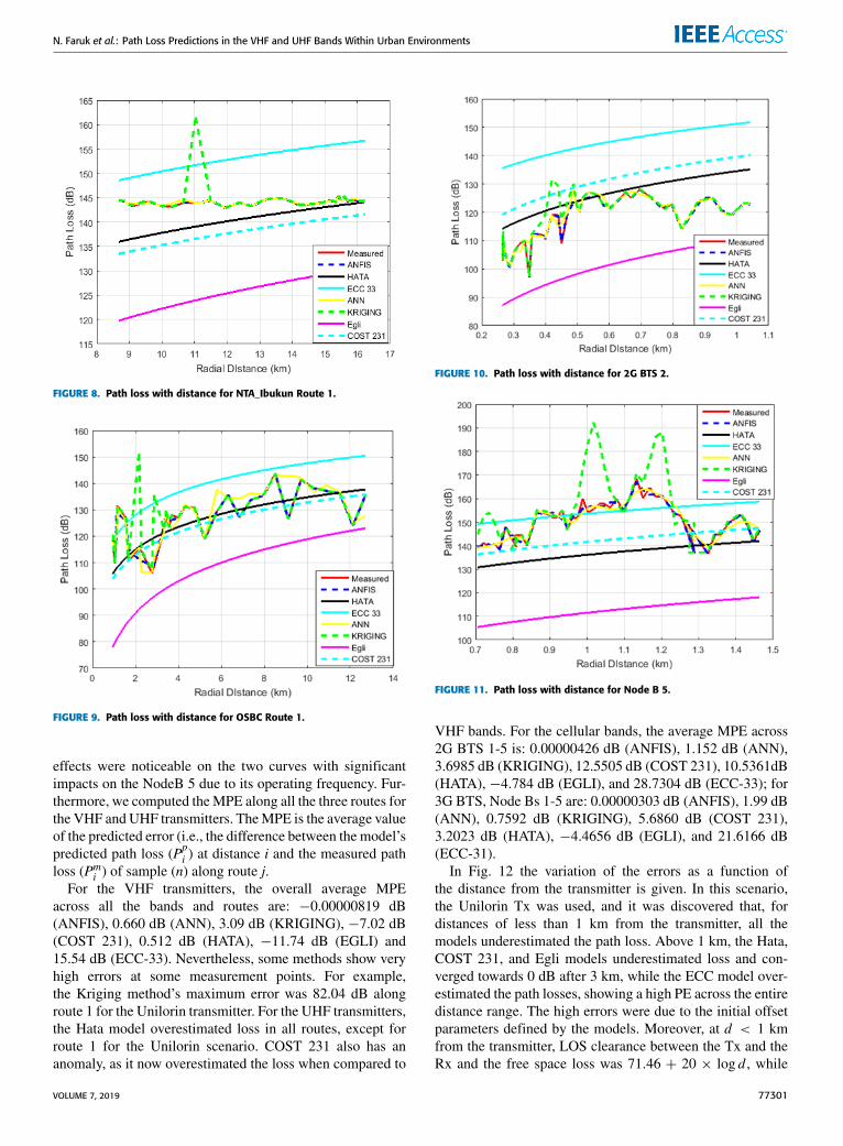
Although the terrain elevation along the route is thesame (measurements were conducted simultaneously) andthe receiver height (ht) is also the same, they nonethelessexperience varying clutter types along the transmission path(TX-RX). Figs. 10 and 11 depict the measured and predictedpath losses for the cellular bands.Multipath fading and clutter
77300 VOLUME 7, 2019
N. Faruk et al.: Path Loss Predictions in the VHF and UHF Bands Within Urban Environments
FIGURE 8. Path loss with distance for NTA_Ibukun Route 1.
FIGURE 9. Path loss with distance for OSBC Route 1.
effects were noticeable on the two curves with significantimpacts on the NodeB 5 due to its operating frequency. Fur-thermore, we computed theMPE along all the three routes forthe VHF andUHF transmitters. TheMPE is the average valueof the predicted error (i.e., the difference between the model’spredicted path loss (Ppi ) at distance i and the measured pathloss (Pmi ) of sample (n) along route j.
For the VHF transmitters, the overall average MPEacross all the bands and routes are: −0.00000819 dB(ANFIS), 0.660 dB (ANN), 3.09 dB (KRIGING), −7.02 dB(COST 231), 0.512 dB (HATA), −11.74 dB (EGLI) and15.54 dB (ECC-33). Nevertheless, some methods show veryhigh errors at some measurement points. For example,the Kriging method’s maximum error was 82.04 dB alongroute 1 for the Unilorin transmitter. For the UHF transmitters,the Hata model overestimated loss in all routes, except forroute 1 for the Unilorin scenario. COST 231 also has ananomaly, as it now overestimated the loss when compared to
FIGURE 10. Path loss with distance for 2G BTS 2.
FIGURE 11. Path loss with distance for Node B 5.
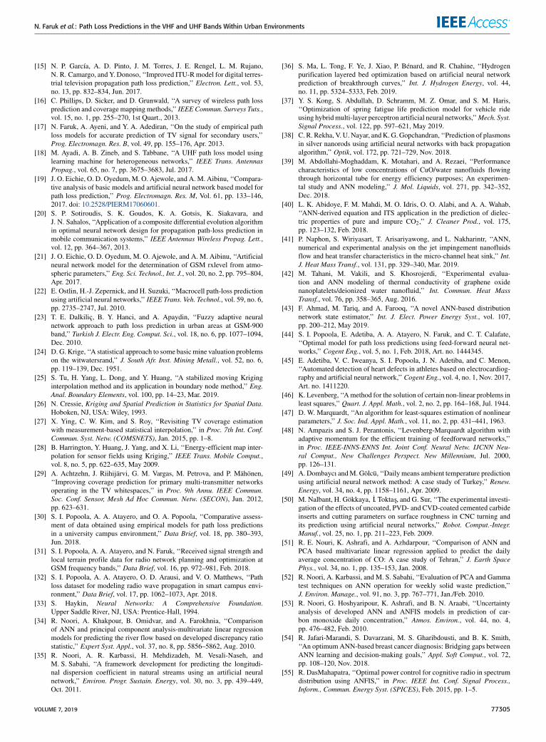
VHF bands. For the cellular bands, the average MPE across2G BTS 1-5 is: 0.00000426 dB (ANFIS), 1.152 dB (ANN),3.6985 dB (KRIGING), 12.5505 dB (COST 231), 10.5361dB(HATA), −4.784 dB (EGLI), and 28.7304 dB (ECC-33); for3G BTS, Node Bs 1-5 are: 0.00000303 dB (ANFIS), 1.99 dB(ANN), 0.7592 dB (KRIGING), 5.6860 dB (COST 231),3.2023 dB (HATA), −4.4656 dB (EGLI), and 21.6166 dB(ECC-31).
In Fig. 12 the variation of the errors as a function ofthe distance from the transmitter is given. In this scenario,the Unilorin Tx was used, and it was discovered that, fordistances of less than 1 km from the transmitter, all themodels underestimated the path loss. Above 1 km, the Hata,COST 231, and Egli models underestimated loss and con-verged towards 0 dB after 3 km, while the ECC model over-estimated the path losses, showing a high PE across the entiredistance range. The high errors were due to the initial offsetparameters defined by the models. Moreover, at d < 1 kmfrom the transmitter, LOS clearance between the Tx and theRx and the free space loss was 71.46 + 20 × log d , while
VOLUME 7, 2019 77301
N. Faruk et al.: Path Loss Predictions in the VHF and UHF Bands Within Urban Environments
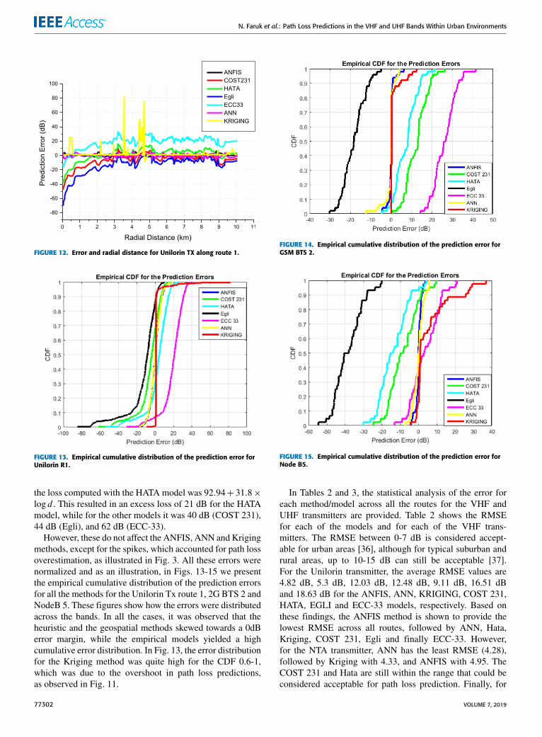
FIGURE 12. Error and radial distance for Unilorin TX along route 1.
FIGURE 13. Empirical cumulative distribution of the prediction error forUnilorin R1.
the loss computed with the HATA model was 92.94+ 31.8×log d . This resulted in an excess loss of 21 dB for the HATAmodel, while for the other models it was 40 dB (COST 231),44 dB (Egli), and 62 dB (ECC-33).
However, these do not affect the ANFIS, ANN and Krigingmethods, except for the spikes, which accounted for path lossoverestimation, as illustrated in Fig. 3. All these errors werenormalized and as an illustration, in Figs. 13-15 we presentthe empirical cumulative distribution of the prediction errorsfor all the methods for the Unilorin Tx route 1, 2G BTS 2 andNodeB 5. These figures show how the errors were distributedacross the bands. In all the cases, it was observed that theheuristic and the geospatial methods skewed towards a 0dBerror margin, while the empirical models yielded a highcumulative error distribution. In Fig. 13, the error distributionfor the Kriging method was quite high for the CDF 0.6-1,which was due to the overshoot in path loss predictions,as observed in Fig. 11.
FIGURE 14. Empirical cumulative distribution of the prediction error forGSM BTS 2.
FIGURE 15. Empirical cumulative distribution of the prediction error forNode B5.
In Tables 2 and 3, the statistical analysis of the error foreach method/model across all the routes for the VHF andUHF transmitters are provided. Table 2 shows the RMSEfor each of the models and for each of the VHF trans-mitters. The RMSE between 0-7 dB is considered accept-able for urban areas [36], although for typical suburban andrural areas, up to 10-15 dB can still be acceptable [37].For the Unilorin transmitter, the average RMSE values are4.82 dB, 5.3 dB, 12.03 dB, 12.48 dB, 9.11 dB, 16.51 dBand 18.63 dB for the ANFIS, ANN, KRIGING, COST 231,HATA, EGLI and ECC-33 models, respectively. Based onthese findings, the ANFIS method is shown to provide thelowest RMSE across all routes, followed by ANN, Hata,Kriging, COST 231, Egli and finally ECC-33. However,for the NTA transmitter, ANN has the least RMSE (4.28),followed by Kriging with 4.33, and ANFIS with 4.95. TheCOST 231 and Hata are still within the range that could beconsidered acceptable for path loss prediction. Finally, for
77302 VOLUME 7, 2019

N. Faruk et al.: Path Loss Predictions in the VHF and UHF Bands Within Urban Environments
TABLE 2. RMSE performance metrics for the VHF transmitter models.
TABLE 3. RMSE performance metrics for the UHF transmitter models.
the Harmony transmitter, ANN still maintained the best per-formance with an RMSE of 4.54 dB, followed by ANFISwith 5.84 dB and then the COST 231, Hata and Egli mod-els. For Kriging and ECC-33, the RMSE values were quitehigh. The Standard Deviation Error (SDE) across all themodels, transmitters and routes were computed and it wasfound to be quite high for the Unilorin Tx when compared toother transmitters. This was due to the high prediction errorsrecorded across the models for d < 1 km. Along this route,the SDE for ANN was 3.71 dB and this was the lowest onewhen compared to 8.27 dB (ANFIS), 11.79 dB (KRIGING),16.09 dB (COST 231), 16.09 dB (HATA), 20.24 dB (EGLI)and 14.98 dB (ECC-33).
The Route-on-Route average SDE for the methods acrossall the bands are: 6.03 dB (ANN), 4.31 dB (ANFIS), 12.55 dB(KRIGING), 2.8 dB (COST 231), 2.82 dB (HATA), 5.16 dB(EGLI), and 4.30 dB (ECC-33). From this analysis, theKriging method has the highest SDE, which was due tosudden spikes on the PE observed. However, the SDE for theUHF transmitters is higher than that of VHF, although NDTVintroduces fewer errors. For the cellular bands, the aver-age RMSE across 2G BTS 1-5 are: 6.19 dB (ANFIS),2.17 dB (ANN), 12.22 dB (KRIGING), 4.21 dB (COST 231),4.21 dB (HATA), 4.784 dB (EGLI) and 3.293 dB (ECC-33);for 3G BTS, Node Bs 1-5 are: 5.64 dB (ANFIS), 1.96 dB(ANN), 9.4930 dB (KRIGING), 3.93 dB (COST 231),3.93 dB (HATA), 4.46 dB (EGLI) and 3.15 dB (ECC-33).Using this metric, for the broadcast frequencies, the empiricalpath loss models (i.e., Hata and COST 231) provide less error,followed by ECC-33.
For the cellular frequencies, ANN has the best overallperformance, followed by the empirical models. It is worthnoting that the fitness of the ANNmodel for these frequencieswas possible, as a result of the high data density. The pathloss data obtained was small, which is due to the coveragedistance of the base stations, mostly being less than 1.5 kmand, as such, the ANN model tends to learn fast and providesfewer errors. The Kriging method consistently yielded a highSDE, and ANFIS was found to be a solution in-between thetwo methods. Therefore, the three methods can be ranked inorder of performance as follows: empirical models, heuris-tic methods and geospatial methods. The empirical modelsyielded the best results using this metric, as these modelsare independent of the underlying physical objects (clutters)along the communication paths, which resulted in a lower lossdeviation from the local mean. Regarding the heuristic andgeospatial methods, these are dependent on themeasured pathlosses, which are mostly affected by fading and shadowingdue to the presence of clutters.
IV. CONCLUSIONIn this paper, heuristic methods, geospatial and empiricalmodels in predicting path loss in the VHF and UHF bandswere presented for specified routes. Electromagnetic fieldstrength measurements were conducted using drive tests atfour different urban environments across cellular and broad-casting bands to test their effectiveness and also to evaluatethe prediction ability of the Artificial Neural Network, Adap-tive Neural Fuzzy Inference Systems, Kriging, COST-231,HATA, Egli and ECC-33 models.
VOLUME 7, 2019 77303

N. Faruk et al.: Path Loss Predictions in the VHF and UHF Bands Within Urban Environments
The performance of the different methods varied withthe performance metrics used. It was found that, in theVHF bands, across cities, the heuristic methods (i.e. ANFISand ANN) provide the lowest mean prediction error. Theoverall average MPE across all bands and routes were of:−0.00000819 dB (ANFIS), 0.660 dB (ANN), 3.09 dB(KRIGING), −7.02 dB (COST 231), 0.512 dB (HATA),−11.74 dB (EGLI) and 15.54 dB (ECC-33). A similar trendwas observed for the UHF transmitters. However, the Krigingmethod showed very high errors at somemeasurement points.These errors could be as high as 105.04 dB - this was due tothe inter space between the path loss measurements. As themethod uses the concept of moving averages to provideoptimal interpolation across space based on spatial distance,against observed values of neighboring data points.
In terms of the RMSE, the heuristic methods still providedthe least RMSE across the bands for the broadcasting andcellular approaches, followed by the geospatial and empiricalmethods, in that order. Nonetheless, it was discovered that, forsome instances, the empirical models performed better thanthe geospatial ones; in all cases, though, heuristic methods-maintained consistency in their performance. The Route-onRoute average standard SDE for the methods showed thatthe empirical models have lower error deviations from themean when compared with the other methods. This occurredbecause empirical models do not account for the dynamicvariation of the path loss due to physical objects such as theterrain and clutter effects along the communication paths,while the heuristic and geospatial methods depend on theactual measured path loss, which is mostly affected by fadingand shadowing. The Kriging method has the highest SDE.This was due to sudden spikes on the PE observed as a resultof data density and neighborhood distance of the path lossdata.
This work has discovered that the three methods performedquite well, depending on the performance metrics used ingauging them. The RMSE for all the methods falls withinacceptable values, except for the Egli and ECC-33 models.However, all the empirical models provided the least standarddeviation errors when compared to the two other methods.It should be noted that the geospatial method required samplemeasurements to be taken before predictions can be donewithin the neighborhoods. This approach, standalone, cannotbe used to make predictions. The heuristic approach canbe used to make predictions based on the trained network,while the empirical methods do not require training mea-surements to make predictions; in fact, only the requiredpropagation parameters are needed. Therefore, this indicatesthat empirical models are still the simplest and the mostwidely applicable among the three methods. In terms of pre-diction accuracy, heuristic methods are the best. Therefore,a trade-off is needed to balance between simplicity, ease ofapplication, and accuracy. This paper thereby emphasizesthat the empirical path loss propagation models can still beimproved upon to provide an optimum prediction that is
comparable to other methods. In particular, we consider thatthere is further scope for refinement in order to reduce theprediction error by incorporating other ambient parametersinto the existing propagation models. A hybrid of the twomethods, i.e., heuristic and empirical, can improve the appli-cation of heuristic methods and may possibly decrease thehigh prediction errors associated with empirical models. Thismatter will be addressed in future works.
ACKNOWLEDGMENTThe authors would like to express their sincere appreciationto the University of Ilorin, Nigeria, for the purchase of thededicated Agilent spectrum analyzer and for the funds pro-vided to facilitate this study. Also, we appreciate HuaweiTechnologies for the equipment provided for data collectionat cellular frequency bands in Kano and Abuja, Nigeria.
REFERENCES[1] O. F. Oseni, S. I. Popoola, H. Enumah, and A. Gordian, ‘‘Radio frequency
optimization of mobile networks in Abeokuta, Nigeria for improved qual-ity of service,’’ Int. J. Res. Eng. Technol., vol. 3, no. 8, pp. 174–180,2014.
[2] W. Wang, T. Jost, and R. Raulefs, ‘‘A semi-deterministic path lossmodel for in-harbor LoS and NLoS environment,’’ IEEE Trans. AntennasPropag., vol. 65, no. 12, pp. 7399–7404, Dec. 2017.
[3] S. P. Sotiroudis and K. Siakavara, ‘‘Mobile radio propagation path lossprediction using artificial neural networks with optimal input informationfor urban environments,’’ AEU-Int. J. Electron. Commun., vol. 69, no. 10,pp. 1453–1463, Oct. 2015.
[4] T. S. Rappaport,Wireless Communications: Principles and Practice, vol. 2.Upper Saddle River, NJ, USA: Prentice-Hall, 1996.
[5] N. Faruk, A. A. Ayeni, and Y. A. Adediran, ‘‘Characterization of propa-gation path loss at VHF/UHF bands for Ilorin city, Nigeria,’’ Nigerian J.Technol., vol. 32, no. 2, pp. 253–265, 2013.
[6] E. Greenberg and E. Klodzh, ‘‘Comparison of deterministic, empirical andphysical propagation models in urban environments,’’ in Proc. IEEE Int.Conf. Microw., Commun., Antennas Electron. Syst. (COMCAS), Nov. 2015,pp. 1–5.
[7] L. B. Felsen and L. Sevgi, ‘‘Adiabatic and intrinsic modes for wave propa-gation in guiding environments with longitudinal and transverse variation:Formulation and canonical test,’’ IEEE Trans. Antennas Propag., vol. 39,no. 8, pp. 1130–1136, Aug. 1991.
[8] L. Sevgi, F. Akleman, and L. B. Felsen, ‘‘Groundwave propagationmodeling: Problem-matched analytical formulations and direct numericaltechniques,’’ IEEE Antennas Propag. Mag., vol. 44, no. 1, pp. 55–75,Feb. 2002.
[9] L. Sevgi, ‘‘Groundwave modeling and simulation strategies and path lossprediction virtual tools,’’ IEEE Trans. Antennas Propag., vol. 55, no. 6,pp. 1591–1598, Jun. 2007.
[10] M. Hatay, ‘‘Empirical formula for propagation loss in land mobile radioservices,’’ IEEE Trans. Veh. Technol., vol. 29, no. 3, pp. 317–325,Aug. 1980.
[11] V. Erceg, L. J. Greenstein, S. Y. Tjandra, S. R. Parkoff, A. Gupta, B. Kulic,A. A. Julius, and R. Bianchi, ‘‘Urban transmission loss models for mobileradio in the 900 and 1800 MHz bands,’’ IEEE J. Sel. Areas Commun.,pp. 1205–1211, Jul. 1999.
[12] N. Faruk, O. W. Bello, A. A. Oloyede, N. T. Surajudeen-Bakinde,O. Obiyemi, and L. A. Olawoyin, ‘‘Clutter and terrain effects on path lossin the VHF/UHF bands,’’ IET Microw., Antennas Propag., vol. 12, no. 1,pp. 69–76, Jan. 2017.
[13] J. Hejselbæk, J. Ø. Nielsen, W. Fan, and G. F. Pedersen, ‘‘Empirical studyof near ground propagation in forest terrain for Internet-of-Things typedevice-to-device communication,’’ IEEE Access, vol. 6, pp. 54052–54063,2018.
[14] H. Munir, S. A. Hassan, H. Pervaiz, Q. Ni, and L. Musavian, ‘‘Resourceoptimization in multi-tier HetNets exploitingmulti-slope path loss model,’’IEEE Access, vol. 5, pp. 8714–8726, 2017.
77304 VOLUME 7, 2019
N. Faruk et al.: Path Loss Predictions in the VHF and UHF Bands Within Urban Environments
[15] N. P. García, A. D. Pinto, J. M. Torres, J. E. Rengel, L. M. Rujano,N. R. Camargo, and Y. Donoso, ‘‘Improved ITU-Rmodel for digital terres-trial television propagation path loss prediction,’’ Electron. Lett., vol. 53,no. 13, pp. 832–834, Jun. 2017.
[16] C. Phillips, D. Sicker, and D. Grunwald, ‘‘A survey of wireless path lossprediction and coveragemappingmethods,’’ IEEECommun. Surveys Tuts.,vol. 15, no. 1, pp. 255–270, 1st Quart., 2013.
[17] N. Faruk, A. Ayeni, and Y. A. Adediran, ‘‘On the study of empirical pathloss models for accurate prediction of TV signal for secondary users,’’Prog. Electromagn. Res. B, vol. 49, pp. 155–176, Apr. 2013.
[18] M. Ayadi, A. B. Zineb, and S. Tabbane, ‘‘A UHF path loss model usinglearning machine for heterogeneous networks,’’ IEEE Trans. AntennasPropag., vol. 65, no. 7, pp. 3675–3683, Jul. 2017.
[19] J. O. Eichie, O. D. Oyedum,M. O. Ajewole, and A.M. Aibinu, ‘‘Compara-tive analysis of basic models and artificial neural network based model forpath loss prediction,’’ Prog. Electromagn. Res. M, Vol. 61, pp. 133–146,2017. doi: 10.2528/PIERM17060601.
[20] S. P. Sotiroudis, S. K. Goudos, K. A. Gotsis, K. Siakavara, andJ. N. Sahalos, ‘‘Application of a composite differential evolution algorithmin optimal neural network design for propagation path-loss prediction inmobile communication systems,’’ IEEE Antennas Wireless Propag. Lett.,vol. 12, pp. 364–367, 2013.
[21] J. O. Eichie, O. D. Oyedum, M. O. Ajewole, and A. M. Aibinu, ‘‘Artificialneural network model for the determination of GSM rxlevel from atmo-spheric parameters,’’ Eng. Sci. Technol., Int. J., vol. 20, no. 2, pp. 795–804,Apr. 2017.
[22] E. Ostlin, H.-J. Zepernick, and H. Suzuki, ‘‘Macrocell path-loss predictionusing artificial neural networks,’’ IEEE Trans. Veh. Technol., vol. 59, no. 6,pp. 2735–2747, Jul. 2010.
[23] T. E. Dalkiliç, B. Y. Hanci, and A. Apaydin, ‘‘Fuzzy adaptive neuralnetwork approach to path loss prediction in urban areas at GSM-900band,’’ Turkish J. Electr. Eng. Comput. Sci., vol. 18, no. 6, pp. 1077–1094,Dec. 2010.
[24] D. G. Krige, ‘‘A statistical approach to some basic mine valuation problemson the witwatersrand,’’ J. South Afr. Inst. Mining Metall., vol. 52, no. 6,pp. 119–139, Dec. 1951.
[25] S. Tu, H. Yang, L. Dong, and Y. Huang, ‘‘A stabilized moving Kriginginterpolation method and its application in boundary node method,’’ Eng.Anal. Boundary Elements, vol. 100, pp. 14–23, Mar. 2019.
[26] N. Cressie, Kriging and Spatial Prediction in Statistics for Spatial Data.Hoboken, NJ, USA: Wiley, 1993.
[27] X. Ying, C. W. Kim, and S. Roy, ‘‘Revisiting TV coverage estimationwith measurement-based statistical interpolation,’’ in Proc. 7th Int. Conf.Commun. Syst. Netw. (COMSNETS), Jan. 2015, pp. 1–8.
[28] B. Harrington, Y. Huang, J. Yang, and X. Li, ‘‘Energy-efficient map inter-polation for sensor fields using Kriging,’’ IEEE Trans. Mobile Comput.,vol. 8, no. 5, pp. 622–635, May 2009.
[29] A. Achtzehn, J. Riihijärvi, G. M. Vargas, M. Petrova, and P. Mähönen,‘‘Improving coverage prediction for primary multi-transmitter networksoperating in the TV whitespaces,’’ in Proc. 9th Annu. IEEE Commun.Soc. Conf. Sensor, Mesh Ad Hoc Commun. Netw. (SECON), Jun. 2012,pp. 623–631.
[30] S. I. Popoola, A. A. Atayero, and O. A. Popoola, ‘‘Comparative assess-ment of data obtained using empirical models for path loss predictionsin a university campus environment,’’ Data Brief, vol. 18, pp. 380–393,Jun. 2018.
[31] S. I. Popoola, A. A. Atayero, and N. Faruk, ‘‘Received signal strength andlocal terrain profile data for radio network planning and optimization atGSM frequency bands,’’ Data Brief, vol. 16, pp. 972–981, Feb. 2018.
[32] S. I. Popoola, A. A. Atayero, O. D. Arausi, and V. O. Matthews, ‘‘Pathloss dataset for modeling radio wave propagation in smart campus envi-ronment,’’ Data Brief, vol. 17, pp. 1062–1073, Apr. 2018.
[33] S. Haykin, Neural Networks: A Comprehensive Foundation.Upper Saddle River, NJ, USA: Prentice-Hall, 1994.
[34] R. Noori, A. Khakpour, B. Omidvar, and A. Farokhnia, ‘‘Comparisonof ANN and principal component analysis-multivariate linear regressionmodels for predicting the river flow based on developed discrepancy ratiostatistic,’’ Expert Syst. Appl., vol. 37, no. 8, pp. 5856–5862, Aug. 2010.
[35] R. Noori, A. R. Karbassi, H. Mehdizadeh, M. Vesali-Naseh, andM. S. Sabahi, ‘‘A framework development for predicting the longitudi-nal dispersion coefficient in natural streams using an artificial neuralnetwork,’’ Environ. Progr. Sustain. Energy, vol. 30, no. 3, pp. 439–449,Oct. 2011.
[36] S. Ma, L. Tong, F. Ye, J. Xiao, P. Bénard, and R. Chahine, ‘‘Hydrogenpurification layered bed optimization based on artificial neural networkprediction of breakthrough curves,’’ Int. J. Hydrogen Energy, vol. 44,no. 11, pp. 5324–5333, Feb. 2019.
[37] Y. S. Kong, S. Abdullah, D. Schramm, M. Z. Omar, and S. M. Haris,‘‘Optimization of spring fatigue life prediction model for vehicle rideusing hybridmulti-layer perceptron artificial neural networks,’’Mech. Syst.Signal Process., vol. 122, pp. 597–621, May 2019.
[38] C. R. Rekha, V. U. Nayar, andK.G. Gopchandran, ‘‘Prediction of plasmonsin silver nanorods using artificial neural networks with back propagationalgorithm,’’ Optik, vol. 172, pp. 721–729, Nov. 2018.
[39] M. Abdollahi-Moghaddam, K. Motahari, and A. Rezaei, ‘‘Performancecharacteristics of low concentrations of CuO/water nanofluids flowingthrough horizontal tube for energy efficiency purposes; An experimen-tal study and ANN modeling,’’ J. Mol. Liquids, vol. 271, pp. 342–352,Dec. 2018.
[40] L. K. Abidoye, F. M. Mahdi, M. O. Idris, O. O. Alabi, and A. A. Wahab,‘‘ANN-derived equation and ITS application in the prediction of dielec-tric properties of pure and impure CO2,’’ J. Cleaner Prod., vol. 175,pp. 123–132, Feb. 2018.
[41] P. Naphon, S. Wiriyasart, T. Arisariyawong, and L. Nakharintr, ‘‘ANN,numerical and experimental analysis on the jet impingement nanofluidsflow and heat transfer characteristics in the micro-channel heat sink,’’ Int.J. Heat Mass Transf., vol. 131, pp. 329–340, Mar. 2019.
[42] M. Tahani, M. Vakili, and S. Khosrojerdi, ‘‘Experimental evalua-tion and ANN modeling of thermal conductivity of graphene oxidenanoplatelets/deionized water nanofluid,’’ Int. Commun. Heat MassTransf., vol. 76, pp. 358–365, Aug. 2016.
[43] F. Ahmad, M. Tariq, and A. Farooq, ‘‘A novel ANN-based distributionnetwork state estimator,’’ Int. J. Elect. Power Energy Syst., vol. 107,pp. 200–212, May 2019.
[44] S. I. Popoola, E. Adetiba, A. A. Atayero, N. Faruk, and C. T. Calafate,‘‘Optimal model for path loss predictions using feed-forward neural net-works,’’ Cogent Eng., vol. 5, no. 1, Feb. 2018, Art. no. 1444345.
[45] E. Adetiba, V. C. Iweanya, S. I. Popoola, J. N. Adetiba, and C. Menon,‘‘Automated detection of heart defects in athletes based on electrocardiog-raphy and artificial neural network,’’ Cogent Eng., vol. 4, no. 1, Nov. 2017,Art. no. 1411220.
[46] K. Levenberg, ‘‘Amethod for the solution of certain non-linear problems inleast squares,’’ Quart. J. Appl. Math., vol. 2, no. 2, pp. 164–168, Jul. 1944.
[47] D. W. Marquardt, ‘‘An algorithm for least-squares estimation of nonlinearparameters,’’ J. Soc. Ind. Appl. Math., vol. 11, no. 2, pp. 431–441, 1963.
[48] N. Ampazis and S. J. Perantonis, ‘‘Levenberg-Marquardt algorithm withadaptive momentum for the efficient training of feedforward networks,’’in Proc. IEEE-INNS-ENNS Int. Joint Conf. Neural Netw. IJCNN Neu-ral Comput., New Challenges Perspect. New Millennium, Jul. 2000,pp. 126–131.
[49] A. Dombaycı andM. Gölcü, ‘‘Daily means ambient temperature predictionusing artificial neural network method: A case study of Turkey,’’ Renew.Energy, vol. 34, no. 4, pp. 1158–1161, Apr. 2009.
[50] M. Nalbant, H. Gökkaya, İ. Toktaş, and G. Sur, ‘‘The experimental investi-gation of the effects of uncoated, PVD- and CVD-coated cemented carbideinserts and cutting parameters on surface roughness in CNC turning andits prediction using artificial neural networks,’’ Robot. Comput.-Integr.Manuf., vol. 25, no. 1, pp. 211–223, Feb. 2009.
[51] R. E. Nouri, K. Ashrafi, and A. Azhdarpour, ‘‘Comparison of ANN andPCA based multivariate linear regression applied to predict the dailyaverage concentration of CO: A case study of Tehran,’’ J. Earth SpacePhys., vol. 34, no. 1, pp. 135–153, Jan. 2008.
[52] R. Noori, A. Karbassi, and M. S. Sabahi, ‘‘Evaluation of PCA and Gammatest techniques on ANN operation for weekly solid waste prediction,’’J. Environ. Manage., vol. 91, no. 3, pp. 767–771, Jan./Feb. 2010.
[53] R. Noori, G. Hoshyaripour, K. Ashrafi, and B. N. Araabi, ‘‘Uncertaintyanalysis of developed ANN and ANFIS models in prediction of car-bon monoxide daily concentration,’’ Atmos. Environ., vol. 44, no. 4,pp. 476–482, Feb. 2010.
[54] R. Jafari-Marandi, S. Davarzani, M. S. Gharibdousti, and B. K. Smith,‘‘An optimumANN-based breast cancer diagnosis: Bridging gaps betweenANN learning and decision-making goals,’’ Appl. Soft Comput., vol. 72,pp. 108–120, Nov. 2018.
[55] R. DasMahapatra, ‘‘Optimal power control for cognitive radio in spectrumdistribution using ANFIS,’’ in Proc. IEEE Int. Conf. Signal Process.,Inform., Commun. Energy Syst. (SPICES), Feb. 2015, pp. 1–5.
VOLUME 7, 2019 77305

N. Faruk et al.: Path Loss Predictions in the VHF and UHF Bands Within Urban Environments
[56] N. T. Surajudeen-Bakinde, N. Faruk, S. I. Popoola, M. A. Salman,A. A. Oloyede, and L. A. Olawoyin, ‘‘Path loss predictions for multi-transmitter radio propagation in VHF bands using adaptive neuro-fuzzyinference system,’’ Eng. Sci. Technol., Int. J., vol. 21, no. 4, pp. 679–691,Aug. 2018.
[57] M. A. Salman, S. I. Popoola, N. Faruk, N. T. Surajudeen-Bakinde,A. A. Oloyede, and L. A. Olawoyin, ‘‘Adaptive neuro-fuzzymodel for pathloss prediction in theVHF band,’’ inProc. Int. Conf. Comput. Netw. Inform.(ICCNI), Oct. 2017, pp. 1–6.
[58] S. Bayat, H. N. Pishkenari, and H. Salarieh, ‘‘Observer design for a nano-positioning system using neural, fuzzy and ANFIS networks,’’Mechatron-ics, vol. 59, pp. 10–24, May 2019.
[59] Z. Li, X. Zhang, K. C. Clarke, G. Liu, and R. Zhu, ‘‘An automaticvariogram modeling method with high reliability fitness and estimates,’’Comput. Geosci., vol. 120, pp. 48–59, Nov. 2018.
NASIR FARUK received the B.Sc. degree (Hons.)in physics from the Kano University of Sci-ence and Technology (KUST) Wudil, Kano,Nigeria, in 2007, the M.Sc. degree (Hons) inmobile& high-speed telecommunication networksfrom Oxford Brookes University, Oxford, U.K.,in 2010, and the Ph.D. degree in electrical and elec-tronics engineering from the University of Ilorin,Nigeria, in 2015. He joined the service of theUniversity of Ilorin, in 2009. From 2015 to 2016,
he was a Postdoctoral Researcher with the Department of Communica-tion and Networking, School of Electrical Engineering, Aalto University,Finland, where he led the group that proposes an energy efficient self-backhaul solution for future heterogeneous networks. He is currently a SeniorLecturer with the Department of Telecommunication Science and the DeputyDirector of the Joint Universities Preliminary Examinations Board, Univer-sity of Ilorin. He received numerous research grants and fellowships fromthe University of Ilorin, TETFUND, AFRINIC/FIRE, Dynamic SpectrumAlliance, Extensia Ltd., and IEEE. He has participated in the TPC of numer-ous international conferences. He has authored or coauthored over 80 scien-tific publications. His research interests include radio propagation, spectrummanagement, the energy efficiency of access, and backhaul networks. He isa member of IET.
SEGUN I. POPOOLA received the B.Tech. degree(Hons.) in electronic and electrical engineeringfrom the Ladoke Akintola University of Technol-ogy, Ogbomoso, Nigeria, and the M.Eng. degreein information and communication engineeringfrom the Department of Electrical and InformationEngineering, Covenant University, Ota, Nigeria.He is currently pursuing the Ph.D. degree withthe School of Engineering, Faculty of Scienceand Engineering, Manchester Metropolitan Uni-
versity, Manchester, U.K. He was a Lecturer with the Department of Elec-trical and Information Engineering, Covenant University. He has authoredand coauthored more than 50 academic papers published in internationalpeer-reviewed journals and conference proceedings. His research interestsinclude wireless communications, machine learning, radio propagation mod-eling, the Internet of Things (IoT), cybersecurity, and smart and connectedcities (SCC). He is a member of the International Association of Engi-neers (IAENG) and a Registered Engineer with the Council for the Regu-lation of Engineering in Nigeria (COREN). He received the Best GraduatingStudent Award from the Department of Electronic and Electrical Engineer-ing, Faculty of Engineering and Technology (FET) in conjunction with theNigerian Society of Engineers (NSE).
NAZMAT T. SURAJUDEEN-BAKINDE receivedthe B.E. and M.Eng. degrees from the Departmentof Electrical and Electronics Engineering, Uni-versity of Ilorin, in 1997 and 2004, respectively,and the Ph.D. degree in electrical engineering andelectronics from the University of Liverpool, U.K.,in 2010. She specializes in wireless communica-tions and has published in reputable journals andbook chapter. She is currently a Senior Lecturerwith the Department of Electrical and Electronics
Engineering, University of Ilorin. She was an Assistant Director (Adminis-tration) with the Centre for International Education, University of Ilorin. Sheis currently the Acting Head of the Department of Electrical and ElectronicsEngineering, Faculty of Engineering and Technology, University of Ilorin.She is also a reviewer for local and international journals. Her currentresearch interests include propagation models for mobile personal commu-nication systems, the Internet of Things, colocation of multiple wireless basestations, and sustainable energy diversity. She is a registered member of theCouncil for the Regulation of Engineering in Nigeria (COREN) and one ofthe examiners of COREN registration exercise for corporate members. Shehas also been appointed as a resource person in the COREN accreditation ofengineering programs in some Universities and Polytechnics in Nigeria.
ABDULKARIM A. OLOYEDE received the firstdegree in electrical engineering from Bayero Uni-versity, Kano, in 2008, and the M.Sc. and Ph.D.degrees in telecommunications engineering fromthe Department of Electronics Engineering, Uni-versity of York, England, in 2011 and 2015,respectively. He is currently a Lecturer with theDepartment of Telecommunication Science, Uni-versity of Ilorin, Nigeria. He is also the Head ofKwara State University (KWASU) Radio and TV
unit and an Adjunct Lecturer with the Electrical and Computer EngineeringDepartment, KWASU. He has authored or coauthored over 35 scientific andnon-scientific publications. He has presented at various conferences aroundthe world and in reputable journals. His current interests include engineeringeducation, spectrum pricing, cognitive radio, topology management, andenergy efficient wireless networks. He is a member appointed by the FederalMinistry of Communications, Nigeria, to the Implementation committee ofthe ICT University of Nigeria. He is a registered member of the Nigeria Soci-ety of Engineers (NSE) and the Council for the Regulation of Engineeringin Nigeria (COREN). He is also the Vice Chair of the TelecommunicationDevelopment Advisory Group (TDAG) of the ITU-D.
ABUBAKAR ABDULKARIM received the B.Eng.degree in electrical engineering from Bayero Uni-versity Kano, Nigeria, the M.Eng. degree in elec-trical engineering from the University of Ilorin,Nigeria, and the Ph.D. degree from the Electricaland Electronics University, Belfast, U.K. He iscurrently a Senior Lecturer with the Department ofElectrical and Electronics Engineering, Universityof Ilorin. He has published several journal andconference papers in electrical & electronics engi-
neering. His research interests include smart grid, renewable energy powerline communication, and reliability of power systems. He is a RegisteredEngineer with the Council for the Regulation of Engineering in Nigeria(COREN). He is a member of professional societies including CorporateMember, Nigerian Society of Engineers (MNSE).
77306 VOLUME 7, 2019

N. Faruk et al.: Path Loss Predictions in the VHF and UHF Bands Within Urban Environments
LUKMAN A. OLAWOYIN received the B.Eng.degree in electrical/electronic engineering fromthe Federal University of Technology, Akure,Nigeria, in 2003, the M.Sc. degree in moderndigital communication system (MDCS) from theUniversity of Sussex, U.K., in 2010, and the Ph.D.degree in information and signal processing fromthe Beijing University of Posts and Telecommu-nication (BUPT), Beijing, China, in 2016. He iscurrently a Lecturer with the Department of
Telecommunication Science, University of Ilorin, Nigeria. His researchinterests include signal processing, multiuser systems, MIMO systems, D2Dcommunication, and physical layer security. He is a Registered Engineer withthe Council for the Regulation of Engineering in Nigeria (COREN). He isa member of professional societies including Corporate Member, NigerianSociety of Engineers (MNSE).
MAARUF ALI received the first degree intelecommunications from Queen Mary Universityof London, in 1989, and the Ph.D. degree inelectrical and electronic engineering from King’sCollege London, University of London, U.K.,in 1997. He was a Senior Lecturer in networkengineering with the University of Suffolk andpart-time with the University of Essex. He is cur-rently an Associate Professor with the Interna-tional Association for Educators and Researchers
(IAER), London, U.K. He has 20 years of teaching experience, 18 yearsbeing at various English universities, including a year teaching Vodafone andMotorola Engineering, and over two years in Saudi Arabia and China. He haspublished over 100 research papers. His recent experiences include being the:Programme Leader inMobile Computing and Communications at HangzhouDianzi University, China, for the University of East London. U.K., and theActing Vice Dean of scientific research at the University of Ha’il, SaudiArabia, for the College of Computer Science and Engineering. He has alsobeen an External Examiner with Computer Science forMiddlesexUniversity,U.K., HKUSPACE, Hong Kong, and the Dublin Institute of Technology,Ireland, and a Programme Validator of Kaplan Institute, Singapore. Hisresearch interests include computer user interface, image processing, andcoding, location-based services, and mobile communications. He has alsoexamined 20 Ph.D. students, 16 as an external examiner, both nationallyand internationally. He is a Member of the IET, ACM, IAENG, ASDF,and the Internet Society and a Professional Educator (PE) of the AmericanSociety for Engineering Education (ASEE). He is also registered with theEngineering Council of the UK and a Chartered Engineer. He was elected theIEEE Region 8 Communications Society of the UK and Republic of IrelandTreasurer (from Secretary) before resigning to work overseas. He was alsothe Chair of the IEE Berkshire Specialist Branch on Electronics, Control,Computing, and Communications Committee, a Member of the IET Oxford-shire Branch and the IET Oxford Brookes University Student Counsellor.
CARLOS T. CALAFATE received the degree(Hons.) in electrical and computer engineeringfrom the University of Oporto, Portugal, in 2001and the Ph.D. degree in informatics from the Tech-nical University of Valencia, in 2006, where he hasworked, since 2002. He is currently a Full Profes-sor with the Department of Computer Engineering,Technical University of Valencia (UPV), Spain.He has published more than 350 articles, several ofthem in journals, including the IEEE TRANSACTIONS
ON VEHICULAR TECHNOLOGY, the IEEE TRANSACTIONS ON MOBILE COMPUTING,the IEEE/ACM TRANSACTIONS ON NETWORKING, Ad hoc Networks (Elsevier),and the IEEE Communications Magazine. His research interests include ad-hoc and vehicular networks, UAVs, the smart cities & IoT, QoS, networkprotocols, video streaming, and network security. He has participated in theTPC of more than 150 international conferences. He is a founding memberof the IEEE SIG on Big Data with Computational Intelligence.
ADEREMI A. ATAYERO received the B.Sc.degree in radio engineering and the M.Sc. degreein satellite communication systems, in 1992and 1994, respectively, and the Ph.D. degree fromthe Moscow State Technical University of CivilAviation (MSTUCA), in 2000. He has served asthe pioneer Deputy Vice-Chancellor (Academic),Coordinator School of Engineering, and twice asthe Head of the Department of Electrical andInformation Engineering. He is currently a Pro-
fessor of communication engineering and the Vice-Chancellor of CovenantUniversity, Nigeria. He has a number of scientific papers in Internationalpeer-reviewed journals and proceedings to his credit. His current researchinterests include various aspects of communication engineering, includingwireless sensor networks, wireless (mobile) communications, the Internet ofThings (IoT), and smart cities. He is a COREN Registered Engineer anda member of the Institute of Electrical and Electronic Engineers (IEEE)and other professional bodies. He is on the editorial board of the CovenantJournal of Science and Technology and of several other International Jour-nals. He was a recipient of various awards and scholarships includingthe 2009 Ford Foundation Teaching Innovation Award. He is the Headof IoT-Enabled Smart and Connected Communities (SmartCU) researchcluster.
VOLUME 7, 2019 77307