
Establishing Context: Augmentative and Alternative Communication ...
Panxian Dadong, South China: Establishing a
Record of Middle Pleistocene Climatic Changes
WANG WEI, LIU JUN, HOU YAMEI, SI XINQIANG, HUANG WEIWEN,
LYNNE A. SCHEPARTZ, AND SARI MILLER-ANTONIO
Study of the Chinese and Southeast Asian Pleistocene environment
has been greatly enriched by the combined use of geological, geographical, bio-stratigraphic, and chemical analyses. A major focus has been on understanding theinfluence of the uplift of the Qinghai-Tibet Plateau on the development of theEast Asian monsoon climatic regime and the identification of climatic oscillationsthroughout the Pleistocene. The Quaternary climates of South and SouthwestChina are not as well known as those of the east or north, but it appears that thee¤ects of the environment on the formation of the extensive and remarkablesouthern karst landscape were not as marked as they were in the north. Mostnotably, the strong scouring actions of the continental ice sheets are absent inthe south (Yuan et al. 1995). Instead, as the Qinghai-Tibet Plateau rose duringthe Quaternary, the karst landscape of South and Southwest China was largelysculpted by major rivers that had their origins in the high plateau mountain ranges(Sweeting 1995).
Most reconstructions of Asian Pleistocene climate change are based on inter-pretations of loess-paleosol sequences (especially the Luochuan loess of NorthChina [Liu et al. 2000]), where loess deposits are viewed as forming under drierclimatic conditions and paleosols are seen as forming during wetter, warmer peri-ods. Therefore, paleoclimatic reconstruction in South China currently depends onmaking use of information about widespread climatic e¤ects such as the monsoonweather patterns. Paleoclimatic inference is becoming more refined, however.Studies incorporating magnetic susceptibility (Chen et al. 2003) and mineralogiccorrelations with magnetic susceptibility ( Ji et al. 2001) have been very useful formore precise paleoclimatic reconstruction. All of these di¤erent techniques aredocumenting major climatic oscillations and rapid environmental transitions. Forexample, the work of Ding et al. (1999) on Middle Pleistocene climatic instability
Wang Wei is with the Chinese University of Geosciences in Wuhan; Liu Jun and Si Xinqiang arewith the Cultural Relic Management Bureau of Liupanshui City; Hou Yamei and Huang Weiwenare with Chinese Academy of Sciences, Institute of Vertebrate Paleontology and Paleoanthropologyin Beijing; Lynne A. Schepartz is with the Department of Anthropology, University of Cincinnati,Ohio; and Sari Miller-Antonio is with the Department of Anthropology/Geography of the Califor-nia State University, Stanislaus.
Asian Perspectives, Vol. 43, No. 2 ( 2004 by the University of Hawai‘i Press.
utilized a technique based on grain size of particles in soil cores to reconstruct ahigh-resolution record of climate changes during the last two glacial-interglacialcycles. They found frequent, large magnitude climatic oscillations during thepenultimate glaciation (ending between 130–140 kya) that were not character-istic of the last interglacial, illustrating that these glacial periods had much morevariable climate. Other evidence for climatic fluctuations during these timesis documented in changes in the mollusk species distributed throughout thepaleosol-loess sequence. These fossils were also found to be good indicators ofmonsoon variability. Rousseau and Wu (1999) provide evidence for drier envi-ronments based on the presence of xerophilous (dry-loving) taxa at 180 kya, 154kya, and 138 kya. Species associated with warmer, wetter climate (hygrophilous,or water-loving taxa) were present between approximately 242 and 232 kya andat 210 kya, 164 kya, and 140 kya years ago. There is also substantial ice core evi-dence for rapid, abrupt climatic transitions during the last few hundred thousandyears (Adams et al. 1999; Alley 2000). The time scale of these transitions is on theorder of a few hundred years or even decades, suggesting that Middle Pleistocenefaunal and human populations had to adapt to environmental change on a regularbasis.
As relatively ‘protected’ environments, cave- and rockshelters are potentiallyimportant sources of paleoclimatic data. Microstratigraphic examinations of caveand rockshelter deposits have proven to be useful for identifying abrupt climaticchange (cf. Courty and Vallverdu 2001). In addition, geological formations thatare unique to cave environments, such as speleothems (also called ‘cave calcites,’as calcite is the primary mineral component of speleothems and limestone), areimportant for dating cave deposits as well as providing information about paleo-climate. Speleothems are features that result from slow-moving water containingcalcium carbonate, and the rate of their formation is dependent upon a dynamicsystem involving the carbon, water, and calcium cycles in the cave and surround-ing environment (Yuan et al. 1995).
According to studies of modern cave formations, speleothem deposition isfaster in warm humid, as opposed to cold dry, intervals. This occurs because incolder periods the amount of surface water is reduced and there is a lower rate ofchemical deposition. During warm climates, healthy perennial vegetation pro-vides an additional source of carbon dioxide. This greatly enhances the ability ofpercolating water to dissolve calcium carbonate (CaCO3), creating favorable con-ditions for calcite formation inside caves (Liu and He 1990; Gascoyne 1992). Thepotential of speleothems for paleoclimatic reconstruction includes (1) using theirgrowth rates to model general climate regimes; (2) using their internal stratigra-phy to document sudden climate change (cf. Yuan et al. 1995: Fig. 5); (3) studyof 18O variations to understand changes in the 18O of the water and the ambienttemperature during their formation; (4) using 13C variation to detect changes in13C sources and calcite precipitation; (5) analysis of 2H variation in fluid inclu-sions to track changes in the 2H of water linked to climatic variation; (6) analysisof pollen and organic inclusions to model surface vegetation; and (7) document-ing trace metal content to determine changes in water composition and the am-bient temperature during their formation (Gascoyne 1992: Table 1). While manyof these analytical procedures are just in the developmental stages and have beentested in rather limited contexts, there is widespread interest in the analysis of
wang wei et al. . climatic changes at panxian dadong 303
speleothems for the reconstruction of fine-grained (in some cases at 100-year res-olution) climatic changes. In the future, speleothem formations, when calibratedwith radiometric dating techniques, may prove to be roughly analogous to treerings in terms of their use in correlating regional sites and evaluating climaticfluctuations.
U-series dated speleothems in eastern China document the climatic changes ofthe past 350 kya (Zhang 1989). The alternating sequence of deposition and non-deposition is correlated with interglacials and glacials. Like the paleosols in loesssequences, these alternations can be compared with oxygen isotope variationand the major oxygen isotope stages. Johnson and Ingram (2001) investigatedthe high-resolution paleoclimate record, based on d18O variation, contained inspeleothems from Gansu, Central China. In one sample that began forming at313G 8.4 kya, they identified several growth hiatuses encompassing extendedperiods when extreme cold or dry conditions prevailed. In the past decade, sev-eral speleothems from southern China, including Guizhou, have been studied anddated (Shen 1993). A newer U-series dating technique, high-precision TIMS(Thermal Ionization Mass Spectrometry), allows researchers to accurately calibratethe growth rate of speleothems and to assess paleoclimatic signatures. For exam-ple, according to Shen et al. (1997a), there were two regional warm and humidevents in Guizhou at approximately 147 kya and 138 kya.
Other paleoclimatic data, such as pollen records, are filling in this picture ofclimatic shifts in southern China during the Middle Pleistocene. To the southeastof Guizhou, researchers have studied an extensive lacustrine deposit (200 m) fromthe Leizhou Peninsula near the South China Sea. The sequence spans the last 400ky and has been correlated with OIS 10 through 1. Zheng and Lei’s (1999) anal-ysis of the pollen data suggests that a marked shift in vegetation zones occurredduring the cool and relatively wet conditions of OIS 8 and 6, when the montaneforests lowered by at least 600m. An even greater shift (800–1000 m) in this forestzone took place between OIS 4 and 2.
Archaeologists working in Asia are now in the position where they can beginto make use of these new analytical techniques and paleoclimatic findings to re-late their research to regional, continental, and global climatic data. In this paperwe discuss how the geologic (including speleothem), stratigraphic, and chrono-logic data from the archaeological site of Panxian Dadong can be interpreted withregard to available broader-based paleoclimatic information to provide a moreintegrated perspective on the Middle Pleistocene paleoenvironmental of uplandsouthern China.
site characteristics
Panxian Dadong (English translation: Panxian ‘Grand Cave’) is located in PanxianDistrict, Liupanshui City, Guizhou Province. The cave location is 25�37 038 00 N,104�44 0 E on the western part of the Guizhou Plateau (Fig. 1). The plateau has ageneral elevation of 1400–2000 m and is composed of carboniferous and permianlimestones, cataclastic rocks, basalt, and coal deposits.
The Middle Pleistocene archaeological record for western South China andneighboring northern Southeast Asia is almost exclusively known from sites in
asian perspectives . 43(2) . fall 2004304
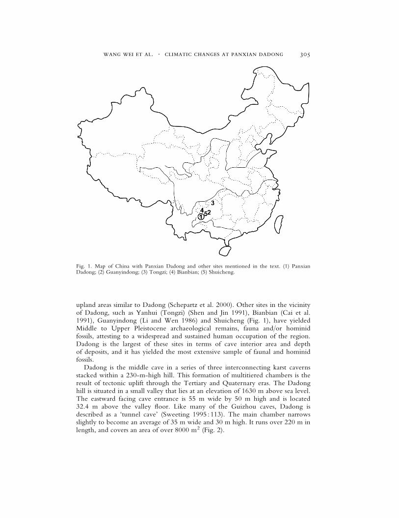
upland areas similar to Dadong (Schepartz et al. 2000). Other sites in the vicinityof Dadong, such as Yanhui (Tongzi) (Shen and Jin 1991), Bianbian (Cai et al.1991), Guanyindong (Li and Wen 1986) and Shuicheng (Fig. 1), have yieldedMiddle to Upper Pleistocene archaeological remains, fauna and/or hominidfossils, attesting to a widespread and sustained human occupation of the region.Dadong is the largest of these sites in terms of cave interior area and depthof deposits, and it has yielded the most extensive sample of faunal and hominidfossils.
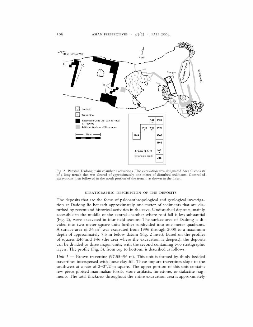
Dadong is the middle cave in a series of three interconnecting karst cavernsstacked within a 230-m-high hill. This formation of multitiered chambers is theresult of tectonic uplift through the Tertiary and Quaternary eras. The Dadonghill is situated in a small valley that lies at an elevation of 1630 m above sea level.The eastward facing cave entrance is 55 m wide by 50 m high and is located32.4 m above the valley floor. Like many of the Guizhou caves, Dadong isdescribed as a ‘tunnel cave’ (Sweeting 1995 : 113). The main chamber narrowsslightly to become an average of 35 m wide and 30 m high. It runs over 220 m inlength, and covers an area of over 8000 m2 (Fig. 2).
Fig. 1. Map of China with Panxian Dadong and other sites mentioned in the text. (1) PanxianDadong; (2) Guanyindong; (3) Tongzi; (4) Bianbian; (5) Shuicheng.
wang wei et al. . climatic changes at panxian dadong 305
stratigraphic description of the deposits
The deposits that are the focus of paleoanthropological and geological investiga-tion at Dadong lie beneath approximately one meter of sediments that are dis-turbed by recent and historical activities in the cave. Undisturbed deposits, mainlyaccessible in the middle of the central chamber where roof fall is less substantial(Fig. 2), were excavated in four field seasons. The surface area of Dadong is di-vided into two-meter-square units further subdivided into one-meter quadrants.A surface area of 36 m2 was excavated from 1996 through 2000 to a maximumdepth of approximately 7.5 m below datum (Fig. 2 inset). Based on the profilesof squares E46 and F46 (the area where the excavation is deepest), the depositscan be divided to three major units, with the second containing two stratigraphiclayers. The profile (Fig. 3), from top to bottom, is described as follows:
Unit 1 — Brown travertine (97.55–96 m). This unit is formed by thinly beddedtravertines interspersed with loose clay fill. These impure travertines slope to thesouthwest at a rate of 2–3�/2 m square. The upper portion of this unit containsfew piece-plotted mammalian fossils, stone artifacts, limestone, or stalactite frag-ments. The total thickness throughout the entire excavation area is approximately
Fig. 2. Panxian Dadong main chamber excavations. The excavation area designated Area C consistsof a long trench that was cleared of approximately one meter of disturbed sediments. Controlledexcavations then followed in the north portion of the trench, as shown in the insert.
asian perspectives . 43(2) . fall 2004306
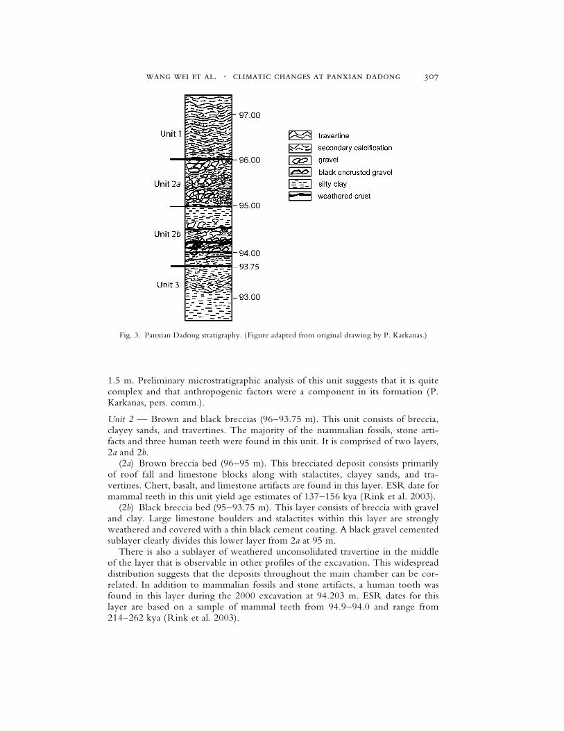
1.5 m. Preliminary microstratigraphic analysis of this unit suggests that it is quitecomplex and that anthropogenic factors were a component in its formation (P.Karkanas, pers. comm.).
Unit 2 — Brown and black breccias (96–93.75 m). This unit consists of breccia,clayey sands, and travertines. The majority of the mammalian fossils, stone arti-facts and three human teeth were found in this unit. It is comprised of two layers,2a and 2b.
(2a) Brown breccia bed (96–95 m). This brecciated deposit consists primarilyof roof fall and limestone blocks along with stalactites, clayey sands, and tra-vertines. Chert, basalt, and limestone artifacts are found in this layer. ESR date formammal teeth in this unit yield age estimates of 137–156 kya (Rink et al. 2003).
(2b) Black breccia bed (95–93.75 m). This layer consists of breccia with graveland clay. Large limestone boulders and stalactites within this layer are stronglyweathered and covered with a thin black cement coating. A black gravel cementedsublayer clearly divides this lower layer from 2a at 95 m.
There is also a sublayer of weathered unconsolidated travertine in the middleof the layer that is observable in other profiles of the excavation. This widespreaddistribution suggests that the deposits throughout the main chamber can be cor-related. In addition to mammalian fossils and stone artifacts, a human tooth wasfound in this layer during the 2000 excavation at 94.203 m. ESR dates for thislayer are based on a sample of mammal teeth from 94.9–94.0 and range from214–262 kya (Rink et al. 2003).
Fig. 3. Panxian Dadong stratigraphy. (Figure adapted from original drawing by P. Karkanas.)
wang wei et al. . climatic changes at panxian dadong 307
Unit 3 — (93.74–?). This is a clayey unit without anthropogenic remains. Itbegins at approximately 6.26 m below datum. The full thickness of this unit isunknown at present, although it has been excavated to a depth of 92.458, or over7.5 m below datum. The known thickness is therefore over 1.28 m.
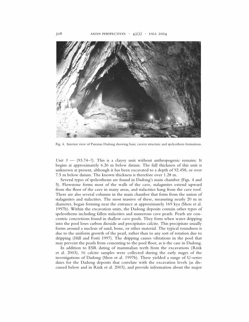
Several types of speleothems are found in Dadong’s main chamber (Figs. 4 and5). Flowstone forms most of the walls of the cave, stalagmites extend upwardfrom the floor of the cave in many areas, and stalactites hang from the cave roof.There are also several columns in the main chamber that form from the union ofstalagmites and stalactites. The most massive of these, measuring nearly 20 m indiameter, began forming near the entrance at approximately 169 kya (Shen et al.1997b). Within the excavation units, the Dadong deposits contain other types ofspeleothems including fallen stalactites and numerous cave pearls. Pearls are con-centric concretions found in shallow cave pools. They form when water drippinginto the pool loses carbon dioxide and precipitates calcite. This precipitate usuallyforms around a nucleus of sand, bone, or other material. The typical roundness isdue to the uniform growth of the pearl, rather than to any sort of rotation due todripping (Hill and Forti 1997). The dripping causes vibrations in the pool thatmay prevent the pearls from cementing to the pool floor, as is the case in Dadong.
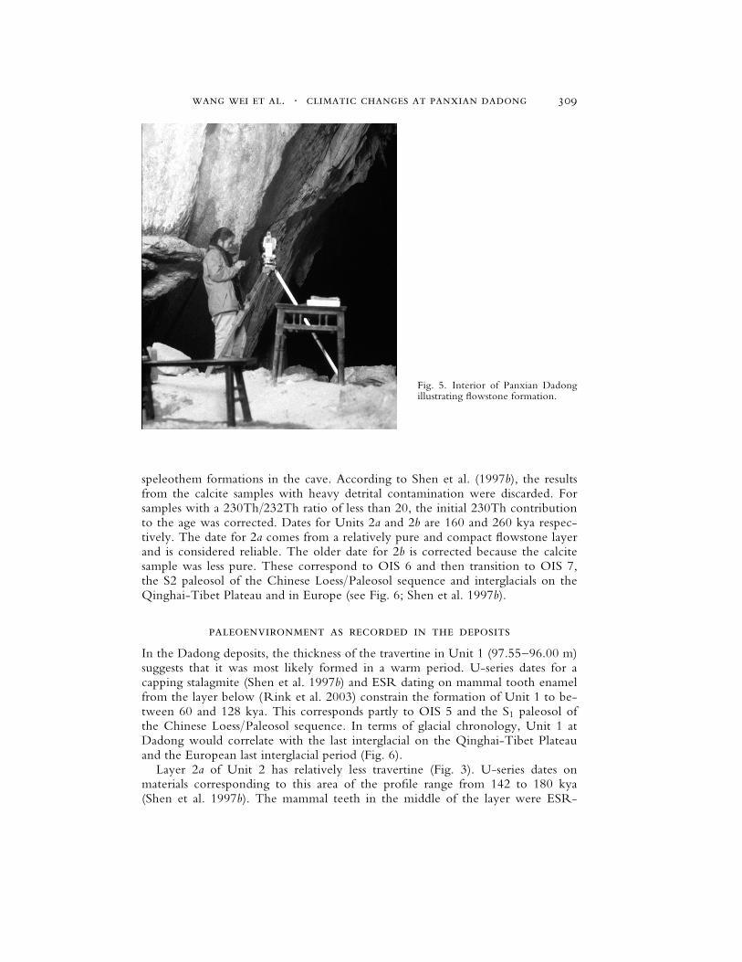
In addition to ESR dating of mammalian teeth from the excavations (Rinket al. 2003), 16 calcite samples were collected during the early stages of theinvestigations of Dadong (Shen et al. 1997b). These yielded a range of U-seriesdates for the Dadong deposits that correlate with the excavation levels (as dis-cussed below and in Rink et al. 2003), and provide information about the major
Fig. 4. Interior view of Panxian Dadong showing basic cavern structure and speleothem formations.
asian perspectives . 43(2) . fall 2004308
speleothem formations in the cave. According to Shen et al. (1997b), the resultsfrom the calcite samples with heavy detrital contamination were discarded. Forsamples with a 230Th/232Th ratio of less than 20, the initial 230Th contributionto the age was corrected. Dates for Units 2a and 2b are 160 and 260 kya respec-tively. The date for 2a comes from a relatively pure and compact flowstone layerand is considered reliable. The older date for 2b is corrected because the calcitesample was less pure. These correspond to OIS 6 and then transition to OIS 7,the S2 paleosol of the Chinese Loess/Paleosol sequence and interglacials on theQinghai-Tibet Plateau and in Europe (see Fig. 6; Shen et al. 1997b).
paleoenvironment as recorded in the deposits
In the Dadong deposits, the thickness of the travertine in Unit 1 (97.55–96.00 m)suggests that it was most likely formed in a warm period. U-series dates for acapping stalagmite (Shen et al. 1997b) and ESR dating on mammal tooth enamelfrom the layer below (Rink et al. 2003) constrain the formation of Unit 1 to be-tween 60 and 128 kya. This corresponds partly to OIS 5 and the S1 paleosol ofthe Chinese Loess/Paleosol sequence. In terms of glacial chronology, Unit 1 atDadong would correlate with the last interglacial on the Qinghai-Tibet Plateauand the European last interglacial period (Fig. 6).
Layer 2a of Unit 2 has relatively less travertine (Fig. 3). U-series dates onmaterials corresponding to this area of the profile range from 142 to 180 kya(Shen et al. 1997b). The mammal teeth in the middle of the layer were ESR-
Fig. 5. Interior of Panxian Dadongillustrating flowstone formation.
wang wei et al. . climatic changes at panxian dadong 309
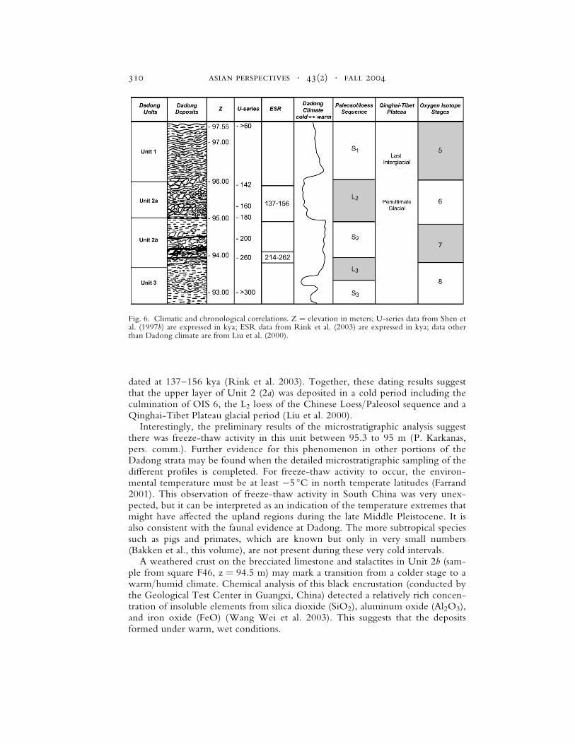
dated at 137–156 kya (Rink et al. 2003). Together, these dating results suggestthat the upper layer of Unit 2 (2a) was deposited in a cold period including theculmination of OIS 6, the L2 loess of the Chinese Loess/Paleosol sequence and aQinghai-Tibet Plateau glacial period (Liu et al. 2000).
Interestingly, the preliminary results of the microstratigraphic analysis suggestthere was freeze-thaw activity in this unit between 95.3 to 95 m (P. Karkanas,pers. comm.). Further evidence for this phenomenon in other portions of theDadong strata may be found when the detailed microstratigraphic sampling of thedi¤erent profiles is completed. For freeze-thaw activity to occur, the environ-mental temperature must be at least �5 �C in north temperate latitudes (Farrand2001). This observation of freeze-thaw activity in South China was very unex-pected, but it can be interpreted as an indication of the temperature extremes thatmight have a¤ected the upland regions during the late Middle Pleistocene. It isalso consistent with the faunal evidence at Dadong. The more subtropical speciessuch as pigs and primates, which are known but only in very small numbers(Bakken et al., this volume), are not present during these very cold intervals.
A weathered crust on the brecciated limestone and stalactites in Unit 2b (sam-ple from square F46, z ¼ 94:5 m) may mark a transition from a colder stage to awarm/humid climate. Chemical analysis of this black encrustation (conducted bythe Geological Test Center in Guangxi, China) detected a relatively rich concen-tration of insoluble elements from silica dioxide (SiO2), aluminum oxide (Al2O3),and iron oxide (FeO) (Wang Wei et al. 2003). This suggests that the depositsformed under warm, wet conditions.
Fig. 6. Climatic and chronological correlations. Z ¼ elevation in meters; U-series data from Shen etal. (1997b) are expressed in kya; ESR data from Rink et al. (2003) are expressed in kya; data otherthan Dadong climate are from Liu et al. (2000).
asian perspectives . 43(2) . fall 2004310
conclusions
Studies of speleothem formation in the karst mountains of Guizhou suggest thatwarm, humid environments prevailed from 240 to 180 kya and again between130 and 100 kya. Under those conditions, the vegetation resembled present-daysubtropical rain forest. The cyclical formation of speleothems in the Guizhoucaves also suggests marked climatic fluctuations in the region during the MiddlePleistocene (Shen 1993). This pattern has been detected in an array of paleo-climatic indicators, ranging from components of the paleosol/ loess sequence inNorth China and to the pollen record of lacustrine deposits near the South ChinaSea (Zheng and Lei 1999). The stratigraphic sequence at Panxian Dadong reflectsthis same pattern of cyclical environmental change during the late Middle Pleis-tocene. Beginning approximately 260 kya there is depositional evidence, in theform of weathering, stalactites, and limestone blocks, for warm, wet conditionsin the lower layer of Unit 2 (2b). This is followed by a cooler episode associatedwith the formation of the upper layer of Unit 2 (2a), which continued until ap-proximately 140 kya. The periods of human activity recorded in the deposits atDadong can be correlated with Oxygen Isotope Stages 5–7. The general climaticconditions during this time span included an early warmer and wetter period (OIS7), followed by cooling and then temperatures low enough to leave characteristicfreeze-thaw features (OIS 6). The identification of freeze-thaw activity is unex-pected in South China, but Dadong’s elevation on the Guizhou Plateau musthave amplified the general cooling that is known for OIS 6. The later period ofhuman activity at Dadong took place during a milder, wetter regime (OIS 5).
Correlations with the major climatic scheme indicated by OIS stages providean overall picture of Middle Pleistocene climate change at Dadong. However,within each of the units are alternating travertines and breccias that would haveformed under very di¤erent environmental conditions—suggesting that there wassubstantial climatic fluctuation on a finer scale throughout much of the sequence.This is supported by the preliminary microstratigraphic analyses and studies of thecave calcites, but more work is needed before the intensity and rate of climatictransitions in Dadong can be fully understood.
acknowledgments
Financial support of this work comes from the U.S. National Science Foundation,and the L.S.B. Leakey, Wenner-Gren, and Luce foundations. We also thank theChinese National Relics Bureau for its support. Wang Wei thanks Panagiotis Kar-kanas (Ephorate of Paleoanthropology-Speleology, Athens, Greece), Jack Rink(McMaster University), and Heather Jones (Louisiana State University) for helpfuldiscussions of the geology. Panagiotis Karkanas provided the schematic figure of theDadong stratigraphy and microstratigraphic information, Kanani Paraso providedmapping assistance, and Sarah Stoutamire produced many of the figures.
references cited
Adams, Jonathan, Mark Maslin, and Ellen Thomas
1999 Sudden climatic transitions during the Quaternary. Progress in Physical Geography23(1) : 1–36.
wang wei et al. . climatic changes at panxian dadong 311
Alley, R. B.
2000 Ice-core evidence of abrupt climatic changes. Proceedings of the National Academy of SciencesUSA 97 : 1331–1334.
Cai, H., X. Wang, and C. Xu
1991 Paleolith of Bianbian cave at Bijie County, Guizhou Province [in Chinese with Englishabstract]. Acta Anthropologica Sinica 10 : 50–7.
Chen, F. H., J. Bloemendal, Z. D. Feng, J. M. Wang, E. Parker, and Z. T. Guo
2003 East Asian monsoon variations during the last interglacial: Evidence from the northwest-ern margin of the Chinese Loess Plateau. http://fadr.msu.ru/inqua/nl-15/ llz-abs.html
Courty, Marie-Agnes, and Josep Vallverdu
2001 The microstratigraphic record of abrupt climatic changes in cave sediments of the westernMediterranean. Geoarchaeology: An International Journal 16(5) : 467–500.
Ding, Z. L., J. Z. Ren, S. L. Yang, and T. S. Liu
1999 Climatic instability during the penultimate glaciation: Evidence from two high-resolutionloess records, China. Journal of Geophysical Research 104(B9) : 20123–20132.
Farrand, William R.
2001 Sediments and stratigraphy in rockshelters and caves: A personal perspective on principlesand pragmatics. Geoarchaeology: An International Journal 16(5) : 537–557.
Gascoyne, M.
1992 Palaeoclimate determinations from cave calcite deposits. Quaternary Science Reviews11 : 609–632.
Hill, Carol, and Paolo Forti
1997 Cave Minerals of the World, 2nd ed. Huntsville, AL: National Speliological Society.
Ji, J. F., W. Balsam, and C. Jun
2001 Mineralogic and climatic interpretations of the Luochuan loess section (China) based ondi¤use reflectance spectrophotometry. Quaternary Research 56 : 23–30.
Johnson, K. R., and B. L. Ingram
2001 High-resolution paleoclimate record based on d18O variations in speleothems from Cen-tral China. Abstract: 70–72, in 4th International Symposium on Applied Isotope Geochemistry,June 2001. Pacific Grove, CA.
Li Yanxian, and Benheng Wen
1986 Guanyindong, A Lower Paleolithic Site at Qianxi County, Guizhou Province. Beijing: CulturalRelics Publishing House.
Liu, T. S., Y. F. Shi, R. J. Wang et al.
2000 The comparative table of China’s Quaternary stratigraphy using climate change as an in-dicator [in Chinese with English abstract]. Quaternary Research, Sinica 20(2) : 110–125.
Liu, Yuyuan, and Jinhua He
1990 The study on the palaeoclimatic long-term variation of the speleothem (stalagmite) col-lected from Luozhi Cave, Guilin, China [in Chinese with English abstract]. Earth Science15(6) : 689–696.
Rink, W. J., L. Schepartz, S. Miller-Antonio, W. Huang, Y. Hou, D. Bakken, D. Richter,
and H. Jones
2003 Electron spin resonance (ESR) dating of tooth enamel at Panxian Dadong Cave, Gui-zhou, China, in Current Research in Chinese Pleistocene Archaeology: 111–118, ed. ShenChen and Susan G. Keates. Oxford: BAR Monograph Series.
Rousseau, D.-D., and Naiqin Wu
1999 Mollusk record of monsoon variability during the L2-S2 cycle in the Luochuan loess se-quence, China. Quaternary Research 52 : 286–292.
Schepartz, L. A., S. Miller-Antonio, and D. A. Bakken
2000 The paleolithic occupation of southwestern China, Vietnam, Laos and Burma. WorldArchaeology 32(1) : 1–13.
Shen, G. J.
1993 Uranium-series ages of speleothems from Guizhou paleolithic sites and their paleoclimaticimplications., in Evolving Landscapes and Evolving Biotas of East Asia Since the Mid-Tertiary:275–282, ed. N. Jablonski. Hong Kong: University of Hong Kong Centre of AsianStudies.
asian perspectives . 43(2) . fall 2004312
Shen, G. J., B. Gahleb, and L. H. Jin
1997a TIMS U-series dating of a stalagmite from Zhenjiadong Cave in Guizhou and its paleo-climatic implications [in Chinese with English abstract]. Carsologica Sinica 16(1) : 11–18.
Shen, G. J., and L. H. Jin
1991 U-series age of Yanhui Cave, the site of Tongzi Man [in Chinese with English abstract].Acta Anthropologica Sinica 10(1) : 65–72.
Shen, G., J. Liu, and L. H. Jin
1997b Preliminary results on U-series dating of Panxian Dadong in Guizhou Province, S-WChina. Acta Anthropologica Sinica 16(3) : 221–230.
Sweeting, M. M.
1995 Karst in China. Its Geomorphology and Environment. Berlin: Springer-Verlag.
Wang Wei, Jun Liu, Ya-mei Hou, L. A. Schepartz, S. Miller-Antonio, W. J. Rink, Xin-qiang
Si, and Wei-wen Huang
2003 Stratigraphic and paleoenvironmental studies at the Dadong cave, Panxian. Acta Anthro-pologica Sinica 22(2) : 131–138.
Yuan Daoxian, Bin Li, and Zaihua Liu
1995 Karst in China. Episodes 18 : 62–65.
Zhang, Shouyue
1989 Palaeokarst of China., in Palaeokarst: 297–311, ed. P. Bosak, D. Ford, J. Glazek, and I.Horacek. Amsterdam: Elsevier.
Zheng, Z., and Z.-Q. Lei
1999 A 400,000 year record of vegetational and climatic changes from a volcanic basin,Leizhou Peninsula, southern China. Palaeogeography, Palaeoclimatology and Palaeoecology145 : 339–362.
abstract
Broad-based reconstructions of the Middle Pleistocene Asian environment arevaluable sources of information that can augment our understanding of prehistorichuman adaptations and expansion into East Asia. The sediments, speleothems, andgeochronology of Panxian Dadong Cave serve as an example of the possible inte-gration of this broader paleoenvironmental information with more fine-grained ar-chaeological data. The current U-series and ESR dating results for Dadong suggestthat the early human activity in the cave began at least 260 kya and continued untilaround 142 kya. This period correlates with Oxygen Isotope Stages 7 through 6.The lower part of the breccia (Layer 2) contains very strongly weathered darkdeposits, suggesting a relatively warm climatic period from 260–180 kya that corre-sponds to OIS 7, followed by a cooler phase with less speleothem formation corre-sponding to OIS 6. The Middle Pleistocene stratigraphic sequence in the Dadongcave deposits documents fluctuating and rapid changes in temperature and humiditythat are also detected in general Asian, as well as South China, paleoclimatic studiesbased on diverse data ranging from microstratigraphic and geochemical sedimentanalyses to mollusk species representation. Keywords: Middle Pleistocene, Asianpaleoenvironment, stratigraphy, speleothem, Panxian Dadong, China.
wang wei et al. . climatic changes at panxian dadong 313
Copyright © 2022 FDOKUMEN