Paliou, E. (2014) “Visibility analysis in 3D spaces: a new dimension to the understanding of...
24
VISIBILITY ANALYSIS IN 3D BUILT SPACES 91 Eleftheria Paliou Visibility analysis in 3D built spaces: a new dimension to the understanding of social space Abstract The existence of a close link between visibility in built space and social life has repeatedly been acknowledged by social theories and has concerned a great number of studies on modern and past built environments. Archaeol- ogists aiming to explore this relationship in a formal way have traditionally been employing one- or two-dimen- sional visibility analysis techniques using ground plans or sections of the spaces under examination. While these methods have considerably enriched archaeological interpretive schemes, this chapter discusses a number of cases (Roman, Mesoamerican, Aegean Late Bronze Age, and Byzantine urban spaces), where social aspects of vis- ibility in built settings can be better understood with reference to a three-dimensional environment. It then describes briefly two applications of the recently proposed computational methods of visibility analysis in three- dimensional digital spaces, and argues that these methodologies have the potential to contribute new approaches to the examination of built environments. 1 Introduction Visibility is a very popular concept within those bodies of theory that seek to link social relations and human action in urban space to the materiality of the built environment, such as environment-behaviour theory (Rapoport 1990), space syntax (Hillier and Hanson 1984), and reception theory (Lynch 1960). These conceptual approaches, which have been recently classed together under the term “empirical urban theory” (Smith 2011), have appealed to some archaeologists, as they are associated with notions that have identifiable manifes- tations in the archaeological record, and are susceptible to a formal examination via spatial analysis. In recent years many works have drawn on empirical urban theories to interpret past built spaces using various two-dimensional visual analysis techniques, which rely upon the construction of lines of sight on building plans and sections. The role of these methods in the proposed interpretative schemes is often considered essential, nonetheless, it is frequently acknowledged that two-dimensional analyses describe inadequately the vis- ual properties of three-dimensional space (Moore 1996, p. 227; Fisher 2009, p. 451). The implications of this fact are fairly obvious: since people in the past engaged with three- dimensional architectural environments, certain social meanings encoded in built settings will remain undetected when space is being studied in two dimensions. This chapter aims to discuss some of the cases where relationships between visibility and social life in past urban spaces can be better understood with reference to a three- dimensional environment. In this discussion special emphasis is given to theoretical con- cepts associated with Rapoport’s Nonverbal Communication approach and the application
Transcript of Paliou, E. (2014) “Visibility analysis in 3D spaces: a new dimension to the understanding of...
VISIBILITY ANALYSIS IN 3D BUILT SPACES 91
Eleftheria Paliou
Visibility analysis in 3D built spaces:a new dimension to the understanding of social space
AbstractThe existence of a close link between visibility in built space and social life has repeatedly been acknowledged bysocial theories and has concerned a great number of studies on modern and past built environments. Archaeol-ogists aiming to explore this relationship in a formal way have traditionally been employing one- or two-dimen-sional visibility analysis techniques using ground plans or sections of the spaces under examination. While thesemethods have considerably enriched archaeological interpretive schemes, this chapter discusses a number ofcases (Roman, Mesoamerican, Aegean Late Bronze Age, and Byzantine urban spaces), where social aspects of vis-ibility in built settings can be better understood with reference to a three-dimensional environment. It thendescribes briefly two applications of the recently proposed computational methods of visibility analysis in three-dimensional digital spaces, and argues that these methodologies have the potential to contribute new approachesto the examination of built environments.
1 Introduction
Visibility is a very popular concept within those bodies of theory that seek to link socialrelations and human action in urban space to the materiality of the built environment, suchas environment-behaviour theory (Rapoport 1990), space syntax (Hillier and Hanson 1984),and reception theory (Lynch 1960). These conceptual approaches, which have been recentlyclassed together under the term “empirical urban theory” (Smith 2011), have appealed tosome archaeologists, as they are associated with notions that have identifiable manifes-tations in the archaeological record, and are susceptible to a formal examination via spatialanalysis. In recent years many works have drawn on empirical urban theories to interpretpast built spaces using various two-dimensional visual analysis techniques, which relyupon the construction of lines of sight on building plans and sections. The role of thesemethods in the proposed interpretative schemes is often considered essential, nonetheless,it is frequently acknowledged that two-dimensional analyses describe inadequately the vis-ual properties of three-dimensional space (Moore 1996, p. 227; Fisher 2009, p. 451). Theimplications of this fact are fairly obvious: since people in the past engaged with three-dimensional architectural environments, certain social meanings encoded in built settingswill remain undetected when space is being studied in two dimensions.
This chapter aims to discuss some of the cases where relationships between visibilityand social life in past urban spaces can be better understood with reference to a three-dimensional environment. In this discussion special emphasis is given to theoretical con-cepts associated with Rapoport’s Nonverbal Communication approach and the application
UnangemeldetHeruntergeladen am | 13.10.14 19:25

92 ELEFTHERIA PALIOU
of more recent space syntax methods, namely isovist and visibility graph analysis. Thearchaeological examples used to support the argument belong to very different cultural con-texts: Roman, Mesoamerican, and Aegean Late Bronze Age urban spaces, as well as LateAntique churches. Finally, this paper briefly describes two applications of the recently pro-posed computational methods of visibility analysis in three-dimensional spaces and arguesthat these methodologies have the potential to contribute new approaches to the exami-nation of built environments, enhancing the interpretive schemes used in archaeologicalsocial analysis.
2 The visibility of built forms
2.1 Environment-behaviour theory and the Nonverbal Communication approach
The relationship between space and social life has concerned a large theoretical corpusthat has significantly influenced archaeological investigations over the years. Among theseworks environment/behaviour theory, and especially Rapoport’s Nonverbal Communi-cation approach, proves particularly useful for the interpretation of archaeological remains(Michailidou 2001; Fisher 2009; Fisher, this volume; Thaler 2009), not least because itseeks to infer social meanings embodied in built space in a way that is “relatively direct andsimple” (Rapoport 1990, p. 10). The Nonverbal Communication approach argues thaturban spaces communicate a variety of latent messages by providing cues, visual, olfactory,and acoustic (Rapoport 1990, p. 106–107), which relate to identity, status, wealth andpower, but also to expected behaviour, accessibility and other information that make humanco-action possible (Rapoport 1990, p. 221). Within this conceptual framework the role ofvisual cues is especially stressed and their symbolic function is witnessed in numerous dif-ferent ways: in the shape, size, scale, colour and materials of built structures, and in spatialrelationships, e.g. prominence, centrality versus periphery, exposed versus hidden (Rapo-port 1990, p. 107). For instance, a built structure of special significance (a public ritualspace, a monument, an elite building) could be easily identified within its architectural con-text because of its larger size, its central, exposed or prominent location, and its distinctarchitectural features (construction materials used, decorative elements, distinctive archi-tectural forms and furnishings). Social actors can read, interpret and associate these char-acteristics with particular uses of space and expected modes of social behaviour, while fre-quently they consciously manipulate the appearance of built environments to promotetheir interests. Although Rapoport (1990) refers mainly to modern built spaces, the notionthat social meanings are communicated via visual cues such as those described above hasalways been accepted by archaeologists.
Whilst in prehistoric environments the existence of a close link between visibility inbuilt space and social life is merely being assumed or inferred from an incomplete archae-
UnangemeldetHeruntergeladen am | 13.10.14 19:25
VISIBILITY ANALYSIS IN 3D BUILT SPACES 93
ological record, in historical cityscapes, such as that of ancient Rome, this relationship isclearly evidenced in surviving written sources. For example, Wallace-Hadrill (1988, p. 46),in a paper discussing social aspects of Roman houses, mentions two characteristic passageswhich suggest that visual access from public spaces to a private residence, successivelyoccupied by Livius Drusus (tribune of the plebeians in 91 BC) and Cicero, was not only desir-able, but also requested and planned:
A public figure went home not so much to shield himself from the public gaze, as to pres-ent himself to it in the best light. Two passages may illustrate Roman sensibilities on thispoint. One records an exchange between Livius Drusus, tribunus plebis in 91, and thearchitect in charge of building his house on the slope of the Palatine overlooking theforum: when the architect promised him to make it “completely private and free frombeing overlooked by anyone”, Livius replied, “No, you should apply your skills to arrangingmy house so that whatever I do should be visible to everybody.” (Vell. Pat. Ii. 14.3). … hissuccessor in the same property, Cicero, felt no differently: “My house stands in full view ofvirtually the whole city” (Wallace-Hadrill 1988, p. 46)
These quotes offer a valuable insight into some of the intentions that guided choices onthe location, form and structure of buildings in ancient Rome. More importantly for thecurrent discussion, they suggest that certain notions of “public” or “private” in the Romancityscape could be better examined in three-dimensional space rather than with two-dimen-sional plans. In this case it would be important to know, for instance, whether and whichparts of the façade, the back spaces or architectural decoration of a building (e.g. paintedand relief decoration) could be seen from public areas of the Roman city. Furthermore, onemight like to know which buildings are more visible from certain parts of the cityscape orwhich structures can be seen with more ease in a given built district.
Similarly, in the case of Mayan architecture human experience in 3D space is con-sidered crucial for understanding socio-symbolic aspects of built space that may haveshaped human movement and action in the past. Hohmann-Vogrin (2005, p. 287) observesthat the use of a ground plan alone is insufficient for appreciating experience in Mayansites, where movement was apparently guided by the altitude of monumental structuresthat could be seen from a distance. Moreover, she argues that visual and physical access inthese spaces would have implicitly expressed important social symbolisms:
Maya sites are like landscapes, resembling mountains, hills, valleys and planes. Openspaces are constituted by plazas, courtyards, terraces and platforms on different levels,while interior space is relatively limited. In some cases access to higher levels wasobviously restricted … Step by step, terraces and platforms become smaller. Sights andviews are determined by the altitude of the respective terrace or platform. On the lowestlevel, the view is limited by walls and platforms taller than the viewer, at least in the smallercourtyards. The field of vision is widened by access to higher levels. On the highest level –presumably never reached by the average person – the view becomes unlimited, so to
UnangemeldetHeruntergeladen am | 13.10.14 19:25

94 ELEFTHERIA PALIOU
speak. Here, social hierarchy is demonstrated literally. This is both functional and sym-bolic. (Hohmann-Vogrin 2005, p. 285)
In recent years advances in the discipline of urban studies and the increasing availability ofcomputing power have enabled the development of computational analysis methods whichaim to quantify aspects of visual experience in built environments. Such approaches seek topermit the comparative investigation of urban configurations, and to examine the socialdimensions of their transformation through space and time. Established visual analysismethods, such as axial1, isovist or visibility graph analysis (Bintliff, Fisher, Hacıgüzeller andThaler, Hillier, Letesson, Stöger: cf. this volume), cannot be used, however, for the investi-gation of visibility in 3D cityscapes. These one- and two-dimensional techniques aim todefine the visible space between walls that offers possibilities for movement, and were cre-ated to underpin different theoretical and empirical considerations than those describedabove. Thus, they do not take into account the three-dimensional topography of a cityscapeor the vertical dimensions of built structures. On the other hand, archaeologists in the pasthave attempted to develop methods that are more suitable for examining human visualexperience in 3D space. For instance, in his analytical approach to Andean architectureMoore (1996) places great emphasis on the vertical dimension of monumental buildings.In order to investigate the visual impact of public built structures he introduced methods ofanalysis that aimed to quantify the impression of “monumentality” induced to a viewerfrom different viewpoints2; he created isovistas, namely contour maps that define locationsin space at which the visual impact of a monument as seen from selected angles of viewchanges significantly (fig. 1). For the creation of these maps only the highest point of the tar-get structure is taken into account. Moore (1996, p. 227–228) admits that, although suffi-cient for his analysis, his measures are crude, and suggests that the application of com-puter-assisted design and Geographic Information Systems (GIS)3 could offer fullerreconstructions of architectural spaces and potentially more subtle recognitions of con-structed patterns. The recent development of fully three-dimensional visual analysis tech-niques reflects similar considerations.
1 In many recent space syntax studies axial lines are referred to as “lines-of-sight” (Turner 2003, p. 661).2 These methods were later used by Letesson and Vansteenhuyse (2006) in the context of Minoan palatial archi-tecture.3 More recent versions of commercial GIS software (e.g. ArcGIS 10) provide the tools for some basic forms ofvisibility analysis on building facades, such as line of sight calculations. This analysis can determine whether a lineof sight will be obstructed by a building or not. However, more sophisticated types of visibility analysis, e.g.viewshed calculations that can determine how much of a façade could be visible from a given location, cannot cur-rently be performed with commercial GIS software.
UnangemeldetHeruntergeladen am | 13.10.14 19:25

VISIBILITY ANALYSIS IN 3D BUILT SPACES 95
2.2 Computational approaches to visibility analysis in 3D spaces:The visibility of Theran murals in the townscape of Late Bronze Age Akrotiri
Visibility analysis in fully 3D spaces4 (Earl 2005; Paliou and Wheatley 2007; Paliou et al.2011; Paliou 2011; Paliou and Knight, in press; Papadopoulos and Earl, this volume; Earl etal., forthcoming) has been applied in archaeological studies with the aim of permitting thequantitative description of views perceived in visually complex 3D environments by ahuman observer on the ground. By coupling common 3D modelling and GIS functional-ities, this approach manages to quantify visual access to vertical built features (e.g. facades,masonry, mural painting) in architecturally intricate built contexts, such as those oftenencountered in real world environments. In this respect it is especially well-suited for theformal examination of concepts associated with Rapoport’s Nonverbal Communicationapproach, and conforms well to the line of enquiry outlined above. It has to be noted that inmany situations estimating in a formal way the communicative potential of 3D built fea-tures can be fairly straightforward. Fisher (2009, p. 445; this volume), for example, hasargued that ashlar masonry in Late Bronze Age Cyprus formed an integral part of the iden-tities of the elite, and was strategically used in socio-politically or ideologically important
4 Fully 3D are those digital spaces with three independent x, y and z axes. These should be distinguished fromdigital models that, although they appear to be 3D, do not have an independent z axis, for example traditional digi-tal elevation models (DEMs), where height is merely an attribute of a set of x, y coordinates (2.5 D models).
Figure 1 | Example of unobstructed isovistas thatmark three different visual thresholds, e.g. thoselocations where the monument occupies 18, 27,and 45 degrees above the horizontal line of vision(based on Moore 1996, figure 3.7).
UnangemeldetHeruntergeladen am | 13.10.14 19:25

96 ELEFTHERIA PALIOU
contexts. To demonstrate his point he quantifies the presence of ashlar masonry in LBArooms by calculating their ashlar elaboration scores: he first divides the length of the wall(s)constructed of ashlar blocks by the total wall length of the room, and subsequentlymultiplies the outcome by a value that defines the degree of elaboration for the observedtype of ashlar masonry (elaboration multiplier). Nonetheless, when it comes to exploring vis-ual access to vertical built features within complex architectural contexts, the use of moresophisticated spatial representations and analytical processes is necessary.
One of the first applications of visibility analysis in 3D spaces aimed to explore aspectsof the visual experience of Theran murals in the Late Bronze Age town of Akrotiri (Thera,Greece: Paliou 2009; Paliou 2011), which was buried by an immense volcanic eruption inprehistory. Akrotiri (fig. 2) is famous for the lavish wall decorations that embellished manyof its public and domestic buildings. The Theran murals, like the site itself, are exception-ally well preserved, and are among the best studied finds of Aegean Bronze Age painting.Since their discovery the wall paintings of Akrotiri have fuelled intense debates regardingtheir uses and intended purposes, with some scholars maintaining that their themes sug-gest a primary religious/ritual function (e.g. Marinatos 1984; Morgan 1998), while othersargue that they had a predominantly secular/social content (e.g. Schachermeyer 1978; Tele-vantou 1994; Doumas 2005). Despite the difficulties involved in interpreting the exactthemes of Theran murals, it is reasonably safe to assume that they were elite architecturalfeatures, since figurative wall painting in the Late Bronze Age Aegean is linked with palatialarchitecture and the most elaborate buildings discovered (Boulotis 1992; Chapin 2004;Gates 2004).
It has long been suggested that the unprecedented number of wall paintings found inTheran domestic spaces may have been associated to strategies of social competitionamong town dwellers who acquired wealth in a relatively short time, due to trade and sea-faring activities (Doumas 1992, p. 29; Schachermeyr 1978; Boulotis 1992, p. 89). Never-theless, most discussion on the visual consumption of wall paintings has concentrated onthe practices (ritual, dining etc.) that took place in the decorated rooms (Michailidou 2001;Boulotis 2005; Chapin 2004), mainly during formal occasions, while the possible latentmessages of the paintings in more mundane everyday situations have remained less wellstudied. For instance, it has been suggested that in Akrotiri wall paintings adorning firstfloor rooms in domestic buildings could have been visible to a passer-by outside the build-ings through the open windows (Doumas 2005). If this was true, murals could have beenused to mark the houses of those having or aspiring to a high social position and wouldhave communicated messages of status not just to the few people allowed into these roomson certain formal occasions, but to any individual traversing the prehistoric settlement inthe course of everyday life. The possibility to see the paintings also from outside the build-ings would perhaps explain why mural decoration was so abundant in Akrotiri. However,appreciating how murals decorating first floor rooms may have been received by thosecrossing the public open spaces presents a number of challenges: the wall paintings used to
UnangemeldetHeruntergeladen am | 13.10.14 19:25
VISIBILITY ANALYSIS IN 3D BUILT SPACES 97
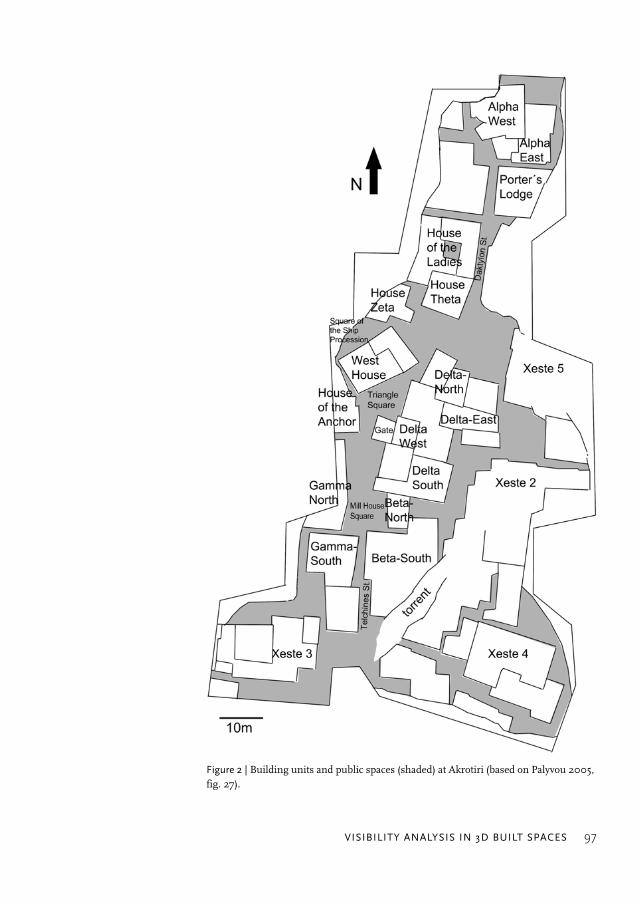
Figure 2 | Building units and public spaces (shaded) at Akrotiri (based on Palyvou 2005,fig. 27).
UnangemeldetHeruntergeladen am | 13.10.14 19:25

98 ELEFTHERIA PALIOU
decorate walls that have nowadays collapsed and could have only been partially seenthrough wooden window frames, which have disintegrated, as suggested by imprints left inthe thin volcanic ash (Palyvou 1999, p. 406–407).
Computational visibility analysis was employed in this case to formally assess the com-municative potential of wall paintings in the townscape of Akrotiri. Room B1 of Beta South,Room 5 of the West House, and the first-floor room above the Gate at Delta West (fig.2)were chosen as case studies, since these spaces could be reconstructed with a relatively highdegree of certainty and were distinguished by typical features of Theran architecture, (e.g.large horizontal windows, pier-and-window partitions, painted friezes). The procedure ofanalysis, which has been described in detail elsewhere (Paliou 2009; Paliou et al. 2011),required as a first step the creation of 3D digital reconstructions5 (fig. 3) of the spaces understudy using information provided by the building remains, the excavation process(imprints of wooden window frames and lattices in the volcanic ash) and the restored wallpaintings, which indicated the dimensions of collapsed walls. Then the visible area of eachpainted surface from a large number of defined viewpoints was recorded in the virtualenvironment, using point-source illumination; this method permits the easy extraction,further analysis and remapping of visual data derived from a 3D model. Such an approachis based on the analogue production of isovist in a digital environment by illuminating a3D model with a single light source that emits light in all directions (cf. also Benedikt 1979);in this case, illuminated and non-illuminated areas of the model correspond to visible andnon-visible surfaces as seen from the location of the light source respectively (Paliou et al.2011).
Viewer locations at the public open spaces outside the reconstructed buildings wereidentified by sampling space at equal intervals (20 cm by 20 cm) using a grid (fig. 4).Subsequently, a simple script was used to animate the light source over each one ofthe observer locations in succession at the eye level of a standing observer (1.55 m).Information on the illumination (visibility) of painted surfaces for each viewing locationwas then extracted in a raster format (fig. 5), to be further analysed and mapped in a GIS6
environment using a series of scripts and batch processes (Paliou et al. 2011). This pro-cedure produced maps which showed the amount of the visible area of a targeted paintedwall that could potentially be seen from each viewing location (fig. 6). One basic benefit ofthis method of analysis is that by constraining the light rays within certain angular rangesit can also establish how much of the painted surface could have been observed withrelative ease (fig. 6 b, d, f). In this case the painted areas visible within an angular range ofup to 25 degrees above eye level were also recorded, viz. the surfaces that could be seenwith eye rotation and with no need for additional upward head movements (Higuchi 1983,
5 All 3D models discussed in this paper were created with various versions of AutoCAD and 3Ds Max software.6 GIS analysis was performed with ArcGIS.
UnangemeldetHeruntergeladen am | 13.10.14 19:25

VISIBILITY ANALYSIS IN 3D BUILT SPACES 99
p. 40; Paliou 2011, fig. 6). Within this visual range the communicative potential of thepaintings is relatively high, as pedestrians walking in a densely built and possibly popu-lated environment are more likely to encounter the painted walls naturally and with ease,without making particular visual effort or interrupting their movement (Paliou 2011,p. 254).
By applying the above analytical methods, changes in the visual experience of someonemoving through the public spaces of the settlement were systematically recorded and ana-lysed, and important spatial relationships, which were not immediately perceivable simplyby walking through the digital reconstruction, became apparent. An important conclusionwas that a large number of the paintings could have been exposed to the viewer from manylocations outside the buildings. The precise themes would not have always been intelli-gible.7 Nonetheless, the mere awareness of lavish wall decoration would have been enoughto convey latent social messages of status and power to those encountering the paintings,
7 The intelligibility of the themes would have also been affected by lighting conditions, the colour of paintedelements and the distance of the paintings to the observer. Although lighting conditions in the Theran houses arehard to reproduce with scientific accuracy (Paliou 2009, p. 87), it makes sense to suggest that rooms with a smallarea (approx. 4 × 4 m) and large or multiple windows piercing the greater part of their outer walls would have beenfairly well illuminated for most part of the day (cf. Doumas 2005).
Figure 3 | 3D model of Room 5 (first floor) of the West House. a,b,c,d: Views from the public open space outsidethe building (Paliou 2011, fig. 3). Created by E. Paliou.
UnangemeldetHeruntergeladen am | 13.10.14 19:25

100 ELEFTHERIA PALIOU
Figure 4 | The grid of viewpoints at the openpublic space outside the West House (Paliou2011, fig. 5a).
Figure 5 | Textures (viewsheds) of the southfrieze of the Miniature Fresco (Room 5,West House) with information on thevisibility of the painted wall surface for fourdifferent viewpoints (white/visible-black/non-visible): a, b, c, d correspond to fig. 3a,3b, 3c, 3d respectively (Paliou 2011, fig. 4).
UnangemeldetHeruntergeladen am | 13.10.14 19:25

VISIBILITY ANALYSIS IN 3D BUILT SPACES 101
and on some occasions to trigger memories of the social events that took place in the dec-orated rooms. Furthermore, the systematic visibility recording and mapping for virtually alllocations outside the buildings highlighted certain necessary and less obvious spatial con-ditions permitting the visibility of the wall paintings from the street network. The resultsshowed that pedestrians would have to be located in most cases at least three and some-times four metres away from the walls of a building embellished with murals to be able toobserve the painted surfaces. Since main roads in Akrotiri are usually up to 2 m. wide, thissuggested that the visibility of wall decoration from public open spaces was possible to agreat extent due to the existence of the so-called squares (fig. 2), the relatively wide open-
Figure 6 | Changes in visual access to the Miniature fresco from outside the WestHouse (Paliou 2011, fig. 9) – a, b: The visible area of the south frieze from the squarewithout (a) and with angular restrictions (b). c, d: The visible area of the west friezefrom the square without (c) and with angular restrictions (d). e, f: The visible area ofthe east frieze from the square without (e) and with angular restrictions (f). Thearrow points to the position of the fresco under study.
UnangemeldetHeruntergeladen am | 13.10.14 19:25
102 ELEFTHERIA PALIOU
ings in the street network. Such spaces distinguish this Cycladic town from other moredensely built contemporary Aegean urban settlements (Palyvou 2005, p. 29); visual accessto first floor rooms in towns that lacked similar openings would have been impossible orrare. In this respect one could argue that it was the particular urban layout of Akrotiri thatpermitted the visibility of mural decoration from outside the buildings, enhancing in thisway the communicative potential of the murals. Hence, the spatial configuration of theprehistoric settlement might have encouraged the surprisingly wide production of walldecoration, as much as social conditions (Paliou 2011).
The case study of Akrotiri is perhaps characteristic of the problems associated withexploring communicative aspects of built features in architecturally complex spaces, andhow these may be solved using methods of visibility analysis in fully 3D digital environ-ments. A similar approach could prove beneficial in other cases, viz. for examining the vis-ual impact of built features in Roman or Mesoamerican societies, providing that the sug-gested methods and interpretive schemes are employed in a context-specific way. Theremainder of this paper argues for the benefits of using three-dimensional visibility analy-sis within theoretical frameworks that place primary emphasis on the social significance ofthe open space delineated by walls and buildings. The focus will be upon isovist and visibil-ity graph analysis, two techniques that were added to the set of Space Syntax methodsalmost a decade ago with the aim of identifying patterns of co-presence in the built environ-ment, and of investigating the ways in which spatial configuration encourages movement,social encounters and interaction.
3 The visibility of space between walls
3.1 Space syntax methods: isovist and visibility graph analysis
Isovist analysis was introduced in the field of urban studies in 1979 by Benedikt, who orig-inally defined the isovist as the set of all points visible from a vantage point in space, namelyas a three-dimensional entity (Benedikt 1979, p. 49). Benedikt (1979; see also Benedikt andBurnham 1985) argued that certain isovist measures, such as area, perimeter, occlusivity,variance, skewness and circularity, influence the formation of human spatial perceptionsand behaviours related to the concepts of privacy, surveillance, prominence, visual accessand exposure. He therefore proposed ways of calculating, mapping and analysing theseisovist qualities. In his analysis he considered for the sake of simplicity the isovist as a hori-zontal two-dimensional plane at the eye level of the observer (Benedikt 1979, p. 52). Morerecently, Turner et al. (2001) drew on the theoretical framework developed by Benedikt, aswell as on social theories of networks, such as those proposed by Hillier and Hanson (1984)and Watts and Strogatz (1998), to analyse the spatial configuration of built spaces using vis-ibility graphs (Hillier, this volume).
UnangemeldetHeruntergeladen am | 13.10.14 19:25

VISIBILITY ANALYSIS IN 3D BUILT SPACES 103
The applications of isovist and Visibility Graph Analysis in archaeology are underlainby the notion that human perception and communication in built spaces often reflectimportant aspects of social organization and cultural behaviour (cf. Taft 1998; Moore 1996;Clark 2007). One of the few works that discuss the use of these methods in ecclesiasticalspace was carried out by Clark (2007), who, following the work of Franz and Wiener (2005),used isovist measures to study the spatial configuration of Byzantine churches in Jordan.Clark considered isovist spaciousness (area), openness (isovist perimeter2/area) and complexity(area/isovist perimeter2) calculated from the altar, the assembly, the ambo and from the seatof the presiding cleric for six distinct church types (Clark 2007). He then performed Vis-ibility Graph Analysis for the same spaces and compared the various levels of visual inte-gration that possibly signify changes in liturgical rites and the relationships between theassembly and the clergy over time (Clark 2007, p. 102).
Clark’s work is interesting because it draws attention to symbolic aspects of the spatialorganization of congregations during liturgical rites. His analytical approach would appearinsufficient, however, if it was to be used for studying certain common types of Byzantineecclesiastical space. For instance, in some Late Antique churches a part of the congregationwould have been situated in second storey galleries, known as gynaecium or matroneum,and hence would have observed the unfolding ritual events from above. According towritten sources referring mainly to Constantinopolitan liturgical rites (Taft 1998), thesespaces would have been occupied by women. In fact the same sources suggest that as a rulemale and female members of the congregation would have been allocated separate spacesduring the liturgy: men would have been situated in the main nave area and perhaps in oneof the side aisles, while women, in addition to the second storey galleries, would have occu-pied one or maybe both lateral spaces of the ground floor, when these were not used bymen. Examining the differences in the visual perception of male and female participantscould enlighten aspects of interaction among the members of the congregation during theliturgy and highlight certain cultural behaviours in the context of formal settings. Still, thevisual experience of the female participants at the matroneum, who would have been look-ing down to observe the ritual activities on the ground floor, cannot be effectively exploredwith two-dimensional methods of analysis, since these only take into account a single hori-zontal slice of space at the eye level of the observer.
3.2 Visibility and co-presence during the liturgy in San Vitale, Ravenna
Three-dimensional visibility analysis offers new possibilities for exploring perceptual andsocial aspects in ecclesiastical space. The method was employed to investigate visual pat-terns in the still extant 6th century church of San Vitale in Ravenna (Paliou and Knight, inpress). San Vitale is an octagonal domed church, with a main nave area and side ambula-tory aisles on the ground floor as well as second storey galleries (fig. 7a). There are no sur-
UnangemeldetHeruntergeladen am | 13.10.14 19:25

104 ELEFTHERIA PALIOU
viving written sources informing us about the spatial organization of the congregationin this church; nevertheless, the architectural similarities of San Vitale to contemporaryConstantinopolitan churches suggest conceptual trade with the Byzantine capital (Gross-mann 1973; Krautheimer 1986; Deichmann 1989; Knight 2010), and possibly a similar useof the second storey galleries as a place for women.8 Within this context visual access fromthe galleries to the ground floor can be thoroughly examined in three-dimensional space, asdemonstrated previously: first, by defining observer locations in the matroneum in equal
8 The spatial separation of male and female members in the Constantinopolitan congregations has been dis-cussed in detail by Mainstone (1988) and Taft (1998).
Figure 7 | a) A 3D model of San Vitale (created by I. Giannakopoulou, modified by E. Paliou, basedon Deichmann 1989); the sampled area (10,270 viewpoints – sampling every 20 cm) at the matroneumis indicated in white. b) Times seen map of the ground floor from the matroneum. c) Visible area (%)of the chancel (hatched) from the matroneum.
UnangemeldetHeruntergeladen am | 13.10.14 19:25

VISIBILITY ANALYSIS IN 3D BUILT SPACES 105
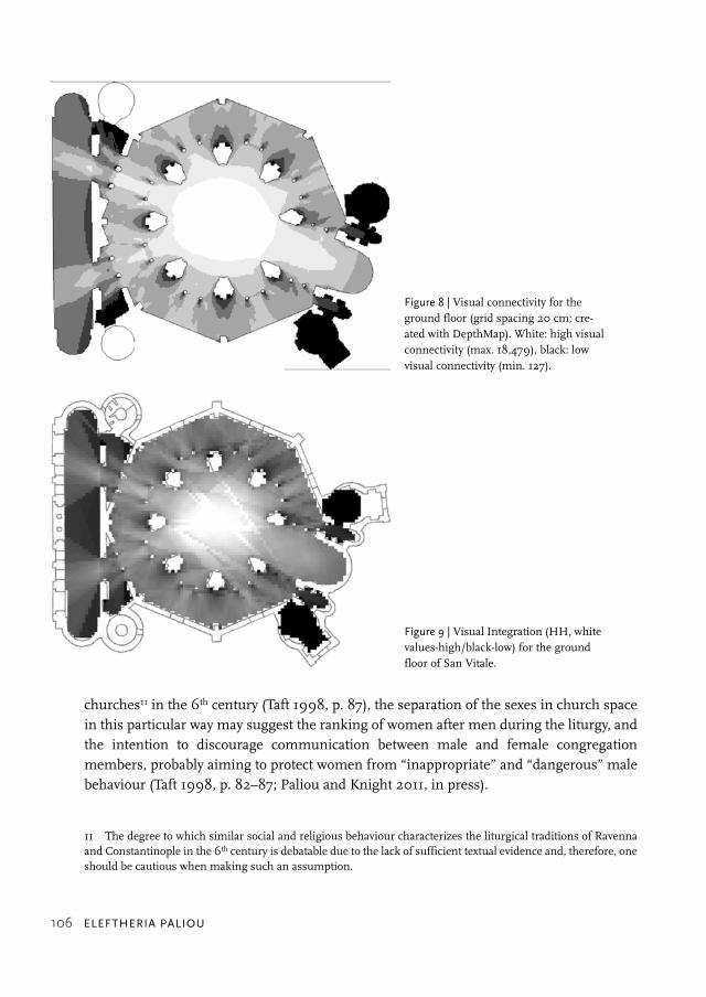
intervals (one every 20 cm, fig. 7a), then recording the ground floor area that can be seenfrom each observer location, and finally analysing information incorporated in binaryviewsheds9 using a GIS. In this case, the final output of the analysis was “times seen” maps(fig. 7b), namely raster images composed by summing up binary viewsheds, whichdescribe how many times different areas of the ground floor are sighted from the matro-neum.
This process allowed quantitative comparisons of the visual experience of men andwomen in church space. The visual access to the liturgical foci from the ground floor wasexamined with visual connectivity maps created using Depthmap (fig. 8). These revealedthat the chancel area, the main focus of attention during the liturgy, is visible on averagefrom 12,623 locations on the ground floor.10 On the other hand, the “times seen” mapdescribing the visibility of the same area from the galleries showed that it can be visuallyaccessed only from 1,026 locations on average (out of 10,270 viewpoints defined by a grid of20 cm intervals: fig. 7a,b). This map also suggests the relatively restricted visual accessfrom the galleries towards the main nave area, where men would have been located. Fig 7cshows that the locations in the galleries which can see a significant part of the area of thechancel (more than 20%) are rather few (1,643 out of a total of 10,270). It follows then thatfemale members of the congregation had somewhat limited visual access to the perform-ance of the ritual compared with those situated on the ground floor. If women, in additionto the galleries, occupied the aisles flanking the nave (left or right), as applies to the sixthcentury liturgy at Constantinople (Taft 1998, p. 36–39), then they would still have been situ-ated on the least visually integrated areas of the ground floor (as suggested by VisibilityGraph analysis in fig. 9). Visual access from the nave area to these spaces (and vice versa)would have, therefore, been restricted.
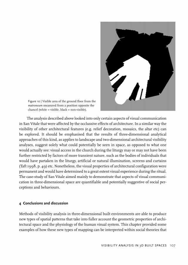
On the other hand, it is also important to note that some locations in the matroneumwould have offered special and literally transcendental views from above (Paliou andKnight, in press) (fig. 10). The few worshippers located in these areas would have perhapsthe most advantageous visual access during the service, as they would have been able toobserve clearly both the unfolding events on the ground floor, and a large number of con-gregation members in the nave area at the same time. Still, the locations in the galleriesoffering such views are limited (fig. 7c); the results of the analysis (fig. 7, 8, 9) mainly sug-gest restricted visual connectivity between the areas allocated to women and the chancelarea, as well as the main nave area occupied by men. Such visual restrictions, which con-cern locations in church space designated for the female rather than the male participants,are imbued with symbolic meaning. If the liturgical rites in Ravenna are associated withsimilar social and religious behaviours as those documented for Constantinopolitan
9 Maps that show visible and non-visible areas (fig. 5, fig. 10).10 The viewer locations on the ground floor were defined by a grid of 20 cm intervals.
UnangemeldetHeruntergeladen am | 13.10.14 19:25
106 ELEFTHERIA PALIOU
churches11 in the 6th century (Taft 1998, p. 87), the separation of the sexes in church spacein this particular way may suggest the ranking of women after men during the liturgy, andthe intention to discourage communication between male and female congregationmembers, probably aiming to protect women from “inappropriate” and “dangerous” malebehaviour (Taft 1998, p. 82–87; Paliou and Knight 2011, in press).
11 The degree to which similar social and religious behaviour characterizes the liturgical traditions of Ravennaand Constantinople in the 6th century is debatable due to the lack of sufficient textual evidence and, therefore, oneshould be cautious when making such an assumption.
Figure 8 | Visual connectivity for theground floor (grid spacing 20 cm; cre-ated with DepthMap). White: high visualconnectivity (max. 18,479), black: lowvisual connectivity (min. 127).
Figure 9 | Visual Integration (HH, whitevalues-high/black-low) for the groundfloor of San Vitale.
UnangemeldetHeruntergeladen am | 13.10.14 19:25
VISIBILITY ANALYSIS IN 3D BUILT SPACES 107
The analysis described above looked into only certain aspects of visual communicationin San Vitale that were affected by the occlussive effects of architecture. In a similar way thevisibility of other architectural features (e.g. relief decoration, mosaics, the altar etc) canbe explored. It should be emphasised that the results of three-dimensional analyticalapproaches of this kind, as applies to landscape and two-dimensional architectural visibilityanalyses, suggest solely what could potentially be seen in space, as opposed to what onewould actually see: visual access in the church during the liturgy may or may not have beenfurther restricted by factors of more transient nature, such as the bodies of individuals thatwould have partaken in the liturgy, artificial or natural illumination, screens and curtains(Taft 1998, p. 49) etc. Nonetheless, the visual properties of architectural configuration werepermanent and would have determined to a great extent visual experience during the ritual.The case-study of San Vitale aimed mainly to demonstrate that aspects of visual communi-cation in three-dimensional space are quantifiable and potentially suggestive of social per-ceptions and behaviours.
4 Conclusions and discussion
Methods of visibility analysis in three-dimensional built environments are able to producenew types of spatial patterns that take into fuller account the geometric properties of archi-tectural space and the physiology of the human visual system. This chapter provided someexamples of how these new types of mapping can be interpreted within social theories that
Figure 10 | Visible area of the ground floor from thematroneum measured from a position opposite thechancel (white = visible, black = non-visible).
UnangemeldetHeruntergeladen am | 13.10.14 19:25
108 ELEFTHERIA PALIOU
lay emphasis upon symbolic aspects of visibility in space. The 3D methods described abovecan be used to analyse visual properties of the open space between walls, as well as visualcharacteristics of built forms. Environment-behaviour studies and Rapoport’s Non-VerbalCommunication approach, which seek to examine the ways in which messages of socialstatus, identity and power are encoded and conveyed via visual cues, could benefit fromsuch approaches; maps showing changes in the visibility of a target feature through space(fig. 6, fig. 7c) can help establish the likelihood that this object will be encountered by amobile individual. Furthermore, such maps could facilitate a better understanding of howlandmarks and prominent architectural features could have influenced human movementpatterns in built space and vice versa. When attempting to tackle problems of this nature,however, one should always bear in mind that the intelligibility of objects in built environ-ments depends on many factors: for example, the comprehensibility of the theme in amural painting scene could be affected by lighting conditions (Paliou 2011; Papadopoulosand Earl, this volume), the colour of painted elements and their distance to the viewer. Suchfactors should be considered when trying to assess the communicative potential of archi-tectural features.12 Papadopoulos and Earl in this volume offer some good examples of howdifferent aspects of visibility in the built environment can be approached with a combinationof formal 3D visual analyses.
Furthermore, as was demonstrated by the case study of San Vitale, the 3D analyticalmethods proposed in this chapter can also be used to examine the visibility of spacebetween walls that is associated with social interactions. Encounters and movement in for-mal settings, such as ritual spaces, follow a set of rules that reflect, produce and reproducesocial relations and order (cf. also Hillier, this volume). As applies to some types of Byzan-tine ecclesiastical space, visibility relationships that trigger and shape human interactionscannot always be reduced to two dimensions. Maps such as those presented in Figure 7bare complementary to visual connectivity maps produced with Depthmap (fig. 8) and areexpected to be useful additional tools for understanding visibility patterns in built environ-ments. Moreover, it is also noteworthy that maps summarizing visual properties of spacecan be fused with audibility maps (Paliou and Knight, in press) and produce analytical prod-ucts that suggest the blending of the senses as advocated by anthropological theorists (cf.also Wheatley, this volume).
Ultimately, a number of other concepts used in urban analysis could be examined anddescribed in quantitative terms with the methods presented here. The notion of “monu-mentality” that is discussed by Moore (1996) in his work on Andean architecture could beassociated with a more refined analytical process, which takes into account the precise formof buildings under study. Furthermore, certain notions of what Lynch has termed “imagea-bility” (Lynch 1960), namely “that quality in a physical object which gives it a high probabil-
12 See footnote 7.
UnangemeldetHeruntergeladen am | 13.10.14 19:25

VISIBILITY ANALYSIS IN 3D BUILT SPACES 109
ity of evoking a strong image in any given observer” (Lynch 1960, p. 9), could be exploredquantitatively by comparing, for example, the degree to which different building facades areexposed to an observer situated in a given built context.
It goes without saying that the visualisation of archaeological spaces in 3D is notalways possible with the same degree of success or certainty: archaeological remains areoften hard to interpret in 3D based on surviving evidence, and every attempt to reconstructan archaeological environment has to cope with data quality issues. Still, in recent yearsarchaeologists have systematically tried to address the problems involved in 3D reconstruc-tion of past environments, and formal ways for dealing with uncertainty in these contextshave been proposed (Paliou 2009; Paliou et al. 2011; Earl et al., forthcoming); methods thathave long been known in the field of GIS-based landscape analysis, such as probability orfuzzy mapping, have been employed to incorporate uncertainty in the results of 3D visibil-ity analysis, and identify those occasions where interpretive statements can be made withgreater confidence (Paliou et al. 2011). The further development of computational tools thatacknowledge and seek to consider the special needs of archaeological data is a worthwhiledirection of research that promises to offer new possibilities for the social analysis of pastbuilt environments.
Acknowledgements:I am very grateful to Topoi Excellence Cluster for funding the “Spatialanalysis and social spaces” workshop and the publication of this volume, as well as to theco-organisers of the workshop, Undine Lieberwirth and Silvia Polla. Also many thanks goto David Knight for his advice on the case study of San Vitale and Gianna Yannakopoulou,who made available the San Vitale 3D model.
Bibliographical references
Benedikt, M. L. (1979)“To Take Hold of Space: Isovists and Isovist Fields”, in: Environment and Planning B: Planningand Design 6, pp. 47–65.
Benedikt, M., and Burnham, A. C. (1985)“Perceiving Architectural Space: From Optic Arrays to Isovists”, in: W. Warren, H. andE. R. Shaw (eds.), Persistence and Change – Proceedings of the first International Conference onEvent Perception, Hillsdale, NJ, pp. 103–114.
Boulotis, C. (1992)“Provlimata tis Aigaiakis zografikis kai oi toichografies tou Akrotiriou”, in: Doumas, C. (ed.),Akrotiri Thiras: Eikosi chronia erevnas (1967–1987). Simperasmata-Provlimata-Prooptikes,Athens, pp. 81–93.
Boulotis, C. (2005)“Aspects of Religious Expression at Akrotiri”, in: Periodical Publication of the Society for thePromotion of Studies on Prehistoric Thera 3, pp. 20–75.
UnangemeldetHeruntergeladen am | 13.10.14 19:25
110 ELEFTHERIA PALIOU
Chapin, A. P. (2004)“Power, Privilege and Landscape in Minoan Art”, in: A. Chapin (ed.), Charis: Essays in Honorof Sara A. Immerwahr [Hesperia Supplement 33], New Jersey, The American School of ClassicalStudies at Athens, pp. 47–64.
Clark, D. L. C. (2007)“Viewing the Liturgy: A Space Syntax Study of Changing Visibility and Accessibility in theDevelopment of the Byzantine Church in Jordan”, in: World Archaeology 39, pp. 84–104.
Deichmann, F. W. (1989)Ravenna, Haupstadt des spätantiken Abendlandes, vol. III. Stuttgart.
Doumas, C. (1992)The Wall-paintings of Thera, Athens, The Thera Foundation.
Doumas, C. (2005)“La Répartition Topographique des Fresques dans les Bâtiments d’Akrotiri à Théra”, in:I. Bradfer-Burdet, B. Detournay, and R. Laffineur (eds.), Kris Technitis: L’ Artisan Crétois.Recueil d’articles en l’ honneur de Jean-Claude Poursat, publié à l’occasion de 40 ans de la décou-verte du Quartier Mu, Liège, pp. 73–81.
Earl, G. P. (2005)“Texture Viewsheds: Spatial Summaries of Built Archaeological Spaces Derived from GlobalLight Mapping.” in: Proceedings of the 11th International Conference on Virtual Systems andMultimedia, October 2005, Ghent, Belgium, pp. 303–312.
Earl, G., Porcelli, V., Papadopoulos, C., Beale, G., Harrison, M., Pagi, H., and Keay, S.(forthcoming)“Formal and Informal Analysis of Rendered Space: The Basilica Portuense”, in: A. Bevan andM. Lake (eds.), Computational Approaches to Archaeological Spaces.
Fisher, K. (2009)“Placing Social Interaction: An Integrative Approach to Analyzing Past Built Environments”,in: Journal of Anthropological Archaeology 28, pp. 439–457.
Franz, G., and Wiener, J. M. (2005)“Exploring Isovist-Based Correlates of Spatial Behavior and Experience”, in: A. Ness (ed.),Proceedings of the 5th International Symposium on Space Syntax, Delft, pp. 503–517.
Gates, C. (2004)“The Adoption of Pictorial Imagery in Minoan Wall Painting: A Comparative Perspective”,in: A. Chapin (ed.), Charis: Essays in Honor of Sara A. Immerwahr [Hesperia Supplement 33],New Jersey, The American School of Classical Studies at Athens, pp. 27–46.
Grossmann, P. (1973)S. Michele in Africisco zu Ravenna, DAI Rom, Mainz a. Rhein.
Higuchi, T. (1983)The Visual and Spatial Structure of Landscapes, Cambridge, MA.
Hillier, B., and Hanson, J. (1984)The Social Logic of Space, Cambridge, UK.
UnangemeldetHeruntergeladen am | 13.10.14 19:25

VISIBILITY ANALYSIS IN 3D BUILT SPACES 111
Hohmann-Vogrin, A. (2005)“Space Syntax in Maya Architecture.”, in: A. Ness (ed.), Proceedings of the 5th InternationalSymposium on Space Syntax, Delft, pp. 279–292.
Knight, D. J. (2010)The Archaeoacoustics of San Vitale, Ravenna, University of Southampton, M. Phil thesis, avail-able at http://eprints.soton.ac.uk/ (22 September 2012).
Krautheimer, R. (1986)Early Christian and Byzantine Architecture, (revised by Curcic, S.), London.
Letesson, Q., and Vansteenhuyse, K. (2006)“Towards an Archaeology of Perception: ‘Looking’ at the Minoan Palaces”, in: Journal of Medi-terranean Archaeology 19, pp. 91–119.
Lynch, K. (1960)The Image of the City, Cambridge, MA.
Mainstone, R.J. (1988)Hagia Sophia: Architecture, Structure and Liturgy of Justinian’s Great Church, New York.
Marinatos, N. (1984)Art and Religion in Thera: Reconstructing a Bronze Age Society, Athens.
Michailidou, A. (2001)Akrotiri Thiras: I meleti ton orofon sta ktiria tou oikismou, Athens.
Moore, D., J. (1996)Architecture and Power in the Ancient Andes – The Archaeology of Public Buildings, Cambridge,UK.
Morgan, L. (1988)The Miniature Wall Paintings of Thera: A Study in Aegean Culture and Iconography, Cambridge,UK.
Paliou, E. (2009)The Visual Consumption of Mural Painting in Late Bronze Age Akrotiri (Thera, Greece): A Com-putational Approach to Visibility Analysis in Three-Dimensional Built Environments, Universityof Southampton (PhD thesis, unpublished).
Paliou, E. (2011)“The Communicative Potential of Theran Murals in Late Bronze Age Akrotiri: ApplyingViewshed Analysis in 3D Townscapes”, in: Oxford Journal of Archaeology, August 2011,pp. 30–33.
Paliou, E., and Knight D. J (in press)“Mapping the Senses: Perceptual and Social Aspects of Late Antique Liturgy in San Vitale,Ravenna”, in: F. Contreras and J. Melero (eds.), Proceedings of CAA 2010, Computer Appli-cations and Quantitative Methods in Archaeology, International Conference, Granada, 6–9 April2010.
UnangemeldetHeruntergeladen am | 13.10.14 19:25

112 ELEFTHERIA PALIOU
Paliou, E., and Wheatley, D. (2007)“Integrating Spatial Analysis and 3D Modelling Approaches to the Study of Visual Space:Late Bronze Age Akrotiri”, in: A. Figueiredo and G. L. Velho (eds.), The World is in Your Eyes –Proceedings of the XXXIIIrd Computer Applications in Archaeology Conference, 21–24 March 2005(Tomar, Portugal), Tomar, pp. 307–312.
Paliou, E., Wheatley, D., and Earl, G. P. (2011)“Three-Dimensional Visibility Analysis of Architectural Spaces: Iconography and Visibilityof the Wall Paintings of Xeste 3 (Late Bronze Age Akrotiri)”, in: Journal of ArchaeologicalScience 38, 2, pp. 375–386.
Palyvou, C. (1999)Akrotiri Thiras: I oikodomiki techni, Athens.
Palyvou, C. (2005)Akrotiri Thera: An Architecture of Affluence 3,500 Years Old, Philadelphia, Pennsylvania.
Rapoport, A. (1990)The Meaning of the Built Environment. A Nonverbal Communication Approach. With a New Epi-logue by the Author, Tucson, Arizona.
Schachermeyr, F. (1978)“Akrotiri: First Maritime Republic?”, in: C. Doumas (ed.), Thera and the Aegean World I.Papers Presented at the Second International Scientific Congress, Santorini, Greece, August 1978,London, pp. 423–428.
Smith, M. (2011)“Empirical Urban Theory for Archaeologists”, in: Journal of Archaeological Method and Theory,18 (3), pp. 167–192.
Taft, R. F. (1998)“Women at Church in Byzantium: Where, When and Why”, in: Dumbarton Oaks Papers 52,pp. 27–87.
Televantou, C. (1994)Akrotiri Thiras: Oi toichografies tis Dytikis Oikias, Athens.
Thaler, U. (2009)Architektur der Macht – Macht der Architektur: Mykenische Paläste als Dokument und Gestal-tungsrahmen frühgeschichtlicher Sozialordnung, University of Heidelberg, PhD thesis (unpub-lished).
Turner, A., Doxa, M., O’ Sullivan, D., Penn, A. (2001)“From Isovists to Visibility Graphs: A Methodology for the Analysis of Architectural Space”,in: Environment and Planning B: Planning and Design 28, pp. 103–121.
Turner, A. (2003)“Analysing the Visual Dynamics of Spatial Morphology”, in: Environment and Planning B:Planning and Design 30, pp. 657–676.
Wallace-Hadrill, A. (1988)“The Social Structure of the Roman House”, in: Papers of the British School at Rome 56,pp. 43–97.
UnangemeldetHeruntergeladen am | 13.10.14 19:25

VISIBILITY ANALYSIS IN 3D BUILT SPACES 113
Watts, D., J., and Strogatz, S. H. (1998)“Collective Dynamics of ‘Small-World’ Networks”, in: Nature 393, pp. 440–442.
Wheatley, D., and Gillings, M. (2002)Spatial Technology and Archaeology: The Archaeological Applications of GIS, London.
UnangemeldetHeruntergeladen am | 13.10.14 19:25

114 ELEFTHERIA PALIOU
UnangemeldetHeruntergeladen am | 13.10.14 19:25