Opportunities for harnessing the increased contribution of glacier and snowmelt flows in the Ganges...
18
Provided for non-commercial research and educational use only. Not for reproduction or distribution or commercial use. This article was originally published by IWA Publishing. IWA Publishing recognizes the retention of the right by the author(s) to photocopy or make single electronic copies of the paper for their own personal use, including for their own classroom use, or the personal use of colleagues, provided the copies are not offered for sale and are not distributed in a systematic way outside of their employing institution. Please note that you are not permitted to post the IWA Publishing PDF version of your paper on your own website or your institution’s website or repository. Please direct any queries regarding use or permissions to [email protected]
-
Upload
independent -
Category
Documents
-
view
0 -
download
0
Transcript of Opportunities for harnessing the increased contribution of glacier and snowmelt flows in the Ganges...

Provided for non-commercial research and educational use only. Not for reproduction or distribution or commercial use.
This article was originally published by IWA Publishing. IWA Publishing recognizes the retention of the right by the author(s) to photocopy or make single electronic
copies of the paper for their own personal use, including for their own classroom use, or the personal use of colleagues, provided the copies are not offered for sale and
are not distributed in a systematic way outside of their employing institution.
Please note that you are not permitted to post the IWA Publishing PDF version of your paper on your own website or your institution’s website or repository.
Please direct any queries regarding use or permissions to [email protected]
Water Policy 15 (2013) 9–25
Opportunities for harnessing the increased contribution ofglacier and snowmelt flows in the Ganges basin
doi: 10.
© IWA
Bharat R. Sharmaa and Devaraj de Condappab
aCorresponding author. International Water Management Institute, New Delhi Office, NASC Complex, Pusa,New Delhi-110012, India. E-mail: [email protected] Environment Institute, Puducherry Centre, India
Abstract
The topography of the Ganges basin is highly variable, with the steep mountainous region of the Himalayaupstream and the large fertile plains in eastern India and Bangladesh downstream. The contribution from the gla-ciers to streamflows is supposed to be significant but there is uncertainty surrounding the impact of climate changeon glaciers. An application of the Water Evaluation and Planning model was set up which contained an experimen-tal glaciers module. The model also examined the possible impacts of an increase in temperature. The contributionfrom glaciated areas is significant (60–75%) in the Upper Ganges but reduces downstream, falling to about 19% atFarakka. Climate change-induced rise in temperature logically increases the quantity of snow and ice that melts inglaciated areas. However, this impact decreases from upstream (þ8% to þ26% at Tehri dam) to downstream(þ1% to þ4% at Farakka). Such increases in streamflows may create flood events more frequently, or ofhigher magnitude, in the upper reaches. Potential strategies to exploit this additional water may include the con-struction of new dams/reservoir storage and the development of groundwater in the basin through managed aquiferrecharge. The riparian states of India, Nepal and Bangladesh could harness this opportunity to alleviate physicalwater scarcity and improve productivity.
Keywords: Ganges basin; Managed aquifer recharge; Snow and glacier melt; Water Evaluation and Planning(WEAP) model
1. Introduction
The Ganges basin in South Asia is a large basin with good supplies of both surface and groundwaterbut it faces wide economic and physical water scarcity. The Ganges basin is the world’s most populousbasin with more than 500 million people inhabiting it in 2001 (average population density of 520 per-sons per km2) with an expected rise to 720 million by 2025 (Pun, 2004). Large populations placeconsiderable pressure on the availability of freshwater resources. Land and water productivity for
2166/wp.2013.008
Publishing 2013
B. R. Sharma and D. de Condappa / Water Policy 15 (2013) 9–2510
most crops and fisheries is low and the population dependent on agriculture (.85%) is very poor(Sharma et al., 2010). The Ganges basin is about 1.09 M km2, distributed between India (79%),Nepal (13%), Bangladesh (4%), and the rest in Tibet (China). The topography of the Ganges basin ishighly variable, with a steep mountainous region of the Himalaya upstream and large plains in easternIndia and Bangladesh downstream. The primary source of water resources of the Ganges river is theGangotri glacier near Gomukh (Uttarakhand, India) at an elevation of about 4,010 m above mean sealevel. As the Ganges river flows 2,525 km from its headwater to the Bay of Bengal, its flow increasesfrom large tributaries originating in Nepal and Tibet, including the Mahakali, Gandak, Koshi and Kar-nali and decreases as a result of large canal diversions (Hosterman et al., 2012). Surface water resourcesof the Ganges (i.e. its long-term mean annual flow volume as it enters the Bay of Bengal) have beenassessed at 525 BCM (billion1 cubic meters). The alluvial deposits from the river system haveformed the vast fertile Gangetic plains (Jain et al., 2007). In the Ganges basin, the main source ofwater is the (south-west) monsoon rainfall, and also the snow and ice melt in the Himalaya duringthe summer season. More than 70% of the annual rainfall is received from the south-west monsoon(June–August). Spatial variation can be noticed, annual precipitation increasing as we move eastward,varying from 350 mm in the west to about 1,500 to 2,200 mm in the delta region (Mirza, 1997). Themountainous catchments of Chisapani, Devghat, Kampughat and Everest are marked with high precipi-tation, which exceeds potential evaporation (Kirby et al., 2009). During the dry months of December toFebruary, water supply declines significantly with reduced outflow to the delta region in Bangladesh(Islam & Gnauch, 2007). During these dry months, snow and ice melt from the region’s mountainsare critical. The transboundary water sharing between India and Bangladesh is regulated by theGanges Water Treaty (1996). This treaty has the limited purpose of sharing the waters during the dryseason only, from January to May each year (Chowdhury, 2010).The Ganges basin receives a net annual input of 1,170 BCM and, after all the uses in the basin have
been satisfied, net runoff from the basin is about 429 BCM (37% of the input). The Ganges basin is oneof the most heavily cultivated areas in the world and vitally important to food security in South Asia.Agriculture production varies throughout the basin and different regions rely on distinct combinations ofrainfed systems, and surface and groundwater irrigation, to support crop growth (Hosterman et al.,2012). Rainfed agriculture in the basin covers almost 52% of the basin area, with a mean annual useof 372 BCM (32% of water used). Irrigated agriculture covers 25% of the basin, with 17% of thetotal area irrigated from surface water resources and 8% from groundwater (210 BCM, 18% of totalwater use). Most of the irrigated water used is for crops irrigated with surface water (70%), with theremaining 30% from groundwater irrigated crops (Kirby et al., 2006a, b; Eastham et al., 2010). Inthe upper mountainous catchments, agricultural production is low and mixed with livestock systems.Agricultural production is intensive and highly developed in the western portion of the basin andrelies heavily on large-scale surface water diversion canals from the Ganges, and on groundwater irriga-tion to produce rice, wheat, sugarcane and other crops. Land and water productivity in the rice–wheatsystems is relatively high in this region (Cai & Sharma, 2010). Farmers in the eastern portion of thebasin (eastern Uttar Pradesh, Bihar and West Bengal states in India, the Nepal Terai and parts of Ban-gladesh) primarily produce rice, wheat, maize, vegetables and fish. Yet, despite the abundance ofsurface water and the prolific groundwater aquifers, productivity has remained low due to the limited
1 In this paper, 1 billion¼ 1� 109.

B. R. Sharma and D. de Condappa / Water Policy 15 (2013) 9–25 11
development of water and other infrastructure, small farm size and high population density, and frequentflooding and poor drainage (Dixit, 2009; Sharma et al., 2010). As such, large populations have remainedpoor and vulnerable. Unfortunately, the high seasonal concentration and variability of precipitation arepredicted to increase the intensity and frequency of extreme events, with the potential for increasedflooding during periods of high precipitation (Bates et al., 2008). These predictions have not yettaken into account the impact of snow and glacier melt on the streamflows.The water quality position of the Ganges is dismal, particularly in the plains, due to point source pol-
lution caused by the discharge of sewage and industrial wastewater from major cities like Delhi, Agra,Kanpur, Varanasi, Patna and Kolkatta, and from arsenic contamination in the downstream regions inWest Bengal and Bangladesh (Chakraborti et al., 2004).
2. Contribution of snow and glaciers
The primary source of water in the Ganges basin is the summer monsoons and snow and ice meltfrom the Himalayan mountains. Himalayan basins have considerable snow- and glacier-covered areas(∼40,000 km2; Raina & Srivastava, 2008). Significant proportions of annual precipitation fall assnow in the high Himalayan mountains and, over long periods of time, the snowfall has built up intoglaciers which are semi-permanent reservoirs of water preserved as ice. Snowpacks accumulateduring the winter periods to be released as melt waters during spring and summer, giving a distinct sea-sonal rhythm to annual flow regimes in streams. The Ganges river, located in the monsoon climate,receives much of its snow during the summer; this snow is then melted almost immediately to contributeto streamflow. The release of water stored as glacier ice is particularly significant in years of low pre-cipitation and during the late summer period when seasonal snowpacks have largely melted. Thus,glaciers provide a buffering effect on streamflow, acting as regulators and providing insurance againsttimes of low flow (Singh et al., 2011). During the dry months (December to February), snow and icemelt from the mountains is critical. However, while in the short-term glacier melt will provide extrawater to the rivers, in the longer term (when those ice masses melt out) the extra water will nolonger be available and the all-important buffering effect will disappear.Snow and ice comprise 2.4, 0.5 and 0.04% of the Ganges source (2,004 km2), Ghaghara
(570 km2) and Upper Yamuna (11 km2) catchments, respectively. The Ganges basin has a totalof 1,020 large glaciers (WWF, 2005). The International Centre for Integrated Mountain Develop-ment (ICIMOD) estimated a total of 7,963 glaciers covering an area of 9,012 km2 and with atotal ice reserve of 793.53 km3 for the Ganges river system (Bajracharya & Shreshtha, 2011). Var-ious studies examining the Himalaya have quantified the changes using detailed climate–snowmeltmodels to estimate the contribution of glaciers to the Ganges river; one such study arrived at a valueof 9% on an annual basis ( Jianchu et al., 2007). However, there is a wide variation among thedifferent studies. More importantly, these contributions are quite large in the upstream catchmentsand become less important downstream. With the debate over melting glaciers in the Himalayanregion becoming more pronounced (Ren et al., 2006; Kulkarni et al., 2007; Prasad & Singh,2007; Solomon et al., 2007; Jain, 2008; Kehrwald et al., 2008; Gautam et al., 2009; Lau et al.,2010) and with the paucity of data for very precise process-based studies, there is an urgentneed to study this aspect in a basin-wide mode. Such an analysis would help to identify the impactsof future climate change on water resources and opportunities for harnessing the potential benefits.

B. R. Sharma and D. de Condappa / Water Policy 15 (2013) 9–2512
The present study is an attempt to provide a preliminary analysis of the following researchquestions:
(i) What are the potential contributions of glacier and snow melt to the flows of the Ganges basin inthe context of climate change?
(ii) What are the potential impacts of the additional water, from glacier and snowmelt, on trans-boundary water sharing?
(iii) What are the available opportunities for harnessing the potential impacts?
3. Methodology and data
The assessment of water resources and the impact of climate change on changes in their availabilityhave been studied in the past by employing a number of models such as the Soil Water Assessment Tool(SWAT) (Mulligan et al., 2011), NASA fvGCM (Lau et al., 2010), GOCART (Yu et al., 2010) and byemploying general mass balance equations. However, most of these models are highly data intensiveand cannot be employed under the data scarce conditions of the Himalaya. We applied the Water Evalu-ation and Planning (WEAP; http://www.weap21.org/) model, which contains an experimental glaciermodule that accounts for snow and glacier processes in the Ganges basin, i.e. seasonal mass variationsand contributions to streamflow. The WEAP system is an initiative of the Stockholm Environment Insti-tute. It emerged from the water resources management modelling tradition, where the focus is onsimulating the management of built hydraulic infrastructure and the implementation of regulatoryregimes in a multi-objective setting, based on assumed hydrologic input information. WEAP employsa unique approach where a database maintains water demand and supply information to drive a massbalance model on a link-node architecture. As climate change becomes an increasingly important chal-lenge facing water managers, WEAP has expanded to include integrated hydrologic simulationfunctionality. The simulation calculates water demand, supply, runoff, infiltration, crop requirements,flows and storage. With this enhanced version, dynamically integrated rainfall/runoff routines translateinformation on climate and catchment conditions into hydrologic fluxes that drive the existing watersystem simulation routines (Yates et al., 2005). It has been applied to various regions in the world,such as North and South America (e.g., Null et al., 2010; Sandoval-Solis et al., 2011), West Africa(e.g., de Condappa et al., 2009) and the Middle East (e.g., Al-Omari et al., 2009). It has also beencoupled with MODFLOW to enable a dynamic planning of surface and groundwater (Droubi et al.,2008). Recent work in the Andes and the Himalayan regions has allowed for the integration of a glacierroutine into these rainfall/runoff calculations by employing the degree-day method.The WEAP model helped to: (i) simulate the surface water resources in the Ganges basin with special
focus on the contribution from snow and glacier melting, as well as the anthropogenic utilization of theresources; and (ii) enable an effortless development of prospective scenarios to climate change (increasein temperature). The first step was to gather the input data, such as the digital elevation model (DEM),land use, climate time series, observed streamflows, glacier coverage and water diversions/uses in theGanges basin. The basic units of modelling were the sub-basins, sub-divided by elevation bands.The Ganges basin was discretised with respect to elevation so as to account for the variation with alti-tude of the glacier coverage and climate. In the second step, WEAP was calibrated and partly validatedon observed streamflows. The task of setting WEAP-Ganges meant validating the hydrological objects
B. R. Sharma and D. de Condappa / Water Policy 15 (2013) 9–25 13
so as to reproduce the observed streamflows at the outlet of the given sub-basin. As time series ofobserved streamflows and glaciers area were not available, the WEAP application developed in thestudy could not precisely model the processes and, instead, provided general trends. In a third step,we applied WEAP to analyse the current context of the surface water resources in the Ganges basin,in particular the contribution from the melting of glaciers. We also examined possible impacts of anincrease in temperature of þ1, þ2, or þ3 °C over 20 years.The data for the streamflows were obtained from the Global Runoff Data Centre (GRDC, 2008),
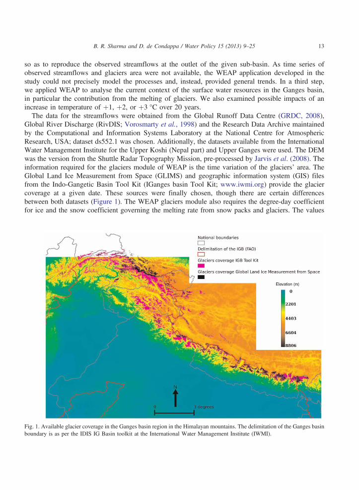
Global River Discharge (RivDIS; Vorosmarty et al., 1998) and the Research Data Archive maintainedby the Computational and Information Systems Laboratory at the National Centre for AtmosphericResearch, USA; dataset ds552.1 was chosen. Additionally, the datasets available from the InternationalWater Management Institute for the Upper Koshi (Nepal part) and Upper Ganges were used. The DEMwas the version from the Shuttle Radar Topography Mission, pre-processed by Jarvis et al. (2008). Theinformation required for the glaciers module of WEAP is the time variation of the glaciers’ area. TheGlobal Land Ice Measurement from Space (GLIMS) and geographic information system (GIS) filesfrom the Indo-Gangetic Basin Tool Kit (IGanges basin Tool Kit; www.iwmi.org) provide the glaciercoverage at a given date. These sources were finally chosen, though there are certain differencesbetween both datasets (Figure 1). The WEAP glaciers module also requires the degree-day coefficientfor ice and the snow coefficient governing the melting rate from snow packs and glaciers. The values
Fig. 1. Available glacier coverage in the Ganges basin region in the Himalayan mountains. The delimitation of the Ganges basinboundary is as per the IDIS IG Basin toolkit at the International Water Management Institute (IWMI).

B. R. Sharma and D. de Condappa / Water Policy 15 (2013) 9–2514
found in the literature are compiled in Table 1. Finally, the recurrent value for the rain–snow temperaturethreshold read in three references (Hasnain, 1999; Thayyen et al., 2005; Singh et al., 2008) for theregion is 2 °C.Following the approach of Condom et al. (2007), the Ganges basin was further discretised with
respect to elevation so as to account for the variation with altitude of glacier coverage and of the climate.In their study of the Gangotri glacier, Singh et al. (2008) used 400 m elevation bands. Given that theGanges basin is such a huge area, we opted for a coarser cut. Analysis of the GLIMS databaseshowed that glaciers are not present below 3,000 m, their occurrence increasing with elevation, reachinga maximum between 5,000 to 6,000 m before decreasing. Hence we chose 0 to 3,000 m for the firstelevation band and defined an elevation band every 1,000 m, upwards. Obviously such a choice doesnot subdivide further sub-basins that are in the plains, below 3,000 m, and which have no glaciers.These spatial units, defined by subdividing the sub-basins with elevation bands as explained above,
were the spatial modelling entities of WEAP-Ganges. We proceeded by river system (e.g., Ganges,Yamuna, Koshi), from upstream to downstream, with a monthly calculation time step. In each modellingentity were placed:
(i) hydrological objects that simulate (a) land-use-related rainfall/runoff and snow melting processes innon-glaciated areas and (b) glaciers and snow melting in glaciated areas; and
(ii) water infrastructures and demand objects that account for water uses.
Setting WEAP-Ganges meant calibrating and possibly validating the hydrological objects so as toreproduce the observed streamflows at the outlet of a given sub-basin. In concrete terms, calibrationwas achieved by matching the parameters of the hydrological objects that pertain to the following:
(i) The glaciers, i.e., the degree-month coefficient, calculated by multiplying the degree-day coefficientby 30, and the rain–snow temperature threshold. As initial values, we referred to values mentionedin Table 1.
(ii) Land use-related rainfall/runoff processes, i.e., land parameters, such as the soil layers’ retentioncapacities, their conductivity and a runoff coefficient. The initial values were those plausible forthe given land use.
Whenever large time series of observed data were available, i.e., more than 10 recent years, part ofthis time series was kept aside for validation. We also evaluated the quality of the WEAP-Ganges andfound that it was satisfactory (as it was possible to simulate average monthly and annual flow trends) forthe Nepalese sub-basins, where observed time series were available and where most of the glaciersare present. As such, it was possible to consider monthly average trends for glacier-related analyses.
Table 1. Some values for the degree-day coefficient.
Source Degree-day coefficient
Singh et al. (1995) Ice: 5.4 mm/°C/6 hSingh et al. (1999) Ice: 8 mm/°C/day; Snow: 6.3 mm/°C/daySingh et al. (2008) Ice: 2.5 to 9 mm/°C/day
B. R. Sharma and D. de Condappa / Water Policy 15 (2013) 9–25 15
In several other sub-basins the quality was variable and as such was good for providing average trends.Other limitations of the current version of WEAP-Ganges include the following:
(i) WEAP-Ganges does not cover the entire Ganges basin but just the part up to the Farakka barragein India. Below that point the impact of glaciers on streamflows was rather small.
(ii) No time series for glacier coverage was available; hence the calibration of the WEAP glaciermodule aimed at reproducing streamflows, while an additional calibration target could be thevariation of the glaciers’ area.
(iii) The description of glacier behaviour is based on a simple conceptual model, which may not cap-ture all glacier processes.
As such, the authors would like to emphasize that the results of the study are preliminary, given themodel’s inherent assumptions, the uncertainties of climate change and any future developments in thebasin. However, they can provide average annual trends for the basin.
4. Results and discussion
4.1. Contribution from the melting of snow and ice in the glaciated areas
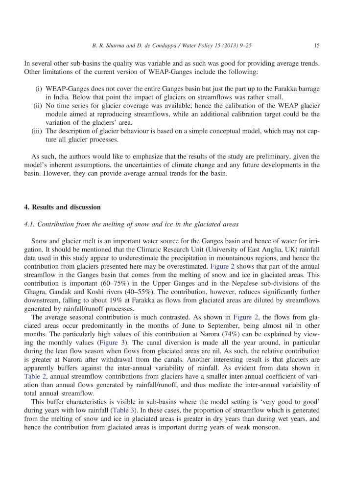
Snow and glacier melt is an important water source for the Ganges basin and hence of water for irri-gation. It should be mentioned that the Climatic Research Unit (University of East Anglia, UK) rainfalldata used in this study appear to underestimate the precipitation in mountainous regions, and hence thecontribution from glaciers presented here may be overestimated. Figure 2 shows that part of the annualstreamflow in the Ganges basin that comes from the melting of snow and ice in glaciated areas. Thiscontribution is important (60–75%) in the Upper Ganges and in the Nepalese sub-divisions of theGhagra, Gandak and Koshi rivers (40–55%). The contribution, however, reduces significantly furtherdownstream, falling to about 19% at Farakka as flows from glaciated areas are diluted by streamflowsgenerated by rainfall/runoff processes.The average seasonal contribution is much contrasted. As shown in Figure 2, the flows from gla-
ciated areas occur predominantly in the months of June to September, being almost nil in othermonths. The particularly high values of this contribution at Narora (74%) can be explained by view-ing the monthly values (Figure 3). The canal diversion is made all the year around, in particularduring the lean flow season when flows from glaciated areas are nil. As such, the relative contributionis greater at Narora after withdrawal from the canals. Another interesting result is that glaciers areapparently buffers against the inter-annual variability of rainfall. As evident from data shown inTable 2, annual streamflow contributions from glaciers have a smaller inter-annual coefficient of vari-ation than annual flows generated by rainfall/runoff, and thus mediate the inter-annual variability oftotal annual streamflow.This buffer characteristics is visible in sub-basins where the model setting is ‘very good to good’
during years with low rainfall (Table 3). In these cases, the proportion of streamflow which is generatedfrom the melting of snow and ice in glaciated areas is greater in dry years than during wet years, andhence the contribution from glaciated areas is important during years of weak monsoon.
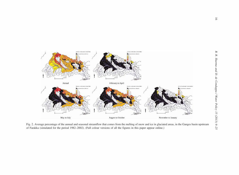
Fig. 2. Average percentage of the annual and seasonal streamflow that comes from the melting of snow and ice in glaciated areas, in the Ganges basin upstreamof Farakka (simulated for the period 1982–2002). (Full colour versions of all the figures in this paper appear online.)
B.R.Sharm
aand
D.de
Condappa
/Water
Policy
15(2013)
9–25
16
Fig. 3. Average monthly contribution from the melting of snow and ice in glaciated areas at some locations in the Ganges basin (simulated for the period 1982–2002).
B.R.Sharm
aand
D.de
Condappa
/Water
Policy
15(2013)
9–25
17

Table 3. Average contribution from melting of snow and ice in glaciated areas simulated for some sub-basins where theWEAP-Ganges’ setting was ‘very good’ to ‘good’.
No. Sub-basin
Average proportion of annual streamflows from glaciated areas
For 1982–2002 For 3 wet years For 3 dry years
44 Busti 44% 40% 46%46 Rabuwa Bazar 45% 40% 50%51 Chatara Kothu 24% 22% 26%
The estimates are ‘Preliminary’ due to the coarse detail achieved in the modelling.
Table 2. Partitioning of average annual streamflow generated from rainfall/runoff and glacier processes at Haridwar andFarakka (simulated for period 1982 to 2002).
Haridwar sub-basin (upstream) Farakka sub-basin (downstream)
Parameter Total Rainfall/runoff Glaciers Total Rainfall/runoff Glaciers
Average flow, km3/yr 30.4 12.0 18.4 335.2 275.0 60.2Coeff. of variation, % 11 20 11 21 24 8
The estimates are ‘Preliminary’ due to the coarse detail achieved in the modelling.
B. R. Sharma and D. de Condappa / Water Policy 15 (2013) 9–2518
4.2. Impact of temperature rise on the melting of glaciers
Intergovernmental Panel on Climate Change (IPCC) and other reports agree on the potential rise inatmospheric temperatures due to a variety of anthropogenic and other factors (Solomon et al., 2007).However, the magnitude of the rise in temperature is quite variable. The IPCC (Christensen et al.,2007) indicates that, in the Tibetan range, the temperature rise at the end of the century could beþ3.8 °C. Studies by ICIMOD (2009) and other agencies provide information of the same magnitude.Therefore, we considered the following three scenarios:
(i) An increase of 1 °C after 20 years, i.e., a rate of þ0.05 °C/year (optimistic).(ii) An increase of 2 °C after 20 years, i.e., a rate of þ0.10 °C/year (business-as-usual).(iii) An increase of 3 °C after 20 years, i.e., a rate of þ0.15 °C/year (extreme scenario).
As calibration of the glacier parameters was based solely on observed streamflow data, we only ana-lysed simulated streamflows and not, for instance, variations in glacier area. In each scenario, thetemperature was raised gradually every year. Rise in temperature increases the quantity of snow andice melt in the glaciated areas and thus augments the streamflows. However, the impact decreasesfrom upstream to downstream, as: (i) enhanced contribution from rainfall dilutes flows from glaciatedareas; and (ii) increased temperature also leads to greater evapotranspiration in the plains, and thus smal-ler streamflows. The amount of extra flow is rather insignificant at the Farakka barrage but it issignificant upstream, as for instance in the Upper Ganges at Haridwar and Narora, or in the mountainoussub-basins (e.g., Tehri dam).The simulated impact on average monthly flows in selected locations of the Ganges basin is shown in
Figure 4. As the contribution from glaciated areas mainly occurs during the high flow season, theincrease in streamflow occurs predominantly during the high flow season of June–September. Although
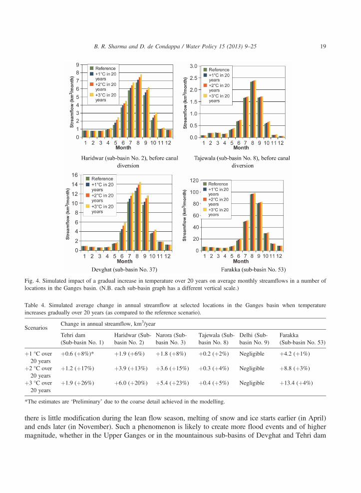
Fig. 4. Simulated impact of a gradual increase in temperature over 20 years on average monthly streamflows in a number oflocations in the Ganges basin. (N.B. each sub-basin graph has a different vertical scale.)
Table 4. Simulated average change in annual streamflow at selected locations in the Ganges basin when temperatureincreases gradually over 20 years (as compared to the reference scenario).
ScenariosChange in annual streamflow, km3/year
Tehri dam(Sub-basin No. 1)
Haridwar (Sub-basin No. 2)
Narora (Sub-basin No. 3)
Tajewala (Sub-basin No. 8)
Delhi (Sub-basin No. 9)
Farakka(Sub-basin No. 53)
þ1 °C over20 years
þ0.6 (þ8%)* þ1.9 (þ6%) þ1.8 (þ8%) þ0.2 (þ2%) Negligible þ4.2 (þ1%)
þ2 °C over20 years
þ1.2 (þ17%) þ3.9 (þ13%) þ3.6 (þ15%) þ0.3 (þ4%) Negligible þ8.8 (þ3%)
þ3 °C over20 years
þ1.9 (þ26%) þ6.0 (þ20%) þ5.4 (þ23%) þ0.4 (þ5%) Negligible þ13.4 (þ4%)
*The estimates are ‘Preliminary’ due to the coarse detail achieved in the modelling.
B. R. Sharma and D. de Condappa / Water Policy 15 (2013) 9–25 19
there is little modification during the lean flow season, melting of snow and ice starts earlier (in April)and ends later (in November). Such a phenomenon is likely to create more flood events and of highermagnitude, whether in the Upper Ganges or in the mountainous sub-basins of Devghat and Tehri dam

B. R. Sharma and D. de Condappa / Water Policy 15 (2013) 9–2520
(Table 4). Such a perceived change is of great consequence for the water infrastructure and the lives andassets of the populations in these regions.On a long-term basis, the combination of glacial retreat, decreasing ice mass, early snowmelt and
increased winter streamflow suggest that climate change is already affecting the Himalayan cryosphere(Kulkarni et al., 2007). Reduced surface runoff will reduce groundwater recharge and affect ground-water dynamics in the region, which will be critical in the western region, where most irrigation isfrom groundwater. SWAT analysis showed an overall reduction in runoff under all greenhouse gas emis-sion scenarios (Gosain & Rao, 2007).
5. Impacts and potential opportunities
The extra water from the glaciated areas in the short to medium term presents a set of potential oppor-tunities and some threats. The extra water can be potentially used for intensification of surface water useand augmentation of groundwater aquifers.
5.1. Surface water resources
The extra water from glaciated areas does not flow when water is most required, i.e., during the lean flowwinter season. Nevertheless, making best use of this extra water presents a potential opportunity. For instance,the Upper Ganges canal currently diverts about 6 km3/year at Haridwar, where the extra water due to theincrease in temperature is about of the same order of magnitude (Table 4). Using this extra water wouldrequire the ability to withdraw and use/store the water during the high flows at suitable locations, such asTehri dam, Haridwar, Narora, etc., which may be somewhat difficult with the existing storage capacitiesand the magnitude of high flows. Nevertheless, the following opportunities could be considered earnestly:
(i) The extra water could be captured by additional reservoirs/dams, in particular in small reservoirs. Thiswater may be used locally or in the context of transboundary agreements between the riparian countries(Bhaduri & Barbier, 2008a). Water storage, in its various forms, provides a mechanism for dealingwith variability (and extra flows) which, if planned and managed correctly, increases water security,agricultural productivity and adaptive capacity (McCartney & Smakhtin, 2010). It should also helpto sufficiently moderate the frequency and intensity of the expected floods in the upstream reaches.As such, these additional storages can make an important contribution to safeguarding livelihoodsand reducing poverty. Amarasinghe & Sharma (2011) showed that a large part of the rural populationin the Ganges basin is chronically poor and almost 10% of the rural poor have monthly per capitaexpenditure below 20% of the poverty line. How well the poor can cope with natural hazards andexternal shocks, and improve their livelihoods, depends upon considerable improvement of thewater infrastructure in the basin. India, Nepal and the bilateral donors need to undertake well-plannedfeasibility studies and make financial commitments for a variety of storage projects in the region.
(ii) The increased flows in May and June (with the early melting of snow and glaciers) could be most ben-eficial in terms of water use, as they happen just after the dry season. This presents a good possibilityfor capturing the magnitude of this extra flow. The additional water would be useful for the irrigationof rice nurseries and for short-duration pulse and vegetable crops, and could more importantly satisfyhigh demands from the domestic and industrial sectors during the hot summer season.

B. R. Sharma and D. de Condappa / Water Policy 15 (2013) 9–25 21
5.2. Groundwater resources
Over the last 50 years, groundwater has become an important source of water for irrigation (Mukherji,2012). The need to produce more food in the near to medium term, given the constraints on availablewater resources, compounded by the challenges and uncertainties associated with climate change,strongly points towards increased and more efficient use of groundwater as one of the key solutions.The western and southern regions of the Ganges basin are witnessing an unprecedented growth ingroundwater use (Jain et al., 2009). By virtue of its nature, groundwater presents an excellent opportu-nity to augment recharge during the high availability period and for a planned use during low/noavailability periods of surface supplies. Managed Aquifer Recharge (MAR) (Gale et al., 2006) is thepractice of purposefully recharging aquifers via surface spreading, or through wells and dykes, for sub-sequent utilization. The benefits of MAR in the Upper Ganges basin (Lakauti distributary) have alreadybeen successfully demonstrated and documented (Sakthivadivel, 2007). Large regional programs in thebasin and adjacent areas could be successfully implemented using the extra water made availablethrough the melting of snow and glaciers upstream.
5.3. Impacts for transboundary states and countries
The Ganges basin in India is shared by a number of Indian states (Uttarakhand, Uttar Pradesh,Madhya Pradesh, Rajasthan, Delhi, Haryana, Bihar and West Bengal) and by Nepal and Bangladesh.Most of the Indian states in the basin face either economic water scarcity (Uttar Pradesh, Bihar andWest Bengal) or severe physical water scarcity for drinking and irrigation (Delhi, Rajasthan, MadhyaPradesh). The existing water sharing mechanisms between the riparian states of India and betweenIndia–Nepal–Bangladesh are weak and a cause of transboundary conflicts (Bhaduri & Barbier,2008b; Bhaduri et al., 2009). The additional water supplies provide an opportunity for the upper riparianstates to beneficially share these waters with the downstream, physically water scarce, regions for mutualbenefits. The positive externalities generated by water transfers from Nepal may influence the watershare of both India and Bangladesh. Higher water supplies in the upper catchments in Nepal providean additional reason to think seriously about the development of its much neglected hydropower poten-tial (Gyawali & Dixit, 2011) and to exhibit political altruism towards resolving transboundary waterconflicts with India and Bangladesh. The Ganges water sharing mechanisms between India and Bangla-desh have seen several changes and even the existing treaty appears to fall short of the expectations ofBangladesh (Chowdhury, 2010). With the projected change in temperature of 1–3° C, the additionalwater flows at Farakka may provide a good opportunity for the riparian countries to devise the bestmeans for gainful utilization of the additional supplies.
6. Conclusions
The Ganges basin is a vast landmass that has been densely populated and intensively cultivated over2,000 years. Today, it is one of the most populous basins in the world. Mastering and manipulatingsnow-fed perennial streams and rivers to water fertile soils has remained the secret of the Gangesbasin’s endemically high population-carrying capacity. Unfortunately, intense anthropogenic activities
B. R. Sharma and D. de Condappa / Water Policy 15 (2013) 9–2522
and the impacts of climate change are now threatening past fortune. The hydrology of the Ganges basin ispartly dependent on glaciers and there are uncertainties about the impact of climate change on them.This study developed an application of the WEAP model which contained an experimental glacier
module simulating snow and ice melting in glaciated areas. The analysis (within the limitations ofthe model and the data) showed that:
(i) the contribution of glacier and snow melt decreases from upstream mountainous sub-basins todownstream flat sub-basins, with a magnitude variation of 75 to 3%;
(ii) glaciated areas contribute to streamflows predominantly during the wet period from June to Sep-tember, i.e., when flows are actually already high; and
(iii) glaciers are apparently a buffer against inter-annual variability of rainfall.
The paper has also examined the impact of temperature rises of 1–3°C over a period of 20 years onstreamflows across the river course. These impacts would be significant upstream while minor down-stream. There are potential opportunities to exploit this additional available water through theconstruction of a number of storage reservoirs that could be used locally, or within the transboundaryagreements between India, Nepal and Bangladesh. There is also a good opportunity to capture thisextra water just at the end of the dry season, when flows from glaciated areas become noticeable andthe demands from agriculture and domestic sectors are at a peak. Using the extra flows for the augmenta-tion of groundwater resources through regional MAR programs is an attractive option for intensive andsustainable use of groundwater resources in the agriculturally important regions of the Ganges basin.The riparian states within India and India–Nepal–Bangladesh have a potential opportunity to alleviatethe physical water scarcity in stressed regions and to better address regional transboundary water conflicts.
References
Al-Omari, A., Al-Quraan, S., Al-Salihi, A. & Abdulla, F. (2009). A water management support system for Amman Zarqa basinin Jordan. Water Resources Management 23, 3165–3189.
Amarasinghe, A. & Sharma, B. R. (2011). Water productivity and poverty in the transboundary river basins of India and Ban-gladesh: a situation analysis. Report developed by IWMI for IUCN program on Ecosystems for Life: A Bangladesh–IndiaInitiative. International Water Management Institute, Colombo, Sri Lanka. See: http://www.iwmi.cgiar.org/Publications/index.aspx, accessed 16 July 2013.
Bajracharya, S. & Shreshtha, B. (2011). The status of glaciers in the Hindu-Kush–Himalayan Region. International Centre forIntegrated Mountain Development, Kathmandu, Nepal, 127 pp.
Bates, B. C., Kundzewicz, Z. W., Wu, S. & Palutikof, J. P. (2008). Climate Change and Water. Technical Paper of the Inter-government Panel on Climate Change (IPCC). IPCC Secretariat, Geneva.
Bhaduri, A. & Barbier, E. (2008a). Linking rivers in the Ganges–Brahmaputra river basin: exploring the transboundary effects.In: Strategic Analyses of the National River Linking Project (NRLP) of India – Series 2. Amarasinghe, U. A. & Sharma, B.R. (eds). International Water Management Institute, Colombo, Sri Lanka, pp. 373–396.
Bhaduri, A. & Barbier, E. B. (2008b). International water transfer and sharing: the case of the Ganges river. Environment andDevelopment Economics 13(01), 29–51.
Bhaduri, A., Manna, U., Barbier, E. & Liebe, J. (2009). Climate change and cooperation in transboundary water sharing: anapplication of stochastic Stackelberg differential games in Volta River basin. Natural Resource Modeling 24(4), 409–444.
Cai, X. L. & Sharma, B. R. (2010). Integrating remote sensing, census and weather data for an assessment of rice yield, waterconsumption and water productivity in the Indo-Gangetic river basin. Agricultural Water Management 97, 309–316.

B. R. Sharma and D. de Condappa / Water Policy 15 (2013) 9–25 23
Chakraborti, D., Sengupta, M. K., Rahman, M. M., Ahamed, S., Chawdhury, U. K., Hossain, M. A., Mukherjee, S. C., Pati, S.,Saha, K. C., Dutta, R. N. & Zaman, Q. Q. (2004). Groundwater arsenic contamination and its health effects in Ganga–Meghna–Brahmaputra plain. Journal of Environmental Monitoring 6(6), 75N–83N.
Chowdhury, N. T. (2010). Water management in Bangladesh: an analytical review. Water Policy 12, 32–51.Christensen, J. H., Hewitson, B., Busuioc, A., Chen, A., Gao, X., Held, I., Jones, R., Kolli, R. K., Kwon, W. T., Laprise, R.,Magaña Rueda, V., Mearns, L., Menéndez, C. G., Räisänen, J., Rinke, A., Sarr, A. & Whetton, P. (2007). Regional ClimateProjections. The Physical Science Basis. Contribution of working group I to the fourth assessment report of the Intergovern-mental Panel on Climate Change. Cambridge University Press, Cambridge, UK and New York, USA. pp. 847–940.
Condom, T., Coudrain, A., Sicart, J. E. & Théry, S. (2007). Computation of the space and time evolution of equilibrium-linealtitudes on Andean glaciers (10°N–55°S). Global and Planetary Change 59, 189–202.
de Condappa, D., Chaponnière, A. & Lemoalle, J. (2009). A decision-support tool for water allocation in the Volta Basin.Water International 34, 71–87. http://www.informaworld.com/10.1080/02508060802677861, accessed 16 July 2013.
Dixit, A. (2009). Kosi embankment breach in Nepal: need for a paradigm shift in responding to floods. Economic and PoliticalWeekly (India) February 7, 70–78.
Droubi, A., Al-Sibai, M., Abdallah, A., Wolfer, J., Huber, M., Hennings, V., El Hajji, K. & Dechiech, M. (2008). Management,Protection and Sustainable Use of Groundwater and Soil Resources in the Arab Region: Development and Application of aDecision Support System (DSS) for Water Resources Management in Zabadani Basin, Syria and Berrechid Basin, Morocco.Report from Phase III of the Technical Cooperation Project between ACSAD and BGR, July 2008. The Arab Centre for theStudies of Arid Zones and Drylands, Damascus, Syria. See: http://www.weap21.org/downloads/BGR-ACSADProjectReport-PhaseIII.pdf, accessed 17 July 2013.
Eastham, J., Kirby, M., Mainuddin, M. & Thomas, M. (2010). Water-use accounts in CPWF basins: simple water-use account-ing of the Ganges basin. BFP05. CPWF Working Papers, Basin Focal Project Series. International Water ManagementInstitute, Colombo, Sri Lanka.
Gale, I. N., Macdonald, D. M. J., Calow, R. C., Neumann, I., Moench, M., Kulkarni, H., Mudrakartha, S. & Palanisami, K.(2006). Managed Aquifer Recharge: an assessment of its role and effectiveness in watershed management. British GeologicalSurvey (BGS) Commissioned Report CR/06/107N. British Geological Survey, Keyworth, Nottingham, UK, 80 pp. See:http://nora.nerc.ac.uk/7453/1/CR06107N.pdf, accessed 17 July 2013.
Gautam, R., Hsu, N. C., Lau, K. M., Tsay, S. C. & Kafatos, M. (2009). Enhanced pre-monsoon warming over the Himalayan–Gangetic region from 1979–2007. Geophysical Research Letters 36, L07704.
Global Runoff Data Centre (GRDC) (2008). The Global Runoff Data Centre. GDRC, 56068 Koblenz, Germany. See: http://www.bafg.de/GRDC, accessed 30 June 2009.
Gosain, A. K. & Rao, S. (2007). Impact assessment of climate change on water resources of two river systems of India. Jal-vigyan Sameeksha 22, 1–20.
Gyawali, D. & Dixit, A. (2011). Mahakali impasse and Indo-Nepal water conflict. Economic and Political Weekly 46, 5 Feb-ruary 2011.
Hasnain, S. I. (1999). Runoff characteristics of a glacierized catchment, Garhwal Himalaya, India.Hydrological Sciences 44, 847–854.Hosterman, H. R., McCornick, P. G., Kistin, E. J., Sharma, B. R. & Bharati, L. (2012). Freshwater, climate change, and adap-tation in the Ganges river basin. Water Policy 14, 67–79.
International Centre for Integrated Mountain Development (ICIMOD) (2009). Climate Change in the Himalayas. Monthly Dis-charge Data for World Rivers. ICIMOD, Kathmandu, Nepal, p. 4.
Islam, S. N. & Gnauch, A. (2007). Mangrove wetland ecosystems in Ganges–Brahmaputra delta in Bangladesh. Frontiers ofEarth Science in China 2(4), 439–448.
Jain, S. K. (2008). Impact of retreat of Gangotri glacier on the flow of Ganga river. Current Science 95, 1012–4.Jain, S. K., Agarwal, P. K. & Singh, V. P. (2007). Ganga Basin. Hydrology and Water Resources of India. Water Science andTechnology Library, Springer, Heidelberg, Germany, pp. 333–418.
Jain, S. K., Sharma, B. R., Zahid, A., Jin, M., Shreshtha, J. L., Kumar, V., Rai, S. P., Hu, J., Luo, Y. & Sharma, D. (2009). Acomparative analysis of the hydrogeology of the Indo-Gangetic and Yellow River basins. In: Groundwater Governance inthe Indo-gangetic and Yellow river Basins: Realities and Challenges. Mukherji, A., Villholth, K. G., Sharma, B. R. & Wang,J. (eds). CRC Press, Taylor & Francis Group, London, UK, pp. 43–66.
Jarvis, A., Reuter, H. I., Nelson, A. & Guevara, E. (2008). Hole-filled SRTM for the globe Version 4. See: http://srtm.csi.cgiar.org, accessed 10 March 2009.
B. R. Sharma and D. de Condappa / Water Policy 15 (2013) 9–2524
Jianchu, X., Shreshtha, A., Vidya, R., Erikson, M. & Hewitt, K. (2007). The Melting Himalayas. ICIMOD Technical Paper,ICIMOD, Kathmandu, Nepal.
Kehrwald, N. M., Thompson, L. G., Tandong, Y., Mosley-Thompson, E., Schotterer, U., Altimov, V., Beer, J., Eikenberg, J. &Davis, M. E. (2008). Mass loss on Himalayan glacier endangers water resources. Geophysical Research Letters 35, L 22503.
Kirby, M., Mainuddin, M., Ahmad, M-u-D., Marchand, P. & Zhang, L. (2006a). Water use account spreadsheets with examplesof some major river basins. In 9th International River Symposium, 3–6 September 2006, Brisbane. International WaterCentre, Brisbane, Australia.
Kirby, M., Mainuddin, M., Podger, G. & Zhang, L. (2006b). Basin water use accounting method with application to theMekong Basin. In: IHP International Symposium on Managing Water Supply for Growing Demand. Sethaputra, S. &Promma, K. (eds). 16–17 October 2006, UNESCO, Bangkok, Jakarta.
Kirby, M., Mainuddin, M. & Eastham, J. (2009). Water-use accounts in CPWF basins: BFP05, Simple water use accountingof the Ganges basin. The Challenge Program on Water and Food, International Water Management Institute, Colombo,Sri Lanka. See: https://cgspace.cgiar.org/bitstream/handle/10568/10190/CPWF_BFP_WP_05.pdf?sequence=1, accessed13 August, 2013.
Kulkarni, A. V., Bahuguna, I. M., Rathore, B. P., Singh, S. K., Randhawa, S. S., Sood, R. K. & Dhar, S. (2007). Glacial retreatin Himalaya using Indian remote sensing satellite data. Current Science 92(1), 69–74.
Lau, K. M. W., Kim, M.-K., Kim, K.-M. & Lee, W.-S. (2010). Enhanced surface warming and accelerated snow melt in theHimalayas and Tibetan Plateau induced by absorbing aerosols. Environment Research Letters 5-025204, 1–10.
McCartney, M. & Smakhtin, V. (2010). Water Storage in an Era of Climate Change: Addressing the Challenge of IncreasingRainfall Variability (Blue Paper). International Water Management Institute, Colombo, 14 pp.
Mirza, M. M. Q. (1997). Hydrological changes in the Ganges system in Bangladesh in the post-Farakka period. HydrologicalSciences – Journal des Sciences Hydrologiques 42, 613–630.
Mukherji, A. (2012). Evolution of irrigation practices: are large scale irrigation systems still relevant? In: Proceedings of AsianIrrigation Forum 2012, 11–13 April 2012. Asian Development Bank, Manila, Philippines. See: http://www.scribd.com/doc/88810930/2012-AIF-D1S2-PPT-Evolution-of-Irrigation-Practices-Are-Large-Scale-Irrigation-Systems-Still-Relevant-by-Aditi-Mukherji, accessed 17 July 2013.
Mulligan, M., Fisher, M., Sharma, B., Xu, Z. X., Ringler, C., Mahe, G., Jarvis, A., Ramirez, J., Clanet, J.-C., Ogilvie, A. &Ahmad, M. D. (2011). The nature and impact of climate change in the Challenge Program on Water and Food (CPWF)basins. Water International 36(1), 96–124.
Null, S. E., Viers, J. H. & Mount, J. F. (2010). Hydrologic response and watershed sensitivity to climate warming in Califor-nia’s Sierra Nevada. PLoS ONE 5(4), e9932.
Prasad, A. K. & Singh, R. P. (2007). Changes in Himalayan snow and glacier cover between 1972 and 2000. EOS Transactionsof the American Geophysical Union 88, 326.
Pun, S. B. (2004). Overview: conflicts over the Ganga? In: Disputes over the Ganga: A Look at Potential Water-Related Con-flicts in South Asia. Subba, B. & Pradhan, K. (eds). Panos Institute South Asia, Kathmandu, Nepal, pp. 2–21.
Raina, V. K. & Srivastava, D. (2008). Glacier Atlas of India. Geological Society of India, Bangalore, pp. 1–316.Ren, J. W., Jing, Z. F., Pu, J. C. & Qin, X. (2006). Glacier variations and climate change in central Himalayas over the past few
decades. Annals of Glaciology 43, 218–22.Sakthivadivel, R. (2007). The groundwater recharge movement in India. In: The Agricultural Groundwater Revolution: Oppor-
tunities and Threats to Development. Giordano, M. & Villholth, K. G. (eds). CAB International, Wallingford, Oxfordshire,UK, pp. 195–210.
Sandoval-Solis, S., McKinney, D. C., Rebecca, L. T. & Patino-Gomez, C. (2011). Groundwater Banking in the Rio GrandeBasin. Journal of Water Resources Planning and Management 137, 62.
Sharma, B., Amarasinghe, U., Xueliang, C., de Condappa, D., Shah, T., Mukherji, A., Bharati, L., Ambili, G., Qureshi, A.,Pant, D., Xenarios, S., Singh, R. & Smakhtin, V. (2010). The Indus and the Ganges: river basins under extreme pressure.Water International 35(5), 493–521.
Singh, P., Ramasastri, K. S. & Singh, U. K. (1995). Hydrological characteristics of the Dokriani Glacier in the Garhwal Hima-layas. Hydrological Sciences Journal 40, 243–257.
Singh, P., Kumar, N. & Bhatnagar, N. K. (1999). Determination of snow and ice melt factors in the Himalayan region throughfield investigations. Report no TR/BR-10/1998-1999. National Institute of Hydrology, Roorkee, India.

B. R. Sharma and D. de Condappa / Water Policy 15 (2013) 9–25 25
Singh, P., Kumar, V., Thomas, T. & Arora, M. (2008). Changes in rainfall and relative humidity in river basins in northwest andcentral India. Hydrological Processes 22, 2982–2992.
Singh, P., Kumar, A. & Kishore, N. (2011). Meltwater storage and delaying characteristics of Gangotri Glacier (Indian Hima-layas) during ablation season. Hydrological Processes 25, 159–166.
Solomon, S., Qin, D., Manning, M., Chen, Z., Marquis, M., Averyt, K. B., Tignor, M. & Miller, H. L. (eds) (2007). ClimateChange 2007: The physical science basis. Contribution of Working Group I to the Fourth Assessment report of the Inter-governmental Panel on Climate Change. Cambridge University Press, Cambridge, UK.
Thayyen, R. J., Gergan, J. T. & Dobhal, D. P. (2005). Monsoonal control on glacier discharge and hydrograph characteristics, acase study of Dokriani Glacier, Garhwal Himalaya, India. Journal of Hydrology 306, 37–49.
Vorosmarty, C. J., Fekete, B. M. & Tucker, B. A. (1998). Global River Discharge, 1807–1991, Version. 1.1 (RivDIS). Data set.Oak Ridge National Laboratory Distributed Active Archive Center, Oak Ridge, Tennessee, USA.
WWF (2005). An overview of glaciers, glacier retreat and subsequent impacts in Nepal, India and China. WWF NepalProgram, Kathmandu, 79 pp. See: www.wwf.or.jp/activities/lib/pdf_climate/environment/Overview_of_Glaciers.pdf, accessed13 August 2013.
Yates, D., Sieber, J., Purkey, D. & Huber-Lee, A. (2005). WEAP21 – A demand-, priority-and preference-driven water plan-ning model. Part 1: Model characteristics. Water International 30, 487–500.
Yu, H., Chin, M., Winker, D. M., Omar, A. H., Zhaoyan, L., Kittaka, C. & Diehl, T. (2010). Global view of aerosol verticaldistributions from CALIPSO lidar measurement and GOCART simulations: regional and seasonal variations. Journal ofGeophysics Research 115 D00H30, 19 pp.