On the shore of a fluctuating lake: Environmental evidence from Ohalo II (19,500 B.P
17
Isr. J. Earth Sci.; 53: 207–223 © 2004 Science From Israel/ LPPLtd. 0021-2164/04 $4.00 E-mail: [email protected] On the shore of a fluctuating lake: Environmental evidence from Ohalo II (19,500 B.P.) Dani Nadel, a Alexander Tsatskin, a Miriam Belmaker, b Elisabetta Boaretto, c Mordechai Kislev, d Henk Mienis, b Rivka Rabinovich, b Orit Simchoni, d Tal Simmons, e Ehud Weiss, d,f and Irit Zohar g a Zinman Institute of Archaeology, University of Haifa, Haifa 31905, Israel b Department of Evolution, Systematics and Ecology, The Hebrew University of Jerusalem, Jerusalem 91904, Israel c Radiocarbon Dating Lab, Department of Environmental Sciences and Energy Research, Weizmann Institute of Science, Rehovot 6100, Israel d Faculty of Life Sciences and Department of Land of Israel Studies, Bar-Ilan University, Ramat Gan 52900, Israel e School of Conservation Science, Bournemouth University, Poole, Dorset, BH12 5BB, UK, and Department of Anthropology, Western Michigan University, Kalamazoo, Michigan 49008, USA f MacCurdy Post-Doctoral Fellow, Department of Anthropology, Peabody Museum, Harvard University, Cambridge, Massachusetts 02138, USA g Department of Zoology, Tel Aviv University, Tel Aviv 69978, Israel, and Department of Maritime Civilizations, and The Leon Recanati Center for Maritime Studies, University of Haifa, Haifa 31905, Israel (Received 15 March 2003; accepted in revised form 17 December 2003) ABSTRACT Nadel, D., Tsatskin, A., Belmaker, M., Boaretto, E., Kislev, M., Mienis, H., Rabinovich, R., Simchoni, O., Simmons, T., Weiss, E., and Zohar, I. 2004. On the shore of a fluctuating lake: Environmental evidence from Ohalo II (19,500 B.P.). Isr. J. Earth Sci. 53: 207–223. The aim of this paper is to provide a high-resolution environmental reconstruction of the Sea of Galilee basin during a very short spell of time at the end of the Upper Pleistocene. We present a multidisciplinary study of sediments and archaeological remains exposed at the submerged and well-preserved Ohalo II prehistoric site. The Ohalo II camp includes in situ brush hut floors, hearths, and other installations, all radiometrically dated to 19,500 B.P. The remains include large quantities of charred material and animal bones. The reconstruction is based on a geoarchaeological study, accompanied by analyses of a wide variety of trees, grasses, mammals, birds, fish, and mollusc remains. The results show that the range of plant and animal species (ca. 240) is not different from that encountered today in the valley and the surrounding slopes. Water level fluctuations were the most dramatic environmental events, probably induced by climatic changes and tectonic activities at the inlet/outlet of the lake. INTRODUCTION The Dead Sea Rift Valley has been the focus of a large number of geological, archaeological, and environmen- tal studies. Many works concentrated on long-term and short-term geological, climatic, and environmental
Transcript of On the shore of a fluctuating lake: Environmental evidence from Ohalo II (19,500 B.P
Isr. J. Earth Sci.; 53: 207–223
© 2004 Science From Israel/ LPPLtd. 0021-2164/04 $4.00
E-mail: [email protected]
On the shore of a fluctuating lake:Environmental evidence from Ohalo II (19,500 B.P.)
Dani Nadel,a Alexander Tsatskin,a Miriam Belmaker,b Elisabetta Boaretto,c Mordechai Kislev,d HenkMienis,b Rivka Rabinovich,b Orit Simchoni,d Tal Simmons,e Ehud Weiss,d,f and Irit Zoharg
aZinman Institute of Archaeology, University of Haifa, Haifa 31905, IsraelbDepartment of Evolution, Systematics and Ecology, The Hebrew University of Jerusalem, Jerusalem 91904, Israel
cRadiocarbon Dating Lab, Department of Environmental Sciences and Energy Research, Weizmann Institute of Science,Rehovot 6100, Israel
dFaculty of Life Sciences and Department of Land of Israel Studies, Bar-Ilan University, Ramat Gan 52900, IsraeleSchool of Conservation Science, Bournemouth University, Poole, Dorset, BH12 5BB, UK, and Department of
Anthropology, Western Michigan University, Kalamazoo, Michigan 49008, USAfMacCurdy Post-Doctoral Fellow, Department of Anthropology, Peabody Museum, Harvard University, Cambridge,
Massachusetts 02138, USAgDepartment of Zoology, Tel Aviv University, Tel Aviv 69978, Israel, and Department of Maritime Civilizations, and
The Leon Recanati Center for Maritime Studies, University of Haifa, Haifa 31905, Israel
(Received 15 March 2003; accepted in revised form 17 December 2003)
ABSTRACT
Nadel, D., Tsatskin, A., Belmaker, M., Boaretto, E., Kislev, M., Mienis, H.,Rabinovich, R., Simchoni, O., Simmons, T., Weiss, E., and Zohar, I. 2004. On theshore of a fluctuating lake: Environmental evidence from Ohalo II (19,500 B.P.).Isr. J. Earth Sci. 53: 207–223.
The aim of this paper is to provide a high-resolution environmental reconstruction ofthe Sea of Galilee basin during a very short spell of time at the end of the UpperPleistocene. We present a multidisciplinary study of sediments and archaeologicalremains exposed at the submerged and well-preserved Ohalo II prehistoric site. TheOhalo II camp includes in situ brush hut floors, hearths, and other installations, allradiometrically dated to 19,500 B.P. The remains include large quantities of charredmaterial and animal bones. The reconstruction is based on a geoarchaeological study,accompanied by analyses of a wide variety of trees, grasses, mammals, birds, fish, andmollusc remains. The results show that the range of plant and animal species (ca. 240)is not different from that encountered today in the valley and the surrounding slopes.Water level fluctuations were the most dramatic environmental events, probablyinduced by climatic changes and tectonic activities at the inlet/outlet of the lake.
INTRODUCTION
The Dead Sea Rift Valley has been the focus of a largenumber of geological, archaeological, and environmen-
tal studies. Many works concentrated on long-term andshort-term geological, climatic, and environmental
208 Israel Journal of Earth Sciences Vol. 53, 2004
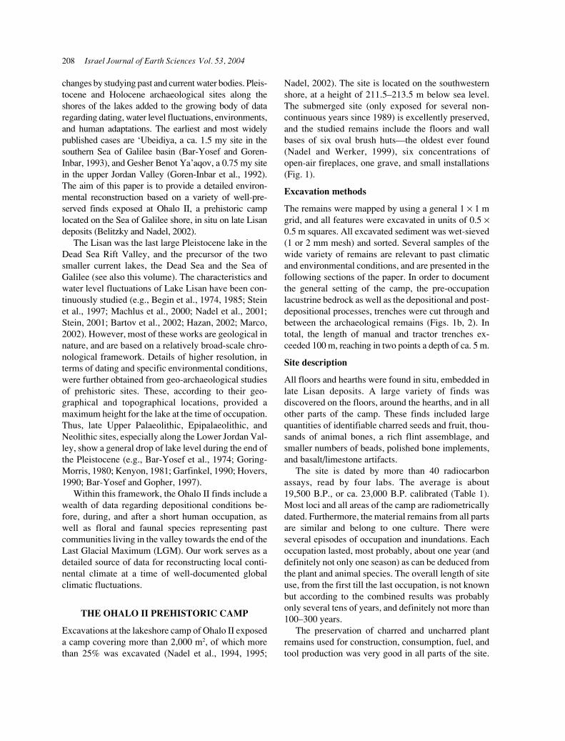
changes by studying past and current water bodies. Pleis-tocene and Holocene archaeological sites along theshores of the lakes added to the growing body of dataregarding dating, water level fluctuations, environments,and human adaptations. The earliest and most widelypublished cases are ‘Ubeidiya, a ca. 1.5 my site in thesouthern Sea of Galilee basin (Bar-Yosef and Goren-Inbar, 1993), and Gesher Benot Ya’aqov, a 0.75 my sitein the upper Jordan Valley (Goren-Inbar et al., 1992).The aim of this paper is to provide a detailed environ-mental reconstruction based on a variety of well-pre-served finds exposed at Ohalo II, a prehistoric camplocated on the Sea of Galilee shore, in situ on late Lisandeposits (Belitzky and Nadel, 2002).
The Lisan was the last large Pleistocene lake in theDead Sea Rift Valley, and the precursor of the twosmaller current lakes, the Dead Sea and the Sea ofGalilee (see also this volume). The characteristics andwater level fluctuations of Lake Lisan have been con-tinuously studied (e.g., Begin et al., 1974, 1985; Steinet al., 1997; Machlus et al., 2000; Nadel et al., 2001;Stein, 2001; Bartov et al., 2002; Hazan, 2002; Marco,2002). However, most of these works are geological innature, and are based on a relatively broad-scale chro-nological framework. Details of higher resolution, interms of dating and specific environmental conditions,were further obtained from geo-archaeological studiesof prehistoric sites. These, according to their geo-graphical and topographical locations, provided amaximum height for the lake at the time of occupation.Thus, late Upper Palaeolithic, Epipalaeolithic, andNeolithic sites, especially along the Lower Jordan Val-ley, show a general drop of lake level during the end ofthe Pleistocene (e.g., Bar-Yosef et al., 1974; Goring-Morris, 1980; Kenyon, 1981; Garfinkel, 1990; Hovers,1990; Bar-Yosef and Gopher, 1997).
Within this framework, the Ohalo II finds include awealth of data regarding depositional conditions be-fore, during, and after a short human occupation, aswell as floral and faunal species representing pastcommunities living in the valley towards the end of theLast Glacial Maximum (LGM). Our work serves as adetailed source of data for reconstructing local conti-nental climate at a time of well-documented globalclimatic fluctuations.
THE OHALO II PREHISTORIC CAMP
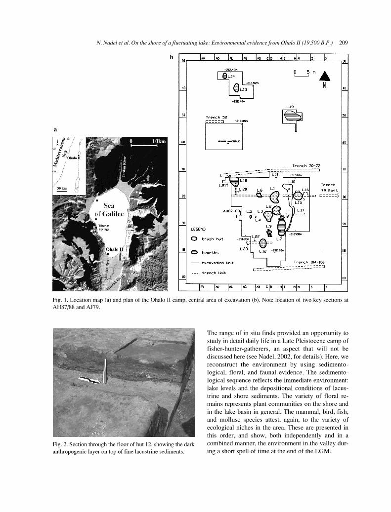
Excavations at the lakeshore camp of Ohalo II exposeda camp covering more than 2,000 m2, of which morethan 25% was excavated (Nadel et al., 1994, 1995;
Nadel, 2002). The site is located on the southwesternshore, at a height of 211.5–213.5 m below sea level.The submerged site (only exposed for several non-continuous years since 1989) is excellently preserved,and the studied remains include the floors and wallbases of six oval brush huts—the oldest ever found(Nadel and Werker, 1999), six concentrations ofopen-air fireplaces, one grave, and small installations(Fig. 1).
Excavation methods
The remains were mapped by using a general 1 × 1 mgrid, and all features were excavated in units of 0.5 ×0.5 m squares. All excavated sediment was wet-sieved(1 or 2 mm mesh) and sorted. Several samples of thewide variety of remains are relevant to past climaticand environmental conditions, and are presented in thefollowing sections of the paper. In order to documentthe general setting of the camp, the pre-occupationlacustrine bedrock as well as the depositional and post-depositional processes, trenches were cut through andbetween the archaeological remains (Figs. 1b, 2). Intotal, the length of manual and tractor trenches ex-ceeded 100 m, reaching in two points a depth of ca. 5 m.
Site description
All floors and hearths were found in situ, embedded inlate Lisan deposits. A large variety of finds wasdiscovered on the floors, around the hearths, and in allother parts of the camp. These finds included largequantities of identifiable charred seeds and fruit, thou-sands of animal bones, a rich flint assemblage, andsmaller numbers of beads, polished bone implements,and basalt/limestone artifacts.
The site is dated by more than 40 radiocarbonassays, read by four labs. The average is about19,500 B.P., or ca. 23,000 B.P. calibrated (Table 1).Most loci and all areas of the camp are radiometricallydated. Furthermore, the material remains from all partsare similar and belong to one culture. There wereseveral episodes of occupation and inundations. Eachoccupation lasted, most probably, about one year (anddefinitely not only one season) as can be deduced fromthe plant and animal species. The overall length of siteuse, from the first till the last occupation, is not knownbut according to the combined results was probablyonly several tens of years, and definitely not more than100–300 years.
The preservation of charred and uncharred plantremains used for construction, consumption, fuel, andtool production was very good in all parts of the site.
N. Nadel et al. On the shore of a fluctuating lake: Environmental evidence from Ohalo II (19,500 B.P.) 209
Fig. 1. Location map (a) and plan of the Ohalo II camp, central area of excavation (b). Note location of two key sections atAH87/88 and AJ79.
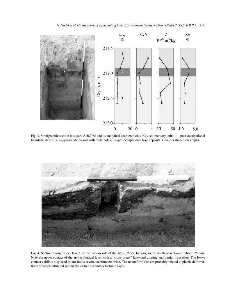
Fig. 2. Section through the floor of hut 12, showing the darkanthropogenic layer on top of fine lacustrine sediments.
b
a
The range of in situ finds provided an opportunity tostudy in detail daily life in a Late Pleistocene camp offisher-hunter-gatherers, an aspect that will not bediscussed here (see Nadel, 2002, for details). Here, wereconstruct the environment by using sedimento-logical, floral, and faunal evidence. The sedimento-logical sequence reflects the immediate environment:lake levels and the depositional conditions of lacus-trine and shore sediments. The variety of floral re-mains represents plant communities on the shore andin the lake basin in general. The mammal, bird, fish,and mollusc species attest, again, to the variety ofecological niches in the area. These are presented inthis order, and show, both independently and in acombined manner, the environment in the valley dur-ing a short spell of time at the end of the LGM.

210 Israel Journal of Earth Sciences Vol. 53, 2004
Table 1Carbon-14 dates (uncalibrated) from Ohalo II, central and south areas of excavation
Lab # Area/Locus Material 14C age ± 1σ (yr) B.P. δ13C (‰)
RT-1625 Central, Loc. 1 Charcoal 21,050 ± 330 –21.8RT-1616 Central, Loc. 1 Charcoal 19,590 ± 150 –13.4RT-1617 Central, Loc. 1 Charcoal 18,700 ± 180 –23.2RT-1623 Central, Loc. 1 Charcoal 18,210 ± 240 –21.0RT-1619 Central, Loc. 2 Charcoal 19,860 ± 190 –20.2RT-1297 Central, Loc. 2 Charcoal 17,500 ± 200 –22.7RT-1618 Central, Loc. 2 Charcoal 19,220 ± 180 –20.6RT-1251 Central, Loc. 3 Charcoal 19,000 ± 190 –22.0RT-1248 Central, Loc. 3 Charcoal 19,800 ± 360 –22.0RT-1342 Central, Loc. 3 Charcoal 19,500 ± 170 –21.5RT-1252 Central, Loc. 3 Charcoal 18,900 ± 400 –20.2RT-1250 Central, Loc. 3 Charcoal 19,250 ± 400 –24.4Pta-5387 Central, Loc. 3 Charcoal 20,100 ± 440 –17.9RT-1343 Central, Loc. 3 Charcoal 18,600 ± 220 –19.5OxA-2565 Central, Loc. 3 Wild barley seed 19,310 ± 190 –24.4OxA-2566 Central, Loc. 3 Wild barley seed 19,110 ± 390 –24.6Pta-5374 Central, Loc. 3 Charcoal 19,400 ± 220 –19.2RT-1244 Central, Loc. 3 Charcoal 18,360 ± 230 –21.5Pta-5386 Central, Loc. 3 Charcoal 19,600 ± 400 –23.6RT-1246 Central, Loc. 4 Charcoal 15,550 ± 130 –20.9OxA-2564 Central, Loc. 4 Wild barley seed 18,680 ± 180 –24.5RT-1358 Central, Loc. 4 Charcoal 18,760 ± 180 –20.8RT-1620 Central, Loc. 6 Charcoal 20,830 ± 180 –19.7RT-1621 Central, Loc. 7 Charcoal 20,070 ± 270 –21.5RT-1622 Central, Loc. 8 Charcoal 20,190 ± 170 –18.4RT-1624 Central, Loc. 10 Charcoal 20,840 ± 290 –20.6RTA-3275 Central, post-occupation Stem of reed 15,430 ± 110 –28.0RT-3537 South Charcoal 21,250 ± 275 –13.0RT-3539 South Charcoal 19,940 ± 210 –22.3RTA-3538 South, AI65c Charcoal 19,490 ± 150 –11.9RTA-3540 South, ZA36 Charcoal 20,270 ± 180 –25.2RTA-3541 South, L66c Charcoal 19,910 ± 170 –25.1RTA-3276 South, post-occupation Plant material 12,830 ± 80 –26.6
GEOARCHAEOLOGY
Stratigraphy
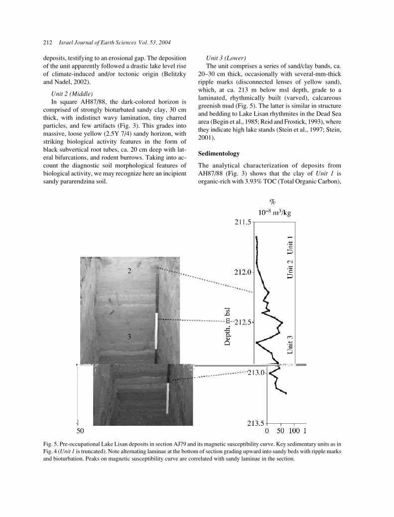
The most complete stratigraphic section is found in thewestern part of the site, where three depositional unitsare distinguished (Fig. 3): upper, middle, and lower.The central part of the site is devoid of the upper coversediment, while the eastern sector of the site is themost disturbed area. For example, in square L79, theupper contact of the archaeological layer shows a“slope break” in the form of lakeward dipping and ispartially truncated, while the lower contact exhibitsdisplaced micro-faults, several centimeters wide
(Fig. 4), which were suggested to manifest a second-ary tectonic deformation (Belitzky and Nadel, 2002).Lacustrine deposits here overlie the cultural layer withinclined lakeward bedding. Hence, the section inAH87/88 (Fig. 3), in the western part of the site, isused as a locality for reference stratigraphy. The sec-tion consists of the following units from top to bottom:
Unit 1 (Upper)Lacustrine clay, pale olive (5Y 6/3–5/3) with red
yellow (7.5YR 6/8) rootlets and subhorizontal, flatbedding represented by several-mm-thick laminae.Angular unconformity separates this unit from lower
N. Nadel et al. On the shore of a fluctuating lake: Environmental evidence from Ohalo II (19,500 B.P.) 211
Fig. 3. Stratigraphic section in square AH87/88 and its analytical characteristics. Key sedimentary units: 1—post-occupationallacustrine deposits; 2—pararendzina soil with mole holes; 3—pre-occupational lake deposits. Unit 2 is shaded on graphs.
Fig. 4. Section through Loci 10–15, at the eastern side of the site (L/M79, looking south, width of section in photo: 75 cm).Note the upper contact of the archaeological layer with a “slope break” lakeward dipping and partial truncation. The lowercontact exhibits displaced micro-faults several centimeters wide. The unconformities are probably related to plastic deforma-tions of water-saturated sediments, or to a secondary tectonic event.
212 Israel Journal of Earth Sciences Vol. 53, 2004
deposits, testifying to an erosional gap. The depositionof the unit apparently followed a drastic lake level riseof climate-induced and/or tectonic origin (Belitzkyand Nadel, 2002).
Unit 2 (Middle)In square AH87/88, the dark-colored horizon is
comprised of strongly bioturbated sandy clay, 30 cmthick, with indistinct wavy lamination, tiny charredparticles, and few artifacts (Fig. 3). This grades intomassive, loose yellow (2.5Y 7/4) sandy horizon, withstriking biological activity features in the form ofblack subvertical root tubes, ca. 20 cm deep with lat-eral bifurcations, and rodent burrows. Taking into ac-count the diagnostic soil morphological features ofbiological activity, we may recognize here an incipientsandy pararendzina soil.
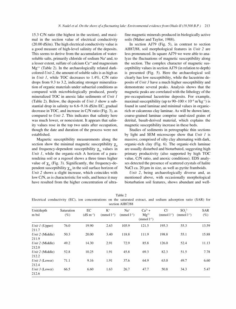
Unit 3 (Lower)The unit comprises a series of sand/clay bands, ca.
20–30 cm thick, occasionally with several-mm-thickripple marks (disconnected lenses of yellow sand),which, at ca. 213 m below msl depth, grade to alaminated, rhythmically built (varved), calcareousgreenish mud (Fig. 5). The latter is similar in structureand bedding to Lake Lisan rhythmites in the Dead Seaarea (Begin et al., 1985; Reid and Frostick, 1993), wherethey indicate high lake stands (Stein et al., 1997; Stein,2001).
Sedimentology
The analytical characterization of deposits fromAH87/88 (Fig. 3) shows that the clay of Unit 1 isorganic-rich with 3.93% TOC (Total Organic Carbon),
Fig. 5. Pre-occupational Lake Lisan deposits in section AJ79 and its magnetic susceptibility curve. Key sedimentary units as inFig. 4 (Unit 1 is truncated). Note alternating laminae at the bottom of section grading upward into sandy beds with ripple marksand bioturbation. Peaks on magnetic susceptibility curve are correlated with sandy laminae in the section.
N. Nadel et al. On the shore of a fluctuating lake: Environmental evidence from Ohalo II (19,500 B.P.) 213
15.3 C/N ratio (the highest in the section), and maxi-mal in the section value of electrical conductivity(20.00 dS/m). The high electrical conductivity value isa good measure of high-level salinity of the deposits.This seems to derive from the accumulation of water-soluble salts, primarily chloride of sodium Na+ and, toa lesser extent, sulfate of calcium Ca++ and magnesiumMg++ (Table 2). In the archaeologically related dark-colored Unit 2, the amount of soluble salts is as high asin Unit 1, while TOC decreases to 1.4%, C/N ratiodrops from 9.3 to 3.2, indicating stronger mineraliza-tion of organic materials under subaerial conditions ascompared with microbiologically produced, poorlymineralized TOC in anoxic lake sediments of Unit 1(Table 2). Below, the deposits of Unit 3 show a sub-stantial drop in salinity to 6.6–9.16 dS/m EC, gradualdecrease in TOC, and increase in C/N ratio (Fig. 3), ascompared to Unit 2. This indicates that salinity herewas much lower, or nonexistent. It appears that salin-ity values rose in the top two units after occupation,though the date and duration of the process were notestablished.
Magnetic susceptibility measurements along thesection show the minimal magnetic susceptibility χ
lf
and frequency-dependent susceptibility χfd values in
Unit 1, while the organic-rich A horizon of a para-rendzina soil or a regosol shows a three times highervalue of χ
lf (Fig. 3). Significantly, the frequency-de-
pendent susceptibility χfd in the soil surface horizon of
Unit 2 shows a slight increase, which coincides withlow C/N, as is characteristic for soils, and hence it mayhave resulted from the higher concentration of ultra-
fine magnetic minerals produced in biologically activesoils (Maher and Taylor, 1988).
In section AJ79 (Fig. 5), in contrast to sectionAH87/88, soil morphological features in Unit 2 areless pronounced. In square AJ79 we were able to ana-lyze the fluctuations of magnetic susceptibility alongthe section. The complex character of magnetic sus-ceptibility values in section AJ79 (in relation to depth)is presented (Fig. 5). Here the archaeological soilclearly has low susceptibility, while the lacustrine de-posits of Unit 3 have a much higher susceptibility anddemonstrate several peaks. Analysis shows that themagnetic peaks are correlated with the lithology of thepre-occupational lacustrine deposits. For example,maximal susceptibility (up to 90–100 × 10–8 m3kg–1) isfound in sand laminae and minimal values in organic-rich or calcareous clay laminae. As will be shown later,coarse-grained laminae comprise sand-sized grains ofdetrital, basalt-derived material, which explains themagnetic susceptibility increase in these beds.
Studies of sediments in petrographic thin sectionsby light and SEM microscope show that Unit 1 ismassive, comprised of silty clay alternating with dark,organic-rich clay (Fig. 6). The organic-rich laminaeare usually disturbed and bioturbated, suggesting highprimary productivity (also supported by high TOCvalue, C/N ratio, and anoxic conditions). EDS analy-ses detected the presence of scattered crystals of haliteNaCl ca. 20 µm in size, as well as pyrite framboids.
Unit 2, being archaeologically diverse and, asmentioned above, with occasionally morphologicalbioturbation soil features, shows abundant and well-
Table 2Electrical conductivity (EC), ion concentrations on the saturated extract, and sodium adsorption ratio (SAR) for
section AH87/88
Unit/depth Saturation EC K+ Na+ Ca2+ + Cl– SO42– SAR
m bsl (%) (dS m–1) (mmol l–1) (mmol l–1) Mg2+ (mmol l–1) (mmol l–1) (%)(mmol l–1)
Unit 1 (Upper) 76.0 19.90 2.63 105.9 121.5 195.3 55.3 13.59211.7Unit 2 (Middle) 50.3 20.00 3.40 118.8 111.9 198.8 55.1 15.88211.9Unit 2 (Middle) 49.2 14.30 2.91 72.9 85.8 126.0 52.4 11.13212.0Unit 2 (Middle) 52.8 10.25 1.91 45.8 69.3 82.3 51.5 7.78212.2Unit 3 (Lower) 71.1 9.16 1.91 37.6 64.9 63.0 49.7 6.60212.4Unit 3 (Lower) 66.5 6.60 1.63 26.7 47.7 50.8 34.3 5.47212.6
214 Israel Journal of Earth Sciences Vol. 53, 2004
water-controlled precipitation (Magee, 1991). In Unit 3rounded peds, or ooids, comprised of calcite aggre-gates (no aragonite, according to FTIR), ca. 100–200 mm in size, are mixed with strongly weathered,sub-rounded grains of olivine, epidote, feldspar, andopaque ore minerals, 150–250 µm in size (Fig. 8a).Occasionally the mineral grains are replaced by dark-brown/reddish clay pseudomorphs, indicating strongpost-depositional weathering. The presence of basaltrock clasts (Fig. 8b) alongside sand-sized grains ofolivine, feldspar, and ore minerals, identified in thinsections, accord well with magnetic enhancement inpre-occupational lacustrine deposits vs. the soil andarchaeological layer.
Site formation processes
Site formation at Ohalo II was primarily controlled bypronounced lacustrine fluctuations and relatedchanges around the lake. The pre-occupationallacustrine deposits demonstrate changing conditionsof deposition from varved, calcareous marls to ooid-rich basalt-derived sand and marl bands, deposited inshallow water at the lake margin. Since the magneticsusceptibility curve shows at least four depositionalcycles, we assume that the water level was intermit-tently falling towards the time of occupation. The rateof deposition seems to have eventually increased,compared with an earlier period of varve deposition,assumed to accumulate at a rate of 0.9 mm/yr (Marco,2002).
Early Epipalaeolithic occupational deposits dem-onstrate remarkable spatial variability and a multi-phase history of anthropogenic accumulation.Bioturbated sandy soils on higher landforms, probablydunes, associated with hydromorphic marshy soils inlow geomorphic positions, formed penecontem-poraneously with human occupation. Abandonmentof the site is believed to have followed a drastic lakelevel rise of climate-induced and/or tectonic origin(Belitzky and Nadel, 2002).
Post-occupational lacustrine deposits lie un-conformably upon the archaeological horizons, indi-cating an erosional gap of unknown duration. Theyconsist of calcareous, laminated lake marls, and areinterpreted as relatively deep-water facies. There wasa strong diagenesis of mineral and organic materials.We hold that these sediments originated in periodi-cally anoxic conditions, conducive to reductive di-agenesis of ferromagnetic grains, and minimal clasticinflux of coarse basalt-derived inflow into the lake.
preserved organic remains in thin sections. The abun-dance and type of organic remains in the dark archaeo-logical layer vary in different loci of the occupationarea. The plant remains are sometimes black due tocharring, sometimes dark brown with a preserved cellstructures. However, these organic horizons with ashand debris of human activities also contain pedogenicneoformations in the form of complex gypsum nodulesstained by ferric oxides and humus. SEM and micro-probe analysis allowed us to detect the existence ofwell-defined crystals of prismatic, euhedral gypsum,partly covered with ferric coatings and iron sulfideFeS
2 framboids (Fig. 7). Large size, prismatic form,
and occurrence basically in nodules all suggest thesecondary origin of gypsum, possibly from ground-
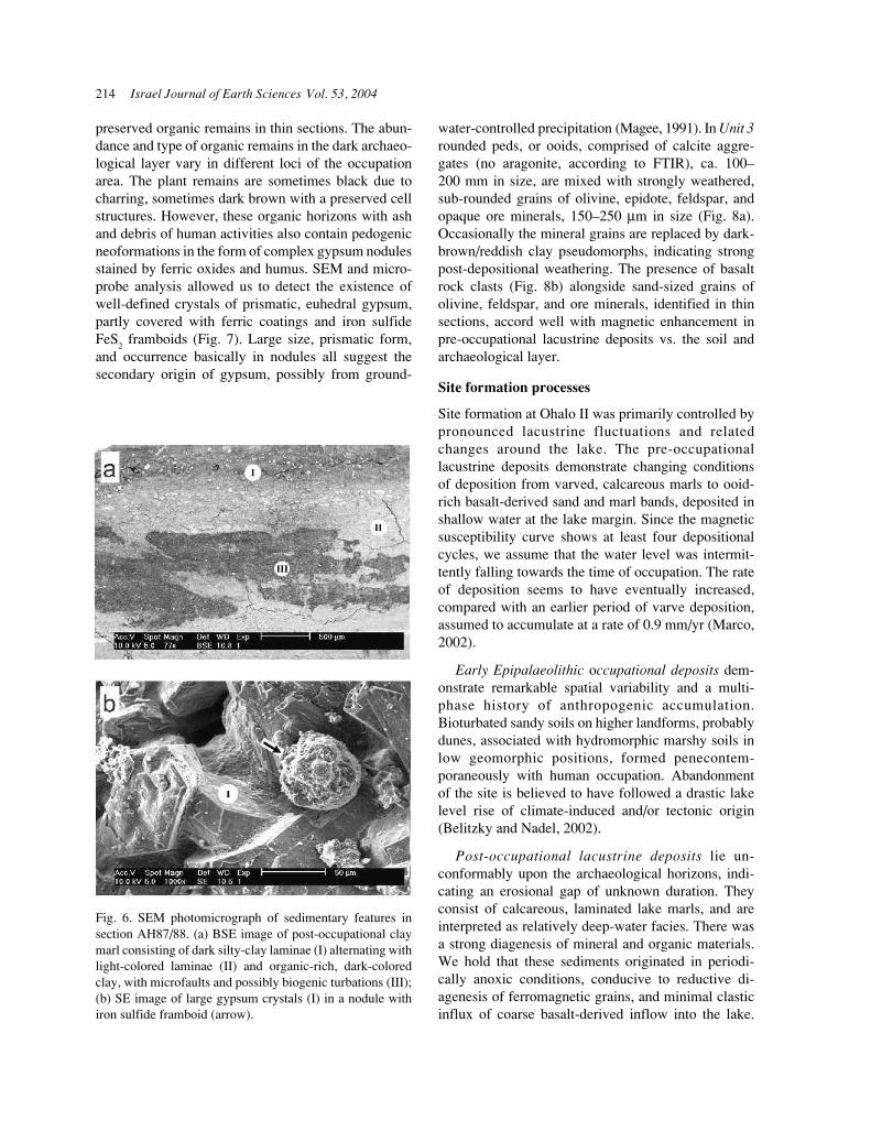
Fig. 6. SEM photomicrograph of sedimentary features insection AH87/88. (a) BSE image of post-occupational claymarl consisting of dark silty-clay laminae (I) alternating withlight-colored laminae (II) and organic-rich, dark-coloredclay, with microfaults and possibly biogenic turbations (III);(b) SE image of large gypsum crystals (I) in a nodule withiron sulfide framboid (arrow).
N. Nadel et al. On the shore of a fluctuating lake: Environmental evidence from Ohalo II (19,500 B.P.) 215
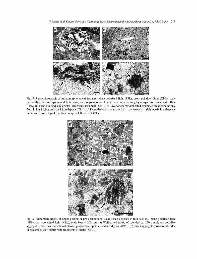
Fig. 7. Photomicrograph of micromorphological features; plane-polarized light (PPL); cross-polarized light (XPL); scalebars = 200 µm. (a) Gypsum nodule (arrows) on root pseudomorph, note occasional staining by opaque iron oxide and sulfide(PPL). (b) Lenticular gypsum crystal (arrow) in Lisan marl (XPL). (c) Layer of charred/unheated elongated grass remains on afloor in hut 1 lying on Lake Lisan deposit (XPL). (d) Degraded charcoal (arrow) in a calcareous ash-rich matrix in a fireplacein Locus 9; note chip of fish bone in upper left corner (XPL).
Fig. 8. Photomicrographs of upper portion of pre-occupational Lake Lisan deposits in thin sections; plane-polarized light(PPL); cross-polarized light (XPL); scale bars = 200 µm. (a) Well-sorted fabric of rounded ca. 250 µm clayey ooid-likeaggregates mixed with weathered olivine, plagioclase, epidote sand-sized grains (PPL). (b) Basalt aggregate (arrow) embeddedin calcareous clay matrix with fragments of shells (XPL).
216 Israel Journal of Earth Sciences Vol. 53, 2004
Analogues of gypsum concretions in association withamorphous ferric precipitates and pyrite in decayedroot channels at Ohalo II may be found in salinesulfidic soils in tidal areas (Stoops et al., 1978;Rabenhorst and James, 1992). It is still unclear, how-ever, whether gypsum as an evaporative mineral,commonly occurring in the southern Lisan Formation(Stein, 2001), precipitated from evaporation of sulfate-bearing lake water or from rising saline groundwater.
THE CHARRED SEEDS: RECONSTRUCTINGTHE PALEO-ECOLOGY
Current ecology and landscape
The leading vegetation community today in the area ofthe sites, is a park-like forest of Ziziphus spina-christi,characteristic to the southern part of the Upper JordanValley and both adjacent low slopes. It is often associ-ated with, or in some areas replaced by, members ofbatha communities. The vegetation gradually changes,upwards to the hills, into Quercus ithaburensis–Styraxofficinalis association, an open deciduous oak forest.Higher up on the hills it changes again, into Quercuscalliprinos–Pistacia palaestina association, the typicalevergreen oak forests and maquis of the Levant, whichcovers most of the mountain slopes west and east of theUpper Jordan Valley.
Unlike other oak species in Israel, Q. ithaburensis hassome noteworthy characters:
a. it forms an open forest;b. it does so both on plains and on lower mountain
slopes, with preference to deep alluvial soils;
c. it does not endure humidity in summer; andd. it is sensitive to low temperatures (Zohary, 1962,
pp. 92–102).
The paleoecology of Ohalo II
The large assemblage of seeds/fruit identified atOhalo II (ca. 90,000) includes species from severalhabitats. The remains of Quercus ithaburensis, Styraxofficinalis, and Pistacia atlantica appear to have be-longed to an open park forest. Grasses and herbaceousspecies, such as Aegilops peregrina, Anthemispseudocotula, Avena sterilis, Hordeum bulbosum,Hordeum spontaneum, and Triticum dicoccoides,commonly grow among the trees of this park forest.All were found at Ohalo II.
Several desert, Irano–Turanian (continental) spe-cies, such as Anabasis articulata, Atriplex leucoclada,Nitraria schoberi, and Suaeda palaestina/fruticosawere found. These represent the dry conditions thatprevailed in the nearby surroundings. The finds ofNitraria schoberi (an extinct species in Israel), togetherwith Anabasis and Atriplex, suggest the presence ofa saline habitat near the site.
Additional habitats are the lake, with plants likeChara spp. and Potamogeton pectinatus, and the riverbank with Arundo/Phragmites, Scirpus litoralis, Vitisvinifera, etc. (Table 3) (Kislev et al., 1992).
The phytogeographical data presented here shedlight on the climate at the time of occupation. It istherefore suggested that the Quercus ithaburensis–Styrax officinalis association migrated several kmsouthwards, towards Ohalo II, in comparison to thesituation today (Kislev and Simchoni, 2002).
Table 3Reconstructed habitats around Ohalo II according to identified seeds/fruit
Park forest Saline Lake River bank
Trees Grasses Herbaceous
Pistacia Aegilops Anthemis Anabasis Chara Arundo/ atlantica peregrina pseudocotula articulata spp. PhragmitesQuercus Avena sterilis Atriplex Potamogeton Scirpus ithaburensis leucoclada pectinatus litoralisStyrax Hordeum Nitraria Vitis vinifera officinalis bulbosum schoberi
Hordeum Suaeda palaestina/ spontaneum fruticosaTriticum dicoccoides

N. Nadel et al. On the shore of a fluctuating lake: Environmental evidence from Ohalo II (19,500 B.P.) 217
THE CHARRED WOOD REMAINS
The large quantities of charred remains include manyfragments of wood tissues. Two assemblages ofcharred wood were analyzed, totaling 113 specimens(Tables 4, 5). All identified tree species grow today inthe Sea of Galilee basin and surrounding slopes. Thus,it appears that the Ohalo II people were commonlyusing wood of tamarisk, oak, willow, and pistachiogrowing on the shore and on the nearby hillsides. Therelative frequencies of the identified specimens do notreflect their relative importance at the site or theirabundance in nature. This is due to the fact that manyfragments of one burnt branch could bias any studiedsample.
FAUNAL REMAINS
Thousands of animal bones were found in each brushhut and around most open-air hearths. This sectiondoes not attempt to provide a full description of thefaunal assemblages and their distribution patterns inthe camp. It does present, however, several prelimi-nary samples of identified mammals, micromammals,birds, fish, and molluscs in order to illustrate theimmediate environment and hence climatic conditionsin the valley.
The sample of 2,749 identified mammal bones(Table 6) is dominated by gazelle (74.9%), which isstill found in many parts of the Mediterranean openpark forest and grasslands (Rabinovich, 2002). Theother nine species include fallow deer, fox, hare, andwild boar. All species are common in Mediterraneanhabitats, though some became extinct in recent centu-ries, probably because of man.
Five species of micromammals (animals weighingless than 3 kg when alive) were identified, of which thecommon field vole (Microtus guentheri) is the mostabundant (Belmaker, 2002). Tristram’s jird (Merionestristrami), the European hedgehog (Erinaceuseuropeaus), the black rat (Rattus rattus), and the housemouse (Mus macedonicus) are also present (Table 7).These species are all found today in the Mediterraneanregion and in grassland habitats in particular (Tchernov,1988).
The assemblage of identified bird bones (N = 1,353,as of 2002) is the largest for any archaeological site inIsrael. It includes 19 families, 48 genera, and 83 spe-cies (Simmons and Nadel, 1998; Simmons, 2002). The
Table 4Identified charred plant remains (wood and stems) retrievedfrom in situ loci and the surface of the site, identified by
Liphschitz (Liphschitz and Nadel, 1997)
Species Loci Surface Total
Tamarix (X5) 47 13 60Tamarix (X4) 4 4Pistacia atlantica 14 2 16Quercus ithaburensis 1 2 3Populus euphratica 5 3 8Fraxinus syriaca 2 2Rhamnus palestina 1 1Atriplex halimus 5 1 6Phoenix dactylifera 1 1
Total 79 22 101
Table 5Identified charred plant remains from the in situ wall of hut 1
(after Nadel and Werker, 1999)
Species Part N
Salix branch 3Tamarix branch 1Quercus ithaburensis branch 1Quercus branch 1Atriplex / Seidlizia stem 3Prosopis? branch 2Monocotyledon straw 1
Total 12
Table 6A sample of identified mammal bones
Species NISP %
Sus scrofa 19 0.7Cervidae 14 0.5Cervus elaphus 11 0.4Dama mesopotamica 413 15.0Bos primigenius 4 0.1Gazella gazella 2,058 74.9Capra aegagrus 4 0.1Vulpes vulpes 118 4.3Hyaena hyaena 2 0.1Felis silvestris 18 0.7Carnivore sp. 12 0.4Lepus capensis 76 2.8
Total 2,749 100.0
218 Israel Journal of Earth Sciences Vol. 53, 2004
Table 7NISP of micromammal species retrieved from in situ loci and the surface of the site
Provenance/ Microtus Meriones Mus Rattus Erinaceusspecies guentheri tristrami macedonicus rattus europeaus indet. Total
Loci 174 43 15 4 21 139 396Surface 26 13 1 2 3 13 58Total 200 56 16 6 24 152 454
Table 8Bird bones from Ohalo II by families and species (sample does not include finds from last season of excavations)
Family Species N
Accipitiridae Milvus migrans 4Haliaeetus albicilla 4Circus aeruginosis 6Circus cyaneus 13Accipter nisus 13Accipter gentilis 15Melierax metabates 1Buteo rufins 5Buteo buteo 19Aquila rapax 2
Falconidae Falco tinnunculus 4Falco columbarius 8Falco biarmicus 2Falco cherrug 2
Phasianidae Alectoris chukar 8Ammoperdix heyi 2Coturnix coturnix 37
Rallidae Fulica atra 23Porphyrio porphyrio 1
Otididae Tetrax tetrax 15Otis tarda 1
Recurvirostridae Himantopus himantopus 1Recurviostra avosetta 1
Charadriidae Vanellus vanellus 1Scolopacidae Numenius phaeopus 1
Numenius arquata 4Arenaria interpres 1
Laridae Larus minutus 1Larus sabini 1Larus argentatus 7Larus ridibundus 1
Strigidae Bubo bubo 5Corvidae Corvus corone 2
Corvus monedula 3Corvus frugilegus 3
Total 603
Family Species N
Podicipidae Podiceps auritus 93Podiceps cristatus 114Podiceps grisegena 30Podiceps nigricollis 15Tachybaptus ruficollis 3
Pelecanidae Pelecanus onocratalus 1Phalocrocoracidae Phalocrocorax aristotelis 1
Phalocrocorax pygmaeus 2Phalocrocorax carbo 1
Ardeidae Ardea cinerea 3Ardea purpurea 1Ardeola ralloides 1Egretta garzetta 4Egretta ibis 1
Threskiornithidae Platalea leucorodia 2Plegadis falinellus 2
Anatidae Cygnus bewickii 8Cygnus cygnus 5Anser albifrons 2Anser anser 16Anser fabalis 21Tadorna tadorna 4Alpochen aegyptiacus 3Anas acuta 6Anas capensis 1Anas clypetea 9Anas crecca 2Anas penelope 1Anas platyrhynchos 11Anas querquedula 11Anas strepera 1Aythya fuligula 4Aythya marila 1Netta rufina 1Mergus merganser 1Mergus serrator 2Melanitta fusca 1Bucephala clangula 1

N. Nadel et al. On the shore of a fluctuating lake: Environmental evidence from Ohalo II (19,500 B.P.) 219
assemblage is dominated (>33% of NISP (number ofidentified specimens)) by Podiceps cristatus, the greatcrested grebe of the Family Podicipidae (Table 8). Atcertain loci, e.g., the Locus 13 brush hut, P. cristatusaccounts for greater than 90% of the NISP, indicatingthe value of this species to the Ohalo II people. Itshould be noted that many species are represented byvery few bones.
Birds nesting in marsh and aquatic habitats com-prise more than half of the species found at the site(Fig. 9); woodland and grassland habitats are also
common, while birds nesting in arid environmentscomprise only ca. 1% of the sample. The bird speciesreflect the proximity of the site to the lake and indicatethat habitats surrounding the Kinneret today werepresent in the same area 23,000 years ago.
The assemblage of identified bird bones (N = 1,352)is the largest for any archaeological site in Israel. Itincludes 19 families, 48 genera, and 83 species(Simmons and Nadel, 1998; Simmons, 2002). Thesample presented here (N = 487) is dominated byPodiceps cristatus, the Great Crested Grebe of thePodicipidae family.
Birds nesting in marsh or aquatic habitats comprisemore than half of the species found at the site (Fig. 9),wood and grass habitats are also common, while birdsnesting in arid environments comprise ca. 1% of thesample. The bird species reflect the presence of waterbodies (lake, marsh) near the site, and indicate thathabitats surrounding the Kinneret today were presentin the same area 23,000 years ago.
Fish remains are the most abundant at the site. Thesample from hut 1 alone includes more than 20,000specimens. There are two families present, namely theCyprinidae and Cichlidae. The first live in fresh waterwhile the latter can tolerate low-salinity waters. Fish ofthese two families are common today in the lake andthe nearby streams.
Fig. 9. The major nesting habitats of birds by NISP (N = 487).
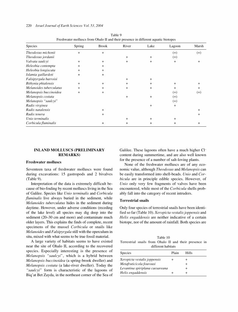
Table 9Freshwater molluscs from Ohalo II and their presence in different aquatic biotopes
Species Spring Brook River Lake Lagoon Marsh
Theodoxus michonii + + (+) (+)Theodoxus jordanii + + (+)Valvata saulcyi + + + + + +Heleobia contempta + +Heleobia longiscata + +Islamia gaillardoti + +Falsipyrgula barroisi + +Bithynia phialensis + + + + + +Melanoides tuberculatus + + + + + +Melanopsis buccinoidea + + (+) (+)Melanopsis costata + + (+)Melanopsis “saulcyi” (+)Radix virginea + +Radix natalensis + +Radix tenera + +Unio terminalis + + +Corbicula fluminalis + + + + +
220 Israel Journal of Earth Sciences Vol. 53, 2004
INLAND MOLLUSCS (PRELIMINARYREMARKS)
Freshwater molluscs
Seventeen taxa of freshwater molluscs were foundduring excavations: 15 gastropods and 2 bivalves(Table 9).
Interpretation of the data is extremely difficult be-cause of bio-fouling by recent molluscs living in the Seaof Galilee. Species like Unio terminalis and Corbiculafluminalis live always buried in the sediment, whileMelanoides tuberculatus hides in the sediment duringdaytime. However, under adverse conditions (recedingof the lake level) all species may dig deep into thesediment (20–30 cm and more) and contaminate mucholder layers. This explains the finds of complete, recentspecimens of the mussel Corbicula or snails likeMelanoides and Falsipyrgula still with the operculum insitu, mixed with what seems to be true fossil material.
A large variety of habitats seems to have existednear the site of Ohalo II, according to the recoveredspecies. Especially interesting is the presence ofMelanopsis “saulcyi”, which is a hybrid betweenMelanopsis buccinoidea (a spring-brook dweller) andMelanopsis costata (a lake-river dweller). Today the“saulcyi” form is characteristic of the lagoons ofBiq’at Bet Zayda, in the northeast corner of the Sea of
Galilee. These lagoons often have a much higher Cl–
content during summertime, and are also well knownfor the presence of a number of salt-loving plants.
None of the freshwater molluscs are of any eco-nomic value, although Theodoxus and Melanopsis canbe easily transformed into shell-beads. Unio and Cor-bicula are in principle edible species. However, ofUnio only very few fragments of valves have beenencountered, while most of the Corbicula shells prob-ably fall into the category of recent intruders.
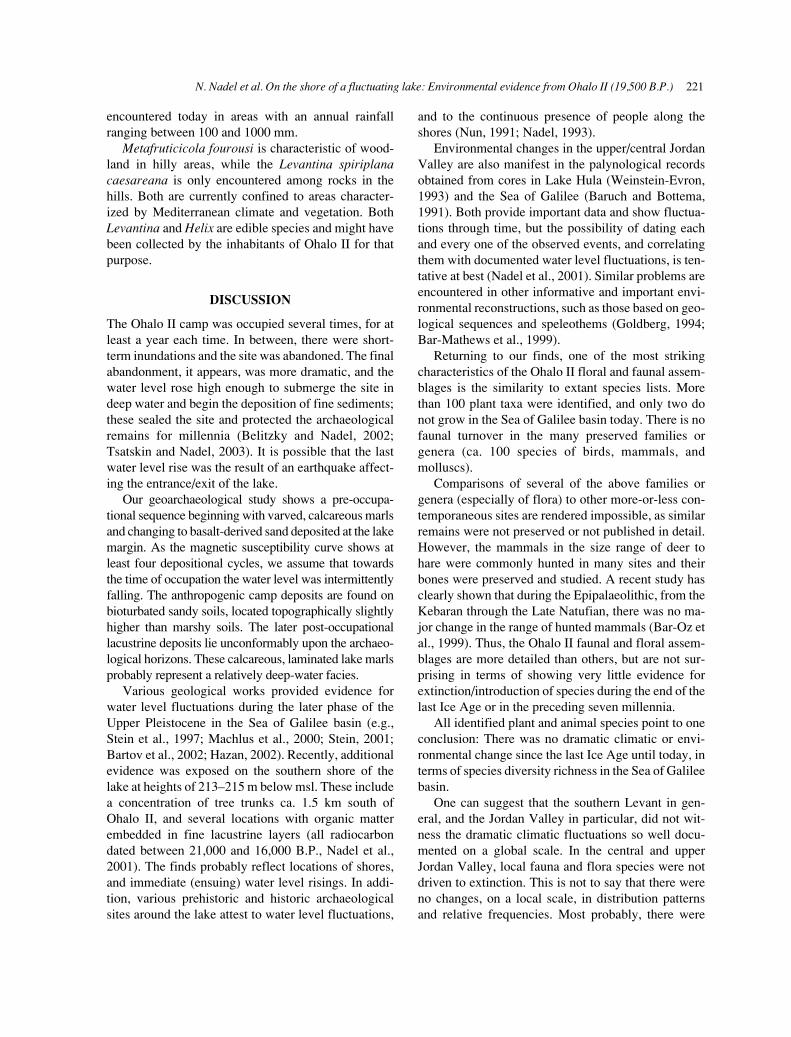
Terrestrial snails
Only four species of terrestrial snails have been identi-fied so far (Table 10). Xeropicta vestalis joppensis andHelix engaddensis are neither indicative of a certainbiotope, nor of the amount of rainfall. Both species are
Table 9Freshwater molluscs from Ohalo II and their presence in different aquatic biotopes
Species Spring Brook River Lake Lagoon Marsh
Theodoxus michonii + + (+) (+)Theodoxus jordanii + + (+)Valvata saulcyi + + + + + +Heleobia contempta + +Heleobia longiscata + +Islamia gaillardoti + +Falsipyrgula barroisi + +Bithynia phialensis + + + + + +Melanoides tuberculatus + + + + + +Melanopsis buccinoidea + + (+) (+)Melanopsis costata + + (+)Melanopsis “saulcyi” (+)Radix virginea + +Radix natalensis + +Radix tenera + +Unio terminalis + + +Corbicula fluminalis + + + + +
Table 10Terrestrial snails from Ohalo II and their presence in
different habitats
Species Plain Hills
Xeropicta vestalis joppensis + +Metafruticicola fourousi +Levantina spiriplana caesareana +Helix engaddensis + +
N. Nadel et al. On the shore of a fluctuating lake: Environmental evidence from Ohalo II (19,500 B.P.) 221
encountered today in areas with an annual rainfallranging between 100 and 1000 mm.
Metafruticicola fourousi is characteristic of wood-land in hilly areas, while the Levantina spiriplanacaesareana is only encountered among rocks in thehills. Both are currently confined to areas character-ized by Mediterranean climate and vegetation. BothLevantina and Helix are edible species and might havebeen collected by the inhabitants of Ohalo II for thatpurpose.
DISCUSSION
The Ohalo II camp was occupied several times, for atleast a year each time. In between, there were short-term inundations and the site was abandoned. The finalabandonment, it appears, was more dramatic, and thewater level rose high enough to submerge the site indeep water and begin the deposition of fine sediments;these sealed the site and protected the archaeologicalremains for millennia (Belitzky and Nadel, 2002;Tsatskin and Nadel, 2003). It is possible that the lastwater level rise was the result of an earthquake affect-ing the entrance/exit of the lake.
Our geoarchaeological study shows a pre-occupa-tional sequence beginning with varved, calcareous marlsand changing to basalt-derived sand deposited at the lakemargin. As the magnetic susceptibility curve shows atleast four depositional cycles, we assume that towardsthe time of occupation the water level was intermittentlyfalling. The anthropogenic camp deposits are found onbioturbated sandy soils, located topographically slightlyhigher than marshy soils. The later post-occupationallacustrine deposits lie unconformably upon the archaeo-logical horizons. These calcareous, laminated lake marlsprobably represent a relatively deep-water facies.
Various geological works provided evidence forwater level fluctuations during the later phase of theUpper Pleistocene in the Sea of Galilee basin (e.g.,Stein et al., 1997; Machlus et al., 2000; Stein, 2001;Bartov et al., 2002; Hazan, 2002). Recently, additionalevidence was exposed on the southern shore of thelake at heights of 213–215 m below msl. These includea concentration of tree trunks ca. 1.5 km south ofOhalo II, and several locations with organic matterembedded in fine lacustrine layers (all radiocarbondated between 21,000 and 16,000 B.P., Nadel et al.,2001). The finds probably reflect locations of shores,and immediate (ensuing) water level risings. In addi-tion, various prehistoric and historic archaeologicalsites around the lake attest to water level fluctuations,
and to the continuous presence of people along theshores (Nun, 1991; Nadel, 1993).
Environmental changes in the upper/central JordanValley are also manifest in the palynological recordsobtained from cores in Lake Hula (Weinstein-Evron,1993) and the Sea of Galilee (Baruch and Bottema,1991). Both provide important data and show fluctua-tions through time, but the possibility of dating eachand every one of the observed events, and correlatingthem with documented water level fluctuations, is ten-tative at best (Nadel et al., 2001). Similar problems areencountered in other informative and important envi-ronmental reconstructions, such as those based on geo-logical sequences and speleothems (Goldberg, 1994;Bar-Mathews et al., 1999).
Returning to our finds, one of the most strikingcharacteristics of the Ohalo II floral and faunal assem-blages is the similarity to extant species lists. Morethan 100 plant taxa were identified, and only two donot grow in the Sea of Galilee basin today. There is nofaunal turnover in the many preserved families orgenera (ca. 100 species of birds, mammals, andmolluscs).
Comparisons of several of the above families orgenera (especially of flora) to other more-or-less con-temporaneous sites are rendered impossible, as similarremains were not preserved or not published in detail.However, the mammals in the size range of deer tohare were commonly hunted in many sites and theirbones were preserved and studied. A recent study hasclearly shown that during the Epipalaeolithic, from theKebaran through the Late Natufian, there was no ma-jor change in the range of hunted mammals (Bar-Oz etal., 1999). Thus, the Ohalo II faunal and floral assem-blages are more detailed than others, but are not sur-prising in terms of showing very little evidence forextinction/introduction of species during the end of thelast Ice Age or in the preceding seven millennia.
All identified plant and animal species point to oneconclusion: There was no dramatic climatic or envi-ronmental change since the last Ice Age until today, interms of species diversity richness in the Sea of Galileebasin.
One can suggest that the southern Levant in gen-eral, and the Jordan Valley in particular, did not wit-ness the dramatic climatic fluctuations so well docu-mented on a global scale. In the central and upperJordan Valley, local fauna and flora species were notdriven to extinction. This is not to say that there wereno changes, on a local scale, in distribution patternsand relative frequencies. Most probably, there were
222 Israel Journal of Earth Sciences Vol. 53, 2004
shifts of plant communities up and down the slopessurrounding the Jordan Valley, and also on a north–south axis. Thus, there was no apparent environmentalstress dictating changes in subsistence patterns. Peoplein the valley enjoyed this situation and some groupsdid not move much—they had water and a large vari-ety of plant and animal food resources on the lakeshoreand in the immediate surroundings.
Indeed, it appears that the most dramatic environ-mental events in the Jordan Valley were lake waterlevel changes, and accordingly, changes in lake size.These were the result of certain fluctuations in precipi-tation within the drainage system, and evaporation inthe lake area. When water level changes were swift,they were probably induced by earthquakes and tec-tonic events at the inlet and/or outlet of the lake.
ACKNOWLEDGMENTS
We wish to thank A. Agnon, S. Belitzky, N. Hazan, S.Marco, and M. Stein for their advice and cooperationin the study of geological aspects. We thank J.Langsam for preparing the SEM micrographs. Wethank Wim Van Neer and the Royal Museum forCentral Africa, in Tervuren, Belgium, for their aid infish identification. For their advice and assistance withthe plant remains we thank E. Werker, T. Shick, Y.Cahanov, and P. Peled. Our sincere thanks to Z.Ortenberg and Y. Gal of the Kinneret Authority fortheir help, the Rahamin family, Kvutzat Kinneret, andKibbutz Afikim for their continuous assistance. Wesincerely appreciate the many useful comments madeby S. Marco and T. Dayan on an early draft.
The project (fieldwork and lab analyses) was gen-erously supported by the Irene Levi Sala CAREArchaeological Foundation, The Israel Science Foun-dation (831/00), the Jerusalem Center for Anthro-pological Studies, the L.S.B. Leakey Foundation, theMAFCAF Foundation, the M. Stekelis Museum ofPrehistory in Haifa, the National Geographic Society,the Israel Antiquities Authority, and the Zinman Insti-tute of Archaeology (University of Haifa).
REFERENCES
Bar-Mathews, M., Ayalon, A., Kaufman, A., Wasserburg,G.J. 1999. The eastern Mediterranean paleoclimate as areflection of regional events: Soreq cave, Israel. Earthand Planetary Science Letters 166: 85–95.
Bar-Oz, G., Dayan, T., Kaufman, D. 1999. The Epipalaeolithicfaunal sequence in Israel: a view from Neve David. Journalof Archaeological Science 26: 67–82.
Bartov, Y., Stein, M., Enzel, Y., Agnon, A., Reches, Z. 2002.Lake levels and sequence stratigraphy of Lake Lisan, thelate Pleistocene precursor of the Dead Sea. QuaternaryResearch 57: 9–21.
Baruch, U., Bottema, S. 1991. Palynological evidence forclimatic changes in the Levant ca. 17,000–9,000 B.P. In:Bar-Yosef, O., Valla, F.R., eds. The Natufian culture inthe Levant. International Monographs in Prehistory, Ar-chaeological Series 1. Ann Arbor, MI, pp. 11–20.
Bar-Yosef, O., Gopher, A., eds. 1997. An early Neolithicvillage in the Jordan Valley. Part I: The archaeology ofNetiv Hagdud. American School of Prehistoric Research,Bulletin 44. Peabody Museum of Archaeology and Eth-nology, Harvard University, Cambridge, MA.
Bar-Yosef, O., Goldberg, P., Levenson, T. 1974. Late Qua-ternary stratigraphy and prehistory in Wadi Fazael, JordanValley: a preliminary report. Paléorient 2(2): 415–428.
Bar-Yosef, O., Goren-Inbar, N. 1993. The Lithic assem-blages of Ubeidiya. A lower Palaeolithic site in the Jor-dan Valley. QEDEM, Monographs of the Institute ofArchaeology, The Hebrew University of Jerusalem.
Begin, Z.B., Ehrlich, A., Nathan, Y. 1974. Lake Lisan, thePleistocene precursor of the Dead Sea. Geological Sur-vey of Israel, Bulletin No. 63, Jerusalem.
Begin, Z.B., Broecker, W., Buchbinder, B., Druckman, Y.,Kaufman, A., Magaritz, M., Neev, D. 1985. Dead Seaand Lake Lisan levels in the last 30,000 years: a prelimi-nary report. Internal report, Geological Survey of Israel.
Belitzky, S., Nadel, D. 2002. Late Pleistocene and recenttectonic deformations at the Ohalo II prehistoric site(19K) and the evolution of the Jordan River outlet fromthe Sea of Galilee. Geoarchaeology: An InternationalJournal 17(5): 453–464.
Belmaker, M. 2002. The small mammals from Ohalo II andthe environment. In: Nadel, D., ed. Ohalo II—a 23,000year-old fisher-hunter-gatherers’ camp on the shore ofthe Sea of Galilee. Hecht Museum, Haifa, pp. 37–38.
Garfinkel, Y. 1990. Gesher, un nouveau site “NeolithiquePreceramique A” dans la moyenne Vallee du Jordain,Israel. L’Anthropologie 94(4): 903–906.
Goldberg, P. 1994. Interpreting late Quaternary continentalsequences in Israel. In: Bar-Yosef, O., Kra, R.S., eds. LateQuaternary chronology and Palaeoclimates of the EasternMediterranean. Radiocarbon, Tucson, AZ, pp. 89–102.
Goren-Inbar, N., Belitzki, S., Verosub, K., Werker, E.,Kislev, M.E., Heimann, A., Carmi, I., Rosenfeld, A.1992. New discoveries at the Middle PleistoceneAcheulian site of Gesher Benot Ya’aqov, Israel. Quater-nary Research 38: 117–128.
Goring-Morris, A.N. 1980. Upper Palaeolithic sites from WadiFazael, Lower Jordan Valley. Paléorient 6: 173–191.
Hazan, N. 2002. Levels of Lake Kinneret/Lake Lisan. In:Nadel, D., ed. Ohalo II—a 23,000 year-old fisher-hunter-gatherers’ camp on the shore of the Sea of Galilee. HechtMuseum, Haifa, pp. 52–56 (in Hebrew).
Hovers, E. 1990. Art in the Levantine Epi-Palaeolithic: an
N. Nadel et al. On the shore of a fluctuating lake: Environmental evidence from Ohalo II (19,500 B.P.) 223
engraved pebble from a Kebaran site in the Lower JordanValley. Current Anthropology 31(3): 317–322.
Kenyon, K.M., ed. 1981. Excavations at Jericho, Vol. III.The British School of Archaeology, Jerusalem.
Kislev, M.E., Simchoni, O. 2002. Reconstructing thepalaeoecology of Ohalo II, an early Epipalaeolithic site inIsrael. In: Mason, S.L.R., Hather, J.G., eds. Hunter–gatherer archaeobotany: perspective from the NorthernTemperate zone. Archetype Publications, London, pp.179–184.
Kislev, M.E., Nadel, D., Carmi, I. 1992. Epipalaeolithic(19,000 BP) cereal and fruit diet at Ohalo II, Sea ofGalilee, Israel. Review of Palaeobotany and Palynology73: 161–166.
Liphschitz, N., Nadel, D. 1997. Epipalaeolithic (19,000B.P.) charred wood remains from Ohalo II, Sea of Gali-lee, Israel. Mitekufat Haeven, Journal of the Israel Pre-historic Society 27: 5–18.
Machlus, M., Enzel, E., Goldstein, S.L., Marco, S., Stein, M.2000. Reconstructing low levels of Lake Lisan by corre-lating fan-delta and lacustrine deposits. Quaternary Inter-national 73/74: 137–144.
Magee, J.W. 1991. Late Quaternary lacustrine, groundwater,aeolian and pedogenic gypsum in the Prungle Lakes,southeastern Australia. Palaeogeography, Palaeo-climatology, Palaeoecology 84: 3–42.
Maher, B., Taylor, R.M. 1988. Formation of ultrafine-grained magnetite in soils. Nature 336: 368–370.
Marco, S. 2002. Paleomagnetic records from southern Sea ofGalilee reveal Late Pleistocene deformation, secularvariation, and the Mono Lake excursion. In: Beck, A.,Katz, V., Ken-Tor, R., eds. Israel Geological SocietyAnnual Meeting, p.76 (Abstract).
Marco, S. 2002. Late Pleistocene paleomagnetic secularvariation from the Sea of Galilee, Israel. GeophysicsResearch Letters 29: doi: 10.1029/2001 GL014038.
Nadel, D. 1993. Submerged archaeological sites on theshores of Lake Kinneret, Israel. ‘Atiqot (English Series)XXII: 1–12.
Nadel, D., ed. 2002. Ohalo II—a 23,000 year-old fisher-hunter-gatherers’ camp on the shore of the Sea of Galilee.Hecht Museum, Haifa (English/Hebrew).
Nadel, D., Werker, E. 1999. The oldest ever brush hut plantremains from Ohalo II, Jordan Valley, Israel (19 K BP).Antiquity 73 (282): 755–764.
Nadel, D., Danin, A., Werker, E., Schick, T., Kislev, M.E.,Stewart, K. 1994. 19,000 year-old twisted fibers fromOhalo II. Current Anthropology 35(4): 451–458.
Nadel, D., Carmi, I., Segal, D. 1995. Radiocarbon dating ofOhalo II: archaeological and methodological implica-tions. Journal of Archaeological Science 22(6): 811-822.
Nadel, D., Belitzky, S., Boaretto, E., Carmi, I., Heinemeier,J., Werker, E., Marco, S. 2001. New dates from sub-merged late Pleistocene sediments in the Sea of Galilee,
Israel. Radiocarbon 43(3): 1167–1178.Nun, M. 1991. The Sea of Galilee. Water levels, past and
present. Published by Tourist Department and KinnerethSailing Co., Kibbutz Ein Gev.
Rabenhorst, M.C., James, B.R. 1992. Iron sulfidization intidal marsh soils. In: Skinner, H.C.W., Fitzpatrick, R.W.,eds. Biomineralization processes of iron and manganese.Modern and Ancient Environments, Catena Supplement21, pp. 203–217.
Rabinovich, R. 2002. The mammal bones: environment,food and tools. In: Nadel, D., ed. Ohalo II—a 23,000year-old fisher-hunter-gatherers’ camp on the shore ofthe Sea of Galilee. Hecht Museum, Haifa, pp. 24–27.
Reid, I., Frostick, L. 1993. Late Pleistocene rhythmite sedi-mentation at the margin of the Dead Sea trough: a guideto palaeoflood frequency. In: MacManus, J., Duck, R.W.,eds. Geomorphology and Sedimentology of Lakes andReservoirs, pp. 259–273.
Simmons, T. 2002. The birds at Ohalo II. In: Nadel, D., ed.Ohalo II—a 23,000 year-old fisher-hunter-gatherers’camp on the shore of the Sea of Galilee. Hecht Museum,Haifa, pp. 32–36.
Simmons, T., Nadel, D. 1998. The avifauna of the EarlyEpipalaeolithic site of Ohalo II (19,400 B.P.), Israel:species diversity, habitat and seasonality. InternationalJournal of Osteoarchaeology 8(2): 79–96.
Stein, M. 2001. The sedimentary and geochemical record ofNeogene–Quaternary water bodies in the Dead SeaBasin—inferences for the regional paleoclimatic history.Journal of Paleolimnology 26: 271–282.
Stein, M., Starinsky, A., Katz, A., Goldstein, S.L., Machlus,M., Schramm, A. 1997. Strontium isotopic, chemical,and sedimentological evidence for the evolution of LakeLisan and the Dead Sea. Geochimica et CosmochimicaActa 61: 3975–3992.
Stoops, G., Eswaran, H., Abtahi, A. 1978. Scanning electronmicroscopy of authigenic sulfate minerals in soils. In:Delgado, M., ed. Soil micromorphology, Vol. II: 1093–1114. Arte Prieto Moreno, Maracena (Granada).
Tchernov, E. 1988. The biogeographical history of the South-ern Levant. In: Yom-Tov, Y., Tchernov, E., eds. The zoo-geography of Israel. Dr W Junk, Dordrecht, pp. 401–409.
Tsatskin, A., Nadel, D. 2003. Formation processes at theOhalo II submerged prehistoric campsite, Israel, deducedfrom soil micromorphology and magnetic susceptibilitystudies. Geoarchaeology 18(4): 409–432.
Weinstein-Evron, M. 1993. Palaeoecological reconstruc-tions of the Upper Palaeolithic in the Levant. In: Pavuk,J., ed. Actes du XIIe Congres International des SciencesPrehistoriques et Protohistoriques. Institut Archeol-ogique de l’Academie Slovaque des Sciences, Bratislava,pp. 259–270.
Zohary, M. 1962. Plant life of Palestine: Israel and Jordan.Ronald Press, New York.