Oligo-Miocene extension in the Lycian orogen: evidence from the Lycian molasse basin, SW Turkey
28
© 2005 Lavoisier SAS. All rights reserved. Geodinamica Acta 18/3-4 (2005) 255–282 Oligo-Miocene extension in the Lycian orogen: evidence from the Lycian molasse basin, SW Turkey Hasan Sözbilir * Dokuz Eylül University, Faculty of Engineering, Department of Geological Engineering, Bornova, TR-35100 |zmir, Turkey Abstract The Lycian molasse basin of SW Turkey is a NE-SW-oriented basin that developed on an imbricated basement, comprising the allo- chthonous Mesozoic rocks of the Lycian nappes and Palaeocene-Eo cene supra-allochthonous sediments. The imbricated basement has resulted from a complex history related to the emplacement of different tectonic units from Late Cretaceous to Late Eocene. Following imbrication, extensional collapse of the Lycian orogen resulted in extensive emergent areas, some of which coincide with prese nt-day mountains. These were surrounded by interconnected depressions, namely, the Kale-Tavas, Çardak-Dazk¬r¬ and Denizli subbasins. The Lycian molasse sequence contains a relatively complete record of the tectonic history of the Lycian orogenic collapse fromwhich it was derived. The sequence is characterised by interdependence between tectonism and sedimentation, the latter of which includes fin- ing- and coarsening-upward sedimentary cycles with syn-depositional intrabasinal unconformities. The Denizli subbasin consists of thick, coarse-grained wedges of alluvial fans and fine-grained fan-delta deposits formed in a shallow- marine environment. Some areas of the fan deltas were colonised by corals, red algae and foraminifera, forming patch reefs. The first phase of extensional collapse in the region is marked by the Lycian orogenic collapse, which may have been initiated by the beginning of the Oligocene (Rupelian), following the main Menderes metamorphism. Starting in the latest Early Miocene or in the Mid- dle Miocene, the area of the molasse basin was subject to defor mation with the Lycian nappes, and to erosion as well. At that time, the Lycian nappes, with some ophiolitic assemblages, were thrust over the molasse deposits and thus, NE-SW-trending folds were formed. The molasse deposits and thrust-related deformational structure s were then unconformably covered by Upper Miocene continental deposits which belong to the neotectonic period of SW Turkey. The second phase of extensional collapse is marked by granitic i ntrusions and the formation of Miocene detachment-related extensional bas ins. This phase may have been related to the exhumation of the gneissic core of the Menderes Massif, from which fragments were derived and incorporated into the upper parts of the Denizli subbasin d uring the Aquitanian. © 2005 Lavoisier SAS. All rights reserved. Keywords: Lycian molasse basin; Menderes Massif; Lycian orogenic collapse; Oligo-Miocene; SW Turkey 1. Introduction Western Turkey is one of the most seismically active regions of the world, where orogenic contraction has been followed by continental extension [1-11]. The region mainly comprises three major tectonostratigraphic units (i.e., Men- deres Massif, Bornova Flysch Zone and Lycian nappes; [12]) that were highly dissected in Miocene time and resulted in crustal thinning and regional-scale faulting along low-angle detachment faults [13-27] (Fig. 1). Detachment- fault systems in this province are associated with domal uplift of the Menderes metamorphic core complex of the lower plate and the formation of asymmetric supradetach- ment basins in the upper plate (e.g. [13, 14] and references therein). Recently, N-S-trending extension across these detachment faults has been interpreted as the earliest phase * Corresponding author. E-mail address: [email protected] (H. Sözbilir)
-
Upload
independent -
Category
Documents
-
view
0 -
download
0
Transcript of Oligo-Miocene extension in the Lycian orogen: evidence from the Lycian molasse basin, SW Turkey

© 2005 Lavoisier SAS. All rights reserved.
Geodinamica Acta 18/3-4 (2005) 255–282
Oligo-Miocene extension in the Lycian orogen: evidence from the Lycian molasse basin, SW Turkey
Hasan Sözbilir *Dokuz Eylül University, Faculty of Engineering, Department of Geological Engineering, Bornova, TR-35100 |zmir, Turkey
Abstract
The Lycian molasse basin of SW Turkey is a NE-SW-oriented basin that developed on an imbricated basement, comprising the allo-chthonous Mesozoic rocks of the Lycian nappes and Palaeocene-Eo cene supra-allochthonous sediments. The imbricated basement hasresulted from a complex history related to the emplacement of different tectonic units from Late Cretaceous to Late Eocene. Followingimbrication, extensional collapse of the Lycian orogen resulted in extensive emergent areas, some of which coincide with prese nt-daymountains. These were surrounded by interconnected depressions, namely, the Kale-Tavas, Çardak-Dazk¬r¬ and Denizli subbasins.
The Lycian molasse sequence contains a relatively complete record of the tectonic history of the Lycian orogenic collapse from whichit was derived. The sequence is characterised by interdependence between tectonism and sedimentation, the latter of which includes fin-ing- and coarsening-upward sedimentary cycles with syn-depositional intrabasinal unconformities.
The Denizli subbasin consists of thick, coarse-grained wedges of alluvial fans and fine-grained fan-delta deposits formed in a shallow-marine environment. Some areas of the fan deltas were colonised by corals, red algae and foraminifera, forming patch reefs.
The first phase of extensional collapse in the region is marked by the Lycian orogenic collapse, which may have been initiated by thebeginning of the Oligocene (Rupelian), following the main Menderes metamorphism. Starting in the latest Early Miocene or in the Mid-dle Miocene, the area of the molasse basin was subject to deformation with the Lycian nappes, and to erosion as well. At that time, theLycian nappes, with some ophiolitic assemblages, were thrust over the molasse deposits and thus, NE-SW-trending folds were formed.The molasse deposits and thrust-related deformational structure s were then unconformably covered by Upper Miocene continentaldeposits which belong to the neotectonic period of SW Turkey. The second phase of extensional collapse is marked by granitic intrusionsand the formation of Miocene detachment-related extensional basins. This phase may have been related to the exhumation of the gneissiccore of the Menderes Massif, from which fragments were derived and incorporated into the upper parts of the Denizli subbasin d uringthe Aquitanian.© 2005 Lavoisier SAS. All rights reserved.
Keywords: Lycian molasse basin; Menderes Massif; Lycian orogenic collapse; Oligo-Miocene; SW Turkey
1. Introduction
Western Turkey is one of the most seismically activeregions of the world, where orogenic contraction has beenfollowed by continental extension [1-11]. The region mainlycomprises three major tectonostratigraphic units (i.e., Men-deres Massif, Bornova Flysch Zone and Lycian nappes;[12]) that were highly dissected in Miocene time and
resulted in crustal thinning and regional-scale faulting alonglow-angle detachment faults [13-27] (Fig. 1). Detachment-fault systems in this province are associated with domaluplift of the Menderes metamorphic core complex of thelower plate and the formation of asymmetric supradetach-ment basins in the upper plate (e.g. [13, 14] and referencestherein). Recently, N-S-trending extension across thesedetachment faults has been interpreted as the earliest phase
* Corresponding author.E-mail address: [email protected] (H. Sözbilir)
G18_03 Page 255 Vendredi, 30. septembre 2005 12:20 12 > Apogee FrameMaker Noir
256 H. Sözbilir / Geodinamica Acta 18/3-4 (2005) 255–282
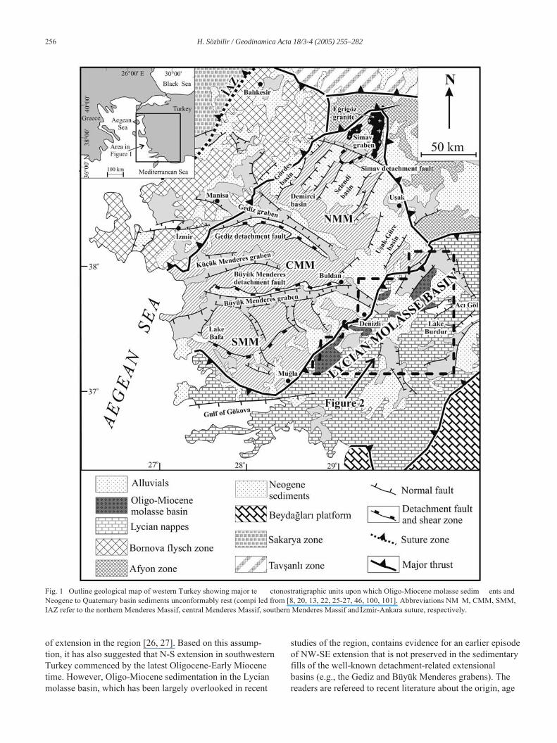
of extension in the region [26, 27]. Based on this assump-tion, it has also suggested that N-S extension in southwesternTurkey commenced by the latest Oligocene-Early Miocenetime. However, Oligo-Miocene sedimentation in the Lycianmolasse basin, which has been largely overlooked in recent
studies of the region, contains evidence for an earlier episodeof NW-SE extension that is not preserved in the sedimentaryfills of the well-known detachment-related extensionalbasins (e.g., the Gediz and Büyük Menderes grabens). Thereaders are refereed to recent literature about the origin, age
Fig. 1 Outline geological map of western Turkey showing major te ctonostratigraphic units upon which Oligo-Miocene molasse sedim ents andNeogene to Quaternary basin sediments unconformably rest (compi led from [8, 20, 13, 22, 25-27, 46, 100, 101]. Abbreviations NM M, CMM, SMM,IAZ refer to the northern Menderes Massif, central Menderes Massif, southern Menderes Massif and |zmir-Ankara suture, respectively.
G18_03 Page 256 Vendredi, 30. septembre 2005 12:20 12 > Apogee FrameMaker Noir

H. Sözbilir / Geodinamica Acta 18/3-4 (2005) 255–282 257
and evolution of extensional tectonics in southwest Turkey(e.g., [8, 10, 16, 19, 23, 25, 28-31] and references therein).
Molasse deposits have long been recognized as an impor-tant tool in the analysis of late orogenic histories [32]. Theterm molasse was originally applied to the molasse of theAlps by Swiss geologists as a distinctive sedimentary facies,consisting of alluvial and shallow-marine deposits thatformed within or adjacent to fold belts in foreland or inter-montane basins [33].
The characteristic features of molasses include the fol-lowing: (1) they lie within or adjacent to emergent fold beltsduring and following orogenic activity; (2) there is a demon-strable association of sedimentation and tectonism; (3)intrabasinal unconformities are present, resulting from dis-continuous uplift within the source area and subsidence inthe basin; (4) metamorphic core complexes, exhumed at thesame time as deposition of the basal molasses, are present[33].
The Oligo-Miocene molasse of southwestern Turkey,here named the Lycian molasse basin, consists of a sequenceof late to early-post orogenic deposits that contain both con-tinental and shallow-marine sediments, similar to othermolasse basins of the world [33, 34]. The sediments lie onthe Mesozoic Lycian nappes and ophiolites, and Palaeocene-Eocene supra-allochthonous sediments. Therefore, they pro-vide important tectonostratigraphic data for the Tertiaryhistory of the region.
The molasse sediments have an areal extent of about150 km SW-NE x 40 km NW-SE (Fig. 2). In the NW, thebasin is in fault contact with the Lycian nappes, while in theSE the molasse sediments are covered discordantly by UpperMiocene clastic sediments. Due to post-depositional tectonicmovements, the Lycian molasse basin is dissected into threeseparate areas of outcrop by NE-SW- and NW-SE-trendingfaults. The southwestern outcrop have been termed the Kale-Tavas molasse (here named Kale-Tavas subbasin). Hakye-
Fig. 2 Simplified geological map of the molasse basin in SW Tur key showing three separate exposures of the molasse deposits, n amely the Kale-Tavas,Çardak-Dazk¬r¬ and Denizli molasse (compiled from [27, 35-39]). Heavy lines with filled triangles show major reactivated thrust as detachment faults.
G18_03 Page 257 Vendredi, 30. septembre 2005 12:20 12 > Apogee FrameMaker Noir

258 H. Sözbilir / Geodinamica Acta 18/3-4 (2005) 255–282
mez [35] mapped the area and defined five formations thatare Chattian-Aquitanian in age. Recently, explanations ofthe tectonic setting and palynostratigraphy of the Kale-Tavas subbasin were presented by Y ¬lmaz et al. [36] andAkgün and Sözbilir [37], respectively. The northern out-crops of the molasse deposits are located to the northeast ofDenizli, where a thick accumulation of terrestrial to marinesediments is observed [38]. Further east, between Çardakand Dazk ¬r¬, an extensive exposure of Lower Oligocene-Aquitanian molasse deposits is also found [39]. The Denizliand the Çardak-Dazk¬r¬ subbasins are poorly known in so faras previous knowledge of the molasse deposits of SW Tur-key was based mainly on outcrops of the Kale-Tavassubbasin.
Y¬lmaz et al. [36] and Gürer and Y ¬lmaz [40] disputedthat the term molasse was appropriate for the Kale-Tavasbasin, which they regarded as a piggy-back basin on thebasis of following arguments: (1) the lack of metamorphicclasts derived from the Menderes Massif; and (2) the lackof a stratigraphic contact between the Kale-Tavas basinsediments and the rocks of the Menderes Massif. How-ever, they reached their conclusions by using field dataderived only from the Kale-Tavas molasse. In this contri-bution, I present evidence that the Denizli molassecontains a record of the unroofing history of the MenderesMassif [41] and, therefore, was deposited during exhuma-tion and represents a molasse succession (in the sense ofMiall [33]).
The aims of this paper are: (1) to describe the primarysedimentary structures and textures, facies and facies associ-ations preserved in the Denizli molasse basin in order toinfer their environments and processes of deposition; (2) toshow the stratigraphic and structural relationships of themolasse sediments with the underlying and overlying units;(3) to outline the stratigraphy of all the molasse exposures inSW Turkey; and (4) to set forth further sedimentological evi-dence related to the exhumation of the Menderes Massif andthe timing of continental extension in western Turkey. Tothese ends, detailed geological maps, several geologicalcross-sections, and four measured logs are presented, andthen synthesized with published data.
2. The Lycian molasses basin
The Lycian molasse basin is subdivided into three subba-sins (the Kale-Tavas subbasin, the Denizli subbasin and theÇardak-Dazk¬r¬ subbasin) by NW-SE- and NE-SW-trendingfaults, and is exposed from Mu…la to Burdur (Fig. 2).
2.1. Kale-Tavas subbasin
In the Kale-Tavas subbasin, Upper Oligocene-LowerMiocene (Chattian to Burdigalian) rocks are represented bythe Akçay group, consisting of a thick (4,100 m) successiondominated by terrestrial to marine deposits (Fig. 3).
The lowermost unit, the Karadere formation (also namedthe Alanyurt formation by Y ¬lmaz et al. [36]) consists ofalluvial-fan deposits with coal lenses. This unit rests uncon-formably on the Lycian nappes and is conformably overlainby the Mortuma formation, comprising braided and mean-dering river deposits with coal-bearing lagoonal sedimentsof Late Oligocene age [35, 37]. The unconformably overly-ing Yenidere formation is characterised by an extremelyvaried succession of terrestrial, limnic and marginal-marinedeposits of Aquitanian age [35]. The angular unconformitybetween the Chattian and Aquitanian rocks is restricted tothe Kale-Tavas subbasin. The Burdigalian is represented byboth the Kale and Künar formations that show both lateraland vertical transitional contact relationships. The Kale for-mation is composed dominantly of marine limestone thatrests unconformably on the Mortuma formation. Towardsthe northwest, the Künar formation (temporal equivalent ofthe Kale formation) has a transitional contact with the under-lying Yenidere formation. The Akçay group isunconformably overlain by continental deposits of theMu…la group, dated as late Astaracian (Middle Miocene) toTurolian (Late Miocene) by Atalay [42].
2.2. Çardak-Dazk¬r¬ subbasin
The Oligo-Miocene fill of this subbasin is called theAc¬göl group, and attains its maximum thickness (up to6,100 m) between Çardak and Dazk¬r¬ [39]. The base of thissubbasin is marked by ophiolite-derived conglomerates andmudstones of the Early Oligocene Armutalan ¬ formation,which was deposited in a fan-delta environment, and gradesupward into the Çardak formation—with the pebbly sand-stone at its base, followed by rippled sandstone-mudstone,and with thick-bedded conglomerate at its top (Fig. 4). Theconformably overlying Hayrettin formation consists of sand-stone-dominated lithologies with lenses of coal and reefalcarbonates. The Hayrettin formation is about 1500-m-thickand has lateral and vertical transitional contacts with theoverlying Tokça formation—a mudstone-dominated succes-sion, including several lenses of coal and reefal carbonates.The Tokça formation is at least 2000-m-thick and of LateOligocene (Chattian) age [39]. The Upper Oligocene-LowerAquitanian are represented by the Bozda … formation, com-prising an conglomerate, sandstone and mudstonealternation with oncoidal limestone at its base. The Ac ¬gölgroup is unconformably overlain by Pliocene continentaldeposits.
2.3. Denizli subbasin (the study area)
The Denizli subbasin is located on tectonically imbricatedunits belonging to the Lycian nappes (or Lycian allochthonof Collins and Robertson [43-46] (Fig. 5). The first regionalevidence of thrusting in the area occurred at the end of theEocene, when the Lycian mélange [43] was thrust onto Pal-aeocene-Eocene supra-allochthonous units (Dereköygroup). This resulted in the formation of a new molasse basin
G18_03 Page 258 Vendredi, 30. septembre 2005 12:20 12 > Apogee FrameMaker Noir

H. Sözbilir / Geodinamica Acta 18/3-4 (2005) 255–282 259
to be filled during the Oligocene-Aquitanian time interval[41].
2.4. Pre-Oligocene basement
In the study area, the basement is represented by variousrock units of the Lycian nappes [38, 47]. They are hereindivided into three formations, namely, in ascending order:(1) the Triassic Karaova formation, (2) the Jurassic-Creta-ceous Çökelez limestone and (3) the Upper CretaceousKaratepe mélange [38]. The Lycian nappes are structurallyunderlain by low-grade schists and intercalated marble
lenses and local metabasic rocks [48]. The details of thestratigraphy and significance of various lithological associa-tions of the pre-Oligocene basement lie outside the scope ofthis paper; thus, the reader is referred to the most recent lit -erature [41, 47, 48] for further reading.
3. Sedimentary fill of the Denizli Subbasin
The Oligo-Miocene fill of the Denizli subbasin (Ac ¬deregroup) is represented by a thick succession (2,000 m) of ter-restrial (Çaykavu ‚tu formation) to marine clastics and
Fig. 3 Generalised lithostratigraphic columnar section of the Ka le-Tavas subbasin illustrating facies changes, fossil contents and the inferreddepositional environments of the formations. Modified from Haky emez [35] and Akgün and Sözbilir [37]. Note the intrabasinal un conformitiesbetween Chattian and Aquitanian, and Chattian and Burdigalian sediments.
G18_03 Page 259 Vendredi, 30. septembre 2005 12:20 12 > Apogee FrameMaker Noir

260 H. Sözbilir / Geodinamica Acta 18/3-4 (2005) 255–282
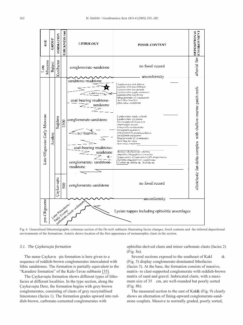
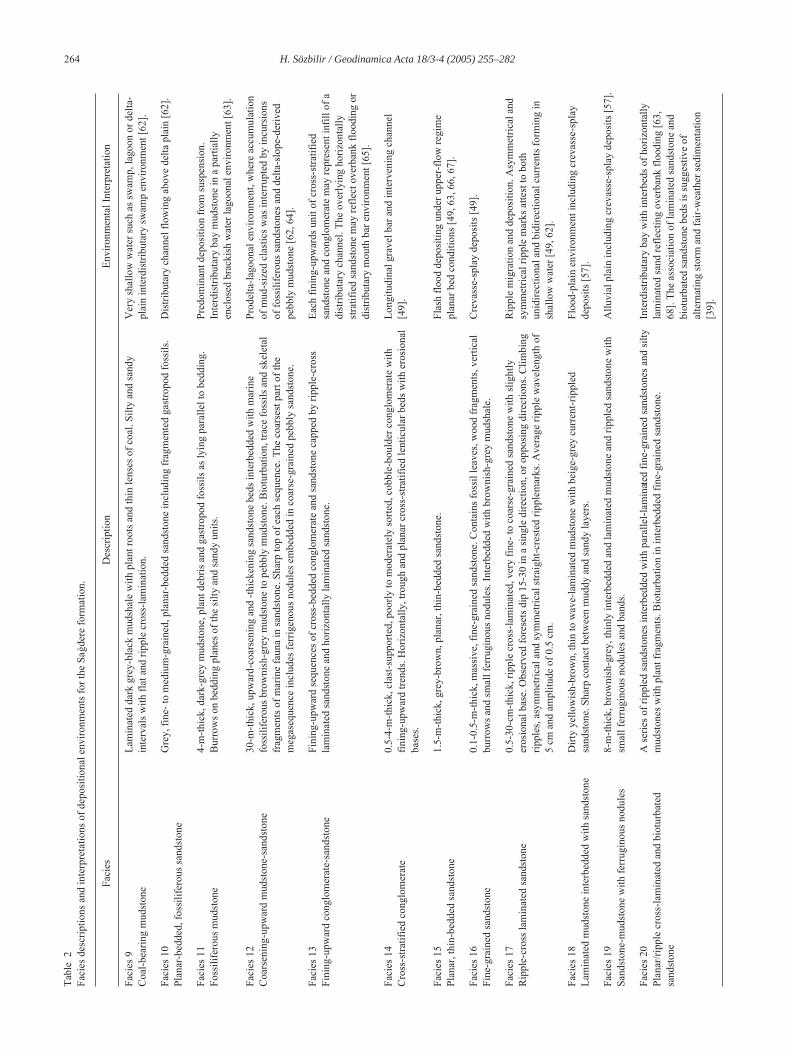
carbonate deposits (Sa …dere formation) (Figs. 5, 6). Thirtyfacies are described (Tables 1, 2) to illustrate the lateral andvertical lithostratigraphic characteristics of these units. Theresults of this work are described below.
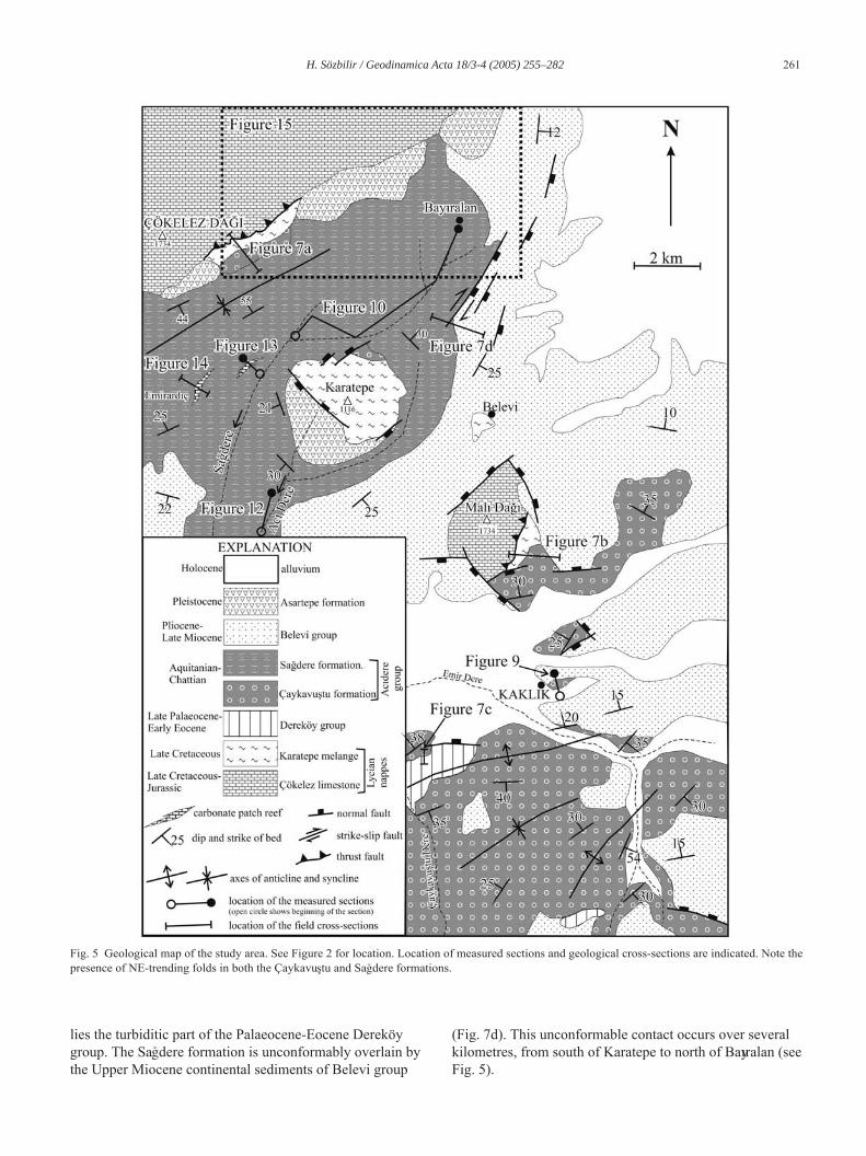
The lower contact of the molasse deposits is observed atseveral localities. As shown by the map and cross-sections(Figs. 5, 7), the molasse deposits unconformably lie on dif-ferent tectonostratigraphic units of the Lycian nappes. To thesouth of Çökelez Mountain, the Çaykavu ‚tu formationunconformably overlies ultrabasic rocks of the Karatepe
mélange (Fig. 7a). The formation begins with clast-sup-ported conglomerates alternating with coarse-grainedsandstones and mudstones. The Çaykavu ‚tu formationgrades conformably into grey sandstone of the Sa …dere for-mation. In the section west of Mal ¬ Da …¬ (Fig. 7b), theÇaykavu‚tu formation unconformably overlies the turbiditicmatrix of the Karatepe mélange, and, in turn, is overlainunconformably by Upper Miocene clastic rocks of theBelevi group. To the west of Kelkaya Tepe (Fig. 7c), thebasal part of the Çaykavu‚tu formation unconformably over-
Fig. 4 Generalised lithostratigraphic columnar section of the Ça rdak-Dazk¬r¬ subbasin illustrating facies changes, fossil contents and the inferreddepositional environments of the formations. Modified from ¥enel [39].
G18_03 Page 260 Vendredi, 30. septembre 2005 12:20 12 > Apogee FrameMaker Noir
H. Sözbilir / Geodinamica Acta 18/3-4 (2005) 255–282 261
lies the turbiditic part of the Palaeocene-Eocene Dereköygroup. The Sa…dere formation is unconformably overlain bythe Upper Miocene continental sediments of Belevi group
(Fig. 7d). This unconformable contact occurs over severalkilometres, from south of Karatepe to north of Bay¬ralan (seeFig. 5).
Fig. 5 Geological map of the study area. See Figure 2 for location. Location of measured sections and geological cross-sections are indicated. Note thepresence of NE-trending folds in both the Çaykavu‚tu and Sa…dere formations.
G18_03 Page 261 Vendredi, 30. septembre 2005 12:20 12 > Apogee FrameMaker Noir
262 H. Sözbilir / Geodinamica Acta 18/3-4 (2005) 255–282
3.1. The Çaykavu‚tu formation
The name Çaykavu ‚tu formation is here given to asequence of reddish-brown conglomerates intercalated withlithic sandstones. The formation is partially equivalent to the“Karadere formation” of the Kale-Tavas subbasin [35].
The Çaykavu‚tu formation shows different types of litho-facies at different localities. In the type section, along theÇaykavu‚tu Dere, the formation begins with grey-brownconglomerates, consisting of clasts of grey recrystallisedlimestones (facies 1). The formation grades upward into red-dish-brown, carbonate-cemented conglomerates with
ophiolite-derived clasts and minor carbonate clasts (facies 2)(Fig. 8a).
Several sections exposed to the southeast of Kakl ¬k(Fig. 5) display conglomerate-dominated lithofacies(facies 3). At the base, the formation consists of massive,matrix- to clast-supported conglomerate with reddish-brownmatrix of sand and gravel. Imbricated clasts, with a maxi-mum size of 35 cm, are well-rounded but poorly sorted(Fig. 8b).
The measured section to the east of Kakl¬k (Fig. 9) clearlyshows an alternation of fining-upward conglomerate-sand-stone couplets. Massive to normally graded, poorly sorted,
Fig. 6 Generalised lithostratigraphic columnar section of the De nizli subbasin illustrating facies changes, fossil contents and the inferred depositionalenvironments of the formations. Asterix shows location of the first appearance of metamorphic clasts in the section.
G18_03 Page 262 Vendredi, 30. septembre 2005 12:20 12 > Apogee FrameMaker Noir

H. Sözbilir / Geodinamica Acta 18/3-4 (2005) 255–282 263Ta
ble
1Fa
cies
des
crip
tions
and
inte
rpre
tatio
ns o
f dep
ositi
onal
env
ironm
ents
for t
he Ç
ayka
vu‚t
u fo
rmat
ion.
Faci
esD
escr
iptio
nEn
viro
nmen
tal I
nter
pret
atio
n
Faci
es 1
Mat
rix-s
uppo
rted
cong
lom
erat
e4−
4.5
m th
ick
beds
with
non
-ero
sion
al b
asal
con
tact
. Peb
ble/
cobb
le g
rave
l and
a m
atrix
of r
eddi
sh-
brow
n sa
ndy-
silty
mud
. Mat
rix-s
uppo
rted,
subr
ound
ed to
roun
ded
clas
ts w
ith c
last
size
rang
ing
from
4 to
40
cm. A
cru
de a
lignm
ent o
f elo
ngat
e gr
avel
cla
sts a
nd a
fain
t lam
inat
ion
shea
r in
mud
dy
mat
rix. N
orm
al a
nd in
vers
e gr
adin
g.
Faci
es G
ms o
f Mia
ll [4
9]. S
ubar
eal d
ebris
flow
[50,
51
].
Faci
es 2
Wel
l-rou
nded
, poo
rly so
rted
cong
lom
erat
eTh
ick-
bedd
ed, c
last
- to
mat
rix-s
uppo
rted,
pol
ymod
al p
ebbl
e to
cob
ble
cong
lom
erat
e, w
hose
un
grad
ed o
r gra
ded
beds
show
fine
r-gr
aine
d ca
ppin
gs o
f san
dsto
ne w
ith m
assi
ve- (
Ta) t
o pl
ane-
para
llel (
Tb) s
tratif
icat
ion.
Wel
l-rou
nded
cla
sts o
f Lyc
ian
carbo
nate
s and
oph
iolit
ic- r
ock
frag
men
ts.
Non
-ero
sion
al to
ero
sion
al b
asal
bou
ndar
ies.
Suba
real
ero
sion
with
tran
spor
t thr
ough
a h
igh-
ener
gy sh
allo
w m
arin
e or
fluv
ial e
nviro
nmen
t prio
r to
dep
ositi
on [5
2−54
]. Ta
and
Tb
Bou
ma
divi
sons
ar
e pe
culia
r to
turb
idite
s.
Faci
es 3
Mas
sive
, mat
rix- t
o cl
ast-s
uppo
rted
cong
lom
erat
e3-
m th
ick,
mas
sive
, mat
rix- t
o cl
ast-s
uppo
rted
cong
lom
erat
e w
ith a
redd
ish-
brow
n m
atrix
of s
and
and
fine
grav
el. W
ell-r
ound
ed a
nd p
oorly
sorte
d, im
bric
ated
cla
sts w
ith a
max
imum
size
of 3
5 cm
. Er
osio
nal t
o no
n-er
osio
nal b
asal
con
tact
.
Cha
nnel
and
long
itudi
nal b
ar d
epos
its o
f sha
llow
br
aide
d st
ream
s in
the
med
ial a
nd p
roxi
mal
par
t of a
n al
luvi
al fa
n [4
9, 5
5].
Faci
es 4
Mas
sive
to n
orm
ally
gra
ded
cong
lom
erat
eM
assi
ve to
nor
mal
ly g
rade
d, p
oorly
sorte
d, c
last
- to
mat
rix-s
uppo
rted
pebb
le to
bou
lder
co
nglo
mer
ate
with
sand
y m
atrix
up
to p
ebbl
e gr
ade.
Sub
roun
ded
to ro
unde
d cl
asts
(5−2
0 cm
) of
ultra
basi
c ro
cks,
limes
tone
, qua
rtzite
and
low
-gra
de m
etam
orph
ic fr
agm
ents
. Len
ses o
f hor
izon
tally
st
ratif
ied
sand
ston
e.
Hig
h-de
nsity
floo
d flo
ws (
hype
rcon
cent
rate
d flo
od
flow
) tha
t are
tran
sitio
nal b
etw
een
norm
al st
ream
an
d de
bris
flow
[56]
.
Faci
es 5
Cro
ss-b
edde
d pe
bbly
sand
ston
e70
-cm
thic
k, le
ntic
ular
, fin
ing-
upw
ard
units
of t
roug
h an
d pl
anar
cro
ss-s
tratif
ied
and
horiz
onta
lly
stra
tifie
d pe
bbly
sand
ston
e w
ith le
ntic
ular
bas
al c
ongl
omer
atic
bed
s. C
last
imbr
icat
ion
show
ing
wes
terly
flow
ing
pala
eocu
rren
ts.
Shal
low
bed
load
cha
nnel
as p
art o
f mig
ratin
g lo
ngitu
dina
l and
tran
sver
se g
rave
lly b
ar. C
hann
el-
floor
lags
(con
glom
erat
e). P
roxi
mal
bra
ided
rive
r de
posi
ts fo
rmed
on
an a
lluvi
al fa
n [5
7].
Faci
es 6
Nor
mal
ly g
rade
d co
nglo
mer
ate
5−6-
m th
ick,
pol
ymic
tic, n
orm
ally
gra
ded
and
clas
t-sup
porte
d co
nglo
mer
ate
with
10−
15-c
m-th
ick
horiz
onta
lly st
ratif
ied
inte
rbed
ded
sand
ston
e. W
ell-r
ound
ed c
last
s of u
ltrab
asic
rock
s, lim
esto
nes,
cher
ts, q
uartz
ite a
nd lo
w-g
rade
met
amor
phic
rock
s.
Long
itudi
nal b
ar (c
ongl
omer
ate)
and
bar
-top
(san
dsto
ne) d
epos
its [5
8].
Faci
es 7
Nor
mal
ly g
rade
d sa
ndst
one
0.5−
15-c
m th
ick,
nor
mal
ly g
rade
d, p
oorly
to w
ell-s
orte
d, fi
ne- t
o ve
ry c
oars
e-gr
aine
d sa
ndst
one
with
bas
al p
ebbl
e cl
asts
. Lat
eral
ly c
ontin
uous
bed
s with
subp
lana
r, no
n-er
osio
nal o
r slig
htly
er
osio
nal b
ound
arie
s.
Hyp
erco
ncen
trate
d flo
w [5
6] o
r sub
aque
ous h
igh-
or
low
-den
sity
turb
idity
cur
rent
s [59
−61]
.
Faci
es 8
Mas
sive
to p
oorly
lam
inat
ed m
udst
one
Ung
rade
d, m
assi
ve to
poo
rly la
min
ated
mud
ston
e ch
arac
teris
ed b
y a
grad
atio
nal c
onta
ct w
ith th
e un
derly
ing
norm
ally
gra
ded
sand
ston
e an
d tru
ncat
ed to
p by
the
mat
rix-s
uppo
rted
cong
lom
erat
e.Su
bare
al w
anin
g flo
od fl
ow [4
9].
G18_03 Page 263 Vendredi, 30. septembre 2005 12:20 12 > Apogee FrameMaker Noir
264 H. Sözbilir / Geodinamica Acta 18/3-4 (2005) 255–282Ta
ble
2Fa
cies
des
crip
tions
and
inte
rpre
tatio
ns o
f dep
ositi
onal
env
ironm
ents
for t
he S
a…de
re fo
rmat
ion.
Faci
esD
escr
iptio
nEn
viro
nmen
tal I
nter
pret
atio
n
Faci
es 9
Coa
l-bea
ring
mud
ston
eLa
min
ated
dar
k gr
ey-b
lack
mud
shal
e w
ith p
lant
root
s and
thin
lens
es o
f coa
l. Si
lty a
nd sa
ndy
inte
rval
s with
flat
and
ripp
le c
ross
-lam
inat
ion.
Ver
y sh
allo
w w
ater
such
as s
wam
p, la
goon
or d
elta
-pl
ain
inte
rdis
tribu
tary
swam
p en
viro
nmen
t [62
].
Faci
es 1
0Pl
anar
-bed
ded,
foss
ilife
rous
sand
ston
eG
rey,
fine
- to
med
ium
-gra
ined
, pla
nar-
bedd
ed sa
ndst
one
incl
udin
g fr
agm
ente
d ga
stro
pod
foss
ils.
Dis
tribu
tary
cha
nnel
flow
ing
abov
e de
lta p
lain
[62]
.
Faci
es 1
1Fo
ssili
fero
us m
udst
one
4-m
-thic
k, d
ark-
grey
mud
ston
e, p
lant
deb
ris a
nd g
astro
pod
foss
ils a
s lyi
ng p
aral
lel t
o be
ddin
g.
Bur
row
s on
bedd
ing
plan
es o
f the
silty
and
sand
y un
its.
Pred
omin
ant d
epos
ition
from
susp
ensi
on.
Inte
rdis
tribu
tary
bay
mud
ston
e in
a p
artia
lly
encl
osed
bra
ckis
h w
ater
lago
onal
env
ironm
ent [
63].
Faci
es 1
2C
oars
enin
g-up
war
d m
udst
one-
sand
ston
e30
-m-th
ick,
upw
ard-
coar
seni
ng a
nd -t
hick
enin
g sa
ndst
one
beds
inte
rbed
ded
with
mar
ine
foss
ilife
rous
bro
wni
sh-g
rey
mud
ston
e to
peb
bly
mud
ston
e. B
iotu
rbat
ion,
trac
e fo
ssils
and
skel
etal
fr
agm
ents
of m
arin
e fa
una
in sa
ndst
one.
Sha
rp to
p of
eac
h se
quen
ce. T
he c
oars
est p
art o
f the
m
egas
eque
nce
incl
udes
ferr
igen
ous n
odul
es e
mbe
dded
in c
oars
e-gr
aine
d pe
bbly
sand
ston
e.
Prod
elta
-lago
onal
env
ironm
ent,
whe
re a
ccum
ulat
ion
of m
ud-s
ized
cla
stic
s was
inte
rrup
ted
by in
curs
ions
of
foss
ilife
rous
sand
ston
es a
nd d
elta
-slo
pe-d
eriv
ed
pebb
ly m
udst
one
[62,
64]
.
Faci
es 1
3Fi
ning
-upw
ard
cong
lom
erat
e-sa
ndst
one
Fini
ng-u
pwar
d se
quen
ces o
f cro
ss-b
edde
d co
nglo
mer
ate
and
sand
ston
e ca
pped
by
rippl
e-cr
oss
lam
inat
ed sa
ndst
one
and
horiz
onta
lly la
min
ated
sand
ston
e.Ea
ch fi
ning
-upw
ards
uni
t of c
ross
-stra
tifie
d sa
ndst
one
and
cong
lom
erat
e m
ay re
pres
ent i
nfill
of a
di
strib
utar
y ch
anne
l. Th
e ov
erly
ing
horiz
onta
lly
stra
tifie
d sa
ndst
one
may
refle
ct o
verb
ank
flood
ing
or
dist
ribut
ary
mou
th b
ar e
nviro
nmen
t [65
].
Faci
es 1
4C
ross
-stra
tifie
d co
nglo
mer
ate
0.5-
4-m
-thic
k, c
last
-sup
porte
d, p
oorly
to m
oder
atel
y so
rted,
cob
ble-
boul
der c
ongl
omer
ate
with
fin
ing-
upw
ard
trend
s. H
oriz
onta
lly, t
roug
h an
d pl
anar
cro
ss-s
tratif
ied
lent
icul
ar b
eds w
ith e
rosi
onal
ba
ses.
Long
itudi
nal g
rave
l bar
and
inte
rven
ing
chan
nel
[49]
.
Faci
es 1
5Pl
anar
, thi
n-be
dded
sand
ston
e1.
5-m
-thic
k, g
rey-
brow
n, p
lana
r, th
in-b
edde
d sa
ndst
one.
Flas
h flo
od d
epos
iting
und
er u
pper
-flo
w re
gim
e pl
anar
bed
con
ditio
ns [4
9, 6
3, 6
6, 6
7].
Faci
es 1
6Fi
ne-g
rain
ed sa
ndst
one
0.1-
0.5-
m-th
ick,
mas
sive
, fin
e-gr
aine
d sa
ndst
one.
Con
tain
s fos
sil l
eave
s, w
ood
frag
men
ts, v
ertic
al
burr
ows a
nd sm
all f
erru
gino
us n
odul
es. I
nter
bedd
ed w
ith b
row
nish
-gre
y m
udsh
ale.
Cre
vass
e-sp
lay
depo
sits
[49]
.
Faci
es 1
7R
ippl
e-cr
oss l
amin
ated
sand
ston
e0.
5-30
-cm
-thic
k, ri
pple
cro
ss-la
min
ated
, ver
y fin
e- to
coa
rse-
grai
ned
sand
ston
e w
ith sl
ight
ly
eros
iona
l bas
e. O
bser
ved
fore
sets
dip
15-
30 in
a si
ngle
dire
ctio
n, o
r opp
osin
g di
rect
ions
. Clim
bing
rip
ples
, asy
mm
etric
al a
nd sy
mm
etric
al st
raig
ht-c
rest
ed ri
pple
mar
ks. A
vera
ge ri
pple
wav
elen
gth
of
5 cm
and
am
plitu
de o
f 0.5
cm
.
Rip
ple
mig
ratio
n an
d de
posi
tion.
Asy
mm
etric
al a
nd
sym
met
rical
ripp
le m
arks
atte
st to
bot
h un
idire
ctio
nal a
nd b
idire
ctio
nal c
urre
nts f
orm
ing
in
shal
low
wat
er [4
9, 6
2].
Faci
es 1
8La
min
ated
mud
ston
e in
terb
edde
d w
ith sa
ndst
one
Dirt
y ye
llow
ish-
brow
n, th
in to
wav
e-la
min
ated
mud
ston
e w
ith b
eige
-gre
y cu
rren
t-rip
pled
sa
ndst
one.
Sha
rp c
onta
ct b
etw
een
mud
dy a
nd sa
ndy
laye
rs.
Floo
d-pl
ain
envi
ronm
ent i
nclu
ding
cre
vass
e-sp
lay
depo
sits
[57]
.
Faci
es 1
9Sa
ndst
one-
mud
ston
e w
ith fe
rrug
inou
s nod
ules
8-m
-thic
k, b
row
nish
-gre
y, th
inly
inte
rbed
ded
and
lam
inat
ed m
udst
one
and
rippl
ed sa
ndst
one
with
sm
all f
erru
gino
us n
odul
es a
nd b
ands
.A
lluvi
al p
lain
incl
udin
g cr
evas
se-s
play
dep
osits
[57]
.
Faci
es 2
0Pl
anar
/ripp
le c
ross
-lam
inat
ed a
nd b
iotu
rbat
ed
sand
ston
e
A se
ries o
f rip
pled
sand
ston
es in
terb
edde
d w
ith p
aral
lel-l
amin
ated
fine-
grai
ned
sand
ston
es a
nd si
lty
mud
ston
es w
ith p
lant
frag
men
ts. B
iotu
rbat
ion
in in
terb
edde
d fin
e-gr
aine
d sa
ndst
one.
Inte
rdis
tribu
tary
bay
with
inte
rbed
s of h
oriz
onta
lly
lam
inat
ed sa
nd re
flect
ing
over
bank
floo
ding
[63,
68
]. Th
e as
soci
atio
n of
lam
inat
ed sa
ndst
one
and
biot
urba
ted
sand
ston
e be
ds is
sugg
estiv
e of
al
tern
atin
g st
orm
and
fair-
wea
ther
sedi
men
tatio
n [3
9].
G18_03 Page 264 Vendredi, 30. septembre 2005 12:20 12 > Apogee FrameMaker Noir
H. Sözbilir / Geodinamica Acta 18/3-4 (2005) 255–282 265
Faci
es 2
1Pa
ralle
l-lam
inat
ed, f
ossi
lifer
ous s
ands
tone
Wel
l-sor
ted,
med
ium
- to
coar
se-g
rain
ed, p
aral
lel-l
amin
ated
sand
ston
e w
ith a
bund
ant p
lant
foss
ils
and
orga
nic
detri
tus.
Tabu
lar w
ith fl
at b
ase
and
top.
Dis
tal d
elta
-fro
nt d
epos
its [7
0].
Faci
es 2
2C
ross
-stra
tifie
d sa
ndst
one
and
cong
lom
erat
eC
ross
-stra
tifie
d sa
ndst
one
and
cong
lom
erat
e w
ith b
asal
scou
rs fl
oore
d w
ith g
rave
l. Le
ss o
ften,
tro
ugh
cros
s-st
ratif
ied
cong
lom
erat
e an
d pe
bbly
sand
ston
e.D
istri
buta
ry c
hann
el fi
ll in
del
ta-p
lain
env
ironm
ent
[55]
.
Faci
es 2
3Pl
anar
/ripp
le c
ross
-lam
inat
ed sa
ndst
one
with
fe
rrug
inou
s nod
ule
Mod
erat
ely
sorte
d, p
lana
r- to
ripp
le-la
min
ated
, fin
e- to
ver
y fin
e-gr
aine
d sa
ndst
one
with
shel
l fr
agm
ents
and
ferr
ugin
ous n
odul
es. S
ynse
dim
enta
ry fa
ults
and
fold
s in
the
mid
dle
part
of th
e fa
cies
.D
istri
buta
ry-m
outh
bar
[63]
. Int
erac
tion
of fl
uvia
l an
d m
arin
e pr
oces
ses [
70].
Syns
edim
enta
ry fa
ultin
g an
d fo
ldin
g in
the
delta
-slo
pe e
nviro
nmen
t.
Faci
es 2
4H
oriz
onta
lly st
ratif
ied
cong
lom
erat
e2-
m-th
ick,
mod
erat
ely
to w
ell-s
orte
d, c
last
-sup
porte
d gr
anul
e-pe
bble
con
glom
erat
e w
ith sa
ndy
mat
rix. L
ocal
ly, c
last
imbr
icat
ion
and
norm
al g
radi
ng. H
oriz
onta
lly st
ratif
ied
beds
with
subp
lana
r, sl
ight
ly e
rosi
onal
to n
on-e
rosi
onal
bou
ndar
ies.
Suba
real
shee
tfloo
d or
wav
e-dr
iven
bed
load
trac
tion
form
ed b
y up
per-
flow
regi
me
plan
ar b
ed c
ondi
tions
[5
5, 7
1]. A
tran
sitio
nal f
acie
s bet
wee
n de
lta-p
lain
an
d de
lta-f
ront
sedi
men
ts [7
2].
Faci
es 2
5Fo
ssili
fero
us sa
ndst
one
Wea
kly
cem
ente
d sa
ndst
one
cont
aini
ng la
rge
amou
nts o
f fra
gmen
ted
and
abra
ded
skel
etal
gra
ins o
f M
adio
lus s
p., M
ytyl
us sp
. and
Cor
bula
sp.
Stor
m-r
ewor
ked
skel
etal
acc
umul
atio
n [6
9, 7
3].
Faci
es 2
6C
erei
phyl
lia
limes
tone
Lent
icul
ar li
mes
tone
with
sess
ile c
oral
Cer
eiph
ylli
a sp
. em
bedd
ed in
mic
ritic
and
ver
y fin
e si
licic
last
ic m
atrix
. Max
imum
thic
knes
s is 3
0 cm
. Und
erla
in b
y co
al-b
earin
g m
udsh
ale
and,
in tu
rn,
over
lain
by
the
coqu
ina
bed
of fa
cies
25.
Tran
sitio
nal f
acie
s fro
m la
goon
to st
orm
-der
ived
se
dim
ents
[73]
.
Faci
es 2
7C
oral
-ree
f lim
esto
neC
oral
bre
ccia
with
scat
tere
d co
loni
es o
f the
sam
e co
ral g
ener
a, b
ound
by
red-
alga
l coa
tings
, alg
al
limes
tone
s with
ben
thic
fora
min
ifera
, gas
tropo
ds, a
nd m
inor
inte
rlaye
rs o
f sili
cicl
astic
sand
ston
e.
Silic
icla
stic
sedi
men
t fill
ing
the
spac
es a
mon
g th
e sk
elet
al fr
agm
ents
.
Patc
h re
ef g
row
ing
in th
e sh
allo
w-m
arin
e ar
ea o
f the
fr
ont o
f pro
grad
ing
fan
delta
[74]
.
Faci
es 2
8Fo
ram
inife
ral p
acks
tone
Mod
erat
ely
to w
ell-s
orte
d lim
esto
ne c
onta
inin
g be
nthi
c fo
ram
inife
ra (m
ainl
y L
epid
ocyc
lina
spec
ies)
up
to 2
cm
in le
ngth
. Som
e al
gae
with
littl
e m
atrix
.Sh
allo
w-m
arin
e en
viro
nmen
t [75
].
Faci
es 2
9Ir
regu
larly
bed
ded
sand
ston
eM
oder
atel
y so
rted,
med
ium
- to
coar
se-g
rain
ed le
ntic
ular
to ta
bula
r san
dsto
ne w
ith ir
regu
lar b
ase
and
top.
Incl
udes
con
torte
d be
ddin
g, fl
uid-
esca
pe st
ruct
ures
and
hum
moc
ky b
eddi
ng.
Prox
imal
fan
delta
-fro
nt d
epos
its. H
umm
ocky
be
ddin
g m
ay b
e pr
oduc
ed b
y co
mbi
ned
flow
in
stor
m-s
helf
envi
ronm
ent b
elow
nor
mal
wav
e ba
se
and
abov
e st
orm
wav
e ba
se [6
9, 7
5].
Faci
es 3
0R
eefa
l rud
ston
e an
f flo
atst
one
Fine
- to
coar
se-g
rain
ed, c
last
-sup
porte
d (r
udst
one)
and
mat
rix-s
uppo
rted
(flo
atst
one)
cor
al a
nd
fora
min
ifera
l fra
gmen
ts e
mbe
dded
in m
ud m
atrix
. Ove
rlies
the
cora
l-ree
f lim
esto
ne fa
cies
and
in
turn
, is o
verla
in b
y al
tern
atio
n of
turb
iditi
c sa
ndst
one
and
shal
e.
Red
epos
ition
of r
eef s
edim
ents
ero
ded
from
the
faci
es 2
7. D
epos
iton
on re
ef fl
at (r
udst
one)
and
fo
rere
ef sl
ope
(flo
atst
one)
[74]
.
Tabl
e2
Faci
es d
escr
iptio
ns a
nd in
terp
reta
tions
of d
epos
ition
al e
nviro
nmen
ts fo
r the
Sa…
dere
form
atio
n. (c
onti
nued
)
G18_03 Page 265 Vendredi, 30. septembre 2005 12:20 12 > Apogee FrameMaker Noir

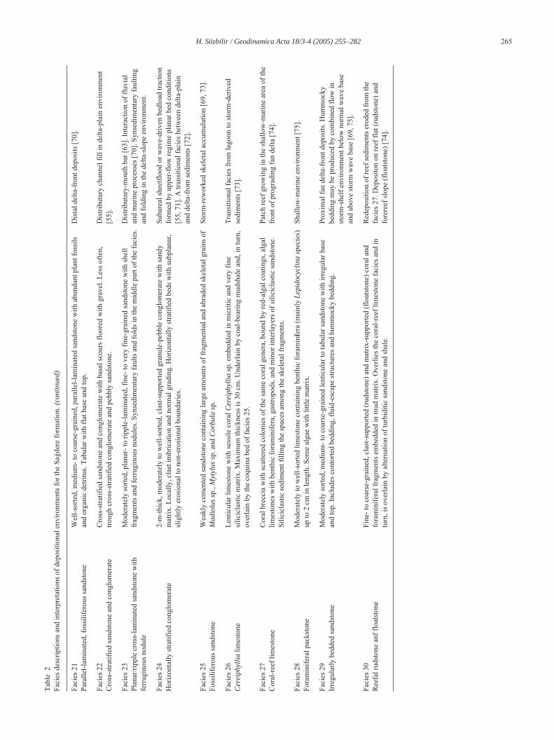
266 H. Sözbilir / Geodinamica Acta 18/3-4 (2005) 255–282
Fig. 7 Geological cross-sections showing (a) an unconformable lower contact of the Çaykavu ‚tu formation with the underlying ophiolitic part of theKaratepe mélange; (b) an unconformable lower contact of the Çaykavu‚tu formation with the underlying turbiditic part of the Karatepe mélange; (c) anunconformable lower contact of the Çaykavu‚tu formation with the underlying turbiditic part of the Palaeocene-Eocene supra-allochthonous sediments;(d) an unconformable upper contact of the Sa…dere formation with the overlying lacustrine sediments of the Upper Miocene-Pliocene Belevi group. SeeFigures 5 and 15 for location.
G18_03 Page 266 Vendredi, 30. septembre 2005 12:20 12 > Apogee FrameMaker Noir

H. Sözbilir / Geodinamica Acta 18/3-4 (2005) 255–282 267
Fig. 8 Field photographs representative of some facies of the Çaykavu‚tu formation. (a) well- rounded, poorly sorted conglomerate (facies 2) includingophiolitic rocks of the Lycian nappes in the western side of Çaykavu‚tu Dere; (b) thick-bedded, clast- to matrix-supported, poly-modal pebble to cobbleconglomerate, whose ungraded or graded beds show finer-grained cappings of sandstone with massive (Ta) to plane-parallel (Tb) stratification. eb-erosional boundary, ss- sandstone; (c) well-rounded clasts of Lycian carbonates and ophiolitic rock f ragments in facies 2. Pencil is ~ 15 cm long; (d)massive, matrix- to clast-supported conglomerate (facies 3) with a reddish-brown matrix of sand and fine gravel in the east of the Kakl¬k area. Note thewell- rounded and poorly sorted, imbricated clasts with a maximum size of 35 cm; (e) cross-bedded pebbly sandstone (facies 5). Note lenticular, fining-upward units of trough and planar cross-stratified and horizont ally stratified pebbly sandstone with lenticular basal conglome ratic beds. White arrowsindicate the scale of the photo. Hammer is ~34 cm long.
G18_03 Page 267 Vendredi, 30. septembre 2005 12:20 12 > Apogee FrameMaker Noir
268 H. Sözbilir / Geodinamica Acta 18/3-4 (2005) 255–282
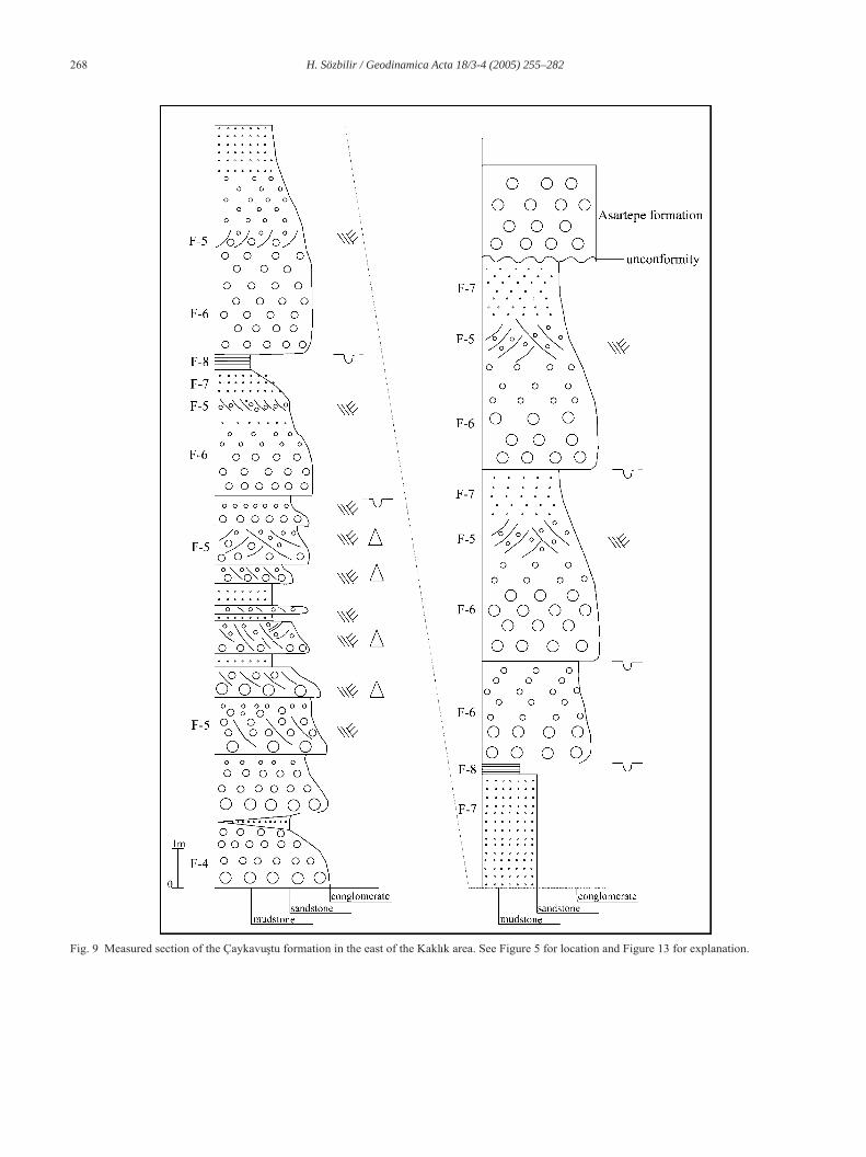
Fig. 9 Measured section of the Çaykavu‚tu formation in the east of the Kakl¬k area. See Figure 5 for location and Figure 13 for explanation.
G18_03 Page 268 Vendredi, 30. septembre 2005 12:20 12 > Apogee FrameMaker Noir
H. Sözbilir / Geodinamica Acta 18/3-4 (2005) 255–282 269
generally clast- to matrix-supported conglomerates of peb-ble to boulder size (facies 4) form the lowest part of themeasured stratigraphic section. Upsection and northward, across-bedded pebbly sandstone facies (Fig. 8e) is exposed(facies 5). This facies is overlain by polymict, normallygraded and clast-supported conglomerates with thin, inter-bedded sandstones (facies 6). Individual conglomerate-sandstone couplets end with normally graded, fine- to verycoarse-grained sandstone with pebble conglomerates(facies 7).
An overall fining-upwards trend in the Kakl ¬k section(Fig. 9) is represented by a reddish-brown mudstone(facies 8) that caps the several conglomerate-sandstone cou-plets. The facies has a gradational contact with theunderlying normally graded sandstone and is truncated bythe matrix-supported conglomerates.
3.2. The Sa… dere formation
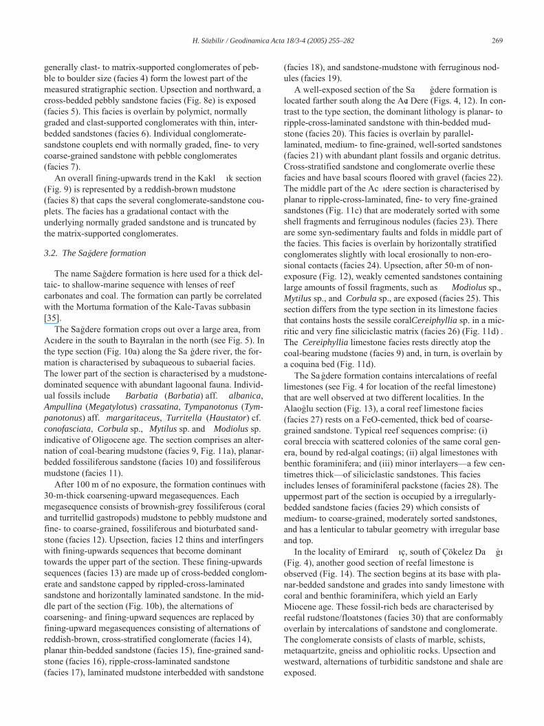
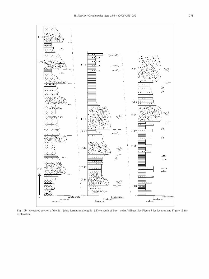
The name Sa…dere formation is here used for a thick del-taic- to shallow-marine sequence with lenses of reefcarbonates and coal. The formation can partly be correlatedwith the Mortuma formation of the Kale-Tavas subbasin[35].
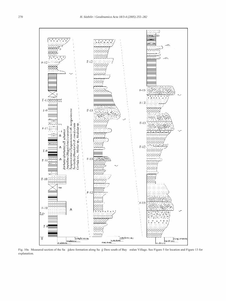
The Sa…dere formation crops out over a large area, fromAc¬dere in the south to Bay¬ralan in the north (see Fig. 5). Inthe type section (Fig. 10a) along the Sa …dere river, the for-mation is characterised by subaqueous to subaerial facies.The lower part of the section is characterised by a mudstone-dominated sequence with abundant lagoonal fauna. Individ-ual fossils include Barbatia (Barbatia) aff. albanica,Ampullina (Megatylotus) crassatina, Tympanotonus (Tym-panotonus) aff. margaritaceus, Turritella (Haustator) cf.conofasciata, Corbula sp., Mytilus sp. and Modiolus sp.indicative of Oligocene age. The section comprises an alter-nation of coal-bearing mudstone (facies 9, Fig. 11a), planar-bedded fossiliferous sandstone (facies 10) and fossiliferousmudstone (facies 11).
After 100 m of no exposure, the formation continues with30-m-thick coarsening-upward megasequences. Eachmegasequence consists of brownish-grey fossiliferous (coraland turritellid gastropods) mudstone to pebbly mudstone andfine- to coarse-grained, fossiliferous and bioturbated sand-stone (facies 12). Upsection, facies 12 thins and interfingerswith fining-upwards sequences that become dominanttowards the upper part of the section. These fining-upwardssequences (facies 13) are made up of cross-bedded conglom-erate and sandstone capped by rippled-cross-laminatedsandstone and horizontally laminated sandstone. In the mid-dle part of the section (Fig. 10b), the alternations ofcoarsening- and fining-upward sequences are replaced byfining-upward megasequences consisting of alternations ofreddish-brown, cross-stratified conglomerate (facies 14),planar thin-bedded sandstone (facies 15), fine-grained sand-stone (facies 16), ripple-cross-laminated sandstone(facies 17), laminated mudstone interbedded with sandstone
(facies 18), and sandstone-mudstone with ferruginous nod-ules (facies 19).
A well-exposed section of the Sa …dere formation islocated farther south along the Ac¬ Dere (Figs. 4, 12). In con-trast to the type section, the dominant lithology is planar- toripple-cross-laminated sandstone with thin-bedded mud-stone (facies 20). This facies is overlain by parallel-laminated, medium- to fine-grained, well-sorted sandstones(facies 21) with abundant plant fossils and organic detritus.Cross-stratified sandstone and conglomerate overlie thesefacies and have basal scours floored with gravel (facies 22).The middle part of the Ac ¬dere section is characterised byplanar to ripple-cross-laminated, fine- to very fine-grainedsandstones (Fig. 11c) that are moderately sorted with someshell fragments and ferruginous nodules (facies 23). Thereare some syn-sedimentary faults and folds in middle part ofthe facies. This facies is overlain by horizontally stratifiedconglomerates slightly with local erosionally to non-ero-sional contacts (facies 24). Upsection, after 50-m of non-exposure (Fig. 12), weakly cemented sandstones containinglarge amounts of fossil fragments, such as Modiolus sp.,Mytilus sp., and Corbula sp., are exposed (facies 25). Thissection differs from the type section in its limestone faciesthat contains hosts the sessile coral Cereiphyllia sp. in a mic-ritic and very fine siliciclastic matrix (facies 26) (Fig. 11d) .The Cereiphyllia limestone facies rests directly atop thecoal-bearing mudstone (facies 9) and, in turn, is overlain bya coquina bed (Fig. 11d).
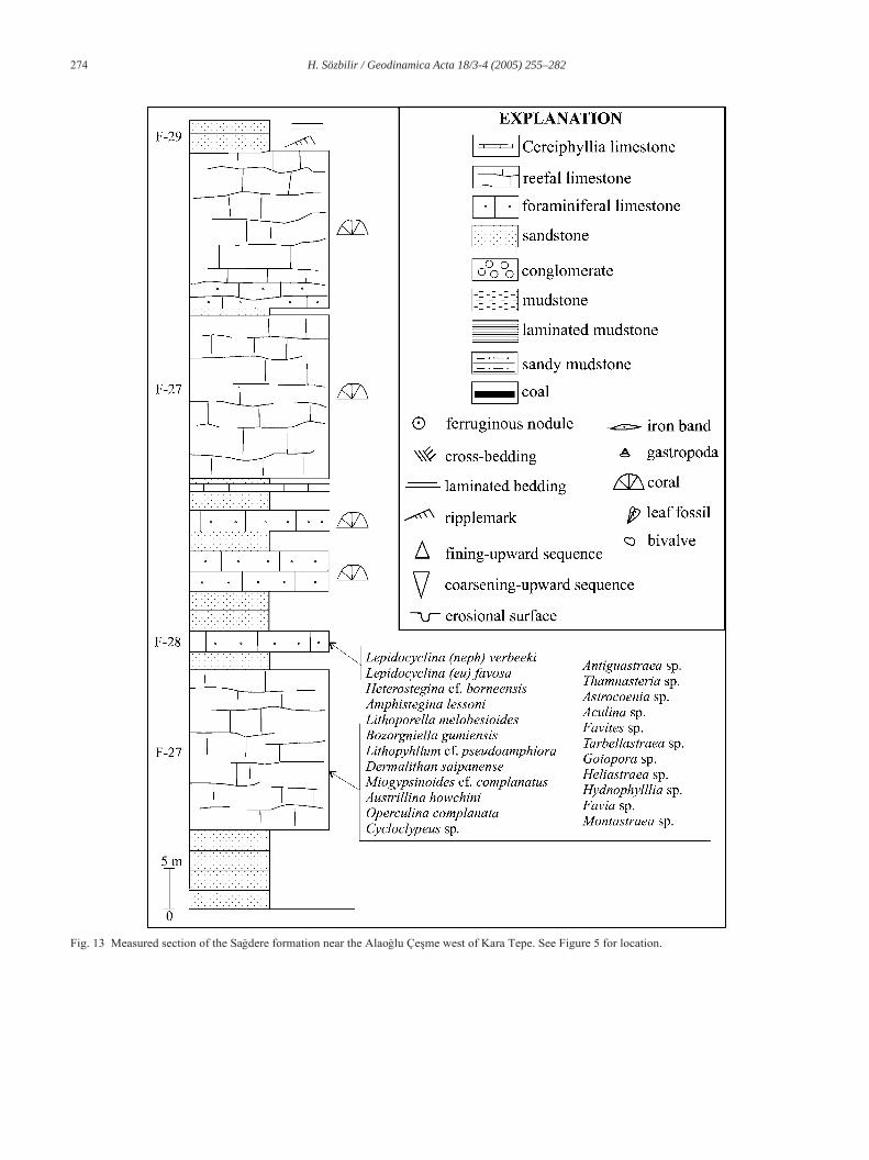
The Sa …dere formation contains intercalations of reefallimestones (see Fig. 4 for location of the reefal limestone)that are well observed at two different localities. In theAlao…lu section (Fig. 13), a coral reef limestone facies(facies 27) rests on a FeO-cemented, thick bed of coarse-grained sandstone. Typical reef sequences comprise: (i)coral breccia with scattered colonies of the same coral gen-era, bound by red-algal coatings; (ii) algal limestones withbenthic foraminifera; and (iii) minor interlayers—a few cen-timetres thick—of siliciclastic sandstones. This faciesincludes lenses of foraminiferal packstone (facies 28). Theuppermost part of the section is occupied by a irregularly-bedded sandstone facies (facies 29) which consists ofmedium- to coarse-grained, moderately sorted sandstones,and has a lenticular to tabular geometry with irregular baseand top.
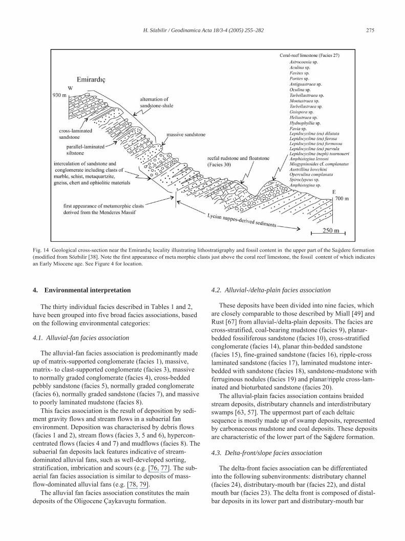
In the locality of Emirard ¬ç, south of Çökelez Da …¬(Fig. 4), another good section of reefal limestone isobserved (Fig. 14). The section begins at its base with pla-nar-bedded sandstone and grades into sandy limestone withcoral and benthic foraminifera, which yield an EarlyMiocene age. These fossil-rich beds are characterised byreefal rudstone/floatstones (facies 30) that are conformablyoverlain by intercalations of sandstone and conglomerate.The conglomerate consists of clasts of marble, schists,metaquartzite, gneiss and ophiolitic rocks. Upsection andwestward, alternations of turbiditic sandstone and shale areexposed.
G18_03 Page 269 Vendredi, 30. septembre 2005 12:20 12 > Apogee FrameMaker Noir
270 H. Sözbilir / Geodinamica Acta 18/3-4 (2005) 255–282
Fig. 10a Measured section of the Sa …dere formation along Sa … Dere south of Bay ¬ralan Village. See Figure 5 for location and Figure 13 forexplanation.
G18_03 Page 270 Vendredi, 30. septembre 2005 12:20 12 > Apogee FrameMaker Noir
H. Sözbilir / Geodinamica Acta 18/3-4 (2005) 255–282 271
Fig. 10b Measured section of the Sa …dere formation along Sa … Dere south of Bay ¬ralan Village. See Figure 5 for location and Figure 13 forexplanation.
G18_03 Page 271 Vendredi, 30. septembre 2005 12:20 12 > Apogee FrameMaker Noir

272 H. Sözbilir / Geodinamica Acta 18/3-4 (2005) 255–282
Fig. 11 Field photographs representative of some facies of the S a…dere formation. (a) coal-bearing mudstone (facies 9) south of Yan¬k Tepe. Note thelaminated dark grey-black mudstone with plant roots and thin le nses of coals. Hammer is ~34 cm long; (b) fossiliferous mudstone (facies 11). Cap is4 cm in diameter. Note plant debris and gastropod fossils lying parallel to bedding (arrowed); (c) planar/ripple cross-laminated sandstone withferruginous nodule (arrowed) in the western side of Ac ¬ Dere (facies 23). The woman is 1.65 m tall; (d) weakly cemented sandstone (facies 25)containing large amounts of fragmented and abraded skeletal gra ins of Madiolus sp., Mytylus sp. and Corbula sp. Hammer is ~34 cm long. This faciesis underlain by lenticular limestone containing sessile organism, Cereiphyllia sp., embedded in micritic and very fine siliciclastic matrix (facies 26); (e)inset is a close-up view of the Cereiphyllia limestone facies. Note the coal-bearing mudstone beneath facies 26.
G18_03 Page 272 Vendredi, 30. septembre 2005 12:20 12 > Apogee FrameMaker Noir

H. Sözbilir / Geodinamica Acta 18/3-4 (2005) 255–282 273
Fig. 12 Measured section of the Sa …dere formation along Sa …dere Dere southwest of Kara Tepe. See Figure 4 for location and Figure 13 forexplanation.
G18_03 Page 273 Vendredi, 30. septembre 2005 12:20 12 > Apogee FrameMaker Noir
274 H. Sözbilir / Geodinamica Acta 18/3-4 (2005) 255–282
Fig. 13 Measured section of the Sa…dere formation near the Alao…lu Çe‚me west of Kara Tepe. See Figure 5 for location.
G18_03 Page 274 Vendredi, 30. septembre 2005 12:20 12 > Apogee FrameMaker Noir
H. Sözbilir / Geodinamica Acta 18/3-4 (2005) 255–282 275
4. Environmental interpretation
The thirty individual facies described in Tables 1 and 2,have been grouped into five broad facies associations, basedon the following environmental categories:
4.1. Alluvial-fan facies association
The alluvial-fan facies association is predominantly madeup of matrix-supported conglomerate (facies 1), massive,matrix- to clast-supported conglomerate (facies 3), massiveto normally graded conglomerate (facies 4), cross-beddedpebbly sandstone (facies 5), normally graded conglomerate(facies 6), normally graded sandstone (facies 7), and massiveto poorly laminated mudstone (facies 8).
This facies association is the result of deposition by sedi-ment gravity flows and stream flows in a subaerial fanenvironment. Deposition was characterised by debris flows(facies 1 and 2), stream flows (facies 3, 5 and 6), hypercon-centrated flows (facies 4 and 7) and mudflows (facies 8). Thesubaerial fan deposits lack features indicative of stream-dominated alluvial fans, such as well-developed sorting,stratification, imbrication and scours (e.g. [76, 77]. The sub-aerial fan facies association is similar to deposits of mass-flow-dominated alluvial fans (e.g. [78, 79].
The alluvial fan facies association constitutes the maindeposits of the Oligocene Çaykavu‚tu formation.
4.2. Alluvial-/delta-plain facies association
These deposits have been divided into nine facies, whichare closely comparable to those described by Miall [49] andRust [67] from alluvial-/delta-plain deposits. The facies arecross-stratified, coal-bearing mudstone (facies 9), planar-bedded fossiliferous sandstone (facies 10), cross-stratifiedconglomerate (facies 14), planar thin-bedded sandstone(facies 15), fine-grained sandstone (facies 16), ripple-crosslaminated sandstone (facies 17), laminated mudstone inter-bedded with sandstone (facies 18), sandstone-mudstone withferruginous nodules (facies 19) and planar/ripple cross-lam-inated and bioturbated sandstone (facies 20).
The alluvial-plain facies association contains braidedstream deposits, distributary channels and interdistributaryswamps [63, 57]. The uppermost part of each deltaicsequence is mostly made up of swamp deposits, representedby carbonaceous mudstone and coal deposits. These depositsare characteristic of the lower part of the Sa…dere formation.
4.3. Delta-front/slope facies association
The delta-front facies association can be differentiatedinto the following subenvironments: distributary channel(facies 24), distributary-mouth bar (facies 22), and distalmouth bar (facies 23). The delta front is composed of distal-bar deposits in its lower part and distributary-mouth bar
Fig. 14 Geological cross-section near the Emirard¬ç locality illustrating lithostratigraphy and fossil content in the upper part of the Sa…dere formation(modified from Sözbilir [38]. Note the first appearance of meta morphic clasts just above the coral reef limestone, the fossil content of which indicatesan Early Miocene age. See Figure 4 for location.
G18_03 Page 275 Vendredi, 30. septembre 2005 12:20 12 > Apogee FrameMaker Noir

276 H. Sözbilir / Geodinamica Acta 18/3-4 (2005) 255–282
deposits in its upper part. Collectively, the sediments fromthe distal mouth bar to the distributary channel constitute atypical coarsening-upward sequence.
As the aggradation advanced, superficial oxidation tookplace in some instances, producing incipient ferruginousnodules and bands [65]. Their deposition reflects interactionbetween fluvial processes and wave action [55, 57]. Thepresence of ferruginous nodules and bands indicate that thedepositional surface was shallow and temporarily emergent.
4.4. Prodelta/Lagoonal (back barrier) facies association
The lagoonal sequence generally consists of interbeddedand interfingering sandstone, shale, siltstone and coal, char-acteristic of a number of overlapping sub-environments(e.g., facies 11, 12, 25 and 26). The sand facies includeswashover-sheet deposits and channel-fill deposits of flood-tidal delta origin [63, 64]. Organic deposits of coal recordmarsh and swamp environments, and typically are quite thin,lagoonal margin, and on emergent washover flats. Subaque-ous mudstone facies are often characterised by brackish-water macro-invertebrate remains [69, 73].
4.5. Reef facies association
The studied fan-delta complex contains several strati-graphic horizons of reefal limestones, which occur at the topof individual fan-delta sequences. Based upon their charac-teristics, the limestones are interpreted here as patch reefs[74]. They are associated with delta-front/slope deposits,and occur as isolated carbonate mounds, 10 m in diameter,and largely massive or poorly bedded limestone units.
These carbonate deposits within the fan-delta complexare good indicators of marine transgressive phases, whichapparently terminated each episode of fan-delta prograda-
tion. The reefal limestones are interpreted as representativeof deposition during stages of fan-delta drowning due torapid but considerable relative rises in sea level [80].
Repetitive colonisation of the fan-delta slopes by reefalorganisms produced units of skeletal limestone (up to 20 cmthick) separated by siliciclastic deposits (up to 10 m thick). Itmay be inferred that the reefs grew mainly during periods ofreduced siliciclastic sedimentation, caused either by pro-longed inactivity of the fan deltas between major stages offlooding and progradation, or by lateral shifting of active deltalobes with development of more local ‘starved’ zones, asobserved in the Almanzora Basin, southeastern Spain [74].
5. Structure
Structures observed in the Lycian molasse basin fill aregrouped into three categories: (1) intrabasinal unconformitiesreflecting deformation and transgression in the Kale-Tavasmolasse; (2) a series of NE-trending anticlines and synclineswith axes subparallel to basin-elongation (see Fig. 5); (3) reversefaults marked by the structural juxtaposition of underlying sedi-mentary rocks of the molasse basin and overlying ophiolitic andcarbonate rocks of the Lycian nappes (see Fig. 15).
Two intrabasinal unconformities occur in the Kale-Tavassubbasin between Chattian and Aquitanian units, and Chattianand Burdigalian units, respectively. They are laterally exten-sive along strike for up to a few kilometres before dying out.Perpendicular to strike, they disappear rather abruptly towardsthe inner zones of the basin where sedimentation was notinterrupted by erosion. This type of unconformity is similar tothe “syntectonic unconformities” of Riba [81], and I interpretthese as having formed with tectonic pulses during the south-eastward translation of the Lycian nappes.
Fig. 15 Detailed geological map south of Çökelez Mountain. See F igure 4 for location. Note a thrust fault along which the Lycia n nappes andsediments of the Sa…dere formation are brought into contact.
G18_03 Page 276 Vendredi, 30. septembre 2005 12:20 12 > Apogee FrameMaker Noir

H. Sözbilir / Geodinamica Acta 18/3-4 (2005) 255–282 277
Folds of mappable scale occur as a series of anticlines andsynclines with axes parallel to the direction of basin elonga-tion (Fig. 5). The main trends of these folds indicate NW-SE- directed compression consistent with southeastwardtranslation of the Lycian nappes, which continued until LateMiocene time [44, 53]. Similar NE-trending folds have beendocumented by Bozkurt [19] in the NE-trending, Early-Mid-dle Miocene lacustrine basins that developed on the northernMenderes Massif.
The tectonic contact between the sedimentary fill of theDenizli subbasin and the Lycian nappes is evident atKuzunkaya (Fig. 15), where sheared serpentinites—sur-rounded by a deformed matrix of alternating sandstone andshale—are thrust over clastic rocks of the Sa …dere forma-tion. In this area, the Sa …dere formation comprises analternation of yellowish-grey laminated mudstone, darkgreen to dark grey sandstone and ophiolite-fragment-rich,poorly sorted conglomerate. A similar contact relationship isobserved in the Çardak-Dazk ¬r¬ subbasin, southwest ofTokça Village, where Lycian carbonates are thrust overmolasse sediments (see Fig. 2).
6. Evidence for unroofing history of the Menderes Massif
Over the last decade, numerous geochronological studieshave greatly advanced our understanding of the unroofinghistory of the Menderes Massif (Fig. 16). Most are concen-trate on the age of so-called augen gneisses in the massif—acontroversial issue of whether the protolith granites are Pre-cambrian or Tertiary (e.g. [20, 82-87] and referencestherein). On the other hand, Tertiary metamorphism hasbeen constrained by Rb/Sr mica ages of 35 ± 5 Ma [88, 89].This age was roughly contemporaneous with 43-37 Ma mus-covite 40Ar-39Ar ages of Hetzel and Reischmann [82], whosuggested that this dated the time of shear-zone developmentin the Menderes Massif. Gessner et al. [85] recently ques-tioned the significance of Tertiary metamorphism anddeformation, and suggested that it was confined to green-schist-facies conditions. Earlier pervasive deformation hasbeen constrained by these authors to the Neoproterozoic.The Lycian nappes were thrust southeastward from LateCretaceous to Late Miocene times [43, 44, 46]. Evidencefrom the upper levels of the Çine submassif of the MenderesMassif and the Tavas/Bozda…¬ unit (see Fig. 2) suggest thatrocks found to the south and east of the Menderes Massifwere thrust over by mid-Palaeocene to Eocene times [46-48]. Lips et al. [90] suggested a multistage exhumation; afirst stage of exhumation around 40-35 Ma was induced bynorthward-directed imbrication of the composite basementin the central Menderes Massif. Younger, Late Oligocene-Early Miocene extension was suggested by Bozkurt andPark [23, 91-93] and Bozkurt [8, 18], and interpreted to be aresult of collapse of the Lycian Orogen. Dating of syn-detachment granites has demonstrated that extension was
underway by 20 Ma [94-96]. A later Pliocene-Recent phaseof extension is responsible for unroofing the gneissic core ofthe Menderes Massif [84, 97].
The occurrence of different clast types in the sedimen-tary succession of the Oligo-Miocene molasse can becorrelated with the progressive unroofing history of theMenderes Massif. Sözbilir [41] showed that the southeast-ern fill of the molasse basin is ophiolite-fragment-rich,originating from the Lycian nappes, whilst the uppermostpart of the northwestern deposits were derived from thenewly exhumed Menderes metamorphic core complex.This suggests that the initial subaerial exposure of theMenderes Massif in the study area took place during theEarly Miocene. This situation indicates the weatheringand eroding Lycian nappes, including ophiolitic assem-blages, constituted the primary source area in thesoutheastern part of the basin. As deformation continued,the Menderes Massif was brought to the surface near theBuldan Horst (Fig. 17). The late phase of molasse sedi-mentation in the Oligo-Miocene time interval was alsocontemporaneous with formation of the Simav detachmentfault and the synextensional E…rigöz granite in the Mend-eres Massif [26, 27, 95-97].
7. Discussion and Conclusion
NW-SE-trending extensional collapse of the Lycian Allo-chthon resulted in the development of an Early Oligocene-Early Miocene Lycian molasse basin in the hinterland of theorogen [36, 43-46] (Fig. 17). The basin-fill sediments restunconformably on the structural units of the Lycian Alloch-thon. These structural units not only constituted thebasement to the basin, but also source regions which sup-plied the basin with sediments. The southern margin of theLycian molasse basin (Kale-Tavas subbasin) is characterisedby internal angular unconformities that are laterally exten-sive along strike for up to a few km before dying out. Thebasin-fill sediments become younger from east to west in thebasin. In the east, between Çardak and Dazk ¬r¬, the oldestage of the molasse sediments is Early Oligocene (Rupelian),while toward the west, in the Kale-Tavas subbasin, the old-est sediments are of Chattian age. These data suggests that,at the eastern margin of the basin, deposition commencedduring the Early Oligocene and shifted to the west over timeuntil the Early Miocene.
The Denizli subbasin is filled with molassic sedimentaryrocks which are characterised by thirty sedimentary facies.These facies can be organized into five facies associations:alluvial- fan, alluvial-/delta-plain, delta-front/slope, prodelta/lagoonal (back barrier) and reef facies associations. Alongthe southeastern margin of the basin, alluvial-fan deposits areof great thickness, but of lesser thickness at the northwesternmargin of the basin. From the SE towards the NW, the allu-vial-fan deposits interfinger with fluvial to marine sedimentsthat formed in an asymmetric basin.
G18_03 Page 277 Vendredi, 30. septembre 2005 12:20 12 > Apogee FrameMaker Noir

278 H. Sözbilir / Geodinamica Acta 18/3-4 (2005) 255–282
Roughly contemporaneously with deposition of themolasse sediments (Early Miocene), a NE-SW-trendingextensional basin began to form on the newly exposed Men-deres Massif (Fig. 17). The unconformable, late-orogenicsedimentation of these hinterland areas was coeval with syn-orogenic deposition in front of the Lycian nappes in theKasaba/Ka‚ basin [53].
NE-SW folding in the molasse basin fill and thrusting ofthe basement over the molasse indicate that a phase of NW-SE compression post-dated sedimentation in the molassebasin; this is consistent with renewed movement of the
Lycian Allochthon [44]. Thus, the molasse basin underwentNW-SE compression while, in the hinterland, NE-trendingextensional basins developed on metamorphic basement.
In contrast to previous studies [36, 40], I report metamor-phic clasts derived from the Menderes Massif in the upperlevels of the basin fill near the structural boundary betweenthe Menderes Massif and the Lycian nappes. These clasts(schist, gneiss) document surface exposure and erosion ofthe Menderes Massif during the latest stages of the infillingof the molasse basin in the Aquitanian (Fig. 15). Therefore,unroofing of metamorphic units, magmatic activity (e.g. the
Fig. 16 Correlation chart of radiometric and palaeontologic dati ng of the Tertiary events in the Menderes Massif and the Lycian nappes.Chronostratigraphic zonation after Rögl [102]. Asterix shows lo cation of the first appearance of metamorphic clasts in the mol asse basin. Salihligranodiorite [14], Büyük Menderes detachment [90], Gediz detach ment [84, 90], E …rigöz granite [43, 96], main Menderes metamorphism [88, 89].Kasaba-Ka‚ basin [53].
G18_03 Page 278 Vendredi, 30. septembre 2005 12:20 12 > Apogee FrameMaker Noir
H. Sözbilir / Geodinamica Acta 18/3-4 (2005) 255–282 279
Fig.
17
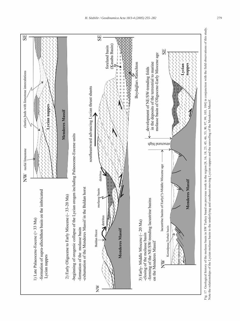
Geo
logi
cal h
isto
ry o
f the
mol
asse
bas
in in
SW
Tur
key
base
d on
pre
viou
s w
ork
in th
e re
gion
[8, 1
6, 1
8, 2
3, 4
5, 4
6, 5
3, 90
, 97,
99,
103
, 104
] in
conj
unct
ion
with
the
field
obs
erva
tions
of t
his
stud
y.N
ote
the
rela
tions
hips
of t
he L
ycia
n m
olas
se b
asin
to th
e un
derly
ing
and
sout
heas
t-mov
ing
Lyci
an n
appe
s an
d th
e un
roof
ing
of th
e M
ende
res
Mas
sif.
G18_03 Page 279 Vendredi, 30. septembre 2005 12:20 12 > Apogee FrameMaker Noir
280 H. Sözbilir / Geodinamica Acta 18/3-4 (2005) 255–282
E…rigöz granite), and formation of the Simav detachmentwere occurring simultaneously, and together are suggestiveof extensional tectonics.
Recent works (e.g. [26, 27]) claim that an early phase ofextensional deformation resulted in the formation of detach-ment faults (the Simav and Ala ‚ehir detachments) in theMenderes Massif at about 20 Ma, and that Early-MiddleMiocene lacustrine rocks that unconformably rest on theMenderes Massif are the oldest extension-related rocks inwestern Turkey (e.g. [7, 98, 99]. However, the Lycianmolasse basin pre-dates these basins. The first phase ofextensional basin formation in the region began in Early Oli-gocene (Rupelian) time subsequent to the main Menderesmetamorphism and the imbrication of the Menderes Massif.The formation of the Simav detachment and related graniteintrusion (E…rigöz granite) are younger events and relate todeeper exhumation of the gneissic sequence of the MenderesMassif, from which fragments were derived and incorpo-rated into the upper part of the Denizli subbasin during theAquitanian.
Acknowledgements
Several figures in this paper resulted from my doctoralfieldwork. Financial support from Dokuz Eylül University(Research Fund Project) is gratefully acknowledged. Myspecial thanks go to my supervisor, Sacit Özer, who has beenof considerable help. I am indebted to the Turkish PetroleumCorporation (TPAO) that funded various phases of my post-doc, field-based research in the study area. Thanks are due toEngin Meriç, Sefer Örçen, Mehmet Sak ¬nç, Sevim Tuzcuand Güler Taner who have identified fossil species docu-mented in the present manuscript. I would also like to thankOlivier Monod and Alan S. Collins for their thoughtfulreviews; their comments and useful criticisms greatlyimproved an earlier version of this manuscript.
References
[1] J.F. Dewey, A.M.C. ¥engör, Aegean and surrounding region: Com-plex multiplate and continuum tectonics in a convergent zone, Geo.Soc. America Bull. 90 (1979) 84-92.
[2] A.M.C. ¥engör, Y. Y ¬lmaz, Tethyan evolution of Turkey: a platetectonic approach, Tectonophysics 75 (1981) 181-241.
[3] J. Jackson, D. McKenzie, The relationship between plate moti onsand seismic moment tensors and rates of active deformation in t heMediterranean and Middle East, Geophys. Jour. 93 (1988) 45-73.
[4] A.M.C. ¥engör, N. Görür, F. ¥aro…lu, Strike-slip faulting and relatedbasin formation in zones of tectonic escape: Turkey as a case study,in: K. Biddle, N. Christie-Blick (Eds), Strike-slip Deformation ,Basin Formation and Sedimentation. Society of Economic Paleon-tologists and Mineralogists, Special Publications 37, 1985, pp. 227-264.
[5] H. Eyido…an, J.A. Jackson, A seismological study of normal faultingin the Demirci, Ala ‚ehir and Gediz earthquake of 1969-1970 inwestern Turkey: implications for the nature and geometry of def or-
mation in the continental crust, Geophys. J. Royal Astronom. So c.81 (1985) 569-607.
[6] A.M.C. ¥engör, Cross-faults and differential stretching of hanging-walls in regions of low-angle normal faulting: examples from west-ern Turkey, in: M.P. Coward, J.F. Dewey, P.L. Hancock (Eds),Continental Extensional Tectonics, Geo. Soc. London, Spec. Publ .,28 1987, pp. 575-589.
[7] G. Seyito…lu, B.C. Scott, Late Cenozoic crustal extension and basinformation in west Turkey, Geo. Mag. 128 (1991) 155-166.
[8] E. Bozkurt, Neotectonics of Turkey – a synthesis, Geodinam. Acta14 (2001) 3-30.
[9] P. England, The alignment of earthquake T-axes with the prin cipalaxes of geodetic strain in the Aegean region, Turkish J. Earth Sci. 12(2003) 47-54.
[10] A. Koçyi…it, A. Özacar, Extensional neotectonic regime through theNE edge of outer Isparta Angle, SW Turkey: new field and seismi cdata, Turkish J. Earth Sci. 12 (2003) 67-90.
[11] O. Lenk, A. Türkezer, S. Ergintav, A.|. Kurt, A. Belgen, Monitoringthe kinematics of Anatolia using permenant GPS network stations ,Turkish J. Earth Sci. 12 (2003) 55-66.
[12] A.|. Okay, M. Sat ¬r, M. Siyako, P. Monie, R. Metzger, S. Akyüz,Paleo- and Neo-Tethyan events in northwestern Turkey: Geologicand geochronologic constrains. In: A. Yin, T.M. Harrison (Eds), theTectonic Evolution of Asia Cambridge University Press, 1996, pp .420-441.
[13] E. Bozkurt, R.G. Park, Southern Menderes Massif: an incipie ntmetamorphic core complex in western Anatolia, Turkey, J. Geo.Soc., London 151 (1994) 213-216.
[14] R. Hetzel, U. Ring, C. Akal, M. Troesch, Miocene NNE-direct edextensional unroofing in the Menderes-Massif, southwestern Tur-key, J. Geo. Soc., London 152 (1995) 639-654.
[15] T. Emre T, H. Sözbilir, Field evidence for metamorphic core com-plex, detachment faulting and accommodation faults in the Gedizand Büyük Menderes grabens (western Turkey), in: Ö. Pi ‚kin,M. Ergün, M.Y. Sava‚ç¬n, G. Tarcan (Eds), International Earth Sci-ences Colloquium on the Aegean Region, |zmir, Turkey, 1997,pp. 73-94.
[16] A. Koçyi…it, H. Yusufo …lu, E. Bozkurt, Evidence from the Gedizgraben for episodic two stage extension in western Turkey, J. G eo.Soc., London 156 (1999) 605-616.
[17] E. Bozkurt, Timing of Extension on the Büyük Menderes Grabe n,Western Turkey and its tectonic implications, in: E. Bozkurt,J.A. Winchester, J.D.A. Piper, (Eds), Tectonics and Magmatism i nTurkey and the Surrounding Area. Geo. Soc. London, Spec. Publ.,173, 2000, pp. 385-403.
[18] E. Bozkurt, Late Alpine evolution of the central Menderes M assif,western Anatolia, Turkey, Inter. J. Earth Sci. 89 (2001) 728-744.
[19] E. Bozkurt, Origin of NE-trending basins in western Turkey, Geod-inam. Acta 16 (2003) 61-81.
[20] E. Bozkurt, Granitoid rocks of the southern Menderes Massif (south-western Turkey): field evidence for Tertiary magmatism in anextensional shear zone, Inter. J. Earth Sci. 93 (2004) 52-71.
[21] E. Bozkurt, R. Oberhänsli, Menderes Massif (western Turkey) :structural, metamorphic and magmatic evolution – a synthesis, Inter.J. Earth Sci. 89 (2001) 679-708.
[22] H. Sözbilir, Extensional tectonics and the geometry of rela ted mac-roscopic structures: Field evidence from the Gediz detachment,western Turkey, Turkish J. Earth Sci. 10 (2001) 51-67.
[23] H. Sözbilir, Geometry and origin of folding in the Neogene sedi-ments of the Gediz Graben, western Anatolia, Turkey, Geodinam.Acta 15 (2002) 277-288.
[24] D.L. Whitney, E. Bozkurt, Metamorphic history of the southe rnMenderes Massif, western Turkey, Geo. Soc. America Bull. 114(2002) 829-838.
[25] E. Bozkurt, H. Sözbilir, Tectonic evolution of the Gediz Gr aben:field evidence for an episodic, two-stage extension in western Tur-key, Geo. Mag. 141 (2004) 63-79.
G18_03 Page 280 Vendredi, 30. septembre 2005 12:20 12 > Apogee FrameMaker Noir

H. Sözbilir / Geodinamica Acta 18/3-4 (2005) 255–282 281
[26] V. I‚¬k, O. Tekeli, G. Seyitoglu, Ductile-brittle transition along th eAla‚ehir detachment fault and its structural relationship with theSimav detachment fault, Menderes Massif, western Turkey, Tec-tonophysics 374 (2003) 1-18.
[27] V. I‚¬k, O. Tekeli, G. Seyitoglu, The 40Ar/39Ar age of extensionalductile deformation and granitoid intrusion in the northern Menderescore complex: implications for the initiation of extensional tectonicsin western Turkey, J. Asian Earth Sci. 23 (2004) 555-566.
[28] E. Altunel, I.S. Stewart, L. Piccardi, A.A. Barka, Earthqua ke fault-ing at ancient Cnidus, SW Turkey, Turkish J. Earth Sci. 12 (200 3)137-152.
[29] A. Gürer, A. Pinçe, Ö.F. Gürer, O.M. |lk¬‚¬k, Resistivity distributionin the Gediz Graben and its implications for crustal structure, Turk-ish J. Earth Sci. 11 (2002) 15-26.
[30] |.H. Karamanderesi, C. Helvac ¬, Geology and hydrothermal altera-tion of Ayd¬n-Salatvatl¬ geothermal field, western Anatolia, Turkey,Turkish J. Earth Sci. 12 (2003) 175-198.
[31] O. Kaya, E. Ünay, G. Saraç, S. Eichhorn, S. Hassenrück, A. Knappe,A. Pekde…er, S. Mayda, Halitpa ‚a transpressive zone: implicationsfor an Early Pliocene compressional phase in central western Anato-lia, Turkey, Turkish J. Earth Sci. 13 (2004) 1-13.
[32] P.A. Allen, P. Homewood, D. Williams, Foreland basins: an i ntro-duction, in: P.A. Allen, P. Homewood (Eds), Foreland Basins.Blackwell, Oxford, 1986, pp. 3-12.
[33] A.D. Miall, Tectonic setting and syndepositional deformatio n ofmolasse and other nonmarine-paralic sedimentary basins, CanadianJ. Earth Sci. 15 (1978) 1613-1632.
[34] F. Massari, A. Colella, Evolution and types of fan delta sy stems insome major tectonic settings, in: W. Nemec, R.J. Steel (eds), F anDeltas. Sedimentology and Tectonic Settings, Blackie, Glasgow,1988, pp.
[35] Y. Hakyemez, Kale-Kurbal¬k (GB Denizli) bölgesindeki Senozoyikya‚l¬ çökel kayalar¬n jeolojisi ve stratigrafisi, MTA Bull. 109 (1989)9-21 [in Turkish with an English abstract].
[36] Y. Y¬lmaz, ¥.C. Genç, O.F. Gürer, M. Bozcu, K. Y¬lmaz, Z. Karac¬k,¥. Altunkaynak, A. Elmas, When did the western Anatolian grabensbegin to develop? in: E. Bozkurt, J.A. Winchester, J.D.A. Piper ,(Eds), Tectonics and Magmatism in Turkey and the SurroundingArea. Geo. Soc. London, Spec. Publ. 173, 2000, pp. 353-384.
[37] F. Akgün, H. Sözbilir, A palynostratigraphic approach to th e SWAnatolian molasse basin: Kale-Tavas molasse and Denizli molasses,Geodinam. Acta 14 (2001) 71-93.
[38] H. Sözbilir, Stratigraphy and Sedimentology of the TertiarySequences in the Northeastern Denizli Province (Southwest Tur-key), PhD Thesis, Dokuz Eylül University, Turkey, (1997)[unpublished, in Turkish].
[39] M. ¥enel, Denizli–J9 Quadrangle, 1: 100,000 Scale Geological Mapand Explanatory Text, Mineral Research and Exploration Institute ofTurkey (MTA) Publications, (1997).
[40] Ö.F. Gürer, Y. Y ¬lmaz, Geology of the Ören and surroundingregions, SW Turkey, Turkish J. Earth Sci. 11 (2002) 2-18.
[41] H. Sözbilir, Revised stratigraphy and facies analysis of the Palaeocene-Eocene supra-allochthonous sediments and their tectonic signifi cance(Denizli, SW Turkey), Turkish J. Earth Sci. 11 (2002) 1-27.
[42] Z. Atalay, Mu …la-Yata…an ve yak ¬n dolay ¬ karasal Neojen’ininstratigrafi ara‚t¬rmas¬, Geo. Soc. Turkey Bull. 23 (1980) 93-99 [inTurkish with an English abstract].
[43] A.S. Collins, A.H.F. Robertson, Lycian melange, southwestern Tur-key: an emplaced Late Cretaceous accretionary complex, Geology25 (1997) 255-258.
[44] A.S. Collins, A.H.F. Robertson, Processes of Late Cretaceou s toLate Miocene episodic thrust sheet translation in the Lycian Ta u-rides, SW Turkey, J. Geo. Soc., London 155 (1998) 759-772.
[45] A.S. Collins, A.H.F. Robertson, Evolution of the Lycian allochthon,western Turkey, as a north-facing Late Palaeozoic to Mesozoic r iftand passive continental margin, Geol. Jour. 34 (1999) 107-138.
[46] A.S. Collins, A.H.F. Robertson, Kinematic evidence for late Meso-zoic-Miocene emplacement of the Lycian Allochthon over theWestern Anatolia Belt, SW Turkey, Geol. Jour. 38 (2003) 1-16.
[47] A.|. Okay, Geology of the Menderes Massif and the Lycian nappessouth of Denizli, western Turkey, MTA Bull. 109 (1989) 37-51.
[48] S. Özer, H. Sözbilir, |. Özkar, V. Toker, B. Sar ¬, Stratigraphy ofUpper Cretaceous-Palaeogene sequences in the southern and easternMenderes Massif (western Turkey), Inter. J. Earth Sci. 89 (2001 )852-866.
[49] A.D. Miall, A review of the braided river depositional environment,Earth-Sci. Rev. 13 (1977) 1-62.
[50] P. Enos, Flow regimes in debris flow, Sedimentology 24 (1977) 133-142.
[51] A.W. Shultz, Subareal debris-flow deposition in the upper PaleozoicCutler Formation, western Colorado, J. Sediment Petrol. 97 (198 4)749-772.
[52] R.G. Walker, Deposition of upper Mesozoic resedimented conglom-erates and associated turbidites in southwestern Oregon, Geo. S oc.America Bull. 88(1977) 273-285.
[53] A.B. Hayward, Miocene clastic sedimentation related to theemplacement of the Lycian Nappes and the Antalya Complex, SWTurkey, in: J.E. Dixon, A.H.F. Robertson (Eds), Geological Evol u-tion of the Eastern Mediterranean. Geo. Soc. London, Spec. Publ .17, 1984, pp. 287-300.
[54] M.F. Follo, Conglomerates as clues to the sedimentary and tectonicevolution of a suspect terrane, Wallowa Mountains, Oregon, Geo.Soc. America Bull. 104 (1992) 1561-1576.
[55] B.R. Rust, Proximal braidplain deposits in the Middle Devon ianMalbaie Formation of Eastern Gaspe, Quebec, Canada, Sedimentol-ogy 31 (1984) 675-695.
[56] G.A. Smith, Coarse-grained nonmarine volcaniclastic sedimen ts:terminology and depositional process, Geo. Soc. America Bull. 9 7(1986) 1-10.
[57] F.G. Ethridge, W.A. Wescott, Tectonic setting, recognition andhydrocarbon reservoir potential of fan-delta deposits, in: E.H.Koster, R.J. Steel (Eds), Sedimentology of Gravel and Conglomer -ates, Canadian Society of Petroleum Geology Memoir 10, 1984,pp. 217-235.
[58] B.R. Rust, Structure and process in a braided river, Sedime ntology18 (1972) 221-240.
[59] D.R. Lowe, Sediment gravity flows: II. Depositional models withspecial reference to the deposits of high-density turbidity currents, J.Sediment. Petrol. 52 (1982) 279-297.
[60] S.K. Chough, I.G. Hwang, M.Y. Choe, The Miocene Doumsan fan-delta, SE Korea: a composite fan-delta system in back-arc margin, J.Sediment. Petrol. 60 (1990) 531-536.
[61] G. Ghibaudo, Subaqueous sediment gravity flow deposits: practicalcriteria for their field description and classification, Sedime ntology39 (1992) 423-454.
[62] H.E. Reineck, I.B. Singh, Depositional Sedimentary Environments.Springer-Verlag: New York (1980).
[63] T. Elliott, Interdistributary bay sequences and their genes is, Sedi-mentology 21 (1974) 611-622.
[64] W. Nemec, R.J. Steel, What is a fan-delta and how do we recognizeit?, in: W. Nemec, R.J. Steel (Eds), Fan Deltas. Sedimentology andTectonic Settings. Blackie, Glasgow, 1988, pp. 3-13.
[65] B.D. Ricketts Delta evolution in the Eureka Sound Group, we sternAxel Heiberg Island: the transition from wave-dominated to fluvial-dominated deltas, Geo. Survey Canada Bull. 402 (1991) 1-60.
[66] A.D. Miall, Architectural-element analysis: a new method of faciesanalysis applied to fluvial deposits, Earth-Sci. Rev. 22 (1985) 261-308.
[67] B.R. Rust, Facies models 2. Coarse alluvial deposits, in:R.G. Walker (Ed), Facies Models. Geoscience Canada ReprintSeries 1 (1979) pp. 9-21.
[68] T. Elliott, Abandonment facies of high-constuctive lobate d eltas,with an example from the Yoredale Series, Proceed. Geo. Soc.Assoc. London 85 (1974) 359-365.
G18_03 Page 281 Vendredi, 30. septembre 2005 12:20 12 > Apogee FrameMaker Noir
282 H. Sözbilir / Geodinamica Acta 18/3-4 (2005) 255–282
[69] R.D. Kreisa, Storm-generated sedimentary structures in subt idalmarine facies with examples from the middle and upper Ordovicianof southwestern Virginia, J. Sediment. Petrol. 51 (1981) 823-848.
[70] W.A. Wescott, F.G. Ethridge, Fan-delta sedimentology and tectonicsetting – Yallahs fan-delta, southeast Jamaica, AAPG Bull. 64(1980) 374-399.
[71] D.B. Waresback, B.N. Turbeville, Evolution of a Plio-Pleist ocenevolcanogenic alluvial fan: the Puye Formation, Jemez Mountains,New Mexico, Geo. Soc. America Bull. 102 (1990) 298-314.
[72] J.C. Harms, J.B. Southard, R.G. Walker, Structures and Sequ encesin Clastic Rocks. Society of Economic Paleontologists and Mineral-ogists. Short Course 9 (1982).
[73] F.T. Fürsich, W. Oschmann, Shell beds as tools in basin analysis: theJurassic of Kachchh, western India, J. Geol. Soc., London 150(1993) 169-185.
[74] C.J. Dabrio, M.D. Polo, Late Neogene fan deltas and associa tedcoral reefs in the Almanzora Basin, Almeria Province, southeasternSpain, in: W. Nemec, R.J. Steel (Eds), Fan Deltas. Sedimentolog yand Tectonic Settings. Blackie, Glasgow, 1988, pp. 354-367.
[75] T. Aigner, Storm Depositional Systems (Lecture Notes in Earth Sci-ences 3). Springer-Verlag: Berlin (1985).
[76] J.E. Evans, Facies relationships, alluvial architecture, an d paleohy-drology of a Paleogene, humid-tropical alluvial fan system:Chumstick Formation, Washington State, USA, J. Sediment. Petrol.61 (1991) 732-755.
[77] K.D. Ridgway, P.G. DeCelles, Stream-dominated alluvial fan andlacustrine depositional systems in Cenozoic strike-slip basins,Denali fault system, Yukon Territory, Canada, Sedimentology 40(1993) 645-666.
[78] B.A. Palmer, A.W. Walton, Accumulation of volcanoclastic apronsin the Mount Dutton formation (Oligocene-Miocene) Marysvalevolcanic field, Geo. Soc. America Bull. 102 (1990) 732-748.
[79] K.X. Whipple, T. Dunne, The influence of debris flow rheolo gy onfan morphology, Owens Valley, California, Geo. Soc. America Bull.104 (1992) 887-900.
[80] N. Kazanc¬, B. Varol, Development of a mass flow-dominated fan-delta complex and associated carbonate reefs within a transgressivePalaeocene succession, central Anatolia, Turkey, Sediment. Geol .68 (1990) 261-278.
[81] O. Riba, Syntectonic unconformities of the Alto Cardener, S panishPyrenees: a genetic interpretation, Sediment. Geol. 15 (1976) 2 13-233.
[82] R. Hetzel, T. Reischmann, Intrusion age of Pan-African augen gneissesin the southern Menderes Massif and the age cooling after Alpine duc-tile extensional deformation, Geo. Mag. 133 (1996) 565-572.
[83] S. Loos, T. Reischmann, The evolution of the southern Mende resMassif in SW Turkey as revealed by zircon datings, J. Geo. Soc. ,London 156 (1999) 1021-1030.
[84] K. Gessner, U. Ring, C. Johnson, R. Hetzel, C. Passchier, T. Güngör,An active bivergent rolling-hinge detachment system: the centra lMenderes metamorphic core complex in western Turkey, Geology29 (2001) 611-614.
[85] K. Gessner, A.S. Collins, U. Ring, T. Güngör, Structural and thermalhistory of poly-orogenic basement: U-Pb gecohronology of grani-toid rocks in the southern Menderes Massif, western Turkey, J. Geo.Soc., London 161 (2004) 93-101.
[86] E. Erdo…an, T. Güngör, The problem of the core-cover boundary ofthe Menderes Massif and an emplacement mechanism for regionallyextensive gneissic granites, western Anatolia (Turkey), Turkish J.Earth Sci. 13 (2004) 15-36.
[87] O.E. Koralay, O.Ö. Dora, F. Chen, M. Sat ¬r, O. Candan, Geochem-istry and geochronology of orthogneisses in the Derbent (Ala ‚ehir)
area, eastern part of the Ödemi‚-Kiraz submassif, Menderes Massif:Pan-African magmatic activity, Turkish J. Earth Sci. 13 (2004) 37-61.
[88] A.M.C. ¥engör, M. Sat¬r, R. Akkök, Timing of tectonic events in theMenderes Massif, western Turkey: implications for tectonic evol u-tion and evidence for Pan-African basement in Turkey, Tectonics 4(1984) 693-707.
[89] M. Sat¬r M, H. Friedrichsen, The origin and evolution of the Mend-eres Massif, W-Turkey: A rubidium/strontium and oxygen isotopestudy, Geol. Rundschau 75 (1986) 703-714.
[90] A.L.W. Lips, D. Cassard, H. Sözbilir, H. Y¬lmaz, J. Wijbrans, Multi-stage exhumation of the Menderes Massif, western Anatolia(Turkey), Inter. J. Earth Sci. 89 (2001) 781-792.
[91] E. Bozkurt, R.G. Park, Evolution of a mid-Tertiary extensional shearzone in the southern Menderes Massif, Western Turkey, Soc. Géo.France Bull. 168 (1997) 3-14.
[92] E. Bozkurt, R.G. Park, Microstructures of deformed grains i n theaugen gneisses of southern Menderes Massif and their tectonic s ig-nificance, Geol. Rundschau 86 (1997) 103-119.
[93] E. Bozkurt, R.G. Park, The structure of the Palaeozoic schists in thesouthern Menderes Massif, western Turkey: a new approach to theorigin of the main Menderes metamorphism and its relation to th eLycian nappes, Geodinam. Acta 12 (1999) 25-42.
[94] E. Bingöl, M. Delaloye, G. Ataman, Granitic intrusions in w esternAnatolia: a contribution to the geodynamic study of this area,Eclogae Geo. Helvetiae 75 (1982) 437-446.
[95] V. I‚¬k, O. Tekeli, Late orogenic crustal extension in the northernMenderes massif (western Turkey): evidence for metamorphic corecomplex formation, Inter. J. Earth Sci. 89 (2001) 757-765.
[96] U. Ring, A.S. Collins, U-Pb SIMS dating of syn-kinematic granites:timing of core-complex formation in the northern Anatolide belt ofwestern Turkey, J. Geo. Soc., London 162 (2005) 289-298.
[97] U. Ring, C. Johnson, R. Hetzel, K. Gessner, Tectonic denudation ofa Late Cretaceous-Tertiary collisional belt: regionally symmetr iccooling patterns and their relation to extensional faults in th e Ana-tolide belt of western Turkey, Geo. Mag. 140 (2003) 421-441.
[98] G. Seyito …lu, B. Scott, Late Cenozoic basin development in westTurkey: Gördes basin tectonics and sedimentation, Geo. Mag. 131(1994) 631-637.
[99] G. Seyito…lu, B.C. Scott, C.C. Rundle, Timing of Cenozoic exten-sional tectonics in west Turkey, J. Geo. Soc., London 149 (1992 )533-538.
[100] A.|. Okay, M. Siyako, The revised location of the |zmir-AnkaraSuture in the region between Bal¬kesir and |zmir, in: S. Turgut (Ed),Tectonics and Hydrocarbon Potential of Anatolia and SurroundingRegions, 1993, pp. 333-355 [in Turkish with English abstract].
[101] S. Özer, H. Sözbilir, Presence and tectonic significance o f Creta-ceous rudist species in the so-called Permo-Carboniferous Gökte peFormation, central Menderes metamorphic massif, western Turkey,Inter. J. Earth Sci. 92 (2003) 397-404.
[102] F. Rögl, Mediterranean and Paratethys palaeogeography duri ng theOligocene and Miocene, in: J. Agusti, L. Rook, P. Andrews (Eds) ,Hominoid Evolution and Xlimatic Change in Europe: The evolutionof Neogene Terrestrial Ecosystems in Europe. Cambridge Univer-sity Press, 1999, pp. 8-22.
[103] E. Bozkurt, Metamorphism of Palaeozoic schists in the sout hernMenderes Massif: field, petrographic, textural and microstructu ralevidence, Turkish J. Earth Sci. 5 (1996) 105-121.
[104] E. Bozkurt, M. Sat ¬r, New Rb-Sr geochronology from the southernMenderes Massif (southwestern Turkey) and its tectonic signifi-cance, Geol. Jour. 35 (2000) 285-296.
G18_03 Page 282 Vendredi, 30. septembre 2005 12:20 12 > Apogee FrameMaker Noir