Offshore : Risk & Technology Consulting Inc. - Bureau of ...
246
Post Mortem Failure Assessment of Jack-up MODUs During Hurricanes Katrina & Rita August 2005 & September 2005 Prepared for: Minerals Management Service MMS Order No.: M07PC13208 Offshore : Risk & Technology Consulting Inc. Dr. Malcolm Sharples, Principal Author, Houston, Texas
-
Upload
khangminh22 -
Category
Documents
-
view
0 -
download
0
Transcript of Offshore : Risk & Technology Consulting Inc. - Bureau of ...
Post Mortem Failure Assessment of Jack-up MODUs During
Hurricanes Katrina & Rita
August 2005 & September 2005
Prepared for: Minerals Management Service
MMS Order No.: M07PC13208
Offs
hore
: R
isk
& T
echn
olog
y C
onsu
lting
Inc.
D
r. M
alco
lm S
harp
les,
Prin
cipa
l Aut
hor,
Hou
ston
, Tex
as

MINERALS MANAGEMENT SERVICE CONTRACT
Hurricanes Katrina & Rita: Jack-ups August & September 2005

MMS Order No. M07PC13208 Post Mortem Failures Jack-ups During Hurricanes Katrina & Rita
Offshore: Risk & Technology Consulting Inc. April 2008 Dr. M. Sharples, Principal Investigator
2
TABLE OF CONTENTS CONVERSIONS............................................................................................................... 5 LIST OF TERMS AND ABBREVIATIONS ....................................................................... 6 1. INTRODUCTION........................................................................................................ 10
1.1 MMS Summary of Katrina and Rita ...................................................................... 12 1.2 MMS Announcement: October 2005 .................................................................... 14
2. THE STORMS............................................................................................................ 15 2.1 Summary from the National Hurricane Center on Hurricane Katrina................... 15
2.1.1 Synoptic History ............................................................................................ 18 2.1.2 Meteorological Statistics and Observations................................................... 19 2.1.3 Casualty and Damage Statistics .................................................................... 20
2.2 Summary of Information from the National Hurricane Center on Hurricane Rita. 23 2.2.1 Synoptic History ............................................................................................. 25 2.2.2 Meteorological Statistics ................................................................................ 25 2.2.3 Casualty and Damage Statistics .................................................................... 26
3. LLOYD’S LIST REPORTS ......................................................................................... 31 3.1 Lloyd’s List Reports: Hurricane Katrina (Extracts Only) ...................................... 31 3.2 Lloyd’s List Reports: Hurricane Rita (Extracts Only) .......................................... 33
4. MEDIA NEWS CLIPPINGS........................................................................................ 37 5. JACK-UPS: HURRICANE INCIDENTS AND INDUSTRY RESPONSE .................... 39
5.1 History................................................................................................................... 39 5.2 Standards.............................................................................................................. 40 5.3 Airgap.................................................................................................................... 43 5.4 Airgap Comparison to API Bulletin 2 INT-MET .................................................... 48 5.5 Comparison of Jack-up Requirements to Fixed Platform Requirements. ........... 51 5.6 Evacuation Metocean Criteria .............................................................................. 53
6. RIGS ADRIFT/ LOST/ IN HURRICANES KATRINA AND RITA................................ 55 7. COMPILED INFORMATION ON JACK-UPS AND STORM EXPERIENCE.............. 61 8. SUMMARY OF JACK-UP DETAILS IN HURRICANE KATRINA .............................. 69
8.1 Ocean Nugget.................................................................................................. 74 8.2 Ocean Tower ................................................................................................... 79 8.3 Ocean Warwick................................................................................................ 80 8.4 Ensco Rigs & Ensco 74 ................................................................................... 85 8.5 Ensco 81 .......................................................................................................... 90 8.6 Ensco 83 .......................................................................................................... 91 8.7 Ensco 105 ........................................................................................................ 92 8.8 GSF Adriatic VII ............................................................................................... 93 8.9 GSF High Island VIII ........................................................................................ 94 8.10 Hercules 21...................................................................................................... 95 8.11 Hercules 25...................................................................................................... 97 8.12 Noble Tom Jobe............................................................................................... 98 8.13 Bob Palmer .................................................................................................... 100 8.14 Cecil Provine.................................................................................................. 103 8.15 Rowan Fort Worth.......................................................................................... 104 8.16 Scooter Yeargain ........................................................................................... 104 8.17 Rowan Gorilla IV ............................................................................................ 106 8.18 Rowan New Orleans ...................................................................................... 107 8.19 Rowan Paris................................................................................................... 109 8.20 Ocean Drake.................................................................................................. 112 8.21 Hercules 30.................................................................................................... 113 8.22 Pride Florida................................................................................................... 114

MMS Order No. M07PC13208 Post Mortem Failures Jack-ups During Hurricanes Katrina & Rita
Offshore: Risk & Technology Consulting Inc. April 2008 Dr. M. Sharples, Principal Investigator
3
8.23 THE 200 ......................................................................................................... 114 8.24 THE 204 ......................................................................................................... 116 8.25 Dolphin 110.................................................................................................... 117
9. SUMMARY OF JACK-UP DETAILS IN HURRICANE RITA.................................... 119 9.1 Ocean Columbia ............................................................................................ 124 9.2 Ocean Spartan............................................................................................... 125 9.3 Ocean Summit ............................................................................................... 126 9.4 Ensco and Ensco 60 ...................................................................................... 127 9.5 Ensco 68 ........................................................................................................ 129 9.6 Ensco 69 ........................................................................................................ 130 9.7 Ensco 81 ........................................................................................................ 133 9.8 Ensco 82 ........................................................................................................ 134 9.9 Ensco 84 ........................................................................................................ 135 9.10 Ensco 90 ........................................................................................................ 136 9.11 Ensco 93 ........................................................................................................ 137 9.12 Ensco 98 ........................................................................................................ 138 9.13 Ensco 105 ...................................................................................................... 139 9.14 GSF Adriatic III............................................................................................... 141 9.15 GSF Adriatic VII ............................................................................................. 145 9.16 GSF High Island I........................................................................................... 154 9.17 GSF High Island II.......................................................................................... 156 9.18 GSF High Island III......................................................................................... 163 9.19 GSF High Island IV ........................................................................................ 172 9.20 GSF Main Pass IV ........................................................................................ 175 9.21 GSF High Island VIII ...................................................................................... 177 9.22 Noble Tom Jobe............................................................................................. 178 9.23 Noble Eddie Paul ........................................................................................... 179 9.24 Arch Rowan.................................................................................................... 180 9.25 Bob Palmer .................................................................................................... 181 9.26 Cecil Provine.................................................................................................. 181 9.27 Charles Rowan .............................................................................................. 182 9.28 Rowan Alaska ................................................................................................ 183 9.29 Rowan Anchorage ......................................................................................... 183 9.30 Rowan California............................................................................................ 184 9.31 Rowan Ft Worth ............................................................................................. 185 9.32 Scooter Yeargain ........................................................................................... 186 9.33 Rowan Gorilla II ............................................................................................. 187 9.34 Rowan Gorilla III ............................................................................................ 188 9.35 Rowan Gorilla IV ............................................................................................ 189 9.36 Rowan Halifax................................................................................................ 190 9.37 Rowan Juneau ............................................................................................... 191 9.38 Rowan Louisiana ........................................................................................... 192 9.39 Rowan Middletown......................................................................................... 199 9.40 Rowan Odessa .............................................................................................. 200 9.41 Rowan Paris................................................................................................... 201 9.42 GSF Main Pass I............................................................................................ 201 9.43 Ocean Drake.................................................................................................. 203 9.44 Pride Arizona.................................................................................................. 204 9.45 Pride Florida................................................................................................... 205 9.46 Pride Kansas.................................................................................................. 206 9.47 Pride Mississippi ............................................................................................ 207

MMS Order No. M07PC13208 Post Mortem Failures Jack-ups During Hurricanes Katrina & Rita
Offshore: Risk & Technology Consulting Inc. April 2008 Dr. M. Sharples, Principal Investigator
4
9.48 Pride Missouri ................................................................................................ 208 9.49 Pride Utah ...................................................................................................... 209 9.50 Pride Wyoming............................................................................................... 210 9.51 THE 207 ......................................................................................................... 211 9.52 THE 250 ......................................................................................................... 211 9.53 THE 253 ......................................................................................................... 212 9.54 Hercules 21.................................................................................................... 213 9.55 Pool 54 ........................................................................................................... 214 9.56 Aban VII ......................................................................................................... 215
10. JACK-UP PERFORMANCE SUMMARY TABLE................................................... 216 12. OTHER REMARKS ................................................................................................ 228 13. CONCLUSIONS AND RECOMMENDATIONS...................................................... 230 13. REFERENCES....................................................................................................... 232 ACKNOWLEDGEMENTS ............................................................................................ 235 APPENDIX A: NOTICE TO LESSEES FOLLOWING HURRICANES KATRINA AND RITA.............................................................................................................................. 236 APPENDIX B: JACKUP HURRICANE DATA COLLECTION FORM .......................... 241
MMS Order No. M07PC13208 Post Mortem Failures Jack-ups During Hurricanes Katrina & Rita
Offshore: Risk & Technology Consulting Inc. April 2008 Dr. M. Sharples, Principal Investigator
5
CONVERSIONS
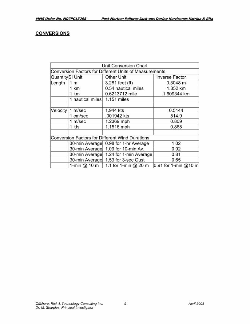
Unit Conversion Chart Conversion Factors for Different Units of Measurements Quantity SI Unit Other Unit Inverse Factor Length 1 m 3.281 feet (ft) 0.3048 m 1 km 0.54 nautical miles 1.852 km 1 km 0.6213712 mile 1.609344 km 1 nautical miles 1.151 miles Velocity 1 m/sec 1.944 kts 0.5144 1 cm/sec .001942 kts 514.9 1 m/sec 1.2369 mph 0.809 1 kts 1.1516 mph 0.868 Conversion Factors for Different Wind Durations 30-min Average 0.98 for 1-hr Average 1.02 30-min Average 1.09 for 10-min Av. 0.92 30-min Average 1.24 for 1-min Average 0.81 30-min Average 1.53 for 3-sec Gust 0.65 1-min @ 10 m 1.1 for 1-min @ 20 m 0.91 for 1-min @10 m

MMS Order No. M07PC13208 Post Mortem Failures Jack-ups During Hurricanes Katrina & Rita
Offshore: Risk & Technology Consulting Inc. April 2008 Dr. M. Sharples, Principal Investigator
6
LIST OF TERMS AND ABBREVIATIONS
The following words and phrases are used in this report have the meanings assigned below: 100-year Return: The (storm/wind/wave/current) expected to be of this value once in every 100 years at a single specific location. 10-year Return: The (storm/wind/wave/current) expected to be of this value once in every 10 years at a single specific location. Airgap: The distance from the Lowest Astronomical Tide (LAT) to the underside of the hull. Required Airgap: Addition of the distance between mean low water level and the top of the wave crest which includes tide, surge height, and wave crest elevation. This number for design purposes may include other allowances for run up, a reserve factor, or a settlement factor. API: American Petroleum Institute – a body supporting technical standards through voluntary committees. API RP 95J:American Petroleum Institute Recommended Practice on Gulf of Mexico Jack-up Operations Hurricane Season- Interim Recommendations First Edition, June 2006. BMC: Baker Marine Corporation – a designer of jack-ups BOP: Acronym for Blowout Preventer Drilling contractor: The individual, partnership, firm, or corporation retained by the owner or operator to perform drilling and/or well workover operations. Evacuation period: The period of time from the commencement of storm preparations until all evacuated personnel have obtained reasonable refuge ashore (generally 12 hours after arriving shore-side). Friede & Goldman (F&G): a designer of jack-ups GOM: Acronym for Gulf of Mexico Hmax: Abbreviation for the maximum wave height: (In deepwater, a rough rule-of-thumb is 1.86 * Hs). Hs: Abbreviation for the significant wave height. The average of the top 1/3rd of the waves. Generally considered as the wave height that observers would report. Hurricane: A severe tropical cyclone having one minute average 33 foot elevation winds in excess of 64 knots (74 miles/hr.).

MMS Order No. M07PC13208 Post Mortem Failures Jack-ups During Hurricanes Katrina & Rita
Offshore: Risk & Technology Consulting Inc. April 2008 Dr. M. Sharples, Principal Investigator
7
Hurricane Season: The portion of the year having relatively high incidence of hurricanes. In the Atlantic, Caribbean and Gulf of Mexico, and for the purposes of this report, it is the time period between June 1 and November 30. IADC: International Association of Drilling Contractors. Independent leg Jack-up: Jack-up unit with legs that can be raised or lowered independently. ISO: International Standards Organization, which promulgates guidance on technical standards based on recommendations by technical committees and approval by countries. Jack-up: A Mobile Offshore Unit with a buoyant hull and one or more legs that can be moved up or down relative to the hull. A Jack-up reaches its operational mode by lowering the leg(s) to the sea floor and then raising the hull to the required elevation. The majority of Jack-ups have three (3) or more legs, each of which may be moved independently, and which are supported on the sea floor by spudcans or a mat. Keppel FELS (Kep): a designer and builder of jack-ups. Kt: Abbreviation for knot or nautical mile per hour Lease Operator: The individual, partnership, firm, or corporation having control or management of operations on the leased area or a portion thereof. The operator may be a lessee, designated agent of the lessee(s), or holder of operating rights under an approved operating agreement. Lease Owner: The individual, partnership, firm, or corporation to whom the United States issues a lease and has been assigned an obligation to make royalty payments required by the lease. Lowest Astronomical Tide (LAT): The lowest level expected to occur under average meteorological conditions and any combination of astronomical conditions. Mat Supported Jack-up: Jack-up unit with the leg(s) connected to a single foundation structure. Mean Water Level (MWL): Midpoint between Lowest Astronomical Tide and Highest Astronomical Tide. MLT or Let: Marathon LeTourneau - a designer and builder of mobile jack-ups later known as LeTourneau. MMS: Minerals Management Service of the U.S. Dept of the Interior MODU: A type of vessel Mobile Offshore Drilling Unit (MODU) capable of moving or being transported between locations to engage in drilling or well workover operations for the exploration or exploitation of subsea resources. N mi. or nm. Nautical Mile

MMS Order No. M07PC13208 Post Mortem Failures Jack-ups During Hurricanes Katrina & Rita
Offshore: Risk & Technology Consulting Inc. April 2008 Dr. M. Sharples, Principal Investigator
8
NOAA: National Oceanographic and Atmospheric Administration OOC: Offshore Operators’ Committee. OTC: Offshore Technology Conference - annual conference with papers held in Houston generally on the first week of May each year Purple Finder: Pole Star's web-based service providing a way of automatically tracking vessel movements in real time. The system utilizes the GMDSS Sat-C terminal already installed on most ocean-going vessels, or specialized GPS-enabled satellite tracking terminals including Inmarsat D+, Mini C, and Iridium SAB: Hurricane Intensity Science Advisory Board Research Working Group. SFMR: An airborne remote sensing instrument Stepped-Frequency Microwave Radiometer first experimented with in Hurricane Allen in 1980. SNAME: Society of Naval Architects and Marine Engineers, under whose auspices the standard known as SNAME 5-5A is published. Spudcan: The individual footings on each leg of a Jack-up rig equipped with independent legs. SSHS: Acronym for Saffir-Simpson Hurricane Scale used to measure hurricanes SSHS Category One Hurricane: Winds 74-95 mph (64-82 kt or 119-153 km/hr). Storm surge generally 4-5 ft above normal. No real damage to building structures. Damage primarily to unanchored mobile homes, shrubbery, and trees. Some damage to poorly constructed signs. Also, some coastal road flooding and minor pier damage. Hurricane Lili of 2002 made landfall on the Louisiana coast as a Category One hurricane. SSHS Category Two Hurricane: Winds 96-110 mph (83-95 kt or 154-177 km/hr). Storm surge generally 6-8 feet above normal. Some roofing material, door, and window damage of buildings. Considerable damage to shrubbery and trees with some trees blown down. Considerable damage to mobile homes, poorly constructed signs, and piers. Coastal and low-lying escape routes flood 2-4 hours before arrival of the hurricane center. Small craft in unprotected anchorages break moorings. SSHS Category Three Hurricane: Winds 111-130 mph (96-113 kt or 178-209 km/hr). Storm surge generally 9-12 ft above normal. Some structural damage to small residences and utility buildings with a minor amount of curtainwall failures. Damage to shrubbery and trees with foliage blown off trees and large trees blown down. Mobile homes and poorly constructed signs are destroyed. Low-lying escape routes are cut by rising water 3-5 hours before arrival of the center of the hurricane. Flooding near the coast destroys smaller structures with larger structures damaged by battering from floating debris. Terrain continuously lower than 5 ft above mean sea level may be flooded inland 8 miles (13 km) or more. Evacuation of low-lying residences with several blocks of the shoreline may be required. Hurricanes Jeanne and Ivan of 2004 were Category Three hurricanes when they made landfall in Florida and in Alabama, respectively.

MMS Order No. M07PC13208 Post Mortem Failures Jack-ups During Hurricanes Katrina & Rita
Offshore: Risk & Technology Consulting Inc. April 2008 Dr. M. Sharples, Principal Investigator
9
SSHS Category Four Hurricane: Winds 131-155 mph (114-135 kt or 210-249 km/hr). Storm surge generally 13-18 ft above normal. More extensive curtainwall failures with some complete roof structure failures on small residences. Shrubs, trees, and all signs are blown down. Complete destruction of mobile homes. Extensive damage to doors and windows. Low-lying escape routes may be cut by rising water 3-5 hours before arrival of the center of the hurricane. Major damage to lower floors of structures near the shore. Terrain lower than 10 ft above sea level may be flooded requiring massive evacuation of residential areas as far inland as 6 miles (10 km). SSHS Category Five Hurricane: Winds greater than 155 mph (135 kt or 249 km/hr). Storm surge generally greater than 18 ft above normal. Complete roof failure on many residences and industrial buildings. Some complete building failures with small utility buildings blown over or away. All shrubs, trees, and signs blown down. Complete destruction of mobile homes. Severe and extensive window and door damage. Low-lying escape routes are cut by rising water 3-5 hours before arrival of the center of the hurricane. Major damage to lower floors of all structures located less than 15 ft above sea level and within 500 yards of the shoreline. Massive evacuation of residential areas on low ground within 5-10 miles (8-16 km) of the shoreline may be required. Only 3 Category Five Hurricanes have made landfall in the United States since records began: The Labor Day Hurricane of 1935, Hurricane Camille (1969), and Hurricane Andrew in August, 1992. Hurricane Camille struck the Mississippi Gulf Coast causing a 25-foot storm surge, which inundated Pass Christian. Hurricane Andrew of 1992 made landfall over southern Miami-Dade County, Florida causing 26.5 billion dollars in losses--the costliest hurricane on record prior to Hurricanes Katrina and Rita. In addition, Hurricane Gilbert of 1988 was a Category Five hurricane at peak intensity and is the strongest Atlantic tropical cyclone on record with a minimum pressure of 888 mb. TAFB: The Tropical Analysis and Forecast Branch (TAFB) (formerly known as the Tropical Satellite Analysis and Forecast (TSAF) unit is an integral part of the National Hurricane Center. UTC: Coordinated Universal Time or UTC, also sometimes referred to as "Zulu time" or "Z", is an atomic realization of Universal Time (UT) or Greenwich Mean Time (GMT), the astronomical basis for civil time. Time zones around the world are expressed as positive and negative offsets from UT.

MMS Order No. M07PC13208 Post Mortem Failures Jack-ups During Hurricanes Katrina & Rita
Offshore: Risk & Technology Consulting Inc. April 2008 Dr. M. Sharples, Principal Investigator
10
1. INTRODUCTION
Jack-ups are shallow water platforms which consist of a barge-like hull, and legs that can be lowered to the sea floor until a foundation is established that can support the hull. Legs typically terminate in mats (mat-supported jack-ups), or spud cans (independent leg jack-ups). The hull contains the drilling and workover equipment, a helicopter deck, storage areas for bulk and liquid materials, crew quarters, loading and unloading facilities and equipment to jack the rig up and down. Many of the jack-ups have a cantilever design feature that permits the drilling platform to be extended out from the hull over a fixed platform so that it can drlll or carry out remedial work on the wells of that fixed structure. The jack-up is elevated above the still water level to accommodate waves without them impinging on the hull: this distance is called the airgap. Jack-ups have been used for other purposes including rocket launching (Ref 1) and production structures generally in marginal fields; they are primarily used in exploratory drilling, development drilling and working over existing wells and structures. The water depth limit of a particular jack-up is determined by the length of the legs and the operating environment. Moving a rig from one location to another involves lowering the hull down into the water until it is afloat, jacking up its legs with the hull floating and towing it to the new location. Jack-ups have been used since the mid-1950s in the Gulf of Mexico: one of the first rigs being the Scorpion.
“George H.W. Bush founded Zapata Off-Shore Co. in 1955. He astutely ordered an unproven, untested, Le Tourneau 3-legged jack-up, the Scorpion, which was the sixth jack-up rig in the world fleet. ……Bush was one of the early offshore risk takers and played a key role in these developments in addition to creating the organization that made them work. “(Ref 2). Figure 1.1: Zapata Scorpion

MMS Order No. M07PC13208 Post Mortem Failures Jack-ups During Hurricanes Katrina & Rita
Offshore: Risk & Technology Consulting Inc. April 2008 Dr. M. Sharples, Principal Investigator
11
In the years since there has been a great number of jack-ups built, some lost, and in the last few years the there is currently a surge in fleet renewal with an increasing number being ordered. The record is depicted in Figure 2 from a Presentation by Rowan Companies. Figure 2.1
Additions to the fleet AttritionSource: Row an Presentation : UH BAUER CO LLEGE O F BUSINESS: M ARCH 30, 2006
S cheduled Construction / O n O rder
0102030405060708090
19501952
19541956
19581960
19621964
19661968
19701972
19741976
19781980
19821984
19861988
19901992
19941996
19982000
20022004
20062008
W orldw ide Jack-up New builds and Attrition 1950-2005
A verage Age of R etired R igs: 30 years
N um ber o f R etired R igs per year (20-year average ): 6 rigs
A verage Age of R etired R igs: 30 years
N um ber o f R etired R igs per year (20-year average ): 6 rigs
55 R igs U nder C onstruction
2006 - 10
2007 – 20
2008 - 20
2009 - 5
55 R igs U nder C onstruction
2006 - 10
2007 – 20
2008 - 20
2009 - 5
Jack-ups have been destroyed from time to time, usually single casualties, sometimes by weather, but there has never been an occasion in the past that knocked out multiple jack-ups in each of two storms, as occurred with the passage of Hurricanes Katrina and Rita in the Gulf of Mexico. Hurricane Katrina in August 2005, and Hurricane Rita in September, 2005 tracked through a high-density corridor of oil and gas infrastructure in the Gulf of Mexico. The route taken by Hurricane Rita could probably not have been worse from a jack-up perspective of exposure of numbers of rigs. A second issue was that several of the jack-ups were in waterdepths where the storm was greater than the design extremes and in many cases the storm was greater than a 100-year extreme for the location.
This study was commissioned by the Minerals Management Service of the Department of the Interior (MMS) to chronicle the incidents that affected the infrastructure of oil and gas equipment: the specific task was to gather information, examine and review jack-up Mobile Offshore Drilling Units (MODUs) and where applicable the collapse and track when adrift. For the weather information the study relies almost exclusively upon the work of Oceanweather who carried out the meteorological hindcast (Ref 20 and Ref 21).
MMS commissioned a study in the aftermath of Hurricane Andrew in 1992 (Ref 5). This study investigated failures associated with mobile offshore drilling units (MODUs) during intense Gulf of Mexico hurricanes prior to and including Hurricane Andrew. The

MMS Order No. M07PC13208 Post Mortem Failures Jack-ups During Hurricanes Katrina & Rita
Offshore: Risk & Technology Consulting Inc. April 2008 Dr. M. Sharples, Principal Investigator
12
study addressed jack-up units, drillships, drilling barges, and semi-submersible drilling units. MMS commissioned a study in the aftermath of Hurricane Lili in 2002 (Ref 6, Ref 7) and Hurricane Ivan in 2004 (Ref 8, Ref 9, Ref 10 ). The studies chronicled the information available from industry related to the damages from Hurricane Lili and Hurricane Ivan respectively for jack-ups and semisubmersibles. The MMS did not undertake a study for semi-submersibles after Hurricanes Katrina and Rita, since there was a Joint Industry Study in progress at the time, the results of which were anticipated to produce a summary report which would be available to MMS as one of the contributors. (Ref 11). Shortly after the advent of jack-ups into the Gulf of Mexico it has been the practice to de-man them for hurricanes, for both safety of life, because they have been designed to a lesser criteria than permanently fixed platforms, and for the protection of the families which may need the crew personnel at home to manage personal/family evacuations. The standard for survival, sufficient to allow de-manning, was the subject of discussion at the IADC Jack-up Committee prior to the Hurricanes Katrina and Rita – what was generally used in the past was the criterion of a 10-year return period (pre-Ivan) hurricane (Ref 51). It has generally been accepted that jack-ups will not necessarily survive a direct hit by the more severe categories of hurricane. The current standard for survival is the “assessment criteria” used for the manned condition to provide adequate time for evacuation (Ref 4). At the time of Hurricanes Katrina and Rita there were approximately 90 jack-ups in the Gulf of Mexico. Of those, 25 jack-ups were impacted in Katrina, and 54 jack-ups were impacted in Rita. Of those impacted 3 became a total loss in Katrina and 5 became a total loss in Rita. Of those that were impacted and survived there were 6 that were “surprising survivals” in Hurricane Katrina and 13 that were “surprising survivals” in Hurricane Rita. Of the jack-ups damaged, but not destroyed, only 3 independent leg jack-ups and 2 mat-supported jack-ups needed to return to the shipyard to carry out the repair. 5 independent leg jack-ups and 4 mat-supported jack-ups were repaired on location and returned to work. At the time of Hurricane Ivan there were approximately 112 jack-ups in the Gulf of Mexico (compared to 142 jack-ups during Hurricane Lili). Of those only 3 jack-ups were impacted and only 1 of those became a constructive total loss. There was no loss of life or pollution associated with that event. From the 1st Quarter of 2006 through the 4th Quarter of 2007 approximately 25 jack-ups have left the Gulf of Mexico (Ref 12), said to be due to increased insurance rates together with a lack of a compensatory increase in dayrate. 1.1 MMS Summary of Katrina and Rita An MMS report produced long after the hurricane summarized the situation. (Ref 13) “On Friday, August 26, 2005, Hurricane Katrina entered the GOM after crossing southeastern Florida. By August 28th, Katrina had grown from a category 3 to a

MMS Order No. M07PC13208 Post Mortem Failures Jack-ups During Hurricanes Katrina & Rita
Offshore: Risk & Technology Consulting Inc. April 2008 Dr. M. Sharples, Principal Investigator
13
category 5 hurricane. It made landfall on the northern Gulf coast Monday, August 29, 2005, as a category 3 hurricane with sustained winds up to 120 miles per hour (mph). Hurricane Rita followed quickly on the heels of Katrina, entering the GOM on September 20, 2005. Rita grew to a category 5 hurricane over the warm waters of the GOM, finally making landfall on the Texas/Louisiana border on September 24, 2005 as a category 3 storm. Over 90 percent of the manned platforms and over 85 percent of working rigs were evacuated at the onset of these two monstrous storms. One hundred percent of the oil production (1.5 MMBOPD), along with 94 percent of the gas production (10 BCFPD), was shut in during Hurricanes Katrina and Rita…... Approximately 3,050 platforms and 22,000 mi of pipeline were in the projected paths of these storms. These two hurricanes accounted for the destruction of more than 100 platforms (all in shallow water except Typhoon in GC 237). Of the total shut-in GOM production caused by Hurricanes Katrina and Rita, deepwater represented the greater percent….. As of March 22, 2006, 23 percent of the daily oil production and 14 percent of the daily gas production was shut in.
Restoring production in the deepwater Gulf of Mexico has unique challenges. As of first quarter 2006, repairs of the damage to the oil and gas pipelines caused by Hurricane Katrina were underway at Shell’s Mars facility (MC 807). This constitutes a world record in water depth for pipeline repair (approximately 3,000 ft [914 m] of water).” The MMS reports indicated no loss of life and the following reports of pollution as a result to the activities of jack-ups. “Reported Petroleum Spills of 50 Barrels or Greater from Federal OCS Facilities Resulting From Damages Caused by 2005 Hurricanes Katrina and Rita Through June 2007” listed from 44 spills and 15,912 bbls only 2 small spills as a result of the jack-up casualties:
• Rowan New Orleans 380 bbls diesel • Rowan Odessa: 1,410 bbl Diesel, 5.6 bbl hydraulic oil, 5.4 bbl chain oil, 149.8
bbl Other Petroleum”.

MMS Order No. M07PC13208 Post Mortem Failures Jack-ups During Hurricanes Katrina & Rita
Offshore: Risk & Technology Consulting Inc. April 2008 Dr. M. Sharples, Principal Investigator
14
1.2 MMS Announcement: October 2005

MMS Order No. M07PC13208 Post Mortem Failures Jack-ups During Hurricanes Katrina & Rita
Offshore: Risk & Technology Consulting Inc. April 2008 Dr. M. Sharples, Principal Investigator
15
2. THE STORMS
At the advent of the 2005 Hurricane Season, the offshore industry in the Gulf of Mexico was still recovering from the aftermath of Hurricane Ivan, which had been reputed to be a 1/2500 year storm based on the methods of determining severity of storms prior to this time (Ref 14). 2.1 Summary from the National Hurricane Center on Hurricane Katrina “Katrina was an extraordinarily powerful and deadly hurricane that carved a wide swath of catastrophic damage and inflicted large loss of life. It was the costliest and one of the five deadliest hurricanes to ever strike the United States. Katrina first caused fatalities and damage in southern Florida as a Category 1 hurricane on the Saffir-Simpson Hurricane Scale. After reaching Category 5 intensity over the central Gulf of Mexico, Katrina weakened to Category 3 before making landfall on the northern Gulf coast. Even so, the damage and loss of life inflicted by this massive hurricane in Louisiana and Mississippi were staggering, with significant effects extending into the Florida panhandle, Georgia, and Alabama. Considering the scope of its impacts, Katrina was one of the most devastating natural disasters in United States history” (Ref 15). “The “best track” of the path of the center of Katrina is displayed in Fig. 2.1, with the wind and pressure histories shown in Figs. 2.2 and 2.3, respectively.

MMS Order No. M07PC13208 Post Mortem Failures Jack-ups During Hurricanes Katrina & Rita
Offshore: Risk & Technology Consulting Inc. April 2008 Dr. M. Sharples, Principal Investigator
16
Figure 2.1: Best Track positions for Hurricane Katrina, 23-30 August 2005.

MMS Order No. M07PC13208 Post Mortem Failures Jack-ups During Hurricanes Katrina & Rita
Offshore: Risk & Technology Consulting Inc. April 2008 Dr. M. Sharples, Principal Investigator
17
Figure 2.2 – Selected wind observations and estimates and best track maximum sustained surface wind speed curve for Hurricane Katrina, 23-30 August 2005. Aircraft observations have been adjusted for elevation using 90%, 80% and 80% reduction factors for observations from 700 mb, 850 mb and 1500 ft respectively. Dropwindsonde observations include actual 10m winds (sfc) as well as surface estimates derived from the mean wind over the lowest 150m of the wind sounding (LLM), and from the sounding boundary layer mean (MBL). Figure 2.3: Selected pressure observations and best track minimum central pressure curve for Hurricane Katrina 23-30 August 2005.

MMS Order No. M07PC13208 Post Mortem Failures Jack-ups During Hurricanes Katrina & Rita
Offshore: Risk & Technology Consulting Inc. April 2008 Dr. M. Sharples, Principal Investigator
18
2.1.1 Synoptic History Katrina made its first landfall in the United States as a Category 1 hurricane on the Saffir-Simpson Hurricane Scale, with maximum sustained winds of 70 knots… at approximately 2230 UTC 25 August. ...The center of Tropical Storm Katrina then emerged into the southeastern Gulf of Mexico at approximately 0500 UTC on 26 August just north of Cape Sable. Once back over water, Katrina quickly regained hurricane status at 0600 UTC with maximum sustained winds of 65 knots. Even though the center of Katrina continued westsouthwestward over the southeastern Gulf of Mexico and away from the southern Florida peninsula, a strong and well-defined rain band impacted large portions of the Florida Keys with tropical storm-force winds for much of the day on 26 August. ….. Katrina embarked upon two periods of rapid intensification (defined as a 30 kt or greater intensity increase in a 24-h period) between 26 and 28 August. The first period involved an increase in the maximum sustained winds from 65 kt to 95 kt in the 24-h period ending 0600 3 UTC 27 August. An eye became clearly evident in infrared satellite imagery early on 27 August, and Katrina became a Category 3 hurricane with 100 kt winds at 1200 UTC that morning about 365 n mi southeast of the mouth of the Mississippi River. During the remainder of the day, the inner eyewall deteriorated while a new, outer eyewall formed, and the intensity leveled off at 100 kt. Accompanying the intensification and the subsequent deterioration of the inner eyewall was a significant expansion of the wind field on 27 August. Katrina nearly doubled in size on 27 August, and by the end of that day tropical storm-force winds extended up to about 140 n mi from the center. …..As Katrina churned westward on 27 August, it produced tropical storm-force winds and heavy rainfall over portions of western Cuba. The new eyewall contracted into a sharply-defined ring by 0000 UTC 28 August, and a second, more rapid intensification then occurred. Katrina strengthened from a low-end Category 3 hurricane to a Category 5 in less than 12 h, reaching an intensity of 145 kt by 1200 UTC 28 August. Katrina attained its peak intensity of 150 kt at 1800 UTC 28 August about 170 n mi southeast of the mouth of the Mississippi River. The wind field continued to expand on 28 August, and by late that day tropical storm force winds extended out to about 200 n mi from the center, and hurricane-force winds extended out to about 90 n mi from the center, making Katrina not only extremely intense but also exceptionally large. The new eyewall that formed late on 27 August and contracted early on 28 August began to erode on its southern side very late on 28 August, while another outer ring of convection consolidated. These structural changes likely contributed to the rapid weakening that was observed prior to final landfall. Katrina turned northward, toward the northern Gulf coast, around the ridge over Florida early on 29 August. The hurricane then made landfall, at the upper end of Category 3 intensity with estimated maximum sustained winds of 110 kt, near Buras, Louisiana at 1110 UTC 29 August. ………The rapid weakening of Katrina, from its peak intensity of 150 kt to 110 kt during the last 18 h or so leading up to the first Gulf landfall, appears to have been primarily due to internal structural changes, specifically the deterioration of the inner eyewall without the complete formation of a new outer eyewall. However, Katrina remained very large as it weakened, and the extent of tropical storm-force and hurricane-force winds was nearly the same at final landfall on 29 August as it had been late on 28 August. The weakening could have been aided by entrainment of dry air that was seen eroding

MMS Order No. M07PC13208 Post Mortem Failures Jack-ups During Hurricanes Katrina & Rita
Offshore: Risk & Technology Consulting Inc. April 2008 Dr. M. Sharples, Principal Investigator
19
the deep convection over the western semicircle while Katrina approached the coast. Gradually increasing wind shear, slightly lower ocean temperatures, and (following the first Gulf landfall) interaction with land each could also have played a role. Without extensive investigation, however, it is not possible to assess the relative roles played by these various factors. The weakening of major hurricanes as they approach the northern Gulf coast has occurred on several occasions in the past when one or more of these factors have been in place. Indeed, an unpublished study by the National Hurricane Center (NHC) reveals that, during the past 20 years, all 11 hurricanes having a central 4 pressure less than 973 mb 12 h before landfall in the northern Gulf of Mexico weakened during these last 12 h… 2.1.2 Meteorological Statistics and Observations Observations in Katrina (Figs. 2.2 and 2.3) include data from satellites, aircraft, airborne and ground-based radars, conventional land-based surface and upper-air observing sites. Observations from aircraft include flight-level and dropwindsonde data from 12 operational missions into Katrina, conducted by the 53rd Weather Reconnaissance Squadron of the U. S. Air Force Reserve Command, which produced 46 center fixes. Three missions were flown by the NOAA Aircraft Operations Center (AOC) Hurricane Hunter WP-3D aircraft, producing additional flight-level and dropwindsonde observations, 19 center fixes, real-time data from the Stepped Frequency Microwave Radiometer (SFMR), and airborne Doppler radar-derived wind analyses provided by NOAA’s Hurricane Research Division (HRD). Additionally, the NOAA G-IV jet conducted six synoptic surveillance missions during 24-29 August to collect dropwindsonde observations, primarily for enhancing the amount of data available to operational numerical models that provided guidance to NHC forecasters. An Air Force C-130J aircraft conducted one surveillance mission jointly with the G-IV on 25 August. ……..Due to the large (~25-30 n mi) radius of maximum winds, it is possible that sustained winds of Category 4 strength briefly impacted the extreme southeastern tip of Louisiana in advance of landfall of the center. The estimated Buras landfall intensity of 110 kt, just beneath the threshold of Category 4, is quite low relative to many other hurricanes with a comparable minimum central pressure. In fact, the central pressure of 920 mb is now the lowest on record in the Atlantic basin for an intensity of 110 kt, surpassing Hurricane Floyd (1999) that at one point had a central pressure of 930 mb with an intensity of 110 kt. The 920 mb pressure is also the third lowest at U. S. landfall on record, behind only Hurricane Camille in 1969 (909 mb) and the 1935 Labor Day hurricane that struck the Florida Keys (892 mb). ………………………………. The massive storm surge produced by Katrina, even though it had weakened from Category 5 intensity the previous day to Category 3 at landfall in Louisiana, can be generally explained by the huge size of the storm. Katrina had on 29 August a large (about 25-30 n mi) radius of maximum winds and a very wide swath of hurricane force winds that extended at least 75 n mi to the east from the center. Even though Hurricane Camille (1969) was more intense than Katrina at landfall while following a similar track, Camille was far more compact and produced comparably high storm surge values along a much narrower swath. Also, Katrina had already generated large northward-propagating swells, leading to substantial wave setup along the northern Gulf coast, when it was at Category 4 and 5 strength during the 24 hours or so before landfall. In
MMS Order No. M07PC13208 Post Mortem Failures Jack-ups During Hurricanes Katrina & Rita
Offshore: Risk & Technology Consulting Inc. April 2008 Dr. M. Sharples, Principal Investigator
20
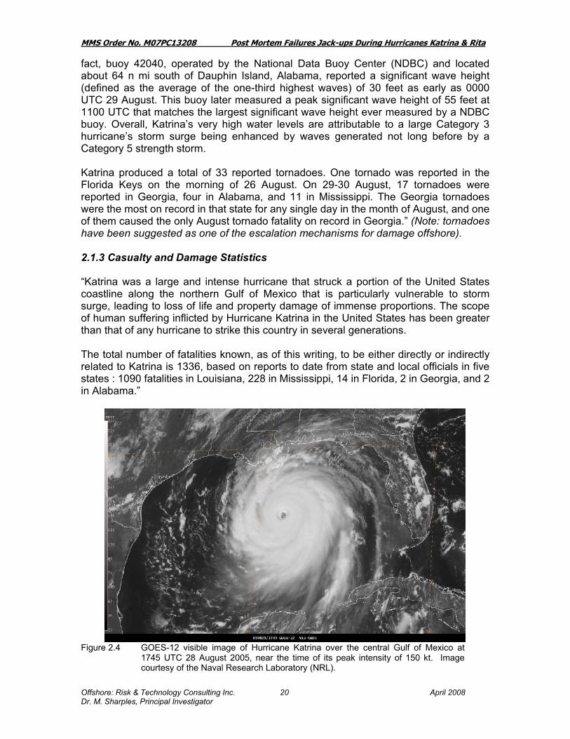
fact, buoy 42040, operated by the National Data Buoy Center (NDBC) and located about 64 n mi south of Dauphin Island, Alabama, reported a significant wave height (defined as the average of the one-third highest waves) of 30 feet as early as 0000 UTC 29 August. This buoy later measured a peak significant wave height of 55 feet at 1100 UTC that matches the largest significant wave height ever measured by a NDBC buoy. Overall, Katrina’s very high water levels are attributable to a large Category 3 hurricane’s storm surge being enhanced by waves generated not long before by a Category 5 strength storm. Katrina produced a total of 33 reported tornadoes. One tornado was reported in the Florida Keys on the morning of 26 August. On 29-30 August, 17 tornadoes were reported in Georgia, four in Alabama, and 11 in Mississippi. The Georgia tornadoes were the most on record in that state for any single day in the month of August, and one of them caused the only August tornado fatality on record in Georgia.” (Note: tornadoes have been suggested as one of the escalation mechanisms for damage offshore). 2.1.3 Casualty and Damage Statistics “Katrina was a large and intense hurricane that struck a portion of the United States coastline along the northern Gulf of Mexico that is particularly vulnerable to storm surge, leading to loss of life and property damage of immense proportions. The scope of human suffering inflicted by Hurricane Katrina in the United States has been greater than that of any hurricane to strike this country in several generations. The total number of fatalities known, as of this writing, to be either directly or indirectly related to Katrina is 1336, based on reports to date from state and local officials in five states : 1090 fatalities in Louisiana, 228 in Mississippi, 14 in Florida, 2 in Georgia, and 2 in Alabama.”
Figure 2.4 GOES-12 visible image of Hurricane Katrina over the central Gulf of Mexico at
1745 UTC 28 August 2005, near the time of its peak intensity of 150 kt. Image courtesy of the Naval Research Laboratory (NRL).

MMS Order No. M07PC13208 Post Mortem Failures Jack-ups During Hurricanes Katrina & Rita
Offshore: Risk & Technology Consulting Inc. April 2008 Dr. M. Sharples, Principal Investigator
21
Figure 2.5: Wind speed at Buoy 42040
The highest measured waves during Hurricane Katrina were at 11GMT on August 29th, 2005, when the National Data Buoy Center (NDBC) buoy 42040 situated at the water depth of 444m (see www.ndbc.noaa.gov and www.nhc.noaa.gov for location with respect to the hurricane track and intensity) measured the significant wave height Hs = 16.91 m (or 55 ft). This buoy is in the Central Gulf of Mexico where, according to state-of-the-art API environmental criteria (Ref 22), the 200-year significant wave height for this water depth is 16.4 m. By interpolation, the highest measured point in Hurricane Katrina was a 260-year return period value. By comparison Hurricane Ivan was the strongest hurricane of the 2004 Atlantic hurricane season. The storm formed in early September, and became the ninth named storm, the sixth hurricane, and the fourth major hurricane of the year. Ivan reached Category 5 strength on the Saffir-Simpson Hurricane Scale, the highest possible category, and it became the sixth (now ninth) most intense Atlantic hurricane on record, as well as the only Category 5 storm of the season.

MMS Order No. M07PC13208 Post Mortem Failures Jack-ups During Hurricanes Katrina & Rita
Offshore: Risk & Technology Consulting Inc. April 2008 Dr. M. Sharples, Principal Investigator
22
Figure 2.6: NOBC Stations within 300 nm of Hurricane Katrina 23-30 August 2005
Figure 2.7: Significant Wave Height at Buoy 42040

MMS Order No. M07PC13208 Post Mortem Failures Jack-ups During Hurricanes Katrina & Rita
Offshore: Risk & Technology Consulting Inc. April 2008 Dr. M. Sharples, Principal Investigator
23
2.2 Summary of Information from the National Hurricane Center on Hurricane Rita (Ref 17) “Rita was an intense hurricane that reached Category 5 strength (on the Saffir-Simpson Hurricane Scale) over the central Gulf of Mexico, where it had the fourth-lowest central pressure on record in the Atlantic basin. Although it weakened prior to making landfall as a Category 3 hurricane near the Texas/Louisiana border, Rita produced significant storm surge that devastated coastal communities in southwestern Louisiana, and its winds, rain, and tornadoes caused fatalities and a wide swath of damage from eastern Texas to Alabama. Additionally, Rita caused floods due to storm surge in portions of the Florida Keys. The “best track” chart of the tropical cyclone’s path is given in Fig. 2.8, with the wind and pressure histories shown in Figs. 2.9 and 2.10, respectively.
Figure 2.8 Best track positions for Hurricane Rita, 18-26 September 2005.
Referring to Figure 2.11 the color changes denote the intensity changes as the hurricane progressed.
MMS Order No. M07PC13208 Post Mortem Failures Jack-ups During Hurricanes Katrina & Rita
Offshore: Risk & Technology Consulting Inc. April 2008 Dr. M. Sharples, Principal Investigator
24
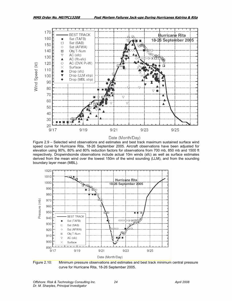
Figure 2.9 – Selected wind observations and estimates and best track maximum sustained surface wind speed curve for Hurricane Rita, 18-26 September 2005. Aircraft observations have been adjusted for elevation using 90%, 80% and 80% reduction factors for observations from 700 mb, 850 mb and 1500 ft respectively. Dropwindsonde observations include actual 10m winds (sfc) as well as surface estimates derived from the mean wind over the lowest 150m of the wind sounding (LLM), and from the sounding boundary layer mean (MBL).
Figure 2.10: Minimum pressure observations and estimates and best track minimum central pressure curve for Hurricane Rita, 18-26 September 2005.

MMS Order No. M07PC13208 Post Mortem Failures Jack-ups During Hurricanes Katrina & Rita
Offshore: Risk & Technology Consulting Inc. April 2008 Dr. M. Sharples, Principal Investigator
25
2.2.1 Synoptic History “Rita originated from a complex interaction between a tropical wave and the remnants of a cold front. The tropical wave moved off the west coast of Africa on 7 September…… Accompanied by very limited convection, the tropical wave moved westward across the Leeward Islands on 16 September and then merged with the surface trough north of Puerto Rico early on 17 September… (At the Florida Straits), however, Rita began to strengthen, and it became a hurricane with an intensity of 70 kt by 1200 UTC 20 September about 100 n mi east-southeast of Key West, Florida. Rita then attained an intensity of 85 kt (Category 2) by 1800 UTC that day, and its center passed about 40 n mi south of Key West about an hour later. Even more rapid strengthening ensued. Rita proceeded westward into the southeastern Gulf of Mexico as a Category 3 hurricane early on 21 September. Throughout most of the remainder of that day, Rita quickly intensified over the very warm waters of the Loop Current and within an environment of very weak vertical wind shear, reaching an intensity of 145 kt by 1800 UTC. Rita had strengthened from a tropical storm to a Category 5 hurricane in less than 36 h. It remained at Category 5 strength for about the next 18 h, reaching its estimated peak intensity of 155 kt by 0300 UTC 22 September while located about 270 n mi south-southeast of the mouth of the Mississippi River. The inner eyewall deteriorated later on 22 September and Rita abruptly weakened to Category 4 strength with 125 kt maximum winds by 1800 UTC that day. By early on 23 September a new, outer eyewall had consolidated and the hurricane had grown in size. However, Rita did not re-intensify following the structural changes. Due to increasing southwesterly wind shear and slightly cooler waters, steady weakening continued on 23 September. Rita rounded the western periphery of the deep-layer ridge and turned toward the northwest that day, with a slight increase in forward speed from about 8 to about 10 kt. It weakened to a Category 3 hurricane with 110 kt maximum winds by 1800 UTC 23 September about 140 n mi southeast of Sabine Pass at the Texas/Louisiana border. Rita maintained Category 3 status up to the time of landfall of the center, which occurred at 0740 UTC 24 September with an estimated intensity of 100 kt, in extreme southwestern Louisiana just west of Johnson’s Bayou and just east of Sabine Pass. Rita weakened after making landfall, remaining a hurricane until only about 1200 UTC 24 September when it was centered about 35 n mi north of Beaumont, Texas. 2.2.2 Meteorological Statistics “Observations in Rita (Figs. 2.9 and 2.10) include data from satellites, aircraft, airborne and ground-based radars, conventional land-based surface and upper-air observing sites, ………………. Aircraft and satellite data indicate that Rita intensified on 21 September from 95 kt (Category 2) at 0000 UTC that day to 145 kt (Category 5) just 18 h later. The first wind observation supporting Category 5 intensity was 138 kt at 1606 UTC from the SFMR, using a post-season calibration based on dropwindsonde data to improve performance at extreme wind speeds. The peak SFMR estimate was 146 kt at 1912 UTC 21
MMS Order No. M07PC13208 Post Mortem Failures Jack-ups During Hurricanes Katrina & Rita
Offshore: Risk & Technology Consulting Inc. April 2008 Dr. M. Sharples, Principal Investigator
26
September, followed by a 144 kt estimate at 1945 UTC. A 700-mb flight-level wind of 161 kt was measured near 1935 UTC, corresponding to about 145 kt at the surface based on the average 90% adjustment from 700 mb. Two dropwindsondes directly measured 10-m winds of 142 and 149 kt shortly after 1930 UTC (Fig. 2.9). Analysis of dropwindsonde observations indicates that the central pressure in Rita fell a remarkable 70 mb in the 24-h period ending 0000 UTC 22 September (Fig. 2.10), when the pressure had fallen to an estimated 897 mb with an estimated wind intensity of 150 kt. The best track central pressure at that time is based upon a dropwindsonde observation at 2309 UTC 21 September of 899 mb, but with a surface wind of 32 kt; therefore, the actual central pressure was likely a couple of mb lower. Following that penetration of the eye, the aircraft departed Rita and no reconnaissance data were available during the subsequent six-hour period between about 2330 UTC 21 September and 0530 UTC 22 September. When the next aircraft arrived, dropwindsondes in the eye measured 898 mb (with a surface wind of 13 kt) at 0538 UTC and 899 mb (with a surface wind of 35 kt) at 0715 UTC. Based on these data, the best track central pressure is also estimated at 897 mb at 0600 UTC 22 September. However, due to the roughly six-hour gap in aircraft data, the lowest pressure and maximum winds that actually occurred in Rita are subject to speculation. Since the pressure was falling until 0000 UTC and rising after 0600 UTC, the minimum pressure in Rita probably occurred at about 0300 UTC 22 September and is estimated at 895 mb. This value represents the fourth-lowest on record in the Atlantic basin best track database, behind 882 mb in Wilma (2005), 888 mb in Gilbert (1988), and 892 mb in the 1935 Florida Keys hurricane. The maximum 700-mb flight-level wind observed during Rita was 165 kt at 0538 UTC 22 September, corresponding to about 149 kt at the surface…. The eye diameter as reported by aircraft contracted from 20 n mi near 0000 UTC to 16 n mi near 0600 UTC, suggesting that slight strengthening could have occurred during that time. Dvorak intensity estimates from both TAFB and SAB were 155 kt at 0645 UTC 22 September, and that was the first time both agencies provided an estimate that high (only SAB estimated 155 kt at 2345 UTC 21 September). Considering all of these factors, the peak best track intensity is set to 155 kt (just 5 kt greater than what was assessed operationally) and is estimated to have occurred at 0300 and 0600 UTC 22 September. Following two days of rapid strengthening, Rita had also become a large hurricane, with 34-kt winds extending out up to 160 n mi from the center at the time of peak intensity.………………….. An estimated total of 90 tornadoes were reported in association with Rita, mainly to the north and east of the circulation center in portions of Alabama, Mississippi, Louisiana, and Arkansas. Rita produced the most tornadoes (56) in a single event (of 48 h or less in duration) ever recorded in the area of responsibility of the Jackson, Mississippi NWS forecast office (which includes portions of northeastern Louisiana and extreme southeastern Arkansas). 2.2.3 Casualty and Damage Statistics “The approach of Rita provoked one of the largest evacuations in U. S. history. Media reports indicate that the number of evacuees in Texas could have exceeded two million. Additional evacuations involving smaller numbers took place in Louisiana. Seven fatalities have been directly attributed to the forces of Rita.………” (Note: none offshore).

MMS Order No. M07PC13208 Post Mortem Failures Jack-ups During Hurricanes Katrina & Rita
Offshore: Risk & Technology Consulting Inc. April 2008 Dr. M. Sharples, Principal Investigator
27
“Oil and gas production and refining in the northwestern Gulf of Mexico region was disrupted by Rita (largely due to evacuations), but the impacts were not as severe as those farther east due to Hurricane Katrina. The measured data for Rita is more limited because there were no buoys to the immediate east of the storm, and those to the west were sufficiently far away not to give a clear picture, from this source, of the waveheights and windspeeds as for Katrina.”

MMS Order No. M07PC13208 Post Mortem Failures Jack-ups During Hurricanes Katrina & Rita
Offshore: Risk & Technology Consulting Inc. April 2008 Dr. M. Sharples, Principal Investigator
28
Figure 2.11: Hurricane Rita Storm Track and Intensity Figure 2.12: Image of Hurricane Rita 9-23-05

MMS Order No. M07PC13208 Post Mortem Failures Jack-ups During Hurricanes Katrina & Rita
Offshore: Risk & Technology Consulting Inc. April 2008 Dr. M. Sharples, Principal Investigator
29
Figure 2.13 shows the frequency and intensity of hurricanes throughout the season. Note that September when Hurricane Rita occurred is the height of the most frequently severe hurricanes. Figure 2.14 was issued by the MMS and depicts the hurricane tracks of both Hurricanes Rita and Katrina superimposed on a map of the Gulf of Mexico showing the platform infrastructure. The span of hurricane force winds are also shown.

MMS Order No. M07PC13208 Post Mortem Failures Jack-ups During Hurricanes Katrina & Rita
Offshore: Risk & Technology Consulting Inc. April 2008 Dr. M. Sharples, Principal Investigator
30
Figure 2.14: `

MMS Order No. M07PC13208 Post Mortem Failures Jack-ups During Hurricanes Katrina & Rita
Offshore: Risk & Technology Consulting Inc. April 2008 Dr. M. Sharples, Principal Investigator
31
3. LLOYD’S LIST REPORTS
The summary that follows is extracted from reports produced by Lloyd’s List, a UK based news service originally and primarily serving the insurance underwriting community. The intention of this section is to put a perspective on the impact of Hurricanes Katrina and Rita. While the jack-up fleet was heavily impacted, with the highest number of casualties in any storm (Rita), it is a small part of the story in the Regional Disaster that was caused by the hurricanes. Specific information on jack-ups is recorded in bold. 3.1 Lloyd’s List Reports: Hurricane Katrina (Extracts Only) London, Aug 29 -- A press report, dated Aug 28, states: The mayor has ordered an immediate evacuation for all of New Orleans, a city with 485,000 inhabitants, as Hurricane "Katrina" bore down with wind up to nearly 282 kph and threats of a massive storm surge. Acknowledging that large numbers of people, many of them stranded tourists, would be unable to leave before the eye of the storm strikes land sometime tomorrow morning, the city set up 10 places of last resort, including the Superdome arena. "This is a once-in-a-lifetime event," Mayor Ray Nagin said. "The city of New Orleans has never seen a hurricane of this magnitude hit it directly." The mayor said a direct hit by "Katrina"'s storm surge would likely top the levees that protect the city from the surrounding water of Lake Pontchartrain, the Mississippi River and marshes. President George Bush pledged federal support. Rain started falling on extreme south-eastern Louisiana by midday today as the storm moved across the Gulf of Mexico towards land. Highways in Mississippi and Louisiana were jammed as people headed away from "Katrina"'s expected landfall. All lanes were limited to northbound traffic on two major interstate highways. Beyond the Gulf Coast, "Katrina" was "unmitigated bad news for consumers" because it had shut down offshore production of at least one million barrels of oil daily and threatened refinery and import operations around New Orleans, said Peter Beutel, an oil analyst in New Canaan, Connecticut. He said crude oil could top $70 a barrel by Monday or Tuesday. London, Aug 30 -- A press report, dated today, states: Hurricane "Katrina" has smashed across the southern coastline of the United States, destroying houses and leaving some areas up to three metres under water. The US National Weather Service says what it calls "extensive and life threatening" storm surge flooding is occurring along the Louisiana and Mississippi coast. The cities of New Orleans and Gulfport appear to have been the worst hit. An early estimate of the damages bill is at least $34 billion. It claimed the lives of at least three people in New Orleans and sent crude oil prices surging to record highs after the evacuation of offshore rigs in the oil-rich Gulf of Mexico and the closure of refineries. Emergency teams waited for the worst of the storm to pass to launch rescue operations. A number of homes were damaged by boats which broke free from their moorings in the heavy winds. Hundreds of thousands of people in New Orleans and other areas of Louisiana as well as Mississippi lost power. London, Aug 31 -- A press report, dated today, states: Royal Dutch Shell Plc said its Capline crude oil pipeline connected to Gulf of Mexico offshore production was shut because of power failures after Hurricane "Katrina" swept through the area. "The Shell-operated Capline Pipeline system did not incur damage from Hurricane "Katrina", but is currently down due to multiple pump stations that are without power,'' Shell said in a

MMS Order No. M07PC13208 Post Mortem Failures Jack-ups During Hurricanes Katrina & Rita
Offshore: Risk & Technology Consulting Inc. April 2008 Dr. M. Sharples, Principal Investigator
32
statement on its Web site dated yesterday. The Capline pipeline transports up to 1.2 million barrels a day of crude oil from the Gulf of Mexico and imported from overseas. It runs more than 650 miles from St, James, Louisiana to Patoka, Illinois, according to Shell. Hurricane "Katrina" has shut 1.4 million barrels of daily crude-oil output, according to the U.S. Minerals Management Service, which manages offshore resources. Platforms in the Gulf account for about 30 percent of U.S. output. Four pipelines carrying refined oil products between New Orleans and Baton Rouge, Louisiana are also shutdown, the Shell statement said. The system is not operating because of power outages and a lack of supply from refineries closed by the hurricane, it said. Eight refineries in Louisiana and Mississippi were closed during the weekend, halting at least 1.79 million barrels a day of capacity. London, Aug 31 -- Diamond Offshore press releases, dated Aug 30, state: (1) Diamond Offshore Drilling, Inc today reported that the jack-up drilling platform Ocean Warwick (3621 gt, built 1971) could not be found on its drilling location during a search by fixed-wing aircraft early this morning. The rig was located on Main Pass Block 299, approximately 12 miles off the coast of Louisiana in about 200 ft. of water prior to passage of hurricane "Katrina". Additional search efforts are under way in an attempt to determine the disposition of the 300-ft. independent cantilever rig. Ocean Warwick is insured for approximately $50 million net of applicable deductibles and has a book value of approximately $14 million. (2) Ocean Warwick, which had previously been listed as missing, has been located on Dauphin Island off the coast of Alabama. Aerial photos indicate that the rig has sustained significant damage and is aground on the island. Diamond Offshore is working to get personnel to the rig but will not be able to make a complete assessment of the condition of the unit until a crew is able to reboard the rig. Dauphin Island is approximately 66 miles northeast of the rig's work location on Main Pass Block 299 prior to passage of hurricane "Katrina". New York, Sep 5 -- Energy companies kept working through the US Labor Day holiday to restore damaged Gulf of Mexico offshore oil and natural gas production facilities and restart Gulf Coast refineries devastated by hurricane "Katrina" last week. Gulf of Mexico oil and natural gas production showed improvement. The US Minerals Management Service said 30.43% of oil output was online this morning, up from about 21% pumping on Saturday (Sep 3). Natural gas production was at 47.75% today, up from 42.21% on Saturday. The government said nearly 28% of 819 manned production platforms and a similar percentage of 134 rigs operating in the Gulf remained evacuated today. Two of eight refineries shut in Louisiana and Mississippi by Katrina were in restart today. Marathon Petroleum Co LLC said its Garyville, La, refinery, third largest shut by "Katrina", was in restart and should be back to normal by tomorrow. Shell said yesterday that Motiva's Convent, La, refinery was coming back slowly, while its Norco, La, refinery could be able to restart by the middle of next week. The two largest shut facilities, Chevron Corp's in Pascagoula, Miss, and ConocoPhillips' in Belle Chasse, La, sustained extensive flood damage, according to the government. Chevron said today that the Pascagoula refinery did not suffer catastrophic damage but added that no restart estimate was available. It said it was still assessing damage as it worked to find employees dislocated by "Katrina." Reduced refinery throughput run rates were seen in 12 other refineries as far away as Illinois and Ohio. Colonial Pipeline's key gasoline and distillate products pipelines from the Gulf Coast heading north-east were at 73%

MMS Order No. M07PC13208 Post Mortem Failures Jack-ups During Hurricanes Katrina & Rita
Offshore: Risk & Technology Consulting Inc. April 2008 Dr. M. Sharples, Principal Investigator
33
capacity on Saturday and were forecast to reach 100% of normal capacity by tonight. The Department of Energy announced last week it will loan crude oil from the national Strategic Petroleum Reserve to refiners. London, Sep 6 -- The closure of the facilities hit by Hurricane "Katrina" meant that 10% of the US's refining capacity was knocked out of commission - as well as a sizable slice of oil and gas production, as rigs were evacuated and in some cases torn from their moorings. London, Sep 13 -- About 60% of the US Gulf's daily crude oil production, 38% of natural gas production and four major refineries representing 5% of national capacity were still shut at the weekend, exactly two weeks after Hurricane "Katrina" swept across the southeast coastline. About 56 rigs were damaged, with 20 total losses. An estimated 122 out of 819 manned platforms and three out of 134 rigs in the region remained evacuated, according to the US Department of Energy. 3.2 Lloyd’s List Reports: Hurricane Rita (Extracts Only) London, Sep 22 -- A press report, dated Sep 21, states: Gaining strength with frightening speed, Hurricane "Rita" swirled toward the Gulf Coast a Category 5, 165-mph monster today as more than 1.3 million people in Texas and Louisiana were sent packing on orders from authorities who learned a bitter lesson from "Katrina". With "Rita" projected to hit Texas by Saturday (Sep 24),………. "Rita" sideswiped the Florida Keys and began drawing energy with terrifying efficiency from the warm waters of the Gulf of Mexico. Between 0200 and 1600, it went from a 115-mph Category 2 to a 165-mph Category 5. Forecasters said "Rita" could be the most intense hurricane on record ever to hit Texas, and easily one of the most powerful ever to plow into the US mainland. By late afternoon, "Rita" was centred more than 700 miles southeast of Corpus Christi. Forecasters predicted it would come ashore along the central Texas coast between Galveston and Corpus Christi. Tropical storm-force winds extending 350 miles across, practically the entire western end of the Gulf Coast was in peril, and even a slight rightward turn could prove devastating to the fractured levees protecting New Orleans. In the Galveston-Houston-Corpus Christi area, about 1.3 million people were under orders to get out, in addition to 20,000 or more along with the Louisiana coast. Special attention was given to hospitals and nursing homes. Crude oil prices rose again on fears that "Rita" would smash into key oil installations in Texas and the gulf. Hundreds of workers were evacuated from offshore oil rigs. Texas, the heart of US crude production, accounts for 25 percent of the nation's total oil output. London, Sep 23 -- A press report, dated today, states: More than a million people are fleeing towns and cities in Texas and Louisiana as the US Gulf Coast prepares for the arrival of Hurricane "Rita" today. Their flight inland has been slowed by traffic jams stretching up to 100 miles, with fuel shortages reported. Texas is due to bear the brunt of the storm but forecasters say its path may shift east, increasing the risk heavy rains may test New Orleans' flood defences. Texas has called on the federal government to put 10,000 troops on standby for search and rescue work. ……About 1,000 state troopers and 5,000 National Guard are already making preparations for the storm in Texas; National Guard lorries are taking badly-needed fuel to petrol stations and stranded motorists around Houston and Oil companies are closing refineries in Texas and moving workers from offshore rigs. According to the National Hurricane Centre, "Rita" weakened yesterday to a Category Four, but was still carrying winds of 140mph

MMS Order No. M07PC13208 Post Mortem Failures Jack-ups During Hurricanes Katrina & Rita
Offshore: Risk & Technology Consulting Inc. April 2008 Dr. M. Sharples, Principal Investigator
34
this morning. The storm remains "extremely dangerous", being at least as powerful as "Katrina" and threatening 370 miles of coastline. Houston's busy airports will close at noon local time (1700, UTC) ahead of "Rita"'s expected landfall late today. A mandatory evacuation order in the island city of Galveston was rapidly observed and 90% of the city's 57,000 residents had left by yesterday afternoon. The escape from Galveston has been gruelling, with those who left spending much of the past 24 hours stuck in traffic jams in stifling humidity. Many have been left stranded on the roadside, out of petrol, low on water and food, waiting for help from the police or the Texas National Guard. In Houston low-lying areas at risk from flooding were also emptying. To the north of the city, a traffic queue up to 100 miles long was reported as people headed inland in temperatures reaching 37C. Scores of hospitals along the main evacuation routes out of Houston closed their doors to new patients today after being swamped by people suffering heat exhaustion, AFP news agency reports. In neighbouring Louisiana, Governor Kathleen Blanco urged people to leave the south-western coast, already battered by Hurricane "Katrina". She estimated that between 300,000 and 500,000 people would go. Engineers have been seeking to bolster the floodwalls in New Orleans, which were overcome by "Katrina"'s storm surges. Some estimates say even a few inches of rain would overcome the weakened flood defences. London, Sep 24 -- A Press report, dated today, states: Hurricane "Rita" has pounded the US Gulf Coast with driving wind and rains, leaving a trail of destruction. Electricity stations exploded and fires erupted as power lines came down, resulting in the loss of power for about a million people in the region. The cities of Houston and Galveston, which were braced for severe weather, escaped a direct hit, as the storm strayed east from its original path. "Rita" has weakened to a Category One hurricane but heavy rains continue. The US National Hurricane Center said winds of up to 120 mph were recorded when the hurricane hit land at about 0600, UTC, but winds had since dropped to around 75mph. "Rita" crashed ashore with a 20ft storm surge into low-lying areas along the Texas-Louisiana border, prompting fears of flooding. The towns of Sabine Pass in Texas and Cameron in Louisiana took the initial fury of the hurricane. ……..The storm following the violent winds was also expected to dump up to 25 in. of rain. …… As well as ripping off rooftops, the storm knocked a container vessel from its moorings in Lake Charles and the vessel threatened to hit a highway bridge, news reports said. Hotel worker Rainey Chretien, of the Elegante Hotel in Beaumont, Texas, said the storm blew out windows, brought down a chandelier and ripped the roof off another section of lobby. There were 16 arrests for burglary in Houston overnight but few reports of lawlessness in other areas. London, Sept 25 -- A press report, dated Sept 24, states: Hurricane "Rita" pummeled east Texas and the Louisiana coast today, triggering floods and demolishing buildings, yet the dominant reaction was relief that the once-dreaded storm proved far less fierce and deadly than "Katrina". Authorities pleaded with the roughly three million evacuees not to hurry home too soon, fearing more chaos. In any other hurricane season, "Rita" might have seemed devastating. It knocked out power for than a million customers, sparked fires across the hurricane zone and swamped Louisiana shoreline towns with a 15-foot storm surge that required daring boat and helicopter rescues of hundreds of people. But the new storm came in the wake of Hurricane "Katrina", with its 1,000-plus death toll, cataclysmic flooding of New Orleans and staggering destruction in Mississippi. By contrast, "Rita" spared Houston, New Orleans and other major cities a direct hit, and by midafternoon today federal officials said they knew of no storm-related fatalities. ……. Valero Energy Corp. said its 255,000-barrel-per-day Port Arthur refinery

MMS Order No. M07PC13208 Post Mortem Failures Jack-ups During Hurricanes Katrina & Rita
Offshore: Risk & Technology Consulting Inc. April 2008 Dr. M. Sharples, Principal Investigator
35
sustained significant damage to two cooling towers and a flare stack, and would need at least two weeks for repairs. ……. "Rita" roared ashore at 0330, EDT, close to the Texas-Louisiana border as a Category 3 hurricane with top winds of 120 miles per hour and warnings of up to 25 inches of rain. By midafternoon, it was downgraded to a tropical storm with top sustained winds of 50 mph as it moved slowly through east Texas toward Shreveport, La. before it weakened, London, Sep 25 -- A press report, dated today, states: Damage caused by hurricane "Rita" as it swept across parts of Texas and Louisiana yesterday, was perhaps only one-seventh as severe financially as the devastation that hurricane "Katrina" inflicted on Mississippi and eastern Louisiana, according to initial estimates by insurance experts. The early estimates suggested that there had been property damage of about $5 billion or less from "Rita", not including the effects of flooding and the impact on offshore oil rigs, which are not covered in most of the calculations. London, Sept 26 -- ……Of the 38 Mobile Offshore Drilling Units (MODUs) reported in the path of Hurricane "Rita", eight are reported adrift. Assessments to critical infrastructure continue but preliminary reports indicate major refineries in the area sustained only minor damage. Of the 819 manned oil and gas facilities in the Gulf of Mexico, 745 remain evacuated. At this time, no major pollution incidents have been reported as a result of damage from "Rita". London, Sep 26 -- A press release from GlobalSantaFe Corporation, dated Houston today, states: Offshore oil and gas drilling rigs GSF Adriatic VII and GSF High Island III, could not be found on their drilling locations during a search by fixed-wing aircraft yesterday. There were no signs of any major damage from Hurricane "Rita" to the company's other rigs in the Gulf of Mexico. All of the company's rigs are insured under a hull and machinery policy subject to a total deductible of $10 million for this event. The two missing jack-up rigs had a combined net book value at Jun 30, 2005, of $22.2 million and are insured for a total of $125 million. The rigs contributed $5.3 million of the company's total $135.3 million of net income for the first six months of 2005. HURRICANE "KATRINA" - GSF RIGS (Wednesday 28 September 2005) London, Sept 27 -- A Rowan Companies Inc press release, dated Sept 26, states: Rowan Companies, Inc announced today that, in the aftermath of hurricane "Rita", its jack-up drill platforms Rowan Odessa (7221 gt, built 1977) and Rowan Halifax (6456 gt, built 1983) were not at their pre-storm locations. In addition, the hull of the jack-up Rowan Louisiana (7222 gt, built 1975) apparently detached from its legs and is aground offshore Louisiana. The Company was also unable to account for drill platform Rowan Fort Worth (6627 gt, built 1978), via a high-altitude aerial survey conducted yesterday. Each of the Company's other Gulf of Mexico rigs was identified, though an assessment of their condition will depend upon closer inspection. The Company will conduct more extensive aerial surveys as soon as weather conditions allow. Rowan Odessa, Rowan Halifax and Rowan Louisiana were operating under contracts that provided for total revenues of approximately $210,000 per day. The rigs are collectively insured for an amount that exceeds their aggregate carrying value. The Company does not maintain insurance against loss of revenue.

MMS Order No. M07PC13208 Post Mortem Failures Jack-ups During Hurricanes Katrina & Rita
Offshore: Risk & Technology Consulting Inc. April 2008 Dr. M. Sharples, Principal Investigator
36
London, Sep 28 -- A Noble Corporation press release, dated Sugar Island, Texas, Sep 27, states: Noble Corporation reported that its offshore drilling units located in the main path of hurricane "Rita" were safely evacuated prior to the storm's arrival and that all the company's units in the U.S. Gulf of Mexico have been secured. ……..The company expects to have Noble personnel on board the unit today. The company further reported, also based on limited and preliminary investigations, that its other two submersibles and its two jack-up rigs operating in the U.S. Gulf of Mexico appeared not to have sustained damage of a material nature. London, Sep 29 -- A press report, dated today, states: Hurricane "Rita" may have caused more damage to rigs and platforms than any Gulf of Mexico storm -- including hurricane "Katrina," oil and gas analysts said yesterday. The combined effect of those hurricanes has already cost the Gulf almost 7% of its annual oil production and 5% of its yearly natural gas output, according to a US Minerals Management Service report yesterday. ''The impact on the rigs is something that's never been seen by this country before," said Daniel Naatz, director of federal resources for the Independent Petroleum Association of America. ODS-Petrodata, which provides data and information to the industry, reported 13 rigs already seriously damaged or destroyed by "Rita." Platform damage was still being assessed, said Tom Marsh, ODS analyst. Meanwhile, nine of 12 pipelines that move gas and oil onshore remain shut down or operate at less than 100% capacity, according to the latest report by the Association of Oil Pipelines. Refineries in the hardest-hit area of Beaumont and Port Arthur, Texas, plus Lake Charles, La, are still not operating, costing about 1.7 million barrels a day of refined products, according to the US Department of Energy. The slow pace of recovery for the Gulf refineries, rigs and platforms and concerns about demand for heating oil this winter drove up oil futures yesterday. Light, sweet crude for November delivery rose $1.28 to $66.35 a barrel on the New York Mercantile Exchange. Natural gas futures for October rose more than $1 to $13.907 per million British thermal units. Heating oil gained more than seven cents to settle at $2.1411 a gallon, while gasoline gained more than 17 cents to settle at $2.3393 a gallon. Washington, Oct 4 -- About 30 percent of offshore oil and natural gas production currently shut in may be due to hurricane damage to onshore oil refineries and natural gas processing plants, Minerals Management Service Director Johnnie Burton said today. Interior Secretary Gale Norton said the department will not know for sure for several more weeks how much shut-in oil and gas production is due to refineries and gas processing plants that are shut down and how much damaged offshore platforms and underwater pipelines are at fault. -- Reuters. London, Oct 28 -- ……… Crude oil production in the Gulf of Mexico has also slowed as a result of the storms. Hurricanes "Katrina" and "Rita" destroyed 113 oil and gas production platforms in the Texas-Louisiana coastal region.

MMS Order No. M07PC13208 Post Mortem Failures Jack-ups During Hurricanes Katrina & Rita
Offshore: Risk & Technology Consulting Inc. April 2008 Dr. M. Sharples, Principal Investigator
37
4. MEDIA NEWS CLIPPINGS
A report of 2 Sept 2005 summarized the situation:
• “One jack-up rig remains missing and presumed sunk after Hurricane Katrina
• 62 MODUs were in the direct path of Hurricane Katrina.
• 55 MODUs were within reach of Katrina’s Tropical storm winds
• 18 MODUs reported notable damage
• Rowan New Orleans 250 ft jack-up capsized”.
• Ocean Warwick 300 ft IC Jack-up capsized Rita wrecks way to new records (Ref: Upstream 30/9/2005 ) More than two-dozen mobile offshore drilling rigs were displaced, damaged or are missing along the path cut by Hurricane Rita in the US Gulf last weekend. The damage is so diverse and severe that some pundits suggest Rita may set a record for the greatest number of offshore rigs damaged and destroyed by a single storm. In contrast, Hurricane Katrina, the Category 4 storm that plowed through the far eastern section of the US Gulf oil patch in late August, resulted only in the confirmed total loss of one jack-up and a handful of platform rigs, while damaging a handful of other rigs. GlobalSantaFe fared little better. The contractor found two of its jack-ups GSF Adriatic VII and GSF High Island III severely damaged about 80 miles (130 kilometres) from their pre-Rita stations. Assessment teams have boarded and begun inspecting the rigs.
Rowan retrieves rig wreckage (Ref: Daily Collection of Maritime Clippings Piet Sinke 205) Rowan has located the wreckage of the Rowan-New Orleans, its LeTourneau 52-class slot jack-up rig which sank in 155 feet of water in Main Pass Block 185 off Louisiana, during Hurricane Katrina. The rig was insured for about $1.1 million more than its carrying value. The company is currently planning for the removal of the wreckage, the cost of which is expected to exceed Rowan's $5 million annual insurance deductible. Storm damage to Rowan's other rigs appears to be minimal. All offshore personnel had been safely evacuated from the Rowan-New Orleans prior to the storm.
Storm damage lingers on in Gulf (Upstream 27 January 2006 )

MMS Order No. M07PC13208 Post Mortem Failures Jack-ups During Hurricanes Katrina & Rita
Offshore: Risk & Technology Consulting Inc. April 2008 Dr. M. Sharples, Principal Investigator
38
Only one third of the 64 large-diameter pipelines damaged by Hurricanes Katrina and Rita last autumn have returned to service according to the US Mineral Management Service, which has just released its analysis of the effects of the storms. The agency said of the 36, 10-inch diameter or greater pipelines damaged by Katrina, just 12 have come back on stream. Rita hit 28 large-diameter lines during her devastating trek across the US Gulf's outer continental shelf (OCS) only 10 of these are back online. In total, both storms are said to have wrecked more than 180 pipelines in federal waters. "The overall damage caused by Hurricanes Katrina and Rita has shown them to be the greatest natural disasters to oil and gas development in the history of the Gulf of Mexico," said Chris Oynes, MMS regional director. The year before, "in the devastating Hurricane Ivan, there were seven platforms destroyed, compared with the 115 platforms destroyed in Katrina and Rita". Katrina, a Category-5 storm when it entered the OCS, destroyed 46 platforms and damaged 20 others. Rita, which was a Category-4 hurricane when it entered the OCS, destroyed 69 platforms and damaged 32 others.”

MMS Order No. M07PC13208 Post Mortem Failures Jack-ups During Hurricanes Katrina & Rita
Offshore: Risk & Technology Consulting Inc. April 2008 Dr. M. Sharples, Principal Investigator
39
5. JACK-UPS: HURRICANE INCIDENTS AND INDUSTRY RESPONSE
5.1 History The history of jack-ups encompasses a long legacy of successful deployment in many challenging conditions. DeLong’s (Ref 1) design for a platform with legs, elevated by airjacks, was developed for logistic support for U.S. Army construction projects. Although DeLong built a small prototype jack-up pier for the Gulf of Mexico in 1950, the first major DeLong pier was built for Thule, Greenland in 1951, to support a strategic buildup of power as a deterrent to Soviet air strikes. DeLong constructed four 50ft x 250 ft jack-up barges in Houston, Texas that were towed to Thule, thereby allowing construction to be extended past the summer after the pack ice closed in. They lasted well over 20 years. Another well-known application of jack-up technology was the Texas Towers (Ref 59) which in 1955 were jacked up on Georges Bank off the East Coast of the U.S., 160 miles southeast of Boston. The complex was an early aircraft detection system, a control system for guiding interceptor aircraft, and a command center. The hulls were 81 ft above the water surface. A total of 4 were constructed. They were dismantled after a tragic loss (not the DeLong design) during a hurricane. DeLong was an engineer well-founded in the principles of design. In testimony over the Texas Tower casualty he demonstrated the fundamental grasp he had on the importance of fixity in the footings of the rig whereby the footing, when penetrated into the soil sufficiently, could cause the leg to act as an encastré beam-column thereby increasing its resistance. The jack-up industry is still in the process of quantifying this benefit. Jack-ups have many times been exposed to hurricanes of various levels of severity: with little in the way of casualties. Risk studies in the past have noted (Ref 53): “In examining the risk from losses due to environmental overload, the conclusion is reached that jack-ups are very safe structures: there appears to be no jack-up, in the timeframe examined, that has been lost because of a deficiency in calculations methods in use by knowledgable experts” This particularly refers to the fact, upon which there is increasing evidence from the results of Hurricanes Katrina and Rita casualties, that the structural capability of the jack-ups that were exposed in the hurricane far exceeded their design values. The lack of jack-up incidents in Hurricane Andrew was largely as a result of many of them being in shallower water than the deeper depths to which they were designed because of the low gas price at the time, and thus were better able to sustain the loads. Hurricane Katrina and Rita coincided with more jack-ups located in deeper water to maintain current production rates in the GOM. Nevertheless the information found shows that the risk points toward the foundations rather than the structures themselves. Hurricanes Katrina and Rita show the extent of impact on the jack-up fleet was more extensive than reported for past hurricanes. For Hurricane Katrina maximum wave heights of about 70 ft were hindcast out to 70 miles from the track and 50 ft were hindcast out to 100 miles from the track. In the case of Rita hindcast wave heights of 50

MMS Order No. M07PC13208 Post Mortem Failures Jack-ups During Hurricanes Katrina & Rita
Offshore: Risk & Technology Consulting Inc. April 2008 Dr. M. Sharples, Principal Investigator
40
ft were hindcast out to 150 miles east of the track combined with extreme waves and currents. The results of a study underway by David Lewis, jack-up expert (Ref 18), to evaluate recent historical performance have shown some interesting results. Those jack-ups believed to be exposed to wave heights in excess of 30 ft. were identified for hurricanes Andrew, Lili, Georges, Ivan, Katrina, and Rita. To these a few select jack-ups exposed to lesser wave heights that showed an identifiable response to one of these hurricanes were added. The resulting database of 174 points identified 12 (7%) jack-ups floated off location or sank. In 27 (15%) cases the jack-up remained on location but experienced some observable response from drill package sliding or additional settlement to damage to the jack-up requiring service crews or shipyard repair. A majority (78%) remained on location without incident, other than minor wind damage, debris on deck, lost anemometers, broken windows etc., and returned to service shortly after the rig crew returned to the unit. The report by David Lewis presents those jack-ups with observed response or with hindcast metocean components that would generally lead to identified responses from Hurricanes Katrina and Rita. The incidences reported, excluding minor damage, represent those cases where the drilling contractor was required to address the response before beginning restarting of the rig: including re-levelling, bringing special service hands to the rig for repair, or taking the jack-up into a shipyard. In reviewing the Katrina and Rita incidences, in some cases the airgap may have been insufficient for the location, in others a bearing capacity failure occurred as a result of the spudcan reaction due to the storm exceeding the preload reaction, it was not possible to identify that any that had been lost due to structural failure within any reasonable overload: thus concluding that structural capability is not a problem, nor is aging of rigs. As the Report shows, when airgap and soil were sufficient the jack-ups were capable of very much more than their design values. 5.2 Standards Prior to about 1987 there was no industry-wide accepted standard for the practice of site assessment of jack-up rigs. ABS had, together with an industry committee written rules for building and classing jack-ups in 1968, but not for the site assessment at a specific location. In the 1972 ABS Rules a preload requirement was added. The acceptance at a specific site was left to the criteria of marine warranty surveyors, drilling contractors, and on occasion an oil company participant for any particular site (Ref 51). In 1992 as a result of a Joint Industry Study a standard for the evaluation of independent leg jack-ups was established which finally resulted in a recommended practice (Ref 46). A summary of the situation concerning its acceptance was outlined in Offshore Engineer January 1998 (Ref 52). In about 1997 an initiative began to develop this SNAME 5-5A Guideline into an ISO standard under the auspices of the Technical Committee 67. The working group which was set up is knows as Technical Committee 67, Subcommittee 7, and Working Group 7 (ISO TC67 SC7 WG7).

MMS Order No. M07PC13208 Post Mortem Failures Jack-ups During Hurricanes Katrina & Rita
Offshore: Risk & Technology Consulting Inc. April 2008 Dr. M. Sharples, Principal Investigator
41
Since about 1994, major drilling contractors under the auspices of the International Association of Drilling Contractors have held a technical exchange on a regular basis among all those in industry interested in participating, and have held regular informative meetings several times a year since. One sub-group, with drilling contractor funding, has been responsible for developing guidance on the site specific assessments of jack-up rigs in the Gulf of Mexico as a Regional Annex to both the SNAME 5-5A and to the ISO WG7 Committee. The group developed guidance on the criteria for jack-up rigs so that they would survive prior to demanning for a hurricane. This work was almost complete prior to Hurricanes Katrina and Rita (Ref 45 and Ref 4). The approach is based on the Gulf of Mexico philosophy to evacuate in advance of a hurricane. The demanning of offshore jack-ups has been used as an assumption in site assessments since the introduction of the jack-up structure in the Gulf. This approach is consistent with the avoidance of consequences listed below in priority order:
• Safety of Personnel • Protection of the Environment • Protection of Assets
Subsequent to the Hurricanes Katrina and Rita the committee assembled to evaluate the need for further guidance. The committee quickly reached a consensus that no “best practice” for assessing jack-ups existed in the de-manned condition as this represented primarily economic considerations. The discussions of the committee continue on the level of analysis one should perform for storms for jack-ups that have been de-manned. The interim results were presented at the IADC Workshop in October 2006 (Ref 19). Some of the points made in the paper were as follows:
• Wave load exceeded design criteria o Peak wave heights and winds higher than anticipated o Storms generated maximum wave heights for periods longer than
anticipated • Incorporating recent storms increases the metocean design conditions
The recommended practice touched the following subjects: • Site data
o Site data o Geotechnical data o Metocean data
• Preload Process • Air gap (Site specific and Generic) • Unit preparations and evacuation • Post storm Recovery through use of transponders • Post storm Inspections if hurricane force winds experienced.
The overall presentation of the new Recommended Practice was given by (Ref 48: Lars Herbst, MMS, “API Recommended Practice 95J”, IADC Jack-up Workshop, October 19, 2006). The new Recommended Practice document (Ref 16) provided guidance on a new recommended airgap: such an airgap would have allowed any jack-up at any location in the Gulf of Mexico in the 3 hurricanes Ivan, Katrina and Rita, to avoid having

MMS Order No. M07PC13208 Post Mortem Failures Jack-ups During Hurricanes Katrina & Rita
Offshore: Risk & Technology Consulting Inc. April 2008 Dr. M. Sharples, Principal Investigator
42
the hull inundated with a wave, provided the rig did not settle. This is greater than the requirement for a 100-year airgap. Additionally it re-iterated the need for soil information and evaluation to carefully assess the potential for additional penetration, even though this was a prior known and evaluated risk. A paper summarizing the recommended practice was presented by (Hedrick W.P. & Verret S.M. “Jackup Operations: New Operational Recommended Practice (Ref 49). A report from Upstream summarizes the situation (Ref 54 Upstream 28.04.2006): “New regulations covering drilling operations are set to provide rigs with increased storm protection after last year’s disastrous hurricane season. The offshore oil and gas industry has raised the bar for protecting jack-up rigs during hurricanes in the Gulf of Mexico as the first of a new set of drilling guidelines is produced in time for the start of the 2006 hurricane season on 1 June. Jack-ups will have to jack up higher and operators will need to collect more comprehensive sea bottom surveys before drilling new wells on the Outer Continental Shelf, according to the new guidelines stemming from revamped metocean criteria. The American Petroleum Institute (API) published in late April "Interim Recommendations" or Recommended Practice (RP) 95J advising operators and drillers (Ref 16). The document was a joint effort involving the International Association of Drilling Contractors, the Offshore Operators Committee (OOC), the API Upstream Executive Committee on Drilling & Production Operations as well as the US Minerals Management Service (MMS) and Coast Guard. The initial effort was intended to boost the ability of jack-ups particularly of the independent leg variety to withstand a hurricane similar to hurricanes Katrina and Rita, which wreaked havoc in the oil patch last summer. [Note: the characterization of the jack-ups as “wrecking havoc” is not appropriate considering that the loss of and damage to jack-ups was small compared to the damage to production facilities and pipelines. Production was not significantly impacted by any of the jack-up losses or by any drifting jack-ups]. Operators will be required to come up with soil and metocean data for every drilling location and the industry at large may not realize the full importance of that exercise, according to one source, who did not wish to be named. The source argues that it could end up discouraging some companies from drilling wells because of problems collecting the information, or the information means the rig is deemed unsuitable for drilling at the particular site. Craig Castille, drilling manager for Dominion E&P and chair of the drilling subcommittee for OOC, says: "I think that you're going to have some situations develop where a location may not get drilled because of the risk, for example the (mooring) system not being robust enough for an area." The rig may also not be "location-friendly", he admits, meaning there could be a risk of affecting surrounding wells, structures and pipelines should the jack-up's footing fail.

MMS Order No. M07PC13208 Post Mortem Failures Jack-ups During Hurricanes Katrina & Rita
Offshore: Risk & Technology Consulting Inc. April 2008 Dr. M. Sharples, Principal Investigator
43
"We (Dominion) have been doing soil borings on locations on the jack-up side for the purpose of being able to design our drive pipe for our well to be freestanding in a hurricane," he says. "We've been providing that to the drilling contractors. "There will be a requirement to do site-specific risk assessment and we have some tools that we've developed to do it," says Castille. The air gap has also been increased for jack-ups. Depending on site-specific metocean data, a jack-up operating in 80 feet of water or more will have to maintain an air gap of 62 feet between the underside of the hull and the mean surface water level.” For the 2007 season the MMS issued a Notice to Lessees: NTL 2007-G13 recommending the use of API 95J in preparing the applications for a permit to drill. A further report by upstream laid out the “new survival strategy for 2006”. ”Some recommendations for increasing the ability of jack-ups to survive the 2006 hurricane season in the Gulf of Mexico.
Site optimization: operators should conduct sea bottom surveys before drilling to identify nearby pipelines, wells and possible soil disturbance from previous jack-up operations that could interfere with rig movement. Preloading procedure: allow one to two hours of preload holding time from last occurrence of spudcan settling to ensure that leg penetration has ceased. Air gap: in the absence of site-specific metocean criteria, an air gap of 62 feet is recommended between the underside of the jack-up hull and the mean water level in water depths of 80 feet or more. This is also the minimum air gap required when securing the jack-up for evacuation.”
5.3 Airgap The results of the Oceanweather data maxima (Ref 20, Ref 21, Ref 55) for every location with data have been plotted in Figs. 5.1, 5.2 and 5.3 against the recommended Airgap as given in API RP 95J (Ref 16). The points plotted include:
• Crest Elevation • Max. Surge Ht • Tide value of 2 ft.
Every point from the data provided for the hurricane of interest (Ivan, Katrina or Rita) has been plotted. When reviewing the data presented, it should be kept in mind that each of these hurricanes were in excess of a 100-year storm, and thus the resulting airgap selected, if above the maxima from the hurricanes –will be greater than 100-year airgap, and for some points may be greater than 1000 year air gap. For each hurricane the points in green depict the airgap required for this storm at the location of the maximum from the Oceanweather study. The recommended airgap from API 95J is

MMS Order No. M07PC13208 Post Mortem Failures Jack-ups During Hurricanes Katrina & Rita
Offshore: Risk & Technology Consulting Inc. April 2008 Dr. M. Sharples, Principal Investigator
44
given (the dark blue line) as is the jack-up rig positions that were in the designated hurricane (the red squares). The jack-up rig at the 300 ft point depicted in the Hurricane Ivan chart is the Ensco 64 which was toppled. The other rigs in Hurricane Ivan survived. One caution in reading the graphs is that just because the jack-up is in the within the Oceanweather data and not above it, does not mean that there were crest elevations at the location of the jack-up, but merely there were some waterdepths affected by the hurricane where the crest elevation would have exceeded the value to which the jack-up was sited. Dots above the API 95J (blue) line would not expect to see crest elevations affecting the hull of the rig at any location in the Gulf of Mexico in that waterdepth.

MMS Order No. M07PC13208 Post Mortem Failures Jack-ups During Hurricanes Katrina & Rita
Offshore: Risk & Technology Consulting Inc. April 2008 2008 Dr. M. Sharples, Principal Investigator
45
Hurricane Ivan Airgap Actuals
0.0
10.0
20.0
30.0
40.0
50.0
60.0
70.0
0 100 200 300 400 500 600
Waterdepth (ft)
Rig
Airg
ap o
r CE+
Surg
e+Ti
de (f
t)
Equivalent Airgap Rigs APIRP95J
Figure 5.1: Hurricane Ivan hindcast required airgap, API RP 95J criteria and actual jack-up airgaps

MMS Order No. M07PC13208 Post Mortem Failures Jack-ups During Hurricanes Katrina & Rita
Offshore: Risk & Technology Consulting Inc. April 2008 2008 Dr. M. Sharples, Principal Investigator
46
Hurricane Katrina Air Gap Actuals
0.0
10.0
20.0
30.0
40.0
50.0
60.0
70.0
80.0
90.0
100.0
0 100 200 300 400 500 600
Waterdepth (ft)
Rig
Airg
ap o
r CE+
Surg
e+Ti
de (f
t)
Equivalent Air Gap Rigs APIRP95J
Figure 5.2: Hurricane Katrina hindcast required airgap, API 95J criteria and jack-up actual airgaps

MMS Order No. M07PC13208 Post Mortem Failures Jack-ups During Hurricanes Katrina & Rita
Offshore: Risk & Technology Consulting Inc. April 2008 2008 Dr. M. Sharples, Principal Investigator
47
Hurricane Rita Airgap Actuals
0.0
10.0
20.0
30.0
40.0
50.0
60.0
70.0
80.0
90.0
100.0
0 100 200 300 400 500 600
Waterdepth (ft)
Act
ual R
ig A
irgap
or C
E+Su
rge+
Tide
(ft)
Equivalent airgap Rig API95J
Figure 5.3: Hurricane Rita hindcast required airgap, APII RP95J criteria and jack-up actual airgaps

MMS Order No. M07PC13208 Post Mortem Failures Jack-ups During Hurricanes Katrina & Rita
Offshore: Risk & Technology Consulting Inc. April 2008 Dr. M. Sharples, Principal Investigator
48
From review of the above, it is clear that the API RP95J recommended line for airgap is well above any of the crest elevations + maximum surge + tide (assuming that each are a maximum together), that occurred in any of the hurricanes at any waterdepth. The recommended line also includes an allowance for settlement and a reserve to ensure no run-up, or damage from not knowing the precise peak of the wave (wave crest uncertainty). Although only 3 storms have been used to validate this API RP95J line, since these storms each were greater than 100-year storms (though not perhaps at every location in the path), it seems likely that this is a very safe airgap. Based on past experience in the Gulf of Mexico the 50ft “rule-of-thumb” for airgap may be an acceptable number depending on the risk profile of the company operating the rig, and any close-by infrastructure that may suffer. Prior to these hurricanes this figure had served the industry well. Since the ability of the jack-up to resist forces decreases as the required airgap increases, it may be prudent to do further work on the 100-year required airgap for the specific site, and weigh that value against the decrease in strength of the jack-up for the increase in airgap as part of the decision-making method to approval. Studies have been carried out on several jack-ups to chronicle the decrease in capability with the increase in airgap (Ref 35). As a word of caution: the Nabors Dolphin 105 in Hurricane Lili had been sited using the API recommended practice for fixed platforms (Ref 64). The airgap was likely exceeded, based on information from a site specific metocean analysis, and the caution is that in shallow water when breaking waves are likely the recommended practice for API RP 95J, may not always be conservative. 5.4 Airgap Comparison to API Bulletin 2 INT-MET Since the hurricanes of 2004 and 2005, a new Interim Guidance on Hurricane Conditions in the Gulf of Mexico has been released (Ref 22). The winds and waves are more recently derived in this document than in the prior industry guidance under the auspices of ISO (Ref 47), however, there is still data of interest in currents contained in the prior document. In particular the wave heights and wind speeds have increased based on the new information by 35% in some cases particularly in the central region. This has a significant affect on jack-ups, where the ability to resist the forces would decrease, by the square of the increase, perhaps by as much as 45%. As indicated in Section 10 and the conclusions in the report, the ability of the jack-ups to survive past the design values and not collapse is shown to be much greater than had previously been demonstrated. Prior to this latest guideline the recommendations made by industry documents did not reflect any difference between one area in the Gulf and another. The current guidelines reflect 4 distinct areas for which guidance is given. It is of note that the values for the Western Gulf of Mexico decreased while those for the Central Gulf of Mexico increased from previous guidance. Figure 7.1 shows the regions of the Gulf of Mexico from API Bulletin 2 INT-MET.
MMS Order No. M07PC13208 Post Mortem Failures Jack-ups During Hurricanes Katrina & Rita
Offshore: Risk & Technology Consulting Inc. April 2008 Dr. M. Sharples, Principal Investigator
49
In deriving the new weather data, based on work carried out by Metocean, Coastal, and Offshore Technologies, LLC, E. P. Berek in a report to the JIP on Mooring (Ref 56), it was indicated that the data used for deriving the metocean extremes had been determined to be 1950+ data. There was less confidence in the data that existed prior to this period because of the measurement techniques available at that time, and therefore it has been omitted from further consideration in the derivation of the new extremes. In review of the data presented by Impact Weather (Ref 57), the following charts show that the earlier hurricanes were quite prominent in the Western portion of the Gulf of Mexico in the early years and in later years the hurricanes took a path toward the Central Zone. Thus if we see future hurricanes heading more to the west as some severe ones did in the past, it is possible that the extremes and therefore the guidance may change in the future.

MMS Order No. M07PC13208 Post Mortem Failures Jack-ups During Hurricanes Katrina & Rita
Offshore: Risk & Technology Consulting Inc. April 2008 Dr. M. Sharples, Principal Investigator
50
Figure 5.4: MTS Presentation (Ref 57)
Figure 5.5: MTS Presentation (Ref 57)

MMS Order No. M07PC13208 Post Mortem Failures Jack-ups During Hurricanes Katrina & Rita
Offshore: Risk & Technology Consulting Inc. April 2008 Dr. M. Sharples, Principal Investigator
51
5.5 Comparison of Jack-up Requirements to Fixed Platform Requirements. The following diagram shows the situation for jack-ups from API 95J (Ref 16) compared to fixed platforms which are in the Gulf of Mexico – from the API deck clearance curve in API RP2A WSD – Fig 2.3.4-8. December 2000, which preceded the 2004 and 2005 hurricane seasons.
Figure 5.6 Comparison of the API RP2A (Ref 64) clearance curve to jack-up airgap

MMS Order No. M07PC13208 Post Mortem Failures Jack-ups During Hurricanes Katrina & Rita
Offshore: Risk & Technology Consulting Inc. April 2008 Dr. M. Sharples, Principal Investigator
52
The figure following uses the API Bulletin 2INT –MET (Ref 22) data to compare to the recommended air gap in API RP95J (Ref 16). The data used included values of surge and tide as well as crest elevation. As can be seen in comparison to each other and in comparison to Figure 5.6 above, the requirements for deck elevations on platforms increased in the Central zone but decreased from the previous guidance in other than the central zone. In waterdepths less than about 80 ft the margin between the API INT-MET data and the jack-up recommendation is much smaller than in the region above 100 ft. The two different approaches to do not appear to be harmonized on the same values of reserve that may be in the data.
Recommended Air Gap for Jackups in Hurricane Season
35
40
45
50
55
60
65
0 50 100
150
200
250
300
350
400
450
500
Water Depth (ft)
Air
Gap
(ft)
Recommended Air Gap (ft)Max Crest Elevation Incuding Surge and Tide West RegionMax Crest Elevation Incuding Surge and Tide West Central RegionMax Crest Elevation Incuding Surge and Tide Central RegionMax Crest Elevation Incuding Surge and Tide East Region
Figure 5.7 Comparison of Jack-up and Fixed Platform Airgap in the guidance documents.
MMS Order No. M07PC13208 Post Mortem Failures Jack-ups During Hurricanes Katrina & Rita
Offshore: Risk & Technology Consulting Inc. April 2008 Dr. M. Sharples, Principal Investigator
53
5.6 Evacuation Metocean Criteria The industry priority is avoiding loss of life by evacuation of jack-ups in good time, when hurricanes approach, since the intensity of the hurricane at the specific location can often not be known until the time has expired for safe abandonment. The criterion upon which safe evacuation may be based was described in a paper “Metocean criteria for Jack-ups in the Gulf of Mexico. (Ref 4) Two levels of concern are evaluated for evacuation.
Assessment Case: represents the worst expected weather based on a 50-year sudden TRS independent extreme metocean criterion that will affect the location with less than 48-hour warning. A standard “design” level analysis is used for this case since it is possible it may be manned during this event. Contingency Case: represents the worst expected weather based on a 50-year sudden TRS independent extreme metocean criterion that will affect the location with less than 72-hour warning. The storm is more intense than that implied in the “Assessment Case”, reflecting storm strengthening during the time between intended evacuation and impact. The “Contingency Case” has more severe metocean criteria than the “Assessment Case” but the load factors used in the assessment are reduced.
The levels of criteria for the assessment case and contingency case are represented in the Figure 5.8. Also plotted on the same graph are the 10-year return period extremes based on the new API criteria. It had been previous practice to assume that the jack-up was capable of 10-year return period hurricane, and assessments had been performed based on this criterion (Ref 51). The current position for the contingency curve tracks very closely the 10-year return period extremes for everywhere except the Central region of the Gulf of Mexico. Even though the 50-year sudden hurricane upon which this is based is subject to independent modeling parameters, it would be recommended to remain extra-cautious about ensuring evacuation from the Central region and perhaps this region should be on a greater alert than in other regions, where the 10-year extremes are more in line with the contingency criteria.

MMS Order No. M07PC13208 Post Mortem Failures Jack-ups During Hurricanes Katrina & Rita
Offshore: Risk & Technology Consulting Inc. April 2008 Dr. M. Sharples, Principal Investigator
54
10 Yr API INT-MET Compared to Assessment & Contingency Curves
0
10
20
30
40
50
60
50 100 150 200 250 300 350 400
Waterdepth (ft)
Wav
e H
t Hm
ax (f
t)
Assessment Curve Contingency Curve Winter storm West 10 yr HmaxWest Central 10 yr Hmax Central 10 yr Hmax East 10 yr Hmax
Figure 5.8 10-Yr API Int-Met Compared to Assessment & Contingency Curves

MMS Order No. M07PC13208 Post Mortem Failures Jack-ups During Hurricanes Katrina & Rita
Offshore: Risk & Technology Consulting Inc. April 2008 Dr. M. Sharples, Principal Investigator
55
6. RIGS ADRIFT/ LOST/ IN HURRICANES KATRINA AND RITA
In order to present the results in an orderly fashion, the jack-ups and what happened to them, are displayed visually below. The later text and tables will describe specifics of the:
• Jack-ups that Drifted • Jack-ups that Sank • Surprising Survivals. • Unexpected Failures – there were only two and they were derrick failure on jack-
ups that were near to shore.

MMS Order No. M07PC13208 Post Mortem Failures Jack-ups During Hurricanes Katrina & Rita
Offshore: Risk & Technology Consulting Inc. April 2008 Dr. M. Sharples, Principal Investigator
56
.
Jack-ups that Drifted
66 miles NE (Katrina) Ocean Warwick
118 miles NW (Rita) Adriatic VII
108 miles NW (Rita) High Island III
Never Found (Rita) Rowan Fort Worth
103 miles NW (Rita) Rowan Louisiana
6 miles NW (Rita) Rowan Odessa

MMS Order No. M07PC13208 Post Mortem Failures Jack-ups During Hurricanes Katrina & Rita
Offshore: Risk & Technology Consulting Inc. April 2008 Dr. M. Sharples, Principal Investigator
57
Jack-ups that Sank
Rowan Fort Worth (Rita)Rowan Odessa (Rita)
Rowan New Orleans (Rita) Rowan Halifax (Rita)

MMS Order No. M07PC13208 Post Mortem Failures Jack-ups During Hurricanes Katrina & Rita
Offshore: Risk & Technology Consulting Inc. April 2008 Dr. M. Sharples, Principal Investigator
58
Surprising Survivals: Katrina
Ocean Nugget Ocean Tower Ensco 74
Ensco 83 Ensco 81 Rowan Paris

MMS Order No. M07PC13208 Post Mortem Failures Jack-ups During Hurricanes Katrina & Rita
Offshore: Risk & Technology Consulting Inc. April 2008 Dr. M. Sharples, Principal Investigator
59
Surprising Survivals: Rita
GSF Adriatic III GSF High Island II
GSF High Island IV
Arch Rowan
Ensco 68 Ensco 69 Ensco 84 Ensco 90 Ensco 98

MMS Order No. M07PC13208 Post Mortem Failures Jack-ups During Hurricanes Katrina & Rita
Offshore: Risk & Technology Consulting Inc. April 2008 Dr. M. Sharples, Principal Investigator
60
Surprising Survivals: Rita (Cont’d)
Rowan California
Rowan Anchorage
Rowan AlaskaCecil Provine

MMS Order No. M07PC13208 Post Mortem Failures Jack-ups During Hurricanes Katrina & Rita
Offshore: Risk & Technology Consulting Inc. April 2008 Dr. M. Sharples, Principal Investigator
61
7. COMPILED INFORMATION ON JACK-UPS AND STORM EXPERIENCE
A variety of sources were used to identify jack-ups that had potentially been impacted by the hurricane. Most of the information was obtained directly from drilling contractors, some information from oil companies involved, and some from the MMS files. Complied in the following tables are the list of jack-ups that we believed were exposed to the hurricanes, most of which were investigated in more detail. In order to compile this report the jack-up names are given together with their reported locations. In some cases we had the block numbers, and in others we had the coordinates. In all cases the weather data came from the Oceanweather hindcasts. In all cases the nearest grid point was chosen. Thus an individual rig may differ a small % from the more accurate determination if the grid points had been interpolated. From the cases checked the difference was small. Where known, the actual airgap is given together with the computed required air gap based on the wave crest elevation, storm surge, and tide allowance of 2 ft. Other columns give distances from the track, whether to the East or West of the track. The section of the Gulf of Mexico that the jack-ups were in is also given. The Gulf of Mexico is divided up into distinct meteorological regions is also given corresponding to the figure below:
Figure 7.1: Reference from (Ref 22). While great effort was made to try to ensure accuracy in the data gathered, there will inevitably be some errors. It was with some difficulty that these data were assembled. Some of the causes were slight errors in reporting, transposition of numbers, jack-ups

MMS Order No. M07PC13208 Post Mortem Failures Jack-ups During Hurricanes Katrina & Rita
Offshore: Risk & Technology Consulting Inc. April 2008 Dr. M. Sharples, Principal Investigator
62
moving between storms. There is no comprehensive database of rigs in storm locations and thus when picking from MMS sources or industry sources there existed some doubt as to the location when picking up the information so long after the storm. The MMS database we had access to reported different locations, and we presumed that permits had been given without the followup move having taken place. While there is likely some errors, there is a huge benefit to tabulating the results in one location to ensure the possibility of re-examining the data in the future. In straightening out conflicts over wave height and crest elevation with other authors of technical papers on the results of jack-ups and the hurricanes, it came of note that they had not always used the Oceanweather crest elevations but made their own estimates.

MMS Order No. M07PC13208
Table 7.1 Jack-ups in Hurricane Katrina - Details
Post Mortem Failures Jack-ups During Hurricanes Katrina Rita
# Rig of Interest DesignLocation &
Block No.
Water
Depth
(ft)
Max 1
min mean
(kt)
Surge Ht
at time of
max wave
(ft)
Max
Surge Ht
(ft)
Maximum
Current
Speed (kts)
Max
Wave Ht
(ft)
Max
Crest Ht
(ft)
Oil Company
Airgap
(C.E. +
Surge + 2
ft tide)
Actual Air
Gap (ft)
API 95 J
Recomm
ended
Airgap
Computed
Clearance
to the
Crest (ft)
<6ft
East or
West of
Storm
Distance
from
Hurricane
Track
(n.mi)
REGION
Orien-
tation
(deg)
Leg
Length
(ft)
Penetration
(ft)
Additional
Penetration
(ft)
Comments
(Estimated Approximate
Capability)
8.1 Ocean Nugget Lev 111-CMain Pass 264-
A234 82.3 1.0 1.0 0.9 73.6 48.9
HoustonExploration Co
51.9 75 62 E 71.7 Central 13 410 5 1One leg penetrated an additional 1 ft.(100 kts wind, 52 ft waves, 1 kt current @ 35 ftairgap & 10 ft penetration)
8.2 Ocean Tower LeT 53SVioska Knoll
251123 80.4 2.7 2.8 1.4 66.7 44.9 Chevron 49.7 55 62 5.3 E 25.6 Central 233 466 45 (100 kts wind, 45 ft waves, 0 kt current )
8.3 Ocean Warwick Lev 111-CMain Pass 299
BA202 94.6 2.1 2.1 2.3 75.7 52.0 Chevron 56.1 83 62 E 43.4 Central 289 410 44 Afloat
All 3 legs failed and the rig floated off location andbeaching at Dauphin Island. Derrick fell on quartersand all legs lost above and below guides.Rig declared total constructive loss.(100 kts wind, 52 ft waves, 1 kt current @ 35 ftairgap & 10 ft penetration)
8.4 Ensco 74Let-Super
116Main Pass 270 205 86.9 1.5 1.5 2.0 72.2 49.3
DominionE & P
52.9 50 62 -2.9 E 56.5 Central 195 511 21 1
Stbd. leg penetrated an additional 1ft. Jackingsystem (7 final drive units, 1 gear box) damage,two bottom shell plates 28A, 29A local damage,cracks in welds at gear unit brace beams backupstructure at main deck. Deck plate buckled inboardand adjacent to port and stbd skid rails. Frames 18& 19 port and stbd and at centerline for frame 19. 5lights and minor wiring in derrick damaged, 2deepwells grounded.Repaired on location and returned toservice.Damage caused by waves contacting hullbottom.(100 kts wind, 50 ft waves, @45 ft airgap)
8.5 Ensco 81LeT116-CEnhanced
LegWest Delta 95 149 90.4 1.9 2.7 2.3 62.6 42.5
BP AmericaProduction
47.3 50 62 2.7 W 11.6C/WCTrans.
477 (100 kts wind, 45 ft waves, @50 ft airgap)
8.6 Ensco 83 LeT82SD-CBreton Sound
4135 95.9 4.4 4.6 2.5 55.6 30.7
GryphonExploration (or
LLOG)37.3 45 46.5 E 34.0 Central 360 (100 kts wind, 40 ft waves)
8.7 Ensco 105 Kep Mod VEugene Island
331-B245 42.4 0.5 0.6 0.5 36.8 22.4 Houston Expl. 24.9 60 62 W 112.6 WC 242 517 83 (100 kts wind, 63 ft waves)
8.8 GSF Adriatic VII LeT 116-CEugine Island
338252 43.8 0.5 0.6 0.5 38.8 23.5 Chevron 26.1 50 62 W 110.0 WC 69 477 74
(100 kts wind, 40 ft waves, 3 kt current @30 ftairgap & 25 ft pen. )
8.9GSF High Island
VIIILeT82SD-C
SouthTimbalier
41/4272 75.2 1.9 1.9 2.5 42.0 26.9
Energy PartnersLtd
30.8 50 55 W 28.9C/WCTrans.
150 360 28(100 kts wind, 40 ft waves @35 ft airgap & 25 ftpen.)
8.10 Hercules 21 Delong Main Pass 41 0 96.8 4.0 4.1 2.2 56.7 31.2 Chevron 37.3 35 46.5 E 16.7 Central 192 0 Y
Mat Damage in Katrina at Main Pass 41/58. In Ritahad moved to Main Pass 21. "Hercules Offshore’smat supported jack-up rig Hercules 21 wasreported to be listing at Main Pass Block 21" refHSBC
8.11 Hercules 25 LeT150-44Breton Sound
4615 98.3 4.5 5.6 1.0 25.0 10.0
CenturyExplorartion
17.6 20 46.5 E 18.3 Central 317 5 Y
"Insurance company declared total constructiveloss" (SEC Filing) "The Hercules 25's derrick fell onthe quarters in Breton Sound Block 46. That rig hasbeen judged to be "beyond saving."(World Oil 11-05)(100 kts wind 40+ ft waves)
8.12 Noble Tom Jobe LeT82SD-CSouth
Timbalier 134136 73.1 1.4 1.7 1.6 53.7 36.4 Chevron 40.1 60 62 W 33.2
C/WCTrans.
100 360 43(100 kts wind 37 ft waves, 1 kt current @25 ft pen.)
8.13 Bob PalmerSuper Gorilla
XLSouth Pass 87 355 104.8 2.6 3.1 1.6 79.9 51.9
Marathon OilCompany
57.0 50 62 -7.0 E 9.5 Central 3 712 104(100 kts wind, 96 ft waves, 3 kt current @60 ftairgap)
8.14 Cecil Provine LeT 116-C Ship Shoal 259 142 59.7 1.0 1.1 1.4 46.5 31.0Apache
Corportion34.2 64 62 W 61.8 WC 335 410 92
(100 kts wind, 45 ft waves, 1 kt current @ 40 ftairgap)
Offshore: Risk Technology Consulting Inc.Dr. M. Sharples, Principal Investigator 63 April 2008

MMS Order No. M07PC13208
Table 7.1 Jack-ups in Hurricane Katrina - Details
Post Mortem Failures Jack-ups During Hurricanes Katrina Rita
# Rig of Interest DesignLocation &
Block No.
Water
Depth
(ft)
Max 1
min mean
(kt)
Surge Ht
at time of
max wave
(ft)
Max
Surge Ht
(ft)
Maximum
Current
Speed (kts)
Max
Wave Ht
(ft)
Max
Crest Ht
(ft)
Oil Company
Airgap
(C.E. +
Surge + 2
ft tide)
Actual Air
Gap (ft)
API 95 J
Recomm
ended
Airgap
Computed
Clearance
to the
Crest (ft)
<6ft
East or
West of
Storm
Distance
from
Hurricane
Track
(n.mi)
REGION
Orien-
tation
(deg)
Leg
Length
(ft)
Penetration
(ft)
Additional
Penetration
(ft)
Comments
(Estimated Approximate
Capability)
8.15Rowan Fort
WorthLeT 116-C S Marsh 146 230 38.8 0.4 0.5 0.4 34.6 20.9 Hunt 23.4 73 62 W 125.9 WC 360 477 78 (100 kts wind, 40 ft waves, 1 kt current)
8.16 Scooter Yeargain TarzanS Timbalier
16849 62.5 1.3 1.4 1.7 44.4 29.8 Exxon Mobil 33.2 71 49 W 55.4
WestCentral
? 412 105 (100 kts wind, 51+ ft waves, 1 kt current)
8.17 Rowan Gorilla IV Gorilla Ship Shoal 349 365 54.9 0.6 0.7 0.7 50.0 30.0 W &T Offshore 32.7 89 62 W 77.1 WC 316 605 55 (100 kts wind, 88 ft waves, 1 kt current)
8.18Rowan New
OrleansLeT 52-S Main Pass 185 155 83.0 2.2 2.2 2.0 69.5 47.5 Magnum 51.7 52 62 0.3 E 64.3 Central 17 359 16 Afloat
Wave was close to hitting hull, or possibly did Rigsank in Main Pass 185Declared total constructive loss.(100 kts wind, 45 ft waves, 0 kt current )
8.19 Rowan Paris LeT 116-CMain Pass 140-
A158 97.2 2.6 2.6 2.5 72.2 49.4 Apache 54.0 55 62 1.0 E 40.3 Central 52 477 96
(100 kts wind, 45 ft waves, 1 kt current @ 35 ftairgap)
8.20 Ocean Drake JU200-MCSouth
Timbalier 189145 68.7 1.4 1.5 1.6 54.9 37.2 Chevron 40.8 35 62 -5.8 W 42.7
C/WCTrans.
269 (100 kts wind, 62 ft waves @ 44 ft airgap)
8.21 Hercules 30BMC
JU200-MSViosca Knoll
158112 82.2 3.9 3.9 1.2 66.0 43.5
Triangle Oil andGas (or
Chevron)49.4 45 62 -4.4 E 62.5 Central 192
"Over on Mobile Block 819, the Hercules 30 waslisting significantly after Katrina." (World Oil Daily,11-05)
Water Depth = 30'Location unsure(100 kts wind, 60+ ft waves)
8.22 Pride Florida JU200-MC Ship Shoal 177 96 49.2 0.8 0.9 0.9 32.3 22.0 W&T Offshore 24.9 62 62 W 88.5 WC (100 kts wind, 64 ft waves, @ 53 ft airgap)
8.23 THE 200 JU200-MC Main Pass 93 72 90.1 5.4 5.4 2.2 55.9 30.8 Apache 38.3 48 55 E 40.7 Central 180 269
"some minor damage occurred to the THE200 and THE 204 jackups.(World Oil 11-05)"
(100 kts wind, 64 ft waves, @ 53 ft airgap)
8.24 THE 204 JU200-MC Main Pass 64 34 100.3 4.6 4.7 1.2 40.2 22.0 Novus Louisiana 28.8 53 46.5 E 27.7 Central 313 269"some minor damage occurred to the THE200 and THE 204 jackups.(World Oil 11-05)"(100 kts wind, 64 ft waves, @ 53 ft airgap)
8.25Nabors Dolphin
110Pan X West Delta 29 30 97.8 1.7 4.6 3.7 29.6 16.2 22.9 45 46.5 -
C/WCTrans.
Dolphin 111(?) had windows blown out in the pilothouse and quarters, resulting in water damage tocontrol systems and the quarters (World Oil 11-05)
Offshore: Risk Technology Consulting Inc.Dr. M. Sharples, Principal Investigator 64 April 2008

MMS Order No. M07PC13208
Table 7.2 Jack-ups in Hurricane Rita - Details
Post Mortem Failures Jack-ups During Hurricanes Katrina Rita
# Rig of Interest DesignLocation &
Block No.
Water
Depth
(ft)
Max 1
min mean
(kt)
Surge Ht
at time of
max wave
(ft)
Max
Surge Ht
(ft)
Maximum
Current
Speed (kts)
Max
Wave Ht
(ft)
Max
Crest Ht
(ft)
Oil Company
Airgap
(C.E. +
Surge + 2
ft tide)
Actual Air
Gap (ft)
API 95 J
Recomm
ended
Airgap
Computed
Clearance
to the
Crest (ft)
<6ft
East or
West of
Storm
Distance
from
Hurricane
Track
(n.mi)
REGION
Orien-
tation
(deg)
Leg
Length
(ft)
Penetration
(ft)
Additional
Penetration
(ft)
Comments
(Estimated Approximate
Capability)
9.1 Ocean Columbia LeT82SD-CWest Cameron
33174 76.6 3.3 4.6 3.4 42.3 28.1
NewfieldExploration
34.7 45 56 W 5.1 WC 360(100 kts wind 37 ft waves, 1 kt current @25 ftpen. )
9.2 Ocean SpartanF&G L-780
MOD IIS Marsh 102 172 87.1 2.0 2.5 3.5 68.0 46.7
LLOGExploration
51.2 45 62 -6.2 E 28.6 WC 401(100 kts wind, 52 ft waves, 1 kt current @50 ftairgap)
9.3 Ocean Summit Lev L111-CMatagorda
Island 820 SL40 20.7 0.6 0.8 0.4 8.8 6.0 Chevron 8.8 50 0 W 196.0 W 253 410
8 on Bow10 Stbd/Port
1.5
One leg penetrated an additional 1.5 ftReleveled Rig(100 kts wind, 52 ft waves, 1 kt current @ 35 ftairgap & 10 ft penetration)
9.4 Ensco 60 Lev L111-C Vermillion 191 100 76.0 2.7 3.8 3.3 55.2 36.7 Taylor Energy 42.5 50 62 E 41.5 WC 33 414 25 0Wire tray in derrick damaged; 21 lightsdamaged; phone system; 1-A/C unit
9.5 Ensco 68 LeT 64 Mod Vermillion 164 95 83.5 3.8 4.3 3.8 55.7 36.6Exxon Mobil
/Hunt42.9 94 62 E 29.1 WC 85 511 56 0
Drill Package skidded to Port Leg. Minordamage to windwall of drill packageSkidded package back to center and returned toservice(100 kts wind, 40 ft waves)
9.6 Ensco 69LeT 84-CEnhanced
LegS Marsh 130 212 90.8 1.7 2.1 3.3 71.3 48.4
EnergyResource
Technology52.5 64 62 E 28.5 WC 112 511 66
Bow - 1 ft;Port 3.5 ft;Stbd 3.7 ft
Hull Plating Damage at Rake, Side Shell &Bottom due to hull contacting the skid-offpackage on the platformElectrical cables on all 3 deepwells damaged;stairways to rig floor from platform damaed;Control house A/C; Covers on elecrical wires onlegs blown off. Emergency lighting at lifeboatsdamaged; crane cab windows broken; satellitephone antenna damaged.Repaired and returned to service.(100 kt winds, 44 ft waves, @ 45 ft airgap) (w)
9.7 Ensco 81LeT116-CEnhanced
legWest Delta 95 205 53.1 0.6 0.6 0.7 48.1 31.8
BP AmericaProduction
34.3 50 62 E 140.6C/WCTrans
511 21(100 kt winds, 44 ft waves, @ 50 ft airgap, 25 ftpenetration)(w)
9.8 Ensco 82 LeT116CWest Cameron
9841 86.1 8.9 10.1 4.5 35.9 19.8
SpinnakerExploration
31.9 50 46.5 E 17.0 WC 265 410 21
Broken leg ladders on each leg(100 kt winds, 44 ft waves, @ 50 ft airgap, 25 ftpenetration)(w)
9.9 Ensco 84 LeT82SD-CEast Cameron
261160 82.6 2.3 3.6 3.3 59.2 40.7 Apache 46.3 45 62 -1.3 W 1.7 WC 0 360
(100 kts wind 40 ft waves, 1 kt current @25 ftpen. )(w)
9.10 Ensco 90 LeT82SD-C Ship Shoal 204 110 74.7 2.0 2.2 3.1 57.8 37.9 Apache 42.1 77 62 E 72.6 WC 145 360 66 5 ft stbd
5 ft additional penetration resulted in 1 degreelow on stern and 2.25 deg low stbd stern. Nostructural damage. Windows broken on stbdcranes bow and port; leg ladder damage stbd &port; 50 ft jet pipe damage on stbd leg incl. 6clamps.Leveled rig and returned to service(100 kts wind 40 ft waves, 1 kt current @25 ftpen. )(w)
9.11 Ensco 93 LeT82SD-C Ship Shoal 37 46.7 0.4 0.4 0.8 40.9 26.1 Hunt 28.5 60 62 E 157.8C/WCTrans
337 360 32(100 kts wind 40 ft waves, 1 kt current @25 ftpen. )(w)
9.12 Ensco 98 LeT82SD-CWest Cameron
540194 70.9 1.7 2.0 2.2 54.6 37.2
CenturyExploration
41.2 60 62 W 25.4 WC 337 360 32
Nav-Aid light missing; port & Bow crane windwsmissing, Several lights missing; Jet linesmissing on stbd leg. Leg ladders missin andbent on all 3 legs.(100 kts wind 40 ft waves, 1 kt current @25 ftpen. )(w)
Offshore: Risk Technology Consulting Inc.Dr. M. Sharples, Principal Investigator 65 April 2008

MMS Order No. M07PC13208
Table 7.2 Jack-ups in Hurricane Rita - Details
Post Mortem Failures Jack-ups During Hurricanes Katrina Rita
# Rig of Interest DesignLocation &
Block No.
Water
Depth
(ft)
Max 1
min mean
(kt)
Surge Ht
at time of
max wave
(ft)
Max
Surge Ht
(ft)
Maximum
Current
Speed (kts)
Max
Wave Ht
(ft)
Max
Crest Ht
(ft)
Oil Company
Airgap
(C.E. +
Surge + 2
ft tide)
Actual Air
Gap (ft)
API 95 J
Recomm
ended
Airgap
Computed
Clearance
to the
Crest (ft)
<6ft
East or
West of
Storm
Distance
from
Hurricane
Track
(n.mi)
REGION
Orien-
tation
(deg)
Leg
Length
(ft)
Penetration
(ft)
Additional
Penetration
(ft)
Comments
(Estimated Approximate
Capability)
9.13 Ensco 105 Kep Mod VEugene Island
331-13245 88.6 1.5 1.8 2.9 71.9 48.4 Houston Expl. 52.2 60 62 E 36.5 WC 242 517 83
Port deepwell tower, port crane front & sidewindows out & A/C unit dmage; StbdCrane front&side windows out, A/C damage & door blewoff, ladder damage on bow leg; satellite dishdamage.(100 kts wind, 63 ft waves)(w)
9.14 GSF Adriatic III LeT116EEast Cameron
328243 91.4 1.7 2.8 2.7 67.6 44.7 Arena Offshore 49.6 84 62 W 5.2 WC 64 477 53 3
Hull damage at stern (indentation) but nopenetration. Possible contact with platform.Additional 3 ft penetration. Elevating Systemdamage, Stern Shell damageRepaired at location. Took on additional 2-4 ftpenetration.
9.15 GSF Adriatic VII LeT116-C EI 338 - A 254 90.4 1.4 1.6 2.8 72.9 48.7 Chevron 52.3 50 62 -2.3 E 36.5 WC 69 477 74 Afloat
All 3 legs failed and the rig floated off locationand beached. Derrick fell off. Numerous bottomand side shell penetrations. Legs and HeliportlostTotal Constructive Loss.(100 kts wind, 40 ft waves, 3 kt current @30 ft
9.16GSF High Island
ILeT82SD-C
High Island A472
183 61.2 1.2 1.3 1.8 47.4 30.9 El Paso 34.2 52 62 17.8 W 60.6 WC 44 360 16(100 kts wind, 40 ft waves @35 ft airgap & 25 ftpen.)
9.17GSF High Island
IILeT82SD-C SMI 90 162 84.5 2.1 2.6 3.3 66.0 45.3 Chevron 49.9 74 62 24.1 E 34.4 WC 328 394 16 5
Additional 5 ft penetration. Leg BracingDamage, lower and upper guide, required helpfrom tug to straighten rig to permit jackingoperation.May have bumped platform. Leg BracingDamage, lower and upper guide, required helpfrom tug to straighten rig to permit jackingoperation.(100 kts wind, 43 ft waves @35 ft airgap & 25 ftpen.)
9.18GSF High Island
IIILeT82SD-C SMI 107 190 87.1 1.8 2.4 3.4 68.5 46.9 Badger Oil 51.3 54 62 2.7 E 31.3 WC 6 360 51 Afloat
All 3 legs failed and the rig floated off locationand beached. Derrick fell off. Legs above upperand below lower guides lost.Declared total constructive loss.Why? Need to Look at Environmental Loadsand Soils(100 kts wind, 42 ft waves @35 ft airgap & 25 ftpen.)
9.19GSF High Island
IVLeT82SD-C Vermillion 321 206 94.2 2.0 3.3 3.6 67.6 45.9 Nexen 51.2 70 62 18.8 E 4.4 WC 78 394 15 5
Initial penetration was 15' on all legs implying asand layer. The additional penetration wasnearly uniform (difference of 1' on one leg)further implying a sand layer with penetrationdue to shakedown. Breach of aft preload tanks,voild tank, and transom. Cracks found in legmembers.(100 kts wind, 42 ft waves @35 ft airgap & 25 ftpen.)
9.20GSF Main Pass
IVF&G L-780
MOD IIVermillion 102 70 83.6 5.3 5.6 3.9 50.5 31.3 Forest Oil 38.9 65 54.6 26.1 E 29.1 WC 235 417 11 (100 kts wind, 52 ft waves, 1 kt current)
9.21GSF High Island
VIIILeT82SD-C
SouthTimbalier
41/4272 56.0 1.2 1.2 1.4 40.6 26.5
Energy PartnersLtd
29.7 50 55 20.3 E 126.9C/WCTrans
150 360 28(100 kts wind, 40 ft waves @35 ft airgap & 25 ftpen.)
9.22 Noble Tom Jobe LeT82SD-CSouth
Timbalier 134136 61.3 0.9 0.9 1.1 52.8 36.3 Chevron 39.2 60 62 20.8 E 113.6
C/WCTrans
100 360 43(100 kts wind, 37 ft waves @1 kt & 25 ft pen.);Splayed stbd leg; K-Brace needed fixing
Offshore: Risk Technology Consulting Inc.Dr. M. Sharples, Principal Investigator 66 April 2008

MMS Order No. M07PC13208
Table 7.2 Jack-ups in Hurricane Rita - Details
Post Mortem Failures Jack-ups During Hurricanes Katrina Rita
# Rig of Interest DesignLocation &
Block No.
Water
Depth
(ft)
Max 1
min mean
(kt)
Surge Ht
at time of
max wave
(ft)
Max
Surge Ht
(ft)
Maximum
Current
Speed (kts)
Max
Wave Ht
(ft)
Max
Crest Ht
(ft)
Oil Company
Airgap
(C.E. +
Surge + 2
ft tide)
Actual Air
Gap (ft)
API 95 J
Recomm
ended
Airgap
Computed
Clearance
to the
Crest (ft)
<6ft
East or
West of
Storm
Distance
from
Hurricane
Track
(n.mi)
REGION
Orien-
tation
(deg)
Leg
Length
(ft)
Penetration
(ft)
Additional
Penetration
(ft)
Comments
(Estimated Approximate
Capability)
9.23 Noble Eddie Paul LeT084-CEHigh Island A
572354 56.8 0.7 0.7 1.4 49.1 30.5 Apache 33.2 63 62 29.8 W 65.4 WC 5 500 49
(100 kts wind, 44 ft waves @45 ft airgap & 25 ftpen.)
9.24 Arch Rowan LeT116-CEugene Island
208100 77.5 2.3 2.9 3.4 56.6 37.9
Pioneer NaturalResources USA
42.7 51 62 8.3 E 62.3 WC 75 477 74(100 kts wind, 44 ft waves, 1 kt current @ 35 ftairgap)
9.25 Bob Palmer Super Gorilla South Pass 87 355 48.9 0.4 0.4 0.4 49.1 30.1Marathon Oil
Company32.5 50 62 17.5 E 144.0 Central 3 712 104
(100 kts wind, 96 ft waves, 3 kt current @60 ftairgap)
9.26 Cecil Provine LeT116-C Ship Shoal 259 142 75.9 1.2 1.2 2.0 63.8 43.8 Apache 47.0 64 62 17.0 E 82.1 WC 335 410 92(100 kts wind, 44 ft waves, 1 kt current @ 35 ftairgap)
9.27 Charles Rowan LeT116-CEast Cameron
4848 89.6 7.5 8.1 4.6 45.6 25.2 Apache 35.4 52 49 16.6 E 21.5 WC 350 443 40
(100 kts wind, 44 ft waves, 1 kt current @ 35 ftairgap)
9.28 Rowan Alaska LeT084-SWest Cameron
575200 73.4 1.5 1.8 2.1 58.6 39.1 Devon 42.9 63 62 20.1 W 21.3 WC 150 478 30 (87 kts wind, 35 ft waves, @ 30 ft airgap)
9.29Rowan
AnchorageLeT052
West Cameron444
105 69.3 1.8 2.1 2.4 49.3 34.1Remington Oil &
Gas38.2 80 62 41.8 W 28.2 WC 37 358 7 (87 kts wind, 35 ft waves, @ 30 ft airgap)
9.30 Rowan California LeT116-CEugene Island
18294 75.8 2.6 3.2 3.3 54.7 36.2
NewfieldExploration
41.4 52 62 10.6 E 57.9 WC 340 410 65(100 kts wind, 44 ft waves, 1 kt current @ 35 ftairgap)
9.31 Rowan Ft Worth LeT116-C S Marsh 146 230 92.8 1.7 2.1 3.3 72.9 49.2 Hunt 53.3 73 0 19.7 E 25.4 WC 360 477 78 Afloat
All 3 legs failed and the rig floated off locationand sank.(100 kts wind, 40 ft waves, 1 kt current)
9.32 Scooter Yeargain TarzanS Timbalier
16849 69.0 1.6 1.6 2.0 56.2 36.5 Exxon Mobil 40.0 71 49 31.0 E 93.9 WC 412 105 (100 kts wind, 50+ ft waves, 1 kt current)
9.33 Rowan Gorilla II Gorilla SM 166 261 101.5 1.8 2.0 3.5 74.2 49.6 ATP 53.6 60 62 6.4 E 15.9 WC 280 638 43(100 kts wind, 80+ ft waves, 1 kt current @ 60 ftairgap)
9.34 Rowan Gorilla III GorillaVermillion267/268
170 71.2 1.8 2.3 2.5 52.7 36.4 Stone Energy 40.7 70 62 29.3 E 22.6 WC 95 503 53(100 kts wind, 85+ ft waves, 1 kt current @ 65 ftairgap)
9.35 Rowan Gorilla IV GorillaShip Shoal
349/359365 85.5 0.9 0.9 1.3 75.1 47.8 W &T Offshore 50.7 89 62 38.3 E 58.2 WC 316 605 55 (100 kts wind, 79 ft waves, 1 kt current)
9.36 Rowan Halifax LeT116-CEast Cameron
346306 87.7 1.5 2.4 2.3 69.5 44.3
Remington Oil &Gas
48.7 70 62 21.3 W 9.1 WC 335 47742 ft bow; 44
ft sternAfloat
All 3 legs failed and the rig floated off locationand sank.Total Loss(100 kts wind, 48 ft waves, 0 kt current )
9.37 Rowan Juneau LeT116-SEWest Cameron
29549 58.1 6.4 6.5 4.2 40.1 24.2 Cimarex Energy 32.7 46 49 13.3 W 8.6 WC 222 343 15 (100 kts wind, 50 ft waves, 0 kt current )
9.38 Rowan Louisiana LeT084-S Vermillion 338 230 99.8 1.9 2.8 3.5 71.6 48.0 Devon 52.8 50 62 -2.8 E 8.7 WC 388 466 62 Afloat
Wave would have hit hull. All 3 legs failed andthe rig floated off location and beached offCameron Louisiana. Repaired and returned toservice(100 kts wind, 40 ft wave ht)
Offshore: Risk Technology Consulting Inc.Dr. M. Sharples, Principal Investigator 67 April 2008
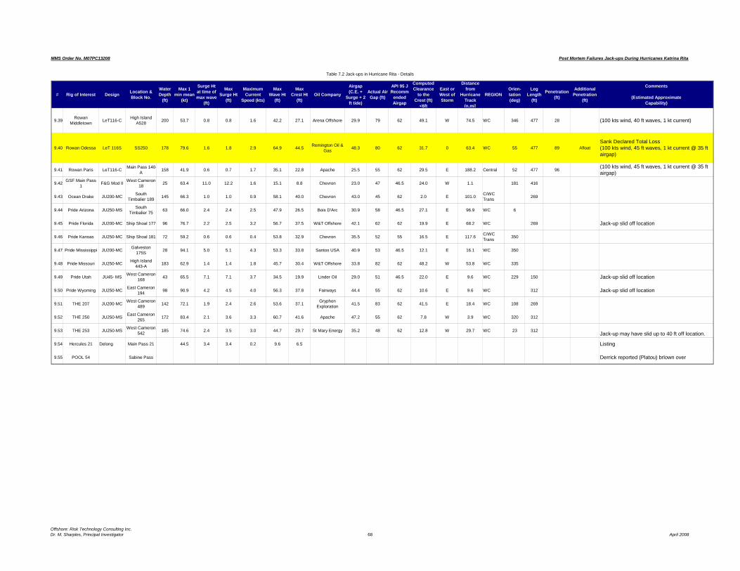
MMS Order No. M07PC13208
Table 7.2 Jack-ups in Hurricane Rita - Details
Post Mortem Failures Jack-ups During Hurricanes Katrina Rita
# Rig of Interest DesignLocation &
Block No.
Water
Depth
(ft)
Max 1
min mean
(kt)
Surge Ht
at time of
max wave
(ft)
Max
Surge Ht
(ft)
Maximum
Current
Speed (kts)
Max
Wave Ht
(ft)
Max
Crest Ht
(ft)
Oil Company
Airgap
(C.E. +
Surge + 2
ft tide)
Actual Air
Gap (ft)
API 95 J
Recomm
ended
Airgap
Computed
Clearance
to the
Crest (ft)
<6ft
East or
West of
Storm
Distance
from
Hurricane
Track
(n.mi)
REGION
Orien-
tation
(deg)
Leg
Length
(ft)
Penetration
(ft)
Additional
Penetration
(ft)
Comments
(Estimated Approximate
Capability)
9.39Rowan
MiddletownLeT116-C
High IslandA528
200 53.7 0.8 0.8 1.6 42.2 27.1 Arena Offshore 29.9 79 62 49.1 W 74.5 WC 346 477 28 (100 kts wind, 40 ft waves, 1 kt current)
9.40 Rowan Odessa LeT 116S SS250 178 79.6 1.6 1.8 2.9 64.9 44.5Remington Oil &
Gas48.3 80 62 31.7 0 63.4 WC 55 477 89 Afloat
Sank Declared Total Loss(100 kts wind, 45 ft waves, 1 kt current @ 35 ftairgap)
9.41 Rowan Paris LeT116-CMain Pass 140-
A158 41.9 0.6 0.7 1.7 35.1 22.8 Apache 25.5 55 62 29.5 E 188.2 Central 52 477 96
(100 kts wind, 45 ft waves, 1 kt current @ 35 ftairgap)
9.42GSF Main Pass
1F&G Mod II
West Cameron18
25 63.4 11.0 12.2 1.6 15.1 8.8 Chevron 23.0 47 46.5 24.0 W 1.1 181 416
9.43 Ocean Drake JU200-MCSouth
Timbalier 189145 66.3 1.0 1.0 0.9 58.1 40.0 Chevron 43.0 45 62 2.0 E 101.0
C/WCTrans
269
9.44 Pride Arizona JU250-MSSouth
Timbalier 7563 66.0 2.4 2.4 2.5 47.9 26.5 Bois D'Arc 30.9 58 46.5 27.1 E 96.9 WC 6
9.45 Pride Florida JU200-MC Ship Shoal 177 96 76.7 2.2 2.5 3.2 56.7 37.5 W&T Offshore 42.1 62 62 19.9 E 68.2 WC 269 Jack-up slid off location
9.46 Pride Kansas JU250-MC Ship Shoal 181 72 59.2 0.6 0.6 0.4 53.8 32.9 Chevron 35.5 52 55 16.5 E 117.6C/WCTrans
350
9.47 Pride Mississippi JU200-MCGalveston
175S28 94.1 5.0 5.1 4.3 53.3 33.8 Santos USA 40.9 53 46.5 12.1 E 16.1 WC 350
9.48 Pride Missouri JU250-MCHigh Island
443-A183 62.9 1.4 1.4 1.8 45.7 30.4 W&T Offshore 33.8 82 62 48.2 W 53.8 WC 335
9.49 Pride Utah JU45- MSWest Cameron
16843 65.5 7.1 7.1 3.7 34.5 19.9 Linder Oil 29.0 51 46.5 22.0 E 9.6 WC 229 150 Jack-up slid off location
9.50 Pride Wyoming JU250-MCEast Cameron
19498 90.9 4.2 4.5 4.0 56.3 37.8 Fairways 44.4 55 62 10.6 E 9.6 WC 312 Jack-up slid off location
9.51 THE 207 JU200-MCWest Cameron
489142 72.1 1.9 2.4 2.6 53.6 37.1
GryphonExploration
41.5 83 62 41.5 E 18.4 WC 108 269
9.52 THE 250 JU250-MSEast Cameron
265172 83.4 2.1 3.6 3.3 60.7 41.6 Apache 47.2 55 62 7.8 W 3.9 WC 320 312
9.53 THE 253 JU250-MSWest Cameron
542185 74.6 2.4 3.5 3.0 44.7 29.7 St Mary Energy 35.2 48 62 12.8 W 29.7 WC 23 312
Jack-up may have slid up to 40 ft off location.
9.54 Hercules 21 Delong Main Pass 21 44.5 3.4 3.4 0.2 9.6 6.5 Listing
9.55 POOL 54 Sabine Pass Derrick reported (Platou) brlown over
Offshore: Risk Technology Consulting Inc.Dr. M. Sharples, Principal Investigator 68 April 2008

MMS Order No. M07PC13208 Post Mortem Failures Jack-ups During Hurricanes Katrina & Rita
Offshore: Risk & Technology Consulting Inc. April 2008
Dr. M. Sharples, Principal Investigator69
8. SUMMARY OF JACK-UP DETAILS IN HURRICANE KATRINA
The contours of wind speed and wave height are given in Figures 8.1 and Figures 8.2respectively for Hurricane Katrina.
Superimposed on the contour maps are the positions of the various jack-ups thatexperienced significant loadings during the hurricane. The jack-ups are numbered and thewindspeeds contour values indicated. The contours are from Oceanweather data (Ref 20).
On Figure 8.3 and Figure 8.4 the jack-ups that broke away or sank are indicated and,where known, the position that the jack-up was after the hurricane. The routes are notknown and thus are shown as straight lines.
The following sections detail the jack-ups with a description of their general characteristics,the damage that resulted when it was reported and comments. The jack-ups are reviewedby name and the detail offered for each rig varies depending on the information madeavailable and on the relevance of the information to the overall conclusions. In cases wherethe jack-ups were overloaded, generally the details of the rig are repeated from the Table7.1 in each section. In some cases photos were available, the detailed engineering studyresults carried out are quoted and referenced.
In order to get some “layman’s” perspective, we undertook to determine from availablesources, an estimate of the overloading beyond design limits that took place. Ourmethodology is described in Section 10 with a Table showing each jackup. Determining theratio of the actual loading to the design limits it was possible to classify those jack-upswhich were probably within design limits, those that were overloaded but expected tosurvive, those that were surprising survivals, those that were expected failures with suchoverload, and those with other problems (for example sliding in mat jack-ups).

MMS Order No. M07PC13208 Post Mortem Failures Jack-ups During Hurricanes Katrina & Rita
Offshore: Risk & Technology Consulting Inc. April 2008 Dr. M. Sharples, Principal Investigator
70
Figure 8.1

MMS Order No. M07PC13208 Post Mortem Failures Jack-ups During Hurricanes Katrina & Rita
Offshore: Risk & Technology Consulting Inc. April 2008 Dr. M. Sharples, Principal Investigator
71
Figure 8.2

MMS Order No. M07PC13208 Post Mortem Failures Jack-ups During Hurricanes Katrina & Rita
Offshore: Risk & Technology Consulting Inc. April 2008 Dr. M. Sharples, Principal Investigator
72
Figure 8.3

MMS Order No. M07PC13208 Post Mortem Failures Jack-ups During Hurricanes Katrina & Rita
Offshore: Risk & Technology Consulting Inc. April 2008 Dr. M. Sharples, Principal Investigator
73
Figure 8.4

MMS Order No. M07PC13208 Post Mortem Failures Jack-ups During Hurricanes Katrina & Rita
Offshore: Risk & Technology Consulting Inc. April 2008 Dr. M. Sharples, Principal Investigator
74
8.1 Ocean Nugget The Ocean Nugget is a Levingston 111 Independent Cantilever design built in 1976 at Levingston, Port Arthur, Texas The principal particulars are:
Length 208 ft Width 178 ft Hull Depth 23 ft Water Depth 300 ft Legs 3 x 410 ft Spud Can Diameter 48 ft Cantilever Reach 45 ft
The Diamond Ocean Nugget, 68 nautical miles east (worst side) of the central path of the hurricane was severely affected by the winds and resulting waves, even at that distance. The Ocean Nugget, from its position in the storm, and the waves hindcast much greater than design, would have been expected to have major damage or to have been toppled similarly to the close by jack-ups Ocean Warwick and Rowan New Orleans. The hindcast data showed 73.6 ft waves would have been impacting the
# Rig of Interest Design Location & Block No.
Water Depth
(ft)
Max 1 min mean
(kt)
Surge Ht at time of max wave
(ft)
Max Surge Ht
(ft)
Maximum Current Speed (kts)
Max Wave Ht
(ft)
Max Crest Ht
(ft)Oil Company
8.1 Ocean Nugget Lev 111-C Main Pass 264-A 234 82.3 1.0 1.0 0.9 73.6 48.9
Houston Exploration Co
Airgap (C.E. +
Surge + 2 ft tide)
Actual Air Gap (ft)
API 95 J Recomm
ended Airgap
Computed Clearance
to the Crest (ft)
<6ft
East or West of Storm
Distance from
Hurricane Track (n.mi)
REGIONOrien-tation (deg)
Leg Length
(ft)
Penetration (ft)
Additional Penetration
(ft)
Comments
(Estimated ApproximateCapability)
51.9 75 62 E 71.7 Central 13 410 5 1One leg penetrated an additional 1 ft.(100 kts wind, 52 ft waves, 1 kt current @ 35 ft airgap & 10 ft penetration)

MMS Order No. M07PC13208 Post Mortem Failures Jack-ups During Hurricanes Katrina & Rita
Offshore: Risk & Technology Consulting Inc. April 2008 Dr. M. Sharples, Principal Investigator
75
legs which were designed for a maximum of 51.8 ft waves. The consequence would be double the design load on the rig.
A diver survey after Katrina showed the leg spud can damages were consistent with the direction of the storm reacting on the unit and occurred because of the storm. Additionally there were some minor cracking in the jackhouses.
Ocean Nugget complied with the industry standard of a 10-year hurricane wave (Ref 23): indeed, according to the warranty surveyor the rig was capable of a 50 year return period wave (50.3 ft), much higher than the industry standard at the time. The jack-up actually saw what was previously the 100 year wave for the location it was at (based on the pre-hurricane statistics). After Hurricane Katrina passed by the Ocean Nugget it was reported that there was a small angle on the rig, a settlement to the rig to the northwest (to the forward port side – the side that showed can damage), and a torsion on the bow leg such that the bow leg was in a bind and could not be jacked down initially. After a few days the hull was re-floated, the legs pulled, examined by divers, repositioned, and the hull jacked up again and fully pre-loaded. The foundation soil into which the legs penetrated was quite hard. Based on the small amount of penetration (5 ft), while adequate for siting the jack-up rig, if the waves started to push the jack-up towards overturning, there would be little “give” in the soil, and unlikely it would penetrate much further on any one side. As it turns out, this “solid foundation” resisted the eccentric load that was put on the spudcan by the hurricane pushing the rig toward the NW, the port forward side. This resulted in the damage to the underside of the spud cans on the port side of the bow, port and starboard legs. The damage is on the expected, leeward side of the legs, since the pre-dominant forces would go down the leeward side of the rig as it started to tip over. Swim-bys of the bow and starboard cans show areas where the marine growth sheared off in patches indicating extreme load. Generally it has been industry practice to adopt a criteria of 10-year return hurricanes for Gulf of Mexico jack-ups when unmanned. (Ref 23). Based on the above warranty surveyor criteria the Ocean Nugget should have been capable of a 50-year storm. At this location the storm wave that impacted the vessel was at least a 100 year return period (based on the statistics pre-Ivan).

MMS Order No. M07PC13208 Post Mortem Failures Jack-ups During Hurricanes Katrina & Rita
Offshore: Risk & Technology Consulting Inc. April 2008 Dr. M. Sharples, Principal Investigator
76
Item Design50-year Source: Lebourhis
Actual
Maximum Wave height (ft) 51.8 50.3 73.6 Period of Max. Wave (sec) 14.8 15.0 10.5 Current Tidal Current (kts) 1 1.5 1.4++ Other current (kts) 0 0.8 ?? Maximum Sustained Winds 100 108.6 82.0 Maximum Gust 142.4 101.4 Maximum Surge (Storm & Other) (ft) 0 9 1.1 Tidal Range (ft) 0 3 ? Air Gap (ft) 35 50 75
Table 8.1.1 Comparison of Ocean Nugget design, insurance approval criteria, and
experienced values

MMS Order No. M07PC13208 Post Mortem Failures Jack-ups During Hurricanes Katrina & Rita
Offshore: Risk & Technology Consulting Inc. April 2008 Dr. M. Sharples, Principal Investigator
77
The damage to the rig is illustrated in the two diagrams that follow:
Figure 8.1.1: Spud Can Damage Locations. The rig is shown at 13 degrees heading, the maximum winds came from 138 degrees, the waves from 144
degrees. The damage to the spud cans is noted.
Figure 8.1.2: Spud Can Damage Locations. 1 photo from each spud can is shown superimposed on the Figure 8.1.1.

MMS Order No. M07PC13208 Post Mortem Failures Jack-ups During Hurricanes Katrina & Rita
Offshore: Risk & Technology Consulting Inc. April 2008 Dr. M. Sharples, Principal Investigator
78
The Spud can damage pattern confirms it is as a result of the storm/hurricane.
• The Ocean Nugget was on a hard location with no “give” for rotation of the spud can.
• The damage is generally on the port side of the port chords with more
damage on the port side of the port leg.
• The damage is a clear indication of an overload from the rig moving toward overturning in the direction of the worst part of the storm. Nothing except the rig being on its “tippee toes” could explain the character of the damage, resulting from being close to the overturning point of the jack-up.
While we are not aware of any similar spud can damage on an independent leg rig, it is not surprising that such an event took place. The leg on the Levingston III is very, very stiff (robust). This has the design feature that it can resist damage from rapid penetration situations very well, but it also attracts wave forces and thus is more subject to overturning in waves. The stiffness of the legs also allows the loads to be transferred into the spud cans. As is the case here the spud cans are bent up on their leeward side, and there are fractures in the top on the port side indicating an overload situation. The damage was noted in the surveys on location prior to drydocking. Table 10.1 noted that the rig was overloaded by a factor of at least 2 times. While the rig would have exceeded the preload capability of the jack-up the soil was sufficient to hold against further penetration: the foundation was a very solid sand layer.

MMS Order No. M07PC13208 Post Mortem Failures Jack-ups During Hurricanes Katrina & Rita
Offshore: Risk & Technology Consulting Inc. April 2008 Dr. M. Sharples, Principal Investigator
79
8.2 Ocean Tower The Ocean Tower is a Letourneau Class 53 IC Year built in 1972 at LeTourneau Vicksburg, Mississippi and upgraded in 2003 with a cantilever conversion. The principal particulars are:
Length 237 ft Breadth 200ft Hull depth 26ft Legs 3 x 467 ft Water Depth 350ft (non-hurricane) Spud Can Diameter 46' Cantilever Reach 55 ft; 65 ft. with 10 ft cantilever beam extensions
The Ocean Tower was subjected to environmental loads greater than its design but less than its ultimate anticipated capability and thus the reader is referred to Table 7.1 and Table 10.1 for results. The conclusion based on Table 10.1 was that the rig was overloaded by a factor of approximately 2.2. It is probable that the vertical loads experienced exceeded the preload values, and thus the soil was sufficient to prevent further penetration. No further information was available to indicate any further insights.
Airgap (C.E. +
Surge + 2 ft tide)
Actual Air Gap (ft)
API 95 J Recomm
ended Airgap
Computed Clearance
to the Crest (ft)
<6ft
East or West of Storm
Distance from
Hurricane Track (n.mi)
REGIONOrien-tation (deg)
Leg Length
(ft)
Penetration (ft)
Additional Penetration
(ft)
Comments
(Estimated ApproximateCapability)
51 9 75 62 E 71 7 Central 13 410 5 1 One leg penetrated an additional 1 ft49.7 55 62 5.3 E 25.6 Central 233 466 45 (100 kts wind, 45 ft waves, 0 kt current )
# Rig of Interest Design Location & Block No.
Water Depth
(ft)
Max 1 min mean
(kt)
Surge Ht at time of max wave
(ft)
Max Surge Ht
(ft)
Maximum Current Speed (kts)
Max Wave Ht
(ft)
Max Crest Ht
(ft)Oil Company
8 1 Ocean Nugget Lev 111 C Main Pass 234 82 3 1 0 1 0 0 9 73 6 48 9 Houston8.2 Ocean Tower LeT 53S Vioska Knoll
251 123 80.4 2.7 2.8 1.4 66.7 44.9 Chevron

MMS Order No. M07PC13208 Post Mortem Failures Jack-ups During Hurricanes Katrina & Rita
Offshore: Risk & Technology Consulting Inc. April 2008 Dr. M. Sharples, Principal Investigator
80
8.3 Ocean Warwick The Ocean Warwick is a Levingston 111- C design built in 1971 at Levingston, Port Arthur, Texas, as the Marline No 6 and was upgraded in 1998. The principal particulars are:
Length 208 ft Width 178 ft Hull Depth 23 ft Water Depth 300 ft Legs 3 x 418 ft Spud Can Diameter 48 ft x 6 ft depth ' Cantilever Reach 45'
Photo 8.3.1 Ocean Warwick on location in Gulf of Mexico. The Ocean Warwick had been the recipient of damage during Hurricane Ivan when the storm overloaded the unit and damaged the unit’s legs and jacking system. The unit had been repaired and was back working on location prior to the advent of Hurricane Katrina. All 3 legs failed and the rig floated off location and beaching at Dauphin Island. The derrick fell on the quarters and all legs were damaged below the guides, with further damage in the upper legs. The rig was declared a total constructive loss.
# Rig of Interest Design Location & Block No.
Water Depth
(ft)
Max 1 min mean
(kt)
Surge Ht at time of max wave
(ft)
Max Surge Ht
(ft)
Maximum Current Speed (kts)
Max Wave Ht
(ft)
Max Crest Ht
(ft)Oil Company
8.3 Ocean Warwick Lev 111-C Main Pass 299 BA 202 94.6 2.1 2.1 2.3 75.7 52.0 Chevron
Airgap (C.E. +
Surge + 2 ft tide)
Actual Air Gap (ft)
API 95 J Recomm
ended Airgap
Computed Clearance
to the Crest (ft)
<6ft
East or West of Storm
Distance from
Hurricane Track (n.mi)
REGIONOrien-tation (deg)
Leg Length
(ft)
Penetration (ft)
Additional Penetration
(ft)
Comments
(Estimated ApproximateCapability)
56.1 83 62 E 43.4 Central 289 410 44 Afloat
All 3 legs failed and the rig floated off location and beaching at Dauphin Island. Derrick fell on quarters and all legs lost above and below guides.Rig declared total constructive loss. (100 kts wind, 52 ft waves, 1 kt current @ 35 ft airgap & 10 ft penetration)

MMS Order No. M07PC13208 Post Mortem Failures Jack-ups During Hurricanes Katrina & Rita
Offshore: Risk & Technology Consulting Inc. April 2008 Dr. M. Sharples, Principal Investigator
81
Photos 8.3.2 The Ocean Warwick as seen from Dauphin Island.
News reports of the incident were as follows:
HOUSTON--(BUSINESS WIRE)--Aug. 30, 2005--Diamond Offshore Drilling, Inc. (NYSE:DO) today reported that the jack-up drilling rig Ocean Warwick, which had previously been listed as missing, has been located on Dauphin Island off the coast of Alabama. Aerial photos indicate that the rig has sustained significant damage and is aground on the island. Diamond Offshore is working to get personnel to the rig but will not be able to make a complete assessment of the condition of the unit until a crew is able to re-board the rig.
Dauphin Island is approximately 66 miles northeast of the rig's work location on Main Pass Block 299 prior to passage of Hurricane Katrina. The Warwick is insured for approximately $50 million net of applicable deductibles. No personnel were on board the rig at the time of the storm.
______________________________________

MMS Order No. M07PC13208 Post Mortem Failures Jack-ups During Hurricanes Katrina & Rita
Offshore: Risk & Technology Consulting Inc. April 2008 Dr. M. Sharples, Principal Investigator
82
Diamond Offshore found its once missing 300-foot independent leg cantilever jack-up Ocean Warwick beached near the Alabama coast.
Before the storm, the unit was drilling in Main Pass block 299, about 66 miles (about 100 kilometres) south-west of its post-storm location.
Aerial photos indicate that the rig has sustained significant damage but the company will not be able to make a complete assessment of the condition of the unit until a crew is able to re-board the rig.
"The legs for the most part are gone," said a Diamond spokesman. "We've seen aerial photographs and it does not look good. It has been seriously damaged and will take some time to tell if it is repairable."
The Ocean Warwick is insured for about $50 million net of applicable deductibles and has a book value of about $14 million (Ref: Upstream 07 September 2005).
______________________________________
Meanwhile, Diamond Offshore believes it could take as long as a year to repair its jack-up Ocean Warwick, which was uprooted and later beached by Katrina.
Company boss Larry Dickerson told analysts in New York last week that the estimate includes the time required to determine whether it makes economic sense to repair the rig or take a loss.
"We have a salvage company on scene right now and will be re-floating this rig," said Dickerson. "The hull is still intact. We plan to take it in and give it a more through examination and make the call whether it is a total constructive loss or if it is something that we believe can be upgraded." Diamond found the rig 106 kilometres north-east of its pre-storm location. The unit, with severely damaged legs and missing derrick, ran aground at Dauphin Island, Alabama. The rig is insured for $55 million, net of deductibles.
Dickerson said he did not have a cost threshold in mind where Diamond would deem the rig not worth repairing.
"We wouldn't spend $150 million to repair it, because we can build a new, higher class of rig for $150 million," he said, "Likely, we might do it at $70 million" (Ref: Upstream 05 October 2005).

MMS Order No. M07PC13208 Post Mortem Failures Jack-ups During Hurricanes Katrina & Rita
Offshore: Risk & Technology Consulting Inc. April 2008 Dr. M. Sharples, Principal Investigator
83
Photos 8.3.3: Different perspectives of Ocean Warwick, on the beach.

MMS Order No. M07PC13208 Post Mortem Failures Jack-ups During Hurricanes Katrina & Rita
Offshore: Risk & Technology Consulting Inc. April 2008 Dr. M. Sharples, Principal Investigator
84
Photos8.3.4: Ocean Warwick in Color and in Black and White to provide better detailing.

MMS Order No. M07PC13208 Post Mortem Failures Jack-ups During Hurricanes Katrina & Rita
Offshore: Risk & Technology Consulting Inc. April 2008 Dr. M. Sharples, Principal Investigator
85
The Ocean Warwick was loaded well past its capability. It was loaded with a 75.7 ft wave (52 ft design), and although the airgap was very high and thus the rig was not subject to inundation of the hull with waves, the overload would have been substantial on the soil conditions present. The overload as presented from the figures in the Table 10.1 is by a factor of about 2.5, perhaps greater depending on the current. While this alone is sufficient to provide a failure mechanism, the most likely cause of issues is with the soil conditions such that when the rig exceeded its preloaded values subsequent settlement was possible such that it would lose airgap and thus become an expected failure. Comments have been made that during the salvage the stern legs were found almost completely withdrawn. The jackup has strong chords and so they may have been attached sufficiently to withdraw them and then broken as the collapse occurred. No further determination was made as to the precise mechanism of failure.
8.4 Ensco Rigs & Ensco 74 Ensco’s Annual Report of 2005 states, “the Company has made minor repairs to several jack-up rigs that were in the path of Hurricane Katrina. The repair costs incurred were not significant and none of the Company’s jack-up rigs experienced significant downtime in order to complete repairs. Although several of the Company’s jack-up rigs were in the path of Hurricane Rita, the Company has detected only minor damage to those rigs and the associated repair costs incurred, or expected to be incurred, are not significant. In addition, none of the Company’s jack-up rigs experienced, or is expected to experience, significant downtime in order to complete damage repairs as a result of this hurricane.” The Ensco 74 a Letourneau Class Super 116 C built in 1999 at Amfels, Brownsville, Texas. The principal particulars are:
Length 243 ft Breadth 206 ft . Depth 26 ft Legs 3 x 511 ft Square Truss Cantilever: Maximum 70 ft overhang from stern to rotary Spud Tanks: 46 ft diameter 24 ft high Operating Waterdepth: 390 ft. Design Criteria: 70 kts; wave period 15 sec; wave height 41 ft.

MMS Order No. M07PC13208 Post Mortem Failures Jack-ups During Hurricanes Katrina & Rita
Offshore: Risk & Technology Consulting Inc. April 2008 Dr. M. Sharples, Principal Investigator
86
Photo 8.4.1 Ensco 74 The small platform over which the Ensco 74 was working was damaged, however, the rig could not have hit the platform because of its configuration, as seen in the
Airgap (C.E. +
Surge + 2 ft tide)
Actual Air Gap (ft)
API 95 J Recomm
ended Airgap
Computed Clearance
to the Crest (ft)
<6ft
East or West of Storm
Distance from
Hurricane Track (n.mi)
REGIONOrien-tation (deg)
Leg Length
(ft)
Penetration (ft)
Additional Penetration
(ft)
Comments
(Estimated ApproximateCapability)
52.9 50 62 -2.9 E 56.5 Central 195 511 21 1
Stbd. leg penetrated an additional 1ft. Jacking system (7 final drive units, 1 gear box) damage, two bottom shell plates 28A, 29A local damage, cracks in welds at gear unit brace beams backup structure at main deck. Deck plate buckled inboard and adjacent to port and stbd skid rails. Frames 18 & 19 port and stbd and at centerline for frame 19. 5 lights and minor wiring in derrick damaged, 2 deepwells grounded. Repaired on location and returned to service.Damage caused by waves contacting hull bottom.(100 kts wind, 50 ft waves, @45 ft airgap)
# Rig of Interest Design Location & Block No.
Water Depth
(ft)
Max 1 min mean
(kt)
Surge Ht at time of max wave
(ft)
Max Surge Ht
(ft)
Maximum Current Speed (kts)
Max Wave Ht
(ft)
Max Crest Ht
(ft)Oil Company
8.4 Ensco 74 Let-Super 116
Main Pass 270 205 86.9 1.5 1.5 2.0 72.2 49.3 Dominion
E & P

MMS Order No. M07PC13208 Post Mortem Failures Jack-ups During Hurricanes Katrina & Rita
Offshore: Risk & Technology Consulting Inc. April 2008 Dr. M. Sharples, Principal Investigator
87
photos. It was not relocated prior to or after the storm. The jacket was pulled straight with a crane and tugs then the damaged jacket leg was repaired.
Photo 8.4.2: Ensco 74 on location after Hurricane Katrina
(Courtesy of Dominion)

MMS Order No. M07PC13208 Post Mortem Failures Jack-ups During Hurricanes Katrina & Rita
Offshore: Risk & Technology Consulting Inc. April 2008 Dr. M. Sharples, Principal Investigator
88
Photo 8.4.3: Ensco 74 on location after Hurricane Katrina (Courtesy of Dominion)
Photo 8.4.4: Ensco 74 on location after Hurricane Katrina (Courtesy of Dominion)

MMS Order No. M07PC13208 Post Mortem Failures Jack-ups During Hurricanes Katrina & Rita
Offshore: Risk & Technology Consulting Inc. April 2008 Dr. M. Sharples, Principal Investigator
89
As a result of Hurricane Katrina the starboard leg of the Ensco 74 penetrated an additional 1 ft. There was some jacking system (7 final drive units, 1 gear box) damage, minor bottom shell damage (two bottom shell plates 28A, 29A local damage), and a few cracks in welds at the gear unit brace beams’ back-up structure at main deck. There were 5 lights and minor wiring in derrick damaged, and 2 deepwells grounded. The rig was repaired on location and returned to service. The main damage is believed to have been caused by the waves contacting the hull bottom.
Photo 8.4.5: Bottom of Hull showing Damage from Wave hitting underside of Hull (Ref 12).
The computed shortage of airgap was approximately 3 ft. however local anomalies could have increased or decreased the effects of the wave. The damage is indicative of the fact that the hull was impacted by a large force from the waves. The likely structural overload referring to Table 10.1 was approximately 1.8 times its design capability, and thus categorized as a surprising survival. A good foundation prevented further settlement, in light of the additional loads.

MMS Order No. M07PC13208 Post Mortem Failures Jack-ups During Hurricanes Katrina & Rita
Offshore: Risk & Technology Consulting Inc. April 2008 Dr. M. Sharples, Principal Investigator
90
8.5 Ensco 81 The Ensco 81 is a Letourneau 116-C jack-up built in 1979 in Clydebank, Scotland as the Penrod 81, and upgraded in 2003. The principal particulars are:
Length 243 ft Breadth 201 ft Depth 26 ft Legs 3 x 477 Square Truss Cantilever: Maximum 47.25 ft overhang from stern to rotary Spud Tanks 46 ft diameter 24 ft high to top of trunk Operating Waterdepth 350 ft.
Although no damage was reported, the likely structural overload referring to Table 10.1 was approximately two times its design capability, and thus categorized as a surprising survival. A good foundation prevented further settlement, in light of the additional loads.
# Rig of Interest Design Location & Block No.
Water Depth
(ft)
Max 1 min mean
(kt)
Surge Ht at time of max wave
(ft)
Max Surge Ht
(ft)
Maximum Current Speed (kts)
Max Wave Ht
(ft)
Max Crest Ht
(ft)Oil Company
8 4 Ensco 74 Let Super Main Pass 205 86 9 1 5 1 5 2 0 72 2 49 3 Dominion
8.5 Ensco 81LeT116-C Enhanced
Leg
West Delta 95 149 90.4 1.9 2.7 2.3 62.6 42.5 BP America
Production
Airgap (C.E. +
Surge + 2 ft tide)
Actual Air Gap (ft)
API 95 J Recomm
ended Airgap
Computed Clearance
to the Crest (ft)
<6ft
East or West of Storm
Distance from
Hurricane Track (n.mi)
REGIONOrien-tation (deg)
Leg Length
(ft)
Penetration (ft)
Additional Penetration
(ft)
Comments
(Estimated ApproximateCapability)
52 9 50 62 2 9 E 56 5 Central 195 511 21 1 Stbd leg penetrated an additional 1ft Jacking
47.3 50 62 2.7 W 11.6 C/WC Trans. 477 (100 kts wind, 45 ft waves, @50 ft airgap)
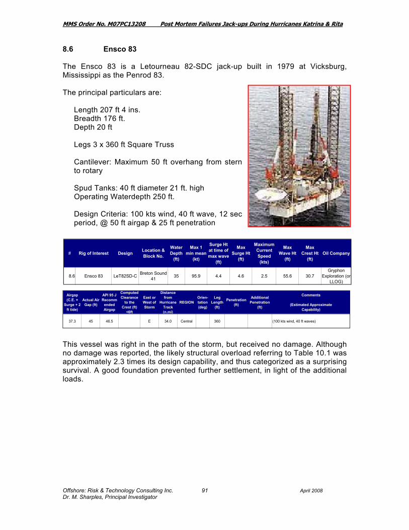
MMS Order No. M07PC13208 Post Mortem Failures Jack-ups During Hurricanes Katrina & Rita
Offshore: Risk & Technology Consulting Inc. April 2008 Dr. M. Sharples, Principal Investigator
91
8.6 Ensco 83 The Ensco 83 is a Letourneau 82-SDC jack-up built in 1979 at Vicksburg, Mississippi as the Penrod 83. The principal particulars are:
Length 207 ft 4 ins. Breadth 176 ft. Depth 20 ft Legs 3 x 360 ft Square Truss Cantilever: Maximum 50 ft overhang from stern to rotary Spud Tanks: 40 ft diameter 21 ft. high Operating Waterdepth 250 ft. Design Criteria: 100 kts wind, 40 ft wave, 12 sec period, @ 50 ft airgap & 25 ft penetration
This vessel was right in the path of the storm, but received no damage. Although no damage was reported, the likely structural overload referring to Table 10.1 was approximately 2.3 times its design capability, and thus categorized as a surprising survival. A good foundation prevented further settlement, in light of the additional loads.
Airgap (C.E. +
Surge + 2 ft tide)
Actual Air Gap (ft)
API 95 J Recomm
ended Airgap
Computed Clearance
to the Crest (ft)
<6ft
East or West of Storm
Distance from
Hurricane Track (n.mi)
REGIONOrien-tation (deg)
Leg Length
(ft)
Penetration (ft)
Additional Penetration
(ft)
Comments
(Estimated ApproximateCapability)
52 9 50 62 2 9 E 56 5 Central 195 511 21 1 Stbd leg penetrated an additional 1ft Jacking
37.3 45 46.5 E 34.0 Central 360 (100 kts wind, 40 ft waves)
# Rig of Interest Design Location & Block No.
Water Depth
(ft)
Max 1 min mean
(kt)
Surge Ht at time of max wave
(ft)
Max Surge Ht
(ft)
Maximum Current Speed (kts)
Max Wave Ht
(ft)
Max Crest Ht
(ft)Oil Company
8 4 Ensco 74 Let Super Main Pass 205 86 9 1 5 1 5 2 0 72 2 49 3 Dominion
8.6 Ensco 83 LeT82SD-C Breton Sound 41 35 95.9 4.4 4.6 2.5 55.6 30.7
Gryphon Exploration (or
LLOG)

MMS Order No. M07PC13208 Post Mortem Failures Jack-ups During Hurricanes Katrina & Rita
Offshore: Risk & Technology Consulting Inc. April 2008 Dr. M. Sharples, Principal Investigator
92
8.7 Ensco 105 The Ensco 105 is a Keppel FELS Mod V Class B jack-up, formerly the Chiles Galileo, was built in Keppel Amfels, Brownsville in 2002. The principal particulars are:
Length 225 ft Breadth 208 ft Depth 25 ft Legs 3 x 517 ft Cantilever Reach: 70 ft Spud Cans 47 ft x 19 ft deep
The rig capabilities are in 328 ft waterdepth, a 100 kt wind combined with a 63 ft wave. The Ensco 105 was in 245 feet water depth with a 60 foot air gap, and 83 feet of leg penetration. No additional penetration was reported after the storm. The maximum wave at the location in Hurricane Katrina was 36.8 ft., well within the capability of the rig which has a design of 63 ft wave height. The average wind speed was less than the maximum design. The Ensco 105 was loaded beyond its design values in Hurricane Rita.
# Rig of Interest Design Location & Block No.
Water Depth
(ft)
Max 1 min mean
(kt)
Surge Ht at time of max wave
(ft)
Max Surge Ht
(ft)
Maximum Current Speed (kts)
Max Wave Ht
(ft)
Max Crest Ht
(ft)Oil Company
8 4 Ensco 74 Let Super Main Pass 205 86 9 1 5 1 5 2 0 72 2 49 3 Dominion8 6 Ensco 83 LeT82SD C Breton Sound 35 95 9 4 4 4 6 2 5 55 6 30 7 Gryphon8.7 Ensco 105 Kep Mod V Eugene
Island 331-B 245 42.4 0.5 0.6 0.5 36.8 22.4 Houston Expl.
Airgap (C.E. +
Surge + 2 ft tide)
Actual Air Gap (ft)
API 95 J Recomm
ended Airgap
Computed Clearance
to the Crest (ft)
<6ft
East or West of Storm
Distance from
Hurricane Track (n.mi)
REGIONOrien-tation (deg)
Leg Length
(ft)
Penetration (ft)
Additional Penetration
(ft)
Comments
(Estimated ApproximateCapability)
52 9 50 62 2 9 E 56 5 Central 195 511 21 1 Stbd leg penetrated an additional 1ft Jacking37 3 45 46 5 E 34 0 Central 360 (100 kts wind 40 ft waves)24.9 60 62 W 112.6 WC 242 517 83 (100 kts wind, 63 ft waves)

MMS Order No. M07PC13208 Post Mortem Failures Jack-ups During Hurricanes Katrina & Rita
Offshore: Risk & Technology Consulting Inc. April 2008 Dr. M. Sharples, Principal Investigator
93
8.8 GSF Adriatic VII The GSF Adriatic VII is a LeTourneau 116-C design built by Letourneau in Singapore in 1983
The principal particulars are:
Length 243 ft Breadth 200 ft Depth 26 ft Legs 3 x 443 ft square truss Cantilever Reach: 45 ft Spud Cans 46 ft diameter Water Depth Capability 328 ft.

MMS Order No. M07PC13208 Post Mortem Failures Jack-ups During Hurricanes Katrina & Rita
Offshore: Risk & Technology Consulting Inc. April 2008 Dr. M. Sharples, Principal Investigator
94
The rig capabilities are in 300 ft waterdepth, a 100 kt wind combined with a 48 ft wave. The GSF Adriatic VII was a casualty in Hurricane Rita, however, in Hurricane Katrina it was was subjected to environmental loads less than its design and thus the reader is referred to Table 7.1 and Table 10.1 for detailed results. 8.9 GSF High Island VIII The GSF High Island VIII is a LeTourneau 82-SDC built at Davie Shipbuilding, Quebec in 1982. The principal particulars are: Length 207 ft Breadth 176 ft Hull Depth 20 ft Spud Can diameter 40 ft Legs 3 x 360 ft long triangular truss Operating Waterdepth 250 ft Design criteria: Wind 100 kts; Wave 38 ft.
# Rig of Interest Design Location & Block No.
Water Depth
(ft)
Max 1 min mean
(kt)
Surge Ht at time of max wave
(ft)
Max Surge Ht
(ft)
Maximum Current Speed (kts)
Max Wave Ht
(ft)
Max Crest Ht
(ft)Oil Company
8 4 Ensco 74 Let Super Main Pass 205 86 9 1 5 1 5 2 0 72 2 49 3 Dominion8 6 Ensco 83 LeT82SD C Breton Sound 35 95 9 4 4 4 6 2 5 55 6 30 7 Gryphon8 7 Ensco 105 Kep Mod V Eugene 245 42 4 0 5 0 6 0 5 36 8 22 4 Houston Expl
8.8 GSF Adriatic VII LeT 116-C Eugine Island 338 252 43.8 0.5 0.6 0.5 38.8 23.5 Chevron
Airgap (C.E. +
Surge + 2 ft tide)
Actual Air Gap (ft)
API 95 J Recomm
ended Airgap
Computed Clearance
to the Crest (ft)
<6ft
East or West of Storm
Distance from
Hurricane Track (n.mi)
REGIONOrien-tation (deg)
Leg Length
(ft)
Penetration (ft)
Additional Penetration
(ft)
Comments
(Estimated ApproximateCapability)
52 9 50 62 2 9 E 56 5 Central 195 511 21 1 Stbd leg penetrated an additional 1ft Jacking37 3 45 46 5 E 34 0 Central 360 (100 kts wind 40 ft waves)24 9 60 62 W 112 6 WC 242 517 83 (100 kts wind 63 ft waves)
26.1 50 62 W 110.0 WC 69 477 74 (100 kts wind, 40 ft waves, 3 kt current @30 ft airgap & 25 ft pen. )
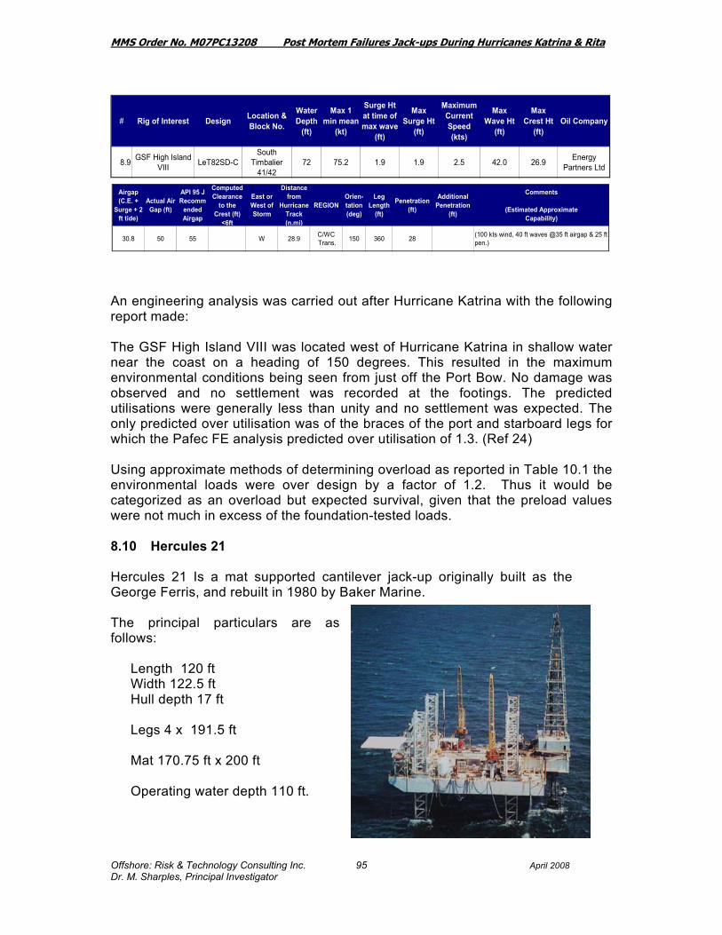
MMS Order No. M07PC13208 Post Mortem Failures Jack-ups During Hurricanes Katrina & Rita
Offshore: Risk & Technology Consulting Inc. April 2008 Dr. M. Sharples, Principal Investigator
95
An engineering analysis was carried out after Hurricane Katrina with the following report made: The GSF High Island VIII was located west of Hurricane Katrina in shallow water near the coast on a heading of 150 degrees. This resulted in the maximum environmental conditions being seen from just off the Port Bow. No damage was observed and no settlement was recorded at the footings. The predicted utilisations were generally less than unity and no settlement was expected. The only predicted over utilisation was of the braces of the port and starboard legs for which the Pafec FE analysis predicted over utilisation of 1.3. (Ref 24) Using approximate methods of determining overload as reported in Table 10.1 the environmental loads were over design by a factor of 1.2. Thus it would be categorized as an overload but expected survival, given that the preload values were not much in excess of the foundation-tested loads. 8.10 Hercules 21 Hercules 21 Is a mat supported cantilever jack-up originally built as the George Ferris, and rebuilt in 1980 by Baker Marine. The principal particulars are as follows:
Length 120 ft Width 122.5 ft Hull depth 17 ft Legs 4 x 191.5 ft Mat 170.75 ft x 200 ft Operating water depth 110 ft.
# Rig of Interest Design Location & Block No.
Water Depth
(ft)
Max 1 min mean
(kt)
Surge Ht at time of max wave
(ft)
Max Surge Ht
(ft)
Maximum Current Speed (kts)
Max Wave Ht
(ft)
Max Crest Ht
(ft)Oil Company
8 4 Ensco 74 Let Super Main Pass 205 86 9 1 5 1 5 2 0 72 2 49 3 Dominion
8.9 GSF High Island VIII LeT82SD-C
South Timbalier
41/4272 75.2 1.9 1.9 2.5 42.0 26.9 Energy
Partners Ltd
Airgap (C.E. +
Surge + 2 ft tide)
Actual Air Gap (ft)
API 95 J Recomm
ended Airgap
Computed Clearance
to the Crest (ft)
<6ft
East or West of Storm
Distance from
Hurricane Track (n.mi)
REGIONOrien-tation (deg)
Leg Length
(ft)
Penetration (ft)
Additional Penetration
(ft)
Comments
(Estimated ApproximateCapability)
30.8 50 55 W 28.9 C/WC Trans. 150 360 28 (100 kts wind, 40 ft waves @35 ft airgap & 25 ft
pen.)

MMS Order No. M07PC13208 Post Mortem Failures Jack-ups During Hurricanes Katrina & Rita
Offshore: Risk & Technology Consulting Inc. April 2008 Dr. M. Sharples, Principal Investigator
96
Following Hurricane Katrina the Hercules 21 at pre-storm location in Main Pass 41/59 sustained mat damage. It planned to go in mid 10/50 for mat repairs. (Platou Report November 2005). Following Hurricane Rita the Hercules 21 was reported as “moved from mat repairs area to neighbouring block Main Pass 21 – listing precariously. Only minor damage from Rita. Moved to Signal Shipyards, Pascagoula, for damage repairs from Hurricanes Katrina and Rita”. (Platou Report November 2005). It was additionally reported that Hercules 21 was “listing precariously at Main Pass Block 21. No other information was available” (Ref 25). In the Table 10.1 this was classified as an “Other Expected Issue” in that mat jack-ups do often move in hurricanes, when severe storms hit, depending on the foundations at the particular site. Offshore Mag. June 2006 “Hercules mat supported jack-up rig was repaired in Signal’s yard, with major steel replacement along with some upgrades.”
# Rig of Interest Design Location & Block No.
Water Depth
(ft)
Max 1 min mean
(kt)
Surge Ht at time of max wave
(ft)
Max Surge Ht
(ft)
Maximum Current Speed (kts)
Max Wave Ht
(ft)
Max Crest Ht
(ft)Oil Company
8.10 Hercules 21 Delong Main Pass 41 0 96.8 4.0 4.1 2.2 56.7 31.2 Chevron
Airgap (C.E. +
Surge + 2 ft tide)
Actual Air Gap (ft)
API 95 J Recomm
ended Airgap
Computed Clearance
to the Crest (ft)
<6ft
East or West of Storm
Distance from
Hurricane Track (n.mi)
REGIONOrien-tation (deg)
Leg Length
(ft)
Penetration (ft)
Additional Penetration
(ft)
Comments
(Estimated ApproximateCapability)
37.3 35 46.5 E 16.7 Central 192 0 Y
Mat Damage in Katrina at Main Pass 41/58. In Rita had moved to Main Pass 21. "Hercules Offshore’s mat supported jack-up rig Hercules 21 was reported to be listing at Main Pass Block 21" ref HSBC

MMS Order No. M07PC13208 Post Mortem Failures Jack-ups During Hurricanes Katrina & Rita
Offshore: Risk & Technology Consulting Inc. April 2008 Dr. M. Sharples, Principal Investigator
97
8.11 Hercules 25 The Hercules 25 was a LeTourneau 150-44-C design built by LeTourneau Brownsville Texas in 1980. The principal particulars were:
Length 153.5 ft Breadth 160 ft Depth 16 ft Legs 3 x 316.75 ft Cantilever 40 ft Spud Tanks 36 ft hexagonal x 19 ft deep Operating Depth 215 ft Design Criteria Water depth 100 ft; Wave height 32 ft, Wave period 15 secs; Photo 8.11.1: Hercules 25 Wind 100 knots
The following reports were available: World Oil 2005 – The Hercules 25’s derrick fell on the quarters in Breton Sound Block 46. The rig has been judged to be “beyond saving” Offshore Oct 2005 – Major damage when the derrick fell on quarters …built 1980 for $18 million.
# Rig of Interest Design Location & Block No.
Water Depth
(ft)
Max 1 min mean
(kt)
Surge Ht at time of max wave
(ft)
Max Surge Ht
(ft)
Maximum Current Speed (kts)
Max Wave Ht
(ft)
Max Crest Ht
(ft)Oil Company
8.11 Hercules 25 LeT150-44 Breton Sound 46 15 98.3 4.5 5.6 1.0 25.0 10.0 Century
Explorartion
Airgap (C.E. +
Surge + 2 ft tide)
Actual Air Gap (ft)
API 95 J Recomm
ended Airgap
Computed Clearance
to the Crest (ft)
<6ft
East or West of Storm
Distance from
Hurricane Track (n.mi)
REGIONOrien-tation (deg)
Leg Length
(ft)
Penetration (ft)
Additional Penetration
(ft)
Comments
(Estimated ApproximateCapability)
17.6 20 46.5 E 18.3 Central 317 5 Y
"Insurance company declared total constructive loss" (SEC Filing) "The Hercules 25's derrick fell on the quarters in Breton Sound Block 46. That rig has been judged to be "beyond saving."(World Oil 11-05)(100 kts wind 40+ ft waves)

MMS Order No. M07PC13208 Post Mortem Failures Jack-ups During Hurricanes Katrina & Rita
Offshore: Risk & Technology Consulting Inc. April 2008 Dr. M. Sharples, Principal Investigator
98
A SMIT team has been busy with the ‘Hercules 25’, she broke off her lower legs, drifted and is now positioned off Breton Sound, Louisiana. The workscope for this project was: oil removal, lighten deck load, remove upper and lower legs, deballast and refloat the platform. This project was terminated on 15th February 2006. (Ref 26 www.smit.com) Hercules mat supported jack-up rig was repaired in Signal’s yard, with major steel replacement along with some upgrades. Signal also salvaged 100 ft of steel from each leg of the Hercules Rig 25. The rest of the Katrina-damaged rig will be scrapped. (Ref 27 Offshore Magazine June 2006). Hercules 25 was classified in the Table 10.1 as a total loss and an “Unexpected Failure”. 8.12 Noble Tom Jobe The Noble Tom Jobe is a LeTourneau 82-SDC constructed in 1982 in Brownsville, Texas. The principal particulars are:
Length 207 ft, Breadth 176 ft Hull Depth 20 ft Legs 3 x 360 ft triangular truss Spud Can Diameter 40 ft Operating Water depth 250 ft. Design Criteria 100 kts wind, 38 ft waves
# Rig of Interest Design Location & Block No.
Water Depth
(ft)
Max 1 min mean
(kt)
Surge Ht at time of max wave
(ft)
Max Surge Ht
(ft)
Maximum Current Speed (kts)
Max Wave Ht
(ft)
Max Crest Ht
(ft)Oil Company
8.12 Noble Tom Jobe LeT82SD-C South Timbalier 134 136 73.1 1.4 1.7 1.6 53.7 36.4 Chevron
Airgap (C.E. +
Surge + 2 ft tide)
Actual Air Gap (ft)
API 95 J Recomm
ended Airgap
Computed Clearance
to the Crest (ft)
<6ft
East or West of Storm
Distance from
Hurricane Track (n.mi)
REGIONOrien-tation (deg)
Leg Length
(ft)
Penetration (ft)
Additional Penetration
(ft)
Comments
(Estimated ApproximateCapability)
40.1 60 62 W 33.2 C/WC Trans. 100 360 43 (100 kts wind 37 ft waves, 1 kt current @25 ft
pen. )

MMS Order No. M07PC13208 Post Mortem Failures Jack-ups During Hurricanes Katrina & Rita
Offshore: Risk & Technology Consulting Inc. April 2008 Dr. M. Sharples, Principal Investigator
99
The Noble Tom Jobe was subjected to environmental loads somewhat greater than its design but less than its ultimate anticipated capability and thus the reader is referred to Table 7.1 and Table 10.1 for results. The Table 10.1 conclusion was that the rig was overloaded by a factor of approximately 1.7.
Photo 8.12.1 Noble Tom Jobe at South Timbalier Block 134

MMS Order No. M07PC13208 Post Mortem Failures Jack-ups During Hurricanes Katrina & Rita
Offshore: Risk & Technology Consulting Inc. April 2008 Dr. M. Sharples, Principal Investigator
100
8.13 Bob Palmer The Bob Palmer is an enhanced version of the Rowan Super Gorilla-class jack-up design and is designated as a Super Gorilla XL. The new unit carries the name of a major player in the company’s history, C. Bob Palmer, former Chairman and CEO of the Rowan Companies. The principal particulars are as follows:
Length: 306 feet Width: 300 feet Depth: 36 feet
When elevated, the unit has the world’s highest leg-up to date and the largest air gap. The rig is outfitted with three legs, each 713 feet long (139 feet more than Gorillas V, VI or VII), and has 30 percent larger spud cans enabling operation in up to 550 feet of water in the environments offshore eastern Canada and in the North Sea and the Gulf of Mexico. The rig is capable of drilling deep gas wells down to 30,000 to 40,000 feet extending the typical drilling range capability by about 15,000 feet deeper than much of the existing jack-up fleet. The Bob Palmer is the deepest waterdepth jack-up in the Gulf of Mexico. With 712 ft of leg it dwarfs an older style design the Rowan Texas seen side-by-side in the picture below taken in Sabine Pass, Texas.
# Rig of Interest Design Location & Block No.
Water Depth
(ft)
Max 1 min mean
(kt)
Surge Ht at time of max wave
(ft)
Max Surge Ht
(ft)
Maximum Current Speed (kts)
Max Wave Ht
(ft)
Max Crest Ht
(ft)Oil Company
8.13 Bob Palmer Super Gorilla XL
South Pass 87 355 104.8 2.6 3.1 1.6 79.9 51.9 Marathon Oil
Company
Airgap (C.E. +
Surge + 2 ft tide)
Actual Air Gap (ft)
API 95 J Recomm
ended Airgap
Computed Clearance
to the Crest (ft)
<6ft
East or West of Storm
Distance from
Hurricane Track (n.mi)
REGIONOrien-tation (deg)
Leg Length
(ft)
Penetration (ft)
Additional Penetration
(ft)
Comments
(Estimated ApproximateCapability)
57.0 50 62 -7.0 E 9.5 Central 3 712 104 (100 kts wind, 96 ft waves, 3 kt current @60 ft airgap)
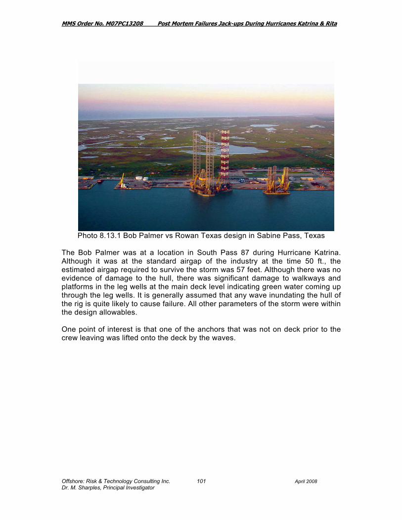
MMS Order No. M07PC13208 Post Mortem Failures Jack-ups During Hurricanes Katrina & Rita
Offshore: Risk & Technology Consulting Inc. April 2008 Dr. M. Sharples, Principal Investigator
101
Photo 8.13.1 Bob Palmer vs Rowan Texas design in Sabine Pass, Texas The Bob Palmer was at a location in South Pass 87 during Hurricane Katrina. Although it was at the standard airgap of the industry at the time 50 ft., the estimated airgap required to survive the storm was 57 feet. Although there was no evidence of damage to the hull, there was significant damage to walkways and platforms in the leg wells at the main deck level indicating green water coming up through the leg wells. It is generally assumed that any wave inundating the hull of the rig is quite likely to cause failure. All other parameters of the storm were within the design allowables. One point of interest is that one of the anchors that was not on deck prior to the crew leaving was lifted onto the deck by the waves.

MMS Order No. M07PC13208 Post Mortem Failures Jack-ups During Hurricanes Katrina & Rita
Offshore: Risk & Technology Consulting Inc. April 2008 Dr. M. Sharples, Principal Investigator
102
Figure 8.13.1: 5-ton anchor was racked on the exterior of the hull 50 feet above the sea before the storm
From the tabular results it is apparent that the airgap was exceeded by 7 ft, but otherwise the maximum wave height was within the capability of the unit. In an engineering study carried out for Rowan the following results were presented for the unity check on the vertical reaction and the overturning moment (Ref 28). No damage was expected and none was reported.
Vertical ReactionUC
OTM Ratio
Bob Palmer / Katrina 0.68 1.06

MMS Order No. M07PC13208 Post Mortem Failures Jack-ups During Hurricanes Katrina & Rita
Offshore: Risk & Technology Consulting Inc. April 2008 Dr. M. Sharples, Principal Investigator
103
8.14 Cecil Provine The Cecil Provine is a Marathon LeTourneau Class 116-C design propulsion assisted built in 1982 by LeTourneau Vicksburg. The principal particulars are as follows:
Length 243 ft Breadth 200 ft Depth 26 ft Legs 3 x 410 ft Cantilever: Beam spacing 52 ft. Maximum overhang 76 ft. from the stern Spud tanks: 46 ft wide x 21 ft deep Design Criteria: 300 ft W.D.
100 kt wind, 1 kt current, 44 ft wave with 25 ft penetration and 35 ft airgap.
The Cecil Provine was at a location where the hurricane environmental forces were judged to be within the capability of the rig, and no damage was reported.
# Rig of Interest Design Location & Block No.
Water Depth
(ft)
Max 1 min mean
(kt)
Surge Ht at time of max wave
(ft)
Max Surge Ht
(ft)
Maximum Current Speed (kts)
Max Wave Ht
(ft)
Max Crest Ht
(ft)Oil Company
8.14 Cecil Provine LeT 116-C Ship Shoal 259 142 59.7 1.0 1.1 1.4 46.5 31.0 Apache
Corportion
Airgap (C.E. +
Surge + 2 ft tide)
Actual Air Gap (ft)
API 95 J Recomm
ended Airgap
Computed Clearance
to the Crest (ft)
<6ft
East or West of Storm
Distance from
Hurricane Track (n.mi)
REGIONOrien-tation (deg)
Leg Length
(ft)
Penetration (ft)
Additional Penetration
(ft)
Comments
(Estimated ApproximateCapability)
34.2 64 62 W 61.8 WC 335 410 92 (100 kts wind, 45 ft waves, 1 kt current @ 40 ft airgap)

MMS Order No. M07PC13208 Post Mortem Failures Jack-ups During Hurricanes Katrina & Rita
Offshore: Risk & Technology Consulting Inc. April 2008 Dr. M. Sharples, Principal Investigator
104
8.15 Rowan Fort Worth The Rowan Fort Worth was a LeTourneau 116-C propulsion assisted, cantilever jack-up built in 1978 and a sister rig to the Rowan Paris and to the Rowan Halifax. The principal particulars are as follows:
Length 243 ft Breadth 200 ft Depth 26 ft Legs 3 x 477 ft Cantilever: Beam spacing 52 ft. Maximum overhang 76 ft. from the stern Spud tanks: 46 ft wide x 21 ft deep Design Criteria: 300 ft W.D.,
87 kt wind, 35 ft wave, 1 kt current with 25 ft penetration
The Rowan Fort Worth was at a location where the hurricane environmental forces were judged to be within the capability of the rig, and no damage was reported. The Rowan Fort Worth was lost in Hurricane Rita. 8.16 Scooter Yeargain The Scooter Yeargain is a Tarzan Class design jack-up, specially designed to drill deep gas wells down to 40,000 feet in shallow water ranging from 15 feet up to 300 feet. The Tarzan Class design is a lighter-weight version of Rowan's "Gorilla Class"
# Rig of Interest Design Location & Block No.
Water Depth
(ft)
Max 1 min mean
(kt)
Surge Ht at time of max wave
(ft)
Max Surge Ht
(ft)
Maximum Current Speed (kts)
Max Wave Ht
(ft)
Max Crest Ht
(ft)Oil Company
8.15 Rowan Fort Worth LeT 116-C S Marsh 146 230 38.8 0.4 0.5 0.4 34.6 20.9 Hunt
Airgap (C.E. +
Surge + 2 ft tide)
Actual Air Gap (ft)
API 95 J Recomm
ended Airgap
Computed Clearance
to the Crest (ft)
<6ft
East or West of Storm
Distance from
Hurricane Track (n.mi)
REGIONOrien-tation (deg)
Leg Length
(ft)
Penetration (ft)
Additional Penetration
(ft)
Comments
(Estimated ApproximateCapability)
23.4 73 62 W 125.9 WC 360 477 78 (100 kts wind, 40 ft waves, 1 kt current)

MMS Order No. M07PC13208 Post Mortem Failures Jack-ups During Hurricanes Katrina & Rita
Offshore: Risk & Technology Consulting Inc. April 2008 Dr. M. Sharples, Principal Investigator
105
and "Super Gorilla Class" designs, with the hull half the size of the Gorilla design The principal particulars are as follows:
Length 215 feet Width 196 feet Depth 22 feet Leg Length 445 feet.
The Scooter Yeargain, was at a location where the hurricane environmental forces were judged to be within the capability of the rig, and no damage was reported.
# Rig of Interest Design Location & Block No.
Water Depth
(ft)
Max 1 min mean
(kt)
Surge Ht at time of max wave
(ft)
Max Surge Ht
(ft)
Maximum Current Speed (kts)
Max Wave Ht
(ft)
Max Crest Ht
(ft)Oil Company
8.16 Scooter Yeargain Tarzan S Timbalier 168 49 62.5 1.3 1.4 1.7 44.4 29.8 Exxon Mobil
Airgap (C.E. +
Surge + 2 ft tide)
Actual Air Gap (ft)
API 95 J Recomm
ended Airgap
Computed Clearance
to the Crest (ft)
<6ft
East or West of Storm
Distance from
Hurricane Track (n.mi)
REGIONOrien-tation (deg)
Leg Length
(ft)
Penetration (ft)
Additional Penetration
(ft)
Comments
(Estimated ApproximateCapability)
33.2 71 49 W 55.4 West Central ? 412 105 (100 kts wind, 51+ ft waves, 1 kt current)

MMS Order No. M07PC13208 Post Mortem Failures Jack-ups During Hurricanes Katrina & Rita
Offshore: Risk & Technology Consulting Inc. April 2008 Dr. M. Sharples, Principal Investigator
106
8.17 Rowan Gorilla IV The Gorilla IV is a Letourneau 150-88-C Gorilla Class, self-elevating propulsion assisted jack-up built in Vicksburg in 1986. The principal particulars are as follows:
Length 297 ft Breadth 292 ft Depth 30 ft Legs 3 x 504 ft Spud Tanks 66 ft diameter requiring soil bearing of 7.25 ksf Design Criteria: 82.7 kt winds, 88 ft waves,
with 2 kts current. The Rowan Gorilla IV was subjected to environmental loads less than its design and thus the reader is referred to Table 7.1 and Table 10.1 for results. The Rowan Gorilla IV, was at a location where the hurricane environmental forces were judged to be within the capability of the rig, and no damage was reported. Table 10.1 thus reports the Rowan Gorilla IV as an expected survival.
# Rig of Interest Design Location & Block No.
Water Depth
(ft)
Max 1 min mean
(kt)
Surge Ht at time of max wave
(ft)
Max Surge Ht
(ft)
Maximum Current Speed (kts)
Max Wave Ht
(ft)
Max Crest Ht
(ft)Oil Company
8.17 Rowan Gorilla IV Gorilla Ship Shoal 349 365 54.9 0.6 0.7 0.7 50.0 30.0 W &T
Offshore
Airgap (C.E. +
Surge + 2 ft tide)
Actual Air Gap (ft)
API 95 J Recomm
ended Airgap
Computed Clearance
to the Crest (ft)
<6ft
East or West of Storm
Distance from
Hurricane Track (n.mi)
REGIONOrien-tation (deg)
Leg Length
(ft)
Penetration (ft)
Additional Penetration
(ft)
Comments
(Estimated ApproximateCapability)
32.7 89 62 W 77.1 WC 316 605 55 (100 kts wind, 88 ft waves, 1 kt current)

MMS Order No. M07PC13208 Post Mortem Failures Jack-ups During Hurricanes Katrina & Rita
Offshore: Risk & Technology Consulting Inc. April 2008 Dr. M. Sharples, Principal Investigator
107
8.18 Rowan New Orleans
The Rowan New Orleans was a 52-class slot jack-up rig built in 1970 operating on a Magnum Hunter Production Inc. location at Main Pass 185 in a waterdepth of 155 ft. The typical operating depth was 250 ft. The principal particulars were as follows:
Length 203 ft Breadth 168 ft Depth 22 ft Legs 3 x 323 ft Cantilever: Slot type with skid off capabilities Spud tanks: 46 ft wide x 21 ft deep
# Rig of Interest Design Location & Block No.
Water Depth
(ft)
Max 1 min mean
(kt)
Surge Ht at time of max wave
(ft)
Max Surge Ht
(ft)
Maximum Current Speed (kts)
Max Wave Ht
(ft)
Max Crest Ht
(ft)Oil Company
8.18 Rowan New Orleans LeT 52-S Main Pass
185 155 83.0 2.2 2.2 2.0 69.5 47.5 Magnum
Airgap (C.E. +
Surge + 2 ft tide)
Actual Air Gap (ft)
API 95 J Recomm
ended Airgap
Computed Clearance
to the Crest (ft)
<6ft
East or West of Storm
Distance from
Hurricane Track (n.mi)
REGIONOrien-tation (deg)
Leg Length
(ft)
Penetration (ft)
Additional Penetration
(ft)
Comments
(Estimated ApproximateCapability)
51.7 52 62 0.3 E 64.3 Central 17 359 16 Afloat
Wave was close to hitting hull, or possibly did Rig sank in Main Pass 185Declared total constructive loss.(100 kts wind, 45 ft waves, 0 kt current )

MMS Order No. M07PC13208 Post Mortem Failures Jack-ups During Hurricanes Katrina & Rita
Offshore: Risk & Technology Consulting Inc. April 2008 Dr. M. Sharples, Principal Investigator
108
The Rowan New Orleans had a penetration of only 16 ft. The soil conditions indicated that from 14 ft to 28 ft depth the soil was “medium dense olive gray fine sand” Silty with scattered clay pockets 13 ft to 20 ft, with scattered organic material 18 ft – 20 ft. The expectation would have been that no further penetration would take place beyond the 16 ft even in the event of a further load on the footings. By calculation it appears that the wave was very close to the bottom of the hull (0.3 ft) and with local anomalies in the wave height it is quite likely to have had some impingment on the hull. Its failure was probably initiated by a high overturning moment, combined with the possibility of wave impacts on the hull. The firm foundation, make it quite likely that the rig’s strength was overcome as overturning commenced. The likely structural overload referring to Table 10.1 was approximately 2.7 times its design capability, and thus categorized as an expected failure. In an engineering study carried out for Rowan (Ref. 30) the following results were presented for the unity check on the vertical reaction and the overturning moment.
Vertical ReactionUC
OTM Ratio
N. Orleans / Katrina 1.90 1.87 The Rowan New Orleans was subject to conditions that challenged its ultimate strength and in addition had only 16 ft of penetration. Also, it is likely to have been subjected to wave impingement on the deck. Its failure was probably initiated by failure of the leg structure or elevating system (Ref 30). The Rowan New Orleans was a sister vessel to the Rowan Houston, also a LeTourneau Class 52 jack-up rig, built in 1969. The Rowan Houston became a casualty in Hurricane Lili in October 2002. (Ref 6). The hull of the Rowan New Orleans was torn from its legs and was said to be on the seabed about 3500 ft from the original location in Main Pass 185. It was declared a constructive total loss.
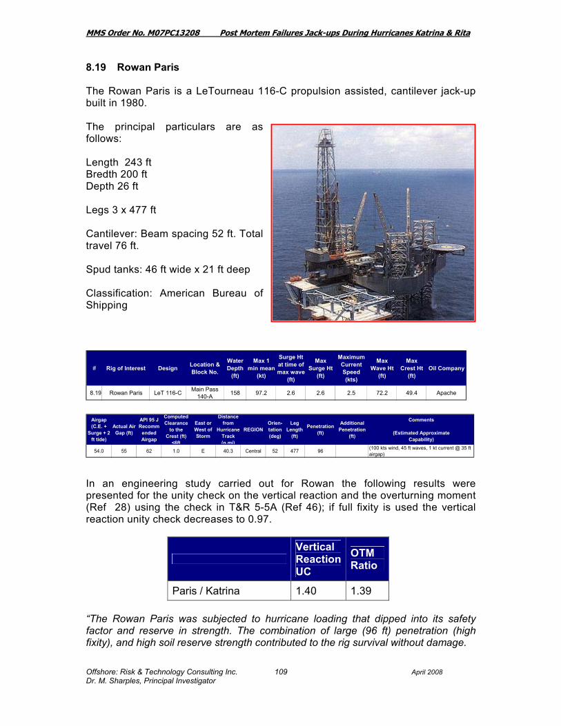
MMS Order No. M07PC13208 Post Mortem Failures Jack-ups During Hurricanes Katrina & Rita
Offshore: Risk & Technology Consulting Inc. April 2008 Dr. M. Sharples, Principal Investigator
109
8.19 Rowan Paris The Rowan Paris is a LeTourneau 116-C propulsion assisted, cantilever jack-up built in 1980. The principal particulars are as follows: Length 243 ft Bredth 200 ft Depth 26 ft Legs 3 x 477 ft Cantilever: Beam spacing 52 ft. Total travel 76 ft. Spud tanks: 46 ft wide x 21 ft deep Classification: American Bureau of Shipping In an engineering study carried out for Rowan the following results were presented for the unity check on the vertical reaction and the overturning moment (Ref 28) using the check in T&R 5-5A (Ref 46); if full fixity is used the vertical reaction unity check decreases to 0.97.
Vertical ReactionUC
OTM Ratio
Paris / Katrina 1.40 1.39 “The Rowan Paris was subjected to hurricane loading that dipped into its safety factor and reserve in strength. The combination of large (96 ft) penetration (high fixity), and high soil reserve strength contributed to the rig survival without damage.
# Rig of Interest Design Location & Block No.
Water Depth
(ft)
Max 1 min mean
(kt)
Surge Ht at time of max wave
(ft)
Max Surge Ht
(ft)
Maximum Current Speed (kts)
Max Wave Ht
(ft)
Max Crest Ht
(ft)Oil Company
8.19 Rowan Paris LeT 116-C Main Pass 140-A 158 97.2 2.6 2.6 2.5 72.2 49.4 Apache
Airgap (C.E. +
Surge + 2 ft tide)
Actual Air Gap (ft)
API 95 J Recomm
ended Airgap
Computed Clearance
to the Crest (ft)
<6ft
East or West of Storm
Distance from
Hurricane Track (n.mi)
REGIONOrien-tation (deg)
Leg Length
(ft)
Penetration (ft)
Additional Penetration
(ft)
Comments
(Estimated ApproximateCapability)
54.0 55 62 1.0 E 40.3 Central 52 477 96 (100 kts wind, 45 ft waves, 1 kt current @ 35 ft airgap)

MMS Order No. M07PC13208 Post Mortem Failures Jack-ups During Hurricanes Katrina & Rita
Offshore: Risk & Technology Consulting Inc. April 2008 Dr. M. Sharples, Principal Investigator
110

MMS Order No. M07PC13208 Post Mortem Failures Jack-ups During Hurricanes Katrina & Rita
Offshore: Risk & Technology Consulting Inc. April 2008 Dr. M. Sharples, Principal Investigator
111
By calculation it appears that the wave would have been very close to the bottom of the hull (1.0 ft). While the overturning moment is above allowable, with a high vertical load it is likely to survive but only if the soil supporting the rig does not give way to further penetration. The likely structural overload referring to Table 10.1 was approximately 2.6 times its design capability, and thus categorized as a surprising survival.

MMS Order No. M07PC13208 Post Mortem Failures Jack-ups During Hurricanes Katrina & Rita
Offshore: Risk & Technology Consulting Inc. April 2008 Dr. M. Sharples, Principal Investigator
112
8.20 Ocean Drake The Ocean Drake is Bethlehem JU 200 Mat Cantilever design built in 1983 by Bethlehem, Guangzhou, China. The principal particulars are as follows:
Length 157 ft Breadth 132 ft Hull Depth 18 ft Legs 3 x 269 ft long 11 ft diameter Cantilever Reach 45' Operating Water depth 200 ft
. This rig saw something very close to its design allowables, above 50 ft waves in both Hurricanes Katrina and Rita. The location in South Timbalier 189 shows soil with an undrained shear strength of 0.5 ksf both at the surface and at 10 ft depth, and thus the rig would not be anticipated to slide in the storm that it experienced (Ref 31). The Ocean Drake was not reported as damaged even though theoretically the airgap should have been a problem.
# Rig of Interest Design Location & Block No.
Water Depth
(ft)
Max 1 min mean
(kt)
Surge Ht at time of max wave
(ft)
Max Surge Ht
(ft)
Maximum Current Speed (kts)
Max Wave Ht
(ft)
Max Crest Ht
(ft)Oil Company
8.20 Ocean Drake JU200-MC South Timbalier 189 145 68.7 1.4 1.5 1.6 54.9 37.2 Chevron
Airgap (C.E. +
Surge + 2 ft tide)
Actual Air Gap (ft)
API 95 J Recomm
ended Airgap
Computed Clearance
to the Crest (ft)
<6ft
East or West of Storm
Distance from
Hurricane Track (n.mi)
REGIONOrien-tation (deg)
Leg Length
(ft)
Penetration (ft)
Additional Penetration
(ft)
Comments
(Estimated ApproximateCapability)
40.8 35 62 -5.8 W 42.7 C/WC Trans. 269 (100 kts wind, 62 ft waves @ 44 ft airgap)

MMS Order No. M07PC13208 Post Mortem Failures Jack-ups During Hurricanes Katrina & Rita
Offshore: Risk & Technology Consulting Inc. April 2008 Dr. M. Sharples, Principal Investigator
113
8.21 Hercules 30 Over on Mobile Block 819, the Hercules 30 was listing significantly after Katrina. It was working on Mobile MO 819 for Triangle Oil and Gas. It has since gone to the shipyard for repair (Ref 25). Reference to the position was (Ref 32) RiglogX at www.Rigzone.com.
# Rig of Interest Design Location & Block No.
Water Depth
(ft)
Max 1 min mean
(kt)
Surge Ht at time of max wave
(ft)
Max Surge Ht
(ft)
Maximum Current Speed (kts)
Max Wave Ht
(ft)
Max Crest Ht
(ft)Oil Company
8.21 Hercules 30 BMCJU200-MS
Viosca Knoll 158 112 82.2 3.9 3.9 1.2 66.0 43.5
Triangle Oil and Gas (or
Chevron)
Airgap (C.E. +
Surge + 2 ft tide)
Actual Air Gap (ft)
API 95 J Recomm
ended Airgap
Computed Clearance
to the Crest (ft)
<6ft
East or West of Storm
Distance from
Hurricane Track (n.mi)
REGIONOrien-tation (deg)
Leg Length
(ft)
Penetration (ft)
Additional Penetration
(ft)
Comments
(Estimated ApproximateCapability)
49.4 45 62 -4.4 E 62.5 Central 192
"Over on Mobile Block 819, the Hercules 30 was listing significantly after Katrina." (World Oil Daily, 11-05)
Water Depth = 30'Location unsure(100 kts wind, 60+ ft waves)

MMS Order No. M07PC13208 Post Mortem Failures Jack-ups During Hurricanes Katrina & Rita
Offshore: Risk & Technology Consulting Inc. April 2008 Dr. M. Sharples, Principal Investigator
114
8.22 Pride Florida The Pride Florida is a Bethlehem mat supported JU 200 MC built in Beaumont in 1981 The principal particulars are as follows:
Length 157 ft Breadth 132 ft Hull Depth 18 ft Legs 3 x 269 ft long 11 ft diameter Cantilever Reach 45' Operating Water depth 200 ft
Since the loading in Hurricane Katrina was less than the design values the relevant information is presented in Table 7.1 and Table 10.1. The rig experienced storm conditions but not sufficient to cause an expected issue. 8.23 THE 200 THE 200 is a Bethlehem JU 200 Mat Cantilever design built in 1979 by Bethlehem, in Beaumont Texas. The principal particulars are as follows:
Length 157 ft Breadth 132 ft Hull Depth 18 ft Legs 3 x 269 ft long 11 ft diameter Cantilever Reach 45' Operating Water depth 200 ft
# Rig of Interest Design Location & Block No.
Water Depth
(ft)
Max 1 min mean
(kt)
Surge Ht at time of max wave
(ft)
Max Surge Ht
(ft)
Maximum Current Speed (kts)
Max Wave Ht
(ft)
Max Crest Ht
(ft)Oil Company
8.22 Pride Florida JU200-MC Ship Shoal 177 96 49.2 0.8 0.9 0.9 32.3 22.0 W&T Offshore
Airgap (C.E. +
Surge + 2 ft tide)
Actual Air Gap (ft)
API 95 J Recomm
ended Airgap
Computed Clearance
to the Crest (ft)
<6ft
East or West of Storm
Distance from
Hurricane Track (n.mi)
REGIONOrien-tation (deg)
Leg Length
(ft)
Penetration (ft)
Additional Penetration
(ft)
Comments
(Estimated ApproximateCapability)
24.9 62 62 W 88.5 WC (100 kts wind, 64 ft waves, @ 53 ft airgap)

MMS Order No. M07PC13208 Post Mortem Failures Jack-ups During Hurricanes Katrina & Rita
Offshore: Risk & Technology Consulting Inc. April 2008 Dr. M. Sharples, Principal Investigator
115
The following was reported: “TODCO said….In addition some minor damage occurred to THE 200 and 204.” (Ref 25) Since the loading in Hurricane Katrina is less that the design values the relevant information is presented in Table 7.1 and Table 10.1. This rig saw something very close to its design allowables, above 50 ft waves in Hurricane Katrina. The location in Main Pass 93 shows soil with an undrained shear strength of >0.2 ksf both at the surface and at 10 ft depth, and thus the rig it would not be surprising to see it slide in a storm of that magnitude (Ref 31).
# Rig of Interest Design Location & Block No.
Water Depth
(ft)
Max 1 min mean
(kt)
Surge Ht at time of max wave
(ft)
Max Surge Ht
(ft)
Maximum Current Speed (kts)
Max Wave Ht
(ft)
Max Crest Ht
(ft)Oil Company
8.23 THE 200 JU200-MC Main Pass 93 72 90.1 5.4 5.4 2.2 55.9 30.8 Apache
Airgap (C.E. +
Surge + 2 ft tide)
Actual Air Gap (ft)
API 95 J Recomm
ended Airgap
Computed Clearance
to the Crest (ft)
<6ft
East or West of Storm
Distance from
Hurricane Track (n.mi)
REGIONOrien-tation (deg)
Leg Length
(ft)
Penetration (ft)
Additional Penetration
(ft)
Comments
(Estimated ApproximateCapability)
38.3 48 55 E 40.7 Central 180 269
"some minor damage occurred to the THE200 and THE 204 jackups.(World Oil 11-05)"
(100 kts wind, 64 ft waves, @ 53 ft airgap)

MMS Order No. M07PC13208 Post Mortem Failures Jack-ups During Hurricanes Katrina & Rita
Offshore: Risk & Technology Consulting Inc. April 2008 Dr. M. Sharples, Principal Investigator
116
8.24 THE 204 THE 204 is a Bethlehem JU 200 Mat Cantilever design built in 1981 by Bethlehem, at Sparrow’s Point. The principal particulars are as follows: Length 157 ft Breadth 132 ft Hull Depth 18 ft Number of Legs 3 x 269 ft long 11 ft diameter Cantilever Reach 45' Operating Water depth 200 ft Mat Supported. The following was reported: “TODCO said….In addition some minor damage occurred to THE 200 and 204.” (Ref: 25 World Oil November 2005) Since the loading in Hurricane Katrina is less that the design values the relevant information is presented in Table 7.1 and Table 10.1. This rig saw some severe winds and waves in Hurricane Katrina. The location in Main Pass 64 shows soil with an undrained shear strength of <0.1 ksf both at the surface and .0.15 ksf at 10 ft depth, and thus the rig it would not be surprising to see it slide in a storm of that magnitude (Ref 31).
# Rig of Interest Design Location & Block No.
Water Depth
(ft)
Max 1 min mean
(kt)
Surge Ht at time of max wave
(ft)
Max Surge Ht
(ft)
Maximum Current Speed (kts)
Max Wave Ht
(ft)
Max Crest Ht
(ft)Oil Company
8.24 THE 204 JU200-MC Main Pass 64 34 100.3 4.6 4.7 1.2 40.2 22.0 Novus Louisiana
Airgap (C.E. +
Surge + 2 ft tide)
Actual Air Gap (ft)
API 95 J Recomm
ended Airgap
Computed Clearance
to the Crest (ft)
<6ft
East or West of Storm
Distance from
Hurricane Track (n.mi)
REGIONOrien-tation (deg)
Leg Length
(ft)
Penetration (ft)
Additional Penetration
(ft)
Comments
(Estimated ApproximateCapability)
28.8 53 46.5 E 27.7 Central 313 269"some minor damage occurred to the THE200 and THE 204 jackups.(World Oil 11-05)"(100 kts wind, 64 ft waves, @ 53 ft airgap)

MMS Order No. M07PC13208 Post Mortem Failures Jack-ups During Hurricanes Katrina & Rita
Offshore: Risk & Technology Consulting Inc. April 2008 Dr. M. Sharples, Principal Investigator
117
8.25 Dolphin 110
The Dolphin 110 is a Pan X mat supported, cantilever jack-up built in 1981 by General Dynamics, Charleston, South Carolina.
The principal particulars are as follows:
Length 137.5 ft Breadth 82 ft Depth 13.5 ft Legs 4 x 190 ft x 6.25 ft Mat: 142 ft long, 128 ft wide, 10 ft deep with a 2 ft skirt Maximum Operating Waterdepth 115 ft.
# Rig of Interest Design Location & Block No.
Water Depth
(ft)
Max 1 min mean
(kt)
Surge Ht at time of max wave
(ft)
Max Surge Ht
(ft)
Maximum Current Speed (kts)
Max Wave Ht
(ft)
Max Crest Ht
(ft)Oil Company
8.25 Nabors Dolphin 110 Pan X West Delta
29 30 97.8 1.7 4.6 3.7 29.6 16.2
Airgap (C.E. +
Surge + 2 ft tide)
Actual Air Gap (ft)
API 95 J Recomm
ended Airgap
Computed Clearance
to the Crest (ft)
<6ft
East or West of Storm
Distance from
Hurricane Track (n.mi)
REGIONOrien-tation (deg)
Leg Length
(ft)
Penetration (ft)
Additional Penetration
(ft)
Comments
(Estimated ApproximateCapability)
22.9 45 46.5 - C/WC Trans.
Dolphin 111(?) had windows blown out in the pilot house and quarters, resulting in water damage to control systems and the quarters (World Oil 11-05)

MMS Order No. M07PC13208 Post Mortem Failures Jack-ups During Hurricanes Katrina & Rita
Offshore: Risk & Technology Consulting Inc. April 2008 Dr. M. Sharples, Principal Investigator
118
The Dolphin 110 was operating within its waterdepth capability prior to Hurricane Katrina. It was reported as follows: (Ref 33: OilOnLine September 2, 2005)
“Nabors Industries Ltd. has announced the results of its preliminary assessment of damage incurred during Hurricane Katrina. Nabors had four rigs either directly or immediately east of the eye path and has ascertained, based upon initial observations, that three of the rigs escaped with little damage. ……Minimal damage has been observed on one of the company's workover jack-ups, Dolphin 110, primarily attributable to water intrusion through blown-out windows in the pilothouse and quarters. Plans are under way to move the rig to a dock for closer inspection and repairs on the quarters, a full mast inspection and potential repairs to one leg.”

MMS Order No. M07PC13208 Post Mortem Failures Jack-ups During Hurricanes Katrina & Rita
Offshore: Risk & Technology Consulting Inc. April 2008 Dr. M. Sharples, Principal Investigator
119
9. SUMMARY OF JACK-UP DETAILS IN HURRICANE RITA
The contours of wind speed and wave height are given in Figures 9.1 and Figures 9.2 respectively for Hurricane Rita. Superimposed on the contour maps are the positions of the various jack-ups that experienced significant loadings during the hurricane. The jack-ups are numbered and the windspeeds contour values indicated. The contours are from Oceanweather (Ref 21) On Figure 9.3 and Figure 9.4 the jack-ups that broke away or sank are indicated and, where known, the position that the jack-up was after the hurricane. The routes are not known and thus are shown as straight lines. The following sections detail the jack-ups with a description of their general characteristics, the damage that resulted when it was reported and comments. The jack-ups are reviewed by name and the detail offered for each rig varies depending on the information made available and the relevance of the results to the overall conclusions. In cases where the jack-ups were overloaded, generally the details of the rig are repeated from the Table 7.2 in each section. In some cases photos were available, in others detailed engineering study results carried out are quoted and referenced. In order to get some “layman’s” perspective, we undertook to estimate from available sources, an estimate of the overloading that took place beyond design. Our methodology is described in Section 10 together with Table 10.1. This is to give a general perspective without resorting to detailed calculations for which the cost would be high, and this method is sufficient for the current purposes. From this perspective it was possible to classify those jack-ups which were probably within design loadings, those that were overloaded but expected to survive, those that were surprising survivals, those that were expected failures with such overload, and those with other problems (for example sliding in mat jack-ups).

MMS Order No. M07PC13208 Post Mortem Failures Jack-ups During Hurricanes Katrina & Rita
Offshore: Risk & Technology Consulting Inc. April 2008 Dr. M. Sharples, Principal Investigator
120
Figure 9.1

MMS Order No. M07PC13208 Post Mortem Failures Jack-ups During Hurricanes Katrina & Rita
Offshore: Risk & Technology Consulting Inc. April 2008 Dr. M. Sharples, Principal Investigator
121
Figure 9.2

MMS Order No. M07PC13208 Post Mortem Failures Jack-ups During Hurricanes Katrina & Rita
Offshore: Risk & Technology Consulting Inc. April 2008 Dr. M. Sharples, Principal Investigator
122
Figure 9.3

MMS Order No. M07PC13208 Post Mortem Failures Jack-ups During Hurricanes Katrina & Rita
Offshore: Risk & Technology Consulting Inc. April 2008 Dr. M. Sharples, Principal Investigator
123
Figure 9.4

MMS Order No. M07PC13208 Post Mortem Failures Jack-ups During Hurricanes Katrina & Rita
Offshore: Risk & Technology Consulting Inc. April 2008 Dr. M. Sharples, Principal Investigator
124
9.1 Ocean Columbia The Ocean Columbia ia a LeTourneau Class 82-SD-C design built by Marathon LeTourneau at the Brownsville, Tx shipyard in 1978. The principal particulars are as follows:
Length: 207 ft Breadth 176 ft Hull Depth 20 ft Legs 3 x 360 ft Spud Can Diameter 40 ft Cantilever Reach 40 ft Design Criteria 100 kt winds, 42 ft waves. Water Depth Rating: 250 ft
The Ocean Columbia was subjected to environmental loads somewhat greater than its design but less than its ultimate anticipated capability and thus the reader is referred to Table 7.2 and Table 10.1 for results. The conclusion was that the rig was overloaded by a factor of approximately 1.3. It was classified in Table 10.1 as overloaded but expected to survive.
# Rig of Interest Design Location & Block No.
Water Depth
(ft)
Max 1 min mean
(kt)
Surge Ht at time of max wave
(ft)
Max Surge Ht
(ft)
Maximum Current Speed (kts)
Max Wave Ht
(ft)
Max Crest Ht
(ft)Oil Company
9.1 Ocean Columbia LeT82SD-C West Cameron 331 74 76.6 3.3 4.6 3.4 42.3 28.1 Newfield
Exploration
Airgap (C.E. +
Surge + 2 ft tide)
Actual Air Gap (ft)
API 95 J Recomm
ended Airgap
Computed Clearance
to the Crest (ft)
<6ft
East or West of Storm
Distance from
Hurricane Track (n.mi)
REGIONOrien-tation (deg)
Leg Length
(ft)
Penetration (ft)
Additional Penetration
(ft)
Comments
(Estimated ApproximateCapability)
34.7 45 56 W 5.1 WC 360 (100 kts wind 37 ft waves, 1 kt current @25 ft pen. )

MMS Order No. M07PC13208 Post Mortem Failures Jack-ups During Hurricanes Katrina & Rita
Offshore: Risk & Technology Consulting Inc. April 2008 Dr. M. Sharples, Principal Investigator
125
9.2 Ocean Spartan The Ocean Spartan is a Friede & Goldman L-780 IC design built in 1980 at GVA, Gothenburg, Sweden, as the Salenergy V and upgraded at AMFELS Brownsville in 2002. The principal particulars are as follows:
Length 180 ft Breadth 175 ft Hull Depth 25 ft Water Depth 300 ft Legs 3 x 401.5 Spud Can Diameter 39 ft 8 ins Cantilever Reach 40 ft
The Ocean Spartan was subjected to environmental loads greater than its design but less than its ultimate anticipated capability and thus the reader is referred to Table 7.2 and Table 10.1 for results. The conclusion was that the rig was overloaded by a factor of approximately 1.8. It is probable that the vertical loads experienced exceeded the preload values, and thus the soil was sufficient to prevent further penetration beyond the fact of the 1 ft of further penetration that was reported on one of the 3 legs.
# Rig of Interest Design Location & Block No.
Water Depth
(ft)
Max 1 min mean
(kt)
Surge Ht at time of max wave
(ft)
Max Surge Ht
(ft)
Maximum Current Speed (kts)
Max Wave Ht
(ft)
Max Crest Ht
(ft)Oil Company
9.2 Ocean Spartan F&G L-780 MOD II S Marsh 102 172 87.1 2.0 2.5 3.5 68.0 46.7 LLOG
Exploration
Airgap (C.E. +
Surge + 2 ft tide)
Actual Air Gap (ft)
API 95 J Recomm
ended Airgap
Computed Clearance
to the Crest (ft)
<6ft
East or West of Storm
Distance from
Hurricane Track (n.mi)
REGIONOrien-tation (deg)
Leg Length
(ft)
Penetration (ft)
Additional Penetration
(ft)
Comments
(Estimated ApproximateCapability)
51.2 45 62 -6.2 E 28.6 WC 401 (100 kts wind, 52 ft waves, 1 kt current @50 ft airgap)

MMS Order No. M07PC13208 Post Mortem Failures Jack-ups During Hurricanes Katrina & Rita
Offshore: Risk & Technology Consulting Inc. April 2008 Dr. M. Sharples, Principal Investigator
126
9.3 Ocean Summit The Ocean Summit is a Levingston III –C design built in 1972 in Port Arthur Texas as the Diamond M 99. The principal particulars are as follows:
Length 208 ft Breadth 178 ft Hull Depth 23 ft Water Depth 300 ft Legs 3 x 418 ft Spud Can Diameter 48 ft Cantilever Reach 45 ft
# Rig of Interest Design Location & Block No.
Water Depth
(ft)
Max 1 min mean
(kt)
Surge Ht at time of max wave
(ft)
Max Surge Ht
(ft)
Maximum Current
Speed (kts)
Max Wave Ht
(ft)
Max Crest Ht
(ft)Oil Company
9 1 Ocean Columbia LeT82SD C West 74 76 6 3 3 4 6 3 4 42 3 28 1 Newfield
9.3 Ocean Summit Lev L111-C Matagorda Island 820 SL 40 20.7 0.6 0.8 0.4 8.8 6.0 Chevron
Airgap (C.E. +
Surge + 2 ft tide)
Actual Air Gap (ft)
API 95 J Recommended Airgap
Computed Clearance to the Crest (ft)
<6ft
East or West of Storm
Distance from
Hurricane Track (n.mi)
REGIONOrien-tation (deg)
Leg Length
(ft)
Penetration (ft)
Additional Penetration
(ft)
Comments
(Estimated ApproximateCapability)
8.8 50 0 W W 253 410 8 on Bow10 Stbd/Port 1.5
One leg penetrated an additional 1.5 ftReleveled Rig(100 kts wind, 52 ft waves, 1 kt current @ 35 ft airgap & 10 ft penetration)
The Ocean Summit was subjected to lower environmental loads than those for which the rig was designed. and well within the design limits. It is reported here only for completeness of information on the settlement. It was reported that the initial and final penetration was only 10 ft on the port and starboard lets. It was reported that the bow leg had an additional 1.5 ft penetration. Upon arrival at the rig, the rig was jacked down, re-pre-loaded, jacked up and went back to work. The Ocean Summit was 196 miles from the storm and since penetration was small this was probably a result of motion on the rig causing the slight settlement.

MMS Order No. M07PC13208 Post Mortem Failures Jack-ups During Hurricanes Katrina & Rita
Offshore: Risk & Technology Consulting Inc. April 2008 Dr. M. Sharples, Principal Investigator
127
9.4 Ensco and Ensco 60 ENSCO Annual Report 2005 reports “the Company has made minor repairs to several jack-up rigs that were in the path of Hurricane Katrina. The repair costs incurred were not significant and none of the Company’s jack-up rigs experienced significant downtime in order to complete repairs. Although several of the Company’s jack-up rigs were in the path of Hurricane Rita, the Company has detected only minor damage to those rigs and the associated repair costs incurred, or expected to be incurred, are not significant. In addition, none of the Company’s jack-up rigs experienced, or is expected to experience, significant downtime in order to complete damage repairs as a result of this hurricane” .
Photo: Ensco 60 in shipyard Photo: Ensco 60 on location The Ensco 60 is a Levingston 111 Class Jack-up, built in 1981 by Levingston, Orange Tx., as the Dual Rig 87, and upgraded in 1997 and 2003. The principal particulars are:
Length 200 ft Breadth 196 ft Depth 22 ft 11 ins. Legs: 3 x 414 ft Square Truss Cantilever maximum 40 ft overhang from stern to rotary. Waterdepth 300 ft.

MMS Order No. M07PC13208 Post Mortem Failures Jack-ups During Hurricanes Katrina & Rita
Offshore: Risk & Technology Consulting Inc. April 2008 Dr. M. Sharples, Principal Investigator
128
Reported damage included a Wire tray in derrick damaged; 21 lights damaged; phone system & 1-A/C unit damaged. The Ensco 60 was subjected to environmental loads somewhat greater than its design, somewhat greater than the foundation had been tested for, but less than its ultimate anticipated capability. The results showed that the vessel saw a wave in excess of the “design wave”, but with a lesser that design windspeed. It has been estimated for Table 10.1 that the vessel saw 1.3 times the capacity.
# Rig of Interest Design Location & Block No.
Water Depth
(ft)
Max 1 min mean
(kt)
Surge Ht at time of max wave
(ft)
Max Surge Ht
(ft)
Maximum Current Speed (kts)
Max Wave Ht
(ft)
Max Crest Ht
(ft)Oil Company
9.4 Ensco 60 Lev L111-C Vermillion 191 100 76.0 2.7 3.8 3.3 55.2 36.7 Taylor Energy
Airgap (C.E. +
Surge + 2 ft tide)
Actual Air Gap (ft)
API 95 J Recomm
ended Airgap
Computed Clearance
to the Crest (ft)
<6ft
East or West of Storm
Distance from
Hurricane Track (n.mi)
REGIONOrien-tation (deg)
Leg Length
(ft)
Penetration (ft)
Additional Penetration
(ft)
Comments
(Estimated ApproximateCapability)
42.5 50 62 E 41.5 WC 33 414 25 0 Wire tray in derrick damaged; 21 lights damaged; phone system; 1-A/C unit

MMS Order No. M07PC13208 Post Mortem Failures Jack-ups During Hurricanes Katrina & Rita
Offshore: Risk & Technology Consulting Inc. April 2008 Dr. M. Sharples, Principal Investigator
129
9.5 Ensco 68 The Ensco 68 is a Letourneau 84-C Enhanced Jack-up built in 1976 by Letourneau as the Penrod 68, at Brownsville Texas, and upgraded in 2004 with increased leg length, cantilever added and environmental capabilities increased. The principal particulars are:
Length 261 ft Breadth 227 ft 5 ins Depth 26 ft Legs 3 x 511 Square Truss Cantilever: Maximum overhang from stern to rotary centerline 60 ft. Spud Tanks 46 ft diameter 24 ft high. Operating Waterdepth 400 ft.
The reported issue was that the Drill Package skidded to Port. There was minor damage to windwall of drill package. Once the crew was on board the skidded package was returned back to center, repairs were carried out on site, and the rig returned to service. The Ensco 68 was subjected to environmental loads more than double the design loads, much greater than the foundation had been tested for. It has been estimated for Table 10.1 that the vessel saw 2.5 times the capacity. The Ensco 68 is thus on the list of surprising survivals in Table 10.1
# Rig of Interest Design Location & Block No.
Water Depth
(ft)
Max 1 min mean
(kt)
Surge Ht at time of max wave
(ft)
Max Surge Ht
(ft)
Maximum Current Speed (kts)
Max Wave Ht
(ft)
Max Crest Ht
(ft)Oil Company
9.5 Ensco 68 LeT 64 Mod Vermillion 164 95 83.5 3.8 4.3 3.8 55.7 36.6 Exxon Mobil
/Hunt
Airgap (C.E. +
Surge + 2 ft tide)
Actual Air Gap (ft)
API 95 J Recomm
ended Airgap
Computed Clearance
to the Crest (ft)
<6ft
East or West of Storm
Distance from
Hurricane Track (n.mi)
REGIONOrien-tation (deg)
Leg Length
(ft)
Penetration (ft)
Additional Penetration
(ft)
Comments
(Estimated ApproximateCapability)
42.9 94 62 E 29.1 WC 85 511 56 0
Drill Package skidded to Port Leg. Minor damage to windwall of drill packageSkidded package back to center and returned to service(100 kts wind, 40 ft waves)

MMS Order No. M07PC13208 Post Mortem Failures Jack-ups During Hurricanes Katrina & Rita
Offshore: Risk & Technology Consulting Inc. April 2008 Dr. M. Sharples, Principal Investigator
130
9.6 Ensco 69 The Ensco 69 is a Letourneau Class 84 Slot Jack-up built in 1976 at Letourneau Vicksburg, Mississippi as the Penrod 69 and upgraded in 1996 consisting of increasing leg length, adding the cantilever and the environmental capabilities were increased.. The principal particulars are
Length 247 ft 7 ins. Breadth 227 ft 5 ins Depth 26 ft Legs 3 x 410 ft Square Truss Slot: 52 ft Transverse; 41 ft Longitudinal Spud Tanks 46 ft diameter x 24 ft high Design Criteria: Winds 100 kts, waves period 13 sec; wave height 44 ft.
During the storm the Ensco 69 was severely loaded beyond its design capability and it was reported that it took on an additional 33" of penetration (also reported as 3.7 ft). As a result the bottom shell at the rake, the side shell, and bottom plating were damaged due to the hull contacting the skid-off package on the platform. Additionally electrical cables on all 3 deepwells were damaged; stairways to the rig floor from the platform were damaged; the control house A/C was damaged; covers on electrical wires on legs were blown off; emergency lighting at lifeboats was damaged; crane cab windows were broken; and the satellite phone antenna damaged. The rig was repaired and returned to service.
Airgap (C.E. +
Surge + 2 ft tide)
Actual Air Gap (ft)
API 95 J Recomm
ended Airgap
Computed Clearance
to the Crest (ft)
<6ft
East or West of Storm
Distance from
Hurricane Track (n.mi)
REGIONOrien-tation (deg)
Leg Length
(ft)
Penetration (ft)
Additional Penetration
(ft)
Comments
(Estimated ApproximateCapability)
52.5 64 62 E 28.5 WC 112 511 66Bow - 1 ft; Port 3.5 ft; Stbd 3.7 ft
Hull Plating Damage at Rake, Side Shell & Bottom due to hull contacting the skid-off package on the platformElectrical cables on all 3 deepwells damaged; stairways to rig floor from platform damaed; Control house A/C; Covers on elecrical wires on legs blown off. Emergency lighting at lifeboats damaged; crane cab windows broken; satellite phone antenna damaged. Repaired and returned to service.(100 kt winds, 44 ft waves, @ 45 ft airgap) (w)
# Rig of Interest Design Location & Block No.
Water Depth
(ft)
Max 1 min mean
(kt)
Surge Ht at time of max wave
(ft)
Max Surge Ht
(ft)
Maximum Current Speed (kts)
Max Wave Ht
(ft)
Max Crest Ht
(ft)Oil Company
9.6 Ensco 69LeT 84-C Enhanced
LegS Marsh 130 212 90.8 1.7 2.1 3.3 71.3 48.4
Energy Resource
Technology

MMS Order No. M07PC13208 Post Mortem Failures Jack-ups During Hurricanes Katrina & Rita
Offshore: Risk & Technology Consulting Inc. April 2008 Dr. M. Sharples, Principal Investigator
131
In an engineering study carried out the following results were presented for the unity check on the vertical reaction and the overturning moment (Ref 28).
* Reported Additional Penetration of 3.7 ft.
Additional remarks by the author were as follows: “The Ensco 69 survived hurricane conditions that largely exceeded its original design conditions. Air gap loss was not an issue based on the hindcast data and the reported additional leg settlements of 3.5 ft and 3.7 ft (port and starboard respectively).
Likely reasons for the survival are the rig upgrades that enhanced its overall capability, the favorable environmental directions, and the favorable soil conditions with very high fixity and sufficient capacity to limit settlement. Leg strength unity checks exceeded 1.0 with maximum values near the mudline. Reasons for the exceedence are the use of nominal yield strength and a conservative column curve (Ref 28).
Vertical Reaction UC
OTM Ratio
Ensco 69/ Rita 1.70* 1.48

MMS Order No. M07PC13208 Post Mortem Failures Jack-ups During Hurricanes Katrina & Rita
Offshore: Risk & Technology Consulting Inc. April 2008 Dr. M. Sharples, Principal Investigator
132
The likely overload as presented in Table 10.1 is 2.9 times its design load, thus placing it in the category of an unexpected survival.
A paper was presented at City University entitled “Jack-up Response Measurements from Hurricanes Katrina and Rita” the abstract of which follows:
The Ensco 69, the GlobalSantaFe Adriatic III and the Rowan Paris jack-ups were close to the track of 2005 Hurricanes Rita and Katrina and all survived with minor damage. Each of the jack-ups was outfitted with a Digital Structures, Inc. - Motion Monitoring System (DSI-MMS) that recorded the accelerations of the hull during the most severe portions of the hurricanes. The objective of this instrumentation project was to use hull motions to predict jack-up natural vibration frequencies, thereby enabling the quantification of spudcan fixity, particularly in extreme storm conditions. This paper presents the highlights of these recorded hurricane motions.(Ref 34).
The paper and/or the presentation made, has at the time of this publication, not yet been made available.

MMS Order No. M07PC13208 Post Mortem Failures Jack-ups During Hurricanes Katrina & Rita
Offshore: Risk & Technology Consulting Inc. April 2008 Dr. M. Sharples, Principal Investigator
133
9.7 Ensco 81 The Ensco 81 is a Letourneau 116-C jack-up built in 1979 in Clydebank, Scotland as the Penrod 81, and upgraded in 2003. The principal particulars are:
Length 243 ft Breadth 201 ft Depth 26 ft Legs 3 x 477 Square Truss Cantilever: Maximum 47.25 ft overhang from stern to rotary Spud Tanks 46 ft diameter 24 ft high to top of trunk Operating Waterdepth 350 ft.
. The Ensco 81 was subjected to environmental loads about equal to its design loads and thus the reader is referred to Table 7.2 and Table 10.1 for results.
# Rig of Interest Design Location & Block No.
Water Depth
(ft)
Max 1 min mean
(kt)
Surge Ht at time of max wave
(ft)
Max Surge Ht
(ft)
Maximum Current Speed (kts)
Max Wave Ht
(ft)
Max Crest Ht
(ft)Oil Company
9.7 Ensco 81LeT116-C Enhanced
leg
West Delta 95 205 53.1 0.6 0.6 0.7 48.1 31.8 BP America
Production
Airgap (C.E. +
Surge + 2 ft tide)
Actual Air Gap (ft)
API 95 J Recomm
ended Airgap
Computed Clearance
to the Crest (ft)
<6ft
East or West of Storm
Distance from
Hurricane Track (n.mi)
REGIONOrien-tation (deg)
Leg Length
(ft)
Penetration (ft)
Additional Penetration
(ft)
Comments
(Estimated ApproximateCapability)
34.3 50 62 E 140.6 C/WC Trans 511 21 (100 kt winds, 44 ft waves, @ 50 ft airgap, 25 ft
penetration)(w)

MMS Order No. M07PC13208 Post Mortem Failures Jack-ups During Hurricanes Katrina & Rita
Offshore: Risk & Technology Consulting Inc. April 2008 Dr. M. Sharples, Principal Investigator
134
9.8 Ensco 82 The Ensco 82 is a Letourneau 116-C jack-up built in 1979 in Vicksburg, Mississippi as the Penrod 82, and upgraded in 2003. The principal particulars are:
Length 243 ft Breadth 200 ft 5 ins. Depth 26 ft Legs 3 x 410 Square Truss Cantilever: Maximum 60 ft overhang from stern to rotary Spud Tanks 46 ft diameter 24 ft high to top of trunk Operating Waterdepth 300 ft.
It was reported there was some minor damage of broken leg ladders on each leg. The Ensco 82 was subjected to environmental loads about equal to its design loads and thus the reader is referred to Table 7.2 and Table 10.1 for results.
# Rig of Interest Design Location & Block No.
Water Depth
(ft)
Max 1 min mean
(kt)
Surge Ht at time of max wave
(ft)
Max Surge Ht
(ft)
Maximum Current Speed (kts)
Max Wave Ht
(ft)
Max Crest Ht
(ft)Oil Company
9.8 Ensco 82 LeT116C West Cameron 98 41 86.1 8.9 10.1 4.5 35.9 19.8 Spinnaker
Exploration
Airgap (C.E. +
Surge + 2 ft tide)
Actual Air Gap (ft)
API 95 J Recomm
ended Airgap
Computed Clearance
to the Crest (ft)
<6ft
East or West of Storm
Distance from
Hurricane Track (n.mi)
REGIONOrien-tation (deg)
Leg Length
(ft)
Penetration (ft)
Additional Penetration
(ft)
Comments
(Estimated ApproximateCapability)
31.9 50 46.5 E 17.0 WC 265 410 21 Broken leg ladders on each leg(100 kt winds, 44 ft waves, @ 50 ft airgap, 25 ft penetration)(w)

MMS Order No. M07PC13208 Post Mortem Failures Jack-ups During Hurricanes Katrina & Rita
Offshore: Risk & Technology Consulting Inc. April 2008 Dr. M. Sharples, Principal Investigator
135
9.9 Ensco 84 The Ensco 84 is a LeTourneau 82-SDC jack-up built in 1981 in Singapore as the Penrod 84, and upgraded in 2004. The principal particulars are:
Length 207 ft 4 ins. Breadth 176 ft. Depth 20 ft Legs 3 x 360 ft. Square Truss Cantilever: Maximum 50 ft overhang from stern to rotary Spud Tanks 40 ft diameter 21 ft high Operating Waterdepth 250 ft.
The Ensco 84 was subjected to environmental loads more than double the design loads, much greater than the foundation had been tested for. The soil must have been sufficient to take this additional load. It has been estimated for Table 10.1 that the vessel saw 2.2 times the capacity. It is therefore classified in Table 10.1 as a surprising survival.
# Rig of Interest Design Location & Block No.
Water Depth
(ft)
Max 1 min mean
(kt)
Surge Ht at time of max wave
(ft)
Max Surge Ht
(ft)
Maximum Current Speed (kts)
Max Wave Ht
(ft)
Max Crest Ht
(ft)Oil Company
9.9 Ensco 84 LeT82SD-C East Cameron 261 160 82.6 2.3 3.6 3.3 59.2 40.7 Apache
Airgap (C.E. +
Surge + 2 ft tide)
Actual Air Gap (ft)
API 95 J Recomm
ended Airgap
Computed Clearance
to the Crest (ft)
<6ft
East or West of Storm
Distance from
Hurricane Track (n.mi)
REGIONOrien-tation (deg)
Leg Length
(ft)
Penetration (ft)
Additional Penetration
(ft)
Comments
(Estimated ApproximateCapability)
46.3 45 62 -1.3 W 1.7 WC 0 360 (100 kts wind 40 ft waves, 1 kt current @25 ft pen. )(w)

MMS Order No. M07PC13208 Post Mortem Failures Jack-ups During Hurricanes Katrina & Rita
Offshore: Risk & Technology Consulting Inc. April 2008 Dr. M. Sharples, Principal Investigator
136
9.10 Ensco 90 The Ensco 90 is a Letourneau 82-SDC jack-up built in 1982 in Brownsville, Texas as the Penrod 90, and upgraded in 2002. The principal particulars are:
Length 207 ft 4 ins. Breadth 176 ft. Depth 20 ft Legs 3 x 360 ft Square Truss Cantilever: Maximum 40 ft overhang from stern to rotary Spud Tanks 40 ft diameter 21 ft 4.5 ins. high Operating Waterdepth 250 ft.
It was reported that the Ensco 90 had 5 ft additional penetration which resulted in being 1 degree low on stern and 2.25 deg low on the starboard stern. There was no structural damage: windows were broken out on the starboard cranes bow and port; there was leg ladder damage starboard & port; and 50 ft of jet pipe including 6 clamps was damaged on the starboard leg. The rig was leveled and returned to service. The Ensco 90 was subjected to environmental loads more than double the design loads, much greater than the foundation for which it has been tested. The soil must have been sufficient to take the extra load without allowing further penetration of the leg. It has been estimated for Table 10.1 that the vessel saw 2.2 times the capacity..
Airgap (C.E. +
Surge + 2 ft tide)
Actual Air Gap (ft)
API 95 J Recomm
ended Airgap
Computed Clearance
to the Crest (ft)
<6ft
East or West of Storm
Distance from
Hurricane Track (n.mi)
REGIONOrien-tation (deg)
Leg Length
(ft)
Penetration (ft)
Additional Penetration
(ft)
Comments
(Estimated ApproximateCapability)
42.1 77 62 E 72.6 WC 145 360 66 5 ft stbd
5 ft additional penetration resulted in 1 degree low on stern and 2.25 deg low stbd stern. No structural damage. Windows broken on stbd cranes bow and port; leg ladder damage stbd & port; 50 ft jet pipe damage on stbd leg incl. 6 clamps. Leveled rig and returned to service(100 kts wind 40 ft waves, 1 kt current @25 ft pen. )(w)
# Rig of Interest Design Location & Block No.
Water Depth
(ft)
Max 1 min mean
(kt)
Surge Ht at time of max wave
(ft)
Max Surge Ht
(ft)
Maximum Current Speed (kts)
Max Wave Ht
(ft)
Max Crest Ht
(ft)Oil Company
9.10 Ensco 90 LeT82SD-C Ship Shoal 204 110 74.7 2.0 2.2 3.1 57.8 37.9 Apache

MMS Order No. M07PC13208 Post Mortem Failures Jack-ups During Hurricanes Katrina & Rita
Offshore: Risk & Technology Consulting Inc. April 2008 Dr. M. Sharples, Principal Investigator
137
9.11 Ensco 93 The Ensco 93 is a Letourneau 82-SDC jack-up built in 1982 in Singapore as the Penrod 93.. The principal particulars are:
Length 207 ft 4 ins. Breadth 176 ft. Depth 20 ft Legs 3 x 360 ft Square Truss Cantilever: Maximum 47 ft overhang from stern to rotary Spud Tanks: 40 ft diameter 21 ft. high Operating Waterdepth 250 ft.
The Ensco 93 was subjected to environmental loads about equal to its design loads and thus the reader is referred to Table 7.2 and Table 10.1 for results.
# Rig of Interest Design Location & Block No.
Water Depth
(ft)
Max 1 min mean
(kt)
Surge Ht at time of max wave
(ft)
Max Surge Ht
(ft)
Maximum Current Speed (kts)
Max Wave Ht
(ft)
Max Crest Ht
(ft)Oil Company
9.11 Ensco 93 LeT82SD-C Ship Shoal 37 46.7 0.4 0.4 0.8 40.9 26.1 Hunt
Airgap (C.E. +
Surge + 2 ft tide)
Actual Air Gap (ft)
API 95 J Recomm
ended Airgap
Computed Clearance
to the Crest (ft)
<6ft
East or West of Storm
Distance from
Hurricane Track (n.mi)
REGIONOrien-tation (deg)
Leg Length
(ft)
Penetration (ft)
Additional Penetration
(ft)
Comments
(Estimated ApproximateCapability)
28.5 60 62 E 157.8 C/WC Trans 337 360 32 (100 kts wind 40 ft waves, 1 kt current @25 ft
pen. )(w)

MMS Order No. M07PC13208 Post Mortem Failures Jack-ups During Hurricanes Katrina & Rita
Offshore: Risk & Technology Consulting Inc. April 2008 Dr. M. Sharples, Principal Investigator
138
9.12 Ensco 98 The Ensco 98 is a Letourneau 82-SDC jack-up built in 1977 in Vicksburg, Mississippi as the Penrod 63 and upgraded in 2003. The principal particulars are:
Length 207 ft 4 ins. Breadth 176 ft. Depth 20 ft Legs 3 x 360 ft Square Truss Cantilever: Maximum 47 ft overhang from stern to rotary Spud Tanks 40 ft diameter 21 ft. high Operating Waterdepth 250 ft. Design Criteria: 100 kts wind, 40 ft wave, 12 sec period
The following damage was reported: Nav-Aid light missing; port & bow crane windows missing; several lights missing; jet lines missing on starboard leg; leg ladders missing and bent on all 3 legs. The Ensco 98 was subjected to environmental loads almost double the design loads, much greater than the foundation had been tested for and must have been sufficient to not allow further penetration with the additional load. It has been estimated for Table 10.1 that the vessel saw 1.9 times the designed capacity. The soil conditions were sufficient to take the increase from the pre-loaded condition without further penetration. The Ensco 98 was thus categorized in Table 10.1 as a surprising survival.
Airgap (C.E. +
Surge + 2 ft tide)
Actual Air Gap (ft)
API 95 J Recomm
ended Airgap
Computed Clearance
to the Crest (ft)
<6ft
East or West of Storm
Distance from
Hurricane Track (n.mi)
REGIONOrien-tation (deg)
Leg Length
(ft)
Penetration (ft)
Additional Penetration
(ft)
Comments
(Estimated ApproximateCapability)
41.2 60 62 W 25.4 WC 337 360 32
Nav-Aid light missing; port & Bow crane windws missing, Several lights missing; Jet lines missing on stbd leg. Leg ladders missin and bent on all 3 legs. (100 kts wind 40 ft waves, 1 kt current @25 ft pen. )(w)
# Rig of Interest Design Location & Block No.
Water Depth
(ft)
Max 1 min mean
(kt)
Surge Ht at time of max wave
(ft)
Max Surge Ht
(ft)
Maximum Current Speed (kts)
Max Wave Ht
(ft)
Max Crest Ht
(ft)Oil Company
9.12 Ensco 98 LeT82SD-C West Cameron 540 194 70.9 1.7 2.0 2.2 54.6 37.2 Century
Exploration

MMS Order No. M07PC13208 Post Mortem Failures Jack-ups During Hurricanes Katrina & Rita
Offshore: Risk & Technology Consulting Inc. April 2008 Dr. M. Sharples, Principal Investigator
139
9.13 Ensco 105 The Ensco 105 is a Keppel FELS Mod V Class B jack-up, formerly the Chiles Galileo, was built in Keppel Amfels, Brownsville in 2002.
The principal particulars are:
Length 225 ft Breadth 208 ft Depth 25 ft Legs 3 x 517 ft Cantilever Reach: 70 ft Spud Cans 47 ft x 19 ft deep
The designed capabilities are for 328 ft waterdepth, a 100 kt wind combined with a 63 ft wave.

MMS Order No. M07PC13208 Post Mortem Failures Jack-ups During Hurricanes Katrina & Rita
Offshore: Risk & Technology Consulting Inc. April 2008 Dr. M. Sharples, Principal Investigator
140
The ENSCO 105 was in 245 feet water depth with a 60 foot air gap, and 83 feet of leg penetration. No additional penetration was reported after the storm. The following damage was reported: Port deepwell tower damaged; port crane front & side windows out & A/C unit damaged; starboard crane front & side windows out; A/C damage & door blown off; ladder damage on bow leg; satellite dish damage. Considering this minor damage, the Ensco 105 fared rather well in the Hurricane Rita, where the maximum wave height was 71.9 ft. The maximum wave at the location in Hurricane Katrina had been 36.8 ft. The average wind speed was less than the maximum design. Based on method used to estimate the ratio of the overload due to the environmental forces in Table 10.1 it is estimated that the rig was overloaded by a factor of 1.3 categorizing it as an “overload but expected survival” as the soil conditions were able to take further load without further penetration.
Airgap (C.E. +
Surge + 2 ft tide)
Actual Air Gap (ft)
API 95 J Recomm
ended Airgap
Computed Clearance
to the Crest (ft)
<6ft
East or West of Storm
Distance from
Hurricane Track (n.mi)
REGIONOrien-tation (deg)
Leg Length
(ft)
Penetration (ft)
Additional Penetration
(ft)
Comments
(Estimated ApproximateCapability)
52.2 60 62 E 36.5 WC 242 517 83
Port deepwell tower, port crane front & side windows out & A/C unit dmage; StbdCrane front &side windows out, A/C damage & door blew off, ladder damage on bow leg; satellite dish damage. (100 kts wind, 63 ft waves)(w)
# Rig of Interest Design Location & Block No.
Water Depth
(ft)
Max 1 min mean
(kt)
Surge Ht at time of max wave
(ft)
Max Surge Ht
(ft)
Maximum Current Speed (kts)
Max Wave Ht
(ft)
Max Crest Ht
(ft)Oil Company
9.13 Ensco 105 Kep Mod V Eugene Island 331-13 245 88.6 1.5 1.8 2.9 71.9 48.4 Houston Expl.

MMS Order No. M07PC13208 Post Mortem Failures Jack-ups During Hurricanes Katrina & Rita
Offshore: Risk & Technology Consulting Inc. April 2008 Dr. M. Sharples, Principal Investigator
141
As shown in the Figure 9.1 the Ensco 105 was located close to the GSF Adriatic VII.. Ensco 105 was 36.5 n.miles from the eye of the hurricane on the eastern side it passed as a category 5 storm. `
Photo 9.13.1 showing the deepwell pipe damage on the ENSCO 105.
Photo 9.13.2
showing the leg ladder
damage on the ENSCO 105. 9.14 GSF Adriatic III The GSF Adiratic III is a LeTourneau
Class 116-C Cantilever jack-
up. It was built in Davie
Shipbuilding, Quebec 1982.

MMS Order No. M07PC13208 Post Mortem Failures Jack-ups During Hurricanes Katrina & Rita
Offshore: Risk & Technology Consulting Inc. April 2008 Dr. M. Sharples, Principal Investigator
142
The principal particulars are as follows:
Length 243 ft Breadth 200 ft Hull depth 26 ft Legs 3 x 477 ft square truss Cantilever 45 ft Operating water depth 350 ft. Design Criteria: 100 kt winds, 48 ft waves
also reported as 43 ft waves@ 50 ft airgap and 25 ft penetration
At the time of the storm the GSF Adriatic III was stationed at East Cameron Block 328 conducting drilling operations for Arena Offshore, LLC. Drilling operations had been completed and the rig was waiting to mobilize to a new location. The GSF Adriatic III survived the hurricane. It was reported that the rig was listing 5o when the crew returned to location due to settlement of 2-4 ft and that there was some minor hull damage, indentations to the hull, but no through-hull penetration, from platform impact and the platform had some resulting damage. Additionally 2 jacking motor shafts failed suspected cause being the motion of the rig during the storm, crane cab windows damaged, and minor cracking in one horizontal plate on the port leg.
Airgap (C.E. +
Surge + 2 ft tide)
Actual Air Gap (ft)
API 95 J Recomm
ended Airgap
Computed Clearance
to the Crest (ft)
<6ft
East or West of Storm
Distance from
Hurricane Track (n.mi)
REGIONOrien-tation (deg)
Leg Length
(ft)
Penetration (ft)
Additional Penetration
(ft)
Comments
(Estimated ApproximateCapability)
49.6 84 62 W 5.2 WC 64 477 53 3
Hull damage at stern (indentation) but no penetration. Possible contact with platform. Additional 3 ft penetration. Elevating System damage, Stern Shell damageRepaired at location. Took on additional 2-4 ft penetration.(100 kts wind, 43 ft waves, @ 50 ft airgap & 25 ft penetration)
# Rig of Interest Design Location & Block No.
Water Depth
(ft)
Max 1 min mean
(kt)
Surge Ht at time of max wave
(ft)
Max Surge Ht
(ft)
Maximum Current Speed (kts)
Max Wave Ht
(ft)
Max Crest Ht
(ft)Oil Company
9.14 GSF Adriatic III LeT116E East Cameron 328 243 91.4 1.7 2.8 2.7 67.6 44.7 Arena
Offshore

MMS Order No. M07PC13208 Post Mortem Failures Jack-ups During Hurricanes Katrina & Rita
Offshore: Risk & Technology Consulting Inc. April 2008 Dr. M. Sharples, Principal Investigator
143
Photos 9.14.1 – Rig/Platform interface after the Hurricane Rita
From an engineering study carried out by an independent consultant the following results were presented for the unity check on the vertical reaction and the overturning moment (Ref 28). * Reported additional penetration 2-4 ft. From another engineering study the following was reported:
“The GSF Adriatic III was positioned directly in the path of the hurricane on a compass heading of 64 degrees. As a result the maximum environmental conditions observed came from the bow, almost along the centreline of the rig. This is considered a favourable approach direction as the hull wind areas are at a minimum and the overturning moment is resisted by both aft legs, thus minimising the increase in vertical footing reaction. The unit’s airgap of 84 ft was considered sufficient to avoid wave contact with the hull. Due to the substantial installed penetration (at least 50 ft) up-lift associated with the overturning utilisation 1.7 is not considered problematic. [Note: this is less than that reported in [Morandi’s presentation (Ref 28)]. Using the geotechnical analysis results a settlement of approximately 10 ft was predicted for the stern legs with no movement of the bow leg. In reality the aft legs penetrated an
Vertical ReactionUC
OTM Ratio
Adriatic III / Rita >1.0* 2.10

MMS Order No. M07PC13208 Post Mortem Failures Jack-ups During Hurricanes Katrina & Rita
Offshore: Risk & Technology Consulting Inc. April 2008 Dr. M. Sharples, Principal Investigator
144
estimated 2-4 ft with the bow leg remaining where it was. The over-prediction of the settlement may be a function of the assumed geotechnical profile. It may also be due to over-prediction of the loading or of the additional penetration that can physically take place for a deeply penetrated footing during the brief period during which the peak loads act.
The unit had two jacking motor shafts fail, which is perhaps not unreasonable given the computed pinion overutilisations of 1.15. The analytical results indicated over-utilisation of the chords and braces with utilisations of 1.7 and 1.4 respectively; thus some distress was to be expected, however none was reported. This unit was instrumented, with hull accelerometers from which its structural natural periods were inferred. The inferred natural period was 4.9 seconds measured prior to the hurricane and 5.6 seconds as the soil stiffness was degraded during the extreme loading of the hurricane. The analytical models gave a natural period of 6.2 seconds. The difference is attributed to discrepancies in the stiffness modelling; the greatest uncertainties in stiffness lie in the foundation and the leg-hull connection. Generally, for a pinion supported jack-up, the model is considered to have less stiffness than the measurement observation, although all the natural periods are much more closely associated with a “fixed” rather than a “pinned” foundation.” “The GSF Adriatic III was analysed at a water depth of 243 ft with an airgap of 84 ft as used in the hurricane analyses; this is greater than the minimum safe airgap of 61 ft recommended by the draft GoMex Annex. Using the Annex methodology, the rig passed all the GoMex Annex checks for the Assessment case and all except the bearing capacity check for the Contingency case. The geotechnical analysis for the Contingency case shows a bearing capacity utilisation of 1.12. The load-penetration curve indicates that this is not expected to result in physical settlement under the analysed storm conditions, however a settlement of 0.68 m would be required to expand the bearing capacity envelope such that the bearing capacity check is satisfied. This level of settlement would result in a hull rotation of 1.0º which is beyond the rig’s standard tolerance, however this settlement is not expected to result in structural overload, so the unit would be deemed to comply with the SNAME Step 3 foundation displacement check. The GSF High Island III saw the maximum wind and waves acting along the line between the starboard leg and rig centroid. As a result it failed falling along the same line. The reversed heading analysis shows the exact opposite of that seen for the GSF Adriatic VII. The Overturning utilisation improves due to the geometry of the rig however the chord, brace and pinion utilisations get worse due to the increased loading on the starboard leg. The maximum footing reaction at the starboard leg increases dramatically which results in a substantial increase in the predicted settlement.
The above is confirmation that the environmental heading is important, especially when there is the potential for foundation settlement, where the loading directions resulting in a single leeward leg are the most onerous” (Ref 35). The above study also presented the spudcan foundation curves. The soil at final preload is described as a firm to stiff clay. As can be seen an additional 10-20% increase in load would anticipate a potential increase in penetration by a few feet only.

MMS Order No. M07PC13208 Post Mortem Failures Jack-ups During Hurricanes Katrina & Rita
Offshore: Risk & Technology Consulting Inc. April 2008 Dr. M. Sharples, Principal Investigator
145
0
5
10
15
20
25
30
0 2000 4000 6000 8000 10000
Vertical foundation load during preloading (tonnes)
Spud
can
tip p
enet
ratio
n (m
)0
20
40
60
80
0 5000 10000 15000 20000
Vertical foundation load during preloading (kips)
Spud
can
tip p
enet
ratio
n (ft
)
Lower Bound
Average
Upper Bound
Spud
can
prel
oad
reac
tion
Recorded final penetration 15.2m (50 ft) to 16.8m (55 ft)
Spud
can
stillw
ater
reac
tion
Recorded initial penetration 13.1m (53 ft) to 13.4m (44 ft)
Figure 3 of Hoyle and Brekke showing potential increase in penetration with increased load
The results tabulated in Table 10.1 indicate that the unit was overstressed by a factor of about 1.8 and is thus classified as a surprising survival. 9.15 GSF Adriatic VII The GSF Adriatic VII was a LeTourneau Class 116-C Cantilever jack-up built by LeTourneau at Singapore and delivered in 1983. The principal particulars are:
Length 243 ft Breadth 200 ft Depth 26 ft Legs 3 x 477 ft Operating water depth 350 ft Maximum cantilever extension 45 ft

MMS Order No. M07PC13208 Post Mortem Failures Jack-ups During Hurricanes Katrina & Rita
Offshore: Risk & Technology Consulting Inc. April 2008 Dr. M. Sharples, Principal Investigator
146
Photo 9.15.1: GSF Adriatic VII on location.
After Hurricane Rita the rig was found 118 n. mi. from its original location and 1.3 n. mi. off the beach. Damage was reported as follows: the derrick fell off; there were numerous bottom and side shell penetrations and most of the legs and the heliport were lost. It traveled from Eugene Island 338 to East Cameron. After examination it was determined that the vessel was a total constructive loss. After salvage it was towed to Sabine Pass and the hulk sold. The hindcast maximum wave was 73 ft whereas the vessel’s design was for a wave height of around 40 ft. depending on waterdepth, penetration, position on legs etc. It was thus subjected to over 3 times the loads it had been originally designed to. Additionally the
Airgap (C.E. +
Surge + 2 ft tide)
Actual Air Gap (ft)
API 95 J Recomm
ended Airgap
Computed Clearance
to the Crest (ft)
<6ft
East or West of Storm
Distance from
Hurricane Track (n.mi)
REGIONOrien-tation (deg)
Leg Length
(ft)
Penetration (ft)
Additional Penetration
(ft)
Comments
(Estimated ApproximateCapability)
52.3 50 62 -2.3 E 36.5 WC 69 477 74 Afloat
All 3 legs failed and the rig floated off location and beached. Derrick fell off. Numerous bottom and side shell penetrations. Legs and Heliport lostTotal Constructive Loss.(100 kts wind, 40 ft waves, 3 kt current @30 ft airgap & 25 ft pen. )
# Rig of Interest Design Location & Block No.
Water Depth
(ft)
Max 1 min mean
(kt)
Surge Ht at time of max wave
(ft)
Max Surge Ht
(ft)
Maximum Current Speed (kts)
Max Wave Ht
(ft)
Max Crest Ht
(ft)Oil Company
9.15 GSF Adriatic VII LeT116-C EI 338 - A 254 90.4 1.4 1.6 2.8 72.9 48.7 Chevron
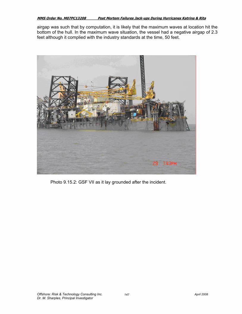
MMS Order No. M07PC13208 Post Mortem Failures Jack-ups During Hurricanes Katrina & Rita
Offshore: Risk & Technology Consulting Inc. April 2008 Dr. M. Sharples, Principal Investigator
147
airgap was such that by computation, it is likely that the maximum waves at location hit the bottom of the hull. In the maximum wave situation, the vessel had a negative airgap of 2.3 feet although it complied with the industry standards at the time, 50 feet.
Photo 9.15.2: GSF VII as it lay grounded after the incident.

MMS Order No. M07PC13208 Post Mortem Failures Jack-ups During Hurricanes Katrina & Rita
Offshore: Risk & Technology Consulting Inc. April 2008 Dr. M. Sharples, Principal Investigator
148
Photo 9.15.3: GSF VII off Cameron Louisiana with shoreline in the background
Photo 9.15.4: GSF Adriatic VII Note: Drilling package is missing and the holes in the aft end facing the reader.
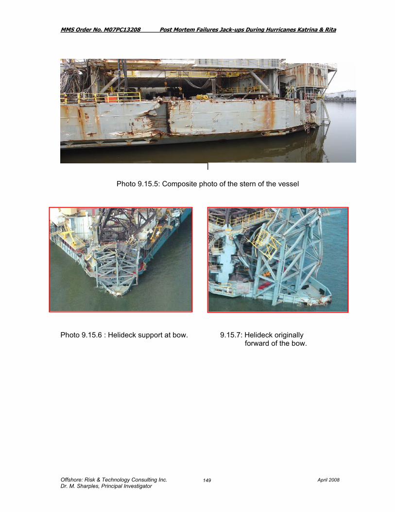
MMS Order No. M07PC13208 Post Mortem Failures Jack-ups During Hurricanes Katrina & Rita
Offshore: Risk & Technology Consulting Inc. April 2008 Dr. M. Sharples, Principal Investigator
149
Photo 9.15.5: Composite photo of the stern of the vessel
Photo 9.15.6 : Helideck support at bow. 9.15.7: Helideck originally ………………………………………………………………….forward of the bow.

MMS Order No. M07PC13208 Post Mortem Failures Jack-ups During Hurricanes Katrina & Rita
Offshore: Risk & Technology Consulting Inc. April 2008 Dr. M. Sharples, Principal Investigator
150
Photos 9.15.8: Mud Pump moved off Lockers damaged due to movement foundation due to rig movement; From the disarray in the quarters, it is apparent that the rig underwent a violent journey. Indications of significant amounts of water entering the quarters was evident.
Photo 9.15.9: Crane damage to boom
The legs and drilling package from the Adriatic VII remained on the sea floor at the location where the rig was prior to the storm. At the time the rig was working for Chevron Texaco adjacent to their Eugene Island 338A platform. As a result of the storm, the Chevron platform was toppled. One of the legs of the Adriatic VII came to rest on top of the Chevron platform debris. The legs, the starboard in particular, were in the way of plugging operations and had to be removed in order to gain access to the wells.

MMS Order No. M07PC13208 Post Mortem Failures Jack-ups During Hurricanes Katrina & Rita
Offshore: Risk & Technology Consulting Inc April 2008 Dr. M. Sharples, Principal Investigator
151
9.15.10 Artist’s rendition shows the situation after the storm but at the pre-storm location.
There were 14 producing wells which were toppled along with the platform. All wells were secured with subsurface safety valves and Christmas trees with the exception of the A-10 well which was being drilled when Hurricane Rita hit. The A-10 was only secured by a storm packer set below the mud line since the BOP was knocked off. The subsurface valves held with no issues until the recovery plan was successfully executed. In June 2007 ’Taklift 1’ and ’Smit Cyclone’ removed one of the three legs of the ’Adriatic VII’. The others were removed in the following months.
9.15.11 Artist’s rendition shows the disposition of the legs after the hull had departed from location.

MMS Order No. M07PC13208 Post Mortem Failures Jack-ups During Hurricanes Katrina & Rita
Offshore: Risk & Technology Consulting Inc April 2008 Dr. M. Sharples, Principal Investigator
152
The soil on location were reported to be stiff clay, with medium dense silt to silty fine sand approximately 2 meters below the final penetration depth and according to the commissioned engineering study further load beyond that tested during the preload would have resulted in extra penetration. [Artist’s impression above might then be somewhat misleading if this occurred]. A sonar display of the location showing the relative location of the legs and drilling package to the platform is below:
Figure 9.15.12 : Sonar Display of Eugene Island 338A after departure of the GSF
Adriatic VII An engineering study carried out for the owners reported as follows: “The Adriatic VII was positioned North East of the hurricane’s path on a compass heading of 69 degrees. As a result of this the rig saw the maximum wind and waves on its Starboard side, thus increasing the vertical loads on the port leg. The analyses predict that the chords and braces had utilisations of around 3.0 and the pinion utilisations almost 2.0. The analyses further predicted that the port leg would have settled by up to 17 ft beyond its initial penetration of 74 ft, which would increase the already excessive leg utilisations. Unfortunately it is unknown how much settlement was actually seen before the rig collapsed.

MMS Order No. M07PC13208 Post Mortem Failures Jack-ups During Hurricanes Katrina & Rita
Offshore: Risk & Technology Consulting Inc April 2008 Dr. M. Sharples, Principal Investigator
153
The predicted direction of loading on the rig agrees with that observed in photographs of the damaged unit where it can be seen that the hull must have fallen to port, due to the fact that the legs above the hull are deflected to port. This is because as the hull moves to port, the port chords of the legs are effectively pulled down through the jack frame and, at the same time, the starboard chords are pushed up through the jack frame thus generating a substantial Rack Phase Difference (RPD), the result of which is that the leg above the jackhouse is brought to approximately the same angle as the leg below the keel. The leg above the hull therefore points in the direction in which the hull fell. It is worth noting that the GSF Adriatic VII had an airgap of only 50ft, which would give a crest clearance of 6.5 ft. Thus, wave-in-deck loading would be expected after only part of the predicted 17 ft settlement had occurred. Whether or not the very high structural utilisations would have resulted in failure without the additional effects of settlement and wave-in deck loading remains a matter of conjecture” (Ref 35). Note: our findings disagree with this – based on a wave height of 72.9 ft and accounting for tide and surge the calculation shows a –2.3 airgap. Thus it is quite likely based on this that the hull bottom was actually hit with the wave.
“The GSF Adriatic VII was analysed in a water depth of 254 ft at an airgap of 50 ft as used for the hurricane analyses. As the installed airgap was less than that advised by the draft GoMex Annex, the unit was also analysed at the recommended minimum safe airgap. The rig satisfied the GoMex Annex checks for the Assessment criteria for both airgaps although the chord utilisations were close to one. The Contingency analyses for both airgaps showed acceptable utilisations of the braces and pinions but over utilisation of the chords. Therefore the rig did not pass the adapted SNAME criteria. The geotechnical analyses showed a bearing capacity over utilisation of 1.2 for the Assessment case and 1.38 for the Contingency case. Although no physical settlement would be expected, a settlement of approximately 0.2 m would be sufficient to expand the bearing capacity envelope such that the bearing capacity check is satisfied for the Assessment case and 0.34m for the Contingency case. This level of settlement would result in a hull rotation of 0.3° for the Assessment case and 0.5° for the Contingency case. This is on the limit of the standard tolerance and due to the already heavily utilised chords it is likely the rig would suffer structural overload. On this basis the unit does not comply with the SNAME step 3 foundation displacement check for either of the cases assessed” (Ref 35). The results presented in Table 10.1 indicate that the degree of overload is approximately 3.2 and thus this is classified as an expected failure, even without any consideration of the wave hitting the hull.
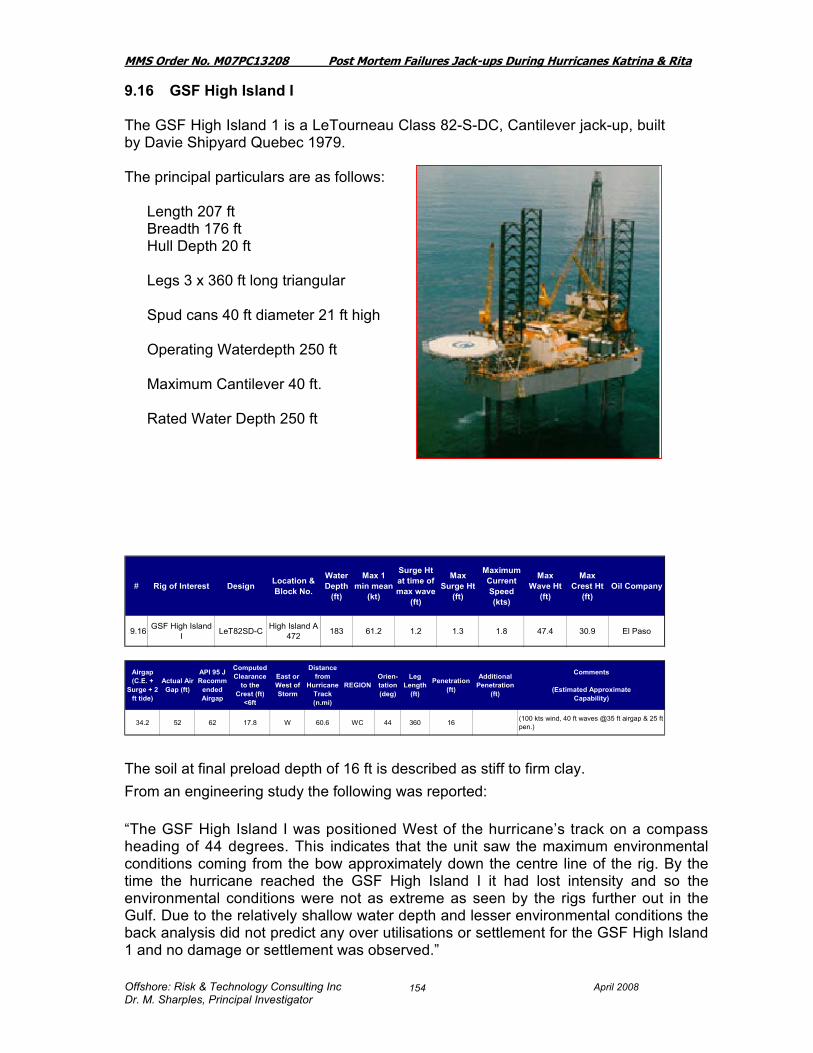
MMS Order No. M07PC13208 Post Mortem Failures Jack-ups During Hurricanes Katrina & Rita
Offshore: Risk & Technology Consulting Inc April 2008 Dr. M. Sharples, Principal Investigator
154
9.16 GSF High Island I The GSF High Island 1 is a LeTourneau Class 82-S-DC, Cantilever jack-up, built by Davie Shipyard Quebec 1979. The principal particulars are as follows:
Length 207 ft Breadth 176 ft Hull Depth 20 ft Legs 3 x 360 ft long triangular Spud cans 40 ft diameter 21 ft high Operating Waterdepth 250 ft Maximum Cantilever 40 ft. Rated Water Depth 250 ft
The soil at final preload depth of 16 ft is described as stiff to firm clay. From an engineering study the following was reported: “The GSF High Island I was positioned West of the hurricane’s track on a compass heading of 44 degrees. This indicates that the unit saw the maximum environmental conditions coming from the bow approximately down the centre line of the rig. By the time the hurricane reached the GSF High Island I it had lost intensity and so the environmental conditions were not as extreme as seen by the rigs further out in the Gulf. Due to the relatively shallow water depth and lesser environmental conditions the back analysis did not predict any over utilisations or settlement for the GSF High Island 1 and no damage or settlement was observed.”
# Rig of Interest Design Location & Block No.
Water Depth
(ft)
Max 1 min mean
(kt)
Surge Ht at time of max wave
(ft)
Max Surge Ht
(ft)
Maximum Current Speed (kts)
Max Wave Ht
(ft)
Max Crest Ht
(ft)Oil Company
9.16 GSF High Island I LeT82SD-C High Island A
472 183 61.2 1.2 1.3 1.8 47.4 30.9 El Paso
Airgap (C.E. +
Surge + 2 ft tide)
Actual Air Gap (ft)
API 95 J Recomm
ended Airgap
Computed Clearance
to the Crest (ft)
<6ft
East or West of Storm
Distance from
Hurricane Track (n.mi)
REGIONOrien-tation (deg)
Leg Length
(ft)
Penetration (ft)
Additional Penetration
(ft)
Comments
(Estimated ApproximateCapability)
34.2 52 62 17.8 W 60.6 WC 44 360 16 (100 kts wind, 40 ft waves @35 ft airgap & 25 ft pen.)

MMS Order No. M07PC13208 Post Mortem Failures Jack-ups During Hurricanes Katrina & Rita
Offshore: Risk & Technology Consulting Inc April 2008 Dr. M. Sharples, Principal Investigator
155
“The GSF High Island I was analysed in 50 ft water depth at an airgap of 52 ft as used for the hurricane analysis. This airgap exceeds the GoMex Annex requirement by 4ft. The rig satisfied all of the structural checks for both the Assessment and Contingency criteria, with the brace strength utilisation rising to 0.9 for the Contingency case. The bearing capacity assessment showed no over utilisation for the Assessment case, however the Contingency case had a bearing capacity over utilisation of 1.2. The load-penetration curves indicated that this is not expected to result in physical settlement under the analysed storm conditions, and that a settlement of 0.1 m would be required to expand the bearing capacity envelope such that the bearing capacity check is satisfied. This level of settlement would result in a hull rotation of 0.19°, which is within the standard rig tolerance and is not expected to result in structural overload. This unit would therefore be deemed to comply with the SNAME step 3 foundation displacement checks.” The results presented in Table 10.1 indicate that the degree of overload is approximately 1.3

MMS Order No. M07PC13208 Post Mortem Failures Jack-ups During Hurricanes Katrina & Rita
Offshore: Risk & Technology Consulting Inc April 2008 Dr. M. Sharples, Principal Investigator
156
9.17 GSF High Island II The GSF High Island II is a LeTourneau 82-SD-C cantilever jack-up built by Davie, Quebec, 1979. The principal particulars are:
Length 207 ft, Breadth 176 ft Hull Depth 20 ft Legs 3 x 394 ft triangular truss Spud Can Diameter 40 ft Operating Water depth 270 ft Maximum Cantilever extension 47 ft..
Design Criteria: 100 kts wind, 38 ft waves
Upon return to the rig the crew found that the bow leg had penetrated an additional 6 ft which resulted in a forward tilt of 3 degrees in a movement away from the platform (Ref 36). Additionally the legs were splayed and twisted. At the time of the storm approximately 75 ft of the 394 ft leg was above the jack frames. All three legs suffered damage and were bent and distorted as a result of the storm. The jacking down process enhanced that damage. The jetting piping and ladders on the legs had been damaged, however the legs were able to be repaired.
Airgap (C.E. +
Surge + 2 ft tide)
Actual Air Gap (ft)
API 95 J Recomm
ended Airgap
Computed Clearance
to the Crest (ft)
<6ft
East or West of Storm
Distance from
Hurricane Track (n.mi)
REGIONOrien-tation (deg)
Leg Length
(ft)
Penetration (ft)
Additional Penetration
(ft)
Comments
(Estimated ApproximateCapability)
49.9 74 62 24.1 E 34.4 WC 328 394 16 5
Additional 5 ft penetration. Leg Bracing Damage, lower and upper guide, required help from tug to straighten rig to permit jacking operation. May have bumped platform. Leg Bracing Damage, lower and upper guide, required help from tug to straighten rig to permit jacking operation. (100 kts wind, 43 ft waves @35 ft airgap & 25 ft pen.)
# Rig of Interest Design Location & Block No.
Water Depth
(ft)
Max 1 min mean
(kt)
Surge Ht at time of max wave
(ft)
Max Surge Ht
(ft)
Maximum Current Speed (kts)
Max Wave Ht
(ft)
Max Crest Ht
(ft)Oil Company
9.17 GSF High Island II LeT82SD-C SMI 90 162 84.5 2.1 2.6 3.3 66.0 45.3 Chevron
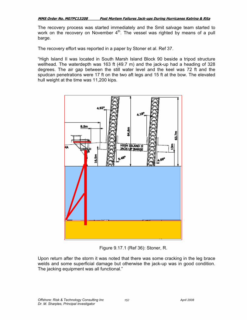
MMS Order No. M07PC13208 Post Mortem Failures Jack-ups During Hurricanes Katrina & Rita
Offshore: Risk & Technology Consulting Inc April 2008 Dr. M. Sharples, Principal Investigator
157
The recovery process was started immediately and the Smit salvage team started to work on the recovery on November 4th. The vessel was righted by means of a pull barge. The recovery effort was reported in a paper by Stoner et al. Ref 37. “High Island II was located in South Marsh Island Block 90 beside a tripod structure wellhead. The waterdepth was 163 ft (49.7 m) and the jack-up had a heading of 328 degrees. The air gap between the still water level and the keel was 72 ft and the spudcan penetrations were 17 ft on the two aft legs and 15 ft at the bow. The elevated hull weight at the time was 11,200 kips.
Figure 9.17.1 (Ref 36): Stoner, R. Upon return after the storm it was noted that there was some cracking in the leg brace welds and some superficial damage but otherwise the jack-up was in good condition. The jacking equipment was all functional.”
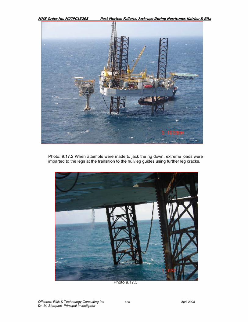
MMS Order No. M07PC13208 Post Mortem Failures Jack-ups During Hurricanes Katrina & Rita
Offshore: Risk & Technology Consulting Inc April 2008 Dr. M. Sharples, Principal Investigator
158
Photo: 9.17.2 When attempts were made to jack the rig down, extreme loads were imparted to the legs at the transition to the hull/leg guides using further leg cracks.
Photo 9.17.3

MMS Order No. M07PC13208 Post Mortem Failures Jack-ups During Hurricanes Katrina & Rita
Offshore: Risk & Technology Consulting Inc April 2008 Dr. M. Sharples, Principal Investigator
159
Photos 9.17.4 Some of the leg chords were bent and many of the K-braces have been overstressed. Damage was reported inside the spud cans where they
interface with the legs.
Photos: 9.17.5 Sheared Bracing.

MMS Order No. M07PC13208 Post Mortem Failures Jack-ups During Hurricanes Katrina & Rita
Offshore: Risk & Technology Consulting Inc April 2008 Dr. M. Sharples, Principal Investigator
160
Photo 9.17.6 : Kink at the lower guide.
Photos 9.17.7: Miscellaneous Leg Photos The Jacking system required some replacement parts. In addition the jack system bracing structure and attachments to the hull sustained some structural cracking. Some minor deck buckling in and around the jack frames was notedand to the lower and upper leg guides. All leg guides required replacement of the leg guide liners.
Due to the rocking motion and very high load cycles on the rig during the storm, significant damage occurred in the spud can to leg connection
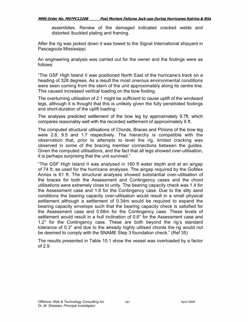
MMS Order No. M07PC13208 Post Mortem Failures Jack-ups During Hurricanes Katrina & Rita
Offshore: Risk & Technology Consulting Inc April 2008 Dr. M. Sharples, Principal Investigator
161
assemblies. Review of the damaged indicated cracked welds and distorted /buckled plating and framing.
After the rig was jacked down it was towed to the Signal International shipyard in Pascagoula Mississippi. An engineering analysis was carried out for the owner and the findings were as follows: “The GSF High Island II was positioned North East of the hurricane’s track on a heading of 328 degrees. As a result the most onerous environmental conditions were seen coming from the stern of the unit approximately along its centre line. This caused increased vertical loading on the bow footing. The overturning utilisation of 2.1 might be sufficient to cause uplift of the windward legs, although it is thought that this is unlikely given the fully penetrated footings and short-duration of the uplift loading. The analyses predicted settlement of the bow leg by approximately 9.7ft, which compares reasonably well with the recorded settlement of approximately 6 ft.
The computed structural utilisations of Chords, Braces and Pinions of the bow leg were 2.8, 9.5 and 1.7 respectively. The hierarchy is compatible with the observation that, prior to attempts to level the rig, limited cracking was observed in some of the bracing member connections between the guides. Given the computed utilisations, and the fact that all legs showed over-utilisation, it is perhaps surprising that the unit survived.”
“The GSF High Island II was analysed in 160 ft water depth and at an airgap of 74 ft, as used for the hurricane analyses. The airgap required by the GoMex Annex is 61 ft. The structural analyses showed substantial over-utilisation of the braces for both the Assessment and Contingency cases and the chord utilisations were extremely close to unity. The bearing capacity check was 1.4 for the Assessment case and 1.6 for the Contingency case. Due to the silty sand conditions the bearing capacity over-utilisation would result in a small physical settlement although a settlement of 0.34m would be required to expand the bearing capacity envelope such that the bearing capacity check is satisfied for the Assessment case and 0.68m for the Contingency case. These levels of settlement would result in a hull inclination of 0.6° for the Assessment case and 1.2° for the Contingency case. These are both beyond the rig’s standard tolerance of 0.3° and due to the already highly utilised chords the rig would not be deemed to comply with the SNAME Step 3 foundation check.” (Ref 35)
The results presented in Table 10.1 show the vessel was overloaded by a factor of 2.9.

MMS Order No. M07PC13208 Post Mortem Failures Jack-ups During Hurricanes Katrina & Rita
Offshore: Risk & Technology Consulting Inc April 2008 Dr. M. Sharples, Principal Investigator
162
9.17.9 Photo: Overview of pullback barge
9.17.10 Photo: Pull back barge: photo taken from jack-up

MMS Order No. M07PC13208 Post Mortem Failures Jack-ups During Hurricanes Katrina & Rita
Offshore: Risk & Technology Consulting Inc April 2008 Dr. M. Sharples, Principal Investigator
163
9.18 GSF High Island III The GSF High Island III is a LeTourneau Class 82-SDC, Cantilever jack-up built by Davie Shipyard Quebec 1979. The principal particulars are as follows:
Length 207 ft Breadth 176 ft Hull Depth 20 ft Spud can diameter: 40 ft. x 21 ft depth Legs 3 x 360ft long triangular Design criteria: 100 kts wind, 38 ft waves
9.18.1 Photo GSF High Island III on location.
# Rig of Interest Design Location & Block No.
Water Depth
(ft)
Max 1 min mean
(kt)
Surge Ht at time of max wave
(ft)
Max Surge Ht
(ft)
Maximum Current Speed (kts)
Max Wave Ht
(ft)
Max Crest Ht
(ft)
9.18 GSF High Island III LeT82SD-C SMI 107 190 87.1 1.8 2.4 3.4 68.5 46.9

MMS Order No. M07PC13208 Post Mortem Failures Jack-ups During Hurricanes Katrina & Rita
Offshore: Risk & Technology Consulting Inc April 2008 Dr. M. Sharples, Principal Investigator
164
Airgap (C.E. +
Surge + 2 ft tide)
Actual Air Gap (ft)
API 95 J Recomm
ended Airgap
Computed Clearance
to the Crest (ft)
<6ft
East or West of Storm
Distance from
Hurricane Track (n.mi)
REGIONOrien-tation (deg)
Leg Length
(ft)
Penetration (ft)
Additional Penetration
(ft)
Comments
(Estimated ApproximateCapability)
51.3 54 62 2.7 E 31.3 WC 6 360 51 Afloat
All 3 legs failed and the rig floated off location and beached. Derrick fell off. Legs above upper and below lower guides lost. Declared total constructive loss.Why? Need to Look at Environmental Loads and Soils(100 kts wind, 42 ft waves @35 ft airgap & 25 ft pen.)
The GSF High Island III was working for Badger Oil in South Marsh Island 107 at the time of Hurricane Rita. The legs collapsed and the rig floated off location. It was severely damaged and drifted approximately 108 mi and grounded off East Cameron 4. It was reported that there was extensive damage to the drilling tower. The pontoon, with the remaining leg protruded from the leg wells, was sitting aground in a self created trench on the sea bottom.
Photo 9.18.2: GSF High Island III off East Cameron At the time of the storm the GSF High Island III was on location at South Marsh Island Block 114 conducting drilling operations for Badger Oil Corporation. The rig suffered major damage as a result of the storm including the loss of all legs and the entire drilling package. The Badger Oil platform was not significantly damaged as a result of the storm. During the failure the legs were ripped downwards causing severe damage to the leg sections and the jacking system. During the survey at the grounding site there was
LATX LATX LATX LATX

MMS Order No. M07PC13208 Post Mortem Failures Jack-ups During Hurricanes Katrina & Rita
Offshore: Risk & Technology Consulting Inc April 2008 Dr. M. Sharples, Principal Investigator
165
water in the engine room, pump room and machinery spaces which required additional cleanup.
Photo 9.18.3: Sonar used to locate canholes of GSF High Island III. Note the two holes for the bow and starboard legs and the remaining port leg alongside the platform.
232

MMS Order No. M07PC13208 Post Mortem Failures Jack-ups During Hurricanes Katrina & Rita
Offshore: Risk & Technology Consulting Inc April 2008 Dr. M. Sharples, Principal Investigator
166
Photo 9.18.3 : High Island III grounded after Hurricane Rita
The soil for the location showed at final preload the legs had completely penetrated the stiff clay and were sitting on a 6 ft layer of medium to dense fine sand. Below that there was stiff to very stiff clay. With the limited information available it appears that further load would be anticipated to highly load the sand layer and possibly penetrate through to the clay with a potential settlement of about 6-7 ft. depending on the bearing strength of the “stiff to very stiff” clay. .
Eastern Cameron Parish, LA

MMS Order No. M07PC13208 Post Mortem Failures Jack-ups During Hurricanes Katrina & Rita
Offshore: Risk & Technology Consulting Inc April 2008 Dr. M. Sharples, Principal Investigator
167
Photo 9.18.4: Hull Structural Inspections: Near the jacking tower some buckling of the main deck appeared to occur. One centerline tank was reported flooded.
Photo 9.18.5: GSF III after the storm

MMS Order No. M07PC13208 Post Mortem Failures Jack-ups During Hurricanes Katrina & Rita
Offshore: Risk & Technology Consulting Inc April 2008 Dr. M. Sharples, Principal Investigator
168
Photo 9.18.6: Showing extent of leg damage
Photo 9.18.7: Lifecraft had been impacted by the storm (hanging from the davit)

MMS Order No. M07PC13208 Post Mortem Failures Jack-ups During Hurricanes Katrina & Rita
Offshore: Risk & Technology Consulting Inc April 2008 Dr. M. Sharples, Principal Investigator
169
.
Photo 9.18.8: Damage to leg close to lower leg guide.
Photo 9.18.9: Lower leg guide cracked.

MMS Order No. M07PC13208 Post Mortem Failures Jack-ups During Hurricanes Katrina & Rita
Offshore: Risk & Technology Consulting Inc April 2008 Dr. M. Sharples, Principal Investigator
170
Photo 9.18.10: First of the High Island 3 legs (bow) on deck (Courtesy Smit website)
In October 2006 the legs of the GSF High Island III were removed. An engineering study carried out for the owners reported as follows: “The GSF High Island III was positioned close to the GSF High Island II in roughly the same water depth, on a heading of 6 degrees which meant the worst environmental conditions were running approximately along the line between the Starboard leg and the rig centroid. Despite the substantial installed penetration (of around 50 ft) the tendency for up-lift of the starboard leg due to the exceedingly high overturning utilisation can not be discounted.
The analyses predicted just under 6 ft settlement of the Bow and Port legs.
The computed structural utilisations of Chords, Braces and Pinions were 4.3, 9.6 and 2.5 respectively. The effects of the predicted settlement would increase the computed structural utilisations. The predicted crest clearance before settlement was 11.7 ft, so after the predicted settlement the clearance should have been around 5.8 ft, which should not have led to wave in deck loads on the hull, unless the waves were larger than given in the hindcast study, or the crests higher than predicted by standard higher order wave theory. The rig grounded in East Cameron 4 after suffering catastrophic failure of the legs and leaving its location. The damage observed confirms the principal direction of loading as the leg sections above the jack houses are all bent to port, which indicates that the rig fell to port when it collapsed (as with the GSF Adriatic VII).

MMS Order No. M07PC13208 Post Mortem Failures Jack-ups During Hurricanes Katrina & Rita
Offshore: Risk & Technology Consulting Inc April 2008 Dr. M. Sharples, Principal Investigator
171
The GSF High Island III was analysed in 190 ft water depth with an airgap of 54 ft. This is less than the 61 ft airgap required by the GoMex Annex so analyses were completed using both airgaps. The first analysis for the installed airgap showed over-utilisation of the braces for both the Assessment and Contingency cases. The chords showed almost full utilisation for the Contingency case. The analysis for the larger 61 ft airgap showed the same trends in utilisations with slight increases as would be expected. The rig would not pass the draft GoMex Annex structural checks for operations at the South Marsh Island location. The bearing capacity check for the 54ft airgap case showed a bearing capacity over-utilisation of 1.67 for the Assessment case and 1.81 for the Contingency case, expected to result in minimal physical settlement. However, a settlement of 1.23m and 1.41 m respectively would be required to expand the bearing capacity envelope such that the bearing capacity check is satisfied. These levels of settlement would result in a hull rotation of 2.2° for the Assessment case and 2.5° for the Contingency case. This is far beyond the operational limit of the rig. The rig would be deemed not to comply with the SNAME Step 3 foundation check.
The back-analyses show that the units that suffered damage were all expected to be subject to foundation settlement although it is (presently) unknown how much, if any, settlement was actually experienced by the GSF Adriatic VII or the GSF High Island III” (Ref 35). Table 10.1 presents the information from that method of determining the extent of overload beyond the modified “design” values. The Table 10.1 reports an overload factor of 3.1.

MMS Order No. M07PC13208 Post Mortem Failures Jack-ups During Hurricanes Katrina & Rita
Offshore: Risk & Technology Consulting Inc April 2008 Dr. M. Sharples, Principal Investigator
172
9.19 GSF High Island IV The GSF High Island IV is a LeTourneau Class 82-SDC, Cantilever jack-up built by Davie Shipyard Quebec 1982. The principal particulars are as follows:
Length 207 ft Breadth 176 ft Hull Depth 20 ft Spud can diameter: 40 ft. x 21 ft depth Legs 3: x 394ft long triangular Operating Depth 270 ft Cantilever extension 47 ft. Design criteria: 100 kts wind, 38 ft waves
Prior to the Hurricane Rita the GSF High Island IV was extended over a platform drilling a Nexen Energy well in Vermillion Block 321 . Before evacuating for Hurricane Rita, the well was secured, the drilling package of the rig was skidded onto the rig and the rig was raised to a 70 ft air gap. Upon returning to the location following Hurricane Rita, an initial report indicated that the rig was found to have twisted and listed 10 degrees to result in the starboard side of the platform being approximately 7 ft closer to the platform (the penetration was 16 ft). While this may appear unusual, a not unsimilar twisting was noted in a study post-Hurricane George (Ref 38).
Airgap (C.E. +
Surge + 2 ft tide)
Actual Air Gap (ft)
API 95 J Recomm
ended Airgap
Computed Clearance
to the Crest (ft)
<6ft
East or West of Storm
Distance from
Hurricane Track (n.mi)
REGIONOrien-tation (deg)
Leg Length
(ft)
Penetration (ft)
Additional Penetration
(ft)
Comments
(Estimated ApproximateCapability)
51.2 70 62 18.8 E 4.4 WC 78 394 15 5
Initial penetration was 15' on all legs implying a sand layer. The additional penetration was nearly uniform (difference of 1' on one leg) further implying a sand layer with penetration due to shakedown. Breach of aft preload tanks, voild tank, and transom. Cracks found in leg members.(100 kts wind, 42 ft waves @35 ft airgap & 25 ft pen.)
# Rig of Interest Design Location & Block No.
Water Depth
(ft)
Max 1 min mean
(kt)
Surge Ht at time of max wave
(ft)
Max Surge Ht
(ft)
Maximum Current Speed (kts)
Max Wave Ht
(ft)
Max Crest Ht
(ft)Oil Company
9.19 GSF High Island IV LeT82SD-C Vermillion
321 206 94.2 2.0 3.3 3.6 67.6 45.9 Nexen
MMS Order No. M07PC13208 Post Mortem Failures Jack-ups During Hurricanes Katrina & Rita
Offshore: Risk & Technology Consulting Inc April 2008 Dr. M. Sharples, Principal Investigator
173
The soil at the location in Vermillion Block 321 was reported as medium dense to dense fine sand at the location of the spud cans. It was also evident that the rig had rocked back and forth during the storm and had contacted the platform, causing damage to the aft of the rig’s hull. Repairs were made on location and following the completion of drilling operations, the rig was jacked down in order to mobilize to the next location. Some additional damage was also found in the hull adjacent to the jack housings. Several of the K-bracings of the bow and starboard legs between the 330 ft and 270 ft levels were found to be parted or cracked and approximately 50 ft of the ladders running down the bow leg, and starboard leg were missing. The aft portion of the hull was impacted in 3 locations. The port aft had a 20 ft hole perhaps from impacting the platform, The mid aft and drive pipe deck guide were dented and the starboard aft part of the hull was dented. 13 bull gears of the jacking system were found to be cracked and needed replacement or welding. Due to the high load cycles on the rig during the storm, significant damage occurred in the spud can-to-leg connection assemblies and there was buckling in all three cans, and the top plating was deformed in one can. Additionally a number of other damages were noted including on 5 A/C units on the top of the living quarters which were inundated with saltwater and damaged, walkways bent and twisted, various antennae and main deck appurtenances damaged due to the high winds, lights were blown out of the derrick and windows were broken at the driller’s console. An engineering study was carried out for the owners and the following was reported: “The GSF High Island IV was located almost exactly on the hurricane’s track, very close to the GSF Adriatic III. The rig was positioned on a heading of 78 degrees which meant that it saw the worst environmental conditions coming onto the Bow roughly down the centreline of the rig at first and then in the opposite direction as the back of the hurricane caught the rig. Analysis shows that the largest loads were seen when the hurricane first hit the rig, rather than when the back of the hurricane passed over. Utilisations for the Chords, Braces and pinions were 1.06, 1.53 and 0.50 respectively during the first part of the hurricane compared to utilisations of 0.53, 0.93 and 0.40 during the second part. The overturning utilisation of 2.7 might be sufficient to cause uplift of the windward legs, although it is thought that this is unlikely given the fully penetrated footings and short-duration of the uplift loading. After the hurricane, it was found that all three legs had settled by around 6 ft. One explanation could be that the stern legs settled during the first part of the hurricane and the bow leg settled during the second part, however the loads required to cause 6 ft of additional penetration are huge, so this explanation can be eliminated. The alternative plausible explanation is that all of the legs sank down into the sand as a consequence of ‘pumping’ and/or liquefaction or shakedown.

MMS Order No. M07PC13208 Post Mortem Failures Jack-ups During Hurricanes Katrina & Rita
Offshore: Risk & Technology Consulting Inc April 2008 Dr. M. Sharples, Principal Investigator
174
The computed structural utilisations of Chords, Braces and Pinions were 3.2, 9.4 and 1.9 respectively, which would be considered to be sufficient to cause distress and, indeed, some damage was reported to all three legs. Twelve cracks were observed in the Bow leg, four in the Port leg and two in the Starboard leg (according to the rig report ref. [9]). Other damage was observed at the stern of the rig where the rig had contacted the platform. Damage was caused to several preload tanks and the transom plate which, if the initial clearances were known, would demonstrate the extent of the rig’s dynamic response during the storm and/or that the settlement of the three legs took place unevenly.” “The GSF High Island IV was analysed at a water depth of 206 ft with a 70ft airgap which is greater than that required by the GoMex Annex. The analyses showed over-utilisation of the chords of 1.12 for the Assessment case and 1.17 for the Contingency case. The braces show over-utilisations of 1.6 for the Assessment case 1.7 for the Contingency case. These results show that the rig would not have met the draft GoMex Annex structural criteria for operations at the Vermillion location. The geotechnical analysis shows substantial over-utilisation of the bearing capacity of 2.16 for the Assessment case and 2.26 for the Contingency case although this is not expected to result in any physical settlement due to the very hard sand foundations. Minimal settlement would be required to expand the bearing capacity envelope such that the bearing capacity checks are satisfied. Thus the SNAME step 3 foundation displacement check would be satisfied.” (Ref 35). Table 10.1 presents the information from that method of determining the extent of overload beyond the modified “design” values. The Table 10.1 reports an overload factor of 3.

MMS Order No. M07PC13208 Post Mortem Failures Jack-ups During Hurricanes Katrina & Rita
Offshore: Risk & Technology Consulting Inc April 2008 Dr. M. Sharples, Principal Investigator
175
9.20 GSF Main Pass IV The GSF Main Pass IV is a Friede & Goldman L-780 MOD II, cantilever jack-up built by Ingalls Shipbuilding at Pascagoula Mississippi in 1982. The principal particulars are as follows:
Length 180 ft Breadth 175 ft Hull Depth 25 ft Legs 3 x 416 ft long triangular Rated Water depth 300 ft Cantilever extension 40 ft Design Conditions: 100 kt wind and 50 ft waves.
The soil conditions on location were reported as Medium dense silty fine sand for two meters under the fully loaded spud cans and below that, firm to stiff clay. An engineering study carried out for owners reported as follows: “The GSF Main Pass IV was located North East of the hurricane’s path on a rig heading of 235 degrees. As a result the environmental loading was seen approaching the port side of the rig which would have increased the vertical loading on the starboard spudcan footings. The analyses showed that no settlement was predicted and the structural utilisations were generally less than 1.0, however JUSTAS predicted over utilisation of the Starboard leg pinions with a UC of 1.2. No actual damage was observed.” “The GSF Main Pass IV was analysed in 70 ft water depth with a 65 ft airgap which is greater than the 50 ft minimum airgap required by the GoMex Annex. The rig satisfied all the GoMex Annex criteria with relatively low member utilisations of up to 0.5. The pinion utilisations were higher at 0.74 for the Assessment case and 0.80 for the Contingency case. Note that the unit was analysed assuming that the rack chocks
Airgap (C.E. +
Surge + 2 ft tide)
Actual Air Gap (ft)
API 95 J Recommended Airgap
Computed Clearance to the Crest (ft)
<6ft
East or West of Storm
Distance from
Hurricane Track (n.mi)
REGIONOrien-tation (deg)
Leg Length
(ft)
Penetration (ft)
Additional Penetration
(ft)
Comments
(Estimated ApproximateCapability)
38.9 65 54.6 26.1 E 29.1 WC 235 417 11 (100 kts wind, 52 ft waves, 1 kt current)
# Rig of Interest Design Location & Block No.
Water Depth
(ft)
Max 1 min mean
(kt)
Surge Ht at time of max wave
(ft)
Max Surge Ht
(ft)
Maximum Current Speed (kts)
Max Wave Ht
(ft)
Max Crest Ht
(ft)Oil Company
9.20 GSF Main Pass IV
F&G L-780 MOD II
Vermillion 102 70 83.6 5.3 5.6 3.9 50.5 31.3 Forest Oil

MMS Order No. M07PC13208 Post Mortem Failures Jack-ups During Hurricanes Katrina & Rita
Offshore: Risk & Technology Consulting Inc April 2008 Dr. M. Sharples, Principal Investigator
176
were not deployed, as was the case during the hurricane. This is likely to be the reason for relatively high utilisations at this shallow water location. The foundation checks showed no over-utilisation of the bearing or sliding capacity, so settlement would be expected. The GSF Main Pass IV would therefore meet the requirements of the GoMex Annex at the Vermilion 102 location “ (Ref 35). The GSF Main Pass IV was subjected to environmental loads very close to the design load. Thus the reader is referred to Table 7.2 and Table 10.1 for detailed results.

MMS Order No. M07PC13208 Post Mortem Failures Jack-ups During Hurricanes Katrina & Rita
Offshore: Risk & Technology Consulting Inc April 2008 Dr. M. Sharples, Principal Investigator
177
9.21 GSF High Island VIII The GSF High Island VIII is a LeTourneau Class 82-S-D-C, Cantilever jack-up built by Davie Shipyard Quebec 1982. The principal particulars are as follows:
Length 207 ft Breadth 176 ft Hull Depth 20 ft Spud can diameter 40 ft. x 21 ft depth Legs 3 x 360ft long triangular Operating Depth 250 ft Cantilever extension 40 ft. Design criteria 100 kts wind, 38 ft waves
An engineering study was carried out for the owners and the following was reported: “The GSF High Island VIII was located west of Hurricane Katrina in shallow water near the coast on a heading of 150 degrees. This resulted in the maximum environmental conditions being seen from just off the Port Bow. No damage was observed and no settlement was recorded at the footings. The predicted utilisations were generally less than unity and no settlement was expected. The only predicted over utilisation was of the braces of the port and starboard legs for which the Pafec FE analyses predicted over utilisation of 1.3. The GSF High Island VIII was analysed in 72ft water depth with an airgap of 50ft. This is almost exactly the minimum airgap required by the GoMex Annex. The rig satisfied the GoMex Annex structural checks for both the Assessment and the Contingency cases with no structural over-utilisations although the braces show high utilizations for the contingency case. The geotechnical analysis shows a bearing capacity utilisation of 0.74 for the Assessment case and 0.94 for the Contingency case. The GSF High
Airgap (C.E. +
Surge + 2 ft tide)
Actual Air Gap (ft)
API 95 J Recommended Airgap
Computed Clearance to the Crest (ft)
<6ft
East or West of Storm
Distance from
Hurricane Track (n.mi)
REGIONOrien-tation (deg)
Leg Length
(ft)
Penetration (ft)
Additional Penetration
(ft)
Comments
(Estimated ApproximateCapability)
29.7 50 55 20.3 E 126.9 C/WC Trans 150 360 28 (100 kts wind, 40 ft waves @35 ft airgap & 25 ft
pen.)
# Rig of Interest Design Location & Block No.
Water Depth
(ft)
Max 1 min mean
(kt)
Surge Ht at time of max wave
(ft)
Max Surge Ht
(ft)
Maximum Current Speed (kts)
Max Wave Ht
(ft)
Max Crest Ht
(ft)Oil Company
9.21 GSF High Island VIII LeT82SD-C
South Timbalier
41/4272 56.0 1.2 1.2 1.4 40.6 26.5 Energy
Partners Ltd

MMS Order No. M07PC13208 Post Mortem Failures Jack-ups During Hurricanes Katrina & Rita
Offshore: Risk & Technology Consulting Inc April 2008 Dr. M. Sharples, Principal Investigator
178
Island VIII would therefore be considered to pass the GoMex Annex foundation checks” (Ref 35). The GSF High Island VIII was subjected to environmental loads very close to the design load. but less than its ultimate anticipated capability and thus the reader is referred to Table 7.2 and Table 10.1 for results. 9.22 Noble Tom Jobe The Noble Tom Jobe is a LeTourneau 82-SDC constructed in 1982 in Brownsville, Texas. The principal particulars are:
Length 207 ft, Breadth 176 ft Hull Depth 20 ft Legs 3 x 360 ft triangular truss Spud Can Diameter 40 ft Operating Water depth 250 ft. Design Criteria: 100 kts wind, 38 ft waves
It was reported that the Noble Tom Jobe had received some minor damage. The starboard leg had splayed which damaged the K-bracing. The vessel was taken off location and went to the yard, repaired quickly and returned to service. The Noble Tom Jobe was subjected to environmental loads somewhat greater than its design but less than its ultimate anticipated capability and thus the reader is referred to Table 7.2 and Table 10.1 for results. The conclusion was that the rig was overloaded by a factor of approximately 1.7.
# Rig of Interest Design Location & Block No.
Water Depth
(ft)
Max 1 min mean
(kt)
Surge Ht at time of max wave
(ft)
Max Surge Ht
(ft)
Maximum Current
Speed (kts)
Max Wave Ht
(ft)
Max Crest Ht
(ft)Oil Company
9.22 Noble Tom Jobe LeT82SD-C South Timbalier 134 136 61.3 0.9 0.9 1.1 52.8 36.3 Chevron
Airgap (C.E. +
Surge + 2 ft tide)
Actual Air Gap (ft)
API 95 J Recommended Airgap
Computed Clearance to the Crest (ft)
<6ft
East or West of Storm
Distance from
Hurricane Track (n.mi)
REGIONOrien-tation (deg)
Leg Length
(ft)
Penetration (ft)
Additional Penetration
(ft)
Comments
(Estimated ApproximateCapability)
39.2 60 62 20.8 E 113.6 C/WC Trans 100 360 43 (100 kts wind, 37 ft waves @1 kt & 25 ft pen.);
Splayed stbd leg; K-Brace needed fixing

MMS Order No. M07PC13208 Post Mortem Failures Jack-ups During Hurricanes Katrina & Rita
Offshore: Risk & Technology Consulting Inc April 2008 Dr. M. Sharples, Principal Investigator
179
9.23 Noble Eddie Paul The Noble Eddie Paul is a LeTourneau Class 84-C Cantilever jack-up built by LeTourneau, Vicksburg 1975 as the Penrod 66 with upgrades and cantilever conversion in 1995. The principal particulars are as follows:
Rated Water Depth 390 ft Survival conditions; Water depth 350 ft; Waves 35 ft Windspeed 78 kts; 0 Current with airgap of 50 ft and penetration of 25 ft. .
No damage was reported on the Eddie Paul. The Noble Eddie Paul was subjected to environmental loads somewhat greater than its design and thus the reader is referred to Table 7.2 and Table 10.1 for results. The conclusion was that the rig was overloaded by a factor of approximately 1.2.
# Rig of Interest Design Location & Block No.
Water Depth
(ft)
Max 1 min mean
(kt)
Surge Ht at time of max wave
(ft)
Max Surge Ht
(ft)
Maximum Current
Speed (kts)
Max Wave Ht
(ft)
Max Crest Ht
(ft)Oil Company
9.23 Noble Eddie Paul LeT084-CE High Island A 572 354 56.8 0.7 0.7 1.4 49.1 30.5 Apache
Airgap (C.E. +
Surge + 2 ft tide)
Actual Air Gap (ft)
API 95 J Recommended Airgap
Computed Clearance to the Crest (ft)
<6ft
East or West of Storm
Distance from
Hurricane Track (n.mi)
REGIONOrien-tation (deg)
Leg Length
(ft)
Penetration (ft)
Additional Penetration
(ft)
Comments
(Estimated ApproximateCapability)
33.2 63 62 29.8 W 65.4 WC 5 500 49 (100 kts wind, 44 ft waves @45 ft airgap & 25 ft pen.)

MMS Order No. M07PC13208 Post Mortem Failures Jack-ups During Hurricanes Katrina & Rita
Offshore: Risk & Technology Consulting Inc April 2008 Dr. M. Sharples, Principal Investigator
180
9.24 Arch Rowan The Arch Rowan is a Marathon LeTourneau Class 116-C design propulsion assisted built in 1981 by LeTourneau Vicksburg and upgraded in 1996. The principal particulars are as follows:
Length 243 ft Breadth 200 ft Depth 26 ft Legs 3 x 410 ft Cantilever: Beam spacing 52 ft. Maximum overhang 76 ft. from the stern Spud tanks: 46 ft wide x 21 ft deep
Design Criteria: 300 ft W.D., 100 kt wind, 1 kt current, 44 ft wave with 25 ft penetration and 35 ft airgap.
The Arch Rowan was subjected to environmental loads somewhat greater than its design but less than its ultimate anticipated capability. Table 10.1 presents the information from that method of determining the extent of overload beyond the modified “design” values. The Table 10.1 reports an overload factor of 1.7.
# Rig of Interest Design Location & Block No.
Water Depth
(ft)
Max 1 min mean
(kt)
Surge Ht at time of max wave
(ft)
Max Surge Ht
(ft)
Maximum Current
Speed (kts)
Max Wave Ht
(ft)
Max Crest Ht
(ft)Oil Company
9.24 Arch Rowan LeT116-C Eugene Island 208 100 77.5 2.3 2.9 3.4 56.6 37.9
Pioneer Natural
Resources USA
Airgap (C.E. +
Surge + 2 ft tide)
Actual Air Gap (ft)
API 95 J Recommended Airgap
Computed Clearance to the Crest (ft)
<6ft
East or West of Storm
Distance from
Hurricane Track (n.mi)
REGIONOrien-tation (deg)
Leg Length
(ft)
Penetration (ft)
Additional Penetration
(ft)
Comments
(Estimated ApproximateCapability)
42.7 51 62 8.3 E 62.3 WC 75 477 74 (100 kts wind, 44 ft waves, 1 kt current @ 35 ft airgap)

MMS Order No. M07PC13208 Post Mortem Failures Jack-ups During Hurricanes Katrina & Rita
Offshore: Risk & Technology Consulting Inc April 2008 Dr. M. Sharples, Principal Investigator
181
9.25 Bob Palmer The Bob Palmer is described in Section 8.13 of this Report. The Bob Palmer had been subjected to extreme winds, waves and currents in Hurricane Katrina, in Hurricane Rita it was not subjected to environmental loads greater than its design and thus the reader is referred to Table 7.2 and Table 10.1 for results. 9.26 Cecil Provine The Cecil Provine is a Marathon LeTourneau Class 116-C design propulsion assisted built in 1982 by LeTourneau Vicksburg. The principal particulars are as follows:
Length 243 ft Breadth 200 ft Depth 26 ft Legs 3 x 410 ft Cantilever: Beam spacing 52 ft. Maximum overhang 76 ft. from the stern Spud tanks: 46 ft wide x 21 ft deep
Design Criteria: 300 ft W.D.,
100 kt wind, 1 kt current, 44 ft wave with 25 ft penetration and
35 ft airgap.
# Rig of Interest Design Location & Block No.
Water Depth
(ft)
Max 1 min mean
(kt)
Surge Ht at time of max wave
(ft)
Max Surge Ht
(ft)
Maximum Current
Speed (kts)
Max Wave Ht
(ft)
Max Crest Ht
(ft)Oil Company
9.25 Bob Palmer Super Gorilla South Pass 87 355 48.9 0.4 0.4 0.4 49.1 30.1 Marathon Oil
Company
Airgap (C.E. +
Surge + 2 ft tide)
Actual Air Gap (ft)
API 95 J Recommended Airgap
Computed Clearance to the Crest (ft)
<6ft
East or West of Storm
Distance from
Hurricane Track (n.mi)
REGIONOrien-tation (deg)
Leg Length
(ft)
Penetration (ft)
Additional Penetration
(ft)
Comments
(Estimated ApproximateCapability)
32.5 50 62 17.5 E 144.0 Central 3 712 104 (100 kts wind, 96 ft waves, 3 kt current @60 ft airgap)
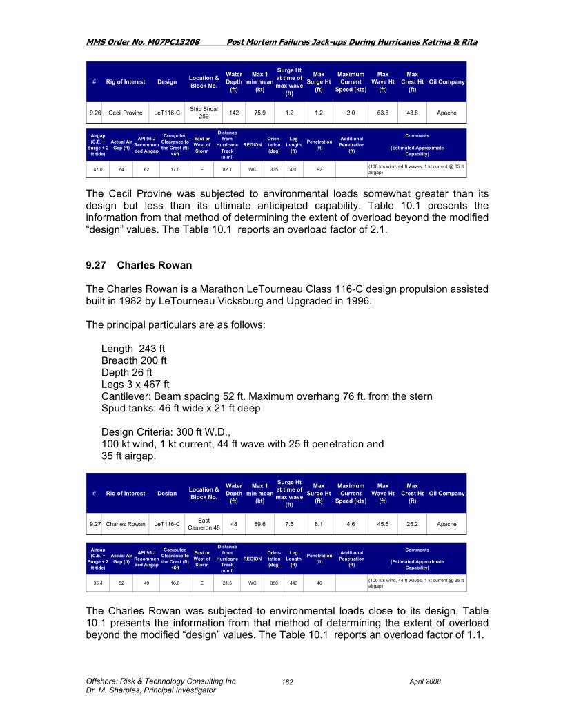
MMS Order No. M07PC13208 Post Mortem Failures Jack-ups During Hurricanes Katrina & Rita
Offshore: Risk & Technology Consulting Inc April 2008 Dr. M. Sharples, Principal Investigator
182
The Cecil Provine was subjected to environmental loads somewhat greater than its design but less than its ultimate anticipated capability. Table 10.1 presents the information from that method of determining the extent of overload beyond the modified “design” values. The Table 10.1 reports an overload factor of 2.1. 9.27 Charles Rowan The Charles Rowan is a Marathon LeTourneau Class 116-C design propulsion assisted built in 1982 by LeTourneau Vicksburg and Upgraded in 1996. The principal particulars are as follows:
Length 243 ft Breadth 200 ft Depth 26 ft Legs 3 x 467 ft Cantilever: Beam spacing 52 ft. Maximum overhang 76 ft. from the stern Spud tanks: 46 ft wide x 21 ft deep Design Criteria: 300 ft W.D., 100 kt wind, 1 kt current, 44 ft wave with 25 ft penetration and 35 ft airgap.
The Charles Rowan was subjected to environmental loads close to its design. Table 10.1 presents the information from that method of determining the extent of overload beyond the modified “design” values. The Table 10.1 reports an overload factor of 1.1.
# Rig of Interest Design Location & Block No.
Water Depth
(ft)
Max 1 min mean
(kt)
Surge Ht at time of max wave
(ft)
Max Surge Ht
(ft)
Maximum Current
Speed (kts)
Max Wave Ht
(ft)
Max Crest Ht
(ft)Oil Company
9.26 Cecil Provine LeT116-C Ship Shoal 259 142 75.9 1.2 1.2 2.0 63.8 43.8 Apache
Airgap (C.E. +
Surge + 2 ft tide)
Actual Air Gap (ft)
API 95 J Recommended Airgap
Computed Clearance to the Crest (ft)
<6ft
East or West of Storm
Distance from
Hurricane Track (n.mi)
REGIONOrien-tation (deg)
Leg Length
(ft)
Penetration (ft)
Additional Penetration
(ft)
Comments
(Estimated ApproximateCapability)
47.0 64 62 17.0 E 82.1 WC 335 410 92 (100 kts wind, 44 ft waves, 1 kt current @ 35 ft airgap)
# Rig of Interest Design Location & Block No.
Water Depth
(ft)
Max 1 min mean
(kt)
Surge Ht at time of max wave
(ft)
Max Surge Ht
(ft)
Maximum Current
Speed (kts)
Max Wave Ht
(ft)
Max Crest Ht
(ft)Oil Company
9.27 Charles Rowan LeT116-C East Cameron 48 48 89.6 7.5 8.1 4.6 45.6 25.2 Apache
Airgap (C.E. +
Surge + 2 ft tide)
Actual Air Gap (ft)
API 95 J Recommended Airgap
Computed Clearance to the Crest (ft)
<6ft
East or West of Storm
Distance from
Hurricane Track (n.mi)
REGIONOrien-tation (deg)
Leg Length
(ft)
Penetration (ft)
Additional Penetration
(ft)
Comments
(Estimated ApproximateCapability)
35.4 52 49 16.6 E 21.5 WC 350 443 40 (100 kts wind, 44 ft waves, 1 kt current @ 35 ft airgap)
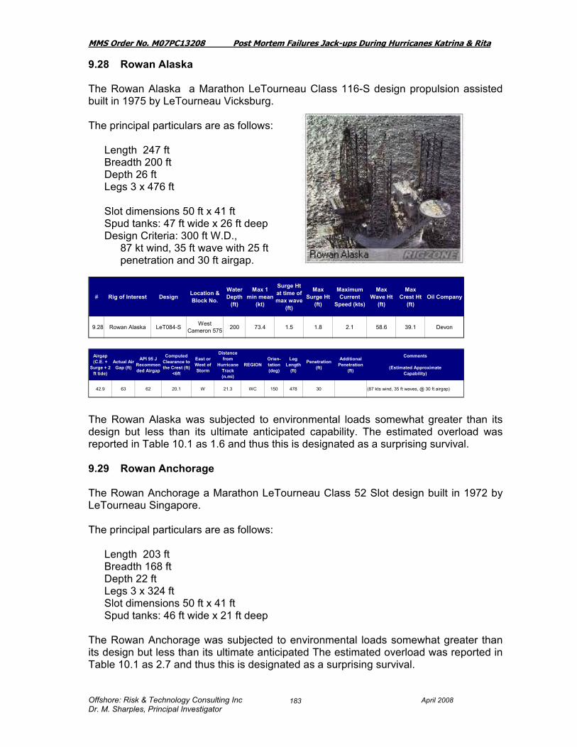
MMS Order No. M07PC13208 Post Mortem Failures Jack-ups During Hurricanes Katrina & Rita
Offshore: Risk & Technology Consulting Inc April 2008 Dr. M. Sharples, Principal Investigator
183
9.28 Rowan Alaska The Rowan Alaska a Marathon LeTourneau Class 116-S design propulsion assisted built in 1975 by LeTourneau Vicksburg. The principal particulars are as follows:
Length 247 ft Breadth 200 ft Depth 26 ft Legs 3 x 476 ft Slot dimensions 50 ft x 41 ft Spud tanks: 47 ft wide x 26 ft deep
Design Criteria: 300 ft W.D., 87 kt wind, 35 ft wave with 25 ft penetration and 30 ft airgap.
The Rowan Alaska was subjected to environmental loads somewhat greater than its design but less than its ultimate anticipated capability. The estimated overload was reported in Table 10.1 as 1.6 and thus this is designated as a surprising survival. 9.29 Rowan Anchorage The Rowan Anchorage a Marathon LeTourneau Class 52 Slot design built in 1972 by LeTourneau Singapore. The principal particulars are as follows:
Length 203 ft Breadth 168 ft Depth 22 ft Legs 3 x 324 ft Slot dimensions 50 ft x 41 ft Spud tanks: 46 ft wide x 21 ft deep
The Rowan Anchorage was subjected to environmental loads somewhat greater than its design but less than its ultimate anticipated The estimated overload was reported in Table 10.1 as 2.7 and thus this is designated as a surprising survival.
# Rig of Interest Design Location & Block No.
Water Depth
(ft)
Max 1 min mean
(kt)
Surge Ht at time of max wave
(ft)
Max Surge Ht
(ft)
Maximum Current
Speed (kts)
Max Wave Ht
(ft)
Max Crest Ht
(ft)Oil Company
9.28 Rowan Alaska LeT084-S West Cameron 575 200 73.4 1.5 1.8 2.1 58.6 39.1 Devon
Airgap (C.E. +
Surge + 2 ft tide)
Actual Air Gap (ft)
API 95 J Recommended Airgap
Computed Clearance to the Crest (ft)
<6ft
East or West of Storm
Distance from
Hurricane Track (n.mi)
REGIONOrien-tation (deg)
Leg Length
(ft)
Penetration (ft)
Additional Penetration
(ft)
Comments
(Estimated ApproximateCapability)
42.9 63 62 20.1 W 21.3 WC 150 478 30 (87 kts wind, 35 ft waves, @ 30 ft airgap)

MMS Order No. M07PC13208 Post Mortem Failures Jack-ups During Hurricanes Katrina & Rita
Offshore: Risk & Technology Consulting Inc April 2008 Dr. M. Sharples, Principal Investigator
184
9.30 Rowan California The Rowan California is a Marathon LeTourneau Class 116-C design propulsion assisted built in 1983 by LeTourneau Singapore. The principal particulars are as follows:
Length 243 ft Breadth 200 ft Depth 26 ft Legs 3 x 410 ft Cantilever: Beam spacing 52 ft. Maximum overhang 76 ft. from the stern Spud tanks: 46 ft wide x 21 ft deep
Design Criteria: 300 ft W.D., 100 kt wind, 1 kt current, 44 ft wave with 25 ft penetration
The Rowan California was subjected to environmental loads somewhat greater than its design but less than its ultimate anticipated capability. The estimated overload was reported in Table 10.1 as 1.5 and thus this is designated as a surprising survival.
# Rig of Interest Design Location & Block No.
Water Depth
(ft)
Max 1 min mean
(kt)
Surge Ht at time of max wave
(ft)
Max Surge Ht
(ft)
Maximum Current
Speed (kts)
Max Wave Ht
(ft)
Max Crest Ht
(ft)Oil Company
9.29 Rowan Anchorage LeT052 West
Cameron 444 105 69.3 1.8 2.1 2.4 49.3 34.1 Remington Oil & Gas
Airgap (C.E. +
Surge + 2 ft tide)
Actual Air Gap (ft)
API 95 J Recommended Airgap
Computed Clearance to the Crest (ft)
<6ft
East or West of Storm
Distance from
Hurricane Track (n.mi)
REGIONOrien-tation (deg)
Leg Length
(ft)
Penetration (ft)
Additional Penetration
(ft)
Comments
(Estimated ApproximateCapability)
38.2 80 62 41.8 W 28.2 WC 37 358 7 (87 kts wind, 35 ft waves, @ 30 ft airgap)
# Rig of Interest Design Location & Block No.
Water Depth
(ft)
Max 1 min mean
(kt)
Surge Ht at time of max wave
(ft)
Max Surge Ht
(ft)
Maximum Current
Speed (kts)
Max Wave Ht
(ft)
Max Crest Ht
(ft)Oil Company
9.30 Rowan California LeT116-C Eugene Island 182 94 75.8 2.6 3.2 3.3 54.7 36.2 Newfield
Exploration
Airgap (C.E. +
Surge + 2 ft tide)
Actual Air Gap (ft)
API 95 J Recommended Airgap
Computed Clearance to the Crest (ft)
<6ft
East or West of Storm
Distance from
Hurricane Track (n.mi)
REGIONOrien-tation (deg)
Leg Length
(ft)
Penetration (ft)
Additional Penetration
(ft)
Comments
(Estimated ApproximateCapability)
41.4 52 62 10.6 E 57.9 WC 340 410 65 (100 kts wind, 44 ft waves, 1 kt current @ 35 ft airgap)

MMS Order No. M07PC13208 Post Mortem Failures Jack-ups During Hurricanes Katrina & Rita
Offshore: Risk & Technology Consulting Inc April 2008 Dr. M. Sharples, Principal Investigator
185
9.31 Rowan Ft Worth The Rowan Fort Worth was a LeTourneau 116-C propulsion assisted, cantilever jack-up built in 1978 and a sister rig to the Rowan Paris and to the Rowan Halifax. The principal particulars are as follows:
Length 243 ft Breadth 200 ft Depth 26 ft Legs 3 x 477 ft Cantilever: Beam spacing 52 ft. Maximum overhang 76 ft. from the stern Spud tanks: 46 ft wide x 21 ft deep
Design Criteria: 300 ft W.D., 87 kt wind, 35 ft wave, 1 kt current with 25 ft penetration
“The Rowan Ft. Worth jack-up rig's legs collapsed and the hull floated off location during Hurricane Rita. Prior to the storm, the Rowan Ft. Worth was located at the South Marsh Island 146B 3-pile fixed platform. The hull was never located even though more than 1,200 square miles were searched as of July 2006. At the time of the hurricane, there were approximately 1,494 bbl of diesel oil on board in secured vessels” (Ref 39). “The Rowan Fort Worth and the Rowan Halifax were subjected to conditions that challenged their ultimate strength and in addition the soil conditions were such that significant additional settlement was possible if the preload vertical reaction was exceeded. Its failure was probably initiated by failure of the leg structure or elevating system with additional settlement of the legs” (Ref 28).
# Rig of Interest Design Location & Block No.
Water Depth
(ft)
Max 1 min mean
(kt)
Surge Ht at time of max wave
(ft)
Max Surge Ht
(ft)
Maximum Current
Speed (kts)
Max Wave Ht
(ft)
Max Crest Ht
(ft)Oil Company
9.31 Rowan Ft Worth LeT116-C S Marsh 146 230 92.8 1.7 2.1 3.3 72.9 49.2 Hunt
Airgap (C.E. +
Surge + 2 ft tide)
Actual Air Gap (ft)
API 95 J Recommended Airgap
Computed Clearance to the Crest (ft)
<6ft
East or West of Storm
Distance from
Hurricane Track (n.mi)
REGIONOrien-tation (deg)
Leg Length
(ft)
Penetration (ft)
Additional Penetration
(ft)
Comments
(Estimated ApproximateCapability)
53.3 73 0 19.7 E 25.4 WC 360 477 78 AfloatAll 3 legs failed and the rig floated off location and sank. (100 kts wind, 40 ft waves, 1 kt current)

MMS Order No. M07PC13208 Post Mortem Failures Jack-ups During Hurricanes Katrina & Rita
Offshore: Risk & Technology Consulting Inc April 2008 Dr. M. Sharples, Principal Investigator
186
Settlement of the leg may have started the sequence since this jackup has somewhat less preload than other less vintage vessels which might have similar wave forces. In an engineering study carried out for Rowan the following results were presented for the unity check on the vertical reaction and the overturning moment (Ref 28). “The loading on the rig would have been predominantly from the starboard side toward port for wind, wave, and current based on the bow-northerly orientation at this location. The soil conditions, would have withstood the preload-designed loads, below the 78 ft penetration, the soil shear strength increases only very modestly with depth. Thus once the preload value had been exceeded it would be anticipated that there would be an increase in penetration and as indicated in the table above the vertical reaction was calculated to be 1.7 times that used to site the rig. Additionally the calculated overturning moment is very large.” Table 10.1 indicates that the Rowan Fort Worth could have been loaded to something 4.3 times its design load. The overturning moment is close to 2 times the load when theoretically the windward leg releases its load. Thus the expectation is that the rig would not have survived. 9.32 Scooter Yeargain The Scooter Yeargain is described in Section 8.16 of this Report. The Scooter Yeargain was subjected to environmental loads less than its design in Hurricane Rita and thus the reader is referred to Table 7.2 and Table 10.1 for results.
Vertical ReactionUC
OTM Ratio
Rowan Fort Worth / Rita >1.70 1.97
# Rig of Interest Design Location & Block No.
Water Depth
(ft)
Max 1 min mean
(kt)
Surge Ht at time of max wave
(ft)
Max Surge Ht
(ft)
Maximum Current
Speed (kts)
Max Wave Ht
(ft)
Max Crest Ht
(ft)Oil Company
9.32 Scooter Yeargain Tarzan S Timbalier 168 49 69.0 1.6 1.6 2.0 56.2 36.5 Exxon Mobil
Airgap (C.E. +
Surge + 2 ft tide)
Actual Air Gap (ft)
API 95 J Recommended Airgap
Computed Clearance to the Crest (ft)
<6ft
East or West of Storm
Distance from
Hurricane Track (n.mi)
REGIONOrien-tation (deg)
Leg Length
(ft)
Penetration (ft)
Additional Penetration
(ft)
Comments
(Estimated ApproximateCapability)
40.0 71 49 31.0 E 93.9 WC 412 105 (100 kts wind, 50+ ft waves, 1 kt current)

MMS Order No. M07PC13208 Post Mortem Failures Jack-ups During Hurricanes Katrina & Rita
Offshore: Risk & Technology Consulting Inc April 2008 Dr. M. Sharples, Principal Investigator
187
9.33 Rowan Gorilla II The Gorilla II is a Letourneau 150-88-C Gorilla Class, self-elevating propulsion assisted jack-up built in LeTourneau Singapore in 1984. The principal particulars are as follows:
Length 297 ft Breadth 292 ft Depth 30 ft Legs 3 x 503 ft Spud Tanks 66 ft diameter requiring soil bearing of 7.25 ksf Design Criteria: 82.7 kt winds, 88 ft waves, 2 kt current with 65 ft airgap.
The Rowan Gorilla II was subjected to environmental loads less than its design and thus the reader is referred to Table 7.2 and Table 10.1 for results.
# Rig of Interest Design Location & Block No.
Water Depth
(ft)
Max 1 min mean
(kt)
Surge Ht at time of max wave
(ft)
Max Surge Ht
(ft)
Maximum Current
Speed (kts)
Max Wave Ht
(ft)
Max Crest Ht
(ft)Oil Company
9.33 Rowan Gorilla II Gorilla SM 166 261 101.5 1.8 2.0 3.5 74.2 49.6 ATP
Airgap (C.E. +
Surge + 2 ft tide)
Actual Air Gap (ft)
API 95 J Recommended Airgap
Computed Clearance to the Crest (ft)
<6ft
East or West of Storm
Distance from
Hurricane Track (n.mi)
REGIONOrien-tation (deg)
Leg Length
(ft)
Penetration (ft)
Additional Penetration
(ft)
Comments
(Estimated ApproximateCapability)
53.6 60 62 6.4 E 15.9 WC 280 638 43 (100 kts wind, 80+ ft waves, 1 kt current @ 60 ft airgap)

MMS Order No. M07PC13208 Post Mortem Failures Jack-ups During Hurricanes Katrina & Rita
Offshore: Risk & Technology Consulting Inc April 2008 Dr. M. Sharples, Principal Investigator
188
Photo 9.33.1: Rowan Gorilla II in Halifax Harbor (Ref 29) 9.34 Rowan Gorilla III The Gorilla III is a Letourneau 150-88-C Gorilla Class, self-elevating propulsion assisted jack-up built in Vicksburg in 1985. Shown in the photo the rig is offshore Nova Scotia. The principal particulars are as follows:
Length 297 ft Breadth 292 ft Depth 30 ft Legs 3 x 504 ft Spud Tanks 66 ft diameter requiring soil bearing of 7.25 ksf Design Criteria: 100 kt winds,
81 ft waves, with 55 ft airgap and 25 ft penetration.

MMS Order No. M07PC13208 Post Mortem Failures Jack-ups During Hurricanes Katrina & Rita
Offshore: Risk & Technology Consulting Inc April 2008 Dr. M. Sharples, Principal Investigator
189
The Rowan Gorilla III was subjected to environmental loads less than its design and thus the reader is referred to Table 7.2 and Table 10.1 for results. 9.35 Rowan Gorilla IV The Gorilla IV is a Letourneau 150-88-C Gorilla Class, self-elevating propulsion assisted jack-up built in Vicksburg in 1986. The principal particulars are as follows:
Length 297 ft Breadth 292 ft Depth 30 ft Legs 3 x 504 ft Spud Tanks 66 ft diameter requiring soil bearing of 7.25 ksf Design Criteria: 82.7 kt winds, 88 ft waves,
with 2 kts current.
The Rowan Gorilla IV was subjected to environmental loads less than its design and thus the reader is referred to Table 7.2 and Table 10.1 for results.
# Rig of Interest Design Location & Block No.
Water Depth
(ft)
Max 1 min mean
(kt)
Surge Ht at time of max wave
(ft)
Max Surge Ht
(ft)
Maximum Current
Speed (kts)
Max Wave Ht
(ft)
Max Crest Ht
(ft)Oil Company
9.34 Rowan Gorilla III Gorilla Vermillion 267/268 170 71.2 1.8 2.3 2.5 52.7 36.4 Stone Energy
Airgap (C.E. +
Surge + 2 ft tide)
Actual Air Gap (ft)
API 95 J Recommended Airgap
Computed Clearance to the Crest (ft)
<6ft
East or West of Storm
Distance from
Hurricane Track (n.mi)
REGIONOrien-tation (deg)
Leg Length
(ft)
Penetration (ft)
Additional Penetration
(ft)
Comments
(Estimated ApproximateCapability)
40.7 70 62 29.3 E 22.6 WC 95 503 53 (100 kts wind, 85+ ft waves, 1 kt current @ 65 ft airgap)
# Rig of Interest Design Location & Block No.
Water Depth
(ft)
Max 1 min mean
(kt)
Surge Ht at time of max wave
(ft)
Max Surge Ht
(ft)
Maximum Current
Speed (kts)
Max Wave Ht
(ft)
Max Crest Ht
(ft)Oil Company
9.35 Rowan Gorilla IV Gorilla Ship Shoal 349/359 365 85.5 0.9 0.9 1.3 75.1 47.8 W &T
Offshore
Airgap (C.E. +
Surge + 2 ft tide)
Actual Air Gap (ft)
API 95 J Recommended Airgap
Computed Clearance to the Crest (ft)
<6ft
East or West of Storm
Distance from
Hurricane Track (n.mi)
REGIONOrien-tation (deg)
Leg Length
(ft)
Penetration (ft)
Additional Penetration
(ft)
Comments
(Estimated ApproximateCapability)
50.7 89 62 38.3 E 58.2 WC 316 605 55 (100 kts wind, 79 ft waves, 1 kt current)

MMS Order No. M07PC13208 Post Mortem Failures Jack-ups During Hurricanes Katrina & Rita
Offshore: Risk & Technology Consulting Inc April 2008 Dr. M. Sharples, Principal Investigator
190
9.36 Rowan Halifax The Rowan Halifax was a LeTourneau 116-C propulsion assisted, cantilever jack-up built in 1978 and a sister rig to the Rowan Paris and to the Rowan Fort Worth. The principal particulars are as follows:
Length 243 ft Breadth 200 ft Depth 26 ft Legs 3 x 477 ft Cantilever: Beam spacing 52 ft. Maximum overhang 76 ft. from the stern Spud tanks: 46 ft wide x 21 ft deep
The soil report showed considerable variability between different sampling methods while also showing generally increasing strength with depth. The very soft to hard clay could well have given way to further penetration under the increased load after the preload values were exceeded, particularly when the values to which the spud can would have been loaded were increased to a factor of 1.7. In an engineering study carried out for Rowan the following results were presented for the unity check on the vertical reaction and the overturning moment (Ref 28).
# Rig of Interest Design Location & Block No.
Water Depth
(ft)
Max 1 min mean
(kt)
Surge Ht at time of max wave
(ft)
Max Surge Ht
(ft)
Maximum Current
Speed (kts)
Max Wave Ht
(ft)
Max Crest Ht
(ft)Oil Company
9.36 Rowan Halifax LeT116-C East Cameron 346 306 87.7 1.5 2.4 2.3 69.5 44.3 Remington Oil
& Gas
Airgap (C.E. +
Surge + 2 ft tide)
Actual Air Gap (ft)
API 95 J Recommended Airgap
Computed Clearance to the Crest (ft)
<6ft
East or West of Storm
Distance from
Hurricane Track (n.mi)
REGIONOrien-tation (deg)
Leg Length
(ft)
Penetration (ft)
Additional Penetration
(ft)
Comments
(Estimated ApproximateCapability)
48.7 70 62 21.3 W 9.1 WC 335 477 42 ft bow; 44 ft stern Afloat
All 3 legs failed and the rig floated off location and sank. Total Loss(100 kts wind, 48 ft waves, 0 kt current )

MMS Order No. M07PC13208 Post Mortem Failures Jack-ups During Hurricanes Katrina & Rita
Offshore: Risk & Technology Consulting Inc April 2008 Dr. M. Sharples, Principal Investigator
191
“The Rowan Fort Worth and the Rowan Halifax were subjected to conditions that challenged their ultimate strength and in addition the soil conditions were such that significant additional settlement was possible if the preload vertical reaction was exceeded. Its failure was probably initiated by failure of the leg structure or elevating system with additional settlement of the legs” (Ref 28). In the environmental conditions that the Rowan Halifax saw it would be classified as an expected failure as show in the Table 10.1. The overload was calculated to be approximately 3 times more than the design capability. 9.37 Rowan Juneau The Rowan Juneau is a Marathon LeTourneau Class 116-S design propulsion assisted built in 1977 by LeTourneau Vicksburg. The principal particulars are as follows:
Length 243 ft Breadth 200 ft Depth 26 ft Legs 3 x 343 ft Slot 50 ft x 41 f Spud tanks: 46 ft wide x 26 ft deep Classification: American Bureau of Shipping Design Criteria: 100 kts wind, 50 ft wave, with Airgap 45 ft and leg penetration 35 ft.
The Rowan Juneau was subjected to environmental loads less than its design and thus the reader is referred to Table 7.2 and Table 10.1 for results.
Vertical ReactionUC
OTM Ratio
Halifax / Rita 1.70 2.60
# Rig of Interest Design Location & Block No.
Water Depth
(ft)
Max 1 min mean
(kt)
Surge Ht at time of max wave
(ft)
Max Surge Ht
(ft)
Maximum Current
Speed (kts)
Max Wave Ht
(ft)
Max Crest Ht
(ft)Oil Company
9.37 Rowan Juneau LeT116-SE West Cameron 295 49 58.1 6.4 6.5 4.2 40.1 24.2 Cimarex
Energy
Airgap (C.E. +
Surge + 2 ft tide)
Actual Air Gap (ft)
API 95 J Recommended Airgap
Computed Clearance to the Crest (ft)
<6ft
East or West of Storm
Distance from
Hurricane Track (n.mi)
REGIONOrien-tation (deg)
Leg Length
(ft)
Penetration (ft)
Additional Penetration
(ft)
Comments
(Estimated ApproximateCapability)
32.7 46 49 13.3 W 8.6 WC 222 343 15 (100 kts wind, 50 ft waves, 0 kt current )

MMS Order No. M07PC13208 Post Mortem Failures Jack-ups During Hurricanes Katrina & Rita
Offshore: Risk & Technology Consulting Inc April 2008 Dr. M. Sharples, Principal Investigator
192
9.38 Rowan Louisiana The Rowan Louisiana is a LeTourneau 84-S self –elevating, propulsion assisted, slot type jack-up. The principal particulars are as follows:
Length 247 ft Breadth 200 ft Depth 24 ft Legs 3 x 477 square truss Design Criteria: 100 kts wind, 35 ft wave, with Airgap 35 ft and leg penetration 25 ft.
The Rowan Louisiana was found 103 mi NW of its original location near Cameron Louisiana. The drift direction can be seen on the Figures 9.3 and 9.4.
Airgap (C.E. +
Surge + 2 ft tide)
Actual Air Gap (ft)
API 95 J Recommended Airgap
Computed Clearance to the Crest (ft)
<6ft
East or West of Storm
Distance from
Hurricane Track (n.mi)
REGIONOrien-tation (deg)
Leg Length
(ft)
Penetration (ft)
Additional Penetration
(ft)
Comments
(Estimated ApproximateCapability)
52.8 50 62 -2.8 E 8.7 WC 388 466 62 Afloat
Wave would have hit hull. All 3 legs failed and the rig floated off location and beached off Cameron Louisiana. Repaired and returned to service(100 kts wind, 40 ft wave ht)
# Rig of Interest Design Location & Block No.
Water Depth
(ft)
Max 1 min mean
(kt)
Surge Ht at time of max wave
(ft)
Max Surge Ht
(ft)
Maximum Current
Speed (kts)
Max Wave Ht
(ft)
Max Crest Ht
(ft)Oil Company
9.38 Rowan Louisiana LeT084-S Vermillion 338 230 99.8 1.9 2.8 3.5 71.6 48.0 Devon

MMS Order No. M07PC13208 Post Mortem Failures Jack-ups During Hurricanes Katrina & Rita
Offshore: Risk & Technology Consulting Inc April 2008 Dr. M. Sharples, Principal Investigator
193
Photo 9.38.1 Rowan Louisiana as located after the storm Based on comparing the rig’s design values to what it saw in the storm it was overload to about 3.2 times its “design capability” as reported in Table 10.1 and thus is an expected failure. It is also likely that the hull was impinged on by the storm since based on calculation the jack-up would have had negative airgap. The combination of overload and additional wave forces, if any, on the hull, would have made this an expected failure. In an engineering study carried out for Rowan the following results were presented for the unity check on the vertical reaction and the overturning moment” (Ref 28). “The Rowan Louisiana was subjected to conditions that challenged its ultimate strength and showed high unity check for the leg chords even under the assumption of full initial fixity without degradation. In addition, it is likely to have been subjected to wave impingement on the deck. Its failure was probably initiated by failure of the leg chords near lower guides. APPEAR TO BE CONFIRMED AFTER RECOVERY OF HULL” (Ref 28).
Vertical ReactionUC
OTM Ratio
Rowan Louisiana / Rita 1.34 1.79

MMS Order No. M07PC13208 Post Mortem Failures Jack-ups During Hurricanes Katrina & Rita
Offshore: Risk & Technology Consulting Inc April 2008 Dr. M. Sharples, Principal Investigator
194
Figure 9.38.2 shows a hole made by the spud can being dragged as the Rowan Louisiana collapsed, and the hull floated off. (Ref 28). Salvage of Rowan Louisiana The Rowan Louisiana was salvaged by specialists Bisso Marine and floated to R&R Marine Fabrication and Drydock in Port Arthur, Texas. By 2007 the vessel was repaired and crews were drilling in the Gulf of Mexico. The extraction of the legs from the seabottom and retrieving the sections that were left behind after the Rowan Louisiana collapsed was carried out by the Bisso Marine salvage team who extracted, leg and can sections that remained penetrated into the sea floor. The 130-foot-long leg and can sections each weighed about 425 tons and were in 230 feet of water, and each had 62 feet of penetration initially, though Bisso reported that there was 82 ft of penetration for the salvage. The following depicts the situation as Bisso saw it: (Ref 40; www.bissomarine.com)
Hole from drag of spud can

MMS Order No. M07PC13208 Post Mortem Failures Jack-ups During Hurricanes Katrina & Rita
Offshore: Risk & Technology Consulting Inc April 2008 Dr. M. Sharples, Principal Investigator
195
“In late 2005, while using the D/B BOAZ, BISSO MARINE had previously removed approximately 235’ of leg from each of the three 84 Class legs which protruded into the water column near the surface and were viewed as a possible hazard to navigation by their owner. Since early 2006, BISSO MARINE has been working in a collaborative effort with the rig owner to assemble a BISSO MARINE designed barge having the capability to physically pull the Leg and Can sections from their deeply penetrated location. The BARGE 415 is designed with a maximum pull of 3,000 tons over the stern and has a side lift capability of 5,000 tons.
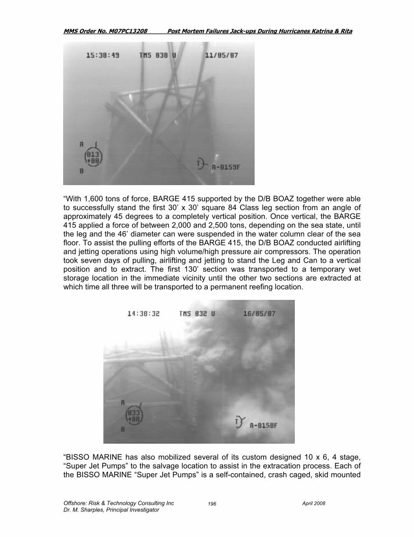
MMS Order No. M07PC13208 Post Mortem Failures Jack-ups During Hurricanes Katrina & Rita
Offshore: Risk & Technology Consulting Inc April 2008 Dr. M. Sharples, Principal Investigator
196
“With 1,600 tons of force, BARGE 415 supported by the D/B BOAZ together were able to successfully stand the first 30’ x 30’ square 84 Class leg section from an angle of approximately 45 degrees to a completely vertical position. Once vertical, the BARGE 415 applied a force of between 2,000 and 2,500 tons, depending on the sea state, until the leg and the 46’ diameter can were suspended in the water column clear of the sea floor. To assist the pulling efforts of the BARGE 415, the D/B BOAZ conducted airlifting and jetting operations using high volume/high pressure air compressors. The operation took seven days of pulling, airlifting and jetting to stand the Leg and Can to a vertical position and to extract. The first 130’ section was transported to a temporary wet storage location in the immediate vicinity until the other two sections are extracted at which time all three will be transported to a permanent reefing location.
“BISSO MARINE has also mobilized several of its custom designed 10 x 6, 4 stage, “Super Jet Pumps” to the salvage location to assist in the extracation process. Each of the BISSO MARINE “Super Jet Pumps” is a self-contained, crash caged, skid mounted

MMS Order No. M07PC13208 Post Mortem Failures Jack-ups During Hurricanes Katrina & Rita
Offshore: Risk & Technology Consulting Inc April 2008 Dr. M. Sharples, Principal Investigator
197
portable unit capable of delivering 2,800 GPM at 1,150 PSI at the nozzle tip. The “Super Jet Pumps” are each powered by 1,600 HP Cummins KTA50.
“BISSO MARINE is under contract to extract and transport a total of fifteen LeTourneau, Inc. designed legs with cans to various reef locations. The fifteen LeTourneau, Inc. legs and cans are a combination of (6) 116-C Class, (3) 116 Class, (3) 84 Class and (3) 52 Class. The water depths range between 155 feet and 320 feet at five separate locations across the Gulf of Mexico”.

MMS Order No. M07PC13208 Post Mortem Failures Jack-ups During Hurricanes Katrina & Rita
Offshore: Risk & Technology Consulting Inc April 2008 Dr. M. Sharples, Principal Investigator
198
Photo 9.38.3: “Prior to working once more in the Gulf of Mexico, crews finish refurbishing the LOUISIANA at the Sabine Pass, Texas yard.”
The Rowan Louisiana was refurbished. “ In addition to a full restoration, some improvements were made in the rig, including increasing hook load capacity to 1.5 million pounds and upping power by 1,100 HP.The rig’s hull has been strengthened, while capacities, and load capabilities have been increased” (Ref 41).

MMS Order No. M07PC13208 Post Mortem Failures Jack-ups During Hurricanes Katrina & Rita
Offshore: Risk & Technology Consulting Inc April 2008 Dr. M. Sharples, Principal Investigator
199
9.39 Rowan Middletown The Rowan Middleton is a LeTourneau Class 116-C, propulsion assisted, cantilever jack-up built in Vicksburg Mississippi in 1980. The principal particulars are: Length 243 ft
Breadth 200 ft Depth 26 ft Legs 3 x 477 ft
Spud Tanks 46 ft diameter, 26 ft high Design Criteria: 100 kts wind,
48 ft waves, 0 current with 35 ft air gap
The Rowan Middletown was subjected to environmental loads less than its design and thus the reader is referred to Table 7.2 and Table 10.1 for results.
# Rig of Interest Design Location & Block No.
Water Depth
(ft)
Max 1 min mean
(kt)
Surge Ht at time of max wave
(ft)
Max Surge Ht
(ft)
Maximum Current
Speed (kts)
Max Wave Ht
(ft)
Max Crest Ht
(ft)Oil Company
9.39 Rowan Middletown LeT116-C High Island
A528 200 53.7 0.8 0.8 1.6 42.2 27.1 Arena Offshore
Airgap (C.E. +
Surge + 2 ft tide)
Actual Air Gap (ft)
API 95 J Recommended Airgap
Computed Clearance to the Crest (ft)
<6ft
East or West of Storm
Distance from
Hurricane Track (n.mi)
REGIONOrien-tation (deg)
Leg Length
(ft)
Penetration (ft)
Additional Penetration
(ft)
Comments
(Estimated ApproximateCapability)
29.9 79 62 49.1 W 74.5 WC 346 477 28 (100 kts wind, 40 ft waves, 1 kt current)

MMS Order No. M07PC13208 Post Mortem Failures Jack-ups During Hurricanes Katrina & Rita
Offshore: Risk & Technology Consulting Inc April 2008 Dr. M. Sharples, Principal Investigator
200
9.40 Rowan Odessa The Rowan Odessa was a LeTourneau Class 116-S, propulsion assisted, jack-up built in Vicksburg Mississippi in 1977. The principal particulars are:
Length 247 ft Breadth 200 ft Depth 26 ft Legs 3 x 477 ft
Spud Tanks 46 ft diameter, 26 ft high
The Rowan Odessa jack-up rig's legs collapsed and the hull floated off location during Hurricane Rita. The hull was located after the hurricane in Ship Shoal 247, six miles from the Rowan Odessa's pre-storm location in Ship Shoal 250. At the time of the hurricane, there were approximately 1,819 bbl of petroleum on board in secured vessels. Extensive recovery operations by Rowan Companies in the Spring and Summer of 2006 resulted in the recovery of roughly 221.1 bbl of diesel oil and 26.2 bbl of other refined products. An estimated 1,571.7 bbl of petroleum products were lost.
In an engineering study carried out for Rowan the following results were presented for the unity check on the vertical reaction and the overturning moment (Ref 28). The estimated overload was reported in Table 10.1 as 2.2 times the design limits.
Vertical Reaction UC
OTM Ratio
Rowan Odessa / Rita 1.42 1.48
# Rig of Interest Design Location & Block No.
Water Depth
(ft)
Max 1 min mean
(kt)
Surge Ht at time of max wave
(ft)
Max Surge Ht
(ft)
Maximum Current
Speed (kts)
Max Wave Ht
(ft)
Max Crest Ht
(ft)Oil Company
9.40 Rowan Odessa LeT 116S SS250 178 79.6 1.6 1.8 2.9 64.9 44.5 Remington Oil & Gas
Airgap (C.E. +
Surge + 2 ft tide)
Actual Air Gap (ft)
API 95 J Recommended Airgap
Computed Clearance to the Crest (ft)
<6ft
East or West of Storm
Distance from
Hurricane Track (n.mi)
REGIONOrien-tation (deg)
Leg Length
(ft)
Penetration (ft)
Additional Penetration
(ft)
Comments
(Estimated ApproximateCapability)
48.3 80 62 31.7 0 63.4 WC 55 477 89 AfloatSank Declared Total Loss(100 kts wind, 45 ft waves, 1 kt current @ 35 ft airgap)

MMS Order No. M07PC13208 Post Mortem Failures Jack-ups During Hurricanes Katrina & Rita
Offshore: Risk & Technology Consulting Inc April 2008 Dr. M. Sharples, Principal Investigator
201
9.41 Rowan Paris The Rowan Paris was described in Section 8.19 of this report. The Design criteria was for 87 kt winds, 35 ft waves, and 0 current with an airgap of 35 ft. The Rowan Paris was subjected to environmental loads less than its design and thus the reader is referred to Table 7.2 and Table 10.1 for results. The Rowan Paris was subjected to extreme loads in Hurricane Katrina but survived. 9.42 GSF Main Pass I The GSF Main Pass I is a Friede & Goldman L-780-Mod II design built in 1982. The principal particulars are as follows:
Length 180 ft Breadth 175 ft Hull Depth 25 ft Spud can diameter 40 ft. Legs 3 x 416 ft. long triangular Operating water depth 300 ft. Maximum cantilever extension (transom to rotary) 40 ft. Design Criteria 100 kts wind and 50 ft waves
# Rig of Interest Design Location & Block No.
Water Depth
(ft)
Max 1 min mean
(kt)
Surge Ht at time of max wave
(ft)
Max Surge Ht
(ft)
Maximum Current
Speed (kts)
Max Wave Ht
(ft)
Max Crest Ht
(ft)Oil Company
9.41 Rowan Paris LeT116-C Main Pass 140-A 158 41.9 0.6 0.7 1.7 35.1 22.8 Apache
Airgap (C.E. +
Surge + 2 ft tide)
Actual Air Gap (ft)
API 95 J Recommended Airgap
Computed Clearance to the Crest (ft)
<6ft
East or West of Storm
Distance from
Hurricane Track (n.mi)
REGIONOrien-tation (deg)
Leg Length
(ft)
Penetration (ft)
Additional Penetration
(ft)
Comments
(Estimated ApproximateCapability)
25.5 55 62 29.5 E 188.2 Central 52 477 96 (100 kts wind, 45 ft waves, 1 kt current @ 35 ft airgap)

MMS Order No. M07PC13208 Post Mortem Failures Jack-ups During Hurricanes Katrina & Rita
Offshore: Risk & Technology Consulting Inc April 2008 Dr. M. Sharples, Principal Investigator
202
No damage was noted to the Main Pass 1. The rig was well within its design capability of 50 ft waves in 300 ft of water since it was only in 25 ft of water with a much less wave. The shallow water waves peak with a higher crest elevation as they move toward becoming a breaking wave, and move toward the coast: the data provided from the weather studies would need to be modified before further understanding could be obtained. An engineering study commissioned by the owners observed the following: “The GSF Main Pass I was located exactly on the hurricane’s path very close to the coast. The rig was placed on a heading of 181 degrees in just 25 feet of water. The worst environmental conditions were seen from the port side, thus producing the maximum footing reaction at the starboard leg. No over utilisations were reported by the JUSTAS computer program and no settlement was predicted. No damage was reported. It should be noted that, in accordance with standard practice, this analysis used wave heights reduced from those reported by OceanWeather/schaudt•us as these were beyond the breaking limit for the water depth at the location. The GSF Main Pass I was analysed in 25ft water depth with a 47ft airgap. The draft GoMex Annex does not give airgap requirements for such shallow water depths but it is assumed that the rig was above the minimum airgap. Several problems became apparent in the analyses relating to the shallow water.
• The wave heights quoted by Ocean Weather were above the breaking limit so the wave heights used were reduced to the breaking limit.
• The kinematics reduction factor was greater than 1.0; i.e., it resulted in an increase into the wave loading.
The GSF Main Pass I satisfied the GoMex Annex structural criteria for both the Assessment and the Contingency criteria with very low utilisations. The foundation checks showed no over-utilisations in bearing or sliding capacity. Thus the GSF Main Pass I would have complied with the GoMex Annex requirements at the West Cameron Location” (Ref 35).
Oil Company
Airgap (C.E. +
Surge + 2 ft tide)
Actual Air Gap (ft)
API 95 J Recommended Airgap
Computed Clearance to the Crest (ft)
<6ft
East or West of Storm
Distance from
Hurricane Track (n.mi)
REGIONOrien-tation (deg)
Leg Length
(ft)
Chevron 23.0 47 46.5 24.0 W 1.1 181 416
# Rig of Interest Design Location & Block No.
Water Depth
(ft)
Max 1 min mean
(kt)
Surge Ht at time of max wave
(ft)
Max Surge Ht
(ft)
Maximum Current
Speed (kts)
Max Wave Ht
(ft)
Max Crest Ht
(ft)
9.42 GSF Main Pass 1 F&G Mod II West Cameron 18 25 63.4 11.0 12.2 1.6 15.1 8.8
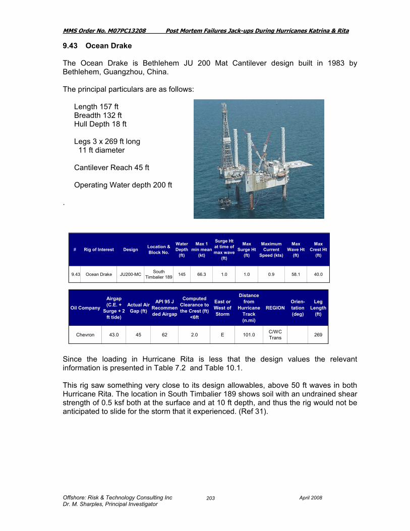
MMS Order No. M07PC13208 Post Mortem Failures Jack-ups During Hurricanes Katrina & Rita
Offshore: Risk & Technology Consulting Inc April 2008 Dr. M. Sharples, Principal Investigator
203
9.43 Ocean Drake The Ocean Drake is Bethlehem JU 200 Mat Cantilever design built in 1983 by Bethlehem, Guangzhou, China. The principal particulars are as follows:
Length 157 ft Breadth 132 ft Hull Depth 18 ft Legs 3 x 269 ft long 11 ft diameter Cantilever Reach 45 ft Operating Water depth 200 ft
. Since the loading in Hurricane Rita is less that the design values the relevant information is presented in Table 7.2 and Table 10.1. This rig saw something very close to its design allowables, above 50 ft waves in both Hurricane Rita. The location in South Timbalier 189 shows soil with an undrained shear strength of 0.5 ksf both at the surface and at 10 ft depth, and thus the rig would not be anticipated to slide for the storm that it experienced. (Ref 31).
# Rig of Interest Design Location & Block No.
Water Depth
(ft)
Max 1 min mean
(kt)
Surge Ht at time of max wave
(ft)
Max Surge Ht
(ft)
Maximum Current
Speed (kts)
Max Wave Ht
(ft)
Max Crest Ht
(ft)
9.43 Ocean Drake JU200-MC South Timbalier 189 145 66.3 1.0 1.0 0.9 58.1 40.0
Oil Company
Airgap (C.E. +
Surge + 2 ft tide)
Actual Air Gap (ft)
API 95 J Recommended Airgap
Computed Clearance to the Crest (ft)
<6ft
East or West of Storm
Distance from
Hurricane Track (n.mi)
REGIONOrien-tation (deg)
Leg Length
(ft)
Chevron 43.0 45 62 2.0 E 101.0 C/WC Trans 269
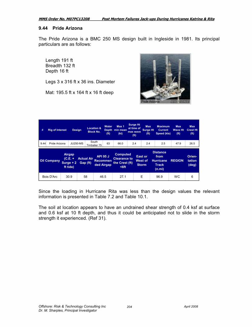
MMS Order No. M07PC13208 Post Mortem Failures Jack-ups During Hurricanes Katrina & Rita
Offshore: Risk & Technology Consulting Inc April 2008 Dr. M. Sharples, Principal Investigator
204
9.44 Pride Arizona The Pride Arizona is a BMC 250 MS design built in Ingleside in 1981. Its principal particulars are as follows:
Length 191 ft Breadth 132 ft Depth 16 ft Legs 3 x 316 ft x 36 ins. Diameter Mat: 195.5 ft x 164 ft x 16 ft deep
Since the loading in Hurricane Rita was less than the design values the relevant information is presented in Table 7.2 and Table 10.1. The soil at location appears to have an undrained shear strength of 0.4 ksf at surface and 0.6 ksf at 10 ft depth, and thus it could be anticipated not to slide in the storm strength it experienced. (Ref 31).
# Rig of Interest Design Location & Block No.
Water Depth
(ft)
Max 1 min mean
(kt)
Surge Ht at time of max wave
(ft)
Max Surge Ht
(ft)
Maximum Current
Speed (kts)
Max Wave Ht
(ft)
Max Crest Ht
(ft)
9.44 Pride Arizona JU250-MS South Timbalier 75 63 66.0 2.4 2.4 2.5 47.9 26.5
Oil Company
Airgap (C.E. +
Surge + 2 ft tide)
Actual Air Gap (ft)
API 95 J Recommended Airgap
Computed Clearance to the Crest (ft)
<6ft
East or West of Storm
Distance from
Hurricane Track (n.mi)
REGIONOrien-tation (deg)
Bois D'Arc 30.9 58 46.5 27.1 E 96.9 WC 6

MMS Order No. M07PC13208 Post Mortem Failures Jack-ups During Hurricanes Katrina & Rita
Offshore: Risk & Technology Consulting Inc April 2008 Dr. M. Sharples, Principal Investigator
205
9.45 Pride Florida The Pride Florida is a Bethlehem JU 200 MC built in Beaumont in 1981 The principal particulars are as follows:
Length 157 ft Breadth 132 ft Hull Depth 18 ft Legs 3 x 269 ft long 11 ft diameter Cantilever Reach 45' Operating Water depth 200 ft
It was reported that the rig moved off locaton about 40 ft +. There were some broken 2” lines in the leg. An underwater inspection on the mat confirmed there was no damage. The soil at location appears to have an undrained shear strength of <0.2 ksf at surface and 0.6 ksf at 10 ft depth, and thus it could be probably have been anticipated that in the extreme waves, wind and current that the rig occasioned, it might be anticipated to slide. (Ref 31). Since the loading in Hurricane Rita/Katrina was less than the design values the relevant information is presented in Table 7.2 and Table 10.1.
# Rig of Interest Design Location & Block No.
Water Depth
(ft)
Max 1 min mean
(kt)
Surge Ht at time of max wave
(ft)
Max Surge Ht
(ft)
Maximum Current
Speed (kts)
Max Wave Ht
(ft)
Max Crest Ht
(ft)Oil Company
9.45 Pride Florida JU200-MC Ship Shoal 177 96 76.7 2.2 2.5 3.2 56.7 37.5 W&T Offshore
Airgap (C.E. +
Surge + 2 ft tide)
Actual Air Gap (ft)
API 95 J Recommended Airgap
Computed Clearance to the Crest (ft)
<6ft
East or West of Storm
Distance from
Hurricane Track (n.mi)
REGIONOrien-tation (deg)
Leg Length
(ft)
Comments
(Estimated ApproximateCapability)
42.1 62 62 19.9 E 68.2 WC 269 Jack-up slid off location

MMS Order No. M07PC13208 Post Mortem Failures Jack-ups During Hurricanes Katrina & Rita
Offshore: Risk & Technology Consulting Inc April 2008 Dr. M. Sharples, Principal Investigator
206
9.46 Pride Kansas The Pride Kansas is a Bethlehem 250 MC built in Singapore in 1976 as the Western Polaris II. The principal particulars are as follows:
Length 166 ft Breadth 109 ft Hull Depth 16 ft Legs 3 x 312 ft long x 12 ft diameter Operating Water depth 250 ft Mat 210 ft x 170 ft x 10ft plus 2 ft scour skirt
It was reported that there were broken windows in both cranes, and radiator damage from flying debris. An underwater inspection revealed that although there was no damage to the mat, there was some minor scouring on the starboard side of the mat. The soil at location appears to have an undrained shear strength of 0.7 ksf at surface and 0.8 ksf at 10 ft depth, and thus it could be anticipated not to slide in the storm strength it experienced. (Ref 31). Since the loading in Hurricane Rita was less than the design values the relevant information is presented in Table 7.2 and Table 10.1.
# Rig of Interest Design Location & Block No.
Water Depth
(ft)
Max 1 min mean
(kt)
Surge Ht at time of max wave
(ft)
Max Surge Ht
(ft)
Maximum Current
Speed (kts)
Max Wave Ht
(ft)
Max Crest Ht
(ft)
9.46 Pride Kansas JU250-MC Ship Shoal 181 72 59.2 0.6 0.6 0.4 53.8 32.9
Oil Company
Airgap (C.E. +
Surge + 2 ft tide)
Actual Air Gap (ft)
API 95 J Recommended Airgap
Computed Clearance to the Crest (ft)
<6ft
East or West of Storm
Distance from
Hurricane Track (n.mi)
REGIONOrien-tation (deg)
Chevron 35.5 52 55 16.5 E 117.6 C/WC Trans 350
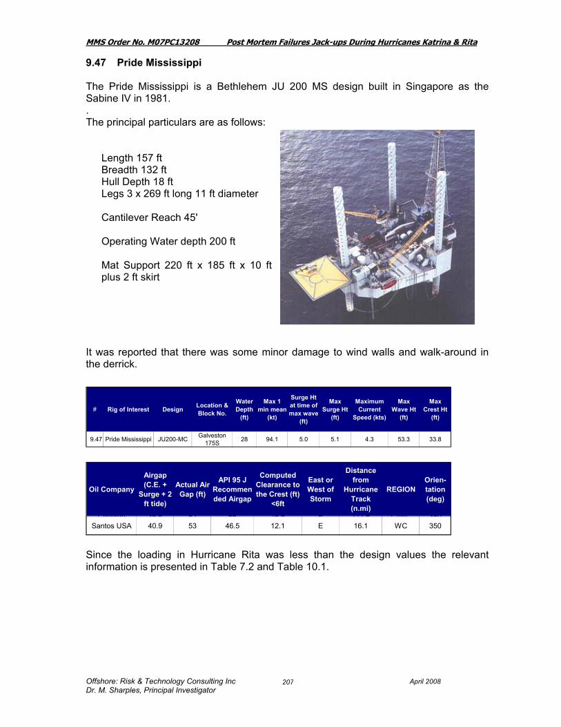
MMS Order No. M07PC13208 Post Mortem Failures Jack-ups During Hurricanes Katrina & Rita
Offshore: Risk & Technology Consulting Inc April 2008 Dr. M. Sharples, Principal Investigator
207
9.47 Pride Mississippi The Pride Mississippi is a Bethlehem JU 200 MS design built in Singapore as the Sabine IV in 1981. . The principal particulars are as follows:
Length 157 ft Breadth 132 ft Hull Depth 18 ft Legs 3 x 269 ft long 11 ft diameter Cantilever Reach 45' Operating Water depth 200 ft Mat Support 220 ft x 185 ft x 10 ft plus 2 ft skirt
It was reported that there was some minor damage to wind walls and walk-around in the derrick. Since the loading in Hurricane Rita was less than the design values the relevant information is presented in Table 7.2 and Table 10.1.
Oil Company
Airgap (C.E. +
Surge + 2 ft tide)
Actual Air Gap (ft)
API 95 J Recommended Airgap
Computed Clearance to the Crest (ft)
<6ft
East or West of Storm
Distance from
Hurricane Track (n.mi)
REGIONOrien-tation (deg)
Chevron 35 5 52 55 16 5 E 117 6 C/WC 350Santos USA 40.9 53 46.5 12.1 E 16.1 WC 350
# Rig of Interest Design Location & Block No.
Water Depth
(ft)
Max 1 min mean
(kt)
Surge Ht at time of max wave
(ft)
Max Surge Ht
(ft)
Maximum Current
Speed (kts)
Max Wave Ht
(ft)
Max Crest Ht
(ft)
9.47 Pride Mississippi JU200-MC Galveston 175S 28 94.1 5.0 5.1 4.3 53.3 33.8

MMS Order No. M07PC13208 Post Mortem Failures Jack-ups During Hurricanes Katrina & Rita
Offshore: Risk & Technology Consulting Inc April 2008 Dr. M. Sharples, Principal Investigator
208
9.48 Pride Missouri The Pride Missouri is a Bethlehem JU 250 MC built in Beaumont 250 in 1982 . The principal particulars are as follows:
Length 166 ft Breadth 109 ft Hull Depth 16 ft Legs 3 x 312 ft long x 12 ft diameter Operating Water depth 250 ft Mat 210 ft x 170 ft x 10ft plus 2 ft scour skirt
The only damage reported was a few broken lights. The soil at location appears to have an undrained shear strength of 0.4 ksf at surface and 0.7 ksf at 10 ft depth, and thus it could be anticipated not to slide in the storm strength it experienced. (Ref 31). Since the loading in Hurricane Rita was less than the design values the relevant information is presented in Table 7.1 and Table 10.1.
# Rig of Interest Design Location & Block No.
Water Depth
(ft)
Max 1 min mean
(kt)
Surge Ht at time of max wave
(ft)
Max Surge Ht
(ft)
Maximum Current
Speed (kts)
Max Wave Ht
(ft)
Max Crest Ht
(ft)
9.48 Pride Missouri JU250-MC High Island 443-A 183 62.9 1.4 1.4 1.8 45.7 30.4
Oil Company
Airgap (C.E. +
Surge + 2 ft tide)
Actual Air Gap (ft)
API 95 J Recommended Airgap
Computed Clearance to the Crest (ft)
<6ft
East or West of Storm
Distance from
Hurricane Track (n.mi)
REGIONOrien-tation (deg)
W&T Offshore 33.8 82 62 48.2 W 53.8 WC 335

MMS Order No. M07PC13208 Post Mortem Failures Jack-ups During Hurricanes Katrina & Rita
Offshore: Risk & Technology Consulting Inc April 2008 Dr. M. Sharples, Principal Investigator
209
9.49 Pride Utah The Pride Utah is a Bethlehem JU 45 MS design built in Beaumont in 1978. The principal particulars are:
Length 160 ft Breadth 72 ft Depth 10 ft main deck, Legs: 4 Operating Waterdepth 45 ft Mat Supported.
It was reported that the rig moved off location 50-60 ft, bow heading turned 98 degrees. There was damage to one capsule which was holed twice. After an underwater inspection it was revealed there was no damage. . The soil at location appears to be granular soil at the surface overlying a clay at 1.5 ksf at 10 ft. It is probable that scour and sliding started in these extreme seastates, and once started, the sliding is likely to continue for a distance (Ref 31). Since the loading in Hurricane Rita was less than the design values the relevant information is presented in Table 7.2 and Table 10.1 In Table 10.1 it is classified as an “other expected issue”.
# Rig of Interest Design Location & Block No.
Water Depth
(ft)
Max 1 min mean
(kt)
Surge Ht at time of max wave
(ft)
Max Surge Ht
(ft)
Maximum Current
Speed (kts)
Max Wave Ht
(ft)
Max Crest Ht
(ft)Oil Company
9.49 Pride Utah JU45- MS West Cameron 168 43 65.5 7.1 7.1 3.7 34.5 19.9 Linder Oil
Airgap (C.E. +
Surge + 2 ft tide)
Actual Air Gap (ft)
API 95 J Recommended Airgap
Computed Clearance to the Crest (ft)
<6ft
East or West of Storm
Distance from
Hurricane Track (n.mi)
REGIONOrien-tation (deg)
Leg Length
(ft)
Comments
(Estimated ApproximateCapability)
29.0 51 46.5 22.0 E 9.6 WC 229 150 Jack-up slid off location

MMS Order No. M07PC13208 Post Mortem Failures Jack-ups During Hurricanes Katrina & Rita
Offshore: Risk & Technology Consulting Inc April 2008 Dr. M. Sharples, Principal Investigator
210
9.50 Pride Wyoming The Pride Wyoming is a 250 MC Bethlehem Beaumont 1976 as the Salenergy 1. The principal particulars are as follows:
Length 166 ft Breadth 109 ft Hull Depth 16 ft Legs 3 x 312 ft long x 12 ft diameter Operating Water depth 250 ft Mat 210 ft x 170 ft x 10ft plus 2 ft scour skirt
It was reported that the rig moved off location 137 ft. The bow heading changed 2 degrees. Drive pipe and BOPs were not visible upon return to the location. The rig had skidded in 15 ft. The deep well pump on the Texas deck was lost and there were a few broken windows and lights. An underwater inspection revealed only a small hole in a flooded tank due to collision with a BOP wing valve. The soil at location appears to have an undrained shear strength of <0.2 ksf at surface overlying granular soil at 10 ft depth, and thus it could be anticipated that it might slide in the storm strength it experienced. (Ref 31). Since the loading in Hurricane Rita was less than the design values the relevant information is presented in Table 7.2 and Table 10.1 In Table 10.1 it is classified as an “other expected issue”.
# Rig of Interest Design Location & Block No.
Water Depth
(ft)
Max 1 min mean
(kt)
Surge Ht at time of max wave
(ft)
Max Surge Ht
(ft)
Maximum Current
Speed (kts)
Max Wave Ht
(ft)
Max Crest Ht
(ft)Oil Company
9.50 Pride Wyoming JU250-MC East Cameron 194 98 90.9 4.2 4.5 4.0 56.3 37.8 Fairways
Airgap (C.E. +
Surge + 2 ft tide)
Actual Air Gap (ft)
API 95 J Recommended Airgap
Computed Clearance to the Crest (ft)
<6ft
East or West of Storm
Distance from
Hurricane Track (n.mi)
REGIONOrien-tation (deg)
Leg Length
(ft)
Comments
(Estimated ApproximateCapability)
44.4 55 62 10.6 E 9.6 WC 312 Jack-up slid off location

MMS Order No. M07PC13208 Post Mortem Failures Jack-ups During Hurricanes Katrina & Rita
Offshore: Risk & Technology Consulting Inc April 2008 Dr. M. Sharples, Principal Investigator
211
9.51 THE 207 THE 207 is a Bethlehem JU 200 Mat Cantilever design built in 1981 by Bethlehem, at Beaumont. The principal particulars are as follows:
Length 157 ft Breadth 132 ft Hull Depth 18 ft Legs 3 x 269 ft long 11 ft diameter Cantilever Reach 45' Operating Water depth 200 ft Mat Supported.
Since the loading in Hurricane Rita is less that the design values the relevant information is presented in Table 7.2 and Table 10.1. The soil at location appears to have an undrained shear strength of 1.25 ksf at surface and 0.9 ksf at 10 ft depth, and thus it could be anticipated not to slide in the storm strength it experienced (Ref 31). 9.52 THE 250 THE 250 is a Bethlehem JU 250 Mat Slot design built in 1974 by Bethlehem, in Singapore. The principal particulars are as follows:
Length 166 ft Breadth 109 ft Hull Depth 16 ft Number of Legs 3 x 312 ft long x 12 ft diameter Operating Water depth 250 ft Mat 210 ft x 170 ft x 10 ft
# Rig of Interest Design Location & Block No.
Water Depth
(ft)
Max 1 min mean
(kt)
Surge Ht at time of max wave
(ft)
Max Surge Ht
(ft)
Maximum Current
Speed (kts)
Max Wave Ht
(ft)
Max Crest Ht
(ft)
9.51 THE 207 JU200-MC West Cameron 489 142 72.1 1.9 2.4 2.6 53.6 37.1
Oil Company
Airgap (C.E. +
Surge + 2 ft tide)
Actual Air Gap (ft)
API 95 J Recommended Airgap
Computed Clearance to the Crest (ft)
<6ft
East or West of Storm
Distance from
Hurricane Track (n.mi)
REGIONOrien-tation (deg)
Leg Length
(ft)
Gryphon Exploration 41.5 83 62 41.5 E 18.4 WC 108 269

MMS Order No. M07PC13208 Post Mortem Failures Jack-ups During Hurricanes Katrina & Rita
Offshore: Risk & Technology Consulting Inc April 2008 Dr. M. Sharples, Principal Investigator
212
Since the loading in Hurricane Rita is less that the design values the relevant information is presented in Table 7.2 and Table 10.1. The soil at location appears to have an undrained shear strength of 0.7 ksf at surface and 0.8 ksf at 10 ft depth, and thus it could be anticipated not to slide in the storm strength it experienced (Ref 31). 9.53 THE 253 THE 253 is a Bethlehem JU 250 Mat Slot design built in 1982 by Bethlehem, in Beaumont. The principal particulars are as follows:
Length 166 ft Breadth 109 ft Hull Depth 16 ft Legs 3 x 312 ft long x 12 ft diameter Operating Water depth 250 ft Mat 210 ft x 170 ft x 10 ft
A report indicated this rig slid about 40 ft but without any damage.
# Rig of Interest Design Location & Block No.
Water Depth
(ft)
Max 1 min mean
(kt)
Surge Ht at time of max wave
(ft)
Max Surge Ht
(ft)
Maximum Current
Speed (kts)
Max Wave Ht
(ft)
Max Crest Ht
(ft)
9.52 THE 250 JU250-MS East Cameron 265 172 83.4 2.1 3.6 3.3 60.7 41.6
Oil Company
Airgap (C.E. +
Surge + 2 ft tide)
Actual Air Gap (ft)
API 95 J Recommended Airgap
Computed Clearance to the Crest (ft)
<6ft
East or West of Storm
Distance from
Hurricane Track (n.mi)
REGIONOrien-tation (deg)
Leg Length
(ft)
Apache 47.2 55 62 7.8 W 3.9 WC 320 312
# Rig of Interest Design Location & Block No.
Water Depth
(ft)
Max 1 min mean
(kt)
Surge Ht at time of max wave
(ft)
Max Surge Ht
(ft)
Maximum Current
Speed (kts)
Max Wave Ht
(ft)
Max Crest Ht
(ft)Oil Company
9.53 THE 253 JU250-MS West Cameron 542 185 74.6 2.4 3.5 3.0 44.7 29.7 St Mary
Energy
Airgap (C.E. +
Surge + 2 ft tide)
Actual Air Gap (ft)
API 95 J Recommended Airgap
Computed Clearance to the Crest (ft)
<6ft
East or West of Storm
Distance from
Hurricane Track (n.mi)
REGIONOrien-tation (deg)
Leg Length
(ft)
Comments
(Estimated ApproximateCapability)
35.2 48 62 12.8 W 29.7 WC 23 312 Jack-up may have slid up to 40 ft off location.

MMS Order No. M07PC13208 Post Mortem Failures Jack-ups During Hurricanes Katrina & Rita
Offshore: Risk & Technology Consulting Inc April 2008 Dr. M. Sharples, Principal Investigator
213
The soil at location appears to have an undrained shear strength of 0.5 ksf at surface overlying granular soil at 10 ft depth. Without detailed calculations and further information on the soil in the area, it is difficult to know whether it would be anticipated to slide (Ref 31). Since the loading in Hurricane Rita is less that the design values the relevant information is presented in Table 7.2 and Table 10.1. Since sliding of mat units is a known issue then this was classified in Table 10.1 as an “other expected issue”. 9.54 Hercules 21 Hercules 21 Is a mat supported cantilever jack-up originally built as the George Ferris, and rebuilt in 1980 by Baker Marine. The principal particulars are as follows:
Length 120 ft Width 122.5 ft Hull depth 17 ft Legs 4 x 191.5 ft Mat 170.75 ft x 200 ft Operating water depth 110 ft.
Following Hurricane Katrina the Hercules 21 at pre-storm location in Main Pass 41/59 sustained mat damage. It planned to go in mid 10/05 for mat repairs. (Platou Report November 2005). Following Hurricane Rita the Hercules 21 was reported as “moved from mat repairs area to neighbouring block Main Pass 21 – listing precariously. Only minor damage
# Rig of Interest Design Location & Block No.
Water Depth
(ft)
Max 1 min mean
(kt)
Surge Ht at time of max wave
(ft)
Max Surge Ht
(ft)
Maximum Current
Speed (kts)
Max Wave Ht
(ft)
Max Crest Ht
(ft)
9.54 Hercules 21 Delong Main Pass 21 44.5 3.4 3.4 0.2 9.6 6.5

MMS Order No. M07PC13208 Post Mortem Failures Jack-ups During Hurricanes Katrina & Rita
Offshore: Risk & Technology Consulting Inc April 2008 Dr. M. Sharples, Principal Investigator
214
from Rita. Moved to Signal Shipyards, Pascagoula, for damage repairs from Hurricanes Katrina and Rita”. (Platou Report November 2005). It was additionally reported that Hercules 21 was “listing precariously at Main Pass Block 21. No other information was available”. (Ref 25 World Oil Nov 2005). In the Table 10.1 this was classified as an “Other Expected Issue” in that mat jack-ups do often move in hurricanes, when severe storms hit, depending on the foundations at the particular site. Offshore Mag. June 2006 “Hercules mat supported jack-up rig was repaired in Signal’s yard, with major steel replacement along with some upgrades.” “Signal also salvaged 100 ft of steel from each leg of the Hercules Rig 25. The rest of the Katrina-damaged rig will be scrapped.” 9.55 Pool 54 The Pool 54 is a Pool design jack-up built in 1983 in Durban south Africa. It is a 4-legged cantilever with propulsion assist. The principal particulars are as follows:
Length 130 ft Breadth 100 ft Depth 11 ft Legs 4 x 160 ft x 42 ins diameter Cantilever 28 ft Mat-supported Operating waterdepth 90 ft
The following reports were available. Derrick blown over (Ref 42: Platou Report November 2005). Reported as working for Houston Exploration “Mast was blown over but Nabors has a substitute mast available and should be able to return the rig to service in a few weeks (Ref 43).
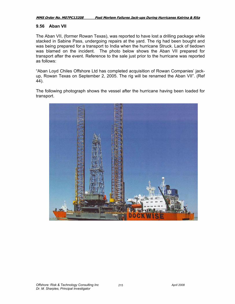
MMS Order No. M07PC13208 Post Mortem Failures Jack-ups During Hurricanes Katrina & Rita
Offshore: Risk & Technology Consulting Inc April 2008 Dr. M. Sharples, Principal Investigator
215
9.56 Aban VII The Aban VII, (former Rowan Texas), was reported to have lost a drilling package while stacked in Sabine Pass, undergoing repairs at the yard. The rig had been bought and was being prepared for a transport to India when the hurricane Struck. Lack of tiedown was blamed on the incident. The photo below shows the Aban VII prepared for transport after the event. Reference to the sale just prior to the hurricane was reported as follows: “Aban Loyd Chiles Offshore Ltd has completed acquisition of Rowan Companies’ jack-up, Rowan Texas on September 2, 2005. The rig will be renamed the Aban VII”. (Ref 44). The following photograph shows the vessel after the hurricane having been loaded for transport.

MMS Order No. M07PC13208 Post Mortem Failures Jack-ups During Hurricanes Katrina & Rita
Offshore: Risk & Technology Consulting Inc April 2008 Dr. M. Sharples, Principal Investigator
216
10. JACK-UP PERFORMANCE SUMMARY TABLE
A number of useful papers have been produced on jack-up performance in the hurricanes Katrina and Rita: most notably Hoyle & Brekke’s paper (Ref 24) and Morandi’s papers (Ref 30, Ref 28) and Morandi’s presentations to the IADC Jack-up Committee. Their results have been derived from sophisticated engineering techniques, and their results and conclusions have much more merit than the simplistic view provided in Table 10. These papers have focused on some, but not all of the jack-ups and thus the attempt in Table 10.1 to bring together in one space a summary of what happened from which one may be able to put the jack-ups in perspective. In order to arrive at detailed conclusions, it is, of course, necessary to plough through the “proper engineering calculations”. A visual summary was given in Section 6 presenting the • Jack-ups that Drifted (short or long distance) • Rigs that Sank • Surprising Survivals: Katrina and • Surprising Survivals: Rita In Table 10 the tabular format allows the reader to evaluate the information of the jack-ups that were affected. The columns give the jack-ups that drifted, those that sank, the total losses, surprising survivals, unexpected failures, etc. Many of the jack-ups could be categorized differently, and whether a box is “x” for a particular jack-up may be quite subjective. The column “Overload Based on Proper Engineering Studies” refers to the papers noted above, and back-up calculations made available for some of the jack-ups. The “site wave” is from the tables in Section 7: Table 7.1 and Table 7.2, which in turn is derived from the Oceanweather studies (Ref 20, Ref 21) The list of jack-ups that we believed were exposed to the hurricanes, most of which were investigated and reported in more detail in the main text. In Table 10.1 additional columns were added which indicated the possible “guestimated” jack-up capability data. It may well be that an individual rig has been strengthened or that at a specific location the rig was more or less capable than these guestimated numbers. Much of the “design” data came from (Ref 60) Mobile Drilling Units of the World, Offshore Publications Ltd., England. Should an accurate design figure needed for the specific rig the owners/designers should be contacted: this is meant to be rough guidance only. The column [“design” wave at site] is subject to much potential error. The number represents a first guess at an equivalent wave height that might result in the same levels of load/stress that the original design calculations might show for the “site”. In many cases the “site” had lesser wind speeds, often more current, and different penetrations than the original design calculations provided for. To carry out such a huge undertaking of providing such numbers based on proper engineering calculations would be prohibitive, and thus we used some judgment in coming up with our “guess” as to what the site equivalent “design wave” might have been in order to determine in a “rough and ready way”, the likely “Overload – based on Ratio of Modified “design” values”. To the extent that others carried out studies we summarized their findings in the column “Overload: Based on Proper Engineering Studies”. For example the Rowan

MMS Order No. M07PC13208 Post Mortem Failures Jack-ups During Hurricanes Katrina & Rita
Offshore: Risk & Technology Consulting Inc April 2008 Dr. M. Sharples, Principal Investigator
217
New Orleans this “rough and ready” calculation showed an overload factor of 2.7 whereas proper engineering calculations concluded an overturning moment of 1.87 and a preload overload of 1.9. Despite its potential inaccuracies, at least with this method as a yardstick, we had some method of ordering the results, some method of seeing them in relation to one another, and determine what learnings we could take away from the events.

MMS Order No M07PC13208 Post Mortem Failures Jack-ups During Hurricanes Katrina Rita
# Rig Name/ Results Rig Type Damage Drifted SankTotal
Loss
Surprising
Survivals
Unexpected
Failures
Overloaded
but
Expected
Survivals
Expected
Failures
Within
Design +/-
Other
Expected
Issue
Overload
Based on
Ratio to
Modified
"design"
Values
OverloadBased on Proper
Engineering studies
Site Wave
(ft)
"design"
wave at
site (ft)
Estimated Design
Hurricane Katrina Ref: see textRef: Mobile Drilling Rigs of the World,
Oilfield Publications Ltd.)
8.1 Ocean Nugget Lev 111-CDamage spud cans,
Some leg cracksX 2.0 73.6 52.0
(100 kts wind, 52 ft waves, 1 kt current @
35 ft airgap & 10 ft penetration)
8.2 Ocean Tower LeT 53S Not reported X 2.2 66.7 45.0 (100 kts wind, 45 ft waves, 0 kt current )
8.3 Ocean Warwick Lev 111-C Beached 66 miles NE X X X 2.5 75.7 47.9(100 kts wind, 52 ft waves, 1 kt current @
35 ft airgap & 10 ft penetration)
8.4 Ensco 74Let-Super
116
Minor Structural damage;
wave touched the
underside of hullX 1.8 72.2 53.8 (100 kts wind, 50 ft waves, @45 ft airgap)
8.5 Ensco 81
LeT 116-C
Enhanced
legX 1.9 62.6 45.0 (100 kts wind, 45 ft waves, @50 ft airgap)
8.6 Ensco 83LeT
82SD-CX 2.3 55.6 37.0 (100 kts wind, 40 ft waves)
8.7 Ensco 105 Kep Mod V X - 36.8 (100 kts wind, 63 ft waves)
8.8 GSF Adriatic VII LeT 116-C X - 38.8
(100 kts wind, 40 ft waves, 3 kt current
@30 ft airgap & 25 ft pen. ) (o). Other info
48 ft wave
8.9 GSF High Island VIIILeT
82SD-CX 1.2 42.0 38.0
(100 kts wind, 40 ft waves @35 ft airgap &
25 ft pen.)
8.10 Hercules 21 Delong Listing at Location X - 31.0
8.11 Hercules 25LeT
150-44Derrick Fell X X - 25.0 (100 kts wind 40+ ft waves)
8.12 Noble Tom JobeLeT
82SD-CX 1.8 53.7 40.0
(100 kts wind 37 ft waves, 1 kt current
@25 ft pen. )
8.13 Bob PalmerSuper
Gorilla XLS
Insufficient Airgap (-7 ft)
Reported : Anchor thrown
onto deckX - 79.9
(100 kts wind, 96 ft waves, 3 kt current
@60 ft airgap)
8.14 Cecil Provine LeT 116-C X - 46.5(100 kts wind, 45 ft waves, 1 kt current @
40 ft airgap)
8.15 Rowan Fort Worth LeT 116-C X - 34.6 (100 kts wind, 40 ft waves, 1 kt current)
8.16 Scooter Yeargain Tarzan X - 44.4 51.0 (100 kts wind, 51+ ft waves, 1 kt current)
8.17 Rowan Gorilla IV Gorilla X - 50.0 (100 kts wind, 88 ft waves, 1 kt current)
Offshore: Risk Technology Consulting Inc.,
Dr. M. Sharples, Principal Investigator
218
April 2008

MMS Order No M07PC13208 Post Mortem Failures Jack-ups During Hurricanes Katrina Rita
# Rig Name/ Results Rig Type Damage Drifted SankTotal
Loss
Surprising
Survivals
Unexpected
Failures
Overloaded
but
Expected
Survivals
Expected
Failures
Within
Design +/-
Other
Expected
Issue
Overload
Based on
Ratio to
Modified
"design"
Values
OverloadBased on Proper
Engineering studies
Site Wave
(ft)
"design"
wave at
site (ft)
Estimated Design
8.18 Rowan New Orleans LeT 52-SRig sank in Main Pass
185X X X 2.7
Wave close to
Hit hull, or may
have done.
OTM 1.87 &
(16ft pen.)
Chord 4.0
Brace >5.
>1.9 (Preload)
69.5 42.3 (100 kts wind, 45 ft waves, 0 kt current )
8.19 Rowan Paris LeT 116-C X 2.6
OTM 1.4 &
96 ft Pen.
>1.4 (Preload)
Chord 2.98
72.2 45.0(100 kts wind, 45 ft waves, 1 kt current @
35 ft airgap)
8.20 Ocean Drake JU 200-MC X 1.3 54.9 48.1 (100 kts wind, 62 ft waves @ 44 ft airgap)
8.21 Hercules 30 Listing at Location X - 66.0 (100 kts wind, 60+ ft waves)
8.22 Pride Florida JU 200-MC X - 32.3 (100 kts wind, 64 ft waves, @ 53 ft airgap)
8.23 THE 200 JU 200-MC Minor damage X - 55.9 (100 kts wind, 64 ft waves, @ 53 ft airgap)
8.24 THE 204 JU200-MC Minor damage X - 40.2 (100 kts wind, 64 ft waves, @ 53 ft airgap)
8.25 Nabors Dolphin 110 Pan XWindows blown/ water
damageX - 29.6
Hurricane Rita Ref: see textRef: Mobile Drilling Rigs of the World,
Oilfield Publications Ltd.)
9.1 Ocean ColumbiaLeT
82SD-CX 1.3 42.3 37.1
(100 kts wind 42 ft waves, 1 kt current
@25 ft pen. )
9.2 Ocean SpartanF&G L-780
MOD IIX 1.8 68.0 50.7
(100 kts wind, 52 ft waves, 1 kt current
@50 ft airgap)
9.3 Ocean Summit Lev 111-C X - 36.6(100 kts wind, 52 ft waves, 1 kt current @
35 ft airgap & 10 ft penetration)
9.4 Ensco 60 Lev 111-C Minor damage X 1.3 55.2 48.4(100 kts wind, 52 ft waves, 1 kt current @
35 ft airgap & 10 ft penetration)
9.5 Ensco 68 LeT 64 ModDrill package shifted;
minor damageX 2.5 55.7 35.0 (100 kts wind, 40 ft waves)
9.6 Ensco 69
LeT 84-C
Enhanced
Leg
Minor damage X 2.9
OTM 1.5
>1.7 (Preload)
Took on 3.7 ft
settlement
71.3 41.6 (100 kt winds, 44 ft waves, @ 45 ft airgap)
9.7 Ensco 81
LeT 116-C
Enhanced
legX - 48.1 48.0
(100 kt winds, 44 ft waves, @ 50 ft airgap,
25 ft penetration)
Offshore: Risk Technology Consulting Inc.,
Dr. M. Sharples, Principal Investigator
219
April 2008

MMS Order No M07PC13208 Post Mortem Failures Jack-ups During Hurricanes Katrina Rita
# Rig Name/ Results Rig Type Damage Drifted SankTotal
Loss
Surprising
Survivals
Unexpected
Failures
Overloaded
but
Expected
Survivals
Expected
Failures
Within
Design +/-
Other
Expected
Issue
Overload
Based on
Ratio to
Modified
"design"
Values
OverloadBased on Proper
Engineering studies
Site Wave
(ft)
"design"
wave at
site (ft)
Estimated Design
9.8 Ensco 82 LeT 116C Minor damage X - 35.9(100 kt winds, 44 ft waves, @ 50 ft airgap,
25 ft penetration)
9.9 Ensco 84LeT
82SD-CX 2.2 59.2 40.0
(100 kts wind 40 ft waves, 1 kt current
@25 ft pen. )
9.10 Ensco 90LeT
82SD-CMinor damage X 2.2 57.8 39.0
(100 kts wind 40 ft waves, 1 kt current
@25 ft pen. )
9.11 Ensco 93LeT
82SD-CX - 40.9
(100 kts wind 40 ft waves, 1 kt current
@25 ft pen. )
9.12 Ensco 98LeT
82SD-CMinor damage X 1.9 54.6 40.0
(100 kts wind 40 ft waves, 1 kt current
@25 ft pen. )
9.13 Ensco 105 Kep Mod V Minor damage X 1.3 71.9 63.0 (100 kts wind, 63 ft waves) (w)
9.14 GSF Adriatic III LeT 116E
Impact to platform plus
Minor damage: 2 motor
shafts failedX 1.8
OTM 2.1,
1.22 (Preload)
1.7 (Chord)
1.4 (Bracing)
Got 2-4 ft
Settlement
67.6 50.4(100 kts wind, 43 ft waves, @ 50 ft airgap
& 25 ft penetration) Other info has 48 ft.
9.15 GSF Adriatic VII LeT 116-C Drifted 118 miles NW X X X 3.2
2.4 (Preload)
3.2 (Chord)
2.8 (Bracing)
72.9 40.8(100 kts wind, 38-40 ft waves, 3 kt current
@30 ft airgap & 25 ft pen. )
9.16 GSF High Island ILeT
82SD-CX 1.3 47.4 40.9
(100 kts wind, 38-40 ft waves @35 ft
airgap & 25 ft pen.)
9.17 GSF High Island IILeT
82SD-C
Tug required to pull rig to
allow jacking downX 2.9
1.8 (Preload)
2.7 (Chord)
9.5 (Bracing)
66.0 39.0(100 kts wind, 38-43 ft waves @35 ft
airgap & 25 ft pen.)
9.18 GSF High Island IIILeT
82SD-CBeached 108 mi NW X X X 3.1
1.9 (Preload)
4.3 (Chord)
9.6 (Bracing)
68.5 39.0(100 kts wind, 38-42 ft waves @35 ft
airgap & 25 ft pen.)
9.19 GSF High Island IVLeT
82SD-CSome cracks in legs X 3.0
1.6 (Preload)
3.2 (Chord)
9.4 (Bracing)
67.6 39.0(100 kts wind, 38-42 ft waves @35 ft
airgap & 25 ft pen.)
9.20 GSF Main Pass IVF&G L-780
MOD IIX - 50.5 (100 kts wind, 50 ft waves, 1 kt current)
9.21 GSF High Island VIIILeT
82SD-CX -
0.98 (Preload)
0.89 (Chord)
1.3 (Bracing)
40.6(100 kts wind, 40 ft waves @35 ft airgap &
25 ft pen.)
9.22 Noble Tom JobeLeT
82SD-CX 1.7 52.8 40.1
(100 kts wind, 37 ft waves @1 kt & 25 ft
pen.)
9.23 Noble Eddie Paul LeT 84-CE X 1.2 49.1 44.1(100 kts wind, 44 ft waves @45 ft airgap &
25 ft pen.)
Offshore: Risk Technology Consulting Inc.,
Dr. M. Sharples, Principal Investigator
220
April 2008

MMS Order No M07PC13208 Post Mortem Failures Jack-ups During Hurricanes Katrina Rita
# Rig Name/ Results Rig Type Damage Drifted SankTotal
Loss
Surprising
Survivals
Unexpected
Failures
Overloaded
but
Expected
Survivals
Expected
Failures
Within
Design +/-
Other
Expected
Issue
Overload
Based on
Ratio to
Modified
"design"
Values
OverloadBased on Proper
Engineering studies
Site Wave
(ft)
"design"
wave at
site (ft)
Estimated Design
9.24 Arch Rowan LeT 116-C X 1.7 56.6 44.0(100 kts wind, 44 ft waves, 1 kt current @
35 ft airgap)
9.25 Bob PalmerSuper
GorillaX 49.1
(100 kts wind, 96 ft waves, 3 kt current
@60 ft airgap)
9.26 Cecil Provine LeT 116-C X 2.1 63.8 44.0(100 kts wind, 44 ft waves, 1 kt current @
35 ft airgap)
9.27 Charles Rowan LeT 116-C X 1.1 45.6 44.0(100 kts wind, 44 ft waves, 1 kt current @
35 ft airgap)
9.28 Rowan Alaska LeT 84-S X 1.6 58.6 30.0 (87 kts wind, 35 ft waves, @ 30 ft airgap)
9.29 Rowan Anchorage LeT 52 X 2.7 49.3 30.0 (87 kts wind, 35 ft waves, @ 30 ft airgap)
9.30 Rowan California LeT 116-C X 1.5 54.7 44.0(100 kts wind, 50+ ft waves, 1 kt current
@ 40 ft airgap)
9.31 Rowan Ft Worth LeT 116-C Unknown X X X X 4.3
OTM 1.97 &
78 ft pen.
>1.7 (Preload)
Chord > 2.0
72.9 35.0 (100 kts wind, 42 ft waves, 0 kt current)
9.32 Scooter Yeargain Tarzan X - 56.2 (100 kts wind, 50+ ft waves, 1 kt current)
9.33 Rowan Gorilla II Gorilla X - 74.3 80.0(100 kts wind, 80+ ft waves, 1.5 kt current
@ 60 ft airgap)
9.34 Rowan Gorilla III Gorilla X - 52.7 85.0(100 kts wind, 85+ ft waves, 1.5 kt current
@ 65 ft airgap)
9.35 Rowan Gorilla IV Gorilla X - 75.1 88.0 (100 kts wind, 88 ft waves, 1.5 kt current)
9.36 Rowan Halifax LeT 116-C Sank near location X X X 3.0
OTM 2.6 &
43 ft pen.
>1.7 (Preload)
Chord 3.4
69.5 40.1 (100 kts wind, 48 ft waves, 0 kt current )
9.37 Rowan Juneau LeT 116-SE X - 40.1(100 kts wind, 46+ ft waves, 1 kt current
@ 50 ft airgap)
9.38 Rowan Louisiana LeT 84-S Drifted 103 mi NW X X 3.2
OTM 1.79 &
62 ft pen.
Wave hit Hull
>1.3 (Preload)
Chord 4.06
71.6 40.0 (100 kts wind, 40 ft wave ht)
9.39 Rowan Middletown LeT 116-C X - 42.2 (100 kts wind, 40 ft waves, 1 kt current)
9.40 Rowan Odessa LeT 116S Sank 6 mi NW of location X X X X 2.2
OTM 1.48 &
89 ft Pen
>1.4 (Preload)
Brace 2.4
Chord 2.1
64.9 43.8(100 kts wind, 45 ft waves, 1 kt current @
35 ft airgap)
Offshore: Risk Technology Consulting Inc.,
Dr. M. Sharples, Principal Investigator
221
April 2008

MMS Order No M07PC13208 Post Mortem Failures Jack-ups During Hurricanes Katrina Rita
# Rig Name/ Results Rig Type Damage Drifted SankTotal
Loss
Surprising
Survivals
Unexpected
Failures
Overloaded
but
Expected
Survivals
Expected
Failures
Within
Design +/-
Other
Expected
Issue
Overload
Based on
Ratio to
Modified
"design"
Values
OverloadBased on Proper
Engineering studies
Site Wave
(ft)
"design"
wave at
site (ft)
Estimated Design
9.41 Rowan Paris LeT 116-C X - 35.1(100 kts wind, 45 ft waves, 1 kt current @
35 ft airgap)
9.42 GSF Main Pass 1 F & G Mod II X 15.1
9.43 Ocean Drake JU200-MC X 58.1 (100 kt wind, 62 ft wave @ 52 ft airgap)
9.44 Pride Arizona JU250-MS X - 47.9 (100 kt wind, 64 ft wave @ 54 ft airgap)
9.45 Pride Florida JU200-MC Jack-up slid off location X - 56.7 (100 kt wind, 64 ft wave @ 54 ft airgap)
9.46 Pride Kansas JU250-MC X - 53.8 (100 kt wind, 64 ft wave @ 54 ft airgap)
9.47 Pride Mississippi JU200-MC X - 53.3 (100 kt wind, 64 ft wave @ 54 ft airgap)
9.48 Pride Missouri JU250-MC X - 45.7 (100 kt wind, 64 ft wave @ 41 ft airgap)
9.49 Pride Utah JU45 Jack-up slid off location X - 34.5 (100 kt wind, 64 ft wave @ 54 ft airgap)
9.50 Pride Wyoming JU250-MC Jack-up slid off location X - 56.3 (100 kt wind, 64 ft wave @ 54 ft airgap)
9.51 THE 207 JU200-MC X - 47.3 (100 kt wind, 62 ft wave @ 52 ft airgap)
9.52 THE 250 JU250-MS X - 58.7 (100 kt wind, 60 ft wave @ 45 ft airgap)
9.53 THE 253 JU250-MS Jack-up slid 40' into THE
252's HeliportX - 53.1 (100 kt wind, 64 ft wave @ 31 ft airgap)
9.54 Hercules 21 Delong Listing at Location X 9.6
9.55 POOL 54Derrick reported (Platou)
brown overX -
Offshore: Risk Technology Consulting Inc.,
Dr. M. Sharples, Principal Investigator
222
April 2008

MMS Order No. M07PC13208 Post Mortem Failures Jack-ups During Hurricanes Katrina & Rita
Offshore: Risk & Technology Consulting Inc. April 2008 Dr. M. Sharples, Principal Investigator
223
For Hurricane Katrina the Table 10.1 clearly shows that the Ocean Warwick and Rowan New Orleans which became casualties were structurally overloaded by a factor of 2.5 or more times the design loads. The Ocean Nugget was overloaded by a factor of 2, and bent up the edges of the can, showing that it was very near to a collapse situation, nonetheless it survived with little damage. The Rowan Paris has been discussed in papers (Ref 28) as a very fortunate survivor, largely due to the 96 ft of penetration (which the “rough and ready method” did not account for sufficiently). The Ensco 74, Ensco 81 and Ensco 83 also are shown to be overloaded but except for the wave touching the underside of the hull of the Ensco 74, no other significant damage was reported. For Hurricane Rita the Table 10.1 clearly shows that the GSF Adriatic VII and High Island III were overloaded by a factor of 3. The more detailed calculations show an overload of the chords of 3.2 and 4.3 respectively for the jack-ups. The Rowan Fort Worth, Rowan Halifax, Rowan Louisiana and Rowan Odessa all had high ratios (based on the “rough and ready” methods), and the engineering calculations carried out confirmed they were overloaded by factors that were clearly well above the design, and thus the outcome an expected failure was noted. In many of the other cases, where engineering calculations were not carried out, the jack-ups were seen to be well above what the designers had intended to be their design limits: as a first pass, by the factors given in the table. The category “other expected issue” was applied to mat jack-ups where the jack-up was structurally with design parameters but where sliding was likely to occur. Again, without engineering calculations and site specific soils information this also is not possible to judge accurately. The McClelland plates (Ref 31) were available and a review of the soil conditions showed that in areas where the surface sediment was particularly soft with undrained shear strength of 0.2 ksf or less, when granular material was present, or when a think clay layer overlayed sand, the rig may have been more likely to slide than when on a firmer clay foundation. What is suggested is that from tabulating the results in this way that it becomes obvious that the jack-ups in the Gulf of Mexico fleet can take very much more load than the “design” limits would indicate, before collapsing. In the detailed explanations it has also been obvious that jack-up survival is much more dependent on getting the soil figures accurately, than the structural part of the equation. With this in mind, it may be appropriate for the industry to measure the jack-ups with a factor of safety on pushover rather than a factor of safety against overstress or overload from a design standpoint. From the information presented it appeared as if there was no particular effect of age of jackup on any of the casualties. The only affect of age was that some of the older jackups had limited preload capability and thus would have been subject to a higher likelihood of exceeding the limits of the lower preload values. Typically on a site specific location, the structural parameters and metocean data is comparatively well known. What is often not known, with sufficient accuracy is the soil data, the history of what jack-ups have been on the location before, and any issues that have changed the foundation. As has been clearly shown, it is probably the most important parameter which the jack-up depends on for its survival.
MMS Order No. M07PC13208 Post Mortem Failures Jack-ups During Hurricanes Katrina & Rita
Offshore: Risk & Technology Consulting Inc. April 2008 Dr. M. Sharples, Principal Investigator
224
11. COMMENTS ON FOUNDATION DATA Since the results of the investigation indicated that in general the foundation was the main issue and not any structural deficiency in the jackups, a key area to focus on is the guidance, and available information that exists in the way of foundation information. From the information presented it appeared as if there was no particular effect of age of jackup on any of the casualties. The only affect of age was that some of the older jackups had limited preload capability and thus would have been subject to a higher likelihood of exceeding the limits of the lower preload values. For the structural survival of a jackup the ideal would be to have the following information available:
1. Recent soil boring at location with emphasis on the layers through which penetration of the leg/mat are likely to occur. (Some historic information may be available for deeper pile designs).
2. Information on the previous history of rigs on location, not only their physical position, and footprint, but also the leg penetrations experienced.
3. Information on issues the previous jackup had going on, or coming off, location or settlement during the time on location.
4. Close-by borings tied in with shallow seismic. 5. Map of geologic hazards of the Gulf of Mexico per McClelland (Ref 31) or Ref
(58). 6. Map of mud-slide area of Gulf of Mexico Ref (65).
In addition it is necessary to know, for both independent leg jackups and mat supported jackups the loads that are expected in the extreme storms for which the jackup is accepted as safe on location, and values for which movement from location is not desirable (particularly mat units). Given the above information it is possible to calculate the penetration expected, know the likely increase of penetration if preload values are exceeded (from which in turn you can calculate the degree of settlement until collapse). For mat unit it is possible in addition to calculate the risk of sliding and thus the potential to damage any wellhead/platform in the direction of sliding. If the location is within the likely mud-slide area of the Gulf of Mexico further more detailed analysis may be necessary from an expert in mud-slide foundation calculations. The following Guidelines are available from the industry sources and quoted here for the convenience of the reader (Ref 63): “A.2.2 Guidelines and Recommended Practice for the Site Specific Assessment of Mobile Jack-up Rigs. American Society of Naval Architects and Marine Engineers, May 1994.
MMS Order No. M07PC13208 Post Mortem Failures Jack-ups During Hurricanes Katrina & Rita
Offshore: Risk & Technology Consulting Inc. April 2008 Dr. M. Sharples, Principal Investigator
225
In the Recommended Practice document, Sections 3.11 to 3.15, covering the site survey aspects, reference is made to the original 1990 UKOOA "Technical Notes for the Conduct of Mobile Drilling Rig Site Surveys". The Technical Notes provides the basis for recommended survey practice. These Guidelines supersede the Technical Notes. "Site specific geotechnical information must be obtained….such information may include shallow seismic survey, coring data, cone-penetrometer tests, side-scan sonar, magnetometer survey…" (Section 2.4.1). "The site should be evaluated for the presence of shallow gas deposits." (Section 2.4.2) "At sites where there is any uncertainty [about shallow soils], corings and/or cone penetrometer tests (CPT) data are recommended. Alternatively the site may be tied-in to such data at another site by means of shallow seismic data." (Section 2.4.4). "The site should be evaluated for potential scour problems " (Section 2.4.5) N.B. Evaluation for potential scour is not an easy procedure and may require Specialist assistance. A.2.1 Seabed and Subseabed Data Required for Approvals of Self Elevating Platforms. Noble Denton International Ltd, 1987 "The purpose of the site survey is to provide data with which to evaluate potential foundation hazards."(Section 1.3) "The seabed surface shall be surveyed using side scan sonar techniques and shall be of sufficient competency to identify obstructions and seabed features and should cover the immediate area of the intended location." (Section 2.4.1) "A shallow seismic survey should be performed over a 1 kilometre square area centred on the location. Line spacing of the survey should typically be not greater than 100 metres by 250 metres over the survey area. Equipment should be capable of giving detailed data to a depth equal to the greater of 30 metres or the anticipated footing penetration plus one footing diameter." (Section 2.5.1) "The shallow seismic survey shall be interpreted by the competent persons who were responsible for performing the work. Every effort should be made in the interpretation to comment on the soil type(s) and strength(s); this will require correlation (by means of a tie line) with a borehole in the vicinity and some degree of local experience". (Section 2.5.2) A.2.4 Guidelines for the Use of Differential GPS in Offshore Surveying. UKOOA, September 1994. These Guidelines seek to provide guidance on quality standards in all aspects of the use of DGPS in seismic positioning from installations to minimum training standards for Operators. Section 2 - Quality Measures

MMS Order No. M07PC13208 Post Mortem Failures Jack-ups During Hurricanes Katrina & Rita
Offshore: Risk & Technology Consulting Inc. April 2008 Dr. M. Sharples, Principal Investigator
226
"Differential GPS has evolved as an attractive method of position fixing offshore. There has not existed, however, a standard set of quality measures to enable users of this technique to verify that required positioning standards are being met. The aim of this section is to present a set of quality measures to the industry and to describe the ongoing statistical testing which must take place during processing if these measures are to be meaningful." Draft ISO Guidelines Petroleum and natural gas industries — Site-specific assessment of mobile offshore units — Part 1: Jack-Ups: ISO TC 67/SC 7/WG 7 “A.6.5.1.4.Geotechnical investigation
A.6.5.1.4.1 General
Site-specific geotechnical investigation and testing are recommended in areas where any of the following apply:
nearby geotechnical data is not available;
the shallow seismic survey cannot be interpreted with any certainty;
significant layering of the strata is indicated; or
the site is known to be potentially hazardous.
A.6.5.1.4.2 Soil investigation and testing
A geotechnical investigation should comprise a minimum of one borehole to a depth equal to 30 metres or the anticipated spudcan penetration plus 1.5 times the spudcan diameter, whichever is the greater. All the layers should be adequately investigated and the transition zones cored at a sufficient sampling rate. The number of boreholes required should account for the lateral variability of the soil conditions, regional experience and the geophysical investigation. When a single borehole is made, the preferred location is at the center of the leg pattern at the intended position at the site. “Undisturbed” soil sampling, in-situ testing and laboratory testing should be conducted. Recognized in-situ soil testing tools include piezocone penetrometer, vane shear, T-bar and/or pressure meter tests.
A.6.5.1.4.3 Geotechnical report
The geotechnical report should include borehole logs, in-situ test records (if appropriate) and documentation of all laboratory tests, together with interpreted soil design parameters. A competent geotechnical engineer should select design parameters suitable for spudcan foundation assessment. For the methods recommended in Section 9.3 and 9.4, the design parameters should include profiles of undrained shear strength and/or effective stress parameters, soil indices (plasticity, liquidity, grain size, etc.), relative density, unit weight and the over consolidation ratio (OCR).

MMS Order No. M07PC13208 Post Mortem Failures Jack-ups During Hurricanes Katrina & Rita
Offshore: Risk & Technology Consulting Inc. April 2008 Dr. M. Sharples, Principal Investigator
227
Additional soil testing to provide shear moduli and cyclic/dynamic behaviour may be required if more comprehensive analyses are to be applied or where the soil strength may deteriorate under cyclic loading.” Matthews-Daniel Program Preload Program Preload™ is a software development from MatthewsDaniel, designed to assist the offshore oil and gas industry in reducing the risk of uncontrolled rapid leg penetrations of jack-up offshore mobile drilling units, more commonly known as 'Punch-Through'. It is utilized during preloading, the most critical phase of going on location. Monitoring information on a 'real-time' basis provides a valuable tool to assist the rig mover in the safe siting of the unit. With real time simulation of rig preloading and punch-through, MatthewsDaniel trains rig movers and other qualified personnel. Other Issues: Additional issues may come to mind when deliberating on the validity of the boring data:
• If the boring data is old, were the crew sure of the precise location of the boring since navigation techniques were not so precise then?
• Did the waterdepth or mounds of soil at the location change because of the presence of a previous rig going on or off location?
• How flat is the seabed?
• How was the original seabed point of measurement known for the start of the boring? For mat units particularly, how was the penetration of the mat observed/determined? This question is to ensure the appropriate layer of soil is taken into account when computing the shear (resistance to sliding).
• What other jackups have been on this location previously? If their footing reactions were much higher this may prove to be an issue with a lighter rig going on location. What was the orientation in relation to the platform?
Some research has been done on this subject in the UK and this is reported in an HSE Research Report (Ref 66). Julian Osborne presented a recent paper at the OGP/CORE Workshop, October 2005, Singapore (Ref 67) where the following was recommended:
• Institute Industry wide call for spudcan load versus penetration data for analyses and validation purposes.
• Implement rig instrumentation systems for foundation load displacement monitoring during installation and storm events.
• Measure hull (elastic) rebound on preload dumping when installed alongside fixed structures (foundation fixity).

MMS Order No. M07PC13208 Post Mortem Failures Jack-ups During Hurricanes Katrina & Rita
Offshore: Risk & Technology Consulting Inc. April 2008 Dr. M. Sharples, Principal Investigator
228
• Record spudcan extraction loads (yield surface modification).
• Validation of jackup scour, predictive penetration and punch-through methods using the vast archives of available data.
• Encourage industry-wide participation in the continued development of Guidelines and Installation procedures to reflect the advances in rig design, rig operation and geotechnology.
There is much soils information on the Gulf of Mexico generally available. A number of issues prevent that being always available in a timely manner to the drilling contractor who is often required to evaluate the location in a minimal timeframe. It would be helpful if the MMS were investigate the possibility of requiring filing of soil information in conjunction with the permit to drill, and require that information be updated once the rig is on location so that crucial information such as the penetration, orientation on location and like information becomes part of the permanent lease files and available to the drilling contractors to consult in subsequent site investigations. While much work has been done by the IADC/SNAME Committee and ISO Committee on jackups there appears to be no comprehensive guidance available on the acceptability of foundation integrity information for Gulf of Mexico sites, such as exists in the UK: “Guidelines for Conduct of Mobile Rig Site Surveys”, UKOOA. This document is not suitable as is for Gulf of Mexico operations but it may be useful to have such guidance available in the future. A useful addition would be to have guidance on the acceptability of existing soil information when presented for a site approval. Many factors go into such an evaluation and tabulating these and their influence would be a helpful in ensuring that appropriate steps were being undertaken to ensure that the data that calculations are carried out are indeed based on sound foundation information.
12. OTHER REMARKS
Morandi (Ref 30) provides an interesting table reproduced below:
Rig Event Water Depth(ft / m)
Max. Wave Height (ft / m)
Area Return Period (Years)
Rowan New Orleans Katrina 155 / 47.2 70 / 21.3 Central 50
Rowan Paris Katrina 156 / 47.5 72 / 21.9 Central 70
Rowan Bob Palmer Katrina 355 / 108.2 80 / 24.4 Central 70
Rowan Louisiana Rita 230 / 70.1 72 / 21.9 West Central 270
Rowan Fort Worth Rita 230 / 70.1 73 / 22.3 West Central 290
Rowan Halifax Rita 306 / 93.3 70 / 21.3 West Central 200
Rowan Gorilla 4 Rita 365 / 111.3 75 / 22.9 West Central 230

MMS Order No. M07PC13208 Post Mortem Failures Jack-ups During Hurricanes Katrina & Rita
Offshore: Risk & Technology Consulting Inc. April 2008 Dr. M. Sharples, Principal Investigator
229
Rig Event Water Depth(ft / m)
Max. Wave Height (ft / m)
Area Return Period (Years)
ENSCO 74 Katrina 205 / 62.5 73 / 22.3 Central 55
ENSCO 69 Rita 215 / 65.5 71 / 21.6 West Central 250
ENSCO 105 Rita 245 / 74.7 73 / 22.3 West Central 280
GSF AD 7 Rita 252 / 76.8 73 / 22.3 West Central 280
Rowan Odessa Rita 178/54 64.9/19.8 West Central 200
Table 5 – Wave Height Return Period for 12 Worst Affect Jack-ups on Katrina and Rita (From Morandi Ref 30) The figures in the “return period” column represent the post hurricane figures from API Bulletin 2 Int-Met (Ref 22). While the metocean return periods have changed in the Gulf of Mexico as new data from the storms has become available the loss of some of the jack-ups is put into perspective by this table. The Rowan Gorilla 4, Ensco 69, and Ensco 105 locations even by today’s standards saw events that are well beyond normally accepted engineering criteria for structural design of permanent manned facilities. While the soil conditions, orientation, other circumstances at location and strength of the rig effect whether a rig would survive it is clear that these two hurricanes were well above what the industry would deem as the extreme design events. While it is not possible to derive a “rule of thumb” to cover all situations it certainly has become an issue that, in some locations, for extreme waves, what was previously thought to be a 100 year event is now thought to be a 20-year event; what was thought to be a 1000 year event is now thought to be less than a 100-year event. Based on the consequences of the hurricanes to the jack-up fleet it is cautioned not to over-react to the hurricane events. Jack-ups have served the industry well in the Gulf of Mexico over the years: these events similar to Hurricanes Ivan, Katrina and Rita are very extreme and well beyond acceptable engineering design standards. The important things to note are that there was no loss of life, no significant pollution resulting, and the jack-ups did not destroy any critical infrastructure. The results were financial to the companies that are controlled by acceptable the risk-reward formula that their management use to their shareholders. Thus for future jack-up standards it is important to balance the risk-reward to the nation exploring and finding hydrocarbons, at reasonable jack-up dayrates with the potential that design loads will be exceeded for a jack-up once in 250+ years, far longer than its useful designed lifetime. At the same time, one must consider the ever changing population of structures, pipelines, and hub platforms in the Gulf of Mexico and it is recommended that the changes be evaluated going forward by industry committees to determine if there should be an changes to the recommended practice based on the proximity of jack-ups to critical infrastructure.

MMS Order No. M07PC13208 Post Mortem Failures Jack-ups During Hurricanes Katrina & Rita
Offshore: Risk & Technology Consulting Inc. April 2008 Dr. M. Sharples, Principal Investigator
230
13. CONCLUSIONS AND RECOMMENDATIONS
Hurricanes provide a unique opportunity to study the structural performance of offshore jack-ups under extreme loading conditions. The structural performance of the jack-ups without exception, was much greater than anticipated providing 6 “surprising survivals” in Hurricane Katrina and 14 “surprising survivals” in Hurricane Rita. There were no jack-ups that failed at locations that received less than their storm design loads. While all the data on soils was not available or not known. In those that were, there were no unexpected foundation underperformances i.e. those that failed all exceeded the preload values used to site the jack-up. Current strategies relative to evacuation of jack-ups’ personnel and use of safety control systems are essential to life safety and prevention of pollution It would be of great benefit to industry if the information about jack-ups was made available by filing a comprehensive report of damages, or lack of them, after event such as these hurricanes. Gathering information some considerable time after the incidents is quite difficult for all parties. Appendix B gives a proposed form of information that would usefully be gathered for future studies. Both the jack-ups that failed were an expected outcome of the severity of the storm, and the design basis for the specific site on which the jack-up was working. Provided the airgap is sufficient and the soil foundation suitable: jack-ups are remarkably robust surviving more than double the loads to which they were designed. The only surprises were in those independent leg jack-ups that survived in circumstances that engineers may well have predicted they would fail. The mat jack-ups that slid, might well have been anticipated to do so in the soil conditions they were sited in, and the extreme loads of the storm to which they were exposed. The new jack-up criteria for airgap exceeds the requirements for each of the hurricanes Ivan, Katrina, and Rita and is above the 100-year level that is the basis for acceptance of fixed platforms. It is recommended that further study be undertaken by the industry to ensure that the airgap increase does not detract from the structural capability of the jack-ups, or create other operational safety issues. Further refinement, for example by regional airgaps in the 4 metocean regions of the Gulf of Mexico, may lead to more rational criteria for airgap. The current position for the contingency curve for the survival of jack-ups while manned, tracks very closely the 10-year return period extremes for everywhere except the Central region of the Gulf of Mexico. Even though the 50-year sudden hurricane upon which this is based is subject to independent modeling parameters, it would be recommended to remain extra-cautious about ensuring evacuation from the Central region, perhaps by remaining on a greater alert than in other regions, where the 10-year extremes are more in line with the contingency criteria.
MMS Order No. M07PC13208 Post Mortem Failures Jack-ups During Hurricanes Katrina & Rita
Offshore: Risk & Technology Consulting Inc. April 2008 Dr. M. Sharples, Principal Investigator
231
It is recommended that the IADC and API committees working on new guidance for jack-up rigs should additionally consider a section to identify critical infrastructure and additional consider more stringent soil conditions for siting in close proximity to those critical structures/pipelines. Since the jack-ups clearly can absorb much more in the way of load than has been allowed under the SNAME 5-5A it is suggested that a better approach to the evaluation of jack-ups may be to approve them for work based on a factor of safety against pushover for those situations where they are demanned. The most important factor against collapse, after airgap, is the soil data. It is recommended that a mechanism be worked out for soil data to be available for jack-ups going onto drilling locations where it already exists. Data provided for piling platforms is not always the best for siting jack-ups, particularly mat-supported jack-ups: in many cases existing data is old and the site may have been impacted by a number of previous jack-ups and the target information may be deeper than the need for the jack-up issues. Considerations should be given for this data to be filed with the MMS and made available to users. A useful reference is Ref 31 “Strength Characteristics of Near seafloor Continental Shelf Deposits of North Central Gulf of Mexico”, McClelland Engineers Report 0178-043, November 1979, Houston Texas. It is understood that a research project #367 with MMS Technology and Assessment Research group was undertaken Ref: 58 “Shear Strength maps of Shallow Sediments in the Gulf of Mexico, Final Report, Wayne Dunlap and others, Texas A&M University, College Station, Texas, August 2004”. This may be a useful reference for mat jack-up owners. It would be useful to provide a document such as exists in the UK for guidelines for the conduct of mobile drilling rig site investigations for use in the Gulf of Mexico. (Ref 62 UKOOA “Guidelines for the Conduct of Mobile drilling Rig site Surveys in the UKCS” March 2007). This will be particularly useful if complied encompassing experience and guidance of those who are retiring from the industry and chronicling the expectation of those who contract for soil analysis who may not themselves be soils experts, to ensure they are being provided with the useful information in the form that it can be used for those siting the jack-up. The part of the industry owning or operating mat jack-ups should review the results of the investigation into recent events which led to a major accident in Mexico involving the Usumacinta mat supported jack-up rig, which moved, in a winter storm. This is not usual for the US Gulf of Mexico, however, in very soft soils, based on the jack-ups that have moved in hurricanes, such an outcome may not be completely unexpected – and it may be that potential movement should be provisioned for in the set-up over the well when a small movement could cause a catastrophic loss. If there are such learnings that arise from the investigation they should be incorporated into guidance on mat-supported jack-ups for site assessment. Some learnings many be applicable to independent leg jack-ups.

MMS Order No. M07PC13208 Post Mortem Failures Jack-ups During Hurricanes Katrina & Rita
Offshore: Risk & Technology Consulting Inc. April 2008 Dr. M. Sharples, Principal Investigator
232
13. REFERENCES
1. Sharples, Malcolm “Innovations in Offshore: Past Present and Comparisons to the Space Industry”, The Offshore & Marine Technology Conference, Offshore South East Asia 1998, Singapore, December 1998. 2. Schempf, F.J., Pioneering Offshore: The Early Years Offshore Energy Center Publication, Penn Well, 2007. 3. Cardone, V.J., A.T. Cox and G.Z. Forristall, OTC 18652: Hindcast of Winds, Waves and Currents in Northern Gulf of Mexico in Hurricanes Katrina (2005) and Rita (2005). Offshore Technology Conference, Houston, Tx., May 2007. 4. Stiff, J., P. Wildberger, V.J. Cardone, A.T. Cox and D.R. Lewis, 2006. OTC 17879: Metocean Criteria for Jack-Ups in the Gulf of Mexico. 2006 Offshore Technology Conference, Houston, Tx., May 2006. 5. Sharples, B.P.M., Colby C., et al, “Evaluation of Securing Procedures for Mobile Offshore Drilling Units when Threatened by Hurricanes”, MMS Report on Hurricane Andrew, 1992. 6. Sharples M., ““Post Mortem Failure Assessment of MODUs During Hurricane Lili” Report to Minerals Management Service, Dept of Interior, October 2002. 7. Sharples B.P.M., Smith C.E., and Bea R.G., “Post Mortem Failure Assessment of MODUs During Hurricane Lili”, OTC 16800, Houston, Texas May 2004. 8. Sharples M., “Post Mortem Failure Assessment of MODUs During Hurricane Ivan” MMS Report, 2005. 9. Buffington S., and Sharples M., “Performance Assessment of MODUs During Hurricane Ivan” OTC 18322, Houston, Texas, May 2006. 10. “MODU Performance in Hurricane Ivan” – Journal of Petroleum Technology, April 2007. 11. “Port Mortem Failure Assessment of Semi-Submersible MODUS during Hurricanes Katrina and Rita, Prepared for the MODU Mooring Strength and Reliability JIP, ABS Consulting 2008. 12. Ensco Presentation: Introduction to ENSCO U.S. Gulf of Mexico Market Outlook, LAGCOE October 24, 2007. 13. “Deepwater Gulf of Mexico: America’s Expanding Frontier” MMS Report 2006-022. 14. API Offshore Hurricane Readiness Conference, July 26-27, 2005, Intercontinental Hotel, Houston, Texas. 15. Richard D. Knabb, Jamie R. Rhome, and Daniel P. Brown “Tropical Cyclone Report” Hurricane Katrina 23-30 August 2005 National Hurricane Center, 20 December 2005. 16. “Gulf of Mexico Jack-up Operations for Hurricane Season – Interim Recommendations, API Recommended Practice 95J”, First Edition, June 2006. 17. Richard D. Knabb, Daniel P. Brown, and Jamie R. Rhome “Tropical Cyclone Report Hurricane Rita 18-26 September 2005”, National Hurricane Center, 17 March 2006. 18. David Lewis – Private Communication

MMS Order No. M07PC13208 Post Mortem Failures Jack-ups During Hurricanes Katrina & Rita
Offshore: Risk & Technology Consulting Inc. April 2008 Dr. M. Sharples, Principal Investigator
233
19. Bill Hedrick, Rowan Drilling Company, Inc., “Hurricane Impacts to Jack-ups in the Gulf of Mexico and Industry’s Response”, IADC Jack-up Workshop, October 19, 2006. 20. Oceanweather Inc., “Hindcast study of Hurricane Katrina (2005) Offshore Northern Gulf of Mexico”, September 2005. 21. Oceanweather Inc., “Hindcast study of Hurricane Rita (2005) Offshore Northern Gulf of Mexico”, October 2005. 22. “Interim Guidance on Hurricane Conditions in the Gulf of Mexico”, API Bulletin 2 Int-Met, First Edition May 2007. 23. Sharples B.P.M., Hammett D., Baucke T., McNease D., Stiff J., “The Existing Rational Risk-Based Acceptance Criteria for Gulf of Mexico Jack-up Site Assessments”, City University Conference London 1999. 24. Hoyle M.J.R., Brekke J.N., “2005 Gulf of Mexico Hurricane Season: Back Analyses of GlobalSantaFe Jack-Ups and Evaluation of Proposed GoMex Annex to SNAME”, Jack-Up Asia Conference, Singapore, 7-8 December 2008. 25. World Oil Nov 2005. 26. www.smit.com 27. Offshore Magazine, June 2006. 28. Morandi A.C., “Impact of Hurricanes Katrina / Rita on Jack-up Rigs” SNAME OC-7 DNV, Oslo, Norway 7th November 2006. 29. Rowan Presentation UH Bauer College of Business, March 30, 2006 30. Morandi A.C., “Jack-up Operations in the Gulf of Mexico Lessons Learned from Recent Hurricanes”, City University Conference on Jack-ups, September 2007. 31. “Strength Characteristics of Near seafloor Continental Shelf Deposits of North Central Gulf of Mexico”, McClelland Engineers Report 0178-043, November 1979, Houston Texas. 32. RigLogX at www.Rigzone.com 33. OilOnLine September 2, 2005. 34. Douglas Stock (Digital Structures, Inc), Jim Brekke (GlobalSantaFe Corporation) and Harold Keys (Noble Corporation), “Jack-up Response Measurements from Hurricanes Katrina and Rita”, City University, September 2007. 35. Mike J.R. Hoyle & James N Brekke “2005 Gulf of Mexico Hurricane Season: Back Analysis of GSF Jack-Ups and Evaluation of Proposed Gulf of Mexico Annex to SNAME”, Jack-Up Asia Conference, Singapore, 7-8 December 2006. 36. Stoner R., “Recovery of a Hurricane-Damaged Jack-up”, Offshore Engineering Society London, 2nd May 2007. 37. Stoner R.W.P., Hoyle M.J.R., Brekke J.N., and Keaton C., “Recovery of a Damaged Jack-up Following Hurricane Rita”, SPE/IADC 105892, IADC Drilling Conference Amsterdam Feb 2007. 38. Stock D.J., Lewis D.R., Baucke T.C., and Hsu H.Y., “Hurricane George Hindcast Assessment of LeTourneau 116-C and 82-SD-C Jack-ups”, OTC 12075, OTC 2000. 39. MMS Report at www.MMS.gov

MMS Order No. M07PC13208 Post Mortem Failures Jack-ups During Hurricanes Katrina & Rita
Offshore: Risk & Technology Consulting Inc. April 2008 Dr. M. Sharples, Principal Investigator
234
40. www.bissomarine.com 41. Grapevine Fourth Quarter 2006, Rowan Companies Inc. 42. Platou Report November 2005. 43. David E. Dismukes, Center for Energy Studies LSU, “The Impacts of Recent Hurricanes to Energy Infrastructure and Market” October 13, 2005. 44. www.rigzone.com 45. SNAME OC-7 Panel GoMex Sub-Committee (February 2006) “Gulf of Mexico Annex to Recommended Practice for Site Specific Assessment of Mobile Jack Up Units”. 46. SNAME, “Recommended Practice for Site Specific Assessment of Mobile Jack-Up Units”, Technical and Research Bulletin 5-5A. 1st Edition - Revision 2, Society of Naval Architects and Marine Engineers, New Jersey January 2002. 47. ISO/FDIS 19901-1:2005(E) Specific Requirements for Offshore Structures -Metocean Design and Operating Considerations, Feb 2005. 48. Herbst Lars, “API Recommended Practice 95J” – IADC Jack-up Workshop, October 19, 2006., 49. Hedrick W.P., Verret S.M. “Jack-up Operations: New Operational Recommended Practice, OTC 18980, OTC 2007. 50. Morandi A.C., “Impact of Hurricanes Katrina and Rita on Rowan’s Gulf of Mexico Fleet”, Internal Rowan Companies Report 51. Payne M.L., Dunn M.D., Evans W.M., Allen J.D., Sharples B.P.M., Scales R.E., Offshore Technology Conference, OTC 5356, Houston, Texas, 1987. 52. Bulletin 5-5A Friend or Foe?, Offshore Engineer January 1998. 53. Sharples M., Bennett Wm. & et al “Risk Analysis of Jack-up Rigs” 2nd International Jack-up Conference, City University, London, 1989. 54. Upstream 28.04.2006. 55. Cardone V. et al, “Hindcast study of Hurricane Ivan (2004) Offshore Northern Gulf of Mexico”, Oceanweather Inc., December 2004. 56. E. P. Berek, Metocean, Coastal, and Offshore Technologies, LLC “Deepwater Gulf of Mexico Metocean Extremes, Report to the Mooring JIP Sept 2006”. 57. Chris Hebert, Presentation by Impact Weather, Marine Technology Society, March 23, 2006. 58. Wayne Dunlap and others, “Shear Strength maps of Shallow Sediments in the Gulf of Mexico”, Final Report, Texas A&M University, College Station, Texas, August 2004”. 59. Z. Jin, R.G. Bea, and D. Stock, “Failure Analysis of Texas Tower No. 4”, OTC 14193, May 2002. 60. Mobile Drilling Units of the World, Offshore Publications Ltd., England. 61. Wisch D.J., Ward, E.G., “Legacy of the Terrible Triplets and Standards for the Future” OTC 18989, Offshore Technology Conference, Houston, 2007.

MMS Order No. M07PC13208 Post Mortem Failures Jack-ups During Hurricanes Katrina & Rita
Offshore: Risk & Technology Consulting Inc. April 2008 Dr. M. Sharples, Principal Investigator
235
62. Stoner R.W.P., Hoyle M.J.R., Brekke J.N., Keaton C., “Recovery of a Damaged Jack-up Following Hurricane Rita, SPE 105892, Amsterdam, February 2007. 63. UKOOA Guidelines for Conduct of Mobile Drilling Rig Site Surveys Volumes 1 & 2 March 1997. 64. Recommended Practice for Planning, Designing and Constructing Fixed Offshore Platforms - API RP 2A. 65. Coleman James M., Suhayda J.N., Offshore Geologic Hazards Rice University Short Course 1979 and subsequent papers. 66. Dier A., Carroll B., Abolfathi S., “Guidelines for Jackup Rigs with particular Reference to Foundation Integrity”, HSE Research Report 289, 2004. 67. Osborne, Julian The Jackup Drilling Option – Ingredients for Success, OGP/CORE Workshop, October 2005, Singapore.
ACKNOWLEDGEMENTS
This work could not have been undertaken except for the special assistance and generous contributions of data from the drilling contractors and oil companies who offered their information and contributed their comments to the study. A number of individuals and organizations made helpful editorial comments. The study is based on Oceanweather’s reporting on the extent of the maximum winds, waves and currents. The original compilation of data was undertaken by David Lewis, Lewis Engineering who provided support and guidance throughout. Papers provided on the detailed analysis carried out by GlobalSantaFe on their jack-ups by Hoyle and Brekke together with more detailed summaries made available by GSF added greatly to the report. Papers and analysis made available by Mike Dowdy of Rowan Companies based on work and papers by Alberto Morandi were invaluable. Ensco and Dominion provided information on issues related to their experiences. The Minerals Management Service sponsored post mortem assessment of the MODUs in Hurricanes Katrina and Rita is an excellent method of gathering together in one place the data which is offered by industry, and providing it for further study and analysis. It remains for the industry in the various committees and standards organizations to react to this information. MMS’s encouragement to share knowledge of these incidents and insights that result from the investigation is a crucial part of encouraging the development of appropriate standards for the MODU industry which is in turn beneficial in protecting the oil and gas infrastructure. Such a pro-active initiative is reflective of MMS’s concern for safety.

MMS Order No. M07PC13208 Post Mortem Failures Jack-ups During Hurricanes Katrina & Rita
Offshore: Risk & Technology Consulting Inc. April 2008 Dr. M. Sharples, Principal Investigator
236
APPENDIX A: NOTICE TO LESSEES FOLLOWING HURRICANES KATRINA AND RITA

MMS Order No. M07PC13208 Post Mortem Failures Jack-ups During Hurricanes Katrina & Rita
Offshore: Risk & Technology Consulting Inc. April 2008 Dr. M. Sharples, Principal Investigator
237
UNITED STATES DEPARTMENT OF THE INTERIOR MINERALS MANAGEMENT SERVICE
GULF OF MEXICO OCS REGION
NTL No. 2006-G09 Effective Date: May 1, 2006 Expiration Date: November 30, 2006
NOTICE TO LESSEES AND OPERATORS OF FEDERAL OIL, AND GAS LEASES IN THE
OUTER CONTINENTAL SHELF (OCS), GULF OF MEXICO OCS REGION
Interim Guidelines for Jack-up Drilling Rig Fitness Requirements for the 2006 Hurricane Season
This Notice to Lessees and Operators (NTL) is issued pursuant to 30 CFR 250.103 and provides guidance on the information you must submit with your Form MMS-123, Application for Permit to Drill (APD) to demonstrate the fitness of any jack-up drilling rig you will use to conduct operations in the Gulf of Mexico (GOM) OCS during the 2006 hurricane season. As required by 30 CFR 250.417(a), this information must demonstrate that the associated jack-up drilling rig is capable of performing at the proposed drilling location. The Minerals Management Service (MMS) Gulf of Mexico OCS Region (GOMR) will use the recommendations in the American Petroleum Institute’s (API) newly developed Recommended Practice 95J, Gulf of Mexico Jack-up Operations for Hurricane Season – Interim Recommendations (API RP 95J), to guide our review and evaluation of the information and data that demonstrate the jack-up rig’s capability to perform at the proposed location. The MMS GOMR highly recommends that you follow the recommendations in API RP 95J as you prepare APD’s to conduct drilling operations during the 2006 hurricane season. Failure to follow the recommendations in API RP 95J may delay the approval of an APD or result in disapproval. This guidance also applies to jack-up rig operations you conduct under Form MMS-124, Application for Permit to Modify (APM).
Background
The effects of Hurricanes Ivan, Katrina, and Rita during the 2004 and 2005 hurricane seasons were detrimental to oil and gas operations on the OCS. These effects included structural damage to fixed production facilities, semi-submersibles, and jack-up rigs. During these hurricanes, nine jack-up rigs experienced a total failure of station-keeping ability. Additionally, there were several moored MODU’s that were unable to keep station through these storms. Interim guidelines for improved moored MODU station-keeping will be addressed under a separate NTL we will issue in the near future.

MMS Order No. M07PC13208 Post Mortem Failures Jack-ups During Hurricanes Katrina & Rita
Offshore: Risk & Technology Consulting Inc. April 2008 Dr. M. Sharples, Principal Investigator
238
Fortunately, these hurricanes did not cause any loss of life or significant pollution because of industry’s ability to secure wells and evacuate personnel successfully. However, the MMS GOMR is concerned about the loss of these facilities and rigs as well as the potential for catastrophic damage to key infrastructure and the resultant pollution from future storms. In an effort to reduce these effects, real and potential, the MMS GOMR has set forth guidance to ensure compliance with 30 CFR 250.4 17 and to improve performance in the area of jack-up station-keeping during the environmental loading that may be experienced during hurricanes.
Industry, the U.S. Coast Guard, and MMS have worked together to develop interim recommended practices for the use of jack-up rigs during the 2006 hurricane season to ensure that consistent proper site assessments are performed and minimum air gaps are provided across the GOM to potentially decrease the amount of jack-up rig failures during hurricanes. These interim guidelines are set forth in API RP 95 J.
Scope
This guidance covers drilling, workover, and completion operations conducted by jack-up rigs during the 2006 hurricane season. All jack-up rigs that will be used to drill, complete, or workover a well under an APD or APM after the effective date of this NTL are covered by the requirements set forth below. The jack-up rig information required for permitting a well during the 2006 hurricane season relates primarily to foundational issues addressed in the pre-loading process and determination of the appropriate air gap for a specific well location. Information regarding procedures to secure and protect wells in open water locations when the rig is secured prior to hurricane evacuations is also required.
If you already have an approved APD or APM and you plan to use a jack-up rig to drill or conduct other well operations between June 1 and November 30, 2006, contact the appropriate GOMR District Manager to determine if you need to submit additional information concerning the jack-up rig’s capability to operate at the proposed location.
Jack-up Rig Fitness
The MMS GOMR has determined that the level of detail and recommendations set forth in the newly developed API RP 95J will help to bring about the sought after improvement in performance for the 2006 hurricane season. Therefore, the MMS GOMR will use API RP 95J to review and evaluate the information submitted with each APD or APM. The MMS GOMR highly recommends that you follow these same recommendations as you prepare APD’s and APM’s for operations you will conduct during the 2006 hurricane season.
Make sure that the information you provide in your APD’s and APM’s to comply with 30 CFR 250.417(a) includes the following:
1. Information that demonstrates that you have provided or will provide appropriate

MMS Order No. M07PC13208 Post Mortem Failures Jack-ups During Hurricanes Katrina & Rita
Offshore: Risk & Technology Consulting Inc. April 2008 Dr. M. Sharples, Principal Investigator
239
bottom survey data (shallow hazards survey and/or bottom Mesotech scan) to the rig contractor to allow the best location for the rig to be established prior to moving on location.
2. Information that demonstrates that you have provided or will provide appropriate geotechnical data (sufficient to determine soil characteristics over depth and foundation strength of the proposed location) to the rig contractor prior to moving on location to facilitate adequate assessment of the foundation prior to preloading operations.
3. Information that demonstrates that you have provided or will provide site-specific metocean data (using the criteria in Appendix C of API RP 95J), including winds, waves, currents, storm surge, and tides, to the rig contractor prior to moving the rig on location to facilitate proper positioning of the rig on location and determine the appropriate air gap. In lieu of site specific data, the MMS GOMR will also accept the use of the more conservative generic data depicted in Appendix D of API RP 95J.
4. The rig contractor’s anticipated preloading procedures and holding times that are proposed to minimize the potential for further settlement from potential hurricane loading.
5. The rig contractor’s information on how the air gap determination was made for the site-specific location. The MMS GOMR will accept a site-specific 100-year hurricane wave crest elevation (using available metocean data from 1950 to the present) with the addition of (a) a wave crest uncertainty allowance of 3 to 5 percent and (b) a settling allowance for the given rig type and soil characteristics and the expected hurricane loading (see item no. 3 above relative to metocean data). As an alternative, the MMS GOMR will accept the more conservative air gap curve depicted in Appendix “A” of API RP 95J.
6. Your plans for supporting and securing the well prior to evacuation. In addition to complying with the MMS requirement for all drilling wells to be properly secured prior to evacuation (30 CFR 250.402), set the storm packer at a depth sufficiently below the mudline to ensure that wellbore integrity is not compromised should failure of the drive pipe/conductor pipe occur.
7. Any additional information that would mitigate or otherwise alter these jack-up rig fitness requirements for the 2006 hurricane season.
Paperwork Reduction Act of 1995 Statement
The information collection referred to in this NTL is intended to provide clarification, description, or interpretation of requirements contained in 30 CFR 250, Subpart D, Oil and Gas Drilling Operations. The Office of Management and Budget (OMB) has approved the information collection requirements in these regulations under OMB control number 1010-0141. This NTL does not impose additional information collection requirements subject to the Paperwork Reduction Act of 1995.

MMS Order No. M07PC13208 Post Mortem Failures Jack-ups During Hurricanes Katrina & Rita
Offshore: Risk & Technology Consulting Inc. April 2008 Dr. M. Sharples, Principal Investigator
240
Contacts
Please direct any questions you may have regarding this NTL to the Drilling Engineer in the respective MMS GOMR District Office, as listed below:
District Engineer Phone Number Email New Orleans David Trocquet 504-736-2506 [email protected]
Houma John McCarroll 985-853-5892 [email protected] Marty Rinaudo 337-289-5107 [email protected]
Lake Charles David Moore 337-480-4604 [email protected] Jackson Lee Fowler 979-266-1004 [email protected]
[original signed for] Chris C. Oynes Regional Director

MMS Order No. M07PC13208 Post Mortem Failures Jack-ups During Hurricanes Katrina & Rita
Offshore: Risk & Technology Consulting Inc. April 2008 Dr. M. Sharples, Principal Investigator
241
APPENDIX B: JACKUP HURRICANE DATA COLLECTION FORM

MMS Order No. M07PC13208 Post Mortem Failures Jack-ups During Hurricanes Katrina & Rita
Offshore: Risk & Technology Consulting Inc. April 2008 Dr. M. Sharples, Principal Investigator
242
Jackup Hurricane Data Collection Form 1. Report for Hurricane: ____________ Date of Report: _____________ Company: _____________Contact: _______________ Email: ______________ Rig Name: ____________ Designer/Design Model: ___________________ Rig Instrumented for motions/structure information? Yes/No Description of Modifications since delivery affecting Structural Design Capability or Preload: ________________________________________________________________________
2. Site Information: Lat: ___________ Long: __________ Block:____________ Waterdepth: _____________ Orientation:_________ Airgap:______________ If working on a well or platform – designation of the platform/well: _______ __________________________________________________ Soils Data Used: Boring Location: _____________________ Boring distance from location: ____________ Date of Boring:_______________ Description of boring to depth of interest or attach copy of Load/Penetration curve: _________________________________________________ Mat Penetration (prior to storm): Forward: ______ Starboard: ________Port: _________ Independent Leg Penetration: Initial Bow Leg: ______ (ft) Port Leg: _______ (ft) Stbd. Leg:________ (ft) Preloaded Bow Leg: ______ (ft) Port Leg: _______ (ft) Stbd. Leg:________ (ft) After Storm Bow Leg: ______ (ft) Port Leg: _______ (ft) Stbd. Leg:________ (ft)
3. Rig Movement During Storm: Rig Heading after storm: _________ (deg.) Rig Inclination (deg): to Bow ________ to Stern:________ to Port: ________ to Starboard: ______ Rig Position Change (relative to a known datum after the rig was re-leveled): Movement Forward:_________ (ft) Movement Aft: ________ (ft) Movement to Port: __________ (ft) Movement to Stbd: ________ (ft)

MMS Order No. M07PC13208 Post Mortem Failures Jack-ups During Hurricanes Katrina & Rita
Offshore: Risk & Technology Consulting Inc. April 2008 Dr. M. Sharples, Principal Investigator
243
4. Cantilever Condition at Time of Evacuation: Stowed: Yes ____ No ____ Rotary Position Aft of Transom: _______(ft)
Drive Pipe Tension: Yes ____ No ____ Tension: ___________(kips) 5. Storm Effect Observations: (if none – write “None” don’t leave blank) Were repairs affected on site? Yes/No Record any significant damage, such as damage to leg members, elevating or fixation system components, or hull structure, especially in decks and bulkheads around leg wells. ________________________________________________________________ ________________________________________________________________ ________________________________________________________________ Brief description of Hull/structural damage requiring Third Party of Shipyard Repair:_____________________________________________________ Expected duration of repairs: (number of lost operating days excluding those shut down for the actual storm, and regardless of who paid for them): _____________ If rig drifted off location: length of any legs below the keel? _______________(ft) Was any damage discovered or alleged to any pipeline or platform – and if so please identify: _______________________________________________________________ What observations/conclusions were there about the failure cause e.g. in excess of structural design limits, foundation limits, collision, etc.? ________________________________ 6. Meteorological Conditions Were any Wind/ Wave/Current measurements made during the storm? Yes/No What are your estimated wind, wave and currents that the rig experienced:
Item Value Experienced
Value Hindcast
Source Value used to approve Site
Source
Wind - 1 min mean or state the duration (kts)
Maximum Wave Height(ft) Significant Wave Height (ft) Wave period (secs) Current (kts) 7. Information to Share: What were you surprised at when you got back to the rig? – (either damage or indications). Please submit the following explanatory information: Photos of damage Drawings/Sketches of location

MMS Order No. M07PC13208 Post Mortem Failures Jack-ups During Hurricanes Katrina & Rita
Offshore: Risk & Technology Consulting Inc. April 2008 Dr. M. Sharples, Principal Investigator
244
Drawings/Sketches of damage Drawings/Sketches of legs on location after – if hull floated off. Design Limits of Rig (multiple cases if appropriate – from Operating Manual or elsewhere). Waterdepth__________ (ft) Wind ____________ (kts) Wave ____________ (ft) Current ___________ (kts) Penetrations _______ (ft)

MMS Order No. M07PC13208 Post Mortem Failures Jack-ups During Hurricanes Katrina & Rita
Offshore: Risk & Technology Consulting Inc. April 2008 Dr. M. Sharples, Principal Investigator
245
Offshore: Risk & Technology Consulting Inc.
CORPORATE HEADQUARTERS
506 Nottingham Oaks Trail, Suite 200,
Houston, Texas 77079
Tel: 713-922-8170 Fax: 281-531-5922
Emergency Night Service: 281-531-7514
Principal: Malcolm Sharples, B.E.Sc, Ph.D., MIME, CEng. P.E.