Nyame-Akuma-Issue-027.pdf - Society of Africanist ...
53
As acting editor of this number while David Lubell is away, I wish to apologize to the readers of Nyame Akuma for the delay in the publication of this issue. As David indicated in the last number (No. 26 - June 1985), we had hoped to get the present issue out to you by the end of 1985. However, toward the deadline date of October, I realized that we had not yet received enough material to warrant a full issue. Pam Willoughby and I decided to send a request for information to a number of people who have contributed in the past and who we hoped needed merely a bit of prodding to respond favourably and quickly. Several individuals did come through and this issue is the result. Before I continue with the more mandane aspects of this editorial, I must first advise readers who may still be unaware of some tragic news. It is with great sadness and a gaping sense of loss that we learned of the sudden and untimely death of Glynn Isaac in Japan in October of 1985. Pam Willoughby, a former student of Glynn at UCLA, has contributed a short obituray for him in this number. Few of us need to be reminded of the scholarly significance of Glynn's research over the past two decades and his commitment to African prehistory. On behalf of the readers sympathies to Barbara Isaac and his family. We would ask that she accept this number of Nyame Akuma as a small tribute to the memory of Glynn. Several aspects of publishing Nyame Akuma have taken on new meaning to me since serving as editor. I think that these are important enough to share with the readership since they are probably not really appreciated by the majority of us each time we receive a new number. 1) The dwindling supply of contributions from the readership with which to put together a new number results in delays in the preparation of each issue and in a reduction in the number of issues that are made available in a year. As I indicated in the opening paragraph, I resorted to soliciting material by contacting individuals directly in the late fall. This method was the preferred practice of Peter Shinnie when he edited the newsletter; I believe David ceased to do this largely out of financial considerations. As readers know, Nyarne Akuma is produced at minimal cost to subscribers, and adding several mailings each year to ask for contributions would certainly increase the costs. However, if the contributions fall off any further, then I am not sure what the future of this newletter will be. Any comments? 2) Readers may not be aware that David prepares each number by re-typing all the material he receives onto his micro-computer before submitting it to the printer. This takes a great deal of personal time and patience, which, I now realize, is also very precious time if you are preparing three courses on a weekly basis. It was largely this factor that served to delay production of this number even further, as both Pam and I are teaching a full load this term. 3) The final factor that came into play, however, was the arrival of my first born on February 23rd. For those of you with children, you know full well the impact such a "bundle of joy" makes on one's life. It has become a real challenge to find a few quiet and free moments in the evening ( or day ) to do some serious work. Readers are advised that the arrangements for the conference in Berkeley from April 12-16th are progressing as planned. This conference combines the usual SAAAM Meetings with a conference in honour of J. Desmond Clark and has as its theme " The Longest Record: The Human Career in Africa ". Jack Harris says he is somewhat overwhelmed and extremely satisfied with the indications of attendance he has received to date- more than 220 participants are expected to be there. This number will be received too late by most readers before the conference starts, so providing full details about the itinerary of the preoceedings would be redundant. Jack Harris informs me (March 26th), however, that the dinner in honour of Desmond Clark will be held on the Sunday evening, April 13th, instead of on the Saturday as originally planned.
-
Upload
khangminh22 -
Category
Documents
-
view
1 -
download
0
Transcript of Nyame-Akuma-Issue-027.pdf - Society of Africanist ...

As acting editor of this number while David Lubell is away, I wish to apologize to the readers of Nyame Akuma for the delay in the publication of this issue. As David indicated in the last number (No. 26 - June 1985), we had hoped to get the present issue out to you by the end of 1985. However, toward the deadline date of October, I realized that we had not yet received enough material to warrant a full issue. Pam Willoughby and I decided to send a request for information to a number of people who have contributed in the past and who we hoped needed merely a bit of prodding to respond favourably and quickly. Several individuals did come through and this issue is the result.
Before I continue with the more mandane aspects of this editorial, I must first advise readers who may still be unaware of some tragic news. It is with great sadness and a gaping sense of loss that we learned of the sudden and untimely death of Glynn Isaac in Japan in October of 1985. Pam Willoughby, a former student of Glynn at UCLA, has contributed a short obituray for him in this number. Few of us need to be reminded of the scholarly significance of Glynn's research over the past two decades and his commitment to African prehistory. On behalf of the readers sympathies to Barbara Isaac and his family. We would ask that she accept this number of Nyame Akuma as a small tribute to the memory of Glynn.
Several aspects of publishing Nyame Akuma have taken on new meaning to me since serving as editor. I think that these are important enough to share with the readership since they are probably not really appreciated by the majority of us each time we receive a new number.
1) The dwindling supply of contributions from the readership with which to put together a new number results in delays in the preparation of each issue and in a reduction in the number of issues that are made available in a year. As I indicated in the opening paragraph, I resorted to soliciting material by contacting individuals directly in the late fall. This method was the preferred practice of Peter Shinnie when he edited the newsletter; I believe David ceased to do this largely out of financial considerations. As readers know, Nyarne Akuma is produced at minimal cost to subscribers, and adding several mailings each year to ask for contributions would certainly increase the costs. However, if the contributions fall off any further, then I am not sure what the future of this newletter will be. Any comments?
2) Readers may not be aware that David prepares each number by re-typing all the material he receives onto his micro-computer before submitting it to the printer. This takes a great deal of personal time and patience, which, I now realize, is also very precious time if you are preparing three courses on a weekly basis. It was largely this factor that served to delay production of this number even further, as both Pam and I are teaching a full load this term.
3) The final factor that came into play, however, was the arrival of my first born on February 23rd. For those of you with children, you know full well the impact such a "bundle of joy" makes on one's life. It has become a real challenge to find a few quiet and free moments in the evening ( or day ) to do some serious work.
Readers are advised that the arrangements for the conference in Berkeley from April 12-16th are progressing as planned. This conference combines the usual SAAAM Meetings with a conference in honour of J. Desmond Clark and has as its theme " The Longest Record: The Human Career in Africa ". Jack Harris says he is somewhat overwhelmed and extremely satisfied with the indications of attendance he has received to date- more than 220 participants are expected to be there.
This number will be received too late by most readers before the conference starts, so providing full details about the itinerary of the preoceedings would be redundant. Jack Harris informs me (March 26th), however, that the dinner in honour of Desmond Clark will be held on the Sunday evening, April 13th, instead of on the Saturday as originally planned.

GLYNN ISAAC (1937 - 1985)
Glynn Isaac, Professor of Anthropology at Havard University, died of unknown causes in Hospital in Japan on ,
October 5, 1985 at the age of 47. A leading member of the Society of Africanist Archaeologists in America, Glynn was best known for his pioneering research on the African Early Stone Age, first at the Acheulean site of Olorgesaile, then later at Koobi Fora (East Turkana). In these projects, he stressed the need for a broad interdisciplinary approach to the study of early human cultural behaviour. He was especially concerned with methodological problems of data collection, analysis and cultural interpretation. A number of new techniques used at Koobi Fora by Glynn and his colleagues have placed the study of early Plestocene archaeological sites on a much sounder scientific basis.
Along with Professor J. Desmond Clark of the University of California at Berkeley, Glym was responsible for the training of many scholars working today in the field of African archaeology. Acquaintances, friends and colleagues all remember his charm'imd wit, as well as his intellectual brilliance. His passing leaves a tremendous gap in our field, and we extend our deepest sympathy to his wife, Barbara, and his family.

MEDITERRANEAN LITTORAL CYCLES, WEST ALEXANDRIA,
EGYPT AND IMPLICATIONS FOR
ARCHEOLOGICAL EXPLORATION
Fekri A . Hassan Washington State University Omar Hegab & Adam el-Shahat Mansoura University
INTRODUCTION
Evidence for previous sea levels on the Mediterranean coast of Egypt consists of a series of eight linear ridges that run parallel to the coast, west of Alexandria. On the ground, the ridges are a striking feature of the coast. They consist of limestone and are separated by troughs filled with colluvium. In places, the ridges form sea cliffs with wave-cut platforms. Lagoons also form behind the Beach Ridge.
The ridges are parallel to the coast and range in , elevation from below sea level, as in the case of the
submerged ridge to higher than 100 meters for Alam Shaltout. The mode of formation of these ridges has been controversial over the last century. They are believed to represent either offshore marine bars or dunes (Selim 1974).
In a field trip to the coast, west of Alexandria, in May 1982, we discoveted an exceptional exposure of the internal anatomy of one of the ridges, the Gebel Maryut Ridge, in a drainage canal excavated across the, near Bahig. This ridge is the third landward from the sea. The second ridge is the Abu Sir Ridge. The first is called the Beach Ridge.
THE LITTORAL CYCLES OF GEBEL MARYUT RIDGE.
The section exposed in the Bahig section is more than one kilometer long. We were able to trace both veritcal and lateral Lithostratigraphic changes which reveal a sequence of marine beds, aeolianites, palaeosols, and colluvium (Fig 1).
The stratigraphic sequence reveals a successsion of sedimentary-littoral cycles similar to those recognized by Butzer in Mallorca, Spain. We recognize four cycles. Each cycle consists of lower marine sediments represented by biocalcarenites with micrite or sparite matrix. The upper hemicycle is represented by aeolian calcarentite, i.e. aeolianite.
Pruaeosols were observed in the upper pan or tne aeolianites, and a top layer of colluvium was noted in one cycle.
The attributes of the marine sediments indicate deposition in a sand-belt on the II'lWgin of an open platform in a shallow-water carbonate environment. The deposits consist mostly of shell debris or bivalves, gastropods, echinoids, forms, algae, and some benthonic ostracods. Oolitic coatings on some bioclasts were also noted and are a further indication of deposition on the outer margin of an open platform. Shoreface conditions are indicated by gradational contacts with basal conglomerates and intercalations of pebbles.
The aeolianites consist of aeolian carbonate sand cemented by calcium carbonate. The top dunal deposits give the ridge its surficial morphology, forming the visible littoral cordon. The bedding of the aeolianites consists of large-scale, steep foresets. The palaeowind directions were northwesterly as those prevailing today.
We also observed calcrete, reddish paeosols, and colluvium post-dating the formation of aeolianites. The calcrete and colluvium contain Helix landsnails.
We thus conclude that the sequence exposed in the Bahig cut of Gebel Maryut ridge represents a succession of cycles commencing with a marine hemicycle linked with sea transgressions followed by a terrestrial hemicycle associated with sea regressions and characterized by the formation of aeolianites in agreement with the models proposed by Sayles, Fairbridge and Teichert, Maud, and Butzer and contrary to those proposed by Bretz, Vacher, and Harmon and others (Gardner 1983). We also infer that pedogenetic processes leading to the formation of reddish soils were synchronous with sea transgressions. Recent studies in the Western Desert and in the central Sahara have clearly shown that interglaciations, which would be associated with sea transgression, coincide with wetter climate in Egypt. During these moist phases the dunes are likely to be stabilized by vegetation and the characteristic Mediterranean reddish soil would develop. Afterwards,during the transition to drier conditions and a fall in sea level, the thinning of vegetation and the drop in water table would enhance deflation and surface runoff erosion leading to the formation of the reddish colluvium. This may be followed closely by the formation of calcrete under progressively drying conditions.
However, we recognize that different layers of calcrete in the sequence may not be of similar origin. For example, a thin layer of concretionary and laminar calcrete overlying reddish colluvial loam

near the top of section probably represents reconstituted calcrete from the mechanically weathered calcrete and carbonate-rich dust by physicochemical and organic processes, a mechanism sugggested by Goudie, Krumbein, and Klappa (Gardner 1983).
CHRONOLOGY
'The chronology of the coastal ridges has also 'been a problem. The section presented here clearly shows that the height of the ridge at 35 m is the height of the top aeolian unit. The level of the marine beds is at 3-9 meters above sea level. The height of the ridges has also been modified by non-eustatic factors. We should like to stress here that the coastal deposits of Egypt were affected by tectonic movements. The ridge antedating Gebel Maryut displays a strike-slip fault, and the whole region shows en echelon faulting related to the clockwise rotation of the African plate. The area adjacent to the Delta may be also affected by subsidence. On the other hand, the area is most probably influenced by the general uplift of the African continent.
Palaeontologic investigations by Shukri, Philip and Said (1956) Indicated that the next older ridge, Khashm el Eish, is early Pleistocene in age. The next younger ridge. Abu Sir, is judged by Butzer (1960) to be Tyrrhenian on the basis of its microfaunal content. (The use of the term Tyrrhenian outside its type locality is now obsolete. Several high sea level stands are now attributed to the "Tyrrhenian" and some authors use "Neotyrrhenian, Eutyrrhenian, and Paleotyrrhenian", but it is better better to use local names and establ ish local l i thostrat igraphic o r morphostratigraphic sequences).
Pending radiometric determinations, the Gebel Maryut Ridge is most probably Middle Pleistocene in age. By comparison with the dated sequence in Mallorca, Atlantic Morocco (Butzer 1975) and data on Red Sea palaeoshorlines (Fairbridge, pers. comm. ), we suggest that the marine hernicylces of Gebel Maryut and Abu Sir were synchronous with some of the several fluctuations dated from 85, 105, 125,200-250, and perhaps >250,000 Kyr. The most recent rise of the sea is well documented for the time post-dating the Graeco-Roman Period
here and other climatic factors may help explain f i s phenomenon.
Elsewhere in the southern and eastern Mediterranean region, coastal sites include Acheulian, Middle Palaeolithic (Mousterian and Aterian), Final Palaeolithic (OranianIIbero- Maurusian, Kebaran), and Neolithic sites. We suggest that the Neolithic sites on the Egyptian coast are now submerged. The Final Palaeolithic sites are probably associated with the colluvium associated with the Beach Ridge (Ridge No. I). The Middle Palaeolithic sites are likely to be associated with the reddish colluvium post-dating the Abu Sir ridge.
Open-air sites that might have'been situated on the beach from the main period of the last glacial and during the late Holocene episodes of low sea level would have been destroyed or drowned. Occupations during the Middle Palaeolithic and the early to Middle Holocene moist wet climate, associated with high sea level, are likely to have been located close to wadis and the footslopes of vegetated dunes. During the erosional episodes associated with drier climate and low sea level surface runoff erosion is likely to have dispersed the remains of such settlements. Sites are likely to have been preserved only in locations where erosion is minimal and where colluvial deposition was rapid.
Rainfall in Egypt was apparently not sufficient to lead to the formation of karstic caves similar to those developed on the Levantine coast where many sites are located and later preserved. The intensive exploitation of the colluvium for farming, expecially during the Graeco-Roman period and the degradation of the landscape by goats and settled nomads in subsequent times must have also contributed significantly to the demise of any remaining archaeological sites.
ACKNOWLEDGEMENTS
This paper was presented at the 1985 Annual Meeting of the Geological Society of America, Orlando, Florida. We thank W. Farrand for comments on a verision of this paper and R. Fairbridge for a stimulating discussion of aeolianites and sea level fluctuations.
ARCHAEOLOGICAL PROSPECTS
So far no prehistoric sites have been located on the Mediterranean coast of Egypt. The data presented

S E A LEVEL
Fig. 1. Cross-section in the Gebel Maryut Ridge in a Drainage Canal near Bahig: ml, m2, m3, and m4 A&B are marine beds. Layer m2 and the basal unit of m3 consist of beach congolomerate resting on wave-cut platforms. Units el to e4D are aeolianites. Unit K1 is calcrete. Units S2 and S3 are reddish palaeosols. Units cx, cy, and cz are reddish colluvium. The diagram on the left-hand side shows fluctuations in sea level as inferred from the section. These fluctuations are correlated with the sea transgressions during the interglacials from 105 to 250 and perhaps >250 Kyr. They are probably equivalent to the Rabatian and Anfatian of Morocco, the Jebailian 1,II and the Enfeen of the Lebanon, and the marine hernicycles Y2,Y 1, XI, X2, and W4 of Mallorca.
REFERENCES
Butzer, K.W. 1960 On the Pleistocene shore lines of Arabs Gulf,
Egypt. Jour. Geology 68:626-637. Butzer, K.W. 1975 Pleistocene Littoral-Sedimen- tary cycles of
the Mediterranean Basin, A Mallorquin view. In After the A~stralo~ithecines (K.W. Butzer & G. L. Isaac, Eds.), pp. 25-72. Mouton, The Hague.
Gardner, R.A.M. 1983 Aeolianite. In Chemical sediments and
geomorphology (A.S. Goudie & K. Pye, Eds.),pp.265-300. Academic Press, New York.
Selim, A. A. 1974 Origin and. lithification of the Pleistocene
carbonates of the Salum area, Western Coastal Plain of Egypt. Jour. Sed. Petrology 44:70-78.
Shukri, N.M., G. Philip, & R.Said. 1956 The geology of the Mediterranean coast
between Rosetta and Bardia, part 1 1. Inst. Egypte Bull. 37:395-433.

MATERIAL CHARACTERISATION OF
" KINTAMPO CIGARS"
DR. E. KOFI AGORSAH DEPT. OF ARCHAEOLOGY UNIVERSITY OF GHANA' P. 0. BOX 3 LEGON ACCRA.
Archaeology has in recent years taken advantage of scientific and technological innovations in the description of the raw materials. As far back as 1956 Shepared used petrographic analysis of ceramic tempers to distinguish different ceramic types. Several characterisation techniques that have been found to be useful include X-ray fluorescence, instrumental neutron activation, optical spectroscopy and x-ray difraction to mention a few.
Characterisation studies have helped obtain data on distribution of raw materials from identifiable sources related to exchange (Earle 1977). Such studies are useful also for identifying the nature of archaeological objects as well as their mode of manufacture (Agorsah 1976) but only very few examples can be found in West African archaeology not only because of the absence of facilities for conducting such studies but primarily because research designs have ignored that aspect of study.
This short note is to provide information on . material characterisation of one of the most
controversial artifacts in African archaeology the so-called Kintampo cultural tradition "rsaps" or "cigars".
The f i s t attempts to explain the objects in question Here made by Davies (1959) who called them "terracotta cigars" because he thought they were hard-baked clay which looked like cigars. Colin Flight (1967:68) called then "stone rasps" made out of a type of sandstone; probably what Posnansky (1972) referred to as "dolomitic marl". Calvocoressi (1969) describes then as made of leached "linonitic marl".
The object in question is well known to archaeologists working in Africa, West Africa particularly but for the benefit of others a paragraph providing some background information is required.
The "Kintarnpo cigars" are generally cylindrical and oval in section usually measuring about 15-22 cm long and 3-5 cm wide in the middle section. Majority of them have geometric scorings various
early food producing cultural tradition dated in Ghana to some 4000 years ago (Flight 1968, Posnanaky 1972). Objects associated with the tradition include polished stone axes (nyame akuma) (Twi), grooved stones (bead polishers), stone bracelets stone beads, biconically bored stones, upper and lower grinding stone, terracotta figurines (Fig.1) and large quantities of pottery and burnt daub. The most popular sites in terms of systematic research, publication, and quali tative data are Kintampo, the site from which the tradition derives its name, (FIight 1967, 1968), Ntereso (Davies 1967,) New Buipe (York 1973), Mumute Agorsah 1973,1976) and Bonoase (Dombrowaki 1978).
Geological analysis:
In 1973 six pieces of cigars from the site of Mumute (7" 51'N and 2' 29'W) in Brong Ahafo of Ghana were examined in the 1 laboratories of the Department of Geology, University of Ghana. The purpose was to attempt to establish whether the objects were made out of some kind of stone or were of baked clay.
The observations made on the six samples were as follows: Sample No.
Cigar (fragment)
- High porosity; very rich in iron; thin section shows no evidence of baking. Specific gravity (S.G.) is 1.96. High porosity; iron rich. possibly baked because of changes in the marginal areas s.g. is 1.72
Normal clay content. Possibly baked.
Definitely baked. Clay is indicated by textural changes along the margin and the formation glass s.g. is 1.83
Low porosity. Definitely baked as indicated by the textural changes along the margin; Perhaps due to result of differential firing, and formation glass throughout the section. s.g. is 1.84
Quite high porosity. Probably baked; evidence is not very clear. There seems to be formation of glass throughout section.

I- 3 MUMUTE.
4 8 5 NTERESO
J. Winter the geologist who analyzed the specimen comments that generally samples 1 and 2 consist of iron rich clay while 3-6 are normal clay material. He thinks that the cigars are too soft for grating hard material such as rock or wood, an assertion supported by hardness test the result being MOH 3.0.
A Stereo-Microscopic microscope is funda- mentally two microscopes, one for each eye, combined for convenience in a single instrument. The two eyes view the same specimen from separate angles and the result is real stereoscopic perception of depth. The cigars were not sufficiently transparent or transluscent and only the surface could be examined firstly to obselve the nature of the grooves (their depth, sharpness) and to attempt to relate Its features to the kind of impact that may have been used in making the grooves in then. Another objective was to examine the wear pattern especially the direction of wear. Only one specimen of "cigar" from the Kintampo (K6) site was available for this examination.
Inside the grooves were embedded some fibrous and crystalline substances (Fig.2). The crystalline was clearly a result of the firing of the objects during manufacture. A toxic organic solution was later applied to specimans of the fibrous organic substance andit turned out to be of animal rather than suspected plant material. How this substance got ambedded deep inside the grooves in uncertain. I suspected that this may have got on to the piece of "cigar" during processing after excavation. Since only one speciman was available this could not be rechecked.
It is intended that similar examination be conducted on more "cigars" especially those handled specially to avoid external substances from sticking to their surfaces.

FACE. I
STEREO- MICROSCOPIC ANALYSIS OF CIGAR FROM KlNTAMPO
U Crystalline
Fibrous substance
#J Mlxtute of U andy
0 Glassy
Fig. 2
X-RAY FLUORESCEf'JCE ANALYSIS OF KINTAMPOa~lGAR"
6 -4 Fah
I
I
I 4
P ' I
9 I
P SAMPLE Kb-127
F
I -
STANDARD SAMPLE
X-RAY Fluorescence: REFERENCES
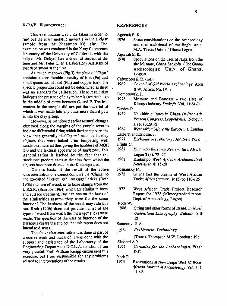
This examination was undertaken in order to find out the main metallic minerals in the a cigar sample from the Kintampo K6, site. The examination was conducted in the X ray fluorscence laboratory of the University of California with the help of Mr. Dokyol Lee a doctoral student at the time and Mr. Peter Chen a Laboratory Assistant of that department at the time.
As the chart shows (Fig3) the piece of "Cigar" contains a considerable quantity of iron (Fe) and small quantities of lead (Pbl) and copper (cu). The specific proportion could not be determined as there . was no standard for calibration. There result also indicates the presence of clay minerals (see the bulge in the middle of curve between G. and F. The iron content in the sample did not put the material of which it was made into any class more than it puts it into the clay group.
However, as mentioned earlier textural changes observed along the margins of the sample seem to indicate differential firing which further supports the view that generally the"CigarsW seen to be clay objects that were baked after tempering with sandstone material thus giving the hardness of MOH 3.0 and the textural appearance of sandstone. This generalization is backed by the fact that the sandstone predominates at the sites from which the objects have been drived, in the Kintampo area.
On the basis of the result of the above characterisation one cannot compare the "Cigars" to the so-called "Letter" or" "message" sticks (Roth 1906) that are of wood, or to bone stamps from the U.S.S.R. (Senenov 1964) which are similar in form and surface treatment. But can one on the basis of the similarities assume they were for the same function? The hardness of the wood may rule this out. Roth (1906) does not provide names of the types of wood from which thenmessage" sticks were made. The question of the uses or function of the terracotta cigars is a subject that this report does not intend to discuss.
The above characterisation was done as part of a course work and much of it was done with the support and assistance of the Laboratory of the Engineering Department U.C.L.A. to whom I am very grateful. Prof. William Knapp encouraged this exercise, but I am responsible for any problems related to interpretations of the results.
Agorsah E. K. 1976 Some considerations on h e Archaeology
and oral traditional of the Begho area, M.A. Thesis Univ. of Ghana Legon.
Agorsah E. K. 1978 Speculations on the uses of rasps from the
site Mumute, Ghana Sankofa (The Ghana Archaeologist), Univ. of Ghana, Legon.
Calvocoressi, D. (Ed.) 1969 Council of Old World Archaeology Area
11 W. Africa, No. IV: 3 Dombrowski J. 1978 Mumute and Bonoase - two sites of
Kintapo Industry Sankofa Vol. 11:64-7 1 Davies 0. 1959 Neolithic cultures in Ghana In Proc.4th
Present Congress, Leopoldville, Nenquin J . (ed) 3:291-2
1967 West Africa before the Europeans. London Earle T. and Ericson, J. 1977 Exchange in Prehistory . AP. New York Flight C. 1967 Kintampo Research Review. Inst. African
Legon 3 (3): 72 -77 1968 Kintampo West African Archaeoloical
Newsletter 8: 15-20 Posnansky M. 1972 Ghana and the origins of West African
Trade: Africa Quarter, ix (2) pp 1 10-125
1972 West African Trade Project Research Report for 1972 (Mimeographed report, Dept. of Archaeology, Legon)
Roth W. 1906 String' and other forms of strand. In North
Queensland Ethnography Bulletin 8:ll- 12.
Semenov S.A. 1964 Prehistoric Technology ,
(Trans). Thompson M.W. London : 195 Shepard A.O. 1971 Ceramics for the Archaeologist, Wash
D.C. York R. 1973 Excavations at New Buipe 1965-67 West
African Journal of ~ r c h a e o l o ~ ~ Vol. 3: 1 - 1 89.

INVESTIGATING THE STONE CIRCLE MOUND SITES AND ART WORKS OF
KOMALAND, N. GHANA
JAMES ANQUANDAH, DEPARTMENT OF ARCHAEOLOGY, UNIVERSITY OF GHANA, LEGON
In the spring of 1984, the Department of Archaeology, university of Ghaa, Legon, received reports concerning ancient mounds discovered in the valleys of the Sisili and Kulpawn rivers of Northern Ghana, Southwest of Sandena, in which numerous cultural materials had been found, including very strikimg terracotta sculptures. A joint research trust was promptly set up by the Legon Department and the Afrika Instituut of Rotterdam, Netherlands, to carry out multi disciplinary (archaeological, historical, linguistic, anthropological and sociological) investigations in the Sisili/Kulpawn basin. The research team that carried out the first season's work in January March 1985 comprised James Anquandah (Director of the archaeological survey and excavations), Laurent Van Ham (Anthropologist, Afrika Instituut, Rotterdam) and Nana Apt (Lecturer in Sociology, University of Ghana, Legon). The Ghana National Museum provided a license for the excavation.
BACKGROUND
The SisililKulpawn basin has seasonal rains and Ghaea savanna woodland vegetation. It is the meeting point of three geological formations-the Voltaian Sedimentary series, the Granitic crystalline rocks and the Upper Birrirnan Metamorphic rocks, which together, account for the variety of milling equipment found in the ancient mounds during the excavations. The local soils, namely savanna ochrosols and laterite intergrade ochrosols are cultivable, but currently not prolific. The main . occupations are agriculture and pastoralism. The ubiquitous non-caltivated shea butter plant (Butyrospermum Parkii) is exploited for subsistence and commercial purposes. The area with the largest concentration of archaeological sites containing the distinctive terracottas is presently inhabited by Koma people who speak Konni , a language genetically closest to Bali the language of the Bulsa who inhabit the area immediately north of
Komaland. Koelle (1854) refers to K0ma people livinn in the area in the mid-19th century but speaking a Grusi language akin to modem Sisala. Nadan (1985) explains that either the Balsa moved into Komaland to displace Sisala speakers or that perhaps the local inhabitants of lomaland adopted Buli language. It is interesting to note here that present-day Bulsa traditional funerary and religious practices bear some resemblance to the funerary practices recorded in the Komaland archaeological sites (Anquandah and van Ham 1985). A preliminary ethnoarchaeological study conducted prior to the excavation revealed that the modem Koma have traditions of potting, iron working, ethnomedicine and building of cylindrical mud huts with grass-thatch roofing.
SURVEY AND EXCAVATIONS
In January 1985, a reconnaissance survey was carried out in Komaland. Surface data obtained from random sampling of mounds at Yikpabongo, Barisi, Tanduo, Tantali, Zeboku, Yizeesi etc. include domestic pottery, grinding stones, metalwork, daub, pottery discs and terracotta sculptures. This information, coupled with oral evidence from interviewees, indicated that the distribution area of the distinctive terracottas covers 20 kilomeues square, roughly.
A multi-stage research strategy initiated to cover 3-4 seasons, work includes (1) ethno- archaeological and ethnohistoric investigations to acquire data for hypothesis formulation; (2) mapping and test excavation of the type-site, Yikpabongo; and (3) the utilization of the Yikpabongo data to carry out in-depth investigations at Zukpeni, which is traditionally held to be the ancient Koma royal seat where hunters have located life-size naturalistic terracottas, at Nangurma probably the largest Koma site, in the Tuvur-Tantali area which has provided terracottas depicting camel-riders, and in selected cave sites.
The first season's work was concentrated at Yikpabongo east and Yikpabongo Bakodeng (10' 15' N; 1' 34' W). At Yikpabongo east a 30 metre grid was laid out extending 420 metres along the north-south exis and 360 metres along the E-W axis. The area was levelled and a contour map of it was drawn in which were marked archaeological mounds of different dimensions. It is hoped in the coming seasons to sample some of the different-sized mounds so as to determine whether the hierarchy of tombs reflects social or economic stratification. Out of 105 mounds which were

mapped, 2 were in diameter over 18 metres, 7 were between llm and 18m, and 96 ranged between 4m and tom. At Yikpabongo east, one small mound L370 (diam. 4m; ht.0.7m) was fully excavated; another small mound I220 (diam. 4m; ht. 0.5m) was partially excavated; and a medium-sized mound H 310(diam 12m; ht 1.2m) was nearly completely excavated. At Yikpabongo Bakoneng, one mound (diam. l l m ; ht. 0.6m) was half-excavated. The author hypothesized that the mounds might be stone circle superstructures covering substructures containing human burials in the style of the Sene-Gambian and Tondidarou (Mali) Stone Circles (Thilmans, Descamps and Khayat 1980), hence the methods adopted for excavation were those of the "Quadrant" and stripping by means of arbitrary levels in 10 cm spits.
RESULTS FROM EXCAVATIONS
Each unit was found to have a Stone Circle superstructure which was underlain by heaps of sandy clay and sandy silt deposits as well as many chunks of granite, metamorphic and sedimentary rocks of various sizes, associated with numerous quems and grinding stone balls of various sizes, thousands of domestic potsherds and pottery discs (? gold weights or game discs). At all levels, there were numerous terracotta sculptures depicting humans, deities and animals. Beneath the heap of assorted equipment and earth debris were disinte- grated daub remains of a possible mud-structured burial chamber or platform where the burial was laid.
Whole pots were located near the feet and may have contained offering drinks and other whole pots served as 'pillows' or props for the, head of the deceased. Close to the human burial were remains of what appear to be a cow, and, or, sheeplgoat sacrificial burial. Each of the larger mounds excavated contained multiple human and animal burials. Several units contained iron knives, arrowheads and ornaments and also cuprous ornaments, some made by cireperdue .
In shape, the metal objects seem to be the material representations of of motifs of daggers, knives bracelets, anklets and necklets depicted on the bodies of the human terracotta sculptures. The Yikpabongo Bakodeng mound produced a number of actual cowry or venus shells (Cyprea annulus ) which may have been imported across the Sahara from the regions of the Indian and Pacific Oceans (Tyron 1885).
One come away from the excavation with the impression that the authors of the mounds probably had a funerary custom which obliged all the clan relations of a deceased person to dump their food preparation equipment, receptacles, end terracotta portraits (representing clan deities, totems or departed clan ancestors) on the tomb at the close of the burial ceremonies. The general concept, but not the detail, of this custom, is paralleled in Akan archaeological contexts documenting funerary rites (Anquandah 1975 and 1982).
The detailed analysis of excavated materials is still in progress; but the following figures may afford some idea of the quantity of cultural materials from each mound.
L.370 H.310 1220 Bak.1 hmest ic Pottery 5179 34,453 .. . . Milling Stones 4 1 1,786 .. .. Terracotta sculptures 19 258 20 226 Pottery Discs - 77 Copper ornaments - 6 Iron ornaments - 8 Daub 29 85
The domestic pottery from the excavations is in the normal style of slipped and rouletted iron age pottery found in the northern half of Ghana (north of latitude 8' north) (Anquandah 1982). Komaland pottery is sand-tempered. The forms include water jars, food bowls, cooking pots, large water storage pots an millet beer jars. Over 60% of the pottery is coated with a fine redlpink slip; over 3096 combines slipping with roulette decoration by means of string, plaited grass, or carved wood roulettes; small samples show channelling, incision and comb-stamping, as well as a motif imitating venus or cowry shells akin to representations on many terracotta sculptures. The subject matter of the terracottas comprises human figures (over go%), animal figures (about 5%), activity figures or pictorial art such as persons riding camels (about 0.5%) and cultural objects such as stools (1%). Animal figures include curled snakes, lions, hippos, crocodiles, frogs camels, and birds (especially owls).
The commonest type of human figure (56%) is depicted with a single head, wearing a beard, a turban, hat or helmet. This type of figure has an elongated base as if it was designed to be hafted in a hollow pillar or staff. There is a striking terracotta class (17%) which depicts figures shod with daggers or knives and elaborately ornamented with cowries,

metal objects or wearing tassels. Another class depicts double-headed or 'Janus' figures. There are a few naturalistic examples in which the apparently sensually-minded artists depict in detail human genital organs separate from the body.
DATING THE MOUNDS
Samples of bone and terracottas from the excavations have been submitted for radiocarbon and thermoluminescent age determinations. However, two terracottas which are surface finds from Yikpabongo have been given thermoluminescent age estimations by two laboratories, as follows (Anquandah amd Van Ham, 1985):- No. K414 405+ 135 BP (Max-Planck Inst; Heidelberg) No. 53855 4 8 m BP (Clamart Lab; Paris)
Also Cypreea annulus cowry shells such as were excavated from the Bakodeng mound are known in 17th to 18th century northern Ghana archaeolo- gical contexts at Jakpawuase, Bagjamso, Ahinkro etc. (York 1972). It would appear on present evidence, therefore, that the Stone Circle mounds at the Yikpabongo site at least, may date to sometime between the 14th and 17th centuries.
SIGNIFICANCE O F THE SITES
The terracottas are far and away the most important and distinctive aspect of Komaland stone circle complex. A Study of sectioned pieces show that the terracottas are unquestionably indigenous manfactures of skilled traditional artists who used local raw materials and fashioned their pieces round an inner core of clay. There was no concern with colour painting. Instead they relied on their skill in plastic decorative styles of high and low relief and sculpture-in-the-round. They possessed aesthetic sensibility, and an appreciation of the details of nature and their ecosystem. Like the Ife artists of Abiri and Osongongon Obamakin, they knew when and how to represent naturalistic or stylized features, or even both, in the same figure. (Fagg 1951; Balandier 1951; Willett 1967:64). There are many instances of the use of symbolism in this art to signify fertility or wealth (eg. cowries and sex organ motifs); some times they depict 'janus' or multiple human heads in one piece as if to suggest social solidarity and multiple decision-making, even as in the Akan proverb "Tiko nko egyina" (one head does not hold a council); sometimes the artists seem to depict mystical deities or ancestral spirits with human bodies and wings and with double sexuality.
All this indicates that the artists may have been guided by religious and other social and functional motives and criteria, thus vindicating the view of Gombrich (1960:llO) "the test of the image is not its lifelikeness but its efficacy within a context of actions. It may be lifelike if it is thought to contribute to its potency".
The dynamism and variety of pattern and concepts exhibited suggest that the artists had unwritten traditional art-producing systems of formulae and modifiable schemata. A close study of the pieces from several sites shows that they do measure up to Jansen's definition of what constitutes a work of art, namely, that its creative process must involve a series of "leaps of the imagination" (Jansen 1962:9-1 1). In lieu of normal historical data facilitated through conventional writing, the terracottas provide eloquent documentation of iron age craftsmanship, religious ideas, funerary customs, sex and beauty, dress styles, a forest ecosystem wetter than today and populated by crocodiles, hippos, lions, snakes etc; and above all, hints of long-range commerce partly based on camel transport and links with the Sahel and Saharan Desert trade systems.
The evidence of actual cowry shells, copper metal objects, art motifs of cowries, camels and camel riders (see Monod: 1969); coupled with the fact that mineralogioal analysis has revealed that one Yikpabongo sculpture was found embedded in gold dust; coupled with the fact of production of vast quantities of pottery and milling equipment which must have entailed considerable labour, skill and transportation of raw materials-- all this seems to suggest the predictive hypothesis that there may have existed a kingdom in Komaland through which the trans-Saharan caravan route linking Egypt and N. Africa with Gao, Mossiland, Ouagadougou, Komaland and the Volta confluence may have passed,and that its people may have thereby grown prosperous to enable them pay for the labour of erecting so many hundreds of packed tombs of various sizes and to patronise numerous skilled creative artists, cire periue metal workers etc.
Future research will clarify the position.

A preliminary report on the work at Yikpabongo is provided in the booklet Discovering the forgotten 'Civilization' of Komaland, Nothern Ghaa , by James ANQUANDAH and Laurent VA HAM; published in Rotterdam, 1985 (ISBN 90-70218-10-0); 47 pages with 17 colour photographs, 8 Black-and-white photos, and several maps and diagrams.
Copies may be obtained at $10 each from Ghames Foundation. Zeeweg 45, 3235 AX Rockanje, Netherlands.
REFERENCES
Anquandah J. 1975 "Archaeology and the arts of the Akan AD
1250- 1850". Proceedings of Inter- University Conference . Kumasi. Legon
1982 Rediscovering Ghana's Past. Longman. Anquandah J. and Van Ham, L. 1985 Discovering the forgotten civilization' of
Komaland: N. Ghana. Rotterdam. Balandier G. 1951 "Conditions sociologiques de l'art noir
"L'art Negre, Presence Afriaine. 10 - 11, P. 58 - 71.
Fagg, W. 1951 "De l'art des Yoruba", L'art Negre
Presence Africaine . 10-1 1, P. 115-116. Gombrich, E.H. 1960 Art and Illusion. . Princeton. Jansen, H.W. 1962 Hist ory of Art , New york Koelle, S.W. 1854 Polyglotto Africana London Monod, T. 1969 "Le Maden Ijafen". Actes dupremier
Colloque Int. d'Archaeologie Africaine, Ft. Lamy
Naden, A. 1985 "Language, history and legend in N.
Ghana", Seminar Paper, History
Department, Legon Thilmans, G. Descamps, C. and Khayat, B. 1980 Protohistoire du Senegal, Les Sites
Megalithiques. Memoire Inst. Fondam. Afr. Noire No. 91, Dakar. Ifan.
Tyran, G.W. 1885 Manual of conchology, vol. 7 .
Philadelphia Willett, F. 1967 Ife in the history o f ' West African
Sculpture. London Willett, F. 1971 African Art. London. York, R. N. 1972 "Cowries as type-fossils in Ghanaian
. archaeology". West African Journ. Arch. 2: 93 - 101.

EVIDENCE FOR PREHISTORIC MAN
ON MOUNT KENYA
William C. Mahaney Geography Department Atkinson College York University 4700 Keele Street North York, Ontario Canada M3J 1P3
Tim Charsley Mines and Geological Department Box 30009 Nairobi, Kenya, East Africa November 1985
I n t r o d u c t i o n
Geological field surveys of Mount Kenya during 1976, 1983184 and 1985 revealed considerable information on repeated glaciations of Mt. Kenya. Aside from one site in Gorges Valley (Mahaney, Barendregt, Churcher & Spence 1985) there is only scattered evidence to suggest that prehistoric man might have lived, cultivated and hunted on Mount Kenya at high elevations (above 3000 m). Earth mounds in Gorges Valley near the Nithi River have been postulated to have a prehistoric origin (Hook, in Zeuner 1948), but are considered to be natural features. Pottery and stone artifacts from two areas, and a shaped cobble of Precambrian gneiss found on the surface of moraines of Teleki age near Lake Ellis (Figure 1) suggest that prehistoric people occasionally visited various areas on the mountain up to 3500 m This accords with the record of obsidian artifacts found above 10,500 ft. (3200 m) by Col. R. Meinherzhagen (Zeuner 1948).
Field Area
A number of major deposits of late glacial and post glacial age are found in the Afroalpine, Hagenia Woodland, and Bamboo Forest zones on Mount Kenya. These glacial deposits have been assigned ages on the basis of topographic position (Baker 1967), as well as weathering features and degree of soil expression (Mahaney 1979a and b, 1980, 1981, 1982a and b, 1983, 1984a and b, 1985).
The Afroalpine area rises from -3150 m to the summit of Mount Kenya at 5199 m. Precipitation derived from the Indian Ocean is delivered by the tropical easterly wind belt and the classical monsoon
system. The southeast slopes are wettest with rainfall reaching 2500 mm (at 2250 m); the northern slopes are driest with -1000 mm annually. On the western flank of the mountain precipitation rises from -500 mm at Naro Moru (2000 m) to -1000 mm on the high moorland (-3500 m) and then drops in the central peaks area (-4300 m) to -750-800 mm (Coetzee 1967). Evapotranspiration data are not available for Mount Kenya. Temperature extrapolations (Coe 1967; Thompson 1966) suggest that temperatures at 4200 m average 3.1 to 3.6"C (from observations taken during two periods in 1948; Coetzee 1967; Hedberg 1964). The drop in precipitation from the western to the northern and eastern flanks (Pedgley 1966) affects leaching effectiveness in soil systems.
Vegetation
Above the heather zone at timberline (-3150 m) the lower Afroalpine zone dominated by Senecio brassica extends upwards to -3700 m where it merges with the upper Afroalpine zone characterized by Senecio keniodendron. The Upper Afroalpine merges with vegetation of the nival zone at -4500 m (Coe 1967; Hedberg 1964). The sites described in this paper are located in the lower Afroalpine zone, timberline ecotone, and upper Hagenia Woodland.
Methods
Samples were collected during the course of field investigations on the eastern flank of Mount Kenya in 1983, 1984 and 1985. Soil descriptions follow the Soil Survey Staff (1951, 1975), and dating methods follow those described by Mahaney, Barendregt, Churcher and Spence (1985).
Resu l t s and Discussion
The Mounds
The mounds found between Mugi Hill and Lake Ellis and extending towards the timberline zone are of two types. The smaller, randomly distributed, and asymmetrically shaped mounds (-1.0 m high x -2.0 m wide x -3.0 m long) are possibly of wind-blown origin, but may have a natural origin as vegetation protected erosional remnants. They date from a period following emplacement of the Darwin Formation on Mount Kenya (Mahaney 1983, 1984a and b, 1985). The second group of mounds appears symmetrical in cross-section, of somewhat larger size (-1.0 m high


x -4 m in diameter) and elliptical in shape. As reported by Mr. Raymond HOOk (in Zeuner 1948) and Baker (1967) they commonly have angular volcanic fragments in their centers. Unlike Zeuner and Baker, we have only observed mounds of the second type to the north of the Nithi River below "The Gates" (Figure 1). While they may be explained as cultivation areas designed by pre-historic people, further work is required to prove they are of human origin. We could not confirm any linearity in mound arrangement as originally observed by HOOk (Zeuner 1948). We did, however, find two stone artifacts of Middle Stone Age type (identified by Dr. S. Wandibba) within the Kech am hollow just north-west of Mugi Hill.
The Caves
In the area around "The Gates" (Figure 1) a number of caves lie concealed close to a prominent waterfall which spills over the outermost moraine of pre-Teleki age in lower Gorges Valley (Mahaney, Barendregt, Churcher and Spence 1985). To find the caves one must hike above the waterfall at "The Gates" and descend to a narrow gorge formed by the Nithi River. In 1984 a number of bone fragments of small mammals and birds were uncovered in rock shelters above the cave net work. In 1985, a fragment of pottery dated at 1100-1300 A.D. was found by G . Watson in the scree downslope of rock over hangs at "The Gates". Two artifacts of Middle Stone Age type were also found at this site at the same time (identifications of pottery and artifacts by Dr. S. Wandibba). If the mounds below "The Gates" are of human origin it is possible that the mound architects used the caves and/or the rock shelters on a permanent or semi-permanent basis. It would seem that an archeological reconnaissance of the caves is required to prove or disprove this theory.
Shaped Stone
Near Lake Ellis (Figure 1) a cobble approx- imately 90 mm in diameter (Figure 3) was found on the surface of a left lateral moraine of Teleki age. This moraine situated along the north side of Lake Ellis is of pre-W.rm age (-200,000 yrs BP). Correlation with similar moraines in Teleki and Gorges Valley can be established using relative dating indices of age, such as topographic position, soil profile expression, and weathering of surface boulders. In addition, buried Ab horizons in paleosols give high ratios (0.42) (Mahaney, Boyer and Rutter 1985) for the D-form of aspartic acid.
Conclusions
From the limited evidence available it appears that prehistoric people occasionally traversed and hunted in the lower moorlands (lower Afroalpine zone) and Hagenia Woodland, especially on the eastern and north-eastern flanks of Mount Kenya. That at least some of this occupation occurred several centuries to perhaps hundreds of thousands of years ago, is suggested by the presence of a cobble artifact with a large-size lichen thallus, stone age artifacts (hand axes), and sizeable earth mounds with appreciable soil cover.

FIGURE 3
Acknowledgements References
This research was supported by grants from the National Geographic Society, Washington, D.C., Natural Sciences and Engineering Research Council of Canada, and York University. Field work was authorized by the Office of the President, Mines and Geological Department and Mountain National Parks, Republic of Kenya. I thank Linda Mahaney, Joseph Carnillo and Simon Murithi for assistance in the field. Laboratory analysis were completed at the Mines and Geological Department in Nairobi. We are particularly indebted to Willie and Didi Curry, formerly of Naro Mom River Lodge, and Tor and Sue Allan (Tor Allan Safaris Ltd.) for logistical support; to P. M. Snyder (formerly Assistant Warden) and F. W. Woodley (Warden) Mt. Kenya National Park, and to their rangers for assisting in the course of the field work. We thank the following people for sample analysis: Dr. Mary Leakey (National Museum of Kenya) for analyzing the cobble sample from Lake Ellis; Dr. C. S. Churcher (Royal Ontario Museum) identified bone fragments collected near "The Gates" in 1984; and Dr. S. Wandibba (National Museum of Kenya) kindly identified pottery and stone artifacts collected at Kech Tarnand "The Gates" in 1985.
Baker, B. H. 1967 Geology of the Mount Kenya Area. Rept.
No. 79 Geol. Surv. Coe, M.J. 1967 The Ecology of the Alpine Zone of Mount
Kenya. The Hague Coetzee, J. A. . 1967 Pollen analytical studies in East and
Southern Africa, in van Zinderen Bakker, E. M. ed. Palaeoecology of Africa, 3
Hedberg, 0. 1964 Features of Afroaleine Plant Eco-ogy. Acta
Phytogeographica Suecica, Uppsala, 49 Mahaney, W. C. 1973 Neoglacial Chronology in the Fourth of
July Cirque, central Colorado Front Range. Bull. Geol. Soc. Amer., 83 (1) 161-170.
1974 Soil stratigraphy and genesis in deposits of Neoglacial age in the Arapaho and Henderson cirques, central Colorado Front Range, in Mahaney, W.C.(ed). Quaternary Environ- ments: Proceedings of a Symposium, Geographical Monographs, 5,197- 240.
1979a Quaternary stratigraphy of Mount Kenya: A Reconnaissance. Palaeoecology of Africa, 11: 163-170.

Mahaney, W. C., 1979b Soil erosion along the Naro Mom track - a
Western approach to Mount Kenya. E. African Agric. & Forestry J., 45 (2): 158-166.
1980 Late Quaternary rock glaciers, Mount Kenya, East Africa. Journal of Glaciology, 25 (93): 492-497.
1981 Paleoclimate reconstructed from paleosols: evidence from the Rocky Mountains and East Africa, in Mahaney, W. C., ed. Quaternary Paleo-climate Pgs. 227-247. Geoabstracts Ltd., Norwich, U.K.
1982a. Chronology of glacial deposits on Mount Kenya, East Africa: description of type sections, in van Zinderen Bakker, E. M., ed. Palaeoecology of Africa, 14: 25-43.
1984b . Lateglacial and postglacial chronology of Mount Kenya, East Africa, in van Zinderen Bakker, E. M. and Coetzee, J. A., (eds). Palaeoecology of Africa, 16: 327-341.
1985 Late glacial and Holocene paleoclimate of Mount Kenya, East Africa. Zeitschrijtf. .r Gletscherkunde und Glazialgeo-logie, in press.
- Piegat, J., Halvorson, D. L. and Sanmu- gadas, K. (1984) in Quaternary Dating Methods, Mahaney, W. C. (ed). Pgs. 355- 374. Elsevier, Amsterdam
- Boyer, M. G. and Rutter, N. W. (1985). Evaluation of amino acid composition as a geochronometer in buried soils on Mount Kenya, East Africa. Seventh Quaternary Symposium, Lethbridge Univ., Lethbridge, Alberta, August 21-25, 1985.
- Barendregt, R. W Churcher, C. S. and Spence, J. (1985). Gorges Valley rock shelters, Mount Kenya Afroalpine area, East Africa. Nyame Akuma, No. 26: 22- 25.
Pedgley, D. E. 1966 Rainfall of Mount Kenya, Weather, 21:
176-188. 1982b Correlation of Quaternary glacial and
periglacial deposits on Mount Kenya, East Africa, with the Rocky Mountains of Western U.S., in X1 INQUA, Moscow, USSR, 1: 208. Aug. 1-9, 1982
1983 Chronology of Quaternary glacial deposits on Mount Kenya, East Africa, Geological Association of Canada Annual Meeting, Abstracts, Victoria, B. C., 256., (1984a). Soils of the Mount Kenya area, their form- ation, ecological and agricultural signifi- cance, a discussion. Mountain Research and Development 4 (3): 284-285.
Soil Survey Staff 1951 Soil Survey Manual, U.S. Govt. Printing
Office, Washington, D.C. Soil Survey Staff 1975 Soil Taxonomy U.S. Govt. Printing
Office, Washington, D. C. Thompson, B. W. 1966 The mean annual rainfall of Mount
Kenya, Weather, 21: 48-49. Zeuner, F. E. 1948 Climate and early man in Kenya, Man, 48:
13-16.
THE SIRIKWA HOLES AND THEIR HOUSES ON HYRAX HILL
John E.G. Sutton British Institute in Eastern Africa P.O. Box 30710 Nairobi, Kenya
As every archaeologist who has been in the Kenya highlands knows, the "North-East Village" (or Site 11) lies in fact on the north western flank of the small lava eminence known as Hyrax Hill, standing by the main road at the eastern edge of Nakuru town. Nor would we describe it now as a "village" of "pit-dwellingsH- terminology reflecting archaeological thinking of the 1930s when Mary Leakey dug here. She excavated two of the thirteen "pits", which are better called hollows, being in fact grass-covered depressions on the hillside each measuring between twelve and thirty metres across. Furthermore, they were not likely to have been in use all together, but successively. As Mary Leakey herself recognized, this is a type of archaeological feature which occurs in numerous groups, not merely in this elevated stretch of the rift valley, but right across the western highlands as far as Mount Elgon, over two-hundred kilometres to the north-west. Generally known as "Sirikwa Holes" (owing to the traditional attribution to a previous population by the present Kalenjin peoples), these hollows, so it has been known for the last twenty years, do not themselves represent actual houses, as was not unreasonably assumed at first. Indeed, for long, the favourite theory was that they had contained sunken earth-roofed structures of a flattish rectanglar type similar to that built recently by the Iraqw of Mbulu district in northern Tanzania . But consistently excavations of these "Sirikwa Holes",

in the "central" rift and later in the western highlands, failed to locate post-holes to support such heavy-roofed or any other sort of houses inside these hollows. What they did reveal were well-defined roughly circular stockade lines around the edge of each hollow, with a narrow and protected entrance on the downhill side. Clearly these were, as the Kalenjin traditions insisted, stoutly fenced and gated cattle-enclosures, artificially sunken for some reason and open to the sky. The broad mounds which lie beside the entrances or a short distance below doubtless represent the dumps of mud and dung cleaned daily from the stock-pen. Rubbish was of course thrown in too: this consists of, beside a few sherds of tall pots, plentiful food-bones of domestic animals.
Since the mid-1960s these "Sirikwa Holes" have been dated to the later Iron Age between approximately two and five centuries ago (to a period presumably before large-scale cattle-raiding and a change of military techniques forced the abandonment of this type of device for penning livestock). The old assumption that the Hyrax Hill "North-East Village" belonged to Louis Leakey's "neolithic Gumban B" was based on stray later-Iron-Age potsherds which he had found in 1926 among the covering stones of the nearby Nakuru Burial Site. Mary Leakey had herself realized that the dating must be very different; but it was not till the comparative work of the late-1950s and early-60s, assisted by the fmt radiocarbon tests, that the matter could be properly sorted out and the supposed "Gumban B" connection discarded at last.
Despite the radically different interpretation of the Sirikwa Holes as late Iron-Age livestock enclosures, it stood to reason that some sort of house or houses must have been associated, whether to accommodate substantial families or whether, in some of the grasslands good for seasonal grazing, to serve the needs of herdboys only. Naturally, the more purely pastoral or the more seasonal the use, the less conspicuous the archaeological signs of houses might be. Moreover, at Hyrax Hill and at the nearby site of Lanet - where Merrick Posnansky meticulously cleared a complete Sirikwa Hole in 1957 - the volcanic ash and soft pumice gravel are not conducive to the detection of wooden wall foundations. But in the western highlands, excavations in the early 1960s on Sirikwa Hole sites with cohesive red soils overlying lava or other rock, brought to light the foundations of round houses, some if not all of which were doubtless of cone-on cylinder type with wooden and daubed walls
ana thatch roofs. The smaller examples, onfy three or four metres across, would have been adequate for herdboys, and also for a few small stock or calves, for an internal partition was found to divide a smooth "bedroom" behind from the broken floor of the front half. But in wetter country good for cultivation alongside stock-keeping, larger houses up to eight metres across were constructed alongside Sirikwa Holes as family dwellings. These again had internal divisions separating human inhabitants from young stock. Whether large or small, these houses were notfor certainly were not normally built within the fenced hollows in which the cattle were penned by night. They stood immediately outside, either by the entrance (thus helping to guard it) or attached to the back of the stockade, but with the door facing into the cattleenclosure thus to preserve a closed unit.
The approximate positions and nature of the houses at Hyrax Hill Site I1 and Lanet were therefore predictable. But for some reason confmation - and indeed the development of this whole subject with such unusually clear archaeological features and excellent potential for late Iron-Age settlement study - has been neglected for twenty years (some minor or inadequately reported assays notwithstanding). The last significant excavation known to me was the clearing of another hollow (labelled D) at Hyrax Hill in 1965 by the Kenya Museum for purposes of viewing alongside the site museum. This example remains open, although silted up to 70 cm in the middle. Part of the surrounding stockade line still shows well (and is comparable to those illustrated in Mary Leakey's plans and sections of hollows B and C which she had excavated in 1938). But once again no post-holes or house position could be detected either in the hollow or around its edge.
Our strategy in October 1985 therefore - after discussion with Dr. Mary Leakey and with the Kenya Museums which provided both an excavation permit and all possible cooperation - was to extend outwards the old excavations of hollows B and D to see if attached houses had been missed, and to lay long cuttings between hollows and mounds in search of previously unsuspected features. Although much of this trenching proved negative in a simple sense, in that below a thin barren topsoil we quickly reached the natural volcanic ash, pumice-gravel or weathered pumice, altogether these findings are valuable for reconstructing the use of the site as a whole, and when seen alongside the more exciting findings in and around hollow F at the southern end of the group. This hollow F happened to be situated

where the pumice gravel lies more thinly over hard lava, and where therefore structures could be detected in the solid rock. The roughly circular edge of the hollow showed up unusually clearly in this case as a defined step-trench about half-a-metre deep; clearly it represents a typical stockade, the footings of which were supported on the inner side by big boulders, themselves obtained during the construction of the hollow. Again no features showed up in the interior, the roughly hewn floor indicating yet once more an unroofed cattle-pen, about twelve metres in diameter, having a narrow, cobbled entrance at the downhill side. But adjoining the stockade in a side-annexe, and also on either side of the entrance defile, there turned up post-trenches of the typical Sirikwa type already known from the western highlands, describing three roundish houses, each five or six metres across. Rough internal trenches divided the houses into three or four rooms each. The back rooms with smooth surfaces would have served domestic and sleeping purposes; the front ones with badly broken floors had been for livestock, presumably calves, lambs and kids which would have been crushed if left in the main enclosure with the adult stock. Because of this heavy floor wear amounting to erosion of the front parts of the houses, the exact door position is discemable in only one of the three. But it is clear that all were entered through the stock-pen: once again there was only one way into the complex, and no back door into any house.
Reflecting from these results to the hollows excavated at Hyrax Hill in 1938 and to that at Lanet in 1957 too, the most reasonable position for houses would again be flanking the entrances. With a little imagination it may still be possible to discern such on the very weathered surfaces by the exposed entrance of hollow D, and from Mary Leakey's plan of C, and again from that of Posnansky for the excavations of the hollow which he called "Hut A" at Lanet. In the last case it had been argued, contrarily, from the stratigraphy of deposits in the middle of the hollow, that some sort of house had stood there. This thinking had of course been influenced by the old idea, deriving from the earlier interpretation of the Hyrax Hill examples, of earth-roofed houses; but also Susannah Chapman's excavation at Kabyoyon on the foothills of Elgon in 1961 had revealed parts of the outlines of two (or possibly three) houses in (or at the back of?) a Sirikwa Hole (perhaps a slightly variant type). These were however small round houses, once again revealed by post trenches: they were not unlike those found (by myself in 1963) in annexes
attached to the backs of small stone lined Sirikwa Holes at Moiben in Uasin Gishu. On balance therefore it seems more likely that, if a house had actually been built in the middle of the excavated Lanet Sirikwa Hole, it was secondary to its purpose as a cattle-pen, and that the original if rather flimsy house or houses would have stood to the side of the entrance. (It would not have been at the back, as the extent of Posnansky's excavation, and a further extension by myself in 1985 to be doubly sure, demonstrate.)
As noted above, it has been assumed that the round houses attached to Sirikwa Holes were of cone-on-cylinder design, not dissimilar basically to recent Kalenjin ones. This doubtless holds for the more substantial examples, notably those revealed (in 1964) at Chemagel (Sotik) in the western highlands. The shapes of those of Hyrax Hill "roundish" indeed, but not truly circular - make us hesitate before insisting on a standard form. It would have been difficult to have constructed effective conical thatch roofs on these lopsided structures: we wonder whether skins and dung were perhaps used instead. One suggestion which we can rule out is that of a flattish or domed earthen roof, simply because the local pumice and ash soil is so loose and porous - as well as because of the lack of a rectangular shape and grid of internal supporting posts.
The suggestion of a skin-anddung-covered roof must not be pressed incautiously at this point. It is inspired of course by the example of modern Maasai - but mostly in those parts of the high grasslands with thick red soil to mix with the dung, which does not obtain at Nakuru. Moreover, the normal Maasai house is rectangular, albeit with rounded corners, not the "squashed circle" shape of these Hyrax Hill discoveries. Either way, this Sirikwa Hole and the attached houses do not, as a complex, offer much of a'parallel for Maasai settlements and encampments as known in this high grassland region during the last one-hundred years. The Hyrax Hill houses do nevertheless have a decidedly pastoral look about them, containing few finds and no true floor deposits, and only a very slight hearth in one of the three. They had sewed as the night shelters for herdsmen and the young livestock. The dearth of tools, grindstones and cooking-pots on the site as a whole bears out this impression; and supports the qualified contrast noticed in the 1960s between Sirikwa Holes in the more open grasslands as here and on the Uasin Gishu plateau, and those in generally wetter country good for mixed pastoral- agricultural activities, such as Nandi and Sotik.

Schematic plans of excavated Sirikwa Holes at (left to right) Chemagel (Sotik), Moiben (Uasin Gishu) and Hyrax Hill (Nakuru), showing the open-air cattle-pens with stockade lines (and stone-revetting in the Moiben example), protected entrances at downhill side, and attached houses.
Scale approximately 1: 250. The broad mounds below the entrance (or on either side at Chemgel) are not shown.
The other important point about the houses, this one shared with those of the westem-highland Sirikwa Holes, is the use of trenches, not individual holes, for the posts (of the outside walls and interior partitions alike). Questions of house-form and shape apart, this method of constructing foundations seems peculiar to Sirikwa Holes: it is not, to my knowledge, recorded ethnographically in this broad region, whether among Kalenjin, Maasai or any other group. Previously it was surmised that a continuous trench served for a wall of juxtaposed logs, either whole or split, thus providing solid and secure house-construction at a time when timber was plentiful. That may hold up to a point in some areas such as Sotik, where the foundation trenches of the houses attached to the Chemagel Sirikwa Hole do indicate stout walls for substantial cone-on-cylinder houses. But at Hyrax Hill the trenches, though constructionally similar, are smaller and less regular (and actually peter out in the remnant gravel bank on the lower side of the house in the annexe); the walls they supported would have
been much less substantial than those at Chemagel. The explanation of the trenching must lie in the digging technique, in particular the tool or tools used. Here we have to conjecture a bit. It is of course certain that this was an Iron-Age population (the few uninspiring flakes of obsidian found at Hyrax Hill and Lanet - if not strays from earlier times - notwithstanding). Yet actual finds of iron have been found on and by Sirikwa Holes only in the west, not yet at Hyrax Hill Site I1 despite three separate sets of excavations there. (But contrast the quite rich iron finds at Site I on the other side of Hyrax Hill, where the Iron Age enclosures with attached houses are basically a derived type of Sirikwa Hole, of 18th - or possibly early 19th - century date.) The really intriguing iron find comes from nearby Lanet: it is a worn tanged object, believed to have been a small hoe, found in the strange earthwork embankment which is probably roughly contemporary with the Lanet Sirikwa Holes. This would have been perhaps a suitable tool for chipping out a trench line - for the houses and

equally for the stockade surrounding each Sirikwa Hole.
This is just one specific constructional aspect of S i r h a Holes. We are left speculating also on the other tools and techniques employed for digging out these big hollows and shovelling away the spoil. The latter could have been managed by hand (or by using shoulder-blades of cattle?) together with leather bags. But for breaking the turf, digging a couple of metres through the subsoil and, in the case of hollow F at Hyrax Hill, cutting into solid rock, effective hoes and digging-sticks would have been needed. The stockades required that substantial timbers be cut and dressed up to a point. There is an organizational as well as simply technical side to this labour to be considered, bearing in mind the vast numbers of these Sirikwa Holes, each used for a few years and then abandoned as it fouled up and its timberwork collapsed, to be replaced by a new one, perhaps constructed alongside.
It is already hinted that the economy of this community at Hyrax Hill Site I1 was predominantly pastoral, not just because of the simple fact of an elaborately constructed and defended cattle-pen - for this holds for all Sirikwa Holes - but more because of the flimsy (if inadequately understood) houses and the rarity of tools or pot-types which one would associate with cultivation and the cooking of grains and vegetables. There are indeed pots, mostly of the tall, gourd-shape type with twisted cord-roulette decoration; this is classic "Lanet ware" (or Kenya Highlands Class C). Possibly these were for beer (made from honey and millet?). The sherds are not scattered or comminuted in the way that usually occurs on busy agricultural homesteads; rather, concentrations of big sherds tend to be found just where the cracked pot has been abandoned. Thus, while the number of potsherds on the site is quite small, the proportion of reconstructible vessels is high.
But the most valuable evidence of daily activity comes from the broad mounds which, as always with Sirikwa Holes, stand outside the entrance, at Hyrax Hill a little to one side. This year we tested three (Mound G next to our Hollow F; Mound J immediately below Hollow B excavated in 1938; and Mound A in order to compare results with those from Mary Leakey's long trench of 1938). The deposits are only a metre or so deep, consisting of a soft, powdery, ashy soil which, pending more detailed tests, seems to consist largely of burnt dung. They represent the daily dumping from the cattle-pens. Samples were taken for flotation level by level from each of the three mounds: some seeds
have been recovered, but, as far as these have been examined yet, it is rather doubtful whether we have eleusine, sorghum or any other food (or beer) grain. The animal bone in these ashy mounds is plentiful and well preserved, albeit broken for roasting, cooking and marrow extraction.
The collection is being studied by Bernard Mbae: it is virtually exclusively that of domestic stock - cattle, sheep and goat. (Sheep and goat rather than sheep or goat, it seems on first look.) In fact this site would be ideal for a detailed study of late Iron-Age herds and flocks in these high equatorial grasslands.
Charcoal is rather sparse in the mounds - which is another reason for thinking that the ash is mostly derived from dung. However, adequate charcoal samples for radiocarbon measurement were obtained in the lower levels of all three. Although I for one am sceptical of extracting precise dates from late Iron-Age radiocarbon tests (even with the help of the most recent calibration curves), we ought to get an indication of roughly where Hyrax Hill fits into the Sirikwa Hole sequence. At present this runs backwards from the eighteenth century (where we would place Chemagel), and the general feeling has been that Hyrax Hill falls towards the earlier end, perhaps as much as five or even six centuries ago. This is largely impressionistic, based on hunches about the evolution of the pottery, as well as of the structures, and on certain local historical assumptions. Since variability seems to be regional as well as chronological, we require independent dating pointers.
In this way we should begin to gain a picture of the history of Masailand and its borders before the Maasai, or should we say before the pastoral Maasai ascendancy which was established by the end of the eighteenth century at latest. The evidence is coming from a variety, of sources, by no means exclusively archaeological. We are reminded however of the concurrence of the Sirikwa Holes dating with that of another archaeological complex towards the southern end of Masailand, three hundred kilometres along the rift (across the Tanzanian border). This consists of Engaruka and related sites with their remains of irrigated agriculture of between about the fifteenth and seventeenth centuries. (Reports of the British Institute's latest work at Engaruka by Peter Robertshaw and myself, together with Carolyn Thorp's study of the domestic animal bones which leads us to suggest stall-feeding and manuring of the fields, have been prepared for this year's Azania, )(XI.) Culturally and economically Engaruka is very distinct from the Sirikwa remains and we do not have to imagine actual contact between the two. But

the simple observation that both flourished at roughly the same period, and that by the time of their ending there seem to be Maasai all around, leaves us with some challenging historical questions.
References
S. Chapman, "A Sirikwa Hole on Mount Elgon", Azania 1 (1966), pp. 139-48
M.D. Leakey, "Report on the excavations at Hyrax Hill, Nakuru", Trans. Royal Soc. S. Africa, MM, part 4 (1945)
National Museums of Kenya, Visitors Guide to the Hyrax Hill Site (revised. by H.V. Merrick, 1983)
M. Posnansky, "Excavations at Lanet", Azania 11 (1967), pp. 89- 1 14
J.E.G. Sutton, The Archaeology of the Western Highlands of Kenya (British Institute in Eastern Africa, memoir 3, 1973), esp. ch. V and app. 3 - 6.
THE DISTRIBUTION OF LONGWE POTTERY SITES IN SOUTHERN
MALAWI
Yusuf M. Juwayeyi Department of Antiquities P.O. Box 264 Lilongwe, Malawi
In 1975, Keith R. Robinson excavated some pottery in the area North and East of the Mulanje Plateau which looked strikingly similar to the pottery recovered from Malowa Rockshelter on the Shire Highlands and described by J. Denbow as "Mawudzu ponery", as well as the pottery recovered from Matope on the banks of the Shire River and referred to as "Channelled Mawudzu" (K.R. Robinson, 1977:35; J. Denbow 1973549; P.A. Cole-King, 1973:12 and plate VI). Although the pottery appeared to resemble Mawudzu pottery more than any of the earlier material such as Nkope and Kapeni, which were also recovered in the North and East of the Mulanje Plateau, it still has characteristics unique to itself to warrant a name other than Mawudzu. It is generally thinner than the typical Mawudzu pottery. A wide variety of decorative styles were observed. These included a combination of bold oblique, vertical and horizontal channelled decorations, concentric circles and sometimes bosses. At Nasiyaya site, the only site that yielded excavated material from very shallow but apparently undisturbed occupation deposit, the pottery appeared grittier than the Early Iron Age material from the same area. It was weathered and the surface finsh eroded. A carbon - 14 date of 970 + or- 50 A.D was obtained from this site (Robinson, 1977:14,27). Robinson called this pottery "Longwe Ware" after the name of a hill where the pottery was extensively scattered on the surface. Its distribution North and East of the Mulanje Plateau extends as far as the Lake Chilwa area (Fig. 1).
Between 1979 and 1983, I carried out intermittent archaeological investigations of the Later Stone Age and Iron Age sites on the Shire Highlands. A survey of sites containing Longwe pottery was one of my main objectives. This survey showed that besides Malowa Rockshelter, Longwe pottery was also present at the neighbouring site of Midima Rockshelter, CZ 23 (Narnitambo tunnel) TO 16 (Morocco Rockshelter) and a few others (Juwayeyi, 1981). Other researchers in Southern

SHIRE HIGHLANDS. MALAWI
Malawi have reported o b s e ~ i n g Longwe pottery at several sites in the Lower Shire and the Ntaja-Namwera areas as well as around Zomba district ( G. Mgomezulu, S. Davison-Hirschmann, personal communication).
Perhaps one of the most interesting features of the distribution of Longwe pottery on the Shire Highlands is that it appears to be more common at rockshelter sites than at Iron Age open sites. It was recovered at six of the seven excavated rockshelters whereas at Iron Age open sites, it was recovered in small quantities at only two of another seven excavated sites. Considering that the longest distance between any two excavated sites on the Shire Highlands is only 14 kilometers, it is hard to explain the near absence of Longwe pottery at open sites. It is possible that at the time the makers of this pottery moved into the Shire Highlands area, local conditions possibly caused by other Iron Age communities existed which compelled them to inhabit largely rockshelters instead of the open areas.
At most of the rockshelter sites, Longwe pottery was recovered together with seeds of both wild and domestic plants. At Midima rockshelter where floral remains were most abundant, Sorghum bicolor was recovered from levels 1 and 2. Other seeds from these levels included several species of cucurbits (Cucurbita sp) such as Cucurbita mschata or Cucurbita pepo L (Sugar or pie pumpkin), and possibly Citrulles lanatus (water melon) both identified by R.K. Brummit of the Royal Botanic Gardens in England. Cucurbita maxima (pumpkin or squash) and Lagenaria siceraria (Gourd) were also recovered

Carbon - 14 dates obtained for Longwe pottery on the Shire Highlands are as follows:
Site Level Lab. No. Age BP
Malowa rockshelter 2 Har 4793 660 + - 50 (1290 a.d.)
Longwe pottery is the earliest pottery type recovered at Malowa. The two dates from this site correspond with some of the older dates known for Mawudzu pottery. The date from Midirna rockshelter dates both Longwe and Kapeni pottery. It falls within the same range as the date obtained by Robinson at Nasiyaya site. No Nkope sherds were recovered from both Malowa and Midima rockshelter.
Should current research in other areas produce dates for Longwe pottery consistent with those from Midima and North-East of the Mulanje Plateau, there will be need to re-examine fully our state of knowledge with respect to Late Iron Age population movements in the area as well as to the well known pottery sequence of Southern Malawi, for the available dates are acceptable for both Longwe and Kapeni pottery. The earliest carbon - 14 date for Kapeni pottery on the Shire Highlands is 920 a.d. (Juwayeyi, 198 1: 155). Since Kapeni and Longwe pottery do not even closely resemble each other, these carbon - 14 dates are probably an indication that the two types of pottery were made by two diffemt groups of people who, however, co-existed in the same area.
Although Longwe pottery is believed to resemble some pottery observed at Angoche Island nearly 300 kilometers to the east of our research area (Robinson, 1977:35), it is still too early to speculate on the origins of the makers of this pottery. Long awaited dates from the Lower Shire and the Ntaja-Namwera areas may help to clarify the Kapeni - Longwe relationship. For the time being however, Longwe pottery is fairly well established on the well known Southern Malawi pottery sequence.
References
Cole-King, P.A. Kukumba Mbiri Mu Malawi: a Swnmary of Archaeological research to March, 1973. Department of Antiqui- ties Pub. No. 15.
Denbow, J.R. 1973 Malowa Rockshelter: Archaeological
Report.Occasiona1 Papers ZI. Depart- ment of Antiquities Pub. No. 14: 5-49.
Juwayeyi, Y.M. 1981 The Later Prehistory of Southern
Malawi: A Contribution to the study of Technology and Economy during the Later Stone Age and Iron Age Periods. Ph.D. thesis in Anthropology. University of California, Berkeley.
Robinson, K.R. 1977 Iron Age Occupation North and
East of the Mulanje Plateau, Malawi. Department of Antiquities. Pub. No. 17.

ARCHAEOLOGICAL RESEARCH IN THE UPPER
BRANDBERGINAMIBIA
Excavations in the Amis Gorge provide clues to the age of the rock paintings in southern Africa . Peter Breunig Universitllt KUln Ins titut fiir Ur- und Friihgeschichte Forschungsstelle AFRlKA 5000 KUln 4 1 1 Germany-West
The Brandberg, Namibia's highest mountain, is situated near the eastern margin of the Namib Desert, approximately 300km north west of Windhoek, 30km west of Uis and 80km from the Atlantic coast. This 120 million years old intrusion rises more than 2000m above the level of the surrounding desert. It is roughly circular, (30km long and 25km wide), and covers an area of 750km2.
The upper region of the mountain is dominated by a favourable ecological system, which is unusual in such an arid environment, and might be the reason for the remarkable number of prehistoric painting and living sites encountered. More than 1 000 sites with nearly 40 000 single paintings were docu- mented by the late Harald Pager between 1977 and 1985. He surveyed the sites, drew plans and traced all the paintings, thus carrying out one of the most intensive and meticulous rock art studies ever.
As an extension of this project, sponsored by the German Research Council @ F G), it was decided to carry out archaeological excavations at several of the rock art sites in order to augment the data contained in the rock paintings. Apart from discovering more about the cultural sequence within the mountain environment, it was hoped that excavations would provide clues to the age of the rock paintings and determine their archaeological context.
The Amis Gorge, in the southwestern part of the Brandberg, was chosen for the first test excavations. The Amis Gorge has 65 rock art sites, all fully documented by Harald Pager, and among them is the Riesenhbhle, (giant cave, so called because of the huge figure painted there), which promised to be the most interesting site for our purpose. The shelter covers an area of approximately 100m2 and contains a total of 1 049 paintings. It is one of Namibia's richest rock painting sites.
A trench of 2 x 3 m was excavated below the "giant" as this large figure has several exfoliated areas of significance (frg.1) and there was a chance that there would be particles of paint preserved in the 1.5m deep sediment.
Close to bedrock coarse flakes and some blades were found. As a result of large boulders embedded in the floor of the shelter, less than lm2 could be excavated to the maximum depth. As a result few typical stone tools were found, but the blades indicated that the material most probably belongs to the Middle Stone Age. The raw material found was mostly volcanic rocks, which can be found in the foothills of the Brandberg, and white quartz. Beside a large amount of stone artifacts only small and badly p r e s e ~ e d particles of bones and charcoal had been found.
Layers of less rich archaeological material separate the Middle Stone Age from the upper 0.5m of the deposit. This upper layer contains a typical Later Stone Age with rnicrolithic tools (segments, micro points, small scrapers), but no ceramics. The raw material found here was mostly white quartz, rock crystal, volcanic rocks and different cryptocrystalline silica forms.
Ostrich eggshell beads, in various stages of production, were found. The finished beads frequently had traces of a reddish substance inside the drill hole. Similar observations were made by Wendt (1972). It appears to be preserved particles of a red- painted skin, traces of which have also been found on the surface of pendants made out of ostrich eggshell and mica schist.
The Later Stone Age layers were interspersed with bones of small mammals and a wide variety of plant remains. It seems that most of the plants were carried into the shelter. Of the material recovered seeds of Sterculiaceae (Sterculia africana and Sterculia quinqueloba) occur most frequently. There are indications that Sterculiaceae had been of special importance in the vegetable diet of the prehistoric mountain dwellers.
As previously mentioned, the walls of the Riesenhohle are covered with more than 1000 painted figures. However, as with most rock art sites the paintings cannot be directly associated with archaeological material because their age is usually unknown. Although Wendt (1974, 1976) discovered dateable painted slabs in a late Middle Stone Age context with an age of between 25 500 and 27 500 B.P. in the Apollo 11 grotto in the southern part of Namibia, this "art mobilier" is quite different from the widqspread rock paintings in southern Africa.
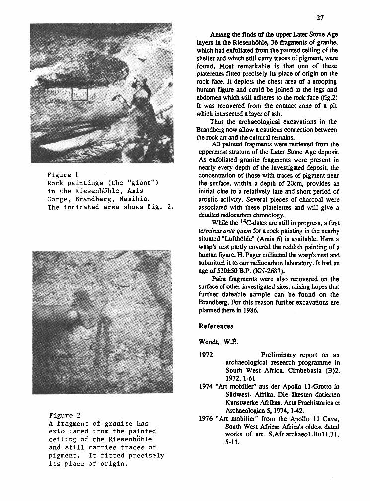
Figure 1 Rock p a i n t i n g s ( t h e "giant") i n t h e Riesenh'dhle, A m i s Gorge, Brandberg, Namibia. The ind ica t ed a r e a shows f i g . 2.
Among the finds of the upper Later Stone Age layers in the RiesenhUhle, 36 fragments of granite, which had exfoliated from the painted ceiling of the shelter and which still cany traces of pigment, were found. Most remarkable is that one of these platelettes fitted precisely its place of origin on the rock face. It depicts the chest area of a stooping human figure and could be joined to the legs and abdomen which still adheres to the rock face (fig.2) It was recovered from the contact zone of a pit which intersected a layer of ash.
Thus the archaeological excavations in the Brandberg now allow a cautious connection between the rock art and the cultural remains.
All painted fragments were retrieved from the uppermost stratum of the Later Stone Age deposit. As exfoliated granite fragments were present in nearly every depth of the investigated deposit, the concentration of those with traces of pigment near the surface, within a depth of 20cm, provides an initial clue to a relatively late and short period of artistic activity. Several pieces of charcoal were associated with these platelettes and will give a detailed radiocarbon chronology.
While the 14c-dates are still in progress, a first terminus ante quem for a rock painting in the nearby situated "LufthUhle" (Amis 6) is available. Here a wasp's nest partly covered the reddish painting of a human figure. H. Pager collected the wasp's nest and submitted it to our radiocarbon laboratory. It had an age of 52at50 BP. (KN-2687).
Paint fragments were also recovered on the surface of other investigated sites, raising hopes that further dateable sample can be found on the Brandberg. For this reason further excavations are planned there in 1986.
References
Wendt, W.E.
1972 Preliminary report on an archaeological research programme in South West Africa. Cimbebasia (B)2, 1972,l-61
1974 "Art mobilier" aus der Apollo 11-Grotto in Sadwest- Afrika. Die Bltesten datierten Kunstwerke Afrikas. Acta Praehistorica et
Figure 2 Archaeologica 5,1974,l-42.
1976 "Art mobilier" from the Apollo 11 Cave, A fragment of g r a n i t e has South West Africa: Africa's oldest dated e x f o l i a t e d from the pa in ted works of art. S.Afr.archaeo1 .Bull.3 1, c e i l i n g of t h e ~ i e s e n h E h l e 5-11. and s t i l l c a r r i e s t r a c e s of pigment. I t f i t t e d p r e c i s e l y i t s p l ace of o r i g i n .

FIELDWORK IN THE WUSHISHI AREA OF NIGERIA 1975-78
Thurstan Shaw Cambridge, U.K.
I am writing this note for Nyame Akuma because the editor has sent a circular letter saying that he is short of copy and asking for contributions. I should be sorry to see Nyame Akuma die for lack of nourishment.
Three interim reports of fieldwork I carried out in the Wushishi area of Nigeria from 1975-78 appeared in Zaria Archaeological Papers Nos. 9, 14 and volume. 111 No. 1 (1976, 1977 and 1978). Because of inadequate financial and logistical support the work was not continued for a further season, as was desirable, but instead it was decided to publish a report of such results as had been obtained up to that point. The pottery was to be classified and analyzed by Mr. S.G.H. Daniels's Statistical Archaeology Unit at Ahmadu Bello University, but unfortunately he left Zaria and the unit wsa disbanded before this analysis was completed. This meant a delay in plans for writing the report, and then in 1981 I had a stroke and until recently was incapable of writing anything. Now I have turned over all the notes and finds to Mr. David Aiyedun, Reseach Fellow in Archaeology, Centre for Nigerian Cultural Studies, Ahmadu Bello University, as material he can use in connection with his Ph.D. at the University of California, Berkeley.
It remains for me to write up an account of the field survey I carried out, together with accounts of the two excavations of Rafin Ndoko and Kongon Makeri. These are necessary to make David Aiyedun's analysis of of the finds meaningful and to provide all the data necessary for his interpretation of the sites. I am engaged upon this work at the moment. Thus I hope I shall have paid my debt to conscience and that in this case excavation will prove nor to be destruction: Such a division of labour is an untidy way to report archaeological work, but one cannot alter the unavoidable facts of circumstances; and after all, this sort of thing has been done before.
Wushishi Reconnaissance Survey, 1985
Kolawole D. Aiyedun, Centre for Nigerian Cultural Studies, Ahmadu Bello University Zaria, Nigeria.
Further intensive archaeological reconnaissance survey of the Wushishi area (Fig 1) was conducted for a period of February, 1985, to supplement previous archaeological reconnaissance carried out in arrangements were used, as well as an open-hearth type process with no tuyereor shaft walls. A friable, golden-brown ore with 55.4% iron content was obtained from over two hundred shaft mines, up to 15 metres deep, and a few opencast pits along the summit depression of Dutsin Makurdo quartzite ridge: (other shaft mines have been reported from the west of the Futua Sokoto road). This ore was carried in donkey panniers to scattered smelting sites next to felled trees, since firewood was the main fuel in this process, which extracted about 16.4% of the iron. Although XRF analyses from the University of Southhampton, U.K. also indicate that the original ore sources for the "early" and "late iron age" sites have not yet been located, the high iron (and phosphorous in some cases) content of their slags suggests that smelting efficiency then was not nearly as high as by the beginning of this century. This apparent improvement in efficiency, the avoidance by smelters of Disi laterites with their low iron content (25.7%), and the typological varieties of furnace already noted would all seem to indicate that there was a degree of innovation and progress over the centuries.
Another source of iron for early Hausaland may have been Koton Karfe (karfe is Hausa for "iron") through which iron from Okene would have passed. A 150 metre wide, 200 metre long, 20-60 metre high slag-heap on Itakpe hill, just north of Okene, was gashed by a track to the rich (average 37% but up to 65% iron content haematite ore used in the modem steel industry;/ and TL dates of 11 10 A. D. + 175 and 1150 A.D. f 170 @urTL 45-SAS and DurTL 45--AS) have been obtained from the bottomost and topmost exposed strata respectively. This fits Obayemi's C9th-C14th radiocarbon dates for iron-smelting elsewhere in this area. The

millions of short, narrow (1112-3 cm. dim.) tuy8res and plugged up fumace wall remnants suggest that natural draught smelting techniques were employed; and it will indeed be of interest to see when and where else this technique appears in West Africa.
Archaeomagnetic dating : A few dates may create a false impression, but from the large-scale and apparently short-term smelting operation at Itakpe hill and from the dating results in the Kano-Zaria area, it would seem that major smelting concentrations were relatively ephemeral; so their movement around West Africa would have caused considerable economic andlor political upheaval, particularly in their wake. To test this contention, it is hoped to carry out extensive archaeomagnetic dating of about 5000 iron smelting sites by obtaining in situ orientated samples of furnace wall clay or fumace bottom slag. At first it may be necessary to carry out the measurements at the University of Newcastle, U.K., but there are grounds for hoping that sufficient funding will be
forthcoming to help establish the first arch aeomagnetic dating centre in West Africa during the the area by Professor Thurstan Shaw, formerly of Cambridge University, during the early part of 1976 (Shaw 1976) and the survey carried out jointly by Messrs Keith Ray of Cambridge University, U.K. (Ray 1978) and David Aiyedun of the Centre for Nigerian Cultural Studies, Ahmadu Bello University, Zaria in 1978 (Aiyedun 1978).
Being part of the researcher's dissertation fieldwork, the objective of this year's survey include the following:-
1. To explore the area in a very broad sense for archaeological features.
2. To check if sites are located in particular ecological zones.
3. To obtain an idea of the sizes, shape and distribution of the settlement mounds over the landscape; plotting and drawing them on distribution map.

4. To obtain further information on all the settlement mounds, by way of their full description, documentation, features associated with them and surface materials which characterize them.
5. To become familiar with archaeological material from the sites, especially within a defined area.
6. To earmark particular spot for excavation.
The frrst thing done was to define an area to be surveyed from the Federal Survey Man of Zungeru Southwest at 1:50,000 (Fig2). Noting fully well that settlement mounds forming the main archaeological feature which characterize the whole area were not found nor located from Wushishi, up to Bankogi Village, a distance of about 4 kilometers southwards, the base point was then made the existing Bankogi Village.
The Temporary Bench Mark (T.B.M.), (point A), used for the reconnaissance survey was a concrete bridge constructed over Bankogi stream, at the southern end of the village. The western boundary (point B), was on a bearing of 270" to a distance of 5 112 kilometers, where it joins the the Wushishi - Bida road. The western stretch follows the Wushishi - Bida road, meandering southwest for a distance of 10 112 kilometers until it gets to Dabiri, directly west of Bankogi stream. The bearing of Dabiri (point C), our first southern boundary
from point B (contact point of the road)was 190'. From Dabiri (point C), eastwards, we surveyed to 1 kilometer south of Maigora (point D), on a bearing of 90' for a distance of 6 kilometers, marking our first southern stretch. From 1 kilometer south of Maigora (point D), we surveyed on a bearing of 32' to Kanko (point E), a distance of 5 kilometers, marking our second southern stretch. From Kanko (point E), we surveyed to Bankogi our Temporary Bench Mark (point A), on a bearing of 353' for a distance of 7 112 kilometers, along Bankogk- Kanko road (fig 2). In terms of coverage, our northern stretch covers a distance of 5 112 kilometers: western stretch, 10 112 kilometers; southern stretch, 11 kilometers and the eastern stretch 7 112 kilometers; thus, total area covered during The reconaissance survey was approximately 77 square kilometers.
This reconnaissance survey is aimed to be used as a further basepoint for future large scale archaeological surveying of the whole area. The reconnaissance by Show (1976) was restricted to visiting and recording of sites in the northern fringes of the area, while that of Ray and Aiyedun (Ray 1978) was also confined to an area of about 7 square kilometers, taking the summit of Kongon Makeri South as a basepoint in the northern vicinity of the area now under study. An attempt is now being made to re-survey this northern area for further

archaeological features and proper description and documentation as well as exploring the western and the southern areas for sites. Future research by way of reconnaissance survey is hoped to be geared to the central and eastern areas till the Zungerr-Minna road is reached all within south of Wushishi, and then effort would be concentrated to the extreme northern zone across the Kaduna river within north of Wushishi, in a systematic manner until the whole area is covered.
The reconnaissance survey was conducted as a straight-forward search for archaeological features, notably settlement mounds. This was done by walking across the landscape from our basepoint- the Temporary Bench Mark -- in the form of transects at about 60-80m intervals between myself and three assistants, transecting westwards with the aid of a compass until the Wushishi - Bida road was reached
A return trip on foot was then made in the opposite direction in the same manner several times until the area surveyed was covered. During the process, settlement mound sites and other features encountered all along were recorded, their measurements taken and plotted, they were fully described and photographed and surface materials from all the sites were noted and from a number of the sites were collected. The present survey was conducted at the time of the year when there was near ideal visibility.
Crops had been harvested, grasses had been burnt, and thus, we had a free access and movement across the terrain. Nearly al l the distances had to be covered on foot, while a few points along the road were reached by the use of a vehicle.
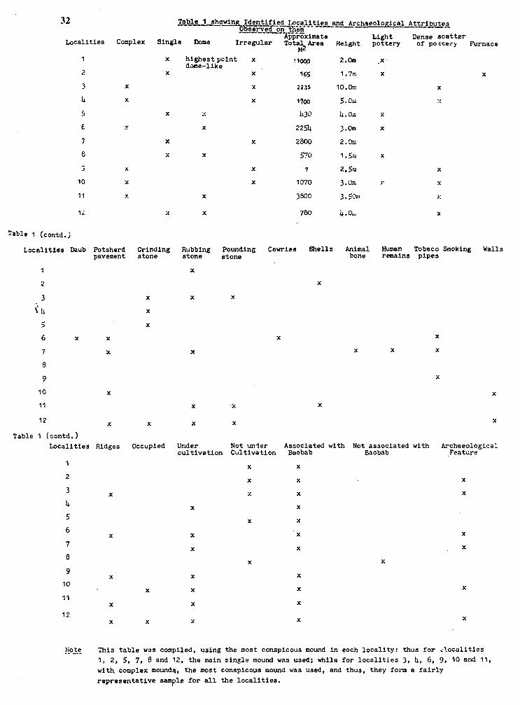
Light Dense scatter Complex Single Dome Irregular Total Area Height pottery of pocrary Furnace
~2 Localities
highest point x dame-like
Table 1 (contd.)
Localitfea Daub Potsherd pavement
Grinding stone
Rubbing stone
X
Pounding stone
Cowries Shells Animal bone
Human Tobaco Smoking Walls remains pipes
1
2
3
i 1:
5 6 x
7
8
9
10
11
7 2
Table 1 (contd.) Localities
1
2
3
4 5
6
7
8
9
10
11
12
X
X
X
X
Ridges
X
X
X
X
X
X
Occupied Under Not unler cultivation Cultivation
X
X
x
X
X
X
X
Associated with Not associated with Baobab Baobab
X
X
X
X
X
X
X
Archaeological Feature
This table was compiled, using the most conspicous mound in each locality: thus for ..'ocalities 1, 2, 5 , 7, 8 and 12, the main single mound was used; while for localities 3 , 4, 6, 9, 10 and 11, with complex moundg, the most conspicous mound was used, and thus, they form a fairly
representative sample for all the localities.

Localities
During the reconnaissance survey, a total of twelve settlement mound sites, each designated as a locality were located and identified (Fig 3). While perhaps, some of these localities, i.e., localities 1-8, in the northern section of the study area had earlier on been visited and recorded as settlement sites (Shaw 1976,2; Ray 1978,7-9), I am not aware of their full description, documentation, plotting and drawing as well as illustrations by way of photographs which were accomplished during the present research. Localities 9 - 12, in the southern section of the study area, all located and identified, appeared to have resulted from the present fieldwork, and were thus, also recorded, described, plotted and drawn as well as photographed, and presented elsewhere (Aiyedun 1985).
Discussion
From this fieldwork, a number of observations can be made. The location and identification of these settlement mounds within the area defined, further confirm the area's general archaeological potential, earlier on emphasized by Shaw (1976) and (1978).
The area is generally characterized by settlement mound form of sites, all generally located close to banks of intermittent streams and were associated with standing baobab trees, ranging from a single baobab (localities 1 and 2), to as many as fourteen (locality 9). with the exception of locality 8 which was devoid of baobab trees. Two general differing environments seem to be observed in terms of the general location of the mounds. In the northern section, apart from locality 8, which was located on a fairly rising ground, with heavily wooded environment, localities 1 to 7, were all located in margins of areas of drained marshland where vegetation is more of open farmed environment, suitable for the growing of sorghum and rice. Mounds in the southern section of the study area, i.e., localities 9 to 12, were generally located in lowlands adjacent to banks of streams where vegetation is also of open farmed environment (Ray 1978, -8), suitable for sorgtum and root crop cultivation, especially yam. (More information is to be obtained on these ecozones). In the southern section, all the four localities (localities 9 to 12), are either partly of completely under cultivation; while in the northern section, apart from localities 4, 6 and 7 which are either
partly or fully under cultivation, localities 1, 2, 3, 5 and 8 were observed to be completely uncultivated during the period of this fieldwork,
Within the area surveyed, the settlement mounds could be classified into two groups on the basis of form and shape. On the basis of form, the mounds were classified into either complex or single. Complex indicate a group of mounds are more than two, exemplified by localities 3,4, 6, 9, 10 and 11. The area of the largest complex mound is about 3,800 sq.m in locality 11, followed by locality 6 with an area of 2254 sq.m. (Locality 9, occupying an area of about 1,000m by 440m and containing about ten mounds would have been the largest, but measurements of the mounds were not properly taken and so was not considered). Single forms of mound refer to a single mound, but at most not more than two adjacent ones in a particular locality, exemplified by localities 1, 2, 5, 7, 8 and 12. The area of the largest single mound is about 2,800 sq.m in locality 7 and the smallest single mound, locality 2, covers an area of about 165 sq.m (Table 1). On the basis of shape, mounds within the study area were either dome shaped, irregular in shape or were a combination of both. There is no particular correlation between form and shape of these mounds. It could be observed that while some complex mounds are dome shaped (localities 6 and 1 I), the remaining generally contain a combination of dome and irregular shaped mounds (localities 3, 4, 9 and 10). Among the single mounds, localities 5, 8 and 12 were dome in shape, while localities 1, 2 and 7 appear more irregular in shape. The outlook of the mounds shows that mounds in the northern section have not gone through much weathering compared to those in the south as shown by the coverage of the mounds.
Cultural remains observed on the mounds, include generally pottery; grinding; pounding and rubbing stones; daub; potsherd pavement; remains of furnace; shells, animal and human bones; cowries and tobacco smoking pipes (Table 1). Apart from the remains of the furnace, potsherd pavement and grinding stones, observed to have been left insitu and found in locality 2; in localities 6, 7, 10 and 12 and in localities 3; 4; 5 and 12 respectively; the remaining cultural remains and their associated archaeological features were seen as a result of exposure; either in the form of rodent activities; in terms of cultivation and irrigation or erosion; which were found mostly in all the localities except localites 1 and 8 (Table 1). In terms of cultural remains; pottery (light and dense scatter) was mostly

found; followed by rubbing and grinding stones and then potsherd pavement; the least common were animal and human remains; furnace; daub and cowries; each of which was found at a locality.
Localities 3 and 6 in the northern section and localities 9; 11 and 12; in the southern section of the area under study had man-made ridges; running for a distance ranging from 40m to 150m; all seem to have been constructed with turf; taking their source or origin from nearby stream and mostly enclosing part of the mounds. The circumstance behind the construction of these man-made ridges is not known at the moment; but at least; they form part of the settlement pattern strategy in the area and extends our knowledge of distribution of walls in the area. As previously noted by Shaw (1977; 1); it is very difficult to ascertain whether the whole of the height of the mounds was made up of cultural deposit or whether they were sitting on top of a natural ridge; and had been added to an existing topographical feature. While the contour plan from the survey plan carried out by Shaw at Rafin Ndoko indicated the second alternative (Shaw 1977; 2); his work at Kongon Makeri south by excavation revealed cultural deposit to a depth of 5.44m to 5.90m and thus; point to the first alternative (Shaw 1978: 2). In the case of the remaining eleven localities concentrated upon during the present fieldwork; this is yet to be ascertained but one of the solutions is definitely excavation.
It should be borne in mind that two of the mounds in the southern section; localities 10 and 12 of our study area are being presently occupied. There is also the case of locality 7; where irrigation work had exposed large area of the mound at the north eastern section and revealing cultural deposit of about 2m deep; with associated cultural materials; including human remains. The pit dug by local inhabitants at the eastern section of mound C locality 10 also reveal cultural deposit to a depth of 1.5m with cultural materials; including gravel flooring; hearth; potsherds and charcoal observed in section. It is most probable then these category of mounds were perhaps made up of collapse mud wall which represent considerable extended period of occupation as Shaw (1976: 2) rightly noted for some of the mounds.
Conclusion
Having carried out a reconnaissance survey of the Wushishi area from Bankogi as basepoint; the archaeological potential of the area has further been highlighted. This area is of great interest for understanding the interconnection of areas within Nigeria and for understanding processes of innovation; technological development and cultural growth. If any spot is to be earmarked for excavation; localities 6; 7; 10 and 12 among others could be considered. Part of the mound in locality 10 is presently being occupied; thus; the excavation would serve as a salvage or rescue excavation before more cultural materials are being destroyed. Surface finds in these four listed localities consist of dense scatter of pottery, potsherd pavement and partly grinding stones to mention but a few. The pit being dug by local inhabitants in locality 10 had revealed in section flooring; hearth and charcoal. People presently inhabiting the area could readily supply oral information.
The exposed part of locality 7 show concentration of potsherds; pounding stones and two human burials. The exposed part of mound A, locality 6, cut by the Bankogi -Kanko road also revealed cowries and smoking tobacco pipes among other cultural remains. Mounds in all these four localities listed have heights not exceeding 3m and thus, excavation of part of any one of them could be meaningfully carried out with the available time, fund and manpower. Such an excavation would answer basis questions about date, depth of deposit, nature of deposit, cultural content and economy. It is also hoped that such an excavation would reveal changes in house pattern, auxilary structures or at least materials used for their construction, especially flooring as well as technological changes, particularly from the point of view of the sequence of pottery. Debris dug would be sieved to recover micro fauna and floral if possible. Soil samples for flotation, pollen analysis and soil analysis would be collected from different excavation levels.

Acknowledgement
The fieldwork reported in this summary was made possible by grant received from Ahmadu Bello University Board of Research and the Centre for Nigerian Cultural Studies, for which I am grateful. The researcher has benefited immensely from the assistance rendered by the following people: Messrs Augustine Yahya (Technical Assistant) and Peter Inim (Photographer), from the Centre for Nigerian Cultural Studies, Ahmadu Bello University, Zaria and Mr. Joseph Mangut, formerly of the Archaeology Unit, Department of History, on the field; Mr. Leo Oluwatomi, of the Archaeology Unit, Department of History, for drawing the maps; Dr. E.T. Jolayemi, of the Department of Mathematics, Ahmadu Bello University, Zaria on mathematical application; Professor N.D. Field, Head of the Department of Surveying, Dr. Bob Hyde, of the Department of Geography and Mr. Tony Saleh, of the Centre for Nigerian Cultural Studies, Ahmadu Bello University, Zaria, for reading the draft of the original report and making suggestions; Mr. Joseph Abraham of the English Department for typing the table and Mallam Lawal of the Department of History, Ahmadu Bello University, Zaria for typing this paper. The researcher also wish to acknowledge the support and co-operation of Mr. S.I.O. Okita the Acting Director of the Centre for Nigerian Cultural Studies and its members of staff.
Bibliograghy: Aiyedun, D. K., 1978. Preliminary Report of Survey carried out
by Messrs Keith Ray and David Aiyedun. Zaria Archaeology Pgapers, Vol. 111, No. 3, Zaria.
Aiyedun, K.D., 1985 Wushishi Reconnaissance Survey, 1985:
Report; i-viii + 30 Quoto sized pages; 3 maps; 62 plates. Centre for Nigerian Cultural Studies, Ahmadu Bello University, Zaria.
Ray, K., 1978. Wushishi Survey 1978: Report. Zaria
Archaeology Papers, Vol. 111, No. 7. Zaria.
Shaw, T., 1976 Preliminary Report on Archaeological
work in the Wushishi Area, Early 1976. Zaria Archaeology Papers, 9. Zaria.
Shaw, T., 1977. Preliminary Report on the Second
Season's Archaeological work in the Wushishi Area, Dry Season 1976 - 1977. a r i a Archaeology Papers, 14. Zaria.
Shaw, T., 1978 Preliminary Report on the Third Season's
Archaeological Work in the Wushishi Area, Dry Season 1977 - 1978. Zaria Archaeology Papers, Vol. 111, No. 1. Zaria.
Pottery from Kongon Makeri (Wushishi) Excavation
Kolawole D. Aiyedun, Centre for Nigerian Cultural Studies, Ahmadu Bello University, Zaria
The excavation of Kongon Makeri mound, Wushishi area of the Kaduna valley, Niger State, Nigaria, by professor Thurstan Shaw, formerly of Cambridge University, United Kingdom, carried out under the auspices of the Centre for Nigerian Cul- tural Studies between 1976 and 1978, yielded enormous amount of pottery collection both as broken potsherds and as potsherd pavement for flooring construction among other cultural materials (Shaw 1976, 1977, 3, 1978, 4), thus providing a record of former activities of the prehistoric inhabitants in the area. The present writer has just completed the analysis of nearly 58,000 broken potsherds recovered from the 5.44 to 5.90m of unbroken cultural deposit, forming part of dissertation fieldwork for the degree of Ph.D in Anthropology at the University of California, Berkeley, united State of America. This paper presents a summary of the tentative result of analysis of the pottery collection. Result to date relating to reconstruction of settlement patterns and the subsistence economy of the prehistoric inhabitants of the area was published in N0.26 Issue of Nyame Akuma, June 1985 - (Aiyedun 1985). The study of Kongon Makeri pottery collection will fulfil the following objectives:
i. It will provide us a record of one of the former activities of the prehistoric inhabitants in the area as well as technological changes that took place over time.

ii. Changes in traditional style w~l l be known from the study of the various decorative motifs and techniques through time.
iii. It will aid in understanding the socioeconomic and cultural contexts of the prehistoric inhabitants, especially when such material is considered along side with other cultural materials recovered.
iv. Given that this is a pioneering work in the area, this knowledge would serve as a basis for future work in the area and in related areas.
Analysis of the ceramics and other materials has led to the recognition of two phases (Early and Upper) at Kongon Makeri. The early phase begins at the base in level 31 and continues to level 21. It is characterized by distinctive pottery, designated Ware A and other materials, including pieces of daub and fired clay, a large number of pounding and rubbing
stones and a few grinding stones. The Upper phase occurred in levels 1 to 20, and while found in all 13 cuttings appeared to be concentrated in the first nine. While some materials were absent from upper phase levels (iron objects in levels 14 to 20, beads and ivory in levels 15 to 20, mollusca and animal bones in levels 17 to 20), daub frred and unfired and unfmd clay, rubbing and pounding stones and pottery designated Ware B. were all recovered consistently in Upper phase levels (Aiyedun 1985,33).
The Early phase. Ware A.
Physical observation and microscopic examination of Ware A sherds showed that the ware can be sub-divided into two groups. Ware A1 is characterized by coarse fragments of angular quartz, mica flakes and iron oxide nodules or earlier rocks. They were crudely made, texture was coarse were largely unburnished and were thickly made. Ware AII, finely and thinly made contain quartz, muscovites and iron oxide nodules standing out of a fine grained clayey matrix (Shibayan, personal communication, 1983). X-ray diffraction analysis show a further break down of Ware A1 minerals as containing a high amount of quartz, relative high amount of microcline (potassium feldspar), some Calcium sodium feldspar, some augite as well as mica, while Ware A11 contain a high percentage of microcline (Potasaium feldspar) and relative high amount of Calcium sodium feldspar as well as some quartz and small amount of horn blende. Both
samples also contain 2:l layer phyllosilicates (Moberg and Okujeni, personal communication, 1984).
Firing ability in terms of temperature in the Early phase reveal that there is not much difference throughout the levels; the lowest value having an average of 516'c at level 27, while the highest has an average of 720°C, reached at level 23. It is however noteworthy that there is not very high variation of values in terms of standard deviation within the values obtained at various cuttings per level (Ahuwan and Jolayemi, personal communication, 1984).
Decorated bodysherds in Ware A is characterized by a variety of decorative motifs which include in the order of dominance stamping, incision, compound decorations, roulette, perforation, relief and grooving. Ware A vessel forms at Kongon Makeri were characterized by pots and bowls. The pots range from small to large sized simple everted necked rim forms, mostly globular shaped. Neck-rim curvature of the pots were either smooth or sharp angled on either none, one or both the interior and exterior profiles. Bowls include small and medium sized necked everted vessels; neckless open - mouthed vessels with restricted or straight rims joining hemispherical body and small neckless open - mouthed vessels with inverted rims joining shallow body. Vessel forms in the very early period were scanty and were of few types as could be seen from levels 28 to 31. There was an improvement in the use of pots and bowls through time, i.e., the upper levels, say from level 21 to 27 consisted more vessel forms; and through time too, features and layers recovered between levels 24 and 25 consisted of pots and bowls being used. Both the pots and the bowls in Ware A were decorated; decorated bowls consist twice in number than decorated pots. These decorative motifs on the vessels in the order of dominance include stamping, incision, roulette, compound decorations, grooving and perforation while relief was absent. Materials from this Early phase including Ware A pottery are presently undated (Aiyedun 1985,33).
The upper phase. Ware B.
Physical observation and microscopic examination of pottery from the Upper phase designated Ware B showed that the sherds contained quartz, mica flakes and iron oxide nodules similar to Ware AI and AII; they are generally fine grained
with quartz grain within finer clayey matrix similar to ware A11 (Shibayan, Personal communication, 1983). X-ray diffraction analysis showed them to contain a high percentage of quartz, some microcline (potassium feldspar) and Calcium sodium feldspar similar to ware A1 as well as 2: 1 layer phyllosilicate common to ware A1 and A11 (Moberg and Okujeni, personal communication, 1984).
Analysis of ware B sherds on the basis of firing temperature reveal that firing temperature was lowest, 500°C, at the lowest level (level 20) in the Upper phase which gradually increases upwards showing a peak close to 800 'C at the middle levels (levels 9 and 10) but declines again to close to 750" in the uppermost levels (levels 1 to 6). However, more research is being done in this direction.
The decorated bodysherds in ware B are characterized on the basis of decorative motifs in the order of dominance by stamping; incision; roulette; compound decoration; perforation; grooving and relief. Extensive analysis of ware B sherds has resulted in the recognition of three levels designated
BI, BII, BIII, in an attempt to study variations and changes in the different decorative motifs employed through time. Attention was focussed progressively on stamping and incision in BIII, on compound decoration, incision, roulette and stamping in BII and in BI progressively on compound decoration and stamping, while roulette was almost equally weighted. In BI, BII, BIII, relief, grooving and perforation were virtually insignificant, while over the ages, stamping was most dominant, except in BI when slightly less attention was paid to it compared with ware A sherds in the Early phase, it also became apparent that perforation and grooving became less significant and relief nearly absent or rare in Ware B during the Upper phase (Aiyedun 1984b, 78).
Vessel forms in Ware B, during the Upper phase consisted of pots and bowls. The pots were characterized by small to large sized everted necked vessels which were either smoothed or angled on none, one or both the interior and exterior profiles with globular body and constricted necked vessels which had almost straight long rims with slightly concave profile at the interior and convex profile at the exterior. While the former were perhaps used for preparing food and other general functions, the latter might have served specialized functions and were rarely used. The bowls were characterized by small to medium sized necked everted vessels with globular body; neckless open - mouthed vessels with straight or nearly straight and restricted rims joining hemespherical body and neckless open -
mouthed vessels with inverted rim joining shallow body. Within Ware B, the lower levels (levels 12 to 20) had the greatest concentration of Vessel forms compared with the upper levels (levels 1 to l l ) , which might be a result of replacement by other forms of materials such as iron, basketry and wooden objects which could serve similar functions as pottery. Both the pots and bowls in Ware B vessels were decorated, though more number of bowls were observed to be decorated. Decorations on the vessels include in the order of dominance roulette, compound decorations grooving, stamping, incision, perforation and relief.
Ware B sherds in this upper phase also include substantial number of potsherd pavements used for flooring construction. More than any other thing, the use of potsherd as pavement reveal to us what use were made of broken sherds. Detail analysis of the potsherd pavement and information that can be gained from such a study are presented elsewhere (Aiyedun 1984a), and thus need not be repeated in detail here. Suffice it to say that plain bodysherds form the bulk of the sherds used as pavement, followed by decorated bodysherds rims and necks. Nearly one-third of the total pavement sherds were burnished, otherwise, the majority were handsmoothed and thus not burnished. Most of the decorated bodysherds and the diagnostic rim sherds used as pavement were generally thinly made and thus were probably those used for household utensils or for household chores with short life expectancy.
Attempt to place the Upper phase from where ware B pottery collection were recovered into a proper chronological perspective has not met with much success. Fragments of smoking pipes made of fine grey clay, found on the surface and in the upper levels point to the fact that the occupation of the mound could ~ o t have come to an end earlier than the seventeenth century (Shaw 1977: 3). Result of seven samples of charcoal from levels 13, 15, 16 and 18 from cuttings L4 to D, received were rather conflicting because there was a discrepancy of three hundred years between the two laboratories. There is a consistent set of 5 dates from the Japanese laboratory but the two from Teledyne Isotopes, U.S.A, are approximately 300 years earlier; and thus the middle part of the mound, i.e., the lower half of our Upper phase date to either the 10th century A.D, or the 13th114th century A.D., (Shaw 1978: 3,4). Results of animal bones and shell remains from the middle levels sent for Electron Spin Resonance (EER) Spectroscopy dating are eagerly awaited.

In conclusion, by and large, a clear picture of the pottery making tradition of the occupational sequence at Kongon Makeri (Wushishi) can be discerned. Technologically, the prehistoric occupants of Kongon Makeri were craftmen of a very high order, if the analysis of the pottery collection can be judged by. On the basis of presently available evidence, it can be seen that while the Early phase represented a less intensive technological stage, the Upper phase witnessed an intensive collecting stage of culture and contained evidence of a highly technologically developed pottery making tradition. More and varied number of vessel forms were ma& and used during the Upper phase. Also, while the evidence indicate that only pottery making was prac- ticed in the Early phase, evidence of large scale pottery making as well as bead making, and perhaps iron working has been demonstrated in the Upper phase. The use of potsherds as pavement for flooring consvuction during the Upper phase, evidence of which was not manifested in Ware A sherds during the Early phase, showed a new dimension into which disposed or broken pottery began to play a part in the settlement pattern strategy of the prehistoric inhabitants of the Wushishi area.
Notes
1. Ware A sherds recovered from Kongon Makeri numbered 7,297, distributed as follows: plain bodysherds, 5,300 (72.63%); decorated bodysherds, 969 (13.27%); rims, 646 (8.85%); necks, 367 (5.02%); bases, 13 (0.17%) and lids, 2 (0.02%).
2. Ware B sherds recovered from the Excavation at Kongon Makeri numbered 50,690, distributed as follows: plain bodysherds, 38,221 (75.40%); decorated bodysherds, 5,951 (11.73%); rims, 3,676 (7.25%); necks, 2,743 (5.41%); bases, 88 (0.17%) and lids, 11 (0.02%).
References
Aiyedun, K.D., 1984a: Disposal of pottery in Prehistoric Times:
A Case Study of Kongon Makeri, Wushishi Area of the Kaduna Valley, Niger State, Nigeria. paper presented at the 5th Annual Conference of the Archaeological Association of Nigeria at the University of Ife, Ile-Ife, Nigeria from 25th - 28th November, 1984.
Aiyedun, D.D., 1984b. Decorative Motifs from Kongon Makeri,
Wushishi pottery. Zaria Archaeology papers, Vol. vi, pp. 65-96. Zaria.
Shaw, T., 1976 Preliminary Report on Archaeological
work in the Wushishi Area, Early 1976. Nyame Akuma 9: 35-37. October, 1976. Calgary.
Shaw, T., 1977 preliminary Report on the second season's
Archaeological work in the Wushishi Area, Dry season 1976-1977. Zaria Archaeology papers, No. 14. Zaria.
Shaw, T., 1978 Preliminary Report on the third season's
Archaeological work in the Wushishi Area, Dry season 1977-1978. Zaria Archaeology Papers, Vol. IIIa, No. 1. Zaria.
Aiyedun, KO., 1985 Analysis of kongon Makeri (Wushishi)
Archaeological Collections. Nyame Akuma, No.26, pp. 32-34. Edmonton, Canada.
FIELDWORK SURVEYS IN AND AROUND KANO STATE,
NIGERIA, 1982-1985
Dr. Patrick Darling Department of History Bayero University P.M.B. 3011 Kano, Nigeria
With one of the largest concentrations of iron smelting in Africa, a wealth of walled settlements depicting different stages of urban development, and with nearly every rock outcrop containing artifacts, Kano State has much to offer the archaeological surveyor. Yet apart from the odd excavation (one rock shelter, one iron smelting furnace, and two rescue jobs on the dye-pots), a casual poking around for "Nok culture" figurines, part of a whistle-stop survey of stone artifacts in Northern Nigeria, and some unrecorded surface collections, little serious archaeological work had been conducted before 1982 - a fact which John Lavers and Professor Murray Last were not slow in pointing out. This report summarizes the main achievments of archaeological survey work during the last three years.
Rock Shelter Sites: these have been identified in nearly all the tor-like (not the whale-back) older porphyritic granite inselbergs of the Basement Complex, as well as in the younger granites of the Alkali Ring Complexes, both types of rock occurring mainly in the southern or western parts of the State. The most widespread and frequent artifacts have been the baked clay fragments of past hearths, quartzite or granite pounderslpounder- grinders, and pottery sherds. Red quartzite pebbles, possibly once collected for their decorative rather than functional use, were noted on the inselbergs bordering the Challawa River. Rough-hewn choppers or diggers made of dark fine grained rocks-similar to those found in intrusive dykes further west were picked up in Falgore Game Reserve: polished tool fragments and a small scraper of a similar rock were discovered around Cata hill on the Dantata estate near Tiga. A blade edge fragment of a rhyolitic ground stone axe was collected in the rocks about 2 km. south of the Challawa gorge dam site; and an even finer grained small, rhyolitic scraper was exposed in the rock shelter midden tell slashed open by a new track for blasting road grit about 15 km. south of Kano: here
a sherd from basal strata near the shelter mouth was TL dated by the University of Durham U.K., to 2640 B.C.f 920 (DurTL 67-lAS). A black, almost obsidian like, small scraper was discovered by Matthew Armstrong (aged 12) in rocks by the Copperfield clinic in Kano itself. A few sites do seem to have deposits suitable for excavation; and it is hoped that in 1985-1986 excavation may throw more light on the sequence of pottery sherd decorations-comb stamping, grid-stamping, net impression, braided (or carved nodular?) roulettes, and plaited cord roulettes.
"Early iron age" sires: A massive concentration of past smelting activity to the north (80-100) and north-west (50 km.) of Kano was revealed following an initial report in October 1882 by girls of the Junior Field Society, F.G.C. Kazaure under Sheila Everard. After field survey of over 10,000 iron-smelting sites in 1982-1984, it was suspected that the non slag-tapping bowl furnaces with thin clay linings (clustered in their hundreds mainly around lateritec mesas but also on quartzite ridges) were earlier than slag- tapping shaft furnaces (found mainly on quartzite ridges and reverside lateritic curiasses). The difficulty of recovering any sherds definitely associated with the bowl furnaces might be explained by their antiquity. The following TL dates have been obtained for furnace bottoms of bowl furnaces: 380 A.D. f 320 (DurTL 45-2AS) Roni south laterited mesa. 1,400 B.C. f 50 (DurTL 57-3AS) Matanfada lateritic mesa. 2,400 B C f 1100 (DurTL 57-2AS) Fitola quartzite ridge.
After consultation with the laboratory there does not appear to be any obivious source of error for the extraordinarily early dates for iron-smelting of the last two sites above; But clearly serious consideration cannot be given; to their interpretation until comparative dating from associated and similar sites has been obtained to check against statistical anomalies.
"Late iron age" sites: Slag-tapping shaft furnaces have proved to have far more varied typologies than has been envisaged by some previous writers on iron-smelting in Hausaland. Furnace shafts were cylindrical, tapering, elipsoidal or divided by a massive clay baullc. cuyeres were placed horizontally (1-2 through mouth in KanolZaria area. 6-8 laid radially in Sodotolcureta area) or vertically incorporated into the furnace structure (Kano 1 Katsina area). Drip-pits appear to have been used extensively in the Sokoto area but, apart from a few hundred miniature furnace bottoms,

L.7 / . \ .d
Rock shelter aitea o @msjorpnst shrine *rock rEder *rodtgongsh& painting
Iron smelting sites .over 1500 site8 eovor250ritea .other riles
Other sites
m ; 3 4 5 6 7
* micrdiths . l tin Mleltii 0 Auyo walk & mando
North of Challnwa rivers TL date 2640 B.C. :920 South of Challana rivar Near Challawa G w ~ e dam Inlaore Came Reimrve Inaalbamm near old Gnno Dutmin Hnkurdi. Bakori l a i r s & Gabaaani: ZL datwe 120 A.D. t 2 5 0 & 830 A.U. t230
seem to be very rare in the Kano area A radiocarbon dare from Harwell of 870 a.d. f 70 (HAR 6258) was obtained from charcoal inside a round-based, tapering shaft furnace in a slag-heap by the Kazaure Resevoir, 80 km. north of Kano City. Durham TL dates for slag-tapping, shaft furnaces were as follows:
540 A.D. + 360 (DurTL 57-6AS) Kazaure resevoir (same group of furnaces as radiocarbon date above): increased error due to low pottery internal dose rate.
720 A.D. * 250 (DurTL 57-6AS) Waira mesa: elipsoidal furnace. 830 A.D. +- 230 (DurTL 57-7AS) Gabasani quartzite hill: cylindrical furnace.
1,140 A.D. f 170 (DurTL 57-4AS) Matanfada mesa: vertical tu yere.
These dates agree with the C7th radiocarbon date for Dalla hill, Kano and for the C8th-C9th dates at Samaru West, Zaria.
The hard, red wood of the kirya tree (Prosopis africana) appears to have been that favoured by blacksmiths and smelters in the Kano area; and its exclusion from the farmed parkland of the Kano close-settled zone may have been an important factor in the movement of most iron-smelting for Kano to outside the present State area by the beginning of this century. Over 150 km. to the south-west, in the Bakori area, both the Sokoto and Kano tuyere arrangements were used, as well as an open-heartn type process with no tuyereor shaft walls. A friable, golden-brown ore with 55.4% iron content was

obtamed from over two nundred shaft mines, up to 15 metres deep, and a few opencast pits along the summit depression of Dutsin Makurdo quartzite ridge: (other shaft mines have been reported from the
west of the Futua Sokoto road). This ore was carried in donkey panniers to scattered smelting sites next to felled trees, since firewood was the main fuel in this process, which extracted about 16.4% of the iron. Although XRF analyses from the University of Southhampton, U.K. also indicate that the original ore sources for the "early" and "late iron age" sites have not yet been located, the high iron (and phosphorous in some cases) content of their slags suggests that smelting efficiency then was not nearly as high as by the beginning of this century. This apparent improvement in efficiency, the avoidance by smelters of Disi laterites with their low iron content (25.7%), and the typological varieties of furnace already noted would all seem to indicate that there was a degree of innovation and progress over the centuries.
Another source of iron for early Hausaland may have been Koton Karfe (karfe is Hausa for "iron") through which iron from Okene would have passed. A 150 metre wide, 200 metre long, 20-60 metre high slag-heap on Itakpe hill, just north of Okene, was gashed by a track to the rich (average 37% but up to 65% iron content haematite ore used in the modem steel industry;/ and TL dates of 11 10 A. D. f 175 and 1150 A.D. f 170 (DurTL 45-5AS and DurTL 45--AS) have been obtained from the bottomost and topmost exposed strata respectively. This fits Obayemi's C9th-C14th radiocarbon dates for iron-smelting elsewhere in this area. The millions of short, narrow (1112-3 cm. dim.) tuy&res and plugged up furnace wall remnants suggest that natural draught smelting techniques were employed; and it will indeed be of interest to see when and where else this technique appears in West Africa.
Archaeomagnetic dating : A few dates may create a false impression, but from the large-scale and apparently short-term smelting operation at Itakpe hill and from the dating results in the Kano-Zaria area, it would seem that major smelting concentrations were relatively ephemeral; so their movement around West Africa would have caused considerable economic andlor political upheaval, particularly in their wake. To test this contention, it is hoped to carry out extensive archaeomagnetic dating of about 5000 iron smelting sites by obtaining in situ orientated samples of furnace wall clay or furnace bottom slag. At first it may be necessary to carry out the measurements at the
University of Newcastle, U.K., but there are grounds for hoping that sufficient funding will be forthcoming to help establish the first arch aeomagnetic dating centre in West Africa during the 1985-6 academic year.
Walled settlements: A gazeteer is being compiled of as many walled settlements as possible from northern Nigeria. Aerial photographs, historical sources, colonial military route reports, district boundary maps, recent Federal Survey maps, student questionairres and direct field observation are all being employed. Early walled compounds (one of which may link to C9th smelting) and settlement walls were usually associated with hilly sites and, in some cases (eg. Kano, Rano, Dal, Auyo), enclosed considerable areas possibly quite densely settled with scattered rural compounds. Some of these earlier walls employed natural coursed rubble of local stone in their constuction: later walls tended to be of tubali mud bricks and plaster. In some cases castellations, loopholes and parapets remain intact. Later towns, including the C19th ribats set up during the Jihad, tended to be more compact, having walls with a rectilinear configuration enclosing denser, more urban settlement patterns. Prior to any serious statistical study, an impressionistic case could be made for their deliberate orientation at about 75 degrees to face Mecca.
Pottery sherds : A few hundred pottery sherd collections have been made in association with all the fieldwork noted above; and all will be sorted and classified simultaneously this coming year with a view to carrying out a computer analysis of their culture sequence chronology, as well as plotting the geographical distribution and noting the functional contexts of form and decoration variables. There are some fairly obvious differences between sherds from many rock shelters, iron-smelting sites and deserted walled settlements; but comment on the nature and extent of any discontinuities would be premature prior to this analysis and also the collection of more samples to offset regional imbalances - a difficult task in the close-settled zone of Kano, because over the last few centuries potential urban middens have been removed as raki (manure and rubbish including sherds) and spread on all the surrounding farmlands.
Ellen Sieber, a Ph.D. student from Indiana University, USA., hopes to be able to throw more light on some of the problems and other aspects of Kano archaeology next year.

Kecent Field Works In the Northern Khartoum Province
Isabella Caneva Di'partimento Scienze Storiche, Archeologiche e Antropologiche dell'Antichit8 Sezione Paletnologia Universith "La Sapienza" Roma 00100
The Italian Mission for Prehistoric Research in Egypt and the sudanl carried out its most recent field campaigns in the Khartoum Province focusing on the interpretation of the regional settlement pattern variation during the past. The specific aim of the study was to relate this variation to the ex- ploitation of different geomorphological features of the environment, consistent with the alternance of different models of subsistence and socio-cultural complexity.
During the 1985 campaign, an area of about 15x7 km was surveyed, using a pedestrian systematic technique. The region, already partially explored by the Mission in the past, (Caneva et a1 1982), lies on the right bank of the Nile, between the villages of Kabbashi and Geili. South and east of this area no archaeological sites were recognized for several km, except for scattered (postmeroitic?) tumuli. However, a few rehistoric remains were found, as already known, along wadi el Kenger as far as 10 km inland. All the sites which were raised above the surrounding terrain were carefully explored. Due to their impressive number (about five hundred), the postmeroitic (?) tumuli were mapped with a certain approximation. The prehistoric sites, on the contrary, were localized using the triangulation topogra hical technique with a high precision theodolite? Other prehistoric remains were found scattered on the surface, either transported by natural agents or due to a generalized surperficial occupation of the land by highly mobile groups. They could not be singly localized on the map, but they are taken into consideration in the general interpretation of the data.
A total of 25 prehistoric sites were localized in the region, including the five already excavated by the Mission 4. Morphologically speaking the sites do not differ one from another: almost all of them appear to have been strongly modified by the construction of post or late meroitic tumuli which heaped up the ancient occupation debris. The sites are therefore differentiated by the typology of the
archaeological materials found, the different rates of artifact classes (for instance microliths versus large flakes) or raw materials (for instance rhyolitelbasalt versus quartz), and the presencdabsence of other remains, such as grinding stones, animal bones, shells, etc. A minimal surface collection was combined to the topographic survey, as an essential basis for predicting the nature and intensity of subsurface materials. Although the preliminary classification of the sites relies on the surface collection, the latter has no representative value and cannot be used for statistical studies. However, it does give an indication of the presence on the site of a certain culture or phase and therefore is a good reference for reconstructing the regional distribution and density of occupation for each period recognized. In addition, it provides test materials to by submitted to chemical analysis and C14 dating, the result of which can be tested against what is known from excavated sites and used as general regional data. From a very preliminary observation it appears that broadly known contexts, such as "wavy line" and "dotted wavy line", are represented by much more varied aspects than was previously thought. Further excavations and studies will determine whether this is due to a chronological sequence or to different groups inhabiting the region.
A very different intensity of land occupation in prehistoric times is evidenced by the frequency of extensive mesolithic sites in comparison to the scarcity of neolithic sites (21:2). Mesolithic gatherers and fishers (but also hunters) were apparently more permanently attracted by riverine resources than neolithic pastoralists, who probably came close to the river only seasonally. The gravel bank bordering both the ancient course of the Nile and the largest wadies appears to have been very intensively inhabited by hunter-gatherer people using different kinds of dotted wavy line decorated pottery, microlithic quartz implements and grinding equipment. This supports our interpretation in terms of settled life of the mesolithic presence along the Nile (Caneva 1983). The following pastoral communities, on the contrary, appear to have concentrated in rare, extensive sites, in the alluvial plain, which, compared with the sites already localized southwards (Haaland 1981), make up a line following the border between the flood plain and the gravel terrace. The first shift of the river flow is therefore dated, and the occupation characterized by a less riverine nature, as was to be expected (Haaland 1981; Caneva 1983, 1985).
The late neolithic occupation is even more

scanty in the area, although some remains are frequently found scattered on the surface of older sites, as a result either of a short frequentation or of the disturbance of graves dug in the site, as at Geili (Caneva 1985 b) and Saggai (Caneva 1983). No pure late neolithic settlements were found in the region until last year. We consider this phenomenon to be related to the shift to pastorlism already suggested by the early neolithic evidence. This shift must have pressed the inhabitants of the region to adopt a different life style, consistent with the mobility requested to stock-breeding communities in arid countries. Therefore, though the region was probably as intensively inhabited as before, seasonal sites would have never left very impressive traces, due to the light equipment preferred. What we expected to find in the region, as far as the late neolithic cultures are concerned, was thus a pattern of camp sites scattered along the Nile, in a strip much wider than that occupied by the previous prehistoric communities. Late neolithic remains apparently not combined with other prehistoric contexts were localized by the Sudan Antiquities Service-French Unit in a gravel quarry inland from the Saggai village, on the left bank of wadi el Kenger. During the 1984 season two other sites were localized by the Italian Mission about 600 m east and west of the first. A rescue excavation was immediately carried out in the three. El Kenger West appeared as a much eroded wavy line site, while the other two were revealed to be late neolithic "settlements".
At El Kenger Middle, parts of undisturbed deposits were still left within the ditches opened by the bull-dozer. In the four soundings carried out we found that the archaeological deposits hardly reached a thickness of 30 cm. The pottery was mostly decorated with incised designs or with pain of dotted lines, both techniques being typical of the context as is evidenced at Geili and Kadada. The lithic industry includes small querns and a very limited variety of quartz microlithic tools (almost exclusively borers). The few animal remains included only domesticates; virtually no water resources were found.
At El Kenger East, five soundings were dug all around the area destroyed by the bull-dozer. The deposits here were even thinner than in the other site (between 5 and 15 cm). The pottery appears to be of a different type: decoration includes, here too, lines of impressed dots, but made exclusively with a comb impression technique, which does not exist in the other site (see Caneva 1984).
A C14 date was obtained by the French Unit from a shell collected at El Kenger Middle. The result, 5080 2 70 (Reinold Lenoble. 1985). gives the site the expected chronological position.
In conclusion, the panorama of post-Shaheinab neolithic now appears more varied and articulated than was previously thought. In addition, as far as the settlement pattern is concerned, the assumption as to the nomadic character of the involved communities is now supported by further in- dications:
- thin archaeological deposits, i.e. short time occupation.
- small pots and few lithic and stone objects, i.e. light equipment.
- low frequency of animal bones, i.e. short time occupation.
- bad conservation of animal bones, i.e. lack of an occupation long enough to bury them.
Notes
University of Rome. Grants from the National Research Council and the Ministry of Foreign Affairs.
2, P. Lenoble, personal communication.
3) The topographic work is due to Mr. R. Caciagli, of the "Istituto per le Tecnologie Applicate ai Beni Culturali", C.N.R.
4, Geili, Saggai, El Kenger Middle, East and West.
REFERENCES
Caneva, I. , ed. 1983 Pottery Using Gatherers and Hunters at
Saggai (Sudan) : Preconditions for Food Production, Origini XII, pp. 7-278.
Caneva, I. 1984 Typological Notes: the Sudanese Case. Paper
read at the Intern. Symposium Late Prehistory of the Nile Valley and the Sahara, Poznan.
1985a. The Prehistory of Central Sudan, Hints for an Overview. In Studi di Paletnologia in onore di S.M. Puglisi, Bari, pp. 58 1-89.

_ _ _ . __ - - -. - - - -
SURVEY GEILI - KABBRSHI Scale I : 1 0 0.000
1985b La Necropoli di Geili. In Quaderni della Ricerca Scientifica C.N.R., 112, Roma, pp. 371 - 92.
Caneva, I ., Marcolongo B., Palmieri A.M., 1982 Prehistoric Settling and Natural Resources in
the Geili Area. Paper read at the V Nubian Conference, Heidelberg.
Geus, F., Reinold, J. 1979 Fouille de sauvetage B el Kadada (Soudan), I.
La campagne d'avril 1976. CRIPEL 5.pp. 7-157.
Haaland, R. 1981 Migratory hardsmen and Culti- vating
Women: the Structure of the Neolithic Seasonal Adaptation in the Khartoum Nile Environment. Bergen, Mimeo.
Reinold, J., Lenoble, P. 1985 Franco-sudanese Excavation: El Kadada
1984-85. Nyame Akuma, 27.

GASH DELTA ARCHAEOLOGICAL PROJECT: 1985 FIELD SEASON
Mauro CREMASCHI, CNR - Universita di Milano, Milano Adelina D'ALESSANDRO, Istituto Universitario Orientale, Napoli Rodolfo FATTOVICH, Istituto Universitario Orientale, Napoli Marcello PIPERNO, Museo heistorico Etnografico 2. Pigorini', Roma
The sixth field season of the Italian Archaeological Mission in Sudan (Kassala) took place from January 22 through March 22, 1985. The Mission was sponsored by the Department of African and Arabian Studios, Istituto Universitario Orientalo, Naples, and the Ligabue Research and Study Centre, Venice. It was supported by grants of the Italian Ministry of Education (research grants 40% - 60%), the Ministry of Foreign Affairs, the National Research Council and the Ligabue Research and Study Centre. The Mission was directed by prof. R. Fattovich, I.U.O., Naples, archaeologist, who was also the responsible for the Ligabue Research and Study Centre, Venice. Other members of the Mission were Dr. M. Piperno, prehistorian, Dr.M. Creamsehi, geologist, Miss A. D'Alessandro, assistant archaeologist, and Dr. M. Polia, surface surveyor. The Sudan Antiquities Service was represented by Mr. Abdallah Mohamed Abdallah, Inspector for Archaeology.
The basic program of the IAMSK in this season was to continue the excavation of the major site in the Gash Delta, Mahal Teglinos (K 11, in progress since 1981 within the frame of the Gash Delta Archaeological Project (see NA 17,19, 21,23,24,25). During this season a preliminary visit to the archaeological area of Aqiq on the Red Sea coast and a brief reconnaissance of the Quaternary deposits with Early and Middle Stone Age artifacts along the middle Atbara river were also carried out. The reconnaissance along the Atbara river in particular was carried out with the agreement of the Joint SMUIUOK Butana Archaeological Project.
1. Mahal Teglinos.
The excavations at Mahal Teglinos, near Jebel
4 ';
Taka (Kassala), were carried out from Februq 1 through March 8, 1985 by R. Fattevich with the assistance of A. D'Alessandro, who was also charged with the preliminary classification of the pottery. M. Polia, in turn, was charged with the drawing of the general plan of the excavations.
The purpose of the 1985 field season was to open an extensive excavation around some stone circles discovered in 1984 (see NA 24/25), in order to understand their possible functional meaning and to connect them to the settlement area in the centra sector of the site. On the whole 22 squares of 2x2m have been opened, covering a surface of 88 sq m with an average depth of 80 cm.
A cemeterial area with a complex sequence of stone structures was brought to light, immediately to the south of the settlement area made evident in 1984. It was completely covered by two layers of stones forming a flat cairn. A circular structure, c 2. 5 m in diameter, was found in the middle of it. Such structure was surrounded by four stone circles, paved with fragmentary upper and lower grinding stones or pebbles, including the two circles of the previous season. Two small stone cairns with the skull of a bovine, moreover, were found to the NW and NE of the main structure.
Two burials of children were found within the main circle. They were buried in the saqe position: With the trunk deposed on the back, the hands crossed on the pubic region; they were lying on a slight layer of ashes.
Another similar structure was identified to the north of the first one, at a lower stratigraphical level, but it was not excavated in this season.
Below the upper level of stone circles, 18 small monolithic stelae were found still fixed in the original soil. They had an average height of 90 cm with the top sometimes included in the upper layer of stones. Three basic types were distinguished: a. flat stones; b. quadrangolar stones; c. pointed stones. In front of each one there was a small fire place and below it, at least in one case, the evidence of a very damaged burial was found, supporting the hypothesis of a funerary function.
Three other burials were discovered in the area. TWO of them were found in the main circle, but they probably belonged to an earlier period. The third one was found to the south of it and was connected to the same archaeological level of the stelae. They exhibited the same basic kind of deposition of the children. No burial had any grave goods, except for a necklace of stone beads near the body of a child.
Three main archaeological levels were identified on the basis of the pottery evidence.

The first level, immediately under the surface in the southemmost part of the digging, can be ascribed to the Taka Phase of the Atbai Ceramic Tradition going back to the end of the first millenium BC, as we can infer from some typical Pre-Aksumite potsherds found in this assembledge and in other sites of this phase.
The second level, immediately underlying the previous one, overlapped the stones covering the structures and the stelae. It was characterized by a high percentage of scraped ware, confirming that it belongs to the Atbai Ceramic Tradition and represents possibly a late stage of the Gash Group (see AAR, 2, 1984: 173-188), and by a new type impressed and deeply grooved ware, which includes some potsherds like the typical Pan-Grave ware. Such level, therefore, might be dated to the middldlate 2nd millennium BC (The occurance of the Pan-Grave-like potsherds has been indicated to RF. by Brigitte Gratien).
The third level was associated to the stone circles and the stelae. It corresponds to the upper level of occupation in the settlement area excavated in the previous seasons (1981, 1984). It can be safely ascribed to the Classic Gash Group, pro- visionally dated back to the early 2nd millennium BC. A dating to the late 3rdlearly 2nd millennium BC might also be confirmed by one potsherd with a rim band decoration recalling some Early Kerma types, collected at the level of the soil where the stelae were fixed. At the same level of the stelae some sherds decorated with a fish-tail engraved pattern over the whole surface, which might recall some A Group and C Group specimens, were found. In any case, no complete or almost complete pot was found in this level.
The Stelae seem to represent a quite new kind of evidence in the Eastern Sudan. Similar monu- ments are associated to tumuli and graves in the C Group and Kerma cemeteries, but their arrangement is different from that visible at Mahal Teglines (at least in this first stage of the excavation). On the contrary, they can be compared to a lot of small stelae scattered on the plateau in Eritrea. In particular, they recall the big Aksumite stelae, the so called "obeliscs", of the early 1st millennium AD. If confirmed, such discovery would suggest that some roots of the Aksumite Culture must be searched in the protohistorical traditions of the lowlands along the northern Ethiopian-Sudanese borderland.
2. Aqiq.
In March 1985, at the end of the season, R. Fattovich, M. Polia. and A.M. Abdallah carried out a five days visit to the site of Aqiq, close to the Ethiopian border, on the Red Sea coast1.
Moving by car from Port Sudan, we had also the opportunity to look at the landscape along the coast and in the Tekar (Baraka) delta, in order to ascertain which harbours would have been suitable in ancient times. In the opinion of (R.F.), only two harbours might have been used by the Greek-Roman and earlier sailors: Suakin and Aqiq. In fact Suakin is quite close to the Red Sea Hills; Aqiq is immediately surrounded by a fertile region, at least in spring, with ground water forming a small oasis approximately 6-7 krn to the west of the modem town. Trinkat, on the contrary, is separated from the hinterland by the huge desert area of Tokar. Some possible evidence of mangrove swamps is visible only to the south of Suakin. They might indicate suitable areas of occupation by prehistoric and ancient fishers, as it happened e.g. along the coasts of Oman in Arabia (Tosi. p.c.).
The occurence of ancient remains at Aqiq was already recorded by other visitors: Crowfoot (1911). Hibbert (1936). K h a n (1939). Hoffman (1975). They described both proto-historical or early historical "megalithic" structures and Greek-Roman relics. The site was explored also by a British team in 1980, but no report about their observations is available.
According to many scholars this harbour can be identified with Ptolemais Therbn. from where expeditions were sent by the Ptolomees to catch elephants in the inland savanna. According to Hoffmann and Desanges such identification could be supported by two temporary lagoons of sweet water close to the bay which might be the lakes quoted by the classical geographers (Desanges 1978).
In 1985. the Italian team found no evidence of Hellenistic remains in the area. They might have been destroyed by the modem buildings. Also the wall to the west of the town described by I. Hoffmann is not visible. It could be a natural ridge, where the "mega1ithic"structures are visible. A small wall ma& of coral blocks was observed to the south of the town. It cuts north to south the Aqiq peninsula. but it is very recent, having been built by the British against an Italian invasion from the sea at the beginning of the I1 World War. In any case, a complete photographical record and the

measurements of the other remains are collected. They represent the first systematic description of them.
These monuments are aligned on a natural ridge, perhaps a fossil dune, at about 3 km from the present sea shore. They are clustered at the two extemeties of it, respectively named Mukban Dareb to the south and Darkeb to the north. The ridge is long, approximately 2 km. but no monument is visible in the middle of it for about 500 m.
The monuments at Mukban Dareb were already described in part by Crowfoot, who carried out the test excavation of two step structures without any result.
In this area we have recognized the following monuments:
1.
ii.
iii.
iv.
v.
vi.
a small rectangular building, approximately 6x7.20 m in size, with walls made of coral blocks, 30 cm thick, divided into two rooms by a transverse wall to the east; the eastern room is paved with whitish plaster. a rectangular pillar, 2.25 m high, fixed in the middle of a plastered floor, 5 x 5 m in size, surrounded by small stelae of about 30 cm. a step structure, 2.85 x 2.85 m. in size, with an external wall of coral blocks, 22 cm thick, and an internal filling of big pebbles; some evidence of plaster are visible on the southern side. two oval structures, respectively 4.10 x 4.70 m and 7.80 x 8 m in size, made with blocks of coral, granite and basalt; to the east and the west of the second one, two stelae of Kassala type are fmed in the soil. a step structure, 2.80 x 2.80 m in size, made of coral and granite blocks with traces of whitish plaster outside. some circular cairns of coral and granite, approximately 2 m in diameter, and square cairns, approximately 2.25 x 2.25 m in size.
vii. groups of small stelae, about 30 cm high, sometimes arranged to form a circle and fixed in a plastered floor.
viii. a stone circle, 2.60 m in diameter, with a stelae in the middle.
ix. three or four small step structures and some stelae of Kassala type. In the area of Darhel the following monuments are visible on the surface:
i. Isolated stelae or small groups of stelae identical to the stelae discovered at Mahal Teglinos; sometimes they seem to be associated to stone circles, 2 -3 m in diameter; they form a well defined stelae field.
ii.
iii.
iv.
v.
vi.
eight tumuli of sand surmonted by a fan - shaped circular crown of oblique stone slabs, 4- 5 m in diameter. three big circular structures, 6-7 m in diameter; one of them was delimited by three orders of small stelae. A circular structure, approximately 12 m in diameter, delimited by stone slabs fixed in the soil, recalling some Kerma graves. two circular or conical cairns, 5 - 10 m diameter. a roughly square structure, 6.40 x 6 m in size, made of coral blocks.
vii. a possible step structure, 718 x 6 m in size, made of coral, granite and basalt blocks.
viii a small square structure, 1 S O x 1.50 m in size, with outside some traces of plaster.
It must be emphasized the occurrence in the whole area of perfectly squared blocks of granite either reused in some monuments or scattered on the surface. They are not local and most likely indicate the presence in the area of an earlier architectural structure, made with a technique recalling the ancient Egyptian one.
The stelae of Kassala type, in turn, suggest links with the regions of the inland. According to local informants they are quite frequent in the area between Aqiq and Karora, which is still today the terminal point of seasonal movements of the nomads from the Gash. On the other hand, some specimens were observed by us along the track to Tokar.
The age of the monuments at Aqiq is uncertain. The stelae and the stone circles might go back to protohistorical times (2nd - 1st millelnium B.C?). The StIuChlreS with evidence of plaster are probably later, insofar as it recalls the plaster used by the Romans by the 2nd century BC, as M.Polia suggested.
3. Atbara.
A preliminary reconnaissance of the Quaternary deposits along the middle Atbara river was carried out by M. Piperno and M. Crmaschi from February 5 to February 15, 1985. It was aimed to identify the levels with EarlyIMiddle Stone Age industries previously recorded by Arkell (1949) between Khashn el Girha and Sarsareib. The team was allowed only to check the real interest of the area for the Quaternary Archaeology. Therefore the work was limited to the geological, sedimentlogical and paleopedlogical observation of the natural sections along the river from 5 km to the north to 5 km to

the south of the Butana Bridge, in order to outline the chronostratigraphical sequence of the palaeolithic industries.
Numerous Acheulean assemblages in situ were found in the Pleistocenic alluvial bars of the Atbara, Faunal remains are practically absent, except for some bones of elephants visible in the sections cut by recent streams draining to the Atbara.
Two new sites were discovered (ATE 5, ATE 8). They are characterized by the frequency of bifaces, in particular hachereaux, in siru and very well preserved.
In the upper sediments of the river the cultural sequence ends with Levallois artitacts which can be referred to the Middle Stone Age.
Three members have been recognized in the Quaternary stratigraphical sequence of the area.
1. Lower Member; it appears on the surface near Khashm el Girha and is constituted by fine fluvial sediments, rich in volcanic materials, pumices and tuff; it is intermit- ted by three successive paleosoils; it con- tains no lithical industry; its top is cut by an erosional surface.
2. Middle Member; it is constituted by fluvial facies (bars of sinuous beds, natural levees, etc.) with many basaltic pebbles; it includes most Acheulean sites.
3. Upper Member; it is mainly constituted by overbank deposits and fluviolacustrine pe- lites; at the base it contains Acheulean in- dustries; at the top it contains Levallois arti- facts. The sequence is covered by a soil on which the earliest ~o locenic sites are lo- cated.
An important assemblage with artifacts of Levallois type was found also in a natural section at the site K 4 near Jebel Taka (Kassala). The artifacts from this site are comparable to those from the top of the Upper Member along the Atbara. They represent the earliest evidence of human occupation of the Kassala area discovered up to now.
Notes:
The project of a survey along the Red Sea Coast from Port Sudan to Aqiq was originally planned by N. H. Chittick, who asked one of us (R. F.) to participate just a few days before his premature death. The results of our brief visit are dedicated to his memory.
References:
Arkell A. J., 1949, The Old Stone Age in the Anglo-Egyptian Sudan, Khartoum.
Crowfoot J. W., 1911 Some Red Sea Ports in the
Anglo-Egyptian Sudan, G . J. 37: 523 - 550. Desanges J.,
1978, Recherches sur l'activite' d e s Mbditerraneens aux confins de 1'Afnque Rome.
Hibbert H. E., 1936 Relics at Agig SNF, 19: 293.
Hofmann I., 1975 Wege und Moglichkeiten eines indischen
Einflusses auf die meroitische Kultur, S t . Augustin B. Bonn.
Kirwan L., 1939, Report on Archaeological Survey
1938-1939, Khartoum: S.A.S. file no. CAI31 - 1 - 7 .
Shiner J. L., 197 1, The Prehistory and Geology of Northern Sudan , Report to NSF: Grant GS 1192, Dallas.
A PAN GRAVE RELATED CULTURE IN THE EASTERN
SUDAN
Karim Sadr Dept. of Anthropology Southern Methodist University, Dallas, Texas
Recent analysis of ceramics collected by the Butana Archaeological Project and the Italian Archaeological Mission, have revealed the presence of Pan-Grave related archaeological culture in the Southern Atbai area of the East Central Sudan, which dates to the latter half of the second mill- enium BC.
The term Pan-Graves refers to a series of small cemeteries and. isolated burials at the edge of the Nile Valley, from central Eygpt to Northern Sudan (Bietak 1966). These burials are thought to have been the graves of mercenaries in the service of the Eygptian army during the second Intermediate Period; 1786-1567 BC (Save-Sbderbergh 1941). The form of the Pan-Graves and their associated ceramics are quite distinct from those of the contemporaneous Eygptian, C-Group and Kerma populations (Adams

1977). The people interred in the pan-graves are thought to have been emigrant nomads from the Nubian Desert; the Medjay population of the Eygptian texts (Save- SClderbergh 194 1).
Recent finds from the Southern Atbai show that the ceramic assemblage of the Mokram Group (one date of 1350 BC: Marks and Sadr, in Press), while distinct from the ceramics of other Southern Atbai cultures pre- and post-dating it, is nearly identical to the ceramic assemblage of the Pan-Grave culture of the Nile Valley. By association, this indicates the intrusion of a nomadic population, closely related to the Pan-Grave and Medjay, which originated from the Nubian Desert.
In the Southern Atbai, almost half of the fifty settlements of the Mokram Group are located on
D'Alessandro, A. 1985 Indagini preliminari sulla ceramica
protostorica del sito di Mahal Teglinos nel delta del Gash (Sudan Orientale) Unpublished Thesis. Istituto Universitario Orientale Di Napoli.
Marks, A.E. and K. Sadr. in Press. Holocene Environments and Occupations
in the Southern Atbai, Sudan: a preliminary formulation. In Bower and Lube11 (eds) Environments in the Late Quaternary of Africa. BAR International series.
She-SOderbergh, T. 1941 Agypten und Nubien. Ein Beitrag zur
Geschichte altagyptischer Aussenpolitik. Lund.
sites previously occupied by the Gash Group population (one date calibrated to 2180 BC; DONGOLA REACH SURVEY: Constantini et al. 1982). At the site of Mahal October - December 1985 Teglinos (Kl) ceramic analysis show that some two Krzysztof A. Grzymski
meters of Gash occupation are truncated and overlain Egyptian Department
by about fifty centimeters of Mokram Group Royal Ontario Museum
occupation (D'Alessandro 1985). This suggests that Toronto, Ontario M5S 2C6
the sudden change in the ceramic assemblage Canada indicates not only the displacement of the indigenous Gash population, but also a takeover of colonization of part of the Gash Group's Territory.
The in-situ Mokram deposits at K1 suggest a fairly permanent occupation. Indeed, survey and excavation data from the many other Mokram sites suggest that the population led a semi sedentary life and subsisted on a mixed economy of cattle pastoralism and sorghum cultivation. Thus it would '
seem that the takeover of the Southern Atbai resulted also in the partial sedentarisation of the nomads of the Nubian Desert.
References Cited
Adams, W.Y. 1977 Nubia: Corridor to Africa. Aldine Press. Bietak, M. 1966 Ausgrabungen in Sayala- Nubien 1961 -1965
Denkmliler der C-Grupp und der Pan-Craber Kultur. Osterreichische Aka- demie der Wissenschaften, Philosophisch- historische Klasse, Denkschriften 92. Vienna.
Constnntini, L. R. Fattovich, E. Pardini, M. Piperno.
1952 Preliminary Report of Archaeological Investigations at the site of Mahal Teglinos (Kassala) November 1981. Nyame Akuma, 21:30.
An archaeological reconnaissance project in Upper Nubia has been sponsored by the Royal Ontario Museum and financially supported by a grant from the Social Sciences and Humanities Research Council of Canada. Our previous field work in the Dongola Reach was concentrated on the east bank of the Nile, as already reported in N A 24/25 and NA 26, with particular attention given to the Khor Letti area. Our plans for this season provided for the surface survey on the west bank and for the completion, wherever necessary, of the work on the east bank.
After the discovery of seventy-eight sites east of the Nile we were rather disappointed to locate only seventeen sites on the west bank between Ed Debba and El Khandaq. Such a contrast in site density on the opposite banks of the Nile seems, however, to reflect not as much a difference in the settlement patterns, as rather a difference in site preservation due to environmental and human factors. A study of satellite photographs suggests that in the region under discussion we have a reverse of the situation observed by Adams (1977:27-28) further north in Batn el Hajar. There, the northerly winds carry the heavy sands produced from eroded Nubian sandstone and deposit them west of the river which forms quite a formidable barrier to the movement of these sands. This comes from the fact

that the actual river flow in Batn el Hajar is to the north-east, rather than s.traight north. However, in the Dongola Reach downstream from Ed Debba the opposite is true - the river generally tends to flow norhwest and tlicrcfore thc sands scttlc on the east bank. In terms of site preservation it has a beneficent effect as the moving sands quickly cover the sites. Although sometimes they in fact erode the material and disperse it through the large areas, on other occasions the dunes embrace the remains and cover them with a coat of sand. In effect many of the habitation sites are surprisingly well preserved. In the case of larger buildings and settlements the fast-accumulating sands lead to the creation of these artificial mounds known throughout the Nile Valley as koms.
On the west bank the situation is very different. There, the most characteristic feature of the landscape is a flat, gravely plain with only faint traces of archaeological material. Some of this may be explained by heavy erosion, but generally it
would seem that whatever settlements did exist where almost exclusively located near the river in what is nowadays a largely agricultural land. The use of mechanical pumps allowed for a substantial expansion of the cultivable land leading thus to almost complete obliteration of ancient remains. This, I feel, was confirmed by the distribution of the sites we did locate. The majority of them were found either in the field or palm groves near the river or in El Baja region where the expanse of the sandy desert resembles somewhat the situation on the east bank. It is also clear that many of the ancient sites were built over in modern times and unless one is prepared to erase modem buildings there is no way to locate and study earlier remains. As a matter of fact we may give as an example a modem village of At Tammariya near El Golid Qubli, that was destroyed in the disastrous Nile flood of 1946 and rebuilt in a slightly different location. This allowed us to visit the abandoned ruins and we immediately noticed the presence of numerous Christian potsherds dispersed throughout suggesting that modem houses were built on an earlier, medieval site.
There nevertheless remains the question of two categories of sites that we would normally expect to find further away from the river - the cemeteries of historic periods and all types of Stone Age sites. It is hard to explain the paucity of the former unless their superstructures were eroded leaving thus no traces on the surface or they were located so close to the river as being overbuilt in modem times as well.
As far as the earlier sites go I would point to the fact that the expedition of the Southern Methodist University that worked further u p 3 5 river in 1965-66 also seems to have observed a similar lack of sites in this type of environment (Marks, Hays and De Heinzelin 1968:167).
When reviewing the sites we have found the general impression is that of deja vu - scatters of potsherds and bricks usually signifying presence of small agricultural communities, mostly of Christian and Islamic periods with some going back to the Meroitic times. The remains of the Islamic fortress at El Khandaq has been already seen by many travellers and one can only hope that sooner or later an extensive architectural and archaeological study of the site will be undertaken. Another fort, but going back to the Christian period was located at Kankalab North, whereas an interesting and relatively well preserved habitation site containing the Meroitic, Early Christian and Islamic material extended along the river south of Kankalab. Early travellers mentioned the site of Khuleiwa allegedly containing the remains of a church, but this we failed to locate unless the site was confused with the ruins of Kankalab, as the modest remains we have noticed at Khuleiwa were those of a small agricultural settlement.
Our exploration on the east bank was concentrated in the southernmost part of the concession as well as immediately north-east of the Khor Letti area with the results similar to those reported upon in NA 26. With out surface survey completed sooner than anticipated we were able to excavate a small tumulus at the site ROM 32 near El Ghaddar and approximately 1.5km north of the Jebel Ghaddar tumuli which we tested last season. The mound selected for excavation was one of the lowest and least preserved in the cemetery but turned out to contain an intact burial made in a side niche. The body, lying in contracted position and oriented East-West with head on the east and facing north, was accompanied by three jars, a bowl and five cups as well as some arrowheads and an earring. The skeleton seemed to be that of a young male. The pottery is clearly post-meroitic, and perhaps should be dated to the 4th - 5th century A.D., i.e. earlier than the tomb excavated at Jebel Ghaddar for which a radiocarbon date of 1370 + 60 B.P. has been recently obtained.
With the test excavation of this grave our survey project came to completion, and as of the next season our expedition will begin the excavation of a habitation site north of El Ghaddar on the east bank of the Nile.

References:
ADAMS, W.Y., 1977 Nubia, Corridor to Africa, London.
MARKS, A.E., T.R. HAYS, J. de HEINZELIN, 1968 Preliminary Report of the Southern
Methodist University Expedition to the Dongola Reach, Kush XV, pp. 165-192.
RENEWED PALEOANTHROPOLOGICAL
RESEARCH AT OLDUVAI GORGE AND LAETOLI, TANZANIA
Donald C. Johanson Director Institute of Human Origins 2453 Ridge Road Berkeley, California 94709
In the spring of 1985 the Institute of Human Origins was issued a Research Clearance Permit by the Tanzania National Scientific Research Council to undertake field research at Olduvai Gorge and Laetoli, situated in northern Tanzania. The research project was in cooperation with the Tanzania Department of Antiquities and the National Musuems of Tanzania.
The permit included the following research team: Dr. Donald C. Johanson, Director, Phys. Anthro. Dr. Robert Drake, UC, Berkeley, Geochronologist Dr. Gerald G. Eck, Univ. Wash., Phys. Anthro. Mr. Paul Manega, Dept. of Antiquities, Geologist Mr. Prosper Ndessokia, Dept. of Antiq., Paleontologist. Mr. Abel Nkini, Dept. of Antiquities, Phys. Anthro. Dr. Tim D. White, UC, Berkeley, Phys. Anthro.
In August, 1985, two weeks were spent in Dar es Salaam presenting lectures at the University of Dar es Salaam and making preparations for a field visit. The team visited the field for 12 days, spending 10 of these at Olduvai Gorge and the remaining two at Laetoli. During the visit to Olduvai, team members inspected exposed sediments at various stratigraphic levels for surface accumulations of stone artifacts and fossil bone. In
We plan to return to Olduvai Gorge for three month long field seasons in 1986-1988. Our major focus will be paleontologically oriented and archeological work, under the direction of Dr. Fidelis Masao, Director of the National Museums of Tanzania, will make note of important artifact occurrences. Excavations will only be undertaken in situations where vital archeological sites are being threatened by erosion.
The goal of the research project proposed is to institute a program of paleontological survey at Olduvai that; 1) addresses geographical and stratigraphical biases in previous faunal collections

from the site; 2) augments heretofore inadequately ERRATA documented vertebrate taxa; 3) increases Olduvai's conuibution to our knowledge of late Pliocene and Pleistocene African Hominidae; 4) refines the stratigraphic and geochronological framework for the Olduvai faunal and cultural sequences; 5) developes a strategy of paleoanthropological resource management to ensure Olduvai's contribution to science in the long term.
Our visit to Laetoli suggested that erosion rate is fairly rapid and many important fossil specimens have recently eroded from the tuff horizons. There is great potential for uncovering additional areas of footprint tuff which will certainly augment knowledge already gained from previous work at the site. Extensive work is not planned for the near future at Laetoli and will have to await completion of our planned three year program at Olduvai Gorge.
The development of a coordinated research program between the Institute of Human Origins in Berkeley, the Tanzania National Scientific Research Council, the National Museums of Tanzania, the Tanzania Department of Antiquities and the University of Dar es Salaam has a number of goals in addition to field research. We will be engaged in training Tanzanian students to the Ph.D. level in the areas of paleontology, physical anthropology, geology, and archeology. Furthermore, we will be involved in the development of research and storage facilities at the National Natural History Museum in Arusha where all artifacts and fossils will be stored and studied. We also hope to be of assistance in the development of a curriculum of study in paleoanthropology at the University of Dar es Salaam.
Although the time spent at Olduvai Gorge and Laetoli was necessarily short, the visit demonstrated that additional paleoanthropological specimens of great abundance and diversity are continually eroding onto the surfaces of the sites and that an effective systematic management program must be implemented if these are not to be lost to science.
We express special appreciation to the Tanzania National Scientific Research Council and the Department of Antiquities for permission to renew field research at the sites of Olduvai Gorge and Laetoli. Our gratitude is expressed to the National Museums of Tanzania, especially Dr. Fidelis Masao and to the University of Dar es Salaam, especially Dr. Peter Schmidt and Mr. Jonathan Karoma, for special assistance and constant encouragement during our time in Tanzania.
A.M. Khabir, of the Department of Archeology and Museology at King Saud University in Saudi Arabia, asks that the following correction be made regarding his article in NA 26:40.
In the first sentence of the fifth paragraph of that article, the published version read:
"The lithic assemblage is a microlithithic. . . . ." The text should have read:
"The lithic assemblage exhibits a microlithic - flake industry."
This correction is important because later in the article, reference is made to the assemblsage being based technologicaly on the production of flakes.
SHORT NOTES
Professor J. Desmond Morris sends the following notes for readers' information.
Late in 1984 was published in South Africa When Animals Were People: A-Z of animals of southern Africa as Bushmen saw and thought of them and as the camera sees them today. The volume is by Bert Woodhouse, the well known authority on rock art in southern Africa. It consists of 120 pages of text and exellent colour and black and white plates of animals, from aardvark to zebra, depicted in the San art of South Africa and Zimbabwe, together with photos of the animals themselves for comparison. All the photos of the rock paintings and more than half of the photographs of the actual animals were taken by the author himself. It is a matter of interest that such a range of animals should be depicted in this art in view of the concentration that is apparent in most regional traditions where the depiction of one or two animals - for, the eland and rhebok in the Drakensberg, or Kudu in Matabeleland - preponderate almost to the exclusion of all the other animals. The significance of this is attributed by Pofessor Davies Lewis-Williams and others to representation of myth and folk lore and especially of the trance phenomenon. Clearly, the much rarer representations of some of the animals seen in this volume must, however, have had some special

significance for the artist who drew them and for those whom they were drawn. This is an interesting compilation. Bert Woodhouse tells me that copies are available in the USA and can be obtained by writing to Mrs. Herta Massie, 1042 East Pier Avenue, Fresno. CA 93704. The cost is US $25.00 a copy.
Xerox copies of the two reports listed below on Iron Age sites in the Transvaal can be obtained from the Transvaal Museum, P.O. Box 413, Pretoria, .
Transvaal, South Africa, at acost of RO.10 (South &can cents) a page.
Early Iron Age Herders of the Limpopo Valley Is a report on the Northern Transvaal Faunal Project for the Human Sciences Research Council by Elizabeth A. Voight and Ina Plug, 1981. The sites dealt with are Happy Rest, Schroda (Zhizo site), Pont Early Iron Age sites, Commando Kop Botswana, ICON site and a concluding synthesis on the Early Iron Age Herders of the Limpopo Valley. It comprises 107 pp of text and illustrations and a 140 pp of tables.
Guide to Archeological Sites in the Northern and Eastern Transvaal by Elizabeth A. Voight, 1982, was prepared for the South African Association of Archeologists' Excusion in June 1981. It is an excellent illustrated guide to the Limpopo Valley Iron Age sites (Mapungubwe, K2, Scroda, etc.) Contributed by E.O.M. Hanisch, J.H. Eloff and A. Meyer, E.A. Voight and Ina Plug, and the Early Iron Age sites in the Eastern Transvaal (Mataba, Silver Leaves, Lyndenberg, Eiland, etc.) by T.M. Evers. It also contains an account of the stratigraphy and assembages from Middle Stone Age to Iron Age from Bushman Rock Shelter by Ina Plug and of the important early Later Stone Age sequence of Heuningsneslcrans shelter by Peter Beaumont. Much of the material in the guide is not readily available elsewhere at present. It comprises 145 pages.
PALAEOECOLOGY OF AFRICA Call for papers
Professor J.A. Coeaee, Acting Editor of volume 18 of Palaeoecology of Africa, writes us to invite contributions from the readers for the next issue. Manuscripts may be submitted by April 1,1986.
Contributions on the following subjects are welcome, if they have a leaning towards palaeoecology of the African continent and the surrounding islands and oceans:
Anthropology O c e a w P P h ~ Archeology Paleontology Biogeography Quarternary Research
Methods Climatology and Paleoclimatology Dating Geology Micropaleontology
Contributions should be sent to either the editor or the publisher:
Acting Editor, Prof. J. A. Coeaee Department of Botony University of the OFS Bloemfontein, 9300 South Africa
Publisher, Mr. A.A. Balltela P.O. Box 1675 NL 3000 BR Rotterdam The Netherlands.