Notched Butterfly Bannerstones in the Ohio Area
16
1 Notched Butterfly Bannerstones in the Ohio Area Jonathan E. Bowen, Ph.D. [email protected] March 2015
-
Upload
independent -
Category
Documents
-
view
3 -
download
0
Transcript of Notched Butterfly Bannerstones in the Ohio Area

1
Notched Butterfly
Bannerstones
in the Ohio Area
Jonathan E. Bowen, Ph.D.
March 2015

2
Introduction
Notched Butterfly Bannerstones (Knoblock 1939) were
manufactured and used sometime around 4500-3500 BC
(Lutz 2000). Distributed from the Mississippi River east to the
Hudson River, from Green Bay south to the Ohio River,
nearly all are made of banded slate. Most weigh between 70 and
200 grams. Regardless of weight, the hole drilled to apparently
receive a shaft is almost always 10 to 12 millimeters in diameter.
One popular hypothesis is that they were attached to the shafts
of spear launchers (atlatls), perhaps special ones reserved for
ritual use (see Converse 2003: 82).
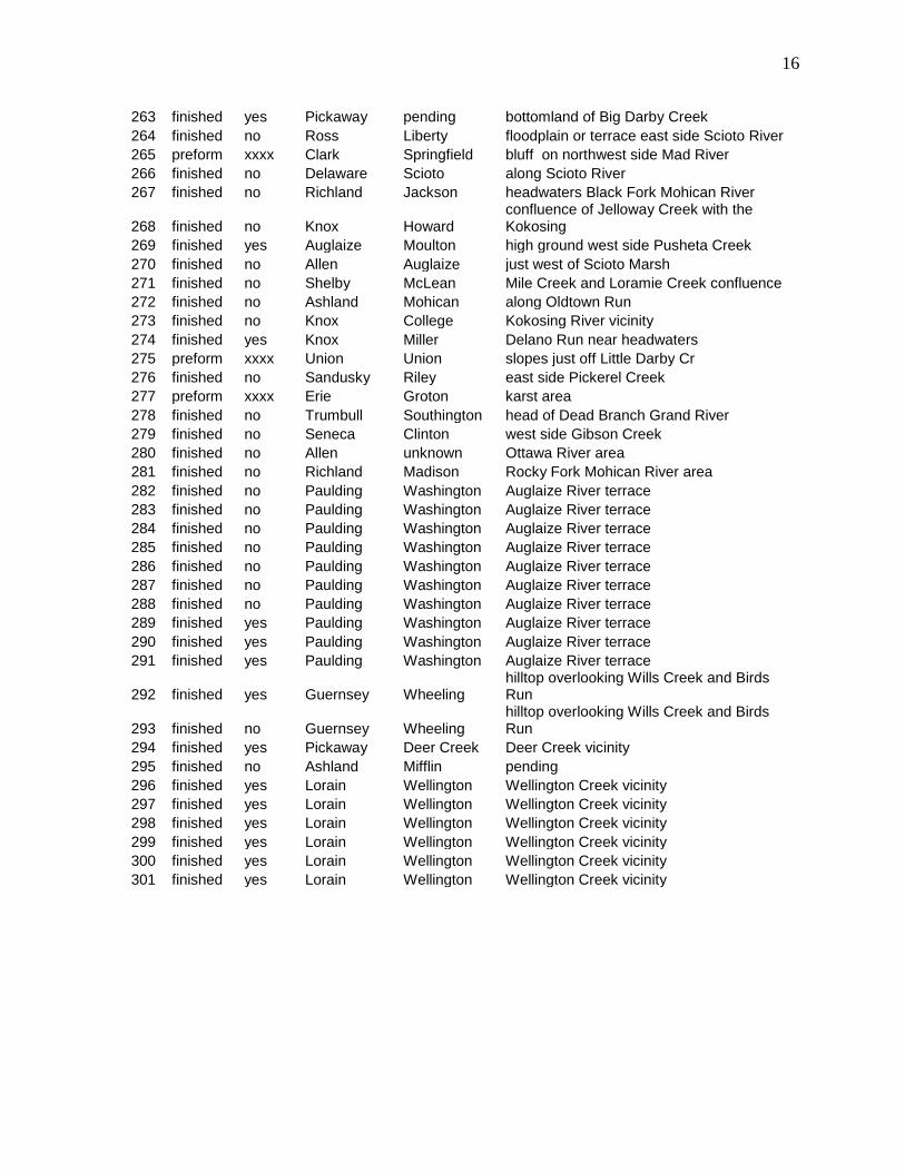
Ohio Notched Butterfly Database
As of March 2015 a total of 301 Notched Butterfly Bannerstones
from Ohio with at least relatively precise proveniences have
been entered into a database, which is appended to the end of
this paper. The entries for square mile section number,
Universal Transverse Mercator coordinates, and person
providing the data are omitted from this on-line version.
Locational data to township and landform only are included. The
complete database, which is suitable for Geographic Information
System (GIS) analyses, is available to researchers upon request.
These data were obtained through an examination of the Ohio
Archaeological Inventory, the Ohio Archaeologist (1951-2015),
the Central States Archaeological Journal, the
Redskin/Artifacts/Prehistoric American, as well as Knoblock
(1939) and Lutz (2000). I have also been seeking out and
recording Notched Butterfly Bannerstones for the past four
decades.

3
Distribution Maps
All Ohio area Notched Butterfly Bannerstones with locational
data known to the township level or better are plotted in Figure
1.
Three archaeological sites in Ohio (33HR111 on the Scioto
River, 33SE1 on the Sandusky River, and Wellington East on
Wellington Creek) have yielded numerous failed preforms as
well as many completed Notched Butterfly Bannerstones. The
locations of these “workshops” is shown in Figure 2. All
preforms from the Ohio area are plotted on the map in Figure 3.
Some Notched Butterfly Bannerstones were broken along the
medial axis, at the perforation. Often they were repaired by
having small holes drilled in each wing so that they could be
bound back together with cordage or sinew.
Figure 4 shows Notched Butterflies with such repair drilling.
These repaired specimens are plotted on the map in Figure 5.
More Notched Butterfly Bannerstones have been recovered from
the State of Ohio than any other single type of bannerstone.
They are also the only type for which production sites with
numerous preforms are known. None have been found with
human remains. It is unknown how they were used or how they
entered the archaeological record (loss, discard, ritual
deposition?).
The Ohio Notched Butterfly Bannerstone database is an ongoing
project with specimens being added as the information becomes
available. Please contact the author for updates.

4
References Cited
Converse, Robert N.
2003 The Archaeology of Ohio. Archaeological
Society of Ohio, Columbus.
Knoblock, Byron W.
1939 Bannerstones of the North American Indian.
Published by the author, Lagrange, Illinois.
Lutz, David. L.
2000 The Archaic Bannerstone. Published by the
Author, Newburgh, Indiana.

5
Fig. 1 - Distribution of Notched Butterfly Bannerstones
in the Ohio Area

6
Fig. 2 - Locations of Notched Butterfly Bannerstone
“Workshop” Sites in the Ohio Area
111 - 33HR111; 1 - 33SE1; W - Wellington East

7
Fig. 3 - Distribution of Notched Butterfly Bannerstone
Preforms in the Ohio Area

8
Fig. 4 - Notched Butterfly Bannerstone with Repair
Perforation

9
Fig. 5 - Distribution of Notched Butterfly Bannerstones in
The Ohio Area with Repair Perforations

10
OHBF state repair county township physical setting description
1 finished no Sandusky Riley east side Sandusky River
2 finished no Sandusky Riley east side South Creek
3 finished no Sandusky Riley west side Yellow Swale
4 finished no Sandusky Washington Muddy Creek vicinity
5 finished yes Sandusky Sandusky west side Little Muddy Creek
6 finished yes Sandusky Washington south side Gries Ditch near Muddy Creek
7 finished no Sandusky Washington Muskellunge Creek vicinity
8 finished no Sandusky Sandusky bluff east side Sandusky River
9 finished no Sandusky Sandusky bluff east side Sandusky River
10 finished no Sandusky Ballville bluff southwest side Sandusky River
11 finished no Seneca Pleasant bluff east side Sandusky River
12 finished no Seneca Pleasant Spicer Run upland just east Sandusky R
13 finished yes Seneca Clinton head ravine east side Sandusky River
14 finished no Seneca Pleasant botomland west side Sandusky River
15 finished no Seneca Clinton bluff west side Sandusky River
16 finished no Seneca Clinton head ravine west side Sandusky River
17 finished yes Seneca Clinton head ravine to Sandusky R
18 preform xxxx Seneca Clinton terrace east side Sandusky River
19 preform xxxx Seneca Clinton terrace east side Sandusky River
20 preform xxxx Seneca Clinton terrace east side Sandusky River
21 preform xxxx Seneca Clinton terrace east side Sandusky River
22 preform xxxx Seneca Clinton terrace east side Sandusky River
23 preform xxxx Seneca Clinton terrace east side Sandusky River
24 preform xxxx Seneca Clinton terrace east side Sandusky River
25 preform xxxx Seneca Clinton terrace east side Sandusky River
26 preform xxxx Seneca Clinton terrace east side Sandusky River
27 preform xxxx Seneca Clinton terrace east side Sandusky River
28 preform xxxx Seneca Clinton terrace east side Sandusky River
29 preform xxxx Seneca Clinton terrace east side Sandusky River
30 finished no Seneca Clinton terrace east side Sandusky River
31 finished no Seneca Clinton terrace east side Sandusky River
32 finished yes Seneca Clinton terrace east side Sandusky River
33 finished no Seneca Clinton Morrison Creek vicinity
34 finished no Seneca Clinton terrace east side Sandusky River
35 finished no Seneca Seneca east side Bells Run near Sandusky River
36 finished no Seneca Seneca bottomland west of Sandusky R
37 finished no Seneca Seneca Sandusky River vicinity
38 finished no Seneca Seneca a complex area with ravines
39 finished no Seneca Seneca a complex area with ravines
40 finished no Seneca Seneca a complex area with ravines
41 finished yes Seneca Seneca a complex area with ravines
42 finished yes Seneca Eden bottomland west side Honey Creek
43 preform xxxx Seneca Seneca near Middle Branch of East Branch Wolf Creek
44 preform xxxx Seneca Seneca near Middle Branch of East Branch Wolf Creek
45 finished no Seneca Thompson north side Royer Ditch
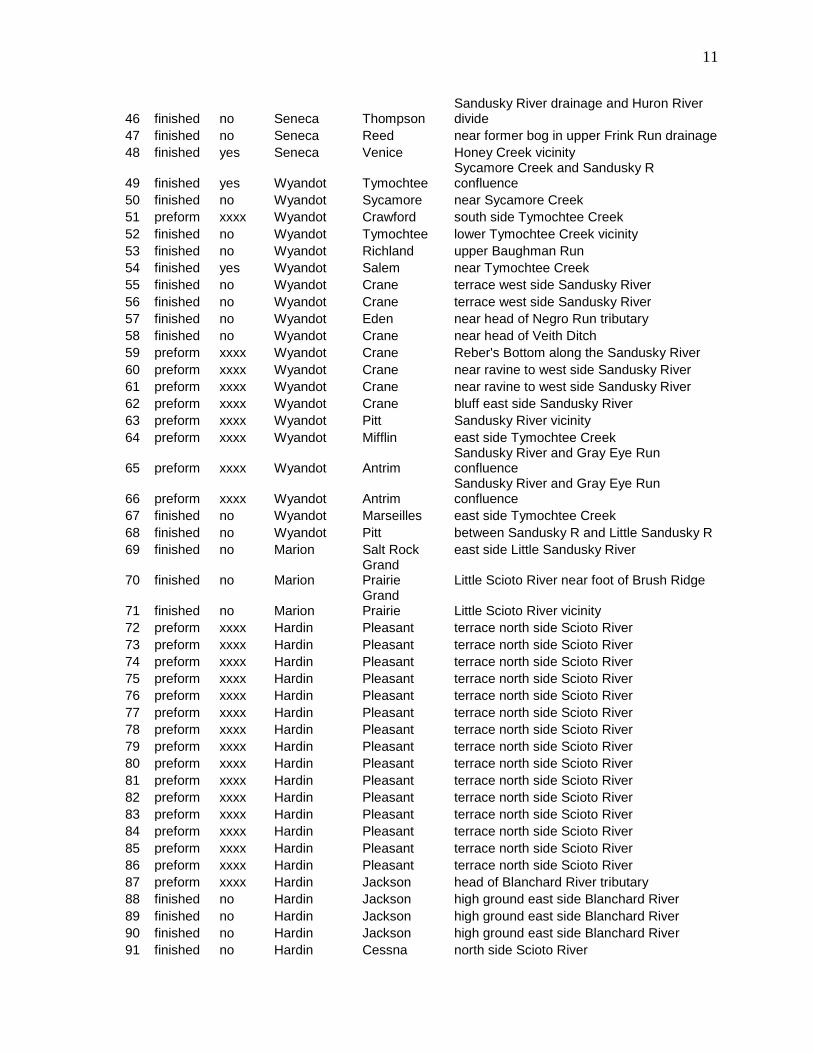
11
46 finished no Seneca Thompson Sandusky River drainage and Huron River divide
47 finished no Seneca Reed near former bog in upper Frink Run drainage
48 finished yes Seneca Venice Honey Creek vicinity
49 finished yes Wyandot Tymochtee Sycamore Creek and Sandusky R confluence
50 finished no Wyandot Sycamore near Sycamore Creek
51 preform xxxx Wyandot Crawford south side Tymochtee Creek
52 finished no Wyandot Tymochtee lower Tymochtee Creek vicinity
53 finished no Wyandot Richland upper Baughman Run
54 finished yes Wyandot Salem near Tymochtee Creek
55 finished no Wyandot Crane terrace west side Sandusky River
56 finished no Wyandot Crane terrace west side Sandusky River
57 finished no Wyandot Eden near head of Negro Run tributary
58 finished no Wyandot Crane near head of Veith Ditch
59 preform xxxx Wyandot Crane Reber's Bottom along the Sandusky River
60 preform xxxx Wyandot Crane near ravine to west side Sandusky River
61 preform xxxx Wyandot Crane near ravine to west side Sandusky River
62 preform xxxx Wyandot Crane bluff east side Sandusky River
63 preform xxxx Wyandot Pitt Sandusky River vicinity
64 preform xxxx Wyandot Mifflin east side Tymochtee Creek
65 preform xxxx Wyandot Antrim Sandusky River and Gray Eye Run confluence
66 preform xxxx Wyandot Antrim Sandusky River and Gray Eye Run confluence
67 finished no Wyandot Marseilles east side Tymochtee Creek
68 finished no Wyandot Pitt between Sandusky R and Little Sandusky R
69 finished no Marion Salt Rock east side Little Sandusky River
70 finished no Marion Grand Prairie Little Scioto River near foot of Brush Ridge
71 finished no Marion Grand Prairie Little Scioto River vicinity
72 preform xxxx Hardin Pleasant terrace north side Scioto River
73 preform xxxx Hardin Pleasant terrace north side Scioto River
74 preform xxxx Hardin Pleasant terrace north side Scioto River
75 preform xxxx Hardin Pleasant terrace north side Scioto River
76 preform xxxx Hardin Pleasant terrace north side Scioto River
77 preform xxxx Hardin Pleasant terrace north side Scioto River
78 preform xxxx Hardin Pleasant terrace north side Scioto River
79 preform xxxx Hardin Pleasant terrace north side Scioto River
80 preform xxxx Hardin Pleasant terrace north side Scioto River
81 preform xxxx Hardin Pleasant terrace north side Scioto River
82 preform xxxx Hardin Pleasant terrace north side Scioto River
83 preform xxxx Hardin Pleasant terrace north side Scioto River
84 preform xxxx Hardin Pleasant terrace north side Scioto River
85 preform xxxx Hardin Pleasant terrace north side Scioto River
86 preform xxxx Hardin Pleasant terrace north side Scioto River
87 preform xxxx Hardin Jackson head of Blanchard River tributary
88 finished no Hardin Jackson high ground east side Blanchard River
89 finished no Hardin Jackson high ground east side Blanchard River
90 finished no Hardin Jackson high ground east side Blanchard River
91 finished no Hardin Cessna north side Scioto River

12
92 finished yes Hardin Pleasant north side Scioto River
93 finished no Hardin Buck south side Scioto River
94 finished no Hardin Hale Upper Panther Creek or Wildcat Creek area
95 finished no Hardin Roundhead north side Scioto River
96 finished no Hardin Roundhead Great Miami R and Scioto R drainage divide
97 finished no Hancock Union east side Ottawa Creek
98 finished no Hancock Eagle west side Eagle Creek
99 finished no Hancock Van Buren headwaters Riley Creek
100 finished no Hancock Eagle west side Eagle Creek
101 preform xxxx Hancock Blanchard north side Blanchard River
102 finished no Hancock Blanchard north side Blanchard River
103 finished no Hancock Big Lick edge of The Outlet swamp
104 finished no Hancock Pleasant head of Rader Cr overlooking the Black Swamp
105 finished yes Hancock Portage Rocky Ford tributary overlooking Black Swamp
106 preform nx Hancock Portage edge of high ground overlooking Black Swamp
107 finished no Hancock Allen north side Rocky Ford Creek
108 finished no Hancock Allen foot of high ground at edge of Black Swamp
109 finished no Hancock Allen foot of high ground at edge of Black Swamp
110 preform xxxx Hancock Cass high ground overlooking Black Swamp
111 finished no Ottawa Benton high ground south side Toussaint Creek
112 finished yes Ottawa Salem north side of Portage River
113 finished no Huron New London headwaters East Branch Vermilion River
114 finished no Huron New London headwaters East Branch Vermilion River
115 finished no Huron New London headwaters East Branch Vermilion River
116 preform xxxx Huron Richmond high ground near north edge of Willard Marsh
117 preform xxxx Huron Richmond high ground near north edge of Willard Marsh
118 preform xxxx Huron Richmond high ground near north edge of Willard Marsh
119 preform xxxx Huron Richmond high ground near north edge of Willard Marsh
120 preform xxxx Huron Richmond high ground near north edge of Willard Marsh
121 preform xxxx Huron Richmond high ground near north edge of Willard Marsh
122 preform xxxx Huron Richmond high ground near north edge of Willard Marsh
123 preform xxxx Huron Richmond high ground near north edge of Willard Marsh
124 preform xxxx Huron Richmond high ground near north edge of Willard Marsh
125 preform xxxx Huron Richmond high ground near north edge of Willard Marsh
126 preform xxxx Huron Richmond high ground near north edge of Willard Marsh
127 preform xxxx Huron Richmond high ground near north edge of Willard Marsh
128 finished no Huron Norwich head trib of West Br Huron R
129 finished no Huron Norwich head of trib of West Br Huron R

13
130 finished no Huron Richmond north edge of Willard Marsh area
131 finished no Huron Fairfield between E Br and W Br Huron R
132 finished no Huron Greenfield West Branch Huron River vicinity
133 finished no Huron Lyme along Megginson Creek
134 finished no Huron Lyme overlooking lake plain at very head of Pipe Cr
135 finished no Huron Lyme overlooking lake plain at very head of Pipe Cr
136 finished no Huron Townsend head of Huron River tributary
137 finished no Erie Margaretta west side Little Pickerel Creek
138 finished no Erie Perkins east side Mills Creek
139 finished no Erie Sandusky east side Pipe Creek near mouth
140 finished no Erie Huron east Dildine Ditch, shoreline Sandusky Bay
141 finished no Erie Huron west side Sawmill Creek near mouth
142 finished no Erie Berlin head of ravine into east side of Huron River
143 finished no Erie Berlin Berlin Heights at head of Old Woman Creek trib
144 finished no Erie Berlin Berlin Heights west side of Old Woman Creek
145 finished no Erie Berlin Berlin Heights east side of Old Woman Creek
146 finished no Erie Berlin Berlin Heights east side of Old Woman Cr
147 finished no Erie Berlin along Old Woman Creek on the Berlin Heights
148 finished no Erie Berlin on the Berlin Heights
149 finished no Erie Berlin Old Woman Creek trib up on the Berlin Heights
150 finished no Erie Berlin trib of Old Woman Cr, on the Berlin Heights
151 finished no Erie Florence vicinity of head of small Old Woman Creek trib
152 finished no Erie Florence northeast side Chappel Creek
153 finished no Erie Berlin along Chappel Creek on the Berlin Heights
154 finished no Erie Berlin east side Chappel Creek on the Berlin Heights
155 finished no Lorain Penfield near the East Branch Black River
156 finished yes Medina Harrisville near the northern edge of the Killbuck Marsh
157 finished no Medina Harrisville near the northern edge of the Killbuck Marsh
158 finished no Medina Harrisville near the northern edge of the Killbuck Marsh
159 finished no Medina Harrisville near the northern edge of the Killbuck Marsh
160 finished no Medina Harrisville near the northern edge of the Killbuck Marsh
161 finished yes Medina Harrisville within the Killbuck Marsh
162 finished no Allen Jackson extreme upper Ottawa River vicinity
163 finished no Allen Jackson near Huber Ditch in Sugar Creek headwaters
164 finished no Shelby Dinsmore north side Loramie Creek near head
165 finished no Shelby Dinsmore north side Loramie Creek near head
166 finished no Shelby Dinsmore north side Loramie Creek near head
167 finished no Logan Bloomfield Great Miami River area
168 finished no Logan Rush Creek Rush Creek area
169 finished no Logan Rush Creek Rush Creek area
170 finished no Logan Rush Creek Rush Creek area
171 finished no Erie Oxford bluff north side West Branch Huron River

14
172 finished no Union Claibourne Fulton Creek area
173 finished no Union Claibourne Fulton Creek area
174 finished no Union Claibourne near Fulton Creek
175 preform xxxx Putnam Blanchard south side Blanchard River
176 finished yes Henry Damascus bottomland south side Maumee River
177 finished no Wood Henry near Rocky Ford Creek
178 finished no Wood Weston near head of small Beaver Creek tribs
179 finished no Wood Plain between Tontogany Cr and W Br Tontogany Cr
180 finished no Wood Freedom between Portage R and North Br Portage R
181 finished yes Wood Webster north side North Branch Portage River
182 finished no Wood Troy north side Toussaint Creek
183 finished no Lucas Providence Harris Ditch and Scherer Ditch confluence
184 finished no Delaware Orange bluff east side Alum Creek
185 finished no Delaware Genoa east side Big Walnut Creek
186 finished no Defiance Noble Tiffin River vicinity
187 preform xxxx Erie Milan Huron River area
188 preform xxxx Erie Milan Huron River area
189 finished no Adams Bratton along Ohio Brush Creek
190 finished no Adams Bratton along Ohio Brush Creek
191 finished no Highland White Oak East Fork White Oak Creek tributary
192 finished no Auglaize Noble Ankerman Creek vicinity
193 finished no Hamilton Crosby ancient valley of Dry Fork of the Whitewater R
194 finished no Hamilton Crosby ancient valley of Dry Fork of the Whitewater R
195 finished no Hamilton Crosby ancient valley of Dry Fork of the Whitewater R
196 finished no Hamilton Crosby ancient valley of Dry Fork of the Whitewater R
197 preform xxxx Crawford Liberty near the Sulphur Springs
198 preform xxxx Crawford Liberty near the Sulphur Springs
199 finished no Crawford Liberty near the Sulphur Springs
200 finished no Crawford Liberty near the Sulphur Springs
201 finished no Crawford Liberty near the Sulphur Springs
202 finished no Crawford Liberty near the Sulphur Springs
203 preform xxxx Richland Sharon Sandusky R and Black Fork Mohican R divide
204 preform xxxx Richland Sharon Sandusky R and Black Fork Mohican R divide
205 finished no Preble Washington near very small tributary of Sevenmile Creek
206 preform xxxx Fairfield Amanda higher ground at edge of Muddy Prairie
207 finished no Lucas Richfield along Gowman Ditch
208 finished no Richland Monroe along Switzer Creek
209 finished no Ashland Green east side Black Fork Mohican River
210 finished no Ashland Orange head of broad valley of Jerome Fork Mohican R
211 finished no Montgomery Perry upper Bear Creek area
212 finished no Preble Twin upper Twin Creek area
213 finished no Delaware Brown Alum Creek area
214 finished no Seneca pending pending
215 finished no Geauga Thompson perhaps upland south of Grand River

15
216 finished no Seneca Eden vicinity of small Honey Creek tributary
217 finished no Crawford Bucyrus general Sandusky River area
218 finished no Preble Harrison upper Twin Creek area
219 finished yes Allen Shawnee upper portion small tributary to Ottawa R
220 finished yes Franklin Plain Rocky Fork Creek or Blacklick Creek area
221 finished no Preble Monroe Goose Creek headwaters vicinity
222 finished no Darke pending pending
223 finished no Augaize St Marys Kopp Creek area
224 finished no Wyandot Salem Blake Ditch vicinity just west of Tymochtee Cr
225 finished no Union Leesburg near Bokes Creek
226 finished no Van Wert Pleasant Town Creek area
227 finished no Richland unknown upper Black Fork Mohican River
228 finished no Franklin Washington general Scioto River area
229 finished no Darke Allen Wabash River headwaters area
230 finished no Richland Cass Black Fork Mohican River vicinity
231 finished no Delaware Liberty area between Scioto R and Olentangy R
232 finished no Warren Washington Little Miami River area
233 finished no Darke Wayne SwampCreek area
234 preform xxxx Darke Brown along Stillwater River
235 finished no Sandusky Ballville along Bark Creek
236 finished no Sandusky Ballville along Bark Creek
237 finished no Sandusky Ballville along Bark Creek
238 finished no Pickaway Scioto along the Scioto River
239 finished no Wyandot Crawford Poverty Run vicinity
240 finished no Sandusky prending Sandusky River vicinity
241 finished no Henry Flat Rock blufftop at head of ravine to Maumee R
242 finished yes Licking Union upper portion of small Buckeye Lake trib
243 finished no Fairfield pending high ground just south of Buckeye Lake
244 preform xxxx Ashland Clear Creek Savannah Lakes vicinity
245 finished no Richland Blooming Grove adjacent to Ganges Swamp
246 finished no Licking Licking vicinity of Dutch Fork
247 preform xxxx Perry Thorn Thorn Township
248 finished yes Licking Lima Muddy Fork
249 finished yes Franklin Perry tiny tributary on blufftop east side Scioto R
250 preform no Darke Greenville includes eastward flowing Greenville Creek
251 finished no Union Bokes Creek Bokes Creek headwaters
252 finished no Allen Marion small tributaries west of Jennnings Creek
253 finished no Marion Pleasant Scioto River and Olentangy River divide area
254 preform xxxx Crawford Polk Olentangy River vicinity
255 finished no Ashland Milton just to east of Black Fork Mohican River
256 finished yes Stark Perry Tuscarawas River vicinity
257 finished yes Wood Middleton bluftop southeast side Maumee River
258 finished yes Lucas Springfield head of ravine on blufftop north side Swan Cr
259 finished no Ross Liberty bottomland east side Scioto River
260 finished no Ross Liberty terrace east side Scioto River
261 finished no Ross Twin bottomland south side Paint Creek
262 finished no Ross Twin bottomland south side Paint Creek
16
263 finished yes Pickaway pending bottomland of Big Darby Creek
264 finished no Ross Liberty floodplain or terrace east side Scioto River
265 preform xxxx Clark Springfield bluff on northwest side Mad River
266 finished no Delaware Scioto along Scioto River
267 finished no Richland Jackson headwaters Black Fork Mohican River
268 finished no Knox Howard confluence of Jelloway Creek with the Kokosing
269 finished yes Auglaize Moulton high ground west side Pusheta Creek
270 finished no Allen Auglaize just west of Scioto Marsh
271 finished no Shelby McLean Mile Creek and Loramie Creek confluence
272 finished no Ashland Mohican along Oldtown Run
273 finished no Knox College Kokosing River vicinity
274 finished yes Knox Miller Delano Run near headwaters
275 preform xxxx Union Union slopes just off Little Darby Cr
276 finished no Sandusky Riley east side Pickerel Creek
277 preform xxxx Erie Groton karst area
278 finished no Trumbull Southington head of Dead Branch Grand River
279 finished no Seneca Clinton west side Gibson Creek
280 finished no Allen unknown Ottawa River area
281 finished no Richland Madison Rocky Fork Mohican River area
282 finished no Paulding Washington Auglaize River terrace
283 finished no Paulding Washington Auglaize River terrace
284 finished no Paulding Washington Auglaize River terrace
285 finished no Paulding Washington Auglaize River terrace
286 finished no Paulding Washington Auglaize River terrace
287 finished no Paulding Washington Auglaize River terrace
288 finished no Paulding Washington Auglaize River terrace
289 finished yes Paulding Washington Auglaize River terrace
290 finished yes Paulding Washington Auglaize River terrace
291 finished yes Paulding Washington Auglaize River terrace
292 finished yes Guernsey Wheeling hilltop overlooking Wills Creek and Birds Run
293 finished no Guernsey Wheeling hilltop overlooking Wills Creek and Birds Run
294 finished yes Pickaway Deer Creek Deer Creek vicinity
295 finished no Ashland Mifflin pending
296 finished yes Lorain Wellington Wellington Creek vicinity
297 finished yes Lorain Wellington Wellington Creek vicinity
298 finished yes Lorain Wellington Wellington Creek vicinity
299 finished yes Lorain Wellington Wellington Creek vicinity
300 finished yes Lorain Wellington Wellington Creek vicinity
301 finished yes Lorain Wellington Wellington Creek vicinity