north-mill-creek-dutch-gap-canal-wbp.pdf - Illinois.gov
527
N North orth M Mill ill C Creek - reek - D Dutch utch G G ap C Canal anal Kenosha County, Wisconsin Lake County, Illinois Watershed-Based Plan A Strategy for Protecting and Restoring the Watershed
-
Upload
khangminh22 -
Category
Documents
-
view
0 -
download
0
Transcript of north-mill-creek-dutch-gap-canal-wbp.pdf - Illinois.gov

Page 1
NNorth orth MMill ill CCreek - reek - DDutch utch GGap CCanalanal
Kenosha County, Wisconsin Lake County, Illinois
Watershed-Based PlanA Strategy for Protecting and Restoring the Watershed

North Mill Creek-Dutch Gap Canal Planning Committee

NORTH MILL CREEK-DUTCH GAP CANAL WATERSHED-BASED PLAN
Lake County, Illinois Kenosha County, Wisconsin
November 2011
“This plan was prepared using United States Environmental Protection Agency funds under Section 319(h) of the Clean Water Act distributed through the Illinois Environmental Protection Agency. The findings and recommendations herein are not necessarily those of the funding agencies.”

Prepared by: Lake County Stormwater Management Commission 500 West Winchester Road Libertyville, Illinois 60048 http://lakecountyil.gov/Stormwater/Pages/default.aspx Phone: (847) 377-7700 Northwater Consultants 2921 Greenbriar Drive, Suite E Springfield, IL 62704 Phone: (217) 725-3181 With assistance from: Bleck Engineering 1375 N. Western Avenue, Lake Forest, Illinois 60045 V3 Consultants 7325 Janes Ave., Ste. 100 Woodridge, Illinois 60517 Final design and layout: Marie Lazzara Lake County Planning and Development Department
In memory of Noel Elfering Family patriarch, farmer, community leader, and
watershed stakeholder

NORTH MILL CREEK-DUTCH GAP CANAL WATERSHED-BASED PLAN
ACKNOWLEDGEMENTS The North Mill Creek-Dutch Gap Canal Watershed Plan was funded in part through the United States Environmental Protection Agency Section 319(h) of the Clean Water Act program administered by the Illinois Environmental Protection Agency. The Lake County Stormwater Management Commission (SMC) also provided funds and in-kind services including project coordination and management; report authorship; geographical information systems support; consultant contract administration; stakeholder input coordination; education and outreach plan; and design layout services. Several agencies and individuals provided significant contributions to this plan including the North Mill Creek-Dutch Gap watershed stakeholder planning committee whose members include representatives from municipal, county, state and federal agencies, homeowner and lake associations, agricultural producers, and interested groups and individuals from throughout the watershed. Of particular mention are Patty Werner, Jodi McCarthy, Mike Prusila, Jeff Laramy, Mike Novotney, and Andrea Cline of SMC; and Mike Adam, Kathy Paap and staff of the Lake County Health Department Lakes Management Unit. Jeff Boeckler and James Adamson of Northwater Consultants and Joy Corona of Bleck Engineering contributed significant support to SMC with analyzing the data and writing sections of the plan report. Northwater was supported by Jessica Spurlock and Derrick Martin of V3 Consultants. Scott Tomkins of Illinois EPA was our patient grant manager. The Lake Villa Public Library, Antioch Township Center, the Villages of Lindenhurst and Bristol, Sunflower Farms Inc, St. Mark’s Lutheran Church and the State Bank of the Lakes in Lindenhurst graciously supported our watershed planning effort by providing us with comfortable places to meet. Most of all we would like to recognize the project partners and watershed stakeholders whose interest in protecting, restoring, and enhancing the North Mill Creek /Dutch Gap Canal watershed has been critical to the success of this plan. The following people participated in watershed planning meetings/events: Last Name First Name Title Company Helker Craig Stream Biologist Wisconsin DNR Welsh Wesley Dir. of Public Works Village of Lindenhurst Marturano Dominic Village Trustee Village of Lindenhurst Heimbrodt Dennis Village Engineer Village of Antioch Elfering Noel Town of Bristol Kerkman Randall Town Administrator Town of Bristol Fisch Colleen Supervisor Town of Bristol Gossling Richard J. President Town of Bristol McCabe John Supervisor Town of Bristol Glembocki William Trustee Town of Bristol Tesar Diane Town Chair Town of Salem Leffingwell Larry Tempel Farms DeWitt Doug Project Mgr. Tallgrass Restoration, LLC May Phil Manager Sunflower Farm Craig Evan Chair Sierra Club Woods & Wetlands

NORTH MILL CREEK-DUTCH GAP CANAL WATERSHED-BASED PLAN
Last Name First Name Title Company Hahn Michael G. Env. Planning Dir. SE Wisc. Reg. Planning Comm. Frank Robert E. President Robert E. Frank Real Estate, Inc. Renwick Jim Renwick Nursery Raymond Marvin Lake County Regional Planning Committee Paulsen William L. Trapping Instructor NTA, ITA, FTA, Lake County Hebard Jerry District Conservationist - WI Natural Resources Conservation Service Turner Erika Acting Dist. Conservationist - IL Natural Resources Conservation Service Richter Brandi Acting Dist. Conservationist - WI Natural Resources Conservation Service Burt Randy Chairman NeuHaven HOA Beautification Committee Martino Will President NeuHaven HOA Singleton Pam NeuHaven HOA Alba Veronica Dist. Conservationist Natural Resources Conservation Service Hollock Bob Millburn Tree Farm Guldan John & Karoline Board Member Millburn Cemetery Assoc. Stellberg Mickey President Mill Creek Crossings HOA Clifton Mike President Loon Lake Management Assn. Lippert Tom Executive Director Lindenhurst Park District Green Glenn Commissioner Lindenhurst Lakes Commission Funk Ken Chairman Lindenhurst Lakes Commission Heinrich Tom Lindenhurst Lakes Commission Warren Joe Lindenhurst Lakes Commission Girmscheid Tim Natural Areas Mgr. Liberty Prairie Conservancy Venturi Daniel B. Township Supervisor Lake Villa Township Marrs Joseph A. Lake Villa Environmental Prusila Michael E. Watershed Planner Lake County Stormwater Mgmt. Werner Patricia Planning Supervisor Lake County Stormwater Mgmt. Novotney Michael E. Watershed Resource Professional Lake County Stormwater Mgmt.
Vancil Susan A. Public Information Coordinator Lake County Stormwater Mgmt. Warner Michael D. Executive Director Lake County Stormwater Mgmt. Chefalo Thomas J. Lake County Planning, Bldg. & Dev. Paap Kathy Lake County Health Dept. Adam Mike Lakes Management Lake County Health Dept. Pfister Mark Assoc. Director Lake County Health Dept. Deem Kelly Lake County Health Dept. Anderson James L. Natural Resource Mgr. Lake County Forest Preserve Dist. Hall Susan Landscape Architect Lake County Forest Preserve Dist. Berns Leslie Restoration Ecologist Lake County Forest Preserve Dist. Klick Kenneth Restoration Ecologist Lake County Forest Preserve Dist. Maurer Debbie Restoration Ecologist Lake County Forest Preserve Dist. Preuss Tim Wildlife Biologist Lake County Forest Preserve Dist. DeGrave Chuck Lake County Dept. of Public Works Pedersen Linda County Board Member Lake County Board Dist. 1 Probst Therese Executive Director Kenosha Racine Land Trust, Inc. Treloar Dan Conservation Planner Kenosha County Yersin Jeff Land & Water Conservation
Engineer Kenosha Co. Dept. of Planning & Dev.
Hill Janice Executive Planner Kane County Yamin Yamin A. James Anderson Company, Inc.

NORTH MILL CREEK-DUTCH GAP CANAL WATERSHED-BASED PLAN
Last Name First Name Title Company Johannesen David R. James Anderson Company, Inc. DeGraff Kara Integrated Lakes Management, Inc. Reeland Brenda Integrated Lakes Management, Inc. Trauscht Tori Sr. Proj. Mgr.
Coordinator Integrated Lakes Management, Inc. Indian Creek Watershed Partners
Marencik Joe Manager Illinois EPA North. Mon. & Assess. Unit Tomkins Scott Illinois EPA – Bureau of Water Myers David J. Conservation Opp. Areas Mgr. IDNR Benson John IDI Mosca Vincent J. Vice President/Sr. Ecologist Hey & Associates, Inc. Weaver Bronwyn Heritage Prairie Farm Doolittle Thomas Chairman Grubb School Drainage Dist. Wilson Don & Victoria Friends of IL Beach Elfering Dale Elfering Farms Dicke Faith M. East Shore Crooked Lake Riesbeck Ron Deep Lake Improvement Assoc. Biasco Paul Daily Herald Schultz Phil & Susan Crooked Lake Homeowners Assn. Weeks Kevin Country Financial Kennepp Eugene F. Clublands of Antioch Knysz Peter M. Mgr. NPDES Policy &
Enforcement Christopher B. Burke Eng., Ltd.
Kehoe Thomas Sr. Env. Resource Specialist Christopher B. Burke Eng., Ltd. Willis Lynn Brighton Farm Ziegenweide Barbara J. Executive Assistant Boy Scouts of America-NE IL Council Rankin William & Vivian Avondale Adventure Stepanek Matthew Antioch Environmental Board Stepanek Cynthia Antioch Environmental Board Vrazda Rasto Sr. Civil Engineer Abbott Laboratories Harrington Doug Assistant 60th State Rep. Rita Mayfield Francis Sandy Michael Bond's Secretary 31st Senatorial District Schmidt Suzi State Senator 31st Senatorial District Hunley Joseph Lindberg John & Ingrid Kolar Jerry Berner Victor Goetz George Lekor Chris Farmer Loecher Lee & Sue Bailey James W. Bernard Jack Block Steve Cassidy Joe Druce-Hoffman
Thomas & Irene
Esperson Warren Ewing Dan Flesher Greg Grant Peter

NORTH MILL CREEK-DUTCH GAP CANAL WATERSHED-BASED PLAN
Last Name First Name Title Company Henley Joe Inglis Sandra Jorgus Harry & Carol Lovell Cecil &
Marguerite
Majewski Bill Ness Craig & Jeanne Noerenburg Vi & Gerry Pedersen Gregg Rago Peter Stingle Jerry Weninger Carol Miller Jerry Farmer Grubb School Drainage District Sommer Alan

Page 1
NNorth orth MMill ill CCreek - reek - DDutch utch GGap CCanalanal
Executive Summary- July 2011
Watershed-Based PlanA Strategy for Protecting and Restoring the Watershed

Page 2
Why this watershed plan?Water is elemental to our lives. Our bodies are largely composed of water - and we need to consume clean water for our survival. Plants and animals also need water – and we in turn depend on these plants and animals for food, medicines, fuel and the everyday products we use. Although elemental to our individual lives, our communi-ties and our planet, we sometimes take water for granted.
Th is plan is important to you because it specifi cally addresses water here in your com-munity within the North Mill Creek-Dutch Gap Canal watershed, and because clean and abundant water, healthy lakes and streams, and safety from fl ooding are impor-tant for residents, agricultural producers, businesses and the economic and environ-mental health of our communities.
How water fl ows and collects in streams, wetlands and lakes is based on landform. Because water fl ow generally does not follow property lines or politi-cal boundaries, we recognize that most water resource problems need to be addressed at the watershed level, which frequently involves multiple landown-ers and several political jurisdictions.
A watershed plan is stakeholder driven and it is a “living” document that can be modifi ed as deemed necessary by watershed stakeholders. Th e water-shed planning process for the North Mill Creek-Dutch Gap Canal brought the municipalities, townships, coun-ties and the broader community of
As a resident, landowner, or business or community official your actions make a difference in keeping the water in our creeks and lakes clean, reducing flooding, and protecting natural areas that provide habitat and places for people to recreate.
AaabwsMtt
Dutch Gap Canal North of Winfi eld Rd
Below: Aerial view of Crooked Lake
Funding for development of the North Mill Creek-Dutch Gap Canal Watershed Plan was provided in part through the USEPA Section 319(h) of the Clean Water Act that is admin-istrated through the Illinois EPA. Lake County Stormwater Management Commission also provided funding for this plan in addition to providing considerable in-kind support. Lake County Health Department also provided in-kind services for monitoring water quality in lakes and streams in the watershed.

Page 3
homeowner associations, businesses, institutions, non-profi t organizations and residents that live or work in the watershed together to plan for managing and improving the land, lakes, streams and wetlands of the watershed.
Th e North Mill Creek-Dutch Gap Canal Watershed Plan was created to help stakeholders better understand the watershed and to identify what actions need to be taken to prevent and reduce fl ood damage, improve water quality, and protect and enhance natural resources, greenways, and recreational opportunities. Th is compre-hensive management plan summarizes the overall condition of the watershed (pres-ent day and into the future) and recommends actions as best practices that you as a stakeholder, individually or in collaboration with others, can take to protect water-shed resources that are still in good shape - and restore those that are degraded.
Stakeholders at watershed planning kick-off meeting
Th e Lake County Stormwater Management Commission (SMC) took the lead to develop this watershed plan for the North Mill Creek/Dutch Gap Canal watershed. A signifi cant outcome of this planning eff ort and the implementation of the plan going forward is to return the ten (10) lakes and two (2) streams in the watershed that are presently listed as being “impaired” to conditions that fully support their designated uses as aquatic habitat and for recreation.
Th e purpose of this plan is to:• restore watershed lakes, streams and wetlands to a healthy condition • reduce the impacts of water pollution and fl ood damage on watershed residents, and • provide opportunities for watershed stakeholders to have a signifi cant role in the process.
Plan Purpose
McDonald Lake

Page 4
Th is watershed plan was developed with a broad representation of watershed stakeholders who took part in the planning process. One hundred thirty people representing municipalities, Lake and Kenosha counties, agricultural interests, natural resource agencies, homeowner and lake associations, and private residents participated in watershed planning meetings and the watershed bus tour in 2010-2011. Th is stakeholder group developed seven goals for this watershed plan.
Watershed Goals• Protect and restore natural resources• Improve water quality• Reduce fl ood damage• Guide new development to benefi t
watershed goals• Preserve and enhance green infrastructure• Enhance education and stewardship• Increase sustainable agricultural practices
Aft er a rain drop or snowfl ake falls on the land, it may infi ltrate into the soil or it may run off over the land surface to a low spot in the landscape, which is usually a body of water (lake, stream or river). A watershed is the area of land that drains to a particular stream, river or lake.
Th e health of a waterbody is a direct refl ection of how the land in the watershed is used andmanaged. Some of the benefi ts of a healthy watershed are: • improved water quality• fewer fl ooding problems• enhanced wildlife habitat• opportunities for education and recreation
What is a Watershed?

Page 5
North Mill Creek-Dutch Gap CanalTh e North Mill Creek/Dutch Gap Canal watershed is a subwatershed of the larger Des Plaines River Basin and encompasses approximately 23,532 acres or 37 square miles in north central Lake County, Illinois and south central Kenosha County, Wisconsin. Th e North Mill–Dutch Gap watershed has abundant water resources includ-ing 39 miles of stream, more than 4,164 acres of wetlands, and 24 named lakes encompassing approximately 1,066 acres. Smaller unnamed water bodies add up to another 418 acres of area bringing the total to 1,484 acres of open water across the watershed. Th e land area of the North Mill Creek-Dutch Gap Canal watershed drains to three tributaries: Hastings Creek, Deer Lake Drain and the mainstem of North Mill Creek-Dutch Gap Canal.
Th e overall North Mill-Dutch Gap wa-tershed is divided into smaller drain-age areas for more detailed study in this watershed plan. Th ese are referred to as “Subwatershed Management Units” (SMUs), and even smaller drainage units are called “Catchments”.
North Mill Creek-Dutch Gap Canal is actually a headwater tributary of the Mississippi River Basin, which covers 1,245,000 square miles of the conti-nental U.S.
PPPP
Watershed Management Units

Page 6
Dead Zone
North Mill Creek- Dutch Gap Canal
Mississippi River Basin: 1,245,000 sq mi
North Mill Creek fl ows into Mill Creek, and then into the Des Plaines and Illinois Rivers before reaching the Mississippi River, and eventually the Gulf of Mexico a thousand miles away.

Page 7
Do you live or work in North Mill Creek-Dutch Gap Canal Watershed?Th e North Mill Creek-Dutch Gap Canal Watershed is a largely rural watershed. In addition to the Dutch Gap Canal and North Mill Creek stream corridor, the natural landscape of the watershed is a complex of lakes, wetlands, savannas, upland prairies, and woodlands.
Interspersed with the remaining natural features of the watershed are farms, subdivi-sions, lake communities, limited commercial areas, a new industrial park and several area schools. Th e Villages of Bristol, Antioch, Lindenhurst, Old Mill Creek, and Lake Villa are the primary watershed jurisdictions, along with unincorporated areas of Antioch, Newport and Salem Townships. Approximately 15,000 people lived in the watershed and 1,300 people worked here in 2000. A population increase of roughly 148% and a 177% increase in employment are forecasted for the watershed between the years of 2000-2035.

Page 8

Page 9
Plant Communities in the Watershed Prior to European Settlement
What is special about the North Mill Creek-Dutch Gap Canal watershed?Th e watershed landscape of gently rolling fi elds, grasslands, lakes, wetlands and woodlands that we see today was created over 10,000 years ago by the last retreat of the Wisconsin Glacier. As the giant ice sheets melted and retreated, they carved out and left behind unique glacial features such as the moraines, ridges, kettle holes, and the outwash till plains still visible throughout the watershed.
Pre-settlement Land Cover
Remnants, some large and some small, of the pre-settlement landscape and plant and animal communities of the watershed remain today. Th ey are the biodiversity of the watershed. Th ese water and natural resources, along with several signifi cant cultural resources that include several sites where mastodon remains were discovered in re-cent years, are worth protection and restoration.

Page 10 PPPPPPPPPPPPPPPaaaaagggggggggeeeee 11111111110000000000000000
Redwing Slough
Below:Marsh at Hendrick Lake
Ethel’s Woods Forest Preserve
Special Places
Th e North Mill Creek-Dutch Gap watershed is identifi ed as a Conservation Opportunity Area by the Illinois State Wildlife Action Plan. Five plants, nine birds and one fi sh species are listed as threat-ened or endangered species (T&E). Th e largest nature preserve in the watershed that is home to several T&E species is the Redwing Slough/Deer Lake Land and Water Reserve totaling over 734 acres. Redwing Slough is considered a Nation-ally Signifi cant Wetland Area by the U.S. Fish and Wildlife Service.
High quality watershed resources include:
• Eighty-two high quality wetlands totaling 1,351 acres. • Th ree recorded Illinois Natural Area Inventory sites include Redwing
Slough, and McDonalds Woods Marsh totaling 986 acres• Raven Glen Forest Preserve includes the 33 acre Timber Lake, one of
the highest quality lakes in Lake County • Ethel’s Woods Forest Preserve includes two high quality wetlands and
numerous old oak-hickory woodlands

Page 11

Page 12
Lakes:Data collected in lakes throughout the watershed indicates a general decline in water quality in most lakes including high nutrient loads from farms and lawns, and decreased water clarity as a result of erosion, carp activity and other factors. Ten of twenty-two watershed lakes are impaired. Five lakes have not been evaluated.
Streams:• Channelization is characterized as moderate to high in 64%
of stream reaches. • Streambanks of 71% of the stream reaches are moderately or
severely eroded. • Sediment accumulation is characterized as moderate to high
in 79% of stream reaches.• Excess debris loading is problematic in 50% of the stream reaches.
Streams and Lakes Under Pressure
What are the current challenges to watershed health?Lakes in the watershed are impaired or becoming impaired by high loads of nutrients and sediment in stormwater runoff and by carp stirring up lake bottoms. Salt from winter de-icing is resulting in an increasing trend in chlorides. Streams are degraded by pollutants in stormwater runoff and runoff from agricultural drain tiles. In-stream erosion is caused by the higher volume of runoff to creeks from impervious surfaces such as building rooft ops, roads, parking lots. Poor riparian or streamside property management and lack of stream buff ers and maintenance have also contributed to degraded streams.
Lake Linden
Dutch Gap at Horton Rd

Page 13
Watershed Threats
More specifi cally watershed threats include:
• Erosion, excess nutrients, and road salt are the biggest threats to water quality.
• Flooding causes property damage, crop loss and road closures. Sixteen locations that include 199 structures have been reported as fl ood problem areas, and Wisconsin farmers report increasing crop loss because of fl ooding.
• Stream channels are degrading due to channelization and lack of maintenance.
• Lakes and streams are being damaged by increasing volumes of storm-water runoff and pollution. Rasmussen Lake is one of the poorest quality lakes in Lake County.
• “Business as usual” development practices create more stormwater runoff increasing pollution, fl ood damage and loss of high quality natural resources.
• Roads create disproportionately more runoff and pollution in the sub-urbanized areas of the watershed. Major roadway improvements being planned include the Route 45 Millburn By-pass; expanding Route 173 to four lanes; and rebuilding and adding intersection improvements to Route 45 in Wisconsin.
More specifi cally watershed threats include:
• Watershed stakeholders lack the knowledge, skills and resources that they need to address watershed issues.
• Th ere has been a lack of communication, coordination and collabora-tion among watershed stakeholders to maintain and improve water-shed health.
nn ffararmemersrs Gully erosion washes topsoil off land and into creek

Page 14
The future of the North Mill Creek-Dutch Gap Watershed: what is at risk?
Th e watershed is changing. Population and jobs are projected to increase dramati-cally in the watershed over the next 25 years with associated changes in land use to a less rural and more suburban watershed. In 2000, 14,860 people lived in the North Mill Creek-Dutch Gap Canal Watershed and 1,361 had jobs here. By 2035 the wa-tershed is expected to be home for more than 36,000 residents and more than 3,700 jobs. Th ese are signifi cant increases and watershed land use is expected to change accordingly. As of 2005 approximately 74% of the watershed was in rural land uses or open space. By 2035 residential, commercial, institutional and industrial lands are supposed to increase, while rural lands and open space are expected to decrease to 60% of the watershed area. Th e largest area of change will be conversions from agriculture and open space to residential.
Impervious Cover Impacts Water ResourcesAs a mostly rural watershed, only 5.6% of the land cover was impervious surface in 2007. Future land use projections indicate that the area covered by impervious surfaces will be two and a half times greater in 2030 covering more than 15% of the land surface. Since watershed development is projected to be signifi cant, an analysis of the watershed’s vulnerability based on the eff ect of impervious cover on stream and lake quality and fl ooding was evaluated using the future land use forecast for the watershed. Increased impervious cover typically results in more stormwater runoff . Th is runoff from lawns streets, driveways, rooft ops, parking lots and streets carries more water and pollutants from the land to streams and lakes and causes stream channels to erode.
Increased volumes of runoff also translate into more frequent fl ooding and a larger fl oodplain in some locations. Th irty-four homes and businesses located in the 100 year fl oodplain, and other structures outside the fl oodplain, may be at risk of fl ood damage in a 100-year fl ood event. (Th ere is a 29% chance of a 100-year fl ood occur-ring within the timeframe of a 30-year home mortgage.)
To reduce the negative impacts of impervious cover on the environment, the wa-tershed plan recommends converting development practices from the traditional stormwater collection and conveyance systems to low impact development practices that reduce and infi ltrate stormwater runoff .

Page 15
Loss of Green InfrastructureGreen infrastructure serves an important function in the North Mill Creek-Dutch Gap Watershed. It not only forms an interconnected network of natural areas that absorb and infi ltrate precipitation, but also includes the wetlands and streams that make up the natural drainage system of the watershed. Best management practices that reduce stormwater runoff such as rain gardens, green roofs, naturalized detention basins and swales also contribute to green infrastructure.

Page 16
An inventory of the watershed’s open land (complete undeveloped) and partially open parcels (minimal area devoted to structures) form the basis of the water-shed’s green infrastructure network. A total of 20,202 acres of open or partially open land was identifi ed. Future land use projections predict that approximately 6,000 acres of this land will be developed over the next 20-30 years (roughly 30%). Th e hydrology functions that this open land currently provides to the watershed (absorbing, infi ltrating, evapotranspiring and storing precipitation) will have to be replaced within the developed lands using low impact development practices so that increases in runoff and its negative environmental and fl ood damage impacts on the watershed can be avoided.

Page 17
What can we do? …the 15 best things that could happen in the next 10 years:
Form a watershed council• Educate and motivate residents, businesses, institutions and
communities to reduce the amount of pollutants they contribute. • Work with communities to develop a collaborative green infrastruc-
ture preservation strategy.• Provide technical assistance to stakeholders for watershed
improvement projects.
Communities & county• Adopt the watershed plan.• Require low impact development standards. • Retrofi t stormwater facilities, government properties and
transportation corridors to reduce runoff and improve water quality.
• Use less road salt and look to use alternative de-icingproducts.
• Ban phosphorus in fertilizers.
Residents and businesses• Convert large areas of yards, lawns, and stormwater facilities
to native landscaping.• Create rain gardens and disconnect rooft op runoff from the
stormsewer system.
Lake and streamside property owners • Establish and maintain native plant buff ers along shorelines
and stream channels.• Maintain streams on your property according to American
Fisheries Society Standards.
Farmers and equestrian & nursery operators• Install and properly maintain stream buff ers and grassed
waterways that include water treatment practices for drain tile discharges.
• Implement nutrient management plans for all operations.• Stabilize eroding fi elds and use best farming practices to
reduce soil loss.

Page 18
Good things are beginning to
Elfering Farm has a nutri-ent management plan and only applies fertilizer where needed
Below: Native plant buff er at Hendrick Lake helps to keep the water clean
Watershed partners are taking the lead and moving forward with implementing best management proj-ects and educational activities recommended in the watershed plan. Join the watershed team and take the lead on a project in your neighborhood or community.

Page 19
happen in the watershed
Left : Lindenhurst is upgrading it’s wastewater treatment plant 2011-2012 to include nutrient removal
Right: Stakeholders are coming together to plan for the future of their watershed
Ecological restoration at Ethel’s Woods Forest Preserve
Lindenhurst promotes storm-water awareness

Page 20
The North Mill Creek – Dutch Gap Watershed Community
ResidentsBusinesses
Schools
CsCOMMUNITIESAntiochBristol
Lake VillaLindenhurst
Old Mill Creek
TOWNSHIPSAntioch Bristol
NewportSalem
AGENCIES/DISTRICTS/ORGANIZATIONS/DISTRICTSLake and Kenosha Counties
Lake County Stormwater Management CommissionLake County Forest Preserve District
Lindenhurst Park DistrictSoutheastern Wisconsin Regional Planning Commission
Natural Resources Conservation ServiceIllinois and Wisconsin Department of Natural Resources
Illinois Environmental Protection AgencyGrubb School Drainage DistrictLindenhurst Lakes Commission
Antioch Environmental CommissionLake and Property Owner Associations
Upper Des Plaines River Ecosystem PartnershipLiberty Prairie Conservancy
Funding for development of the North Mill Creek-Dutch Gap Canal Watershed Plan was provided in part through the USEPA Section 319(h) of the Clean Water Act that is administrated through the Illinois EPA. Lake County Stormwater Management Commission also provided funding for this plan in addition to providing considerable in-kind support. Lake County Health Department provided in-kind services for monitoring water quality in lakes and streams in the watershed.

1

NORTH MILL CREEK-DUTCH GAP CANAL WATERSHED-BASED PLAN
TABLE OF CONTENTS 1.1 Watershed Setting .................................................................................................................................. 1
1.2 The Watershed Over Time .................................................................................................................. 3
1.3 Impacts of Watershed Development.................................................................................................. 5
1.4 Where Do We Go From Here? ........................................................................................................... 7
1.5 About This Watershed Plan ................................................................................................................. 8
Plan Purpose: ...................................................................................................................................................... 8
Project Planning Team and Project Funding: ........................................................................................... 9
Scope and Project Approach ....................................................................................................................... 9
Previous and Related Studies and Plans: .................................................................................................. 10
Process and Plan Organization: ................................................................................................................ 11
1.6 Using This Plan .................................................................................................................................... 13
Who Should Use This Plan ........................................................................................................................ 13
How to Use this Plan .................................................................................................................................. 14

NORTH MILL CREEK-DUTCH GAP CANAL WATERSHED-BASED PLAN
FIGURE 1-1 WATERSHED MAP ........................................................................................................ 1
FIGURE 1-2 NORTH MILL-DUTCH GAP WATERSHED ....................................................................... 1
FIGURE 1-3: GEOLOGY ..................................................................................................................... 2
FIGURE 1-4: MORAINE DEPOSITS ..................................................................................................... 3
FIGURE 1-5: PRE-EUROPEAN SETTLEMENT NATURAL COMMUNITIES ............................................. 4
FIGURE 1-6: HISTORIC MARSH SLOUGHS .......................................................................................... 4
FIGURE 1-7: INCREASED RUNOFF FROM INCREASED CONSTRUCTION DIAGRAM .............................. 6

NORTH MILL CREEK-DUTCH GAP CANAL WATERSHED-BASED PLAN
1
FIGURE 1-1 WATERSHED MAP *Graphic courtesy of the USEPA
FIGURE 1-2 NORTH MILL-DUTCH GAP
INTRODUCTION: The North Mill Creek-Dutch Gap Canal Watershed 1.1 WATERSHED SETTING
What is a watershed? A watershed is the area of land drained by a river/stream system or body of water. As simple as the definition sounds, a watershed is actually a complex interaction between ground, climate, water, vegetation, and animals. In today’s developed watersheds, other elements such as sewage, agricultural drainage, impervious surfaces, stormwater and erosion are all detrimental to the health of the watershed. Erosion: Displacement of soil particles on the land surface due to water or wind action. The North Mill Creek-Dutch Gap Canal watershed is a subwatershed of the larger Des Plaines River Basin and encompasses approximately 23,532 acres or 37 square miles in north central Lake County, Illinois and south central Kenosha County, Wisconsin. The North Mill–Dutch Gap watershed includes 39 miles of stream, more than 4164 acres of wetlands and 24 named lakes encompassing approximately 1,066 acres. Smaller un-named water bodies encompass approximately another 418 acres bring the total for open water to 1,484 acres across the watershed. North Mill Creek-Dutch Gap Canal is actually a headwater tributary of the Mississippi River Basin, which covers 1,245,000 sq. miles of the continental US. North Mill Creek flows into Mill Creek to the Des Plaines and Illinois Rivers before reaching the Mississippi River and eventually the Gulf of Mexico a thousand miles away. Watershed: An area confined by topographic divides that drains to a given stream or river. The land area above a given point on a waterbody (river, stream, lake, wetland) that contributes runoff to that point is considered the watershed.

NORTH MILL CREEK-DUTCH GAP CANAL WATERSHED-BASED PLAN
2
FIGURE 1-3: GEOLOGY The blue region represents the approximate location of the study. This area has been affected all three phases of glaciation; most recently the Wisconsin Period.
Geology- the Watershed Stage The geologic setting within the watershed was formed during the most recent glacial period known as the Pleistocene Era or “Ice Age” that began approximately 70,000 years ago and ended 10-14,000 years ago. During this time, 80% of Illinois was covered with one or more sheets of glacial ice (Neely and Heister 1987). Although the study area was most likely glaciated repeatedly during the Ice Age, the last glacial retreat, the Wisconsin Glacier, resulted in almost all of the geologic features present today (Fryell 1927). Some of these features include loess, outwash gravels and sands, and till. The Lake Michigan lobe of the Wisconsin glaciation extended as far south as Shelbyville, Illinois. As this lobe retreated, ground moraines, till plains, and recessional moraines formed. These formations presently appear as concentric belts around southern Lake Michigan and the Chicago region. The state of Illinois has 14 geographic or natural divisions. Each division is unique from other divisions by its geology and
distribution of flora and fauna. The North Mill Creek-Dutch Gap Canal watershed is located in the Northeastern Morainal Division (Neely and Heister 1987), a region that was covered by the Lake Michigan Lobe of the Wisconsin ice sheet (Figure 1.3). Loess: A fine-grained unstratified accumulation of clay and silt deposited by wind. Outwash: Sand and gravel deposits removed or washed out from a glacier. Till: A hetergeneous mixture of clay, silt, sand, gravel, stones, and boulders deposited directly by and underneath a glacier without stratification. Recessional moraines: An end moraine formed during a temporary but significant halt in the final retreat of a glacier. Natural divisions: Large land areas that are distinguished from each other by bedrock, glacial history, topography, soils, and distribution of plants and animals. Flora: Collectively, the plants of a particular region, geological period, or environment. Faunal: Animals of a particular region or period, considered as a group. When the Wisconsin ice sheet receded approximately 14,000 years ago, it deposited the Valparaiso and Lake Border moraines (Figure 1.4). As a result, the study area is characterized by rough, glacial landform topography. The study area is also unique in Illinois because the soils are derived from glacial drift that lead to the development of poorly drained soils and many natural lakes and stream systems. Glacial Drift: Earth and rocks which have been transported by moving ice or land ice.

NORTH MILL CREEK-DUTCH GAP CANAL WATERSHED-BASED PLAN
3
FIGURE 1-4: MORAINE DEPOSITS developed from advancing and retreating glaciers, the latest being the Wisconsin glacier. Source: The Physiography of the Region of Chicago (Fryell 1927)
Study Area
Topography: The relative elevations of a landscape describing the configuration of its surface.
The bedrock of the study area is composed primarily of dolomite, limestone, sandstone, shale, and coal. Fossils indicate that bedrock was formed during a geologic period known as the Silurian that began approximately 440 million years ago. Rock formed during this period is found at the surface only in the northern third of the state. Today, these rock formations are economically important because they yield limestone and other important minerals. Bedrock: The solid rock that underlies loose material, such as soil, sand, clay, or gravel.
1.2 THE WATERSHED OVER TIME Mammoth remains found in Bristol that date between 12,000 and 13,000 years ago provide the oldest historical record of the watershed. Mammoth bones gently removed in the fall of 1992 from what had become a Kenosha County field, provided the first evidence that humans had butchered a mammoth east of the Mississippi River. Since that time, remains of two more mammoths have been discovered in the area. The third animal excavated most recently in the vicinity of Mud Lake had a large number of cut marks on its bones, showing it had been scavenged by humans after it was dead.
Much later in history, in the early 1800’s, pre-settlement natural community mapping in the North Mill Creek-Dutch Gap Canal watershed indicated there were high-quality natural communities such as savannas, wetlands/marsh, prairie and woodland. Most of the watershed at that time was a landscape of scattered oak trees with the combined prairie and wetland understory typical of savannas. The predominant savanna was interspersed with marsh/wetland, oak woodlands, wet prairie and open water lakes. The northeastern watershed landscape was mostly prairie and very large complexes of marsh/wetland. The marsh/wetland and prairies in the Wisconsin portion of the watershed is supported by current accounts by local farmers that the soils and hydrology on the Wisconsin side of the watershed is much different than soils on the Illinois side of the watershed. NOTEWORTHY: Natural Communities A natural community is made up of all living things in a particular ecosystem but is usually named by its dominant vegetation type. Prior to European settlement in the 1830’s, when the Potawatomie were the last of several Native American tribes who called the area home, Lake County exhibited a

NORTH MILL CREEK-DUTCH GAP CANAL WATERSHED-BASED PLAN
4
FIGURE 1-5: PRE-EUROPEAN SETTLEMENT NATURAL COMMUNITIES The historical government land survey (1838-1840) indicated pre-settlement natural communities in the North Mill Creek-Dutch Gap Canal watershed included savanna, wet meadow/prairie, marsh, prairie, oak woodlands, and upland forest. The pre-settlement area was dominated by savanna type vegetation.
FIGURE 1-6: HISTORIC MARSH SLOUGHS were channelized to improve drainage for farming.
mix of natural communities including prairies, savannas, oak woodlands, dune complexes, and wetlands. Savanna: A type of woodland characterized by open spacing between its trees and by intervening grassland. Wetland: Wetlands are land that is inundated or saturated by surface or ground water at a frequency and duration sufficient to support, and under normal conditions, do support a prevalence of plants adapted for life in saturated soil conditions (hydrophytic vegetation). A wetland is identified based on three attributes: 1) hydrology, 2) hydric soils and 3) hydrophytic vegetation. Marsh: An area of soft, wet, low-lying land, characterized by grassy vegetation and often forming a transition zone between water and land.
High quality wetland/wet prairie High quality oak woodland/savanna
Typical historic stream channel Typical altered stream channel – Dutch Gap

NORTH MILL CREEK-DUTCH GAP CANAL WATERSHED-BASED PLAN
5
These natural communities likely worked in unison to infiltrate and treat precipitation, which minimized surface stormwater runoff leaving the watershed with the large marsh/prairie complexes rather than defined stream channels in the north. Red Wing Slough is likely the landscape that most closely resembles the marsh/wetland complexes that once existed in the northeast part of the watershed. Following European settlement, most of the watershed was altered for agricultural purposes. This resulted in the clear-cutting of savanna and woodlands, clearing of prairies, and installation of drain tiles and agricultural ditches to convey water from the marshes into stream channels to create farmland. The Dutch Gap Canal is actually a channel that was excavated to drain wetland for farmland. The name Dutch Gap shows up for the first time on an 1887 plat map. It was probably formed by the individual efforts of several Wisconsin farm families before it was completed by a steam-powered dredge in 1916. (Kenosha News December 6, 2000) While much of the watershed still remains in farms, suburban development of the watershed began with lakeside subdivisions. A rapid increase in suburban development began in the 1990s and carried through much of the 2000 decade, resulting in new suburban villages mixing with the older rural areas of the watershed. In Illinois, the watershed is comprised of portions of the Villages of Antioch, Lake Villa, Old Mill Creek, and Lindenhurst. These municipalities are interspersed with unincorporated areas of Antioch, Newport, and Lake Villa Townships that make up over half of the Illinois side of the watershed. In Wisconsin, the watershed is comprised of portions of the Village of Bristol and Salem Township. Most (88%) of the Wisconsin side of the watershed is within the Village of Bristol, which expanded to include the entire Town of Bristol in 2010. The watershed includes several high quality and remnant natural areas and is identified as a “Conservation Opportunity Area” in the Illinois Wildlife Action Plan. Natural areas of particular note include: Red Wing Slough – owned by the Illinois Department of Natural Resources, Mud Lake Sedge Meadow in Wisconsin - privately owned, and Ethel’s Woods Forest Preserve, which is undergoing restoration and is owned by the Lake County Forest Preserve District. 1.3 IMPACTS OF WATERSHED DEVELOPMENT Under natural conditions most of the precipitation that falls to the earth is intercepted by or taken up by plants and evaporated back into the air, or seeps into the ground and either becomes groundwater or travels in a shallow layer underground until it seeps back out in a low area such as a lake, wetland or stream and becomes the base flow that keeps these water features “wet” during the dry months of the year. In heavy rain or snowmelt events, the excess precipitation that isn’t taken up by plants and doesn’t infiltrate into the soil becomes runoff. As natural conditions are changed in a watershed to allow for development such as fields for farming, and built environments like buildings, lawns, roads and parking lots, there is less vegetation and open soil available to infiltrate precipitation, while at the same time there are more impervious surfaces that water runs off from. These conditions result in significant increases in stormwater runoff flowing quickly to our streams, wetlands and lakes through stormsewers and drain tiles. At the same time, less precipitation is available to plants and to recharge our groundwater aquifers.

NORTH MILL CREEK-DUTCH GAP CANAL WATERSHED-BASED PLAN
6
NOTEWORTHY: Urbanization Increases Runoff As farms, fields and woodlands in the watershed are developed into more urban land uses, what was once pervious open space is converted to impervious built up surfaces. This action reduces the amount of land available for the natural infiltration of precipitation into the ground. As impervious surfaces increase so does the volume of stormwater runoff, which can result in flooding and degraded water quality and habitat. In the absence of sensitive development practices, projected development trends over the next 20-30 years are expected to worsen flooding and water quality problems and decrease open space areas. The rapid flow of water to streams results in what is termed “flashy hydrology”. Water levels rise quickly during a storm event to a much higher than natural level and then fall quickly after a storm is over. In addition, since much the precipitation has been converted from infiltrating into the ground to runoff, there isn’t enough shallow ground water to maintain stream base flow in the dry months to support aquatic habitats and water quality, and ground water aquifers that support our water supply are not being recharged. High flows that cannot be conveyed by drain tiles, stream channels or stormsewers can result in flood damage as water backs up into low areas and overtops streambanks. These rapid rise and fall storm events frequently erode our stream banks toppling streamside trees and carrying debris downstream until it becomes lodged in a debris jam that causes additional erosion as water has to find its way around the jam. In addition to toppling trees from stream banks, erosion also changes the stream channel. The channel has to erode by cutting down and widening to accommodate the additional flow from the increased stormwater runoff. The result is that road, sanitary and stormsewer infrastructure may also be undermined by erosion as the channel changes in size or flow path to accommodate great volume of runoff flow. Increased stormwater flows also cause pollution damage. Stormwater runoff carries pollutants that have collected in or on our landscape as it hurries its way through drain tiles or stormsewers to our wetlands, lakes and streams. Excess nutrients from fertilizers and animal waste (whether from farm
FIGURE 1-7: INCREASED RUNOFF FROM INCREASED CONSTRUCTION DIAGRAM

NORTH MILL CREEK-DUTCH GAP CANAL WATERSHED-BASED PLAN
7
Lake County Forest Preserve will be removing the dam on Mill Creek that creates Rasmussen Lake and restoring the historic stream channel.
or subdivision) and road salt, hydrocarbons and metals from our roads and autos are just a few of the sources of these pollutants. Erosion from construction sites and farm fields adds to the in-stream erosion created by increased stormwater flows, contributing pollutants to our lakes and streams. Erosion leaves behind sediment that fills drain tiles and stormsewers ending up in our lakes and streams; degrading aquatic habitat for fish and the aquatic insects that are critical links in the food web. 1.4 WHERE DO WE GO FROM HERE? The health of the North Mill Creek-Dutch Gap watershed is a direct reflection of how we collectively manage the landscape of the watershed. There are all together approximately 15,000 people, two counties, five municipalities, four townships and a number of other local, state and regional jurisdictions that strongly influence what happens on the landscape of the North Mill-Dutch Gap watershed. Every watershed resident/landowner can make an individual difference on their land that results in cleaner water, less flood damage and improves aquatic habitat in streams, lakes and wetlands. Off to a good start, one hundred thirty (130) people representing sixty-two (62) organizations/jurisdictions and thirty-four (34) individual residents participated in the watershed planning process over the period of 14 months providing valuable input on next steps. An additional two hundred thirty people received planning updates and meeting/event invitations via our watershed contact list. Watershed “Influentials” While each and every property owner/resident in the watershed can make a difference, there are several stakeholders that wield a lot of influence.
• The five municipal and two county governments located in the watershed guide what happens to the watershed landscape through land use and development and land management policies, decisions and regulations.
• There are also several very large landowners and farmers that manage large acreages in the
watershed that can significantly influence watershed conditions. They also influence other farming, nursery and equestrian uses, and therefore broader watershed outcomes. The largest single landowner is the Lake County Forest Preserve District. The District owns 3,053 acres, which is approximately 13% of the watershed.
• Influential land managers include not
only the large land owners, but all of the riparian and lakeside landowners and lake and homeowner associations in the watershed. How they manage their yards, runoff from their properties, and how they maintain shoreline and stream buffers can significantly influence aquatic resources because they manage the water’s edge.

NORTH MILL CREEK-DUTCH GAP CANAL WATERSHED-BASED PLAN
8
Fortunately there is something that we can all do, and this watershed plan outlines the actions that need to be taken to restore watershed conditions and our impaired lakes and streams to a healthy state. There is more than one possible future for the watershed, and the future we realize will depend on the choices we make to manage the portion of the watershed landscape that we are responsible for or can influence. The business-as-usual trajectory using conventional development, farm practices, stormwater management and landscape management practices that got us where we are today, will result in continued soil and stream loss to erosion, water pollution, degraded natural resources and flood damage. As an alternative to business-as-usual, this plan presents recommendations and the tools to support their implementation that will integrate the needs of people with the preservation of environmental resources rather than offering “development” or “preservation” as an either/or choice. Implementing this watershed plan can reverse the current trend of a degraded watershed and begin the road to recovery. 1.5 ABOUT THIS WATERSHED PLAN PLAN PURPOSE: The Lake County Stormwater Management Commission (SMC) took the lead to develop this watershed plan for the North Mill Creek/Dutch Gap Canal watershed. The purpose of this effort was to come up with a plan to restore watershed lakes, streams and wetlands to a healthy condition while reducing the impacts of water pollution and flood damage on watershed residents, and providing opportunities for watershed stakeholders to have a significant role in the process. This plan was developed with, and generally accepted and supported by, a broad representation of watershed stakeholders who participated in the planning process. A significant outcome of this planning effort and the implementation of the plan going forward is to return the ten watershed lakes and two streams that are presently listed as being “impaired” on the Illinois 303(d) list of impaired waters to conditions that fully support their designated uses.
Lake County Stormwater Management Commission (SMC): Government agency created to coordinate the stormwater activities of over 90 jurisdictions throughout Lake County. They provide technical assistance, local knowledge and problem-solving skills to coordinate flood damage reduction, flood hazard mitigation, water quality enhancements and natural resource protection projects and programs. This plan identifies Best Management Practices (BMPs) to remedy/mitigate losses of natural resources, water quality degradation, and flood damages. The plan also makes recommendations for watershed stakeholders to implement to preserve, manage, and restore natural resources as well as prevent actions that will cause or exacerbate unintended water quality and flood damage problems. Watershed planning brings communities together to protect and improve the land and water resources they share and impact. Best Management Practices (BMPs): BMPs are non-structural practices such as site planning and design aimed to reduce stormwater runoff and avoid adverse development impacts - or structural practices that are designed to store or treat stormwater runoff to mitigate flood damage and reduce pollution. Some BMPs used in urban areas may include stormwater detention ponds, restored wetlands, vegetative filter strips, porous pavement, silt fences and biotechnical streambank stabilization. Mitigation: Measures taken to eliminate or minimize damage from development activities, such as construction in wetlands or Regulatory Floodplain filling, by replacement of the resource.

NORTH MILL CREEK-DUTCH GAP CANAL WATERSHED-BASED PLAN
9
PROJECT PLANNING TEAM AND PROJECT FUNDING: The SMC took the lead in securing cost-share funding from IL EPA through a Clean Water Act Section 319 grant to fund a water quality monitoring study and develop a watershed-based plan for North Mill Creek. Recognizing that water flow doesn’t respect political boundaries or land ownership, and that a significant portion of the watershed lay on the Wisconsin side of the state line, SMC expanded the planning effort into a bi-state watershed plan. The “paid” planning team included SMC and the Lake County Health Department Lakes Management Unit (LMU or Lakes Management) who lead the water quality monitoring effort, and several consultants who provided monitoring and planning support including: Northwater Consultants; Living Waters; and Bleck Engineering. Staff of the Lake County Forest Preserves, the Villages of Lindenhurst, Bristol, Old Mill Creek, and Lake Villa, Kenosha County and Lake County Planning and Development departments, Lake County Public Works and Division of Transportation, the Southeastern Wisconsin Regional Planning Commission, the Natural Resources Conservation Service on both sides of the state line, IL Department of Natural Resources, WI Department of Natural Resources and of course the IL Environmental Protection Agency provided data, information and strong planning support. The watershed plan was ultimately funded in part with the Section 319 grant and by the Lake County Stormwater Management Commission. NOTEWORTHY: SMC Watershed Planning Authority: SMC’s authority for stormwater management for Lake County and development of this Watershed Plan is provided in 55 ILCS 5/5-1062. This state-level enabling legislation was enacted in response to the major flooding that occurred in October 1986 and August 1987 that caused widespread damages and dislocations across northeastern Illinois. Lake County established the Lake County Stormwater Management Planning Committee in December 1987; a municipal/county partnership made up of six municipal members and six County Board members. In response to the enabling legislation at the state and county level, Lake County developed and adopted a Comprehensive Stormwater Management Plan in June 1990 and adopted an update of that plan in 2002. This watershed plan will be adopted as an amendment to the 2002 Comprehensive Plan. SMC’s authority for stormwater management enables it to: • Enact and implement a countywide stormwater management plan that includes the
management of natural and man-made drainageways and incorporates watershed plans • Prescribe and enforce rules and regulations for watershed management, floodplains and
control of stormwater runoff countywide • Levy up to a 0.20% annual tax to implement the stormwater management plan SCOPE AND PROJECT APPROACH The primary scope of this project is the development of a comprehensive watershed-based management plan for the 37 square mile bi-state North Mill Creek / Dutch Gap Canal watershed that identifies actions to improve water quality, protect and enhance green infrastructure and natural resources, and reduce flood risks. The planning approach was designed to help stakeholders from multiple jurisdictions and with various interests to better understand and become engaged in the watershed, with a desired planning outcome to spur implementation of watershed improvement projects and programs that will accomplish the goals and objectives established by this plan.

NORTH MILL CREEK-DUTCH GAP CANAL WATERSHED-BASED PLAN
10
One of the key federal programs supporting watershed improvement is the Clean Water Act Section 319 Nonpoint Source Pollution Prevention Program. This program targets voluntary activities that reduce nonpoint source pollution of the nation’s waters. The Section 319 program supports a wide variety of voluntary watershed activities, and in Illinois provides funding for education, watershed planning, and best management practices and projects such as pollution prevention, stream restoration, and drainage system water quality retrofits. To be eligible for Section 319 funds however, watersheds are required to have a watershed-based plan or Total Maximum Daily Load (TMDL) implementation plan. The North Mill Creek-Dutch Gap Canal watershed plan is designed to meet the nine minimum elements required by US EPA for a watershed-based plan. NOTEWORTHY: USEPA Elements of a Watershed-Based Plan The nine elements are as follows:
1) Identification of the causes and sources or groups of similar sources of pollution that will need to be controlled to achieve the pollutant load reductions estimated in the watershed-based plan;
2) Estimate of the pollutant load reductions expected following implementation of the management measures described under number 3 below;
3) Description of the nonpoint source management measures that will need to be implemented to achieve the load reductions estimated under number 2 above and an identification of the critical areas in which those measures will be needed to implement the plan;
4) Estimate of the amounts of technical and financial assistance needed, associated costs, and/or the sources and authorities that will be relied upon, to implement the plan;
5) Public information/education component that is designed to change social behavior;
6) Plan implementation schedule;
7) Description of interim, measurable milestones;
8) Set of criteria that can be used to determine whether pollutant loading reductions are being achieved over time;
9) Monitoring component to evaluate the effectiveness of the implementation efforts over time.
PREVIOUS AND RELATED STUDIES AND PLANS: Several previous and concurrent studies of the watershed led to biological, habitat, water quality, and demographic/geographic data. This information was collected, analyzed and summarized, and supplemented with newly collected field data was used to reach conclusions regarding the condition of the resources in the watershed. Field studies completed in association with this planning effort include: detailed stream and detention basin inventories performed by SMC; a biological and water quality monitoring of Hastings and North Mill Creek performed by Lakes Management and Living Waters; a lakes assessment by Lakes Management; a windshield tour and field verification of best management practice locations by Northwater Consulting. A list of previous studies and reports is included in Chapter 9. Summaries of collected field data and reports are included in the Appendices of this report.

NORTH MILL CREEK-DUTCH GAP CANAL WATERSHED-BASED PLAN
11
PROCESS AND PLAN ORGANIZATION: The watershed planning process consisted of seven primary steps that translate into the main sections of this plan document.
1. Assemble a Planning Committee A successful watershed plan depends on the interest, input and engagement of watershed stakeholders. A stakeholder is anyone who has an interest or “stake” in the watershed. The SMC extended invitations to participate to a bi-state list of prospective stakeholders by indentifying all of the related watershed jurisdictions, agencies and organizations, all property owners who owned land along a creek or lake in the watershed (riparian landowners) and all property owners who owned parcels of 25 acres or more. Press releases were sent to the media to encourage newspaper and web coverage of the watershed planning effort and upcoming meetings and events. The outcome was the formation of a watershed planning committee that participated on a voluntary basis over the period of a little more than a year of monthly meetings to assist in developing the plan.
2. Identify Issues and Develop Plan Goals and Objectives The North Mill Creek / Dutch Gap Canal Planning Committee identified interests, issues, and opportunities to be addressed in the plan process and plan report. The major issues or topics of concern to stakeholders include the importance of: protecting and improving water quality; maintaining open space and preserving natural resources; preventing flood damage; stream health and conveyance; lake health and fisheries; potential impacts of future development; maintaining the natural and constructed drainage system including drain tiles; the future of farming and food production in the watershed; and watershed education and coordination.
3. Inventory and Characterization of Water Resources and the Watershed This watershed plan includes a characterization and comprehensive assessment of the watershed that is based on collected data, prior studies and field inventories and surveys conducted for this planning process. This section of the plan includes a number of maps, figures and tables of watershed data and analysis on a broad spectrum of topics ranging from demographics, to water quality, flooding and a green infrastructure inventory.
4. Watershed Problems Assessment Following the inventory and characterization of the watershed, the planning team directed attention to identifying watershed problems based on the data compiled and analyzed in the previous section of the plan. A problems assessment of land use impacts (vulnerability analysis), water quality (pollutant loading), and flood damage conditions in the watershed are included in the topics cover the problems assessment in this section of the plan.
5. Watershed Action Plan The watershed “action plan” is both a programmatic and site-specific action plan that includes recommendations for best management policies and practices (BMPs) to improve the condition of natural resources, reduce flood damage, and identify critical areas to focus remedial and preventive BMPs to improve water quality. The action plan also addresses watershed cooperation and coordination and is designed to provide the clean water and healthy land desired by watershed stakeholders as expressed in the watershed goals and objectives. The action plan includes watershed-level programmatic recommendations as well as recommending site-specific projects needed to address critical areas in the watershed.

NORTH MILL CREEK-DUTCH GAP CANAL WATERSHED-BASED PLAN
12
6. Implementing, Monitoring and Evaluating Progress This section of the plan identifies key stakeholders who are responsible for implementing the watershed plan, potential funding sources for implementation, and an implementation schedule. Evaluating how well stakeholders are doing in terms of achieving the goals and objectives of the watershed plan is also included in this section where a monitoring plan, milestones and a watershed report card support evaluating watershed plan implementation progress. Monitoring programs to track water quality progress and evaluate the effectiveness of the implementation efforts over time with respect to the established criteria and milestones and pollutant load reduction estimates following implementation of recommended BMPs within critical areas are included in this section.
7. Watershed Outreach, Information & Education Strategy Watershed outreach, information & education programs are a vital component to any watershed planning effort because they inform the general public and communities on how to become more aware of the effects of human actions on the quality of a watershed, and how to help make a positive change. There are many stakeholders who have a role and responsibility to behave in ways that protect the water and land resources of the watershed. The outreach, information & education strategy provides guidance on how to reach a broad spectrum of stakeholders to make them aware of their role in the watershed, and is also designed to guide stakeholders in how to take action to meet water quality and other watershed-based goals and objectives.
8. Glossary of Terms The Glossary of Terms (Chapter 8.0) includes definitions or descriptions of technical words or agencies that the user may find useful when reading or using the document. All words that appear in the Glossary show up as bold and italicized (i.e. Glossary of Terms).
9. References and Prior Studies and Reports Chapter 9 contains the list with brief descriptions of the prior studies and reports for the watershed and the references used in compiling the plan report. Appendices The Appendix to this report is available on CD. It contains original raw data, methodologies, inventory data, and other information. Of particular mention is the Toolbox of Watershed Best Management Practices (Appendix B). This Toolbox contains watershed restoration and management techniques that can be used to help achieve the watershed goals and objectives identified in the North Mill Creek / Dutch Gap Canal watershed plan.
Watershed Plan Review and Adoption Process:
Once completed and reviewed by SMC staff and the watershed planning committee, the SMC approved the start of an official 60-day public review and comment period for the draft watershed plan. The plan was also submitted to the Illinois Department of Natural Resources (IDNR) Offices of Water Resources and Resource Conservation and Chicago Metropolitan Agency for Planning (CMAP), for review and recommendations. Any subsequent amendments to the plan will also be submitted to Illinois Department of Natural Resources and Chicago Metropolitan Agency for Planning for review. Illinois Department of Natural Resources (IDNR): A government agency established to manage, protect and sustain Illinois' natural and cultural resources; provide resource-compatible

NORTH MILL CREEK-DUTCH GAP CANAL WATERSHED-BASED PLAN
13
recreational opportunities and to promote natural resource-related issues for the public's safety and education. Chicago Metropolitan Agency for Planning (CMAP) The Chicago Metropolitan Agency for Planning (CMAP)( www.cmap.illinois.gov) formerly known as the Northeastern Illinois Planning Commission (NIPC) has developed model ordinances on stormwater management, soil erosion and sediment control, streams and wetlands, and floodplains for local governments to use in developing regulatory programs. CMAP provides some technical assistance and training opportunities to local governments to improve watershed management activities - including watershed planning and stormwater management. A public hearing was held at the county seat during the 60-day public comment period. Notice of the hearing was published in the Lake County News Sun (a newspaper of general circulation in the county) prior to the hearing. The Lake County Stormwater Management Commission will review and consider the comments received and may amend or approve the plan and recommend it to the county board for adoption. The county board may then enact the proposed plan by ordinance as an amendment to the Lake County Comprehensive Stormwater Management Plan. 1.6 USING THIS PLAN WHO SHOULD USE THIS PLAN This plan will be of limited use without the commitment of watershed stakeholders to improve, restore, manage and steward watershed resources. As the primary land use, development and infrastructure authorities in the watershed, municipal and county agencies and elected officials will have a significant amount of influence and responsibility for implementing this plan. These public agencies represent the interests of their constituents and are strongly influenced by every community resident or landowner. Therefore, every watershed stakeholder may influence the future of the watershed. State and federal agencies and elected officials and private organizations such as lake associations, homeowner associations and private conservation organizations will also play an important role. State and federal agencies can support the implementation of this plan by approving projects in a timely fashion, supporting projects with funding, and providing technical information, tools and resources to assist local authorities and watershed organizations in their efforts. Private associations and organizations have the ear and influence of their members and can provide significant contributions to land and water protection. Individual watershed residents and landowners must also accept responsibility for managing their own land and water resources responsibly and for working with others to implement this plan. All jurisdictions, organizations and private landowners and residents will have to work together in order to successfully protect and restore the watershed. The power of water is immense, as anyone who has experienced flooding can attest. The flow of water also does not respect property lines or jurisdictional boundaries, therefore, everyone needs to share in the long-term stewardship responsibility, and share the costs and benefits of watershed improvements. Plan implementation will also depend on a watershed organization to oversee, guide, coordinate and monitor watershed activities on behalf of all of the stakeholders. This organization

NORTH MILL CREEK-DUTCH GAP CANAL WATERSHED-BASED PLAN
14
typically forms as an outgrowth of those who participated in the watershed planning process with support coming from a variety of local and state agencies as well as local land use authorities and decision makers. This watershed organization will be the primary mechanism to engage the general public in watershed activities, to support the implementation of the watershed plan, and to voice their concerns and celebrate their successes in restoring watershed resources. HOW TO USE THIS PLAN For those unfamiliar with watershed planning, this document may appear overwhelming. There are pages of information with a lot of tables and maps that report on the condition of the watershed to navigate, and many costly recommendations that an individual could not possibly begin to implement. These recommendations are for public agencies to consider. But there are also a number of straightforward actions that each person in the watershed can take to improve the watershed. Every action, no matter how small, when undertaken by many, or key, landowners can have a positive impact on improving the watershed. To get a general understanding of what this plan is about – please read the Executive Summary, which also includes a list of top priority actions for each stakeholder group. For additional details, browse the table of contents and flip to the relevant section you are interested in. To find out… …. what this plan is intended to accomplish, read about the watershed goals and objectives in
Chapter 2. …. detailed information about watershed resources and condition, read the section(s) of interest in
Chapter 3. …. what the problems are facing the watershed, Chapter 4 includes a summary and analysis of
watershed problems that need to be addressed by the Action Plan. …. what kind of actions can be taken to improve the watershed, the Action Plan in Chapter 5
includes a watershed-wide programmatic action plan that includes general recommendations; and a site-specific action plan directed to critical areas of the watershed that identifies actions that can be taken to help fix problems in a specific area.
…. what kind of funding may be available to provide cost share for implementing watershed
improvement projects, refer to the Funding Sources in Appendix K. …. what sort of outreach and education is needed so that watershed stakeholders understand the
watershed problems, their role in the watershed, and have the capability to implement the Action Plan, refer to Chapter 7 the Watershed Education and Outreach Strategy.

2

NORTH MILL CREEK-DUTCH GAP CANAL WATERSHED BASED PLAN
TABLE OF CONTENTS CHAPER 2: WATERSHED ISSUES, OPPORTUNITIES, VISION, GOALS & OBJECTIVES 2.1 Watershed Issues ......................................................................................................................... 15 2.2 Watershed Opportunities ............................................................................................................. 19 2.3 Stakeholders Have a Vision for the Watershed ............................................................................ 21 2.4 Watershed Goals and Objectives .................................................................................................. 22
Table 2-1: Watershed Issues............................................................................................................... 16 Table 2-2: Prioritization of Watershed Issues ................................................................................... 20 Table 2-3: Goal 1 Objectives ............................................................................................................. 23 Table 2-4: Goal 2 Objectives ............................................................................................................. 25 Table 2-5: Goal 3 Objectives ............................................................................................................. 26 Table 2-6: Goal 4 Objectives ............................................................................................................. 27 Table 2-7: Goal 5 Objectives ............................................................................................................. 29 Table 2-8: Goal 6 Objectives ............................................................................................................. 30 Table 2-9: Goal 7 Objectives ............................................................................................................. 32
Figure 2-1: .......................................................................................................................................... 22

NORTH MILL CREEK-DUTCH GAP CANAL WATERSHED BASED PLAN
15
WATERSHED ISSUES, OPPORTUNITIES, VISION, GOALS & OBJECTIVES
2.1 WATERSHED ISSUES One of the first tasks undertaken by the North Mill Creek-Dutch Gap Canal Planning Committee (watershed planning committee) was to identify watershed issues based on stakeholder input. Issues were identified by meeting participants at the February and March 2010 planning meetings and voted on to determine priorities. The five highest priority individual issues by vote are:
1. Water Quality (negative water quality trend; quality and functionality of water body; impairments such as phosphorus, TSS, pesticides, chloride; non-point source pollution and nutrient load (phosphorus and fertilizers); water quality septic) - 55 points
2. Protection of environmental corridor, wetlands, and sensitive natural areas – 27 points
3. Elevated water level in Dutch Gap (loss of farmable land due to flooding or poor drainage) – 25 points
4. Flooding (Lake George, Dutch Gap, Des Plaines, local, agricultural land) – 24 points
5. Siltation of waterways (Sedimentation; lake sedimentation also upstream impacts) – 22 points
The issues were then grouped in categories by topic areas to begin categorizing them into goal topics. The list below is the complete issues list by group. The list reflects the priority order by category from high to low. (The water quality and natural resources categories received equal votes by category, but water quality is listed first since it received the highest votes as an individual issue.) The watershed issue topic areas receiving the most votes were 1. Water Quality 2. Natural Resources 3. Flooding 4. Stream/Lake Health 5. Land/Water Management
After the watershed issues were identified, stakeholders then provided input on what steps might be taken to address these watershed issues. The input provided by stakeholders on the potential steps to be taken is listed in the right hand column below next to the appropriate issue.

NORTH MILL CREEK-DUTCH GAP CANAL WATERSHED BASED PLAN
16
Table 2-1: Watershed Issues
STAKEHOLDER IDENTIFIED WATERSHED ISSUES Water Quality • Water quality: (Negative water quality trend; quality and functionality of water body; impairments such as
phosphorus, TSS, pesticides, chloride; non-point source pollution and nutrient load (phosphorus and fertilizers); water quality septic)
• Future development (water quality)
• Water quality (recreational overuse)
• Inadequate stream buffers (Existing farm operations close to waterways - lack of buffers)
• Illegal dumping / runoff pollution
• Waste water treatment plant – effect on water quality (pharmacy/personal care contamination)
Natural Resources • Protection of environmental corridor, wetlands, and sensitive natural areas • Beavers (Beaver dam control Hastings & Mill Creek; Paasch Lake also has been dammed up at the culvert,
Mud Lake, Lake George) • Invasive plants (Losing diversity of plants in Redwing Slough (currently it is all cattails
• Lack of natural area preservation (in Wisconsin) (open space preservation)
• Invasive species (IE carp)
• Wildlife Habitat – wetlands
• Loss of wildlife (Helicopter disruption of swans in the Redwing Slough area)
Flooding • Elevated water level in Dutch Gap (loss of farmable land due to flooding or poor drainage)
• Flooding (Lake George, Dutch Gap, Des Plaines, local, agricultural land, ) • Effects of flooding from future developments – extended flooding conditions (runoff volume increase,
potential future changes in zoning and floodplains – filling floodplains), • Outside organizations influencing flood zones (concern with projects outside of the watershed being
mitigated in North Mill Creek watershed)
• Prevent development and fill in current floodplains and wetlands
• Floodplain map accuracy
Stream/Lake Health • Siltation of waterways (Sedimentation; lake sedimentation also upstream impacts) • Effect of Rasmussen Dam removal
• Erosion control – on stream / lake and surrounding (also upstream impacts)
• Chemical treatment on lakes
• Channelization of the creek (re-meandering)

NORTH MILL CREEK-DUTCH GAP CANAL WATERSHED BASED PLAN
17
STAKEHOLDER IDENTIFIED WATERSHED ISSUES Land & Water Use, Management & Impacts • Development impacts (future development)
• Need for sustainable agricultural uses
• Farm expansion (in particular dairy and horse) impact on resources and water quality
• Land use conversions (agriculture to residential, agricultural for preservation)
• Population increase effects on watershed
• Farmland (also upstream impacts)
• Not addressing negative trends
• Lake Shorelines – development
• Recreational uses
Stormwater Management & Drainage • Maintain drainage systems - tiles and surface drainage to keep farmland (Tiles) • Greater volume of runoff due to development • Trees and brush control and debris jams along the creek (north of Millburn on North Mill and on the Des
Plaines; to help alleviate flooding ) • Topography - low spots
• Detention ponds – shoreline
Education/Information/Input • Lack of good information for homeowners and farmers
• Public education of new residents on watershed issues and best practices
• Need more information on funding opportunities
• Proper input from homeowners and farmers
Water Supply • Groundwater / surface water depletion (water quality/quantity - well and irrigation; preserve recharge for
ground water)
Property Rights & Responsibilities • Farmland preservation
• Control of lake levels
• Property value (near waterbodies)
• Condemnation concerns
• Usability of private property
Inter-Jurisdictional/Multi-Stakeholder Cooperation • Cooperation between states • Lack of communication between existing landowners and certified villages when new subdivisions are
constructed • Enforcement of Department of Natural Resources in Wisconsin

NORTH MILL CREEK-DUTCH GAP CANAL WATERSHED BASED PLAN
18
STAKEHOLDER IDENTIFIED WATERSHED ISSUES Climate Change • Climate change consideration (such as increased rainfall)
STAKEHOLDER IDENTIFIED STEPS TO ADDRESS WATERSHED ISSUES
• Best management practice implementation
• Buffers (and have better incentives)
• (Identify/remediate) Toxic material sources
• Predictive model for land use on water quality
• Initiative to decrease fertilizer use (nutrient management)
• (Address) Waterfowl pollution
• Use beet juice as a salt alternative
• Production of meaningful data / TMDL
• Wetland restorations / addition and preservation
• Protection of high quality areas
• (Correct) Flooding due to drain tile failure
• Enforce floodplain regulations
• Channel capacity increase
• Floodplain buffers maintain and expand
• Compensatory flood storage
• Floodplain property purchase for open space
• Stream Health
• Restoration of Creek (Re-meander the creek, add pool riffles, recreate habitat)
• Bank stabilization with natives (streambank stabilization)
• Keep water out of the creek infiltration
• Sustainable agricultural practices
• Maintenance program for water ways
• Smart developments (sustainable)
• Present developments o Upgrading o Green infrastructure
• Maintaining runoff quantity and quality (Flow control – runoff volume reduction)
• Pre-development hydrology (currently done by Town of Salem and Bristol)

NORTH MILL CREEK-DUTCH GAP CANAL WATERSHED BASED PLAN
19
• Come up with an easier system of removing debris from the Wisconsin streams without having to go through the red tape
• New development regulations for open space and stormwater (promote conservation development)
• Promoting infiltration practices (creation for infiltration)
• Employ more vegetated drainage swales
• Retrofit detention and existing stormwater systems
• Regional stormwater utility
• Road salt reduction / deicing alternatives
• BMP education and incentives
• Phosphorus ban / not fertilizing lands (education and outreach)
• Educational programs (Environmental educational curriculum development K-12)
• More understanding / education on how stormwater is implemented in Lake County
• Purchase of rights/easements for buffers
• Resident role in watershed management
• Implement Des Plaines plans and try to resolve potential conflicts between the Des Plaines plan and Kenosha Comprehensive Plan (in terms of land use)
• Discharge locations from detention basins onto farm fields – the Villages should require the developers to talk with the surrounding landowners about the discharge points since they are making the farmland unusable.
• Interstate coordination / regulations
• Consistency with land use planning / regulation across state lines
• BMP’ plans enforced
• Money established perpetual funding sources
• Tax incentives for rain gardens
2.2 Watershed Opportunities
Following the identification of watershed issues, stakeholders provided input on what they think the watershed opportunities are. They considered what they really like about the watershed and identified these characteristics as opportunities for preserving for the future. Stakeholders also identified opportunities for education and outreach. Planning participants again voted to prioritize the opportunities. The opportunities are listed in priority order below based on the stakeholder votes.
The identification and prioritization of issues and opportunities at the outset of the planning process was the basis the planning team and stakeholders used for developing goals and objectives for the watershed plan and to guide the planning team’s focus in completing the watershed assessment. The prioritization process did not limit watershed planning to only the five high priority issues/ opportunities, but rather allowed the watershed plan development team to focus their efforts and make sure that the highest priority issues are adequately addressed in the planning process and within this

NORTH MILL CREEK-DUTCH GAP CANAL WATERSHED BASED PLAN
20
watershed plan report. The planning team also considered the results of the watershed assessment in developing the plan objectives.
Table 2-2: Prioritization of Watershed Issues PRIORITY (voting results)
OPPORTUNITY
70 Open land (large open/undeveloped areas; open space - forest preserves, trails, etc; high quality natural areas; nature, wildlife & habitat.)
46 Water resources: lakes, streams, wetlands (lakes and Redwing Slough),
48 Farmlands (good productive land; excellent quality agricultural land; farmland preservation)
39 Rural setting, but close to everything (quiet, rural flavor; current agricultural / rural feel; good balance of open space, farming, and built environments)
39 Good planning and management (work with municipalities - comprehensive plans and updates)
36 Open space purchase and preservation (land preservation; Wisconsin open space preservation (buyer’s market….its time to buy))
20 Water quality and fish (improve quality of water bodies)
18 Finding funding (grants for watershed improvement projects (money for Wisconsin and Illinois))
16 Aquifers / water conservation
16 Strong education outreach for buy-in
16 Any future development presents opportunities (detention and stormwater options – wetland, groundwater recharge)
12 Incentives for change and implementation (increase level of tax incentives for floodplain and open space set aside)
8 Restoration (prairie and wetland) as mitigating factor for development
8 Education about pharmacy contamination treatment
6 Ordinances for residential development o Promote no phosphorus fertilizers o Enforcement of ordinances
6 Targeting pollutants and sediment
6 Love it, but getting too crowded (keep subdivisions out)
5 Strong environmental friendly zoning authority
5 Road salt reduction (smart de-icing practices)
4 Promotion of manure management for smaller farms not currently required to implement them
3 Promotion of conservation management for agriculture (i.e. lower phosphorus application rates)
3 Friendly people

NORTH MILL CREEK-DUTCH GAP CANAL WATERSHED BASED PLAN
21
2 Lake views and scenery 1 Economic security (locally grown food)
1 Encourage landowners to be conservation minded
0 Development – future (make it positive - especially Route 173 / Tollway)
0 Route 45 and Edwards – future school site used as a demonstration site
0 Wisconsin DNR enforcement
2.3 Stakeholders Have a Vision for the Watershed The planning team took the watershed stakeholder planning committee through a visioning exercise that spanned several planning meetings to come up with their vision for the North Mill Creek/Dutch Gap Canal Watershed. The visioning process began with the following question:
What would you like the North Mill Creek/Dutch Gap Canal watershed landscape to look like - or be - in 20 years?
Begin with what you value related to the landscape, water resources & living conditions (consider what you like and would like to preserve - think about the future)
Stakeholders then considered writing a newspaper article about the watershed in 20 years and provided input on what the headline, story, quotes and photos in the article would contain. The outcome of the visioning exercise resulted in the following watershed vision statement: Our vision for the North Mill Creek and Dutch Gap Canal watershed is to have clean water, diverse
ecosystems and fish and wildlife, which are supported by land use and development plans that promote the effective use, preservation and enhancement of working, recreational, and natural open space.
We envision a community with rural or “small town” aesthetics and quality of life with residents that are well-informed of watershed issues.

NORTH MILL CREEK-DUTCH GAP CANAL WATERSHED BASED PLAN
22
GOALS Mini vision statements or targets
for the watershed plan → the desired change or outcome you wish to achieve
Are driven by stakeholder issues and problems identified by the watershed assessment.
Ideally, will be clear, concise and measurable (you’ll know when you have achieved it)
OBJECTIVES Are specific, more precise steps
needed to attain goals
Position reached or purpose achieved by some activity by a specific time
Objective outcomes should be measureable, attainable, relevant and time-based
There may be multiple objectives for one goal
2.4 Watershed Goals and Objectives Seven goals were established for the North Mill Creek / Dutch Gap Canal watershed to address the issues and opportunities raised by the watershed planning committee. These goals led to the development of objectives and ultimately the action plan recommendations. The goals and objectives:
reflect watershed conditions Address stakeholder priority issues Consider expected future changes Meet funders’ expectations (IL EPA)
Over the period of the planning year, “measurable” indicators were assigned to each goal to help measure future progress toward meeting each goal as the watershed action plan is implemented. The Action Plan contains recommended programmatic actions that address water quality, flooding, natural resources, green infrastructure, new development, education and coordination goals, and site specific actions that recommend best management practices for specific problem locations identified during inventories and assessments. The goals and objectives are examined in more detail when evaluating the watershed plan’s performance and progress by evaluating milestones related to measurable indicators for the goals and objectives.
Figure 2-1: Watershed stakeholders get a close look at wastewater treatment plant, dairy and crop farm, and a high quality lake during the watershed bus tour in September 2010.

NORTH MILL CREEK-DUTCH GAP CANAL WATERSHED BASED PLAN
23
Goal 1: Improve and protect water quality (physical, biological, and chemical health), eliminate impairments and non-point source pollution, and implement land development and management practices to prevent pollution.
Outcome: Water bodies are not impaired (fully support designated uses) and future pollution is prevented, have healthy lakes, streams, and wetlands
Table 2-3: Goal 1 Objectives
ID Objective
Other Goals Addressed
1.A Reduce the quantity of road salt (sodium chloride) needed for safe and cost effective winter maintenance to reverse the current trend of rising chloride levels in lakes.
Indicators: Salt tonnage/road mile Chloride trends in lakes.
1.B Retrofit single purpose detention basins and other stormwater management structures to provide water quality benefits.
Indicator: Number of detention basins retrofitted.
1.C Reduce/eliminate the disposal of pharmaceuticals into toilets and drains by providing a feasible collection system.
Indicators: Number of collection sites for pharmaceuticals Measured quantity of pharmaceuticals collected.
1.D Reduce phosphorus loads that are the causes of water impairments by: Watershed municipalities and counties pass ordinances banning
the use of fertilizers with phosphorus unless a soil test indicates it is needed.
Remove phosphorus from wastewater discharges. Use of agricultural best management practices to reduce nutrient
loads from farmland. Upgrading poorly functioning septic systems. Indicators: Number of municipalities and counties that have adopted a phosphorus ban. Installation of phosphorus removal technology at wastewater treatment plant as planned for 2011. Number of farmer participating in NRCS BMP programs Number of water bodies removed from the “impaired waters list”
7
1.E Maintain, expand and restore high quality riparian buffers where needed along and around streams, lakes and wetlands to protect/improve water quality and biological health of waters.
Indicator: Total linear feet or area of buffer.

NORTH MILL CREEK-DUTCH GAP CANAL WATERSHED BASED PLAN
24
ID Objective
Other Goals Addressed
1.F Reduce pollution caused by dissolved and suspended solids and sediment accumulation in surface waters and wetlands by: reducing erosion by stabilizing and buffering erodible soils, stabilizing eroding shorelines and streambanks, and preventing land development-related erosion using construction
and post-construction best management practices. Indicators: Area of erodible soils stabilized and buffered. Total linear feet of shoreline and streambanks stabilized. Ordinance/development standards revised as needed. Number of erosion/sediment control violations.
5, 7
1.G Keep the spreading and storage of manure out of streams, wetlands and floodplains.
Indicator: Track reported violations
7
1.H Reform permitting requirements, provide incentives/cost share program, and promote pollution and stormwater runoff reduction programs (such as Conservation @Home) to result in retrofitting/implementing best management practices that reduce pollution and infiltrate stormwater.
Indicators: Number of program participants. Money spent on incentives. Number of communities that revise permitting requirements.
1.I Restore stream channels to geomorphology and instream habitat that supports good aquatic biological quality.
Indicators: Length of stream channel restored. Improved biological quality
2

NORTH MILL CREEK-DUTCH GAP CANAL WATERSHED BASED PLAN
25
Goal 2: Protect, enhance & restore natural resources (soil, water, plant communities, and fish and wildlife) through the expansion of green infrastructure reserves and environmental corridors, maintaining hydrology and buffers for high quality areas, and employing good natural resource management practices.
Outcome: Natural resources are protected, enhanced, or restored
Table 2-4: Goal 2 Objectives
ID Objective
Other Goals Addressed
2.A Permanently preserve more natural lands as conservation areas through purchase by forest preserve or by conservation easement including natural resource protection areas associated with equestrian uses.
Indicators: Acres purchased Acres of conservation easements
3, 4
2.B Adopt development standards that protect natural resources on development sites and provide buffers for high quality areas.
Indicators: Area of protected natural resources on development sites. Area of natural resource buffer provided on new development sites
4, 5
2.C Identify and protect environmental corridors through subdivisions, farmland, institutions, and office parks.
Indicators: Larger hub or linear areas connected
4
2.D Identify high quality aquatic resources through assessment. Indicator: Number of assessed vs. not assessed water resources.
1
2.E Develop a specific action plan for each impaired lake and improve the resource by removing invasive species such as carp, cattails and purple loosestrife.
Indicators: Number of action plans prepared. Evaluate aquatic resource trends based on lake assessment reports
1
2.F Restore forest preserve lands to natural communities and control invasive species.
Indicators: Acres restored. Acres managed for invasive species control.
2.G Develop environmental corridor and trail connections between new and existing forest preserves, across state lines, with community environmental corridor and trail systems, and equestrian trail connections.
Indicators: Environmental corridor length added. Length of trail connections Number of interstate corridor/trail connections Number of connections made
2.H Communities adopt policies and standards and management practices that keep invasive species out.
Indicator: Number of communities that have ordinances and programs that control and manage invasive species.

NORTH MILL CREEK-DUTCH GAP CANAL WATERSHED BASED PLAN
26
Goal 3: Prevent flood damage from worsening in the watershed and reduce existing flood damage to structures, infrastructure and the increasing crop loss due to flooding.
Outcome: Reduction in flood damage to structures and infrastructure and reduction in farmland flooding
Table 2-5: Goal 3 Objectives
ID Objective
Other Goals Addressed
3.A Create flood storage by increasing water retention/infiltration areas in new and existing developed areas and at regional flood storage sites to reduce flooding and prevent downstream erosion.
Indicators: Acres deed restricted for infiltration/retention Fewer flooding reports from flood problem areas Acre feet of new live storage
1
3.B Prevent increased loss of crops due to flooding by maintaining the conveyance capacity of stream channels using practices such as two-stage channels and maintaining a lower water level in the Dutch Gap Canal for positive tile drainage.
Indicator: Reports of crop loss due to flooding.
3.C Reduce road flooding by investigating and redesigning road structures that are causing flooding.
Indicator: Reducing number of road and intersection closures
3.D Lake County floodplain regulations match Kenosha regulations that prohibit building in the 100 year floodplain.
Indicator: No permits are issued for constructing buildings in the 100-year floodplain.
3.E Communities and counties enact ordinances and standards that require sump pump and downspout discharges be directed to lawn or rain gardens and infiltrated.
Indicators: Number of communities with disconnection ordinances/standards.
1
3.F Establish institutional maintenance program, establish maintenance standards, and maintain conveyance in streams and drainage ways including the removal of debris blockages and maintenance/repair of erosion and hydraulic structures.
Indicators: Stream maintenance entities/programs established Reports by maintenance entities of linear feet maintained/repaired or amount of debris removed.
3.G Research and identify overland flow routes and require more specific/stringent maintenance and easement requirements of stormwater features in new developments.
Indicators: Mapped overland flow routes. New developments with adequate maintenances standards and drainage easement requirements.

NORTH MILL CREEK-DUTCH GAP CANAL WATERSHED BASED PLAN
27
ID Objective
Other Goals Addressed
3.H Improve enforcement of floodplain regulations. Indicators: Number of enforcement actions.
Frequency of compliance assessment.
Goal 4: Use a system of both site level stormwater green infrastructure practices and regional greenways and trails to protect and connect natural resource areas and to provide recreational opportunities.
Outcome: Site level and regional green infrastructure system is established
Table 2-6: Goal 4 Objectives
ID Objective
Other Goals Addressed
4.A Distinguish between high, medium and low quality natural resources to guide green infrastructure planning efforts to preserve high quality areas while directing recreation toward lower quality resources.
Indicator: Acres of high, medium and low quality resources. Number of municipalities, counties, other districts that include green infrastructure priorities on land use/plan maps.
2
4.B Expand the universe of allowable stormwater management best management practices to include non-structural options such as allowing stormwater credit for undisturbed natural areas, vegetated buffers and native landscaping in yards rather than turf.
Indicator: Track allowance of nonstructural BMP changes in municipal and county development standards/codes.
1, 2, 3
4.C Implement green street retrofits (including in older resort areas and subdivisions around lakes) and install stormwater and natural resource best management practices for new road projects (including the new Millburn Bypass) to provide green infrastructure benefits.
Indicators: Length of roadway retrofitted or designed with best management practices. Estimated volume of runoff reduced
1, 2, 3
4.D Implement green infrastructure best management practices including porous pavement in parking lots to increase infiltration and reduce runoff volumes as retrofits in existing developed areas and in new developments. Establish cost-sharing retrofit programs as an incentive.
Indicator: Number of green infrastructure BMPs implemented. Estimate the volume of runoff reduced/ infiltrated. Track participation in incentive programs.
1, 3
4.E Identify and protect groundwater recharge areas as part of the green infrastructure network.
Indicator: Groundwater recharge areas included and protected in green infrastructure network

NORTH MILL CREEK-DUTCH GAP CANAL WATERSHED BASED PLAN
28
ID Objective
Other Goals Addressed
4.F Communities, counties and natural resource agencies adopt and use the watershed Green Infrastructure Plan and other regional green infrastructure/greenway plans in local land use plans and policies.
Indicator: Number of communities that have adopted/ incorporated plan in comprehensive plans.
4.G Integrate green infrastructure approach into local stormwater and capital improvement/maintenance budgets.
Indicators: Number of recommended green infrastructure projects included in community programs.
1, 3
4.H Develop and use standards for sustainable trail design and construction to link green infrastructure sites.
Indicators: Length of sustainable trail built.

NORTH MILL CREEK-DUTCH GAP CANAL WATERSHED BASED PLAN
29
Goal 5: Guide new development design and practices to protect or enhance existing water resources, natural resources and open space (working and natural lands).
Outcome: New development occurs without impairing water resources, natural resources, and open space
Table 2-7: Goal 5 Objectives
ID Objective
Other Goals Addressed
5.A Develop use standards/guidelines for applying the green infrastructure approach to site planning and design and stormwater management including building networks that strategically connect to off-site green infrastructure.
Indicators: Number of new developments that have applied green infrastructure standards Number of properties that have applied standards to retrofitting existing development
1, 2, 3, 4
5.B Review and revise existing development codes to allow or require the green infrastructure approach to site planning and design and stormwater management by right.
Indicators: Number of watershed communities that have reviewed their development codes. Number of code changes.
1, 2, 3, 4
5.C Cluster development while still meeting overall minimum zoning and reduce footprint of homes and buildings (reduce allowable minimum size of homes in zoning category).
Indicator: Number of new clustered developments. Ordinance revisions. Average size/land covered by new homes.
1, 2, 3, 4
5.D Reduce the stormwater maintenance burden on deed restricted homeowner association common areas by designing stormwater practices/systems that are easy/low maintenance.
Indicator: Track maintenance fees for mowed vs naturalized facilities
1, 2, 3
5.E Reduce/eliminate centralized detention ponds and replace with decentralized wetlands, rain gardens of meaningful or effective size relative to impervious area, and drainage swale stormwater system that includes lots that do not back up to one another but allow open space views.
Indicator: Number or area of rain gardens Percent of land dedicated to stormwater features.
1, 2, 3, 4

NORTH MILL CREEK-DUTCH GAP CANAL WATERSHED BASED PLAN
30
Goal 6: Provide watershed stakeholders with knowledge, skills and motivation needed to implement the watershed plan. Watershed stakeholders include (but are not limited to) residents, property owners, property owner associations, government agencies and jurisdictions, and developers.
Outcome: Stakeholders have adequate information and knowledge of resources to implement the watershed plan
Table 2-8: Goal 6 Objectives
ID Objective
Other Goals Addressed
6.A All watershed residents will know “what a watershed is” and what watershed they live in.
Indicator: Watershed sign density
1, 2, 3, 4, 5, 7
6.B Educate Home Owner Associations and others on proper maintenance of detention basins and other stormwater/drainage features they are responsible for
Indicator: Number of workshops Number of participants
1, 2, 3, 4
6.C Minimize phosphorous use thru education about yard landscaping and maintenance agricultural BMPs Indicator: Number of workshops, yard walks
Number of attendees Number of farmers with nutrient management plans
1, 7
6.D Collaborate with educational institutions such as CLC to provide training on property management best management practices for targeted stakeholders: Homeowners, Municipal, county and township officials, Lake owners, Stream riparian owners, Farmers Indicator: Number of training events
Number of participants
1, 2, 4, 7
6.E Provide training on practices related to good lake management including aquatic plant management, fisheries and water quality
Indicator: Number of lake associations reached
1, 2
6.F Educate developers, plan commissions, and Village Boards on the green infrastructure approach to site planning and design and stormwater management. Target = new development
Indicator: Number of developers/site design consultants reached Number of plan commissioners reached Number of Village trustees reached Number of municipal and county ordinances updated to be green infrastructure friendly
5

NORTH MILL CREEK-DUTCH GAP CANAL WATERSHED BASED PLAN
31
ID Objective
Other Goals Addressed
6.G Educate property owners and associations on the need for green infrastructure and on the proper maintenance of green infrastructure practices. Target = existing development
Indicator: Number of rain gardens installed Number of rain barrels sold Number of local nurseries with native plants
4
6.H Outreach, encouragement, education for agricultural producers (farmers, equestrian, nurseries)that provides links to existing agencies that offer technical assistance, training and funding resources to encourage producer participation in NRCS, Extension and state agriculture programs that support BMPs and sustainable agriculture.
Indicator: Enrollment in agriculture programs
7
6.I General public education on flood mitigation and prevention Indicators: Number of flyers/mailings to high flood risk property
owners Number of interactions with public about flooding problems Number of hits on website
3
6.J Provide training for riparian landowners on best practices for stream restoration and maintenance that will restore the conveyance of Dutch Gap Canal to its intended capacity.
Indicators: Number of participants in training Agreement on best channel design and capacity
2, 3, 7
6.K Conduct workshops on best practices to minimize the use of road salt for public and private snow removal providers.
Indicators: Number of attendees by sector Reduction in quantity of road salt applied Number of municipalities and large parking lot owners that use alternative de-icing products
1, 2
6.J Educate the general public on the importance of watershed health (water quality, flood prevention, soil conservation and agricultural production, green infrastructure, water-based recreation) are to the economy of the communities in the watershed.
Indicator: Number of newspaper or web articles on this topic Every community highlights this topic with an article in their community newsletter or on their website
1, 2, 3, 4, 5, 7

NORTH MILL CREEK-DUTCH GAP CANAL WATERSHED BASED PLAN
32
Goal 7: Encourage watershed stakeholder participation in farmland preservation programs and implementation of sustainable agricultural practices that meet the watershed goals.
Outcome: The plan encourages farmland preservation and sustainable agriculture practices that meet the watershed goals
Table 2-9: Goal 7 Objectives
ID Objective
Other Goals Addressed
7.A Research and develop a farmland preservation program for both the Illinois and Wisconsin portions of the watershed (may be two different programs), and partner with existing farmland protection groups to share knowledge and provide support.
Indicators: County/municipal adopted farmland preservation program(s)
7.B Keep prime farmland in agricultural production. Indicator: Track prime farm acres in production or conversely
prime farmland rezoned and converted to other uses
7.C Conserve soils by using erosion control measures on farms and utilizing best farming practices to reduce erosion.
Indicators: Acres of cover crops or crop residue left on fall fields.
1, 2
7.D Watershed farms and equestrian facilities establish and follow manure/ nutrient management programs. Appropriate agencies/communities enforce existing regulations related to animal waste disposal.
Indicator: Number of farming and equestrian operations with plans. Number of inspections/violations that are resolved
1
7.E Promote and support sustainable organic farming and “pollinator friendly” practices, crops and habitat (for bees and other plant pollinators).
Indicators: Track number of organic farms Track number of organic farming training events or technical support services provided Estimate and track pollinator friendly habitat on farms
1, 2
7.F Install/use farming best management practices such as pesticide application (product and methods); and maintaining farmland buffers along waterways and through overland flow paths (grassed waterways and other appropriate practices) and erodible soil areas to protect/improve water quality.
Indicator: Length or area of farmland waterway and erodible soil buffers.
1, 2, 3, 4

NORTH MILL CREEK-DUTCH GAP CANAL WATERSHED BASED PLAN
33
ID Objective
Other Goals Addressed
7.G Maintain drain tiles to reduce sediment transport to waterways. Investigate opportunities and establish demonstration site for end of tile water quality best management practice. After careful study, disable/remove non-functioning drain tiles that are no longer useful.
Indicator: Sediment accumulation in channels adjacent to and downstream of row crop farms. Demonstration site established and monitored Length of drain tile removed.
1
7.H Create more community gardens. Indicator: Number of communities that have community gardens
Number of participants in community gardens
7.I Create and implement resource management plans for all farms, equestrian facilities and nurseries in the watershed.
Indicators: Number or percent of farms, equestrian facilities and nurseries with resource plans.
1, 2

3

NORTH MILL CREEK-DUTCH GAP CANAL WATERSHED BASED PLAN
TABLE OF CONTENTS CHAPER 3: WATERSHED CHARACTERISTICS, ASSESSMENT
3.1 Climate and Precipitation ....................................................................................................... 34
Climate ........................................................................................................................................ 34
Precipitation ............................................................................................................................... 35
3.2 Subwatersheds ......................................................................................................................... 36
Topography ................................................................................................................................ 36
Subwatershed Management Units .......................................................................................... 39
3.3. Soil Conditions ....................................................................................................................... 44
Soil Series ................................................................................................................................... 44
Hydric Soils ................................................................................................................................ 47
Soil Erodibility ........................................................................................................................... 49
Hydrologic Soil Groups ........................................................................................................... 52
3.4 Watershed Jurisdictions .......................................................................................................... 56
Lake County Jurisdictions ........................................................................................................ 57
Kenosha County Jurisdictions................................................................................................. 59
One Watershed: Multiple Jurisdictions and Programs ........................................................ 60
3.5 Watershed Demographics/Population and Employment Projections ........................... 63
3.6 Land Use................................................................................................................................... 66
Historic Land Use/Cover ........................................................................................................ 66
Current Land Use/Cover ......................................................................................................... 69
Future Land Use/Cover .......................................................................................................... 75
Agricultural Land Use/Cover ................................................................................................. 78
Effect of Land Use & Land Cover ......................................................................................... 80
Agricultural Land Use .......................................................................................................... 81
Water Quality Impacts .................................................................................................... 81
Aquatic Habitat Impacts ................................................................................................. 81
Soil Loss ............................................................................................................................ 82
Urban/Residential ................................................................................................................ 82
Impervious Cover Model ......................................................................................................... 83
Calculating Impervious Cover ............................................................................................ 86
Current Impervious Cover .................................................................................................. 88
Future Impervious Cover .................................................................................................... 90
3.7 Transportation ......................................................................................................................... 93
Existing Transportation Network .......................................................................................... 93

NORTH MILL CREEK-DUTCH GAP CANAL WATERSHED BASED PLAN
Trails ........................................................................................................................................... 93
Planned Improvements and Potential Impacts .................................................................... 95
3.8 Natural Resources ................................................................................................................... 98
Threatened and Endangered (T&E) Species ........................................................................ 99
Nature Preserves/Forest Preserves/High Quality Natural Area ..................................... 101
Lake County Forest Preserves ............................................................................................. 101
Illinois Nature Preserves ..................................................................................................... 103
Redwing Slough/Deer Lake Water Reserve .............................................................. 103
Brooklands Wood, Water, and Land Reserve............................................................ 103
Webber Wildlife Land and Water Reserve ................................................................. 103
Wisconsin Natural Area .................................................................................................... 103
3.9 Green Infrastructure Inventory .......................................................................................... 105
Inventory Findings .................................................................................................................. 106
Inventory Findings – Ownership Type ........................................................................... 108
Inventory Findings – Public/Private Ownership .......................................................... 111
Inventory Findings – Protection Status .......................................................................... 113
3.10 Water Quality (Lakes and Streams) .................................................................................. 117
Studies and Sample Locations ............................................................................................... 119
Overall Assessment Results ................................................................................................... 123
Temperature ........................................................................................................................ 124
Dissolved Oxygen .............................................................................................................. 126
Chlorides and Conductivity .............................................................................................. 128
pH ......................................................................................................................................... 131
Nutrients .............................................................................................................................. 134
Nitrogen and Total Kjeldahl Nitrogen ....................................................................... 134
Phosphorus and Total Nitrogen to Total Phosphorus ratios ................................. 137
Total Suspended Solids (TSS)/Turbidity/Water Clarity .............................................. 143
Total suspended solids (TSS) ....................................................................................... 143
Turbidity .......................................................................................................................... 145
Water Clarity (Secchi Depth) ....................................................................................... 145
Fecal Coliform (E. coli) Bacteria ...................................................................................... 148
Metals ................................................................................................................................... 149
Biological Monitoring (2010 Survey) ............................................................................... 151
Point Source Pollution ........................................................................................................... 159
National Pollution Discharge Elimination System (NPDES) ..................................... 159

NORTH MILL CREEK-DUTCH GAP CANAL WATERSHED BASED PLAN
Leaking Underground Storage Tank Sites (LUST) ........................................................ 161
Site Remediation Program (SRP) ..................................................................................... 161
Non-Point Source Pollution .................................................................................................. 162
3.11 Lakes Inventory ................................................................................................................... 163
Illinois Lake Studies ........................................................................................................... 165
Wisconsin Lake Studies ..................................................................................................... 165
Lake Environmental Parameters .......................................................................................... 165
Aquatic Plants ..................................................................................................................... 167
Floristic Quality Index ....................................................................................................... 168
Individual Lake Summaries ................................................................................................... 170
Benet Lake/Lake Shangrila ............................................................................................... 170
Candice Lake ....................................................................................................................... 171
Crooked Lake ...................................................................................................................... 171
Deer Lake ............................................................................................................................ 172
George Lake ........................................................................................................................ 174
Hastings Lake ...................................................................................................................... 175
Hendrick Lake ..................................................................................................................... 177
Lake Linden ......................................................................................................................... 178
McDonald Lakes 1and 2 (MC1 & MC2) ......................................................................... 180
McDonald Lake 1 (MC1) .............................................................................................. 180
McDonald Lake 2 (MC2) .............................................................................................. 181
Potomac Lake ..................................................................................................................... 182
Rasmussen Lake .................................................................................................................. 184
Redwing Slough .................................................................................................................. 186
Slough Lake ......................................................................................................................... 187
Spring Ledge Lake .............................................................................................................. 189
Timber Lake (North) ......................................................................................................... 189
Waterford Lake ................................................................................................................... 191
White Lake ........................................................................................................................... 193
3.12 Stream Inventory ................................................................................................................. 195
North Mill Creek-Dutch Gap Canal Mainstem ............................................................. 195
Hastings Creek .................................................................................................................... 196
Deer Lake Drain ................................................................................................................. 196
Channel Conditions ................................................................................................................ 199
Channelization ......................................................................................................................... 201

NORTH MILL CREEK-DUTCH GAP CANAL WATERSHED BASED PLAN
Pool-Riffle Development ....................................................................................................... 201
Streambank Erosion ............................................................................................................... 204
Sediment Accumulation and Debris Loads ......................................................................... 206
Hydraulic Structures ............................................................................................................... 208
Discharge Points ..................................................................................................................... 212
Riparian Corridor/Floodplain ............................................................................................... 214
Aquatic Habitat /Substrate Composition............................................................................ 216
Qualitative Water Quality Observations ......................................................................... 218
Current Stream Management Activity ............................................................................. 219
3.13 Wetlands Inventory............................................................................................................. 221
Current Management Activities ............................................................................................ 227
3.14 Flooding ............................................................................................................................... 228
Flood Risk ................................................................................................................................ 228
Constructed Drainage System ............................................................................................... 232
Stormsewer............................................................................................................................... 234
Detention Basins ..................................................................................................................... 236
Hydraulics/Impoundments ................................................................................................... 238
Regional Storage Locations ................................................................................................... 240
Figure 3-1: Project Location ............................................................................................................. 37 Figure 3-2: Subwatershed Drainage Areas ..................................................................................... 38 Figure 3-3: Relationship between sizes of drainage areas in a drainage basis ........................... 39 Figure 3-4: Subwatershed Management Units ............................................................................... 42 Figure 3-5: Digital Elevation Model ................................................................................................ 43 Figure 3-6: Soil Series Map ............................................................................................................... 46 Figure 3-7: Percent Coverage of Hydric Soils Pie Chart .............................................................. 47 Figure 3-8: Hydric Soil Groups ........................................................................................................ 48 Figure 3-9: Highly Erodible Soils Map ........................................................................................... 51 Figure 3-10: Hydrologic Soil Groups .............................................................................................. 55 Figure 3-11: State Representative Boundaries ............................................................................... 56 Figure 3-12: US Congressional Districts and County Board Districts ....................................... 56 Figure 3-13: Municipal Boundaries.................................................................................................. 62 Figure 3-14: Population Change ...................................................................................................... 65 Figure 3-15: Household Change ...................................................................................................... 65 Figure 3-16: Employment Change................................................................................................... 65 Figure 3-17: Pre-Settlement Vegetation .......................................................................................... 67 Figure 3-18: Pre-settlement Land Cover ........................................................................................ 69 Figure 3-19: 2005 Land Use GIS Map ............................................................................................ 73 Figure 3-20: 2005 Current Land Use Pie Charts ........................................................................... 74 Figure 3-21: Projected Land Use Changes ..................................................................................... 77 Figure 3-22: Agricultural Land Use, 2008 Agricultural Survey .................................................... 79

NORTH MILL CREEK-DUTCH GAP CANAL WATERSHED BASED PLAN
Figure 3-23: Current Impervious Cover per SMU ........................................................................ 90 Figure 3-24: Future Impervious Cover, per SMU ......................................................................... 92 Figure 3-25: Existing Transportation Network ............................................................................. 94 Figure 3-26: Milburn Bypass............................................................................................................. 95 Figure 3-27: High Quality Natural Areas ...................................................................................... 104 Figure 3-28: Open and Partially Open Parcels Inventory .......................................................... 107 Figure 3-29: Owner Types for Open and Partially Open Parcels ............................................. 110 Figure 3-30: Public and Private Ownership of Open and Partial Open Parcels .................... 112 Figure 3-31: Protection Status of Open and Partially Open Parcels ........................................ 115 Figure 3-32: Monitoring Sites ......................................................................................................... 121 Figure 3-33: LCHD 2010 Sampling Locations. ........................................................................... 122 Figure 3-34: Water temperature data from Hastings Creek at Miller Road, 2010. ................. 125 Figure 3-35: Water temperature data from North Mill Creek at Kelly Road, 2010. .............. 125 Figure 3-36: Water temperature data from North Mill Creek at Highway 173, 2010. ........... 126 Figure 3-37: Dissolved oxygen data (7-day moving average), 2010 .......................................... 128 Figure 3-38: Dissolved oxygen data lake averages, 2010 ............................................................ 128 Figure 3-39: Chloride concentrations from monthly grab samples, 2010 ............................... 130 Figure 3-40: Chloride concentrations and conductivity readings, 2010. .................................. 130 Figure 3-41: Chlorides concentration lake averages, 2010 ......................................................... 131 Figure 3-42: Conductivity lake averages, 2010 ............................................................................. 131 Figure 3-43: Water pH data from Hastings Creek at Miller Road, 2010 ................................. 132 Figure 3-44: Water pH data from North Mill Creek at Kelly Road, 2010 ............................... 133 Figure 3-45: Water pH data from North Mill Creek at Highway 173, 2010 ........................... 133 Figure 3-46: pH lake averages, 2010 .............................................................................................. 134 Figure 3-47: Total Kjehdahl Nitrogen .......................................................................................... 135 Figure 3-48: Total Kjehdahl Nitrogren (TKN) concentrations lake averages, 2010 .............. 136 Figure 3-49: Nitrate-nitrite nitrogen concentrations from monthly grab samples, 2010 ...... 137 Figure 3-50: Total phosphorus concentrations from monthly stream grab samples, 2010. . 138 Figure 3-51: Total phosphorus concentrations from monthly stream grab samples, 2010. . 138 Figure 3-52: Phosphorus averages in lakes, 2010 ........................................................................ 139 Figure 3-53: Total soluble reactive phosphorus .......................................................................... 140 Figure 3-54: Total suspended solids concentrations from monthly grab samples, 2010 ...... 144 Figure 3-55: Average Total Suspended Solids for Lakes, 2010 ................................................. 144 Figure 3-56: Average Secchi Depth of Lakes, 2010 .................................................................... 146 Figure 3-57: Trophic State Classifications and Water Clarity Standards .................................. 147 Figure 3-58: Fecal coliform bacteria levels from monthly grab samples, 2010 ....................... 149 Figure 3-59: Impaired Waters, IEPA 303(d) Listed Waters....................................................... 158 Figure 3-60: Point Source Discharges (NPDES) ........................................................................ 160 Figure 3-61: Lakes and Other Open Water .................................................................................. 164 Figure 3-62: Shoreline Erosion and Invasive Plant Abundance ............................................... 169 Figure 3-63: Stream Inventory Map .............................................................................................. 198 Figure 3-64: Degree of Channelization Map ................................................................................ 203 Figure 3-65: Degree of Streambank Erosion ............................................................................... 205 Figure 3-66: Degree of Sediment Accumulation ......................................................................... 207 Figure 3-67: Example of a problem hydraulic structure ............................................................. 210 Figure 3-68: Problem Hydraulic Structures Map ......................................................................... 211 Figure 3-69: Problem Discharge Points Map. .............................................................................. 213 Figure 3-70: Riparian Corridor Improvements ............................................................................ 215

NORTH MILL CREEK-DUTCH GAP CANAL WATERSHED BASED PLAN
Figure 3-71: Instream Habitat Quality (Observed) ..................................................................... 217 Figure 3-72: Grubb School Drainage District Boundaries ........................................................ 220 Figure 3-73: Wetland Inventory ..................................................................................................... 223 Figure 3-74: 100 Year Floodplain .................................................................................................. 230 Figure 3-75: Hydrograph Example ................................................................................................ 233 Figure 3-76: Stormsewersheds ....................................................................................................... 235 Figure 3-78: Hydraulic Impediments ............................................................................................ 239 Figure 3-79: Existing Storage Locations ....................................................................................... 241 Figure 3-80: Existing Regionally Significant Storage Locations ................................................ 242
Table 3-1: SMU Area ......................................................................................................................... 40
Table 3-2: Soils Series ........................................................................................................................ 45
Table 3-3: Highly Erodible Soils ...................................................................................................... 49
Table 3-4: Highly Erodible Soils ...................................................................................................... 50
Table 3-5: Hydrological Soil Attributes .......................................................................................... 54
Table 3-6: Jurisdictional bodies in the Lake County portion of the Watershed. ...................... 58
Table 3-7: Jurisdictional bodies in the Kenosha County portion of the Watershed. ............... 59
Table 3-8: CMAP’s 2030 forecast data for the Lake County portion of the Watershed ......... 63
Table 3-9: SEWRPC’s 2035 forecast data ...................................................................................... 64
Table 3-10: Total forecasted data for the watershed .................................................................... 64
Table 3-11: Pre-settlement Land Cover (Acreage is approximate) ............................................. 69
Table 3-12: 2005 Watershed Land Use ........................................................................................... 71
Table 3-13: 2035 Projected Land Use ............................................................................................. 75
Table 3-14: Agricultural Land Use by Acres and Percent ............................................................ 78
Table 3-15: Impervious Cover Model ............................................................................................. 86
Table 3-16: Summary of EPA’s TR55 land uses and associated imperviousness .................... 88
Table 3-17: Current and Predicted Impervious Cover (IC) ......................................................... 88
Table 3-18: Highway runoff constituents and their primary sources ......................................... 97
Table 3-19: List of T&E Species in the Illinois portion of the Watershed ............................... 99
Table 3-20: Acreage of Open Parcels in the Watershed ............................................................. 106
Table 3-21: Owner Type Summary for Open Parcels ................................................................ 108
Table 3-22: Owner Type Summary for Partially Open Parcels ................................................. 109
Table 3-23: Public and Private Ownership ................................................................................... 111
Table 3-24: Protection Status ......................................................................................................... 113
Table 3-25: Protection Status by Subwatershed .......................................................................... 116
Table 3-26: Geometric Mean Concentrations of Pollutants ...................................................... 118
Table 3-27: Illinois State Water Quality Standards...................................................................... 119

NORTH MILL CREEK-DUTCH GAP CANAL WATERSHED BASED PLAN
Table 3-28: Percent violations of the DO Illinois state water quality standard, 2010. .......... 127
Table 3-29: Total Kjehdahl Nitrogen and Total Nitrogen to Phosphorus Ratio, 2010 ........ 140
Table 3-30: Average Trophic State Index, Phosphorus Limited (TSIp) for Lakes ................ 142
Table 3-31: Trophic State Index Ranking, Phosphorus Limited (TSIp) for Lakes ................ 142
Table 3-32: Illinois Surface Water Quality Standards, IEPA 2010 ........................................... 149
Table 3-33: Macroinvertebrate IBI quality categories. ................................................................ 150
Table 3-34: Biological Stream Characterization ........................................................................... 151
Table 3-35: 2010 Living Waters Biological Survey Results ........................................................ 152
Table 3-36: 2008 IBI Results .......................................................................................................... 153
Table 3-37: IEPA Assessment of Lakes and Streams ................................................................. 156
Table 3-38: LUST and SRP Sites ................................................................................................... 161
Table 3-39: Erosion of Lake Shorelines ....................................................................................... 166
Table 3-40: Aquatic vegetation density and percentage of exotic species ............................... 167
Table 3-41: Floristic Quality Index ................................................................................................ 168
Table 3-42: Range of Channel Dimensions ................................................................................. 199
Table 3-43: Degree of Channelization .......................................................................................... 201
Table 3-44: NM-3 Pool-Riffle Development ............................................................................... 202
Table 3-45: NM-4 Streambank Erosion ....................................................................................... 204
Table 3-46: NM-5 Sediment Accumulation ................................................................................. 206
Table 3-47: Instream and Overbank Debris Load ...................................................................... 208
Table 3-48: Hydraulic Structures ................................................................................................... 209
Table 3-49: Discharge Points ......................................................................................................... 212
Table 3-50: ADID Wetlands in Illinois and Attributes .............................................................. 224
Table 3-51: Stormsewersheds ......................................................................................................... 234

NORTH MILL CREEK-DUTCH GAP CANAL WATERSHED BASED PLAN
34
3.0 WATERSHED CHARACTERISTICS ASSESSMENT
3.1 CLIMATE AND PRECIPITATION CLIMATE Illinois is situated midway between the western Continental Divide and the Atlantic Ocean and often times underneath the polar jet-stream. There are several environmental factors that affect the climate of Illinois including: solar energy and weather systems. The intensity of the sun’s incoming energy is determined by Illinois mid-latitude position. This position causes Illinois to experience warm summers and cold winters, since the regional solar energy input is three to four times greater in the summer than in the winter. Another factor affecting seasonal climates in Illinois is the polar jet-stream (National Climatic Data Center, 2009). Polar jet-stream: The polar jet-stream is a focal point for movement between polar air masses moving southward or tropical air moving northward. This convergence of diverse air masses causes Illinois to have cold winters and warm humid summers with short frequent fluctuations in wind direction, cloudiness, humidity and temperature (Matthews, 1996). National Climatic Data Center: The National Climatic Data Center (NCDC) provides a comprehensive summary of climate statistics including normals and extremes for particular sites in Illinois. The NCDC has compiled average temperature and precipitation data from the past 30 years and daily extremes since 1923. Locally, Lake Michigan influences the climate of Illinois, including the North Mill Creek-Dutch Gap Canal watershed. The Lake’s large thermal mass moderates both the heat of the summer and the cold of the winter. Weather data also suggests that Lake Michigan increases general area cloudiness and decreases summer precipitation. During the winter, Lake Michigan enhances precipitation totals by adding lake-effect snow, which occurs when winds originate from the north or northeast (National Climatic Data Center, 2009). Data collected in Antioch, Illinois (partially located in the watershed) best represents the overall climate and weather patterns experienced in the watershed. The winter months are cold, averaging 23 F (-5°C); winter lows average 15 F (-9 C). The coldest temperature on record is -29°F (-34°C) recorded on January 12, 1977. Summers are warm, averaging 70 F (21°C); summer highs average 80°F (27°C). The highest recorded temperature, 104°F (40 C) occurred on August 1, 1988. The wide variety of climate conditions creates diverse watershed conditions. For example, during the winter months of December and January, North Mill Creek-Dutch Gap Canal watershed does experience precipitation in the form of snow however; this precipitation minimally affects flooding within the watershed. Likewise, during the months of May and June, the watershed will usually experience a warming temperature and wet weather conditions, due to snow melt, potentially resulting in stream and localized flooding. During

NORTH MILL CREEK-DUTCH GAP CANAL WATERSHED BASED PLAN
35
the months of mid-September and October, the watershed will experience cooling temperatures and precipitation frequency will decrease. PRECIPITATION Illinois exhibits a wide variability in annual precipitation. There have been prolonged wet periods, most recently during the 1970s and 1980s. There have also been major multi-year droughts in the 1930s and 1950s. January and February are normally the driest months while May and June are typically the wettest months. Illinois annually has rainstorms producing 40 or more flash-floods, each with several inches of rainfall in a few hours, in localized areas. These flashfloods can cause massive flooding within the North Mill Creek-Dutch Gap Canal watershed, potentially resulting in water damage to buildings. Illinois’ greatest recorded winter snowfall total was 105.1 inches at Antioch, Illinois in 1978-1979. Lake County Stormwater Management utilized rain gauge data located in the watershed to summarize the following statistics. From the early 1999 to late 2009, an average of just over 27 inches of precipitation per year was recorded at rain gauge station. Most of this precipitation falls during the 2-year recurrence interval storm event. The 10 and 100-year recurrence interval rain events define peak flows for major flood events and potential flooding locations across the watershed. The most precipitation received in one year (37.20 inches) occurred in 2001. The least amount of precipitation received in one year (17.59 inches) occurred in 2005. The one-day maximum precipitation (3.59 inches) occurred on June 13, 1999. These unpredictable storm events can cause an increase in stream, flow, velocity and flooding in surrounding areas.

NORTH MILL CREEK-DUTCH GAP CANAL WATERSHED BASED PLAN
36
3.2 SUBWATERSHEDS TOPOGRAPHY Glaciers formed the landscape topography of the watershed. The watershed lies in a portion of Illinois and Wisconsin that was repeatedly glaciated during the Pleistocene Era or “Ice Age.” The Lake Michigan lobe of the last Wisconsin glaciation and the deposits left by the lobe shaped much of the landscape found in the watershed. The landscape created by these conditions consist of moraines, flood plains, bogs, outwash plains, lake plains, beaches, stream terraces, and kames, ridges, and kettle holes (lakes and ponds). Moraines: A prominent ridge of rock debris dumped at the end of a glacier and formed of unsorted boulders, sand, gravel and clay (Jackson et al., 2005). Kame: A low mound, know, hummock, or short irregular ridge, composed of stratified sand and gravel deposited by a subflacial stream as a fan or delta at the margin of a melting glavier.(Jackson et al., 2005). Ridges: A line connecting the highest points along a landscape and separate drainage basins or small scale drainage systems from on another (American Trails, 2007). Kettle Hole: A depression in the surface of a ground moraine, caused by the melting of a block of subsurface ice after the moraine had formed (University of Wisconsin – Stephens Point Department of Geography, 2006).) Topography is an essential tool in the watershed planning process because topography defines the boundaries of the North Mill Creek-Dutch Gap Canal watershed with the variability in ground elevations determining the overland flow of runoff from precipitation, the locations of wetlands and lakes, and the paths of streams or rivers. Topographic data (typically displayed as contours) is used in the planning process to develop water quality models, flood mitigation models, and to:
• divide the land area of a watershed into smaller drainage units: Subwatershed Management Units (SMUs) and Catchments; Subwatershed Management Units (SMUs): Small unit of a subwatershed that is delineated and used in watershed planning efforts to evaluate the effects of impervious cover, there is less chance for confounding pollutant sources, boundaries have fewer political jurisdictions, and monitoring/mapping assessments can be done in a relatively short amount of time Catchments: Subwatershed Management Units are divided into even more refined drainage areas called catchments to calculate nonpoint source pollutant loads and help identify more specific “critical areas” of pollutant contribution in the watershed.
• develop Digital Elevation Models (DEMs); and to DEMs: Regularly spaced grid elevation points used to produce elevation maps (United States Geoglogical Survey, 2009).
• identify regionally significant Depressional Storage Areas. Depressional Storage Areas: Non-riverine depressions where stormwater collects (Lake County Stormwater Management, 2007).
Topographic data is used to determine flow paths and ridge lines (saddles). Water flows from the top of the saddle down each side of a ridge. As water continues downhill, it flows into progressively larger water courses (from catchment to subwatershed management unit

NORTH MILL CREEK-DUTCH GAP CANAL WATERSHED BASED PLAN
37
basin to subwatershed, to watershed, basin). North Mill Creek-Dutch Gap Canal watershed includes tributary drainage from Deer Lake Drain and Hastings Creek; is a subwatershed of Mill Creek, which is a subwatershed of and drains to the Des Plaines River Watershed; which drains to and is a watershed of the Illinois River Basin a subwatershed of the Mississippi River (Figure 3-1). The main stream in the North Mill Creek-Dutch Gap Canal watershed is North Mill Creek, which confluences with the main stem of Mill Creek south of Millburn Road. Mill Creek in turn drains into the Des Plaines River south of Wadsworth Road. The northern reaches of the North Mill Creek, located in Wisconsin, is named the Dutch Gap Canal. As mentioned previously, North Mill Creek contains two main tributaries Deer Lake Drain and Hastings Creek, which drain from northwest and west, where the highest land elevation in the watershed is found (Figure 3-2: Subwatershed Drainage Areas). The highest elevation in the northwestern portion of the watershed is approximately 886 feet above mean sea level, while the lowest point in the south eastern portion of the watershed is approximately 688 feet above mean sea level (see Figure 3-5: Digital Elevation Model). This reflects a 198-foot change in elevation as you traverse from the northwest section to the southeast section of the watershed. Figure 3-1: Project Location

NORTH MILL CREEK-DUTCH GAP CANAL WATERSHED BASED PLAN
38
Figure 3-2: Subwatershed Drainage Areas

NORTH MILL CREEK-DUTCH GAP CANAL WATERSHED BASED PLAN
39
SUBWATERSHED MANAGEMENT UNITS A watershed is an area of land that drains water, sediment, and dissolved materials to a common outlet at some point along a stream channel or a lake. Watershed ecosystems are shown to be dynamic, constantly seeking states of equilibrium while being affected by man-made influences and natural daily changes in weather and climate. The method used to address the complexity of a large watershed is to reduce the size or scale into manageable units. The United States Geologic Service (USGS) developed a national framework for cataloging watersheds of different geographical scales. This hierarchy of scales is designated using a hydrologic unit cataloging (HUC) system. HUC’s divide all the watersheds in the United States into boundaries by using four different classifications and the cataloging unit is the smallest to define the drainage/watershed. The 12-digit HUC identifier for the North Mill Creek-Dutch Gap watershed is 071200040201. Figure 3-3: Relationship between sizes of drainage areas in a drainage basis
The Center for Watershed Protection (CWP) has also developed hierarchical scales for watershed units based on topography and acreage. CWP designates subwatersheds within a watershed as sized from 2 to 15 square miles. Figure 3-3 shows the “nesting” of watershed units based on drainage areas and geographic landscape location. Considering the North Mill-Dutch Gap watershed within the context of the larger drainage basin of the Mississippi River illustrates how this watershed plan affects and impacts more than just the stakeholders in North Mill Creek-Dutch Gap Canal watershed. As a subwatershed of the Upper Mississippi River Basin, the actions taken in this watershed by stakeholders can impact the Gulf of Mexico hypoxia conditions that have created the “Dead Zone” at the mouth of the Mississippi River.
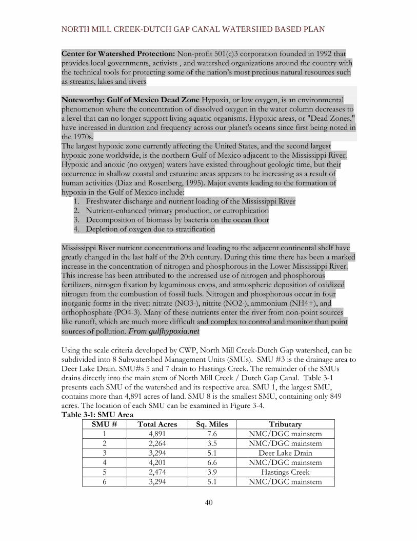
NORTH MILL CREEK-DUTCH GAP CANAL WATERSHED BASED PLAN
40
Center for Watershed Protection: Non-profit 501(c)3 corporation founded in 1992 that provides local governments, activists , and watershed organizations around the country with the technical tools for protecting some of the nation’s most precious natural resources such as streams, lakes and rivers Noteworthy: Gulf of Mexico Dead Zone Hypoxia, or low oxygen, is an environmental phenomenon where the concentration of dissolved oxygen in the water column decreases to a level that can no longer support living aquatic organisms. Hypoxic areas, or "Dead Zones," have increased in duration and frequency across our planet's oceans since first being noted in the 1970s. The largest hypoxic zone currently affecting the United States, and the second largest hypoxic zone worldwide, is the northern Gulf of Mexico adjacent to the Mississippi River. Hypoxic and anoxic (no oxygen) waters have existed throughout geologic time, but their occurrence in shallow coastal and estuarine areas appears to be increasing as a result of human activities (Diaz and Rosenberg, 1995). Major events leading to the formation of hypoxia in the Gulf of Mexico include:
1. Freshwater discharge and nutrient loading of the Mississippi River 2. Nutrient-enhanced primary production, or eutrophication 3. Decomposition of biomass by bacteria on the ocean floor 4. Depletion of oxygen due to stratification
Mississippi River nutrient concentrations and loading to the adjacent continental shelf have greatly changed in the last half of the 20th century. During this time there has been a marked increase in the concentration of nitrogen and phosphorous in the Lower Mississippi River. This increase has been attributed to the increased use of nitrogen and phosphorous fertilizers, nitrogen fixation by leguminous crops, and atmospheric deposition of oxidized nitrogen from the combustion of fossil fuels. Nitrogen and phosphorous occur in four inorganic forms in the river: nitrate (NO3-), nitrite (NO2-), ammonium (NH4+), and orthophosphate (PO4-3). Many of these nutrients enter the river from non-point sources like runoff, which are much more difficult and complex to control and monitor than point sources of pollution. From gulfhypoxia.net
Using the scale criteria developed by CWP, North Mill Creek-Dutch Gap watershed, can be subdivided into 8 Subwatershed Management Units (SMUs). SMU #3 is the drainage area to Deer Lake Drain. SMU#s 5 and 7 drain to Hastings Creek. The remainder of the SMUs drains directly into the main stem of North Mill Creek / Dutch Gap Canal. Table 3-1 presents each SMU of the watershed and its respective area. SMU 1, the largest SMU, contains more than 4,891 acres of land. SMU 8 is the smallest SMU, containing only 849 acres. The location of each SMU can be examined in Figure 3-4. Table 3-1: SMU Area
SMU # Total Acres Sq. Miles Tributary 1 4,891 7.6 NMC/DGC mainstem 2 2,264 3.5 NMC/DGC mainstem 3 3,294 5.1 Deer Lake Drain 4 4,201 6.6 NMC/DGC mainstem 5 2,474 3.9 Hastings Creek 6 3,294 5.1 NMC/DGC mainstem

NORTH MILL CREEK-DUTCH GAP CANAL WATERSHED BASED PLAN
41
7 2,220 3.5 Hastings Creek 8 894 1.4 NMC/DGC mainstem 23,532
The digital elevation map of the watershed in Figure 3.5 reflects the elevations of the land in the watershed showing where the higher land areas on the periphery of each SMU are draining to low spots including the wetlands and stream channels in the interior landscape of each drainage unit. The highest elevation in the northwest corner of the watershed is at 886 feet above sea level, while the lowest elevation is in the southeast corner where North Mill Creek flows into Mill Creek, which is at 688 feet above sea level reflecting a drop of almost 200 feet in elevation along the length of the watershed.

NORTH MILL CREEK-DUTCH GAP CANAL WATERSHED BASED PLAN
42
Figure 3-4: Subwatershed Management Units

NORTH MILL CREEK-DUTCH GAP CANAL WATERSHED BASED PLAN
43
Figure 3-5: Digital Elevation Model

NORTH MILL CREEK-DUTCH GAP CANAL WATERSHED BASED PLAN
44
3.3. SOIL CONDITIONS Soils determine the water-holding capacity of a site and include both the erosion potential and infiltration capabilities. Soil characteristics are used to identify wetlands, potential wetland restoration sites, and construction/development/land use potential. Erosion: Displacement of soil particles on the land surface due to water or wind action. Infiltration: That portion of rainfall or surface runoff that moves downward into the subsurface soil. Lake County Stormwater Management Commission (SMC) utilized the Natural Resources Conservation Service’s (NRCS) soil surveys for Lake and Kenosha Counties to extract detailed soil data for the North Mill Creek-Dutch Gap Canal watershed. This data was utilized to map the locations of soil types, the extent of hydric soils, highly erodible soils, and the infiltration capacity. Hydric Soils: Soils that are wet frequently enough to periodically produce anaerobic conditions that alter the physical, biologic and chemical characteristics of the soil, thereby influencing the species composition or growth, or both, of plants on those soils. SOIL SERIES Deposits left during the last period of glaciation approximately 14,000 years ago are the raw materials of present soil types. A combination of physical, biological, and chemical variables such as topography, drainage patterns, climate, erosion and vegetation, have interacted over centuries to form the variety of soils found in the watershed. These soils were formed under wetland, forest, and prairie plant communities, and are identified by a name associated with each series or class of soils with similar characteristics. A soil series name generally is derived from a town or landmark in or near the area where the soil series was first recognized, although naming conventions vary by county. Table 3-2 contains information on the soil series that occur in the watershed. Soil types (series) are differentiated based on amounts and size of particles making up the soil, water-holding capacity, the slopes on which they occur, permeability characteristics, and organic content. Sixty different soil series have been identified throughout the watershed based on soil series coverage area as determined by NRCS’ Soil Survey of Lake County (NRCS 2005) and the NRCS’ Soil Survey of Kenosha County (NRCS 2002). Of the sixty different soil series, only the 26 most dominant have been listed in Table 3-2 and symbolized in Figure 3-6. The remaining 34 soils have been classified as “non-dominant soils”. These soils, combined, cover approximately 5% of the entire watershed.

NORTH MILL CREEK-DUTCH GAP CANAL WATERSHED BASED PLAN
45
Table 3-2: Soils Series Dominant Soil Types in the Watershed
Soil Series Hydric Y/N
Highly Erodible
Hydrologic Soil Group Acres % of
Watershed Ozaukee N N C 5863 24.92% Morley N Y B 2437 10.36% Ashkum Y N C 1897 8.06% Houghton Y N A 1442 6.13% Markham N Y C 1293 5.49% Water N N Imp 1235 5.25% Pella Y N C 1195 5.08% Beecher Y N B 1026 4.36% Zurich N Y B 699 2.97% Montgomery Y N D 596 2.53% Grays/Markham N N B/C 527 2.24% Zurich/Ozaukee N N B/C 515 2.19% Elliott N N C 407 1.73% Navan N N A/D 384 1.63% Varna N N C 381 1.62% Aztalan N N C 358 1.52% Mundelein N N B 267 1.12% Sawmill Y N D 253 1.08% Peotone Y N C 241 1.02% Wauconda/Beecher N N B/C 240 1.02% Hebron N N B 226 0.96% Grays N N B 207 0.88% Wauconda N N B 184 0.78% Martinton N N C 153 0.65% Fox N Y B 141 0.60% Blount N N C 128 0.54% Non-Dominant Soil Types N/A N/A N/A 1237 5.26%
Totals 23532 100.00%
Ozaukee is the predominant soil type in the watershed, covering approximately 5,900 acres or approximately 25% of the total 23,532 acres in the watershed. Most of the Ozaukee area is found in Lake County. Morley soils are the next most dominant soil series covering approximately 10% or roughly 2,400 acres, mostly located in Kenosha County. Of the major soil types, Ozaukee, Grays, Zurich, and Markham are well drained, non-hydric soils. Prairie and hardwood trees historically grew on these soils. Pella, Houghton, Ashkum, Beecher and Montgomery are the dominant poorly drained, hydric soils found in wetlands or drained wetlands. Historic plant communities in these areas consisted of water tolerant grasses, forbs, shrubs, and trees.
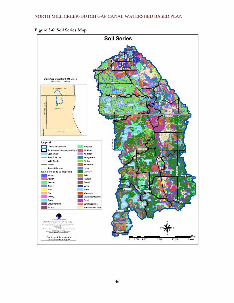
NORTH MILL CREEK-DUTCH GAP CANAL WATERSHED BASED PLAN
46
Figure 3-6: Soil Series Map

NORTH MILL CREEK-DUTCH GAP CANAL WATERSHED BASED PLAN
47
HYDRIC SOILS Hydric soils are defined by the National Technical Committee for Hydric Soils (NTCHS) as soils that formed under conditions of saturation, flooding, or ponding and retain moisture long enough during the growing season to develop anaerobic (oxygen-deprived) conditions in the upper strata of the soil layers (the soil layers closest to the surface)(Federal Register, 1994). Anaerobic conditions support the growth and reproduction of hydrophytic vegetation. Hydric soil areas provide opportunities for wetland restoration/enhancement and stormwater storage. Furthermore, hydric soils are a good indicator of depressional areas and historic wetland locations. Hydrophytic vegetation: Plant life growing in water, soil or on a substrate that is at least periodically deficient in oxygen as a result of excessive water content; one of the indicators of a wetland. Figure 3-8 displays coverage of hydric soils in the watershed, while Figure 3-7 is a pie chart showing the percentage of coverage by each soil type. Hydric soils comprise approximately 7,300 (31.1%), while non-hydric soils comprise 13,695 acres (58%) of the watershed and hydric inclusion soils account for 2,159 acres (9%). 355 acres (2%) of the watershed is classified as unknown. As can be seen in Figure 3-8, hydric soils dominate the northeastern quarter of the watershed surrounding the Dutch Gap Canal. Hydric Inclusion Soil: A soil unit (usually adjacent to hydric soils) that are not wet enough to form hydric properties but do have some hydric properties. Figure 3-7: Percent Coverage of Hydric Soils Pie Chart
The unknown soils are located under open water, in Wisconsin. It can be assumed that these soils are hydric.
Percent Coverage of Hydric Soils
9.17%
1.51%
58.20%
31.12%
All HydricNot HydricHydric InclusionUnknown

NORTH MILL CREEK-DUTCH GAP CANAL WATERSHED BASED PLAN
48
Figure 3-8: Hydric Soil Groups

NORTH MILL CREEK-DUTCH GAP CANAL WATERSHED BASED PLAN
49
SOIL ERODIBILITY NOTEWORTHY: Soil Erodibility and Pollution Soil characteristics, especially the tendency of soil particles to become detached and mobilized by water runoff, have considerable impact on water quality. Runoff: The portion of rain or snow that does not percolate into the ground and is discharged into streams or lakes by flowing over the ground instead. For instance, sandy soils are more prone to erosion than clayey soils, although pollutants are more likely to be attached to clay particles. It is important to map highly erodible soils because they represent areas that may potentially contribute high amounts of total suspended solids (TSS) to streams and lakes. Total suspended solids (TSS): The organic and inorganic material suspended in the water column and greater than 0.45 micron in size. High TSS levels can result in stream degradation as a result of silt deposition and pollution. Silt: Fine mineral particles intermediate in size between clay and sand. Some pollutants frequently attach to TSS particles and wash into lakes and streams, polluting the water and sediments and decreasing water clarity. A map identifying the location of highly erodible soils (Figure 3-9) was created by selecting soils that have been classified as highly erodible by the Natural Resources Conservation Service. The highly erodible soils (Casco, Markham, Ozaukee, Rush, Zurich, and Morley series) account for 3,337 acres or 14.3% of the total watershed. Table 3-3: Highly Erodible Soils Soil Erodibility by Name, Soil Code, and Acres of Coverage)
Soil Name Soil Code Acres Percentage of Watershed
Casco 323D2, 969E2 5.11 0.02% Fox 327C2 6.20 0.03% Markham 531C2 237.76 1.01% Ozaukee 530C2, 530D2, 530E, 530F 2,289.59 9.73% Rush 791C2 17.17 0.07% Zurich 696CD 103.92 0.44%
Morley MzdC, MzdC2, MzdD, MzdD2, 673.78 2.86%
Total 3,333.53 14.17% Erodible soils can be found along stream channels/lake shorelines, on agricultural lands, and may be found on potential construction sites. Figure 3-9 depicts how erodible soils relate to these areas. Streambank and lakeshore restoration or stabilization in areas determined to be moderately or highly eroded would reduce soil erosion and associated pollutant loading. Agricultural field erosion is also associated with erodible soils and frequently occurs where surface flowpaths form. Agriculture on highly erodible soils accounts for approximately 1340 acres (5.7%) of the land use in the watershed (Table 3-4).

NORTH MILL CREEK-DUTCH GAP CANAL WATERSHED BASED PLAN
50
Table 3-4: Highly Erodible Soils
Acres of Highly Erodible
Soil on Non Ag Acres of Highly
Erodible Soil on Ag TOTAL ACRES
Hastings Creek 709 282 991 NMC/DGD mainstem 1324 1058 2382 TOTAL ACRES 2033 1340 3373
These areas would benefit from erosion control measures such as grassed waterways, dry dams, silt fences and wind breaks. Waterways adjacent to agricultural fields with extensive erodible soils would benefit from practices such as filter strips that capture eroded sediment and pollutants before it gets into the stream.
Photos of farmland erosion in the watershed

NORTH MILL CREEK-DUTCH GAP CANAL WATERSHED BASED PLAN
51
Figure 3-9: Highly Erodible Soils Map

NORTH MILL CREEK-DUTCH GAP CANAL WATERSHED BASED PLAN
52
HYDROLOGIC SOIL GROUPS NOTEWORTHY: The permeability and surface runoff potential of the soils in the United States have been classified by the Soil Conservation Service (SCS) into Hydrologic Soil Groups (HSGs). HSGs are based on a soil’s infiltration and transmission (permeability) rates and are used to calculate runoff curve numbers Runoff curve numbers: Numbers developed to classify the runoff potential of different soil types with different land cover. The curve numbers are a function of Hydrologic Soil Groups, land cover or usage, and antecedent soil moisture conditions. The curve number value can be a number from 0 to 100 although the typical range is between 25 through 98. A curve number value of 98 is considered to be an impervious land cover such as pavement or a building roof. A low curve number value would indicate conditions with a very low runoff potential such as woodland. The main Hydrologic Soil Groups are separated into 4 categories, A, B, C, and D. The HSG permeability and surface runoff characteristics are defined as follows:
• Group A, due to high infiltration rates, have low total surface runoff potential. These soils are composed mainly of deep, well drained sands and gravels.
• Group B have low to moderate runoff potential with moderate infiltration rates and consist of moderately coarse to moderately fine textures.
• Group C have moderate to high surface runoff potential with slow infiltration rates. They chiefly consist of soils with layers that impede the downward movement of water. Their textures are fine to moderately fine.
• Group D have the greatest runoff potential with very slow infiltration rates. They consist chiefly of clay soils with high water tables and shallow soils over nearly impervious materials.
There are also areas with combined soil groups: HSG-A/B, HSG-A/D, HSG-B/D, HSG-C/D. These combined soil groups are a combination of soil types and exhibit a combination of permeability and surface runoff characteristics. The soil characteristics can change depending on saturation, slope, and time of year. The Hydrologic Soil Groups (HSGs) in the North Mill-Dutch Gap watershed and their corresponding soil texture, drainage description, runoff potential, infiltration rate, and transmission rate are shown in Table 3-5. Approximately half of the watershed is moderately well-drained while the remainder is poorly drained. Best Management Practices (BMPs) are often recommended based on the infiltration and permeability rates of a particular HSG. Poorly drained clayey soils make the implementation of BMPs such as pervious paving and other infiltration techniques more challenging without amending the soil with more pervious material such as sand or rock. Figure 3-10 depicts the location of each HSG found in the watershed. Analysis reveals the following percentages of soil types for the watershed:
HSG–C (57.20%), HSG-B (15.14%), HSG-C/D (4.70%), HSG-D (6.98%), HSG–A/D (4.87%), HSG-B/D (5.85%), HSG-A/B (0.01%).

NORTH MILL CREEK-DUTCH GAP CANAL WATERSHED BASED PLAN
53
Open water (streams and lakes) comprise the remaining (5.25%) of the watershed. HSG–A soils are not present in the watershed.

NORTH MILL CREEK-DUTCH GAP CANAL WATERSHED BASED PLAN
54
Table 3-5: Hydrological Soil Attributes
HSG Soil Textures Drainage Description
Runoff Potential Infiltration Rate Transmission
Rate Acres Percent of Watershed
A/B Sand, Loamy, Sandy Loam, Silt Loam
Excessively to Moderately Well Drained
Low to Moderate High to Moderate High to
Moderate 3.3 0.01%
A/D Sand or Silt Loam to Clay
Well Drained to Poorly Drained High to Low High to Very Low High to Very
Low 1,143.1 4.9%
B Silt Loam or Loam Moderately Well to Well Drained Moderate Moderate Moderate 3,557.0 15.1%
B/D Silt Loam, Silty Clay Loam, Clay
Moderately Well to Poorly Drained
Moderate to Low Moderate to Low Moderate to
Very Low 1,373.5 5.8%
C Sandy Clay Loam Somewhat Poorly Drained High Low Low 13,438.3 57.2%
C/D Sandy Clay Loam, Silty Clay Loam, Clay
Somewhat Poorly Drained to Poorly Drained
High Low to Very Low Low to Very Low 1,103.1 4.7%
D Clay Loam, Silty Clay Loam, Sandy Clay Loam, Silty Clay, or Clay
Poorly Drained High Very Low Very Low 1,640.6 7.0%
Water Water Impervious Impervious Impervious 1,235.1 5.3%
While the HSG classification system designates a large portion of the watershed’s soils have low permeability and high runoff potential, there are opportunities for infiltration. The HSG-B soil group is desirable in that it provides moderate infiltration and increased groundwater recharge. Many of the HSG-B soil areas are existing open space in SMU 1, 2, 3, and 6 and along North Mill Creek mainstem just south of the state line. Careful planning should be implemented to ensure future development in these areas allow for the maximum infiltration and minimal run-off. Agricultural land use provides additional infiltration opportunities if care is taken when planting and harvesting.

NORTH MILL CREEK-DUTCH GAP CANAL WATERSHED BASED PLAN
55
Figure 3-10: Hydrologic Soil Groups

NORTH MILL CREEK-DUTCH GAP CANAL WATERSHED BASED PLAN
56
3.4 WATERSHED JURISDICTIONS The North Mill Creek-Dutch Gap Canal watershed has several political jurisdictions including: Lake County (in Illinois), Kenosha County (in Wisconsin), various townships, and municipalities. Figure 3-11: State Representative Boundaries
Figure 3-12: US Congressional Districts and County Board Districts

NORTH MILL CREEK-DUTCH GAP CANAL WATERSHED BASED PLAN
57
LAKE COUNTY JURISDICTIONS The Lake County portion of the watershed has 14,853 acres of the 23,532 total acres and includes the townships of Newport, Lake Villa, and Antioch, and the municipalities of Antioch, Lake Villa, Lindenhurst, and Old Mill Creek. Additional Illinois jurisdictional bodies that are located in the watershed are shown in Table 3-6 and include:
1. Lake County Board Districts (1st District, 3rd District) 2. Lake County Forest Preserve District 3. Lake County Soil and Water Conservation District 4. Park Districts (Lindenhurst ) 5. Illinois State Representative District (61st District, 62nd District) 6. Illinois State Senatorial District (31st District) 7. US Congressional District (8th District)
There is public and private shared responsibility for management, regulation, and protection of watersheds in Lake County. The Lake County Watershed Development Ordinance (WDO) is applied county-wide by municipal and county governments to permit development and redevelopment that could affect water resources within incorporated and unincorporated areas. Unincorporated areas are permitted and enforced by the Lake County Planning, Building and Development Department (LCPB&D) utilizing the Unified Development Ordinance (UDO). Incorporated: Land that is part of a municipality and is subject to its taxation and services. Unincorporated: Land that is not part of a municipality and is not subject to its taxation and services.

NORTH MILL CREEK-DUTCH GAP CANAL WATERSHED BASED PLAN
58
Table 3-6: Jurisdictional bodies in the Lake County portion of the Watershed. Jurisdiction Body Acres % of Watershed % of
Lake County Total Watershed Township Antioch 6,483 43% 27% Lake Villa 4,409 30% 19% Newport 3,961 27% 17% Township Total 14,853 100% 63% Municipality Antioch 2,098 14% 9% Lake Villa 192 1% 1% Lindenhurst 1,886 13% 8% Old Mill Creek 2,271 15% 10% Municipality Total 6,447 43% 28% Unincorporated 8,406 57% 36% Park Districts 35 <1% <1% Lake County Forest Preserve District 3,070 21% 13%
Lake County Soil & Water Conservation District
14,853 100% 63%
Illinois Department of Natural Resources 768 5% 3%
County Board Districts
1st District 11,731 79% 41% 3rd District 3,122 21% 13% County Board Districts Total 14,853 100% 63%
Congressional District
8th District 14,853 100% 63% State Senate 31st District 14,853 100% 63% State House 61st District 14,178 95% 60% 62nd District 675 5% 3% State House Total 14,853 100% 63%

NORTH MILL CREEK-DUTCH GAP CANAL WATERSHED BASED PLAN
59
KENOSHA COUNTY JURISDICTIONS The townships of Salem and the Village of Bristol in Kenosha County are located within the watershed and include 8,679 acres of the 23,532 total acres. Additional Kenosha County jurisdictional bodies that are located in the watershed are shown on Table 3-7: and include:
1. Kenosha County Board Districts (23rd, 25th, & 28th Districts) 2. Parks Division (Bristol Woods) 3. Wisconsin State Assembly Districts (65th & 66th Districts) 4. Wisconsin State Senatorial District (22nd District) 5. US Congressional District (1st District) 6. Lake George Rehabilitation District
Table 3-7: Jurisdictional bodies in the Kenosha County portion of the Watershed.
Jurisdiction Body Acres % of Watershed % of Total Kenosha County Kenosha County Watershed
Township Salem 1,012 12% 4% Unincorporated 1,012 12% 4% Municipality Village of Bristol 7,667 88% 33% Incorporated 7,667 88% 33%
Park Districts 3 <1% <1% Kenosha County - Parks Division
3 <1% <1%
Wisconsin Department of Natural Resources
457 5% 2%
County Board Districts
23 rd 142 2% <1 25th 141 2% <1 28th 8,396 96% 36% County Board Total 8,679 100% 37% Congressional District 1st U.S. House District 8,679 100% 37% State Senate 22nd District 8,679 100% 37% State Assembly 65th District 3,771 43% 16% 66th District 4,908 57% 21% State Assembly Total 8,679 100% 37%
In Kenosha County, a majority of development projects are reviewed by several divisions within the Planning and Development Department; while some projects are reviewed by the Public Works Department. The Planning and Development Department establishes county zoning ordinances that regulate and permit in a planned and orderly manner various land

NORTH MILL CREEK-DUTCH GAP CANAL WATERSHED BASED PLAN
60
uses (including water entities and structures) in order to promote the general welfare of its citizens, the quality of the environment, and the conservation of its resources. (Kenosha County Planning, 2006.) Also, Kenosha County, through the Division of County Development, establishes stormwater practices that help decrease potential adverse impacts, such as pollution discharge and flooding. One such practice includes a Stormwater Review for developments that require site plan review, a certified survey map (CSM), or are subdividing land through platting or condominium (Kenosha County Planning, 2006). Kenosha County also possesses individual Lake Districts and Associations, along with other organizations such as the Root/Pike Watershed Initiative Network, Town & Country Resource Conservation & Development (RC&D), Kenosha/Racine Land Trust, Southeast Fox River Basin Partnership, etc. These and other organizations like them are an important component in the protection of water resources. ONE WATERSHED: MULTIPLE JURISDICTIONS AND PROGRAMS One of the challenges of watershed planning, and implementing a watershed plan, is that a watershed usually includes multiple jurisdictions that have varying interests, resources and responsibilities. This variability can be positive if the jurisdictions actively work together to collaborate on policies, projects and practices, but frequently it presents watershed coordination challenges for efficiently implementing Best Management Practices (BMP) projects and for providing program, policy and regulatory consistency. In some cases independent actions by one community or jurisdiction can have a negative impact on watershed neighbors, or a good project may not be as effective as it could have been if resources had been pooled to expand the scope of the project to cover a broader area of the watershed thereby providing economy of scale. Watershed planning brings communities together to protect and improve the land and water resources that they share and impact. Watershed activities and projects offer many opportunities for communities and other government agencies to operate outside of their traditional “silos”. When communities meet regularly as a watershed council, it provides opportunities to share information and coordinate activities. For instance, when a community or agency develops or updates a comprehensive plan, considering the watershed green infrastructure plan and the plans of neighboring communities and sister agencies (such as parks departments or districts) can avert disagreement and costly competition, and will benefit the watershed as a whole. For example, a municipality may receive a development proposal for a land parcel that the local parks department has identified as environmentally sensitive and has included in their long-range conservation plan for the community. Although the underlying zoning for the land may allow the proposed development, both the community and the developer are likely going to face challenges from competing interests for the land, and with developing the land so that it does not negatively impact whatever feature made it environmentally sensitive. Sharing information about the land during the comprehensive planning process can avert these kinds of problems down the road. In some cases the land planning authority for a jurisdiction will not be the jurisdiction or department that will be most involved in implementing BMPs in the watershed. For instance, while Lake County Planning and Development does long range land use planning and approves development in unincorporated Lake County (which makes up 57% of the watershed in Lake County), the Townships are frequently more active as project partners for

NORTH MILL CREEK-DUTCH GAP CANAL WATERSHED BASED PLAN
61
BMP projects than the County government. With multiple jurisdictions in the watershed, coordination challenges can be a limiting factor in completing BMP projects, especially in the case of large inter or multijurisdictional projects. Chapter 4 (Watershed Problems Assessment) contains information related to improving jurisdictional coordination among the responsible parties in the watershed. The North Mill Creek-Dutch Gap watershed includes an added level of coordination complexity, because coordination not only has to occur at the local level but also at the state level since the watershed spans two states. Wisconsin statutes requiring county “smart growth” plans and shoreland development restrictions are two examples of statutory requirements that do not apply to land in Illinois, which uses a different system for addressing long term planning and development in riparian areas. Also different between Wisconsin and Illinois is that the State of Wisconsin owns the lake bottoms, while in Illinois private lakes tend to have a variety of lake bottom owners, which can make ”whole lake” management decisions more complicated. There are also state program differences for one of the primary funding programs for watershed improvement projects. In Illinois, the Clean Water Act Section 319 funding is awarded for nonpoint source pollution reduction projects on a competitive basis based on applications. In Wisconsin the state initiates priorities and makes decisions regarding 319 program funding expenditures to reduce nonpoint source pollution. Wisconsin also allocates other state funds to support watershed planning. Coordinating watershed improvement projects and activities may be complicated by state program and funding priority differences, state and county statutory differences, as well as, by multiple local community governments that may have different views and interest levels regarding watershed protection as the watershed continues to develop. Establishing a sustainable watershed council that provides a venue for communication, coordination and collaboration will help resolve some of the multiple jurisdiction challenges.

NORTH MILL CREEK-DUTCH GAP CANAL WATERSHED BASED PLAN
62
Figure 3-13: Municipal Boundaries

NORTH MILL CREEK-DUTCH GAP CANAL WATERSHED BASED PLAN
63
3.5 WATERSHED DEMOGRAPHICS/POPULATION AND EMPLOYMENT PROJECTIONS NOTEWORTHY: DEMOGRAPHICS About Demographic Forecasts To create demographic projections, regional agencies analyze data from local agencies for various demographic criteria, including population, households, and employment. After the data is collected from local governments, adjustments must be made to the data in situations where there is overlapping or contradictory information amongst the local jurisdiction boundaries. Forecasts are then projected for quarter sections, which are 160-acre tracts of land. Lake County Demographic The following forecasts for Lake County are developed by first generation region-wide estimates for population, households, and employment using data obtained from the Regional Economics Application Laboratory. Next, the Chicago Metropolitan Agency for Planning (CMAP) meets with local governments to determine future land development patterns within each jurisdiction and then, by combining the results from the Regional Economics Application Laboratory, CMAP, creates official demographic forecasts for the region. In September 2006, CMAP calculated its forecast for population, households, employment for the six-county Chicago region. The Lake County 2030 population forecast is 841,860, a projected 30.7% increase from 2000 to 2030. CMAP projected that the number of households in Lake County will increase by 34.5% while employment opportunities will increase by 31.4%. Kenosha County Demographic The forecasts for Kenosha County are developed by the Southeastern Wisconsin Regional Planning Commission (SEWRPC). SEWRPC is the agency responsible for that region’s official population, households and employment forecasts, including the Kenosha County portion of the North Mill Creek-Dutch Gap Canal watershed. SEWRPC utilizes U.S. Census Bureau data in their planning forecasts. The Lake County portion of the watershed anticipates a population increase of roughly 171% and a household increase of about 154% between the years of 2000-2030 (Table 3-8). Employment for the Lake County area of the watershed is projected to increase over 247% during the period 2000-2030. (Chicago Metropolitan Agency for Planning 2030 Forecasts, rev. 2006). These results are spatially depicted in Figures: 3-14, 3-15, and 3-16. Table 3-8: CMAP’s 2030 forecast data for the Lake County portion of the Watershed
2000 2030 Forecast Change (2000-2030)
Percent Change (2000-2030)
Population 12,067 32,752 20,685 171.4% Households 4,096 10,408 6,312 154.1% Employment 679 2,360 1,681 247.5%
Source: Chicago Metropolitan Agency for Planning 2030 Forecasts (rev. 2006).

NORTH MILL CREEK-DUTCH GAP CANAL WATERSHED BASED PLAN
64
Table 3-9 illustrates SEWRPC’s forecasted changes in population, households, and employment between 2000 and 2035 for the Kenosha County portion of the North Mill Creek-Dutch Gap Canal watershed area. From 2000-2035, the Kenosha County portion of the watershed is predicted to experience an additional 1,290 persons or roughly a 46% increase in population. While Kenosha County is experiencing growth in population, households, and employment, this growth is small when compared to Lake County. The low growth rate in this area, as shown in Table 3-9, may reflect the increased distance from the population centers of Chicago and Milwaukee and their surrounding suburbs and exurbs. Exurb: a prosperous residential area outside of a city and beyond the suburbs. Examples are the residential areas surrounding Lake George and Lake Shangrila-Benet Lake. Table 3-9: SEWRPC’s 2035 forecast data for the Kenosha County portion of the watershed
2000 2035 Forecast Change (2000-2035)
Percent Change (2000-2035)
Population 2,793 4,083 1,290 46.2% Households 1,102 1,780 678 61.5% Employment 682 1,411 729 106.8%
Source: Southeast Wisconsin Regional Planning Commission 2035 Forecasts. By combining the forecasted demographic data from Lake County and Kenosha County, total demographic changes can be calculated for the entire watershed. As shown in Table 3-10, the watershed as a whole is expected to experience growth in population, households, and employment. From 2000-2035, the North Mill Creek-Dutch Gap Canal watershed will experience a 147% increase in population or about an additional 21,975 people, while employment opportunities will increase by 177%. Housing in the watershed is anticipated to increase from 5,198 to 12,188, an increase of over 134%. These results are spatially depicted in Figures 3-14, 3-15, and 3-16. Table 3-10: Total forecasted data for the watershed
2000 2035 Forecast Change (2000-2035)
Percent Change (2000-2035)
Population 14,860 36,835 21,975 147.9% Households 5,198 12,188 6,990 134.5% Employment 1,361 37,71 2,410 177.1%
Source: Chicago Metropolitan Agency for Planning: 2030 Forecasts (Revised 2006) and Southeast Wisconsin Regional Planning Commission: 2030 Forecasts.

NORTH MILL CREEK-DUTCH GAP CANAL WATERSHED BASED PLAN
65
Figure 3-14: Population Change
NOTE: Figures 3-14, 3-15, 3-16 detail by quarter section the population, household, and employment changes that are forecasted in the watershed. It should be noted that demographic changes are given for entire quarter sections, even though only partial portions of some quarter sections are within the NMC/DGC watershed boundary.
Figure 3-15: Household Change
Figure 3-16: Employment Change

NORTH MILL CREEK-DUTCH GAP CANAL WATERSHED BASED PLAN
66
3.6 LAND USE Land Cover: The physical material that covers the surface of the Earth. Such categories include, forest, urban, water, prairie, etc. Land Use describes the general type of human activity (usually economic) that takes place on a particular area of land. HISTORIC LAND USE/COVER The historical government survey (1832-1840) of the pre-settlement natural communities (pre-settlement vegetation) was assessed for the watershed. This survey displays a community network of land cover including upland forest, forested bog, marsh prairie, wet meadow prairie, savanna, and lakes or ponds. The distribution of these communities in the watershed is displayed in Figure 3-17. Marsh: An area of soft, wet, low-lying land, characterized by grassy vegetation and often forming a transition zone between water and land. Wet Meadow Prairie: A type of wetland away from stream or river influence with water made available by general drainage and consisting of non-woody vegetation. Savanna: A seasonal ecosystem with a continuous herbaceous layer usually dominated by grasses or sedges and a sporadic layer of tress and/or shrubs.

NORTH MILL CREEK-DUTCH GAP CANAL WATERSHED BASED PLAN
67
Figure 3-17: Pre-Settlement Vegetation

NORTH MILL CREEK-DUTCH GAP CANAL WATERSHED BASED PLAN
68
Prior to European settlement, the North Mill Creek-Dutch Gap Canal watershed was characterized by savanna, which covered more than 16,000 acres (69%) of the area. Other significant pre-settlement land cover types include marsh/wetland (3,369 acres, 14% of area), prairie (1,826 acres, 8% of watershed), and upland forest/oak woodland (1,197 acres, 5% of watershed). Eight open water areas are also noted in the survey: Slough, Crooked, Hastings, Timber/Huntley, Deer, Benet/Shangrila, Paasch, and George Lakes. The survey characterizes the present-day course of North Mill Creek-Dutch Gap Canal mainstem and Hastings Creeks subwatsershed as wet meadow/prairie along the lower (southern) reaches and marsh/wetland along the upper (northern) reaches. It is important to note that prior to the agricultural development of the watershed, ditching of the modern stream channels and wide-scale drainage of the surrounding lands, no system of well-defined stream channels existed upstream of Illinois Route 173. Rather, overland water flow drained slowly through a network of low-lying wetland and wet prairie swales and marshes or percolated into the groundwater aquifer. A categorized classification of the pre-settlement vegetation is located in Table 3-11 and Figure 3-18. Today, development has drastically altered the natural vegetation communities, largely replacing pre-settlement vegetation communities with agricultural and urban land cover.

NORTH MILL CREEK-DUTCH GAP CANAL WATERSHED BASED PLAN
69
Table 3-11: Pre-settlement Land Cover (Acreage is approximate) Vegetation Acres Forested Bog 15 Marsh 3,369 Upland Forest 1,197 Prairie 1,826 Savanna 16,236 Wet Meadow/Wet Prairie 296 Water 593 Figure 3-18: Pre-settlement Land Cover
CURRENT LAND USE/COVER Land cover in the North Mill Creek-Dutch Gap Canal watershed has changed substantially since European settlement. Data collected by the Lake County Planning, Building and Development Department (LCPBD) and Southeastern Wisconsin Regional Planning Commission (SEWRPC) was used to assess current land use/cover in the watershed. The data is a representation of land use/cover as of 2005 and utilizes a modified version of the 1995 Northeastern Illinois Planning Commission (Now Chicago Metropolitan Agency for Planning, or CMAP) classification system (see Modified NIPC Classification description). The 2005 land use/cover data was developed by utilizing parcel information and aerial
Forested Bog <1%
Marsh 14%
Upland Forest 5%
Prairie 8%
Savanna 69%
Wet Meadow/Wet
Prairie 1%
Water 3%
Pre-Settlement Vegetation
Forested Bog
Marsh
Upland Forest
Prairie
Savanna
Wet Meadow/Wet Prairie Water

NORTH MILL CREEK-DUTCH GAP CANAL WATERSHED BASED PLAN
70
photography and is represented in Figure 3-19. The total acreage and percentage of watershed calculations for each land use category is presented in Table 3-11.
Residential: Includes single and multiple family housing, townhomes, apartments, retirement communities, farmhouses (Larger than 1 acre), mobile homes, and income restricted housing, and associated parking. Excludes military bases and other group living quarters that are included under the Government/Institutional land use.
Modified NIPC Land Use Classification System:
Commercial and Services: Includes shopping malls and associated parking, single building offices, office parks, and a commercial mix, i.e. restaurants, auto repair shops, grocery stores, etc. Also includes zoos, museums, cultural centers, auto dealerships, and hotels/motels.
Government/Institutional: Includes military bases and associated living quarters, medical and healthcare facilities, educational facilities, government administration and services (fire, police, post offices, etc), cemeteries, and prisons and correctional facilities.
Industrial: Includes mineral extraction, manufacturing, warehousing/distribution centers, and industrial parks.
Transportation/Utility: Includes roadways and road right-of-ways, Interstates and tollways, bus facilities, air transportation centers, other non-residential or commercial parking lots, utilities and waste water facilities, landfills, railroads and associated rail stations, also includes telephone poles and land associated with cell towers and other communications.
Agricultural: Includes row crops, pasture, fallow lands, dairy and other livestock enterprises, equestrian lands, associated barns and out buildings, orchards, vineyards and nurseries.
Public/Private Open Space: Includes parks, golf courses, nature preserves, game preserves, abandoned right-of-ways, recreation trails (wider than 5ft), athletic fields when not associated with another land use, botanical gardens, forest preserves, and set asides for stormwater management (wet and dry bottom detention basins). Note: Determination of this land use/land cover type is based primarily on ownership and zoning and should not be confused with the term “open space” as it is used later in the green infrastructure inventory, which is based primarily on intensity of site development (see section 3.9).
Forest/Grassland/Wetland: Land that has not been developed for any human purpose, including picnicking and hiking, undeveloped and unused land, non-reserve forests and grasslands, and wetlands that are larger than 0.25 acres. Also includes land that is currently under development but is less than 50% developed. Land that is past this threshold is coded under a specific land use.
Open Water: Includes rivers, streams, canals (wider than 200 ft), lakes, reservoirs, and lagoons.

NORTH MILL CREEK-DUTCH GAP CANAL WATERSHED BASED PLAN
71
Table 3-12: 2005 Watershed Land Use North Mill Creek /
Dutch Gap Canal Watershed
Lake County Kenosha County
Land Use Category Acreage % Watershed
Area
Acreage % Watershed
Area
Acreage % Watershed
Area Agricultural 10,477 45% 5,012 34% 5,465 63% Forest/Grassland 1,495 6% 1,486 10% 9 <1% Government / Institutional 142 1% 104 1% 38 <1%
Industrial 40 <1% 29 <1% 11 <1% Public / Private Open Space 5,369 23% 3,514 24% 1,855 21%
Residential 2,683 11% 2,045 14% 638 7% Retail / Commercial 70 <1% 56 <1% 14 <1% Transportation, Communication and Utilities
1,126 5% 777 5% 349 4%
Water 1,310 6% 984 7% 326 4%
Wetlands+ 820 3% 812 5% 8 <1% Total 23,532 100% 14,819 100% 8,713 100%
+NOTE: The data presented in this table does not represent pure “land use” categories as it contains land cover designations such as wetlands, forest and grasslands as well. If land use alone was included in this data set, these “land cover” areas would be classified as ‘vacant’. Because only the wetland in undeveloped areas is aggregated for this inventory, the wetland acreages in this table will not equal the acreage of wetland reported from the Lake County Wetland Inventory, which is a more accurate assessment. Additionally, due to differences in the way that Lake and Kenosha Counties map land uses, the mapped/calculated acreages and percentages shown in maps and tables may differ more or less than they actually do on the ground. Current land use/cover in the watershed is shown in Figure 3-19 while the statistics are summarized in Table 3-12 and Figure 3-20. Agriculture is the dominant land use, covering 10,477 acres (45%) of the North Mill Creek-Dutch Gap Canal watershed. Open space (both publicly and privately-owned) is the second most prevalent land use occupying 5,369 acres (23%) of the watershed, followed by 2,683 acres (11%) of residential land use. The other land use/land cover classifications include: forest/grassland at 1,495 acres (6%), water at 1,310 acres (6%), transportation/communication/utilities at 1,126 acres (5%), and wetlands at 820 acres. The less prominent land uses include government/institutional at 142 acres (<1%), retail/commercial at 70 acres (<1%), and industrial at 40 (<1%). These statistics illustrate the general absence of large areas of typical urban land uses (retail/commercial; industrial; government/institutional; and transportation, communication and utilities) common in more urbanized watersheds. Rural land uses and land cover types (agriculture, forest/grassland, and public/private open space) currently account for approximately 74% of the watershed area.

NORTH MILL CREEK-DUTCH GAP CANAL WATERSHED BASED PLAN
72
Differences in land use patterns between the Lake and Kenosha County portions of the watershed are subtle but do exist. Agriculture composes a significant proportion (45%) of all land use in the watershed and accounts for the majority of the Kenosha County portion of the watershed (63%). While significant, agriculture covers only about one-third of the Lake County portion of watershed lands. Residential land uses are more prevalent in Lake County (14%) than in Kenosha County (7%). Finally, the land use data suggest that the Lake County portion of the watershed has far more acres and a higher percentage of forest/grassland and wetland “land covers” than Kenosha County. While Lake County has more acreage of both of forest/grassland and wetlands due to the fact that a larger percentage of the watershed is located in Lake County, the difference in percent coverage is may also be the result of the differences in the way that land use is tabulated by Lake and Kenosha Counties. In the context of this watershed plan, this discussion is primarily concerned with the effect of land use on water resources. Urban land uses typically have a higher percentage of impervious surface per unit area (or impervious surface ratio), a factor that can contribute to water quality and stream and lake degradation (Schueler, 1994). Agricultural uses often result in the modification of hydrology through ditching and the installation of field tiles, which deliver runoff to receiving streams and lakes similar to stormsewer systems in urban areas. These modifications also contribute to changes in water quality. Therefore, it is useful to examine land use patterns as they affect individual water bodies. Land use in the Hastings Creek subwatershed drainage is more developed than other areas of the watershed, therefore for this analysis, land use data was aggregated by the Hastings Creek subwatershed and compared to land use in the North Mill Creek-Dutch Gap Canal mainstem subwatershed (refer to Figure 3-2). The following figures include pie charts illustrating the differences in land use coverage between the Hastings Creek subwatershed and North Mill Creek-Dutch Gap Canal mainstem. The most obvious difference is that the Hastings Creek subwatershed contains a much lower percentage of agricultural land (22%) than the North Mill Creek-Dutch Gap Canal mainstem (50%). Hastings Creek subwatershed has a higher percentage of “urban” land uses, with residential and transportation, communications, and utilities accounting for almost 29% of land use coverage while the same land use categories account for only 13% of the North Mill Creek-Dutch Gap Canal mainstem. These differences in land use can help watershed stakeholders identify the causes and sources of nonpoint source pollution and identify solutions that are workable and appropriate given the context of local land uses and the receiving waters. Impervious surface: The total area of rooftops, pavement, and other compacted or hard surfaces that prevent infiltration of precipitation into the ground and therefore result in the generation of surface runoff from nearly all precipitation)

NORTH MILL CREEK-DUTCH GAP CANAL WATERSHED BASED PLAN
73
Figure 3-19: 2005 Land Use GIS Map

NORTH MILL CREEK-DUTCH GAP CANAL WATERSHED BASED PLAN
74
Figure 3-20: 2005 Current Land Use Pie Charts
Agricultural 44.5%
Forest, Grassland, and Beach 6.4%
Government and Institutional
0.6%
Industrial 0.2%
Public and Private Open Space
22.8%
Residential 11.4%
Retail and Commercial 0.3%
Transportation, Communications and
Utilities 4.8%
Water 5.6%
Wetlands 3.5%
Current Watershed Land Use
22.2%
0.9%
Forest, Grassland and Beach
8.0% 0.9%
Industrial 0.1%
Public and Private Open Space 24.7%
Residential 21.3%
7.6%
Water 9.6%
Wetlands 4.7%
Land Use in Hastings Creek Subwatershed
Transportation, Communication
and Utilities
Agricultural
Government and Institutional
Commercial and Retail
50.1%
0.2%
5.9% 0.5%
Industrial 0.2%
Public and Private Open Space 22.3%
Residential 8.9%
4.1%
Water 4.5% Wetlands
3.2%
Land Use in NMC/DGC Subwatershed
Agricultural
Transportation, Communication
and Utilities
Government and Institutional
Commercial and Retail
Forest, Grassland and Beach

NORTH MILL CREEK-DUTCH GAP CANAL WATERSHED BASED PLAN
75
FUTURE LAND USE/COVER NOTEWORTHY: FUTURE LAND USE Future land use projections were calculated using data from the Lake County Planning, Building and Development Department as well as the Southeastern Wisconsin Regional Planning Commission. The data was collected in 2008 and is a compilation of information from municipal comprehensive plans, zoning maps, and Environmental Limitations and High Priority Open Space maps provided in the 2008 Lake County Regional Framework Plan. Next, a Geographic Information System (GIS) was used to incorporate these policies and plans into comprehensive county-wide maps of projected future land use/land cover (in this case, one for Lake County and one for Kenosha County). Information for the areas of Lake and Kenosha Counties within the North Mill Creek-Dutch Gap Canal watershed was combined to present a single map of projected future land use for the watershed. Geographic Information System (GIS): A system of hardware, software, people, and organization in which geographical data is stored, retrieved, mapped and analyzed (Peugue and Marble, 1990). Future land use and land cover provides important information about how large areas of the watershed may develop in the near future. While this information is a “best guess” based on current municipal and county land use plans and zoning, it is an indication of the type and magnitude of watershed-scale land use/land cover changes that are likely to occur in the coming decades. Because land uses and land covers in a watershed are known to affect water resources, the future land use projection allows for analysis of how water resources are likely to respond to changes within the watershed. Those projections are used to guide the action recommendations of the watershed plan. Table 3-13: 2035 Projected Land Use
Projected Land Use Category Acreage Percent of Watershed
Percent Change from 2005 Land Use
Agricultural 7,978 34% -24% Government/Institutional* 799 3% +463%
Industrial 162 1% +305% Public/Private Open Space 4,868 21% -9%
Residential 7,394 31% +176% Retail/Commercial1 390 2% +457%
Transportation, Communication and Utilities1 672 3% NA
Water 1,269 5% -3%2
Total3 23,532 100% -- 1Projected land use category contains no data for the Kenosha County portion of the watershed. 2Small water features (such as small detention basins or open-water wetlands) included in the data for current land use were not captured in the future land use data and were subsumed into the surrounding primary projected use, therefore resulting in an apparent 3% reduction in the “water” classification. This

NORTH MILL CREEK-DUTCH GAP CANAL WATERSHED BASED PLAN
76
is a result of the way that land use data is aggregated and mapped and should not be construed as an expected reduction in the amount of surface water area.
3Forest/Grassland and Wetland categories from 2005 Land Use do not exist in the 2035 Projected Land Use. They have been included in other categories.
*Includes 636 acres of land subcategorized as “Office/Research Park” NA Not mapped for future land use
The most significant projected land use/land cover changes in the watershed are an overall increase in the area of residential and retail/commercial land and an overall decrease in the area of agricultural land. Residential land is projected to increase by 4,711 acres, or 64%, ultimately covering 7,394 acres (31%) of the watershed (Table 3-13). The area of agricultural land is projected to decrease by 31%, from 10,477 acres to 7,978 acres. Much of the increase in residential land (as well as much of the complementary decrease in agricultural land) is projected to occur in Lake County in the incorporated areas south of Illinois Route 173 in the Villages of Antioch, Lindenhurst, and Old Mill Creek, and in Kenosha County in the Village of Bristol north of 93rd Street and in the Town of Salem in the northwest corner of the watershed (see Figure 3-21: Projected Land Use Changes). Retail/commercial and industrial development is projected along Illinois Route 173, although these land uses are projected to occupy a relatively small portion of the total watershed area, they have traditionally had the highest percentages of impervious cover. While open space in the watershed will likely decrease from 2005 levels (“Public/Private Open Space” and “Forest/Grassland” Current Land Use categories), the pattern of open space may be redistributed within the watershed, as well. The future land use/land cover projections suggest that in the next few decades, open space may decrease in northern portions of the watershed and increase in the southern portions. The decrease in open space in the northern half of the watershed is due, in part, to the projected conversion of some areas currently mapped as open space to residential uses. Additionally, future land use mapping is more general than the parcel-based mapping of current land use, so only Kenosha County’s “Primary Environmental Corridors” are mapped as “open space” in the future land use map. Smaller open space areas outside of these corridors are subsumed into the surrounding land use. The increase in open space in the southern portion of the watershed is due primarily to the mapped future open space corridor along North Mill Creek that is currently classified as “agricultural.” Lake County Forest Preserves has been actively purchasing property in the watershed during the past few years, and the open space acreages will also likely change due to Forest Preserve restoration initiatives that will result in natural restoration of existing agricultural lands.

NORTH MILL CREEK-DUTCH GAP CANAL WATERSHED BASED PLAN
77
Figure 3-21: Projected Land Use Changes

NORTH MILL CREEK-DUTCH GAP CANAL WATERSHED BASED PLAN
78
AGRICULTURAL LAND USE/COVER Agricultural land use/cover was broken into more detailed agricultural categories such as by crop type for row crops, pasture/hay, vegetables/fruits etc. since there are differences in runoff and pollutant loads for different crop practices (refer to Table 3-14 for acreages of detailed categories). These agriculture categories were calculated based on satellite imagery. Early in the agricultural growing season, remote sensing satellites capture images of the surface of the earth. Professional interpreters of these images can thereby classify the various land uses within an image. Once classified, the image is transformed into geospatial data for GIS by the United States Department of Agriculture’s National Agricultural Statistics Survey division. By utilizing the GIS data, agricultural land use can be spatially viewed for the watershed in Figure 3-22. Based on the USDA Satellite Imagery Analysis, the watershed contains approximately 9,667 total acres (41%) of agricultural land. It should be noted that the total acreage and the acreages of various types of agricultural activities differ from those tabulated by Lake and Kenosha Counties. This discrepancy is caused by differences in the way that the geographic areas covered by different land uses are measured and categorized by USDA. While the statistics may differ slightly, it is important to evaluate the various types of agricultural activities in the watershed so that recommendations in the plan are contextually practical and feasible. Corn cultivation is the most prevalent agricultural land use in the watershed at 3,982 acres or 17% of the total watershed area. Soybean cultivation (2,620 acres, 11% of watershed area) and pasture/hay/grass (2,524 acres, 11% of watershed area) are also significant agricultural land use types. Winter wheat, alfalfa, dry beans, fruits and vegetables, seed/sod grass, oats, and other crops are also grown in the watershed, but together cover just over 2% of the total watershed area. The USDA Agricultural Land Use data does not specify which type of tillage method farmers are using. Table 3-14: Agricultural Land Use by Acres and Percent of Watershed (Rounded)
Watershed Lake County Kenosha County Agricultural
Category Acres Percent of Watershed Acres
Percent of Lake County Acres
Percent of Watershed
Oats <1 <1% -- -- <1 <1% Fallow/Idle Cropland 3 <1% 2 <1% 1 <1%
Other Crops 3 <1% -- -- 3 <1% Seed/Sod Grass 4 <1% 2 <1% 2 <1% Miscellaneous
Vegetables & Fruits 5 <1% -- -- 5 <1% Dry Beans 10 <1% -- -- 10 <1%
Alfalfa 160 1% 23 <1% 137 2% Winter Wheat 356 2% 134 1% 222 3%
Pasture/Hay/Grass 2,524 11% 1,341 9% 1,183 14% Soybeans 2,620 11% 1,596 11% 1,024 12%
Corn 3,982 17% 1,790 12% 2,192 25% Total 9,667 41% 4,888 33% 4,779 55%

NORTH MILL CREEK-DUTCH GAP CANAL WATERSHED BASED PLAN
79
PLEASE NOTE: The USDA Agricultural Land Use data was compiled by analyzing satellite imagery bands. The Lake County Land Use data was compiled using parcel based methodologies and aerial photography; therefore, these two data sets cannot be compared and must remain separate based on the coarseness/refinement of the source data. Figure 3-22: Agricultural Land Use, 2008 Agricultural Survey

NORTH MILL CREEK-DUTCH GAP CANAL WATERSHED BASED PLAN
80
Farmland Preservation While no farmland preservation programs exist in the Lake County portion of the watershed, Kenosha County first adopted a farmland preservation plan in 1981 and is undertaking an update of that plan beginning in 2011. Additionally, the Wisconsin state-wide “Working Lands Initiative” of 2009 simplified the farmland preservation tax credit program available to Wisconsin farmers. The farmland preservation tax credit ranges from $5-$10 per acre and is available to farmers who are located in a certified farmland preservation zoning district or if they have entered into an individual farmland preservation agreement with the State. Interest in historic farming and locally grown food exists in Lake County as expressed by the work of several organizations and independent farmers. Lake County contracted with American Farmland Trust for a 2001 study that was titled “On Thin Soil: The Uncertain Future of Agriculture in Lake County”. The study assessed the current state of agriculture in the county and found that nurseries were flourishing, but traditional agriculture was in decline primarily due to high land values and farmland being held for speculative purposes. While the County did not adopt a farmland preservation program as an outcome of this study, the Heritage Farm Foundation (http://www.lchff.org/index.php) was established and supported by the county. The work of other organizations including the Liberty Prairie Foundation, the Liberty Prairie Conservancy, the Farm Business Development Center (http://prairiecrossingfarms.com/) and the College of Lake County promote locally grown and organic food production initiatives in the county and region. Tempel Farms has expanded to include organic farming of fruits and vegetables at the North Mill Creek watershed’s edge in the Mill Creek watershed in recent years (http://tempelfarmsorganics.com/# ). EFFECT OF LAND USE & LAND COVER The numerous land uses throughout the North Mill Creek-Dutch Gap Canal watershed affect water resources in various ways.
→ Impervious surfaces contribute elevated levels of surface runoff and may lead to flooding and stream channel erosion.
→ Tiles used to drain agricultural fields contribute unnatural runoff volumes to receiving waters that negatively impact hydrology and stream condition.
→ Parking lots and roads are sources of pollutants from vehicles and road maintenance such as heavy metals and chloride from road salt.
→ Agriculture and landscaped residential and office parcels are often sources of nutrients such as phosphorus and nitrogen and pesticides that can lead to excessive aquatic plant and algae growth and low levels of oxygen.
→ Open space areas may increase infiltration of precipitation and nutrient uptake from runoff.
The two dominant land uses, agriculture and residential, pose environmental concerns in the watershed. Some land managers offset the potential for increases in runoff and nonpoint source pollution from use of their property by installing measures to reduce runoff and pollution, or by following a management plan that results in a reduction in the potential sources of pollution. Following are a few examples of the various ways in which land use has an effect on the lakes, streams and wetlands in a watershed. Based on the future land use/land cover

NORTH MILL CREEK-DUTCH GAP CANAL WATERSHED BASED PLAN
81
projections, a few general conclusions can be drawn about the North Mill Creek-Dutch Gap Canal watershed: Agricultural Land Use Agricultural land use can result in non-point source pollution (NPS) primarily due to soil erosion and nutrient runoff. Agricultural land use can affect water quality, surrounding habitat and hydrological flows. While the amount of impervious area associated with agricultural land use is low relative to other “urban” land uses, runoff is increased by drain tiles and the application of fertilizers and pesticides, large-scale disturbance of the soil surface, and the storage and disposal of manure are all activities that can adversely impact water quality. In order to mitigate the impacts agricultural land use has on water quality, habitats, and hydrological flow, many producers utilize best management practices. Most of these practices involve proper application of fertilizers, pesticides and water irrigation (EPA, 2008). Other best management practices focus on soil erosion control, such as contour farming or various tillage practices (Hawkins et al., 2009), and may include the installation of filter strips for stream and wetland buffers, and end of tile water quality treatment practices. Non-point Source Pollution: refers to pollutants that accumulate in waterbodies from a variety of diffuse sources including runoff from the land, impervious surfaces, the drainage system. NOTEWORTHY: Tile Drains While agricultural soils are good at absorbing and infiltrating precipitation, runoff can still occur. Agriculture runoff will typically occur when water input exceeds soil infiltration capacities or when precipitation or snowmelt infiltrates drain tiles, which are designed to drain standing water from the upper soil layers of cropland to prevent crop damage. The hydrologic effect of drain tiles is analogous to that of storm sewers: runoff is collected in conduits and quickly routed off-site, changing both the amount of groundwater recharge as well as the timing and amount of runoff to receiving waters such as lakes, streams, and wetlands. If overland runoff or tile drainage does occur, it commonly carries sediment, nutrients and pesticides that can adversely affect surrounding water bodies. To reduce the negative effects of runoff from fields, farmers employ various soil management techniques, for example using contour or no-till farming and using best management practices such as field buffers and grassed waterways (Hawkins et al., 2009).
While applying nutrients in the form of manure, irrigation, or chemicals facilitates the growth of crops, doing so in excess can cause nutrients to be washed into rivers and streams in the form of runoff (EPA, 2008). Additionally, nutrients are often bound to soil particles that are eroded from fields into surface waters. Elevated nutrient and sediment loading can result in excessive plant and algal growth, high turbidity, algal blooms, and low oxygen levels. The effects can be particularly pronounced in lakes, since the nutrients are not continually “flushed” by flowing water but may be recycled again and again by the growth and death of plants within the lake.
Water Quality Impacts
Aquatic Habitat Impacts

NORTH MILL CREEK-DUTCH GAP CANAL WATERSHED BASED PLAN
82
After precipitation or snowmelt, runoff can transport sediment and nutrients from disturbed soils to nearby water bodies. Sediment loading from this runoff, particularly in the form of silt and clay, can cause waters to become more turbid than normal, depleting the amount of sunlight plants receive. If turbidity is exacerbated by wind/wave action or sediment disturbance by fish (e.g. carp), aquatic plant growth may be drastically limited or reduced. In addition to sediment depleting available sunlight, sediment can cover desirable sand, gravel, or rock streambeds which are preferred by aquatic insects and fish. Nutrients from runoff can cause aquatic plant overgrowth, which in turn limits recreational activities, creates foul tasting and smelling water, and can even cause fish kills following plant die-off (EPA, 2008).
To determine how much potential pollution is entering water bodies, it is imperative to recognize the amount of soil loss for a given field of crop, since the soil contains sediments and nutrients. Calculating soil loss is a challenging effort by environmental scientists due to numerous complicated factors. However, a study by Novotny (1995) calculated that soil loss for a crop field of corn in Southeast Wisconsin without any soil conservation practice would yield about 30.9 ton of soil per acre per year. In the same study, if the farmer practiced contour farming, then soil loss would be reduced to approximately 15.45 tons per acre per year.
Soil Loss
NOTEWORTHY: Soil Loss There are numerous factors that are used to calculate soil loss of an agricultural field. These factors are:
• The more intense the rainfall, the quicker soil erodes http://www.iwr.msu.edu/rusle/rfactor.htmrainfall
• Certain soils erode quicker than others soil erodibility • The longer the length of the flow path, the more erosion occurs
• The steeper the slope the more erosion occurs http://www.iwr.msu.edu/rusle/lsfactor.htm slope length
slope steepness • The more cover on the crop, the less erosion occurs cover-management • See Best Management Practices support practice
Tillage practices that are most common within the watershed include conventional and conservation (SEWRPC, 2003). Conventional tillage leaves virtually no cover on the field thus, exposing the soil to precipitation and ultimately increasing the susceptibility to soil erosion. Conservation tillage, to the contrary, leaves a minimum of 30% plant cover on the soil, thus reducing the potential for erosion (SEWRPC, 2003). Contour farming involves planting along the slope contour, which even with conventional tilling practices, can reduce soil erosion by as much as 50%. Urban/Residential Residential land use contains impervious cover that may increase surface runoff volumes, and maintenance of streets and lawns can result in increased amounts of nonpoint source pollution such as excess nutrients from fertilizers. The projected land use/land cover data suggests that both Lake and Kenosha Counties and many of the municipalities envision additional residential, retail/commercial, and industrial development within their planning and zoning jurisdictions in the North Mill Creek-Dutch Gap Canal watershed. These uses are expected to replace agriculture, forest/grassland, and open space uses, which typically

NORTH MILL CREEK-DUTCH GAP CANAL WATERSHED BASED PLAN
83
have little or no impervious surface. Residential use is projected to account for the largest area of the expanding land uses in the watershed. While single family residential typically has a lower percentage of impervious surface coverage than the other projected expanding land uses in the watershed, it has more impervious area than agriculture, forest/grassland and open space uses and therefore will likely result in additional watershed imperviousness. Impervious Cover: the sum of roads, parking lots, sidewalks, rooftops, and other surfaces of an urban landscape that prevent infiltration of precipitation (Schueler, 1994). IMPERVIOUS COVER MODEL NOTEWORTHY: THE IMPACTS OF IMPERVIOUSNESS Impervious Cover Development by humans generally increases the amount of impervious cover for a given area and reduces the amount of open space for infiltrating and storing precipitation. Rain and snowmelt cannot permeate into the impervious ground of paved features such as roads, parking lots, or shingles from a roof. Instead, the rain or snowmelt quickly channels into sewers, ditches, swales, streams and lakes at increasingly high rates. The ratio of impervious cover to total watershed area can be used as an indicator of how urban land uses affect the natural functions of streams (Schueler, 1994). This ratio is often referred as the Impervious Surface Ratio (ISR) or is expressed as a percentage. Water Quality Imperviousness affects water quality in streams and lakes by increasing pollutant loads and water temperatures. Monitoring and modeling studies conducted by Schueler (1994) have shown that an increase in imperviousness is directly related to an increase in urban pollutant loads from the atmosphere, vehicles, roof surfaces and lawns. During a storm, pollutants such as fertilizer (nitrogen and phosphorus), metals, oils, and bacteria from animal droppings are delivered to streams and lakes in the form of runoff. Furthermore, since rooftops, asphalt roads, and parking lots absorb solar heat, impervious surfaces can increase stormwater runoff temperature as much as 12 degrees compared to vegetated areas (Galli, 1990). Hydrologic Flow and Flooding Hydrologic flows are altered by the amount of impervious cover in a watershed. More impervious cover generally translates to more surface runoff entering drainage systems such as streams or sewers, and if unmitigated, will result in more frequent floods and higher flood levels (Schueler, 1994). Furthermore, as development increases, the area of wetlands and other open spaces in a watershed typically decrease. A loss of these areas will increase flow because wetlands and open space capture rainfall and release it slowly back into streams and lakes (Lawrence, 2002). Constructed detention basins minimize flooding in highly impervious areas by regulating the discharge rate of stormwater runoff but do not reduce the overall increase in runoff volume, meaning that less precipitation infiltrates to recharge groundwater aquifers (WDNR). Habitat Increased impervious cover from development negatively impacts stream habitat and its associated biological communities. In addition to the pollutants carried by runoff from impervious surfaces, when a stream receives greater and more frequent runoff, the stream

NORTH MILL CREEK-DUTCH GAP CANAL WATERSHED BASED PLAN
84
Condition typical of sensitive SMU Condition typical of sensitive SMU
Condition typical of sensitive SMU
bed and banks become unstable, which leads to a cycle of streambank erosion, streambed incision (or “downcutting”) and sediment suspension. This results in turbid conditions and sedimentation that can result in undesirable changes to aquatic life (Schueler, 1994 and Waters, 1995). In addition, sediment deposition alters habitat for aquatic plants and animals by covering streambed habitat important to insects, mussels and some fish species (USGS, 2009). Streams begin to show signs of impacts from impervious surfaces when watershed impervious cover reaches a threshold of approximately 10%. Impervious Cover as an Indicator Imperviousness can be applied as an indicator to measure the impacts of urban land uses on water quality, hydrological flow and flooding, and habitat related to streams (Schueler, 1994). As a result from the previously discussed impacts of impervious cover, biological communities containing native species that are sensitive to pollution and hydrological stress are replaced by species that are more tolerant of these impacts, causing biodiversity to decrease. Based on studies of the relationship between impervious thresholds and stream quality (Schueler, 1994), the Center for Watershed Protection developed an impervious cover model, a simple urban stream classification model based on impervious cover and stream quality. The classification system contains three stream categories and predicts the existing and future quality of streams based on the measurable change in impervious cover. The three categories include: sensitive, impacted, and non-supporting (Center for Watershed Protection, 2008). The model is used to classify Subwatershed Management Units (SMUs) and associated streams into one of three categories: Sensitive, Impacted, or Non-Supporting. Each category exhibits characteristics as described below and defined by the Center for Watershed Protection. They are also depicted in Table 3-15 and Figure 3-23. Subwatershed Management Unit (SMU): An individual drainage area within the watershed that has relatively consistent geographical and land use characteristics throughout.
• Sensitive SMUs generally exhibit little impervious cover (<10%). Therefore, they usually have stable stream channels that are not severely eroding, downcutting, or filling with sediment. Streams in sensitive SMUs also tend to have excellent stream habitat (such as diverse substrate or bed material,
in-stream vegetation, pools and riffles and other naturally-occurring habitat features), better water quality, and more diverse biological communities (i.e., more species of fish, aquatic insects, shellfish, and other aquatic life). Sensitive SMUs also have wide vegetated riparian buffers and streams are able to overflow into floodplains and backwaters during high flows.
• Impacted SMUs generally have moderate impervious cover (10-25%). As the impervious cover exceeds 10%, stream channels begin to exhibit “telltale” signs of

NORTH MILL CREEK-DUTCH GAP CANAL WATERSHED BASED PLAN
85
Condition typical of impacted SMU
Condition typical of non-supporting SMU
watershed urbanization. The most obvious sign of impacts from impervious cover is often stream bank erosion, channel widening and channel incision or “downcutting” as a result of larger stormwater runoff volumes. These are also signs of stream channel “instability”. These physical changes in the stream channel can also impact stream habitat, including scouring of the streambed, deposition of silt or fine sediment, and loss of riparian habitat. Water quality is often degraded as nonpoint source pollutants are carried into the stream by runoff from impervious surfaces. If the stream is incising (“downcutting”), it may become disconnected from the floodplain, only overflowing the streambanks during exceptionally high flows. This not only affects floodplain habitat but can also result in downstream flood problems. Because of the changes in stream channel conditions, water quality, and habitat, the diversity of aquatic life in impacted SMUs is diminished. The most sensitive species are absent from impacted streams.
• Non-Supporting SMUs have high impervious cover (>25%). At this level of watershed impervious cover, streams lose much of their ecological functionality and function primarily as flow pathways for urban runoff. Under “non-supporting” conditions, stream channels are highly unstable and exhibit severe and prevalent erosion, widening, downcutting, and sedimentation. The stream channel will frequently change shape as materials are eroded and deposited during runoff events. Floodplains may be inundated only during the most extreme flood events and become isolated from the stream channel both hydrologically and ecologically. Because the stream is primarily conveying urban runoff from impervious surfaces, water quality is consistently poor. Non-supporting streams often deliver high nutrient loads to downstream receiving water bodies. The combination of severely degraded habitat and water quality also results in a lack of biological diversity, with only the most pollution-tolerant aquatic species present.

NORTH MILL CREEK-DUTCH GAP CANAL WATERSHED BASED PLAN
86
Table 3-15: Impervious Cover Model: Impervious categories and descriptions based on the Impervious Cover Model Category % Impervious
Cover Description
Sensitive Less than 10% Subwatershed generally exhibits little impervious cover (≤10%), stable stream channels, excellent habitat, high water quality, and diverse biological communities.
Impacted Greater than 10% less than 25%
Subwatershed generally possesses moderate impervious cover (>10-25%), and somewhat degraded stream channels, altered habitat, decreasing water quality, and fair-quality biological communities.
Non-Supporting
Greater than 25% Subwatershed generally has high impervious cover (>25%), and highly degraded stream channels, degraded habitat, poor water quality, and poor-quality biological communities.
Source: The Center for Watershed Protection NOTEWORTHY: Application of the Impervious Cover Model for North Mill Creek-Dutch Gap Canal The impervious cover model was designed as a planning tool for application in urban and suburban watersheds. The use of the model as an indicator of stream quality in the North Mill Creek-Dutch Gap Canal watershed, which contains large areas of open space and agricultural land, should be applied carefully for several reasons. First, because many of the SMUs contain less than 10% impervious cover, the model estimates the SMUs are “sensitive” and follows with the assumption that the quality of streams draining those SMUs is relatively high. In fact, many of the streams in those SMUs are actually agricultural ditches and do not represent “sensitive” or high-quality streams. Additionally, the model does not account for the contributions of drain tiles in agricultural lands. Fields drained by tiles are not included as impervious cover, but the hydrologic effect of tile-drained fields on receiving streams is different from that of permeable, non-tiled open space. While the model probably under-estimates the current and historical effect of tiling and channelization on streams, it still provides insight as to where the greatest impacts from urban land uses are occurring. The application of this model to the projected, or “future” watershed land use scenario is probably more representative of overall watershed conditions, as the watershed is expected to gain significant areas of residential land. This watershed plan uses the impervious cover model as just one of many indicators of where water quality impacts are originating and occurring. Calculating Impervious Cover The existing and projected impervious cover of SMUs is calculated based on analysis of current and projected land use data. For current land use, each land parcel was assigned a land use category based on a comparison with existing land use maps and ground truth verification of the actual land uses, via 2007 color aerial photography. Future impervious cover estimates were based on projected future land use maps. Existing and future impervious cover estimates were calculated by assigning an impervious cover percentage for each parcel based upon the Environmental Protection Agency (EPA)

NORTH MILL CREEK-DUTCH GAP CANAL WATERSHED BASED PLAN
87
TR-55 standards. Table 3-16 displays the TR-55 standards. For the ‘disturbed land’ land use category, each parcel was evaluated based on what the disturbed land parcel’s predicted land use category will be, for example, residential, commercial, etc, and was then assigned the appropriate impervious percent value in accordance with the TR55 standard. GIS was then used to aggregate the impervious cover estimates in each SMU. TR-55: A single event rainfall runoff hydrologic model designed for small watersheds and developed by the USDA-NRCS and EPA (Environmental Protection Agency, 2008).

NORTH MILL CREEK-DUTCH GAP CANAL WATERSHED BASED PLAN
88
Table 3-16: Summary of EPA’s TR55 land uses and associated imperviousness Land Uses/ Projected Land
Use Classification Percent
Impervious Agriculture 0 Cemeteries 20 Commercial 85 Government 72 Industrial 72 Institutional 72 Office Campus 72 Open Space 0 Residential <1/8 acre lot size 65 ¼ acre lot size 38 1/3 acre lot size 30 ½ acre lot size 25 1 acre lot size 20 2 acre lot size 12 > 2 acre lot size 5 Transportation (includes ROW) 75 Utilities 10 Forest & Grassland 0 Water 100* Wetland Varies 0-100** Source: EPA TR-55 paper *Water is technically modeled as 100% impervious however, 0% impervious was used when calculating impervious cover because it is a natural feature of the landscape. **The composition of wetlands varies from high infiltration soils to completely saturated soils, however 0% impervious was used when calculating impervious cover because it is a natural feature of the landscape. Current Impervious Cover According to Table 3-17, the watershed contains approximately 1,318 acres (5.6%) of impervious cover. The Impervious Cover Model recommends calculating imperviousness at a scale of 2-10 square miles; therefore, the SMUs were used for the impervious cover analysis. One square mile = 640 acres, therefore, all but SMU 8 meet the areal size recommended by the model. Each SMU was analyzed individually. Figure 3-23 displays the different SMU classifications for impervious cover. Table 3-17: Current and Predicted Impervious Cover (IC)
North Mill Creek-Dutch Gap Canal Watershed Subwatershed Management Unit
Acres Current IC %
Current Acres IC
Future IC %
Future Acres IC
Added IC Acres
SMU 1 4,891 3.6% 176 8.5% 417 241 SMU 2 2,264 6.6% 149 7.3% 165 16 SMU 3 3,293 6.5% 213 7.3% 242 29 SMU 4 4,200 2.5% 107 23.2% 975 868

NORTH MILL CREEK-DUTCH GAP CANAL WATERSHED BASED PLAN
89
SMU 5 2,474 6.4% 158 19.2% 476 318 SMU 6 3,294 4.1% 136 18.2% 600 464 SMU 7 2,221 12.7% 282 22% 489 207 SMU 8 895 10.8% 97 24.5% 219 122 Watershed Total 23,532 5.6% 1,318 15.2% 3,583 2,265
The majority of SMUs in the watershed contain less than 10% impervious cover and therefore fall into the “sensitive” category of the impervious cover model. However, as mentioned in the previous “Noteworthy”, these SMUs contain stream channels that have been extensively modified by dredging, ditching, straightening, and dam construction. Therefore, many of the stream channels in these areas are not typical of “sensitive” SMUs as described in the assumptions of the impervious cover model. There are, however, areas within these SMUs that contain high-quality habitat, such as the Red Wing Slough and Deer Lake wetland complex and Timber Lake. The SMUs at the southern end of the watershed are the only two in the entire watershed that surpass the 10% impervious cover threshold and are characterized as “impacted”. These SMUs contain the majority of the urban development in the watershed, primarily in the Villages of Lindenhurst and Lake Villa. Within these “impacted” SMUs, stream channels, water quality, biological communities and aquatic habitat would be expected to be somewhat degraded. Based on the SMC stream inventory, Millburn Creek, a small tributary that flows out of the McDonald Lakes, fits this description.

NORTH MILL CREEK-DUTCH GAP CANAL WATERSHED BASED PLAN
90
Figure 3-23: Current Impervious Cover per SMU
Future Impervious Cover The results of the impervious cover analysis for future land use is in Table 3-17 and Figure 3-24. According to future land use projections, all SMUs are projected to experience

NORTH MILL CREEK-DUTCH GAP CANAL WATERSHED BASED PLAN
91
increases in impervious cover, with resulting shifts to the “impacted” classifications within the impervious cover model. Future land use data indicates that approximately 3,583 acres (15.2%) of the watershed will be covered by impervious surfaces, an increase of more than 2,265 acres. To gain a better understanding of these changes, the watershed plan assesses each SMU individually. Three of the SMUs are projected to shift from the ‘sensitive’ tier of the impervious cover model to ‘impacted’ based on projected future development. Based on future land use projections, the watershed area generally located north of Illinois Route 173 and west of U.S. Route 45 is expected to experience small increases in impervious cover but remain below 10% and remain in the “sensitive” category. Increases in this area is attributable to the projection that some of the agricultural land in this part of the watershed will shift to single-family residential land use as well as the projected development of light industrial and commercial uses along the Route 173 corridor. SMUs in the southern half of the watershed (generally along and south of Illinois Route 173) are all expected to exceed 10% impervious cover in the future and shift into the “impacted” category. This shift is primarily due to expected residential build-out in the municipalities of Old Mill Creek, Lindenhurst, and Antioch, as well as some industrial and commercial development along the Route 173 and Route 45 corridors. The shift to the higher levels of impervious cover, where streams have the potential to exhibit reduced or limited biological or ecological function is a consideration for programmatic and site-specific action recommendations in those SMUs. Thought should be given to policies and best management practices that mitigate the increased pollutant loads and runoff volumes created by additional impervious surface in these SMUs.

NORTH MILL CREEK-DUTCH GAP CANAL WATERSHED BASED PLAN
92
Figure 3-24: Future Impervious Cover, per SMU

NORTH MILL CREEK-DUTCH GAP CANAL WATERSHED BASED PLAN
93
3.7 TRANSPORTATION EXISTING TRANSPORTATION NETWORK The transportation network in North Mill Creek-Dutch Gap Canal watershed is composed of several main thoroughfares that are maintained by multiple agencies in two states. TRAILS There are approximately 24 miles of existing trails in the watershed, all of which are located in Lake County. They are managed by either the Lake County Division of Transportation, Lake County Forest Preserve or by the local municipalities. The majority of these trails are located in the central and southern portions of the watershed. The most extensive trail systems are located in Raven Glen and McDonald Woods Forest Preserves. The Raven Glen Preserve features two trail systems divided by Timber Lake. East of Timber Lake, a multi-purpose trail system offers a gravel trail for hiking, bicycling and cross-country skiing, and a separate grass trail for horseback riding only. Raven Glen also features a woodland walk open to hikers only. West of Timber Lake and accessible by the west trailhead entrance on Route 173 just west of Savage Road, a shared trail is open for hiking, bicycling, horseback riding, and cross-country skiing. Trails east and west of Timber Lake do not connect. The McDonald Woods Forest Preserve trails include a path that circles McDonald Lake and is part of the McDonald Woods Forest Preserve trail system. Trails here are slated to connect to the 35-mile Millennium Trail and other community hiking and biking paths for transportation. The Lake County Division of Transportation has plans to create an additional 10 miles of trails. Existing and proposed trail locations are shown on Figure 3-25. The Forest Preserve District recently engaged in developing a master plan in 2011-2013 for all of the new forest preserves in the watershed, and will be looking at trail connections between Dutch Gap, Pine Dunes, Prairie Stream, Raven Glen and Ethel’s Woods. There are no water trails (canoe/kayak) in the watershed as the creek size is not sufficient to support watercraft. Several of the larger lakes in the watershed offer opportunities for motorized and/or non-motorized boating, although access may be limited to community residents, shoreline property owners or lake association members. ROADWAYS U.S. Highway 45 is the major north-south arterial running nearly the entire length of the watershed. In Illinois, the road is maintained by the Illinois Department of Transportation (IDOT) and in Wisconsin is maintained by the Wisconsin Department of Transportation (WISDOT). U.S. 45 is one of the oldest thoroughfares in the watershed and generally marks its north-south axis (Figure 3-25). IDOT also maintains two state highways that run east-west across the watershed: Illinois Route173 (Rosecrans Road) in the central portion of the watershed and Illinois Route 132 (Grand Avenue) across the southern end of the watershed. The other main roadways in the watershed are county highways and generally run east-west. In Illinois, the Lake County Division of Transportation (LCDOT) maintains Millburn and Grass Lake Roads while in Wisconsin, the Kenosha County Division of Highways maintains County Highways V, JS, WG (State Line Road), CJ (Horton Road), Q (110th St.), and C (93rd St.). No railroads or commercial airports are located in the watershed.

NORTH MILL CREEK-DUTCH GAP CANAL WATERSHED BASED PLAN
94
Figure 3-25: Existing Transportation Network and Proposed Improvements

NORTH MILL CREEK-DUTCH GAP CANAL WATERSHED BASED PLAN
95
PLANNED IMPROVEMENTS AND POTENTIAL IMPACTS This project entails the Phase I study of improvements on U.S. Route 45 between IL 132 and IL 173, with special focus on the Grass Lake Road and Millburn Road intersections in the vicinity of the Millburn Historic District. Phase 1 of the road improvement study is scheduled to be completed in Spring 2012 for the “Millburn Bypass”. Currently, the junctions of Millburn Road and Grass Lake Road with U.S. 45 are offset by approximately 300 feet, causing traffic congestion. Three potential new alignments were proposed as shown in Figure 3-26. They included: 1) relocate the eastern terminus of Grass Lake Road to the south road to align with the present western terminus of Millburn Road; 2) relocate U.S. 45 to the west of its current alignment. (The Millburn Historic District would intersect only with Grass Lake Road.); and 3) relocate U.S. 45 to the east of its current alignment. (The Millburn Historic District would intersect only with Millburn Road.) Route A4 was chosen as the preferred option in the fall of 2011for subsequent plan development and construction. http://www.route45project.com/
Figure 3-26: Milburn Bypass Other planned roadway improvements in the watershed include the expansion of Route 173 in Illinois and resurfacing and intersection improvements along Route 45 throughout the Wisconsin portion of the watershed. The Route 45 improvements in Wisconsin by WisDOT are scheduled for construction in spring 2015 and include resurfacing of the roadway throughout the watershed extent, ditch grading and intersection improvements. The Illinois Department of Transportation (IDOT) initiated the Illinois Route 173 Phase I Planning and Environmental Study and formed a Technical Advisory Group in 2011. This study will address potential improvement of Illinois Route 173 from Illinois Route 59 to U.S. Route 41. The corridor traverses a mixture of land uses, including residential, retail, agricultural and natural areas. Illinois Route 173 is a Strategic Regional Arterial, or SRA. SRA routes supplement the expressway system by accommodating long-distance and high-volume traffic in the Chicago region. A previous SRA Corridor Study for Illinois Route 173 provided conceptual research and guidelines. But it did not provide the detailed engineering and environmental assessment that will be part of this study. A Stakeholder Involvement Plan (SIP) is currently in place and outlines many opportunities for the public to provide input. http://www.illinoisroute173study.com/newsEvents.html?sm=S1&mn=1

NORTH MILL CREEK-DUTCH GAP CANAL WATERSHED BASED PLAN
96
In addition to these planned major roadway improvements, it is also expected based on the future land use changes projected for the watershed, that new residential development will result in considerable road length being constructed within and connecting new developments to the transportation network. It will be important to identify and follow sustainable roadway design that minimizes the volume of runoff and nonpoint source pollutants from these roadways and the planned major roadway improvement projects in the watershed. No “green street” examples that address stormwater volume and pollution impacts currently exist in the watershed. Road improvement and construction projects are vital to economic stability and growth but can impact the surrounding environment if not constructed using Best Management Practices. Road construction and widening increases the amount of impervious surface in the watershed, resulting in increased runoff and potential for water quality degradation if not properly mitigated during and post construction. Road construction also greatly increases the chances for soil erosion to nearby streams and lakes. This will occur if soil erosion control measures are not properly installed before and maintained during and after construction (Arnold and Gibbons, 1996). Roadways and parking areas are a major contributor to urban non-point source pollution. Because pavement is impervious, it generates high volumes of runoff relative to unit surface area. This runoff often carries high amounts of metals, hydrocarbons, chlorides and other pollutants. Having safe and efficient roadways is a vital component of the local economy and quality of life. In the North Mill Creek-Dutch Gap Canal watershed, roadways provide for the only means of motorized transportation (there are no railroads or airports) and are therefore essential for the movement of people, goods, and services. In order to improve water quality, it is therefore important to consider implementing policies and practices that reduce or mitigate the impacts of the transportation network on water quality while maintaining low levels of congestion and high levels of traffic safety. NOTEWORTHY: Streets and Non-Point Source Pollution According to a Chesapeake Bay Commissions study (2003), residential, commercial, and industrial streets were found to be the main contributor of non-point source pollution in the urban setting. “Not only did streets produce some of the highest concentrations of phosphorous, suspended solids, bacteria and several metals, but they also generated a disproportionate amount of the total runoff volume. Consequently, streets typically contributed four to eight times the pollutant load than would have been expected if all source areas contributed equally” (Chesapeake Bay Commission, 2003). A number of factors contribute to high pollutant loading from streets. Streets are directly connected to the drainage system, resulting in a high runoff coefficient. In addition to being connected to a drainage system, street curb and gutter systems tend to trap and retain fine particles that blow into them and are then flushed off in stormwater during a rain event. Streets therefore tend to be the collection point for pollutants delivered from sidewalks, driveways, lawns and rooftops, as well as from vehicular traffic emissions and leaks. Table 3-18 includes a list of the type of constituents in highway runoff that are sources of pollution.

NORTH MILL CREEK-DUTCH GAP CANAL WATERSHED BASED PLAN
97
Table 3-18: Highway runoff constituents and their primary sources
Constituents Primary Sources Particulates Pavement wear, vehicles, atmosphere, maintenance Nitrogen, Phosphorus Atmosphere, roadside fertilizer application Lead Leaded gasoline (auto exhaust), tire wear (lead oxide
filler material, lubricating oil and grease, bearing wear) Zinc Tire wear (filler material), motor oil (stabilizing additive),
grease Iron Auto body rust, steel highway structures (guard rails etc),
moving engine parts Copper Metal plating, bearing and bushing wear, moving engine
parts, brake lining wear, fungicides and insecticides Cadmium Tire wear (filler material), insecticide application Chromium Metal plating, moving engine parts, brake lining wear Nickel Diesel fuel and gasoline (exhaust), lubricating oil, metal
plating, bushing wear, brake lining wear, asphalt paving Manganese Moving engine parts Cyanide Anti-cake compound (ferric ferrocyanide, sodium
ferrocyanide, yellow prussiate of soda) used to keep deicing salt granular
Sodium, Calcium, Chloride Deicing salts Sulphate Roadway beds, fuel, deicing salts Petroleum Spills, leaks or blow-by motor lubricants, antifreeze and
hydraulic fluids, asphalt surface leachate PCB Spraying of highway rights-of-way, background
atmospheric deposition, PCB catalyst in synthetic tires Source: US DOT, FHWA, Report No. FHWA/RD-84/057-060, June, 1987; USEPA 1993.
NORTH MILL CREEK-DUTCH GAP CANAL WATERSHED BASED PLAN
98
3.8 NATURAL RESOURCES Threatened and endangered (T & E) species and communities, rare habitats, and important natural areas, including forest preserves, nature preserves and high quality (ADID) wetlands make up the high quality natural resources in the watershed. Most of these natural resource features are common to both sides of the state line in the North Mill Creek-Dutch Gap Canal, although Kenosha County does not have a forest preserve district similar to Lake County’s. NOTEWORTHY: Identifying High Quality Natural Resources The Illinois Natural Heritage Database provides information on the presence of the state’s T&E plants and animals, Illinois Natural Areas Inventory (INAI) sites, Illinois Nature Preserves, and Forest Preserve lands. The database’s information was gathered from the INAI inventory (conducted in the mid 1970’s), as well as by Illinois Department of Natural Resources (IDNR) biologists, resource managers, and volunteers. Lake County T&E species information was also assembled during Lake County Health Department-Lakes Management Unit’s water quality and plant sampling of the lakes, in addition to 20 years of T&E data from the Lake County Forest Preserve District (LCFPD) queried through the IDNR Element Occurrence Records (EOR) reports. The Southeast Wisconsin Regional Planning Commission (SEWRPC) identified the ADID (high quality) wetlands for Kenosha County. The Wisconsin Department of Natural Resources (WDNR) maintains the Wisconsin Natural Heritage Inventory (WNHI) for the state. The Natural Heritage database was developed to assist planners, engineers, conservationists, and regulatory authorities in setting management priorities in areas where special species or habitats exist. The Wisconsin Natural Heritage Inventory works in a manner similar to Illinois, but also stipulates that if you want to develop an area that at one time was inhabited by a threatened or endangered species, a survey of the area must be done to ensure the species is no longer present. If a single occurrence of the species is found, caution must be taken not to disturb the species and habitat loss must be mitigated. Threatened and Endangered Species: An “endangered” species is one that is in danger of extinction throughout all or a significant portion of its range. A “threatened” species is one that is likely to become endangered in the foreseeable future. Illinois Natural Areas Inventory (INAI): A survey conducted by the Illinois Department of Natural Resources to catalogue high quality natural areas, threatened and endangered species and unique plant, animal and geologic communities for the purpose of maintaining biodiversity. Illinois Nature Preserves: State-protected areas that are provided the highest level of legal protection, and have management plans in place. Element Occurrence Record: Species, communities, or other biological features are referred to as “elements” in Natural Heritage Programs and Conservation Data Centers. Each “element occurrence” represents a compendium of available information about the feature on the ground. ADID Wetlands: Wetlands that were identified through the Advanced Identification (ADID) process completed in 1992. The ADID process sought to identify wetlands that

NORTH MILL CREEK-DUTCH GAP CANAL WATERSHED BASED PLAN
99
should be protected because of their high functional ecological, water quality and hydrologic (stormwater storage) values. THREATENED AND ENDANGERED (T&E) SPECIES As of 2007 there were 135 T&E species listed for Lake County, Illinois with 14 species and a “natural community” located in the Illinois side of the North Mill Creek-Dutch Gap watershed. Table 3-19 lists each T&E species or ecological community in Illinois and provides additional information such as status and source of data. On the Wisconsin side of the watershed, there are 6 listed species (5 are species of special concern and 1 is state-listed endangered) and 2 natural communities. No formal status is assigned to natural communities by the Wisconsin Department of Natural Resources. State-listed T&E species are designated “endangered” if in danger of extinction as a breeding species, while a “threatened” species includes any breeding species which is likely to become an endangered species within the foreseeable future. No Federally Endangered or Threatened species have been observed in the watershed. Additionally, it should be noted that some species may be listed as threatened or endangered in one state and not listed at all in another. A good example from the North Mill Creek-Dutch Gap Canal watershed is the tamarack, which is a threatened species in Illinois, where it occurs in only 3 counties and is at the extreme southern margin of its natural range. Tamarack is common in Wisconsin, and in fact it is one of the most widely distributed conifers in North America.
Table 3-19: List of T&E Species in the Illinois portion of the Watershed
Common Name Scientific Name Type Status Source
Tamarack Larix laricina Vascular Plant ST LCHD/IDNR
Scrub Bog, Central Midwest Type Tall shrub bog Natural Areas ST LCHD
/IDNR
Pied-billed Grebe Podilymbus podiceps Vertebrate Animal ST LCHD
/IDNR Yellow-headed
Blackbird Xanthocephalus xanthocephalus Vertebrate Animal SE LCHD
/IDNR
King Rail Rallus elegans Vertebrate Animal SE LCHD
/IDNR
Little Green Sedge Carex viridula Vascular Plant ST LCHD/IDNR
Common Tern Sterna hirundo Vertebrate Animal SE LCHD
/IDNR
Iowa Darter Etheostoma exile Vertebrate Animal ST LCHD
/IDNR
Black Tern Chlidonias niger Vertebrate Animal ST LCHD
/IDNR
Common Moorhen Gallinula chloropus Vertebrate Animal ST LCHD
/IDNR

NORTH MILL CREEK-DUTCH GAP CANAL WATERSHED BASED PLAN
100
Common Name Scientific Name Type Status Source
Least Bittern Ixobrychus exilis Vertebrate Animal ST LCHD
/IDNR
Sandhill Crane Grus canadensis Vertebrate Animal ST LCHD
/IDNR
Buckbean Menyanthes trifoliata Vascular Plant ST LCHD/IDNR
American Orpine Sedum telephioides Vascular Plant ST LCHD/IDNR
Black Crowned Night Heron Nycticorax nycticorax Vertebrate
Animal SE LCHD/IDNR
*ST= State Threatened SE=State Endangered The majority of the Illinois T&E species were found around the Redwing Slough area, although two species were found near McDonald Lakes and one near Timber Lake. The Lake County Health Department has noted the presence of sandhill cranes (Grus canadensis), pied-billed grebes (Podilymbus podiceps), and yellow-headed blackbirds (Xanthocephalus xanthocephalus) in their lake summary reports from 2006 and 2007. A state endangered black-crowned night heron (Nycticorax nycticorax) was identified in a 2006 summary report of the area. An active Great Egret rookery has also been discovered. In most cases, T&E species are located within ecologically significant/protected areas in the North Mill Creek-Dutch Gap Canal Watershed. These areas include 82 ADID (high quality) wetlands, 3 Illinois Natural Area Inventory sites (Antioch Bog, Redwing Slough, and McDonalds Woods Marsh), 8 forest preserves, and 3 Illinois Nature Preserves and one identified natural area in Wisconsin (Mud Lake Sedge Meadow). These natural areas may provide habitat for threatened or endangered species and contain examples of high-quality natural communities. NOTEWORTHY: ADID WETLANDS & ILLINOIS NATURAL AREA INVENTORY (INAI) ADID Wetlands The Advanced Identification (ADID) process involved collecting information on the values and functions of wetlands identifying those of high value based on their habitat, water quality, and stormwater storage functions. The EPA conducts the process in cooperation with the U.S. Army Corps of Engineers (USACE), US Fish & Wildlife Service and local and regional agencies. Designation as an ADID wetland results in a more rigorous permitting review when impacts such as filling are proposed. As a result, alterations of ADID wetlands are strongly discouraged. Local communities can use the ADID inventory to help them better understand the values and functions of wetlands under their jurisdiction. The ADID wetlands inventory was completed for Lake County in 1992. ADID wetlands mapped in Kenosha County were determined by the U.S. Department of the Army Corps of Engineers, the U.S. EPA, and the Wisconsin Department of Natural Resources. This inventory was first completed in 1985 and the wetlands were selected because of their location in a Primary Environmental Corridor (as shown from 1980 Regional Plan maps) or because they exhibited outstanding natural habitat.

NORTH MILL CREEK-DUTCH GAP CANAL WATERSHED BASED PLAN
101
An Amendment to the Natural Areas and Critical Species Habitat Plan for Southeastern Wisconsin includes wetlands that are in natural areas but outside the primary environmental corridor to be included in the ADID as well. Illinois Natural Area Inventory Sites (INAI) The Illinois Natural Area Inventory (INAI) was established in the 1970’s by the Illinois Nature Preserve Commission (INPC) to identify “high quality” examples of the natural features found in Illinois. Included in the INAI inventory is a system to classify natural communities, a grading scale related to the quality of natural areas, and the inventory itself. The INAI was developed in order to generate detailed areas and natural resources that qualify for formal state protection (University of Illinois Institute of Natural Resource Sustainability, 2009) INAI sites contain one or more of the following attributes: high quality natural communities, specific suitable habitat for state-listed species, state dedicated Nature Preserves, outstanding geological features, species reintroductions and translocations, unusual concentrations of flora or fauna, and/or high quality streams (Kieninger, 2005). NATURE PRESERVES/FOREST PRESERVES/HIGH QUALITY NATURAL AREA Several dedicated Illinois Nature Preserves and Lake County Forest Preserves are located in the watershed. These areas offer the highest level of protection for rare flora and fauna and high-quality natural communities. There are eight forest preserves areas (totaling 3,070 acres) in the watershed; these areas are all located in the Illinois portion of the watershed and are owned and maintained by the Lake County Forest Preserve District (Figure 3-27). The Illinois Nature Preserves are maintained by the Illinois Department of Natural Resources (IDNR). In addition to the protected natural areas in the Illinois side of the watershed, Mud Lake Sedge Meadow, a designated high quality natural area, is located north of the state line in Wisconsin. This high quality natural area is privately owned, but has been recommended for public acquisition to protect its high quality plan community. Lake County Forest Preserves Dutch Gap Dutch Gap Forest Preserve is a 786 acre preserve located between U.S. Highway 45, State Line Road and Crawford Road. The preserve consists of two parcels separated by Edwards Road. North Mill Creek, otherwise known as Dutch Gap Canal in this area, is the primary hydrologic feature of the preserve. While there are small woodlots, the primary land cover is agricultural. There is an existing equestrian center located in the south parcel. There is a four acre remnant fen within the preserve which is home to many rare plants and insects. Raven Glen Totaling over 535 acres, Raven Glen is the second largest forest preserve in the watershed. Raven Glen contains nine (9) of the 21 high quality wetlands in the watershed. Previously a camp ground and the Raven Glen dairy farm, Raven Glen includes 33-acre Timber Lake, a portion of Hastings Creek and possesses two trail systems. According to the Lake County Forest Preserve, wetland and savannah restoration has been planned to improve the water quality on Timber Lake. This has also been designed to attract more grassland birds.

NORTH MILL CREEK-DUTCH GAP CANAL WATERSHED BASED PLAN
102
Ethel’s Woods Ethel’s Woods is a 486 acre forest preserve named for Ethel Untermeyer who formed the Lake County Forest Preserve District in 1958. This preserve contains Rasmussen Lake and portions of Hastings and North Mill Creeks. It also contains two (2) ADID high quality wetlands and numerous old oak-hickory woodlands. Its location next to the Raven Glen Preserves provides the Lake County Forest Preserve over 1,000 acres of continuous protected land holdings (Lake County Forest Preserve). Future restoration work at this site includes the proposed removal of the Rasmussen Lake dam and restoration of the North Mill Creek stream channel to a free-flowing condition. Prairie Stream Prairie Stream Forest Preserve is a 331 acre preserve located between U.S. Route 45 and the Red Wing Slough state natural area. The preserve is just north of State Route 173 and is across U.S. Route 45 from Dutch Gap Forest Preserve. The preserve is primarily agricultural fields and contains a former equestrian farm. Hastings Lake Hastings Lake is a 268-acre forest preserve that includes approximately 12,000 feet of shoreline around the 80-acre Hastings Lake. It is the site of the Hasting Lake YMCA. Invasive vegetation is currently being removed along the lakeshore in preparation for full implementation of the master plan for the site, which includes a variety of uses. Included in the plan are wetland restoration areas, wetland educational area, boardwalks, fishing piers, and a car-top boat launch. McDonald Woods McDonald Woods is a 298-acre preserve that includes 3 lakes that were constructed by the previous landowner in the 1940s. The Lake County Forest Preserve District has restored these lakes to a wetland condition. The lakes receive runoff from Potomac, Waterford, and Spring Ledge Lakes in the Village of Lindenhurst. Millburn Creek, a small tributary to North Mill Creek mainstem, flows out of the east end of the lakes. Duck Farm Duck Farm is named for the well-known duck farm once operated here. In 1911, the Weber family started a duck farm at this site. At the height of its operation, more than 50,000 ducks resided on the farm. The District acquired the property in 1989. The preserve features a 48- acre dog exercise area. Duck Farm offers a scenic countryside and a safe haven for a variety of waterfowl and wildlife. The preserve features gently sloping topography dotted with dense woodlands and expansive prairies. Slough Lake is tucked within the preserve. A section of the preserve also connects to neighboring Sand Lake. Pine Dunes Pine Dunes Forest Preserve is a 433 acre preserve located between North Hunt Club Road and Crawford Road, South of State Line Road and just north of State Route 173. Only the western edge of the preserve along Crawford Road is in the North Mill-Dutch Gap watershed. The largest part of the Preserve drains to the mainstem of the Des Plaines River. The landscape of Pine Dunes consists of gently undulating topography and a combination of retired tree nursery, agricultural fields and country farm homes. The area has over 35 acres

NORTH MILL CREEK-DUTCH GAP CANAL WATERSHED BASED PLAN
103
of mapped wetland, and 36.5 acres are mapped as ADID high quality wetlands. Twelve acres of prairie have been planted with native vegetation and 12 acres if woodland have been cleared of exotic and invasive vegetation. There are many important bird species present within the preserve. Illinois Nature Preserves
The largest nature preserve in the watershed, totaling over 734 acres, is the Redwing Slough/Deer Lake Land and Water Reserve, located in the northwest corner of the Lake County portion of the watershed. When water acreage is calculated, Redwing Slough totals about 996 acres. Redwing Slough is protected by IDNR as a natural area. The report states Redwing Slough is home to several T & E species and is considered an optimal habitat for aquatic and wetland dependent species. It is therefore, considered a Nationally Significant Wetland Area by the U.S. Fish and Wildlife Service and is also classified as a high quality ADID wetland.
Redwing Slough/Deer Lake Water Reserve
The smallest nature preserve in the watershed, totaling just over 13 acres. The Brooklands Reserve is maintained by the Illinois Nature Preserves Commission and serves as buffer to Redwing Slough. It is located north of Redwing Slough, just south of the state line.
Brooklands Wood, Water, and Land Reserve
The Webber Reserve totals just over 20 acres. It is also maintained by the Illinois Nature Preserves Commission and serves as a buffer to Redwing Slough. It is located north of the Slough, to the east of the Brooklands Reserve.
Webber Wildlife Land and Water Reserve
Wisconsin Natural Area Mud Lake Sedge Meadow Mud Lake Sedge Meadow is a 55 acre good-quality wetland complex consisting of shallow marsh, sedge meadow, low prairie, fresh (wet) meadow, and shrubb-carr. Species diversity is good with 86 species of plants identified at the site including a number of uncommon species. Mud Lake Sedge Meadow is privately owned and unprotected as a natural area. The Southeastern Wisconsin Regional Planning Commission has recommended public acquisition of Mud Lake Sedge Meadow by Kenosha County.

NORTH MILL CREEK-DUTCH GAP CANAL WATERSHED BASED PLAN
104
Figure 3-27: High Quality Natural Areas

NORTH MILL CREEK-DUTCH GAP CANAL WATERSHED BASED PLAN
105
3.9 GREEN INFRASTRUCTURE INVENTORY NOTEWORTHY: Green infrastructure is defined by the Lake County Stormwater Management Commission (SMC) as site-specific best management practices (such as naturalized detention facilities, vegetated swales, porous pavements, rain gardens and green roofs) that are designed to maintain natural hydrologic functions by absorbing and infiltrating precipitation where it falls, on the local, municipal or neighborhood scale. On the regional scale, green infrastructure consists of the interconnected network of open spaces and natural areas, such as forested areas, floodplains, wetlands, greenways, parks and forest preserves. Green infrastructure is a type of stormwater management that is cost-effective, sustainable and environmentally friendly. Green infrastructure benefits include, increased land value, improved human health, improved air quality, increased wildlife habitat, recreational space, urban heat island mitigation, reduced energy demands, reduced stormwater pollution, reduced sewer overflow events, reduced and delayed stormwater runoff volumes, and increased carbon sequestration (Environmental Protection Agency, 2009). Greenway: A linear open space area that is either landscaped or left in its natural condition. It may follow a natural feature of the landscape such as a river or stream, or it may occur along an unused railway line or some other right of way. Greenways connect large areas of green infrastructure known as “hubs” providing stream buffers and corridors for wildlife and recreational trails. The first step in assessing green infrastructure in the North Mill Creek-Dutch Gap Canal watershed is to initiate an open space inventory. Aerial photographs, property parcels and assessor records were used in GIS to classify the open parcels and partially open parcels in an objective manner. In calculating acreages, neither open, nor partially open parcels, include open water, such as lakes or rivers. Open and partially open parcels can be either protected or unprotected; unprotected areas may be developed in the future. Open parcel (within the context of the green infrastructure planning effort): parcels with no built structures or impervious cover. Partially open parcel (within the context of this planning effort): parcels with a structure (building, parking) on a relatively small part of the parcel, thus still offering potential for implementation of Best Management Practices. They may also be private residences with acreage exceeding the surrounding minimum zoning. There are roughly 8,452 parcels in the watershed, covering 22,202 acres. The watershed contains a large amount of open space, which is well dispersed throughout the watershed, as indicated in Figure 3-28: Open and Partially Open Space Parcels Inventory. Of the 8,452 parcels, 1,818 are open space, covering 11,994 acres, and 729 are partially open space parcels covering 8,208 acres (Table 3-20). Roughly 51% of the watershed is open space while 35% is partially open space. The open and partially open parcels vary in size from less than 1/100th of an acre to over 378 acres. Open parcels are generally comprised of agricultural land, undeveloped land, common-ownership outlots and deed-restricted areas (such as detention basins and wetlands), public open space (such as parks and forest preserves), and lakefront property. There are generally

NORTH MILL CREEK-DUTCH GAP CANAL WATERSHED BASED PLAN
106
no occupied structures on open parcels, though there may be picnic shelters, utility sheds, and other similar types and sizes of buildings as well as roads or parking areas occupying less than 5% of the total parcel area. Partially open parcels contain some development (often residences, farmsteads and accessory buildings) but with acreage exceeding the surrounding minimum zoning. Partially open parcels also may include agricultural land, institutional sites, and deed-restricted areas or easements that contain stormwater detention or wetland areas. INVENTORY FINDINGS NOTEWORTHY: Green Infrastructure (Open and Partially Open Space) Green infrastructure provides innumerable benefits to the watershed. The open space filters the air and water, reduces the volume and energy of surface water runoff, and provides wildlife habitat and recreation areas. These factors prove to be beneficial for social, economic, environmental and human health reasons. In addition much of the open land is in the form of wetlands that act like a sponge, absorbing rainwater and slowly releasing it into the aquifer, thus maintaining the groundwater level while decreasing flooding potential (Environmental Protection Agency, 2009). All of these positive factors are reduced and sometimes even irrevocably destroyed when urban and suburban development is poorly planned or mismanaged. Table 3-20: Acreage of Open Parcels in the Watershed
Portion of Study
Total Area
(acres)
Open Parcels Partially Open Parcels
Area (acres)
Percent of Watershed
Area (acres)
Percent of Watershed
County Lake 12,500 8,468 36% 4,032 17% Kenosha 7,702 3,526 15% 4,176 18%
Subwatershed NMC/DGC mainstem
13,723 7,160 30% 6,563 28%
Hastings 3,509 2,625 11% 884 4% Deer Lake Drain 2,970 2,209 10% 761 3%
Watershed 20,202 11,994 51% 8,208 35% *The parcel area in WI does not include the area of lakes, waterways or right-of-ways **The parcel area in IL does not include right-of-ways ***Percent does not equal 100 because the area being divided does not include the area of lakes, waterways (WI) or right-of-ways (WI and IL)

NORTH MILL CREEK-DUTCH GAP CANAL WATERSHED BASED PLAN
107
Figure 3-28: Open and Partially Open Parcels Inventory

NORTH MILL CREEK-DUTCH GAP CANAL WATERSHED BASED PLAN
108
Inventory Findings – Ownership Type An ownership classification scheme was developed as part of the inventory process (Figure 3-29). Parcels were assigned to these categories by reviewing ownership tax records.
• The owner type with the highest percent of both open parcels and partially open parcels in the watershed and within each county are private owners. Private owners account for 14,769 acres of open space (open parcels) in the watershed, 7,751 acres in Lake County and 7,198 acres in Kenosha County.
• The owner type with the second highest percent of both open parcels and partially open parcels in the watershed and within Lake County are forest preserves. Forest preserves account for 3,053 acres of open space (open parcels) in the watershed and are exclusively located within Lake County.
• The owner type with the second highest percent of both open parcels and partially open parcels in Kenosha County is Religious Institutions. Religious Institutions account for 571 acres of open space (open parcels) in the watershed, 283 acres in Lake County and 288 acres in Kenosha County.
Table 3-21: Owner Type Summary for Open Parcels Owner Type Percent of Open Parcels owned
in: Acres of Open Parcels owned in:
Lake Kenosha Watershed Lake Kenosha Watershed Private 47% 90% 60% 3,994 3173 7,167 Hospital <1% 0% <1 20 0 20 Homeowner/Business Association
2% 0% 1 164 0 164
Private Club 0% 0% 0 0 0 0 Religious Institution 2% 5% 3 142 162 304 Forest Preserves 36% <1% 25 3,053 3 3,056 Lake/Kenosha County
<1% <1% <1 2 11 13
Municipality 1% 0% 1 62 0 62 Park District 1% <1% 1 84 14 98 School District <1% 0% <1 25 0 25 State (IL or WI) 11% 5% 9 908 159 1,067 Township <1% <1% <1 7 3 10 Unknown <1% 0% <1 7 0 7

NORTH MILL CREEK-DUTCH GAP CANAL WATERSHED BASED PLAN
109
Table 3-22: Owner Type Summary for Partially Open Parcels Owner Type Percent of Partially Open
Parcels owned in: Acres* of Partially Open Parcels owned in:
Lake Kenosha Watershed Lake Kenosha Watershed Private 89% 96% 93% 3,577 4,025 7,602 Hospital <1% 0% 0% 4 0 4 Homeowner/Business Association
<1% 0% 0% 18 0 18
Private Club 0% 1% 0% 0 25 25 Religious Institution 3% 3% 3% 141 126 267 Forest Preserves 0% 0% 0% 0 0 0 Lake/Kenosha County
0% 0% 0% 0 0 0
Municipality 1% 0% 0% 23 0 23 Park District 3% 0% 1% 107 0 107 School District 1% 0% 1% 26 0 26 State (IL or WI) 3% 0% 2% 137 0 137 Township 0% 0% 0% 0 0 0 Unknown 0% 0% 0% 0 0 0 * Note that the area calculation for partially open parcels is for the entire parcel (including the developed portion).

NORTH MILL CREEK-DUTCH GAP CANAL WATERSHED BASED PLAN
110
Figure 3-29: Owner Types for Open and Partially Open Parcels

NORTH MILL CREEK-DUTCH GAP CANAL WATERSHED BASED PLAN
111
Inventory Findings – Public/Private Ownership Public/private ownership was distilled from ownership type information presented above (Figure 3-30 and Table 3-23). Some general observations are:
• In Lake County there is more acreage in Open Parcels than in Partially Open Parcels. The opposite is true in Kenosha County.
• There are 4,223 acres of open space and 290 acres of partially open space in public ownership, which cumulatively equals 4,513 acres (19%) of the watershed area.
Table 3-23: Public and Private Ownership
Open Parcels Lake County Kenosha County Watershed
Ownership Percent Area
(acres) Percent Area
(acres) Percent Area
(acres) Private 52% 4,420 85% 3,343 65% 7,763 Public 48% 4,041 5% 182 35% 4,223
Unknown <1% 7 0% 0 <1% 7 Total 100% 8,468 100% 3,525 100% 11993
Partially
Open Parcels Lake County Kenosha County Watershed
Ownership Percent Area
(acres) Percent Area
(acres) Percent Area
(acres) Private 93% 3,742 100% 4,176 96% 7,918 Public 7% 290 0% 0 4% 290 Unknown <1% 1 0% 0 <1% 1 Total 100% 4,033 100% 4,176 100% 8,209

NORTH MILL CREEK-DUTCH GAP CANAL WATERSHED BASED PLAN
112
Figure 3-30: Public and Private Ownership of Open and Partial Open Parcels

NORTH MILL CREEK-DUTCH GAP CANAL WATERSHED BASED PLAN
113
Inventory Findings – Protection Status Protected open space differs from unprotected since it is permanently preserved by outright ownership of a private or public body that is either chartered to permanently save land or it has a permanent deed restriction such as a conservation easement. Public protected areas include forest preserve districts, state nature preserves, and park districts. Privately protected areas include homeowners/business association-owned land with deed restrictions or conservation easements, and land owned by land trusts and other conservation organizations. The conversion of open space to other uses increases runoff and will likely degrade water quality and result loss of wildlife habitat, habitat connectivity and resident’s “sense of place” within the watershed. Conservation easement: The transfer of land use rights without the transfer of land ownership. Conservation easements can be attractive to property owners who do not want to sell their land now, but would support perpetual protection from further development. The inventory identified that approximately 18% of the open and partially open space in the watershed is protected (Table 3-24 and Figure 3-31). The majority of the open and partially open space, 82%, in the watershed is not protected. Other points of significance:
• Almost 98% of the unprotected open and partially open space is under private ownership.
• Almost all of the land in Kenosha County is unprotected, which is where the headwaters of the watershed are located. As shown in Tables 3-24 and 3-25, the Kenosha County portion of the watershed is almost entirely privately owned and in “unprotected” status. Studies by Gomi et al. (2002) indicate that the chance of obtaining a healthy stream or river is dramatically decreased when the headwaters are in poor condition. By protecting the headwaters, adverse physical, biological, and chemical pollution will decrease.
• The majority of the Lake County portion of the watershed is also privately owned and unprotected, but 35% of the open and partial open parcels in Lake County are publicly owned and approximately 40% of the open and partial open parcels are considered “protected” (Tables 3-24 and 3-25).
Headwaters are upper reaches of tributaries in a drainage basin. They are important to watersheds since headwaters typically contain extensive wetland complexes that are important to the overall health of stream systems (Freeman et al., 2007).) Table 3-24: Protection Status
Open Parcels
Lake County Kenosha County Watershed
Protection Status Percent
Area (acres) Percent
Area (acres) Percent
Area (acres)
Protected 52% 4,403 1% 32 37% 4,435 Unprotected 46% 3,933 99% 3,493 62% 7,426 Unknown 2% 132 <1% <1 1% 132 Total 100% 8,486 100% 3,525 100% 11,993

NORTH MILL CREEK-DUTCH GAP CANAL WATERSHED BASED PLAN
114
Partially Open
Parcels
Lake County Kenosha County Watershed
Protection Status Percent
Area (acres) Percent
Area (acres) Percent
Area (acres)
Protected 13% 537 0% 0 7% 537 Unprotected 86% 3,747 100% 4176 93% 7,650 Unknown 1% 22 0% 0 <1% 22 Total 100% 4,033 100% 4176 100% 8,209

NORTH MILL CREEK-DUTCH GAP CANAL WATERSHED BASED PLAN
115
Figure 3-31: Protection Status of Open and Partially Open Parcels

NORTH MILL CREEK-DUTCH GAP CANAL WATERSHED BASED PLAN
116
Subwatershed boundaries provide a different perspective for assessing open space and defining management needs. Table 3-25 shows open space protection status by subwatershed. General Observations are below.
• The majority of the unprotected open and partially open parcels are along the NMC-DGC mainstem. This represents approximately 58% of all open and partially open parcels in the watershed.
• The open parcels in both Deer Lake Drain and Hastings Creek subwatersheds are more than 50% protected.
Table 3-25: Protection Status by Subwatershed
Open Parcels
Subwatershed NMC-DGC mainstem Hastings Deer Lake
Protection Statues Percent
Area (acres) Percent
Area (acres) Percent
Area (acres)
Protected 23% 1,646 51% 1,328 66% 1,461 Unprotected 77% 5,495 46% 1,199 33% 732 Unknown <1% 19 3% 98 1% 15 Total 100% 7,160 100% 2,625 100% 2,208
Partially Open
Parcels
Subwatershed NMC-DGC mainstem Hastings Deer Lake
Protection Statues Percent
Area (acres) Percent
Area (acres) Percent
Area (acres)
Protected 3% 186 20% 178 23% 173 Unprotected 97% 6,371 78% 691 77% 588 Unknown <1% 6 2% 16 0% 0 Total 100% 6,563 100% 885 100% 761

NORTH MILL CREEK-DUTCH GAP CANAL WATERSHED BASED PLAN
117
3.10 WATER QUALITY (LAKES AND STREAMS) Water quality refers to a water body’s ability to support a variety of aquatic life and recreational uses such as swimming, fishing, boating, and drinking. Water quality assessments also incorporate the aesthetic value of the water body when determining its overall health. Water pollution reduces the health of aquatic ecosystems, including lakes and streams, and may be harmful to human health. Water quality is impacted by pollutants from a number of point and nonpoint sources. During storms, pollutants on the landscape are washed from the ground and impervious surfaces into storm sewers, roadside drainage ditches, and natural drainageways and ultimately into the watershed’s receiving streams and lakes. Physical changes in the watershed, such as stream channelization and the loss of riparian vegetation and wetlands, reduce the ability of the natural drainage system to filter pollutants and infiltrate water into the ground, and contribute sediment and other pollutants to the stream, thereby reducing the quality of aquatic habitat. Water quality problems can be a result of many years of modification of the watershed landscape. These changes include modification of the stream channel, floodplain, wetlands, and other water resource-related landscape features. Negative changes are also caused by an increase in watershed impervious cover (e.g., paving, concrete, rooftops) that has led to an increase in the volume and rate of runoff in the watershed. The increased quantity of runoff causes problems such as excessive stream bank erosion and the deepening of the stream channel due to in-stream erosion. In addition to increasing surface runoff, impervious surfaces reduce the amount of rainwater that infiltrates into the ground to recharge groundwater sources. This water quality summary includes information from water quality reports, data from stream inventories and recent water quality monitoring. Nonpoint source pollution (NPS or NPSP): Refers to pollutants that accumulate in waterbodies from a variety of diffuse sources including runoff from the land, impervious surfaces, the drainage system and deposition of air pollutants.) (Point source pollution: Refers to discharges from a single source such as an outfall pipe conveying wastewater from an industrial plant or wastewater treatment facility. NOTEWORTHY: Land Use & Water Quality Studies have shown that land use has a direct effect on water quality. Generally, the higher the percent of connected impervious cover of a land use, the greater the pollution load it generates. Pollutants from a variety of diverse and diffuse sources collect on impervious surfaces and are flushed into rivers and streams when it rains. Urban lawns, driveways, rooftops, parking lots and streets are the source areas of these pollutants, while the causes include: vehicles, road surface applications, direct atmospheric deposition, fertilizer; pesticides/herbicides, general litter (including pet litter), vegetative decay; and soil erosion from construction sites. Urban runoff also carries pollutants such as oil and grease, metals, and pathogens such as fecal coliform bacteria. Runoff from impervious surfaces can be 10-12 degrees warmer than runoff from land in a natural state, which combined with reduced summer flows results in higher in-stream water temperatures. Table 3-26 is a comparison of pollutant loads from a number of nonpoint sources representing different land uses based on extensive monitoring for a Wisconsin study.

NORTH MILL CREEK-DUTCH GAP CANAL WATERSHED BASED PLAN
118
Table 3-26: Geometric Mean Concentrations of Pollutants in Stormwater Runoff from Urban Areas*
Source Area Total Phosphorus (mg/l)
Solids E. coli Zinc Cadmium Copper (mg/l) (c/100ml) (μl) (μl) (μl)
Residential feeder street 1.31 662 92,000 220 0.8 46
Residential collector street 1.07 326 56,000 339 1.4 56
Commercial arterial street 0.47 232 9,600 508 1.8 46
Industrial collector street 1.5 763 8,380 479 3.3 76
Industrial arterial street 0.94 690 4,600 575 2.5 74
Residential roofs 0.15 27 290 149 ND 15 Commercial roofs 0.2 15 1,117 330 ND 9 Industrial roofs 0.11 41 144 1,155 ND 6 Residential lawns 2.67 397 42,000 59 ND 13 Driveways 1.16 173 34,000 107 0.5 17 Commercial parking 0.19 58 1,758 178 0.6 15 Industrial parking 0.39 312 2,705 304 1 41
Adopted from Bannerman ET. AL., 1993 *Table 3-26 reproduced from Watershed Techniques Vol. 1, No. 1 NOTEWORTHY: Water Quality Monitoring and Illinois Water Quality Standards Water quality monitoring is conducted in lakes and streams, but differs depending on the parameters measured. Lakes are usually monitored for nutrients, suspended solids, water clarity, and dissolved oxygen. These measurements are used to analyze and develop Trophic State Indices. A TSI is an indicator of water quality for lakes and helps determine management strategies. Similar to lakes, streams are also monitored for nutrients, total suspended solids, and dissolved oxygen. However, flows are also monitored in order to assess the pollutant loading effects of various storm events. Whether monitoring lakes or streams the overall objective is the same: To assess the existing conditions in order to restore or maintain the chemical, physical, and biological integrity of the body of water. The goal is met by monitoring for specific chemical, physical and biological parameters. Once collected, data for these parameters are compared to “General Use” water quality standards established by the Illinois Pollution Control Board (IPCB). These general use standards are designed to protect Illinois’s water for aquatic life, wildlife, agricultural uses, secondary contact (swimming, drinking, etc.), and industrial uses. General Use standards are established to protect Designated Uses. The Illinois State Water Quality Standards that apply to the pollutants identified as causing water quality impairments in the watershed are included in the table below.

NORTH MILL CREEK-DUTCH GAP CANAL WATERSHED BASED PLAN
119
Table 3-27: Illinois State Water Quality Standards Parameter Units General Use Arsenic µg/L 360 x 1.0 = 360 Acute Standard, 190 x 1.0 = 190
Chronic Standard Dissolved Oxygen mg/L March – July ≥5.0 minimum and ≥6.0 7-day mean
August – February ≥3.5 minimum, ≥4.0 7-day mean and ≥5.5 30-day mean
Fecal Coliform Count/100 ml
May – October: 200, 400
Manganese µg/L 1000 Phosphorus (Total) Mg/L 0.05 Sedimentation/Siltation No standard Total Suspended Solids No standard Trophic State Index (TSI): Is a measure of the degree of plant material in a body of water. It is measured using several indices of biomass such as: Water Clarity (Secchi Depth), algal chlorophyll, and total phosphorus which are a measure of plant material in a water body. Illinois Pollution Control Board (IPCB): An independent agency created in 1970 by the Environmental Protection Act. The Board is responsible for adopting Illinois’ environmental regulations and deciding contested environmental cases.) Designated Uses: The EPA requires that states and authorized Native-American Tribes specify appropriate water uses to be achieved and protected. These uses are determined by considering the values of the water body for public water supply, fisheries, recreational uses, industrial uses, navigational purposes, and the protection of fish and wildlife. The suitability of the body of water is determined by the chemical, physical biological characteristics exemplified by the water body. Characteristics necessary to support a use can be identified so that water bodies exhibiting similar characteristics can be grouped together in usage support categories. STUDIES AND SAMPLE LOCATIONS Water quality studies have been completed by several agencies within the North Mill Creek-Dutch Gap Canal waters. The sample site locations can be found in Figure 3-32 and the Figure 3-33 aerial.
• The majority of the recent stream and lake water quality sampling incorporated into this plan is based on studies conducted by the Lake County Health Department Lakes Management Unit (LCHD) during 2001, 2006 and 2010. In 2010, the LCHD conducted a 9-month water quality monitoring program at three (3) stream monitoring sites and a 5-month water quality assessment on 12 lakes within the watershed. The three stream sites that were monitored within the watershed are: Hastings Creek at Miller Road (USGS05527905; IEPA site GWAA-L-C2), North Mill Creek at Highway 173 (USGS05527900; IEPA site GWA-01), and North Mill Creek at Kelly Road (USGS05527910; IEPA site GWA-03). The LCHD collected grab samples monthly, and storm event sampling was conducted at both Hastings Creek and North Mill Creek at Highway 173. All samples for the monthly analysis

NORTH MILL CREEK-DUTCH GAP CANAL WATERSHED BASED PLAN
120
were taken more than 24 hours after a rain event, with the exception of the June sampling, which occurred during a rain event.
• There is also LCHD lake assessment data available from 2001 and 2006 on 3 lakes that were not assessed in 2010; providing assessment data for 15 of the 18 lakes within the Lake County portion of the watershed. A copy of the 2010 LCHD water quality and flow monitoring report is included in Appendix N.
• Biological monitoring was conducted by the Wisconsin DNR in 2003 and 2005 on the Dutch Gap Canal north of Horton Road in Kenosha County. There is also limited data available on 2 additional lakes within the Wisconsin portion of the watershed.
• Biological monitoring was conducted by the Illinois EPA (macroinvertebrates) and by the Illinois DNR (fish), at the same three stream locations discussed above, in 2008. In concert with the Illinois DNR biological monitoring efforts, the Illinois EPA took a few grab samples in order to more fully analyze a wide range of potential impairments.
• Biological monitoring was conducted at four locations (the same three locations discussed above plus North Mill Creek at Edwards Road) in 2010 by Living Waters Consulting. Water quality information collected by Living Waters was essentially the field conditions at the time of biological sampling. A copy of the Living Waters Report biological monitoring report can also be found in Appendix N.

NORTH MILL CREEK-DUTCH GAP CANAL WATERSHED BASED PLAN
121
Figure 3-32: Monitoring Sites

NORTH MILL CREEK-DUTCH GAP CANAL WATERSHED BASED PLAN
122
Figure 3-33: LCHD 2010 Sampling Locations.1
1 Rasmussen Lake has not been assessed by LCHD since 2001.

NORTH MILL CREEK-DUTCH GAP CANAL WATERSHED BASED PLAN
123
NOTEWORTHY: Typical Parameters Assessed
• Temperature • Dissolved Oxygen (DO) • Chlorides and Conductivity • pH • Nitrogen and Total Kjeldahl Nitrogen • Phosphorus & Total Nitrogen to Total Phosphorus ratios • Trophic State Index (TSI) • Total Suspended Solids (TSS)/Turbidity • Water Clarity / Secchi Depth (applicable in lakes only) • Fecal Coliform (E. coli) • Metals
OVERALL ASSESSMENT RESULTS In general, waterbodies in the North Mill Creek-Dutch Gap Canal watershed have poor water quality. Twelve of the waterbodies (10 lakes, North Mill Creek and Hastings Creek) in the watershed are classified as impaired by the Illinois Environmental Protection Agency (Illinois EPA) for at least one designated use. As previously discussed, the majority of the water quality assessment information provided in Section 3.10 is based on the detailed sampling efforts conducted by the LCHD. Sampling data collected by other entities (including the Illinois EPA, Illinois DNR and Living Waters) generally supported the assessments made by the LCHD. Each stream site had high concentrations of nutrients, particularly nitrite-nitrate nitrogen and phosphorus. Chloride concentrations, which have become an issue in many waterbodies in Lake County, were relatively low in the streams due to the primarily rural watershed, although readings as high as 200mg/L were measured in Hastings Creek. Fecal coliform bacteria results warrant additional investigation as some elevated readings (above the state standard of 500 colonies/100 ml) were found at the Kelly Road and at Hastings Creek sampling sites. Dissolved oxygen (DO) concentrations at each site violated the Illinois state standards for at least a portion of the study, however, the 7 day average at each site rarely dropped below 4.5 mg/L. Water quality was poorest at the Hastings Creek site. While water flow and depth were more consistent at this site the nutrient concentrations (both nitrogen and phosphorus) were significantly higher. The most likely source of the nutrients is treated effluent from the Lindenhurst Sewage Treatment Plant (STP) that is located approximately one mile upstream from the water sampling site. Ten (10) lakes in the watershed are listed as impaired by Illinois Environmental Protection Agency. Of the lakes studied, only two (Timber and Waterford Lakes) had average phosphorus concentrations below the state standard of 0.05 mg/L, therefore most of the lakes in the watershed violate the state standard for phosphorus. Most of the lakes remain in poor water quality condition, suffering from high nutrient and sediment concentrations, algae blooms, and invasive aquatic plant growth. These stressors have resulted from a variety of causes, such as the historic duck farm on Slough Lake that resulted in excessive nutrients

NORTH MILL CREEK-DUTCH GAP CANAL WATERSHED BASED PLAN
124
in that lake and the lakes downstream (Crooked and Hastings). Other inputs include rural (i.e., agriculture), urban (i.e., fertilizers, septic, road salts), and internal (i.e., carp, wind/wave action, invasive species) sources. Aquatic plant diversity, an important part of a healthy ecosystem, was relatively poor in the lakes studied. While some lakes had beneficial native species, most had one or two exotic invasive species present. Other lakes were nearly devoid of plants, due to human influences. Temperature Water temperatures fluctuated with daily air temperatures as well as with seasonal changes, i.e., water temperatures were higher in summer and cooler in spring and fall. In 2010, the Waukegan Airport recorded a high of 33°C (91°F) multiple times in both July and August and an average temperature of 10°C (50°F). High water temperatures may have detrimental impacts on aquatic species, such as invertebrates and fish, by lowering the dissolved oxygen levels. High water temperatures play an important role in many biological and chemical processes in the creek. Most of North Mill Creek-Dutch Gap Canal is low gradient with minimal bank coverage in many areas. Organisms such as macroinvertebrates and fish can be negatively affected by high water temperatures. This has particular relevance to the fishery in the creek as higher water temperatures are not conducive to some fish species. All three stream sites are shallow and the substrate is comprised primarily of silt, factors than can cause high water temperatures through absorption of solar radiation. Interestingly, the Kelly Road site, where temperatures where highest, has the densest tree canopy. This is likely the result of two conditions: warm water from the Rasmussen Lake impoundment upstream and the low water level conditions at the site in July/August. While the sonde was always submerged in water, the water level dropped to a point where the sonde probes were near the water surface. At the other sites the sondes were in deeper water (2-3 feet).
• Water temperature remained relatively stable at each stream site during the course of the LCHD study. However, water temperatures at Kelly Road exceeding the state standard (maximum temperature 31.66 C), occurred on July 21. During the monitoring season a total of 237 readings (1% of the total 22,191 readings at this site) exceeded 30 C at this site. All of these exceedances were in July or August. Kelly Road also had the highest median water temperature at 19.66 C.
• At Hastings Creek, the maximum temperature was 29.12 C on 7/21. The median
water temperature at this site was 18.48 C. At Highway 173 the maximum temperature was 28.67 C on August 31, with a median of 18.34 C.

NORTH MILL CREEK-DUTCH GAP CANAL WATERSHED BASED PLAN
125
Figure 3-34: Water temperature data from Hastings Creek at Miller Road, 2010.
Figure 3-35: Water temperature data from North Mill Creek at Kelly Road, 2010.

NORTH MILL CREEK-DUTCH GAP CANAL WATERSHED BASED PLAN
126
Figure 3-36: Water temperature data from North Mill Creek at Highway 173, 2010.
Dissolved Oxygen Dissolved oxygen is a basic requirement for a healthy aquatic ecosystem. Most fish and beneficial aquatic insects "breathe" oxygen dissolved in the water column. Some fish and aquatic organisms (such as carp and sludge worms) are adapted to low oxygen conditions, but most desirable fish species suffer if dissolved oxygen concentrations fall below state standards. Larval and juvenile fish are more sensitive and require even higher concentrations of dissolved oxygen. Many fish and other aquatic organisms can recover from short periods of low dissolved oxygen availability. Prolonged episodes of depressed dissolved oxygen concentrations of 2 mg/L or less can result in fish kills and "dead" waterbodies. Oxygen concentrations in the water column fluctuate under natural conditions, but severe depletion usually results from human activities that introduce large quantities of biodegradable organic materials into surface waters. In polluted waters, bacterial degradation of organic materials can result in a net decline in oxygen concentrations in the water. Oxygen depletion can also result from chemical reactions that place a chemical oxygen demand on receiving waters. Other factors (such as temperature and salinity) influence the amount of oxygen dissolved in water. Prolonged hot weather will depress oxygen concentrations and may cause fish kills even in clean waters because warm water cannot hold as much oxygen as cold water (Scorecard). Algae and aquatic plants in the creek elevate dissolved oxygen (DO) concentrations during the day (due to photosynthesis) and lower DO concentrations at night (due to respiration). Low DO conditions typically exist in mid to late summer when air and water temperatures are high and water levels are low. The current Illinois state standards for DO are based on the time of year and either a single event or a 7-day average:
March – July 5 mg/L or 6 mg/L (7-day average) August - February 3.5 mg/L or 4 mg/L (7-day average)

NORTH MILL CREEK-DUTCH GAP CANAL WATERSHED BASED PLAN
127
• Assessing the DO concentrations across the study period, there were dichotomous results, with Hastings Creek and Highway 173 exhibiting more DO issues from March to July while the DO at Kelly Road was poorest in the later portion of the study (August to November). The period of August to November was very dry with minimal rain and low flow conditions. Kelly Road is likely to be impacted the most by these conditions since it is immediately downstream of the Rasmussen Dam. No water was flowing over the dam, resulting in stagnant pools downstream. This, coupled with high water temperatures, caused DO concentrations to drop as higher water temperature hold less oxygen than cooler water. • The Living Waters data, from fall 2010, indicated that North Mill Creek at
Edwards Road had relatively low dissolved oxygen levels (4.3 mg/L) at the time of sampling.
• Dissolved oxygen (DO) concentrations at each lake monitored by the LCHD,
violated the Illinois state standards for at least a portion of the study, however, the 7 day average at each site rarely dropped below 4.5 mg/L. DO concentrations did fall below 2 mg/L at each site, sometimes for more than 24 hours, most likely due to the low flow conditions and high water temperatures later in the summer.
• In general the average DO concentration for the lakes exceeded the state
standard in the epilimnion at all assessed lakes except Redwing Slough. McDonald Woods Lake #1 and #2 are impaired for dissolved oxygen (DO), where DO levels dip to 5 mg/L or lower within the first foot of depth. Additionally, anoxic conditions (< 1.0 mg/L) existed in Timber Lake from May through September in the hypolimnion.
Epilimnion: The warm upper layer of water in a lake. Hypolimnion: The cold lower layer of water in a lake. Anoxic Conditions: Deficiency of oxygen. Table 3-28: Percent violations of the DO Illinois state water quality standard, 2010.
Hastings Creek
Highway 173
Kelly Road
March - July (5.0 mg/L min) 16.13% 18.62% 6.21% March - July (7 day ave, 6 mg/L) 18.57% 23.56% 9.01% Aug - Nov (3.5 mg/L min) 6.85% 9.14% 28.76% Aug - Nov (7-day Ave, 4 mg/L) 8.42% 0.00% 39.37%

NORTH MILL CREEK-DUTCH GAP CANAL WATERSHED BASED PLAN
128
Figure 3-37: Dissolved oxygen data (7-day moving average), 2010
Figure 3-38: Dissolved oxygen data lake averages, 2010
Chlorides and Conductivity Specific conductivity indirectly measures the concentration of chemical ions or dissolved salts in the water, and is used an indicator of salt as a pollutant. The more chemical ions or dissolved salts a body of water contains, the higher the conductivity will be. Chloride concentration measurements are an indicator of how much salt is entering the waterbody, either through water runoff or natural leeching. Accordingly, conductivity and chloride concentrations are dependent on the watershed geology, the size of the watershed, the land uses within that watershed, evaporation and bacterial activity. In most surface waters chloride concentrations are generally highest during the winter and spring months as a result of road de-icing activities, which generally consist of sodium chloride (rock salt). The
0 2 4 6 8 10 12
White Lake Waterford Lake
Timber Lake Slough Lake
Redwing Slough Rasmussen Lake
Potomac Lake McDonald Lake 2 McDonald Lake 1
Lake Linden Hendrick Lake Hastings Lake
Deer Lake Crooked Lake
Dissolved Oxygen (mg/L)

NORTH MILL CREEK-DUTCH GAP CANAL WATERSHED BASED PLAN
129
leaching of effluent from a sanitary sewer line into a stream can also increase conductivity readings. Low water levels tend to increase concentrations of ions in the water column, while rain events tend to temporarily flush ions out of the stream system. Conductivity: the property or power of conducting heat, electricity, or sound. High chloride concentrations have negative impacts on aquatic life. In lakes, chloride concentrations over 250 mg/L (equivalent to ~1.2 mS conductivity) are a concern, and anything over 500 mg/L Cl (~2.0 mS) will lead to a waterbody being considered impaired by Illinois state standards. Groundwater chloride concentrations are usually below 50 mg/L in northeast Illinois. Noteworthy: Conductivity of Water The conductivity of water refers to its ability to transmit electrical current. Conductivity changes also occur with depth fluctuations. For example, in stratified lakes the conductivity normally increases in the dense, bottom layer of water as bacterial decomposition converts organic materials to bicarbonate and carbonate ions, depending on the pH of the water. Conductivity is a good indicator of potential watershed or lake problems if an increasing trend is observed over a period of years. High levels of chlorides can negatively impact aquatic life and degrade drinking water. For these reasons, it is important to keep track of and manage any increases of conductivity and chlorides in the lakes within the watershed. Chloride concentrations, which have become an issue in many waterbodies in Lake County, were relatively low compared to other areas in Lake County due to the low amount of urban development in the watershed (dense urban development results in more salt applied to pavement and higher amounts of impervious areas). According to the 2010 LCHD Study, “Conductivity and chloride concentrations have declined in lakes sampled in 2010 compared to 2006. As expected, the highest average chloride concentrations came from lakes near roads. Considerable efforts have been made to reduce chloride entering our waterbodies and this should continue as chloride ions do not breakdown and will accumulate in a lake, settling toward the bottom. In addition to the negative impacts on aquatic life, chloride may influence the lake’s energy flow patterns including thermal stratification, which may have long-term impacts on the lake.”
• During this study, average chloride stream concentrations ranged from 44 mg/L (Kelly Road) to 151 mg/L (Hastings Creek). The highest chloride concentrations were in Hastings Creek, which drains a portion of the Village of Lindenhurst.
• The Living Waters data, from fall 2010, indicated that the conductivity was lowest at the Edwards Road monitoring location and relatively high at Hasting Creek (which corresponds to the LCHD data).
• The 2000-2010 county median chloride concentration and conductivity, for lakes, is 142 mg/L and 0.86 mS/cm. The lake concentrations in this watershed range from 37 mg/L (White Lake) to 202 mg/L (Slough Lake). Chloride concentration readings for Lake Shangrila (Kenosha County) are not available. George Lake, in Wisconsin, has an average chloride reading of 36mg/L, which is higher than the average for that region (19mg/L). As indicated here, lakes in Lake County tend to have higher chloride concentrations than lakes in Wisconsin.

NORTH MILL CREEK-DUTCH GAP CANAL WATERSHED BASED PLAN
130
Figure 3-39: Chloride concentrations from monthly grab samples, 2010
Figure 3-40: Chloride concentrations and conductivity readings, 2010.

NORTH MILL CREEK-DUTCH GAP CANAL WATERSHED BASED PLAN
131
Figure 3-41: Chlorides concentration lake averages, 2010
Figure 3-42: Conductivity lake averages, 2010
*1000mS=1Siemen. Siemens are used to measure the conductivity of water solutions. It is a base unit such as meters and grams.
pH The letters (pH) describe the acidic or basic nature of a substance. When chemicals are mixed with water, the mixture can become either acidic or basic. Most discharge flow types are neutral, having a pH value around 7, although groundwater concentrations can be somewhat variable. Good conditions for aquatic life are supported by values of pH ranging from 6.5 to 8.5. pH is a reasonably good indicator for liquid wastes from industries, which
0 50 100 150 200 250
White Lake Waterford Lake
Timber Lake Slough Lake
Redwing Slough Rasmussen Lake
Potomac Lake McDonald Lake 2 McDonald Lake 1
Lake Linden Hendrick Lake Hastings Lake
Deer Lake Crooked Lake
County Median
Average Chlorides Concentration mg/L
0 0.2 0.4 0.6 0.8 1 1.2
White Lake Waterford Lake
Timber Lake Slough Lake
Redwing Slough Rasmussen Lake
Potomac Lake McDonald Lake 2 McDonald Lake 1
Lake Linden Hendrick Lake Hastings Lake
Deer Lake Crooked Lake
County Median
Average Conductivity mS/cm

NORTH MILL CREEK-DUTCH GAP CANAL WATERSHED BASED PLAN
132
can have very high or low pH (ranging from 3 to 12). The pH of residential wash water tends to be rather basic (pH of 8 or 9). Although pH data is often not conclusive by itself, it can identify problem areas. pH: A liquid’s pH is a measure of the concentration of hydrogen ions (H+ ) it contains. It ranges from 0 to 14. A pH of 7 is neutral, a pH less than 7 is acidic, and a pH greater than 7 is basic.
• The pH readings in the North Mill and Hastings Creeks almost exclusively ranged from 6-9, with most readings between 7-8. In a few instances pH exceeded 9. At Kelly Road, pH was above 9, with a maximum of 9.57 on July 21. The pH readings greater than 9 at Kelly Road were recorded 257 times (or approximately 1.2% of the total readings at the site).
• The 2000-2010 county median pH, for lakes, is 8.36. The average pH for McDonald Woods Lake #1 was 9.02 and was the only lake average above 9.
Figure 3-43: Water pH data from Hastings Creek at Miller Road, 2010

NORTH MILL CREEK-DUTCH GAP CANAL WATERSHED BASED PLAN
133
Figure 3-44: Water pH data from North Mill Creek at Kelly Road, 2010
Figure 3-45: Water pH data from North Mill Creek at Highway 173, 2010

NORTH MILL CREEK-DUTCH GAP CANAL WATERSHED BASED PLAN
134
Figure 3-46: pH lake averages, 2010
Nutrients All plants require nutrients for growth. In aquatic environments, nutrient availability usually limits plant growth. In freshwater lakes and streams, the “limiting nutrient” is usually nitrogen or phosphorus. Nitrogen and phosphorus generally are present at background or natural levels below 0.3 and 0.05 mg/L, respectively. When a limiting nutrient is introduced into a water body, aquatic plant productivity may increase dramatically. Increased aquatic plant productivity creates increased organic material, which eventually dies and decays. The decaying organic matter produces unpleasant odors and depletes the oxygen supply required by fish and aquatic insects (Scorecard).
Nitrogen and Total Kjeldahl Nitrogen
Nitrogen is an important nutrient for plant and algae growth. Sources of nitrogen, as well as carbon, naturally occur in high concentrations and come from a variety of sources ranging from fertilizer and animal wastes to human waste from sewage treatment plants or failing septic systems, to groundwater, air, and rainfall. As a result it is very difficult to control or reduce nitrogen inputs to a lake. There are currently no state or federal standards for nitrate-nitrite nitrogen. NOTEWORTHY: Total Kjeldahl Nitrogen (TKN) Total Kjeldahl Nitrogen (TKN) is the sum of organic nitrogen; ammonia (NH3) and ammonium (NH4+) in the chemical analysis of soil, water, or wastewater. To calculate Total Nitrogen (TN), the concentrations of nitrate-N and nitrite-N are determined and added to TKN.
• All three stream sites had similar median TKN concentrations. TKN did increase at
7.4 7.6 7.8 8 8.2 8.4 8.6 8.8 9 9.2
White Lake Waterford Lake
Timber Lake Slough Lake
Redwing Slough Rasmussen Lake
Potomac Lake McDonald Lake 2 McDonald Lake 1
Lake Linden Hendrick Lake Hastings Lake
Deer Lake Crooked Lake
County Median
Average pH

NORTH MILL CREEK-DUTCH GAP CANAL WATERSHED BASED PLAN
135
Kelly Road during the last few months of sampling. This may be more a function of water depth, as during September - November water levels were very low (generally less than two feet across the channel) at this time. This could have cause nitrogen to be more concentrated due to a shorter surface to bottom distance. Conversely, the other two sites maintained slightly deeper depths. The sampling methodology calls for the sample water to be uniformly collected from just below the surface to the bottom. In addition, TKN concentrations at Hastings Creek should be viewed with caution as the high concentrations of nitrate-nitrite nitrogen in the samples can interfere with the laboratory test for TKN, resulting in lower values.
• The Lake County Median TKN value for lakes is 1.18 mg/L. TN:TP ratios are
further discussed within the phosphorus section (Section 3.10) of this report. Figure 3-47: Total Kjehdahl Nitrogen (TKN) concentrations from monthly grab samples, 2010.

NORTH MILL CREEK-DUTCH GAP CANAL WATERSHED BASED PLAN
136
Figure 3-48: Total Kjehdahl Nitrogren (TKN) concentrations lake averages, 2010
NOTEWORTHY: Nitrate-nitrite nitrogen (NO2-NO3) NO2-NO3 (Nitrate-nitrite nitrogen) is a measure of the inorganic nitrogen in the water. Any excess nitrogen in the water is a source of fertilizer for aquatic plants and algae. If there is an excess level of nitrogen (and phosphorus), plants and algae will grow excessively. Excess plants in a body of water can create many problems. An excess in the growth of plants and algae create an unstable amount of dissolved oxygen. During the day, there will be usually be high levels of dissolved oxygen, and at night the levels of oxygen can decrease dramatically creating a stressful environment for aquatic organisms. This can lead to a loss of fish and macro invertebrate diversity. Excess plants and algae will also create conditions where organic matter accumulates. Dead plant materials settle to the bottom of the creek and bacteria that feed on decaying organic material will greatly increase in numbers. These bacteria will consume oxygen and, therefore, the level of dissolved oxygen in this water will fall to levels that are too low for many aquatic insects and fish to survive. Also, this can cause extreme changes in habitat. Fish that need gravel or sand for spawning may find nothing but mats of vegetation and muck.
• The nitrate-nitrite nitrogen concentrations in Hastings Creek were very high (average
of 10.08 mg/L) with particularly high concentrations from August through November (max of 22.10 mg/L). At Highway 173, NO2-NO3 concentrations remained stable with the exception of the June 23rd grab sample which was probably higher due the rain event that was occurring. The Kelly Road nitrate-nitrite concentrations mirrored TKN at the site and increased in September – November. The lower concentrations in May through July are attributed to the higher flow rates during this time causing a more dilute concentration.
• Any water body downstream of Hastings Creek will also be impacted by the high nitrate-nitrite nitrogen concentrations. Currently, the only lake downstream is
0 0.5 1 1.5 2 2.5
White Lake Waterford Lake
Timber Lake Slough Lake
Redwing Slough Rasmussen Lake
Potomac Lake McDonald Lake 2 McDonald Lake 1
Lake Linden Hendrick Lake Hastings Lake
Deer Lake Crooked Lake
County Median
Average TKN

NORTH MILL CREEK-DUTCH GAP CANAL WATERSHED BASED PLAN
137
Rasmussen Lake. The lake’s dam is planned to be removed by Lake County Forest Preserve District and the creek channel is to be restored. Poor water quality from Hastings Creek may affect the long-term management strategies of this stretch of North Mill Creek.
Figure 3-49: Nitrate-nitrite nitrogen concentrations from monthly grab samples, 2010
Phosphorus is a necessary nutrient that helps determine plant and algal growth. In waters where phosphorus is the limiting nutrient increased phosphorus increases plant and algal growth and decreased phosphorus decreases plant and algal growth. Total phosphorus (TP) concentrations are important to a lake’s productivity and health. TP concentrations greater than 0.03 mg/l can cause algal blooms. The State of Illinois General Use Standard for TP is 0.05 mg/l while the Lake County average is 0.066 mg/l. When TP levels exceed 0.05 mg/l lake wide algal blooms can occur. Increases in algal blooms lead to decreased water clarity, a decrease in light penetration, and increase in total suspended solids.
Phosphorus and Total Nitrogen to Total Phosphorus ratios
• Average total phosphorus (TP) concentrations varied across all stream sites, ranging
from 0.154 mg/L (Highway 173) to 1.832 mg/L (Hastings Creek). As expected, highest concentrations were found in Hastings Creek throughout the sampling season, but particularly from August to November when concentrations ranged from 2.480 to 3.400 mg/L. The likely source is from the Lindenhurst Sewage Treatment Plant (STP). Currently there are no phosphorus limits on effluent at this STP.
• The Lake County median is 0.065 mg/L. According to 2010 LCHD Study, 11 out of the 14 lakes sampled in Lake County portion of the North Mill Creek-Dutch Gap Canal watershed exhibited elevated phosphorus levels. Rasmussen Lake exhibited the highest phosphorus levels in the watershed. This is most likely due to the lake’s

NORTH MILL CREEK-DUTCH GAP CANAL WATERSHED BASED PLAN
138
proximity to the Lindenhurst STP and the predominantly agricultural land usage in the watershed area of this lake.
Figure 3-50: Total phosphorus concentrations from monthly stream grab samples, 2010.
Figure 3-51: Total phosphorus concentrations from monthly stream grab samples, 2010.
• Noteworthy is that the TP in Waterford Lake declined from the 2006 average (0.061 mg/L); this decline was seen in most lakes in the watershed and is most likely the result of weather conditions. The summer of 2006 had above average temperatures and below average precipitation, whereas, the summer of 2010 had about average

NORTH MILL CREEK-DUTCH GAP CANAL WATERSHED BASED PLAN
139
temperatures but above average precipitation. Similarly 2008 and 2009 were considered “wet” summers. This likely helped many lakes by “flushing” some of the nutrients out of the lake.
• According to the Southeastern Wisconsin Regional Plan Commission (SEWRPC),
the commission responsible for setting water quality standards in southeastern Wisconsin, both Lake Shangrila/Benet Lake and George Lake exhibit phosphorus levels that exceed the 0.02mg/L standard. It is interesting to note that the phosphorus standard for lakes in southeast Wisconsin (0.02 mg/L) is less than ½ the phosphorus concentration in the Illinois state standard (0.05 mg/L). Lake Shangrila posts a reading of .046mg/L, while George Lake posts an average reading of 0.05, but posted a high reading of 0.125 during the spring. The source of this phosphorus in unknown, however, based on SEWRPC studies the source is unlikely from internal loading and therefore, likely from surface water run-off.
Figure 3-52: Phosphorus averages in lakes, 2010
NOTEWORTHY: TN:TP To compare the availability of nitrogen and phosphorus, a ratio of total nitrogen to total phosphorus (TN:TP) is used. TN:TP ratios less than or equal to 10:1 indicate nitrogen is limiting, ratios greater than or equal to 15:1 indicate phosphorus is limiting, and ratios greater than 10:1, but less than 15:1 indicate there are enough of both nutrients to facilitate excess algal or plant growth. It is important to know if a lake is limited by nitrogen or phosphorus; any addition of the limiting nutrient to the lake will likely result in algae blooms or an increase in plant density. Typically, aquatic systems are either phosphorus (P) or nitrogen (N) limited. This means that one of the nutrients is in short supply and any addition of that nutrient to the lake will result in an increase of plant and/or algal growth. Most lakes and many streams in Lake County are phosphorus limited.
0 0.1 0.2 0.3 0.4 0.5 0.6
White Lake Waterford Lake
Timber Lake Slough Lake
Redwing Slough Rasmussen Lake
Potomac Lake McDonald Lake 2 McDonald Lake 1
Lake Linden Hendrick Lake Hastings Lake
Deer Lake Crooked Lake
County Median
Average Phosphorus

NORTH MILL CREEK-DUTCH GAP CANAL WATERSHED BASED PLAN
140
• Hastings Creek had a TN:TP ratio of 6:1, indicating a strongly nitrogen limited system. When nitrogen is limited, aquatic organisms are unable to utilize the available phosphorus (soluble reactive phosphorus; SRP) and the concentrations increase for both parameters. Phosphorus can also be released from sediment through biological or mechanical processes, or from plant or algae cells as they die. The TN:TP ratios for Highway 173 and Kelly Road were both 11:1.
Figure 3-53: Total soluble reactive phosphorus concentrations from monthly stream grab samples, 2010.
• In general the lakes are Phosphorus limited, except for Slough Lake which is extremely Nitrogen Limited; both McDonald Lake 2 and Potomac Lake have sufficient nitrogen and potassium for excessive algae growth.
Table 3-29: Total Kjehdahl Nitrogen and Total Nitrogen to Phosphorus Ratio, 2010
Lake Year Assessed
TKN* (mg/L) TN:TP Limiting
Nutrient Lake County
Median 2000-2010 1.18
Crooked Lake 2010 1.26 20:1 Phosphorus Deer Lake 2010 1.46 17:1 Phosphorus
Hastings Lake 2010 1.18 23:1 Phosphorus Hendrick Lake 2006 1.49 43:1 Phosphorus Lake Linden 2010 1.02 18:1 Phosphorus
McDonald Lake 1 2010 1.29 17:1 Phosphorus McDonald Lake 2 2010 2.32 11:1 Nitrogen
Potomac Lake 2010 1.00 12:1 Nitrogen Rasmussen Lake 2001 2.32 NA Redwing Slough 2010 1.41 22:1 Phosphorus

NORTH MILL CREEK-DUTCH GAP CANAL WATERSHED BASED PLAN
141
Slough Lake 2010 2.05 5:1 Nitrogen Timber Lake 2010 0.81/4.40** 39:1 Phosphorus
Waterford Lake 2010 0.85 23:1 Phosphorus White Lake 2010 1.41 17:1 Phosphorus
*Epilimnion Zone unless otherwise noted ** Epilimnion Zone / Hypolimnion Zone
NOTEWORTHY: Tropic State Index (TSI) Limnologists measure biological productivity by computing a Trophic State Index (TSI). TSI is usually measured using one of several indices: water transparency (Secchi Depth), algal chlorophyll, or total phosphorus. The most common TSI used to assess Lake County Lakes is the phosphorus based TSI (TSIp). The single index number derived from the TSI is then compared to numerical ranges for the four trophic states discussed below. This uses phosphorus as the primary indicator for water quality. There are 4 TSIp categories: Oligotrophic, Mesotrophic, Eutrophic and Hypereutrophic. The trophic state of a lake is important because managers can choose effective strategies to meet the goals of a lake and set reasonable expectations regarding the waterbody’s true potential. For example, oligotrophic and mesotrophic lakes are better managed for swimming than eutrophic lakes because they are generally clearer and contain less biological productivity. Eutrophic lakes are better managed for fishing and bird watching. TSIp categories.
• Oligotrophic (lacking biological productivity, TSIp <40): A waterbody with the lowest level of biological productivity. Oligotrophic waterbodies typically have clear water, few aquatic plants, and few fish.
• Mesotrophic (moderate biological productivity, TSIp 40-49): A waterbody with moderate levels of biological productivity and are characterized by intermediate nutrient concentrations and intermediate productivity. These lakes can support algae but the severe blooms associated with eutrophic and hypereutrophic lakes are not common. Similarly, mesotrophic systems support some rooted plants but not at nuisance levels. These waterbody’s commonly have clear water with beds of submerged aquatic plants and medium levels of nutrients.
• Eutrophic (high biological productivity, TSIp 50-69): A waterbody having a high level of biological productivity which is usually a result of high nutrient loads and are able to support algal blooms and extensive rooted plant populations. Eutrophic lakes often lack oxygen in the bottom waters during summer stratification. This lack of oxygen limits the habitat potential.
• Hypereutrophic (overabundant biological productivity, TSIp >70): A waterbody having the highest level of biological productivity as well as extensive algal blooms. They typically have very low water clarity, potential for many fish and other wildlife, and may have an abundance of aquatic plants.
Limnology: The scientific study of bodies of fresh water for their biological, physical, and geological properties. Trophic State is a measure of the degree of plant material, e.g. algal weight or biomass, in of a body of water.

NORTH MILL CREEK-DUTCH GAP CANAL WATERSHED BASED PLAN
142
Table 3-30: Average Trophic State Index, Phosphorus Limited (TSIp) for Lakes
Table 3-31: Trophic State Index Ranking, Phosphorus Limited (TSIp) for Lakes
Lake Year Assessed
TSIp County Ranking
(Out of 165) TSIp TSIp
Category
Crooked Lake 2010 81 65.41 Eutrophic Deer Lake 2010 104 69.66 Eutrophic
Hastings Lake 2010 58 61.13 Eutrophic Hendrick Lake 2006 38 55.00 Eutrophic Lake Linden 2010 64 62.45 Eutrophic
McDonald Lake 1 2010 99 68.71 Eutrophic McDonald Lake 2 2010 155 82.25 Hypereutrophic
Potomac Lake 2010 93 68.21 Eutrophic Rasmussen Lake 2001 164 93.85 Hypereutrophic Redwing Slough 2010 90 67.73 Eutrophic
Slough Lake 2010 162 90.03 Hypereutrophic Timber Lake (N) 2010 15 48.05 Mesotrophic Waterford Lake 2010 46 57.34 Eutrophic
White Lake 2010 95 68.42 Eutrophic
0 20 40 60 80 100
White Lake Waterford Lake
Timber Lake Slough Lake
Redwing Slough Rasmussen Lake
Potomac Lake McDonald Lake 2 McDonald Lake 1
Lake Linden Hendrick Lake Hastings Lake
Deer Lake Crooked Lake
Average TSIp

NORTH MILL CREEK-DUTCH GAP CANAL WATERSHED BASED PLAN
143
Total Suspended Solids (TSS)/Turbidity/Water Clarity NOTEWORTHY: Total Suspended Solids A TSS measurement quantifies all particles suspended and dissolved in water. Closely related to turbidity, this parameter quantifies sediment particles and other solid compounds typically found in water, including nonvolatile suspended solids such as non-organic clay or sediment materials, and volatile suspended solids such as algae and other organic matter. Watersheds experience a natural sediment load that is dependent upon its climate, geology, and vegetation. Sedimentation is considered a pollutant when it exceeds this natural level and has a detrimental effect on water quality. The Illinois EPA “General Use” standard for TSS is 750 ppm. Additional information provided by Waters (1995) indicates TSS measurements greater than 80 ppm has been found to be deleterious to aquatic life. Rain washes silt and other soil particles off of plowed fields, construction sites and urban areas into waterbodies. Sedimentation and siltation can severely alter aquatic communities. Sediment may clog and abrade fish gills or suffocate eggs and aquatic insect larvae on the bottom. Suspended silt may interfere with recreational activities and aesthetic enjoyment of waterbodies by reducing water clarity. Nutrients and toxic chemicals may attach to sediment particles on land and ride the particles into surface waters where the pollutants may settle with the sediment or detach and become soluble in the water column (Scorecard).
Total suspended solids (TSS)
• During this study, total suspended solid (TSS) concentrations averaged 40 mg/L (Hastings Creek), 33 mg/L (Highway 173), and 18 mg/L (Kelly Road). The June 23rd grab samples occurred during a rain event and resulted in the highest concentrations at Hastings Creek (176 mg/L) and Highway 173 (121 mg/L). The impact of the rain event was not observed at Kelly Road (28 mg/L) on this date, likely due to the Rasmussen dam holding back some of the rainwater. Based on observations of the eroded streambanks at each site and the soft organic streambed, sedimentation is a problem in the watershed. Sediment loads may be high, particularly during rain events. As more of the watershed is developed, stream flows may increase, causing additional sedimentation.
• The majority of the sediment in the stream samples was from inorganic sources. The
highest inorganic portion (80% of the TSS) was at Highway 173, while being slightly lower at Hastings Creek (60%) and Kelly Road (55%).
• McDonald Woods Lake #2 had the highest average TSS concentration at 77 mg/L (likely due to Carp disturbing bottom sediment); Timber Lake had the lowest average TSS reading at 2.5 mg/L. The County 2000-2010 average TSS value is 8.1 mg/L.

NORTH MILL CREEK-DUTCH GAP CANAL WATERSHED BASED PLAN
144
Figure 3-54: Total suspended solids concentrations from monthly grab samples, 2010
Figure 3-55: Average Total Suspended Solids for Lakes, 2010
NOTEWORTHY: Turbidity Turbidity, a measurement of the ‘cloudiness’ of water, is caused by suspended particles, or TSS (total suspended solids), and may indicate erosion or sedimentation problems. Turbidity tends to increase after rain events when runoff carries particles into the stream, when high flows erode streambanks and/or the streambed, and when the increased volume of water in the channel stirs the sediment in the bottom of the channel. Turbidity measurements greater than 20 NTU (Nephelometric Turbidity Units) have been found to cause undesirable changes in aquatic life (Walker 1978).
0 10 20 30 40 50 60 70 80 90
White Lake Waterford Lake
Timber Lake Slough Lake
Redwing Slough Rasmussen Lake
Potomac Lake McDonald Lake 2 McDonald Lake 1
Lake Linden Hendrick Lake Hastings Lake
Deer Lake Crooked Lake
County Median
Average TSS mg/L

NORTH MILL CREEK-DUTCH GAP CANAL WATERSHED BASED PLAN
145
Turbidity
• Turbidity readings at all three stream sites varied considerably. Minimums at all sites during some times of the year were at or near 0.0 Nephelometric Turbidity Unit (NTUs), while maximums often exceeded 1000 NTUs. Hastings Creek had the highest maximum and median turbidity values over the course of the study. Turbidity can be influenced by a number of factors including the debris type and coarseness during flow. High turbidity readings were associated generally with rain events, with highest values occurring during and immediately after rain. This corresponds to the monthly water sample results, particularly with TSS. Between rain events turbidity was low with median readings at all sites being at or below 15 NTUs.
Nephelometric Turbidity Unit (NTU): a measure of the turbidity of a water sample calculated by measuring the scatter of the intensitiy of a beam of light caused by suspended solids in the water.
Water Clarity (Secchi Depth)
NOTEWORTHY: Water Clarity (Secchi Depth) Water clarity is a direct result of the amount of TSS in the water column, and is usually the first thing people notice about a lake, as it visually typifies the overall lake quality. High TSS values, typically correlated with low Secchi readings, low water clarity, and poor water quality, can be detrimental to many aspects of the lake ecosystem, including the plant and fish communities. Secchi depth readings are a simple method of visually measuring water clarity at various depths. A Secchi disk (a disk with alternating black and white patches) is lowered by a rope until the colors are no longer discernable. The depth point at which the disk becomes indistinct and unreadable is measured and recorded as the Secchi depth. High Secchi depths indicate clear water; whereas low Secchi depths indicate cloudy or turbid water. A lake must have a minimum Secchi depth of 1.5 ft to meet the state standard for water quality. It must have a measurement of at least 4.0 ft in order to meet the state standard for swimming. Secchi depth: A measure of the clarity of water, especially seawater. Secchi depth is measured using a circular plate, known as a Secchi disk, which is lowered into the water until it is no longer visible. High Secchi depths indicate clear water; whereas low Secchi depths indicate cloudy or turbid water.
• The Lake County Secchi depth median is 2.95 feet. According to the 2010 LCHD Study, lakes in the North Mill Creek-Dutch Gap Canal Watershed meet the general water quality Secchi depth standard, and except McDonald Lakes 1 & 2 met the state standard for water quality. Crooked Lake, Hendrick Lake, Lake Linden, Timber Lake, and Waterford Lake met the standard for swimming. Redwing Slough and Potomac Lake had readings of 0 due to their shallowness.
• According to SEWRPC the average Secchi-depth for southeastern Wisconsin is 4.9 ft. The most current Secchi reading available from Lake Shangrila is 1 ft which is an indicator of high turbidity and poor water quality. The latest available Secchi depth reading available from George Lake is 3.3 ft and an indicator of fair water quality.

NORTH MILL CREEK-DUTCH GAP CANAL WATERSHED BASED PLAN
146
Figure 3-56: Average Secchi Depth of Lakes, 2010
0 1 2 3 4 5 6 7 8
White Lake Waterford Lake
Timber Lake Slough Lake
Redwing Slough Rasmussen Lake
Potomac Lake McDonald Lake 2 McDonald Lake 1
Lake Linden Hendrick Lake Hastings Lake
Deer Lake Crooked Lake
County Median
Average Secchi Depth (ft)

NORTH MILL CREEK-DUTCH GAP CANAL WATERSHED BASED PLAN
147
Figure 3-57: Trophic State Classifications and Water Clarity Standards

NORTH MILL CREEK-DUTCH GAP CANAL WATERSHED BASED PLAN
148
NOTEWORTHY: E coli Bacteria E. coli is one member of the fecal coliform bacteria group. Biologists use E. coli as an indicator organism to identify the potential for the presence of pathogenic organisms in a water sample. The Illinois “General Use” standard for E. coli states that during the months May – October, based on a minimum of five samples, taken over not more than a 30 day period, fecal coliform shall not exceed 200 colonies per 100 ml of water nor shall more than 10% of the samples during any 30 day period exceed 500 colonies per 100 ml. Fecal Coliform (E. coli) Bacteria North Mill Creek-Dutch Gap Canal flows through primarily rural areas with minimal sanitary sewer lines near the stream banks. However, fecal coliform can come from many rural and urban sources including failing septic systems. Sometimes heavy rain washes fecal material from the upstream areas into the stream. Pinpointing the exact source is often difficult.
• Based on monthly samples, fecal contamination is an issue that should be addressed in the watershed. The average concentrations were 996 colony forming units (cfu)/100 ml (Hastings Creek), 383 cfu/100 ml (Highway 173), and 136 cfu/100 ml (Kelly Road). The highest reading (10,000 cfu/100 ml) came from the composite sample collected at Highway 173 during the June 23rd rain event. The grab sample at this site was lower (1800 cfu/100ml) as were the counts at Hastings Creek (composite: 100 cfu/100ml; grab: 300 cfu/100ml) and Kelly Road (340 cfu/100 ml).
• The Lindenhurst STP is required to monitor fecal coliform bacteria as part of their permit. Records indicate that during the course of this study, bacteria concentrations in the effluent did not exceed 15 cfu/100ml.
• Fecal coliform readings were not taken for the lakes as part of the 2010 water quality assessment by the LCHD. However, the IEPA 303(d) report indicates that Hastings Lake is impaired due to fecal coliform. The LCHD does monitor fecal data at beaches at both Crooked Lake and Lake Linden.
Colony forming units: is a measure of viable bacterial or fungal numbers.

NORTH MILL CREEK-DUTCH GAP CANAL WATERSHED BASED PLAN
149
Figure 3-58: Fecal coliform bacteria levels from monthly grab samples, 2010
Red line is the Illinois state standard of 500 cfu/100ml NOTEWORTHY: Metals Metals are a pollutant of concern in urban watersheds. Metals can impair a stream’s biological community and, in extreme cases, its recreational potential. Most metals are acutely and chronically toxic to all forms of life and have the capacity to bioaccumulate in the food web. Acute toxicity refers to the capacity of any substance or combination of substances that adversely affects organisms from a single or short term exposure (Illinois EPA, 1994). Chronic toxicity refers to the capacity of any substance or combination of substances that causes debilitating effects in an organism from exposure over a substantial portion of that organism’s life cycle (Illinois EPA, 1994). Vehicle use/wear and exhaust are primary sources of metal to the urban landscape. Paints and the weathering of steel structures add additional metals to the watershed. Metals Hastings Creek is listed as impaired due to Arsenic and North Mill Creek is impaired due to Arsenic and Manganese. Table 3-32: Illinois Surface Water Quality Standards, IEPA 2010
Parameter Units General use Secondary contact
Arsenic µg/L (1) 1000 Manganese µg/L 1000 1000 (1) Acute and Chronic Standards partially based on natural logarithm of hardness of the receiving water
NOTEWORTHY: Evaluating biological stream health Biological monitoring is used to evaluate water quality based on the biological health of streams. This type of monitoring is done by biologists to understand change in aquatic biota

NORTH MILL CREEK-DUTCH GAP CANAL WATERSHED BASED PLAN
150
and ecosystems caused by changes in water quality. Two tools are used to determine the health of a stream: the Macroinvertebrate Biotic Index (MBI) and the Index of Biotic Integrity (IBI).
Macroinvertebrate Index of Biotic Integrity The MBI is designed to evaluate water quality by measuring the types of benthic macroinvertebrates found in a stream. These bottom dwelling creatures can tolerate different levels of pollution and are therefore a good indicator of water quality. The MBI is a good indicator of impacts from point sources because the species are less mobile than fish. They tend to inhabit only areas in which they can thrive. The m-IBI is an evaluation of stream health based on seven parameters. These seven parameters include: total taxa richness, Ephemeroptera (mayfly) taxa richness, Coleoptera (beetle) taxa richness, intolerant taxa richness (tolerance value J 3), Macroinvertebrate Biotic Index (with values from a poorest of 0 to a best of 11), percentage individuals as scrapers (a sensitive macroinvertebrate feeding group that consumes algae off coarse substrates), and percentage individuals as a sum of Ephemeroptera + Plecoptera + Trichoptera taxa (“EPT” taxa, a sensitive assemblage of macroinvertebrates). The higher the m-IBI score, the better the stream health. The seven metric scores were compared to “best” values known for Illinois In degraded streams, m-IBI results can often differentiate stream health among sample sites more effectively than fish IBI results. (For medium to high-quality streams, fish IBI often differentiates stream health more effectively than m-IBI.) Table 3-33: Macroinvertebrate IBI quality categories. Index Score
lower boundary upper
boundary Comparison to Reference Narrative
Description 73.0 100.0 >75th percentile Exceptional 41.8 72.9 >10th percentile Good 20.9 41.7 bisect 10th percentile (upper) Fair 0.0 20.8 bisect 10th percentile (lower) Poor
Index of Biotic Integrity (IBI) The IBI is based on fish surveys with the rating dependent of the abundance and the composition of fish species in a stream. Fish communities are useful for assessing stream quality because fish represent the upper level of the aquatic food chain and therefore reflect conditions in the lower levels. Fish population characteristics are dependent on the physical habitat, hydrologic and chemical conditions of the stream, and are considered a good indicator of overall stream quality because they reflect stress from both chemical pollution and habitat changes. For example, the presences of species that are intolerant of pollution are an indicator of good water quality. The IBI for Illinois streams is calculated on a scale of 12 to 60: the higher the score, the higher the stream quality. The IBI can be used to classify the ability of the stream to host aquatic resources. Biological Stream Characterization (BSC)

NORTH MILL CREEK-DUTCH GAP CANAL WATERSHED BASED PLAN
151
The Biological Stream Characterization (BSC) is a multi-tiered stream quality classification system based on the attributes of fish living in moving water communities. The predominant stream quality indicator is the Index of Biotic Integrity (IBI). The IBI is composed of 12 metrics that form a basis for describing the health of the fishing community. When insufficient IBI data is available, the BSC allows for the use of sport fishery and macroinvertebrate data to rate the streams. The BSC provides a uniform process to rate streams statewide and used by a variety of agencies for stream protection, restoration, and planning efforts.
Biological Monitoring (2010 Survey) A Biological Monitoring Study was conducted in September and October of 2010 by Living Waters Consulting at four sites in the watershed (three of these sites correspond to the LCHD water quality monitoring sites). The study included collection and identification of fish, macroinvertebrate and mussel specimens in the field. Results from this survey showed the following.
• Fish and macroinvertebrate diversity is low; bluegill was the most common species of fish captured.
• The macroinvertebrate diversity was greater than fish diversity but was still generally low.
• The fish and macroinvertebrate habitat ranged from poor to excellent, suggesting both habitat and water quality factor in the overall biological diversity of the stream as shown in Table 3-35.
Table 3-34: Biological Stream Characterization (BSC) criteria for the classification Illinois Streams
IBI Class BSC Category Biotic Resource Quality Description
51- 60 A Unique Aquatic Resource
Excellent. Comparable to the best situations without human disturbance
41-50 B Highly Valued Aquatic Resource
Good. Good fishery for important game fish species; species richness may be somewhat below
expectations for stream size and geographic region
31-40 C Moderate Aquatic Resource
Fair. Fishery consists predominantly of bullhead, sunfish, and carp. Species diversity and number
of intolerant fish reduced. Trophic structure skewed with the increased frequency of
omnivores, green sunfish, or tolerant species
21-30 D Limited Aquatic Resource
Poor. Fishery predominantly for carp; fish community dominated by omnivores and
tolerant forms. Species richness may be notably lower than expected for geographic area, stream
size, or available habitat.
≥20 E Restricted Aquatic Resource
Very Poor. Few fish of any species present; no sport fishery exists.

NORTH MILL CREEK-DUTCH GAP CANAL WATERSHED BASED PLAN
152
• No “intolerant” pollution sensitive species were collected suggesting biological communities are limited by poor water quality as well as other factors (such as lack of habitat).
• Aquatic macroinvertebrate community quality is limited by siltation. • Although overall diversity of the fish community is limited there were a diversity of
sunfish species observed in Hastings and North Mill Creeks. • Two common mussels, a white heelsplitter and giant floater mussel, were found
below Rasmussen Lake dam. Table 3-35: 2010 Living Waters Biological Survey Results
Station # Waterbody Location m-IBI IBI
1 North Mill Creek
North Mill Creek at Edwards Road 36.2 (fair) 19 (D)
2 North Mill Creek North Mill Creek at IL 173 51.6 (good) 19 (D)
3 North Mill Creek
Downstream Rasmussen Lake North Mill Creek at Old Kelly
Road 39.8 (fair) 21 (D)
4 Hastings Creek Hastings Creek at Miller Road 33.7 (fair) 23 (D)
The Illinois EPA conducted stream quality monitoring during the 2008 study for the overall Des Plaines watershed as a part of the statewide Intensive Basin Survey Program (IBS). In the Intensive Basin Survey program, sites are monitored on a 5-year rotational basis and the data collected is used in the Illinois EPA’s Biannual Integrated Quality Report. There were three sites sampled in the North Mill Creek-Dutch Gap Canal watershed that corresponded with the LCHD monitoring sites. The parameters measured in this survey include the following:
• field parameters (Temperature, DO, pH, conductivity, discharge), • water chemistry (Alkalinity, chloride, fluoride, sulfate, TSS, VSS, TOC, phosphorus
(T&D), total nitrogen, ammonia, TKN, cyanide, phenols, metals), • macroinvertebrates, • fish, and • habitat.
The Illinois EPA’s overall assessment was that the sites exhibited degraded macroinbvertebrate and fish communities. GWA-01 had heavy sedimentation with elevated levels of arsenic and potassium, GWA-03 had sediment with elevated levels of potassium, manganese, TKN, and phosphorus, and GWAA-L-C2 had moderate sedimentation with elevated levels of arsenic, potassium, and an exceedance of phosphorus. (Refer to Table 3-36 for sampling station locations.)

NORTH MILL CREEK-DUTCH GAP CANAL WATERSHED BASED PLAN
153
Table 3-36: 2008 IBI Results Station
# Waterbody Location MIBI IBI Stream Class
GWA-03 North Mill Creek
Downstream Rasmussen Lake North Mill Creek at Old Kelly
Road
36.7 (fair)
16 (poor) E
GWA-01 North Mill Creek North Mill Creek at Route 173 37.1
(fair) 15
(poor) E
GWAA-L-C2
Hastings Creek Hastings Creek at Miller Road 30.8
(fair) 11
(poor) E
In 2003 and 2005, the Wisconsin DNR also conducted a study on the Dutch Gap Canal at one sample location that shows the same degraded macroinvertebrate and fish communities as in the IEPA study in 2008. In 2003, they determined that the fish assessment was “very poor” (IBI rating of 5). In 2005 when they sampled the site, they also evaluated the macroinvertebtes and found an HBI of 7.4, which is considered to be “fairly poor” due to significant organic pollution. The IBI rating for fish also decreased to 3, a classification of “too low to calculate”. NOTEWORTHY: Illinois Integrated Water Quality Report, 305(b) List, and Impaired Waters Section 303(d) List According to Section 305(b) of the Clean Water Act (CWA), Illinois is required to submit to USEPA a report that describes the state of its waters. Accordingly, the Illinois Environmental Protection Agency (IEPA) classifies Illinois lakes and streams for their ability to support applicable Designated Uses (also referred to as Beneficial Uses) including: aquatic life, fish consumption, public and food processing water supply, swimming (primary contact), recreational (secondary contact), indigenous aquatic life, and aesthetic quality uses. Note: none of the North Mill-Dutch Gap water bodies have public and food processing water supply or indigenous Aquatic life as a Designated Use. The degree of support (attainment) of a designated use in a particular stream segment or water body is determined by an analysis of various types of information, including biological, physicochemical, physical habitat and toxicity data. When sufficient data are available, each applicable designated use in each stream segment or lake is assessed as Fully Supporting (good), Not Supporting (fair), or Not Supporting (poor). Each assessment is then categorized. Waters in which at least one applicable use is not fully supported are classified as “impaired.” Category 5 waters constitute Illinois’ 303(d) List; Category 5 includes those Impaired Waters that have at least one pollutant cause of impairment (such as metals or pesticides), unless they fall under the specific exceptions described in categories 4a, 4b or 4c. Non-pollutant causes of impairment such as habitat degradation are not a component of Illinois’ 303(d) List. The USEPA has the authority to review and approve or disapprove the submitted State’s 303(d) List.

NORTH MILL CREEK-DUTCH GAP CANAL WATERSHED BASED PLAN
154
Category system: USEPA requires all waters of the state to be reported in a five category system as below. Although the guidance allows waters to be placed into more than one category, Illinois EPA treats all categories as mutually exclusive. Category 1: Segments are placed into Category 1 if all designated uses are supported, and no use is threatened. (Note: Illinois does not assess any waters as threatened) Category 2: Segments are placed in Category 2 if some, but not all of the designated uses are supported. (All other uses are reported as Not Assessed or Insufficient Information) Category 3: Segments are placed in Category 3 when there is insufficient available data and/or information to make a use-support determination for any use. Category 4 contains segments which have at least one impaired use but a Total Maximum Daily Load (TMDL) assignment is not required. Category 4 is further subdivided as follows based on the reason a TMDL is not required. Category 4a: Segments are placed in Category 4a when a TMDL to address a specific segment/pollutant combination has been approved or established by USEPA. Illinois EPA places water bodies in category 4a only if TMDLs have been approved for all pollutant causes of impairment. Category 4b: Segments are placed in Category 4b if technology-based effluent limitations required by the Act, more stringent effluent limitations required by state, local, or federal authority, or other pollution control requirements (e.g., best management practices) required by local, state or federal authority are stringent enough to implement applicable water quality standards (see 40 CFR 130.7(b)(1)) within a reasonable period of time. Category 4c: Segments are placed in Category 4c when the state demonstrates that the failure to meet an applicable water quality standard is not caused by a pollutant, but instead is caused by other types of pollution (i.e. only non-pollutant causes of impairment). Water bodies placed in this category are usually those where aquatic life use is impaired by habitat related conditions. (See discussion in Section C-2 Assessment Methodology, Aquatic Life-Streams) Category 5: Segments are placed in Category 5 if available data and/or information indicate that at least one designated use is not being supported and a TMDL is needed. Water bodies in Category 5 (and their pollutant causes of impairment) constitute the 303(d) List that USEPA will review and approve or disapprove pursuant to 40 CFR 130.7. TMDL Priority: USEPA regulations at 40 CFR Part 130.7(b)(4) require establishing a priority ranking of the 303(d) listed waters for the development of TMDLs that accounts for the severity of pollution and the designated uses. For the purposes of the Illinois Section 303(d) List, the prioritization process was done on a watershed basis instead of on individual water body segments. Illinois EPA watershed boundaries are based on USGS ten-digit hydrologic units. Developing prioritization at this watershed scale provides Illinois with the ability to address watershed issues at a manageable level and document improvements to a watershed’s health. The Illinois Section 303(d) List was prioritized based on a several step process: The first step in the prioritization process is based on use designations, establishing a High, Medium and Low Priority for specific uses as described below. High Priority – watersheds containing one or more waters that are Not Supporting public and food processing water supply use. Medium Priority – watersheds containing one or more waters that are Not Supporting aquatic life use, fish consumption use, or primary contact (swimming) use. Low Priority – watersheds containing waters that are Not Supporting aesthetic quality use only.

NORTH MILL CREEK-DUTCH GAP CANAL WATERSHED BASED PLAN
155
The Clean Water Act and USEPA regulations require states to submit a list of Impaired Waters still requiring TMDLs, pollutants causing the impairment, and a priority ranking for TMDL development (including waters targeted for TMDL development within the next two years. Waters included on previous lists are also included on the current list unless new information is available to update the assessment or there is other “good cause” for delisting them. Total Maximum Daily Load (TMDL): The maximum amount of pollutant that a water body can take in and still support its designated uses; also commonly referred to as a water body’s pollution diet. Illinois Integrated Water Quality Report The results of water quality sampling and assessments that have been completed for this watershed were used to generate reports from the Illinois EPA. The 2010 Integrated Report is based on guidance from USEPA which is intended to satisfy the requirements of sections 305(b), 303(d) and 314 of the Federal Water Pollution Control Act Amendments of 1972 (PL 92-500) and subsequent amendments (hereafter, collectively called the “Clean Water Act” or CWA) in a single combined report. In April 2010, IEPA published a draft report entitled Illinois Integrated Water Quality Report And Section 303(D) List.
The results, for this watershed, are listed below in Table 3-37 and shown in Figure 3-59. Information for Kenosha County was unavailable as there have not been studies conducted for the waterbodies located in this portion of Wisconsin.
Table 3-37 lists impairments of water bodies in the North Mill Creek Watershed and the sources of their impairments. Phosphorous and Total Suspended Solids (TSS) tend to be an impairment cause for most lakes and streams throughout the watershed. Increased levels of phosphorous and TSS are attributed to agriculture and rural (residential) sources. Chemical pollutants are causes are for impairments as well channel modifications such as channelization and hydrostructure flow regulations, as seen in Hastings Creek (Table 3-37). Modifying the stream channel causes sedimentation/siltation concerns and TSS impairments that can be reasons for an impaired waters listing.

NORTH MILL CREEK-DUTCH GAP CANAL WATERSHED BASED PLAN
156
Table 3-37: IEPA Assessment of Lakes and Streams in the Lake County portion of the Watershed
Lake Category1 Impaired Use2 Priority 303(d) List Causes
(Impairments)
Additional Causes per 305
(b) Report Sources
Crooked Lake 5 Aesthetic
Quality M Total Suspended
Solids (TSS), Phosphorus (Total)
Wildlife/Waterfowl, Agriculture, Rural (residential)
Deer Lake 5 Aesthetic Quality M Phosphorus (Total) Aquatic Plants
(Macrophytes) Rural (residential), Runoff from
Forest/Grassland/Parkland
Hastings Lake 5
Swimming, Aesthetic Quality
M
Total Suspended Solids (TSS),
Phosphorus (Total), Fecal Coliform
Recreational Pollution (non boating), Agriculture, Rural (residential), Runoff from
Forest/Grassland/Parkland Hendrick
Lake NA
Lake Linden 5 Aesthetic
Quality M Cause Unknown Aquatic Plants (Macrophytes)
Source Unknown, Residential Districts, Runoff from
Forest/Grassland/Parkland McDonald
Lake 1 NA
McDonald Lake 2 NA
Potomac Lake 5 Aesthetic
Quality M Phosphorus (Total) Aquatic Plants (Macrophytes)
Rural (residential), Urban Runoff/Storm Sewers
Rasmussen Lake 5 Aesthetic
Quality M Total Suspended
Solids (TSS), Phosphorus (Total)
Oxygen, Dissolved Source Unknown
Redwing Slough 5 Aesthetic
Quality M Total Suspended
Solids (TSS), Phosphorus (Total)
Aquatic Plants (Macrophytes)
Agriculture, Runoff from Forest/Grassland/Parkland

NORTH MILL CREEK-DUTCH GAP CANAL WATERSHED BASED PLAN
157
Slough Lake 5
Aquatic Life, Aesthetic Quality
M Total Suspended
Solids (TSS), Phosphorus (Total)
Oxygen, Dissolved
Agriculture, Rural (residential), Runoff from
Forest/Grassland/Parkland Timber Lake 2 Full Support
Waterford Lake 5 Aesthetic
Quality M
Total Suspended Solids (TSS),
Phosphorus (Total)
Recreational Pollution (non
boating), Rural (residential), Urban Runoff/Storm Sewers
White Lake 5 Aesthetic
Quality M Phosphorus (Total)
Site Clearance (Land Development or Redevelopment), Agriculture, Rural (residential), Runoff from Forest/ Grassland/ Parkland
Hastings Creek 5 Aquatic Life M
Phosphorus (Total), Sedimentation/
Siltation, Arsenic
Alteration in stream-side or
littoral vegetative covers,
Other flow regime alterations
Channelization; Upstream Impoundments; Contaminated
Sediments, Impacts from Hydro-structure Flow Regulation/
modification; Municipal Point Source Discharges; Urban Runoff/Storm Sewers; Site Clearance; Crop Production
North Mill Creek 5 Aquatic Life M
Arsenic, Manganese, Sedimentation/
Siltation, Phosphorus (Total)
Other flow regime alterations, Loss
of Instream Cover
Contaminated Sediments, Dam or Impoundment, Agriculture
1 NA (Not Assessed): Lake has not yet been assessed. As of 2010 the IEPA has assessed 46.5 % of the total lake and pond acreage in the state for at least one designated use. 2 Each waterbody has not yet been assessed for each of its Designated Uses.

NORTH MILL CREEK-DUTCH GAP CANAL WATERSHED BASED PLAN
158
Figure 3-59: Impaired Waters, IEPA 303(d) Listed Waters

NORTH MILL CREEK-DUTCH GAP CANAL WATERSHED BASED PLAN
159
POINT SOURCE POLLUTION National Pollution Discharge Elimination System (NPDES) Point sources of pollution are discharges from a single source such as a pipe conveying wastewater from an industrial process or a wastewater treatment facility into the stream. Point sources are regulated and monitored by the United States Environmental Protection Agency under the Clean Water Act of 1972. There are two active National Pollutant Discharge Elimination System (NPDES) municipal wastewater permits in the watershed. The Lindenhurst wastewater treatment plant is the only site in Illinois, and Rainbow Manor Mobile Home Park is the only permitted wastewater discharge in the Wisconsin portion of the watershed. Figure 3-60 shows the locations of the NPDES point source discharges in the watershed. Two NPDES point discharge sites located on this map are no longer active. They are the Bristol Utility District 1 and the William J. Weber Duck Farm. Under the NPDES program, the Lindenhurst Sewer Treatment Plant (STP) discharges wastewater into Hastings Creek, which subsequently carries the water to its confluence with North Mill Creek just north of Rasmussen Lake. Per the 2010 LCHD report, the design average flow (DAF) for the facility is 2.0 million gallons per day (MGD) and the design maximum flow (DMF) for the facility is 5.7 MGD. Treatment consists of screening, comminutors, activated sludge, clarification, filtration and sludge handling facilities. Permitted daily maximum concentration limits are only for chemical biological demand (CBOD5; 20 mg/L), suspended solids (24 mg/L), chlorine residual (0.05 mg/L), and ammonia nitrogen (3.0 mg/L April-Oct, 7.2 Nov-March). In addition, dissolved oxygen shall not be below 6 mg/L, pH must be between 6 and 9 standard units, and fecal coliform bacteria must not exceed 400 colonies/100 ml (May through Oct). The plant is required to submit Discharge Monitoring Report (DMR) forms to Illinois EPA monthly and is currently meeting all Illinois EPA requirements despite the apparent water quality problems associated with Hastings Creek. The discharge from the Lindenhurst plant significantly impacts the flow in Hastings Creek. Without the sewer treatment plant discharge, the creek would likely only have intermittent flow. This was collaborated by a long time local resident along the creek who indicated that Hastings Creek wasn’t a “creek” before the treatment plant began operations. The discharge is dependent on the volume of sewage processed through the plant as the plant will receive higher inflow volumes at certain times of the day and week. In addition, flow is influenced by Hastings Lake, depending on whether water is flowing out of the lake. In the summer of 2007 Lake County Stormwater Management Commission conducted a stream inventory for the North Mill Creek-Dutch Gap Canal watershed. During this field study 34 problem discharge locations were identified. Problems range from broken or failed pipes to oily discharges. One pipe was identified as having a strong sewer odor and grayish discharge. It was later tested and identified to contain large amounts of fecal coliform, and was capped by the Lake County Health Department. NPDES identified point discharges are presented on Figure 3-61.

NORTH MILL CREEK-DUTCH GAP CANAL WATERSHED BASED PLAN
160
Figure 3-60: Point Source Discharges (NPDES)
NOTEWORTHY: IEPA National Pollution Discharge Elimination System (NPDES) Pollution Permits: NPDES permits regulate wastewater and are administered by the IEPA under the federal Clean Water Act to reduce pollutants to our nation’s waters. Two types of wastewater discharges are controlled by NPDES permits including industrial process (point source) and stormwater (non-point source). A NPDES permit may be required at one business for either type of wastewater or for both. Wastewater includes almost any discharge of water that is generated from any process industry, manufacturing, trade, or business and can also include solids, liquid or gaseous waste, or substances where discharge would cause water pollution or a violation of the effluent or water quality standards of the State set forth by the Illinois Pollution Control Board (IPCP). National Pollutant Discharge Elimination System (NPDES Phase II): A Clean Water Act law requiring smaller communities and public entities that own and operate a Municipal Separate Storm Sewer System (MS4) to apply and obtain a NPDES permit for stormwater discharges. Permittees at a minimum must develop, implement, and enforce a stormwater program

NORTH MILL CREEK-DUTCH GAP CANAL WATERSHED BASED PLAN
161
designed to reduce the discharge of pollutants from the MS4 to the maximum extent practical. The stormwater management program must include these six minimum control measures: Public education and outreach on stormwater impacts Public involvement/participation Illicit discharge detection and elimination Construction site stormwater runoff control Post-construction stormwater management in new development and redevelopment Pollution prevention/good house keeping for municipal operations Leaking Underground Storage Tank Sites (LUST) Reporting information from the Environmental Data Resources (EDR), a government generated environmental database, identifies Leaking Underground Storage Tank Sites and Site Remediation Program sites, within the watershed. Leaking Underground Storage Tanks are a major source of contamination and pose serious threats to human and animal safety. These tanks have been linked to fires and explosions, inhalation of toxic vapors, ground and drinking water contamination, contamination of lakes, rivers, and streams, and soil contamination. The Illinois EPA has identified four LUST sites present in the watershed. These locations all involve the release of gasoline and may have impacted water quality in the watershed at one time. All of these sites have been listed as either No Further Remediation Need (NFR) or Non-LUST and therefore no longer active in the program. Table 3-38 below provided a list of LUST and Site Remediation Program (SRP) Sites. Site Remediation Program (SRP) The goal of the Site Remediation Program is to provide technical assistance and NFR letters to applicants seeking to perform investigative or remedial activities. Applicants govern the scope of the assistance and can ensure their own compliance with the Environmental Protection Act through the Site Remediation Program. There is one SRP site located in the North Mill Creek-Dutch Gap Canal watershed. It is no longer active. Table 3-38: LUST and SRP Sites
Site Name Database/Program Comments Amoco Oil Company # 376 IL-173 and US Hwy 45, Antioch
LUST Gasoline Released 1994, NFR 1996, No Longer Active
Johnny’s State Line Tavern, 43441 N Hwy 45, Antioch
LUST Gasoline Released 1990, NFR 2006, No Longer Active
42909 Deep Lake Rd, Antioch
LUST Gasoline Released 2006, Determined to be Non-LUST later in 2006
Koeune’s Greenhouse, 42344 N. Hwy 45, Antioch
LUST Unleaded Gasoline Release 1991, NFR 2004, No Longer Active

NORTH MILL CREEK-DUTCH GAP CANAL WATERSHED BASED PLAN
162
Gridley Property, 917-925 Grand Ave. Lake Villa
SRP Enrolled 8/2000, NFR 10/2000, 56 affected acres, No Longer Active in SRP
NON-POINT SOURCE POLLUTION When rain flows across the landscape, pollutants such as oil and grease, road salt, eroding soil and sediment, metals, bacteria from pet wastes, and excess nutrients (nitrogen and phosphorus) from fertilizers are washed from streets, courses into the streams and lakes. This kind of pollution is called nonpoint source pollution, because it comes from the entire watershed rather than a single point, plant, or facility. These pollutants accumulate as the water flows downstream and eventually begin to degrade the quality of our streams and lakes by impacting aquatic life, as well as human uses such as fishing, swimming, and bird watching. In this way, every small bit of pollution adds up to a very large problem. The two land uses that contribute the most nonpoint source pollution are urban areas, where water runoff is not filtered through vegetation before entering a water body, and agricultural areas, where open ground and drain tiles allow water to carry sediments, fertilizers, and other contaminants into a body of water. In addition to chemicals and other substances picked up from the landscape, nonpoint source pollution includes other parameters such as temperature, acidity, and the amount of oxygen in the water. Aquatic organisms, including fish and insects that are critical links in the food chain, need oxygen that is dissolved in the water to breathe. Low flows and nonpoint source pollution can cause the dissolved oxygen levels in the water to fall below healthy levels. When this happens, some plants and animals will die (in some cases causing large fish kills) and others capable of relocating will leave to try to find more habitable waters. Water temperature can also cause problems. Many fish and other aquatic animals require cool or cold flowing water to survive. As rainwater flows across urban surfaces and through the sewer system, these surfaces warm the water causing the overall temperature of the receiving stream to be too warm for many aquatic plants and animals. This water can also be either more acidic or more alkaline than is healthy for these organisms to survive. As part of this watershed study, a nonpoint source model was created to identify those locations in the watershed that are likely to be contributing the greatest loads of nonpoint source pollutants. Chapter 4 includes a summary of the nonpoint source pollutant modeling results for North Mill Creek-Dutch Gap Canal.

NORTH MILL CREEK-DUTCH GAP CANAL WATERSHED BASED PLAN
163
3.11 LAKES INVENTORY The Lake County portion of the North Mill Creek-Dutch Gap Canal Watershed includes more than 935 acres of open water. Open water generally includes all lakes, ponds, streams, and wetlands with open water surfaces. In addition, there are numerous detention ponds and natural ponds in this watershed that have not been studied or listed to date. Eighteen lakes are located in the Illinois section of the watershed: Benet Lake, Candice Lake, Crooked Lake, Deer Lake, Hastings Lake, Hendrick Lake, Lake Linden, McDonald Lake1, McDonald Lake2, Potomac Lake, Rasmussen Lake, Redwing Slough, Slough Lake, Timber Lake, Waterford Lake, White Lake, White Slough, and Spring Ledge Lake. Sampling and assessment data is available for all of the Illinois lakes except for Benet, Candice and Spring Ledge Lakes. Of the assessed lakes 2010 data is incorporated into this report except that for Hendrick Lake and Rasmussen Lake which were last assessed in 2006 and 2001 respectively.

NORTH MILL CREEK-DUTCH GAP CANAL WATERSHED BASED PLAN
164
Figure 3-61: Lakes and Other Open Water

NORTH MILL CREEK-DUTCH GAP CANAL WATERSHED BASED PLAN
165
Illinois Lake Studies Reports completed by Lake County Health Department Lakes Management Unit indicate that in general most North Mill Creek-Dutch Gap Canal watershed lakes are in average condition when compared to other county lakes. Since there was no lake assessment data available from the Lakes Management Unit for Benet Lake, Candice Lake or Spring Ledge Lake they are not included in the following tables. Median information is available based on the results obtained by the LCHD from 2000 through 2010. Copies of detailed lake reports, including historical data on all of the lakes, can be obtained from www.lakecountyil.gov/Health/want/LakeReports. Wisconsin Lake Studies The Wisconsin Department of Natural Resources (WDNR) facilitates a volunteer monitoring group called the Citizens Lake Monitoring Program (CLMU). Data is collected by this group on the two major lakes in Wisconsin – Lake Shangrila/Benet Lake and George Lake. In addition to this information, an extensive report on George Lake is available from the Southeastern Wisconsin Regional Planning Commission (SEWRPC). The George Lake report is titled: “A Lake Management Plan for George Lake, Kenosha County, Wisconsin.” This data is summarized in the Lakes Inventory section (Section 3.11) and the full report from SEWRPC is located in Appendix N. Data from these two lakes is given in the individual lakes summaries that follow, but is not included in the Illinois lakes data tables. LAKE ENVIRONMENTAL PARAMETERS A comparison of lake results with respect to sampling parameters is included within Section 3.10. The overall assessment of shoreline conditions, aquatic vegetation, and overall plant quality and individual lake assessment data is included in this section of the report. NOTEWORTHY: Shoreline Erosion Shoreline erosion usually increases as deep-rooted native vegetation is replaced by shallow-rooted non-native vegetation such as turf grass. Erosion not only results in loss of shoreline, but also negatively influences the lake’s overall water quality by contributing nutrients, sediment, and pollutants into the water. Additionally, turf grasses or constructed seawalls provide little habitat for wildlife and do not serve as a natural buffer to filter runoff. As suburban development increases in this area, it can be assumed that increased phosphorus loading and surface runoff will occur, resulting in increased algal blooms and decreased water quality, (Novotny, Nonpoint Pollution and Stormwater Management). According to the Lake County Health Department Lakes Management Unit (LCHD), most lakes in the county have eroded shorelines with invasive plant species as shown in Table 3-39 and depicted on Figure 3-62.

NORTH MILL CREEK-DUTCH GAP CANAL WATERSHED BASED PLAN
166
Table 3-39: Erosion of Lake Shorelines
Lake Year
Assessed % of Lake Developed
% of Lake with
Erosion %
Slight
% Moder-
ate %
Severe Lake County
Median 2000-10 34% 20% Crooked Lake 2010 68% 42% 27% 9% 6%
Deer Lake 2010 0% 0% 0% 0% 0% Hastings Lake 2010 0% 10% 4% 1% 5% Hendrick Lake 2006 0% NR NR NR NR Lake Linden 2010 100% 16% 16% 0% 0%
McDonald Lake 1 2010 0% 0% 0% 0% 0% McDonald Lake 2 2010 0% 70% 15% 50% 5%
Potomac Lake 2010 64% 89% 52% 12% 25% Rasmussen Lake 2001 1% 96% 56% 7% 33% Redwing Slough 2010 0% NR NR NR NR
Slough Lake 2010 0% 30% 9% 11% 10% Timber Lake 2010 43% 0% 0% 0% 0%
Waterford Lake 2010 100% 25% 11% 9% 5%
White Lake 2010 0% 5% 4% 1% 0% Noteworthy:
Shoreline Assessment A complete assessment of the shoreline was completed on lakes monitored between 2000 - 2004. Other years, only degree of shoreline erosion was assessed. The degree of shoreline erosion was categorically defined as none, slight, moderate, or severe. Below are brief descriptions of each category.
None – Includes man-made erosion control such as beach, rip-rap and sea wall. Slight – Minimal or no observable erosion; generally considered stable; no erosion control practices will be recommended with the possible exception of small problem areas noted within an area otherwise designated as “slight”. Moderate – Recession is characterized by past or recently eroded banks; area may exhibit some exposed roots, fallen vegetation or minor slumping of soil material; erosion control practices may be recommended although the section is not deemed to warrant immediate remedial action. Severe – Recession is characterized by eroding of exposed soil on nearly vertical banks, exposed roots, fallen vegetation or extensive slumping of bank material, undercutting, washouts or fence posts exhibiting realignment; erosion control practices are recommended and immediate remedial action may be warranted.

NORTH MILL CREEK-DUTCH GAP CANAL WATERSHED BASED PLAN
167
Aquatic Plants Aquatic plant diversity is an important part of a healthy ecosystem. The lakes in this study had relatively poor plant diversity. Several lakes had 8-10 species, while some had only one or two species. Nearly all had at least one non-native invasive species, either Curlyleaf Pondweed (Potamogeton crispus) or Eurasian Watermilfoil (Myriophyllum spicatum). Most of these lakes are glacial in origin, so it is assumed that historically the aquatic plant diversity was higher. Most of the lakes have been significantly altered by anthropogenic means. The introduction of carp and use of aquatic herbicides are the main causes of species decline. The management entities of these lakes include a diverse group, including private owners, homeowner associations, municipalities, townships, and government agencies (i.e., Lake County Forest Preserves, Illinois DNR, Wisconsin DNR). All are trying to balance recreational uses with ecologic health. The management of the lakes for aquatic vegetation is critical to the future condition and potential uses of the lakes. The LCHD lake surveys results for aquatic plants are shown in Table 3-40 and depicted on Figure 3-62. Table 3-40: Aquatic vegetation density and percentage of exotic species
Lake Year Assessed
Rake Density (aquatic
coverage)
Percentage of Sampled Sites with Curlyleaf
Pondweed
Percentage of Sampled Sites with Eurasian Watermilfoil
Crooked Lake 2010 42% 11.6% 2.9% Deer Lake 2010 96.8% 1.6% 0%
Hastings Lake 2010 47.1% 6.9% 44.8% Hendrick Lake 2006 Lake Linden 2010 97.1% 0% 0%
McDonald Lake 1 2010 30% 11.1% 0% McDonald Lake 2 2010 30% 0% 0%
Potomac Lake 2010 100% 0% 0% Rasmussen Lake 2001 Redwing Slough 2010 99.3% 26.8% 1.4%
Slough Lake 2010 6.7% 0% 0% Timber Lake 2010 87.1% 14.5% 74.2%
Waterford Lake 2010 76.4% 0% 0% White Lake 2010 100% 2% 0%
NOTEWORTHY: Aquatic Plant Sampling: In order to randomly sample each lake, mapping software (ArcMap 9.3) was used to overlay a grid pattern onto an aerial photo of the lake and place points 60 or 30 meters apart, depending on lake size. Plants were sampled using a garden rake fitted with hardware cloth. The hardware cloth surrounded the rake tines and is tapered two feet up the handle. A rope was tied to the end of the handle for retrieval. At designated sampling sites, the rake was tossed into the water, and using the attached rope, was dragged across the bottom, toward the boat. After pulling the rake into the boat, plant coverage was assessed for overall abundance. Then plants were individually identified and placed in categories based on coverage. Plants that were not found on the rake but were seen in the immediate vicinity of the boat at the time of sampling were also recorded.

NORTH MILL CREEK-DUTCH GAP CANAL WATERSHED BASED PLAN
168
Floristic Quality Index The Floristic quality index (FQI; Swink and Wilhelm 1994) can be used to: 1) identify natural areas, 2) compare the quality of different sites or different locations within a single site, 3) monitor long-term trends, and 4) monitor habitat restoration efforts. Each aquatic plant in a lake is assigned a number between 1 and 10 (10 indicating the plant species most sensitive to disturbance). This is done for every floating and rooted plant species found in a lake. These numbers are averaged and multiplied by the square root of the number of species present to calculate an FQI. A high FQI number indicates that there are a large number of sensitive, high quality plant species or a good diversity of plants present in a lake. (LCHD Reports) Floristic quality index (FQI) is an assessment tool designed to evaluate the closeness the flora of an area is to that of undisturbed conditions. Table 3-41: Floristic Quality Index
Lake Year Assessed
FQI (all)
FQI (native)
FQI County Ranking
(out of 154) Lake County Median 2000- 2010 15.3 14.4
Crooked Lake 2010 14.0 16.0 81 Deer Lake 2010 23.5 24.4 22
Hastings Lake 2010 15.0 17.0 71 Hendrick Lake 2006 17.7 17.7 47 Lake Linden 2010 8.0 8.0 136
McDonald Lake 1 2010 16.7 17.7 55 McDonald Lake 2 2010 12.5 12.5 94
Potomac Lake 2010 17.8 17.8 45 Rasmussen Lake 2001 7.1 7.1 138 Redwing Slough 2010 24.0 25.8 21
Slough Lake 2010 5.0 5.0 146 Timber Lake 2010 20.9 23.4 35
Waterford Lake 2010 9.2 9.2 124 White Lake 2010 16.0 17.0 61

NORTH MILL CREEK-DUTCH GAP CANAL WATERSHED BASED PLAN
169
Figure 3-62: Shoreline Erosion and Invasive Plant Abundance

NORTH MILL CREEK-DUTCH GAP CANAL WATERSHED BASED PLAN
170
INDIVIDUAL LAKE SUMMARIES The majority of the following information is derived from lake summary reports prepared by the Lake County Health Department Lakes Management Unit (LCHD). Information about lakes residing in the Wisconsin portion of the North Mill Creek-Dutch Gap Canal watershed was obtained from the Southeastern Wisconsin Regional Planning Commission (SEWRPC) in cooperation with the Citizens Lake Monitoring Network (CLMN). Benet Lake/Lake Shangrila Benet Lake is a 95.14-acre glacial lake located primarily in Wisconsin (93.5%) with a small portion (6.5%) on the south side extending into Lake County in Illinois. Benet Lake is connected by a shallow channel to Lake Shangrila and is sometimes considered part of the same lake with a total of size of 185.9 acres. The Illinois portion of the lake lies in the extreme northwest corner of the watershed. Benet Lake is not connected directly to North Mill Creek-Dutch Gap Canal and is considered an isolated water body. To date, the Lake County Health Department Lakes Management Unit has not surveyed Benet Lake and will likely not since the vast majority of the lake lies within Wisconsin. The Southeastern Wisconsin Regional Planning Commission (SEWRPC) includes lake studies in its planning assessments. However, they have not done an assessment on Benet Lake/Lake Shangrila to date. The Wisconsin Department of Natural Resources monitors Wisconsin lakes, and part of this monitoring involves lake data from volunteers in the Citizens Lake Monitoring Network (CLMN), one of whom has been gathering data on Benet Lake. The 2007 Benet Lake annual report gives the following data: Secchi depth 1.4 feet, Trophic State Index reading of 72 (Wisconsin has their own variation of this index) indicating a slightly hypereutrophic condition. Benet Lake is considered over productive and nutrient rich. Visual data indicates heavy algal blooms, dense plant beds, and blue green algae present. Assessment and readings on Benet Lake reveal the following:
• The average total phosphorus (TP) is .046(mg/L) which is above the SEWRPC standard of 0.02mg/L and an indicator of fair water quality;
• Benet Lake’s nitrogen readings not available from CLMN report; • The Benet Lake total nitrogen:total phosphorus (TN:TP) ratio not available from the
CLMN report; • The average Secchi depth of 1.4 feet compared to the SE Wisconsin average of 4.9
feet; • Chloride and conductivity levels not available from CLMN report; • The 2007 Benet Lake TSIp readings indicated a slightly hypereutrophic condition; • Shoreline erosion readings not available from CLMN report; • CLMN report notes Eurasian Watermilfoil present along the shoreline; and • FQI readings not part of CLMN report.

NORTH MILL CREEK-DUTCH GAP CANAL WATERSHED BASED PLAN
171
Candice Lake Candice Lake, a 10.34-acre glacial lake, lies in the north central portion of the North Mill Creek-Dutch Gap Canal watershed. Candice Lake receives water from Deer Lake and Redwing Slough and drains northeast into Wisconsin where it connects to the main stem of the Dutch Gap Canal (North Mill Creek). Candice Lake is connected to large ADID wetland areas on its south and western boundaries. To date, no further information is known of or available for Candice Lake. Crooked Lake Crooked Lake is a 140-acre glacial lake located in the southwest corner of the North Mill Creek-Dutch Gap Canal watershed. Crooked Lake’s watershed drains an area of 921 acres, which includes water from Slough Lake to its south. Crooked Lake drains into Hastings Lake to its east, making it part of the Hastings Creek subwatershed, all subordinate to North Mill Creek mainstem. The southern connection with the Slough Lake tributary and the northeast connection with Hastings Lake contain large areas of ADID wetland. Crooked Lake has a maximum depth of 26.5 feet, an average depth of 10.8 feet, and a shoreline length of 2.7 miles. Crooked Lake is adjacent to single-family homes with public and private portions of open space. The single family homes contribute 37% of the estimated runoff in the watershed, 32% of runoff comes from transportation (roads) and 28% runoff comes from public and private open space. Current and historical uses are boating, fishing, swimming, and aesthetics. The lake is managed by the Township and the Crooked Lake Homeowners Association. Crooked Lake was assessed by the Lake County Health Department Lakes Management Unit in 2010. Crooked Lake was stratified into upper (epilimnion) and lower (hypolimnion) layers during the sampling season. A lake’s hypolimnion normally becomes oxygen deprived (anoxic) as the season progresses and this was observed in Crooked Lake. The anoxic level (<1 mg/L) does not adequately support most fish and aquatic life. The epilimnion of Crooked Lake was adequate for the support of fish and aquatic life with a 2010 dissolved oxygen reading (10.24 mg/L) above the threshold level (>5.0 mg/L). Assessment and readings on Crooked Lake from a 2010 report reveal the following:
• Slightly increased shoreline erosion from 2001 to 2006, currently 42% of the lake shore is eroded to varying degrees (27% slight, 9% moderate and 6% severe);
• An increasing encroachment of exotic species was indicated when comparing the 2001 to 2006 report data. The 2010 rake density of aquatic plant coverage was 42%. Of the aquatic coverage identified by rake sampling, the percentage exotic species was 11.6% with Curlyleaf Pondweed and 2.9% with Eurasian Watermilfoil;
• The 2010 Crooked Lake TSIp value of 65.41 indicated a eutrophic
• The average total phosphorus (TP) concentration (0.070 mg/L) in the epilimnion for Crooked Lake was close to the county median (0.065 mg/L);
condition resulting in a rank of 81 out of 165 ranks in Lake County;
• Crooked Lake’s Total Kjeldahl Nitrogen (TKN) level (1.26 mg/L) was higher than the county median (1.18 mg/L);
• The Crooked Lake Total Nitrogen: Total Phosphorus (TN:TP) ratio of 20:1 indicates phosphorus as highly limiting;
• The average Secchi depth (4.28 feet) and TSS readings (7.3 mg/L) indicated better

NORTH MILL CREEK-DUTCH GAP CANAL WATERSHED BASED PLAN
172
clarity than the county based on a comparison with the county median Secchi Depth (2.95 feet) and TSS readings (8.1 mg/L);
• The 2010 Chloride levels (173 mg/L) has decressed from the 2006 level (225 mg/L) but is still higher than the county median (142 mg/L) and the 2010 Conductivity levels (0.8843 mS/cm) has also decressed from the 2006 level (1.1034 mS/cm) but it is still higher than the county median (0.7800 mS/cm);
• FQI (native) readings (16.0) is above the county median (14.4) resulting in a rank of 81 out of 154 ranks in Lake County (with respect to FQI);;
• Crooked Lake is on the IEPA Impaired Waters List (303(d) list) for not supporting the Aesthetic Quality Designated Use (TSS and TP have been listed as causes of impairment).
• There are two beaches on the lake. Crooked Lake Oaks beach was closed three times and Sedgewood Cove Subdivision beach was not closed at all in 2010.
Deer Lake Deer Lake is a 58.9-acre glacial lake located in the north central portion of the North Mill Creek / Dutch Gap Canal watershed east of Antioch, IL. Deer Lake receives water from Redwing Slough and drains northeast into ADID wetlands around and into Candice Lake, which connects in turn to North Mill Creek. Deer Lake’s watershed drainage is 2293.5 acres and includes Redwing Slough. Shoreline length is 3.6 miles, the maximum depth is 8.0 feet, and the average depth is 4.0 feet (estimated). Deer Lake and its surrounding area are managed by the Illinois Department of Natural Resources (IDNR). Historical information indicates Deer Lake was used for waterfowl hunting, which is still the case with possession of permit from IDNR. The shoreline remains largely undeveloped with the only development being an earthen dam and culvert at the northeast end of the lake and a small boathouse at the southeast end of the lake. Designation as an ADID wetland site by the USEPA and an Illinois Natural Areas Inventory (INAI) indicates that the lake and surrounding natural environment have potential for high quality aquatic resources based on water quality and hydrology values. Within the Deer Lake watershed, the major land use percentages are: agriculture 29%, public and private open space 28%, transportation 23%, wetland 9%, and single family homes 8%. These land uses contribute to the storm water runoff that finds its way into Deer Lake. The relatively shallow nature of Deer Lake allows, through wind and wave action, a well-mixed water column with adequate dissolved oxygen levels (DO) for a healthy sunfish/bass fishery. 2010 Dissolved oxygen concentrations of at least 5.0 mg/L were recorded in Deer Lake from the water’s surface down to near the lake bottom every month except August. The low values in August were likely due to the warm temperatures combined with a die-off of algae as an algae bloom was noted in July and not in August. The low DO levels near the bottom were likely a result of the highly organic lake bottom. Water clarity readings by Secchi disk was well above the Lake County median. Water clarity was deepest in May (6.60 feet) and shallowest in July (2.07 feet), averaging 3.54 feet in 2010, which was down from the 2000 average of 5.99 feet and the 2006 average of 5.59 feet.

NORTH MILL CREEK-DUTCH GAP CANAL WATERSHED BASED PLAN
173
During 2010, the average conductivity of 0.4654 milliSiemens/cm (mS/cm) for Deer Lake was lower than the Lake County 2009 median conductivity reading was 0.7910 mS/cm. This was a 17% decrease from the 2006 average of 0.5468 mS/cm. However, this was up 27% from the 2000 average of 0.3653 mS/cm. Conductivity is positively correlated with chloride (Cl-) concentrations. The average Cl- concentration in Deer Lake was lower than the Lake County 2009 median of 145 mg/L during 2010, with an average of 42 mg/L. This was also a decrease from the 2006 average of 64 mg/L. The 2010 average total phosphorus (TP) concentration of 0.094 mg/L was above the county 2009 median of 0.063 mg/L. This was an increase from 2006 when the average TP concentration was 0.043 mg/L. This increase was likely due to a change in the aquatic plant abundance. Assessment and readings on Deer Lake from a 2010 report reveal the following:
• There was no shoreline erosion documented in 2010. • Deer Lake had a diverse aquatic plant community, with a total of 13 plant species
and one macro-algae found. The most common species was Coontail at 79 % of the sampling sites and Star Duckweed was the second most common species at 68 % of the sampling sites. In 2006 and 2000, Coontail and Eurasian Watermilfoil were the two most abundant aquatic plants found. The aquatic plant community switched from being dominated my rooted species to being dominated by free-floating species. In 2010, the percentage of sampled sites with exotic species was extremely low (1.6% with Curlyleaf Pondweed and 0.0% with Eurasian Watermilfoil);
• The 2010 TSIp value of 69.66 indicated a eutrophic
• The average total phosphorus (TP) concentration (0.094 mg/L) in the epilimnion for was above the county median (0.065 mg/L);
(nearly hypereutrophic) condition resulting in a rank of 104 out of 165 ranks in Lake County (with respect to TSIp);
• Deer Lake’s Total Kjeldahl Nitrogen (TKN) level (1.46 mg/L) was higher than the county median (1.18 mg/L). The Total Nitrogen: Total Phosphorus (TN:TP) ratio of 17:1 indicates phosphorus as limiting;
• The average Secchi depth (3.54 feet) and TSS readings (7.8 mg/L) indicate slightly better clarity as compared with the county median Secchi depth (2.95 feet) and TSS readings (8.1 mg/L);
• The 2010 median Chloride level (42 mg/L) and Conductivity level (0.4654 mS/cm) are significantly lower than the county median Chloride level (142 mg/L) and Condicutivity (0.7800 mS/cm);
• FQI (native) reading (24.4) is significantly above the county median (14.4) resulting in a rank of 22 out of 154 ranks in Lake County (with respect to FQI);;
• Deer Lake is on the IEPA Impaired Waters List (303(d) list) for not supporting the Aesthetic Quality Designated Use (TP have been listed as the cause of impairment).
Water levels on Deer Lake decreased slightly during the sampling season. The fluctuations in Deer Lake’s levels fall within normal seasonal patterns. Stable lake water level has a high correlation with lower shoreline erosion, as observed in Deer Lake. The low level of erosion is further attributed to the growth of cattails around the entire shoreline. Purple Loosestrife, a non-native exotic species frequently found around the nation’s wetlands and shorelines, was not found around Deer Lake in the 2006 assessment. This is a positive indicator for

NORTH MILL CREEK-DUTCH GAP CANAL WATERSHED BASED PLAN
174
Deer Lake but the reasons for it are not currently clear. Wildlife assessments around Redwing Slough and Deer Lake reveal good species diversity and density. This correlates with the high water FQI (above) and the mainly rural, undeveloped setting that provides excellent wildlife habitat. The only negatives have been in the fish population of Deer Lake, historically affected by fish kills in the 1950’s and 1970 and Common Carp infestations (treated with rotenone in 1963). Current fish populations were not surveyed in 2006. George Lake George Lake is a 59-acre glacial lake located in Kenosha County Wisconsin. The lake shoreline length is 1.2 miles. The maximum depth is 16 feet and the average depth is approximately 7 feet. The George Lake watershed area is 2,187 acres. The lake has two intermittent unnamed tributary streams that enter the lake from the west and southwest respectively. The southwest tributary connects to a large wetland area and a wetland lake named Paasch Lake. George Lake has one outlet, a fixed crest spillway/ dam, at the northeast corner. This outlet stream is a major tributary of North Mill Creek / Dutch Gap Canal. The land use, according to SEWRPC’s 2000 statistics revealed the following: 60 percent (1,349 acres) of the George Lake subwatershed in agricultural; wetlands, woodlands, and surface waters comprised approximately 28 percent (619 acres); residential use approximately 8 percent (188 acres); commercial, industrial, governmental, institutional, transportation, utilities, and recreational land uses combined comprised approximately 4 percent (89 acres) of the George Lake subwatershed. A gradual land use change from agricultural to urban has been underway since the 1950’s. Under the SEWRPC 2020 plan, the trend toward more intensive urban land usage in southeastern Wisconsin is expected to continue. The Wisconsin Department of Natural Resources receives lake data from the Citizens Lake Monitoring Network (CLMN) for some lakes, and a CLMN volunteer has been gathering data on George Lake. The 2007 George Lake annual report gives the Secchi depth reading of 4.38 feet (half the geographical region average but close to the southeast Wisconsin region average of 4.9 feet). The SEWRPC report gives the Secchi average as 3.4 feet. The Trophic State Index reading of 51 (Wisconsin has their own variation of this index) indicating a eutrophic condition. George Lake is considered productive and nutrient rich. Visual data indicates algal blooms and decreased water clarity. Assessment and readings on George Lake reveal the following:
• The average total phosphorus (TP)(0.05 – 0.125) concentration for George Lake is an indicator of poor water quality;
• The George Lake Total Nitrogen: Total Phosphorus (TN:TP) ratio indicates phosphorus as limiting;
• The average Secchi depth and TSS readings of George Lake for the season indicated clarity close to the area median;
• Increasing Chloride and Conductivity levels; • The 2006 George Lake TSIp readings indicated a eutrophic• Slight shoreline erosion found in 2007; and
condition;

NORTH MILL CREEK-DUTCH GAP CANAL WATERSHED BASED PLAN
175
• High quality habitat with high numbers of plant and animal species. An extensive study on George Lake was compiled by the Southeastern Wisconsin Regional Planning Commission (SEWRPC) in a report titled “A Lake Management Plan for George Lake, Kenosha County, Wisconsin.” This report dating from August 2007 numbers 176 pages in downloadable PDF format. Hastings Lake Hastings Lake is a 74-acre lake located in the southwest area of the North Mill Creek / Dutch Gap Canal watershed. The Hastings Lake watershed is approximately 1791 acres and includes Slough Lake, Crooked Lake, and Lake Linden. Hastings Lake drains to Hastings Creek, which connects in turn to North Mill Creek mainstem which enters Rasmussen Lake. The lake has 2.4 miles of shoreline, a maximum depth of 25.69 feet, and an average depth of 13.4 feet. Hastings Lake is listed as an ADID wetland. The YMCA and the Lake County Forest Preserve District are the management entities for Hastings Lake, and even though the land use of the area is comprised of 23% single-family homes, there is no public access. YMCA camp employees and attendees use Hastings Lake for fishing and leisure activities. The Lake County Forest Preserve and the YMCA owns the lake bottom. The 268 acre preserve features open fields, dense woodlands and wetlands. Visitors can utilize the lake and preserves for aesthetics, trails, and shoreline fishing. Future public access improvements and amenities include potential recreational opportunities focused around the lake, and restoration efforts for the site’s wetlands and woodlands. Hastings Lake was stratified from May to August of its sampling season in 2006. Dissolved oxygen (DO) was considered adequate for supporting a sunfish/bass fishery. Fish sampling results indicated nine fish species, although dominated by Yellow Bass and Common Carp. Common Carp, responsible for stirring up bottom sediments and increased turbidity, are a non-native species that should be removed where possible. The epilimnion of Hastings Lake was adequate for the support of fish and aquatic life with a 2010 dissolved oxygen (9.43 mg/L) above the threshold level (>5.0 mg/L). Many water quality parameters have improved since the 2006 lake study. Total phosphorus in Hastings Lake averaged 0.052 mg/L which is a 31% decrease from the 2006 concentration of 0.068 mg/L and only slightly above the Illinois Environmental Protection Agency impairment rate of 0.050 mg/L. Nitrogen is the other nutrient critical for algal growth. The average Total Kjeldahl nitrogen concentration for Hastings Lake was 1.18 mg/L, which was equal to the 2010 county median of 1.18 mg/L and lower than the 2006 concentration by 51% (1.78 mg/L). Conductivity concentrations, are correlated with chloride concentrations, the average conductivity reading for Hastings Lake in 2010 was 0.8491 mS/cm, is a 28% decrease from the 2006 average (1.0886 mg/L). Aquatic plant sampling was conducted on Hastings Lake in July. Nine species of plants were present covering 89% of all sites sampled. Similar to 2006 Eurasian Watermilfoil and Coontail were the two dominant species with plants present at 84.8% and 41.3% of sites, respectively. Curlyleaf Pondweed was also found in the lake. Eurasian Watermilfoil and Curlyleaf Pondweed are invasive, exotic species that tend to crowd out native species.

NORTH MILL CREEK-DUTCH GAP CANAL WATERSHED BASED PLAN
176
Assessment and readings on Hastings Lake from a 2010 report reveal the following: • Slightly increased shoreline erosion from 2001 to 2006, currently 10% of the lake
shore is eroded to varying degrees (4% slight, 1% moderate and 5% severe); • Aquatic plant sampling was conducted on Hastings Lake in July. Nine species of plants
were present covering 47.1% of all sites sampled. Similar to 2006 Eurasian Watermilfoil and was the dominant species; however White Water Lily is now more abundant than Coontain. Curlyleaf Pondweed was also found in the lake. Eurasian Watermilfoil and Curlyleaf Pondweed are invasive, exotic species that tend to crowd out native species. In 2010, the percentage of sampled sites with exotic species was fairly high (6.9% with Curlyleaf Pondweed and 44.8% with Eurasian Watermilfoil);
• The 2010 TSIp value of 61.13 indicated a eutrophic
• The average total phosphorus (TP) concentration (0.052 mg/L) in the epilimnion for was lower than the county median (0.065 mg/L);
condition resulting in a rank of 58 out of 165 ranks in Lake County (with respect to TSIp);
• Hasting Lake’s Total Kjeldahl Nitrogen (TKN) level (1.18 mg/L) was the same as the county median (1.18 mg/L). The Total Nitrogen: Total Phosphorus (TN:TP) ratio of 23:1 indicates phosphorus as highly limiting;
• The average Secchi depth (3.52 feet) and TSS readings (5.2 mg/L) indicate slightly better clarity as compared with the county median Secchi depth (2.95 feet) and TSS readings (8.1 mg/L);
• The 2010 median Chloride level (160 mg/L) and Conductivity level (0.8491 mS/cm) are higher than the county median Chloride level (142 mg/L) and Conductivity (0.7800 mS/cm);
• FQI (native) readings (17) is higher than the county median (14.4) resulting in a rank of 71 out of 154 ranks in Lake County (with respect to FQI);
• Hasting Lake is on the IEPA Impaired Waters List (303(d) list) for not supporting the Swimming and Aesthetic Quality Designated Use (TSS and TP have been listed as causes of impairment).
The shoreline was reevaluated in 2006 indicating that little change in erosion had occurred since 2001. Approximately 87% of the shoreline consists of wetland with woodlands and buffer zones. Overall the 92.7% of the shoreline shows little or no erosion. Invasive species, however, cover 93.4% of Hastings Lake shoreline wetland area and include Reed Canary Grass, Buckthorn, and Purple Loosestrife. These non-native species do not provide good quality habitat or the greatest degree of shoreline stabilization. Removal of non-native species is recommended wherever possible.

NORTH MILL CREEK-DUTCH GAP CANAL WATERSHED BASED PLAN
177
Hendrick Lake Hendrick Lake is a private 17.8-acre glacial lake located between Grass Lake Road and Gelden Road in Lake Villa Township. While the lake predominantly resides within unincorporated boundaries, a small portion to the south is within the Village of Lindenhurst. Hendrick Lake receives water from its 158-acre watershed and drains via an outflow pipe on its north end into a wetland area. This wetland area in turn flows east into Hastings Creek, connecting into North Mill Creek mainstem and eventually the Upper Des Plaines River. The USEPA has identified Hendrick Lake as an ADID wetland. According to this identification, the lake and surrounding wetlands have potential for high quality aquatic resources based on assessed water quality and hydrology values. Hendrick Lake has a shoreline length of 0.9 miles, a maximum depth of 6 feet, and an estimated average depth of 3 feet. The major watershed land uses (in 2006) were: Single Family (32%), Disturbed Land (16%), and Wetland (15%). Current and Historical Use is listed as: Aesthetics. There is no defined management entity for the lake. Once a month from May through September in 2006, two water samples were collected. The shallow nature of Hendrick Lake affects its water quality in several ways. Wind and wave action and the relative shallowness keep the lake well mixed and unstratified. Dissolved oxygen measurements fluctuated throughout the season, above 5 mg/L in May and June and below 5 mg/L in July, August, and September. Oxygen concentrations below the 5 mg/L level cause oxygen stress in fish species, limiting Hendrick Lake’s fishery potential. Assessment and readings on Hendrick Lake from a 2006 report reveal the following:
• Increasing encroachment of exotic species; • The 2006 TSIp value of 55.00 indicated a eutrophic
• The average total phosphorus (TP) concentration (0.034 mg/L) in the epilimnion for was lower than the county median (0.065 mg/L);
condition resulting in a rank of 38 out of 165 ranks in Lake County (with respect to TSIp);
• The lake’s Total Kjeldahl Nitrogen (TKN) level (1.49 mg/L) was higher than the county median (1.18 mg/L). The Hendrick Lake Total Nitrogen:Total Phosphorus (TN:TP) ratio of 43:1 indicates phosphorus as highly limiting.;
• The average Secchi depth (> 6 feet) and TSS readings (2.7 mg/L) indicate significantly better clarity as compared with the county median Secchi depth (2.95 feet) and TSS readings (8.1 mg/L);
• The 2006 median Chloride level (128 mg/L) and Conductivity level (0.6922 mS/cm) are lower than the county median Chloride level (142 mg/L) and Conductivity (0.7800 mS/cm);
• FQI (native) readings (17.7) is higher than the county median (14.4) resulting in a rank of 47 out of 154 ranks in Lake County (with respect to FQI);
• The lake has not been included in the IEPA 305(b) report. The land uses contributing the highest percentages of estimated storm water runoff were: Single Family (42%), Forest & Grassland (27%), and Transportation (24%). Recent housing

NORTH MILL CREEK-DUTCH GAP CANAL WATERSHED BASED PLAN
178
developments built around Hendrick Lake have added detention ponds and prairie plant buffering strips between the lawns and the lake in an effort to treat run-off water quality. Hendrick Lake is densely covered with aquatic plants. Eleven species and one macro-algae were found on the lake in the 2006 sampling, with Northern Watermilfoil and Coontail being the predominant species at 90% and 84% respectively. In 2004, Eurasian Watermilfoil (EWM), an invasive species, was found in the lake. In 2006, no EWM was found. The dense plant populations in Hendrick Lake help stabilize bottom sediments reducing sediment re-suspension caused by wind and wave action. Additionally, the lake appears to have no Common Carp, bottom feeders that stir up lake sediments and a primary cause of poor water clarity. Lake Linden Lake Linden is a 30.6-acre human constructed impoundment located entirely within the village of Lindenhurst. The lake is connected to an ADID wetland via an outflow pipe at its southwest edge, which in turn connects to Hastings Lake and Hastings Creek, a tributary of North Mill Creek mainstem. Lake Linden’s shoreline measures 1.4 miles. The lake has a maximum depth is 11 feet, with an average depth of 4.8 feet. The lake watershed area is 354.1 acres with 62% of the area in single-family homes, 14% in transportation, 4% in retail/commercial and water. There are two beaches, three parks and a boat launch ramp on the lake. Lindenhurst village residents use the lake for swimming, boating, and fishing. The large amount of impervious surfaces associated with residential, commercial, and roadways results in increased storm water runoff into the lake. However, the shoreline contains several wetland transitional areas, which contribute to the above average water quality. The Lindenhurst Lakes Commission manages Potomac Lake, Waterford Lake, Spring Ledge Lake and Lake Linden and makes local recommendations to the Village Board regarding non-point source pollution, water-related recreation, and fishery and aquatic plant management. Overall water quality in Lake Linden has not improved since the 2006 lake study. Total phosphorus concentrations in Lake Linden averaged 0.057 mg/L which is 42% increase from the 2006 concentration of 0.033 mg/L and is above the IEPA’s impairment rate of 0.050 mg/L. Nitrogen is the other nutrient critical for algal growth. The Total Kjeldahl nitrogen concentration for Lake Linden was 1.02 mg/L which was slightly lower than the 2006 concentration (1.13 mg/L). The 2010 average total suspended solids (TSS) concentration for Lake Linden was 4.2 mg/L, which was less than the county median but a 31% increase from the 2006 average of 2.9 mg/L. Water clarity was measured by Secchi depth, with the lowest reading in August (2.15 feet) corresponding to the high TSS concentration (8.8 mg/L). Conductivity concentrations are correlated with chloride concentrations, the average conductivity reading for Lake Linden was in 2010 was 0.7294 mS/cm, this was a 65% decrease from the 2006 average (1.2028 mS/cm). As a result of the shallow depths of Lake Linden, wind and wave action keep the water well mixed and unstratified. Dissolved oxygen (DO) levels correlate to the mixing of lake waters and read an average of 7.13 mg/L. The DO is above the 5.0 mg/L needed for healthy sunfish/bass support.

NORTH MILL CREEK-DUTCH GAP CANAL WATERSHED BASED PLAN
179
Assessment and readings on Lake Linden from a 2010 report reveal the following: • Currently 16% of the lake shore is slightly eroded; • Aquatic plant sampling was conducted on Lake Linden in July. The aquatic plant
community consisted of two species and plants were found at 97% of the sites sampled. Chara spp. was the dominant species at 77% of the sites sampled and Water Stargrass at 53% of sites sampled. The species diversity has continued to decreased; with one fewer specie than in 2006 with the absence of White Water Crowfoot and six fewer species than were counted in 2002. The changes in plant diversity may be attributed to annual chemical treatments of copper sulfate and Sonar©. In 2010, exotic species were not present at any of the sampled sites;
• The 2010 TSIp value of 62.45 indicated a eutrophic
• The average total phosphorus (TP) concentration (0.057 mg/L) in the epilimnion for was lower than the county median (0.065 mg/L);
condition resulting in a rank of 64 out of 165 ranks in Lake County (with respect to TSIp);
• The Total Kjeldahl Nitrogen (TKN) level (1.02 mg/L) was lower than the county median (1.18 mg/L). The Total Nitrogen: Total Phosphorus (TN:TP) ratio of 18:1 indicates phosphorus as limiting;
• The average Secchi depth (4.60 feet) and TSS readings (4.2 mg/L) indicate significantly better clarity than the county median Secchi depth (2.95 feet) and TSS readings (8.1 mg/L);
• The 2010 median Chloride level (134 mg/L) and Conductivity level (0.7294 mS/cm) are lower than the county median Chloride level (142 mg/L) and Conductivity (0.7800 mS/cm);
• FQI (native) readings (8) is significantly lower than the county median (14.4) resulting in a rank of 136 out of 154 ranks in Lake County (with respect to FQI);
• The lake is on the IEPA Impaired Waters List (303(d) list) for not supporting the Aesthetic Quality Designated Use (cause of impairment is listed as unknown).
• There are two beaches on the lake. Linden’s Landin beach was closed one time and Meyers beach was not closed at all in 2010.
Shoreline assessment in 2002 found a high percentage as developed with riprap and seawall being the most common land use (29.3% and 28.6% respectively). Other shoreline types found were beach, shrub, buffer, and lawn. Shoreline erosion shows an increase from the 2002 assessment. Areas by the park on the southwest side of the lake are of specific concern. Exotic plant species such as Buckthorn and Purple Loosestrife were observed as well and removal of these species is recommended. Habitat conditions around the lake are considered fair, with the three parks located along the shoreline offering limited habitat. The wetland area at the southwest corner provides the best habitat on the lake. The LCHD Lakes Management Unit recommends replacing sea wall and riprap with a more natural buffer installation. IDNR performed fish surveys on Lake Linden in the early 1970’s. A Rotenone treatment was conducted in 1991 which killed nearly all of the fish in the lake except for large game species removed prior to the treatment. Largemouth Bass, Channel Catfish, Muskellunge and Bluegills were stocked in the lake over several years and since 1998, Bluegill have been

NORTH MILL CREEK-DUTCH GAP CANAL WATERSHED BASED PLAN
180
stocked annually. Fishing on Lake Linden is restricted to catch and release. McDonald Lakes 1and 2 (MC1 & MC2) McDonald Lakes 1 and 2 are wetland marshes located in unincorporated Lake Villa Township that were deepened into wetland lakes by installing spillways between the two lakes and damming the outlet of MC2. The lakes and surrounding woodland and wetland areas are owned and maintained by the Lake County Forest Preserve District, residing in the McDonald Woods Forest Preserve. The area is listed for aesthetic use and is without water access. The LCFPD maintains MC1 for aesthetics and wildlife habitat, animals such as beaver, red eared slider, green frog, damsel and dragonflies, and admiral butterflies can be found utilizing the area, as well as a variety of bird species such as the kingfisher, marsh wren, green heron, double crested cormorant and great blue heron are among those commonly seen around the lake.
McDonald Lake 1 (MC1) is approximately 8.6 acres with a watershed of approximately 66 acres and receives water from wetlands to its southwest and west. A housing development southwest of MC1 on the west side of Beck Road contains a wetland, “enhanced” as a detention pond with active outflow culvert draining east under Beck Road, into the MC1 tributary stream. Maximum depth is 3.0 feet with an average depth of 1.5 feet. Shoreline length is 0.48 miles and is entirely comprised of wetland. McDonald Lake 1 connects via dam into McDonald Lake 2 and via its tributary stream into North Mill Creek.
McDonald Lake 1 (MC1)
The extreme shallow nature of MC1 results in its water being well mixed, due to constant wind and wave action. Aquatic vegetation was assessed at nine points within the 8.6 acre lake, Coontail (Ceratopyllum demeserum) was found densely populating 8 of the nine points assessed. Curlyleaf Pondweed (Potamogeton crispus) was detected in at one point in the lake and was the only non-native invasive species detected in the lake. The abundance of plants present in MC1 assisted in providing improved water quality than it likely would have if plants were not present. Earlier it was mentioned that eutrophic lakes usually can support large fish populations. The fact that the plant population well exceeds the recommended 40% plant cover for establishing a game fishery plus the fact that MC1 is impaired for dissolved oxygen (DO), DO levels dip to 5 mg/L or lower within the first foot of depth does not make conditions favorable for supporting a fish population. Although MC1 has a plant population that is too dense to support a game fishery, the abundance of plants in the lake provide some water quality benefits. Chloride concentrations in MC1 decreased since 2006 from 198 mg/L to 95 mg/L in 2010. This is similar to what has been observed in lakes in Lake County that LCHD-ES has monitored in the past few years. It is thought that especially in smaller lakes like MC1 the wet years that we have experienced has flushed the systems. However, the trend remains a slight increase continuing to take place in the county. One of the main ingredients in Rock Salt is chloride. This is used in deicing operations throughout the county as well as in water softener salt. Although these concentrations do not exceed any standard, concentrations as little as 12 mg/L can impact some faunal species.

NORTH MILL CREEK-DUTCH GAP CANAL WATERSHED BASED PLAN
181
Assessment and readings on McDonald Lake 1 from a 2010 report reveal the following: • There was no shoreline erosion documented. • The aquatic plants were found at 100% of the sites sampled. In 2010, the percentage
of sampled sites with exotic species was fairly low (11.1% with Curlyleaf Pondweed and none with Eurasian Watermilfoil);
• The 2010 TSIp value of 68.71 indicated a eutrophic
• The average total phosphorus (TP) concentration (0.088 mg/L) in the epilimnion for was higher than the county median (0.065 mg/L). There are two factors that likely contribute to these elevated levels, one is runoff coming from the watershed and the other is an artifact of the lake historically being a wetland and containing very organic soils.;
condition resulting in a rank of 99 out of 165 ranks in Lake County (with respect to TSIp);
• The Total Kjeldahl Nitrogen (TKN) level (1.29 mg/L) was higher than the county median (1.18 mg/L). In 2010, TKN concentrations ranged from 1.10 mg/L to 1.59 mg/L. The Total Nitrogen: Total Phosphorus (TN:TP) ratio of 17:1 indicates phosphorus as limiting;
• The average Secchi depth (1.13 feet) and TSS readings (15.6 mg/L) indicate significantly poorer clarity than the county median Secchi depth (2.95 feet) and TSS readings (8.1 mg/L);
• The 2010 median Chloride level (95 mg/L) and Conductivity level (0.6166 mS/cm) are lower than the county median Chloride level (142 mg/L) and Conductivity (0.7800 mS/cm);
• FQI (native) readings (17.7) is slightly higher than the county median (14.4) resulting in a rank of 55 out of 154 ranks in Lake County (with respect to FQI);
• The lake has not been included in the IEPA 305(b) report.
McDonald Lake 2 (MC2) is approximately 21.2 acres with a watershed area of 567 acres. Land use within the watershed is comprised of 61% single-family homes with their corresponding impervious surfaces. MC2 watershed contains MC1 and also receives water from Potomac and Waterford Lakes to its northwest. The shoreline length is 1.65 miles and is entirely comprised of wetland. McDonald Lake 2 connects via its tributary stream into North Mill Creek mainstem. MC2 is a very shallow wetland lake having a maximum depth of 2.7 feet and an average depth of only 1.3 feet.
McDonald Lake 2 (MC2)
The extreme shallow nature of MC2 results in the water being well mixed due to wind and wave action. The surface waters of MC2 were well oxygenated (>5mg/L) except during June (2.84 mg/L). When dissolved oxygen (DO) drops below the 5.0 mg/L level the water becomes marginal quality for healthy sunfish/bass fisheries. Aquatic vegetation was assessed at 23 points within the 21.2 acre lake, Coontail (Ceratopyllum demeserum) was commonly found populating 5 of the 23 points assessed and detected at 3 other sites. Flat stemmed Pondweed was detected at 4 sites. The lack of plants in the lake likely contributes to some of the poor water quality found in MC2. Thirty –nine percent of the lake was populated by plants which if the dissolved oxygen was improved may support fish other than Carp. There are an many carp present in this lake. MC2 is listed as impaired for dissolved oxygen (DO). DO concentrations at the surface in August and September were 5.22 mg/L and 5.03 mg/L,

NORTH MILL CREEK-DUTCH GAP CANAL WATERSHED BASED PLAN
182
respectively. At one foot below the surface they 4.33 mg/L and 4.73 mg/L respectively for August and September. These concentrations are responsible for stressing fish and can lead to fish kills. In September, 2010 an algal mat was present on the lake, a sample was taken and it turned out to be a filamentous green algae, Hydrodictyon, an interesting fact about this algae is that its structure makes it less susceptible to treatment by copper because it is difficult for copper to penetrate the extremely dense mat. Overall, as seen by the bullet point list below, MC2 has poor water quality and ranks near the bottom of the county’s lakes. Assessment and readings on McDonald Lake 2 from the 2010 LCHD report reveal the following:
• Currently 70% of the lake shore is eroded to varying degrees (15% slight, 50% moderate and 5% severe);
• The aquatic plants were found at 30% of the sites sampled. In 2010, none of the sampled sites contained exotic species;
• The 2010 TSIp value of 82.25 indicated a hypereutrophic
• The TP concentrations recorded in MC2 during 2010 ranged from 0.136 mg/L to 0.400 mg/L with an average value of 0.225 mg/L. There are three factors that likely contribute to these elevated levels: (1) nutrient laden waters entering from MC2’s extensive watershed, (2) historically lake was a wetland containing organic soils/sediments, and (3) carp are present in the water and are a vector for distributing sediment into water column. Phosphorus binds to sediments.
condition resulting in a rank of 155 out of 165 ranks in Lake County (with respect to TSIp).
• The Total Kjeldahl Nitrogen (TKN) level (2.32 mg/L) was significantly higher than the county median (1.18 mg/L). The Total Nitrogen: Total Phosphorus (TN:TP) ratio of 11:1 indicates there is enough of both nutrients for excessive algal growth.;
• The average Secchi depth (0.50 feet) and TSS readings (77.0 mg/L) indicate extremely poorer clarity than the county median Secchi depth (2.95 feet) and TSS readings (8.1 mg/L);
• The 2010 median Chloride level (136mg/L) and Conductivity level (0.7876 mS/cm) are near the county median Chloride level (142 mg/L) and Conductivity (0.7800 mS/cm);
• FQI (native) readings (12.5) is slightly lower than the county median (14.4) resulting in a rank of 94 out of 154 ranks in Lake County (with respect to FQI);
• The lake has not been included in the IEPA 305(b) report. Potomac Lake Potomac Lake is located in Lake Villa Township, entirely within the village limits of Lindenhurst. Potomac Lake was originally a wetland that was dredged and then flooded. Lindenhurst residents, predominantly private homeowners, use Potomac Lake for swimming, fishing and non-gas powered boating. Some property owners have developed beaches, but there are no public beaches and there is no public access. The Lindenhurst Lakes Commission manages Potomac Lake, Waterford Lake, Spring Ledge Lake and Lake Linden and makes local recommendations to the Village Board regarding non-point source pollution, water-related recreation, and fishery and aquatic plant management.

NORTH MILL CREEK-DUTCH GAP CANAL WATERSHED BASED PLAN
183
Potomac Lake measures 14.6 acres and has a shoreline length of 0.9 miles. The lake’s maximum depth is 3.5 feet and its average depth is 2.3 feet. The lake watershed is 77 acres and it has no major tributaries. Potomac Lake receives its water via its watershed and from storm water runoff from the surrounding roads and residential area. The lake drains excess water via a dam at the south end flowing into Waterford Lake, connecting to Spring Ledge Lake and McDonald Lake 2 and its tributary stream to North Mill Creek. The 2010 average total suspended solids (TSS) concentration for Potomac Lake was less than 2.7 mg/L which was less than the county median (7.9 mg/L) and a 26% reduction from the 2006 concentration of 3.4 mg/L. Water clarity is measured by Secchi Depth. Due to the shallow nature of the lake, water clarity data could not be quantified as the Secchi Depth readings were obstructed by the lake bottom throughout the sampling season. The shallowness also means that the lake does not stratify and wind and wave action keep the water well oxygenated. The average epilimnetic dissolved oxygen (DO) concentration was 6.66 mg/L, above the adequate concentration (>5.0 mg/L) needed to support a healthy sunfish/ bass fishery. Some water quality parameters have improved since the 2006 lake study. Total phosphorus concentrations in Potomac Lake averaged 0.085 mg/L which is a 51% increase from the 2006 concentration of 0.042 mg/L and is above the IEPA’s impairment rate of 0.050 mg/L. Nitrogen is the other nutrient critical for algal growth. The average Total Kjeldahl nitrogen concentration for Potomac Lake was 1.00 mg/L, which was slightly lower than the 2006 concentration (1.04 mg/L). Assessment and readings on Potomac Lake from a 2010 LCHD report reveal the following:
• The shoreline of Potomac Lake was assessed in 2010 for shoreline erosion. Approximately 89% of the shoreline had some degree of erosion. Overall, 11 % of the shoreline had no erosion, 52% has slight erosion, 12% had moderate, and 25% has severe erosion.
• The aquatic plant community in the lake has improved dramatically since 2006, when only Chara spp. a macro algae was present. Aquatic plant sampling was conducted in July for the 2010 study. The aquatic plant community consisted of eight native species and plants were found at 100% of the sites sampled. Duckweed and Flatstem Pondweed were the dominant species at 71% and 41% of the sites sampled, respectively. Additionally Small Pondweed was also documented in September. Additionally, none of the sampled sites contained exotic species;
• The 2010 TSIp value of 68.21 indicated a eutrophic
• The average total phosphorus (TP) concentration (0.085 mg/L) in the epilimnion for was higher than the county median (0.065 mg/L).
condition resulting in a rank of 93 out of 165 ranks in Lake County (with respect to TSIp).
• The Total Kjeldahl Nitrogen (TKN) level (1.00 mg/L) was slightly lower than the county median (1.18 mg/L). The Total Nitrogen: Total Phosphorus (TN:TP) ratio of 12:1 indicates there is enough of both nutrients for excessive algal growth.;
• The 2010 median Chloride level (195 mg/L) and Conductivity level (0.888 mS/cm) are higher than the county median Chloride level (142 mg/L) and Conductivity

NORTH MILL CREEK-DUTCH GAP CANAL WATERSHED BASED PLAN
184
(0.7800 mS/cm) and a 75% decrease from the 2006 average (1.5530 mS/cm).; • FQI (native) readings (17.8) is slightly higher than the county median (14.4) resulting
in a rank of 45 out of 154 ranks in Lake County (with respect to FQI); • The lake is on the IEPA Impaired Waters List (303(d) list) for not supporting the
Aesthetic Quality Designated Use (TP listed as the cause of impairment). Shoreline assessment performed in 2000 found 64% of shoreline developed, with manicured lawn being the most common land use (43%). Riprap (18%) and seawall (18%) also occurred on the shoreline. In 2000, approximately 54% of the manicured lawn shoreline had some form of erosion. The 2006 shoreline reassessment found many areas around the lake had increased erosion levels. While some residents have installed buffer strips along their lakefront, many areas of manicured lawn remain with erosion problems. Lawn root systems do not provide proper stabilization needed to hold sediments in place. LMU recommends adding native buffer strip installation to reduce further erosion. Improperly install seawall and riprap can also result in erosion. Even where installed, riprap and seawall do not offer proper habitat. This could be improved by installing proper native buffering plantings. Habitat conditions around the lake are listed as fair, offering limited habitat. Wetland and prairie area on the southeastern shore provide good, but limited habitat for wildlife. Incorporating habitat enhancement with shoreline buffering could result in overall improvement in habitat quality. Rasmussen Lake Rasmussen Lake is located north of the Village of Old Mill Creek in an unincorporated area of Newport Township and is surrounded by Lake County Forest Preserve District owned land designated as Ethel’s Woods. Rasmussen Lake is a human-made, on-line lake, created in 1957 by constructing a dam on North Mill Creek. The shoreline length of Rasmussen Lake is 2.7 miles, its surface area is 58 acres, its maximum depth is 11 feet, and it has an average depth of 5.5 feet (estimated). Rasmussen Lake receives its water from North Mill and Hastings Creeks and drains directly to the continuation of North Mill Creek at its outflow dam on the south end. The Lake County Forest Preserve District currently limits all access to Rasmussen Lake. The Lake County Forest Preserve District (LCFPD) and United States Geological Survey (USGS) are currently monitoring flow and sediment transport in the stream system above and below Rasmussen Lake, an impoundment of North Mill Creek. LCFPD owns Rasmussen Lake and has completed a feasibility study and alternatives analysis related to removal of the impoundment and stream restoration. Lake County Health Department’s Lake Management Unit last sampled Rasmussen Lake in 2001. Water samples were taken once a month, from June through September 2001. Samples were collected at three feet and seven feet and analyzed for a variety of parameters. Assessment and readings on Rasmussen Lake per the 2001 evaluation reveal the following:
• Based on the 2001 shoreline erosion assessment, 96% of the shoreline had erosion and evidence of very dynamic water elevation fluctuations. The extent of erosion varied (56% slight, 7% moderate and 33% severe);
• The LCHD staff randomly sampled locations in Rasmussen Lake each month for aquatic plants, and found virtually none. Rasmussen Lake offers very poor habitat

NORTH MILL CREEK-DUTCH GAP CANAL WATERSHED BASED PLAN
185
for submersed aquatic plants. Aquatic plants will not photosynthesize in water depths with less than 1% of the available sunlight.
• The TSIp value of 93.85 indicated a highly hypereutrophic
• The average total phosphorus (TP) concentration (0.503 mg/L) in the epilimnion for is significantly higher than the county median (0.065 mg/L). The Total Kjeldahl Nitrogen (TKN) level (2.32 mg/L) is significantly higher than the county median (1.18 mg/L). The Rasmussen Lake Total Nitrogen:Total Phosphorus (TN:TP) ratio indicates nitrogen limiting;
condition resulting in a rank of 164 out of 165 ranks in Lake County (with respect to TSIp);
• The average Secchi depth (1.80 feet) and TSS readings (22.8 mg/L) are much worse than the county average based on a comparison with the 2010 county median Secchi depth (2.95 feet) and TSS readings (8.1 mg/L);
• Increasing Chloride and Conductivity levels; • FQI (native) readings (7.1) is significantly lower than the 2010 county median (14.4)
resulting in a rank of 138 out of 154 ranks in Lake County (with respect to FQI); • The lake is on the IEPA Impaired Waters List (303(d) list) for not supporting the
Aesthetic Quality Designated Use (TSS and TP are listed as the causes of impairment).
Water clarity of Rasmussen Lake during 2001 was considered poor, with an average of 1.8 feet deep. Several sources are available and suggested as causing the lack of clarity, including: severe erosion around at least 1/3 of the lake shoreline, wind & wave action, abundance of Common Carp (widely known to stir up water sediments), and treated effluent from the Lindenhurst sewage treatment plant discharging into Hastings Creek (approximately 2.8 miles upstream from confluence with Rasmussen Lake). Rasmussen Lake has levels of dissolved oxygen below the threshold for healthy fishery (DO) <5.0 mg/L. The lake also shows limited stratification, has high alkalinity concentrations, and dynamic water elevation fluctuations. A shoreline assessment in August, 2001, found only the dam spillway section as the only developed area (approximately 1% of the entire shoreline). Woodland shoreline was recorded as 59% of the shoreline, 32% as shrub, and prairie as 8%. Approximately 96% of the total shoreline is eroding with a breakout of 33% severely eroding, 7% moderately eroding, and 56% slightly eroding. One of the few positives for Rasmussen Lake is the high number of birds located on and around the lake. The 2001, September bird assessment found 27 species. The surrounding habitat is currently rated as good, with the potential to be much better. This is reflected by the management activities on-going in Ethel’s Woods. The “Ethel’s Woods Ecological Restoration,” being performed by the Lake County Forest Preserve District, involves: Reforestation of 28 acres of woodland, creating 11 acres of wetlands, planting of over 80,000 plants and shrubs, performing prescribed burns, restoring 8 acres of former wetlands. The restoration activity should positively affect Rasmussen Lake via surface and subsurface runoff. Recent studies and assessments are available on Rasmussen Lake from the Lake County

NORTH MILL CREEK-DUTCH GAP CANAL WATERSHED BASED PLAN
186
Forest Preserve District as the area is being studied extensively for the removal of the Rasmussen Lake Dam and restoration of the natural creek bed. The project is in the design and permitting stage and involves several agencies (LCFPD, USACE, LCP&D, LCSMC, etc.). The time frame and scope of this project is still being determined. The following studies have been conducted as a part of the project:
• Bathymetric, sonar, and water quality data survey: 2009 updated previous surveys in 2003 and 2005. The bathymetric data showed that was in increase in the sedimentation rate for the lake.
• Fish survey of Rasmussen Lake: 2005, 2006 • Sediment coring and sedimentation analysis (including contaminants analysis): 2005 • Soil survey of Ethel’s Woods Forest Preserve: 2006 • Examination of total suspended solids entering and leaving Rasmussen Lake during
1” or greater storm events: 2005 • Discharge and Sediment Analysis by U.S. Geological Survey – June 2007
Redwing Slough Redwing Slough is a 203-acre glacial marsh east of Antioch in northern Lake County. Redwing Slough drains through an ADID wetlands complex connected to Deer Lake and eventually to North Mill Creek. Redwing Slough itself is listed as an ADID wetland by the USEPA, Illinois Natural Areas Inventory (INAI), indicating that the lake and its surrounding natural environment have high functionality. Redwing Slough a glacial lake with 203.4 acres of surface area. The lake has a shoreline length of 7.8 miles, a maximum depth of 4.0 feet, and an estimated average depth of 2.0 feet. The watershed area of Redwing Slough is 1147.3 acres. Major land use in the watershed is listed as agricultural, public and private open space, and wetlands. Historically, Redwing Slough has been used for waterfowl hunting. The area is managed by the Illinois Department of Natural Resources, which still allows hunting by special permit. Assessment and readings on Redwing Slough from a 2010 LCHD report reveal the following:
• Redwing Slough had an increase in plant diversity from 2006 to 2010. There was a total of 15 aquatic plant species and one macro-algae found. In 2006 there were eight aquatic plant species and one macro-algae found. The decreased plant diversity in 2006 could be due to low water level prohibiting the sampling of the southern portion of the slough. The 2010 rake density of aquatic plant coverage was 99.3%. Of the aquatic coverage identified by rake sampling, the percentage exotic species was 26.8% with Curlyleaf Pondweed and 1.4% with Eurasian Watermilfoil;
• The 2010 TSIp value of 67.73 indicated a eutrophic
• The average total phosphorus (TP) concentration (0.082 mg/L) in the epilimnion for was higher than the county median (0.065 mg/L);
condition resulting in a rank of 90 out of 165 ranks in Lake County (with respect to TSIp);
• The Total Kjeldahl Nitrogen (TKN) level (1.41 mg/L) was higher than the county median (1.18 mg/L). The Total Nitrogen: Total Phosphorus (TN:TP) ratio of 22:1

NORTH MILL CREEK-DUTCH GAP CANAL WATERSHED BASED PLAN
187
indicates phosphorus as highly limiting; • Per the 2006 report, the average Secchi depth was above the county median (Secchi
disk was visible to the bottom. Depth classified as 4+); • The average inflow TSS readings (33.3 mg/L) is significantly higher than the average
outflow TSS readings (11.0). The 2010 the average total suspended solids (TSS) concentration at the outflow was a 39% decrease from the 2006 average of 18.1 mg/L. However, this was a 56% increase from 2000. The 2009 county median was 7.9 mg/L. The increased TSS levels could have been due to the abundance of free-floating aquatic macrophytes and algae along with detritus resuspended by congregating fish.;
• The 2010 median Chloride level (40 mg/L) and Conductivity level (0.3747 mS/cm) at the outflow are significantly lower than the county median Chloride level (142 mg/L) and Conductivity (0.7800 mS/cm) and then at inflow point;
• FQI (native) readings (25.8) is significantly higher than the county median (14.4) resulting in a rank of 21 out of 154 ranks in Lake County (with respect to FQI);
• The lake is on the IEPA Impaired Waters List (303(d) list) for not supporting the Aesthetic Quality Designated Use (TSS and TP are listed as the causes of impairment).
During 2010, the average conductivity of 0.3747 milliSiemens/cm (mS/cm) for Redwing Slough was lower than the Lake County 2009 median conductivity reading was 0.7910 mS/cm. This was a 63% decrease from the 2006 average of 0.6104 mS/cm. However, this was up 5% from the 2000 average of 0.3551 mS/cm. Conductivity is positively correlated with chloride (Cl-) concentrations (indicative of road salts). The average Cl- concentration in Redwing Slough was lower than the Lake County 2009 median of 145 mg/L during 2010, with an average of 40 mg/L. This was also a decrease from the 2006 average of 86 mg/L. Adequate dissolved oxygen (DO) (>5.0 mg/L) existed at the outflow only in May. The DO at the outflow was low during June (3.91 mg/L), July (1.73 mg/L), August (0.94 mg/L), and September (2.30 mg/L). Similar conditions existed during in 2006 and 2000. Large surface coverage of macrophytes and the shallow nature of Redwing Slough likely contributed to these low DO conditions. The rural setting of Redwing Slough with an essentially undeveloped shoreline provides excellent habitat for a variety of birds, mammals and other wildlife. Seventeen bird species were observed in the May-September 2006 survey period, including some threatened and endangered species. Slough Lake Slough Lake is a 37.8-acre glacial lake located at the far southwest portion of the North Mill Creek / Dutch Gap Canal Watershed. Slough Lake is the headwater of the Hastings Creek SMU tributary system that flows into North Mill Creek. It receives runoff from the ADID wetlands and forest preserves surrounding it and contributes water to Crooked Lake and Hastings Lake to its north and northeast. Slough Lake has a maximum depth of 19 feet and an average depth of 8.0 feet. Its shoreline length is 1.2 miles and the overall watershed is 234.0 acres. Slough Lake (ADID Site 43) was surveyed on 10/22/91 giving the lake and its surroundings an area of 44.95 acres ADID designation.

NORTH MILL CREEK-DUTCH GAP CANAL WATERSHED BASED PLAN
188
Historically, the lake was part of a duck farm. Today primary watershed land use is a combination of public and private open space. Slough Lake is currently managed by the Lake County Forest Preserve District. It is not open for fishing or boating, and there is no public access. Slough Lake’s water quality is one of the poorest in the county. Water samplings were collected from May through September, 2006 and again in 2010. Thermal stratification normally occurs in lakes throughout the summer season, developing an upper warm layer (epilimnion) and a lower cold layer (hypolimnion). Although expected to develop stratified layers, Slough Lake did not stratify at all. Conductivity and chloride readings were well above the county medians and may lend to the lack of stratification. Dissolved oxygen (DO) readings, >5 mg/L throughout the season is high enough to support a sunfish/bass fishery. DO readings at the 12-14 foot depth were anoxic (<1 mg/L). Assessment and readings on Slough Lake from a 2010 report reveal the following:
• Currently 30% of the lake shore is eroded to varying degrees (9% slight, 11% moderate and 10% severe);
• The 2010 rake density of aquatic plant coverage was 6.7% and consisted of Common Duckweed (Lemna minor), a floating leaf. The fact that this lake is void of plants also lends to algae blooms and TSS problems.
• The 2010 TSIp value of 90.03 indicated a eutrophic
• The average total phosphorus (TP) concentration (0.386 mg/L) in the epilimnion was well in excess of the county median (0.065 mg/L). Slough Lake TP concentrations ranged from a low of 0.224 mg/L in May to a high of 0.591 mg/L in August.;
condition resulting in a rank of 162 out of 165 ranks in Lake County;
• The Total Kjeldahl Nitrogen (TKN) level (2.05 mg/L) was higher than the county median (1.18 mg/L). Concentrations ranged from 1.54 mg/L (May) to 3.46 mg/L in August. An algal bloom was recorded in August. The Total Nitrogen: Total Phosphorus (TN:TP) ratio of 5:1 indicates nitrogen as highly limiting;
• The average Secchi depth (1.63 feet) and TSS readings (19.4 mg/L) indicated significantly poorer clarity than the county average based on a comparison with the county median Secchi Depth (2.95 feet) and TSS readings (8.1 mg/L). In 2010 TSS concentrations ranged from 14 mg/L in July to 32 mg/L in August;
• The 2010 Chloride levels (202 mg/L) and Conductivity levels (1.1306) are higher than the county median Chloride levels (142 mg/L) and Conductivity levels (0.7800 mS/cm);
• FQI (native) readings (5) is significantly below the county median (14.4) resulting in a rank of 146 out of 154 ranks in Lake County (with respect to FQI);
• Slough Lake is on the IEPA Impaired Waters List (303(d) list) for not supporting the Aquatic Life Aesthetic Quality Designated Use (TSS and TP have been listed as causes of impairment).
Fishery studies for Slough Lake indicated very unhealthy conditions. IDNR surveys indicate an overabundance of Common Carp (usually associated with increased turbidity) and Green

NORTH MILL CREEK-DUTCH GAP CANAL WATERSHED BASED PLAN
189
Sunfish. Both of these species are indicators of poor water quality and fisheries. The LCHD-LMU recommends removal of these species as part of an overall restoration and management plan. Carp (Carpinus carpinus) also likely contribute to the elevated levels of phosphorus and TSS. They are notorious bottom feeders and disrupt and redistribute sediments into the water column. Phosphorus binds to sediments. The sediments distributed throughout the lake have been impacted by historical uses of the lake, it was estimated that it housed over 100,000 ducks during the 1940’s and 1950’s. The fecal matter once deposited into the lake is now detritus (decaying/decayed organic matter) and part of the sediment contained in Slough Lake. The approximately 45% of the watershed is made up of public and private open space owned by the Lake County Forest Preserve District. Single-family housing makes up 23% of the watershed, with the lake taking up 16%. The open space and wetland area provide good habitat and also aid in filtering out some nutrients from reaching the lake. However, in its present degraded state, Slough Lake negatively impacts its downstream lake neighbors (Crooked Lake and Hastings Lake). Spring Ledge Lake Spring Ledge Lake is an approximately 5-acre wetland lake situated between Waterford Lake and McDonald Lake 2. Spring Ledge Lake receives overflow water from piping at the southeast corner of Waterford Lake. Although there is not an LMU lakes report for Spring Ledge Lake, it is mentioned in the report for Waterford Lake (Lake Facts page and Summary of Water Quality page). No lake study on Spring Ledge Lake is listed in the LMU lakes data. The Lindenhurst Lakes Commission manages Potomac Lake, Waterford Lake, Spring Ledge Lake and Lake Linden and makes local recommendations to the Village Board regarding non-point source pollution, water-related recreation, and fishery and aquatic plant management. From a visual inspection on July 16, 2008, Spring Ledge Lake appears to be surrounded by single-family homes, with a small public fishing access point at the inflow area on the north shore. Water clarity from a distance appear better than average although there were large algal mats present around the shoreline. The lake/shoreline interface showed turf lawns running down to the waters edge with little or no natural aquatic plant buffering areas. There appears to be some erosion along the southwest shoreline. Spring Ledge Lake water quality may reflect that of Waterford Lake, its primary water source. However, without direct study and sampling, this remains conjecture. Timber Lake (North) Timber Lake is a 33-acre glacial lake located in northern Lake County east of Antioch. The lake receives water from a small tributary along its southeastern shoreline and from White Slough and its wetland complex flowing into the northwest corner. The Timber Lake outflow, located at the northeast corner of the lake, drains into a wetland complex, which in turn connects to Hastings Creek and on into North Mill Creek. Timber Lake has a shoreline length of 1.1 miles, a maximum depth of 36.0 feet, and an average depth of 18.0 feet (estimated). The watershed area is 412.1 acres and the major watershed land uses are: agriculture 33%, forest and grassland 16%, and wetland 14%. Around Timber Lake directly, agriculture accounts for 20% and single-family housing 24% of the dominant land use.

NORTH MILL CREEK-DUTCH GAP CANAL WATERSHED BASED PLAN
190
Water quality readings taken on Timber Lake revealed that it is one of the healthier lakes in Lake County. Current and historical uses are for fishing, swimming, and aesthetics. Access to Timber Lake is via the Raven Woods Forest Preserve. Timber Lake north is partially owned and managed by the LCFPD. Timber Lake was weakly stratified in May and strongly stratified by June (at approximately 10 – 12 feet) and strongly stratified from July through September (at approximately 10 – 20 feet). Turnover was beginning during the September sampling, although the thermocline was still present at approximately 19 – 20 feet. Dissolved oxygen concentrations in the epilimnion did not indicate any significant problems. However, anoxic conditions (< 1.0 mg/L) existed from May through September in the hypolimnion.. Assessment and readings on Timber Lake from a 2010 report reveal the following:
• Shoreline erosion well managed, the one problem area due to cattle access point; • There were a total of 15 plant species and one macro-algae found in Timber Lake
(N) resulting in a total aquatic coverage of 87.1%. The most common species was Eurasian Watermilfoil (EWM) at 74.2% of the sampling sites, while White Water Lily was the second most abundant species at 67.7% of the sampling sites. In 2001 White Water Lily was the most common aquatic plant and EWM was found only in a small pocket on the southwestern portion of the lake. The presense of Curlyleaf Pondweed, another exotic plant, was also present at 14.5% of the sampled sites in 2010.
• The 2010 TSIp value of 48.05 indicated a Mesotrophic condition resulting in a rank of 15 out of 165 ranks in Lake County (with respect to TSIp);
• The average total phosphorus (TP) concentration (0.021 mg/L) in the epilimnion for was significantly lower than the county median (0.065 mg/L). The average total phosphorus (TP) concentration (0.452 mg/L) in the hypolimnion for was significantly higher than the county median (0.167 mg/L), the increase in the hypolimnion may be due to phosphorus inputs from groundwater;
• The Total Kjeldahl Nitrogen (TKN) level (0.81 mg/L) in the epilimnion was lower than the county median (1.18 mg/L), however the TKN level (4.40 mg/L) in the hypolimnion. The Total Nitrogen: Total Phosphorus (TN:TP) ratio of 39:1 indicates phosphorus as highly limiting.;
• Secchi depth (water clarity) averaged 7.37 feet during 2010, which was above the Lake County 2009 median of 2.95 feet. This was a three foot decrease from the 2006 average of 10.35 feet, but an increase from the 2001 sampling when the Secchi depth averaged 7.12 feet. The concentrations of total suspended solids (TSS), which directly affect the water clarity, increased from an average of 2.4 mg/L in 2006 to 2.5 mg/L in 2010. This was a decrease from the 2001 average of 4.1 mg/L. All of these values were less than the Lake County epilimnetic median of 8.1 mg/L;
• The 2010 median Chloride level (38 mg/L) and Conductivity level (0.5598 mS/cm) are significantly lower than the county median Chloride level (142 mg/L) and Conductivity (0.7800 mS/cm). This was a slight decrease from the 2006 average of 43 mg/L and 0.5996 mS/cm. However, this was an increase from the 2001 average Conductivity of 0.5027 mS/cm;
• FQI (native) readings (23.4) is significantly above the county median (14.4) resulting

NORTH MILL CREEK-DUTCH GAP CANAL WATERSHED BASED PLAN
191
in a rank of 35 out of 154 ranks in Lake County (with respect to FQI);; • Timber Lake has been assessed through the IEPA 305(b) report and is not on their
Impaired Waters List (303(d) list. The LMU along with the Max McGraw Wildlife Foundation performed a non-game fish survey in 2003. Over 10 species were found, including the Iowa Darter, an Illinois endangered species. The Lake County Forest Preserve District allows catch and release only fishing through its access point at Raven Woods. Habitat around Timber Lake was assessed as being good. The rural, undeveloped areas have a mix of open fields and small woods provide excellent habitat for a variety of birds, mammals, and other wildlife. Good numbers of wildlife, including the threatened Sandhill Crane, were noted in the 2001 and 2006 assessments. Deadfalls into the lake along the southern and eastern shorelines provide biological cover. A plan for improvements to the land around Timber Lake was implemented by the Lake County Forest Preserve District during 2006. Among the planned improvements were wetland and woodland restoration, installation of educational loops, fishing piers, overlooks, a picnic area, and trails for hiking, biking, and horseback riding with future plans for additional trail access. An old campground and adjacent farmland on the eastern shoreline were converted into natural habitat by LCFPD. Waterford Lake Waterford Lake was created in 1969 and lies within the Village of Lindenhurst in Lake Villa Township. It is almost entirely private with two exception access points available to Lindenhurst residents. Waterford Lake, with a watershed area of 241.1 acres, has two lobes connected by a channel. The watershed includes drainage from Potomac Lake, runoff from storm sewers, roadways, and developed area impervious surfaces. Waterford Lake drains to Spring Ledge Lake to its southeast, which in turn flows into the McDonald Lakes system and thereafter to North Mill Creek. The shoreline length of Waterford Lake measures 1.8 miles with a surface area of 66.7-acres, its maximum depth is 13.0 feet with an average depth of 5.6 feet. The Lindenhurst Lakes Commission manages Potomac Lake, Waterford Lake, Spring Ledge Lake and Lake Linden and makes local recommendations to the Village Board regarding non-point source pollution, water-related recreation, and fishery and aquatic plant management. Many water quality parameters have improved since the 2006 lake study. Total phosphorus concentrations in Water Lake averaged 0.040 mg/L in 2010 which is a 53% decrease from the 2006 concentration of 0.061 mg/L and below the IEPA impairment rate of 0.050 mg/L. Nitrogen is the other nutrient critical for algal growth. The average Total Kjeldahl nitrogen concentration for Waterford Lake was 0.85 mg/L which is below the county median (1.18 mg/L) and lower than the 2006 concentration by 79% (1.52 mg/L). The 2010 average total suspended solids (TSS) concentration for Waterford Lake was 3.9 mg/L, which was less than the county median (7.9 mg/L) and is a notable decrease from the 2006 average of 12.0 mg/L. Water clarity was measured by Secchi depth, with the lowest reading in August (2.30

NORTH MILL CREEK-DUTCH GAP CANAL WATERSHED BASED PLAN
192
feet) corresponding with a high TSS concentration (4.8 mg/L). Conductivity concentrations, are correlated with chloride concentrations, the average conductivity reading for Waterford Lake in 2010 was 0.8536 mS/cm, which was a 41% decrease from the 2006 average (1.2022 mg/L). Assessment and readings on Waterford Lake from a 2010 LCHD report reveal the following:
• Based on the 2010 assessment, Waterford Lake had approximately 25% of the shoreline having some degree of erosion. Overall, 75% of the shoreline had no erosion, 11% had slight erosion, 9% had moderate, and 5% had severe erosion. In general shoreline erosion could be improved by buffer strips and natural plantings to replace seawall, riprap and turf lawn areas;
• Three species of plants were present covering 76% of all sites sampled. A dramatic shift occurred in the aquatic plant community since 2006 which was completely dominated by Chara spp. a macro algae. Water Stargrass a native plant was the dominant species with plants present at 72% of sites. In addition to Water Stargrass and Chara spp., Sago Pondweed was also documented at 11% of the sites. There were no exotic plants identified by rake sampling.;
• The 2010 TSIp value of 57.34 indicated a eutrophic
• The average total phosphorus (TP) concentration (0.040 mg/L) in the epilimnion was below the county median (0.065 mg/L).;
condition resulting in a rank of 46 out of 165 ranks in Lake County;
• The Total Kjeldahl Nitrogen (TKN) level (0.85 mg/L) was lower than the county median (1.18 mg/L).; The Total Nitrogen: Total Phosphorus (TN:TP) ratio of 23:1 indicates Phosphorus as highly limiting;
• The average Secchi depth (4.70 feet) and TSS readings (3.9 mg/L) indicated significantly better clarity than the county average based on a comparison with the county median Secchi Depth (2.95 feet) and TSS readings (8.1 mg/L).;
• The 2010 Chloride levels (175 mg/L) and Conductivity levels (0.8536) are higher than the county median Chloride levels (142 mg/L) and Conductivity levels (0.7800 mS/cm);
• FQI (native) readings (9.2) is significantly below the county median (14.4) resulting in a rank of 124 out of 154 ranks in Lake County (with respect to FQI). However, this is a notable improvement since 2006 when the FQI reading was 0.0 ranking it 149th out of 151 county lakes;
• The lake is on the IEPA Impaired Waters List (303(d) list) for not supporting the Aquatic Life Aesthetic Quality Designated Use (TSS and TP have been listed as causes of impairment).
In July of 2006, a survey was conducted to determine the population of aquatic plants. Only one species of aquatic plant, Chara spp., was found in Waterford Lake, located at 29% of the sampling sites. The species assessment showed a dramatic decrease from the 2000 assessment showing eight species. The LMU suggests this change may be due to annual Sonar© and copper sulfate treatments to reduce aquatic plants and algae. The chemical treatments to the lake are the main cause in the FQI reading of 0.0.

NORTH MILL CREEK-DUTCH GAP CANAL WATERSHED BASED PLAN
193
In 1972, 1995 and 1998, the Illinois Department of Natural Resources (IDNR) performed fish surveys. The results indicated a predominance of Common Carp and Bluegill with Largemouth Bass also well represented. After 1998 the lake was treated with rotenone, to kill and remove the Carp. In 1999, following the rotenone treatment, the lake was stocked with Muskellunge, Largemouth Bass, Bluegill, Fathead Minnows, and Channel Catfish. There is a catch and release rule on both Muskellunge and Largemouth Bass in the lake in an attempt by the Lindenhurst Lakes Commission to maintain fishery species balance. Habitat conditions around the lake are assessed as fair, with three small parks located along the shoreline offering limited habitat. The exotic shoreline plant species Purple Loosestrife and Buckthorn were observed. These plants should be monitored and removed where possible. Shoreline buffer strips are recommended in place of the manicured lawn, riprap, and seawall portions of the shoreline to improve habitat quality and encourage wildlife. White Lake White Lake was constructed in 1964 as storage for water from two surrounding streams. Measured at 42.0 acres, White Lake has a shoreline of 1.6 miles, a maximum depth of 9.5 feet and an estimated average depth of 4.5 feet. The lake receives most of its water from the 310 acres watershed’s storm water runoff and from creeks that flow into the northeast and southwest ends of the lake. An earthen dam at the southern tip of the eastern arm is the only outlet of the lake (via a pipe used to provide rudimentary water control). A private lake, now owned by Neumann Homes (or formerly owned, Neumann Homes filed for bankruptcy in October, 2007), White Lake is to be utilized by owners of the single-family homes now being built around the lake. Uses will be aesthetics, non-motored boating, and fishing. Historically, White Lake was used for fishing by the landowner and guests. Access is for subdivision residents only and there is no public access. Water clarity is affected by pollutants in the water. TSS which is a measure of organic, inorganic and has increased twofold since 2006, so of course water clarity as measured by Secchi depth has decreased by half. Water clarity was measured at its lowest level in July at 1.6 feet. At the time of the July sampling event, the two aerators in White Lake were barely bubbling and the lake had turned green from an algal bloom. Six days prior to the water sampling, the aerators were fully functioning and there was no algal bloom present. Water clarity recovered only slightly by September with a Secchi depth recorded at 3.34 feet. The average non-volatile suspended solids is a measurement of sediment averaged 0.025 mg/L and accounts for a very small percentage of TSS measured in White Lake during 2010. Both nutrients as well as chlorides have increased since 2006, many of the lakes in Lake County have experienced a decrease in chloride concentrations in the past couple years, likely due to the very wet summers that we have experienced over the past two to three years. However that is not the case for chlorides in White Lake. Assessment and readings on White Lake from a 2010 report reveal the following:
• Currently 5% of the lake shore is eroded to varying degrees (4% slight and 1% moderate);
• Aquatic vegetation was present at 47 of the 48 sites sampled on the lake in July equating to almost 100% aquatic coverage. Coontail was found at 94% of the sites

NORTH MILL CREEK-DUTCH GAP CANAL WATERSHED BASED PLAN
194
sampled. During 2010, Curlyleaf Pondweed was the only non-native invasive plant that was present in White Lake and then it was only found at one location (2% of the aquatic coverage).;
• The 2010 TSIp value of 68.42 indicated a eutrophic
• The average total phosphorus (TP) concentration (0.086 mg/L) in the epilimnion was above the county median (0.065 mg/L). The Total Kjeldahl Nitrogen (TKN) level (1.41 mg/L) was above than the county median (1.18 mg/L).; The Total Nitrogen: Total Phosphorus (TN:TP) ratio of 17:1 indicates Phosphorus as limiting;
condition resulting in a rank of 95 out of 165 ranks in Lake County;
• The average Secchi depth (3.96 feet) and TSS readings (7.3 mg/L) are relatively consistent with the county average based on a comparison with the county median Secchi Depth (2.95 feet) and TSS readings (8.1 mg/L).;
• The 2010 Chloride levels (37 mg/L) and Conductivity levels (0.3734) are lower than the county median Chloride levels (142 mg/L) and Conductivity levels (0.7800 mS/cm) but higher than the 2006 values likely due to the introduction of additional rock salts associated with the recent completed Neuman Homes residential subdivision;
• FQI (native) readings (17) is above the county median (14.4) resulting in a rank of 61 out of 154 ranks in Lake County (with respect to FQI).;
• The Lake is on the IEPA Impaired Waters List (303(d) list) for not supporting the Aquatic Life Aesthetic Quality Designated Use (TP has been listed as causes of impairment).
The abundance of vegetation and algae in White Lake likely was the cause of the listing of White Lake for a pH impairment. Photosynthesizing plants not only produce hydroxyl ions (OH-) in the water but also consume protons (H+). In some cases pH can get as high as 10 in late afternoons. During July, pH was measured in White Lake at 9.5. Dissolved oxygen increased during this sampling likely due to transpiring algae. Sampling of White Lake was performed from May through September 2006. Water level readings indicated the lake decreased 13 inches by September. The drop in water level was higher than average. Fluctuating water levels attribute to shoreline erosion and diminished water quality. Measurements of White Lake indicate slightly stratified layering. Stratifying normally affects dissolved oxygen (DO) concentrations with anoxic conditions increasing at the lower (hypolimnion) layer. DO readings of >5.0 mg/L are needed to support a healthy fishery. DO readings in White Lake were >5.0 mg/L in May and June, dropping to the thresh-hold level in July and decreasing further in August and September. These low readings negatively affect fishery health and if they drop too low lead to the death of fish. In 2010 the average DO reading was 7.38 mg/L.

NORTH MILL CREEK-DUTCH GAP CANAL WATERSHED BASED PLAN
195
3.12 STREAM INVENTORY NOTEWORTHY: Watershed Setting The North Mill Creek-Dutch Gap Canal watershed drains 36.77 square miles (23,532 acres) in northeastern Illinois and southeastern Wisconsin as a subwatershed of Mill Creek; which is a subwatershed of and drains to the Des Plaines River Watershed; which drains to and is a watershed of the Illinois River Basin a subwatershed of the Mississippi River (Figure 3-1). The North Mill Creek-Dutch Gap Canal watershed is bordered to the west by the Fox River watershed, which contains the Upper Fox River, Sequoit Creek, and Squaw Creek subwatersheds. The bordering subwatersheds within the Des Plaines River watershed include the Salem Branch to the north, Upper Des Plaines to the east, and Mill Creek to the south. The North Mill Creek-Dutch Gap Canal watershed covers 23.16 square miles (14,819 acres) of northern Lake County, Illinois and 13.61 square miles (8,713 acres) of southern Kenosha County, Wisconsin. DETERMINING FLOW PATHWAYS The North Mill Creek-Dutch Gap Canal watershed contains three primary stream branches: North Mill Creek-Dutch Gap Canal (mainstem), Hastings Creek and Deer Lake Drain. The land use of North Mill Creek-Dutch Gap Canal watershed north of Rasmussen Lake dam mainly consists of open space and agriculture. The stream here has a greater degree of channelization and acts mainly as a drainage way between agricultural fields. However, south of Rasmussen Lake dam and predominantly west of US Highway 45, the surrounding land use is residential and commercial. North Mill Creek-Dutch Gap Canal Mainstem The main stream in the watershed is known as the Dutch Gap Canal in Wisconsin and North Mill Creek in Illinois. It flows approximately 16 miles to where it converges with Mill Creek at the southeastern corner of the watershed. The mainstem begins just north of 93rd Street, east of US Highway 45 in Kenosha County, Wisconsin. The headwaters are George Lake, the Village of Bristol, and drainage from the surrounding land. As the stream flows south, a tributary from Mud Lake enters the mainstem. Further south, Deer Lake Drain converges with the mainstem, just north of the Wisconsin-Illinois state line. The Deer Lake Drain provides drainage for the wetland areas surrounding Redwing Slough, Deer Lake, and Candace Lake, respectively. Continuing downstream, Hastings Creek converges with a tributary from Timber Lake and then confluences with the mainstem just north of Rasmussen Lake. From Rasmussen Lake dam southward, two tributaries enter the mainstem, one which drains the more residentially developed area west of US Highway 45 and the other which starts at a farm field north of Kelly Road. Another tributary enters just below Millburn Road that drains Waterford Lake to McDonald Lakes into the mainstem. McDonald Lakes contains two dams, one separating the two water bodies and another at the eastern end of the lakes. Finally, the North Mill Creek-Dutch Gap Canal mainstem continues south until it converges with Mill Creek. In general the land use within 100 feet of North Mill Creek-Dutch Gap Canal mainstem channel is agriculture and open space.

NORTH MILL CREEK-DUTCH GAP CANAL WATERSHED BASED PLAN
196
Hastings Creek Hastings Creek flows for approximately four miles through three lakes (Slough Lake, Crooked Lake, and Hasting Lake). The headwaters of Hastings Creek begin with drainage from a residential area just west of Slough Lake. Hastings Creek begins as a system of lakes and wetlands with only some portions having a defined channel. Downstream of Hastings Lake the channel becomes more distinct. The Timber Lake tributary flows into Hastings Creek shortly before it converges with North Mill Creek mainstem, between Miller Road and Illinois Route 173. Portions of Hastings Creek are located underground including Timber Lake tributary east of US Highway 45 and downstream of Slough Lake to Duck Farm Forest Preserve. The surrounding land at the headwaters is primarily residential, but becomes dominated by agriculture and open space as the creek progresses downstream towards the North Mill Creek mainstem. Deer Lake Drain The Deer Lake Drain flows just under two miles from Deer Lake and Candice Lake to the North Mill Creek mainstem. Deer Lake Drain begins just south of Illinois Route 173 between Deep Lake Road and Savage Road in the Raven Glen Forest Preserve. Deer Lake Drain flows from the Forest Preserve through Redwing Slough, Deer Lake, and Candice Lake. From the dam at Candice Lake the stream flows northeasterly into Kenosha County where it merges with North Mill Creek-Dutch Gap Canal mainstem. Given that Deer Lake Drain begins on publically owned land, the dominant land use is open space and recreation. After if flows through the series of lakes, the land use changes to mainly wetland, and then to agriculture before it converges with North Mill Creek-Dutch Gap Canal mainstem. NOTEWORTHY: Stream Assessment: Lake County SMC Stream Inventory The Lake County Stormwater Management Commission (SMC) conducted an extensive inventory of physical habitat and channel characteristics to determine conditions within the North Mill Creek-Dutch Gap Canal watershed stream network. Habitat and channel condition assessments are based on data collected during the stream inventory. Though not specifically assessed, the inventory also addressed aquatic and riparian life where possible or identifiable. The data summarized was collected from May to June 2007. SMC staff assessed approximately 22 miles of stream channels. Wetlands, overflow and drainage swales, and zero- and first-order feeder channels (the smallest perennial streams as well as those that only carry water for part of the year or after storm events) were not assessed during of the stream inventory. The stream network was divided into forty individual stream reaches for data collection and reporting purposes (see Figure 3-63). In the North Mill Creek-Dutch Gap Canal watershed, six of the reaches consist entirely or primarily of lakes and/or wetlands and were not assessed. The remaining reaches consist primarily of stream channels that were assessed. The major stream characteristics inventoried include:
• Channel conditions (physical dimensions, degree of bank erosion, sediment accumulation, debris load, pool/riffle development);
• Hydraulic structures (bridges, culverts, dams and weirs); • Discharge points (pipes, drain tiles, stormsewers, tributary streams and swales);

NORTH MILL CREEK-DUTCH GAP CANAL WATERSHED BASED PLAN
197
• Riparian corridor (floodplain and streambank land use and cover); and • Aquatic habitat (substrate composition and in-stream cover).
Appendix C summarizes major reach characteristics for the North Mill Creek-Dutch Gap Canal watershed. Stream reach: A segment of the stream exhibiting relatively homogeneous hydraulic, geomorphic, riparian, and land use conditions throughout. Each stream reach is assigned an alphanumeric code for identification purposes.

NORTH MILL CREEK-DUTCH GAP CANAL WATERSHED BASED PLAN
198
Figure 3-63: Stream Inventory Map

NORTH MILL CREEK-DUTCH GAP CANAL WATERSHED BASED PLAN
199
CHANNEL CONDITIONS A number of factors were assessed in order to determine and describe the condition of stream channels in the North Mill Creek-Dutch Gap Canal watershed. Parameters such as degree of channelization, pool/riffle development, streambank erosion, sediment accumulations, and debris loads were the parameters used to measure the channel conditions. Physical measurements such as bank height, bank slope, channel width and water depth reflect the shape of the channel and the amount of water that is transported by the river under both high and low flow conditions. Streambank vegetation, canopy coverage and hydraulic structures affect the hydraulic capacity of the channel and floodway and are therefore also are important in assessing the condition of the channels. The inventory suggests a diversity of stream channel characteristics throughout the watershed. The data gathered also suggest that a number of natural and anthropogenic processes are occurring throughout the watershed with both favorable and detrimental results. A brief summary of conditions and parameters inventoried for streams in the North Mill Creek-Dutch Gap Canal watershed is presented within this section. Additional information regarding overall reach and channel character is available in Appendix C. Table 3-42 demonstrates the range of channel dimensions present in the stream reaches of the North Mill Creek-Dutch Gap Canal watershed. Anthropogenic: Caused or influenced by humans. Table 3-42: Range of Channel Dimensions*
Stream Bank Height
(feet) Bank Slope (Rise/Run)
Channel Width, Top
(feet)
Channel Width, Bottom
(feet) Min. Max. Min. Max. Min. Max. Min. Max.
North Mill Creek-Dutch Gap Canal mainstem 0.83 5.06 0.39 1.02 7.33 31.67 3.25 25.62
North Mill Creek mainstem to McDonald Lakes (including Tributaries)
1.17 3.33 0.25 0.9 7 12.5 2.83 6.17
Hastings Creek 0.88 3.58 0.31 0.92 8.33 18 4.67 13.5
Deer Lake Drain 0.5 2.67 0.28 1.03 10.33 11.67 6.33 7.67
*Range of individual reach means

NORTH MILL CREEK-DUTCH GAP CANAL WATERSHED BASED PLAN
200
Source: Field Manual of Urban Stream Restoration-ILState Water Survey
Typical Stream Platform
NOTEWORTHY: Stream Geomorphology Complex riffle/pool sequences are usually associated with naturally meandering stream channels formed by the energy of the flow. Deeper pools are generally located in the bend of the channel while shallow riffles occur in the runs that connect each pool in the bend. Pool/riffles benefit the stream system by providing various habitats while aerating the water during low flow conditions. Channelized streams are often void of any riffles and pools depending on the degree of channelization. Under baseflow conditions, pools are low-
gradient areas of deeper water and slower velocity while riffles are high-gradient areas of shallow water and higher
velocity. Pools represent localized deeper areas in the channel while riffles represent localized shallows. During periods of baseflow, sediment is eroded from riffles and deposited in pools. During floods, the relationship of relative velocity in riffles and pools is reversed and sediments are scoured from pools and deposited on riffles or bars. During periods of elevated flow when the velocity in pools exceeds that over riffles, deposition and bar formation tend to occur in areas adjacent to pools. In a stream with a single main navigable channel, pools are typically associated with the outer portions of meander bends while riffles are typically located upstream or downstream of pools. Bars typically form alongside pools or runs. Because pools and riffles exhibit very different physical conditions and are often adjacent to one another in the channel, they are important to ecological health of the stream channel. Because of their typically shallow depth, increased gradient and large sediment size, riffles cause turbulence throughout the water column and have the effect of aerating the stream, causing oxygen to dissolve from the air into the water. Pools, on the other hand, have slower velocities and increased depth, offering habitat to wide range of aquatic species. Channelization often reduces the extent of pool-riffle sequences in a stream. Baseflow: The amount of water in a stream that results from ground water discharge.

NORTH MILL CREEK-DUTCH GAP CANAL WATERSHED BASED PLAN
201
CHANNELIZATION Channelization is the reduction in the length of the channel by substituting straight cuts for its natural winding course. Channelization of a stream is undertaken for several reasons. One reason, applicable to this watershed, is to restrict water to a certain area of a stream's natural bottom lands so that the bulk of such lands can be made available for agriculture or development. It is often difficult to maintain a straight cut owing to the tendency of the water flow to erode the banks and form a sinuous channel again. Table 3-43: Degree of Channelization
Degree of Channelization
North Mill Creek-Dutch
Gap Canal Mainstem
Hastings Creek Deer Lake Drain Watershed (Total)
Reaches % Reaches % Reaches % Reaches %
None 4 33.33% 0 0.00% 0 0.00% 4 18.18%
Low 1 8.33% 2 25.00% 1 50.00% 4 18.18%
Moderate 1 8.33% 3 37.50% 0 0.00% 4 18.18%
High 6 50.00% 3 37.50% 1 50.00% 10 45.45%
*None < 5%; Low 5-33%; Moderate 34-66%; High >66% POOL-RIFFLE DEVELOPMENT Most stream channels in the North Mill Creek-Dutch Gap Canal watershed exhibit some degree of pool-riffle development, as shown in Table 3-44. Over the entire watershed, all but three of the assessed reaches exhibited some pool-riffle formation. None of the reaches showed a high degree of pool-riffle development, but 32% of the assessed reaches in the watershed showed a moderate degree of pool-riffle development. The greatest extent of pool-riffle development was encountered in North Mill Creek mainstem below the Rasmussen Lake dam. The mainstem channel north of Rasmussen Lake, however, has very little pool-riffle development, which is most likely due to the low gradient and high degree of channelization in the area. Channelization and dredging have likely reduced the amount of pool-riffle development in some lower-gradient reaches or created a defined channel where one would not have otherwise occurred. Figure 3-64 shows the degree of channelization for each assessed stream reach in the watershed.

NORTH MILL CREEK-DUTCH GAP CANAL WATERSHED BASED PLAN
202
Table 3-44: NM-3 Pool-Riffle Development
Degree of Pool/Riffle
Development*
North Mill Creek-Dutch
Gap Canal Mainstem
Hastings Creek Deer Lake Drain Watershed (Total)
Reaches % Reaches % Reaches % Reaches %
None 3 13 0 0 0 0 3 9
Low 12 52 5 63 3 100 20 59 Moderate 8 35 3 37 0 0 11 32
High 0 0 0 0 0 0 0 0 *None < 5%; Low 5-33%; Moderate 34-66%; High >66%

NORTH MILL CREEK-DUTCH GAP CANAL WATERSHED BASED PLAN
203
Figure 3-64: Degree of Channelization Map

NORTH MILL CREEK-DUTCH GAP CANAL WATERSHED BASED PLAN
204
STREAMBANK EROSION Erosion is a function of the amount of runoff generated by a storm event that results in bankfull flows over an extended period of time, the steepness of the banks, and the amount and type of vegetation growing on the banks. Erosion can cause significant water quality problems due to sediment accumulation and sediment transport downstream. The majority of the reaches in the North Mill Creek-Dutch Gap Canal watershed showed some degree of erosion with 59% being classified as moderate and 12% classified as having a high degree of erosion. The most severe streambank erosion is located on the mainstem between Winfield Road and Horton Road (NM034), along the last reach of the Deer Lake Drain as it converges with the mainstem (NM030); along Hastings Creek as it crosses under Miller Road (NM016); and the section downstream of the outlet to McDonald Lakes. With increasing development in the Hastings Creek (NM016) system, increased erosion is more likely due to the higher rate of runoff generated by impervious surfaces associated with development. In other highly eroded reaches near Horton Road in Kenosha County (NM034 and NM030), the dominant land use was agriculture and the high degree of channelization lead to a greater amount of erosion. Only one reach in the entire watershed located south of the Redwing Slough was classified as having no erosion (NM028), which can be attributed to over half of the channel flow path consisting of wetlands. Table 3-45 summarizes the streambank erosion in the North Mill Creek-Dutch Gap Canal watershed. The Hastings Creek subwatershed has the highest amount of erosion, with 25% of the reaches having a high degree and the other 75% having a moderate degree, likely due to the fact that the Hasting Creek is entirely channelized and the Hastings Creek subwatershed management unit (SMU) has a higher degree of residential land use than the other SMUs. Table 3-45: NM-4 Streambank Erosion
Extent of Erosion*
North Mill Creek-Dutch Gap Canal
Mainstem Hastings Creek Deer Lake
Drain Watershed (Total)
Reaches
%
Reaches
%
Reaches
%
Reaches
%
None 0 0 0 0 1 33 1 3 Low 8 35 0 0 1 33 9 26
Moderate 13 56 6 75 1 33 20 59 High 2 9 2 25 0 0 4 12
*None < 5%; Low 5-33%; Moderate 34-66%; High >66%

NORTH MILL CREEK-DUTCH GAP CANAL WATERSHED BASED PLAN
205
Figure 3-65: Degree of Streambank Erosion

NORTH MILL CREEK-DUTCH GAP CANAL WATERSHED BASED PLAN
206
SEDIMENT ACCUMULATION AND DEBRIS LOADS Sediment erosion, transport and deposition are naturally occurring processes in stream systems, but the magnitude of these processes can be amplified due to human modifications to the watershed. Typically a stream generates, suspends, and transports sediment through high-gradient reaches and deposits sediment in low gradient reaches and/or in areas where velocity decreases. These low-velocity areas may be naturally occurring areas such as pools or sloughs. They may also occur behind debris jams or beaver dams or upstream of channel constrictions such as culverts or dams. All but one reach in the North Mill Creek-Dutch Gap Canal watershed exhibited some sediment accumulation (see Table 3-46). Reach NM013 was classified as “none” due to its location south of the Rasmussen Lake dam. Sediment is collected by the “sediment trap” effect of the dam as well as the channel gradient and high quantity of boulders. In some cases, deposition is likely increased due to local or upstream increases in runoff and/or erosion. The stream inventory also revealed:
• 79% percent of North Mill Creek-Dutch Gap Canal watershed reaches experience moderate or high degrees of sediment accumulation.
• The most common degree of sediment accumulation is moderate. 67% of the stream reaches are classified in this manner.
• The cases of high sediment accumulation occurred in the Hastings Creek system, where 4 out of the 8 reaches were classified as high.
The high amount of sediment accumulation is likely due to the high degree of bank erosion caused by the increased runoff from impervious surfaces upstream and the degree of channelization associated with the upstream land use (highly developed residential area). Sediment run-off from the agricultural areas further downstream also may contribute to sediment accumulation. Figure 3-66 depicts the degree of sediment accumulation present in each of the stream reaches. Table 3-46: NM-5 Sediment Accumulation, North Mill Creek / Dutch Gap Canal Watershed
Sediment Accumulations*
North Mill Creek-Dutch
Gap Canal Mainstem
Hastings Creek
Deer Lake Drain
Watershed (Total)
Reaches % Reaches % Reaches % Reaches % None 1 4 0 0 0 0 1 3 Low 5 22 1 13 0 0 6 18 Moderate 17 74 3 37 3 100 23 67 High 0 0 4 50 0 0 4 12 *None < 5%; Low 5-33%; Moderate 34-66%; High >66%

NORTH MILL CREEK-DUTCH GAP CANAL WATERSHED BASED PLAN
207
Figure 3-66: Degree of Sediment Accumulation
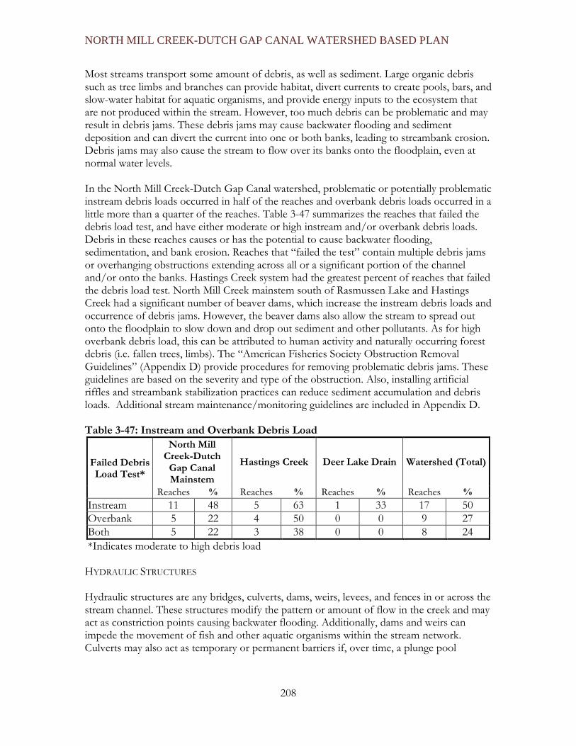
NORTH MILL CREEK-DUTCH GAP CANAL WATERSHED BASED PLAN
208
Most streams transport some amount of debris, as well as sediment. Large organic debris such as tree limbs and branches can provide habitat, divert currents to create pools, bars, and slow-water habitat for aquatic organisms, and provide energy inputs to the ecosystem that are not produced within the stream. However, too much debris can be problematic and may result in debris jams. These debris jams may cause backwater flooding and sediment deposition and can divert the current into one or both banks, leading to streambank erosion. Debris jams may also cause the stream to flow over its banks onto the floodplain, even at normal water levels. In the North Mill Creek-Dutch Gap Canal watershed, problematic or potentially problematic instream debris loads occurred in half of the reaches and overbank debris loads occurred in a little more than a quarter of the reaches. Table 3-47 summarizes the reaches that failed the debris load test, and have either moderate or high instream and/or overbank debris loads. Debris in these reaches causes or has the potential to cause backwater flooding, sedimentation, and bank erosion. Reaches that “failed the test” contain multiple debris jams or overhanging obstructions extending across all or a significant portion of the channel and/or onto the banks. Hastings Creek system had the greatest percent of reaches that failed the debris load test. North Mill Creek mainstem south of Rasmussen Lake and Hastings Creek had a significant number of beaver dams, which increase the instream debris loads and occurrence of debris jams. However, the beaver dams also allow the stream to spread out onto the floodplain to slow down and drop out sediment and other pollutants. As for high overbank debris load, this can be attributed to human activity and naturally occurring forest debris (i.e. fallen trees, limbs). The “American Fisheries Society Obstruction Removal Guidelines” (Appendix D) provide procedures for removing problematic debris jams. These guidelines are based on the severity and type of the obstruction. Also, installing artificial riffles and streambank stabilization practices can reduce sediment accumulation and debris loads. Additional stream maintenance/monitoring guidelines are included in Appendix D. Table 3-47: Instream and Overbank Debris Load
Failed Debris Load Test*
North Mill Creek-Dutch
Gap Canal Mainstem
Hastings Creek Deer Lake Drain Watershed (Total)
Reaches % Reaches % Reaches % Reaches % Instream 11 48 5 63 1 33 17 50 Overbank 5 22 4 50 0 0 9 27 Both 5 22 3 38 0 0 8 24 *Indicates moderate to high debris load
HYDRAULIC STRUCTURES Hydraulic structures are any bridges, culverts, dams, weirs, levees, and fences in or across the stream channel. These structures modify the pattern or amount of flow in the creek and may act as constriction points causing backwater flooding. Additionally, dams and weirs can impede the movement of fish and other aquatic organisms within the stream network. Culverts may also act as temporary or permanent barriers if, over time, a plunge pool

NORTH MILL CREEK-DUTCH GAP CANAL WATERSHED BASED PLAN
209
develops, causing the bottom of the culvert to become elevated above the water level of the pool. Manmade hydraulic structures also require periodic maintenance and replacement. A complete summary table of the 120 hydraulic structures recorded in the stream inventory can be found in Appendix C. The North Mill Creek-Dutch Gap Canal mainstem contained the greatest amount of hydraulic structures with 85, for a density of five structures per stream mile. While containing a fewer amount of structures, Hastings Creek and Deer Lake Drain have hydraulic structure density of approximately six structures per stream mile. Overall, there was an average of five and a half hydraulic structures per mile of stream. Manmade dams were also common on the mainstem and on Deer Lake Drain as they were constructed to create online lakes. Table 3-48 summarizes numbers and types of hydraulic structures in the North Mill Creek-Dutch Gap Canal watershed. Table 3-48: Hydraulic Structures
Hydraulic Structures North Mill Creek-Dutch Gap Canal
Mainstem
Hastings Creek
Deer Lake Drain
Watershed (Total)
Beaver Dam 16 4 1 21 Bridge 22 7 1 30 Culvert 30 9 5 44 Dam 4 0 2 6 Fence 8 3 2 13 Other 5 1 0 6
Total Hydraulic Structures 85 24 11 120
Hydraulic Structures per stream Mile 5.0 6 6 5.5
Problem Hydraulic Structures 33 7 3 43
The majority of the hydraulic structures were in-stream culverts under crossings. Culverts can present a problem if they are fragmented, crushed, or filled with sediment. Bridges were also abundant in the watershed with a total of 30 bridges, 19 of which are wooden footbridges. Many of the crossing structures were found to be non-operational and in disrepair with the potential to cause debris jams and erosion on surrounding banks (see list of photos in Appendix C). There are a total of 13 fences that cross the stream channel impeding the flow of the stream and in some cases causing debris jams (see list of photos in Appendix C). Beaver dams were prevalent throughout the watershed, 78% of the dams recorded were identified as beaver dams. Some of the dams created backwaters, and in some instances also created cut-off channels.

NORTH MILL CREEK-DUTCH GAP CANAL WATERSHED BASED PLAN
210
Figure 3-68 provides the location of the 43 problem hydraulic structures identified in the watershed. They are identified by their photo ID number. Thirty-four of the problem hydraulic structures are located in the Lake County portion of the watershed. Appendix C contains a comprehensive list of the structures and associated problems. The Action Plan includes recommendations for addressing these problematic hydraulic structures. The following photograph (Figure 3-67) depicts a problem hydraulic structure. By examining the picture, it is apparent that the structure lacks appropriate levels of rip rap and needs to be cleared of some woody debris. A chain link fence can also be seen in front of the culvert. At times of high water flow this could potentially restrict the movement of water through the pipe. Figure 3-67: Example of a problem hydraulic structure

NORTH MILL CREEK-DUTCH GAP CANAL WATERSHED BASED PLAN
211
Figure 3-68: Problem Hydraulic Structures Map

NORTH MILL CREEK-DUTCH GAP CANAL WATERSHED BASED PLAN
212
DISCHARGE POINTS Discharge points are identified as any outfalls into streams in the North Mill Creek-Dutch Gap Canal watershed, including drain tile outlets, sump pump pipes, stormsewer outfalls, drainage swales, open channels, and tributaries. In general, the stream inventory methodology defines an outfall as any pipe over four inches in diameter that drains into a stream channel. The stream inventory documented 113 discharge points into stream channels (see Table 3-49). Hastings Creek contains the highest amount of discharge points per stream mile (4.1 pipes and 3.3 tributaries/swales per stream mile). Discharge points were most common in the more developed suburban and residential areas where sump pump and stormsewer outfalls are numerous. Table 3-49: Discharge Points
Discharge Points
North Mill Creek-Dutch Gap Canal mainstem (16 miles)
Hastings Creek (4
miles)
Deer Lake Drain
(2 miles)
Unnamed Tribs (4 miles)
Total Watershed (26 miles)
Tributary, Swales and Gullies 32 14 5 7 58
Pipes (includs Storm Sewers, Culverts, and Drain Tiles) 28 15 4 9 56
Total Discharge Points 60 29 9 16 114
Problem Discharge Points 34 14 4 6 58 Problem discharge points found in the North Mill Creek -Dutch Gap Canal watershed contribute to streambank erosion and the transport of excess sediment to the stream channel. The location of these points is illustrated by Figure 3-69. Another problem frequently noted during the stream inventory is the state of disrepair of some drain tiles, particularly those constructed of clay. Many of these tiles were crushed during development activities or were abandoned as farming techniques improved and have since crumbled. As the streambank erodes, longer sections of the tile become exposed and eventually collapse under their own weight. This effectively shortens the pipe, further eroding the streambank since the point where the water discharges has moved up the streambank. Erosion is also a problem with steel pipes, as they age they become rusted and holes develop. This leads to erosion around the pipe and further streambank erosion. As for plastic pipes, there are also some erosion problems when the plastic pipe has been punctured or cut, again shortening the point where the water discharges. In total, there were 58 problem discharge locations, including 19 steel pipes, nine clay pipes, and eleven plastic pipes. During the 2007 Stream Inventory a suspicious discharge was located that was whitish/ grayish in color and had a strong sewer odor. The Lake County Health Department was informed and once tested it was found to have over 180,000 fecal coliforms. Since the discharge pipe was located on Lake County Forest Preserve District land and no responsible

NORTH MILL CREEK-DUTCH GAP CANAL WATERSHED BASED PLAN
213
party could be located, they were able to cap the discharge pipe, preventing any future discharge. Appendix C contains a list of each discharge point and any associated problems. The Action Plan makes recommendations for addressing problem discharge points. Figure 3-69: Problem Discharge Points Map.

NORTH MILL CREEK-DUTCH GAP CANAL WATERSHED BASED PLAN
214
RIPARIAN CORRIDOR/FLOODPLAIN Vegetation and land use characteristics were visually assessed while walking the stream channel throughout the inventory process. In general, the riparian zone and streambanks are not intensively developed, although they are moderately to highly impacted by human activity in some reaches. The riparian zone or corridor is defined as extending 100 feet from the stream channel on either side and was visually estimated and evaluated during the inventory. Approximately half of the riparian corridor area in the watershed is open space or vacant land (not including lakes and wetlands); some of the riparian corridor in Illinois is preserved in public ownership by the Illinois Department of Natural Resources or the Forest Preserve District. While almost entirely in private ownership, much of the riparian corridor in Wisconsin is classified as “Environmental Corridor”, which is protected as open space by stringent development restrictions. An additional 25% of the riparian corridor was agricultural land use and in most cases the buffer width was sufficient, although there were instances where crops were intruding into the buffer width of the stream, leaving less than 10 feet of vegetation. Recreation land use accounted for only 8% of the land use along the stream, all of which is owned and managed by the Lake County Forest Preserve. Shrubs, herbaceous plants and grasses, and wetland vegetation composed the majority of streambank vegetation, and significant portions were also covered by trees or bare soil. Some streambanks were dominated by invasive species such as buckthorn, but in general there were a wide variety of species. Figure 3-70 illustrates riparian buffers areas that need improvement. Any stream reaches exhibiting less than a 30 foot buffer on either side of the stream, or any other notable problems such as heavy invasive cover, have been classified as having a high priority for improvement. Some recommendations for improving the buffer are brush maintenance and the establishment of native vegetation. The Action Plan makes more recommendations for improving the buffers. NOTEWORTHY: Kenosha County Shoreland Ordinance The Kenosha County General Zoning and Shoreland/Floodplain Zoning Ordinance (Chapter 12 of the Municipal Code of Kenosha County) defines Shorelands as “All land, water and air located within the following distances from the ordinary high water mark of navigable waters as defined in section 144.26(2)(d) of the Wisconsin Statutes: 1,000 feet from a lake, pond or flowage; 300 feet from a river or stream or to the landward side of the floodplain, whichever distance is greater. If the navigable water is a glacial pothole lake, the distance shall be measured from the high water mark thereof. (11/5/86).” The use of any parcel of land located within the county's designated Shoreland-Floodplain area shall be conducted in accordance with the provisions of Chapter NR115 of the Wisconsin Administrative Code, Wisconsin's Shoreland Management Program, and in the case of conflict between this ordinance and the Wisconsin Administrative Code, (NR-115) the provision with the greater restriction shall apply. Within the designated Shoreland area, the County Ordinance imposes significant use restrictions with respect to tree cutting and shrubbery, clearing, earth movement, structures, tillage and grazing, water withdrawal and diversion uses and crop production.

North Mill Creek-Dutch Gap Canal Watershed Plan
215
Figure 3-70: Riparian Corridor Improvements

North Mill Creek-Dutch Gap Canal Watershed Plan
216
AQUATIC HABITAT /SUBSTRATE COMPOSITION Substrate composition, instream vegetation, and instream cover for fish were assessed during the stream inventory to provide an indication of the quality of the aquatic habitat available in the North Mill Creek-Dutch Gap Canal watershed. North Mill Creek-Dutch Gap Canal watershed streambeds are composed of a variety of sediment grains that range in diameter from extremely fine clays (<1/1000th of an inch) to relatively coarse cobbles and boulders (>1 foot). NOTEWORTHY: Substrate Composition and Aquatic Habitat Generally, fine sediments are transported in suspension until velocity slows enough that they are deposited on the streambed. Larger sediments are not transported as readily and may only move during increased flows. Clays are typically regarded as cohesive sediments that naturally adhere to one another and are therefore more difficult to erode while silts are more easily eroded. Sands and larger sediments (e.g., gravels and cobbles) are less cohesive. Clay and silt-dominated banks and beds, therefore, tend to be associated with narrow, incised channels while sand, gravel, and cobble-dominated channels are more often shallow and wide. Clay/silt channels tend to incise or deepen in response to increased flows while sand/gravel channels tend to widen. These relationships, however, are also contingent upon a number of other contributing factors such as gradient, bank slope, and bank vegetation. Substrate is an important measure of habitat quality. Substrate with over 25% cobble provides an excellent habitat for fish and macroinvertebrates. Extremely fine sediments, such as clays, adhere closely to one another and may bury the streambed. Coarse-grained sediments like gravels present abundant interstices, allowing water, oxygen, and other dissolved and suspended materials to infiltrate the hyporheic zone. Excessive deposition of clays, silts, and fine particulate organic matter reduces the potential for infiltration and accessibility to the hyporheic zone. Excessive deposition also negatively affects filter feeders such as mussels, and may cause anoxia, or oxygen depletion, in the streambed as organic materials decompose. Hyporheic Zone: The hyporheic zone refers to the area surrounding the stream channel that is saturated and through which there is some percolation or flow. Essentially, the hyporheic zone is the area where the surface water and groundwater interface and mix. These interstitial pores also provide habitat to benthic (bottom-dwelling) macroinvertebrates, which play important roles in both aquatic food webs and ecosystem functioning. In the North Mill Creek-Dutch Gap Canal watershed, most reaches contain a mixture of sediment types, although segments are often dominated by a combination of either:
• sands, gravels and cobbles, or • silts, clays, and organic matter.
Across the entire watershed, clay, silt, and organic matter dominated the substrate composition in most of the reaches (24 of 34 reaches). Most reaches exceed 20% composition of both substrate groups, suggesting that throughout a reach neither association out rightly dominates, but that both likely occur. The only portion of the watershed that appears to be dominated by one type of substrate is North Mill Creek mainstem below the

North Mill Creek-Dutch Gap Canal Watershed Plan
217
Rasmussen Lake dam, which is primarily composed of sand, gravel, and cobble. This is likely due to the “sediment trap” effect of Rasmussen Lake as well as the higher gradient and flows that likely erode and transport a relatively high amount of fine sediment to Mill Creek. Figure 3-71: Instream Habitat Quality (Observed)

North Mill Creek-Dutch Gap Canal Watershed Plan
218
Figure 3-71 illustrates the locations and types of habitats found in the watershed. Six stream reaches have been classified as high quality as they exhibited at least seven quality habitat types, such as undercut banks, pools, logs, overhanging vegetation, rootwads, boulders, backwaters, and macrophytes. Qualitative Water Quality Observations Visual inspections of several water quality indicators were made during the stream inventory. Turbidity and watercolor, the presence of grease and oil in the sediment or water column, and the abundance of algae were assessed. In general, turbidity is not a significant problem in the North Mill Creek-Dutch Gap Canal watershed. Of the four reaches having high turbidity, three were in Hastings Creek (NM015, NM16, and NM17). These reaches also contain excessive fine sediment, which may be re-suspended by minor disturbances. Grease and oil were present in nearly a third of all stream reaches in the watershed. Where grease and oil was present, it was detected in both the sediment and the water column. The presence of grease and oil bore no strong relationship to any particular land use, but is probably related to urban runoff from transportation uses upstream. Algae are an indicator of high nutrient loads. Algae were not a significant problem in watershed streams. Excessive algae growth can negatively impact aquatic organisms and habitat by causing large daily fluctuations in dissolved oxygen levels. Algae are photosynthetic and therefore take up carbon dioxide during the day and release oxygen into the water column and the air. At night, algae respire, taking oxygen out of the water column and releasing carbon dioxide. Therefore, larger populations of algae have greater potential to cause large daily oxygen fluctuations. In addition, abundant algae populations are often aesthetically undesirable and typically detract from the visual quality of water resources. Algae scores were calculated by totaling the percentage of the reach affected by both floating and attached algae, based on visual inspection. North Mill Creek-Dutch Gap Canal mainstem contained the highest algae score with a score of 17. Instream fish cover availability was evaluated based on the presence of a number of structural elements and habitats, consisting of undercut banks, pools over 28 inches deep, aquatic macrophytes, logs, overhanging vegetation, rootwads, boulders, and backwaters. Fish utilize these various forms of habitat in a number ways, including spawning, rearing, foraging, predator avoidance, and resting. Overhanging vegetation is the most abundant cover type, appearing in all of the assessed reaches, whereas boulders are least abundant. Logs, undercut banks, and macrophytes were also common in stream channels in the watershed, each occurring in more than 80% of the assessed reaches. The role of logs and other large woody debris (LWD) in stream systems and restoration has lately become a matter of consideration. In forested watersheds, logs and other LWD divert flow, create eddies (current reversals), and play an important role in pool, riffle, and bar development. Backwater areas have probably decreased over time and presently occur in wetlands and other low-lying areas and behind weirs, dams and debris jams.

North Mill Creek-Dutch Gap Canal Watershed Plan
219
Many fish species require multiple types of habitat over varying time spans to accommodate daily and seasonal requirements as well as life-cycle changes. Habitat diversity, therefore, can be as important as habitat abundance. Overall, the North Mill Creek-Dutch Gap Canal watershed offered about five types of cover per reach. The North Mill Creek mainstem has the greatest amount of diversity for instream cover, averaging 5.5 forms per reach. Deer Lake Drain contained the least amount of cover with an average of 3.7 forms per reach. Water quality monitoring at three sites was performed between March 2010 and November 2010 (Hastings Creek at Miller Road, Mill Creek at 173 and Mill Creek at Kelly Road). Each stream site had high concentrations of nutrients, particularly nitrite-nitrate nitrogen and phosphorus. Elevated total suspended solids were found during the one storm event that was sampled at two sites in June. Chloride concentrations that have become an issue in many waterbodies in Lake County, were relatively low due to the primarily rural character of the watershed. Fecal coliform bacteria results warrant additional investigation as some elevated readings (above the state standard of 500 colonies/100 ml) were found. Dissolved oxygen (DO) concentrations at each site violated the IL state standards for at least a portion of the study, however, the 7 day average at each site rarely dropped below 4.5 mg/L. DO concentrations did fall below 2 mg/L at each site, sometimes for > 24 hours, most likely due to the low flow conditions and high water temperatures later in the summer. Current Stream Management Activity The Grubb School Drainage District performs stream management activities in a portion of the watershed (Figure 3-72). The district was re-activated in the mid 1980’s; it took numerous years until their coffers accumulated enough funds to begin performing maintenance activities. In the 1990’s, the district received a grant to clear brush from the stream corridor. In recent years, new development within the district boundaries and a modified assessment structure has allowed the district to increase maintenance activities. Current activities include:
• Clearing brush from streambanks and the stream corridor • Removing debris jams • Maintaining tile lines, and • Coordinating with the Lake County Forest Preserve District on maintenance
efforts and needs.

North Mill Creek-Dutch Gap Canal Watershed Plan
220
Figure 3-72: Grubb School Drainage District Boundaries

North Mill Creek-Dutch Gap Canal Watershed Plan
221
3.13 WETLANDS INVENTORY Wetlands play an important role in supporting the health of the watershed. They facilitate the recharge and discharge of groundwater, which results in a replenished aquifer. They also filter sediments and nutrients in runoff, provide necessary wildlife habitat, reduce flooding, and help maintain water levels in streams. By performing these functions, wetlands improve water quality and biological health of streams and lakes located downstream while helping to protect public safety (Environmental Protection Agency, 2009) In order to farm the rich soils, European settlers drained wetlands, channelized streams, and cleared forest land. This activity changed the hydrology and wetland processes of the region. Even after being cleared or drained the underlying soil retains its characteristics. Hydric soils (soils that remain wet for an extended period of time) are used to identify pre-settlement wetlands. The watershed possesses an extensive network of existing wetlands in addition to the drained wetlands that now remain as hydric soils. A significant portion of the existing wetlands are directly associated with parcels along stream corridors. The Lake and Kenosha County portions of the watershed contain 2,688 acres and 1,476 acres of wetlands respectively. The majority of wetlands in the Lake County portion of the watershed are located to the west of Deer Lake, at 594 acres, and north of Hastings Lake at 138 acres. The majority of wetlands in the Kenosha County portion of the watershed are located to the northeast of George Lake, at roughly 200 acres, and the east and west of Perch Lake at 130 acres. This area of the watershed contains, 2,900 acres of hydric soil, located in the southeastern section of the county, indicating that a large portion of this area was wetland at one time. NOTEWORTHY: Wetland Inventory The Lake County Wetlands Inventory (LCWI) is an inventory of wetlands in Lake County, Illinois that shows approximate wetland boundaries using the off-site delineation methodology in the 1989 “Federal Manual for identifying and Delineating Jurisdictional Wetlands.” The LCWI, completed by a group of federal, state, and county agencies and published in March 1993, was developed by a multi-agency team using a combination of information sources including: USDA/Soil Conservation Service wetland inventory maps, National Wetland Inventory (NWI) maps, the soil survey of Lake County and low altitude aerial photographs. The LCWI identifies nine (9) different wetland types, based on the criteria established by the Natural Resource Conservation Service (NRCS): artificial wetland, converted wetland, farmed wetland, farmed wetland not regulated under the 1985 Food Security Act, non-wetland prior converted, prior converted, urban converted, and wetland. The inventory is intended to improve the understanding and management of the County’s wetland resources. The Wisconsin Wetland Inventory (WWI) includes maps showing graphic representations of the type, size and location of wetlands in Wisconsin. These maps have been prepared from an analysis of high altitude imagery in conjunction with soil surveys, topographic maps, previous wetland inventories and field work. Within this context, the objective of the WWI is to produce reconnaissance level information on the location, type, size of these habitats

North Mill Creek-Dutch Gap Canal Watershed Plan
222
such that they are accurate at the nominal scale of the 1:24,000 (1 inch = 2000 feet) base map. National Wetlands Inventory: U.S. Fish and Wildlife Service study that provides information on the characteristics, extent, and status of U.S. Wetlands and deepwater habitats and other wildlife habitats. Based on hydric soils mapping, approximately 7,300 acres of wetlands existed prior to settlement. About 4,318 acres (or 59%) of these wetlands still remain today. The Lake and Kenosha County portions of the watershed contain 4,411 acres and 2,900 acres of hydric soil respectively. The hydric soils in Lake County are scattered throughout the county. The majority of the Kenosha County hydric soils are located in the southeastern section of the county. Many of the drained wetlands (hydric soils) are located in the northeastern portion of the watershed, which is currently in agricultural land use. These sites are excellent wetland restoration candidates, due to the likelihood that drain tiles are present that may be manipulated for restoration of wetland hydrology if desired (Biebighauser, 2007). Figure 3-73 depicts the location of existing wetlands including those designated as Advanced Identification (ADID) wetlands in Illinois and High Quality Natural Areas (HQNA – also ADID) in Wisconsin. Figure 3-73 also distinguishes between farmed wetlands and artificial wetlands. Farmed wetlands are identified by using aerial photographs for 5 consecutive years. Poor crop growth (crop stress) is the main identifier. An area must exhibit crop stress in 3 out of 5 years to be considered a farmed wetland. Artificial wetlands are man-made for detention, aesthetic, or wastewater treatment purposes. These areas are not considered wetlands until they can support wetland dependent vegetation. NOTEWORTHY: High Functionality (ADID) Wetlands In 1992, Lake County implemented the Advanced Identification (ADID) process in an attempt to identify high functionality wetlands in order to protect high quality plant communities and/or functional values. ADID is a United States Environmental Protection Agency (USEPA) program developed to indicate permit-processing time and provide information to local governments. The USEPA and U.S. Army Corp of Engineers (USACE)(Chicago District) used three primary functions to evaluate wetlands during the ADID process used in Illinois. These functions include: ecological value (i.e. wildlife habitat and plant species diversity), hydrologic functional value (i.e. stormwater storage or bank stabilization), and water quality value (i.e. sediment and nutrient removal). (Environmental Protection Agency, 2009).

North Mill Creek-Dutch Gap Canal Watershed Plan
223
Figure 3-73: Wetland Inventory

North Mill Creek-Dutch Gap Canal Watershed Plan
224
In Lake County, 11 wetlands have been designated as ADID using the criteria described in the previous noteworthy. This is roughly 1,345 acres. Kenosha County identifies wetlands as High Quality Natural Areas using different criteria than Lake County. To be considered an HQNA wetland in Kenosha County, a wetland must be located in an environmental corridor or be in a designated Natural Area. In Kenosha County, HQNA wetlands total approximately 980 acres. The wetlands are not assigned ID numbers or names. Table 3-50 lists several specific ADID wetlands in Lake County, and the attributes that were used to designate them as such. Table 3-50: ADID Wetlands in Illinois and Attributes ADID Site
ID Name/Survey
Site ADID Attributes
5 Benet Lake Stormwater storage; shoreline/bank stabilization; sediment/toxicant retention; nutrient removal and transformation
6 Redwing Slough/Deer Lake
State threatened or endangered bird species; high quality wildlife habitat; shoreline/bank stabilization; sediment/toxicant retention; nutrient removal and transformation
18 Antioch Bog State threatened or endangered plant species; stormwater storage; sediment/toxicant retention
19 Private Wetland (Unnamed)
Stormwater Storage; sediment/toxicant retention; nutrient removal and transformation
23 Private Wetland (Unnamed)
High Quality Plant Community; stormwater storage; sediment/toxicant removal; nutrient removal and transformation
30 Hendrick Lake High quality wildlife habitat; stormwater storage; shoreline/bank stabilization; sediment/toxicant retention
31 Hastings Lake Shoreline/bank stabilization; sediment/toxicant retention; nutrient removal and transformation
32 North Mill Creek (South of
Rasmussen Lake), and McDonald
Lakes
Presence of State Threatened or Endangered Species; high quality stream; Shoreline/bank stabilization; sediment/toxicant retention; nutrient removal and transformation
39 Crooked Lake Shoreline/bank stabilization; sediment/toxicant retention; nutrient removal and transformation
42 Unnamed High quality wildlife habitat; stormwater storage; sediment/toxicant removal
43 Slough Lake Shoreline/Bank stabilization; sediment/toxicant retention; nutrient removal and transformation

North Mill Creek-Dutch Gap Canal Watershed Plan
225
NOTEWORTHY: Wetland Protection IN NORTHEASTERN ILLINOIS The US Army Corps of Engineers (USACE) has jurisdiction over Waters of the United States (WOUS). The USACE, Chicago District, has a series of regional permits (RP) for various activities with minimal individual and cumulative impacts to WOUS in Lake County. Most activities that impact more than 0.1 acre of WOUS require mitigation at a 1.5:1 acreage replacement ratio. In some cases, such as proposed impacts to an ADID wetland, the USACE generally requires an individual permit (IP). ADID sites are normally considered unsuitable for filling activities since they have higher environmental, economic and/or social value. In the rare cases where an ADID wetland is impacted, a minimum 3:1 mitigation ratio is required. In Lake County, waters and wetlands that are not under the jurisdiction of the USACE are classified as Isolated Waters of Lake County (IWLC). Regulations for development activity within IWLC are included in the Lake County Watershed Development Ordinance (WDO). Submittal requirements vary depending on the amount of impact proposed. The current mitigation threshold is 0.10 acre for impacts to High Quality Aquatic Resource HQAR and 0.25 acre for all other IWLC impacts. Impacts at or above the threshold are typically required to be mitigated at a ratio of 1.5:1 acreage replacement. Impacts to HQAR are required to be mitigated at a minimum 3:1 ratio, depending on the type of HQAR impacted. Wetland Buffer Widths, Lake County WDO Linear Buffers (Streams)
• 50-foot wide buffers along linear water bodies (streams) draining 20 acres but less than one square mile;
• 30-foot wide buffers along linear water bodies (streams) with greater than one square mile drainage;
• 100-foot wide minimum buffer for high quality (ADID) linear wetlands or with Index of Biotic Integrity (IBI) greater than 40.
Water Body/Wetland Buffers
• 30-foot wide buffer around all water bodies with a total surface area greater than 1/3 acre but less than one acre;
• 40-foot wide buffer around all water bodies with a total surface area greater than one acre but less than 2.5 acres;
• 50-foot wide buffer around all water bodies greater than 2.5 acres; • 100-foot minimum buffer around all water bodies that are high quality (ADID)
IN SOUTHEASTERN WISCONSIN As in Illinois, WOUS in Wisconsin are regulated by the USACE. The USACE, St. Paul, Minnesota District, uses several types of permits/authorizations for WOUS impacts, including:
• “non-reporting” general permits for some minor activities that do not require applying or reporting to the USACE;

North Mill Creek-Dutch Gap Canal Watershed Plan
226
• other general permits if the proposed work also requires authorization from the Wisconsin Department of Natural Resources (WDNR);
• abbreviated letters-of-permission (LOP) authorization for many projects that are not eligible for general permits, which require applying to and receiving written authorization from the USACE; and,
• individual permits for regulated work that is not covered by general permits or LOP authorizations.
Waters (including wetlands) that are not under the jurisdiction of the USACE are regulated by the WDNR. The Wisconsin Non-Federal Wetlands Water Quality Certification General Permit (NFWGP-WI) establishes 10 general conditions in which the permittee must abide by related to permit expiration and maintaining the condition of the permitted activity as well as others. Wetland Buffer Widths, Kenosha County – Special natural resource interest (NR103.04)
• Trout streams, endangered/threatened species, fish and wildlife refuges, calcareous fens, wild/scenic rivers • 75 feet
– Highly Susceptible Wetlands • Sedge meadows, fens, bogs, forested wetlands, fresh wet meadows, shallow/deep marshes, various swamps • 50 feet
– Less Susceptible Wetlands • Dominated by 90% or greater of an invasive species (i.e. reedcanary grass) • 10% average wetland width: 10-foot min and 30-foot max
– Waters (Lakes and Streams) • Lakes and Streams (from ordinary high water mark) • 50 feet
In addition to the WDNR regulations, Kenosha County has adopted Shoreland regulations which protect stream corridors. The Shoreland regulations include minimum buffer widths. The buffer area may be disturbed; however, it must be stabilized from erosion and restored to self-sustaining vegetation. Impervious surfaces are not permitted within the buffer area, except as allowed as further described below. Riprap, and other hard armor, may be installed to prevent erosion. BMPs such as swales, wet detention basins and other similar practices are allowed within the buffer areas. Buffer areas apply to development, except as follows:
• Redevelopment • In-fill less than 5 acres • Structures that cross or access surface waters such as boat landings, bridges and
culverts • Structures constructed in accordance with s. 59.692(1v) [the gazebo clause] • Impervious surfaces which drain away from the protective area to another BMP.
(Ex. Road with swale parallel to stream)

North Mill Creek-Dutch Gap Canal Watershed Plan
227
As development continues, it will become increasingly important for wetlands to be restored and protected. Since extensive development has yet to reach the North Mill Creek-Dutch Gap Canal watershed area, there is an opportunity for future planning efforts to ensure opportunity for both development and wetland protection/restoration management. CURRENT MANAGEMENT ACTIVITIES Wetland creation and restoration can be beneficial in restoring basic environmental functions that historic wetlands once provided. Wetland restoration can positively influence the environment by reducing flood volumes and rates, increasing biodiversity, and improving water quality conditions (Chester County Pennsylvania, 2004). This results in cleaner water entering streams and lake systems while providing a decrease in algal blooms and aquatic vegetation overgrowth. Fortunately, it can be easy to restore a drained hydric soil area back to its original wetland state. This process involves removing, plugging, or breaking the drain tiles, or other wetland-dewatering devices, and allowing the area to naturally fill with groundwater. Planting the area with natural wetland vegetation if there is not an adequate wetland seed bank remaining in the soil is the final restorative step. Several recent wetland restoration and management activities are occurring in the Lake County section of the North Mill Creek-Dutch Gap Canal watershed. The main effort is an ecological restoration of Ethel’s Woods Forest Preserve. It is anticipated that wetland restoration will also take place in Raven Glen in the coming years. Finally, an 8-acre wetland is being managed along the outflow of Timber Lake, as a requirement by the Army Corp of Engineers. By removing invasive species in Ethel’s Woods, roughly 8 acres of former wetland were restored to their original historic state. The goal of this restoration project was to restore Ethel’s Woods to a mosaic of woodland and wetland communities, provide valuable enhancements to the aquatic resources, permanently plant former agricultural fields with native pollutant filtering vegetation, and restore the herbaceous vegetation layer in the existing woodland. Water quality benefits included: reduced erosion and runoff from the agricultural fields, reduced erosion and longer infiltration times within the existing woodland, and longer infiltration in restored wetlands. The wetland restoration started in 2004 and continued through 2006. Initially, some difficulties arose, due to failure of adequately re-hydrating the sedge meadow. Overall though, the project was considered a success (Lake County Forest Preserve). Raven Glen, an site near Ethel’s Woods, is another Forest Preserve area that has undergone wetland restoration efforts. There is limited information regarding these efforts however. Several nearby high-quality wetlands are protected by additional land acquisition. Eventually, it is anticipated that the drained hydric soils in the Forest Preserve area will be re-hydrated and connected to Hastings Creek (Lake County Forest Preserve).

North Mill Creek-Dutch Gap Canal Watershed Plan
228
3.14 FLOODING FLOOD RISK The Federal Emergency Management Association (FEMA) has conducted studies called Flood Insurance Studies (FIS) to determine the areas prone to flooding within the 100-year floodplain. Flood Insurance Studies are then used to produce Flood Insurance Rate Maps (FIRM), which are used to calculate flood insurance costs and requirements for structures located within the 100-year floodplain. (Note: Section 4.4 summarizes flood problems and flood risk locations in the North Mill Creek-Dutch Gap Canal Watershed. ) The effective FIS’s for the North Mill Creek-Dutch Gap Canal watershed were developed in the early 1980’s. An updated FIS has not been conducted for the Lake County portion of the watershed. There have been updates to the effective FIRM panels since the 1980’s; these updates are a result of map product changes as opposed to a restudy of the watershed’s hydrology, land use and drainage characteristics. For example all map panels were revised in 1997 when the mapping system went to a countywide format; originally map panels were produced based on municipal boundaries. There are several effective FIRM maps for the Lake County portion of the watershed that have been updated since the maps were reissued in 1997 based on Letters of Map Change that were submitted to FEMA. In spring 2011 FEMA issued preliminary digital firm map (DFIRM) panels for the Lake County portion of the watershed. In this map product the floodplain boundary has been revised based on digitally available 2-foot topography; this product is not associated with an updated FIS. It is expected that the official DFIRM will be issued in 2012. An updated floodplain study for Kenosha County was conducted as a part of Upper Des Plaines River watershed planning and the Des Plaines Phase II planning process. The study was sent to FEMA for review and comment in 2003, and is anticipated to be approved in late 2011. In the meantime, Kenosha County has adopted the updated 100-year floodplain boundaries as a part of a “Flood Overlay District” in the County zoning ordinance to ensure the most accurate and up to date information is used when development occurs. Figure 3-74 reflects the “Flood Overlay District” for the Kenosha portion of the watershed and the existing floodplain information generated from the 1980’s FIS’s for Lake County. The watershed contains 1,822 acres, roughly 8%, that is expected to be flooded during a 100-year flood. Section 4.4 also contains information related to the 100-year floodplain and discusses known flood problem areas and flood risk assessment (structures in the floodplain). NOTEWORTHY: Floodplain Floodplains along stream and river corridors perform a variety of benefits. Some of these benefits include aesthetic value, flood storage, water quality, and plant and wildlife habitat. One of the most important functions however, is the capacity of the floodplain to hold water during significant rain events, in order to minimize flood damage.

North Mill Creek-Dutch Gap Canal Watershed Plan
229
The 100-year floodplain is accepted as the national standard for purposes of regulating activities in the floodplain. Included in the 100-year floodplain, are the floodway and the flood fringe. A physical depiction can be viewed below.
Source: Suwannee River Water Management District 100-year floodplain: land adjoining the channel of a river, stream, watercourse, lake or wetland that has been or may be inundated by floodwater during periods of high water that exceed normal bank-full elevations. The 100-year floodplain has a probability of 1% chance per year of being flooded. Floodway is the portion of stream or river channel that includes the immediate adjacent land that conveys flood flows (National Flood Insurance Program). Flood fringe is the outer portions of the 100-year floodplain and is subject to periodic flooding. Flood Insurance Studies: Studies conducted by the Federal Emergency Agency (FEMA) to determine areas that have the highest probability for flooding.

North Mill Creek-Dutch Gap Canal Watershed Plan
230
Figure 3-74: 100 Year Floodplain

North Mill Creek-Dutch Gap Canal Watershed Plan
231
NOTEWORTHY: Stormwater and Floodplain Regulations LAKE COUNTY WATERSHED DEVELOPMENT ORDINANCE In 1992, Lake County adopted a comprehensive stormwater management ordinance (the Watershed Development Ordinance (WDO) that governs the entire County. The WDO restricts stormwater release rates for certain land developments within the County. The ordinance limits release rates from the 2 year, 24 hour and 100 year, 24 hour recurrence interval design storm to 0.04 cfs/acre and 0.15 cfs/acre per development acre, respectively. The WDO also includes runoff volume reduction provisions. These provisions of the WDO are currently being revised. As currently proposed, Best Management Practices shall be provided to reduce the runoff volume, for developments that result in at least 0.5 acre of ‘new’ impervious surface area; the minimum volume required shall be 3,000 cubic feet per acre of new impervious area of the development. This volume reduction is different from detention in that the volume is intended will be eliminated from the site’s runoff volume by infiltration, evaporation and evapotranspiration methods. The amended WDO is anticipated to be adopted Countywide in early 2012. KENOSHA COUNTY ORDINANCE Kenosha County Stormwater Management, Erosion Control, and Illicit Discharge Ordinance (Chapter 17 of the Municipal Code of Kenosha County effective March 5, 2010) applies to all unincorporated lands within Kenosha County. A stormwater permit is required for certain land development activities. A component of the stormwater permit is the creation of a stormwater management plan that, to the maximum extent practicable, adheres to the following guiding principles:
1) Preserve natural watershed boundaries and drainage patterns; 2) Reserve adequately sized and sited areas for storm water infiltration, detention and
treatment early in the planning process; 3) Locate storm water Best Management Practices (BMP) upstream from where runoff
leaves the site or enters waters of the state and outside of wetlands, floodplains, primary and secondary environmental corridors, or isolated natural areas;
4) Minimize soil compaction and maintain pre-development groundwater recharge areas; 5) Minimize impervious surfaces and have them drain to vegetated areas for pollutant
filtering and infiltration; 6) Emphasize vegetated swales and low flow velocities for storm water conveyance,
treatment and infiltration, especially for transportation related projects; 7) Allow for different storm water management strategies for cleaner runoff (i.e. roofs)
versus more polluted runoff (i.e. streets and parking lots); 8) Provide overland flow paths throughout the site to safely convey stormwater around
buildings and structures. Additionally, overland flow paths to the receiving watercourse downstream of BMP’s shall be analyzed to minimize adverse impacts to neighboring landowners.
9) Distribute storm water bioretention and infiltration BMPs throughout the site plan for large developments.
When applicable, within Salem township, detention facilities shall be designed to reduce the post-development peak rates of runoff during the two-, 10- and 100-yr recurrence interval storms to less than the peak rates of runoff during the same recurrence interval storms occurring under predevelopment conditions. Within the Village of Bristol (which as of 2010 includes all land previously within the Town of Bristol), detention facilities shall be designed

North Mill Creek-Dutch Gap Canal Watershed Plan
232
to reduce the post-development peak rates of runoff during the 100-yr recurrence interval storm to less than the peak rates of runoff during the 10-year recurrence interval storm occurring under predevelopment conditions, and reduce the post-development peak rates of runoff during the 10- and 2 year recurrence interval storm to less than the peak rates of runoff during the 2 year recurrence interval storm occurring under predevelopment conditions. Watershed Development Ordinance: one part of the adopted Lake County Comprehensive Stormwater Management Plan. It sets forth the minimum requirements for the stormwater management aspects of development in Lake County (Lake County Stormwater Management Commission) Stormsewershed: An area of land whose stormwater drains in to a common storm sewer system (American Planning Association, 2006 (Beir et al., 2006) CONSTRUCTED DRAINAGE SYSTEM As European settlers converted the watershed’s natural landscape to agriculture, they improved the drainage of wetland (hydric) soils by using underground drain tiles and ditches. Likewise, as land owners today convert natural and farmed lands to residential, industrial, and commercial land uses they improve the drainage of the landscape with stormsewer systems and stormwater storage facilities (detention basins), to maximize the land’s development potential and to reduce the likelihood of flooding problems NOTEWORTHY: Improved Drainage AGRICULTURAL DRAIN TILE NETWORK The natural drainage system of overland flow paths and wetlands draining into streams, lakes, and watersheds began to change when European settlers discovered the potential agricultural productivity of the soils in the area. Most of these soils remained wet for several days following a rain event, which causes significant problems with crop production. Saturated soils do not provide sufficient aeration for crop root development and lead to crop stress. In the late 1800’s, European settlers began using primitive agricultural drainage tile systems and ditches to remove standing or excess water from poorly drained lands. In the 1960’s and 1970’s, drainage tiles became the standard for removing unwanted water from the land. Drainage tiles ultimately carry water to ditches, streams, or lakes thereby increasing peak flows and the duration of bankfull flows which can lead to stream channel degradation (downcutting and widening) and downstream flooding. Drain tile networks are likely located throughout the watershed on land that is currently used for agriculture and in areas that were formerly farm fields. To determine the exact location of drain tiles, a site specific drain tile study has to be done before any development or restoration can be conducted. Other tile networks are located on land that is no longer used for agriculture; in most cases, these tiles are no longer functional. Since most drain tiles are located in depressional areas in agricultural fields, they provide excellent opportunities for wetland restoration projects. Breaking and/or removing sections of old drain tile is one of the most effective and cost efficient means to restore hydrology to former wetlands. When tiles are disabled, hydrology and wetland plants (both native and non-native) naturally return to areas that were historically wetland. Higher quality wetlands that provide water quality improvement and contain native species beneficial to nature are often created when

North Mill Creek-Dutch Gap Canal Watershed Plan
233
restoration strategies, such as seeding or planting, are implemented in concurrence with tile disablement. STORM SEWER SYSTEM AND DETENTION BASINS As settlement of the area increased, the natural drainage system began to experience more changes as residential, commercial, and industrial land uses increased. Since early urban development was constructed without detention basins, water was directly sent to wetlands, lakes, streams and rivers causing an increase in peak runoff discharge (see graphic below). An increase in peak discharges usually concludes with an increase in flooding. Detention basins are designed to capture stormwater runoff from a surrounding development and release the water slowly over a given amount of time, thereby reducing peak flows. Limited release from the frequent storms allows for more close approximation of the bankfull flow capacity of stream channels. Although many flood problems are alleviated using this method, channel degradation can result as prolonged bankfull flows cause streambank erosion. In addition, while regulating the outflow from detention basins to the stream channel reduces peak flows, detention basins do not address the total volume of runoff. As a consequence, flows from tributaries collect in mainstem river channels where the total volume of runoff results in flooding and flood damage. More recently, land planners and engineers have realized the benefits of reducing the volume of runoff from developed sites by minimizing impervious surface and infiltrating stormwater runoff on-site using green infrastructure rather than automatically routing it through detention basins. Figure 3-75: Hydrograph Example
Source: Carleton College Science Education Research Center Bankfull: A point at which water flow in a stream fills the channel to the top of its banks just to the point where water begins to overflow on to the adjacent floodplain. Bankfull stage flows transport the greatest quantity of soil and stone over time, because the bankfull stage occurs about once every year or two (Environmental Protection Agency, 2008).

North Mill Creek-Dutch Gap Canal Watershed Plan
234
STORMSEWER In the developed areas of the watershed, a stormsewer network or stormsewershed drains runoff directly to a stream or lake, or into a detention basin, which collects and holds the water for a period of time before discharging it to a stream or lake. Stormsewer networks (stormsewershed) were delineated in the watershed by reviewing municipal and stormsewer maps, and analyzing aerial photography. Figure 3-76 identifies: • Areas developed and not sewered/detained prior to 1992 (before the Lake County
Watershed Development Ordinance requirements), • Areas developed and sewered/detained prior to 1992 • Areas developed and sewered/detained after 1992, and • Stormsewered areas in Kenosha County.
Undeveloped areas, lands used for agriculture, and many older residential developments are not detained. Older developments were built before detention basins were required by ordinances and consequently were constructed without. North Mill Creek-Dutch Gap Canal watershed contains approximately 3,320 acres of stormsewersheds, as shown in Table 3-51. These stormsewersheds are concentrated in the western half of the watershed. A majority of the stormsewersheds (2,175acres) were developed in Illinois after the 1992 Watershed Development Ordinance (WDO). Table 3-51: Stormsewersheds
Development No. of Areas
Total Acres
Percent of Watershed
Post-1992 14 2,174.76 9.2% Pre-1992 5 1,141.89 4.8%
Total 19 3,316.65 -- As shown in Figure 3-76, there are two stormsewersheds that do not have detention. The first stormsewershed is near the center of the watershed and uses a channel and swale system. The second is in an area of mostly agricultural lands located in the southeastern portion of the watershed.

North Mill Creek-Dutch Gap Canal Watershed Plan
235
Figure 3-76: Stormsewersheds

North Mill Creek-Dutch Gap Canal Watershed Plan
236
DETENTION BASINS In 2009, the Lake County Stormwater Management Commission (SMC) conducted a detention basin inventory on all areas that are being used for detention. These locations were identified using aerial image analysis and subsequently field verified to insure that these areas were man-made detention basins. Approximately 120 potential areas were identified and 94 were confirmed as detention basins. All of the potential areas were in Lake County as detention areas were not identified in Kenosha County. The location and year of construction (post or pre 1992) for each detention basin is illustrated in Figure 3-77. A summary of the detention basin inventory can be found in Appendix E. The estimated storage volume of these detention basins is approximately 354.82 acre-ft. During the field verification process each basin was reviewed for the following:
• Location (Latitude/Longitude) • Size and drainage characteristics • Design features • Maintenance and design problems • Potential safety problems • Retrofit opportunities
The results of the inventory indicate that 75 of the 94 (80%) of the detentions basins would benefit from some type of retrofit or maintenance improvement. The addition of rip rap, aerators, sediment control buffers, and native vegetation, and the removal of woody vegetation and other debris would contribute to improving the overall water quality of these detention basins. As demonstrated by the Detention Basin Inventory (Figure 3-77), the majority of the detention basins in Lake County were constructed post 1992 and fall under the jurisdiction of the Watershed Development Ordinance (WDO). The land in this watershed was predominately used for agriculture in past decades, and excluding the older lake communities, has been developed relatively recently. Most of the Pre-1992 basins were constructed in Lake Villa, which is located in the southern portion of watershed.

North Mill Creek-Dutch Gap Canal Watershed Plan
237
Figure 3-77: Detention Basin Inventory

North Mill Creek-Dutch Gap Canal Watershed Plan
238
HYDRAULICS/IMPOUNDMENTS In 2007 SMC conducted a Stream Inventory for the North Mill Creek-Dutch Gap Canal Watershed. Of the 120 hydraulic structures inventoried 27 of them were dams. Of these, only six were man-made. The remaining 21 were the work of beavers. In general, dams change the hydrology by creating lakes and ponds, and in the case of beaver dams, river meanders, oxbow lakes and backwaters. A majority of the dams are located on North Mill Creek in the Lake County portion of the watershed as shown in Figure 3-78: Hydraulic Impediments. Of the dams on North Mill Creek, the most significant is located at the southern tip of Rasmussen Lake. As discussed in previous sections of this plan, the damming of North Mill Creek in this location created Rasmussen Lake. There is a restoration project being proposed by the Lake County Forest Preserve District to remove this structure as it is likely contributing to the poor water quality observed in the lake. In addition to affecting the headwater of a stream, dams and other hydraulic impediments inhibit the migration of fish and macroinvertebrates up and downstream thus, interfering with the natural ecological process of the stream (Higgs et al., 2002).The Heinz Center published a book in 2002 entitled, “Dam Removal-Science and Decision Making” that provides objective insight on the numerous issues involved with dam removal. Information in this book can be used to assess the safety, environmental, legal, social, economic, and management issues surrounding the decision making process of dam removal.

North Mill Creek-Dutch Gap Canal Watershed Plan
239
Figure 3-78: Hydraulic Impediments

North Mill Creek-Dutch Gap Canal Watershed Plan
240
REGIONAL STORAGE LOCATIONS For this study, Regional Storage Locations (RSL’s) are defined as existing or created depressional areas that are presently storing, or potentially could store stormwater runoff to decrease flooding in the watershed. Besides flood protection, RSL’s can be used for the mitigation of wetland losses (wetland restoration), channel protection, and water quality protection. Most areas in the watershed exhibit few flooding issues, although downstream flood damage along the Des Plaines River is a chronic problem. Created storage locations would provide many benefits including reduced runoff to streams; thus, channel erosion and runoff to the Des Plaines River is also minimized. If designed and planted as a wetland restoration, storage areas would improve water quality and habitat as well as increase groundwater recharge (Lake County Stormwater Management Commission, 2007). The criteria used to identify existing storage locations are summarized below. Detailed methods for identifying these areas are outlined in Appendix: F. Existing Storage Areas Criteria: • Include all existing open water (streams and lakes), wetlands, detention basins, and 100-
year floodplains; • Exclude parcels less than 1/3 acre, transportation, and building footprints; • Only include locations greater than 5 acres (5 acres is needed to create 10 acre-feet of
storage assuming depressional area is on average 2 feet deep); • Calculate estimated storage assuming 2 feet of storage volume at each location. The location of each existing regional storage site is shown on Figure 3-79. GIS analysis has identified 31 existing storage locations in the Kenosha County portion of the watershed. These storage locations cover 1,174 acres and can potentially store 3,538 acre-feet of water. The most significant storage is a large wetland/wet prairie area to the northeast of George Lake. This area totals 462 acres and has the potential to store 924 acre-feet of water. Existing Regionally Significant Storage Locations are identified on Figure 3-80.

North Mill Creek-Dutch Gap Canal Watershed Plan
241
Figure 3-79: Existing Storage Locations

North Mill Creek-Dutch Gap Canal Watershed Plan
242
Figure 3-80: Existing Regionally Significant Storage Locations

4

NORTH MILL CREEK-DUTCH GAP CANAL WATERSHED BASED PLAN
TABLE OF CONTENTS CHAPER 4: WATERSHED PROBLEMS ASSESSMENT 4.1 Land Use Impacts .............................................................................................................................. 243
Land Use & Watershed Vulnerability Analysis ............................................................................... 244 Step 1: Initial Classification ............................................................................................................ 244 Step 2: Final Classification and Evaluation of Restoration Potential ..................................... 247 Step 3: Projected Impervious Cover and Vulnerability Ranking ............................................ 251
Future classification .................................................................................................................... 251 Vulnerability ................................................................................................................................ 253
Step 4: Priority Ranking ................................................................................................................ 255 Reducing Land Use Impacts through Development Policy & Regulations ................................ 258
Watershed Development ................................................................................................................... 259 Local Municipal and County Policies and Ordinances ...................................................................... 264
4.2 Water Resource Problems Assessment ........................................................................................... 267 Lake impairment Findings .................................................................................................................. 267
Water Quality ................................................................................................................................... 268 Biological Impairments ................................................................................................................... 268 Shoreline erosion: ............................................................................................................................ 268
Stream Impairment Findings.............................................................................................................. 268 Water Quality ................................................................................................................................... 268
Point Source Impacts ....................................................................................................................... 269 Hydrologic Impairments and Sources: ......................................................................................... 271 Hydraulic Impairments and Sources: ........................................................................................... 272
Nonpoint Sources: ............................................................................................................................... 273 Overview of Pollutant Loading ..................................................................................................... 274 Nonpoint Source Pollution Load Model ..................................................................................... 275 Methodology .................................................................................................................................... 278 NPS Pollutant Loading for Existing Conditions ........................................................................ 278
Sediment Source Analysis .......................................................................................................... 289 Septic System Analysis ............................................................................................................... 290
Pollutant Loading Hotspots........................................................................................................... 291 Critical Nonpoint Source Pollution and Priority Areas Identification ......................................... 296
4.3 Water Quality Monitoring and Stream Channel Maintenance Programs .................................. 301 Water Quality and BMP Implementation Criteria (Indicators and Targets) ............................... 302
4.4 Flood Damage .................................................................................................................................... 304 Flood Problem Areas Inventory ........................................................................................................ 305 Site Specific Flood Damage Mitigation ............................................................................................ 308
4.5 Watershed Jurisdictional Coordination .......................................................................................... 311 Watershed Roles and Responsibilities .............................................................................................. 312 In-the-Ground Projects ...................................................................................................................... 313
4.6 Green Infrastructure Plan ................................................................................................................. 314 Parcel Prioritization Criteria ............................................................................................................... 315 Parcel Prioritization Results ............................................................................................................... 317
Overall Prioritization – A Green Infrastructure Network ........................................................ 318 Flood Prevention and Reduction .................................................................................................. 322 Natural Resource Protection and Enhancement ........................................................................ 323 Water Quality Improvement.......................................................................................................... 324

Stream or Streambank Restoration/Preservation....................................................................... 325 Potential Wetland Restoration Sites .................................................................................................. 326
Figure 4-1: Initial Classification of SMUs Based on Existing Impervious Cover ............................... 246 Figure 4-2: Final Classification of SMUs based on Analysis of Field Data and Subwatershed Characteristics ................................................................................................................................................ 250 Figure 4-3: Projected Impervious Cover of SMUs .................................................................................. 252 Figure 4-4: Vulnerability Ranking of SMUs .............................................................................................. 254 Figure 4-5: Priority Ranking of SMUs ....................................................................................................... 257 Figure 4-6: Watershed Development Jurisdictional Authorities ............................................................ 261 Figure 4-7a: Flows ......................................................................................................................................... 270 Figure 4-7b: Total Phosphorus 2010 levels, streams ............................................................................... 270 Figure 4-7c: Nitrate-Nitrite Nitrogen 2010 levels, streams..................................................................... 271 Figure 4-8: Catchments ................................................................................................................................ 277 Figure 4-9: Pollution Loading: Chloride .................................................................................................... 284 Figure 4-10: Pollution Loading: Total Suspended Sediment .................................................................. 285 Figure 4-11: Pollution Loading: Total Nitrogen ....................................................................................... 286 Figure 4-12: Pollution Loading: Total Phosphorus ................................................................................. 287 Figure 4-13: Pollution Loading: Fecal Coliform Bacteria ....................................................................... 288 Figure 4-14: Pollutant Loading Analysis “hotspots” at the SMU level ................................................. 295 Figure 4-15: Critical Areas ........................................................................................................................... 300 Figure 4-16: Flood Problem Areas ............................................................................................................. 307 Figure 4-17: Structures in 100 year Floodplain ......................................................................................... 310 Figure 4-18: How the open space parcel prioritization works. .............................................................. 317 Figure 4-19: Green Infrastructure Prioritization Results for all Goals ................................................. 320 Figure 4-20: Green Infrastructure Prioritization Results Flood Prevention and ................................. 322 Reduction ....................................................................................................................................................... 322 Figure 4-21: Green Infrastructure Prioritization Results Natural Resource Protection and Enhancement ................................................................................................................................................. 323 Figure 4-22: Green Infrastructure Prioritization Results Water Quality Improvement ..................... 324 Figure 4-23: Green Infrastructure Prioritization Results Stream or Streambank Restoration/Preservation ............................................................................................................................. 325 Figure 4-24: Potential Wetland Restoration Sites ..................................................................................... 327
Table 4-1: Current and Predicted Impervious Cover (See Figure 4-1) ................................................. 243 Table 4-2: Initial Vulnerability SMU Classification .................................................................................. 245 Table 4-3: Vulnerability Classification Descriptions ................................................................................ 247 Table 4-4: Intermediate Vulnerability SMU Classification ..................................................................... 248 Table 4-5: Final classification guidelines for SMUs. ................................................................................ 249 Table 4-6: Final Vulnerability Classification ............................................................................................. 249 Table 4-7: Future SMU Classification (Impervious Cover) .................................................................... 251 Table 4-8: Future SMU Classification (Vulnerability) ............................................................................. 253 Table 4-9: Priority Ranking Criteria ........................................................................................................... 255 Table 4-10: SMU Priority Ranking ............................................................................................................. 255 Table 4-11: Stormwater and Wetland Regulations Comparison ............................................................ 262 Table 4-12: Potential Causes and Sources of Pollution ........................................................................... 274 Table 4-13: Existing Conditions Annual Nonpoint Source Pollution Load Model Results .............. 278

Table 4-14: Existing Conditions Nonpoint Source Pollutant Loading By Land Use ......................... 279 Table 4-15: Existing Conditions Nonpoint Source Loading by Catchment ........................................ 280 Table 4-16: Sediment Pollutant Loading ................................................................................................... 289 Table 4-17: Existing Sediment Pollutant Loading From Major Gully Erosion ................................... 289 Table 4-18: Existing Conditions Gully Erosion Loading by Catchment .............................................. 290 Table 4-19: Potential Septic System Failure Details................................................................................. 290 Table 4-20: Estimated Pollutant Loading From Failing Septic Systems ............................................... 290 Table 4-21: Pollutant Loading Ranking Data by Catchment .................................................................. 292 Table 4-22: Pollutant Loading Ranking Summary ................................................................................... 294 Table 4-23: Critical Areas ............................................................................................................................. 297 Table 4-24: Flood Problem Areas .............................................................................................................. 306 Table 4-25: Structures within the 100yr Floodplain ................................................................................ 308 Table 4-26: Parcel Prioritization Criteria ................................................................................................... 316 Table 4-28: Lake County Open Parcel Summary ..................................................................................... 321 Table 4-29: Kenosha County Open Parcel Summary.............................................................................. 321

NORTH MILL CREEK-DUTCH GAP CANAL WATERSHED BASED PLAN
243
4.0 WATERSHED PROBLEMS ASSESSMENT This section of the report is a more detailed assessment of the problems identified in the Watershed Characteristics Assessment (Chapter 3.0). The following subsections describe how further analysis was used to assess how land use impacts are affecting the water quality, natural resources, and flooding conditions in the North Mill Creek-Dutch Gap Canal watershed. The watershed assessment section identifies several current and potential future problems in the watershed:
• Land use impacts on watershed health related to impervious cover, pollutant loading, and soil erosion
• Stream degradation (both physical and chemical) • Lake degradation (both physical and chemical) • Flood damage/flood risk associated with land development impacts and wetland loss • Lack of watershed-level jurisdictional coordination
4.1 LAND USE IMPACTS The problem: Hydrology changes in the watershed related to human land uses have resulted in lake and stream degradation, increased flood damage (currently limited), and nonpoint source pollution. Several of the lakes in the watershed are plagued by high nutrients, increasing salt concentrations, relatively low biological diversity, shoreline erosion and poor buffers. The streams in the watershed are primarily experiencing streambank erosion, nutrient loading, habitat alteration, and decreased biological productivity. Although flooding is not a serious problem, flood risk is a problem. Fifty-two structures were identified in the 100-year floodplain and 16 flood problem areas that experience flood damage have been identified (3 due to local drainage issues; 8 have depressional flooding and 5 overbank flooding locations). In addition, hydrology changes are leading to debris loading in stream channels that can lead to flooding, erosion and sediment deposition. Primary cause: Increased surface runoff due to impervious cover and an altered hydrology caused by extensive drain tiles. The Center for Watershed Protection’s “Watershed Vulnerability Analysis” was used to locate specific subdrainage areas or subwatershed management units (SMUs) in the watershed that are contributing most to the problems associated with impervious surfaces. A summary of the impervious cover assessment from Chapter 3 is included below in Table 4-1. Table 4-1: Current and Predicted Impervious Cover (See Figure 4-1)
Subwatershed Management Unit
Acreage Current Impervious
Cover
Predicted Impervious
Cover SMU 1 4,891 3.6% 8.5% SMU 2 2,264 6.6% 7.3% SMU 3 3,293 6.5% 7.3% SMU 4 4,200 2.5% 23.2% SMU 5 2,474 6.4% 19.2% SMU 6 3,294 4.1% 18.2% SMU 7 2,221 12.7% 22% SMU 8 895 10.8% 24.5% Total (acreage) 2,3532 1,318 3,583

244
Average percent 5.6% 15.2% LAND USE & WATERSHED VULNERABILITY ANALYSIS NOTEWORTHY: Watershed Vulnerability Analysis In 1998, the Center for Watershed Protection (CWP) published the Rapid Watershed Planning Handbook. This document introduced rapid assessment methodologies for watershed planning. More recently, the CWP released the Watershed Vulnerability Analysis as a refinement of the techniques used in the Rapid Watershed Planning Handbook (Zielinski 2002). The vulnerability analysis focuses on existing and projected impervious cover as the driving forces impacting potential stream quality within a watershed. A detailed discussion of land use and impervious cover impacts on watershed conditions is summarized in Section 3.6: Land Use/Land Cover. Center for Watershed Protection: Non-profit 501 (c)3 corporation founded in 1992 that provides local government, activists, and watershed organizations with the technical tools for protecting some of the nation’s precious natural resources such as streams, lakes, and rivers. Watershed Vulnerability Analysis: Rapid planning tool for watersheds and subwatersheds that estimates impervious cover and assesses the watershed’s vulnerability to water resource degradation. A modified Watershed Vulnerability Analysis was used to compare Subwatershed Management Units (SMUs) across the North Mill Creek-Dutch Gap Canal watershed, and to evaluate the vulnerability of the SMUs and water resource quality to projected impervious cover associated with future land use changes. For the analysis, four steps were followed to generate four primary outcomes for use by watershed planners and resource managers. The four steps/outcomes are listed below and described in more detail in the following pages and in Appendix G:
1. Initial classification of SMUs based on current impervious cover estimates. 2. Final classification of SMUs based on the assessment of the other factors, beyond
impervious cover, that influence water resources in the SMU. 3. Ranking the most vulnerable SMUs based on projected impervious cover estimates. 4. Ranking of priority SMUs for immediate BMP implementation.
Step 1: Initial Classification The first step in the watershed vulnerability analysis involves an initial classification of each SMU based solely on existing estimated impervious cover (See Appendix G for methodology; and the impervious cover description in Section 3.6 for more information). There are eight (8) SMUs present in the North Mill Creek-Dutch Gap Canal Watershed. Of these eight, two can be classified as “impacted” and the remaining six as “sensitive”, based solely on existing impervious cover. The Sensitive SMUs are located in the northern portion of the watershed in areas that contain large areas of agricultural land use, open space, and low density residential and commercial development. The impacted SMUs are located in the southern portion of the watershed in areas with low-to-medium density residential and commercial developments, with smaller amounts of agricultural land use and open space mixed in. Table 4-2 lists the existing imperviousness of each SMU and the initial classification for all eight SMUs. This information is displayed on Figure 4-1 and more detailed information is included in Appendix G.

245
Table 4-2: Initial Vulnerability SMU Classification SMU ID
Initial Classification Impervious Area Classification
1 Sensitive <= 10% Sensitive 2 Sensitive >10%<=25% Impacted 3 Sensitive >25% Non-Supporting 4 Sensitive 5 Sensitive 6 Sensitive 7 Impacted 8 Impacted

246
Figure 4-1: Initial Classification of SMUs Based on Existing Impervious Cover

247
Step 2: Final Classification and Evaluation of Restoration Potential Impervious cover is not a perfect indicator of water resource quality. Evaluating water resource health based solely on impervious cover does not always reflect actual conditions because the impact of impervious cover can be mitigated by other factors such as the presence of native vegetative communities (e.g., forests, prairies, savannas), the presence of stormwater management practices that address stormwater quantity and quality, and the presence of riparian buffers along streams and lakes. Likewise, factors such as extensive drain tiling, channel modification, dams, nutrient application, and land clearance in rural watersheds with little impervious cover may result in more impacts than predicted by the amount of impervious cover alone. Therefore, additional field data and subwatershed characteristics are analyzed in Step 2 of the watershed vulnerability analysis so that SMUs are more accurately classified into one of 6 final classifications that also reflect restoration potential (Table 4-3). Table 4-3: Vulnerability Classification Descriptions Classification Description Sensitive < 10% impervious cover; field data and watershed characteristics
indicate that other factors beyond IC are not negatively impacting water resource and subwatershed health.
Restorable Sensitive < 10% impervious cover; field data and watershed characteristics indicate that other factors beyond IC are positively impacting water resource and subwatershed health. OR Slightly more than 10% impervious cover; field data and watershed characteristics indicate that other factors beyond IC are positively impacting water resource and subwatershed health.
Impacted 10 - 25% impervious cover; field data and watershed characteristics indicate that other factors beyond IC are not negatively impacting water resource and subwatershed health. OR < 10% impervious cover; field data and watershed characteristics indicate that other factors beyond IC are negatively impacting water resource and subwatershed health.
Restorable Impacted 10 - 25% impervious cover; field data and watershed characteristics indicate that other factors beyond IC are positively impacting water resource and subwatershed health. OR Slightly more than 25% impervious cover; field data and watershed characteristics indicate that other factors beyond IC are positively impacting water resource and subwatershed health.
Non-Supporting > 25% impervious cover OR 10 - 25% impervious cover; field data and watershed characteristics indicate that other factors beyond IC are negatively impacting water resource and subwatershed health.
Restorable Non-Supporting
> 25% impervious cover; field data and watershed characteristics indicate that other factors beyond IC are positively impacting water resource and subwatershed health.

248
For this Watershed-Based Plan, a two-step process was used to complete the final classification of each of the SMUs. First, the Illinois and Wisconsin Integrated Water Quality Reports and Section 303(d) Lists were reviewed to determine whether or not the SMUs have any impaired water bodies. Any SMU with a water body that appears on either Illinois’ or Wisconsin’s Section 303(d) List was automatically classified as impacted, even if it was not classified as impacted in the initial classification. By definition, an impaired or impacted water body is one that does not support full use by humans, wildlife, fish, and other aquatic life. The presence of a water resource that does not support full use within an SMU is an indication that impervious cover and/or other watershed characteristics are negatively impacting water resources and subwatershed health. Table 4-4: Intermediate Vulnerability SMU Classification SMU ID
Initial Classification (based only on Impervious Cover)
Impaired water body located in SMU?
Revised Classification (Change from Initial Classification)
1 Sensitive No Sensitive (No Change) 2 Sensitive No Sensitive (No Change) 3 Sensitive Yes Impacted (Change) 4 Sensitive Yes Impacted (Change) 5 Sensitive Yes Impacted (Change) 6 Sensitive Yes Impacted (Change) 7 Impacted Yes Impacted (No Change) 8 Impacted Yes Impacted (No Change) Second, 8 additional field data and subwatershed characteristics were examined to evaluate the impact of other factors, besides impervious cover, on water resources and subwatershed health. These factors were selected from the field and subwatershed criteria outlined in the Center for Watershed Protection’s (CWP) Watershed Vulnerability Assessment document (Zielinski, 2002). Each of these factors were assigned either a “plus” or a “minus” rating, based upon the positive or negative impact that they have upon water resources and subwatershed health:
1. SMU contains documented rare, threatened, and endangered (RTE) plant or animal species populations. (+)
2. Wetlands make up more than 10% of the SMU. (+) 3. Inventoried conservation areas (e.g., Lake County Forest Preserve District holdings, Nature
Preserves, Environmental Corridors, conservation easements) comprise more than 10% of the SMU. (+)
4. More than 75% of the streambanks and shorelines within the SMU have at least a 25 foot riparian buffer. (+)
5. Environmental monitoring (e.g., SMC stream inventories, Lake County Health Department lake inventories, other water quality sampling) indicates poor water quality or habitat value within the water resources found within the SMU. (–)
6. Farmland and other agricultural land uses make up more than 25% of the SMU. (–) 7. Stream channels within the SMU show evidence of historic alteration. (–) 8. Existing development does not utilize stormwater infrastructure that provides quantity and
quality control and runoff reduction. (–)

249
Table 4-5 outlines the guidelines that were used for adjusting the SMU classifications based upon the field data and subwatershed characteristics. The final SMU classifications are displayed on Figure 4-2 (Table 4-6). Table 4-5: Final classification guidelines for SMUs. Classification Guidelines
Sensitive < 10% impervious cover; no impaired water resources; as many positive factors as or more positive factors than negative factors
Restorable Sensitive
< 10% impervious cover; impaired water resources; more positive factors than negative factors OR slightly more than 10% impervious cover; no impaired water resources; more positive factors than negative factors
Impacted
10-25% impervious cover; no impaired water resources; as many positive factors as or more positive factors than negative factors OR < 10% impervious cover; impaired water resources; fewer positive factors or as many positive factors as negative factors
Restorable Impacted
10-25% impervious cover; impaired water resources; more positive factors than negative factors OR slightly more than 25% impervious cover; no impaired water resources; more positive factors than negative factors
Non-Supporting
> 25% impervious cover; no impaired or impaired water resources; fewer positive factors or as many positive factors as negative factors OR 10-25% impervious cover; impaired water resources; fewer positive factors or as many positive factors as negative factors
Restorable Non-Supporting
> 25% impervious cover; impaired or no impaired water resources; more positive factors than negative factors
* A SMU must have data for 5 or more field criteria to qualify for the analysis. Table 4-6: Final Vulnerability Classification SMU ID Total +/- based on 8
field criteria Final Classification based on field data and subwatershed characteristics
1 -1 Sensitive 2 0 Sensitive 3 0 Restorable Sensitive 4 -2 Impacted 5 0 Impacted 6 -1 Impacted 7 +1 Impacted 8 0 Impacted

250
Figure 4-2: Final Classification of SMUs based on Analysis of Field Data and Subwatershed Characteristics

251
Of the eight SMUs in the North Mill Creek-Dutch Gap Canal Watershed, five were classified as impacted (SMUs 4, 5, 6, 7, 8), one was classified as restorable sensitive (SMU 3), and two were classified as sensitive (SMUs 1 and 2) based on this analysis of field data, subwatershed characteristics, and impervious cover. Although three of the SMUs that were classified as impacted contain less than 10 percent impervious cover (SMUs 4, 5 and 6), field data and watershed characteristics, including the presence of water resources that appear on either Illinois’ or Wisconsin’s Section 303(d) List, indicate that other factors beyond impervious cover are negatively impacting water resource and subwatershed health within these SMUs. SMU 3, which has been classified as “restorable sensitive”, has characteristics that indicate significant improvements in water resource quality are possible through the implementation of watershed restoration best management practices (BMPs). These characteristics include a high percentage of wetlands and inventoried conservation areas. Step 3: Projected Impervious Cover and Vulnerability Ranking
Future classification
Projected impervious cover was evaluated during the third step of the watershed vulnerability analysis. For this study, projected imperviousness was based on the land use changes that are projected in 20-year comprehensive plans and parcel/zoning information available through the Lake County Planning and Building Department and local municipalities. It should be noted that the projections contained in these plans were developed prior to the recent economic downturn and large acquisitions by the Lake County Forest Preserve District. Like the initial classification, future impervious cover is estimated using the Lake County Stormwater Management Commission (SMC) landuse/land cover table based on projected land use changes, then a projected classification of Sensitive, Impacted, or Non-Supporting, based solely upon future impervious cover, is assigned to each SMU. This analysis is important when trying to identify the Sensitive and Impacted SMUs that are most vulnerable to future development pressure. The future classification, which is based only upon projected impervious cover, resulted in five SMUs being classified as impacted and three SMUs being classified as sensitive as indicated on Table 4-7 (Figure 4-3; Appendix G: Table 1). As noted above, the future impervious cover estimates are based on land use projections that were developed prior to the economic recession of 2008 and additional land purchases by the Lake County Forest Preserves, both of which may affect the amount of future impervious cover in the watershed. Based on this evaluation of projected future impervious cover, SMUs 4, 5, and 6 are projected to shift from an initial classification of “sensitive” to “impacted” within the next 20 years. SMU 4, in particular, is projected to have a 20.7% increase in impervious cover of the next 20 years. SMUs 5, 6, 7 and 8 are projected to change from “sensitive” to “impacted” as a result of impervious cover increases of 9-15%. SMUs 1, 2, and 3 are projected to be classified as “sensitive” based on projected impervious cover increases of 5% or less. Table 4-7: Future SMU Classification (Impervious Cover) SMU ID Final Classification
(from Step 2) Future Classification (based on Projected Impervious Cover only)
1 Sensitive Sensitive 2 Sensitive Sensitive 3 Restorable Sensitive Sensitive 4 Impacted Impacted

252
5 Impacted Impacted 6 Impacted Impacted 7 Impacted Impacted 8 Impacted Impacted Figure 4-3: Projected Impervious Cover of SMUs

253
The vulnerability of each SMU was evaluated by considering the following questions: Vulnerability
1. Will the SMU classification change (e.g., shift from sensitive to impacted)?; 2. Will the SMU classification come close to changing (e.g., come within 2% of shifting
from sensitive to impacted)? ; 3. What is the absolute change in impervious cover (e.g., will the impervious cover shift a
small amount or a larger amount)? A vulnerability of low, medium, or high was assigned to each SMU as indicated in Table 4-8 (Appendix G: Table 1; Figure 4-4) based on the following:
→ Low = no change in classification and < 5% change in impervious cover → Medium = classification close to changing and/or 5-10% change in impervious cover → High = change in classification and/or > 10% change in impervious cover
Table 4-8: Future SMU Classification (Vulnerability) SMU ID Does future impervious cover
classification change from initial classification?
Change in Impervious Cover %
Vulnerability
1 No 5% Medium 2 No 0.6% Low 3 No 0.9% Low 4 Yes 20.7% High 5 Yes 12.8% High 6 Yes 14.1% High 7 No 9.3% Medium 8 No 13.7% Medium The vulnerability analysis resulted in 2 SMUs being ranked as “low vulnerability”, 3 being ranked as “medium”, and 3 being ranked as “high.” The highly vulnerable SMUs include SMUs 4, 5 and 6. This high vulnerability results from the significant amount of impervious cover that is projected to be added within these SMUs within the next 20 years. Even though SMU 1 does not change classifications, it is projected to gain 5% more impervious cover, thus tripping the “<5% change” criteria threshold and is classified as “medium” vulnerability. SMUs 7 and 8 are classified as “medium” because they both approach the 25% impervious cover threshold for a “non-supporting” SMU. SMUs 2 and 3 are considered “low” vulnerability because they are expected to gain less than 1% impervious cover in the planning time frame.

254
Figure 4-4: Vulnerability Ranking of SMUs

255
Step 4: Priority Ranking The last step in the analysis is a ranking of priority SMUs based on the results of Steps 1, 2, and 3. This is accomplished by creating a priority ranking that identifies the most vulnerable SMUs in need of immediate attention through the implementation of watershed protection and restoration best management practices (BMPs). The following criteria were used to rank each SMU as Low, Medium, or High Priority:
1. Vulnerability, as determined under Step 3. 2. Comparison of the factors, other than impervious cover, that influence SMU health, as
determined under Step 2. 3. Percentage of land that is publicly owned (public ownership may facilitate
implementation of large watershed projects more efficiently) A “Vulnerability Score”, “Field Criteria Score”, and “Public Ownership Score” were assigned to each SMU (Table 4-9). These scores were weighted and totaled to determine a priority score, and “High”, “Medium”, and “Low” priorities were assigned to all SMUs. The priority ranking analysis identified 3 high priority, 3 medium priority and 2 low priority SMUs. The results of the priority ranking are shown in Table 4-10 and depicted in Figure 4-5 (Table 1, Appendix G). Table 4-9: Priority Ranking Criteria Component of Priority Score
Criteria Score weight
Vulnerability Score Based on Vulnerability Ranking from Step 3: “High” = 3 “Medium” = 2 “Low” = 1
2x
Field Criteria Score Based on overall +/- score from Step 2: Negative values = 3 “0” = 2 Positive values = 1
1x
Public Ownership Score Based on percentage of SMU in public ownership: More than 20% = 3 10-20% = 2 Less than 10% = 1
1x
Table 4-10: SMU Priority Ranking SMU ID Vulnerability
(Score) Field Criteria +/- (Score)
Public Ownership % (Score)
Priority Rank (Total Score)
1 Medium (2) -1 (3) 3.7% (1) Medium (8) 2 Low (1) 0 (2) 1.3% (1) Low (5) 3 Low (1) 0 (2) 37.6% (3) Low (7) 4 High (3) -2 (3) 18.5% (2) High (11) 5 High (3) 0 (2) 18.9% (2) High (10) 6 High (3) -1 (3) 15.9% (2) High (11) 7 Medium (2) +1 (1) 32.1% (3) Medium (8) 8 Medium (2) 0 (2) 31.5% (3) Medium (9)

256
Three SMUs have been ranked with a high priority: SMUs 4, 5, and 6. These were given a “high” prioritization because they are classified as highly vulnerable, may be subject to projected future land use changes, and also have opportunities for implementation of best management practices and/or restoration projects. In particular, SMU 4 contains the planned commercial/industrial development corridor along Illinois 173 as well as some recent Lake County Forest Preserve land acquisitions. SMUs 5 and 6 are projected to experience additional residential growth. In all the high-priority SMUs, best management practices will need to be targeted toward existing opportunity sites as well as future development locations. SMUs 1, 7, and 8 are “medium” priority because they are projected to experience increases in impervious area but remain in the same classification. SMUs 2 and 3 are “low” priority because they are expected to experience increases in impervious area of less than 1%, despite having little protected open space or publicly-owned land. The SMUs containing the greatest percentages of publicly-owned land are categorized as “medium” or “low” priority because they were ranked as “medium” or “low” vulnerability and field criteria factors were either neutral or positive.

257
Figure 4-5: Priority Ranking of SMUs

258
REDUCING LAND USE IMPACTS THROUGH DEVELOPMENT POLICY & REGULATIONS Sometimes the appropriate measures of watershed protection are the problems we avoid, not the problems we have to fix. While this watershed management plan does not include land use recommendations because land use decisions are the right and responsibility of the watershed municipalities and counties; the health of watershed lakes, streams and wetlands is a direct reflection of land use and management, therefore, considering land development impacts is necessary for effective watershed planning. Negative indicators in the North Mill Creek-Dutch Gap Canal watershed show that land use and management have impacted the physical, chemical and biological health of streams and lakes in the watershed, and have created some flood damage problems. Current water resource problems combined with projected future land use changes signal the need for changes in how land is developed and managed in the watershed. If watershed communities continue to follow “business as usual” development practices, it is anticipated that increases in runoff volume and pollution will continue to increase as development increases and land use changes occur within the North Mill Creek-Dutch Gap Watershed. Among the primary goals of the watershed plan are recommended actions for protecting and restoring natural resources, improving water quality, and reducing and preventing flood damage in the watershed. These actions include both remedial and preventative measures. One of the most significant and influential preventative measures are policies and regulatory programs. Therefore, a review of the ordinances within the watershed was conducted to evaluate policy and regulations for development as it pertains to detention, water quality, floodplains/floodways, and wetlands to identify where opportunities for watershed-friendly development practices may exist. Two types of regulatory and policy programs were reviewed based on their potential to positively influence watershed health by preventing development-related impacts. One type of program relates to watershed development regulations and policy focused on stormwater management; the second type is local ordinances and policy that direct development practices. The ordinance review was performed for the following regulatory/policy documents:
o Lake County Watershed Development Ordinance (LC-WDO) o the Kenosha County Stormwater Management, Erosion Control and Illicit Discharge
Ordinance (KC-SMO), and the o Kenosha County General Zoning and Shoreland/ Floodplain Zoning Ordinance
(KC-SFZO). It is important to note that for wetland and floodplain/floodway regulation, the KC-SMO and KC-SFZO documentation deferred to Wisconsin State regulations as precedent. Therefore in Kenosha County, changes to these regulations are outside the control of local communities. Lake County Stormwater Management Commission and Kenosha County should consider developing and administering watershed-specific stormwater management regulations to meet the goals and technical issues of concern related to new development in the watershed. The primary technical issues of concern in North Mill Creek-Dutch Gap Canal watershed are:
• Significant increases in impervious surface, particularly in the southern and eastern portion of the watershed are projected;

259
• Nonpoint source pollution from agricultural and development related runoff has impaired watershed lakes and Hastings and North Mill Creeks
Some local policy and ordinance concerns that were identified during stakeholder meetings or during the development of this plan are included below.
• Although overbank flooding has not currently been identified as a major flood damage concern for the watershed since it mainly affects roadways at stream crossings, land use changes will increase runoff volumes. Stakeholders have also identified flood damage concerns near Lake George and a small number of sites in the south part of the watershed. Farmers have reported increasing crop loss due to flooding in Kenosha County. The effects of increased runoff volume resulting from land use changes can be addressed in a variety of ways.
o Review the detention volume/release rate requirements for the Wisconsin portion of the watershed, which is currently less restrictive than Lake County.
o Ordinance and policy language can be reviewed and revised to ensure that the disconnection and minimization of impervious surfaces are allowed by right.
o Currently depressional storage areas (outside of the floodplain overlay district) are not required to be maintained as natural floodplain storage in the Wisconsin portion of the watershed. As these natural storage areas are lost due to land development changes, increased downstream flood heights can be expected.
• Water quality has been identified as a major watershed concern. Local community
ordinances can be reviewed and revised to insure that development codes do not preclude, but rather encourage best management practices (BMPs) such as:
o The use of native vegetation in home and business landscaping. o Green street designs (streets with bio-swales or other vegetated conveyance systems
instead of traditional curb and gutter). o Mandatory infiltration for a significant portion of increased runoff volume due to
land development. (The Lake County Watershed Development Ordinance has draft infiltration language proposed as part of its runoff volume reduction program.)
o Preservation of natural retention and infiltration areas to reduce polluted runoff. o Rainwater harvesting
• Currently stream corridor enhancements are not required as part of land development
activities in any portion of the watershed. Requirements or incentives for stream corridor buffering and restoration for stream reaches located on new development sites could provide both flood damage and water quality benefits.
• Currently there aren’t any standardized long-term maintenance and monitoring protocols for
naturalized stormwater drainage systems and natural areas. Development of standardized protocol for monitoring and maintenance plans for new developments, and required endowment funds for long-term implementation of the plans could be a significant benefit to the watershed.
Watershed Development

260
Development affecting water resources (streams, lakes, isolated wetlands, and floodplains) in the North Mill Creek-Dutch Gap Canal watershed is most significantly regulated by the Watershed Development Ordinance (WDO) in Lake County. The WDO is administered and enforced by the Lake County Stormwater Management Commission (SMC) or a certified community. Within Lake County, primary WDO authority has been delegated to Certified Communities. Fully Certified Communities within the watershed include the Villages of Antioch, Lindenhurst, Old Mill Creek and the Lake County Planning Building and Development Department (which is a fully Certified Community for all unincorporated areas within Lake County). Lake Villa is a partially Certified Community; it is certified to enforce the standard provisions of the WDO leaving the Isolated Wetland provisions under the SMC authority. Watershed Development Ordinance: One part of the adopted Lake County Comprehensive Stormwater Management Plan. It sets forth minimum countywide requirements for stormwater and wetland aspects of development.) Certified community: community authorized by SMC to administer and enforce the majority of the provisions of the WDO. A community can be a fully certified community (delegated to review both standard (general stormwater provisions) and isolated wetland aspects of the WDO or partially certified community (delegated to review either standard or isolated wetland aspects of the WDO). SMC retains certain review authorities, primarily with respect to aspects of the floodplain and floodway provisions of the WDO in certified communities. Kenosha County Stormwater Management, Erosion Control, and Illicit Discharge Ordinance (Chapter 17 of the Municipal Code of Kenosha County effective March 5, 2010) applies to all unincorporated lands within Kenosha County. Title 14 Land Division and Subdivision Code of the Town of Bristol Code of Ordinances (2008) applies to all development within the Village of Bristol. Figure 4-6 shows the jurisdictional authorities as they relate to development in the watershed. A basic comparison of the significant ordinance provisions (stormwater, floodplain and wetland) for each permitting authority is included in Table 4-11. The Lake County Watershed Development Ordinance (LC-WDO) and the Kenosha County Stormwater Management, Erosion Control, and Illicit Discharge Ordinance (KC-SMO) are both comprehensive in the detention and water quality categories. The LC-WDO requires a more restricted release rate for the 100-year design storm whereas the KC-SMO requires specific targets in the removal of TSS and infiltration of stormwater runoff. Both the LC-WDO and KC-SMO require best management practices (BMPs) to treat stormwater runoff for vehicle servicing and fueling areas. Both ordinances also require standard buffers from channels, wetlands, and open water bodies. When evaluating the floodplain/floodway and wetland categories, it became apparent that the LC-WDO was much more comprehensive in policy and regulations. No information on floodplain compensatory storage or wetland mitigation requirements could be found in the KC-SMO or the Kenosha County General Zoning and Shoreland/ Floodplain Zoning Ordinance (KC-SFZO). The KC-SFZO referenced Wisconsin State Statutes and Codes but did not provide any detailed information from them. It is recommended as an action item to evaluate the relevant Wisconsin state codes and statutes.

261
Figure 4-6: Watershed Development Jurisdictional Authorities

262
Table 4-11: Stormwater and Wetland Regulations Comparison
EFFECTIVE REGULATIONS Lake County Watershed Development Ordinance
Kenosha County Stormwater Management, Erosion Control, and Illicit Discharge Ordinance
DE
TE
NT
ION
1. Detention threshold1 0.5 to 1 acre of new impervious 1 acre of disturbance
2. Rainfall depth2 6.50 inches 5.88 inches
3. Allowable release rate
0.04 cfs/ac for 2 yr, 24 hr event
0.15 cfs per acre for 100-year
0.04 cfs/ac for 2-yr design storm Pre-development or 0.30 cfs per
acre for 100-year
4. Detention allowed in isolated wetlands
May be allowed in certain wetlands
May be allowed, requires pre-treatment
FLO
OD
PLA
IN
5. Compensatory storage - depressional 1.0 : 1 1.0 : 1
6. Compensatory storage - riverine 1.2 : 1 1.0 : 1
7. Subsidence fill and restoration allowances
YES, without compensatory storage
YES, requires compensatory storage
8. Floodplain Identification
FIRM, depressions > 0.75-acre-feet, and riverine >
100 tributary acres
FIRM-based Floodplain Overlay District
9. Floodway Identification
FIRM and riverine areas > 640 acres All viewed as Floodway
WQ
10. Water quality treatment threshold
More than 0.5 acres of new impervious requires
treatment
1 acre of disturbance
Pretreatment required before parking lot and road runoff
infiltration
BMPs required to control petroleum at fueling and vehicle
maintenance areas
Hydrocarbon treatment for vehicle fueling and service facilities and 25+ parking
stalls
11. Water quality treatment amount
0.01"/1% of impervious or approved BMP
80% TSS reduction; re-development 40%
WE
TLA
ND
S
12. Wetland hydrology 80-150% Rule for 2-year storm
Calculations to demonstrate hydrology
13. Wetland mitigation threshold
0.25-acres, 0.10-acres if high quality 6
Minimization geared, 10,000 square feet
14. Preliminary jurisdiction determinations3
YES NO
15. Wetland restoration fund4
YES, no limit on impact size NO

263
EFFECTIVE REGULATIONS Lake County Watershed Development Ordinance
Kenosha County Stormwater Management, Erosion Control, and Illicit Discharge Ordinance
B
UFF
ER
S 16. Buffers for high
quality aquatic resources
100 feet 50-75 feet
17. Buffers for channels draining < 640 acres
50 feet Concentrated flow channels with drainage areas greater than 130 ac
- 10' buffer 18. Buffers for
channels draining > 640 acres
30 feet 50 feet
19. Buffers for water body > 1/3 acre 30 feet Highly susceptible wetlands – 50
feet
20. Buffers for water body > 1 acre 40 feet
Less susceptible wetlands -10% of average wetland width between
10-30 feet
21. Buffers for water body > 2.5 acres 50 feet
Outstanding and exceptional resource waters and wetlands in
special natural resource areas - 35' 10% of wetland width; 50 feet for
lakes 22. As-built drawings
and calculations Required for sites w/
SWM system Required for sites w/ SWM
system
OT
HE
R
23. Drain tiles and maintainable outlet
Replace if impacted & maintainable outlet
Notification and possible restoration
25. Soil erosion/sediment control inspection5
DECI Program WDNR/NPDES
26. Runoff volume reduction (RVR)
NA (0.82 inches
proposed with WDO amendment– has not been
adopted yet)
Residential post development is at least 90% of pre-development infiltration rate, or infiltrate 25% of the post development runoff
from 2-yr, 24-hr event Non residential post development is at least 60% of predevelopment
rate, or 10% of post 2-yr, 24-hr event
27. USEPA water
quality effluent limitations
50 Nephelometric Turbidity Units 280 (370) NTUs
280 (370) NTUs
28. As-Built drawings and calculations
Enforcement Officer discretion
Required for sites with a SWM system
LEGEND Least Restrictive Most Restrictive
1 New impervious is the net increase of impervious surface from the existing condition. Therefore re-development of an existing site with a net impervious based threshold would be the least restrictive because of the allowable credit of existing impervious.
2 Rainfall depths are used to size detention facilities and storm sewers. A higher rainfall depth will require larger detention facilities and storm sewers. Base Flood Elevation (BFE) determinations will also be higher.

264
3 SMC offers this service to expedite permitting process. Jurisdictional determination from the US Army Corps of Engineers can take more than 6 months. SMC works with the Corps to issue determinations within 30 days.
4 SMC manages and makes this fund available to all watersheds in Lake County. Enables developers to pay into fund if wetland mitigation bank credits are not available. This can be time and cost-effective.
5 Designated Erosion Control Inspector (DECI) program is very similar to NPDES requirements that are applicable to all other Counties. Purpose is to improve communication and compliance of development sites.
6 0.10 acres except SFH (proposed) Of utmost importance for North Mill Creek-Dutch Gap Canal watershed from a watershed development regulatory and policy coordination perspective is:
• requiring that mitigation for unavoidable wetland loss occur within the same watershed as the impact;
• instituting more effective and consistent runoff volume reduction practices as the watershed is forecasted to experience dramatic development over the next 25 years;
• adopting consistent water resource buffer requirements and detention and floodplain development standards watershed-wide;
• developing stream maintenance and restoration standards that can be applied on development sites and throughout the watershed.
Local Municipal and County Policies and Ordinances The Lake and Kenosha County stormwater management ordinances set the minimum standards for development as a consistent standard in each county. Therefore, changes in development policy and regulation related to water resources fall in the hands of SMC, local enforcement officers for WDO Certified Communities in Lake County, and Kenosha County. It is up to the enforcing bodies to communicate effectively and discuss problems with stormwater ordinance language interpretation and amendment needs that may help clarify regulations. Additional avenues for policy & regulatory change are the responsibility of the County and local municipalities in their land use plans, local subdivision ordinances, etc. Local municipal ordinances can positively or negatively affect watershed response, and may be the best avenue for incorporating watershed-specific development standards and practices that prevent flood damage and protect water quality. Local community staff has the most significant role, and could assist developers in the site review process by assessing each new development site for proper best management practice (BMP) selection, and implementation of stormwater management practices that best minimize runoff volumes and velocities. NOTEWORTHY: Community Programs & Regulations Influence Watershed Health There are many codes and ordinances that have an influence on the health and function of a watershed. Table 5-10 includes typical types of codes and ordinances that can be evaluated and potentially changed or modified to help improve watershed conditions. Table 5-10 – Code or Ordinance Types With Ties to Watershed Health Code, Ordinance and Regulation Types With Ties To Watershed Health Erosion and Sediment Control Ordinances Zoning Ordinance Environmental Regulations (Buffers, Water Quality, Wetlands, NEPA, Threatened/Endangered Species, etc.)
Subdivision Codes

265
Floodplain Regulations Street Standards and Road Design Stormwater Management & Drainage Building and Fire Regulation Standards Tree Protection and Landscaping Public Fire Defense Parking Requirements Grading Ordinance Bold indicates key categories that influence watershed health Appendix O includes a self-appraisal form that watershed communities may use to evaluate their existing codes and ordinances to identify where regulatory changes and modifications can be made to improve watershed health. Adopting watershed-friendly codes and ordinances will elevate regulating entities into leaders in protecting and enhancing watershed resources. It is recommended that watershed communities perform this self-appraisal and establish an action plan to improve their rankings. Planning and zoning guidance provides the next level of watershed protection. Most planning and zoning regulation is in the form of local comprehensive land use plans and floodplain, zoning, and other development related ordinances that regulate onsite land use practices to ensure adequate floodplain, wetland, stream, lake, pond, soil conservancy, and other natural resource protection. Zoning ordinances and overlay districts in particular define what type of development is allowed and where it can be located relative to natural resources. Other examples of planning/zoning forms of resource protection include riparian and wetland buffers, impervious area reduction, open space/greenway dedication, and conservation development. Conservation development is discussed further below. To improve the impact of planning/zoning on water resource protection, there needs to be improved coordination and communication between county and local government. Local enforcement officers; local planners and zoning boards should be very familiar with watershed development regulations and consider revisions to local ordinances that address watershed, subwatershed, and/or site-specific natural resource issues not covered by county, regional or state program requirements. NOTEWORTHY: Conservation and Low Impact Development County and local governments can work together to develop incentives for conservation and low impact development. Conservation development is the ideal compromise between economic development and water resource protection. Some ways to incorporate conservation development into developing communities and provide incentives for developers include:
• Allow conservation development “by-right” (does not require variances) • Establish a joint county/community application process that reduces review time for
conservation development; • Reduce fees for conservation development application review; • County and municipalities work together to locate appropriate parcels for future
conservation development, and then zone those parcels as conservation development; • Require all developments to have a certain percentage of preserved open space; • Develop native landscaping ordinances; • Reduce setback requirements between lots and encourage multi-level and clustered
residential development to reduce land consumption; • Provide credit for combining natural buffers with recreational opportunities;

266
• Require native plantings in all detention basins; Communities may incorporate conservation and low impact development using several methods and strategies. Conservation development zoning could be applied to re-zoning changes in rural areas. The conservation development zoning classification should outline the intent, design guidelines, density bonus, and the specific areas where conservation development zoning changes would be permitted. The areas that may be re-zoned to a conservation development might include areas that are adjacent to ecologically significant lands or are identified in the green infrastructure system. Rural residential districts or less productive agricultural areas may also be considered. Areas that are defined as rural residential could provide a transition from higher density residential to rural. Design guidelines for conservation developments should include low impact development practices, a detailed outline of the process used to define the environmentally sensitive areas on the site, and identify areas on the site that are developable. Because each site will have different developable areas and sizes, design guidelines should be flexible and should consider different development characteristics, such as roadway length, width, and lot size. Density bonus may be written into the zoning code and could include bonuses for the following: use of native vegetation throughout the development, including individual lots, reduction in pavement or impervious surface, use of permeable pavements, increased percentages of open space, trail or sidewalk connections to other developments or regional trails, additional expanded buffering of natural areas and adjacent spaces and creation of wildlife habitat. Note: Stakeholders indicated that there are insufficient recreational opportunities, via trails, in Wisconsin during the watershed planning process. Additional public open space could be procured or dedicated with new development, and connecting trail systems added to the overall trail network.

267
4.2 WATER RESOURCE PROBLEMS ASSESSMENT The problem: Waterbodies in the watershed have poor water quality. Ten of the 14 lakes, Hastings Creek and North Mill Creek mainstem, within the Lake County portion of the watershed are classified as “impaired” by the Illinois EPA. Of the streams, water quality was poorest at the Hastings Creek monitoring site. Primary causes: Phosphorous and Total Suspended Solids (TSS) tend to be a cause of impairment for most lakes and streams throughout the watershed. Increased levels of phosphorous and TSS are attributed to wastewater effluent, agricultural production and suburban (including residential) sources. Chemical pollutant loads are causing impairments, as are physical alterations such as Carp stirring up sediments and channel modifications to improve drainage or increase the area of usable land such as channelization. Modifying the stream channel causes erosion and sedimentation/siltation concerns with associated high total suspended solids (TSS), which can be reasons for an impairment listing. Fecal coliform is listed as the cause of impairment for one lake, and arsenic and manganese are listed as causes of impairment in Hastings and North Mill Creeks. Changes to the watershed hydrology as a result of changing land use (impervious effects) and tile drainage impacts both lakes and streams. Hydrology changes in the watershed related to human land uses have resulted in lake sedimentation and stream erosion, increased flood damage (currently still limited), and nonpoint source pollution. There have also been substantial modifications to the stream system. Large segments of North Mill-Dutch Gap and Hasting Creek have been modified by channelization and the construction of hydraulic structures. These hydrological and hydraulic changes further result in a decreased quantity of pool riffle complexes, increased sediment accumulation, increased debris loads, habitat alteration and decreased biological productivity. NOTEWORTHY: Chemical, Physical and Biological Assessments Pollutants are inputs into water bodies that can be monitored by collecting chemical data for parameters such Phosphorus, Total Suspended Solids and fecal coliform bacteria. Physical modifications to the water bodies also play a significant role in degrading streams and water quality as they can impair aquatic habitat. Water quality monitoring has evolved to rely on chemical monitoring, toxicological and biological assessment data. Detailed chemical monitoring provides information on conditions as a snapshot in time when assessed using grab samples (reflects water chemistry at the time the sample is collected) that is restricted to the selected analyses and constrained by available methodology and detection limits. Other basic chemical and physical parameters can be collected continuously over a period of time using in-stream probes such as the datasondes used for monitoring North Mill and Hastings Creeks in 2010. Biological data, a survey of macroinvertebrates (bugs and worms) and fish, can be used to assess stream health over time as water quality and aquatic habitat affect the makeup of the animal communities in the stream. Biological assessments improve the chances of detecting effects of episodic events (e.g., spills), toxic nonpoint source pollution (e.g., pesticides), and cumulative and chronic pollution. Biological assessment data can also reflect the effects of unknown or unregulated chemicals (such as pharmaceuticals), non-chemical impacts, and habitat alterations. LAKE IMPAIRMENT FINDINGS

268
The main lake resource concerns are based on water quality parameters, overall biological health, and shoreline erosion. Water Quality Ten of the 14 lakes studied had average phosphorus concentrations in excess of the state standard. The lakes also suffered from high sediment concentrations (TSS) with the average TSS concentration at McDonald Lake 2 significantly higher than the other lakes. To a lesser extent recreational pollution (non-boating), wildlife (other than waterfowl) and land development have also been identified as potential sources of Phosphorus and TSS at several of the lakes within the watershed. The seven-day average for DO for all lakes was higher than the state standard everywhere except Redwing Slough and Rasmussen Lake. Fecal coliform readings were obtained in grab samples collected by the LCHD during their study with violations of the state standard at the Hastings Creek and Kelly Road sampling sites. LCHD also samples beach locations for fecal coliform, which is identified by Illinois EPA as a cause of impairment for Hastings Lake. Both point and nonpoint source pollutant discharges have been identified as probable sources. Detailed summaries of water quality and lakes can be referred to in Section 3.10 and 3.11. Biological Impairments Lakes can also have impaired water quality as a result of internal sources (i.e., carp, wind/wave action, invasive species, and having excessive or being devoid of aquatic vegetation). Aquatic plant diversity, an important part of a healthy ecosystem, was relatively poor in the lakes studied. Some lakes were nearly devoid of plants, due to human influences. The Floristic Quality Indices (FQI) values on several lakes were some of the worst in the county (see Table 3-41). The lakes suffered from algae blooms, and invasive aquatic plant growth. The decreased biological productivity and limited diversity of both fish and macroinvertebrate species are most likely a result of these impaired water quality and habitat alterations. Shoreline erosion: According to the Lake County Health Department Lakes Management Unit (LMU), most lakes in the county have eroded shorelines with invasive plant species as summarized in Table 3-39 and shown in Figure 3-63. This erosion will impact the water quality of the lakes, biological productivity, and loss of shoreline and property. STREAM IMPAIRMENT FINDINGS Water Quality Each stream site had high concentrations of nutrients, particularly nitrite-nitrate nitrogen and phosphorus. The highest concentrations were found in Hastings Creek. Fecal coliform bacteria results warrant additional investigation. The 7-day average dissolved oxygen (DO) concentrations on North Mill Creek mainstem at Highway 173 violated the IL state standards 24% of the time in 2010 (between March and July) and the mainstem at Kelly Road violated the IL state standard 39%

269
of the time (between August and November). The highest chloride concentrations were in Hasting Creek. Both Hastings Creek and North Mill Creek mainstem are impaired for sedimentation/siltation. Metals (Arsenic and Manganese) exceed state standards on both Hastings and North Mill Creeks. Grease and oil were visually noted during the stream inventory in nearly a third of all stream reaches in the watershed. Of the assessed stream locations only North Mill Creek mainstem at IL 173 had a good Macroinvertebrate Index of Biotic Integrity (m-IBI) rating, the other 3 locations were identified as fair. All monitored stream locations received a Biological Stream Characterization (BSC) of class D (Limited Aquatic Resource) based on the 2010 biological assessment survey. The 2008 survey results indicated that the MBI at 3 of these locations was fair, and they had a Biological Stream Characterization of E (Restricted Aquatic Resource). Point Source Impacts The Lindenhurst Sewage Treatment Plant (STP) is the only currently permitted point source discharger into the watershed; it is located approximately one mile upstream from the water sampling site on Hasting Creek. The most likely source of the higher nutrients levels found in Hasting Creek is the STP; although the STP is not violating any of the effluent standards in its NPDES permit. Hastings Creek water quality also affects North Mill Creek mainstem, downstream of its confluence with Hasting Creek, and Rasmussen Lake. The discharge from the Lindenhurst STP significantly impacts the flow in Hastings Creek. Without the STP, the creek would likely only have intermittent flow. The discharge is dependent on volume through the plant as the plant will receive higher inflow volumes at certain times of the day and week. In addition, flow is influenced by Hastings Lake, depending on whether water is flowing out of the lake. The following chart demonstrate that Hastings Creek flow is more consistent than at the other monitored stream locations due to the STP, although flow rates did decline in late-summer when there was no flow upstream of the STP and no water leaving Hastings Lake. Phosphorus and Nitrate-Nitrite Nitrogen levels for Hastings Creek were considerably higher than other stream reaches as shown in the following figures (4-7a, 4-7b, 4-7c). There are plans to upgrade the STP facility in 201l-2012 including the addition of a phosphorous removal facility, which should address the concern of the heavier nutrient loads in the Hastings Creek reach. At least one discharge location, on the mainstem of North Mill Creek identified during the 2007 stream inventory, was identified as having a strong sewer odor and grayish discharge. It was later tested, identified to contain large amounts of fecal coliforms, and was capped by the Lake County Health Department. This type of point source pollutant is considered an illicit discharge into the creek.

270
Figure 4-7a: Flows
Figure 4-7b: Total Phosphorus 2010 levels, streams

271
Figure 4-7c: Nitrate-Nitrite Nitrogen 2010 levels, streams
Hydrologic Impairments and Sources: The increased volume of runoff from impervious cover and extensive drain tiles has changed the hydrology of the watershed resulting in increased runoff to streams. These hydrologic changes not only increase the volume of runoff, but also modify the timing of the runoff. There are higher peak flows without detention, or alternatively prolonged runoff flow periods with the routing of stormwater through detention basins that increase the frequencies and duration of smaller bankfull and near bankfull flow events. It is these flows that are the primary channel forming events increasing streambank erosion. The hydrology changes that are leading to in-stream erosion are also causing debris loading in stream channels (toppled trees and shrubby vegetation collects in areas creating debris jams) that can lead to more erosion, flooding and sediment deposition. In addition, impervious cover and stormwater routing to streams prevent precipitation from infiltrating into the ground, thereby reducing baseflows during dry weather periods, which can significantly impair aquatic habitat. Increased impervious cover has in recent decades resulted in more point discharges for stormwater conveyance, such as drain tile outlets, sump pump pipes, storm sewer outfalls, drainage swale, open channel, and tributaries. Discharge points can contribute to streambank erosion and transport pollutants and excess sediment to the stream channel. As expected, the discharge points are most common in the more developed suburban and residential areas where sump pump and stormsewer outfalls are numerous. The stream inventory results indicate that Hastings Creek contains the highest amount of discharge points per stream mile. A total of 36 problematic point discharge locations, found to be contributing to streambank erosion and transporting excess sediment to the

272
stream channel, were identified in the stream inventory. Table 3-49 lists types of discharge points located in the reaches and Figure 3-70 is a map of the location of problem discharge points. Hydrologic changes also affect water temperatures. Urbanization tends to increase stream temperatures which decreases dissolved oxygen levels (warm water does not hold oxygen as well as cold water). Water temperatures in excess of the state standard were documented on North Mill Creek at Kelly Road in July and August of the study period. This is likely the result of two conditions: warm water from the upstream impoundment Rasmussen Lake and the low water level conditions at the site in July/August. As discussed in detail in Sections 3.5 and 4.1 one SMU in particular (NMC8) is projected to have a 47% increase in impervious cover over the next 20 years, while two other SMUs (NMC5 and NMC6) are projected to have increases of 25.6% and 28% more impervious cover in the next 20 years. These changes in impervious cover will likely result in even more significant changes in watershed hydrology, and will exacerbate the hydrology-related problems if development practices that reduce runoff volumes are not employed in the watershed. Hydraulic Impairments and Sources: Several hydraulic conditions are resulting in in-stream impairments. These include channelization impacts on pool/riffle development and stream channel stability (erosion,sedimentation and debris loads); and hydraulic structures in the channel such as dams, culverts and bridges and their impacts on conveyance and channel stability. Hydraulic changes (including channelization, hydraulic structures and debris loads) are causing streambank erosion that increases sedimentation. Almost all of North Mill Creek mainstem, upstream of Rasmussen Lake, the entire Dutch Gap Canal, and a significant portion of Hasting Creek have a high degree of channelization. The channelization of these stream sections, the result of agricultural drainage needs, is a main reason for channel characteristics that affect both stream quality and stability (increased erosion, sediment accumulation, debris loads). Figure 3-65 displays the degree of channelization in the watershed. The channelized area North of Rasmussen Lake is mostly agricultural land use, and crop loss problems as a result of increasing flooding are of concern to Wisconsin farmers. Channelization also alters stream morphology, and along with dredging, this likely reduces the amount of natural pool-riffle development throughout the reaches. There were no areas with a high degree of pool-riffle development (greater than 66%) identified. The majority of the watershed is identified as having a low percent of pool-riffle development (5-33%). The greatest extent of pool-riffle development was encountered in the unchannelized North Mill Creek mainstem below the Rasmussen Lake dam (Figure 3-44). Streambank erosion is a result of both hydrologic and hydraulic impacts. Erosion can cause significant water quality problems due to sediment accumulation and sediment transport downstream. The majority of the reaches in the North Mill Creek-Dutch Gap Canal watershed showed some degree of erosion with 59% being classified as moderate and 12% classified as high degrees of erosion (Table 3-45). The most severe streambank erosion is located on the mainstem between Winfield Road and Horton Road (NM034), along the last reach of the Deer Lake Drain as it converges with the mainstem (NM030), along Hastings Creek as it crosses under Miller Road (NM016), and the section downstream of the outlet to McDonald Lakes.

273
Sediment load is also a result of both hydrologic and hydraulic impacts. Sediment erosion, transport and deposition are naturally occurring processes in stream systems, but the magnitude of these processes can be amplified due to human modifications to the watershed. The stream inventory revealed:
• 79% percent of North Mill Creek-Dutch Gap Canal watershed reaches experience moderate or high degrees of sediment accumulation.
• The most common degree of sediment accumulation is moderate. 67% of the stream reaches are classified in this manner.
• The cases of high sediment accumulation occurred in the Hastings Creek system, where 4 out of the 8 reaches were classified as high.
The high amount of sediment accumulation is likely due to the high degree of bank erosion caused by the increased runoff from impervious surfaces upstream and the degree of channelization associated with the upstream land use (highly developed residential area). Sediment run-off from the agricultural areas further downstream also may contribute to sediment accumulation. Natural streams systems transport some amount of debris, as well as sediment. Debris is beneficial to the ecosystem as habitat, however too much debris can be problematic and may result in debris jams. These debris jams can result in backwater flooding and sediment deposition, and can divert the flow current into one or both banks leading to streambank erosion. In the watershed, problematic or potentially problematic instream debris loads occurred in half of the reaches and overbank debris loads occurred in a little more than a quarter of the reaches. The largest percentage of these areas was located in the Hasting Creek system. Hastings Creek also had the greatest percent of reaches that failed the debris load test; and both North Mill Creek mainstem south of Rasmussen Lake and Hastings Creek had a significant number of beaver dams (Table 3-47). Hydraulic structures (such as bridges, culverts, dams, weirs and fences in or across the stream channel) can modify the pattern or amount of flow by acting as constriction points causing backwater flooding, erosion and serving as barriers that impede the movement of fish and other aquatic organisms. A total of 43 hydraulic structures have been identified as problematic within the watershed, 34 of these structures are located within Lake County. NONPOINT SOURCES: It is difficult to determine precise sources of nonpoint pollution. By definition, nonpoint source pollution has no single point of origin. This pollution comes from everyone and everywhere in the watershed. That is why it is important to address nonpoint source pollution issues in terms of the smallest practical watershed unit, which in this study is the catchment drainage unit (Figure 4-8). Water quality managers can then focus on those catchments with the highest concentrations of pollutant contributions (“hotspots”), and see what can be done within the catchment to reduce those pollutants. Table 4-12 below summarizes many of the potential sources for excessive pollutant loads noted in the pollutant loading analysis. Critical nonpoint source pollution areas are further described later in this section. The most common nonpoint source pollutants in Illinois are nutrients and sediment. Agriculture (both crop production and pasture practices) is a significant source of nutrient loads to the watershed. Urban, rural residential sources, and runoff from open land areas (e.g. lawn or parkland fertilization, leaf litter/forest bed runoff) have also been identified as sources of nutrients loads,

274
likely due to fertilizers and the septic systems associated with these land uses. Runoff from the historic duck farm on Slough Lake also created excessive nutrients in that lake and the lakes downstream (Crooked and Hastings). Urban runoff also carries pollutants such as oil and grease, metals and pathogens such as fecal coliform. Runoff from agricultural areas of highly erodible soils with unstabilized concentrated flow paths (e.g. rill and gully areas), and construction sites with poor erosion control practices, contribute to the sediment load in both lakes and streams. McDonald Lake 2, Rasmussen Lake and Slough Lake had significantly higher sediment loads than the others assessed in the watershed. Sediment loads were highest in the streams during rain events; as more of the watershed is developed, stream flows may increase, causing additional sedimentation. Critical areas that might be contributing to the sediment load in the watershed are identified in the Critical Areas analysis. Table 4-12: Potential Causes and Sources of Pollution
Overview of Pollutant Loading Pollutant loading within a watershed is the contribution of pollutants from the sum of point sources and nonpoint sources. Nonpoint source pollution is a primary concern related to water quality in the North Mill Creek-Dutch Gap Canal watershed due to its rural setting and numerous land use practices. The watershed stakeholders and planning committee have identified total nitrogen, total
Pollutant
Potential Causes and Sources of Pollution
Fecal Coliform (E. coli) bacteria
Causes: Animal and human waste Sources: Public parks, Streets, lawns, driveways, parking lots, etc.
Total Suspended Solids (TSS)
Causes: Eroded soils and other loose debris Sources: Streets, lawns, driveways, parking lots, soil erosion: elevated and highly varied stream flows, improper construction site management of sediment, agricultural practices in highly erodible soils, increasing land development without proper stormwater management practices
Total Nitrogen (TN)
Causes: Excessive concentration in stormwater Sources: Applications of fertilizer, failing septic systems, sewage treatment plant discharges, livestock, nuisance geese
Total Kjeldahl Nitrogen (TKN)
Causes: Excess concentration in stormwater Sources: Plant and animal decay
Total Phosphorous (TP)
Causes: Excess concentration in stormwater Sources: Streets, residential lawns (lawn fertilizers, grass clippings), driveways, agricultural fertilizers, soil erosion, runoff from animal raising operations, untreated stormwater and wastewater, detergents, inadequate or failing septic systems, lake sediments, nuisance geese
Manganese
Cause: Excess concentration in stormwater Source: motor vehicles, groundwater, industrial pollution
Arsenic
Cause: Excess concentration in stormwater Source: groundwater, industrial pollution
Grease and Oil Cause: Excess concentration in stormwater Source: food processing wastes, motor vehicles, industrial pollution
275
phosphorus, total suspended sediment, chloride, and fecal coliform bacteria as the priority nonpoint source pollutants to address in the watershed plan. To accomplish goals of improving the water quality of the watershed, these selected pollutants were identified as priorities based on first-hand experiences in the watershed, water quality monitoring results, land use activities in the watershed and known water quality impairments. NOTEWORTHY: Nonpoint Source Pollution: As defined by Environmental Protection Agency (IEPA), the pollution from nonpoint sources originates from urban runoff, construction activities, manmade modification of hydrologic regime of a watercourse (e.g. retention, detention, channelization, etc.), silviculture, mining, agriculture, irrigation return flows, solid waste disposal, atmospheric deposition, stream erosion, and individual or zonal sewage disposal. Nonpoint source pollution originates in a wide spectrum of public and private activities, and is the nation’s and the state’s number one threat to water quality. Since runoff from the rainfall flows over or through the land and collects pollutants and nutrients prior to entering waterways, the overall characteristics of the land use within a watershed greatly influences water quality. Land use types have diverse effects on water quality, by contributing different pollutants with varying amounts and concentrations. The cumulative effect of this pollution throughout the watershed represents the contribution of nonpoint source pollution. Point sources are also contributors to the overall watershed pollutant loading but the primary focus of this plan is to address nonpoint source pollutant loading. The premise of not focusing in detail on point source loading is that it is being addressed through individual permit requirements and monitoring and enforcement by regulatory agencies. The permitted point source facilities within the watershed include the Lindenhurst municipal wastewater treatment, Rainbow Lake Manor Mobile Home Park and the Bristol Utility District 1. All permitted facilities are subject to regulation through Illinois EPA and Wisconsin DNR, and annual discharge volume estimates and permitted pollutant concentration of the regulated constituents are publically available. Nonpoint Source Pollution Load Model For the North Mill Creek-Dutch Gap Canal watershed, a custom Geographic Information System (GIS) based model was developed to estimate nonpoint source pollutant loads and spatially assess the watershed-wide loading behavior of total nitrogen, total phosphorus, chloride, sediment and fecal coliform bacteria. Nonpoint source pollution can be managed best, and least expensively, at the source area (i.e. individual parking lots, roads, agricultural fields, yards etc.). Nonpoint source pollution modeling was used to better identify those areas of the watershed that are likely the highest contributors of pollution so that they can be targeted for pollutant reduction and mitigation practices. Nonpoint source pollution loading is modeled at the catchment level. The Center for Watershed Protection (CWP) has developed hierarchical scales for watershed units based on topography and acreage. CWP designates catchments within a watershed as sized from 50 to 500 acres. Surface drainage to lakes, and other hydrologically significant points, should also be accounted for in the delineation of catchments. Using the CWP scale criteria and identified hydrologically significant points, the watershed was subdivided into 76 catchments (Figure 4-8). The average size of the 76 SMUs is 309 acres, with the smallest SMU at 49 acres and the largest at 1125 acres with most of the size distribution falling in the 150-200 acres group.

276
Catchments: Subwatershed Management Units are divided into more refined drainage areas called catchments to calculate nonpoint source pollutant loads and help identify more specific “critical areas” of pollutant contribution in the watershed. A nonpoint source pollution loading model was built and executed for each catchment within the watershed. It should be noted that all computation models have assumptions and limitations and the model is designed as a planning tool. Therefore, the provided analytical results will not represent the exact pollution loads due to calibration and model limitations. In these conditions, the relative results provide very useful information for targeting and prioritizing catchments and land parcels that have the largest impact on water quality within the watershed. These areas can be targeted for Best Management Practice (BMP) implementation and will provide the greatest water quality improvement benefit to the watershed.

277
Figure 4-8: Catchments

278
Methodology The model incorporates a land use and Soil Survey Geographic database (SSURGO) soils data for the entire watershed. Using these Geographic Information System (GIS) layers and local climate data, average annual runoff volumes were estimated for the entire watershed. Event mean concentrations (EMCs) of pollutants were applied to the runoff based on each type of land use practice in the watershed. The EMCs were established based on literature sources, water quality studies and professional experience, the EMCs used in the model can be found in Appendix H. For agricultural areas the model also incorporates a Universal Soil Loss Equation (USLE) with a delivery ratio based on the soil types and land practices. The USLE portion of the model allows for more accurate loading estimates for individual land parcels based on soil types and topography (Appendix H). Formulas and selected variables incorporated into the model are derived from Spreadsheet Tool for Estimation of Pollutant Load (STEPL) Version 3, Tetra Tech, 2004. Schueler’s Simple Method (1987) was modified and incorporated into the model for calculating fecal coliform bacterial loads (Appendix H). Event Mean Concentrations (EMC): A method for characterizing pollutant concentrations in a receiving water from a runoff event often chosen for its practicality. The value is determined by compositing (in proportion to flow rate) a set of samples, taken at various points in time during a runoff event, into a single sample for analysis. Universal Soil Loss Equation (USLE): USLE is a mathematical model used to describe soil erosion processes. Erosion models play critical roles in soil and water resource conservation and nonpoint source pollution assessments, including: sediment load assessment and inventory, conservation planning and design for sediment control, and for the advancement of scientific understanding. The USLE (or one of its derivatives) is the main models used by United States government agencies to measure water erosion. Spreadsheet Tool for Estimation of Pollutant Load (STEPL): STEPL employs simple algorithms to calculate nutrient and sediment loads from different land uses and the load reductions that would result from the implementation of various best management practices (BMPs). NPS Pollutant Loading for Existing Conditions Figures 4-9 through 4-13 spatially illustrate the existing condition pollution loads for chloride, total suspended sediment, total nitrogen, total phosphorus and fecal coliform bacteria, respectively. Tables 4-13 through 4-15 display the pollutant load results for the watershed based on land use category and subwatershed management units. These figures and tables are valuable planning and implementation tools to identify specific locations and areas that are contributing significant pollution loading to the watershed. Table 4-13: Existing Conditions Annual Nonpoint Source Pollution Load Model Results
Parameter Model Results Ave. Per Acre Total Suspended
Sediment – (ton/yr) 15,539 0.66
Total Nitrogen (lb/yr) 201,784 8.57

279
Total Phosphorus (lb/yr) 104,543 4.44
Fecal Coliform (CFU in billions/yr) 57,409 2.4
Chloride (lbs/yr) 6,982,860 297
Total Annual Storm Runoff (AC-Feet) 22,792 0.97
Table 4-14: Existing Conditions Nonpoint Source Pollutant Loading By Land Use
Land use Type Total Acres
Chloride Load
(lbs/ac)
TSS Load (tons/ac)
Total Nitrogen (lbs/ac)
Total Phosphorus
(lbs/ac)
Fecal Coliform
(B-cfu/ac) Residential 2744 571.31 0.026 4.36 0.57 6.59
Commercial and Retail 69 1145.97 0.167 7.68 1.11 2.13 Government and
Institutional 141 939.35 0.081 7.51 0.94 1.74
Industrial 40 904.53 0.142 5.40 0.93 2.76 Transportation, Communication,
Utilities 1128 4538.76 0.143 11.80 1.93 3.16
Cropland and Pasture 9800 3.00 0.679 12.89 9.40 3.10 Nursery, Greenhouse, Orchards, Tree/Sod
Farms 295 1.14 0.032 3.14 0.46 1.18
Farm Facilities - Non-Equestrian 176 2.56 0.096 8.32 1.15 2.65
Farm Facilities - Equestrian 153 1.67 0.096 3.88 0.58 1.73
Public and Private Open Space 5382 1.48 0.008 1.85 0.08 0.29
Forest and Grassland 1453 1.19 0.006 1.90 0.23 0.24 Wetlands 814 2.27 0.012 3.63 0.43 0.45
Water 1316 5.67 0.009 7.09 0.62 1.13 **Load results in this table are the result of the nonpoint source model and do not account for major gully and streambank erosion sources

280
Table 4-15: Existing Conditions Nonpoint Source Loading by Catchment **Load results in this table are the result of the nonpoint source model and do not account for major gully and streambank erosion sources
SMU Code
Total Acres
Chloride Load Total Suspended Sediment Total Nitrogen Total Phosphorus Fecal Coliform
Total (lbs) lbs/ac Total (tons) tons/acre
Total (lbs) lbs/acre Total (lbs) lbs/acre
Total (cfu in billions) per acre
1 189 255248 1348.87 10 0.05 1074 5.67 156 0.82 951 5.03 2 124 39290 316.2 67 0.54 1121 9.02 926 7.46 251 2.02 3 169 18874 111.45 144 0.85 2230 13.17 2034 12.01 492 2.91 4 250 60472 241.95 11 0.04 1030 4.12 180 0.72 381 1.53 5 94 84315 899.05 3 0.04 573 6.11 70 0.75 379 4.05 6 132 31004 235.24 110 0.83 1599 12.13 1531 11.61 417 3.16 7 65 19157 296.39 18 0.27 641 9.91 292 4.52 196 3.04 8 618 252893 409.24 355 0.57 5532 8.95 3650 5.91 1802 2.92 9 364 91246 250.79 299 0.82 3810 10.47 2686 7.38 1058 2.91 10 290 59142 203.96 142 0.49 1844 6.36 839 2.89 886 3.06 11 49 38558 787.7 2 0.03 230 4.69 28 0.57 178 3.65 12 263 140785 535.98 125 0.48 3199 12.18 1896 7.22 817 3.11 13 166 108085 652.29 7 0.04 726 4.38 111 0.67 480 2.89 14 623 51126 82.07 305 0.49 4899 7.86 4245 6.81 1114 1.79 15 244 72708 298.07 152 0.62 2678 10.98 2159 8.85 698 2.86 16 140 9169 65.66 70 0.5 1459 10.45 843 6.04 466 3.34 17 318 43629 137.28 169 0.53 3325 10.46 1886 5.93 1084 3.41 18 540 106587 197.43 96 0.18 3458 6.41 1517 2.81 1166 2.16 19 378 166431 439.72 144 0.38 2877 7.6 2020 5.34 1101 2.91 20 336 109232 324.93 158 0.47 2615 7.78 2168 6.45 763 2.27 21 462 92906 201.15 185 0.4 3534 7.65 2653 5.74 1080 2.34 22 687 151426 220.35 527 0.77 8558 12.45 7317 10.65 1995 2.9 23 564 46344 82.21 300 0.53 5125 9.09 4272 7.58 1211 2.15 24 237 60932 257.32 121 0.51 2073 8.76 1493 6.31 668 2.82 25 439 32939 75.04 219 0.5 4394 10.01 2703 6.16 1351 3.08

281
Table 4-15: Existing Conditions Nonpoint Source Loading by Catchment, cont.
SMU Code
Total Acres
Chloride Load Total Suspended
Sediment Total Nitrogen Total Phosphorus Fecal Coliform
Total (lbs) lbs/ac Total (tons) tons/acre
Total (lbs)
lbs/acre
Total (lbs)
lbs/acre
Total (cfu in
billions) per acre 26 571 230049 402.56 139 0.24 4313 7.55 2044 3.58 1337 2.34 27 531 64355 121.29 209 0.39 4023 7.58 2829 5.33 1082 2.04 28 251 17890 71.14 189 0.75 3515 13.98 2613 10.39 846 3.36 29 834 168446 201.95 232 0.28 7701 9.23 3763 4.51 2332 2.8 30 564 32217 57.17 79 0.14 3361 5.96 1296 2.3 725 1.29 31 125 9724 78.11 67 0.54 1822 14.64 1056 8.48 450 3.62 32 377 94614 250.99 144 0.38 2599 6.89 1991 5.28 852 2.26 33 793 104551 131.82 260 0.33 8756 11.04 4281 5.4 2191 2.76 34 154 11940 77.49 32 0.21 1154 7.49 531 3.45 270 1.75 35 438 63637 145.19 129 0.29 3459 7.89 1978 4.51 851 1.94 36 283 74012 261.14 147 0.52 2607 9.2 2079 7.34 752 2.65 37 108 80200 745.07 11 0.1 682 6.33 179 1.66 339 3.14 38 72 19899 278.21 15 0.21 494 6.91 224 3.13 173 2.41 39 119 18600 155.87 22 0.18 864 7.24 357 3 265 2.22 40 330 56247 170.61 24 0.07 1411 4.28 395 1.2 504 1.53 41 334 15625 46.72 73 0.22 2309 6.9 1151 3.44 556 1.66 42 139 159154 1148.08 6 0.04 764 5.51 105 0.76 604 4.36 43 522 63617 121.78 97 0.19 2975 5.7 1495 2.86 781 1.49 44 525 19529 37.17 34 0.07 2176 4.14 561 1.07 457 0.87 45 1125 282951 251.41 108 0.1 5697 5.06 1688 1.5 1803 1.6 46 253 157687 624.31 9 0.04 1188 4.7 140 0.55 630 2.5 47 518 350659 676.99 68 0.13 3252 6.28 1083 2.09 1417 2.74 48 186 86448 464.51 25 0.14 1139 6.12 415 2.23 604 3.24 49 248 48497 195.16 98 0.4 2573 10.35 1507 6.06 605 2.43 50 219 61997 283.2 36 0.17 1332 6.08 556 2.54 362 1.66

282
Table 4-15: Existing Conditions Nonpoint Source Loading by Catchment, cont.
SMU Code
Total Acres
Chloride Load Total Suspended
Sediment Total Nitrogen Total Phosphorus Fecal Coliform
Total (lbs) lbs/ac Total (tons) tons/acre
Total (lbs)
lbs/acre
Total (lbs)
lbs/acre
Total (cfu in
billions) per acre 51 212 20404 96.21 74 0.35 1900 8.96 1095 5.16 423 1.99 52 181 44569 245.67 82 0.45 1814 10 990 5.46 601 3.31 53 242 124882 516.36 31 0.13 1448 5.99 508 2.1 619 2.56 54 375 56575 151.06 97 0.26 3286 8.77 1589 4.24 775 2.07 55 388 78286 201.94 66 0.17 2645 6.82 1073 2.77 776 2 56 177 73503 415.17 31 0.18 1312 7.41 503 2.84 506 2.86 57 102 18901 185.53 33 0.33 989 9.71 526 5.16 252 2.47 58 425 133252 313.45 150 0.35 4089 9.62 2319 5.46 1334 3.14 59 161 26564 164.96 44 0.27 1267 7.87 685 4.25 368 2.29 60 207 31953 154.68 30 0.14 1143 5.53 472 2.29 302 1.46 61 203 67928 334.57 38 0.19 1452 7.15 619 3.05 582 2.87 62 412 288641 700.08 25 0.06 2080 5.04 408 0.99 1100 2.67 63 99 16941 170.28 38 0.38 1150 11.56 610 6.13 298 2.99 64 472 266031 564.03 76 0.16 3545 7.52 1266 2.69 1458 3.09 65 296 231009 780.58 24 0.08 1482 5.01 367 1.24 719 2.43 66 204 103625 507.2 19 0.09 1218 5.96 319 1.56 582 2.85 67 154 9326 60.68 39 0.26 1287 8.38 647 4.21 300 1.95 68 193 19997 103.41 46 0.24 1542 7.97 760 3.93 360 1.86 69 171 152396 893.68 6 0.04 1118 6.55 135 0.79 688 4.04 70 134 86998 647.56 5 0.04 576 4.28 87 0.65 311 2.32 71 61 63158 1036.01 3 0.05 383 6.28 48 0.79 216 3.55 72 468 228547 488.22 12 0.03 2097 4.48 231 0.49 1109 2.37 73 135 106496 790.46 16 0.12 878 6.51 259 1.92 460 3.41 74 147 34277 233.56 39 0.26 1263 8.6 616 4.2 363 2.47 75 390 206567 530.2 10 0.03 2121 5.44 236 0.61 892 2.29

283
76 144 56990 395.42 4 0.02 502 3.48 53 0.37 243 1.68

284
Figure 4-9: Pollution Loading: Chloride

285
Figure 4-10: Pollution Loading: Total Suspended Sediment
**Load results in this table are the result of the nonpoint source model and do not account for major gully and streambank erosion sources

286
Figure 4-11: Pollution Loading: Total Nitrogen
**Load results in this table are the result of the nonpoint source model and do not account for major gully and streambank erosion sources

287
Figure 4-12: Pollution Loading: Total Phosphorus
**Load results in this table are the result of the nonpoint source model and do not account for major gully and streambank erosion sources

288
Figure 4-13: Pollution Loading: Fecal Coliform Bacteria

289
Sediment Source Analysis
The nonpoint source model does not directly account for significant sources of streambank and gully erosion, as these sources are often not easily identified or estimated using watershed pollutant load models. Estimates for significant gully and streambank erosion were made based on a watershed-wide windshield survey that was conducted in April of 2011 and review of assessment and inventory data collected by the Lake County Stormwater Management Commission (SMC). Table 4-16 summarizes the sediment pollutant load estimates for the watershed. Based on review of data and the windshield survey, it is estimated that an additional 2,500 – 3,000 tons per year of sediment is delivered as the result of significant streambank erosion sources in the watershed. This estimate is in the 20% range of total sediment loading of the watershed. Although streambank erosion is a large source of sediment loading in the watershed, it is not as significant of a contributor as sheet/rill and gully erosion. Areas of significant gully erosion in the North Mill Creek-Dutch Gap watershed were identified during the windshield survey. Gullies evaluated only included those visible from the road right-of-ways or during assessments of land parcels with granted landowner permission. A total of 15 large eroding gullies were assessed and the load estimates were calculated using USEPA methodologies that are further detailed in Appendix H. Analysis indicates that gully erosion is a significant source of sediment loading in the watershed. Tables 4-16, 4-17, 4-18 outline the findings of the gully assessment. Chapter 5 further details these gullies as recommended BMP implementation locations. Table 4-16: Sediment Pollutant Loading Estimates
Source Sediment (tons/yr)
Nonpoint source model 7,031 Major gully erosion
sources 6,008
Significant streambank erosion sources 2,500
Total 15,539 Table 4-17: Existing Sediment Pollutant Loading From Major Gully Erosion (Based on 15 gullies assessed)
Total Sediment (tons/yr)
Total P Load (lbs/yr)
Total N Load (lbs/yr)
Average Gully Width (ft)
Average Gully Length (ft)
Average Gully Depth (ft)
6,008 6,128 20,426 3 1,207 2

290
Table 4-18: Existing Conditions Gully Erosion Loading by Catchment Catchment
Code Sediment (tons/yr) Nitrogen (lbs/yr) Phosphorus (lbs/yr)
22 180 612 184 33 1,620 5,508 1,652 55 9 31 9 58 27 92 28 60 360 1,224 367 63 1,665 5,661 1,698 64 1,017 3,458 1,037 67 1,080 3,672 1,102 68 50 168 50
Septic System Analysis
Based on analysis of potable water wells in the watershed that are outside known wastewater treatment districts, the entire watershed contains approximately 671 septic systems. Assuming a conservative failure rate of 2%, approximately 13.42 systems are likely failing in the watershed. The following tables 4-19 and 4-20 summarize pollutant loading from failing septic systems for the entire watershed. All septic system loadings were calculated using STEPL, Version 3, Tetra Tech, 2004. Table 4-19: Potential Septic System Failure Details
Table 4-20: Estimated Pollutant Loading From Failing Septic Systems
Approx. # of Septic Systems
Population per Septic
System
Septic Failure Rate,
%
Failing Septic
Systems
Population on Failing
Septic
Direct Discharge Population
Failing Septic Flow,
gal/day
671 2.4 2 13.4 32.6 0 2,283
N Load, lb/yr
P Load, lb/yr BOD, lb/yr
417 163 1,704

291
Pollutant Loading Hotspots A custom GIS-based pollution load model was developed for the North Mill Creek-Dutch Gap watershed as described above. Results from this model were used to identify pollution loading “hotspots”, areas with the highest relative contribution of pollution by catchment. Based on results from the custom GIS-based pollution load model for the watershed and additional gully and stream bank erosion estimates, the statistical quartiles of nitrogen, phosphorus, sediment, chloride and fecal coliform bacteria were established based on loading per acre for each catchment. Each of the catchments received a point value High=3, Medium=2, Low=1 based on the statistical quartile analysis for each pollutant.
• Catchments with loading in the upper quartile were ranked high as ‘3’ • Catchments with loading between the 1st and 2nd quartiles (25% -75%) were ranked moderate
as ‘2’ • Catchments with loading values beneath the 1st quartile (25%) were ranked low as ‘1’
The ranking values for each pollutant were summed for each catchment to develop the pollutant load hotspot ranking criteria. Since the ranking scheme includes five pollutants with ranking values from 1–3; the highest possible loading score per catchment is 15 and the lowest possible loading score per catchment is 3. Catchments with a ranking value of 11–15 are considered "high"; 8–11 are considered "medium" and 3–8 are considered "low". The catchment rankings ranged from 5 through 14; so no catchments were ranked at the lowest or highest possible indices. The “hotspot” pollutant loading map (Figure 4-14) reflects the assessment of the catchments. All high priority hotspots can be considered high priority areas needing water quality BMP projects to reduce pollutant loading. It is important to note that for planning and implementation purposes, only the three (3) highest pollutant loading areas are identified as “critical.” Although more than three catchments can be considered high priority for pollution loading, the three highest ranked catchments were selected as “critical” because implementation efforts can be more effectively targeted to smaller, more manageable areas where they are needed the most. Implementation efforts should be targeted to these “critical” areas first and then to the other high priority catchments. Individual pollutant loading information per pollutant, per catchment is presented in Table 4-21. The numbers of high, medium and low rank catchments per pollutant are identified in Table 4-22.

292
Table 4-21: Pollutant Loading Ranking Data by Catchment SMU Code
Total Acres
Chloride (lbs/ac) Rank
TSS (tons/ac) Rank
Total Nitrogen (lbs/ac) Rank
Total Phosphorus (lbs/ac) Rank
Fecal Coliform (cfu in bi. /ac) Rank
Total Points Rank
1 189 1348.87 H 0.05 L 5.67 L 0.82 L 5.03 H 9 Medium
2 124 316.2 M 0.54 H 9.02 M 7.46 H 2.02 L 11 High
3 169 111.45 L 0.85 H 13.17 H 12.01 H 2.91 M 12 High
4 250 241.95 M 0.04 L 4.12 L 0.72 L 1.53 L 6 Low
5 94 899.05 H 0.04 L 6.11 M 0.75 L 4.05 H 10 Medium
6 132 235.24 M 0.83 H 12.13 H 11.61 H 3.16 H 14 High
7 65 296.39 M 0.27 M 9.91 H 4.52 M 3.04 M 11 High
8 618 409.24 M 0.57 H 8.95 M 5.91 M 2.92 M 11 High
9 364 250.79 M 0.82 H 10.47 H 7.38 H 2.91 M 13 High
10 290 203.96 M 0.49 M 6.36 M 2.89 M 3.06 M 10 Medium
11 49 787.7 H 0.03 L 4.69 L 0.57 L 3.65 H 9 Medium
12 263 535.98 H 0.48 M 12.18 H 7.22 H 3.11 H 14 High
13 166 652.29 H 0.04 L 4.38 L 0.67 L 2.89 M 8 Medium
14 623 82.07 L 0.49 M 7.86 M 6.81 H 1.79 L 9 Medium
15 244 298.07 M 0.62 H 10.98 H 8.85 H 2.86 M 13 High
16 140 65.66 L 0.5 H 10.45 H 6.04 H 3.34 H 13 High
17 318 137.28 L 0.53 H 10.46 H 5.93 H 3.41 H 13 High
18 540 197.43 M 0.18 M 6.41 M 2.81 M 2.16 M 10 Medium
19 378 439.72 M 0.38 M 7.6 M 5.34 M 2.91 M 10 Medium
20 336 324.93 M 0.47 M 7.78 M 6.45 H 2.27 M 11 High
21 462 201.15 M 0.4 M 7.65 M 5.74 M 2.34 M 10 Medium
22 687 220.35 M 0.77 H 12.45 H 10.65 H 2.9 M 13 High
23 564 82.21 L 0.53 H 9.09 M 7.58 H 2.15 M 11 High
24 237 257.32 M 0.51 H 8.76 M 6.31 H 2.82 M 12 High
25 439 75.04 L 0.5 M 10.01 H 6.16 H 3.08 H 12 High
26 571 402.56 M 0.24 M 7.55 M 3.58 M 2.34 M 10 Medium
27 531 121.29 L 0.39 M 7.58 M 5.33 M 2.04 L 8 Medium
28 251 71.14 L 0.75 H 13.98 H 10.39 H 3.36 H 13 High
29 834 201.95 M 0.28 M 9.23 M 4.51 M 2.8 M 10 Medium

293
Table 4-21: Pollutant Loading Ranking Data by Catchment, cont. SMU Code
Total Acres
Chloride (lbs/ac) Rank
TSS (tons/ac) Rank
Total Nitrogen (lbs/ac) Rank
Total Phosphorus (lbs/ac) Rank
Fecal Coliform (cfu in bi. /ac) Rank
Total Points Rank
30 564 57.17 L 0.14 M 5.96 L 2.3 M 1.29 L 7 Low
31 125 78.11 L 0.54 H 14.64 H 8.48 H 3.62 H 13 High
32 377 250.99 M 0.38 M 6.89 M 5.28 M 2.26 M 10 Medium
33 793 131.82 L 0.33 H 11.04 H 5.4 M 2.76 M 11 High
34 154 77.49 L 0.21 M 7.49 M 3.45 M 1.75 L 8 Medium
35 438 145.19 M 0.29 M 7.89 M 4.51 M 1.94 L 9 Medium
36 283 261.14 M 0.52 H 9.2 M 7.34 H 2.65 M 12 High
37 108 745.07 H 0.1 M 6.33 M 1.66 M 3.14 H 12 High
38 72 278.21 M 0.21 M 6.91 M 3.13 M 2.41 M 10 Medium
39 119 155.87 M 0.18 M 7.24 M 3 M 2.22 M 10 Medium
40 330 170.61 M 0.07 L 4.28 L 1.2 L 1.53 L 6 Low
41 334 46.72 L 0.22 M 6.9 M 3.44 M 1.66 L 8 Medium
42 139 1148.08 H 0.04 L 5.51 L 0.76 L 4.36 H 9 Medium
43 522 121.78 L 0.19 M 5.7 L 2.86 M 1.49 L 7 Low
44 525 37.17 L 0.07 L 4.14 L 1.07 L 0.87 L 5 Low
45 1125 251.41 M 0.1 L 5.06 L 1.5 L 1.6 L 6 Low
46 253 624.31 H 0.04 L 4.7 L 0.55 L 2.5 M 8 Medium
47 518 676.99 H 0.13 M 6.28 M 2.09 M 2.74 M 11 High
48 186 464.51 M 0.14 M 6.12 M 2.23 M 3.24 H 11 High
49 248 195.16 M 0.4 M 10.35 H 6.06 H 2.43 M 12 High
50 219 283.2 M 0.17 M 6.08 M 2.54 M 1.66 L 9 Medium
51 212 96.21 L 0.35 M 8.96 M 5.16 M 1.99 L 8 Medium
52 181 245.67 M 0.45 M 10 H 5.46 M 3.31 H 12 High
53 242 516.36 H 0.13 M 5.99 L 2.1 M 2.56 M 10 Medium
54 375 151.06 M 0.26 M 8.77 M 4.24 M 2.07 M 10 Medium
55 388 201.94 M 0.17 M 6.82 M 2.77 M 2 L 9 Medium
56 177 415.17 M 0.18 M 7.41 M 2.84 M 2.86 M 10 Medium
57 102 185.53 M 0.33 M 9.71 M 5.16 M 2.47 M 10 Medium
58 425 313.45 M 0.35 M 9.62 M 5.46 M 3.14 H 11 High

294
Table 4-21: Pollutant Loading Ranking Data by Catchment, cont. SMU Code
Total Acres
Chloride (lbs/ac) Rank
TSS (tons/ac) Rank
Total Nitrogen (lbs/ac) Rank
Total Phosphorus (lbs/ac) Rank
Fecal Coliform (cfu in bi. /ac) Rank
Total Points Rank
59 161 164.96 M 0.27 M 7.87 M 4.25 M 2.29 M 10 Medium
60 207 154.68 M 0.14 H 5.53 H 2.29 M 1.46 L 11 High
61 203 334.57 M 0.19 M 7.15 M 3.05 M 2.87 M 10 Medium
62 412 700.08 H 0.06 L 5.04 L 0.99 L 2.67 M 8 Medium
63 99 170.28 M 0.38 H 11.56 H 6.13 H 2.99 M 13 High
64 472 564.03 H 0.16 H 7.52 H 2.69 M 3.09 H 14 High
65 296 780.58 H 0.08 L 5.01 L 1.24 L 2.43 M 8 Medium
66 204 507.2 H 0.09 L 5.96 L 1.56 L 2.85 M 8 Medium
67 154 60.68 L 0.26 H 8.38 H 4.21 M 1.95 L 10 Medium
68 193 103.41 L 0.24 M 7.97 M 3.93 M 1.86 L 8 Medium
69 171 893.68 H 0.04 L 6.55 M 0.79 L 4.04 H 10 Medium
70 134 647.56 H 0.04 L 4.28 L 0.65 L 2.32 M 8 Medium
71 61 1036.01 H 0.05 L 6.28 M 0.79 L 3.55 H 10 Medium
72 468 488.22 M 0.03 L 4.48 L 0.49 L 2.37 M 7 Low
73 135 790.46 H 0.12 M 6.51 M 1.92 M 3.41 H 12 High
74 147 233.56 M 0.26 M 8.6 M 4.2 M 2.47 M 10 Medium
75 390 530.2 H 0.03 L 5.44 L 0.61 L 2.29 M 8 Medium
76 144 395.42 M 0.02 L 3.48 L 0.37 L 1.68 L 6 Low
Table 4-22: Pollutant Loading Ranking Summary
Pollutant # High # Medium # Low Total Suspended Solids (TSS) 19 19 38 Total Nitrogen (N) 19 19 38 Total Phosphorus (Tot P) 19 19 38 Fecal Coliform 19 19 38 Chloride 19 39 18 Total 29 39 8

295
Figure 4-14: Pollutant Loading Analysis “hotspots” at the SMU level

296
CRITICAL NONPOINT SOURCE POLLUTION AND PRIORITY AREAS IDENTIFICATION For this report, critical areas are defined as catchments in the watershed best suited to focus implementation efforts to help achieve the goals and objectives of the watershed plan. Critical areas represent catchments that likely contribute to water quality problems in the watershed, and also opportunities where project implementation would provide the greatest value and benefit related to improving water quality and addressing additional stakeholder concerns. The following criteria were used to identify categories of critical areas related to nonpoint source pollution.
• Highly Erodible Soils • Well and Septic Density • Hydric Soils and Wetland Restoration (opportunity sites) • Treatment Wetlands (opportunity sites) • Equestrian Areas • Pollutant Loading Hot Spots • Impervious Surfaces • Nutrient and Pesticide Management • Field Verified Best Management Plan Locations • Runoff and Infiltration Zones • Detention Basin Retrofits • Stream and Lake Bank Erosion • Aquatic Stream Habitat Improvement • Lake and Stream Buffers • Areas of Greatest Future Land-Use Change
Figure 4-14 depicts the 36 catchments that were identified to be critical or priority areas. Of these areas, 26 catchments are identified as critical/priority for multiple different criteria. Table 4-23, and the discussion following this table, includes a brief description of the criteria used to identify the critical areas. It is important to note that almost every catchment did meet some or all of the above listed criteria, however only three catchments for each criterion were selected as priority critical areas. Priority critical areas meet the highest values associated with each criterion. For example, highly erodible soils critical areas represent three catchments with the highest total percentage area of highly erodible soils; every catchment does have highly erodible soils, however some have a much greater percentage area than others. Chapter 5 further describes the methodology, identifies these areas and includes recommendations toward meeting the overall plan objectives.

297
Table 4-23: Critical Areas
Critical Area Description Critical Catchments
Highly Erodible Soils
Section 3.3 (Soils) identifies and maps all of the highly erodible soils in the watershed. Erodible soils on agricultural lands are extremely susceptible to erosion. Concentrated flow areas on these highly erodible soils provide pollutant transport pathways to a stream or lake. Highly erodible soil areas that are within agricultural and pasture areas as well as within 400 feet to a stream, lake, or concentrated flow pathway are considered in the critical areas analysis.
51, 36, 57
Wells and Septic Density
Water quality, especially in rural areas can be impacted by the presence and density of septic systems. Often, older septic systems can fail to function properly. As a result, localized water quality issues can arise. The two similar but independent criteria that were used to identify septic fields and wells in the critical areas analysis are: septic field density and number of septic systems within 500 feet of a concentrated flow area.
8, 75, 19
Hydric Soils and Wetland
Restoration
The location of hydric soils offers the greatest opportunity for creating or restoring wetlands which can provide significant benefits to the watershed by improving flood conditions, water quality and creating habitat. Section 4.6 identified potential wetland restoration sites using two criteria 1) a minimum of 2.5 acres of drained hydric soil must be present, and 2) the site is located on an open or partially open parcel. Priority areas for the critical areas analysis were on a sub-set of that data, specifically hydric soils in agricultural land use, due to an assumed higher probability of success.
31, 16, 25
Treatment Wetland
Opportunities
Water quality, can be impacted by the discharge of treated wastewater from wastewater treatment facilities. Even when discharge achieves state adopted water quality standards, supplemental treatment is possible using treatment wetlands, especially during periods of high wastewater flows. Hydric soils, wetlands, and other open space within 2,000 feet of a wastewater treatment facility are included as priority areas for the critical areas analysis.
31, 16, 43
Equestrian Areas
Equestrian facilities are an agricultural use in the watershed. Several stakeholders specifically identified equestrian facilities as areas where opportunities exist to reduce water quality impacts. Equestrian facilities in the watershed include stables and pasture areas, with several adjacent to local waterways. Equestrian facilities within 1,000 feet of a stream, lake or concentrated flow area are included in the critical areas analysis
43, 18, 29
Pollution Loading Hotspots
Catchments with the highest percentile of pollutant loading for nitrogen, phosphorus, sediment, chloride and fecal coliform bacteria are included as critical areas.
64, 12, 6

298
Table 4-23: Critical Areas (cont.)
Critical Area Description Critical Catchments
Impervious Surface
In watersheds where urban areas exist, runoff and pollution loading is intensified as the percentage of impervious surface increases. Catchments with the highest density of impervious surface are included in these critical areas. The highest density was determined by calculating the total percentage area of impervious surface (area of impervious/area of catchment.)
1, 71, 47
Nutrient and Pesticide
Management
Nutrients and pesticides applied to agricultural ground contribute to watershed pollution loading. Areas with flat or gently sloping soils (land slopes less than 4%) have the greatest need for non-structural BMPs. Flatter areas do not achieve great benefit from structural BMPs. Cropped A and B soils within agricultural areas were identified for these critical areas.
31, 28, 16
Field Verified BMP Locations
A critical component of any watershed plan is the identification of site-specific best management measures. The windshield survey identified numerous BMP opportunity sites throughout the watershed. Catchments with the greatest density of implementation opportunities are identified as priority areas.
64, 55, 63, 67, 68
Runoff and Infiltration
Zones
The amount of runoff resulting from precipitation is directly influenced by soil properties and some soil types are known to exhibit higher rates of runoff than others. Group “C” and “D” soils have very high rates of runoff and these soils can increase the delivery of pollutants to streams and lakes. The catchments with the greatest density of agricultural soils with high runoff potential; “C” and “D” groups are considered as priority areas to reduce runoff. The catchments with the most urban A soils are also considered as priority areas to reduce runoff by providing more opportunities for infiltration.
31, 33, 16 / 21, 20, 32
Detention Basin Retrofits
The Lake County Stormwater Management Commission completed an inventory of detention basins within the watershed. The catchments with the greatest density of retrofit needs (detention basin retrofits needed) were identified as priority areas.
47, 46, 66
Stream and Lake Bank Erosion
Eroding stream and lake banks deliver sediment and nutrients directly to waterways. Section 3.12 (Streams) includes a detailed summary of the streambank conditions along 34 stream reaches. Section 3.11 (Lakes Inventory) documents the degree of shoreline erosion for all the assessed lakes in the watershed. The catchments with the most severe erosion rates and density were identified as critical areas.
30, 4, 71
Aquatic Stream Habitat
Improvements
The Lake County Stormwater Management Commission identified stream reaches in need of aquatic habitat improvements. Improvements in these areas were noted because insufficient structure exists to support aquatic vegetation, fish, and macro-invertebrates. The lack of this structure is often a result of modifications to the stream or poor water quality. Critical areas represent those units with the highest density of aquatic habitat improvement needs.
8, 55, 35

299
Table 4-23: Critical Areas (cont.)
Critical Area Description Critical Catchments
Lake and Stream Buffers
Agriculture and urban development can lead to loss of important stream and lake buffers. Buffers filter pollutants from runoff thus improving water quality and provide beneficial wildlife habitat. Based on local development ordinances, a minimum buffer width of 50 feet was used to denote adequate stream and lake buffers. Critical areas represent those units with the highest density of buffer enhancement needs.
26, 69, 5
Areas of Greatest Land Use Change
Mitigating future development impacts is an important proactive strategy to address water quality and hydrologic issues before they become a problem. Understanding future development trends can assist stakeholders in making informed decisions related to land development and economic growth. Catchments with the greatest density of anticipated future land use changes were identified as priority areas.
3, 33, 68

300
Figure 4-15: Critical Areas

301
4.3 WATER QUALITY MONITORING AND STREAM CHANNEL MAINTENANCE PROGRAMS The problem: The North Mill Creek-Dutch Gap Canal watershed generally lacks a comprehensive ongoing and targeted stream and lake water quality monitoring program aimed at assessing stream and lake conditions and the effects of best management practices (BMPs) throughout the watershed. Lake monitoring has been conducted in the Lake County portion of the watershed approximately every 5 years, so there is some good trend information provided by this program. In addition Illinois EPA (IL EPA) and Illinois Department of Natural Resources (IDNR) monitor every 5 years as part of the state’s basin-wide water quality assessment for the Des Plaines River, which also may provide general trend information, but does not capture more immediate impacts of BMPs. There is not a consistent lake or stream monitoring program in the Kenosha County portion of the watershed. As noted in the Water Quality section of Chapter 3, there has been significant water quality monitoring within the Lake County portion of the watershed for the past few years. Monitoring completed outside of normal IL EPA basin assessment includes continuous stream monitoring done in 2010 to support this watershed planning effort; and monitoring as part of the study to investigate the feasibility of removing the Rasmussen Lake dam and restoring the North Mill Creek channel through what is now the lake. This monitoring was conducted by the Lake County Health Department-Lakes Management Unit (LCHD), Illinois Environmental Protection Agency (IL EPA), Illinois Department of Natural Resources (IDNR) and under contract with Living Waters Inc. Stream data collected as grab samples by IL EPA, single day fish surveys by IDNR, and lake data collected by the LCHD provide “snapshot” pictures of water quality at the time of sampling that generally occurs on established 5-year time intervals. This ongoing “snapshot” monitoring represents some of the best trend data for assessing water quality in the watershed over time. There has been limited water quality monitoring done by the Wisconsin Department of Natural Resources (WDNR) or local agencies on Dutch Gap Canal and for the Wisconsin lakes. There does not appear to be a regular monitoring schedule for these waters. Consistent and more comprehensive monitoring is needed to evaluate water quality of all waters in the watershed to establish baseline conditions in order to assess changes with best management practices/action plan implementation. In addition to the problem of gaps in the monitoring effort, there is also limited stream maintenance activity due to the lack of a comprehensive stream maintenance program for the watershed. Some individual riparian landowners are maintaining the stream on their properties, but there are no established standards or consistency in maintenance efforts. The Grubb School Drainage District maintains a portion of Hastings Creek to support agricultural production, but there are no institutionalized stream maintenance programs for the remainder of the watershed. Primary causes: What the watershed lacks are strong stream and lake water quality monitoring programs that are consistent throughout the watershed, as well as multijurisdictional cooperation to agree to stream maintenance standards and implement a stream channel maintenance program. The causes for this present lack of monitoring and maintenance are:
• lack of locally institutionalized stream maintenance and water quality monitoring (except for lake assessments) programs;

302
• these programs are expensive for local communities and there is not a designated funding source for these program activities;
• improved inter-jurisdictional and organizational coordination for this purpose is needed to realize economies of scale and to avoid unnecessary duplication of monitoring services;
• cost-effective technical and laboratory support services are lacking and are needed. An organized water quality monitoring and stream channel maintenance program should be implemented in the North Mill Creek-Dutch Gap Canal watershed to:
• Consistently assess the state of water quality within streams and lakes on both sides of the state line;
• Assess how well BMPs are working to remove pollutants for meeting water quality targets and ultimately milestones and project goals;
• Assess how well BMPs and recommended policies/programs are working to prevent water quality and stream condition from worsening;
• Result in agreed to and accepted stream maintenance standards and a cooperative institutionalized stream maintenance program.
• Assess the public’s social behavior related to water quality issues. Water quality monitoring can be performed by trained personnel collecting physical, chemical, biological and social indicator data related to plan goals and objectives. An effective water quality monitoring program will likely need to involve local units of government and school organizations to implement. Various municipal, county, township, drainage district staff or private contractors can conduct stream channel maintenance. A lead responsible entity (or entities) will need to be cooperatively designated and funded to provide economy of scale. WATER QUALITY AND BMP IMPLEMENTATION CRITERIA (INDICATORS AND TARGETS) The efforts of water quality sampling and BMP implementation projects cannot be fully assessed without establishing a set of environmental and social criteria that water quality goals and standards can be compared to. Criteria are expressed as indicators with associated target values. The water quality goals and objectives in the watershed plan provide guidance on the types of indicators that can be monitored to assess success of the watershed plan implementation. Watersheds are complex systems with varying degrees of interaction and interconnection between environmental (chemical, physical, biological) and social characteristics. Indicators can be used as a measure of health within the watershed. For example, chemical indicators could include phosphorus or nitrogen concentration; physical indicators could include habitat characteristics in a stream or water temperature; and biological indicators may include fish or invertebrate diversity. Physical habitat indicators are often highly interconnected with hydrologic and morphologic characteristics. Environmental criteria (chemical, physical, and biological indicators) related to water quality are usually assessed by way of an established monitoring protocol that has been developed by state or federal agencies. Social indicators can be measured using demographics and measures of social participation such as the number of cleanup miles along a stream, and other means. Social criteria related to watershed improvement are more difficult to assess, but can and should be assessed to determine effectiveness

303
in informing and engaging watershed residents in behaviors that improve watershed conditions. Examples of social outreach/engagement indicators may include:
• numbers of informational flyers/door knockers distributed per given time period; • number of radio or television broadcasts related to water quality improvement projects; • number of water quality public workshops held per year; • number of volunteer water quality monitoring and stewardship groups that have been
formed or total number of volunteer hours of service performed within the watershed, regardless of group affiliation;
• number of projects completed per year; • number of stream miles or shoreline cleaned-up or restored per year.
A strategy for water quality monitoring is included in Chapter 6, which addresses implementation and evaluation of the watershed plan.

304
4.4 FLOOD DAMAGE The problem: Hydrology changes in the watershed related to increases in impervious surface and wetland loss are two reasons for increased flooding. According to the watershed assessment, only 56% of the original pre-settlement wetlands in the watershed remain. Most wetland losses were the result of draining to produce viable agricultural land. Currently, flood damage occurs to roadways that are located in floodplains and to buildings located in flood problem areas. Most of the buildings that are currently affected are located in areas where the drainage system is not adequate to handle the volume of runoff created by development over time. If development practices continue as usual, it is anticipated that flood damage will worsen as the watershed continues to be converted to more developed land uses to accommodate the large influx of people and jobs that are forecasted in the future. A Flood Problem Areas Inventory and an assessment of structures in the floodplain, was conducted. All of these analyses were conducted to better understand the flooding issues in the watershed. Primary cause: Wetland loss and increasing impervious surface coverage across the watershed creating more runoff volume. Prior to European settlement, the North Mill Creek-Dutch Gap Canal watershed contained approximately 7,322.57 acres of wetlands. During that time, wetlands were poorly drained or not drained at all and acted as sponges that controlled the amount of water released into streams and lakes. European settlers to the region spent years draining many of these wetlands in an attempt to farm the rich soils. Today, approximately 4,164.30 wetland acres of the original 7,322.57 acres (56%) remain. The loss of wetlands is a direct result of human alterations to the natural landscape and hydrology of the watershed. Initially clay tiles were used to drain land for farming. Since then, many agricultural parcels have been developed, forever losing the opportunity to restore the water storage capacity of the wetlands that once existed in these locations. Presently, many miles of storm sewers, drainage tile and ditches accommodate the drainage needs of communities and rural areas. Most storm sewer systems and drainage tiles and ditches are able to handle the runoff from low intensity rainfall events. However, as more land is developed with impervious surfaces such as houses, streets, and shopping centers, a greater amount of runoff enters drainage systems. Increased runoff to sewers, ditches, and streams can cause water to collect/back up into depressional areas in the landscape and in the low areas adjacent to waterways. During large or especially intense precipitation events this can result in flooding. New development results in increased impervious surfaces typically generating more runoff to creeks and lakes. Unless low impact development practices that reduce runoff volume are employed with new development, it is expected that the volume of stormwater runoff will increase, thereby increasing flood damage. Hydrology changes are also leading to in-stream erosion and debris loading in stream channels that can also result in increased flooding and sediment deposition. Noteworthy: Causes of Flood Damage in the Watershed A majority of the flood damage in the watershed occurs in developed areas. Because these sites are developed, mitigation options that alleviate flooding are limited. Often the primary problem with depressional flooding is the absence of an outlet for the water to drain. The primary concern with local drainage problems is an insufficient drainage structure capable of handling increased runoff

305
from new impervious surface as the surrounding areas developed. Overbank flooding where roads cross stream channels is a flood problem in the Wisconsin area of the watershed. Depressional Storage Flooding: Depressional storage flooding results from stormwater collecting in a depressional area of the landscape that either has no outlet for the water to drain, or an insufficiently sized outlet to efficiently drain the amount of collected run-off. Local Drainage Problems: Local drainage problems result from nearby development creating more stormwater run-off in a localized area, from poorly located or designed developments that eliminate or alter the natural water storage or drainage system, or from inadequate drainage system infrastructure. Overbank Flooding: Overbank flooding is caused by water elevations that exceed the banks of a lake, river, stream or other channel and overflows onto adjacent lands. FLOOD PROBLEM AREAS INVENTORY The countywide Flood Problem Areas Inventory (FPAI) conducted in 1995/1996, and updated in 2002, by the Lake County Stormwater Management Commission (SMC) was used to identify current flood damage problems and assess potential flood prone areas in the watershed. In late 2010 and early 2011, SMC contacted the stakeholders in the existing flood problem areas and the local jurisdictional entities (Townships, Villages, Southeastern Wisconsin Regional Planning Commission (SEWRPC), roadway entities, etc.) to update the flood problem areas inventory for the watershed. SMC distributed a questionnaire about flooding to the North Mill Creek-Dutch Gap Canal stakeholder group and had a facilitated session at the January 2011 stakeholder meeting to gather information and discuss areas that flood in the watershed. A total of 16 flood problem sites in the watershed were identified in these efforts. There are a total of 199 structures located in these flood problem areas at risk of flood damage. Eight flood problem sites are located in Illinois, seven are located in Wisconsin, and one site straddles the Illinois-Wisconsin state line. Table 4-24 defines and Figure 4-17 illustrates the 16 problem areas. The flood problem sites are characterized in this section and further detailed in chapter 5 in terms of defining action and implementation measures. For inventory purposes, flood damage was categorized by type based on the cause of flooding. The following types of flood damage occur in the watershed and are identified on the flood problem areas map and in the summary table that follows:
• overbank flooding from a river or stream; • a local drainage system that allows insufficient capacity to handle drainage from the
surrounding neighborhood/built up area; • location within a depressional area in the landscape that does not include a sufficient outlet
for stormwater and therefore floods; or Areas that commonly experience nuisance flooding are not included in the Flood Problem Area Inventory. Flood problem area: composed of one or more structures in a geographical area that are damaged by the same primary source/cause of flooding. Structures include transportation, utility infrastructure, buildings, and well and septic failure caused by flooding. Areas also include locations where road flooding results in damage to infrastructure, loss of critical access or is a threat to safety. Nuisance flooding: includes yard or open space flooding where it does not result in damage to a structure, loss of access, or loss of septic or utility function.

306
The FPAI noted sixteen Flood Problem Areas in the North Mill Creek-Dutch Gap Canal watershed. An identifying code number and cause of flooding are included with other information in Table 4-24, while Figure 4-16 locates each flood area in the watershed. Table 4-24: Flood Problem Areas
Flood Problem Area
ID Problem Type Problem
Description Frequency of
Flood Reported
2-031 Local Drainage Problems 2 Residents 2 times per year
10-011 Depressional Storage Flooding 2 Residents 1986/1993
11-031 Depressional Storage Flooding Road Annually
11-021 Depressional Storage Flooding 2 Residents Annually
11-051 Depressional Storage Flooding 1 Resident 1986/1993
10-021 Local Drainage Problems 3-4 Residents Any heavy rain
11-23 Depressional Storage Flooding
2-12 Buildings 2009
11-24 Local Drainage Problems 1-2 Residents 2007/2009
11-25 Depressional Storage Flooding 5 Residents 1995
11-26 Depressional Storage Flooding 1 Resident Occasionally
11-272 Depressional Storage Flooding Road
11-282 Overbank Flooding Road 1979/1983/1986 11-292 Overbank Flooding Road 1986
11-302 Overbank Flooding Road 1993/1995/1996/2000
11-312 Overbank Flooding Road 1993/2000
11-32 Overbank Flooding Several Residents 2000
1Data obtained from Lake County Flood Hazard Mitigation Plan (LCSMC 1999) 2 Per the Comprehensive Plan for the Des Plaines River Watershed” by SWERPC

307
Figure 4-16: Flood Problem Areas

308
Flood Risk Assessment In addition to identifying more frequently occurring flood problems as reflected in the Flood Problem Areas Inventory, SMC also used a geographic information system (GIS) including aerial photography and planimetric data along with floodplain maps, to identify structures located in the 100-year floodplain that are at risk of flood damage in a large flood event. To determine the use and type of these structures, analysts compared aerial photography with planimetric data and assigned each building outline a structure type. Planimetric data: Planimetric data used for this assessment included a map showing the horizontal position of physical features such as roads, parking lots and buildings. Map features show roads, sidewalks, streets, highways and alleys including curb lines, edge of paved surfaces, and general feature details as building footprints (greater than 10x10ft) and parking lots. Flood risk areas are special flood hazard areas where structures have been identified as being at risk for flood damage because of their location in the 100-year floodplain. All structures located within the 100-year floodplain are shown on Figure 4-17. Many of the identified structures are potential flood problem areas. Table 4-25 includes a summary of these structures. According to the findings, 62 structures or portions of structures are located in the floodplain. Of these, houses (35), sheds (16), and garages (4) are the most common. Most of these structures that are at risk of flooding are located on lake shores and stream banks throughout the watershed. Table 4-25: Structures within the 100yr Floodplain Structures by Type Number Houses 31 Sheds 11 Garages 4 Offices/Small Buildings 3 Boat House 1 Gazebo 1 Barn 1 Totals 52 SITE SPECIFIC FLOOD DAMAGE MITIGATION The 16 locations in the flood problem inventory were evaluated to determine if flood mitigation measures were appropriate. Conceptual flood mitigation recommendations are provided for eight of the Flood Problem Area Inventory sites in the Site-specific Action Plan in Chapter 5. The eight locations selected for action recommendations are within Illinois as more detailed information was available for these sites due to the Flood Problem Areas Inventory. Mitigation projects are prioritized as high (H), moderate (M) and low (L) as shown in Table 5.39. The prioritization was made by: evaluating the type of flooding problem reported (roadway, structural, etc.); the number of impacted entities; and the frequency of the flooding problems.
• A high priority (H) was given to the 3 flood problem areas that reported structural flooding on an annual or more frequent basis.

309
• A medium priority (M) was given to the two flood problem areas reported to have less frequent but more recent structural flooding as well as the one flood problem area reported to have annual roadway flooding.
• The two flood problem areas that reported one and two structural flooding incidents respectively during the 1986 and 1993 storm events were given a low priority (L) since the 1986 and 1993 storm events are two of the oldest reported storm events in the inventory and they are two of the most damaging storm events recorded in the last 40 to 50 years.
Mitigation recommendations are included in Chapter 5 for FPAI ID#s 10-01, 2-03, 11-02, 11-23, 11-24, 11-03, 11-01, 11-05.

310
Figure 4-17: Structures in 100 year Floodplain

311
4.5 WATERSHED JURISDICTIONAL COORDINATION • The problem: Watershed protection is a shared responsibility of multiple jurisdictions in the
watershed that operate with different policies, practices and regulations. There has not been a coordinated effort and consistent management of the watershed due to the multiple authorities and jurisdictions and divergent development requirements related to water resources in Illinois and Wisconsin. Requirements for, and application of, best management practices vary based on local standards, requirements and incentives. As outlined in Section 4.1 “Reducing Land Use Impacts through Development Policy & Regulations”, for Lake County, development within incorporated areas is regulated by municipal administration of the Lake County Watershed Development Ordinance (WDO) and local municipal ordinances (these may vary). In unincorporated areas the Lake County Planning, Building and Development Department assumes this role through enforcement of the Unified Development Ordinance (UDO). For Kenosha County, the Kenosha County Stormwater Management, Erosion Control, and Illicit Discharge Ordinance applies to all unincorporated lands, while Title 14 Land Division and Subdivision Code of the Town of Bristol Code of Ordinances (2008) applies to all development within the Village of Bristol. While public policies and regulations can significantly influence the prevention of further watershed degradation, private efforts will be needed to address current watershed issues such as the poor water quality and degraded streams prevalent throughout the watershed. Private landowners (farmers and suburban) and homeowner groups will need to voluntarily incorporate best management practices (BMPs) in the landscapes that they manage to resolve the existing watershed problems and improve conditions. Education and outreach can significantly influence voluntary participation in watershed improvement activities.
• Primary cause: With multiple jurisdictions including two states in the watershed, coordination
is a limiting factor in adopting consistent preventative practices, and presents challenges in completing BMP projects that may provide broad watershed benefits. There presently is not a watershed-wide stakeholder engagement effort that supports voluntary implementation of BMPs. The following section describes watershed jurisdictional coordination roles/ responsibilities.
Watershed protection provided by jurisdictional entities and private stakeholders comes in several forms: policy/regulation; planning/zoning; and in-the-ground BMP projects. Implementation of BMP projects may require government coordination, and developing partnerships with private entities. Multiple levels of government from municipalities and townships to the county, regional, state and the federal government have a significant role in watershed project implementation and outcomes. This section describes watershed management and discusses ways to improve jurisdictional coordination among the responsible parties.

312
WATERSHED ROLES AND RESPONSIBILITIES Watershed management in the North Mill Creek-Dutch Gap Canal watershed is a shared responsibility of both public and private interests. Municipal and county government share the greatest responsibility for watershed protection. They play a significant role in influencing and overseeing development impacts to the watershed through land use planning, policies and regulatory oversight. Township and state government also oversee road projects that may impact watershed resources. Development affecting water resources (rivers, streams, lakes, isolated wetlands, and floodplains) is largely regulated by the Lake County Watershed Development Ordinance (WDO) and Kenosha County Stormwater Management, Erosion Control, and Illicit Discharge Ordinance (KC-SMO), and under local ordinances and land use plans. (A detailed assessment of policy and regulatory programs is included in section 4.1 of this Chapter.) Lake County WDO certified communities, which includes all four municipalities in the Lake County portion of the North Mill Creek-Dutch Gap Canal watershed (Lindenhurst, Old Mill Creek, Lake Villa, and Antioch), administer and enforce the standard development provisions of the WDO, but SMC administers the Isolated Wetlands Program for each of the municipalities. Water resources on unincorporated parcels are regulated by the Unified Development Ordinance (UDO) and enforced by the Lake County Planning, Building and Development Office (LCPBD). Unincorporated areas are located in Antioch, Newport and Lake Villa Townships. Development affecting water resources in these townships must be reviewed by LCPBD, or in the case of publicly funded projects in the floodway, by SMC. Lake County Planning Building and Development (LCPBD) reviews often involve coordination with SMC on issues such as base flood elevation determinations. Water resource protection even at the county and municipal level still involves close coordination with state agencies and the federal government. Cultural resources, threatened and endangered species, rare habitats, and navigable, scenic waterways, or federal jurisdiction wetlands are all regulated by state or federal agencies. Other governments and private entities with watershed jurisdictional or technical advisory roles include the Lake County Forest Preserve District, park districts (Antioch, Lindenhurst, and Lake Villa), County Board Districts, and the Lake County Soil and Water Conservation District. The forest preserve district and municipal park districts play a critical role in natural resource protection, particularly for rare or high quality habitat and threatened and endangered species. They protect and manage land that often contains wetlands, lakes, ponds, streams, and detention facilities. The County Board oversees decisions made by county government and therefore has the power to override or alter policies and regulations for unincorporated Lake County (58% of watershed). The Lake County Soil and Water Conservation District provides technical resource assistance to the public and other regulatory agencies. Although the district has no regulatory authority, it influences watershed protection through soil and sediment control and pre-development site inspections.

313
Kenosha County The Village of Bristol has jurisdiction over land use development in most of the Wisconsin area of the watershed following the incorporation of the former Town of Bristol into the Village in 2010. The Village largely follows the Kenosha County land use planning and development policies and regulations and also complies with the State of Wisconsin Shoreland zoning restrictions and runoff reduction standards in NR 151. The Southeastern Wisconsin Regional Planning Commission also plays a significant role and has developed a watershed management plan, natural areas management plan and has restudied and re-mapped the floodplains in the Wisconsin portion of the watershed. The Village of Bristol has a small stormwater utility fee that can be used to fund some of the stormwater practices that benefit the watershed. IN-THE-GROUND PROJECTS In-the-ground projects are encouraged and incentivized through county-wide adoption of a watershed management plan by local units of government. Plan adoption should be followed by close coordination, and development of funding mechanisms, timelines, and shared responsibilities for the projects prioritized by watershed planning efforts. Of particular importance for implementing projects identified in watershed plans is the development of partnerships – stakeholder groups (Homeowners associations, businesses, etc), schools, watershed council, community agencies and the like – to coordinate, fundraise, secure grants, and ultimately oversee project implementation. The experience and success that partnerships often gain from working together on a watershed project can influence regulatory changes and further cooperation among policy-makers. Watershed plans, such as those recently developed for Lake County watersheds, often identify lead and support roles for multiple units of government to assist private landowners and watershed groups. Specific types of aid that governments can provide to private landowners can include BMP project funding or technical assistance especially for studies/plans. Private entities as partners can also provide cost share for design, consulting, and construction work for projects, and/or in-kind BMP services such as seeding, planting, restoration work, trail construction, and interpretive education. Nearly all watershed projects, including those developed through coordinated planning efforts, benefit from partnerships that share design, permitting, material, and labor costs. In both Lake and Kenosha County, partnerships involving one or more municipalities, townships, drainage districts, homeowner associations, developers, county agencies, lakes management groups, landowners, and local, state and federal agencies are possible. Teams of public and private entities are becoming more and more critical for securing state or federal funding for in-the-ground projects. Projects with shared costs and benefits often result in more successful projects because of relationship building among partners who share a vested interest in how well their projects perform, and how soon they can build future projects together.

314
4.6 GREEN INFRASTRUCTURE PLAN Problem: Currently, approximately 62% of the open parcels and 93% of the partially open parcels that make up the green infrastructure of the watershed are in private ownership and are unprotected. Forecasted changes in demographics and land use indicate that green infrastructure in the watershed (mostly agricultural land uses – farms, equestrian, nurseries) will be converted to developed land uses over the next twenty-five years. Green infrastructure provides innumerable benefits to the watershed: it filters the air and water providing water quality benefits; reduces the volume and energy of surface water runoff within the natural drainage system thereby preventing/reducing flood damage and mitigating the impacts of imperviousness on stream erosion; and provides wildlife habitat and recreation areas. These factors prove to be beneficial for social, economic, environmental and human health reasons. Wetlands as a significant category of green infrastructure in the North Mill Creek-Dutch Gap watershed, have been significantly reduced by land use changes over the past century. Agricultural drainage activities followed by suburban development have resulted in forty-four percent (44%) of the watershed’s historic wetlands being drained or filled. Green infrastructure: On the regional scale, green infrastructure consists of the interconnected network of open spaces and natural areas, such as forested areas, floodplains, wetlands, greenways, parks and forest preserves that infiltrate precipitation and maintain the natural hydrology of a watershed. Green infrastructure also includes site-specific best management practices (such as naturalized detention facilities, vegetated swales, porous pavements, rain gardens and green roofs) that are designed to maintain natural hydrologic functions on the local, municipal or neighborhood scale by absorbing and infiltrating precipitation where it falls. Green infrastructure provides a type of stormwater management that is cost-effective, sustainable and environmentally friendly. Greenway: A linear open space area that is either landscaped or left in its natural condition. It may follow a natural feature of the landscape such as a river or stream, or it may occur along an unused railway line or some other right of way. Greenways connect large areas of green infrastructure known as “hubs” providing stream buffers and corridors for wildlife and recreational trails. Open parcel (within the context of the green infrastructure planning effort): parcels with no built structures or impervious cover. Partially open parcel (within the context of this planning effort): parcels with a structure (building, parking) on a relatively small part of the parcel, thus still offering potential for implementation of Best Management Practices. They may also be private residences with acreage exceeding the surrounding minimum zoning. Primary Cause: The watershed as a whole is expected to experience significant growth in population, households, and employment from 2000-2035. The North Mill Creek-Dutch Gap Canal watershed is forecasted to have a 147% increase in population adding about 21,975 people, while employment is projected to increase by 177%. Housing in the watershed is anticipated to increase from 5,198 to 12,188 (over 134%). (See Table 3-10 for demographic summary.) Open land areas that are presently part of the green infrastructure inventory are expected to be converted to developed uses to accommodate the forecasted demographic changes. Residential land is projected to increase by 4,711 acres, or 64%, ultimately covering 7,394 acres (31%) of the watershed (Table 3-13). The area of agricultural land is projected to decrease by 31%, from 10,477 acres to 7,978 acres. Much of the increase in residential land (as well as much of the complementary decrease in agricultural land) is projected to occur in Lake County in the incorporated areas south of Illinois Route 173 in the

315
Villages of Antioch, Lindenhurst, and Old Mill Creek, and in Kenosha County in the Village of Bristol north of 93rd Street and in the Town of Salem in the northwest corner of the watershed (see Figure 3-21: Projected Land Use Changes). A primary objective of this watershed plan is to examine green infrastructure (open and partially open parcels) in the North Mill Creek-Dutch Gap Canal watershed, and determine how open land would best be utilized as part of the green infrastructure system to meet major watershed goals including:
• flood prevention and reduction • natural resource protection and enhancement • water quality improvement • stream or streambank restoration/preservation
PARCEL PRIORITIZATION CRITERIA Defining the watershed’s green infrastructure system began with first identifying all open and partially open parcels in the watershed (see Section 3.9: Green Infrastructure Inventory). Once the inventory was complete, the North Mill Creek-Dutch Gap Canal Watershed Planning Committee (NMCPC) reviewed and approved an appropriate set of geographic information system based (GIS) criteria to use to prioritize open areas for the green infrastructure system or network. Prioritization criteria were selected based on the benefits it would provide in meeting four watershed goals: flood prevention/damage reduction; natural resource protection/enhancement; water quality protection/improvement; stream protection/restoration. See Table 4-26 for a complete list of the prioritization criteria that includes a matrix indicating which goals are addressed by each criterion. The Green Infrastructure plan development process included the following tasks:
• Complete the green infrastructure inventory using open and partially open parcels (See Section 3.9 Green Infrastructure Inventory)
• Establish goals for the green infrastructure system • Develop prioritization criteria • Prioritize all open/partially open space in the green infrastructure inventory • Create implementation recommendations for the green infrastructure network in the Action
Plan (Chapter 5)

316
Table 4-26: Parcel Prioritization Criteria
Criteria Flood Prevention & Reduction
Natural Resources Protection & Enhancement
Water Quality Improvement
Stream or Streambank Restoration/ Preservation
1. Parcels that intersect 100-year floodplain. X X
2. Parcels within 0.5-miles of the headwaters. X X X
3. Parcels that intersect with a wetland. X X X
4. Parcels that are adjacent to or include at least 10 acres of drained hydric soils. X X X
5. Parcels in an Subwatershed Management Unit where less than 10% of the SMU is existing wetland.
X X
6. Parcels within 0.5-mile radius of Lake County Stormwater Management Committee known flood problem area.
X
7. Parcels that are within 300 feet of a watercourse or lake. X X X X
8. Parcels that intersect with developed areas that do not have stormwater management facilities. X
9. Parcels intersecting with SMU’s that are non-point source pollutant hotspots X
10. Parcels adjacent to or including forest preserves, land trusts, township, and privately and publicly protected open space.
X
11. Parcels adjacent to or including high quality wetlands (ADID) X X
12. Parcels adjacent to or including Illinois Natural Areas Inventory sites, nature preserves, high quality natural areas and Wisconsin Natural Heritage Inventory sites.
X
13. Parcels adjacent to or including Threatened & Endangered species sites.
X
14. Parcels intersecting with or adjacent to a National Pollution Discharge Elimination System permitted point source discharge location.
X
15. Parcels with prime agricultural soils X
16. Parcels with highly erodible soils X X
17. Parcels greater than 35 acres X X X
18. Parcels traversed by, adjacent to, or within 0.25 mi. of a mapped greenway or trail. X
19. Parcels that connect existing protected open space areas. X
20. Parcels that contain a depressional area. X

317
PARCEL PRIORITIZATION RESULTS The open and partially parcels were analyzed based on the prioritization criteria using a GIS and a binomial process. If a parcel met a criterion it received a “Yes” or one point. If the parcel did not meet that criterion, it received a “No” or zero points. GIS was then used to rank the parcels. Rank was determined based on the maximum points received by each parcel for each goal. For example the total maximum points for Flood Prevention and Reduction is 10 of the overall 20 points. Figure 4-18 depicts the parcel prioritization process. Figure 4-18: How the open space parcel prioritization works.
Source: North Branch of the Chicago River Open Space Management Plan (Futurity Inc, Christy S.F. 2004) After completion of the prioritization (ranking), parcels were categorized as ‘high’, ‘medium’ or ‘low’ priority based on natural breaks (in statistical histogram data) in the GIS data. Finally, the total points for each parcel were summed to determine the overall parcel priority for the green infrastructure system. Parcels with the highest number of points overall were ranked highest in the context of the system, meaning that they possess the greatest capacity for helping the watershed meet its goals (flood prevention and reduction, natural resource protection and enhancement, water quality improvement and stream or streambank restoration/preservation). This categorization was

318
visually displayed and evaluated and connector parcels were identified. Connector parcels were manually categorized. See Figure 4-19 for the green infrastructure prioritization results. Connector parcels: parcels, which link higher priority parcels together. Connector parcels may be a lower priority when examined at a microscale but become a high priority when examined on at a watershed scale as providing the links between green infrastructure hubs. Overall Prioritization – A Green Infrastructure Network A general examination of Figure 4-20 reveals the results of the parcel prioritization for all 20 criteria and the location of high, medium, and low priority parcels. The highest total value received by a parcel in the weighting process was 15 (having met 15 of the 20 criteria). Parcels meeting 10-15 of the criteria, and connector parcels, are designated high priority for meeting the goal while parcels meeting 7-9 criteria are designated medium priority. Parcels with a combined value of 1-6 are categorized low priority. Much of the open space in the northern half of the watershed is ranked high priority for meeting project goals. This area contains many protected parcels that are associated with stream/lake corridors, wetlands, and high quality natural areas. There are more medium priority open parcels in the southern portion of the watershed. Much of this area is built out with fewer parcels having high quality natural areas, although the combined connecting parcels along and surrounding the waterways are important as buffer and riparian corridor. Figure 5-1 (Chapter 5: Prioritized Action Plan) uses the results of the parcel prioritization for all criteria (Figure 4-19) to specifically map high and medium priority parcels that are recommended for the green infrastructure system with greenway connections in the watershed.
Green Infrastructure

319
Table 4-27: Watershed Open Parcel Summary
Watershed
Parcels Quantity / Acreage High Priority Medium Priority Low Priority
Overall 217 / 6,901 624 / 8,208 1,706 / 5,093 Flooding 316 / 8,336 827 / 7,932 1,404 / 3,933 Natural Resources 305 / 8,526 1,103 / 10,183 1,139 / 1,493 Water Quality 325 / 8,897 1,113 / 9,210 1,109 / 2,094 Stream / Streambank 520 / 10,360 945 / 6,902 1,082 / 2,940

320
Figure 4-19: Green Infrastructure Prioritization Results for all Goals

321
Lake County Out of the 1,950 open and partially open parcels in the Lake County portion of the watershed, 139 parcels were categorized as high priority. The high priority sites constitute approximately 3,887 acres, or 16.5% of the total watershed area. A majority of the open space surrounding Redwing Slough is ranked high priority for meeting project goals. This area is important for conserving natural resources, such as Illinois Natural Area Inventory (INAI) sites, high quality Advanced Identification (ADID) wetlands, stream headwaters, Threatened and Endangered (T&E) species sites, etc. There are 377 parcels that were classified as medium priority, covering 5,342 acres. These parcels are distributed throughout the middle portion of the Lake County section of the watershed and make up 23% of the total watershed area. The majority of the parcels (1,434 parcels) are classified as low priority, which constitutes 3,272 acres. The parcels that are classified as low priority contain mostly agricultural land use. Table 4-28: Lake County Open Parcel Summary Lake County portion of
Watershed Parcels / Acreage
High Priority Medium Priority Low Priority Overall 139 / 3,887 377 / 5,342 1,434 / 3,272 Flooding 188 / 4,482 590 / 5,231 1,172 / 2,788 Natural Resources 179 / 4,740 711 / 6,684 1,060 / 1,077 Water Quality 275 / 6,070 809 / 5,268 866 / 1,163 Stream / Streambank 355 / 6,553 762 / 4,893 833 / 1,054 Kenosha County Out of the 597 open and partially open parcels in the Kenosha County part of the watershed, 78 were categorized as high priority. The high priority sites constitute approximately 3,014 acres, or 13% of the watershed area. A majority of the high priority parcels are surrounding George Lake and in the eastern section of the county. This area is important for addressing three watershed goals (flood prevention and reduction, natural resource protection and enhancement, water quality improvement). There are 247 parcels that were classified as medium priority, covering 2,866 acres or 12% of the watershed. A majority of the parcels are scattered throughout the western portion of Kenosha County. There are 272 parcels that were classified as low priority, constituting roughly 1,821 acres. The parcels, which are classified as low priority, contain mostly agricultural land use. Table 4-29: Kenosha County Open Parcel Summary
Kenosha County portion of Watershed
Parcels / Acreage High Priority Medium Priority Low Priority
Overall 78 / 3,014 247 / 2,866 272 / 1,821 Flooding 128 / 3,854 237 / 2,701 232 / 1,146 Natural Resources 126 / 3,786 392 / 3,498 79 / 417 Water Quality 50 / 2,827 304 / 3,942 243 / 931 Stream / Streambank 165 / 3,806 183 / 2,008 249 / 1,886

322
Flood Prevention and Reduction Table 4-26 outlines the ten criteria selected to prioritize parcels for flood prevention and reduction. Figure 4-20 reveals the location of high, medium, and low priority parcels where appropriate BMPs for reducing flood damage could be implemented with the best results. The highest total value received by a parcel is 7 points. Parcels meeting 5-7 of the criteria, and connector parcels, are designated high priority for meeting the goal, while parcels meeting 3-4 criteria are designated medium priority. Parcels with a combined value of 0-2 are categorized low priority. Figure 4-20: Green Infrastructure Prioritization Results Flood Prevention and Reduction

323
Natural Resource Protection and Enhancement Table 4-26 outlines the twelve criteria selected to prioritize parcels for natural resource protection and enhancement. Figure 4-21 reveals the location of high, medium, and low priority parcels. The highest total value received by a parcel for this goal is 11. Parcels meeting 7-11 of the criteria, and connector parcels, are designated high priority for meeting the goal, while parcels meeting 4-6 criteria are designated medium priority. Parcels with a combined value of 0-3 are categorized as low priority. Figure 4-21: Green Infrastructure Prioritization Results Natural Resource Protection and Enhancement

324
Water Quality Improvement Table 4-26 lists the ten criteria selected to prioritize parcels for water quality improvement. Figure 4-22 reveals the location of high, medium, and low priority parcels where BMPs for protecting and improving water quality would prove most beneficial. The highest total value received by a parcel for this goal is 8. Parcels meeting 5-8 of the criteria, and connector parcels, are designated high priority for meeting the goal, while parcels meeting 3-4 criteria are designated medium priority. Parcels with a combined value of 0-2 are categorized low priority. Figure 4-22: Green Infrastructure Prioritization Results Water Quality Improvement

325
Stream or Streambank Restoration/Preservation Table 4-26 outlines the three criteria selected to prioritize parcels for stream restoration/ preservation. Figure 4-23 reveals the location of high, medium, and low priority parcels where appropriate BMPs for reducing flood damage could be implemented with the best results. The highest total value received by a parcel is 3 points. Parcels meeting 2-3 of the criteria, and connector parcels, are designated high priority for meeting the goal, while parcels meeting 1 criterion are designated medium priority. Parcels that did not receive any points are categorized low priority. Figure 4-23: Green Infrastructure Prioritization Results Stream or Streambank Restoration/Preservation

326
POTENTIAL WETLAND RESTORATION SITES Wetland restoration is a green infrastructure practice that will benefit all four of the green infrastructure system goals; therefore, analysis was performed to identify opportunity sites for potential wetland restoration. Potential restoration sites were identified using wetlands characteristics criteria and a Geographic Information System (GIS). To locate potential restoration sites two criteria were used; 1) a site needed to have a minimum of 2.5 acres of drained hydric soil, and 2) the site is located on an open or partially open parcel. These criteria were used because:
• Hydric soils are an indicator of drained historic wetlands, and tend to be the most economical and successful restoration sites.
• The minimum size of 2.5 acres of soil was used because this minimum acreage of wetland restoration typically retains large amounts of stormwater and holds the water for a long period of time, allowing physical, chemical and biological functions of the plants and soils to clean the water as it permeates the surface.
• Open and partially open parcels were selected because they provide the most reasonable opportunities for wetland restoration.
The analysis yielded 248 potential restoration sites. The large number of potential sites is due to the rural character and abundance of agricultural land use present in the North Mill Creek-Dutch Gap Canal watershed. The sites were categorized by their potential for restoration. Sites on publicly owned parcels with no development were given a “high” potential rating. Sites on privately owned land that have some or no development were given a “limited” potential rating. Lastly, sites that were located on privately owned land that has been developed were given a potential rating of “none”. These ratings were assigned by reviewing 2008 aerial photography, parcel ownership maps, and existing land use information provided by the Southeastern Wisconsin Regional Planning Commission (SEWRPC) and Lake County GIS. Forty-five potential sites were given a “high” ranking. These sites are located on land owned by the Lake County Forest Preserve, the Illinois Department of Natural Resources, or municipal Park Districts. This land is not developed and is likely adjacent to existing wetlands. 177 sites have been given a “limited” ranking due to their location on privately owned land. Most of this land is partially developed or is currently being used for agriculture. The remaining 26 sites have been given a ranking of “none” due to the fact that they are on private land that has been developed for residential, industrial, or commercial land uses. A more detailed site-specific study will have to be done before any restoration activities begin. Figure 4-24 illustrates the locations of these potential restoration sites. Appendix R lists each potential site and explains its existing condition, potential for restoration, and its acreage.

327
Figure 4-24: Potential Wetland Restoration Sites

5

NORTH MILL CREEK-DUTCH GAP CANAL WATERSHED BASED PLAN
5.0 PRIORITIZED ACTION PLAN TABLE OF CONTENTS 5.0 Prioritized Action Plan .......................................................................................................................... 328
5.1 Implementation Partners ....................................................................................................................... 328
5.2 Programmatic Action Plan .................................................................................................................... 331
Regulatory and Policy Programmatic Actions ...................................................................................... 346
5.3 Project Specific Action Plan ................................................................................................................. 348
Site-specific best management practice projects .................................................................................. 349
Catchment-based actions based on critical area analysis ..................................................................... 350
Wetland restoration and protection sites............................................................................................... 358
Site Specific actions by jurisdictional area ............................................................................................. 362
Unincorporated Areas – Action Recommendations ........................................................................... 362
State of Illinois - Actions ......................................................................................................................... 368
State of Wisconsin – Actions .................................................................................................................. 368
Lake County Forest Preserve District – Actions ................................................................................. 368
Village of Lake Villa – Actions ............................................................................................................... 373
Village of Lindenhurst – Actions ........................................................................................................... 375
Village of Old Mill Creek – Actions ....................................................................................................... 381
Village of Antioch – Actions ................................................................................................................... 384
Village of Bristol – Actions ..................................................................................................................... 388
Figure 5-1: Green Infrastructure Hubs and Corridors ............................................................................ 339
Figure 5-2: Eligible CRP and CREP Areas ............................................................................................... 345
Figure 5-3: Critical area catchments ........................................................................................................... 351
Figure 5-4: Flood Problem Area Inventory Locations ............................................................................ 356
Figure 5-5: Regionally Significant Storage Locations .............................................................................. 357
Figure 5-6: High Quality ADID Priority Protection, Restoration and Management Wetlands ........ 360
Figure 5-7: Action Plan Jurisdictional/Governing Body Boundaries ................................................... 361
Figure 5-8: Site Specific BMP Projects; Unincorporated Areas; Kenosha County ............................. 362
Figure 5-9: Site Specific BMP Projects; Unincorporated Areas; Lake County .................................... 364
Figure 5-10: Site Specific BMP Projects; State of Illinois ....................................................................... 367
Figure 5-11: Site Specific BMP Projects; Lake County Forest Preserve District ................................ 371
Figure 5-12: Site Specific BMP Projects; Village of Lake Villa .............................................................. 372
Figure 5-13: Site Specific BMP Projects; Village of Lindenhurst .......................................................... 374
Figure 5-14: Site Specific BMP Projects; Village of Old Mill Creek ..................................................... 380
Figure 5-15: Site Specific BMP Projects; Village of Antioch.................................................................. 383
Figure 5-16: Site Specific BMP Projects; Village of Bristol .................................................................... 387

Table 5-1: Implementation Partners .......................................................................................................... 329
Table 5-2: Programmatic Actions for Goal 1 ........................................................................................... 332
Table 5-3: Programmatic Actions for Goal 2 ........................................................................................... 334
Table 5-4: Programmatic Actions for Goal 3 ........................................................................................... 335
Table 5-5: Programmatic Actions for Goal 4 ........................................................................................... 337
Table 5-6: Programmatic Actions for Goal 5 ........................................................................................... 340
Table 5-7: Programmatic Actions for Goal 6 ........................................................................................... 341
Table 5-8: Programmatic Actions for Goal 7 ........................................................................................... 343
Table 5-9: List of Important Regulatory and Policy Partners ................................................................ 346
Table 5-10: Regulatory/Policy Action Recommendations ..................................................................... 347
Table 5-11: Project Specific Action Plan Categories ............................................................................... 348
Table 5-12: Site Specific BMP Projects Summary.................................................................................... 349
Table 5-13: Critical Area Analysis by Jurisdictional Areas ...................................................................... 352
Table 5-14: Existing and Potential Regionally Significant Storage Locations ...................................... 355
Table 5-15: Priority ADID Wetlands by Catchment ............................................................................... 358
Table 5-16: Site Specific Project Summary for Unincorporated Areas; Kenosha County ................. 363
Table 5-17: Site Specific Project Summary; BMPs for Unincorporated Lake County ....................... 365
Table 5-18: Additional Site Specific Project Summary for Unincorporated Areas; Lake County .... 366
Table 5-19: High Priority Flood Problem Area Inventory Recommendations for Unincorporated Areas; Lake and Kenosha County .............................................................................................................. 366
Table 5-20: Site Specific Project Summary for the State of Illinois Department of Natural Resources and Illinois Department of Transportation .............................................................................................. 368
Table 5-21: Site Specific Project Summary; Hydrologic Impediments; Lake County FPD ............... 368
Table 5-22: Site Specific Project Summary for the Lake County Forest Preserve District ................ 369
Table 5-23: Site Specific Project Summary; Detention Basin Retrofits for the Village of Lake Villa ......................................................................................................................................................................... 373
Table 5-24: Site Specific Project Summary; Detention Basin Retrofits, Hydrologic Impediments, and Problem Discharge Points for the Village of Lindenhurst ..................................................................... 375
Table 5-25: Site Specific Project Summary for the Village of Lindenhurst .......................................... 378
Table 5-26: Flood Problem Area Inventory Recommendations for the Village of Lindenhurst ...... 378
Table 5-27: Site Specific Project Summary; Hydrologic Impediments and Problem Discharge Points; Village of Old Mill Creek ............................................................................................................................. 381
Table 5-28: Site Specific Project Summary for the Village of Old Mill Creek ..................................... 382
Table 5-29: Site Specific Project Summary; Detention Basin Retrofits and Hydrologic Impediments; Village of Antioch ......................................................................................................................................... 384
Table 5-30: Site Specific Project Summary for the Village of Antioch ................................................. 386

Table 5-31: Site Specific Project Summary; Hydrologic Impediments and Problem Discharge Points; Village of Bristol............................................................................................................................................ 388
Table 5-32: Site Specific Project Summary for the Village of Bristol.................................................... 390

328
5.0 PRIORITIZED ACTION PLAN While Chapter 4 identifies types of Best Management Practices that can be used in the North Mill Creek-Dutch Gap watershed, this chapter presents specific recommended action items developed jointly by the watershed stakeholders, Lake County Stormwater Management Commission, and the consultant planning team. The critical implementation partners for the watershed are identified in Section 5.1. There are three primary types of action plan recommendations presented in this chapter which include, (i) programmatic actions, (ii) critical area analysis site-specific actions and (iii) other site-specific project actions. The action plan recommendations identify specific locations for best management projects and activities recommended for implementation at the watershed scale. Critical areas are catchments the meet a series of established criteria designed to serve as priority zones for project implementation “Programmatic Actions” represent program and project actions that are applicable throughout the watershed, the actions are based on achieving the goals and objectives of the watershed plan as outlined in Chapter 2. The critical area analysis presented in Chapter 4 resulted in the identification of specific drainage catchments in the watershed where actions would be best prioritized to achieve the greatest watershed benefits. The critical area analysis is summarized in this chapter in the context of focusing “Critical Area Actions” in specific subwatershed catchments. The “Site-Specific Actions” address additional site-specific opportunities or issues that have been identified throughout the watershed. It is important to note that this chapter of action items serves only as a starting point for watershed implementation projects. It is designed to be a “kick start” to move quickly into implementation. Plan Implementation and Evaluation (Chapter 6) outlines an implementation strategy for the Chapter 5 Action Plan. As the plan is implemented and adapted over time, it is expected that additional projects will develop as the planning and implementation process continues. The Information and Education Plan (Chapter 7) further identifies outreach and education recommendations that will provide watershed stakeholders with the knowledge and skills they will need to implement the watershed plan.
5.1 IMPLEMENTATION PARTNERS Throughout the prioritized action plan tables and narrative, responsible parties are suggested for taking the lead partner role or providing a supporting partner role in plan implementation. This section presents the responsible parties as well as a brief description of their role. Table 5-1 provides a concise reference or key of implementation partners for reviewing the programmatic and site-specific action plan tables that follow. A more comprehensive and detailed description of watershed stakeholder roles and responsibilities is included in Chapter 6 of this plan report. Lead partners identify the lead public or private landowner, agency or other stakeholder with the greatest potential to implement the action. Support partners include parties that could be involved in assisting in the action implementation related to regulation, permitting, coordination, technical needs and funding assistance.

329
Table 5-1: Implementation Partners Abbreviation Responsible Party General Responsibility
AG Agricultural Producers Management and operation of cropped and other agricultural lands
CMAP Chicago Metropolitan Agency for Planning
Technical and planning assistance, training, and funding assistance
CBL Corporate and Business Landowners
Grounds management and maintenance.
DD Drainage Districts (includes Grubb School DD)
Maintain conveyance, stability, and function of drainage-ways within district boundaries
DH Developers and Homebuilders
Land development, stormwater management system design and construction
DOT Departments/Divisions of Transportation, including
State, County, Municipal, and Township Highway and
Streets Departments
Maintain, design and construct roadways in the watershed including stream, lake and wetland
crossings
EQ Equestrians Owners, managers, operators, tenants, and users of equestrian facilities and land uses
EXT County Extension Service U of I Champaign/Urbana and UW Madison -provide education and technical support
FEMA Federal Emergency Management Agency
National Flood Insurance Program, floodplain mapping and enforcement, and mitigation funding.
IDNR Illinois Department of Natural Resources
Natural area/resource preservation and management, research, technical and financial
assistance IEMA Illinois Emergency
Management Agency Flood and disaster planning, emergency response,
and hazard mitigation IEPA Illinois Environmental
Protection Agency Water resource monitoring, pollution regulation
and control, technical assistance, and project funding
HOA/POA Homeowners Associations/Property Owners Associations
Management of common areas and natural and constructed drainage system
KC Kenosha County Land use planning & permitting for unincorporated areas, natural resources, drainage
system management KRLT Kenosha Racine Land Trust Private land and subdivision open space
conservation easements LA Lake Associations Lake management for water quality and recreation
LCP&D Lake County Land use planning & permitting for unincorporated areas, natural resources, drainage
system management LCFPD Lake County Forest Preserve
District Manage and maintain green infrastructure, natural
areas, and open space

330
Abbreviation Responsible Party General Responsibility LCHD Lake County Health
Department Monitor, manage, and provide technical support
for water resources LCPW Lake County Public Works
Department Manages water and wastewater facilities in Lake
County. SMC Lake County Stormwater
Management Commission Technical and financial assistance for flooding,
watershed planning, and water quality LPC Liberty Prairie Conservancy Conservation @Home program and private land
conservation easements M Municipalities (all
departments) Land use and development, technical and financial
support, and drainage system management NGRREC National Great Rivers
Research and Education Center
Stream, lake, wetland, and coastal data collection, watershed education and outreach
NRCS/SWCD Natural Resources Conservation Service / Soil
and Water Conservation Districts
Provide natural resource management technical and financial assistance
PD Park and Recreation Districts Management and maintenance of parks and open space
PRL/RL Private Residential / Riparian Landowner
Land management and maintenance including stream channels and riparian corridors
RP WIN Root-Pike Watershed Information Network
Organized coalition of 17 SE Wisconsin municipalities to reduce stormwater runoff
T Townships Road maintenance and support for watershed improvement project
USACE US Army Corps of Engineers Wetland protection and regulation, wetland restoration funding
USDA United States Department of Agriculture
Farmland and natural resource technical and financial assistance
USEPA US Environmental Protection Agency
Water resource monitoring, pollution regulation and control, project funding, technical assistance
USFWS US Fish and Wildlife Service Threatened and endangered species, technical and funding assistance for habitat restoration
WDNR Wisconsin Department of Natural Resources
Natural area/resource preservation and management, research, technical assistance Water
resource monitoring, pollution regulation and control, project funding
WEM Wisconsin Emergency Management
Emergency response, prevention and management
WPC Watershed Planning Committee
Coordinate watershed plan implementation, education and outreach
WWT Wastewater Treatment Facilities
Maintain wastewater treatment regulatory standards

331
5.2 PROGRAMMATIC ACTION PLAN The programmatic action plan includes recommended and suggested watershed improvement actions that are applicable throughout the entire watershed. The actions are designed to meet the goals and objectives of the watershed plan and are categorized by each goal. The seven goals of the watershed plan are included in the action plan below and further detailed in Chapter 2. The programmatic action plan details actions outlined to help meet the goals and associated objectives presented in Chapter 2. The action tables include information regarding each action that includes: (i) priority, (ii) cost (if applicable), (ii) lead partners and support partners, (iii) timeframe.
(i) Priority was assigned to each action item and classified as H (high), M (medium), or L (low). These rankings were based on factors that included lead partners, land ownership, costs, technical requirements and other action specific shortcomings. Medium and low priority projects should not be disregarded, in many cases, funding availability, technical assistance or other shortcomings result in an action being classified as medium or low.
(ii) Lead and support partners identifies the lead public or private landowner, agency or other stakeholder with the greatest potential to implement the action. Support partners include parties that could be involved in assisting in the action implementation related to regulation, permitting, coordination, technical needs and funding assistance.
(iii) Timeframe is an indicator of when the action item should be implemented and whether it is an on-going action or not. The three classifications include: Short (1-5 years), Medium (6-10 years), or Long (10+ years).
Common Acronyms/Abbreviations Used in Tables BMP – Best management practice CRP – Conservation Reserve Program CREP – Conservation Reserve Enhancement Program EQIP – Environmental Quality Incentives Program IEPA – Illinois Environmental Protection Agency NRCS – Natural Resource Conservation Service SWCD – Soil & Water Conservation District USDA – United States Department of Agriculture WRP – Wetland Reserve Program

332
Goal 1: Improve and protect water quality (physical, biological, and chemical health), eliminate impairments and non-point source pollution, and implement land development and management practices to prevent pollution.
Outcome: Water bodies are not impaired (fully support designated uses). Future
pollution is prevented allowing for healthy lakes, streams, and wetlands.
Table 5-2: Programmatic Actions for Goal 1
Action
Oth
er
Goa
ls
Priority Lead Partners
Supporting Partners
Time Frame
1.A Develop and implement nutrient management plans for agricultural ground and nurseries.
7 H AG NRCS/SWCD, IEPA, WDNR,
EXT S
1.B Implement agricultural best management practices to reduce nutrient loading from agricultural lands.
7 H AG NRCS/SWCD, IEPA, WDNR S, M
1.C Create/restore wetlands to filter runoff and improve water quality. 2, 3, 5, 7 M AG
NRCS, WDNR, IEPA, USACE,
SMC M
1.D
Establish/enhance minimum 50-foot filter strips and buffers along stream corridors, drainageways, wetlands, lakes and other high quality areas.
2, 4, 5, 7 M AG,
PRL/RL, EQ
USDA, NRCS/SWCD, IEPA, WDNR
S, M, L
1.E
Illinois communities consider ordinances or policy to limit the availability/use of fertilizers with phosphorus by homeowners in urban areas.
M M, LC LCHD, LCPW S
1.F Develop outreach and consider a cost-share mechanism to help private property owners fix failing septic systems.
6 M M,
LCHD, KC
M
1.G
Implement a watershed wide water quality-monitoring program to assess whether water quality standards are being met and to evaluate watershed implementation effectiveness.
M M, KC, LCHD,
SMC IEPA, LCFPD S
1.H Support and continue Lake County Health Department and IEPA’s Volunteer Lake Monitoring Programs.
6 H LCHD, LA M S
1.I Stabilize eroding streambanks, toe and side slopes using bioengineering practices with deep-rooted native plants.
2, 3, 7 H
LCFPD, DD,
WDNR, PRL/RL
USACE, IDNR, IEPA,
SMC M
1.J
Stabilize eroding lake and detention basin shorelines. Consider replacing rip-rap, concrete and turf grass shorelines with deep-rooted native landscaping and bioengineering where possible.
2, 3, 4 H DH, CBL,
HOA/ POA
M, LCP&D, KC, WDNR, SMC, IEPA
M

333
1.K
Establish and publish watershed-wide recommended guidance for winter de-icing BMPs including road salt application rates and methods. Perform outreach to applicators.
1, 6 H KC, LC, DOT, CBL
M, T, LCSMC, LCHD,
WDNR, IEPA S
1.L Encourage new infrastructure improvement projects to incorporate runoff reduction and water quality designs and BMPs
5, 6 H S
1.M
Establish pharmaceutical disposal center (s) or a system to collect unused pharmaceuticals so they are not disposed of in drains and toilets.
M, L LCHD, SWALCO M, LCPW M
1.N Install and maintain grassed waterways and swales for drainages in agricultural fields and nurseries.
7 H AG USDA, NRCS/SWCD S
1.O Consider the application of nutrient inactivation techniques in lakes and aeration systems.
1, 2 L LA LCHD, WDNR M
1.P Where feasible, retrofit existing swales and open drainage-ways to infiltrate runoff with natural landscaping.
1, 2 M
PRL, HOA/ POA,
AG, CBL, DOT
DH, WDNR, SMC, IEPA,
RP WIN, LPC S
1.Q Stabilize and retrofit stormwater outfall structures and the associated streambanks and channel.
1 M
M, T, DOT, HOA/ POA
SMC, LCP&D, KC S
1.R
Maintenance of detention basins; including stabilizing eroding inlets and outlets, removing excess woody plants and invasive species, addition of native plant species, cleaning inlets and outlets.
1 H HOA / POA, M
IEPA, SMC, KC, LCP&D,
DOT S
1.S
Install bioretention practices to capture rooftop runoff and filters (sand, filtration basins, treatment wetlands, other filtration practices) downstream of government maintenance, industrial and commercial facilities; transportation runoff collection points; and other land uses potentially generating a heavy load of pollutants.
1, 2, 3 H, M
DH, CBL, DOT, M, LCP&D,
KC
SMC, WDNR, IEPA, RP WIN M

334
Goal 2: Protect, enhance & restore natural resources (soil, water, plant communities, and fish and wildlife) through the expansion of green infrastructure reserves and environmental corridors, maintaining hydrology and buffers for high quality areas, and employing good natural resource management practices.
Outcome: Natural resources are protected, enhanced, or restored
Table 5-3: Programmatic Actions for Goal 2
Action
Oth
er
Goa
ls
Priority Lead Partners
Supporting Partners
Time Frame
2.A Permanently preserve additional lands as conservation areas with associated recreational and equestrian uses.
1, 3, 4 H, M LCFPD, PD, KC, SEWRPC
KRLT, LPC S, M, L
2.B
Restore and manage existing preserved lands to natural ecosystem health and function. Through restoring hydrology and native plants and managing invasive species.
3, 4 M LCFPD, PD, KC, SEWRPC
KRLT, LPC S, M, L
2.C
Develop environmental corridor and trail connections between new and existing forest preserves, across state lines, with community environmental corridor and trail systems, on private land, and equestrian trail connections.
4 H, M LCFPD, PD, KC, SEWRPC
LC, DOT S, M, L
2.D
Restore stream channels, streambeds and aquatic habitat to a healthy condition. This includes in-stream habitat features, such as natural channel substrates and pools & riffles to improve water quality and aquatic biodiversity.
1, 3 H, M
PRL/RL, DD,
WDNR, LCFPD
USACE, IDNR, IEPA, M, SMC S
2.E For moderately and severely eroded stream reaches, develop a stream restoration plan and cost estimate.
1 H
PRL/RL, LCFPD, KC, DD,
SMC,
IDNR, IEPA, USDA, WDNR, NRCS/SWCD,
M
S
2.F
If not already completed, develop lake management plans/diagnostic studies that address water quality, invasive species, fisheries and recreational use.
1, 2 H, M LA,
IDNR, WDNR
LCHD, M, POA/HOA,
PRL/RL M
2.G
Promote invasive species awareness at public boat launches regarding boat transport, live-well water and use of live bait.
2 H LA,
WDNR, IDNR
LCHD, M S
2.H
On private lands, work with non-profit organizations and USDA programs such as CRP, CREP, WRP and EQIP to re-restore/enhance natural areas.
7 H, M
PRL, AG,
HOA/ POA, LA
IDNR, WDNR, USDA,
NRCS/SWCD, KRLT, CBL
L

335
Goal 3: Prevent flood damage from worsening in the watershed and reduce existing flood damage to structures, infrastructure and the increasing crop loss due to flooding.
Outcome: Reduction in flood damage to structures and infrastructure and control crop loss due to flooding
Table 5-4: Programmatic Actions for Goal 3
Action
Oth
er G
oals
Priority Lead Partners
Supporting Partners
Time Frame
3.A
Modify, retrofit or eliminate man-made hydraulic restrictions along the stream corridors to promote natural stream morphology and maintain conveyance for adequate farm drainage.
7 H, M
AG, DD, PRL/RL, WDNR, LCFPD
USACE, IDNR,
SMC, KC M
3.B
Utilize two-stage channels to maintain drainage from farm lands and channel conveyance while providing aquatic habitat. This will require developing technical specifications with the NRCS/SWCD so that the USDA can provide financial and technical support for the practice.
1, 2 H
AG, RL, NRCS/S
WCD, KC,
SMC, DD
WDNR, IEPA,
LCFPD S, M
3.C
Require in-watershed mitigation for any floodplain or wetland permitting to maintain storage capacity. This may require the establishment of a wetlands mitigation bank in the watershed.
2 M SMC,
USACE, SEWRPC
M, LCP&D,
KC S
3.D
Develop consistent floodplain modeling based on anticipated future land-use conditions in order to further develop flood mitigation and prevention priorities.
1, 4 M SEWRPC SMC M, LC, KC M
3.E
Consider developing a consistent floodplain boundary between Kenosha and Lake counties for watershed planning and green infrastructure purposes.
5 H
M, KC, LC,
SEWRPC SMC
FEMA, IEMA, WEM, IDNR, WDNR
M
3.F
Develop and implement a regular stream inspection and maintenance program throughout the watershed. Remove accumulated debris (woody and otherwise) to maintain conveyance and reduce flood and scour damage to infrastructure.
2 H
SMC, M, LCP&D, DD, KC, LCFPD
IDNR, IEPA,
WDNR S
3.G
Monitor, maintain, and clean out stormwater detention facilities, storm drains and catch basins to ensure effective operation and provide maximum detention, water quality benefits and habitat. Develop a monitoring and maintenance plan that identifies who is responsible, a maintenance schedule, budget and funding source.
5 H
DH, CBL,
HOA/POA
M, LC, KC, WDNR,
SMC S
3.H Consider modifying Lake County floodplain regulations to match Kenosha county rules that prohibit building in the 100-year floodplain.
M SMC, M, LCP&D S

336
3.I Preserve the function of existing depressional storage areas identified in the watershed. H
SMC, KC,
LCP&D, SEWRPC
M, WDNR, IDNR L
3.J Identify where beaver are negatively impacting stream reaches and flooding and manage appropriately.
L
LA, PRL/RL HOA/POA, DD
LCFPD S, M, L
3.K
Mitigate flood damages by installing green infrastructure practices to infiltrate runoff, creating additional flood storage, floodproofing or elevating at-risk structures. Consider opportunities for voluntary buyouts of repetitively flood-damaged buildings.
H, M
PRL, M, SMC, KC,
LCP&D
WDNR, FEMA, IEMA, WEM, DOT
L

337
Goal 4: Use a system of both site level stormwater green infrastructure practices and regional
greenways and trails to protect and connect natural resource areas and to provide recreational opportunities.
Outcome: Site level and regional green infrastructure system is established
Table 5-5: Programmatic Actions for Goal 4
Action
Oth
er G
oals
Priority Lead Partners
Supporting Partners
Time Frame
4.A
Consider restoring and enhancing disregarded or under-utilized space at commercial, industrial and residential developments (e.g. fenced property perimeters and common grounds) with stormwater green infrastructure practices.
1, 2, 3 M DH, M,
HOA/POCBL,
LCP&D, KC, SMC, WDNR,
IDNR, RP WIN, LPC,
KRLT
L
4.B Identify infiltration and groundwater recharge areas as part of the green infrastructure network.
3 H LCP&D, KC
WDNR, ISGS, M S
4.C
Restore and preserve pre-development hydrology by using deep-rooted native vegetation and native trees wherever possible for landscaping. This will also benefit water quality by reducing the need for fertilizers and pesticides.
1, 2, 3 M DH, CBL, PRL/RL
M, LCP&D, KC, SMC
S
4.D
Designate high, medium and low quality natural resources in the watershed to guide green infrastructure planning efforts in the region, and direct active recreation uses towards lower quality resources.
2 H LCFPD,
PD, IDNR,
LPC M
4.E
Land planning jurisdictions such as municipalities, park districts etc. adopt a Green Infrastructure Plan based on the watershed Green Infrastructure Plan to use as a tool in prioritizing and implementing green infrastructure preservation and restoration programs.
2, 6 H M, PD,
LCP&D, KC
LCFPD, SMC,
IDNR, WDNR, CMAP,
SEWRPC
S
4.F
Clearly identify and designate areas prioritized in the Green Infrastructure Plan as green infrastructure conservation areas in county, park district and municipal comprehensive plans and maps.
2 H M, PD,
LCP&D, KC
SEWRPC, CMAP, IDNR, WDNR
S
4.G
Identify and designate a lead person from each applicable partner entity to serve as a watershed green infrastructure plan coordinator to participate in periodic meetings with other community partners to identify collaborative opportunities and strategies to protect and connect green infrastructure corridors.
6 H
M, PD, LCP&D,
KC, SEWRPC,
CMAP, IDNR, WDNR
KRLT, LPC, SMC S

338
4.H
Avoid development in and installation of gray infrastructure through, high priority green infrastructure system parcels wherever possible.
4 M DH, M, LCP&D,
KC S
4.I
Develop a preservation strategy to protect high priority green infrastructure not readily protected through public ownership or by zoning including the natural drainage system of stream corridors and wetland complexes. The strategy may include purchase funds, developer fees and donations, conservation easements, purchase of development rights programs, or other measures.
2, 6 M
M, LCP&D,
KC, IDNR, WDNR
LPC, KRLT, SMC,
SEWRPC, CMAP
S
4.J
Non-profit organizations choose a school to work with to naturalize open space and potentially adopt into the green infrastructure network.
6 M RP WIN, KRLT, LPC
M
A Green Infrastructure System composed of large hubs of green infrastructure connected by corridors is proposed in this action plan as reflected in Figure 5-1. This proposed green infrastructure system is composed of both private and publicly owned lands that are made up of open parcels and some partially open parcels as described in Chapter 4. The entire green infrastructure system includes 8,884 acres of larger land hubs that are connected by 1,364 acres of stream corridor and 217 acres of isolated high priority connector parcels. Sixty-three percent of the green infrastructure hubs are publicly owned. Thirty-seven percent are in private ownership. The public/private ownership of the connecting corridors is reversed, with 36% currently being publicly owned land and 64% privately owned. There are 42 miles of proposed and existing trails identified within the system. This mapped green infrastructure system presents a watershed-wide network of green infrastructure, but does not reflect the individual sites throughout the watershed that are recommended for stormwater green infrastructure best management practices. These practices are designed to address stormwater runoff from a particular developed site or area. Because of the numerous opportunities for these types of practices throughout the watershed, these smaller individual sites are not mapped as part of the larger network or system.

339
Figure 5-1: Green Infrastructure Hubs and Corridors

340
Goal 5: Guide new development (and redevelopment) design and practices to protect or enhance existing water resources, natural resources and open space (working and natural lands).
Outcome: New development occurs without impairing water resources, natural
resources, and open space
Table 5-6: Programmatic Actions for Goal 5
Action
Oth
er G
oals
Priority Lead Partners Supporting Partners
Time Frame
5.A
Land use decision making jurisdictions develop and adopt a process for incorporating watershed recommendations into the development review process.
1, 2, 3, 4, 6 H M, LCP&D,
KC CMAP,
SEWRPC S
5.B Keep areas of the watershed that have high infiltration soil types as undisturbed open space features in developing/ redeveloping sites.
1, 2, 3 H DH, M, LCP&D, KC
SMC, WDNR,
SEWRPC S
5.C Requirements or incentives for native landscaping in open space areas of new development. 2, 3, 4 M M, LCP&D,
KC M
5.D
Install stormwater green infrastructure BMPs in new developments. Reduce sole use of centralized detention ponds and replace with distributed infiltration-based stormwater management system using bioretention practices. Consider applying lot-level infiltration practices in addition to overall development practices with a goal of keeping all of the precipitation that falls on a lot either infiltrated or evaporated at the lot level.
1,3,4 H DH, M,
LCP&D, KC, CBL
SMC, WDNR, RP WIN,
LPC
M
5.E Identify potential wetland mitigation banking sites in the watershed and encourage private and/or public investment for in-watershed mitigation.
2, 3, 4 M, L SMC, USACE, KC
SEWRPC, LCFPD L
5.G Incorporate naturalized stream restoration as part of new developments where applicable. 2 M M, SMC, KC,
LCP&D SEWRPC M
5.I
Jurisdictions require that developers demonstrate measures taken to minimize impervious surfaces (i.e. parking ratios, multi-level parking, permeable surface parking, reduced street widths, sidewalks on one side of street, etc.)
1, 3 M DH, M,
LCP&D, KC, CBL
M
5.J
Retrofit curb and gutter areas along roadways, parking lots, and other impervious surfaces to allow stormwater to enter swales or other naturalized drainage-ways. Use porous pavement or retrofit raised landscape beds adjacent to impervious surface to depressed landscaping as parking lots are being refurbished to reduce stormwater runoff.
1, 3 H, M CBL, DH, M, LCP&D, KC
SMC, WDNR, IEPA,
RP WIN
M
5.K Install green roofs where feasible and practical to capture, filter and evaporate stormwater. 1, 3 L DH, CBL, PRL M, LCP&D,
KC L

341
Goal 6: Provide watershed stakeholders with knowledge, skills and motivation needed to implement the watershed plan. Watershed stakeholders include (but are not limited to) residents, property owners, property owner associations, government agencies and jurisdictions, and developers.
Outcome: Stakeholders have adequate information and knowledge of resources
to implement the watershed plan
Table 5-7: Programmatic Actions for Goal 6
Action
Oth
er G
oals
Priority Lead Partners
Supporting Partners
Time Frame
6.A
Signage: Install signage on primary roads that communicate the watershed boundaries to the public. Include stream name signs at all stream crossings. Incorporate watershed signage and information at public properties such as forest preserves, public parks and public lake boat slips and consider adding distinctive watershed signs with watershed name as an addition to street sign posts on frequently travelled roadways.
H DOT, M,
T, PD, LCFPD
LCSMC, SEWRPC S-M
6.B
Develop and distribute a watershed door knocker flyer that educates the public about the watershed, watershed issues, improvement goals and the importance of watershed health.
H WPC, RP-WIN
LCHD, SMC, M, T S
6.C
Provide outreach, encouragement and education for agricultural producers (farmers, equestrian, and nurseries). Link producers with technical assistance and funding programs that encourage best management practices and promote conservation easements.
1, 2 H NRCS, SWCD
SMC, LCHD,
LCP&D, KC
S-L
6.D
Provide education and outreach to private property owners and managers who retain contractors for salt application and snow removal to encourage lower application rates; and limit unnecessary salt application.
1 H CBL, SMC,
LCHD, M
DOT, T, WDNR,
IEPA S
6.E Provide education and training to riparian landowners related to best practices for stream restoration and channel maintenance.
1, 2, 3 M SMC,
NRCS, SWCD
M, T, KC, LCP&D S-M
6.F Support and promote the LPC Conservation@Home program. Non-profit in Kenosha County should consider promoting and supporting a similar program.
1, 2, 3, 4 M, L
LPC, RP WIN,
KRLT WPC, M M
6.G Educate residents about invasive species and how to identify them and manage them to prevent the spread. 2 L LCFPD,
PD, M
LPC, KRLT, LCHD, WDNR
S
6.H
Encourage homeowner association participation in watershed implementation by providing them with information on funding opportunities and support with project development.
1, 2, 4 M WPC SMC, LCHD, KC S-L

342
Action
Oth
er G
oals
Priority Lead Partners
Supporting Partners
Time Frame
6.I
Provide workshops for the public and specifically residents and businesses affected by flood damage to educate them on the causes of flooding, flood mitigation practices and what can be done to prevent local and regional flood damage.
3 M SMC, KC, M,
IEMA, WEM, FEMA, IAFSM, WAFSM
S-L
6.J
Work with schools, teachers and churches in the watershed to provide education about the watershed. Work with schools to develop a natural area demonstration site for education and recreation opportunities.
2, 4 M WPC,
LPC, CLC, RP WIN
LCHD, SMC, KC M
6.K
Educate riparian landowners to avoid disposal or burning of yard waste in the stream or riparian buffer, which adds excess nutrients to the stream system and kills the plant buffer that stabilizes the streambanks and filters runoff to the stream. Properly dispose of yard and pet wastes, household chemicals and trash. Do not dispose of these in storm sewers, roadside swales, or the stream.
1 L SMC,
LCHD, PRL/RL
M, LCP&D,
KC,
S-L
6.L
Establish representatives from each municipality, township and county along with other agencies and non-governmental partners to form a watershed council. Establish regular (e.g., quarterly) stakeholder coordination meetings to discuss projects, watershed plan implementation and land use planning and development activities. Consider forming an official organization to coordinate and lead watershed plan implementation.
H WPC
M, SMC, KC, IEPA,
WDNR, NRCS,
SEWRPC, CMAP
S

343
Goal 7: Encourage watershed stakeholder participation in farmland preservation programs and implementation of sustainable agricultural practices that meet the watershed goals.
Outcome: Communities preserve farmland and the rural character of the
watershed; and agricultural producers use sustainable agriculture practices that meet the watershed goals
Table 5-8: Programmatic Actions for Goal 7
Action
Oth
er G
oals
Priority Lead Partners
Supporting Partners
Time frame
7.A
Consider a watershed farmland preservation program that includes both Illinois and Wisconsin designed to keep prime farmland in agricultural production
4 H
AG, LCP&D,
K, NRCS,
M, T, LCFPD S, M, L
7.B Encourage and incentivize the development of resource management plans for farms in the watershed
1 H
AG, NRCS, SWCD, EXT,
LCFPD
IL & WI Dept. of Ag, USDA S, M
7.C Implement conservation farming and tillage practices or avoid disturbance on highly erodible land and steep slopes
1 H AG, LCFPD
USDA, NRCS/SWCD S
7.D Stabilize gullies with dry dams/water and sediment control basins or other appropriate best management practices
1 H AG, LCFPD
USDA, NRCS/SWCD, WDNR, IEPA
S
7.E Install fall cover crops on sloped or highly erodible agricultural land 1 M AG,
LCFPD USDA,
NRCS/SWCD S, M
7.F Stabilize large fields with terrace installation 1, 2 M AG, LCFPD
USDA, NRCS/SWCD S, M
7.G
Maintain conveyance in streams and drainage-ways adjacent to and downstream of agricultural land to reduce overland flooding and from collecting pollutants
1, 3 M, L
DD, WDNR, PRL/RL, LCFPD
USACE, SMC, IDNR S, M, L
7.H Disable and remove non-functioning drainage tiles following feasibility study to evaluate potential impacts to neighboring properties
1, 3 M LCFPD SMC, KC S, M, L
7.I Maintain drainage tiles and implement demonstration site for an end of tile water quality best management practice
1 H AG,
LCFPD, SMC
K, NRCS/SWCD S, M
7.J Implement alternative watering systems for livestock that have access to streams and lakes.
1, 2 M AG USDA, NRCS/SWCD S, M
7.K
Minimize livestock access to highly erodible lands and steep slopes with fencing or cattle guards; Fence to keep grazing areas away from open water areas and wetlands
1, 2 M AG, EQ USDA, NRCS/SWCD M
7.L Develop and implement comprehensive livestock nutrient management plans 1 H AG,
LCFPD USDA,
NRCS/SWCD S
7.M Encourage livestock rotational grazing L AG, EQ, LCFPD
USDA, NRCS/SWCD S

344
Action
Oth
er G
oals
Priority Lead Partners
Supporting Partners
Time frame
7.N
Divert runoff and drainage around manure storage areas and where feasible around animal paddock and pen areas (paddock drainage systems).
1 M AG, EQ, LCFPD
USDA, NRCS/SWCD,
EXT S, M
7.O Collect rainwater from farm building rooftops and use for nonpotable animal use, garden or arena water demand.
1, 3 M AG, EQ,
LCFPD
USDA, NRCS/SWCD,
EXT M, L
7.P Develop and implement manure management and storage plans. 1 H AG, EQ,
LCFPD NRCS, EXT M
7.Q Avoid manure disposal in floodplains, highly erodible land areas and adjacent drainage areas of wetlands and water bodies
1, 3 H AG, EQ, LCFPD
NRCS, EXT, SMC, KC, LCP&D
S
7.R Convert highly erodible land areas, 10-year floodplain and lands adjacent to ADID wetlands passive land use practices.
1, 2 M AG, EQ, LCFPD NRCS M-L
7.S Route runoff from agriculture facilities through bio-retention basins and swales
1, 3 M EQ, AG,
LCFPD
NRCS, LCSMC, KC,
IEPA M, L
7.T Avoid grazing in riparian areas, during wet times of the year 1, 2 H EQ NRCS, EXT S, M
Common Abbreviations and Acronyms Used in Table BMP – Best management practice CRP – Conservation Reserve Program CREP – Conservation Reserve Enhancement Program EQIP – Environmental Quality Incentives Program IEPA – Illinois Environmental Protection Agency NRCS – Natural Resource Conservation Service SWCD – Soil & Water Conservation District USDA – United States Department of Agriculture WRP – Wetland Reserve Program Of special note and worth considering for agricultural areas is the Conservation Reserve Program (CRP), Wetland Reserve Program (WRP) and the Conservation Reserve and Enhancement Program (CREP). These cost-share programs offer incentive payment to producers to take ground out of production. These areas are then restored to provide nutrient filtering sediment stabilization and wildlife habitat. The Conservation Reserve and Enhancement Program is similar to the Conservation Reserve Program with the exception that it is only offered in the Illinois River Basin (which includes the North Mill Creek-Dutch Gap Canal watershed) and provides the opportunity for landowners to extend enrollment options over and above the fifteen (15) year maximum that the Conservation Reserve Program offers. Permanent conservation easements and enhanced practice installation cost-share rates are offered through the state under the Conservation Reserve and Enhancement Program. General eligibility requirements must be met to be eligible for both programs. Several requirements include: ground has a history of cropping or pasture; is within the 100-year floodplain; and is considered Highly Erodible (HEL.) Potentially eligible agricultural areas were assessed for the watershed and opportunities by catchment are presented in Figure 5-2.

345
Figure 5-2: Eligible CRP and CREP Areas

346
REGULATORY AND POLICY PROGRAMMATIC ACTIONS Modifications and changes to local regulation and policy can have a significant “prevention” influence on achieving the goals and objectives of the watershed plan. Ordinances, codes and other regulatory tools are key mechanisms to prevent future development from negatively impacting the watershed. Community and agency policies can also be used to encourage or incentive retrofit practices to mitigate existing flood damage, water quality and natural resource problems identified in the watershed assessment. The way that some community codes and ordinances are currently written encourages or requires development and stormwater management design approaches that may unintentionally result in negative impacts to watershed health. Municipal and county regulatory entities are encouraged to provide incentives for approaches that minimize impervious cover, preserve green infrastructure, and use green infrastructure stormwater practices to reduce stormwater runoff; and to provide greater flexibility in the reviewing and approving these types of development designs and practices in order for watershed-healthy innovation to prevail. Table 5-9 illustrates the most significant regional and local entities in the watershed that influence, develop and enforce local policy and regulation. State and federal agencies are not highlighted due to the fact that watershed stakeholders have a greater influence over local and regional policies and regulations than state and federal policy and regulation. Table 5-9: List of Important Regulatory and Policy Partners
Entity Jurisdiction/Area of Influence Chicago Metropolitan Agency For Planning (CMAP) Chicago Metro Area/Lake County Southeastern Wisconsin Regional Planning Commission (SEWRPC) SE Wisconsin/Kenosha County Lake County Government Agencies/Departments (Planning & Development, Stormwater, Transportation, Health, Public Works etc.)
Lake County
Kenosha County Government Departments Kenosha County Village of Bristol, WI (includes Town of Bristol) Township Salem Township, WI Township Village of Antioch, IL Village/Municipality Antioch Township, IL Township Village of Lindenhurst, IL Village/Municipality Newport Township, IL Township Village of Lake Villa, IL Village/Municipality Village of Old Mill Creek, IL Village/Municipality
Specific regulatory and policy recommended actions included in Table 5-10 are based on the assessment of the application and consistency of regulatory and policies in the watershed in Chapter 4. It should be noted that additional regulatory and policy action recommendations are also included within the programmatic actions outlined in Tables 5-2 through 5-8.

347
Table 5-10: Regulatory/Policy Action Recommendations
Action
Prio
rity
Lead Partners
Supporting Partners
Time frame
RP-A Establish consistency between the Lake County and Kenosha County detention regulations (e.g. restrict the 100-year release rate in Kenosha County to 0.15 cfs/ac).
M KC, M SEWRPC M
RP-B
Consider establishing total suspended sediment (TSS) or other numerical water quality performance requirements for new developments and redevelopment in Lake County similar to Kenosha county.
M SMC M, LCP&D M
RP-C Encourage the use of green infrastructure stormwater best management practices for detention credit or for other incentives. M LCP&D,
KC, M SMC M
RP-D Kenosha county to consider compensatory storage and wetland mitigation requirements for impacts within the Kenosha County portion of the watershed (in-watershed mitigation).
M KC SEWRPC, WDNR M
RP-E Lake County to consider in-watershed (North Mill Creek-Dutch Gap) mitigation for all wetland impacts. M SMC,
USACE LCP&D, M M
RP-F Kenosha County to consider adopting drain tile requirements similar to Lake County to prevent future flooding problems. H KC, M SEWRPC M
RP-G
Perform a detailed review of the Wisconsin state codes and statues as they relate to detention, water quality, floodplains/floodways and wetlands to identify opportunities for local ordinance enhancements where needed. The applicable codes and statues are:
• Wisconsin State Statute 30: Navigable Waters, Harbors and Navigation
• Wisconsin Administrative Code Chapter NR115: Wisconsin’s Shoreland Protection Program
• Wisconsin Administrative Code Chapter NR116: Wisconsin’s Floodplain Management Program
M SEWRPC KC, M M

348
5.3 PROJECT SPECIFIC ACTION PLAN Project specific action items and recommendations are tied to a particular location in the watershed or one of the catchments identified as a critical area. As with the programmatic actions, these site-specific recommendations were developed to address watershed problems, to improve watershed resources and to achieve the watershed goals and objectives. During development of the watershed-based plan, several methods were used to identify specific project sites. These methods included coordination and meetings with stakeholders, review of watershed assessment data, critical area analysis and results of a windshield survey conducted in April 2011. The identification of specific sites suited for watershed improvement projects has been ongoing during the planning process and will continue throughout plan implementation. This chapter is not intended to be a comprehensive inventory of all possible projects in the watershed; it is only intended to provide guidance on where to “kick start” implementation. Site-specific watershed projects include urban/suburban and agricultural best management practices, detention basin retrofits, problem hydrologic/hydraulic structure modification, flood mitigation solutions and wetland preservation/restoration priorities. The critical area analysis provides catchment specific actions that include a range of project types to address each critical area criteria. Opportunity sites for flood mitigation, and regionally significant storage site action recommendations are also highlighted. The action recommendations are listed by project type. Each category is summarized with maps and tables that are followed by actions categorized by governing/jurisdictional body. The four primary categories of actions are identified and defined in Table 5-13 below. Chapter 6 includes pollutant load reduction and further implementation details. The projects are summarized by jurisdiction/governing body later in this chapter and further detailed in Appendix O. Table 5-11: Project Specific Action Plan Categories
Project Specific Action Category
ID Code Description
Site-specific best management practice projects
SS + SR Site Specific (SS) and Stakeholder Recommended (SR) project recommendations are based on coordination with stakeholders and project opportunities identified
during windshield survey Flood mitigation and regionally
significant storage sites -- Site specific flood mitigation projects are based on
identified Flood Problem Area Inventory sites described in Chapter 4, Figure 4-17 and potential
regional flood storage areas identified through analysis. Catchment-based actions based
on critical area analysis CA General recommendations for best management
practices based on location in critical area catchments as detailed in Chapter 4.
Wetland restoration and protection sites
-- An analysis of wetlands in watershed and opportunities for protection and restoration as described in Section 4.

349
SITE-SPECIFIC BEST MANAGEMENT PRACTICE PROJECTS Best management practices (BMPs) These site-specific projects were identified based on coordination with watershed stakeholders, review of the problems assessment in Chapter 4 and a windshield survey conducted in April 2011. There are 175 site-specific projects recommended. These projects would benefit over 9,800 acres if fully implemented (Figures 5-8 through 5-16). An additional 123 projects are recommended that include modifying hydrologic/hydraulic restrictions in the watershed and retrofitting detention basins; these project locations are shown on the respective maps (Figures 5-8 through 5-16.) Site-specific best management practice projects are summarized in Table 5-14 and illustrated in Figures 5-8 through 5-16 by jurisdictional area. Appendix O includes supplemental details regarding each individual project recommendation. Table 5-12: Site Specific BMP Projects Summary
Site Specific BMP Type* # of Projects
Acres Benefited
Estimated Total Cost
Equestrian BMPs 31 152 $69,300 Filter Strips/Buffers 34 1,012 $2,439,255
Nutrient Management Plan 69 7,523 $118,125 Rain Gardens** 3 2 $4,000
Two-Stage Drainage Ditch 4 56 $360,000 Urban BMPs 16 391 $1,173,000
Water and Sediment Control Basins/Dry Dams
6 227 $162,000
Grassed Waterways 8 391 $38,810 Wetland Creation/Restoration 4 77 $60,000
Hydrologic/Hydraulic Impediments 29 435 $560,000 Detention Basin Retrofits 94 1,128 $875,000
*projects are further detailed later in this chapter by jurisdiction, in Chapter 6 and Appendix O **there are many opportunities for rain gardens that are not identified in the site-specific plan because they were too numerous to map, but these opportunities are captured by the programmatic action plan. Additional Site-Specific Projects Additional site-specific projects are coded with an SR prefix and were identified based on coordination with watershed stakeholder. They are included separately than the above category because they are more general and less defined in terms of scope and scale. These additional projects are illustrated in 5-8 through 5-16 and further described by jurisdiction/governing body later in this chapter and in Appendix O.

350
CATCHMENT-BASED ACTIONS BASED ON CRITICAL AREA ANALYSIS Based on the critical area analysis presented in detail in Chapter 4, a series of general project action recommendations are provided based on the results for each critical area criteria. Figure 5-3 illustrates the critical areas catchments in the watershed and jurisdictional boundaries. An analysis of existing data was conducted and based on a series of criteria established by local technical advisors, critical catchments were designated. Critical area descriptions, what jurisdictions fall within these areas, and general recommendations are provided below in Table 5-15. General or broad recommendations were developed with the intent to guide future actions; however these recommendations do not represent a physical location and therefore remain “general.” Site specific action recommendations and details are provided by jurisdiction/governing body later in this chapter.

351
Figure 5-3: Critical area catchments

352
Table 5-13: Critical Area Analysis by Jurisdictional Areas
Action Plan ID Number
Critical Area Type Critical Catchments Jurisdiction General
Recommendations
CA 1
Highly Erodible Soils. Soil loss contributes sediment and pollutants to waters and reduces soil productivity.
36, 51, 57
Unincorporated (Lake and Kenosha Co.), Lake County FPD, Village of Antioch, Village of Bristol
Enroll in CRP, CREP; apply agricultural and pasture BMPs
CA 2 & 3
Wells and Septic Density. These areas are critical because they have the highest number of septic systems and water wells. Poorly maintained septic systems can impact water quality.
8, 19, 75
Unincorporated (Lake and Kenosha Co.), Lake County FPD, Village of Lake Villa, Village of Lindenhurst, Village of Bristol
Implement in-stream monitoring program to identify potential water quality problems
CA 4
Hydric Soils and Wetland Restoration. These catchments are critical for wetland restoration.
16, 25, 31 Village of Bristol Restore hydrology and wetlands in hydric soil areas
CA 5
Treatment Wetland Opportunity. These catchments are critical for wetland restoration and creation near wastewater treatment plants.
16, 31, 43
Unincorporated (Lake and Kenosha Co.), Lake County FPD, Village of Antioch, Village of Bristol
Perform feasibility study to develop possible treatment wetland implementation
CA 6
Equestrian Areas. These areas are critical for restoration and project implementation in equestrian areas.
18, 29, 43
Unincorporated (Lake and Kenosha Co.), Lake County FPD, Village of Old Mill Creek, Village of Antioch
Implement equestrian BMP projects
CA 7
Pollution Loading Hotspots. These areas are critical because they have the highest modeled pollutant loading.
6, 12, 64
Unincorporated (Lake and Kenosha Co.), Village of Lindenhurst, Village of Old Mill Creek, Village of Bristol
Apply all types of BMP projects
CA 8
Impervious Surfaces. Higher densities of impervious surfaces will increase runoff and pollutant transport to streams and lakes.
47 Unincorporated (Lake and Kenosha Co.), State of Illinois, Village of Antioch,
CA 9
Nutrient and Pesticide Management. These areas are critical for minimizing the application of fertilizer and pesticides.
31, 28, 16 Village of Bristol Implement nutrient management plans
CA 11
High Runoff Zones. These areas are critical because they include a high percentage of soils with higher than average rates of surface runoff. This can also increase the transport of pollutants.
16, 31, 33 Unincorporated (Lake and Kenosha Co.), Village of Old Mill Creek, Village of Bristol
Implement agricultural BMPs; naturalized detention and wetlands to reduce runoff and scour

353
Action Plan ID Number
Critical Area Type Critical Catchments Jurisdiction General
Recommendations
CA 12
Urban Area Infiltration Zones. These areas are critical because they include soils with higher rates of water infiltration and therefore critical to reducing runoff and protecting areas of groundwater recharge.
20, 21, 32 Village of Bristol
Implement regulatory and policy procedures; designate green infrastructure and open space areas
CA 13
Detention Basin Retrofits. These areas are critical because they include the greatest number of field verified detention basin retrofit opportunities.
46, 47, 66
Unincorporated (Lake and Kenosha Co.), State of Illinois, Lake County FPD, Village of Lake Villa, Village of Lindenhurst, Village of Antioch
Retrofit detention basins; naturalize bottom and buffer
CA 14
Stream and Lake Bank Erosion. These areas are critical because they have the greatest amount of lake and streambank erosion. Erosion contributes to water quality problems.
4, 31, 71 Lake County FPD, Village Lindenhurst, Village of Old Mill Creek, Village of Bristol
Stabilize stream and lake bank erosion
CA 15
Aquatic Stream Habitat Improvements. These areas are critical for restoration of fish and wildlife habitat. Recent studies show that these areas do not support adequate stream habitat.
8, 35, 55
Unincorporated (Lake and Kenosha Co.), Lake County FPD, Village of Old Mill Creek, Village of Bristol
Implement in-stream habitat improvement projects and bank/bed stabilization
CA 16
Lake and Stream Buffers. Vegetated buffers help to filter runoff and pollutants. These areas are critical because they represent the greatest amount of stream and lake banks not adequately buffered.
5, 26, 69 Unincorporated (Lake and Kenosha Co.), Village of Lindenhurst, Village of Bristol
Establish lake and stream buffers, enhance flow conveyance
CA 17
Areas of Greatest Land Use Change. Recent forecasts suggest these areas will see the greatest future increase in development.
26, 33, 68 Unincorporated (Lake and Kenosha Co.), Village of Old Mill Creek, Village of Bristol
Implement regulatory and policy procedures; designate green infrastructure and open space lands

354
Flood Mitigation and Regionally Significant Storage Sites Flood Mitigation Flood mitigation recommendations are provided for eight of the Flood Problem Area Inventory sites that are fully characterized in Chapter 4. The eight locations selected for more detailed action recommendations are within Illinois, and the mitigation projects are prioritized as high (H), medium (M) and low (L). A high priority (H) was given to the 3 flood problem areas that reported structural flooding on an annual basis (or more frequently). A medium priority (M) was given to the two flood problem areas reported to have less frequent but more recent structural flooding as well as the one flood problem area reported to have annual roadway flooding. The two flood problem areas that reported one and two structural flooding incidents respectively during the 1986 and 1993 storm events were given a low priority (L) since the 1986 and 1993 storm events are two of the oldest reported storm events in the inventory and they are two of the most damaging storm events recorded in the last 40 to 50 years. The recommendations are provided based on jurisdiction/governing body later in the chapter. A site visit was conducted for the three high (H) priority projects and more detailed recommendations are made for those sites. Although the Flood Problem Area Inventory is a good source for information on locations where flooding is known to occur in the watershed, it is likely not all-inclusive of problem areas and it lacks the necessary site specific detailed information (detailed topography, flooding depths, etc.) needed to accurately access flood damages and associated recommended mitigation alternatives. Typically, a detailed flood study or drainage analysis in combination with some level of engineering design and property owner input is required to determine the most feasible and cost-effective flood mitigation measures for a specific problem area. Since that information is not available, the flood mitigation recommendations for each of the eight sites located in Illinois are general in nature and identify multiple mitigation measures that are typically considered for the identified flooding type. Flood mitigation recommendations are not provided for the sites located entirely or partially in Wisconsin since there was less information available to accurately delineate these areas or evaluate the severity of the problem as is provided by the Lake County Flood Problems Inventory. Potential regionally significant storage sites The regionally significant storage area analysis is presented in Chapter 4 and the methodology defined in Appendix F. Regionally significant storage locations and potentially regional storage locations are defined as areas in the watershed that provide significant storage or could potentially be created or modified to increase significant storage in the watershed. Locations greater than 25 acres and with at least 100 acres or more of tributary area were considered possible storage locations (Chapter 4). Thirty four (34) sites were identified as potential storage areas based on the methodology outlined in Appendix F. Of these 34 sites, 28 sites were found to include existing storage areas comprising approximately 1,350 acre-feet of available storage. Of the 28 existing storage areas, 11 were found to be regionally significant by providing at least 50 acre-feet of storage. It is important to note that significantly more storage is available in the watershed in existing open water lakes and large wetland complexes however these areas were excluded from this analysis in order to focus on previously unidentified areas of storage.

355
Due to the criteria that locations containing Lake County Wetland Inventory mapped wetlands be excluded from the potential sites, only 6 sites were found to be potential storage areas (according to the methodology as outlined in Appendix F) comprising approximately 260 ac-ft of available storage. Of the 6 existing storage areas, only 2 were found to be regionally significant by providing at least 50 ac-ft of storage. Table 5-14 below summarizes the sites that were found to be regionally significant and Figure 5-5 shows the locations identified in this analysis. Table 5-14: Existing and Potential Regionally Significant Storage Locations
Site ID
Governing/ Jurisdictional
Body
Estimated Existing Storage
Wetland? Estimated Potential Storage
Potential RSSL?
2 Lake County FPD & Village of Old
Mill Creek
60 ac-ft Yes N/A No
4 State of Illinois 260 ac-ft Yes N/A No 7 Lake County FPD 80-ac-ft Yes N/A No 11 Village of Old
Mill Creek 50 ac-ft No 130 ac-ft Yes
14 Village of Lindenhurst
55 ac-ft Yes N/A No
16 Unincorporated Lake County
100 ac-ft Yes N/A No
18 Unincorporated Lake County
30 ac-ft No 70 ac-ft Yes
19 Village of Antioch and
Unincorporated Lake County
55 ac-ft Yes N/A No
29 State of Wisconsin
85 ac-ft Yes N/A No
30 State of Wisconsin
175 ac-ft Yes N/A No
31 Village of Bristol 75 ac-ft Yes N/A No 34 Village of Bristol 60 ac-ft Yes N/A No
RSSL – Regionally Significant Storage Location

356
Figure 5-4: Flood Problem Area Inventory Locations

357
Figure 5-5: Regionally Significant Storage Locations
Dutch Gap Canal/North Mill Creek Watershed Location

358
WETLAND RESTORATION AND PROTECTION SITES Advanced Identification (ADID) Study wetlands or high quality wetlands were assessed to determine locations appropriate for preservation, restoration, and management options. These high quality wetlands were evaluated for their extent within and outside of existing protected areas. Those wetlands within existing Forest Preserve or “protected” areas can be targeted for restoration and maintenance activities and those outside of currently protected areas can be targeted for protection or preservation. In Wisconsin, protected wetlands fall within “Environmental Corridors;” strict zoning currently affords protection to these areas, however this could potentially change over time and therefore should be considered. Once these areas have been protected, restoration and maintenance can proceed. Table 5-15 and Figure 5-6 illustrate these wetland areas. Table 5-15: Priority ADID Wetlands by Catchment
Catchment ID Area (acres) for protection
Area (acres) for restoration and management
4 0.56 53.11 5 0.87 0.00 6 12.45 0.00 7 12.38 0.00 8 67.36 0.00 10 20.68 0.00 11 0.00 2.32 13 10.16 0.64 14 155.92 0.00 15 26.38 0.00 19 69.70 0.00 20 120.63 0.00 21 149.84 0.00 23 198.74 0.00 24 11.47 0.00 26 5.59 0.00 30 0.00 15.88 32 106.62 0.00 33 6.88 0.00 34 41.95 0.00 36 20.56 0.00 37 9.92 0.00 38 3.78 6.01 40 4.57 16.77 41 13.73 31.30 44 42.05 150.74 45 73.76 276.97 46 40.09 13.38 47 6.21 30.49 52 24.12 0.00 54 34.48 7.67 59 0.82 0.00 60 7.33 3.51 62 6.66 72.80 63 0.52 0.00 64 8.64 0.00 65 0.39 0.76

359
Catchment ID Area (acres) for protection
Area (acres) for restoration and management
66 39.20 0.00 67 20.67 0.00 68 9.86 0.00 70 7.48 12.03 72 35.90 127.48 73 0.61 0.00 74 30.55 0.00 75 27.08 0.40 76 5.66 17.51

360
Figure 5-6: High Quality ADID Priority Protection, Restoration and Management Wetlands

361
Figure 5-7: Action Plan Jurisdictional/Governing Body Boundaries

362
SITE SPECIFIC ACTIONS BY JURISDICTIONAL AREA The following section provides site-specific project recommendations for each jurisdictional area within the watershed. Figures 5-8 through 5-16 show site-specific actions by each major jurisdiction. Numerical codes on each map correspond to the BMP codes found in each table below. Figures 5-8 through 5-16 also include color-coded BMP locations representing those areas identified as NA in the tables below. With respect to retention basin retrofit recommendations, a large percentage of the basins assessed require some type of maintenance; only a subset of the total number of basins are detailed below; those with specific recommended actions. Refer to the list found in Appendix E for information on all basins. UNINCORPORATED AREAS – ACTION RECOMMENDATIONS Figure 5-8: Site Specific BMP Projects; Unincorporated Areas; Kenosha County

363
Table 5-16: Site Specific Project Summary for Unincorporated Areas; Kenosha County
Action BMP Code
Number of Projects/Area
Benefited Priority Time
Frame
Apply Equestrian BMPs N/A 5 acres M M
Implement Nutrient Management Plans N/A 372 acres M M
Apply Urban Stormwater BMPs N/A 9 acres M M Install Grassed Waterway N/A 16 acres M M
*projects can be further evaluated with Figures 5-8 through 5-16 and Appendix O

364
Figure 5-9: Site Specific BMP Projects; Unincorporated Areas; Lake County

365
Table 5-17: Site Specific Project Summary; BMPs for Unincorporated Lake County
Problem Action BMP Type BMP Code Basin Name Priority Time
Frame
N/A Add Grates to inlets/outlets; Add Rip Rap to inlets/outlets
Detention Basin
Retrofit 1-27
Christian Life Fellowship
Assembly of L L
Old farm crossing Alter or remove crossing to allow for debris and high volume conditions.
Hydrologic Impediment 367 -- H S
Combination of a beaver dam, concrete armoring and tree blocking channel; approximately 5 foot drop
Develop a restoration/stabilization plan for this site to eliminate this hydraulic impediment without destabilizing the upstream channel
Hydrologic Impediment 381 -- H M
Old concrete structure, erosion on right bank upstream, concrete under water across most of channel, metal gear structure, possible old dam
Remove concrete and stabilize area
Hydrologic Impediment 376 -- H M
Sewer odor with white grayish discharge
Drain tile outlet repair Problem
Discharge Point
126 -- H S
Small tributary Vegetate channel Problem
Discharge Point
353 -- H M
N/A Stabilize banks to prevent erosion immediately adjacent to structure
Problem Discharge
Point 363 -- H S
Swale, piece of broken clay drain pipe at mouth
Repair or remove pipe, stabilize channel
Problem Discharge
Point 396 -- H M
Two culverts Repair structure so that it is flush with bank, stabilize outfall to prevent erosion
Problem Discharge
Point 425 -- H M
Water is flowing into pipe not discharging
Repair pipe Problem
Discharge Point
448 -- H S
Tributary from drain tile Stabilize channel
Problem Discharge
Point 457 -- H L
Swale w/ erosion Stabilize channel with vegetation
Problem Discharge
Point 538 -- H M

366
Table 5-18: Additional Site Specific Project Summary for Unincorporated Areas; Lake County
Action BMP Code
Number of Projects/Area
Benefited Priority Time
Frame
Fix Instream Discharge Problem N/A 3 L L
Remove or modify drive-through restriction on the creek to properly convey storm event flows SR24 1 H S
Highway 173 Expansion; implement green infrastructure practices for that reduce runoff volumes and pollutant loads during and post construction
N/A 1 H S
Route 45 Millburn Bypass; implement green infrastructure practices that reduce runoff volumes and pollutant loads during and post construction
N/A 1 H S
Apply Equestrian BMPs N/A 88 acres M M Install Filter Strips N/A 258 acres H S Implement Nutrient Management Plans N/A 1673 acres M M Install Two-Stage Ditch N/A 55 acres M M Apply Urban Stormwater BMPs N/A 109 acres M M Install Water and Sediment Control Basins N/A 88 acres H S Install Grassed Waterway N/A 57 acres M M Constructed Wetland N/A 36 acres H S
*projects can be further evaluated with Figures 5-8 through 5-16 and Appendix O Table 5-19: High Priority Flood Problem Area Inventory Recommendations for Unincorporated Areas; Lake and Kenosha County
FPAI ID Action Type Action Priority Cost Time
frame
10-02
Assessment Perform stormwater analysis of the approximately 20-acre drainage area and develop plans for implementation solution
H $10 - $20K S
Implementation
Based on an initial site investigation, the recommended improvements should address poorly defined overland flow paths and consider installing additional storm-sewer capacity and one or two additional inlets. Drainage area could also benefit from additional detention.
H $60-150K S
2-03
Assessment Perform stormwater analysis of the approximately 10-acre drainage area and develop plans for implementation solution
H $10K - $20K S
Implementation
Based on an initial site investigation, the recommended improvements should address inadequate overland flow paths that are needed to drain the area. Storm sewer connection and inlet would also improve the conditions in addition to watershed detention storage.
H $60 - $100K S
* Figure 5-4 illustrates project locations

367
Figure 5-10: Site Specific BMP Projects; State of Illinois

368
STATE OF ILLINOIS - ACTIONS Table 5-20: Site Specific Project Summary for the State of Illinois Department of Natural
Resources and Illinois Department of Transportation
Action BMP Code Number of Projects/Area Benefited
Priority Time Frame
Neuhaven Development - Develop and implement an operations and maintenance plan for the natural areas that drain to Redwing Slough
SR5 1 H S
Redwing Slough - Control invasive wetland species SR6 1 M M
Redwing Slough - Evaluate water control structure modifications to benefit the Dutch Gap Canal conveyance and stream function
SR7 1 M M
Highway 173 Expansion; implement green infrastructure practices that reduce runoff volumes and pollutant loads during and post construction
N/A 1 H S
Route 45 Millburn Bypass; implement green infrastructure practices that reduce runoff volumes and pollutant loads during and post construction
N/A 1 H S
*projects can be further evaluated with Figures 5-8 through 5-16 and Appendix O STATE OF WISCONSIN – ACTIONS No site specific recommendations are required for the State of Wisconsin; all recommendations in the State fall under the City of Bristol. LAKE COUNTY FOREST PRESERVE DISTRICT – ACTIONS Table 5-21: Site Specific Project Summary; Hydrologic Impediments; Lake County FPD
Problem Action BMP Type BMP Code Priority Time
Frame
Fence with small openings from forest preserve; potential debris jam
Alter or remove fence across stream to allow for debris and high volume conditions
Hydrologic Impediment 351 H S
End of stream, rusted culvert pipe, surrounded by concrete rubble, eroded horseshoe shape around pipe, very little flow, dead fish in reach
Repair structure Hydrologic Impediment 358 H M
Top fence crossing channel, bottom fence is opened downstream
Alter or remove fence across stream to allow for debris and high volume conditions
Hydrologic Impediment 404 H S
Old bridge Remove pilings Hydrologic Impediment 400 H L
Steel fence w/ concrete side walls and debris jam upstream
Alter or remove fence across stream to allow for debris
Hydrologic Impediment 245 H S

369
Table 5-22: Site Specific Project Summary for the Lake County Forest Preserve District
Action BMP Code
Number of Projects/Area
Benefited Priority Time
Frame
Highway 173 Expansion; implement green infrastructure practices for that reduce runoff volumes and pollutant loads during and post construction
N/A 1 H S
Route 45 Millburn Bypass; implement green infrastructure practices that reduce runoff volumes and pollutant loads during and post construction
N/A 1 H S
Ethel’s Woods - remove dam at Rasmussen Lake and restore riparian and wetland areas (this has been initiated). Monitor stream hydrology, morphology, water quality and habitat resulting from dam removal. Monitoring program recommended upstream of 173
SR17 1 H M
Ethel’s Woods - apply timber stand improvement practices to reduce invasive species and enhance woodland habitat. Perform timber stand improvement to thin understory, buckthorn and bush honeysuckle in riparian and floodplain areas to improve conveyance.
SR18 1 M M
Install Filter Strips NA 100 acres M M
Install Water and Sediment Control Basins NA 17.5 acres M S Duck Farm - restore riparian areas, apply BMP practices for recreational areas SR15 1 L M
Duck Lake - consider actions to address phosphorus treatment; remediation of former duck farm; alum treatment to reduce phosphorus
SR16 1 M S
Edwards Rd. area equestrian facilities - implement equestrian BMPs, avoid manure disposal in floodplain areas
SR12 H M
Apply agricultural BMPs and nutrient management plans on leased agricultural ground SR14 H M
and high volume conditions
Wood and steel bridge, possible dam, in ruins, some of pillar eroded and over half of wood missing
Alter or remove remaining structure to allow for debris and high volume conditions
Hydrologic Impediment 271 H M
Possible old crossing, concrete spanning most of channel, left culvert has some flow, right is full of sediment, stream has scoured left bank and is flowing around structure
Repair or remove structure Hydrologic Impediment 127 H M
Old foot bridge in disrepair, part in stream
Alter or remove foot bridge to allow for debris and high volume conditions
Hydrologic Impediment 330 H M

370
Action BMP Code
Number of Projects/Area
Benefited Priority Time
Frame
Perform regular monitoring where road crossings exist on North Mill Creek and Dutch Gap to clear culverts, remove logjams and flow constrictions on a regular basis.
SR25 M L
Apply Equestrian BMPs NA 13 acres M S Nutrient Management Plans NA 323 acres H M Riparian restoration and enhancement; install water control structure to enhance and restore wetlands at McDonald Woods
SR23 1 M M
Enhance stream and riparian stream corridor; enhance wetland areas in the western portion of the preserve (Raven Glen)
SR20 1 M L
Perform stream maintenance to clear log jams and flow restrictions at Raven Glen SR21 1 H L
Perform timber stand improvement to thin understory, buckthorn and bush honeysuckle in riparian and floodplain areas to improve conveyance at Prairie Stream
SR19 1 M M
Restore and enhance ADID wetlands, enhance and install buffers along wetlands and flow paths at Prairie Stream
SR22 1 M M
*projects can be further evaluated with Figures 5-8 through 5-16 and Appendix O

371
Figure 5-11: Site Specific BMP Projects; Lake County Forest Preserve District

372
Figure 5-12: Site Specific BMP Projects; Village of Lake Villa

373
VILLAGE OF LAKE VILLA – ACTIONS Table 5-23: Site Specific Project Summary; Detention Basin Retrofits for the Village of Lake Villa
Problem Action BMP Code Basin Name Priority Time
Frame
Clogging, turbidity, sediment, excess woody vegetation, geese
Aerator; additional Rip Rap at inlets; unclog outlet; remove excess woody vegetation
24-7 Cedar Crossing Pond 9 L M
Erosion, shoreline erosion, algae, excess woody vegetation, geese
Addition of aerator; addition of Rip Rap; removal of excess woody vegetation
24-3 Cedar Crossing Homeowners Association
L M
Shoreline erosion, turbidity, sediment,
Addition of aerator; addition of native vegetation 24-9
Cedar Crossing Homeowners Association
L M
Erosion, shoreline erosion, algae, turbidity, sediment, excess woody vegetation
Addition of aerator; sediment basin at inlet; remove excess woody vegetation; add natural vegetation
24-8 Cedar Crossing Homeowners Association
L M
Shoreline erosion, algae, turbidity, litter, excess woody vegetation, geese
Addition of aerator; removal of excess woody vegetation; removal of debris; addition of native vegetation
24-6 G Buschman M Buschman L M
Erosion, sediment, excess woody vegetation
Sediment basin; addition of native vegetation 24-4 G Buschman
M Buschman L M Shoreline erosion, turbidity, geese
Addition of aerator; addition of native vegetation 24-10 G Buschman
M Buschman L M
Excess woody vegetation Remove woody vegetation; add Rip Rap; remove invasive plant species
24-2 Lake Villa Public Library L M

374
Figure 5-13: Site Specific BMP Projects; Village of Lindenhurst

375
VILLAGE OF LINDENHURST – ACTIONS Table 5-24: Site Specific Project Summary; Detention Basin Retrofits, Hydrologic Impediments, and Problem Discharge Points for the Village of Lindenhurst
Problem Action BMP Type BMP Code Basin Name Priority Time
Frame
Erosion, scour, algae, excess woody vegetation
Addition of aerator; remove excess woody vegetation
Detention Basin
Retrofits 29-53
Franciscan Communities
Inc L M
Litter Remove Debris; Fix Erosion Detention
Basin Retrofits
29-35 Thomas Olsen M M
Litter Remove excess debris; leave bottom un-mowed
Detention Basin
Retrofits 29-51 Thomas
Olsen M M
N/A Native vegetation; enable access to manhole
Detention Basin
Retrofits 29-46
Saint Mark Lutheran Church
M M
Erosion, clogging, algae, turbidity, geese
Addition of aerator; Rip Rap at inlet
Detention Basin
Retrofits 29-12
Franciscan Communities,
Inc L M
Erosion, algae, turbidity Rip Rap at inlet
Detention Basin
Retrofits 29-13
Franciscan Communities,
Inc L M
Algae, excess woody vegetation
Additional native bottom vegetation
Detention Basin
Retrofits 29-30 Property
Specialists Inc L M
Shoreline erosion, algae Addition of native vegetation to basin bottom; addition of aerator
Detention Basin
Retrofits 29-48
Mallard Ridge Estates
Homeowners Association
L M
Algae, turbidity Addition of aerator; native vegetation in basin bottom
Detention Basin
Retrofits 29-2
Mallard Ridge Estates
Homeowners Association
L M
Excess woody vegetation
Remove excess woody vegetation
Detention Basin
Retrofits 29-28
Property Specialists
Inc. L M
Clogging, shoreline erosion, turbidity, geese
Addition of aerator; limit woody vegetation; additional native vegetation
Detention Basin
Retrofits 29-9
Forest Trail Homeowners Association
L M
Clogging, shoreline erosion, turbidity, excess woody vegetation, geese
Addition of aerator; clearing of debris from outlet; remove excess woody vegetation; addition of native vegetation; removal of invasive vegetation
Detention Basin
Retrofits 29-17
Forest Trail Homeowners Association
L M
Clogging, shoreline erosion, algae, turbidity, sediment
Addition of aerator; addition of native vegetation
Detention Basin
Retrofits 29-1
Chicago Title Land Trust
Co L M
N/A Grate on inlet Detention
Basin Retrofits
29-15 Property
Specialists Inc.
L M
Erosion, clogging, Addition of Rip Rap at inlet Detention 29-11 Forest Trail L M

376
Problem Action BMP Type BMP Code Basin Name Priority Time
Frame
shoreline erosion, algae, turbidity
and outlet; modification of side slope vegetation
Basin Retrofits
Homeowners Association
Erosion, clogging, shoreline erosion, algae, excess woody vegetation
Manage erosion; unclog outlet
Detention Basin
Retrofits 29-7
Providence Woods
Homeowners Association
H S
Shoreline erosion, geese Addition of aerator(s)
Detention Basin
Retrofits 29-8
Heritage Trails
Homeowners Association
H S
N/A Grate for inlet; energy dissipaters at inlet/outlet
Detention Basin
Retrofits 29-32
L.B. Andersen & Company,
Inc H S
Algae Additional native vegetation (particularly around inlets).
Detention Basin
Retrofits 29-37
Providence Woods
Homeowners Association
H S
Algae Aerator; Rip Rap at outlet; native bottom vegetation
Detention Basin
Retrofits 29-55
Lake Villa Fire
Protection District
L M
Clogging Remove obstruction from inlet
Detention Basin
Retrofits 29-40
Bd of Educ Millburn Com Con Sch Dist
24
H S
Shoreline erosion Additional native vegetation Detention
Basin Retrofits
29-5
Heritage Trails
Homeowners Association
H S
Algae, turbidity, excess woody vegetation
Remove excess woody debris;
Detention Basin
Retrofits 29-44
Waterford Commons
Owners Association
M M
Turbidity Remove excess woody vegetation
Detention Basin
Retrofits 29-36
Grants Grove Homeowners Association
L M
Erosion, shoreline erosion,
Addition of native vegetation to basin bottom; addition of aerator; removal of excess woody vegetation
Detention Basin
Retrofits 29-24
Grants Grove Homeowners Association
L M
Turbidity Manage clogging potential at inlet and outlet
Detention Basin
Retrofits 29-25
Grants Grove Homeowners Association
L M
Shoreline erosion, algae Install outlet with grate Detention
Basin Retrofits
29-26 Grants Grove Homeowners Association
L M
Shoreline erosion, Addition of native vegetation Detention
Basin Retrofits
29-18 Grants Grove Homeowners Association
L M
Erosion Manage erosion at inlets/outlets
Detention Basin
Retrofits 29-43
Auburn Meadows
Homeowners Association
L M

377
Problem Action BMP Type BMP Code Basin Name Priority Time
Frame
Shoreline erosion, algae Addition of native vegetation; addition of aerator
Detention Basin
Retrofits 29-42
Grants Grove Homeowners Association
L M
Shoreline erosion, algae Replace perforated riser with concrete outlet
Detention Basin
Retrofits 29-23
Grants Grove Homeowners Association
L M
Shoreline erosion
Addition of sediment basin at outlet; addition of native vegetation; removal of excess woody vegetation and debris
Detention Basin
Retrofits 29-27
Grants Grove Homeowners Association
L M
Erosion, shoreline erosion Addition of Rip Rap at outlet
Detention Basin
Retrofits 29-21
Grants Grove Homeowners Association
L M
Clogging Limit woody vegetation around basin;
Detention Basin
Retrofits 29-19
Auburn Meadows Phase III
Homeowners
L M
Shoreline erosion, algae, turbidity
Native vegetation in basin and on side slopes
Detention Basin
Retrofits 29-22
Grants Grove Homeowners Association
L M
Shoreline erosion, algae Addition of aerator; addition of sediment basin; grate at outlet
Detention Basin
Retrofits 29-45
Wedgewood Subdivision
Homeowners Association
L M
Litter Addition of aerator; sediment basin at outlet cleaned
Detention Basin
Retrofits 29-41
Wedgewood Subdivision
Homeowners Association
L M
Erosion, shoreline erosion, turbidity, sediment
Addition of aerator; addition of native vegetation
Detention Basin
Retrofits 29-38
Natures Ridge Homeowners Association
L M
Clogging, shoreline erosion, algae, geese
additional native vegetation at inlet; removal of woody debris at outlets
Detention Basin
Retrofits 29-47
Natures Ridge Homeowners Association
M M
Fence in disrepair with potential to cause backups, debris
Alter or remove fence across stream to allow for debris and high volume conditions
Hydrologic Impediment 159 -- H S
Fence crossing stream and in both directions, with barbed wire
Alter or remove fence across stream to allow for debris and high volume conditions
Hydrologic Impediment 325 -- H S
End of steel fence from water treatment plant; fence crossing stream
Alter or remove fence across stream to allow for debris and high volume conditions
Hydrologic Impediment 326 -- H S
Foot bridge, human activities, dead fish in water and on banks
Alter or remove foot bridge to allow for debris and high volume conditions
Hydrologic Impediment 344 -- H S
Erosion around FES Stabilize slope and FES Hydrologic Impediment 313 -- H M

378
Problem Action BMP Type BMP Code Basin Name Priority Time
Frame
Broken drainage pipe Remove or repair structure Problem
Discharge Point
308 -- H S
Drainage pipe w/ erosion undercutting pipe
Repair structure; stabilize bank
Problem Discharge
Point 313 -- H M
Drainage pipe w/ plastic flange Stabilize bank
Problem Discharge
Point 322 -- H M
Eroded tributary Pull back slopes, stabilize channel with vegetation
Problem Discharge
Point 347 -- H L
Table 5-25: Site Specific Project Summary for the Village of Lindenhurst
*projects can be further evaluated with Figures 5-8 through 5-16 and Appendix O Table 5-26: Flood Problem Area Inventory Recommendations for the Village of Lindenhurst
FPAI ID Action Type Action Priority Cost Time
frame
11-02
Assessment Perform detailed stormwater analysis that expands on previous flood study for this area and develop concept/preliminary engineering level report that identifies 2-3 solutions.
H $25 - $50K S
Implementation
Based on initial site investigations and limited information from the previous flood study for this area, the analysis will likely identify recommended improvements that address undersized storm sewers and/or inlets, lack of storm sewers and/or inlets at key locations, poorly defined, inadequate, or non-existent (due to topography) overland flow paths, lack of detention, additional buy-outs or some combination of all of the above.
H $150 - 500K S
Action BMP Code
Number of Projects or
Area Benefited
Priority Time Frame
Lindenhurst Wastewater Treatment Facility - Treatment Wetland Pilot Project to add secondary filtering and treatment of wastewater effluent prior to reaching Hastings Creek
SR1-3 1 M M
Nutrient Management Plan NA 21 acres H L Apply Urban BMPs NA 221 acres M M Install Water and Sediment Control Basins NA 2 acres M S Wetland Restoration/Creation NA 16 acres M S

379
FPAI ID Action Type Action Priority Cost Time
frame
11-23
Assessment Perform stormwater analysis that recommends mitigation alternatives.
M $15 - $25K M
Implementation Implementation might include options such as: Detention Basins, Barriers, Drainage Improvements, Buyouts/Acquisition, Dry Floodproofing, Wet Floodproofing
11-24
Assessment Perform stormwater analysis that recommends mitigation alternatives.
M $15 - $25K M
Implementation Implementation might include options such as: Detention Basins, Barriers, Drainage Improvements, Buyouts/Acquisition, Dry Floodproofing, Wet Floodproofing
11-03
Assessment Perform stormwater analysis that recommends mitigation alternatives.
M $15 - $25K M
Implementation Implementation might include options such as Regional Detention, Detention Basins, Barriers, Drainage Improvements
10-01
Assessment Perform stormwater analysis that recommends mitigation alternatives.
L $15 - $25K M
Implementation Implementation might include options such as: Detention Basins, Barriers, Drainage Improvements, Dry Floodproofing, Wet Floodproofing
11-05
Assessment Perform stormwater analysis that recommends mitigation alternatives.
L $15 - $25K M
Implementation Implementation might include options such as: Regional Detention, Detention Basins, Barriers, Drainage Improvements, Buyouts/Acquisition, Dry Floodproofing, Wet Floodproofing
Possible implementation solutions are provided based on a cursory review of the sites using topographic maps and aerial imagery. All cost estimates are for a stormwater analysis study.* Figure 5-4 illustrates project locations.

380
Figure 5-14: Site Specific BMP Projects; Village of Old Mill Creek

381
VILLAGE OF OLD MILL CREEK – ACTIONS Table 5-27: Site Specific Project Summary; Hydrologic Impediments and Problem Discharge Points; Village of Old Mill Creek
Problem Action BMP Type BMP Code Priority Time
Frame
Metal and wood foot bridge with debris
Timber foot bridge with old metal bride and concrete footing; debris jam across channel
Hydrologic Impediment 189 H L
Steel fence across channel with small openings, could create back ups
Alter or remove fence across stream to allow for debris and high volume conditions
Hydrologic Impediment 94 H S
Debris jam and wire/wood fence across channel
Alter or remove fence across stream to allow for debris and high volume conditions
Hydrologic Impediment 117 H S
Timber foot bridge, potential to cause back ups
Alter or remove foot bridge to allow for debris and high volume conditions
Hydrologic Impediment 183 H L
Armoring and an old structure, potential to obstruct flow
Remove remaining concrete structure
Hydrologic Impediment 105 H M
Timber foot bridge with old metal bride and concrete footing; debris jam across channel
Remove remaining concrete structure
Hydrologic Impediment 98 H M
Swale Swale/concentrated flow/bank stabilization
Problem Discharge Point 68 H M
N/A Outfall repair/stabilization Problem Discharge Point 78 H L
N/A Concentrated flow - stabilization Problem Discharge Point 89 H M
Broken drainage pipe. Head of pipe found approx 30 ft downstream
Drain tile outlet repair and bank stabilization
Problem Discharge Point 109 H S
N/A Outfall repair/stabilization Problem Discharge Point 112 H M
Discharge from pond Outfall repair/stabilization Problem Discharge Point 185 H M
Bank erosion around pipe Outfall repair and bank stabilization
Problem Discharge Point 190 H M
Swale, open unvegetated channel, runoff from agricultural field Stabilize channel with vegetation Problem
Discharge Point 205 H S
Swale, open unvegetated channel, runoff from field Stabilize channel with vegetation Problem
Discharge Point 206 H S
Failed plastic drainage pipe with no flow, flow from channel
Remove or restore pipe functioning
Problem Discharge Point 214 H S
Unstabilized pipe Stabilize outfall Problem Discharge Point 222 H S
Runoff from agricultural field Re-grade slopes and stabilize channel with vegetation
Problem Discharge Point 223 H M

382
Table 5-28: Site Specific Project Summary for the Village of Old Mill Creek
Action Number of Projects or Area Benefited Priority Time
Frame
Apply Equestrian BMPs 21 acres M M Install Filter Strips 37 acres H S Nutrient Management Plan 770 acres H L Install Water and Sediment Control Basins 119 acres H S Install Grassed Waterways 304 acres H S Rain Garden 2 acres M S
*projects can be further evaluated with Figures 5-8 through 5-16 and Appendix O

383
Figure 5-15: Site Specific BMP Projects; Village of Antioch

384
VILLAGE OF ANTIOCH – ACTIONS Table 5-29: Site Specific Project Summary; Detention Basin Retrofits and Hydrologic Impediments; Village of Antioch
Problem Action BMP Type BMP Code
Basin Name Priority Time
Frame
Erosion, clogging, shoreline erosion, turbidity, sediment
Unclog outlet; addition of restrictor at overflow
Detention Basin
Retrofit 1-16
Bmb Associates I
Llc M M
Erosion, shoreline erosion, turbidity, sediment
Addition of native plant species; addition of aerator; management of erosion
Detention Basin
Retrofit 1-18
Bmb Associates I
Llc M M
Erosion, excess woody vegetation
Addition of Rip Rap to inlets; removal of invasive plant.
Detention Basin
Retrofit 1-11
Bmb Associates I
Llc L M
Shoreline erosion, algae, excess woody vegetation
Addition of aerator; more native vegetation to minimize erosion
Detention Basin
Retrofit 1-24
Bmb Associates I
Llc M M
Erosion, clogging, shoreline erosion, sediment, excess woody vegetation
Remove invasive plant species; add sediment basin
Detention Basin
Retrofit 1-20
Bmb Associates I
Llc L M
Clogging, shoreline erosion, algae, litter,
Remove invasive plant species; additional Rip Rap at inlets
Detention Basin
Retrofit 1-17
Bmb Associates I
Llc M M
Erosion, clogging, excess woody vegetation
Unclog outlet; add sediment basin; manage short-circuiting
Detention Basin
Retrofit 1-23
Bmb Associates I
Llc L M
Algae Aerator Detention
Basin Retrofit
1-1 Bmb
Associates I Llc
L M
Clogging, algae, sediment
Addition of aerator; addition of Rip Rap
Detention Basin
Retrofit 1-10 Pulte Homes M M
Erosion, shoreline erosion, turbidity, litter, excess woody vegetation, geese
Line the channel coming from drainage ditch with rip rap; add rip rap at SE inlet; remove woody vegetation; add native vegetation
Detention Basin
Retrofit 1-12
Deercrest Homeowners Association
M M
Erosion, shoreline erosion, turbidity, geese
Remove woody vegetation; add native vegetation; add aerator
Detention Basin
Retrofit 1-28
Deercrest Homeowners Association
M M
Erosion, clogging, excess woody vegetation
Remove excess woody vegetation
Detention Basin
Retrofit 1-15
Deercrest Homeowners Association
M M
Clogging, algae, turbidity, litter, excess woody vegetation, geese
Repair overflow structure; remove woody vegetation; add native vegetation.
Detention Basin
Retrofit 1-2
Deercrest Homeowners Association
M M
Erosion, shoreline erosion, algae, turbidity, litter, sediment, excess woody vegetation
Addition of aerator(s); Rip Rap placed at inlets; remove excess woody vegetation
Detention Basin
Retrofit 1-22 Pulte Homes M M
Clogging, algae, excess woody vegetation
Clear clutter from inlet and outlet
Detention Basin
Retrofit 1-4 Village of
Antioch M M

385
Problem Action BMP Type BMP Code
Basin Name Priority Time
Frame
Litter Add rip rap, remove invasive plants, repair or replace silt fencing
Detention Basin
Retrofit 1-3
Deercrest Homeowners Association
M M
Erosion, clogging, shoreline erosion, excess woody vegetation
Remove invasive species and clear outlet of debris
Detention Basin
Retrofit 1-5
Deercrest Homeowners Association
M M
Shoreline erosion, algae Additional Rip Rap at inlets; additional native vegetation
Detention Basin
Retrofit 1-9 Pulte Homes L M
Erosion, shoreline erosion, algae
Addition of aerator; addition of Rip Rap; fix erosion to bank
Detention Basin
Retrofit 1-13 Pulte Homes L M
Clogging, algae, turbidity, excess woody vegetation
Removal of woody vegetation
Detention Basin
Retrofit 1-6 Neuman
Homes M M
Excess woody vegetation Fix input problem from other basin; remove excess woody vegetation
Detention Basin
Retrofit 1-8 Pulte Homes L M
Erosion, clogging, algae, shoreline erosion,
Addition of aerator; removal of invasive plants; remove woody vegetation
Detention Basin
Retrofit 1-7
Deercrest Homeowners Association
M M
Clogging, shoreline erosion, algae, excess woody vegetation
Addition of Rip Rap or some energy dissipater
Detention Basin
Retrofit 1-26 Paul Serio L M
Erosion, shoreline erosion, geese
Addition of Rip Rap at Inlets; more native vegetation
Detention Basin
Retrofit 1-25 Pulte Homes M M
Erosion, shoreline erosion, algae, geese
Addition of aerator; addition of Rip Rap at inlets/outlets; more native vegetation
Detention Basin
Retrofit 1-21 Pulte Homes M M
Erosion, shoreline erosion, algae, excess woody vegetation
Addition of aerator; addition of native plants; removal of invasive plants
Detention Basin
Retrofit 1-14
Deercrest Homeowners Association
M M
Fence w/ utility line, barbed wire either side of fence
Alter or remove fence across stream to allow for debris and high volume conditions
Hydrologic Impediment 387 -- H S
Poor function wood and concrete dam, upstream is wetland
Repair or remove structure Hydrologic Impediment 540 -- H M
Drainage pipe, with erosion and debris jam Stabilize outfall and bank
Problem Discharge
Point 276 -- H M
Swale Regrade slopes and stabilize channel with vegetation
Problem Discharge
Point 282 -- H S
PVC pipe sticking out into channel
Remove section of pipe so that it is flush with bank, stabilize outfall to prevent erosion
Problem Discharge
Point 283 -- H M
Broken pipe with erosion undercut Stabilize outfall and bank
Problem Discharge
Point 285 -- H S

386
Problem Action BMP Type BMP Code
Basin Name Priority Time
Frame
Drainage pipe Stabilize outfall and bank Problem
Discharge Point
287 -- H M
PVC pipe w/ erosion
Remove section of pipe so that it is flush with bank, stabilize outfall to prevent erosion
Problem Discharge
Point 289 -- H M
Discharge pipe under concrete structure, brownish color to discharge water
Repair structure so that it is flush with bank, stabilize outfall to prevent erosion
Problem Discharge
Point 298 -- H M
Discharge pipe under concrete structure, brownish color to discharge water
Repair structure so that it is flush with bank, stabilize outfall to prevent erosion
Problem Discharge
Point 299 -- H M
Drainage pipe with 3 broken sections, channel eroded back to pipe
Repair pipe, stabilize outfall Problem
Discharge Point
393 -- H M
Table 5-30: Site Specific Project Summary for the Village of Antioch
Action BMP Code
Number of Projects or
Area Benefited
Priority Time Frame
Highway 173 Expansion; implement green infrastructure practices for that reduce runoff volumes and pollutant loads during and post construction.
N/A 1 H S
White Lake Development, Former Neumann Homes: Stabilize and restore several detention basin areas SR4 1 M S
Redwing Slough - Evaluate water control structure modifications to benefit the Dutch Gap Canal conveyance and stream function
SR7 1 M M
Proposed Antioch Industrial area - establish green infrastructure areas and other critical areas to protect; mandate urban BMP requirements
SR13 1 M M
Filter Strip NA 46 acres H M Nutrient Management Plan NA 340 acres M L
*projects can be further evaluated with Figures 5-8 through 5-16 and Appendix O

387
Figure 5-16: Site Specific BMP Projects; Village of Bristol

388
VILLAGE OF BRISTOL – ACTIONS Table 5-31: Site Specific Project Summary; Hydrologic Impediments and Problem Discharge Points; Village of Bristol
Problem Action BMP Type BMP Code Priority Time
Frame
Fence Alter or remove fence across stream to allow for debris and high volume conditions
Hydrologic Impediment 563 H S
Walls failing, erosion Alter or repair structure Hydrologic Impediment 494 H M
Old bridge foot bridge Repair or remove structure Hydrologic Impediment 551 H L
Broken end Repair pipe, stabilize outfall Problem
Discharge Point
433 H M
Bank eroded back behind pipe Repair or remove pipe, stabilize bank
Problem Discharge
Point 440 H M
Eroded channel from corn field Stabilize channel with vegetation
Problem Discharge
Point 445 S
Rusted and broken Remove or repair structure Problem
Discharge Point
464 H S
Tributary flowing through culvert Possible daylighting opportunity
Problem Discharge
Point 467 H L
Drainage from corn field Regrade slopes and stabilize channel with vegetation
Problem Discharge
Point 470 H M
Discharge pipe with another transects over pipe, erosion below and above pipe
Investigate pipe layout; remove/repair as needed
Problem Discharge
Point 474 H S
Erosion around pipe Repair structure so that it is flush with bank, stabilize outfall to prevent erosion
Problem Discharge
Point 476 H M
Drainage pipe broken and eroding back Repair structure, stabilize bank
Problem Discharge
Point 479 H M
Broken steel drainage pipe, erosion Repair structure, stabilize bank
Problem Discharge
Point 482 H S
Piece completely broken off, eroding back around pipe underground
Repair structure, stabilize bank Problem
Discharge Point
484 H M
Buried and broken Remove or repair structure Problem
Discharge Point
488 H S
Broken pipe Remove or repair structure, stabilize bank
Problem Discharge
Point 490 H S
Erosion Repair structure so that it is flush with bank or remove
Problem Discharge
Point 495 H S

389
Large eroded hole up on bank, pipe broken
Repair or remove structure, stabilize bank
Problem Discharge
Point 496 H S
Protruding into channel but not much erosion
Repair structure so that it is flush with bank, stabilize outfall to prevent erosion
Problem Discharge
Point 498 H L
Two pipes Remove pipes or make flush with bank and stabilize
Problem Discharge
Point 499 H S
N/A Repair structure so that it is flush with bank, stabilize outfall to prevent erosion
Problem Discharge
Point 504 H M
N/A Repair structure so that it is flush with bank, stabilize outfall to prevent erosion
Problem Discharge
Point 505 H M
Channel with clay pipe rubble Repair or remove drain tile Problem
Discharge Point
506 H S
N/A Repair structure so that it is flush with bank, stabilize outfall to prevent erosion
Problem Discharge
Point 508 H M
Broken with armor Repair structure, stabilize bank Problem
Discharge Point
510 H M
Broken and partly buried Repair structure, stabilize bank Problem
Discharge Point
511 H M
Appears to be no flow, under water Remove or repair structure
Problem Discharge
Point 512 H M
Sticking out into channel Repair structure so that it is flush with bank, stabilize outfall to prevent erosion
Problem Discharge
Point 518 H M

390
Table 5-32: Site Specific Project Summary for the Village of Bristol
Action BMP Code
Number of Projects/Area
Benefited Priority Time
Frame
Route 45 Resurfacing; implement green infrastructure practices that reduce runoff volumes and pollutant loads during and post construction
N/A 1 H S
George Lake, WI - incorporate urban BMPs to account for increasing full-time residences and development
SR8 1 M M
Mud Lake, WI - Incorporate equestrian and pasture land BMPs to filter runoff prior to entering lake SR9 1 M M
Mud Lake, WI - Implement alternative watering systems and exclusionary fencing for horses and livestock to avoid direct animal usage of lake
SR10 1 M M
Mud Lake, WI - Manure management recommended for equestrian facilities SR11 1 H S
Apply Equestrian BMPs NA 25 acres H S Install Filter Strips NA 570 acres M M Nutrient Management Plan NA 4055 acres H L Apply Urban BMPs NA 50 acres H S Install Grassed Waterways NA 14 acres H S Wetland Restoration/Creation NA 16 acres M S
*projects can be further evaluated with Figures 5-8 through 5-16 and Appendix O

6

NORTH MILL CREEK-DUTCH GAP CANAL WATERSHED-BASED PLAN
6.0 PLAN IMPLEMENTATION AND EVALUATION TABLE OF CONTENTS 6.0 Plan Implementation and Evaluation .................................................................................................. 391
Introduction ............................................................................................................................................... 391
6.1 Non-Point Source Pollution Load Reductions .................................................................................. 391
Critical Area General Recommendations - Non-Point Source Load Reduction Estimates .......... 391
Site Specific Non-Point Source Load Reduction Estimates............................................................... 392
Comparison of Load Reductions vs. Total Pollutant Loading .......................................................... 399
6.2 Financial and Technical Resource Needs ........................................................................................... 400
Flood Mitigation Projects Implementation Cost Estimates ............................................................... 403
6.3 Action Plan Implementation .............................................................................................................. 404
6.4 Watershed plan implementation ........................................................................................................ 405
Implementation Partners ......................................................................................................................... 406
Corporate and Business Landowners (CBL) .................................................................................... 406
Developers & Homebuilders (DH) ................................................................................................... 406
Drainage Districts (DD) ...................................................................................................................... 406
Homeowner and Lake Management Associations .......................................................................... 406
Illinois Department of Natural Resources (IDNR) ......................................................................... 407
Illinois & Wisconsin Department of Transportation (IDOT & WisDOT) ................................ 407
Kenosha Racine Land Trust (K/RLT) .............................................................................................. 407
Lake and Kenosha Counties ............................................................................................................... 408
Lake County Forest Preserve District (FPD) ................................................................................... 408
Lake County Stormwater Management Commission (SMC) ......................................................... 408
Lake County Health Department (LCHD) ...................................................................................... 408
Liberty Prairie Conservancy (LPC) .................................................................................................... 409
Municipalities (all departments) (M) .................................................................................................. 409
Natural Resources Conservation Service (NRCS) ........................................................................... 409
Parks and Recreation Districts (PD) .................................................................................................. 409
Root-Pike Watershed Initiative Network (WIN) ............................................................................. 410
Plant Nurseries ...................................................................................................................................... 410
Prairie Research Institute ..................................................................................................................... 410
Private Farmers ..................................................................................................................................... 410

Private Equestrian Facilities (EQ) ...................................................................................................... 410
Private Residential Landowners (PRL) .............................................................................................. 411
RiverWatch ............................................................................................................................................ 411
Schools ................................................................................................................................................... 411
Townships (T) ....................................................................................................................................... 411
Upper Des Plaines River Ecosystem Partnership (UDPREP) ...................................................... 411
U.S. Department of Agriculture (USDA) ......................................................................................... 412
Wisconsin DNR .................................................................................................................................... 412
Implementation Supporters .................................................................................................................... 412
Chicago Metropolitan Agency for Planning (CMAP) ..................................................................... 412
Chicago Wilderness .............................................................................................................................. 412
College of Lake County ....................................................................................................................... 413
Federal Emergency Management Agency (FEMA) ........................................................................ 413
Illinois Environmental Protection Agency (IEPA) Bureau of Water ........................................... 413
Illinois and Wisconsin Emergency Management Agency (IEMA/WEM) .................................. 413
Lake County Audubon ........................................................................................................................ 413
Lake and Kenosha County Farm Bureau .......................................................................................... 414
Lake and Kenosha County Extension Service ................................................................................. 414
Town and Country Resource Conservation &Development (RC&D) ........................................ 414
Lake County Public Works (LCPW).................................................................................................. 414
Lake/McHenry County Soil and Water Conservation District (SWCD) ..................................... 414
Sierra Club ............................................................................................................................................. 415
Southeastern Wisconsin Regional Plan Commission (SEWRPC) ................................................. 415
U.S. Environmental Protection Agency (USEPA) .......................................................................... 415
U.S. Fish and Wildlife Service (USFWS) ........................................................................................... 415
Solid Waste Management Agency (SWALCO) ................................................................................ 416
U.S. Army Corps of Engineers (USACE) ......................................................................................... 416
6.5 Funding Resources and Opportunities .............................................................................................. 416
Water Quality Monitoring Plan .............................................................................................................. 419
Water Quality and BMP Effectiveness Monitoring ............................................................................. 422
Evaluating Performance of Plan Implementation ............................................................................... 427
Milestones and Plan Performance .......................................................................................................... 427
Monitoring Score Card and Milestones ................................................................................................. 428

Implementation Schedule ........................................................................................................................ 431
Table 6-1: Estimated Pollutant Load Reductions from General Critical Area (CA) Recommendations ......................................................................................................................................................................... 392
Table 6-2a: Site Specific Best Management Practice (BMP) Project Details and Estimated Removal Efficiencies ..................................................................................................................................................... 394
Table 6-2b: Site Specific Best Management Practice (BMP) Projects Summary ................................. 394
Table 6-3: Expected Non-Point Source Pollutant Load Reductions from Site Specific Best Management Practice (BMP) Projects ....................................................................................................... 395
Table 6-4: Expected Non-Point Source Load Reductions from Site Specific Best Management Practice (BMP) Projects by Catchment ..................................................................................................... 397
Table 6-5: Load Reduction Targets for Site Specific Best Management Practices (BMP) Projects . 399
Table 6-6: Site Specific Best Management Practice BMP Project Implementation Costs ................. 400
Table 6-7: General Critical Area (CA) Implementation Costs ............................................................... 402
Table 6-8: Site Specific Implementation Costs by Unit Load Reduction ............................................. 403
Table 6-9: Available Funding Resources ................................................................................................... 417
Table 6-10: Indicators and targets to meet water quality goal & objectives. ........................................ 419
Table 6-11: General Implementation Schedule ........................................................................................ 431
Figure 6-1: Gully Erosion in the Watershed ............................................................................................. 396
Figure 6-2: Existing and Recommended Water Quality Sampling Sites ........................................... 426
Figure 6-3: Score Card .................................................................................................................................. 429

391
6.0 PLAN IMPLEMENTATION AND EVALUATION INTRODUCTION This chapter identifies a strategy and details for transitioning from watershed planning to implementation. This chapter also presents important mechanisms to evaluate whether the goals and objectives of the watershed plan are being met with implementation of the plan. . How readily this plan is used and implemented by watershed stakeholders is one indicator of its success. Improvement in watershed resources is another indicator. Successful plan implementation will require significant cooperation and coordination among watershed stakeholders to secure project funding and to efficiently and effectively move the action plan from paper to the watershed. This chapter relates some more technical details about the expected results of putting action recommendations in place and the cost of plan implementation. It presents a plan for monitoring and evaluating plan implementation as a way to determine progress towards watershed goals and objectives. Finally, it outlines a required schedule and provides a “score card” outlining time based milestones and corresponding measurement indicators. The watershed plan can be considered a living document and has the flexibility for stakeholders to make revisions over time that reflect shifts in local priorities or watershed conditions.
6.1 NON-POINT SOURCE POLLUTION LOAD REDUCTIONS North Mill Creek/Dutch Gap non point source pollution loading was modeled and detailed in Chapter 4 to estimate total pollution loading of sediment, nitrogen, phosphorus, chloride, and fecal coliform bacteria. Pollutant load reduction estimates were made for implementing the recommended actions included for the critical area recommendations and site-specific best management practice recommendations which are summarized in the action plan (Section 5.3)). Load reduction estimates can be used to quantify the benefits of project implementation and identify which practices result in the greatest benefits to water quality. The following section outlines watershed based and project specific non-point source load reductions. CRITICAL AREA GENERAL RECOMMENDATIONS - NON-POINT SOURCE LOAD REDUCTION ESTIMATES The critical area analysis and recommended action items are detailed in Sections 5.3. This section details the estimated pollutant load reductions that would result from implementing these recommendations. A limitation of the non-point source pollution load modeling effort undertaken in the North Mill Creek/Dutch Gap watershed is the relative accuracy of calculating load reductions for best management practices. If best management practices are known and are associated with a specific location on-the-ground, calculating load reductions can be made simply by delineating the drainage area to that location and calculating how much of a reduction that specific best management practice is expected to produce. In the case of the majority of critical areas, exact location information was not available at a scale and accuracy to reasonably produce project specific

392
load reductions. As a result, we provide general estimates of pollution load reductions for each critical area implementation category. Despite the benefits from the implementation of all critical area recommendations, estimates show that urban best management practices, if implemented will result in the most significant load reductions. The following table is a generalized estimation of expected load reductions by critical area; detailed load reductions, cost estimates and priorities by site-specific best management practice can be found in Appendix O, Expanded Action Plan. Table 6-1: Estimated Pollutant Load Reductions from General Critical Area (CA) Recommendations
ID Critical Area Type
Critical Catchment
Total Critical
Area unit
Initial Target
%
Initial Target Action
Quantity
Sediment Load
Reduction (tons/yr)
Nitrogen Load
Reduction (lbs/yr)
Phosphorus Load
Reduction (lbs/yr)
Chloride Load
Reduction (lbs/yr)
Bacteria Load
Reduction (billion cfu/yr)
CA 1
Highly Erodible Soils 51, 36, 57 124 ac 50% 62 126 2,398 1,457 279 481
CA 2
Wells and Septic Density 8, 75, 19 180 ac NA NA N/A N/A N/A N/A N/A
CA 3
Hydric Soils and Wetland Restoration
31, 16, 25 526 ac 15% 79 71 1,825 830 35,195 4,740
CA 4
Treatment Wetland
Opportunities 31, 16, 43 582 ac 5% 29 26 670 305 12,920 174
CA 5
Equestrian Areas 43, 18, 29 60 ac 80% 48 14 559 70 120 208
CA 6
Pollution Loading Hotspots
64, 12, 6 867 ac 25% 217 39 1,003 456 326 260
CA 7
Impervious Surfaces 1, 71, 47 158 ac 20% 32 2 141 18 15,552 52
CA 8
Nutrient and Pesticide
Management Areas
31, 28, 16 487 ac 95% 463 189 3,581 2,176 417 718
CA 9
High Runoff Zones 31, 33, 16 830 ac 25% 208 424 8,043 4,888 936 1,612
CA 10
Urban Area Infiltration
Zones 21, 20, 32 321 ac 50% 161 11 710 88 78,246 264
CA 11
Detention Basin Retrofits 47, 46, 66 36 ct 20% 7 2 154 19 17,010 57
CA 12
Stream and Lake Bank
Erosion Stabilization
30, 4, 71 108 ac 20% 22 250 300 1,200 0 0
CA 13
Aquatic Stream Habitat
Improvements 8, 55, 35 25 ac 20% 5 250 300 1,200 0 0
CA 14
Lake and Stream Buffers 26, 69, 5 35,456 ft 80% 28,365 30 762 347 14,702 1,980
CA 15
Areas of Greatest Land Use Change
3, 33, 68 1,081 ac 50% 541 180 11,929 1,482 1,314,630 4,436
Total 1,614 32,375 14,534 1,490,331 14,982
SITE SPECIFIC NON-POINT SOURCE LOAD REDUCTION ESTIMATES The site specific best management practice project recommendations are described and summarized in Section 5.3 and further detailed in Appendix O. Load reduction estimates are provided for 175 specific Best Management Practice projects that were identified during a windshield survey, a GIS

393
analysis of watershed data and coordination with watershed stakeholders. The suite of projects would benefit over 9,800 acres if fully implemented. NOTEWORTHY- Best Management Practices Equestrian BMP: This include a variety of practices associated with Equestrian areas including manure management, gutter systems and water diversions around facilities to reduce runoff and the transport of pollutants, stream fencing, grassed swales and filter strips in drainage ways and along streams and nutrient management. Filter Strip: A filter strip is an area of grass or other permanent vegetation used to reduce sediment, organic particulates, nutrients, pesticides, and other contaminants from runoff and to maintain or improve water quality. Nutrient Management Plan: A detailed plan outlining the management, amount, source, placement, form and timing of the application of plant nutrients and soil amendments. Rain Garden: A rain garden is a planted depression that allows rainwater runoff from impervious urban areas like roofs, driveways, walkways, parking lots, and compacted lawn areas the opportunity to be absorbed. Two-Stage Drainage Ditch: The typical drainage ditch with a trapezoidal shape is chosen for hydraulic efficiency over a wide range of flow events. The two-stage ditch design more closely mimics natural stream channel function and maximizes potential contact area with the streambed and floodplain. Urban BMP: This includes a variety of practices associated with urban areas to reduce runoff and filter pollutants such as bioswales, wetlands or detention areas, fertilizer and pesticide application education, pores pavement, rain gardens and rain barrels. Water and Sediment Control Basin (WASCB) or Dry Dam: A small earthen ridge-and-channel or embankment built across a small watercourse within a field. Grass Waterway: A type of conservation buffer, designed to prevent soil erosion while draining runoff water from adjacent cropland. Wetland: Those areas that are inundated or saturated by surface or groundwater at a frequency and duration sufficient to support, and that under normal circumstances do support, a prevalence of vegetation typically adapted for life in saturated soil conditions. Wetlands generally include swamps, marshes, bogs and similar areas.
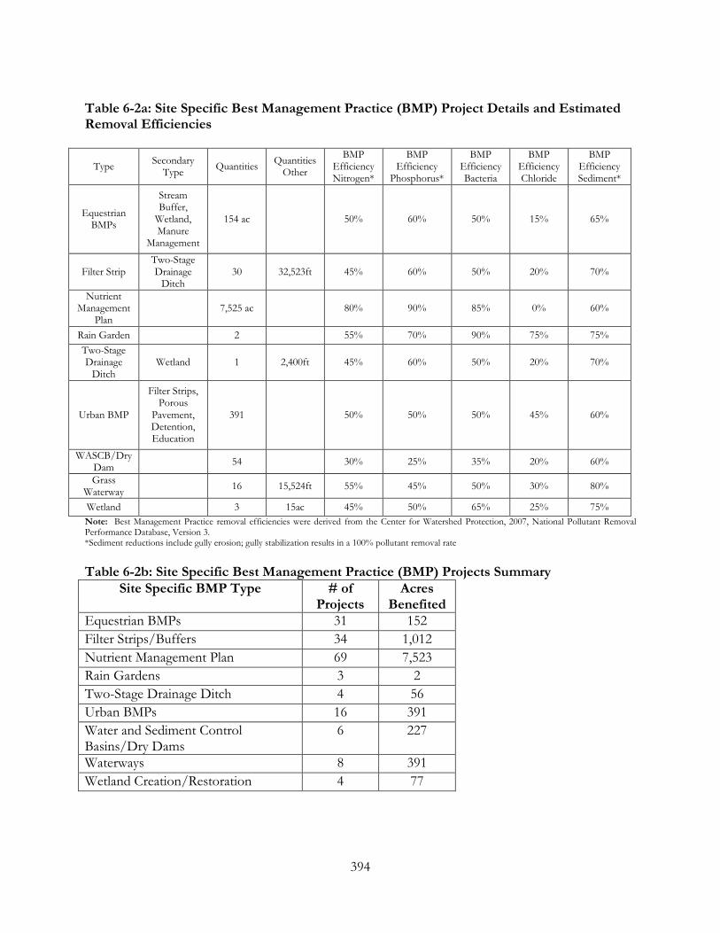
394
Table 6-2a: Site Specific Best Management Practice (BMP) Project Details and Estimated Removal Efficiencies
Type Secondary Type Quantities Quantities
Other
BMP Efficiency Nitrogen*
BMP Efficiency
Phosphorus*
BMP Efficiency Bacteria
BMP Efficiency Chloride
BMP Efficiency Sediment*
Equestrian BMPs
Stream Buffer,
Wetland, Manure
Management
154 ac 50% 60% 50% 15% 65%
Filter Strip Two-Stage Drainage
Ditch 30 32,523ft 45% 60% 50% 20% 70%
Nutrient Management
Plan 7,525 ac 80% 90% 85% 0% 60%
Rain Garden 2 55% 70% 90% 75% 75% Two-Stage Drainage
Ditch Wetland 1 2,400ft 45% 60% 50% 20% 70%
Urban BMP
Filter Strips, Porous
Pavement, Detention, Education
391 50% 50% 50% 45% 60%
WASCB/Dry Dam 54 30% 25% 35% 20% 60%
Grass Waterway 16 15,524ft 55% 45% 50% 30% 80%
Wetland 3 15ac 45% 50% 65% 25% 75% Note: Best Management Practice removal efficiencies were derived from the Center for Watershed Protection, 2007, National Pollutant Removal Performance Database, Version 3. *Sediment reductions include gully erosion; gully stabilization results in a 100% pollutant removal rate Table 6-2b: Site Specific Best Management Practice (BMP) Projects Summary
Site Specific BMP Type # of Projects
Acres Benefited
Equestrian BMPs 31 152 Filter Strips/Buffers 34 1,012 Nutrient Management Plan 69 7,523 Rain Gardens 3 2 Two-Stage Drainage Ditch 4 56 Urban BMPs 16 391 Water and Sediment Control Basins/Dry Dams
6 227
Waterways 8 391 Wetland Creation/Restoration 4 77

395
Table 6-3: Expected Non-Point Source Pollutant Load Reductions from Site Specific Best Management Practice (BMP) Projects The following table is a summary of expected load reductions; detailed load reductions, cost estimates and priorities by best management practice can be found in Appendix O, Expanded Action Plan Best Management
Practice (BMP) Type
Sediment Load
Reduction (tons/yr)
Nitrogen Load
Reduction (lbs/yr)
Phosphorus Load
Reduction (lbs/yr)
Chloride Load
Reductions (lbs/yr)
Bacteria Load Reduction
(billions-cfu)
Equestrian BMPs 9.66 299.95 53.37 38.79 133.62 Filter Strip 604.96 5,349.44 17,023.29 18,776.16 1,530.03 Nutrient
Management Plan 2,895.34 73,518.23 58,899.18 0.00 19,217.35
Rain Garden 0.07 6.89 1.24 1,953.41 11.76 Two-Stage Ditch 11.90 250.73 167.68 1,966.18 73.81
Urban BMP 12.72 1,196.49 173.23 264,511.04 1,078.72 Water and Sediment Control Basins/Dry
Dams
1,756.01 6,515.72 2,034.90 8,775.30 207.29
Grass Waterway 3,451.58 13,697.84 10,846.91 4,627.84 622.68 Wetland 14.80 339.80 156.88 18,537.22 123.13
Grand Total 8,757.06 101,175.09 89,356.67 319,185.93 22,998.40

396
Figure 6-1: Gully Erosion in the Watershed

397
Table 6-4: Expected Non-Point Source Load Reductions from Site Specific Best Management Practice (BMP) Projects by Catchment
Catchment Area Load Reduction
Sediment Load Reduction
(lbs/yr)
Nitrogen Load
Reduction (lbs/yr)
Phosphorus Load
Reduction (lbs/yr)
Chloride Load
Reductions (lbs/yr)
Bacteria Load Reduction billions-cfu
1 6.03 320.62 15.97 2.29 3,331.91 16.12 2 64.29 71,252.62 710.37 754.44 0.01 163.62 3 144.94 163,815.95 1,506.60 1,597.55 16.33 350.94 4 18.22 8,148.32 177.90 97.78 141.04 49.76 5 54.29 3,268.52 157.23 22.83 34,517.21 149.36 6 85.99 91,473.96 936.93 973.10 0.00 217.21 7 30.43 13,451.95 283.70 155.29 1,628.73 82.15 8 296.26 367,594.90 2,902.10 2,713.34 0.00 784.88 9 262.69 292,450.46 2,360.86 1,861.99 0.00 681.11 10 136.14 156,280.45 1,021.48 674.58 0.00 343.48 11 8.80 541.97 26.83 3.87 5,655.39 26.95 12 180.79 147,623.82 1,987.82 1,557.05 1,061.85 501.07 13 23.98 3,407.15 96.62 33.52 5,485.88 53.57 14 237.71 258,632.22 2,622.03 2,733.23 5,663.80 616.30 15 155.34 178,627.47 1,857.86 1,903.53 0.00 432.90 16 150.40 96,881.73 1,164.35 738.92 519.04 415.85 17 275.18 199,296.20 2,384.79 1,612.72 738.25 789.77 18 213.16 80,553.82 1,514.22 928.73 7.76 409.98 19 119.35 144,912.62 1,420.40 1,527.74 0.00 326.52 20 104.60 90,418.23 956.11 943.97 22,510.53 280.05 21 209.22 194,066.97 2,213.10 2,098.28 0.12 527.72 22 575.35 831,450.09 6,532.71 6,313.06 1,178.33 1,451.42 23 320.62 298,820.46 3,391.33 3,216.23 760.24 810.17 24 112.26 108,919.48 1,166.08 1,118.58 0.93 287.02 25 438.59 280,922.92 3,453.83 2,373.93 48.20 1,156.48 26 158.34 79,136.48 1,033.92 808.97 72,591.14 430.38 27 338.54 238,505.71 2,734.76 2,458.89 321.21 701.71 28 248.46 249,525.58 2,100.98 1,852.10 1,379.25 549.89 29 489.17 207,290.62 4,173.73 2,499.93 9.55 1,107.52 30 138.42 64,762.14 1,187.77 721.86 14.96 311.78 31 120.34 85,229.40 1,103.25 806.72 327.14 288.93 32 127.58 134,333.94 1,258.84 1,388.50 4.71 292.32 33 538.71 3,526,392.46 10,252.60 3,997.71 2,356.92 1,197.88 34 65.27 28,177.31 597.74 347.91 0.65 158.40 35 250.16 159,536.97 1,831.36 1,487.43 3,020.02 485.62 36 77.97 68,357.78 802.59 738.49 0.85 194.23 37 18.98 8,205.36 164.21 99.90 0.00 43.17 38 35.19 16,436.80 266.42 177.65 2.26 72.32

398
39 64.46 22,457.76 482.55 261.56 4.58 133.79 40 95.46 24,789.65 561.14 295.61 1.15 160.05 41 132.89 67,018.82 1,164.08 787.66 0.09 300.40 42 1.70 97.80 5.04 0.72 1,000.98 5.38
43 242.53 90,281.20 1,355.89 903.03 469.16 363.40
44 65.45 28,957.16 552.68 347.35 0.00 146.25
45 99.54 49,492.37 854.58 558.29 3.60 223.90 46 1.02 816.18 11.49 9.20 0.00 2.86 47 116.01 54,331.57 1,034.44 647.07 0.43 272.30 48 49.60 23,458.07 439.71 276.74 1.06 115.35 49 159.25 100,370.53 1,420.92 1,056.84 20.59 360.52 50 57.86 26,952.25 418.29 263.29 1,470.86 111.21 51 54.48 25,923.05 470.30 285.87 2,304.39 124.67 52 192.86 126,099.73 1,393.15 854.61 2,760.72 525.92 53 35.72 16,101.53 307.13 193.78 0.15 80.21 54 150.54 64,443.64 1,540.04 824.99 131.82 412.23 55 164.10 281,384.48 1,320.70 701.37 3,176.38 269.63 56 30.12 15,796.57 285.00 187.21 568.18 78.86 57 54.34 22,804.66 469.98 278.46 160.11 124.21 58 218.36 116,749.60 1,789.19 1,188.89 181.19 457.35 59 35.17 14,568.06 319.49 182.71 0.00 84.57 60 100.56 1,280,272.73 2,220.21 5,304.23 2,426.65 99.05 61 96.90 37,252.58 541.34 325.60 9,532.17 174.05 62 16.90 11,188.86 173.45 128.74 0.00 43.80 63 93.01 2,347,809.26 4,103.29 5,899.66 2,979.97 120.98 64 183.80 2,250,067.32 4,534.07 7,977.49 3,459.27 321.76 65 35.99 8,600.48 189.92 76.00 20,717.09 71.22 66 14.59 8,605.36 151.78 101.08 0.22 39.40 67 91.60 1,250,146.58 2,366.74 4,948.04 1,395.98 142.39 68 91.06 136,204.38 944.91 494.38 1,193.88 199.12 69 67.50 4,299.81 209.49 30.29 45,151.21 203.31 70 2.80 881.84 22.51 10.60 0.23 6.38 71 24.86 1,528.67 74.12 10.55 15,941.19 67.57 72 11.00 1,175.01 39.43 10.35 6,555.97 30.61 73 27.95 13,738.04 282.71 169.57 0.00 74.20 74 60.56 36,863.37 588.99 397.59 1.42 151.57 75 56.21 3,575.81 166.92 24.63 34,281.03 141.39 76 0.00 0.00 0.00 0.00 0.00 0.00
The information presented above describes the expected or modeled pollutant load reductions if all recommended site-specific best management practices are implemented. Considering current water quality impairments for nutrients and sediment, the greatest water quality benefits would occur if implementation was prioritized to catchments 33, 60, 63, and 64. Focusing on these four catchments

399
could result in reductions of up to 4,500 tons of sediment annually, over 20,000 pounds of Nitrogen and 25,000 pounds of Phosphorus annually. Reductions to address bacteria loading should be prioritized to catchment 22 (14,000 billions-cfu annually). Project implementation to address Chloride should be targeted to catchments 26 and 69 where load reductions could exceed 110,000 pounds of Chloride annually.
COMPARISON OF LOAD REDUCTIONS VS. TOTAL POLLUTANT LOADING Installing recommended site specific best management practices will have numerous positive benefits on water quality. As previously noted in Table 6-2, expected non-point source pollutant load reductions from known project locations will result in significant load reductions. Comparing these results to the total modeled watershed pollution loading, a relatively high percentage reduction in pollution can be expected as shown in Table 6-5. Table 6-5: Load Reduction Targets for Site Specific Best Management Practices (BMP) Projects
Pollutant Expected Annual Load Reductions
Total Modeled Pollution Loading
Percentage Reduction of Overall Loads
Sediment (tons/yr) 8,757 15,539 56% Nitrogen (lbs/yr) 101,175 201,784 50% Phosphorus (lbs/yr) 89,357 104,543 85% Chloride (lbs/yr) 319,186 6,982,860 5% Bacteria (billion coliform forming units - cfu)
22,998 57,409 40%
Sediment and nutrient reductions, especially in phosphorus are at or greater than 50% of the total loading. The 85% reduction in phosphorus loads is realized primarily through the implementation of nutrient management on all eligible agricultural ground; nutrient management can reduce up to 90% of phosphorus and 80% of nitrogen loading to streams. Additionally, structural practices such as water and sediment control basins or grassed waterways will offer nutrient savings through reductions in sediment. Low chloride and bacteria reductions represent a limitation of the modeling and watershed assessment effort to accurately pinpoint site-specific urban best management practices projects; the majority of the chloride and bacteria load is originating from urban areas and roadways. Further, best management practices typically have poor removal efficiencies for chloride; so the best practice to reduce chloride loading is to reduce the application rates which can best be achieved through policy and education and outreach efforts.

400
6.2 FINANCIAL AND TECHNICAL RESOURCE NEEDS Implementation of this plan will require the development of partnerships with local, state, and federal organizations for implementation, technical assistance, and funding. These efforts require the investment of a significant amount of time and resources and, especially, funding. Tables 6.6 and 6.7 summarize the estimated amount of funding required for initial and ongoing implementation of the practices recommended in the action plan. Initial costs reflect the cost of installing and/or establishing the BMP; annual costs indicate the cost for ongoing management and maintenance. There are numerous sources of funds available to help support projects or provide cost-share to match other sources of funds. A list of numerous local, regional and state funding sources, and the types of projects funded under the various programs, is provided in Table 6-9. Most of the programs require a local match of funds or in-kind services. Although these funding sources can provide a good source of revenue, significant local investment of time and financial resources will be required to implement this plan. If fully implemented, however, the quality of the watershed lakes, stream reaches, and wetlands could be significantly improved. Cost estimates are generated from a combination of technical experience, previous watershed plans, and the US Department of Agriculture’s average practice cost list. Cost estimates are generalized for watershed-scale planning purposes and these estimates should not be used to estimate costs for individual projects, as costs will range significantly. The estimates also do not account for pollutant load reductions from programmatic (non-site-specific) action items or Education and Outreach and Policy/Regulation best management practices since direct impacts are not easily determined. Therefore these costs could vary significantly if extensive education and policy changes are implemented. Tables 6-6 and 6-7 provide cost estimates by site-specific best management practice and by catchment; detailed load reductions, cost estimates and priorities by site-specific best management practice and catchment can be found in Appendix O, Expanded Action Plan. Table 6-6: Site Specific Best Management Practice BMP Project Implementation Costs
Type Secondary Type Quantities Quantities Other
Unit Cost Total Cost
Equestrian BMPs
Stream Buffer, Wetland Buffer,
Manure Management
154 ac N/A $450 $69,300
Filter Strip Two-Stage Drainage Ditch 30 32,523ft $1.50/sq
ft $2,439,255
Nutrient Management
Plan N/A 7,525 ac N/A $25 $118,125
Rain Garden N/A 2 $2000 $4,000 Two-Stage
Drainage Ditch Wetland 1 2,400ft $150.00 $360,000

401
Urban BMP
Filter Strips, Porous Pavement,
Detention, Education
391ac N/A $3000 $1,173,000
Water and Sediment Control
Basins/Dry Dams
N/A 54 $3000 $162,000
Grass Waterway N/A 16 15,524ft $2.50 $38,810
Wetland N/A 3 15ac $4,000 $60,000 Grand Total N/A
$4,424,490

402
Table 6-7: General Critical Area (CA) Implementation Costs ID Critical Area
Type Critical
Catchments Action
Recommendation Total
Critical Area
Unit Initial Target
%
Unit Cost
Total Cost
CA 1
Highly Erodible Soils
51, 36, 57 Enroll in CRP, CREP; apply
agricultural and pasture BMPs
124 acres 50% $3,000/2ac of
drainage
$186,000
CA 2
Wells and Septic Density
8, 75, 19 Implement in-stream monitoring
program to evaluate potential water
quality problems
180 areas NA $100,000 $100,000
CA 3
Hydric Soils and Wetland Restoration
31, 16, 25 Restore hydrology and wetlands to
hydric soil areas in the watershed
526 acres 15% $3,000/ac $1,578,000
CA 4
Treatment Wetland
Opportunities for Runoff and
Tile Flow
31, 16, 43 Perform feasibility study to develop
possible treatment wetland
implementation
582 acres 5% $3,000/ac $1,746,000
CA 5
Equestrian Areas
43, 18, 29 Implement equestrian BMP
projects
60 acres 80% $450/ac $27,000
CA 6
Pollution Loading Hotspots
64, 12, 6 Apply all types of BMP projects
867 acres 25% $3,000/ 2ac of
drainage
$1,300,500
CA 7
Impervious Surfaces
1, 71, 47 Implement urban stormwater BMPs
158 acres 20% $3,000/ac $474,000
CA 8
Nutrient and Pesticide
Management
31, 28, 16 Implement nutrient management plans
487 acres 95% $25/ac $12,175
CA 9
High Runoff Zones
31, 33, 16 Implement agricultural BMPs;
naturalized detention and
wetlands to reduce runoff and scour
830 acres 25% $3,000/ac $2,490,000
CA 10
Urban Area Infiltration
Zones
21, 20, 32 Implement regulatory and
policy procedures; designate green
infrastructure and open space areas
321 acres 50% $3,000/ac $963,000
CA 11
Detention Basin Retrofits
47, 46, 66 Retrofit detention basins; naturalize
bottom and buffer
36 basins 20% $3,000 $108,000

403
CA 12
Stream and Lake Bank
Erosion
30, 4, 71 Stabilize stream and lake bank erosion
108 acres 20% $38/ft $10,260,000
CA 13
Aquatic Stream Habitat
Improvements
8, 55, 35 Implement in-stream habitat improvement
projects
25 acres 20% $3,000/ac $75,000
CA 14
Lake and Stream Buffers
26, 69, 5 Establish lake and stream buffers
35,456 feet 80% $1.50/sq ft
$2,659,200
CA 15
Areas of Greatest Land Use Change
3, 33, 68 Implement regulatory and
policy procedures; designate green
infrastructure and open space lands
1,081 acres 50% $3,000/ac $3,243,000
Total $25,221,875
As previously noted in Table 6.3, expected non-point source pollutant load reductions from identified project locations will result in the following: 8,757 tons/year of sediment, 101,175 pounds/year of nitrogen, 89,357 pounds/year of phosphorus, 319,186 pounds/year of chloride, and 22,998 billion cfu of bacteria. These values represent the potential if each and every project is implemented; in reality, only a percentage of these reductions will be realized due to financial and logistical limitations related to actual implementation. Table 6-8: Site Specific Implementation Costs by Unit Load Reduction
Sediment ($/tons)
Nitrogen ($/lbs)
Phosphorus ($/lbs)
Chloride ($/lbs)
Bacteria ($/billion
cfu) Cost/Unit
load reduction
192 44 50 13 192
FLOOD MITIGATION PROJECTS IMPLEMENTATION COST ESTIMATES As detailed in Chapter 5, Section 5.3, eight flood mitigation measures have been identified for flood problem areas in Illinois. For conceptual planning purposes, the three high priority areas were evaluated to determine the upper range of anticipated costs assuming the worst-case scenario that the preferred mitigation measure was the buyout/acquisition approach. The upper end of the conceptual estimate cost for this measure is estimated to be in the neighborhood of $1,000,000 depending on various factors including purchase costs, demolition costs, restoration costs, and legal costs.

404
Given the size of the tributary drainage areas and the number of structures impacted, a more reasonable anticipated implementation cost range is $50,000 to $350,000 per flood problem area. It is reasonable that the flood problem areas identified as having local drainage problems (10-02 and 2-03) will be at the lower end of the cost range since these types of problems are commonly resolved cost-effectively by constructing new and/or improving existing overland flow routes or other simple diversion techniques. For the depressional storage flooding areas, the implementation of storage based measures are typically more expensive since the earthwork is more involved and can require some property acquisition combined with significant material haul off and utility relocation.
6.3 ACTION PLAN IMPLEMENTATION The North Mill Creek/Dutch Gap watershed includes many partners (see Table 5-1) that will have to coordinate efforts to implement many of the projects recommended in the action plan. Since no single municipality, district, resident, business, landowner, or organization has the financial or technical resources to accomplish the plan goals and objectives alone, working together will be essential to achieve meaningful results. Combining and coordinating resources, funding, effort and leadership will be the most efficient and effective means of creating real improvement of watershed resources. One important step in plan implementation will be the establishment of a multiple stakeholder watershed committee or organization to step forward as a project leader to help organize and coordinate plan implementation. Responsibilities of this organization would also include administration, coordination of stakeholders to support individual watershed projects and working with municipalities and other stakeholders to implement recommended policies and programs. Throughout the watershed planning process, the Watershed Planning Committee has provided valuable input to the plan regarding watershed issues, resources, and priorities. The Planning Committee can continue to hold regular meetings, take the lead in implementing plan recommendations, organize watershed field trips, host educational workshops and forums, and bring watershed stakeholders and multiple units of government together to discuss watershed issues and opportunities. The Planning Committee may consider whether a formal staff position is needed to support the efforts of the Committee and to solicit volunteers or develop funding for the position. The Planning Committee or an established watershed organization is encouraged to work to generate additional stakeholder interest and involvement with watershed plan implementation and stewardship activities. As projects are initiated, and as the positive environmental, aesthetic, and community benefits come to light, projects and participation are expected to increase over time. There are tangible benefits to stakeholder participation in watershed activities, from positive media attention to improved quality of life for community residents. Increased involvement also can yield significant local, state, and federal funding opportunities to help share the cost of project implementation. The watershed action plan contains a number of programmatic and site specific recommendations and an identification of the party responsible for leading the implementation of those recommendations. Some actions can be added to existing capital improvement and maintenance plans, budgets, and schedules or added to existing work programs. This is a fairly quick

405
and easy approach to implementing recommendations within the purview of specific jurisdictions. In other cases, however, the action recommendation will require the involvement of multiple stakeholders for implementation, such as residents, a municipality, and a county, state, or federal agency to provide financial and technical support. Some actions require cross jurisdictional coordination; the establishment of a green infrastructure corridor along the stream channel, or the preservation and restoration often require inter-jurisdictional cooperation and may require a longer time frame for implementation. Other actions will require the cooperation of individual or groups of landowners, whether they are residents, homeowners associations, businesses, or institutions. These actions will often need a leader, or a single champion for the project, that can organize resources and keep the project moving forward. This champion may be the watershed organization, or a single entity such as a landowner or the municipality. Actions that involve preservation of areas of land or water may also require the involvement of a local land trust, or other conservation organization. These groups can often provide technical or financial assistance for preservation efforts. In some cases, actions recommend the adoption of new policies, plans, or standards that modify the form, intensity, or type of development or redevelopment in the watershed in a way that better protects watershed resources. These actions will require some effort on the part of municipalities to understand how plans and policies can be modified and to discuss and adopt new, or modify existing, policies, plans and standards. The first step in this effort is to understand current practices impact watershed resources and how they can be improved, followed by discussions and debate about possible modifications, and finally adopting policies and standards that have the desired outcome(s). A dedicated and determined effort will benefit all watershed stakeholders.
6.4 WATERSHED PLAN IMPLEMENTATION
Parties who are key potential partners whose support will lead to the realization of identified goals for the North Mill Creek-Dutch Gap Canal watershed are identified below as “Implementation Partners”. The organizations below are listed as implementation partners because they are expected to fulfill one or more of the following functions: oversee or implement watershed protection, restoration and remediation strategies, acquire funding for watershed plan implementation, organize or participate in data collection, provide regulatory or technical guidance, issue permits, monitor the success of the watershed plan, acquire land for green infrastructure restoration or protection purposes, and develop education strategies.
Because implementation of the watershed plan will largely rest with local communities, it is critical that they be involved from the beginning. They usually have the most to gain by participating and the most up-to-date information on the structure, needs, and available resources of the community. In addition, some of the most powerful tools for watershed implementation, such as planning, controlling development standards, and zoning reside at the local level.
Several local and regional agencies/organizations along with a number of state and federal agencies are listed as “Implementation Supporters” below. While the state will be the lead party responsible for implementing action recommendations for the state-owned Redwing Slough, regional, state and

406
federal agencies are generally not identified as lead parties responsible for watershed plan implementation, but as resources that can assist with implementation or provide technical or funding support.
IMPLEMENTATION PARTNERS Corporate and Business Landowners (CBL) Although commercial and industrial land uses make up a relatively small percentage of the watershed, these land uses frequently generate significant nonpoint source pollutant loads. A considerable area of new commercial and industrial development is planned for the Route 173 corridor in Lake County.
The active participation of CBLs in the planning and watershed implementation process can lead to significant positive impacts on the quality of the North Mill Creek-Dutch Gap Canal watershed. Businesses can become involved by retrofitting existing facilities, managing their grounds, infiltrating or harvesting rooftop runoff, designing and retrofitting parking lots to reduce runoff volume and pollutant loadings, and by sponsoring watershed events. With an upfront commitment and support from the CBL community, new development can also be designed to minimize runoff and pollutant loadings.
Developers & Homebuilders (DH) The practices of developers can significantly impact a watershed. Developers should be encouraged or required to employ sustainable development techniques such as low impact and conservation development that focus on maintaining the natural hydrology of the development site. In addition to designing new developments with sustainable best management practices (BMPs), homebuilders should use BMPs during the construction process, especially those related to soil erosion and sedimentation control. Failure to use BMPs, or improper use, can lead to soil erosion and other pollutant discharges.
Drainage Districts (DD) The Grubb School Drainage District is responsible for addressing drainage problems within its district boundary, which includes a large percent of Hastings Creek. Thus, issues related to channel and stormwater management infrastructure along Hastings Creek should include the GSDD as an implementation partner. GSDD will also be a key partner in a collaboration that establishes stream maintenance standards for the watershed.
Homeowner and Lake Management Associations A number of subdivisions and lake areas in the watershed have established property owner associations that assess fees and have the responsibility of managing the common ownership/use areas including lakes, beaches, stormwater management facilities, wetlands, and neighborhood park and open spaces. Many associations struggle with collecting fees and employing best management practices of the natural (wetlands, creeks and lakes) and constructed elements (detention basins) of

407
the drainage system. These associations will be key implementers of the watershed management plan.
Illinois Department of Natural Resources (IDNR) The office of Conservation within the IDNR will be a key local partner as the owner and manager of Redwing Slough a large wetland conservation area located in Antioch. The North Mill Creek watershed in Illinois is also designated as a Conservation Opportunity Area in the Illinois Wildlife Action Plan, therefore IDNR has a strong interest in working with local stakeholders to conserve wildlife and enhance wildlife habitat.
Several offices within the IDNR provide services that will be key to the implementation of the North Mill Creek-Dutch Gap Canal watershed plan for issues related to water resource management, habitat protection and management, wildlife management, invasive species control, wetland management, and hunting and fishing permitting.
• The Office of Water Resources (OWR) is the state’s lead organization for the regulation of floodplain development as well as for the implementation and funding of structural flood control and mitigation.
• The Office of Realty and Environmental Planning (OREP) is responsible for natural resource and outdoor recreation planning.
• The Office of Resource Conservation (ORC) reviews Clean Water Act Section 404 wetland permits for impacts on fish and wildlife resources; it manages threatened and endangered species issues; it also protects fisheries and other aquatic resources through regulation, ecological management and public education.
• The Office of Capital Development (OCD) administers state and federal grants for open space programs.
Illinois & Wisconsin Department of Transportation (IDOT & WisDOT) IDOT and WisDOT are responsible for the planning, construction, and maintenance of portions of the major roadways in the North Mill Creek-Dutch Gap Canal watershed. The Route 45 Milburn Bypass and Route 173 expansion are major road improvements currently being planned by IDOT and the Lake County Division of Transportation. Roadway improvements are also planned for Route 45 in Wisconsin. Incorporation of best management practices and sustainable design into transportation projects and using best practices to reduce road salt usage, can provide significant reduction in the volume of stormwater runoff and nonpoint source pollution generated by major roadways in the watershed.
Kenosha Racine Land Trust (K/RLT) Kenosha/Racine Land Trust, Inc. (K/RLT) is a non-profit organization that aims to protect open space and natural areas in Kenosha and Racine counties for the benefit of current and future generations through identifying and prioritizing the most critical resources left in Southeastern Wisconsin. K/RLT owns one property but mainly holds private easements and monitors

408
conservation subdivisions. K/LRT holds easements on more than 519 acres on seven parcels and protects more than 500 acres as conservation areas associated with subdivisions. http://krlt.org/index.html
Lake and Kenosha Counties North Mill Creek-Dutch Gap Canal flows through Lake and Kenosha Counties. The Village of Bristol recently incorporated almost all of the land area in the Kenosha County portion of the watershed. In Kenosha County, a majority of developmental projects are reviewed by several divisions within the Planning and Development Department. Other projects are reviewed by the Public Works Department. Unlike Lake County, the Kenosha Planning and Development Department also has a Conservation division that provides stormwater management, coordinated state and federal incentive and grant programs, a farmland preservation program and shoreline permitting.
Fifty-seven percent of the Lake County portion of the watershed is unincorporated indicating the county has a role in land use planning, development, natural resource protection, and drainage system management in a large part of the watershed. Working with the County departments of planning, building and development (PB&D), public works and health departments (LCHD), and division of transportation (LCDOT), can help ensure that North Mill Creek-Dutch Gap Canal enjoys responsible, sustainable land use planning, road and sewer maintenance, and public health policies.
Lake County Forest Preserve District (FPD) The Lake County Forest Preserve District is the largest single landowner in the watershed. FPD owns and manages over 3,000 acres of green infrastructure open space and agricultural lands within the North Mill Creek-Dutch Gap Canal watershed. The most recent land acquisitions in the watershed have centered on the north and south side of Edwards Road just south of the state line. Much of the FPD land is farmland. The District is beginning the process of developing long-term restoration and use plans for these preserves, which are scheduled to be completed in 2012-2013.
Lake County Stormwater Management Commission (SMC) SMC's mission is to coordinate the stormwater activities of over 90 jurisdictions throughout Lake County. SMC provides technical assistance, local knowledge and problem-solving skills to coordinate flood damage reduction, flood hazard mitigation, watershed planning, water quality enhancements and natural resource protection projects and programs. SMC organized and facilitated the North Mill Creek-Dutch Gap watershed planning effort.
Lake County Health Department (LCHD) The LCHD Lakes Management Unit provides technical expertise essential to the management and protection of Lake County surface waters. The goal of the LMU is to monitor the quality of the county’s surface water in order to maintain or improve water quality and alleviate nuisance

409
conditions, promote healthy and safe lake conditions, and protect and improve ecological diversity. The LCHD is also responsible for septic system management programs and well testing and monitoring.
Liberty Prairie Conservancy (LPC) The Liberty Prairie Conservancy is a non-profit conservation organization that provides services throughout Lake County to help private and public landowners preserve and steward land working on all types of natural areas as well as farmland and even landscaped properties. The Conservancy launched the Conservation@Home Program in 2011. A popular sustainable landscaping program, Conservation@Home will offer homeowners property consultations, landowner resources, and a property certification program to support and recognize eco-friendly lawn and garden practices. Additional information about the Conservancy can be accessed at the Conservancy’s website (www.libertyprairie.org).
Municipalities (all departments) (M) Municipalities (elected officials and staff) have the principal responsibility for land use and development planning, policies, and standards. There are also opportunities to make others aware of the watershed management planning process through local government newsletters and presentations at board meetings, which are often televised on local cable television networks. Municipalities are therefore crucial to watershed protection efforts. By partnering with municipalities and encouraging the adoption of sustainable zoning and development practices, a watershed protection group can check the increase of water quality impairments. Municipalities are also a key part of any watershed protection strategy because they are responsible for the enforcement of local land use and development ordinances. Many are also responsible for enforcing the Lake County Watershed Development Ordinance.
Natural Resources Conservation Service (NRCS) NRCS provides technical expertise and education on conservation, development, management, and wise use of natural resources to landowners and land managers. Areas of expertise include streambank stabilization and soil erosion/ sediment control, wetland and habitat restoration, agricultural conservation, water quality protection, conservation planning, and natural resource maps and reports. NRCS administers several cost-share programs targeted to water quality, wetland restoration, and other watershed priorities.
As part of its watershed protection effort, NRCS administers the USDA Watershed Program (under Public Law 83-566). The purpose of the program is to assist federal, state, and local agencies; local government sponsors; tribal governments; and other program participants in protecting watersheds from damage caused by erosion, floodwater, and sediment; restoring damaged watersheds; conserving and developing water and land resources; and solving natural resource and related economic problems on a watershed basis.
Parks and Recreation Districts (PD)

410
Park and recreation districts often control a large amount of open space in a watershed and maintain recreational facilities and parks. Parks also contain many recreational opportunities and trails, several bordering North Mill Creek-Dutch Gap Canal. Partnerships with local park districts can help ensure the preservation of open space while also facilitating recreational and other community opportunities that can help increase support for watershed protection efforts.
Root-Pike Watershed Initiative Network (WIN) While the Root-Pike is a Lake Michigan watershed, the Root-Pike WIN provides services for Dutch Gap watershed communities. WIN is a grassroots collaborative engaged in several watershed-based programs including a rain garden initiative and coordinates the Keep Our Waters Clean program through the Southeast Wisconsin Clean Water Network partnering with seventeen municipalities (including Bristol in the Dutch Gap watershed) to reduce polluted stormwater runoff. http://www.rootpikewin.org/index.php/keep-our-waters-clean.html
Plant Nurseries Several commercial nursery operations are located in the watershed. As a subset of the agricultural stakeholders, the nursery operators manage relatively large tracts of land. Their land management and operation decisions have the potential to affect drainage and sediment and nutrient delivery to water resources. Due to their size, nursery operations may provide opportunities for the implementation of best management practices to improve water quality and habitat.
Prairie Research Institute Prairie Research Institute is the home of the Illinois scientific surveys: Illinois Natural History Survey, Illinois State Archaeological Survey, Illinois State Geological Survey, Illinois State Water Survey and Illinois Sustainable Technology Center. (It was formerly the Institute of Natural Resource Sustainability.) URL: http://prairie.illinois.edu
Private Farmers Private farmers include anyone managing a crop or non-equestrian livestock operation within the watershed. This includes both tenant operators and landowners. Because cropland accounts for more than 30% of the watershed, farmers are an important implementation partner. Farmers can work independently or with other partners to preserve farmland in the watershed and implement best management practices for erosion control, soil conservation, and nutrient reduction to reduce nonpoint source pollution.
Private Equestrian Facilities (EQ)
There are a number of privately-owned and operated equestrian facilities in the watershed. Many of these facilities include paddock and pasture areas and large stables, barns, and other operational

411
buildings. Like any land use, equestrian facility operation can impact water quality and runoff. However, because these facilities encompass large areas of land managed as a unit, they also offer excellent opportunities for implementation of best management practices and restoration. Additionally, the large buildings offer opportunities for practices such as rainwater harvesting and reuse.
Private Residential Landowners (PRL) The activities of residential landowners, often unknowingly, can have a significant impact of the quality of a watershed. Practices such as excess lawn fertilization, connection of downspouts to the sewer system, or destruction of riparian buffers can be significant sources of nonpoint pollution. Watershed protection efforts should educate residents on the consequences of their actions and present alternatives. More positively, political pressure from local residents on municipal or county officials can lead to increased emphasis on watershed protection. And many local residents play important roles in watershed planning and protection efforts.
RiverWatch The RiverWatch program relies on a volunteer base to monitor, collect and record stream, lake, wetland, and coastal data for the state database. It is also a valuable educational resource that can be used to educate others about watershed issues and concerns. RiverWatch holds volunteer training for stream monitoring on a annual basis. http://www.ngrrec.org/index.php/riverwatch
Schools Schools are venues for education and outreach related to watershed plan implementation. Schools reach a wide audience of both children and adults (parents) and provide opportunities for education through both curricula related to watershed issues, innovative projects, and even small demonstration sites that can serve as laboratories or provide “real-life” learning experiences.
Townships (T) While unincorporated townships generally play a secondary role in watershed protection, they often have responsibility for road upkeep and occasionally sponsor drainage system improvement projects. The use of best management practices by townships, especially for road maintenance, and winter snow and ice removal can help improve water quality within the watershed.
Upper Des Plaines River Ecosystem Partnership (UDPREP) A public–private cooperative of watershed stakeholders formed in 1996 to preserve, protect, and enhance the Upper Des Plaines River Watershed is a nonprofit organization that works to bring people together to share ideas and discover partnership opportunities. UDPREP covers 15 subwatersheds and the Des Plaines River mainstem from Salt Creek in Cook County, Illinois to the headwaters in Kenosha and Racine Counties in Wisconsin. The entire North Mill Creek/Dutch Gap Canal watershed is included in the area served by UDPREP.

412
U.S. Department of Agriculture (USDA) USDA’s Farm Services Agency (FSA) has several programs that support watershed protection and restoration efforts. Under the Conservation Reserve Program (CRP), farmers receive annual rental payments, cost sharing, and technical assistance to plant vegetation for land they put into reserve for 10 to 15 years. The Conservation Reserve Enhancement Program (CREP) targets state and federal funds to achieve shared environmental goals of national and state significance. The program uses financial incentives to encourage farmers and ranchers to voluntarily protect soil, water, and wildlife resources. The Grassland Reserve Program (GRP) uses 30-year easements and rental agreements to improve management of, restore, or conserve up to 2 million acres of private grasslands. The Conservation Security Program (CSP) is a voluntary program that provides financial and technical assistance to promote the conservation and improvement of soil, water, air, energy, plant and animal life, and other conservation purposes on tribal and private working lands.
Wisconsin DNR The Wisconsin Department of Natural Resources (WDNR) is a key partner for the stakeholders in Kenosha County. The WDNR oversees watershed planning, water quality programs, floodplain, stormwater and non-federal wetland permitting, shoreland management, and fishery and wildlife management in Wisconsin. The WNDR also controls allocation of Federal Clean Water Act (“Section 319”) funding for nonpoint source pollution reduction projects. Due to its role in both permitting and funding, WDNR is a key partner for Wisconsin stakeholders interested in implementing projects in Kenosha County.
IMPLEMENTATION SUPPORTERS Chicago Metropolitan Agency for Planning (CMAP) CMAP provides technical and planning assistance to local communities, community organizations and watershed protection groups. CMAP has developed model ordinances tailored to the Chicago region for stormwater management, water conservation, sediment control, streams and wetlands, and floodplains. CMAP also offers technical assistance and training opportunities to local governments and watershed groups and helps local governments apply for state and federal funding programs.
Chicago Wilderness Chicago Wilderness (CW) is a regional alliance composed of more than 250 organizations that work together to restore local nature and improve the quality of life for all who live in the CW region by protecting land and water. The members of Chicago Wilderness include local, state and federal agencies, large conservation organizations, cultural and education institutions, volunteer groups, municipalities, corporations, and faith-based groups. CW has developed a “Green Infrastructure Vision” that maps key locations for green infrastructure of regional importance, into which the green infrastructure network outlined in this plan fits.

413
College of Lake County The College of Lake County (CLC) is a comprehensive community college accredited by the Higher Learning Commission. Each semester CLC serves approximately 18,000 credit students, with more than 80 percent enrolled in transfer or career preparation programs. Federal Emergency Management Agency (FEMA) FEMA is the principal federal agency involved in flood mitigation and flood disaster response. Among its duties, FEMA is responsible for the National Flood Insurance program, helps municipalities develop and enforce floodplain ordinances, develops floodplain maps, and administers funding for flood mitigation plans and projects. FEMA is currently considering a grant application to purchase repetitively flooded homes in the Village of Lindenhurst.
Illinois Environmental Protection Agency (IEPA) Bureau of Water Under the federal Clean Water Act and state legislation, IEPA is responsible for ensuring that Illinois' rivers, streams, wetlands and lakes will support all uses for which they are designated including protection of aquatic life, recreation and drinking water supplies. IEPA was a key source of funding for the development of the watershed plan. In addition, several IEPA activities are important to this plan implementation:
• Monitoring: IEPA oversees data collection at various sites (rivers, streams, lakes, etc.) across the state, including Hastings Creek and North Mill Creek in the watershed. The Illinois Water Quality Report (305(b)) summarizes these monitoring efforts.
• Funding: IEPA administers several state and federal grant programs. Primary examples are the Section 319 funding under the Clean Water Act and the Illinois Green Infrastructure Grant (IGIG) program, which helps local governments, nonprofit entities, and numerous other state, federal, and local partners to reduce nonpoint source pollution and stormwater runoff through technical and financial support.
• Regulation: IEPA regulates point and nonpoint source pollution discharges into the state’s waters through regulatory and non-regulatory programs.
Illinois and Wisconsin Emergency Management Agency (IEMA/WEM) IEMA and WEM are the state agencies responsible for flood and disaster planning, emergency response, and hazard mitigation. The state emergency management agencies work with local governments on flood mitigation plans and provide operational support during floods. IEMA and WEM also administer FEMA-funded programs in the state, including flood mitigation grant programs. http://emergencymanagement.wi.gov/ http://www.state.il.us/iema/
Lake County Audubon The Mission of the Lake County Audubon Society is education, conservation and restoration of natural ecosystems, focusing on birds, and other wildlife and their habitats for the benefit of

414
humanity and the earth's biological diversity. The Audubon sponsors activities and educational programs holding monthly program meetings in Libertyville, IL. http://lakecountyaudubon.org/
Lake and Kenosha County Farm Bureau Kenosha County Farm Bureau located at 1701 Main Street in Union Grove WI 53182 phone: 262-878-2418.
The Lake County Farm Bureau is a not-for-profit membership organization. Originally, the Bureau was formed to help farmers improve their production practices. Today, the Lake County Farm Bureau® serves both rural and urban people who are interested in the production of a plentiful and safe food supply. Lake County Farm Bureau provides educational programs and technical assistance including their Ag In The Classroom program. http://www.lcfb.com/
Lake and Kenosha County Extension Service Lake County Extension (University of Illinois Champaign) offers educational programs in five broad areas: healthy society; food security and safety; environmental stewardship; sustainable and profitable food production and marketing systems; and enhancing youth, family and community well-being. http://web.extension.illinois.edu/lake/
The Kenosha County Extension (University of Wisconsin Madison) offers education services related to farming and livestock management, horticulture, nutrition and health, community planning and leadership, and youth development. http://kenosha.uwex.edu/
Town and Country Resource Conservation &Development (RC&D) Town and Country RC&D works to enhance and improve the quality of life in the 13-county area of Southeast Wisconsin by promoting healthy communities, a healthy environment and sustainable economic growth. The mission of the RC& D is to optimize opportunities for sustainable economic growth, healthy communities, and a healthy environment in the Town and Country RC&D area through the support and coordination of regional agencies, municipalities and organizations. Projects focus on economic development, food and farms, grazing, urban wood market, water and sustainability. http://www.tacrcd.com/index.html
Lake County Public Works (LCPW) The primary responsibility of Lake County Public Works is to provide water and sanitary sewer service to widely distributed portions of Lake County. Public Works owns and operates 297 miles of water main and 354 miles of sanitary sewer main. They provide direct water service to over 20,000 customers within 12 water distribution systems totaling approximately 25 square miles. Four water reclamation sewage treatment facilities serve 25,000 direct customers as well as 100,000 indirect customers through contract agreements with 14 different Lake County municipalities.
Lake/McHenry County Soil and Water Conservation District (SWCD)

415
The Lake/McHenry County SWCDs were formed in the 1940s and 50s (a) for the conservation of soil, soil resources, water and water resources in the State, (b) for the control and prevention of soil erosion, (c) for the prevention of air and water pollution, and (d) for the prevention of erosion, floodwater and sediment damages. Services provided by the SWCD include soil erosion sediment control inspections, natural resource inventories, soil tests, soil borings, technical assistance and workshops and training opportunities. The SWCD also administers several small grant programs. http://mchenryswcd.org/ http://lakeswcd.org/
Sierra Club
The national club is divided into State-based chapters, and each chapter is further divided into groups. The Illinois portion of the watershed falls into the “Woods and Wetlands” (Northeastern Illinois) group of the Illinois chapter while the Wisconsin portion falls into the “Southeast Gateway” (Southeastern Wisconsin) group of the Wisconsin chapter. Among their activities, the groups sponsor outings and other events related to the Club’s mission and goals.
Southeastern Wisconsin Regional Plan Commission (SEWRPC)
SEWRPC was established in 1960 as the official areawide planning agency for the southeastern region of Wisconsin. SEWRPC serves the seven counties of Kenosha, Milwaukee, Ozaukee, Racine, Walworth, Washington, and Waukesha. SEWRPC was created to provide objective information and professional planning initiatives to help solve problems and to focus regional attention on key issues of regional consequence. SEWRPC provides planning and technical assistance for public works systems, such as highways, transit, sewerage, water supply, and park and open space facilities. SEWRPC also provides regional expertise in addressing environmental issues, including flooding, air and water pollution, natural resource base deterioration, and changing land use. Previous work by SEWRPC directly related to this watershed plan includes a watershed plan and floodplain study for the Des Plaines River Watershed in Wisconsin and current and projected land use mapping.
U.S. Environmental Protection Agency (USEPA) The USEPA oversees the environmental protection efforts of the IEPA and is the ultimate source for Section 319 and other environmental improvement programs. Section 404 of the Clean Water Act, which regulates the dredging and filling of wetlands, is jointly administered by USEPA and the U.S. Army Corps of Engineers.
U.S. Fish and Wildlife Service (USFWS) The USFWS provides technical assistance to local watershed protection groups. It also administers several grant and cost-share programs that fund wetland and aquatic habitat restoration. The USFWS also administers the federal Endangered Species Act and supports a program called Endangered Species Program Partners, which features formal or informal partnerships for protecting endangered and threatened species and helping them to recover. These partnerships

416
include federal partners as well as states, tribes, local governments, nonprofit organizations, and individual landowners.
Solid Waste Management Agency (SWALCO) Many local governments have solid waste programs that address the disposal of solid waste and yard waste. They might also handle the recycling, illegal dumping, and household hazardous waste programs.
U.S. Army Corps of Engineers (USACE) USACE plays a major role in wetland protection and regulation through Section 404 of the Clean Water Act, which requires USACE to administer permit applications for alterations to wetlands and waters of the United States. The USACE Chicago district has also established a Wetlands Restoration Fund, which may be available to North Mill Creek-Dutch Gap Canal watershed communities. The USACE office that is responsible for wetland protection and regulation in Kenosha County is located in Waukesha, Wisconsin.
6.5 FUNDING RESOURCES AND OPPORTUNITIES Many Federal, State, local and private programs are available to fund BMP implementation. The following table outlines the most common and available sources of funding for best management practices/recommendations outlined in this plan and the estimated cost-share rates (if applicable). This list, while not comprehensive, includes the most common funding resources, although other funding programs may be available. Applicants should research available programs ahead of time; information on grant programs is most readily available on-line at the listed agencies website or via grant search sites. Most best management practices identified in this plan are eligible for some form of funding. With many grant programs, those applications that “leverage” multiple funding sources also have the greatest probability of being funded. Although many grant programs and funding agencies will fund various types of practices, they tend to direct funds to those practices that address their agency or program goals.

417
Table 6-9: Available Funding Resources
Best Management Practice
Funding Sources Notes/Cost Share Rates
Filter strips, riparian buffers,
dry dams or water and sediment control
basins, grass waterways,
terrace, diversion
Illinois Environmental Protection Agency – Section
319 program
Natural Resource Conservation Service (NRCS)
– Environmental Quality Incentive Program (EQIP)
Farm Service Agency (FSA) – Conservation Reserve
Program (CRP)
Soil and Water Conservation District (SWCD) –
Conservation Practice Program (CPP)
Illinois Department of
Natural Resources (IDNR)/SWCD –
Conservation Reserve and Enhancement Program
(CREP)
IDNR – State Wildlife Grant (SWG) program
NRCS – Wildlife Habitat Improvement Program
(WHIP)
CRP and CREP are land set-aside programs
that provide direct payments to landowners to take agricultural ground out of production and replace with native vegetation or some other type of conservation practice. Contracts for
these programs are 10 years for CRP and up to permanent easements for CREP
EQIP provides cost-share assistance on
agricultural ground for implementing practices that limit soil erosion and nutrient transport.
CPP is a state program that provides funding
for certain practices: dry dams, grass waterways, filter strips, well sealing, and nutrient
management.
CREP eligible acres must be in the 100 year floodplain and/or have cropped ground with erodibility index of 8 or greater adjacent to
riparian zones; must have cropping history of at least 4 years between 1995 and 2001.
SWG program requires 50% state match and
must address goals/species outlined in the State of Illinois Comprehensive Wildlife Plan. This
program is primarily for habitat restoration projects.
NRCS, FSA, and SWCD programs provide
60% cost-share, however, some special programs and practices can provide up to 90%. FSA, CREP, CRP and some NRCS programs
such as EQIP also provide annual rental payments for taking ground out of production.

418
Streambank stabilization and in-stream grade control
or other grade control
IEPA – 319 Program SWCD – Streambank
Stabilization and Restoration Program (SSRP)
NRCS – EQIP program
IEPA 319 offers 60% cost share SSRP offers 75% cost share to install practices to reduce streambank erosion such as stone-toe
protection, stream barbs, and riffles
EQIP offers 60% cost share.
Wetland restoration and other habitat
practices
IEPA – 319 program NRCS – EQIP program
NRCS – Wetland Reserve Program (WRP)
FSA – CRP program US F&W – Landowner
Incentive Program IDNR/SWCD – CREP
program IDNR – SWG program IDNR – Special Wildlife
Funds Grants
WRP provides funding to purchase easements on properties with wetland resources–
multiple/stringent eligibility requirements.
NRCS, FSA, and SWCD programs provide a minimum of 60% cost-share, however, some special programs and practices can provide up
to 90%. FSA, CREP and some NRCS programs also provide annual rental payments
for taking ground out of production.
Livestock management,
including fencing, stream crossings,
pasture management, watering systems etc.
IEPA – 319 program NRCS – EQIP program
IDNR – Forestry Development Act funding
(FLEP)
FLEP is applicable to livestock fencing for woodlands only
EQIP typically provides 60% cost-share
Urban non-point pollution and runoff
reduction BMPs; Stormwater detention and retention basin
water quality retrofits; Stormwater green
infrastructure
IEPA – 319 program Illinois Green Infrastructure
Grant program (IGIG)
IEPA 319 - Competitive grant program requires 40% state/local match and offers 60%
cost share IGIG program is directed to Municipal Separate Storm Sewer System (MS4) or
Combined Sewer Overflow (CSO) areas and provides up to 85% cost-share assistance for
installing best management practices In special circumstances EQIP may provide cost share for retention structures but often
cost share rates are less than 60% IEPA 319 program is a competitive grant program with applications accepted annually (August 1st deadline); focus is water quality; funding prioritized to “impaired waters” and in those areas with watershed plans in place; multiple BMP applications desirable; 40% non-federal match required; Applicants are generally not-for-profit organizations/watershed groups or entities acting on behalf of private landowners FSA/USDA/SWCD programs available on agricultural ground; require landowner cost-share (varies depending on program) and in most cases cropping history; continuous sign-up available for some programs; applicants must contact local FSA/NRCS/SWCD offices; applicants are individual landowners.

419
6.6 WATERSHED MONITORING PLAN
The purpose of the monitoring plan for the North Mill Creek/Dutch Gap Watershed is to assess the overall implementation success of best management practices and other plan recommendations. This can be accomplished by conducting the following actions:
1. Track implementation of management measures in the watershed 2. Estimate effectiveness of management measures 3. Continued periodic water quality monitoring from facilities, lakes and streams
Tracking the implementation of plan recommendations can be used to address the following monitoring goals:
Determine the extent to which plan recommendations and practices have been implemented over time compared to action needed to meet water quality targets
Establish a baseline from which decisions can be made regarding the need for additional incentives for implementation efforts
Measure the extent of voluntary implementation efforts
The need for a consistent on-going water quality monitoring plan is identified in Chapter 4. This section includes a proposed monitoring plan and also focuses on organizational monitoring or monitoring of project implementation. WATER QUALITY MONITORING PLAN Monitoring environmental criteria is the most effective way to measure progress toward meeting water quality goals. The watershed plan committee specifically developed a water quality goal with associated objectives during the development of goals and objectives for the plan (Chapter 2). Indictors are identified for each objective to ascertain whether the water quality objectives are being met. Specific values can be set as a target for each indicator to represent the desired conditions that will meet the water quality objective. Targets can be based on water quality criteria, on data analysis, reference conditions, literature values, or expert examination of water quality conditions to identify values representative of conditions that support “Designated Uses” (IEPA 2005) and biological integrity/quality. Evaluation of the progress towards meeting targets indicates whether implemented BMPs are effective. If implemented BMPs are determined to be ineffective, the implementation approach should be reconsidered or changed altogether. Table 6-10 includes specific indicator and target values that may be used to meet the objectives related to the water quality goal developed for this plan. Table 6-10: Indicators and targets to meet water quality goal & objectives. Goal 1 Water Quality Indicator and Target Value Improve and protect water quality (physical, biological, and chemical health), eliminate impairments and non-point source pollution, and implement land development
Water bodies are not impaired (fully support designated uses) and future pollution is prevented, have healthy lakes, streams, and wetlands No watershed “waters” are listed as impaired.

420
and management practices to prevent pollution. Objective Water Quality Indicator and Target Value 1.A Reduce the quantity of road salt
(sodium chloride) needed for safe and cost effective winter maintenance to reverse the current trend of rising chloride levels in lakes.
Indicators: Salt tonnage/road mile
Chloride trends in lakes Education results
Chloride (road salt): less than 500 mg/l (based on state standard) Macroinvertebrate Biotic Index (MBI): Less than 7.5 Index of Biotic Integrity: Greater than 31 Education: All communities in the watershed are aware of best management application timing, methods and rates and of de-icing alternatives to road salt.
1.B Retrofit single purpose detention basins and other stormwater management structures to provide water quality benefits.
Indicator: Number of detention basins
retrofitted.
Stormwater leaving stormwater management structures meets IEPA water quality standards (see IEPA water quality standards below) General Use standard: Temperature: Less than 90 degrees F (based on IEPA standards) pH: Between 6.5 and 9 (based on IEPA standards) Dissolved Oxygen: No less than 6.0 mg/L (based on IEPA standard) Macroinvertebrate Biotic Index (MBI): Less than 7.5 Index of Biotic Integrity: Greater than 31 Chemical Water Quality Standards: See IEPA water quality standards in Table 40. Qualitative Habitat Evaluation Index (QHEI): Greater than 60
1.C Reduce/eliminate the disposal of pharmaceuticals into toilets and drains by providing a feasible collection system.
Indicators: Number of collection sites for pharmaceuticals Measured quantity of pharmaceuticals collected.
No detection of pharmaceuticals in water quality monitoring.
1.D Watershed municipalities and counties pass ordinances banning the use of fertilizers with phosphorus unless a soil test indicates it is needed.
Indicator: Number of municipalities and
counties that have adopted a phosphorus ban.
Meet the water quality standard established by the state for phosphorus. (Illinois standard is 0.05 mg/L for phosphorus in lakes.)

421
1.E Maintain, expand and restore high quality riparian buffers where needed along and around streams, lakes and wetlands to protect/improve water quality and biological health of waters.
Indicator: Total linear feet or area of
buffer.
Will meet the chemical, biological, and physical water quality standards established by the state.
1.F Reduce pollution caused by dissolved and suspended solids and sediment accumulation in surface waters and wetlands by: reducing erosion by stabilizing and
buffering erodible soils, stabilizing eroding shorelines and
streambanks, and preventing land development-related
erosion using construction and post-construction best management practices.
Indicators: Area of erodible soils stabilized and buffered. Total linear feet of shoreline and streambanks stabilized. Ordinance/development standards revised as needed. Number of erosion/sediment control violations.
Total Suspended Solids: Maximum of 750 ppm (based on state water quality standards) Turbidity: Less than 20 Nephelometric Turbidity Units (based on literature values)
1.G Keep manure storage and spreading out of streams, wetlands and floodplains.
Indicator: Track reported violations
Stream meets state water quality standards

422
1.H Reform permitting requirements, provide incentives/cost share program, and promote pollution and stormwater runoff reduction programs (such as Conservation @Home) to result in retrofitting/implementing best management practices that reduce pollution and infiltrate stormwater.
Indicators: Number of program participants. Money spent on incentives. Number of communities that revise permitting requirements.
Policy/permit requirements prevent water quality from worsening.
WATER QUALITY AND BMP EFFECTIVENESS MONITORING Many local resources agencies and municipalities track program successes and implementation to satisfy internal requirements. For example, The US Department of Agriculture and local Soil and Water Conservation Districts monitor program successes and report at the county level. Tracking implementation at the watershed level is rarely conducted unless local agencies are 1) willing to provide the information and 2) a formal request is made from local stakeholders. This only occurs if a watershed group or interested entity is active in the area. In the North Mill Creek/Dutch Gap Watershed, the local watershed committee could work with the appropriate parties to voluntarily establish a monitoring program to track plan implementation. This may include a periodic report that summarizes best management practices currently in place and the work stakeholders have completed to implement best practices. This report would form the baseline from which to measure success and monitor plan implementation. The following sections provide specific direction for effective organizational monitoring, including a “score card” system that stakeholders can refer to when trying to determine next steps or actions and for tracking success or identifying areas of the plan that need to be re-visited. As funding allows, actual environmental monitoring data should be collected on a 3-5 year cycle to assess the performance of BMPs for meeting water quality targets and ultimately milestones and project goals. (Note: Lakes will be monitored on a rotating cycle every 5 years by the LCHD LMU. This assessment can be used to determine the overall effectiveness of multiple BMPs on water quality). It is usually necessary to collect and analyze water quality, biological samples, or habitat quality data to determine a BMP’s effectiveness. This can be accomplished by either measuring the concentration of a particular parameter in the influent and effluent for the BMP or measuring baseline and post implementation values. BMP effectiveness monitoring can be performed using

423
several methods. BMP monitoring should be conducted by environmental consultants or community staff trained in various BMP monitoring methods. A desired outcome may be an:
• observed pollutant removal efficiency, • increased infiltration capability, • increase in other physical parameters such habitat value as measured by the Qualitative Habitat Evaluation Index (QHEI). QHEI is a quantitative assessment of physical characteristics of a sampled stream similar to Index of Biotic Integrity (IBI) biological data for fish. QHEI represents a measure of instream geography. By combining evaluations of QHEI and IBI, researchers can gain a well-rounded perspective of both the physical and biological conditions of a particular stream site. This comprehensive assessment is critical for evaluating disturbance and land use practices. positive changes in stream biological indexes such as Index of Biotic Integrity (IBI) and Macroinvertebrate Biotic Index (MBI). Qualitative Habitat Evaluation Index (QHEI) The qualitative habitat evaluation index (QHEI) is a quantitative assessment of physical characteristics of a sampled stream. By combining evaluations of QHEI and IBI, scientists can gain a perspective of both the physical and biological conditions of a particular stream site. This comprehensive assessment is critical for evaluating disturbance and land use practices. Index of Biotic Integrity (IBI)The IBI is based on fish surveys with the rating dependent of the abundance and the composition of fish species in a stream. Fish communities are useful for assessing stream quality because fish represent the upper level of the aquatic food chain and therefore reflect conditions in the lower levels. Macroinvertebrate Biotic Index (MBI) The MBI is designed to evaluate water quality by measuring the types of benthic macroinvertebrates found in a stream. These bottom dwelling creatures can tolerate different levels of pollution and are therefore a good indicator of water quality.
In addition to defining the pollutant removal efficiency of BMPs, it is important to monitor the hydraulic performance and morphological changes resulting from implementation of the BMP. Urbanized areas typically increase the total volume and rate of stormwater runoff that enters receiving streams and storm sewer systems. This causes changes in both hydrology and morphology. A goal of BMPs is usually to attenuate these flow and morphological impacts. Supplemental morphological measurements of the stream channel such as bank height, channel width, and other parameters should be conducted prior to BMP implementation and evaluated yearly after implementation or after significant rain events. One potential problem with in-stream indicators is the issue of isolating dependent variables. There are likely many variables influencing the quality of the habitat, so making conclusions with regard to one specific constituent should be done with caution. It should be noted however that the indicators mentioned are excellent for assessing overall changes in a watershed's condition due to BMP implementation and changes in management measures but don’t necessarily identify which BMPs are most effective.

424
Water quality monitoring should also occur in different locations (not specific to individual BMPs) in the watershed to help document the sources of pollutants and reduction of pollutants following multiple BMP implementation. These locations include lakes and stream branches. Appendix N (Water Quality Monitoring and Stream Maintenance Methodology) contains specific recommended procedures by which physical, chemical, and biological monitoring indicators should be collected in the watershed. (Note: physical monitoring includes stream channel maintenance while monitoring. Recommendations related to stream channel maintenance are also included in Appendix N). The following section indicates where water quality monitoring should be implemented, by whom, and how often it should be conducted. Figure 6-2 and Table 6-11 depict existing and recommended locations within the North Mill Creek-Dutch Gap Canal watershed where water quality data should be collected and monitored in the future. Figure 6-2 does not depict recommended sampling locations related to specific BMPs. This monitoring will come later as projects are implemented. The water quality monitoring recommendations include:
• Lake County Health Department (LCHD) continues to sample lakes in the watershed: Deer Lake, Redwing Slough, Waterford Lake, Potomac Lake, White Lake, Timber Lake, Crooked Lake, Hastings Lake, Lake Linden, and McDonald Lakes, on a 5 year cycle. Ideally, studies for each should be conducted in the same calendar year for comparison purposes.
• Stream water quality should be cooperatively monitored continuously on a cycle of every 5 years by the LCHD, Village of Lindenhurst, Grubb School Drainage District and WDNR. Monitoring should be coordinated to use the same protocol and schedule.
• WDNR or local/regional agency or lake association monitors Lakes in Wisconsin (George, Paasch, Benet, Mud and Shangri-La)
• School Environmental Programs or other local organization establish a stream monitoring program that includes chemical baseline/low flow and post rain event monitoring at 4 locations conducted annually. All four samples should be collected on the same day. Post rain event monitoring should follow the same major rain event (greater than 1.5 inches).
• IL EPA and IDNR Intensive Basin Survey Program continue to collect fish, macroinvertebrate, and water quality data every 5 years. WDNR should establish a similar schedule of monitoring for the Dutch Gap Canal.
• North Mill Creek-Dutch Gap Canal Planning Committee (NMCPC) review NPDES and NPDES II Permit records for watershed MS4 communities and the wastewater treatment plant on Hastings Creek and at Rainbow Manor Mobile Home Park every year to see if any reports have been filed for exceeding effluent limits.
NPDES is an acronym for the National Pollutant Discharge Elimination System, which is a program for permitting wastewater, industrial and stormwater discharges to waterways.
NPDES II refers to the permit program that applies to stormwater discharges from communities in urban areas.
MS4 is the abbreviation for communities with municipal separate storm sewer systems.

425
• The entities responsible for funding a best management practice (BMP) design and implementation provide funding/staff support to monitor pre and post water quality conditions. The watershed plan committee or council with assistance from IL EPA and WDNR should look for an efficient/cost-effective system to evaluate BMP effectiveness.

426
Figure 6-2: Existing and Recommended Water Quality Sampling Sites

427
EVALUATING PERFORMANCE OF PLAN IMPLEMENTATION This plan is meant to be a flexible tool to achieve water quality improvements within the North Mill Creek-Dutch Gap Watershed. Local stakeholders and professional staff should identify how they will implement the plan (watershed committee/council, subcommittees, reporting structure, meeting schedule, etc.). The Watershed Plan will be evaluated by assessing the progress made on each of the seven goals (Chapter 2) The following recommendations are included to help track progress and achieve the goals with plan implementation.
1. In the early stages of the plan implementation process, watershed stakeholders should establish a sustainable and active watershed committee that will meet at least quarterly to discuss watershed progress. During the monitoring process, the committee or council should discuss the results of monitoring, assess each milestone using grade classifications and adapt the watershed management plan and their actions accordingly.
2. The plan should be evaluated every five (5) years to assess the progress made as well as to
revise the plan, if appropriate, based on the progress achieved. The plan should also have a comprehensive review every 15-20 years. Amendments and changes may be made more frequently as laws change or new information becomes available that will assist in providing a better outlook for the watershed. As goals are accomplished and additional information is gathered, efforts may need to be shifted to watershed issues of higher priority.
3. In addition to the official five (5) year evaluation and update, the local stakeholders and
professional staff will have a key role in evaluating implementation progress on an annual basis. The watershed committee should ask each major project partner in the watershed to provide a brief annual update on project implementation. This report can be developed by using the “score card” system presented in section 6-3and Appendix Q. They can review the status of milestones recommended in the monitoring plan annually and then identify the top priority concerns and actions for the following year’s focus.
4. Other opportunities for evaluating the status of plan implementation include the completion of quarterly project reports or group meeting minutes. Since this plan is a flexible tool tracking changes/modifications are anticipated based on usability and changes in priority throughout implementation.
MILESTONES AND PLAN PERFORMANCE Interim measurable milestones are directly tied to the watershed performance indicators. Milestones are essential when determining if management measures are being implemented and how effective they are at achieving plan goals and objectives over given time periods. This allows for periodic plan updates and changes that can be made if milestones are not being met.

428
Watersheds are complex systems with varying degrees of interaction and interconnection between physical, chemical, biological, hydrological, habitat and social characteristics. “Indicators” that reflect these characteristics may be used as a measure of watershed health. Goals and objectives in the watershed plan determine which indicators should be monitored to assess the success of the watershed plan. Physical indicators could include amount of sediment entering a steam reach or presence or lack of adequate stream buffers, whereas chemical and biological indicators could include nitrogen loads or macro-invertebrate health. Social indicators can be measured using demographic data or for example the number of landowners adopting conservation practices. North Mill Creek-Dutch Gap watershed score cards were developed for each of the seven (7) plan goals and are located in Appendix Q. Score card milestones are based on short term (1-5 years), medium term (6-10 years) and long term (10+ years) objectives. Terms were used to help evaluate progress toward meeting goals and objectives. The milestones and “score cards” can be used to identify and track plan implementation to ensure that progress is being made towards achieving the plan goals and to make corrections as necessary. MONITORING SCORE CARD AND MILESTONES Detailed monitoring “score card” examples for each of the seven goals are presented in Appendix Q. The score cards are based on the objectives, recommendations and indicators of success for each goal, which are revisited in this section. This score card system will serve as the organizational monitoring plan and a tool for tracking progress toward meeting plan goals and specific recommendations/action items. Realistic short term (1-5 yr), medium (6-10 yr) and long term (10+ yr) milestones and indicators are included in the score cards (Appendix Q). Each milestone is a specific action recommendation and is intended to fulfill plan objectives if executed. Indicators are to be used as measurement tools when determining if each milestone has/has not been met. If the measurement of each indicator becomes problematic, the watershed committee should revisit and make adjustments where needed. It is up to local stakeholders to determine the priority of each milestone based on their ability to follow through with them; Chapter 5.0 provides additional direction on recommended action priorities. Milestones in the score cards can be graded based on the following criteria:
A = Met or exceeded milestone(s); B = Milestone(s) 75% achieved; C = Milestone(s) 50% achieved; D = Milestone(s) 25% achieved; F = Milestone(s) not achieved

429
Figure 6-3: Score Card
Objective ID
Indicator Milestone Grade
Goal 1 Improve and Protect Water Quality: Improve and protect water quality (physical, biological, and chemical health), eliminate impairments and non-point source pollution, and implement land development and management practices to prevent pollution.
1b Number of detention basins retrofitted S 10 basins M 15 basins L 15 basins
1e Total linear feet of buffer installed S 5,000 feet M 5,000 feet L 5,000 feet
1f Area of erodible soils stabilized and buffered
S 150 acres M 150 acres L 200 acres
1f Percent of highly erodible lake shoreline and streambanks stabilized
S 5% M 10% L 25%
Goal 2 Protect and Enhance Natural Resources: Protect, enhance and restore natural resources (soil, water, plant communities, and fish and wildlife) through the expansion of green infrastructure reserves and environmental corridors, maintaining hydrology and buffers for high quality areas, and employing good natural resource management practices. 2a Acres of conservation easements
S 500 acres M 800 acres L 1,200 acres
2b Area or length of natural resource buffer provided on new development sites
S 2,000 feet M 5,000 feet L 8,000 feet
2f Acres managed for invasive species control
S 1,000 acres M 1,500 acres L 3,000 acres
Goal 3 Reduce Flooding: Prevent flood damage from worsening in the watershed and reduce existing flood damage to structures, infrastructure and the increasing crop loss due to flooding.
3a Reduction in flooding reports from flood problem areas
S 5 M 5 to 10 L No Reports
3a Acre-feet of new live storage S 500 acre-feet M 500 acre-feet L 500 acre-feet
3d Acres of floodplain land acquired S 100 acres S 200 acres M 400 acres
Goal 4 Green Infrastructure: Use a system of both site level stormwater green infrastructure practices and regional greenways and trails to protect and connect natural resource areas and to provide recreational opportunities.
4c Length of roadway retrofitted or designed with BMPs
S 2,000 Feet M 2,000 Feet L 2,500 Feet
4d Number of urban stormwater BMP projects implemented on existing and new developments
S 5 Developments M 8 Developments L 80 % of all new and existing developments
4d Stormwater runoff volume reduction from implementing BMPs on existing and new developments
S 20% M 35% L 35%

430
Objective ID
Indicator
Milestone Grade
Goal 5 Development and Design Guidance: Guide new development design and practices to protect or enhance existing water resources, natural resources and open space (working and natural lands).
5a Number of new developments with applied green infrastructure standards
S 5 developments M 8 developments L 80 % of all new and existing developments
5e Number of rain gardens installed S 100 M 300 L 500
5e
New developments that reduce centralized detention and replace with decentralized wetlands and rain gardens (%)
S 2 developments M 5 developments
L 50 % of all new developments
Goal 6 Education and Outreach: Provide watershed stakeholders with knowledge, skills and motivation needed to implement the watershed plan. Watershed stakeholders include (but are not limited to) residents, property owners, property owner associations, government agencies and jurisdictions, and developers.
6a Number of workshops for proper maintenance of detention basins and stormwater features
S 10 M 2 annually L 2 annually
6f
Number of acres enrolled in USDA or NRCS program
S 1,500 acres (primarily nutrient management) M 2,000 acres (primarily nutrient management) L 2,000 acres (primarily nutrient management)
6k
Road and parking lot de-icing BMPs; propose salt application rate standards and reach out to entities and companies that apply salt or pay to have salt applied
S 20 companies
M 20 companies
L All companies and entities
Goal 7 Agriculture: Encourage watershed stakeholder participation in farmland preservation programs and implementation of sustainable agricultural practices that meet the watershed goals.
7c Conserve soils with best farming practices; acres of no till or cover crop application
S Minimum 2,000 acres M Minimum 2,000 acres L 75% of all current agricultural ground
7d
Farms and equestrian facilities establish manure and nutrient management programs; number of operations with plans; acres of land with plans; number of inspections
S 75 acres M 75 acres L 90% of all equestrian facilities
7f Length or area of agricultural waterways and buffers installed to reduce runoff and pollutant loading
S 5,000 feet M 5,000 feet L 5,000 feet

431
IMPLEMENTATION SCHEDULE Implementing best management practices should occur immediately where willing landowners or other interested stakeholders have been identified. A general implementation schedule is presented below; however, more detailed implementation time frames are included in chapter 5 for each action item and in the score card systems in Appendix Q. Table 6-11: General Implementation Schedule
General 10 Year Implementation Schedule Task
Yea
r 1
Yea
r 2
Yea
r 3
Yea
r 4
Yea
r 5
Yea
r 6
Yea
r 7
Yea
r 8
Yea
r 9
Yea
r 10
Form watershed committee or council X
Research funding and technical assistance to implement a series of recommendations identified in the action plan
X X X X
Submit grant applications, secure additional funding sources for plan implementation
X X X X X X X X
Coordinate available programs; policy changes and other local initiatives and those programs where private landowners are responsible for signing up (CRP, EQIP, etc.)
X X X X X X X X X
Project planning, site surveys and project design and budget development
X X X X X X X X
Prioritizing and incorporating the recommendations in the watershed plan into existing programs, activities and budgets
X X X X X X X X X X
Implementation and construction of projects X X X X X X X X Report and monitor progress X X X X X X X X X X Communicate success stories X X X X X X X X X Evaluate accomplishments X X X

7

NORTH MILL CREEK-DUTCH GAP CANAL WATERSHED-BASED PLAN
7.0 EDUCATION AND OUTREACH STRATEGY & TOOLS TABLE OF CONTENTS 7.1 Target Audiences .................................................................................................................................... 432
7.2 Partner Organizations ............................................................................................................................ 433
7.3 Six steps to Education and outreach program development ........................................................... 434
7.4 Guidance for Implementation .............................................................................................................. 434
General Guidance ..................................................................................................................................... 434 Direct Mailing and Outreach .................................................................................................................. 435 Media and Marketing Campaign ............................................................................................................ 435 Technical Workshops and Conferences................................................................................................ 436 Manuals and Technical Resources ......................................................................................................... 436 Public Involvement, Stewardship, and Community Events .............................................................. 436 Primary & Secondary Education ............................................................................................................ 437 Demonstration Projects with Educational Signage ............................................................................. 437
7.5 Message Formats and Delivery Mechanisms ...................................................................................... 437
7.6 Evaluating the Outreach Plan ............................................................................................................... 438
7.7 Watershed Information and Education Resources ........................................................................... 438

NORTH MILL CREEK-DUTCH GAP CANAL WATERSHED-BASED PLAN
432
7.0 EDUCATION AND OUTREACH STRATEGY & TOOLS A watershed-based plan must include a strategy to inform and educate the public and stakeholders about watershed issues and to encourage them to take positive action, become involved in wa-tershed stewardship activities, and change behaviors that may be impacting watershed resources. Be-cause many watershed problems result from individual actions and the solutions are often voluntary, effective public involvement and participation will activate the implementation of the watershed-based plan and encourage changes in behavior that will help improve watershed resources. Further-more, the general public is often unaware of the environmental impact of their day-to-day activities on environmental resources. An understanding of watershed issues and how individual activities can play a role in protecting water quality and other resources helps provide the motivation and basis for changing behavior. This section of the plan provides a general overall strategy for information, education, and public in-volvement to address watershed topics and issues. Different strategies may be appropriate for differ-ent scales, e.g., a watershed wide storm drain stenciling campaign or a targeted one-on-one outreach campaign for streamside landowners and residents. 7.1 TARGET AUDIENCES To define the audience for educational outreach, contacts should be made with individuals, organi-zations, and decision-makers within the watershed community to determine their level of under-standing of watershed issues and needs for further education and outreach. The intent is to include both existing partners, as well as stakeholders that previously have not been participants, and to be responsive to their needs for information as well as their motivations.
The primary target audiences for this plan are (1) residents and other landowners, (2) land and re-source managers and organizations, (3) government officials and agencies, and (4) developers and contractors. More specifically, potential target audiences include the following; abbreviations are keyed to the education tables:
1. Residents and other landowners • Riparian residents and landowners • Non-riparian residents and landowners • Homeowner associations (HOA) • General public • Businesses and institutions
2. Land and resource managers and organizations
• Land and resource managers including agricultural producers, equestrian operators, nur-series, homeowner associations, facility managers, and site stewards
• Organizations, committees, agencies, and special interest groups interested in the future and management of watershed resources

NORTH MILL CREEK-DUTCH GAP CANAL WATERSHED-BASED PLAN
433
3. Government officials and agencies • Local governments, including municipalities, counties, park districts, forest preserve dis-
tricts, and transportation departments that manage land within the watershed • Schools
4. Developers and contractors
• Developers and homebuilders • Consultants and contractors (architects, engineers, planners, landscapers, lawn care)
working in the watershed The various target audiences will need to hear different messages, or the same message in different ways, through a variety of delivery mechanisms, as determined by this plan and through the initial contact with target audiences mentioned above. A number of strategies for crafting and delivering messages for watershed information and education are provided below and by the watershed stake-holder committee in Table 7.1. Single issue messages tend to be simple and effective, though mes-sages can also be crafted to address multiple issues such as the link between hydrology and stream health.
7.2 PARTNER ORGANIZATIONS Organizations that will be responsible for implementing the watershed plan recommendations can also help implement the education and information strategy as well as be target audiences. Each partner should couple plan implementation efforts with parallel efforts to inform and educate. There are several educational programs that are currently being implemented by other organizations that watershed stakeholders may take advantage of for the North Mill Creek/Dutch Gap Canal wa-tershed outreach and education program.
• The Liberty Prairie Conservancy (LPC), a county-wide land trust, will be providing technical assistance and a landscape certification program for watershed-friendly management practic-es such as native landscaping, rain gardens and rainwater harvesting for lake county residents as part of a new program called Conservation @ Home. The LPC program also includes a speaker’s bureau for community groups that want to learn more about private land protec-tion. They have also sponsored controlled burning and invasive species control training pro-grams.
• The Upper Des Plaines Ecosystem Partnership (UDPREP) coordinates a watershed tour and several other workshops every year and provides information on grant funding for wa-tershed projects. UDPREP is presently engaged in a Green Infrastructure for Green Com-munities Initiative in the upper Des Plaines watershed that includes providing technical assis-tance to local communities interested in green infrastructure projects.
• The Root-Pike WIN provides education and outreach services for Dutch Gap watershed communities. WIN is a grassroots collaborative engaged in several watershed-based pro-grams including a rain garden initiative and coordinates the Keep Our Waters Clean program through the Southeast Wisconsin Clean Water Network partnering with seventeen munici-palities (including Bristol in the Dutch Gap watershed) to reduce polluted stormwater run-off.

NORTH MILL CREEK-DUTCH GAP CANAL WATERSHED-BASED PLAN
434
• The various municipalities, townships and the Lake County Stormwater Management Com-mission (SMC) also provide pollution prevention and non-point source BMP information and workshops as a component of the National Pollution Discharge Elimination System (NPDES) program.
7.3 SIX STEPS TO EDUCATION AND OUTREACH PROGRAM DEVELOPMENT The USEPA Handbook for Developing Watershed Plans to Restore and Protect Our Waters recommends the following six-step approach for developing an education and outreach program. The USEPA publi-cation Getting in Step: A Guide for Conducting Watershed Outreach Campaigns describes each of these steps in detail.
1. Define driving forces, goals and objectives. 2. Identify and analyze the target audiences. 3. Create the messages for each audience, clearly articulating what actions they should take. 4. Package the message to various audiences. 5. Distribute the messages. 6. Evaluate the Information and Education program.
7.4 GUIDANCE FOR IMPLEMENTATION The following are general ideas for implementing the Education and Outreach Strategy. More de-tailed recommendations for addressing the specific North Mill – Dutch Gap watershed issues are in-cluded in Table7.1. GENERAL GUIDANCE • Use words that the general public can understand and speak to their existing values and priori-
ties. • Keep messages simple and straightforward, with only two or three take-home points at a time,
use graphics and photos to illustrate the message, and repeat it frequently. • Emphasize the connections between the message, storms, the stream, Lake Michigan, land man-
agement, and the urban landscape and streets. • Develop multiple messages: one broad message for the general public and a series of more spe-
cifically targeted messages for specific audiences along the creek (e.g., landowners, business owners, and municipalities.)
• Identify and provide for the different needs of various audience groups. When interacting with a group, stress the dimensions of the project that apply most to them. For example, when interact-ing with homeowners, focus on items such as rain gardens, lawn care, and restoration and man-agement of riparian buffers. Develop a similar “menu” of topics for each target audience.
• Coordinate the information and education strategy with partner organizations to combine ef-forts, achieve economies of scale, tap into each others’ networks, share costs, and ensure a con-sistent message.
• All materials and messages should promote the local watershed groups with contact information and “how to get involved” information.

NORTH MILL CREEK-DUTCH GAP CANAL WATERSHED-BASED PLAN
435
• Work to correct perception problems, such as Dutch Gap, Hastings Creek, Deer Lake Drain and North Mill Creek being viewed as drainage ditches rather than as community assets to be pro-tected, enhanced, and enjoyed.
• Basic watershed science education (e.g., biology, the water cycle, stream ecology) may be needed when the audience has little knowledge about the creek, lakes, wetlands or watershed.
• Be sure to inform your audience about actions they can take to help address watershed problems and issues.
• Post your message in public places such as libraries and village halls. DIRECT MAILING AND OUTREACH • Materials targeted to landowners and businesses along the creeks should be designed to help
them understand riparian systems, streambanks, and buffers, and how to manage land and ripa-rian areas appropriately including septic system inspections and upgrades when necessary. Like-wise for targeting lakeshore property owners.
• Individual quick-read “issue fact sheets” on watershed issues can be periodically sent to munici-pal officials as well as other leaders and decision-makers who have limited time for reading and absorbing important information.
• One-on-one outreach on watershed issues and improvement efforts, especially to municipal of-ficials and other local decision makers.
• Survey (email, mail, telephone) of stakeholders to assess current state of education. • Design a set of BMP manuals for your various target audiences: residents, streamside landown-
ers, lake owners, homeowner associations, various agricultural uses, business, municipalities, schools, and industries.
• Create and disseminate a guide for responsible stormwater management in the watershed, such as a pamphlet for landowners that describes simple, small-scale practices.
MEDIA AND MARKETING CAMPAIGN • If not already in place, install watershed road signs at stream crossings and at watershed bounda-
ries: “You are entering the North Mill Creek - Dutch Gap Canal Watershed. Please help protect our stream.”
• To respond to public inquiries prompted by media coverage, prepare a brochure for mailing that describes local watershed organizations to those interested.
• Develop a website, email list, list serve, or weblog to publicize watershed efforts, events, basic watershed information, resources, and useful links.
• Create and implement a public relations and marketing campaign to include advertisements and outreach via local newspapers, village newsletters, homeowner association newsletters, commu-nity meetings, and local watershed organization and farming newsletters.
• Create a media kit and identify media outlets (radio, TV, newspaper, websites). • Create general watershed and water quality education materials such as a watershed Power Point
presentation and enlist volunteers to present the program at community meetings and events. • Distribute and post watershed map/poster/brochures that include pollution control strategies,
watershed principles, and interesting facts about the watershed.

NORTH MILL CREEK-DUTCH GAP CANAL WATERSHED-BASED PLAN
436
• Develop a traveling exhibit and hands-on educational workshops focused on restoration activi-ties.
• Use paid advertising (direct mail, newspaper ads, cable or local access TV commercials) targeted to streamside landowners and residents.
• Send e-mail "alerts” to municipalities regarding water-related conferences, information, and strategies.
• Contribute articles to local periodicals and publications. • Determine appropriate elements of a media packet, including a map of the watershed. • Coordinate an entertaining outdoor event for media representatives. • Develop on-going media relations procedures. TECHNICAL WORKSHOPS AND CONFERENCES • Coordinate hands-on educational workshops highlighting priority watershed issues and restora-
tion objectives. • Organize and fund a series of technical workshops targeted towards separate stakeholder groups,
e.g., government officials, developers, professional consultants like engineers and landscape arc-hitects, lawn care companies, and private citizens, particularly riparian landowners. The work-shops should educate each group as to what the current problems are in the watershed, what caused the problems, and what actions each target group can take to facilitate a solution. These technical workshops may be sponsored by organizations such as CMAP, Illinois Water Envi-ronment Association (IWEA), IEPA, American Public Works Association (APWA), the Illinois Society of Professional Engineers (ISPE), and others.
• General and technical workshops, open houses, and presentations targeting municipal leaders, engineers, public works officials, planners, and others to teach basics of water quality and wa-tershed management.
• Hold stormwater open houses for professionals, engineers, consultants, and planners to share knowledge and techniques.
MANUALS AND TECHNICAL RESOURCES • Encourage watershed communities to pursue technical assistance to incorporate development
guidelines and standards into comprehensive plans as well as zoning and subdivision code to en-courage development in the watershed that is compatible with the goals and objectives of this plan.
• Identify funding and sources of project support and distribute a database of grantors, grant pro-grams, and grant writing workshops to potential implementers in the watershed. Distribute list of grantors for watershed protection projects.
• Provide annual grant writing workshops to target audiences. PUBLIC INVOLVEMENT, STEWARDSHIP, AND COMMUNITY EVENTS • Encourage development of sub-basin leaders and groups to promote watershed education, vo-
lunteer, and stewardship opportunities. Encourage involvement of or leadership by municipali-ties in these new groups.
• Emphasize direct involvement opportunities such as stream clean-up events, watershed bus tours, stream walks, rain garden walks, restoration projects, and hands-on learning events. Hold special events for public officials and staff.

NORTH MILL CREEK-DUTCH GAP CANAL WATERSHED-BASED PLAN
437
• Create a self-guided tour of the watershed highlighting scenic spots, natural areas, wetlands, trails, and areas of concern such as streambank erosion sites, stormwater outfalls, and urban ru-noff sites.
• Develop a recognition program for watershed improvement efforts of industry, business, schools, citizens, elected officials, and environmental groups implementing watershed improve-ment projects. Hold an annual award ceremony and publish a directory of outstanding wa-tershed management projects.
• Develop a storm drain stenciling or button campaign. Distribute door hangers to explain storm drain stenciling efforts.
• Develop an “Adopt a Stream” program whereby an individual or group accepts responsibility for managing a specific stream reach.
• Arrange site visits and install interpretive signs at BMP installation sites. • Establish a hotline or notification system to report fly dumping or illicit sanitary sewer or septic
connections. • Engage the public in stream corridor or lakeshore restoration programs to help clean up the
stream/lake, restore and manage the riparian corridor, and control invasive species. • Engage the public in wetland restoration programs to help control invasive species and plant
wetland species. • Establish or tap into an existing volunteer stream monitoring program such as the RiverWatch
program in Illinois that provides stream monitoring training. • Hold stakeholder meetings to inform the public about watershed conditions and activities and as
a forum for public discourse. PRIMARY & SECONDARY EDUCATION • Create a hands-on watershed curriculum, including watershed ecology and non-point source pol-
lution training for teachers, home-based educators, field trips, chemical test kits, nets, sampling equipment, and wildlife identification books. The Soil and Water Conservation Districts may help sponsor these.
• Hold workshops for teachers, home-based educators, and an annual student congress. • Develop and disseminate a list of watershed education resources for use by K-12 educators. • Maintain a group of trained student and teacher volunteers and create service learning opportun-
ities such as clean ups and monitoring for students annually. • Create and maintain a educator network web site and water quality database. DEMONSTRATION PROJECTS WITH EDUCATIONAL SIGNAGE • Restoration projects. • Demonstration projects such as parking lot biofilters, residential rain gardens, stream restora-
tion/stabilization. Capital projects are typically expensive, but they can provide both direct, physical improvement as well as public education.
7.5 MESSAGE FORMATS AND DELIVERY MECHANISMS • Electronic media: radio public service announcements, TV advertisements, or video programs
on the local access cable channel.

NORTH MILL CREEK-DUTCH GAP CANAL WATERSHED-BASED PLAN
438
• Printed materials (newsletters, brochures, flyers, posters, displays, billboards) distributed through direct mail or posted in public spaces.
• Press releases, news articles, and advertisements in local papers. • Watershed events and activities (tours, fairs and festivals, field trips, open houses, restoration
outings, stream clean-ups, and storm drain stenciling) • Presentations (workshops, conferences, group meetings, public hearings and meetings) • Watershed interpretive and educational signs. • Demonstration projects. • Individual contact (door-to-door, telephone). • Watershed organization website with links to related sites. • Giveaways (bumper stickers, t-shirts, stickers, coffee mugs) 7.6 EVALUATING THE OUTREACH PLAN Evaluation provides a feedback mechanism for ongoing improvement of your outreach effort and for assessing whether the effort is successful. It also builds support for further funding. The follow-ing ideas should be customized to particular needs of the party responsible for implementing the education and information campaign. For a number of these evaluation strategies, baseline informa-tion should be collected before the outreach activities begin and checked periodically throughout the outreach campaign to help measure progress and effectiveness. Actual reduction in impairment of water quality in North Mill Creek/Dutch Gap Canal or Hastings Creek is perhaps the best indicator of outreach effectiveness. While it is difficult to attribute water quality improvement to specific outreach strategy programs or actions, there is little doubt that in-creased understanding and involvement in the watershed is essential to watershed improvement. Specific information on monitoring and evaluating an education strategy are identified below. 7.7 WATERSHED INFORMATION AND EDUCATION RESOURCES There are a number of resources that include effective outreach messages, delivery techniques, wa-tershed management planning, media relations, and strategies to assist with developing an outreach campaign. A web search provides many examples, but a good place to begin is with US EPA. They and others provide downloadable resources that can be customized for the North Mill Creek-Dutch Gap Canal watershed. Although some financial cost-share may be required from public or private grant sources for larger educational activities such as training workshops and demonstration projects, many of the activities and tools covered in this education toolbox can be incorporated into the established work activities, products and education programs of the “partner leads” identified in Table 7.1 within their existing budgets. The “outreach” messages will be most effective if multiple partners utilize the messages in communications and publications with a goal of “immersing” the watershed community in a topic over a short term such as 6 months to 2 years.

NORTH MILL CREEK-DUTCH GAP CANAL WATERSHED-BASED PLAN
439
Table 7.1 North Mill Creek-Dutch Gap Canal Education and Outreach Tools & Strategy TARGET AUDIENCES
EDUCATION/OUTREACH METHOD OR VEHICLE PARTNER LEADS POTENTIAL MESSAGES
Topic Green Infrastructure Planning and Implementation Developers, Municipalities, Elected Officials Engineers, Planners, Colleges, Permit Entities
Workshops/Seminars, Demonstration Project; Promotion Of Green Infrastructure Plan
Municipalities, Lake & Kenosha County, Forest Preserve District, Chicago Wilderness, CMAP, SEWRPC, UDPREP, SMC
Connect to the Network Green Is the Color of Our Future
Topic Agriculture BMPs (may include: soil protection, nutrient management) Farmers, Equestrian Uses, Nurseries
Farm Bureaus, Trade Organizations, Extension Service; Find Funding To Provide Scholar-ships To Existing Training Classes; Farm Walks
Farm Bureaus, NRCS, SWCD UW Madison & U of I Extension
Our Land, Our Water-It's All Connected What Happens On Your Farm Should Stay On Your Farm Use Only What You Need (nutrient input) Better Your Waterways Don't Lead Your Horse To Water Plant Yourself Some Roots Keep Manure Out Of Streams
Topic Waste Dumping Equestrian Facilities, Residential Owners HOAs, Business Dis-tricts/Owners, Contrac-tors
TV (LCTV)/Video Clip, Film Series, Grate Inlet Stencil/Stamp; Water Bill Inserts; Picture/Depiction Of Local Wildlife Being Dumped On
Work w/Root-Pike WIN (has messages already), Lake Co Health Dept, Chamber of Commerce, Munici-palities (Waste pickup), Pharma-ceutical Collection (Drop off/ col-lection)
Don't Dump On Me! Someone You Love Lives Downstream! Don't Send Your Problem Downstream Compost-->Don't Dump Compost Up! Don't Dump Down! Don't Flush Your Pharms!

NORTH MILL CREEK-DUTCH GAP CANAL WATERSHED-BASED PLAN
440
Topic Maintaining Natural Hydrology on Your Property - Don’t Create Runoff (infiltrate and harvest rain water) Property Owners, Pub-lic Building Managers
Rain Garden Tour (SE Wisconsin, Root-Pike WIN) Conservation @ Home: Yard Tours, Property Assessments (LPC), Secure Funding For Native Landscaping Training And Design Support; Offer Rain Barrels At A Discount w/Promo 1x/Year; Best Yard Contest
Root-Pike WIN (17 Municipality Partners With Them Already For Stormwater Reduction); Liberty Prairie Conservancy; Garden Clubs; Lake Co Municipalities; Nurseries; Landscape Designers; Graham –Martin Foundation
Kicking it (Doing it) Old School--> Harvest, Reuse, Recycle Your Rainwater; Save Your Rain; Restoring Your Streams, One Drop At A Time; Disconnect Your Downspout; Natural Landscape-->It Costs Less in the Long Run;
Topic Urban Pollution Prevention: Excess Nutrients, Septic Management, Pharmaceuticals, Chlorides, Waste Oils/Greases, Yard Debris, Herbicides, Pesticides
Individual Residents, Lawn Care Contractors, Business Owners (Gas Stations, Service Sta-tions, Car Washes), HOAs Large Parking Lot Owners
Print Materials On Alterna-tive/Natural Yard Care Products; Community Events; Lake Education Days; Farmers Markets; TV Ads; County Fairs; Pilot/Demonstration Lawns/Sites Competition: May Find a Sponsor to Provide Free Product or Service
Root-Pike WIN, Municipalities, Lake And HOA, Schools
Get Your Car Fixed! Give a Hoot, Don't Pollute! Keep It Off the Land and Out of the Wa-ter; Sweep, Don’t Hose; Soil: Test Before You Treat; An Ounce of Prevention Saves a Pound of Pollution
Topic Yard and Landscaping Management (Native Landscaping)
Residential Property Owners, HOAs
Presentations at HOA meetings; HOA Newsletters/website; Vil-lage/Municipal Website: Provide List Of Local Nurseries That Sell Native Plants And Negotiate Discount For Residents Participating In Program.
Landscape Contractors; Conserva-tion @ Home (Liberty Prairie Conservancy - Individual Property Assessments And Info) American Society Of Landscape Architects
Plant More Natives - Mow Less! Get Off Turf-Go Native! Turf is for Golf Courses Expose Your Soils and Go Native!

NORTH MILL CREEK-DUTCH GAP CANAL WATERSHED-BASED PLAN
441
Topic Flood proofing and Floodplain Risk Awareness, Management, and Prevention Municipalities, Flood-Prone Homeown-ers/Business Owners, Critical Facilities
Direct Mailings/Outreach To Floodprone Property Owners; Floodproofing Workshops After A Flood, PSA, Print Materials, Tech-nical Assistance With Flood Audits, Buyout Programs, Website, Promote Via Partnerships (realtors, insurance agents etc.)
FEMA, IEMA, Municipalities, Counties, Townships, SMC,
Don't Build in a Low Spot; Protect Yourself=Buy Flood Insurance; Control Your Runoff-->Don't Flood Your Neighbors; Stay High, Stay Dry! Learn From Noah=Floodproof Your Home; Be Safe, Not Sorry, Check Floodplain Maps Before You Buy!
Topic Road and Parking Management/ Snow and Ice Removal Best Practices HOAs, Municipalities, Landscape Contractors, Large Parking Lot Owners(schools, malls), IL/Wis/County DOTs, Townships
Workshops/Training; Equipment, Product Application & Calibration Demonstration
LCHD, SMC, APNA, ILCA, State; Business Operations Management Association BOMA; IL Association of Landscape Con-tractors; American Public Works Associa-tion
It’s About Timing and Temperature; Be Safe - and Save Our Lakes; Store It Right; Spread It Right; (Use BMPs for winter de-icing, convey the fact that salt is showing up in lakes and wells)
Topic Low Impact Development and Stormwater BMPs (runoff rate and volume control)
Municipalities, Village Board, Planning Com-mission, Developers, Real Estate Community
Workshops, Demonstration Sites/Develop Website, Technical Guidance At Permit Request/Pre-App, Case Studies
SMC, Municipalities, Experienced Consultants/Developers Talk About Their Projects
Natural SW Management; It Does It All=All Benefits Of Green In-frastructure, Keep It Recharging, Lake Co/Kenosha Co, All SW Criteria-->Flood

NORTH MILL CREEK-DUTCH GAP CANAL WATERSHED-BASED PLAN
442
Topic Construction Site Erosion
Contractors, Towns, Municipalities, County, Heavy Equipment Op-erator Unions, Riparian Land Develop-ers/Owners
Workshops, BBQ (Free Lunch), Ad-vertise (Or Editorial) In Trade Maga-zine And At Trade Events, Erosion Control Minute
SMC, Lake & Kenosha County Planning & Development; Munici-palities, Award Program: Find Good Example Of Erosion Con-trol Company Contractor (Least Amt. Of Infractions)
Keep The Dirt On The Land (Not In The Water); Save Money – Avoid Dredg-ing/Maintenance (drain system that col-lects sediment + lake), Phase Grading-->No Bare Soil! Cut Back On Mass Grading: Design Ac-cording To Landscape
Topic Lake and Shoreline Management Lake Residents, Man-agement Associations, Municipalities, Lake Us-ers
Informational Signage At Lakes And Access Areas, Targeted Distribution To Lake Stakeholders, Boast Stickers, Bait Shops: Boat Cleaning High Pro-file!
Lake Mgmt Association, IDNR, WDNR, Lake County Health Dept, ILMA
Buff Up Your Fish/Lake, Keep Boats/Livewells Clean, Know Your Bait, If You Don't Want It In Your Lake Don't Put It On Your Lawn, Manage The Water’s Edge, Keep It Stable With A Native Buffer, Be Good Neighbors To The Fish
Topic Natural Area/Wetland Management and Restoration (Invasive Plants) Landowners, Land Managers, Nurseries, HOAs
Species Education, Information Signage At Wet-lands/Water Bodies, Technical/Management Assistance, Conferences/Workshops Like “Wild Things”, Habitat or Animal Monitoring Train-ing , Restoration Work Days
Forest Preserve District, SMC, Municipalities, Chicago Wilder-ness, Liberty Prairie Conservancy, Natural Areas Consultants
Wetlands not Wastelands, Diversity, Go Native, No Imports, We Come, We Go - The Land Is Our Legacy Keep A Place For Creature Comfort

NORTH MILL CREEK-DUTCH GAP CANAL WATERSHED-BASED PLAN
443
Topic Riparian Buffers and Habitat Corridors Riparian Landowners, Elected Officials, De-velopers, Home Buyers Market, Municipalities, Agencies
Flyers, Certification Or Placards, Municipality Workshops To Influ-ence Development, Information Signage Along Existing Corridors, Training + Workshops
CMAP, Non-Profit Groups, Chi-cago Wilderness, SMC, SEWRPC, NRCS
Buff Up Your Watershed, Get Connected, Stay Connected, Go Riparian Not Contrarian, We Have Our Highways Give Them Theirs
Topic Stream Corridor and Channel Restoration, Management, and Streambank Stabilization (incl. dams, impound-ments, and other obstructions)
Riparian Landowners, Grubb School DD, Public (to support dam removal), Municipalities and Local Agencies, DOTs
Demonstration Projects, Provide Free Stream Audit w/Technical As-sistance, Workshops/Trainings
Forest Preserve District, far-mers/farm bureau, Riparian Lan-downers, National Park Service, Rivers, Trails, and Conservation Assistance Program, Chicago Wil-derness, SMC, SEWRPC, NRCS, Stream Restoration Consultants
You Are Responsible For Maintaining The Creek On Your Property, Recognize The Loss Of Crops Due to Flooding and Stream Erosion Will In-crease Cost Of Food, Let Fish Move, (look at messages from environmental and recreation users on dam removal)
Topic Stormwater Infrastructure (incl. detention basin) and Outfall Management
HOA, Municipalities, Townships
HOA Help Website, HOA Work-shops, Provide Tech. Assistance, HOA Hotline
SMC, Municipalities, Consul-tants/Landscape Contractors
Don't Delay Maintenance--Costs More In Future, Where To Go For "Good" Help, WQ And Habitat Benefits Of Naturaliza-tion, Avoid Mosquito Breeding Grounds
Topic Nuisance Wildlife Management (muskrats, carp, beavers, geese) Landowners, HOAs, Condo Associations, Property Managers, Lake Mgmt Assoc., Golf Courses
Education About Species and Prop-erty Management, Lake Access Signage, Newsletters, Printouts, Management Options
Forest Preserve District, SMC (HO Workshop), Animal Control, Health Dept, Lake Mgmt Associa-tion, IDNR
Tall Natives -No Geese, We Can Live Together With Proper Man-agement

8

NORTH MILL CREEK-DUTCH GAP CANAL WATERSHED-BASED PLAN
444
8.0 GLOSSARY OF TERMS 2 year-3 year-10 year-100 year flood: For each river, engineers assign statistical probabilities to
different size floods to describe a common or ordinary flood for a particular river versus a less likely or a severe flood for the same river. A 100-year flood is a flood that has a 1-percent chance of being equaled or exceeded in any given year. The 100-year flood, also referred to as the “base flood”, is the standard used by the National Flood Insurance Program (NFIP) for floodplain management and is used to determine the need for flood insurance. A structure located within the 100-year special flood hazard area shown on an NFIP map has a 26 percent chance of suffering flood damage during the term of a 30-year mortgage. A two-year flood event has a 50% probability of occurring in any year; 2-year rain events are important because they form the general shape of our stream systems and are the cause for much of the pollutant loading.
100-year floodplain: A flood inundates a floodplain. A 100-year flood is a flood that has a 1-percent
chance of being equaled or exceeded in any given year. A 100-year flood may also be referred to as the base flood. The area inundated during the base flood is called the 100-year floodplain.
303(d): The Federal Clean Water Act requires states to submit a list of impaired waters to the
USEPA for review and approval using water quality assessment data from the Section 305(b) Water Quality Report. States are then required to develop total maximum daily load analyses (TMDLs) for waterbodies on the 303(d) list.
305(b): The Illinois 305(b) report is a water quality assessment of the state’s surface and groundwater resources that is compiled by the IEPA as a report to the USEPA as required under Section 305(b) of the Clean Water Act.
ADID wetlands: Wetlands that were identified through the Advanced Identification (ADID)
process. Completed in 1992, the ADID process sought to identify wetlands that should be protected because of their high functional value. The three primary functions evaluated were: 1. Ecological value based on wildlife habitat quality and plant species diversity; 2. Hydrologic functions such as stormwater storage value and/or shoreline/bank stabilization
value; and 3. Water quality values such as sediment/toxicant retention and/or nutrient
removal/transformation function. American Fisheries Society (AFS) Stream Obstruction Removal Guidelines: Document
describing environmentally sound techniques to maintaining natural stream characteristics when dealing with channelization, clearing, snagging, or other severe stream modifications. Document can be found in Appendix D.
Artificial wetland: A designed wetland, created for human use, such as wastewater or sewage
treatment, as habitat to attract wildlife, or for land reclamation after mining or other disturbance. Aquatic habitat: Structures such as stream substrate, woody debris, aquatic vegetation, and
overhanging vegetation that is important to the survival of fish and macroinvertebrates.

NORTH MILL CREEK-DUTCH GAP CANAL WATERSHED-BASED PLAN
445
Bankfull: The point at which water flow in a stream fills the channel to the top of its banks just to the point where water begins to overflow onto the adjacent floodplain. Bankfull stage flows transport the greatest quantity of soil and stone over time, because the bankfull stage occurs about once every year or two.
Base Flood Elevation (BFE): The elevation delineating the level of flooding resulting from the
elevation of the 100-year flood. (See also Floodplain.) Base flow: Stream discharge that is not directly attributable to direct runoff or melting snow. It is
usually sustained by groundwater. Bedrock: The solid rock that underlies loose material, such as soil, sand, clay, or gravel. Benthic: Bottom dwelling (often referring to macroinvertebrates). Best Management Practices (BMPs): BMPs are non-structural practices such as site planning and
design aimed to reduce stormwater runoff and avoid adverse development impacts - or structural practices that are designed to store or treat stormwater runoff to mitigate flood damage and reduce pollution. Some BMPs used in urban areas may include stormwater detention ponds, restored wetlands, vegetative filter strips, porous pavement, silt fences and biotechnical streambank stabilization.
Biodiversity: The variety of organisms (plants, animals and other life forms) that includes the
totality of genes, species and ecosystems in a region. Bio-infiltration (rain gardens): Excavated depressional areas where stormwater runoff is directed
and allowed to infiltrate back into groundwater rather than allowing to runoff. Infiltration areas are planted with appropriate vegetation.
Biological Oxygen Demand (BOD): The amount of dissolved oxygen that is required by
microscopic organism (e.g. bacteria) to decompose organic matter in waterbodies. Biological Stream Characterization (BSC): A multi-tiered stream quality classification based
primarily on the attributes of lotic fish communities. The predominant stream quality indicator used in this process is the Index of Biotic Integrity (IBI), comprised of 12 metrics, which form a basis for describing the health or integrity of the fish community. When insufficient fishery data are available for calculating an IBI value, BSC criteria allow the use of sport fishing information or macroinvertebrate data to rate streams. BSC provides a uniform process of characterizing streams statewide and is used by a variety of sources for stream protection, restoration and planning efforts.
Bioengineering (or Soil Bioengineering): Techniques for stabilizing eroding or slumping stream
banks that rely on the use of plants and plant materials such as live willow posts, brush layering, coconut logs and other “greener” or “softer” techniques. This is in contrast to techniques that rely on creating “hard” edges with riprap, concrete and sheet piling (metal and plastic).
Carrying capacity (streams): The maximum amount of water that a stream channel can support
without overtopping its banks.

NORTH MILL CREEK-DUTCH GAP CANAL WATERSHED-BASED PLAN
446
Center for Watershed Protection (CWP): Non-profit 501(c)3 corporation founded in 1992 that
provides local governments, activists, and watershed organizations around the country with the technical tools for protecting some of the nation’s most precious natural resources such as streams, lakes and rivers.
Certified Municipalities: A municipality that is certified by LCSMC to enforce the provisions of
the Lake County Watershed Development Ordinance (WDO). The municipality’s designated Enforcement Officer enforces the provisions in the Ordinance.
Channel modification: Alteration of a channel by changing the physical dimensions or materials of
its bed or banks. Channel modification includes damming, riprapping or other armoring, widening, deepening, straightening, relocating and lining and significant removal of bottom or woody vegetation of the channel. Channel modification does not include the clearing of dead or dying vegetation, debris or trash from the channel; these actions are referred to as channel maintenance.
Channelized stream: A stream that has been artificially straightened, deepened, or widened to
accommodate increased stormwater flows, to increase the amount of adjacent land that can be developed or used for urban development, agriculture or for navigation purposes. In addition to being unsightly, channelized streams have a uniform gradient, no riffle and pool development, no meanders (curves) and very steep banks. The vegetation is frequently removed and replaced with riprap, concrete or other hard surfaces. During low flow periods in the summer, many channelized streams have low dissolved oxygen levels, in part due to shallow, slow-moving water. Under these conditions, they provide poor habitat for fish or other stream organisms such as benthic macroinvertebrates.
Channel: Any river, stream, creek, brook, branch, natural or artificial depression, ponded area, lakes,
flowage, slough, ditch, conduit, culvert, gully, ravine, swale, wash, or natural or man-made drainageway, in or into which surface or groundwater flows, either perennially or intermittently.
Chicago Metropolitan Agency for Planning (CMAP) The Chicago Metropolitan Agency for Planning (CMAP)( www.cmap.illinois.gov) formerly known as the Northeastern Illinois Planning Commission (NIPC) has developed model ordinances on stormwater management, soil erosion and sediment control, streams and wetlands, and floodplains for local governments to use in developing regulatory programs. CMAP provides technical assistance and training opportunities to local governments to improve watershed management activities - including watershed planning and stormwater management. Conservation development: A development designed to protect open space and natural resources
for people and wildlife while at the same time allowing building to continue. Conservation design developments designate half or more of the buildable land area as undivided permanent open space.
Conservation easement: The transfer of land use rights without the transfer of land ownership.
Conservation easements can be attractive to property owners who do not want to sell their land now, but would support perpetual protection from further development. Conservation easements can be donated or purchased.

NORTH MILL CREEK-DUTCH GAP CANAL WATERSHED-BASED PLAN
447
Converted Wetland: see Prior Converted Wetland. Clean Water Act (CWA): The CWA is the basic framework for federal water pollution control and
has been amended in subsequent years to focus on controlling toxics and improving water quality in areas where compliance with nationwide minimum discharge standards is insufficient to meet the CWA’s water quality goals.
Debris load: Natural and man-made debris including leaves, logs, lumber, trash and sediment. Depressional Storage/Area: Non-riverine depressions where stormwater collects. Designated Use: EPA requirements that States and authorized Indian Tribes specify appropriate
water uses to be achieved and protected. Appropriate uses are identified by taking into consideration the use and value of the water body for public water supply, for protection of fish, shellfish, and wildlife, and for recreational, agricultural, industrial, and navigational purposes. In designating uses for a water body, States and Tribes examine the suitability of a water body for the uses based on the physical, chemical, and biological characteristics of the water body, its geographical setting and scenic qualities, and economic considerations. Each water body does not necessarily require a unique set of uses. Instead, the characteristics necessary to support a use can be identified so that water bodies having those characteristics can be grouped together as supporting particular uses.
Detention basin/facility: A man-made structure for the temporary storage of stormwater runoff
with controlled release during or immediately following a storm. Discharge (streamflow): The volume of water passing through a channel during a given time,
usually measured in cubic feet per second (cfs). Digital Elevation Model (DEM): Regularly spaced grid of elevation points used to produce
elevation maps. Dissolved oxygen (DO): The amount of oxygen in water, usually measured in milligrams/liter
(mg/L). Downcutting: The action of a stream to deepen itself, often as a result from channelization. Drainage basin: Land surface region drained by a length of stream channel; usually 1,000 to 10,000
square miles in size. Ecosystem: An ecological community together with its environment, functioning as a unit. Element Occurrence Records (EORs): Species, communities, or other biological features are
referred to as "elements" Natural Heritage Programs and Conservation Data Centers. Each "element occurrence" represents a compendium of available information about the feature on the ground.
Erosion: Displacement of soil particles on the land surface due to water or wind action.

NORTH MILL CREEK-DUTCH GAP CANAL WATERSHED-BASED PLAN
448
European settlement: A period in the early 1800’s when European settlers moved across the
United States in search of better lives. During this movement, much of the historical communities were altered for farming and other types of development.
Evaporation: The process of liquid water becoming water vapor, including vaporization from water
surfaces, land surfaces, and snow fields, but not from leaf surfaces. Evapotranspiration: The combined processes through which water is transferred to the
atmosphere from open water and ice surfaces, bare soil and vegetation. Eutrophic: A waterbody having a high level of biological productivity which is usually a result of
high nutrient loads. Farmed wetland: Wetlands that were manipulated and used to produce an agricultural commodity
prior to December 23, 1985, but had not been completely converted prior to that date and therefore are not prior converted cropland. These areas still meet the wetland criteria and include areas that are seasonally ponded or flooded for an extended period of time.
Faunal: Animals of a particular region or period, considered as a group. Federal Emergency Management Agency (FEMA): Government agency within the Department
of Homeland Security that responds to, plans for, recovers from, and mitigates against disasters/emergencies, both natural and man-made.
Fee in lieu: Defined by the Corps and EPA as a payment "to a natural resource management entity
for implementation of either specific or general wetland or other aquatic resource development projects" for projects that "do not typically provide compensatory mitigation in advance of project impacts."
Filamentous algae: Simple one-celled or multi-celled organisms (usually aquatic) capable of
photosynthesis that are an indicator of high nutrient levels in the water column. Filter strip: A long narrow portion of vegetation used to retard water flow and collect sediment for
the protection of watercourses, reservoirs, sensitive areas, or adjacent properties. Fish cover: Natural (trees, logs, boulders and undercut banks) and unnatural (tires and lunkers)
structures in the stream that are available to fish for hiding, resting or egg laying. Flashy hydrology/flooding: A quickly rising and falling overflow of water in stream channels that
is usually the result of increased amounts of impervious surface in the watershed. Flood Insurance Rate Map (FIRM): A map prepared by the Federal Emergency Management
Agency that depicts the special flood hazard area (SFHA) within a community. The FIRM includes zones for the 100-year and 500-year floodplains and may or may not depict Regulatory Floodways.

NORTH MILL CREEK-DUTCH GAP CANAL WATERSHED-BASED PLAN
449
Flood Insurance Study (FIS): Studies conducted by the Federal Emergency Agency (FEMA) to determine areas that have the highest probability for flooding.
Flood of record: The highest elevation recorded for the largest known flood event. Flood
elevations are determined from the United States Geologic Survey Hydrologic Atlas. Flood problem area (FPA): One or more buildings, roads or other infrastructure in one location
that are repeatedly damaged by flooding. Flood risk area: Special flood hazard areas where structures have been identified as being at risk for
flood damage because of their location in the 100-year floodplain (see 100-year floodplain). Floodproofing: Any combination of structural and non-structural additions, changes or
adjustments to structures or property which reduce or eliminate flood damage to real estate or improved real property, water and sanitary facilities, structures and contents.
Floodplain (100-year): Land adjoining the channel of a river, stream, watercourse, lake or wetland
that has been or may be inundated by floodwater during periods of high water that exceed normal bank-full elevations. The 100-year floodplain has a probability of 1% chance per year of being flooded.
Floodway: the floodway is the portion of the stream or river channel that includes the adjacent land
areas to that must be reserved to discharge the 100-year flood without increasing the water surface. Figure 49 below depicts the 100-year floodplain and floodway.
Flora: Collectively, the plants of a particular region, geological period, or environment. Flow Regimes: The period during which a particular amount of water flows through a stream
system. General Use Water Quality Standards (State): The Illinois Pollution Control Board (IPCB), a
sister Agency to the Illinois EPA, develops water quality standards in Illinois. These standards serve to protect aquatic life, human health or wildlife, although wildlife based criteria have not yet been derived.
Geographic Information System (GIS): A computer-based approach to interpreting maps and
images and applying them to analysis of systems and problem-solving. Glacial Drift: Earth and rocks which have been transported by moving ice or land ice. Global Positioning System (GPS): Satellite mapping systems that enables locators and mapping to
be created via satellite. Grassland: An area such as a prairie or a meadow with grass or grass-like vegetation.

NORTH MILL CREEK-DUTCH GAP CANAL WATERSHED-BASED PLAN
450
Gray infrastructure: A network of transportation, power, communication and other human constructed systems that are designed to connect across multiple jurisdictions and incorporate facilities that function at different scales.
Greenways: A protected linear open space area that is either landscaped or left in its natural
condition. It may follow a natural feature of the landscape such as a river or stream, or it may occur along an unused railway line or some other right of way. Provides wildlife corridors and recreational trails.
Green infrastructure: Defined by the Lake County Stormwater Management Commission as: on
the local scale, municipal or neighborhood, green infrastructure consists of site-specific best management practices (such as naturalized detention facilities, vegetated swales, porous pavements, rain gardens, and green roofs) that are designed to maintain natural hydrologic functions by absorbing and infiltrating precipitation where it falls. On the regional scale, green infrastructure consists of the interconnected network of open spaces and natural areas (such as forested areas, flooplains and wetlands, greenways, parks, and forest preserves) that mitigate stormwater runoff, naturally recharge aquifers, improve water quality while providing recreational opportunities and wildlife habitat.
Groundwater recharge: Primary mechanism for aquifer replenishment which ensures future
sources of groundwater for commercial and residential use. Headwaters: Upper reaches of tributaries in a drainage basin. High Quality Aquatic Resources (HQAR): Waters of the United States or Isolated Waters of
Lake County (unconnected waters) that are determined to be critical due to their uniqueness, scarcity, function or value.
Hydraulic and Hydrologic modeling: Engineering analysis that predicts expected flood flows and
flood elevations based on land characteristics and rainfall events. Hydraulic impediment: Structure of object that impedes free movement of water or aquatic
organisms such as a dam or debris jam. Hydraulic impoundments: Man-made reservoirs that provide flood protection. They are designed
to store floodwater in excess of a bypass rate. Hydraulic structures: Low head dams, culverts, weirs, bridges, levees, and any other structures along
the course of the river. Hydraulics: A branch of science that deals with practical applications of liquid in motion. Hydrologic Simulation Program-Fortran (HSPF): Computer program that simulates for
extended periods of time the hydrologic, and associated water quality, processes on pervious and impervious land surfaces and in streams.
Hydric inclusion soil: A soil unit (usually adjacent to hydric soils) that are not wet enough to form
hydric properties but do have some hydric properties.

NORTH MILL CREEK-DUTCH GAP CANAL WATERSHED-BASED PLAN
451
Hydric soil: Soil units that are wet frequently enough to periodically produce anaerobic conditions,
thereby influencing the species composition or growth, or both, of plants on those soils. Hydrograph: A way of measuring and graphing stream flow, or discharge, as it varies with time. Hydrologic Soil Groups (HSG): Soils are classified by the Natural Resource Conservation Service
into four Hydrologic Soil Groups based on the soil's runoff potential. The four Hydrologic Soils Groups are A, B, C and D. A's generally have the smallest runoff potential and D’s the greatest.
Hydrology: The scientific study of the properties, distribution, and effects of water on the earth's
surface, in the soil and underlying rocks, and in the atmosphere. Hydrophytic vegetation: Plant life growing in water, soil or on a substrate that is at least
periodically deficient in oxygen as a result of excessive water content; one of the indicators of a wetland.
Hypereutrophic: A waterbody having the highest level of biological productivity. They typically
have very low water clarity, potential for many fish and other wildlife, and may have an abundance of aquatic plants.
Illicit connections & infiltration (I&I): Any discharge to a municipal separate stormsewer that is
not composed entirely of stormwater. Illinois Environmental Protection Agency (Illinois EPA): Government agency established to
safeguard environmental quality, consistent with the social and economic needs of the State, so as to protect health, welfare, property and the quality of life.
Illinois Department of Natural Resources (IDNR): A government agency established to
manage, protect and sustain Illinois' natural and cultural resources; provide resource-compatible recreational opportunities and to promote natural resource-related issues for the public's safety and education.
Illinois Department of Transportation: The Illinois Department of Transportation focuses
primarily on the state’s policies, goals and objectives for Illinois’ transportation system and provides an overview of the department’s direction for the future.
Illinois Natural Areas Inventory (INAI): A survey conducted by the Illinois Department of
Natural Resources to catalogue high quality natural areas, threatened and endangered species and unique plant, animal and geologic communities for the purpose of maintaining biodiversity.
Illinois Nature Preserves: State-protected areas that are provided the highest level of legal
protection, and have management plans in place. Illinois Pollution Control Board (IPCB): An independent agency created in 1970 by the
Environmental Protection Act. The Board is responsible for adopting Illinois' environmental regulations and deciding contested environmental cases.

NORTH MILL CREEK-DUTCH GAP CANAL WATERSHED-BASED PLAN
452
Impervious cover/surface: An area covered with solid material or that is compacted to the point where water can not infiltrate underlying soils (e.g. parking lots, roads, houses, patios, swimming pools, tennis courts, etc.). Stormwater runoff velocity and volume can increase in areas covered by impervious surfaces.
Impervious Cover Model: Simple urban stream classification model based on impervious cover
and stream quality. The classification system contains three stream categories, based on the percentage of impervious cover that predicts the existing and future quality of streams based on the measurable change in impervious cover. The three categories include sensitive, impacted, and non-supporting.
Incised channel: A stream that has degraded and cut its bed into the valley bottom. Indicates
accelerated and often destructive erosion. Index of Biotic Integrity (IBI): The IBI is based on fish surveys with the rating dependent on the
abundance and composition of the fish species in a stream. Fish communities are useful for assessing stream quality because fish represent the upper level of the aquatic food chain and therefore reflect conditions in the lower levels of the food chain. Fish population characteristics are dependent on the physical habitat, hydrologic and chemical conditions of the stream, and are considered good indicators of overall stream quality because they reflect stress from both chemical pollution and habitat perturbations. For example, the presence of fish species that are intolerant of pollution are an indicator that water quality is good. The IBI is calculated on a scale of 12 to 60, the higher the score the better the stream quality.
Infiltration: That portion of rainfall or surface runoff that moves downward into the subsurface
soil. Invasive vegetation/plant: Plant species that are not native to an area and tend to out-compete
native species and dominate an area (e.g. European buckthorn or garlic mustard). Isolated waters of Lake County (Isolated wetland): All waters such as lakes, ponds, streams
(including intermittent streams), farmed wetlands, and wetlands that are not under U. S. Army Corps of Engineers jurisdiction:
A. The limits of the Isolated Waters of Lake County extend to the ordinary high water mark or the delineated wetland boundary.
B. Isolated Waters of Lake County exclude permitted excavations created for such purposes as: stormwater conveyance, detention/retention areas constructed as part of a stormwater management system, recreation, stock watering, irrigation, settling basins or wastewater treatment systems and roadside ditches. Also excluded are areas created by incidental construction grading that are exempt per Article IV Section A.2. of this ordinance.
C. Compensatory wetland mitigation created to meet the requirements of this Ordinance or Section 404 of the Clean Water Act is not excluded.
Knobby hill: Glacial formation by which melting ice deposits material forming irregularly shapes. Kettle hole: A depression in the surface of a ground moraine, caused by the melting of a block of
subsurface ice after the moraine had formed.

NORTH MILL CREEK-DUTCH GAP CANAL WATERSHED-BASED PLAN
453
Lake County Health Department-Lakes Management Unit (LCHD): Government agency
initiated to monitor the quality of Lake County’s surface water in order to maintain or improve water quality and alleviate nuisance conditions, promote healthy and safe lake conditions, and protect and improve ecological diversity.
Lake County Stormwater Management Commission (LCSMC): Government agency created
to coordinate the stormwater activities of over 90 jurisdictions throughout Lake County. They provide technical assistance, local knowledge and problem-solving skills to coordinate flood damage reduction, flood hazard mitigation, water quality enhancements and natural resource protection projects and programs.
Lake County Watershed Development Ordinance (WDO): see Watershed Development
Ordinance. Lake County Wetland Inventory (LCWI): An inventory of wetlands in Lake County, Illinois that
shows approximate wetland boundaries using the off-site delineation methodology in the 1989 “Federal Manual for Identifying and Delineating Jurisdictional Wetlands”. The LCWI was completed by a group of federal, state and county agencies and published in March 1993.
Liberty Prairie Conservancy (LPC): A non-profit land conservation organization dedicated to
protecting natural areas and working farmland throughout Lake County. The Conservancy was founded in 1995 to steward and advocate for the Liberty Prairie Reserve.
Limnology: The scientific study of bodies of fresh water for their biological, physical, and
geological properties. Loess: A fine-grained unstratified accumulation of clay and silt deposited by wind. Macroinvertebrates: Invertebrates that can be seen by the unaided eye (macro). Most benthic
invertebrates in flowing water are aquatic insects or the aquatic stage of insects, such as stonefly nymphs, mayfly nymphs, caddisfly larvae, dragonfly nymphs and midge larvae. They also include such things as clams and worms. The presence of benthic macroinvertebrates that are intolerant of pollutants is a good indicator of good water quality.
Macroinvertebrate Biotic Index (MBI): The MBI is very similar to the IBI except it is based on
sampling macroinvertebrates (insects, worms etc.) that live in the stream rather than fish. The MBI scale is from 1 to 10, with 1 being the highest stream quality indicator and 10 being the worst. A MBI less than 6 indicates a good macroinvertebrate population. As with fish, the presence of pollution intolerant macroinvertebrate species is an indicator of good water quality. Since macroinvertebrates are less mobile than fish, the MBI is a good index to evaluate upstream/downstream impacts of point source discharges.
Macroinvertebrate Biotic Index (MBI): Method used to rate water quality using
macroinvertebrate taxa tolerance to degree of and extent of organic pollution in streams. The method detects change in biological systems that result from the actions of human society.

NORTH MILL CREEK-DUTCH GAP CANAL WATERSHED-BASED PLAN
454
Marsh: An area of soft, wet, low-lying land, characterized by grassy vegetation and often forming a transition zone between water and land.
Meander (stream): A sinuous channel form in flatter river grades formed by the erosion on one
side of the channel (pools) and deposition on the other (point bars). Mesotrophic: A waterbody with moderate levels of biological productivity. These waterbody’s
commonly have clear water with beds of submerged aquatic plants and medium levels of nutrients.
Mitigation: Measures taken to eliminate or minimize damage from development activities, such as
construction in wetlands or Regulatory Floodplain filling, by replacement of the resource. Moraine: see Terminal Moraine. National Flood Insurance Program (NFIP): Managed by the Mitigation Division within the
Federal Emergency Management Agency (FEMA), participants in the NFIP adopt and enforce floodplain management ordinances to reduce future flood damage and in exchange are eligible to receive federally funded flood insurance.
National Wetland Inventory (NWI): U.S. Fish and Wildlife Service study that provides
information on the characteristics, extent, and status of U.S. wetlands and deepwater habitats and other wildlife habitats.
Native vegetation/plants: Plant species that have historically been found in an area. Natural community: an assemblage of plants and animals interacting with one another in a
particular ecosystem Natural divisions: Large land areas that are distinguished from each other by bedrock, glacial
history, topography, soils, and distribution of plants and animals. No-net-loss: A policy for wetland protection to stem the tide of continued wetland losses. The
policy has generated requirements for wetland mitigation so that permitted losses due to filling and other alterations are replaced and the net quality wetland acreage remains the same.
Nonpoint source pollution (NPS): Refers to pollutants that accumulate in waterbodies from a
variety of sources including runoff from the land, impervious surfaces, the drainage system and deposition of air pollutants.
National Pollutant Discharge Elimination System (NPDES Phase II): Clean Water Act law
requiring smaller communities and public entities that own and operate an MS4 to apply and obtain an NPDES permit for stormwater discharges. Permittees at a minimum must develop, implement, and enforce a stormwater program designed to reduce the discharge of pollutants from the MS4 to the maximum extent practicable. The stormwater management program must include these six minimum control measures: 1. Public education and outreach on stormwater impacts 2. Public involvement/participation

NORTH MILL CREEK-DUTCH GAP CANAL WATERSHED-BASED PLAN
455
3. Illicit discharge detection and elimination 4. Construction site stormwater runoff control 5. Post-construction stormwater management in new development and redevelopment 6. Pollution prevention/good housekeeping for municipal operations
Nutrients: Substances needed for the growth of aquatic plants and animals such as phosphorous
and nitrogen. The addition of too many nutrients (such as from sewage dumping and over fertilization) will cause problems in the aquatic ecosystem through excess algae growth and other nuisance vegetation and may cause adverse impacts to aquatic species.
Oak woodland: A type of ecosystem characterized by open spacing between oak trees and
intervening areas of grassland. Oligotrophic: A waterbody with the lowest level of biological productivity. Oligotrophic
waterbodies typically have clear water, few aquatic plants, and few fish. Open space: Any land that is not developed and is often set aside for conservation or recreation
purposes. It can be either protected or unprotected. Protected open space differs from unprotected in that it is permanently preserved by outright ownership by a body chartered to permanently save land, or by a permanent deed restriction such as a conservation easement. Open space is important to a watershed’s hydrology, habitat, water quality, and biodiversity.
Organic matter: Decomposing vegetative litter and animal matter. Outwash: Sand and gravel deposits removed or washed out from a glacier. Partially open parcel: Parcels that have been developed to some extent, but still offer some
opportunities for open space and Best Management Practice (BMP) implementation. They typically include private residences with acreage exceeding the surrounding minimum zoning, partly developed industrial sites, or institutions (churches, schools, etc.) with extensive grounds.
Point source pollution: Refers to discharges from a single source such as an outfall pipe conveying
wastewater from an industrial plant or wastewater treatment facility. Pollutant load: The amount of any pollutant deposited into waterbodies from point source
discharges, combined sewer overflows, and/or stormwater runoff. Pool: A location in an active stream channel usually located on the outside bends of meanders,
where the water is deepest and has reduced current velocities. Prairie: A type of grassland characterized by low annual moisture and rich black soil characteristics. Preventative measures: Actions that reduce the likelihood that new watershed problems such as
flooding or pollution will arise, or that those existing problems will worsen. Preventative techniques generally target new development in the watershed and are geared toward protecting existing resources and preventing degradation.

NORTH MILL CREEK-DUTCH GAP CANAL WATERSHED-BASED PLAN
456
Prior converted wetland: Wetlands that were drained, dredged, filled, leveled, or otherwise manipulated, including the removal of woody vegetation to make production of an agricultural commodity possible, and that (1) do not meet specific hydrologic criteria, (2) have had an agricultural commodity planted or produced at least once prior to December 23, 1985, and (3) have not since been abandoned (see next paragraph). Activities occurring in prior converted cropland are not regulated under Swampbuster or Section 404 of the CWA.
Radial Environmental Report: Report that identifies sites within subwatersheds that are listed on
government-generated, environmental databases. The report contains information on sites that may pose environmental threats due to locations where hazardous materials have been released.
Rain gauge station: Location where a specialized rain gauge (cup or cylindrical device) has been
installed to collect and measure the amount of liquid precipitation over a period of time. Regionally Significant Storage Locations (RSSL): Existing or created depressional areas on the
landscape within a watershed. Regulatory floodplain: Regulatory Floodplains may be either riverine or non-riverine depressional
areas. Projecting the base flood elevation onto the best available topography delineates floodplain boundaries. A floodprone area is Regulatory Floodplain if it meets any of the following descriptions: 1. Any riverine area inundated by the base flood where there is at least 640 acres of tributary
drainage area. 2. Any non-riverine area with a storage volume of 0.75 acre-foot or more when inundated by
the base flood. 3. Any area indicated as a Special Flood Hazard Area on the FEMA Flood Insurance Rate Map
expected to be inundated by the base flood located using best available topography. Regulatory floodway: The channel, including on-stream lakes, and that portion of the Regulatory
Floodplain adjacent to a stream or channel as designated by the Illinois Department of Natural Resource-Office of Water Resources, which is needed to store and convey the existing and anticipated future 100-year frequency flood discharge with no more that a 0.1 foot increase in stage due to the loss of flood conveyance or storage, and no more than a 10% increase in velocities. Where interpretation is needed to determine the exact location of the Regulatory Floodway boundary, the IDNR-OWR should be contacted for the interpretation.
Remedial measures: Used to solve known watershed problems or to improve current watershed
conditions. Remedial measures include retrofitting drainage system infrastructure such as detention basins and stormsewer outfalls to improve water quality, adjust release rates, or reduce erosion.
Remnant: a small fragmented portion of the former dominant vegetation or landscape which once covered the area before being cleared for human land use.
Recessional moraines: An end moraine formed during a temporary but significant halt in the final
retreat of a glacier.

NORTH MILL CREEK-DUTCH GAP CANAL WATERSHED-BASED PLAN
457
Retention facilities: A facility designed to completely retain a specified amount of stormwater runoff without release except by means of evaporation, infiltration or pumping.
Retrofit: Refers to modification to improve problems with existing stormwater control structures
such as detention basins and conveyance systems such as ditches and stormsewers. These structures were originally designed to improve drainage and reduce flood risk, but they can also be retrofitted to improve water quality.
Ridge: A line connecting the highest points along a landscape and separating drainage basins or
small-scale drainage systems from one another. Riffle: Shallow rapids, usually located at the crossover in a meander of the active channel. Riparian: Referring to the riverside or riverine environment next to the stream channel, e.g.,
riparian, or streamside, vegetation. Runoff: The portion of rain or snow that does not percolate into the ground and is discharged into
streams by flowing over the ground instead. Runoff curve numbers: Numbers developed to classify the runoff potential of different soil types
with different land cover. The curve numbers are a function of Hydrologic Soil Groups, land cover or usage, and antecedent soil moisture conditions. The curve number value can be a number from 0 to 100 although the typical range is between 25 through 98. A curve number value of 98 is considered to be an impervious land cover such as pavement or a building roof. A low curve number value would indicate conditions with a very low runoff potential.
Savanna: A type of woodland characterized by open spacing between its trees and by intervening grassland.
Section 319 of the Clean Water Act (Section 319(h)): see U.S. Environmental Protection Agency
Section 319. Sediment: Soil particles that have been transported from their natural location by wind or water
action. Sedimentation: The process that deposits soils, debris and other materials either on other ground
surfaces or in bodies of water or watercourses. Sensitive resource: Ecological features of the landscape that are determined to be critical due to
their uniqueness, scarcity, function or value, and sensitivity to human impacts. Silt: Fine mineral particles intermediate in size between clay and sand. Source reduction: Changing everyday practices to reduce the quantity of pollutants that end up on
the land and in the water.

NORTH MILL CREEK-DUTCH GAP CANAL WATERSHED-BASED PLAN
458
Stakeholders: Individuals, organizations, or enterprises that have an interest or a share in a project. (see also Watershed Stakeholders).
Stormwater management: A set of actions taken to control stormwater runoff with the objectives
of providing controlled surface drainage, flood control and pollutant reduction in runoff. Stormsewershed: An area of land whose stormwater drains into a common storm sewer system Stream corridor: The area of land that runs parallel to a stream. Stream order: A number from 1 to 6 or higher, designating the relative position of a stream or
stream segment in a watershed. Ranking proceeds from the headwaters. First-order streams are without specific tributaries; the junction of two first-order streams produces a second-order stream; the junction of two second-order streams produces a third-order stream, and etc.
Stream reach: A stream segment having fairly homogenous hydraulic, geomorphic and riparian
cover and land use characteristics (such as all ditched agriculture or all natural and wooded). Reaches generally should not exceed 2,000 feet in length.
Streambank stabilization: Techniques used for stabilizing eroding streambanks. Stream monitoring: Chemical, biological and physical monitoring used to identify the causes and
sources of pollution in the river and to determine the needs for reduction in pollutant loads, streambank stabilization, debris removal and habitat improvement.
Substrate (stream): The composition of the bottom of a stream such clay, silt or sand. Subwatershed: A smaller basin within a larger drainage area that all drains to a central point of the
larger watershed. Subwatershed Management Unit (SMU): Small unit of a watershed or subwatershed that is
delineated and used in watershed planning efforts because the effects of impervious cover are easily measured, there is less chance for confounding pollutant sources, boundaries have fewer political jurisdictions, and monitoring/mapping assessments can be done in a relatively short amount of time.
Swale: A vegetated channel, ditch or low-lying or depressional tract of land that is periodically
inundated due to the conveyance of stormwater from one point to another. Swales are often used in natural drainage systems instead of stormsewers.
Threatened and Endangered Species (T&Es): An “endangered” species is one that is in danger
of extinction throughout all or a significant portion of its range. A “threatened” species is one that is likely to become endangered in the foreseeable future.
Till: A hetergeneous mixture of clay, silt, sand, gravel, stones, and boulders deposited directly by
and underneath a glacier without stratification. Topography: The relative elevations of a landscape describing the configuration of its surface.

NORTH MILL CREEK-DUTCH GAP CANAL WATERSHED-BASED PLAN
459
Total dissolved solids (TDS): A measure of the dissolved solids in water sample. Total suspended solids (TSS): The organic and inorganic material suspended in the water column
and greater than 0.45 micron in size. Treatment Train: Several BMPs used together to improve water quality, infiltration and reduce
sedimentation. Total Maximum Daily Load (TMDL): A TMDL is the highest amount of a particular pollutant
discharge a waterbody can handle safely per day. Trophic State Index (TSI): Trophic State is a measure of the degree of plant material in of a body
of water. It is usually measured using one of several indices (TSI) of algal weight (biomass): water transparency (Secchi Depth), algal chlorophyll, and total phosphorus.
TR55 Document: A single event rainfall-runoff hydrologic model designed for small watersheds
and developed by the USDA-NRCS and EPA. Turbidity: Refers to the clarity of the water, which is a function of how much material including
sediment is suspended in the water. United States Environmental Protection Agency Section 319 (Section 319): Section 319 of the
Clean Water Act encourages and funds nonpoint source pollution control projects (any indirect pollution, like runoff, stormwater discharge, road salt, sediment, etc.) or NPS reduction at the source.
United States Geological Survey (USGS): Government agency established in 1879 with the
responsibility to serve the Nation by providing reliable scientific information to describe and understand the Earth; minimize loss of life and property from natural disasters; manage water, biological, energy, and mineral resources; and enhance and protect our quality of life.
United States Army Corps of Engineers (USACE): Federal group of civilian and military
engineers and scientists that provide services to the nation including planning, designing, building and operating water resources and other Civil Works projects. These also include navigation, flood control, environmental protection, and disaster response.
Upper Des Plaines River Ecosystem Partnership (UDPREP): This Partnership was organized
in 1996 between Wisconsin and Illinois through the Illinois Department of Natural Resources Ecosystems Program of Conservation 2000 and seeks to preserve and restore Illinois ecosystems. The Partnership is collaboration among the diverse organizations and private landowners who share an interest in improving the quality of life within the watershed. Their objectives include open space protection and restoration, floodplain and stormwater management, water quality improvement, reduction of soil erosion, enhancement of recreational opportunities, and demonstration of the feasibility of interstate and public/private partnerships.

NORTH MILL CREEK-DUTCH GAP CANAL WATERSHED-BASED PLAN
460
Urban runoff: Water from rain or snow events that runs over surfaces such as streets, lawns, parking lots and directly into storm sewers before entering the river rather than infiltrating the land upon which it falls.
Vegetated buffer: An area of vegetated land to be left open adjacent to drainageways, wetlands,
lakes, ponds or other such surface waters for the purpose of eliminating or minimizing adverse impacts to such areas from adjacent land areas.
Vegetated swale: An open channel drainageway used along residential streets and highways to
convey stormwater and filter pollutants in lieu of conventional storm sewers. Velocity (of water in a stream): The distance that water can travel in a given direction during a
period of time expressed in feet per second. Watershed: An area confined by topographic divides that drains to a given stream or river. The
land area above a given point on a waterbody (river, stream, lake, wetland) that contributes runoff to that point is considered the watershed.
Watershed Development Ordinance (WDO): One part of the adopted Lake County
Comprehensive Stormwater Management Plan. It sets forth the minimum requirements for the stormwater management aspects of development in Lake County.
Watershed stakeholder: A person who has a personal, professional, legal or economic interest in
the watershed and the outcome of the watershed planning process. Watershed partner(s): Watershed stakeholders who take an active role in the watershed
management planning process and implementing the watershed plan. Waters of the United States (WOUS): For the purpose of this Ordinance the term Waters of the
United States refers to those water bodies and wetland areas that are under the U. S. Army Corps of Engineers jurisdiction.
Watershed Vulnerability Analysis: Rapid planning tool for application to watersheds and
subwatersheds that estimates future and impervious cover and provides guidance on factors that might alter the initial classification or diagnosis of a watershed or subwatershed.
Water yield: The total water that flows out from all or part of a drainage basin through either
surface channels or subsurface aquifers within a given time frame, such as a year. Wetland: A wetland is considered a subset of the definition of the Waters of the United States.
Wetlands are land that is inundated or saturated by surface or ground water at a frequency and duration sufficient to support, under normal conditions, do support a prevalence of vegetation adapted for life in saturated soil conditions (known as hydrophytic vegetation). A wetland is identified based upon the three attributes: 1) hydrology, 2) hydric soils and 3) hydrophytic vegetation.

NORTH MILL CREEK-DUTCH GAP CANAL WATERSHED-BASED PLAN
461
Wet meadow: A type of wetland away from stream or river influence with water made available by general drainage and consisting of non-woody vegetation growing in saturated or occasionally flooded soils.

9

NORTH MILL CREEK-DUTCH GAP CANAL WATERSHED-BASED PLAN
462
9.0 PRIOR STUDIES AND REFERENCES
The North Mill Creek / Dutch Gap Canal watershed has been studied through a number of inventories and reports. This watershed plan attempts to compile, analyze, and summarize work that has been completed by others as well as integrate new data and information. Agencies and organizations including the Lake County Stormwater Management Commission (LCSMC), Lake County Health Department (LCHD)-Lakes Management Unit, CMAP, formerly known as NIPC, US Army Corps of Engineers (USACE), United States Geological Survey (USGS), Illinois Department of Natural Resources (IDNR), Upper Des Plaines River Ecosystem Partnership, Lake County Forest Preserve, Kenosha County, Southeastern Wisconsin Regional Planning Commission (SEWRPC), and Illinois Environmental Protection Agency (Illinois EPA) have completed studies to assess the condition of, and aid in the ecological restoration of, the North Mill Creek / Dutch Gap Canal watershed.
9.1 PRIOR STUDIES AND PLANS 1. Illinois Department of Natural Resources stream biologists sampled the fish community in two
locations on the North Mill Creek mainstem (GWA-01 and GWA-03) in 2008. A sample was also taken in Hastings Creek (GWA-A-L-C2), which flows into North Mill Creek just north of Rasmussen Lake. Fish data was used to calculate Index of Biotic Integrity (IBI) scores to evaluate the biological health and water quality of streams in the watershed. Data obtained from these surveys are used in Illinois 2008 Section 305(b) Water Quality Reports and Illinois 303(d) impaired waters lists.
2. In 1996, SMC completed a Flood Problem Areas Inventory (FPAI) of Lake County, which was updated in 2002. The FPAI compiled information on flood problems in the 26 subwatersheds of the county including the North Mill Creek Watershed. As a part of the watershed plan development, SMC contacted local officials as well as stakeholders in January 2011 to get updated flood problem area information for both Kenosha and Lake Counties. There are 15 flood problem areas identified in the watershed. A County-Wide All Natural Hazards Mitigation Plan was completed for Lake County in 2005. The natural hazards assessed include flooding, ice storms, severe winds, tornadoes, extreme heat etc.
3. A Biological Monitoring Study was conducted in 2010 by Living Waters Consulting at four sites
in the watershed. The study included collection and identification of fish, macroinvertebrate and mussel specimens in the field, calculation of the qualitative habitat evaluation index (QHEI), laboratory sorting and identification of voucher specimens collected in the field, calculation of the fish- and macroinvertebrate-Index of Biotic Integrity (f-IBI and m-IBI) as well as a summary report describing the data.
4. The United States Geological Survey (USGS) collected physical and chemical water samples at
three stations within the watershed. These samples are generally collected on a five-year cycle as part of the Intensive Basin Survey Program. Data obtained from these surveys are used in Illinois 2004 Section 305(b) Water Quality Reports and Illinois Section 303(d) impaired waters lists.

NORTH MILL CREEK-DUTCH GAP CANAL WATERSHED-BASED PLAN
463
5. IDNR RiverWatch volunteers and IEPA biologists sampled the macroinvertebrate community at three different locations within the watershed. Two locations on the North Mill Creek mainstem and one on Hastings Creek. Volunteers and biologists calculated Macroinvertebrate Biotic Index (MBI) scores to evaluate the biological health and water quality of streams in the watershed.
6. The Lake County Health Department-Lakes Management Unit completed studies in 2006 on
Crooked Lake, Deer Lake, Hastings Lake, Lake Linden, Potomac Lake, Redwing Slough, Slough Lake, Timber Lake, Waterford and, White Lake.
7. A draft Water Quality and Flow Monitoring Study has been completed by the Lake County
Health Department. The project consisted of a 9-month water quality and flow monitoring program at three (3) North Mill/Hastings Creek monitoring sites, and a 5-month water quality and aquatic habitat assessment of 12 lakes within the watershed. The overall objective of this study was to document water quality conditions in Hastings and North Mill Creeks and watershed lakes to provide a water quality baseline for the streams and trend information for the lakes. This data will be used to assess trends and the benefits of implementing watershed action recommendations.
8. The Lake County Forest Preserve District has been conducting studies on Rasmussen Lake since
2005 to design and prepare for the removal of the Rasmussen dam. The report findings include bathymetry, sonar, and water quality data as well a sedimentation analysis.
9. In August 2000, the Northeastern Illinois Planning Commission (Now CMAP), in cooperation
with the Upper Des Plaines Ecosystem Partnership, completed a draft plan for improving water quality in the Upper Des Plaines River Watershed. The North Mill Creek / Dutch Gap Canal watershed was included in the Watershed Restoration Action Strategy (WRAS). This regional strategy was produced to begin the IEPA planning and implementation process for improving water quality in the watershed.
10. In February 2001, Lake County Stormwater Management Commission completed the Des
Plaines River Wetland Restoration Study that identified potential wetland restoration sites in the entire Des Plaines River watershed including some in the North Mill Creek / Dutch Gap Canal Watershed.
11. During the summer of 2007, the Lake County Stormwater Management Commission completed
a stream inventory of the North Mill Creek / Dutch Gap Canal watershed. The inventory involved walking the stream reaches collecting measurements, taking photos, and noting in-stream, streambank, and riparian corridor characteristics. A Global Positioning System (GPS) was used to locate points of interest to be incorporated into a Geographic Information System (GIS) database.
12. During the summer of 2009, the Lake County Stormwater Management Commission completed
a detention basin inventory of the North Mill Creek / Dutch Gap Canal Watershed. The inventory involved collecting measurements, taking GPS-Linked photos, noting retro-fit opportunities, and identifying inlets and outlets.

NORTH MILL CREEK-DUTCH GAP CANAL WATERSHED-BASED PLAN
464
13. Lake County geographic information for the North Mill Creek / Dutch Gap Canal watershed was compiled over the past years and is accessible via the Lake County Geographic Information System (GIS). The database contains information including wetlands, soils, land use, and other relevant data.
14. The Corps compiled GIS data for the development of a Phase II Study of the entire upper Des
Plaines River watershed including North Mill Creek / Dutch Gap Canal. 15. Under the IDNR C2000 program, a Strategic Subwatershed Identification Process (SSIP) was
compiled in 2003-2004 for the Upper Des Plaines River Ecosystem Partnership (UDREP). The study covered the entire Upper Des Plaines River watershed including North Mill Creek / Dutch Gap Canal.
16. The Southeastern Wisconsin Regional Planning Commission (SEWRPC) authored several
studies used in compiling information about the Wisconsin portion of the watershed. They include: A Comprehensive Plan for the Des Plaines River Watershed. Waukesha, Wisconsin: SEWRPC; Regional Natural Areas and Critical Species Habitat Protection and Management Plan for Southeastern Wisconsin; and A Lake Management Plan for George Lake, Kenosha County, WI.
9.2 REFERENCES American Trails. 14 Mar 2007. Accessible Trails and Greenways Planning. 13 Aug 2009
<http://www.americantrails.org/resources/info> Applied Ecological Services, Inc. 2001. Watershed Diagnostic Study of the Little Calumet-Galien
River Watershed. Submitted to Indiana DNR. Applied Ecological Services, Inc. 2003a. Draft- Schaumburg Biodiversity Recovery Plan.
Submitted to the Village of Schaumburg, IL. Applied Ecological Services, Inc. 2007b. Indian Creek Watershed-Based Plan. Submitted to Lake
County Stormwater Management Commission. Applied Ecological Services, Inc. 2008c. Bull Creek-Bull’s Brook Watershed Plan. Submitted to
Lake County Stormwater Management Commission. Army Corps of Engineers, St. Paul District / U.S. Environmental Protection Agency. Region 5
Public Notice. November 6, 1985 Arnold Jr, C.L. and C.J. Gibbons. 1996. Impervious Surface Coverage. Journal of the American
Planning Association. Spring 62(2):p243 Beir, David, Mark Johnston, William R. Klein, and Megan S. Lews. 2006, The Evaluation, Validation,
and Benchmarking of Earth Observing Systems Data Assimilation in the Land Based Classification Standards Decision Support System. The American Planning Association.

NORTH MILL CREEK-DUTCH GAP CANAL WATERSHED-BASED PLAN
465
Bertrand, W.A. 1989. Biological stream characterization (BSC): Biological assessment of Illinois stream quality through 1993. Illinois Biological Stream Characterization Work Group. IEPA/BOW/96-058. Illinois Environmental Protection Agency, Springfield. 40 pp.
Biebighauser, Thomas R. 2007. Wetland Drainage, Restoration, and Repair. New York: University
of Kentucky. Booth, D. and L. Reinelt. 1993. Consequences of Urbanization on Aquatic Systems-measured
effects, degradation thresholds, and corrective strategies, pp. 545-550 cited in Schueler, T. 1994. The Importance of Imperviousness. Watershed Protection Techniques. 1(3): 100-111.
Chesapeake Bay Commission. 2003. Legislative. Using Federal Surface Transportation Programs. Chester County Planning Commission. 2004. United States of America-State of Pennsylvania.
Reducing Stormwater and Flooding. Chicago Metropolitan Agency for Planning 2030 Forecasts (rev. 2006). Conservation Design Forum. 2009. Kellogg Creek and Dead River Watershed-Based Plans.
Submitted to Lake County Stormwater Management Commission. Conservation Fund, Applied Ecological Services, Inc., Resource Data, Inc., Heart Lake
Conservation Associates, Velasco & Associates, and K. Singh & Associates. 2001. Conservation Plan. Submitted to Milwaukee Metropolitan Sewerage District.
Des Plaines River Wetland Restoration Study. February 2001. Prepared for Lake County Stormwater
Management Commission by Hey and Associates, Inc. Environmental Data Resources, 2002, Radial Environmental Report for the Bull Creek Watershed I Lake
County, Ill., unpublished technical report for Bull Creek and Bull’s Brook, Integrated Lakes Management, Gurnee, Ill.
Environmental Protection Agency. October 2005. DRAFT Handbook for Developing Watershed
Plans to Restore and Protect Our Waters. Office of Water-Nonpoint Source Control Branch. Washington, DC. EPA 841-B-05-005.
Environmental Protection Agency, Region 5. November 1992. Advanced Identification (ADID)
Study Lake County, IL. Site Data Sheets. Chicago, IL Federal Emergency Management Agency. 4 Jun 2009. “FEMA: Flood Insurance Studies (FIS)”. 13
Aug 2009 < http://www.fema.gov/hazard/map/fis.shtm> Freeman, mary C., Catherine M. Pringle, and Rhett C. Jackson. Hydrologic Connectivity and the
Contribution of Stream. Journal of the American Water Resources Association. 43.2 (2007): 5-14. Print. Fryxell, F.M. 1927. The physiography of the Region of Chicago. Augustana College, Department of
Geology. The University of Chicago Press, Chicago, Illinois, 45pp.

NORTH MILL CREEK-DUTCH GAP CANAL WATERSHED-BASED PLAN
466
Futurity, Inc. Christy S.F. 2005. North Branch of the Chicago River Open Space Plan. Prepared for the North Branch Chicago River Watershed Project.
Galli, J. 1990. Thermal impacts associated with urbanization and stormwater management best
management practices. Metro. Wash. Counc. Gov., Maryland Dep. Environ. Washington, D.C. 188 pp cited in Schueler, T. 1994. The Importance of Imperviousness. Watershed Protection Techniques. 1(3): 100-111.
Gomi, T., R.C. Sidle and J.S. Richardson. Oct 2002. Understanding Processes and Downstream
Linkages of Headwater Streams. BioScience, Vol. 52, No 10 pg 905-916 Hawkins, Gary L., Dana Sullivan, and David T. Lightle. 2009. Simulating Crop Rotations in the
Piedmont with Revised Universal Soil Loss Equation 2.” The University of Georgia. Higgs, Stephen, Elizabeth Maclin, and Angela Bednarek. 2002. The Ecology of Dam Removal-A
Summary of Benefits and Impacts. American Rivers. Hilsenhoff, W.L. 1988. Rapid field assessment of organic pollution with a family-level biotic index.
Journal of the North American Benthological Society. 7(1):65-68. Hite, R.L., and W.A. Bertrand. 1989. Biological Stream Characterization (BSC): a biological
assessment of Illinois stream quality. Illinois Biological Stream Characterization Work Group, 31 pp. + appendices.
Hocutt, C.H. 1981. Fish as indicators of biological integrity. Fisheries (Bethesda) 6:28-30. Horner, R.H., J.J. Skupien, E.H. Livingston, and H.E. Shaver. 1994. Fundamentals of Urban
Runoff Management: Technical and Institutional Issues. Terrene Institute. Washington D.C., pp. 52-53.
Illinois EPA. 1994. Quality Assurance Project Plan. Integrated water monitoring program
document. Illinois EPA, Bureau of Water, Division of Laboratories. Springfield, IL. Illinois Pollution Control Board. 2002. Part 302: Water Quality Standards, Illinois Adm. Code 35:
Environmental Protection. Chicago, IL. Illinois Pollution Control Board. 2005. Welcome to the IPCB. Web: 18 Aug 2009
<http://www.ipcb.state.il.us> Illinois EPA, Bureau of Water. 2008 and draft 2010 a. Illinois Water Quality Report.
IEPA/BOW/04-006 Illinois EPA., 1987. Section C: Macroinvertebrate Monitoring. Revised ed. IEPA Bureau of Water,
Division of Water Pollution Control Planning Section, 55pp. Illinois EPA,. 2000. Draft manual for calculating Index of Biotic Integrity scores for streams in
Illinois.

NORTH MILL CREEK-DUTCH GAP CANAL WATERSHED-BASED PLAN
467
Illinois EPA, October 2005. Draft Handbook for Developing Watershed Plans to Restore and Protect Our Waters. Office of Water-Non Point Source Control Branch. Washington. EPA 841-B-05-005.
Illinois Sierra Club. 2005. Wetland Protection: Is Your Wetland “ADID”? www.ilinois.sierraclub.org Institute of Water Research Michigan State University. 2002. RUSLE Factors of Soil Loss. Web: 20
Aug 2009 < http://www.iwr.msu.edu/rusle/factors.htm> Jackson, Julie A., James P. Mehl, Klaus E. Neuendorf, and American Geological Institute. Glossary of
Geology, 5th Edition. New York: American Geological Institute, 2005. Karr, J.R. 1981. Assessment of biotic integrity using fish communities. Fisheries (Bethesda) 6(6): 21-
27. Karr, J.R., K.D. Fausch, P.L. Angermeier, P.R. Yant, and I.J. Schlosser. 1986. Assessing biological
integrity in running waters: a method and its rationale. Illinois Natural History Survey. Special Publication 5, Champaign, IL, 22pp.
Kenosha County Planning. 2006. Kenosha County General Zoning and Shoreland/Floodplain
Zoning Ordinance of the Municipal Code of Kenosha County. Rep. no. 12, Wisconsin: Kenosha County.
Kieninger, T. 2005. Illinois Natural Areas Inventory (INAI) Data for Illinois. Illinois Natural
Heritage Database Program, Illinois Department of Natural Resources. Lake County Health Department. 2010. Water Quality and Flow Monitoring in North Mill Creek
Watershed, 2010. Lake Management Reports, Lake County, IL. Lake County Stormwater Management Commission. 1999. Lake County Flood Hazard Mitigation
Plan. Lake County Stormwater Management Commission. 2001. Des Plaines River Wetland Restoration
Study. Submitted to LCSMC by Hey and Associates, Inc. Lake County Stormwater Management Commission. 2007. Waukegan River Watershed Plan.
Regional Significant Storage Locations Lake County Stormwater Management Commission. November 2008. Watershed Development
Ordinance. Effective November 18, 2008. Matthews, Kevin. 1996. “Climate of Glenwood, Illinois”. Design Integration laboratory-Research
and Education in Creative Spatial Design: Integration with Digital Tools, Media, and Methods for Architecture and All Designers. 01 July 2009 < http://www.designlaboratory.com>
National Climatic Data Center. 2009. US Department of Commerce. www.ncdc.noaa.gov

NORTH MILL CREEK-DUTCH GAP CANAL WATERSHED-BASED PLAN
468
National Technical Committee for Hydric Soils. Federal Register. Changes in Hydric Soils in the United States. July 13, 1994.
Natural Resource Conservation Service. 2005. Soil Survey of Lake County, Illinois. Natural Resources Conservation Service. U.S. Department of Agriculture Handbook 436. Neely, R.D., and Heister, C.G., compilers, 1987. The natural resources of Illinois—introduction and
guide: Illinois Natural History Survey Special Publication 6, 224pp. Nevada Division of Water Planning. “Water Words. 21 July 2009
<http://water.nv.gov/waterplanning> Northeast Illinois Planning Commission. Census 2000 General Demographics Profiles. May 14,
2002. Northeast Illinois Planning Commission. 2030 Forecasts of Population, Households and
Employment for Counties and Municipalities. September 30, 2003. Novotny, Vladimir, editor. 1995. Nonpoint Pollution and Urban Stormwater Management. Water
Quality Management Library, Volume 9. Technomic Publishing Co, Inc, Lancaster PA. Ohio Environmental Protection Agency. 1999. Association between nutrients, habitat, and the
aquatic biota in Ohio rivers and streams. Ohio EPA Technical Bulletin MAS/1999-1-1, Columbus.
O’Leary, M., N. Thomas, D. Eppich, D. Johannesen and S. Apfelbaum. 2001. Watershed
Diagnostic Study of the Little Calumet – Galien River Watershed. Submitted to IN DNR - Division of Water Resources, Indianapolis, IN.
Peuguet, Donna J., and Duane F. Marble. 1990. Introductory Readings in Geographical Information
Systems. CRC. Rankin, E.T. 1989. The qualitative habitat evaluation index (QHEI): rationale, methods, and
application. Division of Water Quality and Planning and Assessment, Columbus. Rankin, E.T. 1995. Habitat indices in water resource quality assessment, in: W.S. Davis and T.
Simon (eds.). Biological Assessment and Criteria: Tools for Risk-based Planning and Decision Making. CRC Press/Lewis Publishers, Ann Arbor, pages 181-208.
Ritter, Michael. Sep 2006. Kettle Hole. The Physical Environment. University of Wisconsin-Stevens
Point, Department of Geography. 13 Aug 2009 <http://www.uwsp.edu/gEo/faculty/ritter> Schueler, T. 1994. The Importance of Imperviousness. Watershed Protection Techniques. 1(3):
100-111.

NORTH MILL CREEK-DUTCH GAP CANAL WATERSHED-BASED PLAN
469
Southeastern Wisconsin Regional Planning Commission (SEWRPC). September 1997, amended December 2010. Regional Natural Areas and Critical Species Habitat Protection and Management Plan for Southeastern Wisconsin.
Southeastern Wisconsin Regional Planning Commission (SEWRPC). August 2007. A Lake
Management Plan for George Lake, Kenosha County, WI. Southeastern Wisconsin Regional Planning Commission. 2003. A Comprehensive Plan for the Des
Plaines River Watershed. Waukesha, Wisconsin: SEWRPC Stream Renovation Guidelines Committee. 1983. Stream Obstruction Removal Guidelines. Prepared
in cooperation with International Association of Fish and Wildlife Agencies. Suwannee River Water Management District. State of Florida. 23 July 2009
<Http://www.srwmd.state.fl.us> U.S. Census Bureau. 2002. Census 2000 Profiles of General Demographics Characteristics: Illinois.
Washington, D.C. U.S. Environmental Protection Agency, Urban Stormwater BMP Performance Monitoring A
Guidance Manual for Meeting the National Stormwater BMP Database Requirements, April 2002.
U.S. Environmental Protection Agency, Techniques for Tracking, Evaluating, and Reporting the
Implementation of Nonpoint Source Control Measures, Urban, January 2001. U.S. Environmental Protection Agency, Preliminary Data Summary of Urban Storm Water Best
Management Practices, August 1999. United States Geological Survey. Jan 2009. USGS Digital Elevation Model (DEM), EROS. Sioux
Falls, SD. 13 Aug. 2009 http://edc.usgs.gov/guides/dem.html Walker, R.D. 1978. Task force on Agricultural Nonpoint Sources of Pollution Subcommittee on Soil
Erosion and Sedimentation. Illinois Institute for Environmental Quality, 72pp. Waters, T.F. 1995. Sediment in Streams: Sources, Biological Effects, and Control. American
Fisheries Society Monograph 7. Bethesda, Maryland, 251pp. Wisconsin Department of Natural Resources. 2007. Citizen Lake Monitoring Network: Lake
Shangrila-Benet Lake and George Lake Reports. Wisconsin Department of Natural Resources. 2008. “Wisconsin Department of Natural
Resources Nonfederal Wetlands Water Quality Certification General Permit”. Madison: Wisconsin Department of Natural Resources
Zielinski, J. 2002. Watershed Vulnerability Analysis. Center for Watershed Protection. Ellicott
City, MD, 22pp.

NORTH MILL CREEK-DUTCH GAP CANAL WATERSHED-BASED PLAN
470
Scorecard: http://scorecard.goodguide.com/env-releases/def/cwa_cause_class_def.html