
Nomination file 1485 (27 MB) - UNESCO World Heritage Centre
162
-
Upload
khangminh22 -
Category
Documents
-
view
0 -
download
0
Transcript of Nomination file 1485 (27 MB) - UNESCO World Heritage Centre


World HeritageList Nomination Form
Convention Concerning the Protection of the World Cultural and Natural Heritage Under the terms of the Convention concerning the Protection of the World Cultural and Natural Heritage, adopted by the General Conference of UNESCO in 1972, the Intergovernmental Committee for the Protection of the World Cultural and Natural Heritage, called ‘the World Heritage Committee’, shall establish, under the title of ‘World Heritage List’, a list of properties forming part of the cultural and natural heritage which it considers as having Outstanding Universal Value in terms of such criteria as it shall have established. The purpose of this form is to enable States Parties to submit to the World Heritage Committee nominations of properties situated in their territory and suitable for inclusion in the World Heritage List. This Nomination Document has been prepared in accordance with the ‘Format for the nomination of cultural and natural properties for inscription in the World Heritage list’ issued by UNESCO. The form has been completed in English and is sent in two copies to:- The SecretariatWorld Heritage CentreUNESCO7 Place de Fontenoy75352 Paris 07 SP France
The newly painted Forth Bridge, illuminated by a sunset, as seen from South Queensferry, November 2012. (© Crown Copyright, reproduced courtesy of Historic Scotland. www.historicscotlandimages.gov.uk, Duncan Peet, dpfb201112015)

The Forth Bridge
Nomination for Inclusion in the World Heritage List
Published by Historic Scotland for the Forth Bridges Forum ISBN: 978-1-84917-144-1ISBN (digital edition): 978-1-84917-145-8
January 2014

Foreword
The Rt Hon Maria Miller, MP, Secretary of State for Culture, Media and Sport
the Forth estuary to the north of Edinburgh and comprising 54,000 tonnes of mild steel, there can be no comparable example of a single, monumental structure capturing so completely the rapid advances in technology, materials and engineering of the 19th Century. At its completion in 1890, it was already an engineering wonder of the world and a tourist attraction in its own right. Its construction was recorded in immense detail and documented in learned journals of the time, leaving a uniquely full and detailed record of its creation, and it has since been maintained to such a high standard that it continues to function as a busy mainline railway bridge.
This nomination has been prepared by a partnership of individuals and organisations working under the auspices of the Forth Bridges Forum, and I would like to thank them all for the time, hard work and resources they have invested in the nomination process over several years. In particular, however, I wish to acknowledge the leading role of Scottish Ministers, and of Historic Scotland, in making this nomination possible.
It is now thirty years since the United Kingdom ratifi ed the World Heritage Convention, and in so doing, joined the international community in committing to identify and protect places across the world that have outstanding universal value. In that time, we have been proud to witness the inscription of 28 British and UK-dependency sites. We remain eager to forge new partnerships with other nations to safeguard and promote that shared heritage, and are pleased to continue our support for UNESCO’s core aim of broadening the World Heritage List.
I am acutely aware that this broadening should not merely increase the number of World Heritage Sites, but also requires to address gaps in the types and distribution of sites that are on the List. It is, for example, clear that sites representing world technological and industrial heritage have been comparatively poorly represented in the List. This situation is gradually being addressed, with the recent inscription of some mining landscapes, and several more industrial sites are now reaching the top of a number of country’s Tentative Lists, but there is still work to be done.
I am therefore especially pleased that the United Kingdom Government can now nominate the Forth Bridge for inclusion in the World Heritage List. Straddling two and a half km of
by The Rt Hon Maria Miller, MP, Secretary of State for Culture, Media and Sport
The Forth Bridge from the Fife Coastal Path at Carlingnose, North Queensferry, October 2012. (© Crown Copyright, reproduced courtesy of Historic Scotland. www.historicscotlandimages.gov.uk, Duncan Peet, dpfb091012035)
4 Foreword

Preface
by The Rt Hon Alex Salmond, MSP, First Minister for Scotland
by The Rt Hon Alex Salmond, MSPFirst Minister for Scotland
While Scotland is a country known the world-over for its stunning landscapes, our image as an industrious and innovative nation does not always receive the acknowledgement that it deserves. Yet, the fact is that one hundred years ago, Scotland had become one of the most sophisticated and highly developed industrial centres in the world. There is no better symbol of this moment in history than the Forth Bridge which, from 1882 to 1890, had emerged from the Firth of Forth as a towering reminder of the innovative powers of our engineers. This was an era when new materials such as mild steel had become cheaply available, and new means of construction based on the shipyard technologies of the Clyde were being developed. With its fl ourishing steel industry, innovative engineers and skilled workforce, Scotland was the perfect place to showcase an engineering project on a scale that had rarely if ever before been witnessed anywhere in the world.
One hundred and twenty four years later, the Forth Bridge remains a busy operational structure that lies at the heart of our national mainline railway infrastructure. Furthermore, thanks to the care and maintenance of many generations of painters and engineers, it remains in astonishingly good condition, benefi tting most recently from over ten years of restoration work by Network Rail and the development of a new paint system. Indeed, you
could argue that it has never looked so good since its completion in 1890.
The Forth Bridge became an icon from the moment its giant double-cantilever towers began to take on the instantly recognisable shape that we know today. It attracted huge numbers of visitors during its construction, and it continues to do so on a daily basis. It rapidly became an international icon of engineering, and continues to appear on coins and banknotes, biscuit tins, telephone cards, and company logos and stationery. Indeed, such is the pervasiveness of its brand that many people believe that it is already a World Heritage Site.
It is with this thought in mind that I am especially delighted to add my support to the nomination of the Forth Bridge for inclusion in the World Heritage List. I can think of no candidate from the world of engineering that shares its unique power, grace and beauty to such great effect. The Forth Bridge represents a unique fusion of human innovation and endeavour on an immense scale, made all the more special by the fact that it remains totally intact in use for the purpose for which it was originally intended.
7
Detail view looking down onto a train passing through the Fife tower of the Forth Bridge, July 2013. (© Crown Copyright, reproduced courtesy of Historic Scotland. www.historicscotlandimages.gov.uk, Miles Oglethorpe, DSC_3660)
Preface

Contents
Foreword 4
Preface 7
Contents 8
Executive Summary 10
Section 1 Identification of the Property 15 1.a State Party and Country 151.b Region 151.c Name of the Property 151.d Geographical Co-Ordinates
to the Nearest Second 151.e Maps and Plans Showing
Boundaries of the Property 161.f Area of the Property 16 Section 2 Description 192.a Description of the Property 192.b History and Development 23
Section 3 Justification for Inscription 393.1.a Brief Synthesis 393.1.b Criteria Under Which Inscription is Proposed and Justification 393.1.c Statement of Integrity 413.1.d Statement of Authenticity 483.1.e Protection and Management
Requirements 523.2 Comparative Analysis 533.3 Proposed Statement of Outstanding Universal Value 70
Section 4 State of Conservation and Factors Affecting the Property 734.a Present State of Conservation 734.b Factors Affecting the Property 77 Section 5 Protection and Management of the Property 855.a Ownership 865.b Protective Designations 885.c Means of Implementing Protective Measures 895.d Existing Plans Related to
Municipality and Region in Which the Proposed Property is Located 111
5.e Property Management Plan 1155.f Sources and Levels of Finance 1205.g Sources of Expertise and Training in Conservation and
Management Techniques 1215.h Visitor Facilities and Statistics 1225.i Policies and Programmes
Related to the Presentation and Promotion of the Property 124
5.j Staffing Levels (Professional, Technical and Maintenance) 125
Section 6 Monitoring 1276.a Key Indicators for Measuring State of Conservation 1276.b Administrative Arrangements for Monitoring the Property 1306.c Results of Previous Reporting
Exercises 130
Section 7 Documentation 1327.a Photographs, Slides, Image Inventory and Authorisation Table and Other
Audiovisual Materials 1327.b Texts Relating to Protective
Designation, Copies of Property Management Plans or Documented Management Systems and Extracts of Other Plans Relevant to the Property 134
7.c Form and Date of Most Recent Records or Inventory of the Property 135
7.d Address Where Inventory, Records and Archives are Held 136
7.e Bibliography 1387.f Glossary 142
Section 8 Contact Information 1458.a Preparer 1458.b Official Local Institution/Agency 1458.c Other Local Institutions 1458.d Official Web Address 145
Section 9 Signature on Behalf of the State Party 147
Section 10 Acknowledgements 149
Above: The Forth Bridge viewed from the west through the Forth Road Bridge, yet emerging as dominant, October 2012. (Copyright, reproduced courtesy of Historic Scotland. www.historicscotlandimages.gov.uk, Duncan Peet, dpfb091012066 )
Contents 9Contents8

State PartyUnited Kingdom State, Province or Region Scotland, lying within Fife and City of Edinburgh local authority boundaries Name of PropertyThe Forth Bridge Geographical Co-Ordinates to Nearest SecondThe centre of the nominated property is at:Latitude: 56° 00’ 04” N Longitude. 3° 23’ 23” Wor Latitude/Longitude: 55.9984, -3.3876
UK Ordnance Survey Grid Coordinates: NT 313554, 679252
Textual Description of the Boundaries of the Nominated PropertyThe Forth Bridge is a 2.53m-long railway bridge spanning the estuary of the River Forth, connecting Fife on the north side with the City of Edinburgh to the south. The nominated property boundaries are defined by the single contract that was let for the construction of the masonry and steel elements of the bridge, and are represented in the original contract drawings. The property does not therefore extend beyond the bridge itself, its stone and steel-built elements.The property has a very wide setting which is best protected by means other than a buffer zone (see 5.c.8 and 5.c.9)
Map of the Nominated PropertySee 1.eCriteria Under Which Inscription is Proposed(i), (ii) and (iv) a. Draft Statement of Outstanding Universal Value a. Brief SynthesisThe Forth Bridge is a globally-important triumph of engineering, at once structural and aesthetic. Linking the eastern Scottish railway network across the Forth estuary, or firth, it represents the pinnacle of 19th-century bridge construction and is without doubt the world’s greatest cantilever trussed bridge. When opened in 1890 it had the longest bridge spans in the world, a record held for 27 years. No other trussed bridge approaches its perfect balance of structural elegance and strength, nor its overall scale, and no bridge is so distinctive from others as is the Forth Bridge from its peers.
Superlative in its application of novel technologies, the Forth Bridge used and influenced engineering know-how that has become international in scope. The bridge continues to act as a vital transport artery and shows in an exemplary way how a historic bridge can be sensitively managed to meet modern needs. Painted Forth Bridge red a task famously set into folklore as endless, this icon of Scotland perfectly encapsulates 19th century belief in mankind’s ultimate ability to overcome any obstacle: the impossible could indeed be made possible.
b. Justification for Criteria Under Which Inscription is Proposed Criterion (i): Represents a Masterpiece of Human Creative GeniusThe Forth Bridge is an aesthetic triumph in its avoidance of decoration and yet an achievement of tremendous grace for something so solid. Its steel-built cantilever design represents a unique level of new human creative genius in conquering a scale and depth of natural barrier that had never before been overcome by man. Criterion (ii): Exhibits an Important Interchange of Human Values on Developments in Architecture and TechnologyThe Forth Bridge was a crucible for the application to civil engineering of new design principles and new construction methods. It was at that time the most-visited and best-documented construction project in the world. It therefore exerted great influence on civil engineering practice the world-over and is an icon to engineers world-wide. Criterion (iv): An Outstanding Example of a Type of Building, Architectural or Technological Ensemble or Landscape which Illustrates (a) Significant Stage(s) in Human HistoryThe Forth Bridge represents a significant stage in human history, namely the revolution in transport and communications. The railway age, of which it is a potent symbol, was made possible by, and influenced the speed and connectivity of, the industrial
Executive Summary
Executive Summary10
Title: Key
Scale:
Projection:
Forth Bridge
1.e Map of the Nominated Property, 2013. Contains public sector information and Ordnance Survey data (© Crown Copyright, 2013 Ordnance Survey [Licence Number 100021521])
1:20,000
British National Grid
Nominated Property

revolution. The bridge forms a unique milestone in the evolution of bridge and other steel construction, is innovative in its design, its concept, its materials and in its enormous scale. It marks a landmark event in the application of science to architecture that went on to profoundly influence mankind in ways not limited to bridge-building. c. Statement of Integrity: The property fully includes all the attributes that express the Outstanding Universal Value of the Forth Bridge. It and its setting do not suffer from the adverse effects of development or neglect. It rises above all nearby development, sets a benchmark for other bridges at a greater distance, and its condition is good. d. Statement of Authenticity: The property has a high degree of authenticity, with very little change having been made to the structural performance or material fabric since it opened in 1890. This can be verified by means of the extensive documentation through photographs taken during and after completion of the works. It has recently benefited from an exemplary conservation programme, with minimal replacement of fabric and it continues in use as a railway bridge connecting eastern Scotland, the purpose for which it was built.
e. Requirements for Protection and Management:The property has the highest level of building designation, having been
included in the statutory list of buildings of special architectural or historic interest at Category ‘A’ on 18th June 1973. It is contained at each end by Conservation Areas, and by other designations affecting the shore and designed landscapes. Its immediate surroundings are therefore protected and managed.
Maintenance is planned ahead through Network Rail’s maintenance programme, monitored from the benchmark of the excellent condition this bridge now has. Processes are in place for consenting change to this listed building that affects its special interest, and for development affecting its setting.
The management and protection arrangements are therefore robust enough to sustain the outstanding universal value of the property. Protection is assured through listed building consent and planning processes that serve well to balance the evolving needs of operational infrastructure and the safeguarding of cultural value. Heritage impact assessment is a tool for managing change. Management relies on monitoring from a sound baseline, a steady programme of maintenance by the owner, attention to community concerns and collaborative pursuit by stakeholders of economic benefits and other opportunities derived from the bridge.
Specific long-term expectations related to key issues include maintenance of strong community support, broadening understanding in the context of world bridges, attention to developments within key views, risk management and inspiring others.
A Management Plan has been prepared by the partners who support this nomination, working together as the Forth Bridges Forum. This partnership is a Transport Scotland-led management forum, established to ensure that local stakeholders’ interests remain at the core of the management of the Forth bridges. The Forth Bridges Forum has undertaken to work together in a strategic partnership for the purposes of promoting the Forth Bridge’s protection, conservation, presentation and transmission to future generations.
Name and Contact Information of Official Local Institution/Agency OrganisationHistoric Scotland AddressDr Miles OglethorpeLongmore House, Salisbury PlaceEdinburgh EH9 1SHScotlandUnited Kingdom
Tel: 44 (0) 131 668 8600Fax: 44 (0) 131 668 8877
E-mail: [email protected]
Website: www.historic-scotland.gov.uk/
Photograph showing progress of the Queensferry main tower on 12 March 1887, (© Crown Copyright, National Records of Scotland).
Executive Summary12 Executive Summary 13

Section 1 –
Identification of the Property
1.a State Party and Country United Kingdom, Scotland1.b Region Fife (North end) and City
of Edinburgh (South end)1.c Name of the Property The Forth Bridge1.d Geographical Co-Ordinates
to the Nearest Second The centre of the nominated property is at Latitude: 56° 00’ 04” N Longitude. 3° 23’ 23” W (context map NW Europe/
UK/ Scotland insets)
Above: Map showing the location of the Forth Bridge in the context of the United Kingdom, 2013. (© ESRI (UK) Limited [2013]).
Opposite: The Forth Bridge in January 2012, taken by William Henderson. (© William Henderson, Forth Bridge Photographic Competition Finalist, William Henderson, FBPC0106)
Section 1 15

Map of the Nominated Property, 2013.Contains public sector information and Ordnance Survey data (© Crown Copyright, 2013 Ordnance Survey [Licence Number 100021521])
Title: Key
Scale:
Projection:
Forth Bridge
1:20,000
British National Grid
Nominated Property
1.e Maps and Plans Showing Boundary of the Property
1.f Area of the Property
Map showing the position of the property in the context of Eastern Scotland showing the Forth and Tay estuaries, current railways and local authority boundaries, 2013. (© Crown Copyright, 2013 Ordnance Survey [Licence Number 100021521])
For statement on Buffer Zone, see 2.a.3 and 5.c, report on setting.
7.5 hectares
Section 116
Title: Key
Projection:
Forth Bridge
British National Grid
Nominated Property
Local Authority Boundary
Local Authority Boundary

The Forth Bridge represents the pinnacle of 19th -century bridge construction and is without doubt the world’s greatest trussed bridge. It is a keystone achievement in the world history of bridge-building and of steel construction, and it continues to act as a major artery connecting the north and south of the country by train.
The railway crosses the Firth of Forth in the east of Scotland, 14km (9 miles) west of central Edinburgh, leaving Lothian at Dalmeny and arriving in Fife at North Queensferry. The point chosen is where the Forth Estuary narrows, separating the inner from the outer Forth. Here volcanic sills of hard quartz dolerite outcrop through the sandstone at Hound Point, Inchgarvie, and have long been quarried at North Queensferry.
The Forth Bridge Company was formed in 1873 to carry into effect the design of Thomas Bouch for a twin suspension bridge hung from immensely tall towers. It would take the shortest crossing point via Inchgarvie Island, separated by two equally deep and wide channels. This meant that each of the main spans would be the biggest the world had yet seen. Bouch’s Tay Rail Bridge was already the longest viaduct in the world. Its two mile route from Fife to
Dundee covered a broad but relatively shallow expanse of water, and so could be made of multiple girder spans. The disastrous collapse of that bridge in 1879 had a seminal impact on bridge design and construction world-wide, and it brought work on the Forth Bridge to an immediate halt. Yet the North British Railway had confidence that the Tay Bridge would be rebuilt and also that the Forth could safely be crossed.
In 1880 John Fowler and Benjamin Baker started design on the present bridge and in 1882 tenders were issued. Their cantilever viaduct was begun in 1883 by Tancred, Arrol and Co, lead contractor, devising in the process ways of overcoming many challenges. The bridge opened in 1890 and still operates today as a vital passenger and freight rail connection.
A world wonder of its age, this Victorian engineering marvel was made possible by new technologies. Steel was used here for the first time on a large-scale European construction project, thanks to the Anglo-French Siemens-Martin process that made economically possible the delivery of great quantities of steel, mostly made in Scotland and Wales.
54,000 tons of mild steel is used in two ways, as main compression
struts of rolled steel plate riveted into 4m diameter tubes, and lighter spars that are used in tension. The overall length is of 2,529m (8,297 feet). Each of the two largest spans of the bridge reach across 521m (1,710 feet). Of balanced cantilever design - built so as to balance each other during construction - once they met, each main span comprised two 207m (680 feet) cantilevers and a 107m (350 feet) suspended span hung between them. When completed they were equally the greatest spans in the world, and stayed so until 1917, when 549m (1,801 feet) was achieved in just one span at Quebec, at the third attempt, the first two having failed with much loss of life. No other attempt has since been made to build such a large steel trussed bridge, and none has ever matched the perfect balance of structural elegance and strength represented by the Forth Bridge.
When completed as a bridge in 1889, and opened to rail traffic in March 1890, the bridge was the greatest example of its type. It holds the record for the world’s longest multi-span cantilever bridge. Its distinctive profile is recognised world-over and the bridge is internationally regarded as an icon of Scotland and as a symbol of engineering prowess.
2.a Description of the Property
2.a.1 Context
Section 2 -Description
Detailed view of the side of the Fife tower, showing the central viaduct carrying the permanent way, with the Inchgarvie tower in the background, July 2013. (© Crown Copyright, reproduced courtesy of Historic Scotland. www.historicscotlandimages.gov.uk, Miles Oglethorpe, DSC_3723)
Section 2 19

The boundary is that used in the contract drawings. The main contract for constructing the masonry and steel elements of the bridge was let as one. Separate contracts were let for the embankments and cuttings connecting the bridge to the rest of the rail network, and these are not therefore considered to be part of the Forth Bridge.
So defined, the property contains all the attributes needed to sustain the property’s Outstanding Universal Value. It comprises the entire bridge, and nothing more than the bridge. Its arches spring from natural ground, partly buried in embankment, and its approach spans rise from the midst of North Queensferry and enclose
the eastern edge of Queensferry. The three towers from which the cantilevers balance are founded on caissons sunk into rock in the sea, on the sea-covered part of Inchgarvie Island, and either side of Battery Pier on the North Queensferry headland. It is accessed at either end at track level from Dalmeny and North Queensferry stations respectively.
Construction of the bridge was awarded as a distinct contract and this is demarcated from the contracts for building the connecting lines north and south. Contract drawings show “Point Marked A (and B) on Contract Plan No. 1 Termination of Contract Works”. The bridge construction contract physically ends where the
stone parapet ends, and where the embankments start. This defines the full extent of the property.
The South (or Queensferry) cantilever pier stands on and includes the caissons set into the water. The central pier stands on the submerged rock of Inchgarvie Island. The Fife pier stands on rock in North Queensferry and allows close access to appreciate the colossal scale of the skewbacks from which the riveted steel tubes forming the main frame of the structure spring. Where the bridge strikes land, from the lowest point of the tide beneath it to its embanked abutments and beyond, it lies within Conservation Areas.
Beyond the property, elements associated with earlier ferry piers, and the later Road Bridge, inform the understanding of the crossing point but are not essential to the Outstanding Universal Value of the bridge. These are already adequately protected through presence in Conservation Areas and Inventory Designed Landscapes, and form part of the immediate setting of, and location of viewpoints for, the bridge.
The railway runs northward through cuttings, and quarries (formed as building materials for the bridge were extracted) to an approach viaduct at Inverkeithing (an under-deck steel girder, also listed and recently painted Forth Bridge red), and it runs southward on an embankment above Dalmeny. But beyond North Queensferry and Dalmeny stations, it ceases to have the character of one viaduct,
so those stretches of track need not be considered part of the property.
One of the islands in the Firth of Forth is very close to the bridge. Inchgarvie Island is a scheduled monument containing fortifications from medieval times to the First and Second World Wars. Some use was made of the island and of other land in the vicinity, during construction of the bridge, and again by Network Rail in its recent work to the bridge. It is in private ownership and is uninhabited. Scheduling of the island excludes the active Forth Bridge. The bridge does not connect to the island, but to the underlying rock below lowest sea level.
Consideration has been given to the inclusion within the nomination of the embankments beyond the north and south ends of the bridge. These are man-made, and in Fife soon give way to an equally man-made tunnel and cutting. They were essential to give level access to trains crossing the bridge, and were completed early in the construction works, but they are clearly not physically part of the bridge. Equally, although also maintained by Network Rail, they are not included within the same management regime, and have therefore been excluded from the property as defined in the nomination.
In conclusion, the property is considered to be complete as a single railway viaduct stretching across the estuary from escarpment to escarpment.
2.a.2 Rationale Behind the Property Boundary
Bridge Component Main Construction Materials
1. North Approach Arches Three granite arches and parapet (not shown)
2. North Approach Viaduct Five-span steel viaduct set on stone piers
3. North Tower Stone tower containing north portal and counterweight
4. Fife Pier and Cantilevers North steel double-cantilever tower on stone piers, with steel internal viaduct
5. North Suspended Span Steel bow-truss span linking cantilevers
6. Inchgarvie Pier and Cantilevers Central steel double-cantilever tower on steel caissons, with steel internal viaduct
7. South Suspended Span Steel bow-truss span linking cantilevers
8. Queensferry Pier and Cantilevers
South steel double-cantilever tower on steel caissons, with steel internal viaduct
9 Jubilee Tower Stone tower containing north portal and counterweight
10. South Approach Viaduct Ten-span steel viaduct set on stone piers
11. South Approach Arches Four granite arches and stone parapet (not shown)
12. Lighthouse on pier for Bouch’s Forth Suspension Bridge
Iron, glass, brick and sandstone.
The drawing is numbered to show the component parts of the bridge. The colour red marks progress achieved by March 1 1888 and in blue, progress by September 1 1888 (source Network Rail Archives: http://www.networkrail.co.uk/VirtualArchive/forth-bridge/ )Forth Bridge Elevation and Section (coloured),1 January 1888. (© Network Rail, Sir John Fowler and B. Baker, NRCA110040Sb)
10 9 8 7 6 12 5 4 3 2
Section 220 Section 2 21

The Forth Bridge is one of the world’s supreme engineering achievements. It epitomises the “can-do” ethos of the high Victorian age with its genesis in the industrial revolution. The Forth Bridge is built of steel but it was spawned in steam. James Watt’s flash of inspiration in 1755 in Glasgow led inexorably to the great engineering icons of the steam age - the ships, railway networks and industrial enterprises powered by steam. In many ways the Forth Bridge is an iconic part of that story. It was built for the steam locomotive and it could not have been built without the power of steam. The fact that it is in Scotland represents a continuous thread back to James Watt’s idea for the separate condenser that led to the commercialisation of steam power.
The Forth Bridge today remains an awe-inspiring sight, at least the equal of the greatest and best known bridges in the world - the Sydney Harbour Bridge, the Golden Gate Bridge, the Brooklyn Bridge, the Quebec Bridge, the Akashi-Kaikyo Bridge. In many ways it exceeds them all in its achievement. The leap in greatest clear span was achieved and held for an unprecedented time. The volume of masonry and steel in a single bridge exceeded anything that had gone before - or since. Even today we would call this a heroic
The property is a landmark from a distance of up to 20km, and contributes in various ways to the setting of so many places that it would be misleading to defi ne a limited area as the only one in which the setting of the bridge must be safeguarded. In light of the UNESCO publication 25 “World Heritage and Buffer Zones” (2009), the Steering Group has concluded that many of the desirable aspirations that could be addressed in the vicinity of the property could better be achieved by avoiding use of the term “buffer”, with its connotations of visual impact and protection against harm, rather than proactive planning. In order to demonstrate this, the setting of the property has been subject to rigorous study by means of key view photography and by viewshed analysis, the results of which can be found in Sections 5.c.8 and 5.c.9.
enterprise. The fact that it was successfully built over 120 years ago and is still in service is stunning.
The Forth Bridge also changed the way the world regarded the engineering of bridges. The collapse of the first Tay Bridge was a lesson in hubris. Apparently, there were limits to man’s ability to overcome natural forces. Undaunted, the railway company not only set out to build another Tay Bridge, but committed to an even greater enterprise, the Forth Bridge, before the second Tay Bridge was completed and proven in service - an incredibly bold step, even for an age characterised by boldness and confidence. That the Forth Bridge was so successful did a great deal to re-establish confidence in engineering, trade and commerce. The first Tay Bridge became an episode in history. The Forth Bridge redefined the future.
Its value to the economy of Scotland and the UK throughout its life has been significant, and it continues to provide a vital arterial rail link from Edinburgh to Fife and the north. I am confident that its impact on the national economy, through direct journey time-savings, and the wider benefits of stimulating economic activity and property values, will have now comfortably exceeded its initial investment. Moreover, its durable well-
maintained construction has led to it continuing to deliver economic value well beyond its original anticipated life, with an estimated 100 years of useful life yet to come. The bridge therefore also represents outstanding economic value, and is, arguably, one of the most distinguished examples of the beneficial impact on today’s economy of our predecessors’ philosophy of “building to last “.
The importance to Scotland of its entrepreneurial builder, Sir William Arrol, was recognised in 2013 with his induction into the Scottish Engineering Hall of Fame. He is currently one of only 15 great engineers so inducted across 300 years of Scottish engineering achievement.
Although the merits of the Forth Bridge stand secure in isolation, its setting is also unique. By 2016, there will be an iconic tripontium at Queensferry. Each bridge will be representative of its age - the 19th-century steel cantilever, the 20th- century suspension bridge, the 21st- century cable-stayed bridge. There is an obvious opportunity to celebrate all of these achievements in some way, but the first and greatest of these is the Forth Bridge, and it is fitting that this supremely important structure, in its own right, be included in the World Heritage list.
Gordon Masterton, OBE, Chairman, ICE Panel for Historical Engineering Works
Vice Chairman, Royal Commission on the Ancient and Historical Monuments of Scotland
Former President, Institution of Civil Engineers
Former President, Institution of Engineers and Shipbuilders in Scotland
Chairman, Scottish Engineering Hall of Fame
2.a.3 The Setting of the Bridge, and a Statement as to Why a Buffer Zone is Not Required for the Proper Protection of the Nominated Property
2.b History and Development
Statement in Support of the Forth Bridge
The ‘Union of South Africa’, Gresley A4 Pacifi c steam locomotive built in 1937, taking a train north over the Forth Bridge, April 2013. (© Crown Copyright, reproduced courtesy of Historic Scotland. www.historicscotlandimages.gov.uk,Duncan Peet, dpfb_210413_002)
Section 2 23Section 222

2.b.1 Crossing the Forth by Ferry
2.b.2 The Growth of Railways, and the Need for a Fixed Crossing
The Firth of Forth is the largest estuary on the east coast of Scotland, extending 88km in length and widening to 31km at its mouth. It represents a major physical barrier to transport attempting to move, especially north and south to and from Scotland’s capital city, Edinburgh. Until the late 19th century, people had either to take to the water by boat or ferry to cross the Forth, or travel 50km west to Stirling to cross the river.
For those travelling north or south who did not wish to go all the way to Stirling, a ferry service is known to have operated as early as the 11th century roughly between what is now Queensferry and North Queensferry. These two communities owe their name to Queen Margaret of Scotland who is believed to have established a ferry at this point for pilgrims on their way north to Dunfermline Abbey and St Andrews. She died in 1093 and made her final journey by boat to Dunfermline Abbey, after which she was canonised in 1250 by Pope Innocent IV.
The emergence of railways was one of the most important driving forces behind the industrial revolution as it gathered pace in the 19th century. Railway systems (iron rails, steam traction, timetables and telegraphy) were pioneered in the UK, greatly increasing the quantity and speed with which freight and passengers could be carried, whilst very substantially reducing the cost of transport.
Horse-drawn wagon ways had been used for moving coal in mining regions since the 17th century, providing links to rivers, canals, and coasts (the Fordell and Charlestown railways on the Fife shore, for example). The advent of steam locomotives, the fi rst of which is attributed to Richard Trevithick (1771-1833) in 1802, opened up major new opportunities. In 1825, the fi rst steam-hauled public railway, The Stockton and Darlington Railway, began operation. In 1830, the Liverpool and Manchester Railway was opened. Engineered by George Stephenson (1781-1848) and Joseph Locke (1805-60), it is regarded as the world’s fi rst ‘inter-city’ railway and demonstrated the viability of carrying passengers as well as freight.
Despite teething troubles, it proved a success, and massive investment ensued in the 1840s, known as ‘Railway Mania’. Railway companies grew up across the UK, resulting in an explosion of development. At its height in 1846, 272 Acts of Parliament were passed establishing new railway companies. Approximately a third of these were never opened, some schemes were fraudulent, and when the bubble burst, many lost all their investment. However, one of the positive outcomes was the construction of a dense railway network at the heart of the British economy.
In the decades that followed, the hundreds of railway companies across the country gradually consolidated, year by year being
absorbed by bigger companies. Ultimately, four big companies emerged in Scotland, the largest of which was the North British Railway Company. It dated originally from its formation by Act of Parliament in 1844, and had operated between Edinburgh and Berwick. Soon its operations grew to cover much of east and central Scotland, through the acquisition of several railways in the Scottish lowlands and the Edinburgh Glasgow Railway in the mid-1860s. However, it was the absorption of several railways to the north in Fife and Angus that prompted plans to build bridges across the Firths of Forth and Tay.
A major step in crossing the Firth of Forth occurred with the establishment of the Granton to Burntisland train ferry in 1850, a ‘fl oating railway’. This took the form of an end-loading paddle steamer called the ‘Leviathan’ built by Robert Napier & Co of Govan, Glasgow, in 1849. The ramp system was designed by eminent engineer, Sir Thomas Bouch (1822-80) and connected lines from Edinburgh to Dundee, and further north, via a similar train ferry from Tayport to Broughty Ferry.
But such ferries were unable to cope with growing traffi c. Dundee needed coal and to be part of a faster north-south network, so the project to span the Firth of Tay took precedence. Meanwhile, at the Firth of Forth, tunnels were ruled out, and a number of bridging points were considered by Thomas Bouch to the west, such as the wide expanse between Blackness and Charlestown, where a multiple-span bridge would have been similar to that at the Tay Bridge.
Queensferry was the narrowest place in the Forth estuary, and had adjacent islands, but there were diffi culties due to the great depth at that point necessitating spans of exceptional size. Yet the North British Railway Co had confi dence that a bridge was achievable and so acquired the Queensferry
By 1710 purpose-built landings for ferry traffic were established at Hawes Pier, Queensferry Harbour, and at North Queensferry. By 1760, the Queensferry ‘passage ferry’ was said to be the busiest in Scotland, but the poor condition of the loading and landing places was such that the engineer, John Smeaton (1724-92), was invited to advise on improvements.
The Forth Ferry Trustee Company was officially incorporated by Act of Parliament in 1809/1810 and commissioned John Rennie (1761-1821) to provide improvements to the existing slip landings at Longcraig, Hawes, Battery and Town Piers at a final cost of £33,825. The several landings on each shore were needed as the wind necessitated a variety of landing points for sailing boats.
Improvements continued with the engagement of Robert Stevenson (1712-1850) to assist with lighting arrangements in 1817, and the introduction of the first steamboats began to transform ferry traffic. Being faster and more direct, they were less geographically constrained, and rival services began to appear elsewhere in the Firth of Forth.
The first to commence was the ‘Broad Ferry’ between Newhaven (on the north side of Edinburgh) and Dysart (adjacent to Kirkcaldy) in 1819. A year later, other steamboats were operating from Newhaven, resulting in the ‘Queensferry Passage’ losing two thirds of its passenger business. Piers and harbours there were not well suited to the new steam vessel, the ‘Queen Margaret’, so in 1828 Thomas Telford (1757-1834), assisted by James Jardine (1776-1858), advised on the extension of the Town Pier. Thus most of the famous names in late 18th -early 19th century British engineering turned their attention to the Queensferry crossing.
Ferry services continued across the Forth even after the completion in 1890 of the Forth Bridge, serving increasing number of road passengers and vehicles that queued far back from both Queensferries. This service was improved in the 1930s but rendered redundant by a new road bridge. The last commercial ferry left Queensferry on 3 September 1964, one day before the opening of the Forth Road Bridge.
Section 224
Longcraig and Town Piers illustrate the infrastructure for ferry crossings close to, and now acting as vantage points for, the Forth Bridge. Longcraig Pier, built for sail in 1812, is now mainly used by the Scout Association. Thomas Telford’s
addition for steam operation of the Town Pier is indicated by square blocks of hard whinstone used to cap the joins between stones. Both Town and Hawes piers have lighthouses to guide ferries (© Historic Scotland, Mark Watson; 2012 and 2011 )
Section 2 25

Section 226 Section 2 27
Passage with all its rights, lands and property in 1867. The Forth Bridge Company was incorporated under an Act of Parliament on 5 August 1873, and authorised to construct a Forth Bridge Railway. It was to carry into effect a design by Thomas Bouch for a twin suspension bridge taking the shortest crossing via Inchgarvie Island, separated by two equally deep and wide channels. This meant that each of the main spans would be the biggest the world had yet seen.
Between 1871 and 1880 Bouch prepared several designs, settling on a double-span steel suspension bridge hung from immensely tall towers. Lacking steel in suffi cient quality or quantity at that time, the project was delayed until September 1878, when the foundation was laid for one of the brick piers on the island of Inchgarvie. Bouch paved the way for the bridge that exists today, but not its form or delivery.
Bouch’s Tay Rail Bridge was already the longest viaduct in the world. Its two mile route from Fife to Dundee covered a broad but relatively shallow expanse of water, and so could be made of multiple girder spans. The disastrous collapse in a storm of that bridge on 28 December 1879 had a seminal impact on bridge design and construction world-wide, and it brought work on the Forth Bridge to an immediate halt. Yet the North British Railway had confi dence that the Tay Bridge would be rebuilt and also that the Forth could safely be crossed.
A new Act of Parliament in 1882 amended the powers of the Company, transferring them to the North British Railway Company. Under a further Act of 12 July 1882 (45 & 46 Vict., ch. cxiv) the North British Railway was authorised to work and maintain the line in perpetuity. Capital to support the project was provided by the Midland Railway (32.5%), the North British Railway (30%), the North Eastern Railway
With the passing of the new act in 1882 came authorisation and contracts enabling the actual construction of the bridge. But fi rst, a new design had to be sought and was therefore put out to competition. Bouch’s design for the Tay Bridge had massively underestimated wind forces, and in retrospect, his design for the Forth Bridge looked extremely fragile. The Railway Board abandoned his design in 1881, a process which itself required an Act of Parliament.
New proposals were soon invited from the Railway Board’s consulting engineers, Sir John Fowler (1817-98), William Henry Barlow (1812-1902)
and Thomas Elliot Harrison (1808-1888), from which emerged the original cantilever design. This was subsequently modifi ed by Fowler and his junior partner, Benjamin Baker (1840-1907), to whom the bridge as built owes most.
With public anxiety high after the Tay Bridge disaster, Parliament imposed much higher specifi cations on the new design, not least wind loading factors, which were raised from 10 to 56 pounds per square foot. The new cantilever design had many advantages, not least the fact that the cantilever towers were designed to be self-supporting during construction.
(18.75%) and the Great Northern Railway (18.75%), companies that were partners in routes to London.
The Forth Bridge Railway Company remained technically in existence long after the completion of the bridge, as part of the North British Railway Company, and even after 1923 when its parent company was amalgamated into the London & North East Railway (LNER), one of the ‘Big Four’ companies to emerge in the consolidation brought about the Railways Act of 1921. The company was only wound up when the British railway network was nationalised by the Transport Act in 1947.
Poster advertising the London and North Eastern Railway (LNER) depicting the Forth Bridge, by H.G. Gawthorn, published by London and North Eastern Railway, c. 1920. (© National Railway Museum / Science & Society Picture Library/ National Museum Scotland,T.2003.329_025844-2)
In 1881, Mr. Barlow, Mr. (now Sir John] Fowler, and Mr. Harrison, representing respectively the Midland, the Great Northern, and the North Eastern Railway Companies, were requested to report as to the practicability of erecting a bridge over the Firth of Forth near Queensferry. This is the resulting drawing containing the three engineers’ signatures. The calculations pay specifi c attention to wind speed [Source: Private collection, Jamie Troughton]
2.b.3 The Design of the Forth Bridge
“Engineers ... are not mere technicians and should not approve or lend their name to any project that does not promise to be benefi cent to man and the advancement of civilization.” Sir John Fowler

The Human Cantilever: Foremen including Japanese engineer, Kaichi Watanabe, demonstrate the cantilever principle.His presence for a year as supervisor of one of the towers reinforces proposed listing under criterion (ii), its international infl uence [Source: Imperial College London]
A 1,500-ton bending press made by Fullerton, Hodgart & Barclay of Paisley, used at the Forth Bridge Works to shape the mild-steel pieces required for the main members of the Bridge, 1885. (© NAS/RCAHMS. Licensor www.rcahms.gov.uk, DP010211)
The structure of the bridge takes the form of three double-cantilever towers with cantilever arms to each side. The towers are 110m (361 feet) high above their granite pier foundations, and the cantilever arms are each 207 (680 feet) long, projecting outwards from the towers, linked together by two suspended spans, each 107m (350 feet) long. The two spans formed by the three towers are 549m (1,801 feet), and were for many years the longest in the world. The central steel cantilever section of the bridge is augmented at each end by steel approach viaducts sitting on tall granite piers. The
bridge is 2.53km (8,296 feet) long in total, and comprises approximately 54,000 tons of mild steel, which includes an estimated 6.5 million rivets.
The cantilever principle was most famously demonstrated by Japanese engineer, Kaichi Watanabe (1858-1932), when in 1887, a year after graduating from the University of Glasgow, he posed for a picture in which he acts as the supported central span, with two men acting as the cantilever towers supporting Watanabe with the counterweights made up of bricks. Watanabe took a post as a foreman on the bridge before returning to Japan in 1888.
2.b.4 The Introduction of Mild Steel
Crucial to the design of the bridge was the decision to build it from steel. Today, most of the steel used for general engineering and construction purposes is known as mild steel, which is chemically very similar to wrought iron in that it contains very low levels of carbon. Its key quality is that it is ductile |and reasonably strong in tension, unlike cast iron, which is brittle and therefore more suited for use in compression. As a consequence, mild steel can be forged, rolled, and worked just like wrought iron. A major difference to wrought iron, however, is that it does not contain any slag threads, and its corrosion resistance is poor.
In the context of structural work, rolled steel can be riveted together to form larger fabricated structures. However, wrought iron production processes do not produce big enough pieces, so fabricating larger structures is much more costly and time-consuming. In contrast, the introduction of mild steel made it possible to produce heavy rolled sections for much larger structures, and a new era of structural steel was born.
Back in the mid-19th century, however, steel was not a cheap product, and building large steel bridges had hitherto been prohibitively expensive. The situation seemed to have changed in the mid-1850s with the development of a ‘converter’ by Henry Bessemer (1813-98), which permitted steel-making in much greater quantities and at considerably lower cost.
There were, nevertheless, problems of variable quality with Bessemer steel, a major issue being the impurities caused by blowing air through molten metal in what was both a violent and spectacular process. Mild steel was therefore initially viewed with suspicion, and it took decades to develop a reputation as a viable competitor to wrought iron. The chief problem was that most iron ores contain phosphorus that could not be removed in the Bessemer process, so Bessemer steel was too brittle
to use in civil engineering. This was not overcome until the Gilchrist-Thomas process to line Bessemer converters with chemically basic material was perfected at Blaenavon (now a world heritage site) in 1879.
But none of the structural steel for the Forth Bridge was produced by Bessemer furnaces. All of the steel was made by the acid ‘Open-Hearth’ process. This was developed initially for the glass industry by Carl Wilhelm Siemens (1823-1883), a German who became a naturalised British subject on marrying a Scot. Other branches of that family formed the famous electrical company in Berlin. With the help of adaptations for steel-making by Frenchmen Emil and Pierre Martin, the Siemens- Martin process was patented in 1866.
By the 1870s, open-hearth furnaces were capable of producing increasing quantities of consistently high-quality mild steel. This was the perfect material with which Tancred, Arrol and Co were able to fabricate the components of the Forth Bridge. Extraordinary progress photographs at the time recorded the use of a bewildering array of plate forming machines and machine tools, particularly in and around the ’drill roads’ where the main tubular members of the bridge were fabricated. A major advantage was the availability of rapidly advancing boiler making and ship-building in the Glasgow conurbation around the River Clyde, which also took full advantage of the availability of high-quality mild steel plate.
A characteristic of mild steel is that it rusts easily and must therefore be protected to prevent structural decay from corrosion. For this reason, all exposed steel in engineering structures is provided with a protective coating. In the case of the Forth Bridge, this has become a signature feature, a distinctive red oxide paint having been developed by the Edinburgh paint company, Craig & Rose specifically for the
Section 228 Section 2 29

bridge. Forth Bridge red paint was regularly and continuously applied to the bridge in a seemingly endless painting programme designed to protect the mild steel, giving rise to the phrase, ‘...like painting the Forth Bridge’ in the context of tedious and endless tasks.
There is no doubt that, whilst mild steel made the Forth Bridge, the Forth Bridge helped establish the reputation of mild steel. At the same time, it also made the reputation of William Arrol. Whilst constructing the Forth Bridge, his
firm had simultaneously built a new, replacement Tay Bridge, and the principal components of Tower Bridge, London. Sir William Arrol & Company went on to build a large number of iconic steel structures in the UK and overseas, like Bankside (now Tate Modern) and Battersea Power Stations. Between 1960 and 1964 Arrol was also part of the consortium building the Forth Road Bridge, and shortly afterwards, the first Severn Bridge connecting England and Wales.
Left: The Inchgarvie tower taking shape in 1888. (© Crown Copyright, National Records of Scotland, BR/FOR/4/34/436)
Below left: Bolts awaiting replacement by permanent rivets on the south (Queensferry)tower. (© Crown Copyright, National Records of Scotland, BR/FOR/4/34/247)
Opposite: The granite piers of the approach viaduct looming above Queensferry in 1888 (© Crown Copyright, National Records of Scotland, BR/FOR/4/34/164)
Section 230

2.b.5 The Construction of the Forth Bridge
“The Forth Bridge must have been the largest steel structure of any kind in the world (and indeed may still be) in terms of the weight of steel used. The 6.5 million rivets would have permitted the construction of some four or more large ocean-going ships of the period.” Professor John R Hume, OBEIndustrial archaeologist Chair, Royal Commission on the Ancient and Historical Monuments of Scotland
The contract for the construction of the Forth Bridge was awarded to Sir Thomas Tancred (1840-1910), Travers Hartley Falkiner, Joseph Phillips and William Arrol (1839-1913) on 21 December 1882. This partnership became Tancred, Arrol & Co, the original contract sum being £1.6 million. Although Sir Thomas Tancred was an established engineer with considerable experience overseas, William Arrol took control of operations, both at his Dalmarnock Ironworks in Glasgow and on site.
The construction is notable because it was remarkably well documented, both in terms of books, articles and journals, and because of the extraordinarily high quality of the progress photographs that were taken throughout the duration of the project. The construction process was recorded in immense detail by William Westhofen, whose work was published in 1890 in the journal, Engineering. Meanwhile, the work in progress of the photographer, Evelyn Carey, was retained by the Forth Bridge Railway Company and its successor, the British Railways Board, and the hundreds of original glass-plate negatives have since been deposited with the National Records of Scotland and remain part of the British Rail collection.
Baker and Fowler’s winning design attracted a mixed reception in 1882, and amongst its detractors was Sir George Biddell Airy (1801-92), whose advice to Sir Thomas Bouch had resulted in the woefully inadequate wind loading of 10 pounds per square foot of the Tay Bridge. On seeing the new cantilever design of the Forth Bridge, he predicted it would fail in conditions less hostile than those that destroyed the Tay Bridge.
At a less practical, aesthetic level, some people were shocked by the appearance of the bridge. The artist, designer and poet, William Morris (1834-96), seeing it near-complete, lectured that ‘There never will be an architecture in iron, every improvement in machinery being uglier, until we reach the supremest specimen of all ugliness – the Forth Bridge’. Responding in his speech to the Edinburgh Literary Institute, Benjamin Baker noted that, ‘It is impossible for anyone to pronounce authoritatively on the beauty of an object without knowing its functions. The marble columns of the Parthenon are beautiful where they stand, but if we took one and bored a hole through its axis and used it as a funnel of an Atlantic liner, it would, to my mind, cease to be beautiful, but of course, Mr Morris might think otherwise.’
In contrast, the respected architect, Alfred Waterhouse (1830-1905) was delighted by the absence of all ornament or any architectural detail borrowed from any style, which he observed would have been out of place. He commented to Sir John Fowler that, ‘As it is, the bridge is a style unto itself; the simple directness of purpose with which it does its work is splendid, and invests your vast monument with a kind of beauty of its own, differing though it certainly does from all the beautiful things I have ever seen.’
Meanwhile, the practical impact of the opening of the Forth Bridge in March 1890 was immediate. The train ferry service across the Forth immediately ended, whilst the previously isolated railway networks on the east side of the country and in the Highlands were connected to the rest of Scotland and the UK, no longer having to travel west to Stirling and Glasgow. Both passenger and freight numbers increased rapidly, and a range of industries, such as Malt Whisky distilling, prospered. The bridge effectively unified the east of Scotland economically and socially.
A further impact of the Forth Bridge was that it made the reputation of mild steel, and helped accelerate the disappearance of wrought iron, which is now no longer produced and is impossible to obtain in any quantity.
The reputations of the engineers and contractors were similarly enhanced. Sir John Fowler was created a baronet and Baker was knighted (KCMG). In 1892, the French Academy of Sciences awarded the Poncelet Prize to them, jointly, for their achievement in designing the Forth Bridge. But neither one built another major bridge: Fowler retired and died in 1898; Baker took over his practice and focussed on the London Underground and the first Aswan dam. Perhaps no other bridge could quite compete with their achievement.
Sir William Arrol (also knighted on completion of the bridge) and other Scottish contracting engineers, founded their reputation on the Forth Bridge. The company’s subsequent work can be found in many parts of the world. In 2013, Sir William Arrol was inducted into the Scottish Engineering Hall of Fame by a committee of representatives of the leading engineering academies, institutions and national museum and archive bodies.
Westhofen, Carey, Phillips and many other visitors, diarists and photographers, witnessed an extraordinary project unfold over eight years. One of the most exciting features of the works as they progressed was the innovation that occurred, fuelled by the fact that they were using a relatively new material, mild steel, and had a growing range of power and technology available.
For example, Arrol is credited with showing great ingenuity in the design and deployment of equipment, including hydraulic riveting machines, cranes and drilling systems, and early electric lighting, and provided many safety devices for his workers. This minimised the need for temporary works and staging. Much of the labour employed on the bridge was recruited from shipyards of the Clyde and Forth, and steelworkers from Lanarkshire, bringing with them many specialist skills, such as boiler-making, for which Scotland became famous. At the peak of construction, 4,600 men were employed, and the offi cial fi gure of 57 casualties during the eight years of construction was recently revised upwards to 73. Although tragic, this seems remarkably low for its time considering the scale and sometimes extremely hazardous nature of the construction works.
Construction of the bridge occurred over two phases. The fi rst, from 1882 to 1885, focused on the substructure, the most important part of which was the sinking of the caissons and construction of the foundations and piers on which the upper structure of the bridge sits. This proved to be one of the most hazardous parts of the project, because decompression sickness ‘the bends’ was not fully understood at the time. With the foundations complete, from 1886 the second phase delivered the superstructure - the three cantilever towers and approach viaducts.
On 15 November 1889, less than ten years after the collapse of the fi rst Tay Bridge, The Forth Bridge Railway Company reported that the last permanent connection had been made with the girders of the bridge, and that it had now become a complete structure sustaining the full strain arising from its own weight, from wind and from change of temperature.
The bridge was fi rst tested and used in January 1890, when two 1,000ft long trains consisting of a locomotive with 50 wagons each passed across the bridge side-by-side through the south entrance. Having been tested successfully, the bridge was offi cially opened on 4 March 1890 when a ‘Golden Rivet’ was driven into place by the Prince of Wales.
2.b.6 The Immediate Impact of the Forth Bridge
Section 232 Section 2 33

2.b.7 The Operation and Use of The Forth Bridge
By 1907, The Forth Bridge was estimated to be carrying about 30,000 passenger trains a year with a gross weight of 14.6 million tons. In 2000, Railtrack, then the rail operating company and owner of the bridge, reported that it carried about 54,000 passenger trains and 6,240 freight trains with a gross weight of about ten million tons. In 2013, Network Rail, the current owners, report that the bridge is carrying between 190 and 200 train movements on a daily basis, which amounts to almost 70,000 a year: more passengers and less freight. It has therefore been in constant use since 1890, and remains an important part of the UK and Scottish railway network.
This position of confidence was not, however, always so certain. In the second half of the 20th century, the British Railways network began to suffer from
major social, economic and industrial change, and especially direct competition from road vehicles. In the face of worsening financial losses, Dr Richard Beeching was invited to consider the future of the railway system, producing in 1963 The Reshaping of British Railways, and then in 1965 The Development of the Major Railway Trunk Routes. The reports recommended closure of over 2,000 stations and 8,000km of railway line, which amounted to over half the UK’s railway stations and 30% of its route km. Most of these closures were implemented, radically reducing the British Railways network and acknowledging major growth in road transport, yet the Forth Bridge survived the cuts.
This shrinkage occurred during a period of public ownership, following nationalisation of the railways in 1947. However, state
ownership of public infrastructure was increasingly questioned from the 1970s onwards, with state assets, especially infrastructure and utilities, being returned to the private sector. In 1983 the future of the Forth Bridge was for the first and only time seriously threatened by a review by Sir David Serpell. One of the options considered was total closure of railways north of Glasgow and Edinburgh, which would have ended the operational use of the bridge. This option was not chosen.
The railways were eventually privatised in 1993, producing a new owner of the rail infrastructure, Railtrack, separate from 25 passenger train operating companies, six freight operating companies, and three rolling stock leasing companies. Railtrack was dissolved in 2002 and replaced by Network Rail Ltd, a statutory corporation created as a “not for dividend”
private company limited by guarantee, funded by railway users and Government support, all profits being reinvested back into the railway network.
Care and maintenance of the Forth Bridge had declined significantly in the final years of state ownership, generating considerable concern, not least in Parliament. Indeed, photographs taken around the time of the bridge’s centenary in 1990 appear to show very large areas of flaking paint and rust. To its credit, Railtrack made a commitment to reverse this decline, and began the investment that subsequently evolved under Network Rail into a major restoration project.
By December 2011, the steelwork of the entire Bridge had been stripped down to bare metal and repainted with a new glass-flake epoxy system developed for the offshore oil and gas industry.
The lead-based paint had been very carefully removed without allowing it to drop into the river below, and the new paint was expected to last for at least 25 years. In addition, a few smaller steel angle sections that had suffered significant corrosion were replaced like-for-like during the restoration programme.
Much of the refurbishment work after 2002 was carried out by Network Rail’s principal contractor, Balfour Beatty as part of a £130 million contract. The paint system is described in more detail in 3.1.d, p.51, but at the height of the contract, there was an average of 400 people working on the bridge daily, using 4,000 tons of scaffolding. Although there will be a continuing maintenance regime, the seemingly endless task of painting the Forth Bridge has, for the time being, come to an end.
Below: View of the Forth Bridge under construction seen from the West taken by William Notman. © Courtesy of RCAHMS (William Notman Collection). Licensor www.rcahms.gov.uk, SC1169302
Opposite: The Forth Bridge as painted by William Lionel Wyllie in 1914. (© Institution of Civil Engineers)
Section 234 Section 2 35

2.b.8 Impact on Advertising, Literature and Film
The bridge has inspired a range of artistic responses. The most famous literary work is probably the novel The Bridge by Iain Banks (1986). Banks’ work has received a boost of interest since the author’s untimely death earlier in 2013. Kidnapped by Robert Louis Stevenson featured the Hawes Inn but was set in the 18th century, before the bridge was built. The bridge has also become associated with John Buchan’s The 39 Steps by featuring in two film versions, although not in the original novel. The bridge features in First World War naval scenes
by marine artists W.L. Wyllie and Sir John Lavery and has attracted numerous other artists. Kate Downie for example, was recently an artist in residence at Inchgarvie Island and interprets well its raw power.
The bridge features in a huge range of popular prints, paintings and drawings, photographs, works of prose, poetry and non-fiction, popular and folk music, digital gaming, railway memorabilia, on bank notes and coins and in commercial advertising as a metaphor for strength, elegance and durability.
Above: Advertisement for a soft drink “made in Scotland from girders” that played to Scottish cultural links to heavy industry.(© Courtesy of A. G. Barr)
Opposite: The Broons® visit the Firth of Forth, 8th July 1951, a comic strip that featured regularly in the UK national newspaper, The Sunday Post, published by DC Thomson in Dundee, Scotland. This particular strip refers to the days when carriage windows could be opened, and passengers threw out penny coins ‘for luck’, a tradition which has its roots in the Tay Bridge Disaster of 1879 (© DC Thomson & Co. Ltd. 2014)
Section 236

3.1.a Brief Synthesis
Section 3 -Justifi cation
The Forth Bridge is the world’s first monumental-scale steel bridge. When it was built it had the longest spans in the world, was unique in its scale and superlative in its application of novel technologies. It is a keystone achievement in the world history of bridge-building and of steel construction. It has worldwide iconic status as a globally-important triumph of historic engineering.
The genius of its design is at once structural and aesthetic. It perfectly encapsulates the 19th century aspiration of ambition that reinforced the belief in mankind’s ultimate ability to overcome any obstacle: to make the impossible possible. The ideas enshrined in this iconic industrial monument had worldwide scientific and architectural application that significantly advanced the condition of mankind and society across the world.
The overall span of 2,529m links Fife to Edinburgh and beyond. Of counterbalanced cantilever design, each of the spans of the bridge consists of two 207m (680 feet) cantilevers and a 107m (350 feet) suspended span. When opened in 1890, they were equally the greatest spans in
the world, and stayed so until 1917, when 549m (1,801 feet) was achieved in the single span of the Quebec Bridge. The overall size of the Forth Bridge remains unsurpassed by any other steel trussed bridge, and none of these has matched the perfect balance of structural elegance and strength represented by the Forth Bridge.
When completed as a bridge in 1889, and opened in March 1890, the bridge was the greatest example of its type. It simultaneously achieved the longest and second longest spans in the world and held that record for an unprecedented length of time. It still holds the record for the world’s longest multi-span cantilever bridge, whilst its distinctive profile is recognised world-over and internationally regarded both as an icon of Scotland and a symbol of engineering prowess.
3.1.b The Criteria Under Which this Inscription is Proposed (and Justifi cation for Inscription Under these Criteria) This nomination attests that the Forth Bridge:
(i) represents a masterpiece of human creative geniusAs a design solution employing new scientific thought and materials, the steel-built cantilever design represents a unique level of new human creative genius in conquering a scale and depth of natural barrier that had never before been overcome by man. The bridge is an aesthetic triumph in its avoidance of decoration and yet an achievement of tremendous grace for something so solidly built. The aesthetics of large cantilever bridges are discussed below at 3.2.3. Suffice to say here that the Forth Bridge alone among these can be considered an artistic masterpiece. Part of this is owed to the antipathy of Baker to interference by architects in his designs, following his experience of such intervention in Egypt. Yet if there is any monumental architecture that did have some influence on the form of the bridge, it is the Egyptian outline of a pylon traced in the granite portals, with their inward sloping batter and overhanging cornices. By going back to that civilisation, and claiming to
The Queensferry tower from the south east, with the Forth Road Bridge visible in the background, October 2012. (© Crown Copyright reproduced courtesy of Historic Scotland, dpfb101012019.)
Section 3 39

3.1.c Statement of Integrity
The property includes within its proposed boundary all the elements necessary to express its Outstanding Universal Value. Its completeness is represented by the fact that the bridge exists today in virtually unchanged form. Designed as a railway bridge intended for use by the trains of the day, it remains in daily use today, some 120 years later, as the major rail artery connecting the north-east and south-east of Scotland.
The bridge is maintained to an exacting standard as a fully functioning railway bridge in daily commercial use. It has been, and continues to be, the focus of considerable investment in maintenance. This ensures that its present-day form and condition are essentially unchanged from theday it was opened. There has been negligible fabric replacement or addition and no structural alteration. The structure standing today is essentially the structure that was built 120 years ago.
Furthermore, the bridge was listed in 1973 by the Secretary of State for Scotland (now the Scottish Ministers) at category ‘A’, providing it with the highest statutory level of protection in Scotland for an historic structure in use. The implications are explained below.
Rationale for property boundary: the boundary is taken to be that used in the contract drawings. The main contract for constructing the masonry and steel elements of the bridge were let as one. Separate contracts were let for the embankments and cuttings connecting the bridge to the rest of the rail network, and these are not therefore considered to be part of the Forth Bridge. Three questions must be answered:
Question 1: Boundaries - does the property contain all the attributes to express the property’s Outstanding Universal Value?Yes. The property contains all the attributes needed to sustain the property’s Outstanding Universal Value. It comprises the entire bridge, and nothing more than the bridge. Its stone arches spring from natural ground, partly buried in embankment, and its approach spans rise from the midst of North Queensferry and cross the shore at the eastern edge of Queensferry.
Construction of the bridge was awarded as a distinct contract and this is demarcated from the contracts for building the connecting lines north and south. Contract drawings show “Point Marked A [/B] on Contract Plan No 1: Termination of Contract Works”. The bridge contract physically ends where the stone parapet ends, and where the embankments start. This defines the full extent of the property.
Islands: The three towers from which the cantilevers balance are founded on caissons sunk into rock in the sea, on the sea-covered part of Inchgarvie Island, and either side of Battery Pier on the North Queensferry headland.
The Queensferry cantilever pier stands on and includes the caissons set into the water. The Fife pier stands on rock in North Queensferry and allows close access to appreciate the colossal scale of the cantilevers. The central pier stands on the submerged rock of Inchgarvie Island. That Island is a Scheduled monument that was occupied by canteens and other ancillary buildings for the construction workforce, and, before and since construction, by fortifications. It is in private ownership and is uninhabited.
root the cantilever form in Asia, not Germany or USA, Baker ensured that Victorian trimmings would be minimal. All other attributes, tabulated under “Form” at 3.1.c are absolutely functional, solidity in compressive members contrasted with lightness in the tensile members. The Forth Bridge is an exceptionally modern design in which form follows function.
(ii) exhibits an important interchange of human values on developments in architecture and technology The Forth Bridge was a crucible for the application to civil engineering of new design principles and new construction methods. Consideration was given to wind speeds and thermal changes, the application of hydraulic machinery, and the organisation of the construction effort as an exercise in site and man-management that reduced loss of life. It was at that time the most-visited and best-documented construction project in the world.
Construction was an international effort. The sub-contractor for the caissons was Louis Coiseau of Paris and Antwerp, and a specialist north Italian (with a sprinkling of French, Belgian, Austrian and German) workforce excavated these. Coiseau registered his patent pneumatic “apparatus for removing sand, &c., from harbours, rivers &c.” in 1884, during his work at the Forth Bridge. Coiseau also worked on the Suez Canal, harbours in Antwerp and Bilbao, and went on to build the Port of Zeebrugge and ship canal to Bruges in 1896-1905. Specific attributes of the bridge related to this are the caissons below water level.
Apart from the Forth Bridge, the attention of Fowler and Baker were also consumed by work in Egypt such as the Aswan (Low) Dam. Tancred was already a major contractor in New Zealand. William Arrol made the Forth Bridge the springboard for his world-wide steel contracting business, not only in bridges but also cranes, dock gates, factory buildings and power stations across the world.
As construction was underway an international engineering audience was updated in the pages of Engineering. Yet the first book about the bridge was in German. Already in 1888, (hardback; 1889 paperback) G. Barkhausen, Professor of Hanover Technical High School had published in German a book on the Forth Bridge. The author had the opportunity to attend the construction during 1887 and described it as “das neue Weltwunder” (new wonder of the world). A German engineering journal had followed progress from 1882 onwards (see Zeitschr. d. Ver. deutscher Ingenieure 1882 S. 585; 1884 S. 792; 1885 S. 364 u. 463; 1887 S. 703). This was followed by publications in English at the time of the opening in 1890 by two of the contractors, Philip Phillips and Wilhelm Westhofen.
Wilhelm Westhofen trained as a draughtsman in Cologne and Mannheim, Germany, came to England to study iron steel and cement, was made assistant engineer responsible for piers and foundations, then supervising engineer for the Inchgarvie tower and official biographer of the bridge. After this he moved to South Africa, became
Head of Engineering and Public Works for Cape Town after first supervising Gourits Bridge, 1892 -a double cantilever bridge, with a central span of 128m (420 feet) and two side spans of 37m (140 feet) each. The height above the river bed, 65m (210 feet), is now used for bungee jumping.
That the Japanese engineer Kaichi Watanabe (1858–1932) spent a year as supervisor of one of the towers of the Forth Bridge reinforces proposed listing under this criterion. Watanabe studied in Japan under Scottish engineer Henry Dyer from 1885, then moved to Glasgow University, graduating with a Civil Engineering and Bachelor of Science degree, and then worked as a construction foreman on the Forth Bridge. His image features on Bank of Scotland £20 bank notes. On his return to Japan in 1888, Kaichi worked as chief engineer for the Nippon Doboku Company and then worked in several other companies. While working with the Hokuestsu Railway Company he patented a fuel saving combustor in which petroleum residue was used. Later in life Kaichi was president of several companies including Sangu Railway Company, Kansai Gas Company, Tokyo Ishikawajima Shipyard, and Keio Electric Railway Company.
Celebrated French engineer Gustave Eiffel attended the opening less than a year after his Eiffel tower, constructed in now-superseded wrought iron.
Direct imitation was almost inconceivable but the Forth Bridge can be said to have exerted great influence on civil engineering practice the world-over and is an icon to engineers world-wide.
(iv) is an outstanding example of a type of building, architecturalor technological ensemble or landscape which illustrates (a) significant stage(s) in human historyThe Forth Bridge is representative of a significant stage in human history, namely the revolution in transport and communications. The railway age, of which it is a potent symbol, was made possible by, and influenced the speed and connectivity of, the industrial revolution. The bridge forms a unique milestone in the evolution of bridge and other steel construction, is innovative in its design, its concept, its materials and in its enormous scale. The attributes related to these values are tabulated at 3.1.c/d -both the physical (solidity, scale, materiality, gateway and landmark functions) and the less tangible (actual and symbolic value to communities and to the nation). The bridge marks a landmark event in the application of science to architecture that went on to profoundly influence mankind in ways not limited to bridge-building.
Section 3 41Section 340

Some use was made of the island by Network Rail in its recent work to the bridge. It is not proposed to include this or other islands within the property. The scheduling of the island excludes the active Forth Bridge, to avoid excessive complication of management processes. The bridge and the light on Bouch’s pier do not connect to the island, but to the underlying rock below lowest sea level.
Other islands are scattered in the outer Forth as far as the Bass Rock and Isle of May, important for birds, lighthouses and other human interaction from ancient times, but none of these specifically relate to crossings of the Forth. The islands of the Forth do not as a collection possess outstanding universal value.
Also beyond the property, elements associated with earlier ferry piers, and defences at the entrance to the inner Forth estuary, the key to Rosyth Naval Dockyard, inform the understanding of the bridge but are not essential to the Outstanding Universal Value of the bridge. Close viewpoints, including the Forth Road Bridge and the Queensferry Crossing (see Question 2 below), are also within the bridgehead zone, but do not form the property per se.
The railway runs northward through cuttings, and past quarries, to an approach viaduct at Inverkeithing (an under-deck girder, similarly built of
steel, also listed and recently painted Forth Bridge red), and it runs southward on an embankment above Dalmeny. But at and beyond North Queensferry and Dalmeny stations, it ceases to have the character of one viaduct, so those stretches of track are not considered part of the property. Travers Hartley Falkiner was responsible for building these stretches, not Tancred, Arrol & Co.
Consideration has been given to the fact that the embankments are man-made, and in Fife soon give way to a tunnel and cutting. They were essential to give level access to trains crossing the bridge, and were completed early in the construction works. They are bounded by stone retaining walls, and management of trees there is a matter for Network Rail. The same big timber top rail as is used on the bridge proper is also used on the small bridges carrying track and platforms over roads just before each station, which give a sense of continuity. These under-track bridges are not specifically listed. Dalmeny and North Queensferry Stations, timber and stone platform buildings typical of North British Railway practice of 1890 are separately listed and not considered by Network Rail to form part of the bridge. Therefore they do not form part of the proposed property.
Question 2: Completeness – is the property of adequate size to ensure the complete presentation of the processes and features which convey its significance? Yes. The property is complete as a single railway viaduct stretching from escarpment to escarpment. Lesser structures associated with crossings of the Forth, like ferry piers, are less directly associated with the Outstanding Universal Value of the bridge and are adequately protected. They do not require inclusion within the property. The immediate setting forms bridgehead zones at each end of the property.
Consideration has been given to three other bridges, but it was concluded that none of these should be added to the property:
The Tay Rail Bridge between Fife and Dundee, is physically separate, by 40 miles (65 km), but historically, and in terms of
design and contracting techniques (Wm Arrol again), historically connected to the Forth Bridge. It was the destruction and rebuilding of the original Tay Bridge that led to the application of science, much better design and construction standards at the Forth Bridge. It is listed category A, continues to carry rail traffic, and contains the surviving girders of the 1878 viaduct on more substantial wrought iron piers, opened in 1887. For a long time it was, at 3.3 km, the longest river crossing in the world, on spans more numerous but less adventurous than those of the Forth Bridge. A refurbishment programme won for Network Rail and its contractors the British Construction Industry Civil Engineering Award in 2003. But to include the Tay Bridge would entail a serial nomination, and possibly inclusion of other great bridges around the world. This is not necessary to support the case for the Outstanding Universal Value of the Forth Bridge.
The Forth Road Bridge straddles the same point between North and South Queensferry as the Forth Bridge, and Sir William Arrol & Co was again a principal contractor responsible for its construction, in a consortium also made up of the Cleveland Bridge & Engineering Company and Dorman Long and Co., builders of Sydney Harbour Bridge. Its 1,006m span was for two years the longest outside the USA (whereas the Forth Bridge held the world title for 28 years) so it could not in itself be considered to have
Outstanding Universal Value over and above other suspension bridges (George Washington, Golden Gate, Tagus, Verrazano Narrows, Ataturk, Humber or Akashi Kaikyo, the current record-holder) that exceed its length. Corrosion in the cables has been arrested, its condition is being monitored, and it will continue to have a function after the adjacent new road bridge is built. As it is listed (category A), it lends support to the protection of the setting of the Forth Bridge, being a key viewing platform from which to see and appreciate it. Yet it is not so close that each bridge cannot be appreciated in its own right (see comparative study below, where other bridges elsewhere can tend to ‘jostle’ each other). Management decisions for it, and for the Queensferry Crossing, could impact on visitor management for the Forth Bridge, and so the
Forth Bridges Forum (see Section 5.e.2 below) helps to facilitate communication and co-ordination.
The Queensferry Crossing is now under construction on the further (west) side of the Road Bridge, which will lie between it and the Forth Bridge. It is to be a four-span cable-stayed bridge, each span being shorter than the main span of the Road Bridge, carried by three single narrower but taller masts. It is an international initiative, the caissons made in and floated across from Gydnia shipyard, Poland, other steelwork fabricated in Spain, and the bridge deck sections in Shanghai, China. But it cannot be stated to be better than any of the top cable-stayed bridges in its class and we do not propose to make out a case for the outstanding universal value of something due for completion in 2016. (In 2013, the Structurae website contains information on 1,247 cable-stayed bridges, most of them built within the last 30 years).
Gordon Masterton, Chairman of the Institution of Civil Engineers Panel for Historical Engineering Works, has noted that, “There is no doubt that when the new bridge is complete, the estuary will have a unique collection of three bridges representative of the best of bridge design from three different centuries, each visible from the other, but the case for the Forth Bridge as the iconic, ground-breaking structure remains solid, with or without its close neighbours.”
The Inchgarvie tower and island, with the Lothian coastline in the background, August 2012. (© Crown Copyright, reproduced courtesy of Historic Scotland. www.historicscotlandimages.gov.uk, Miles Oglethorpe, DSC_7935)
Tay Road Bridge: South end of the Tay Bridge, Dundee, re-built after the collapse of Sir Thomas Bouch’s original railway bridge in 1879. This view, taken in 2001, shows the stumps of the Bouch bridge’s piers. (© Crown Copyright: RCAHMS. Licensor www.rcahms.gov.uk, SC656466)
The Forth Road Bridge, seen from the south east, October 2012. (© Crown Copyright, reproduced courtesy of Historic Scotland. www.historicscotlandimages.gov.uk, Mark Watson)
Section 3 43Section 342

Question 3: State of Conservation – are the attributes conveying Outstanding Universal Value at risk from neglect or decay? The Forth Bridge is, considering its age, in an excellent state of conservation. The recently-completed refurbishment of the bridge was very thorough and assures, within the foreseeable future, against risk from neglect or decay to its Outstanding Universal Value.
Continued use as an essential part of the national rail network is the best means to ensure its continued maintenance. In the
The following table sets out attributes that demonstrate the integrity of the bridge and may be
cross referred to the table of values and attributes given under “Authenticity” at 3.1.d.;
highly unlikely event that trains cease to use the bridge, looking far into the future, there is a good track record of other railway bridges being converted to carry roads (Edinburgh Western Relief Road, or Connel Bridge, Argyll, for example), and many more now carry cycleways, pedestrian routes, and could carry forms of transport not yet envisaged. In a few rare cases, other adaptive re-uses have been achieved, so disuse would not necessarily threaten the existence of the bridge. There is no suggestion that this will occur while there is still a role for a railway network in the national economy.
ScotRail local train passing through the Fife showing the ‘Holbein Straddle’, so named by Baker after portraits by Hans Holbein of English king Henry VIII, his feet far apart for stability. July 2013. (© Crown Copyright, reproduced courtesy of Historic Scotland. www.historicscotlandimages.gov.uk, Miles Oglethorpe, DSC_3728)
Attributes Integrity Completeness State ofConservation
Complete absence of decoration P Commemorative plaques
PPlaques may need organising as the awards increase
Form
Diminutive scale of the pier on Inchgarvie for the start of Bouch’s suspension bridge contrasting with the:• “Holbein straddle” of the cantilevers• Sweeping batter of the stone piers• Strong tubes for compression elements• Curved form of bottom chord
(unlike most cantilever bridges) and relatively small link spans to continue the appearance of a curve
• Wider central pier acting as an anchor span (only noticeable in east or west elevation)
P
PPP
P
P
PPP
P
PPP
P
Function and Scale
• Allowance in expansion joints, sliding bed plates and bracing, for thermal effects and extreme wind loads
P P P
• Unprecedented 4m diameter dimensions of tubular skewbacks
P P P
• Contrasting small scale of houses and all other structures at both Queensferries
In setting P Generally good
• Steel in riveted tubes form large-section elements when viewed from the ground level (accessible to all)
P P P
• Forth Bridge red paint P Now over a long-lasting glass-flake epoxy coating
Good
• Multiple spars for tension elements, diagonals and when viewed horizontally below track level and at high level (mainly seen by staff)
P P P
User Experiences
• From the north, imminent arrival in Edinburgh, Scotland’s capital city, or a signifi cant stage in journeys south
P P P
• From the south, the start of an adventure in northern Scotland: a proper journey not just a trip
P P P
For other travellers, views:• From the east, a sense of arrival in
Scotland when on a cruise liner, continental passenger ferry, or on the fl ight path into Edinburgh airport
Key view
PP P
To road-users,• The tops of the bridge stand out e.g. from
the M90 by Crossgates, signal proximity to the Forth and although lower are more eye-catching than the towers of the Road Bridge
In setting Few competitors – Dakota hotel, gantry signs on M90, but miniscule obstructions by comparison
P
For train passengers, views down into the Queensferries, then views up and down the Firth, succeeded by glimpses through the tubes and spars, and the echoing sound of the train, make crossing it a multi-sensory kinetic experience, signalling:
Section 3 45Section 344

Attributes Integrity Completeness State ofConservation
• in North Queensferry the overwhelming presence of the skewback rising from the rock, and then a widening out of views as bridges diverge southwards
Conservation Area P P
• in Queensferry a high elevated viaduct, seen from below or in elevation, and the perspective effect of bridges converging on the opposite headland, framing a vista
Conservation Area P P
• From small pleasure and tour boats, yachts and sea kayaks, the awe-inspiring experience of being dwarfed by a massive structure
At sea P P
• from Hound Point, Dalmeny estate, the Binns, Blackness Castle and Abercorn on the south shore the bridge is silhouetted through the almost-invisible cables of the road bridge, and viewable in true elevation.
PKey View Designed Landscape
P P
• viewed from Limekilns, Rosyth or Dalgety Bay on the north shore, the bridge is seen at an angle, distinctive in colour and shape amongst other competing elements.
PKey view P P
• from Dunfermline (New Row, Pittencrieff Park) the three towers over Castleand Hill
PKey view PTops only Wind turbine in foreground
• from Edinburgh shore (Cramond, Granton Newhaven)
PKey view Fife and part of Inchgarvie Tower only
P
• from Edinburgh Castle, Calton Hill, Arthurs Seat
In view Fife Tower Only P
• from Bathgate Hills, West Lothian Council, upper part in elevation, farmland foreground
PKey view P
• from Bonhard, Bo’ness, Falkirk Council, in elevation, farmland foreground
PKey view P
Other Values
• 73 deaths during construction. Besides graves in local churches and monuments to the dead in the Queensferries (erected in 2012), the bridge is itself a monument
In and outside bridgehead zone
P P
• Workmen’s bothies exist on the bridge, Dalmeny workshops and houses for foremen at 1-16 Rosshill Terrace, Dalmeny, and senior staff at 22 Newhall Rd (Bridge House). They are reminders of the human element
P P Pebbledash on the brick terraced houses
• Major triumph for the contractors, much-visited during construction by eminent engineers and non-engineers.
P P
• Pioneered use of hydraulic machinery on a large scale
P The last ‘gold’ rivet (in fact brass) placed by Prince of Wales
P
• 200 train movements per day: a Monitoring indicator
P
Attributes Integrity Completeness State ofConservation
• Ferry piers by John Rennie, P P (but with extra buildings on Hawes pier)
• Related inns and leading lights P P P NQHT lantern restored 2011
• Forth Road Bridge, opened 1964, the fi rst long-span suspension bridge in the UK, crosses nearby, and a little further away a cable stay crossing is under construction
P P P Corrosion in cables was identifi ed, monitored and arrested.
Strengthened for modern traffi c loads at various stages. Toll booths now removed.
• Fortifi cations ranging in date from medieval to Second World War, batteries and coastguard stations perched on Inchgarvie, around quarries in Fife and near both ends of the bridge. All point to the narrowing of the Forth at the point that dictated the location of the bridge
P P Variable - House under construction at Carlingnose. Inchgarvie deteriorating slowly
Symbolic/ advertisement value
• Commercial drivers: the North British Railway company built both the Forth and Tay bridges only because it was in competition for longer-distance passengers with Caledonian Railway.
(Tay Bridge not in the property).
PThe prestigious railway terminus hotels in Edinburgh also refl ect this: NB (now the ‘Balmoral’)
P
• Used in bank notes, pound coins (representing Scotland in the UK bridges series), Fife Council’s logo, in commercial advertising (‘Irn Bru made from girders’), the Millennium count-down clock, as a backdrop for political announcements
Across Scotland and the UK Use of the Forth Bridge, at once familiar and extraordinary, is higher than ever in an ever increasing range of media
P
• a backdrop to community events like the “Loony Dook” that brings it national attention every New Year
Bridgehead zone P P
In literature and fi lm
• The Thirty Nine Steps uses the Forth Bridge in the fi rst two fi lmed versions as the point at which Hannay escapes the authorities who are searching the train. Buchan’s book, was set in the Southern Uplands but in 1935, Hitchcock chose to use it for dramatic effect, fi lmed partly on the bridge, partly in a studio. A 1959 remake makes more use of the actual bridge.
• Iain Banks’ novel The Bridge features a fantasy version of the Forth Bridge, on an even more monumental scale, inhabited, and with characters named after the original builders and designers.
The Forth Bridge is the stepping off point for a fantastic imagined bridge
Note that views of the bridge are examined in more depth as ‘viewsheds’ in a separate setting report and viewpoints study at 5.c.8
The experience for other residents and visitors Located at the historic crossing point, the Queensferry Passage, between the towns of Queensferry and North Queensferry (all in bridgehead zone). Attributes include:
Section 3 47Section 346

Section 3 49Section 348
3.1.d Statement of Authenticity
The Forth Bridge maintains a very high level of authenticity. As both a wonder of its age and as an iconic symbol of industrial achievement, the bridge has been described, drawn, painted and photographed throughout its existence. The original plans, drawings and documentation relating to its commission, design and construction are all still in existence, appropriately archived, and permit its design to be compared in exacting detail with today’s bridge. Thus, based upon the high degree of documentation and the numerous later studies covering the bridge’s 125-year lifespan, it is possible to state with complete confi dence that the structure as it appears today makes a near exact match to its original form and fi nish. Key factors demonstrating authenticity include:• Form/Design - high• Materiality/Substance – a very
high percentage of the steel and
stone fabric is as built. Only a few rivets and sections of steelwork have had to be replaced, and only a tiny proportion of the weight of the bridge comprises new material added to carry: fl oodlights, support points, a temporary lift and platform kept to facilitate scaffolding for future maintenance
• Use/Function: continuing in use• Tradition/Technique –
new paint system, matching the original colour but providing longer-term protection, see below and section 4
• Management Systems – adapted to meet current requirements, especially those statutorily defi ned by the UK Health & Safety Executive (HSE)
• Location/Setting: unharmed despite or because of the fact that it stands out in views from great distances and sets a standard to the Forth Road Bridge (1964), and Queensferry Crossing (under construction 2012-2016)
Authenticity: Attributes TableAttributes are aspects or qualities of a property which are associated with or express the Outstanding Universal Value, tangible or intangible, and
authenticity in particular. They are the focus of protection and management actions, and their disposition has informed the boundary of the property.
Values Attributes
Engineering form triumphant over style Complete absence of formal decoration
Solidity, strength and security (to recover the reputation of railway engineering from the Tay Bridge Disaster)
• Diminutive scale of the pier on Inchgarvie for the start of Bouch’s suspension bridge, contrasting with:
• ‘Holbein straddle’ of the towers• Sweeping batter of the stone piers• Strong tubular strut compression elements• Curved form of bottom chord (unlike other cantilever bridges) and relatively small link
spans form reassuring pseudo-arches• Wider central tower binds the bridge (noticeable in E or W elevation, not either
Queensferry shore)
Scientifi c awareness of climatic effects, post Tay Bridge disaster
Allowance for thermal effects and extreme wind loads in expansion joints, sliding bed plates and bracing
Gigantic scale Unprecedented 4m diameter dimensions of tubular skewbacks, the steel foundations members from which the cantilever towers spring
Materiality/Substance A very high percentage of the steel and stone fabric is as built. Only a few rivets and sections of steelwork have had to be replaced, and only a tiny proportion of the weight of the bridge comprises new material added to carry: fl oodlights, support points, a temporary lift and platform to facilitate future maintenance
Gateway For train passengers, views down into the Queensferries, succeeded by glimpses through the tubes and spars, and the echoing sound of the train, makes a crossing a double sensory experience signalling:• From the north, imminent arrival in Edinburgh or a signifi cant stage in journeys south• From the south, the start of an adventure in northern Scotland
To travellers by air and sea:• From the east, a sense of arrival in Scotland when on continental passenger ferries,
or on the flight path into Edinburgh airport
To road users e.g. from the M90 by Crossgates• Tops of the bridge stand out, to signal proximity to the Forth, and although lower are more
eye-catching than the towers of the adjacent Forth Road Bridge
Landmark dominating its setting (see viewpoint study, for elaboration at 5.c.8)
To residents and visitors on foot or in small boats:
• in North Queensferry an overwhelming presence in the town of the skewback rising from the rock, and then a widening out of views as bridges diverge southwards
• in South Queensferry a high elevated viaduct, seen from below or in elevation, and the perspective effect of bridges converging on the opposite headland, framing a vista
• from Hound Point, Dalmeny estate, Blackness Castle and Abercorn on the south shore the bridge is silhouetted through the almost-invisible cables of the adjacent Forth Road Bridge, and viewable in true elevation
• viewed from Limekilns, Rosyth or Dalgety Bay on the north shore, the bridge is seen at an angle, distinctive in colour and shape, amongst other competing elements
Human effort and sacrifice 73 deaths occurred during construction. Besides graves in local churches and monuments to the dead in the Queensferries (erected in 2012), the bridge is itself a monument. Workmen’s bothies exist on the bridge and also workshops and houses for staff at 1-16 Rosshill Terrace, Dalmeny for foremen, and senior staff (Bridge House). These are reminders of the human element to the bridge.
View of approach viaduct, and the three piers under construction, 2 August 1887. (© Crown Copyright, National Records of Scotland, BR/FOR/4/34/360)

Values Attributes
Heroic age of engineering Major triumph for the contractors, much-visited during construction by eminent engineers and non-engineers.• Pioneered use of hydraulic machinery on a large scale• Steel in riveted tubes, formed large-section elements when viewed from the ground level
(accessible to all)
A key operational part of the national rail infrastructure
60,000 train movements per year• 5 million passenger journeys• tonnes of freight
Linking communities, expanding opportunities for travel
Located on the site of the historic crossing point on the river between what are now the towns of South and North Queensferry. (The name Queensferry refers to Saint Margaret’s crossing to the then Royal capital of Dunfermline in 1070 for her marriage to King Malcolm Canmore) Attributes such as• ferry piers by John Rennie and others• related inns and leading lights• Forth Road Bridge, opened 1964, the fi rst long-span suspension bridge in the UK• Queensferry Crossing• fortifi cations ranging in date from medieval to Second World War, batteries and
coastguard stations perched around quarries in Fife all point to the narrowing of the Forth at the point that dictated the location of the bridge.
Commercial competition driving forward development
The North British Railway company built two bridges (over the Firths of Forth and Tay) because it was in intense competition for longer-distance passengers with Caledonian Railway, and over shorter distances allowed Fife coalfi elds and commuters to access Edinburgh
Reputation as a by-word for an enduring task Forth Bridge red paint, now replaced by a long-lasting glass-fl ake epoxy coating
Symbol for communities E.g. the “Loony Dook” event every New Year’s Day. Strong positive attribute evident in Queensferry Ambition literature for a Business Improvement District
Iconic as representing Scotland: making tangible the intangible
Widespread use• on Bank of Scotland bank notes• on Bank of England pound coins, representing Scotland in the bridges series, 2005• as Fife Council‘s logo• in commercial advertising (Vodafone, Barr’s Irn Bru ‘made from girders’, Cheynes Hair
Salons, Forth Removals etc...)• Millennium count-down clock• as a backdrop to political announcements
All aspects set out in the attribute table (at 3.1.c) are truthfully conveyed by the Forth Bridge. No reconstruction has occurred that might compromise authenticity. Continuing use as a railway bridge guarantees authenticity, because signals and other essential upgraded equipment will be there not to mislead but to deliver the requirements of a modern operational railway.
All stages in construction of the bridge were well documented in drawings and by numerous photographs commissioned by the contractors and taken by one of the engineers responsible, E. Carey. They are published in a detailed account of the construction of the bridge by another engineer, Wilhelm Westhofen, in the journal, Engineering, and the glass-plate
original photographs are in the possession of the National Records of Scotland. As the bridge was so highly visible, the construction works attracted numerous other photographers, offi cial or not.
Archival drawings are informative in showing the evolution of the design. For example, the 1882 contract drawings show extra classical detail to portals with fl at lintels, which soon after developed into a simple arched portal, with just a hint of an Egyptian pylon. Sketched annotations on versions of these show some reconsideration of steelwork dimensions as it was constructed, better to accommodate trains. So the bridge is itself a laboratory for the application of engineering science, and the departures made from the designs underscore its authenticity.
“Every step (the engineers) took was an experiment on a working scale and every fact they learned was imprinted on their memories by the toil and trouble it has cost.”
Wilhelm Westhofen, ‘The Forth Bridge’, Engineering (1890)
The Forth Bridge is probably the best-documented work anywhere of 19th century civil engineering. “The result is that we have a better idea today of how it was constructed than possibly any other structure of its time” - Mike Chrimes, Civil Engineering 1839-1889, a Photographic History (1991). These records confi rm that the design, material and workmanship (excepting the precise paint system) of the bridge as it was when trains fi rst crossed it are that which the bridge has to this day. Modest changes in use include:
• Workmen’s ‘Buckies’ or bothies that feature in historic photographs and are still used today for shelter and comfort breaks at the Fife Tower. They are made of sheet steel and are very likely to be almost contemporary with the bridge, the windows and interior fi ttings having been upgraded. These reminders of human needs underscore the authenticity of the object. They do not interrupt the profi le of the bridge as they are within the area of the tower just below track level.
• A concrete shelter by the track at each end of the stone parapet, in view from each station. These each stand on the furthest point of the embankment rather than on top of the bridge structure. Probably built in c1900-1920 they are utilitarian shelters that add authenticity and human scale, standing just outside the property.
• Pads, support points, sockets and brackets left to facilitate scaffolding for future maintenance. These are welded and so are clearly distinguishable from original fabric when seen close-to. (see fi g foot of image now on p37)
• A temporary lift and platform at the Fife Tower
• Floodlights, 1989 and 1999
There has been an important change to maintenance practice. The bridge is always subject to on-going maintenance, and there has been a signifi cant but not now obvious change to the way this is carried out. Steel needs a protective coating, and so an unending task, often described as “like painting the Forth Bridge,” has passed into folklore.
After nearly twenty years of work by the owner, Network Rail (and previously Railtrack), the painting of the bridge has become a discontinuous activity. The drivers for this were UK Health and Safety Executive (HSE) restrictions on access to certain parts of the bridge that had not seen new coats of paint for many years, although an HSE report in 1996 found that the bridge did have structural integrity.
The resulting health and safety requirements dictated that access to some parts of the bridge could only be safely achieved with full enclosure, and it also became clear that if existing surface paints were to be removed down to a base of bare steel without contaminating the Forth with lead and other residue from the original red oxide paint, this process had to be achieved in an enclosed environment.
The Fife approach spans (that had been most at issue when fl akes of old paint fell to the ground) started to be cleaned back to bare metal and repainted in 1993. This paint is today in comparatively good condition but has a lesser expected lifespan than the glass epoxy fl ake paint that started to be trialled in 1996. In 1998 representatives of Railtrack (now Network Rail) and Historic Scotland met to discuss a new three-coat protective system derived from technology tested on North Sea offshore oil and gas platforms. There followed a sustained ten-year period in which all parts of the bridge were at some time swathed in scaffolding.
The top coat today remains Forth Bridge red and the glass-fl ake epoxy coating beneath should achieve or exceed an expected 20-year lifespan. The work paid close attention to conservation principles and the last
of that scaffolding was removed in January 2012. A high level of Government funding, via Network Rail, has therefore been invested over more than a decade to assure the future of the bridge. It is, then, highly unlikely to fall into disrepair in the foreseeable future.
This project achieved several awards from UK institutions for the quality of the work. For example, the Saltire Award was given in 2012 to the Forth Bridge from a short list of 17 Scottish engineering projects. The Saltire Award recognised:
“The teamwork, dedication and pure physical effort displayed by all those who designed and executed the work to restore this truly iconic structure using ground-breaking techniques and methods. Network Rail took a fresh look at the century-old problem of maintaining the Forth Bridge and swept away all previously conceived ideas in favour of a fresh approach. Designer Pell Frischmann Consulting Engineers Ltd and Contractor Balfour Beatty Civil Engineering Ltd took up this stance and all worked together as a close group, often in very arduous conditions, developing innovative ideas to ensure an extremely high quality end product ensuring this truly iconic structure will remain in excellent condition for many decades to come.”
Improved fl oodlights make new work clearly distinguishable and reversible, (© Crown Copyright, reproduced courtesy of Historic Scotland. www.historicscotlandimages.gov.uk, Mark Watson)
Section 3 51Section 350

World Heritage Sites in Scotland are protected through the Town and Country Planning (Scotland) Act 1997 and the Planning etc (Scotland) Act 2006. These provide a framework for local and regional planning policy and act as the principal primary legislation guiding planning and development in Scotland. Scottish Planning Policy (SPP) gives the Government’s national planning policy on the historic environment. It provides for the protection of World Heritage Sites by considering the impact of development on their Outstanding Universal Value, authenticity and integrity. Local policies that protect the property are contained within City of Edinburgh and Fife Local Development Plans. The Queensferry and North Queensferry Conservation Areas, themselves containing listed buildings, give protection to the immediate vicinity on land.
Individual buildings, monuments and areas of special archaeological, architectural or historic interest are designated and protected under the Planning (Listed Building and Conservation Areas) (Scotland) Act 1997 and the 1979 Ancient Monuments and Archaeological Areas Act. In this case, the Forth Bridge is listed at Category ‘A’ under the Town and Country Planning (Scotland) (Listed Buildings and Conservation Areas) Act (1997)
This section sets out to identify ways in which the site can be compared with others around the world and to identify, as far as possible, its comparators. The geo-cultural area is global in the case of steel bridges because late 19th-century communication within the engineering profession meant that any advance made in one part of the world would soon be known world-over.
Comparisons are made fi rst (3.2.1) according to the construction material used and second (3.2.2) according to its form and span. From this derives the aesthetics of bridges, a thorny topic in the case of cantilever bridges. Bridges of the world are next compared (3.2.3) against each other by span, listing fi rst the cantilever truss bridges, and then all types of bridges, than all types of man-made spans, and the length of time those records were held by various structures. The Forth Bridge features in each of these. Then comparisons are drawn with bridges now on the World Heritage List, individually (3.2.4), or in urban landscapes, (3.2.5) or within mountain railway World Heritage sites, as elements of cultural landscapes (3.2.6) and that are on tentative lists (3.2.7). The comparison concludes with a table of the iconic and other values ascribed to the bridges already discussed (3.2.8).
as a building of special architectural or historic interest. As a listed building planning authorities “shall have special regard to the desirability of preserving the building, its setting or any features of special architectural or historic interest which it possesses”. In addition, Scottish Ministers must be consulted on any development which affects a category A listed building or its setting (Schedule 5, Town and Country Planning (Development Management Procedure) (Scotland) Regulations 2013.
Changes to the bridge that affect its special interest are subject to listed building consent. A specific Partnership Management Agreement (PMA) tailored to the Forth Bridge is in place to facilitate change in future. Any impact on the attributes that reflect Outstanding Universal Value will be managed through existing legislative systems, and general guidance. See Section 5 for the operation of consents for the bridge, and for the layers of protection that exist in the setting of the bridge.
Requirements and Objectives of the Management PlanThe Management Plan will depend on an active cycle of research, recording, monitoring, planning, and review. With this in mind, and drawing on the experience of existing World Heritage Sites, the Steering Group has identified a number of Management Principles with which it intends to help shape the Action Plan. Identification• to conduct further research
and surveys as required to improve knowledge and understanding of the property
Protection• to review the statutory protection
of the property, and where appropriate, in the areas adjacent to the site
Conservation• to maintain, and where desirable
enhance the system of assessment and monitoring of the state of conservation of the property already implemented by Network Rail
• to build on the extensive recent restoration work, prioritising essential maintenance works to ensure an appropriate state of conservation of the property, securing additional resources where necessary; and
• to develop and implement effective management measures for all identified environmental pressures, disasters and risks to the property.
Presentation• to implement sustainable visitor
management to improve the attractiveness of the property and the surrounding area to visitors without detriment to its Outstanding Universal Value and to the quality of life of the communities living around the bridge; and
• to develop improved interpretation to foster wider understanding and appreciation of the property and present its values to a wide range of audiences.
Community Benefit• to improve the local transport
and infrastructure of the areas around the bridge not only to facilitate tourism and other business opportunities, but also for the benefit of the local communities.
Inspiration to Future Generations• to further engage the local
communities and a wider audience in the promotion and appreciation of the property, helping them to harvest the benefits of potential inscription both now and in the future.
Management• to ensure that the efforts
and resources of all partners and stakeholders are properly co-ordinated and work towards the achievement of the shared vision of the Plan; and
• to routinely monitor progress and report regularly both on the condition of the property, developments in the areas adjacent to the site, and other sensitive areas relating to its wider setting.
3.1.e Protection and Management Requirements
3.2 Comparative Analysis
“The Forth Bridge shattered records. The volumes of masonry for its piers, the height, length and depth of its cantilevers, the scale of its free spans, the volume of steel in the whole structure were all world beaters and even today it remains one of the world’s biggest and most famous bridges.”David J Brown, Bridges, (pub. Mitchell Beazley, 1993)
Plan looking down on top of a cantilever arm and a sketch depicting the comparative size of two Eiffel Towers laid horizontally within the Inchgarvie (centre) cantilever of the Forth Bridge. ‘Registered G.W.W. Trademark.’ Lantern slide. (© Courtesy of RCAHMS. Licensor www.rcahms.gov.uk, SC1312302)
Section 3 53Section 352

Mild steel is the construction material of the modern age. It is fundamental to the skyscraper and to almost all engineering structures erected today. The ability to use it economically came into being with the development of the Siemens-Martins process in the 1860s, a result of international collaboration.
The acid open-hearth steel made by this process could also consume the pig iron from low-phosphorus ores, iron scrap and waste steel returned from the construction yard - a recyclable material. 6% of the steel ordered for the Forth Bridge was returned as scrap - between 3 and 4,000 tons, for re-use as new steel.
Earlier production of steel, as opposed to iron, only produced limited quantities not available for use in engineering. For centuries carbon steel gave a sharp edge to wrought iron, but was not itself available in quantities that could be of structural quality. The Bessemer process, patented in 1856, suited only a limited range of ores, suffered quality control issues, and almost all of its production in the 1860s-70s went into railway rails and ships. The transition to steel was first achieved in shipbuilding, notably on the Clyde, paving the way for volume production to enable something as large as the Forth Bridge.
So a big steel bridge could not even be a consideration until around 1880. However international nuances in translation often take ‘steel’ (acier in French) to be interchangeable with ‘iron’ (in French, fer, or fonte if cast) so it may be that further explanation is needed of the difference made to engineering practices by the adoption of steel. It made possible the ability to calculate the performance of a material less prone to fluctuation in quality than is iron.
Cantilevers are structures at least a portion of which act as an anchorage for sustaining another portion which extends beyond the supporting pier. The overhanging element can be built without false work, or centring, and this made it attractive in cases where the flow in the river or great depths (there is a deep trench in the Forth) make other support measures impossible. The span can be further increased by: (i) balancing the cantilever,
simultaneously building a matching anchor arm that will link back to a solid foundation
(ii) introducing a suspended span (or drop-in truss)Thus the Forth Bridge comprises
three balanced cantilevers that support two suspended spans. The central pier is actually an anchor span. This combination is equalled at no other bridge.
Bridge design responds to topography and the circumstances of the site, taking into account any need for clear space beneath, predicted traffic loadings, and wind speeds, for example. The best-looking bridges are those that respond simply and gracefully to functional need. The main way in which engineers measure them is not by overall length but by the clear spans they achieve. The largest spans now achievable in bridge construction are of the suspension type: Brooklyn Bridge in 1883, for example, showed what was possible for road traffic, but it could not carry a train.
For railway construction, however, the cantilever would be the safest way to take heavy loads over wide spans. The Niagara Cantilever Bridge of 1883 achieved a single 495-foot span, but was
replaced by an arch in 1925. By this time the Quebec Bridge, 1917, had the longest single span, yet still its overall scale and length is much less than that of the Forth Bridge.
Fowler and Baker chose to emphasise the ancient origins of the timber cantilever type of bridge, rather than recent developments in Germany or America. The first of the type in modern times was patented by Heinrich Gerber and his iron bridge, no longer extant, spanned 47m at Hassfurt am Main, Germany in 1867. In Germany, cantilever bridges are known as “Auslegerbrücke“ and where there is a suspended span as “Gerberbrücke“.
Comparison of examples around the world shows not only that the Forth Bridge was by far the biggest of the type, but is demonstrably the most elegant.
The thematic study Context for World Heritage Bridges for the International Committee on the Conservation of the Industrial Heritage (TICCIH) and the International Council on Monuments and Sites (ICOMOS) by Eric DeLony concludes that only three cantilever bridges might have the potential to demonstrate the Outstanding Universal Value required of a World Heritage Site. These are:• The Forth Bridge (1890), UK,• Poughkeepsie (1886-9), New York
State, USA, and• Québec Bridge (1917), Canada.
That thematic study makes clear that the Forth Bridge stands out from these. In discussing steel cantilever bridges, DeLony states that, “The crowning achievement of the material during the 19th century, was the mighty Forth
Railway Bridge in Scotland (1890).” He echoes this sentiment throughout his study: “the Forth Railway Bridge, perhaps the world’s greatest cantilever” and “The world’s most famous cantilever [the Forth Bridge] is also one of the world’s first and largest steel bridges and held the record for longest cantilever for 27 years.”
That comparative study omitted one important early bridge and it shall be described here first, followed by the other two in the TICCIH/ICOMOS study.
Landsdowne Bridge, Sukkur, Pakistan, adopted a humped form and is an important pioneer in bridge-building. As with the Forth Bridge it was needed to replace a ferry that formed a bottleneck in the developing rail network of what was then India. Here it crossed the River Indus between Sukkur and Rhotri.
Sir Alexander Rendel, aware of the start made at the Forth Bridge, proposed two anchored cantilevers each 94.5m (310 feet) long and a 61m (200-foot) suspended span between them. It had its steelwork assembled and erected as a trial in London in 1887, and was then sent to India. The connection between the cantilevers was made early in 1889. The first railway test was made on 19 March 1889 and the bridge was inaugurated on 25 March. Therefore its completion preceded the Forth Bridge by almost a year and held for most of that year the longest span, 250m (820 feet), in any trussed bridge (but less than several suspension spans).
The design was controversial and looks remarkable even today, as if two elephants were tugging against each other’s trunks. The two
The Forth Bridge is the first major construction in Europe entirely of steel. It has sometimes been stated that the world’s first steel bridge is the Eads Bridge over the Mississippi at St Louis, completed in 1874. This achieved the largest arched spans till then, of 153 and 158m (502 and 520 feet). It is an arched bridge, but one built on cantilever principles to avoid placing centring in the river. Temporary structure formed above the arches cantilevered out from each bank until the arches met at the middle, and the over-lying parts could then be removed. The arches are of wrought iron tubes that contain within them bundles of chrome steel staves. None of its steelwork is visible and instead what is seen is a multiplicity of wrought iron in between the arch and the roadway. Therefore, although significant, it cannot be considered to be a true steel bridge.
That honour went to Glasgow Bridge over the Missouri, which comprises five Whipple trusses, each of 91m(300 feet) span, completed in 1879. Today only the piers are original. The trusses were replaced in 1900 in the Parker form, and a road bridge is immediately alongside. As production costs fell in the 1880s, steel steadily replaced wrought iron in USA, and the first large steel cable suspension bridge, the Brooklyn Bridge, New York, was completed in 1883 between huge masonry towers. Its span of 486m briefly held the world record until exceeded by the Forth Bridge in 1889/90.
The Forth Bridge is therefore the largest and oldest surviving of the first generation of steel trussed bridges, and its commencement came only four years after the first in the world, which does not survive. It is a uniquely important landmark in the development of steel as the construction medium of the modern age.
3.2.1 Material: Mild Steel
3.2.2 Form and Span: the Cantilever Bridge
A comparison of strut cross-sections is instructive, showing that the Forth Bridge (a) was truly massive, more than seven times as large as at Eads Bridge, (b) 1874 over the Mississippi, and much stronger than the
fi rst Quebec Bridge, (c) 1907. A series of design weaknesses led to the latter collapsing during construction, killing 75 workers (David Collings), and Proceedings of ICE, 161, November 2008, paper 800020)
Section 3 55Section 354

great humps stood out from a distance, 52m (170 feet) high, and the suspended span between them is relatively long and low. “Contemplating the monstrosity of the design” exercised engineers even before it was built, and The Engineer (July 11 1884) was among the “somewhat unmerciful criticism of the appearance of the bridge” Husband, (1899)
“The appearance of this bridge is bizarre in the extreme, and the structure is economic in neither weight of material nor in cost of shopwork” (J.A.L. Waddell, Bridge Engineering, 1916). However that is a consequence of it being a prototype, and also of an erection process that had no access to on-site fabrication shops or hydraulic machinery.
Poughkeepsie Bridge, New York State, USA, has no structure rising above the deck, so the bridge bellies downwards at its three cantilever spans, each of 167m, reliant on two 160m anchor spans. At the time of opening, the spans had already been surpassed by Lansdowne Bridge in India (also 1889, see above), but are barely one third the size of those of the Forth Bridge. They were each strengthened by a third line of trusses in 1912. Its function has changed from railroad to a pedestrian route, the Hudson Valley Greenway. So it is contemporary and has many approach spans, but crosses a much smaller river, has been more altered than the Forth Bridge, and its long-term maintenance liability depends on local volunteers. The bridge sets a good example of the value of local conservation efforts, but it “can lay very little claim to anything approaching a pleasing appearance, whilst the third [the Forth Bridge] is infinitely more graceful than either of the others” (Joseph Husband,“On the Aesthetic Treatment of Bridge Structures”, Minutes of the Proceedings of the Institution of Civil Engineers, Volume 145 (1901)
Quebec Bridge, Canada saw the only attempt made to challenge the Forth Bridge in form and scale. The supervising engineer had considered the Forth Bridge to be over-engineered. “The clumsiest and most awkward piece of engineering in my opinion that was ever constructed” – is the verdict on the Forth Bridge of Theodore Cooper. The words would haunt him as he approved the design of the fi rst Quebec Bridge, which collapsed with the loss of 76 lives during construction in 1907.
A second collapse as the suspended span was hoisted into position on a new and less elegant bridge in 1916 cost a further 13 lives. This may have been a consequence of extending the length at design stage from 490 to 548.6m, without compensating for the need to balance the ends. The failures here show just how far cantilever bridges were pushing at the boundaries of what was possible.
When fi nally completed in 1917, Quebec took the record from the Forth Bridge for a single span. But the Forth Bridge is much longer
overall, and its arches form elegant curves, whereas Quebec Bridge is angular, looking as though it should pivot on its piers. The suspended span is comparatively large and ungainly compared to the cantilever arms and to those at the Forth Bridge. If the overall span were measured and compared between the centres of the piers just one span of the Forth Bridge would be the larger. This is demonstrated even in the publicity put out on the opening of Quebec Bridge, comparing the spans of cantilever bridges. See p.58.
No further cantilever bridge would ever challenge the record span. One was designed by Charles Evan Fowler in 1914 to cross the East Bay at San Francisco by 2,000-foot spans, and drawings bear a strong resemblance to the Forth Bridge, in its four piers acting as a central anchor span and its curved undersides, but no batter. The larger-section compressive members were to be octagonal not tubular, to ease fabrication off site and simplify connections made in situ, but it was not to be built. A table of the largest trussed bridges, all of them cantilevers, is given at 3.2.4.
Below: In the illustration taken from Waddell, Bridge Engineering, p 595 (1916) the then three largest cantilever spans (Forth, Queensboro, named here as Blackwell’s Island, and Landsdowne) were drawn side by side but not to scale. In reality it would take more than two Landsowne bridges to equal one span of the Forth Bridge, rather than the other way around.
Artist’s impression in a postcard published for the Canadian Railway News Co Ltd, Montreal. The caption on the reverse states it to be “90 feet longer than the famous Forth Bridge” but omits the fact that this is just one span, not the length overall (private collection)
Bottom: Overall view looking downstream with western shore of Hudson River in background - Poughkeepsie Bridge, Spanning Hudson River, Poughkeepsie, Dutchess County, New York, USA, c. 1968. (© Library of Congress Prints and Photographs Division Washington, D.C. 20540 USA. HAER NY,14-POKEP,8—2)
Section 3 57Section 356

Section 3 59Section 358
In his two volume masterwork Bridge Engineering (1916) J A Waddell gives a critique of each large cantilever bridge then in existence. Waddell offers an American perspective on what was considered state-of-the-art. The table opposite compiles the bridges listed by Waddell and ranks the world’s largest cantilever bridges in 1916 with spans of over 150m. As many bridges were named after the date at which they were published in contemporary engineering periodicals, later names had to be deduced and are given in the second column. Bridges that no longer exist are in square brackets.
Thus, out of 20 of the largest steel cantilever bridges built by 1916, seven (35%) have been demolished. Eleven are in use for traffi c (55%), some of them having switched from railway to road vehicles (e.g. Royal Alexandra, and Connel). Two are no longer in use for traffi c (10%), but are open for use by pedestrians (Poughkeepsie) and proposed bungee jumping (Young’s Bridge, which is 86m – 283 feet - high). This is a relatively high survival rate for bridges, showing that bridges of that scale have a certain robustness if they make it through the hazardous construction phase.
Waddell makes subjective points about the aesthetics of each of the bridges he discusses, and he acknowledges that these are from an American perspective. Accordingly bridges that are built by Europeans in Europe or in other parts of the World - Lansdowne
in what is now Pakistan, by British engineers, and Luokou in China, by German engineers - are considered defective in terms of their economy. Admiral Scheer-Brücke at Ruhrort over the Rhine in Germany, 1907, was destroyed in 1945. Every span was a different length and to Waddell its truss depths were “far too small for economy and appearance.” Attempts to infl uence design for aesthetic purposes are looked at with some disdain, but nevertheless he does not shirk some of the aesthetic issues that can arise with cantilever bridges. American bridges could be the worst offenders in this respect.
3.2.3 Historic Cantilever Bridges, 1880-1916, and the Aesthetic Question
To celebrate the fi nal completion of Quebec Bridge, a scaled comparison was made with single spans of other bridges of the type, but not of their overall length. The drawings appear to be adapted from Waddell (1916), but are to scale and with the addition of cross-sections. Next in size is what is now known as Queensboro Bridge - this, Memphis and Beaver Bridges still exist, but not Monongahela Bridge in Pittsburgh. (The Quebec Bridge, 1917, image sourced in ICE Library)
Source: JA Waddell, Bridge Engineering (1916), cross-referred against Bridge Hunter, Structurae, HAER, Library of Congress and individual websites. The Harahan or New Memphis Bridge is combined in the ranking with the adjacent Frisco Bridge as it opened in 1916, is discussed by Waddell and has the same spans. Tyrone (now Young’s) bridge has moved up in the rankings because its span is greater than Waddell gives in his text. Long Lake Highway Bridge has disappeared without trace, “a very light highway structure built as cheaply as possible”, and the bridge now there was built in 1940, but images were obtainable of all of the other bridges.
Rank and Name Given by Waddell
Later Name and Town if Appropriate
Longest Span State (in USA) and Country
Year Completed[/Demolished]
1 Firth of Forth Forth, Queensferry 521m (1710 ft.) UK 1890
2 Blackwell’s Island Queensboro, 59th Street, New York
360m (1182 ft.) NY, USA 1909
3 Landsdowne Sukkur, Rhotri 250m (820 ft.) Pakistan 1889
[4 Monongahela] Pittsburgh, Wabash RR 247m (812 ft.) Pa, USA 1904 [1948]
5 Memphis Old and New Frisco, Harahan 241m (790 ft.) Tn, USA 1892 and 1917
6 Beaver RR Beaver, Ohio River 235m (769 ft.) Pa, USA 1911
[7 Sewickly] Sewickly Highway 230m (750 ft.) Pa, USA 1911 [1980]
8 Mingo Junction Mingo Junction 213m (700 ft.) Pa, USA 1904
9 Thebes Thebes 198m (671 ft.) Ill, USA 1905
[10 Ruhrort] Admiral Scheer-Brücke 203m (667 ft.) Germany 1907 [1945]
[11 Red Rock RR] became Highway 66, 201m (660 ft.) Az/Ca, USA 1890 [1978]
[12 Marietta] Williamstown-Marietta 198m (650 ft.) Oh/WV, USA 1903 [1992]
13 Cernavoda Anghel Saligny, Borcea 190m (623 ft.) Romania 1895
14 Inter-Provincial Royal Alexandra, Ottawa 172m (556 ft.) Canada 1901
15 Tyrone Young’s High Bridge 168m (551 ft.) KY, USA 1889 (closed in 1985)
16 Poughkeepsie Poughkeepsie 167m (548 ft.) NY, USA 1889 (closed in 1974)
17 Tsinanfu on Tianjin- Pukuo Railway
Luòkôu Huánghé Tiělù Qiáo, Yellow River, Jinan
165m (540 ft.) China 1912
[18 Long Lake Highway] 165m (525 ft.) NY, USA [replaced in 1940]
19 Connel Connel, Argyll 160m (524 ft.) UK 1903
[20 Cincinnati & Newport Highway]
Central, CincinnatiHighway 27
158m (520 ft) KY, USA 1891 [1992]

Memphis /Frisco Bridge is “both unsightly and uneconomic of material”, according to Waddell, due to a War Department requirement to have the widest span at one side. This was the third longest railway span in the world at 241m (790 feet) when completed in 1892. A second bridge is immediately alongside – Harahan Bridge, 1916, with abandoned “side car” timber-decked roadways, the same spans but a deeper truss deck - and on the left, a road bridge for Interstate 55 (1949). This tripontium of bridges crowds in the earliest bridge, restricting views from the side.
Thebes Bridge, 1905: its cantilever spans of 205m (671 feet) and 158m (518 feet) are “too squat forfine appearance” (Waddell). This and the Memphis bridges had gone too far down the utilitarian route, without gateway statements at the start and end of the cantilevers.
The aesthetic solution was to give more attention to symmetry and height to the beginning and end of each cantilever span. The formidable nature of the superstructure could be made acceptable by adopting the superficial curves of a suspension bridge. This is what most early 20th century cantilever bridges attempted, so going in the opposite direction from the Forth Bridge’s reference to arched forms. The results were variously convincing, depending on the skill of designer and contractor, and the circumstances of the site.
Railroad bridges might adopt pronounced crests at the tops of piers, like those that survive from Waddell’s list, at Beaver and Mingo Junction. So they have something like an apparent curve to the main span. They differ from the Forth Bridge in scale and in the fact that the Forth Bridge has its curve as a supportive-looking pseudo-arch beneath the deck.
Queensboro Bridge, or 59th Street Bridge, by Gustav Lindenthal, named in the named above as Blackwell’s Island Bridge, was much discussed in engineering circles at the design and construction phases. It had the longest span in the Americas until Quebec Bridge, 1917. But according to Waddell “the layout of this bridge was a constructive lie. The top chords of the long spans were made into a continuous curve to resemble the curves of a suspension bridge, the object being aesthetics.” In retrospect it may be said that making a bridge aesthetically pleasing enough to fi t well in the cityscape of a great metropolis is the duty of a bridge designer, and this has been achieved. To Waddell its performance was questionable, and changes to loadings were made after the Quebec collapse in 1907. After rehabilitation in 1995-2001 it carries nine traffi c lanes into Manhattan.
Cernavod Bridge, (1895) over the Danube in Romania “may seem odd to the trained eyes of American engineers, [but] its appearance is not altogether unpleasing, because the perfect symmetry in its layout is quite striking” (Waddell). Anghel Saligny achieved this by having four spans of the same length, although two acted as anchor spans and two as cantilever spans, building up to one longer centre span, each framed by higher points. Also known as the King Carol I bridge it has National Romantic style masonry portals. It too features in the TICCIH/ICOMOS list of potential world heritage bridges, under ‘steel’.See http://www.360cities.net/image/saligny08#373.10,3.32,37.7.
Luokou Bridge over the Yellow River north of Jinan, Shandung, China (1912) was built by the German engineers MAN and has defects in Waddell’s view - “the truss depths over piers are far too small for economy” and “the structure is too squat for aesthetics”. Nonetheless it survived military action in 1928, 1937 and 1949, a period of closure, 1991-2000, and is, after refurbishment in 1998-2000, again a useful part of the rail network. See http://binged.it/18rCHli
Pseudo-Suspension Cantilever Bridges: A more convincing impression of a suspension bridge was achievable in single spans of 90-150m. These three attractive bridges were built circa 1900 in valuable town settings, but are far smaller than the Forth Bridge and many genuine suspension bridges. They were built as balanced cantilever trusses but it is debated by experts as to whether they may be defi ned as true cantilever bridges.
Loschwitzer Brücke (above)(Das Blaue Wunder Bridge) is perhaps the most interesting of these bridges. Situated in Dresden, it was built in 1893, has been described as neither a suspension bridge, as the hangars are braced, nor a cantilever bridge, but it does seem to perform like the latter. “The central span doesn’t look like it is merely supported vertically by the ends of the cantilevers. It looks like a full moment connection, in which case out of balance live loads may be putting the central span into compression. However, the live load variations will probably be relatively small compared to the dead load. Depending on how the bridge was
constructed, this is likely to have given the effect of a suspended span”, that is one dropped into a cantilever bridge (Gordon Masterton). A new bridge to alleviate traffi c opened in 2013.
As these bridges were relatively, small they were not discussed by Waddell. To another commentator on bridge aesthetics, Joseph Husband, methods of disguising a cantilever as an arch or a suspension bridge are “impostures [sic], and the diminishing depth towards the centre of the suspended span violates the primary law of economic design.” (Minutes of the Proceedings of the Institution of Civil Engineers, Volume 145 (1901)
Above: Frisco or Memphis Bridge: the 1892 bridge is fl anked by bridges built in 1916 and 1949. Photograph taken from beneath the longest cantilever span, the higher part being its anchor span, 1985 (Clayton B Fraser, Photographer, Survey number: HAER TN-14 HAER/ Library of Congress)
Below: Beaver Bridge has a symmetrical 234.39 m (769 ft) central span incorporating a distinguishable suspended span. All tensioned steelwork is above deck level, carried by stone piers. As a good example of typical American practice Beaver Bridge is still in use as a railroad bridge. (Jet Lowe, photographer, HAER, Library of Congress. Survey number: HAER PA-510)
see http://www.bernd-nebel.de/bruecken/ http://en.structurae.de/structures/data/index.cfm?id=s0000500http://en.structurae.de/structures/data/index.cfm?id=s0004768http://en.structurae.de/structures/data/index.cfm?id=s0023602http://www.asce.org/People-and-Projects/Projects/Landmarks/Northampton-Street-Bridge/
Bridge Dimensions Country Date
Das Blaue Wunder, Dresden, 147m (482 ft) Germany 1893
Northampton Street, Easton 91m (300 ft) NJ, USA 1896
Starovolzhsky Bridge, Tver 93m (306 ft) Russia 1900
Section 3 61Section 360

Distribution of SteelworkMany larger cantilever bridges are found wanting aesthetically even if they make a formidable impression in terms of bulk. They are either “top heavy” or “bottom heavy”.
• “Top heavy” bridges, the structure
almost all above the road deck, with masonry piers below, are the most-commonly found type in America, for example: Queensboro, Beaver, Mingo Junction, Thebes, Memphis. This type continued into the present day. The largest examples are listed at 3.2.3, but mention should also be made of these for their impact on the skyline of cities, Montreal and Brisbane respectively, even ones already containing tall buildings:
• “Bottom Heavy” Bridges with substructure all below road deck tend to occur over deep gorges, such as Young’s/ Tyrone bridge, USA, or Gourits Bridge, South Africa (by Baker and Westhofen, 1892). They may be cheaper where their substructure is also steel, not masonry, but reliance on steel in compression was not considered best practice, and more of these have proved temporary: both of these are now disused except by bungee jumpers.
• The happy medium of almost equal
distribution above and below the deck, so reducing the apparent bulk of the steelwork, as was done at the Forth and Quebec Bridges, is quite rare. The number of cantilever bridges that distributed structure below as well as above deck is limited.
Royal Alexandra Bridge in Ottawa has some few elements of its cantilevers below road level, and so does Connel Bridge in Scotland, showing some infl uence carried over from the Forth
bridges in Newark NJ, 1932. Through-arch bridges built as cantilevers also needed to spring from points below the road deck: Blue Water Bridge, Michigan-Ontario, 1938, Great North Bay, NY, 1951, but these are far outnumbered by bridges in which the structure of the cantilevers does not go below the deck. So the direct imitators of the form of the Forth Bridge are in fact few.
Moving bridges were quite often of the cantilever type, found at river mouths of shipbuilding cities and at large ship canals. Transporter bridges can’t really resemble the Forth Bridge, and are discussed below at 3.2.4, but an elegant example of a swing bridge incorporating balanced cantilevers should be mentioned. Liepaja Oskara Kalpaka over Karosta Canal in Latvia was designed by A Gustave Eiffel, 1906. The French contractors were Levallois-Perret.
This is symmetrically disposed not only across the river but above and below the road line, so sharing some of the aesthetic of the Forth Bridge’s arched effect below the deck, yet also hinting at the curve of a suspension bridge above the road deck. It is much more usual for swing bridges to have minimum fabric below the road deck, to avoid collision with shipping, so this may be a singularly elegant bridge.
Busy Locations: a bridge at an optimum crossing point may later be jostled by other bridges which blur the clarity with which they can be appreciated. This applies to Memphis (Frisco/ Hanrahan), Cernavodă and Lansdowne bridges for example. Frisco Bridge would not anyway have looked well in elevation because of its asymmetry. The suspended-deck arched bridge beside Landsdowne has attracted its admirers and is at least easily distinguishable from the cantilever bridge. Compared to these, the Forth Bridge clearly stands apart from its later neighbours when viewed from most angles (see viewpoint study at 5.c.8).
Writers on the aesthetics of bridges are united on the supreme aesthetic achievement of the Forth Bridge.
One of the most perceptive comments was made by the much respected architectural photographer, Eric de Maré, in his book, Bridges of Britain, published in 1954. He noted that, ‘When completed it staggered the world and it remains an extraordinarily impressive spectacle – a national symbol for Scotland... The design scorns all affectation; it has a diffi cult job to do and it does it with a simple, functional directness and a superb, unselfconscious confi dence.’
Bridge. To Waddell (referring to Connel Bridge) “the economics of the design are worse than questionable” and “the splaying of the triangles, which was really unnecessary for stability, caused an extravagant use of masonry for the piers.” So the ‘Holbein straddle’ at the Forth Bridge has few if any imitators beyond the UK.
Red Rock Bridge between Arizona and California, USA, perhaps made a nod to the Forth Bridge. Both were opened in the same year, 1890, but the former no longer exists, having converted from rail to road as part of the celebrated Route 66, and was demolished in 1978. Its form of cantilever pier made passing resemblance to those at the Quebec and Forth Bridges in outline if not detail: an over-sized suspended span, an absence of tubes, and in section it had none of the downward splay of the Forth Bridge.
Some confi dence in steel in compression below as well as above the deck came to inter-war America: the bridge of the Gods, 1926; the Conde B McCullough Bridge, 1936 (both in Oregon), and the Pulaski Skyway
Bridge Dimensions Country Date
Jacques Cartier Bridge, Montreal 334 m Canada 1930
Story Bridge, Brisbane 282 m Australia 1940
An anchored cantilever bridge with splayed triangles at Connel Bridge, Argyll, UK, 1903. The masonry piers look rather less extravagant than Waddell claimed them to be. He was not in favour of the angle taken by the bridge. A tidal surge occurs at this picturesque location (© Crown Copyright reproduced courtesy of Historic Scotland. Mark Watson, 2012)
Photograph taken by Eric de Maré of the south cantilever of the Forth Bridge’s Queensferry tower undergoing painting, seen from the top of the South portal, c. 1964. (© Courtesy of RCAHMS Eric de Maré Collection). Licensor www.rcahms.gov.uk, SC1359951)
Section 3 63Section 362

The website “Structurae” lists 178 cantilever bridges around the world. Of these 26 have been demolished, three are out of service and one is under construction. This form of bridge is rather less common than other basic forms (the arch, the girder, the suspension), but not so rare as to make the Forth Bridge a dead end in bridge evolution. It is a class of trussed bridge, of which there are many more examples, but only cantilever bridges can achieve great spans.
It is evident that the Quebec and Forth Bridges are in a class apart. It is a striking fact that there has been no attempt to surpass these in the last 80 years. All but two of the other more recent bridges are below 500m in span.
Howrah, 1943, Nanko, 1974 and Tokyo Bay, 2010, are of 457m, 510m and 440m respectively. The other major cantilevers, between 360 and 501m span, are in USA. The Forth and Quebec bridges had already set a standard that none of these were to surpass.
The next table examines the length of time that bridges of all types held the record span. It demonstrates that the Forth Bridge was the longest-standing record holder in modern times, and only the Golden Gate Bridge at San Francisco came close to that record. As the Forth Bridge has two equal main spans, two half spans and a run of closer-span viaducts at each end, it comfortably exceeded the total length of every one of these celebrated bridges until 1998.
It is noticeable from this table that the lighter-weight suspension bridges that were built before the 1880s have either failed or had their chains/cables substantially modified in order to carry heavier loadings, all except Union Bridge, UK. Only from the 1880s could a large span bridge be made of steel sufficiently strong to meet modern requirements, and the first of these are the Brooklyn Bridge (suspension type) and the Forth Bridge (cantilever type).
Many comparative tables miss these points, referring only to suspension bridges that historically had brief lives and single spans. Comparison of images past and present show the Forth Bridge to have unprecedented robustness and unequalled scale.
The next table considers all man-made spans, not just bridges, the record-holding bridges becoming fewer after 1901. The Forth Bridge was surpassed not by Quebec Bridge but by a power cable at Carquinez Strait, California. However that was removed in 1930 when a multi-span bridge was built at that point. The record then went to German radio antennae slung between mountains, also now removed. The lesser spans of the George Washington and Golden Gate Bridges reclaimed the record in 1934-56, after which power lines again overtook all traffic carrying bridges. The current record holding span relies on mountains in Greenland to achieve that length without sagging into the sea.
From this perspective the Forth Bridge had the last of the great spans achieved by a bridge before the advent of cables, not capable of carrying vehicles, that took over the record books. The first two cables that exceeded the span of the Forth Bridge no longer exist. In fact the Forth Bridge simultaneously held first and second place, then second and third place, because it has two equal main spans.
Other Bridge TypesSteel-arched bridges can look elegant, such as Bayonne (USA), 1931, and Sydney Harbour Bridge (Australia), 1932, of 510 and 509m span respectively. None, however, can cross stretches of water as large as the Forth because each arch must be restrained by large abutments. Concrete, wrought-iron, cast-iron and masonry arches are smaller still, and so are tubular and trussed girder bridges, such as Britannia and Royal Albert (both UK), Tczew (Poland) and Yenisei (Russia, see below at 3.2.8) railway bridges.
Present Day Cantilever Bridges Compared by Span Timeline of Record-Holding Spans of all Types
Time Line of Record-Holding Bridge Spans of all Types
3.2.4 The Longest Spans
No Bridge Span (m) Location Country Year
1 Pont de Quebec 549 Quebec City Canada 1917
2 The Forth Bridge 521 (x2) Fife/Edinburgh Scotland, UK 1890
3 Minato or Nanko 510 Osaka Japan 1974
4 Commodore Barry 501 Chester, PA USA 1974
5 Greater New Orleans 1 480 New Orleans, LA USA 1958
6 Greater New Orleans 2 480 New Orleans, LA USA 1988
7 Howrah 457 Calcutta India 1943
8 Veterans Memorial 445 Gramercy, LA USA 1995
9 Tokyo Bay 440 Tokyo Japan 2010
10 Transbay/ East Bay 427 San Francisco, CA USA 1936
Year Bridge (Current State) Span (m) Type; Length of Record
1998 Akashi-Kaikyo, Japan 1991 Suspension
1981 Humber, UK 1410 Suspension, 17 years
1964 Verrazano-Narrows, NY USA 1298 Suspension, 17 years
1937 Golden Gate, CA, USA 1280 Suspension, 27 years
1931 George Washington, NJ, USA 1067 Suspension, 6 years
1929 Ambassador, USA/ Canada 564 Suspension, 2 years
1917 Quebec, Canada 549 Cantilever, 12 years
1889 The Forth Bridge, UK 521 (x2) Cantilever, 28 years
1883 Brooklyn, NY, USA 486 Suspension, 6 years
1869 Niagara, Clifton (destroyed 1889) 387 Suspension, 14 years
1867/1898
Roebling/ Cincinnati, OH, KT, USA (steel cables added 1899)
322 Suspension, 2 years
1849/1856
Wheeling, WV, USA (rebuilt after collapse 1854, modifi ed 1860, 1872)
308 Suspension, 5 years and 11 years
1834 Zaehringen Bridge, Fribourg, Switzerland (Demolished in 1920s)
271 Suspension, 15 years
1826/ 1940
Menai, Wales UK , reconstructed 1940
176 Suspension, 8 years
1420 or 1430
Chak-sam-cho-ri-lamasary: iron footbridge, Tibet (demolished after 1878. Union Bridge, Berwickshire/ Northumberland, UK, equalled that span as record-holder from 1820-26)
137 Suspension, 400 years
Year Place Span (m) Type; length of record
1993 Ameralik, Greenland 5376 Power Line
1975 Sogneford 1, Norway 4850 Power Line, 18 years
1956 Messina Straits, Italy 3646 Power Line, 19 years
1937 Golden Gate, CA, USA 1280 Bridge, 20 years.
1934 George Washington, NJ, USA 1067 Bridge, 3 years
1920 Hertzogstand Radio Antenna, Germany (reduced in 1934)
2580 Between mountains.14 years.
1901 Carquinez Strait, Oakland USA(removed in 1930)
1350 Power line, 19 years
1889 Forth Bridge 521 (x2) Bridge, 12 years
Ref: Table of Steel Truss Girder Bridges - 10 longest spans listed in Finnish website http://bridge.aalto.fi /en/longspan.html No more long-span truss bridges have been completed since 2010 but the tables for other bridge types were updated in 2011/2012, so this is up-to-date. Set against the table
in Dupré’s, Bridges (1997), the fi rst 8 have retained their place but the new Tokyo Bay bridge pushed Transbay, California down to number 10, and Baton Rouge Bridge, Louisiana (376m, 1968) off the table. Checked against http://en.structurae.de/structures/stype/list.cfm?id=4026&min=100
Sources for table opposite,lower table: John H Stephens, The Guinness Book of Structures (1976); Eric DeLony, Landmark American Bridges (1992) published by the American Society of Civil Engineers; Judith Dupré’s, Bridges (1997), and for up to date base sources various web pages including one related only to suspension bridges, to which is here added the two cantilever bridges that took the record away from suspension bridges between 1889 and 1929. Each suspension bridge was checked against the bridgemeister website, a defi nitive illustrated list of all true suspension bridges, placed in date order. All bridges listed here were also checked against the Structurae website.
Section 3 65Section 364

3.2.5 Bridges Now on the World Heritage List
The World Heritage List contains no single railway bridge or viaduct. There are four sites at which a road bridge is the principal focus of inscription, all of them much smaller than the Forth Bridge. These are the Mehmed Paša Sokolović Bridge of Višegrad, the Mostar Bridge, (both in Bosnia Herzegovina), the Iron Bridge at Ironbridge Gorge (UK) and the Vizcaya Bridge (Spain).
The Mehmed Paša SokoloviçBridge of Višegrad is a 16th-century stone bridge across the Drina River on 11 arches spanning 11-15m each, four of them rebuilt in 1952 after damage in both World Wars. It is long but similar to other
late-medieval bridges and was important to Ottoman control of the Balkans.
The Old Bridge Area and Bridge of Mostar dated from the 16th century and was reconstructed after its deliberate destruction in 1994. Its reconstruction is a powerful symbol of reconciliation, so the criterion that gives it Outstanding Universal Value is (vi), representing the idea that it links communities. The inscription applies not just to the stone-arched bridge but also to parts of the town closely defi ned by it (‘Most’ means bridge) and were restored following heavy war damage.
The Iron Bridge, 1779, is a product of a different, proto-industrial, age, different design (mortised joints as if it were of timber), different materials (cast iron) and character (arched). It is a European fi rst, a symbol of its age as much as the Forth Bridge is more than a century later. The World Heritage Site is an industrial landscape much larger than the small bridge that is its symbol.
Vizcaya Bridge, 1893, is of steel and of just slightly later date to the Forth Bridge, but uses a totally different technology and design approach. Its (replaced) gondola carries light road traffi c, not rail. It is the fi rst of a group of nine
similar transporter bridges, each of them landmarks in the shipbuilding towns where they were built. All these bridges are much lesser in span than the Forth Bridge but there is one way that several other transporter bridges followed the Forth Bridge model. Whereas Vizcaya and Rochefort are suspension bridges, other transporter bridges built 1905-1916 are of the cantilever type, so are more robust and contain more original fabric: at Duluth in USA, Buenos Aires in Argentina, Osten and Rendsburg in Germany, Middlesborough, Warrington and Newport in the UK.
Vizcaya Bridge is 160m long and clears 45m above high tide. All but the towers were destroyed in 1937 during the Spanish Civil War, so the boom and suspension cables date from 1939-1941 and its fourth gondola was installed in 1998. It has witnessed many more changes than the Forth Bridge and is considerably smaller, but it is well-loved locally and is a fine structure.
The Vizcaya Bridge, the Hydraulic Lifts of the Canal du Centre in Belgium, and the Völklingen Ironworks in Germany are the only steel engineering structures that are single items on the World Heritage List.
Mostar Bridge was rebuilt following its destruction in the civil war of the 1990s, and was inscribed as a World Heritage Site in 2005. (© Courtesy of Jacqueline Mulcair)
The Iron Bridge, completed in 1779, April 2011. (© Crown Copyright, reproduced courtesy of Historic Scotland. www.historicscotlandimages.gov.uk, Mark Watson)
The Transporter Bridge, Puente Vizcaya, near Bilbao, completed in 1893 and inscribed as a World Heritage Site in 2006 (© Crown Copyright, Historic Scotland, Miles Oglethorpe, 2012)
Section 3 67Section 366

3.2.6 Bridges Incorporated Within Urban World Heritage Sites
3.2.7 Bridges Within Canal and Mountain Railway World Heritage Sites
3.2.8. Large Bridges Currently on World Heritage Tentative Lists
Bridges are at once so fundamental to people’s engagement with their environment that it is not surprising that a number of World Heritage sites include bridges within their inscribed boundaries. Prominent examples include:• Paris, all the bridges crossing the
Seine, of stone, wrought iron and steel, within the centre. The Eiffel Tower is within that property too.
• St Petersburg: numerous small iron and stone bridges
• Prague, Charles Bridge, stone- arched bridge, with statuary
• Bath, Victoria suspension and Pulteney stone arched bridge;
• Old and New Towns of Edinburgh: Dean, George IV, Regent, North and South Bridges - all arched and all but North Bridge (steel, constructed 1894-7 by Sir William Arrol) are of stone
• Budapest Chain Bridge, rebuilt after war damage
• Oporto, described belowThese bridges form part of the
distinctive make-up of places that border rivers, but they are by no means the only distinguishing elements of those places that give Outstanding Universal Value.
Amongst the most important undamaged examples is at Oporto, Portugal, where the largest wrought-iron span in the world can be found in the form of the Luiz I Bridge, its 172.5m span (1885) comprising a tied arch and two-level roadway. To the east, just outside the World Heritage property, is the wrought-iron Pia Maria railway
bridge, 160m span, built in 1877 by Gustave Eiffel. Its design is similar to his Garabit Bridge, also wrought iron, built in France in 1885 with a span of 165m. The largest arched span in the material that preceded steel, wrought-iron, is therefore one third of just one of the spans of the Forth Bridge, whose construction was simultaneously underway in the 1880s.
One road bridge and two railway viaducts are on the tentative lists of other countries, but they do not match the unique qualities or scale of the Forth Bridge, and in fact one of them is already demolished:
• Puente de Occidente, over the Cauca River in Medellin, Colombia, is a wire-cable suspension bridge built in 1887-1895, strongly infl uenced by Brooklyn Bridge, USA, on which its engineer had worked. It has timber portal towers and a timber deck. It has a span of 291m or 2/3 of just one of the main spans of the Forth Bridge, and less than several earlier suspension bridges in North America.
• Malleco Viaduct, Chile, was built
in France by Schneider and Co in 1886-8, and erected in Chile in 1889-90. The overall length of 347.5m divides into fi ve equal spans of 69.5m each. One main span of the Forth Bridge could comfortably bridge all of this. The rails are at an impressive height of 102m above the bottom of a gorge, and the small cantilevers are more like trestles. In 2013 this holds 56th place in the league of world’s highest rail bridges, but an increasing number of very high bridges are being built in China. Later diagonal reinforcements were inserted between the girder and the towers for the structure to bear the weight of modern locomotives.
• Yenisei River Railway Bridge, Krasnoyarsk, Russia, is 1,000m long, with six main spans each of 137m. ICOMOS favourably considered its merits in 2003, without a visit, but did not see a case for emergency inscription. The bridge was then demolished and replaced by the current bridge in 2007. Comparison of archival photographs reveals that the 1896-9 single-track bridge of six bowstring arches is now two parallel bridges with horizontal top chords. The Trans-Siberian Railway as a whole is acknowledged to be an extraordinary achievement in adverse conditions and extremes of temperature, and was important in tying together the largest country in the world. As the bridge was replaced in 2007 it is not a realistic candidate for inscription and is likely to be removed from the tentative list when it is reviewed by Russia.
The heritage corridor concept was developed in America as a way of interpreting a linear landscape shaped by a road, railway or waterway. Four such landscapes are on the World Heritage List as mountain railways. Viaducts are characteristic elements in the Semmering and Rhaetian railways (respectively in Austria, Switzerland/Italy) but all 16 at Semmering are of masonry or brick arches and so
are the 42 bridges and viaducts at the Rhaetian Railway (the Albula/ Bernina line) - many of them widened. The longest is 165m on multiple arches, a distance covered in a single bound by several cantilever bridges elsewhere. But Alpine engineers distrusted iron and steel. In Darjeeling, India, the time taken to travel was of little concern so the line consists of loops and zig-zags rather than any sizeable bridges. The Semmering and Darjeeling lines are discussed in the ICOMOS/TICCIH study Railways as World Heritage Sites (1999) which addresses entire railway routes, not individual structures. While the topography of mountain railways may have presented construction challenges, no individual viaduct is singled out for its engineering prowess in the way that the Forth Bridge stands out.
Among the sections of canals on the World Heritage List –Canal du Centre, (Belgium) du Midi (France), Rideau (Canada) and Pontcysyllte (UK)- only this last has a monumental scale of aqueduct that carries forward the standard set by the ancient Roman aqueducts of Segovia (Spain), Pont du Gard (France), and Valens (Istanbul, Turkey), all world heritage listed in 1985. Conveying water meant a heavier dead load compared to the live loads carried by road and railway bridges, so there is a considerable amount of masonry, but less élan is possible in an aqueduct than in a bridge. Completed in 1808 the trough and short arched spans at Pontcysyllte Aqueduct are of cast iron, as Jessop and Telford’s way of reducing the weight. It was not the fi rst iron aqueduct or bridge, but it is uniquely one of a kind, so shares some of the pioneering values to be set in the case of steel by the Forth Bridge. Its value lies also in its striking situation in combination with weirs, feeder canals and another stone aqueduct, so it was inscribed in the World Heritage List in 2009 under criteria (i), (ii) and (iv).
Pontcysyllte Aqueduct in Wales, UK, was built in 1795-1808 under Scottish engineer Thomas Telford, having cast-iron trough and arched ribs between many stone piers. Uniquely one of a kind, it shares some of the
pioneering values set in the case of steel by the Forth Bridge. (© Crown Copyright, courtesy of Historic Scotland, www.historicscotlandimages.gov.uk, Mark Watson, 2007)
Section 3 69Section 368

3.2.9 Comparison of Values and Attributes
3.3 Proposed Statement of Outstanding Universal Value
The values in the attributes table at 3.1.c are here set against the bridges that might be compared beside the suggested UNESCO criteria that may be applicable at the Forth Bridge. so that like is compared with like.
In conclusion, it is apparent that long-span bridges are absent from
a. Brief Synthesis The Forth Bridge is a globally-important triumph of engineering, at once structural and aesthetic. Linking the eastern Scottish railway network across the Forth estuary, or fi rth, it represents the pinnacle of 19th -century bridge construction and is without doubt the world’s greatest trussed bridge. When opened in 1890 it had the longest bridge spans in the world, a record held for 27 years. No other trussed bridge approaches its perfect balance of structural elegance and strength, nor its overall scale, and no bridge is so distinctive from others as is the Forth Bridge from its peers.
Superlative in its application of novel technologies, the Forth Bridge used and infl uenced engineering know-how that has become international in scope. The bridge continues to act as a vital transport artery and shows in an exemplary way how a historic bridge can be sensitively managed to meet modern needs. Painted Forth Bridge red, a task famously set into folklore as endless, this icon of Scotland perfectly encapsulates 19th century belief in mankind’s ultimate ability to overcome any obstacle: the impossible could indeed be made possible.
b. Justifi cation for Criteria Under Which Inscription is ProposedCriterion (i): represents a masterpiece of human creative geniusThe Forth Bridge is an aesthetic triumph in its avoidance of decoration and yet an achievement of tremendous grace for something so solid. Its steel-built cantilever design represents a unique level of new human creative genius in conquering a scale and depth of natural barrier that had never before been overcome by man.
Criterion (ii): exhibits an important interchange of human values on developments in architecture and technology The Forth Bridge was a crucible for the application to civil engineering of new design principles and new construction methods. It was at that time the most-visited and best-documented construction project in the world. It therefore exerted great infl uence on civil engineering practice the world-over and is an icon to engineers world-wide.
Criterion (iv): an outstanding example of a type of building, architectural or technological ensemble or landscape which illustrates (a) signifi cant stage(s) in human historyThe Forth Bridge represents a signifi cant stage in human history, namely the revolution in transport and communications. The railway age, of which it is a potent symbol, was made possible by, and infl uenced the speed and connectivity of, the industrial revolution. The bridge forms a unique milestone in the evolution of bridge and other steel construction, is innovative in its design, its concept, its materials and in its enormous scale. It marks a
landmark event in the application of science to architecture that went on to profoundly infl uence mankind in ways not limited to bridge-building.
c. Statement of Integrity: The property fully includes all the attributes that express the Outstanding Universal Value of the Forth Bridge. It and its setting do not suffer from the adverse effects of development or neglect. It rises above all nearby development, sets a quality benchmark for other bridges at a greater distance, and its condition is good.
d. Statement of Authenticity: The property has a high degree of authenticity, with very little change having been made to the structural performance or material fabric since it opened in 1890. This can be verifi ed by means of the extensive documentation through photographs taken during and after the works. It has recently benefi ted from an exemplary conservation programme, with minimal replacement of fabric, and it continues in use as a railway bridge connecting eastern Scotland, the purpose for which it was built.
e. Requirements for Protection and Management: The property has the highest level of building designation, having been included in the statutory list of buildings of special architectural or historic interest at Category ‘A’ on 18th June 1973. It is contained at each end by Conservation Areas, and by other designations affecting the shore and designed landscapes. Its immediate surroundings are therefore protected and managed.
Maintenance is planned ahead through Network Rail’s maintenance programme, monitored from the benchmark of the excellent
condition this bridge now has. Processes are in place for consenting change to this listed building that affects its special interest, and for development affecting its setting.
The management and protection arrangements are therefore robust enough to sustain the Outstanding Universal Value of the property. Protection is assured through listed building consent and planning processes that serve well to balance the evolving needs of operational infrastructure and the safeguarding of cultural value. Heritage impact assessment is a tool for managing change. Management relies on monitoring from a sound baseline, a steady programme of maintenance by the owner, attention to community concerns and collaborative pursuit by stakeholders of economic benefi ts and other opportunities derived from the bridge.
Specifi c long-term expectations related to key issues include maintenance of strong community support, broadening understanding in the context of world bridges, attention to developments within key views, risk management and inspiring others.
A Management Plan has been prepared by the partners who support this nomination, working together as the Forth Bridges Forum. This partnership is a Transport Scotland-led management forum, established to ensure that local stakeholders’ interests remain at the core of the management of the Forth bridges. The Forth Bridges Forum has undertaken to work together in a strategic partnership for the purposes of promoting the Forth Bridge’s protection, conservation, presentation and transmission to future generations.
the World Heritage list. No bridge currently on the World Heritage List or on any other state’s Tentative List compares to the Forth Bridge. It is therefore safe to conclude that the Forth Bridge represents a class of monument which is not represented on the current list. It bridges a gap.
Values Set by the Forth Bridge Other Bridges that Might Compare
(i) Art of the possible shown by conquest of a natural obstacle
Golden Gate Bridge, USA
(i) (ii) Engineering form triumphant over style Royal Albert Bridge Saltash.
(i) Solidity, strength and security Tay Bridge UK (as rebuilt)
(ii) Scientifi c awareness of climatic effects Tay Bridge UK and subsequent bridges
(i) (iv) Gigantic scale Quebec: one bigger single span, but much smaller in total
(iv) Gateway Golden Gate Bridge, USASydney Harbour Bridge, AustraliaTower Bridge, London, UK,Victoria Falls Bridge, Zambia / Zimbabwe
(iv) Landmark dominating its setting from whatever viewpoint
Vizcaya Bridge (and other transporter bridges: Newport, Middlesbrough, Warrington, Rochefort, Osten, Rendsburg)Sydney Harbour BridgeGolden Gate Bridge, San FranciscoJacques Cartier Bridge, MontrealRoyal Alexandra Bridge, OttawaMillau Viaduct, France (2004)
(ii) (iv) Human effort and sacrifi ce: Railways Trans-Siberian (Russia) Canadian Pacifi c (Canada) Simmering (Austria) Rhaetian (Swiss/Italy)Quebec Bridge (89 lives lost in two disasters) Workers on Eads and Brooklyn Bridges, USA, suffered from ‘Caisson disease’ leading to modern understanding of decompression sickness - ‘the bends’.
(ii) (iv) Heroic age of engineering Menai, UK, long-span suspension bridge, 1826 (rebuilt)Royal Albert, Tamar, UK, lenticular, 1859Eads Bridge, USA 1874, fi rst use of steel in a big arched bridge, Brooklyn Bridge, USA, 1883, fi rst to use steel cablesPontcysyllte Aqueduct, UK, 1808
(iv) Linking communities, expanding opportunities for travel.
Mostar (but all bridges do this to some extent)
(iv) Commercial competition driving forward development (whereas rail infrastructure works in many other countries were state initiatives)
Ribble Viaduct (Settle & Carlisle) UKTay Bridge UKIron Bridge UK
(iv) Reputation as a by-word for an enduring task
Nothing surpasses the perception of the endless task of painting the Forth Bridge
Section 3 71Section 370

4.a Present State of Conservation
Section 4 – State of Conservation and Factors Affecting the Property
This section reviews the physical condition of the property, any threats to it, and conservation measures against these threats. The base-line data or benchmarks used are recorded in Section 6, which covers monitoring.
Current Physical ConditionThe Forth Bridge is in an outstanding state of conservation, especially when considering its age. The recently completed refurbishment of the bridge was very thorough and, within the foreseeable future, assures the site against risk from neglect or decay to its Outstanding Universal Value. There is no discernible threat to its continued use as an essential part of the national rail network, which is the best means to ensure its continued maintenance and high state of conservation.
Network Rail performs Mandatory Visual Inspections of the Structure. These are documented as written reports with a view to highlighting urgent issues. These are carried out from existing walkways adjacent to the track and the walkways immediately below track level in the Internal and Approach viaducts. These inspections (by eye and binoculars) are to some degree limited to everything that can be seen from these walkways but serve as a very good general health check. Effectively one sixth of the bridge is inspected each year.
The Condition of the Bridge in 1995: the UK Health and Safety Executive (HSE) then commissioned an independent assessment of the bridge using consultants Pell Frischmann. It determined the strength of the various members of the bridge by means of condition survey, hazard assessment and structural analysis, and found:• The bridge was safe, in its current
condition, to carry Railtrack’s present loading requirement.
• Although the bridge had been allowed to deteriorate, at that time the structural integrity of the bridge was not compromised;
• The assessed capacity of the bridge in its then current condition complied with modern standards of safe design of bridge structures;
• The existing maintenance regime required improvement if the deterioration of the bridge was to be arrested and potential structural problems in the future were to be avoided.This gave the impetus for
the comprehensive programme of refurbishment that followed and was completed by Network Rail in 2011. It shows how far the bridge has come thanks to that investment. To take as an example:
The bridge’s bearings are original, have never been replaced and were deemed fi t for purpose as part of the structural integrity calculations carried out in 1995 by Pell Frischmann for the Health and Safety Executive (HSE).
Scaffolding on the north side of the Fife tower, December 2008, (© Courtesy of Balfour Beatty)
Section 4 73

Section 4 75Section 474
One of these had had a crack patch-repaired in 1934.
On-going maintenance of the bridge includes periodic checking of the bearings and in the event that serious problems develop, Network Rail would consider replacement as a solution. A “modern” greasing system has been introduced into the secondary bearings in the approach viaducts and suspended spans. The lubrication arrangement is made up of a series of “grease-o-matic” canisters that effectively feed the bearings with a low viscosity grease. These followed recommendations made in the HSE report in 1996, and was not deemed necessary in the principal bearings at the North and South Jubilee Towers.
Past Repairs: Other repairs are known to have taken place in the past, such as the strengthening of the deck trough that carries trains in 1919-24 and in 1934 a patched repair using a section of rail in an abutment. These enabled full and non-stop operation of the bridge.
In the recent past all repairs have been carried out sympathetically in keeping with the bridge structure, using, for example, “modern rivets” or cup-head bolts incorporating a round head on the most visual of surfaces to mimic the original rivets used in the construction of the bridge. This technique is more often used in the repair of riveted strictures than the reintroduction of hot riveting. That process died out in World War Two.
Fatigue: Wear and tear: The bridge is not now stretched to its limits. Fatigue was considered in the UK Health & Safety Executive (HSE) report in 1995: “...the results indicated that, in the context of modern train loading, only a small percentage of the estimated total endurance had been used up. Fatigue effects from temperature and wind loading were also considered but were not significant”.
In relation to heavy rail, the Forth Bridge and the rail network associated with it can still significantly increase capacity and services. Therefore there was no case for including heavy rail as a precaution in the new Forth Replacement Crossing. This is built only for road transport because the Forth Bridge can continue to be relied on for rail.
Historically the Forth Bridge had been the principal path for coal trains serving the large thermal power station at Longannet, but the re-opening of the Stirling-Alloa-Kincardine railway line has greatly reduced this load. At its height, the overall freight traffic amounted to some 6,000 freight train journeys per annum, each outward train being up to 1,400 tonnes in weight – but very much less coming back because they usually returned empty. However, the bridge remains an important freight route (e.g. for pipes and cement) and can be called on at any time as the only diversionary route to again service Longannet. Meanwhile, the reduction in freight train numbers has freed capacity to permit an increase in the numbers of passenger train paths across the bridge.
In summary, general wear and tear has little significant impact on the bridge. Regular maintenance of the Railway itself, along with a routine care and maintenance regime for the structure addresses any items of general wear and tear. Replacement of worn components is generally limited to the rails themselves and to the embedded timber baulks on which they sit. The timbers in the troughs absorb some of the impact energy of the trains and spread the load.
Conservation MeasuresThe property is protected through the planning system by its designation as a Category ‘A’ Listed building. The draft Management Plan identifies actions to further protect and enhance the condition of the historic fabric.
One such measure is for example, the recent removal by Network Rail of some unsightly cable troughs from the South face of the South Jubilee Tower, which has returned this granite elevation to its original clear view. The Management Plan will help to build on the achievements of the recent restoration works.
Table collated from information in the Network Rail CARRS report (and see 6.a Monitoring)
South Arches 3 Span Masonry Arch Viaduct
Constructed in granite. Arches noted to be in good overall condition with no notable defects reported for many years. Widespread leaching and effl orescence reported in addition to vegetation ingress issues
North Approach ViaductConstructed in early steel, Metallic 5-spans viaduct, coated in old 5-coat Alkyd system throughout between 1993 and 1997. Oldest and therefore poorest paint on the bridge but still serviceable. Envisage need to commence repainting in approximately 5 years’ time. Systematic attention required regarding contact points during annual maintenance contract. Minor non-urgent steelwork repairs envisaged to be carried out along with contact points. As this travels over dry land in Fife, and is relatively easily accessed, this part has what is now the oldest paint. So it is early in the programme for attention.
North Tower, Constructed of GraniteTwin barrel arch over the running lines. Internal spiral staircase in relatively poor condition, though non-essential. Maintenance of stairs to be programmed in within the next 5 years. No repainting envisaged within next 15 years. Systematic attention to contact points.
North Queensferry, Internal ViaductAll elements coated in glass-fl ake epoxy system with exception of bays 5 and 6 North. North Queensferry internal viaduct. Glass-fl ake systems applied during 1997 to 2011. Alkyd System applied 1996/ 1997. Repainting may be expected to Alkyd system areas within 5 to 10 years. No repainting of glass-fl ake system envisaged within 10 years. Systematic attention required to contact points during annual maintenance contract. Minor non-urgent steelwork repairs envisaged to be carried out along with contact points.
North Queensferry Pier and CantileverAll elements coated in glass-fl ake epoxy system except Fife North “C” Bracings, glass-fl ake systems applied during 1997 to 2011. Alkyd system applied 1996/ 1997. No repainting envisaged to glass-fl ake areas for 10 to 15 years. Possible need to repaint areas of Alkyd coatings areas within 5 to 10 years. Systematic attention required to contact points during annual maintenance contract. Minor non-urgent steelwork repairs envisaged to be carried out along with contact points.
North Suspended SpanSoffi t coated in 1996 with old 5 coat Alkyd system and we could expect to have to repaint within 5 to 10 years. Structure above base of wind fence coated in epoxy glass-fl ake system 2004 to 2010. No repainting of this area expected in next 15 years. Systematic attention required to contact points during annual maintenance contract. Minor non-urgent steelwork repairs envisaged to be carried out along with contact points. Some attention may be required to the old gantry system - now locked off at end of span.
Inchgarvie Internal ViaductAll elements coated in epoxy glass-fl ake main coat system between 2005 and 2011. No repainting envisaged within the next 15 years. Systematic attention required to contact points during annual maintenance contract. Minor non-urgent steelwork repairs envisaged to be carried out along with contact points.
Inchgarvie Tower and CantileversNo expectation to repaint within 15 years. Systematic attention required to contact points during annual maintenance contract. Minor non-urgent steelwork repairs envisaged to be carried out along with contact points.

Section 4 77Section 476
The next major intervention priority in a hard-to-access area like Inchgarvie tower would then arise in 2028. The bridge is in as good a condition as it was before the First World War. This is most unusual in bridges of this age.
Members of the Steering Group have reviewed the issues potentially affecting the property under the following headings, which are described in more detail in the Management Plan: • Development pressures
affecting the property• Environmental pressures• Natural disasters and risk
preparedness• Responsible Visitor Access
and Education
Potential Future Alterations to the PropertyAs an operational structure, there is little in the way of development that is possible within the property itself. However, there are two potential exceptions: Electrifi cation: the railway is currently not electrifi ed, but it is possible that future investment in the line might raise the question of electrifi cation. It is unlikely, given the immense scale of the bridge and the comparatively small size of the internal viaduct, that there would be signifi cant visual impact on external views to wiring within the cantilevers. The wires would somehow have to thread through the cross spars, raising technical challenges. Where the wires would stand out would be on the approach viaducts.
For comparison, were such proposals to arise, it would be worth examining the relatively minor impact of the installation of overhead wires for a new metro system on the Luiz I Bridge in the heart of the Historic Centre of Oporto World Heritage site in 2005.
On the UK east coast line, the Royal Border Bridge at Berwick on Tweed also shows that it is possible to add catenary wires in a way that responds to the rhythm of a listed viaduct.
Visitor Access: see 4.b.(iv) on Responsible Visitor Access at the bridge. If two forms of access on foot are adopted the physical changes will be limited to:
• A detached orientation centre for walkers at the Queensferry end of the approach spans, taking ramp and stairs into the historic walkway within the girder at its starting point, the stone abutment
• A more permanent lift where there now is one for maintenance purposes at the Fife Tower
• A visitor centre at the foot of the Fife Tower, designed to exploit views up into the structure and towards Inchgarvie
• Some additional clips and handrails that will be barely visible against the mass of the bridge. The model for these will probably be what is provided at Sydney Harbour Bridge in Australia
Setting: It could be argued that almost anything that is built within the setting of the bridge would be dwarfed by it, and it is the contrast in scale between ordinary buildings and the bridge which is an attribute of its Outstanding Universal Value. Historic Scotland has conducted a viewpoint analysis to identify those places from which valuable views can be enjoyed. This will inform planning decisions in the surrounding areas, and on other practical management issues such as the control of vegetation (see viewpoints study at 5.c.8).
Any new development that may impact on setting will be tested through protective mechanisms set out in the relevant local development plan. The Outstanding Universal Value of the bridge, which includes its setting, will
South Suspended SpanStructure above base of wind fence coated in epoxy glass-fl ake system 2003 to 2008. Soffi t coated in 1996 with “Old” 5 coat Alkyd system and we could expect to have to repaint within 5 to 10 years. Attention also may be required to the old gantry system - now locked off at end of span. Systematic attention required to contact points during annual maintenance contract. Minor non-urgent steelwork repairs envisaged to be carried out along with contact points.
South Queensferry Pier and CantileverAll elements coated in epoxy glass-fl ake main coat system applied between 1998 and 2011. No repainting envisaged within the next 10 years at least -and 15 years for more recently painted elements e.g struts and top members. Systematic attention required to contact points during annual maintenance contract. Minor non-urgent steelwork repairs envisaged to be carried out along with contact points.
South (Jubilee) TowerSupport tower constructed in granite. Twin barrel arch over the running lines. New external cantilevered wrap around walkway installed in 2012. Internal spiral staircase is redundant and currently out of general use. Minor repairs required. Externally available faces coated in epoxy glass-fl ake system approx 2006. In excellent condition. No repainting envisaged within 15 to 20 years. Systematic attention to Contact points.
Ten-Span Metallic Viaduct Numbered from Low Mileage End from DalmenyConstructed in early steel. South approach spans 1 to 9 - counting from the South All coated in 3 coats. Epoxy glass-fl ake main coat. 1996 to 1999 coat 1997. Systematic attention required regarding Contact points. Span 10 ( nearest to Jubilee Tower) coated in “Old” 5 Coat Alkyd system in 1996, possibly need to repaint 2018 onwards. Systematic attention required regarding Contact points during annual maintenance contract. Minor non-urgent steelwork repairs envisaged to be carried out along with contact points.
South Approach Arches4-span masonry arch viaduct numbered from low mileage end from Dalmeny. Constructed in granite. End support completely buried under embankment at Dalmeny end. Arches noted to be in good overall condition with no notable defects reported for many years. Widespread leaching and effl orescence continually reported in addition to vegetation issues.
LighthouseThe Lighthouse is a category A listed structure and is owned by Network Rail.
4.b Factors Affecting the Property
4.b (i) Development Pressures Affecting the Property
Commemorative plaque presented in 1985 by the Institution of Civil Engineers and the American Society of Civil Engineers, October 2012. (© Crown Copyright, reproduced courtesy of Historic Scotland. www.historicscotlandimages.gov.uk, Duncan Peet, dpfb091012043)

be a material consideration in determination of planning applications by the local authority or by Scottish Ministers, as the case may be. As it is a listed building both planning authorities “shall have special regard to the desirability of preserving the building, its setting or any features of special architectural or historic interest which it possesses.” - Planning (Listed Buildings and Conservation Areas) (Scotland) Act (1997). In addition, Scottish Ministers must be consulted on any development which affects a category A listed building or its setting -Schedule 5, Town and Country Planning (Development Management Procedure) (Scotland) Regulations 2013.
The springing point at each end of the bridge is protected by Conservation Area designation: North Queensferry Conservation Area and Queensferry Conservation Area. These link into the relevant local development plans. Any proposed development must pass the test that it either enhances or preserves the special character of the area, as is set out in the respective Conservation Area Appraisals. A harmful development not preserving or enhancing that character would then be refused permission by the local authority. An example of development within a conservation area is Deep Sea World in North Queensferry Conservation Area.
The development of Carlingnose Battery, fi rst built to protect the bridge and approaches to Rosyth Naval Dockyard, offers the case of a development just outside a conservation area. The battery is a listed building, having previously been a Scheduled monument (a designation applicable to uninhabited/ unused assets). Now, houses neatly fi t into the fortifi cations, parts of which are occupied as studios.
At a greater distance from the conservation areas, some development will occur that might
No severe environmental pressures are anticipated to harm the bridge per se.
Sea Levels: any increases brought about by Climate Change are unlikely to affect the structure as it was built to stand in water and to cope with climatic weather extremes. Defences against rising sea level may of course impact upon its immediate setting, either immersing the shore to a greater extent than now, or defending settlements against inundation.
Wind Loading: The calculated wind loading was 2.8kN/m2 which equates to 148 MPH or 66m/sec. This value is high by modern standards, and therefore well within safe parameters.
Temperature Variation: the design intention was to allow the bridge to expand and contract freely, so the expansion joints and bearings were designed to allow for 70°F (21.1°C). temperature change. There is a special detail at the connection of the rails that allows for this. Although the bearings did not give free movement the HSE estimated the thermal stresses at the most critical member under worst-case conditions and found the stresses to be not signifi cant.
Vegetation Management: Network Rail reports that there are no signifi cant issues
regarding invasive plants at the bridge – only minor issues are reported relating to the masonry of the approach viaducts.
Beyond the property itself, the Viewpoint Study has identifi ed several key viewpoints where there is a need to monitor and where it is necessary cut back vegetation to open up signifi cant views. For example, the view from the new Contact and Education Centre is now much improved by judicious pruning of trees in front of it in 2013.
It is important that trees and shrubs are managed against clear objectives for the protection and presentation of the bridge and that these be balanced with bio-diversity objectives.
Environmental Assessment (Scotland) Act 2005Under section 8(1) of the above Act, in consultation with the Scottish Environment Protection Agency and Scottish Natural Heritage, Historic Scotland has formally determined that the Forth Bridge – World Heritage Site Nomination & Management Plan is unlikely to have signifi cant environmental effects and therefore that an environmental assessment is not required. Copies of this determination are available from: Historic Scotland, Longmore House, Salisbury Place, Edinburgh, EH9 1SH orwww.historic-scotland.gov.uk/seadeterminations
be quite substantial, such as at Rosyth dockyard on the north side, and the Dakota Hotel on the south side. The Forth Road Bridge (1964) itself demonstrates continued function of this location as a crossing point, has alleviated traffi c queues in the ‘historic town’ parts of both Queensferries and makes a complimentary group with the Rail Bridge. It too is now listed category A and had the largest span in Europe for two years (until the Tagus Bridge, 1966).
The construction of the new ‘Queensferry Crossing’, a road bridge which runs from Port Edgar to St Margaret’s, to the other side of the Forth Road Bridge from the property, is scheduled to be completed in 2016. The addition of a new crossing should not diminish the Outstanding Universal Value of
the Forth Bridge. The new crossing was designed in full consideration of the impact it will have on existing cultural assets, including the Forth Bridge.
If anything, the addition of a new crossing can be used as a positive force for the area and will add to the setting of the property, allowing for comparison and promotion of three centuries-worth of bridges spanning the Forth Estuary, each being good or outstanding examplars of contemporary long-span bridge engineering: cantilever, suspension and cable-stay. “Three bridges from three centuries” is a strapline adopted by the Forth Bridges Forum for the crossings at this headland. As a collection of long-span bridges, the group possesses qualities combined that are more than the sum of the individual parts.
4.b (ii) Environmental Pressures
Scaffolding and encapsulation, January 2009, (© Courtesy of Balfour Beatty), P1050029
Section 478 Section 4 79

Disaster Risk Management (DRM) will be addressed through the Management Plan.
The Forth Estuary is not within a seismic zone. The materials from which the bridge is built are not readily combustible, so natural risks are low. The main consideration in its construction was wind pressure. In the light of events at the Tay Bridge, allowance for wind was very conservative -see 4.b (ii).
Man-made risks may be higher than natural risks. The most signifi cant risk is therefore likely to be some sort of collision or derailment on the bridge itself, and emergency plans are in place should such an event occur. Collision by shipping is mitigated against by navigation lights fi xed to the suspended spans and to the pier of the Bouch Bridge, which has a continued utility as a means of warding off shipping from Inchgarvie Rock and the lower part of the bridge cantilever. Aircraft safety in the UK is regulated by the Civil Aviation Authority, which has strict measures in place to prevent aircraft collision. Low Flying Rule 5 (3) b states: “Except with the written permission of the Civil Aviation Authority, an aircraft shall not be
The carrying capacity of the bridge in terms of passenger numbers is able to expand somewhat as the volume of goods trains has been reduced by the routing of coal traffic via Alloa. Other factors could be an influence: the length of trains for example. It is not expected that Inscription would substantially influence decisions as to whether to travel by train over long distances, but it should be possible to monitor ticket sales to the adjacent Dalmeny and North Queensferry stations as being in part influenced by a desire to experience the bridge.
The absolute number of people who might pause to appreciate the bridge can never be established because the viewpoints are wide spread and are not monitored. Public consultation over the summer of 2013 did establish that there were concerns in the bridgehead communities that increasing visitor numbers needed to be managed. North Queensferry has limited road access, due to its position on a headland, but appears able to absorb 100,000 visitors per year to Deep Sea World. In Queensferry car parking can be difficult on certain days, especially when cruise liners take over the car park near Hawes Pier for use by coaches taking their passengers elsewhere in Scotland. These issues require local management.
An opportunity will arise to make more of the Forth Road Bridge as regular road traffic is transferred in 2017 from it to the Queensferry Crossing. It can serve as a good platform from which to view the Forth Bridge, on foot, by bicycle or bus. The existing footway will be more pleasant to experience with less traffic beside it, so the available space for views towards the bridge will substantially increase soon after inscription.
However it is possible to gauge quality, not quantity, of its impact on visitors through Trip Advisor rankings, and strong presence on photographic websites like Flickr. Viewpoints are never so crowded that the bridge cannot be appreciated, as if it were the case of a small object surrounded by a large crowd, like the
Mona Lisa in the Louvre. See also 5.h, for Visitor Facilities and Statistics.
Economic Consequences of World Heritage Listing The Forth Bridge already attracts significant numbers of visitors to both the Queensferry and North Queensferry areas, and has the potential to attract more if this nomination is successful. It is for this reason that a study of the potential economic impact and benefits of inscription was commissioned from the James Rebanks Consultancy in December 2012, and was followed by meetings with local stakeholders and a public consultation in May 2013. Detailed Information on the feedback generated by the consultation and from Rebanks’ study can be found at http://www.forthbridgeworld heritage.com/
A key point to note at this stage, however, is that whatever the scale of the economic and social impacts that might follow the inscription of the bridge, they will affect only the areas and communities around it, and not the Forth Bridge itself. The bridge is maintained for its role as part of the national rail network, and is not dependant on tourist income.
The Forth Bridges ForumThe Forth Bridges Forum is a Transport Scotland-led management Forum, established to ensure that local stakeholders’ interests remain at the core of the management and maintenance of the Forth bridges. In addition, it provides a mechanism for the collective promotion of the Queensferry Crossing, the Forth Road Bridge (FRB) and the Forth Bridge. The Queensferry Crossing (known in its early stages as the Forth Replacement Crossing) is a second road crossing currently under construction on the far (west) side of the adjacent Forth Road Bridge.
The Forth Bridges Forum, through its sub-group, the Forth Bridge World Heritage Nomination Steering Group, is facilitating, resourcing and promoting this World Heritage nomination. It will seek to
an earthen bund mound formed from shale oil waste. Provisions are in place in case of accident here, the main concern being for possible impact on natural habitat and human life.
A whinstone quarry has been in occasional operation on the north side of the headland, evidence of the longstanding use of volcanic basalt from North Queensferry over many years, not least for use in construction of the Forth Bridge itself. Its expansion to the south is circumscribed by the position of a public road, and houses are between it and the bridge, so it is not likely ever to come into view. Older quarries on the south side of the headland now form a valuable nature reserve, managed by Scottish Wildlife Trust, and do not harm impressions of the property.
4.b (iii) Natural Disasters and Risk Preparedness
4.b (iv) Responsible Visitor Access and Education
Historic Buildings Fire Database: Building Salvage Priorities
This structure is Category A listed, of national importance, so the preservation of the entire fabric is highly desirable.
Cultural Signifi cance High
Fire Vulnerability Low
Vulnerability to Fire Fighting Procedures
Low
Operational Considerations Negligible fi re risk
Fixed Firefi ghting/Detection No immediate water supply available, 1200m from hydrant to centre of bridge (55 hose lengths). Closed water relay to scene of incident using LPPs.
fl own closer than 500 feet (152.4 m) to any person, vessel, vehicle or structure”. Aircraft are warned away by the lights on the taller pylons of the Forth Road Bridge as well as identifi cation of the three peaks of the bridge in maps of all obstacles over 300 feet (100 m) tall, in United Kingdom Aeronautical Information Publications in the Enroute (ENR) section ENR 5.4.
The entry prepared for the Forth Bridge by Fife Fire and Rescue Service in 2005 for the Historic Buildings Fire Database makes specifi c notes about railway procedures and that there is no immediate water supply available. See table above for an extract.
An oil pipeline runs from Hound Point, 2 km west of the bridge, in the bed of the Forth as far as Grangemouth and also to a depot south of the A90, there hidden by
Section 4 81Section 480

ensure that the operation of the new crossing and adaptation of the existing road bridge serve the interests of local communities, and the needs of The Forth Bridge.
Presentation – Visitor Management, Community and EducationPresentation of the Outstanding Universal Value is a key aspiration for all managing a World Heritage Site. It is a priority for the Forth Bridges Forum. Bodies on its Forth Bridge World Heritage Nomination Steering Group are already exploring potential activities associated with enhancing promotion, visitor management, community participation and education, both for the bridge and for the wider area. The Management Plan addresses opportunities to strengthen this work and to deliver it in a coordinated manner.
The Development of Visitor Access on the Bridge The majority of people experience the bridge as passengers, as residents or as passers-by in the vicinity. Interpretation is provided through panels in both towns, through memorials and in Queensferry Museum, the recently opened Contact and Education Centre, thr ough literature and on line, and is planned to be provided in North Queensferry station.
Nothing, however, can quite match the impact of being on the bridge to personally capture its immense scale and extraordinary geometry. Some privileged guests have taken the opportunity to do this while access lifts are still in place. Other people have raised money for various charities, such as the Chest Heart and Stroke Association, by abseiling from the south viaduct, in cooperation with Network Rail. These have paved the way for what has recently been put into the public domain.
Network Rail announced in September 2013 that it is investigating the possibility of providing some sort of safe public pedestrian access to the bridge. In this it may follow the example offered
0 (zero). There are no inhabitants in the property itself. There is no set buffer zone for purposes of protecting the setting, because existing designations are adequate for the protection of views close-to and in the immediate environs of the bridge.
Approximately 10,400 people live in the bridgehead zones, the area adjacent to the bridge comprising Queensferry and North Queensferry at its south and north ends respectively. Of these around 1,100 are in North Queensferry and 9,300 in South Queensferry.
Benchmark source: The UK census occurs every ten years and gives a long-term perspective on the growth or decline of communities. The 2011 Census results give a population of 9,300 for South Queensferry, an apparent reduction from 2001 (9,550 in Queensferry) but the defi nition of the base population has changed slightly between censuses, e.g. whether population is ‘present’ on census night or ‘normally resident’, and whether students are allocated to term-time or parental addresses. The fi gures include Dalmeny as part of South Queensferry. In North Queensferry the population has gone up very slightly (by 52) since 2001.
The population compared to Scotland as a whole is relatively young. A higher proportion is below
16 compared to the national average, and in South Queensferry in particular there are more people of working age, and fewer people of pensionable age. North Queensferry shows a higher proportion of persons born outside Scotland (23%, to the national average of 13%). That ratio is less marked in South Queensferry. Neither fi gure gives ground for worry.
by Story Bridge in Brisbane and by Sydney Harbour Bridge, both in Australia, where organised groups are clipped to the bridge and led around it in tours.
Providing some sort of visitor access presents many challenges on such a busy operational structure, and would be absolutely bound by health and safety restrictions and requirements. Equally, were a scheme to be further developed, it would be essential that it did not in any way detract from the authenticity and integrity of the bridge.
Access to and appreciation of heritage is a major priority for most World Heritage Sites, where practicable, and where not harming the integrity and fabric of the property. Therefore, members of the Forth Bridge World Heritage Nomination Steering Group are pleased at the prospect of some sort of potential visitor access, and should the opportunity arise, will work together towards realising this vision.
However, even if no more pedestrian access were given than is now possible, the bridge can be very well appreciated by passengers and from points off the bridge. Virtual access may be made possible by the creation of a 3D model using data gathered using the latest laser scanning technologies, and this will benefit those who by reason of physical fitness, or distance from the bridge, could not expect to climb it.
4.b (v) Number of Inhabitants Within the Nominated Property and the Buffer Zone
Above: North Queensferry from the Forth Road Bridge, the construction platform in the foreground was developed for housing after the bridge opened in 1964 (© Crown copyright Historic Scotland, Duncan Peet 2012)
Below: Queensferry harbour was developed in the middle ages, and is protected by a Conservation Area stretching along the south shore between the two bridges. (© Crown copyright Historic Scotland 2013)
View taken by Eric Watt within the girders of the Forth Bridge during a guided visit by the Scottish Industrial Heritage Society, c. 1975. (© Courtesy of RCAHMS (Eric Watt Collection). Licensor www.rcahms.gov.uk )
Section 482 Section 4 83

Section 5 – Protection and Management of the Property
“Scotland, like all countries in the developed world, has in place legislation and systems to identify and record its historic environment, and legislation and regulation to protect important monuments, buildings, landscapes and areas and to control what happens to them. Scottish Ministers are committed to protecting Scotland’s historic environment and to ensuring that effective legal and administrative systems are in place and maintained, to identify, record, conserve and enhance it in the national interest for present and future generations” Scottish Historic Environment Policy (SHEP 1.24)
Looking south towards the Inchgarvie tower, July 2013, (© Crown Copyright reproduced courtesy of Historic Scotland). www.historicscotlandimages.gov.uk
Section 5 85

Title: Key
Scale:
Projection:
Forth Bridge
Map showing cultural designated places close to the Property, 2013. Contains public sector information and Ordnance Survey data (© Crown Copyright, 2013 Ordnance Survey [Licence Number 100021521])
1:30,000
British National Grid
Nominated Property
Listed Building
Scheduled MonumentGardens and designed landscapes inventory site
Battlefi elds Inventory site
Conservation area
5.a Ownership
Network Rail is the owner of the bridge and responsible for its on-going day-to-day maintenance and management. To facilitate that management it also owns land beneath and beside the bridge, as indicated here in pink: (right) Queensferry, showing the south masonry arch over a footpath, and (below) the Fife Cantilever at North Queensferry showing the Battery Piers and land acquired for the construction phase. The land claimed from the sea in that area is shown white and access rights granted to a new house are hatched red and green. (Source Network Rail, 26.06.2013. Reproduced from the Ordnance Survey Map with permission of the controller of Her Majesty’s Stationery Offi ce. Crown Copyright. Licence No: 0100040692)
Section 586

5.b Protective Designation
5.c Means of Implementing Protective Measures
5.c.1 Listed Buildings
All necessary measures for the protection of the bridge and its setting are in place. The designations specific to the bridge are listed here, and the implications in practice for both the bridge and its setting are set out at 5.c.
The Forth Bridge is listed at category A as a building of special architectural or historic interest in:
• City of Edinburgh Council, Edinburgh Burgh
HBNUM: 40370 Item No: 30 QF
• Fife Council, Inverkeithing Parish HBNUM 9977 Item No: 6
Planning authorities “shall have special regard to the desirability of preserving the building, its setting or any features of special architectural or historic interest which it possesses.” This is fundamental to the legislation set out in the:
• Planning (Listed Buildings and Conservation Areas) (Scotland) Act 1997, as subsequently amended, and with associated regulations for implementation of the Act. http://www.legislation.gov.uk/ukpga/1997/9/contents
This replaced the previous legislation, • The Town and Country Planning
(Scotland) Act (1947), under which the bridge was first listed,http://www.legislation.gov.uk/ukpga/Geo6/10-11/53/contents and the
• The Town and Country Planning (Scotland) Act (1972), http://www.legislation.gov.uk/ukpga/1972/52/contents
The Forth Bridge is listed at Category ‘A’. This gives it the highest level of statutory protection for a building that is in use, and any change that affects the special interest of the bridge requires listed building consent. This has to be obtained from both City of Edinburgh and Fife Councils, with advice in certain circumstances from Historic Scotland on behalf of Scottish Ministers.
Listed Building Consent is a process for permitting change, and for documenting those changes that could affect the special interest of the bridge.
A Summary Chronology of Consent Cases for the Bridge:1987 - Dry grit blasting of the portals,
conditional on making good the pointing
1988 - New compound for rescue boat
1989 - Stone cleaning, picnic /viewing area /environmental improvement at North Queensferry
1990 - British Rail Property Board seeks consent for fl oodlighting. Historic Scotland suggests welding or resin gluing instead of drilling through the original struts in case they prove temporary
1990 - June consent is granted for fl oodlighting
1994 - Consent granted for anti-trespass fence at the north end/pier
1998 - Internally-illuminated digital Millennium countdown clock given temporary consent
1999 - Listed Building Consent granted for different fl oodlighting scheme designed by Ross di Alessi
2012 - Consent given for walkway to wrap around Jubilee Tower portal
Conservation in the UK is achievedby proactive measures alongsidesteps to control change in bothcultural and natural heritagespheres. Means of implementing protective measures, and also steps that canenhance setting include:• Local development plans• Strategic Environmental
Assessment (SEA) scoping studies for development within the setting (the SEA scoping study for nomination of the Forth Bridge as a World Heritage Site is an example of this)
• Property Management Plan: from Network Rail CARRS strategy
• Baseline study and model derived from proposed 3D scanning
• Partnership Management Agreement for routine handling of listed building consent cases at the bridge: Fife and City of Edinburgh Councils, Network Rail and Historic Scotland
• Conservation area appraisals to guide enhancement and development
• Natural heritage measures for monitoring and improving habitat are coordinated through the Forth Estuary Forum, a voluntary partnership of organisations
around the Forth with an interest in the well-being of the Forth and its coastal communities. It is supported by Marine Scotland. http://www. forthestuaryforum.co.uk/
• An Inner Forth Landscape Partnership is under development by the Royal Society for the Protection of Birds, and will deliver both cultural and natural heritage projects in partnership with local communities in the area of the Forth west of the bridges. http:// innerforthlandscape.wordpress.com/
The continuing managementregime and the wealth ofrecords, photographs anddetailed information about the bridge ensures that much of thematerial required to support the Management Plan is readily available.
The date of listing is given as 18th June 1973. This is the date at which previously-compiled lists were given statutory effect on implementation of The Town and Country Planning (Scotland) Act (1972). It happens that bridges sometimes span between more than one local authority, or even country, and accordingly must be listed in both places. The listing designation specifically includes the pier of the first attempt at a Forth Bridge, that now carries a light.
Scottish Ministers must be consulted on any development which affects a category A listed building or its setting -Schedule 5, Town and Country Planning (Development Management Procedure) (Scotland) Regulations 2013.
While the setting, as defined in 5.c.8 and 5.c.9, therefore has legal protection, there is no designated buffer zone because the bridge is conspicuous at enormous distances. Yet there are in place around the ends of the bridge areas designated for cultural, natural and other planning reasons. Each end of the bridge lies in Conservation Areas
designated under the same legislation of 1972 and 1997. Each was first designated in the 1970s and benefit from character appraisals that amended their boundaries to bring in all of the bridge where it crosses land. They are:• Queensferry Conservation Area, City of Edinburgh and • North Queensferry Conservation Area, Fife, details of which are included in 5.c.3 below.
All of North Queensferry is included in the Inventory of Historic Battlefields, as Inverkeithing Battlefield. See 5.c.7 and http://www.historic-scotland.gov.uk/battle_of_inverkeithing_summary.pdf
The intertidal shore line below the bridge also benefits from natural designations of the same area, for different reasons: • Ramsar site (Wetland of
International Importance designated under the Ramsar Convention, 1971)
• Natura sites (Special Protection Areas and Special Areas of Conservation)
• Sites of Special Scientific Interest (SSSI).
Section 5 89Section 588

Where works apply to all of the bridge, or where what is done at one end will have implications for the other end, this must be obtained from both Fife and City of Edinburgh Councils, with advice as appropriate from Historic Scotland, for Scottish Ministers. Ultimately there is the possibility of “call-in” for determination of an application by Scottish Ministers, but the policy is generally to have decision making at the closest appropriate level.
A Partnership Management Agreement (PMA) is in preparation between the relevant parties (Fife and City of Edinburgh Councils, Historic Scotland and Network Rail). It sets out to clarify the handling of listed building consent processes: what level of interaction is required for works that go beyond regular maintenance and might impact upon the special interest of the bridge. The operation of a Partnership Management Agreement specifi cally drawn up for the bridge rules out the call-in by Scottish Ministers of decisions on most types of work.
Under the Town and Country Planning (Development Management Procedure) (Scotland) Regulations 2008, planning authorities are required to consult Historic Scotland on development proposals they consider to affect the setting of a Category A listed building. This includes not only the Forth Bridge and the Forth Road Bridge, but also a number of buildings around about, like Hopetoun House. Therefore there are a number of opportunities to consider the impact of development upon the setting of heritage assets.
In addition to the Forth Bridge itself, in the adjacent bridgehead zones, there are a number of historic buildings in the area close to the bridge. Those that relate to crossings of the Forth or which have some historic relationship to the bridge are included in the table below. There are three categories of listing, although these do not impact upon requirements for applicants in considering change. They are:
And not listed, but relevant to the building of the bridge, crossings and defences of the Forth:
A - National/International importance B - Regional importanceC - Locally valuable and altered buildings
Name of Building Designation
Light House and pier of the fi rst bridge by Thomas Bouch, 1878, included within the listing of the Forth Bridge itself
Category A
Forth Road Bridge, 1964 Category A
Name of Building, Fife Designation
North Queensferry Station, 1890 Category B
Town Pier, 1810-18, Category A
East and West Battery Piers, 1810-13, altered 1883-90 Category A
Railway Pier, 1872-7, Category B
Pilot Boat Slipway circa 1883, Category C
Pierhead Tower House, 1810 Category C
Pierhead Signal House, 1810 Category B
Royal Naval Signal Station Cottages, Category B
Carlingnose Battery, 1901-2 Category A
Name of Building, City of Edinburgh Designation
Dalmeny Station, 1890 (but not earlier one) Category B
Hawes (New Hall) Pier and Leading Light, 1810 Category B
Queensferry Harbour 16th century/ 1809-18 Category B
Bridge House, 22-23 Newhalls Rd, 1882 Category C
Hawes Garage, 18th century Category C
Hawes Inn, 1838/1893 Category B
1-16 Rosshill Terrace, Dalmeny Station, c. 1883-6. Two brick-built terraces of company housing built for key members of the bridge construction workforce, now in private ownership subjected to many cosmetic alterations. The single-storey terrace running northwards from these post-dates construction of the bridge. Protected by on-going occupation.
Long Craig Pier, 1812, an intact ferry pier, like Town Pier and Hawes, built because the sail-driven ferries could land at various points on the coast. This forms an edge to the Dalmeny Designed Landscape, Edinburgh (with Creative Photographers Meetup group, capturing the Forth Bridge at sunset).
Carlingnose Submarine Mining Station Pier 1901-2, Fife, is valued in natural heritage terms as a bird roost, part of the Scottish Wildlife Trust Carlingose Reserve. Its primary function was in protecting the narrow part of the Forth by laying mines.
All images (©) Crown Copyright, Historic Scotland (2013)
5.c.2 Scheduled Monuments
5.c.3 Conservation Areas
The property contains no scheduled monument. This designation applies to assets of national importance that are not expected to be put into use. Within the immediate setting there lies respectively in Fife and the City of Edinburgh:• The Chapel of St James, patron
saint of Travellers/Pilgrims, an essential place of worship for all ferry travellers in the middle ages.
• The Island of Inchgarvie is scheduled, and specifi cally excludes the Forth Bridge. The central cantilever tower of the bridge stands on rock that is near the island, but is not connected above the low waterline.
The springing point at each end of the bridge is protected by Conservation Area designation: North Queensferry Conservation Area and Queensferry Conservation Area. These cultural designations link into the relevant local development plans. Any development there must enhance or preserve the special character of the area, as is set out in their respective, and up to date, conservation area appraisals. Trees and buildings are protected from felling, lopping or demolition without the appropriate permissions. Certain works to buildings that are within conservation areas may need planning permission.
North Queensferry Conservation Area Area includes the ground carrying the entire approach viaduct, north portal and all of the Fife Tower. The land here is bounded by the masonry blocks of the East and West Battery Piers, topped by tubular iron railings. The CA includes the Station and part of the escarpment that is at track level between the road and rail bridges (the rest of which at Northcliff is covered by a Tree Preservation Order). The conservation area boundary was amended to cover this larger area in 2005 and the Character Appraisal of the conservation area went through public consultation in 2011.
Extracts from Conservation Area Appraisal: • The lower village is effectively split
in two by the piers of the Forth
Bridge which dominate the setting of this part of the village.
Upper Village: • Many properties enjoy
spectacular views across the West Bay towards the Forth Rail and Road Bridges and beyond.
Development and Enhancement Opportunities:• An important consideration for
inclusion in the [World Heritage] list is that the relevant authorities fully endorse the site being given this status. In the case of the Forth Rail Bridge, those authorities are Fife and Edinburgh City Councils as local authorities, both of which have formally agreed to support the inclusion of the Forth Rail Bridge in the List.
Queensferry Conservation Area The Conservation Area includes the masonry arches and the first seven spans of the Queensferry viaduct of the property, as far as the tidal Low Water Mark. The Conservation Area Character Appraisal was published by City of Edinburgh Council in 2001, and is due to be revised.
Extract from Character Appraisal: • The Conservation Area boundary
stretches to Station Road in the south and over a considerable extent of woodland to the west up Hawes Brae. This helps to protect the strong woodland setting and also gives a setting commensurate in scale to the Rail Bridge.
• Both bridges have the additional characteristic of forming gateways into the area.
Section 5 91Section 590

A World Heritage Site, the ‘Old and New Towns of Edinburgh’ is over 15 km away to the south east. The Forth Bridge is barely visible from the high points within it, Edinburgh Castle and Calton Hill. There are high-building policies protective of its setting, views inwards outwards and across, derived from viewshed studies. (See viewpoints study at 5.c.8).
The Frontiers of the Roman Empire World Heritage Site has its most northerly component, the Antonine Wall, commence at Bo’ness on the Forth estuary, 11 km to the west, within the Falkirk Council local authority area. The Forth Bridge is visible from Bo’ness, but none of the Frontiers of the Roman Empire may be discerned from the bridge.
The property is not within a designed Garden or Designed Landscape, but there are some nearby that help to protect views from and towards the property. Those referred to here are all included in the Inventory of Gardens and Designed Landscapes compiled for Scottish Ministers by Historic Scotland.
These are particularly evident in the more open landscape on the south side of the River Forth. That part of Dalmeny estate that stretches from the Forth Bridge to Mons Hill and Hound Point is so protective of the landscape setting as to be considered part of the bridgehead zone to the Forth Bridge. To the other side of Queensferry, Hopetoun House has on its axis a direct view of the Forth Bridge, and also views of it in elevation through the Forth Road Bridge from the shore line of that estate, Society Point to Abercorn. The Monument at The Binns, a property of the National Trust for Scotland, achieves a similar but more elevated view across Hopetoun. Inland is Dundas Castle which mainly looks south and east but also from a low ridge to the north and both bridges. The route taken by the M90 towards the Forth Bridge and soon the Forth Replacement Crossing intervenes but the top towers of the Forth Bridge are still in view.
The wider landscape in Fife north and east of the bridge and beyond its bridgehead zone includes estates like Fordell Castle, Pittencrieff and Donibristle (a remaining part of which is the inventory entry St Colme) that look onto the Forth. The foregrounds of
these key viewpoints benefi t from Inventory designation. It is not felt necessary to regard these as being in the bridgehead zone because that would also embrace a wide expanse of sea and some intervening recent development (low-lying Rosyth Garden suburb, Inverkeithing and Dalgety Bay suburbia) that is not particularly designated.
Implications: Under the Town and Country Planning (Development Management Procedure) (Scotland) Regulations 2008, planning authorities are required to consult Historic Scotland on development proposals considered to affect an Inventory Garden or Designed Landscape. This applies only to developments that require planning permission, and is a material consideration but not a prohibition on development. Developments within designed landscapes will be considered in terms of their impact on that designed landscape, and only rarely will impact on the Outstanding Universal Value of a World Heritage Site beyond those boundaries.
The gardens and designed landscapes listed and mapped here predate the construction of the Forth Bridge, excepting Pittencrieff Park (1903). The focus of the Inventory designation is the conservation of the landscape within the park, but views to and from that landscape will be a consideration, according to the weighting of the values in the Statement of Signifi cance. Thus Dalmeny designed landscape provides the setting for category A listed buildings and so has
outstanding architectural value, and is of outstanding “scenic signifi cance as it can be viewed from the Firth of Forth, the Forth Bridges and the south coast of Fife…” Although not initially laid out with a view to protecting a bridge that had yet to be built, these landscapes are cultural and natural components in the safeguards that are in place for the setting of the Forth Bridge.
The table above contains references made to views towards and from the Forth Bridges and Firth of Forth extracted from the Inventory of Gardens and Designed Landscapes.
Those contiguous parts of the Inventory sites on the Lothian/south side of the River Forth and within the visual contour are within the ‘bridgehead zone’. They offer some protection from development within their boundaries to key views indicated in the map, as also do the Inventory sites not in the bridgehead zone.
5.c.4 World Heritage Sites
5.c.5 Gardens and Designed Landscapes
Dalmeny The designed landscape itself is of high scenic signifi cance as it can be viewed from the Firth of Forth, the Forth Bridges, and the south coast of Fife as well as being signifi cant from the adjacent locality.
Dundas Castle There are long-distance views over the parkland to the Firth of Forth and views northwards out to the Forth Bridges.
Hopetoun House Hopetoun House was sited facing due east. An Avenue extending east from the house was described on the layout plan by William Adam as ‘carrying your eye over two miles of the River Forth to the island and ruins of Inchgarvie and from thence forward along the River 22 miles or more to North Berwick Law, being a high Mount in form of a sugar loaf which terminates the Avenue’. This designed view has been interrupted by the road and rail bridges across the Forth.
House of The Binns “Panoramic Views to the bridges of the Forth” from Monument over Hopetoun to all of the bridge.
Pittencrieff Park Views can be obtained southwards to the Forth Road Bridge and the Lothian hills.
Fordell Castle From the site of Fordell House (demolished 1962) there are expansive views south over open parkland towards Dalgety Bay and the Firth of Forth.
St Colme St Colme is set on elevated ground overlooking Barnhill Bay, with extensive views over the Firth of Forth to Edinburgh and the Lothian coast. The eastern approach from Aberdour allows uninterrupted views over the Firth of Forth. Along the remainder of the old east drive to Donibristle House there are panoramic views over the Firth of Forth to the Lothians and towards Donibristle House. From the site of the old summerhouse in Temple Plantation there is a panoramic view over the Forth. Perimeter tree belts enclose the landscape to the north.
Reference http://www.historic-scotland.gov.uk/index/heritage/gardens.htm
Passing down the approach roads and along the High Street, there are significant views to the two landmarks of the Bridges, category A listed buildings which need to be maintained and enhanced.Both of these structures are of interest in themselves but the juxtaposition of the two define a key part of the unique sense of place of Queensferry.
Statement of Essential Character:• A unique setting within the Forth
framed by the Forth Rail and Road Bridges
• Open views ‘down’ from the rail and road bridges which emphasise the importance of the roofscape
Dalmeny Conservation Area appraisal emphasises the rural character of this village conservation area, the landmark buildings, predominant vernacular building forms and materials, and the mainly residential character. The Forth Bridge is visible in gaps between houses from the green and from the road running northwards. The Conservation Area Character Appraisal was approved by City of Edinburgh Council in 2000.
A tree preservation order (TPO) has an equal effect on felling and lopping of trees, even where not actually in a Conservation Area. This applies in respect of tree cover at the escarpment that is at track level between the road and rail bridges at Northcliff, North Queensferry.
Section 5 93Section 592

Map showing the natural designated areas close to the Property, 2013. Contains public sector information and Ordnance Survey data (© Crown Copyright, 2013 Ordnance Survey [Licence Number 100021521])
Title: Key
Scale:
Projection:
Forth Bridge
1:30,000
British National Grid
Nominated Property
SPA
SSSI
Ancient Woodland
RAMSAR
The Inventory of Historic Battlefi elds is a non-statutory designation for Scotland’s nationally signifi cant battlefi elds, which seeks to retain key landscape characteristics and important features for the future, protecting, managing, enhancing and promoting them as appropriate, while allowing the landscape to accommodate modern demands. There are no new legal restrictions on the area identifi ed by the Inventory maps. Instead, the Inventory sites will be given particular consideration in the planning process and in the plans and policies of other relevant public bodies. Planning authorities and public bodies may consult Historic Scotland on development proposals considered to affect an Inventory battlefi eld and may give them consideration in the determination of a case.
The property stands at its northern end within Inverkeithing Battlefi eld, which is included in the Inventory of Historic Battlefi elds. North Queensferry was the landing point in 1651 of an invading English army. Since then the battle landscape has physically changed through land reclamation, the new Rosyth garden city, the growth of Inverkeithing and the concentration of transport infrastructure at this headland. Topography and contemporary accounts give clues to the location of initial stances of the English army at Ferryhills, cut through by the Forth Bridge tunnel, and these
Natural heritage designations take account of landscape, biodiversity, geo-diversity and public enjoyment of the Countryside. A hierarchy of designations exists ranging from European to local level. These apply to the inter-tidal zone close to and below the bridge and are layered according to their value to different species.
Of these, Ramsar sites give the strongest protection available to natural sites of European importance in the European Union. Ramsar sites are wetlands of international importance, designated under the Ramsar Convention of 1971 (ratifi ed by the UK in 1976). This designation applies to the inter-tidal shoreline of North Queensferry round to and including Inverkeithing Bay, and on the corresponding southern shore, the area from Port Edgar and Queensferry around Dalmeny and Hound Point, taking in Cramond Island as far as and including Granton Harbour west breakwater. (Only Rosyth, Dalgety Bay and Hopetoun are stretches of the shore not within this designation). This means that the rocky shore beneath the Forth Bridges (both Road and Rail), the ferry slipways and their immediate environs are protected from actions that might harm their value to migratory bird species, in particular. A side benefi t is protection of the foreground in views from the shore of the Forth Bridge.
are among the key view points within the further setting of the bridge.
A recent archaeological investigation was organised by North Queensferry Heritage Trust and Fife Council into a possible English army breastwork on the Ferry Hills. It uncovered a bank of large lumps of angular whinstone rock with mechanical quarry drilling holes, making this a feature most likely associated with the construction of the railway and the bridge. The bridge and its approaches impact on the landscape of the battlefi eld, and yet management of the battlefi eld will help towards conserving its setting.
5.c.6 Battlefi elds
5.c.7 Natural Designations
Section 594

The main natural designated sites are:
Firth of Forth Ramsar (wetland) natural site:http://gateway.snh.gov.uk/sitelink/siteinfo.jsp?pa_code=8424Link to more information about Ramsar Sites can be found at: www.snh.gov.uk/protecting-scotlands-nature/protected-areas/international-designations/ramsar-sites/
Firth of Forth Sites of Special Scientifi c Interest (SSSI)http://gateway.snh.gov.uk/sitelink/siteinfo.jsp?pa_code=8163
Sites of Special Scientifi c Interest (SSSI) are those areas of land and water (to the seaward limits of local authority areas) that Scottish Natural Heritage (SNH) considers to best represent natural heritage. SNH designates SSSI under the Nature Conservation (Scotland) Act 2004. SSSI are protected by law. It is an offence for any person to intentionally or recklessly damage the protected natural features of an SSSI.
The Site Management Statement for the Firth of Forth SSSI sets out broad objectives for management which focus on maintaining bird populations, favourable conditions for feeding, resting, roosting and breeding, habitats of a botanical and invertebrate interest, signifi cant geological features, and encouragement of balance between recreational enjoyment and natural conservation.
Carlingnose Quarry SSSI is managed by the Scottish Wildlife Trust and includes a stage in the Fife Coastal Path that offers good views towards the bridge. It has a high degree of habitat and plant diversity. Management aims include reducing invasive scrub. Quarrying will not resume. ‘Operations requiring consent’ are set out here: http://gateway.snh.gov.uk/sitelink/documentview.jsp?p_pa_code=8163&p_Doc_Type_ID=28
Several World Heritage Sites suffer from over development around them - even possibly as a result of inscription. UNESCO rightly wants to ensure that the setting of a World Heritage Site can be safeguarded against inappropriate development. First, the setting needs to be understood by identifying the prime viewpoints. Then viewshed analysis is discussed as a tool that helps to achieve this. The need or not for Heritage Impact Assessment can then be narrowed down so that it is not obliged to come into play until really needed.
“The light vertical profi le gives way to an increasingly dense form as one moves more towards a foreshortened view. The inward slope of the metal piers becomes more apparent as one approaches a cross sectional view. The Forth Bridge, like the Brooklyn Bridge, takes on a radically different appearance as one moves around it. It has a simple profi le but density of interior form that connects it to other structural art peers of the 1880s: Brooklyn, Garabit and Eiffel’s Tower. All show simple profi les but complex sections.”
David Billington, The Tower and the Bridge, the New Art of Structural Engineering. Princeton, 1983
As the angle of approach makes a big difference to experiences of the Forth, including the kinetic experience when the viewer is in motion, it was important to select views by physical investigation of as many points as possible. The views move around the bridge clockwise from due north and were taken in 2012-13, chosen in light of public consultation and a photographic competition in the summer of 2013. The locations are numbered and mapped overleaf.
The numerical scores in the fi rst column relate to the
mapping of viewsheds by GIS (the use of contour lines on digital maps in a Geographic Information System, explained on pages 107 to 111). One point is scored for each of the tops of the bridge’s three towers, and one for each of the two portals or adjacent stretch of approach viaduct, and one point for each of the bases that can be seen. The higher the number, the more of the bridge that can be seen from a particular viewpoint. Higher scores do not necessarily mean a better view than those that are close to and more constricted.
Natura site: Firth of Forth Special Protection Area (SPA) http://gateway.snh.gov.uk/sitelink/siteinfo.jsp?pa_code=8499SPA are strictly protected sites classifi ed in accordance with Article 4 of the EC Birds Directive, which came into force in April 1979. They are classifi ed for rare and vulnerable birds (as listed on Annex I of the Directive), and for regularly occurring migratory species, at, for example, Port Edgar.
The map of natural heritage designations also shows locations valuable for their native woodland (particularly Mons Hill) and for their geological interest (the shale outcrops at Queensferry)
5.c.8 Setting: Views and Viewshed Analysis
General aerial view of the Firth of Forth from the south west, showing the Forth Bridge and Forth Road Bridge (left), with Dundas designed landscape in the foreground, 2012. (© RCAHMS (Aerial Photography Collection). Licensor www.rcahms.gov.uk, DP 140350)
Blackness Castle in West Lothian, with the Forth Bridge in the background, October 2012. (© Crown Copyright, reproduced courtesy of Historic Scotland. www.historicscotlandimages.gov.uk, Duncan Peet, dpfb091012051)
Section 5 97Section 596

Map showing the numbered view points around the Property, 2013. Contains public sector information and Ordnance Survey data (© Crown Copyright, 2013 Ordnance Survey [Licence Number 100021521])
Title: Key
Scale:
Projection:
Forth Bridge
1:250,000
British National Grid
Nominated Property
Viewpoints
0
Viewpoint Visibility of Forth Bridge Images Approximately Clockwise
1. North Queensferry, slope below bridge (looking N, 2012 and S, 2011)
2
The whole cantilever crosses dry land, as a mass of complex steelwork, broad at the base of Fife tower, narrowing to a point at masonry pier.
2. North Queensferry from Fife to Inchgarvie Cantilever
2
Wooded backdrop; Massive tower dwarfs light on pier of Bouch suspension bridge. Inchgarvie Island just to the left.
3. North Queensferry East Battery pier looking North
2
Steel and shadow combine to give impression of an arch. Backdrop of Forth Road Bridge, village and wooded hill to West, signal station to east.
4. North Queensferry East Battery Pier and rising ground above it (photo in 2006, during the work)
3
Full view at tight angle showing batter of the steelwork. Not now open to public.
5. North Queensferry Deep Sea World
3
Portal and Fife Cantilever loom over former quarry containing aquatic visitor attraction and car park. The old Signal Station and the new cottages added to resemble it are on the lip of the quarry. The café looks onto the bridge.
6. N Queensferry, Helen Lane Dominant among new and old buildings, Forthside Terrace, East Bay and quarries.
7. North Queensferry Carlingnose Battery
8
Good but private view over bridge above track level. Visitors discouraged.
8. Carlingnose Point SWT Wildlife Reserve
8
Fife Coastal path through quarries, views towards whole bridge and the three arches, then just Inchgarvie and Queensferry Towers from torpedo mining pier.
9. Fife Coastal Path, Port Laing to Inverkeithing Bay
4
Queensferry and part of Inchgarvie Tower at an angle, then out of sight from Port Laing beach, but tops of towers in view from path North of beach and more from rocky shore (shown right).
10. North Queensferry Ferryhill Rd
1
The Fife Tower of Forth Bridge rears up as road crests the hill that had hidden it from view.

Viewpoint Visibility of Forth Bridge Images Approximately Clockwise
11. M90 by Crossgates
3
Three towers are straight ahead. Dot matrix signs distract.
12. Bridge over M90 at NT857138 Fordell Firs
(just E of fl y over bridge)
6
Angled bridge over water shows a true arch between Queensfery and Inchgarvie Towers. Inverkeithing out of sight in hollow. Pavement, but involves a walk from Duloch over M90 bridge.
13. Hillend B981at NT 848138
Angled bridge as above but from a lower point. Now the Forth is not visible so bridge appears to cross dry land. Farmland in foreground. Inverkeithing High School is in middle distance. No stopping point, but enjoyed from cars heading south.
14. St Davids Harbour Dalgety Bay shore
8
The further east, away from the bridge, the more all three towers come into view, silhouetted above track level, and without Forth Road Bridge.
15. Donibristle House and Downing Point, Bathing House Wood, Fife Coastal Path
3
A small headland masks part of bridge, itself offering a view. The House is angled eastward, is enfolded by modern Dalgety Bay housing.
16. Aberlady, Kilspindie golf course (Gullane similar, even further away, at 30 km)
3
Full elevation (Inchgarvie tower is less obvious due to hill behind) but very far off. Curvature of the earth means that track level and below is out of sight.
17. Hound Point, Dalmeny
8
Full elevation.
18. Whitehouse Bay (2013)
8
Longcraig Pier and shore in foreground . Inchgarvie island framed by Inchgarvie Cantilever and Forth Road Bridge.
19. Leuchold, Mons Hill, Dalmeny Estate Fields
8
Full view from Leuchold across fi elds. Road and rail decks are aligned so Rail Bridge has clean lines.
20. Mons Hill Woodland Dalmeny Estate
8
Looks down onto the bridge through trees.
Viewpoint Visibility of Forth Bridge Images Approximately Clockwise
21. Long Craig Pier
8
South Approach span is in elevation.
22. Long Craig Pier
8
Inchgarvie cantilever on the skew; Forth Bridge and biggest crane in Rosyth Docks are beyond.
23. Leith Docks Entrance
3
Inchgarvie (part) and Fife Cantilevers and north suspended span. Rest is hidden by Mons Hill and Cramond Island.
24. Newhaven Harbour
3
Inchgarvie (part) and Fife Cantilevers. Showing Granton Middle Pier (that carried train ferries until Forth Bridge was built) and leading light.
25. Granton Harbour 3
Inchgarvie and Fife Cantilevers seen from Anchor apartments (which block view from mainland Granton) and from end of breakwater. Part of Inchgarvie cantilever is obscured by Cramond Island.
26. Calton Hill, Old and New Towns of Edinburgh WHS 2013
Fife Cantilever, upper part between Muirhouse towers. Foreground St Andrews Cathedral, St Andrew and St George Church.
27. Edinburgh Castle 1
Fife Tower, just over Mons Hill. Ochil Hills beyond, with dome of West Register House, also in Old and New Towns of Edinburgh WHS; the rest of this view is not within that WHS).
28. Arthurs Seat 1
Fife Cantilever, but not in silhouette (Forth Road Bridge towers more prominent).
29. Corstorphine Hill (many trees in the way; view is from open view nearest Barnton Rd)
1
Top of Queensferry tower only (Forth Road Bridge towers more prominent).
30. Craiglockhart Hill 2
Queensferry and Inchgarvie towers masked by Mons Hill. Craiglockhart Asylum (Napier University) in foreground.

Viewpoint Visibility of Forth Bridge Images Approximately Clockwise
41. Queensferry Hawes Pier 7
The most commonly seen view, but upper part of pier is disfi gured by buildings. Bridge looks solid.
42. Asburnham Loan, Queensferry, old construction site for Forth Bridge
3
Tops of three towers.New houses on site of bridge construction yard, masked from the shore by trees. A narrow footpath runs parallel to the wooded embankment.
43. Queensferry High School 4
Three towers, portal and two suspended spans at track level above houses and trees.
44. Queensferry walkway to Dalmeny station (former railway line)
8
A few gaps between trees show bridge just below track level.
45. Queensferry Newhalls Road 8
Open view of a more transparent structure than closer to; south approach spans are seen in true elevation. Shore in foreground also known as the Craigs, or rocks.
46. Queensferry High St 4-8
Vista glimpsed between buildings, and view from one open area.
47. Queensferry Harbour down Gote Lane
4
Two forms of transport. (The balloons represent a venue open on European Heritage Day/ Doors Open Day).
48. Queensferry Harbour 8
Full view of both converging bridges obtainable from harbour walls.
49. Queensferry, The Binks 8
Natural jetty formed in the geology made this an ancient ferry departure point, approach viaduct and south portal are in elevation (shown at low tide).
50. Contact and Education Centre
8
Through the viewing window, when under construction in 2012.
Viewpoint Visibility of Forth Bridge Images Approximately Clockwise
31. B924 Bankhead New Hall Gate
4
Trees obscure lower part of bridge in summer. Open fi eld beyond estate wall.
32. Bankhead cottages 3
Towers over rise in ground; chimney of Bankhead steading.
33. B924 and Easter Dalmeny Watertower
5
All three towers across fi elds.
34. Dalmeny Village 3
Humps above trees as if bridge were ‘Nessie’ the Loch Ness Monster, from road, and from churchyard through trees.
35. Dalmeny Village 2
Framed between houses.
36. Footpath on former railway Dalmeny to South Queensfery
2
Bridge is glimpsed through trees in summer, more visible in winter.
37. Queensferry, foot of Hawes Brae
8
Approach spans standing in water accentuate their height. The closer to the bridge the more solid it appears.
38. Dalmeny Station 2
Portal and Queensferry Tower, above track curving onto bridge. Showing the downward splay or ‘Holbein Straddle’ of the main trusses counterbalanced by the splay upward and outwards of the top chords of the cantilevers.
39. Hawes Rd under Bridge 2
Stone walls to N and S; steel trussed girder above. Plaques by ASCE, Railway Heritage Trust and Saltire Awards slightly too far away to be read.
40. Queensferry, right of Hawes Pier
7
Approach spans standing in water accentuate their height the cantilevers are quite distant.
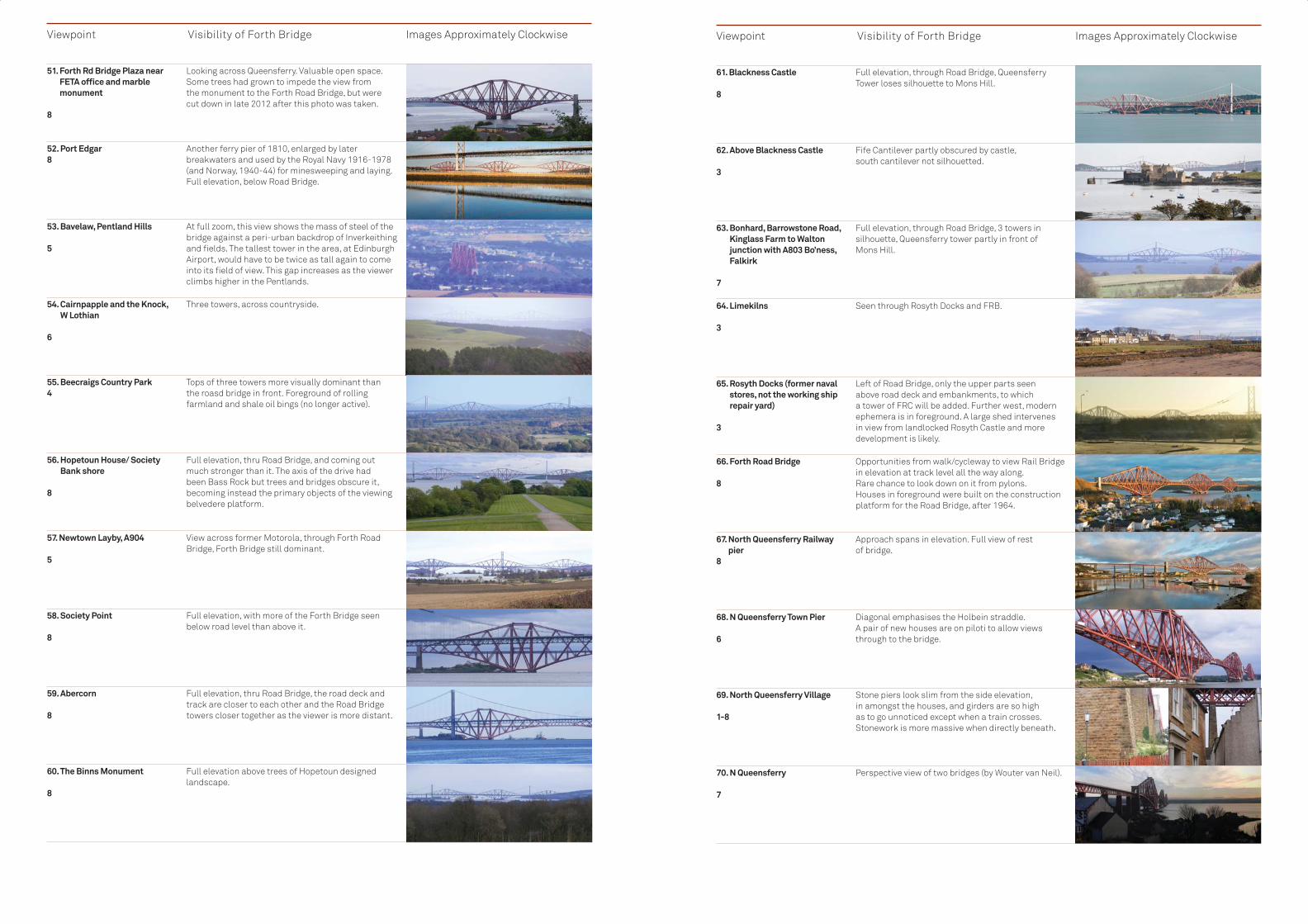
Viewpoint Visibility of Forth Bridge Images Approximately Clockwise
51. Forth Rd Bridge Plaza near FETA offi ce and marble monument
8
Looking across Queensferry. Valuable open space. Some trees had grown to impede the view from the monument to the Forth Road Bridge, but were cut down in late 2012 after this photo was taken.
52. Port Edgar8
Another ferry pier of 1810, enlarged by later breakwaters and used by the Royal Navy 1916-1978 (and Norway, 1940-44) for minesweeping and laying. Full elevation, below Road Bridge.
53. Bavelaw, Pentland Hills 5
At full zoom, this view shows the mass of steel of the bridge against a peri-urban backdrop of Inverkeithing and fi elds. The tallest tower in the area, at Edinburgh Airport, would have to be twice as tall again to come into its fi eld of view. This gap increases as the viewer climbs higher in the Pentlands.
54. Cairnpapple and the Knock, W Lothian
6
Three towers, across countryside.
55. Beecraigs Country Park4
Tops of three towers more visually dominant than the roasd bridge in front. Foreground of rolling farmland and shale oil bings (no longer active).
56. Hopetoun House/ Society Bank shore
8
Full elevation, thru Road Bridge, and coming out much stronger than it. The axis of the drive had been Bass Rock but trees and bridges obscure it, becoming instead the primary objects of the viewing belvedere platform.
57. Newtown Layby, A904 5
View across former Motorola, through Forth Road Bridge, Forth Bridge still dominant.
58. Society Point 8
Full elevation, with more of the Forth Bridge seen below road level than above it.
59. Abercorn 8
Full elevation, thru Road Bridge, the road deck and track are closer to each other and the Road Bridge towers closer together as the viewer is more distant.
60. The Binns Monument 8
Full elevation above trees of Hopetoun designed landscape.
Viewpoint Visibility of Forth Bridge Images Approximately Clockwise
61. Blackness Castle 8
Full elevation, through Road Bridge, Queensferry Tower loses silhouette to Mons Hill.
62. Above Blackness Castle 3
Fife Cantilever partly obscured by castle, south cantilever not silhouetted.
63. Bonhard, Barrowstone Road, Kinglass Farm to Walton junction with A803 Bo’ness, Falkirk
7
Full elevation, through Road Bridge, 3 towers in silhouette, Queensferry tower partly in front of Mons Hill.
64. Limekilns 3
Seen through Rosyth Docks and FRB.
65. Rosyth Docks (former naval stores, not the working ship repair yard)
3
Left of Road Bridge, only the upper parts seen above road deck and embankments, to which a tower of FRC will be added. Further west, modern ephemera is in foreground. A large shed intervenes in view from landlocked Rosyth Castle and more development is likely.
66. Forth Road Bridge 8
Opportunities from walk/cycleway to view Rail Bridge in elevation at track level all the way along. Rare chance to look down on it from pylons.Houses in foreground were built on the construction platform for the Road Bridge, after 1964.
67. North Queensferry Railway pier
8
Approach spans in elevation. Full view of rest of bridge.
68. N Queensferry Town Pier 6
Diagonal emphasises the Holbein straddle.A pair of new houses are on piloti to allow views through to the bridge.
69. North Queensferry Village 1-8
Stone piers look slim from the side elevation, in amongst the houses, and girders are so highas to go unnoticed except when a train crosses. Stonework is more massive when directly beneath.
70. N Queensferry 7
Perspective view of two bridges (by Wouter van Neil).

Viewshed analysis around the Firth of Forth, with the Forth Bridge in the centre. The whiter the area, the higher the potential visibility. A score of 0 (out of sight) is represented in black, 5 (in full view) is white and the values in-between are shades of grey, 2013. (© Crown Copyright, 2013 Ordnance Survey [Licence Number 100021521])
Photographs all © Crown Copyright, Historic Scotland, 2011-13, unless stated otherwise
Title: Key
Scale:
Projection:
Forth Bridge
1:150,000
British National Grid
Nominated Property
Bridge Visible
Bridge not Visible
Visability Scale
Viewpoint Visibility of Forth Bridge Images Approximately Clockwise
71. North Queensferry, Mt Hooly Crescent, turning area
2
View towards Fife Portal and tower at girder level. (View in December 2012. tree foliage obscures views to and from this location in other seasons)The view from Fife Coastal path below this is similarly seasonal, the masonry piers more to the fore.
72. North Queensferry, Mt Hooly Crescent, small car park/ view point at edge of Conservation Area
7
30 m to the west of the above view, free from trees, over rooftops. Full view of bridge, with Holbein straddle evident.
73. Dunfermline New Row 3
View from Town Centre past Alhambra theatre (brick building on right). The signal tower on Castleand Hill, in front of Inchgarvie Tower, is not an obstacle as it can be seen through.
74. Dunfermline Pittencrieff Park
3
Tops of three towers over Castleand Hill from beside Pittencrieff House. View from other parts of park obscured by trees and houses on a ridge. One wind turbine in foreground was pointed out by a Flickr photographer.
75. Castleand Hill signal station From Lothian View
3
Three towers above crest of Ferryhills.
76. Inverkeithing from Whinny Hill Crescent
3
Tops of three towers visible over Ferry Hills, with water tank under turf on left. In the old town the bridge is aligned so only the very top of the Fife Tower is seen.
77. Ferry Hill above North Queensferry
4
Telephoto, with Pentland Hills in the distance. Emphasises the upwards splay of the cantilevers counterbalancing the overall Holbein straddle.
78. N Queensferry Battery Pier (view to N)
4
Overwhelming presence.
The viewpoint study shows that it is the Fife Tower and cantilever that stands most prominently because it projects into the Forth whereas the Queensferry cantilevers are more sheltered, enclosed by Mons Hill to the east and the gently rising ground of West Lothian and Falkirk to the west.
From points north and south,
much depends on climatic conditions where land is the backdrop. The bridge stands out against sunshine and shadows that give a visual contrast, but on other occasions it might merely vanish into the landscape. The Forth Bridge and its neighbour, the Forth Road Bridge, are sufficiently far apart in north-south axes that
in most cases one or the other bridge will be captured in a photograph, but not both together.
The tallest modern building is the control tower of Edinburgh Airport, 57m high, built in 2005. It can be seen from the top of the Forth Bridge, and vice versa. But they are hardly in competition at a distance of around 5-6 km.

200
150
100
50
0
0 1000 2000 3000 4000 5000 6000 7000 8000 9000 10000 11000 12000 13000 14000 15000 1600
20
0
0
40
60
80
100
120
1000 2000 3000 4000 5000 6000 7000 8000 9000 10000 11000 12000 13000
-10010
3020
405060708090100
2000 400 600 800 1000 1200 1400 1600 1800 2000 2200 2400 2600 2800 3000 3200 3400 3600 3800 4000 4200
-102000 400 600 800 1000 1200 1400 1600 1800 2000 2200 2400 2600 2800 3000 3200 3400 3600
0102030405060708090
The observer is assumed to be 1.8m high. Trees and buildings are not factored in, so there is still a need to verify what is visible from the ground. For this, see the preced-ing photographic “Viewpoints Study” at 5.c8. 2012. (© Crown Copyright Historic Scotland, Courtesy of James Steel)
Forth Bridge Line of Sight Analysis from Selected Points
A Geographical Information System (GIS) process known as ‘Viewshed’ was used to score locations from 0, where nothing can be seen, to 5, where both portal towers and the top of each of the three cantilever towers are seen. Three of the points are at a height of 100.6m (330 ft) and two points representing the rail level above high water at the two towers are at 48.2m (158 ft). Higher scores indicate that more of the bridge can be seen.
The Points Used to Score the ViewshedThe observer is assumed to be 1.8 m high. Trees and buildings are not factored in, so there is still a need to verify what is visible from the ground. For this, see the preceding photographic “Viewpoints Study” at 5.c.8.
Viewshed analysis around the Firth of Forth, with the Forth Bridge in the centre. The whiter the area, the higher the potential visibility. A score of 0 (out of sight) is represented in black, 5 (in full view)
is white and the values in-between are shades of grey.
The viewshed highlights the fact that Mons Hill is a significant natural obstruction that shields Edinburgh from the bridge, and vice versa. Only the Fife Tower can be seen from Granton, Newhaven, Calton Hill, Edinburgh Castle and Arthur’s Seat.
On the south bank, the bridge is seen in full elevation from the Dalmeny shore, as far as Hound Point due east, and from many points along the shore of the Inner Forth. See map Further to the east of Edinburgh, East Lothian only offers distant glimpses of the upper part of the bridge, from Aberlady and Cockenzie. Recent development at Leith now intervenes from Prestonpans. Beyond 15Km the view of the bridge from sea level starts to disappear due to the curvature of the earth.
To the west of the bridge, areas of West Lothian and Falkirk Councils offer fuller views from the shore and from Hopetoun,
the Binns Monument, Blackness, Bo’ness and the Bathgate Hills.
On the north bank in Fife, the bridge is angled away from the Rosyth to Charlestown shoreline of the Inner Forth and so is competing against other features in Rosyth docks, and the neighbouring Forth Road Bridge. From the east the scene from the Fife Coastal Path features the bridge leading southwards. The degree of prominence from Dalgety Bay and from Burntisland depends on the backdrop and on climatic factors. There are points inland from which the bridge is also visible, around the M90 motorway, and the upper parts may also be seen from Dunfermline, over intervening hills.
The viewshed can be rotated through 90 degrees into any number of cross-sections showing the profi le of land between the bridge and a viewer. A selection of locations in the viewshed is shown here. The graphs represent lines of sight from given locations to the Forth Bridge. Red lines are points that cannot be seen from the observer, shown as a black dot on the left of each graph. Green indicates what could be seen in the lie of the land, assuming that trees and buildings did not intervene in front of or beyond a specifi c target.
City of Edinburgh Council has adopted such a system to establish the impact of any proposed high-rise development within the city.
5.c.9 The Viewshed Process Applied to the Forth Bridge
Arthur’s Seat. City of Edinburgh: Only Fife Tower and Portal are visible. Even 1960s high-rise in Pilton does not obstruct the view, achieved by zoom lens. The clock in the foreground is that of the North British Railway Hotel, in a World Heritage Site.
Edinburgh Castle, City of Edinburgh: similar line to the view from Arthur’s Seat but from a lower height, so less is visible. The dome belongs to West Register House within the Old and New Towns World Heritage Site.
Layby North of Newton, West Lothian:
The bridge is seen in full elevation through the Road Bridge.
Castlandhill Hill, Lothian View Rd, Fife:
Good view of the upper part of each tower, silhouetted against the snowy Pentland Hills in winter. Ferryland Hill shields the rest of the bridge, shown as the bump in cross section.
When viewed in line from Bavelaw in the Pentland Hills, 16-20 km away, the control tower would need to have been twice as high again to intrude into the sight line of the Forth Bridge. From higher points in these hills, the bridge is a distant element, unobstructed by man-made competition. This suggests that development does not need to be controlled to protect such long views.
From east and west, long views benefit where a backdrop is either sky or water. This particularly applies to views from the west looking out to sea. Therefore, development on the Forth shoreline should take into consideration impact on some cherished views. However it is evident that existing structures along the edge of the Forth have almost no adverse effect when viewed as part of the back drop to the Forth Bridge. The Forth Road Bridge is clearly distinguishable even when views pass through it, and the Queensferry Crossing now under construction will have a similar effect. Buildings by the shore at Rosyth Dockyard, and at Longannet, the largest power station in Scotland, do not compete against the Forth Bridge even when they come into the background frame. But in some lights the views from those places will first take in the two modern bridges.
It is therefore suggested that a strictly-defined Buffer Zone would be less helpful than would attention paid to setting at any distance, not for the potential harm to the outstanding value of the bridge (which is almost certainly nil) but for the benefit the bridge can bring to experiences of the Forth Estuary. For this reason, the bridgehead zone comprising the two communities of North and South Queensferry is the area of focus for research on possible economic benefits and local concerns on ways to mitigate and manage traffic flows.
Section 5108 Section 5 109

02040608000
5000 1000 1500 2000 2500 3000 3500 4000 4500 5000 5500 6000 6500 7000 7500 8000 8500
0
50
100
150
250
300
200
100009000800070006000500040003000200010000 11000 12000 13000 14000 15000 16000
0
20
-20
40
60
80
100
0 500 1000 1500 2000 2500 3000 3500 4000 4500 5000 5500 6000 6500 7000 7500 8000
All images © Crown Copyright, Historic Scotland, Mark Watson
Pittencrieff Park, Dunfermline,beside Pittencrieff House, Fife:Tops of three towers show above Castleand Hill, (the green/red bump), Ferryland Hill (only the tip)and are silhouetted against snow on the Pentland Hills. The higher part of the park has trees in the way, and houses intrude further to the west
Cairnpapple Hill, West Lothian: The Forth Bridge is seen at long distance in full elevation. The Forth Road Bridge is over to the left and not in its way.
House of the Binns, West Lothian: View from the monument over -looking Hopetoun, the bridge is in full elevation through the Forth Road Bridge, the two decks in perfect alignment.
This is useful in determining the potential impact of development on the Old and New Towns of Edinburgh existing World Heritage Site, even well beyond the property (there is no Buffer Zone). What may be built in low-lying folds of hills may have less impact than would a new building of the same height on the crest of a hill. It may then be possible to adjust the massing of that development so as to minimise harm to the setting of specifi c landmarks. Planning Authorities considering setting as a factor in determining planning applications may also take guidance from: http://www.historic-scotland.gov.uk/setting-2.pdf
The fi rst two viewshed sightlines show that development in the centre of Edinburgh cannot obstruct views of the Forth Bridge. The others show that some hills could potentially affect views from a greater distance.
Summary in Respect of Setting In conclusion, the several layers of designated land and shore around the bridge ensure that it is protected at an appropriate level.
The north side is a projecting headland, so the recent and on-going developments at Rosyth Dockyard and Dalgety Bay do not impact on the immediate setting of the bridge, but benefi t from angled views of the bridges that lie in front. The height of the Forth Bridge, and its neighbouring Road Bridge, ensures that they are landmarks even well inland, as set out in the attributes table and the illustrated clockwise setting table. Yet there are some points close to where one or other bridge is hidden by a hill. The Forth Bridge is so dominant that developments in either town, or their hinterland, would not in most cases threaten its appearance or setting.
However where views that are of value are identifi ed through the key views study, planning authorities will take into consideration in their decision-making the protection of those views.
No additional statutory controls result from World Heritage listing in Scotland, but national guidance requires planning authorities to set specifi c policies to assist in managing development within the Sites and within the wider setting of the Sites. Scottish Planning Policy (SPP, adopted in 2010) states: “120. Planning authorities should protect World Heritage Sites and their settings from inappropriate development, [include] relevant policies in the development plan and [set] out the factors that will be taken into account when deciding applications for development proposals which may impact on a world heritage site. The immediate setting of a World Heritage Site, important views, and other areas which are important to the site and its protection, should be protected from inappropriate development. The setting of a World Heritage Site is the area around it in which change or development may have an adverse impact on the World Heritage Site. 121. A statement of outstanding universal value is adopted by UNESCO when a site is inscribed, which provides the basis for the effective protection and management of World Heritage Sites. World heritage site
management plans should be prepared which summarise the significance of the site and set policies for the protection and enhancement of the site. Planning authorities should consider incorporating the management plan into the development plan as supplementary guidance.”
A revised SPP aims to be more incisive (2013 consultation draft): “121. Where a development proposal has the potential to affect a World Heritage Site, the planning authority should protect and preserve its Outstanding Universal Value.”
The Town and Country Planning (Scotland) Act 1997 and The Planning etc (Scotland) Act 2006 provide the legal framework for local planning policy. They act as the principal primary legislation guiding planning and development in Scotland.
As explained above, individual buildings, monuments and areas of special archaeological, architectural or historic interest are protected under the Planning (Listed Building and Conservation Areas) (Scotland) Act 1997 and the 1979 Ancient Monuments and Archaeological Areas Act. All of Scotland’s World Heritage Sites incorporate, include or are composed of scheduled monuments or listed buildings, the setting of which is a material
consideration for Local Authorities in determining applications for planning permission. In all cases where a proposed development may impact upon the setting of a scheduled monument or category A listed building, Historic Scotland must be consulted.
Local policies specifically protecting the property will be contained within the Fife and City of Edinburgh Local Plans. Local Development Plans (LDP) set out policies and proposals for the development and use of land. The policies in each LDP are used to determine applications for development. The LDP informs decisions on investment opportunities, the provision of infrastructure and community facilities. Local residents and community groups are encouraged to use the LDP to understand and engage with the planning issues affecting their area.
Local development plans, as the local interpretation of regional and national planning policy, must conform with the relevant Strategic Development Plan (SDP) for their region and the National Planning Framework (NPF). LDP policies provide the means by which development is managed, and by which World Heritage Sites are protected from inappropriate development. Below the LDP, more detailed local guidance is set out in
5.d Existing Plans Related to Municipality or Region in Which the Property is Located
Section 5 111Section 5110

Map of Local Landscape Areas close to the Property, August 2013. Contains public sector information and Ordnance Survey data (© Crown Copyright, 2013 Ordnance Survey [Licence Number 100021521])
Title: Key
Scale:
Projection:
Forth Bridge
1:75,000
British National Grid
Nominated Property
Candidate speciallandscape area
Area of great landscape value
Local Landscape Area
Supplementary Guidance documents.The planning authorities
surrounding the bridge are currently in a state of transition between the old Local Plans system and the new LDP/SDP system. However the principles behind, and the strength of the policies affecting the bridge and its setting remain the same through this period of change.
Fife Policy SummaryThe Dunfermline and West Fife Local Plan (DWFLP), adopted 2012, is to be replaced by the Fife Local Development Plan in 2015. The DWFLP remains the current, adopted statement of Council policy until the LDP is formally adopted. Once the Proposed LDP is published in June 2014, however, it will become a material consideration in the determination of current planning applications. In the Fife LDP it is intended to include policy specifi cally directed at protecting the context of the Forth Bridge.
A sample policy is that Development on the undeveloped coast in [Fife] will not be supported unless certain safeguards are followed, directing development fi rst to developed coastline and which:• demonstrates high standards
of design and siting,• demonstrates appropriate scale
and character;• is not subject to nor will it
contribute to coastal erosion or fl ood risk
• safeguards cultural / natural heritage resources, footpath/cycle networks
• avoids obtrusive lighting or coalescence of coastal villages
City of Edinburgh Policy SummaryThe Rural West Edinburgh Local Plan (RWELP), adopted 2006, altered 2011 is to be replaced by the Edinburgh Local Development Plan (LDP), published as a proposed plan in March 2013. The RWELP remains the current, adopted statement of Council policy until the LDP is formally adopted, anticipated to be by late 2015. The proposed LDP is,
however, a material consideration in the determination of current planning applications.
The DWFLP, RWELP and LDP contain key policy objectives that are broadly comparable across both local authorities. They include those to:• ensure that new development
meets the objective of sustainable development and contributes to a healthy and attractive environment;
• protect, conserve and enhance the key environmental and heritage resources, including landscape, built heritage and important natural habitats;
• encourage quality of design in all new forms of development; and
• protect the special character of historic buildings and townscapes.
Detailed policies then focus on the following themes which are of particular relevance to the property and its setting:• Design of new development -
the Council encourages innovation and well designed developments that relate sensitively to the existing quality and character of the local and wider environment, generate distinctiveness and a sense of place, and help build stronger communities.
• Development in the Green Belt and countryside – here, development is only permitted where it meets certain restricted criteria and would not detract from the landscape quality and/or rural character of the area.
• Nature conservation and biodiversity – development is not permitted which would adversely affect the integrity of designated areas, protected landscapes or species unless in exceptional circumstances of demonstrable public benefi t.
• Special landscape areas – development is not permitted which would damage or detract from the overall character and appearance of the area.
• Trees – development will not be
permitted which is likely to have a damaging impact on a protected tree or one considered worthy of retention, unless necessary for good arboricultural reasons.
• Archaeology – development is not permitted which would adversely affect nationally important remains or their setting. Archaeological evaluation, preservation in situ or excavation, recording and analysis will be required where non-designated remains are likely to be affected.
• Historic buildings – there is a general presumption against demolition or signifi cant alterations which would have an adverse effect on the character of historic buildings. Other alterations will be permitted only if not detrimental to the special character, historic interest or setting of the building.
• Conservation areas – development must preserve or enhance the special character or appearance of the conservation area and its setting.
• Historic gardens and designed landscapes – development will only be permitted where there is no detrimental impact on the character of a site or its component features.
Local Landscape AreasIn place of the former designation “Area of Great Landscape Value” and “Areas of Outstanding Landscape Quality” (AGLV/ AOLQ) local authorities have developed proposals for what were called Candidate Special Landscape Areas (cSLA). The term ‘candidate’ will be dropped after consultation is complete and then the term will be Local Landscape Areas, as already adopted in Fife (see map). As the landscape areas are at different stages in the consultation process they carry different names in each local authority (see map). These tend to be areas that are rural in character, and so policies will aim to retain that character.
City of Edinburgh has these:• cSLA01: Southern Forth Coast
Section 5112

• cSLA04 Dundas Estate• sSLA22 Craigie Hill (south of A90) Fife has these:• Ferryhill,• Letham Hill,• South East Dunfermline• Forth Islands In West Lothian the Forth Shore AGLV will in due course become the Forth Coast Local Landscape Area.
To inform the Local Development Plan, specifi c research has addressed, for example, the capacity for Wind Energy Development in West Lothian, a consultation published in 2011. This found that only limited pockets around Livingston New Town, the M8 Motorway and around Black Law to the south west had that potential. The part nearest the Forth shore, Hopetoun Estate, was considered to be on the “highest scale of sensitivity and therefore unsuited to use as a wind farm. Even if that were not the case we have argued that wind
turbines would not threaten the Outstanding Universal Value of the bridge.
A similar capacity study into windfarms in Fife found that there are no landscape areas of Fife suitable for development of extensive windfarms with large scale turbines. In contrast with much of Scotland there is no or very limited capacity for wind turbines in the highest upland areas, due to the limited extent, high visual sensitivity and landscape value of these areas within Fife. Larger scale lowland farming areas have the greatest inherent capacity for wind turbine development. Some smaller scale lowland valley and basin areas have no or very limited capacity. Some coastal areas have limited capacity. Similar areas, whilst of a suitable scale and character for wind turbines, are visually sensitive and have a high landscape value and therefore have no capacity for development. (Onshore Wind Energy Strategy for Fife 2012).
The tops of the three double-cantilever towers of the Forth Bridge as seen from near Dalmeny, to the south east of the Bridge, an area of Green Belt in the Local Development Plan July 2011. (© Crown Copyright, reproduced courtesy of Historic Scotland. www.historicscotlandimages.gov.uk,Miles Oglethorpe)
The Management Plan, which accompanies this Nomination, has been developed under the auspices of the Forth Bridges Forum’s sub-group, the Forth Bridge World Heritage Nomination Steering Group. The aim of the plan is to meet the future management needs of the nominated property and to coordinate the many interested bodies, groups and individuals. To be successful, management planning needs to follow a continuing process of assessment, objective setting, consultation, monitoring and review as set out in the unpublished ICOMOS UK draft guidance paper Management of the Historic Environment 2007, and the recently published UNESCO Resource Manual Managing Cultural World Heritage (November 2013)
The process of developing this Plan has been led by Historic Scotland, in partnership with Network Rail, the owner of the property. However, it has involved all members of the Forth Bridge World Heritage Nomination Steering Group, and has further benefitted from information drawn from public consultation. It is related closely to the proposed Outstanding Universal Value and the assessment of the current condition, pressures and threats outlined elsewhere in this nomination document.
The Plan expresses a vision for management of the property, which is: • To manage the property in
a sustainable manner which conserves, enhances and promotes its Outstanding Universal Value both within and around the Site itself,
but also at a national and international scale
• To carefully balance the requirements of protection and conservation against the need for access to the property, and the interests of the local communities in encouraging sustainable economic growth
• To engage with and deliver benefits to the local communities around the property whilst also minimising any negative effects that might follow a successful nomination
• To develop opportunities for education and learning, especially in the context of the adjacent road bridges
• To generate income and employment that adds value to the local economy and can contribute to the conservation and promotion of the property.A list of opportunities for
improvement and actions proposed for protection and conservation to deliver this vision have been produced by the Forth Bridges Forum World Heritage Nomination Steering Group, based on work commissioned from Rebanks Consulting Ltd, and on a public consultation carried out between 20th May and 11th August 2013. The Plan sets out a prioritised list of agreed action for a six year period, with lead partners for each. This action plan is subject to measurement and monitoring as set out in Section 6 of this Nomination. It will be under regular review by the Steering Group to ensure co-ordination of effort and alteration of actions to reflect any changes in the condition or needs of the property. Resources for implementation are identified in Section 5.f.
5.e Property Management Plan
5.e.1 The Vision
Section 5 115Section 5114

Section 5 117
The Forth Bridges Forum is a Transport Scotland-led management Forum, established to ensure that local stakeholders’ interests remain at the core of the management and maintenance of the Forth bridges. These are the Forth Bridge, the Forth Road Bridge, and the Queensferry Crossing. In addition, it provides a mechanism for the collective promotion of these bridges. Its interests therefore include National and local government, environmental organisations, the owners and operators of the bridges, a wide range of business interests, and the communities who live around the bridges.
The Forum is managed on behalf of Scottish Ministers by Transport Scotland, an agency of the Scottish Government. In order to manage and fund the nomination of the Forth Bridge for World Heritage listing, it created a sub group, the Forth Bridge World Heritage Nomination Steering Group, which reported back to the Forum on a quarterly basis.
The group currently comprises representatives from:• Network Rail (as owner of
the property)• Transport Scotland (Chair)• Historic Scotland• City of Edinburgh Council
and Fife Council (the local authorities)
• Visit Scotland (the national tourism organisation)
• FETA (Forth Estuary Transport Authority)
• Queensferry & District and North Queensferry Community Councils
• Queensferry Ambition• North Queensferry Heritage Trust This group has already worked together to deliver the nomination, and the intention is that it continues to collaborate, taking forward this Management Plan and reporting back to the Forth Bridges Forum. In doing so, the plan will evolve, and the membership of the group will broaden, involving, for example, other business organisations and adjacent areas. In particular, stronger links with Education Scotland and the Institution of Civil Engineers will be established. Should the World Heritage Committee decide to inscribe the Forth Bridge in 2015, the Steering Group will drop the word ‘Nomination’ from its title.
A core priority will inevitably be the conservation, maintenance and operation of the nominated property itself, and a central element within this process will therefore be the implementation of a Partnership Management Agreement (PMA) linked to this Management Plan. The completion and signing up to the PMA is one of the fi rst actions of the Plan, and specifi cally involves the following members of the Steering Group that have a statutory planning function, besides the potential applicant:• Network Rail• Historic Scotland• Fife Council• City of Edinburgh Council The specifi c function of the PMA will be to ensure the effi cient operation of consents for the bridge by monitoring, and where appropriate, consenting any works that are required, whilst at the same time protecting its integrity, authenticity and specifi cally, its Outstanding Universal Value. The role of the PMA Group will therefore be to protect the Outstanding Universal Value of the property whilst also helping it to continue as an operating structure that is a fundamental part of Scotland’s and the UK’s railway network. A group comprising the PMA partners will therefore meet regularly to ensure that the agreement is properly implemented. The PMA requires annual review of what has been done and a forward look to what will be proposed in the coming year.
The Management Plan is a living document, separate from the Nomination itself. It therefore amplifies the management information contained here and it is the vehicle for reviews of the management objectives. It comprises:• the Site description, extent,
details of ownership and baseline condition;
• the Statement of Outstanding Universal Value
• statutory duties of main bodies and other existing management arrangements;
• the operation of heritage protection measures and land use planning
• a summary of the pressures on/threats to the property and opportunities for change or improvements;
• means of implementation of the Plan; and
• measures by which it will be monitored.
Most importantly, the Management Plan contains a six-year action plan. As part of the process of developing the Management Plan, several key Management Principles were derived from the Outstanding Universal Value, the current condition of the property, the identified threats and pressures, and the aspirations of the agreed vision for future management. The action plan is arranged around these Principles as follows:
Protection• To agree and develop a consistent
framework for future control to
ensure the appropriate protection of the Outstanding Universal Value of the property.
• To report on the Partnership Management Agreement (PMA) between the owners of the property, Network Rail, the two local authorities, Fife and City of Edinburgh Councils, and Historic Scotland, the purpose of which is to facilitate and streamline Listed Building Consents processes in the context of the continuing use and operation of the bridge
Conservation• To agree and implement a common
system for assessment and monitoring of the state of conservation of the property
• To prioritise and carry out maintenance works to ensure an appropriate state of conservation of the bridge, securing resources where necessary; and
• To develop and implement effective management measures for all identified environmental pressures, disasters and risks to the property.
Presentation• To implement sustainable visitor
management to improve the understanding and appreciation of the property without detriment to its Outstanding Universal Value; and
• To carry out research and interpretation to develop understanding of the property relative to related bridges, and to present its values to a wide range of audiences.
Community Benefit• In anticipation of further growth in
visitors, carry out an infrastructure review, to include roads and parking, in both Queensferry and North Queensferry, as well as in adjacent areas where more capacity might be available.
• To carry out a review of public transport serving the communities at both ends of the bridge, to identify whether it can be better integrated and improved to convey an anticipated increase in visitors
Inspiration to Future Generations• To engage communities in the
understanding of the property, decision making and management action to protect it for future generations.
• To encourage understanding of the bridge at as many levels as possible within the education system in Scotland
• Specifically, to use the property to promote the engineering profession in Scotland inspiring current and future generations in the UK and across the world.
The most urgent actions are separated out into the Year One Plan, with details of the lead partner responsible for taking forward each action. The Forth Bridges Forum, and the World Heritage Steering Group, will review the Plan every year to update the six-year action plan and agree priorities for the new year.
Section 5116
5.e.2 The Forth Bridges Forum
5.e.3 The Forth Bridge World Heritage Nomination Steering Group
5.e.4 The Forth Bridge Partnership Management Agreement Group
5.e.5 The Management Plan

The communities at both Queensferries have long had the Forth Bridges at the core of their identities. Community involvement is well established through engagement with the local community councils, and through offi cers and elected members of the local authorities, Fife and City of Edinburgh Councils. These links will be enhanced in the future, and are essential if the impact of inscription is to be managed to deliver local benefi ts. For example the local communities aim to play a vital part in celebrating the Forth Bridge’s 125th anniversary in 2015.
The Steering Group wished to better understand the economic performance of the Queensferries prior to a possibly inscription, and to explore ways that listing could be made to deliver local benefi ts. Rebanks Consulting Ltd was commissioned in December 2012 to examine those potential economic benefi ts of nomination to the local communities around the bridge. The consultants accordingly held surgeries with individual businesses in order to inform that report. The Business Improvement District in
Queensferry was instrumental in reaching many of these businesses.
There followed a formal twelve-week public consultation exercise to provide opportunities for local residents, local businesses, organisations, public bodies, visitors and others to comment on the nomination and management issues relating to the nominated property.
The consultation examined the proposals for nomination and management of the Site, highlighting the key issues, potential benefi ts, threats, opportunities and restrictions. A consultation questionnaire accompanied the document, and both were made available throughout the twelve week period and at public venues across the area, an online version being built into a website dedicated to the nomination at www.forthbridgeworldheritage.com. The consultation commenced on 20th May and concluded on 11th August 2013. Four drop-in sessions were arranged during the consultation period to enable the public to speak to offi cers about the proposals. These sessions were
attended by 93 members of the public. The response to the consultation
was broadly very positive, with the overwhelming majority of online respondents welcoming the nomination of the bridge. Of those who were less confi dent about the perceived benefi ts of World Heritage inscription, most were also in favour, but were worried about potentially negative impacts upon the quality of life in the two communities.
Much of the concern in the online questionnaire focused on road infrastructure, parking, potential congestion and worsening traffi c hazards. These were perceived by many to be problems that already exist, and so the World Heritage nomination was thought by some to be a good opportunity for the local authorities to take the initiative and propose solutions before the situation gets worse. There was a consensus that action needs to be taken as soon as possible, rather than waiting until inscription in 2015.
These issues also emerged strongly in the drop-in workshops, where a co-ordinated, sustainable approach to transport and parking was thought by
stakeholders to be needed. Suggested solutions included
better use both of train services and of boat transport, as well as an expansion of park & ride facilities. Many people believe that World Heritage will on balance bring with it opportunities for business, including tourism, and has the potential to feed into many forms of education. Perceived benefi ts ranged in scale from those affecting local businesses to national and international developments. There was an almost universal sense of pride in the cultural value associated with the bridge, even amongst those who were less keen on World Heritage inscription.
All the workshops hoped that World Heritage listing would result in the attraction of more investment into the communities, with better networking, improved and better co-ordinated public transport, and with this, the potential for ‘Green Tourism’. There was therefore a strong feeling that effective management will be needed to ensure adequate systems are in place, and where appropriate, enhanced infrastructure should minimise any potentially detrimental effects of more traffi c and people, if World Heritage inscription is achieved in 2015.
There are wider circles that sense a shared ‘ownership’ of the Forth Bridge beyond the immediate residents and businesses. Three will be mentioned here:
Travellers might cross the bridge just once or twice in their lives, and yet remember doing so, or they may be regular commuters depending on the bridge to sustain their way of life. Those who pass through Waverley Station had the opportunity to speak to offi cers of City of Edinburgh Council and Historic Scotland, and to pick up a postcard which directed people to the consultation on line.
Photographers form communities that have captured it either as a one-off visit or over time watching it change through the seasons and from different viewpoints. This dispersed group can be approached on line through relevant Flickr and meet-up groups. For example the “Forth Bridges” Flickr group has 714 members who combined to upload 4,360 photographs since January 2006. The Forth Bridge features strongly in other groups such as “Bridges of the World”, which has 7,737 members. 694 out of 72,216 photographs are tagged ‘Forth’, showing either the road or rail bridges. (both websites last accessed in November 2013).
Open participation in a photographic competition in August/September 2013 saw the submission of nearly 250 entries, some of which were of an exceptionally high standard, and some have been included within this document. About 150 of the photographs were taken from the south shore of the Forth, 70 from the north shore, 10 from the bridge itself, 9 from the sea and 4 from the air. The two most distant views were taken from the west, from Culross on the north side of the Forth and from Blackness Castle on the south side. This indicates the relative ease of access by most Scots to Queensferry, although much of the visual drama is found at North Queensferry.
Civil Engineers the world-over see the bridge as symbolic of the achievements of that profession. Two of the main organisations that bring these people together are the Institution of Civil Engineers, which has long been associated with the bridge through its support of the Forth Bridges Visitor Centre Trust, for example. The ICE Panel for Historical Engineering Works keeps informed of progress. The American equivalent ASCE has already awarded a Landmark plaque to the bridge.
5.e.6 Community Involvement
A banner advertising the twelve-week public consultation on the World Heritage nomination, which was held in the summer of 2013. (© Crown Copyright,
reproduced courtesy of Historic Scotland. www.historicscotlandimages.gov.uk, Mark Lawson)
Section 5 119Section 5118

Section 5 121
Members of the Forth Bridges Forum (formed in November 2011) include Network Rail (the owner), Transport Scotland and Historic Scotland (Scottish Government Agencies), VisitScotland (the national tourism organisation), and Fife and City of Edinburgh Councils (the two local authorities) which have undertaken to support both the nomination of the bridge, and its subsequent management.
At a practical level, the bulk of the management and maintenance costs are already borne by Network Rail because the bridge will remain an operational railway viaduct. Network Rail has invested heavily in the bridge since it came into being, and recently completed a £130-million maintenance and painting programme over a ten-year period. This has left the structure in an excellent condition for the foreseeable future. It is therefore anticipated that longer-term maintenance will be far less of a burden than was previously the case, and will simply form a routine part of the day-to-day management of the bridge.
£1 million is allocated per year for the maintenance of the bridge, and for the next five years on a five-yearly control period. These sums require to be declared to the Office of Rail Regulation.
Network Rail Business PlanNetwork Rail’s business plan supports sustainable safe operation of all structures in delivering train paths for freight and passenger traffic. The Scottish element of this includes major structures such as the Forth and Tay Railway Bridges. Funding is
The maintenance of the bridge requires a broad scope of expertise. This includes ‘Permanent Way’ (railway track etc.) teams from Network Rail, Bridge Examination supplied under Framework Contractor, Amey, and the in-house Asset Management Engineering team, which assesses and prioritises items highlighted by the examiners. It also controls budgets to ensure structural maintenance is carried out timeously. In addition, Network Rail contracts in a variety of specialist expertise such as multi-disciplined rope-access technicians, safety critical (regarding railway) staff, steelwork and protective coatings specialists, and most important, Safety Management of those working on the bridge through the Principal Contractor.
The Forth Bridge has over the years proved an invaluable learning resource to the engineers and contractors involved. They now know that what they tested at the Forth Bridge is applicable to other structures. Sources of training in conservation for professional, technical and trades people:• The Scottish Lime Centre Trust
provides hands on and theoretical training in a range of conservation practices. It has
recently launched training for civil and structural engineers. It is based at Charlestown on the north bank of the Forth Estuary, seven km from the Forth Bridge, and has been the principal location, since 1994, to promote for the public benefit the appropriate repair of Scotland’s traditional and historic buildings. It offers advice, training and practical experience in the use of lime for the repair and conservation of such buildings and furthers the preservation and development of Scottish building traditions, crafts and skills. See http://www.scotlime.org/
• A National Conservation Centre is planned by Historic Scotland “to create a unique national and international hub in technical conservation for research and learning to ensure a sustainable future for the historic environment”. Its base will be in Stirling, the lowest medieval crossing point of the River Forth.
• The Institute for Historic Buildings Conservation is a membership association for professional building conservation practitioners and historic environment specialists. See http://www.ihbc.org.uk/
• The Royal Incorporation of Architects in Scotland has an accreditation scheme for Conservation Architects, the RICS likewise has one for surveyors, and most relevant here, there is accreditation for engineers:
The Conservation Accreditation Register for Engineers (CARE) identifies civil and structural engineers skilled in the conservation of historic structures and sites. CARE is sustained by Institution of Civil Engineers and the Institution of Structural Engineers. Members have followed a rigorous approval procedure to confirm an appreciation of disciplines and interests extending well beyond their professional training as engineers and have
demonstrated that they are fully conversant with conservation philosophy and methods applied to heritage projects.
Additionally, CARE has been established to:-• Assist clients in selecting an
appropriate engineer with proven conservation experience.
• Encourage education and training in conservation engineering
• Promote sympathetic and best practice conservation
• Raise awareness of conservation in the engineering profession
There are (in November 2013) 37 registered members across the UK and Ireland, with one in Scotland. The rate of increase in Scotland could be considered as a possible monitoring measure for the profile achieved by conservation engineering, helped by the symbolism of the Forth Bridge, and to show the pool available long-term for deployment of conservation engineering expertise available at the bridge. See http://www.careregister.org.uk/
“Civil engineering affects every aspect of people’s lives. It’s not just about creating the infrastructure we all depend on. It’s about transforming the way we work. The way we live. The way we think. So let’s make sure we never underestimate the impact of what we do. Because we must inspire the next generation of civil engineers…in my experience, it’s the iconic structures in our own regions that really capture people’s imagination – for example, The Forth Bridge”
(Presidential Address of Professor Barry Clarke, President, ICE, 2012)
expected to maintain these in a manner that will allow trains to cross at agreed weights and speeds, though these do vary according to vehicle types involved.
Revenue FundingThe maintenance funds for the bridge structure come from the overall structures settlement for Scotland. Similarly the maintenance of the Railway Track elements themselves is simply part of the overall in-house ‘Permanent Way Maintenance Department’. Funding is underwritten by the Scottish Government (via its agency, Transport Scotland), the UK Department for Transport, and Train Operator access payments. The mix of these is overseen by the Rail Regulator, the Office of Rail Regulation. This needs-based allocation offers a more flexible way for the operator of a large number of engineering assets to prioritise work than would any specific ring-fenced funding for The Forth Bridge. In practice a regular draw-down of funds occurs.
Recent InvestmentBetween 2001 and 2011, Network Rail has spent £130 million restoring the bridge and bringing its coating system up to a standard that should leave it in a prime condition for 20 years or more. The scale of this restoration project is unprecedented
in the UK, and had a profound impact on those were involved, as is captured in these words from (above) Iain Heigh, the project manager. “For many of the 1,600 men and handful of women who have worked on the restoration of the Forth Bridge over the last ten years, this has been a job that defined our careers. Few of us regard it as just a job.” (Forth Bridge: Restoring an Icon, 2012)
Planned InvestmentNetwork Rail is currently committed to approximately £1 million per annum for ongoing care and maintenance of the bridge structure for the next five years. In addition, there will be weekly maintenance of the track and fittings as part of the overall railway maintenance of the “permanent way” at further cost of approximately £0.2 million per annum. Approximately £0.2 million of this £1.2m is devoted to annual structural inspections, a ratio of around 1:6. Given the access issues that had plagued the bridge in the past, the better understanding of the fabric following the refurbishment work is paying dividends. As part of Network Rail’s stewardship following its major investment, it is developing maintenance plans into the very long term. It will, however, be many years before levels of investment similar to those in recent years are required again.
Section 5120
5.f Sources and Levels of Finance
5.g Sources of Expertise and Training in Conservation and Management Techniques

There is currently no public pedestrian access to the bridge, but plans to promote this are now being considered (see 4.b.4). At least three sponsored “abseils” take place from the Dalmeny (south) side every year in order to raise funds for charities like the Chest Heart and Stroke Association. Each of those participants will feel a special affi nity for the bridge following those close and hair-raising encounters.
Many visitors are drawn by the bridges either to Queensferry and North Queensferry, despite no formal marketing of the bridge as a tourist attraction and at present no means of counting individual visitors. Yet it was already reported by Trip Advisor reviewers early in 2013 to be the third best visitor attraction in Fife. Now (December 2013), the fi rst six being four golf courses, a beach and sky-diving. Not one of the more conventional heritage attractions ranked close to the Forth Bridge. Deep Sea World, a marine wildlife attraction beneath the Forth Bridge at North Queensferry, has at times attracted over 200,000 visitors per year.
The number of people who experience and interact with the bridge in their daily lives is very large indeed because that is the nature of a major and highly visible piece of infrastructure. It may be more useful to consider the quality of the interaction rather than
sheer numbers of bridge users, but nonetheless the overall interaction of people who consider it in some way “their Bridge” is substantial. It could be said that the bridge is experienced by over 40 million people a year, based on the following assumptions:• Road bridge drivers: 23,800,000
counting each vehicle on the road bridge as containing one person who will glance to the east, and adding.
• Road bridge passengers, cyclists and pedestrians, say 10,000,000 at a conservative estimate.
• Rail users: 3,600,000, assuming trains are below capacity at around 50 passengers in each train at 200 trains a day.
• Residents: 3,650,000 assuming that each resident within the bridgehead communities (10,000) steps out of their house or looks through a window once per day. Almost all will glimpse the bridge, many in fact multiple times. This disregards those who see it from a greater distance.
• Tour groups 100,000 (split between cruise ships and bus/boat tours).
This fi gure approaches that of the entire UK population and of course includes people who see it many times over in one year. It cannot be claimed that this number is taking that route in order to appreciate the bridge, but a momentary lifting of the spirits can be ascribed to many who experience it in this way,
Rail: Up to 200 passenger trains cross the bridge every day, meaning that it is experienced in that way approximately 3 million times per year. In many cases this will be repeat visits by commuters. The number of tickets bought to either Dalmeny or North Queensferry Stations might help to gauge numbers of people who choose the stations at either end of the bridge as a destination, often for tourist purposes. Road: The Forth Bridge cannot fail to be noticed by persons crossing the Forth Road Bridge. In 2012 there were 23,744,931 traffi c movements, whereas in 2008 there were 21,408,363, an increase of 2 million within 4 years. Oddly, some 100,000 more vehicles travel south rather than north, which suggests that people naturally choose to travel in a clockwise direction, going north by routes to the west of the Forth. Counting is by means of a Weigh in Motion (WiM) station installed to monitor loading on that bridge. Plates in the carriageway capture and record the number and weight of vehicles as they drive over a sensor. The bridge is also used by cyclists and pedestrians, who are not counted but have a better opportunity to enjoy views. They will benefi t when most road traffi c is taken from the Forth Road Bridge to the Queensferry Crossing, and the middle bridge becomes a viewing platform. (Source: FETA, www.forthroadbridge.org)
Residents and Local Visitors:Queensferry Museum, 53 High Street, Queensferry, is operated by City of Edinburgh Council. Admission is free. Among the themes displayed are crossings of the Forth and “The Forth Bridge: Wonder of the Modern Age” The collection includes objects crafted from bridge steel, commemorative objects and items relating to working conditions during the construction. The museum occupies a 19th century building on the north side of the High Street, with views towards the bridges, and the room below is used for meetings of the Community Council and by Queensferry Ambition, so it can be said to be at the hub of the local community. North Queensferry Heritage Trust is dedicated to preserving and promoting the history and beauty of North Queensferry. It has already achieved the recreation of the historic refl ective light in the signal tower at the Town Pier, sells a DVD related to the history and crossings of the Forth “History Bridged”, has developed two heritage trails and an interactive gallery that may be viewed on line at http://www.nqht.org/
In 2012 the station building at North Queensferry was leased from the train operating company, First Scotrail, by North Queensferry Station Trust for the purpose of restoration to its original condition. Support for the project was received from Transport Scotland and First Scotrail under the Stations Community Regeneration Scheme (SCRF), Railway Heritage Trust, Fife Council and local volunteers. The Trust expects to have Phase 1 of the refurbishment completed and ready for use by April 2014. It is planning to have the former ticket offi ce used as a visitor information centre and café. The former general-waiting room will be used again as a comfortable waiting room but also will be available for use privately by local community groups. The former ladies waiting room is to be used as a ’Railway-themed exhibition’ area
managed by the North Queensferry Heritage Trust. The Heritage Trust, with help from volunteers, plans to exhibit railway-travel linked artefacts from local sources as well as recalling the part Scottish industry played in the wider world of the railway story. The trust was founded in 1988, in the run-up to the centenary celebrations for the Forth Bridge, and so in the same year was the: Queensferry History Group, to stimulate an interest in local history, research and record the history of Queensferry and the surrounding area. It was instrumental in researching the ‘Briggers’ who worked and died in construction the bridge, creating the memorials that stand at each end of the bridge.( http://www.edinburghmuseums.org.uk/Venues/Queensferry-Museum/Collections/Queensferry-Collections/The-Queens-Ferry )
The Forth Bridges Visitor Centre Trust, its trustees mainly drawn from the Institution of Civil Engineers, has wound up, as the hotel which hosted it wanted its function room returned for commercial use. Its collection has returned to lenders, like National Museums Scotland, or to Heriot Watt University. The Forth Estuary Transport Authority (FETA) which currently manages the Forth Road Bridge, has some of the material related to the Road Bridge formerly displayed there, and the North Queensferry Heritage Trust will display other items in North Queensferry Station. A Contact and Education Centre opened in Queensferry in 2013 to convey information about all three bridges, as part of the outreach developed for the construction of the Queensferry Crossing. It contains models and displays of all three bridges, and is open to the public on advertised days like European Heritage Day, and particularly for educational visits from schools. There is a large viewing window onto
the bridges, whilst the adjacent room houses a control centre managing traffi c control and monitoring systems on Scotland’s trunk roads. Tours: Boat Tours that use the bridge as a substantial part of the experience, even when the destination might be Inchcolm Island, wildlife or a general river cruise, include:• Maid of the Forth• The Forth Belle• Seafari
A “Forth Bridges Bus and Boat Tour” brings day visitors from Edinburgh, and Gray Line tours in offering tours from Edinburgh to the Highlands of Scotland guarantees a view of the Forth Bridges en route, generally from the Forth Road Bridge monument beside the Contact and Education centre. Both fi rms have images of the Forth Bridge prominently displayed on the sides of their coach. Exact visitor numbers are commercially sensitive, but it seems that numbers justify daily visits, and more frequently during the summer. This means several thousand visitors see the bridge as part of a general package visit to Scotland provided by these and other fi rms. Tours on foot are offered by Queensferry Historic Walking Tours and others. Cruise Ships: An estimated 48,600 passengers came to South Queensferry in 2013, generating more than £370,000 income. They landed from 21 ships that were too large to pass beneath the Forth Bridges. They moor just beside the bridge and transfer passengers to Hawes Pier, thus excluding local visitors from that car and coach park. The great bulk of the revenue that they bring is received elsewhere in Scotland, but “Cruise Forth” and Queensferry Ambition is working to develop the local offer both at Rosyth and Queensferry.
5.h Visitor Facilities and Statistics
Lamp restored at Town Pier by North Queensferry Heritage Trust, 2013. (© Crown Copyright, reproduced courtesy of Historic Scotland. www.historicscotlandimages.gov.uk,Mark Watson)
Section 5 123Section 5122

Section 5 125
There are currently no co-ordinated policies and programmes relating to the property, but one of the principal aims of the Management Plan will be to address this situation through a number of actions.
In the meantime, as stated in 5.h above, existing initiatives include, for example the development at North Queensferry Station, and as outlined in 4.b.4, proposals for a visitor experience on the bridge by Network Rail. In addition, virtual access through digital presence on websites is increasing, and will be supplemented by the 3D outputs of digital laser-scan surveys of the bridge.
It is also likely that in the future the neighbouring Forth Road Bridge will play an increased leisure role, and serve to a greater extent than it already does as a viewing platform for the Forth Bridge.
If physical access to the bridge and prominent viewpoints nearby is to be achieved, there is some potential for confl ict in the design of viewing platforms if placed on bridges, but these can be appropriately managed through the consents system that is in place for both the Forth Bridge and the Forth Road Bridge, both of which have the highest level of listed building protection. Similarly, developments in the adjacent conservation areas must enhance or preserve the character of those areas.
There are concerns in the local communities that visitor numbers need to be appropriately managed, so as to secure local economic benefi t whilst not damaging the residents’ ways of life. This, again, is therefore a topic for the Management Plan.
Should the property be inscribed, consideration needs to be given to the placing of the UNESCO and World Heritage logo at an appropriate location near to the bridge, and for the management of the plaques already fi xed to it. It would also be desirable if ways were identifi ed to promote the Outstanding Universal Value of the Forth Bridge in the context of “bridges of the world” through various media.
The numbers vary and many, particularly in Network Rail, are dedicated to other structures as well as the bridge. However, in summary, there are carrying out on-going care and maintenance to the bridge:• approximately six people involved
through routine Permanent Way Maintenance teams
• approximately eight engineers/ project management staff from Network Rail
• a further four staff involved through Bridge examination contracts, and
• approximately 20 more people involved full-time from Network Rail’s principal contractor, Balfour Beatty
Section 5124
5.i Policies and Programmes Related to the Presentation and Promotion of the Property
5.j Staffi ng Levels (Professional, Technical and Maintenance)
Above: Forth Bridge Maintenance Team at the Saltire engineering awards ceremony,1 May 2013. (© Crown Copyright, reproduced courtesy of Historic Scotland, Miles Oglethorpe)
Left: Michael Berry, part of the Balfour Beatty team, who has been working on the bridge for nine years, July 2013. (© Crown Copyright, reproduced courtesy of Historic Scotland.Miles Oglethorpe, DSC_3734)
The awards ceremony for Transport Scotland’s Forth Bridge photographic competition, hosted by Scottish Government Minister for Transport and Veterans, Keith Brown MSP on 26 November 2013, © Crown Copyright reproduced courtesy of Historic Scotland. www.historicscotlandimages.gov.uk, Santiago Arribas.

Section 6 – Monitoring
Monitoring the State of Conservation
6.a Key Indicators for Measuring State of Conservation
In accordance with Article 29 of the World Heritage Convention, the Department for Culture, Media and Sport, must on behalf of the United Kingdom Government produce periodic reports on the legislative and administrative provisions and state of conservation of the World Heritage Site. They will be undertaken within the six-year time scale of the World Heritage Convention periodic reporting exercise and guided by best practice. The results will be used to assess the implementation of the Strategic Action Plans detailed in Section 7 of the Management Plan.
Key indicators are established in the Management Plan for measuring quantitatively and qualitatively the state of conservation of the Forth Bridge.
A principal means of achieving this will be via Network Rail’s CARRS (Civil Asset Register and electronic Reporting System system), which is tailored to the maintenance and monitoring needs of the Forth Bridge. In addition, the company has an asset management plan which is currently under full review, in line with Network Rail’s Strategic Major Structures Policy (programmed for 2013/2014). This will include annual care and maintenance budget statements along with assessment for the need for theoretical major works based on the expected serviceable lifespan of the new protective coating systems recently applied to the bridge as part of the restoration project.
CARRS was developed as a structures asset management system to operate at a national level, allowing Network Rail to replace the multiple local systems previously in operation throughout the network, thus having a single view of the national structures asset portfolio. The CARRS system is a work fl ow system which holds records in a
common format (fi le/folder) providing the ability to schedule and receive updates of examination reports electronically into a supporting document management system and also allow for the electronic sign off of reports that will generate work items which can be exported to the people and organisations responsible for carrying out the work.
Opposite: The south suspension span, with restoration work nearing completion in July 2011 (© Crown Copyright reproduced courtesy of Historic Scotland. www.historicscotlandimages.gov.uk, Miles Oglethorpe, DSC_5886)
Section 6 127

Network Rail’s CARRS ensures that each part of the bridge is programmed to be inspected and works prioritised according to their urgency. Each section of the bridge is colour coded, as above. It has a time-span appropriate to the cycle of attention needed at each part. Copied above is a sample page referring to the work recently done to that part of the bridge, the Fife cantilevers and pier. It shows that this area had some paintwork done by the old, but not original, fi ve-coat Alkyd system. Those areas will therefore be the fi rst to be recoated by the system
Ancient and Historical Monuments of Scotland, to name but a few. See full list at 7.
In partnership with the Glasgow School of Art, the creation of a 3D digital model through detailed and extremely accurate laser scanning technology is also being investigated, with the aim of providing a baseline survey and data set. A pilot survey was completed with excellent results in August 2013, and a complete survey of the bridge is being considered as an action of the Management Plan.
Other indicators will be less within the purview of Network Rail. The main soft indicator (one capable of fl uctuating in a meaningful way) for cultural heritage is the number of assets within the bridgehead zone that are on the Buildings at Risk Register. At the time of writing (2013), that fi gure is one: the Railway Pier at North Queensferry. But should there be a large increase in buildings at risk and are more normal building types - houses, shops - that would be an indication that all was not well in the economy of those places.
The Business Improvement District operated by Queensferry Ambition will be an invaluable resource for measuring the economic performance of that town. Currently one former restaurant is closed and boarded up, because a chain of public houses went into liquidation for reasons beyond local control.
applied elsewhere on the bridge in the last decade.
More generally, Network Rail routinely reports asset conditions to the Offi ce of Rail Regulation, and the Partnership Management Agreement provides a means by which local authorities, in certain cases consulting Scottish Ministers, will be able to monitor change to the bridge. A baseline resource from which to monitor change is given by the photographic surveys and collections in the National Records of Scotland, Historic Scotland and the Royal Commission on the
Indicator Periodicity Location of Records
Number of Buildings on the Buildings at Risk Register (BARR)
Updated all the time but could be reviewed annually RCAHMS
BARR churn Updated all the time but could be reviewed annually RCAHMS
Enhancement of or harm to key views by foliage or new development
Six monthly fi xed point photography (winter and summer will give different results)
Historic Scotland. Local authorities to monitor
Train tickets sold to North Queensferry and Dalmeny
Annual. Shows those who make the Queensferries their destination by public transport, as opposed to the starting point for commuters
ScotRail
Left: Screen-capture images showing an extract from the CARRS database, 2013. (© Network Rail)
Opposite: Hoist providing maintenance access to the Fife tower. © Crown Copyright, reproduced courtesy of Historic Scotland, DSC_7907)
Section 6 129Section 6128

The nominated property is a single structure which is an important part of an operating national railway network. The constant monitoring of its condition is therefore a statutory requirement, with Network Rail routinely reporting to the Office of Rail Regulation.
This means that a rigorous condition monitoring mechanism is already in place, and can be harnessed through the Civil Asset Register and electronic Reporting System (CARRS), and through the Partnership Management Agreement Group’s (PMA Group) regular meetings and reporting process. This in turn will, from 2014 onwards, integrate with the activities of the Steering Group, which will be charged with taking forward and monitoring progress relating to the actions identified in the Management Plan.
The Steering Group will therefore depend on the PMA Group for information on activities directly affecting the property, and will collate regular summaries of works undertaken and any changes to the condition of the property, together with potential future change. Annual Reports by the Steering Group will draw together this data and information from other sources (including other stakeholders within the Group). This will be used to satisfy the needs of UNESCO’s periodic reporting cycle, which requires a formal report every six years.
At present, following the extensive restoration project, the property is in exceptionally good condition, and this will be an excellent baseline position from which to monitor change.
In 1995 the UK Health and Safety Executive (HSE) investigated the condition of the bridge. Historic Scotland observed that exercise - its architect John Knight joined inspections at that date, and expert engineering input was by consulting engineers Pell Frischmann. It was concluded then that “The bridge has a suffi cient structural integrity to give an acceptable level of safety”. HSE made a number of recommendations for on-going monitoring on the basis of the hazard log that was developed at that time. See sample extract above (at 6.a) from CARRS by Network Rail for the current monitoring system implemented to achieve this.
Contact:Forth Bridge World Heritage Steering GroupForth Bridges Forum SecretariatTransport ScotlandBuchanan House58 Port Dundas RoadGlasgow G4 0HFScotland
6.b Administrative Arrangements for Monitoring the Property
6.c Results of Previous Reporting Exercises
The Forth Bridge viewed from the south east, April 2013. (© Crown Copyright, reproduced courtesy of Historic Scotland. www.historicscotlandimages.gov.uk,Duncan Peet, dpfb_210413_010)
Section 6130

Section 7 – Documentation
7.a Photographs, Slides, Image Inventory and Authorisation Table and Other Audiovisual Materials
Id No.
Format Caption Date of Photo (m/yr)
Photographer Copyright Owner
Contact Details of Copyright Owner on Page
Non- Exclusive Cession of Rights
1 JPEG View of Forth Bridge from South Queensferry, dpfb091012047
11/12 Duncan Peet Historic Scotland Page 136 Yes
2 JPEG Forth Bridge from South Queensferry, dpfb201112015
11/12 Duncan Peet Historic Scotland Page 136 Yes
3 JPEG Forth Bridge from Forth Road Bridge, North Queensferry, dpfb271112010
11/12 Duncan Peet Historic Scotland Page 136 Yes
4 JPEG Union of South Africa crossing the Forth Bridge, dpfb_210413_027
04/13 Duncan Peet Historic Scotland Page 136 Yes
5 JPEG Union of South Africa crossing the Forth Bridge, dpfb_210413_028
04/13 Duncan Peet Historic Scotland Page 136 Yes
6 JPEG Blackness Castle with the Forth Bridge in the background, dpfb091012051
11/12 Duncan Peet Historic Scotland Page 136 Yes
7 JPEG Forth Bridge from Carlingnose nature reserve, North Queensferry, dpfb091012035
10/12 Duncan Peet Historic Scotland Page 136 Yes
8 JPEG View from North Queensferry of a train crossing the Forth bridge, dpfb_210413_016
10/12 Duncan Peet Historic Scotland Page 136 Yes
9 JPEG Forth Bridge from Ferryhills, North Queensferry, dpfb091012039
10/12 Duncan Peet Historic Scotland Page 136 Yes
10 JPEG Detail of North Queensferry cantilever with North Queensferry station in the background, DSC_3630
07/13 Miles Oglethorpe Historic Scotland Page 136 Yes
Id No.
Format Caption Date of Photo (m/yr)
Photographer Copyright Owner
Contact Details of Copyright Owner on Page
Non- Exclusive Cession of Rights
11 JPEG Top Girder looking towards North Queensferry Station, DSC_3640
07/13 Miles Oglethorpe Historic Scotland Page 136 Yes
12 JPEG View from Forth Bridge looking towards South Queensferry, DSC_3655
07/13 Miles Oglethorpe Historic Scotland Page 136 Yes
13 JPEG View from Forth Bridge looking towards South Queensferry, DSC_3690
07/13 Miles Oglethorpe Historic Scotland Page 136 Yes
14 JPEG Detail of central suspended span, DSC_3717
07/13 Miles Oglethorpe Historic Scotland Page 136 Yes
15 JPEG Detail of suspended central span and navigation light on Bouch bridge pier, DSC_3652
08/12 Miles Oglethorpe Historic Scotland Page 136 Yes
16 JPEG View through high girders of Train crossing the Forth Bridge, DSC_3660
07/13 Miles Oglethorpe Historic Scotland Page 136 Yes
17 JPEG Detail showing Forth Bridge walk way beneath the permanent way, DSC_7864
08/12 Miles Oglethorpe Historic Scotland Page 136 Yes
18 JPEG View from the north of the of the Inchgarvie Tower of the top of the Forth Bridge, DSC_3714
03/13 Miles Oglethorpe Historic Scotland Page 136 Yes
19 JPEG The North Queensferry tower looking towards South Queensferry, DSC_0903
08/12 Miles Oglethorpe Historic Scotland Page 136 Yes
20 JPEG Train crossing the Forth Bridge, DSC_3728
07/13 Miles Oglethorpe Historic Scotland Page 136 Yes
21 JPEG View from the top of the Forth Bridge looking towards South Queensferry, DSC_7935
08/12 Miles Oglethorpe Historic Scotland Page 136 Yes
22 JPEG Forth Bridge, Queensferry cantilever arm, DSC_7876
08/12 Miles Oglethorpe Historic Scotland Page 136 Yes
23 JPEG Detail of cantilever and rivets, DSC_7880
08/12 Miles Oglethorpe Historic Scotland Page 136 Yes
24 JPEG Forth Bridge Fife skewback detail, DSC_3739
07/13 Miles Oglethorpe Historic Scotland Page 136 Yes
25 JPEG Forth Bridge Detail of fi nal hand painting of rivets
2011 Unkown Historic Scotland Page 136 Yes
26 JPEG The Forth Bridge and Albert Hotel in North Queensferry, DSC_3758
07/13 Miles Oglethorpe Historic Scotland Page 136 Yes
27 JPEG Forth Bridge from Fife Coastal Path, Carlingnose, North Queensferry, dpfb091012033
10/12 Duncan Peet Historic Scotland Page 136 Yes
28 JPEG The Forth Bridge from South Queensferry, dpfb091012046
10/12 Duncan Peet Historic Scotland Page 136 Yes
29 JPEG Train crossing Forth Bridge from Fife Coastal Path, Carlingnose, North Queensferry, dpfb_210413_002
04/13 Duncan Peet Historic Scotland Page 136 Yes
30 JPEG The Forth Bridge from North Queensferry, dpfb271112006
11/12 Duncan Peet Historic Scotland Page 136 Yes
Section 7 133Section 7132

Scottish and UK Government Legislation• Ancient Monuments and
Archaeological Areas Act 1979• Transport Acts 1947, 1962
and 2001• Forth Bridge Railway Act 1873• Planning (Listed Buildings and
Conservation Areas) (Scotland) Act 1997
• Planning (Scotland) Act 2006• Historic Environment
(Amendment) (Scotland) Act 2011• Nature Conservation (Scotland)
Act 2004 Scottish Government Policy and Guidance Planning Policy Guidance / Statements• The Scottish Government. 2005.
A Guide to Conservation Areas in Scotland. Available at: http://www.scotland.gov.uk/Resource/Doc/37428/0009675.pdf
• National Planning Policy Guidance (NPPG)18
• Planning Advice Note (PAN) 2 / 2011 Planning and Archaeology
• Planning and the Historic Environment and Planning Advice Note (PAN) 71 Conservation Area Management.
• Scottish Planning Policy (SPP) Available at: www.scotland.gov.uk/planning
• Town and Country Planning.
The most up-to-date records of the property are maintained by Network Rail as part of its routine maintenance regime. However, the Royal Commission on the Ancient and Historical Monuments of Scotland (RCAHMS) has regularly updated its photographic records of the bridge, especially prior to and following the centenary celebrations in 1990. A significant proportion of this coverage is from the air.
Most recently, Transport Scotland and Historic Scotland have jointly funded a pilot laser scanning project, the aim of which was to test the possibility of creating a detailed and extremely accurate record in the form of a digital 3D model. If successful, the data would have a use in the long-term conservation of the bridge by virtue of creating an immensely detailed baseline record. It could also be used to generate sophisticated digital interpretation for the benefit of actual and virtual visitors. The survey used digital technologies that have been developed as part of the Scottish Ten project, which is recording all five of Scotland’s existing World Heritage sites, and another five sites around the world.
Initial results from the work on the Forth Bridge, which was completed in August, suggest that such a survey for the whole structure is technically possible and potentially more affordable than had been anticipated. The intention is therefore to raise the funds required to survey the entire Bridge.
(Development Management Procedure Scotland) Regulations 2008.
• Historic Scotland. Managing Change in the Historic Environment Guidance Notes. Available at: http://www.historic-scotland.gov.uk/managingchange [Accessed October 2013]
• The Scottish Historic Environment Policy (SHEP). 2011. Historic Scotland
• PAN 75 Planning for Transport• Development Planning and
Management Transport Appraisal Guidance (DPMTAG)
Local Authority Policy and PublicationsCity of Edinburgh Council• Guidance for Listed Buildings
and Conservation Areas• Edinburgh Built Heritage Strategy• The Rural West Edinburgh
Local Plan (RWELP) 2006• Edinburgh Local Development
Plan Fife Council• Dunfermline & West Fife Local
Plan. November 2012• Action Programme. April 2013• Onshore Wind Energy Strategy for
Fife 2012
West Lothian Council• Strategic Development Plan. 2013• West Lothian Local Development
Plan Scheme No.5A. 2013 Conservation Area Appraisals• City of Edinburgh Council, 2001.
Queensferry Conservation Area Character Appraisal. [PDF] Edinburgh: City of Edinburgh Council. Available at : http://www.edinburgh.gov.uk/download/meetings/id/39995/item_6_3_conservation_area_queensferry - 133k - 2001-01-30
• City of Edinburgh Council. 2000. Dalmeny Conservation Area character appraisal. [PDF] Available at: http://www.edinburgh.gov.uk/downloads/fi le/1502/dalmeny_conservation_area_character_appraisal
• Fife Council, 2011. North Queensferry Conservation Area Character Appraisal and Management Plan. Dunfermline: Fife Council. Available at: http://www.fi fedirect.org.uk/publications/index.cfm?fuseaction=publication.pop&pubid=068CBC54-003E-D5A7-53D540E1E10A0E3F
Other• Firth of Forth Site of Special
Scientifi c Interest: Site Management Statement
• Rebanks Consulting Ltd., Forth Bridge World Heritage Nomination – Realising the Potential Benefi ts [PDF] Available at: http://www.forthbridgeworldheritage.com/images/forth_bridges_forum/documents/Rebanks%20Forth%20Bridge%20Benefi ts%20Report%20-%20FINAL%202013.pdf [Accessed October 2013]
• Network Rail: Full strategic business plan for Scotland
• Network Rail. Route Plans: Scotland
7.b Texts Relating to Protective Designation, Copies of Property Management Plans or Documented Management Systems and Extracts of Other Plans Relevant to the Property
7.c Form and Date of Most Recent Records or Inventory of the Property
Initial results from the 3D laser scanning pilot survey of the bridge, completed by Historic Scotland in August 2013, with the assistance of the Digital Design Studio at the Glasgow School of Art (© Crown Copyright, reproduced courtesy of Historic Scotland and the Glasgow School of Art. www.historicscotlandimages.gov.uk)
Section 7 135Section 7134

Historic ScotlandLongmore HouseSalisbury PlaceEdinburghEH9 1SHwww.historic-scotland.gov.uk Network RailKings Place90 York WayLondonN1 9AGwww.networkrail.co.uk/VirtualArchive/forth-bridge Institution of Civil Engineers1 Great George StreetWestminsterLondonSW1P 3AAwww.ice.org.uk Centre for Architecture1920 Baile StreetMontrealQC H3H 2S6Canadawww.cca.qc.ca/en Imperial CollegeSouth Kensington CampusExhibition RdLondonSW7 2AZwww3.imperial.ac.uk Transport ScotlandBuchanan House58 Port Dundas RoadGlasgowG4 0HFwww.transportscotland.gov.uk
Glasgow City ArchivesMitchell LibraryNorth StreetGlasgowScotlandG3 7DNwww.mitchelllibrary.org/virtualmitchell National Galleries of ScotlandThe MoundEdinburghEH2 2ELwww.nationalgalleries.org National Libraries of Scotland, George IV BridgeEdinburghEH1 1EWwww.NLS.ukMap and Drawing collection National Museums of ScotlandChambers StEdinburghEH1 1JFwww.nms.ac.uk
National Records of Scotland3 West Register StreetEdinburghScotlandEH1 3YTwww.nrscotland.gov.uk Royal Commission of Ancient and Historical Monuments ScotlandJohn Sinclair House16 Bernard TerraceEdinburghEH8 9NXwww.RCAHMS.gov.uk
Centre for Architecture, Montreal• Collection of Evelyn Carey
photographs and photomechanical prints
Glasgow City Archive• Sir William Arrol & Co Ltd Collection,
1884 – 1951 (Including Forth Bridge)• Correspondence of J. Parker
Smith: Letter from William Arrol, Dalmarnock Iron Works, Bridgeton, to James Parker Smith about proportion of wages to total cost of Tay and Forth Bridges
• Forth Bridge: Plans, Technical Drawings & Special Drawings
• Coloured plans of general arrangements of cantilever tube riveting machines and cages
• Full scale detailed drawings of machinery
• ‘The Forth Bridge’, in its various stages of construction and compared with the most notable bridges of the world
• Cash books 1887-1915 Historic Scotland• Photographic survey 2012 & 2013• List descriptions and
designation fi les Imperial College, London• Evelyn Carey Collection
of Photograph Albums and Glass Slides
• Forth Bridge Blueprints• Forth Bridge painting by
William Wyllie Institution of Civil Engineers• Blueprints of the bridge• Glass Slides• Photographic Collection• ‘Bringing in the Wounded Lion’
painting by W. L. Wylie• Phillips, P., 1890. The Forth
Bridge in its various stages of construction and compared with the most notable bridges of the world. Edinburgh: Grant. (Various Editions)
National Library of Scotland• Contract Drawings• Photograph Collection National Museums Scotland
• Drawings and Blue prints of the Forth Bridge by B. Baker
• London and North Eastern Railway (LNER) Posters by H. G. Gawthorn, published by London and North Eastern Railway Paper
• L.N.E.R. poster originally painted by Norman Wilkinson c. 1937
• Collection of photographs• Commemorative memorabilia
from the opening of the Forth Bridge 1890
• Album, consisting of 49 monochrome photographs from 1954
National Records of Scotland• Photographs and drawings of
Forth Bridge Works 1884 – 1885• Records of British Railways Board
1845 – 1999• Forth Bridge Railway Acts• Minutes of Board and General
Meetings (Copies)• (Also contains copies of
Agreements; Reports & Accounts; Acts of Parliament of 1873, 1876, 1878 and 1882; and Diagrams of Forth Bridge - 1881)
• Minute of Agreement between Forth Bridge Railway and William Arrol & Co.
• Notebooks containing engineer’s notes and calculations etc during construction of Forth Bridge: (No. 1 – 4)
• British Rail: Evelyn Carey Collection. Glass plate negatives mostly showing stages of construction of Forth Bridge
• Original plans Network Rail Online Archive• 1988 Plans, elevations and details Royal Commission on the Ancient and Historical Monuments of Scotland (RCAHMS)• RCAHMS Photographic Survey• RCAHMS Aerial Photographic
Survey• Inglis Collection (Photographs)• Ian G. Lindsay Collection
(Photographs)• Collection of photographs
by Eric De Maré• Donated Private Collections
7.d Addresses Where Inventory, Records and Archives are Held
7.d.1 Principal Sources of Archival Material
Section 7 137Section 7136

Books:• Andrew, J., Bowman, C., Donaldson,
S.J. and Glen, A., 2012. Forth Bridge: Restoring an Icon. Ramsey: Lily Publications.
• Bruce, W. S., 1981. The Railways of Fife. Perth: Mercat Press.
• Chrimes, M., 1991. Civil Engineering 1839-1889, a Photographic History. London: Thomas Telford Ltd.
• Ellis, H. C., 1955. The North British Railway. London: H. O. Lloyd & Co.
• Forth Road Bridge Joint Board. 1964. The Forth Road Bridge: the offi cial story. Edinburgh: Forth Road Bridge Joint Board.
• Graf, B., 2002. Bridges that Changed the World. Munich: Prestel.
• Hay, G. D. and Stell, G.P., 1986. Monuments of Industry. Glasgow: RCAHMS.
• King, L., 2004. Building the bridge. London: Windfall.
• Koerte, A. S., 1991. Two Railway Bridges of an Era: Firth of Forth and Firth of Tay. Basel: Birkhauser Verlag AG.
• MacKay, S., 1985. Bridge Across the Century: the story of the Forth Bridge. Edinburgh: Moubray House Publisher.
• MacKay, S., 1990. The Forth Bridge A Picture History 1890 to 1990. Edinburgh: Moubray House Publisher.
• McKean, C., 2006. Battle for the North: The Tay and Forth Bridges and the 19th -century Railway Wars. London: Granta Publications.
• Michie, R. C., 1982. Investment and Railways in Nineteenth Century
Scotland in Scottish Industrial History. Vol. 5.1. Edinburgh: Scottish Society for Industrial Archaeology.
• Murray, A. with MacLean, C. and Scott, S., 1988. Forth Railway Bridge: A Celebration. 2nd ed. London: Granta Publications.
• Parkyn N. ed., 2002. The Seventy Architectural Wonders of Our World. London: Thames & Hudson.
• Paxton R. A. and Shipway, J., 2007. Civil Engineering Heritage- Lowlands and Borders. London: Thomas Telford Ltd.
• Paxton, R. ed., 1990. 100 Years of the Forth Bridge. London: Thomas Telford Ltd. (Also in Japanese, expanded edition, 1992, Tokyo)
• Paxton, R., Kerr, J. and McBeth, D., 1981. Our engineering heritage: three notable examples in the Edinburgh area, Dean Bridge, Leith Docks, Forth Rail Bridge. Edinburgh: Institution of Civil Engineers, Edinburgh and East of Scotland Association.
• Rolt, L. T. C., 1974. Victorian Engineers. London: Pelican Books.
• Thomas, J. 1975. The North British Railway: Volume 2. London: David & Charles.
• Topping, B.H.V., Developments in Structural Engineering: Proceedings of the Forth Rail Bridge Centenary Conference Set. Florida: CRC Press.
• Veitch, K. ed., 2009. Scottish Life and Society: Transport and
Books, Journals/Articles• Baker, B., 1882. The Forth Bridge.
London: Bedford Press.• Baker, B., 1885. Address of B.
Baker, M.Inst.C.E., President of the Mechanical Science Section, of the British Association for the Advancement of Science Meeting in Aberdeen. London: Bedford Press.
• Baker, B., 1887. Bridging the Firth of Forth. London: Bedford Press.
• Barkhausen, G., 1889. Die Forth-Brücke. Berlin.
• Barlow, W. H. and Pole, W., 1880. Report on the Forth Bridge: designed by Thomas Bouche, Esq., Mem. Inst. C.E., for crossing the Firth of Forth at Queensferry. Edinburgh: Hugh Paton & Sons.
• Cameron, J. A. & Co., 1889. The Forth Bridge and all about it. Edinburgh: Cameron, J. A. & Co.
• Husband, J., 1901. “On the Aesthetic Treatment of Bridge Structures”, Minutes of the Proceedings of the Institution of Civil Engineers, Volume 145.
• Phillips, P., 1890. The Forth Bridge in its various stages of construction and compared with the most notable bridges of the world. 2nd ed. Edinburgh: Grant.
• Roome, F. H., 1885. Ordnance Gazetteer of Scotland Vol. VI. p232.
• Schoolbred, J. N., 1885. Electric lighting at the Forth Bridge works. London: [s.n.] British Association for the Advancement of Science.
• Sexton, A. H., 1902. An Outline of the Metallurgy of Iron and Steel. Manchester.
• Skelton, H. J., 1891. Economics of Iron and Steel. London: Biggs & Co.
• The Times, 1880. The Tay Bridge Disaster. (29925): 5. 5 July 1880.
• The Times, 1890. Description and History of the bridge. (32950). Tuesday 4 March 1890. p.13.
• Waddell, J. A. L., 1916. Bridge Engineering. London and New York: Chapman & Hall Ltd, John Wiley & Sons Inc.
• Westhofen, W., 1989. The Forth Bridge Centenary Edition fi rst published as a supplement to Engineering Magazine in 1890. London: Engineering.
Communications. Edinburgh: John Donald.
• Whyte, I. B. and MacDonald, A. J., 1997. John Fowler, Benjamin Baker, Forth Bridge. Stuttgart and London: Axel Menges.
• Wills, E. M., 2009. The Briggers: The Story of the Men Who Built the Forth Bridge. Edinburgh: Birlinn.
Journals/Articles:• Gardiner, L., 1989. The Forth
Bridge: engineering wonder of the world. Rothmill quarterly.
• Institution of Civil Engineers, Edinburgh and East of Scotland Association., 1970. Our engineering heritage three notable examples in the Edinburgh area - Dean Bridge, Leith docks, Forth rail bridge. Edinburgh: Institution of Civil Engineers.
• Oman, C., 1931. The First Forth Bridge, A. D. 209. Reprinted from the Numismatic Chronicle. [s.n.]
• Patterson, L., 2012. Wonders and Blunders. Building. Vol. 277 (Issue 9235). p.24 – 25.
• Shipway, J.S. 1990. The Forth Railway Bridge Centenary, 1890 – 1990: Some notes on its design. Proceedings of the Institute of Civil Engineers. p.1079 – 1107.
7.e.2 Contemporary Published Sources
7.e Bibliography
7.e.1 Literature Concerned with the Nominated Property and its Builders
Section 7 139Section 7138

Books, Journals/Articles• Baker, B., 1882. Discussion on
Wind Pressures. Proceedings of the Institution of Civil Engineers - Civil Engineering. Vol no. 3. Pg 138 – 194.
• Beckett, D., 1969. Great Buildings of the World: Bridges. New York: Paul Hamlyn.
• Billington, D, 1983 The Tower and the Bridge, the New Art of Structural Engineering. Princeton
• Blanc, A., McEvoy, M. and Plank, R., 1993. Steel Construction Institute: Architecture and Construction in Steel. London: Chapman & Hall.
• Brown, D. J., 1993. Bridges. Mitchell Beazley
• Canadian Association of Engineers Conference. 1981. The Quebec Bridge – Lessons in Design and Professional Practice. Francis, R. M., May 1981. Quebec: Canadian Association of Engineers.
• Collings, D., 2008. Lessons from Historical Bridge Failures. Proceedings of the Institution of Civil Engineers - Civil Engineering. Vol no. 161. p.20-7
• DeLony, E., 1993. Landmark American Bridges. New York: American Society of Civil Engineers.
• Dupré, J., 1997, 1998. Bridges. New York & Koln
• Geißler, K., 2004. Die Elbebrücke Blaues Wunder in Dresden – Tragwerk und Maßnahmen zur weiteren sicheren Nutzung,
• Aalto. 2006. Table of Steel Truss Girder Bridges. Available at: http://bridge.aalto.fi /en/longspan.html [accessed October 2013] (Finnish)
• American Society of Civil Engineers. Firth of Forth Railway Bridge. Available at: http://www.asce.org/People-and-Projects/Projects/Landmarks/Firth-of-Forth-Railway-Bridge/?terms=Forth [accessed October 2013]
• Auslegerbrücken. Die Eisenbahnbrücke über den Firth of Forth. Available at: http://www.bernd-nebel.de/bruecken/ [accessed : October 2013] (German)
• BBC News. 2013. Plan for viewing platform at top of Forth Rail Bridge. Available at: http://www.bbc.co.uk/news/uk-scotland-edinburgh-east-fi fe-23840609 [accessed October 2013]
• Benjamin Baker. Bridging the World. Available at: http://www.benjaminbaker.org.uk/life-and-times-of-benjamin-baker.html [accessed October 2013]
• Benjamin Baker., 1907. Obituary. The Engineer. Available at: http://www.gracesguide.co.uk/Benjamin_Baker [accessed November 2013]
• Best Bridges. Forth Railway Bridge. Available at: http://www.bestbridge.net/Eu_en/forth-railway-bridge.phtml [accessed October 2013] (Russian)
• Bridgemeister. Snapshots: Cantilever Bridges. Available at: http://www.bridgemeister.com/contributions.php?type=C&pg=1 [accessed: October 2013]
• CCHS. 2013. Abseil of the Forth Rail Bridge for Scotland’s Health Charity. Available at: http://www.chss.org.uk/supportus/fundraise-for-us/events/ultimate-abseil/ [accessed October 2013]
• http://www.engineering-timelines.com/
• Forth Bridges Festival.
2014. Available at: http://forthbridgesfestival.com/ [accessed October 2013]
• Forth Bridges Forum, 2013. Available at : http://www.forthbridgeworldheritage.com/ [accessed October 2013]
• Historic Scotland, Managing Change in the Historic Environment, engineering structures, http://www.historic-scotland.gov.uk/engineeringstructures.pdf (2010, accessed 2013
• Forth Road Bridge http://www.forthroadbridge.org/home [accessed November 2013]
• Institute of Civil Engineers. http://www.ice.org.uk/News-Public-Affairs/ICE-News/Historic-Bridge-and-Infrastructure-Awards-2012
• National Library of Scotland, 2013. Available at: http://www.nls.uk/ [accessed October 2013]
• National Library of Scotland, Construction of the Forth Bridge set: http://www.fl ickr.com/photos/nlscotland/5180817383/in/set-72157625399050306 [accessed November 2013]
• Network Rail Archive, 2012. The Forth Bridge, Fife. Available at : http://www.networkrail.co.uk/VirtualArchive/forth-bridge/ [accessed October 2013]
• Pont de Quebec. Available at: http://www.historicbridges.org/bridges/browser/?bridgebrowser=quebec/quebec/ [Accessed October 2013]
• RCAHMS, 2013. Canmore. Available at: www.RCAHMS.gov.uk [accessed October 2013]
• Real Men Go Forth. 2007. [TV Documentary] UK: BBC.
• Scottish Natural Heritage. Site Details for the Firth of Forth. Available at: www.gateway.snh.gov.uk [accessed October 2013]
• SNH. Firth of Forth Ramsar (wetland) natural site. Available at: http://gateway.snh.gov.uk/sitelink/siteinfo.jsp?pa_code=8424 [accessed October 2013]
• Talbot, F. A., 1913. Railway Wonders of the World. London: Casselland Company Ltd. Available at: http://www.archive.org/stream/railwaywondersof00talb#page/276/mode/2up [accessed September
2013]• The Briggers. 2009. Available at:
http://www.briggers.com/ [accessed October 2013]
• Flickr. Bridges of the World: http://www.fl ickr.com/groups/14842918@N00/ [accessed November 2013]
• Flickr, Forth Bridges Pool, http://www.fl ickr.com/groups/forthbridges/ [accessed November 2013]
• The Forth Bridge Experience. http://www.forthbridgeexperience.com/# [accessed : October 2013]
• The Loony Dook. 2013. Available at: http://www.theloonydook.co.uk/ [accessed October 2013]
• The National Archives of Scotland. Available at : http://www.nas.gov.uk/onlineCatalogue/ [accessed October 2013]
• The Royal Mint. Available at: http://www.royalmint.com/discover/uk-coins/coin-design-and-specifi cations/one-pound-coin [accessed : October 2013]
• Trans-Siberian Railway. Available at: http://www.transsib.ru/Eng/catalog.htm (Russian) [accessed September 2013]
• UNESCO. Forth Bridge. Available at: http://whc.unesco.org/en/tentativelists/5680/ [accessed October 2013]
• UNESCO. Managing Cultural World Heritage (accessed November 2013)
• UNESCO. Preparing World Heritage Nominations (2011, accessed 2013)
• UNESCO. Managing Disaster Risks at World Heritage (2008, accessed 2013) , all at: http://whc.unesco.org/en/resourcemanuals/
• Unknown. 1937. Spanning the Firth of Forth. Wonders of World Engineering Part 3. [Online] Available at: http://wondersofworldengineering.com/forthbridge.html [accessed October 2013]
• Unknown. 1935. The Forth Bridge. Railway Wonders of the World. [Republished online 2012.] Available at: http://www.railwaywondersoftheworld.com/forth-bridge.html [accessed October 2013]
• William Arrol, 1913. Obituary. The Engineer. Available at: http://www.gracesguide.co.uk/William_Arrol [accessed November 2013]
Books, Journals/Articles • Dennison, E. P. and Coleman, R.,
2000. North Queensferry: the Archaeological Implications of Development. Edinburgh.
• Land Use Consultants, 1993. Inventory of Gardens and Designed Landscapes in Scotland. Lothian and Borders Vol 5:, and Supplementary Vol 1 Lothians; Vol 3 Fife, 2001. Also updated version at http://www.historic-scotland.gov.uk/index/heritage/gardens.htm
• MacKay, S., 1988. Silver Highway, the Story of the Forth Road Bridge. Edinburgh: Moubray House Press.
• Smout, T. C. and Stewart, M., 2012. The Firth of Forth: An Environmental History. Edinburgh: Birlinn Ltd.
Stahlbau 73, Heft 3, S. 139.• Gelhaar, A., Hirche, J.,
2006. Instandsetzung von Korrosionsschäden Van der Elbebrücke Loschwitz-Blasewitz “Blaues Wunder”, Stahlbau, 75 Heft 5, S.357.
• L’Herbaux, M., 1986. Une Merveille du Monde; le Pont de Quebec, Québec.
• Langmead, D., Garnaut, C., 2001. Encyclopedia of Architectural and Engineering Feats. Santa Barbara: ABC-CLIO Inc.
• Martin, T. and MacLeod, I. A., 1995. The Tay Railway Bridge Disaster: A Reappraisal based on Modern Analysis Methods. Proceedings of the Institution of Civil Engineers - Civil Engineering. Vol no. 108. p.77 - 83.
• Petroski, H., 1995. Engineers of Dreams: Great Bridge Builders and the Spanning of America. New York: Alfred A. Knopf.
• Stephens, J. H., 1976. The Guinness Book of Structures: Bridges, Tunnels, Dams… London: Guinness Superlatives Ltd.
• Tilly, G., Gifford and Partners, 2002. Conservation of Bridges. London: Spon Press.
7.e.3 Contextual Literature Concerned with Comparable Bridges
7.e.4 Setting
7.e.5 Digital Resources
Section 7 141Section 7140

That part of a pier from which an arch springs, sustaining one end of a bridge span and at the same time supporting the embankment which carries the track or roadway. Aspects of a property which are associated with or express the Outstanding Universal Value. Attributes can be tangible or intangible. Those characteristics that most truthfully refl ect and embody the cultural heritage values of a place, rooted in its specifi c cultural context. Something that supports weight at the end of an arch or beam that rests on a support. A bearing shoe is a device that supports, guides, and reduces the friction of motion between fi xed and moving parts. Shelter for workforce on the Forth Bridge, or a whelk in Scots. From the latin buccinum for horn-shaped shellfi sh, so suiting a small hard shelter clinging to a larger thing. It is also applied to a beverage and to a town in Moray in the north east of Scotland. A watertight casing used in founding and building structures in water that is too deep for cofferdams. A structure at least one portion of which acts as an anchorage for sustaining another portion which projects beyond the supporting pier. Civil Asset Register and electronic Reporting System -a work fl ow system which holds records in a common format allowing Network Rail to schedule and receive updates of examination reports that will generate work. Iron whose shape is produced by pouring liquid metal into moulds. Strong in compression, as an arch or pillar, and can be decorative. A watertight enclosure pumped dry of water to allow construction work to take place below the waterline, as when building bridges.
Action to keep “as found” a building or artefact, whether by historical accident or through a combination of protection and active conservation. The provision of legal restraints or controls on the destruction or damaging of buildings … sites, areas or other things of acknowledged value, with a view to their survival for the future.The nominated site: the place, area of land or sea that has Outstanding Universal Value. Greek term for a monumental gateway of an Egyptian temple consisting either of one or two quadrilateral masonry masses with sloping sides pierced by a doorway. Or a steel tower carrying high-tension electricity cables. Burgh in City of Edinburgh, formerly West Lothian County, also known (incorrectly) as South Queensferry. Wetlands designated under the Convention on Wetlands of International Importance, signed in Iran in 1971.Re-establishment of what existed in the past, on the basis of documentary or physical evidence. The description, depiction and analysis of a place using drawings, survey, photographs and any other suitable means as well as the preservation of documents, photographs and other material relating to the place in its present or earlier condition. Work beyond the scope of regular maintenance to remedy defects, signifi cant decay or damage caused deliberately or by accident, neglect, normal weathering or wear and tear, the object of which is to return the building or artefact to good order, without alteration or restoration. Making an exact copy or copies of a building or artefact. Alteration of a building or artefact which has decayed, been lost or
damaged, or is thought to have been inappropriately repaired or altered in the past, the objective of which is to make it conform again to its design or appearance at a previous date. Work to a building, part of a building or artefact carried out in such a way that it can be reversed at some future time, without any signifi cant damage having been done. Rod of metal used to splice together sheets of wrought iron or steel by heat and hammers while hot via pre-bored or drilled holes. The surroundings in which a place is experienced. The sum of the cultural or natural values of a place, often set out in a statement of signifi cance. The intersection of the tubular struts at the base of the cantilevers (see photograph on page 88). The prevention of on-going degradation by removal of, or protection from, adverse conditions. Capable of meeting present needs without compromising the ability to meet future needs. A span connecting two cantilever arms and supported wholly thereby. A roadway suspended from towers by chain or wire cables, securely attached to abutments.Providing structural adequacy. A mixture of iron and slags produced by direct reduction in a charcoal furnace or by puddling in a reverbatory furnace, then rolled. Strong in tension, as in a girder, and has a laminated structure.
Action to manage change that secures the cultural signifi cance of buildings, artefacts, natural resources or anything of acknowledged value to the future. Area of special architectural or historic interest, the character or appearance of which it is desirable to preserve or enhance. Concept of a building or artefact. It can exist as an abstract in the mind, on paper or it can be represented in the building or artefact if realised. Physical material of which a building or artefact is made. A measure of the wholeness and intactness of the natural and/or cultural heritage and its attributes. Any action which has a physical effect on the fabric of a building or artefact. Building of special architectural or historic interest that has been afforded legal protection. The periodic inspection and care of the fabric of an object, with routine attention and cyclical replacement of parts to defects as they occur. Activities appropriate for maintaining a place and the coordination of the various actions and stakeholders that this requires. A refi ned alloy of iron and less than 0.3% carbon, cheap and malleable, used in construction and manufacturing without further special treatment.Village in Fife within Inverkeithing Parish. Metal formed of pig iron, iron or steel scrap, which is converted into steel by the direct action of an oxidizing fl ame in a regenerative gas furnace. Also “Acid Open-Hearth”.Cultural and/or natural signifi cance which is so exceptional as to transcend national boundaries and to be of common importance for present and future generations of all humanity.
7.f Glossary
Abutment
Attributes
Authenticity
Bearing
Buckie (Scots)
Caisson
Cantilever
CARRS
Cast Iron
Cofferdam
Conservation
Conservation Area
Design
Fabric
Integrity
Intervention
Listed Building
Maintenance
Management
Mild Steel
North Queensferry
Open-Hearth Steel
Outstanding Universal Value
Preservation
Protection
The Property
Pylon
Queensferry
Ramsar Site
Reconstruction
Record
Repair
Replication
Restoration
Reversibility
Rivet
Setting
Skewback
Stabilisation
Sustainable
Suspended SpanSuspension Bridge
StrengtheningWrought Iron
Sources: British Standard BS7913; National Historic Ironwork Group; ICOMOS Chapter LXXX of J.A.L. Waddell’s Bridge Engineering (New York: Wiley, 1916) http://www.icomos.org/~fl eblanc/documents/terminology/doc_terminology_e.html#C
Section 7 143Section 7142

Section 8 – Contact Information
8.a Preparer
8.b Offi cial Local Institution/Agency
8.d Offi cial Web Address
8.c Other Local Institutions
Forth Bridges Forum Bid Leaders:Historic ScotlandLongmore HouseSalisbury PlaceEdinburgh EH9 1SHScotlandTel: +44 (0) 131 668 8600Fax: +44 (0) 131 668 8722Email: [email protected] Editorial Team:Mark WatsonMiles OglethorpeMari McKeeIan HeighAlastair Fyfe
Historic Scotland www.forthbridgeworldheritage.com
Network RailTransport ScotlandFife CouncilCity of Edinburgh CouncilQueensferry & District Community CouncilNorth Queensferry Community CouncilNewton Community CouncilForth Estuary Transport AuthorityQueensferry Ambition Visit Scotland
View looking north at deck level within the Fife tower, shortly after completion of the restoration project, October 2012 (© Crown Copyright reproduced courtesy of Historic Scotland. www.historicscotlandimages.gov.uk, Miles Oglethorpe, DSC_8566)
Section 8 145

Section 9 – Signature on Behalf of the State Party
The Forth Bridge: Second Place of the Contemporary Category, Transport Scotland Forth Bridge Photographic Competition, taken by Nigel Darling, April 2013. (© Nigel Darling, Forth Bridge Photo Competition Finalist, Nigel Darling FBPC0018)
Section 9 147

Section 10 – Acknowledgements
Eleven key organisations within the Forth Bridge World Heritage Nomination Steering Group gave constant support towards this nomination. They are, in alphabetical order: Members of the Steering GroupCity of Edinburgh CouncilFife CouncilForth Estuary Transport Authority (FETA)Historic ScotlandNetwork RailNorth Queensferry Community CouncilNorth Queensferry Heritage TrustQueensferry AmbitionQueensferry & District Community CouncilScottish Government Historic Environment Policy UnitTransport ScotlandVisit Scotland In addition, thanks are due to a number or people and organisations without whom the development of this nomination dossier and management plan would have been impossible. These include: The Editorial TeamAlastair FyfeIan HeighMari McKeeMiles OglethorpeMark Watson
Members of the Forth Bridges Forum World Heritage Nomination Steering GroupCraig Bowman (Network Rail)Diane Brown (Queensferry Ambition)Andrew Burke (HEPU, Scottish Government)Raymond Convill (Transport Scotland)Campbell Docherty (Brickwork Communications Ltd)Mary Finlayson (North Queensferry Community Council)Carron Flockhart (Transport Scotland)Alastair Fyfe (Chair, Transport Scotland)Will Garrett (City of Edinburgh Council)Keith Giblett (Queensferry & District Community Council)Ian Heigh (Network Rail)Lynn Hoey (Fife Council)Rachel Haworth (City of Edinburgh Council)Stacey Ingram (Transport Scotland)James Lawson (North Queensferry Heritage Trust)Mark Lawson (Historic Scotland, and Scotland Offi ce)Iain Mitchell (North Queensferry Community Council)Gordon Morrison (Visit Scotland)Miles Oglethorpe (Historic Scotland)Richard Pinn (Visit Scotland)Douglas Speirs (Fife Council)David Thomson (Transport Scotland)Chris Waite (FETA)Mark Watson (Historic Scotland) In addition to those mentioned above, many other people and
The Forth Bridge at sunset, taken in January 2013 by Sebastian Loegering. (© Sebastian Loegering, Forth Bridge Photographic Competition Finalist, FBPC0173)
Section 10 149

organisations have contributed to the preparation of the nomination, a selection of whom are listed below, some individually, and some by institution.
Balfour BeattyJohn Andrew The Big PartnershipAllan Buchan The BriggersFrank HayJenni MeldrumLen SaundersJames WalkerElspeth WillsGordon Muir City of Edinburgh CouncilEuan McMeekenDuncan RobertsonJenny BruceAlison MorrisAudrey PrimroseGilly JohnstonSaty KaurStaff of Queensferry High School English HeritageKeith FalconerChristopher Young Fife CouncilAlastair HamiltonStaff of Inverkeithing High School Glasgow School of Art, Digital Design StudioAlastair Rawlinson
Historic ScotlandVanesa GonzalesLaura HindmarchDorothy HoskinsJennifer Johnston WattElizabeth McCroneLesley MacinnesChris McGregorAlasdair McKenzieJohn MacNeilMichal MichalskiDavid MitchellLisa NicholsonDuncan Peet
Laura ShawJames SteelIan A G ThomsonLyn WilsonAlice Wyllie ICOMOS UKPeter Marsden Institution of Civil EngineersMike ChrimesCarol MorganRobert McWilliamGordon MastertonRoland Paxton National Records of ScotlandDavid BrownLinda Ramsay Network RailSandra HebentonDavid SimpsonDuncan Sooman Rebanks Consulting LtdJames RebanksMike Clarke The Royal Commission on the Ancient and Historical Monuments of ScotlandJohn R HumeMiriam McDonald Scottish Government, Historic Environment Policy UnitAndrew BurkeDavid FleetwoodAndrew FlemingLuke Wormald StandEmma ChasselsClaudine Cockburn UK Government, Department of Culture, Media & SportFrancesca Conlon Transport ScotlandGraham Porteous West Lothian CouncilSarah Collings
The Forth Bridge from Dalmeny Station at night: First Place of the Contemporary Category, Transport Scotland Forth Bridge Photographic Competition, taken by Grant Ritchie, February 2013. (© Grant Ritchie, Forth Bridge Photo Competition Winner, Grant Ritchie FBPC0022)
Section 10150


The Forth Bridge
Management Plan2014 – 2019
ISBN: 978-1-84917-146-5ISBN (digital edition): 978-1-84917-147-2

The Gresley A4 Pacifi c steam locomotive (built in 1937)
‘Union of South Africa’ travelling north over the Fife tower of the Forth Bridge, April 2013. (© Crown Copyright reproduced courtesy of Historic Scotland. www.historicscotlandimages.gov.uk, Duncan Peet, dpfb_210413_031)
ForewordMany would argue that the World Heritage listing of the Forth Bridge is long overdue, and others mistakenly believe that it is already a World Heritage Site. Add to this the fact that the bridge will in 2015 see its 125th birthday, and that it is in as good condition as it has ever been after a massive restoration project, and it becomes clear that this is an excellent time to be putting forward a nomination for World Heritage inscription.
With this in mind, we, the lead organisations within the Forth Bridges Forum, are delighted to be able to take forward this World Heritage nomination. There is, in addition, the added excitement of the neighbouring Forth Road Bridge reaching its 50th anniversary in 2014, and the prospect of the completion of the new Queensferry Crossing in 2016. Three consecutive years from 2014 to 2016 will therefore celebrate major engineering achievements spanning three centuries, and the aspiration is that World Heritage inscription in 2015 will provide a major focus within this celebratory festival period, providing a solid foundation for the future conservation and promotion of the Forth Bridge.
There is no doubt that the Forth Bridge is hugely important for Fife, the City of Edinburgh, Scotland, and for the UK, both as a major piece of operational transport infrastructure, and as an icon of a great industrial age. The bridge has now been operating for 124 years, a fact which demonstrates beyond doubt the success of its design, which was born in the most diffi cult circumstances - the aftermath of the Tay Bridge disaster. It is also a testament to the quality of the maintenance regimes and staff of the various railway companies and contractors that have cared for the bridge over the last twelve and half decades. The fact is, especially following the most recent period
of investment and restoration, the bridge is in remarkably good condition, and with the help of this Management Plan, should remain so for many decades to come.
Whilst potential inscription of the Forth Bridge will not itself impact on its operational function as an essential part of the UK’s mainline rail network, it is likely to have a signifi cant effect upon the areas adjacent to each end of the bridge, and potentially on the region, Scotland and the UK more generally. The bridge is already a tourist attraction in its own right, and the publicity generated by potential inscription as a World Heritage Site has the potential to attract many more visitors and create challenges and opportunities for the adjacent communities in Fife, Edinburgh and the Lothians. This Management Plan will therefore seek to identify ways in which the benefi ts of inscription can be maximised beyond the management and care for the bridge itself, whilst also considering ways of minimising or preventing some of the problems that might ensue as a consequence of an increase in visitors to the area. It will also look beyond the regional confi nes of the bridge and its setting, and consider wider benefi ts that may ensue, not least in the context of education and skills, and in the promotion of engineering amongst our younger generations in particular.
This Management Plan is being implemented with the assistance of many partner organisations and local people. It is encouraging that the nomination has received such strong support from the public and all the member organisations of the Forth Bridge World Heritage Steering Group, and we very much look forward to working together over the next six years to ensure both the successful management of the Forth Bridge itself, and the impact of inscription more broadly, should the nomination be successful.
David Higgins Chief Executive, Network Rail
Sue Bruce Chief Executive, City of Edinburgh Council
David Middleton Chief Executive, Transport Scotland
Steve Grimmond Chief Executive, Fife Council
Ian Walford Chief Executive, Historic Scotland
Malcolm Roughead Chief Exec utive, Visit Scotland
Foreword 3

It gives me immense pleasure as Chair of the Forth Bridges Forum to play my part in promoting the nomination of the Forth Bridge for inclusion in the World Heritage List. As the major stakeholder organisation championing the interests of the communities and businesses that are situated around the Forth Bridges, it is more than appropriate that the Forum is playing such a vital role not only in the nomination, but also in the subsequent planning process that will be so vital if the benefi ts of inscription are to be fully realised.
To achieve this ambition, the Forum has invested considerable time and energy in developing this Management Plan, which is a live document that will evolve over time as opportunities and challenges emerge in the coming years. I have been delighted to be able to contribute to this process, and look forward to maintaining the support of the Forum for the duration of the Plan, and if the opportunity arises, for subsequent plans also.
At a personal level, and as a Chartered Civil Engineer and member of the Institution of Civil Engineers, I am especially thrilled that the Forth Bridge now stands a good chance of being properly recognised for being the extraordinary, awe-inspiring structure that it is. There is nothing else like it, and I truly believe it has the power to enthuse and inspire new generations of engineers across the world.
Roy Brannen Chairman, Forth Bridges Forum
Preface Contents
Foreword 3
Preface 4
Contents 5
The Function of the Management Plan 6
The Vision 7
Section 1 – Description, Extent, Ownership, Baseline Condition, Partners and Stakeholders 9
1a Site Description 91b Extent of the Property 121c Ownership 141d Baseline Studies of Current
Condition of the Property 141e Partners and Major
Stakeholders in the Property 201f The Consultation Process for
the Nomination 211g Summary of Response to the
Consultation 22
Section 2 – Analysis of Significance, Heritage Protection, Land-Use Planning, Designations, Protection and Management Arrangements 25
2a Analysis of Significance 252b Heritage Protection 262c Land-Use Planning 302d Other Designations and
Protection 342e Existing Management
Arrangements 38
Section 3 – Pressure On/Threats to the Property and Opportunities for Improvements 43
3a Pressures 443b Opportunities for Improvement 48
Section 4 – Dealing with the Issues 51
4a Proposed Actions 51
Section 5 – Long-Term Vision 555a Management Vision 555b Management Principles 56
Section 6 – Strategic Action Plan for the First Six Years 59
Section 7 – Means of Implementation 63
7a Forth Bridge World Heritage Nomination Steering Group 63
7b Membership of the Forth Bridge World Heritage Nomination Steering Group 63
7c Forth Bridge Partnership Management Agreement Group 64
7d Transition Arrangements 647e Existing Allocation of Resources 64
Section 8 – Monitoring 678a Key Indicators for Measuring
State of Conservation 67
Section 9 – Plan for Year One (2014-15) 69
Section 10 – Acknowledgements 72
Section 11 – Bibliography 7411 Bibliography 74
Contents 5Preface4

The Vision 7The Function of the Management Plan6
This Management Plan has been developed to support the future management needs of the property, to coordinate the interests of associated organisations, groups and individuals, and to maximise the benefi ts that might ensue from inscription whilst minimising any negative impacts that might also arise. The process of developing this Plan has been led by the Forth Bridges Forum, which includes Network Rail as the owner of the property. The preparation of the Management Plan has been overseen by the World Heritage Nomination Steering Group (known as the ‘Steering Group’), a sub-group of the Forth Bridges Forum, and has also drawn on information gathered through a 12-week public consultation, which included four public meetings incorporating workshop sessions in the local communities. As a consequence, the Management Plan has assimilated the views of local people who are likely to be most affected by inscription as well as baseline information on the current condition of the property, maintenance and monitoring programmes, together with anticipated pressures and threats that may emerge during the period of the plan.
The Plan expresses an ambition for the management of the property, which is to:
In 2012, the Forth Bridge World Heritage Nomination Steering Group invited James Rebanks to assess the potential economic benefi ts that might be realised, with work put in by the partners if the Forth Bridge were inscribed. In his subsequent report, he proposed the vision outlined below.
"The Forth Bridge will be a World Heritage site that changes people’s lives for the better. A World Heritage Site that brings stakeholders together to make new things possible, at a global, national, regional and local scale. A World Heritage Site that people from around the world can learn about, or visit and have a genuinely world class experience.
A World Heritage Site that is an exemplar of best practice: stimulating
progressive changes to the infrastructure of local communities to ensure tourism is effectively managed and sustainable. Also, crucially, World Heritage listing will benefi t local communities by improving quality of life and by raising the profi le of local communities as places to live, work and invest. This nomination aspires to make a Scottish icon into a global icon: a showcase of the best of Scottish endeavour, imagination, engineering and design."James Rebanks (2013), The Forth Bridge World Heritage Nomination: - Realising the Potential Benefi ts
The Steering Group aspires towards the ambition articulated in these words, and this Management Plan attempts to outline ways in which it might be achieved.
Manage it in a sustainable manner, to conserve, enhance and present its Outstanding Universal Value locally, nationally and internationally, and to balance the needs of conservation, operation and access alongside the interests of the adjacent local communities, whilst also contributing more generally to sustainable economic growth.
Consequently, it aims to engage with and deliver benefi ts to the local communities around the property; to attract visitors to the area; to develop opportunities for education and learning and adds value to the local and national economy.
The Plan sets out a prioritised list of agreed actions for a six year period, with lead partners for each. This Action Plan is subject to measurement and monitoring as set out in Section 6 of the Nomination. It will be under regular review by the Forth Bridge World Heritage Nomination Steering Group. This will ensure co-ordination of effort and alteration of actions to refl ect any changes in circumstances or needs of the property.
This Management Plan focuses on maintaining the conservation of the Forth Bridge, together with managing the potential impact of its inscription. In particular, it will focus on processes that contribute to protecting and enhancing its
setting, and improve interpretation, access and facilities both for local communities and for visitors to the area. It will also attempt to accommodate the needs of people seeking virtual access to the bridge, whether for monitoring or in an educational context.
The associated Action Plan covers the period 2014–2019, during which the nomination will be submitted and considered for inscription. Actions in the fi rst years are geared towards information-gathering and project development, as well as establishing the essential mechanisms for engagement by local communities. These will help to deliver improvements to local infrastructure and site interpretation.
The Management Plan also acts as the framework for the Forth Bridge World Heritage Nomination Steering Group to co-ordinate specifi c actions and make effective use of other plans, policies and programmes that may cover the area around the property. It has been produced in consultation with key stakeholders to ensure it can be effectively supported and implemented by the wide range of organisations and communities that have an interest in the property.
The Function of the Management Plan
The Vision
Forth Bridge from the north west, November 2012. (© Crown Copyright, reproduced courtesy of Historic Scotland. www.historicscotlandimages.gov.uk Duncan Peet, dpfb271112010)

ContextThe Forth Bridge represents the pinnacle of 19th-century bridge construction and is without doubt the world’s greatest trussed bridge. It is a keystone achievement in the world history of bridge-building and of steel construction, and it continues to act as a major artery connecting the north and south of the country by train.
The railway crosses the Firth of Forth in the east of Scotland, 14 kilometres (9 miles) west of central Edinburgh, leaving Lothian at Dalmeny and arriving in Fife at North Queensferry. The point chosen is where the Forth Estuary narrows, separating the inner from the outer Forth. Here volcanic sills of hard quartz dolerite outcrop through the sandstone at Hound Point, Inchgarvie, and have long been quarried at North Queensferry.
The Forth Bridge Company was formed in 1873 to carry into effect the design of Thomas Bouch for a twin suspension bridge hung from immensely tall towers.
It would take the shortest crossing point via Inchgarvie Island, separated by two equally deep and wide channels. This meant that each of the main spans would be the biggest the world had yet seen. Bouch’s Tay Rail Bridge was already the longest viaduct in the world. Its 3.26 km route from Fife to Dundee covered a broad but relatively shallow expanse of water, and so could be made of multiple girder spans. The disastrous collapse of that bridge in 1879 had a seminal impact on bridge design and construction world-wide, and it brought work on the Forth Bridge to an immediate halt. Yet the North British Railway had confi dence that the Tay Bridge would be rebuilt and also that the Forth could safely be crossed.
In 1880 John Fowler and Benjamin Baker started design on the present bridge and in 1882 tenders were issued. Their cantilever viaduct was begun in 1883 by Tancred, Arrol and Co, lead contractor, devising in the
Section 1 –Description, Extent, Ownership, Baseline Condition, Partners and Stakeholders
1.a Site Description
Opposite: The Forth Bridge’s Inchgarvie tower in July 2011, showing scaffolding providing access and encapsulation designed both to contain the old paint following its removal and assist the drying of the new paint. (© Crown Copyright, reproduced courtesy of Historic Scotland. www.historicscotlandimages.gov.ukMiles Oglethorpe)
Section 1 9

construction-once they met each main span comprised two 207 metre (680 feet) cantilevers and a 107 metre (350 feet) suspended span hung between them. When completed they were equally the greatest spans in the world, and stayed so until 1917, when 549 metres (1,801 feet) was achieved in just one span at Quebec, at the third attempt, the fi rst two having failed with much loss of life. No other attempt has been made to build such a large steel trussed bridge, and none has ever matched the perfect balance of structural elegance and strength represented by the Forth Bridge.
When completed as a bridge in 1889, and opened to rail traffi c in March 1890, the bridge was the greatest example of its type. It holds the record for the world’s longest multi-span cantilever bridge. Its distinctive profi le is recognised world-over and the bridge is internationally regarded as an icon of Scotland and as a symbol of engineering prowess.
process ways of overcoming many challenges. The bridge opened in 1890 and still operates today as a vital passenger and freight rail connection.
A world wonder of its age, this Victorian engineering marvel was made possible by new technologies. Steel was used here for the fi rst time on a large-scale European construction project, thanks to the Anglo-French Siemens-Martin process that made economically possible the delivery of great quantities of steel, mostly made in Scotland and Wales.
53,000 tonnes of mild steel is used in two ways, as main compression struts of rolled steel plate riveted into 4m diameter tubes, and lighter spars that are used in tension. The overall length is of 2,529 metres (8,297 feet). Each of the two largest spans of the bridge reach across 521 metres (1,710 feet). Of balanced cantilever design-built so as to balance each other during
Progress photograph of the Forth Bridge from the south shore showing the south approach viaduct, Hawes Pier and surrounding buildings, 9 Aug 1887. (© Crown Copyright, National Records of Scotland, BR/FOR/4/34/395,Evelyn Carey, AAA01539)
Map of the Nominated Property, 2013.Contains public sector information and Ordnance Survey data (© Crown Copyright, 2013 Ordnance Survey [Licence Number 100021521])
Title: Key
Scale:
Projection:
Forth Bridge
1:20,000
British National Grid
Nominated Property
Section 1 11

1.b Extent of the Property
The property contains all the attributes needed to sustain the property’s Outstanding Universal Value. It comprises the entire bridge, and nothing more than the bridge. Its arches spring from natural ground, partly buried in embankment, and its approach spans rise from the midst of North Queensferry, and from the eastern edge of Queensferry. The three towers from which the cantilevers balance are founded on caissons sunk into rock in the sea, on the sea-covered part of Inchgarvie Island, and either side of Battery Pier on the North Queensferry headland. It is accessed from either end at track level from Dalmeny and North Queensferry stations respectively.
Construction of the bridge was awarded as a distinct contract and this is demarcated from the contracts for building the connecting lines north and south. Contract drawings show: “Point Marked A (and B) on Contract Plan No. 1 Termination of Contract Works”. The bridge construction contract physically ends where the stone parapet ends, and where the embankments start. This defi nes the full extent of the property.
The South (or Queensferry) cantilever pier stands on and includes the caissons set into the water. The central pier stands on the submerged rock of Inchgarvie Island. The Fife pier stands on rock in North Queensferry and allows
close access to appreciate the colossal scale of the skewbacks from which the riveted steel tubes forming the main frame of the structure spring. All parts of the bridge form the property, whether lying in conservation areas or stretching across water between the two conservation areas.
Beyond the property, elements associated with earlier ferry piers, and the later Road Bridge, inform the understanding of the crossing point but are not essential to the Outstanding Universal Value of the bridge. These are already adequately protected through presence in Conservation Areas and Inventory Designed Landscapes, and form part of the immediate setting of, and location of viewpoints for, the bridge.
The railway runs northward through cuttings, and quarries (formed as building materials for the bridge were extracted) to an approach viaduct at Inverkeithing (an under-deck steel girder, also listed and recently painted Forth Bridge red), and it runs southward on an embankment above Dalmeny. But beyond North Queensferry and Dalmeny stations, it ceases to have the character of one viaduct, so those stretches of track need not be considered part of the property.
One of the islands in the Firth of Forth is very close to the bridge. Inchgarvie Island is a scheduled monument containing fortifi cations from medieval times to the First and Second World Wars. Some use was made of
the island, like other land in the vicinity, during construction of the bridge, and again by Network Rail in its recent work to the bridge. It is in private ownership and is uninhabited. It is not proposed to include this within the property, just as the scheduling of the island excludes the active Forth Bridge. The bridge does not connect to the island, but to the underlying rock below lowest sea level.
Consideration has been given to the inclusion within the nomination of the embankments beyond the north and south ends of the bridge. These are man-made, and in Fife soon give way to a tunnel and cutting. They were essential to give level access to trains crossing the bridge, and were completed early in the construction works, but they are clearly not physically part of the bridge. Equally, although also maintained by Network Rail, they are not included within the same management regime, and have therefore been excluded from the property as defi ned in the nomination.
In conclusion, the property is considered to be complete as a single railway viaduct stretching across the estuary from escarpment to escarpment.
10 9 8 7 6 12 5 4 3 2
The drawing is numbered to show the component parts of the bridge. The colour red marks progress achieved by March 1 1888 and in blue, progress by September 1 1888 (source Network Rail Archives:www.networkrail.co.uk/VirtualArchive/forth-bridge/)Forth Bridge Elevation and Section (coloured),1 January 1888. (© Network Rail, Sir John Fowler and B. Baker, NRCA110040Sb)
Bridge Component Main Construction Materials
1. North Approach Arches Three granite arches and parapet (not shown)
2. North Approach Viaduct Five-span steel viaduct set on stone piers
3. North Tower Stone tower containing north portal and counterweight
4. Fife Pier and Cantilevers North steel double-cantilever tower on stone piers, with steel internal viaduct
5. North Suspended Span Steel bow-truss span linking cantilevers
6. Inchgarvie Pier and Cantilevers Central steel double-cantilever tower on steel caissons, with steel internal viaduct
7. South Suspended Span Steel bow-truss span linking cantilevers
8. Queensferry Pier and Cantilevers
South steel double-cantilever tower on steel caissons, with steel internal viaduct
9 Jubilee Tower Stone tower containing north portal and counterweight
10. South Approach Viaduct Ten-span steel viaduct set on stone piers
11. South Approach Arches Four granite arches and stone parapet (not shown)
12. Lighthouse on pier for Bouch’s Forth Suspension Bridge
Iron, glass, brick and sandstone
Section 1 13Section 112

1.c Ownership
1.d Baseline Studies of Current Condition of the Property 1.d.1 Condition Assessments
1.d.2 Latest State of Conservation Report
Network Rail is the owner of the bridge and responsible for its ongoing day-to-day maintenance and management. It is a non-profi t making virtual public limited company funded by railway users and Government support.
A baseline resource from which to monitor change is given by the photographic surveys routinely carried out by Network Rail and its contractors (currently Balfour Beatty), and historically through the collections in the National Records of Scotland, Historic Scotland, the Royal Commission on the Ancient and Historical Monuments of Scotland (RCAHMS), Imperial College London, and the Institution of Civil Engineers.
In partnership with the Glasgow School of Art, the creation of a 3D digital model through detailed and extremely accurate laser scanning technology is also being investigated, with the aim of providing a baseline survey and data set. A pilot survey was completed with excellent results in August 2013, and a complete survey of the bridge is being considered as an action of this Management Plan.
More generally, Network Rail routinely reports to the Office of Rail Regulation, and the Partnership Management Agreement provides a means by which local authorities, in certain cases consulting Scottish Ministers, will be able to monitor the condition of the bridge.
Considering its age, the Forth Bridge is in an excellent state of conservation. The recently completed refurbishment of the bridge was very thorough and assures the site against risk from neglect or decay to its Outstanding Universal Value for the foreseeable future. There is no discernible threat to its continued use as an essential part of the national rail network, which is the best means to ensure its continued maintenance and high state of conservation.
Network Rail performs Mandatory Visual Inspections of the Structure. These are documented as written reports with a view to highlighting urgent issues. These are carried out from existing walkways adjacent to the track and the walkways immediately below track level in the Internal and Approach viaducts. These inspections (by eye and binoculars) are to some degree limited to everything that can be seen from these walkways but serve as a very good general health check. Effectively one sixth of the bridge is inspected each year.
The Condition of the Bridge in 1995: the UK Health and Safety Executive (HSE) then
commissioned an independent assessment of the bridge using consultants Pell Frischmann. It determined the strength of the various members of the bridge by means of condition survey, hazard assessment and structural analysis, and found:• The bridge was safe, in its
current condition, to carry Railtrack’s (the custodian of the bridge from 1994 to 2002) present loading requirement
• Although the bridge had been allowed to deteriorate, at that time the structural integrity of the bridge was not compromised
• The assessed capacity of the bridge in its then current condition complied with modern standards of safe design of bridge structures
• The existing maintenance regime required improvement if the deterioration of the bridge was to be arrested and potential structural problems in the future were to be avoided.
This gave the impetus for the comprehensive programme of refurbishment that followed and was completed by Network Rail in 2011. It shows how far the bridge has come thanks to that investment. To take as an example:
The bridge’s bearings are original, have never been replaced and were deemed fi t for purpose as part of the structural integrity calculations carried out in 1995. One of these had had a crack patch-repaired in 1934.
On-going maintenance of the bridge includes periodic checking of the bearings and in the event that serious problems develop, Network Rail would consider replacement as a solution. A “modern” greasing system has been introduced into the secondary bearings in the approach viaducts and suspended spans. The lubrication arrangement is made up of a series of “grease-o-matic” canisters that effectively feed the bearings with a low viscosity grease. These followed recommendations made in the HSE report in 1996, and was not deemed necessary in the principal bearings at the North and South Jubilee Towers.
Past Repairs: Other repairs are known to have taken place in the past, such as the strengthening of the deck trough that carries trains in 1919-24 and in 1934 a patched repair using a section of rail in an abutment. These enabled full and non-stop operation of the bridge.
In the recent past all repairs have been carried out sympathetically in keeping with the bridge structures, using, for example, “modern rivets” or cup-head bolts incorporating a round head on the most visual of surfaces to mimic the original rivets used in the construction of the bridge. This technique is more often used in the repair of riveted strictures than the reintroduction of hot riveting. That process died out in World War Two.
Fatigue: Wear and tear: The bridge is not now stretched to its limits. Fatigue was considered in the HSE report in 1995: “...the results indicated that, in the context of modern train loading, only a small percentage of the estimated total endurance had been used up. Fatigue effects from temperature and wind loading were also considered but were not signifi cant”.
The Forth Bridge and the rail network associated with it can still signifi cantly increase capacity and services. Therefore there was no case for including heavy rail as a precaution in the new Forth Replacement Crossing. This is built only for road transport because the Forth Bridge can continue to be relied on for rail.
Far Left: The poor condition of the old paint in 1989, a decade before the commencement of restoration project and the application of the new paint system. (© Crown Copyright: RCAHMS.Licensor www.rcahms.gov.ukMiles Oglethorpe, SC676298)
Left: View from the top of the Fife tower showing much improved paintwork, July 2013. (© Crown Copyright, reproduced courtesy of Historic Scotland. www.historicscotlandimages.gov.ukMiles Oglethorpe, DSC_3705)
Section 1 15Section 114
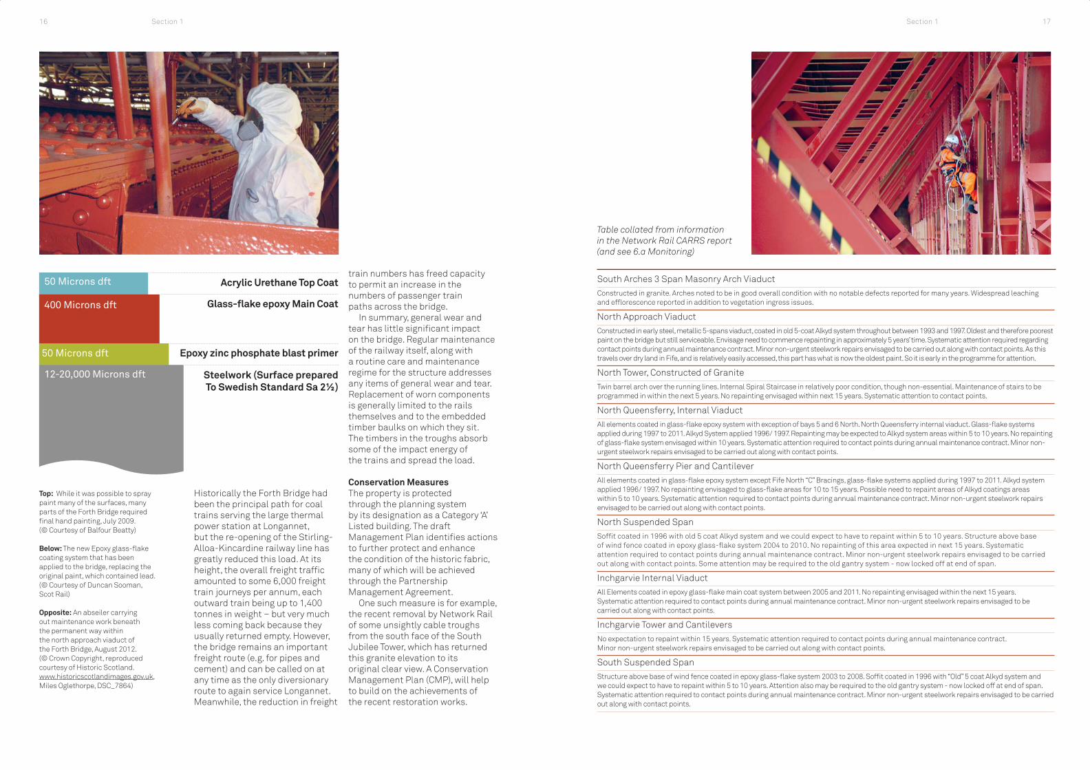
50 Microns dft Acrylic Urethane Top Coat
Glass-fl ake epoxy Main Coat
Epoxy zinc phosphate blast primer
Steelwork (Surface prepared To Swedish Standard Sa 2½)
400 Microns dft
50 Microns dft
12-20,000 Microns dft
Top: While it was possible to spray paint many of the surfaces, many parts of the Forth Bridge required fi nal hand painting, July 2009. (© Courtesy of Balfour Beatty)
Below: The new Epoxy glass-fl ake coating system that has been applied to the bridge, replacing the original paint, which contained lead. (© Courtesy of Duncan Sooman, Scot Rail)
Opposite: An abseiler carrying out maintenance work beneath the permanent way within the north approach viaduct of the Forth Bridge, August 2012. (© Crown Copyright, reproduced courtesy of Historic Scotland. www.historicscotlandimages.gov.uk, Miles Oglethorpe, DSC_7864)
Historically the Forth Bridge had been the principal path for coal trains serving the large thermal power station at Longannet, but the re-opening of the Stirling-Alloa-Kincardine railway line has greatly reduced this load. At its height, the overall freight traffi c amounted to some 6,000 freight train journeys per annum, each outward train being up to 1,400 tonnes in weight – but very much less coming back because they usually returned empty. However, the bridge remains an important freight route (e.g. for pipes and cement) and can be called on at any time as the only diversionary route to again service Longannet. Meanwhile, the reduction in freight
train numbers has freed capacity to permit an increase in the numbers of passenger train paths across the bridge.
In summary, general wear and tear has little signifi cant impact on the bridge. Regular maintenance of the railway itself, along with a routine care and maintenance regime for the structure addresses any items of general wear and tear. Replacement of worn components is generally limited to the rails themselves and to the embedded timber baulks on which they sit. The timbers in the troughs absorb some of the impact energy of the trains and spread the load.
Conservation MeasuresThe property is protected through the planning system by its designation as a Category ‘A’ Listed building. The draft Management Plan identifi es actions to further protect and enhance the condition of the historic fabric, many of which will be achieved through the Partnership Management Agreement.
One such measure is for example, the recent removal by Network Rail of some unsightly cable troughs from the south face of the South Jubilee Tower, which has returned this granite elevation to its original clear view. A Conservation Management Plan (CMP), will help to build on the achievements of the recent restoration works.
Table collated from information in the Network Rail CARRS report (and see 6.a Monitoring)
South Arches 3 Span Masonry Arch ViaductConstructed in granite. Arches noted to be in good overall condition with no notable defects reported for many years. Widespread leaching and effl orescence reported in addition to vegetation ingress issues.
North Approach ViaductConstructed in early steel, metallic 5-spans viaduct, coated in old 5-coat Alkyd system throughout between 1993 and 1997. Oldest and therefore poorest paint on the bridge but still serviceable. Envisage need to commence repainting in approximately 5 years’ time. Systematic attention required regarding contact points during annual maintenance contract. Minor non-urgent steelwork repairs envisaged to be carried out along with contact points. As this travels over dry land in Fife, and is relatively easily accessed, this part has what is now the oldest paint. So it is early in the programme for attention.
North Tower, Constructed of GraniteTwin barrel arch over the running lines. Internal Spiral Staircase in relatively poor condition, though non-essential. Maintenance of stairs to be programmed in within the next 5 years. No repainting envisaged within next 15 years. Systematic attention to contact points.
North Queensferry, Internal ViaductAll elements coated in glass-fl ake epoxy system with exception of bays 5 and 6 North. North Queensferry internal viaduct. Glass-fl ake systems applied during 1997 to 2011. Alkyd System applied 1996/ 1997. Repainting may be expected to Alkyd system areas within 5 to 10 years. No repainting of glass-fl ake system envisaged within 10 years. Systematic attention required to contact points during annual maintenance contract. Minor non-urgent steelwork repairs envisaged to be carried out along with contact points.
North Queensferry Pier and CantileverAll elements coated in glass-fl ake epoxy system except Fife North “C” Bracings, glass-fl ake systems applied during 1997 to 2011. Alkyd system applied 1996/ 1997. No repainting envisaged to glass-fl ake areas for 10 to 15 years. Possible need to repaint areas of Alkyd coatings areas within 5 to 10 years. Systematic attention required to contact points during annual maintenance contract. Minor non-urgent steelwork repairs envisaged to be carried out along with contact points.
North Suspended SpanSoffi t coated in 1996 with old 5 coat Alkyd system and we could expect to have to repaint within 5 to 10 years. Structure above base of wind fence coated in epoxy glass-fl ake system 2004 to 2010. No repainting of this area expected in next 15 years. Systematic attention required to contact points during annual maintenance contract. Minor non-urgent steelwork repairs envisaged to be carried out along with contact points. Some attention may be required to the old gantry system - now locked off at end of span.
Inchgarvie Internal ViaductAll Elements coated in epoxy glass-fl ake main coat system between 2005 and 2011. No repainting envisaged within the next 15 years. Systematic attention required to contact points during annual maintenance contract. Minor non-urgent steelwork repairs envisaged to be carried out along with contact points.
Inchgarvie Tower and CantileversNo expectation to repaint within 15 years. Systematic attention required to contact points during annual maintenance contract. Minor non-urgent steelwork repairs envisaged to be carried out along with contact points.
South Suspended SpanStructure above base of wind fence coated in epoxy glass-fl ake system 2003 to 2008. Soffi t coated in 1996 with “Old” 5 coat Alkyd system and we could expect to have to repaint within 5 to 10 years. Attention also may be required to the old gantry system - now locked off at end of span. Systematic attention required to contact points during annual maintenance contract. Minor non-urgent steelwork repairs envisaged to be carried out along with contact points.
Section 1 17Section 116

The next major intervention priority in a hard-to-access area like Inchgarvie tower would then arise in 2028. The bridge is in as good a condition as it was before the First World War. This is most unusual in bridges of this age.
The property is a landmark from a distance of up to 20km, and contributes in various ways to the setting of so many places that it would be misleading to defi ne a limited area as the only one in which the setting of the bridge must be safeguarded. In light of the UNESCO publication 25, World Heritage Buffer Zones (2009), the Steering Group has concluded that many of the desirable aspirations that could be addressed in the vicinity of the property could better be achieved by avoiding use of the term “buffer”, with its connotations of visual impact and protection against harm, rather than pro-active planning. In order to demonstrate this, the setting of the property has been subject to rigorous study by means of Key View photography and by Viewshed analysis, the results of which can be found in Section 5.c.8 of the Nomination Document.
For key-view photography, viewpoints were chosen by physical investigation from as many points as possible, supplemented by internet searches of photographic images of the Forth Bridge. The viewpoint study demonstrated that it is the Fife Tower and cantilever
that stands most prominently because it projects into the Forth, whereas the Queensferry cantilevers to the south are more sheltered, enclosed by a hill to the east and by gently rising ground to the west.
From points north and south, much depends on climatic conditions where land is the backdrop. The bridge stands out against sunshine and shadows that give a visual contrast, but on other occasions it might merely vanish into the landscape. The Forth Bridge and the adjacent Forth Road Bridge are suffi ciently far apart in north-south axes that in most cases one or the other bridge will be captured in a photograph, but not usually both together.
The tallest modern building in the vicinity is the control tower of Edinburgh Airport, 57m high, built in 2005. It can be seen from the top of the Forth Bridge, and vice versa. They are, however, hardly in competition at a distance of around 5-6 Km. When viewed in line from hills 16-20 km away to the south, the control tower would need to have been twice as high again to intrude into the sight line of the Forth Bridge. From higher points in these hills, the bridge is a distant element, unobstructed by man-made competition. This suggests that development does not need to be controlled to protect such long views.
From east and west, long views benefi t where a backdrop is either sky or water. This particularly applies to views from the west looking out to sea. Development on the Forth shoreline should therefore take into consideration impact on some cherished views. However it is evident that existing structures along the edge of the Forth have almost no adverse effect when viewed as part of the backdrop to the Forth Bridge. The Forth Road Bridge is clearly distinguishable even when views pass through it, and the Queensferry Crossing now under construction will have a similar effect. Large buildings by the shore at Rosyth Dockyard, and at Longannet, the largest power station in Scotland, do not compete
against the Forth Bridge even when they come into the background frame.
In order to further better understand the setting of the bridge, a ‘Viewshed analysis’ was also undertaken. Using topographic data from digital maps, a scoring system for viewpoints was applied, the higher the score, the more of the bridge that can be seen at any specifi c location. Each ‘viewshed’ can be rotated through 90 degrees into any number of cross-sections showing the profi le of land between the bridge and a viewer. The most important viewshed sightlines show that development in the centre of Edinburgh cannot obstruct views of the Forth Bridge. The others show that some hills could potentially affect views from a greater distance.
City of Edinburgh Council adopted key view assessment to help assess the impact of proposed high-rise development within the city. This has proved to be useful in determining the potential impact of proposed development on the Old and New Towns of Edinburgh existing World Heritage Site, even well beyond the property itself (there is no Buffer Zone). What may be built in low-lying folds of hills may have less impact than would a new building of the same height on the crest of a hill. It may then be possible to adjust the massing of that development so as to minimise harm to the setting of specifi c landmarks. The system worked well, and Planning Authorities considering setting as a factor in determining planning applications may also take guidance from: http://www.historic-scotland.gov.uk/setting-2.pdf.
In the case of the Forth Bridge, the scale and setting of the structure is such that monitoring proposed developments using Viewshed analysis and controlling development through the existing system of Planning and designations will be at least as effective as has proved to be the case in the City of Edinburgh. It is therefore our view that a strictly-defi ned Buffer Zone would not be helpful in the context of the Forth Bridge.
1.d.3 Landscape Assessment and Visual Appraisal
Detail of the access walkway and structural steel work beneath the permanent way in the south viaduct of the Forth Bridge, July 2011.(© Crown Copyright, reproduced courtesy of Historic Scotland. www.historicscotlandimages.gov.ukMiles Oglethorpe)
South Queensferry Pier and CantileverAll elements coated in epoxy glass-flake main coat system applied between 1998 and 2011. No repainting envisaged within the next 10 years at least -and 15 years for more recently painted elements e.g struts and top members. Systematic attention required to contact points during annual maintenance contract. Minor non-urgent steelwork repairs envisaged to be carried out along with contact points.
South (Jubilee) TowerSupport tower constructed in granite. Twin barrel arch over the running lines. New external cantilevered wrap around walkway installed in 2012. Internal spiral staircase is redundant and currently out of general use. Minor repairs required. Externally available faces coated in epoxy glass-flake system approx 2006. In excellent condition. No repainting envisaged within 15 to 20 years. Systematic attention to Contact points.
Ten-Span Metallic Viaduct Numbered from Low Mileage End from DalmenyConstructed in early steel. South approach spans 1 to 9 - counting from the South All coated in 3 coats. Epoxy glass-fl ake main coat. 1996 to 1999 coat 1997. Systematic attention required regarding Contact points. Span 10 ( nearest to Jubilee Tower) coated in “Old” 5 Coat Alkyd system in 1996, possibly need to repaint 2018 onwards. Systematic attention required regarding Contact points during annual maintenance contract. Minor non-urgent steelwork repairs envisaged to be carried out along with contact points.
South Approach Arches4-span masonry arch viaduct numbered from low mileage end from Dalmeny. Constructed in granite. End support completely buried under embankment at Dalmeny end. Arches noted to be in good overall condition with no notable defects reported for many years. Widespread leaching and efflorescence continually reported in addition to vegetation issues.
LighthouseThe Lighthouse is a category A listed structure and is owned by Network Rail.
Section 1 19Section 118

The Nomination and Management Plan have been developed by the Forth Bridge World Heritage Nomination Steering Group, a sub-group of the Forth Bridges Forum. The Steering Group comprises representatives of the following organisations: • Network Rail: the owner and
operator of the Forth Bridge. It is a ‘not for shareholder dividend’ company, all its profi ts being reinvested in improving the UK railway network.
• Transport Scotland: the Scottish Government agency responsible for transport, whose responsibilities include railway infrastructure in Scotland. Transport Scotland also manages and funds the Forth Bridges Forum.
• Historic Scotland: the Scottish Government agency responsible for protecting and promoting Scotland’s historic environment.
• Fife Council: the local authority covering the area around North end of the bridge, including North Queensferry.
• City of Edinburgh Council: the local authority covering the south end of the bridge, including Queensferry.
• Forth Estuary Transport Authority (FETA): the public body responsible for maintaining the existing Forth Road Bridge.
• Visit Scotland: the national organisation responsible
The process of engaging local communities and businesses in the development of the World Heritage Site nomination commenced with the commissioning in December 2012 of Rebanks Consulting Ltd to examine the potential economic benefi ts of nomination to the local communities around the bridge. There followed a formal twelve-week public consultation exercise to provide an opportunity for local residents, businesses, organisations, visitors and others to comment on the nomination and management proposals for the Forth Bridge.
A public consultation document was produced which contained a summary of the proposals for nomination and management of the Site, highlighting the key issues, including potential benefi ts, threats, opportunities and restrictions. A consultation questionnaire accompanied the document, and both were made available throughout a twelve week period and at public venues across the area. The consultation commenced on Monday 20th May and ended on Sunday 11th August 2013, and was available online through a dedicated website at www.forthbridgeworldheritage.com. In addition, four drop-in workshop sessions were arranged from May to August 2013 to enable the public to speak to members of the Steering Group about the proposals, and a promotion day
was held at Edinburgh Waverley Station on 30th July.
The consultation focused on management issues relating to the local communities situated around the Forth Bridge, for whom the impact of World Heritage is likely to be most intense. Fifty-eight valid responses were received via the online questionnaire. Of the four public events that were held, two were hosted in Queensferry (south of the river), and two in North Queensferry, together attracting 93 people. The meetings took the form of facilitated workshops and proved to be lively and constructive events.
for promoting tourism in collaboration with private businesses, public agencies and local authorities both in Scotland itself, the UK and overseas.
• Queensferry Ambition: Business Improvement District (BID) established in 2012 to promote Queensferry as a quality destination for businesses, residents and visitors, through strengthening local involvement and partnership.
• Queensferry & District Community Council: a voluntary but statutory body representing the people of Queensferry and Dalmeny.
• North Queensferry Community Council: a voluntary but statutory body representing the people of North Queensferry.
• North Queensferry Heritage Trust: a voluntary organisation dedicated to preserving and promoting the history and beauty of North Queensferry and its immediate surroundings.
The Steering Group has overseen the production of the Nomination Document and Management Plan, supported by a secretariat in Transport Scotland, and will continue to co-ordinate actions for the implementation of the Management Plan and its vision. A concordat to this effect has been agreed by the group:
We, the representatives of the Scottish Ministers (Transport Scotland and Historic Scotland), Network Rail, Visit Scotland, Fife Council, City of Edinburgh Council, the Forth Estuary Transport Authority, Queensferry Ambition, Queensferry & District Community Council, North Queensferry Community Council and North Queensferry Heritage Trust declare our support for the nomination of the Forth Bridge as a World Heritage Site. We confi rm that all parties are committed to working together to achieve appropriate recognition for the Forth Bridge in the cultural heritage of Scotland, the UK and its wider international context. Moreover, all parties confi rm that they will work together to improve the protection, management, presentation and interpretation of the Forth Bridge and so deliver sustainable development for the economic and social benefi t of the communities that live alongside it.
Membership of the Steering Group remains open and others with active interests around the property will be encouraged to join as appropriate. In the event of inscription being achieved in 2015, the word ‘Nomination’ will be removed from the full title of the Steering Group, and in the longer term it will review and revise the Management Plan.
1.e Partners and Major Stakeholders in the Property
1.f The Consultation Process for the Nomination
Billy Steven (left) and Grant Ritchie (right), winners of the Transport Scotland Forth Bridge Photo Competition, with Keith Brown , MSP (centre), Minister for Transport and Veterans in the Scottish Government, 26 November 2013, (© Crown Copyright, reproduced courtesy of Historic Scotland. www.historicscotlandimages.gov.ukSantiago Arribas)
Section 1 21Section 120

Opposite: Nocturnal view of the Forth Bridge taken from the Town Pier, North Queensferry, by Ian Appleton in March 2012. (© Ian Appleton, Forth Bridge Photographic Competition Finalist, Ian Appleton, FBPC0115)
The response to the consultation was broadly very positive, with the overwhelming majority of online respondents welcoming the nomination of the bridge. Of those who were less confi dent about the perceived benefi ts of World Heritage inscription, most were also in favour, but were concerned about potentially negative impacts upon the quality of life in the two communities.
Much of the concern in the online questionnaire focused on road infrastructure, parking, potential congestion and worsening traffi c hazards caused by a predicted increase in visitor numbers. These were perceived by many to be problems that already exist, and so the World Heritage nomination was thought by some to be a good opportunity for the local authorities to take the initiative and propose solutions before the situation gets even worse. There was a consensus that action needs to be taken as soon as possible, rather than waiting until potential inscription in 2015.
These issues also emerged strongly in the workshops, where it was stressed that a co-ordinated, sustainable approach to transport and parking was needed. Suggested solutions included better use of both of train services and of boat transport, as well as an expansion of park & ride facilities.
A small number of people expressed concern at the possibility of a surge in the number of visitors, so harming the existing character of the communities on both banks of the Forth, and any potentially negative impact on the natural environment. However, overall,
responses were both positive and helpful, and have been incorporated into this Management Plan.
Many believe that World Heritage will bring with it opportunities for business, including tourism, and has the potential to feed into many forms of education. Perceived benefi ts ranged in scale from those affecting local businesses to national and international developments. There was an almost universal sense of pride and cultural value associated with the bridge, even amongst those who were concerned about harmful impacts from World Heritage inscription.
All the workshops expressed the hope that World Heritage would result in the attraction of more investment into the communities, with better networking, improved and better co-ordinated public transport, and with this, the potential for ‘Green Tourism’. There was therefore a strong feeling that effective management will be needed to ensure adequate systems and enhanced infrastructure to minimise the potentially detrimental effects of more traffi c and people, if World Heritage inscription is achieved.
Meanwhile, the widespread support for the nomination was further demonstrated during the day of promotion at Waverley Station.
No negative reactions to the nomination were detected amongst a wide range of passing passengers and other pedestrians throughout the day. Some even expressed surprise that the Forth Bridge is not already a World Heritage Site.
1.g Summary of Response to the Consultation
Section 122

The Forth Bridge is a globally-important triumph of engineering, at once structural and aesthetic. It represents the pinnacle of 19th century bridge construction and is without doubt the world’s greatest cantilever trussed bridge. When opened in 1890 it had the longest bridge spans in the world, a record held for 27 years. No other trussed bridge approaches its perfect balance of structural elegance and strength, nor its overall scale, and no bridge is so distinctive from others as is the Forth Bridge from its peers.
Superlative in its application of novel technologies, the Forth Bridge used and infl uenced engineering know-how that had become international in scope. The bridge continues to act as a vital transport artery and shows in an exemplary way how an historic bridge can be sensitively managed to meet modern needs. Painted Forth Bridge red, a task famously set into folklore as endless, this icon of Scotland perfectly encapsulates 19th century belief in mankind’s ultimate ability to overcome any obstacle: the impossible could indeed be made possible.
Section 2 – Analysis of Signifi cance, Heritage Protection, Land-Use Planning, Designations and Management Arrangements
2.a Analysis of Signifi cance
2.a.1 Statement of Outstanding Universal Value
Aerial view from the south of Queensferry, with the Forth Bridge and Forth Road Bridge, 2012.(© RCAHMS Aerial Photography Collection.Licensor www.rcahms.gov.uk, DP114662)
2.a.2 Justifi cation for Inscription
The Forth Bridge is the world’s fi rst monumental-scale steel bridge. When it was built it had the longest spans in the world, was unique in its scale and superlative in its application of novel technologies. It is a keystone achievement in the world history of bridge-building and of steel construction. It has worldwide iconic status as a globally-important triumph of historic engineering.
The genius of its design is at once structural and aesthetic. The ideas enshrined in this iconic industrial monument had worldwide scientifi c and architectural application that
Section 2 25

The Forth Bridge itself is listed at Category ‘A’ for its international and national importance. This gives it statutory protection and any change to the character of the bridge requires Listed Building Consent, which has to be obtained from City of Edinburgh and Fife Councils, with advice from Historic Scotland on behalf of Scottish Ministers. The date of statutory listing was 18th June 1973.
In addition to the Forth Bridge itself, in the adjacent bridgehead zone (at its north and south ends), there are a number of other listed buildings. Those relating to crossing the Forth are included in the table on page 28.
signifi cantly advanced the condition of mankind and society across the world.
The overall span of 2,529 metres links Fife to Edinburgh and beyond. Of counterbalanced cantilever design, each of the 521 m (1710 feet) spans of the bridge consists of two 207m (680 feet) cantilevers and a 107m (350 feet) suspended span. When opened in 1890, they were equally the greatest spans in the world, and stayed so until 1917. The overall size of the Forth Bridge remains unsurpassed by any other steel trussed bridge, and none of these has matched the perfect balance of structural elegance and strength represented by the Forth Bridge.
On completion in 1889 the bridge was therefore the greatest example of its type. It simultaneously achieved the longest and second longest spans in the world and held that record for an unprecedented length of time. It still holds the record for the world’s longest multi-span cantilever bridge, whilst its distinctive profi le is recognised world-over and internationally regarded both as an icon of Scotland and a symbol of engineering prowess.
The criteria on which this nomination is based are therefore that the Forth Bridge:
Criterion i): Represents a Masterpiece of Human Creative GeniusThe Forth Bridge is an aesthetic triumph in its avoidance of decoration and yet an achievement of tremendous grace for something so solid. Its steel-built cantilever design represents a unique level
of new human creative genius in conquering a scale and depth of natural barrier that had never before been overcome by man.
Criterion ii): Exhibits an Important Interchange of Human Values on Developments in Architecture and TechnologyThe Forth Bridge was a crucible for the application to civil engineering of new design principles and new construction methods. It was at that time the most-visited and best-documented construction project in the world. It therefore exerted great infl uence on civil engineering practice world-over and is an icon to engineers world-wide.
Criterion iv): An Outstanding Example of a Type of Building, Architectural or Technological Ensemble or Landscape Which Illustrates (a) Signifi cant Stage(s) in Human HistoryThe Forth Bridge represents a signifi cant stage in human history, namely the revolution in transport and communications. The railway age, of which it is a potent symbol, was made possible by, and infl uenced the speed and connectivity of, the industrial revolution. The bridge forms a unique milestone in the evolution of bridge and other steel construction, is innovative in its design, its concept, its materials and in its enormous scale. It marks a landmark event in science and architecture that went on to profoundly infl uence mankind in ways not limited to bridge-building.
2.b Heritage Protection
2.b.1 Listed Buildings
Title: Key
Scale:
Projection:
Forth Bridge
Map showing cultural designated places close to the Property, 2013. Contains public sector information and Ordnance Survey data (© Crown Copyright, 2013 Ordnance Survey [Licence Number 100021521])
1:30,000
British National Grid
Nominated Property
Listed Building
Scheduled MonumentGardens and designed landscapes inventory site
Battlefi elds Inventory site
Conservation area
Section 226

Name of Building Designation
Light House and pier of the fi rst bridge by Thomas Bouch, 1878, included within the listing of the Forth Bridge itself
Category A
Forth Road Bridge, 1964 Category A
Name of Building, Fife Designation
North Queensferry Station, 1890 Category B
Town Pier, 1810-18, Category A
East and West Battery Piers, 1810-13, altered 1883-90 Category A
Railway Pier, 1872-7, Category B
Pilot Boat Slipway circa 1883, Category C
Pierhead Tower House, 1810 Category C
Pierhead Signal House, 1810 Category B
Royal Naval Signal Station Cottages, Category B
Carlingnose Battery, 1901-2 Category A
Name of Building, City of Edinburgh Designation
Dalmeny Station, 1890 Category B
Hawes (New Hall) Pier and Leading Light, 1810 Category B
Queensferry Harbour 16th century/ 1809-18 Category B
Bridge House, 22-23 Newhalls Rd, 1882 Category C
Hawes Garage, 18th century Category C
Hawes Inn, 1838/1893 Category B
There is no scheduled monument as part of the property. This designation applies to assets of national importance that are not expected to be put into use. So the nearby Island of Inchgarvie is scheduled, and specifi cally excludes the Forth Bridge. The central cantilever tower of the bridge stands on rock that is near the island. The Chapel to St James in North Queensferry is a scheduled monument. St James is the patron saint of travellers.
The springing point at each end of the bridge is protected by Conservation Area designation: North Queensferry Conservation Area and Queensferry Conservation Area. These cultural designations link into the relevant local development plans. Any development there must enhance or preserve the special character of the area, as is set out in their respective conservation area character appraisals. Trees and buildings are protected from felling, lopping or demolition without the appropriate permissions. Certain works to buildings that are within conservation areas may need planning permission. North Queensferry Conservation Area includes the ground carrying the entire approach viaduct, north portal and all of the Fife Tower. The land here is bounded by the masonry blocks of the East and West Battery Piers, topped by tubular iron railings. The Conservation Area includes the Station and part of the escarpment that is at track level between the road and rail bridges. The conservation area boundary was amended to cover this larger area in 2005 and the Character Appraisal of the conservation area went through public consultation and was adopted in 2011. http://www.fi fedirect.org.uk/publications/index.cfm?fuseaction=publication.pop&pubid=068CBC54-003E-D5A7-53D540E1E10A0E3F
The local authority area to the south of the property, City of Edinburgh, contains a World Heritage Site, the ‘Old and New Towns of Edinburgh’, but this is over 15 km away to the south east. The Forth Bridge is just visible from high points like the Castle and Calton Hill but not from most parts of that site.
The Frontiers of the Roman Empire World Heritage Site has its most northerly component, the Antonine Wall, commence at Bo’ness on the Forth estuary, 11 km to the west, within the Falkirk local authority area.
Note that World Heritage Sites in the UK are afforded protection through the national planning system and have no separate statutory protection from that.
Queensferry Conservation Area The Conservation Area includes the masonry arches and the fi rst seven spans of the Queensferry viaduct of the property, as far as the tidal Low Water Mark. The Conservation Area is enclosed at the west end by the Forth Road Bridge. The Conservation Area Character Appraisal was published by City of Edinburgh Council in 2001, so the council proposes to prepare a review of this appraisal in the short to medium term.http://www.edinburgh.gov.uk/downloads/fi le/1507/queensferry_conservation_area_character_appraisal Dalmeny Conservation Area appraisal emphasises the rural character of this village conservation area, the landmark buildings, predominant vernacular building forms and materials, and the mainly residential character. The Forth Bridge is visible in gaps between houses from the green and from the road running northwards. The Conservation Area Character Appraisal was approved by City of Edinburgh Council in 2000.http://www.edinburgh.gov.uk/directory_record/10196/dalmeny_conservation_area A tree preservation order (TPO) has an equal effect on felling and lopping of trees, even where not actually a conservation area. This applies in respect of tree cover at the escarpment that is at track level between the road and rail bridges at Northcliff, North Queensferry.
2.b.2 Scheduled Monuments
2.b.3Conservation Areas
2.b.4 World Heritage Sites
The Hawes Pier with leading light and the Hawes Inn and stables, all listed, situated at the east side of Queensferry, close to the bridge, and located within a Conservation Area, July 2013. The pier, inn and stables all served ferry travellers prior to the opening of the Forth Road Bridge in 1964. (© Crown Copyright reproduced courtesy of Historic Scotland. www.historicscotland.images.gov.uk Miles Oglethorpe, DSC_3687)
Section 228 Section 2 29

This Section provides details of the development control and planning system covering the property and the areas at each end of the bridge. Existing plans and policies support the heritage protection system outlined above and provide for the protection of the landscape and wider setting. Local Plans and frameworks are currently being revised and so present opportunities for new specifi c policies to be introduced. The Steering Group, including the local authority partners with responsibility for planning, is committed to the full and effective use of existing policies for the protection, conservation and presentation of the property while the new planning policies are continually being developed and implemented.
Scotland has a similar but devolved system to the rest of the UK for the control of development, which is achieved through the spatial planning system. Much of the detail of this system of development control and spatial planning is exercised through the Local Authorities responsible for spatial planning and development control, with government guidance.
World Heritage Sites in Scotland are protected by the following legislation. The Town and Country Planning (Scotland) Act 1997 and The Planning etc (Scotland) Act 2006 provide a framework for local and regional planning policy and act as the principal primary legislation guiding planning and development in Scotland. Additionally, individual buildings, monuments and areas of special archaeological, architectural or historic interest are designated and protected under the Planning (Listed Building and Conservation Areas) (Scotland) Act 1997 and the 1979 Ancient Monuments and Archaeological Areas Act. In this case, the property is a category A listed building, whilst the Queensferry and North Queensferry Conservation Areas, themselves containing listed buildings, provide adequate protection to the immediate bridgehead zones.
The Scottish Historic Environment Policy (SHEP) is the primary policy guidance on the protection and management of the historic environment in Scotland. Scottish Planning Policy (SPP) sits alongside the SHEP and includes the Government’s national planning policy on the historic environment. It provides for the protection of World Heritage Sites by considering the impact of development on their Outstanding Universal Value, authenticity and integrity. Local policies specifi cally protecting the property are contained within City of Edinburgh and Fife Local Development Plans.
There are four levels of planning in Scotland:• The National Planning Framework
for Scotland• Strategic Development
Plans (these have replaced Structure Plans)
• Local Development Plans (these replace Local Plans)
• Supplementary Guidance (e.g. Conservation Area Appraisals or, potentially, planning aspects of a World Heritage Site Management Plan)
Local Development Plans (LDP) set out policies and proposals for the development and use of land in their area. They are the local interpretation of regional and national planning policy, and must conform to the relevant Strategic Development Plan (SDP) for their region and the National Planning Framework (NPF). The Scottish Historic Environment Policy (SHEP) is the strategic statement of national policy relating specifi cally to the historic environment. Below the LDP, more detailed local guidance is set out in Supplementary Guidance documents.
The policies in each LDP are used to determine applications for development. The LDP also informs decisions on investment opportunities, the provision of infrastructure and community facilities. Local residents and community groups are encouraged to use the LDP to understand and engage with the planning issues affecting their area.
LDP policies therefore provide the means by which development affecting the designated sites is managed, and by which they are protected from inappropriate development. All development is approved, or not, under the terms of the relevant LDP, which set out a vision as to how areas will change. They describe where development will take place and where it will not. These are updated in a regular cycle of review and consultation.
The planning authorities surrounding the bridge are currently in a state of transition between the old Local Plans system and the new LDP/SDP system. However the principles behind, and the strength of the policies affecting the bridge and its setting remain the same through this period of change. The local authorities are both represented on the Steering Group, which will play a part in ensuring that the conservation of the property is adequately promoted in any new and revised Plans and guidance.
Fife Policy SummaryThe Dunfermline and West Fife Local Plan (DWFLP), adopted 2012, is to be replaced by the Fife Local Development Plan in 2015. The DWFLP remains the current, adopted statement of Council policy until the LDP is formally adopted. Once the Proposed LDP is published in June 2014, however, it will become a material consideration in the determination of current planning applications. In the Fife LDP it is intended to include policy specifi cally directed at protecting the context of the Forth Bridge. The broad policies are listed below Edinburgh as there is a general read-across between those of each local authority, but one specifi c to Fife should also be mentioned:
Development on the undeveloped coast [in Fife] will not be supported unless certain safeguards are followed, directing development fi rst to developed coastline and which:• demonstrates high standards of
design and siting,
• demonstrates appropriate scale and character
• is not subject to nor will it contribute to coastal erosion or fl ood risk
• safeguards cultural / natural heritage resources, footpath/cycle networks
• avoids obtrusive lighting or coalescence of coastal villages
City of Edinburgh Policy SummaryThe Rural West Edinburgh Local Plan (RWELP), adopted 2006, altered 2011, was joined by the Edinburgh Local Development Plan (LDP), published in March 2013. The RWELP remains the current, adopted statement of Council policy until the LDP is formally adopted, anticipated to be by late 2015. The proposed LDP is, however, a material consideration in the determination of current planning applications.
The DWFLP, RWELP and LDP contain key policy objectives that are broadly comparable across both local authorities. They include those to:• ensure that new development
meets the objective of sustainable development and contributes to a healthy and attractive environment;
• protect, conserve and enhance the key environmental and heritage resources, including landscape, built heritage and important natural habitats;
• encourage quality of design in all new forms of development; and
• protect the special character of historic buildings and townscapes.
Detailed policies then focus on the following themes which are of particular relevance to the property and its setting:• Design of new development – the
Council encourages innovation and well designed developments that relate sensitively to the existing quality and character of the local and wider environment, generate distinctiveness and a sense of place, and help build stronger communities.
• Development in the Green Belt and countryside – here, development is only permitted where it meets certain restricted criteria and would not detract from the landscape quality and/or rural character of the area.
• Nature conservation and biodiversity – development is not permitted which would adversely affect the integrity of designated areas, protected landscapes or species unless in exceptional circumstances of demonstrable public benefi t.
• Special or Local Landscape Areas – development is not permitted which would damage or detract from the overall character and appearance of the area.
• Trees – development will not be permitted which is likely to have a damaging impact on a protected tree or one considered worthy of retention, unless necessary for good arboricultural reasons.
• Archaeology – development is not permitted which would adversely affect nationally important remains or their setting. Archaeological evaluation, preservation in situ or excavation, recording and analysis will be required where non-designated remains are likely to be affected.
• Historic buildings – there is a general presumption against demolition or signifi cant alterations which would have an adverse effect on the character of historic buildings. Other alterations will be permitted only if not detrimental to the special character, historic interest or setting of the building.
• Conservation areas – development must preserve or enhance the special character or appearance of the conservation area and its setting.
• Historic gardens and designed landscapes – development will only be permitted where there is no detrimental impact on the character of a site or its component features.
2.c Land-Use Planning
2.c.1 World Heritage Sites and Planning
2.c.2 Relevant Local Plans
Section 230 Section 2 31

Map of Local Landscape Areas close to the Property, August 2013. Contains public sector information and Ordnance Survey data (© Crown Copyright, 2013 Ordnance Survey [Licence Number 100021521])
Title: Key
Scale:
Projection:
Forth Bridge
1:75,000
British National Grid
Nominated Property
Candidate speciallandscape area
Area of great landscape value
Local Landscape Area
In place of the former designation “Area of Great Landscape Value” and “Areas of Outstanding Landscape Quality” (AGLV/ AOLQ) local authorities have developed proposals for what were called Candidate Special Landscape Areas (cSLA). The term ‘candidate’ will be dropped after consultation is complete and then the term will be Local Landscape Areas, as already adopted in Fife (see map). As the landscape areas are at different stages in the consultation process they carry different names in each local authority (see map). These tend to be areas that are rural in character, and so policies will aim to retain that character.
In West Lothian the Forth Shore AGLV will in due course become the Forth Coast Local Landscape Area.
City of Edinburgh has these:• cSLA01: Southern Forth Coast• cSLA04 Dundas Estate• sSLA22 Craigie Hill
(south of A90) Fife has these:• Ferry Hills• Letham Hill• South West Dunfermline• Forth Islands
To inform the Local Development Plan, specifi c research has addressed, for example, the capacity for Wind Energy Development in West Lothian,
in a consultation published in 2011. This found that only limited pockets around Livingston New Town, the M8 Motorway and around Black Law to the south west had that potential. The part nearest the Forth shore, Hopetoun Estate, was considered to be on the “highest scale of sensitivity” and therefore unsuited to use as a wind farm. Even if that were not the case we have argued that wind turbines would not threaten the Outstanding Universal Value of the bridge.
A similar capacity study into windfarms in Fife found that there are no landscape areas of Fife suitable for development of extensive windfarms with large scale turbines. In contrast with much of Scotland there is no or very limited capacity for wind turbines in the highest upland areas, due to the limited extent, high visual sensitivity and landscape value of these areas within Fife. Larger scale lowland farming areas have the greatest inherent capacity for wind turbine development. Some smaller scale lowland valley and basin areas have no or very limited capacity. Some coastal areas have limited capacity. Similar areas, whilst of a suitable scale and character for wind turbines, are visually sensitive and have a high landscape value and therefore have no capacity for development. (Onshore Wind Energy Strategy for Fife 2012)
2.c.3 Local Landscape Areas and the Capacity for Wind Farms
Section 232

The Forth Estuary Forum monitors and coordinates actions that enhance the environment of the Firth of Forth.
Gardens and Designed LandscapesThere is no designed Garden or Designed Landscape within the property, but there are some nearby, and they therefore play an important role in protecting the setting of the bridge. Those referred to here are all included in the Inventory of Gardens and Designed Landscapes compiled for Scottish Ministers by Historic Scotland. These are particularly evident in the more open landscape of the south side of the River Forth. That part of Dalmeny estate that stretches from the Forth Bridge to Mons Hill and Hound Point is so protective of the landscape setting as to be considered part of the bridgehead zone to the Forth Bridge. To the other side of Queensferry, Hopetoun House has on its axis a direct view of the Forth Bridge, and also views of it in elevation through the Forth Road Bridge from the shore line of that estate, Society Point to Abercorn. The Monument at The Binns, a property of the National Trust for Scotland, achieves a similar but more elevated view across Hopetoun. Inland is Dundas Castle which mainly looks south and east but also from a low ridge to the north and both bridges. The
route taken by the M90 towards the Forth Bridge and soon the Queensferry Crossing intervenes but the top towers of the Forth Bridge are still in view.
The wider landscape in Fife north and east of the bridge and beyond its bridgehead zone includes estates like Fordell Castle, Pittencrieff and Donibristle (a remaining part of which is the inventory entry St Colme) that look onto the Forth. The foregrounds of these Key Viewpoints benefi t from Inventory designation.
Implications: Under the Town and Country Planning (Development Management Procedure) (Scotland) Regulations 2008, planning authorities are required to consult Historic Scotland on development proposals considered to affect an Inventory Garden or Designed Landscape. This applies only to developments that require planning permission, and is a material consideration but not a prohibition on development. Developments within designed landscapes will be considered in terms of their impact on that designed landscape, and only rarely will impact on the Outstanding Universal Value of a World Heritage Site beyond those boundaries also be a consideration.
The gardens and designed landscapes listed and mapped here predate the construction of the Forth Bridge, excepting
Pittencrieff Park (1903). The focus of the Inventory designation is the conservation of the landscape within the park, but views to and from that landscape will be a consideration, according to the weighting of the values in the Statement of Signifi cance. Thus Dalmeny designed landscape provides the setting for category A listed buildings and so has outstanding architectural value, and is of outstanding “scenic signifi cance as it can be viewed from the Firth of Forth, the Forth Bridges and the south coast of Fife…” Although not initially laid out with a view to protecting a bridge that had yet to be built, these landscapes are cultural and natural components in the safeguards in place for the setting of the Forth Bridge.
Reference is made in the table opposite to views towards and from the Forth Bridges and Firth of Forth extracted from the Inventory of Gardens and Designed Landscapes:
Those contiguous parts of the Inventory sites on the Lothian/south side of the River Forth and within the visual contour are within the bridgehead zone. They offer some protection from development within their boundaries to key views indicated in the map, as also do the Inventory Sites not in the bridgehead zone.
Battlefi eldsThe property stands at its northern end within the designated
Inverkeithing Battlefi eld, which is included in the Inventory of Historic Battlefi elds. North Queensferry was the landing point in 1651 of an invading English army. Since then, the battle landscape has physically changed through land reclamation, the new Rosyth garden city, the growth of Inverkeithing and the concentration of transport infrastructure at this headland. Topography and contemporary accounts give clues to the location of initial stances of the English army
at Ferryhills, cut through by the Forth Bridge tunnel, and of the Scots at Whinny and Castland Hills and their last stand at Pitreavie Castle.
The Inventory of Historic Battlefi elds is a non-statutory designation for Scotland’s nationally signifi cant battlefi elds, which seeks to retain key landscape characteristics and important features for the future, protecting, managing, enhancing and promoting them as appropriate, while allowing the landscape to accommodate modern demands. There are no new legal restrictions on the area identifi ed by the Inventory maps. Instead, the Inventory sites will be given particular consideration in the planning process and in the plans and policies of other relevant public bodies. Planning authorities and public bodies may consult Historic Scotland on development proposals considered to affect an Inventory battlefi eld and may give them consideration in the determination of a case.
A whinstone quarry is in occasional operation on the north side of the headland, evidence of the longstanding use of volcanic basalt from North Queensferry over many years, not least for use in construction of the Forth Bridge. Its expansion to the south is circumscribed by the position of a public road.
A recent archaeological investigation was organised by North Queensferry Heritage Trust
2.d Other Designations and Protection
Dalmeny The designed landscape itself is of high scenic signifi cance as it can be viewed from the Firth of Forth, the Forth Bridges, and the south coast of Fife as well as being signifi cant from the adjacent locality.
Dundas Castle There are long-distance views over the parkland to the Firth of Forth and views northwards out to the Forth Bridges.
Hopetoun House Hopetoun House was sited facing due east. An avenue extending east from the house was described on the layout plan by William Adam as ‘carrying your eye over two miles of the River Forth to the island and ruins of Inchgarvie and from thence forward along the River 22 miles or more to North Berwick Law, being a high Mount in form of a sugar loaf which terminates the Avenue’. This designed view has been interrupted by the road and rail bridges across the Forth.
House of The Binns
“Panoramic Views to the bridges of the Forth” from Monument over Hopetoun to all of the bridge.
Pittencrieff Park Views can be obtained southwards to the Forth Road Bridge and the Lothian hills.
Fordell Castle From the site of Fordell House (demolished 1962) there are expansive views south over open parkland towards Dalgety Bay and the Firth of Forth.
St Colme St Colme is set on elevated ground overlooking Barnhill Bay, with extensive views over the Firth of Forth to Edinburgh and the Lothian coast. The eastern approach from Aberdour allows uninterrupted views over the Firth of Forth. Along the remainder of the old east drive to Donibristle House there are panoramic views over the Firth of Forth to the Lothians and towards Donibristle House. From the site of the old summerhouse in Temple Plantation there is a panoramic view over the Forth. Perimeter tree belts enclose the landscape to the north.
Reference http://www.historic-scotland.gov.uk/index/heritage/gardens.htm
Section 234 Section 2 35

Section 236
and Fife Council into a possible English army breastwork on the Ferry Hills. It uncovered a bank composed of very large lumps of angular whinstone rock with mechanical quarry drilling holes, making this a feature most likely associated with the construction of the railway and the bridge. The bridge and its approaches simultaneously impact on the landscape of the battlefi eld and are reminders of the most direct route that an invading army could take. The possible landing point at Port Laing, and the initial defensive position of the English Army on the Ferry Hills nonetheless lie on the North Queensferry peninsula, and Castland Hill is one of its key view points within the further setting of the bridge.
Natural DesignationsThe inter-tidal zone close to and below the bridge benefi t from natural designations that are layered according to their value to different species. Of these, Ramsar sites give the strongest protection available to natural sites of European importance in the European Union. Ramsar sites are wetlands of international importance, designated under the Ramsar Convention of 1971 (ratifi ed by the UK in 1976). This designation applies to the inter-tidal shoreline of North Queensferry round to and including Inverkeithing Bay, and on the corresponding southern Shore, the area from Port Edgar and Queensferry around Dalmeny and Hound Point, taking in Cramond Island as far as and including Granton Harbour west breakwater. (Only Rosyth, Dalgety Bay and Hopetoun are stretches of the shore not within this designation). This
means that the rocky shore beneath the Forth Bridges (both Road and Rail), and all the ferry slipways in their immediate environs are protected from actions that might harm their value to migratory bird species, in particular. A side effect is protection of the foreground in views from the shore of the Forth Bridge.
Specifi c natural designated sites and areas include: Firth of Forth Ramsar (Wetland) Natural Site:http://gateway.snh.gov.uk/sitelink/siteinfo.jsp?pa_code=8424Link to more about Ramsar Sites: www.snh.gov.uk/protecting-scotlands-nature/protected-areas/international-designations/ramsar-sites/ Firth of Forth Sites of Special Scientifi c Interest (SSSI)http://gateway.snh.gov.uk/sitelink/siteinfo.jsp?pa_code=8163Sites of Special Scientifi c Interest (SSSI) are those areas of land and water (to the seaward limits of local authority areas) that Scottish Natural Heritage (SNH) considers to best represent natural heritage – its diversity of plants, animals and habitats, rocks and landforms, or a combinations of such natural features. They are the essential building blocks of Scotland’s protected areas for nature conservation. Many are also designated as Natura sites (Special Protection Areas or Special Areas of Conservation). The national network of SSSI in Scotland forms part of the wider GB series. SNH designates SSSI under the Nature Conservation (Scotland) Act 2004. SSSI are protected by law. It is an
offence for any person to intentionally or recklessly damage the protected natural features of an SSSI. The Site Management Statement, site code 8163, sets out fi ve broad objectives for management:• maintaining bird populations,• maintaining the area in a
favourable condition for feeding, resting, roosting and breeding
• maintaining habitat, botanical and invertebrate interest,
• maintaining the geological features of interest,
• encouraging recreational enjoyment while recognising the need to protect the nature conservation interest.
Carlingnose Quarry SSSI is managed by Scottish Wildlife Trust and includes a stage in the Fife Coastal Path that offers good views towards the bridge. It has a high degree of habitat and plant diversity. Management aims are to reduce invasive scrub. Quarrying will not resume. ‘Operations requiring consent’ are set out here: http://gateway.snh.gov.uk/sitelink/documentview.jsp?p_pa_code=8163&p_Doc_Type_ID=28 Firth of Forth Special Protection Area (SPA)http://gateway.snh.gov.uk/sitelink/siteinfo.jsp?pa_code=8499SPA are strictly protected sites classifi ed in accordance with Article 4 of the EC Birds Directive, which came into force in April 1979. They are classifi ed for rare and vulnerable birds (as listed on Annex I of the Directive), and for regularly occurring migratory species, at, for example, Port Edgar.
Map showing the natural designated areas close to the Property, 2013. Contains public sector information and Ordnance Survey data (© Crown Copyright, 2013 Ordnance Survey [Licence Number 100021521])
Title: Key
Scale:
Projection:
Forth Bridge
1:30,000
British National Grid
Nominated Property
SPA
SSSI
Ancient Woodland
RAMSAR

Section 238
The members of the Steering Group and other bodies undertake many activities around The Forth Bridge, but Network Rail and its contractors are solely responsible for managing the property itself. A key purpose of the Management Plan is therefore to support Network Rail with this task, but also to co-ordinate wider efforts relating to the impact of potential inscription, and to focus on the priorities for the area around the property that is most likely to be affected if the nomination is successful.
The nominated property is owned, operated and maintained by Network Rail, the national railway company responsible for maintaining and operating the railway infrastructure in the UK. Network Rail routinely reports to the Offi ce of Rail Regulation. Although at present there is no unifi ed, published Heritage Policy for the railways in the UK, Network Rail, like its predecessor, Railtrack, has a proud track record in protecting, conserving and restoring railway heritage.
In Scotland, this is achieved by actively adhering to the policies laid down in the Scottish Historic Environment Policy (SHEP), working with Historic Scotland on upgrading and rationalising designations, the most recent example being thematic work on signal boxes. Network Rail has a central team, including planners, archivists and engineers, to provide a strategic view of building and architectural issues, like managed stations, many of which are listed buildings. Part of this work involves producing conservation and development management plans for managed, listed stations in association with local authorities and Historic Scotland. In the case of larger structures such as Glasgow Central Station and the Forth Bridge, this can involve a formal Partnership Management Agreement. In situations where historic railway infrastructure is
no longer used, disposal is carefully managed through the Railway Heritage Committee, which was recently incorporated to come under the Trustees of the Science Museum Group, including the National Railway Museum.
In the case of the Forth Bridge, Network Rail uses its Civil Asset Register and electronic Reporting System (CARRS), to ensure that each part of the bridge is programmed to be inspected and works are prioritised according to their urgency. Each section of the bridge is colour coded, as illustrated below. It has a time-span appropriate to the cycle of attention needed at each part.
In addition, a Partnership Management Agreement for the Forth Bridge provides a means by which local authorities, in certain cases consulting Scottish Ministers, will be able to monitor works affecting the bridge.
2.e Existing Management Arrangements
2.e.1 Network Rail
Below: These sample pages (© Network Rail) refer to the work recently done to parts of the bridge, including the Fife cantilevers and pier. It shows that this area had some paintwork done by the old, but not original, fi ve-coat Alkyd system. Those areas will therefore be the fi rst to be recoated by the system applied elsewhere on the bridge in the last decade.
Section 2 39

Fife and City of Edinburgh Councils are represented on the World Heritage Nomination Steering Group, and together own and maintain some of the infrastructure within and around the communities at each end of the bridge. The local authorities work in the public interest with other organisations, landowners, and service providers, as well as the Community Councils.
The national authority is the Scottish Government, working through its agencies such as Transport Scotland and Historic Scotland. The United Kingdom as state party to the World Heritage Convention is represented by the Department for Culture Media and Sport (DCMS).
There is a variety of businesses within the communities at each end of the bridge, and in the case of Queensferry, since 2012, business interests have been co-ordinated through the Business Improvement District (BID) Queensferry Ambition. Another Business Improvement District is making progress in Dunfermline, Fife. Many of these businesses have an interest in possible enhancements to local infrastructure, as increases in visitors might follow inscription. The adjacent estates of Dalmeny and Hopetoun also promote tourism and provide leased business space in farm steadings. Many business premises make reference in their signage and shopfronts to one or both bridges, showing a long-standing symbiotic relationship to the Forth bridges.
There is a wide variety of signage and displays indoors, in print and online provided through a range of local organisations, ranging from North Queensferry Heritage Trust, South Queensferry Museum (under City of Edinburgh council), to the ‘Briggers partnership’, together with the provision of bus, boat and walking tours organised by businesses and volunteers. For many years, information on the Forth Bridge was made available by the Forth Bridges Visitor Centre Trust, which operated a website and a small exhibition at the Queensferry Hotel. However the hotel elected to reclaim the exhibition space for its own business use, and in 2012, the trustees chose to wind up the Trust.
There is therefore currently no formal visitor centre dedicated only to presentation and interpretation of the Forth Bridge. There is, however, the Forth Bridges ‘Contact and Education Centre’, established by Transport Scotland in 2013 in Queensferry, at the south end of the Forth Road Bridge. This contains an exhibition space and viewing area serving all three bridges (the Forth Bridge, the Forth Road Bridge, and Queensferry Crossing). Meanwhile, the Forth Bridges Forum has established a website at www.forthbridgeworldheritage.com which provides on line information and a means for consultation on the Forth Bridge and its World Heritage nomination.
Network Rail is consulting on a proposal to establish visitor centres with interpretation and education facilities at one end of the bridge, and is exploring the possibility of providing public access to both ends of the bridge superstructure.
There have, meanwhile, been a number of schools-based education initiatives that have promoted the Forth Bridge to children. These have taken the form of art and writing initiatives, organised by City of Edinburgh and Fife Councils. Queensferry and Inverkeithing High Schools have invested time and resources in the 2013/2014 academic year. A competition was designed to engage young people in the nomination process, raising their awareness of the bridge, its history and signifi cance, to actively engage with and feel a part of the World Heritage nomination. The premise for all entries is a piece of writing - fi ction, non-fi ction, historical or science fi ction, using the bridge as centre piece. The Bridge by the late Iain Banks has been set by the schools to offer inspiration.
The Steering Group’s purpose and composition is outlined above, and plays a key role in ensuring community engagement. It has met on a monthly basis, with a secretariat provided by Transport Scotland, and has fulfilled a governance role, overseeing the production of the Nomination Document and Management Plan. Following the submission of the Nomination dossier, it will meet regularly. Once the decision of the World Heritage Committtee is known, and if favourable, it will continue to function, but will lose the word ‘Nomination’ from its title. In the longer term it will be responsible for revising the Management Plan.
Much of the technical side of managing the property will come under the auspices of a Partnership Management Agreement (PMA). It will focus on the conservation, maintenance and operation of the bridge itself, will link with the Steering Group and feed into the conservation-related actions in this Management Plan. Indeed, the completion and signing up to the PMA is one of the first actions of the Plan. The PMA itself involves Network Rail, Historic Scotland, Fife Council and City of Edinburgh Council, whose representatives will meet as a group (the PMAG) on a regular basis.
2.e.2 Local and National Authorities
2.e.3 Private Owners and Businesses in the Bridgehead Zone
2.e.4 Presentation and Education
2.e.5 World Heritage Management and the Forth Bridge World Heritage Nomination Steering Group
Left: A Forth Bridges tour bus outside the Hawes Inn in Queensferry, which brings visitors from Edinburgh to see the Forth Bridge, May 2013 (© Crown Copyright reproduced courtesy of Historic Scotland. www.historicscotlandimages.gov.uk, Miles Oglethorpe, MKO 049)
Right: Members of the Steering Group join a health and safety induction session before visiting the Forth Bridge, October 2012. (© Crown Copyright reproduced courtesy of Historic Scotland. www.historicscotlandimages.gov.uk Miles Oglethorpe, DSC_8548)
Section 240 Section 2 41

Since its formation under the wing of the Forth Bridges Forum, The Forth Bridge World Heritage Nomination Steering Group has considered the potential pressures, threats and opportunities that face the property. In taking these issues forward, the Steering Group has chosen to address them under the headings developed from the UNESCO Operational Guidelines for World Heritage. These are: • Conservation and maintenance
of the property• Development• Presentation – including
education, skills and learning, and visitor/tourism pressures
• Natural environmental pressures
• Disasters and risk preparedness
In addition to discussions within the Steering Group, many of these issues emerged within the work commissioned from Rebanks Consulting Ltd in 2012, which is summarised in the report ‘The Forth Bridge World Heritage Nomination: - Realising the Potential Benefi ts, completed in January 2013. This was further augmented by feedback received during the public consultation in the summer of 2013. A summary of the key themes that emerged is included below. See www.forthbridgeworldheritage.
com .
Section 3 – Pressure On/Threats to the Property and Opportunities for Improvements
Train leaving the Forth Bridge and approaching Dalmeny railway station, October 2012. (© Crown Copyright, reproducedcourtesy of Historic Scotland.www.historicscotlandimages.gov.ukDuncan Peet, dpfb261012001)
3D point cloud cross-section generated by laser scanning the Forth Bridge’s Fife Tower, surveyed in August 2013. (© Crown Copyright, reproduced courtesy of Historic Scotland and the Glasgow School of Art. www.historicscotlandimages.gov.uk )
Section 3 43
World Heritage Sites can be complex to manage and protect. In ensuring the effectiveness of management and protection regimes, it is important that there is a clear understanding of the issues and challenges that are likely to present themselves. In the case of the Forth Bridge, two distinct strands emerge. These relate specifi cally to the Forth Bridge itself, and then to the areas surrounding the bridge which, although not included within the property, may be affected if it is inscribed. This Management Plan therefore aims to address both the conservation of the Forth Bridge and the opportunities, issues and challenges that may arise immediately outside the nominated property.
A key issue that arose at the outset of the nomination process was whether or not there is a need for a Buffer Zone, and of its potential effectiveness were one applied to such a large and dominant structure. As has been explained previously, it was concluded that the immense scale and visibility of the bridge is such that a buffer zone would be unnecessary and impracticable. Instead, it was decided that the setting of the bridge can be better protected through the local planning system, and in particular, through the range of designation systems (both natural and historic) that already exist,
supported by the use of Key View and Viewshed data (see 5.c.8 in the Nomination). This Management Plan does not therefore provide for a Buffer Zone, but this position can be reviewed during the Plan period if circumstances suggest a change.
Meanwhile, work undertaken by the Forth Bridge World Heritage Steering Group and by Rebanks Consulting Ltd identifi ed in a number of key issues and challenges. These can broadly be broken down into fi ve areas – Operational Integrity and Conservation, Development Pressures, Presentation and Understanding, Management and Governance, and Local Community Benefi ts.
Operational Integrity and ConservationUnusually, this particular nomination is for only one site, but the simplicity of there being only one entity with a single owner is offset considerably by the fact that it is 2.5 kilometres long, is a busy operating structure, straddles two local authorities, and has a direct impact upon the communities that live around it. Perhaps most signifi cant, however, is the fact that it is currently in excellent condition, having just benefi ted from a major restoration programme. Indeed, it has never within living memory looked so good, and there are no known threats to the conservation of the property.
A major factor lying behind its excellent condition is that the Forth Bridge remains in daily use today, some 124 years from its opening, as the major rail artery connecting the north-east and south-east of Scotland. It is maintained to an exacting standard as a fully functioning railway bridge in daily commercial use.
These facts are central to the Outstanding Universal Value of the bridge. It is, therefore, crucial that it retains its central function, and this must be central both to the World Heritage nomination, and to the ongoing operation, management, and conservation of the bridge.
Development PressuresThe partners in the Steering Group are aware that, if not properly managed, the impact of inscription might impact negatively on some aspects of life in the areas around the bridge. There are a number of potential development pressures that might follow the inscription of the Forth Bridge as a World Heritage site, and some of these were highlighted during the public consultation. These could include:
• A signifi cant increase in the
number of visitors to both North and South Queensferry;
• Heightened pressure on existing services and infrastructure, including roads and public transport
• Potentially harmful alterations or additions to properties within or immediately adjacent to the bridge;
• Destruction of valuable features and views around the bridge in response to pressure from development;
• Infl uence on the value of property in the neighbourhoods close to the bridge;
• Increased demand for development in the setting of the bridge.
Presentation and UnderstandingPromoting appreciation and respect for any World Heritage Site is dependent on effective presentation. A key challenge in the management and promotion of the site will therefore be to develop ways in which the understanding of the bridge, its construction and its past, can translate to a wide audience and generate a range of benefi ts, not least in education. Part of this will include better understanding of World Heritage, how the bridge compares to others and yet is adjudged as having Outstanding Universal Value.
At present there is very little in the way of physical access or interpretation for visitors. There is also no single focal point for online information, although the Forth Bridges Forum website at www.forthbridgeworldheritage.com now fulfi ls part of this function. These and other access issues
will need to be addressed as part of the management of the property, but the Steering Group has already commissioned a 3D laser scanning survey with a view to providing virtual access to the property, and ways in which physical access might be provided are also already being considered.
Local Community Benefi tsA central ambition of this nomination is to examine ways in which World Heritage can help deliver benefi ts to local communities. At the same time, it will be important to help people understand that World Heritage is not an answer for all issues. Attempting to deliver benefi ts for the communities will require a strong stakeholder group, a clear direction, co-operation and effective co-ordination between management partners, local communities and other stakeholders.
One key example of an issue on which World Heritage could look to deliver benefi ts emerged during the consultation on both the north and south banks of the Forth. This was the need to provide better infrastructure in local communities. There was a strong sense that local road and parking infrastructure was already stretched, being constrained by water, but other issues such as public transport and visitor facilities were also cited.
Management and GovernanceA key challenge will be ensuring that the good work from the nomination phase can be continued into the delivery phase. It will be important to ensure that Management partners do not assume that the hard work is over in the event of inscription. An effi cient and effective management structure will need to be put in place that can deliver the objectives and actions from the Management Plan.
Management objectives at
World Heritage Sites are going to be limited in a time of restricted funding and resources, so it will be essential that creative thinking and joint working play a central part in the management of sites. This is especially important when working to deliver benefi ts for the local communities. Drawing on the experience of the existing community of World Heritage Sites in Scotland will therefore be important, especially through the World Heritage Site co-ordination team at Historic Scotland.
3.a Pressures 3.a.1 Issues and Challenges
Section 3 45Section 344

The table below contains a list of perceived pressures potentially affecting the bridge
3.a.2. Pressures Affecting the Nominated Property
Pressure Status/Comment
Conservation and Maintenance
P-1 Prevention of decay – need for ongoing maintenance Critical to maintaining OUV. Addressed comprehensively by recent Restoration Project
P-2 Operational issues, such as functional change, including line upgrades and electrifi cation
Should continue to be tackled through normal listed building consent process
P-3 Inappropriate methods or materials for repairs through lack of understanding, skills or materials, or changing modern standards
Essential for maintaining authenticity: high standards maintained during and prior to the recent restoration project
P-4 Prioritisation and allocation of resources – maintaining the high standards established by the recent restoration work within tightening budgets
Essential to levels of maintenance and repair
P-5 Maintenance of management arrangements and standards across partners and contractors to ensure effective implementation
Essential to long-term management. Measures in place
P-6 Effects of any previous inappropriate repairs or alterations (e.g. the 1990 fl oodlights scattered all over the bridge were steadily removed in the recent refurbishment)
Repair needed to maintain authenticity. Not perceived to be a signifi cant problem, but previous minor interventions reversed during recent restoration
P-7 Need for economic activities associated with the bridge to generate income to reinvest in the management and presentation of the bridge
Income-earning capacity not an issue except as part of overall rail network
Development
P-8 Maintenance of effective protection of areas adjacent to the bridge through designation and planning policies
Necessary to long-term protection of the setting of the property
P-9 Potential increase in development pressure in the areas around the bridge, especially in event of inscription
Potential impact on the setting of the property
P-10 Changes to land use within areas around the bridge, including farming, housing and business development
Potential impact on the setting of the property
P-11 Loss of or change to historic and natural features in the areas around the bridge
Potential impact on the setting of the property
P-12 Potential alterations or additions to properties close to or immediately adjacent to the bridge,
Impacts on the value and presentation of theproperty
P-13 Increased vehicular and pedestrian traffi c in the communities around the bridge
A growing pressure on local services and infrastructure, even prior to the nomination
Pressure Status/Comment
P-14 Need to develop the presentation of the Outstanding Universal Value – how to get the story across
Critical UNESCO objective
P-15 Need to continue engaging the local community to support the property
Essential UNESCO objective and critical to long-term management of the surrounding area
P-16 Need to maintain health and safety for visitors both to the property and to the surrounding area without compromising the historic fabric
Essential for presentation and protection, and statutory compliance
P-17 Need to ensure long-term sustainable access without congestion, erosion, damage or compromised safety
Essential to protecting the fabric of the property and the quality of life in the surrounding area
P-18 Need to improve physical and non-physicalaccessibility to the property
Important for presentation and visitor management, whilst not undermining the integrity of the property
P-19 Need for enhanced visitor facilities Important for presentation and visitor management, whilst not undermining the integrity of the property
P-20 Anti-social behaviour, litter and graffi ti Important for protection of quality of life of residents, and presentation and visitor experience
Environmental Pressures
P-21 Management of the potential impact on natural designated sites near to the bridge
Important layer of statutory protection in the conservation of the setting of the property
P-22 Climate change impact: sea level change The anticipated rises in sea level are not a threat to the bridge
P-23 Climate change impact: more intense precipitation The increasing intensity of precipitation is not a threat to the bridge, but may affect the stretches of railway beyond each of its ends
P-24 Encroachment of vegetation onto the fabric of the property Maintenance programmes are in place to prevent the establishment of vegetation in the fabric of the bridge
P-25 Birds nesting on the structure, and the associated build-up of detritus and corrosive guano
Maintenance programmes are in place to prevent the accumulation of debris and waste from birds on the bridge
Disasters and Risk Preparedness
P-26 Storm damage, particularly high winds The bridge has a history of sustaining storm force weather conditions over its 124-year life, including wind speeds in excess of 177 kph without any detrimental structural effects - evidence of the strength inherent in the bridge design. The structural condition of the bridge is constantly monitored, with specifi c visual inspections in the aftermath of heavy storms.
P-27 Collision of rail traffi c on the bridge Network Rail operates a modern signalling system to ensure separation of trains. It also has contingency plans that are ready to come into operation in the event of a collision or other serious incident on the bridge. Arrangements vary depending on the incident, but all emergency services are conversant with the bridge structure. Furthermore, arrangements exist between Network Rail and train operating companies to supply rail-mounted support as necessary.
P-28 Collision of river/ocean-going vessel or aircraft with the piers or spans of the bridge
All major craft in the Firth of Forth are marshalled by The Forth Ports Authority along strict navigation channels and bearings. Geologically and topographically, the bed profi le is understood to offer the bridge good protection. All aircraft in UK airspace are controlled by National Air Traffi c Services which ensures aircraft fl y well clear of the bridge. Even so, Network Rail maintains contingency plans that are ready to come into operation in the highly unlikely event of the collision of a ship, boat or aircraft with the bridge. This includes response from all emergency services including the Royal National Lifeboat Institute (RNLI) whose life boat station is located immediately beside the bridge.
P-29 Visitor incidents, including trespass, wilful damage All organised visits take place under the direct control of Network Rail and its Principal Contractor. A full briefi ng and support arrangement is in place for any emergency that can arise.Security of the property is provided by full fencing of land-accessible areas. Railway stations at either end of the bridge are monitored by closed circuit security cameras.
Presentation – Visitor/Tourism Pressures, Education and Learning
Section 3 47Section 346

World Heritage Site listing does not automatically deliver benefi ts to the site in question or to its local communities. There are, however, signifi cant opportunities and benefi ts that can be achieved if the site is managed well.
Rebanks Consulting suggests that if the Forth Bridge becomes a World Heritage Site, its inscription can be used in an innovative and progressive manner that ensures it can be a leading example of a sustainable World Heritage Site which delivers signifi cant benefi ts both for its local communities,
and for a much wider audience with potential interest in the site.
With these observations in mind, the table below includes possible opportunities that have been identifi ed by the Steering Group and which have the potential to enhance the conservation and presentation of the property. The priority column on the right side of the table indicates whether implementation is in progress or will be carried out at the earliest opportunity, in the short term (years one, two and three of the Action Plan) or in the longer term.
3.b Opportunities for Improvement/ Benefi ts
Opportunities Status/Comment/Priority
O-1 Development of a Partnership Management Agreement (PMA) for the Forth Bridge to tackle statutory (listed building consent) cases as effi ciently and effectively as possible, and to manage issues such as line upgrades, electrifi cation and visitor access.
Nearing completion 2013/2014
O-2 Review heritage protection designation to update Listing and consider all elements of the bridge.
Completed in 2013
O-3 Develop a Landscape Plan from the Viewshed and Viewpoint photographic data to set out a strategy for managing views and visual access, to improve the landscape setting by vegetation management and inform land-use planning decisions in the areas around the property.
Initial analysis complete
Commence in Year 1
O-4 Explore with transport companies, regulators, local authorities and local communities the development of better co-ordinated, sustainable public transport to and around the property.
Year 1 priority
O-5 With the Forth Bridges Forum, consider the implications for road traffi c access to the two communities adjacent to the property and the existing Forth Road Bridge and the new Queensferry Crossing.
Year 2 priority. Issues will include the ease with which passing motorway traffi c can access the Queensferries, and the use to which the Forth Road Bridge will be put.
O-6 Investigate the possibility of repairing and re-instating piers adjacent to the property, and actively promoting more boat-based transport.
Year 1 priority
O-7 Explore the possibility of levering in more external investment, including local authority and national heritage funding for community projects, including interpretation and infrastructure.
Year 1 onwards
O-8 Use the Nomination and potential inscription as a means of cementing relationships between the communities on each side of the Forth.
Ongoing
O-9 Forge closer community links by engaging more formally with and reviving local Heritage Trusts, creating an ongoing programme of activities and events.
Propose commencing in Year 2
O-10 Work towards the creation of a must-see international tourist attraction with enhanced visitor facilities and interpretation, transforming the property into attraction in its own right.
Year 1 onwards developed by Network Rail
Opportunities Status/Comment/Priority
O-11 Develop an Audience Development Plan examining how the presentation of the bridge can be improved, and to whom. This will inform some of the specifi c initiatives that might emanate from the opportunities listed here.
Commence in Year 1
O-12 Consider developing physical access onto the property, to include people with different physical abilities, incorporating strong educational content and high-quality presentation.
Planning in progress. Action anticipated from Year 1
O-13 Consider developing virtual access to the property using the latest available 3D modelling technologies.
Pilot survey completed 2013. Action anticipated from Year 1
O-14 Develop an interpretation style and strategy (with associated branding) to ensure consistency of signage and mobile interpretation.
Year 1 priority
O-15 Improve viewpoints of the bridge and associated interpretation, with the collaboration of local communities, heritage trusts and business organisations.
Year 1 priority. To include vegetation control
O-16 Raise the profi le of tourism in the region by integrating the property into established tourist packages and promotion.
Gateway to Fife and Northern Scotland, add value to the Edinburgh offer
O-17 Develop a Scottish World Heritage package, in collaboration with the existing fi ve sites in Scotland. This could involve widening and sharing existing educational support, and integration into established events and programmes.
Proposed for Year 1
Could embrace international World Heritage Sites and Cultural Routes like the European Route of Industrial Heritage (ERIH).
O-18 Develop off-site marketing and pre-visit information through websites, Tourist Information Centres, and collaboration with wider regional initiatives to encourage more visits and extend awareness of the Site.
Year 2 priority, with the help of Visit Scotland
O-19 Develop Forth Bridge education modules for use in the Curriculum for Excellence within the Scottish education system, and also more widely, such as within professional occupations, like engineering or design.
Year 2 onwards
O-20 Develop a central online web resource promoting the property, with key pages in other languages.
Site established. To be developed incrementally throughout the period of this Management Plan.
Paper lithograph advertising poster entitled ‘Scotland for Your Holidays’, depicting the Forth Bridge for British Railways, by Terence Cuneo, original artwork painted from life, printed by Waterlow & Sons Ltd, London, c. 1952. (© National Railway Museum / Science & Society Picture Library)
Section 3 49Section 348

This Section presents actions in response to each of the pressures identifi ed in Section 3.a for inclusion in the Action Plan. Some actions also relate to opportunities from Sections 3.b. As in Section 3,
Conservation & Maintenance
the priority column indicates whether implementation is in progress or will be carried out at the earliest opportunity, in the short term (years two and three of the Action Plan) or in the longer term.
Section 4 – Dealing with the Issues
4.a Proposed Actions
Issue Proposed Actions Priority
P-1 Prevention of decay – need for ongoing maintenance.
Already part of Network Rail’s management regime for the property.
Constant – in progress
P-2 Operational issues, such as functional change, including line upgrades, electrifi cation, and potential visitor access.
O-1 - To be accommodated within a Partnership Management Agreement that is being drawn up between Network Rail, Fife and City of Edinburgh Councils, and Historic Scotland. Experience in other World Heritage sites such as in the Historic Centre of Porto suggests that electrifi cation would have minimal impact on the property.
Nearing completion
P-3 Inappropriate methods or materials for repairs through lack of understanding, skills or materials, or changing modern standards.
Network Rail’s maintenance and management regime maintains high standards of conservation.
Not perceived to be a problem – standards constantly monitored.
P-4 Prioritisation and allocation of resources – maintaining the high standards established by the recent restoration work within tightening budgets.
Following the completion of the recent restoration work, resources have been set aside for continued annual maintenance (approximately £1.2 million per annum – i.e. £1.0 million for maintenance and c. £0.2 million on annual structural inspections).
Constant – in progress
P-5 Maintenance of management arrangements and standards across partners and contractors to ensure effective implementation.
High standards are maintained and monitored both by Network Rail and its contractors, currently Balfour Beatty. This is a statutory requirement because the property is an operational structure.
Constant – in progress
P-6 Effects of any previous inappropriate repairs or alterations.
Considered to be minimal, and where possible, reversed during the recent restoration programme.
Not considered to be a problem
P-7 Need for economic activities associated with the bridge to generate income to reinvest in the management and presentation of the bridge.
There is no pressure for the property to generate its own income. Its maintenance is resourced directly from Network Rail as part of its wider maintenance programme, which itself is supported by funding from the Scottish Government.
Not considered to be an issue or practicable
Opposite: Newly painted steelwork in the Queensferry (south) tower, July 2011. (© Crown Copyright reproduced courtesy of Historic Scotland. www.historicscotlandimages.gov.uk, Miles Oglethorpe, DSC_5863)
Section 4 51

Issue Proposed Actions Priority
Development
P-8 Maintenance of effective protection of the areas adjacent to the bridge through designations and planning policies.
O-2 - Ensure heritage protection designations are kept up to date. O-3 – develop a Landscape Plan to help protect the setting of the property.
In progress
P-9 Potential increase in development pressures in the areas around the bridge, especially in anticipation of inscription.
Make sure that existing planning systems and associated designations are observed and implemented. As for P-8 above, opportunities O-2 and O-3 also apply.
In progress
P-10 Changes to land use within the areas around the bridge, including forestry, housing and business development.
As P-3 above – make sure that existing planning systems and associated designations are observed and implemented.
In progress
P-11 Loss of undesignated features in the areas around the bridge.
Most signifi cant historic features near to the property should be protected by Conservation Areas, and therefore covered by existing planning systems.
In progress
P-12 Potential alterations or additions to properties close to or immediately adjacent to the bridge, if not adequately controlled.
As P-3 above – make sure that existing planning systems and associated designations are observed and implemented.
In progress
P-13 Increased vehicular and pedestrian traffi c in the communities around the bridge.
O-4 – work towards the development of an integrated public transport system. O-5 – Forth Bridges Forum to consider the role of the two Forth road bridges in the management of traffi c in the communities. O-6 – investigate repairing and bringing into use more piers and encouraging more river boat traffi c. O-7 - lever in more funding for local infrastructure.
Year 1
P-14 Need to develop the presentation of the Outstanding Universal Value – how to get the story across.
Consider a variety of options for actual and virtual visitors. These are articulated in O-11 – to work on an ‘Audience Development Plan’. O-12 - consider developing visitor access onto the property itself, and also develop virtual access through 3D digital modelling (O-13). In addition, it will be important to develop a consistent style and/or brand, especially for interpretation and signage (O-14). It will also be important to present the property in the context of Scotland’s existing fi ve World Heritage Sites (O-17), and to integrate it into existing tourism packages (O-16).
Year 1
P-15 Need to continue engaging the local community to support the property.
O-8 – cementing relationships between the communities at the north and south ends of the property. O-9 – forging closer community links, especially via local Heritage Trusts.
In progress
P-16 Need to maintain health and safety for visitors both to the property and to the surrounding area without compromising the historic fabric.
Establish a monitoring regime which measures changes in traffi c within each local community and identifi es risks and hazards that need to be addressed.
Year 1
P-17 Need to ensure long-term sustainable access without congestion, erosion, damage or compromised safety.
Actions as for P-13 above. Review public transport provision (O-4), and consider virtual means of gaining access to the property (O-13), as well as the development of a dedicated website (O-20). At the same time, it will be important to improve and maintain visibility from key viewpoints (O-15).
Year 1
P-18 Need to improve physical and non-physicalaccessibility to the property.
O-12 and O-13 - Consider developing physical and virtual access onto the property, to include people with different physical abilities, incorporating strong educational content and high-quality presentation. This could evolve into a ‘must-see’ international tourist attraction (O-10), and through the development of off-site marketing and pre-visit information (O-18).
In progress
Issue Proposed Actions Priority
P-19 Need for enhanced visitor facilities. In addition to O-12 and O-13 in P-18 above, the possibility of developing enhanced visitor facilities in each community should also be considered. In an educational context, this should also include the development of education modules to help younger visitors appreciate the property (O-19).
Years 1 to 6
P-20 Anti-social behaviour, litter and graffi ti. Routine monitoring within both communities, and in the vicinity of the property.
Years 1-6
Natural Environment
P-21 Management of the potential impact on natural designated sites near to the Bridge.
Routine monitoring of the shoreline and other designated areas, in collaboration with local organisations, Scottish Natural Heritage and other national bodies.
Years 1-6
P-22 Climate change impact: sea level change, increases in storminess and sea level rise and consequent increases in coast erosion; torrential rain and fl ooding.
No impact on the property is anticipated as this is a resilient structure intended to stand in the sea.
On-going monitoring
P-23 Climate change impact: more intense precipitation; changes to wetting and drying cycles.
No impact on the property is anticipated as steel is protected against surface corrosion, the masonry is substantial and the joints are tight.
On-going monitoring
P-24 Encroachment of vegetation onto the fabric of the property.
Vegetation encroachment onto the structure of the property will be tacked through the routine maintenance regime.
On-going monitoring in progress
P-25 Birds nesting on the structure, and the associated build-up of detritus and corrosive waste.
Debris and waste from nesting birds on the structure of the property will be tacked through the routine maintenance regime.
In progress
P-26 Storm damage, particularly high winds. The bridge has a history of sustaining storm- force weather conditions over its 124 Year life (in particular wind speeds in excess of 110mph) without any detrimental structural effect whatsoever, which is testimony to the stiffness and strength inherent in the bridge design. The structural condition of the bridge is effectively constantly monitored, including a specifi c visual inspection in the aftermath of heavy storms.
Routine – in progress
P-27 Collision of rail traffi c on the bridge. Network Rail operates a modernsignalling system to ensure separation of trains.. It also has contingency plans that are ready to come into operation in the event of a collision or other serious incident on the bridge. Arrangements vary depending on the incident, but all emergency services are conversant with the bridge structure. Furthermore, arrangements exist between Network Rail and train operating companies to supply rail-mounted support as necessary.
Routine – in progress
P-28 Collision of river/ocean-going vessel oraircraft with the piers or spans of the bridge.
All major craft in the Firth of Forth are marshalled by The Forth Ports Authority along strict navigation channels and bearings. Geologically and topographically, the bed profi le is understood to offer the bridge good protection. All aircraft in UK airspace are controlled by National Air Traffi c Services which ensures aircraft fl y well clear of the bridge. Even so, Network Rail maintains contingency plans that are ready to come into operation in the highly unlikely event of the collision of a ship, boat or aircraft with the bridge. This includes response from all emergency services including the RNLI whose life boat station is located immediately beside the bridge.
Routine – in progress
P-29 Visitor incidents, including trespass, wilful damage.
All Organised visits take place under the direct control of Network Rail and its Principal Contractor. A full briefi ng and support arrangement is in place for any emergency that can arise. Security to the property is provided by full fencing of land-accessible areas. Railway Stations at either end of the bridge are monitored by closed-circuit security cameras.
Routine – in progress
Presentation – Education, Learning, and Visitors/Tourism Disasters and Risk Preparedness
Section 4 53Section 452

Using information gathered through community engagement and the public consultation in 2013, the Steering Group has worked together to develop a vision of how both the property should be managed in the future, and how the benefi ts of World Heritage listing might be harnessed if the nomination is successful. The intention is that this will guide the implementation and future revision of the Management Plan.
Establishing a clear vision is an essential means of ensuring that a World Heritage Site can be effectively managed and protected, whilst also delivering benefi ts for its local communities. As part of this process, it is important that management partners and local communities understand what World Heritage listing might achieve, if everyone works towards those goals. The creation of an agreed vision also allows for the development of a framework of longer-term aims, which in turn informs the priorities for medium-term objectives, based on the analysis of key current issues.
In the case of the Forth Bridge, the excellent state of the bridge itself following Network Rail’s recent restoration programme allows more of a focus on wider benefi ts that World Heritage inscription might bring.
The Vision on which this Management Plan has been founded has been captured in the words of James Rebanks at the introductory section of this document. In practical terms, this can be summarised in terms of the following specifi c aims:
• To manage the property in a sustainable manner which conserves, enhances and promotes its Outstanding Universal Value both within and around the Site itself, but also at a national and international scale
• To carefully balance the requirements of protection and conservation against the need for access to the property, and the interests of the local communities in encouraging sustainable economic growth
• To engage with and deliver benefi ts to the local communities around the property whilst also minimising any negative effects that might follow a successful nomination
• To develop opportunities for education and learning, especially in the context of the adjacent road bridges
• To generate income and employment that adds value to the local economy and can contribute to the conservation and promotion of the property.
Section 5 – Long-TermVision
5.a Management Vision
Opposite: View looking south from the top of the Fife tower, also showing the central tower of the Bridge, and Inchgarvie island, July 2013. (© Crown Copyright, reproduced Courtesy of Historic Scotland. www.historicscotlandimages.gov.ukMiles Oglethorpe, DSC_3649)
Section 5 55

Section 556
Realisation of the above vision will require the appropriate management of the property and its surroundings. This in turn will depend upon an active cycle of research, recording, monitoring, planning, and review. With this in mind, and drawing on the experience of existing World Heritage Sites, the Steering Group has identifi ed a number of Management Principles which it intends to help shape the Action Plan in Section 6. These actions relate closely to the Pressures and Opportunities already identifi ed in Sections 3 and 4.
Identifi cation• to conduct further research and
surveys as required to improve knowledge and understanding of the property
Protection• to review the statutory protection
of the property, and where appropriate, in the areas adjacent to the site
Conservation• to maintain, and where desirable
enhance the system of assessment and monitoring of the state of conservation of the property already implemented by Network Rail
• to build on the extensive recent restoration work, prioritising essential maintenance works to ensure an appropriate state of conservation of the property, securing additional resources where necessary; and
• to develop and implement effective management measures for all identifi ed environmental pressures, disasters and risks to the property.
Presentation• to implement sustainable visitor
management to improve the attractiveness of the property and the surrounding area to visitors without detriment to its Outstanding Universal Value and to the quality of life of the communities living around the bridge; and
• to develop improved interpretation to foster wider understanding and appreciation of the property and present its values to a wide range of audiences.
Community Benefi t• to improve the local transport
and infrastructure of the areas around the bridge not only to facilitate tourism and other business opportunities, but also for the benefi t of the local communities.
Transmission to Future Generations• to further engage the local
communities and a wider audience in the promotion and appreciation of the property, helping them to harvest the benefi ts of potential inscription both now and in the future.
Management• to ensure that the efforts
and resources of all partners and stakeholders are properly co-ordinated and work towards the achievement of the Vision; and
• to routinely monitor progress and regularly report on the condition of the property, developments in the areas adjacent to the site, and other sensitive areas relating to its wider setting.
5.b Management Principles
Opposite: View from the top of the Fife Tower, looking back to the north portal of the Forth Bridge, with North Queensferry Station in the background. The stubs on the top of the steelwork, which are not visible from the ground, were welded on to allow the erection of scaffolding in the future, facilitating long-term maintenance. July 2013. (© Crown Copyright, reproduced courtesy of Historic Scotland. www.historicscotlandimages.gov.ukMiles Oglethorpe, DSC_3640)

This Action Plan is designed to mesh with the requirements of the standard reporting cycle to UNESCO for World Heritage Sites. It attempts to organise and prioritise the actions identifi ed by the Steering Group under the headings defi ned by the issues and management principles as laid out in Sections 4 and 5 (above). The Action Plan comprises actions
that have been recognised in 2014 as being essential for the successful management of the property and the delivery of the agreed Vision. Inevitably, details of these actions are subject to revision based on further evidence, consultation or experience during the six years of the Action Plan. Those that relate to the fi rst year of the Plan presented in Section 9.
Section 6 – Strategic Action Plan for the First Six Years
Action Timescale/Group
Identifi cation
ID-1 In the interests of education and the promotion of the site, build on the work of the Comparative Study and further analyse the position of the property amongst the World’s most important historic bridges.
Years 2-6Historic Scotland
ID-2 Conduct a survey to confi rm the existence and location of the most important surviving records across the world relating to the property.
Years 2-6Historic Scotland
Protection
PRO-1 Conduct a review of the designation of the property. Reconsider if necessary during the lifetime of the Plan.
Completed, 2013
PRO-2 Ensure that conserving the property and its wider setting is properly integrated into Local Development Plans and Frameworks.
Years 1-6Fife, City of Edinburgh and West Lothian Councils
PRO-3 Review the appraisals of the bridgehead Conservation Areas as required. This is more urgent on the south bank of the Forth where the Conservation Area Appraisal is 12 years old, and less so in Fife where it is only a year old.
Year 2
City of Edinburgh Council and year 5 Fife Council
PRO-4 Assess the need to review other designated sites and areas within the setting of the property. Years 2-6Fife and City of Edinburgh Councils, Historic Scotland
Conservation
CON-1 Draft and agree a Partnership Management Agreement (PMA) which defi nes and improves the processes through which consent is achieved for works on the property.
Completed, 2014
CON-2 To defi ne and agree standards of maintenance through the Partnership Management Agreement Group, developing a formal Conservation Management Plan.
Year 1PMAG
Opposite: View of the bridge from the north west, with part of North Queensferry in the foreground, November 2012, (© Crown Copyright reproduced courtesy of Historic Scotland. www.historicscotlandimages.gov.uk)
Section 6 59

Section 6 61
Action Timescale/Group
Conservation
CON-3 To agree a system of monitoring of the property which feeds directly into the State of Conservation reporting process.
Year 1PMAG
CON-4 Future maintenance and other works to be aligned with the agreed Conservation Management Plan
Years 1-6PMAG
CON-5 Continue to undo previous inappropriate repairs or alterations as appropriate. Years 1-6Network Rail
CON-6 Manage anti-social side effects of public access (legal and otherwise), such as graffi ti and litter, metal theft etc.
Years 1-6Network Rail
CON-7 Monitor changes to the key views in order to review the need for a defi ned Buffer Zone. Years 3-6Fife and City of Edinburgh Councils, Historic Scotland
CON-8 Monitor the need for an enhanced View cone and Viewshed analysis to better implement protection of the setting of the property. View cones to consider the appropriateness of planned built elements in defi ned vertical and horizontal planes.
Years 3-6Fife and City of Edinburgh Councils, Historic Scotland
CON-9 Maintain existing site emergency arrangements between operators, the local authorities, the emergency services and the Scottish Government, and review as levels of public access evolve.
Years 1-6PMAG
CON-9 DRM: Review the Historic Buildings Fire Database Record prepared in 2005 with specifi c notes about railway procedures and alternative water supply. Consider full fi re or other risk assessment.
Years 3-6. Network Rail, HS and Fire Scotland
Presentation
PRES-1 To develop a site-wide Audience Development Plan, assessing how the property can be better presented, and the need to manage and improve infrastructure to reap the benefi ts of increased visitor numbers whilst minimising the negative impact on local communities.
Year 1+Steering Group
PRES-2 Consider the possibility of developing visitor access onto the property. Year 1Network Rail
PRES-3 Develop a consistent site-wide signage and interpretation strategy. Years 1-6Steering Group
PRES-4 Develop off-site marketing and pre-visit information through existing and potential new routes, through Tourist Information Centres, websites and social media.
Years 1-6Visit Scotland, with the Steering Group
PRES-5 Develop mobile interpretation using guidebooks and digital media. Year 2+Steering Group
PRES-6 Conduct a laser-scan survey of the property and create a 3D model for a wide range of uses including education, virtual tourism, and asset management.
Year 1+ (pilot survey completed)Historic Scotland
PRES-7 Create interpretation panels for deployment at key viewpoints around the property. Year 2+Steering Group
PRES-8 Introduce a programme of vegetation management around key public viewpoints. Years 1-6Fife and City of Edinburgh Councils,
PRES-9 Further integrate views of the property into national bicycle networks and local footpaths and trails, existing and those being developed such as the Ferryhill Heritage Trail.
Years 1-5Steering Group
PRES-10 Co-ordinate presentation of the property with promotional activities and events supporting the Forth Road Bridge and the Queensferry Crossing.
Years 1-6Steering Group
PRES-11 Develop a World Heritage package involving Scotland’s existing World Heritage Sites, and where possible, linking with international World Heritage sites and cultural routes like ERIH.
Year 2Historic Scotland; Visit Scotland
Community Benefi t
CB-1 In anticipation of further increases in visitors, initiate an infrastructure review, to include roads and parking, in both Queensferry and North Queensferry, as well as in adjacent areas where more capacity might be available.
Year 1+Transport Scotland, Fife and City of Edinburgh Councils
CB-2 Carry out a review of public transport (co-ordinated with PRES-3) serving the communities at both ends of the property, to include ways in which it can be better integrated and improved to help accommodate an anticipated increase in visitors.
Year 1+Transport Scotland, Fife and City of Edinburgh Councils
Action Timescale/Group
Transmission to Future Generations
TRA-1 Bring together community groups around the property (on both sides of the Forth) and develop an integrated programme of activities and events.
Years 1-6Steering Group
TRA-2 Widen existing educational activity relating to the property in support of local schools and colleges.
Years 1-6Steering Group
TRA-3 Develop education modules for inclusion within Scotland’s Curriculum for Excellence, and within Scran (Scottish Cultural Resources Access Network).
Years 2-3Steering Group
TRA-4 Promote knowledge and appreciation of the property through existing railway heritage networks. Years 2-6Network Rail
TRA-5 In partnership with the Institution of Civil Engineers, promote awareness, appreciation and scholarship in support of the property, especially amongst emerging generations of professional engineers.
Years 2-6Steering Group
Management
MAN-1 Following the submission of the nomination dossier, maintenance of the Forth Bridge World Heritage Steering Group at least until the decision by the World Heritage Committee in 2015.
Year 1+Steering Group
MAN-2 The Steering Group to seek out sources of external funding to help further the aims of the Management Plan.
Years 1-6Steering Group
MAN-3 The Steering Group to monitor the impact of the Nomination and potential inscription on local communities around the property.
Years 1-6Steering Group
MAN-4 The Steering Group to continue to manage the dedicated website at www.forthbridgeworldheritage.com.
Years 1-6Transport Scotland
MAN-5 The Steering Group to act upon the recommendations of the Audience Development Plan (PRES-1).
Years 2-6Steering Group
MAN-6 The Steering Group to ensure that the property (and this Management Plan, including later revisions) is properly included in any future Development Plans, planning policies, revisions etc. in both Fife and City of Edinburgh.
Years 1-6Fife, City of Edinburgh and West Lothian Councils
MAN-7 The Steering Group to seek sources of funding (internal and external) to fund a full 3D digital survey (and the creation of a 3D digital model) of the property (PRES-6).
Year 1Historic Scotland
MAN-8 The Steering Group to seek funding to support the development of visitor facilities that provide access to the property.
Year 1Network Rail
MAN-9 The Steering Group to seek to ensure that existing levels of resources provided for the conservation and operation of the property are, at the very least, maintained in the coming years.
Years 1-6Network Rail and Transport Scotland
MAN-10 Through business communities, actively explore means by which the property can act as a positive socio-economic driver in the local communities.
Years 1-6Steering Group
MAN-11 Assess the need to have a World Heritage Site co-ordinator dedicated to the site. Year 2Steering Group
Section 660

Following the submission of the Nomination Dossier in January 2014, the Steering Group will remain in place at least until the decision of the World Heritage Committee in 2015. It will continue to meet at regular intervals, and will oversee the implementation of the fi rst actions outlined in this Management Plan. As its work evolves, the Steering Group will consider whether or not it should remain in place following potential inscription, or if a new governance structure is necessary.
If the property deferred, referred (to the State Party) or rejected from inclusion in the World Heritage List, the title and purpose of the group will be reviewed. Many of the management actions in respect of monitoring the bridge, monitoring change through the Partnership Management Agreement, and in safeguarding setting through existing designations, will continue in any case.
The group currently comprises representatives from:• Network Rail (as owner of
the property)• Transport Scotland (Chair)• Historic Scotland • City of Edinburgh Council and Fife
Council (the local authorities)• Visit Scotland (the national
tourism organisation)• FETA (Forth Estuary Transport
Authority)• Queensferry & District and North
Queensferry Community Councils• Queensferry Ambition • North Queensferry Heritage Trust
This group has already worked together to deliver the nomination, and the intention is that it continues to collaborate, taking forward this Management Plan. In doing so, the plan will evolve, and the membership of the group may broaden, involving, for example, other business organisations and adjacent council areas.
Section 7 – Means of Implementation
7.a Forth Bridge World Heritage Nomination Steering Group
7.b Membership of the Forth Bridge World Heritage Nomination Steering Group
Opposite: Newly painted steelwork in the Fife (north) tower, October 2012. (© Crown Copyright reproduced courtesy of Historic Scotland. www.historicscotlandimages.gov.uk, Miles Oglethorpe, DSC_8567)
Section 7 63

A core priority will inevitably be the conservation, maintenance and operation of the nominated property itself, and a central element within this process will therefore be the implementation of a Partnership Management Agreement (PMA) as part of this Management Plan. The completion and signing up to the PMA is one of the fi rst actions of the Plan, and specifi cally involves the following members of the Steering Group:• Network Rail• Historic Scotland• Fife Council• City of Edinburgh Council
The specifi c function of the PMA is to ensure the safe and effi cient operation of the bridge by monitoring, and where appropriate, consenting any works that are required, whilst at the same time protecting its integrity, and specifi cally, its Outstanding Universal Value. A group comprising the PMA partners meets regularly to ensure that the agreement is properly implemented.
With the continuation of the Steering Group after the submission of the Nomination to UNESCO in early 2014, the only signifi cant change will be the implementation of the Partnership Management Agreement, and the introduction of regular meetings of the partners. The PMA will therefore in effect cover the technical management of the property itself, leaving the broader issues relating to the stakeholders more generally to be covered by the Steering Group.
For the property itself, Network Rail has earmarked an annual budget of £1 million to support the continued maintenance and conservation of the property. In addition, there will be weekly maintenance of the track and fi ttings as part of the overall railway maintenance at further cost of approximately £0.2 million per annum. Overall, these works therefore cover ‘Permanent Way’ teams from Network Rail itself, with the support of experienced and sometimes specialist contractors. These include multi-disciplined rope-access technicians, railway safety-critical specialist staff, steelwork and protective coatings specialists, and most important, safety management of those working on the bridge through the Principal Contractor, Balfour Beatty.
The Steering Group has resourced fi nancially and in kind, the support required in the preparation, economic research, outreach, consultation and publication of the nomination. Any surplus funds that exist following the submission will be used to capitalise on this work, to support the continuing activities of the Group, in furtherance of the actions outlined in this Management Plan.
7.c The Forth Bridge Partnership Management Agreement Group
7.d Transition Arrangements
7.e Existing Allocation of Resources
Visitors at the top of the Fife tower, October 2012. (© Crown Copyright reproduced courtesy of Historic Scotland. www.historicscotlandimages.gov.uk, Miles Oglethorpe, DSC_8596)
Section 764

In accordance with Article 29 of the World Heritage Convention, the Department for Culture, Media and Sport, on behalf of the United Kingdom Government, must produce periodic reports on the legislative and administrative provisions and state of conservation of a World Heritage Site every six years. To assist in this process, key indicators for measuring quantitatively and qualitatively the state of conservation have been established in the Management Plan for the Forth Bridge. They will be monitored within the six-year periodic reporting time scale of the World Heritage Convention and guided by best practice. The results will be used to assess the implementation of the Strategic Action Plans detailed in this Management Plan.
The nominated property is a single structure which is an important part of an operating national railway network. The constant monitoring of its condition is therefore a statutory requirement, with Network Rail routinely reporting to the Offi ce of Rail Regulation.
The Forth Bridge is a Category ‘A’ listed building. It does not currently feature in the Buildings at Risk Register.
A system of inspections is already in place as part of the routine maintenance programme, the information from which is recorded in the Civil Asset Register and electronic Reporting System (CARRS).
The Forth Bridge World Heritage Nomination Steering Group will be responsible for monitoring the impact of potential inscription and the progress of the various actions outlined in Section 6.
This means that a rigorous condition monitoring mechanism is already in place, harnessed through the Civil Asset Register and electronic Reporting System (CARRS), and through the Partnership Management Agreement Group’s (PMA Group) regular meetings and reporting process. This in turn will integrate with the activities of the Steering Group, which is charged with taking forward and monitoring progress relating to the actions identifi ed in the Management Plan.
The Steering Group will therefore depend on the PMA Group for information on activities directly affecting the property, and will collate regular summaries of works undertaken, any changes to the condition of the bridge, and potential for future change. Annual Reports by the Steering Group will draw together this data and information from other sources (including other stakeholders within the Group). This will be used to satisfy the needs of UNESCO’s periodic reporting cycle, which requires a formal report by the State Party every six years.
At present the property is in exceptionally good condition, the extensive refurbishment project providing an excellent baseline position from which to monitor change. In addition, there is a possibility that the bridge will be fully documented using 3D laser scanning technologies which have the capability to produce an immensely accurate record. A pilot survey was conducted in August 2014, and if the results demonstrate that it is possible to record the entire property in this way, then resources will be sought to do so.
Section 8 – Monitoring8.a Key Indicators for Measuring the State of Conservation
8.a.1 Listed Buildings
8.a.2 Network Rail Inspections
8.a.3 Monitoring Within the Areas Adjacent to the Property
3D point cloud detail of one of the Fife Tower’s skewbacks, surveyed as part of a pilot project in August 2013. (© Crown Copyright, reproduced courtesy of Historic Scotland and the Glasgow Schoolof Art. www.historicscotlandimages.gov.uk )
Section 8 67

The actions identifi ed below are derived from the Strategic Action Plan in Section 6. They relate only to the fi rst year of the Plan, and therefore the numbers of the Actions in this particular table are not necessarily consecutive.
Section 9 – Plan for Year One (2014-15)
Action Timescale/Group
Protection
PRO-2 Ensure that the property and its wider setting are properly integrated into Local Development Plans and Frameworks
Years 1-6Fife, City of Edinburgh and West Lothian Councils
Conservation
CON-2 To defi ne and agree standards of maintenance through the Partnership Management Agreement Group, developing a formal Conservation Management Plan
Year 1PMAG
CON-3 To agree a system of monitoring of the property which feeds directly into the State of Conservation reporting process
Year 1PMAG
CON-4 Future maintenance and other works to be aligned with the agreed Conservation Management Plan
Years 1-6PMAG
CON-5 Continue to undo previous inappropriate repairs or alterations as appropriate Years 1-6Network Rail
CON-6 Manage anti-social side effects of public access (legal and otherwise), such as graffi ti and litter, metal theft etc.
Years 1-6Network Rail
CON-9 Maintain existing site emergency arrangements between operators, the local authorities, the emergency services and the Scottish Government, and review as levels of public access evolve
Years 1-6PMAG
Presentation
PRES-1 to develop a site-wide Audience Development Plan, assessing how the property can be better presented, and the need to manage and improve infrastructure to reap the benefi ts of increased visitor numbers whilst minimising the negative impact on local communities
Year 1+Steering Group
PRES-2 Consider the possibility of developing visitor access onto the property Year 1Network Rail
PRES-3 Develop a consistent site-wide signage and interpretation strategy Years 1-6Steering Group
PRES-4 Develop off-site marketing and pre-visit information through existing and potential new routes, through Tourist Information Centres, websites and social media
Years 1-6Visit Scotland, with the Steering Group
Forth Bridge as seen from the Fife Coastal Path, North Queensferry, October 2012. (© Crown Copyright, reproduced courtesy of Historic Scotland. www.historicscotlandimages.gov.ukDuncan Peet, dpfb091012033)
Section 9 69

Action Timescale/Group
Presentation
PRES-6 Conduct a laser-scan survey of the property and create a 3D model for a wide range of uses including education, virtual tourism, and asset management
Year 1+ (pilot survey completed)Historic Scotland
PRES-8 Introduce a programme of vegetation management around key public viewpoints Years 1-6Fife and City of Edinburgh Councils
PRES-9 Further integrate views of the property into national bicycle networks and local footpaths and trails
Years 1-2Steering Group
PRES-10 Co-ordinate presentation of the the property with promotional activities and events supporting the Forth Road Bridge and the Queensferry Crossing
Years 1-6Steering Group
Community Benefi t
CB-1 in anticipation of further increases in visitors, initiate an infrastructure review, to include roads and parking, in both Queensferry and North Queensferry, as well as in adjacent areas where more capacity might be available
Year 1+Transport Scotland, Fife and City of Edinburgh Councils
CB-2 Carry out a review of public transport (co-ordinated with PRES-3) serving the communities at both ends of the property, to include ways in which it can be better integrated and improved to help accommodate an anticipated increase in visitors
Year 1+Transport Scotland, Fife and City of Edinburgh Councils
Transmission to Future Generations
TRA-1 Bring together community groups around the property (on both sides of the Forth) and develop an integrated programme of activities and events
Years 1-6Steering Group
TRA-2 Widen existing educational activity relating to the property in support of local schools and colleges
Years 1-6Steering Group
Management
MAN-1 Following the submission of the nomination dossier, maintenance of the Forth Bridge World Heritage Steering Group at least until the decision by the World Heritage Committee in 2015
Year 1+Steering Group
MAN-2 The Steering Group to seek out sources of external funding to help further the aims of the Management Plan
Years 1-6Steering Group
MAN-3 The Steering Group to monitor the impact of the Nomination and potential inscription on local communities around the property
Years 1-6Steering Group
MAN-4 The Steering Group to continue to manage the dedicated website at www.forthbridgeworldheritage.com.
Years 1-6Transport Scotland
MAN-6 The Steering Group to ensure that the property (and this Management Plan, including later revisions) is properly included in any future Development Plans, planning policies, revisions etc. in both Fife and City of Edinburgh.
Years 1-6Fife, City of Edinburgh and West Lothian Councils
MAN-7 The Steering Group to seek sources of funding (internal and external) to fund a full 3D digital survey (and the creation of a 3D digital model) of the property (PRES-6)
Year 1Historic Scotland
MAN-8 The Steering Group to seek funding to support the development of visitor facilities that provide access to the property
Year 1Network Rail
MAN-9 The Steering Group to seek to ensure that existing levels of resources provided for the conservation and operation of the property are, at the very least, maintained in the coming years
Years 1-6Network Rail and Transport Scotland
MAN-10 Through business communities, actively explore means by which the property can act as a positive socio-economic driver in the local communities
Years 1-6Steering Group
The east side of the Queensferry tower, looking north towards the skewbacks based on its central piers, August 2012. (© Crown Copyright, reproduced courtesy of Historic Scotland. www.historicscotlandimages.gov.ukMiles Oglethorpe, DSC_7876)
Section 970

Eleven key organisations within the Forth Bridge World Heritage Nomination Steering Group gave constant support towards this nomination. They are, in alphabetical order:
Members of the Steering GroupCity of Edinburgh CouncilFife CouncilForth Estuary Transport Authority (FETA)Historic ScotlandNetwork RailNorth Queensferry Community CouncilNorth Queensferry Heritage TrustQueensferry AmbitionQueensferry & District Community CouncilScottish Government Historic Environment Policy UnitTransport ScotlandVisit Scotland
In addition, thanks are due to a number or people and organisations without whom the development of this nomination dossier and management plan would have been impossible. These include:
The Editorial TeamAlastair FyfeIan HeighMari McKeeMiles OglethorpeMark Watson
Members of the Forth Bridges Forum World Heritage Nomination Steering GroupCraig Bowman (Network Rail)Diane Brown (Queensferry Ambition)Andrew Burke (HEPU, Scottish
Government)Raymond Convill (Transport Scotland)Campbell Docherty (Brickwork Communications Ltd)Mary Finlayson (North Queensferry Community Council)Carron Flockhart (Transport Scotland)Alastair Fyfe (Chair, Transport Scotland)Will Garrett (City of Edinburgh Council)Keith Giblett (Queensferry & District Community Council)Ian Heigh (Network Rail)Lynn Hoey (Fife Council)Rachel Haworth (City of Edinburgh Council)Stacey Ingram (Transport Scotland)James Lawson (North Queensferry Heritage Trust)Mark Lawson (Historic Scotland, and Scotland Offi ce)Iain Mitchell (North Queensferry Community Council)Gordon Morrison (Visit Scotland)Miles Oglethorpe (Historic Scotland)Richard Pinn (Visit Scotland)Douglas Speirs (Fife Council)David Thomson (Transport Scotland)Chris Waite (FETA)Mark Watson (Historic Scotland)
In addition to those mentioned above, many other people and organisations have contributed to the preparation of the nomination, a selection of whom are listed below, some individually, and some by institution.
Balfour BeattyJohn Andrew
The Big PartnershipAllan Buchan
The BriggersFrank HayJenni MeldrumLen SaundersJames WalkerElspeth WillsGordon Muir
City of Edinburgh CouncilEuan McMeekenDuncan RobertsonJenny BruceAlison MorrisAudrey PrimroseGilly JohnstonSaty Kaur Staff of Queensferry High School
English HeritageKeith FalconerChristopher Young
Fife CouncilAlastair HamiltonStaff of Inverkeithing High School
Glasgow School of Art, Digital Design StudioAlastair Rawlinson
Historic ScotlandVanesa GonzalesLaura HindmarchDorothy HoskinsJennifer Johnston WattElizabeth McCroneLesley MacinnesChris McGregorAlasdair McKenzieJohn MacNeilMichal MichalskiDavid MitchellLisa Nicholson
Section 10 – Acknowledgements
Duncan PeetLaura ShawJames SteelIan A G ThomsonLyn WilsonAlice Wyllie
ICOMOS UKPeter Marsden
Institution of Civil EngineersMike ChrimesCarol MorganRobert McWilliamGordon MastertonRoland Paxton
National Records of ScotlandDavid BrownLinda Ramsay
Network RailSandra HebentonDavid SimpsonDuncan Sooman
Rebanks Consulting LtdJames RebanksMike Clarke
The Royal Commission on the Ancient and Historical Monuments of ScotlandJohn R HumeMiriam McDonald
Scottish Government, Historic Environment Policy UnitAndrew BurkeDavid FleetwoodAndrew FlemingLuke Wormald
StandEmma ChasselsClaudine Cockburn
UK Government, Department of Culture, Media & SportFrancesca Conlon
Transport ScotlandGraham Porteous
West Lothian CouncilSarah Collings
Other Contributing Institutions Institution of Civil EngineersNational Libraries of ScotlandNational Museums of ScotlandNational Records of ScotlandRoyal Commission on the Ancient and Historical Monuments of ScotlandScience Museum
Other ContributorsA & G Barr plc Rianne BenninckLin CollisWouter van NeilAna Pereira RodersPeter StubbsD C ThomsonJamie TroughtonLoes Veldpaus
Mapping is produced from Ordnance Survey material with permission of OrdnanceSurvey on behalf of the Controller of Her Majesty’s Stationery Offi ce © Crown Copyright. Unauthorised reproduction infringes Crown Copyright and may lead toprosecution or civil proceedings.
Ordnance Survey Licence Number 1000021521, 2013.
Copyright for the illustrations and images remains with the owners. All rights reserved.
It is likely, given the scale of the work involved with this nomination, that we will have accidentally omitted signifi cant names from these acknowledgements. We therefore apologise if we have missed naming you as a contributor.
Section 10 73Section 1072

Bibliography
Scottish and UK Government Legislation• Ancient Monuments and
Archaeological Areas Act 1979• Transport Acts 1947, 1962 and
2001• Forth Bridge Railway Act 1873• Planning (Listed Buildings and
Conservation Areas) (Scotland) Act 1997
• Planning (Scotland) Act 2006• Historic Environment
(Amendment) (Scotland) Act 2011• Nature Conservation (Scotland)
Act 2004
Scottish Government Policy and Guidance Planning Policy Guidance / Statements• The Scottish Government. 2005.
A Guide to Conservation Areas in Scotland. Available at: http://www.scotland.gov.uk/Resource/Doc/37428/0009675.pdf
• Planning Advice Note (PAN) 2 / 2011 Planning and Archaeology
• Planning and the Historic Environment and Planning Advice Note (PAN) 71 Conservation Area Management.
• Scottish Planning Policy (SPP) Available at: www.scotland.gov.uk/planning
• Town and Country Planning. (Development Management Procedure Scotland) Regulations 2008.
• Historic Scotland. Managing Change in the Historic Environment Guidance Notes. Available at: http://www.historic-scotland.gov.uk/managingchange [Accessed October 2013]
• The Scottish Historic Environment
Policy (SHEP). 2011. Historic Scotland
• PAN 75 Planning for Transport• Development Planning and
Management Transport Appraisal Guidance (DPMTAG)
Local Authority Policy and Publications
City of Edinburgh Council• Guidance for Listed Buildings and
Conservation Areas• Edinburgh Built Heritage Strategy• The Rural West Edinburgh Local
Plan (RWELP) 2006• Edinburgh Local Development
Plan
Fife Council• Dunfermline & West Fife Local
Plan. November 2012• Action Programme. April 2013• Onshore Wind Energy Strategy
for Fife 2012
West Lothian Council • Strategic Development Plan. 2013• West Lothian Local Development
Plan Scheme No.5A. 2013
Conservation Area Appraisals• City of Edinburgh Council, 2001.
Queensferry Conservation Area Character Appraisal. [PDF] Edinburgh : City of Edinburgh Council. Available at : http://www.edinburgh.gov.uk/download/meetings/id/39995/item_6_3_conservation_area_queensferry - 133k - 2001-01-30
• City of Edinburgh Council. 2000. Dalmeny Conservation Area Character Appraisal. [PDF] Available at: http://www.
edinburgh.gov.uk/downloads/fi le/1502/dalmeny_conservation_area_character_appraisal
• Fife Council, 2011. North Queensferry Conservation Area Character Appraisal and Management Plan. Dunfermline: Fife Council. Available at: http://www.fi fedirect.org.uk/publications/index.cfm?fuseaction=publication.pop&pubid=068CBC54-003E-D5A7-53D540E1E10A0E3F
Other• Scottish Natural Heritage, Firth
of Forth Site of Special Scientifi c Interest: Site Management Statement
• Rebanks Consulting Ltd., Forth Bridge World Heritage Nomination – Realising the Potential Benefi ts [PDF] Available at: http://www.forthbridgeworldheritage.com/images/forth_bridges_forum/documents/Rebanks%20Forth%20Bridge%20Benefi ts%20Report%20-%20FINAL%202013.pdf [Accessed October 2013]
• Network Rail: Full strategic business plan for Scotland
• Network Rail. Route Plans: Scotland
• UNESCO. Managing Cultural World Heritage (accessed November 2013)
• UNESCO. Preparing World Heritage Nominations (2011, accessed 2013)
• UNESCO. Managing Disaster Risks at World Heritage (2008, accessed 2013) , all at: http://whc.unesco.org/en/resourcemanuals/
Section 11 – Bibliography
This Management Plan has been compiled in support of the nomination of the Forth Bridge for World Heritage listing by the Forth Bridge World Heritage Steering Group on behalf of the Forth Bridges Forum. It represents commitment to action in support of an agreed vision by the key partners supporting the nomination, and covers the period 2014-2019. The Steering Group comprises representatives from City of Edinburgh Council, Fife Council,
the Forth Estuary Transport Authority, Historic Scotland, Network Rail, North Queensferry Community Council, North Queensferry Heritage Trust, Queensferry Ambition, Queensferry & District Community Council, Scottish Government Historic Environment Policy Unit, Transport Scotland and Visit Scotland.
Inevitably, this and other World Heritage Site Management Plans are dynamic in nature, requiring regular
amendment as actions are completed and new situations and opportunities arise. This Plan, produced specifi cally in support of the World Heritage Site nomination, will require early and constant review and revision. Even if the bridge were not to be inscribed, many of the outputs (deliverable results) and broader outcomes contained in the management plan will still be achieved thanks to the impetus given by the nomination to UNESCO.
Closing Statement on the Management Plan
Below: Second Place in the Contemporary Category, Transport Scotland Forth Bridge Photographic Competition, taken by Nigel Darling, April 2013. (© Nigel Darling, Forth Bridge Photo Competition Finalist, Nigel Darling FBPC0018)
Section 1174 Section 11 75

The Forth Bridge from Ferryhills, North Queensferry, October 2012. (© Crown Copyright, reproduced courtesy of Historic Scotland. www.historicscotlandimages.gov.uk,Duncan Peet, dpfb091012039)


Annex A
1
FORTH BRIDGE WORLD HERITAGE NOMINATION Annex containing supplementary information for ICOMOS Included below is a list of historic publications that provide more information on the property in a variety of forms. They are pdf documents, and have been stored in a shared folder on Dropbox (https://www.dropbox.com/sh/lisocu2rjhv34dh/AABe5XwA-0o7Xa2LbxeSGaj8a?dl=0). We can supply this material on disk or a usb memory stick if access to Dropbox proves to be problematic. This is merely a selection – there is a lot more information available, but mostly not in digital form. This material comprises: several issues of Engineering, including Westhofen’s detailed description of the
construction of the Bridge, pieces on the history of mild steel, and on hydraulic machinery, including riveters.
A sequence of seven issues of Scientific American reporting on progress and completion of the Bridge
Some Sir William Arrol & Co stationery, an advertisement, and its seminal (and very large) company brochure of 1909
The first volume of Engineering Wonders of the World, also dated 1909 The book, Engineers of Dreams by Henry Petroski (1996) and a paper by the same
author, ‘An Anthropomorphic Model’, which appeared in the The American Scientist in 2013.
A catalogue of record material from Sir William Arrol & Co, held by the National Monuments Record of Scotland in Edinburgh
A June 1913 issue of Bulletin Mensuelde L’Association desAnciens Elèvesde L’Ecole Centrale Lyonnais
An illustration used in Engineering Wonders of the World (1909) to demonstrate the immense scale of the Forth Bridge, as superimposed on the centre of London

Annex A
2
Question 2. Has the State Party considered the advantages and disadvantages of deeming the Queensferry Conservation Area and the North Queensferry Conservation Area to be de facto buffer zones for the nominated property? Mapping the ‘Bridgehead Zone’ The two maps below show the cultural designated sites and areas, and the natural designated areas. The first map also shows (in pink) the area of the ‘Bridgehead Zone’, which draws together the various designations (both cultural and natural) to create a de-facto buffer zone which uses the various forms of statutory designation that are already in place to protect the immediate setting of the property through the planning system.
Our intention is to create a hybrid version of the this and the map below, incorporating all the statutory designations to demonstrate the cohesion of the Bridgehead Zone. This will be a new action in the next iteration of the Management Plan (in 2015).

Annex A
3
Map of natural designated areas close to the Forth Bridge.

Annex A
4
Summary of Maritime/Marine Governance and Regulation Given that Local Authority responsibility and planning powers stop at mean low water mark, some clarification is required in relation to responsibility for maritime protection covering the water around and under the property. Although Network Rail own the footings on which the property rests, the Crown Estate owns the seabed and water body around the Bridge, and is responsible for managing it sustainably. Any revenue earned is paid to the UK Government. The key contact in relation to the Forth Bridge is the Coastal Development Manager, currently Paul Bancks ([email protected]). Regulation of the shipping on the Forth Estuary is carried out by the Forth and Tay Navigation Service (FTNS), and the Nomination Dossier does consider shipping as a possible hazard to the bridge, as is mentioned in the Management Plan. FTNS is part of Forth Ports, one of the biggest port operators in the UK. The principal contact is the Chief Harbour Master, currently Captain Bob Baker, whose contact details are, Grangemouth Port Office, Grangemouth FK3 8UE, +44 (0) 1324 668400, [email protected] . The Scottish Government Directorate, Marine Scotland, is responsible for overseeing the management of Scotland’s seas, and amongst its remit is the creation of ‘Marine Planning Partnerships’ (MPPs). It is likely that an MPP will be established in the future for the Forth, and if so, the Forth Bridge World Heritage Steering Group will engage accordingly, especially with a view to protecting the setting of the property. The contact at Marine Scotland is Anna Donald ([email protected]). Co-ordination of the many groups and stakeholders with an interest in the management of the river is carried out by the Forth Estuary Forum, which is a grouping that promotes the exchange of information such as data that monitors the ecological condition of the Forth. This is mentioned in the nomination as a useful management grouping relating to natural heritage. There also is the Inner Forth Landscape Partnership which covers the estuary to the west of Blackness-Rosyth.
6. Proposed Statement of Outstanding Universal Value. Could the State Party provide a sample or indication of the built structures that give evidence of “the great influence” the Forth Bridge exerted on civil engineering practice, and of the profound “influence its construction had on mankind in ways not limited to bridge-building”? One of the greatest influences of the Forth Bridge stems directly from the catastrophic failure of Sir Thomas Bouch’s Tay Bridge in 1879, which brought into disrepute the proposed first design of the Forth Bridge (also by Bouch). This was to be a suspension bridge, and the response was an enthusiasm for the much more rigid, wind-resistant cantilever designs, of which the Forth Bridge was an extraordinary example. It is therefore unfortunate that, having criticised the Forth Bridge for being massively over-designed, Theodore Cooper’s Quebec Bridge, also a great cantilever design, proved to be under-specified, and collapsed twice during construction with great loss of life. Bridge historians such as Henry Petroski tend to regard the second collapse of the Quebec Bridge in 1917 as the moment when large-scale cantilever bridges fell out of favour, and suspension bridges were rehabilitated. This is one explanation for why there are so few large cantilever bridges in the world.

Annex A
5
This illustration by Charles J de Loey appeared in Engineering Wonders of the World in 1909. It is useful because it captures one of Arrol’s steam cranes working on top of the cantilever tower, and the riveting cages, at the time situated at the top of the two vertical tubular members. As for influence on mankind in ways not limited to bridge-building, for many people the property highlight’s humanity’s ability to overcome obstacles. In that sense lunar exploration owes something to the Forth Bridge. For example a posting by Dr Ian Johnson of the Open University compares the Forth Bridge with Concorde: “What links these two very different iconic creations? I think they gained their status because both of them answered very basic needs of the human condition: to take us beyond ourselves and our world, to cross the

Annex A
6
universe, to boldly go. And to look fantastic.” http://www.open.edu/openlearn/science-maths-technology/iconic-engineering-the-forth-bridge-and-concorde
7. Reference is made to the application of “novel technologies.” Could the State Party confirm that these novel technologies relate to creating a great span and to capitalizing on the properties of a relatively new material, mild steel? Are there any other novel technologies?
This illustration shows the letterhead of stationery used by Sir William Arrol & Co in 1908, 18 years after the completion of the Forth Bridge. The above illustration is a sample of typical stationery used by Sir William Arrol & Company. By 1908, Arrol’s business had expanded to take advantage of an explosion in demand for steel structures and associated machinery which its completion of the Forth Bridge had helped to generate. The letterhead is notable because it not only depicts three of the company’s most prominent contracts – the Forth Bridge, the Tay Bridge and Tower Bridge in London, but also refers to the hydraulic machinery that it continued to manufacture, not least, riveters.
8. Could the State Party briefly elaborate on the “new design principles and new construction methods” mentioned in Criterion (ii)? The impact of the new construction methods, together with the quality, affordability and versatility of mild steel, is captured in Sir William Arrol’s own trade literature, an example of which is the advertisement below. Arrol also published a large hard-bound brochure in 1909 which recorded the company’s achievements to date. In 1987, Sir William Arrol was closed by its parent company. Some of its archive was rescued by the Royal Commission on the Ancient and Historical Monuments of Scotland (RCAHMS), and is now housed in Edinburgh. A catalogue of material relating to this collection was published, and a pdf copy has been deposited in the Dropbox directory mentioned above, together with a copy of Arrol’s 1909 brochure. This also provides a good

Annex A
7
overview of the range and scale of mild-steel construction projects that the company went on to complete.
An example of Arrol publicity dating from 1929, depicting examples of its larger projects. The iconic Giant Cantilever cranes were a potent symbol of Scottish engineering, and were built as far afield as Australia and Japan.

Annex A
8
13. What is the current status of the draft Property Management Plan for the nominated property? Has its six-year action plan, which is scheduled to begin in 2014, begun? Yes, the six-year action plan has been active since the submission of the Nomination in January 2014. The table below is an extract containing only those elements relating to the first year. FORTH BRIDGE WORLD HERITAGE NOMINATION Summary Management Plan Tracker, 26 September 2014
Commit-ment Number
Identification Owner Timescale Years
Comments
PRO-1 Protection: Conduct a review of the designation of the property. Reconsider if necessary during the lifetime of the Plan.
HS Completed 2013
Done
PRO-2 Protection: Ensure that conserving the property and its wider setting is properly integrated into Local Development Plans and Frameworks.
Fife, CEC, WLC
1 - 6
In Progress
PRO-3 Protection: Review the appraisals of the bridgehead Conservation Areas as required. This is more urgent on the south bank of the Forth where the Conservation Area Appraisal is 12 years old, and less so in Fife where it is only a year old.
CEC (Y2) Fife (Y5) 2, 5
In Progress
CON-1 Conservation: Draft and agree a Partnership Management Agreement (PMA) which defines and improves the processes through which consent is achieved for works on the property.
NR, HS, CEC, Fife
Completed 2014
Done Will be updated annually
CON-2 Conservation: To define and agree standards of maintenance through the Partnership Management Agreement Group, developing a formal Conservation Management Plan.
PMAG 1
In progress
CON-3 Conservation: To agree a system of monitoring of the property which feeds directly into the State of Conservation reporting process.
PMAG 1
In progress

Annex A
9
CON-4 Conservation: Future maintenance and other works to be aligned with the agreed Conservation Management Plan
PMAG 1 - 6
In progress
CON-5 Conservation: Continue to undo previous inappropriate repairs or alterations as appropriate.
NR 1 - 6 Standard procedure, managed through PMA
CON-6 Conservation: Manage anti-social side effects of public access (legal and otherwise), such as graffiti and litter, metal theft etc.
NR 1 - 6
Standard security procedure
PRES-1 Presentation: To develop a site-wide Audience Development Plan, assessing how the property can be better presented, and the need to manage and improve infrastructure to reap the benefits of increased visitor numbers whilst minimising the negative impact on local communities.
Steering Group
1+
Not commenced yet
PRES-2 Presentation: Consider the possibility of developing visitor access onto the property.
NR 1 Network Rail have begun the process
PRES-3 Presentation: Develop a consistent site-wide signage and interpretation strategy.
Steering Group
1 - 6
Process commenced, with Queensferry Ambition a prime mover
PRES-4 Presentation: Develop off-site marketing and pre-visit information through existing and potential new routes, through Tourist Information Centres, websites and social media.
VS with Steering Group
1 - 6
Tourism Strategy being developed by newly formed Tourism Group
PRES-6 Presentation: Conduct a laser-scan survey of the property and create a 3D model for a wide range of uses including education, virtual tourism, and asset management.
HS 1+ (pilot survey completed)
Pilot survey completed and funding secured for full survey in 2015
PRES-8 Presentation: Introduce a programme of vegetation management around key public viewpoints.
Fife, CEC 1 - 6
Not commenced yet
PRES-9 Presentation: Further integrate views of the property into national bicycle networks and local footpaths and trails, existing and those being developed such as the Ferryhill Heritage Trail.
Steering Group
1 - 5
Not commenced yet

Annex A
10
PRES-10
Presentation: Co-ordinate presentation of the property with promotional activities and events supporting the Forth Road Bridge and the Queensferry Crossing.
Steering Group
1 - 6
Done, through Forth Bridges website and Forth Bridges Festival. Work will continue
CB-1 Community Benefit: In anticipation of further increases in visitors, initiate an infrastructure review, to include roads and parking, in both Queensferry and North Queensferry, as well as in adjacent areas where more capacity might be available.
TS, Fife, CEC
1+
Data gathering now under way
CB-2 Community Benefit: Carry out a review of public transport (co-ordinated with PRES-3) serving the communities at both ends of the property, to include ways in which it can be better integrated and improved to help accommodate an anticipated increase in visitors.
TS, Fife, CEC
1+
Not commenced yet
TRA-1 Transmission to Future Generations: Bring together community groups around the property (on both sides of the Forth) and develop an integrated programme of activities and events.
Steering Group
1 - 6
Forth Bridges Festival events have commenced this process
TRA-2 Transmission to Future Generations: Widen existing educational activity relating to the property in support of local schools and colleges.
Steering Group
1 - 6
Forth Bridge local schools writing competition has commenced this process
MAN-1 Management: Following the submission of the nomination dossier, maintenance of the Forth Bridge World Heritage Steering Group at least until the decision by the World Heritage Committee in 2015.
Steering Group
1+
Done
MAN-2 Management: The Steering Group to seek out sources of external funding to help further the aims of the Management Plan.
Steering Group
1 - 6
Continuing – contributions being made from key partners
MAN-3 Management: The Steering Group to monitor the impact of the Nomination and potential inscription on local communities around the property.
Steering Group
1 - 6
Dialogue with local communities being maintained

Annex A
11
MAN-4 Management:The Steering Group to continue to manage the dedicated website at www.forthbridgeworldheritage.com.
TS 1 - 6
Continuing
MAN-6 Management:The Steering Group to ensure that the property (and this Management Plan, including later revisions) is properly included in any future Development Plans, planning policies, revisions etc. in both Fife and City of Edinburgh.
Fife, CEC, WLC
1 - 6
Continuing dialogue with local authorities
MAN-7 Management: The Steering Group to seek sources of funding (internal and external) to fund a full 3D digital survey (and the creation of a 3D digital model) of the property (PRES-6).
HS 1
Done
MAN-8 Management: The Steering Group to seek funding to support the development of visitor facilities that provide access to the property.
NR 1
No action – pending submission and approval of Network Rail proposals
MAN-9 Management: The Steering Group to seek to ensure that existing levels of resources provided for the conservation and operation of the property are, at the very least, maintained in the coming years.
NR, TS 1 - 6
Continuing
MAN-10
Management: Through business communities, actively explore means by which the property can act as a positive socio-economic driver in the local communities.
Steering Group
1 - 6
Not yet commenced
MAN-11
Management: Assess the need to have a World Heritage Site co-ordinator dedicated to the site.
Steering Group
2 In progress – under discussion

ANNEX B
1
Scoping Document: selected key views from middle distance locations inland of the Forth Bridge
Consultation with stakeholders, and the local authorities concerned, resulted in a
sifting of the 78 viewpoints enumerated in the Nomination Dossier to create a more
limited set of nine proposed key viewpoints where it would be beneficial to establish
viewcones. This, and the impact upon the setting of the Forth Bridge, can be a
material consideration in the determination of planning applications.
They are not exclusively what constitutes the setting of the Forth Bridge, as there are
many more locations from which the bridge may be seen close to and far away. It
was not felt necessary to select viewpoints in which the foreground is the sea or the
shoreline, which is in any case protected against development.
Map 1: the position of the nine proposed viewcones (Crown Copyright: Ordnance Survey)
The Forth Bridge
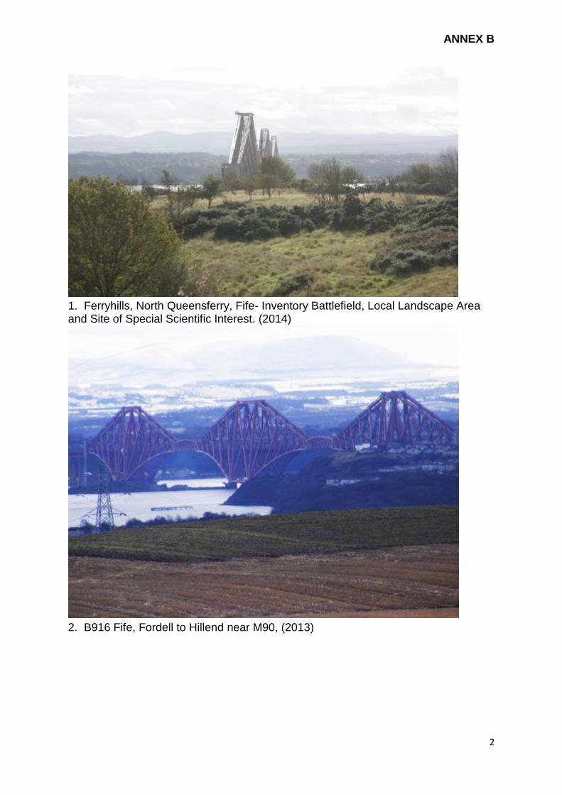
ANNEX B
2
1. Ferryhills, North Queensferry, Fife- Inventory Battlefield, Local Landscape Area and Site of Special Scientific Interest. (2014)
2. B916 Fife, Fordell to Hillend near M90, (2013)

ANNEX B
3
3. B916, Fife, railway in cutting in foreground, Inverkeithing High School in mid
ground. (2013)
4. Mons Hill, Dalmeny Estate, Edinburgh. Inventory Designed Landscape and
Special Landscape Area (2013)

ANNEX B
4
5. Bankhead Farm Steading, Dalmeny, Edinburgh. Designated as Green Belt. (2013)
6. From Dalmeny village and water tower, public road, Edinburgh. Designated as
Green belt. (2013)

ANNEX B
5
7. From Forth Bridges Contact and Education Centre and FETA viewing platform,
Queensferry, City of Edinburgh (2013)
8. Hopetoun East Lodge and the Banks, West Lothian. Area of Great Landscape
Value and Designed Landscape in Inventory (2014)

ANNEX B
6
9. Newton lay-by, West Lothian. (2013)

ICOMOS – 11 rue du Séminaire de Conflans 94220 Charenton-le-Pont France Tel. + 33 (0) 1 41 94 17 59 Fax. + 33 (0) 1 48 93 19 16
[email protected] www.icomos.org
H. E. Mr Matthew Sudders Ambassador, Permanent Delegate Permanent Delegation of the United Kingdom of Great Britain and Northern Ireland to UNESCO Maison de l'UNESCO Bureau M3.06 1, rue Miollis 75732 PARIS Cedex 15
Our Ref. GB/MA 1485 Charenton-le-Pont, 17 December 2014 World Heritage List 2015 The Forth Bridge (United Kingdom) - Additional information II Dear Sir, ICOMOS is currently assessing the nomination of The Forth Bridge as a World Heritage property. We thank you for the additional information you provided on 4 October 2014 and 24 October 2014. As part of our evaluation process, the ICOMOS World Heritage Panel has now reviewed this nomination, including the additional information received, and has identified areas where it considers further information is needed. Buffer Zone ICOMOS understands the contention that the nominated property’s surroundings are protected by means of the local planning system and existing heritage designations. We welcome the proposal to consider the suite of existing cultural and natural heritage designations that are described and mapped in a document submitted in October 2014 entitled “Forth Bridge Bridgehead Zone” as forming the basis of a de facto buffer zone for the nominated property. For the purposes of effective protection of the nominated property, as outlined in paragraphs 103 and 104 of the Operational Guidelines, the relevant marine (water) area of the estuary should also be included. This suite of designations along with the relevant marine (water) area now need to be officially confirmed and submitted by the State Party as constituting the de facto buffer zone. We believe that a consolidated map and description of the suite of cultural and natural heritage designations and the chosen marine area that collectively comprise this “Bridgehead Zone” should be created and disseminated for the benefit of stakeholders, regulatory and planning officials, and interested parties. A limited number of key viewsheds and views of the bridge also need to be selected, mapped, and included in the appropriate planning instruments and Property Management Plan, with the objective of ensuring their protection. Management System ICOMOS considers that the authority or authorities responsible for the relevant marine (water) area of the estuary need to be included in the management system for the property, and should be involved in the identification of the key viewsheds mentioned above. The institutionalization of the current Steering Group needs to be clarified, and the presence of the Forth Bridge Partnership Management Agreement Group as a technical body for managing and monitoring the property needs to be confirmed.

We believe that a clearer presumption against the construction of wind turbines within the key viewsheds of the bridge needs to be made in the appropriate planning instruments and the Property Management Plan. Interpretation and Tourism Plan An interpretation and tourism plan that fully respects the proposed Outstanding Universal Value of the nominated property needs to be developed in full consultation with local residents. This plan should be included as part of the Property Management Plan, or as an adjunct to it. Could a timetable please be provided that indicates when each of these recommended improvements will be undertaken and when each is expected to be completed. We look forward to your responses to these points, which will be of great help in our evaluation process. We would be grateful if you could provide ICOMOS and the World Heritage Centre with the above information by 28 February 2015 at the latest. We thank you in advance for your kind cooperation. Yours faithfully
Regina Durighello Director World Heritage Programme Copy to Historic Scotland UNESCO World Heritage Centre

Heritage Team 4th Floor 100 Parliament Street London SW1A 2BQ T: 020 7211 2018 [email protected] www.gov.uk/dcms
26 February 2015 Regina Durighello Director, World Heritage Programme ICOMOS 11 rue du Séminaire de Conflans 94220 Charenton-le-Pont France France Your ref.: GB/MA 1485 25th February 2015
Dear Regina,
The Forth Bridge (United Kingdom) -- Additional information II
Thank you for your letter of 17th December 2014, and for the opportunity to provide further information in support of the Forth Bridge World Heritage nomination.
You requested information in relation to the ‘Bridgehead Zone’, the Management System, and plans for Interpretation and Tourism. I hope that the information provided in the paragraphs and table below meet with the requirements of your evaluation team.
1. Buffer Zone
We have prepared a summary description of the suite of designations in a separate document accompanying this letter (see Annex A). With the exception of the projected marine planning area, all of these designations are explained in more detail in the Nomination Dossier (Nomination Document, pp. 88 to 96, and Management Plan pp. 26 to 37).
We have included in the attached document and also separately a consolidated map of the ‘Bridgehead Zone’ depicting the cultural and natural heritage designations, together with the marine planning area. We can confirm that this is being disseminated to stakeholders, regulatory officials and planners through the Forth Bridges Forum and its network of interested parties.

Department for Culture, Media & Sport
Similarly, we are in the process of finalising with the planning authorities, City of Edinburgh and Fife Councils, the selection of the nine key viewsheds from those provided in the Nomination Dossier. These will be mapped and included in the appropriate local authority and marine planning instruments in order to ensure their protection.
The Steering Group acknowledges the desirability of incorporating the relevant marine and estuary management systems into the management of the property’s setting. These systems are undergoing a strengthening process, and the resulting ‘Scottish National Marine Plan’ is currently before parliament and about to be implemented. We will therefore work directly through Marine Scotland as the Marine Planning Authority, and liaise with Forth Ports as the navigation authority, and the owner of the seabed, the Crown Estate (see Annex A).
2. Management System
Since the Technical Evaluation Mission in October, the Steering Group has contacted all the relevant organisations involved in the regulation of the Marine Planning Area around the Property. These include the owners of the sea bed, Crown Estates, the regulators of the main harbour, Forth Ports, and Marine Scotland. As a consequence, we are including these organisations in the business circulation of the Steering Group, and have invited Paul Bancks, the local Coastal Development Manager for The Crown Estates to join the Steering Group.
At the same time, as stated in Item 1 above, we have explicitly included marine protection in the suite of designations included in the Bridgehead Zone, and have depicted this on the revised map (see Annex A). The area of water around the Bridge forms part of the Scottish Marine Area and is subject to marine planning under the Marine (Scotland) Act 2010 with World Heritage Sites afforded protection through the policies of the Scottish National Marine Plan. Scottish Marine Regions and Marine Planning Partnerships are to be established to address matters at a local level. Marine protection will also be included in an updated version of actions contained within the Management Plan, and will be coordinated with the key viewsheds.
We will also monitor the existing local authorities’ presumption against the construction of large wind turbines whether onshore or offshore. Information on the statutory protection of the setting of the property, which includes potential wind farm developments, can be found pages 88-90 in the Nomination Dossier.
Whilst not being presumptuous about inscription, we acknowledge the need to institutionalise the existing Steering Group. Indeed, the Group, and its parent organisation, the Forth Bridges Forum, will be discussing this issue at its next meeting. At the same time, the property’s Partnership Management Agreement (PMA), which is reviewed and renewed annually, will formally incorporate World Heritage into its remit. The PMA Group’s work will routinely feed into the management and monitoring of the

Department for Culture, Media & Sport
property, and be fed back to the Steering Group.
3. Interpretation Plan
The Management Plan cited several opportunities and actions focused on the development of an ‘Audience Development Plan’, but we recognise that the development of separate Interpretation and Tourism Plans is more practical.
Several interpretation activities were included in the Management Plan’s actions, and progress is already being made with a number of these. Perhaps the most significant of these is the 3D digital documentation of the property using laser scanning technologies, a pilot project having been successfully completed last year. Funding for a full digital documentation project has now been secured, and work will commence in April 2015.
The resulting data will provide a valuable resource from which a wide range of interpretation applications can be developed. Some of these will have great education potential. The project has already engaged third-year engineering students at Edinburgh Napier University, and will link up with the Institution of Civil Engineers.
We agree that this, and other interpretation projects, need to be coordinated within an Interpretation Plan. For this reason, the Steering Group decided to commence the process of developing an Interpretation Plan at its most recent meeting (5 February). This task is now added to the updated list of actions in the Management Plan, and will also involve the local communities.
4. Tourism Plan
The need for the development of a Tourism Plan plan that fully respects the proposed Outstanding Universal Value of the nominated property has been recognised for some time, and was one of the reasons for the creation by the Forth Bridges Forum of its ‘Tourism Project Group’ last year, led by
VisitScotland, the national tourism organisation for Scotland. The group is working with the local communities, stakeholders and all partners, including Transport Scotland and the owners of the Property, Network Rail, and seeks to co-ordinate and manage the impact of tourism in the area around the property through the creation of a Tourism Marketing Strategy. This will then be used to develop a Tourism Plan and has been added to the updated list of actions in the Management Plan.
A number of initiatives have already commenced, including consultancy work around facilities, signage, visitor access, marketing, retail and potential income generation from tourism in the area around the Forth Bridges. Furthermore, work is under way on the development of a proposed Forth Bridge Experience project which hopes to see the introduction of visitor centres at each end of the Bridge. The intention is that these will provide exhibition space and education facilities as well as public access to the nominated property, and will be a major contributor to the development of a sustainable tourism offering and a major education asset in the region.

Department for Culture, Media & Sport
Proposals for the visitor centres are being progressed with sensitivity towards the nomination process and the views of local residents and will be put out to public consultation later this year. Meanwhile, the two local authorities, Fife and City of Edinburgh Councils, have already embarked upon the collection of traffic data in the areas around the property with the aim of reviewing road traffic patterns and intensity, public transport and local infrastructure. The local communities regularly contribute to progress on this.
5. Improvement Timetable
We will take action to implement these improvements as follows:
Actions Comment Start Deadline
1.1 Setting - Bridgehead Zone: adoption and assimilation into local authority Development Plans and planning guidance
In progress: New consolidated map completed and attached to this submission. Marine planning included. Bridgehead Zone map circulated to key stakeholders, including Planning Authorities.
Summary description of suite of designations in Annex A.
07-10-2014 31-12-2015
1.2 Setting – Viewshed: agree selection of the 9 key viewsheds with the planning authorities. These will be mapped and included in the appropriate planning instruments, ensuring their protection.
In progress, using the viewsheds defined in the Nomination Dossier. Linkages will be made with supplementary guidance to the relevant Local Development Plans
07-10-2014 31-12-2015
2.1 Management System: Marine management. Marine protection will also be included in an updated version of actions contained within the Management Plan, and will be co-ordinated with the key viewsheds.
In progress - completion awaiting implementation of new marine legislation and the establishment of Scottish Marine Regions and a Marine Planning Partnership.
07-10-2014 31-12-2015
2.2 Management System: Institutionalisation of the current Steering Group
In progress: is being addressed by the Steering Group
07-10-2014 31-12-2015
2.3 Management System: formalising the Partnership Management Agreement (PMA)
In progress: PMA to be reviewed and renewed, and more formal ties with the World Heritage Steering Group established through PMA Group
07-10-2014 30-09-2015
2.4 Management System: In progress: we will ensure 05-02-2015 31-12-2015

Department for Culture, Media & Sport
Actions Comment Start Deadline
Wind Turbines that any proposed onshore or offshore wind turbines are given full assessment in terms of potential impacts on the setting of the bridge.
3. Interpretation Plan In Progress: Steering Group has agreed to commence work on the Plan, including existing actions relating to Audience Development, all of which will involve the local communities.
05-02-2015 31-12-2015
4. Tourism Plan In Progress: Tourism Group established and already working on Tourism Strategy. Steering Group has started work on the Tourism Plan in consultation with the local communities.
05-02-2015 31-12-2015
5. Management Plan: Actions update
In progress: the lists of Actions outlined in the Management Plan will be updated and refreshed for 2015-16 issued later this year, together with a progress report
05-02-2015 31-08-2015
ongoing annually to 2021
We hope very much that the additional information we have provided answers your questions. If, however, you require further information or clarification, please do not hesitate to let us know.
Yours sincerely,
Hannah Jones
World Heritage Site and Underwater Policy Advisor

312000
312000
313000
313000
314000
314000
315000
315000
316000
316000
6770
00
6770
00
6780
00
6780
00
6790
00
6790
00
6800
00
6800
00
6810
00
6810
00
6820
00
6820
00
6830
00
6830
00
Contains public sector information andOrdnance Survey data © CrownCopyright 2015 Ordnance Survey[Licence Number 100021521]
x
0 1,500
Metres
Listed Building!
Scheduled MonumentNatural HeritageProtected Sites
Green Belt
Key
Gardens and Designed Landscape
Conservation Area
Nominated PropertyBridgehead ZoneBoundaryInventory Battlefield
! ! ! !
! ! ! !
! ! ! !
Title:The Forth Bridge:Bridgehead Zone
Scale:1 : 30,000 @ A4
Projection:British National Grid
Marine Planning Area

ANNEX A
1
FORTH BRIDGE WORLD HERITAGE NOMINATION: SUPPLEMENTARY INFORMATION
Bridgehead Zone
The Forth Bridge (2013) seen here from the listed Railway Pier in North Queensferry Conservation Area, designated for cultural heritage, viewed across a bay that is a Site of Special Scientific Interest, Ramsar and Special Protection Area for nature conservation, within the planned Scottish Marine Region of the Tay and Forth Estuaries. A part of the Inverkeithing battlefield is on the left and part of the Dalmeny Designed Landscape and Edinburgh’s Green Belt is seen through the cantilevers of the bridge over an island that is a scheduled monument.
Supplementary information for ICOMOS evaluation, February 2015

ANNEX A
2
Map 1: Forth Bridge, nominated World Heritage Site, ‘Bridgehead Zone’

ANNEX A
3
FORTH BRIDGE WORLD HERITAGE NOMINATION: SUPPLEMENTARY INFORMATION Bridgehead Zone 1. Introduction All necessary measures for the protection of the immediate setting of the Property are in place, and together form the Bridgehead Zone which, in effect, acts as an area protected by a combination of statutory natural and cultural designations, and through local authority and marine planning systems. This is represented above in Map 1 (also supplied as a separate file), and in the short descriptions of the various designations provided in the text below. Map 1 itself contains the aggregation of planning designations that reinforce the protection afforded the Bridgehead Zone. More detailed information on cultural and natural designated sites and areas in the immediate setting of the Property are included in the Nomination Dossier, and are indicated here in Map 2 (Cultural Designations) and Map 3 (Natural Designations) below. The principal difference in Map 1 is the reference to the Marine Planning Area, covering all of the water around and over which the property is situated. 2. Listed Buildings The Forth Bridge itself is listed at Category ‘A’. This gives it the highest level of statutory protection for a building that is in use, and any change that affects the special interest of the bridge requires listed building consent. This has to be obtained from both City of Edinburgh and Fife Councils, with advice in certain circumstances from Historic Scotland on behalf of Scottish Ministers. The Bridgehead Zone contains around 200 listed buildings, each of which has a setting that is protected in law. 3. Scheduled Monuments Within the Bridgehead Zone, each with a protected setting, are:
The Chapel of St James, patron saint of Travellers/Pilgrims, an essential place of worship for all ferry travellers in the middle ages (in Fife)
The Island of Inchgarvie, specifically excluding the Forth Bridge. The central cantilever tower of the bridge stands on rock that is near the island, but is not connected to it above the low waterline (in the City of Edinburgh)
Harlow Cairn, Dalmeny Estate (in the City of Edinburgh)
4. Conservation Areas
There are three Conservation Areas within the Bridgehead Zone, which are:
North Queensferry Conservation Area
Queensferry Conservation Area
Dalmeny Conservation Area

ANNEX A
4
The coastal conservation areas (Queensferry and North Queensferry) extend as far as the jurisdiction of local planning authorities can go, which is to mean low water, where the tide is furthest out. Planning authorities have a duty to preserve or enhance the character of conservation areas. 5. Gardens and Designed Landscapes The Inventory of Gardens and Designed Landscapes includes two that come into the Bridgehead Zone, both on the south side of the Property. These are parts of the Dalmeny and Hopetoun House estates, as explained in the nomination dossier. 6. Battlefields The national Inventory of Battlefields includes one that is partially included within the Bridgehead Zone. This is situated on the north side of the property and is associated with the Battle of Inverkeithing, which took place in 1651. Most of the bloodshed occurred further north and east of Inverkeithing. 7. Local Development Plan Policies: Green Belt and Open Space. Local Authorities have the power to designate ‘Green Belt’ areas through Local Development Plans. The fundamental aim of Green Belt Policy is to prevent urban sprawl by keeping land permanently open. The essential characteristic is their openness and permanence. Green belts prevent coalescence of towns and villages, so keeping the separateness of Queensferry from Edinburgh, and they assist urban regeneration by focussing development in towns rather than outside of them. In the case of the Bridgehead Zone, an area of Green Belt is long-established to the south of the Property on the south-east edge of South Queensferry. This forms the north-west end of a crescent that encircles all of urban Edinburgh. See policy ENV10 http://www.edinburgh.gov.uk/downloads/file/3839/second_proposed_local_development_plan_june_2014 Also in the Edinburgh Local Development Plan is policy ENV18 for “protection of open space”, which appears as white space on Map 1. At South Queensferry, the land between the Port Edgar shore road and the old railway line, widening as it goes under the Forth Road Bridge and eastward is so marked in the local plan, as are the Queensferry High School grounds and Fairy Glen down to the green space between the Main Street and Hawes. This is the policy for green space within urban settlements, whereas Green Belt must be a more continuous and large rural area in order to have its effect. In Fife, on the north side of the Property, the open space within the Bridgehead Zone comprises pockets within the Conservation Area, an area of escarpment beyond that covered by a Tree Protection Order, and Sites of Special Scientific Interest, one of them a wildlife reserve managed by the Scottish Wildlife Trust. 8. Natural Designations

ANNEX A
5
The Bridgehead Zone contains several types of protected natural site. These are SSSI (Sites of Special Scientific Interest), Ramsar (wetland sites), SPA (Special Protection Areas), and Ancient Woodland. The Ramsar International Convention and SPA areas are precisely the same as the national SSSI designated shore line areas, but are managed differently according to the various species that pass through or stay in those habitats. All these are regulated through Scottish Natural Heritage (SNH), the national body responsible for protecting the natural environment, and provide statutory protection within the immediate setting of the property. In the interests of clarity, these four natural designations have been combined within Map 1, but more detail can be found in Map 3 below and in the nomination dossier itself. 9. Marine Regulation The original maps within the Nomination Dossier did not refer to marine protection, but in response to comments received during the Technical Evaluation Mission in October 2014, we have included the projected regional marine planning area within the Bridgehead Zone, and this is depicted on Map 1. The area of water around the Bridge forms part of the Scottish Marine Area and is subject to marine planning under the Marine (Scotland) Act 2010 with World Heritage Sites afforded protection through the policies of the Scottish National Marine Plan. In due course, matters at a local level will be addressed through regional marine planning. The boundaries of Scottish Marine Regions are not yet finalised in statute, and the statutory Marine Planning Partnerships remain to be established. In practice, responsibility for the management and regulation of the areas of water in the Bridgehead Zone falls to the owners of the sea bed, Crown Estates, the regulators for navigation, Forth Ports, and Marine Scotland. As a consequence, these organisations are now included in the business circulation of the Steering Group. Paul Bancks, the local Coastal Development Manager for The Crown Estates is invited to join the Steering Group. Marine plans cover the area seaward from mean high water. Terrestrial planning covers the area landward from mean low water, with the exception of fish farming where local authority controls extend offshore. As a consequence, a dual protection exists on the foreshore between mean high and low water. This protects the immediate foreground shore and shallow water in views towards the Forth Bridge.

ANNEX A
6
Map 2: showing cultural designated places close to the property

ANNEX A
7
Map 3: Natural designated areas close to the property