no voice, no choice - IDSK
16
OCCASIONAL PAPER 28 NO VOICE, NO CHOICE: RIVERINE CHANGES AND HUMAN VULNERABILITY IN THE ‘CHARS’ OF MALDA AND MURSHIDABAD Jenia Mukherjee July 2011 INSTITUTE OF DEVELOPMENT STUDIES KOLKATA DD-27/D Salt Lake City, Sector - 1 Kolkata - 700 064 Phone : +91 (33) 23213120/21 Fax : +91 (33) 23213119 e-mail : [email protected], Website : www.idsk.edu.in
-
Upload
khangminh22 -
Category
Documents
-
view
3 -
download
0
Transcript of no voice, no choice - IDSK
OCCASIONAL PAPER
28
NO VOICE, NO CHOICE: RIVERINE CHANGES
AND HUMAN VULNERABILITY IN THE
‘CHARS’ OF MALDA AND MURSHIDABAD
Jenia Mukherjee
July 2011
INSTITUTE OF DEVELOPMENT STUDIES KOLKATA
DD-27/D Salt Lake City, Sector - 1
Kolkata - 700 064
Phone : +91 (33) 23213120/21 Fax : +91 (33) 23213119
e-mail : [email protected], Website : www.idsk.edu.in
l l
* Assistant Professor, History of Ecology and Environment, Institute of
Development Studies Kolkata
1 2
No voice, no choice: Riverine changes and
human vulnerability in the ‘chars’ of
Malda and Murshidabad
Jenia Mukherjee*
Abstract
The paper attempts to study the ecological history of ‘chars’ (bars or
sandy shoals) in the two districts of West Bengal – Malda and Murshidabad,
which are a part of the Lower Gangetic Basin (LGB). ‘Chars’ are sandy
shoals that emerge as an aftermath of river-bank erosion that engulfs one
part of the land and gives rise to another patch on its other side. The
shifting of the Ganges as a long-term phenomenon, constantly shaping
and reshaping the territory of LGB is evident from historical records. Erosion
and land re-allocation are age-old problems along the bank of the Ganges.
The erosion of vast stretches of land and subsequent emergence of ‘chars’
have been in progress for the last 200 years or so. But with the construction
of the Farakka Barrage in 1975, the entire process of erosion/sedimentation
has augmented leading to the rise of ‘existing’ or ‘running chars’ in the
study-area. Several large ‘chars’ have come up in the last few decades
along with the opening up of deep channels which has in turn affected the
linear path of the river. The construction of the Farakka Barrage has
caused huge sedimentation, increasing flood intensity and aggravating
tendency of bank failures in both Malda (upstream) and Murshidabad
(downstream).
These geological patches (‘chars’) are the emblem of uncertainty, poverty,
vulnerability, border disputes between states and countries and lack of
governance leading to the exercise of different forms of crime and
criminality. Due to the continuous emergence, submergence, re-emergence
and re-submergence of the ‘chars’, we find that the people living in the
‘chars’ (the erosion victims) suffer from the ‘SDRR’ (settlement>
displacement>re-settlement>re-displacement) syndrome where hazard
(mainly in the form of river-bank erosion and inundation) easily gets
transformed into disaster as, Disaster = Hazard x Vulnerability. People
have moved between four to 16 times in the last 15 years in some of
these newly developed running/existing ‘chars’. But what binds them here?
Why do they return again to these fragile landscapes as soon as water
recedes? How do they cope?
The paper has reflected on some of these crucial issues.
Bar Formation: A General Understanding
William M. Davis pointed out long ago (1899) “…a river is seen to
be a moving mixture of water and waste.”1 If we minutely observe
the flow of a river, we find that the smallest fragments among the
detritus make a rapid journey from the point where the river receives
them to their final resting place in the sea. But many of the detrital
pieces step and stop for a long period of time. The continuous
blanket of detritus that forms the bed of an alluvial stream has an
even-gradient usually. However, it may have numerous subaqueous
undulations caused by distribution of some of the bed material in
disjunct concentrations known as bars. The bars migrate gradually
downstream as a result of their being filled out on their downstream
sides by material washed from their upstream slopes; they may be
completely destroyed by a great flood which, however, leaves new
ones when it subsides.
The common types of bars which occur in alluvium streams include:
alternate bars, middle bars and point bars. To study bar formation
we need to have a thorough understanding of the mechanics of
flow and sediment transport of a river controlling bed morphology
in river bends. A bar formation depends on a number of factors
such as: w/d (width/depth) ratio in the bend, sinuosity (ratio of
channel length to valley length), human activities and most
importantly, the very interaction between ‘system’ and ‘environmental’
variables (Table 1).
TABLE: 1
System variables Environmental Variables
Weathering process Climatic characteristics
Transport process Geology
Sediment discharge Topography and slope
Solute concentration Vegetation
Sediment quality Tectonic activity
(Source: Ian Statham, Earth Surface Sediment Transport, Oxford : Clarendon
Press, 1977)
The Lower Gangetic Basin: Past and Present
To understand ‘char’ formation in Malda and Murshidabad districts
of West Bengal, first we need to trace the course of the River
Ganges in its lower section.
Many changes have occurred in the hydrography of the LGB during
the past centuries of which we have information from fragmented
sources such as: old scriptures, records of administrative and
revenue divisions, travellers’ accounts, etc. Ptolemy’s account is a
powerful source of our knowledge as we find here a depiction of all
the major streams of the Ganges Delta. He had provided more or
less correct latitudinal and longitudinal locations of their mouths.
His account is important because though he made “a mistake of
about four minutes to a degree in the calculation of longitude, but
it is quite easy to locate the rivers he mentioned.”2 From the early
maps we get to know the geographical details of the basin, mainly
the lower part. Mention may be made of the early Portuguese
explorers and cartographers of 16th century like: De Barro and
Gastaldi who had provided the oldest of modern maps of the Ganges
Delta,3 and the Dutch explorer Matheus Van den Brouche of 17th
century. These maps can be regarded as predecessors of the first
correct map of the rivers of Bengal by Major James Rennell after
his long survey of the Bengal Province between 1764 and 1779.
However, these have certain cartographic lacunae and hence need
to be studied cautiously.4
By a comparison of Matheus Van den Brouche and Major James
Rennell’s maps we can trace the route of the Ganges in Bengal
and find out that 17th and 18th centuries were periods of great
changes.5
From Van den Brouche’s map we find:
l The Bhagirathi, through which the waters of the Ganges used
to pass from the 12th – 16th centuries, is no longer the main
stream of the river. The Padma channel, which is shown as a
broad, braiding stream, entwining numerous large islands, now
carries the bulk of the Ganges waters.
l The Bhagirathi, however, is still connected with the Ganges,
north of Murshidabad, and serves as its western distributary.
The only island shown in the Bhagirathi is the one near its off-
lake from the Ganges. South of this island it meanders freely.
l Besides the Bhagirathi, the Jalangi and Chandna are the only
major distributaries of the Ganges. Both these streams have a
south-western course, and the Jalangi joins the Bhagirathi from
the east near its Damodar confluence.
The salient features of Rennell’s map were:
l The Padma is the main channel of the Ganges which flows
independently to the sea without uniting with either the
Brahmaputra or the Meghna. The meanders of the Ganges
between Rajsahi and Goalundo are more pronounced on this
map than that of Van den Brouche’s.
l The Bhagirathi has been further reduced, its connection with
the Ganges functioning only during the rains. Among the active
distributaries of the Ganges are the Chandna and Jalangi.
The evolution of the present drainage system is the result of changes
that had occurred since the last two hundred years.
In the second decade of the 20th century, the course of the Ganges
between Rajmahal and Farakka was straight and aligned in a
south-easterly direction. This course is described in the
topographical sheet bearing No.72 P/13 (1:63360), surveyed in the
year 1922-23. This is a changed course of the river as previously
Ganges flowed along an altogether different course dashing Gour,
the medieval capital town of Bengal, as reflected in the writings of
R.K. Mukherjee6 and Sir J.N.Sarkar.7 Major Hirst (1915) attributed
the subsequent changes of the course of river to tectonic causes
and apprehended that there was a severe earthquake in 1505
A.D. shortly after which the Ganges left its old course past Gour
and retreated southwards. There were two other distributaries of
the Ganges namely Choto Bhagirathi and Pagla which joined each
other near Mehdipur and flowed southeast to join Mahananda. The
latter subsequently discharged into the Padma near Godagarhi
Ghat of Rajshahi (Bangladesh). In the process of this migration,
Kalindri, Choto Bhagirathi and Pagla were left moribund. The capital
town of Gour, which flourished in the 15th and 16th centuries,
was located on the interfluve between Kalindri and Bhagirathi. The
decay of these two distributaries might have been a slow process
covering several centuries. There are historical references of
medieval riverine route between Chittagong and Gour. The
medieval navigation route must have been through Padma-
3 4

Mahananda-Kalindri or Choto Bhagirathi. The bulk of the Ganges
water must have flown through this course; otherwise it could hardly
facilitate navigation. The lower Mahananda below old Malda must
have been a part of the Ganges. The decline of Gour after 1575
A.D. may be attributed to the changing course of the Ganges
system. These changes must have taken place much before
Rennell pursued the survey during 1764-1779 as his map depicts
the course of Ganges flowing far south of Gour.
The construction of the Farakka Barrage has brought a major
change in the topography and hydrography of the study-area. Below
Rajmahal the river is divided in two with Bhutni Diara (the large
mid-stream island existing for more than hundred years) in between.
As the eastern channel has dried up due to siltation, the river now
flows through the western channel. On the eastern side of Bhutni,
a branch of Koshi River (Mara Koshi) and Fulhar (a tributary of
Mahananda) have joined Ganges. From the meeting point of Fulhar
and Ganges, Kalindri has emerged. It has later merged with
Mahananda at Nimasarai Ghat of Malda city. Bhagirathi (not to be
confused with the main Bhagirathi) and Pagla after emerging from
Mathurapur and Khasmahal have flown in the east, later merging
with each other near Malda-Bangladesh border had merged with
Mahananda. The delta of Ganges can be said to start from Farakka
in West Bengal. The river divides into two arms about 40 km south-
east below Farakka at Khejurtala village in Murshidabad district.
The right arm of the river (which was the original course of Ganges)
continues to flow south in West Bengal in the name of the Bhagirathi
(called Hooghly in its downstream stretch) and crosses 500 km. to
the sea. The left arm of the main Ganges flows into Bangladesh
after flowing along the border of Murshidabad for
60 km. in the name of Padma, joined by the Brahmaputra and the
Meghna Rivers, and all these rivers form this huge delta before
ultimately falling into the Bay of Bengal.
The Construction of the Farakka Barrage: Cause and Impact
As we have already seen from the two maps (Van Den Brouche
and Rennell), that since the 17th century the Bhagirathi became a
much narrow outlet of the Ganges and the Padma became
voluminous. The Farakka Barrage was constructed to serve the
need of preservation and maintenance of the Calcutta Port by
improving the regime and navigability of the Bhagirathi-Hoogly River
system. As the Calcutta Port was located 120 km north of the
delta, it was never an ideal port for the movement of big vessels.
Before the construction of the Calcutta Port, the Bhagirathi lost its
connection from the main channel of the Ganges. From 17th
century account of Jean-Baptiste Travernier we find that at Suti
the main source of the Ganges was filled up with sand and
sediment.8 Between 1768 and 1777 the Bhagirathi almost remained
dry in the winter months.9 Jalangi and Mathabhanga were the
alternative channel-routes for the movement of steamers. But these
two channels also lost their importance in the last decade of the
19th century.10
From the middle of 19th century the British became anxious about
the future of the Calcutta Port and started thinking about the feasibility
of an alternative port construction. In a report to the British
Government, the Secretary of the Bengal Chamber of Commerce
wrote, “I am directed by the Committee of the Bengal Chamber of
Commerce, to solicit the favour of your bringing to the notice of the
most noble Governor of Bengal, the difficult and dangerous state of
the navigation of the river Hooghly, which threatens, at no distant
period, to render access to the port of Calcutta altogether
impracticable for any vessel but those of the smallest tonnage.”11
Port Canning was constructed between 1865 and 1866. But due to
the problem of sediment accumulation, this port also had a limited
lifeline till 1871 only.
Several methods to bring more water into the Bhagirathi River
failed. In June, 1931, only 19 cusec water flowed into the river at
Jangipur.12 The distributaries that feed the river like Mayurakshi,
Ajay, Damodar, Rupnarayan and Haldi and smaller outlets like Pagla,
Banslai, etc. in the western side and Jalangi and Mathabhanga-
Churni in the eastern side carry huge amount of silt and the
construction of a number of dams over the western-side distributaries
has reduced the capacity of the channels to drain the silt in the sea
even in the rainy seasons.13
In spite of these difficulties the survival of the Calcutta Port was
extremely important. The plan for the construction of a barrage on
Ganges near Rajmahal and the creation of a feeder canal to bring
the surplus water from the Ganges to the Bhagirathi River first
surfaced in the opinion of Sir Atherton in 1853.14 In the post-
5 6

independence period, the question of revival of Calcutta Port seemed
to be a vital issue. In 1957, the internationally renowned river expert
Dr. Walter Henson was invited in India to provide technical solution
to the problem. After thorough investigation, Henson reflected, “The
best and only technical solution of the problem is the construction
of a barrage across the Ganges at Farakka with which the upland
discharge into the Bhagirathi-Hooghly can be regulated as planned
and with which the long-term deterioration in the Hooghly can be
stopped and possibly converted into a gradual improvement...The
tidal reach will be improved and the frequency and intensity of
bores will be decreased.”15
The Farakka Barrage project was started in 1962 and was completed
in 1971. The excavation of the 38km.long feeder canal took about
four years and the project was commissioned on 21st May, 1975.
In its 196th report, the Public Accounts Committee reflected, “The
Committee are greatly perturbed to find that while in 1961 and
again in 1965, it was decided that in view of the character of the
project, its essentiality and the benefits which were likely to be
derived from the various works, it should be completed by 1970-71,
in actual fact only the barrage was completed in 1971, but the
essential canal work for taking the headwaters from the Ganga to
feed the Bhagirathi-Hooghly system and save the deterioration in
the Calcutta Port was completed only four years later in 1975.”16
Fig. 1: Layout of the Farakka Barrage Project
(Source: Kalyan Rudra, The Encroaching Ganga and Social
Conflicts: The Case of West Bengal, India, p. 7.)
Table: 2: Salient features of the Farakka Barrage Project
A. Farakka Barrage
Length : 2.62 Km
Number of Bays : 109
Span of Each Bay : 18.30 m
Lowest Bed Level : 10.30 m above m.s.l.
Pond Level : 21.90 m above m.s.l.
Crest Level of Spillway : 15.80 m above m.s.l.
Crest Level of Under Sluices and River Sluices : 14.30 m above m.s.l.
B. Head Regulator
Pond Level : 21.90 m above m.s.l.
Full Supply Level at Land : 1133 cumec
Clear Water Way : 11 bays of 12.20 m
each
Crest Level : 18.10 m above m.s.l.
C. Feeder Canal :
Length : 38.30 km
Design Discharge : 1133 cumec
Bed Width : 150.80 m
Full Supply Depth : 6.10 m
D. Jangipur Barrage :
Length : 212.70 m
Number of Bays : 15
Span of Each Bay : 12.2 m
Crest Level : 14.30 m above m.s.l.
(Source: S.K. Basu, A Geotechnical Assessment of the Farakka Barrage Project,
Murshidabad and Malda Districts, West Bengal, Geological Survey of India, Bull.No.4,
pp.2-3.)
The barrage was built with the pious intention of inducing water into
the Hooghly River with a view to flush the sediment load into the
deeper part of estuary to retain the navigational status of the Calcutta
Port. The 2.64 km long Farakka Barrage was designed to divert
40,000 cusecs (1133 cumec) of Ganges water to Bhagirathi.
However, there is a huge gap between the real purpose and the
actual outcome.
The induced water through Ganges-Bhagirathi feeder canal was
supposed to flush the sediment load from the estuary and keep the
navigation channel free from siltation. But sedimentation in the
7 8
estuary continues unabated. It is admitted in the published document
of the Calcutta Port Trust that induced discharge from Farakka
Barrage had not been able to negate the estuarine sedimentation.17
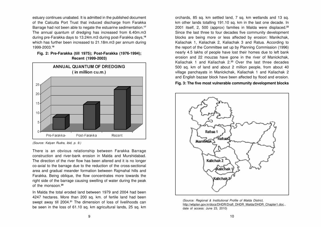
The annual quantum of dredging has increased from 6.40m.m3
during pre-Farakka days to 13.24m.m3 during post-Farakka days,18
which has further been increased to 21.18m.m3 per annum during
1999-2003.19
Fig. 2: Pre-Farakka (till 1975); Post-Farakka (1976-1994);
Recent (1999-2003)
(Source: Kalyan Rudra, ibid, p. 9.)
There is an obvious relationship between Farakka Barrage
construction and river-bank erosion in Malda and Murshidabad.
The direction of the river flow has been altered and it is no longer
co-axial to the barrage due to the reduction of the cross-sectional
area and gradual meander formation between Rajmahal hills and
Farakka. Being oblique, the flow concentrates more towards the
right side of the barrage causing swelling of water during the peak
of the monsoon.20
In Malda the total eroded land between 1979 and 2004 had been
4247 hectares. More than 200 sq. km. of fertile land had been
swept away till 2004.21 The dimension of loss of livelihoods can
be seen in the loss of 61.10 sq. km agricultural lands, 25 sq. km
orchards, 85 sq. km settled land, 7 sq. km wetlands and 13 sq.
km other lands totalling 191.10 sq. km in the last one decade. In
2001 itself, 2, 500 (approx) families in Malda were displaced.22
Since the last three to four decades five community development
blocks are being more or less affected by erosion: Manikchak,
Kaliachak 1, Kaliachak 2, Kaliachak 3 and Ratua. According to
the report of the Committee set up by Planning Commission (1996)
nearly 4.5 lakhs of people have lost their homes due to left bank
erosion and 22 mouzas have gone in the river of Manickchak,
Kaliachak 1 and Kaliachak 2.23 Over the last three decades
500 sq. km of land and about 2 million people, from about 40
village panchayats in Manickchak, Kaliachak 1 and Kaliachak 2
and English bazaar block have been affected by flood and erosion.
Fig. 3: The five most vulnerable community development blocks
(Source: Regional & Institutional Profile of Malda District,
http://wbplan.gov.in/docs/DHDR/Draft_DHDR_Malda/DHDR_Chapter1.doc.,
date of access: June 23, 2010)
9 10

Table 3: Left bank erosion by the Ganges in the Malda
district (Upsteam from the Farakka Barrage)
Years Maximum Approximate Land Approximate Maximum
approximate erosiom loss maximum water-
bank-length width (m) (hectares) discharge level
affecte (metres) (‘000 cusecs) (metres)
(kilometers
1931-1978 — — 14335 — —
1979 5.0 200 60 42.80 22.90
1980 7.0 150 105 73.00 24.80
1981 11.0 400 260 57.00 23.70
1982 5.0 150 65 68.00 24.80
1983 5.0 200 90 60.50 24.90
1984 7.0 100 70 61.40 24.80
1985 6.0 150 90 57.30 24.30
1986 6.0 200 105 49.80 24.20
1987 8.0 300 240 73.90 25.40
1988 7.0 100 70 68.00 25.10
1989 10.0 150 150 36.80 22.90
1990 8.0 200 160 55.50 24.20
1991 11.0 150 170 69.70 25.30
1992 9.0 150 130 46.40 23.90
1993 7.0 200 145 54.20 —
1994 7.0 1250 160 67.90 24.90
1995 8.0 200 145 49.80 24.00
1996 15.0 250 310 71.00 25.10
1997 6.0 100 60 47.70 24.10
1998 10.0 900 330 75.90 25.40
(Source: Superintending Engineer, Farakka Barrage Project, reproduced from
Showkat Iqbal, ‘Flood and Erosion Induced Population Displacements: A Socio-
economic Case Study in the Gangetic Riverine Tract at Malda District, West Bengal,
India’, Journal of Human Ecology, vol. 30, no. 3, p. 204)
Fig. 4: River Bank erosion along the Ganges, upstream of
the Barrage
(Source: Sutapa Mukhopadhyay and Malay Mukhopadhyay, Bank Erosion of River
Ganga, Eastern India – A Threat to Environmental Systems Management, http://
www.quebec2007.ca/pdf/salle204a/seance21/articles/s_mukhopadhyay.pdf, date of
access: June 22, 2011)
So far as the district of Murshidabad is concerned the rotational
bank failures between the Farakka Barrage and Jalangi, a stretch
11 12
of about 100 km, has been severe. The human impact of this has
been massive. While about one million people are displaced every
year by flood and erosion in Bangladesh; it is no less than 10,000
people who are evicted every year from their homelands by erosion
in Murshidabad district alone.24 In mid-1970s, in Dhulian and its
adjoining areas about 50,000 people became homeless. The
encroaching river wiped out 50 mouzas and engulfed about 10,000
hectares of fertile land. A large part of the interfluve, lying between
the Bhagirathi and Padma with an area of about 77 sq. km.
between Nayansukh and Giria, disappeared forever between 1925
and 1974.25 Thus the map of this area has been changed beyond
recognition. This is evident when we compare the older topo-sheet
published by the Survey of India in 1925 and the recent satellite
images.26 Farakka, Samserganj, Suti I, Suti II, Raghunathganj II,
Lalgola, Bhagwangola I, Bhagwangola II, Raninagar I, Raninagar
II and Jalangi face the problem of bank erosion massively year
after year.
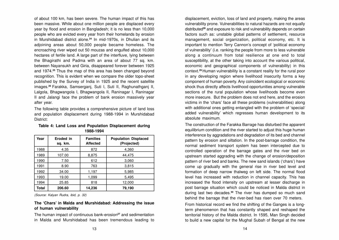
The following table provides a comprehensive picture of land loss
and population displacement during 1988-1994 in Murshidabad
District:
Table 4: Land Loss and Population Displacement during
1988-1994
Year Eroded in Families Population Displaced
sq. km. Affected (Projected)
1988 4.35 872 4,360
1989 107.00 8,875 44,475
1990 7.50 612 3,060
1991 8.90 763 3,815
1992 34.00 1,197 5,985
1993 19.00 1,099 5,495
1994 25.85 818 12,000
Total 206.60 14,236 79,190
(Source: Kalyan Rudra, ibid, p. 32)
The ‘Chars’ in Malda and Murshidabad: Addressing the issue
of human vulnerability
The human impact of continuous bank-erosion27 and sedimentation
in Malda and Murshidabad has been tremendous leading to
displacement, eviction, loss of land and property, making the areas
vulnerability prone. Vulnerabilities to natural hazards are not equally
distributed28 and exposure to risk and vulnerability depends on certain
factors such as: unstable global patterns of settlement, resource
management, social organization, political economy, etc. It is
important to mention Terry Cannon’s concept of ‘political economy
of vulnerability’ (i.e. ranking the people from more to less vulnerable
along a continuum from total resilience at one end to total
susceptibility, at the other taking into account the various political,
economic and geographical components of vulnerability) in this
context.29 Human vulnerability is a constant reality for the rural poor
in any developing region where livelihood insecurity forms a key
component of human poverty. Any coincident ecological or economic
shock thus directly affects livelihood opportunities among vulnerable
sections of the rural population whose livelihoods become even
more insecure. But the problem does not end here, and the erosion
victims in the ‘chars’ face all these problems (vulnerabilities) along
with additional ones getting entangled with the problem of ‘special/
added vulnerability’ which regresses human development to its
absolute maximum.
The construction of the Farakka Barrage has disturbed the apparent
equilibrium condition and the river started to adjust this huge human
interference by aggradations and degradation of its bed and channel
pattern by erosion and siltation. In the post-barrage condition, the
normal sediment transport system has been intercepted due to
controlled operation of the barrage gates and the river bed on
upstream started aggrading with the change of erosion/deposition
pattern of river bed and banks. The new sand islands (‘chars’) have
come up gradually with the general rise in river bed level and
formation of deep narrow thalweg on left side. The normal flood
level has increased with reduction in channel capacity. This has
increased the flood intensity on upstream at lesser discharge in
post barrage situation which could be noticed in Malda district in
during last two decades.30 The river has dumped so much sand
behind the barrage that the river-bed has risen over 70 meters.
From historical record we find the shifting of the Ganges is a long-
term phenomenon that has constantly shaped and reshaped the
territorial history of the Malda district. In 1595, Man Singh decided
to build a new capital for the Mughal Subah of Bengal at the new
13 14

upriver site of Rajmahal (now in Jharkhand) on the west bank of
the Ganges. Eventually in 1826, the place named Tandah was
swallowed by the river and its site remerged much later as a Diara
char. Initially, the location of the new capital at Rajmahal or
Akbarnagar was favourable, because of its accessibility by river
and its impregnability in view of the natural protection afforded to
it by the Rajmahal hills. The temporary shift of the Subah
headquarters from Rajmahal to Jahangirnagar or Dhaka thus took
place for strategic rather than ecological reasons and in 1639,
Shah Shuja shifted the capital of the Subah back to Rajmahal and
also extended the city further. However, the Ganges appears to
have oscillated in the opposite direction at this point of time, gradually
yielding new ‘chars’ and ‘diaras’ along its right-bank which reduced
the impregnability of the city. When Mir Jumla transferred the
headquarters of the Subah back to Dhaka in 1660, the river had
shifted more than 4 km away from the city, leaving Rajmahal as yet
another medieval relic city along the shifting trajectories of the
Ganges.
Erosion and land reallocation is an age-old problem along the bank
of the Ganges. The erosion of vast stretches of land and subsequent
emergence of ‘chars’ have been in progress for last 200 years or
so. Major Henry Thomas Colebrooke, in his paper ‘On the courses
of the Ganges through Bangal’, described the devastation caused
by the river in the Murshidabad district. He noted: “The quantity of
land, which has been destroyed by the river in course of a few
years, will amount, upon most moderate calculation, to 40 square
miles, or 25,600 acres: but this is counter-balanced, in a great
measure, by alluviation which has taken place on the opposite
shore.”31 In the late 19th century, W. W. Hunter (1876) observed
that an acre of land was engulfed by the gnawing Padma within
half an hour.32 Captain W. Sherwill accounted on the emergence
and submergence of ‘chars’ and wrote, “Islands become inhabited,
cleared and cultivated; population increases, large village start up,
land revenue is collected for ten or twelve years; then fabric will
disappear within one rainy season.”33
But the riverine change in the post-Farakka situation has played a
massive role in the rise of the new running or existing ‘chars’ in
Malda and Murshidabad and brought vagaries to the life of the
erosion-victims living in these fragile land patches. A scientific
explanation of the emergence and submergence of running ‘chars’
has been provided by Supriya Sengupta. He argues that
accumulated silt leads to the rise of a sand-bed (‘char’) in the
interfluves; being obstructed by this bed the river then divides into
two channels with the ‘char’ in between. This makes the flow oblique.
The flow gets obstructed with the river-bank eventually causing
river-bank erosion. The eroded silt and sediment is carried by the
river which again accumulates to form a ‘char’, and the cycle
continues.34
It is important to understand the different types of ‘chars’ in this
context. Broadly ‘chars’ in our study-area can be classified into the
dead, mature and running or existing chars as per their duration of
existence. The dead ‘chars’ is the one which has not faced any
significant change due to fluvial action for the last few decades.
The ‘chars’ which has not faced any significant change due to
fluvial action for the last 10-15 years is known as the mature char.
The existing or running ‘chars’ are those land patches which face
regular changes due to the action of the river and continuously
emerge and submerge, the process being known as ‘Sikasti’ (land
that gets eroded) and ‘Payasti’ (newly formed or emerged land) in
the local dialect. The duration of existence largely determines the
intensity of vulnerability in the ‘chars’.
Several large ‘chars’ in Malda have come up since the last few
decades such as the Gadai Char and the Dakatia Char along with
the opening up of deep channels which has in turn affected the
linear path of the river. The Hamidpur Char have come up in this
district. The appearance, disappearance and re-appearance of
charlands in Panchanandapore in Malda district have become a
regular phenomenon. In Murshidabad also the same process has
been active leading to the Nirmal Char and the Jalangi charlands.
The erosion victims in these uncertain patches are affected with
the ‘SDRR’ (settlement, displacement, resettlement and re-
displacement) syndrome due to the continuous emergence,
submergence, re-emergence and re-submergence of the chars.
People have moved between four to 16 times in the last 15 years!
Thus, human vulnerability takes an added dimension in the existing
charlands and the erosion victims get afflicted with a special and
added form of erosion and flood-induced actuality.
15 16

Illustration 1: The problems faced by the erosion victims in
the existing charlands
The people who migrate and settle in the newly emerged char
lands lead a life under the shadow of poverty and insecurity. The
erosion and resultant homelessness cause an oversupply of
agricultural labour in the fertile ‘chars’ engaging the labourers at a
wage lower than the minimum fixed by the government. In the
Malda ‘chars’, the average daily wage of adults working in the
chars is even less than Rs. 60.
There are no hospitals in the ‘chars’. An expecting woman has to
be taken 10 kms away by boat to the mainland. Thirteen expecting
women died due to lack of timely medical attention in the past one
year from the Malda chars. Most children suffer from malnutrition.
Even schemes like pulse polio are a far cry in most chars. Fifteen
to twenty children die on an average, of malnutrition every year in
the ‘chars’ of the Malda district.
The problem is not confined to that of erosion and displacement;
there also exists the border problem as the Murshidabad ‘chars’
have developed towards Bangladesh. As per official estimate, till
1992-94 more than 10,000 hectares of ‘chars’ have come up at
places which have become inaccessible from the Indian side but
can be reached easily from Bangladesh. The erosion wiped away
boundary posts at many places creating border dispute. Akheriganj,
which literally means the last settlement, virtually disappeared from
the map when the 1989-1900 erosion struck it. The disastrous
erosion engulfed 2,766 houses and left 23,394 persons homeless.35
Many erosion-victims migrated to the newly emerged Nirmal Char
along the opposite bank. A population of 20,000 lives in an area of
50 sq. km. in Nirmal Char. From here Rajshahi town of Bangladesh
can be reached within 45 minutes on road, whereas to come to the
mainland of India one has to cross the mighty Padma which will
take more than three hours. Moreover the basic infrastructure
provided here is far too poor and the people’s plight is further
heightened by negligence of the mainland administration. Since
there is no primary health centre, people go to Rajshahi for treatment.
The concept of international border is very much flexible due to
basic problems of living.
Fig. 5: Nirmal Char
(Source: Kalyan Rudra, ibid, p. 31.)
Instances of fighting for harvesting with Bangladeshi cultivators have
been reported again and again apart from the usual problem of
allotting created land to the rightful owners. Once again the question
of Bangladeshi infiltrators, the recent fiasco over ISI agents has
increased in this district due to these ‘chars’ areas.36 The Jalangi
Char has been cultivated by the Bangladeshi nationals in spite of
strong protest by the Indian Government. In April 1993, a joint
survey was conducted to ascertain the boundary on the ‘chars’, but
the ‘SDRR’ syndrome
economic political social other
Loss of
occupation
Loss of
land
Depression in
wage-level
Loss of
property
Statelessness
Denial of
Art. 21
(Right to life)
Displacement/
eviction
Identify crisis
Health/
sanitation
Education
Criminal
activities
17 18
Bangladesh subsequently declined to accept this newly identified
boundary. Certainly, Bangladesh has a better access to the ‘chars’
and it is also often difficult for the district authorities of Murshidabad
to provide proper security to the new settlers there.37
This cross-border conflict not only has an inter dimension, but it
also has intra-level of complexities. In Malda, ‘chars’ have created
problem with the adjoining state of Bihar. Mouzas on the charlands
like Piarpore, Paranpur, Palashghacha, Kanchi Jadupur, Srighar,
Begamganj, Dogachchi, Daskathia, Nityanandapur, Mangatppur,
Hosenabad, Hakimabad, Jituagar inhabited by one and half lakh
people, can be accessed from Paglar Ghat in two hours by boat,
it does not have a single health centre or primary school and the
administration there is of Bihar. Yet for registration of land one has
to come to Malda since the land belongs to Malda officially. In the
census handbook these places are shown to be part of Malda. A
strange kind of dual stateship prevails here. Those displaced have
ration cards and voter ID cards issued to them by the West Bengal
government. In the words of the victims of the Malda coastal erosion,
“If we know which administration we belong to, we could figure out
our rights and make necessary demands.” The newly emerged
clusters of settlement ‘chars’ are not acknowledged as revenue
villages. The people suffer from the irony of dual citizenship. Even
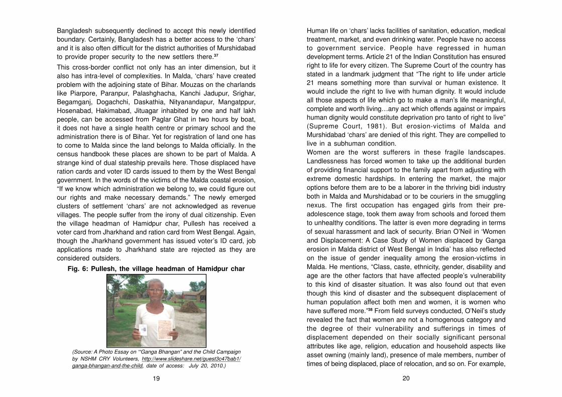
the village headman of Hamidpur char, Pullesh has received a
voter card from Jharkhand and ration card from West Bengal. Again,
though the Jharkhand government has issued voter’s ID card, job
applications made to Jharkhand state are rejected as they are
considered outsiders.
Fig. 6: Pullesh, the village headman of Hamidpur char
(Source: A Photo Essay on ‘“Ganga Bhangan” and the Child Campaign
by NSHM CRY Volunteers, http://www.slideshare.net/guest3c47bab1/
ganga-bhangan-and-the-child, date of access: July 20, 2010.)
Human life on ‘chars’ lacks facilities of sanitation, education, medical
treatment, market, and even drinking water. People have no access
to government service. People have regressed in human
development terms. Article 21 of the Indian Constitution has ensured
right to life for every citizen. The Supreme Court of the country has
stated in a landmark judgment that “The right to life under article
21 means something more than survival or human existence. It
would include the right to live with human dignity. It would include
all those aspects of life which go to make a man’s life meaningful,
complete and worth living…any act which offends against or impairs
human dignity would constitute deprivation pro tanto of right to live”
(Supreme Court, 1981). But erosion-victims of Malda and
Murshidabad ‘chars’ are denied of this right. They are compelled to
live in a subhuman condition.
Women are the worst sufferers in these fragile landscapes.
Landlessness has forced women to take up the additional burden
of providing financial support to the family apart from adjusting with
extreme domestic hardships. In entering the market, the major
options before them are to be a laborer in the thriving bidi industry
both in Malda and Murshidabad or to be couriers in the smuggling
nexus. The first occupation has engaged girls from their pre-
adolescence stage, took them away from schools and forced them
to unhealthy conditions. The latter is even more degrading in terms
of sexual harassment and lack of security. Brian O’Neil in ‘Women
and Displacement: A Case Study of Women displaced by Ganga
erosion in Malda district of West Bengal in India’ has also reflected
on the issue of gender inequality among the erosion-victims in
Malda. He mentions, “Class, caste, ethnicity, gender, disability and
age are the other factors that have affected people’s vulnerability
to this kind of disaster situation. It was also found out that even
though this kind of disaster and the subsequent displacement of
human population affect both men and women, it is women who
have suffered more.”38 From field surveys conducted, O’Neil’s study
revealed the fact that women are not a homogenous category and
the degree of their vulnerability and sufferings in times of
displacement depended on their socially significant personal
attributes like age, religion, education and household aspects like
asset owning (mainly land), presence of male members, number of
times of being displaced, place of relocation, and so on. For example,
19 20
belonging to a particular religious category determines the degree
of women’s vulnerability in times of displacement. As found during
the fieldwork, the deserted and widows among the Muslims get a
lot of help from certain practices like Fetura, Zakat and Asul,
prevalent among the Muslims, which define the imperative of helping
the poor. Recently, Priyanka Dutta’s paper on ‘Migration as source
of risk-aversion among the environmental refugees: The case of
women displaced by erosion of the river Ganga in the Malda district
of West Bengal, India’ has also highlighted the same issue.39 She
has added that through these charities Muslim widows sustain
themselves and hence they have a lesser tendency to migrate.40
Remedial Strategies to Mitigate the Crisis
A large number of flood mitigation measures were implemented by
the government since the enunciation of the National Policy on
Flood (management) in 1954. All the remedial measures that have
been implemented to mitigate crisis such as the construction of 30
km embankment, 27 spurs and revetments, etc. proved to be
ineffective owing to the gradual shifting of the Ganges towards the
left bank upstream of the Farakka Barrage. Major portions of the
seven retired embankments and spurs have been washed out. The
spurs have created additional problems rather than mitigating them.
In addition to the trapped sediment load, tons of boulders which are
used for anti-erosion works along the banks, are too often dislodged
and deposited into the river. The construction of a 100-m long spur
requires 14357 tons of boulders. Out of 27 spurs constructed so far
upstream of the Farakka Barrage, 20 spurs have been fully or
partially swept away. Spur Nos. 18, 20 and 24 which were recently
re-constructed have also been out-flanked. The flow of the river
gets obstructed by accumulated sediments, boulders and ruins of
the eroded villages. The current is thus deflected causing severe
bank-erosion.41
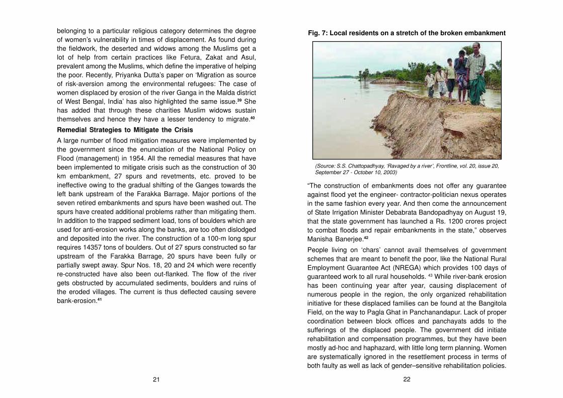
Fig. 7: Local residents on a stretch of the broken embankment
(Source: S.S. Chattopadhyay, ‘Ravaged by a river’, Frontline, vol. 20, issue 20,
September 27 - October 10, 2003)
“The construction of embankments does not offer any guarantee
against flood yet the engineer- contractor-politician nexus operates
in the same fashion every year. And then come the announcement
of State Irrigation Minister Debabrata Bandopadhyay on August 19,
that the state government has launched a Rs. 1200 crores project
to combat floods and repair embankments in the state,” observes
Manisha Banerjee.42
People living on ‘chars’ cannot avail themselves of government
schemes that are meant to benefit the poor, like the National Rural
Employment Guarantee Act (NREGA) which provides 100 days of
guaranteed work to all rural households. 43 While river-bank erosion
has been continuing year after year, causing displacement of
numerous people in the region, the only organized rehabilitation
initiative for these displaced families can be found at the Bangitola
Field, on the way to Pagla Ghat in Panchanandapur. Lack of proper
coordination between block offices and panchayats adds to the
sufferings of the displaced people. The government did initiate
rehabilitation and compensation programmes, but they have been
mostly ad-hoc and haphazard, with little long term planning. Women
are systematically ignored in the resettlement process in terms of
both faulty as well as lack of gender–sensitive rehabilitation policies.
21 22
The government fails to recognize that a considerable proportion of
the displaced are women and hence there is a need for gender-
sensitive rehabilitation policies. Lyla Mehta’s argument is relevant
in this context. She mentions that women, suffering from
environmental hazards are entrapped with a ‘double bind’; on one
hand gender inequality is perpetuated in terms of unequal resource
allocation and distribution by male biases, on the other hand, this
is exacerbated by biases within the state policies dealing with
displacement-rehabilitation-resettlement.44
While the role of government depicts a pessimistic picture, rays of
hope peep in from the initiatives launched by few action groups and
NGOs operating in this vulnerable zone. A local group Ganga
Bhangan Protirodh Action Nagorik Committee (GBPANC), duly
supported by Child Rights and You (CRY) has initiated a number
of measures to meet the problems of the erosion-victims in the
‘chars’ and protect their rights. They are bold enough to declare
that they are carrying the fight for ‘equality’ and not ‘charity’. In spite
of silence from the part of the government, the local community
organized by Nagorik Committee has surveyed the land at their
own and even attempted to submit the same to the local village
panchayats as a step to institutionalize their existence. The
Committee has also undertaken a scheme to reach out to the
pregnant women and malnourished children, living on the ‘chars’
and develop a networking system with the state authorities and
other organizations including the political parties and civil societies
to get across the true pictures of sufferings and sorrows, trials and
disasters that the people of the ‘chars’ are relentlessly subjected to.
No voice, no choice: coping-up as a compulsory exercise
The erosion victims in the ‘chars’ of Malda and Murshidabad districts
live a life beyond redemption. But why do they still prefer to stay in
these uncertain land patches? As we have already seen, people
have moved between four to 16 times in the last 15 years in some
of these ‘chars’. Still what binds them here? Why do they return
again as soon as water recedes, even being aware of the fragile
condition of the ‘chars’?
To understand this, socio-economic marginality of the people has
to be taken into consideration.
Like vulnerability, adaptation or coping with crisis situations also
depend on institutional and structural factors. Again, people in the
‘chars’ facing added/special vulnerability adapt less or lack the means
to cope with crisis than their less vulnerable counterparts living in
the mainland. Vulnerability is indirectly proportional to resilience
(i.e. vulnerability = 1/resilience) and vulnerability is directly
proportional to susceptibility (vulnerability = susceptibility). So it is
imperative to have an understanding of social differentiation in
adaptation.
Moreover, ‘chars’ are extremely fertile lands with high productivity.
Barren sand-fields are steadily converted into croplands through
bio-manuring and labour. Thanks to their traditional attitudes and
feelings, they know more or less accurately the level to which the
river water will rise for different volumes of water released from
upstream reservoirs. They remain alert during the monsoons. Small
boats are kept ready to carry them away from the rising waters.
A recent trend has developed in romanticizing these survival efforts
of the poorest and idealizing their initiatives as ‘adaptation’, ‘coping
up’, etc. But though there is a need to recognize these skills and
techniques as they are eco-friendly and cost-effective, and
incorporate them in the mainstream knowledge of hydrological and
agrarian practices, we should not forget that the suffering masses
are obliged to take risks and compelled to sustain their livelihood
in this hostile environment. It is not a simple matter of semantics
to describe this ability as resilience, competency, or as capacity to
adapt. We need to recognize and define this ability of adaptation —
as day-to-day, continual but contingent, set of strategic/structural
choices and decisions made by individuals and communities who
are extremely poor and vulnerable.45 They are bound to dance with
the moods of the river46 They are the poorest, the most toiling
masses in the most uncertain eco-system, they are the people with
no voice, hence no choice.
Notes
1. Quoted in C.H. Crickmay, The Work of the River: A Critical Study of
the Central Aspects of Geomorphology (New York: American Elsevier
Publishing Co. Inc., 1974), pp. 17-18.
2. N.K. Bhattasali, ‘Antiquity of the Lower Ganges and its Courses’,
Science and Culture’, VII, 1941.
23 24
3. Radhakamal Mukherjee, The Changing Face of Bengal (Calcutta:
University of Calcutta, 1938), p. 141.
4. P.L. Madan, River Ganga: A Cartographic Mystery (New Delhi:
Manohar, 2005).
5. S.A.I. Hamid Rizvi, Comparative Physiography of the Lower Ganges
and Lower Mississippi Valleys, unpublished PhD dissertation (Baton
Rouge: Lousiana State University, 1995), pp. 120-123.
6. R.K. Mukherjee writes, “Leaving the hills of Rajmahal, Ganges
seemed to have passed northwards through the modern Kalindri
and then southwards in the lower course of Mahananda, east of the
ruins of ancient Gour” (The Changing face of Bengal, ibid, p. 141).
7. Jadunath Sarkar writes, “Time has levelled to the dust the glories of
the Gauda under Hindu and Muslim rule and the ruins of their capital
lies scatterred in heaps for miles along the eastern bank of Kalindri
river through which flowed the main current of the Ganges down to
the close of the Thirteenth Century” (The History of Bengal: Muslim
Period 1200-1757, [Patna: Academia Asiatica, 1973], p. 24).
8. W.S. Sherwill, Report on the rivers of Bengal, (Calcutta : Calcutta
Printing and Publishing Company, 1858), p. 17.
9. James Rennell writes, “The Cossimbazar river is almost dry from
October to May” (Memoir of a Map of Hindoostan (London, 1788), p.
385.
10. Kalyan Rudra, Ganga Bhangan Katha: Malda-Murshidabad, (Kolkata:
Mrittika), p. 27.
11. Papers relating to the formation of Port Canning on the Matla Bengal:
Bengal Printing Co. Ltd, 1865), p. 1, quoted in Kalyan Rudra, ibid,
p. 28.
12. Annual Report on Major rivers, 1931-32, Nadia River Division, p. 12,
quoted in Kalyan Rudra, ibid.
13. Ibid, pp. 28-30.
14. Ibid, p. 30.
15. Begum Khursida, Tension over the Farakka barrage (Calcutta, 1987),
p. 29, quoted in ibid, p. 31.
16. Serial No. 2, Appendix – VII, para 2.4, 196th Report of the Public
Accounts Committee (5th Lok Sabha), Public Accounts Committee
(1977-78), 6th Lok Sabha, 37th Report, Farakka Barrage Project
Report, Ministry of Agriculture and Irrigation’, Lok Sabha Secretariat,
New Delhi, Nov. 1977.
17. Kalyan Rudra, The Encroaching Ganga and Social Conflicts: The
Case of West Bengal, India, (West Bengal: Dept. of Geography,
Habra H.C. Mahavidyalaya, 2003), p. 9.
18. T. Sanyal and A.K. Chakraborty, ‘Farakka Barrage Project: Promises
and Achievements’, S.C. Chakraborty edited Commemorative Volume,
125 Years of Kolkata Port Trust (1995) p. 57, quoted in Kalyan
Rudra, ibid.
19. Kalyan Rudra, ibid.
20. Ibid, p. 12.
21. J. Maitra, Boundary Dispute between West Bengal and Jharkhand:
Correspondences and Documents, (Malda, West Bengal : CPI(M)
District Committee, 2004), pp.17-19.
22. Priyanka Dutta, Migration as source of risk-aversion among the
environmental refugees: The case of women displaced by erosion of
the river Ganga in the Malda district of West Bengal, India, COMCAD
Arbeitspapiere – Working Papers, No. 98, 2011, p. 15.
23. Manisha Banerjee, A Report on the Impact of Farakka Barrage on
the Human Fabric (submitted to World Commission on Dams:
Thematic Review: Flood Control Options And many other thematic
reviews) New Delhi, 1999, pp. 13-14.
24. K.M. Elahi and John Rogge, Riberbank erosion, flood, and population
displacement in Bangladesh: A report on the Riverbank Erosion
Impact Study, Jahangirnagar University, Dhaka, Bangladesh, 1990,
cited in Kalyan Rudra, ibid, p. 29 and Showkat Iqbal, ‘Flood and
Erosion Induced Population Displacements: A Socio-economic Case
Study in the Gangetic Riverine Tract at Malda District, West Bengal,
India’, Journal of Human Ecology, vol. 30, no. 3, p. 204.
25. Kalyan Rudra, ‘Exploration to the Bhagirathi off-take’ (in Bengali)
(Biswa Biksha, 1992), vol.2, no.2, pp. 27-33.
26. Kalyan Rudra, The Encroaching Ganga and Social Conflicts, ibid, p.
32.
27. Known as ‘bhangan’ in the local dialect.
28. Cutter, Blaikie et. al., Downs et. al., Anderson and Woodrow, Oliver-
Smith, Anderson, Maskrey, Varley, quoted in E. Enarson and B.H.
Morrow (ed), The Gendered Terrain of Disaster through Women’s
Eyes (USA: Praeger Publishers, 1998), p. 2.
29. Terry Cannon, ‘Vulnerability Analysis and Disasters’, D.J. Parker, ed,
Floods, London: Routledge, 2000.
30. P.K. Parua, ‘Fluvial Geomorphology of the River Ganga around
Farakka’, Journal of the Institution of Engineers, 2002, vol.82, pp.193-
196.
31. R. H. Colebrook, ‘On the course of the Ganges through Bengal’,
Asiatic Researches, vol. 7, p. 14.
25 26

32. Quoted in Kalyan Rudra, The Encroaching Ganga and Social
Conflicts, ibid, pp. 30.
33. W. Sherwill, Report on the rivers of Bengal, ibid, p. 18.
34. Supriya Sengupta, Nadi, Bichitra Bidya Granthamala, Jiggasha, 1982,
p. 7, quoted in Kalyan Rudra, Ganga Bhangan Katha: Malda-
Murshidabad, ibid, p. 57.
35. Kalyan Rudra, ibid.
36. Manisha Banerjee, ibid, p. 19.
37. Kalyan Rudra, ibid, p. 33.
38. Brian O’Neil, ‘Women and Displacement: A Case Study of Women
displaced by Ganga erosion in Malda district of West Bengal in
India’, Development and Environment, http://epc2010.princeton.edu/
download.aspx?submissionId=100534, date of access: June 20, 2010.
39. Priyanka Dutta, Migration as source of risk-aversion among the
environmental refugees: The case of women displaced by erosion of
the river Ganga in the Malda district of West Bengal, India, COMCAD
Arbeitspapiere – Working Papers, No. 98, 2011, p. 17.
40. Ibid.
41. Kalyan Rudra, ibid, p. 11.
42. Manisha Banerjee, ibid, p. 15-16.
43. The Mahatma Gandhi National Rural Employment Guarantee Act
aims “at enhancing the livelihood security of people in rural areas by
guaranteeing hundred days of wage-employment in a financial year
to a rural household whose adult members volunteer to do unskilled
manual work,” http://nrega.nic.in/netnrega/home.aspx
44. M. Kumar, ‘Incorporating Gender Issues in National Responses’,
paper presented at the Regional Workshop on NHRIs and IDPS,
organized by Asia Pacific Forum, Colombo, October, 2005, p. 8.
45. Kuntala Lahiri Dutta and Gopa Samanta, ‘Like the Drifting Grains of
Sand: Vulnerability, Security and Adjustment by Communities in the
Charlands of the Damodar River, India’, South Asia: Journal of South
Asian Studies, vol. 30, no. 2, 2007, p. 348.
46. Gilles Saussier, Living in the Fringe, (Paris: Figura Association, 1998).
Bibliography
1. Ahmed, I, ‘Rivers and Environmental Refugees’, Indian Journal of
Landscape Systems and Ecological Studies, vol. 24, 2001.
2. Banerjee, Manisha, A Report on the Impact of Farakka Barrage on
the Human Fabric (submitted to World Commission on Dams:
Thematic Review: Flood Control Options And many other thematic
reviews) New Delhi, 1999.
3. Basu, S.K., ‘A Geotechnical Assessment of the Farakka Barrage
Project, Murshidabad and Malda Districts, West Bengal’, Geological
Survey of India, Bull.No.47, 1982.
4. Bhattasali, ‘Antiquity of the Lower Ganges and its Courses’, Science
and Culture’, VII, 1941.
5. Cannon, Terry, ‘Vulnerability Analysis and Disasters’, D.J. Parker,
ed, Floods, (London: Routledge, 2000).
6. Colebrook, R.H., ‘On the course of the Ganges through Bengal’,
Asiatic Researches, vol. 7.
7. Crickmay, C.H., The Work of the River: A Critical Study of the Central
Aspects of Geomorphology (New York: American Elsevier Publishing
Co. Inc., 1974).
8. District Human Development Report: Malda, (HDRCC: Development
and Planning Department, Government of West Bengal), April 2007.
9. Dutta, Priyanka, Migration as source of risk-aversion among the
environmental refugees: The case of women displaced by erosion of
the river Ganga in the Malda district of West Bengal, India, COMCAD
Arbeitspapiere – Working Papers, No. 98, 2011.
10. Elahi, K.M. and John Rogge, Riberbank erosion, flood, and population
displacement in Bangladesh: A report on the Riverbank Erosion
Impact Study, (Dhaka: Jahangirnagar University, 1990).
11. Enarson, E and B.H. Morrow (ed), The Gendered Terrain of Disaster
through Women’s Eyes (USA: Praeger Publishers, 1998).
12. Hamid Rizvi, S.A.I., Comparative Physiography of the Lower Ganges
and Lower Mississippi Valleys, unpublished PhD dissertation (Baton
Rouge: Lousiana State University, 1995).
13. Hunter, W.W., A Statistical Account of Bengal, vol. 9 (Districts of
Murshidabad and Pabna), (London: Trubner and Co., 1876).
14. Inglis, W.A., ‘Some of the problems set us by the Rivers of Bengal’,
Journal of the Asiatic Society of Bengal, vol. 5, no.10, 1909.
15. Iqbal, Showkat, ‘Flood and Erosion Induced Population
Displacements: A Socio-economic Case Study in the Gangetic
Riverine Tract at Malda District, West Bengal, India’, Journal of Human
Ecology, vol. 30, no. 3.
16. Kumar, M, ‘Incorporating Gender Issues in National Responses’,
paper presented at the Regional Workshop on NHRIs and IDPS,
organized by Asia Pacific Forum, Colombo, October, 2005.
17. Lahiri Dutta, Kuntala and Gopa Samanta, ‘Like the Drifting Grains of
Sand: Vulnerability, Security and Adjustment by Communities in the
Charlands of the Damodar River, India’, South Asia: Journal of South
Asian Studies, vol. 30, no. 2, 2007.
27 28
18. Leopold, L.B., M. G. Wolman, J.P. Miller, Fluvial Processes in
Geomorphology (San Francisco: W.H. Freeman and Co., 1964).
19. Madan, River Ganga: A Cartographic Mystery (New Delhi: Manohar,
2005).
20. Maitra, J, Boundary Dispute between West Bengal and Jharkhand:
Correspondences and Documents, (CPI(M) District Committee: Malda,
West Bengal, 2004).
21. Mukherjee, R.K., The Changing Face of Bengal (Calcutta: University
of Calcutta, 1938).
22. Sutapa Mukhopadhyay and Malay Mukhopadhyay, Bank Erosion of
River Ganga, Eastern India – A Threat to Environmental Systems
Management, http://www.quebec2007.ca/pdf/salle204a/seance21/
articles/s_mukhopadhyay.pdf, date of access: June 22, 2011.
23. O’Neil, Brian, Women and Displacement: A Case Study of Women
displaced by Ganga erosion in Malda district of West Bengal in
India, Development and Environment, http://epc2010.princeton.edu/
download.aspx?submissionId=100534, date of access: June 20, 2010.
24. Parua, P.K., ‘Erosion Problems of the River Ganga in the districts of
Malda and Murshidabad in West Bengal’, Civil Engineering Today,
Journal of ASCE, vol. 13, no. 2, 1999.
25. Parua, P.K., ‘Fluvial Geomorphology of the River Ganga around
Farakka’, Journal of the Institution of Engineers, 2002, vol.82.
26. Rennell, James, Memoir of a Map of Hindoostan (London, 1788).
27. Richards, Keith (ed), River Channels: Environment and Process
(Oxford: Basil Blackwell, 1987).
28. Rudra, Kalyan, ‘Exploration to the Bhagirathi off-take’ (in Bengali)
Biswa Biksha, vol.2, no.2, 1992.
29. Rudra Kalyan, Ganga Bhangan Katha: Malda-Murshidabad, (Kolkata:
Mrittika, 2002).
30. Rudra, Kalyan, ‘Problems of River Bank Erosion along the Ganga in
Murshidabad district of West Bengal’, Indian Journal of Geography
& Environment, vol. 1.
31. Rudra, Kalyan, ‘Living On the Edge: The Experience along The Bank
of the Ganga in Malda District, West Bengal’, Indian Journal of
Geography & Environment vol. 5, 2000, pp. 57-67.
32. Rudra, Kalyan, ‘Quaternary history of the lower Ganga distributaries’,
Geographical Review of India, vol. 48, no. 3, 1987.
33. Rudra, Kalyan, The Encroaching Ganga and Social Conflicts: The
Case of West Bengal, India, (West Bengal: Dept. of Geography,
Habra H.C. Mahavidyalaya, 2003).
34. Rudra, Kalyan, ‘The Farakka Barrage Project – An interruption to
fluvial regime’, Indian Journal of Landscape System and Ecological
Studies, vol 19, no. 2, 1996.
35. Rudra,Kalyan ‘Will Ganga outflank the Farakka Barrage?’ (in Bengali),
Desh, 09.12.2000, pp.58-68.
36. Saussier, Gilles, Living in the Fringe, (Paris: Figura Association, 1998).
37. Sherwill, W, Report on the rivers of Bengal, (Calcutta: Calcutta Printing
and Publishing Company, 1858).
38. Statham, Ian, Earth Surface Sediment Transport, (Oxford: Clarendon
Press, 1977).
39. Tandon, S.K., Charu. C. Pant and S. M. Casshyap (ed), Sedimentary
Basins of India (Nainital: Gyanodaya Prakashan, 1991).
29 30