No. 1 - 4 JANUARY 2020 UNITED STATES OF AMERICA
124
No. 1 4 JANUARY 2020 UNITED STATES OF AMERICA Published Weekly by the National Geospatial-Intelligence Agency Prepared Jointly with the National Ocean Service and U.S. Coast Guard Contents Section I Special Notice to Mariners Paragraphs . . . . . . . . . . . . . . . . . . . . . . . . . . . I-1.1 Chart Corrections . . . . . . . . . . . . . . . . . . . . . . . . . . . . . . . . . . . . . . . . . . . . I-2.1 Chartlets / Depth Tabulations / Notes . . . . . . . . . . . . . . . . . . . . . . . . . . . . NONE Charts Affected by Notice to Mariners . . . . . . . . . . . . . . . . . . . . . . . . . . . I-3.1 Section II NGA/DLIS Catalog Corrections . . . . . . . . . . . . . . . . . . . . . . . . . . . . . . . . II-1.1 Navigation Publications Corrections . . . . . . . . . . . . . . . . . . . . . . . . . . . . . II-2.1 USCG Light List Corrections / Radiobeacon Corrections . . . . . . . . . . . . . II-3.1 NGA List of Lights / Radiobeacon / DGPS Corrections . . . . . . . . . . . . . . NONE Publications Affected by Notice to Mariners . . . . . . . . . . . . . . . . . . . . . . . II-4.1 Section III Broadcast Warnings . . . . . . . . . . . . . . . . . . . . . . . . . . . . . . . . . . . . . . . . . . III-1.1 Marine Information . . . . . . . . . . . . . . . . . . . . . . . . . . . . . . . . . . . . . . . . . . III-2.1 Visit the Maritime Safety Web site at https://msi.nga.mil
-
Upload
khangminh22 -
Category
Documents
-
view
0 -
download
0
Transcript of No. 1 - 4 JANUARY 2020 UNITED STATES OF AMERICA

No. 14 JANUARY 2020
UNITED STATES OF AMERICA
Published Weekly by the National Geospatial-Intelligence Agency
Prepared Jointly with the National Ocean Service and U.S. Coast Guard
Contents
Section ISpecial Notice to Mariners Paragraphs . . . . . . . . . . . . . . . . . . . . . . . . . . . I-1.1Chart Corrections . . . . . . . . . . . . . . . . . . . . . . . . . . . . . . . . . . . . . . . . . . . . I-2.1Chartlets / Depth Tabulations / Notes . . . . . . . . . . . . . . . . . . . . . . . . . . . . NONECharts Affected by Notice to Mariners . . . . . . . . . . . . . . . . . . . . . . . . . . . I-3.1
Section IINGA/DLIS Catalog Corrections . . . . . . . . . . . . . . . . . . . . . . . . . . . . . . . . II-1.1Navigation Publications Corrections . . . . . . . . . . . . . . . . . . . . . . . . . . . . . II-2.1USCG Light List Corrections / Radiobeacon Corrections. . . . . . . . . . . . . II-3.1NGA List of Lights / Radiobeacon / DGPS Corrections . . . . . . . . . . . . . . NONEPublications Affected by Notice to Mariners. . . . . . . . . . . . . . . . . . . . . . . II-4.1
Section IIIBroadcast Warnings . . . . . . . . . . . . . . . . . . . . . . . . . . . . . . . . . . . . . . . . . . III-1.1Marine Information . . . . . . . . . . . . . . . . . . . . . . . . . . . . . . . . . . . . . . . . . . III-2.1
Visit the Maritime Safety Web site at https://msi.nga.mil

ii
IMPORTANT INFORMATION
The Notice to Mariners is published by the National Geospatial-Intelligence Agency (NGA), under the authority ofDepartment of Defense Directive 5105.60, to advise mariners of important matters affecting navigational safety, including newhydrographic discoveries, changes in channels and navigational aids, etc. (U.S. Code Title 10, Sec. 442 and Title 44, Sec. 1336refer). Nothing in the arrangement of information implies endorsement or acceptance by NGA in matters affecting the statusand boundaries of States and territories. The Notice to Mariners presents corrective information affecting charts, NGA/DLISCatalog of Maps Charts and Related Products, Coast Pilots, USCG Light Lists, NGA List of Lights and other productsproduced by the National Geospatial-Intelligence Agency, National Ocean Service and U.S. Coast Guard.
Information for the Notice to Mariners is contributed by the following Agencies: National Geospatial-Intelligence Agency(NGA) (Department of Defense) for waters outside the territorial limits of the United States; National Ocean Service (NOS)(Department of Commerce), which is charged with the surveys and charting of the coasts and harbors of the United States andits territories; the U.S. Coast Guard (USCG) (Department of Homeland Security), which is responsible for the safety of life atsea and the establishment and operation of aids to navigation; and the U.S. Army Corps of Engineers (Department of Defense),which is charged with the improvement of rivers and harbors of the United States. In addition, important contributions aremade by foreign hydrographic offices and cooperating observers of all nationalities.
For further information concerning NGA hydrographic products and services, including the Maritime Safety Web site, usersmay contact:
The Maritime Safety Web site can be accessed directly at https://msi.nga.mil. For your convenience, NGA provides thefollowing e-mail addresses: For information affecting Notice to Mariners, use [email protected]; for information affectingSailing Directions and all other navigational publications, use [email protected]; for information concerning the MaritimeSafety Web site, use [email protected]; and for information concerning the World Wide Navigational Warning Service,use [email protected].
Mariners are requested to notify NGA of discrepancies in charts and publications, using the Marine Information Report andSuggestion Sheet at the back of this Notice to Mariners. This form should also be used to report permanent changes, additions,or deletions from charted or published information. Reports which constitute an immediate hazard to navigation should be sentto the nearest NAVAREA Coordinator via coast radio stations. All reports are greatly appreciated.
Name Telephone DSN FAXMaritime Safety Office 571-557-8384 N/A 571-558-3213NGA Maritime Safety Watch 571-557-5455 547-5455 571-558-3426Maritime Safety Web site 571-557-7103 547-7103 N/ANotice to Mariners: Regions 1 and 2 571-557-8282 547-8282 571-558-3213Notice to Mariners: Regions 3 thru 9 571-557-8383 547-8383 571-558-3213Sailing Directions, Fleet Guides 571-557-5831 547-5831 571-558-3213Navigation Publications 571-557-8080 547-8080 571-558-3213NGA/DLIS Catalog of Maps Charts and Related Products
269-961-7766 661-7766 269-961-7791
Cover Photo: The United States Training Ship KENNEDY is the training vessel for Massachusetts Maritime Academy, inBuzzards Bay, Massachusetts. The TS KENNEDY was built in 1964 as the SS Velma Lykes in Avondale Shipyards, NewOrleans, LA. In 1985 she was acquired by MARAD and renamed the SS Cape Bon, and was activated for Desert Storm in1991. In 2003 she was converted to a training ship and renamed the TS Enterprise. In 2009 she underwent a $10 millionupgrade and was renamed to the TS KENNEDY. In 2012 TS KENNEDY was activated to support relief efforts for HurricaneSandy. Each winter the TS KENNEDY sets sail on her two-month-long sea term to teach the next generation of professionalmariners.
INFORMATIONOF
SPECIAL INTERESTOR
IMPORTANCETO
MARINERS
NM 1/20
SPECIALANNOUNCEMENTS
NEW PRODUCTSOR SERVICES
IMPORTANTCHANGES
4 January 2020
National Geospatial-Intelligence AgencySpringfield, VA 22150-7500
iii
NEW EDITION OF COAST PILOT
U.S. COAST PILOT 3, ATLANTIC COAST: SANDY HOOK, NJ, TO CAPE HENRY, VA FIFTY-THIRD EDITION, 2020, IS READY FOR ISSUE. SEE SECTIONS II AND III.
NATIONAL GEOSPATIAL-INTELLIGENCE AGENCY’S IMPLEMENTATION OF A HARDCOPY TO DIGITAL TRANSITION STRATEGY
THIS NOTICE IS A REMINDER OF THE NATIONAL GEOSPATIAL-INTELLIGENCE AGENCY(NGA) HARDCOPY TO DIGITAL TRANSITION PROGRAM. SEE SECTION III FOR DETAILS.
iv
EXPLANATION OF CONTENTS
The Notice to Mariners contains corrective information affecting nautical charts, the NGA/DLIS Catalog of Maps Chartsand Related Products, Coast Pilots, USCG Light Lists, NGA List of Lights and other related nautical publications. Theinformation contained in these corrections is important to safe navigation. It is the user’s responsibility to decide which of theircharts and publications require correction. Consult the U.S. Coast Guard Local Notice to Mariners for information pertainingto waterways within the United States that are not normally used by oceangoing vessels. Because of the sometimes transitorynature of aids to navigation, depths and port information, local area sources should be consulted whenever possible. Thispublication is not required to be maintained intact. Portions may be separated for correction or attachment to an affectedproduct. The Notice to Mariners is divided into the following sections:
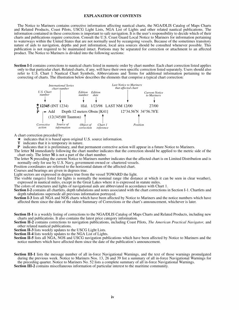
Section I-1 contains corrections to nautical charts listed in numeric order by chart number. Each chart correction listed appliesonly to that particular chart. Related charts, if any, will have their own specific correction listed separately. Users should alsorefer to U.S. Chart 1 Nautical Chart Symbols, Abbreviations and Terms for additional information pertaining to thecorrecting of charts. The illustration below describes the elements that comprise a typical chart correction:
A chart correction preceded by:★ indicates that it is based upon original U.S. source information.T indicates that it is temporary in nature.P indicates that it is preliminary, and that permanent corrective action will appear in a future Notice to Mariners.
The letter M immediately following the chart number indicates that the correction should be applied to the metric side of thechart only. The letter M is not a part of the chart number.
The letter N preceding the current Notice to Mariners number indicates that the affected chart is on Limited Distribution and isnormally only for use by U.S. Navy, government-owned or -chartered vessels.
Position coordinates are referred to the horizontal datum of the affected chart. Courses and bearings are given in degrees true. Light sectors are expressed in degrees true from the vessel TOWARD the light. The visible range(s) listed for lights is normally the nominal range (the distance at which it can be seen in clear weather),
expressed in nautical miles, except in the Great Lakes where it is expressed in statute miles.The colors of structures and lights of navigational aids are abbreviated in accordance with Chart 1.Section I-2 contains all chartlets, depth tabulations and notes associated with the chart corrections in Section I-1. Chartlets and
depth tabulations supersede all previous information portrayed.Section I-3 lists all NGA and NOS charts which have been affected by Notice to Mariners and the notice numbers which have
affected them since the date of the oldest Summary of Corrections or the chart’s announcement, whichever is later.
Section II-1 is a weekly listing of corrections to the NGA/DLIS Catalog of Maps Charts and Related Products, including newcharts and publications. It also contains the latest price category information.
Section II-2 contains corrections to navigation publications, including Coast Pilots, The American Practical Navigator, andother related nautical publications.
Section II-3 lists weekly updates to the USCG Light Lists.Section II-4 lists weekly updates to the NGA List of Lights.Section II-5 lists all NGA, NOS and USCG navigation publications which have been affected by Notice to Mariners and the
notice numbers which have affected them since the date of the publication’s announcement.
Section III-1 lists the message number of all in-force Navigational Warnings, and the text of those warnings promulgatedduring the previous week. Notice to Mariners Nos. 13, 26 and 39 list a summary of all in-force Navigational Warnings forthe preceding quarter. Notice to Mariners No. 52 lists a complete summary of all in-force Navigational Warnings.
Section III-2 contains miscellaneous information of particular interest to the maritime community.
12345 (INT 1234) 1Ed. 1/23/98 LAST NM 12/00 27/00
Add Depth 12 meters Obstn [K41] 12°34.56′N 34°56.78′E(12(345)00 Taunton)
Last Notice to Mariners that affected chart
Source of information
Object of
Editionnumber
U.S. Chart number
Edition date
International Series chart number
★TP
Current Notice to Mariners
correctionCorrective
actionChart 1
referencePosition

SECTION I NM 1/20
I-1.1
INDEX TO SPECIAL NOTICE TO MARINERS PARAGRAPHS
Paragraph Title Page
1 The Prudent Mariner........................................................................................................................ I-1.3
2* Nautical Chart Symbols and Abbreviations Information................................................................. I-1.4
3 Geographic Names Usage for NGA Products.................................................................................. I-1.4
4* International Ice Patrol .................................................................................................................... I-1.4
5* Special Warnings.............................................................................................................................. I-1.5
6 Amver .............................................................................................................................................. I-1.5
7* International Aeronautical and Maritime Search and Rescue (IAMSAR) Manual.......................... I-1.6
8 Special Reporting Instructions for U.S. Flag Vessels, Vessels Carrying War Risk Insurance,and Certain Other Designated Vessels (Formerly USMER Vessels)................................................ I-1.6
9 Urgency and Safety Signals.............................................................................................................. I-1.7
10 Submarine Emergency Identification Signals and Hazard to Submarines....................................... I-1.7
11 Rules, Regulations and Proclamations Issued by Foreign Governments......................................... I-1.8
12 Warning - Danger from Submarine Cables....................................................................................... I-1.8
13 Warning - Danger from Submarine Pipelines................................................................................... I-1.9
14 Caution - Close Approach to Moored Offshore Aids to Navigation................................................ I-1.9
15 Pipeline Laybarges and Jetbarges..................................................................................................... I-1.9
16 Required Reporting of Damaged U.S. Aids to Navigation.............................................................. I-1.9
17 Regulations for the Prevention of Pollution from Ships................................................................... I-1.9
18 Compliance with the Act to Prevent Pollution from Ships............................................................... I-1.14
19 International Safety Management Code Enforcement...................................................................... I-1.15
20 Ballast Water Management for Control of Non-Indigenous Species............................................... I-1.15
21 Vessel Security Regulations: MTSA and ISPS Code....................................................................... I-1.15
22 Warning-Possible Danger from Unlabeled Intermodal Containers and Drums............................... I-1.16
23 Reporting of Dangers to Navigation................................................................................................. I-1.16
24* Vessel Traffic Services and Vessel Movement Reporting System Center, Call Signs,
Designated Frequencies, and Monitoring Areas............................................................................... I-1.17
25 Seismic Surveys................................................................................................................................ I-1.21
26 United States - Caution Regarding Submarine Operations.............................................................. I-1.21
27 Special Rules with Respect to Additional Station and Signal Lights for Navy Ships...................... I-1.22
28 United States Naval Vessels - Navigational Light Waivers-Distinctive Lights Authorized forNaval Vessels.................................................................................................................................... I-1.22
29* Traffic Separation Schemes, Areas to be Avoided, Recommended Tracks, and Other
Routing Measures............................................................................................................................. I-1.23
30 Firing Danger Areas......................................................................................................................... I-1.25
31 Endangered Species (Whales and Sea Turtles) Eastern Seaboard.................................................... I-1.25
32* Reporting Depth Information........................................................................................................... I-1.3133 Warning-Mined Areas...................................................................................................................... I-1.31
34 Mined Areas Reported...................................................................................................................... I-1.32
35 Minesweeping - Caution - Attention is Called to the Following Instructions.................................. I-1.32
* Denotes significant change

NM 1/20 SECTION I
I-1.2
INDEX TO SPECIAL NOTICE TO MARINERS PARAGRAPHS
Paragraph Title Page
36 United States - Explosive Ordnance - Warning - General................................................................. I-1.33
37 Caution - Oil Well Structures in Waters Contiguous to the U.S. and its Territories......................... I-1.34
38 Caution Regarding Approach of Single Vessels Toward Naval Formations and Convoys............... I-1.35
39 National Geospatial-Intelligence Agency Distribution System........................................................ I-1.35
40* International Hydrographic Organization (IHO).............................................................................. I-1.37
41 International Distress Signals............................................................................................................ I-1.38
42* Worldwide Navigational Warning Service (WWNWS).................................................................... I-1.40
43 Weather Observation Reports ........................................................................................................... I-1.45
44 Radar Beacons (RACONs)................................................................................................................ I-1.46
45* NAVTEX........................................................................................................................................... I-1.46
46* Satellite Detection of Distress Signals.............................................................................................. I-1.47
47 HF and VHF Radiotelephone and Radiotelex Marine Safety Broadcasts........................................ I-1.49
48* Inland Navigation Rules.................................................................................................................... I-1.49
49 Guidelines for WGS Datum Conversion........................................................................................... I-1.49
50* Anti-Shipping Activities Message.................................................................................................... I-1.51
51 Caution on Announcement of New Charts and Publications............................................................ I-1.52
52 Global Positioning System (GPS) and Differential GPS (DGPS) Information................................ I-1.52
53 Digital Selective Calling Distress Alert............................................................................................ I-1.54
54 Vessel Squat in Shallow Water.......................................................................................................... I-1.54
55 Promulgation of Maritime Safety Information by U.S. Information Providers................................ I-1.56
56 Coast Guard Safety Information Available on Internet..................................................................... I-1.58
57* National Ocean Claims..................................................................................................................... I-1.58
58 U.S. Economic Sanctions.................................................................................................................. I-1.68
59 Maritime Industry Reporting of a Suspected or Actual Terrorist Incident....................................... I-1.69
60 Electronic Vessel Notice of Arrival (eNOA) Submission................................................................. I-1.69
61 America’s Waterway Watch.............................................................................................................. I-1.70
62 Loss of Inmarsat-C Safety Messages................................................................................................ I-1.70
63 Automatic Identification System....................................................................................................... I-1.70
64 Cellular Phone use for Maritime Distress Notification..................................................................... I-1.71
65 Discolored Water............................................................................................................................... I-1.71
66 International Maritime Bureau (IMB) Maritime Security Hotline................................................... I-1.73
67* Transportation Worker Identification Credential (TWIC)................................................................ I-1.73
68* Long Range Identification and Tracking (LRIT) System................................................................. I-1.73
69 Counter-Piracy.................................................................................................................................. I-1.74
70* Space Weather Impacts..................................................................................................................... I-1.74
71 Mariner's Safety Endangered When VHF Radio Distress Alerts By Digital Selective Calling (DSC)Lack Location And Identification Information................................................................................. I-1.75
* Denotes significant change

SECTION I NM 1/20
I-1.3
(1) THE PRUDENT MARINER.
a. Warning On Use Of Floating Aids To Navigation and on Aids to Navigation in General and Fixing a Navigational Position.The aids to navigation depicted on charts comprise a system consisting of fixed and floating aids with varying degrees of
reliability. Therefore, prudent mariners will not rely solely on any single aid to navigation, particularly a floating aid. An aid tonavigation also refers to any device or structure external to a craft, designed to assist in determination of position. Thisincludes celestial, terrestrial, and electronic means, such as Global Positioning System (GPS) and Differential GPS (DGPS).Here, too, the prudent mariner will not rely solely on any single aid to navigation.
The buoy symbol is used to indicate the approximate position of the buoy body and the sinker which secures the buoy tothe seabed. The approximate position is used because of practical limitations in positioning and maintaining buoys and theirsinkers in precise geographical locations. These limitations include, but are not limited to, inherent imprecisions in positionfixing methods, prevailing atmospheric and sea conditions, the slope of and the material making up the seabed, the fact thatbuoys are moored to sinkers by varying lengths of chain, and the fact that buoy and/or sinker positions are not under continu-ous surveillance but are normally checked only during periodic maintenance visits which often occur more than a year apart.The position of the buoy body can be expected to shift inside and outside the charting symbol due to the forces of nature. Themariner is also cautioned that buoys are liable to be carried away, shifted, capsized, sunk, etc. Lighted buoys may be extin-guished or sound signals may not function as the result of ice or other natural causes, collisions, or other accidents. Many ofthese factors also apply to articulated lights.
For the foregoing reasons, a prudent mariner must not rely completely upon the position or operation of floating aids tonavigation, but will utilize bearings from fixed objects and aids to navigation on shore. Further, a vessel attempting to passclose aboard always risks collision with a yawing buoy or with the obstruction the buoy marks.b. Use of Foreign Charts.
In the interest of safe navigation, caution should be exercised in the use of foreign charts not maintained through U.S.Notice to Mariners.
Foreign produced charts are occasionally mentioned in NGA Sailing Directions and often times are used by the U.S. Navywhen such charts may be of a better scale than U.S. produced charts. Mariners are advised that if or when such foreign chartsare used for navigation it is their responsibility to maintain those charts from the Notice to Mariners of the foreign country pro-ducing the charts.
The mariner is warned that the buoyage systems, shapes, colors, and light rhythms used by other countries often have a dif-ferent significance than the U.S. system.
Mariners are further warned about plotting positions, especially satellite-derived positions such as from GPS, ontoforeign charts where the datum is unknown or the conversion from WGS-84 is unknown.c. Chart Notes Regarding Different Datums.
NGA’s Digital Nautical Charts (DNC) are all built to WGS-84 standards; however, NGA paper charts have various datums.Particular caution should be exercised during a passage when transferring the navigational plot to an adjacent chart upon a dif-ferent geodetic datum or when transferring positions from one chart to another chart of the same area which is based upon adifferent datum. The transfer of positions should be done by bearings and distances from common features.
Notes on hardcopy charts should be read with care, as they give important information not graphically presented. Notes inconnection with the chart title include the horizontal geodetic datum which serves as a reference for the values of the latitudeand longitude of any point or object on the chart. The latitudes and longitudes of the same points or objects on a second chartof the same area which is based upon a different datum will differ from those of the first chart. The difference may be naviga-tionally significant, particularly when the scale of the chart is large. Additionally, datum changes between chart editions couldsignificantly affect the positions of navigational aids found in the List of Lights and other NGA publications.
Positions obtained from satellite navigation systems, such as from GPS, are normally referred to the World Geodetic Sys-tem 1984 (WGS-84) Datum. The differences between GPS satellite-derived positions and positions on some foreign chartscannot be determined: mariners are warned that these differences MAY BE SIGNIFICANT TO NAVIGATION and are there-fore advised to use alternative sources of positional information, particularly when closing the shore or navigating in the vicin-ity of dangers.d. Bilateral Charts
NGA, through international agreements, has adopted select trusted foreign hydrographic office charts into its paper stan-dard nautical chart global portfolio. These charts, which are duplicates of foreign copyrighted charts, must be in English, usemetric units, and reference WGS-84 datum. Each chart has an NGA chart number, a National Stock Number (NSN), and a barcode added in the margin. The resultant chart product is known as an NGA “bilateral chart” and is marked as “DistributionLimited,” available only to DoD and Government users. These charts are then maintained with corrections published in the USNotice to Mariners as any other NGA chart. NGA bilateral charts currently exist in waters of Australia, Canada, Japan, and theUK. Commercial users of NGA paper charts for these areas who may require a chart that is not available to them will need to

NM 1/20 SECTION I
I-1.4
(1) THE PRUDENT MARINER. (Continued).
purchase the original foreign chart from the respective foreign hydrographic office or one of their chart vendors. They will thenhave to maintain that chart using the Notice to Mariners published by that country to keep the chart current and safe fornavigation. Updated information and a complete listing of all NGA bilateral charts is reissued weekly in the U.S. Notice toMariners (Section III) which are available on the NGA Maritime Safety Website at: https://msi.nga.mil/NGAPortal.(Repetition NTM 1(1)19) (NGA/SFHG)
(2) NAUTICAL CHART SYMBOLS AND ABBREVIATIONS INFORMATION.
Symbols and abbreviations approved for use on all paper and electronic navigational charts published by the National Geo-spatial-Intelligence Agency (NGA) and the National Ocean Service (NOS) are contained in the April 15, 2019 edition of U.S.Chart No. 1, Symbols, Abbreviations and Terms used on Paper and Electronic Navigational Charts. This publication, in PDFformat, is available through electronic access at the Maritime Safety Web site: (https://msi.nga.mil/Publications/Chart1) andfrom the “U.S. Chart No. 1” page of the NOAA Office of Coast Survey Web site at: http://www.nauticalcharts.noaa.gov/publi-cations/us-chart-1.html. New in this edition are removal of codes in the Buoy, Beacons section and the addition of different V-AIS symbols.
This edition updates the descriptions and depictions of the basic nautical chart elements and symbols described in the ChartSpecifications of the IHO published by the International Hydrographic Organization, on charts produced by NOAA, NGA andNGA reproductions of foreign navigational charts. Lastly, the document shows the symbols specified by the IHO for the por-trayal of Electronic Navigational Chart (ENC) data on Electronic Chart Display and Information Systems.
Buoys and Beacons of the IALA Buoyage System Regions A and B are illustrated in Appendix 1, including light character-istics in full color.(Supersedes NTM 1(2)19) (NGA/SFHG)
(3) GEOGRAPHIC NAMES USAGE FOR NGA PRODUCTS.
Wherever possible, names used on NGA charts and in NGA publications are in the form approved by the United StatesBoard on Geographic Names. Generally, local official spellings are used for those features entirely within a single sovereignty,while names of countries and those features which are common to two or more countries or which lie beyond single sover-eignty carry Board-approved conventional spellings (i.e., names in common English language usage). When alternate nameswould be of value to the user, they may be shown for information purposes within parentheses. Important individual namechanges are made to all revised charts as the opportunity permits. Geographic names or their spellings do not necessarilyreflect recognition of the political status of an area by the United States Government.(Repetition NTM 1(3)19) (NGA)
(4) INTERNATIONAL ICE PATROL.
The North American Ice Service (NAIS), a partnership comprised of the International Ice Patrol (IIP), the Canadian IceService (CIS), and the U.S. National Ice Center (NIC), provides year-round maritime safety information on iceberg and sea iceconditions in the North Atlantic Ocean. The daily NAIS Iceberg Limit, valid at 0000Z, along with the daily Sea Ice Limit, willbe distributed as a NAVAREA IV warning in the format of a text Iceberg Bulletin and as a graphic Iceberg Chart.
The purpose of the NAIS Iceberg Bulletin and Chart is to advise mariners of the estimated iceberg extent within the region.On the Chart, numbers within each 1 degree by 1 degree grid sector inside the Iceberg Limit are intended to provide marinersan awareness of the relative density of icebergs. IIP produces the NAIS iceberg warning products from January through Augustwhen icebergs typically threaten the transatlantic shipping lanes, and CIS produces the products from September throughDecember when icebergs typically only threaten Canadian coastal waters. To access the current iceberg warnings as well asmore information on the Iceberg Bulletin and Iceberg Chart, visit: https://www.navcen.uscg.gov/?pageName=iipProducts.
NAIS reconnaissance is conducted in the North Atlantic Ocean with a focus on the Grand Banks of Newfoundland and theeast coast of Labrador due to the location of the transatlantic shipping lanes. Ice conditions south of Greenland are not moni-tored by NAIS. For iceberg conditions off of Greenland, visit the Danish Meteorological Institute's website at:https://www.dmi.dk/products-in-english/. While NAIS strives to be as accurate as possible in reporting the presence of ice-bergs to mariners, it is not possible to ensure that all icebergs are detected and reported. There is no substitute for due vigilanceand prudent seamanship, especially when operating near sea ice and icebergs.
SECTION I NM 1/20
I-1.5
(4) INTERNATIONAL ICE PATROL SERVICE. (Continued).
Reports of icebergs in the North Atlantic originate from various sources, including passing ships, reconnaissance flights,and space-borne reconnaissance. Once position, time, size, and shape of icebergs detected are received, the data is entered intoa computer model that predicts iceberg drift and deterioration. As the time after detection increases, so does the uncertainty inestimated positions. This uncertainty is taken into account when the Iceberg Limit is determined.
If an iceberg or radar target is detected and reported outside the published NAIS Iceberg Limit, a Navigational Warning(NAVWARN) will be sent by the Canadian Coast Guard Marine Communications and Traffic Service (MCTS) and an urgentNAVAREA IV message will be distributed on SafetyNET via the U.S. National Geospatial-Intelligence Agency (NGA) as theNAVAREA IV Coordinator. These warnings will remain in effect for 24 hours. Iceberg warning products will be revisedshortly after notification between 1200Z and 0000Z or by 1400Z if reported between 0000Z and 1200Z.
Ships are encouraged to immediately report sightings of icebergs or stationary radar targets that may likely be icebergs tothe nearest Canadian Coast Guard MCTS Station or through INMARSAT using Service Code 42, as there is no charge whenusing this code. Vessels participating in a Voluntary Observing Ship (VOS) program should continue to report weather and seasurface temperature (SST) to their respective programs. Vessels interested in providing weather and SST reports to the U.S.National Oceanic and Atmospheric Administration's VOS program can contact: [email protected] or visit: www.vos.noaa.gov forguidance.
When making iceberg reports, please include SHIP NAME and CALL SIGN, ZULU TIME, SHIP POSITION (latitude,longitude), COURSE, SPEED, VISIBILITY, ICEBERG/RADAR TARGETS POSITION (Specify either the geographic coor-dinates or range/bearing from ship's position), ZULU TIME OF SIGHTING, METHOD OF DETECTION (Visual, Radar, orBoth), LENGTH (in meters), SHAPE OF ICEBERG (See Table 3), and VESSEL CONTACT INFORMATION. If possible,please attach any photographs taken of the iceberg to the report.(Supersedes NTM 1(4)19) (USCG)
(5) SPECIAL WARNINGS AND MARAD ADVISORIES REPLACED BY U.S. MARITIME ADVISORY SYSTEM.
As of 26 January 2017, special warnings issued by the Department of State and MARAD Advisories issued by the U.S.Maritime Administration have been replaced by the new U.S. Maritime Advisory System (see below). New alerts and adviso-ries issued by the U.S. Maritime Advisory System are now available from the Maritime Security Communications with Indus-try (MSCI) Web portal at: https://www.marad.dot.gov/environment-and-safety/office-of-security/msci/.(Supersedes NTM 1(5)19) (DEPT. OF STATE, U.S. MARITIME ADMINISTRATION)
(6) AMVER.
The Internet Web site for Amver is: www.amver.com. The Amver system, maintained and administered by the UnitedStates Coast Guard, with the cooperation of coast radio stations of many nations, is a global ship reporting system for searchand rescue (SAR) which provides important aid to the development and coordination of SAR efforts in the offshore areas ofthe world. Vessels of all nations, on the high seas, are encouraged to voluntarily send movement (sailing) reports and periodicposition reports to the Amver Center located in Martinsburg, West Virginia, via selected radio stations and coast earth stations.
Information from these reports is entered into a computer database which is used to generate and maintain dead reckoningpositions. Characteristics of vessels which are valuable for determining SAR capability are also entered into the computerfrom available sources of information. Information concerning the predicted location and SAR characteristics of each vesselestimated to be in the search area of interest is made available, upon request and only to recognized SAR agencies of anynation, or vessels needing assistance. Predicted locations are only disclosed for reasons related to maritime safety.
Messages sent within the Amver system are at no cost to the ship owner. Benefits to shipping include: improved chances ofaid in emergencies, reduced number of calls for assistance by vessels not favorably located to assist, and reduced time lost byvessels responding to calls for assistance. An Amver participant is under no greater obligation to render assistance during anemergency than a vessel that is not participating.
Instructions on participation in the Amver system are available on the Web site: http://www.amver.com.

NM 1/20 SECTION I
I-1.6
(6) AMVER. (Continued).
Amver Maritime Relations OfficeUSCG Battery Park Building1 South StreetNew York, NY 10004-1499U.S.A.
Telephone: (212) 232-3862Fax: (212) 332-3866Email: [email protected] site: http://www.amver.com
AMVERSEAS is a comprehensive real-time ship and environmental data acquisition and transmission system, whichacquires several types of data such as AMVER (Automated Mutual assistance Vessel Rescue system), Met (Meteorological),TSG (ThermoSalinoGraph), and XBT (eXpendable Bathy Thermograph) messages.
AMVER reports can be sent at no cost to the ship if sent via INMARSAT-C, using the AMVER/SEAS software and thedesignated Vizada land earth stations (LES 004-104-204-304) and the proper Special Access Code (SAC). AMVER reportssent in text format should use SAC 43 and in BINARY format, SAC SEAS should be used. AMVER reports can also be sentvia email, which the ship would be responsible for transmission costs. Send AMVER reports via email to:[email protected].
AMVER/SEAS software requirements: Windows based PC with operating system of Vista, Windows XP, Windows 7,Windows 2000, Windows NT, Windows 98, Windows 95 (works best with 200 MHz Pentium or better); video card that sup-ports 800 x 600 pixels, with 65K colors or better; 10 MB of free hard disk space, and a 3.5 inch floppy disk drive or thumbdrive. Additionally, an Inmarsat Standard C transceiver with a 3.5 inch floppy disk drive or thumb drive and capability to trans-mit a binary file is required as well.
You may get asked to install prerequisites if your computer does not have Visual C++ 2008 installed. The NET Framework3.5 SP1, and the Visual C++ Runtime Libraries (x86) component will be installed. This component is required to runAMVERSEAS v 9.0 modules. Please choose always Accept and/or Install.
To request AMVERSEAS software send an email to: [email protected].(Repetition NTM 1(6)19) (USCG)
(7) INTERNATIONAL AERONAUTICAL AND MARITIME SEARCH AND RESCUE (IAMSAR) MANUAL.
The 2019 edition of the International Aeronautical and Maritime Search and Rescue (IAMSAR) became applicable 1 July2019. Instead of publishing future amendments, a complete new edition will be published every three years with the next edi-tion to be in 2022. IAMSAR Manual, Volume III, Mobile Facilities is to be carried onboard Safety Of Life At Sea (SOLAS)compliant merchant vessels and intended to be carried aboard other vessels, aircraft and rescue units to help with performanceof a search, rescue or on-scene coordinator function, and with aspects of search and rescue that pertain to their own emergen-cies. The 2019 edition of Volume III had extensive restructuring of the document but not major change to the text, andincludes “Action Cards” for use in “Own Emergencies” and for “Rendering Assistance”. This Manual can be purchased directfrom the International Maritime Organization (IMO) or from selected book sellers around the world as provided under “Publi-cation Catalogue” on the IMO web page: www.imo.org.(Supersedes NTM 1(7)19) (USCG)
(8) SPECIAL REPORTING INSTRUCTIONS FOR U.S. FLAG VESSELS, VESSELS CARRYING WAR RISK INSURANCE, AND CERTAIN OTHER DESIGNATED VESSELS (Formerly USMER Vessels).
According to a U.S. Maritime Administration regulation effective 1 August 1983, U.S. flag vessels and foreign-flag “WarRisk” vessels must report and regularly update their voyages per the Amver reporting criteria.
Who Must Report A. U.S.-flag vessels of one thousand gross tons or more, operating in foreign commerce.B. Foreign-flag vessels of one thousand gross tons or more, for which an Interim War Risk Insurance binder has been issuedunder the provisions of Title XXI, Merchant Marine Act, 1936.
SECTION I NM 1/20
I-1.7
(8) SPECIAL REPORTING INSTRUCTIONS FOR U.S. FLAG VESSELS, VESSELS CARRYING WAR RISK INSURANCE, AND CERTAIN OTHER DESIGNATED VESSELS (Formerly USMER Vessels). (Continued).
Who May ReportOther merchant vessels, when approved by MARAD, whose owners may have chosen to participate and to have voyage
information forwarded to MARAD. (Other merchant vessels may participate in Amver, but information provided by them willbe released only for safety purposes or to satisfy certain advance arrival notification requirements of Title 33, Code of FederalRegulations.)
When to ReportA. Sailing plans may be sent days or even weeks prior to departure, but no later than departure.B. Departure Report must be sent as soon as practicable upon leaving port.C. Position Report must be sent within twenty-four hours of departure, and subsequently no less frequently than every forty-
eight hours until arrival.D. Arrival Report must be sent immediately prior to or upon arrival at the Port of Destination.E. Reports are to be sent during the Radio Officer’s normal duty hours, but no later than the above schedule.F. At the discretion of the vessel, reports may be sent more frequently than the above schedule, as, for example, in heavy
weather or under other adverse conditions.(Repetition NTM 1(8)19)
(USCG)(9) URGENCY AND SAFETY SIGNALS.
The radiotelephone urgency signal is the group of words PAN PAN (pronounced “Panne-Panne”) spoken three times. Theurgency call format and the urgency signal indicate that the calling station has a very urgent message to transmit concerningthe safety of a mobile unit or a person. The call has priority over all other communications except distress calls and it should beused in all urgent cases in which the sending out of the SOS or MAYDAY signal is not fully justified.
The urgency signal and message may be addressed to all stations or to a specific station. The message must be canceled assoon as any action is no longer necessary.
The radiotelephone SAFETY signal “SECURITE” (pronounced “SAY-CUR-E-TAY”) spoken three times, is provided forreporting hazards to navigation or meteorological warnings including dangers regarding ice, derelicts, tropical storms, etc.Transmissions bearing the safety signal preface are accorded priority over all other transmission less those bearing the distressor urgency preface.(Repetition NTM 1(9)19) (USCG)
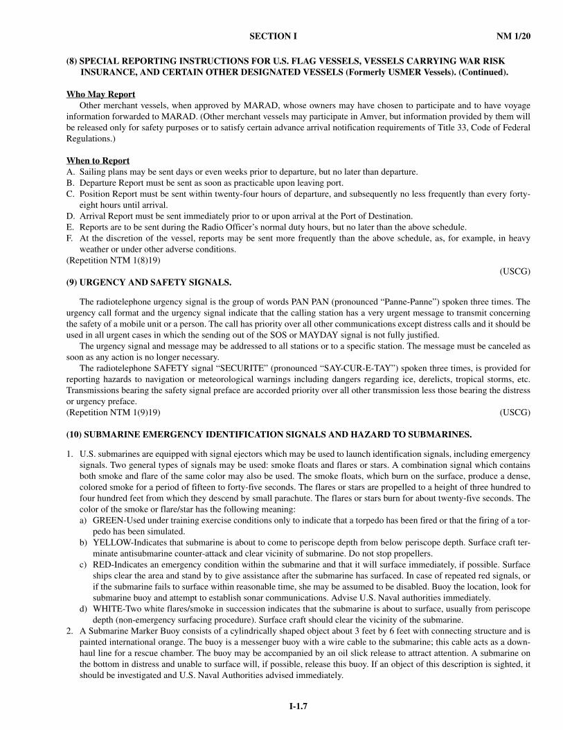
(10) SUBMARINE EMERGENCY IDENTIFICATION SIGNALS AND HAZARD TO SUBMARINES.
1. U.S. submarines are equipped with signal ejectors which may be used to launch identification signals, including emergencysignals. Two general types of signals may be used: smoke floats and flares or stars. A combination signal which containsboth smoke and flare of the same color may also be used. The smoke floats, which burn on the surface, produce a dense,colored smoke for a period of fifteen to forty-five seconds. The flares or stars are propelled to a height of three hundred tofour hundred feet from which they descend by small parachute. The flares or stars burn for about twenty-five seconds. Thecolor of the smoke or flare/star has the following meaning:a) GREEN-Used under training exercise conditions only to indicate that a torpedo has been fired or that the firing of a tor-
pedo has been simulated.b) YELLOW-Indicates that submarine is about to come to periscope depth from below periscope depth. Surface craft ter-
minate antisubmarine counter-attack and clear vicinity of submarine. Do not stop propellers.c) RED-Indicates an emergency condition within the submarine and that it will surface immediately, if possible. Surface
ships clear the area and stand by to give assistance after the submarine has surfaced. In case of repeated red signals, orif the submarine fails to surface within reasonable time, she may be assumed to be disabled. Buoy the location, look forsubmarine buoy and attempt to establish sonar communications. Advise U.S. Naval authorities immediately.
d) WHITE-Two white flares/smoke in succession indicates that the submarine is about to surface, usually from periscopedepth (non-emergency surfacing procedure). Surface craft should clear the vicinity of the submarine.
2. A Submarine Marker Buoy consists of a cylindrically shaped object about 3 feet by 6 feet with connecting structure and ispainted international orange. The buoy is a messenger buoy with a wire cable to the submarine; this cable acts as a down-haul line for a rescue chamber. The buoy may be accompanied by an oil slick release to attract attention. A submarine onthe bottom in distress and unable to surface will, if possible, release this buoy. If an object of this description is sighted, itshould be investigated and U.S. Naval Authorities advised immediately.

NM 1/20 SECTION I
I-1.8
(10) SUBMARINE EMERGENCY IDENTIFICATION SIGNALS AND HAZARD TO SUBMARINES. (Continued).
3. A Submarine Emergency Position Indicating Radio Buoy (SEPIRB) is a serialized signal identifying the submarine andhatch from which to conduct rescue operations.
4. Transmission of the International Distress Signal (SOS) will be made on the submarine’s sonar gear independently or inconjunction with the red emergency signal as conditions permit.
5. Submarines may employ any or all of the following additional means to attract attention and indicate their position whilesubmerged:a) Release of dye marker.b) Ejection of oil.c) Release of air bubble.d) Pounding on the hull.
6. United States destroyer-type vessels in international waters will, on occasion, stream a towed underwater object at variousspeeds engaged in naval maneuvers. All nations operating submarines are advised that this underwater object in thestreamed condition constitutes a possible hazard to submerged submarines.
(Repetition NTM 1(10)19) (U.S. NAVY)
(11) RULES, REGULATIONS AND PROCLAMATIONS ISSUED BY FOREIGN GOVERNMENTS.
The National Geospatial-Intelligence Agency, as a means of promoting maritime safety, includes in its publications rules,regulations, and proclamations affecting navigation as issued by foreign nations.
In this connection, it should be clearly understood that the publication of such material is solely for information relative to the navigational safety of shipping, and in no way constitutes a legal recognition by the United States of the internationalvalidity of any rule, regulation, or proclamation so published. While every effort is made to publish all such information, theNational Geospatial-Intelligence Agency cannot assume any liability for failure to publish any particular rule, regulation, proc-lamation, or the details thereof.(Repetition NTM 1(11)19) (NGA/SFHG)
(12) WARNING - DANGER FROM SUBMARINE CABLES
Certain submarine cables are used for telecommunications functions while others are used for power transmission. Allpower cables and most telecommunications cables carry dangerous high voltages. Damaging or severing a submarine cable,whether a telecommunications cable or a power cable, may, in some circumstances be considered as a national disaster andvery severe criminal penalties may apply. Electrocution, with injury or loss of life, could occur if any cables carrying high volt-age are broached. Depending on whether the cable is primarily for power or telecommunications, damage may result in powercuts, loss of voice, data transfer or internet connectivity. In these circumstances, cables are considered as critical infrastructure.
In view of the serious consequences resulting from damage to submarine cables, vessel operators should take special carewhen anchoring, fishing, mining, dredging, or engaging in underwater operations near areas where these cables may exist orhave been reported to exist. In order to minimize the risk of such damage as much as possible, vessels should avoid any such
activity at a minimum distance of 0.25-nautical mile1 on either side of submarine cables.Mariners are also warned that the seafloor where cables were originally buried may have changed and cables become
exposed; therefore particular caution should be taken when operating vessels in areas where submarine cables exist especiallywhere the depth of water means that there is a limited under-keel clearance.
Vessels fouling a submarine cable should not attempt to clear or raise the cable due to the high possibility of damaging thecable. No attempt should be made to cut a cable and anchors or gear that cannot be cleared should be slipped. Before anyattempt to slip or cut gear from the cable is made, the cable should first be lowered to the seafloor. Note that there is a risk ofcapsizing smaller vessels (primarily fishing vessels) if they attempt to bring a cable to the surface. Following an incident offouling a cable, a vessel should immediately notify the local responsible authority of the position, type, and amount of gearremaining on the seafloor. In inland areas or along the coast, warning signs or marker beacons are often erected to warn themariner of the existence of submarine cables.
Incidents involving the fouling of submarine cables should be reported at the shortest possible notice to the responsible
authorities2 who should be advised as to the nature of the problem and the position of the vessel.(Repetition NTM 1(12)19) (USCG)
1. Each responsible authority can set this distance to a value that they feel is appropriate. 2. The responsible authorities can be listed here, as well as contact methods (telephone, facsimile, VHF, e-mail, inter-
net, etc.) and required information.

SECTION I NM 1/20
I-1.9
(13) WARNING - DANGER FROM SUBMARINE PIPELINES.
Submarine pipelines pass beneath various navigable waterways throughout the world. Installation of new pipelines may bereported in the Notice to Mariners; their locations may or may not be charted. Where feasible, warning signs are often erectedto warn the mariners of their existence. In view of the serious consequences resulting from damage to submarine pipelines,vessel operators should take special care when anchoring, fishing, or engaging in underwater operations near areas where thesepipelines may exist or have been reported to exist.
Many pipelines carry natural gas under high pressure or petroleum products. Fire or explosion, with injury or loss of life ora serious pollution incident, could occur if they are penetrated.
Vessels fouling a pipeline should attempt to clear without undue strain. Anchors or gear that cannot be cleared should beslipped; no attempt should be made to cut a pipeline.(Repetition NTM 1(13)19) (USCG)
(14) CAUTION - CLOSE APPROACH TO MOORED OFFSHORE AIDS TO NAVIGATION.
Courses should invariably be set to pass these aids with sufficient clearance to avoid the possibility of collision. Errors ofobservation, current and wind effects, other vessels in the vicinity, and defects in steering gear may be, and have been, thecause of collisions. Experience shows that buoys cannot be safely used as leading marks to be passed close aboard, and shouldalways be left broad off the course whenever sea room permits.
It should be borne in mind that most large buoys are anchored to a very long scope of chain and, as a result, the radius oftheir swinging circle is considerable. The charted position is the approximate location. Furthermore, under certain conditionsof wind and current, they are subject to sudden and unexpected sheers which are certain to hazard a vessel attempting to passclose aboard.
Further warning on use of floating aids to navigation for position taking is contained in paragraph 1 of this Notice. Whenapproaching an offshore light structure, large navigational buoy, or a station on a submarine site, on radio bearings, the risk ofcollision will be lessened by ensuring that the radio bearing does not remain constant.(Repetition NTM 1(14)19) (USCG)
(15) PIPELINE LAYBARGES AND JETBARGES.
With the increased number of pipeline laying operations in the Gulf of Mexico and other areas, operators of all types ofvessels should be aware of the dangers of passing close aboard, close ahead, or close astern of a jetbarge or pipelaying barge.Pipelaying barges and jetbarges usually move at 1/2 knot or less and have anchors which extend out approximately 3500-5000feet in all directions, and may be marked by lighted anchor buoys. The exposed pipeline behind the pipelaying barge and theareas in the vicinity of anchors are hazardous to navigation and should be avoided. The pipeline and anchor cables also repre-sent a submerged hazard to navigation. It is suggested, if safe navigation permits, for all types of vessels to pass well ahead ofthe pipelaying barge or well astern of the jetbarge. The pipelaying barge, jetbarge, and attending vessels may be contacted onVHF-FM Channel 16 for passage instructions.(Repetition NTM 1(15)19) (USCG)
(16) REQUIRED REPORTING OF DAMAGED U.S. AIDS TO NAVIGATION.
It frequently occurs that aids to navigation are collided with, causing damage and displacement, or complete loss, withoutthe knowledge of the Coast Guard District Commander. The replacement or repair of such aids is consequently often not madeas promptly as desired. This situation results in diminished protection for marine traffic, and is attributable in large part to thefailure of vessel operators to furnish notice of these collisions to the nearest local or district office of the U.S. Coast Guard, orto Coast Guard Headquarters, as required by law and regulation. The prompt submission of notice of any marine casualty oraccident, including damage or destruction of aids to navigation, is required by the Marine Investigation Regulations, Section4.05-20 of Title 46, Code of Federal Regulations, with penalty for noncompliance.(Repetition NTM 1(16)19) (USCG)
(17) REGULATIONS FOR THE PREVENTION OF POLLUTION FROM SHIPS.
International Convention for the Prevention of Pollution by Ships - MARPOL 73/78:In 1973, the International Maritime Organization (IMO) adopted the International Convention for the Prevention of Pol-
lution by Ships and subsequently modified it by Protocol in 1978. The Convention is widely known as MARPOL 73/78. Its objective is to limit ship-borne pollution by restricting operational pollution and reducing the possibility of accidental pollu-tion. MARPOL specifies standards for stowing, handling, shipping, and transferring pollutant cargoes, as well as standards for
NM 1/20 SECTION I
I-1.10
(17) REGULATIONS FOR THE PREVENTION OF POLLUTION FROM SHIPS. (Continued).
discharge of ship-generated operational wastes. Acceptance of the convention by a national government obliges them to make the requirements part of domestic law.
MARPOL 73/78 consists of six separate Annexes, each set out in regulations covering the various sources of ship-generated pollution. Annex I and II are mandatory for all signatory nations to MARPOL while Annexes III, IV, V, and VI areoptional.
Currently, the U.S. is signatory to Annexes I, II, III, V, and VI. Annexes I, II, V, and VI have been incorporated into U.S.law by the Act to Prevent Pollution from Ships (APPS) and implemented within 33 USC 1901 and 33 CFR 151. The U.S.incorporates Annex III by the Hazardous Materials Transportation Act (HMTA) implemented within 46 USC 2101 and 49CFR 171-174 and 176. Although the U.S. has not ratified Annex IV, the U.S. has equivalent regulations for the treatment anddischarge standards of shipboard sewage – the Federal Water Pollution Control Act (FWPCA) as amended by the Clean WaterAct and implemented by 33 USC 1251 and 33 CFR 159.
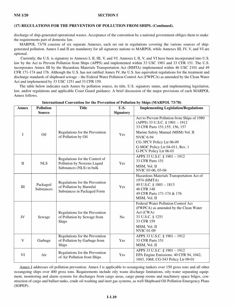
The table below indicates each Annex by pollution source, its title, U.S. signatory status, and implementing legislation,law, and/or regulations and applicable Coast Guard guidance. A brief discussion of the major provisions of each MARPOLAnnex follows.
Annex I addresses oil pollution prevention. Annex I is applicable to oceangoing tankers over 150 gross tons and all otheroceangoing ships over 400 gross tons. Requirements include oily waste discharge limitations, oily-water separating equip-ment, monitoring and alarm systems for discharges from cargo areas, cargo pump rooms and machinery space bilges, con-struction of cargo and ballast tanks, crude oil washing and inert gas systems, as well Shipboard Oil Pollution Emergency Plans(SOPEP).
International Convention for the Prevention of Pollution by Ships (MARPOL 73/78)Annex Pollution
SourceTitle U.S.
SignatoryImplementing Legislation/Regulations
I OilRegulations for the Prevention of Pollution by Oil
Yes
Act to Prevent Pollution from Ships of 1980 (APPS) 33 U.S.C. § 1901 – 191233 CFR Parts 151,155, 156, 157Marine Safety Manual (MSM) Vol. IINVIC 6-94CG-3PCV Policy Ltr 06-09G-MOC Policy Ltr 04-011, Rev. 1G-PCV Policy Ltr 06-01
II NLSRegulations for the Control of Pollution by Noxious Liquid Substances (NLS) in bulk
Yes
APPS 33 U.S.C. § 1901 – 191233 CFR Parts 151MSM, Vol. IINVIC 03-06, 03-04
IIIPackaged
Substances
Regulations for the Prevention of Pollution by Harmful Substances in Packaged Form
Yes
Hazardous Materials Transportation Act of 1974 (HMTA)49 U.S.C. § 1801 – 181346 CFR 14849 CFR Parts 171-174 & 176MSM, Vol. II
IV SewageRegulations for the Prevention of Pollution by Sewage from Ships
No
Federal Water Pollution Control Act (FWPCA) as amended by the Clean Water Act (CWA)33 U.S.C. § 125133 CFR 159MSM, Vol. IINVIC 01-09
V GarbageRegulations for the Prevention of Pollution by Garbage from Ships
YesAPPS 33 U.S.C. § 1901 – 191233 CFR Parts 151MSM, Vol. II
VI AirRegulations for the Prevention of Air Pollution from Ships
YesAPPS 33 U.S.C. § 1901 – 1912EPA Engine Emissions: 40 CFR 94, 1042, 1043, 1068; CG-543 Policy Ltr 09-01
SECTION I NM 1/20
I-1.11
(17) REGULATIONS FOR THE PREVENTION OF POLLUTION FROM SHIPS. (Continued).
The U.S. implements MARPOL 73/78 Annex II by the Act to Prevent Pollution from Ships (APPS), codified within 33USC 1901. The implementing regulations are in 33 CFR 151.
Ships to which Annex I MARPOL 73/78 is applicable are also required to have an International Oil Pollution Prevention(IOPP) Certificate. Annex I, Chapter 2 and 33 CFR 151.19. Issuance of the IOPP Certificate verifies that the vessel is in com-pliance with the requirements of Annex I and that any required equipment is on board and operational.
Annex I also requires each vessel to maintain an Oil Record Book to record all oil transfers and discharges. Annex I, Reg-ulation 17 & 36, 33 CFR 151.25. The Coast Guard’s most recent update to the Oil Record Book was in 2007. A copy is avail-able to all U.S. vessel owners and operators subject to the Oil Record Book requirements through any local Captain of thePort/Officer in Charge, Marine Inspection. Vessel operators are encouraged to obtain and use the latest edition of the OilRecord Book (Rev 01-07).
Annex II addresses discharge criteria and measures for controlling pollution caused by Noxious Liquid Substances (NLS)carried in bulk. Annex II is applicable to oceangoing vessels and non-self propelled ocean-going ships that carry NLS cargoes. These regulations limit at-sea discharges of NLS residue. It requires vessels to discharge its NLS residues to reception facili-ties, except under specified conditions. The Annex II requirements include discharge restrictions for various
classes of cargo residues; the maintenance of a Cargo Record Book for recording all NLS cargo and residue transfers anddischarges; and a Procedures and Arrangements Manual describing the correct procedures for off loading and pre-washingcargo tanks.
The U.S. implements MARPOL 73/78 Annex II by the Act to Prevent Pollution from Ships (APPS), codified within 33USC 1901. The implementing regulations are in 33 CFR 151.
Since April of 1987, Annex II NLS cargoes have been classified in one of four categories: A, B, C, or D. As of January 1,2007, the IMO revised Annex II to incorporate new classification rules that changed the criteria for assigning values for boththe ship type and pollution category. For further details of these new classifications and vessel compliance, see Navigation andVessel Inspection Circular (NVIC) 03-06.
The existing pollution categories A, B, C, D, and III have been replaced by X, Y, Z and Other Substances (OS). CategoryX has the most severe pollution hazards, category Y has moderate pollution hazards, category Z has low pollution hazards andcategory OS has no hazards when discharged from tank cleaning or de-ballasting operations. Category X and other substancesthat tend to solidify in tanks must be pre-washed in port under the supervision of a Pre-wash Surveyor prior to departure fromthe off loading terminal. Authorized vessel discharges of NLS residue at sea must be below the water line. Tanks that carryCategory Y and Z NLS cargoes must be tested to ensure that after tank stripping only a minimal amount of residues willremain. Reception facilities must be able to assist in cargo stripping operations by reducing backpressure during the finalstages of off loading.
Terminals and ports receiving oceangoing tankers, or any other oceangoing ships of 400 GT or more, carrying residues andmixtures containing oil, or receiving oceangoing ships carrying NLS cargoes, are required to provide adequate reception facil-ities for the wastes generated. Coast Guard Captains of the Port issue a Certificate of Adequacy to terminals or ports to showthat they comply with federal reception facility requirements.
Resolution A.673 (16) for Offshore Supply Vessels:As discussed above, on October 15, 2004, the Marine Environmental Protection Committee (MEPC) of the International
Maritime Organization (IMO) adopted revisions to Annex II and the International Code for the Construction and Equipment ofShips Carrying Dangerous Chemicals in Bulk (IBC Code). Those amendments entered into force January 1, 2007.
The 2004 revisions to Annex II included changes to Regulation 11. The revised language of Regulation 11.2 of Annex IIrequires that for the carriage of NLS cargoes listed in Chapter 17 of the IBC Code by those vessels other than chemical tankersor liquefied gas carriers, Flag Administrations shall establish appropriate measures to minimize the uncontrolled discharge ofNLS cargoes into the sea. Furthermore, Regulation 11.2 states that each Flag Administration’s measures shall be based upon“Guidelines” developed by the IMO. In the associated footnote to the term “Guidelines,” reference is made specifically to Res-olution A.673 (16).
Resolution A.673 (16) was adopted on October 19, 1980, and later amended by Resolution MSC.236 (82) on December 1, 2006. It provides an alternative to the IBC Code for the design, construction, and operation of OSVs. It is intended to permit limited quantities of NLS substances to be transported in bulk in OSVs with minimum risk to the vessel, its crew, and the environment. The basic philosophy of Resolution A.673 (16) is to apply standards contained in the IBC Code to the extent that is practicable and reasonable, taking into account the unique design features and service characteristics of these vessels, as well as to limit the quantity of hazardous and noxious liquid substances carried onboard OSVs.
NM 1/20 SECTION I
I-1.12
(17) REGULATIONS FOR THE PREVENTION OF POLLUTION FROM SHIPS. (Continued).
The U.S. implementation of A.673 (16) is found in CG-522 Policy Letter 09-01. This policy has been developed by theCoast Guard, in consultation with the OSV industry, to provide guidance to owners, operators, and designers for the design,construction, and operation of U.S. flagged OSVs. It is intended to resolve any conflicts until such time as relevant U.S. regu-lations are more completely harmonized with the revised international standards.
Annex III applies to all ships carrying harmful substances in packaged forms, or in freight containers, portable tanks orroad and rail tank wagons. Annex III requires standards on packaging, marking, labeling, documentation, stowage, quantitylimitations, exceptions and notifications for preventing or minimizing pollution by harmful substances.
The U.S. implements MARPOL 73/78 Annex III under the Hazardous Materials Transportation Act (HMTA), codifiedwithin 46 USC 2101. The implementing regulations are in 49 CFR 171 -174 and 176.
For the purpose of Annex III, “harmful substances” are those substances which are identified as marine pollutants in theInternational Maritime Dangerous Goods Code (IMDG Code), also defined in U.S. domestic regulations under 49 CFR 171.4and 171.8. On 5 November 1992, the U.S. Research and Special Programs Administration (RSPA) amended the HazardousMaterials Regulations (HMR, 49 CFR 100-177) to list and regulate these marine pollutants in all modes of transportation.Under the HMR, marine pollutants are listed in a separate appendix, (Appendix B to 49 CFR 172.101 – List of Marine Pollut-ants). In accordance with 49 CFR 172.322, “marine pollutant mark” is required for those materials. The marine pollutant markis in addition to any existing labels or placards designating a hazardous substance.
Annex IV applies to discharges of sewage into the sea. Annex IV applies to all ships over 400 gross tons engaged in inter-national voyages or to ships less than 400 gross tons certified to carry more than 15 persons. The Annex requires the installa-tion of holding tanks or approved sewage treatment devices.
The U.S. did not ratify Annex IV. Rather, the U.S. has equivalent regulations for the treatment and discharge standards ofshipboard sewage – the Federal Water Pollution Control Act (FWPCA) as amended by the Clean Water Act codified in 33USC 1251. The U.S. considers the implementing regulations of 40 CFR 140 and 33 CFR 159 as equivalent to the sewage treat-ment requirements of Annex IV. For more information on this equivalency and vessel compliance, see NVIC 01-09.
Section 312 of FWPCA, as amended, requires the installation of a Marine Sanitation Device (MSD), a sewage treatmentdevice to prevent the discharge of untreated or inadequately treated sewage into U.S. waters. The Act requires every vessel thatoperates in U.S. waters and equipped with an installed toilet to have a certified and operable MSD. A vessel with no installedtoilet is not subject to the provisions of section 312. Installed toilets that are not equipped with a certified MSD, and that dis-charge raw sewage directly over the side are illegal. Section 312(g)(2) of the FWPCA directs the Coast Guard to certify MSDsand 33 CFR 159 sets out equipment construction and operation requirements.
Since the U.S. has not ratified MARPOL 73/78 Annex IV, the Coast Guard will not enforce its provisions aboard foreignvessels during Port State Control examinations, even if the vessel is under the flag of an Annex IV signatory country. Foreignvessels must meet the requirements of 33 CFR 159 when operating in U.S. waters. However, since the U.S. considers AnnexIV equivalent to 33 CFR 159, Coast Guard Port State Control officers shall accept foreign vessels that comply with Annex IV.A foreign flag vessel that has a “Certificate of Type Test” under MARPOL Annex IV indicating that its sewage treatmentplant meets the test requirements of Resolution MEPC.2(VI) of the International Maritime Organization (IMO) will beaccepted by the Coast Guard as being in compliance with 33 CFR 159.7(b) or (c). The Coast Guard considers such treatmentplants as fully equivalent to a Coast Guard certified Type II MSD (NVIC 9-82, CH-1, dated 8 October 1988) as long as theunit is in operable condition. U.S. registered vessels will continue to be required to have Coast Guard certified MSDs per 33CFR 159.
Annex V applies to ship-generated garbage, and aims to reduce the amount of garbage - both plastics and other persistentwastes - that ships dump into the oceans. Annex V defines “garbage” broadly, and includes nearly any kind of waste generatedduring a ship's normal operations. This Annex requires terminals to provide reception facilities at ports and terminals toreceive plastics and other garbage from visiting vessels.
On July 15, 2011, the International Maritime Organization's (IMO) Marine Environment Protection Committee (MEPC)formally adopted Resolution MEPC.201(62), amending MARPOL Annex V. These amendments entered into force on January1, 2013 and established a general prohibition on discharges of garbage into the sea. Under prescribed conditions, exceptionsare provided for food wastes, cargo residues, cleaning agents or additives contained in cargo hold, deck, and external surfacewash waters, and animal carcasses. An overview of MARPOL Annex V and associated amendments may be found on IMO's website at: http://www.imo.org/OurWork/Environment/PollutionPrevention/Garbage/Pages/Default.aspx.The U.S. imple-ments MARPOL 73/78 Annex V under the Marine Plastic Pollution Research and Control Act of 1987 (MPPRCA), codifiedwithin 33 U.S.C. § 1901 et seq. The implementing regulations are in 33 CFR 151.51 - 79. These requirements require adequatewaste reception facilities at U.S. ports; that manned ships of certain sizes to display pollution prevention placards; for certain

SECTION I NM 1/20
I-1.13
(17) REGULATIONS FOR THE PREVENTION OF POLLUTION FROM SHIPS. (Continued).
ships to develop a waste management plan; and that certain manned ships maintain waste disposal records. MPPRCA and 33CFR 151.51 is applicable to all recreational, fishing, uninspected and inspected vessels, and foreign flag vessels on the naviga-ble waters and all other waters subject to the jurisdiction of the United States, out to and including the Exclusive EconomicZone (200 miles).
Annex VI outlines international requirements for vessel air emissions and shipboard air pollution prevention measures.Annex VI entered into force for the United States on January 8, 2009. Starting on that date, U.S. ships operating anywhere andforeign-flag ships operating in United States waters must comply with the requirements set out in MARPOL Annex VI. (33U.S.C. 1901(a) (4) & (5), 1902(a)(1)&(5), and 1907 (a), as amended by the Maritime Pollution Prevention Act of 2008(MPPA), Pub.L. 110-280, 122 Stat 2611).
On July 15, 2011, the International Maritime Organization formally adopted Resolution MEPC.203(62), which amendsMARPOL Annex VI. The main requirements of MEPC.203(62) entered into force on January 1, 2013 as MARPOL Annex VIChapter 4 and addresses ship energy efficiency.
Annex VI sets limits on sulfur oxide (SOx) and nitrogen oxide (NOx) emissions from ship exhausts and prohibits deliber-ate emissions of ozone-depleting substances. These regulations include a global cap of 3.5% m/m on the sulfur content of fueloil and calls on IMO to monitor the worldwide average sulfur content of fuel. A mandatory NOx Technical Code defines howvessels can achieve the set limits on NOx emissions.
Additionally, certain regions may be declared an Emission Control Area (ECA). In these areas, the sulfur content of fueloil used on board ships must not exceed 0.1% m/m. Alternatively, ships may fit an exhaust gas cleaning system or use othertechnological methods to limit SOx emissions. The Baltic Sea and North Sea Areas have already been designated as ECAs.
The North American Emission Control Area (ECA), under the International Convention for the Prevention of Pollutionfrom Ships (MARPOL), came into effect on 1 August 2012, bringing in stricter controls on emissions of sulfur oxide (SOx),nitrogen oxide (NOx) and particulate matter for ships trading off the coasts of Canada, the United States and the French over-seas collectivity of Saint-Pierre and Miquelon. Within ECAS, the sulfur content of fuel oil (expressed in terms of % m/m - thatis, by weight) must be no more than 0.10% m/m on and after 1 January 2015. This compares to 3.50% m/m outside an ECA,falling to 0.50% m/m on and after 1 January 2020. This date could be deferred to 1 January 2025, depending on the outcome ofa review, to be completed by 2018, as to the availability of compliant fuel oil.
Annex VI prohibits deliberate emissions of ozone depleting substances, which include halons and chlorofluorocarbons(CFCs). New installations containing ozone-depleting substances are prohibited. But existing installations containing hydro-chlorofluorocarbons (HCFCs) are permitted until 1 January 2020. The Annex also prohibits the incineration on board ships ofcertain products, such as contaminated packaging materials and polychlorinated biphenyls (PCBs). Coast Guard guidelines forensuring compliance with Annex VI can be found in CG-543's Policy Letter 09-01 located on Homeport (http://homeport.uscg.mil - Missions > Domestic Vessels > Domestic Vessel Policy > Office of Commercial Vessel Compliance Pol-icy Letters or http://homeport.uscg.mil - Missions > Port State Control > General Information > MARPOL Annex VI).
Oil Spill Reporting. Article 8 and Protocol I of MARPOL 73/78 requires the immediate reporting of any un-permitted dis-charges of oil, NLS substances, or harmful substance in package form to the party in which the vessel is located. For any dis-charge that occurs within the waters under U.S. jurisdiction, the reporting requirements are found in 33 CFR 153, Subpart B –Notice of the Discharge of Oil or a Hazardous Substance.
33 CFR 153.203 states that any person in charge of a vessel or of an onshore or offshore facility shall, as soon as they haveknowledge of any discharge of oil or a hazardous substance shall immediately notify the National Response Center (NRC),NRC’s toll free telephone number is (800) 424–8802, fax number is (202) 372–2920.
If direct reporting to the NRC is not practicable, notice of discharge may be made to the Coast Guard or EPA predesignatedOn-Scene Coordinator (OSC) for the geographic area where the discharge occurs. All such reports shall be promptly relayed tothe NRC. If it is not possible to notify the NRC or the predesignated OSC immediately, reports may be made immediately tothe nearest Coast Guard unit, provided that the person in charge of the vessel or onshore or offshore facility notifies the NRCas soon as possible.
Any person who fails to notify the appropriate agency of the United States Government immediately of a discharge is,upon conviction, fined in accordance with 18 U.S. Code, or imprisoned for not more than 5 years, or both (33 CFR 153.205).
Penalties for Violation. As stated in 33 CFR 151.04, a person who violates MARPOL 73/78, the Act to Prevent Pollution from Ships (APPS)(33 USC 1901-1911), or the implementing regulations (33 CFR 151), is liable for civil or criminal penal-ties. Civil penalties carry a fine not to exceed $40,000 for each violation. A person who makes a false, fictitious statement or fraudulent representation in any matter in which a statement or representation is required to be made to the Coast Guard under MARPOL 73/78, the Act, or the implementing regulations, is liable for a civil penalty of $8,000 for each statement or repre-
NM 1/20 SECTION I
I-1.14
(17) REGULATIONS FOR THE PREVENTION OF POLLUTION FROM SHIPS. (Continued).
sentatation, as provided by 33 U.S.C. 1908(b)(2). A person who knowingly violates MARPOL 73/78, the Act, or the regulations of this subpart commits a class D felony. 18 U.S.C. 1355 et seq.
Vessel owners or operators that discharge oil or hazardous substances into or upon the navigable waters of the UnitedStates, adjoining shorelines, or into or upon the waters of the contiguous zone, may be subject to civil penalties. Civil penaltiescarry a fine of not more than $15,000 per violation and a maximum amount not exceed $190,000. 33 U.S.C. 1321 et seq.
Vessel General Permit (VGP): NPDES stands for National Pollution Discharge Elimination System, which is a matterwithin the authority of our federal Environmental Protection Agency under the Clean Water Act. As the result of a court deci-sion in 2005, vessels lost the exclusion to the requirements which they had long enjoyed. The VGP incorporates existing CGregulations for ballast, bilge and gray water and dry cargo residue runoff, and in most cases imposes permitting requirementsthat exceed these standards. It established requirements for 26 types of general discharges, as well as for corrective actions,inspections, monitoring, recordkeeping and reporting. The EPA has the primary responsibility for enforcing the provisions ofthe VGP and specific questions should be directed to them. Further information on the VGP is provided on the Coast Guard’s Homeport web page http://homeport.uscg.mil/ selecting the following tabs: Missions > Domestic Vessels > Domestic VesselGeneral > EPA Vessel General Permit (VGP) or on the EPA web page at: http://www.epa.gov/npdes/vessels or CG web pageat: http://www.uscg.mil/hq/cg5/cg522/cg5224/vgp.asp.(Repetition NTM 1(17)19) (USCG)
(18) COMPLIANCE WITH THE ACT TO PREVENT POLLUTION FROM SHIPS.
Widely known as the London Dumping Convention, the 1972 International Convention on the Prevention of Marine Pollu-tion by Dumping of Wastes and Other Matter entered into force on August 30, 1975. This Convention addresses the unregu-lated dumping of non-ship generated waste materials into ocean waters, and creates a regime to prevent or strictly limitdumping that degrades or endangers human health or the marine environment. The Convention bans the dumping of certainhazardous materials and requires permits for the dumping of other identified materials and other wastes or matter. “Dumping”is defined as the deliberate disposal at sea of wastes or other matter from vessels, aircraft, platforms, or other man-made struc-tures. In addition, the Convention controls the incineration of wastes on board ships, sets out criteria for the selection of dump-ing and incineration sites at sea, and has provisions to promote regional cooperation.
The Marine Protection, Research, and Sanctuaries Act of 1972 (MPRSA or the Ocean Dumping Act) is codified at 33U.S.C. §1401 et seq. MPRSA implements the 1972 London Dumping Convention under U.S. law. MPRSA was amended in1988 by Public Law 100-688, Title I of which is the Ocean Dumping Ban Act of 1988, and Title IV of which is the Shore Pro-tection Act.
The purpose of MPRSA is to regulate the transportation of material from the U.S. or by U.S. vessels, aircraft, or agenciesfor the purpose of dumping the material into ocean waters, and the dumping of material transported by any person from a loca-tion outside the U.S. if the dumping occurs in the territorial sea or the contiguous zone of the U.S.
MPRSA establishes the statutory authority to regulate ocean dumping beyond the territorial sea line (three mile limit) fromU.S. flag vessels and of material from the U.S.; and regulate dumping by any vessel in the U.S. territorial sea and contiguouszone.
Under MPRSA, no dumping is allowed in U.S. waters except some sewage, sludge, dredge materials, and fish wastes. TheEPA may issue a permit for dumping of other materials under extraordinary circumstances.
Various federal agencies share certain responsibilities under the MPRSA. The EPA issues ocean dumping permits, and theU.S. Army Corps of Engineers (USACE) issues permits for the dumping of dredge materials. NOAA monitors the effects ofwaste dumping. The Coast Guard is responsible to conduct surveillance and other appropriate enforcement activity to preventunlawful transportation of material for dumping, or unlawful dumping.
One of the Coast Guard’s activities under the MPRSA includes enforcement of regulations relating to safe transportation ofmunicipal and commercial waste (33 CFR 151.1000). Here, the regulations state that a vessel may not transport municipal orcommercial waste in coastal waters without a conditional permit issued by the Coast Guard. 33 CFR 151.1009 and 1012describe the transportation of municipal or commercial waste requirements and the application process for obtaining a condi-tional permit.(Repetition NTM 1(18)19) (USCG)
SECTION I NM 1/20
I-1.15
(19) INTERNATIONAL SAFETY MANAGEMENT CODE ENFORCEMENT.
Compliance with the ISM Code is mandatory for passenger ships, cargo ships, bulks carriers, and oil and chemical tankers,gas carriers, as well as high speed craft and MODUs over 500 GT engaged on international voyages. To demonstrate compli-ance, vessels must present copies of approved Documents of Compliance and Safety Management Certificates to Coast GuardPort State control Boarding Officers during routine compliance examinations. ISM compliance demonstrates that vessel oper-ators have safety and environmental policies, emergency response procedures, designated accident and code non-conformityreporting procedures, and on board maintenance and operating manuals. If inbound vessels are not in compliance with the ISMCode, they will be denied entry into U.S. waters (SOLAS Chapter IX and 33 CFR 96).(Repetition NTM 1(19)19) (USCG)
(20) BALLAST WATER MANAGEMENT FOR CONTROL OF NON-INDIGENOUS SPECIES.
The United States Coast Guard’s ballast water management (BWM) program is responding to concerns that aquatic nuisancespecies (ANS) may be entering the waters of the United States in the large quantities of ballast water carried into U.S. watersaboard commercial vessels. Carried in this ballast water are plants, animals, bacteria, and pathogens. These organisms range insize from microscopic, to large plants, and free-swimming fish. They have the potential to displace native species, degradenative habitats, spread disease, and disrupt human social and economic activities that depend on water resources. Any shipcarrying ballast water is a potential invasion source. In 2016, new compliance dates took effect that set the implementationschedule for the installation and use of BWM treatment system. The USCG’s regulations apply to all commercial vesselsequipped with ballast water tanks that operate in U.S. waters or are bound for ports or places in the U.S.
Highlights of the BWM program include:(a) While similar to the International BWM Convention, the United States is not signatory to the BWM Convention.
Ships must comply with the regulations in 33 CFR Part 151 Subparts C and D;
(b) Requires mandatory ballast water management practices for all vessels that operate in U.S. waters;(c) Requires each vessel to maintain a BWM plan that has been developed specifically for the vessel and that will allow
those responsible for the plan's implementation to understand and follow the vessel's BWM strategy; and
(d) Requires the reporting and record keeping of ballasting operations by all vessels.
These regulations implement the provisions of the Non-indigenous Aquatic Nuisance Prevention and Control Act of1990 (NANPCA, 16 USC 4701 – 4751) as amended by the National Invasive Species Act of 1996 (NISA).
The Coast Guard provides guidance on the BWM program in NVIC 01-18. The Coast Guard’s Aquatic Nuisance Spe-cies web page provides an additional guidance on the BWM program: http://www.uscg.mil/hq/cg5/cg522/cg5224/ andhttp://www.uscg.mil/hq/cg5/cg522/cg5224/bwm.asp(Supersedes NTM 1(20)19) (USCG)
(21) VESSEL SECURITY REGULATIONS: MARITIME TRANSPORTATION SECURITY ACT (MTSA) AND INTERNATIONAL SHIP AND PORT FACILITY SECURITY (ISPS) CODE.
In December 2002, the International Maritime Organization (IMO) amended the International Convention of Safety of Lifeat Sea (SOLAS) by implementing Chapter XI-2: Special measures to enhance maritime security. SOLAS XI-2 implements theISPS Code, which established a set of international security-oriented regulations relating to vessel and port facilities. ISPS isapplicable to all cargo ships over 500 Gross Tons (Admeasurements in accordance with the International Tonnage Conven-tion) and passenger ships, regardless of tonnage size, engaged on international voyages.
On October 22, 2003, the U.S. Coast Guard implemented domestic security regulations for maritime security under theauthority of the MTSA. The MTSA has additional applicability requirements for other vessel types and sizes, but in generalthe requirements contained in the MTSA align, where appropriate, with the security requirements in the SOLAS XI-2 and theISPS Code. Title 33 of the Code of Federal Regulations, Parts 101 through 2106, contain the regulations issued under MTSAthat require the owner of each vessel covered by regulation to comply with an approved Vessel Security Plan (VSP). SOLASvessels must comply with a similar plan called a Ship Security Plan (SSP).
To ensure vessels subject to MTSA and/or ISPS are in compliance, the Coast Guard conducts annual security plan verifica-tion exams on all U.S. flag inspected and uninspected vessels and onboard foreign vessels operating in U.S. waters. In verify-ing compliance with this plan, the inspector has three tasks: ensure that the vessel or facility complies with the approved plan,ensure that the plan and assessment adequately addresses the security vulnerabilities, and verify that the measures accomplishthe intended function.

NM 1/20 SECTION I
I-1.16
(21) VESSEL SECURITY REGULATIONS: MARITIME TRANSPORTATION SECURITY ACT (MTSA) AND INTERNATIONAL SHIP AND PORT FACILITY SECURITY (ISPS) CODE. (Continued).
The Coast Guard conducts security plan verification exams on inspected vessels during the vessel's normal inspection process. After the initial security plan verification exam, uninspected vessels subject t o MTSA undergo subsequent securityplan verification exams once every 5 years, while vessels subject to both MTSA and ISPS undergo subsequent exams twiceevery 5 years, to align with the requirements for the International Ship Security Certificate (ISSC). The Coast Guard conductsISPS exams on foreign vessels under its Port State Control program.
Further guidance on the Coast Guard's vessel security program for vessels subject to MTSA/ ISPS is found in NVIC 04-03, change 3, in the Marine Safety Manual, Volume II, and at the Office of Commercial Vessel Compliance (CG-CVC) webpage at: https://www.uscg.mil/hq/cgcvc/.(Repetition NTM 1(21)19) (USCG)
(22) WARNING - POSSIBLE DANGER FROM UNLABELED INTERMODAL CONTAINERS AND DRUMS.
With the many exotic chemicals being transported in inter-modal freight containers and in drums as deck cargo, increas-ingly more reports are received regarding the loss overboard of these potentially dangerous cargo-carrying units. Empty con-tainers and drums may contain residues which may be extremely hazardous to touch or smell, and vapors emanating fromthese packages may be explosive.
When encountering derelict inter-modal containers and drums, whether afloat or from the sea bottom, the dangers listedabove should be considered. Identifying labels will give adequate warning, but containers and drums are more likely to befound with caution labels washed away. All inter-modal freight containers have unique identifying numbers, which should beincluded in any sighting report if visible from a safe distance. Avoid direct contact and notify U.S. Coast Guard of any sight-ings in U.S. coastal waters (24 HR TOLL FREE reporting number 1-800-424-8802), or government authorities of the nearestport state if sighting is near any foreign shores.(Repetition NTM 1(22)19) (USCG)
(23) REPORTING OF DANGERS TO NAVIGATION.
Mariners will occasionally discover uncharted shoals, malfunctions of important navigational aids, or other dangerous situ-ations that should be made known to other navigators. Those items that can be classified as urgent should be reported by anyrapid means to the closest responsible charting authority. The general criterion for important data is “that information withoutwhich a mariner might expose his vessel to unnecessary danger.” Reports to the U.S. Coast Guard and to foreign authoritiescan be made via radio using voice, SITOR and Digital Selective Calling (DSC), via TELEX, or via satellite using telephoneand fax. Reports to NGA (NAVAREA IV, NAVAREA XII, HYDROLANT, HYDROPAC, and HYDROARC) in Springfield,VA can be made via the Automated Message Handling System (AMHS) (NGA NAVSAFETY) WASHINGTON DC, tele-phone (1-800-362-6289), fax (1-571-558-3426), or email ([email protected]).
Guidance in preparing reports of dangers to navigation and specific radio frequencies, addresses and telephone numbersare contained in NGA Pub. 117, Radio Navigational Aids. Reports should be brief, but must contain:
What - Description of dangerWhen - UT and dateWhere - Latitude and Longitude (Reference chart in use.)Who - Reporting vessel and observer
Additionally, mariners are requested to notify NGA of discrepancies in charts and publications using the “Marine Informa-tion Report and Suggestion Sheet” form included in each issue of the Notice to Mariners. The same form can be submittedelectronically from the Submit Reports section of the Maritime Safety Office Web site at: https://msi.nga.mil/NGAPortal/MSI.portal(Repetition NTM 1(23)19) (NGA/SFHGA)
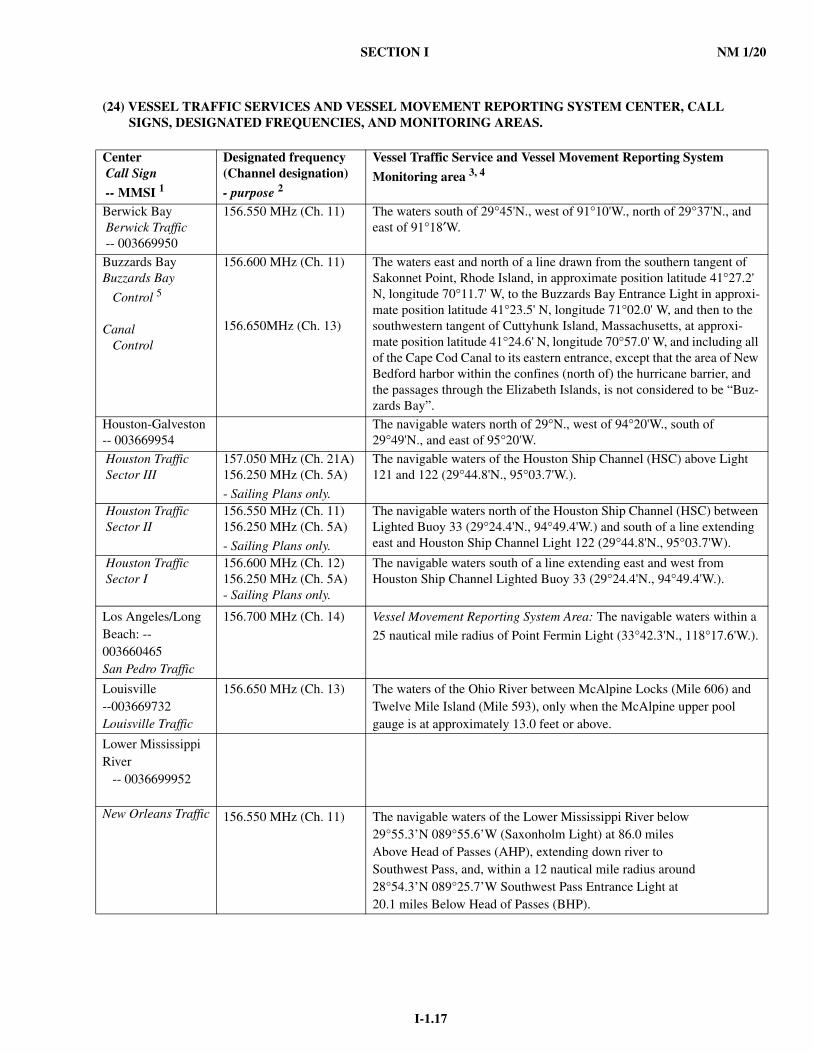
SECTION I NM 1/20
I-1.17
(24) VESSEL TRAFFIC SERVICES AND VESSEL MOVEMENT REPORTING SYSTEM CENTER, CALL SIGNS, DESIGNATED FREQUENCIES, AND MONITORING AREAS.
Center Call Sign
-- MMSI 1
Designated frequency(Channel designation)
- purpose 2
Vessel Traffic Service and Vessel Movement Reporting System
Monitoring area 3, 4
Berwick Bay Berwick Traffic -- 003669950
156.550 MHz (Ch. 11) The waters south of 29°45'N., west of 91°10'W., north of 29°37'N., and east of 91°18′W.
Buzzards BayBuzzards Bay
Control 5
Canal Control
156.600 MHz (Ch. 11)
156.650MHz (Ch. 13)
The waters east and north of a line drawn from the southern tangent of Sakonnet Point, Rhode Island, in approximate position latitude 41°27.2' N, longitude 70°11.7' W, to the Buzzards Bay Entrance Light in approxi-mate position latitude 41°23.5' N, longitude 71°02.0' W, and then to the southwestern tangent of Cuttyhunk Island, Massachusetts, at approxi-mate position latitude 41°24.6' N, longitude 70°57.0' W, and including all of the Cape Cod Canal to its eastern entrance, except that the area of New Bedford harbor within the confines (north of) the hurricane barrier, and the passages through the Elizabeth Islands, is not considered to be “Buz-zards Bay”.
Houston-Galveston-- 003669954
The navigable waters north of 29°N., west of 94°20'W., south of 29°49'N., and east of 95°20'W.
Houston Traffic Sector III
157.050 MHz (Ch. 21A) 156.250 MHz (Ch. 5A)
- Sailing Plans only.
The navigable waters of the Houston Ship Channel (HSC) above Light 121 and 122 (29°44.8'N., 95°03.7'W.).
Houston Traffic Sector II
156.550 MHz (Ch. 11) 156.250 MHz (Ch. 5A)
- Sailing Plans only.
The navigable waters north of the Houston Ship Channel (HSC) between Lighted Buoy 33 (29°24.4'N., 94°49.4'W.) and south of a line extending east and Houston Ship Channel Light 122 (29°44.8'N., 95°03.7'W).
Houston Traffic Sector I
156.600 MHz (Ch. 12) 156.250 MHz (Ch. 5A) - Sailing Plans only.
The navigable waters south of a line extending east and west from Houston Ship Channel Lighted Buoy 33 (29°24.4'N., 94°49.4'W.).
Los Angeles/LongBeach: --003660465San Pedro Traffic
156.700 MHz (Ch. 14) Vessel Movement Reporting System Area: The navigable waters within a
25 nautical mile radius of Point Fermin Light (33°42.3'N., 118°17.6'W.).
Louisville --003669732Louisville Traffic
156.650 MHz (Ch. 13) The waters of the Ohio River between McAlpine Locks (Mile 606) and Twelve Mile Island (Mile 593), only when the McAlpine upper pool gauge is at approximately 13.0 feet or above.
Lower Mississippi River -- 0036699952
New Orleans Traffic 156.550 MHz (Ch. 11) The navigable waters of the Lower Mississippi River below29°55.3’N 089°55.6’W (Saxonholm Light) at 86.0 milesAbove Head of Passes (AHP), extending down river toSouthwest Pass, and, within a 12 nautical mile radius around28°54.3’N 089°25.7’W Southwest Pass Entrance Light at20.1 miles Below Head of Passes (BHP).
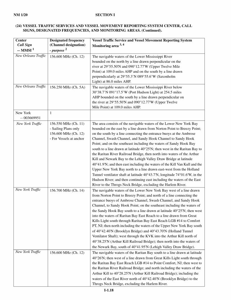
NM 1/20 SECTION I
I-1.18
(24) VESSEL TRAFFIC SERVICES AND VESSEL MOVEMENT REPORTING SYSTEM CENTER, CALL SIGNS, DESIGNATED FREQUENCIES, AND MONITORING AREAS. (Continued).
Center Call Sign
-- MMSI 1
Designated frequency(Channel designation)
- purpose 2
Vessel Traffic Service and Vessel Movement Reporting System
Monitoring area 3, 4
New Orleans Traffic 156.600 MHz (Ch. 12) The navigable waters of the Lower Mississippi Riverbounded on the north by a line drawn perpendicular on theriver at 29°55.50'N and 090°12.77'W (Upper Twelve MilePoint) at 109.0 miles AHP and on the south by a line drawnperpendicularly at 29°55.3’N 089°55.6’W (SaxonholmLight) at 86.0 miles AHP.
New Orleans Traffic 156.250 MHz (Ch. 5A) The navigable waters of the Lower Mississippi River below30°38.7’N 091°17.5’W (Port Hudson Light) at 254.5 milesAHP bounded on the south by a line drawn perpendicular onthe river at 29°55.50'N and 090°12.77'W (Upper TwelveMile Point) at 109.0 miles AHP.
New York -- 003669951
1
New York Traffic 156.550 MHz (Ch. 11)- Sailing Plans only156.600 MHz (Ch. 12) - For Vessels at anchor
The area consists of the navigable waters of the Lower New York Bay bounded on the east by a line drawn from Norton Point to Breezy Point; on the south by a line connecting the entrance buoys at the Ambrose Channel, Swash Channel, and Sandy Hook Channel to Sandy Hook Point; and on the southeast including the waters of Sandy Hook Bay
south to a line drawn at latitude 40°25'N; then west in the Raritan Bay to the Raritan River Railroad Bridge, then north into waters of the Arthur Kill and Newark Bay to the Lehigh Valley Draw Bridge at latitude
40°41.9'N; and then east including the waters of the Kill Van Kull and the Upper New York Bay north to a line drawn east-west from the Holland
Tunnel ventilator shaft at latitude 40°43.7'N, longitude 74°01.6'W, in the Hudson River; and then continuing east including the waters of the East River to the Throgs Neck Bridge, excluding the Harlem River.
New York Traffic 156.700 MHz (Ch. 14) The navigable waters of the Lower New York Bay west of a line drawn from Norton Point to Breezy Point; and north of a line connecting the entrance buoys of Ambrose Channel, Swash Channel, and Sandy Hook Channel, to Sandy Hook Point; on the southeast including the waters of
the Sandy Hook Bay south to a line drawn at latitude 40°25'N; then west into the waters of Raritan Bay East Reach to a line drawn from Great Kills Light south through Raritan Bay East Reach LGB #14 to Comfort PT, NJ; then north including the waters of the Upper New York Bay south
of 40°42.40'N (Brooklyn Bridge) and 40°43.70'N (Holland Tunnel Ventilator Shaft); west through the KVK into the Arthur Kill north of
40°38.25'N (Arthur Kill Railroad Bridge); then north into the waters of
the Newark Bay, south of 40°41.95'N (Lehigh Valley Draw Bridge).New York Traffic 156.600 MHz (Ch. 12) The navigable waters of the Raritan Bay south to a line drawn at latitude
40°26'N; then west of a line drawn from Great Kills Light south through the Raritan Bay East Reach LGB #14 to Point Comfort, NJ; then west to the Raritan River Railroad Bridge; and north including the waters of the
Arthur Kill to 40°28.25'N (Arthur Kill Railroad Bridge); including the
waters of the East River north of 40°42.40'N (Brooklyn Bridge) to the Throgs Neck Bridge, excluding the Harlem River.
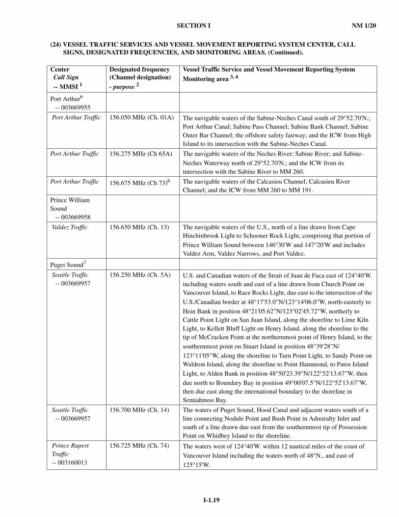
SECTION I NM 1/20
I-1.19
(24) VESSEL TRAFFIC SERVICES AND VESSEL MOVEMENT REPORTING SYSTEM CENTER, CALL SIGNS, DESIGNATED FREQUENCIES, AND MONITORING AREAS. (Continued).
Center Call Sign
-- MMSI 1
Designated frequency(Channel designation)
- purpose 2
Vessel Traffic Service and Vessel Movement Reporting System
Monitoring area 3, 4
Port Arthur6
-- 003669955
Port Arthur Traffic 156.050 MHz (Ch. 01A) The navigable waters of the Sabine-Neches Canal south of 29°52.70'N.; Port Arthur Canal; Sabine Pass Channel; Sabine Bank Channel; Sabine Outer Bar Channel; the offshore safety fairway; and the ICW from High Island to its intersection with the Sabine-Neches Canal.
Port Arthur Traffic 156.275 MHz (Ch 65A) The navigable waters of the Neches River; Sabine River; and Sabine-
Neches Waterway north of 29°52.70'N.; and the ICW from its intersection with the Sabine River to MM 260.
Port Arthur Traffic 156.675 MHz (Ch 73)6 The navigable waters of the Calcasieu Channel; Calcasieu River Channel; and the ICW from MM 260 to MM 191.
Prince William Sound -- 003669958
Valdez Traffic 156.650 MHz (Ch. 13) The navigable waters of the U.S., north of a line drawn from Cape Hinchinbrook Light to Schooner Rock Light, comprising that portion of
Prince William Sound between 146°30'W and 147°20'W and includes Valdez Arm, Valdez Narrows, and Port Valdez.
Puget Sound7
Seattle Traffic -- 003669957
156.250 MHz (Ch. 5A) U.S. and Canadian waters of the Strait of Juan de Fuca east of 124°40'W. including waters south and east of a line drawn from Church Point on Vancouver Island, to Race Rocks Light, due east to the intersection of the
U.S./Canadian border at 48°17'53.0"N/123°14'06.0"W, north-easterly to
Hein Bank in position 48°21'05.62"N/123°02'45.72"W, northerly to Cattle Point Light on San Juan Island, along the shoreline to Lime Kiln Light, to Kellett Bluff Light on Henry Island, along the shoreline to the tip of McCracken Point at the northernmost point of Henry Island, to the
southernmost point on Stuart Island in position 48°39'28"N/
123°11'05"W, along the shoreline to Turn Point Light, to Sandy Point on Waldron Island, along the shoreline to Point Hammond, to Patos Island
Light, to Alden Bank in position 48°50'23.39"N/122°52'13.67"W, then
due north to Boundary Bay in position 49°00'07.5"N/122°52'13.67"W, then due east along the international boundary to the shoreline in Semiahmoo Bay.
Seattle Traffic -- 003669957
156.700 MHz (Ch. 14) The waters of Puget Sound, Hood Canal and adjacent waters south of a line connecting Nodule Point and Bush Point in Admiralty Inlet and south of a line drawn due east from the southernmost tip of Possession Point on Whidbey Island to the shoreline.
Prince Rupert Traffic -- 003160013
156.725 MHz (Ch. 74) The waters west of 124°40'W. within 12 nautical miles of the coast of
Vancouver Island including the waters north of 48°N., and east of
125°15'W.
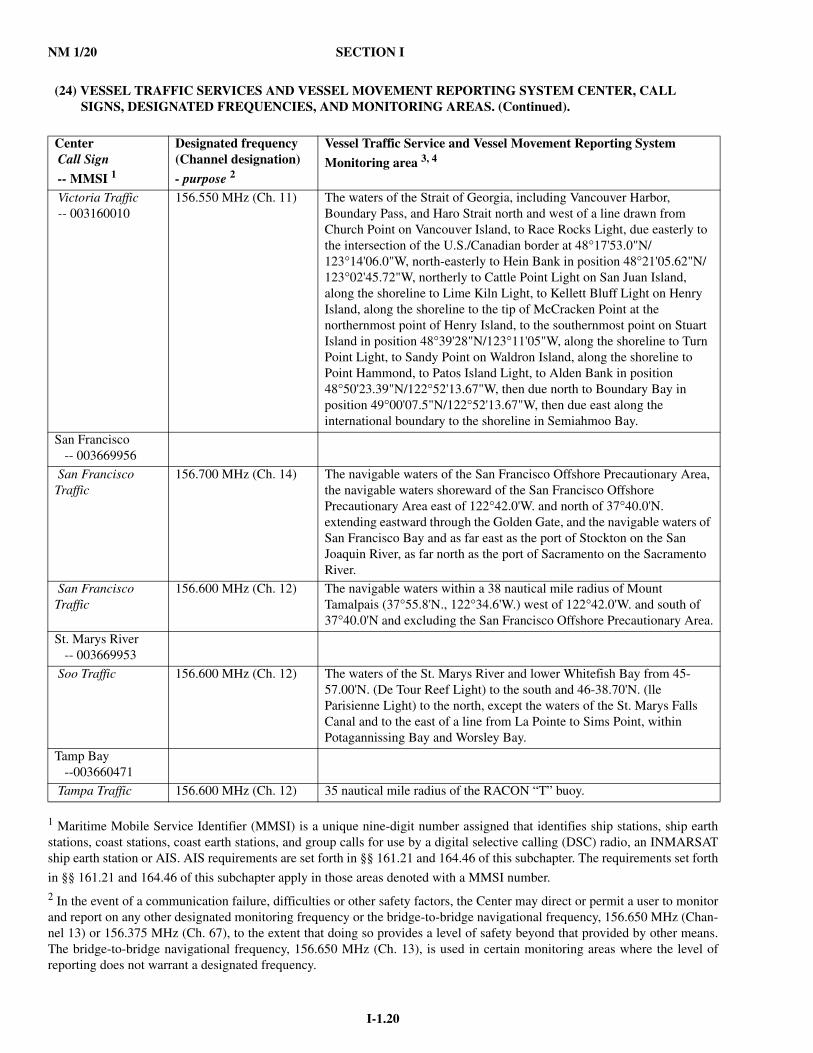
NM 1/20 SECTION I
I-1.20
1 Maritime Mobile Service Identifier (MMSI) is a unique nine-digit number assigned that identifies ship stations, ship earthstations, coast stations, coast earth stations, and group calls for use by a digital selective calling (DSC) radio, an INMARSATship earth station or AIS. AIS requirements are set forth in §§ 161.21 and 164.46 of this subchapter. The requirements set forth
in §§ 161.21 and 164.46 of this subchapter apply in those areas denoted with a MMSI number.2 In the event of a communication failure, difficulties or other safety factors, the Center may direct or permit a user to monitorand report on any other designated monitoring frequency or the bridge-to-bridge navigational frequency, 156.650 MHz (Chan-nel 13) or 156.375 MHz (Ch. 67), to the extent that doing so provides a level of safety beyond that provided by other means.The bridge-to-bridge navigational frequency, 156.650 MHz (Ch. 13), is used in certain monitoring areas where the level ofreporting does not warrant a designated frequency.
(24) VESSEL TRAFFIC SERVICES AND VESSEL MOVEMENT REPORTING SYSTEM CENTER, CALL SIGNS, DESIGNATED FREQUENCIES, AND MONITORING AREAS. (Continued).
Center Call Sign
-- MMSI 1
Designated frequency(Channel designation)
- purpose 2
Vessel Traffic Service and Vessel Movement Reporting System
Monitoring area 3, 4
Victoria Traffic -- 003160010
156.550 MHz (Ch. 11) The waters of the Strait of Georgia, including Vancouver Harbor, Boundary Pass, and Haro Strait north and west of a line drawn from Church Point on Vancouver Island, to Race Rocks Light, due easterly to the intersection of the U.S./Canadian border at 48°17'53.0"N/123°14'06.0"W, north-easterly to Hein Bank in position 48°21'05.62"N/123°02'45.72"W, northerly to Cattle Point Light on San Juan Island, along the shoreline to Lime Kiln Light, to Kellett Bluff Light on Henry Island, along the shoreline to the tip of McCracken Point at the northernmost point of Henry Island, to the southernmost point on Stuart Island in position 48°39'28"N/123°11'05"W, along the shoreline to Turn Point Light, to Sandy Point on Waldron Island, along the shoreline to Point Hammond, to Patos Island Light, to Alden Bank in position 48°50'23.39"N/122°52'13.67"W, then due north to Boundary Bay in position 49°00'07.5"N/122°52'13.67"W, then due east along the international boundary to the shoreline in Semiahmoo Bay.
San Francisco -- 003669956
San Francisco Traffic
156.700 MHz (Ch. 14) The navigable waters of the San Francisco Offshore Precautionary Area, the navigable waters shoreward of the San Francisco Offshore Precautionary Area east of 122°42.0'W. and north of 37°40.0'N. extending eastward through the Golden Gate, and the navigable waters of San Francisco Bay and as far east as the port of Stockton on the San Joaquin River, as far north as the port of Sacramento on the Sacramento River.
San Francisco Traffic
156.600 MHz (Ch. 12) The navigable waters within a 38 nautical mile radius of Mount Tamalpais (37°55.8'N., 122°34.6'W.) west of 122°42.0'W. and south of 37°40.0'N and excluding the San Francisco Offshore Precautionary Area.
St. Marys River -- 003669953
Soo Traffic 156.600 MHz (Ch. 12) The waters of the St. Marys River and lower Whitefish Bay from 45-57.00'N. (De Tour Reef Light) to the south and 46-38.70'N. (lle Parisienne Light) to the north, except the waters of the St. Marys Falls Canal and to the east of a line from La Pointe to Sims Point, within Potagannissing Bay and Worsley Bay.
Tamp Bay --003660471
Tampa Traffic 156.600 MHz (Ch. 12) 35 nautical mile radius of the RACON “T” buoy.
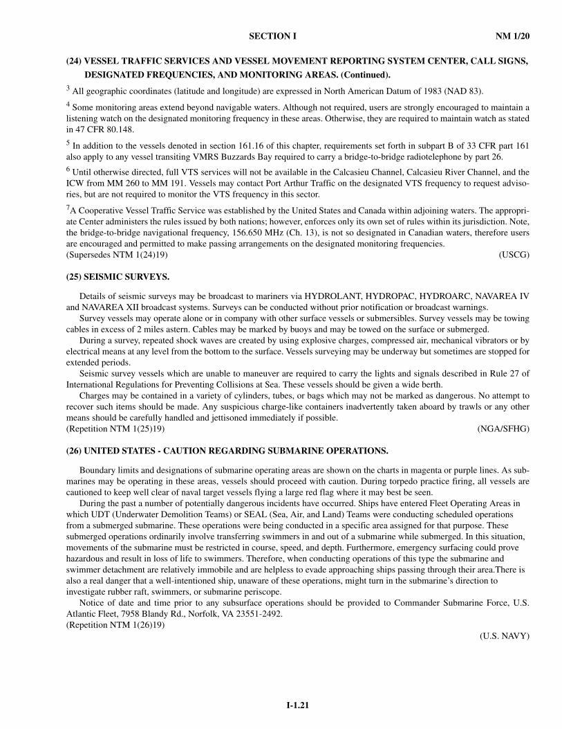
SECTION I NM 1/20
I-1.21
(24) VESSEL TRAFFIC SERVICES AND VESSEL MOVEMENT REPORTING SYSTEM CENTER, CALL SIGNS,
DESIGNATED FREQUENCIES, AND MONITORING AREAS. (Continued).3 All geographic coordinates (latitude and longitude) are expressed in North American Datum of 1983 (NAD 83).4 Some monitoring areas extend beyond navigable waters. Although not required, users are strongly encouraged to maintain alistening watch on the designated monitoring frequency in these areas. Otherwise, they are required to maintain watch as statedin 47 CFR 80.148.5 In addition to the vessels denoted in section 161.16 of this chapter, requirements set forth in subpart B of 33 CFR part 161also apply to any vessel transiting VMRS Buzzards Bay required to carry a bridge-to-bridge radiotelephone by part 26.6 Until otherwise directed, full VTS services will not be available in the Calcasieu Channel, Calcasieu River Channel, and theICW from MM 260 to MM 191. Vessels may contact Port Arthur Traffic on the designated VTS frequency to request adviso-ries, but are not required to monitor the VTS frequency in this sector.7A Cooperative Vessel Traffic Service was established by the United States and Canada within adjoining waters. The appropri-ate Center administers the rules issued by both nations; however, enforces only its own set of rules within its jurisdiction. Note,the bridge-to-bridge navigational frequency, 156.650 MHz (Ch. 13), is not so designated in Canadian waters, therefore usersare encouraged and permitted to make passing arrangements on the designated monitoring frequencies.(Supersedes NTM 1(24)19) (USCG)
(25) SEISMIC SURVEYS.
Details of seismic surveys may be broadcast to mariners via HYDROLANT, HYDROPAC, HYDROARC, NAVAREA IVand NAVAREA XII broadcast systems. Surveys can be conducted without prior notification or broadcast warnings.
Survey vessels may operate alone or in company with other surface vessels or submersibles. Survey vessels may be towingcables in excess of 2 miles astern. Cables may be marked by buoys and may be towed on the surface or submerged.
During a survey, repeated shock waves are created by using explosive charges, compressed air, mechanical vibrators or byelectrical means at any level from the bottom to the surface. Vessels surveying may be underway but sometimes are stopped forextended periods.
Seismic survey vessels which are unable to maneuver are required to carry the lights and signals described in Rule 27 ofInternational Regulations for Preventing Collisions at Sea. These vessels should be given a wide berth.
Charges may be contained in a variety of cylinders, tubes, or bags which may not be marked as dangerous. No attempt torecover such items should be made. Any suspicious charge-like containers inadvertently taken aboard by trawls or any othermeans should be carefully handled and jettisoned immediately if possible.(Repetition NTM 1(25)19) (NGA/SFHG)
(26) UNITED STATES - CAUTION REGARDING SUBMARINE OPERATIONS.
Boundary limits and designations of submarine operating areas are shown on the charts in magenta or purple lines. As sub-marines may be operating in these areas, vessels should proceed with caution. During torpedo practice firing, all vessels arecautioned to keep well clear of naval target vessels flying a large red flag where it may best be seen.
During the past a number of potentially dangerous incidents have occurred. Ships have entered Fleet Operating Areas in which UDT (Underwater Demolition Teams) or SEAL (Sea, Air, and Land) Teams were conducting scheduled operations from a submerged submarine. These operations were being conducted in a specific area assigned for that purpose. These submerged operations ordinarily involve transferring swimmers in and out of a submarine while submerged. In this situation, movements of the submarine must be restricted in course, speed, and depth. Furthermore, emergency surfacing could prove hazardous and result in loss of life to swimmers. Therefore, when conducting operations of this type the submarine and swimmer detachment are relatively immobile and are helpless to evade approaching ships passing through their area.There is also a real danger that a well-intentioned ship, unaware of these operations, might turn in the submarine’s direction to investigate rubber raft, swimmers, or submarine periscope.
Notice of date and time prior to any subsurface operations should be provided to Commander Submarine Force, U.S.Atlantic Fleet, 7958 Blandy Rd., Norfolk, VA 23551-2492.(Repetition NTM 1(26)19)
(U.S. NAVY)
NM 1/20 SECTION I
I-1.22
(27) SPECIAL RULES WITH RESPECT TO ADDITIONAL STATION AND SIGNAL LIGHTS FOR NAVY SHIPS.
1. Man overboard lights.-Naval vessels may display, as a means of indicating man overboard, two pulsating, all around redlights in a vertical line located on a mast from where they can best be seen.
2. Yard arm signaling lights.-Naval vessels may display, as a means of visual signaling, white all around lights at the end ofthe yardarms. These lights will flash in varying sequences to convey the intended signal.
3. Aircraft warning lights.-Naval vessels may display, as a means of indicating the presence of an obstruction to low flyingaircraft, one or two all around red lights on each obstruction.
4. Underway replenishment contour lights.-Naval vessels may display, as a means of outlining the contour of the deliveryship during night time underway replenishment operations, red or blue lights at deck edge extremities. These lights arebeing converted to blue, vice red, therefore either color may be seen until conversion is complete.
5. Minesweeping station keeping lights.-Naval vessels engaged in minesweeping operations may display, as an aid in main-taining a prescribed interval and bearing, two white lights in a vertical line visible from 070 through 290 degrees relative.
6. Submarine identification light.-Submarines may display, as a distinctive means of identification, an intermittently flashingamber beacon located where it can best be seen, as near as practicable, all around the horizon.
7. Special operations lights.-Naval vessels may display, as a means of coordinating certain operations, a revolving beam col-ored red, green or amber, located on either yardarm or mast platform from where it can be seen all around the horizon.
8. Convoy operations stern light.-Naval vessels may display, during periods of convoy operations, a blue light located nearthe stern, with the same characteristics as, but in lieu of, the normal white stern light.
9. Wake illumination light.-Naval vessels may display a white light located near the stern to illuminate the wake.10. Flight operations lights.-Naval vessels engaged in night flight operations may display various arrangements of light sys-
tems containing combinations of different colored lights as a means of assisting in the launch and recovery of aircraft andenhancing flight safety. These light systems will be located at various points on the vessels, depending on the vessel typeand nature or the flight operations being conducted.
11. Amphibious operations lights.-Naval vessels engaged in night amphibious operations may display various arrangementsof light systems containing combinations of different colored lights as a means of assisting in the launch and recovery ofassault craft and enhancing the safety of the amphibious operation. These light systems will be located at various points onthe vessels, depending on the vessel type and the nature of the amphibious operations being conducted.
12. Minesweeping polarity signal lights.-Naval vessels engaged in minesweeping operations may display either a red or greenlight on each side of vessel.
13. Replenishment-at-sea floodlights.-Naval vessels engaged in replenishment-at-sea operations may display various arrange-ments of floodlights of different colors for general illumination of equipment, work areas, and cargo being transferredbetween ships. These lights will be located at various points on the vessels, depending on the vessel type and location ofthe replenishment-at-sea handling areas.
14. Replenishment-at-sea cargo transfer signal lights.-Naval vessels engaged in replenishment-at-sea operations may displayone or more red light signal devices on the delivery side of the vessels. These devices display various combinations oflights to indicate type of cargo being transferred.
15. Replenishment-at-sea truck light.-Naval vessels engaged in replenishment-at-sea operations may display one or more redall-round light(s) located on a mast to assist the receiving vessel in approaching the delivery vessel.
16. Replenishment-at-sea lights.-Naval aircraft carriers and similar type vessels may display two all-round lights installedalong the forward starboard flight deck edge to indicate the fore-and-aft axis when the aircraft carrier or similar type ves-sel is the delivery vessel.
(Repetition NTM 1(27)19) (U.S. NAVY)
(28) UNITED STATES NAVAL VESSELS - NAVIGATIONAL LIGHT WAIVERS - DISTINCTIVE LIGHTS AUTHORIZED FOR NAVAL VESSELS.
1. All ships are warned that, when U.S. Naval vessels are met on the high seas or on navigable waters of the United Statesduring periods when navigational lights may be displayed; certain navigational lights of some naval vessels may vary fromthe requirements of the Regulations for Preventing Collisions at Sea, 1972, and rules applicable to the navigable waters ofthe United States, as to number, position, range of visibility or arc of visibility. These differences are necessitated by rea-sons of military function or special construction of the naval ships. An example is the aircraft carrier where the two mast-head lights are considerably displaced to starboard from the center or keel line of the vessel when viewed from ahead.Certain other naval vessels cannot comply with the horizontal separation requirements of the masthead lights, and the twomasthead lights on even larger naval vessels, such as some cruisers, will thus appear to be crowded together when viewedfrom a distance. Other naval vessels may also have unorthodox navigational light arrangements or characteristics whenseen either underway or at anchor.
SECTION I NM 1/20
I-1.23
(28) UNITED STATES NAVAL VESSELS - NAVIGATIONAL LIGHT WAIVERS - DISTINCTIVE LIGHTS AUTHO- RIZED FOR NAVAL VESSELS. (Continued).
2. Naval vessels may also be expected to display certain other lights. These lights include, but are not limited to, different col-ored recognition light signals, and aircraft landing lights. These lights may sometimes be shown in combination with navi-gational lights.
3. During naval maneuvers, naval ships, alone or in company, may also dispense with showing any lights, though efforts willbe made to display lights on the approach of shipping.
4. Naval vessels, except for aircraft carriers, may dispense with showing the masthead lights during operations or maneuversin which the vessels are restricted in ability to maneuver.
(Repetition NTM 1(28)19) (CNO)
(29) TRAFFIC SEPARATION SCHEMES, AREAS TO BE AVOIDED, RECOMMENDED TRACKS, AND OTHER ROUTING MEASURES.
To increase the safety of navigation, particularly in converging areas of high traffic density, routes incorporating traffic sep-aration schemes have been adopted by the IMO in certain areas of the world. Certain maritime nations have also adopted theirown non-IMO approved traffic separation schemes. In the interest of safe navigation, it is recommended that through trafficuse these schemes, as far as circumstances permit, by day and by night and in all weather conditions.
An area to be avoided (ATBA) is a routing measure comprising an area within defined limits, in which either navigation isparticularly hazardous or it is exceptionally important to avoid casualties, and which should be avoided by all ships, or certainclasses of ships.
Recommended tracks are routes, generally found to be free of dangers, which ships are advised to follow to avoid possiblehazards nearby.
The International Maritime Organization (IMO) is recognized as the only international body responsible for establishingand recommending measures on an international level concerning ships’ routing. In deciding whether or not to adopt or amenda traffic separation scheme, IMO will consider whether the scheme complies with the design criteria for traffic separationschemes and with the established methods of routing. IMO also considers whether the aids to navigation proposed will enablemariners to determine their position with sufficient accuracy to navigate the scheme in accordance with Rule 10 of the Interna-tional Regulations for Preventing Collisions at Sea (72 COLREGS).
General principles for navigation in traffic separation schemes are as follows:1. A ship navigating in or near a traffic separation scheme adopted by IMO shall in particular comply with Rule 10 of the 72
COLREGS to minimize the development of risk of collisions with another ship. The other rules of the 72 COLREGS applyin all respects, and particularly the steering and sailing rules if risk of collision with another ship is deemed to exist.
2. Traffic separation schemes are intended for use by day and by night in all weather conditions, in ice-free waters or underlight ice conditions where no extraordinary maneuvers or assistance by an icebreaker is required.
3. Traffic separation schemes are recommended for use by all ships unless stated otherwise. Bearing in mind the need foradequate underkeel clearance, a decision to use a traffic separation scheme must take into account the charted depth, thepossibility of changes in the sea-bed since the time of last survey, and the effects of meteorological and tidal conditionson water depths.
4. A deep-water route is an allied routing measure primarily intended for use by ships which require the use of such a routebecause of their draft in relation to the available depth of water in the area concerned. Through traffic to which the aboveconsideration does not apply should, if practicable, avoid following deep-water routes. When using a deep-water routemariners should be aware of possible changes in the indicated depth of water due to meteorological or other effects.
5. The arrows printed on charts merely indicate the general direction of traffic; ships should not set their courses strictly alongthe arrows.
6. Vessels should, so far as practicable, keep clear of a traffic separation line or separation zone.7. Vessels should avoid anchoring in a traffic separation scheme or in the area near its terminus.8. The signal “YG” meaning “You appear not to be complying with the traffic separation scheme” is provided in the Interna-
tional Code of Signals for appropriate use.NOTE.-Several governments administering traffic separation schemes have expressed their concern to IMO about the largenumber of infringements of Rule 10 of the 72 COLREGS and the dangers of such contraventions to personnel, vessels andenvironment. Several governments have initiated surveillance of traffic separation schemes for which they are responsibleand are providing documented reports of vessel violations to flag states. As in the past, the U.S. Coast Guard will investi-gate these reports and take appropriate action. Mariners are urged to comply at all times with the 72 COLREGS and, in par-ticular, Rule 10 when operating in or near traffic separation schemes.
NM 1/20 SECTION I
I-1.24
(29) TRAFFIC SEPARATION SCHEMES, AREAS TO BE AVOIDED, RECOMMENDED TRACKS, AND OTHER ROUTING MEASURES. (Continued).
9. Notice of temporary adjustments to traffic separation schemes for emergencies or for accommodation of activities which would otherwise contravene Rule 10 or obstruct navigation may be made in Notices to Mariners. Temporary adjustments
may be in the form of a precautionary area within a traffic lane, or a shift in the location of a lane.10. The IMO approved routing measures which affect shipping in or near U.S. waters are:
UNITED STATES TRAFFIC SEPARATION SCHEMESIn the Approaches to Portland, MaineIn the Approach to Boston, MassachusettsIn the Approaches to Narragansett Bay, Rhode Island and Buzzards Bay, MassachusettsOff New YorkOff Delaware BayIn the Approaches to Chesapeake Bay, including a deep water routeIn the Approaches to the Cape Fear RiverIn the Approaches to Galveston BayIn the Approaches to Los Angeles-Long BeachIn the Santa Barbara ChannelOff San FranciscoIn the Strait of Juan de Fuca and its ApproachesIn Puget Sound and its approachesIn Haro Strait, Boundary Pass, and in the Strait of GeorgiaIn Prince William Sound, Alaska
UNITED STATES AREAS TO BE AVOIDEDIn the region of Nantucket ShoalsIn the vicinity of the Excelerate Northeast Gateway Energy Bridge Deepwater PortIn the vicinity of the Neptune Deepwater PortIn the Great South ChannelOff the Florida Coast (Adjacent to Florida Keys)At Louisiana Offshore Oil Port (LOOP) in the Gulf of MexicoOff the California Coast (In the region of the Channel Islands)Off Washington CoastIn the region of the Aleutian ArchipelagoIn the Papahãnaumokuãkea Marine National Monument PSSAIn the region of the Northwest Hawaiian Islands
UNITED STATES NO ANCHORING AREASIn the vicinity of Northeast Gateway Energy Bridge Deepwater PortIn the vicinity of Neptune Deepwater PortFlower Garden BanksTortugas Ecological Reserve and the Tortugas Bank in the Florida Keys
(UNITED STATES RECOMMENDED TRACKSOff the California Coast (Off Monterey Bay for vessels 300 gross tons or more and vessels carrying hazardous cargoin bulk)
UNITED STATES TWO-WAY ROUTEIn the Strait of Juan de Fuca
(Supersedes NTM 1(29)19) (IMO/USCG)
SECTION I NM 1/20
I-1.25
(30) FIRING DANGER AREAS.
Firing and bombing practice exercises take place either occasionally or regularly in numerous areas established for thosepurposes along the coast of practically all maritime countries.
In view of the difficulty in keeping these areas up to date on the charts, and since the responsibility to avoid accidents restswith the authorities using the areas for firing and/or bombing practice, these areas will not as a rule be shown on NGA charts.
National Ocean Service Charts show firing and bombing practice areas as defined by Code of Federal Regulations (Title33, Part 334) in United States waters.
Any permanent aid to navigation that may be established to mark a danger area, or any target, fixed or floating, that mayconstitute a danger to navigation, will be shown on the appropriate charts.
Warning signals, usually consisting of red flags or red lights, are customarily displayed before and during the practice, butthe absence of such warnings cannot be accepted as evidence that a practice area does not exist. Vessels should be on thelookout for local warnings and signals, and should, whenever possible, avoid passing through an area in which practice is inprogress, but if compelled to do so should endeavor to clear it at the earliest possible moment.(Repetition NTM 1(30)19) (NGA/SFHG)
(31) ENDANGERED SPECIES (WHALES AND SEA TURTLES) EASTERN SEABOARD.
National Oceanic and Atmospheric Administration’s (NOAA) National Marine Fisheries Service (NMFS), Office ofProtected Resources has advised that several species of endangered and threatened sea turtles and endangered whales occuralong the U.S. eastern seaboard; all are vulnerable to collisions with vessels.
Sea Turtles. Sea turtles are highly susceptible to vessel collisions because they regularly surface to breathe and often restat or near the surface. Leatherback turtles commonly feed on jellyfish near the surface; areas where concentrations ofjellyfish are readily visible should be avoided or traversed slowly as turtles are likely to be present and actively feeding. Seaturtles can be difficult to see, especially in choppy or rough seas. Sea turtles are commonly found along the U.S. easternseaboard from Maine to Florida and throughout the Caribbean. Critically important nesting beaches and associated nearshore habitat occurs from North Carolina to Florida, and adult turtles migrate to and from these areas from April throughSeptember. These are particularly important times and areas for adults, but sea turtles (both adults and juveniles) are foundyear-round in waters along the eastern seaboard and care should be taken at all times to avoid collisions.
North Atlantic Right Whales. The North Atlantic right whale is one of the world's most endangered large whalespecies. North Atlantic right whales are found primarily in continental shelf waters between Florida and the Gulf of St.Lawrence. The species is listed as “endangered” under the Endangered Species Act, and protected under the MarineMammal Protection Act. Approaching within 500 yards of right whales is prohibited and is a violation of U.S. federal law.
These whales migrate annually along the east coast between feeding grounds off New England and Canada and thesouthern calving grounds from North Carolina to Florida. Because right whales mate, rest, feed and nurse their young at thesurface, and often do not move out of the way of oncoming vessels, they are highly vulnerable to being struck. Pregnantfemales and females with nursing calves are particularly vulnerable to collisions with vessels.
Right whales are large baleen whales. Adults are generally 45 to 55 feet in length and can weigh up to 70 tons. The bodyis mostly black, but irregularly shaped white patches of skin may be present on the underside. The best field identifiersare a broad back with no dorsal fin, irregular raised white patches on the head, and a distinctive two-column V-shapedblow when viewed from directly behind or in front of the whale. The whales have broad, paddle-shaped flippers and abroad, deeply notched tail. Right whales are slow moving and seldom travel faster than 5 or 6 knots. They can staysubmerged for 10 to 20 minutes and may appear suddenly when surfacing to breathe. They are often seen alone or insmall groups. At times, right whales form large groups of 20 or more animals.
The following table describes the seasonal occurrence of North Atlantic right whales. However, in any given yearoceanographic variability may affect the seasonal distribution of this species. There are two areas in U.S. waters designatedas critical habitats for right whales: coastal waters of Florida, Georgia, South Carolina, and North Carolina (SebastianInlet, Florida, to Cape Fear, North Carolina), and coastal waters of Massachusetts, New Hampshire and Maine as well asthe off- shore waters in the Gulf of Maine and Georges Bank to the Hague Line. The northern critical habitat areas arefeeding and nursery grounds, while the southern area contains the only known calving/nursery area for North Atlanticright whales.

NM 1/20 SECTION I
I-1.26
(31) ENDANGERED SPECIES (WHALES AND SEA TURTLES) EASTERN SEABOARD. (Continued).
To reduce the number and severity of vessel strikes with right whales, the following recommendations and regulationshave been established:
Vessels greater than or equal to 65 ft in overall length are subject to mandatory speed restrictions of 10 knots or less in sea-sonal management areas (SMA) along the U.S. East Coast during times when right whales are likely to be present. The North-eastern SMA speed restrictions are in place from January 1 through May 15 in Cape Cod Bay, from March 1 through April 30off Race Point, and from April 1 through July 31 in the Great South Channel. Speed restrictions in the U.S. Mid-AtlanticSMAs are in place from November 1 to April 30, and include Block Island Sound, entry into the Ports of New York/NewJersey, Delaware Bay, Entrance to Chesapeake Bay, and the Ports of Morehead City and Beaufort, NC, and within a continuousarea approximately 20 nautical miles from shore around the major ports of Wilmington, NC, Charleston, SC and Savannah,GA. Speed restrictions are in place in the Southeastern U.S. SMA from November 15 to April 15, this area extends from shoreapproximately 30 nautical miles eastward and contains the major ports of Brunswick, GA, Fernandina Beach, FL and Jack-sonville, FL. NOAA Fisheries may also establish voluntary Dynamic Management Areas (DMAs) when right whales are pres-ent in areas and times not covered by the SMAs. Information about established DMAs will be announced via Coast GuardBroadcast Notice to Mariners, Coast Guard Local Notice to Mariners, and NAVTEX. Mariners are encouraged to avoid DMAsor reduce speeds to 10 knots or less while transiting through DMAs. Additional information on SMA locations and exemptionsto this law in addition to printed compliance guides can be found at the following website: https://www.fisheries.noaa.gov/national/endangered-species-conservation/reducing-ship-strikes-north-atlantic-right-whales.
As weather and conditions permit, a dedicated seasonal program of aerial and vessel surveys are conducted in various loca-tions along the U.S. East Coast to provide whale sighting information to mariners. Surveys typically occur in the followinglocations at the specified times: a) Cape Cod Bay from December through May and year-round in the Gulf of Maine (includingthe Great South Channel); b) Georgia south to Crescent Beach, FL from December through March. Survey planes occasionallyuse VHF-FM channel 16 to contact ships directly if whales have been spotted in close proximity to that vessel. However, manyright whales go undetected by surveys. Right whale advisories are broadcast periodically for these and surrounding areas byCoast Guard Broadcast Notice to Mariners, NAVTEX, NOAA Weather Radio, Cape Cod Canal Vessel Traffic Control, the Bayof Fundy Vessel Traffic Control, and are included in the return message from the Right Whale Mandatory Ship Reporting(MSR) systems. Sighting information may be obtained by sending an email to: [email protected] (Northeast) or
Location Season Comments
Central Gulf of Maine (Jordan Basin, Cashes Ledge)
April-June, October-December
Cape Cod Bay December-May
Great South Chan-nel, Northern Edge of Georges Bank
March-July
Bay of Fundy, Sco-tian Shelf (Browns Bank, Roseway Basin), Gulf of St. Lawrence
June - October Most of the population can be found in this area during this time
Jeffreys Ledge October-December Whales are frequently sighted in this area
Stellwagen Bank National Marine Sanctuary
Year-round Peak sightings occur in the early spring with infrequent sightings in the summer
New York to North Carolina
Year-round The migration corridor between right whale habitats is thought to be primarily west of the Gulf Stream
South Carolina, Georgia and Flor-ida Calving Area
November-April Calving right whales have been sighted as far north as Cape Fear, NC and as far south as Miami, FL with rare sightings in the Gulf of Mexico

SECTION I NM 1/20
I-1.27
(31) ENDANGERED SPECIES (WHALES AND SEA TURTLES) EASTERN SEABOARD. (Continued).
[email protected] (Southeast). Recent right whale sighting information can also be found at: http://www.nefsc.noaa.gov/psb/surveys/.
In addition to the requirements identified above, NOAA National Marine Fisheries Service recommends the following pre-cautionary measures to avoid adverse interactions with the North Atlantic right whales:
1. Before entering right whale habitat, check sources for recent right whale sighting reports. Local ship pilots also have infor-mation on whale sightings and safe local operating procedures.
2. Review right whale identification materials and maintain a sharp watch with lookouts familiar with spotting whales. Eventhough right whales are very large, they can be difficult to spot because of their dark color and lack of a dorsal fin.
3. Avoid transiting through the right whale critical habitats and areas where right whales have recently been sighted. If transit-ing between ports within critical habitats, minimize transit distance. Route around observed or recently reported rightwhales and anticipate delays due to whale sightings. Vessels should avoid transits at night or during periods of lowvisibility.
4. If a right whale is sighted from the vessel or reported along the intended track of the vessel, mariners should exercise cau-tion, post a lookout and continue to operate at 10 knots when consistent with safe navigation. If a right whale is sighted, avessel must steer a course away from the right whale and immediately leave the area at slow safe speed. Do not assumeright whales will move out of the way of an approaching vessel.
Any whale accidentally struck, any dead whale carcass, and any sighting of a whale injured or entangled in fishing gearshould be reported immediately to the Coast Guard or NOAA National Marine Fisheries Service noting the precise location,date, and time of the accident or sighting. In the case of an accidental strike other information such as the speed and course ofthe vessel, vessel specifications such as size and propulsion, water depth, environmental conditions such as visibility, windspeed and direction, description of the impact, fate of the animal, and species and size, if known should be provided. Reports toNOAA for dead, ship struck or injured whales can be made to +1-866-755-6622 in the Northeast U.S. and +1-877-WHALE-HELP (942-5343) in the Southeast U.S or at https://fisheries.noaa.gov/report.
Recommended Two-Way Routes were developed for vessels entering and transiting through Cape Cod Bay and arrivingand departing the ports of Brunswick, GA, Fernandina Beach, FL and Jacksonville, FL. To reduce the risk of vessel strikes tothe North Atlantic right whale, an Area To Be Avoided was established in the Great South Channel, east of the Boston Harbor
traffic lanes. Vessels of 300 gross tons and above should avoid the area between the period of April 1st through July 31st. Thearea is bounded by 41°44′05″N, 69°34′58″W; 42°10′00″N, 68°31′00″W; 41°24′53″N, 68°31′00″W; and 40°50′28″N,
68°58′40″W, and then back to the starting point. Information on these can be found at:http://www.nmfs.noaa.gov/pr/shipstrike/.
Mandatory Ship Reporting (MSR) Systems areas exist for two areas off the east coast of the United States. The system inthe northeastern U.S. operates year round and the system in the southeast U.S. operates from November 15 to April 16. Thesystems require all vessels 300 gross tons or greater to report to a shore-based station when entering the areas. In return, ves-sels will receive an automated message indicating precautionary measures mariners can take to reduce the possibility of strik-ing right whales and recent sighting locations. The reporting system requires reporting only and will affect no other aspect ofvessel operation. Operators should review the contents of the return message. Reports to the Mandatory Ship Reporting Sys-tems can be sent by email: [email protected] or Telex: 48156090. Additional information on MSR locations andreporting procedures may be obtained in the U.S. Coast Pilots or at the following Web site:http://www.fisheries.noaa.gov/national/endangered-species-conservation/reducing-ship-strikes-north-atlantic-right-whales#mandatory-ship-reporting-system.
Example Report to MSR North:WHALESNORTH// (Reporting system area, WHALESSOUTH is the other area)M/487654321// (Vessel INMARSAT number)A/CALYPSO/NRUS// (Vessel name and call sign)B/031401Z APR// (Day, time and month of report)E/345// (True course)F/10.0// (Speed in knots and tenths)H/031410Z APR/4104N/06918W// (Date, time and point of entry into system)I/BOSTON/032345Z APR// (Destination and ETA)L/WP/4104N/06918W/10.0//L/WP/4210N/06952W/10.0//L/WP/4230N/07006W/10.0//

NM 1/20 SECTION I
I-1.28
(31) ENDANGERED SPECIES (WHALES AND SEA TURTLES) EASTERN SEABOARD. (Continued).
Route information can be reported as a set of waypoints (WP) and intended speed shown above or a rhumb line to port and intended speed shown below:
L/RL/10.0(Compliance Guide for Right Whale Ship Strike Reduction Rule (50 CFR 224.105)
ATTENTION: All vessels greater than or equal to 65 ft (19.8 m) in overall length and subject to the jurisdiction of theUnited States and all vessels greater than or equal to 65 ft in overall length entering or departing a port or place subjectto the jurisdiction of the United States.
YOU MUST SLOW TO SPEEDS OF 10 KNOTS OR LESS IN ACTIVE SEASONAL MANAGEMENT AREAS
Feeding Areas
The rule does not apply to waters inshore of COLREGS lines.
Cape Cod Bay Off Race Point Great South Channel
January 1 - May 15 March 1 - April 30 April 1 - July 31
Includes all waters of Cape Cod Bay with Northern Boundary of 42°04′56.5″N, 070°12′W to 42°12′N, 070°12′W then due west back to shore.
Waters bounded by:42°04′56.5″N 070°12′W42°12′N, 070°12′W42°12′N, 070°30′W42°30′N, 070°30′W42°30′N, 069°45′W41°40′N, 069°45′Wthen due west back to shore.
Waters bounded by:42°30′N, 069°45′W42°30′N, 067°27′W42°09′N, 067°08′24″W41°00′N, 069°05′W41°40′N, 069°45′Wthen back to starting point.

SECTION I NM 1/20
I-1.29
(31) ENDANGERED SPECIES (WHALES AND SEA TURTLES) EASTERN SEABOARD. (Continued).
Migratory Route
November 1 through April 30
Vessel speed is restricted in the following areas:
- Block Island Sound waters bounded by: 40°51′53.7″N 070°36′44.9″W, 41°20′14.1″N 070°49′44.1″W, 41°04′16.7″N
071°51′21.0″W, 40°35′56.5″N 071°38′25.1″W, then back to starting point.- Within a 20 nm (37 km) radius of the following (as measured seaward from the COLREGS lines):
- Ports of New York/New Jersey: 40°29′42.2″N 073°55′57.6″W
- Entrance to the Delaware Bay (Ports of Philadelphia and Wilmington): 38°52′27.4″N 075°01′32.1″W
- Entrance to the Chesapeake Bay (Ports of Hampton Roads and Baltimore): 37°00′36.9″N 075°57′50.5″W
- Ports of Morehead City and Beaufort, NC: 34°41′32.0″N 076°40′08.3″W

NM 1/20 SECTION I
I-1.30
(31) ENDANGERED SPECIES (WHALES AND SEA TURTLES) EASTERN SEABOARD. (Continued).
- Within a continuous area 20 nm from shore between Wilmington, NC, to Brunswick, GA, bounded by the following:
and west back to the shore.
Calving and Nursery Ground
November 15 through April 15Vessel speed is restricted in the area bounded to the north by latitude 31°27′N; to the south by latitude 29°45′N; to the east by
longitude 080°51′36″W.
Temporary Dynamic Management Areas (DMAs) may also be established by NOAA Fisheries Service. Mariners areencouraged to avoid these areas or travel at 10 knots or less while transiting through these areas. NOAA Fisheries Service willannounce DMAs to mariners through its customary maritime communication media.
Point Latitude Longitude
A 34°10′30″N 077°49′12″W
B 33°56′42″N 077°31′30″W
C 33°36′30″N 077°47′06″W
D 33°28′24″N 078°32′30″W
E 32°59′06″N 078°50′18″W
F 31°50′00″N 080°33′12″W
G 31°27′00″N 080°51′36″W
SECTION I NM 1/20
I-1.31
(31) ENDANGERED SPECIES (WHALES AND SEA TURTLES) EASTERN SEABOARD. (Continued).
NOAA FISHERIES SERVICE
Mandatory speed restrictions of 10 knots or less are required in Seasonal Management Areas along the U.S. East Coastduring times when right whales are likely to be present. The purpose of this regulation is to reduce the likelihood of deaths andserious injuries to these endangered whales that result from collisions with vessels.
Vessels may operate at a speed greater than 10 knots only if necessary to maintain a safe maneuvering speed in an areawhere conditions severely restrict vessel maneuverability as determined by the pilot or master.
If a deviation from the 10 knot speed restriction is necessary, the following information must be entered into the vessel’slogbook:
- Reasons for deviation- Speed at which vessel is operated- Latitude and longitude at time of deviation- Time and duration of deviation- Master of the vessel shall sign and date the logbook entry
(Supersedes NTM 1(31)19) (NOAA)
(32) REPORTING DEPTH INFORMATION.
The many ships presently equipped with reliable depth recorders constitute a potential wealth of sounding data desired bycharting agencies for the purpose of confirming charted depths or charting heretofore unknown depths. While oceanographicsurvey vessels remain the primary source of bathymetric data, depth recordings submitted by navy, coast guard and merchantvessels will make an important contribution to the vital task of charting the oceans.
Mariners are encouraged to obtain and report soundings whenever bridge routine and equipment capabilities will allow.The American Practical Navigator (Bowditch) (PUB9), Sections 3104-3109 describes the bathymetric requirements and pro-vides some guidance for observing and reporting sonic soundings. However, soundings must be correlated to positions andaccompanied by supportive data such as:
(a) Detailed position/time information.(b) Mariner’s own evaluation of positional accuracy (type of navigational system used and frequency of fixes).(c) Ship’s course and speed with time of changes noted.(d) Echogram scales in use and graduated scales provided, with time of scale changes.(e) Draft of vessel and whether zero reference is corrected for draft.
(f) Regular annotations of date/time marks on echograms to enable correlation with positions.(g) State of the tide and weather conditions.(h) Other related information considered appropriate.
An uncharted depth of 15 fathoms/28 meters or less should be considered an urgent danger to navigation, and should bereported via radio without delay. Follow up with substantiating evidence, including the echogram, track chart and/or positionlog and all relevant navigational data and forward to NGA at the earliest opportunity.
Charts submitted to amplify a sounding report will be replaced, on request, with a new chart, except that foreign charts willbe replaced with the equivalent U.S. chart, if available. Data reports and charts should be sent to the National Geospatial-Intelligence Agency, Mail Stop N64-SH, 7500 GEOINT Dr., Springfield, VA 22150-7500, either directly by mail or via anyU.S. Consulate.(Supersedes NTM 1(32)19) (NGA/SFHG)
(33) WARNING - MINED AREAS.
Mines of various types and ages pose a threat to navigation in many parts of the world. Once mined, an area can never becertified to be completely danger free. Sweeping produces only statistical probability of protection. Mines may still remain,having failed to respond to orthodox sweeping methods. Some swept areas have not been covered by modern surveys and maycontain uncharted wrecks, shoals or other dangers to navigation.
Prudent seamanship in former mine fields, swept channels and swept areas includes:
NM 1/20 SECTION I
I-1.32
(33) WARNING - MINED AREAS. (Continued).
(a) Transit using only established routes or buoyed channels.(b) Avoid shallow water. Sweeping techniques often preclude sweeping in restricted waters.(c) Avoid fishing, trawling or any other form of submarine or seabed activity.(d) Mariners are advised to anchor with caution only in established anchorages.(e) Consult local authorities and regulations.
(Repetition NTM 1(33)19) (U.S. NAVY)
(34) MINED AREAS REPORTED.
Minefields-Tarabulus, Libya.
In early 1973 Libya reported that the following areas had been mined. Although these areas are probably no longer a minethreat, they still represent a potential hazard to navigation. The areas reported by Libya are bounded by lines joining the fol-lowing positions:
1. (a) 32°52′48″N., 13°24′30″E. 2. (a) 32°53′42'″N., 13°20′36″E.(b) 32°57′42″N., 13°24′30″E. (b) 32°55′54'″N., 13°18′00″E.(c) 32°57′42″N., 13°18′00″E. (c) 32°55′54'″N., 13°15′00″E.(d) 32°53′48″N., 13°22′18″E. (d) 32°54′30'″N., 13°15′00″E.
(Repetition NTM 1(34)19) (U.S. NAVY)
(35) MINESWEEPING - CAUTION - ATTENTION IS CALLED TO THE FOLLOWING INSTRUCTIONS.
Minesweeping Operations:
(a) United States vessels engaged in minesweeping operations or exercises are hampered while restricted in ability to maneu-ver. Other Vessels Must Keep Clear of Minesweepers (COLREGS 1972).
(b) With a view to indicating the nature of the work on which they are engaged, these vessels will show the signals herein-after mentioned. For the public safety, all other vessels, whether steamers or sailing craft, must endeavor to keep out ofthe way of vessels displaying these signals and not approach them inside the distances mentioned herein, especiallyremembering that it is dangerous to pass between the vessels of a pair or group sweeping together.
(c) All vessels towing sweeps are to show:BY DAY.-A black ball at the fore mast and a black ball at the end of each fore yard.BY NIGHT.-All around green lights instead of the black balls, and in a similar manner.
(d) Vessels or formations showing these signals are not to be approached nearer than 1,000 meters on either beam and vesselsare not to cross astern closer than 1,000 meters. Under no circumstances is a vessel to pass through a formation of mine-sweepers.
(e) Minesweepers should be prepared to warn merchant vessels which persist in approaching too close by means of any ofthe appropriate signals from the International Code of Signals.
(f) In fog, mist, falling snow, heavy rainstorms, or any other conditions similarly restricting visibility, whether by day ornight, minesweepers while restricted in ability to maneuver will sound signals for a vessel towing (1 prolonged blast fol-lowed by 2 short blasts) according to 72 COLREGS.
Helicopters Conducting Minesweeping Operations:
(a) The United States is increasingly employing helicopters to conduct minesweeping operations or exercises. When soengaged, helicopters, like vessels, are considerably hampered in their ability to maneuver. Accordingly, surface craftapproaching helicopters engaged in minesweeping operations should take safety precautions similar to those described in(b) and (d) above with respect to minesweeping vessels.
(b) Helicopters towing minesweeping gear and accompanying surface escorts, if any, will use all available means to warnapproaching ships of the operations or exercises being conducted. Also, measures will be taken where practicable tomark or light the gear or objects being towed.
(c) Minesweeping helicopters are equipped with a rotating beacon which has selectable red and amber modes. The ambermode is used during towing operations to notify/warn other vessels that the helicopter is towing. While towing, the heli-copter’s altitude varies from 15 to 95 meters above the water and speeds vary from 0 to 30 knots.
(d) General descriptions and approximate dimensions for towed minesweeping gear currently being used in conjunction withhelicopters are as follows:
SECTION I NM 1/20
I-1.33
(35) MINESWEEPING - CAUTION - ATTENTION IS CALLED TO THE FOLLOWING INSTRUCTIONS.(Continued).
(1) Mechanical sweep gear consisting, in part, of large lengths of submerged cables and explosive cutters. The onlyitems normally visible on the surface are three to five international orange floats, depending upon the quantity ofgear in use, which generally define the dimensions of the tow. The maximum width is 100 meters and the maximumdistance behind the helicopter is 600 meters.
(2) Acoustical sweep device weighing approximately 70 pounds. This device is towed behind the helicopter on a 250-meter orange polypropylene tow cable. When dead in the water, the gear will rise to the surface, supported by a yel-low float.
(3) A hydrofoil platform containing equipment used for magnetic influence sweeping. The platform is towed on the endof a 140-meter cable and trails electrodes in the water which extend 185 meters behind the platform. Very often, theaforementioned acoustical sweep device is towed in conjunction with this platform by attaching it to the end of oneof the electrodes by a 30-meter polypropylene tow line. In this configuration, the total length of the tow is 215 and350 meters, respectively, behind the hydrofoil platform and helicopter. Special care must be exercised when cross-ing astern of the hydrofoil platform as the towed cable is barely visible, and the attached acoustic device is sub-merged just beneath the surface and is not visible to surface vessels.
(4) Helicopters employed in minesweeping operations and their tows may function during the day, and in various typesof weather conditions. The major danger to any surface vessel is getting the various cables wrapped in its screws.Small craft also are subject to the risk of collision with the hydrofoil platform.
(Repetition NTM 1(35)19) (U.S. NAVY)
(36) UNITED STATES - EXPLOSIVE ORDNANCE - WARNING - GENERAL.
The continental shelf of the United States contains many forms of unexploded ordnance (military weapons), and whilesome ordnance hazard areas are designated, many unexploded ordnance locations are not known. The types most likely tobe encountered are underwater ordnance (weapons) such as torpedoes, mines, depth charges, and aerial bombs, but otherordnance items may be found. In general, any metallic object having fins, vanes, propellers, horns, or possibly platesscrewed or bolted to an external surface should be regarded as dangerous. This warning is published for all shipmasters,trawlers, fishermen, divers or persons conducting operations on or near the ocean bottom, and provides instructions onthe action to be taken when ordnance items or suspicious objects are encountered:
(1) OBJECTS SNAGGED OR NETTED: Any object which cannot be immediately identified as a non-explosive (inert) itemMUST BE TREATED AS AN EXPLOSIVE ITEM. If in any doubt about its identity, TREAT IT AS EXPLOSIVE. Non-explosive naval ordnance items such as practice torpedoes and practice mines will normally be painted bright orange, forready identification. Any object which is not painted orange may be dangerous and possibly can explode if brought onboard or bumped in any way. If an object is brought to the surface of the water and it cannot be immediately identified asan inert item, DO NOT ATTEMPT TO BRING IT ON BOARD OR ALONGSIDE. If possible, release the object immedi-ately and radio the nearest Navy or Coast Guard activity giving position and description of the object. If the object cannotbe released, or freed by cutting net or line, the following actions are advised:
(a) stream object as far aft as possible;(b) notify nearest Navy or Coast Guard activity and stand by for instructions or help;(c) position crew at forward end of vessel, keeping deckhouse between them and the object astern; exposed personnel
should remain under cover if possible;(d) maintain steerageway as necessary to stay in the area until help or instructions arrive.If unable to stand by while waiting for instructions because of deteriorating weather or sea conditions or other uncontrol-lable factors, keep the Navy or Coast Guard activity informed of your vessel’s position AND AVOID POPULATEDAREAS, OTHER VESSELS, OR SHORE- OR SEA-BASED STRUCTURES.
(2) OBJECTS BROUGHT ON BOARD: If a suspected explosive object is not detected until trawl or net contents have beendischarged on board the vessel, take the following actions:(a) avoid any bump or shock to the object;(b) secure it in place against movement;(c) keep it covered up and wet down;(d) radio nearest Navy or Coast Guard activity and standby for instructions.If unable to stand by while waiting for instructions because of deteriorating weather or sea conditions or other uncontrol-lable factors, keep the Navy or Coast Guard activity informed of your vessel’s position AND AVOID POPULATEDAREAS, OTHER VESSELS, OR SHORE- OR SEA-BASED STRUCTURES.
NM 1/20 SECTION I
I-1.34
(36) UNITED STATES - EXPLOSIVE ORDNANCE - WARNING - GENERAL. (Continued).
(3) FLOATING OBJECTS: If a floating object cannot be readily identified as non-explosive, IT MUST BE CONSIDEREDTO BE EXPLOSIVE. DO NOT APPROACH, OR ATTEMPT TO RECOVER OR BRING ON BOARD. Report locationimmediately to the nearest Navy or Coast Guard activity and warn all other ships or craft in the vicinity. Try to keep theobject in sight until instructions are received.
(4) NAVAL MINES: Naval mines constitute a risk to shipping, fishing, underwater exploration, and other maritime interests.The different types of mines, the conditions under which they are most likely to be sighted, and the recommended actionare as follows:
FLOATING MINES- Consider all floating mines to be live and dangerous. DO NOT TOUCH OR APPROACH.The possibility of drifting mines being camouflaged with seaweed or other innocent appearing floating objectsshould be borne in mind and avoiding action taken. The following procedures and precautions are recommended:GROUND MINES- ON THE HIGH SEAS. Report the location of the mine by the most rapid means as soon as cir-cumstances permit, this report is to be similar to that required for any hazard to navigation (See para 5). Minessighted in anchorage areas or other patrolled water should, if circumstances permit, be kept under observation andreported to the nearest Navy or Coast Guard activity (See para 5). The recovery or handling of the mine should bedone only by qualified explosive ordnance disposal personnel. If a mine is drifting down on a vessel at anchor and itcannot be avoided by other means, it is recommended that a stream of water from a fire hose be played near themine to force it away from the vessel. WARNING: Mines may explode if a stream of water is played near them.Exposed personnel should remain under cover until danger is past.MOORED MINES- Moored mines may sometimes be seen several feet under the surface if the water is clear, or themine may be floating on the surface. Often several mines or even a long row of the mines can be seen. Usually thesighting of one or more such mines indicates the presence of a minefield. Approaching the general vicinity of suchmines is dangerous and should not ordinarily be undertaken by vessels. When mines are sighted, the location of themines should be determined as accurately as possible, the area should be buoyed if this is feasible, all ships in thevicinity should be warned, and the appropriate Navy or Coast Guard activity should be notified immediately.Ground mines are normally laid in water so deep that they will not be seen unless the water is very clear. However,in very clear water with a hard white sand bottom, even a camouflaged mine can often be located because of thelong, regular shadow it casts. The sighting of such a mine may indicate a minefield in the neighborhood. Approach-ing the general vicinity of such a mine is very dangerous. If a mine is sighted, the location should be determined asaccurately as possible and buoyed, all ships in the vicinity should be warned, and the appropriate Navy or CoastGuard activity should be notified immediately.BEACHED MINES- Any of the above types of mine may be found on the beach, either thrown up by the waves ormislaid by aircraft. Any mine found beached or floating close inshore should be reported at once to the nearestNavy, Coast Guard, military, or civil authority, and the mine should be kept under guard until the arrival of respon-sible authorities. No person except qualified explosive ordnance disposal personnel should be allowed closer than400 yards.
(5) REPORTING OF SUSPICIOUS OBJECTS RESEMBLING MINES: Ships frequently report objects resembling minesbut give insufficient information to properly evaluate the reports. As a result, needless time and expense is incurred onlyto find that they are not mines but other floating objects. HOWEVER, VESSELS SHOULD NOT ATTEMPT TORECOVER OBJECTS RESEMBLING MINES OR PASS CLOSE ABOARD FOR POSITIVE IDENTIFICATION -KEEP WELL CLEAR. Since mines are a danger to life and property at sea, masters of ships sighting unidentified or sus-picious objects are requested to furnish the following information to the nearest Navy or Coast Guard radio station oractivity:(a) Position of object, and how closely it was approached.(b) Size, shape, condition of painting, and the presence of marine growth.(c) Whether or not horns or rings are attached.(d) Whether or not definite identification possible.
(Repetition NTM 1(36)19) (U.S. NAVY)
(37) CAUTION - OIL WELL STRUCTURES IN WATERS CONTIGUOUS TO THE U.S. AND ITS TERRITORIES.
Caution should be exercised when navigating in the waters contiguous to the U.S. and its territories particularly in the Gulfof Mexico, Santa Barbara Channel, California, and Cook Inlet, Alaska, in order to avoid collision with oil well structures andtheir associated mooring piles, anchor and mooring buoys, etc.
SECTION I NM 1/20
I-1.35
(37) CAUTION - OIL WELL STRUCTURES IN WATERS CONTIGUOUS TO THE U.S. AND ITS TERRITORIES.(Continued).
In general, oil well structures can be identified at night by the display of one or more quick flashing white or red lights,however, ships can expect to encounter unlighted structures as well. Structures may be equipped with a fog signal consisting ofa horn sounding one 2-second blast every 20 seconds. Submerged wells may be marked by lighted or unlighted buoys.
Shipping safety fairways have been established through the concentration of oil wells in the Gulf of Mexico and SantaBarbara Channel. Mariners are encouraged to use these fairways and should avoid anchoring within a safety fairway. Certainareas adjacent to shipping safety fairways have been charted as fairway anchorages.(Repetition NTM 1(37)19) (USCG)
(38) CAUTION REGARDING APPROACH OF SINGLE VESSELS TOWARD NAVAL FORMATIONS AND CONVOYS.
A formation of warships or a convoy is more difficult to maneuver than a single ship. Therefore, the attention of masters iscalled to the danger of all concerned which is caused by a single vessel approaching a formation of warships or convoy soclosely as to involve risk of collision, or attempting to pass ahead of, or through such a formation or convoy. All ships aretherefore cautioned to employ the customary manners of good seamanship and, where there is ample sea room, adopt earlymeasures to keep out of the way of a formation of warships or convoy. The fact that in the interests of safety a single vesselshould keep out of the way of a formation or convoy does not entitle vessels sailing in company to proceed without regard tothe movements of the single vessel. Vessels sailing in formation or convoy should accordingly keep a careful watch on themovements of any single vessel approaching the squadron or convoy and should be ready, in the case the single vessel does notkeep out of the way, to take such action as will best aid to avert collision.(Repetition NTM 1(38)19) (U.S. NAVY)
(39) NATIONAL GEOSPATIAL-INTELLIGENCE AGENCY DISTRIBUTION SYSTEM.
GENERAL INFORMATION AND CUSTOMER ORDERING GUIDANCE.
DEFENSE LOGISTICS AGENCY FOR AVIATION-MAPPING CUSTOMER OPERATIONS (DSCR-QAM).The Defense Logistics Agency for Aviation is available to assist customers during normal duty hours, Monday through Fri-
day, 0730 to 1730 (except holidays) Eastern Time. After hours messages are recorded for processing on the next business day.The office can respond to inquiries regarding catalog usage, ordering procedures, product availability, disposition of excessstock, subscriptions and many other GGI&S related activities and interests.
Defense Logistics Agency for AviationMapping Customer Operations (DSCR-QAM)8000 Jefferson Davis HighwayRichmond, VA 23297-5339Phone: 804-279-6500Toll Free: 800-826-0342DSN: 695-6500Web site: www.dla.mil/aviation/offers/products/mapping.aspxemail: [email protected]
NATIONAL GEOSPATIAL-INTELLIGENCE AGENCY (NGA) OFFICE OF CORPORATE COMMUNICATIONS.The NGA Office of Corporate Communications is the point of contact for public queries. Phone: 571-557-5400. For assis-
tance with NGA products and services, email: [email protected].
OBTAINING NGA NAUTICAL CHARTS AND PUBLICATIONS.DoD customers should refer to the ordering procedures contained in the Catalog of Maps, Charts and Related Products.
Requests for NGA products from non-DoD U.S. Government Agencies are on a reimbursable basis.
(1) CHARTSCivilian users can obtain information about purchasing NOAA and NGA paper charts at:
https://www.nauticalcharts.noaa.gov/index.html.

NM 1/20 SECTION I
I-1.36
(39) NATIONAL GEOSPATIAL-INTELLIGENCE AGENCY DISTRIBUTION SYSTEM. (Continued).
DoD users and DoD contractors may direct questions concerning the availability and distribution of announced hardcopycharts to the Defense Logistics Agency (DLA) Mapping Customer Operations at 1-800-826-0342 or 804-279-6500; DSN 695-6500; Fax 804-279-6524, or by visiting: http://www.dla.mil/aviation/offers/products/mapping.aspx
NGA standard nautical hardcopy chart products are made available and distributed by three different authorized methods:1) The mailing and shipping of charts to Department of Defense (DoD) customers and other authorized U.S. Government
users by the Defense Logistics Agency (DLA)2) The posting of selected new charts (as large .pdf print files) to NGA websites for access by Department of Defense
(DoD) customers and other authorized U.S. Government users3) The print-on-demand access of all public release NGA charts available for purchase through official NOAA certified
printers, on behalf of NGA
The posting of selected new NGA charts (as large .pdf print files) to NGA websites for access by Department of Defense(DoD) customers and other authorized U.S. Government users is normally made the day after NGA clears the New Editionfor release and the chart is sent to DLA for printing and automatic distribution. The traditional NGA printed paper chart isthen usually received onboard vessels some six to eight weeks later from DLA. For those charts releasable for public sale,they are also made available a week after NGA release through official NOAA certified printers at:https://www.nauticalcharts.noaa.gov/publications/print-agents.html. Regardless of how the NGA chart is obtained by the cus-tomer (downloaded from NGA website, distributed from DLA, or obtained through NOAA printers) each is official, meets allFederal chart carriage requirements, and should be put into service when officially announced in the US Notice to Mariners.Each chart must then be updated and maintained with all applicable corrections from the date shown in the lower left corner ofthe chart through the most current US Notice to Mariners in order to be considered safe for navigation. For questions, contactNGA at [email protected].
Through a special arrangement between NOAA and NGA, all NOAA charts are also available (as large .pdf print files) onthe NGA websites for Department of Defense (DoD) customers and other authorized U.S. Government users. These NOAAchart files are updated every week with all Notice to Mariners corrections applied (NGA, USCG, and Canadian Coast Guard).The official NGA websites for DoD customers and other authorized U.S. Government users to download selected NGA andNOAA charts are:
- NIPRNet: https://www.geo.nga.mil/products/dnc/epods/index.htm- SIPRNet: https://www.geoint.nga.smil.mil/products/dnc1/epods/index.htm- JWICS: https://www.geoint.nga.ic.gov/products/dnc1/epods/index.htm
(2) PUBLICATIONSNew editions of NGA publications, announced in the Notice to Mariners, are available through electronic access at the
Maritime Safety Web site: (https://msi.nga.mil/NGAPortal/MSI.portal).Although most NGA navigational publications are no longer offered in printed form from U.S. Government sources,
authorized reproductions of these publications can still be purchased from commercial vendors. Known commercial vendorsof authorized reproductions are listed below:
ProStar Publications Inc. (http://www.prostarpublications.com/b1/index.php)Maryland Nautical (https://mdnautical.com/491-government-publications)American Nautical Services (http://www.amnautical.com/collections/nga-books)Landfall Navigation (http://www.landfallnavigation.com/govpub.html)Islamorada Internacional (Panama Canal) (http://www.islamorada.com/english/nautical_publications/)Horizon Nautical, Inc. (http://www.horizon-usa.net)Celestaire (https://www.celestaire.com/product-category/bookssoftware.html)Paradise Cay Publications (http://www.paracay.com/nautical/index.php)Safe Navigation Inc. (http://www.safenavigation.com)Pilothouse (https://www.pilothousecharts.com)Bluewater Books and Charts (http://www.bluewaterweb.com)
This directory represents only that these vendors may offer sale of NGA publications. It is neither exclusive nor exhaustive,and in no way constitutes an endorsement by NGA of the listed vendors, nor the services or products they provide. Vendors ofauthorized NGA publications that wish to be included in this directory should notify the NGA Maritime Safety Office by emailto [email protected] or by telephone at 571-557-7103.
SECTION I NM 1/20
I-1.37
(39) NATIONAL GEOSPATIAL-INTELLIGENCE AGENCY DISTRIBUTION SYSTEM. (Continued).
For additional information, visit the Products Catalog page at the Maritime Safety Web site: https://msi.nga.mil/NGAPortal/MSI.portal.(Repetition NTM 1(39)19) (NGA/NOAA)
(40) INTERNATIONAL HYDROGRAPHIC ORGANIZATION (IHO).
The International Hydrographic Organization (IHO) was originally established in 1921 as the International HydrographicBureau (IHB), the present name having been adopted in 1970 as a result of a revised international agreement between themember nations. However, the former name, International Hydrographic Bureau, was retained for the IHO’s administrativebody of three Directors and a small Staff at the Organization’s headquarters in Monaco.
The Vision of the IHO is to be the authoritative worldwide hydrographic body which actively engages all coastal and inter-ested States to advance maritime safety and efficiency and which supports the protection and sustainable use of the marineenvironment.
The Mission of the IHO is to create a global environment in which States provide adequate and timely hydrographic data,products and services and ensure their widest possible use
The IHO sets forth hydrographic standards as they are agreed upon by the member nations. All Member States are urgedand encouraged to follow these standards in their surveys, nautical charts and publications. As these standards are uniformlyadopted, the products of the world’s hydrographic and oceanographic offices become more uniform. Much has been done inthe field of standardization since the Bureau was founded.
During the 19th century, many maritime nations established hydrographic offices to provide means for improving the navi-gation of naval and merchant marine vessels by providing nautical publications, nautical charts and other navigational ser-vices. Non-uniformity of hydrographic procedures, charts and publications was much in evidence. In 1889, an InternationalMarine Conference was held at Washington, D.C., and it was proposed to establish a “permanent international commission.”Similar proposals were made at the sessions of the International Congress of Navigation held at St. Petersburg in 1908 andagain in 1912.
In 1919 the hydrographers of Great Britain and France cooperated in taking the necessary steps to convene an internationalconference of hydrographers. London was selected as the most suitable place for this conference and on July 24, 1919, theFirst International Conference opened, attended by the hydrographers of 24 nations. The object of the conference was clearlystated in the invitation to attend. It read, “To consider the advisability of all maritime nations adopting similar methods in thepreparation, construction, and production of their charts and all hydrographic publications; of rendering the results in the mostconvenient form to enable them to be readily used; of instituting a prompt system of mutual exchange of hydrographic infor-mation between all countries; and of providing an opportunity for consultations and discussions to be carried out on hydro-graphic subjects generally by the hydrographic experts of the world.” In general, this is still the purpose of the InternationalHydrographic Organization. As a result of the conference, a permanent organization was formed and statutes for its operationswere prepared. The International Hydrographic Bureau, now the International Hydrographic Organization, began its activitiesin 1921 with 18 nations as members. The Principality of Monaco was selected as the headquarters because of its easy commu-nication with the rest of the world and also because of the generous offer of Prince Albert I of Monaco to provide suitableaccommodations for the Bureau in the Principality. The IHO, including the 3 Directors and their staff, is housed in its ownheadquarters which were built and are maintained by the Government of Monaco.
Officers and enlisted men of naval vessels and masters, mates or navigating personnel of merchant ships, including plea-
sure craft, are welcome to visit the Bureau’s Office at 4b quai Antoine 1er, Monte-Carlo.The works of the IHO are published in both French and English and distributed through various media. The catalogue of
Publications page at: http://www.iho.int/iho_pubs/IHO-Catalogue.htm contains a list and brief description of all IHO publica-tions. These publications have been arranged under classification criteria agreed by Member States in 2009 and reported inIHO Circular Letter 13/2009. Most IHO publications are free of charge and may be downloaded from the IHO Publicationspage at: http://www.iho.int/iho_pubs/IHO_Download.htm. Inquiries as to the availability of the publications should be made
directly to the International Hydrographic Organization, 4b quai Antoine 1er, B.P. 445, MC 98011 MONACO CEDEX, Princi-pality of Monaco, phone: 377 93 10 81 00, fax: 377 93 10 81 40, email: [email protected], web site: http://www.iho.int/srv1
In order that the work of the IHO may be reviewed and future plans developed, conferences are held every five years. Theyare attended by delegates from member nations.
Presently, the following nations are Member States of the International Hydrographic Organization:

NM 1/20 SECTION I
I-1.38
(40) INTERNATIONAL HYDROGRAPHIC ORGANIZATION (IHO). (Continued).
* IHO Membership suspended(Supersedes NTM 1(40)19) (IHO)
(41) INTERNATIONAL DISTRESS SIGNALS.
1. All seamen should be familiar with the international distress signals and procedures, both for recognition purposes and forself-reliance in the event of distress where captain and officers may have been incapacitated.
2. Short range distress signals, limited to range of visibility or audibility are:(a) “SOS” signal in Morse Code made by any audio or visual means. [...---...](b) International Code of Signals “NC”.(c) Hoisting any square flag with a ball or anything resembling a ball, above or below it.(d) Flames made visible (as a burning oil barrel).(e) A rocket parachute flare or hand held flare showing a red light.(f) Rockets or shells, throwing red stars fired one at a time at short intervals.(g) Orange smoke, as emitted from a distress flare.(h) A gun or other explosive signal fired at intervals of about one minute.
Algeria Guatemala Portugal
Argentina Iceland Qatar
Australia India Romania
Bahrain Indonesia Russia
Bangladesh Iran Saudi Arabia
Belgium Ireland *Serbia
Brazil Italy Seychelles
Brunei Jamaica Singapore
Bulgaria Japan Slovenia
Burma Kuwait Solomon Islands
Cameroon Latvia South Africa
Canada Malaysia South Korea
Chile Malta Spain
China Mauritius Sri Lanka
Colombia Mexico Suriname
*Congo, Democratic Republic of the Monaco Sweden
Croatia Montenegro *Syria
Cuba Morocco Thailand
Cyprus Mozambique Tonga
Denmark Netherlands Trinidad and Tobago
Dominican Republic New Zealand Tunisia
Ecuador Nigeria Turkey
Egypt North Korea Ukraine
Estonia Norway United Arab Emirates
Fiji Oman United Kingdom
Finland Pakistan United States
France Papua New Guinea Uruguay
Georgia Peru *Vanuatu
Germany Philippines Venezuela
Greece Poland Vietnam

SECTION I NM 1/20
I-1.39
(41) INTERNATIONAL DISTRESS SIGNALS. (Continued).
(i) A continuous sounding of any fog-signal apparatus.(j) Slowly and repeatedly raising and lowering arms outstretched to each side.
3. Radio distress signals via radiotelephone:(a) For MF Radiotelephone. Effective 01 August 2013, the Coast Guard (CG) terminated the radio guard for the
international distress and safety frequency 2182 kHz and the international Digital Selective Calling (DSC) dis-tress and safety frequency 2187.5 kHz. This closure also terminated the marine information and weather broad-casts transmitted on 2670 kHz. This termination decision was made after a review of CG medium frequency(MF) communications sites revealed significant antenna and infrastructure support degradation that put the CGat risk of not being able to receive and respond to calls for assistance on the 2 MHz distress frequencies.
(b) For VHF FM Radiotelephone. Set transmitter to VHF FM Channel 16 and transmit the distress message as out-lined in (c) below.
(c) Transmit the distress message consisting of the word MAYDAY repeated three times followed by the vessel’sidentification repeated three times. Immediately continue by giving the position; nature of distress; number ofpeople on board; nature of assistance required and any other information which may facilitate rescue authorities.Pause to await acknowledgment and if nothing is heard within one minute, repeat the same again until acknowl-edged. Speak the distress message clearly and calmly.
4. Radio distress signals via satellite:(a) For satellite terminals equipped with a distress button. Activate the button and follow displayed menu instruc-
tions.(b) For satellite terminals without a distress button. Place a call to nearest Rescue Coordination Center or system
operator and provide identification, position, nature of distress, number of persons on board and type of assis-tance requested.
5. Radio distress signals via Digital Selective Calling (DSC): The distress call should be composed to include ship's positioninformation, the time at which the position was taken, and the nature of distress. If the DSC radio is connected to a naviga-tion receiver, position and time-of-position should already be included. The distress call should be transmitted on VHFChannel 70 (156.525 MHz), or the HF frequencies 4207.5, 6312, 8414.5, 12577 and 16804.5 kHz. An acknowledgment ofthe distress call should be received on the DSC frequency. Once an acknowledgment has been received, the radio distressprocedures via radiotelephone (above) should be followed on the associated voice channel: VHF Channel 16 (156.800MHz), 4125, 6215, 8291, 12290 and 16420 kHz. For DSC distress calls on VHF Channel 70, the radio distress proceduresvia radiotelephone should be followed on the associated voice channel if an acknowledgment is not received after 5 min.
6. Simple to follow instructions for the operation of auto alarms, radiotelephone, DSC and satellite communications equip-ment should be clearly posted in the radio rooms of all ships. Procedures outlined here are purposely brief. Completeinformation on emergency radio procedures is contained in Chapter 4 of Radio Navigational Aids (Pub. 117).
7. Procedures for canceling false distress alerts: If a distress alert is inadvertently transmitted, the following steps shall betaken to cancel the distress alert:
(a) VHF Digital Selective Calling:(1) Reset the equipment immediately;(2) Set to Channel 16; and(3) Transmit a broadcast message to “All stations” giving the ship's name, call sign or registration number, and
MMSI, and cancel the false distress alert.(b) HF Digital Selective Calling:
(1) Reset the equipment immediately;(2) Tune for radiotelephony on the distress and safety frequency in each band in which a false distress alert was
transmitted; and(3) Transmit a broadcast message to “All stations” giving the ship's name, call sign or registration number, and
MMSI, and cancel the false distress alert frequency in each band in which a false distress alert was transmit-ted.

NM 1/20 SECTION I
I-1.40
(41) INTERNATIONAL DISTRESS SIGNALS. (Continued).
(c) INMARSAT ship earth station: Immediately notify the appropriate Rescue Coordination Center that the alert iscanceled by sending a distress priority message by way of the same land earth station through which the falsedistress alert was sent. Provide ship name, call sign or registration number, and INMARSAT identity with thecanceled alert message.
(d) EPIRB: Once an EPIRB is switched on, whether accidental or intentionally, the user should make every reason-able attempt to communicate with SAR authorities by other means to advise them of the situation before turningthe EPIRB off.
(e) General and other distress alerting systems: Notwithstanding paragraphs (a) through (e) of this section, shipsmay use additional appropriate means available to them to inform the nearest appropriate U.S. Coast Guard res-cue coordination center that a false distress alert has been transmitted and should be canceled.
(Repetition NTM 1(41)19) (IMO/USCG)
(42) WORLDWIDE NAVIGATIONAL WARNING SERVICE (WWNWS).
The Worldwide Navigational Warning Service (WWNWS) was established in 1977 through the joint efforts of the Interna-tional Hydrographic Organization (IHO) and the International Maritime Organization (IMO). The WWNWS is a coordinatedglobal service for the promulgation of information on hazards to navigation which might endanger international shipping.
The WWNWS is an internationally and nationally coordinated service for the promulgation of maritime safety information,which includes navigational warnings that contain urgent information relevant to safe navigation broadcast to ships in accor-dance with the provisions of the International Convention for the Safety of Life at Sea. Maritime safety information is of vitalconcern to all ships. It is therefore essential that common standards are applied to the collection, editing and dissemination ofthis information. Only by doing so will the mariner be assured of receiving the information they need, in a form which theyunderstand, at the earliest possible time. Such information includes the following: failure and/or changes to major navigationalaids, newly discovered wrecks or natural hazards including icebergs in or near main shipping lanes, hazardous military opera-tions and areas where search and rescue, anti-pollution operations, acts of piracy and cable-laying or other underwater activi-ties are taking place.
The WWNWS divides the world into 21 Navigation Warning Areas (NAVAREAS) (see graphic page, I-1.49). A NAVAREAis a geographical sea area established for the purposes of coordinating the collection of maritime safety information and thebroadcast of navigational warnings.
Within each NAVAREA one national authority, designated the NAVAREA Coordinator, assumes responsibility for the coor-dination and promulgation of navigational warnings. Designated “National Coordinators” of other coastal states in aNAVAREA are responsible for collecting and forwarding information to the NAVAREA Coordinator. In the Baltic, a Sub-areaCoordinator has been established to filter information prior to passing to the NAVAREA Coordinator.
NAVAREA Coordinators are responsible for the exchange of information as appropriate with other coordinators, includingthat which should be further promulgated by charting authorities in Notice to Mariners. Broadcast schedules appear in theInternational Maritime Organization's Master Plan of Shore-Based Facilities for the Global Maritime Distress and Safety Sys-tem (GMDSS.1/Circ.22), Annex 8, and in the lists of radio signals published by various hydrographic authorities (in the U.S.,Pub. 117). Transmissions usually occur frequently enough during the day to fall within at least one normal radio watch period,and the information is repeated with varying frequency as time passes until either the danger has passed or the information onit has appeared as a Notice to Mariners.
NAVAREA I (United Kingdom)United Kingdom Hydrographic OfficeAdmiralty WayTauntonSomerset TA1 2DNUnited KingdomPhone: 44 1823 353448Fax: 44 1823 322352Email: [email protected] site: https://www.admiralty.co.uk/maritime-safety-information/radio-navigational-warnings
Baltic Sea Sub-Area Coordinator Swedish Maritime AdministrationNtM/BALTICOSE-601 78 NorrkopingSwedenPhone: 46 771 63 06 05Email: [email protected] site: http://www.sjofartsverket.se/baltico

SECTION I NM 1/20
I-1.41
(42) WORLDWIDE NAVIGATIONAL WARNING SERVICE (WWNWS). (Continued).
NAVAREA II (France)Department “Information et Ouvrages Nautiques”Service Hydrographique et Océanographique de la Marine13 Rue du Chatellier, CS 9280329228 Brest Cedex2FrancePhone: 33 2 56 31 24 24 (Duty Officer, H24) 33 6 24 80 08 92 (Duty Officer, spare)Fax: 33 2 56 31 25 84Email: [email protected] (H24) [email protected] (spare)Web site: http://diffusion.shom.fr/navarea-en-vigueur
NAVAREA III (Spain)Director del Instituto Hidrográfico de la Marina Plaza de San Severiano No 3 11007 CadizSpain Phone: 34 956 599409/599414 Fax: 34 956 599396/545347Email: [email protected]
[email protected] site: http://www.armada.mde.es/ihm/Aplicaciones/Navareas/Index_Navareas_xml_eng.htm
NAVAREA IV AND XII (United States)Maritime Safety OfficeMail Stop N64-SH7500 Geoint DriveSpringfield,Virginia 22150-7500United States of AmericaPhone: 1 571 557 5455Fax: 1 800 DMA NAVY (362 6289)Email: [email protected] site: https://msi.nga.mil/NavWarnings
NAVAREA V (Brazil)Head of Safety of Navigation Information DivisionRua Barão de Jaceguay, s/n°Ponta d'Areìa - Niteroi - RJCEP-24048-900BrazilPhone: 55 21 2189-3023/3210Fax: 55 21 2189-3210/2620-0073Email: [email protected] [email protected] site: https://www.marinha.mil.br/chm/
NAVAREA VI (Argentina)Maritime Safety DepartmentServicio Hidrografía NavalAvenida Montes de Oca 2124C 1270ABV-Buenos AiresArgentinaPhone: 54 11 4301-2249/4301-0061/67 Ext 4028Fax: 54 11 4301-2249Email: [email protected] [email protected] site: http://www.hidro.gob.ar/Nautica/INv.asp
NAVAREA VII (South Africa)Hydrographer, SA NavyHydrographic OfficePrivate Bag X1Tokai7966 Cape TownRepublic of South AfricaPhone: 27 21 787 2408 or 787 2445/2444Fax: 27 21 787 2233 or 787 2228 (24hrs)Email: [email protected] [email protected] site: http://www.sanho.co.za/
NAVAREA VIII (India)Joint Director of HydrographyMaritime Safety Information Services (MSIS)National Hydrographic Office107-A, Rajpur RoadP.B. No. 75, DehradunUttarakhand-248 001IndiaPhone: 91 135 2747365Fax: 91 135 2748373Email: [email protected]
(For urgent NAVAREA promulgation)[email protected]
Web site: http://www.hydrobharat.nic.in
NAVAREA IX (Pakistan)Area Coordinating Office NAVAREA IXPN Hydrographic Department11, Liaquat BarracksKarachi-75530PakistanPhone: 92 21 48506821/48506152/485061511Fax: 92 21 9201623/99203246Email: [email protected] [email protected] site: http://www.paknavy.gov.pk/hydro/index.asp
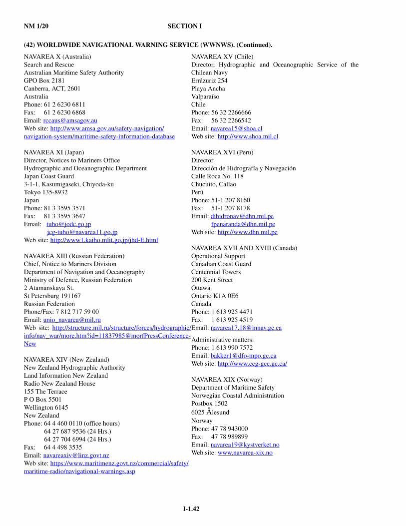
NM 1/20 SECTION I
I-1.42
(42) WORLDWIDE NAVIGATIONAL WARNING SERVICE (WWNWS). (Continued).
NAVAREA X (Australia)Search and RescueAustralian Maritime Safety AuthorityGPO Box 2181Canberra, ACT, 2601AustraliaPhone: 61 2 6230 6811Fax: 61 2 6230 6868Email: [email protected] site: http://www.amsa.gov.au/safety-navigation/navigation-system/maritime-safety-information-database
NAVAREA XI (Japan)Director, Notices to Mariners OfficeHydrographic and Oceanographic DepartmentJapan Coast Guard3-1-1, Kasumigaseki, Chiyoda-kuTokyo 135-8932JapanPhone: 81 3 3595 3571Fax: 81 3 3595 3647Email: [email protected] [email protected] site: http://www1.kaiho.mlit.go.jp/jhd-E.html
NAVAREA XIII (Russian Federation)Chief, Notice to Mariners DivisionDepartment of Navigation and OceanographyMinistry of Defence, Russian Federation2 Atamanskaya St.St Petersburg 191167Russian FederationPhone/Fax: 7 812 717 59 00Email: [email protected] site: http://structure.mil.ru/structure/forces/hydrographic/info/nav_war/more.htm?id=11837985@morfPressConference-New
NAVAREA XIV (New Zealand)New Zealand Hydrographic AuthorityLand Information New ZealandRadio New Zealand House155 The TerraceP O Box 5501Wellington 6145New ZealandPhone: 64 4 460 0110 (office hours)
64 27 687 9536 (24 Hrs.)64 27 704 6994 (24 Hrs.)
Fax: 64 4 498 3535Email: [email protected] site: https://www.maritimenz.govt.nz/commercial/safety/maritime-radio/navigational-warnings.asp
NAVAREA XV (Chile)Director, Hydrographic and Oceanographic Service of theChilean NavyErrázuriz 254Playa AnchaValparaísoChilePhone: 56 32 2266666Fax: 56 32 2266542Email: [email protected] site: http://www.shoa.mil.cl
NAVAREA XVI (Peru)DirectorDirección de Hidrografía y NavegaciónCalle Roca No. 118Chucuito, CallaoPerúPhone: 51-1 207 8160Fax: 51-1 207 8178Email: [email protected] [email protected] site: http://www.dhn.mil.pe
NAVAREA XVII AND XVIII (Canada)Operational SupportCanadian Coast GuardCentennial Towers200 Kent StreetOttawa Ontario K1A 0E6CanadaPhone: 1 613 925 4471Fax: 1 613 925 4519Email: [email protected]
Administrative matters:Phone: 1 613 990 7572Email: [email protected] site: http://www.ccg-gcc.gc.ca/ NAVAREA XIX (Norway)Department of Maritime SafetyNorwegian Coastal AdministrationPostbox 15026025 ÅlesundNorwayPhone: 47 78 943000Fax: 47 78 989899Email: [email protected] site: www.navarea-xix.no
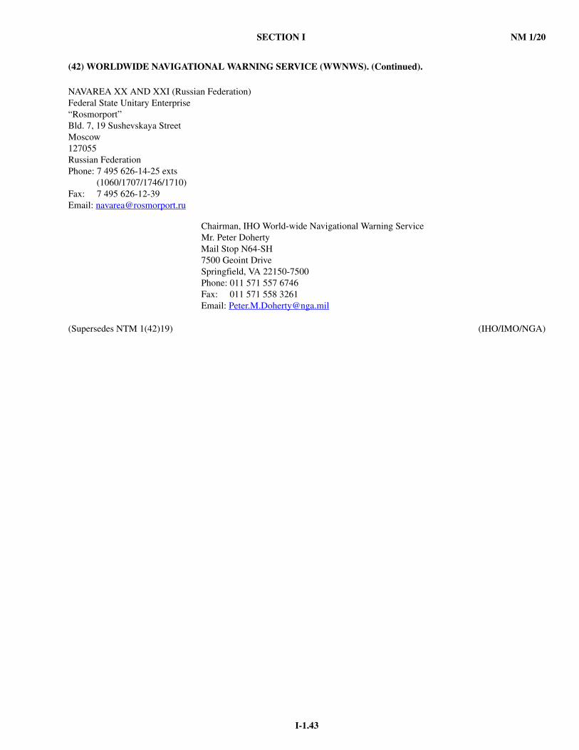
SECTION I NM 1/20
I-1.43
(42) WORLDWIDE NAVIGATIONAL WARNING SERVICE (WWNWS). (Continued).
(Supersedes NTM 1(42)19) (IHO/IMO/NGA)
NAVAREA XX AND XXI (Russian Federation)Federal State Unitary Enterprise“Rosmorport”Bld. 7, 19 Sushevskaya StreetMoscow127055Russian FederationPhone: 7 495 626-14-25 exts (1060/1707/1746/1710)Fax: 7 495 626-12-39Email: [email protected]
Chairman, IHO World-wide Navigational Warning ServiceMr. Peter DohertyMail Stop N64-SH7500 Geoint DriveSpringfield, VA 22150-7500Phone: 011 571 557 6746Fax: 011 571 558 3261Email: [email protected]
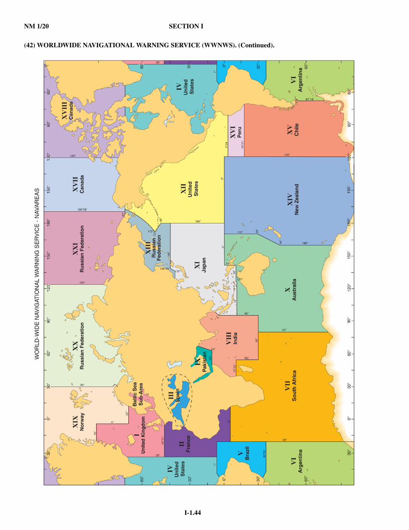
NM 1/20 SECTION I
I-1.44
(42) WORLDWIDE NAVIGATIONAL WARNING SERVICE (WWNWS). (Continued).

SECTION I NM 1/20
I-1.45
(43) WEATHER OBSERVATION REPORTS.
All ships are encouraged to participate in the international Voluntary Observing Ship (VOS) program. For information, andto arrange assistance from a U.S. National Weather Service Port Meteorological Officer (PMO) contact:
Voluntary Observing Ship ProgramNOAA/NWS Headquarters1325 East West HighwayBuilding SSMC2Silver Spring, MD 20910Telephone: (228) 688-1457Fax: (228) 688-3923email: [email protected] site: http://www.vos.noaa.gov
Details on the coding and transmission of weather observations may be found in “Observing Handbook No. 1” provided toships participating in the U.S. VOS program. The U.S. VOS program also makes available a PC software e-logbook known asTurboWin, which greatly assists in coding and transmitting VOS observations as well as providing ships the capability to par-ticipate in the USCG Automated Mutual Assistance Vessel Rescue System Program (AMVER) creating ships position report-ing, globally. http://amveruscg.blogspot.com/2012/01/what-is-amver.html
Detailed information on the dissemination of National Weather Service marine products including radiofax, such as fre-quency and scheduling information may be found in NGA Publication 117, the British Admiralty List of Radio Signals Vol-ume 3(2), and at http://www.nws.noaa.gov/om/marine/home.htm (includes links to products).
GENERAL INSTRUCTION FOR REPORTING WEATHER OBSERVATIONS
CODED WEATHER MESSAGES: All weather report messages by radio, email or Inmarsat will be coded in WorldMeteorological Organization (WMO) ship synoptic code FM13-X and/or BUFR
STANDARD SYNOPTIC OBSERVATION TIMES: The regular synoptic hours for reporting are 0000, 0600, 1200, and1800 UTC. However, watch schedules and other ship functions sometimes make it impractical to meet the synoptic weatherreporting schedule. Weather observations may also be submitted at the intermediate hours of 0300, 0900, 1500, and 2100UTC. These should be reported as soon as possible, but no later than three (3) hours after the synoptic observation time.Hourly observations are accepted as well.
TIMELINESS AND REPORT VALUE: All weather reports should be transmitted as soon as possible to the NationalWeather Service. Weather reports can be ingested by computer forecast models for only for a limited time after the reportinghour. Major computer programs are run at all synoptic hours and a few programs are run every three (3) hours. Forecasterslook at, and use, all timely reports in making their forecasts and warnings.
SPECIAL WEATHER OBSERVATIONS
TROPICAL STORMS/HURRICANES: Hurricane season has been designated June 1 through November 30 because of thenumber of tropical storms and hurricanes during the period. Many special programs are in operation during this season and itis requested that the observation schedule, when within 300 miles of a named tropical storm or hurricane, it is standard prac-tice, worldwide, to transmit weather reports every three (3) hours (00, 03, 06, 09, etc.). Hourly reports when within a storm(wind speed 48 knots or higher) or special reports for conditions not forecast, much worse than forecast, or for sudden weatherchanges) should be sent whenever conditions warrant.
SPECIAL REQUESTS FOR OBSERVATIONS: The U.S. National Weather Service may request ships located in areas ofsuspected storm development to take special observations at more frequent intervals than the routine six (6) hourly synopticobservation times. If your ship happens to be in such an area, your report will be helpful even though conditions may notappear bad enough to warrant a special observation. If the National Hurricane Center or the Environmental Prediction Centercontacts your ship directly for your local meteorological report, you can directly send them your response:[email protected] or [email protected], Central Pacific Hurricane Center Honolulu [email protected],and [email protected], which will go to the watch standers at the National Hurricane Centers as well as the Tropical Analysisand Forecast Branch, an integral part of the National Hurricane Center.
OBSERVATIONS DURING STORM CONDITIONS: Whenever TROPICAL STORM, TYPHOON, or HURRICANEconditions are encountered anywhere, “SAFETY OF LIFE AT SEA CONVENTION,” Chapter V, requires all ships to takespecial observations and transmit the report to the closest national meteorological service via the most convenient radio orInmarsat station. In addition to this requirement, it is highly desirable that weather reports be transmitted hourly, if possible;but in any case, not less frequently than every three (3) hours.

NM 1/20 SECTION I
I-1.46
(43) WEATHER OBSERVATION REPORTS. (Continued).
EXTRATROPICAL STORMS: Submit a weather report message as soon as the average wind equals or exceeds 48 knots.Report at least every three (3) hours when under STORM conditions.
COASTAL REPORTS: The weather starts changing as soon as the air moves from land out over the water. Ship weather reporting should continue as close to the coast as ship routine permits. When within 200 miles of the U.S. or Canadian coast-lines, reports are requested every three (3) hours.
TRANSMISSION OF WEATHER REPORTS
INMARSAT-B and INMARSAT-C: Instructions may be found in “Observing Handbook No. 1” andhttp://www.vos.noaa.gov/vos_resource.shtml.EMAIL TRANSMISSIONS: In addition to using INMARSAT, ships can transmit observations using email. Your weatherobservations can be emailed directly into the NWS gateway system. Send your emailed observations to: [email protected]. Tosend Weather Observations by e-mail you first must configure the E-Mail settings in TurboWin e-logbook. (Settings can befound under the Maintenance Section and is password protected. Contact your servicing PMO for the password.) If an E-Mailclient, such as Outlook, Outlook Express or Thunderbird is already installed and configured on the computer, TurboWin willuse the E-Mail client automatically. For full reference go to: http://www.vos.noaa.gov/vos_resource.shtml. The ship is respon-sible for paying email transmission costs(Repetition NTM 1(43)19) (NOAA/NWS)
(44) RADAR BEACONS (RACONs).
Radar beacons (RACONs) are radar responder devices designed to produce a distinctive image on the screens of ship'sradar sets, thus enabling the mariner to determine his position with greater certainty than would be possible using a normalradar display alone.
The U.S. Coast Guard operates approximately 70 radar beacons (RACONs) as maritime navigational aids in the GreatLakes, and off the Atlantic, Pacific, and Gulf coasts. RACONs are used to mark and identify points on shore, channel separa-tion, channel entrances under bridges, and uncharted hazards to navigation (the Morse letter “D”, dash-dot-dot, has beenreserved for this purpose). RACON marks displayed on a radar screen are Morse characters typically of length 1 to 2 miles,always start with a dash, and always extend radially outward from the radar target marked by the beacon. RACON locationsand identifications are included on most marine navigation charts.
RACONs should be visible to most commercial shipboard radar systems on vessels 6-8 miles from the RACON installa-tion, regardless of radar size. No additional receiving equipment is required. Some precautions are necessary, however, if useof RACONs is desired. Radars that operate in the 10 cm band (2900-3100 MHz) are usually installed as a second radar onlarger vessels, and may not respond to RACONs. The Coast Guard now installs dual band (3 cm and 10 cm) RACONs in mostlocations. In addition, rain clutter control switches on radars must be switched off or, if necessary, on low to ensure that theRACON is visible. Finally, most RACONs operating in the U.S. are frequency agile RACONs. Pulse correlation circuitry(interference or clutter rejection on some radars) installed on most newer radars, if on, may prevent the radar from displayingsome RACONs. This circuitry should be switched off.(Repetition NTM 1(44)19) (USCG)
(45) NAVTEX.
NAVTEX is an international automated medium frequency (518 kHz) direct-printing service for promulgation of naviga-tional and meteorological warnings and forecasts, as well as urgent marine safety information to ships. It was developed toprovide a low-cost, simple, and automated means of receiving this information aboard ships at sea within approximately 200nautical miles of a shore transmitting site. NAVTEX receivers can be configured to display desired categories of messages andto prevent duplicate printing of previously received messages. Mariners who do not have NAVTEX receivers, but have SITORradio equipment, can also receive these broadcasts by operating it in the FEC mode and tuning to 518 kHz. Internationally,NAVTEX may also broadcast on the alternate NAVTEX frequencies of 490 and 4209.5 kHz but U.S. NAVTEX stations do notbroadcast on those frequencies. For further information concerning NAVTEX including broadcast schedules, consult Pub 117,the US Coast Navigation Center web site at: https://www.navcen.uscg.gov/?pageName=NAVTEX, or the IMO GMDSS Mas-ter Plan. Additional information on NAVTEX can be found on the National Weather Service’s Marine Weather Services web-site at: http://www.nws.noaa.gov/om/marine/navtex.htm.

SECTION I NM 1/20
I-1.47
(45) NAVTEX. (Continued).
NAVAREA IV/XII, HYDROLANT, HYDROPAC, HYDROARC and ice information broadcasts are issued over HFSITOR/NBDP (Simplex Telex Over Radio/Narrow Band Direct Printing) from Coast Guard Stations in Boston, Point Reyes,Honolulu and Guam. Broadcasts are made on 6314 kHz, 8416.5 kHz, 12579 kHz, 16806.5 kHz and 22376 kHz. See NGA Pub.117, Radio Navigational Aids, for schedules.(Supersedes NTM 1(45)19) (USCG/NWS)
(46) SATELLITE DETECTION OF DISTRESS SIGNALS.
The Cospas-Sarsat system is an international cooperative program using satellites to detect distress beacons operating inthe 406.0 to 406.1 megahertz (MHz) frequency range. The Cospas-Sarsat system uses low earth orbiting (LEO) and geo-stationary orbiting (GEO) satellites. Together, these satellites enable distress signals to be received by the Cospas-Sarsat sys-tem from anywhere on the planet, 24 hours a day, 7 days a week, in many cases nearly instantaneously.
When a Cospas-Sarsat satellite receives a distress signal, it is relayed to a network of ground stations (LUTs) and MissionControl Centers (MCCs). The USMCC, operated by the National Oceanic and Atmospheric Administration (NOAA),processes signals originating in the United States' areas of responsibility, and sends alert information to the appropriate U.S.Rescue Coordination Center (RCC). There are three types of distress beacons: EPIRBs (Emergency Position Indicating RadioBeacons) for use in the maritime environment, ELTs (Emergency Locater Transmitters) used on aircraft and PLBs (PersonalLocater Beacons) for personal use. Some EPIRBs and all ELTs are capable of automatic activation, where PLBs can only beactivated manually.
EMERGENCY POSITION INDICATING RADIO BEACON (EPIRB).The Emergency Position-Indicating Radio Beacon (EPIRB) is a device, usually carried aboard maritime craft, which trans-
mits a signal that alerts search and rescue authorities and enables rescue units to locate the scene of the distress. Table 1 pro-vides an overview of the different categories of EPIRBs currently authorized for use in the U.S. Classes A, B, and S EPIRBsare no longer permitted for use within the United States and should be replaced by Cat I or Cat II 406 MHz EPIRBs.
A properly maintained 406 MHz EPIRB detected by LEO or GEO satellites will enable to the system to locate a distress towithin 5km or better on a single burst. Some 406 MHz EPIRBs also contain GPS receivers, or accept GPS information fromexternal GPS units, and encode the GPS position into the distress signal. This GPS-encoded position dramatically improvesthe location accuracy down to the 100-meter level and can, in some cases, drastically reduce the response time for rescue. Forcurrent carriage requirements, refer to Navigation and Vessel Inspection Circular No. 3-99. Any questions concerning require-ments to carry EPIRBs or other safety equipment should be referred to the U.S. Coast Guard Office of Commercial VesselCompliance (CVC) at: [email protected]. Questions regarding type approval of EPIRBs or theirhydrostatic release units should be directed to the Division of Lifesaving and Fire Safety (CG-ENG-4) at:[email protected].
TABLE 1
PERSONAL LOCATER BEACON (PLB)The Personal Locater Beacon (PLB) is a portable, individual-use distress beacon that operates much the same as an EPIRB.
These beacons are designed to be carried by an individual person. Unlike some EPIRBs, they can only be activated manually.Like EPIRBs, all U.S. PLBs also have a built-in, low-power homing beacon that transmits on 121.5 MHz. This allows rescueforces to home in on a beacon once the 406 MHz satellite system has provided its 5km position for the immediate area of dis-tress. Some PLBs also have a GPS receiver installed which encodes the position into the distress signal.
CLASS FREQUENCY DESCRIPTION DETECTION
Cat I 406 MHz with121.5 MHz homing signal
Float free automatically activated beacon
Polar, medium, and geostationary orbiting satellites
Cat II 406 MHz with121.5 MHz homing signal
Manually activated Polar, medium, and geostationary orbiting satellites
NM 1/20 SECTION I
I-1.48
(46) SATELLITE DETECTION OF DISTRESS SIGNALS. (Continued).
FALSE ALERTSDistress beacon false alarms are a major problem. The emergency beacon user must be aware of how inadvertent activa-
tions can quickly overburden search and rescue resources, resulting in costly responses and creating the potential for loss oflife. Inadvertent ELT, PLB, and EPIRB activations should be reported immediately; for accidental activations of ELT's andPLB's, call the Air Force Rescue Coordination Center at 1-800-851-3051, and for EPIRB's, contact the Coast Guard at 1-855-406-USCG (8724). Minimize false alerts with proper handling, storage, and disposal of distress beacons; understand and com-ply with manufacturer's operating and disposal instructions for your particular distress beacon; and tune a radio to 121.5 MHzto monitor the frequency/detect any inadvertent activation. Again, report any inadvertent activation of distress beacons imme-diately.
MAINTENANCEEmergency beacon owners should test their beacons in accordance with manufacturer instructions, and examine them for
water tightness, battery expiration date and registration expiration date.406 MHz emergency beacons can be tested at any time using the beacon's self-test switch only. The 121.5 MHz homing
frequency can be detected by an FM radio tuned to 99.5 MHz or an AM radio tuned to any vacant frequency and located closeto the emergency beacon.
BEACON REGISTRATION406 MHz beacon registration has been mandatory since 13 September 1994 by Federal Communications Commission reg-
ulations. All U.S. coded 406 MHz distress beacons MUST be registered with the National Oceanic and Atmospheric Adminis-tration (NOAA) which maintains the U.S. beacon registration database. Registration is free of charge, and must be renewedevery two (2) years. When a 406 MHz alert is received, the system automatically checks the beacon registration data base foran ID match and appends vital registration information (when available) to the alert message that is sent to the responsibleRCC. Registration information can be used in conjunction with the geostationary satellites immediate alerting capability toallow a SAR response 45-90 minutes sooner than otherwise possible - a significant response advantage. In rare circumstanceswhere the Cospas-Sarsat system is not able to calculate a distress position, registration data may provide the only link to res-cue. It is therefore imperative that the information in NOAA's registration database is verified by the beacon owner. Updatesor corrections can be made at any time by using the contact information below.
If you purchase a new or a used U.S. coded 406 MHz emergency beacon, you MUST register it with NOAA. If you changeany contact information (such as your phone number, address, or your emergency contact information) you MUST updateyour registration data with NOAA. If you sell your emergency distress beacon you MUST notify NOAA immediately.
You may register or update your beacon information online at: http://www.beaconregistration.noaa.gov. You may alsosubmit a 406 MHz emergency beacon registration form via mail or fax to:
DOC/NOAASARSAT BEACON REGISTRATIONNSOF, E/SPO531315 East West HwySilver Spring, MD 20910-3282
Fax: (301) 817-4565Web site: https://www.beaconregistration.noaa.gov/rgdb
Call (301) 817-4515 or toll-free (888) 212-SAVE (7283) for further information on registering 406 MHz emergencybeacons.
Once a beacon is registered, NOAA will send a proof-of-registration letter to the beacon owner to confirm registration andas ready evidence of compliance. EPIRB and PLB owners will also receive a decal that should be placed on the designatedlocation on the beacon. NOAA also contacts all registered beacon owners on a two year schedule to maintain database accu-racy. This two year contact is by email only if an email is provided in the registration; if no email is provided in the registrationthen the contact will be made through the US Postal Service to the registration address. This service is free of charge. Pleasekeep your registration current - IT MAY SAVE YOUR LIFE.(Supersedes NTM 1(46)19) (USCG/NOAA)

SECTION I NM 1/20
I-1.49
(47) HF AND VHF RADIOTELEPHONE AND RADIOTELEX MARINE SAFETY BROADCASTS.
Urgent and routine broadcasts of marine safety information are announced on VHF Channel 16 (156.8 MHz) and made onChannel 22A (157.1 MHz), the ship station transmit frequency portion of Channel 22, of Appendix 18 of the InternationalTelecommunications Union (ITU) Radio Regulations.
The U.S. Coast Guard (USCG) normally broadcasts selected coastal weather and local navigational warnings on VHF FMChannel 22A (157.1 MHz). In areas where NOAA Weather Radio broadcasts provide complete overlapping coverage of theU.S. Coast Guard VHF network, the U.S. Coast Guard may elect to broadcast warnings only and not routinely broadcast NWSmarine forecasts.
The USCG does not support Medium Frequency (MF) services and encourages the public mariner to use more modernsafety and distress services which can be more reliably received by the U.S. Coast Guard.
The USCG will continue to maintain a continuous watch on VHF FM channel 16 (156.8 MHz) and on existing voice andDSC frequencies in the 4/6/8/12 and 16 MHz bands as described in the Coast Guard Navigation Center website:https://www.navcen.uscg.gov/?pageName=cgcommsCall.
Questions and comments concerning VHF marine safety broadcasts should be addressed to the local Coast Guard Districtstaff, or to:
United States Coast GuardCOMMANDANT (CG-652)Stop 77102703 Martin Luther King Jr. Ave. SEWashington, DC 20593-7710
(Supersedes NTM 1(47)19) (USCG)
(48) INLAND NAVIGATION RULES.
CARRIAGE: The operator of each self-propelled vessel, 12 meters or more in length, is required to carry on boardand maintain for ready reference, a copy of the Inland Navigation Rules. The U.S. Coast Guard (USCG) has developed a moreprinter friendly edition of the combined Inland Navigation Rules and Convention on the International Regulations for Prevent-ing Collisions at Sea, 1972 (COLREGS), that allows mariners to meet this basic carriage requirement in addition to those othermethods described by this section. The "Amalgamated Version" of the Rules follows, and, provides a more printer friendlymethod (~20 pages) to access the information traditionally found in the U.S. Coast Guard Navigation Rules and RegulationsHandbook. The Amalgamated Edition of the 72 COLGRES and Inland Navigation Rules are maintained and updated by theUSCG Office of Navigation Systems (the same office that produces/updates the handbook). Mariners may print their own copyfrom the USCG NAVCEN website: https://www.navcen.uscg.gov/?pageName=NavRulesAmalgamated.
Another copy of this Amalgamation is also provided in Appendix B of each volume of National Oceanic and Atmo-spheric Administration's (NOAA) - United States Coast Pilot: https://nauticalcharts.noaa.gov/publications/coast-pilot/index.html. If you prefer the traditional side-by-side International/Inland format, The Navigation Rules and Regulations Hand-book (ISBN: 9780160925665) is available to download for free at: https://www.navcen.uscg.gov/pdf/navRules/Handbook/CG_NRHB_20190212.pdf. The Government Publishing Office provides a print-on-demand service, as do several commercialpublishers.
As per USCG Navigation and Vessel Inspection Circular NVIC 01-16 Ch-1, electronic carriage of the Inland Naviga-tion Rules is not currently authorized. However, the potential for allowing electronic carriage of the Nav Rules as equivalent tohard copy carriage (for the purposes of carriage requirements only) is currently under review by the USCG.
CHANGES: Changes are published, as they occur, in the Notice to Mariners; and appear in Summary of Corrections(Volume 5). A record of changes is maintained online at: https://www.navcen.uscg.gov/pdf/CG_NRHB_20181106_Corrigen-dum.pdf. For questions concerning the Navigation Rules: Email: [email protected] Phone: (202) 372-1565.
(Supersedes NTM 1(48)19) (USCG)
(49) GUIDELINES FOR WGS DATUM CONVERSION.
1. The following information is provided to assist navigators in converting geographic positions from World Geodetic System1972 (WGS 72) to World Geodetic System 1984 (WGS 84) and vice versa:a. Positions obtained from satellite navigation systems or measured from charts referred to the World Geodetic System
1972 must be moved 0.01 minute eastward and 0.00 minute northward to be placed on the World Geodetic System 1984.b. Positions obtained from satellite navigation systems (or charts) referred to the World Geodetic System 1984 must be
moved 0.01 minutes westward and 0.00 minutes southward to be placed on the World Geodetic System 1972.
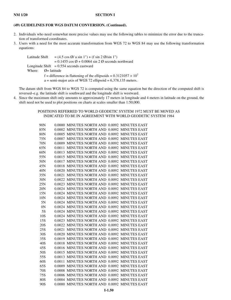
NM 1/20 SECTION I
I-1.50
(49) GUIDELINES FOR WGS DATUM CONVERSION. (Continued).
2. Individuals who need somewhat more precise values may use the following tables to minimize the error due to the trunca-tion of transformed coordinates.
3. Users with a need for the most accurate transformation from WGS 72 to WGS 84 may use the following transformationequations:
Latitude Shift = (4.5 cos Ø/ a sin 1") + (f sin 2 Ø/sin 1")= 0.1455 cos Ø + 0.0064 sin 2 Ø seconds northward
Longitude Shift = 0.554 seconds eastwardWhere: Ø= latitude
f = difference in flattening of the ellipsoids = 0.3121057 × 10⁷
a = semi-major axis of WGS 72 ellipsoid = 6,378,135 meters.
The datum shift from WGS 84 to WGS 72 is computed using the same equation but the direction of the computed shift isreversed–e.g. the latitude shift is southward and the longitude shift is westward.
4. Since the maximum shift only amounts to approximately 17 meters in longitude and 4 meters in latitude on the ground, theshift need not be used to plot positions on charts at scales smaller than 1:50,000.
POSITIONS REFERRED TO WORLD GEODETIC SYSTEM 1972 MUST BE MOVED ASINDICATED TO BE IN AGREEMENT WITH WORLD GEODETIC SYSTEM 1984
90N 0.0000 MINUTES NORTH AND 0.0092 MINUTES EAST85N 0.0002 MINUTES NORTH AND 0.0092 MINUTES EAST80N 0.0005 MINUTES NORTH AND 0.0092 MINUTES EAST75N 0.0007 MINUTES NORTH AND 0.0092 MINUTES EAST70N 0.0009 MINUTES NORTH AND 0.0092 MINUTES EAST65N 0.0011 MINUTES NORTH AND 0.0092 MINUTES EAST60N 0.0013 MINUTES NORTH AND 0.0092 MINUTES EAST55N 0.0015 MINUTES NORTH AND 0.0092 MINUTES EAST50N 0.0017 MINUTES NORTH AND 0.0092 MINUTES EAST45N 0.0018 MINUTES NORTH AND 0.0092 MINUTES EAST40N 0.0020 MINUTES NORTH AND 0.0092 MINUTES EAST35N 0.0021 MINUTES NORTH AND 0.0092 MINUTES EAST30N 0.0022 MINUTES NORTH AND 0.0092 MINUTES EAST25N 0.0023 MINUTES NORTH AND 0.0092 MINUTES EAST20N 0.0024 MINUTES NORTH AND 0.0092 MINUTES EAST15N 0.0024 MINUTES NORTH AND 0.0092 MINUTES EAST10N 0.0024 MINUTES NORTH AND 0.0092 MINUTES EAST
5N 0.0024 MINUTES NORTH AND 0.0092 MINUTES EAST0N 0.0024 MINUTES NORTH AND 0.0092 MINUTES EAST5S 0.0024 MINUTES NORTH AND 0.0092 MINUTES EAST
10S 0.0024 MINUTES NORTH AND 0.0092 MINUTES EAST15S 0.0023 MINUTES NORTH AND 0.0092 MINUTES EAST20S 0.0022 MINUTES NORTH AND 0.0092 MINUTES EAST25S 0.0021 MINUTES NORTH AND 0.0092 MINUTES EAST30S 0.0020 MINUTES NORTH AND 0.0092 MINUTES EAST35S 0.0019 MINUTES NORTH AND 0.0092 MINUTES EAST40S 0.0018 MINUTES NORTH AND 0.0092 MINUTES EAST45S 0.0016 MINUTES NORTH AND 0.0092 MINUTES EAST50S 0.0015 MINUTES NORTH AND 0.0092 MINUTES EAST55S 0.0013 MINUTES NORTH AND 0.0092 MINUTES EAST60S 0.0011 MINUTES NORTH AND 0.0092 MINUTES EAST65S 0.0009 MINUTES NORTH AND 0.0092 MINUTES EAST70S 0.0008 MINUTES NORTH AND 0.0092 MINUTES EAST75S 0.0006 MINUTES NORTH AND 0.0092 MINUTES EAST80S 0.0004 MINUTES NORTH AND 0.0092 MINUTES EAST90S 0.0000 MINUTES NORTH AND 0.0092 MINUTES EAST

SECTION I NM 1/20
I-1.51
(49) GUIDELINES FOR WGS DATUM CONVERSION. (Continued).
POSITIONS REFERRED TO WORLD GEODETIC SYSTEM 1984 MUST BE MOVED ASINDICATED TO BE IN AGREEMENT WITH WORLD GEODETIC SYSTEM 1972
90N 0.0000 MINUTES SOUTH AND 0.0092 MINUTES WEST85N 0.0002 MINUTES SOUTH AND 0.0092 MINUTES WEST80N 0.0005 MINUTES SOUTH AND 0.0092 MINUTES WEST75N 0.0007 MINUTES SOUTH AND 0.0092 MINUTES WEST70N 0.0009 MINUTES SOUTH AND 0.0092 MINUTES WEST65N 0.0011 MINUTES SOUTH AND 0.0092 MINUTES WEST60N 0.0013 MINUTES SOUTH AND 0.0092 MINUTES WEST55N 0.0015 MINUTES SOUTH AND 0.0092 MINUTES WEST50N 0.0017 MINUTES SOUTH AND 0.0092 MINUTES WEST45N 0.0018 MINUTES SOUTH AND 0.0092 MINUTES WEST40N 0.0020 MINUTES SOUTH AND 0.0092 MINUTES WEST35N 0.0021 MINUTES SOUTH AND 0.0092 MINUTES WEST30N 0.0022 MINUTES SOUTH AND 0.0092 MINUTES WEST25N 0.0023 MINUTES SOUTH AND 0.0092 MINUTES WEST20N 0.0024 MINUTES SOUTH AND 0.0092 MINUTES WEST15N 0.0024 MINUTES SOUTH AND 0.0092 MINUTES WEST10N 0.0024 MINUTES SOUTH AND 0.0092 MINUTES WEST5N 0.0024 MINUTES SOUTH AND 0.0092 MINUTES WEST0N 0.0024 MINUTES SOUTH AND 0.0092 MINUTES WEST5S 0.0024 MINUTES SOUTH AND 0.0092 MINUTES WEST
10S 0.0024 MINUTES SOUTH AND 0.0092 MINUTES WEST15S 0.0023 MINUTES SOUTH AND 0.0092 MINUTES WEST20S 0.0022 MINUTES SOUTH AND 0.0092 MINUTES WEST25S 0.0021 MINUTES SOUTH AND 0.0092 MINUTES WEST30S 0.0020 MINUTES SOUTH AND 0.0092 MINUTES WEST35S 0.0019 MINUTES SOUTH AND 0.0092 MINUTES WEST40S 0.0018 MINUTES SOUTH AND 0.0092 MINUTES WEST45S 0.0016 MINUTES SOUTH AND 0.0092 MINUTES WEST50S 0.0015 MINUTES SOUTH AND 0.0092 MINUTES WEST55S 0.0013 MINUTES SOUTH AND 0.0092 MINUTES WEST60S 0.0011 MINUTES SOUTH AND 0.0092 MINUTES WEST65S 0.0009 MINUTES SOUTH AND 0.0092 MINUTES WEST70S 0.0008 MINUTES SOUTH AND 0.0092 MINUTES WEST75S 0.0006 MINUTES SOUTH AND 0.0092 MINUTES WEST80S 0.0004 MINUTES SOUTH AND 0.0092 MINUTES WEST90S 0.0000 MINUTES SOUTH AND 0.0092 MINUTES WEST
(Repetition NTM 1(49)19) (NGA)
(50) ANTI-SHIPPING ACTIVITY MESSAGES.
The Anti-Shipping Activity Message (ASAM) database, a part of the Maritime Safety Web site is a National Geospatial-Intelligence Agency service for mariners providing reports of hostile actions directed against ships. The ASAM database wasdeveloped at the request of the U.S. Interagency Working Group on Piracy and Maritime Terrorism. It contains randomreports of various forms of aggression against shipping around the world. Events are categorized by date and by geographicarea and are based on the NGA subregion system. The user can submit an ASAM, with the full particulars of an incident to bereported, or search the existing ASAM database by user-defined queries via the Maritime Safety Web site:https://msi.nga.mil/PiracyUpon receipt of the ASAM at NGA, the text is reviewed and evaluated for further action, edited, and stored in the ASAMdatabase for access by all customers.
The database can be used as a voyage planning tool by providing cautionary information to ship owners and masters con-cerning security conditions in and near ports and narrow channels around the world. ASAMs can also be downloaded asKMZ, Arc shapefiles and/or personal Geodatabase zip files.
NM 1/20 SECTION I
I-1.52
(50) ANTI-SHIPPING ACTIVITY MESSAGES. (Continued).
Examples of ASAM Reports in this file include the ACHILLE LAURO incident, robberies of ships transiting the MalaccaStraits, attacks on fishing boats and merchant ships sailing off the coast of Western Sahara, and certain events occurring inand around the Persian Gulf.
When sending a hostile action report, the user of ASAM should provide NGA with as much of the following informationas is possible:
1. Date of Occurrence;2. Geographic Location; 3. Known or Suspected Aggressor;4. Victim (Ship’s) Name;5. A detailed description of the occurrence being reported.
For further information on the ASAM database, users may contact (571) 557-8080 or write:
MARITIME SAFETY OFFICEMAIL STOP N64-SFHNATIONAL GEOSPATIAL-INTELLIGENCE AGENCY7500 GEOINT DRIVESPRINGFIELD, VA 22150-7500
Note that the ASAM file is only an indicator of hostile actions reported to NGA and is not a complete listing of allhostile actions that have occurred worldwide. NGA strongly urges the mariner to assist in the population of the ASAM data-base by sending reports of hostile actions.(Supersedes NTM 1(50)19) (NGA/SFHG)
(51) CAUTION ON ANNOUNCEMENT OF NEW CHARTS AND PUBLICATIONS.
CAUTION: DO NOT USE A NEW CHART OR PUBLICATION UNTIL IT IS ANNOUNCED IN NOTICE TOMARINERS. There may be occasions when a new edition of a chart or publication is received prior to the official announce-ment of its release being published in the U.S. Notice to Mariners. Since Notice to Mariners corrections are for specific edi-tions of products, it is imperative that the user neither discard the previous edition nor use the new edition until this officialannouncement is received. Further, since Notice to Mariners corrections are for specific editions of products, it is critical thatthe user update only the specifically-referenced product edition. Additionally, users of the NGA Web site are advised thatannouncements of new editions in this system appear approximately one week ahead of the date of the published Notice toMariners.(Repetition NTM 1(51)19) (NGA/SFHG)
(52) GLOBAL POSITIONING SYSTEM (GPS) AND DIFFERENTIAL GPS (DGPS) INFORMATION.
The Global Positioning System (GPS) is a satellite-based radionavigation system with continuous worldwide coverage. Itprovides position, navigation, and timing (PNT) signals to users across the globe. GPS is operated and controlled by the U.S.Department of Defense (DoD) under United States Air Force (USAF) management. The USAF develops, maintains, and oper-ates the space and control segments. United States Code has established that the GPS Standard Positioning Service (SPS) willbe available for peaceful civil, commercial, and scientific uses on a continuous worldwide basis free of direct user fees. TheU.S. Department of Transportation is the Government's interface for civil users of GPS and works closely with the U.S. CoastGuard to disseminate information to the public. In an effort to meet the needs of civil users, the Coast Guard operates the Nav-igation Information Service (NIS), as a part of the Coast Guard Navigation Center (NAVCEN) located in Alexandria, Vir-ginia. GPS information provided includes: planned, current, or recent satellite outages, GPS constellation changes,Operational Advisory messages, system status, YUMA/SEM Almanac data, and GPS testing notices. Whenever possible,advance notice of GPS satellite outages will be provided by the DoD and made available by the U.S. Coast Guard. The DoDprovides at least 48-hour advance notice for any planned disruption of the Standard Positioning Service (SPS) in peacetime.Specific information regarding Air Force dissemination of GPS information to the public can be found in GPS Interface Con-trol Document (ICD) ICD-GPS-240. The NAVCEN website is updated when new information is received. NIS services aredescribed below:

SECTION I NM 1/20
I-1.53
(52) GLOBAL POSITIONING SYSTEM (GPS) AND DIFFERENTIAL GPS (DGPS) INFORMATION. (Continued).
1. GPS constellation and status information is available on the NAVCEN website at: https://navcen.uscg.gov. Notice Adviso-ries to Navstar Users (NANU) and the daily GPS Operational Advisory are also provided through an email subscriptionservice. Watchstanders are available 24 hours a day for assistance via phone (703) 313-5900.
2. The NIS disseminates GPS Operational Advisory information through USCG broadcast stations using VHF-FM voice andNAVTEX broadcasts. The broadcasts provide GPS users in the marine environment with satellite advisory informationthat could affect GPS navigational accuracy. Information is provided in message format via an established system of mes-sage dissemination. NIS provides the GPS Operational Advisory Broadcast information to NGA for broadcast in NAVA-REA, HYDROLANT, HYDROPAC and HYDROARC messages. These messages are generally geared to the deep draftmariner. NGA also publishes a Weekly Notice to Mariners (NTM) containing USCG Marine Information Broadcasts andNGA broadcast warnings for a seven-day period. NAVCEN also publishes GPS information on a weekly basis on theNAVCEN website at: https://www.navcen.uscg.gov/pdf/gps/gpsnotices/GPS_Interference.pdf. The NIS also responds toreports of GPS disruptions by receiving and processing reports made by civil GPS users through the NAVCEN website at:https://www.navcen.uscg.gov/?pageName=gpsUserInput.
To comment on any of these services or ask questions about GPS status, contact the NIS at:
COMMANDING OFFICERUSCG NAVCEN MS 73107323 TELEGRAPH ROADALEXANDRIA, VA 20598-7310Phone: (703) 313-5900GPS Status Recording: (703) 313-5907Email: [email protected]: https://navcen.uscg.govOnline Contact Form: https://www.navcen.uscg.gov/?pageName=contactUs.
The Civil GPS Service Interface Committee (CGSIC) was established to address issues and problems that relate to the civiluse of GPS. The CGSIC is an official interface between civil GPS users and the GPS operators in DoD. The U.S. Departmentof Transportation, Office of the Assistant Secretary for Research and Technology, Chairs the CGSIC. The U.S. Coast GuardNavigation Center (NAVCEN) is the Deputy Chair and administrator.
The CGSIC meets annually and is open to anyone interested in civil GPS issues. Additional pertinent information isreleased throughout the year via an e-mail mailing list. There is no fee to attend a CGSIC meeting or to join the mailing list.Full presentations from CGSIC meetings are available on the CGSIC portion of the GPS.gov website. Input from CGSICmeetings is provided to United States GPS authorities for consideration in GPS policy development and GPS service opera-tion. Visit the GPS.gov website at: https://www.gps.gov/cgsic/.
Additional information can be provided by contacting:
CGSIC EXECUTIVE SECRITARIATCOMMANDING OFFICERUSCG NAVCEN MS 73107323 TELEGRAPH ROADALEXANDRIA, VA 20598-7398Phone: (703) 313-5900Website: https://navcen.uscg.govOnline Contact Form: https://www.navcen.uscg.gov/?pageName=contactUs.
DISCONTINUANCE OF DGPS SERVICEThe U.S. Coast Guard will discontinue service from its remaining 38 Differential Global Positioning Service (DGPS) over
the next three years. This staged reduction of the remaining DGPS broadcast service sites will begin in 2018 and end with thecurtailment of the Coast Guard broadcast of GPS corrections over medium frequency in 2020.
Due to the increasing accuracy and integrity of the Global Positioning System (GPS), the Coast Guard no longer has a mis-sion requirement for DGPS. Specifically, GPS provides sufficient positional accuracy to meet international navigation require-ments for harbor approaches and to position Federal Aids to Navigation (ATON). Additionally, other commercial andgovernment GPS augmentation systems are available for GPS users. The accuracy of un-augmented GPS increasingly exceeds

NM 1/20 SECTION I
I-1.54
(52) GLOBAL POSITIONING SYSTEM (GPS) AND DIFFERENTIAL GPS (DGPS) INFORMATION. (Continued).
the 10-meter accuracy requirements for harbor navigation and harbor approaches.The DGPS service has begun discountenance in early 2018 and will continue in a phased manner by FY 2020. The Coast
Guard will release the actual broadcast termination dates via local Notice to Mariners. Information concerning DGPS statusand termination status is disseminated through local USCG Broadcast Notice to Mariners, NAVTEX broadcasts, and via thewebsite: https://www.navcen.uscg.gov/?pageName=dgpsMain.(Repetition NTM 1(52)19) (USCG)
(53) DIGITAL SELECTIVE CALLING DISTRESS ALERT.
Digital Selective Calling (DSC) is a capability offered with some VHF and HF maritime radios, intended to initiate callsand provide distress alert information to the U.S. Coast Guard and other rescue coordination centers. DSC is a major elementof the Global Maritime Distress and Safety System (GMDSS), an International Maritime Organization-mandated telecommu-nications system required on vessels subject to the provisions of the Safety of Life at Sea Convention (SOLAS). All SOLASvessels are required to interconnect their GPS with their DSC radios to provide an accurate position in the event of sending adistress alert. The interconnection of the DSC radio with the GPS is required for SOLAS vessels and is required by the Inter-national Telecommunications Union for non-SOLAS vessels. When a DSC distress call is received the radio shall be changedto the corresponding voice working channel. Continue listening on the working channel to ensure communications betweenthe Coast Guard and ship in distress is established. In the event communications are not heard between the vessel in distressand the Coast Guard, advise the Coast Guard by any means available.
Coast Guard Communications Command and other select Coast Guard Stations operate VHF, HF and DSC, and can bereached using the Maritime Mobile Service Group Identity (MMSI) 003669999. The United States has declared GMDSS SeaArea A1. After careful consideration, the United States has determined it will NOT declare a GMDSS Sea Area A2 now or inthe future. Continue listening on the working channel to ensure communications between the Coast Guard and ship in distressis established. In the event communications are not heard between the vessel in distress and the Coast Guard, advise the CoastGuard by any means available.(Repetition NTM 1(53)19) (USCG)
(54) VESSEL SQUAT IN SHALLOW WATER.
The following discussion is primarily aimed towards mariners who are navigating ocean-going commercial vessels onapproaches to ports, where water depths are beginning to shoal (less than 3 times the ship’s draft). The discussion describes thephenomenon of “squat” and is intended to help mariners recognize circumstances where it could significantly affect the navi-gational draft of their vessels.
In August 1992, a 950-foot passenger liner transiting past Martha’s Vineyard ran over two uncharted boulders at a speed ofnearly 25 knots. The vessel’s deepest calculated draft was 32 ft 4 inches at the bow; the general charted water depth in the areawas 39 feet, although the water depths over the boulders were determined to be 33.4 and 34.2 feet. One major contributing fac-tor was that neither the master nor pilot adequately judged the considerable squatting effect caused by the high-speed transit inrelatively shallow waters (which were only about 1.22 times the ship’s draft). The casualty investigation determined that squathad increased the bow draft by at least 2.7 feet.
DISCUSSION OF SQUAT: The term “squat” describes the combination of sinkage (overall settling of the hull) and trim(the bow up/down rotation of the hull). This phenomenon occurs in waters of any depth, but is particularly affected by proxim-ity to the sea floor. Therefore, the effects of squat become more pronounced in shallow and/or restricted waters (such as canalsor dredged channels). As a ship moves forward in shallow water, the displaced water must quickly flow around and under thehull to fill the void left behind. This accelerated water flow affects the pressure distribution along the hull. Consequently, thevessel squats, effectively increasing its draft and trim. Depending upon the vessel’s speed and hull form, the ship may trim byeither the bow or the stern. Generally, full-bodied hulls (where the block coefficient Cb is greater than 0.7, such as tankers)tend to trim by the bow, whereas fine-bodied hulls (such as container ships) tend to trim by the stern.
SHALLOW WATER EFFECTS: Shallow water affects a ship in two manners: squat (which increases the effective draft atbow and/or stern), and maneuverability (which reduces maneuvering responses compared to open, deep water performance).These effects increase with vessel speed and decreasing water depth.
CALCULATION OF SQUAT: Squat is a function of the vessel’s speed through the water, the ratio of ship draft to waterdepth, the ratio of cross-sectional areas of the hull and channel, the block coefficient of the hull, and other factors. Formulas for
SECTION I NM 1/20
I-1.55
(54) VESSEL SQUAT IN SHALLOW WATER. (Continued).
predicting squat for any particular ship are complex and may not be practical for direct use by mariners. However, a useful“rule of thumb” can be used as long as mariners understand its limitations, as discussed below. In general, shallow watereffects can begin to appear when water depth is less than 3 times the vessel’s draft, and can become significant when the waterdepth is less than 1.5 times the draft. For a ship in unrestricted shallow water (i.e., not within the confines of a dredged channelor canal), a conservative rule-of-thumb for estimating squat is:
S = 0.033CbV2
[where: S = squat (ft), V = ship speed, including any head current (knots), and Cb = block coefficient of hull]. Forexample: at 15 knots, the squat for a container ship (Cb = 0.60) proceeding against a 1-knot head current would beapproximately 5.1 feet and for a tanker (Cb = 0.85) would be approximately 7.2 feet.
The estimated squat should be added to the deepest calculated draft of the vessel (bow or stern). This rule-of-thumb conser-vatively overestimates the squat of a ship and is therefore considered to be safe for operational decisions.
However, the above rule-of-thumb equation is valid only when the ship’s speed is not excessive for the water depth. Specifi-cally, the speed must be less than:
V<2.52 x SQRT(d)[where V = ship speed (kts), and SQRT(d) = square root of the water depth “d” (ft)]. For example: in 50 feet of water,the above squat estimate is valid only if the ship’s speed is less than 17.8 knots. If the ship’s speed is faster than thelimiting speed, then the squat prediction is no longer reliable and a greater squat should be assumed.
As the ship moves into shallower water, the limiting speed will decrease. For example, in 30 feet of water, the limitingspeed for the rule-of-thumb decreases to 13.8 knots. Therefore, if the ship maintains a constant speed as it proceeds into shal-lower water, it may eventually exceed the limiting speed and experience a significant increase in squat:
If the block coefficient Cb is not known, it may be approximated as follows:
Cb = 35Disp/(LxBxT)[where Disp = full-load displacement (long tons), L = length between perpendiculars (ft), B = beam (ft), and T = fullload draft (ft)]. For example, the block coefficient Cb of a container ship 810′L x 106′B x 36′T with a full-load dis-placement of 51,710 Ltons is approximately 0.59.
UNDERKEEL CLEARANCE: When evaluating the underkeel clearance in shallow waters, mariners are advised to alsotake into account the wave-induced motions of the ship (heave and pitch), the uncertainty within their own draft & trim calcu-lations, as well as a prudent margin for uncertainty in the charted water depths (even modern hydrographic surveys may notlocate all sea floor obstructions or the shallowest depths). In particular, sudden changes in water depth (such as passing over ashoal area) can cause transient squat effects that can be more substantial than predicted. Similarly, sudden changes in shipspeed (acceleration or deceleration) can also cause transient changes in squat. For broad-beamed ships with a relatively “ten-der” rolling periods (such as modern, post-Panamax container ships), rolling motions can significantly increase drafts at thebilges, in addition to the effects of squat.
MANEUVERABILITY AND SPEED: In addition to squat, mariners should also be aware that shallow water may increaseturning diameter of the vessel. Modeling of tankers has shown an increase in turning diameter of 60% to 100% in water lessthan 1.25 times the ship's draft. Hydrodynamic effects such as yawing and sheering should also be taken into account in shal-low and restricted waters, especially when passing another vessel.
Also, the vessel will require substantially more revolutions to maintain the same speed (during sea trials with a 270-footdestroyer drawing 8 feet of water, the ship required 400 rpm to reach 22 knots in 100 feet of water, but nearly 500 rpm to main-tain the same speed in 45 feet of water).
RESTRICTED WATERS: When the ship is transiting shallow restricted waters (such as a dredged channel within a shal-low bay), the hydrodynamic flow around the hull is confined by the banks of the channel, creating a different pressure distribu-tion and aggravating the squat condition (usually by increasing the stern squat). The squat estimated by the above “rule ofthumb” should be doubled. Maneuverability is also further degraded; which is of particular concern when passing (meeting orovertaking) another vessel in the waterway or when maneuvering near banks or in channel curves.
NM 1/20 SECTION I
I-1.56
(54) VESSEL SQUAT IN SHALLOW WATER. (Continued).
RECOGNIZING SHALLOW WATER EFFECTS: Signs that a ship has entered shallow water conditions can include oneor more of the following:
- Vibration increases suddenly,- Engine loads down and revolutions decrease,- Wavemaking increases, especially at the bow,- Ship becomes more stable and slower to respond to controls,- Echo sounders indicate a change in clearance or depth,- The shaft horsepower (shp) speed decreases at the same engine revolutions,- Water flow around the ship changes, and water color darkens (possibly indicating entrained mud).
REGULATIONS: The Code of Federal Regulations (CFR) requires that the person directing the movement of the vessel setthe vessel’s speed with consideration for the tendency of the vessel underway to squat and suffer impairment of maneuverabilitywhen there is small underkeel clearance [33 CFR 164.11(p)(3)]. In addition, the International Maritime Organization recommendsthat ships be provided with a bridge poster, a pilot card, and a maneuvering booklet. These should include information on the squatand maneuvering characteristics for that particular vessel [see also USCG Navigation Safety Inspection Circular 7-89].
For more information, contact:
Commandant, U.S. Coast GuardNaval Architecture Division (CG-ENG-2)2703 Martin Luther King Jr Ave, S.E.Washington, D.C. 20593-7509Telephone: (202) 372-1370
(Repetition NTM 1(54)19) (USCG)
(55) PROMULGATION OF MARITIME SAFETY INFORMATION BY U.S. INFORMATION PROVIDERS.
The purpose of this information is to provide mariners with the details of the promulgation of Maritime Safety Information(MSI) via the Global Maritime Distress and Safety System (GMDSS) by U.S. information providers, namely the NationalGeospatial-Intelligence Agency (NGA), the U.S. Coast Guard (USCG), and the National Weather Service (NWS).
Mariners should consult PUB 117, the SafetyNet Users Handbook (available at:http://www.iho.int/mtg_docs/International_Organizations/IMO/SafetyNET.pdf); IMO GMDSS Master Plan, or the U.S. CoastGuard Navigation Center web site at: https://www.navcen.uscg.gov.(Repetition NTM 1(55)19) (USCG)

SECTION I NM 1/20
I-1.57

NM 1/20 SECTION I
I-1.58
(56) COAST GUARD SAFETY INFORMATION AVAILABLE ON INTERNET.
USCG Navigation Center website provides information for radionavigation and maritime telecommunications systems.Access to general information and, as appropriate, current operational status, and effective policies for Global Positioning Sys-tem (GPS), Nationwide Differential GPS (NDGPS), Universal Shipborne Automatic Identification System (AIS), Long RangeIdentification and Tracking (LRIT), and the Global Maritime Distress and Safety System (GMDSS), including NAVTEX,Digital Selective Calling (DSC), Inmarsat SafetyNET, and other Maritime Safety Information (MSI) broadcasts can be madedirectly, at no charge, via the Internet at: https://www.navcen.uscg.gov.
Various marine safety information products can be obtained via email subscription through the USCG Navigation Cen-ter Web site at: https://www.navcen.uscg.gov/?pageName=feeds. In addition, information regarding annual Light Lists inPDF format as well as weekly Light List information in PDF and XML format can be found at:https://www.navcen.uscg.gov/?pageName=lightLists. Mariners are encouraged to report all degradation, outages, or otherincidents or anomalies of radionavigation services to the U.S Coast Guard Navigation Center at: https://navcen.uscg.gov orphone: (703) 313-5900.(Repetition NTM 1(56)19) (USCG)
(57) NATIONAL OCEAN CLAIMS.
The following list shows national claims of maritime jurisdiction. Publication of this material is solely for information rel-ative to the navigational safety of shipping and in no way constitutes legal recognition by the United States. The informationhas been compiled from the best available sources.
Country Territorial Sea Contiguous Zone
Fisheries or Economic
Zone
Continental Shelf
Albania 12* --- 15 Defined by coordi-nates, 200m or E
Algeria 12* 24 32-52 Equidistant
Angola 12 24 200 200NM or CM
Antigua and Barbuda** 12* 24 200 200NM or CM
Argentina 12* (1) 24 200 200NM or CM
Australia 12 (2) 24 200 200NM or CM
Bahamas, The** 12 --- 200 200m or E
Bahrain 12 24 --- ---
Bangladesh 12* 18 (3) 200 CM
Barbados 12* --- 200 200NM or CM
Belgium 12 24 Defined by coordinates (4)
Equidistant (4)
Belize 12 (5) --- 200 ---
Benin 12 (82) --- 200 (82) 200 (82)
Bosnia and Herzegovina --- (6) --- --- ---

SECTION I NM 1/20
I-1.59
(57) NATIONAL OCEAN CLAIMS. (Continued).
Country Territorial Sea Contiguous Zone
Fisheries or Economic
Zone
Continental Shelf
Brazil 12* (7) 24 200 (7) 200NM or CM
Brunei 12 --- 200 (8) 200NM or CM (83)
Bulgaria 12 (9) 24 200 200m or E (9)
Burma 12* (10) 24 (10) 200 200NM or CM
Cambodia 12* 24 (11) 200 200NM (11)
Cameroon 12 24 200 (12) 200NM or CM
Canada 12 (13) 24 200 200NM or CM
Cabo Verde** 12* 24 200 Defined bycoordinates (95)
Chile 12 24 200 200/350NM (14)
China 12* 24 (15) 200 (15) 200NM or CM
Colombia 12 24 (93) 200 200NM
Comoros** 12 --- 200 200NM or CM
Congo, Republic of the 12* --- 200 200NM or CM
Congo, Democratic Republic of the (formerly Zaire)
12 200 (16) 200NM/350NM (16)
Cook Islands 12 --- 200 200NM or CM
Costa Rica 12 --- 200 (17) 200NM or CM
Côte d’Ivoire 12 24 200 Defined bycoordinates
Croatia 12* --- 200 (18) 200m or E
Cuba 12 (19) 24 200 200NM or CM
Cyprus 12 24 200 (89) 200m or E
Denmark 12* (20) 24 200 200m or E
Djibouti 12 (21) 24 200 ---
Dominica 12 24 200 ---
Dominican Republic** 12 (22) 24 200 200NM or CM
Ecuador 12 --- 200 200NM (23)
Egypt 12* (24) 24 (24) 200 (89) 200m or E
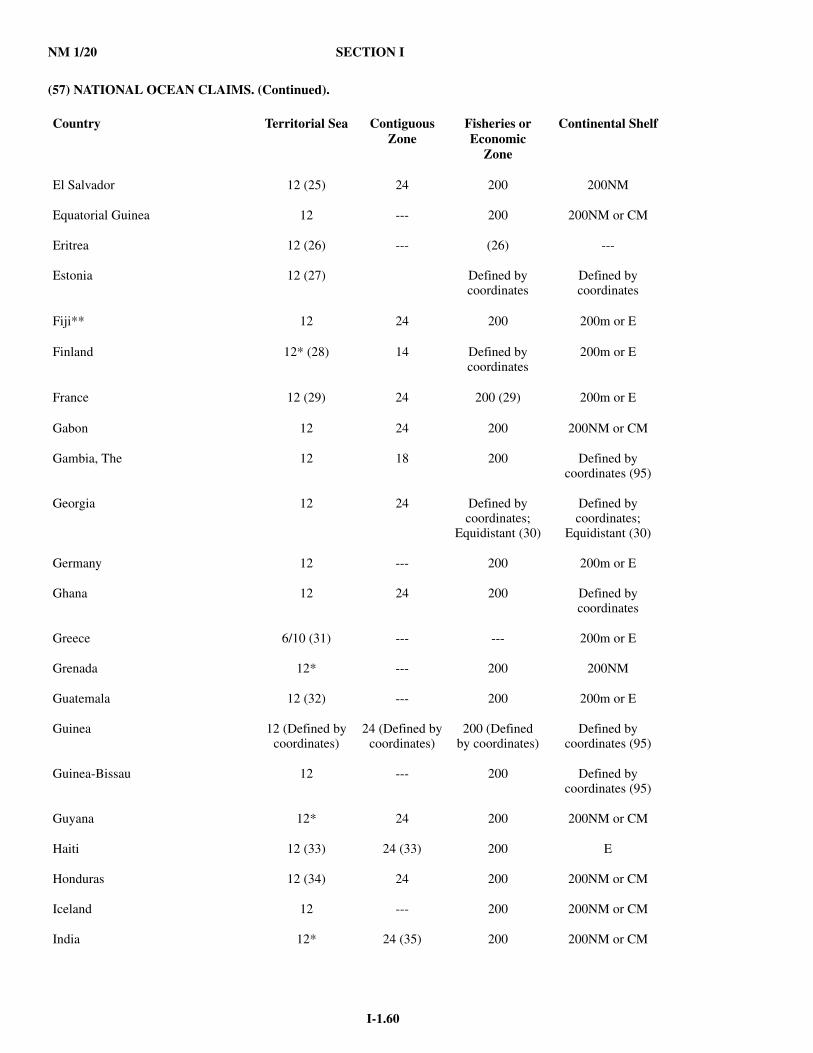
NM 1/20 SECTION I
I-1.60
(57) NATIONAL OCEAN CLAIMS. (Continued).
Country Territorial Sea Contiguous Zone
Fisheries or Economic
Zone
Continental Shelf
El Salvador 12 (25) 24 200 200NM
Equatorial Guinea 12 --- 200 200NM or CM
Eritrea 12 (26) --- (26) ---
Estonia 12 (27) Defined by coordinates
Defined bycoordinates
Fiji** 12 24 200 200m or E
Finland 12* (28) 14 Defined by coordinates
200m or E
France 12 (29) 24 200 (29) 200m or E
Gabon 12 24 200 200NM or CM
Gambia, The 12 18 200 Defined bycoordinates (95)
Georgia 12 24 Defined by coordinates;
Equidistant (30)
Defined bycoordinates;
Equidistant (30)
Germany 12 --- 200 200m or E
Ghana 12 24 200 Defined bycoordinates
Greece 6/10 (31) --- --- 200m or E
Grenada 12* --- 200 200NM
Guatemala 12 (32) --- 200 200m or E
Guinea 12 (Defined bycoordinates)
24 (Defined bycoordinates)
200 (Defined by coordinates)
Defined bycoordinates (95)
Guinea-Bissau 12 --- 200 Defined bycoordinates (95)
Guyana 12* 24 200 200NM or CM
Haiti 12 (33) 24 (33) 200 E
Honduras 12 (34) 24 200 200NM or CM
Iceland 12 --- 200 200NM or CM
India 12* 24 (35) 200 200NM or CM

SECTION I NM 1/20
I-1.61
(57) NATIONAL OCEAN CLAIMS. (Continued).
Country Territorial Sea Contiguous Zone
Fisheries or Economic
Zone
Continental Shelf
Indonesia** 12* (36) --- (84) 200 200NM or CM
Iran 12* 24 (37) Equidistant (37) Equidistant(37)
Iraq 12 --- (85) --- (not specified)
Ireland 12 24 200 Partially defined by coordinates
Israel 12 --- Equidistant E
Italy 12 (38) (86) 24 Equidistant 200m or E
Jamaica** 12 24 200 200NM or CM
Japan 12 (39) 24 200 200NM or CM
Jordan 3 --- --- ---
Kenya 12 (40) --- 200 Defined bycoordinates
Kiribati** 12 (Defined bycoordinates)
24 (Defined bycoordinates)
200 (Defined by coordinates)
Defined bycoordinates
Korea, North (DPRK) 12* (41) 50 (41) 200 200NM
Korea, South (ROK) 12* (42) 24 200 200NM or CM
Kuwait 12 24 Equidistant Equidistant
Latvia 12 (43) --- 200 (90) 200m or E
Lebanon 12 --- Defined by coordinates
---
Liberia 12 24 200 200m or E
Libya 12* (44) --- Equidistant (91) CS
Lithuania 12* (Defined by coordinates)
24 (Defined bycoordinates)
Defined by coordinates
Equidistant;defined bycoordinates
Madagascar 12 24 200 200NM (46)
Malaysia 12 (47) --- 200 200m or E
Maldives** 12* 24 200 Defined bycoordinates
Malta 12* 24 25 200m or E
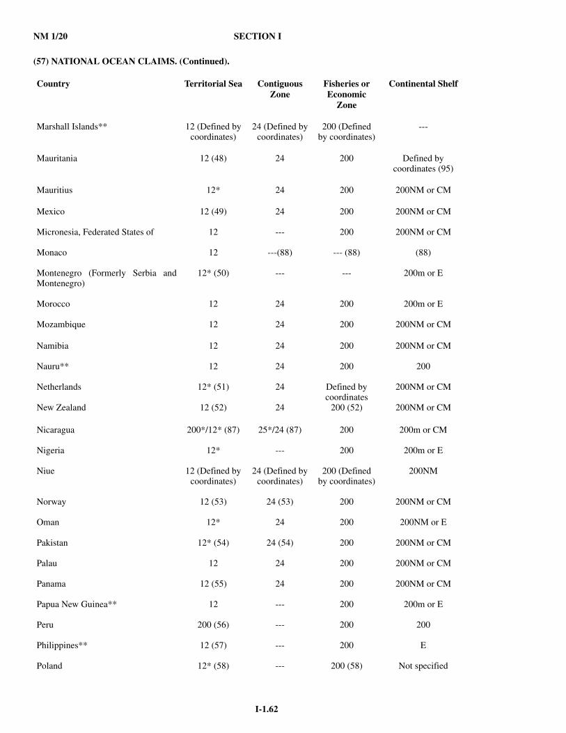
NM 1/20 SECTION I
I-1.62
(57) NATIONAL OCEAN CLAIMS. (Continued).
Country Territorial Sea Contiguous Zone
Fisheries or Economic
Zone
Continental Shelf
Marshall Islands** 12 (Defined bycoordinates)
24 (Defined bycoordinates)
200 (Defined by coordinates)
---
Mauritania 12 (48) 24 200 Defined bycoordinates (95)
Mauritius 12* 24 200 200NM or CM
Mexico 12 (49) 24 200 200NM or CM
Micronesia, Federated States of 12 --- 200 200NM or CM
Monaco 12 ---(88) --- (88) (88)
Montenegro (Formerly Serbia andMontenegro)
12* (50) --- --- 200m or E
Morocco 12 24 200 200m or E
Mozambique 12 24 200 200NM or CM
Namibia 12 24 200 200NM or CM
Nauru** 12 24 200 200
Netherlands 12* (51) 24 Defined by coordinates
200NM or CM
New Zealand 12 (52) 24 200 (52) 200NM or CM
Nicaragua 200*/12* (87) 25*/24 (87) 200 200m or CM
Nigeria 12* --- 200 200m or E
Niue 12 (Defined by coordinates)
24 (Defined by coordinates)
200 (Defined by coordinates)
200NM
Norway 12 (53) 24 (53) 200 200NM or CM
Oman 12* 24 200 200NM or E
Pakistan 12* (54) 24 (54) 200 200NM or CM
Palau 12 24 200 200NM or CM
Panama 12 (55) 24 200 200NM or CM
Papua New Guinea** 12 --- 200 200m or E
Peru 200 (56) --- 200 200
Philippines** 12 (57) --- 200 E
Poland 12* (58) --- 200 (58) Not specified
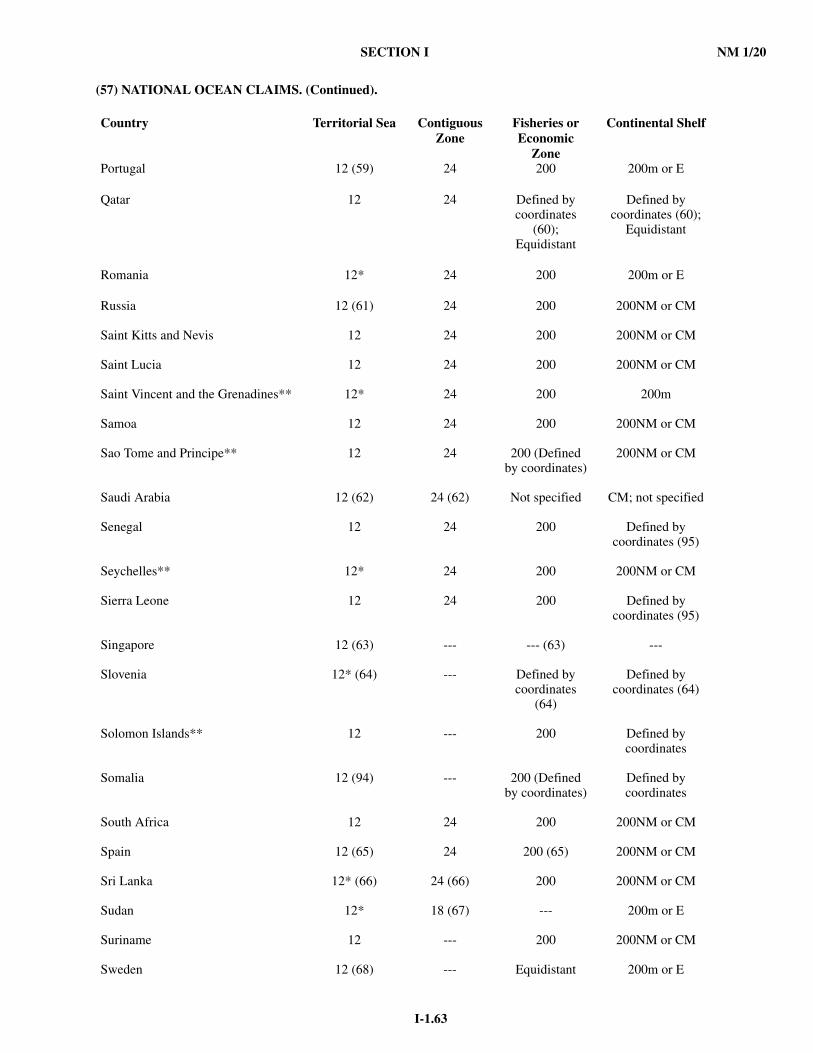
SECTION I NM 1/20
I-1.63
(57) NATIONAL OCEAN CLAIMS. (Continued).
Country Territorial Sea Contiguous Zone
Fisheries or Economic
Zone
Continental Shelf
Portugal 12 (59) 24 200 200m or E
Qatar 12 24 Defined by coordinates
(60);Equidistant
Defined bycoordinates (60);
Equidistant
Romania 12* 24 200 200m or E
Russia 12 (61) 24 200 200NM or CM
Saint Kitts and Nevis 12 24 200 200NM or CM
Saint Lucia 12 24 200 200NM or CM
Saint Vincent and the Grenadines** 12* 24 200 200m
Samoa 12 24 200 200NM or CM
Sao Tome and Principe** 12 24 200 (Defined by coordinates)
200NM or CM
Saudi Arabia 12 (62) 24 (62) Not specified CM; not specified
Senegal 12 24 200 Defined bycoordinates (95)
Seychelles** 12* 24 200 200NM or CM
Sierra Leone 12 24 200 Defined bycoordinates (95)
Singapore 12 (63) --- --- (63) ---
Slovenia 12* (64) --- Defined by coordinates
(64)
Defined bycoordinates (64)
Solomon Islands** 12 --- 200 Defined bycoordinates
Somalia 12 (94) --- 200 (Defined by coordinates)
Defined bycoordinates
South Africa 12 24 200 200NM or CM
Spain 12 (65) 24 200 (65) 200NM or CM
Sri Lanka 12* (66) 24 (66) 200 200NM or CM
Sudan 12* 18 (67) --- 200m or E
Suriname 12 --- 200 200NM or CM
Sweden 12 (68) --- Equidistant 200m or E
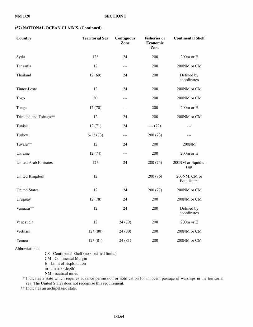
NM 1/20 SECTION I
I-1.64
(57) NATIONAL OCEAN CLAIMS. (Continued).
Abbreviations:CS - Continental Shelf (no specified limits)CM - Continental MarginE - Limit of Exploitationm - meters (depth)NM - nautical miles
* Indicates a state which requires advance permission or notification for innocent passage of warships in the territorialsea. The United States does not recognize this requirement.
** Indicates an archipelagic state.
Country Territorial Sea Contiguous Zone
Fisheries or Economic
Zone
Continental Shelf
Syria 12* 24 200 200m or E
Tanzania 12 --- 200 200NM or CM
Thailand 12 (69) 24 200 Defined bycoordinates
Timor-Leste 12 24 200 200NM or CM
Togo 30 --- 200 200NM or CM
Tonga 12 (70) --- 200 200m or E
Trinidad and Tobago** 12 24 200 200NM or CM
Tunisia 12 (71) 24 --- (72) ---
Turkey 6-12 (73) --- 200 (73) ---
Tuvalu** 12 24 200 200NM
Ukraine 12 (74) --- 200 200m or E
United Arab Emirates 12* 24 200 (75) 200NM or Equidis-tant
United Kingdom 12 200 (76) 200NM, CM or Equidistant
United States 12 24 200 (77) 200NM or CM
Uruguay 12 (78) 24 200 200NM or CM
Vanuatu** 12 24 200 Defined bycoordinates
Venezuela 12 24 (79) 200 200m or E
Vietnam 12* (80) 24 (80) 200 200NM or CM
Yemen 12* (81) 24 (81) 200 200NM or CM

SECTION I NM 1/20
I-1.65
(57) NATIONAL OCEAN CLAIMS. (Continued).
FOOTNOTESThe numbers presented in the table reflect a claim regarding the breadth of a zone contained in national legislation - regardlessof whether this legislation contains an additional specific reference to the need for delimitation of maritime boundaries withadjacent or opposite states. Therefore there are instances where a state claim exceeds the maximum possible breadth due to thedistance to opposite states.Security Zone - A state claim to control activity beyond its territorial sea for security reasons unrelated to that state's policepowers in its territory, including its territorial sea. This Summary lists only those Security Zones which presently claim torestrict navigation and overflight activities conducted exclusively beyond their claimed territorial seas. A claim of right ofsurveillance beyond the territorial sea or a claim of the right of "hot pursuit" in enforcing violations of law which occur in astate's territorial sea, inland waters, or land territory does not constitute a claimed Security Zone.Fishery zones not extending beyond a claimed territorial sea or EEZ are encompassed within the territorial sea or EEZ and notlisted separately.Many coastal nations have established straight baselines or have asserted historic waters claims. These footnotes mention someof the more significant ones. It exceeds the scope of this Summary, however, to provide an exhaustive list of baseline andhistoric waters claims. Accordingly, users should refer to other sources of information to obtain a complete compendium ofmaritime claims. 1. Argentina. Claims San Matias Gulf (Golfo San Matias), Nuevo Gulf (Golfo Nuevo) and San Jorge Gulf (Golfo San Jorge)as internal waters and claims, jointly with Uruguay, the Rio de la Plata estuary as internal waters. 2. Australia. Claims Anxious, Rivoli, Encounter and Lacepede Bays as historic waters. 3.Bangladesh. Contiguous Zone also considered a Security Zone. Nuclear-powered vessels and vessels transporting nuclear materials or other radioactive substances are required to give notice prior to entering territorial sea. 4. Belgium. EEZ limits set by coordinates found in the Act concerning the EEZ of Belgium in the North Sea of April 1999. Fishery zone and CS extend to median line equidistant from baseline of neighbors. 5. Belize. From the mouth of the Sarstoon River to Ranguana Cay, Belize's territorial sea is 3NM; according to Belize'sMaritime Areas Act, 1992, the purpose of this limitation is "to provide a framework for the negotiation of a definitiveagreement on territorial differences with the Republic of Guatemala." 6. Bosnia and Herzegovina. No information on maritime claims is available. 7. Brazil. Claims to require permission for more than 3 warships of same flag to be in territorial sea at same time. Militaryexercises can be carried out in EEZ only with Brazil's consent. The U.S. does not recognize this restriction and protested in1983 and 1988, and conducted an operational assertion in FY 2011. 8. Brunei. 200NM or median EEZ. 9. Bulgaria. In territorial sea and internal waters, foreign submarines shall be required to navigate on the surface. Innocentpassage of warships limited to designated sea lanes. CS limits will be established by agreement between states with adjacent oropposite coasts on Black Sea on basis of international law. 10. Burma. Claims as internal waters all waters inside a 223NM baseline closing Gulf of Martaban as well as waters inside straight baselines connecting coastal islands. Contiguous Zone also considered a Security Zone. 11. Cambodia. Contiguous Zone also considered a Security Zone. Continental Shelf: "All activities by foreigners", for"whatever end" are regulated. The U.S. does not recognize these claims. 12. Cameroon. EEZ will stretch from the external boundary of the territorial sea to the limit placed under its jurisdiction by international law. 13. Canada. Claims as internal waters all waters between its islands in the Arctic; also claims Hudson Bay as a historic bay. 14. Chile. Claimed continental shelves for Easter Island and Sala y Gomez Island, extending 350 nautical miles from theirrespective baselines. 15. China. Claims right to create safety zone around any structure in EEZ, right to require prior authorization to laysubmarine cables and pipelines, and right to broad powers to enforce laws in the EEZ. Contiguous Zone also considered aSecurity Zone. 16. Congo. Congo, Dem. Rep. of the. Claimed 200nm EEZ as allowed under the 1982 Law of the Sea Convention; 1983.Recommends coordination with neighboring states; 1992. Claims 350nm Continental Shelf measured from baseline, or to100nm from 2,500m isobath; 2009. 17. Costa Rica. Permit required for foreign flag fishing vessels to transit Costa Rican waters. 18. Croatia. Requires 24hr notice in advance of a foreign warship exercising innocent passage. Prohibits more than threeforeign warships from transiting the territorial sea in innocent passage. 19. Cuba. Claims straight baselines enclosing varying distances of water between Cape Frances (Cabo Frances), the Isle of Pines (Isla de la Juventud) (notable are those enclosing 21-35.6N and 79-50.5W), Breton Cay (Cayo Breton) and Cape Cruz(Cabo Cruz) as internal waters.
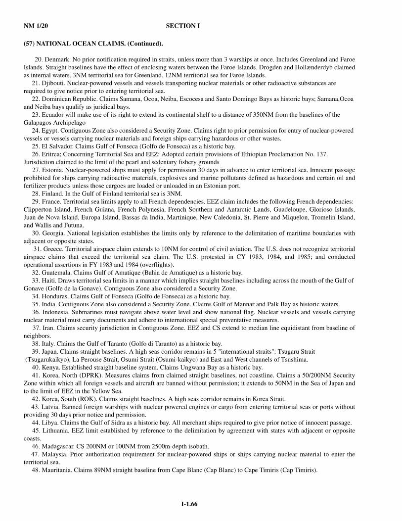
NM 1/20 SECTION I
I-1.66
(57) NATIONAL OCEAN CLAIMS. (Continued).
20. Denmark. No prior notification required in straits, unless more than 3 warships at once. Includes Greenland and FaroeIslands. Straight baselines have the effect of enclosing waters between the Faroe Islands. Drogden and Hollænderdyb claimedas internal waters. 3NM territorial sea for Greenland. 12NM territorial sea for Faroe Islands. 21. Djibouti. Nuclear-powered vessels and vessels transporting nuclear materials or other radioactive substances are required to give notice prior to entering territorial sea. 22. Dominican Republic. Claims Samana, Ocoa, Neiba, Escocesa and Santo Domingo Bays as historic bays; Samana,Ocoa and Neiba bays qualify as juridical bays. 23. Ecuador will make use of its right to extend its continental shelf to a distance of 350NM from the baselines of theGalapagos Archipelago 24. Egypt. Contiguous Zone also considered a Security Zone. Claims right to prior permission for entry of nuclear-powered vessels or vessels carrying nuclear materials and foreign ships carrying hazardous or other wastes. 25. El Salvador. Claims Gulf of Fonseca (Golfo de Fonseca) as a historic bay. 26. Eritrea; Concerning Territorial Sea and EEZ: Adopted certain provisions of Ethiopian Proclamation No. 137. Jurisdiction claimed to the limit of the pearl and sedentary fishery grounds 27. Estonia. Nuclear-powered ships must apply for permission 30 days in advance to enter territorial sea. Innocent passageprohibited for ships carrying radioactive materials, explosives and marine pollutants defined as hazardous and certain oil andfertilizer products unless those cargoes are loaded or unloaded in an Estonian port. 28. Finland. In the Gulf of Finland territorial sea is 3NM. 29. France. Territorial sea limits apply to all French dependencies. EEZ claim includes the following French dependencies: Clipperton Island, French Guiana, French Polynesia, French Southern and Antarctic Lands, Guadeloupe, Glorioso Islands,Juan de Nova Island, Europa Island, Bassas da India, Martinique, New Caledonia, St. Pierre and Miquelon, Tromelin Island,and Wallis and Futuna. 30. Georgia. National legislation establishes the limits only by reference to the delimitation of maritime boundaries withadjacent or opposite states. 31. Greece. Territorial airspace claim extends to 10NM for control of civil aviation. The U.S. does not recognize territorialairspace claims that exceed the territorial sea claim. The U.S. protested in CY 1983, 1984, and 1985; and conductedoperational assertions in FY 1983 and 1984 (overflights). 32. Guatemala. Claims Gulf of Amatique (Bahia de Amatique) as a historic bay. 33. Haiti. Draws territorial sea limits in a manner which implies straight baselines including across the mouth of the Gulf of Gonave (Golfe de la Gonave). Contiguous Zone also considered a Security Zone. 34. Honduras. Claims Gulf of Fonseca (Golfo de Fonseca) as a historic bay. 35. India. Contiguous Zone also considered a Security Zone. Claims Gulf of Mannar and Palk Bay as historic waters. 36. Indonesia. Submarines must navigate above water level and show national flag. Nuclear vessels and vessels carryingnuclear material must carry documents and adhere to international special preventative measures. 37. Iran. Claims security jurisdiction in Contiguous Zone. EEZ and CS extend to median line equidistant from baseline ofneighbors. 38. Italy. Claims the Gulf of Taranto (Golfo di Taranto) as a historic bay. 39. Japan. Claims straight baselines. A high seas corridor remains in 5 "international straits": Tsugaru Strait (Tsugarukaikyo), La Perouse Strait, Osumi Strait (Osumi-kaikyo) and East and West channels of Tsushima. 40. Kenya. Established straight baseline system. Claims Ungwana Bay as a historic bay. 41. Korea, North (DPRK). Measures claims from claimed straight baselines, not coastline. Claims a 50/200NM SecurityZone within which all foreign vessels and aircraft are banned without permission; it extends to 50NM in the Sea of Japan andto the limit of EEZ in the Yellow Sea. 42. Korea, South (ROK). Claims straight baselines. A high seas corridor remains in Korea Strait. 43. Latvia. Banned foreign warships with nuclear powered engines or cargo from entering territorial seas or ports withoutproviding 30 days prior notice and permission. 44. Libya. Claims the Gulf of Sidra as a historic bay. All merchant ships required to give prior notice of innocent passage. 45. Lithuania. EEZ limit established by reference to the delimitation by agreement with states with adjacent or oppositecoasts. 46. Madagascar. CS 200NM or 100NM from 2500m-depth isobath. 47. Malaysia. Prior authorization requirement for nuclear-powered ships or ships carrying nuclear material to enter theterritorial sea. 48. Mauritania. Claims 89NM straight baseline from Cape Blanc (Cap Blanc) to Cape Timiris (Cap Timiris).

SECTION I NM 1/20
I-1.67
(57) NATIONAL OCEAN CLAIMS. (Continued).
49. Mexico. No more than 3 foreign warships will be authorized in Mexican ports on each coast at the same time, and nomore than one in any given port. Port calls by more than one training vessel can be authorized only if permission is requestedthree months in advance. Nuclear-powered and nuclear-armed ships are not allowed to enter Mexican territorial waters or dockin Mexican ports. 50. Montenegro. No official information on maritime claims is available. This information corresponds to the limits andclaims of the previous national entity, Serbia and Montenegro, and is therefore not authoritative. 51. Netherlands. Considers the Westerschelde internal waters through which passage requires prior permission. IncludesAruba and the Netherlands Antilles. 52. New Zealand. Includes Tokelau. Prohibits entry of nuclear-powered and nuclear armed ships into its ports. 53. Norway. Territorial sea claim includes Jan Mayen and Svalbard. Contiguous Zone claim applies only to Norway. 54. Pakistan. Foreign supertankers, nuclear-powered ships and ships carrying nuclear materials are required to give priornotification for entry into territorial sea. Contiguous Zone also considered a Security Zone. 55. Panama. Claims Gulf of Panama as a historic bay. 56. Peru. The 200nm limit is called the 'Maritime Dominion' of Peru. Peru claims sovereignty and jurisdiction withoutprejudice to the freedom of international communication, "in conformity with the laws and treaties ratified by the state." 57. The Philippines declared 33 islands, cays, shoals and reefs, contained in a delimited area (Kalayaan) of the SpratlyIslands, to be Philippine territory; Presidential Decree No. 1596. 58. Poland. Claims a closing line across Gulf of Gdansk and a fishing zone to the median line in the Baltic. EEZ isdetermined by lines connecting extreme points of specified lateral limits. 59. Portugal. Established straight baselines for various areas along continental coast and Madeira and Azores island groups. Claims Tagus and Sado estuaries and associated bays as historic waters. 60. Qatar. Extends to median line with neighboring states. 61. Russia. In a Joint Statement with Ukraine declared that the Sea of Azov and Strait of Kerch are historic internal watersof the two nations. 62. Saudi Arabia. Claims power to regulate nuclear-powered vessels in the territorial sea and to require prior authorizationfor such vessels. Contiguous Zone also considered a Security Zone. 63. Singapore. Singapore has stated that it will negotiate agreed maritime boundary delimitations with neighboring countries whose territorial sea and exclusive economic zone claims overlap with Singapore's. 64. Slovenia. Foreign warships require 24-hour advance notice for innocent passage through territorial sea and must usedesignated sea lanes only. Territorial Sea and Continental Shelf boundaries are defined by coordinates through agreements w/the former Yugoslavia. 65. Spain. Claims to control transit passage by aircraft and exercise pollution control over vessels in international strait.Claims 200NM Economic Zone in Atlantic only. Fishery zone in the Mediterranean defined by coordinates. 66. Sri Lanka. Contiguous Zone also considered a Security Zone. Claims Palk Bay, Palk Strait and Gulf of Mannar ashistoric waters. 67. Sudan. Contiguous Zone also considered a Security Zone. 68. Sweden. Territorial sea claim is less than 12NM (but varying) in certain areas of the Skagerrak, the Kattegat and theBaltic. 69. Thailand. Claims inner Gulf of Thailand as a historical bay to 12°35'45''N. 70. Tonga. Claims 12NM territorial sea for Minerva Reef. 71. Tunisia. Claims straight baselines enclosing Gulf of Tunis (Khalij Tunis) and Gulf of Gabes (Khalij Gabes) as internalwaters. 72. Tunisia. EEZ limits to be fixed in coordination with neighboring states. 73. Turkey. Claims a 12NM territorial sea in the Black Sea and in the Mediterranean and a 6NM territorial sea in the Aegean. EEZ is claimed in the Black Sea. 74. Ukraine. In a Joint Statement with Russia declared that the Sea of Azov and Strait of Kerch are historic internal waters of the two nations. 75. United Arab Emirates. EEZ extends to agreed CS boundaries or to median lines. 76. United Kingdom. Fishery claims include Ascension, Bermuda, British Virgin Islands, Cayman Islands, Ducie and Oeno Atolls, Henderson Island, Pitcairn Island, St. Helena, Tristan da Cunha, Turks and Caicos Islands. Has also established afishing zone around the Falkland/Malvinas Islands; although 200NM wide, the zone is only enforced to a distance of 150NM.Established Environment (Protection and Preservation) Zone for the British Indian Ocean Territory. 77. United States. EEZ applies to Northern Marianas (consistent with the Covenant), American Samoa, Guam, Puerto Rico, U.S. Virgin Islands and other U.S. possessions and territories. 78. Uruguay. Claims, jointly with Argentina, the Rio de la Plata estuary as internal waters.
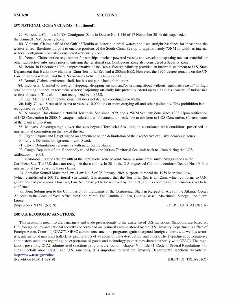
NM 1/20 SECTION I
I-1.68
(57) NATIONAL OCEAN CLAIMS. (Continued).
79. Venezuela. Claims a 24NM Contiguous Zone in Decree No. 1,446 of 17 November 2014; this supersedes the claimed15NM Security Zone. 80. Vietnam. Claims half of the Gulf of Tonkin as historic internal waters and uses straight baselines for measuring theterritorial sea. Baselines purport to enclose portions of the South China Sea up to approximately 75NM in width as internalwaters. Contiguous Zone also considered a Security Zone. 81. Yemen. Claims notice requirement for warships, nuclear-powered vessels and vessels transporting nuclear materials orother radioactive substances prior to entering the territorial sea. Contiguous Zone also considered a Security Zone. 82. Benin. In December 1998, a representative of the Benin Foreign Ministry provided an informal statement to U.S. StateDepartment that Benin now claims a 12nm Territorial Sea and a 200nm-EEZ. However, the 1976 decree remains on the UNLaw of the Sea website, and the UN continues to list the claim as 200nm. 83. Brunei. Claims continental shelf, but has not published delimitation. 84. Indonesia. Claimed to restrict "stopping, dropping anchor, and/or cruising about without legitimate reason" in highseas"adjoining Indonesian territorial waters; "adjoining officially interpreted to extend up to 100 miles seaward of Indonesianterritorial waters. This claim is not recognized by the U.S. 85. Iraq. Mentions Contiguous Zone, but does not declare coordinates or width. 86. Italy. Closed Strait of Messina to vessels 10,000 tons or more carrying oil and other pollutants. This prohibition is notrecognized by the U.S. 87. Nicaragua. Has claimed a 200NM Territorial Sea since 1979, and a 25NM Security Zone since 1983. Upon ratificationof LOS Convention in 2000, Nicaragua declared it would amend domestic law to conform to LOS Convention. Current statusof the claim is uncertain. 88. Monaco. Sovereign rights over the seas beyond Territorial Sea limit, in accordance with conditions prescribed ininternational convention on the law of the sea. 89. Egypt. Cyprus and Egypt signed an agreement on the delimitation of their respective exclusive economic zones. 90. Latvia. Delimitation agreement with Sweden. 91. Libya. Delimitation agreements with neighboring states. 92. Congo, Republic of the. Reportedly rolled back the 200nm Territorial Sea limit back to 12nm during the LOS ratification in 2008. 93. Colombia. Extends the breadth of the contiguous zone beyond 24nm in some areas surrounding islands in the Caribbean Sea. The U.S. does not recognize these claims. In 2014, the U.S. requested Colombia conform Decree No. 1946 tointernational law regarding these claims. 94. Somalia: Somali Maritime Law - Law No. 5 of 26 January 1989, purports to repeal the 1959 Maritime Law, (which established a 200 Territorial Sea Limit). It is assumed that the Territorial Sea is at 12nm, which conforms to U.N.guidelines and provisions. However, Law No. 5 has yet to be received by the U.N., and its contents and affirmations yet to beconfirmed. 95. Joint Submission to the Commission on the Limits of the Continental Shelf in Respect of Area in the Atlantic OceanAdjacent to the Coast of West Africa for: Cabo Verde, The Gambia, Guinea, Guinea-Bissau, Mauritania, Senegal, and SierraLeone.(Supersedes NTM 1(57)19) (DEPT. OF STATE/NGA)
(58) U.S. ECONOMIC SANCTIONS.
This section is meant to alert mariners and trade professionals to the existence of U.S. sanctions. Sanctions are based onU.S. foreign policy and national security concerns and are primarily administered by the U.S. Treasury Department's Office ofForeign Assets Control (“OFAC”). OFAC administers sanctions programs against targeted foreign countries, as well as terror-ists, international narcotics traffickers, proliferators of weapons of mass destruction, and others. The Department of Commerceadministers sanctions regarding the exportation of goods and technology (sometimes shared authority with OFAC). The regu-lations governing OFAC administered sanctions programs are found in chapter V of title 31, Code of Federal Regulations. Forcurrent details about OFAC and U.S. sanctions, it is important to visit the Treasury Department's sanctions website at:http://www.treas.gov/ofac.(Repetition NTM 1(58)19) (DEPT. OF TREASURY)

SECTION I NM 1/20
I-1.69
(59) MARITIME INDUSTRY REPORTING OF A SUSPECTED OR ACTUAL TERRORIST INCIDENT.
In addition to oil and hazardous substance releases, the National Response Center (NRC) must be notified of any suspectedor actual terrorist incident (e.g., chemical, radiological, biological, or etiological discharge into the environment) anywhere in the United States and its territories, particularly one affecting transportation systems. Coast Guard units that receive reports ofsuspected or actual incidents should ensure such reports are reported to the NRC at 800-424-8802 or (202) 267-2675.
Individuals are encouraged to visit the NRC Web site: (http://www.nrc.uscg.mil) for reporting requirements and other help-ful information.(Repetition NTM 1(59)19) (USCG)
(60) ELECTRONIC VESSEL NOTICE OF ARRIVAL (eNOA) SUBMISSION.
The Coast Guard’s Notice of Arrival (NOA) rule was published in February 2003 and requires ships to submit accuratevessel, crew, passenger, and cargo information to the Coast Guard’s National Vessel Movement Center (NVMC) prior toarrival in a U.S. port or place. Time frames for submitting this information are based on a vessel’s voyage time. Failure to sub-mit a NOA prior to arrival in a U.S. port or place is a violation of the regulation and may result in civil or criminal penalties ordenial of a vessel to enter port. Even if a NOA is submitted, failure to submit one using the methods specified in the regulationor without accurate or complete data may result in significant delays, so industry is reminded to be familiar with submissionrequirements.
Vessels and their respective maritime stakeholders should review the NOA regulations found in 33 Code of Federal Regu-lations (CFR) Part 160, Subpart C, to ensure submission of complete and accurate reports and minimize any disruption totrade.
The regulation requires NOAs to be submitted to the NVMC via multiple means to include email, or one of three electronicmethods. The electronic methods are an easy way to complete the requirements and comply with the regulation. All requiredinformation can be entered via the electronic Notice of Arrival and Departure (eNOAD), available on the NVMC Web site at:http://www.nvmc.uscg.gov, and consisting of the following three formats:
-A Web site that can be used to submit NOA information directly to the NVMC;-Raw eXtensible Markup Language (XML) formatted documents that conform to the eNOAD schema, provided forthose interested in creating their own application; this format would draw information from their existing systems tosubmit, via web service, XML formatted data to comply with NOA requirements;
-A Microsoft InfoPath template, designed for those wanting to input NOA data offline (when not connected to the Inter-net) for submission later via their Internet connection or as an email attachment to the NVMC.
-An XLS Workbook 7.0 for 33 CFR 160 reporting requirements and an XLS OCS Workbook 1.0 for 33 CFR 146requirements, both available under the Downloads tab of the NVMC website.
Vessels should remember that the eNOAD serves as a collection for the Coast Guard’s Notice of Arrival requirements andU.S. Custom and Border Protection’s (USCBP) Advanced Passenger Information System (APIS) requirements, which werepublished on 5 April 2005. Submissions received through one of the three eNOAD formats fulfill both agencies’ requirements.
Submitting a NOA via fax, telephone, or regular email does not meet CBP vessel APIS requirements published in 19 CFRPart 4.
On January 13, 2011 the U.S. Coast Guard issued a final rule for 33CFR 146 to establish Notice of Arrival (“NOA”)requirements for “units” (i.e. U.S. and foreign flag vessels, floating facilities, and mobile offshore drilling units (“MODUs”)engaging in Outer Continental Shelf (“OCS”) activities in order to enhance U.S. maritime domain safety and security aware-ness on the OCS. Previously, only MODUs were required to make NOA reports offshore; this new regulation became effectiveFebruary 14, 2011 and can be found at: www.nvmc.uscg.gov under the Regulations tab.
The responsibility for ensuring that an NOA/D report is provided to the NVMC remains with the vessel owner/operator oragent. The NVMC Web site www.nvmc.uscg.gov offers information on both agencies' requirements, methods of submission,and frequently asked questions (FAQs). The NVMC can be contacted at: [email protected] or by telephone at 1-800-708-9823 or 304-264-2502 for more information. For NOA regulatory issues, contact the U.S. Coast Guard Headquarters AdvanceNOA Program Manager LCDR Mike Lendvay at 202-372-1218. The U.S. Customs and Border Protection submission and reg-ulation guide may be found at the USCBP web site: http://www.cbp.gov/linkhandler/cgov/travel/inspections_carriers_facilities/apis/air_vessel_guides/vessel_guide.ctt/vessel_guide.pdf. The CBP Questions/Customer Service General Inquiriesphone number is 1-877-CBP-5511 (1-877-227-5511).(Repetition NTM 1(60)19) (USCG)
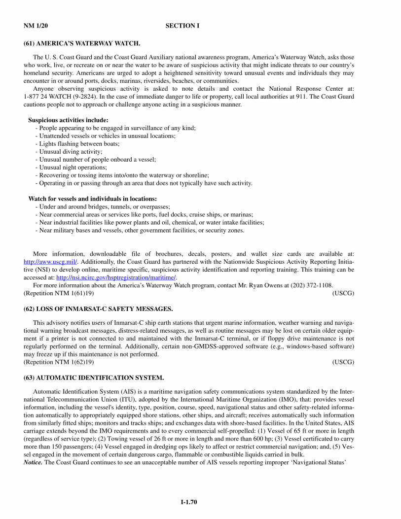
NM 1/20 SECTION I
I-1.70
(61) AMERICA’S WATERWAY WATCH.
The U. S. Coast Guard and the Coast Guard Auxiliary national awareness program, America’s Waterway Watch, asks thosewho work, live, or recreate on or near the water to be aware of suspicious activity that might indicate threats to our country’shomeland security. Americans are urged to adopt a heightened sensitivity toward unusual events and individuals they mayencounter in or around ports, docks, marinas, riversides, beaches, or communities.
Anyone observing suspicious activity is asked to note details and contact the National Response Center at:1-877 24 WATCH (9-2824). In the case of immediate danger to life or property, call local authorities at 911. The Coast Guardcautions people not to approach or challenge anyone acting in a suspicious manner.
Suspicious activities include:- People appearing to be engaged in surveillance of any kind;- Unattended vessels or vehicles in unusual locations;- Lights flashing between boats;- Unusual diving activity;- Unusual number of people onboard a vessel;- Unusual night operations;- Recovering or tossing items into/onto the waterway or shoreline;- Operating in or passing through an area that does not typically have such activity.
Watch for vessels and individuals in locations:- Under and around bridges, tunnels, or overpasses;- Near commercial areas or services like ports, fuel docks, cruise ships, or marinas;- Near industrial facilities like power plants and oil, chemical, or water intake facilities;- Near military bases and vessels, other government facilities, or security zones.
More information, downloadable file of brochures, decals, posters, and wallet size cards are available at:http://aww.uscg.mil/. Additionally, the Coast Guard has partnered with the Nationwide Suspicious Activity Reporting Initia-tive (NSI) to develop online, maritime specific, suspicious activity identification and reporting training. This training can beaccessed at: http://nsi.ncirc.gov/hsptregistration/maritime/.
For more information about the America’s Waterway Watch program, contact Mr. Ryan Owens at (202) 372-1108.(Repetition NTM 1(61)19) (USCG)
(62) LOSS OF INMARSAT-C SAFETY MESSAGES.
This advisory notifies users of Inmarsat-C ship earth stations that urgent marine information, weather warning and naviga-tional warning broadcast messages, distress-related messages, as well as routine messages may be lost on certain older equip-ment if a printer is not connected to and maintained with the Inmarsat-C terminal, or if floppy drive maintenance is notregularly performed on the terminal. Additionally, certain non-GMDSS-approved software (e.g., windows-based software)may freeze up if this maintenance is not performed.(Repetition NTM 1(62)19) (USCG)
(63) AUTOMATIC IDENTIFICATION SYSTEM.
Automatic Identification System (AIS) is a maritime navigation safety communications system standardized by the Inter-national Telecommunication Union (ITU), adopted by the International Maritime Organization (IMO), that: provides vesselinformation, including the vessel's identity, type, position, course, speed, navigational status and other safety-related informa-tion automatically to appropriately equipped shore stations, other ships, and aircraft; receives automatically such informationfrom similarly fitted ships; monitors and tracks ships; and exchanges data with shore-based facilities. In the United States, AIScarriage extends beyond the IMO requirements and to every commercial self-propelled: (1) Vessel of 65 ft or more in length(regardless of service type); (2) Towing vessel of 26 ft or more in length and more than 600 hp; (3) Vessel certificated to carrymore than 150 passengers; (4) Vessel engaged in dredging ops likely to affect or restrict commercial navigation; and, (5) Ves-sel engaged in the movement of certain dangerous cargo, flammable or combustible liquids carried in bulk.Notice. The Coast Guard continues to see an unacceptable number of AIS vessels reporting improper ‘Navigational Status’
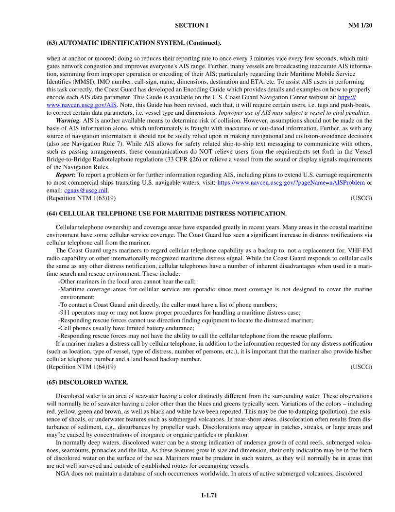
SECTION I NM 1/20
I-1.71
(63) AUTOMATIC IDENTIFICATION SYSTEM. (Continued).
when at anchor or moored; doing so reduces their reporting rate to once every 3 minutes vice every few seconds, which miti-gates network congestion and improves everyone's AIS range. Further, many vessels are broadcasting inaccurate AIS informa-tion, stemming from improper operation or encoding of their AIS; particularly regarding their Maritime Mobile Service Identifies (MMSI), IMO number, call-sign, name, dimensions, destination and ETA, etc. To assist AIS users in performing this task correctly, the Coast Guard has developed an Encoding Guide which provides details and examples on how to properly encode each AIS data parameter. This Guide is available on the U.S. Coast Guard Navigation Center website at: https://www.navcen.uscg.gov/AIS. Note, this Guide has been revised, such that, it will require certain users, i.e. tugs and push-boats, to correct certain data parameters, i.e. vessel type and dimensions. Improper use of AIS may subject a vessel to civil penalties.
Warning. AIS is another available means to determine risk of collision. However, assumptions should not be made on thebasis of AIS information alone, which unfortunately is fraught with inaccurate or out-dated information. Further, as with anysource of navigation information it should not be solely relied upon in making navigational and collision-avoidance decisions(also see Navigation Rule 7). While AIS allows for safety related ship-to-ship text messaging to communicate with others,such as passing arrangements, these communications do NOT relieve users from the requirements set forth in the VesselBridge-to-Bridge Radiotelephone regulations (33 CFR §26) or relieve a vessel from the sound or display signals requirementsof the Navigation Rules.
Report: To report a problem or for further information regarding AIS, including plans to extend U.S. carriage requirementsto most commercial ships transiting U.S. navigable waters, visit: https://www.navcen.uscg.gov/?pageName=nAISProblem oremail: [email protected].(Repetition NTM 1(63)19) (USCG)
(64) CELLULAR TELEPHONE USE FOR MARITIME DISTRESS NOTIFICATION.
Cellular telephone ownership and coverage areas have expanded greatly in recent years. Many areas in the coastal maritimeenvironment have some cellular service coverage. The Coast Guard has seen a significant increase in distress notifications viacellular telephone call from the mariner.
The Coast Guard urges mariners to regard cellular telephone capability as a backup to, not a replacement for, VHF-FMradio capability or other internationally recognized maritime distress signal. While the Coast Guard responds to cellular callsthe same as any other distress notification, cellular telephones have a number of inherent disadvantages when used in a mari-time search and rescue environment. These include:
-Other mariners in the local area cannot hear the call;-Maritime coverage areas for cellular service are sporadic since most coverage is not designed to cover the marineenvironment;
-To contact a Coast Guard unit directly, the caller must have a list of phone numbers;-911 operators may or may not know proper procedures for handling a maritime distress case;-Responding rescue forces cannot use direction finding equipment to locate the distressed mariner;-Cell phones usually have limited battery endurance;-Responding rescue forces may not have the ability to call the cellular telephone from the rescue platform.
If a mariner makes a distress call by cellular telephone, in addition to the information requested for any distress notification(such as location, type of vessel, type of distress, number of persons, etc.), it is important that the mariner also provide his/hercellular telephone number and a land based backup number.(Repetition NTM 1(64)19) (USCG)
(65) DISCOLORED WATER.
Discolored water is an area of seawater having a color distinctly different from the surrounding water. These observationswill normally be of seawater having a color other than the blues and greens typically seen. Variations of the colors – includingred, yellow, green and brown, as well as black and white have been reported. This may be due to dumping (pollution), the exis-tence of shoals, or underwater features such as submerged volcanoes. In near-shore areas, discoloration often results from dis-turbance of sediment, e.g., disturbances by propeller wash. Discolorations may appear in patches, streaks, or large areas andmay be caused by concentrations of inorganic or organic particles or plankton.
In normally deep waters, discolored water can be a strong indication of undersea growth of coral reefs, submerged volca-noes, seamounts, pinnacles and the like. As these features grow in size and dimension, their only indication may be in the formof discolored water on the surface of the sea. Mariners must be prudent in such waters, as they will normally be in areas thatare not well surveyed and outside of established routes for oceangoing vessels.
NGA does not maintain a database of such occurrences worldwide. In areas of active submerged volcanoes, discolored

NM 1/20 SECTION I
I-1.72
(65) DISCOLORED WATER. (Continued).
water is a common occurrence and all such reports are charted or included in a Notice to Mariners correction. Mariners areurged to submit new reports of discolored water to the nearest NAVAREA Coordinator via coast radio stations (for NAVAREAIV and NAVAREA XII, by email to [email protected]). Reports can also be submitted via the NGA Maritime Safety Web site(https://msi.nga.mil/submit-report).
The legend “Discolored water” appears on many NGA charts, particularly those of the Pacific Ocean where underwatervolcanic activity is known to occur. In such areas, shoal water or discolored water may suddenly appear where only deep waterhas been historically depicted. Most of these legends remain on the charts from the last century, when very few deep seasoundings were available and less was known about the causes of discolored water. Few reports of discolored water haveproved on examination to be caused by shoals. Nonetheless, due to the isolated areas normally in question, mariners shouldalways give prudent respect to what may lie beneath the surface.
Today, such reports can be compared with the accumulated information for the area concerned. A more thorough assess-ment can be made using imagery if the water conditions and depth (roughly less than 100 feet) allow.
Mariners are therefore encouraged, while having due regard to the safety of their vessels, to approach sightings and areas ofdiscolored water to find whether or not the discoloration is due to shoaling. If there is good reason to suppose the discolorationis due to shoal water, a report should be made as noted above.
Volcanic activity. On occasion, volcanic eruptions may occur beneath the surface of the water. These submarine eruptionsmay occur more frequently and may be more widespread than has been suspected in the past. Sometimes the only evidence ofa submarine eruption is a noticeable discoloration of the water, a marked rise in sea surface temperature, or floating pumice.
Mariners witnessing submarine volcanic activity have reported trails of steam with a foul sulfurous odor rising from the seasurface and unusual sounds heard through the hull, including shocks resembling a sudden grounding. A subsea volcanic erup-tion may be accompanied by rumbling and hissing, as hot lava meets the cooler sea.
In some cases, reports of discolored water at the sea surface have been investigated and found to be the result of newly-formed volcanic cones on the sea floor. These cones can grow rapidly and constitute a hazardous shoal in only a few years.
Variations in Color. The normal color of the sea in the open ocean in middle and low latitudes is an intense blue or ultra-marine. The following variations in appearance occur elsewhere:
• In coastal regions and in the open sea at higher latitudes, where the minute floating animal and vegetable life of the sea(plankton) is in greater abundance, the blue of the sea is modified to shades of green and bluish-green. This discolorationresults from a soluble yellow pigment discharged by the plant constituents of the plankton.
• When plankton is found in dense concentrations, the color of the organisms themselves may discolor the sea, giving it amore or less intense brown or red color. The Red Sea, Gulf of California, the region of the Peru Current, South Africanwaters, and the Malabar Coast of India are particularly liable to this variation, seasonally.
• Plankton is sometimes suddenly exterminated by changes in sea conditions, producing a dirty brown or grayish-browndiscoloration. This occurs on an unusually extensive scale at times off the Peruvian coast, where the phenomenon iscalled “Aguaje.”
• Larger masses of animate matter, such as fish spawn or floating kelp may produce other kinds of temporary discolor-ation.
• Mud carried down by rivers produces discoloration which, in the case of the great rivers, may affect a large sea area, suchas the Amazon River outfall. Soil or sand particles may be carried out to sea by wind or dust storms, and volcanic dustmay fall over a sea area. In all such cases, the water is more or less muddy in appearance.
• Submarine earthquakes may also produce mud or sand discoloration in relatively shallow water, and crude oil has some-times been seen to gush up. The sea may be extensively covered with floating pumice after a volcanic eruption.
• Isolated shoals in deep water may make the water appear discolored, the color varying with the depth of the water. Theplay of the sun and cloud on the sea may often produce patches appearing at a distance convincingly like shoal water.
Visibility. The distance at which coral reefs can be seen is dependent upon the observer’s height of eye, the state of the sea,and the relative position of the sun. When the sea is glassy calm, it is extremely difficult to distinguish the color differencebetween shallow and deep water. The best conditions for sighting reefs result from a relatively high position, with the sunabove 20 degrees elevation and behind the observer, and a sea ruffled by a slight breeze. Under these conditions, with a heightof eye of 10-15 meters it is usually possible to sight patches at a depth of less than 6-8 meters from a distance of a few hundredyards.
The use of polarized lenses is strongly recommended, as they make the variations in color of the water stand out moreclearly.
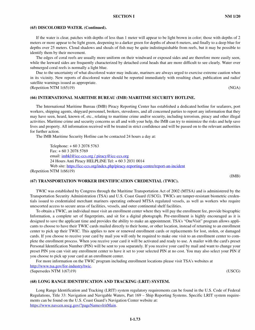
SECTION I NM 1/20
I-1.73
(65) DISCOLORED WATER. (Continued).
If the water is clear, patches with depths of less than 1 meter will appear to be light brown in color; those with depths of 2meters or more appear to be light green, deepening to a darker green for depths of about 6 meters, and finally to a deep blue fordepths over 25 meters. Cloud shadows and shoals of fish may be quite indistinguishable from reefs, but it may be possible toidentify them by their movement.
The edges of coral reefs are usually more uniform on their windward or exposed sides and are therefore more easily seen,while the leeward sides are frequently characterized by detached coral heads that are more difficult to see clearly. Water oversubmerged coral reefs is normally a light blue.
Due to the uncertainty of what discolored water may indicate, mariners are always urged to exercise extreme caution whenin its vicinity. New reports of discolored water should be reported immediately with resulting chart, publication and radio/satellite warnings issued as appropriate.(Repetition NTM 1(65)19) (NGA)
(66) INTERNATIONAL MARITIME BUREAU (IMB) MARITIME SECURITY HOTLINE.
The International Maritime Bureau (IMB) Piracy Reporting Center has established a dedicated hotline for seafarers, portworkers, shipping agents, shipyard personnel, brokers, stevedores, and all concerned parties to report any information that theymay have seen, heard, known of, etc., relating to maritime crime and/or security, including terrorism, piracy and other illegalactivities. Maritime crime and security concerns us all and with your help, the IMB can try to minimize the risks and help savelives and property. All information received will be treated in strict confidence and will be passed on to the relevant authoritiesfor further action.
The IMB Maritime Security Hotline can be contacted 24 hours a day at:
Telephone: + 60 3 2078 5763Fax: + 60 3 2078 5769email: [email protected] / [email protected] Hours Anti Piracy HELPLINE Tel: + 60 3 2031 0014Web site: https://icc-ccs.org/index.php/piracy-reporting-centre/report-an-incident
(Repetition NTM 1(66)19)(IMB)
(67) TRANSPORTATION WORKER IDENTIFICATION CREDENTIAL (TWIC).
TWIC was established by Congress through the Maritime Transportation Act of 2002 (MTSA) and is administered by theTransportation Security Administration (TSA) and U.S. Coast Guard (USCG). TWICs are tamper-resistant biometric creden-tials issued to credentialed merchant mariners operating onboard MTSA regulated vessels, as well as workers who requireunescorted access to secure areas of facilities, vessels, and outer continental shelf facilities.
To obtain a TWIC, an individual must visit an enrollment center where they will pay the enrollment fee, provide biographicInformation, a complete set of fingerprints, and sit for a digital photograph. Pre-enrollment is highly encouraged as it isdesigned to save the applicant time and provides the ability to make an appointment. TSA's “OneVisit” program allows appli-cants to choose to have their TWIC cards mailed directly to their home, or other location, instead of returning to an enrollmentcenter to pick up their TWIC. This applies to new or renewed enrollment cards or replacements for lost, stolen, or damagedcards. If you choose to receive your card by mail you will only be required to make one visit to an enrollment center to com-plete the enrollment process. When you receive your card it will be activated and ready to use. A mailer with the card's presetPersonal Identification Number (PIN) will be sent to you separately. If you receive your card by mail and want to change yourpreset PIN you can visit any enrollment center to have it set to your selected PIN at no cost. You may also select your PIN ifyou choose to pick up your card at an enrollment center.
For more information on the TWIC program including enrollment locations please visit TSA's websites at http://www.tsa.gov/for-industry/twic.(Supersedes NTM 1(67)19) (USCG)
(68) LONG RANGE IDENTIFICATION AND TRACKING (LRIT) SYSTEM.
Long Range Identification and Tracking (LRIT) system regulatory requirements can be found in the U.S. Code of FederalRegulations, Title 33: Navigation and Navigable Waters, Part 169 – Ship Reporting Systems. Specific LRIT system require-ments can be found on the U.S. Coast Guard’s Navigation Center website at:https://www.navcen.uscg.gov/?pageName=lritMain.

NM 1/20 SECTION I
I-1.74
(68) LONG RANGE IDENTIFICATION AND TRACKING (LRIT) SYSTEM. (Continued).
The LRIT system provides for the global identification and tracking of ships worldwide. LRIT requirements were developed by the International Maritime Organization (IMO) and implemented in the Safety of Life at Sea (SOLAS) 1974 Convention under Regulation V/19-1. The U.S. Coast Guard serves as the Administration for adopting, implementing and enforcing LRIT regulatory and system requirements. The LRIT system consists of the ship borne LRIT information transmitting equipment, the Communication Service Provider(s), the Application Service Provider(s), the LRIT Data Center(s), including any related Vessel Monitoring System(s), the LRIT Data Distribution Plan and the International LRIT Data Exchange. LRIT data serves many purposes including, but not limited to: navigation safety, maritime security and domain awareness, environmental protection, vessel traffic services, search and rescue, weather forecasting and prevention of marine pollution.
The U.S. Coast Guard operates an International Data Exchange (IDE) in support of the IMO and international maritimemember state countries. Also, the U.S. Coast Guard maintains a National Data Center (NDC) that monitors vessels that are 300gross tons or greater on international voyages and either bound for a U.S. port or traveling within 1000 nautical miles of theU.S. coast.
Operators of U.S. flagged vessels subject to 33 CFR Part 169 LRIT regulations are encouraged to contact the U.S. CoastGuard from the websites listed above to discuss LRIT regulatory and conformance testing requirements. Vessels with existingGMDSS, SSAS, or LRIT capable equipment can demonstrate compliance with LRIT regulations through issuance of a Con-formance Test Report (CTR) issued by the Application Service Provider (ASP). Vessels purchasing new LRIT stand-aloneequipment with U.S. Coast Guard type approval (http://cgmix.uscg.mil/equipment/) along with a CTR is needed to demon-strate compliance with the LRIT regulations.
On behalf of the United States, the U.S. Coast Guard recognizes Pole Star Space Applications as the U.S. testing ASP. Pre-viously issued CTRs issued by CLS America will remain valid. For more information on scheduling an LRIT conformancetest, please visit the U.S. Coast Guard Navigation Center’s website and contact page at:https://www.navcen.uscg.gov/?pageName=lritConformanceTestSched, enter your contact information, and enter “Test Sched-uling” in the comments field. A U.S. Coast Guard representative associated will reply.(Supersedes NTM 1(68)19) (USCG)
(69) COUNTER-PIRACY.
Under the authority of the U.S. Code of Federal Regulations (CFR), Title 33: Navigation and Navigable Waters, Part101.405 – Maritime Security Directives, the U.S. Coast Guard issued MARSEC Directive 104-6 (Series) to provide directionto U.S. flagged vessels operating on high risk waters.
The general requirements include: the conduct of vessel specific threat assessments, measures taken to harden the vessel,consideration to utilizing security personnel, and submittal of a piracy annex to the Vessel Security Plan (VSP) for U.S. CoastGuard review and approval. MARSEC Directive 104-6, Annex 1, addresses special requirements for commercial vessels oper-ating on the Horn of Africa and Gulf of Aden waters.
The U.S. Coast Guard and U.S. Maritime Administration (MARAD) maintain counter-piracy websites with detailed infor-mation including, but not limited to: anti-piracy guidelines, piracy reports, port security advisories, joint agency initiatives andinternational efforts on deterring piracy.(Repetition NTM 1(69)19) (USCG)
(70) SPACE WEATHER IMPACTS.
Different types of space weather can affect different types of technologies on Earth. Solar flares can produce strong X-raysthat degrade or block high frequency radio waves used for radio communication during events known as Radio BlackoutStorms. Solar Energetic Particles (energetic protons) can penetrate satellite electronics and cause electrical failure. These ener-getic particles also block radio communications at high latitudes during Solar Radiation Storms. Coronal Mass Ejections(CME) can cause geomagnetic storms on Earth and induce extra currents in the ground that can degrade power grid operations.
Geomagnetic storms can also modify the signal from radio navigation systems (GPS and GNSS) causing degraded accu-racy. Geomagnetic storms also produce the aurora. Space weather affects people who depend on these technologies. For moreinformation on space weather and its effects on radio and satellite communications visit: https://www.swpc.noaa.gov/impacts(Supersedes NTM 1(70)19) (NOAA)
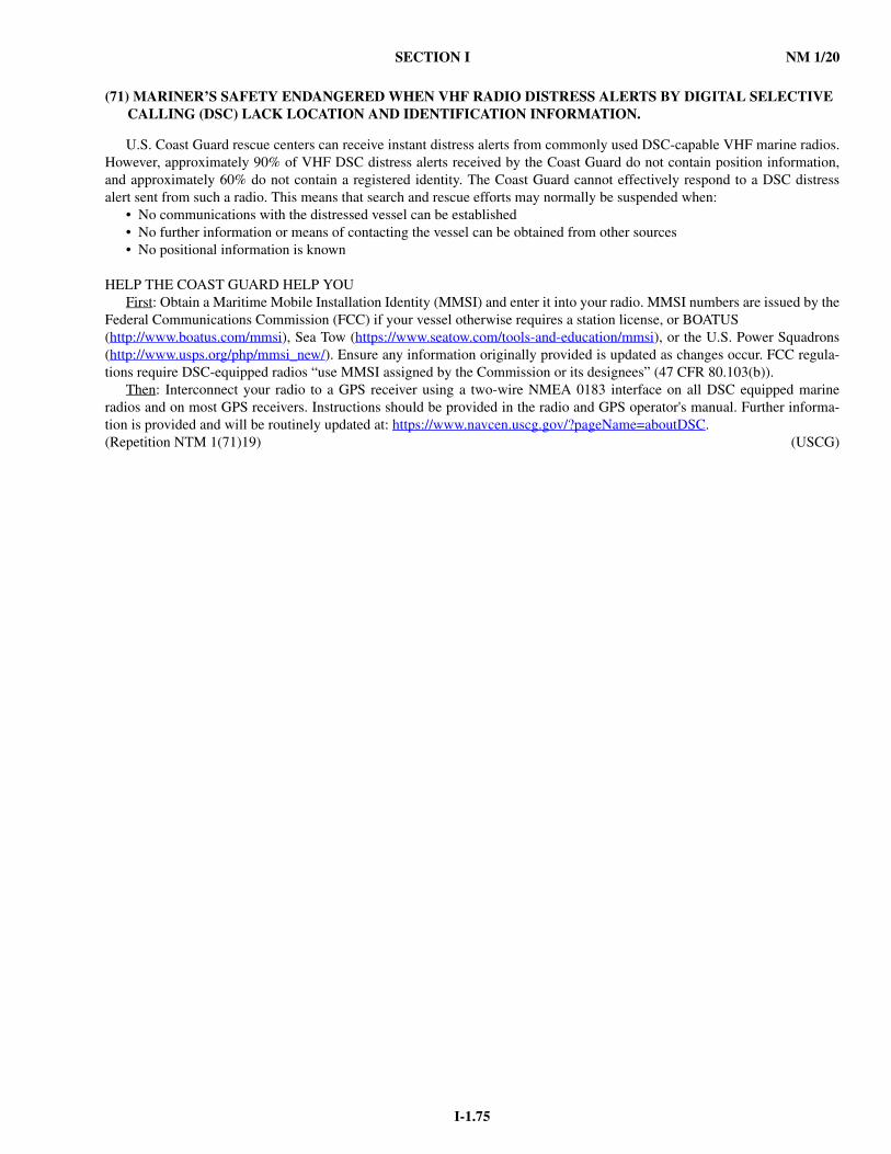
SECTION I NM 1/20
I-1.75
(71) MARINER’S SAFETY ENDANGERED WHEN VHF RADIO DISTRESS ALERTS BY DIGITAL SELECTIVE CALLING (DSC) LACK LOCATION AND IDENTIFICATION INFORMATION.
U.S. Coast Guard rescue centers can receive instant distress alerts from commonly used DSC-capable VHF marine radios.However, approximately 90% of VHF DSC distress alerts received by the Coast Guard do not contain position information,and approximately 60% do not contain a registered identity. The Coast Guard cannot effectively respond to a DSC distressalert sent from such a radio. This means that search and rescue efforts may normally be suspended when:
• No communications with the distressed vessel can be established• No further information or means of contacting the vessel can be obtained from other sources• No positional information is known
HELP THE COAST GUARD HELP YOU First: Obtain a Maritime Mobile Installation Identity (MMSI) and enter it into your radio. MMSI numbers are issued by the
Federal Communications Commission (FCC) if your vessel otherwise requires a station license, or BOATUS(http://www.boatus.com/mmsi), Sea Tow (https://www.seatow.com/tools-and-education/mmsi), or the U.S. Power Squadrons(http://www.usps.org/php/mmsi_new/). Ensure any information originally provided is updated as changes occur. FCC regula-tions require DSC-equipped radios “use MMSI assigned by the Commission or its designees” (47 CFR 80.103(b)).
Then: Interconnect your radio to a GPS receiver using a two-wire NMEA 0183 interface on all DSC equipped marineradios and on most GPS receivers. Instructions should be provided in the radio and GPS operator's manual. Further informa-tion is provided and will be routinely updated at: https://www.navcen.uscg.gov/?pageName=aboutDSC.(Repetition NTM 1(71)19) (USCG)
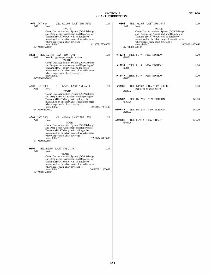
SECTION I NM 1/20CHART CORRECTIONS
I-2.1
★62 (INT 62) 3Ed. 6/22/96 LAST NM 52/16 1/20Add Note
“NOTEOcean Data Acquisition System (ODAS) buoys and Deep-ocean Assessment and Reporting of Tsunami (DART) buoys will no longer be maintained on this chart unless located in areas where larger scale chart coverage is unavailable.” 13°45′S 73°00′W
(NTM0008/2014)
★624 3Ed. 3/21/81 LAST NM 10/11 1/20Add Note in right upper margin of chart
“NOTEOcean Data Acquisition System (ODAS) buoys and Deep-ocean Assessment and Reporting of Tsunami (DART) buoys will no longer be maintained on this chart unless located in areas where larger scale chart coverage is unavailable.”
(NTM0008/2014)
★705 (INT 705) 3Ed. 6/5/82 LAST NM 46/19 1/20Add Note
“NOTEOcean Data Acquisition System (ODAS) buoys and Deep-ocean Assessment and Reporting of Tsunami (DART) buoys will no longer be maintained on this chart unless located in areas where larger scale chart coverage is unavailable.” 22°00′N 74°15′E
(NTM0008/2014)
★706 (INT 706) 4Ed. 4/19/86 LAST NM 12/19 1/20Add Note
“NOTEOcean Data Acquisition System (ODAS) buoys and Deep-ocean Assessment and Reporting of Tsunami (DART) buoys will no longer be maintained on this chart unless located in areas where larger scale chart coverage is unavailable.” 22°00′N 81°30′E
(NTM0008/2014)
★800 4Ed. 8/3/96 LAST NM 28/16 1/20Add Note
“NOTEOcean Data Acquisition System (ODAS) buoys and Deep-ocean Assessment and Reporting of Tsunami (DART) buoys will no longer be maintained on this chart unless located in areas where larger scale chart coverage is unavailable.” 56°30′N 116°00′E
(NTM0008/2014)
★804 5Ed. 4/13/96 LAST NM 38/17 1/20Add Note
“NOTEOcean Data Acquisition System (ODAS) buoys and Deep-ocean Assessment and Reporting of Tsunami (DART) buoys will no longer be maintained on this chart unless located in areas where larger scale chart coverage is unavailable.” 53°00′N 30°00′E
(NTM0008/2014)
★12210 46Ed. 11/19 NEW EDITION 1/20(NOS)
★13233 20Ed. 11/19 NEW EDITION 1/20(NOS)
★18449 21Ed. 11/19 NEW EDITION 1/20(NOS)
★22081 1Ed. 1/19/07 CHART CANCELED 1/20Replaced by chart 808981
(NGA)
★803487 2Ed. 10/12/19 NEW EDITION N1/20(NGA)
★803489 2Ed. 10/12/19 NEW EDITION N1/20(NGA)
★808981 1Ed. 11/9/19 NEW CHART N1/20(NGA)

I-3.1
SECTION I NM 1/20
CHARTS AFFECTED BY NOTICE TO MARINERSNM 4/19 THROUGH NM 1/20
Note: N indicates Not For Sale; P indicates Preliminary; T indicates Temporary; * indicates New Edition/New Chart; ** indicates Chart Canceled
Chart No.
Ed.No.
Notice toMariners No.
10 2 51/1911 2 33,51/1912 1 51/1913 1 51/1914 4 51/1950 9 6,11,52/1951 1 6,11,52/1952 1 36,44,52/1962 3 1/20
101 3 51/19102 5 51/19103 5 13,46,51/19104 5 51/19106 1 15/19107 3 51/19108 9 9,13,33,48/19109 5 13,51/19111 3 51/19120 6 13,33,51/19121 5 51/19124 10 51/19125 7 51/19126 39 13,51/19200 3 51/19202 2 15/19211 5 51/19301 1 52/19302 1 30,52/19310 20 30/19400 3 48/19401 5 48/19402 4 51/19411 54 12,31,38,39,44,48,51,
52/19500 10 13,52/19501 13 12,39,41,52/19504 4 6,9,11,52/19505 2 52/19507 2 36/19508 2 48/19509 4 8,13,52/19510 3 52/19511 4 13,52/19513 10 52/19520 127 9,11,44/19522 87 36,52/19523 8 9,11/19524 12 36/19525 3 36/19526 10 6,11,36,52/19530 35 6,9,11,12,13,41,52/19540 19 6,9,44,52/19541 2 9,44,52/19550 7 19/19600 5 52/19601 4 52/19608 2 52/19624 3 1/20632 8 19,48,50/19704 1 45/19705 3 46/19;1/20706 4 12/19;1/20707 2 12/19708 3 50/19800 4 1/20804 5 1/20
1113A 33 50/19*1114A 36 7,22,26,32,38,46/191115A 44 8,13,33/191116A 80 4,6,8,10,11,12,13,16,18,
26,28,33,38,42,46,47/191117A 44 4,12,13,33,42,46,49,50,
51/194148 3 9,26,32,46/194149 1 40/19
11004 9 4,12,13/1911006 34 32,33,38/1911009 39 4,5,31,33,37,48/1911013 48 32,38,39,40,44/1911299 1 N30/1911300 44 4,12,13,33,42,46,49,50,
51/1911301 26 16,51/1911302 34 16/1911305 2 N6/1911307 38 30/1911308 26 6/19
11309 43 25*,30,32,49/1911311 25 30,32,42,49/1911312 7 46/19*11313 24 4,25,30,33/1911314 26 8/1911316 43 31/19*11317 33 21,48,49,50/1911318 2 N6,N7,N30,N49/1911319 34 49,50/1911320 1 N30/1911322 33 49/1911323 66 9*,32,46/1911324 40 6,7,32/1911325 41 32/1911326 41 21*,42,46/1911327 38 8,42,46/1911328 29 32/1911329 41 9*,32/1911330 24 35*,42,46/1911331 22 7/1911332 34 35*,42,46/1911339 5 46/19*11340 80 4,6,8,10,11,12,13,16,18,
26,28,33,38,42,46,47/1911341 45 12*,26,28,42,47/1911342 57 34/19*11344 41 10,11,12,13/1911346 5 12,18/1911347 41 46/19*11349 47 11,12,16/1911350 28 42/1911351 44 44/19*11352 42 12,16,18/1911353 9 5/19*11354 28 16,42/1911355 32 9*,42/1911356 42 44/19*11357 43 10,11,12,13,18,42/1911358 58 12,13/1911360 44 8,13,33/1911361 78 6/1911362 6 N8,N13,N15,N33/1911363 46 6,11,12,30/1911364 46 46/1911365 25 18/1911366 16 11,12,13,15,25/1911367 39 21,41/1911368 25 21,41,42/1911370 29 11,12,16,25,41/1911373 52 15,25,40/1911374 38 7,25,40/1911376 58 7,8,21,32,40,48/1911377 11 8,21,32,48/1911378 39 46/19*11380 4 21,48/1911382 42 33/1911383 55 8,42/1911384 38 8/1911385 28 42,44/1911388 18 42/1911389 36 22*,28,36/1911390 26 6,7,18,33/1911391 26 6,7,18,33,36/1911392 9 33/1911393 23 6,28/1911400 37 19*,22,46/1911401 33 26*,42/1911402 23 42/1911404 25 11/1911405 31 11/1911409 31 38/1911411 22 44/19*11412 50 44/19*11415 14 41/19*11416 14 22*,29,42,46/1911420 33 50/19*11423 9 N26,N32,N38,N46/1911424 21 19*,26/1911425 41 29*,42/1911426 40 18/19*11434 30 12*,25,26,32,38/1911435 15 N9,N13,N25,N26,N32,
N38/1911439 29 26/19*11441 42 11/1911442 37 11/1911446 33 11/19
Chart No.
Ed.No.
Notice toMariners No.
11450 11 38/1911451 36 46,49/1911459 2 11/1911460 44 5,33/1911461 5 38/1911465 40 46,49/1911467 44 46,49/1911468 45 46,49/1911472 37 5/19*11476 24 27/19*11477 6 N5,N33/1911479 6 N5,N33,N40/1911480 41 5,9,31,33,48/1911481 10 38/1911484 25 9/19*11488 29 9/1911489 41 46/19*11490 22 20*,48/1911491 40 39/19*11492 21 46/1911493 10 N46/1911494 9 N46/1911496 12 N5,N9,N31,N33,N48/1911503 47 10*,32,46/1911505 5 9,38/1911506 46 21/1911509 32 9,48/1911511 18 48/1911512 65 9,38/1911513 29 38/19*11514 31 26,46/1911516 32 38,48/1911517 18 25,38/1911518 38 25,31,46,48/1911520 45 4,31,37/1911521 32 20,31,44,46/1911522 21 31,44/1911524 54 9,25,31,42,44,46/1911525 10 N4,N31,N37/1911528 3 16*,20,31,44,46/1911532 23 41/19*11534 40 41/19*11536 20 21,31/1911537 40 4,14,22,31,32/1911541 42 11*,21,27,38,43/1911542 20 43/1911543 25 21,27/1911544 41 21,27/1911545 67 31*,48/1911547 40 8,9,21,27,38/1911550 33 44/19*11555 43 4,37/1912200 53 4,9,10,33,34,37,38,48/1912201 29 N4,N9,N10,N15,N33,
N34,N37,N38/1912204 39 7,51/1912205 35 7,51/1912207 25 37/19*12208 17 15,48/1912210 46 1/20*12214 51 14*,38,48/1912221 84 25*,38,48,52/1912222 56 23*,33,38,48/1912224 28 9,52/1912225 62 37/19*12226 19 32/1912228 35 48/1912230 67 46,48/1912231 32 28*,48/1912233 39 10/1912238 43 51/1912241 24 51/1912243 15 51/1912245 70 10*,33,38,48/1912248 45 15,25,27,38/1912251 24 15,27/1912252 25 7/1912254 51 44/19*12256 19 33,38,48/1912263 58 33,48,51/1912264 34 27*,46/1912266 34 33/19*12270 40 33*,48,51/1912272 33 51/1912273 60 8,26,33,42,48/1912274 38 9*,42,48/1912277 37 37/19*
Chart No.
Ed.No.
Notice toMariners No.
12278 79 8,26,33,51/1912280 11 8,9,15,26,33,38,46,48,
52/1912281 57 11,26/1912282 37 33,48/1912284 17 11/1912285 43 19*,32,48/1912286 33 32,48/1912300 49 9,31,32,52/1912301 23 N9,N14,N31,N32,
N52/1912304 49 46,48/1912311 48 10*,38,39,47,51/1912312 58 8,31,34,47,48/1912313 53 34/1912314 34 5/19*12316 37 38/1912318 45 48/1912324 37 49,52/1912325 6 4/1912326 53 7,9,13,16,52/1912327 108 7,12,15,16,22,25,38,39,
40,41,42,49,52/1912331 33 15,22,38,40,41/1912332 24 49/1912333 37 13,22,38/1912334 73 5*,25,52/1912335 46 11*,25,52/1912338 11 13/1912339 47 38/1912342 24 38/1912350 62 11*,13,39,41,42/1912352 35 8,16/1912353 19 16/1912354 47 5*,15,31,40/1912358 23 18*,31/1912363 42 7,16,37,52/1912364 40 7,16,31,34,37,40,52/1912365 28 7,52/1912366 30 40/1912367 25 7,16,34/1912369 27 37,40,52/1912370 21 40/1912371 25 4,31/1912372 38 22*,31/1912373 17 19/19*12374 16 11/19*12375 23 18/19*12401 13 12,16,49/1912402 14 16,30,40,41,42,52/1913000 1 N9,N13,N17,N21,N32,
N33,N43/1913003 52 4,9,10,13,15,26,31,32,33,
37,38,43/1913006 36 9,12,13,26,31,32,43/1913009 38 9,26,43/1913200 39 9,26,32,43/1913201 12 N9,N13,N26,N32,
N43/1913205 41 31,32/1913209 28 31,32/1913212 40 31/1913213 43 31/1913214 30 31/1913215 21 31,32/1913216 1 N31/1913217 17 32/1913218 44 7,32,40,46/1913221 63 26*,32,42,51/1913223 44 32,42/1913224 41 26*,32,40,42/1913225 35 40,42/1913226 8 42,51/1913227 15 42,51/1913228 13 40/1913229 34 7,10,32,44,46,51/1913230 53 11*,32,46/1913232 5 7/1913233 20 1/20*13235 7 32,44,51/1913236 32 7,10/1913237 44 37/19*13238 16 7/1913241 18 7/1913242 18 7/1913246 40 9/1913253 20 9/19
Chart No.
Ed.No.
Notice toMariners No.

I-3.2
NM 1/20 SECTION I
CHARTS AFFECTED BY NOTICE TO MARINERSNM 4/19 THROUGH NM 1/20
Note: N indicates Not For Sale; P indicates Preliminary; T indicates Temporary; * indicates New Edition/New Chart; ** indicates Chart Canceled
13260 43 9,12,26,43/1913263 9 N9,N12,N13,N21,N26,
N43/1913267 37 39*,50/1913270 66 9,26,40,50,51/1913272 55 44*,51/1913274 30 26,31,43,46,50,51/1913275 32 13,26,31,50,51/1913276 23 13,31,40,51/1913278 28 13,43,46/1913279 34 43/1913281 19 51/1913282 12 4/1913283 23 33/1913285 12 33/1913286 34 16/19*13287 13 27/1913290 41 44/19*13292 42 8/1913293 36 43/1913295 12 43/1913302 25 18*,40,51/1913305 31 38/1913308 13 38/1913309 30 14,31,39,40,51/1913312 24 4,9/1913313 22 9/1913318 19 9/1913323 9 9/1913325 16 9,12,26/1913326 14 9/1913392 3 26/1913394 5 26,27,45/1913396 7 26,27,45/1914001 N33,N46/1914003 6 9,13,15,17,21,32,33,
38/1914013 N26,N33,N46/1914019 N9,N12,N21,N26,N27,
N45/1914036 1 N26,N28,N29,N30,N33,
N46/1914047 1 N30/1914048 2 N30,N39/1914049 N26,N28,N29,N30,
N33/1914050 1 N30/1914193 1 N21,N47/1914195 2 N21/1914196 N26/1914197 N26/1914207 33 15/1914209 2 N15,N17,N18,N19,
N22/1914211 2 N17,N18,N22/1914212 2 N17,N18,N19,N21,
N26/1914213 2 N20,N21,N22/1914215 1 N20,N26,N28,N50/1914216 2 N26,N28,N35,N36,N37,
N39,N40/1914219 1 N50,N52/1914220 N26/1914334 1 N26/1914348 1 N26/1914359 1 N26,N28,N29,N39/1914756 1 N21,N47/1914757 1 N35,N47/1914758 1 N15,N21/1914759 2 N13/1914760 N26/1914770 17 15,21/1914774 17 13/1914775 2 N15,N21/1914776 1 N13/1914781 21 9/19*14783 21 9/19*14785 18 8/19*14800 10 26/1914802 31 13,26/1914826 28 52/1914829 7 52/1914830 34 10/19*14833 27 11/1914836 28 24/1914837 29 24/1914839 38 24,52/19
Chart No.
Ed.No.
Notice toMariners No.
14844 34 26/19*14846 16 24/1914847 31 24/1914848 60 25,28,33,38,41/1914850 56 36,52/1914852 48 28,52/1914853 19 24,25,28,33,38,52/1914854 16 24,28,33/1914860 37 46/1914864 28 24/1914865 17 28/1914880 34 46/19*14881 36 48/19*14904 28 22/19*14905 33 24/1914911 22 24/1914924 29 25,26/1914926 14 25/19*14935 22 17/1914937 25 17/1914938 25 17/1914966 29 19/19*14971 22 25/1914972 27 25/1916016 22 14/1916190 2 5/19*16204 8 5/19*16594 14 4/1916645 20 52/1916646 14 52/1916660 31 5/1916663 10 5/1916665 11 5/1916700 32 4/1916709 25 4/1917003 4 11,12/1917007 1 N11,N14,N44/1917010 1 N7,N12,N47/1917400 18 14,44/1917411 1 N11,N14,N15,N44/1917420 29 11,14,15,30/1917434 14 30/1917435 17 30/1917440 2 N51/1917454 1 N14/1917460 N14/1917496 1 N9,N18,N31,N47,N48,
N50/1917498 1 N7,N15,N19,N22,N34,
N35,N50/1917499 1 N7,N11,N19,N34,N35,
N37,N46,N50/1917514 1 N12/1917520 2 N15,N19,N35,N46/1917524 N34,N39/1917525 1 N34,N39/1918000 8 25,32,41,46/1918002 9 N12,N32,N41,N46/1918003 20 7,12,52/1918005 6 N41/1918007 33 12,52/1918008 9 N12,N52/1918009 4 N41/1918010 22 39/1918020 39 12,25,32,41,46/1918022 36 12,25,32,35,41,46/1918400 51 34*,44,52/1918421 53 12*,20,44/1918426 2 N7,N9/1918427 25 44/19*18428 10 44/1918429 11 44/1918431 9 16,20/1918432 7 16,20,21,41/1918433 6 41/1918434 7 44/1918435 2 N7,N34/1918436 2 N31/1918437 2 N7,N50/1918441 48 10/1918442 1 N9,N11,N16,N21,
N35/1918444 17 38,43/1918446 18 10,38/1918447 30 38/1918448 36 33/1918449 21 1/20*
Chart No.
Ed.No.
Notice toMariners No.
18453 27 38/1918456 21 33,38/1918460 14 7,10,49/1918461 1 N7,N16,N20,N21,N37,
N50,N52/1918462 1 N11,N46/1918464 25 26/1918465 39 11/1918466 2 N11,N46/1918467 2 N37,N41/1918469 1 N8,N18,N42/1918471 11 26/1918473 9 10/1918480 32 7,10,12,52/1918500 31 38/19*18504 66 33/1918520 28 38/19*18521 77 14*,29,30/1918523 58 28/1918524 38 28,44,46/1918525 38 4,25,28,44/1918526 60 4,28,44/1918531 24 28,44/1918532 21 12,52/1918556 26 52/1918558 39 52/1918587 71 14/1918622 56 43/1918640 27 51/1918643 18 32/1918645 28 33,51/1918649 68 10,14,15,21,33/1918650 58 15,21/1918651 45 33/1918653 12 10,14,15/1918654 45 25/1918655 59 25/1918656 56 8,25,36/1918657 19 8,25,36/1918658 31 8,36/1918659 16 36/1918660 3 36/1918661 30 36/1918662 22 36/1918663 6 36/1918666 1 36/1918680 32 51/1918700 23 32,41/1918703 26 11/1918704 13 11/1918720 34 35,41/1918721 12 35/1918740 45 12,20,32,36,41/1918741 21 N32,N36/1918746 40 12,20/1918760 9 N12,N32,N35,N41,
N46/1918765 17 32,36/1918768 8 N29*,N32,N36,N46/1918772 48 27,36/1918773 43 27/1919002 12 N28,N44/1919004 39 28,44/1919007 18 6,9,11,44/1919008 5 9,11,44/1919010 20 9,28,44/1919013 19 9,44/1919016 12 6/1919320 17 28,44/1919327 11 28/1919339 3 N44/1919340 27 44/1919342 11 44,46/1919347 19 44,46/1919351 11 44/1919357 25 44,46/1919359 12 44/1919360 1 N44,N46/1919362 14 44,46/1919366 38 44/1919367 41 24/1919369 7 24,44/1919379 3 N44/1919380 15 44/1919381 9 44/1919387 10 N44/1921005 5 51/19
Chart No.
Ed.No.
Notice toMariners No.
21008 62 50/1921011 5 51/1921014 72 21,43,50/1921017 50 43,50/1921021 4 N14,N16,N46/1921026 47 44/1921120 27 43/1921126 2 N21,N43/1921140 1 14,16,32,36,46/1921200 1 51/1921301 14 21/1921401 21 14/1921524 4 36,38/1921560 33 28/1921562 14 28/1921580 40 28/1921602 3 N46/19*21604 27 N46/19*21606 1 N46/19*22008 35 36,38/1922050 4 46/1922051 19 46/1922052 7 19,34,46/1922054 1 46/1922055 1 46/1922080 3 36/1922081 1 1/20**22100 4 N36/1922101 20 36/1922130 2 40/1922134 1 N11,N34,N39,N40/1922140 2 40/1922143 4 52/1922160 2 36,38/1922170 3 36,38,47,52/1922172 9 N24,N34,N36,N37/1922173 37 N24,N34,N36,N38,N39,
N52/1922181 18 N33,N34,N39,N40,N46,
N47,N52/1922233 30 N28,N46/1922259 6 N46/1922263 3 N13,N46/1922264 4 N46/1922275 3 46/1922290 4 46/1922293 15 46/1922294 17 N13,N39,N43/1922395 2 30/1922398 1 N14/1922399 1 N14/1922401 5 N14/1922405 7 N38/1922409 5 N13,N14,N47/1922410 33 N16/1922419 1 N19,N45,N46/1922420 3 N30,N45/1922422 1 N19,N46/1922426 1 N18,N19,N36,N38,N45,
N46/1922428 1 N18/1922431 1 N18,N19,N36/1922432 1 N42/1922483 1 N16,N43/1923030 6 11,19/1924000 39 15/1924004 36 36/1924008 42 36/1924012 40 13,15,20,47/1924016 53 13,15,20/1924028 6 11,15,19/1924050 12 N11,N12,N19/1924052 17 N13,N17,N26,N33,N34,
N35,N39,N40,N43,N46,N47/19
24053 17 N13,N33,N34,N35,N39,N51/19
24055 7 N11,N12,N13,N17,N47/19
24057 6 N6,N11,N12,N15,N16,N19,N20,N33,N51/19
24080 6 N15/1924091 7 N15/1924100 6 N15/1924150 28 N36/1924160 22 N36/19
Chart No.
Ed.No.
Notice toMariners No.
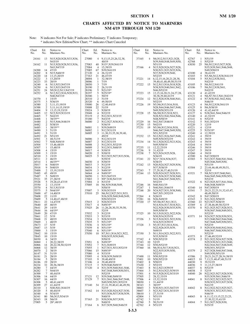
I-3.3
SECTION I NM 1/20
CHARTS AFFECTED BY NOTICE TO MARINERSNM 4/19 THROUGH NM 1/20
Note: N indicates Not For Sale; P indicates Preliminary; T indicates Temporary; * indicates New Edition/New Chart; ** indicates Chart Canceled
24161 13 N15,N20,N28,N33,N36,N43/19
24162 11 N15,N20,N28,N33,N36,N43,N47/19
24200 14 47/1924202 8 N15,N40/1924220 14 13,15,20/1924222 3 13,20/1924223 33 20/1924240 6 N13,N33,N47/1924250 6 N13,N33,N47/1924251 24 N9,N12,N13,N47/1924252 6 N12,N13,N16,N20,N33,
N40,N47/1924370 1 15/1924375 3 N36/1924380 2 5,11,15,19/1924388 2 5,11,14,15,19/1924404 9 13,15,19,33/1924405 12 N15,N19,N33/1924465 7 N42/1924468 1 38/19**24480 2 N15,N46,N48/1924482 2 N38/1924485 1 38/19**24490 3 51/1924491 3 51/1924492 21 N51/1924501 3 48,51/1924502 7 N48,N49/1924504 7 15,46,48/1924507 1 15,48/1924508 4 15/1924509 3 15/1924510 3 15/1924511 2 46/1924514 1 46/19**25017 6 N40/1925018 9 N40/1925400 2 15,19,33/1925485 45 49/1925487 5 N49/1925521 35 27,28/1925528 5 19,28,43,47/1925550 2 13,15/1925570 4 N13,N15/1925575 5 N44/19*25600 47 14,40/1925608 22 11/1925609 5 14,40,47,48/1925611 22 14,47/1925640 45 40/1925641 29 14/1925644 16 44/19*25649 20 47/1925661 12 5/1925668 21 40/1925669 1 40/1925673 17 5/1925687 13 5/1925800 3 15/1925842 10 15/1925845 10 15/1926030 6 34/1926060 1 20,22,38/1926066 14 20,22,38,50,52/1926068 12 38/1926070 2 38/1926147 31 51/1926181 21 28/1926184 5 28/1926186 19 28/1926224 32 20,36,38/1926280 7 44/1926282 7 N44/1926300 7 40,44/1926306 14 44/1926307 16 44/1926308 5 40,41,44/1926309 27 41,44/1926310 1 N40,N41,N44/1926320 5 40,44/1926340 6 N34/1926341 80 N6,N15,N34/1926343 18 N6/1927005 5 28*,40/19
Chart No.
Ed.No.
Notice toMariners No.
27080 4 9,13,15,25,26,32,38,40/19
27083 40 N15*,N39,N41/1927084 4 15,39/1927085 67 N39,N41/1927120 4 26,31/1927163 21 46,47/1928004 1 32,38/1928006 1 7/1928050 3 7/1928190 2 26,31/1928196 5 N21/19*28197 5 N25/19*28300 1 50/1928310 2 51/1928320 6 49,50/1935000 26 12,40,44/1935008 22 51/1935024 3 N30/1935048 4 N32/1935119 2 N12,N31,N33/1935180 7 N43/1936000 2 N12,N27,N30,N31,
N36/1936001 1 N39,N49/1936002 1 N12,N31/1936005 3 11,30,33,35,38,39,40,
49/1936006 3 N12,N31/1936007 2 N12,N31/1936008 2 N12,N31,N32/1936009 2 N12,N31,N40/1936017 4 N30/1936020 2 N30/1936025 5 N12,N22,N27,N33,N36,
N39/1936030 4 N30/1936033 3 N12/1936034 3 N12/1936039 3 N49/19*36044 4 N49/19*36050 1 N33,N47/1937003 3 N9*,N30,N47/1937004 4 N33/1937005 18 N6,N39,N48,N49,
N50/1937007 3 N30,N33/1937010 25 N6,N12,N27,N31,N33,
N36,N39,N40,N48,N49,N50,N52/19
37015 2 N20,N33/1937017 4 N49/19*37025 26 11,26,28,30,35,39,50,
52/1937032 3 N12/1937033 3 N33/1937034 3 N28,N33/1937035 5 N51/19*37036 4 N51/19*37039 8 N51/19*37040 6 N51/19*37050 10 N7,N11,N14,N21,N22,
N30,N35,N39,N49,N50/19
37051 6 N49/19*37052 7 N31,N49/1937055 1 N27,N31,N33,N52/1937066 15 N49/19*37080 4 N33/1937095 4 N38,N39,N49/1937103 9 39,40,49/1937106 4 39,40,49/1937115 3 N39,N40,N49/1937120 4 N31,N39,N40,N41,N46,
N47,N48,N49,N50,N51,N52/19
37121 12 N39,N40,N49/1937129 7 N31,N41,N46,N47,N48,
N49,N50,N51,N52/1937140 34 27,31,39,40,41,46,49,50,
52/1937162 14 N15,N20,N24,N27,N30,
N33,N36,N37,N38,N39,N40/19
37163 21 N30,N36,N37,N39,N40/19
37164 6 N37,N39,N40,N46/19
Chart No.
Ed.No.
Notice toMariners No.
37165 4 N6,N12,N15,N21,N28,N39,N40,N48,N49,N50,N51/19
37166 4 N15,N20,N24,N27,N28,N30,N31,N33,N35,N36,N37,N38,N39,N40,N52/19
37221 14 6,12,15,16,20,21,28,38,39,40,41,48,49,50,51/19
37222 15 N12,N13,N16,N18,N28,N38,N39,N40,N41,N42,N46,N52/19
37223 15 12,15,16,20,21,24,27,28,30,38,39,40,41/19
37224 12 N12,N28,N38,N40,N41,N52/19
37226 19 N5,N6,N15,N16,N18,N28,N44,N46,N47,N48,N49,N50,N51/19
37228 15 N6,N8,N15,N18,N23,N28,N32,N42,N44,N46,N48,N50/19
37229 16 N42,N47,N48/1937230 15 N42/1937231 19 N5,N6,N12,N16,N18,
N46,N47,N48,N49,N50,N51,N52/19
37232 13 N12,N21,N24,N47,N48,N49,N50,N52/19
37234 14 N12,N20,N22,N23,N24,N49,N50/19
37235 11 12,22,23/1937236 9 31,42/1937238 7 N23,N24,N25,N28,
N36/1937241 22 N21*,N24,N36,N37,
N38/1937242 13 N20,N24,N27,N29,N36,
N37,N38/1937243 7 27,29,30,37,40,51/1937244 13 N20,N24,N27,N28,N31,
N33,N36,N37,N38,N40,N41,N46,N47,N48,N51,N52/19
37246 16 N40,N41/1937247 1 N40,N41,N44/1937248 20 N24,N27,N31,N38,N40,
N47,N51,N52/1937264 4 N26/1937281 16 N26,N49/1937320 17 N5,N6,N7,N11,N13,
N14,N16,N17,N18,N21,N22,N26,N30,N35,N39,N49,N50/19
37325 10 N13,N18,N21,N22,N26,N30,N34,N35/19
37326 3 N15,N18,N21,N22,N30,N34,N35,N39/19
37328 3 N5,N7,N13,N14,N16,N22,N26,N35,N39,N49/19
37330 3 N11,N14,N21,N22,N33,N35,N39/19
37342 4 N50,N52/1937343 10 52/1937344 12 N50,N52/1937360 16 N6,N14,N17,N18,N21,
N22,N35,N39,N50,N52/19
37400 11 N50,N52/1937401 10 N50,N52/1937402 8 N50/1937420 2 N52/1937463 8 N12,N23,N39/1937464 3 N12,N14,N23,N39/1937501 4 N15,N28,N32,N33/1937505 2 28,32,33/1937506 4 15,32,33/1938030 1 31,44/1938343 3 30/19*38603 3 N30,N31,N33,N47/1938607 3 N23,N27,N31,N33/1938610 1 27,31/1942004 1 N51/1942742 3 51/1942760 5 50,51/1942762 4 N51/19
Chart No.
Ed.No.
Notice toMariners No.
42767 1 N51/1942768 1 N52/1943030 25 N6,N12,N15,N27,N28,
N35,N39,N41,N46,N48,N49,N50/19
43100 4 38,41/1943103 5 N5,N6,N12,N38,N41/1943104 5 N5,N12,N38,N41,
N42/1943105 5 N6,N12,N41/1943106 7 N6,N12,N38,N41,
N42/1943120 4 41,42/1943121 4 N6,N7,N12,N41,N42/1943122 4 N7,N38,N41,N42,N44,
N46/1943123 4 N6,N12,N38,N41/1943125 8 N6,N38/1943126 4 41,42,44/1943127 6 N38,N41,N44,N46/1943140 4 41,52/1943141 6 N52/1943142 5 N41,N52/1943220 3 12/1943221 4 12/1943225 5 N35/19*43240 4 12,39/1943241 4 39/1943242 4 39/1943243 4 39/1943244 4 39/1943246 5 39/1943247 5 39/1943260 4 39/1943300 6 N47,N50/1943303 5 N23,N37,N40,N41,N44,
N45,N46,N49,N50,N51/19
43304 2 23,44,46,48,49,50,51,52/19
43321 7 N8,N23,N37,N40,N41,N44,N45,N46,N50,N51,N52/19
43322 6 N23,N25,N37,N41,N44,N46,N48,N49/19
43340 14 N47,N50/1943341 7 20,21,22,23,31,32,43,47,
48,49,50/1943342 8 N47,N50/1943343 3 N21,N22,N50/1943360 22 N23,N27,N28/1943369 6 27,38,46,49,50,52/1943370 8 N21,N25,N27,N28,N33,
N38,N47,N48,N49,N51,N52/19
43371 14 N24,N27,N28,N30,N31,N33,N40,N42,N44,N46,N47,N48,N49,N50,N51,N52/19
43372 5 N29,N30,N40,N42,N44,N46,N47,N48,N50,N51,N52/19
43373 8 27,46,49,52/1943374 2 N21,N22,N24,N27,N28,
N29,N30,N31,N33,N40,N42,N44,N47,N48,N49,N50,N51,N52/19
43379 2 N27,N28,N40,N47,N48,N49,N50,N51/19
43386 2 20,21,24,27,28,34,38/1944015 10 7,13,21,40,47,48,51/1944030 9 39,51/1944036 5 11,13,27,38/1944037 6 N52/1944038 5 52/1944040 26 N22,N23,N27,N28,N30,
N35,N39,N41,N46/1944041 8 N15,N22,N23,N25,N27,
N30,N32,N33,N37,N38,N41/19
44042 8 N12,N22,N23,N25,N27,N30,N31,N32,N33,N41,N46/19
44043 8 8,11,12,13,15,22,23,25,27,30,32,33,41/19
44044 7 N11,N27,N28,N30,N35/19
Chart No.
Ed.No.
Notice toMariners No.

I-3.4
NM 1/20 SECTION I
CHARTS AFFECTED BY NOTICE TO MARINERSNM 4/19 THROUGH NM 1/20
Note: N indicates Not For Sale; P indicates Preliminary; T indicates Temporary; * indicates New Edition/New Chart; ** indicates Chart Canceled
44045 7 N7,N11,N27,N28,N35,N39,N41/19
44046 11 N15,N30,N31,N38/1944048 13 N6,N7,N11,N25,N27,
N28,N29,N38,N46,N50/19
44049 11 N7,N22,N27,N30,N33,N35,N37/19
44050 25 N29*,N33,N35,N37,N38,N39/19
44051 2 N7,N23,N35/1944052 2 N7,N11,N31/1944054 1 N37,N48/1944057 6 N46,N48/1944061 22 30,48/1944064 20 N48/1944065 8 N15,N19,N20,N21,N38,
N46/1944066 11 N6,N21,N22,N38/1944067 23 15,19,20,21,31,38,46,49,
50/1944069 17 N48/1944076 4 N46/1944081 10 N52/1944082 12 N13,N15,N20,N28,N48,
N51/1944083 9 N7,N23,N46,N48/1944084 2 N22,N23,N41,N47,N48,
N49/1944085 2 13,15,31,48,51/1944087 1 N46/1944100 9 N22,N33,N46,N48,N51,
N52/1944105 3 N25,N27,N28,N30,N34,
N43,N46/1944120 9 N15,N28,N41,N48,N49,
N51/1944122 2 N12,N28,N29/1944123 2 N12,N28,N29/1944140 10 N13,N15,N46/1944178 3 N28,N30,N34,N35,
N37/1944179 3 N8,N11,N33,N34,
N37/1944180 7 N15,N21,N22,N47/1944181 6 N7,N8,N21,N30,N33,
N34,N35,N37,N41,N47/19
44182 5 N15,N16,N18,N21,N22,N23,N30,N32,N33,N34,N35,N36,N37,N38,N39,N41,N46,N47,N50,N51/19
44183 7 N7,N12,N13,N15,N18,N21,N27,N30,N33,N34,N37,N38,N39,N46/19
44184 10 N7,N8,N12,N13,N15,N16,N18,N21,N22,N24,N27,N28,N30,N31,N32,N33,N34,N35,N37,N41,N47,N50/19
44185 8 N7,N8,N11,N13,N15,N16,N18,N21,N22,N29,N30,N33,N34,N35,N37,N41,N43,N47,N50/19
44186 3 N7,N8,N12,N21,N24,N27,N28,N32,N33,N34,N37,N38/19
44187 3 N7,N8,N12,N21,N24,N28,N33,N37,N38,N47/19
44200 10 N47/1944240 9 N46/1944281 3 N46,N48,N52/1944283 3 N46,N48,N52/1944319 3 39,49,51/1944320 5 N46,N47,N49,N52/1944323 1 N29,N32,N46,N47/1944324 1 N8,N13,N16,N23,N29,
N47/1944326 1 N13,N39,N47/1944327 1 N39,N47/1944340 13 N39,N41,N49,N51,
N52/1944341 9 N9*,N41,N49,N51/1944342 10 N39,N41,N46/19
Chart No.
Ed.No.
Notice toMariners No.
44352 4 N23,N36,N39,N42,N46/19
44355 2 N39,N42/1944360 11 N8,N39,N41/1944361 8 N8,N11,N12,N22/1944362 2 N8,N12,N13,N22,N30,
N52/1944364 1 N41,N50/1944367 3 N41,N50/1944400 6 N40,N41,N47,N48,
N51/1944401 10 N40,N41,N47,N51/1944410 5 47/1944420 7 7,23,27/1944430 4 N7,N13,N23,N51/1944442 2 N7,N23/1944443 1 N7,N32,N47,N51/1944444 8 N27,N46/1944445 1 N27,N46/1944446 2 N39,N47/1944447 1 N23,N42,N47,N50/1944462 6 N8,N12,N13,N20,N21,
N23,N28,N41,N44,N46,N47,N49,N51/19
44463 10 N8,N21,N23,N41,N44,N46,N51/19
44465 4 N8,N13,N21,N43,N46,N48,N49,N51/19
51002 7 7,13,39/1951013 5 21/19*51017 31 7,30,39/1951022 11 30/1951027 8 38/1951032 10 38/1951037 10 52/1951081 11 N7,N39/1951082 8 N7,N39/1951109 6 N52/1951142 3 N39,N44/1951154 3 5,6/1951159 4 N6/1951160 22 N5,N40/1951163 5 N39,N45/1951164 19 N39/1951165 10 N29*,N39/1951167 8 N34*,N39/1951168 3 N45/1951180 5 40,46/1951181 10 29,36/1951220 8 13,22/1951222 7 N20/1951223 3 N13,N20,N25/1951224 1 7,18/1951225 3 21,22,25,28,30,39,40/1951240 2 7/1951261 23 49/1951263 23 38/1951280 8 7/1951300 4 25,28,30,39,40/1951341 24 N25,N26,N27/1951345 1 N25,N26,N27,N40/1951346 1 N31,N42,N52/1951347 2 N30,N31,N39,N42,N50,
N52/1951473 1 N37,N41/1951480 4 38/1951559 4 22,25/1951560 11 8,38/1951561 11 38/1951562 10 41,44/1951601 10 N21/19*51605 1 N8,N22/1951622 1 N43/1951640 6 52/1951641 6 N25,N27,N38/1951642 5 N52/1951644 5 N52/1952031 2 40/1952036 1 N21*,N45,N49/1952039 6 N29*,N39,N40,N45,
N46,N49/1952040 19 N39,N40,N41,N46,
N49/1952042 7 N34/19*52043 23 N6,N23,N26,N29,N30,
N33,N38,N39,N46/1952045 8 N33,N38,N39,N46/19
Chart No.
Ed.No.
Notice toMariners No.
52046 22 N26/1952048 4 N6,N39,N40,N46,
N49/1952051 2 N23/1952053 1 N23,N26/1952060 17 N26/1952061 3 N12,N26,N31,N39/1952062 8 N26,N39/1952079 1 N12/1952080 15 N11,N12,N15,N28,N29,
N31/1952082 4 N12,N15,N23,N28,N29,
N31,N48/1952083 2 25,28,29,44,46/1952084 3 N12,N23,N28,N29,
N48/1952085 4 N12/1952088 3 15,29,48/1952117 1 29,30,47/1952118 1 30/1952119 1 29/1952120 13 N25,N27,N29,N39/1952121 10 N29,N39/1952122 17 N6,N7,N8,N25,N27,
N38,N39/1952125 2 N8,N25,N27,N39/1952126 2 N6,N7,N8,N25,N27,
N38,N39/1952140 7 N12,N15,N26/1952143 9 N12,N15,N26/1952144 6 N15,N26/1952145 1 N26,N39/1952147 1 N12,N23,N30/1952160 7 8/1952180 14 15,23,43,44,47/1952183 10 N46/1952184 5 N46,N47/1952186 4 N5,N15,N21,N23,
N30/1952200 8 19,43,47,49,50,51,52/1952202 7 47,49,50,51,52/1952220 7 52/1952240 10 N38,N39,N45/1952243 12 N27,N38,N39/1953011 3 15,44,48,52/1953031 2 25,26,31,40,48,52/1953060 15 13,21,26,30,40/1953061 11 N5,N6,N12,N21,N26,
N39,N40/1953062 14 N5,N21,N26/1953081 10 N6,N12,N13,N21,N26,
N30/1953082 15 N20,N22,N26,N30,N46,
N49/1953084 7 N13,N26,N40,N42,N44,
N45,N46,N47,N48/1953085 7 N9,N26,N44,N46,
N48/1953086 9 N13,N26,N40,N42,N45,
N46,N47,N48/1953087 10 N6,N13,N26,N40,N42,
N44,N45,N46,N47/1953090 2 N44/1953093 4 N13,N26/1953100 18 N11,N26,N31,N32,N34,
N40,N42,N44,N47/1953101 8 N31,N32,N34,N40,
N41/1953103 1 N7,N31,N32,N34,N40,
N42/1953104 3 N31,N34,N40/1953105 21 N11,N30,N47/1953106 8 N11,N30,N47/1953107 18 N7,N42/1953110 2 N32/1953120 15 N32,N48,N52/1953122 4 N31,N34,N40/1953130 1 32,47,48/1953135 3 N48,N52/1953141 6 N11,N12,N34,N44,N48,
N49,N52/1953160 15 N11,N44,N48,N49/1953161 9 N48,N49/1953162 8 N48,N49,N50/1953164 10 N48/1953165 14 N49,N52/1953179 1 N6/19
Chart No.
Ed.No.
Notice toMariners No.
53180 11 N44,N48,N49/1953181 4 43/1953183 14 N31,N34,N41,N49/1953184 5 31,34/1953200 8 N27/1953201 7 N34,N36,N44/1953203 12 N6,N26,N27,N35,N39,
N40/1953204 11 N26,N27,N35,N40/1953205 4 N6,N26,N39,N44/1953206 8 N6,N26,N34,N44/1953207 2 N26,N39/1953212 4 N36,N44/1953220 8 N27/1953242 12 13,34,35,39,42,44/1953244 3 N34,N44/1953262 8 12,19,44/1953268 4 12,19,30/1953284 4 32,47,48/1953285 4 32/1953287 7 N46/19*54041 7 13/1954061 13 N30,N34,N47,N51,
N52/1954082 13 N11,N12,N34,N40/1954083 5 N12,N34/1954090 3 13,26,27,30,49/1954095 3 6,48/1954105 3 6,48,52/1954115 3 6,7,9,15,27,40,41,46,48,
52/1954120 5 52/1954125 4 5,7,9,12,13,15,21,27,39,
40,41,44,45,46,48,52/1954131 3 15,21,26,44,46,48,49,
52/1954140 8 9,40,41,46/1954141 5 N9,N27,N34/1954151 1 12,13,16,19,25,27,29,40,
49/1954161 13 N39,N48,N52/1954162 5 48/1954165 3 N39,N40,N41,N42,
N46/1954166 4 N52/1954168 1 40,41,42,45,46,48/1954169 3 15,39,40,41,44,45,46,48,
52/1954180 7 5,7,12,13,15,27,40,41,44,
45,48/1954181 7 12,16,48/1954200 4 34,48/1954201 6 34,48/1954220 5 12,34,48/1954222 4 30/1954223 2 48/1954224 3 33,49/1954226 2 48/1954265 1 49/1954266 2 30,40,44,49/1954267 1 30,40,44/1954279 4 12,13,26,27,40,45/1954280 11 40,48,49/1954281 6 12,13/1954287 7 29,30,33,48,49/1954288 5 33/1954289 9 N29,N30,N31,N33,
N34/1954300 12 12,49/1954314 2 25,48/1954318 3 11,12,49/1954320 4 16,21,25,33,38,49/1954321 3 N49/1954322 8 11,12,25,29,49/1954329 4 16/1954335 3 33,38/1954340 8 12,16,20,21,24,26,27,29,
33,38/1954343 10 12,20,23,24,26,27,29,33,
34/1954344 6 12,16,20,21,24,26,27,29,
33,38/1954346 9 20,23,24,27,32,34,40,
41/1954359 3 N34,N37/1954360 12 12,27,32/1954361 11 N5,N33,N34,N37/19
Chart No.
Ed.No.
Notice toMariners No.
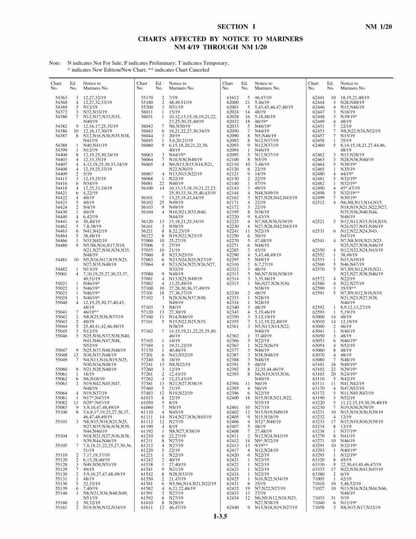
I-3.5
SECTION I NM 1/20
CHARTS AFFECTED BY NOTICE TO MARINERSNM 4/19 THROUGH NM 1/20
Note: N indicates Not For Sale; P indicates Preliminary; T indicates Temporary; * indicates New Edition/New Chart; ** indicates Chart Canceled
54363 3 12,27,32/1954368 4 12,27,32,33/1954369 5 N12/1954372 3 N32,N33/1954380 7 N12,N17,N33,N35,
N40/1954382 9 12,16,17,25,35/1954386 10 12,16,17,30/1954387 8 N12,N16,N30,N35,N38,
N41/1954388 1 N40,N41/1954399 1 N12/1954400 8 12,19,25,30,34/1954403 4 12,33,35/1954407 4 4,12,19,25,30,33,34/1954408 4 12,19,25,33/1954409 2 5/1954413 3 12,19,25/1954416 6 N34/1954418 4 12,25,33,34/1954421 6 4,22/1954422 4 40/1954423 5 40/1954424 2 N4/1954430 1 40/1954440 4 6,42/1954441 6 30,40/1954462 5 7,8,38/1954463 6 N41,N42/1954464 5 38,48/1954466 1 N33,N42/1954480 9 N5,N6,N16,N17,N19,
N21,N27,N30,N34,N35,N48/19
54481 10 N5,N16,N17,N19,N25,N27,N35,N48/19
54482 1 N13/1955001 4 7,10,19,25,27,30,33,37,
40,51/1955021 1 N46/19*55022 1 N46/19*55023 1 N46/19*55024 1 N46/19*55040 4 12,19,25,30,37,40,43,
48/1955041 7 46/19**55042 2 N8,N25,N36,N37/1955043 2 40/1955044 5 25,40,41,42,46,48/1955045 3 N12/1955046 5 N25,N36,N37,N38,N40,
N41,N46,N47,N48,N52/19
55047 9 N25,N37,N40,N48/1955048 13 N36,N37,N48/1955049 7 N4,N11,N16,N19,N25,
N30,N34,N48/1955060 8 N21,N28,N40/1955061 1 18/1955062 6 N6,N18/1955063 2 N19,N42,N45,N47,
N48/1955064 4 N19,N37/1955081 1 N17*,N47/1955082 11 N29*,N47/1955085 9 5,9,10,47,48,49/1955100 8 5,6,8,17,19,22,27,36,37,
46,47,48,49/1955103 3 N8,N15,N18,N21,N25,
N27,N35,N36,N38,N39,N44,N46/19
55104 3 N18,N21,N27,N36,N38,N39,N44,N46/19
55105 7 7,8,18,21,22,25,27,30,36,51/19
55110 2 7,17,19,37/1955120 2 6,13,28,40/1955128 3 N49,N50,N51/1955129 7 49/1955130 2 5,9,10,27,47,48,49/1955131 1 48/1955138 5 32,33/1955139 6 7,40/1955140 3 N8,N21,N36,N48,N49,
N51/1955160 2 30,32/1955161 2 N19,N30,N32,N34/19
Chart No.
Ed.No.
Notice toMariners No.
55170 2 7/1955180 2 48,49,51/1955200 3 N51/1956011 1 15/1956031 1 10,12,13,15,18,19,21,22,
23,25,30,35,40/1956042 7 N6,N30/1956043 6 18,21,22,27,30,34/1956044 3 20/1956045 1 5,6,20,21/1956060 9 6,15,18,20,21,22,30,
40/1956063 3 N44/19*56064 7 N10,N30,N40/1956065 4 N6,N13,N15,N18,N21,
N22,N30/1956067 4 N13,N15,N22/1956068 1 N22/1956081 22 N40/1956100 14 10,13,15,18,19,21,22,23,
25,30,33,34,35,40,43/1956101 7 13,25,35,43,44/1956102 25 N49/1956103 9 N49/1956104 4 N10,N21,N33,N40,
N44/1956120 13 15,18,21,25,34/1956161 3 N50/1956221 8 8,22,23/1956222 8 N19,N22,N23/1957000 10 25,27/1957006 5 27/1957035 10 21/1957060 8 N23,N25/1957063 6 N23,N24,N25,N27/1957064 4 N23,N24,N25,N26,N27,
N32/1957080 9 N49/1957081 4 N13,N25,N49/1957082 4 13,25,49/1957100 10 27,28,30,36,37,49/1957101 18 27,36,37/1957102 3 N28,N36,N37,N48,
N49/1957103 3 N8/1957120 13 27,30/1957160 11 N14,N46/1957161 5 N15,N22,N25,N35,
N38/1957162 7 14,15,19,21,22,25,35,40,
46/1957165 1 14/1957169 1 19,21,22/1957170 1 40,46/1957201 6 N43,N52/1957240 8 18/1957241 13 N8,N22/1957260 3 12/1957261 2 12,43/1957262 4 12,23,43/1957381 13 N21,N27,N38/1957460 5 21/1957483 12 N19,N22/1961015 8 22/1961050 5 8/1961060 7 N8/1961110 4 N45/1961111 14 N14,N27,N36,N45/1961112 12 N27/1961190 4 8/1961192 1 N8,N27,N38/1961210 6 22,27/1961211 8 N27/1961212 4 N27/1961220 5 22/1961221 1 N22/1961242 2 40/1961538 1 27,40/1961541 9 N21/1961542 8 N28,N33/1961550 2 21,43/1961581 6 N5,N6,N14,N21,N22/1961582 4 6,21,22,46/1961591 5 N27/1961592 6 N27/1961610 8 N28/1961611 12 46,47/19
Chart No.
Ed.No.
Notice toMariners No.
61612 5 46,47/1962000 21 5,46/1962001 5 5,43,45,46,47,48/1962024 14 48/1962028 16 5,18,48/1962032 18 46/19*62033 5 N46/19*62050 7 N44/1962090 8 N5,N46/1962092 8 N12,N37/1962093 9 N12,N37/1962094 1 N46/1962095 5 N12,N37/1962100 8 N5/1962110 10 5,48/1962120 6 22/1962121 9 14/1962130 2 22/1962140 1 47/1962143 3 49/1962144 4 N48,N49/1962162 3 N27,N28,N42,N43/1962171 4 22/1962172 3 22/1962195 8 N38/1962220 9 8,43/1962225 4 N7,N8,N30,N39/1962230 4 N27,N28,N42,N43/1962241 11 N22/1962250 6 50/1962270 5 47,48/1962271 6 N48/1962285 3 43/1962290 4 5,43,48,49/1962295 5 N49/1962310 2 6,7,27/1962312 3 48/1962313 5 N6,N7,N30,N38/1962314 3 5,35,46/1962315 1 N6,N27,N28,N30,
N38/1962330 2 48/1962333 1 N28/1962334 1 N28/1962340 3 48/1962343 4 5,19,46/1962350 3 5,12,19/1962355 7 5,12,19,22,40/1962361 3 N5,N13,N14,N22,
N40/1962362 1 37,40/1962366 5 N22/1962367 1 N22,N26/1962377 3 N46/1962387 3 N38,N48/1962388 3 N48/1962391 5 48/1962392 8 22,35,44,46/1962393 8 N6,N19,N35,N36,
N40/1962394 11 N6/1962395 4 N6/1962396 6 N22/1962400 18 N15,N18,N21,N22,
N35/1962401 10 N27/1962402 12 N15,N19,N49/1962405 9 N15,N18/1962406 4 N32*,N48/1962407 5 48/1962408 7 27,48/1962411 2 N12,N24,N43/1962412 14 N9*,N22/1962413 13 9/19**62417 4 N12,N24/1962420 6 N22/1962421 1 N22/1962422 1 N22/1962423 1 N22/1962424 1 N22/1962425 1 N10,N22,N34/1962431 8 25/1962432 19 N7,N22,N27/1962433 13 27/1962434 12 N6,N9,N12,N18,N23,
N27,N38/1962440 9 N15,N18,N19,N27/19
Chart No.
Ed.No.
Notice toMariners No.
62441 10 18,19,21,40/1962444 3 N28,N40/1962446 4 N15,N46/1962447 3 N18/1962448 3 N39/19*62449 4 48/1962451 7 22/1962453 7 N8,N22,N34,N52/1962457 7 N15/1962458 1 35/1962460 5 8,14,15,18,21,27,44,46,
48/1962462 3 N15,N28/1962463 3 N28,N38,N40/1962464 5 N39/19*62465 1 N35/1962480 4 44/19*62481 5 N32/19*62482 1 N32/19*62490 4 45*,47/1962498 5 N32/19**62499 7 N39/19*62512 4 N6,N8,N13,N14,N15,
N18,N19,N21,N22,N27,N35,N36,N40,N44,N48/19
62521 5 N12,N13,N15,N18,N19,N24,N27,N43,N46/19
62531 6 N12,N22,N24,N43,N47/19
62541 4 N7,N8,N18,N21,N23,N25,N27,N38,N46/19
62550 4 N12,N22,N24,N43/1962552 1 38,49/1962553 1 N15,N19/1962560 5 N46,N47/1962570 5 N7,N9,N12,N18,N21,
N23,N27,N38,N46/1962572 4 N22/1962580 4 N22,N27/1962590 3 35/19**62591 5 N7,N9,N12,N18,N19,
N21,N23,N27,N38,N46/19
62592 1 8,9,12,13,27/1962593 1 5,19/1963000 14 48/1963010 14 12,19/1963040 2 46/1963041 1 N46/1963050 3 48/1963053 6 N46/19*63054 4 N52/1963060 8 48/1963070 4 48/1963080 7 N48/1963101 18 N49/19*63102 22 N29/19*63103 20 N24/19*63110 5 N42/1963111 11 N41,N42/1963170 4 N47,N52/1963172 5 N11,N45,N47/1963190 3 N52/1963220 5 11,12,15,19,30,39,40/1963230 7 N19,N30,N39/1963231 10 N15,N19,N30,N39/1963232 4 12/1963233 17 N15,N19,N30,N39/1963234 8 12/1963238 1 N37/19*63270 8 N41/1963271 10 N46/1963291 10 N32/19*63293 1 N40/19*63295 1 N32/19*63320 8 45/1963330 9 22,30,43,45,46,47/1963337 17 N22,N30,N43,N47/1963380 2 6/1971005 1 42/1971018 10 5,46,52/1971027 10 N13,N16,N24,N44,N46,
N48/1971033 31 5/1971040 6 N11/19*71058 3 N8,N15,N17,N32/19
Chart No.
Ed.No.
Notice toMariners No.

I-3.6
NM 1/20 SECTION I
CHARTS AFFECTED BY NOTICE TO MARINERSNM 4/19 THROUGH NM 1/20
Note: N indicates Not For Sale; P indicates Preliminary; T indicates Temporary; * indicates New Edition/New Chart; ** indicates Chart Canceled
71059 2 N8,N15,N17,N32/1971061 16 N8,N9,N15,N17/1971066 3 N20*,N30,N40,N41,
N42/1971067 1 N20/19*71180 29 5,46,52/1971185 25 N5,N43,N46,N52/1971186 3 N43/1971230 11 47,49/1971238 1 N46/1971239 4 N17,N33/1971241 11 N16/1971243 6 16,20,34,46,47,49/1971244 4 16,17,33/1971247 21 N28/19*71248 4 N29*,N46/1971250 2 N13/19*71251 14 N29/19*71252 3 N12,N16,N17,N20/1971253 13 N28/19*71254 3 N11/19*71255 8 N13/19*71256 2 N16/1971265 4 12,16,20,34,46,47/1971271 12 N42/1971285 4 42/1971295 3 30,40,42,44/1971305 3 N15/1971320 2 N13,N43/1971325 9 N13/1971330 14 N43/1971331 12 N12,N43/1971333 3 N43/1971335 3 N5,N43/1971430 3 16/1971440 2 10,16/1972000 8 31,34,47,52/1972007 10 48,50,52/1972021 8 31,47,50,52/1972028 7 31/1972035 8 31,34,47,48,49,50,52/1972045 2 48,49,50,52/1972203 2 48,49,50,52/1972204 2 N16,N48,N49,N50,N51,
N52/1972223 8 32,48,49,50,52/1972231 9 N31,N32,N34,N40,
N51/1972234 3 N31,N32,N42,N51/1973000 9 16,52/1973004 4 47,52/1973006 2 52/1973082 1 16,47/1973191 4 N52/1973393 3 N29/19*73580 4 30,47,48/1973581 4 20,30,34,42,47,48,50/1973590 6 30,47,48/1974000 6 18/1974002 2 49,51/1974003 5 49/1974004 2 17,34,47,51/1974005 2 31,34,47/1974012 10 32/1974027 9 30/1974036 2 N30/19*74037 1 N50/1974174 1 N47,N49/1974180 3 N47,N49/1974181 8 46,47,49/1974185 1 N46,N47,N49/1974189 2 N49/1974216 3 N41/1974220 8 31,49/1974237 4 N41/1974251 8 17,34,47,51/1974258 1 N42,N43,N44,N51/1974262 3 N20,N34,48,N51/1974263 3 N51/1974265 2 16,17,20,34,47,51/1974277 4 N30/19*74289 5 30,31,49/1974290 12 30,31,49/1974292 8 30,31,32/1974296 4 30,31,49/1974300 2 N30/1974302 4 N32,N41/19
Chart No.
Ed.No.
Notice toMariners No.
74304 1 N30,N31,N32/1974311 4 N30,N32/1974342 2 N34,N41,N42,N43/1974345 4 N30/19*74397 6 N31,N32,N34,N41/1974398 3 N31,N41,N43/1974402 2 N32,N34,N41/1974410 3 32,41/1974420 3 41,50/1974451 4 N15/19*74582 9 44,48/1974583 15 21,30,42,44/1974585 2 N30/19*74588 2 N43/1974592 1 N19/19*74593 1 N19/19**75035 18 18,19/1975130 16 34/1975134 3 34/1975137 2 N43/1975253 2 N30/19*75266 1 N17,N18,N19,N40,
N41/1975267 2 N29*,N32/1975269 2 N29*,N32,N36/1975274 1 N17,N19,N40/1976050 8 5,9,11,31/1976052 9 N5,N6,N9,N11,N19,
N31,N46/1976070 9 39/1976071 10 N39,N43/1976151 7 17,36/1981002 7 36/1981023 6 44,48/1981025 4 N35/19*81048 10 44/1981054 16 11,25/1981059 2 N35*,N44/1981060 2 44/1981067 9 44/1981523 5 49/19*81711 7 31/1982374 9 37/1982377 2 24,37,41/1982683 4 6,22,46,47/1982689 4 N6,N22,N30,N38,N47,
N49/1982690 11 N30/1982694 6 6,22,23,30,51/1982697 6 30,49/1983010 6 12/1983034 1 12/1983039 11 12/1983059 3 43,48/1983484 12 44/1983500 2 21/19*91020 6 N28/1991240 5 49/1991280 8 N28,N43/1991289 20 N5/1991294 9 N5,N12,N24,N28,N43,
N47/1991297 10 N5,N12,N24,N28,N43,
N47/1992006 5 13,24/1992025 4 N40/1992030 4 15,40/1992090 2 22,40/1992100 3 40/1992320 4 5,12,15,40/1992380 4 N5,N12,N22,N40/1992383 8 N12/1992385 5 N5,N12,N40/1992520 2 10/1992529 5 N52/1993010 6 15,16,40/1993018 8 16/1993020 2 19/1993022 4 19/1993025 5 19,32/1993030 7 32,43,46,48/1993036 12 N32/1993042 2 43/1993044 2 43,48/1993045 2 43/1993047 2 44,46,48/1993048 1 13,24/19
Chart No.
Ed.No.
Notice toMariners No.
93049 1 19,44,48/1993050 1 N15,N16,N43/1993061 4 43/1993110 2 46/1993113 3 N46/1993117 3 46/1993240 12 12,15,22,30,31,40/1993241 10 N12,N15,N31/1993244 8 12,15,16,43/1993245 7 N5,N15,N16,N22,N30,
N40,N52/1993247 5 40,52/1993248 1 22,30/1993249 1 5,15,16/1993260 9 22,30,40/1993280 5 16/1993284 5 16/1993300 6 16/1993301 6 16/1993440 4 43/1993446 7 43/1993500 6 32/1993503 7 N32/1993540 5 32/1993710 4 N30/1993721 7 N21/19*93734 14 N34/19*93736 26 N21/19*93778 9 N11,N22,N24,N25/1994004 7 12/1994016 3 29,34/1994028 8 8,11,12,13,16,17,20,22,
25,27,30,31,32,33,34,36,39,51,52/19
94033 6 23,24,26,27,30,34,39,41,44,48,49/19
94060 12 21/1994061 6 16,20,21/1994082 9 42,43/1994083 13 N42,N43/1994084 2 N42,N43/1994120 7 12,21,42/1994123 10 N18,N22/1994127 3 N18,N22/1994160 9 12,20,21,27,36,42,48/1994164 2 20,27,36,48/1994165 4 30,36,48/1994180 10 34/1994203 11 N21,N29,N34/1994216 9 N5,N21,N22,N30/1994217 7 N22,N27/1994218 6 N5,N21,N27/1994219 3 N5,N6,N7,N8,N12,
N21/1994220 5 21,22,30,34/1994282 10 N8,N11,N12,N34,N47,
N48,N49/1994283 9 N11,N13,N34,N47,
N49/1994287 2 12,17,34,48/1994290 3 8,11,12,16,34/1994360 7 N34/1994420 4 16,24,38,39,40,41,48/1994421 11 5,16,38,39,41/1994423 13 N16/1994427 2 N16,N17,N18,N27,N34,
N39,N40,N43/1994440 4 N16,N40/1995016 9 13,27/1995054 1 N39*,N47/1995060 15 N7,N11,N18,N22,N23,
N24,N26,N27,N30,N33,N34,N44,N46,N47,N48,N49,N51,N52/19
95065 8 N24,N26,N34,N44,N47,N48,N49,N51/19
95066 14 N23,N24,N26,N27,N34,N43,N44,N47,N49,N51,N52/19
95067 17 N44,N47,N49,N51,N52/19
95068 4 N7,N8,N9,N11,N12,N43,N45,N47,N52/19
95080 15 N6,N7,N8,N9,N11,N16,N24,N28,N37,N39,N40,N43,N44,N47,N49/19
Chart No.
Ed.No.
Notice toMariners No.
95082 10 N6,N7,N8,N9,N12,N14,N20,N38/19
95083 9 N6,N9,N14,N38/1995084 8 N8,N16,N18,N34,N37,
N39,N40,N43,N44,N47,N49/19
95085 6 N6,N8,N14,N16,N31,N46,N47,N49/19
95086 6 N6,N7,N8,N12,N13,N14,N16,N18,N28,N31,N34,N47,N49/19
95087 4 N9,N14/1995100 13 6,7,8,13,16,27,30,32,33,
36,37,38,39,40,43,44,46,47,49/19
95101 9 N6,N7,N8,N16/1995102 9 N6,N27/1995103 10 N7,N8,N13,N27,N30,
N31,N32,N33,N34/1995120 10 N6,N8,N16,N27,N31,
N32,N33,N34,N36/1995136 2 N21,N22,N25,N34,N35,
N37,N46,N47,N49,N50,N51,N52/19
95138 10 N25,N34,N37,N40,N44,N46,N47,N48,N50,N51,N52/19
95140 17 N12,N13,N16,N19,N20,N22,N24,N25,N27,N28,N30,N37,N38,N40,N42,N43,N44,N47,N49,N50,N51,N52/19
95141 9 N19,N20,N22,N24,N25,N26,N27,N28,N29,N34,N37,N38,N39,N40,N43,N46,N47,N49,N50,N52/19
95143 13 N19,N22,N25,N26,N28,N29,N34,N37,N39,N40,N42,N43,N44,N46,N47,N48,N49,N50,N51,N52/19
95144 11 N22,N25,N26,N28,N29,N30,N34,N37,N38,N40,N42,N43,N47,N48,N51,N52/19
95146 17 N6*,N25,N28,N29,N30,N34,N38,N40,N42,N51/19
95147 15 N46/19*95148 7 N22,N28/1995149 12 N13*,N23,N28,N34,
N38,N40,N42,N51,N52/19
95151 19 N5,N13,N14,N15,N16,N20,N22,N23,N24,N36,N46,N51/19
95152 7 N5,N12,N16,N20,N22,N23,N24,N28,N36,N52/19
95155 1 N38,N42,N43,N48/1995159 1 N6,N7,N9,N11,N12,
N13,N19/1995160 15 N39/19*95161 19 N11,N12,N13,N14,N16,
N18,N19,N20,N21,N22,N25,N27,N28,N30,N34/19
95162 3 N16/1995163 4 N6,N7,N8,N9,N11,N12,
N13,N19,N20/1995167 13 N6,N7,N9,N11,N12,
N13,N20/1995173 3 N51/1995180 13 N6,N7,N8,N12,N13,
N25,N51/1995274 4 15/1995279 1 N16/1995288 2 N39,N52/1995339 2 N30/1996000 5 27/1996004 14 27/1996039 8 N27/1996041 12 N27,N29,N45/1996042 12 N5,N30/1996043 9 N27,N29/1996044 11 N27/19
Chart No.
Ed.No.
Notice toMariners No.

I-3.7
SECTION I NM 1/20
CHARTS AFFECTED BY NOTICE TO MARINERSNM 4/19 THROUGH NM 1/20
Note: N indicates Not For Sale; P indicates Preliminary; T indicates Temporary; * indicates New Edition/New Chart; ** indicates Chart Canceled
96060 7 27/1996927 1 N34,N35,N37,N52/1996933 1 N52/1996943 15 42,52/1996951 3 N39*,N47,N51/1996962 4 52/1997015 10 40/1997021 8 8,12,13,16,17,25/1997022 2 N11,N12,N13,N16,N20,
N22,N25,N30/1997026 10 39/1997029 3 47/1997030 3 N32,N33,N48,N49,N50,
N52/1997034 2 N30,N32,N48,N50/1997044 5 N42/19*97089 2 N30,N31,N32,N45,N48,
N49,N51/1997090 2 N32,N48,N49,N51/1997133 2 N39/19*97134 4 N44/19*97136 2 N39/19*97139 3 N41/19*97140 17 47/1997159 6 39,40,47/1997166 2 N39,N40,N47/1997167 3 39,40,47/1997180 7 N30,N31,N32,N33,N45,
N51,N52/1997190 2 31,32,33,48,51/1997191 1 N20/1997197 1 N20,N35,N40/1997198 1 N20,N35,N40/1997210 1 N20,N35,N40/1997212 1 N25,N42/1997213 2 N39/19*97239 10 40/1997245 11 20,27,29/1997266 6 N20,N21,N22,N24,N25,
N27,N28,N30,N36,N37,N40,N45,N48/19
97271 12 19,20,21,22,24,25,36,37,38,40,45,48/19
97273 11 22,36,48/1997288 4 N39,N40/1997293 2 N24,N36,N48/1997297 1 N32,N39,N40,N48,
N49/1997302 1 N39,N40/1997311 1 N22,N48/1997319 5 N39/19*97330 1 N17,N47/1997333 1 N18,N20/1997362 1 N31,N35/1997371 1 N12/1997380 7 16,17,18,20/1997381 7 18,20,24/1997396 14 16,17,19/1997397 8 N16,N17,N19/1997420 17 30,39,52/1997425 7 N30,N31,N35,N39,
N52/1997440 8 17/1997472 8 5,40,42,43/1997567 1 N17,N47,N50/19
801208 1 N30,N52/19801243 1 N24/19801316 1 N24,N28/19801382 1 N22,N36,N37/19801425 1 N52/19*801485 1 N15/19*801885 4 N40/19**801925 1 N52/19**801959 2 N15/19**803185 1 N40/19*803222 1 N33,N34,N37,N42/19803404 2 N34/19**803424 1 N9,N19,N20/19803445 1 N7,N16,N17/19803455 2 N50/19*803456 1 N32/19803458 1 N16,N32/19803461 1 N21/19803462 1 N7/19803463 1 N16/19803478 1 N7,N9,N17,N19,N20,
N22/19
Chart No.
Ed.No.
Notice toMariners No.
803487 2 N1/20*803489 2 N1/20*803497 1 N14/19803498 1 N44/19803610 1 N24/19803617 1 N24,N25,N27,N28,N32,
N40/19803621 1 N22,N32/19803653 1 N43,N47/19803668 1 N33/19*803682 1 N40/19*803684 1 N40/19*803704 1 N34/19*803728 1 N24/19803738 1 N13/19803752 1 N46/19*803759 1 N15/19*805118 4 N47/19**805318 1 N34*,N48/19806902 2 N21/19*806918 1 N30,N32,N37/19806921 1 N13/19806932 1 N22,N32/19806938 1 N7,N9,N25,N26/19806939 1 N20,N21/19806964 1 N19/19806973 2 N30*,N33,N34,N36,
N37,N42/19806978 1 N24/19806979 2 N51/19*808914 1 N46/19*808955 1 N24/19808981 1 N1/20*809102 1 N25/19809122 1 N30/19809125 1 N32/19809127 1 N26,N27,N35/19809151 1 N24,N28/19809187 1 N22,N32/19
Chart No.
Ed.No.
Notice toMariners No.
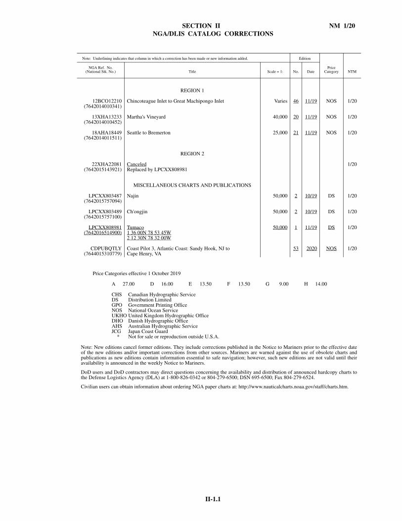
SECTION II NM 1/20NGA/DLIS CATALOG CORRECTIONS
II-1.1
Note: Underlining indicates that column in which a correction has been made or new information added. Edition
PriceCategory NTM
NGA Ref. No.(National Stk. No.) Title Scale = 1: No. Date
REGION 1
12BCO12210(7642014010341)
Chincoteague Inlet to Great Machipongo Inlet Varies 46 11/19 NOS 1/20
13XHA13233(7642014010452)
Martha's Vineyard 40,000 20 11/19 NOS 1/20
18AHA18449(7642014011511)
Seattle to Bremerton 25,000 21 11/19 NOS 1/20
REGION 2
22XHA22081(7642015143921)
CanceledReplaced by LPCXX808981
1/20
MISCELLANEOUS CHARTS AND PUBLICATIONS
LPCXX803487(7642015757094)
Najin 50,000 2 10/19 DS 1/20
LPCXX803489(7642015757100)
Ch'ongjin 50,000 2 10/19 DS 1/20
LPCXX808981(7642016514900)
Tumaco1 36 00N 78 53 45W2 12 30N 78 32 00W
50,000 1 11/19 DS 1/20
CDPUBQTLY(7644015310779)
Coast Pilot 3, Atlantic Coast: Sandy Hook, NJ toCape Henry, VA
53 2020 NOS 1/20
Price Categories effective 1 October 2019
A 27.00 D 16.00 E 13.50 F 13.50 G 9.00 H 14.00
CHS Canadian Hydrographic ServiceDS Distribution LimitedGPO Government Printing OfficeNOS National Ocean ServiceUKHO United Kingdom Hydrographic OfficeDHO Danish Hydrographic OfficeAHS Australian Hydrographic ServiceJCG Japan Coast Guard
* Not for sale or reproduction outside U.S.A.
Note: New editions cancel former editions. They include corrections published in the Notice to Mariners prior to the effective dateof the new editions and/or important corrections from other sources. Mariners are warned against the use of obsolete charts andpublications as new editions contain information essential to safe navigation; however, such new editions are not valid until theiravailability is announced in the weekly Notice to Mariners.
DoD users and DoD contractors may direct questions concerning the availability and distribution of announced hardcopy charts tothe Defense Logistics Agency (DLA) at 1-800-826-0342 or 804-279-6500; DSN 695-6500; Fax 804-279-6524.
Civilian users can obtain information about ordering NGA paper charts at: http://www.nauticalcharts.noaa.gov/staff/charts.htm.

SECTION II NM 1/20
NAVIGATION PUBLICATIONS
II-2.1
COAST PILOT CORRECTIONS
COAST PILOT 3 53 Ed 2020 NEW EDITION (NOS) 1/20
COAST PILOT 4 51 Ed 2019 15 DEC 2019 LAST NM 52/19Chapter 11—Paragraph 145; read:
(145) Main Ship Channel is the only deep-draft approach toKey West. Federal project depth is 34 feet from the Straits ofFlorida to a turning basin off the Naval Air Station TrumanAnnex Mole and inside the annex basin, thence 30 feet to anupper turning basin off Key West Bight, and thence 12 feet toand including a turning basin in the bight. For detailedchannel information and minimum depths as reported by theU.S. Army Corps of Engineers (USACE), use NOAAElectronic Navigational Charts. Surveys and channelcondition reports are available through a USACEhydrographic survey website listed in Appendix A. Thechannel from the entrance to the upper turning basin ismarked by lighted ranges and other aids to navigation. Spoilareas are west of the channel.
(L 538-2019) 1/20
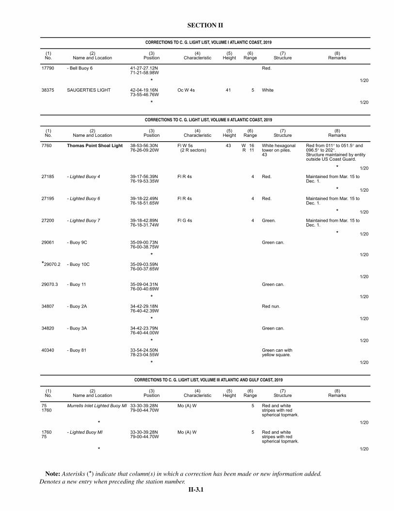
II-3.1
SECTION II
Note: Asterisks (*) indicate that column(s) in which a correction has been made or new information added. Denotes a new entry when preceding the station number.
CORRECTIONS TO C. G. LIGHT LIST, VOLUME I ATLANTIC COAST, 2019
(1)No.
(2)Name and Location
(3)Position
(4)Characteristic
(5)Height
(6)Range
(7)Structure
(8)Remarks
17790 - Bell Buoy 6 41-27-27.12N71-21-58.98W
Red.
* 1/20
38375 SAUGERTIES LIGHT 42-04-19.16N73-55-46.76W
Oc W 4s 41 5 White
* 1/20
CORRECTIONS TO C. G. LIGHT LIST, VOLUME II ATLANTIC COAST, 2019
(1)No.
(2)Name and Location
(3)Position
(4)Characteristic
(5)Height
(6)Range
(7)Structure
(8)Remarks
7760 Thomas Point Shoal Light 38-53-56.30N76-26-09.20W
Fl W 5s(2 R sectors)
43 W 16R 11
White hexagonal tower on piles.43
Red from 011° to 051.5° and 096.5° to 202°. Structure maintained by entity outside US Coast Guard.
* 1/20
27185 - Lighted Buoy 4 39-17-56.39N76-19-53.35W
Fl R 4s 4 Red. Maintained from Mar. 15 to Dec. 1.
* 1/20
27195 - Lighted Buoy 6 39-18-22.49N76-18-51.65W
Fl R 4s 4 Red. Maintained from Mar. 15 to Dec. 1.
* 1/20
27200 - Lighted Buoy 7 39-18-42.89N76-18-31.74W
Fl G 4s 4 Green. Maintained from Mar. 15 to Dec. 1.
* 1/20
29061 - Buoy 9C 35-09-00.73N76-00-38.75W
Green can.
* 1/20
*29070.2 - Buoy 10C 35-09-03.59N76-00-37.65W
1/20
29070.3 - Buoy 11 35-09-04.31N76-00-40.69W
Green can.
* 1/20
34807 - Buoy 2A 34-42-29.18N76-40-42.39W
Red nun.
* 1/20
34820 - Buoy 3A 34-42-23.79N76-40-44.00W
Green can.
* 1/20
40340 - Buoy 81 33-54-24.50N78-23-04.55W
Green can with yellow square.
* 1/20
CORRECTIONS TO C. G. LIGHT LIST, VOLUME III ATLANTIC AND GULF COAST, 2019
(1)No.
(2)Name and Location
(3)Position
(4)Characteristic
(5)Height
(6)Range
(7)Structure
(8)Remarks
751760
Murrells Inlet Lighted Buoy MI 33-30-39.28N79-00-44.70W
Mo (A) W 5 Red and white stripes with red spherical topmark.
* 1/20
176075
- Lighted Buoy MI 33-30-39.28N79-00-44.70W
Mo (A) W 5 Red and white stripes with red spherical topmark.
* 1/20
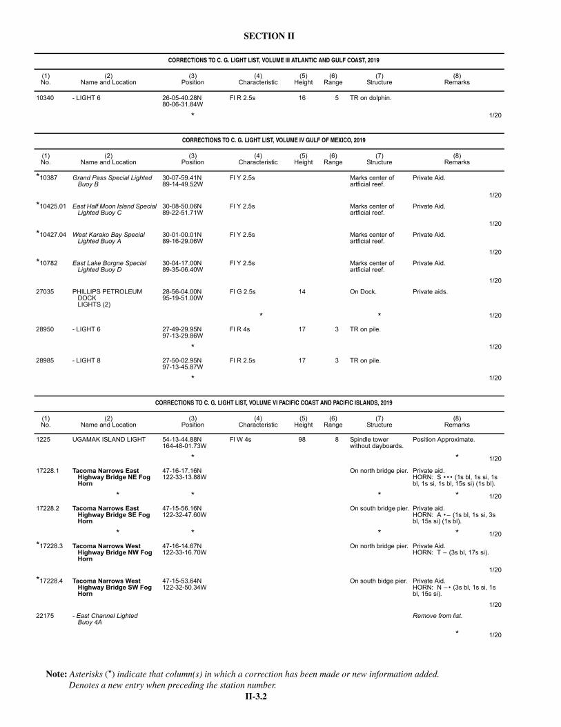
II-3.2
SECTION II
Note: Asterisks (*) indicate that column(s) in which a correction has been made or new information added. Denotes a new entry when preceding the station number.
10340 - LIGHT 6 26-05-40.28N80-06-31.84W
Fl R 2.5s 16 5 TR on dolphin.
* 1/20
CORRECTIONS TO C. G. LIGHT LIST, VOLUME IV GULF OF MEXICO, 2019
(1)No.
(2)Name and Location
(3)Position
(4)Characteristic
(5)Height
(6)Range
(7)Structure
(8)Remarks
*10387 Grand Pass Special Lighted Buoy B
30-07-59.41N89-14-49.52W
Fl Y 2.5s Marks center of artficial reef.
Private Aid.
1/20
*10425.01 East Half Moon Island Special Lighted Buoy C
30-08-50.06N89-22-51.71W
Fl Y 2.5s Marks center of artficial reef.
Private Aid.
1/20
*10427.04 West Karako Bay Special Lighted Buoy A
30-01-00.01N89-16-29.06W
Fl Y 2.5s Marks center of artficial reef.
Private Aid.
1/20
*10782 East Lake Borgne Special Lighted Buoy D
30-04-17.00N89-35-06.40W
Fl Y 2.5s Marks center of artficial reef.
Private Aid.
1/20
27035 PHILLIPS PETROLEUM DOCKLIGHTS (2)
28-56-04.00N95-19-51.00W
Fl G 2.5s 14 On Dock. Private aids.
* * 1/20
28950 - LIGHT 6 27-49-29.95N97-13-29.86W
Fl R 4s 17 3 TR on pile.
* 1/20
28985 - LIGHT 8 27-50-02.95N97-13-45.87W
Fl R 2.5s 17 3 TR on pile.
* 1/20
CORRECTIONS TO C. G. LIGHT LIST, VOLUME VI PACIFIC COAST AND PACIFIC ISLANDS, 2019
(1)No.
(2)Name and Location
(3)Position
(4)Characteristic
(5)Height
(6)Range
(7)Structure
(8)Remarks
1225 UGAMAK ISLAND LIGHT 54-13-44.88N164-48-01.73W
Fl W 4s 98 8 Spindle tower without dayboards.
Position Approximate.
* * 1/20
17228.1 Tacoma Narrows East Highway Bridge NE Fog Horn
47-16-17.16N122-33-13.88W
On north bridge pier. Private aid.HORN: S • • • (1s bl, 1s si, 1s bl, 1s si, 1s bl, 15s si) (1s bl).
* * * * 1/20
17228.2 Tacoma Narrows East Highway Bridge SE Fog Horn
47-15-56.16N122-32-47.60W
On south bridge pier. Private aid.HORN: A • – (1s bl, 1s si, 3s bl, 15s si) (1s bl).
* * * * 1/20
*17228.3 Tacoma Narrows West Highway Bridge NW Fog Horn
47-16-14.67N122-33-16.70W
On north bridge pier. Private Aid.HORN: T – (3s bl, 17s si).
1/20
*17228.4 Tacoma Narrows West Highway Bridge SW Fog Horn
47-15-53.64N122-32-50.34W
On south bidge pier. Private Aid.HORN: N – • (3s bl, 1s si, 1s bl, 15s si).
1/20
22175 - East Channel LightedBuoy 4A
Remove from list.
* 1/20
CORRECTIONS TO C. G. LIGHT LIST, VOLUME III ATLANTIC AND GULF COAST, 2019
(1)No.
(2)Name and Location
(3)Position
(4)Characteristic
(5)Height
(6)Range
(7)Structure
(8)Remarks
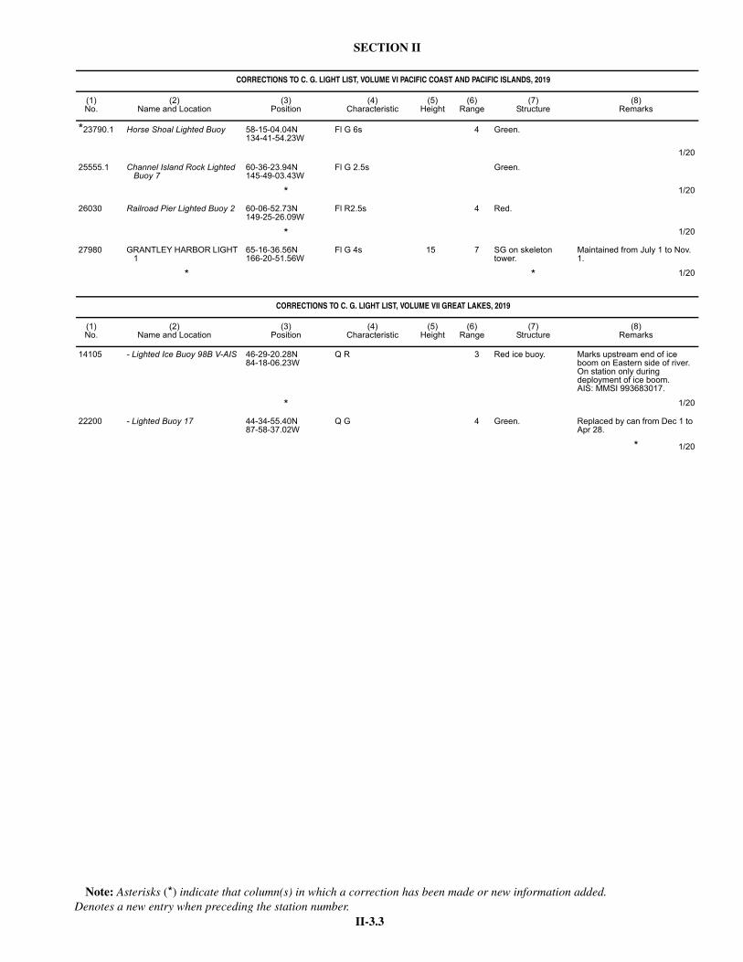
II-3.3
SECTION II
Note: Asterisks (*) indicate that column(s) in which a correction has been made or new information added. Denotes a new entry when preceding the station number.
*23790.1 Horse Shoal Lighted Buoy 58-15-04.04N134-41-54.23W
Fl G 6s 4 Green.
1/20
25555.1 Channel Island Rock Lighted Buoy 7
60-36-23.94N145-49-03.43W
Fl G 2.5s Green.
* 1/20
26030 Railroad Pier Lighted Buoy 2 60-06-52.73N149-25-26.09W
Fl R2.5s 4 Red.
* 1/20
27980 GRANTLEY HARBOR LIGHT 1
65-16-36.56N166-20-51.56W
Fl G 4s 15 7 SG on skeleton tower.
Maintained from July 1 to Nov. 1.
* * 1/20
CORRECTIONS TO C. G. LIGHT LIST, VOLUME VII GREAT LAKES, 2019
(1)No.
(2)Name and Location
(3)Position
(4)Characteristic
(5)Height
(6)Range
(7)Structure
(8)Remarks
14105 - Lighted Ice Buoy 98B V-AIS 46-29-20.28N84-18-06.23W
Q R 3 Red ice buoy. Marks upstream end of ice boom on Eastern side of river. On station only during deployment of ice boom.AIS: MMSI 993683017.
* 1/20
22200 - Lighted Buoy 17 44-34-55.40N87-58-37.02W
Q G 4 Green. Replaced by can from Dec 1 to Apr 28.
* 1/20
CORRECTIONS TO C. G. LIGHT LIST, VOLUME VI PACIFIC COAST AND PACIFIC ISLANDS, 2019
(1)No.
(2)Name and Location
(3)Position
(4)Characteristic
(5)Height
(6)Range
(7)Structure
(8)Remarks

II-4.1
SECTION II NM 1/20
PUBLICATIONS AFFECTED BY NOTICE TO MARINERS THROUGH NM 1/20
Note: * indicates New Edition/New Publication; ** indicates Publication Canceled; N indicates Not For Sale
Publication Ed. Notice toMariners No.
NGA/DLIS CATALOGS CATCDNMCIRegion 1 2019 47*,48,50/19;1/20Region 2 2019 47/19*;1/20Region 3 2019 47*,49,51/19Region 4 2019 47/19*Region 5 2019 47/19*Region 6 2019 47*,49/19Region 7 2019 47/19*Region 8 2019 47*,49/19Region 9 2019 47/19*Miscellaneous Charts and Publications
2019 47*,48,49,50,51,52/19;1/20
NGA LIST OF LIGHTSPUB 110 2019 39/19*PUB 111 2019 18*,26,31,36,37,38,
39,40,42,43,47/19PUB 112 2019 26*,27,28,30,31,
36/19PUB 113 2019 31*,47,48,49,51,
52/19PUB 114 2019 22*,27,31,32,33,34,
35,36,37,38,39,40/19
PUB 115 2019 34*,37,38,39,40,42/19
PUB 116 2019 13*,16,18,20,21,22,24,33/19
SAILING DIRECTIONSPUB 120 2018 25/18*;13,39/19PUB 123 2017 49/17*;23,52/18;
23/19PUB 124 2017 7*,26/17;19/18;6,21,
45/19PUB 125 2017 30/17*;8,36/18;
15/19PUB 126 2017 17*,52/17;30,48/18;
10,35/19PUB 127 2017 19*,52/17;30/18;13,
35/19PUB 131 2017 18*,33,46/17;17/18;
14,38/19PUB 132 2017 7*,26,40/17;10/18;
14,33/19PUB 140 2019 20*,46/19PUB 141 2018 31/18*;13,42/19PUB 142 2018 35/18*;23/19PUB 143 2017 11*,29,42/17;11/18;
13,35,52/19PUB 145 2018 8*,48/18;20,47/19PUB 146 2017 12/17*;20,52/18;29,
52/19PUB 147 2018 49/18*;23/19PUB 148 2017 12/17*;10/18;4,37,
38/19PUB 153 2017 8/17*;9,38/18;20,
39/19PUB 154 2017 39/17*;17,52/18;
24/19PUB 155 2017 46/17*;39/18;24,
52/19PUB 157 2018 38/18*;18,39,52/19PUB 158 2017 19/17*;11,52/18;
29/19PUB 159 2017 19/17*;18/18;12,
46/19PUB 160 2019 24*,42,52/19PUB 161 2017 32/17*;9,31/18;12,
45/19PUB 162 2017 13*,42/17;20,52/18PUB 163 2018 25/18*;10/19PUB 164 2018 11*,44/18;24/19PUB 171 2018 16/18*;4,31,45/19PUB 172 2017 11*,34,48/17;20,
35/18;10,34/19PUB 173 2017 20*,40,49/17;26,
52/18PUB 174 2019 21/19*PUB 175 2017 25/17*;9,44/18;
24/19PUB 180 2017 6*,29,45/17;9,26,
45/18;5,21/19
PUB 181 2017 43/17*;30/18;12,30/19
PUB 182 2018 21*,50/18;23/19PUB 183 2017 29/17*;20/18;4,21,
29,49/19PUB 191 2017 16*,46/17;26/18;12,
39/19PUB 192 2017 23*,40/17;20/18;10,
34/19PUB 193 2017 4*,35/17;10,34/18;
21/19PUB 194 2019 45/19*PUB 195 2019 37*,49/19PUB 200 2017 13*,31/17;10/18;5,
30/19
USCG LIGHT LIST VOLUMES I - VIIVOLUME I 2019 5*,7,8,11,12,13,14,
15,16,17,18,19,20,21,22,23,24,25,26,27,28,29,30,31,32,33,34,35,36,37,38,39,40,41,42,43,44,45,46,47,48,49,50,51,52/19;1/20
VOLUME II 2019 5*,6,7,8,9,10,11,12,13,14,15,16,17,18,19,20,21,22,23,24,25,26,27,28,29,30,31,32,33,34,35,36,37,38,39,40,41,42,43,44,45,46,47,48,49,50,51,52/19;1/20
VOLUME III 2019 5*,8,9,11,12,13,14,15,16,17,18,19,20,21,22,23,24,25,26,27,30,31,32,33,34,36,37,39,40,41,42,43,44,45,46,47,49,50/19;1/20
VOLUME IV 2019 5*,7,8,9,11,12,13,14,15,17,18,19,20,21,22,23,24,25,26,27,28,29,31,32,33,34,35,36,37,38,39,40,41,42,43,44,45,46,47,48,49,50,52/19;1/20
VOLUME V 2019 5/19*VOLUME VI 2019 5*,6,7,8,9,10,11,12,
13,15,16,17,18,19,20,21,22,23,24,25,26,27,28,29,30,31,33,34,35,36,37,38,39,40,41,42,43,44,45,46,47,48,49,50,51,52/19;1/20
VOLUME VII 2019 5*,7,11,12,17,18,19,20,22,23,24,25,26,27,28,29,31,33,34,35,37,38,40,42,43,46,47,50,51,52/19;1/20
DIGITAL PUBS - QUARTERLYDIGITAL PUBS - QUARTERLY
2019 N45/19*
FLEET GUIDESPUB 940 2015 N6/15*PUB 941 2015 N6*,N13,N31/15
NOS MISCELLANEOUS PUBLICATIONSCATALOG A 2012 22/12*CATALOG G 2012 18/12*CATALOG K 2012 34/12*CATALOG L 2012 27/12*CATALOG P 2012 32/12*
ALMANACSAIR ALMANAC 2020 35/19*
Publication Ed. Notice toMariners No.
NAUTICAL ALMANAC
2020 35/19*
COAST PILOTCOAST PILOT 1 49 17*,21,23,31,32,34,
40,44,45,52/19COAST PILOT 2 49 46*,48/19COAST PILOT 3 53 1/20*COAST PILOT 4 51 41*,44,47,49,52/19;
1/20COAST PILOT 5 47 22*,23,27,31,32,39,
40,47,49,52/19COAST PILOT 6 49 13*,15,16,17,19,20,
22,31,34,35,37,40,44,52/19
COAST PILOT 7 51 52/18*;10,13,14,16,19,21,23,24,25,28,29,31,38,39,44,46/19
COAST PILOT 8 41 26*,42/19COAST PILOT 9 37 36*,41,44/19
RADIO NAVIGATIONAL AIDSPUB 117 2014 51/14*
AMERICAN PRACTICAL NAVIGATORPUB 9 2019 26*,28/19
INTERNATIONAL CODE OF SIGNALSPUB 102 2003 20/03*
WORLD PORT INDEXPUB 150 2019 37/19*
DISTANCES BETWEEN PORTSPUB 151 2001 4/02*
RADAR NAVIGATION AND MANEUVERING BOARD MANUALPUB 1310 2001 51/01*
SIGHT REDUCTION TABLES (MARINE)PUB 229 VOL. 1 1970 11/71*PUB 229 VOL. 2 1970 11/71*PUB 229 VOL. 3 1970 7/71*PUB 229 VOL. 4 1970 3/71*PUB 229 VOL. 5 1970 3/71*PUB 229 VOL. 6 1970 23/70*
SIGHT REDUCTION TABLES (AIR)PUB 249 VOL. 1 2007 38/07*PUB 249 VOL. 2 1952 46/52*PUB 249 VOL. 3 1952 46/52*
CHART NO. 1CHART NO. 1 2019 19/19*
ATLAS OF PILOT CHARTSPUB 106 2002 42/03*PUB 107 1998 30/99*PUB 109 2001 49/02*
USCG NAVIGATION RULESNAVIGATION RULES AND REGULATIONS
2014 38*,51/14;37,41,50/15;7/18
NOS TIDE TABLESEAST PACIFIC 2020 N50/19*W PACIFIC/INDIAN OCEAN
2020 N50/19*
WEST ATLANTIC 2020 N50/19*EUROPE/WEST AFRICA
2020 N50/19*
TIDAL CURRENT TABLESPACIFIC 2020 N50/19*ATLANTIC 2020 N50/19*
Publication Ed. Notice toMariners No.
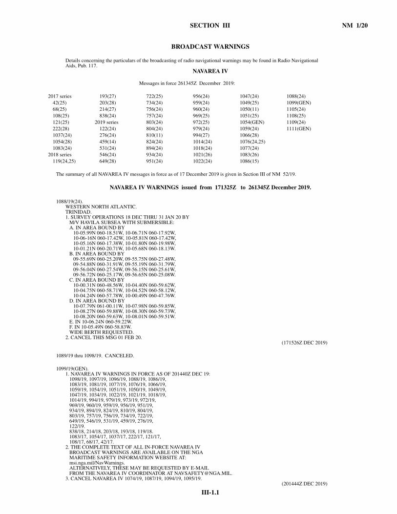
III-1.1
SECTION III NM 1/20
BROADCAST WARNINGS
Details concerning the particulars of the broadcasting of radio navigational warnings may be found in Radio Navigational Aids, Pub. 117.
NAVAREA IV
The summary of all NAVAREA IV messages in force as of 17 December 2019 is given in Section III of NM 52/19.
NAVAREA IV WARNINGS issued from 171325Z to 261345Z December 2019.
1088/19(24). WESTERN NORTH ATLANTIC.TRINIDAD.1. SURVEY OPERATIONS 18 DEC THRU 31 JAN 20 BY M/V HAVILA SUBSEA WITH SUBMERSIBLE: A. IN AREA BOUND BY 10-05.99N 060-18.51W, 10-06.71N 060-17.92W, 10-06-16N 060-17.42W, 10-05.81N 060-17.42W, 10-05.16N 060-17.38W, 10-01.80N 060-19.98W, 10-01.21N 060-20.71W, 10-05.68N 060-18.13W. B. IN AREA BOUND BY 09-55.69N 060-25.20W, 09-55.75N 060-27.48W, 09-54.88N 060-31.91W, 09-55.19N 060-31.79W, 09-56.04N 060-27.54W, 09-56.15N 060-25.61W, 09-56.72N 060-25.17W, 09-56.65N 060-25.08W. C. IN AREA BOUND BY 10-00.31N 060-48.56W, 10-04.40N 060-59.62W, 10-04.75N 060-58.71W, 10-04.52N 060-58.12W, 10-04.24N 060-57.78W, 10-00.49N 060-47.76W. D. IN AREA BOUND BY 10-07.79N 061-00.11W, 10-07.98N 060-59.85W, 10-08.27N 060-59.88W, 10-08.30N 060-59.73W, 10-08.20N 060-59.63W, 10-08.01N 060-59.51W. E. IN 10-06.24N 060-59.22W. F. IN 10-05.49N 060-58.83W. WIDE BERTH REQUESTED.2. CANCEL THIS MSG 01 FEB 20.
(171526Z DEC 2019)
1089/19 thru 1098/19. CANCELED.
1099/19(GEN). 1. NAVAREA IV WARNINGS IN FORCE AS OF 201440Z DEC 19: 1098/19, 1097/19, 1096/19, 1088/19, 1086/19, 1083/19, 1081/19, 1077/19, 1076/19, 1066/19, 1059/19, 1054/19, 1051/19, 1050/19, 1049/19, 1047/19, 1034/19, 1022/19, 1021/19, 1018/19, 1014/19, 994/19, 979/19, 973/19, 972/19, 969/19, 960/19, 959/19, 956/19, 951/19, 934/19, 894/19, 824/19, 810/19, 804/19, 803/19, 757/19, 756/19, 734/19, 722/19, 649/19, 546/19, 531/19, 459/19, 276/19, 122/19. 838/18, 214/18, 203/18, 193/18, 119/18. 1083/17, 1054/17, 1037/17, 222/17, 121/17, 108/17, 68/17, 42/17.2. THE COMPLETE TEXT OF ALL IN-FORCE NAVAREA IV BROADCAST WARNINGS ARE AVAILABLE ON THE NGA MARITIME SAFETY INFORMATION WEBSITE AT: msi.nga.mil/NavWarnings. ALTERNATIVELY, THESE MAY BE REQUESTED BY E-MAIL FROM THE NAVAREA IV COORDINATOR AT [email protected]. CANCEL NAVAREA IV 1074/19, 1087/19, 1094/19, 1095/19.
(201444Z DEC 2019)
Messages in force 261345Z December 2019:
2017 series 193(27) 722(25) 956(24) 1047(24) 1088(24)42(25) 203(28) 734(24) 959(24) 1049(25) 1099(GEN)68(25) 214(27) 756(24) 960(24) 1050(11) 1105(24)108(25) 838(24) 757(24) 969(25) 1051(25) 1108(25)121(25) 2019 series 803(24) 972(25) 1054(GEN) 1109(24)222(28) 122(24) 804(24) 979(24) 1059(24) 1111(GEN)1037(24) 276(24) 810(11) 994(27) 1066(28)1054(28) 459(14) 824(24) 1014(24) 1076(24,25)1083(24) 531(24) 894(24) 1018(24) 1077(24)
2018 series 546(24) 934(24) 1021(26) 1083(26)119(24,25) 649(28) 951(24) 1022(24) 1086(15)

NM 1/20 SECTION III
III-1.2
1100/19 thru 1104/19. CANCELED.
1105/19(24). WESTERN NORTH ATLANTIC.1. CABLE OPERATIONS IN PROGRESS UNTIL FURTHER NOTICE BY CABLESHIP LIDA ALONG TRACKLINE JOINING 09-43.50N 056-42.50W, 09-39.82N 053-51.30W. TWO MILE BERTH REQUESTED.2. CANCEL NAVAREA IV 973/19, 1097/19.
(231726Z DEC 2019)
1106/19 and 1107/19. CANCELED.
1108/19(25). WESTERN NORTH ATLANTIC.BRITISH VIRGIN ISLANDS.1. CABLE OPERATIONS IN PROGRESS UNTIL 27 DEC BY CABLESHIP LAYLA IN VICINITY OF TRACKLINE JOINING 19-44.70N 063-05.77W, 19-50.14N 063-05.77W, 19-47.48N 062-43.99W, 19-52.93N 062-43.99W, 19-48.65N 062-35.29W, 19-54.00N 062-35.29W, 19-50.48N 062-25.13W, 19-55.92N 062-25.13W, 19-55.79N 062-20.17W, 19-57.20N 062-20.17W. WIDE BERTH REQUESTED.2. CANCEL THIS MSG 28 DEC 19.
(241331Z DEC 2019)
1109/19(24). WESTERN NORTH ATLANTIC.GUYANA.1. SURVEY OPERATIONS IN PROGRESS UNTIL 31 DEC BY M/V SEABED CONSTRUCTOR IN AREA BOUND BY 08-03.99N 056-43.10W, 07-55.39N 056-26.38W, 07-43.71N 056-31.78W, 07-42.15N 056-28.56W, 07-30.67N 056-34.34W, 07-24.89N 056-22.11W, 07-19.66N 056-24.78W, 07-39.35N 057-03.99W, 07-39.81N 057-06.45W, 07-50.09N 057-04.20W, 08-01.57N 056-57.65W, 08-04.75N 056-53.98W, 08-00.98N 056-46.62W. WIDE BERTH REQUESTED.2. CANCEL THIS MSG 01 JAN 20.
(241739Z DEC 2019)
1110/19. CANCELED.
1111/19(GEN). 1. NORTH AMERICAN ICE SERVICE (NAIS) ICEBERG BULLETIN 260001Z DEC.2. ICEBERG LIMIT ALONG TRACKLINE JOINING 53-20N 055-49W, 53-45N 055-00W, 54-30N 054-15W, 58-00N 057-00W, 59-00N 057-00W.3. ESTIMATED ICEBERG LIMIT ALONG TRACKLINE JOINING 59-00N 057-00W, 60-00N 053-00W, 58-00N 049-00W, 58-00N 039-00W, 64-00N 037-00W, 65-00N 028-00W.4. SEA ICE LIMIT ALONG TRACKLINES JOINING: A. 46-00N 059-50W, 46-10N 059-40W, 47-55N 060-55W, 47-15N 064-00W, 48-55N 063-35W, 48-55N 061-10W, 51-05N 057-40W, 47-45N 059-50W, 47-25N 059-20W, 47-20N 055-15W. B. 46-55N 055-15W, 46-25N 052-55W, 47-35N 052-30W, 48-20N 052-45W, 49-35N 053-30W, 50-05N 055-10W, 53-10N 055-10W, 54-45N 056-35W, 56-05N 059-50W, 59-30N 062-55W, 59-35N 061-55W, 59-25N 060-40W, 64-25N 057-50W.5. MOST RECENT RECONNAISSANCE: SOUTHERN LIMIT ICEBERG FLIGHT 22 DEC 19.6. REPORT POSITION AND TIME OF ANY ICEBERGS SEA ICE OR STATIONARY RADAR TARGETS THAT MAY LIKELY BE ICE TO THE NEAREST CANADIAN COAST GUARD MARINE COMMUNICATIONS AND TRAFFIC SERVICE STATION OR USING INMARSAT CODE 42.7. FOR MORE REPORTING INFORMATION OR TO DOWNLOAD SHAPEFILES AND WEEKLY PREDICTIONS, GO TO WWW.NAVCEN.USCG.GOV/IIP.8. CANCEL THIS MSG 270001Z DEC 19.
(251902Z DEC 2019)
1112/19. CANCELED.
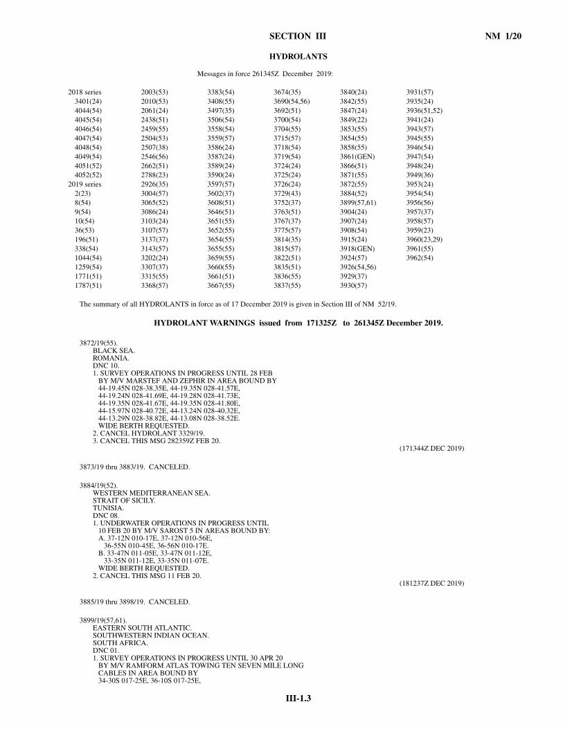
III-1.3
SECTION III NM 1/20
HYDROLANTS
The summary of all HYDROLANTS in force as of 17 December 2019 is given in Section III of NM 52/19.
HYDROLANT WARNINGS issued from 171325Z to 261345Z December 2019.
3872/19(55). BLACK SEA.ROMANIA.DNC 10.1. SURVEY OPERATIONS IN PROGRESS UNTIL 28 FEB BY M/V MARSTEF AND ZEPHIR IN AREA BOUND BY 44-19.45N 028-38.35E, 44-19.35N 028-41.57E, 44-19.24N 028-41.69E, 44-19.28N 028-41.73E, 44-19.35N 028-41.67E, 44-19.35N 028-41.80E, 44-15.97N 028-40.72E, 44-13.24N 028-40.32E, 44-13.29N 028-38.82E, 44-13.08N 028-38.52E. WIDE BERTH REQUESTED.2. CANCEL HYDROLANT 3329/19.3. CANCEL THIS MSG 282359Z FEB 20.
(171344Z DEC 2019)
3873/19 thru 3883/19. CANCELED.
3884/19(52). WESTERN MEDITERRANEAN SEA.STRAIT OF SICILY.TUNISIA.DNC 08.1. UNDERWATER OPERATIONS IN PROGRESS UNTIL 10 FEB 20 BY M/V SAROST 5 IN AREAS BOUND BY: A. 37-12N 010-17E, 37-12N 010-56E, 36-55N 010-45E, 36-56N 010-17E. B. 33-47N 011-05E, 33-47N 011-12E, 33-35N 011-12E, 33-35N 011-07E. WIDE BERTH REQUESTED.2. CANCEL THIS MSG 11 FEB 20.
(181237Z DEC 2019)
3885/19 thru 3898/19. CANCELED.
3899/19(57,61). EASTERN SOUTH ATLANTIC.SOUTHWESTERN INDIAN OCEAN.SOUTH AFRICA.DNC 01.1. SURVEY OPERATIONS IN PROGRESS UNTIL 30 APR 20 BY M/V RAMFORM ATLAS TOWING TEN SEVEN MILE LONG CABLES IN AREA BOUND BY 34-30S 017-25E, 36-10S 017-25E,
Messages in force 261345Z December 2019:
2018 series 2003(53) 3383(54) 3674(35) 3840(24) 3931(57)3401(24) 2010(53) 3408(55) 3690(54,56) 3842(55) 3935(24)4044(54) 2061(24) 3497(35) 3692(51) 3847(24) 3936(51,52)4045(54) 2438(51) 3506(54) 3700(54) 3849(22) 3941(24)4046(54) 2459(55) 3558(54) 3704(55) 3853(55) 3943(57)4047(54) 2504(53) 3559(57) 3715(57) 3854(55) 3945(55)4048(54) 2507(38) 3586(24) 3718(54) 3858(55) 3946(54)4049(54) 2546(56) 3587(24) 3719(54) 3861(GEN) 3947(54)4051(52) 2662(51) 3589(24) 3724(24) 3866(51) 3948(24)4052(52) 2788(23) 3590(24) 3725(24) 3871(55) 3949(36)
2019 series 2926(35) 3597(57) 3726(24) 3872(55) 3953(24)2(23) 3004(57) 3602(37) 3729(43) 3884(52) 3954(54)8(54) 3065(52) 3608(51) 3752(37) 3899(57,61) 3956(56)9(54) 3086(24) 3646(51) 3763(51) 3904(24) 3957(37)10(54) 3103(24) 3651(55) 3767(37) 3907(24) 3958(57)36(53) 3107(57) 3652(55) 3775(57) 3908(54) 3959(23)196(51) 3137(37) 3654(55) 3814(35) 3915(24) 3960(23,29)338(54) 3143(57) 3655(55) 3815(57) 3918(GEN) 3961(55)1044(54) 3202(24) 3659(55) 3822(51) 3924(57) 3962(54)1259(54) 3307(37) 3660(55) 3835(51) 3926(54,56)1771(51) 3315(55) 3661(51) 3836(55) 3929(37)1787(51) 3368(57) 3667(55) 3837(55) 3930(57)
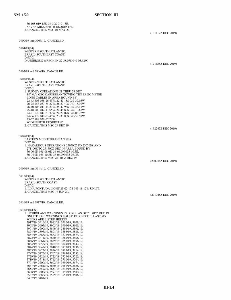
NM 1/20 SECTION III
III-1.4
36-10S 019-15E, 34-30S 019-15E. SEVEN MILE BERTH REQUESTED.2. CANCEL THIS MSG 01 MAY 20.
(191117Z DEC 2019)
3900/19 thru 3903/19. CANCELED.
3904/19(24). WESTERN SOUTH ATLANTIC.BRAZIL-SOUTHEAST COAST.DNC 01DANGEROUS WRECK IN 22-38.07S 040-05.62W.
(191655Z DEC 2019)
3905/19 and 3906/19. CANCELED.
3907/19(24). WESTERN SOUTH ATLANTIC.BRAZIL-SOUTHEAST COAST.DNC 01.1. SURVEY OPERATIONS 21 THRU 28 DEC BY M/V GEO CARIBBEAN TOWING TEN 13,000 METER LONG CABLES IN AREA BOUND BY 22-43.80S 038-26.43W, 22-43.18S 037-39.05W, 26-25.95S 037-35.27W, 26-27.40S 040-18.30W, 26-40.50S 043-14.20W, 25-47.93S 042-33.12W, 25-18.60S 042-11.55W, 24-49.80S 042-10.63W, 24-21.62S 042-21.32W, 24-22.07S 042-03.72W, 24-06.77S 042-03.45W, 23-33.80S 040-58.57W, 23-32.88S 039-57.28W. WIDE BERTH REQUESTED.2. CANCEL THIS MSG 29 DEC 19.
(192243Z DEC 2019)
3908/19(54). EASTERN MEDITERRANEAN SEA.DNC 10.1. HAZARDOUS OPERATIONS 250500Z TO 250700Z AND 271100Z TO 271300Z DEC IN AREA BOUND BY 36-06.0N 035-08.0E, 36-06.0N 035-10.5E, 36-04.0N 035-10.5E, 36-04.0N 035-08.0E.2. CANCEL THIS MSG 271400Z DEC 19.
(200936Z DEC 2019)
3909/19 thru 3914/19. CANCELED.
3915/19(24). WESTERN SOUTH ATLANTIC.BRAZIL-SOUTH COAST.DNC 01.1. ILHA PONTUDA LIGHT 23-02-17S 043-18-12W UNLIT.2. CANCEL THIS MSG 16 JUN 20.
(201045Z DEC 2019)
3916/19 and 3917/19. CANCELED.
3918/19(GEN). 1. HYDROLANT WARNINGS IN FORCE AS OF 201405Z DEC 19. ONLY THOSE WARNINGS ISSUED DURING THE LAST SIX WEEKS ARE LISTED HEREIN. 3917/19, 3916/19, 3915/19, 3910/19, 3909/19, 3908/19, 3907/19, 3905/19, 3904/19, 3903/19, 3901/19, 3900/19, 3899/19, 3896/19, 3895/19, 3894/19, 3893/19, 3891/19, 3886/19, 3885/19, 3884/19, 3883/19, 3882/19, 3876/19, 3874/19, 3872/19, 3871/19, 3870/19, 3869/19, 3868/19, 3866/19, 3861/19, 3859/19, 3858/19, 3856/19, 3854/19, 3853/19, 3852/19, 3849/19, 3847/19, 3844/19, 3842/19, 3840/19, 3837/19, 3836/19, 3835/19, 3822/19, 3816/19, 3815/19, 3814/19, 3787/19, 3775/19, 3767/19, 3763/19, 3752/19, 3729/19, 3726/19, 3725/19, 3724/19, 3723/19, 3719/19, 3718/19, 3715/19, 3710/19, 3704/19, 3701/19, 3700/19, 3692/19, 3690/19, 3674/19, 3667/19, 3661/19, 3660/19, 3659/19, 3655/19, 3654/19, 3652/19, 3651/19, 3646/19, 3635/19, 3608/19, 3602/19, 3597/19, 3590/19, 3589/19, 3587/19, 3586/19, 3559/19, 3558/19, 3506/19, 3497/19, 3481/19.

III-1.5
SECTION III NM 1/20
2. THE SUMMARY OF ALL HYDROLANT WARNINGS IN FORCE AS OF 29 DEC 2018 IS GIVEN IN SEC III OF NTM 52/18. WARNINGS ISSUED DURING THE SUBSEQUENT QUARTERS ARE SUMMARIZED IN NTM 13/19, 26/19 AND 39/19.3. THE COMPLETE TEXT OF ALL IN-FORCE HYDROLANT BROADCAST WARNINGS ARE AVAILABLE ON THE NGA MARITIME SAFETY INFORMATION WEBSITE AT: msi.nga.mil/NavWarnings. ALTERNATIVELY, THESE MAY BE REQUESTED BY E-MAIL FROM NGA AT [email protected]. CANCEL HYDROLANT 3526/19, 3824/19, 3897/19, 3906/19.
(201413Z DEC 2019)
3919/19 thru 3923/19. CANCELED.
3924/19(57). EASTERN SOUTH ATLANTIC.NAMIBIA.DNC 01.RACON (G) 22-52.16S 014-30.10E UNRELIABLE.
(210934Z DEC 2019)
3925/19. CANCELED.
3926/19(54,56). EASTERN MEDITERRANEAN SEA.CYPRUS-EAST COAST.DNC 10.1. SURVEY OPERATIONS 22 DEC THRU 31 MAY 20 BY M/V BARBAROS HAYREDDIN PASA, M/V TANUX-1 AND M/V APOLLO MOON IN AREA BOUND BY 34-49.07N 034-21.35E, 35-04.98N 034-21.62E, 35-19.93N 034-48.77E, 34-41.27N 034-47.92E, 34-17.82N 034-30.25E, 34-06.57N 034-15.20E, 34-17.55N 034-15.37E, 34-15.82N 033-56.43E, 34-41.30N 033-56.73E. FIVE MILE BERTH REQUESTED.2. CANCEL THIS MSG 01 JUN 20.
(211515Z DEC 2019)
3927/19 and 3928/19. CANCELED.
3929/19(37). BAY OF BISCAY.EASTERN NORTH ATLANTIC.DNC 08.24 METER F/V RACHEL JAY REQUESTING ASSISTANCEIN 46-26.5N 006-25.20W.VESSELS IN VICINITY REQUESTED TO KEEP A SHARPLOOKOUT, ASSIST IF POSSIBLE.REPORTS TO MRCC ETEL,TELEX: 42950519,PHONE: 332 9755 3535,FAX: 332 9755 4934, E-MAIL: [email protected].
(220711Z DEC 2019)
3930/19(57). GULF OF GUINEA.GABON.DNC 01.1. SEVERAL VESSELS ATTACKED IN 00-19N 009-24E AT 220200Z DEC.VESSELS ARE ADVISED TO KEEP CLEAR OF THIS POSITION AND TO EXERCISE EXTREME CAUTION. VESSELS IN VICINITY REQUESTED TO KEEP A SHARP LOOKOUT, ASSIST IF POSSIBLE.REPORTS TO NAVAREA II, PHONE: 332 9822 8888, 332 5631 2424, FAX: 332 5631 2584, E-MAIL: WATCHKEEPERS@MDAT- GOG.ORG,[email protected]. CANCEL THIS MSG 290200Z DEC 19.
(221020Z DEC 2019)
3931/19(57). EASTERN SOUTH ATLANTIC.NAMIBIA.DNC 01.RACON AT PELICAN POINT LIGHT 22-53.5S 14-26.1EUNRELIABLE.
(221500Z DEC 2019)

NM 1/20 SECTION III
III-1.6
3932/19 thru 3934/19. CANCELED.
3935/19(24). WESTERN SOUTH ATLANTIC.BRAZIL-SOUTH COAST.DNC 01.1. HAZARDOUS OPERATIONS 280900Z TO 281500Z DEC IN AREA BOUND BY 23-10.0S 042-45.1W, 23-10.0S 042-12.5W, 22-56.2S 042-12.5W, 22-56.2S 042-45.1W.2. CANCEL THIS MSG 281600Z DEC 19.
(230108Z DEC 2019)
3936/19(51,52). ALBORAN SEA.SPAIN.DNC 08.1. UNDERWATER OPERATIONS BY M/V REBECCA IN VICINITY OF TRACKLINE JOINING: A. IN PROGRESS UNTIL 27 DEC 36-17.61N 003-41.79W, 36-17.52N 003-47.08W, 36-17.61N 003-41.79W, 36-16.12N 002-43.55W. B. 28 THRU 31 DEC 36-10.66N 004-12.79W, 36-08.32N 004-17.29W, 36-10.66N 004-12.79W, 36-14.36N 004-00.79W. C. 31 DEC THRU 02 JAN 20 35-51.14N 005-00.85W, 35-51.14N 004-49.22W. WIDE BERTH REQUESTED.2. CANCEL THIS MSG 03 JAN 20.
(231210Z DEC 2019)
3937/19 thru 3940/19. CANCELED.
3941/19(24). WESTERN SOUTH ATLANTIC.DNC 01.1. DERELICT CABLE ADRIFT IN AREA BOUND BY AREA BOUND BY 25-28.33S 044-13.35W, 25-23.65S 044-13.35W, 25-23.65S 043-59.91W, 25-28.33S 043-59.91W.2. CANCEL THIS MSG 262342Z DEC 19.
(232342Z DEC 2019)
3942/19. CANCELED.
3943/19(57). GULF OF GUINEA.NIGERIA.DNC 01.1. M/V ATTACKED IN 01-47N 004-28E AT 240655Z DEC. VESSELS ARE ADVISED TO KEEP CLEAR OF THIS POSITION AND TO EXERCISE EXTREME CAUTION. REPORTS TO MDAT-GOG, PHONE: 332 9822 8888, E-MAIL: [email protected]. CANCEL THIS MSG 310759Z DEC 19.
(240759Z DEC 2019)
3944/19. CANCELED.
3945/19(55). BLACK SEA.TURKEY.DNC 10.1. HAZARDOUS OPERATIONS 270600Z TO 270900Z DEC IN AREA BOUND BY 42-30.0N 037-47.0E, 42-13.0N 037-47.0E, 42-13.0N 037-08.5E, 42-30.0N 037-08.5E.2. CANCEL THIS MSG 271000Z DEC 19.
(240829Z DEC 2019)
3946/19(54). AEGEAN SEA.DNC 09.1. HAZARDOUS OPERATIONS IN PROGRESS UNTIL 27 DEC IN AREA BOUND BY 36-56N 023-29E, 36-42N 023-32E, 36-41N 023-48E, 36-47N 023-55E.2. CANCEL THIS MSG 28 DEC 19.
(241030Z DEC 2019)

III-1.7
SECTION III NM 1/20
3947/19(54). EASTERN MEDITERRANEAN SEA.DNC 10.1. HAZARDOUS OPERATIONS 270900Z TO 271100Z AND 280900Z TO 281300Z DEC IN AREA BOUND BY 36-21N 028-33E, 35-55N 028-32E, 35-55N 029-14E, 36-06N 029-14E.2. CANCEL THIS MSG 281400Z DEC 19.
(241033Z DEC 2019)
3948/19(24). WESTERN SOUTH ATLANTIC.BRAZIL-SOUTHEAST COAST.DNC 01.1. HAZARDOUS OPERATIONS 290900Z TO 291500Z DEC IN AREA BOUND BY 23-10.0S 042-45.1W, 22-56.2S 042-45.1W, 22-56.2S 042-12.5W, 23-10.0S 042-12.5W.2. CANCEL THIS MSG 291600Z DEC 19.
(241035Z DEC 2019)
3949/19(36). CELTIC SEA.DNC 19.1. ODAS BUOY K1 ADRIFT IN VICINITY 49-00N 010-00W AT 240900Z DEC.2. CANCEL THIS MSG 271044Z DEC 19.
(241044Z DEC 2019)
3950/19 thru 3952/19. CANCELED.
3953/19(24). WESTERN SOUTH ATLANTIC.BRAZIL-SOUTH COAST.DNC 01.MAN OVERBOARD FROM VESSEL IN 22-55.63S 043-48.50WON 24 DEC. VESSELS IN VICINITY REQUESTED TO KEEP ASHARP LOOKOUT, ASSIST IF POSSIBLE. REPORTS TO ANYCOASTAL RADIO STATION.
(250205Z DEC 2019)
3954/19(54). AEGEAN SEA.DNC 09.1. HAZARDOUS OPERATIONS 291000Z TO 291100Z DEC IN AREA BOUND BY 39-31N 026-00E, 39-41N 026-00E, 39-41N 025-47E, 39-31N 025-47E.2. CANCEL THIS MSG 291200Z DEC 19.
(251135Z DEC 2019)
3955/19. CANCELED.
3956/19(56). EASTERN MEDITERRANEAN SEA.CYPRUS-SOUTHEAST COAST.DNC 10.1. HAZARDOUS OPERATIONS 270800Z TO 271100Z, 291000Z TO 291200Z DEC, 061300Z TO 061500Z, 081200Z TO 081500Z, 141400Z TO 141600Z, 170700Z TO 171000Z, 220900Z TO 221100Z, 251400Z TO 251700Z, 280900Z TO 281200Z, 301200Z TO 301400Z JAN 20 IN AREA BOUND BY 34-40.05N 033-54.30E, 34-10.10N 033-54.30E, 34-10.10N 033-37.85E, 34-33.50N 033-37.85E.2. CANCEL THIS MSG 301500Z JAN 20.
(251310Z DEC 2019)
3957/19(37). ENGLISH CHANNEL.BAY OF BISCAY.CELTIC SEA.FRANCE.DNC 20.1. NAVTEX STATION CROSS CORSEN (A) 48-28.6N 005-03.2W OFF AIR.2. BROADCASTS WILL BE TRANSMITTED FROM: A. CROSS CORSEN ON 2182 KHZ. B. NAVAREA II VIA SAFETYNET.
(251701Z DEC 2019)
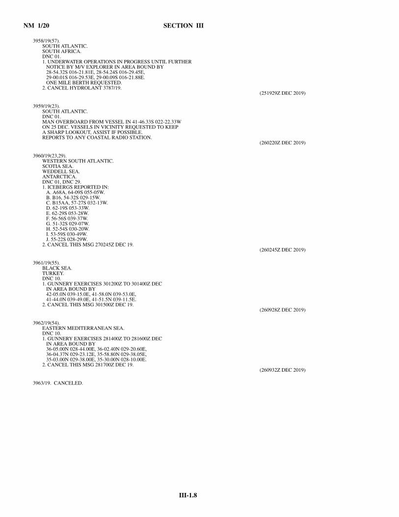
NM 1/20 SECTION III
III-1.8
3958/19(57). SOUTH ATLANTIC.SOUTH AFRICA.DNC 01.1. UNDERWATER OPERATIONS IN PROGRESS UNTIL FURTHER NOTICE BY M/V EXPLORER IN AREA BOUND BY 28-54.32S 016-21.81E, 28-54.24S 016-29.45E, 29-00.01S 016-29.53E, 29-00.09S 016-21.88E. ONE MILE BERTH REQUESTED.2. CANCEL HYDROLANT 3787/19.
(251929Z DEC 2019)
3959/19(23). SOUTH ATLANTIC.DNC 01.MAN OVERBOARD FROM VESSEL IN 41-46.33S 022-22.33WON 25 DEC. VESSELS IN VICINITY REQUESTED TO KEEPA SHARP LOOKOUT, ASSIST IF POSSIBLE.REPORTS TO ANY COASTAL RADIO STATION.
(260220Z DEC 2019)
3960/19(23,29). WESTERN SOUTH ATLANTIC.SCOTIA SEA.WEDDELL SEA.ANTARCTICA.DNC 01, DNC 29.1. ICEBERGS REPORTED IN: A. A68A, 64-09S 055-05W. B. B16, 54-32S 029-15W. C. B15AA, 57-27S 032-13W. D. 62-19S 053-33W. E. 62-29S 053-28W. F. 56-56S 039-37W. G. 51-32S 029-07W. H. 52-54S 030-20W. I. 53-59S 030-49W. J. 55-22S 028-29W.2. CANCEL THIS MSG 270245Z DEC 19.
(260245Z DEC 2019)
3961/19(55). BLACK SEA.TURKEY.DNC 10.1. GUNNERY EXERCISES 301200Z TO 301400Z DEC IN AREA BOUND BY 42-05.0N 039-15.0E, 41-58.0N 039-53.0E, 41-44.0N 039-49.0E, 41-51.5N 039-11.5E.2. CANCEL THIS MSG 301500Z DEC 19.
(260928Z DEC 2019)
3962/19(54). EASTERN MEDITERRANEAN SEA.DNC 10.1. GUNNERY EXERCISES 281400Z TO 281600Z DEC IN AREA BOUND BY 36-05.00N 028-44.00E, 36-02.40N 029-20.60E, 36-04.37N 029-23.12E, 35-58.80N 029-38.05E, 35-03.00N 029-38.00E, 35-30.00N 028-10.00E.2. CANCEL THIS MSG 281700Z DEC 19.
(260932Z DEC 2019)
3963/19. CANCELED.
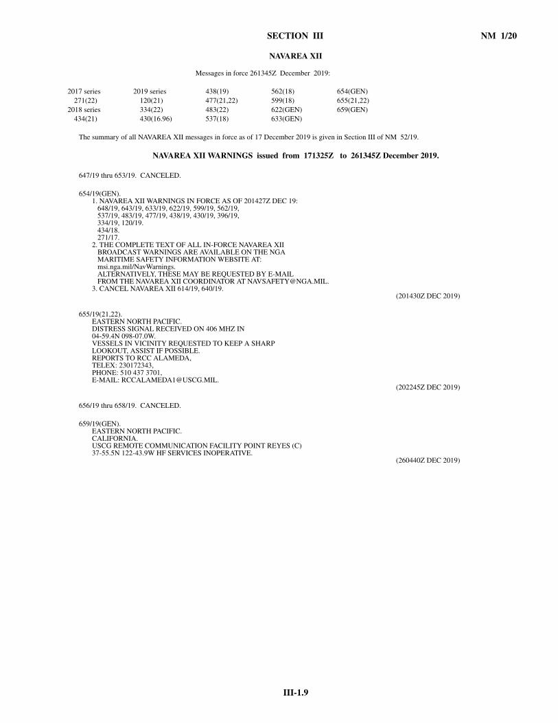
III-1.9
SECTION III NM 1/20
NAVAREA XII
The summary of all NAVAREA XII messages in force as of 17 December 2019 is given in Section III of NM 52/19.
NAVAREA XII WARNINGS issued from 171325Z to 261345Z December 2019.
647/19 thru 653/19. CANCELED.
654/19(GEN). 1. NAVAREA XII WARNINGS IN FORCE AS OF 201427Z DEC 19: 648/19, 643/19, 633/19, 622/19, 599/19, 562/19, 537/19, 483/19, 477/19, 438/19, 430/19, 396/19, 334/19, 120/19. 434/18. 271/17.2. THE COMPLETE TEXT OF ALL IN-FORCE NAVAREA XII BROADCAST WARNINGS ARE AVAILABLE ON THE NGA MARITIME SAFETY INFORMATION WEBSITE AT: msi.nga.mil/NavWarnings. ALTERNATIVELY, THESE MAY BE REQUESTED BY E-MAIL FROM THE NAVAREA XII COORDINATOR AT [email protected]. CANCEL NAVAREA XII 614/19, 640/19.
(201430Z DEC 2019)
655/19(21,22). EASTERN NORTH PACIFIC.DISTRESS SIGNAL RECEIVED ON 406 MHZ IN04-59.4N 098-07.0W.VESSELS IN VICINITY REQUESTED TO KEEP A SHARPLOOKOUT, ASSIST IF POSSIBLE.REPORTS TO RCC ALAMEDA,TELEX: 230172343,PHONE: 510 437 3701,E-MAIL: [email protected].
(202245Z DEC 2019)
656/19 thru 658/19. CANCELED.
659/19(GEN). EASTERN NORTH PACIFIC.CALIFORNIA.USCG REMOTE COMMUNICATION FACILITY POINT REYES (C)37-55.5N 122-43.9W HF SERVICES INOPERATIVE.
(260440Z DEC 2019)
Messages in force 261345Z December 2019:
2017 series 2019 series 438(19) 562(18) 654(GEN)271(22) 120(21) 477(21,22) 599(18) 655(21,22)
2018 series 334(22) 483(22) 622(GEN) 659(GEN)434(21) 430(16.96) 537(18) 633(GEN)

III-1.11
SECTION III NM 1/20
HYDROPACS
The summary of all HYDROPACS in force as of 17 December 2019 is given in Section III of NM 52/19.
HYDROPAC WARNINGS issued from 171325Z to 261345Z December 2019.
4183/19 thru 4191/19. CANCELED.
4192/19(93). SOUTH CHINA SEA.VIETNAM.DNC 11.MAN OVERBOARD FROM F/V BTH 98367TS IN VICINITY10-18N 108-48E AT 171030Z DEC. VESSELS INVICINITY REQUESTED TO KEEP A SHARP LOOKOUT,ASSIST IF POSSIBLE.REPORTS TO MRCC VIETNAM,FAX: 8422 5398 1615,E-MAIL: [email protected].
(180921Z DEC 2019)
4193/19. CANCELED.
4194/19(74). GULF OF CARPENTARIA.AUSTRALIA-NORTH COAST.DNC 05.DISTRESS SIGNAL RECEIVED ON 406 MHZ IN14-43.1S 135-26.8E AT 180916Z DEC.VESSELS IN VICINITY REQUESTED TO KEEP A SHARPLOOKOUT, ASSIST IF POSSIBLE.REPORTS TO JRCC AUSTRALIA,PHONE: 612 6230 6811, FAX: 612 6230 6868,E-MAIL: [email protected].
(181038Z DEC 2019)
4195/19 thru 4197/19. CANCELED.
Messages in force 261345Z December 2019:
2018 series 1392(93) 2812(74) 3629(93) 4069(82) 4194(74)996(93) 1394(81) 2863(94) 3649(22) 4112(63) 4198(62)1833(93) 1407(63) 2878(74) 3662(93) 4117(22) 4205(74)2314(93) 1439(74) 2884(74) 3670(63) 4118(22) 4207(57,61)3990(83) 1466(22) 2893(93) 3674(63) 4122(63) 4209(95)4185(93) 1488(63) 2894(63) 3731(62) 4125(62) 4212(74)
2019 series 1573(93) 2902(62) 3775(62) 4126(63) 4216(GEN)68(93) 1739(61) 2988(22) 3781(83) 4127(61) 4219(62)106(93) 1742(62) 2995(93) 3789(72,73) 4128(83) 4220(71)154(93) 1778(63) 2996(93) 3791(62) 4132(63) 4222(63)169(83) 1894(75) 3135(62,63) 3862(71) 4134(63) 4224(75)250(93) 2041(93) 3141(62) 3870(62) 4136(63) 4225(62,63)303(63) 2049(71) 3192(93) 3890(97) 4137(71) 4229(81)415(81) 2069(74) 3254(82) 3901(63) 4142(62) 4232(81,91)559(93) 2173(62) 3278(61) 3918(63) 4150(71) 4238(94)561(71) 2223(93) 3337(62) 3921(93) 4151(81,97) 4239(74)584(71) 2224(93) 3343(63) 3923(62,63) 4154(63) 4241(63)593(93) 2231(63) 3392(97) 3924(93) 4159(97) 4245(74)641(81) 2312(83) 3408(93) 3953(93) 4161(93) 4249(81,91,93)749(81) 2343(93) 3425(93) 3957(74) 4163(93) 4250(93)750(81) 2362(61) 3513(74) 3962(74) 4164(83) 4251(62)751(81) 2443(61) 3550(63) 3985(63) 4168(63) 4252(63)765(61) 2474(81) 3557(63) 4004(76) 4171(62,63) 4255(62)1006(75) 2543(61) 3566(83) 4011(93) 4172(62) 4256(63)1022(61) 2582(74) 3575(71) 4019(75) 4173(93) 4258(62)1115(63) 2634(96) 3591(82) 4027(61) 4181(63)1145(74) 2698(75) 3600(63) 4047(63) 4182(93)1308(62) 2718(62) 3620(96) 4068(83) 4192(93)

NM 1/20 SECTION III
III-1.12
4198/19(62). PERSIAN GULF.QATAR.DNC 10.SURVEY OPERATIONS IN PROGRESS UNTIL FURTHERNOTICE BY M/V GRO PORTEUS IN AREAS BOUND BY:A. 26-44.52N 051-53.91E, 26-44.52N 051-56.21E, 26-42.50N 051-56.20E, 26-42.50N 051-53.86E.B. 26-38.82N 051-49.53E, 26-38.75N 051-52.39E, 26-36.49N 051-52.35E, 26-36.60N 051-49.46E.C. 26-32.61N 051-55.54E, 26-32.53N 052-00.69E, 26-26.04N 052-00.78E, 26-26.12N 051-55.52E.WIDE BERTH REQUESTED.
(181527Z DEC 2019)
4199/19 thru 4204/19. CANCELED.
4205/19(74). CORAL SEA.AUSTRALIA-EAST COAST.DNC 05.1. CABLE OPERATIONS IN PROGRESS UNTIL FURTHER NOTICE BY CABLESHIP ILE DE BREHAT ALONG TRACKLINE JOINING 26-39.4S 153-06.7E, 26-32.0S 153-19.0E, 26-11.0S 153-39.0E, 26-10.0S 153-59.0E. WIDE BERTH REQUESTED.2. CANCEL HYDROPAC 4091/19.
(182151Z DEC 2019)
4206/19. CANCELED.
4207/19(57,61). EASTERN SOUTH ATLANTIC.SOUTH AFRICA.DNC 01.1. SURVEY OPERATIONS IN PROGRESS UNTIL 30 APR 20 BY M/V RAMFORM ATLAS TOWING TEN SEVEN MILE LONG CABLES IN AREA BOUND BY 34-30S 017-25E, 36-10S 017-25E, 36-10S 019-15E, 34-30S 019-15E. SEVEN MILE BERTH REQUESTED.2. CANCEL THIS MSG 01 MAY 20.
(191143Z DEC 2019)
4208/19. CANCELED.
4209/19(95). YELLOW SEA.DNC 23.1. GUNNERY EXERCISES 230100Z TO 230900Z, 240100Z TO 241100Z, 260400Z TO 260900Z DEC, 0300Z TO 0900Z DAILY 27 THRU 29 DEC IN AREA BOUND BY 37-25N 124-43E, 37-30N 124-43E, 37-30N 124-50E, 37-25N 124-50E.2. CANCEL THIS MSG 291000Z DEC 19.
(191211Z DEC 2019)
4210/19 and 4211/19. CANCELED.
4212/19(74). EASTERN INDIAN OCEAN.TIMOR SEA.AUSTRALIA-NORTHWEST COAST.DNC 04.1. UNDERWATER OPERATIONS IN PROGRESS BY M/V FUGRO ETIVE IN AREA BOUND BY 12-17S 123-20E, 13-53S 123-20E, 13-53S 130-30E, 12-17S 130-30E. THREE MILE BERTH REQUESTED.2. CANCEL HYDROPAC 3978/19.
(201016Z DEC 2019)
4213/19 thru 4215/19. CANCELED.
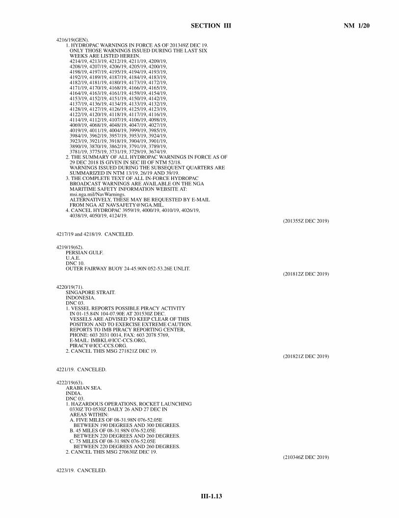
III-1.13
SECTION III NM 1/20
4216/19(GEN). 1. HYDROPAC WARNINGS IN FORCE AS OF 201349Z DEC 19. ONLY THOSE WARNINGS ISSUED DURING THE LAST SIX WEEKS ARE LISTED HEREIN. 4214/19, 4213/19, 4212/19, 4211/19, 4209/19, 4208/19, 4207/19, 4206/19, 4205/19, 4200/19, 4198/19, 4197/19, 4195/19, 4194/19, 4193/19, 4192/19, 4189/19, 4187/19, 4184/19, 4183/19, 4182/19, 4181/19, 4180/19, 4173/19, 4172/19, 4171/19, 4170/19, 4168/19, 4166/19, 4165/19, 4164/19, 4163/19, 4161/19, 4159/19, 4154/19, 4153/19, 4152/19, 4151/19, 4150/19, 4142/19, 4137/19, 4136/19, 4134/19, 4133/19, 4132/19, 4128/19, 4127/19, 4126/19, 4125/19, 4123/19, 4122/19, 4120/19, 4118/19, 4117/19, 4116/19, 4114/19, 4112/19, 4107/19, 4106/19, 4098/19, 4069/19, 4068/19, 4048/19, 4047/19, 4027/19, 4019/19, 4011/19, 4004/19, 3999/19, 3985/19, 3984/19, 3962/19, 3957/19, 3953/19, 3924/19, 3923/19, 3921/19, 3918/19, 3904/19, 3901/19, 3890/19, 3870/19, 3862/19, 3791/19, 3789/19, 3781/19, 3775/19, 3731/19, 3729/19, 3674/19.2. THE SUMMARY OF ALL HYDROPAC WARNINGS IN FORCE AS OF 29 DEC 2018 IS GIVEN IN SEC III OF NTM 52/18. WARNINGS ISSUED DURING THE SUBSEQUENT QUARTERS ARE SUMMARIZED IN NTM 13/19, 26/19 AND 39/19.3. THE COMPLETE TEXT OF ALL IN-FORCE HYDROPAC BROADCAST WARNINGS ARE AVAILABLE ON THE NGA MARITIME SAFETY INFORMATION WEBSITE AT: msi.nga.mil/NavWarnings. ALTERNATIVELY, THESE MAY BE REQUESTED BY E-MAIL FROM NGA AT [email protected]. CANCEL HYDROPAC 3959/19, 4000/19, 4010/19, 4026/19, 4038/19, 4050/19, 4124/19.
(201355Z DEC 2019)
4217/19 and 4218/19. CANCELED.
4219/19(62). PERSIAN GULF.U.A.E.DNC 10.OUTER FAIRWAY BUOY 24-45.90N 052-53.26E UNLIT.
(201812Z DEC 2019)
4220/19(71). SINGAPORE STRAIT.INDONESIA.DNC 03.1. VESSEL REPORTS POSSIBLE PIRACY ACTIVITY IN 01-15.84N 104-07.90E AT 201530Z DEC. VESSELS ARE ADVISED TO KEEP CLEAR OF THIS POSITION AND TO EXERCISE EXTREME CAUTION. REPORTS TO IMB PIRACY REPORTING CENTER, PHONE: 603 2031 0014, FAX: 603 2078 5769, E-MAIL: [email protected], [email protected]. CANCEL THIS MSG 271821Z DEC 19.
(201821Z DEC 2019)
4221/19. CANCELED.
4222/19(63). ARABIAN SEA.INDIA.DNC 03.1. HAZARDOUS OPERATIONS, ROCKET LAUNCHING 0330Z TO 0530Z DAILY 26 AND 27 DEC IN AREAS WITHIN: A. FIVE MILES OF 08-31.98N 076-52.05E BETWEEN 190 DEGREES AND 300 DEGREES. B. 45 MILES OF 08-31.98N 076-52.05E BETWEEN 220 DEGREES AND 260 DEGREES. C. 75 MILES OF 08-31.98N 076-52.05E BETWEEN 220 DEGREES AND 260 DEGREES.2. CANCEL THIS MSG 270630Z DEC 19.
(210346Z DEC 2019)
4223/19. CANCELED.

NM 1/20 SECTION III
III-1.14
4224/19(75). BASS STRAIT.AUSTRALIA-SOUTHEAST COAST.DNC 05.TABLE CAPE LIGHT 40-56.8S 145-43.7E UNLIT.
(210903Z DEC 2019)
4225/19(62,63). ARABIAN SEA.PAKISTAN.DNC 03, DNC 10.1. HAZARDOUS OPERATIONS 0400Z TO 1200Z DAILY 22 THRU 28 DEC IN AREA BOUND BY 25-48N 064-00E, 25-48N 065-30E, 25-15N 066-35E, 23-10N 066-35E, 23-10N 062-20E, 25-00N 062-20E.2. CANCEL THIS MSG 281300Z DEC 19.
(211340Z DEC 2019)
4226/19 thru 4228/19. CANCELED.
4229/19(81). WESTERN NORTH PACIFIC.PHILIPPINE SEA.DNC 12.DISTRESS SIGNAL RECEIVED ON 406 MHZIN 16-36.3N 146-13.0E AT 222242Z DEC.VESSELS IN VICINITY REQUESTED TO KEEP A SHARPLOOKOUT, ASSIST IF POSSIBLE.REPORTS TO RCC GUAM,PHONE: 671 355 4824, 671 355 4910,FAX: 671 355 4831,E-MAIL: [email protected].
(230015Z DEC 2019)
4230/19 and 4231/19. CANCELED.
4232/19(81,91). PHILIPPINE SEA.DNC 23.1. CABLE OPERATIONS 232300Z DEC UNTIL FURTHER NOTICE BY M/V ANIEK IN AREA BOUND BY 21-03.3N 127-21.3E, 21-00.0N 128-50.3E, 20-55.0N 129-05.7E, 20-53.7N 130-06.6E, 20-17.6N 131-37.8E, 20-28.3N 131-44.4E, 21-06.2N 130-07.6E, 21-07.1N 129-05.9E, 21-12.7N 128-51.4E, 21-15.7N 127-22.1E. WIDE BERTH REQUESTED.2. CANCEL HYDROPAC 3729/19.
(231327Z DEC 2019)
4233/19 thru 4237/19. CANCELED.
4238/19(94). EAST CHINA SEA.CHINA.DNC 23.1. CABLE OPERATIONS 25 THRU 31 DEC ALTERNATE 01 THRU 05 JAN 20 BY CABLESHIP KDDI OCEAN LINK IN AREA BOUND BY 30-55.8N 122-35.2E, 30-58.8N 122-49.5E, 30-55.0N 123-09.0E, 30-56.4N 123-17.7E, 30-55.0N 123-18.0E, 30-53.7N 123-11.2E, 30-57.0N 122-49.6E, 30-54.7N 122-35.5E. WIDE BERTH REQUESTED.2. CANCEL THIS MSG 06 JAN 20.
(241209Z DEC 2019)
4239/19(74). EASTERN INDIAN OCEAN.AUSTRALIA-NORTHWEST COAST.DNC 04.SURVEY OPERATIONS IN PROGRESS UNTIL FURTHER NOTICEBY M/V AMAZON CONQUEROR IN AREA BOUND BY19-34.2S 114-55.8E, 19-34.2S 115-24.8E,20-15.9S 115-24.8E, 20-15.9S 114-55.8E.FIVE MILE BERTH REQUESTED.
(241217Z DEC 2019)
4240/19. CANCELED.
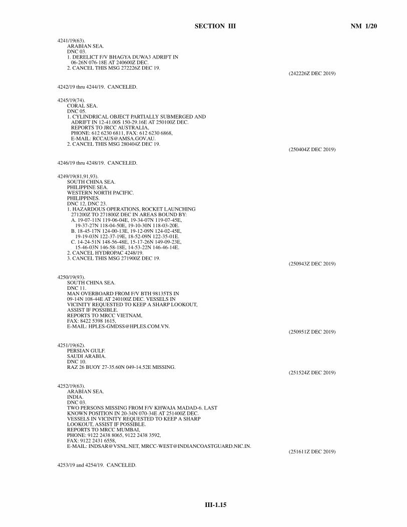
III-1.15
SECTION III NM 1/20
4241/19(63). ARABIAN SEA.DNC 03.1. DERELICT F/V BHAGYA DUWA3 ADRIFT IN 06-26N 076-18E AT 240600Z DEC.2. CANCEL THIS MSG 272226Z DEC 19.
(242226Z DEC 2019)
4242/19 thru 4244/19. CANCELED.
4245/19(74). CORAL SEA.DNC 05.1. CYLINDRICAL OBJECT PARTIALLY SUBMERGED AND ADRIFT IN 12-41.00S 150-29.16E AT 250100Z DEC. REPORTS TO JRCC AUSTRALIA, PHONE: 612 6230 6811, FAX: 612 6230 6868, E-MAIL: [email protected]. CANCEL THIS MSG 280404Z DEC 19.
(250404Z DEC 2019)
4246/19 thru 4248/19. CANCELED.
4249/19(81,91,93). SOUTH CHINA SEA.PHILIPPINE SEA.WESTERN NORTH PACIFIC.PHILIPPINES.DNC 12, DNC 23.1. HAZARDOUS OPERATIONS, ROCKET LAUNCHING 271200Z TO 271800Z DEC IN AREAS BOUND BY: A. 19-07-11N 119-06-04E, 19-34-07N 119-07-45E, 19-37-27N 118-04-50E, 19-10-30N 118-03-20E. B. 18-45-17N 124-00-13E, 19-12-09N 124-02-45E, 19-19-03N 122-37-19E, 18-52-09N 122-35-01E. C. 14-24-51N 148-56-48E, 15-17-26N 149-09-23E, 15-46-03N 146-58-18E, 14-53-22N 146-46-14E.2. CANCEL HYDROPAC 4248/19.3. CANCEL THIS MSG 271900Z DEC 19.
(250943Z DEC 2019)
4250/19(93). SOUTH CHINA SEA.DNC 11.MAN OVERBOARD FROM F/V BTH 98135TS IN09-14N 108-44E AT 240100Z DEC. VESSELS INVICINITY REQUESTED TO KEEP A SHARP LOOKOUT,ASSIST IF POSSIBLE.REPORTS TO MRCC VIETNAM,FAX: 8422 5398 1615,E-MAIL: [email protected].
(250951Z DEC 2019)
4251/19(62). PERSIAN GULF.SAUDI ARABIA.DNC 10.RAZ 26 BUOY 27-35.60N 049-14.52E MISSING.
(251524Z DEC 2019)
4252/19(63). ARABIAN SEA.INDIA.DNC 03.TWO PERSONS MISSING FROM F/V KHWAJA MADAD-6. LASTKNOWN POSITION IN 20-34N 070-34E AT 251400Z DEC.VESSELS IN VICINITY REQUESTED TO KEEP A SHARPLOOKOUT, ASSIST IF POSSIBLE.REPORTS TO MRCC MUMBAI,PHONE: 9122 2438 8065, 9122 2438 3592,FAX: 9122 2431 6558,E-MAIL: [email protected], [email protected].
(251611Z DEC 2019)
4253/19 and 4254/19. CANCELED.

NM 1/20 SECTION III
III-1.16
4255/19(62). PERSIAN GULF.U.A.E.DNC 10.PLATFORM ESTABLISHED IN 25-43.86N 055-40.20E.
(261014Z DEC 2019)
4256/19(63). BAY OF BENGAL.INDIA.DNC 03.1. HAZARDOUS OPERATIONS 0001Z TO 1700Z DAILY 30 AND 31 DEC IN AREA BOUND BY 16-42N 083-12E, 17-10N 083-42E, 16-41N 084-11E, 16-13N 083-41E.2. CANCEL THIS MSG 311800Z DEC 19.
(261027Z DEC 2019)
4257/19. CANCELED.
4258/19(62). PERSIAN GULF.U.A.E.DNC 10.1. SURVEY OPERATIONS IN PROGRESS UNTIL 29 DEC IN AREAS BOUND BY: A. 24-48.30N 052-21.61E, 24-48.12N 052-37.78E, 24-42.53N 052-37.69E, 24-42.71N 052-21.55E. B. 24-39.83N 051-35.93E, 24-40.95N 051-41.82E, 24-40.95N 052-02.27E, 24-35.19N 052-02.27E, 24-35.19N 051-36.20E. C. 25-05.52N 052-49.57E, 25-05.35N 053-02.02E, 25-00.51N 053-01.94E, 25-00.67N 052-49.50E. D. 25-08.57N 052-53.19E, 25-08.50N 052-58.51E, 24-57.46N 052-58.34E, 24-57.52N 052-53.02E. WIDE BERTH REQUESTED.2. CANCEL HYDROPAC 4234/19.3. CANCEL THIS MSG 30 DEC 19.
(261345Z DEC 2019)
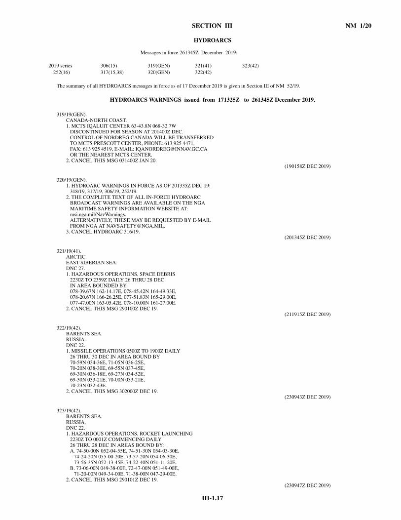
III-1.17
SECTION III NM 1/20
HYDROARCS
The summary of all HYDROARCS messages in force as of 17 December 2019 is given in Section III of NM 52/19.
HYDROARCS WARNINGS issued from 171325Z to 261345Z December 2019.
319/19(GEN). CANADA-NORTH COAST.1. MCTS IQALUIT CENTER 63-43.8N 068-32.7W DISCONTINUED FOR SEASON AT 201400Z DEC. CONTROL OF NORDREG CANADA WILL BE TRANSFERRED TO MCTS PRESCOTT CENTER, PHONE: 613 925 4471, FAX: 613 925 4519, E-MAIL: [email protected] OR THE NEAREST MCTS CENTER.2. CANCEL THIS MSG 031400Z JAN 20.
(190158Z DEC 2019)
320/19(GEN). 1. HYDROARC WARNINGS IN FORCE AS OF 201335Z DEC 19: 318/19, 317/19, 306/19, 252/19.2. THE COMPLETE TEXT OF ALL IN-FORCE HYDROARC BROADCAST WARNINGS ARE AVAILABLE ON THE NGA MARITIME SAFETY INFORMATION WEBSITE AT: msi.nga.mil/NavWarnings. ALTERNATIVELY, THESE MAY BE REQUESTED BY E-MAIL FROM NGA AT [email protected]. CANCEL HYDROARC 316/19.
(201345Z DEC 2019)
321/19(41). ARCTIC.EAST SIBERIAN SEA.DNC 27.1. HAZARDOUS OPERATIONS, SPACE DEBRIS 2230Z TO 2359Z DAILY 26 THRU 28 DEC IN AREA BOUNDED BY: 078-39.67N 162-14.17E, 078-45.42N 164-49.33E, 078-20.67N 166-26.25E, 077-51.83N 165-29.00E, 077-47.00N 163-05.42E, 078-10.00N 161-27.00E.2. CANCEL THIS MSG 290100Z DEC 19.
(211915Z DEC 2019)
322/19(42). BARENTS SEA.RUSSIA.DNC 22.1. MISSILE OPERATIONS 0500Z TO 1900Z DAILY 26 THRU 30 DEC IN AREA BOUND BY 70-59N 034-36E, 71-05N 036-25E, 70-20N 038-30E, 69-55N 037-45E, 69-30N 036-18E, 69-27N 034-52E, 69-30N 033-21E, 70-00N 033-21E, 70-23N 032-43E.2. CANCEL THIS MSG 302000Z DEC 19.
(230943Z DEC 2019)
323/19(42). BARENTS SEA.RUSSIA.DNC 22.1. HAZARDOUS OPERATIONS, ROCKET LAUNCHING 2230Z TO 0001Z COMMENCING DAILY 26 THRU 28 DEC IN AREAS BOUND BY: A. 74-50-00N 052-04-55E, 74-51-30N 054-03-30E, 74-24-20N 055-00-20E, 73-57-20N 054-06-30E, 73-56-35N 052-13-45E, 74-22-40N 051-11-20E. B. 73-06-00N 049-38-00E, 72-47-00N 051-49-00E, 71-20-00N 049-34-00E, 71-38-00N 047-29-00E.2. CANCEL THIS MSG 290101Z DEC 19.
(230947Z DEC 2019)
Messages in force 261345Z December 2019:
2019 series 306(15) 319(GEN) 321(41) 323(42)252(16) 317(15,38) 320(GEN) 322(42)
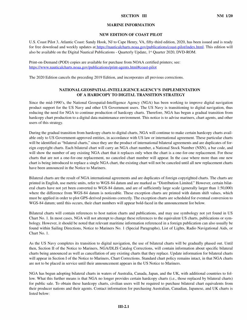
III-2.1
SECTION III NM 1/20
MARINE INFORMATION
NEW EDITION OF COAST PILOT
U.S. Coast Pilot 3, Atlantic Coast: Sandy Hook, NJ to Cape Henry, VA, fifty-third edition, 2020, has been issued and is readyfor free download and weekly updates at https://nauticalcharts.noaa.gov/publications/coast-pilot/index.html. This edition willalso be available on the Digital Nautical Publications - Quarterly Update, 1st Quarter 2020, DVD-ROM.
Print-on-Demand (POD) copies are available for purchase from NOAA certified printers; see: https://www.nauticalcharts.noaa.gov/publications/print-agents.html#coast-pilot
The 2020 Edition cancels the preceding 2019 Edition, and incorporates all previous corrections.
NATIONAL GEOSPATIAL-INTELLIGENCE AGENCY’S IMPLEMENTATION OF A HARDCOPY TO DIGITAL TRANSITION STRATEGY
Since the mid-1990’s, the National Geospatial-Intelligence Agency (NGA) has been working to improve digital navigationproduct support for the US Navy and other US Government users. The US Navy is transitioning to digital navigation, thusreducing the need for NGA to continue production of hardcopy charts. Therefore, NGA has begun a gradual transition fromhardcopy chart production to a digital data maintenance environment. This notice is to advise mariners, chart agents, and otherusers of this strategy.
During the gradual transition from hardcopy charts to digital charts, NGA will continue to make certain hardcopy charts avail-able only to US Government-approved entities, in accordance with US law or international agreement. These particular chartswill be identified as “bilateral charts,” since they are the product of international bilateral agreements and are duplicates of for-eign copyright charts. Each bilateral chart will carry an NGA chart number, a National Stock Number (NSN), a bar code, andwill show the number of any existing NGA chart that it replaces only when the chart is a one-for-one replacement. For thosecharts that are not a one-for-one replacement, no canceled chart number will appear. In the case where more than one newchart is being introduced to replace a single NGA chart, the existing chart will not be canceled until all new replacement chartshave been announced in the Notice to Mariners.
Bilateral charts are the result of NGA international agreements and are duplicates of foreign copyrighted charts. The charts areprinted in English, use metric units, refer to WGS-84 datum and are marked as “Distribution Limited.” However, certain bilat-eral charts have not yet been converted to WGS-84 datum, and are of sufficiently large scale (generally larger than 1:50,000)where the difference from WGS-84 datum is noticeable. These exception charts are printed with datum shift values, whichmust be applied in order to plot GPS-derived positions correctly. The exception charts are scheduled for eventual conversion toWGS-84 datum; until this occurs, their chart numbers will appear bold-faced in the announcement list below.
Bilateral charts will contain references to host nation charts and publications, and may use symbology not yet found in USChart No. 1. In most cases, NGA will not attempt to change these references to the equivalent US charts, publications or sym-bology. However, it should be noted that relevant maritime information referenced in a foreign publication can also usually befound within Sailing Directions, Notice to Mariners No. 1 (Special Paragraphs), List of Lights, Radio Navigational Aids, orChart No. 1.
As the US Navy completes its transition to digital navigation, the use of bilateral charts will be gradually phased out. Untilthen, Section II of the Notice to Mariners, NGA/DLIS Catalog Corrections, will contain information about specific bilateralcharts being announced as well as cancellation of any existing charts that they replace. Update information for bilateral chartswill appear in Section I of the Notice to Mariners, Chart Corrections. Standard chart policy remains intact, in that NGA chartsare not to be placed in service until their announcement appears in the US Notice to Mariners.
NGA has begun adopting bilateral charts in waters of Australia, Canada, Japan, and the UK, with additional countries to fol-low. What this further means is that NGA no longer provides certain hardcopy charts (i.e., those replaced by bilateral charts)for public sale. To obtain these hardcopy charts, civilian users will be required to purchase bilateral chart equivalents fromtheir producer nations and their agents. Contact information for purchasing Australian, Canadian, Japanese, and UK charts islisted below:

NM 1/20 SECTION III
III-2.2
Australian Hydrographic Service Web site: http://www.hydro.gov.au
Australian Distribution Network: http://www.hydro.gov.au/prodserv/distributors/distributors.htm
Canadian Hydrographic Service Web site: http://notmar.com/charts/index.php
Canadian Sales Agents: http://www.chs-shc.dfo-mpo.gc.ca/chs/en/Dealers/locate.htm
Japan Coast Guard and List of Agents Web sites: http://www1.kaiho.mlit.go.jp/jhd-E.html
UK Hydrographic Office Web site: http://www.ukho.gov.uk
UK Sales Agents: http://www.ukho.gov.uk/list_of_agents.html
NGA issues this notice weekly. It will also appear in the “What’s New @ Maritime” section of the Maritime Safety Web site(https://msi.nga.mil); however, the following list of announced bilateral charts will only appear in the Notice to Mariners.
NGA bilateral Australian, Canadian, Japanese, and UK charts announced to date:
Former US Chart No. Current US Chart No. Foreign Chart No.Originally Announced
in NtM Later Edition14002 14ACO14000 Can. 4023 23/0414005 14ACO14001 Can. 4012 23/0414006 14ACO14334 Can. 4016 9/0914009 14ACO14004 Can. 4015 23/0414009 14ACO14011 Can. 4047 23/0414009 14ACO14012 Can. 4002 29/04 52/1614009 14ACO14013 Can. 4013 29/0414009 14ACO14015 Can. 4045 29/0414014 14ACO14013 Can. 4013 29/0414040 14ACO14016 Can. 4010 29/0414041 14XHA14019 Can. 4011 29/0414083 14AHA14036 Can. 4320 45/05 34/0714088 14AHA14047 Can. 4201 46/0514089 14AHA14048 Can. 4202 39/06 41/1614090 14AHA14049 Can. 4237 6/0514091 14AHA14050 Can. 4203 48/0614115 14XCO14058 Can. 4227 29/0414144 14XHA14143 Can. 4950 38/03 15/1514190 14ACO14096 Can. 4905 6/0914202 14XHA14193 Can. 1432 38/03 3/1614202 14XHA14195 Can. 1431 42/03 52/1514203 14XHA14195 Can. 1431 42/03 52/1514221 14XHA14209 Can. 1311 32/08 15/1514221 14XHA14211 Can. 1312 40/03 15/1514222 14XHA14211 Can. 1312 40/03 15/1514227 14XHA14215 Can. 1316 39/03 38/1214240 14XHA14217 Can. 1236 43/03 15/1514241 14XHA14218 Can. 1233 39/03 14/1514253 14ACO14004 Can. 4015 23/0414340 14ACO14334 Can. 4016 9/0914342 14BCO14336 Can. 4626 11/1014360 14ACO14348 Can. 4017 12/1014364 14AHA14359 Can. 4846 25/0914415 14ACO14377 Can. 4020 12/1015008 15ACO15001 Can. 4730 12/1015011 15ACO15002 Can. 7050 16/0815017 15ACO15003 Can. 5450 33/0715018 15ACO15004 Can. 4700 12/1015020 15ACO15005 Can. 7011 12/10

III-2.3
SECTION III NM 1/20
15041 15ACO15007 Can. 4731 41/0815061 15ACO15014 Can. 4732 42/0815120 15ACO15030 Can. 4775 31/0715140 15ACO15031 Can. 4776 12/1015160 15ACO15032 Can. 5300 34/0815312 15ACO15035 Can. 5400 6/0915670 15XCO15672 Can. 7570 44/0917008 17ACO17007 Can. 3002 40/0817005 17ACO17010 Can. 3001 41/1417413 17ACO17411 Can. 3802 42/0817414 17BCO17415 Can. 3854 42/0817416 17BCO17417 Can. 3853 41/0817438 17BHA17440 Can. 3956 12/10 50/1717441 17BHA17442 Can. 3927 12/0717444 17XHA17448 Can. 3955 32/08 15/1517445 17BHA17439 Can. 3957 12/10 49/1717480 17ACO17454 Can. 3744 12/1017486 17XCO17458 Can. 3727 13/0917489 17XHA17488 Can. 3598 12/10 49/1717495 17ACO17493 Can. 3605 6/0717513 17XHA17497 Can. 3539 8/05 1/0817515 17XHA17496 Can. 3513 6/0917517 17XHA17498 Can. 3512 44/0917518 17BHA17499 Can. 3463 31/0717543 17ACO17501 Can. 3604 1/0817546 17XCO17510 Can. 3603 31/1017548 17BCO17511 Can. 3671 31/0717550 17ACO17514 Can. 3602 24/0718401 18BHA18404 Can. 3459 42/08 44/1018405 18BHA18426 Can. 3493 25/07 49/1118406 18BHA18435 Can. 3481 23/07 36/1218407 18BHA18436 Can. 3494 12/07 15/1518408 18BHA18437 Can. 3495 42/08 15/1518413 18BHA18442 Can. 3442 31/0718415 18BHA18461 Can. 3441 24/0718416 18AHA18462 Can. 3440 24/0718418 18AHA18466 Can. 3419 24/07 15/1518419 18BHA18469 Can. 3412 44/1518420 18BHA18467 Can. 3479 12/07 16/0835009 35ACO35002 UK 266 19/04 10/1635009 35ACO35003 UK 268 19/0435009 35ACO35004 UK 273 19/0435009 35ACO35005 UK 278 23/04 4/0735009 35ACO35006 UK 1191 24/04 8/1335009 35ACO35010 UK 1192 28/04 5/1635009 35ACO35013 UK 1409 23/04 35/1335009 35ACO35014 UK 1407 23/04 33/0935016 35ACO35015 UK 2635 26/06 9/1635022 35ACO35017 UK 1128 16/08 10/1635023 35ACO35018 UK 1129 37/07 10/1635031 35ACO35019 UK 1127 4/06 10/1635032 35ACO35020 UK 1125 7/0735036 35ACO35024 UK1123 3/07 28/1735040 35ACO35006 UK 1191 24/04 8/0635060 35ACO35010 UK 1192 28/04
Former US Chart No. Current US Chart No. Foreign Chart No.Originally Announced
in NtM Later Edition
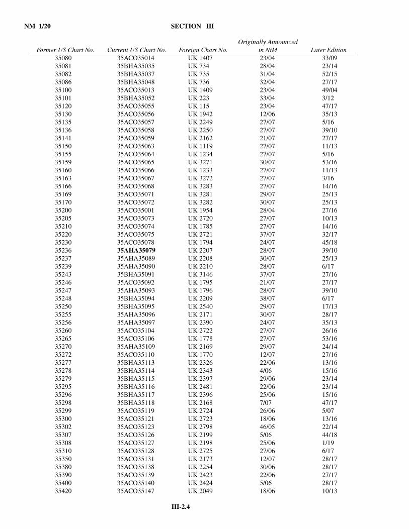
NM 1/20 SECTION III
III-2.4
35080 35ACO35014 UK 1407 23/04 33/0935081 35BHA35035 UK 734 28/04 23/1435082 35BHA35037 UK 735 31/04 52/1535086 35BHA35048 UK 736 32/04 27/1735100 35ACO35013 UK 1409 23/04 49/0435101 35BHA35052 UK 223 33/04 3/1235120 35ACO35055 UK 115 23/04 47/1735130 35ACO35056 UK 1942 12/06 35/1335135 35ACO35057 UK 2249 27/07 5/1635136 35ACO35058 UK 2250 27/07 39/1035141 35ACO35059 UK 2162 21/07 27/1735150 35ACO35063 UK 1119 27/07 11/1335155 35ACO35064 UK 1234 27/07 5/1635159 35ACO35065 UK 3271 30/07 53/1635160 35ACO35066 UK 1233 27/07 11/1335163 35ACO35067 UK 3272 27/07 3/1635166 35ACO35068 UK 3283 27/07 14/1635169 35ACO35071 UK 3281 29/07 25/1335170 35ACO35072 UK 3282 30/07 25/1335200 35ACO35001 UK 1954 28/04 27/1635205 35ACO35073 UK 2720 27/07 10/1335210 35ACO35074 UK 1785 27/07 14/1635220 35ACO35075 UK 2721 37/07 32/1735230 35ACO35078 UK 1794 24/07 45/1835236 35AHA35079 UK 2207 28/07 39/1035237 35AHA35089 UK 2208 30/07 25/1335239 35AHA35090 UK 2210 28/07 6/1735243 35BHA35091 UK 3146 37/07 27/1635246 35ACO35092 UK 1795 21/07 27/1735247 35AHA35093 UK 1796 28/07 39/1035248 35BHA35094 UK 2209 38/07 6/1735250 35BHA35095 UK 2540 29/07 17/1335255 35AHA35096 UK 2171 30/07 28/1735256 35AHA35097 UK 2390 24/07 35/1335260 35ACO35104 UK 2722 27/07 26/1635265 35ACO35106 UK 1778 27/07 53/1635270 35AHA35109 UK 2169 29/07 24/1435272 35ACO35110 UK 1770 12/07 27/1635277 35BHA35113 UK 2326 22/06 13/1635278 35BHA35114 UK 2343 4/06 15/1635279 35BHA35115 UK 2397 29/06 23/1435295 35BHA35116 UK 2481 22/06 23/1435296 35BHA35117 UK 2396 25/06 15/1635298 35BHA35118 UK 2168 7/07 47/1735299 35ACO35119 UK 2724 26/06 5/0735300 35ACO35121 UK 2723 18/06 13/1635302 35ACO35123 UK 2798 46/05 22/1435307 35ACO35126 UK 2199 5/06 44/1835308 35ACO35127 UK 2198 25/06 1/1935310 35ACO35128 UK 2725 27/06 6/1735350 35ACO35131 UK 2173 12/07 28/1735380 35ACO35138 UK 2254 30/06 28/1735390 35ACO35139 UK 2423 22/06 27/1735400 35ACO35140 UK 2424 5/06 28/1735420 35ACO35147 UK 2049 18/06 10/13
Former US Chart No. Current US Chart No. Foreign Chart No.Originally Announced
in NtM Later Edition
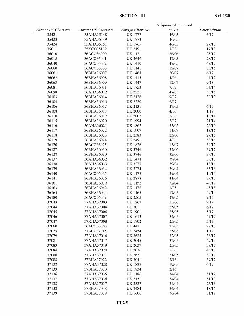
III-2.5
SECTION III NM 1/20
35421 35AHA35148 UK 1777 46/05 6/1735423 35AHA35149 UK 1773 46/0535424 35AHA35151 UK 1765 46/05 27/1735011 35XCO35172 UK 219 8/08 17/1336010 36ACO36000 UK 1121 26/06 28/1736015 36ACO36001 UK 2649 47/05 28/1736040 36ACO36002 UK 1410 47/05 47/1736060 36ACO36006 UK 1141 12/07 53/1636061 36BHA36007 UK 1468 20/07 6/1736062 36BHA36008 UK 1415 4/06 44/1236063 36BHA36009 UK 1447 12/07 9/1336081 36BHA36011 UK 1753 7/07 34/1436098 36AHA36012 UK 2221 47/05 53/1636103 36BHA36014 UK 2126 9/07 39/1736104 36BHA36016 UK 2220 6/0736106 36BHA36017 UK 2131 47/05 6/1736108 36BHA36018 UK 2000 4/06 1/1936110 36BHA36019 UK 2007 8/06 18/1136115 36BHA36020 UK 1994 3/07 21/1436116 36AHA36021 UK 1867 23/05 26/1036117 36BHA36022 UK 1907 11/07 13/1636118 36BHA36023 UK 2383 25/06 27/1636119 36BHA36024 UK 2491 4/06 53/1636120 36ACO36025 UK 1826 13/07 39/1736127 36BHA36030 UK 3746 32/06 39/1736128 36BHA36030 UK 3746 32/06 39/1736137 36AHA36032 UK 1478 39/04 39/1736138 36AHA36033 UK 3275 39/04 13/1636139 36BHA36034 UK 3274 39/04 35/1336140 36ACO36035 UK 1178 39/04 10/1336141 36BHA36036 UK 2878 41/04 37/1336161 36BHA36039 UK 1152 52/04 49/1936163 36BHA36042 UK 1176 1/05 45/1836165 36BHA36044 UK 1165 17/05 49/1936180 36ACO36049 UK 2565 27/05 9/1337043 37AHA37003 UK 1267 15/06 9/1937044 37AHA37004 UK 30 25/05 6/1737045 37AHA37006 UK 1901 25/05 5/1737046 37AHA37007 UK 1613 34/05 47/1737047 37XHA37008 UK 1902 25/05 5/1737060 36ACO36050 UK 442 25/05 28/1737075 37ACO37015 UK 2454 25/08 1/1237079 37AHA37016 UK 2625 32/05 38/1737081 37AHA37017 UK 2045 32/05 49/1937083 37AHA37019 UK 2037 25/05 39/1737084 37AHA37020 UK 2036 5/06 43/1737086 37AHA37021 UK 2631 31/05 39/1737088 37BHA37022 UK 2041 2/16 39/1737122 37AHA37028 UK 1828 19/05 6/1737133 37BHA37030 UK 1834 2/1637136 37AHA37035 UK 1186 34/04 51/1937137 37AHA37036 UK 2151 34/04 51/1937138 37AHA37037 UK 3337 34/04 26/1637138 37BHA37038 UK 2484 34/04 18/1637139 37BHA37039 UK 1606 36/04 51/19
Former US Chart No. Current US Chart No. Foreign Chart No.Originally Announced
in NtM Later Edition
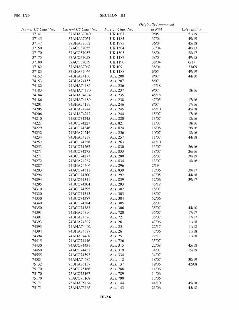
NM 1/20 SECTION III
III-2.6
37141 37AHA37040 UK 1607 9/05 51/1937145 37AHA37051 UK 1185 37/04 49/1937147 37BHA37052 UK 1975 36/04 45/1837150 37ACO37055 UK 1504 37/04 40/1337170 37ACO37057 UK 1503 38/04 28/1737175 37ACO37058 UK 1187 38/04 49/1537180 37ACO37059 UK 1190 38/04 6/1737182 37AHA37062 UK 109 38/04 33/0937183 37BHA37066 UK 1188 6/05 49/1974152 74BHA74150 Aus. 208 8/07 44/1074153 74BHA74155 Aus. 207 8/0774182 74AHA74185 Aus. 236 45/1874183 74AHA74180 Aus. 237 9/07 18/1674184 74AHA74174 Aus. 235 45/1874186 74AHA74189 Aus. 238 47/05 17/1674201 74BHA74199 Aus. 246 8/07 17/1674205 74BHA74244 Aus. 245 45/10 45/1874206 74AHA74212 Aus. 244 15/07 17/1674210 74BCO74245 Aus. 820 13/07 18/1674221 74BCO74227 Aus. 821 11/07 18/1674229 74BCO74246 Aus. 824 16/08 26/1674232 74BHA74216 Aus. 256 10/07 18/1674234 74BHA74237 Aus. 257 11/07 44/1874252 74BCO74258 Aus. 263 41/1074253 74BCO74262 Aus. 830 13/07 26/1674271 74BCO74275 Aus. 833 18/07 26/1674271 74BCO74277 Aus. 280 35/07 30/1974272 74BHA74267 Aus. 834 13/07 18/1674287 74BHA74306 Aus. 296 2/1974293 74ACO74311 Aus. 839 12/06 39/1774294 74BCO74300 Aus. 292 47/05 44/1874294 74ACO74311 Aus. 839 12/06 39/1774295 74BCO74304 Aus. 293 45/1874310 74BCO74395 Aus. 302 18/0774320 74BCO74313 Aus. 303 18/0774330 74BCO74387 Aus. 304 52/0674340 74BCO74384 Aus. 305 35/0774350 74BCO74383 Aus. 306 35/07 44/1074391 74BHA74390 Aus. 720 35/07 17/1774391 74BHA74396 Aus. 721 35/07 17/1774393 74BHA74397 Aus. 26 47/06 11/1874393 74AHA74402 Aus. 25 22/17 11/1874394 74BHA74397 Aus. 26 47/06 11/1874394 74AHA74402 Aus. 25 22/17 11/1874415 74ACO74416 Aus. 726 35/0774430 74ACO74431 Aus. 315 22/08 45/1874450 74ACO74451 Aus. 319 34/07 15/1974555 74ACO74593 Aus. 334 34/0774581 74AHA74585 Aus. 112 18/07 30/1975132 75BHA75137 Aus. 137 19/06 42/0875170 75ACO75166 Aus. 788 14/0675170 75ACO75167 Aus. 789 14/0675170 75ACO75168 Aus. 790 17/0675171 75AHA75164 Aus. 144 44/10 45/1875171 75AHA75165 Aus. 143 21/06 45/18
Former US Chart No. Current US Chart No. Foreign Chart No.Originally Announced
in NtM Later Edition
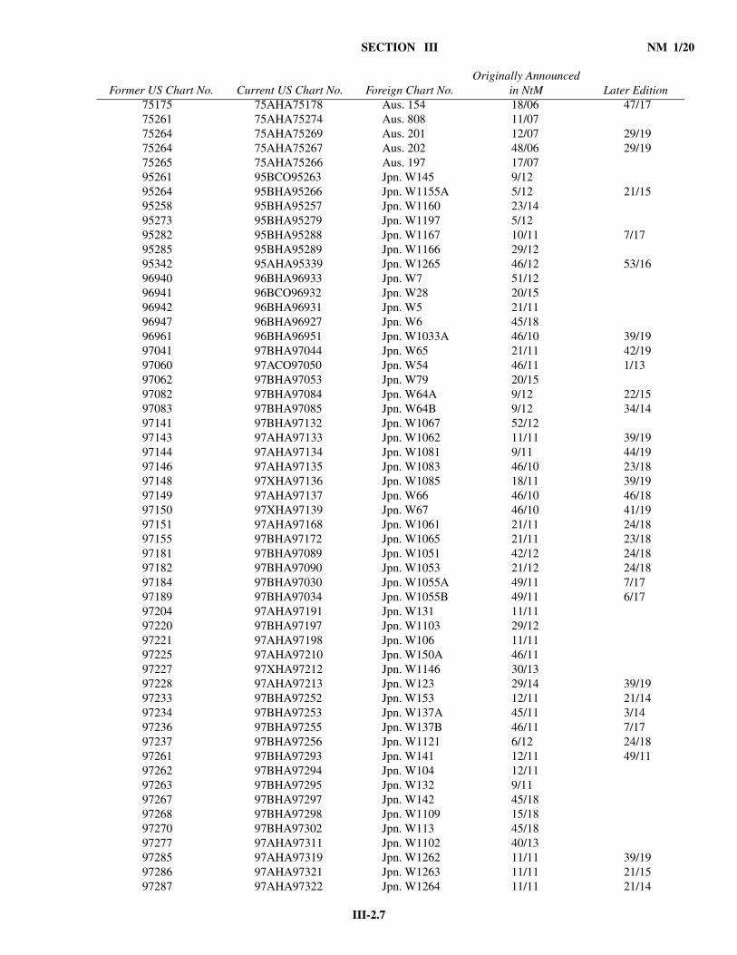
III-2.7
SECTION III NM 1/20
75175 75AHA75178 Aus. 154 18/06 47/1775261 75AHA75274 Aus. 808 11/0775264 75AHA75269 Aus. 201 12/07 29/1975264 75AHA75267 Aus. 202 48/06 29/1975265 75AHA75266 Aus. 197 17/0795261 95BCO95263 Jpn. W145 9/1295264 95BHA95266 Jpn. W1155A 5/12 21/1595258 95BHA95257 Jpn. W1160 23/1495273 95BHA95279 Jpn. W1197 5/1295282 95BHA95288 Jpn. W1167 10/11 7/1795285 95BHA95289 Jpn. W1166 29/1295342 95AHA95339 Jpn. W1265 46/12 53/1696940 96BHA96933 Jpn. W7 51/1296941 96BCO96932 Jpn. W28 20/1596942 96BHA96931 Jpn. W5 21/1196947 96BHA96927 Jpn. W6 45/1896961 96BHA96951 Jpn. W1033A 46/10 39/1997041 97BHA97044 Jpn. W65 21/11 42/1997060 97ACO97050 Jpn. W54 46/11 1/1397062 97BHA97053 Jpn. W79 20/1597082 97BHA97084 Jpn. W64A 9/12 22/1597083 97BHA97085 Jpn. W64B 9/12 34/1497141 97BHA97132 Jpn. W1067 52/1297143 97AHA97133 Jpn. W1062 11/11 39/1997144 97AHA97134 Jpn. W1081 9/11 44/1997146 97AHA97135 Jpn. W1083 46/10 23/1897148 97XHA97136 Jpn. W1085 18/11 39/1997149 97AHA97137 Jpn. W66 46/10 46/1897150 97XHA97139 Jpn. W67 46/10 41/1997151 97AHA97168 Jpn. W1061 21/11 24/1897155 97BHA97172 Jpn. W1065 21/11 23/1897181 97BHA97089 Jpn. W1051 42/12 24/1897182 97BHA97090 Jpn. W1053 21/12 24/1897184 97BHA97030 Jpn. W1055A 49/11 7/1797189 97BHA97034 Jpn. W1055B 49/11 6/1797204 97AHA97191 Jpn. W131 11/1197220 97BHA97197 Jpn. W1103 29/1297221 97AHA97198 Jpn. W106 11/1197225 97AHA97210 Jpn. W150A 46/1197227 97XHA97212 Jpn. W1146 30/1397228 97AHA97213 Jpn. W123 29/14 39/1997233 97BHA97252 Jpn. W153 12/11 21/1497234 97BHA97253 Jpn. W137A 45/11 3/1497236 97BHA97255 Jpn. W137B 46/11 7/1797237 97BHA97256 Jpn. W1121 6/12 24/1897261 97BHA97293 Jpn. W141 12/11 49/1197262 97BHA97294 Jpn. W104 12/1197263 97BHA97295 Jpn. W132 9/1197267 97BHA97297 Jpn. W142 45/1897268 97BHA97298 Jpn. W1109 15/1897270 97BHA97302 Jpn. W113 45/1897277 97AHA97311 Jpn. W1102 40/1397285 97AHA97319 Jpn. W1262 11/11 39/1997286 97AHA97321 Jpn. W1263 11/11 21/1597287 97AHA97322 Jpn. W1264 11/11 21/14
Former US Chart No. Current US Chart No. Foreign Chart No.Originally Announced
in NtM Later Edition
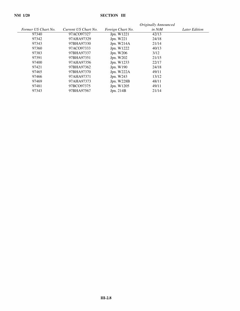
NM 1/20 SECTION III
III-2.8
97340 97ACO97327 Jpn. W1221 42/1397342 97AHA97329 Jpn. W221 24/1897343 97BHA97330 Jpn. W214A 21/1497360 97ACO97333 Jpn. W1222 40/1397383 97BHA97337 Jpn. W206 3/1297391 97BHA97351 Jpn. W202 21/1597400 97AHA97356 Jpn. W1233 22/1797421 97BHA97362 Jpn. W190 24/1897465 97BHA97370 Jpn. W222A 49/1197466 97AHA97371 Jpn. W243 13/1297469 97AHA97373 Jpn. W228B 48/1197481 97BCO97375 Jpn. W1205 49/1197343 97BHA97567 Jpn. 214B 21/14
Former US Chart No. Current US Chart No. Foreign Chart No.Originally Announced
in NtM Later Edition
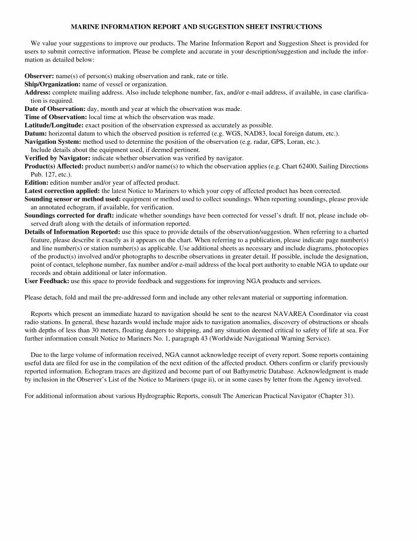
MARINE INFORMATION REPORT AND SUGGESTION SHEET INSTRUCTIONS
We value your suggestions to improve our products. The Marine Information Report and Suggestion Sheet is provided forusers to submit corrective information. Please be complete and accurate in your description/suggestion and include the infor-mation as detailed below:
Observer: name(s) of person(s) making observation and rank, rate or title.Ship/Organization: name of vessel or organization.Address: complete mailing address. Also include telephone number, fax, and/or e-mail address, if available, in case clarifica-
tion is required.Date of Observation: day, month and year at which the observation was made.Time of Observation: local time at which the observation was made.Latitude/Longitude: exact position of the observation expressed as accurately as possible.Datum: horizontal datum to which the observed position is referred (e.g. WGS, NAD83, local foreign datum, etc.).Navigation System: method used to determine the position of the observation (e.g. radar, GPS, Loran, etc.).
Include details about the equipment used, if deemed pertinent.Verified by Navigator: indicate whether observation was verified by navigator.Product(s) Affected: product number(s) and/or name(s) to which the observation applies (e.g. Chart 62400, Sailing Directions
Pub. 127, etc.).Edition: edition number and/or year of affected product.Latest correction applied: the latest Notice to Mariners to which your copy of affected product has been corrected.Sounding sensor or method used: equipment or method used to collect soundings. When reporting soundings, please provide
an annotated echogram, if available, for verification.Soundings corrected for draft: indicate whether soundings have been corrected for vessel’s draft. If not, please include ob-
served draft along with the details of information reported.Details of Information Reported: use this space to provide details of the observation/suggestion. When referring to a charted
feature, please describe it exactly as it appears on the chart. When referring to a publication, please indicate page number(s)and line number(s) or station number(s) as applicable. Use additional sheets as necessary and include diagrams, photocopiesof the product(s) involved and/or photographs to describe observations in greater detail. If possible, include the designation,point of contact, telephone number, fax number and/or e-mail address of the local port authority to enable NGA to update ourrecords and obtain additional or later information.
User Feedback: use this space to provide feedback and suggestions for improving NGA products and services.
Please detach, fold and mail the pre-addressed form and include any other relevant material or supporting information.
Reports which present an immediate hazard to navigation should be sent to the nearest NAVAREA Coordinator via coastradio stations. In general, these hazards would include major aids to navigation anomalies, discovery of obstructions or shoalswith depths of less than 30 meters, floating dangers to shipping, and any situation deemed critical to safety of life at sea. Forfurther information consult Notice to Mariners No. 1, paragraph 43 (Worldwide Navigational Warning Service).
Due to the large volume of information received, NGA cannot acknowledge receipt of every report. Some reports containinguseful data are filed for use in the compilation of the next edition of the affected product. Others confirm or clarify previouslyreported information. Echogram traces are digitized and become part of out Bathymetric Database. Acknowledgment is madeby inclusion in the Observer’s List of the Notice to Mariners (page ii), or in some cases by letter from the Agency involved.
For additional information about various Hydrographic Reports, consult The American Practical Navigator (Chapter 31).

MARINE INFORMATION REPORT AND SUGGESTION SHEET
Observer _______________________________________Ship/Organization _________________________________
Address________________________________________________________________________________________
______________________________________________________________________________________________
Email address __________________________________________________________________________________
Date of Observation _______________________________ Time of Observation (Local) _______________________
Latitude _________________________ Longitude _______________________ Datum _______________________
Navigation System __________________________________ Verified by Navigator: Yes ______ No ________
Product(s) Affected _________________________________ Editionn _____________________________________
Latest correction applied: N.M. ______________________
Sounding sensor or method used _______________________ Sounding(s) corrected for draft: Yes ____ Noc_____
Details of Information Reported (continue on additional sheets as necessary) _________________________________
______________________________________________________________________________________________
______________________________________________________________________________________________
______________________________________________________________________________________________
______________________________________________________________________________________________
______________________________________________________________________________________________
______________________________________________________________________________________________
______________________________________________________________________________________________
______________________________________________________________________________________________
______________________________________________________________________________________________
______________________________________________________________________________________________
______________________________________________________________________________________________
______________________________________________________________________________________________
______________________________________________________________________________________________
______________________________________________________________________________________________
______________________________________________________________________________________________
______________________________________________________________________________________________
User Feedback (continue on additional sheets as necessary)
______________________________________________________________________________________________
______________________________________________________________________________________________
______________________________________________________________________________________________
______________________________________________________________________________________________
______________________________________________________________________________________________
FIRST-CLASS MAILPOSTAGE & FEES PAID
NGAPERMIT NO. G-2
MARITIME SAFETY OFFICEMAIL STOP N64-SHNATIONAL GEOSPATIAL-INTELLIGENCE AGENCY7500 GEOINT DRIVESPRINGFIELD, VA 22150-7500
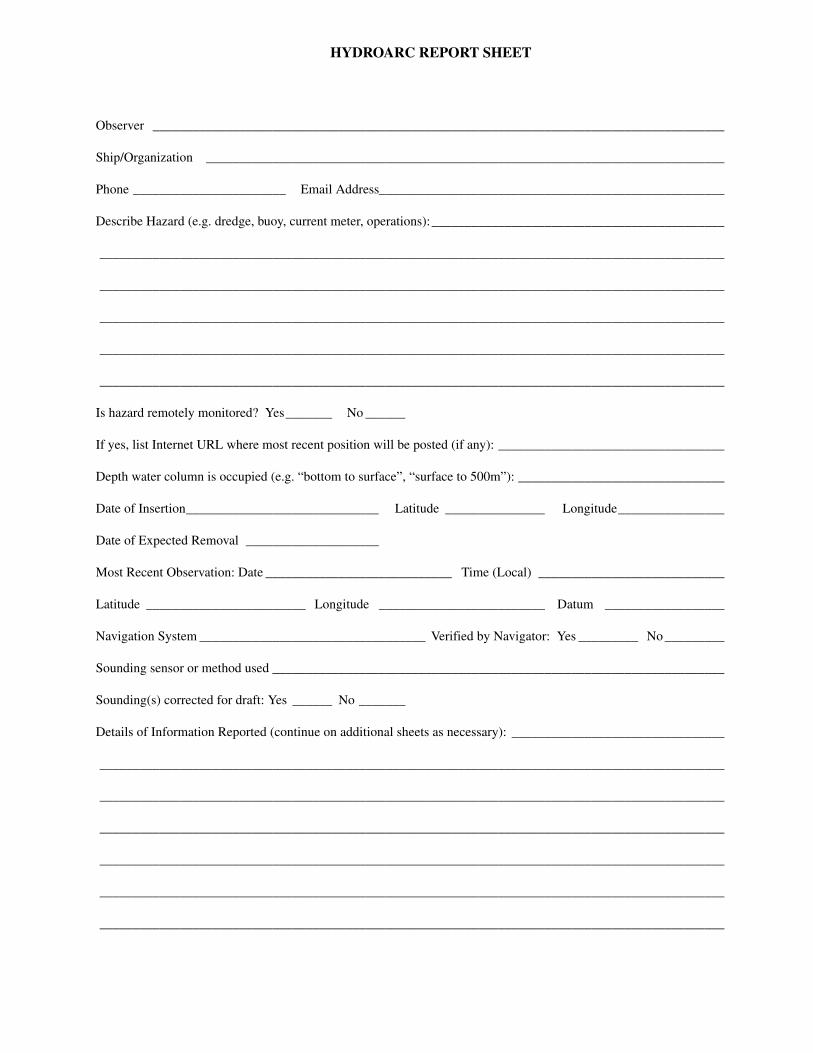
HYDROARC REPORT SHEET
Observer ______________________________________________________________________________________
Ship/Organization ______________________________________________________________________________
Phone _______________________ Email Address ____________________________________________________
Describe Hazard (e.g. dredge, buoy, current meter, operations):____________________________________________
______________________________________________________________________________________________
______________________________________________________________________________________________
______________________________________________________________________________________________
______________________________________________________________________________________________
______________________________________________________________________________________________
Is hazard remotely monitored? Yes_______ No ______
If yes, list Internet URL where most recent position will be posted (if any): __________________________________
Depth water column is occupied (e.g. “bottom to surface”, “surface to 500m”): _______________________________
Date of Insertion_____________________________ Latitude _______________ Longitude________________
Date of Expected Removal ____________________
Most Recent Observation: Date ____________________________ Time (Local) ____________________________
Latitude ________________________ Longitude _________________________ Datum __________________
Navigation System __________________________________ Verified by Navigator: Yes _________ No _________
Sounding sensor or method used ____________________________________________________________________
Sounding(s) corrected for draft: Yes ______ Noc_______
Details of Information Reported (continue on additional sheets as necessary): ________________________________
______________________________________________________________________________________________
______________________________________________________________________________________________
______________________________________________________________________________________________
______________________________________________________________________________________________
______________________________________________________________________________________________
______________________________________________________________________________________________
FIRST-CLASS MAILPOSTAGE & FEES PAID
NGAPERMIT NO. G-2
MARITIME SAFETY OFFICEMAIL STOP N64-SHNATIONAL GEOSPATIAL-INTELLIGENCE AGENCY7500 GEOINT DRIVESPRINGFIELD, VA 22150-7500

For
char
t num
beri
ng p
urpo
ses,
the
wor
ld is
div
ided
into
nin
e re
gion
s, e
ach
corr
espo
ndin
g to
the
geog
raph
ic li
mit
s of
one
of
the
nine
reg
ions
in t
he N
GA
/DL
IS C
atal
og o
f M
aps
Cha
rts
and
Rel
ated
Pro
duct
s. E
ach
Reg
ion
is f
urth
er s
ubdi
vide
d in
to t
he n
umbe
red
Subr
egio
ns i
n th
eab
ove
grap
hic.
The
fir
st tw
o di
gits
of
all f
ive-
digi
t cha
rt n
umbe
rs in
dica
te th
e ge
ogra
phic
sub
regi
on to
whi
ch th
e ch
art p
erta
ins.
Use
rs c
anlo
cate
cor
rect
ions
in th
is N
otic
e fo
r ch
arts
of
thei
r im
med
iate
inte
rest
by
dete
rmin
ing
the
two-
digi
t Sub
regi
on n
umbe
r of
the
pert
inen
t geo
-gr
aphi
c ar
ea, a
nd th
en tu
rnin
g to
the
page
or
page
s th
at li
st th
e ch
art n
umbe
rs b
egin
ning
wit
h th
ose
two
digi
ts.

IMP
OR
TAN
TNA
VIG
ATIO
NAL
INFO
RMAT
ION
TIM
E—
DA
TED
NO
TIC
E T
O
MA
RIN
ER
S
PL
EA
SE
EX
PE
DIT
E D
EL
IVE
RY


![A second visit to the United States of North America [microform]](https://static.fdokumen.com/doc/165x107/6336583562e2e08d490372db/a-second-visit-to-the-united-states-of-north-america-microform.jpg)