New functions and changes in Geo Professional - 3D ...
23
14.02.2019 News and changes in Geo http://www.sbg.se/revisions/georev_english.htm 1/23 New functions and changes in Geo Professional The list shows the most important updates in the program. Version Date Description 2019.1.11 18-12-14 Test version IFC New feature support for IFC 4 (alignments also supported) Open and view file(s) in 3D, alone or together with other supported files in Geo Filter object(s) in a filter view Select object(s) in the filter view Select objects(s) in the graphics View properties for selected objects Import selected object(s) into native formats (*geo, .l3d or *trm) 3D Graphics Experimental change in how to navigate and zoom in 3D, it is now possible to walk around the models and survey data in a whole new way. However, this feature is still at the expriment level, but please try and comment. The key assignments are set as follows: '+': Move forward 1 meter '-': Move backward 1 meter 'A': Turn left (left arrow) 'D': Turn right (right arrow) 'W': Turn up (up arrow) 'S': Turn down (down arrow) 'Shift': 5 time faster on moving 'Ctrl': 5 time slower on moving Tunnel Changes in how tunnels are sectioned from design areas (dwg), extended use with settings also for dH. This facilitates especially when the tunnel crosses itself in different planes (slopes and ramp tunnels). Maintenance changes Changes and fixes: Stability improvements, found thanks to those Geo Professional users who sent automatically created error reports to the development team. 2018.2.3 18-12-03 Official version Import / Export Support for Topcon *.tn3 terrain models in import and export. 3D Graphics Automatically set 3D rotation center to the middle of visible objects. Maintenance changes Changes and fixes: Point database is missing in 2018.2.1.11 (32-bit, Fixed Trim was broken, Fixed Not possible to save tpf after entering parameters for Affine transformation, Fixed Crash when selecting file under "External References" for *.dwg file on Win 10, Fixed Trimble Link did not work in 64 bit, Fixed (you may need to install an updated version from Trimble) Radius not handle correctly for source files in "Extract coordinates" with border polygon. Fixed If Extract Points is used together with a border polygon the line code is lost. Fixed Net adjustment reported to low relative redundancy for free net adjustments. Did not affect coordinates and separate observations, only relative redundancy for the entire net adjustment. Fixed Stability improvements, found thanks to those Geo Professional users who sent automatically created error reports to the development team. 2018.2.2 18-09-17 Test version AutoCad Changed CAD-engine to Teigha 2019 Hatched areas exported from TRM-files is exported as separate layer. Export by using BH90 has several improvements for "status", line type and coding. Cut and fill map Hatched areas are now reported as m2 from cut and fill maps. Maintenance changes Changes and fixes: Graphic tool trim line could create wrong heights sometimes. Fixed Text export was broken in 2018.2.1. Fixed Leica DBX (XML) import ignored gem-files when importing GNSS-data. Fixed Pile intersection by eccentric surveying was broken. Fixed Could not install 32-bit version after installed 64-bit. Fixed Stability improvements, found thanks to those Geo Professional users who sent automatically created error reports to the development team. 2018.2.1 18-06-29 Test version System Geo comes now as 64-bit version. Graphic tools New function for interpolating heights on an entire polyline, the line must have heights at the ends as well as any points on the line. Node points on the line without height get new interpolated height based on surrounding points. The tool is located under the right-click menu in the 2d graphics when the polyline is selected. Import/export Leica DBX import now uses HeXML as interface for import. That will improve the
-
Upload
khangminh22 -
Category
Documents
-
view
0 -
download
0
Transcript of New functions and changes in Geo Professional - 3D ...

14.02.2019 News and changes in Geo
http://www.sbg.se/revisions/georev_english.htm 1/23
New functions and changes in Geo ProfessionalThe list shows the most important updates in the program.
Version Date Description
2019.1.11 18-12-14 Test version
IFC New feature support for IFC 4 (alignments also supported)
Open and view file(s) in 3D, alone or together with other supported files in GeoFilter object(s) in a filter viewSelect object(s) in the filter viewSelect objects(s) in the graphicsView properties for selected objectsImport selected object(s) into native formats (*geo, .l3d or *trm)
3D Graphics Experimental change in how to navigate and zoom in 3D, it is now possible to walkaround the models and survey data in a whole new way. However, this feature is still atthe expriment level, but please try and comment.
The key assignments are set as follows:
'+': Move forward 1 meter '-': Move backward 1 meter 'A': Turn left (left arrow)
'D': Turn right (right arrow) 'W': Turn up (up arrow)
'S': Turn down (down arrow)
'Shift': 5 time faster on moving 'Ctrl': 5 time slower on moving
Tunnel
Changes in how tunnels are sectioned from design areas (dwg), extended use withsettings also for dH. This facilitates especially when the tunnel crosses itself in differentplanes (slopes and ramp tunnels).
Maintenance changes Changes and fixes:
Stability improvements, found thanks to those Geo Professional users who sentautomatically created error reports to the development team.
2018.2.3 18-12-03 Official version Import / Export Support for Topcon *.tn3 terrain models in import and export. 3D Graphics Automatically set 3D rotation center to the middle of visible objects.
Maintenance changes Changes and fixes:
Point database is missing in 2018.2.1.11 (32-bit, FixedTrim was broken, FixedNot possible to save tpf after entering parameters for Affine transformation,FixedCrash when selecting file under "External References" for *.dwg file on Win 10,FixedTrimble Link did not work in 64 bit, Fixed (you may need to install an updatedversion from Trimble)Radius not handle correctly for source files in "Extract coordinates" with borderpolygon. FixedIf Extract Points is used together with a border polygon the line code is lost.FixedNet adjustment reported to low relative redundancy for free net adjustments.Did not affect coordinates and separate observations, only relative redundancyfor the entire net adjustment. Fixed
Stability improvements, found thanks to those Geo Professional users who sentautomatically created error reports to the development team.
2018.2.2 18-09-17 Test version
AutoCad Changed CAD-engine to Teigha 2019Hatched areas exported from TRM-files is exported as separate layer.Export by using BH90 has several improvements for "status", line type andcoding.
Cut and fill map Hatched areas are now reported as m2 from cut and fill maps.
Maintenance changes Changes and fixes:
Graphic tool trim line could create wrong heights sometimes. FixedText export was broken in 2018.2.1. FixedLeica DBX (XML) import ignored gem-files when importing GNSS-data. FixedPile intersection by eccentric surveying was broken. FixedCould not install 32-bit version after installed 64-bit. Fixed
Stability improvements, found thanks to those Geo Professional users who sentautomatically created error reports to the development team.
2018.2.1 18-06-29 Test version System Geo comes now as 64-bit version.
Graphic tools
New function for interpolating heights on an entire polyline, the line must have heightsat the ends as well as any points on the line. Node points on the line without height getnew interpolated height based on surrounding points. The tool is located under theright-click menu in the 2d graphics when the polyline is selected.
Import/export Leica DBX import now uses HeXML as interface for import. That will improve the
14.02.2019 News and changes in Geo
http://www.sbg.se/revisions/georev_english.htm 2/23
dataflow from Leica Captivate Point cloud Import of LAS 1.3 and 1.4 is now supported
AutoCad
BH90: Change the description for status to the text instead of the characterIf attribute "Status" is used and exported to BH90, set character to all layersconnected
Communication Export of coordinate systems are improved for iCON field by USB. The correct foldersare created automatically on USB-stick for easier import to iCON field.
LandXML
Import of parcel with curves are now supportedSurveying data as LandXML is now supported for import.Import of cross sections from Civil 3D is improved.
Maintenance changes Changes and fixes:
Net adjustment: Redundancy (K) value not correctly calculated for freeadjustments in net adjustment. FixedBH90: If separate files and same code, layer can not be created. Fixed
Stability improvements, found thanks to those Geo Professional users who sentautomatically created error reports to the development team.
2018.1.982 18-04-30 Official version
Road Added a cross section view for cross fall models (CFM), need to define roadwidth to be used.Cross sections along line, calculation improvements how to create new points.
Tunnel DifferenceModel
The contour lines are divided into different layers when a DWG cut and fill map isgenerated.
Difference Model The contour lines are divided into different layers when a DWG cut and fill map isgenerated.
Reports
Added information regarding units in volume and area reports.Tunnel volume report, only view the calculation limit if this is used in thecalculation.Transformation report for 2D helmert + height difference now displays theheight diff as well
Drawing Profile drawing uses the settings for profile height from project settings. Graphic view Improvements for opening a *.ggv that includes not existing files.
Import / ExportAdded a general text export for *.geo and *.llc filesImprovement of DC Import for coordinate systems
AutoCad Added support to create dwg-file from l3d and terrain height profile (pro). Leica ConX Added icons for truck, piler, roler and driller LandXML Improvements for Cg Points Add on/ Plug in New DBX-tool added under download, support for Leica GS18T
Maintenance changes Changes and fixes:
Stability improvements, found thanks to those Geo Professional users who sentautomatically created error reports to the development team.
2018.1.981 17-12-22 Test version
Volume Calculation,Intersection Line
When calculating terrain model to reference height, you can now automatically createthe intersection line in the same way as in model to model.
Export Export of LLC-files to LandXML is now supported.
3D-graphics The measurement tool in the 3D view is now extended with 2D length, sloping lengthand slope.
Coordinate files Split lines in closed polygon are now changed so that the line is only divided where youchoose and no longer even on the last element of the polygon
Maintenance changes Changes and fixes:
Stability improvements, found thanks to those Geo Professional users who sentautomatically created error reports to the development team.
2018.1.980 17-11-06 Test version
Graphics New preview cross section tools which supports multiple surfaces. Terrain models(*.trm) and dwg files are supported. The cross section is defined by two clicks in thegraphics or by one click and a cross section perpendicular to the active line reference isgenerated.
OverlappedMeasurements
New function, Overlapped Measurements, for railway surveying. The function is madeto check that angular deviation does not occur between station set ups and it can beused both with or without road-/railway line.
Point CloudPossible to select which scans to import from Leica MS50/MS60. Previously, you onlycould get all or no scans from each station set up. Now it's possible to select individualscans from each station set up.
LandXML Added import of cgpoints in lat/long Coordinate systems Changed default settings for axis from xyz to NEH
Volume Calculation,MBS
Support for DWG files with surfaces in MBS, so they can be used directly as models forexisting layers.
Volume Calculation,Intersection Line
New output in volume calculation, model to model. It's possible to get the intersectionline with height, of the two input models in the calculation.
Maintenance changes Changes and fixes:
Stability improvements, found thanks to those Geo Professional users who sentautomatically created error reports to the development team.
2017.1.971 17-10-12 Test version
14.02.2019 News and changes in Geo
http://www.sbg.se/revisions/georev_english.htm 3/23
Leica ConX All ConX projects are now listed and possible to connect to, even if companies areusing account types to set up hierarchies. Earlier only projects created on the rootwere listed.
Tunnel Possible to add a multiple number of tun-files to a TBS.
File handlingSharePoint Improved support for subfolders on SharePoint server.
Translate Codes The function, Translation of codes, couldn't handle codes containing space. Fixed Import/Export The REB import is reintroduced. No changes of the import have been made.
LandXMLA new setting, Ignore invisible faces, is added to the LandXML import. Triangles inLandXML files can have an attribute that they are invisible, even they are a part of thetriangulation. When this option is selected, these triangles are ignored.
Remote support A direct link to Screen Connect is now available in the Help menu.
Maintenance changes Changes and fixes:
Some users, especially with Windows 10, could only run version 2017.1.970with hardware lock. But only if the certificate was already on the hardwarelock. FixedThe function, Cross sections along line, could in some special situationsgenerate extra points when using the option intersection with side lines. FixedProject settings; files with space before file extension were ignored even if theywere defined as control points or approximate points. FixedArea calculation of polygons for which the last element was a circle arc didn'twork. Fixed
Stability improvements, found thanks to those Geo Professional users who sentautomatically created error reports to the development team.
2017.1.970 17-05-04 Test version
Leica ConX New for Geo 2017 is integration of Leica ConX. Users can connect to the cloud basedservice and manage project data for machine control and field crew units. Note! Yoursubcription must always be valid to run this feature.
In project settings in Geo it’s now possible to use the Leica ConX credentials (must beon Company level) to login and link to a Leica ConX project.
Alignment (*l3d) Added height coordinate in 2d graphic for both plane and profile view.
Pointcloud For better visibility we added a function to change the linewidth for the point cloudtools.
LandXML Added support for stringlines from AutoCad Civil3D with Naviate.
Maintenance changes Changes and fixes:
3D view for trm-files could be very slow in Geo version 960-962. Fixed
Stability improvements, found thanks to those Geo Professional users who sentautomatically created error reports to the development team.
2016.2.962 17-03-28 Officiell version
Work flow pane Right click to find the 10 latest opened files.
AutoCad New function, support for CAD layers according to BH90 standard for export toDWG by saving view as AutoCAD file. This function requires the correct codelist and the associated template file (* .dwt) to operate. We have created newcode lists sbg2_BH90 and sbg2z_BH90 for Geographic Information. Call andtalk with our support for a detailed review or read more in the news.Dialog AutoCadlager is now larger than before.
Coordinates Modify points is extended with the ability to modify data for results in other fields. Alignment (*l3d) Graphical copying of road alignment into geo file now supports parabolic profile. LandXML import Support for LandXML files with HeXML 1.8 embedded.
Maintenance changes Changes and fixes:
Tunnel: Visualization of tunnel made errors in interpolation and often when tunfile is closed. FixedTunnel: Geo crashes when a new line is drawn after the existing lines of * .tunfiles deleted. FixedTunnel: Only integer was permitted by section intervals when creating colorizeddifference models. FixedAutoCAD: Tooltip info is displayed in the wrong color. FixedAutoCAD display order of 2d graphics could mistakenly make files invisible.FixedAutoCAD: Export of geo file with spaces for line code could get incorrect DWG.FixedVolume calculation model, the model can be extremely slow on large models ofGeo 2016. Fixed3D View: Failed to write minus the setup dialog workspace. FixedExcavation and fill levels, layers could be hidden behind the overlay. FixedNumeric view for geo files updated lines are not always correct. Fixed Measurement data: x and y values are exchanged in dialogue "Resection withGNSS". Fixed
Stability improvements, found thanks to those Geo Professional users who sentautomatically created error reports to the development team.
2016.2.961 16-11-30 Test version
Surveying Station setup on known point with multiple back sights weights now the calculationswith respect to the lengths.
Import / export When importing LandXML it was only possible to save the imported files in theexisting folder, now you can also create new folders when importing.

14.02.2019 News and changes in Geo
http://www.sbg.se/revisions/georev_english.htm 4/23
Enhanced support for SDR3 from eg Sokkia and Topcon.
Pile intersectionThe pile intersection calculation is now enhanced with the ability to other slope formatas well as a rotation bearing of the coordinate system to get local deviation in the pilegroup.
AutoCad
Support for "MTEXT" from AutoCAD drawingsIn view save as AutoCAD is now added description text AutoCad layer forexport with code list. This description is from the description of the code list.
Maintenance changes
Changes and fixes:
3D length of polygons in the numeric view showed not always the right length,fixedVolume calculation Model to model with multiple boundary polygons couldsometimes give strange values, fixedWhen changing the display order of the 2D graphics with AutoCAD files couldsometimes stop plotting the DWG file, fixed.Tunnel, with the use of DWG as a theoretical tunnel released not always Geomemory when the tunnel description was closed, fixed.Copy the road alignment from the help layer to active L3D file did not work asexpected, fixed.The ability to draw on the help layer in cross section was broken, fixed.
Stability improvements, found thanks to those Geo Professional users who sentautomatically created error reports to the development team.
2016.2.960 16-10-07 Test version
Graphics
New function, save the help layer to a new geo file. Is in the Data menu whenusing the layer is active. The status bar now holds ENH (xyz) also for terrain models when zoomed150% on Windows. New snapping tools, snap to vertex.
Import / Export New format, import of TRM from STL (terrain model for ski slopes)
New format 12d, import and export of 12da (12D archive from Australia)
3D Graphics Changing the center of rotation of the 3D model by right-clicking on the newcenter of rotation. Tip: Use snapping tools for greater accuracy New snapping tools, snap to vertex.
Maintenance changes Changes and fixes:
Graphics, now you can close multiple files simultaneously from the dialogue"Documents in the graphical view"
Stability improvements, found thanks to those Geo Professional users who sentautomatically created error reports to the development team.
2016.1.952 16-09-05 Officiell version
Graphics If multiple files are open it's possible to use "Bring Forward", "Bring to Front", "SendBackward" or "Send to Back" in Documents in Window.
Licensing Create Cut and Fill Map for difference model (*.dfm) is now available from the trm-module.
Surveying, leveling Adaptation for the Leica LS15
Tunnel Extracting tun files from design mesh files (dwg) Improvement for creating cross-sections from design mesh files
Terrain model Improvement for creating terrain models from closed polygons when using "checkconnection to same line"
Import coordinatesystem
Bug when importing Trimble DC coordinate systems (RSO, Azimuth atequator/skew/grid)
Roadline Offset station stationing option added to the Data menu for road lines
If element number contains a comma sign in *.l3d, change this to dot, when save as*.lin/prf
Maintenance changes Changes and fixes:
Stability improvements, found thanks to those Geo Professional users who sentautomatically created error reports to the development team.
2016.1.951 16-02-26 Test version GUI Change appearance / size of various dialogs in polish Surveying Added TS16, TS60 and MS60 to predefined list for atmospheric corrections Import / Export Added support for Topcon leveling format *.cs1 LandXML Change serialization of LandXML from version 1.1 to 1.2 (Export)
Maintenance changes Changes and fixes:
Clean for field function broken in 2016 branchCross-sections are not correct if TDM is added under 'user2' layer in TBSExport Points and Lines' doesn't export all the breaklines in TRM fileCrash with Volume calculation if Import / Export dialog has been openBugs in localization creationLine color is not coming in TBS file even when configured for file type default inL3D file
Stability improvements, found thanks to those Geo Professional users who sentautomatically created error reports to the development team.
2016.1.950 15-12-03 Test version Volume calculation
New user interface for volume calculation from terrain models. A workflowpane is used, so the graphical window can be used for viewing files.
14.02.2019 News and changes in Geo
http://www.sbg.se/revisions/georev_english.htm 5/23
Stockpile volume calculation is implemented.MBS, Changed standard for side lines so that * L3D is the first choice and not *cfm as previous versions, it is still possible to select both * cfm and the oldformat * .lin
Colored DifferenceModel
Colored cut and fill maps in dwg format, with user defined intervals and colors, can becreated from difference models (*.dfm).
Tunnel Colored tunnel difference models in 2D and 3D in dwg format, with user definedintervals and colors, can be created from TBS models.
Create Terrain Model Option to include/exclude points with a code that starts with a minus sign ( - )while creating the terrain model.Option to view the created terrain model in either active or new window.
File Transfer A file transfer dialog to transfer files to/from a user defined location e.g a removabledevice or network location. No file converting is done, but associated files are handled.
Grid Model/ModifyModel
The option to convert grid models (*.gdm) is moved to the Functions menu.The new user interface is in a workflow view.Possible to convert a grid model into AutoCAD format dwg or dxf. The data canbe exported as points, triangle surface or grid surface.
Alignments / roadlines
Graphics Settings, alignments has now been extended with the ability to set the linetype and line width.
LandXML Validation of LandXML files at import. The option is available in the Data menu forLandXML as well.
Point Cloud Grid model (*.gdm) can be included in a point cloud (*.gpc). Drawing Profile Drawings for road profiles allows you to draw the slope up to 7.5%
Maintenance changes Changes and fixes:
Stability improvements, found thanks to those Geo Professional users who sentautomatically created error reports to the development team.
2015.2.944 15-12-03 Officiell version
Maintenance changesChanges and fixes:
Stability improvements, found thanks to those Geo Professional users who sentautomatically created error reports to the development team.
2015.2.943 15-09-04 Officiell version
HeXML Support for reading HeXML version 1.7 (Coordinate systems from Leica SmartWorx andCaptivate)
Multi/Single Network Problem with connection to the license server solved.
Maintenance changes Changes and fixes:
Stability improvements, found thanks to those Geo Professional users who sentautomatically created error reports to the development team.
2015.2.942 15-06-11 Officiell version
Point Clouds Possible to use an existing polygon as 2D filter for point cloud (*.gpc)"
Maintenance changes Changes and fixes:
Stability improvements, found thanks to those Geo Professional users who sentautomatically created error reports to the development team.
2015.2.941 15-04-30 Test version
Export Export of road line with station equation is now supported for export to LeicaSmartWorx and LandXML.
Google Earth
Adjustment of the display button so the software is following Windows settings forwhich program to use to view Google Earth files. If e.g. Google Earth Pro or any otherGIS software is preferred to be used, this software can be started automatically.
Maintenance changesChanges and fixes:
Stability improvements, found thanks to those Geo Professional users who sentautomatically created error reports to the development team.
2015.2.940 15-03-20 Test version
Graphics
New graphical tool, Auto-Join Lines. This tool automatically joins connecting linesegments into one polyline if you select one line segment. The tool only applies to geo-files.
You will find this new tool under Tools | Split / Connect lines.
Tunnel
New method regarding design (theoretic) tunnel, a 3D design tunnel in theAutoCAD® file format DWG can now be used instead of, or in combination withtheoretic tunnel section (.tun). Point Cloud can now be used directly in tunnel, you don't need to createcross sections any more. Design tunnel can be used to filter unwanted data from a point cloud.Design tunnel in the DWF format and also in tun file format can be used.
Surface Statistics New extended report displaying max / min deviation.
Import DWG Extended possibility to handle DWG-files with several surfaces in different layers. Geocan now extract terrain models to several trm-files directly.
Maintenance changesChanges and fixes:
Stability improvements, found thanks to those Geo Professional users who sentautomatically created error reports to the development team.
2014.1.906 15-03-20 Official version
Maintenance changesChanges and fixes:
Stability improvements, found thanks to those Geo Professional users who sentautomatically created error reports to the development team.
2015.1.932 15-02-27 Test version Maintenance changes Changes and fixes:

14.02.2019 News and changes in Geo
http://www.sbg.se/revisions/georev_english.htm 6/23
Stability improvements, found thanks to those Geo Professional users who sentautomatically created error reports to the development team.
Help layer It is now possible to clear (delete) the help layer even when it is not the active file. Terrainmodel It was not possible to create a *.trm if the *.geo file was not saved at least once. Fixed Import DGN Improved speed performance when importing2014.1.905 15-02-27 Official version
Maintenance changesChanges and fixes:
Stability improvements, found thanks to those Geo Professional users who sentautomatically created error reports to the development team.
Drawings Black background in the graphic made black objects in drawing invisible. Fixed2015.1.931 14-12-23 Test version
Maintenance changesChanges and fixes:
Stability improvements, found thanks to those Geo Professional users who sentautomatically created error reports to the development team.
Transformation If you added and removed points several times, wrong transformation points could beused. Fixed.
Tunnel Tun and tdm files were not visible in the graphic view of a TBS file. Fixed.2014.1.904 14-12-23 Official version
Maintenance changesChanges and fixes:
Stability improvements, found thanks to those Geo Professional users who sentautomatically created error reports to the development team.
Drawings Section drawing was showing the same section for all printed sections. Fixed.2015.1.930 14-11-07 Testversion
Road / Rail New Road Line Format (*.L3D)
Supporting Station Equation (Rail).Horizontal and Vertical geometry is now saved in one single file, in whichstation equations also can be added.Vertical geometry now supports parabola.New Cross Fall Model replaces the older camber file / cross slope file, (*.skv).Possible to convert between the new and the old road line format.When converting rail geometry including station equations to lin/prf, the linewill be divided into parts regarding kilometers.Road line is now displayed in a new graphical display, both in 2D and in 3D.Possible to reverse a road line, including the profile.
CAD Now possible to import Microstation (*.dgn) to *.dwg. Upgraded cad engine supporting new .dwg formats.
Tunnel It is now possible to calculate geological over profile.2014.1.903 14-11-07 Official version
Maintenance changes Changes and fixes: Stability improvements, found thanks to those Geo Professional users who sent
automatically created error reports to the development team. Geo could round/truncate decimals incorrectly in files, when iCloud was used with
Swedish Windows, fixed. Improved import of DWG files including 3D faces.
2014.1.902 14-09-18 Official version
Maintenance changes Changes and fixes: Stability improvements, found thanks to those Geo Professional users who sent
automatically created error reports to the development team. 2014.1.901 14-07-04 Test version
Maintenance changes Changes and fixes:
- Changing windows/tabs with the function keys F2, F3 and F4. Fixed. - In the numerical view the option "Localize Graphically", didn't change to the graphical
view in v. 900. Fixed. Stability improvements, found thanks to those Geo Professional users who sent
automatically created error reports to the development team. Examples: - Geo crashed if you tried to create a camber (.skv) file from coordinates using a line
without an associated profile. Fixed. - If a camber file (.skv) was removed from a volume calculation (mbs), Geo crashed.
Fixed. - If a terrain model (.trm) was closed while the tool "Draw Stop Line" was active, Geo
could crash. Fixed. - A GDI resource leak could cause a crash. Fixed.
2014.1.900 14-06-18 Test version
Point Clouds
New functions in the point cloud module: - Archiving of point clouds (zip).
- Imports are extended with importing ASCII files, both with the order XYZ and alsowith YXZ, this feature also supports color and / or intensity values.
- New 3D filter introduced where a box is drawn to filter the data. - Export of LAS files are now supported, color and / or classes included in the export.
- When exporting, it is possible to sparse out the number of points, even if they arecolored.
Displaying Point Clouds:
- Point cloud can now be colored based on the elevation - Point cloud can now display color based on source files (not supported for direct
imports from Leica MS50) Import LandXML
- LandXML import from Thekla Civil with Infrastructure Model 3 has extended support
Installation
- The installation package is updated with new point cloud engine, which means that"Poincloud Utility" must be reinstalled if the point cloud module is to be used.

14.02.2019 News and changes in Geo
http://www.sbg.se/revisions/georev_english.htm 7/23
Surveying
New function: - Traceability of survey data, when coordinates are calculated, information about the
origin and known points in the coordinate files header, are stored. A report of thisinformation can be created from the file information dialog.
Coordinate files
- New report to print a complete coordinate file with polylines and points, this reportcan also be saved as an Excel file, if desired. Found under the Data menu when acoordinate file is active.
Coordinate systems
- New feature to download and install missing coordinate systems within the program.This feature is under "Edit Coordinate System" and the option "Select a pre-definedcoordinate system."
Documentation
- Help texts are up to date and in sync with the features of the software. User interface
Changes and new features:
- Document Tabs have new icons for the display mode instead of file type. - Create terrain model is moved to the workflow view. The created terrain model is
opened in the active window. - You can now create new projects directly from the dialog to change / open projects.
- 3D graphics, the height scale is redesigned, and color is now shown only when it hasa function. The color range is also changed for clarity.
- Help button is inserted into the workflow pane. - The tool create lin / prf now adds a sequential number to the file name if the tool is
used multiple times in the same session. System
- Geo has its own crash reporter that catches crashes of the program and sends it tothe development department.
- New feature where the program checks for new versions of Geo, this function isautomatic but can also be started manually under the help menu.
Maintenance changes Changes and fixes:
- Traverse files are now listed under the surveys in the file tree - The file tree is now updated in the background for quicker start of Geo
- Transformation Reports do not rounds values anymore. - Display of the old file types for sections LSD and KSD did not work in v.861, fixed.
2013.01.861 13-11-29 Official version
Point Clouds New functions in the point cloud module: - Point cloud dialogs are updated with help buttons
- Import of data from Leica MS50 and the E57 format are improved and does nowsupport high ASCII coded characters (e.g. å, ä, ö) in the projct name, folders orfile names.
LandXML-import Import of LandXML from Thekla Civil using inframodel schemas are now supported.
Installation The installation package are now updated with a new driver for hardlock, Windows 8.1is now supported.
Maintenance changes Improvements and fixes: - The DWG function "clean for field" has been modified and is now a little less
aggressive in erasing block references and layers. - DWG snapping on block did not work in Geo2013. Fixed
- Improving the import of Leica MS50 data from scanning stations that are only definedbut never scanned. Previously, these did not load. Fixed
- Transformation of scan data from Leica MS50 was incorrect in the rotation earlier(only point clouds). Fixed.
- Scans from MS50 where no pictures were included could sometimes fail imports.Fixed
- Project tree can now be inactivated by a simple right click in the project tree. 2013.01.858 13-09-12 Test version
Point Clouds New functions in the point cloud module: - Extended filtering methods, it's possible to filter the point cloud based on
classifications from LAS-files. - The point cloud can be colorized based on the classifications.
- Extended support for ESRI-grid, now handles both variants of the file format whenimporting height points.
- Improved preview when importing point clouds from Leica MS50. Panoramic imageswith the laser scanning regions are now visible when reading the data.
- Point clouds from Leica MS50 can be reoriented when imported. Coordinates for newstations can be calculated in the Coordinate calculation or Net adjustment.
Maintenance changes Improvements and fixes: - Handle of cross section drawings with multiple sec files was broken in previous Geo
2013 versions. Fixed. - Vektorize from DWG to coordinates was broken in previous Geo 2013 versions. Fixed.
- Printout of drawings with embedded DWG-files could render bad lines. Fixed2013.01.854 13-07-08 Test version
Maintenance changes Improvements and fixes: - There was no warning given if a file was changed and saved to a new filename that
already exists. - Improved reading of line data from MX-Genio.
2013.01.853 13-06-28 Test version
Point Clouds A new module for point clouds is available. Some functions: - Support for a range of point cloud file formats, LAS, PTS Leica PCI, Leica MS50, ESRI
grid and more. - 2D boundary filter to exclude points from the cloud.
- 3D surface filter to exclude points above or beneath. - Filter by intensity value is possible.
- It's possible to snap to points in the cloud. This makes it possible to draw 3d-linesdirectly in the graphics.
- Create cross sections directly from the point cloud without creating a surface. - An advanced simplificaction method can be used to create a point cloud with reduced

14.02.2019 News and changes in Geo
http://www.sbg.se/revisions/georev_english.htm 8/23
density for export. - Export of point clouds to PTS, Geo or Leica PCI formats.
- A tool that finds the lowest or highest points in a grid is available. - Save surface filters as terrain models which then can be further used for other
operations. In order to visualize point clouds it is recommended to use a computer with a
dedicated graphics card for accelerated 3D graphics and a separate memory plussupport for OpenGL 2.1 or later.
LandXML-view A new graphical import of LandXML files makes it possible to review the data before it'simported. Parts of the content can be selected for import.
User interface - A new workflow panel is introduced. Makes it easier to work interactively with thegraphics from various tools. The tool for creating a line and profile is an example wherethis is implemented.
- A new 3D reference grid is linked to the tools in the 3D view. Makes it easier yetmore powerful to work in 3D.
- By pressing and holding the space bar, the rotation tool is activated in the 3D-view.This makes it possible to continue to work with the currently active tool while rotatingthe view.
- A new button is added to delete the contents of the help layer. - The active line reference can be selected directly from the pane below the graphics
window. - An input field for section/chainage was added to the pane below the graphics window.
AutoCAD Support for DWG 2013.
Maintenance changes Improvements and fixes: - A problem to open drawings (dra) from older program versions was fixed.
- An automatic filtering of special characters in layer names and block names is donewhen exporting to DWG (this is an adaptation to recent versions of AutoCAD wherethese characters aren't allowed anymore).
- Length report from PLM. The distance to the station was added to the report. 2012.02.808 13-07-04 Official version.
Maintenance changes Improvements and fixes: - Improved import of stringlines from LandXML and converters such as MxGenio.
- A problem to create skapa LMD files was fixed. - The Russian translations were updated.
- When selecting coordinate systems the currently active one will be highlighted. 2012.02.806 12-12-12 Official version.
AutoCAD-files New features and improvements:
- Possibility to set a default base drawing to be used every time an export is made. - When exporting contour lines there will no longer be points created at each line node.
Maintenance changes Improvements and fixes: - LandXML, an error was fixed when importing profiles.
- Adjustment to automatically detect and start the latest version of Google Earth. - Trimble-kommunikation, updated version of Trimble-link.
- Updated coordinate systems for Poland, Denmark and New Zeeland.2012.02.804 12-09-07 Test Version, unverified functions may be included.
Coordinatecalculation, freestation
New station setup method, combined TPS/GNSS instead of known points, RUFRIS.The method is available in GeoPad from v.2012.01.805.
AutoCAD-filer New features and improvements: - New feature to easily clean up unwanted data from DWG / DXF files, "Clean for
Field". In short, it deletes all that is not visible in the graphics. Can often reduce thefile size to half or less.
- Improved handling of AutoCAD layers in the dialog for document properties. Makes iteasier to switch selected layers.
- Updated support for dwg files. A number of reported files that could not be opened inprevious versions are now good to display.
Cross Sections Editing of cross sections of the graphics has been improved to be able bind lines. Railroad, tamping Now it is possible to limit the calculation of tamping with starting and ending section.
Trimble Support for import of Trimble *. JXL files, support also for points with linked images.
Note that the JXL file and the images must be located in the same folder to make thiswork.
Maintenance changes Improvements and fixes: - Adaptations to handle LandXML files reported to contain errors.
- Horizontal net adjustment appeared always in meters in the observation tab, even ifanother unit was used. Fixed.
2012.01.774 12-09-05 Official version
Maintenance changes Improvements and fixes: - Statistic acceptance control, Geo could crash during the randomization of the points.
- Leica DBX Export displayed an error message when the center line was addedafterwards.
- Terrain sections failed and created a faulty result together with some alignments. - The area tool could make Geo to crash on Windows XP.
- Railroad, tamping report can now save custom tolerances. - Adjustments to handle LandXML files reported to contain errors.
- Adapt for new versions of Leica RR Plugins that creates HeXML output 2012.01.772 12-06-27 Official version
Maintenance changes Improvements and fixes: - Communication with iCON Site/Build is possible with Active Sync/Windows Mobile
Device Center. - The file list in the TrimbleLink dialog could display all files.
- The zoom limits were adjusted for files created from TBS/MBS visualization.

14.02.2019 News and changes in Geo
http://www.sbg.se/revisions/georev_english.htm 9/23
- Adjustments have been made to be able to read some LandXML-files that has beenreported to give error messages.
2012.01.770 12-04-19 Official version
Import/export Now it's possible to transfer files even if the import/export dialog is in the mode forshowing the active file.
Maintenance changes Improvements and fixes: - 'Modify points' doesn't work in 2012.01.769. Resolved.
2012.01.769 12-04-05 Official version
Import/export Improved import/export of files using new shortcut functions. - The transfer dialog automatically shows the active document (and associated files)
for export. - New buttons in the dialog makes it easy to shift from showing the active document
and all files in the project.
Coordinate systems Support for import and export of coordinate systems in LandXML format. - This makes it easier to exchange coordinate system information with Leica Viva units.
Communikation,
LeicaTailored data transfer with Leica iCON units (iCON Site/Build). A new menu alternativewas added to the Communication menu.
Communikation,
Trimble Import of attributes from Trimble (registered as Field Notes) is possible.
Maintenance changes Improvements and fixes: - Export of terrain profiles to DWG creates a 3D line instead of a 2D line.
- Fix for export of selected objects to DWG. - Snap to intersection between a geo-line and a line file (lin) was fixed.
- Fixed a problem when using higher priority for soil that rock in volume calculations(mbs).
- Export to Google Earth, colors of point texts follows the display in Geo. - Tunnel, a problem to create tdm files in sub directories was fixed.
- Added possibilty to the select size of point marks in 3D views. 2012.01.759 12-01-15 Test Version, unverified functions may be included.
Railroads A new function for calculation of tamping data was added.
Graphical tools New functions were added to the draw line tool.
- The angle to the next line segment can be selected. - The slope of the line segment can be selected.
Maintenance changes Changes and fixes: - Export to Google Earth, a problem with names that contains language-specific
characters was solved. - Lengths in lat-long files(llc) can be shown if a corresponding coordinate system is
defined. - Problems with black lines on black backgrounds or white lines on white beckgrounds
were solved. - Possibility to store special code and remark to ESRI Shape.
- LandXML-import sets point numbers also for line points. - The area tool crashed in cross section views.
- Japanese coordinate systems were added to the installation. - Transformation of terrain models didn't work.
2012.01.754 11-12-21 Test Version, unverified functions may be included.
Projects Possibility to turn off the automatic file watcher for the project tree.
Communication When exporting to Leica DBX it is possible to select either 1200 or VIVA, to handle theseparate folders for jobs in VIVA.
Communication When exporting surveying data to Leica format it is possible to also include thecoordinates of station points.
Tunnel Added possibility to select the number of elements when converting an ellipse to circlearcs in TUN files.
Maintenance changes Changes and fixes - The tool 'copy point/element' didn't increase point numbers.
- Prevented crashes when switching between 2D- and 3D graphics. - Rendering of 3D surfaces could fail for some graphic cards.
2012.01.750 11-10-28 Test Version, unverified functions may be included.
Reference calculation A new function is available for calculating surface statistics. The report containsdeviations of the height of measured points in relation to a design surface. Thefunction works for terrrain models (TRM), string models (LMD), camber (LIN,PRF,SKV)and volume calculations (MBS).
Transformation Terrain models , TRM, can be transformed directly from the transformation dialog andby using global transformation (local to local).
Surveying Support for images linked to points. Images that were taken with Leica Viva or TS15are handled when importing data.
Surveying Correction parameters are taken directly from the instrument. Surveying A new gps localization method was added; control line. Attributed The attribute window shows data and images linked to a point. Import/export Support for import and export of ESRI Shape.
Google Earth A new function was added to export graphical views to GoogleEarth format (KML/KMZ).If Google Earth is installed on the computer it will be launched automatically.
3D-graphics Texts (e.g. point numbers or codes) can be viewed also in the 3D-graphics.
Graphics Additional data, such as chainage, codes, radii is shown for stringline models (lmd) ingraphical windows.
LandXML-import LandXML, support for the element type 'parcel'.2010.02.718 11-10-03 Official version
Maintenance changes Changes and improvements - Fixed sorting from the line list in coordinate files.

14.02.2019 News and changes in Geo
http://www.sbg.se/revisions/georev_english.htm 10/23
- The tool 'move selected objects' didn't handle the height. - The tool 'copy point/element' didn't increase point numbers.
- Fixed crashes when switching between 2D- and 3D graphics. - 3D-views of surfaces didn't work for some graphic cards.
2010.02.717 11-05-29 Official version
Maintenance changes Changes and improvements - In order to improve the transfer of road data (mbs) to Visual Machine (via LandXML)
the center line code will be set automatically. - The slope value in the report created by rail surveying calculation wasn't correct.
- When importing poly lines from AutoCAD dwg the line code is set according to thecurrent layer.
2010.02.716 11-02-18 Test Version, unverified functions may be included.
Surveying, freestation
Improved the reporting in the calculation dialog to make it easier to diagnoseerroneous surveying records.
Surveying, freestation
Fix to be able to handle calculations of free stations based on records earlier in thesurveying sequence.
Graphics, 3D Fixed a 3D-graphics problem related to Intel graphics cards.
Graphics Fixed a graphical problem where lines in coordinate files can disappear when showed inthe same window as dwg files.
Grafik Updated import of the file formats MxGenio, REB, Ispol and Clip.2010.02.714 10-12-20 Test Version, unverified functions may be included.
Graphics, AutoCAD Objects of the type 'PolyFaceMesh' in dwg files can be visualized in 3d and beconverted to coordinate files. The object type 'Solid' can also be imported.
Graphics New tool to fit a sloping plane to any number of points. Projects The list with projects in the selection dialog wasn't updated as intended. Trimble Improved handling of coordinate systems when reading data in Trimble DC format.2010.02.712 10-11-19 Test Version, unverified functions may be included.
Graphics The tool 'Show object information' was only available for coordinate files (affectsv709).
Measurements, FreeStation Improvements in the handling of references in the Free Station dialog.
Coordinate systems Coordinate system updates for France (geoid models RAF09 and RAC09).2010.02.709 10-10-26 Test Version, unverified functions may be included.
AutoCAD import Support for ellipses imported from dwg/dxf. Will be handled as lines in coordinate files.
AutoCAD export Fixed a problem with symbols with arcs. These were converted to straight lines whenexported from sym-files. This does not affect symbols in templates (dwt).
Graphics The menu that shows which objects that are inside a selected area now also showspoint code, remarks and attributes.
3D-Graphics Fixed problems to show 3D-graphics when using NVidia Quadro graphics cards.2010.02.708 10-09-30 Test Version, unverified functions may be included.
LandXML Support for pipe structures in the form of Pipe Network which is imported in twoseparate coordinate files (geo), one with the pipes and one with the structs. Attributessuch as dimensions, material and pipe types are also stored in the file. Usually will alsoelevations be present in the file with the structs.
User interface Dropdown menues are expanded quicker, i.e. the time that the mouse button must beheld down has been shortened.
Communication,ActiveSync/MobileDevice Center
Improved handling of the destination folder of the connected unit.
Leica DBX export Improved export of ROAD-projects to Leica DBX, more clear choices in the dialog. Problem solved when transferring lines without camber was resolved.
Trimble Link Incorrect calculation of cross section based on camber (skv) was resolved.2010.02.704 10-08-27 Test Version, unverified functions may be included.
Cross sectiongraphics
Improved the editing of properties for cross sections in section files, volumecalculations and tunnel calculations. The list with the layers is easier to view.
Trimble DC Support for dc-files with multiple coordinate systems.
MultiHL Tool MultiHL Tool (used for configuration of network dongles) can be used in 64 bitoperating systems.
LandXML The objekttype ProfSurf can be imported to profiles (prf).2010.02.703 10-07-13 Test Version, unverified functions may be included.
LandXML Improved LandXML export: - Multiple files can be selected and exported to a single xml file.
- Separate transfer of stringlines makes it easier to control the transfer. The center lineselection is made in a dialog
Leica DBX Improved export to Leica DBX
- Multiple files can be selected and exported to dbx. - A new export dialog.
2010.02.701 10-06-14 Test Version, unverified functions may be included.
Edit coordinate files Line code can be edited in the point information dialog. Volyme calculation Standard sections, fixed problem with the element type ”To terrace”.2010.02.700 10-06-03 Test Version, unverified functions may be included.
Units It's possible to select the length unit to be used in a project, i.e. meter or foot(International/US Survey Foot).
Setup A number of options can be done separately for each project: - Units

14.02.2019 News and changes in Geo
http://www.sbg.se/revisions/georev_english.htm 11/23
- Code list, symbol file and linetype file - Number of decimals
- Coordinate axis and angle system
For all options it's possible to select a default value.
Number of decimals It's possible to select the precision for values shown. These are the values that can beset:
- coordinates - heights
- lengths - angles
- slopes - areas
- volumes - sections/chainages
- lat/long Background image New function to save the image with adjustments for GeoPad. AutoCAD-support Support for dwg- and dxf version 2010 and 2011. Both import and export.
New functionsassociated to thedocument tabs
Right-click a tab in order to: - Save the file
- Close the window and all files within it, - Open the folder containgen the file in the Windows Explorer. This can now also be
done in the project tree.
Click the mid button to close a window.
Transformation A new function with a simplified version of the global transformation. Transforms one
or more files between two systems defined by lok-files. The old function is now called"Global transformation, avanced".
Stringline model,LMD Profile height and point numbers are now set in cross sections created from LMD.
Project Problem with write-protected project files solved.2010.01.682 10-06-14 Official version
Multi/Single Network Problem with connection to the license server solved.2010.01.681 10-05-17 Official version
Communication,Trimble
Import of coordinate systems TrimbleDC; problem solved for files that contain a scalefactor in the local project options, "Local site settings".
2010.01.680 10-04-23 Official version
Surveying Improved traceability for free stations between GeoPad och Geo.
Communication,Trimble Fix for lines with clothoids for transfers using Trimble Link.
2010.01.677 10-02-16 Test Version, unverified functions may be included.
Leveling, Sokkia New function for importing leveling from Sokkia (cs1-format).2010.01.676 10-02-09 Test Version, unverified functions may be included.
Tunnel New function for mirroring a theoretic tunnel section (tun).2010.01.675 10-01-25 Test Version, unverified functions may be included.
Allmänt Stabilitetsförbättringar samt felrättningar. Kodlistor Kodlista för järnväg tillagd. Koordinatsystem Norska UTM-zoner. Languages Updates for norwegian, finnish, polish and french.2010.01.673 09-11-11 Test Version, unverified functions may be included.
Grafiska verktyg Verktygen Trim och Extend fungerar nu även mot en tänkt förlängning av objekten(edge-mode).
Import/Export Förbättrad import av KOF-format. Stöd för lat/long samt import av linjer skapade medSagmetoden och Bølgemetoden.
Allmänt Diverse rättningar (gäller endast version 2010): - Utskrift av ritning med flera blad.
- Radera objekt i 3D-vyn. - Import av rådata, resultatfilen öppnades i ett gömt fönster.
- Längdrapport skapad från koordinatfil skapades i ett gömt fönster. - Problem att spara hjälplagret åtgärdat. .
2010.01.670 09-10-06 Test Version, unverified functions may be included.
User interface New improved user interface (GUI) with an option to select a theme. - Tabs instead of separate windows for the files. The tab color indicates the content.
- The project tree and output window can be automatically hidden in order to maximizethe desktop work area.
- A new system for snapping windows and toolbars - New toolbars with dropdon buttons. Click and hold to expose the buttons.
Installation The installation of Geo has been adapted for Windows Vista and Windows 7 with a newfolder structure for projects, global files and system files.
Graphical tools New tools for Trim and Extend (Trimma/Förläng) . Used when editing coordinate files.
AutoCAD-files - Stöd för att visa objekttypen 3D-solid. - Support for dimension objects and solids
Drwaings Support for dimension objects Import/export Improved dialog for import and export.2008.03.651 09-12-11 Official version
License handling, If the contact to the license server is broken, and can't be establish again, backup-files

14.02.2019 News and changes in Geo
http://www.sbg.se/revisions/georev_english.htm 12/23
Single/Multi Network will be created when Geo is closed down. Import Added new version of external format converters.2008.03.650 09-11-02 Official version
Coordinate systems Added Lambert 1-parallel projections. (Morocco, Jamaica..).
Communication,Leica
Additional fixes for interpretation of the prism constant when reading rounds ofmeasurement.
2008.03.648 09-09-15 Official version
Profile check Profile check, improved presentation of deviations and tolerances.
Tunnel Graphical presentation of the distance between theoretic and measured tunnel can bemade in cross sections created without using a tunnel model.
Communication,Leica Fixed a problem to interpret the prism constant when reading rounds of measurement.
Transformation,graphically Fixed a problem when saving the transformed data in a new file.
Graphics, 3D The current setup for zoom and rotation is reset when a new file is opened.
Imort/Export,LandXML
Improvements were made to the LandXML import, e.g. when interpolating string linesfrom cross sections.
2008.03.646 09-07-12 Test Version, unverified functions may be included.
Grid models Fixed problem with grid model to coordinate file conversion.2008.03.645 09-07-08 Test Version, unverified functions may be included.
Alignments Changes in clothoid calculations. Traditionally SBG have used an approximation for calculating coordinates on a Clothoid.
The approximation has been known to have a limited range of validity. However, theapproximation has been well established in road/rail construction engineering so untilnow there have been little reason for changing it. Recently, it have been demonstratedthat there are applications where the range of validity is exceeded, resulting inincorrect results. Therefore the calculation routines have been changed. The changeonly affects clothoids with a curvature that are close to (or longer) than a quarter of acircle, or such ones that are far away from the segment of infinite radius.
As long as data is imported and used in applications where this change is present thereis no problem. But if you send imported or edited data to other applications theremight be a problem. Versions of Geo, GeoPad and GeoROG/UMC3D that are notadjusted for this will not calculate coordinates correctly. For this reason, always run aline check in the application where the line will be used, even if you don't intend tomodify it.
The line check in Geo has been extended to show an information message if the lineconsists of clothoids that can cause these kinds of problems in older versions of Geo,GeoPad and GeoROG/UMC3D. .
CoordinateCalculation Improved correction for earth curvature.
Coordinate systems Possibility to select the version of the localization file (lok) when saving it, in order tobe used in products that can't handle the latest version.
LandXML Improved LandXML import, solves problem with cross section layers without any data. Grid models Fixed problem with grid model creation (642). Language updates Updates for finnish, dutch and norwegian.2008.03.642 09-05-07 Test Version, unverified functions may be included.
GeoPadCommunication
When transferring background images to GeoPad it's possible to adjust the file size andimage resolution.
Volume Calculation The report contains separated volumes for each part when using limitating lines(polygons) in the calculation.
LandXML import Automatic 3D curve interpolation to stringlines can be done directly when importingLandXML files that contains some form of standardized coding (Leica/Trimble/Bentley).
LandXML export Export of coordinates to LandXML, the order of the line codes was adjusted to work inMikrofyn's Visual Machine.
LandXML export Export of coordinate files with lines to LandXML, the file is adjusted to be imported in
Leica LGO/TMS Office and Trimble TGO. The element type "Line" is used instead of"IrregularLine" when possible.
2008.02.631 09-03-18 Test Version, unverified functions may be included.
Coordinate systems New coordinate systems added for the Netherlands. Export to KOF Change for line code when exporting to KOF format.2008.02.630 09-02-16 Test Version, unverified functions may be included.
AutoCAD files Improved display of dwg files. Koordinatsystem Added new Swedish geoid model SWEN08. Trimble Trimble Link, fixed problem with the dialog for road export. Trimble Trimble DC, fixed problem when reading rounds of measurement. Trimble Trimble DC, fixed problem to interpret line codes.2008.02.629 09-02-04 Test Version, unverified functions may be included.
Licenses Improved handling of network dongles. A new tool, MultiHLTool, can be found in the
start menu of Geo. It makes it easier to shift between network dongle acces (MultiHL)and the other license options.
Coordinate systems Extended correction of measurements. Now includes correction for geodetic datum,geoid model and local transformation.
Coordinate systems Added coordinate system files for Denmark and Great Brittain, can be selected in theinstallation phase.
Lokalization Fixed errors in the Trimble DC top lokalization import. The DC header was not readproperly and the height transformation calculated the sloping plane erroneously.
14.02.2019 News and changes in Geo
http://www.sbg.se/revisions/georev_english.htm 13/23
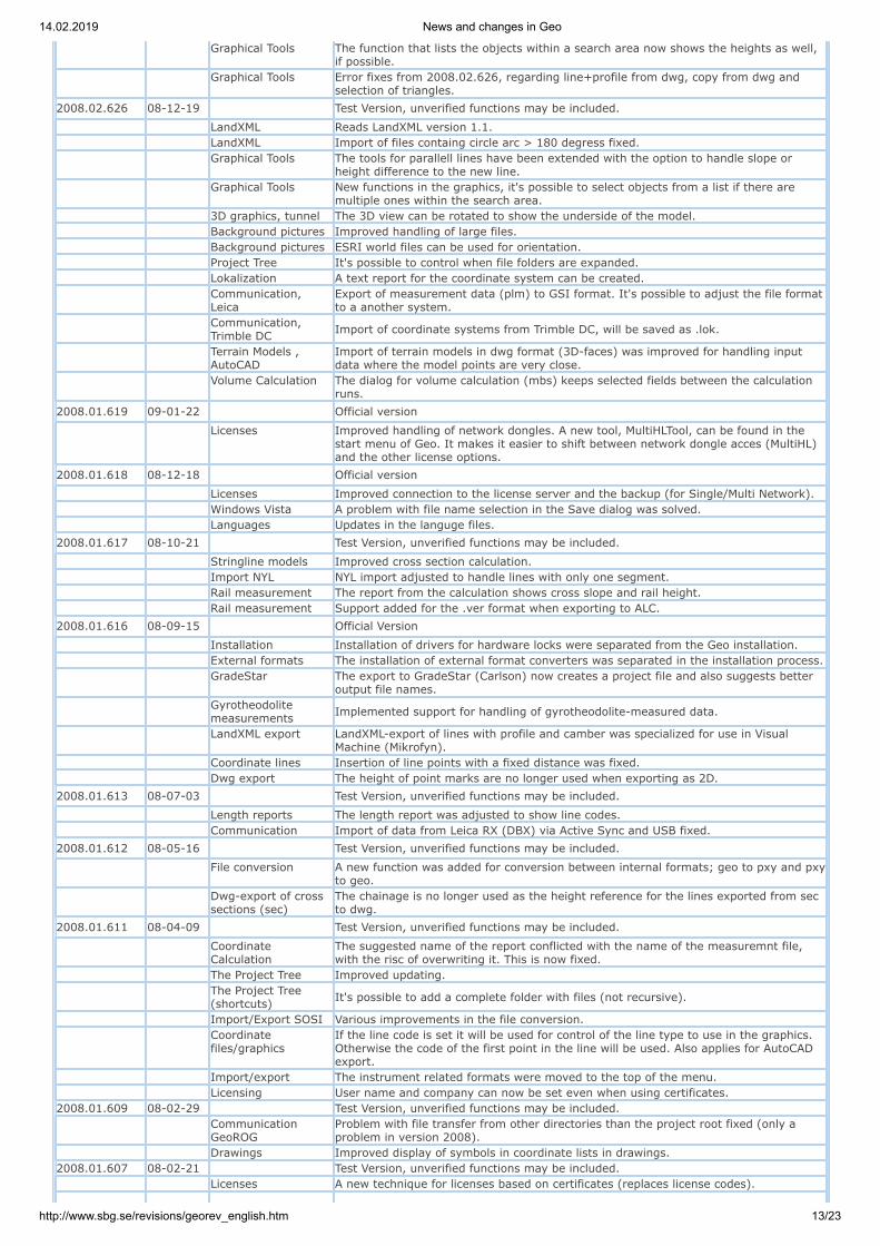
Graphical Tools The function that lists the objects within a search area now shows the heights as well,if possible.
Graphical Tools Error fixes from 2008.02.626, regarding line+profile from dwg, copy from dwg andselection of triangles.
2008.02.626 08-12-19 Test Version, unverified functions may be included.
LandXML Reads LandXML version 1.1. LandXML Import of files containg circle arc > 180 degress fixed.
Graphical Tools The tools for parallell lines have been extended with the option to handle slope orheight difference to the new line.
Graphical Tools New functions in the graphics, it's possible to select objects from a list if there aremultiple ones within the search area.
3D graphics, tunnel The 3D view can be rotated to show the underside of the model. Background pictures Improved handling of large files. Background pictures ESRI world files can be used for orientation. Project Tree It's possible to control when file folders are expanded. Lokalization A text report for the coordinate system can be created.
Communication,Leica
Export of measurement data (plm) to GSI format. It's possible to adjust the file formatto a another system.
Communication,Trimble DC Import of coordinate systems from Trimble DC, will be saved as .lok.
Terrain Models ,AutoCAD
Import of terrain models in dwg format (3D-faces) was improved for handling inputdata where the model points are very close.
Volume Calculation The dialog for volume calculation (mbs) keeps selected fields between the calculationruns.
2008.01.619 09-01-22 Official version
Licenses Improved handling of network dongles. A new tool, MultiHLTool, can be found in the
start menu of Geo. It makes it easier to shift between network dongle acces (MultiHL)and the other license options.
2008.01.618 08-12-18 Official version
Licenses Improved connection to the license server and the backup (for Single/Multi Network). Windows Vista A problem with file name selection in the Save dialog was solved. Languages Updates in the languge files.2008.01.617 08-10-21 Test Version, unverified functions may be included.
Stringline models Improved cross section calculation. Import NYL NYL import adjusted to handle lines with only one segment. Rail measurement The report from the calculation shows cross slope and rail height. Rail measurement Support added for the .ver format when exporting to ALC.2008.01.616 08-09-15 Official Version
Installation Installation of drivers for hardware locks were separated from the Geo installation. External formats The installation of external format converters was separated in the installation process.
GradeStar The export to GradeStar (Carlson) now creates a project file and also suggests betteroutput file names.
Gyrotheodolitemeasurements Implemented support for handling of gyrotheodolite-measured data.
LandXML export LandXML-export of lines with profile and camber was specialized for use in VisualMachine (Mikrofyn).
Coordinate lines Insertion of line points with a fixed distance was fixed. Dwg export The height of point marks are no longer used when exporting as 2D.2008.01.613 08-07-03 Test Version, unverified functions may be included.
Length reports The length report was adjusted to show line codes. Communication Import of data from Leica RX (DBX) via Active Sync and USB fixed.2008.01.612 08-05-16 Test Version, unverified functions may be included.
File conversion A new function was added for conversion between internal formats; geo to pxy and pxyto geo.
Dwg-export of crosssections (sec)
The chainage is no longer used as the height reference for the lines exported from secto dwg.
2008.01.611 08-04-09 Test Version, unverified functions may be included.
CoordinateCalculation
The suggested name of the report conflicted with the name of the measuremnt file,with the risc of overwriting it. This is now fixed.
The Project Tree Improved updating.
The Project Tree(shortcuts) It's possible to add a complete folder with files (not recursive).
Import/Export SOSI Various improvements in the file conversion.
Coordinatefiles/graphics
If the line code is set it will be used for control of the line type to use in the graphics.Otherwise the code of the first point in the line will be used. Also applies for AutoCADexport.
Import/export The instrument related formats were moved to the top of the menu. Licensing User name and company can now be set even when using certificates.2008.01.609 08-02-29 Test Version, unverified functions may be included.
CommunicationGeoROG
Problem with file transfer from other directories than the project root fixed (only aproblem in version 2008).
Drawings Improved display of symbols in coordinate lists in drawings.2008.01.607 08-02-21 Test Version, unverified functions may be included. Licenses A new technique for licenses based on certificates (replaces license codes).

14.02.2019 News and changes in Geo
http://www.sbg.se/revisions/georev_english.htm 14/23
Projects A new project view consisting of three tabs: 1. Dynamic project tree. Automatically displays all files in the current project
directory and its sub-directories. Geo monitors changes in these directories whichmakes it easy to see whether files are being added or removed. The files are orderedby file type which makes it easier to open them without having to use the "Open file"dialog. Double-clicking a file opens it, while right-clicking allows you to perform otheroperations such as creating new files, renaming them, send by e-mail, archive, etc.
2. Project Shortcuts. Allows you to manually add shortcuts to files you want toaccess easily, even files not part of the current project you're viewing. This can beuseful if you have a set of files you use for multiple projects.
3. Project Settings. A single view where you can manage all project-specific settings.It makes it easier to get a quick overview and make changes to the current project'ssettings.
Installation New installer, using msi files.
Installation/Language It's now possible to switch what language Geo uses without having to install a different
version or having to reinstall the application. Language settings can be changed in theHelp menu.
Coordinate systems Files for coordinate systems are now part of the Geo installation.
Coordinate systems A simplified wizard for localization. We use a new format called .lok, which is also usedby GeoPad..
Measurement A new format for levelling has been introduced. The .lvt files work like .lev files butwith greater precision.
Roadlines The function "Sections along line" contains a number new calculation alternatives onpage 2. Still developed.
Roadlines Line files (lin) can be converted to coordinate lines (geo) directly in the graphics.
Graphics New dialog for files in graphical windows. It's now column-based, so it's easier to view
files with long search paths. You can also turn off point numbers, height and codes formany files simultaneously.
Graphics, AutoCAD You can select which AutoCAD version you want to use by default when you save .dwgor .dxf files.
Graphics, AutoCAD Import of xr-filer (file with external references to AutoCAD). Activated when a dwg isopen and there is an .xr file in the same directory.
Graphics, AutoCAD Frozen layers in dwg files were visible in 3D-views. Fixed. Export Bever The file type for Bever export changed to .tli. Import LandXML Fixed error when importing LandXML file with station equations.
2007.10.580 08-01-25 Official Version
Import LandXML Fixed error when importing LandXML file with station equations.2007.10.579 07-10-15 Test Version, unverified functions may be included.
Volume Calculation Changed handling of rock unit height in mbs. It's controlled by a new check box in thembs rock properties.
Volume Calculation A new check box for extrapolation of rock in mbs. Volume Calculation Improved error checking when calculation cut and fill.2007.09.577 07-09-13 Test Version, unverified functions may be included. Drawings Solved a problem with multiple drawings referring to the same dwg file. Net adjustment Free net adjustments with bearings fixed.2007.08.576 07-08-13 Test Version, unverified functions may be included.
Export to AutoCADdwg/dxf
No extra POINT-object will be created for points that also generates a block insert.Messages shown during export more informative.
Measure Possibility to set a scale factor (ppm) when calculating a free station.2007.06.572 07-06-18 Test Version, unverified functions may be included. Communication Transfer of road line to Geodimeter/Trimble 600 didn't work in version 568-5702007.06.570 07-06-07 Test Version, unverified functions may be included. Communication File transfer from GeoPad didn't work in version 568. Fixed. Import REB Extended support for import of REB-data.2007.05.568 07-05-30 Test Version, unverified functions may be included.
Graphics New graphical tool for transforming objects. Select the objects to transform and pointout the alignment points. Both coordinate files and AutoCAD-files can be transformed.
Graphics New graphical tools for zooming. It's possible to store 2 different zoom-positions andeasily switch between them with toolbar buttons. Can be very useful for the newgraphical transformation tool, when alignment points in two different systems are to beconnected.
Graphics New zoom-option. Zoom to selected objects.
Graphics More options when inserting points in lines. It's possible to control distances andintersections with other lines.
Graphics The snap for perpendicular can use the intersection height. AutoCAD-support Support for AutoCAD version 2007 and 2008. Both reading and writing. AutoCAD-support When extracting data from AutoCAD files, objects with insert point 0,0 can be filtered.
Remove duplicatepoints Extra options for how to remove duplicates.
Compare files Added the text "Result: File 1 - File 2" to the file compare report. Tunnel Tunnel contours can bew created directly from cross sections. Communication When transferring to Trimble TSCE, a warning is given if duplicate point numbers exist. Import SOSI Line codes are handled bewteen SOSI- and GEO-formats.
2007.04.557d 07-04-12 Official Version
ExportLandXML/Leica 1200 Now it is possible to export mbs to LandXML or Leica 1200. Contact support for details.
Import KOF and SOSI Improved conversion of point- and line codes. Line files Simple clothoid to cubic parabola conversion. Will convert all clothoid transitions that

14.02.2019 News and changes in Geo
http://www.sbg.se/revisions/georev_english.htm 15/23
are "tangent to curve" or "curve to tangent".2007.03.557 07-03-16 Test Version, unverified functions may be included.
Import KOF Line codes are set when importing KOF-files. It's also possible to set the line codesaccording to Anpakke standard (-2.2, -1.2, 1.2, 2.2 ...).
Import Trimble DC Fix for import of geoid model.
Graphics Saved graphics views (.ggv) couldn't be opened in version 555. Fixed2007.03.555 07-03-09 Test Version, unverified functions may be included. String model A new stringline-based model format.
Terrain models A new graphical tool, create section. Point out a line in order to calculate and displaylong sections and/or cross sections.
Coordinate files A new numerical view makes it possible to view and edit the line properties in acoordinate file.
Graphical tools Extended output from the baseline tool. System New hardlock drivers with support for Windows Vista2006.12.532 06-12-11 Official Version General General adjustments for Windows Vista.
Graphical views New function: Save Graphical views. The function makes it possible to save the currentgraphical view along with all the files and their settings (e.g. colors, point features andzoom level). This is very useful if you wish to reopen a set of files with their individualsettings later on. The view file can then be added to the project tree for even easieraccessability.
Rail Surveying The function has been changed to be able to save the data in ALC format (for further
use in rail bound machines). It's also possible to exclude the slope correction if thisalready has been done in the GeoPad.
CE-Communication New template-based transfer to any CE-unit. Makes it possible to select startupdirectory and default data format for the unit.
Communication Leica Added support for geoid model and deformation model on DBX-import.
CommunicationTrimble SCS900 Added import of control file (equivalent to pp-file).
Import LandXML Import of string model from LandXML. It's possible to select the layers to import. Export to AutoCAD The color of layers is set according to the code list for coordinate files drawn using it. Tunnel Visualization of the tunnel only used the first tunnel model. Fixed. Import TrimbleDC Instrument accuracy was read wrong from DC file. resolved. Coordinate systems No longer possible to select other than GRS80/WGS84 as global ellipsoid. Settings No longer possible to select other unit than degrees for Lat/Long.
Net adjustment Hna-document couldn't be opened if the input order for X and Y had been switched.Fixed.
2006.10.519 06-10-10 Official Version
Communication An error when trying to read from some instruments fixed. Only applies to version2006.06.504 / 510 / 515.
Communication Sokkia SD2/3, fixed error reading angles in gon.
Export till AutoCAD Lager för punktkoder kunde skapas även om man valde filnamn eller fast lager videxporten. Fixat
Export till AutoCAD Om en koordinatfil ritas med symboler enligt kodlista sätts lagrens färger enligt dennaom man väljer punktkod som lageröverföring.
2006.09.515 06-09-14 Test Version, unverified functions may be included.
Surveying The use of height correction (earth radius and refraction) in coordinate calculations isnow done for each station, separated in the station headers in the plm-file, instead ofthe previous project setting. Note that if an older plm-file (where this information isn'tpresent) is opened height correction will be turned on, even if the old project settingswere off.
Graphical editing When a points is moved in the graphical window and the target point is snapped upon,it's now possible to select the height of the point.
Graphicalediting/AutoCAD Improved snapping in dwg files. Quicker selection when in multi snap mode.
Graphicalediting/AutoCAD A new snap tool uses the insertion point of blocks and text objects.
Drawings Improved support for relative paths for files in drawings (dra).
Tunnel The resulting file from the function "Adjust points to tunnel section" couldn't be viewedin 3D.
Line Data (lin) New function to insert cubic parabola in the form of circle arcs. Reports Automatic name suggestion for created reports. Import AnPakke Put labels on normal section elements when importing tvv-files. Export KOF Writing KOF-files was corrected. LandXML/Leica 1200 Support for exporting linemodel in the form of coordinate file.
LandXML/Leica 1200 Made the LandXML export dialog more descriptive + remember left/right codes fromlast time.
LandXML/Leica 1200 Better lin+prf+skv export, now manages all changes in lin+prf+skv.
CommunicationTrimble Line file export was adjusted for Survey Controller 11.31 (Trimble DC Transfer).
CommunicationTrimble Code lists and .dxf can be exported directly to Survey Controller via Trimble Link.
Communication File transfer to USB was corrected. Coordinate systems Ellipsoid "Australian National" added.2006.08.510b 06-08-17 Official Version
Communication An error when trying to read from some instruments fixed. Only applies to version2006.06.504 and 510.
Communication Sokkia SD2/3, fixed error reading angles in gon.

14.02.2019 News and changes in Geo
http://www.sbg.se/revisions/georev_english.htm 16/23
2006.08.510 06-08-17 Official Version Communication Selection of com-ports fixed. Only applies to version 2006.06.504.2006.06.504 06-06-21 Test Version, unverified functions may be included. Levelling Net Graphical representation of levelling nets. Levelling Net Possibility to create control loops for data to adjust. Communication Transfer of files to USB device for further use in the GeoROG. AutoCAD files Dwg files can be transformed. AutoCAD files External references can be removed from a dwg file. AutoCAD files External references can be bined to a dwg file. Coordinates New cinditions for point filters; between, outside and modulus. Graphics Point numbers can be set with the function "Set point informaation". Drawings Alignment lines between drawing sheets can be shown.2006.04.497 06-04-20 Official Version AutoCAD files New graphical tool for exploding objects and blocks. AutoCAD files Printouts of dwg- and dra-files in the same view could be misplaced on some printers. Graphics, Help Layer The help layer is automatically activated as soon as a help layer tool is selected.
Graphucs, TerrainModels Triangles can be filled using a pattern and color.
3D Graphics When changing from 2D graphics to 3D, the same colors are used for the files.
2006.03.494 06-03-23 Test Version, unverified functions may be included.
AutoCAD-files Lineweights can be changed in dwg-files. AutoCAD-files Linetypes for layers can changed in dwg-files. AutoCAD-files Plotting fixed for dwg-files in combination with background images.
Communication,Trimble It's possible to generate lines based on codes for measurement files.
Communication,Geodimeter Improved precision when exporting to older Geodimeter-units.
Import/Export, SOSI File export now allows setting variables in .HODE.2006.03.492 06-03-10 Official Version AutoCAD files AutoCAD files placed in drawings of .dra format are shown in page views.
AutoCAD files Point texts in coordinate files can be written either as attributes to blocks or as textobjects.
AutoCAD files Damaged or corrupt dwg files can be repaired. Import/export Support for SOSI format. Import, Leica GSI Chainage was calculated wrongly during import of HZALIGNM and VALIGNM.. Terrain models Better handling of corrupt models when creating terrain sections.2006.02.488 06-02-21 Test Version, unverified functions may be included.
Setting out The report from the set out calculation adjusted for sloping distance and heightdifference.
AutoCAD files When extracting coordinates the point code is set to the AutoCAD layer.2006.02.487 06-02-10 Test Version, unverified functions may be included.
Line profiles (Forpipes, wires, gas ...)
New file format for line profiles and related information about types, dimensions,chambers...
AutoCAD-files Support for dwg- and dxf-files created in AutoCAD 2004, 2005 och 2006. Support for binary dxf-files.
All AutoCAD-objects in dwg- and dxf-files can be viewed, e.g. dimensions, text styles,splines and others.
AutoCAD line stiles based on .shx-files can be shown. Support for AutoCAD text styles based on .shx-files. Support for AutoCAD-drawings with TrueType-fonts (ttf). Support for external references (XRef). Suppport for creation of external references (XRef). Extraction of nested blocks data to coordinate files. Extraction of selected object in the graphics as an alternative to layer-based selections. Support for Layouts in dwg-files. Support for Auditing dwg-files. Support for Purge-command in dwg-files. Dwg-files can be vektorisered to coordinate format. Objects in dwg-files can be removed. Improved editing of layer options. Improved export till dwg-format. Separate setup dialogs for each file type. Drawings When exporting drawings to dwg each page will be represented by an AutoCAD Layout. Drawings Profile drawings with line profiles (pipes, wires...) can be created. 3D-Graphics Circles and radii in coordinate files can be viewed in 3D.
Import/Export ofKOF-format KOF - updated for version 2.
Import/ExportLandXML LandXML - A line-based model can be created as an alternative to a mbs-file.
Leica-DBX DBX-databases are time-stamped.
Leica-communication When exporting road lines with profile and camber all gsi-files are written with thesame decimal setup to make sure that the instrument uses the correct configuration.
Trimble-communication Fixed a problem with new-line-start when generating lines by point code.
2006.01.479 06-01-24 Test Version, unverified functions may be included.2006.01.478 06-01-20 Test Version, unverified functions may be included.

14.02.2019 News and changes in Geo
http://www.sbg.se/revisions/georev_english.htm 17/23
LandXML Improved import of mass description. New options controlling output directory andlimit to section interval.
Files No more limits on how many files can be selected/opened at the same time. Files Faster file load when opening many lines. Tunnel Fixed problem when opening tbs-files. Only an issue for version 2005.12.473.2005.12.473 05-12-13 Test Version, unverified functions may be included.
Communication viaTrimble Link
Support for Trimble Link, for transfer between Geo and Trimble's instruments andunits.
Communication Leica Improved error handling when using Leica Roadrunner and Printf-pc. AnPakke import Improved reading of tvv files with many columns. Volume Calculation Fixed a problem when calculation deep excavation in some sections. Volume Calculation Reduced distance between the model layers when priority is used. Tunnel A problem with tun-files having points on the same elevation as the profile was fixed. Models Model to model calculation. The grid method used border incorrectly. Fixed. Models Modified Cut Model dialog slightly.2005.11.470 05-11-16 Official Version
Volume Calculation In cross sections where the excavation layer follows a model layer without cutting it, afalse length can be reported for the layer. Fixed.
Export to AutoCAD When exporting contour lines to AutoCAD dwg the elevation of the lines will now beused even for rounded curves.
2005.11.469 05-11-08 Test Version, unverified functions may be included.
CommunicationGeoROG Limit for long file names increased when transfering to the GeoROG.
CommuniCation Leica The options for transfer as either DBX or GSI wasn't stored. Fixed.
CommunicationTrimble Several changes, e.g. regarding cdoes for line start and line end.
Numerical Views When saving a numerical view in Excel-format (xls) the sheet name is set in order toavoid a warning in Excel.
Import LandXML Changed name setting of files. Tunnel Calculation Fixed a problem when using a calculation different interval than the one in the tbs-fil.2005.10.467 05-10-19 Test Version, unverified functions may be included.
CommunicationGeoROG
Several improvements, e.g. a warning is given if a file already exists when transferringto the GeoROG.
Line calculations Correction of points to sections/profiles. Point codes are transferred from input data.
Communication withLeica System 1200 Improved functionality when importing data from Leica System 1200.
Communication withTrimble
Simplified transfer to Trimble Survey Controller with Trimble Link. Contact SBG if youwould like to test the function.
2005.09.464 05-09-12 Official Version Coordinate systems Several stereographic projections included. Free station Problem with measurements in face 2 resolved. Graphics, area tool Current area shown in output pane, no need to create report.
Communication,TrimbleDC Line coding supported when transferring point data.
Communication,Geodimeter 600 Problem with large coordinate files resolved. Problem with long job names resolved.
Communication,GIF10 Problem to transfer coordinates to GIF10 resolved.
Hardlock Support for Aladdin HASP HL hardlock. Presentation The sign for km-limits in chainage values can be changed. Point Database Search for points, an error when combining the SELECT-statement fixed. Point Database A table view can be used without an indexed column. Volume Calculation Element with direction to line+profile can now be vertical.2005.06.456 05-06-21 Test Version, unverified functions may be included. Levelling, from gsi "Measure Only" will be interpreted as an intermediate point. Import/Export File folders with names containing a point were not shown correctly.
CommunicationGeoROG It wasn't possible to step back from an empty directy. Fixed
Coordinatecalculation Special code PP now asks where to save coded points.
Numeric view New option in numeric view to locate points and lines in the graphical view
Terrain models(volume calc. modelto model)
Grid method made safer. Now also possible to create output file from the calculation.
Volume calculation Fixed error in calculation of extra excavation.
Tunnel Visualizing. The complete rock model was always used despite of the calculationinterval. Now only the part inside the interval is used.
2005.05.454 05-05-31 Official Version Graphics Object selections can be transferred between 2d- and 3d-views.
Coordinate files Lines without points can be removed and single point lines can be converted to singlepoints.
Volume calculation Fixed error in calculation of extra excavation.2005.05.453 05-05-26 Test Version, unverified functions may be included. Terrain models Connection of triangles between separated model parts can now be made.
Import/Export,LandXML Now handles station equation.
Export Leica 1200 An error in chainage calculation for side lines was fixed.
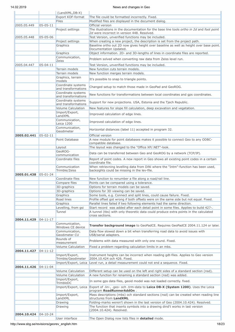
14.02.2019 News and changes in Geo
http://www.sbg.se/revisions/georev_english.htm 18/23
(LandXML,DB-X) Export KOF-format The file could be formatted incorrectly. Fixed. Files Modified files are displayed in the document dialog.2005.05.449 05-05-11 Official version
Project settings The illustrations in the documentation for the base line tools ortho in 2d and foot point2d were incorrect in version 448. Resolved.
2005.05.448 05-05-06 Test Version, unverified functions may be included. Project settings When creating a new project, the description is set from the project path.
Graphics Baseline ortho out 2D now gives height over baseline as well as height over base point.Documentation Updated.
Graphics Object information. 2D- and 3D-lengths of lines in coordinate files are reported.
Communication,Zeiss Problem solved when converting raw data from Zeiss level run.
2005.04.447 05-04-11 Test Version, unverified functions may be included. Terrain models New function cuts terrain models. Terrain models New function merges terrain models.
Graphics, terrainmodels It's possible to snap to triangle points.
Coordinate systemsand transformations Changed setup to match those made in GeoPad and GeoROG.
Coordinate systemsand transformations New functions for transformations between local coordinates and gps coordinates.
Coordinate systemsand transformations Support for new projections. USA, Estonia and the Tjech Republic.
Volume Calculation New features for slope fill calculation, deep excavation and vegetation.
Import/Export,LandXML Improved calculation of edge lines.
Communication,Leica 1200 Improved calculation of edge lines.
Communication,Geodimeter Horizontal distances (label 11) accepted in program 32.
2005.02.441 05-02-11 Official version
Point Database A new module for point databases makes it possible to connect Geo to any ODBC-compatible database.
Layout The layout was changed to the "Office XP/.NET"-look.
GeoROG-communication Data can be transferred between Geo and GeoROG by a network (TCP/IP).
Coordinate files Report of point codes. A new report in Geo shows all existing point codes in a certaincoordinate file.
CommunicationTrimble/Zeiss
When retrievning levelling data from DiNi where the "Intm"-function has been used,backsights could be missing in the lev-file.
2005.01.438 05-01-24 Coordinate files New function to renumber a file along a road/rail line. Compare files Points can be compared using a tolerance. 3D-graphics Options for terrain models can be saved. 3D-graphics Options for 3D viewing can be saved. Graphics Some tools, e.g. Connect and split lines, could cause failure. Fixed. Road lines Profile offset got wrong if both offsets were on the same side but not equal. Fixed. Graphics Parallel lines failed if two following elements had the same direction. Levelling, from gsi Start record was added after each detail point in some files. Applies to build 427-.
Tunnel A tunnel (tbs) with only theoretic data could produce extra points in the calculatedcross sections.
2004.11.429 04-11-17
Communication,Windows CE device Transfer background image to GeoPadCE. Requires GeoPadCE 2004.11.124 or later.
Communication,Geodimeter CU
Data flow slowed down a bit when transferring road data to avoid issues withUSB/serial adapters.
Rounds ofmeasurement Problems with data measured with only one round. Fixed.
Volume Calculation Fixed a problem regarding calculation limits in an mbs.2004.11.427 04-11-12
Import/Export,Trimble/Geodimeter
Instrument heights can be incorrect when reading gdt-files. Applies to Geo version2004.10.424 och 426. Fixed.
Import/Export, Leica Level run, a detail measurement could not end a sequence. Fixed.2004.11.426 04-11-04 Volume Calculation Different setup can be used on the left and right sides of a standard section (nsd). Volume Calculation A new function for renaming a standard section (nsd) was added.
Import/Export,TrimbleDC In some gps data files, geoid model was not loaded correctly. fixed.
Import/Export, Leica Export of .lin-, .geo- och .trm-data to Leica DB-X (System 1200). Uses the Leicaprogram RoadRunnerAddOn .
Import/Export,LandXML
Mass descriptions (mbs) och standard sections (nsd) can be created when reading linestructures from LandXML
Drawing Folding-marks weren't shown in the last version of Geo (2004.10.424). Resolved.
Drawing The function that inserts symbols into a drawing dind't works in last version(2004.10.424). Resolved.
2004.10.424 04-10-24 User interface The Open Dialog now lists files in detailed mode.

14.02.2019 News and changes in Geo
http://www.sbg.se/revisions/georev_english.htm 19/23
User interface New shortcut for print preview.
Communication,GeoPad/CE Quicker viewing of files in the CE-device.
Communication,GeoPad/CE Geo reads the predefined root directory of the CE-unit.
Communication,GeoROG Remote connection for transfer of files between Geo and GeoROG.
Communication,GeoROG Setup files can be transferred to Geo.
Communication,GeoPad/CE, GeoROG New shortcuts for GeoROG and GeoPad (CE) transfer.
Import/Export,LandXML
Coordinate files, terrain models, line files and profiler can be read and written to/fromthe LandXML format. Requires that Microsoft .NET Framework 1.1 is installed.
Import/Export, Leica Conversion of terrain models from the Leica GSI format to Geo .trm format.
Import/Export,Kordab
Import of Kordab-files, .242- and .243-files can be merged to one coordinate filedirectly when importing.
Import/Export,Kordab Import av Kordab-files, type codes can be converted to Geo codes with the code list.
Import/Export,AnPakke Improved import of AnPakke data to mass descriptions, mbs.
Graphics Support for GIF format in background images. Also TIF format with LZW-compression.
Graphics Smarter usage of the snap functions when using graphical tools. Some tools don't usethe snap, e.g. zoom window and select objects.
Reports The logotype in reports and lists can be in bitmapped format. Possible formats: bmp,jpg, pcx, tga, tif, gif, png.
Road lines New function, Modify sections (.sec). Can be used to channge codes or heights in across section file.
Road lines Editing of lines and profiles. The start point of the next element can be calculated if thelength and direction is given.
Drawings It's possible to set the default drawing panel for new drawings.
Drawings Bitmapped formats can be used for logotypes in drawings. Possible formats: bmp, jpg,pcx, tga, tif, gif, png.
Terrain Models AutoCAD Dwg/Dxf, surfaces (3d-faces) can be extracted directly to terrain models(.trm).
2004.08.351 04-08-20
Communication,Leica
Line files that were exported to gsi-format and then back to .lin-format again hadradiuses 10 times too small.
2004.08.350 04-08-04
Koordinatsystem The positive direction of the coorinate axis can be changed. This only affects thepresentation of coordinates.
2004.06.348 04-07-16
Communication,Geodimeter 600
New UDS-files in the global folder. 1.uds: Station setup for standard measurement. Links to 11.uds
2.uds: Prepares for rounds measurement with prog 32 by setting pressure, temp, PPM,operator etc.
11.uds: Standard measurement. Logging of measurement data.
Communication,Leica
New files for System 1200, in the global folder. Code lists:
SBGCTRL: Contains SBG´s free codes. (Control codes) SBG2CTRL: Contains SBG´s free codes, and the code list SBG2.
Export filters: SBG_GSI_Coo_v1.FMT: Exports points and lines to GSI-format for Geo.
SBG_GSI_Pol_v1.FMT: Exports measurement data to GSI-format for Geo.
The Geo software has been updated to handle these exported files.
Communication,Leica
New handling of Info-records (72-79) in GSI files. User selection of interpretation.Attribute, special code or remark.
2004.06.347 04-06-11
Communication,Leica Export of terrain models to Leica GSI.
2004.04.345 04-04-23
Communication,TrimbleDC Gps data could be transformed wrong. (from ver 341). fixed.
2004.04.344 04-04-21 Voume Calculation Calculation of rock surface could in same cases include the area for rock uncovering.
Voume Calculation The area for rock uncovering is included in the volume reportalong with the area forrock cut.
Graphics, help points The Help Point file now has the same name as the project file.
Tunnel Nya calculation fields available. The surface area for rock under/over the theoretictunnel can be calculated.
Communication,TrimbleDC Adjustment of exported profiles for safer input to the ACU.
Communication,TrimbleDC Deleted points in the dc-file reappeared in geo. fixed.
Communication,TrimbleDC
Gps data. If the dc-file contained multiple coordinate systems, all were used, instead ofjust last. fixed.
Communication,TrimbleDC Gps data with 3 parameter fitting where transformed wrong. fixed.
2004.04.342 04-04-06 2004.04.341 04-04-05
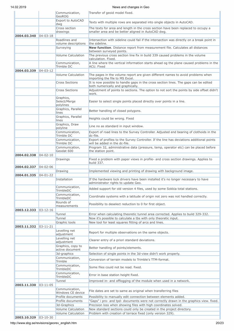
14.02.2019 News and changes in Geo
http://www.sbg.se/revisions/georev_english.htm 20/23
Communication,GeoROG
Transfer of geoid model fixed.
Export to AutoCADdwg Texts with multiple rows are separated into single objects in AutoCAD.
Cross sectiondrawings
The texts for area and length in the cross section have been replaced to occupy asmaller area and be better aligned in AutoCAD dwg.
2004.03.340 04-03-18
Roadlines andvolume descriptions
Intersection with sideline could fail if the intersection was directly on a break point inthe sideline.
Surveying New function. Distance report from measurement file. Calculates all distancesbetween surveyed points.
Volume Calculation The previous cross section line fix in build 339 caused problems in the volumecalculation. Fixed.
Communication,Trimble DC
A line where the vertical information starts ahead og the plane caused problems in theACU. Fixed
2004.03.339 04-03-12
Volume Calculation The pages in the volume report are given different names to avoid problems whenimporting the file to MS Excel.
Cross Sections It is now possible to handle gaps in the cross section lines. The gaps can be editedboth numerically and graphically.
Cross Sections Adjustment of points to sections. The option to not sort the points by side offset didn'twork.
Graphics,Select/Mergepolylines
Easier to select single points placed directly over points in a line.
Graphics, Parallellines Better handling of closed polygons.
Graphics, Parallellines Heights could be wrong. Fixed
Graphics, Drawpolyline Line no as standard in input window.
Communication,Trimble DC
Export of road lines to the Survey Controller. Adjusted end bearing of clothoids in thedc-file.
Communication,Trimble DC
Export of profiles to the Survey Controller. If the line has deviations additional pointswill be added in the dc-file.
Communication,Geodat 600
Program 32, administrative data (pressure, temp, operator etc) can be placed beforethe station point.
2004.02.338 04-02-10
Drawings Fixed a problem with paper views in profile- and cross section drawings. Applies tobuild 337.
2004.02.337 04-02-06 Drawing Implemented viewing and printing of drawing with background image.2004.01.335 04-01-22
Installation If the hardware lock drivers have been installed it's no longer necessary to haveadministrator rights to update Geo.
Communication,TrimbleDC Added support for old version 4 files, used by some Sokkia total stations.
Communication,TrimbleDC Coordinate systems with a latitude of origin not zero was not handled correctly.
Rounds ofmeasurements Possibility to deselect reduction to 0 for first object.
2003.12.333 03-12-16 Tunnel Error when calculating theoretic tunnel area corrected. Applies to build 329-332. Tunnel Now it's possible to calculate a tbs with only theoretic input. Graphic tools New tool for least squares fitting of arcs and lines.2003.11.332 03-11-21
Levelling netadjustment Report for multiple observations on the same objects.
Levelling netadjustment Clearer entry of a priori standard deviations.
Graphics, copy toactive document Better handling of points/elements.
3d-graphics Selection of single points in the 3d-view didn't work properly.
Communication,Trimble Conversion of terrain models to Trimble's TTM-format.
Communication,TrimbleDC Some files could not be read. fixed.
Communication,TrimbleDC Error in base station height fixed.
Tunnel Improved in- and offlogging of the module when used in a network.2003.11.330 03-11-05
Communication,Windows CE device File dates are set to same as original when transferring files
Profile documents Possibility to manually edit connection between elements added. Profile documents "Gaps" i pro- and tpd- documents were not correctly drawn in the graphics view. fixed. 3d-Graphics Precision loss when showing files with high coordinates solved. Volume Calculation New standard sections could only be created in the project directory. Volume Calculation Problem with creation of terrace fixed (only version 329).2003.10.329 03-10-30

14.02.2019 News and changes in Geo
http://www.sbg.se/revisions/georev_english.htm 21/23
Archives New functions to create and open archives in zip-format directly from Geo. Can alsobe sent as e-mail directly.
VolumeCalculation/TunnelCalculation
New function, Visualization. Creates 3d-views with colored surfaces for differentobjects.
Volume Calculation New stop function for elements in standard sections. Stop 'to line and center
profile'. The element connects to an edge line for side offset and to the center line forelevation.
Tunnel Printout of theoretic tunnel from numerical views fixed.
Cross Sections Adjustment of points to section. Possibility to not sort points sidewise (i.e. to keepmeasurement order).
Coordinates New function creates chainage report with sloping distances between points in acoordinate file.
Import/Export Boreing. Export of line coordinates to Tamrock format.
Surveying Sequnce Measurement. The conversion takes place after coodinate calculation.Other instruments that Geodimater can now be used.
Graphics, AutoCADDwg When extracting data, the point code will be set according to the layer in the dwg-file.
Lines The function 'Section along line' didn't set the special code CF for camber correctly. Lines New function to recalculate chainage in a line according to the element lengths. Lines The line-reverse function added to the menu. Profiles Graphical copy from terrain profile to theoretic profile didn't work.2003.09.325 03-10-10
Coordinates.Orhtogonal transform3D
Bug fixed.
Volume Calculation Interpolation of build-up will now be calculated for elements that attach to a side line.
Graphics.Measuretool andbaseline.
Line slope is shown in percent.
2003.09.324 03-09-30
Graphics, AutoCADDwg Adjusted text heights for texts in dwg-files.
Graphics Adjusted text heights in graphics and drawings. I the two latest versions the heightswere slightly bigger. Fixed
2003.09.323 03-09-29
Linecoding for Leicainstruments
Changes made to linecoding type 1. (line no from code 7, point no same as entered inthe instrument).
Volume Calculation,model to modell Build 322 contained an error in the calculation. Fixed.
Export to AutoCADDwg Improved display of information about the transfer result.
Communication,GeoPadCE/GeoROG Associated files when transferring tbs- mbs- and lin-files had a bug. fixed.
Communication,TrimbleDC Support for attributes when reading coordinates and surveys.
2003.09.322 03-09-23
Communication,TrimbleDC Error in atmospheric correction in DC version 10.7. Fixed.
Import of AutoKa-PC Improved reading of file headers. Terrain Models Problem when creating terrain models based on multiple coordinate files fixed. Graphics Update of graphics improved when editing profile element data.2003.09.320 03-09-17
VolumeCalculation/Tunnel Files that are part of a mbs or tbs can be put in any file directory.
Tunnel New function, 'Correction of Points into Tunnel Sections' (comp. Tunnel Tacheometry).
Communication, Gdm600 Delay added after each sent point, to prevent time out in serial communication.
Communication,GeoPadCE/GeoROG
When transferring tbs- mbs- and lin-files, associated files can be includedautomatically.
Import Anpakke More options when interpreting camber file.2003.07.318 03-07-29
Communication,TrimbleDC Adjustments made for new data types in version 10.7.
Levelling netadjustment Possible to sum measurements over move points.
Survey, runds ofmeasurement Did not work when data was stored as height diffs instead of vertical angles.
2003.07.317 03-07-07
Communication,GeoPad/GeoROG
New tool outputs Gps-coordinates on the port. Useful when testing mbs-files in theGeoROG och GeoPad before real usage.
Graphics The tool for connecting points to lines could loose it's lock or lock on unwanted objects.2003.06.315 03-06-23
Survey, calculation ofcoordinates Bugg in special code R3 fixed.
Survey, correction ofmeasurements Height reduction and arc correction added to Estonian projection correction.
Graphics, profile Improved editing for terrain profiles (pro/tpd). Both graphical and numerical.Numerical printout fixed.

14.02.2019 News and changes in Geo
http://www.sbg.se/revisions/georev_english.htm 22/23
Graphics, profile Terrain profiles can be color-coded using both the side offset or layers. Applies also forsymbols and line types.
Graphics, profile Terrain profiles can be copied graphically to theoretic profiles (prf).
Graphics, profile Terrain profiles can be created from cross sections (sec), all cross section layers (soil,rock, excavation and others) can be transferred to the profile.
Graphics, crosssections Punkter i tvärsektionen kan flyttas grafiskt.
AutoCAD Dwg Extracted data can be transformed directly. Volume Calculation Element with the combination 'to terrace' and buildup type 'unknown' fixed. Volume Calculation Elements with 'cut at' weren't marked in the graphics.
Communication,TrimbleDC Transfer of road line data (line, profile, camber, cross sections) to/from Trimble DC.
Communication,Leica Cross sections (sec) can be exported to the gsi-format.
Extract with polygon Files containing radiuses could cause failure.2003.05.313 03-05-26 Survey, free station Backsights no longer need to be collected at the top of the document. Graphics New snap-tools. 'Perpendicular', 'Near' och 'Tangent point'.
Communication,Leica Camber >= 10% handled in sta- and crs-files when writing gsi-files.
Communication,TrimbleDC Transfer of GPS-data from Trimble DC. Contact SBG for instructions.
Communication,TrimbleDC Adjustments to Roadline transfer.
Communication,TrimbleDC Adjustment for Trimble Survey Controller v7.50 or later.
Cross Sections Possibility to view the profile elevation and the difference from it for points in a crosssection.
Volume Calculation Calculation of top soil outside polygon fixed..2003.05.311 03-05-14
Communication,TrimbleDC Adjustments to Roadline transfer.
Communication,GeoDos Roadlines did not transfer correctly. (All version 2003).
2003.05.310 03-05-12 Graphics Curve alignment lines can be drawn for theoretic profiles/vertical lines (prf). Graphics Some line types weren't drawn correctly in the graphics.
Cross Sections In the function 'sections along line', codes for the points to be calculated can beentered.
Cross Sections The function 'sections along line' is modified so that 'profile offsets' will be included inthe calculation.
Cross Section StakeOut
It's now possible to enter a negative point-offset when createing a 'orthogonal pointreport'.
Communication Transfer of cross sections to Trimble DC. Contact SBG for instructions.2003.05.309 03-05-02
Communication Transfer of line, profile and cross fall data to and from Trimble DC. Contact SBG forinstructions.
Net adjustment Elastic adjustment did not work. Appeared in 2003.03.06.
Communication,Geodimeter Transfer adjusted for Program 32.
Rounds ofmeasurement Better handling of stations without rounds.
AutoCAD Dwg MTEXT-objects supported (text objects with multiple rows of text). Volume Calculation The calculation of top soil reported the complete soil area instead. (Version 306-308). Graphics Possibility to create cloes polygones with the tool 'connect lines'.
Graphics Lines that were connected to an entry in the code list, without the line type given,were invisible in the graphics.
2003.04.308 03-04-24
Volume Calculation Volume calculation in combination with 'unit height'. Error in the calculation fixed (onlyapplies for version 306-307).
Graphics Input of coordinates for tools in profile views didn't work. Solved.2003.04.307 03-04-22 Volume Calculation General top soil in combination with rock cut above soil didn't work.
Levelling netadjustment Problem with toggling on/off of observations solved.
Graphics Quicker drawing of line types from the code list.2003.03.306 03-04-10 Volume Calculation A new function added, 'create report with orthogonal points'.
Volume Calculation Improved handling of buildup layers. The layer widths are stored in a file parallel to thembs-file.
Volume Calculation Border polygon calculation added. Both .geo- and .pxy-format.
Volume Calculation Top soil calculation, any number of border polygon can be used within a single crosssection.
Volume Calculation General top soil area is now better adjusted to the theoretic surface width. Plane net adjustment Better handling of large coordinates.
Rounds ofmeasurement Prism constant was lost. Solved.
Survey New setting for generation of lines from point numbers when communicating, opening
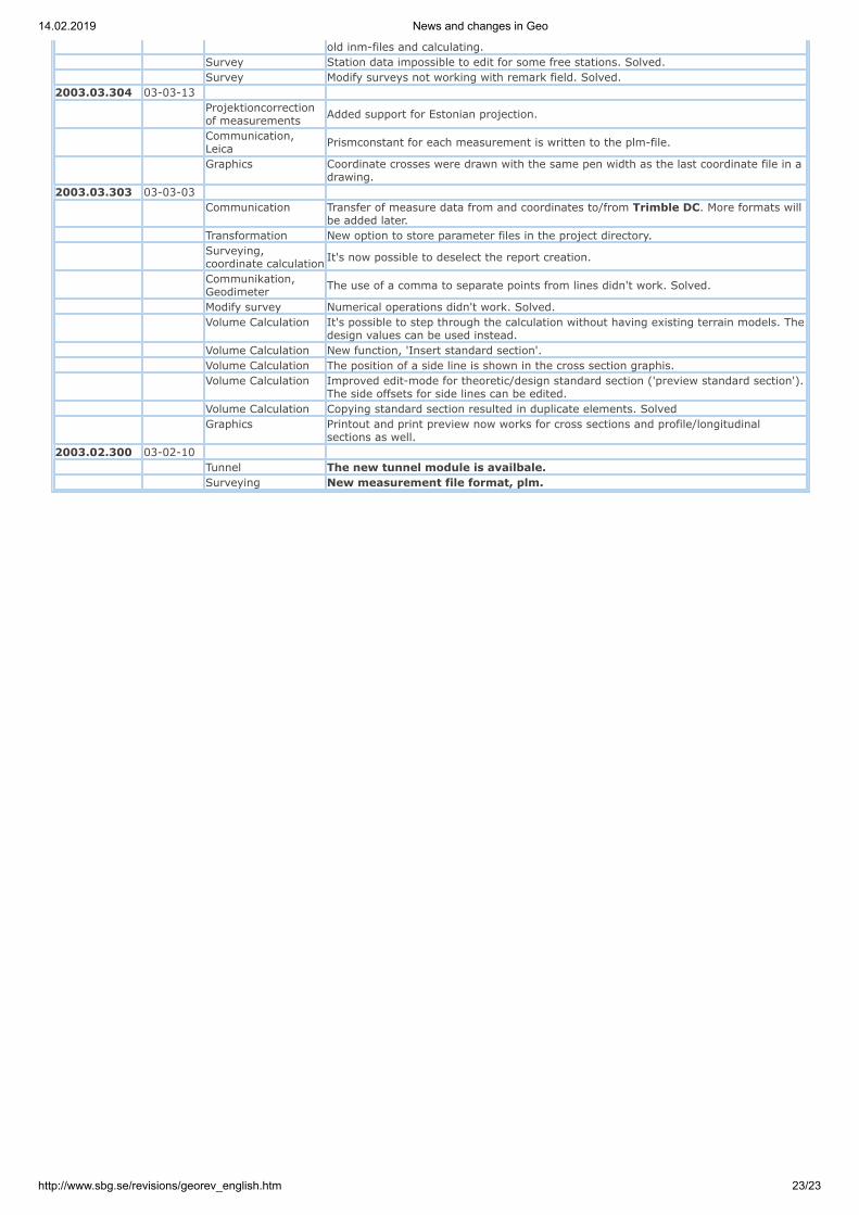
14.02.2019 News and changes in Geo
http://www.sbg.se/revisions/georev_english.htm 23/23
old inm-files and calculating. Survey Station data impossible to edit for some free stations. Solved. Survey Modify surveys not working with remark field. Solved.2003.03.304 03-03-13
Projektioncorrectionof measurements Added support for Estonian projection.
Communication,Leica Prismconstant for each measurement is written to the plm-file.
Graphics Coordinate crosses were drawn with the same pen width as the last coordinate file in adrawing.
2003.03.303 03-03-03
Communication Transfer of measure data from and coordinates to/from Trimble DC. More formats willbe added later.
Transformation New option to store parameter files in the project directory.
Surveying,coordinate calculation It's now possible to deselect the report creation.
Communikation,Geodimeter The use of a comma to separate points from lines didn't work. Solved.
Modify survey Numerical operations didn't work. Solved.
Volume Calculation It's possible to step through the calculation without having existing terrain models. Thedesign values can be used instead.
Volume Calculation New function, 'Insert standard section'. Volume Calculation The position of a side line is shown in the cross section graphis.
Volume Calculation Improved edit-mode for theoretic/design standard section ('preview standard section').The side offsets for side lines can be edited.
Volume Calculation Copying standard section resulted in duplicate elements. Solved
Graphics Printout and print preview now works for cross sections and profile/longitudinalsections as well.
2003.02.300 03-02-10 Tunnel The new tunnel module is availbale. Surveying New measurement file format, plm.