Neolithic Ditches in Thessaly, Apostolos Sarris, Nasos Argyriou, Tuna Kalayci, François-Xavier...
28
NEOLITHIC DITCHES IN THESALLY Laboratory of Geophysical – Satellite Remote Sensing and Archaeo-environment Institute for Mediterranean Studies Foundation for Research and Technology, Hellas (I.M.S.-F.O.R.T.H.) Rethymno, Crete, Greece Apostolos Sarris, Nasos Argyriou, Tuna Kalayci, François-Xavier Simon, Jamieson Donati, Carmen Cuenca García, Gianluca Cantoro, Meropi Manataki. Workshop / Special Session on ‘Remote Sensing and GIS for Archaeology and Cultural Heritage’
Transcript of Neolithic Ditches in Thessaly, Apostolos Sarris, Nasos Argyriou, Tuna Kalayci, François-Xavier...
NEOLITHIC DITCHES IN THESALLY
Laboratory of Geophysical – Satellite Remote Sensing and Archaeo-environment
Institute for Mediterranean Studies
Foundation for Research and Technology, Hellas (I.M.S.-F.O.R.T.H.)
Rethymno, Crete, Greece
Apostolos Sarris, Nasos Argyriou, Tuna Kalayci, François-Xavier Simon, Jamieson Donati, Carmen Cuenca García, Gianluca Cantoro, Meropi Manataki.
Workshop / Special Session on ‘Remote Sensing and GIS for Archaeology and Cultural Heritage’

• Water resources have played a critical parameter in human occupation and the
location of the settlements since the prehistoric times.
• Many settlements, especially in prehistoric periods have been located either along
the course of main streams or in a close vicinity to them, exploiting the water
resources for their immediate needs and for cultivation purposes.
• At the same time this proximity to water resources has often endangered the
habitation quarters and even the whole settlement.
• The floodplains of major rivers are dynamic environments and their past study
poses particular difficulties.
Water Resources and Archaeology
GeoSat
ReSeA
rch
IMS-F
ORTH

Fluvial activities influence archaeology in two ways.
First, the choice of locations for settlements was part of a cultural
formation process predetermined to some extent by the population's understanding or appreciation of local stream activity. Second, cultural remains and site preservation and ultimately their
discovery and recognition may have been affected with stream flow and flooding.
The main aims of the study are to develop new methods of investigation and to reconstruct the environmental and settlement history.
Fluvial Activities and Archaeology
GeoSat
ReSeA
rch
IMS-F
ORTH

Exploration Techniques and Methodological Approaches Employment of a variety of methods:
Field walking, geophysical prospection, examination of sections exposed in field ditches,
and coring for soil and sediment samples.
These methods are complemented by a range of remote sensing techniques: analyses of
satellite and aerial photographs and Digital Elevation Models (DEMs).
Reconstructed (from coring) Digital Elevation Models (DEMs) regarding the period,
were considered in this study.
Reconstruction of the Künzing-Unternberg
rondel, Museum Quintana, Lower Bavaria
http://en.wikipedia.org/wiki/Neolithic_circular_enclos
ures_in_Central_Europe#/media/File:Museum_Quinta
na_-_Unternberg_1.jpg GeoSat
ReSeA
rch
IMS-F
ORTH

Neolithic habitation in Europe
Ground zero
GeoSat
ReSeA
rch
IMS-F
ORTH
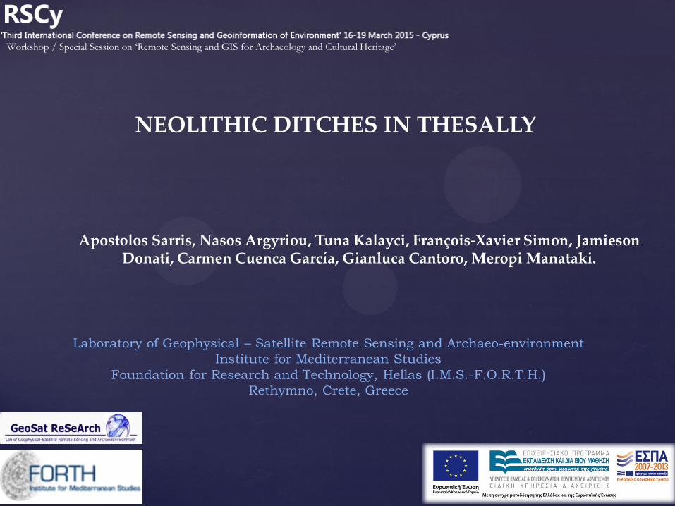
Case study: Thessaly Neolithic settlements, so called Magoules, were
constructed between the Early Neolithic and
Bronze Age (6800-3000 BC). ~350 Thessalian
tells (magoulas) have been documented in
alluvial plains of Trikala and Larissa.
Recorded rate of subsidence of 1.5
m/1000 years for the Larisa basin, is
important to study flooding susceptibility.
GeoSat
ReSeA
rch
IMS-F
ORTH
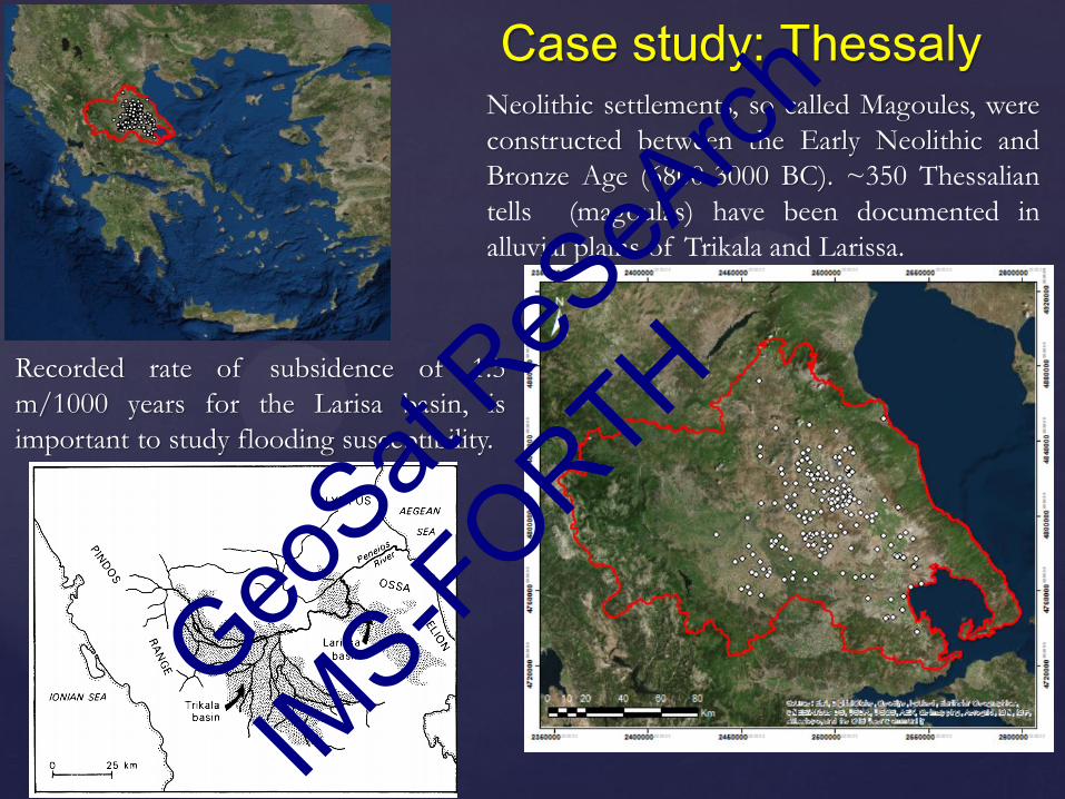
@ Magoula Mati
@ Magoula Zerelia
NEOLITHIC TELLS
@ Magoula Visviki
Magoules: small hills, within the plain,
with a relatively few meters height .
GeoSat
ReSeA
rch
IMS-F
ORTH

• 342 documented magoulas
• 181 sites (53% of the total) are established on
alluvial deposits & 81 sites on fluvial deposit
areas.
• These formations are of low altitude & are
ideal for cultivation.
http://neolithicthessaly.ims.forth.gr/
Registration and mapping
of Neolithic settlements
in Thessaly
& GIS analyses for
the management of the
natural landscape
&
site distribution patterns
among ecological and
topographic zones of
Thessaly.
Status of knowledge of the Neolithic Landscape in Thessaly
GeoSat
ReSeA
rch
IMS-F
ORTH

IGEAN (Innovative Geophysical Approaches for the Study of Early Agricultural Villages of
Neolithic Thessaly) project, is implemented under the "ARISTEIA" Action of
the "Operational Programme Education And Lifelong Learning" and is co-funded by the
European Social Fund (ESF) and National Resources (2013-2015).
Application of non-destructive,
remote sensing techniques
to explore multiple settlements
&
to analyze the broader
characteristics of Neolithic
habitation in Thessaly.
The project has been
successful in documenting
the diachronic development
of Neolithic sites from core
habitation mounds (≤ 1
hectare) to large, sprawling
communities several
hectares in size. GeoSat
ReSeA
rch
IMS-F
ORTH

Area of interest
Rizomilos 2
Nikonanou
Visviki Mati
Bakalis
Kastro Kokkinas
Eleutherochori
Perdika 1
Perdika 2
Belitsi
Karatsagliou
Almiriotiki
Karatsantagli Zerelia
Almiros 2
Kamara
GeoSat
ReSeA
rch
IMS-F
ORTH

Methodologies – Multi-magnetometer Techniques
Sensorik & Systemtechnologie (SENSYS)
MX Compact system
8 multi-channel measurement system
Equipped with FGM600 fluxgate
gradiometers separated by 0.25-0.5m &
connected to a DGPS navigation system
Ideal for large-scale scanning
Bartington single sensor unit also in use in
thick vegetation areas
GeoSat
ReSeA
rch
IMS-F
ORTH

Methodologies – Ground Penetrating Radar (GPR) & Electromagnetic Techniques
Sensors & Software
Noggin Plus System with 250 MHz antennas
Sampling 50 x 2.5 cm
8 channels MALA MIRA GPR,
400 MHz antennas
Sampling 10 x 2.5 cm
Penetration Depth ~2.5m
GEM2: HCP 2.5 m Conductivity /
1.7 m susceptibility
GEM2 - Geophex
Tx Rx Tx Rx 1 Rx 2 Rx 3
CMD Mini explorer– GF Instruments
CMD: HCP 2 m Conductivity /
1 m susceptibility
GeoSat
ReSeA
rch
IMS-F
ORTH
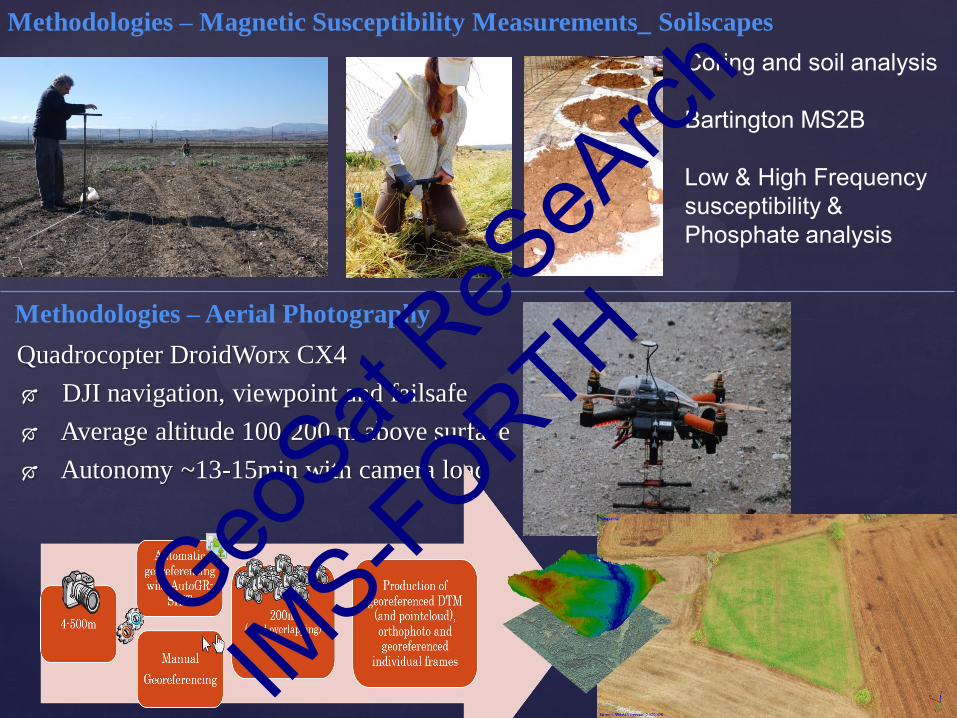
Methodologies – Magnetic Susceptibility Measurements_ Soilscapes
Coring and soil analysis Bartington MS2B Low & High Frequency susceptibility & Phosphate analysis
Quadrocopter DroidWorx CX4
DJI navigation, viewpoint and failsafe
Average altitude 100-200 m above surface
Autonomy ~13-15min with camera load
Methodologies – Aerial Photography
GeoSat
ReSeA
rch
IMS-F
ORTH

Almiros 2 Early Neolithic – Middle Neolithic
GeoSat
ReSeA
rch
IMS-F
ORTH

Almiros 2 – Magnetics
Mudbrick fragments
Core habitation zone: 15-20
rectilinear structures with high
magnetic values (mudbrick)
2 large circular ditches &
multiple possible entrances
GeoSat
ReSeA
rch
IMS-F
ORTH

Almiros 2 – EM Conductivity (HCP for 0-2.5 m depth)
High conductivity area to
the south possible
evidence of flooding
susceptibility ??
GeoSat
ReSeA
rch
IMS-F
ORTH

Magoula Rizomilos 2– Magnetics
Multiple concentric ditches
with various breaks that
represent entrances.
Another smaller satellite or
older settlement to the east
GeoSat
ReSeA
rch
IMS-F
ORTH

Magoula Rizomilos 2– Magnetics
A 1.5m flooding simulation could have reached the outer ditch of the main magoula.
Oral testimonies of the villagers mention that the area was repeatedly flooded in historical
period, due to the vicinity of the magoula to the Lake Karla.
GeoSat
ReSeA
rch
IMS-F
ORTH

Magoula Almiriotiki Early Neolithic – Late Bronze Age
GeoSat
ReSeA
rch
IMS-F
ORTH

Magoula Almiriotiki – Magnetics
GeoSat
ReSeA
rch
IMS-F
ORTH

Magoula Almiriotiki
– Magnetics
marsh area
-core habitation zone on the highest topographic level
- 60+ rectilinear structures (mudbrick and stone structures)
- Extensive network of ditches
GeoSat
ReSeA
rch
IMS-F
ORTH

Magoula Nikonanou – Magnetics & EM
Magoula Velestino 4 – Visviki - DEM
GeoSat
ReSeA
rch
IMS-F
ORTH
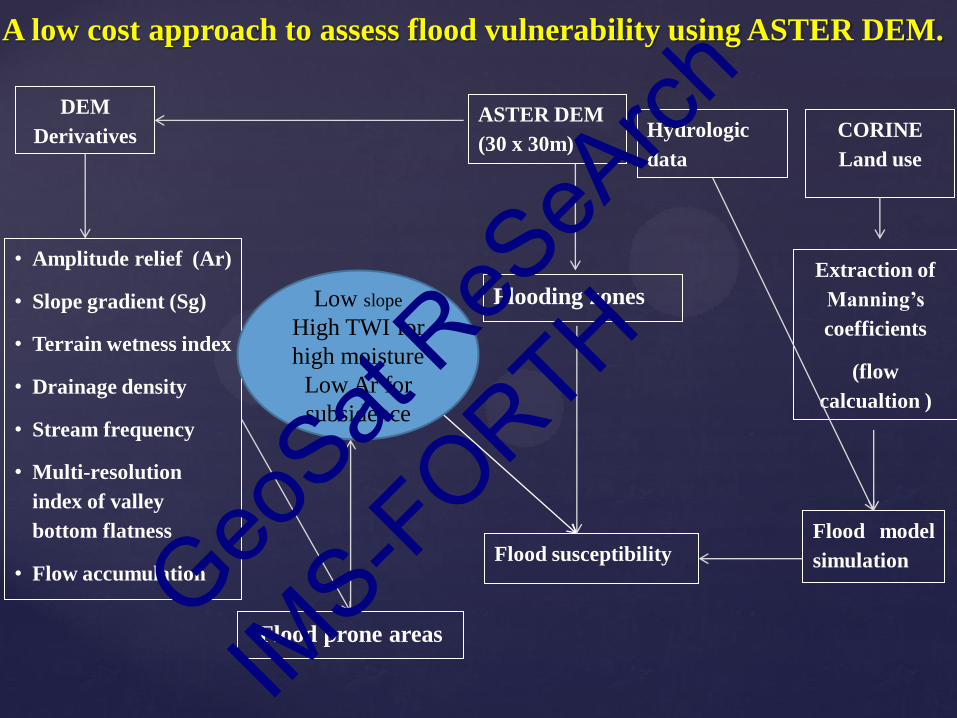
ASTER DEM
(30 x 30m)
DEM
Derivatives
• Amplitude relief (Ar)
• Slope gradient (Sg)
• Terrain wetness index
• Drainage density
• Stream frequency
• Multi-resolution
index of valley
bottom flatness
• Flow accumulation
Extraction of
Manning’s
coefficients
(flow
calcualtion )
CORINE
Land use
Flood susceptibility
Flooding zones
Flood model
simulation
A low cost approach to assess flood vulnerability using ASTER DEM.
Flood prone areas
Hydrologic
data
Low slope
High TWI for
high moisture
Low Ar for
subsidence
GeoSat
ReSeA
rch
IMS-F
ORTH

• Region A: high values of TWI (flat surface with high moisture
accumulation and alluvial deposits).
• Region B: high values (but lower that region A due to lower
stream ordering and water discharge).
• Region C: intermediate to low values, revealing steep slopes,
major longitudinal ridges and V-shaped valleys.
Geomorphometric information using ASTER DEM
The Topographic Wetness Index (TWI), determines the spatial
distribution of soil moisture and surface saturation. V-shaped
valleys (tectonic active) vs U-shaped valleys (erosional
dominated).
Slope gradient (Sg), shows maximum slope steepness ie. the
change in elevation between each cell and its neighbors.
• Region A: flat regions
• Region B: foot slopes
• Region C: undulating terrain & intermittent valley zones;
rolling plains
• Region D: escarpments & dissected ridges.
A C
A
B
A B
D
C
GeoSat
ReSeA
rch
IMS-F
ORTH

Predictive floodplains
Based on selected threshold values in
order to isolate the information of the
DEM derivatives being relevant to
flood impact, the final prone
floodplains were determined.
Weighted overlay approach &
Analytical Hierarchy Process
(AHP) were employed for the
definition of the weights. GeoSat
ReSeA
rch
IMS-F
ORTH
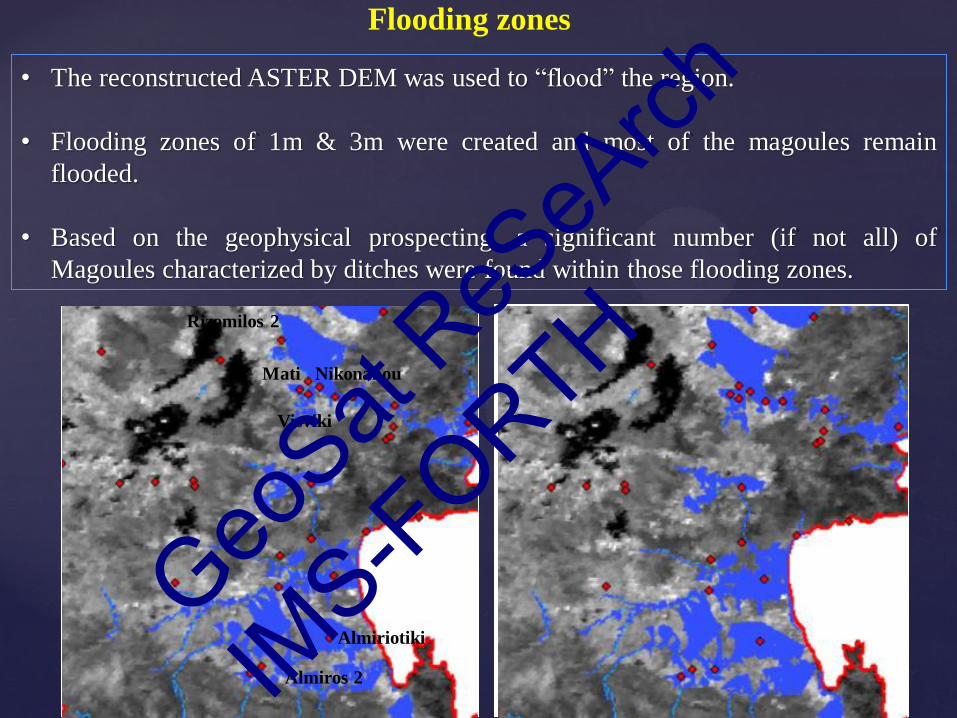
Flooding zones
• The reconstructed ASTER DEM was used to “flood” the region.
• Flooding zones of 1m & 3m were created and most of the magoules remain
flooded.
• Based on the geophysical prospecting, a significant number (if not all) of
Magoules characterized by ditches were found within those flooding zones.
Rizomilos 2
Nikonanou
Visviki
Almiriotiki
Almiros 2
Mati
GeoSat
ReSeA
rch
IMS-F
ORTH

Concluding Remarks
Conceptualize a landscape of variation: Similar and divergent characteristics of
settlements in planning and in structural materials
- Internal organization of the structures, clusters of structures
- Corridors and entrances
- Existence of enclosures (ditches/fortifications)
In areas where frequent or periodic flooding could have been anticipated, it is
possible that Neolithic people might have applied variable criteria in choosing
sites for temporary or for long-term occupations – almost always in close proximity to
palaeochannels.
Manifold geophysical prospection approaches indicate a persistence of habitation
even in flood prone areas and the existence of multiple enclosures and ditches
around these settlements may suggest counter measures against periodic
flooding events.
GeoSat
ReSeA
rch
IMS-F
ORTH

NEOLITHIC DITCHES IN THESALLY
Laboratory of Geophysical – Satellite Remote Sensing and Archaeo-environment
Institute for Mediterranean Studies
Foundation for Research and Technology, Hellas (I.M.S.-F.O.R.T.H.)
Rethymno, Crete, Greece
Apostolos Sarris, Nasos Argyriou, Tuna Kalayci, François-Xavier Simon, Jamieson Donati, Carmen Cuenca García, Gianluca Cantoro, Meropi Manataki.
Workshop / Special Session on ‘Remote Sensing and GIS for Archaeology and Cultural Heritage’
GeoSat
ReSeA
rch
IMS-F
ORTH