Nautical Archaeological Inspection of the Israel Department of Antiquties
19
The Inrernarionnl Jo~irtial of Nuitfical Arc hueologi, and L'nderwater Eyplorution (I 984). 13.3: 223-24 1 Israel Department of Antiquities and Museums Center for Nautical and Regional Archaeology, Dora A concise nautical history of Dor/Tantura Shelley Wachsmann Israel Department of Antiquities and Museums. P.O. Box 586, Jerusalem, Israel 91004 Kurt Raveh Centerfor Nautical and Regional Archaeology, Kibbutz Nahsholim Dour Na Hof ha- Carmel, Israel 20815 Introduction In recent years there has been a growing interest in Tel Dor, one of the major maritime sites on Israel's Mediterranean coast. This is due in no small part to the ongoing land excavations there which are being carried out by the Hebrew University's Institute of Archaeology and the Israel Exploration Society together with affiliated universities under the director- ship of Ephraim Stern (Stern, 1980; 1981; 1982; Raban, 1981: 295-308; 1983: 229-41; Rosenthal-Heginbottom, 198 1; Wenning, 1983). The recent excavations carried out by Claudine Dauphin for the Israel Department of Antiquities and Museums (IDAM) have also revealed new information on the Byzantine basilica at Dor (Dauphin, 1979; 1981; 1982-83; 1983). IDAM's Sea Base is located in the nearby scenic 19th-century glass factory. This has now been restored as the Center for Nautical and Regional Archaeology, Dora located in Kibbutz Nahsholim (Figs 1, 2). Due to their proximity to the Center, the underwater environs of both Tel Dor and the later Arab village of Tantura which surplanted it, have been intensively sur- veyed by us since 1976. Publication of various aspects of the results of this ongoing survey are under preparation and will appear as separate monographs. These will include reports on shipwrecks, cargoes, stone and metal anchors, pottery, the proto-harbour in 0305-7445/84/030223 + 19 $03.00/0 Tantura Lagoon, Napoleonic weaponry, etc. (for the present see Wachsmann & Raveh, 1978: However, as an introduction to the maritime aspects of Dor, we feel that a short review of the historical sources which touch on the nautical side of Dor/Tantura's past may be considered useful. 281-82; PI. 56: A-C; 1980: 259-61). The topography of Dor The ruins of the ancient maritime site of Dor are located on a mound directly north of the modern settlement of Kibbutz Nabsholim. The site has been alternately known as Tel Dor, El Burj, or Khirbet Tantura. It is situated at lati- tude 32" 36 ' 50' ' and longitude 34" 54' 40' ' and is approximately 27 km south of the modern city of Haifa and 13 km north of the ancient site of Caesarea (Figs 3, 4). Dor is one of the largest tels in Israel. It is built on a rocky promontory which is part of an aeolianite (kurkar) ridge that stretches parallel to the sea and the Carmel Mountain Range"] (Figs 5-7). To the south of the tel is a sandy shore with several islands offshore. These form the continu- ation of the kurkar ridge. The Arabic names of these islands are, from north to south: (Jezirat el) FallPtiyeh, ShaddPdeh, Iamar and Hamam. Their modem Hebrew names are: (I) Shhafit, Dor, Tafat and yofami. The islands, together with a fifth island which is today connected to 0 1984 The Nautical Archaeology Trust Ltd.
Transcript of Nautical Archaeological Inspection of the Israel Department of Antiquties

The Inrernarionnl Jo~irtial of Nuitfical Arc hueologi, and L'nderwater Eyplorution ( I 984). 13.3: 223-24 1
Israel Department of Antiquities and Museums
Center for Nautical and Regional Archaeology, Dora
A concise nautical history of Dor/Tantura
Shelley Wachsmann Israel Department of Antiquities and Museums. P.O. Box 586, Jerusalem, Israel 91004
Kurt Raveh Center for Nautical and Regional Archaeology, Kibbutz Nahsholim Dour Na Hof ha- Carmel, Israel 20815
Introduction In recent years there has been a growing interest in Tel Dor, one of the major maritime sites on Israel's Mediterranean coast. This is due in no small part to the ongoing land excavations there which are being carried out by the Hebrew University's Institute of Archaeology and the Israel Exploration Society together with affiliated universities under the director- ship of Ephraim Stern (Stern, 1980; 1981; 1982; Raban, 1981: 295-308; 1983: 229-41; Rosenthal-Heginbottom, 198 1; Wenning, 1983).
The recent excavations carried out by Claudine Dauphin for the Israel Department of Antiquities and Museums (IDAM) have also revealed new information on the Byzantine basilica at Dor (Dauphin, 1979; 1981; 1982-83; 1983).
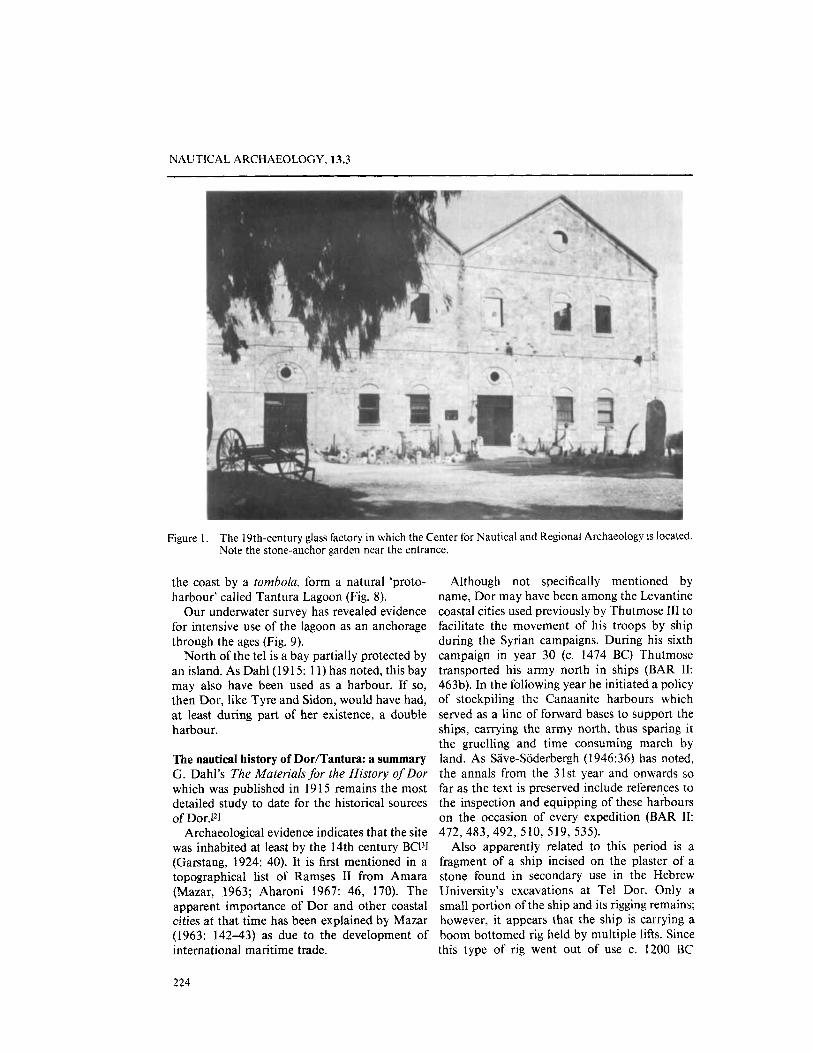
IDAM's Sea Base is located in the nearby scenic 19th-century glass factory. This has now been restored as the Center for Nautical and Regional Archaeology, Dora located in Kibbutz Nahsholim (Figs 1 , 2) . Due to their proximity to the Center, the underwater environs of both Tel Dor and the later Arab village of Tantura which surplanted it, have been intensively sur- veyed by us since 1976.
Publication of various aspects of the results of this ongoing survey are under preparation and will appear as separate monographs. These will include reports on shipwrecks, cargoes, stone and metal anchors, pottery, the proto-harbour in
0305-7445/84/030223 + 19 $03.00/0
Tantura Lagoon, Napoleonic weaponry, etc. (for the present see Wachsmann & Raveh, 1978:
However, as an introduction to the maritime aspects of Dor, we feel that a short review of the historical sources which touch on the nautical side of Dor/Tantura's past may be considered useful.
281-82; PI. 56: A-C; 1980: 259-61).
The topography of Dor The ruins of the ancient maritime site of Dor are located on a mound directly north of the modern settlement of Kibbutz Nabsholim. The site has been alternately known as Tel Dor, El Burj, or Khirbet Tantura. It is situated at lati- tude 32" 36 ' 50' ' and longitude 34" 54' 40' ' and is approximately 27 km south of the modern city of Haifa and 13 km north of the ancient site of Caesarea (Figs 3, 4).
Dor is one of the largest tels in Israel. It is built on a rocky promontory which is part of an aeolianite (kurkar) ridge that stretches parallel to the sea and the Carmel Mountain Range"] (Figs 5-7).
To the south of the tel is a sandy shore with several islands offshore. These form the continu- ation of the kurkar ridge. The Arabic names of these islands are, from north to south: (Jezirat el) FallPtiyeh, ShaddPdeh, Iamar and Hamam. Their modem Hebrew names are: (I) Shhafit, Dor, Tafat and yofami. The islands, together with a fifth island which is today connected to
0 1984 The Nautical Archaeology Trust Ltd.
NAUTICAL ARCHAEOLOGY, 13.3
Figure 1. The 19th-century glass factory in which the Center for Nautical and Regional Archaeology is located. Note the stone-anchor garden near the entrance.
the coast by a tombola, form a natural ‘proto- Although not specifically mentioned by harbour’ called Tantura Lagoon (Fig. 8). name, Dor may have been among the Levantine
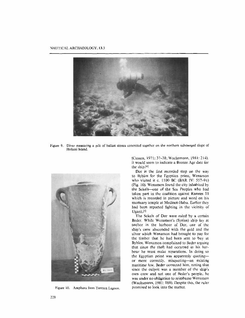
Our underwater survey has revealed evidence coastal cities used previously by Thutmose 111 to for intensive use of the lagoon as an anchorage facilitate the movement of his troops by ship through the ages (Fig. 9). during the Syrian campaigns. During his sixth
North of the tel is a bay partially protected by campaign in year 30 (c. 1474 BC) Thutmose an island. As Dahl(19 15: 1 1) has noted, this bay transported his army north in ships (BAR 11: may also have been used as a harbour. If so, 463b). In the following year he initiated a policy then Dor, like Tyre and Sidon, would have had, of stockpiling the Canaanite harbours which at least during part of her existence, a double served as a line of forward bases to support the harbour. ships, carrying the army north, thus sparing it
the gruelling and time consuming march by The nautical history of DodTantura: a summary land. As Save-Soderbergh (1 946:36) has noted, G. Dahl’s The Materials for the History of Dor the annals from the 31st year and onwards so which was published in 19 15 remains the most far as the text is preserved include references to detailed study to date for the historical sources the inspection and equipping of these harbours of D0r.1~1 on the occasion of every expedition (BAR 11:
Archaeological evidence indicates that the site 472, 483, 492, 510, 519, 5 3 5 ) . was inhabited at least by the 14th century BC131 Also apparently related to this period is a (Garstang, 1924: 40). It is first mentioned in a fragment of a ship incised on the plaster of a topographical list of Ramses I1 from Amara stone found in secondary use in the Hebrew (Mazar, 1963; Aharoni 1967: 46, 170). The University’s excavations at Tel Dor. Only a apparent importance of Dor and other coastal small portion of the ship and its rigging remains; cities at that time has been explained by Mazar however, it appears that the ship is carrying a (1963: 142-43) as due to the development of boom bottomed rig held by multiple lifts. Since international maritime trade. this type of rig went out of use c. 1200 BC
224

S. WACHSMANN AND K. RAVEH: DOR/TANTURA
Figure 2. Part of the exhibit of maritime finds. Figure 3. Map of the coast in the region of Dor.
225

Figure 5 . Aerial photograph of the coast south of Dor. Tantura Lagoon and Tel Dor appear at the very top of the photograph. The photograph was taken 8 June, 1918. From the Archives of the Israel Department of Antiquities and Museums.
Figure 6 . Tel Dor. Aerial photograph taken 8 June 1918. From the Archives of the Israel Department of Antiquities and Museums.
226

Figure 7 . The Camel Coast from Tel Dor (at bottom) to Haifa Bay. Note the headland at Atlit in the centre of the photograph. Taken 8 June 1918. From the Archives of the Israel Department of Antiquities and Museums.
Figure 8. Tantura and its lagoon. Note the glass factory, with its tripartite second storey roof still intact, and ancillary buildings on the lower right side of the photograph. Aerial photograph taken 22 January 1923. From the Archives of the Israel Department of Antiquities and Museums.
NAUTICAL ARCHAEOLOGY, 13.3
Figure 9. Diver measuring a pile of ballast stones concreted together on the northern submerged slope of Hofami Island.
(Casson, 1971: 37-38; Wachsmann, 1981: 214), it would seem to indicate a Bronze Age date for the ship.r41
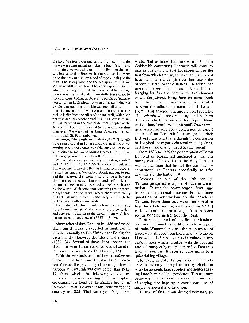
Dor is the first recorded stop on the way to Byblos for the Egyptian priest, Wenamon who visited it c. 1100 BC (BAR IV: 557-91) (Fig. 10). Wenamon found the city inhabited by the Sekels-one of the Sea Peoples who had taken part in the coalition against Ramses 111 which is recorded in picture and word on his mortuary temple at Medinet-Habu. Earlier they had been reported fighting in the vicinity of Ugarit. (51
The Sekels of Dor were ruled by a certain Beder. While Wenamon’s (Syrian) ship lay at anchor in the harbour of Dor, one of the ship’s crew absconded with the gold and the silver which Wenamon had brought to pay for the timber that he had been sent to buy at Byblos. Wenamon complained to Beder arguing that since the theft had occurred in his har- bour he must make reparations. In doing so the Egyptian priest was apparently quoting- or more correctly, misquoting-an existing maritime law. Beder corrected him, noting that since the culprit was a member of the ship’s own crew and not one of Beder’s people, he was under no obligation to reimburse Wenamon (Wachsmann, 1981: 188). Despite this, the ruler promised to look into the matter. Figure 10. Amphora from Tantura Lagoon.
228

S. WACHSMANN AND K. RAVEH: DOR/TANTURA
However, Wenamon apparently became im- patient and sailed away. Later he stole back approximately the amount of silver missing from a Sekel (?) ship. After many trials and tribulations Wenamon finally succeeded in obtaining the timber at Byblos. He was about to embark for Egypt when eleven Sekel ships arrived at Byblos demanding restitution for the silver stolen by Wenamon. The fact that Beder was capable of fielding a fleet of eleven ships to go after the priest suggests the existence of a thriving maritime center at Dor in that period. Interestingly, the number of ships sent by Beder agrees with the number of ships recorded in war fleets of the Mycenaeans and Sea Peoples referred to in texts from Pylos and Ugarit (Wachsmann 1981: 188,213-14).
Both the Eshmunezer inscription (ANET, Supl: 662) and Pseudo-Skylax (Aharoni, 1967: 361-62) indicate that Dor was a Sidonian harbour city in the late 5th and 4th centuries BC.
In 2 19 BC Antiochus 111 Megas unsuccessfully besieged Dor during one of his earlier campaigns against Ptolemy Philopator (Pol.vbius, V: 66). Garstang (1924: 39) has noted that although Antiochus had some forty ships which he had taken from the maritime cities of Tyre and Ptolemais (Acre) (Polyhius, V: 62) he was incapable of preventing Egyptian reinforcements from reaching Dor, apparently by sea.
Antiochus VII Sidetes besieged Dor after Tryphon had taken refuge there in 139/8 BC ( I Maccabees XV: 10-3 7; Josephus, Antiquities XIII: 223-24). The siege was carried out by land and sea, however, it was raised after Tryphon managed to escape from the city.
Josephus mentions Dor and Jaffa in connec- tion with the construction of the Herodian harbour of Caesarea. In Antiquities XV: 333 they are described as: ‘. . . small towns on the seashore and are poor harbours because the south-west wind beats on them and always dredges up sand from the sea upon the shore, and thus does not permit a smooth landing: instead it is usually necessary for merchants to ride unsteadily at anchor off shore.’
Josephus seems to be alluding here to the city’s harbour having filled with sand to the point where larger (?) ships could not be accomodated in it and, therefore, had to ride at anchor in the open sea. A parallel passage in Wars I: 409 gives a slightly different impression:
‘For the whole sea-board from Dora to Joppa, midway between which the city (Caesarea) lies, was without a harbour, so that vessels bound for Egypt along the coast of Phoenicia had to ride at anchor in the open when menaced by the south-west wind; for even a moderate breeze from this quarter dashes the waves to such a height against the cliffs, that their reflux spreads a wild commotion far out to sea.’
It is of interest to note that Nicolaus of Damascus appears to have been Josephus’ source for both passages (Dahl, 19 15: 79).
The discovery of a Byzantine wreck in Tantura Lagoon (Fig. 11) with at least part of her cargo still intact, underlines Dor’s maritime connections during this period.[6]
Stephen of Byzantium, writing probably in the 5th century AD, quotes CIaudius Iolaus (apparently 1st century AD) concerning Dor:
‘Next to Caesarea lies Dor, a very small town inhabited by Phoenicians. These settled here because of the somewhat rocky nature of the beaches and the abundance of the purple fish. At first they built themselves cabins, about which they placed stakes. When their business prospered, however, they split the rocks, and with the stones thus set free they built city walls, and made a harbour with good and safe anchorage. They called the place in their native tongue Dor. But the Greeks, for the sake of its more pleasing sound, agree to call the city Dora. And some make the statement that Doros, the son of Poseidon, was its founder’ (Dahl 19 15: 94).
Remains of the purple die industry have been reported at Dor. Berners, who visited the site in 1875 wrote: ‘Just south of the tell is a small bay running inland about two hundred yards, the shore of which is covered. to the depth of half a foot with purple shells; no doubt the same kind as those from which the Tynans used to extract their celebrated dye. I vainly endeavoured to find an unbroken specimen’ (1 876:
Note that Pliny (Natural History, IX: 60: 125-27) writes that the shells of the murex of a certain size were broken to facilitate removal of the substance in the snails’ hypobronchial gland which was used in the dyeing process.
The existence of quantities of shells on the beach at Dor was also noted by Stanley in 1889 (p. 261): ‘Its (Dor’s) situation, with its little harbour enclosed within the wild rocks rising over the shell-strewn beach, and covered by the fragments of the later city of Tantura, is still a striking feature on the lonely shore . ’
67-68).
229

NAUTICAL ARCHAEOLOGY, 13.3
Figure 1 1. Photo-mosaic, showing a frame with ceiling planking above and strakes below, of part o fa Byzantine shipwreck discovered in Tantura Lagoon. It is one of three wrecks found there during the survey.
Figure 12. Wreck located inside Tantura Lagoon. The possibility that this may be the remains of the shipwreck described by the Chevalier d’Arvieux is being studied.
230

S. WACHSMANN AND K. RAVEH: DOR/TANTURA
Figure 13. The spring as it appears today.
Figure 14. Villagers from Tantura drawing water from the spring. Photograph taken 5 June 1922. From the Archives of the Israel Department of Antiquities and Museums.
In 1664 the Chevalier d'Arvieux, who was the French consul at Sidon, visited Tantura. This "illage had sprung up to the south of D~~ after the demise of that site. He wrote a fascinating description of the wreck of a Greek ship and a subsequent wine banquet"] (Fig. 12):
'Tantura is a little harbour which is in the dominion of the Emir Turabey. We had just arrived, when. because of the stormy weather a big Greek vessel ran ashore on a sandbank. It was loaded with Cyprian wine and cheese and was on its way to Egypt, As as it struck, it was broken into pieces by the waves. The cheese stayed in the sea, while the casks ofwine drifted
23 I

NAUTICAL ARCHAEOLOGY, 13.3
away on the waves. Emir Dervik, who had watched the shipwreck from the hills, hurried to that place with part of his cavalry and some of the servants of the big emir. They began to plunder the sailors and the travel- lers. And they let the Arabs pull out the broken pieces of the vessel, and everything that drifted to shore. When the captain and his sailors were naked, they hid in the bushes and waited for night because they wanted to go to the nearest village to get something to wear. I consoled them about their loss and told them that 1 was a Christian and that I had some authority with the Arabs. Because of that I wanted to try to help them. They were very glad that they met me and had heard me speaking their language, the common Greek one. I proposed to them to help to pull out of the sea what could be rescued. In this way I desired that something would be given back to them. I reached an agreement with the Emir and he promised to satisfy them. When those poor sailors, who didn’t care about the violence of the waves, threw the merchants’ goods on the shore, and went back again into the vast sea, they rescued many things. They couldn’t prevent the smashing of the casks. They were just able to rescue two of them and brought them to the shore with a lot of trouble. The Arabs had rescued some of the cheese; so I said to them while joking that the cheese was made of sow’s milk. Immediately they threw the cheese away and washed their hands. So the Greeks made use of the cheese. It began to get dark and the sea was so stormy that the sailors couldn’t work anymore. I asked the Emir to give back their clothes to them. So he gave the order, and the Arabs gave back the majority of their clothes to them. Because the Emir wanted to sleep in Tantura in tents, which had been erected for him I made them hopeful of receiving more (of their goods). I advised them to wait, until he would have had his evening fare, so that they could meet him in a cheerful mood.
The Emir ordered to prepare his evening fare. Nothing was easier than this, because everyone in the village had brought him presents of meat. birds, venison, fruit and coffee, but nobody had thought about bringing wine. I found two jugs of wine at a Greek inhabitant of the village, named Abu Moussa. I let those poor sailors present it. The prince took the two jugs with pleasure. We sat down to dinner. I gave the Greeks a sign to stay outside the tent and wait until I would have them brought in. Meanwhile they were offered something to eat.
The meal was big and took a long time. There were a number of Arabs who didn’t drink wine. so the Emir, I and four or five of his other servants had quite enough of the wine. They brought the chalice among the party, they sang good and bad and this provincial pastime was pleasing. Now I thought it to be a good time to let the Greeks come in so 1 had them summoned. They entered in groups, kissed the Emir’s vest and went to the sides. The prince asked me if they hadn’t been given back their clothes and if they would desire anything else. I answered that his demands had been fulfilled exactly, but that these poor people had been ruined by the loss of their vessel and the merchants’ goods. They implored for those broken pieces from the
232
shipwreck which they could rescue from the sea. This was not much, but could help them to come back to their home and to aid their families in their misery. Those in the party who wanted yet to profit from the remaining goods refused. The Emir ordered, after thinking about it for a while, that everything had to be immediately taken away from those. This was more than had been requested. The Greeks kissed the seam of his vest to show him their deep appreciation. They soon went away to work on the salvage of the boat that had been thrown on the shore by the sea; they hoped to make the best of the next day since the wind would be calmer and the Emir would be away with all those who could hinder them’ (Dahl, 1915: 124-26).
During a previous visit to Tantura in 1660 d’Arvieux described a freshwater spring that flowed from a rock in the sea at a distance of two rzithen (approx. 10m) from the coast. He also noted that the spring was flooded by even the smallest of storm waves. Oddly enough, this was the only fresh water spring at Tantura; all other springs, which were located inland, were brackish (Ijahl, 1915: 124)
The spring may still be seen today. It is located at the north-eastem extremity of Tantura Lagoon and was still in use during modern times[*] (Figs 13 ~ 14).
In 1737 the English traveller Richard Pococke visited Tantura which he called TorturdYl. Wrote Pococke (1745: 57-58): ‘The next morning we set out very early, with some persons whom the sheik ordered to go with us, and travelled, as they computed, about 10 miles south to Tortura, a small village, with a port to the south, for large boats, which are sometimes forced to put in there by stress of weather, when passengers are obliged to pay a caphar of a sequin, or nine shillings a head. This seems to be the ancient Dora, mentioned by Saint Jerome, as nine miles from Caesarea. The present village is to the east side of the bay; to the north of the port, there is a small promontory on which there is a ruined castle; here probably was the old town as it is mentioned to have been on a peninsula.’
Perhaps one of the most unusual ‘nautical’ episodes in the site’s history which has left its archaeological mark underwater was due to a luck of ships! On the eve of 20 May 1799 a sadly disillusioned Napoleon Bonaparte raised his unsuccessful siege of Acre. Leaving their positions around the walled city, the battered French army struck out south on’ a forced march. Many of the soldiers were incapacitated from wounds received during the fierce fighting or by having fallen victim to the plague which ravaged the French camp.

S. WACHSMANN AND K. RAVEH: DOR/TANTURA
Figure 15. .Map showing the environs of Dor/Tantura and the encampment of Napoleon Bonaparte on 2 I May 1799. After Jacotin 1820-30: pl. 46.
Passing Haifa at midnight the French found more of their wounded and sick. The march to Tantura continued under horrifying conditions. Early on the morning of 2 1 May the army
straggled into Tantura and Bonaparte had his camp set up nearby (Fig. 15). Previously he had sent specific orders to Admiral Peree, the officer in charge of his fleet, to meet the army there with
233

NAUTICAL ARCHAEOLOGY, 13.3
234

S. WACHSMANN AND K. RAVEH: DOR/TANTIJRA
the ships at his disposal in order to evacuate the army, with its ordnance to the rear bases at Jaffa and Damiette in Egypt. However, the ships never arrived and in their place the army found an additional 700-800 wounded and sick soldiers lying on the beach at Tantura.
Faced with a largely disabled army and lack- ing sufficient supplies for an extended march Bonaparte gave orders to allocate all beasts of burden to transporting the wounded and the sick. However, this meant that the ordnance had to be left behind. Throughout the night of the 21st and the morning of the 22nd. the French soldiers toiled to dispose of the weaponry in various ways in order to prevent it falling into enemy hands.
Cannon carriages, together with caissons of gunpowder, were burnt on the beach. Some tw>enty artillery pieces were jettisoned into the sea. Two of these were recovered during the survey along with other artifacts relating to this episode[lOl.
Bonaparte’s visit to Tantura left an apparently indelible impression on the villagers. Wrote Buckingham, who visited the site in 18 16: ‘They inquired eagerly after Bonaparte, whom they all knew. . .’ (1 822: 122).
In 18 14, Light was becalmed at Tantura while sailing north from Jaffa:
‘1 took a passage in an open rice boat of about forty tons, with a crew of six or seven men, going to Acri, and embarked about nine o’clock on the evening ofmy return from Ramla. The wind, however, prevented us from sailing till the morning, when we passed the low sandy shore ofZabour, a long straggling village, behind which was a range of low hills: the ruins of Caesarea then presented themselves, with wooded hills over- hanging them. We were obliged to anchor at Santoora, and remained there part of the night, when a land breeze sprang up, and in the morning we found our- selves beyond Castel Pelligrino, called by the Syrians Atleet; near which the mountains, covered with brush- wood, shelve gently down to the shore’ (Light, 1818: 191).
Rogers, writing in the latter part of the 19th cen- tury, also describes being halted by unfavourable winds at Tantura: ‘On one occasion, in the month of September. when we were on our way from Jaffa to Haifa in an Arab sailing-boat, we landed at Tanthah to pursue our journey by land, because “the winds were contrary”. It was at the same time of the year (after the Fast of Atonement, which is kept on the tenth day of Tishri.
or towards the end of September) that St. Paul was tossed about by ”contrary winds” on the sea, and when, as he said, “sailing was dangerous” (Acts XXVII.9).
We were assured that the voyage from Jaffa to Haifa by sea would not occupy more than eight or ten hours, and as we were extremely anxious to arrive there as quickly as possible, my brother made arrangements with the owner of a little Arab sailing-boat to convey us there, with our servants and baggage. We were ready and waiting, when at midnight he sent word to us that “the wind was favourable.” and that he was ready to sail. We hurried down to the dark warf accompanied by our kawass and my servant Katrhe, a woman of Bethlehem. and two Carmelite monks who had requested permission to travel with us. The great water-gate of Jaffa was opened for us, and I was some- how dropped gently into a little rowing-boat far down in the darkness below, where I was taken charge of by two sturdy boatmen. After much shouting and jolting we were all huddled together, and the boat skimmed rapidly over the water to the sailing-vessel which awaited us outside the shallow rock-encircled harbour, and to which with some little difficulty we were trans- ferred. It was divided into three parts-the central portion being like an uncovered hold, four feet deep and eight feet square. The decks, fore and aft, were encumbered with ship’s tackle and crowded with sail- ors. who were singing lustily. The hold, lighted by two lanterns, was matted and set apart for passengers and luggage. Our portmanteaus and carpet-bags served us for a couch, and the monks sat on their saddle-bags, wrapped in their comfortable-looking hooded robes. Poor Katrine, who had never been on the sea before, was very much alarmed. She rolled herself up in her cloak, stretched herself full-length by my side, and was happily soon fast asleep. Our kawass smoked his pipe in company with the captain above, and an Italian, who had smuggled himself and his luggage on board in the hurry and darkness, kept aloof with the sailors. The sky was bright with stars, the south wind was strong and filled the sails, and by fits and starts I dozed till dawn of day. Then 1 roused myself and watched the little group around me-the hooded monks sleeping soundly, my brother at my feet leaning against a ham- per, and Katrine so enveloped that 1 could not dis- tinguish her head from her heels.
The favourable wind had ceased. and the sailors were busy taking in sail. By the time the sun appeared above the low coast hills the wind had shifted to the west, and we were in danger of being driven on the rocks. It then suddenly veered to the north, and blew so violently that the captain was obliged to cast anchor, and we were tossed on a heavy sea near to a desolate coast where there was no possibility of land- ing. By nine o’clock the sun was very powerful. An awning made of the now useless sails was thrown over
235
NAUTICAL ARCHAEOLOGY, 13.3
the hold. We found our quarters far from comfortable, but we were determined to make the best ofthem, and fortunately we were all good sailors. By noon the heat was intense and suffocating in the hold, so 1 climbed on to the deck and sat on a coil of rope clinging to the mast. The strong wind and the sea spray revived me. We were still at anchor. The coast opposite to us, which was every now and then concealed by the high waves, was a range of drifted sand-hills, transversed by flocks of goats feeding on the scanty patches of pasture. Not a human habitation, not even a human being was visible, and not a boat or ship was seen all day.
In the afternoon the wind ceased, but the little ship rocked lazily from the effect ofthe sea swell, which had not subsided. My brother read St. Paul’s voyage to me. as it is recorded in the twenty-seventh chapter of the Acts of the Apostles. It seemed to me more interesting than ever. We were not far from Caesarea, the port from which St. Paul embarked.
At sunset “the south wind blew softly”. The sails were soon set, and in better spirits we sat down to our evening meal. and shared our chickens and preserved soup with the monks of Mount Carmel, who proved to be very pleasant fellow-travellers.
We passed a dreamy restless night, “sailing slowly”, and in the morning were nearly opposite Tantdrah. The wind had changed to the north-east, so my brother insisted on landing. We tacked, about, put out to sea, and then allowed the strong wind to drive us towards the picturesque coast. Little islands of rock and mounds of ancient masonry stood out before it, beaten by the waves. With some manoeuvering the boat was brought safely to the beach, where there were plenty of Tantdrah men to meet us and carry us through the surf to the smooth yellow sands.
I was delighted to find myself on firm land again, and I shall remember St. Paul’s advice to the centurion, and vote against sailing in the Levant in an Arab boat during the equinoctial gales’ (PPSE: 118-19).
Shumacher visited Tantura in 1886 and noted that from it ‘grain is exported in small sailing vessels, generally to Esh ShQny near Bein’it; the vessels anchor between the isles and the shore’ (1887: 84). Several of these ships appear in a sketch showing Tantura and its port, situated in the lagoon, as seen from Tel Dor (Fig. 16).
With the reintroduction of Jewish settlement in the area ofthe Carmel Coast in 1882 at Zich- ron Yaakov, the possibility of creating a Jewish harbour at Tanturah was considered (Ilan 1982: 19-from which the following quotes are derived). This idea was suggested by Captain Goldsmith, the head of the English branch of ‘Hovevai Tsion’ (Lovers ofZion), who visited the country in 1883. That same year Yehiel Bril
wrote: ‘Let us hope that the desire of Captain Goldsmith concerning Tanturah will come to pass in our day, and that her shores will be the first from which trading ships of the Children of Israel will depart, carrying on their masts the banner of Israel to the distances’. He added: ‘At present one sees at this coast only small boats foraging for fish and coming to take charcoal which the fellahin bring here on camel-back from the charcoal furnaces which are located between the adjacent mountains and the sea- shore’. This angered him and he notes ruefully: ‘The fellaliirz who are desolating the land burn the trees which are suitable for ship-building, while others (trees) are not planted’. One promi- nent Arab had received a concession to export charcoal from Tanturah for a two-year period; Bril was indignant that although the concession had expired ‘he exports charcoal in many ships, and there is no one to attend to this vandal!’
From 1893 to 1925 the private yacht of Baron Edmond de Rothschild anchored at Tantura during each of his visits to the Holy Land. It was at that time that he had the glass factory constructed at Tantura specifically to take advantage of the harbour“’].
Towards the end of the 19th century, Tantura prospered as a port of trade in water- melons. During the heavy season, from June to September, camel caravans brought large quantities of watermelons to the beach at Tantura. From there they were transported in large baskets to waiting boats (iaram or feluka) which carried them out to larger ships anchored several hundred metres from the coast.
During the period of the British Mandate, Tantura continued its traditional role as a port of trade. Watermelons, still the main article of trade, were shipped from there, mainly to Egypt. However, in 1930 that country introduced heavy custom taxes which, together with the reduced rates of transport by rail, put an end to Tantura’s trading revenues. It reverted once again to a quiet fishing village.
However, in 1948 Tantura regained import- ance as the only supply harbour by which the Arab forces could land supplies and fighters dur- ing Israel’s war of Independence. Tantura now became a major support base as numerous craft of varying size kept up a continuous line of supply between it and Lebanon.
Because of this, it was deemed necessary by
236

S. WACHSMANN AND K. RAVEH: DOR/TANTURA
Figure 17. Modem-day Arab fishermen tend their boats at Tantura Lagoon during a winter storm.
the Israeli forces to neutrdize the port. On 23 May 1948 ‘Operation Harbour’-the code name for the capture of Tantura-took place. While the battle was fought on land, partially on Tel Dor and in and around the glass factory, an Israeli naval boat blockaded Tantura harbour. Due to a lack of communication the land forces, which had captured the high land on the tel, mistook the boat for an enemy craft and commenced firing upon it. The boat’s crew returned the fire. The mistake was eventually realized and both sides ceased their firing, but only after one of the craft’s crew had been hit. So ended Dor’s last ‘naval engagement’.
With the creation of the State of Israel two settlements were founded in the region. They are Moshav Dor which is located east of the lagoon, and Kibbutz Nahsholim (trans. ‘wild surf) situ- ated adjacent to and south of Tel Dor. For a time, the lagoon continued to serve as an har- bour for Nahsholim’s two fishing trawlers and the smaller fishing boats of the expatriate Greek fishermen of Moshav Dor.
The nautical heritage of Dor continues at present in the many kibbutz sailors, the Arab fishermen (Fig. 17), a maritime educational
centre where schoolchildren learn the art of sailing and the activities of IDAM’s Sea Base and the Centre for Nautical and Regional Archaeology.
Today, the fine coast of Dor is one of Israel’s most popular beaches. Wind surfers glide over the waters where Wenamon’s ship long ago stood at anchor and sun worshippers have taken to the sandy shores where once Bonaparte found his disabled troops slowly dying.
Acknowledgements We wish to thank Mr Avraham Eitan, Director of the Israel Department of Antiquities and Museums for his permission to publish here arti- facts and archival material belonging to the Department. Thanks are also due to Ms Marianne Habrichs for translating the d’Arvieux episode and to Ms Zarza Friedman for the photograph appearing in Fig. 2, and to Mr Rani Jilovsky for kindly bringing to our attention the reference to Rogers’ visit to Tantura.
We have attempted to establish ownership of copyright for the aerial photographs appearing in Figs 5-8, but without result. A valid claim thereto will be acknowledged.
237
NAUTICAL ARCHAEOLOGY, 13.3
Notes [I] Concerning the paleography of the Ddr coast, see Sneh (198 I) . [2] For more recent discoveries and discussions, see Avi-Yonah (1973) and Foerster (1975), both with
[3] The current archaeological excavations are only beginning to reach Bronze Age levels at the time of writing. [4] A study of this ship representation will appear in a separate monograph. [5] On the pronounciation of their name, previously often translated TjekkedTjekkel see now Rainey (1 982:
134) and Wachsmann (1982: 297, no. I). [6] This is one of three shipwrecks found during our survey. Dor, with its episcopal basilica, was an important
station for Christian pilgrims on theif way to and from Jerusalem during the Byzantine Period (Dauphin. 1982-83: 25-26; 1983: 75). It is quite likely that shipbome pilgrims may also have stopped to visit the basilica in which was displayed a chip of rock from Golgotha (Leibovitch, 1954). Writes Dauphin (1 982-83: 3 I ) , ‘such a prized relic must have exercised tremendous magnetism over pilgrims travelling from the north along the Via Maris or disembarking at the port of Dora’.
additional bibliographies; also Albright (1923: 8-10), Avigad (1975), Ben Dov (1976), Haran (1977).
[7] The following passage was translated from the 18th century German by Ms Marianne Habrichs. [8] For a description of a similar spring at Jaffa see Brocquiere (1 807: 92). [9] On the etymology of the place name. Tantura/Tortura/Santura see Guerin (1875: 306) and Dahl ( I9 15:
[lo] For a more detailed description of this historical incident and archaeological remains relating to it which
[I I] For a more detailed discussion of the history of this region during the 19th and 20th centuries see HHD:
28-33).
were found during the survey see Wachsmann & Raveh (1982: 1983-84; in press a and b).
, 1 8 4 2 from which the following is summarized.
References Aharoni, Y., 1967, The Land of the Bible: A Historical Geography. (trans. A. F. Rainey). London. Albright, W. F., 1923, Some archaeological and topographical results of a trip through Palestine. Bulletin oj
ANET Suppl.. 1969, The Ancient Near East: Supplementary Texts and Pictures Relating to the Old Testament.
Antiquities, Josephus, 1963, (trans. R. Marcus). The Loeb Classical Library vol. VIII. London. Avigad, N., 1975, The Priest of Dor. Israel Exploration Journal 25: 101-5. Avi-Yonah, M.. 1973, Dor. In D. Cassuto (Ed.), Encyclopedia Migrait vol. 11: 579-81. Jerusalem (In Hebrew.) BAR, 1906-7, A n c i e n t c o r d s ofEgypt, J. H. Breasted (Ed.), vols I-V. Chicago. Ben Dov. M., 1976, ;T$+ -A geographical term of possible ‘Sea People’ origin. Tel Aviv 3: 70-3. Bemers, C. H., 1876, Two Months in Syria in 1875, London. Brocquiere, B. de la, 1807, The Travels ofBrocquiere to Palestine, (trans. T. Johnes). London. Buckingham, J. S., 1822, Travels in Palestine, vol. I. London. Dahl, G., 1915, The Materials for the History ofDor. New Haven. Dauphin, C. M.. 1979, Dor, Byzantine Church. Israel Exploration Journal 29: 235-6. Dauphin, C. M., 1981, Dor, Byzantine Church, 1980. Israel Exploration Journal31: 117-1 19. Dauphin. C. M., 1982-83, On the Pilgrim’s Way to the Holy City. Bulletin of the Anglo-Israel Archaeological
Dauphin, C. M., 1983, La basilique de Dors. Archaeologia 180-1. (Juillet-Aout): 68-75. Foerster. G., 1975, Dor. In M. Avi-Yonah (Ed.), Encyclopedia qfArchaeologica1 Excavations in the Holy Land,
Garstang, J., 1924, Tantura (Dora). Bulletin of the British School of Archaeology in Jerusalem 4: 35-45. Guerin, M. V., 1875, Description de la Palestine, Samarie, vol 11. Paris. Haran, M., 1977, A temple at Dor? Israel Exploration Journal 27: 12-5. HHD. @of Hubonim-Dor, n.d. (Published by the Society for the Protection of Wildlife, Yof ha-Carmel Field
School.) (In Hebrew). Ilan, Z., 1982, ilrchaeological und Historical Sites in Israel: II. Central and Southern Regions. Tel Aviv. (In
Hebrew.) Jacotin, M., 1820-30. Carte topographique de Iggypte et ~ephrsieursparties despays limitrophes, leveependant
I’expedition de I’armPe.franCaise. In Description de I’Egypte, ou Rescueil des observations et des recherches qui ont ktk faites en Egvpte pendant I’expkdition de l’armke francaise. 2e ed., vol. VIII. Publite par C. L. F. Panckoucke, Paris.
the American Schools of Oriental Research 11: 3-14.
J. B. Pritchard (Ed.). Princeton.
Society 1: 25-3 1.
vol I: 334-7. Jerusalem. English Edition.
Leibovitch, J., 1954, The Reliquary Column of Dor. Christian Newsfrom Israel 5: 22-3. Mazar, B., 1963, Dor and Rehob in an Egyptian Topographical List. Yediot 27: 13944. (In Hebrew.) Pococke, R., 1745, A Description of the East and Some Other Countries, vol. 11. London. PPSE, n.d.. Picturesque Palestine, Sinai and Eg.vpt. C. Wilson (Ed.), London. Raban, A., 198 1, Recent maritime archaeological research in Israel. IJNA 10.4: 287-308. Raban, A., 1983, Recent maritime archaeological research in Israel. IJNA 12.3: 229-51.
238

S. WACHSMANN AND K. RAVEH: DOR/TANTURA
Rainey, A. F., 1982, Toponymic Problems. Tel Aviv 9: 130-6. Rosenthal-Heginbottom, R., 198 I , Notes on Hellenistic Braziers from Tel Dor. Qadmoniot XIV, nos 3 4 (55-6):
110-1. (In Hebrew.) Save-Soderbergh, T., 1946, The Navy of‘the Eighteenth Egyptian Dvnast-v. Uppsala. Shumacher, G., 1887, Researchers in the plain north of Caesarea. Palestine Exploration Fund, Quarterly
Statement 20: 78-90. Sneh, Y., 1981, The Paleography and the History ofthe Coast of Dor in the Holocene Period. (Unpublished
MA thesis. Haifa University.) (In Hebrew with English abstract.) Stanley, A. P., 1889. Sinai and Palestine: in connection with their history. London. Stem, E., 1980, Tel Dor, 1980. Israel Exploration Journal 30: 209-13. Stern, E., 1981, Hellenistic Dor. Qadmoniot XIV, nos 3-4 (55-6): 103-10. (In Hebrew.) Stem, E., 1982, Excavations at Tel Dor, 1981. Israel Exploration Journal 32: 107-17 & pls 12: B-15. Wachsmann, S., 1981, The ships of the Sea Peoples. IJNA 10: 187-220. Wachsmann, S., 1982. The ships ofthe Sea Peoples. (IJNA, 10.3: 187-220): additional notes. IJNA 11: 297-304. Wachsmann, S. & K. Raveh, 1978, Underwater Investigations by the Department of Antiquities and Museums.
Wachsmann, S. & K. Raveh, 1980, Underwater work carried out by the Israel Department of Antiquities. IJNA
Wachsmann, S. & K. Raveh, 1982, The search for Napoleon’s lost ordnance in the sea off Tantura/Dor.
Wachsmann, S. & K. Raveh, 1983-84, The guns of Tantura: Napoleonic weaponry from beneath the sea.
Wachsmann, S. & K. Raveh, in press a, In the footsteps of Napoleon at Tantura. Archaeology. Wachsmann, S. & K. Raveh, in press b. A bronze Napoleonic mortar from the Tantura/Dor Coast. Qadmoniof.
Wars, Josephus, 1927, (trans. H.St.J. Thackeray). The Loeb Classical Library, vol. 11. London. Wenning, R., 1983. Hellenistiche Skulpturen in Israel. Boreas 6: 105-18 & taf. 16.
Israel E.xploration Journal 28: 281-83 & pl. 56.
9: 256-64.
Quadmoriot XV, nos 2-3 (58-9): 87-91. (In Hebrew.)
Israel-Land and Nature (English Edition) 9.2: 56-60.
(In Hebrew.)
Postscript added in proof
Since this paper has gone t o press, several significant discoveries have been made during o u r ongoing survey in Tantura Lagoon. W e summarize the main points here prior to more detailed publications in the future: (1) We have suggested in the past, on the basis of stone anchors found in the region of the lagoon, that this area served as a ‘proto-harbour’ for the site of Dor during the Bronze Age (Wachsmann & Raveh, 1978: 282; 1980: 260, 258 figs 4-5). However, since n o stone anchors have been found to date in the Bronze Age strata of Israeli sites bordering the Mediterranean Coast, the dating of the stone anchors found during the survey remained problematic.
The lagoon has now surrendered a ceramic bowl which appears to date to the latter part of the Middle Bronze Age found in conjunction with a single pottery sherd identified by Dr Robert S. Merrillees as a fragment of a Cypriote White Painted Cross Line Style jug and dated to the Middle Cypriote 111-Late Cypriote IA, c. 17th century BC. These artifacts indicate that Tantura Lagoon was indeed in use by that time and suggest that the existence of the ‘proto-harbour’ here may have been the raison d’Etre for the establishment of Dor. (2) A second amphora of the type shown here in Fig. 10, apparently dating to the end of the Late Bronze Age o r the very beginning of the Iron Age, c. 13th-12th centuries BC, has been retrieved from the lagoon. Since Wenamon mentions a single harbour a t Dor [‘I have been robbed in thy harbour . . . When I had spent nine days, moored in his harbour’. . . (BAR IV: 566)], and since now the lagoon may be shown to have been active at this time it would seem that Wenamon’s ship was anchored somewhere in the vicinity of the lagoon when his silver and gold was stolen.
The appearance of two intact amphorae in the sand covering the seabottom may be the first evidence of a cargo or shipwreck in this immediate area (see below). (3) Quantities of pottery dating to the end of the Iron Age or the Persian Period (c. 8th-6th centuries BC) have now been found. It is not clear a t present whether the pottery forms one or two separate ceramic entities. The pottery is composed mainly of sherds of cylindrical and ‘basket-handle’ jars. Several bases of the latter type still contain organic material, including in a t least one case what appear to be grape-pips.
239

NAUTICAL ARCHAEOLOGY, 13.3
It is premature to give definitive interpretations to these ceramic finds. It should be noted, how- ever, that the lagoon is clearly an ideal wreck-preserving mechanism as proven by the three ship- wrecks already found during the survey. If any of these pottery remains are rel'ated to one or more ships that actually sank in the lagoon there are very good prospects for the preservation of the wooden wrecks themselves. A second possibility which should be taken into account is that the pottery groups may be related to coastal installations which have subsided; and, of course, other explanations for their existence are not lacking. Whatever their ultimate origins, future work in the lagoon appears extremely promising. (4) In 1983, at the time of the discovery of the Byzantine wreck, an iron anchor of Byzantine date was found nearby. The anchor had the top of its shank and one of its arms missing. At the time the anchor was recorded and tagged with underwater buoys and left in situ (Fig. 18).
Figure 18. Iron Byzantine anchor A106 in situ, as photographed in 1983.
Recently a 1 . 5 ~ 3 . 0 mz section was excavated, with the anchor serving as part of the section's eastern border. As the excavation progressed the upper part of the anchor's shank was found to be resting on a stone which in turn rested on a pierced stone-either a stone anchor or a mooring stone (max. dimensions 0.70 x 0.50 x 0.20 m3-the hole is situated on the long side), thus forming a stratigraphical sequence of anchors on the seafloor!
240

S. WACHSMANN AND K. RAVEH: DOR/TANTURA
( 5 ) Several pieces of marble building materials were recovered from the lagoon. The most interesting of these is a profiled lintel or architrave-piece (max. dimensions 2.80 ~ 0 . 4 4 x0.35 m3; weight approx 800 kg). It is probably of Roman date. The marble still bears the remains of an iron pin stuck into one of its extremities. This clearly indicated that it arrived on the seabed after being removed from an existent building, in all probability located at Dor. These marble pieces bear stark witness to the intense activity of theft of building materials from that site after its demise (see also Wachsmann & Raveh, 1980: 260, 259 fig. 7). The marble was probably being removed for the lime kilns rather than as building material.
Acknowledgements We wish to thank the following scholars for their valuable comments on our recent finds: Professor Trude Dothan, Dr Gideon Foerster, Dr Shulamit Geva. Ms Bracha Goz, Dr Amihai Mazar, Dr Robert S. Merrillees, Professor Ephraim Stern and Mr Avshalom Zemer.
24 1