National Parks Conservation Assn. Official Comments on New Clean Water Act Rule - Docket ID No....
12
November 14, 2014 Water Docket Environmental Protection Agency Mail Code 2822T 1200 Pennsylvania Avenue NW. Washington, DC 20460 Attention: Docket ID No. EPA-HQ-OW-2011-0880 To whom it may concern: On behalf of the National Parks Conservation Association and our more than 1 million members and supporters, I write to offer the Environmental Protection Agency (“EPA”) and U.S. Army Corps of Engineers (“USACE”) NPCA’s support for the proposed rule clarifying the scope of the Clean Water Act (“CWA”). National parks are inseparable from the waters that are in, surround, and flow through them. Because many park waters originate on lands outside of park boundaries, where beyond boundary activities impact park water quality and availability, the National Park Service (“NPS”) often relies on the EPA and USACE to exercise their CWA authority to prevent impairment of park waters. The proposed rule helps protect national park waters by providing a clearer and more predictable science-based and legal framework for determining which waters are protected by the CWA. For the past 13 years, Supreme Court decisions and agency guidance have created regulatory confusion over the protected status of waters that crucially affect water quality in parks. This clarification of the CWA’s jurisdiction is important for parks because many of the waters that are at risk from the existing jurisdictional confusion significantly impact the quality of park waters. Small and seasonal stream networks of headwater, intermittent, and ephemeral streams often overlap park boundaries and strongly influence the biological, chemical, and physical integrity of park ecosystems. Additionally, larger downstream park units are vulnerable to pollution from activities upstream. Shoreline parks also suffer from water quality issues that emerge inland, often from small and upstream waters that could lose their protection if no action is taken to clarify the CWA’s scope. Headwater, Ephemeral, and Intermittent Streams Recent regulatory uncertainties especially threaten headwater, ephemeral, and intermittent streams as well as other upstream areas that feed into park units. About 117 million (one-third of Americans) – and many park visitors – depend on drinking water from public water systems that are fed in whole or in part by intermittent, headwater, or ephemeral streams (EPA 2009). For the past 13 years, confusion resulting from both the Supreme Court decisions and agency guidance particularly muddied the protection status of these types of waters, which respectively
Transcript of National Parks Conservation Assn. Official Comments on New Clean Water Act Rule - Docket ID No....

November 14, 2014 Water Docket Environmental Protection Agency Mail Code 2822T 1200 Pennsylvania Avenue NW. Washington, DC 20460 Attention: Docket ID No. EPA-HQ-OW-2011-0880 To whom it may concern: On behalf of the National Parks Conservation Association and our more than 1 million members and supporters, I write to offer the Environmental Protection Agency (“EPA”) and U.S. Army Corps of Engineers (“USACE”) NPCA’s support for the proposed rule clarifying the scope of the Clean Water Act (“CWA”). National parks are inseparable from the waters that are in, surround, and flow through them. Because many park waters originate on lands outside of park boundaries, where beyond boundary activities impact park water quality and availability, the National Park Service (“NPS”) often relies on the EPA and USACE to exercise their CWA authority to prevent impairment of park waters. The proposed rule helps protect national park waters by providing a clearer and more predictable science-based and legal framework for determining which waters are protected by the CWA. For the past 13 years, Supreme Court decisions and agency guidance have created regulatory confusion over the protected status of waters that crucially affect water quality in parks. This clarification of the CWA’s jurisdiction is important for parks because many of the waters that are at risk from the existing jurisdictional confusion significantly impact the quality of park waters. Small and seasonal stream networks of headwater, intermittent, and ephemeral streams often overlap park boundaries and strongly influence the biological, chemical, and physical integrity of park ecosystems. Additionally, larger downstream park units are vulnerable to pollution from activities upstream. Shoreline parks also suffer from water quality issues that emerge inland, often from small and upstream waters that could lose their protection if no action is taken to clarify the CWA’s scope. Headwater, Ephemeral, and Intermittent Streams Recent regulatory uncertainties especially threaten headwater, ephemeral, and intermittent streams as well as other upstream areas that feed into park units. About 117 million (one-third of Americans) – and many park visitors – depend on drinking water from public water systems that are fed in whole or in part by intermittent, headwater, or ephemeral streams (EPA 2009). For the past 13 years, confusion resulting from both the Supreme Court decisions and agency guidance particularly muddied the protection status of these types of waters, which respectively
NPCA Comments on Docket ID No. EPA-HQ-OW-2011-0880 Page 2
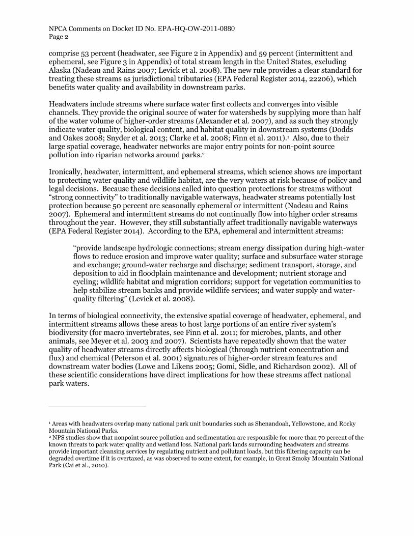
comprise 53 percent (headwater, see Figure 2 in Appendix) and 59 percent (intermittent and ephemeral, see Figure 3 in Appendix) of total stream length in the United States, excluding Alaska (Nadeau and Rains 2007; Levick et al. 2008). The new rule provides a clear standard for treating these streams as jurisdictional tributaries (EPA Federal Register 2014, 22206), which benefits water quality and availability in downstream parks. Headwaters include streams where surface water first collects and converges into visible channels. They provide the original source of water for watersheds by supplying more than half of the water volume of higher-order streams (Alexander et al. 2007), and as such they strongly indicate water quality, biological content, and habitat quality in downstream systems (Dodds and Oakes 2008; Snyder et al. 2013; Clarke et al. 2008; Finn et al. 2011).1 Also, due to their large spatial coverage, headwater networks are major entry points for non-point source pollution into riparian networks around parks.2 Ironically, headwater, intermittent, and ephemeral streams, which science shows are important to protecting water quality and wildlife habitat, are the very waters at risk because of policy and legal decisions. Because these decisions called into question protections for streams without “strong connectivity” to traditionally navigable waterways, headwater streams potentially lost protection because 50 percent are seasonally ephemeral or intermittent (Nadeau and Rains 2007). Ephemeral and intermittent streams do not continually flow into higher order streams throughout the year. However, they still substantially affect traditionally navigable waterways (EPA Federal Register 2014). According to the EPA, ephemeral and intermittent streams:
“provide landscape hydrologic connections; stream energy dissipation during high-water flows to reduce erosion and improve water quality; surface and subsurface water storage and exchange; ground-water recharge and discharge; sediment transport, storage, and deposition to aid in floodplain maintenance and development; nutrient storage and cycling; wildlife habitat and migration corridors; support for vegetation communities to help stabilize stream banks and provide wildlife services; and water supply and water-quality filtering” (Levick et al. 2008).
In terms of biological connectivity, the extensive spatial coverage of headwater, ephemeral, and intermittent streams allows these areas to host large portions of an entire river system’s biodiversity (for macro invertebrates, see Finn et al. 2011; for microbes, plants, and other animals, see Meyer et al. 2003 and 2007). Scientists have repeatedly shown that the water quality of headwater streams directly affects biological (through nutrient concentration and flux) and chemical (Peterson et al. 2001) signatures of higher-order stream features and downstream water bodies (Lowe and Likens 2005; Gomi, Sidle, and Richardson 2002). All of these scientific considerations have direct implications for how these streams affect national park waters.
1 Areas with headwaters overlap many national park unit boundaries such as Shenandoah, Yellowstone, and Rocky Mountain National Parks. 2 NPS studies show that nonpoint source pollution and sedimentation are responsible for more than 70 percent of the known threats to park water quality and wetland loss. National park lands surrounding headwaters and streams provide important cleansing services by regulating nutrient and pollutant loads, but this filtering capacity can be degraded overtime if it is overtaxed, as was observed to some extent, for example, in Great Smoky Mountain National Park (Cai et al., 2010).

NPCA Comments on Docket ID No. EPA-HQ-OW-2011-0880 Page 3
In addition to protecting scientifically-important headwater, ephemeral, and intermittent streams themselves, the rule also provides for the evaluation of these waters in “networks” and aggregation of small features. When considered together, these networks represent a collection of waters with strong connectivity to downstream water bodies and other features (Gomi, Sidle, and Richardson 2002), like park units. Taken individually, small streams in headwater systems may not always display discretely significant contributions to higher order streams; however, their strong biological and chemical connections become more apparent when headwater streams are analyzed as the networks that science has clear methods for identifying (e.g., see NCDWQ 2010 and various guidance documents from USACE).3 These stream types are important to national parks across the country. The southwestern U.S. and Colorado River watershed, for example, is especially reliant on intermittent and ephemeral streams (Levick et al. 2008). These streams constitute over 81 percent of all streams in this region, which includes such icons as the Grand Canyon National Park, Lake Mead National Recreation Area, and the Glen Canyon National Recreation Area. These parks alone have over 12 million visitors each year (NPS 2013). Colorado River headwaters are in Rocky Mountain National Park. The Colorado River supplies seven states with water, hydropower, flood control, recreation, and habitats. Many areas in the Colorado watershed have generally arid climates where many important streams dry up or flow infrequently. Reliable water flows in the Colorado are also necessary to fulfill the U.S.’s 1944 treaty obligation to annually deliver certain volumes to Mexico. Long-term trends in precipitation and temperature patterns suggest mean annual runoff in this area will decrease by 8.5 percent by 2050, making it especially important to protect the quality and quantity of what little water may be left (DOI 2011). Glacier National Park’s Flathead River region is an area where headwater pollution threatens U.S. national parks. The Flathead River feeds the iconic Glacier National Park, but the river has its headwaters in British Columbia, Canada. The U.S. Congress and Canadian Parliament both designated these combined areas as the world’s first International Peace Park, the Waterton-Glacier Peace Park, which the United Nations recognized as a World Heritage Area in 1995. However, recently, a Canadian land-use plan almost permitted significant pollution in the headwaters of the Flathead River Valley, thereby directly threatening the internationally significant natural resources in Glacier National Park (NPCA 2010a). Fortunately, the British Columbia Premier and Montana Governor agreed to protect the transboundary Flathead River valley from energy exploitation. Recent regulatory uncertainties regarding the “waters of the United States” threaten to expand the same problem within the U.S. Shenandoah National Park is home to major headwaters for the Chesapeake watershed. The Shenandoah River and neighboring tributaries feed into the Chesapeake Bay, which is the largest estuary system in North America. There are over 55 national park units in the Chesapeake region, and the bay’s rate of flow and quality affect drinking water, recreation, and commercial fishing in the surrounding regions. A 2010-2012 survey found that only 31 percent of the Chesapeake Bay was attaining water quality standards (including dissolved oxygen, water clarity, underwater bay grasses, and chlorophyll-a concentrations—all vital to aquatic ecosystem
3 Overzealous application of the aggregation concept is prevented by the rule’s requirement that the case-specific scientific analysis of aggregations be “more than speculative or insubstantial,” as Justice Kennedy suggested. Furthermore, delineations of streams with significant nexuses are fairly reliable in areas with healthy bank vegetation, which helps channel locations to not naturally move over time; this is especially true in mountainous areas which contain many headwaters with winter permafrost that hardens banks and slows stream flow (Crawford and Stanley 2014).

NPCA Comments on Docket ID No. EPA-HQ-OW-2011-0880 Page 4
health). The goal is to have 60 percent attain these standards by 2025 (FLCCB 2014). Seventeen million people live in the Chesapeake watershed, which spans six states and the District of Columbia, has nearly 12,000 miles of shoreline, and is the largest estuary system in North America with 150 major rivers and streams, and 100,000 smaller streams, creeks, and rivers (Chesapeake Bay Program). The Shenandoah watershed provides some of the cleanest contributions to the Bay (USGS watershed online mapper), and this is largely a result of strong protections for the streams in and surrounding the park. In addition, the Snake River’s headwaters largely overlap the southwest areas of Yellowstone National Park (having strong connection to Jackson Lake). The Snake River passes through Grand Teton National Park, the Snake River Wild and Scenic River, and many non-national park lands in between. Flowing east, Yellowstone National Park also contains one of the branches of the headwaters of the Missouri River, which eventually flows into the Mississippi River and Gulf of Mexico. Large Impacts on Downstream Park Units The protection of water must begin at its source otherwise pollutants aggregate and get worse on the way downstream. This is a particular concern for national parks, where waters flowing into and through the parks may be adversely impacted by beyond boundary threats. These threats include point source pollution from upstream landfills, toxic dumps, mining practices, inadequate septic and wastewater disposal systems, contaminated runoff from agriculture and urban development, and pollution such as acid rain that upsets the delicate balance of water quality. Parks with their fixed geographic boundaries cannot on their own prevent the threats occurring in their watersheds affecting water quality and availability in park units. Most rivers and lakes that flow through park units originate outside park boundaries. For example, Buffalo National River ranks as the number two tourist destination in Arkansas, and it attracts $44 million in tourism spending creating 610 jobs in the surrounding Ozark communities. However, a major branch of the Buffalo River has high E-coli bacteria concentrations that possibly originate from animal agricultural operations within the watershed (see Buffalo River Watershed Alliance 2014). At Big Hole National Battlefield in southwestern Montana, the North Fork of the Big Hole River flows through the park and is impaired from flow alterations and nonpoint source pollution from upstream creeks and tributaries (NPS 2013b; Big Hole Watershed Committee 2012). At Colonial National Historical Park, upstream rural and urban land disturbances on watersheds are polluting creeks and streams. As a result, the marshes and wetlands of the park are being harmed by increased stream bank soil erosion and sediment deposition. At the St. Croix National Scenic Riverway, nutrient runoff from expanded residential development on watershed lands adjacent to these parks are polluting park waters. Similarly, the unique mineralized and freshwater springs of Chickasaw National Recreation Area, which lures in visitors as the park’s main attraction, are being degraded from leaky sewer pipes from nearby municipalities (Pringle 2000). Urban parks especially have suffered from pollution and effluents that flow from non-park areas. Around 90 percent of the water bodies and waterways in the National Capital Parks Region in and near Washington, D.C. are impaired, and Rock Creek Park in the nation’s capital is similarly degraded (NPS 2014). Two NPS units in and near the heart of St. Paul, Minnesota, (Mississippi National River and Recreation Area and Saint Croix) are the fifth and eleventh most impaired park areas in the nation (NPS 2014). Also, Gateway National Recreation Area in New
NPCA Comments on Docket ID No. EPA-HQ-OW-2011-0880 Page 5
York City is the seventh most visited unit in the national park system (NPS 2013a), but 66 percent of its water bodies are polluted, largely because it receives pollution from the confluence of the Hudson Bay watershed and many areas of industrial activity (NPS 2014). Suburban areas also strongly affect water quality in nearby parks, such as Cuyahoga Valley National Park, which is close to Cleveland, Ohio. Cuyahoga waters are 100 percent impaired meaning the water in Ohio’s only national park do not meet water quality standards (NPS 2014). Similarly, with the fourth most impairments (NPS 2014), the Illinois & Michigan Canal National Heritage Corridor receives pollution from the drainage basin of much of Chicago’s southwestern suburbs. Shoreline Park Units Through this rulemaking shoreline park units will also benefit from clearer CWA protections for surrounding waters. Enhanced water quality in upstream watersheds will aggregate into better water quality along lakeshores and coastlines. Rivers eventually flow to the coast, and as a result, much of the pollution that enters in upstream areas aggregates in estuarine and coastal regions, including parks managed by NPS (Ruttenberg and Granek 2011). The NPS system has four national lakeshores bordering the Great Lakes and 85 coastal park units, which include national seashores and recreation areas. Pollution from upstream activities deplete water clarity and the health of iconic coral reefs in areas such as Biscayne National Park (NPCA 2006) and NPS areas in the U.S. Virgin Islands (Rothenberger et al., 2008). Water quality is generally good but declining in the U.S. Virgin Islands, due largely to polluted runoff and sedimentation from developed areas (Rothenberger et al., 2008). In the Everglades, water pollution has caused overpopulation of some inland and coastal plant species (Surratt, Shinde, and Aumen 2012; also see Miller et al. 2004), which imbalances these coastal ecosystems. Although water quality is generally good in Assateague Island National Seashore, water quality in the park and surrounding bays has declined steadily over the long-run due to agricultural practices much further upstream in the watershed (Carruthers et al. 2012). Pollution from runoff from intermittent drainage ditches plagues the Cape Hatteras National Seashore (Mallin and McIver 2012). (While the CWA rule excludes upland-draining ditches from jurisdiction, it does not exclude ditches that contribute to a traditionally navigable waterway, such as those affecting these parks). Almost the entire coastline of Santa Monica Mountains National Recreation Area is impaired and has fish advisories for toxins and high mercury content (NPS 2014; EPA 2014), which likely resulted from a combination of suburban runoff into non-NPS upstream areas and offshore pollution. Climate Change All of the threats to the quality and availability of water in national parks could be exacerbated by climate change. Changes in long-term weather and temperature patterns will only compound existing stresses to water quality in parks (NPCA 2010b) and alter water resource quantity, quality, and location (e.g., see discussion for NPS units in the Great Lakes region in Schramm and Loehman 2010), especially in small and intermittent streams. Many smaller and intermittent waters could relocate as some areas receive more rain and others less. Glacier-fed rivers and lakes will also experience significant changes as land-ice melts and flows into the sea. Moreover, water temperature affects many chemical and ecological processes in water, such as dissolved nitrogen and oxygen levels and fish hatching cycles, respectively. These weather- and temperature-driven changes will be difficult if not impossible for our national parks to avoid making CWA protection for small, intermittent, and upstream water features even more

NPCA Comments on Docket ID No. EPA-HQ-OW-2011-0880 Page 6
important as our waters experience weather- and temperature-driven stresses that would amplify the effects of upstream pollution. For example, a 2009 National Park Service report found that northern prairie wetlands, which provide essential habitat for many wildlife populations, are at risk of being lost due to changes in land use and patterns in rainfall and temperature (Beerie and Phillips 2007, cited in Loehman 2009). Climate change could also be causing notable changes in water chemistry in Olympic, Mt. Rainier, and North Cascades National Parks, but more research is needed to understand this relationship (Sheibley et al. 2014). Studies in Great Smoky Mountain National Park found that some storm events can cause spikes in watershed surface water pH, and this, where frequent enough, has caused extirpation of some fish species in several streams (Deyton et al. 2009). In this region and others, scientists predict storm frequency and seasonal distribution will change significantly in the future, which could bring more episodic acid and nutrient spikes that affect species that rely on these features. So in addition to protecting park units from today’s threats to water quality, restoring traditional protection for “waters of the United States” will help them be resilient to future stressors. Conclusion NPCA strongly supports this rulemaking. The proposed clarifications help protect and restore the waters flowing in and through our national parks. Because EPA and USACE have primary responsibility for implementing and enforcing the CWA, the national parks rely on these partner agencies to help prevent impairment of park waters from activities that take place beyond park boundaries. This is especially true for headwater, ephemeral, and intermittent streams, which science shows are important to protecting water quality and wildlife habitat of the over 66,250 miles of ephemeral and intermittent streams in our national park system. However, pollution that finds its way into smaller rivers and lakes easily aggregates as it travels downstream through many national parks, battlefields, and recreation areas. This can be particularly problematic as upstream polluted waters discharge into coastal areas. We appreciate your consideration of our views. Sincerely, Chad W. Lord Senior Director, Water Policy CWL/lm

NPCA Comments on Docket ID No. EPA-HQ-OW-2011-0880 Page 7
Appendix
Figure 1: Percentage of Surface Drinking Water from Intermittent, Ephemeral, and Headwater
Streams (EPA 2009)
Figure 2: “ Headwater Stream Length, as a Proportion of Total Stream Length Within Each 8
Digit HUC Watershed, in the U.S., Excluding Alaska, as Computed Querying the NHD RAD v2.0
for Reaches That Have No Other Inflowing Streams at the 1:100,000 Scale. The NHD RAD v2.0
Does not Capture Streams Under 1 mile (i.e., 1.61 km) in Length.” Image and description source:
Nadeau and Rains 2007.
NPCA Comments on Docket ID No. EPA-HQ-OW-2011-0880 Page 8
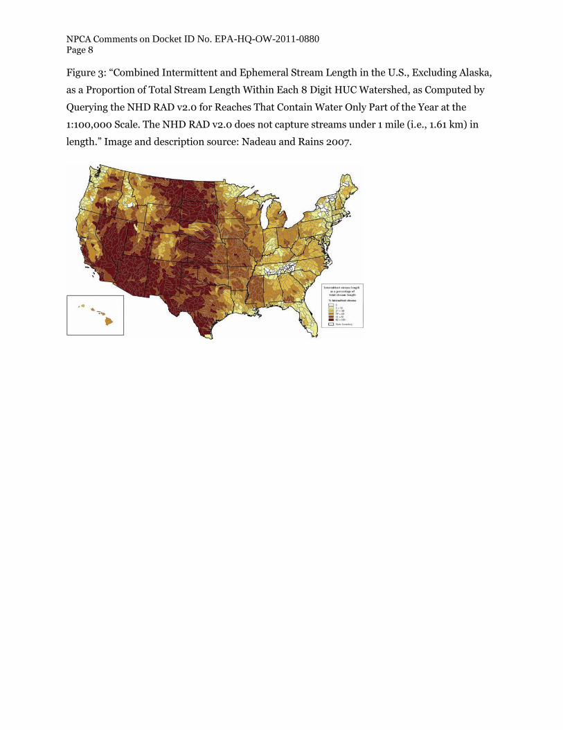
Figure 3: “Combined Intermittent and Ephemeral Stream Length in the U.S., Excluding Alaska,
as a Proportion of Total Stream Length Within Each 8 Digit HUC Watershed, as Computed by
Querying the NHD RAD v2.0 for Reaches That Contain Water Only Part of the Year at the
1:100,000 Scale. The NHD RAD v2.0 does not capture streams under 1 mile (i.e., 1.61 km) in
length.” Image and description source: Nadeau and Rains 2007.

NPCA Comments on Docket ID No. EPA-HQ-OW-2011-0880 Page 9
Bibliography
Alexander, R. B., E. W. Boyer, R. A. Smith, G. E. Schwarz, and R. B. Moore. 2007. “The role of headwater streams in downstream water quality.” Journal of the American Water Resources Association 43:41−59.
Beedle Jennifer. 2008. Paddle Tourism Study. North Carolina State Trails Program.
Beeri, O., and Phillips, R. L. 2007. “Tracking palustrine water seasonal and annual variability in agricultural wetland landscapes using Landsat from 1997 to 2005.” Global Change Biology, 13(4), 897-912.
Big Hole Watershed Committee. 2012. “Big Hole River, Montana Watershed Restoration Plan: Part 1. Divide, Montana.” bhwc.org. Found at: bigholewatershed.files.wordpress.com/2011/08/wrp-i-upper-big-hole_final.pdf
Cai, M., Schwartz, J. S., Robinson, R. B., Moore, S. E., & Kulp, M. A. 2010. “Long-term effects of acidic deposition on water quality in a high-elevation Great Smoky Mountains National Park Watershed: use of an ion input–output budget.” Water, Air, & Soil Pollution, 209(1-4), 143-156.Clarke, A., R. MacNally, N. Bond, and P. S. Lake. 2008. Macroinvertebrate diversity in headwater streams: a review. Freshwater Biology 53:1707−1721.
Cappiella, K., and L. Fraley-McNeal. 2007. “The Importance of Protecting Vulnerable Streams and Wetlands at the Local Level.” Center for Watershed Protection.
Carruthers, T. J., Beckert, K., Schupp, C. A., .... 2013. “Improving Management of a Mid-Atlantic Coastal Barrier Island Through Assessment of Habitat Condition.” Estuarine, Coastal and Shelf Science 116: 74-86.
Center for Watershed Protection. Cochran, M.J. March 2014. “Quarterly Report January 1–March 31: Demonstrating and Monitoring the Sustainable Management of Nutrients on C&H Farm in Big Creek Watershed.” University of Arkansas System Division of Agriculture.
Crawford, J. T., & Stanley, E. H. (2014). “Distinct Fluvial Patterns of a Headwater Stream Network Underlain by Discontinuous Permafrost.” Arctic, Antarctic, and Alpine Research, 46(2), 344-354.
Deyton, E. B., Schwartz, J. S., Robinson, R. B., Neff, K. J., Moore, S. E., & Kulp, M. A. (2009). “Characterizing episodic stream acidity during stormflows in the Great Smoky Mountains National Park.” Water, Air, and Soil Pollution 196(1-4), 3-18.
Dodds, W. K., and R. M. Oakes. 2008. “Headwater influences on downstream water quality.” Environmental Management 41:367−377.
ELI Project No. 0931-01. Washington, DC: Environmental Law Institute.
Environmental Law Institute. May 2013. “State Constraints: State-Imposed Limitations on the Authority of Agencies to Regulate Waters Beyond the Scope of the Federal Clean Water Act.” Washington, DC.
NPCA Comments on Docket ID No. EPA-HQ-OW-2011-0880 Page 10
EPA and USACE. March 2014. “Economic Analysis of Proposed Revised Definition of Waters of
the United States.” Washington, DC.
EPA. 2005. “Table 1: State-by-State NHD Analyses of Stream Categories and Drinking Water Data” (attachment to letter from EPA Assistant Administrator Benjamin H. Grumbles to Jeanne Christie, Executive Director, Association of State Wetland Managers), 9 January 2005. (Cited in Inglis, Van Heeke, Weissman, Hallock, and Rumpler. Waterways Restored: The Clean Water Act’s Impact on 15 American Rivers, Lakes and Bays.)
EPA. 2009. “Geographic Information Systems Analysis of the Surface Drinking Water Provided by Intermittent, Ephemeral and Headwater Streams in the U.S.” Data available here: http://water.epa.gov/lawsregs/guidance/wetlands/upload/wetlands_science_surface_drinking_water_surface_drinking_water_results_county.pdf
EPA. 2014. “303(d) Listed Impaired Waters NHDPlus Indexed Dataset with Program Attributes.” From the 303(d) Listed Impaired Waters National Geospatial Dataset. Released 4 August 2014. http://water.epa.gov/scitech/datait/tools/waters/data/downloads.cfm
Finn, D. S., N. Bonada, C. Murria, and J. M. Hughes. 2011. “Small but mighty: headwaters are vital to stream network biodiversity at two levels of organization.” Journal of the North American Benthological Society 30:963−980.
Gomi, T., R. C. Sidle, and J. S. Richardson. 2002. “Understanding processes and downstream linkages of headwater systems.” Bioscience 52:905−916.
Kaval, P., and J. Loomis. 2003. “Updated Outdoor Recreation Use Values with Emphasis on National Park Recreation.” Prepared for National Park Service.
Leibowitz, S.G., P. J. Wigington, M.C. Rains, and D. M. Downing. 2008. “Non-navigable streams and adjacent wetlands: addressing science needs following the Supreme Court's Rapanos decision.” Frontiers in Ecology and the Environment 6: 364–371.
Levick, L., J. Fonseca, D. Goodrich, M. Hernandez, D. Semmens, J. Stromberg, R. Leidy, M. Scianni, D. P. Guertin, M. Tluczek, and W. Kepner. 2008. “The Ecological and Hydrological Significance of Ephemeral and Intermittent Streams in the Arid and Semi-arid American Southwest.” U.S. Environmental Protection Agency and USDA/ARS Southwest Watershed Research Center, EPA/600/R-08/134, ARS/233046, 116 pp.
Loehman, R. 2009. “Understanding the science of climate change: Talking points - impacts to prairie potholes and grasslands.” Natural Resource Report NPS/NRPC/NRR—2009/138. National Park Service, Fort Collins, Colorado.
Lowe, W. H., and G. E. Likens. 2005. “Moving headwater streams to the head of the class.” Bioscience 55:196−197.
Mallin, M. A., & McIver, M. R. 2012. “Pollutant impacts to Cape Hatteras National Seashore from urban runoff and septic leachate.” Marine Pollution Bulletin 64(7): 1356-1366.
Margriter, S. C., Bruland, G. L., Kudray, G. M., & Lepczyk, C. A. 2014. “Using indicators of land-use development intensity to assess the condition of coastal wetlands in Hawai ‘i.” Landscape Ecology, 29(3), 517-528.

NPCA Comments on Docket ID No. EPA-HQ-OW-2011-0880 Page 11
Meyer, J. L., Kaplan, L.A., Newbold, D., Strayer, D. L., Woltemade, C. J., Zedler, J. B., Beilfuss,
R., Carpenter, Q., Semlitsch, R., Watzin, M.C., and P. H. Zedler. 2003. “Where Rivers are Born: The Scientific Imperative for Defending Small Streams and Wetlands.” American Rivers and the Sierra Club. Washington, DC.
Meyer, J. L., D. L. Strayer, J. B. W., S. L. Eggert, G. S. Helfman, and N. E. Leonard. 2007. “The Contribution of Headwater Streams to Biodiversity in River Networks.” Journal of the American Water Resources Association 43:86−103.
Miller, R. L., B. F. McPherson, R. Sobczak, and C. Clark. 2004. “Water Quality in Big Cypress National Preserve and Everglades National Park: Trends and Spatial Characteristics of Selected Constituents.” U.S. Geological Survey Water Resources Investigations Report 03-4249, 34 p.
Nadeau, T., and Rains, M.C. 2007. “Hydrological Connectivity Between Headwater Streams and Downstream Waters: How Science Can Inform Policy.” Journal of American Water Resources Association. 43:1.
NCDWQ (North Carolina Division of Water Quality). 2010. “Methodology for Identification of Intermittent and Perennial Streams and their Origins.” Version 4.11.
NPCA. 2006. “State of the Parks: Biscayne National Park: A Resource Assessment.” Center for Park Research. Washington, DC.
NPCA. 2010a. “Glacier Field Report: Historic Victory for Glacier, North Fork.” NPCA Northern Rockies Region Field Office.
NPCA. 2010b. “Climate Change & National Park Wildlife: A Survival Guide for a Warming World.” National Parks Conservation Association.
NPCA. 2011. “The State of America’s National Parks.” Center for Park Research. Washington, DC.
NPS. 2013a. “Annual Park Ranking Report for Recreation Visitors in 2013.” Web. https://irma.nps.gov/Stats/SSRSReports/National%20Reports/Annual%20Park%20Ranking%20Report%20%281979%20-%20Last%20Calendar%20Year%29
NPS. 2013b. “State of the Park Report for Big Hole National Battlefield.” State of the Park Series No. 1. National Park Service, Washington, D.C. http://www.nps.gov/stateoftheparks/biho/naturalresources/waterquality.cfm
NPS. 2013. “2012 National Park Visitor Spending Effects: Economic Contributions to Local Communities, States, and the Nation.” Prepared by Thomas, C., C. Huber, and L. Koontz. Natural Resource Report NPS/NRSS/EQD/NRR—2014/765.
NPS. 2014. “National Park Service Hydrographic and Impairment Statistics Database.” http://nature.nps.gov/water/HIS/index.cfm
Peterson, B., Wollheim, W., Mulholland, P., Webster, J., Meyer, J., and .... 2001. “Control of Nitrogen Export from Watersheds by Headwater Streams.” Science. 292: 86-89.

NPCA Comments on Docket ID No. EPA-HQ-OW-2011-0880 Page 12
Pringle, C. 2000. “Threats to U.S. Public Lands from Cumulative Hydrologic Alterations
Outside of Their Boundaries.” Ecological Applications. 10(4): 978-979.
Rothenberger, P., Blondeau, J., Cox, C., Curtis, S., Fisher, W., Garrison, V., ... & Waddell, J. 2008. “The state of coral reef ecosystems of the US Virgin Islands.” In Waddell, JE and AM Clarke (eds). 387-417.
Ruttenberg, B. I., & Granek, E. F. 2011. “Bridging the Marine-Terrestrial Disconnect to Improve Marine Coastal Zone Science and Management.” Marine Ecology Progress Series 434: 203-212.
Schramm, A and R. Loehman. 2010. “Understanding the science of climate change: talking points - impacts to the Great Lakes.” Natural Resource Report NPS/NRPC/CCRP/NRR—2010/247. National Park Service, Fort Collins, Colorado.
Surratt, D., Shinde, D., & Aumen, N. 2012. “Recent cattail expansion and possible relationships to water management: changes in Upper Taylor Slough” (Everglades National Park, Florida, USA). Environmental management, 49(3), 720-733.
Thieler, E. R., Williams, S. J., & Beavers, R. 2002. “Vulnerability of US National Parks to sea-level rise and coastal change.” U.S. Geological Survey.
U.S. Bureau of Reclamation. April 2011. “SECURE Water Act Section 9503(c) – reclamation climate Change and Water.” Report to United States Congress.