National Mission on Himalayan Studies (NMHS)
102
NMHS Fellowship Grant Progress Page 1 of 23 National Mission on Himalayan Studies (NMHS) HIMALAYAN RESEARCH FELLOWSHIP [Reporting Period: from May 2019 to March 2020] Kindly fill the NMHS Fellowship Annual Progress Report segregated into the following 7 segments, as applicable to the NMHS Fellowship nature and outcomes. 1. Fellowship Grant Information and Other Details 2. Fellowship Description at Himalayan Research Associates (H-RAs) Level 3. Fellowship Description at Himalayan Junior Research Associates (H-JRFs) Level 4. Fellowship Description at Institutional/ University Level 5. Fellowship Concluding Remarks/ Annual Summary 6. Specific Research Question(s) Addressed with Succinct Answer(s) 7. Any other information Please let us know in case of any query at: nmhs [email protected] NMHS-Fellowship Annual Progress Report (APR) 1. Fellowship Grant Information and Other Details NMHS Fellowship Grant ID: GBPNI/NMHS-2018-19/HSF31-09 Name of the Institution/ University: IIT Roorkee No. of Himalayan Research/Project Associates: 00 No. of Himalayan Junior Research/Project Fellows: 01 2. Fellowship Description at H-RA Level Himalayan Research Associates (H-RAs) H-RAs Profile Description: Not Applicable S. No. Name of RA Date of Joining Research Title Name of the PI and Designation Qualification 1. ….
-
Upload
khangminh22 -
Category
Documents
-
view
0 -
download
0
Transcript of National Mission on Himalayan Studies (NMHS)
NMHS Fellowship Grant Progress Page 1 of 23
National Mission on Himalayan Studies (NMHS) HIMALAYAN RESEARCH FELLOWSHIP
[Reporting Period: from May 2019 to March 2020] Kindly fill the NMHS Fellowship Annual Progress Report segregated into the following 7 segments, as applicable to the NMHS Fellowship nature and outcomes.
1. Fellowship Grant Information and Other Details
2. Fellowship Description at Himalayan Research Associates (H-RAs) Level
3. Fellowship Description at Himalayan Junior Research Associates (H-JRFs) Level
4. Fellowship Description at Institutional/ University Level 5. Fellowship Concluding Remarks/ Annual Summary
6. Specific Research Question(s) Addressed with Succinct Answer(s) 7. Any other information
Please let us know in case of any query at: nmhs
NMHS-Fellowship Annual Progress Report (APR)
1. Fellowship Grant Information and Other Details
NMHS Fellowship Grant ID: GBPNI/NMHS-2018-19/HSF31-09
Name of the Institution/ University: IIT Roorkee
No. of Himalayan Research/Project Associates: 00
No. of Himalayan Junior Research/Project Fellows: 01
2. Fellowship Description at H-RA Level
Himalayan Research Associates (H-RAs)
H-RAs Profile Description: Not Applicable
S. No. Name of RA Date of Joining Research Title Name of the PI and Designation Qualification
1. ….

NMHS Fellowship Grant Progress Page 2 of 23
Progress Brief (to be filled for each H-RA in separate row):
RA No. Research Objective(s) Addressed Deliverables Achievements Research/
Experimental Work*
1. • ... •
• •
[Enclose descriptive file – max. 250 words]
*Experimental work giving full details (in separate sheet, within 300 words) of experimental set up, methods adopted, data collected supported by necessary table, charts, diagrams & photographs. Note: Data, table and figures may be attached as separate source file (.docx, .xls, jpg, .jpeg, .png, .shp, etc. ).
3. Fellowship Description at H-JRF Level
Himalayan Junior Research Project Fellows (H-JRFs)
H-JRFs Profile Description: S. No. Name of JRF Date of Joining Name of the PI Qualification
1. Rajeev Ranjan 16/05/2019 Prof. Ajanta Goswami B. Tech GeoTechnology (Bharthidasan University) M.Sc.Geoinformatics(IIITMK) Ph.D. (Persuing at IIT Roorkee)
Progress Brief (to be filled for each JRF in separate row):
JRF No.
Research Objectives Deliverable Achievements Research/ Experimental Work*
1. • Comparative analysis of pre-existing hydrological models for snow and glacier melt runoff assessment
• Improvement of snow and glacier melt modelling approaches by introducing water balance characteristics
• Understanding the future climatic variability and its impacts on snow and glacier runoff on Himalayan region
• Assessing the current and future national adaptation strategies and their relevance to community level
• Selection of best hydrological models for runoff modelling in the Himalayan region
• An Improved of snow and glacier melt runoff model developed to calculate the basin runoff with more accuracy in Himalayan region
• Develop understanding about the future climatic variability and its impacts on snow and glacier runoff
• Providing relevant snow and glacier melt information to the policy maker for possible adaptation programme in future
• Review of pre-existing runoff modelling approach done
• Data collection and analysis of runoff model
• Data collection and analysis of climate data
[Enclose descriptive file – max. 250 words]
*Experimental work giving full details (in separate sheet, within 300 words) of experimental set up, methods adopted, data collected supported by necessary table, charts, diagrams & photographs. Note: Data, table and figures may be attached as separate source file (.docx, .xls, jpg, .jpeg, .png, .shp, etc. ).
NMHS Fellowship Grant Progress Page 3 of 23
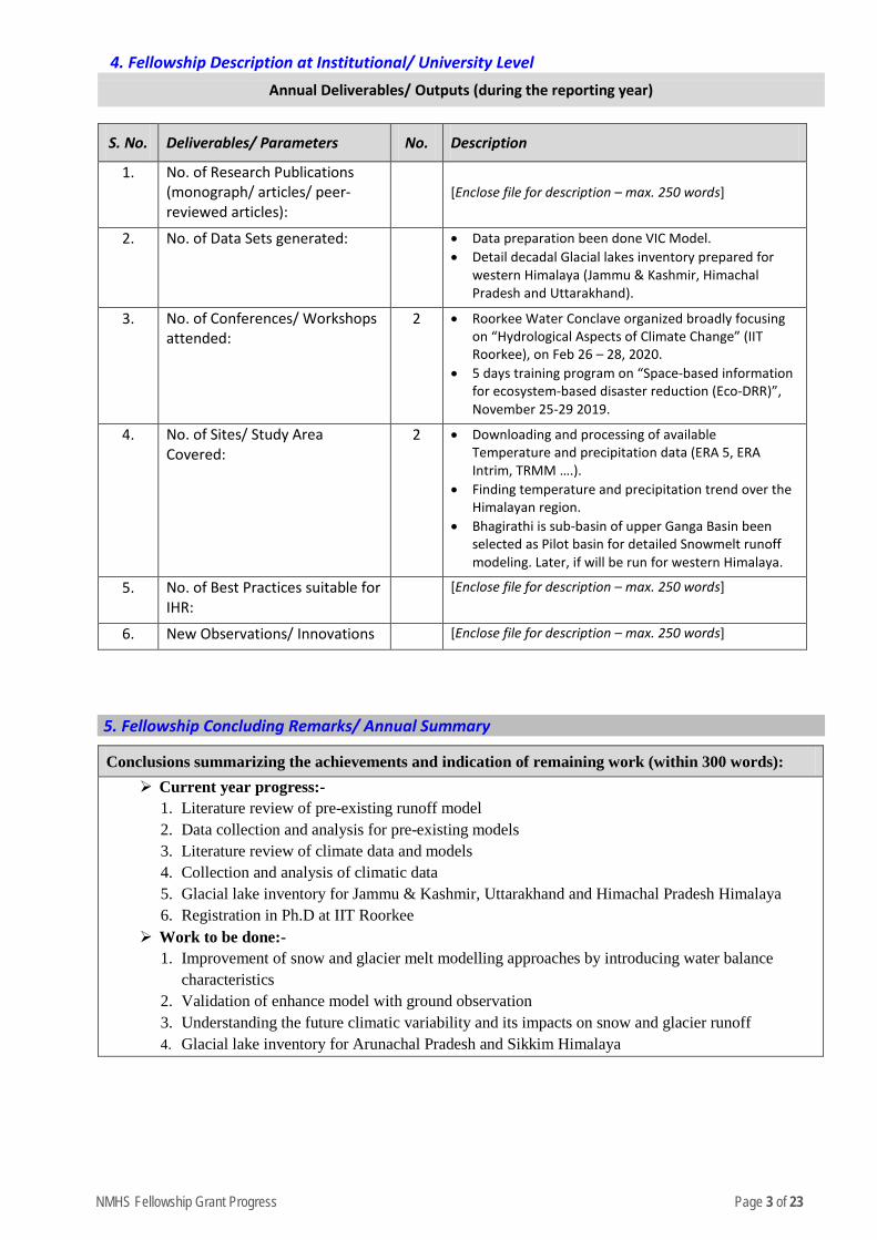
4. Fellowship Description at Institutional/ University Level
Annual Deliverables/ Outputs (during the reporting year)
S. No. Deliverables/ Parameters No. Description
1. No. of Research Publications (monograph/ articles/ peer-reviewed articles):
[Enclose file for description – max. 250 words]
2. No. of Data Sets generated: • Data preparation been done VIC Model. • Detail decadal Glacial lakes inventory prepared for
western Himalaya (Jammu & Kashmir, Himachal Pradesh and Uttarakhand).
3. No. of Conferences/ Workshops attended:
2 • Roorkee Water Conclave organized broadly focusing on “Hydrological Aspects of Climate Change” (IIT Roorkee), on Feb 26 – 28, 2020.
• 5 days training program on “Space-based information for ecosystem-based disaster reduction (Eco-DRR)”, November 25-29 2019.
4. No. of Sites/ Study Area Covered:
2 • Downloading and processing of available Temperature and precipitation data (ERA 5, ERA Intrim, TRMM ….).
• Finding temperature and precipitation trend over the Himalayan region.
• Bhagirathi is sub-basin of upper Ganga Basin been selected as Pilot basin for detailed Snowmelt runoff modeling. Later, if will be run for western Himalaya.
5. No. of Best Practices suitable for IHR:
[Enclose file for description – max. 250 words]
6. New Observations/ Innovations [Enclose file for description – max. 250 words]
5. Fellowship Concluding Remarks/ Annual Summary
Conclusions summarizing the achievements and indication of remaining work (within 300 words): Current year progress:-
1. Literature review of pre-existing runoff model 2. Data collection and analysis for pre-existing models 3. Literature review of climate data and models 4. Collection and analysis of climatic data 5. Glacial lake inventory for Jammu & Kashmir, Uttarakhand and Himachal Pradesh Himalaya 6. Registration in Ph.D at IIT Roorkee
Work to be done:- 1. Improvement of snow and glacier melt modelling approaches by introducing water balance
characteristics 2. Validation of enhance model with ground observation 3. Understanding the future climatic variability and its impacts on snow and glacier runoff 4. Glacial lake inventory for Arunachal Pradesh and Sikkim Himalaya

NMHS Fellowship Grant Progress Page 4 of 23
6. Specific Research Question(s) Addressed with Succinct Answer(s)
S. No. Research Questions Addressed Succinct Answers (within 150-200 words)
1.
7. Any Other Information • Detailed Annexures Attached
Signature of PI
IIT Roorkee
Report (hard copy) should be submitted to:
The Nodal Officer, NMHS-PMU National Mission on Himalayan Studies (NMHS) गो�वद बल्लभ पंत रा�ीय िहमालयी पयार्वरण एवं सतत ्िवकास ससं्थान G.B. Pant National Institute of Himalayan Environment and Sustainable Development (GBPNIHESD) Kosi-Katarmal, Almora 263643, Uttarakhand
Report (soft copy) should be submitted to:
E-mail: [email protected]
NMHS Fellowship Grant Progress Page 5 of 23
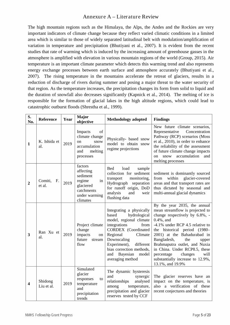
Annexure A – Literature Review
The high mountain regions such as the Himalaya, the Alps, the Andes and the Rockies are very important indicators of climate change because they reflect varied climatic conditions in a limited area which is similar to those of widely separated latitudinal belt with modulation/amplification of variation in temperature and precipitation (Bhutiyani et al., 2007). It is evident from the recent studies that rate of warming which is induced by the increasing amount of greenhouse gasses in the atmosphere is amplified with elevation in various mountain regions of the world (Group, 2015). Air temperature is an important climate parameter which detects this warming trend and also represents energy exchange processes between earth surface and atmosphere accurately (Bhutiyani et al., 2007). The rising temperature in the mountains accelerate the retreat of glaciers, results in a reduction of discharge of rivers during summer and posing a major threat to the water security of that region. As the temperature increases, the precipitation changes its form from solid to liquid and the duration of snowfall also decreases significantly (Kapnick et al., 2014). The melting of ice is responsible for the formation of glacial lakes in the high altitude regions, which could lead to catastrophic outburst floods (Shrestha et al., 1999).
S. No. Reference Year Major
objective Methodology adopted Findings
1 K. Ishida et al. 2019
Impacts of climate change on snow accumulation and melting processes
Physically- based snow model to obtain snow regime projections
New future climate scenarios, Representative Concentration Pathway (RCP) scenarios (Moss et al., 2010), in order to enhance the reliability of the assessment of future climate change impacts on snow accumulation and melting processes
2 Comiti, F. et al. 2019
factors affecting sediment regime in glaciered catchments under warming climates
Bed load sample collection for sediment transport monitoring, Hydrograph separation for runoff origin, DoD analysis and weir flushing data
sediment is dominantly sourced from within glacier-covered areas and that transport rates are thus dictated by seasonal and multi-annual glacial dynamics
3 Ran Xu et al. 2019
Project climate change impacts on future stream flow
Integrating a physically based hydrological model, regional climate integrations from CORDEX (Coordinated Regional Climate Downscaling Experiment), different bias correction methods, and Bayesian model averaging method
By the year 2035, the annual mean streamflow is projected to change respectively by 6.8%, -0.4%, and -4.1% under RCP 4.5 relative to the historical period (1980–2001) at the Bahadurabad in Bangladesh, the upper Brahmaputra outlet, and Nuxia in China. Under RCP8.5, these percentage changes will substantially increase to 12.9%, 13.1%, and 19.9%
4 Shidong Liu et al. 2019
Simulated glacier responses to temperature and precipitation trends
The dynamic hysteresis and synergic relationships analysed among temperature, precipitation and glacier reserves tested by CCF
The glacier reserves have an impact on the temperature, is also a verification of these recent conjectures and theories
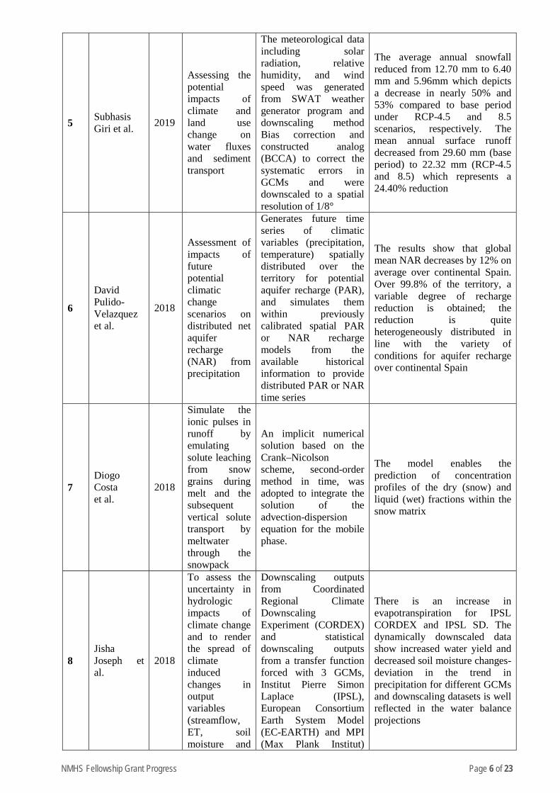
NMHS Fellowship Grant Progress Page 6 of 23
5 Subhasis Giri et al. 2019
Assessing the potential impacts of climate and land use change on water fluxes and sediment transport
The meteorological data including solar radiation, relative humidity, and wind speed was generated from SWAT weather generator program and downscaling method Bias correction and constructed analog (BCCA) to correct the systematic errors in GCMs and were downscaled to a spatial resolution of 1/8°
The average annual snowfall reduced from 12.70 mm to 6.40 mm and 5.96mm which depicts a decrease in nearly 50% and 53% compared to base period under RCP-4.5 and 8.5 scenarios, respectively. The mean annual surface runoff decreased from 29.60 mm (base period) to 22.32 mm (RCP-4.5 and 8.5) which represents a 24.40% reduction
6
David Pulido-Velazquez et al.
2018
Assessment of impacts of future potential climatic change scenarios on distributed net aquifer recharge (NAR) from precipitation
Generates future time series of climatic variables (precipitation, temperature) spatially distributed over the territory for potential aquifer recharge (PAR), and simulates them within previously calibrated spatial PAR or NAR recharge models from the available historical information to provide distributed PAR or NAR time series
The results show that global mean NAR decreases by 12% on average over continental Spain. Over 99.8% of the territory, a variable degree of recharge reduction is obtained; the reduction is quite heterogeneously distributed in line with the variety of conditions for aquifer recharge over continental Spain
7 Diogo Costa et al.
2018
Simulate the ionic pulses in runoff by emulating solute leaching from snow grains during melt and the subsequent vertical solute transport by meltwater through the snowpack
An implicit numerical solution based on the Crank–Nicolson scheme, second-order method in time, was adopted to integrate the solution of the advection-dispersion equation for the mobile phase.
The model enables the prediction of concentration profiles of the dry (snow) and liquid (wet) fractions within the snow matrix
8 Jisha Joseph et al.
2018
To assess the uncertainty in hydrologic impacts of climate change and to render the spread of climate induced changes in output variables (streamflow, ET, soil moisture and
Downscaling outputs from Coordinated Regional Climate Downscaling Experiment (CORDEX) and statistical downscaling outputs from a transfer function forced with 3 GCMs, Institut Pierre Simon Laplace (IPSL), European Consortium Earth System Model (EC-EARTH) and MPI (Max Plank Institut)
There is an increase in evapotranspiration for IPSL CORDEX and IPSL SD. The dynamically downscaled data show increased water yield and decreased soil moisture changes-deviation in the trend in precipitation for different GCMs and downscaling datasets is well reflected in the water balance projections
NMHS Fellowship Grant Progress Page 7 of 23
water yield) from all the possible values of the uncertain parameters in VIC model
ESM (Earth System Model). Monte-Carlo Simulations (MCS) are performed with 1000 generated sets of sensitive model parameters for each of the GCM-regional model combination
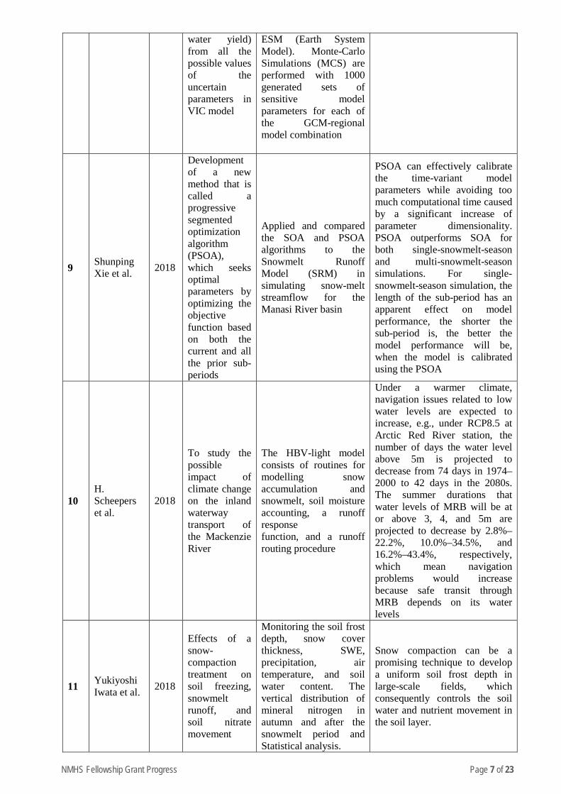
9 Shunping Xie et al. 2018
Development of a new method that is called a progressive segmented optimization algorithm (PSOA), which seeks optimal parameters by optimizing the objective function based on both the current and all the prior sub-periods
Applied and compared the SOA and PSOA algorithms to the Snowmelt Runoff Model (SRM) in simulating snow-melt streamflow for the Manasi River basin
PSOA can effectively calibrate the time-variant model parameters while avoiding too much computational time caused by a significant increase of parameter dimensionality. PSOA outperforms SOA for both single-snowmelt-season and multi-snowmelt-season simulations. For single-snowmelt-season simulation, the length of the sub-period has an apparent effect on model performance, the shorter the sub-period is, the better the model performance will be, when the model is calibrated using the PSOA
10 H. Scheepers et al.
2018
To study the possible impact of climate change on the inland waterway transport of the Mackenzie River
The HBV-light model consists of routines for modelling snow accumulation and snowmelt, soil moisture accounting, a runoff response function, and a runoff routing procedure
Under a warmer climate, navigation issues related to low water levels are expected to increase, e.g., under RCP8.5 at Arctic Red River station, the number of days the water level above 5m is projected to decrease from 74 days in 1974–2000 to 42 days in the 2080s. The summer durations that water levels of MRB will be at or above 3, 4, and 5m are projected to decrease by 2.8%–22.2%, 10.0%–34.5%, and 16.2%–43.4%, respectively, which mean navigation problems would increase because safe transit through MRB depends on its water levels
11 Yukiyoshi Iwata et al. 2018
Effects of a snow-compaction treatment on soil freezing, snowmelt runoff, and soil nitrate movement
Monitoring the soil frost depth, snow cover thickness, SWE, precipitation, air temperature, and soil water content. The vertical distribution of mineral nitrogen in autumn and after the snowmelt period and Statistical analysis.
Snow compaction can be a promising technique to develop a uniform soil frost depth in large-scale fields, which consequently controls the soil water and nutrient movement in the soil layer.
NMHS Fellowship Grant Progress Page 8 of 23
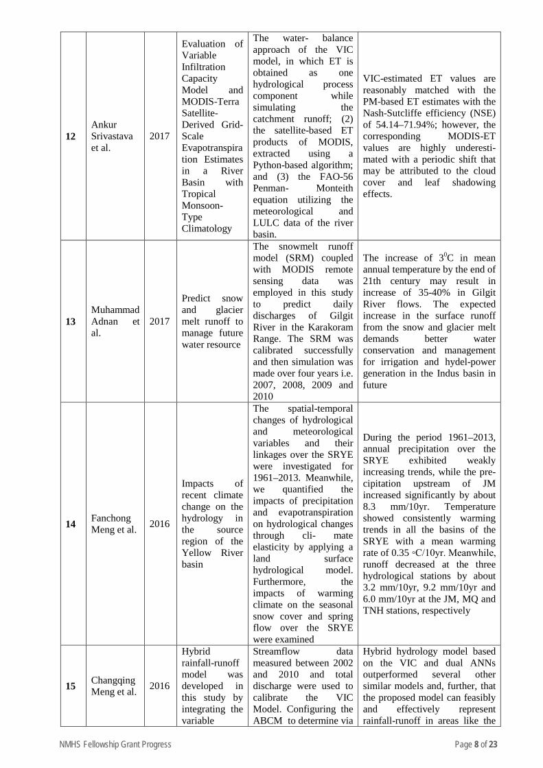
12 Ankur Srivastava et al.
2017
Evaluation of Variable Infiltration Capacity Model and MODIS-Terra Satellite-Derived Grid-Scale Evapotranspiration Estimates in a River Basin with Tropical Monsoon-Type Climatology
The water- balance approach of the VIC model, in which ET is obtained as one hydrological process component while simulating the catchment runoff; (2) the satellite-based ET products of MODIS, extracted using a Python-based algorithm; and (3) the FAO-56 Penman- Monteith equation utilizing the meteorological and LULC data of the river basin.
VIC-estimated ET values are reasonably matched with the PM-based ET estimates with the Nash-Sutcliffe efficiency (NSE) of 54.14–71.94%; however, the corresponding MODIS-ET values are highly underesti- mated with a periodic shift that may be attributed to the cloud cover and leaf shadowing effects.
13 Muhammad Adnan et al.
2017
Predict snow and glacier melt runoff to manage future water resource
The snowmelt runoff model (SRM) coupled with MODIS remote sensing data was employed in this study to predict daily discharges of Gilgit River in the Karakoram Range. The SRM was calibrated successfully and then simulation was made over four years i.e. 2007, 2008, 2009 and 2010
The increase of 30C in mean annual temperature by the end of 21th century may result in increase of 35-40% in Gilgit River flows. The expected increase in the surface runoff from the snow and glacier melt demands better water conservation and management for irrigation and hydel-power generation in the Indus basin in future
14 Fanchong Meng et al. 2016
Impacts of recent climate change on the hydrology in the source region of the Yellow River basin
The spatial-temporal changes of hydrological and meteorological variables and their linkages over the SRYE were investigated for 1961–2013. Meanwhile, we quantified the impacts of precipitation and evapotranspiration on hydrological changes through cli- mate elasticity by applying a land surface hydrological model. Furthermore, the impacts of warming climate on the seasonal snow cover and spring flow over the SRYE were examined
During the period 1961–2013, annual precipitation over the SRYE exhibited weakly increasing trends, while the pre- cipitation upstream of JM increased significantly by about 8.3 mm/10yr. Temperature showed consistently warming trends in all the basins of the SRYE with a mean warming rate of 0.35 ◦C/10yr. Meanwhile, runoff decreased at the three hydrological stations by about 3.2 mm/10yr, 9.2 mm/10yr and 6.0 mm/10yr at the JM, MQ and TNH stations, respectively
15 Changqing Meng et al. 2016
Hybrid rainfall-runoff model was developed in this study by integrating the variable
Streamflow data measured between 2002 and 2010 and total discharge were used to calibrate the VIC Model. Configuring the ABCM to determine via
Hybrid hydrology model based on the VIC and dual ANNs outperformed several other similar models and, further, that the proposed model can feasibly and effectively represent rainfall-runoff in areas like the
NMHS Fellowship Grant Progress Page 9 of 23
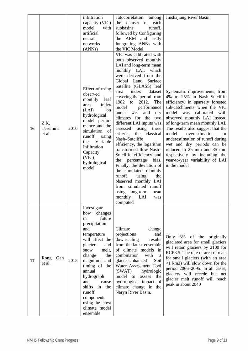
infiltration capacity (VIC) model with artificial neural networks (ANNs)
autocorrelation among the dataset of each subbasins runoff, followed by Configuring the ARM and lastly Integrating ANNs with the VIC Model
Jinshajiang River Basin
16 Z.K. Tesemma et al.
2016
Effect of using observed monthly leaf area index (LAI) on hydrological model perfor- mance and the simulation of runoff using the Variable Infiltration Capacity (VIC) hydrological model
VIC was calibrated with both observed monthly LAI and long-term mean monthly LAI, which were derived from the Global Land Surface Satellite (GLASS) leaf area index dataset covering the period from 1982 to 2012. The model performance under wet and dry climates for the two different LAI inputs was assessed using three criteria, the classical Nash–Sutcliffe efficiency, the logarithm transformed flow Nash–Sutcliffe efficiency and the percentage bias. Finally, the deviation of the simulated monthly runoff using the observed monthly LAI from simulated runoff using long-term mean monthly LAI was computed
Systematic improvements, from 4% to 25% in Nash–Sutcliffe efficiency, in sparsely forested sub-catchments when the VIC model was calibrated with observed monthly LAI instead of long-term mean monthly LAI. The results also suggest that the model overestimation or underestimation of runoff during wet and dry periods can be reduced to 25 mm and 35 mm respectively by including the year-to-year variability of LAI in the model
17 Rong Gan et al. 2015
Investigate how changes in future precipitation and temperature will affect the glacier and snow melt, change the magnitude and timing of the annual hydrograph and cause shifts in the runoff components using the latest climate model ensemble
Climate change projections and downscaling results from the latest ensemble of climate models in combination with a glacier-enhanced Soil Water Assessment Tool (SWAT) hydrologic model to assess the hydrological impact of climate change in the Naryn River Basin.
Only 8% of the originally glaciated area for small glaciers will retain glaciers by 2100 for RCP8.5. The rate of area retreats for small glaciers (with an area <1 km2) will slow down for the period 2066–2095. In all cases, glaciers will recede but net glacier melt runoff will reach peak in about 2040
NMHS Fellowship Grant Progress Page 10 of 23
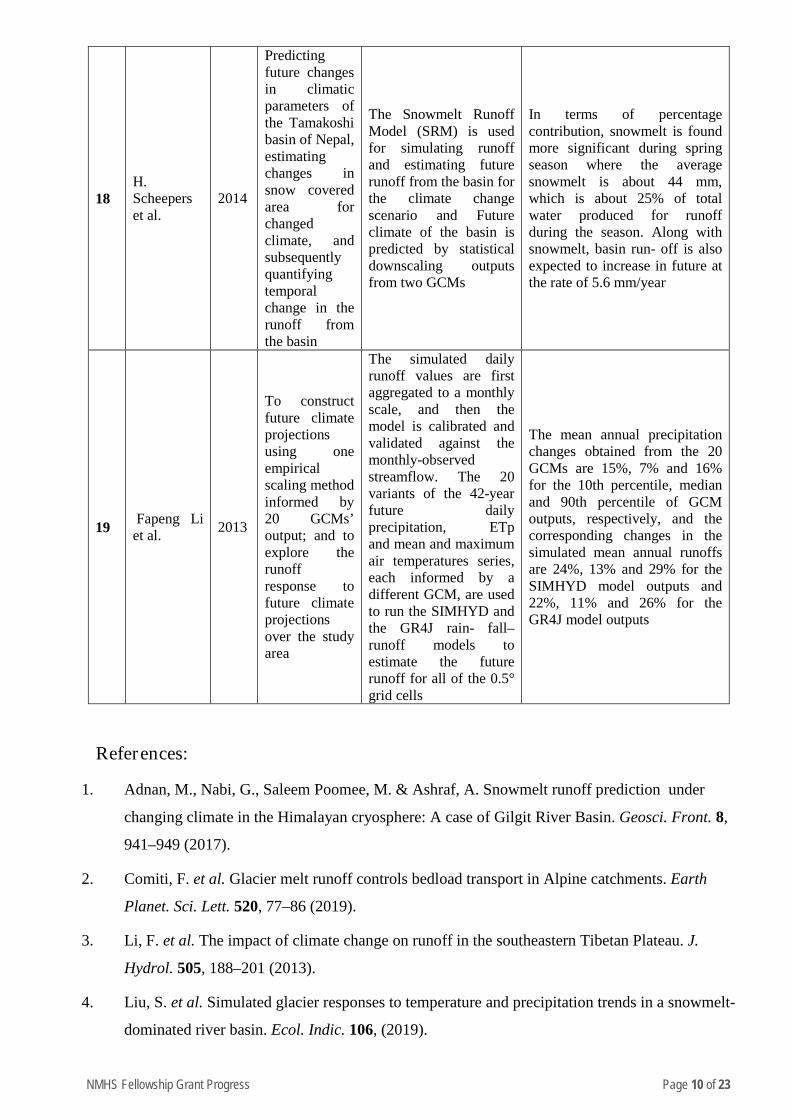
18 H. Scheepers et al.
2014
Predicting future changes in climatic parameters of the Tamakoshi basin of Nepal, estimating changes in snow covered area for changed climate, and subsequently quantifying temporal change in the runoff from the basin
The Snowmelt Runoff Model (SRM) is used for simulating runoff and estimating future runoff from the basin for the climate change scenario and Future climate of the basin is predicted by statistical downscaling outputs from two GCMs
In terms of percentage contribution, snowmelt is found more significant during spring season where the average snowmelt is about 44 mm, which is about 25% of total water produced for runoff during the season. Along with snowmelt, basin run- off is also expected to increase in future at the rate of 5.6 mm/year
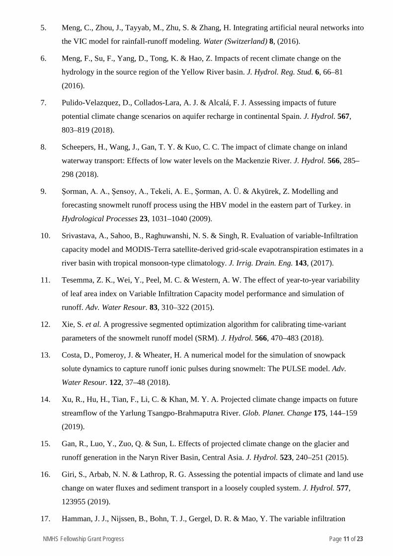
19 Fapeng Li et al. 2013
To construct future climate projections using one empirical scaling method informed by 20 GCMs’ output; and to explore the runoff response to future climate projections over the study area
The simulated daily runoff values are first aggregated to a monthly scale, and then the model is calibrated and validated against the monthly-observed streamflow. The 20 variants of the 42-year future daily precipitation, ETp and mean and maximum air temperatures series, each informed by a different GCM, are used to run the SIMHYD and the GR4J rain- fall–runoff models to estimate the future runoff for all of the 0.5° grid cells
The mean annual precipitation changes obtained from the 20 GCMs are 15%, 7% and 16% for the 10th percentile, median and 90th percentile of GCM outputs, respectively, and the corresponding changes in the simulated mean annual runoffs are 24%, 13% and 29% for the SIMHYD model outputs and 22%, 11% and 26% for the GR4J model outputs
References:
1. Adnan, M., Nabi, G., Saleem Poomee, M. & Ashraf, A. Snowmelt runoff prediction under
changing climate in the Himalayan cryosphere: A case of Gilgit River Basin. Geosci. Front. 8,
941–949 (2017).
2. Comiti, F. et al. Glacier melt runoff controls bedload transport in Alpine catchments. Earth
Planet. Sci. Lett. 520, 77–86 (2019).
3. Li, F. et al. The impact of climate change on runoff in the southeastern Tibetan Plateau. J.
Hydrol. 505, 188–201 (2013).
4. Liu, S. et al. Simulated glacier responses to temperature and precipitation trends in a snowmelt-
dominated river basin. Ecol. Indic. 106, (2019).
NMHS Fellowship Grant Progress Page 11 of 23
5. Meng, C., Zhou, J., Tayyab, M., Zhu, S. & Zhang, H. Integrating artificial neural networks into
the VIC model for rainfall-runoff modeling. Water (Switzerland) 8, (2016).
6. Meng, F., Su, F., Yang, D., Tong, K. & Hao, Z. Impacts of recent climate change on the
hydrology in the source region of the Yellow River basin. J. Hydrol. Reg. Stud. 6, 66–81
(2016).
7. Pulido-Velazquez, D., Collados-Lara, A. J. & Alcalá, F. J. Assessing impacts of future
potential climate change scenarios on aquifer recharge in continental Spain. J. Hydrol. 567,
803–819 (2018).
8. Scheepers, H., Wang, J., Gan, T. Y. & Kuo, C. C. The impact of climate change on inland
waterway transport: Effects of low water levels on the Mackenzie River. J. Hydrol. 566, 285–
298 (2018).
9. Şorman, A. A., Şensoy, A., Tekeli, A. E., Şorman, A. Ü. & Akyürek, Z. Modelling and
forecasting snowmelt runoff process using the HBV model in the eastern part of Turkey. in
Hydrological Processes 23, 1031–1040 (2009).
10. Srivastava, A., Sahoo, B., Raghuwanshi, N. S. & Singh, R. Evaluation of variable-Infiltration
capacity model and MODIS-Terra satellite-derived grid-scale evapotranspiration estimates in a
river basin with tropical monsoon-type climatology. J. Irrig. Drain. Eng. 143, (2017).
11. Tesemma, Z. K., Wei, Y., Peel, M. C. & Western, A. W. The effect of year-to-year variability
of leaf area index on Variable Infiltration Capacity model performance and simulation of
runoff. Adv. Water Resour. 83, 310–322 (2015).
12. Xie, S. et al. A progressive segmented optimization algorithm for calibrating time-variant
parameters of the snowmelt runoff model (SRM). J. Hydrol. 566, 470–483 (2018).
13. Costa, D., Pomeroy, J. & Wheater, H. A numerical model for the simulation of snowpack
solute dynamics to capture runoff ionic pulses during snowmelt: The PULSE model. Adv.
Water Resour. 122, 37–48 (2018).
14. Xu, R., Hu, H., Tian, F., Li, C. & Khan, M. Y. A. Projected climate change impacts on future
streamflow of the Yarlung Tsangpo-Brahmaputra River. Glob. Planet. Change 175, 144–159
(2019).
15. Gan, R., Luo, Y., Zuo, Q. & Sun, L. Effects of projected climate change on the glacier and
runoff generation in the Naryn River Basin, Central Asia. J. Hydrol. 523, 240–251 (2015).
16. Giri, S., Arbab, N. N. & Lathrop, R. G. Assessing the potential impacts of climate and land use
change on water fluxes and sediment transport in a loosely coupled system. J. Hydrol. 577,
123955 (2019).
17. Hamman, J. J., Nijssen, B., Bohn, T. J., Gergel, D. R. & Mao, Y. The variable infiltration
NMHS Fellowship Grant Progress Page 12 of 23
capacity model version 5 (VIC-5): Infrastructure improvements for new applications and
reproducibility. Geosci. Model Dev. 11, 3481–3496 (2018).
18. Ishida, K. et al. Impacts of climate change on snow accumulation and melting processes over
mountainous regions in Northern California during the 21st century. Sci. Total Environ. 685,
104–115 (2019).
19. Iwata, Y., Yanai, Y., Yazaki, T. & Hirota, T. Effects of a snow-compaction treatment on soil
freezing, snowmelt runoff, and soil nitrate movement: A field-scale paired-plot experiment. J.
Hydrol. 567, 280–289 (2018).
20. Joseph, J., Ghosh, S., Pathak, A. & Sahai, A. K. Hydrologic impacts of climate change:
Comparisons between hydrological parameter uncertainty and climate model uncertainty. J.
Hydrol. 566, 1–22 (2018).
21. Khadka, D., Babel, M. S., Shrestha, S. & Tripathi, N. K. Climate change impact on glacier and
snow melt and runoff in Tamakoshi basin in the Hindu Kush Himalayan (HKH) region. J.
Hydrol. 511, 49–60 (2014).
22. Vano et al. - 2018 - DOs and DON ’ Ts for using climate change information for water
resource planning and management guidelines for st.
NMHS Fellowship Grant Progress Page 13 of 23
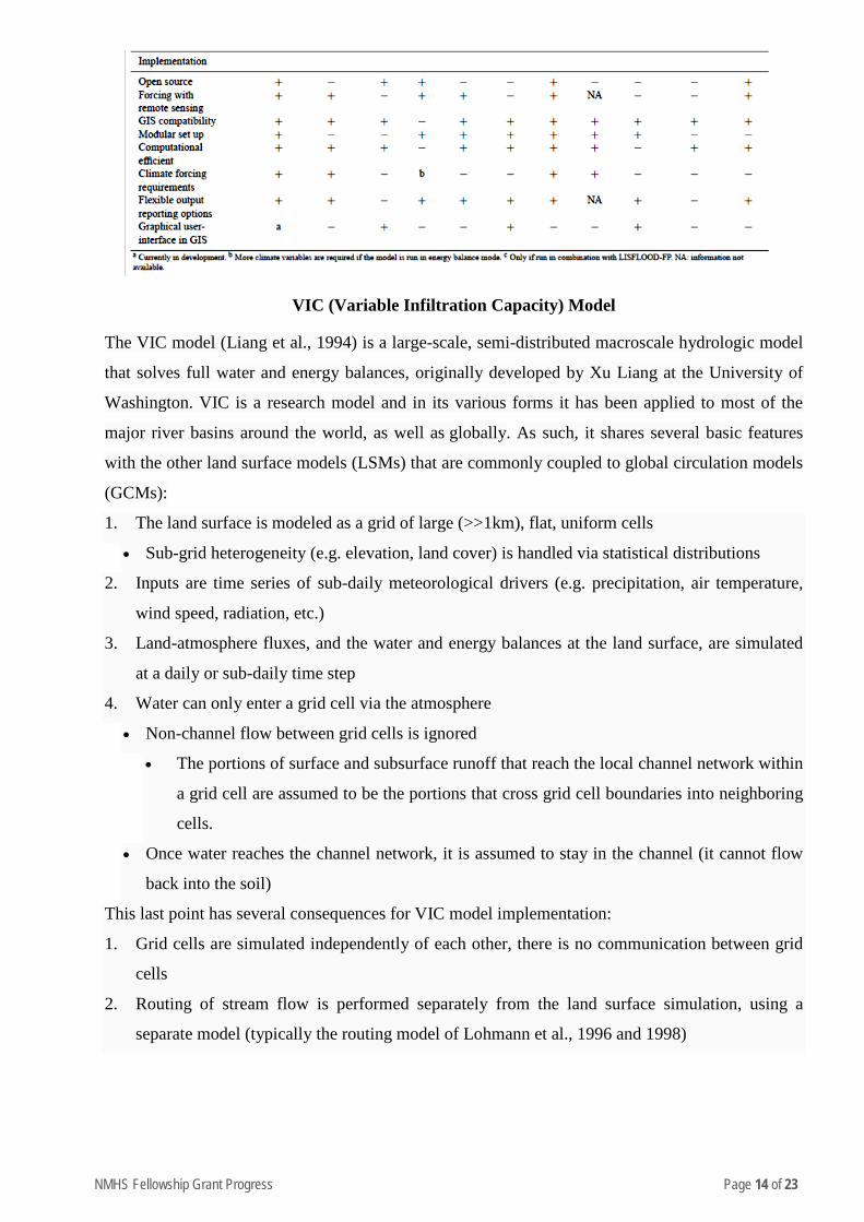
Annexure B – (Techniques/Model Utilized)
In response to these challenges, hydrologists and water resource specialists are developing
modeling tools to analyze, understand and explore solutions to support decision makers and
operational water managers (Pechlivanidis et al. 2011). The strength of hydrological models is that
they can provide output at high temporal and spatial resolutions, and for hydrological processes that
are difficult to observe on the large scale that they are generally applied on (Bastiaanssen et al.
2007). Models enable hydrologists and water managers to change focus from a re-active towards a
pro-active approach.
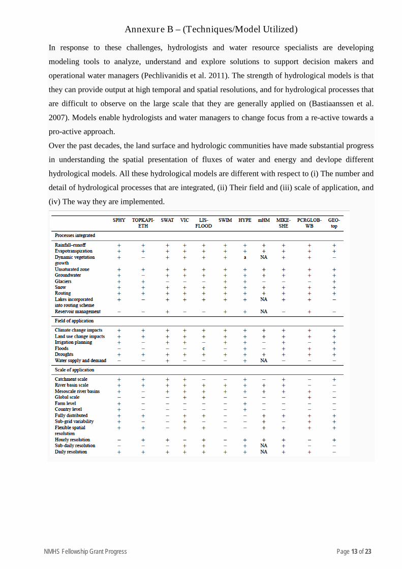
Over the past decades, the land surface and hydrologic communities have made substantial progress
in understanding the spatial presentation of fluxes of water and energy and devlope different
hydrological models. All these hydrological models are different with respect to (i) The number and
detail of hydrological processes that are integrated, (ii) Their field and (iii) scale of application, and
(iv) The way they are implemented.
NMHS Fellowship Grant Progress Page 14 of 23
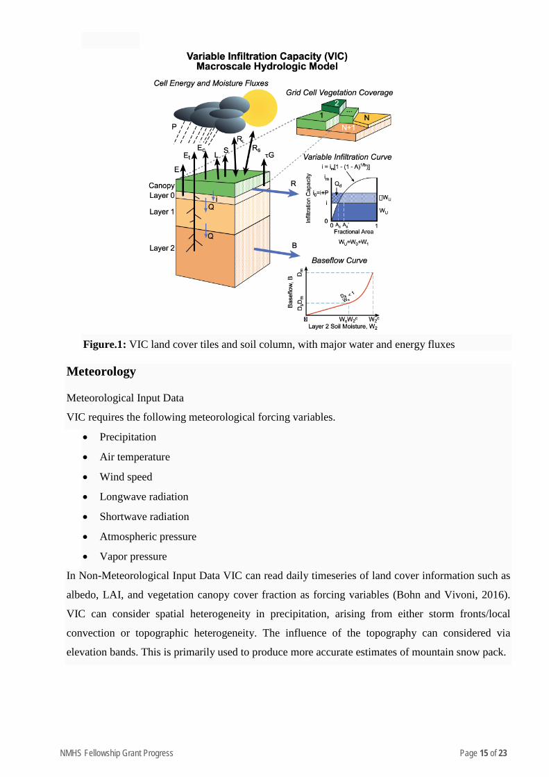
VIC (Variable Infiltration Capacity) Model
The VIC model (Liang et al., 1994) is a large-scale, semi-distributed macroscale hydrologic model
that solves full water and energy balances, originally developed by Xu Liang at the University of
Washington. VIC is a research model and in its various forms it has been applied to most of the
major river basins around the world, as well as globally. As such, it shares several basic features
with the other land surface models (LSMs) that are commonly coupled to global circulation models
(GCMs):
1. The land surface is modeled as a grid of large (>>1km), flat, uniform cells
• Sub-grid heterogeneity (e.g. elevation, land cover) is handled via statistical distributions
2. Inputs are time series of sub-daily meteorological drivers (e.g. precipitation, air temperature,
wind speed, radiation, etc.)
3. Land-atmosphere fluxes, and the water and energy balances at the land surface, are simulated
at a daily or sub-daily time step
4. Water can only enter a grid cell via the atmosphere
• Non-channel flow between grid cells is ignored
• The portions of surface and subsurface runoff that reach the local channel network within
a grid cell are assumed to be the portions that cross grid cell boundaries into neighboring
cells.
• Once water reaches the channel network, it is assumed to stay in the channel (it cannot flow
back into the soil)
This last point has several consequences for VIC model implementation:
1. Grid cells are simulated independently of each other, there is no communication between grid
cells
2. Routing of stream flow is performed separately from the land surface simulation, using a
separate model (typically the routing model of Lohmann et al., 1996 and 1998)
NMHS Fellowship Grant Progress Page 15 of 23
Figure.1: VIC land cover tiles and soil column, with major water and energy fluxes
Meteorology
Meteorological Input Data
VIC requires the following meteorological forcing variables.
• Precipitation
• Air temperature
• Wind speed
• Longwave radiation
• Shortwave radiation
• Atmospheric pressure
• Vapor pressure
In Non-Meteorological Input Data VIC can read daily timeseries of land cover information such as
albedo, LAI, and vegetation canopy cover fraction as forcing variables (Bohn and Vivoni, 2016).
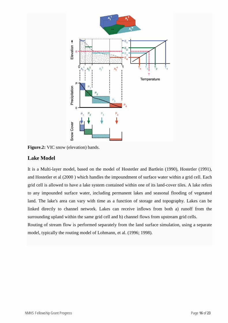
VIC can consider spatial heterogeneity in precipitation, arising from either storm fronts/local
convection or topographic heterogeneity. The influence of the topography can considered via
elevation bands. This is primarily used to produce more accurate estimates of mountain snow pack.
NMHS Fellowship Grant Progress Page 16 of 23
Figure.2: VIC snow (elevation) bands.
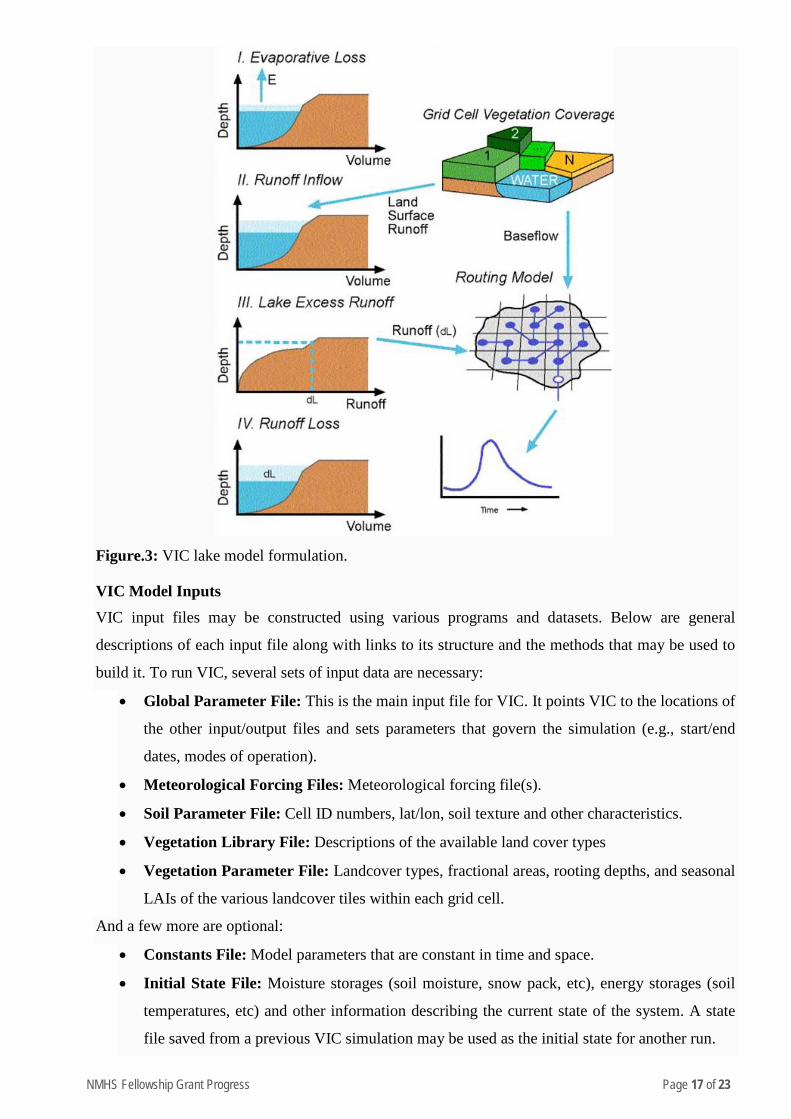
Lake Model
It is a Multi-layer model, based on the model of Hostetler and Bartlein (1990), Hostetler (1991),
and Hostetler et al (2000 ) which handles the impoundment of surface water within a grid cell. Each
grid cell is allowed to have a lake system contained within one of its land-cover tiles. A lake refers
to any impounded surface water, including permanent lakes and seasonal flooding of vegetated
land. The lake's area can vary with time as a function of storage and topography. Lakes can be
linked directly to channel network. Lakes can receive inflows from both a) runoff from the
surrounding upland within the same grid cell and b) channel flows from upstream grid cells.
Routing of stream flow is performed separately from the land surface simulation, using a separate
model, typically the routing model of Lohmann, et al. (1996; 1998).
NMHS Fellowship Grant Progress Page 17 of 23
Figure.3: VIC lake model formulation.
VIC Model Inputs VIC input files may be constructed using various programs and datasets. Below are general
descriptions of each input file along with links to its structure and the methods that may be used to
build it. To run VIC, several sets of input data are necessary:
• Global Parameter File: This is the main input file for VIC. It points VIC to the locations of
the other input/output files and sets parameters that govern the simulation (e.g., start/end
dates, modes of operation).
• Meteorological Forcing Files: Meteorological forcing file(s).
• Soil Parameter File: Cell ID numbers, lat/lon, soil texture and other characteristics.
• Vegetation Library File: Descriptions of the available land cover types
• Vegetation Parameter File: Landcover types, fractional areas, rooting depths, and seasonal
LAIs of the various landcover tiles within each grid cell.
And a few more are optional:
• Constants File: Model parameters that are constant in time and space.
• Initial State File: Moisture storages (soil moisture, snow pack, etc), energy storages (soil
temperatures, etc) and other information describing the current state of the system. A state
file saved from a previous VIC simulation may be used as the initial state for another run.
NMHS Fellowship Grant Progress Page 18 of 23
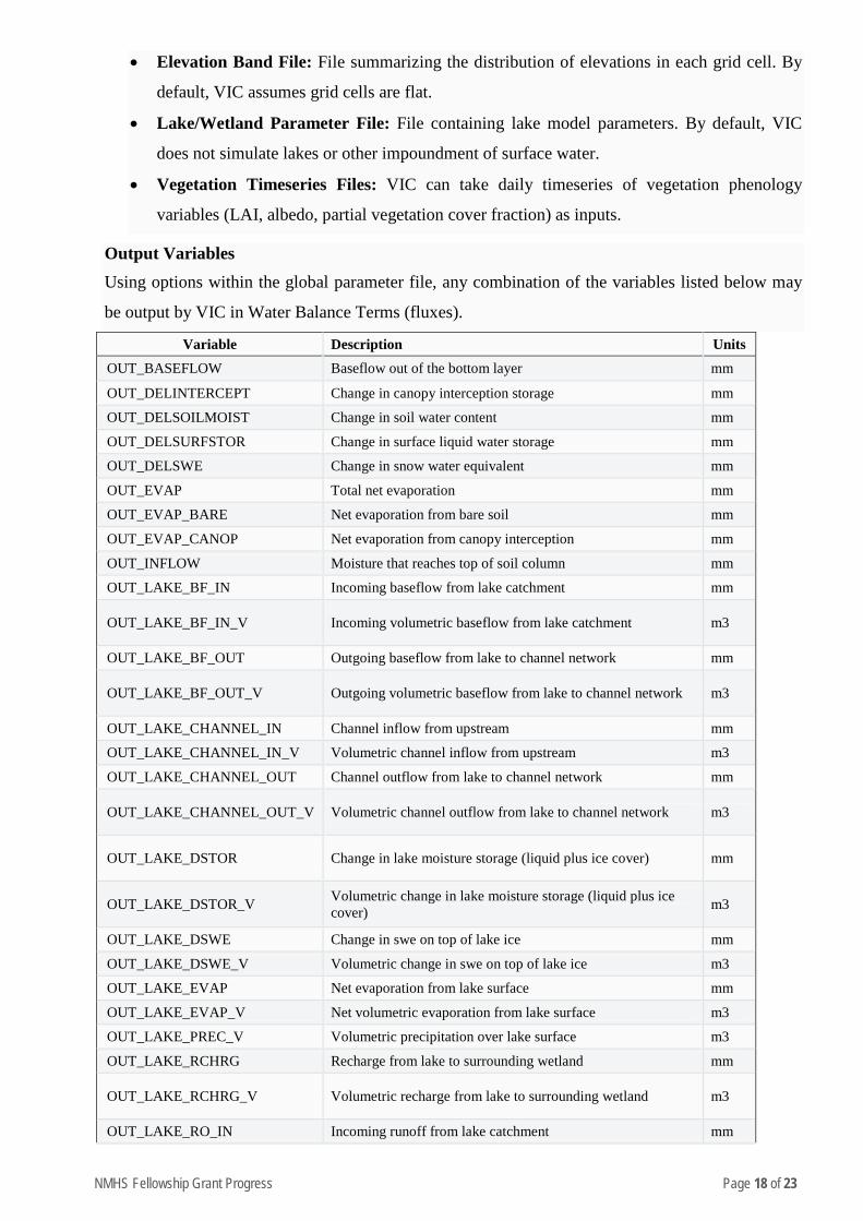
• Elevation Band File: File summarizing the distribution of elevations in each grid cell. By
default, VIC assumes grid cells are flat.
• Lake/Wetland Parameter File: File containing lake model parameters. By default, VIC
does not simulate lakes or other impoundment of surface water.
• Vegetation Timeseries Files: VIC can take daily timeseries of vegetation phenology
variables (LAI, albedo, partial vegetation cover fraction) as inputs.
Output Variables Using options within the global parameter file, any combination of the variables listed below may
be output by VIC in Water Balance Terms (fluxes).
Variable Description Units OUT_BASEFLOW Baseflow out of the bottom layer mm
OUT_DELINTERCEPT Change in canopy interception storage mm
OUT_DELSOILMOIST Change in soil water content mm
OUT_DELSURFSTOR Change in surface liquid water storage mm
OUT_DELSWE Change in snow water equivalent mm
OUT_EVAP Total net evaporation mm
OUT_EVAP_BARE Net evaporation from bare soil mm
OUT_EVAP_CANOP Net evaporation from canopy interception mm
OUT_INFLOW Moisture that reaches top of soil column mm
OUT_LAKE_BF_IN Incoming baseflow from lake catchment mm
OUT_LAKE_BF_IN_V Incoming volumetric baseflow from lake catchment m3
OUT_LAKE_BF_OUT Outgoing baseflow from lake to channel network mm
OUT_LAKE_BF_OUT_V Outgoing volumetric baseflow from lake to channel network m3
OUT_LAKE_CHANNEL_IN Channel inflow from upstream mm
OUT_LAKE_CHANNEL_IN_V Volumetric channel inflow from upstream m3
OUT_LAKE_CHANNEL_OUT Channel outflow from lake to channel network mm
OUT_LAKE_CHANNEL_OUT_V Volumetric channel outflow from lake to channel network m3
OUT_LAKE_DSTOR Change in lake moisture storage (liquid plus ice cover) mm
OUT_LAKE_DSTOR_V Volumetric change in lake moisture storage (liquid plus ice cover) m3
OUT_LAKE_DSWE Change in swe on top of lake ice mm
OUT_LAKE_DSWE_V Volumetric change in swe on top of lake ice m3
OUT_LAKE_EVAP Net evaporation from lake surface mm
OUT_LAKE_EVAP_V Net volumetric evaporation from lake surface m3
OUT_LAKE_PREC_V Volumetric precipitation over lake surface m3
OUT_LAKE_RCHRG Recharge from lake to surrounding wetland mm
OUT_LAKE_RCHRG_V Volumetric recharge from lake to surrounding wetland m3
OUT_LAKE_RO_IN Incoming runoff from lake catchment mm
NMHS Fellowship Grant Progress Page 19 of 23
OUT_LAKE_RO_IN_V Incoming volumetric runoff from lake catchment m3
OUT_LAKE_VAPFLX Outgoing sublimation from snow on top of lake ice mm
OUT_LAKE_VAPFLX_V Outgoing volumetric sublimation from snow on top of lake ice m3
OUT_PET
Potential evapotranspiration (= area-weighted sum of potential transpiration and potential soil evaporation). Potential transpiration is computed using the Penman-Monteith eqn with architectural resistance and LAI of the current veg cover.
mm
OUT_PREC Incoming precipitation mm
OUT_RAINF Rainfall mm
OUT_REFREEZE Refreezing of water in the snow mm
OUT_RUNOFF Surface runoff mm
OUT_SNOW_MELT Snow melt mm
OUT_SNOWF Snowfall mm
OUT_SUB_BLOWING Net sublimation of blowing snow mm
OUT_SUB_CANOP Net sublimation from snow stored in canopy mm
OUT_SUB_SNOW Total net sublimation from snow pack (surface and blowing) mm
OUT_SUB_SURFACE Net sublimation from snow pack surface mm
OUT_TRANSP_VEG Net transpiration from vegetation mm OUT_WATER_ERROR Water budget error mm
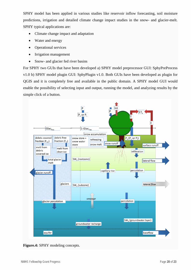
SPHY(v2.0): Spatial Processes in Hydrology
SPHY is a spatially distributed leaky bucket type of model, and is applied on a cell-by-cell basis.
The main terrestrial hydrological processes are described in a conceptual way so that changes in
storages and fluxes can be assessed adequately over time and space. SPHY is written in the Python
programming language using the PCRaster (Karssenberg et al. 2001; Karssenberg et al. 2010;
Karssenberg 2002; Schmitz et al. 2009; Schmitz et al. 2013) dynamic modeling framework. Key
features of the SPHY model can be summarized as:
• Robust scientific basis
• Combines strength of existing de facto hydrological models
• Modular setup in order to switch on/off irrelevant processes for computation efficiency
• Wide range of applicability in terms of regions, climates, modeling purposes, spatial and
temporal scales
• Performs under data scarcity
• Linkable to remote sensing data
• Easy adjustment and application
• Graphical User Interfaces (GUIs) for QGIS
• Open source
NMHS Fellowship Grant Progress Page 20 of 23
SPHY model has been applied in various studies like reservoir inflow forecasting, soil moisture
predictions, irrigation and detailed climate change impact studies in the snow- and glacier-melt.
SPHY typical applications are:
• Climate change impact and adaptation
• Water and energy
• Operational services
• Irrigation management
• Snow- and glacier fed river basins
For SPHY two GUIs that have been developed a) SPHY model preprocessor GUI: SphyPreProcess
v1.0 b) SPHY model plugin GUI: SphyPlugin v1.0. Both GUIs have been developed as plugin for
QGIS and it is completely free and available in the public domain. A SPHY model GUI would
enable the possibility of selecting input and output, running the model, and analyzing results by the
simple click of a button.
Figure.4: SPHY modeling concepts.
NMHS Fellowship Grant Progress Page 21 of 23
To simulate snowmelt, the well-established and widely used degree-day melt modeling approach is
used (Hock 2003). The application of degree-day models is widespread in cryospheric models and
is based on an empirical relationship between melt and air temperature. Degree-day models are
easier to set up compared to energy-balance models, and only require air temperature. Using a
degree-day modeling approach, the daily potential snowmelt is calculated as
The soil column structure in SPHY is similar to VIC (Liang et al. 1994, 1996), where top two
layers are soil storages and a third is groundwater storage. Their corresponding drainage
components are surface runoff, lateral flow and baseflow. SPHY simulates each cell precipitation in
the form of rain or snow, depending on the temperature. Melting of glacier ice contributes to the
river discharge by means of a slow and fast component, being (i) percolation to the groundwater
layer that eventually becomes baseflow, and (ii) direct runoff. The cell-specific runoff, which
becomes available for routing, is the sum of surface runoff, lateral flow, baseflow, snowmelt and
glacier melt.
After calculating the different runoff components, the cell-specific total runoff (QTot) is calculated
by adding these different runoff components. Depending on the modules being switched on, the
different runoff components are i) rainfall runoff (RRo), (ii) snow runoff (SRo), (iii) glacier runoff
(GRo), and iv) baseflow (BF). Rainfall runoff is the sum of surface runoff and lateral flow from the
first soil layer.
SPHY enables the user to turn on/off modules that are not required. This function is very important
when not all hydrological processes are relevant to the study. This function runs in two-fold: (i)
decrease model run-time, and (ii) decrease the amount of required model input data.
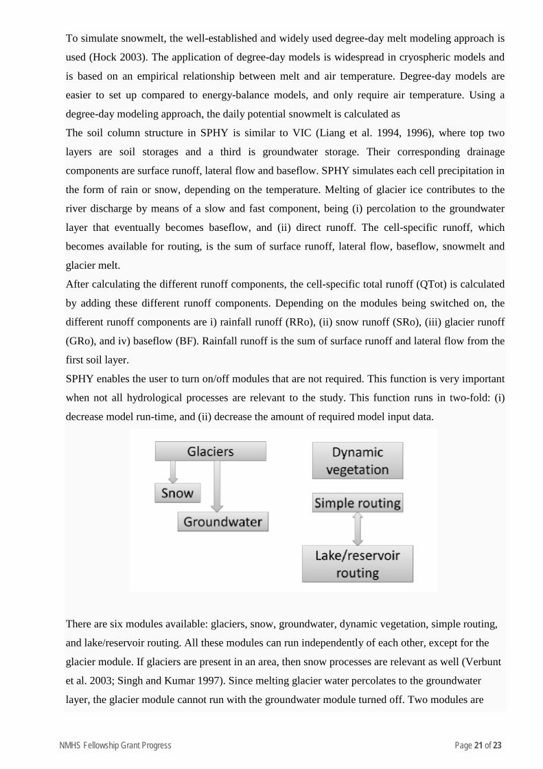
There are six modules available: glaciers, snow, groundwater, dynamic vegetation, simple routing,
and lake/reservoir routing. All these modules can run independently of each other, except for the
glacier module. If glaciers are present in an area, then snow processes are relevant as well (Verbunt
et al. 2003; Singh and Kumar 1997). Since melting glacier water percolates to the groundwater
layer, the glacier module cannot run with the groundwater module turned off. Two modules are
NMHS Fellowship Grant Progress Page 22 of 23
available for runoff routing: (i) a simple flow accumulation routing scheme, and (ii) a fractional
flow accumulation routing scheme used when lakes/reservoirs are present.
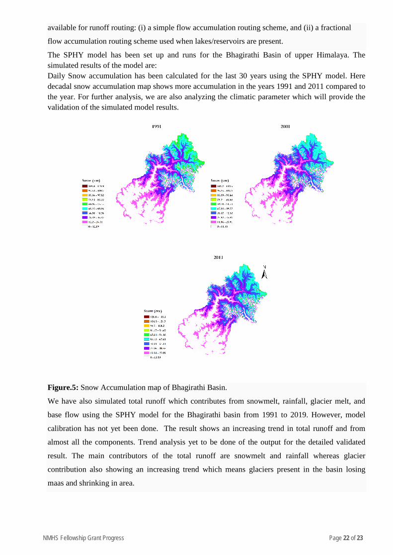
The SPHY model has been set up and runs for the Bhagirathi Basin of upper Himalaya. The simulated results of the model are: Daily Snow accumulation has been calculated for the last 30 years using the SPHY model. Here decadal snow accumulation map shows more accumulation in the years 1991 and 2011 compared to the year. For further analysis, we are also analyzing the climatic parameter which will provide the validation of the simulated model results.
Figure.5: Snow Accumulation map of Bhagirathi Basin.
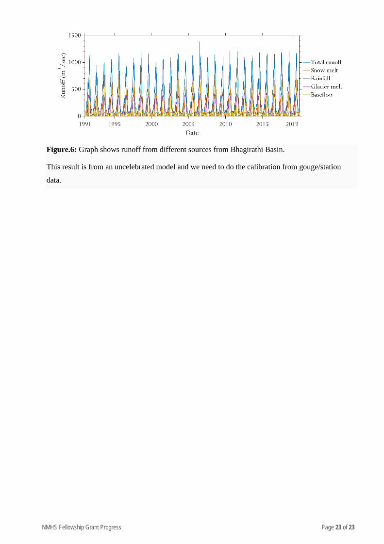
We have also simulated total runoff which contributes from snowmelt, rainfall, glacier melt, and
base flow using the SPHY model for the Bhagirathi basin from 1991 to 2019. However, model
calibration has not yet been done. The result shows an increasing trend in total runoff and from
almost all the components. Trend analysis yet to be done of the output for the detailed validated
result. The main contributors of the total runoff are snowmelt and rainfall whereas glacier
contribution also showing an increasing trend which means glaciers present in the basin losing
maas and shrinking in area.
NMHS Fellowship Grant Progress Page 23 of 23
Figure.6: Graph shows runoff from different sources from Bhagirathi Basin.
This result is from an uncelebrated model and we need to do the calibration from gouge/station
data.
NMHS Fellowship Grant Progress Page 1 of 20
National Mission on Himalayan Studies (NMHS) HIMALAYAN RESEARCH FELLOWSHIP
(Period from 21 August 2019 to 31st March 2020.) Kindly fill the NMHS Fellowship Annual Progress Report segregated into the following 7 segments, as applicable to the NMHS Fellowship nature and outcomes.
1. Fellowship Grant Information and Other Details
2. Fellowship Description at Himalayan Research Associates (H-RAs) Level
3. Fellowship Description at Himalayan Junior Research Associates (H-JRFs) Level
4. Fellowship Description at Institutional/ University Level 5. Fellowship Concluding Remarks/ Annual Summary
6. Specific Research Question(s) Addressed with Succinct Answer(s) 7. Any other information
Please let us know in case of any query at: nmhs
PRO FORMA
NMHS-Fellowship Annual Progress Report (APR)
1. Fellowship Grant Information and Other Details
NMHS Fellowship Grant ID: NHM-1336-DMC
Name of the Institution/ University: Indian Institute of Technology Roorkee, Uttarakhand, India
No. of Himalayan Research/Project Associates: 00
No. of Himalayan Junior Research/Project Fellows: 01

NMHS Fellowship Grant Progress Page 2 of 20
2. Fellowship Description at H-RA Level
Himalayan Research Associates (H-RAs)
H-RAs Profile Description: Not Applicable
S. No. Name of RA Date of Joining Research Title Name of the PI and
Designation Qualification
1. ….
Progress Brief (to be filled for each H-RA in separate row): Not Applicable
RA No. Research Objective(s) Deliverables Achievements
Research/ Experimental
Work*
1.
*Experimental work giving full details (in separate sheet, within 300 words) of experimental set up, methods adopted, data collected supported by necessary table, charts, diagrams & photographs. Note: Data, table and figures may be attached as separate source file (.docx, .xls, jpg, .jpeg, .png, .shp, etc. ).
Given in Appendix 1.
NMHS Fellowship Grant Progress Page 3 of 20
3. Fellowship Description at H-JRF Level
Himalayan Junior Research Project Fellows (H-JRFs)
H-JRFs Profile Description: S. No. Name of JRF Date of Joining Name of the PI Qualification
1. Sandeep Gairola 21 August 2019 Prof. Inderdeep Singh
• B. Tech. Mechanical (THDC IHET)
• M. Tech. Manufacturing technology (NIT Uttarakhand)
• Ph.D. (Persuing IIT Roorkee)
Progress Brief (to be filled for each JRF in separate row):
JRF No. Research Objectives Deliverable Achievements
Research/ Experimental Work*
1.
1. Investigate the potential of Himalayan waste (various natural fiber, filler bio-waste) as a reinforcement in the development of bio composite.
• Various natural fibers Jute, hemp, sisal, kenaf pine needle etc. has been reviewed and found that it has a potential to use a reinforcement in composite development.
Potential of forest waste as a reinforcement has been studied.
For objective 1, a literature review of past researchers work on various natural fibers and fillers has been studied.(Attached in annexures A )
For objective 2, potential of pine needle and jute fiber has been studied to use as a reinforcement in development of sustainable composite materials.
For objective 3, hand lay-up and compression molding technique techniques has been used.(Attached in annexures B)
For objective 4, detailed ASTM standard were followed.(Attached in annexures C)
Supporting results data Attached in annexure D
2. Selection of various forest waste based natural reinforcement.
• Jute and pine needles has been reviewed and can be used to make hybrid composite materials.
Pine needle with different aspect (short fiber and particulate form) can be used.
3. Develop a forest-waste based sustainable composite materials
• A particulate form of pine needle used to develop epoxy based composite materials.
• A hybrid composite of pine needle and jute fiber with polypropylene has been developed by compression Molding.
Pilot experiment has been done to examine the potential of selected waste as a reinforcement in development of sustainable composite materials.
4. Study the various properties of the developed composite materials by various characterization, i.e., thermal, mechanical, morphological, etc.
• For Mechanical behavior Tensile and flexural test were carried out.
• For Thermal behavior TGA/DTA test were carried out.
• For Crystalline behavior XRD test was carried out.
• For Morphological study SEM test was carried out.
Reduction in plastic content by 40 % is achieved.
5. Design a product out of the developed composite materials
…………..
---------
NMHS Fellowship Grant Progress Page 4 of 20
4. Fellowship Description at Institutional/ University Level
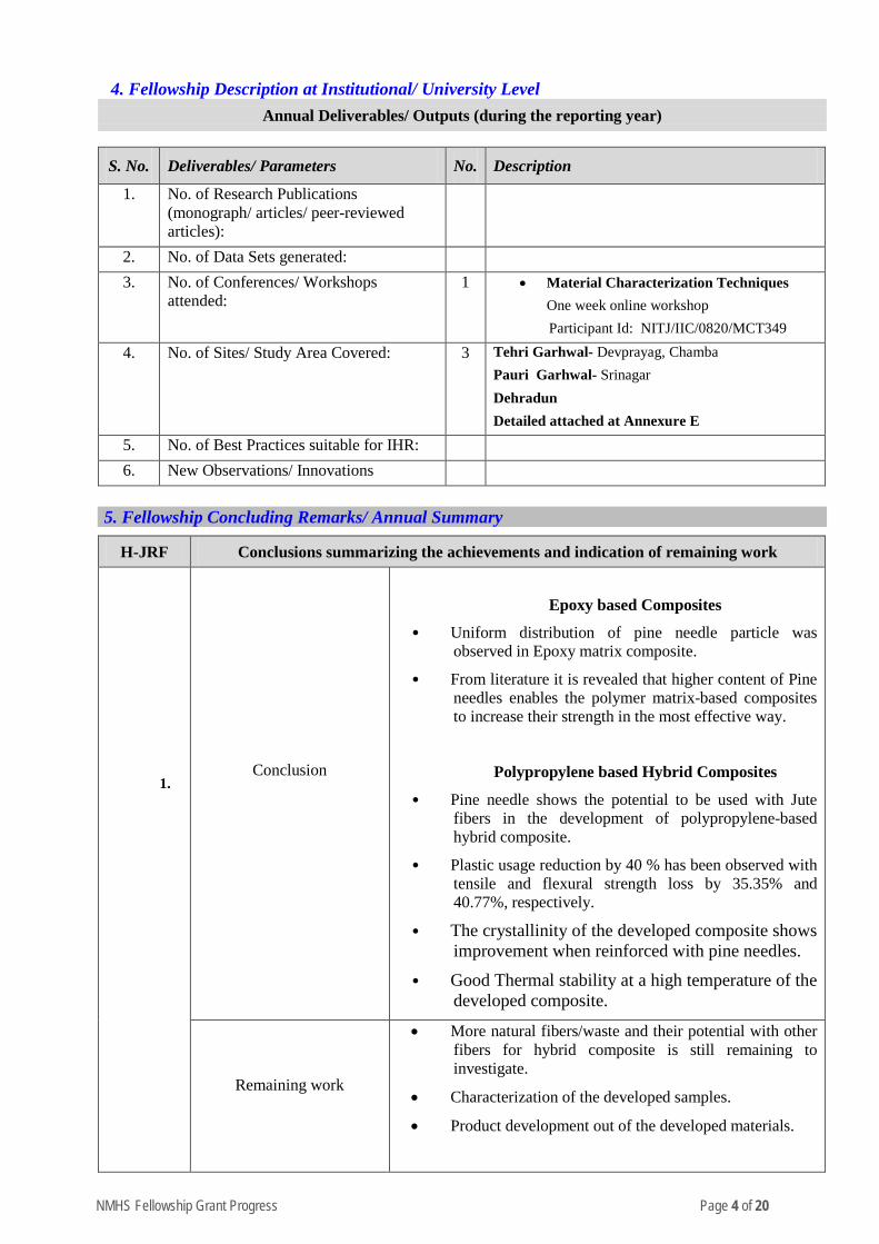
Annual Deliverables/ Outputs (during the reporting year)
S. No. Deliverables/ Parameters No. Description
1. No. of Research Publications (monograph/ articles/ peer-reviewed articles):
2. No. of Data Sets generated:
3. No. of Conferences/ Workshops attended:
1 • Material Characterization Techniques One week online workshop
Participant Id: NITJ/IIC/0820/MCT349
4. No. of Sites/ Study Area Covered: 3 Tehri Garhwal- Devprayag, Chamba Pauri Garhwal- Srinagar Dehradun Detailed attached at Annexure E
5. No. of Best Practices suitable for IHR:
6. New Observations/ Innovations
5. Fellowship Concluding Remarks/ Annual Summary
H-JRF Conclusions summarizing the achievements and indication of remaining work
1.
Conclusion
Epoxy based Composites
• Uniform distribution of pine needle particle was observed in Epoxy matrix composite.
• From literature it is revealed that higher content of Pine needles enables the polymer matrix-based composites to increase their strength in the most effective way.
Polypropylene based Hybrid Composites
• Pine needle shows the potential to be used with Jute fibers in the development of polypropylene-based hybrid composite.
• Plastic usage reduction by 40 % has been observed with tensile and flexural strength loss by 35.35% and 40.77%, respectively.
• The crystallinity of the developed composite shows improvement when reinforced with pine needles.
• Good Thermal stability at a high temperature of the developed composite.
Remaining work
• More natural fibers/waste and their potential with other fibers for hybrid composite is still remaining to investigate.
• Characterization of the developed samples.
• Product development out of the developed materials.
NMHS Fellowship Grant Progress Page 5 of 20
6. Specific Research Question(s) Addressed with Succinct Answer(s)
S. No. Research Questions Addressed Succinct Answers (within 150-200 words)
1. NA
7. Any Other Information
Detailed Annexures are added as follows.
• Annexure A – Literature Review
• Annexure B - Techniques Utilized for development of Composite materials
• Annexure C - Technologies used to characterize the developed samples
• Annexure D- Supporting Results data
• Annexure E- A site map
Signature of PI
Indian Institute of Technology Roorkee
Report (hard copy) should be submitted to:
The Nodal Officer, NMHS-PMU National Mission on Himalayan Studies (NMHS) गो�वद बल्लभ पंत रा�ीय िहमालयी पयार्वरण एवं सतत ्िवकास ससं्थान G.B. Pant National Institute of Himalayan Environment and Sustainable Development (GBPNIHESD) Kosi-Katarmal, Almora 263643, Uttarakhand
Report (soft copy) should be submitted to:
E-mail: [email protected]
NMHS Fellowship Grant Progress Page 6 of 20
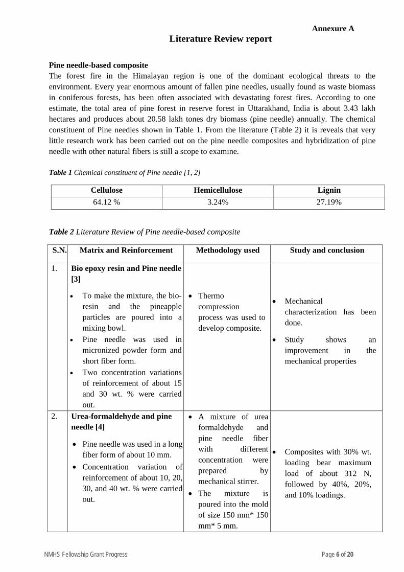
Annexure A Literature Review report
Pine needle-based composite The forest fire in the Himalayan region is one of the dominant ecological threats to the environment. Every year enormous amount of fallen pine needles, usually found as waste biomass in coniferous forests, has been often associated with devastating forest fires. According to one estimate, the total area of pine forest in reserve forest in Uttarakhand, India is about 3.43 lakh hectares and produces about 20.58 lakh tones dry biomass (pine needle) annually. The chemical constituent of Pine needles shown in Table 1. From the literature (Table 2) it is reveals that very little research work has been carried out on the pine needle composites and hybridization of pine needle with other natural fibers is still a scope to examine. Table 1 Chemical constituent of Pine needle [1, 2]
Cellulose Hemicellulose Lignin 64.12 % 3.24% 27.19%
Table 2 Literature Review of Pine needle-based composite
S.N. Matrix and Reinforcement Methodology used Study and conclusion
1. Bio epoxy resin and Pine needle [3]
• To make the mixture, the bio-resin and the pineapple particles are poured into a mixing bowl.
• Pine needle was used in micronized powder form and short fiber form.
• Two concentration variations of reinforcement of about 15 and 30 wt. % were carried out.
• Thermo compression process was used to develop composite.
• Mechanical characterization has been done.
• Study shows an improvement in the mechanical properties
2. Urea-formaldehyde and pine needle [4]
• Pine needle was used in a long fiber form of about 10 mm.
• Concentration variation of reinforcement of about 10, 20, 30, and 40 wt. % were carried out.
• A mixture of urea formaldehyde and pine needle fiber with different concentration were prepared by mechanical stirrer.
• The mixture is poured into the mold of size 150 mm* 150 mm* 5 mm.
• Composites with 30% wt. loading bear maximum load of about 312 N, followed by 40%, 20%, and 10% loadings.
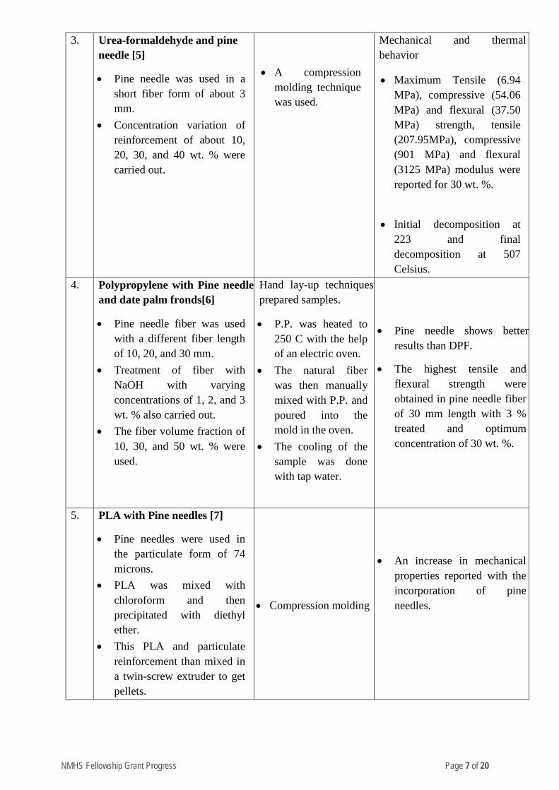
NMHS Fellowship Grant Progress Page 7 of 20
3. Urea-formaldehyde and pine needle [5]
• Pine needle was used in a short fiber form of about 3 mm.
• Concentration variation of reinforcement of about 10, 20, 30, and 40 wt. % were carried out.
• A compression
molding technique was used.
Mechanical and thermal behavior
• Maximum Tensile (6.94 MPa), compressive (54.06 MPa) and flexural (37.50 MPa) strength, tensile (207.95MPa), compressive (901 MPa) and flexural (3125 MPa) modulus were reported for 30 wt. %.
• Initial decomposition at 223 and final decomposition at 507 Celsius.
4. Polypropylene with Pine needle and date palm fronds[6]
• Pine needle fiber was used with a different fiber length of 10, 20, and 30 mm.
• Treatment of fiber with NaOH with varying concentrations of 1, 2, and 3 wt. % also carried out.
• The fiber volume fraction of 10, 30, and 50 wt. % were used.
Hand lay-up techniques prepared samples.
• P.P. was heated to 250 C with the help of an electric oven.
• The natural fiber was then manually mixed with P.P. and poured into the mold in the oven.
• The cooling of the sample was done with tap water.
• Pine needle shows better results than DPF.
• The highest tensile and flexural strength were obtained in pine needle fiber of 30 mm length with 3 % treated and optimum concentration of 30 wt. %.
5. PLA with Pine needles [7]
• Pine needles were used in the particulate form of 74 microns.
• PLA was mixed with chloroform and then precipitated with diethyl ether.
• This PLA and particulate reinforcement than mixed in a twin-screw extruder to get pellets.
• Compression molding
• An increase in mechanical properties reported with the incorporation of pine needles.
NMHS Fellowship Grant Progress Page 8 of 20
6. Phenolic resin with Pine needles[8]
• Pine needles used in fiber form with varying concentrations of 3,5,7,9 wt. %.
• The raw material used: Vermiculite, Porous iron powder, BaSO4, Petroleum coke, Artificial graphite, Alumina, Antimony sulfide, Friction powder, Carbon black, Pine needle fibers
• Compression molding is used.
• A mixture of raw materials with resin molded with compression molding at 160 degree Celsius and 40 MPa.
• Wear study has been done.
• The study shows an improvement in Tribological properties with the lowest wear rate in 7 wt. % pine needle fiber.
7. LDPE and HDPE with Pine needles [9]
• Pine needle used as flour with < 500 microns.
• Flour concentration of 10, 30, 50 wt. % were used.
• Pine needle flour with HDPE and LDPE were converted into pellets.
• A sample prepared by injection molding
• A thermal and morphological study was done.
• TGA and FTIR were performed to study the behavior.
• Tensile strength shows a reduction with pine needle flour content.
8. Polypropylene with Pine needle[10]
• Treated pine needle of 40 mesh size were used.
• Reinforced with 10, 20 and 30 wt. %.
• Treated with soda pulping by using 14% NaOH and 2% anthraquinone.
• Extruded with PP and converted to pellets.
• Samples prepared by injection molding.
Thermal and flammability analysis were done.
• Initial decomposition at 318.5 0C with 5% loss and complete decomposition at 525 0C with residue of 5.25 %.
• Higher burning rate was reported with incorporation of pine needle.
NMHS Fellowship Grant Progress Page 9 of 20
9. Pine needle with isocyanate prepolymer[11]
• Pine needle in the long fiber form of 30 mm used.
• Compression molding was used at 140°C and 10 MPa pressure for 10 min.
Biological resistance, flammability, and thermoacoustic characteristics was studied.
• The thermal conductivity (0.136 W/m K) and sound transmission loss (26.51 dB) were reported.
10. Pine needle with phenolic resin[12]
• Pine needle in the short fiber form of 3 mm used.
• Reinforced with 10, 20, 30 and 40 wt. %.
• Compression molding
Mechanical and thermal behaviour.
• Maximum mechanical properties reported for 30 wt. %.
• Tensile (15.11 MPa), compressive (86.34 MPa) and flexural strength (89.24 MPa).
• Tensile (435.41 MPa), compressive (2233.95 MPa), and flexural modulus (5591.54 MPa).
• Initial (246 0C) and final decomposition temperature (941 0C) were reported.
11. Pine needle with phenolic formaldehyde[13]
• Pine needle in the particulate form of 200 microns used.
• Reinforced with 10, 20, 30 and 40 wt. %.
• Hand lay-up technique was used.
Mechanical behaviour were studied.
• Maximum mechanical properties reported for 30 wt. %.
• Tensile (32.38 MPa), compressive (101.74 MPa) and flexural strength (386.10 MPa).
• Tensile (712.55 MPa), compressive (2417.38 MPa), and flexural modulus (13079.27 MPa).
• Initial (223 0C) and final decomposition temperature (507 0C) were reported.
NMHS Fellowship Grant Progress Page 10 of 20
References: [1]. M.K. Ghosh and U.K. Ghosh, BioResources, 6, 1556 (2011) [2]. J. Asadullah, Pak. J. Sci. Ind. Res., 49, 407 (2006). [3]. Singha, A. S., & Thakur, V. K. (2008). Mechanical, morphological, and thermal properties of pine needle-
reinforced polymer composites. International Journal of Polymeric Materials, 58(1), 21-31. [4]. Thakur, V. K., Singha, A. S., & Thakur, M. K. (2013). Fabrication and physico-chemical properties of high-
performance pine needles/green polymer composites. International Journal of Polymeric Materials and Polymeric Biomaterials, 62(4), 226-230.
[5]. Singha, A. S., & Thakur, V. K. (2008). Mechanical, morphological, and thermal properties of pine needle-reinforced polymer composites. International Journal of Polymeric Materials, 58(1), 21-31.
[6]. Alzebdeh, K. I., Nassar, M. M., & Arunachalam, R. (2019). Effect of fabrication parameters on strength of natural fiber polypropylene composites: Statistical assessment. Measurement, 146, 195-207.
[7]. Sinha, P., Mathur, S., Sharma, P., & Kumar, V. (2018). Potential of pine needles for PLA‐bas ed composites. Polymer Composites, 39(4), 1339-1349.
[8]. Ma, Y., Liu, Y., Shang, W., Gao, Z., Wang, H., Guo, L., & Tong, J. (2014). Tribological and mechanical properties of pine needle fiber reinforced friction composites under dry sliding conditions. RSC Advances, 4(69), 36777-36783.
[9]. Naldony, P., Flores-Sahagun, T. H., & Satyanarayana, K. G. (2016). Effect of the type of fiber (coconut, eucalyptus, or pine) and compatibilizer on the properties of extruded composites of recycled high density polyethylene. Journal of Composite Materials, 50(1), 45-56.
[10]. Malkapuram, R., Kumar, V., & Negi, Y. S. (2010). Novel treated pine needle fiber reinforced polypropylene composites and their characterization. Journal of reinforced plastics and composites, 29(15), 2343-2355.
[11]. Chauhan, M., Gupta, M., Singh, B., Singh, A. K., & Gupta, V. K. (2012). Pine needle/isocyanate composites: Dimensional stability, biological resistance, flammability, and thermoacoustic characteristics. Polymer composites, 33(3), 324-335.
[12]. Thakur, V. K., Singha, A. S., & Mehta, I. K. (2010). Renewable resource-based green polymer composites: Analysis and characterization. International Journal of Polymer Analysis and Characterization, 15(3), 137-146.
[13]. Singha, A. S., & Thakur, V. K. (2010). Synthesis, characterization and study of pine needles reinforced polymer matrix based composites. Journal of reinforced plastics and composites, 29(5), 700-709.
NMHS Fellowship Grant Progress Page 11 of 20
Annexure B
(Techniques Utilized for development of Composite materials)
Composite development
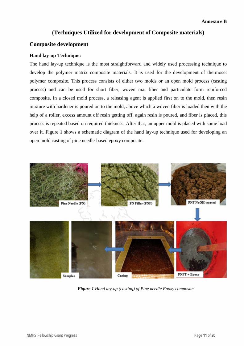
Hand lay-up Technique:
The hand lay-up technique is the most straightforward and widely used processing technique to
develop the polymer matrix composite materials. It is used for the development of thermoset
polymer composite. This process consists of either two molds or an open mold process (casting
process) and can be used for short fiber, woven mat fiber and particulate form reinforced
composite. In a closed mold process, a releasing agent is applied first on to the mold, then resin
mixture with hardener is poured on to the mold, above which a woven fiber is loaded then with the
help of a roller, excess amount off resin getting off, again resin is poured, and fiber is placed, this
process is repeated based on required thickness. After that, an upper mold is placed with some load
over it. Figure 1 shows a schematic diagram of the hand lay-up technique used for developing an
open mold casting of pine needle-based epoxy composite.
Figure 1 Hand lay-up (casting) of Pine needle Epoxy composite
NMHS Fellowship Grant Progress Page 12 of 20
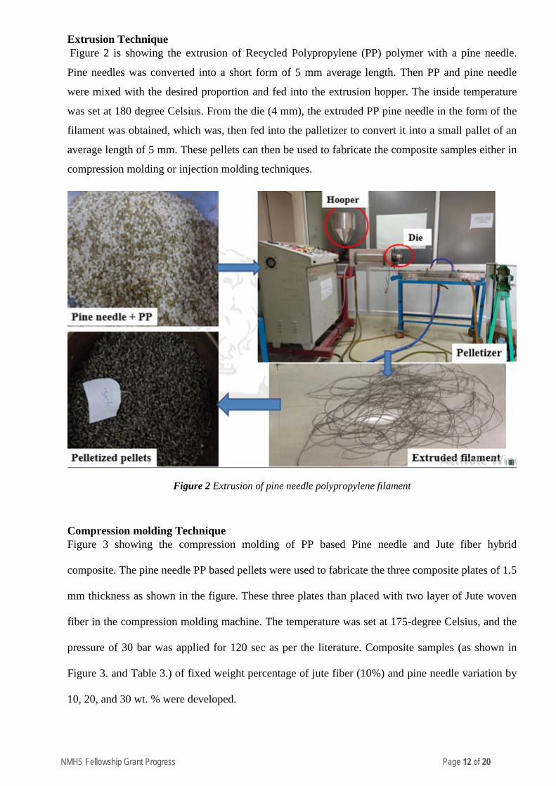
Extrusion Technique Figure 2 is showing the extrusion of Recycled Polypropylene (PP) polymer with a pine needle.
Pine needles was converted into a short form of 5 mm average length. Then PP and pine needle
were mixed with the desired proportion and fed into the extrusion hopper. The inside temperature
was set at 180 degree Celsius. From the die (4 mm), the extruded PP pine needle in the form of the
filament was obtained, which was, then fed into the palletizer to convert it into a small pallet of an
average length of 5 mm. These pellets can then be used to fabricate the composite samples either in
compression molding or injection molding techniques.
Figure 2 Extrusion of pine needle polypropylene filament
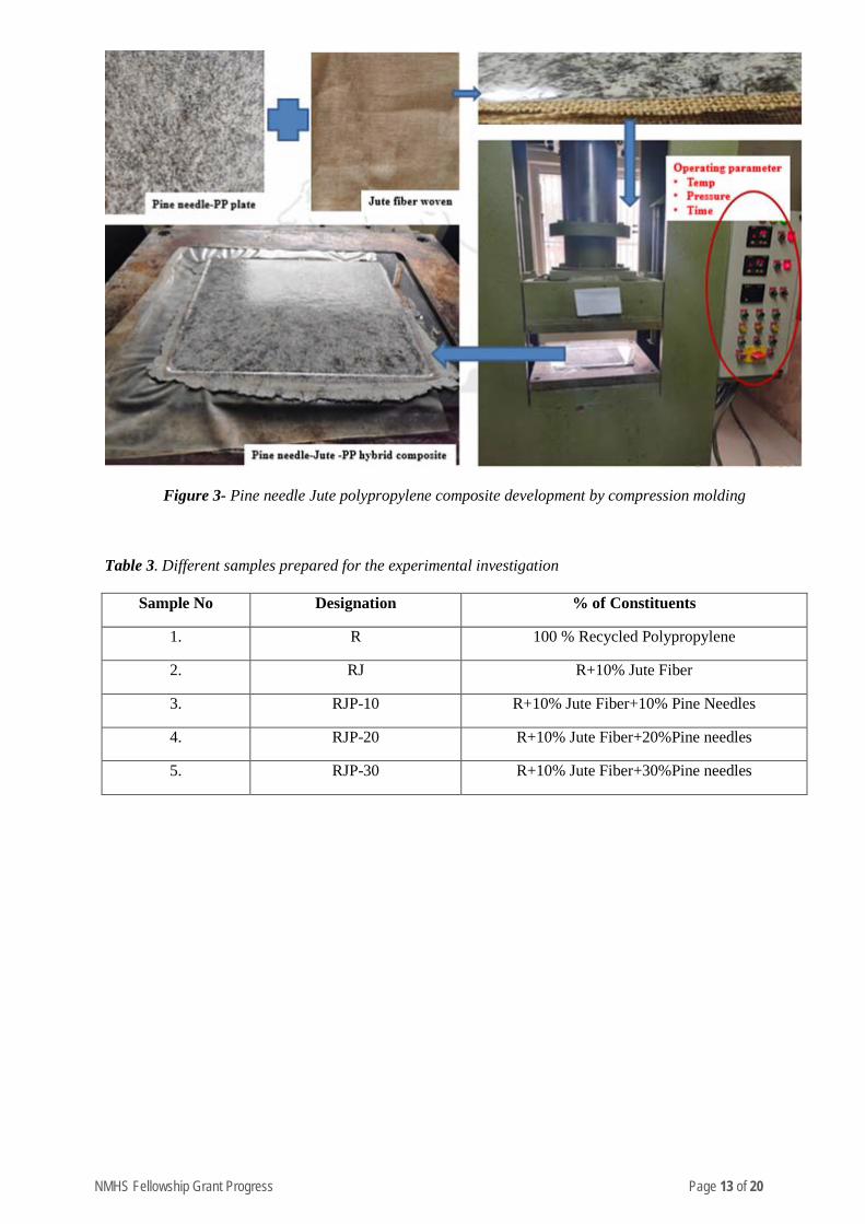
Compression molding Technique Figure 3 showing the compression molding of PP based Pine needle and Jute fiber hybrid
composite. The pine needle PP based pellets were used to fabricate the three composite plates of 1.5
mm thickness as shown in the figure. These three plates than placed with two layer of Jute woven
fiber in the compression molding machine. The temperature was set at 175-degree Celsius, and the
pressure of 30 bar was applied for 120 sec as per the literature. Composite samples (as shown in
Figure 3. and Table 3.) of fixed weight percentage of jute fiber (10%) and pine needle variation by
10, 20, and 30 wt. % were developed.
NMHS Fellowship Grant Progress Page 13 of 20
Figure 3- Pine needle Jute polypropylene composite development by compression molding
Table 3. Different samples prepared for the experimental investigation
Sample No Designation % of Constituents
1. R 100 % Recycled Polypropylene
2. RJ R+10% Jute Fiber
3. RJP-10 R+10% Jute Fiber+10% Pine Needles
4. RJP-20 R+10% Jute Fiber+20%Pine needles
5. RJP-30 R+10% Jute Fiber+30%Pine needles
NMHS Fellowship Grant Progress Page 14 of 20
Annexure C
(Technologies used to characterize the developed samples)
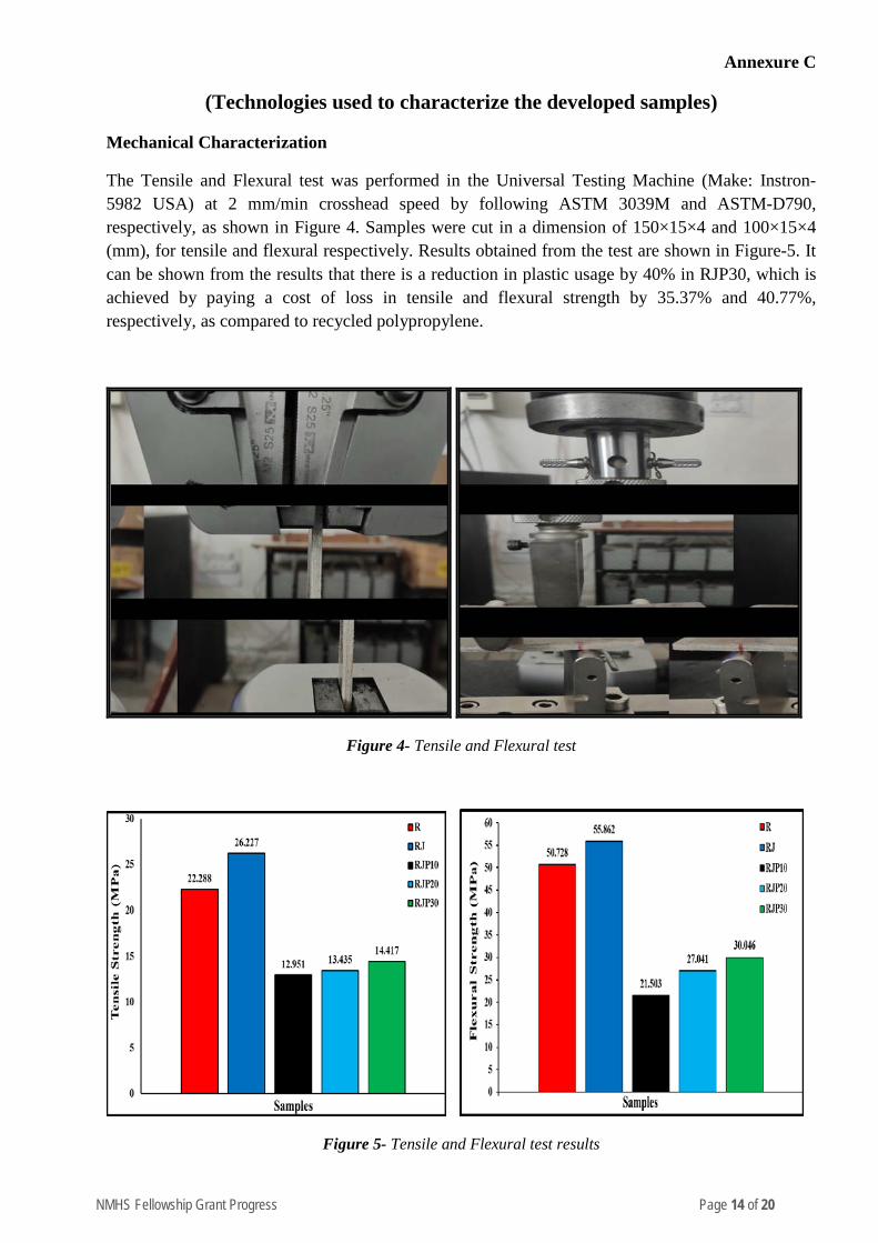
Mechanical Characterization
The Tensile and Flexural test was performed in the Universal Testing Machine (Make: Instron-5982 USA) at 2 mm/min crosshead speed by following ASTM 3039M and ASTM-D790, respectively, as shown in Figure 4. Samples were cut in a dimension of 150×15×4 and 100×15×4 (mm), for tensile and flexural respectively. Results obtained from the test are shown in Figure-5. It can be shown from the results that there is a reduction in plastic usage by 40% in RJP30, which is achieved by paying a cost of loss in tensile and flexural strength by 35.37% and 40.77%, respectively, as compared to recycled polypropylene.
Figure 4- Tensile and Flexural test
Figure 5- Tensile and Flexural test results
NMHS Fellowship Grant Progress Page 15 of 20
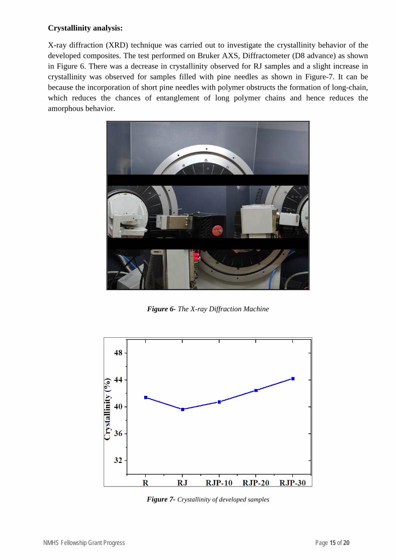
Crystallinity analysis:
X-ray diffraction (XRD) technique was carried out to investigate the crystallinity behavior of the developed composites. The test performed on Bruker AXS, Diffractometer (D8 advance) as shown in Figure 6. There was a decrease in crystallinity observed for RJ samples and a slight increase in crystallinity was observed for samples filled with pine needles as shown in Figure-7. It can be because the incorporation of short pine needles with polymer obstructs the formation of long-chain, which reduces the chances of entanglement of long polymer chains and hence reduces the amorphous behavior.
Figure 6- The X-ray Diffraction Machine
Figure 7- Crystallinity of developed samples
NMHS Fellowship Grant Progress Page 16 of 20
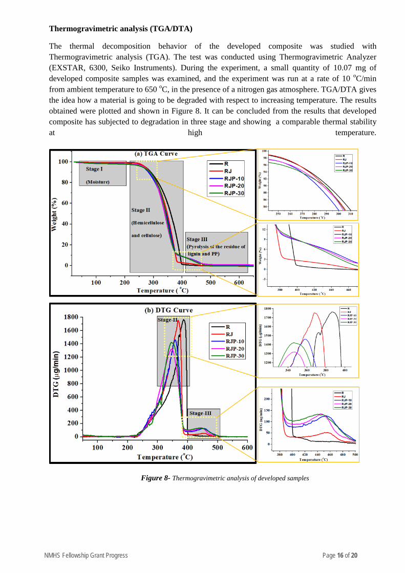
Thermogravimetric analysis (TGA/DTA)
The thermal decomposition behavior of the developed composite was studied with Thermogravimetric analysis (TGA). The test was conducted using Thermogravimetric Analyzer (EXSTAR, 6300, Seiko Instruments). During the experiment, a small quantity of 10.07 mg of developed composite samples was examined, and the experiment was run at a rate of 10 oC/min from ambient temperature to 650 oC, in the presence of a nitrogen gas atmosphere. TGA/DTA gives the idea how a material is going to be degraded with respect to increasing temperature. The results obtained were plotted and shown in Figure 8. It can be concluded from the results that developed composite has subjected to degradation in three stage and showing a comparable thermal stability at high temperature.
Figure 8- Thermogravimetric analysis of developed samples
NMHS Fellowship Grant Progress Page 17 of 20
Annexure D
Supporting Results data
Table 4. The Mechanical behavior testing data (Tensile and Flexural test respectively)
R RJ RJP10 RJP20 RJP30
Tensile strength (MPa) 22.288 26.227 12.951 13.435 14.417
Flexural strength (MPa) 50.728 55.862 21.503 27.041 30.046
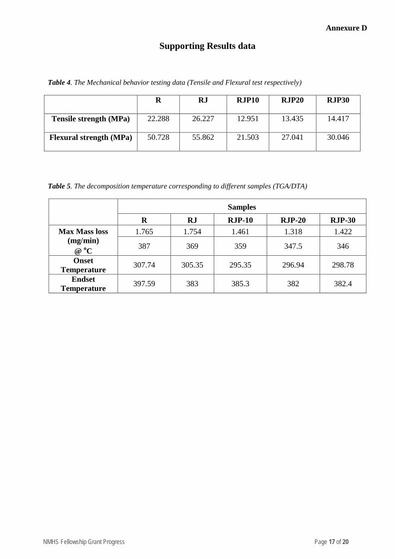
Table 5. The decomposition temperature corresponding to different samples (TGA/DTA)
Samples
R RJ RJP-10 RJP-20 RJP-30 Max Mass loss
(mg/min) @ oC
1.765 1.754 1.461 1.318 1.422
387 369 359 347.5 346
Onset Temperature 307.74 305.35 295.35 296.94 298.78
Endset Temperature 397.59 383 385.3 382 382.4
NMHS Fellowship Grant Progress Page 18 of 20
Annexure E
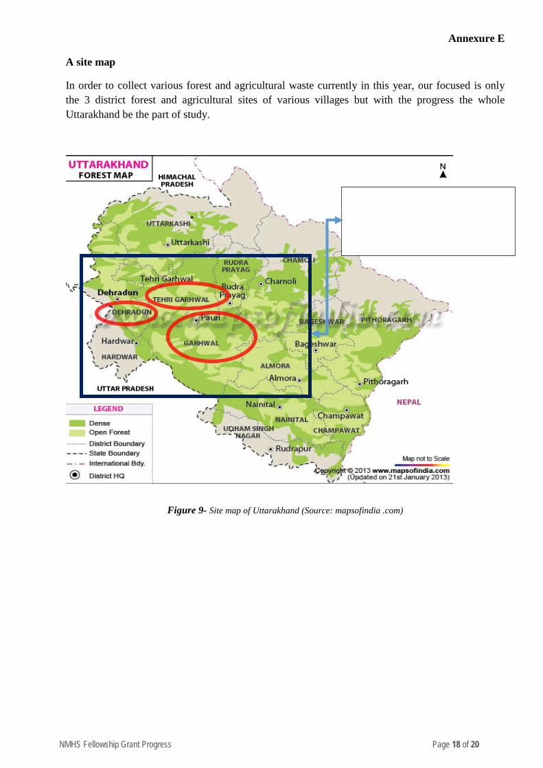
A site map
In order to collect various forest and agricultural waste currently in this year, our focused is only the 3 district forest and agricultural sites of various villages but with the progress the whole Uttarakhand be the part of study.
Figure 9- Site map of Uttarakhand (Source: mapsofindia .com)
Current district under observation
• Dehradun • Tehri Garhwal • Pauri Garhwal
NMHS Fellowship Grant Progress Page 19 of 20
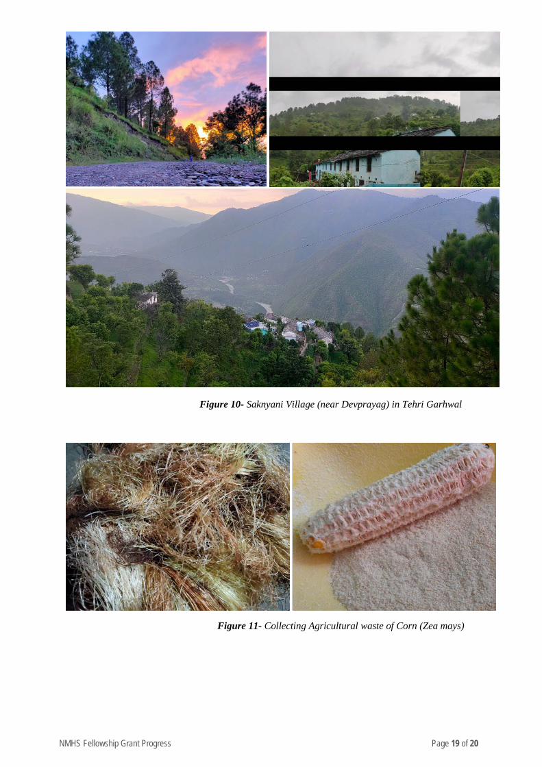
Figure 10- Saknyani Village (near Devprayag) in Tehri Garhwal
Figure 11- Collecting Agricultural waste of Corn (Zea mays)

NMHS Fellowship Grant Progress Page 20 of 20
Figure 10- Collecting Forest waste of Date Palm tree

NMHS Fellowship Grant Progress Page 1 of 35
National Mission on Himalayan Studies (NMHS) HIMALAYAN RESEARCH FELLOWSHIP
(PRO FORMA FOR THE ANNUAL PROGRESS REPORT)
[Reporting Period: from 1st August 2019 to 31st March 2020] Kindly fill the NMHS Fellowship Annual Progress Report segregated into the following 7 segments, as applicable to the NMHS Fellowship nature and outcomes.
1. Fellowship Grant Information and Other Details
2. Fellowship Description at Himalayan Research Associates (H-RAs) Level
3. Fellowship Description at Himalayan Junior Research Associates (H-JRFs) Level
4. Fellowship Description at Institutional/ University Level 5. Fellowship Concluding Remarks/ Annual Summary
6. Specific Research Question(s) Addressed with Succinct Answer(s) 7. Any other information
Please let us know in case of any query at: nmhs
PRO FORMA
NMHS-Fellowship Annual Progress Report (APR)
1. Fellowship Grant Information and Other Details
NMHS Fellowship Grant ID: NMH_1334_DMC
Name of the Institution/ University: Indian Institute of Technology, Roorkee
No. of Himalayan Research/Project Associates: 00
No. of Himalayan Junior Research/Project Fellows: 01

NMHS Fellowship Grant Progress Page 2 of 35
2. Fellowship Description at H-RA Level
Himalayan Research Associates (H-RAs)
H-RAs Profile Description: Not Applicable
S. No. Name of RA Date of Joining Research Title Name of the PI and Designation Qualification
1. ….
Progress Brief (to be filled for each H-RA in separaterow): Not Applicable
RA No. Research Objective(s) Addressed Deliverables Achievements Research/
Experimental Work*
1. o
• • •
[Enclose descriptive file – max. 250 words]
*Experimental work giving full details (in separate sheet, within 300 words) of experimental set up, methods adopted, data collected supported by necessary table, charts, diagrams & photographs.Note: Data, table and figures may be attached as separate source file (.docx, .xls, jpg, .jpeg, .png, .shp, etc. ).
NMHS Fellowship Grant Progress Page 3 of 35
3. Fellowship Description atH-JRF Level
Himalayan Junior Research Project Fellows (H-JRFs)
H-JRFs Profile Description: S. No. Name of JRF Date of Joining Name of the PI Qualification
1. Shivani Chouhan 1st August’2019 Prof. Mahua Mukherjee
B.Plan (NIT-Bhopal)
M.Tech (IIT-Roorkee)
Pursuing Ph.D ( IIT Roorkee)
Progress Brief (to be filled for each JRF in separate row):
JRF No. Research Objectives Deliverable Achievements Research/
Experimental Work*
1. 1. To study the development trend of the study area with a focus to demographic and Landuse Landcover changes.
2. Assessment of Multi Hazard and climate induced Risk for the identified areas.
3. To Study existing livelihood pattern & identify alternative livelihood options for Planning sustainable hill habitat
4.To identify Mitigation Strategies for identified Hazards with focus on Vulnerable Zone, Coping Capacity, Habitats, Livelihood and Natural Resources in order to achieve Sustainable Planning for hills
Objective 1:
- Land-use and Land cover Maps
- Building Typologies identification
- Construction Practices gaps - Settlement growth pattern - Population projection graphs
Objective 2:
-Hazard zonation map
- Vulnerable zone identification & Mapping
- Damage Scenario
- Climate change graph and effects
-Identification/Marking of all important buildings
Objective 3:
-Existing livelihood pattern
-Alternative livelihood option -Interview with stakeholders for acceptance of alternative options
Objective 1: Site Visit I in October-November 2019 (Annexure 7) Existing building typologies : Partially studied Study of Site and construction material selection criteria (Annexure 9) Objective 2: Vulnerability Survey form : Developed (Annexure 10) Socio Economic Survey Form: Developed Building Vulnerability form: Developed Site Multi Hazard Vulnerability form: Developed (Annexure 10) Instrumental Survey form on Existing built-up: Ready Objective 3:
For Objective 1, Planning to identify all the gaps in existing construction practices and material used as well as at planning level by identifying vulnerable zone for future development.
Real-world implementation of developed strategies For Objective 2, Planning to identify all the hazards through hazard modeling on GIS, Idenfications of Hazrd Source, Risk Index model etc, in order to achieve Disaster resilient development plan and prepare the society.
For Objective 3, Planning for better livelihood with aim for more self sustainable economic growth without exploiting nature.
For Objective 4, Planning and recommendations for future development and growth, enhancing skills and knowledge & awareness among the community, with the
NMHS Fellowship Grant Progress Page 4 of 35
Objective 4:
- Gram Panchayat Development Plan
- Detailed Maps
-Recommendations for Construction practices - Gaps identifications - Capacity Building - Livelihood policies -Role and Responsibilities
Secondary data study of Demographic and Geographic profile of study area. Existing & alternative livelihood option study and existing government policies on the same: Studying Objective 4: Manuals for “Masons Training program on Earthquake Resistance Construction Techniques”: Prepared (Annexure 9)
Manuals for Women and children on “Disaster preparedness and Awareness”: Prepared
aim for risk resilient Planning. SWOT Analysis of Data collected will play an important role.
*Experimental work giving full details (in separate sheet, within 300 words) of experimental set up, methods adopted, data collected supported by necessary table, charts, diagrams & photographs. Note: Data, table and figures may be attached as separate source file (.docx, .xls, jpg, .jpeg, .png, .shp, etc. ).
NMHS Fellowship Grant Progress Page 5 of 35
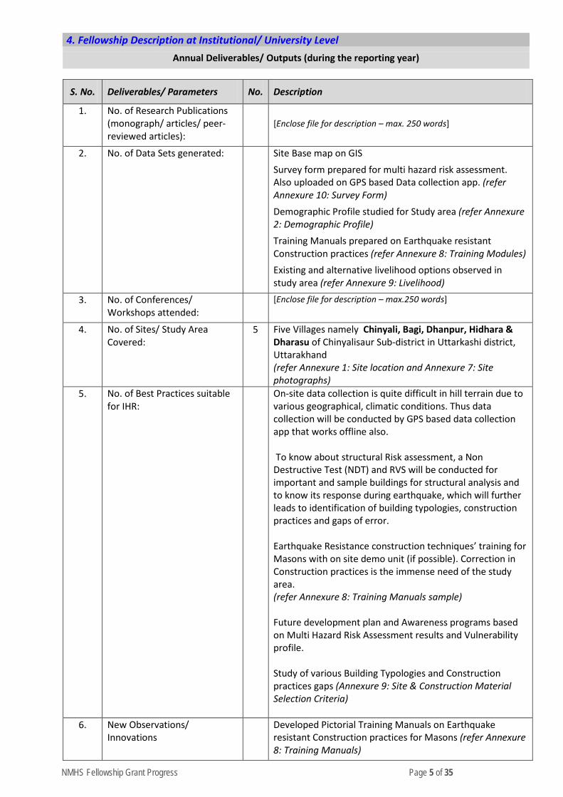
4. Fellowship Description at Institutional/ University Level
Annual Deliverables/ Outputs (during the reporting year)
S. No. Deliverables/ Parameters No. Description
1. No. of Research Publications (monograph/ articles/ peer-reviewed articles):
[Enclose file for description – max. 250 words]
2. No. of Data Sets generated: Site Base map on GIS Survey form prepared for multi hazard risk assessment. Also uploaded on GPS based Data collection app. (refer Annexure 10: Survey Form) Demographic Profile studied for Study area (refer Annexure 2: Demographic Profile) Training Manuals prepared on Earthquake resistant Construction practices (refer Annexure 8: Training Modules) Existing and alternative livelihood options observed in study area (refer Annexure 9: Livelihood)
3. No. of Conferences/ Workshops attended:
[Enclose file for description – max.250 words]
4. No. of Sites/ Study Area Covered:
5 Five Villages namely Chinyali, Bagi, Dhanpur, Hidhara & Dharasu of Chinyalisaur Sub-district in Uttarkashi district, Uttarakhand (refer Annexure 1: Site location and Annexure 7: Site photographs)
5. No. of Best Practices suitable for IHR:
On-site data collection is quite difficult in hill terrain due to various geographical, climatic conditions. Thus data collection will be conducted by GPS based data collection app that works offline also. To know about structural Risk assessment, a Non Destructive Test (NDT) and RVS will be conducted for important and sample buildings for structural analysis and to know its response during earthquake, which will further leads to identification of building typologies, construction practices and gaps of error. Earthquake Resistance construction techniques’ training for Masons with on site demo unit (if possible). Correction in Construction practices is the immense need of the study area. (refer Annexure 8: Training Manuals sample) Future development plan and Awareness programs based on Multi Hazard Risk Assessment results and Vulnerability profile. Study of various Building Typologies and Construction practices gaps (Annexure 9: Site & Construction Material Selection Criteria)
6. New Observations/ Innovations
Developed Pictorial Training Manuals on Earthquake resistant Construction practices for Masons (refer Annexure 8: Training Manuals)

NMHS Fellowship Grant Progress Page 6 of 35
Building Typologies identified in study area and its response to Seismic activities, gaps in construction practices will be highlighted, Retrofitting techniques will be recommended etc. (refer Annexure 9) Existing and alternative livelihood options observed in study area that need to be promoted (refer Annexure 6: Livelihood)
5. Fellowship Concluding Remarks/ Annual Summary
Conclusions summarizing the achievements and indication of remaining work (within 300 words):
Covid 19 has profoundly affected the life as well as livelihood of the people. Lockdown situation have delayed the primary survey part of the Research work. Thus some major Covid related points need to be supplement in the mitigation strategies of this research. Work completed till date are as follows
• Site Visit I in October-November 2019 (Annexure 7) • Vulnerability Survey form : Developed (Annexure 10) • Socio Economic Survey Form: Developed • Building Vulnerability form: Developed (Annexure 10) • Site Multi Hazard Vulnerability form: Developed (Annexure 10) • Manuals for “Masons Training program on Earthquake Resistance Construction Techniques”:
Prepared (Annexure 8) • Manuals for Women and children on “Disaster preparedness and Awareness”: Prepared • Instrumental Survey on Existing built-up: Ready • Secondary data study of Demographic and Geographic profile of study area. (Annexure 2) • Livelihood identification (Annexure 6) • Site and Construction material selection criteria study (Annexure 9)
Work to be done are
• Site Survey for Primary Data on Disaster Risk Assessment, Development trend, Livelihood. • Data Analysis • Vulnerable zone identification • Building Typologies Identification • SWOT Analysis • Meeting with Gram Panchayat & Experts • Findings and Outcomes • Validation Survey • Disaster Management Plan • Gram Panchayat Develop Plan (GPDP) preparation • Conducting programs based on Community Participation • Meeting with various NGOs, authority and social groups for their support in capacity building • Maps Preparation • Report preparation
There is an immense need for enhancing the skills, knowledge and the coping capacity in the right direction based on the availability of the resources as per the Risk assessment findings that will create a sustainable Risk Resilience village plan. This research will give the right path for the development and mitigation from upcoming disasters.
6. Specific Research Question(s) Addressed with Succinct Answer(s)
S. No. Research Questions Addressed Succinct Answers (within 150-200 words)
1. How to prepare the society for upcoming Disasters, in minimizing the
Multi-Hazard Frequency has increased over the last few decades. Uttarakhand has a history of Disasters

NMHS Fellowship Grant Progress Page 7 of 35
socio economic loss with a focus on Risk Resilient Planning to create a sustainable Hill Habitats?
such as earthquakes, landslides, floods, Cloudbursts, forest fires, etc. Unrecognized Practices and lack of awareness increase the impact of disasters. There is a huge crowd of local and national pilgrims, which leads to a sudden increase in carbon footprint and creates a natural imbalance. Uttarkashi district is prone to multi hazards and it has the vast history disasters that had disturbed the nature and society economically and socially. Preparation is the only way to prepare the society for the upcoming disasters. This study will identify vulnerable zones, multi-hazard status, failures in construction practices, community strength, opportunities, Livelihood alternatives in the areas, existing coping capacity, impacts on climate change etc. It will provide a GPDP for every village for future sustainable development. There is an immense need to strengthen skills, knowledge and coping capacity in the right direction, based on the availability of resources as identified in the Risk assessment findings, which will create a sustainable risk resilience village plan.
7. Any Other Information • Due to COVID-19 situation and Lockdown from March 2020, Site survey and on-site data
collection could not take place.
• Annexure attached are as follows:
o Annexure 1: Site Location o Annexure 2: Demographic Profile o Annexure 3: Methodology o Annexure 4: Research Finding o Annexure 5: Project Timeline o Annexure 6: Existing and Alternative Livelihood options o Annexure 7: Site Photos o Annexure 8: Training Manuals o Annexure 9: Site & Construction Material Selection Criteria o Annexure 10: MHRA Survey Form for School Buildings
<Signature of PI/ Head of Institution>
<Name of the Institution>
Report (hard copy)should be submitted to:
The Nodal Officer, NMHS-PMU National Mission on Himalayan Studies (NMHS) गो�वद बल्ल पंत रा�ीय िहमा्यी पयारवरर एवं सतत ्िवकास ससं्ाा G.B. Pant National Institute of Himalayan Environment and Sustainable Development (GBPNIHESD) Kosi-Katarmal, Almora 263643, Uttarakhand
Report (soft copy)should be submitted to: E-mail: [email protected]
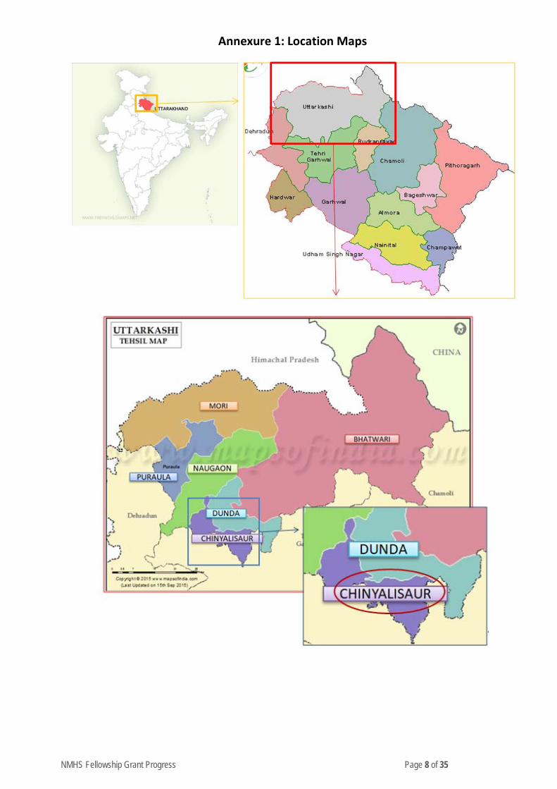
NMHS Fellowship Grant Progress Page 8 of 35
Annexure 1: Location Maps
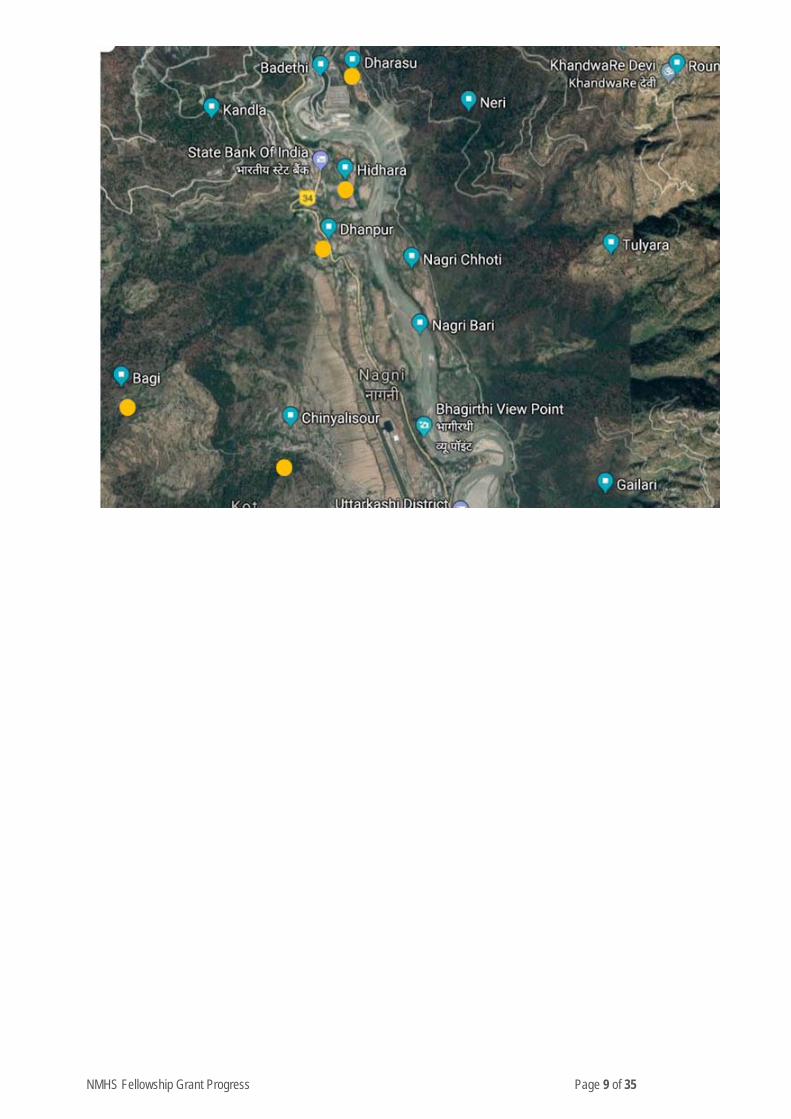
NMHS Fellowship Grant Progress Page 9 of 35
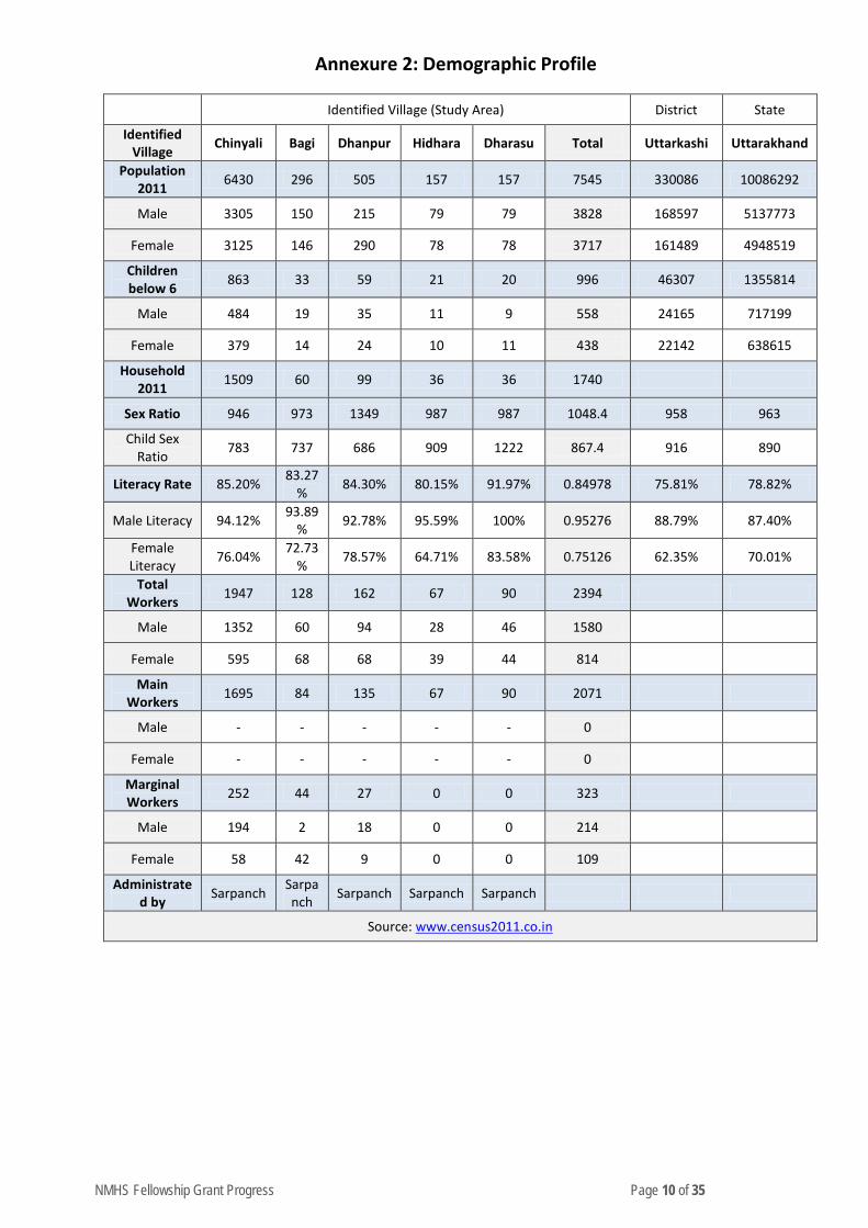
NMHS Fellowship Grant Progress Page 10 of 35
Annexure 2: Demographic Profile
Identified Village (Study Area) District State
Identified Village Chinyali Bagi Dhanpur Hidhara Dharasu Total Uttarkashi Uttarakhand
Population 2011 6430 296 505 157 157 7545 330086 10086292
Male 3305 150 215 79 79 3828 168597 5137773
Female 3125 146 290 78 78 3717 161489 4948519
Children below 6 863 33 59 21 20 996 46307 1355814
Male 484 19 35 11 9 558 24165 717199
Female 379 14 24 10 11 438 22142 638615
Household 2011 1509 60 99 36 36 1740
Sex Ratio 946 973 1349 987 987 1048.4 958 963
Child Sex Ratio 783 737 686 909 1222 867.4 916 890
Literacy Rate 85.20% 83.27% 84.30% 80.15% 91.97% 0.84978 75.81% 78.82%
Male Literacy 94.12% 93.89% 92.78% 95.59% 100% 0.95276 88.79% 87.40%
Female Literacy 76.04% 72.73
% 78.57% 64.71% 83.58% 0.75126 62.35% 70.01%
Total Workers 1947 128 162 67 90 2394
Male 1352 60 94 28 46 1580
Female 595 68 68 39 44 814
Main Workers 1695 84 135 67 90 2071
Male - - - - - 0
Female - - - - - 0
Marginal Workers 252 44 27 0 0 323
Male 194 2 18 0 0 214
Female 58 42 9 0 0 109
Administrated by Sarpanch Sarpa
nch Sarpanch Sarpanch Sarpanch
Source: www.census2011.co.in
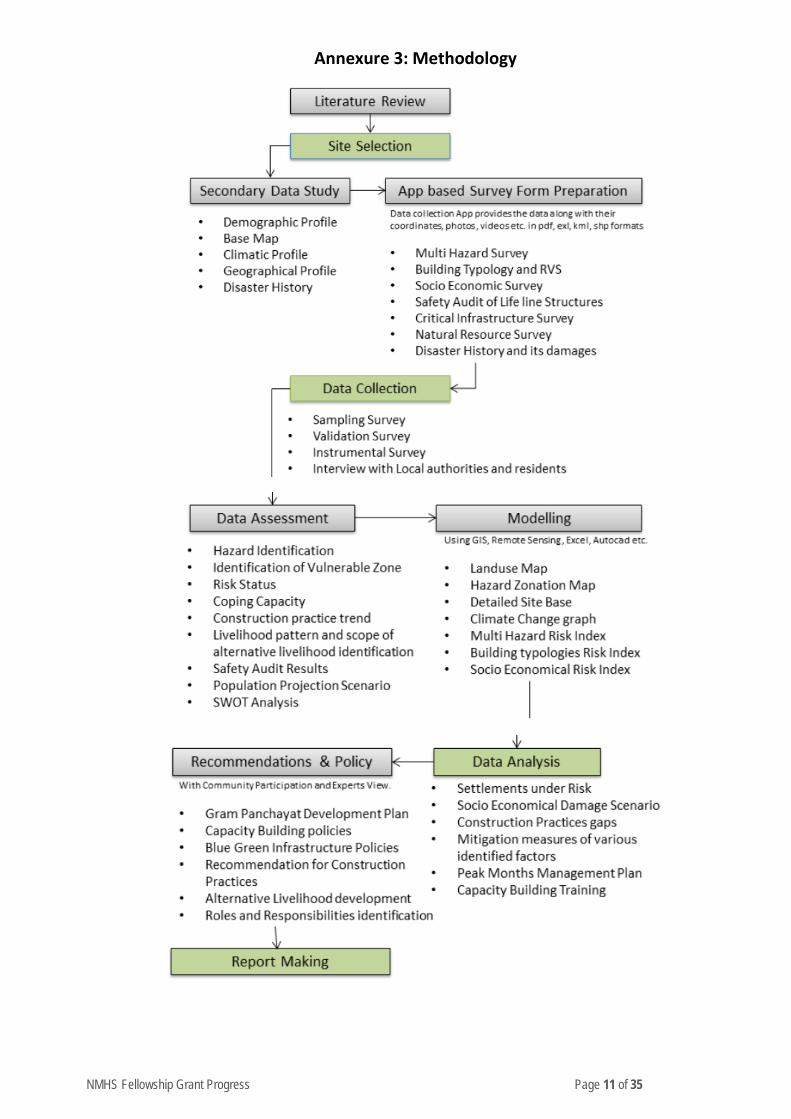
NMHS Fellowship Grant Progress Page 11 of 35
Annexure 3: Methodology
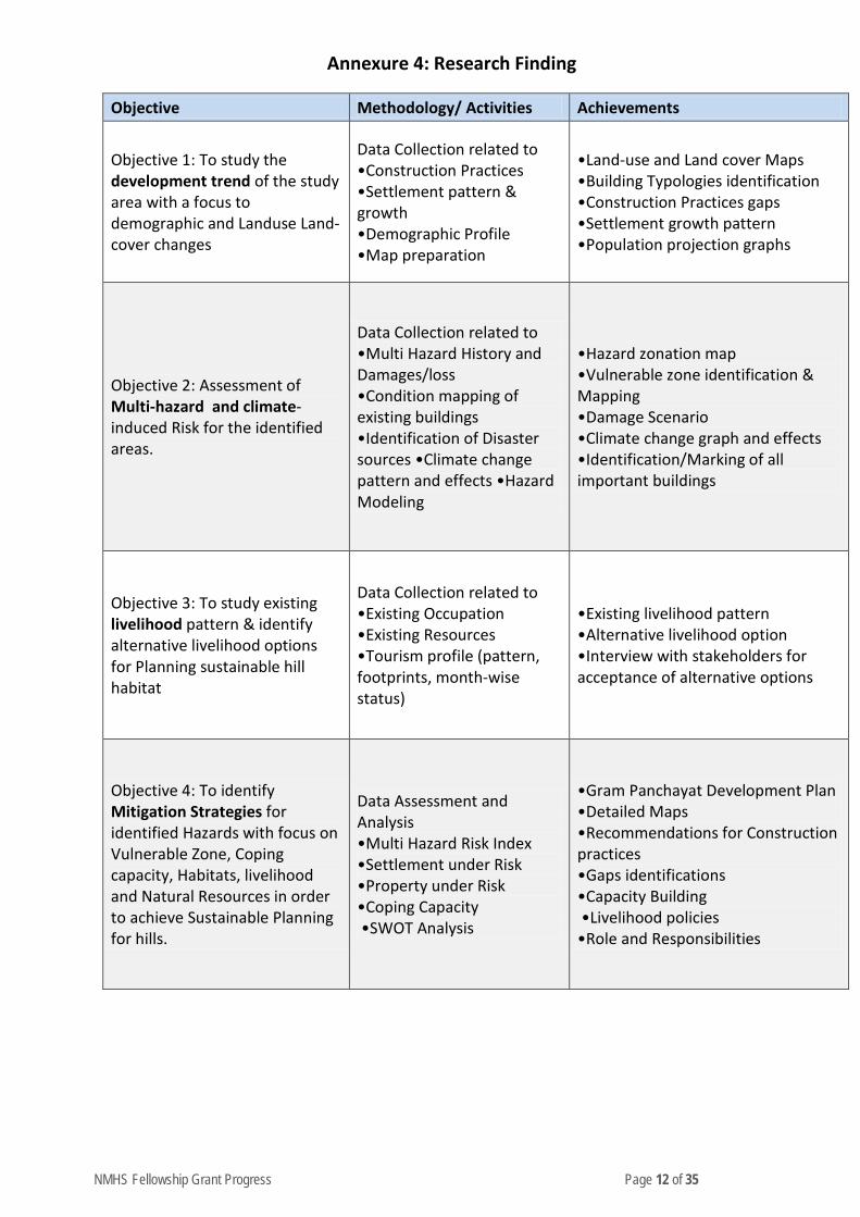
NMHS Fellowship Grant Progress Page 12 of 35
Annexure 4: Research Finding
Objective Methodology/ Activities Achievements
Objective 1: To study the development trend of the study area with a focus to demographic and Landuse Land-cover changes
Data Collection related to •Construction Practices •Settlement pattern & growth •Demographic Profile •Map preparation
•Land-use and Land cover Maps •Building Typologies identification •Construction Practices gaps •Settlement growth pattern •Population projection graphs
Objective 2: Assessment of Multi-hazard and climate-induced Risk for the identified areas.
Data Collection related to •Multi Hazard History and Damages/loss •Condition mapping of existing buildings •Identification of Disaster sources •Climate change pattern and effects •Hazard Modeling
•Hazard zonation map •Vulnerable zone identification & Mapping •Damage Scenario •Climate change graph and effects •Identification/Marking of all important buildings
Objective 3: To study existing livelihood pattern & identify alternative livelihood options for Planning sustainable hill habitat
Data Collection related to •Existing Occupation •Existing Resources •Tourism profile (pattern, footprints, month-wise status)
•Existing livelihood pattern •Alternative livelihood option •Interview with stakeholders for acceptance of alternative options
Objective 4: To identify Mitigation Strategies for identified Hazards with focus on Vulnerable Zone, Coping capacity, Habitats, livelihood and Natural Resources in order to achieve Sustainable Planning for hills.
Data Assessment and Analysis •Multi Hazard Risk Index •Settlement under Risk •Property under Risk •Coping Capacity •SWOT Analysis
•Gram Panchayat Development Plan •Detailed Maps •Recommendations for Construction practices •Gaps identifications •Capacity Building •Livelihood policies •Role and Responsibilities
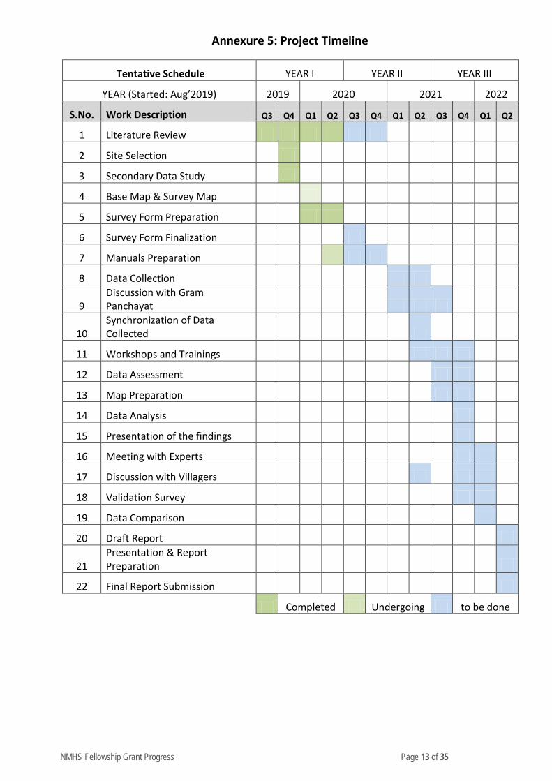
NMHS Fellowship Grant Progress Page 13 of 35
Annexure 5: Project Timeline
Tentative Schedule YEAR I YEAR II YEAR III
YEAR (Started: Aug’2019) 2019 2020 2021 2022
S.No. Work Description Q3 Q4 Q1 Q2 Q3 Q4 Q1 Q2 Q3 Q4 Q1 Q2
1 Literature Review
2 Site Selection
3 Secondary Data Study
4 Base Map & Survey Map
5 Survey Form Preparation
6 Survey Form Finalization
7 Manuals Preparation
8 Data Collection
9 Discussion with Gram Panchayat
10 Synchronization of Data Collected
11 Workshops and Trainings
12 Data Assessment
13 Map Preparation
14 Data Analysis
15 Presentation of the findings
16 Meeting with Experts
17 Discussion with Villagers
18 Validation Survey
19 Data Comparison
20 Draft Report
21 Presentation & Report Preparation
22 Final Report Submission
Completed Undergoing to be done
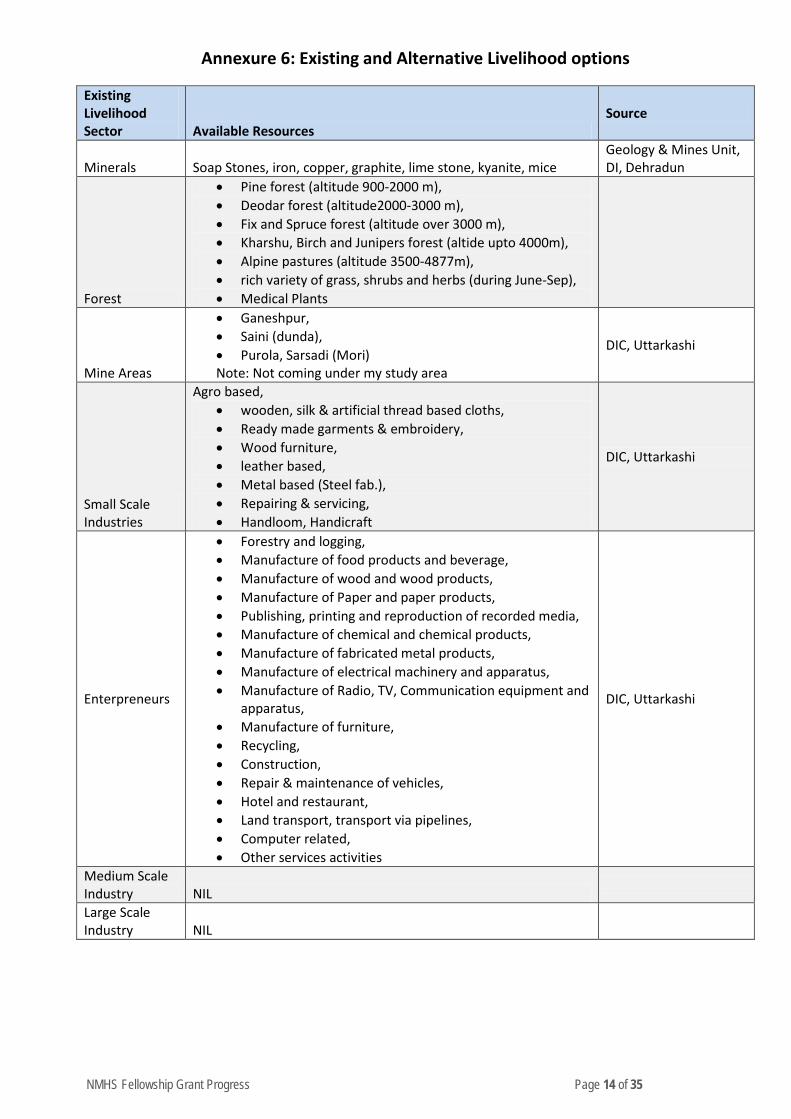
NMHS Fellowship Grant Progress Page 14 of 35
Annexure 6: Existing and Alternative Livelihood options
Existing Livelihood Sector Available Resources
Source
Minerals Soap Stones, iron, copper, graphite, lime stone, kyanite, mice Geology & Mines Unit, DI, Dehradun
Forest
• Pine forest (altitude 900-2000 m), • Deodar forest (altitude2000-3000 m), • Fix and Spruce forest (altitude over 3000 m), • Kharshu, Birch and Junipers forest (altide upto 4000m), • Alpine pastures (altitude 3500-4877m), • rich variety of grass, shrubs and herbs (during June-Sep), • Medical Plants
Mine Areas
• Ganeshpur, • Saini (dunda), • Purola, Sarsadi (Mori)
Note: Not coming under my study area
DIC, Uttarkashi
Small Scale Industries
Agro based, • wooden, silk & artificial thread based cloths, • Ready made garments & embroidery, • Wood furniture, • leather based, • Metal based (Steel fab.), • Repairing & servicing, • Handloom, Handicraft
DIC, Uttarkashi
Enterpreneurs
• Forestry and logging, • Manufacture of food products and beverage, • Manufacture of wood and wood products, • Manufacture of Paper and paper products, • Publishing, printing and reproduction of recorded media, • Manufacture of chemical and chemical products, • Manufacture of fabricated metal products, • Manufacture of electrical machinery and apparatus, • Manufacture of Radio, TV, Communication equipment and
apparatus, • Manufacture of furniture, • Recycling, • Construction, • Repair & maintenance of vehicles, • Hotel and restaurant, • Land transport, transport via pipelines, • Computer related, • Other services activities
DIC, Uttarkashi
Medium Scale Industry NIL
Large Scale Industry NIL
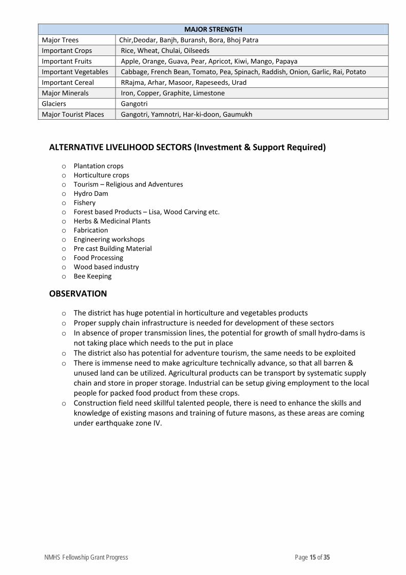
NMHS Fellowship Grant Progress Page 15 of 35
MAJOR STRENGTH Major Trees Chir,Deodar, Banjh, Buransh, Bora, Bhoj Patra Important Crops Rice, Wheat, Chulai, Oilseeds Important Fruits Apple, Orange, Guava, Pear, Apricot, Kiwi, Mango, Papaya Important Vegetables Cabbage, French Bean, Tomato, Pea, Spinach, Raddish, Onion, Garlic, Rai, Potato Important Cereal RRajma, Arhar, Masoor, Rapeseeds, Urad Major Minerals Iron, Copper, Graphite, Limestone Glaciers Gangotri Major Tourist Places Gangotri, Yamnotri, Har-ki-doon, Gaumukh
ALTERNATIVE LIVELIHOOD SECTORS (Investment & Support Required)
o Plantation crops o Horticulture crops o Tourism – Religious and Adventures o Hydro Dam o Fishery o Forest based Products – Lisa, Wood Carving etc. o Herbs & Medicinal Plants o Fabrication o Engineering workshops o Pre cast Building Material o Food Processing o Wood based industry o Bee Keeping
OBSERVATION
o The district has huge potential in horticulture and vegetables products o Proper supply chain infrastructure is needed for development of these sectors o In absence of proper transmission lines, the potential for growth of small hydro-dams is
not taking place which needs to the put in place o The district also has potential for adventure tourism, the same needs to be exploited o There is immense need to make agriculture technically advance, so that all barren &
unused land can be utilized. Agricultural products can be transport by systematic supply chain and store in proper storage. Industrial can be setup giving employment to the local people for packed food product from these crops.
o Construction field need skillful talented people, there is need to enhance the skills and knowledge of existing masons and training of future masons, as these areas are coming under earthquake zone IV.
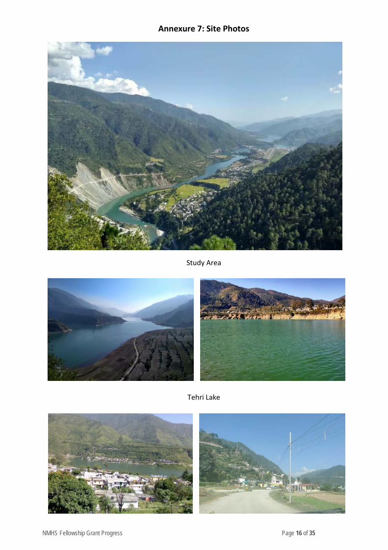
NMHS Fellowship Grant Progress Page 16 of 35
Annexure 7: Site Photos
Study Area
Tehri Lake
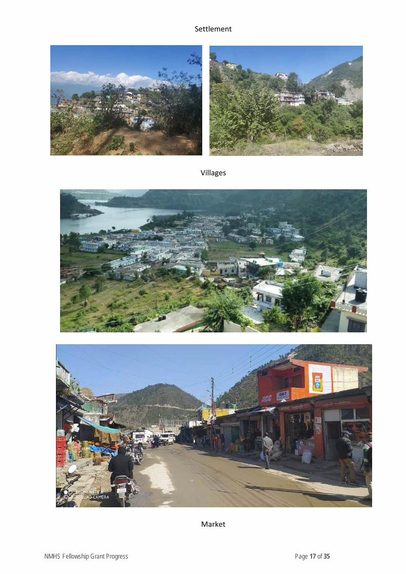
NMHS Fellowship Grant Progress Page 17 of 35
Settlement
Villages
Market
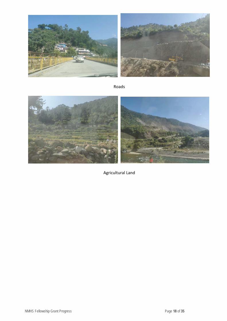
NMHS Fellowship Grant Progress Page 18 of 35
Roads
Agricultural Land
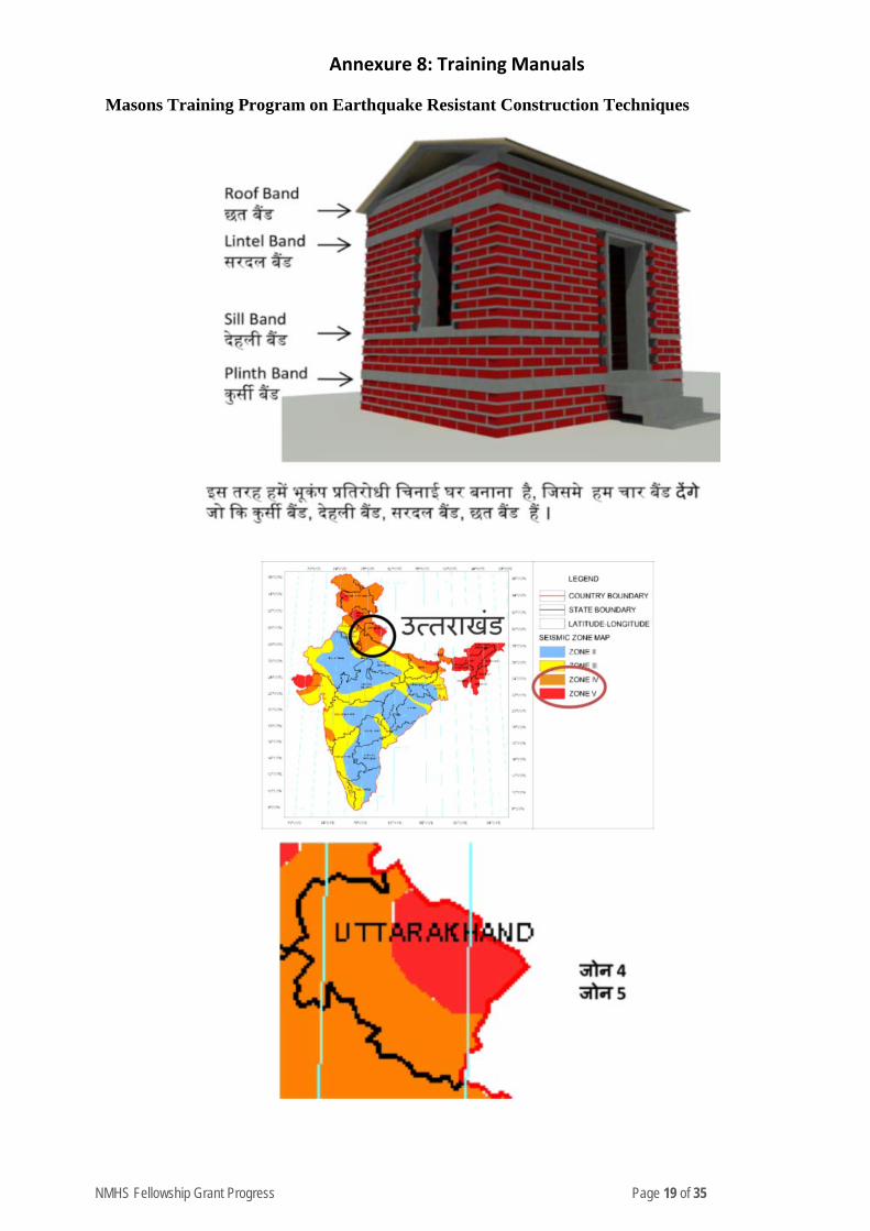
NMHS Fellowship Grant Progress Page 19 of 35
Annexure 8: Training Manuals
Masons Training Program on Earthquake Resistant Construction Techniques
NMHS Fellowship Grant Progress Page 20 of 35
Annexure 9: Site & Construction Material Selection Criteria
This chapter is all about site and construction material selection criteria which is important to take in consideration before building construction.
BUILDING TYPOLOGIES IN INDIA
The buildings are classified as engineered and non-engineered depending on the structural design and material that go in their construction.
the classification based on construction-type should be based on the knowledge of thestructural system, load transfer mechanism, the predominant construction material used,and theperformance during past earthquakes. Buildings are classified based on the material type as follows:
• Masonry and Mortar type • Structural Concrete • Steel • Wooden Structure • Masonry and Mortar type • Structural Concrete • Steel
In addition, various factors influence the Seismic performance of a building and are listed below:
The height of the building:
The seismic response of a building to a ground vibration is a function of its natural frequency - in other words, its inherent mass and stiffness. These factors vary with the height of the building and hence, its vulnerability. As a result, in severe seismic zones, the building height is restricted in accordance with the seismic hazard estimation, specific to a region.
Irregularities:
The obstruction to the load path in transferring the forces from roof to the foundation is caused by the horizontal and vertical irregularities present in the building. A more detailed description about the irregularities is given in IS 1893.
Quality of Construction
The Quality imparted by the local construction practices in terms of compliance with codal provisions and the Status of maintenance or visual appearance is a major factor.
Ground Slope
In several parts of the country such as in the Himalayas, along with the Eastern and Western Ghats and in North-Eastern states, the sloping terrain is often encountered, as a result of which, a large number of buildings are located on hill slopes. Depending on the sloping angle, the slopes are classified as the gentle slope (≤ 20°) and steep slope (> 20°). When houses are constructed on gentle slopes, the ground is typically leveled before construction. For a building constructed ona steep slope, the foundation will vary in terms of elevation along the plan of the building. This leads to vertical members with varying mass and stiffness resulting in vertical irregularity. The stability of the ground is also one of the major parameters that influence the seismic performance of a Building.
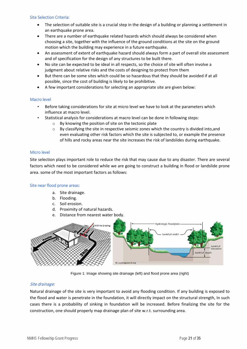
NMHS Fellowship Grant Progress Page 21 of 35
Site Selection Criteria:
• The selection of suitable site is a crucial step in the design of a building or planning a settlement in an earthquake prone area.
• There are a number of earthquake related hazards which should always be considered when choosing a site, together with the influence of the ground conditions at the site on the ground motion which the building may experience in a future earthquake.
• An assessment of extent of earthquake hazard should always form a part of overall site assessment and of specification for the design of any structures to be built there.
• No site can be expected to be ideal in all respects, so the choice of site will often involve a judgment about relative risks and the costs of designing to protect from them
• But there can be some sites which could be so hazardous that they should be avoided if at all possible, since the cost of building is likely to be prohibitive.
• A few important considerations for selecting an appropriate site are given below:
Macro level
• Before taking considerations for site at micro level we have to look at the parameters which influence at macro level.
• Statistical analysis for considerations at macro level can be done in following steps: o By knowing the position of site on the tectonic plate o By classifying the site in respective seismic zones which the country is divided into,and
even evaluating other risk factors which the site is subjected to, or example the presence of hills and rocky areas near the site increases the risk of landslides during earthquake.
Micro level
Site selection plays important role to reduce the risk that may cause due to any disaster. There are several factors which need to be considered while we are going to construct a building in flood or landslide prone area. some of the most important factors as follows:
Site near flood prone areas:
a. Site drainage. b. Flooding. c. Soil erosion. d. Proximity of natural hazards. e. Distance from nearest water body.
Figure 1: Image showing site drainage (left) and flood prone area (right)
Site drainage: Natural drainage of the site is very important to avoid any flooding condition. If any building is exposed to the flood and water is penetrate in the foundation, it will directly impact on the structural strength, In such cases there is a probability of sinking in foundation will be increased. Before finalizing the site for the construction, one should properly map drainage plan of site w.r.t. surrounding area.
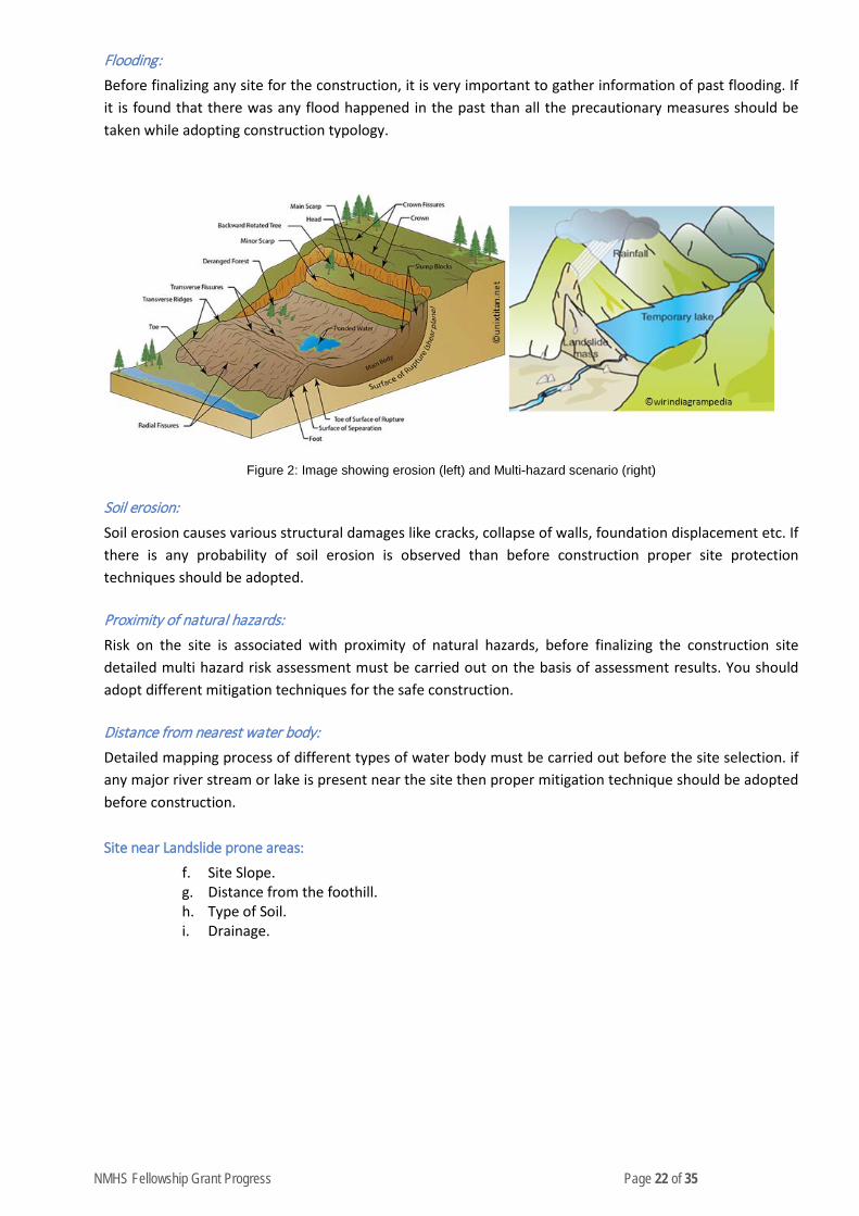
NMHS Fellowship Grant Progress Page 22 of 35
Flooding: Before finalizing any site for the construction, it is very important to gather information of past flooding. If it is found that there was any flood happened in the past than all the precautionary measures should be taken while adopting construction typology.
Figure 2: Image showing erosion (left) and Multi-hazard scenario (right)
Soil erosion: Soil erosion causes various structural damages like cracks, collapse of walls, foundation displacement etc. If there is any probability of soil erosion is observed than before construction proper site protection techniques should be adopted.
Proximity of natural hazards: Risk on the site is associated with proximity of natural hazards, before finalizing the construction site detailed multi hazard risk assessment must be carried out on the basis of assessment results. You should adopt different mitigation techniques for the safe construction.
Distance from nearest water body: Detailed mapping process of different types of water body must be carried out before the site selection. if any major river stream or lake is present near the site then proper mitigation technique should be adopted before construction.
Site near Landslide prone areas:
f. Site Slope. g. Distance from the foothill. h. Type of Soil. i. Drainage.
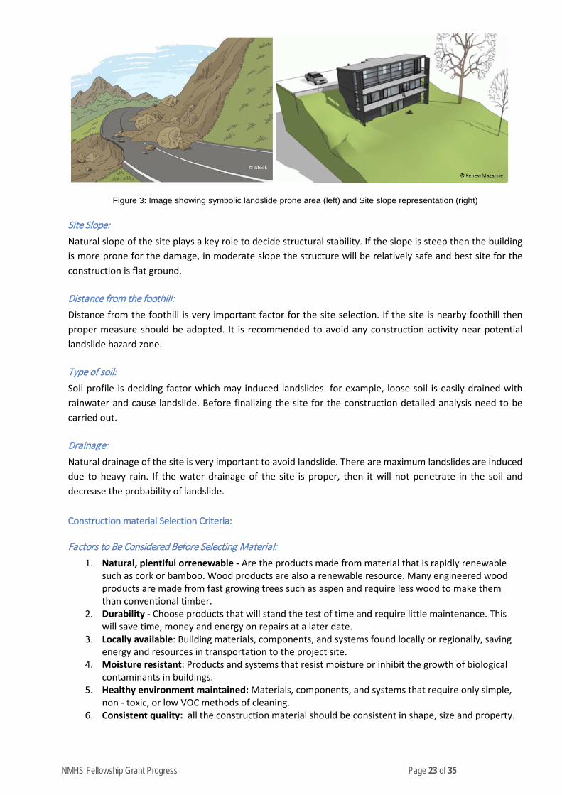
NMHS Fellowship Grant Progress Page 23 of 35
Figure 3: Image showing symbolic landslide prone area (left) and Site slope representation (right)
Site Slope: Natural slope of the site plays a key role to decide structural stability. If the slope is steep then the building is more prone for the damage, in moderate slope the structure will be relatively safe and best site for the construction is flat ground.
Distance from the foothill: Distance from the foothill is very important factor for the site selection. If the site is nearby foothill then proper measure should be adopted. It is recommended to avoid any construction activity near potential landslide hazard zone.
Type of soil: Soil profile is deciding factor which may induced landslides. for example, loose soil is easily drained with rainwater and cause landslide. Before finalizing the site for the construction detailed analysis need to be carried out.
Drainage: Natural drainage of the site is very important to avoid landslide. There are maximum landslides are induced due to heavy rain. If the water drainage of the site is proper, then it will not penetrate in the soil and decrease the probability of landslide.
Construction material Selection Criteria:
Factors to Be Considered Before Selecting Material: 1. Natural, plentiful orrenewable - Are the products made from material that is rapidly renewable
such as cork or bamboo. Wood products are also a renewable resource. Many engineered wood products are made from fast growing trees such as aspen and require less wood to make them than conventional timber.
2. Durability - Choose products that will stand the test of time and require little maintenance. This will save time, money and energy on repairs at a later date.
3. Locally available: Building materials, components, and systems found locally or regionally, saving energy and resources in transportation to the project site.
4. Moisture resistant: Products and systems that resist moisture or inhibit the growth of biological contaminants in buildings.
5. Healthy environment maintained: Materials, components, and systems that require only simple, non - toxic, or low VOC methods of cleaning.
6. Consistent quality: all the construction material should be consistent in shape, size and property.

NMHS Fellowship Grant Progress Page 24 of 35
On the basis of Energy efficiency: Energy Efficiency can be maximized by utilizing materials, components and systems that help reduce energy consumption in buildings and facilities. Water Conservation can be obtained by utilizing products, materials and systems that help reduce water consumption in buildings and landscaped areas, and increase water recycling and reuse. Indoor Air Quality can be enhanced by utilizing materials that meet one or more of the following criteria:
1. Low or non-toxic: Materials that emit few or no carcinogens, reproductive toxicants, or irritants as demonstrated by the manufacturer through appropriate testing.
2. Minimal chemical emissions: Products that have minimal emissions of Volatile Organic Compounds (VOCs). Products that also maximize resource and energy efficiency while reducing chemical emissions.
3. Low-VOC assembly: Materials installed with minimal VOC-producing compounds, or no-VOC mechanical attachment methods and minimal hazards.
4. Moisture resistant: Products and systems that resist moisture or inhibit the growth of biological contaminants in buildings.
5. Healthy environment maintained: Materials, components, and systems that require only simple, non - toxic, or low VOC methods of cleaning.
Affordability can be considered when building product life-cycle costs are lower or comparable to those of “conventional” products, or are within a project-defined percentage of the overall budget
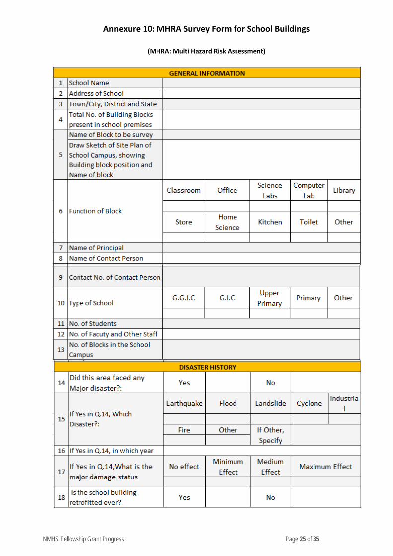
NMHS Fellowship Grant Progress Page 25 of 35
Annexure 10: MHRA Survey Form for School Buildings
(MHRA: Multi Hazard Risk Assessment)

NMHS Fellowship Grant Progress Page 26 of 35
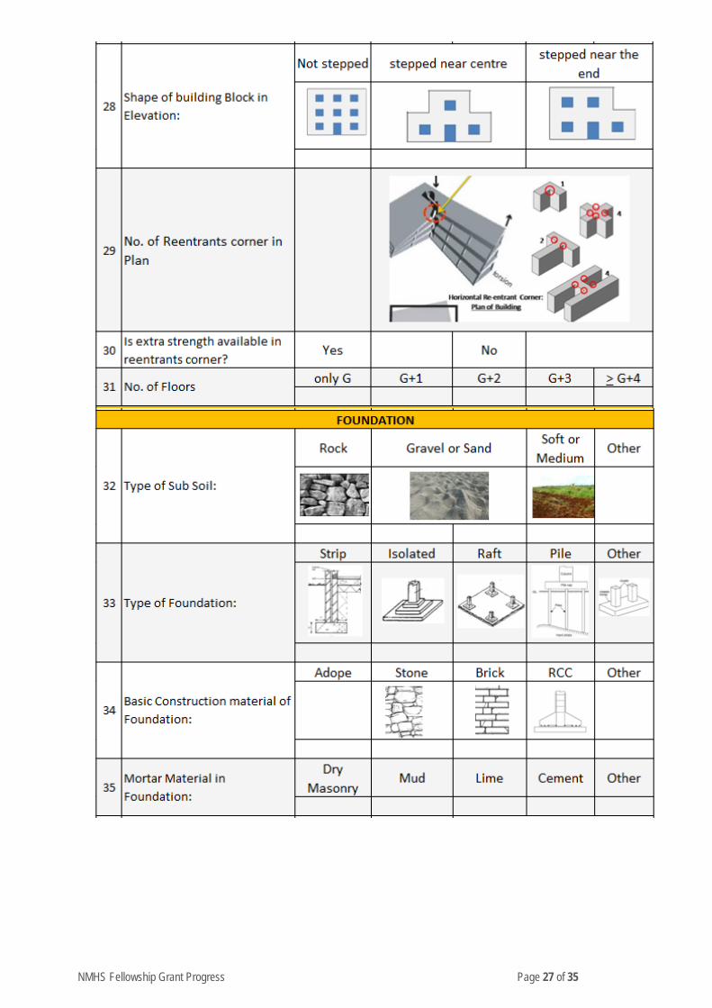
NMHS Fellowship Grant Progress Page 27 of 35
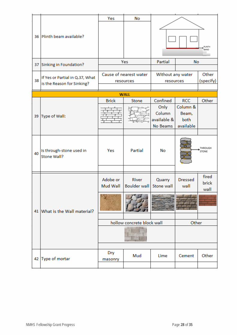
NMHS Fellowship Grant Progress Page 28 of 35
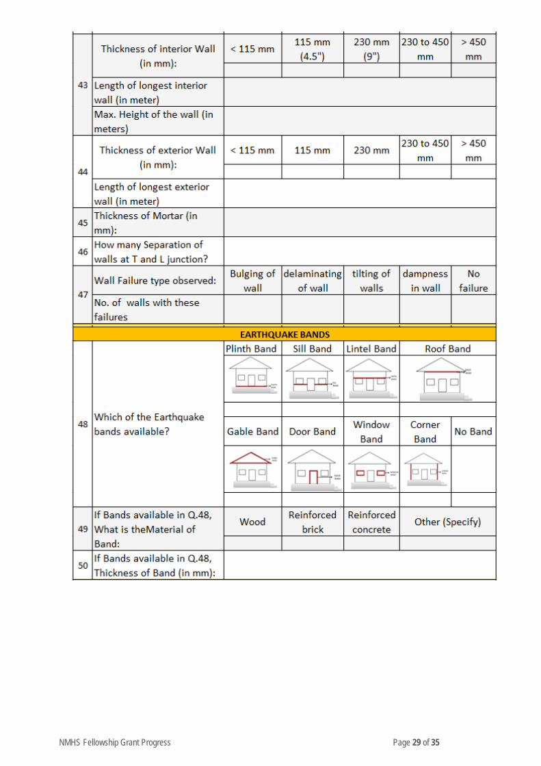
NMHS Fellowship Grant Progress Page 29 of 35
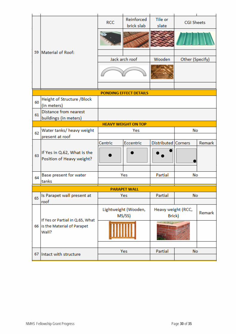
NMHS Fellowship Grant Progress Page 30 of 35
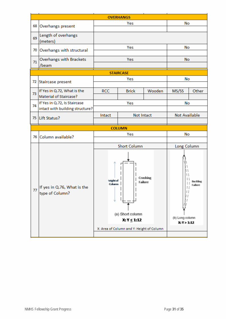
NMHS Fellowship Grant Progress Page 31 of 35

NMHS Fellowship Grant Progress Page 32 of 35
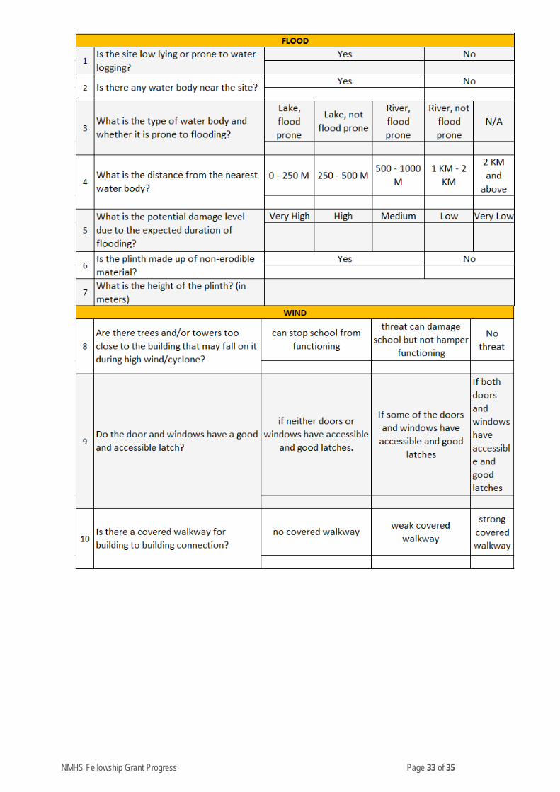
NMHS Fellowship Grant Progress Page 33 of 35

NMHS Fellowship Grant Progress Page 34 of 35

NMHS Fellowship Grant Progress Page 35 of 35
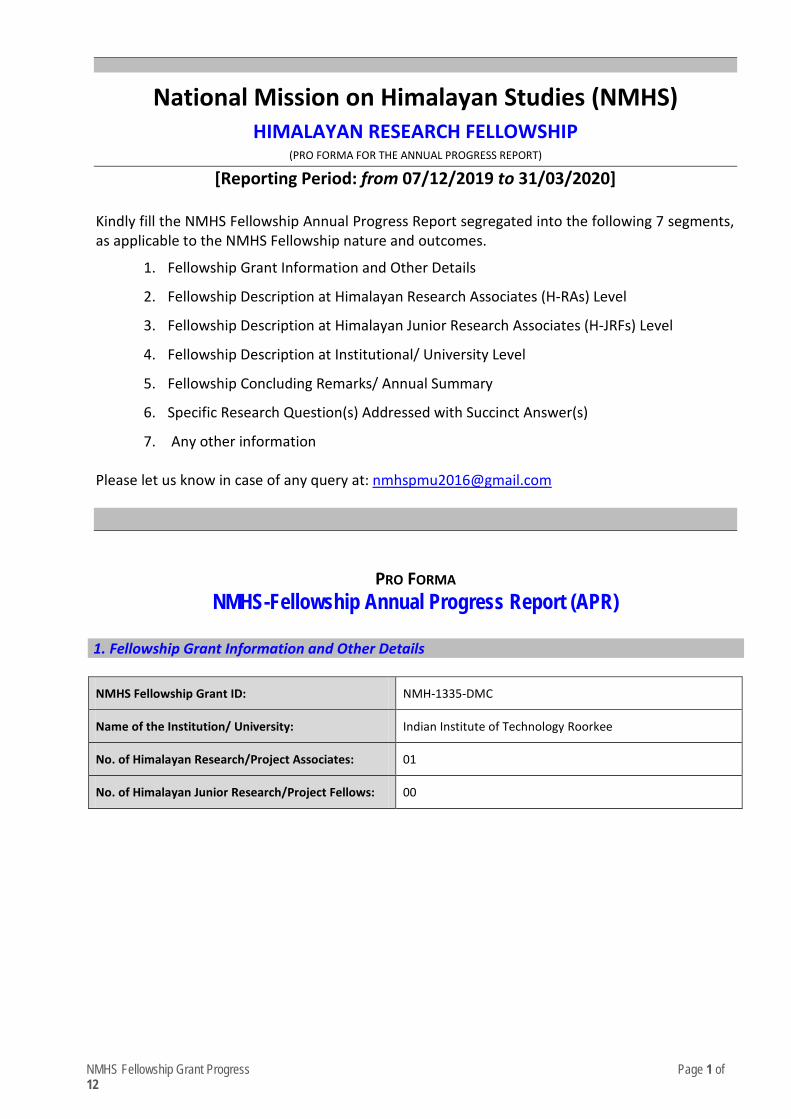
NMHS Fellowship Grant Progress Page 1 of 12
National Mission on Himalayan Studies (NMHS) HIMALAYAN RESEARCH FELLOWSHIP
(PRO FORMA FOR THE ANNUAL PROGRESS REPORT)
[Reporting Period: from 07/12/2019 to 31/03/2020] Kindly fill the NMHS Fellowship Annual Progress Report segregated into the following 7 segments, as applicable to the NMHS Fellowship nature and outcomes.
1. Fellowship Grant Information and Other Details
2. Fellowship Description at Himalayan Research Associates (H-RAs) Level
3. Fellowship Description at Himalayan Junior Research Associates (H-JRFs) Level
4. Fellowship Description at Institutional/ University Level 5. Fellowship Concluding Remarks/ Annual Summary
6. Specific Research Question(s) Addressed with Succinct Answer(s) 7. Any other information
Please let us know in case of any query at: nmhs
PRO FORMA
NMHS-Fellowship Annual Progress Report (APR)
1. Fellowship Grant Information and Other Details
NMHS Fellowship Grant ID: NMH-1335-DMC
Name of the Institution/ University: Indian Institute of Technology Roorkee
No. of Himalayan Research/Project Associates: 01
No. of Himalayan Junior Research/Project Fellows: 00
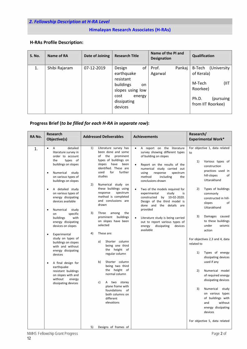
NMHS Fellowship Grant Progress Page 2 of 12
2. Fellowship Description at H-RA Level
Himalayan Research Associates (H-RAs)
H-RAs Profile Description:
S. No. Name of RA Date of Joining Research Title Name of the PI and Designation Qualification
1. Shibi Rajaram 07-12-2019 Design of earthquake resistant buildings on slopes using low cost energy dissipating devices
Prof. Pankaj Agarwal
B-Tech (University of Kerala)
M-Tech (IIT Roorkee)
Ph.D. (pursuing from IIT Roorkee)
Progress Brief (to be filled for each H-RA in separate row):
RA No. Research Objective(s) Addressed Deliverables Achievements Research/
Experimental Work*
1. • A detailed literature survey in order to account the types of buildings on slopes
• Numerical study on various types of buildings on slopes
• A detailed study on various types of energy dissipating devices available
• Numerical study on specific buildings with energy dissipating devices on slopes
• Experimental study on types of buildings on slopes with and without energy dissipating devices
• A final design for earthquake resistant buildings on slopes with and without energy dissipating devices
1) Literature survey has been done and some of the prominent types of buildings on slopes have been identified. These are used for further studies
2) Numerical study on these buildings using response spectrum method is completed and conclusions are drawn
3) Three among the prominent buildings on slopes have been selected
4) These are:
a) Shorter column being one third the height of regular column
b) Shorter column being two third the height of normal column
c) A two storey plane frame with foundations of both columns on different elevations
5) Designs of frames of
• A report on the literature survey showing different types of building on slopes
• Report on the results of the numerical study carried out using response spectrum method including the conclusions drawn
• Two of the models required for experimental study is constructed by 10-02-2020. Design of the third model is done and the details are provided
• Literature study is being carried out to report various types of energy dissipating devices available
For objective 1, data related to
1) Various types of construction practices used in hill-slopes of Uttarakhand
2) Types of buildings commonly constructed in hill-slopes of Uttarakhand
3) Damages caused to these buildings under seismic action
For objectives 2,3 and 4, data related to
1) Types of energy dissipating devices used if any
2) Numerical model of required energy dissipating devices
3) Numerical study on various types of buildings with and without energy dissipating devices
For objective 5, data related

NMHS Fellowship Grant Progress Page 3 of 12
these buildings are completed and frames a and b are constructed with ductile detailing according to IS 13920.
6) document containing results and conclusions of response spectrum method on various types of hill buildings is attached
7) A document containing progress report of the project is attached
to
1) Ductile detailing using IS 13920
2) Types of energy dissipating devices that are most efficient
3) Experimental study using models with and without energy dissipating devices
After completing all particular objectives the final optimized design of buildings on slopes with and without energy dissipating devices is established using Quasi Static Test Facility in Earthquake Department of IIT Roorkee
*Experimental work giving full details (in separate sheet, within 300 words) of experimental set up, methods adopted, data collected supported by necessary table, charts, diagrams & photographs. Note: Data, table and figures may be attached as separate source file (.docx, .xls, jpg, .jpeg, .png, .shp, etc. ).
Given in Appendix 1.

NMHS Fellowship Grant Progress Page 4 of 12
3. Fellowship Description at H-JRF Level
Himalayan Junior Research Project Fellows (H-JRFs)
H-JRFs Profile Description: - Not Applicable S. No. Name of JRF Date of Joining Name of the PI Qualification
1. ….
Progress Brief (to be filled for each JRF in separate row): Not Applicable
JRF No. Research Objectives Deliverable Achievements Research/
Experimental Work*
1. • • •
• • •
[Enclose descriptive file – max. 250 words]
*Experimental work giving full details (in separate sheet, within 300 words) of experimental set up, methods adopted, data collected supported by necessary table, charts, diagrams & photographs. Note: Data, table and figures may be attached as separate source file (.docx, .xls, jpg, .jpeg, .png, .shp, etc. ).
NMHS Fellowship Grant Progress Page 5 of 12
4. Fellowship Description at Institutional/ University Level
Annual Deliverables/ Outputs (during the reporting year)
S. No. Deliverables/ Parameters No. Description
1. No. of Research Publications (monograph/ articles/ peer-reviewed articles):
[Enclose file for description – max. 250 words]
2. No. of Data Sets generated: [Enclose file for description – max. 250 words]
3. No. of Conferences/ Workshops attended:
[Enclose file for description – max. 250 words]
4. No. of Sites/ Study Area Covered: [Enclose file for description – max. 250 words]
5. No. of Best Practices suitable for IHR: [Enclose file for description – max. 250 words]
6. New Observations/ Innovations [Enclose file for description – max. 250 words]
5. Fellowship Concluding Remarks/ Annual Summary
Conclusions summarizing the achievements and indication of remaining work (within 300 words):
Completed activities :
1) Literature survey required to assess various types of buildings constructed on slopes in Uttarakhand
2) Literature survey to quantify various kinds of damages occurring due to seismic action on buildings located on slopes
3) Numerical study using response spectrum method on various types of buildings on slopes and specific conclusions
4) Comparison of response of Step-back Set-back buildings and Step-back buildings using response spectrum method
5) Two models required for experimental study at Quasi-Static test facility in IIT Roorkee were casted by 10-02-2020
6) The design for the third model is completed.
Work to be done are :
1) Literature survey required to evaluate various kinds of energy dissipating devices used in buildings during seismic action
2) Quantify the merit and demerit of each over the other
3) Creating an efficient numerical model for the energy dissipating device
4) Completing the experimental study on constructed models
5) Constructing more models for experimental study constructed with and without energy dissipating device
6) Preparing a final seismic resistant design for hill buildings with and without energy dissipating devices
NMHS Fellowship Grant Progress Page 6 of 12
6. Specific Research Question(s) Addressed with Succinct Answer(s)
S. No. Research Questions Addressed Succinct Answers (within 150-200 words)
1. a) Major damages occurring in buildings on hill slopes b) Efficiency of currently used documents like Delhi Master Plan(s) and IS 1893(part 1): 2016 c) Efficiency of Step-back Set-back configuration over Step- back configurations for buildings on slopes using numerical study. Though models for experimental study are constructed, experimental study was not performed due to Covid 19.
1) Short column failure is a major type of damage occurring in irregular building on slopes 2) Shear failure of beams and columns are also common 3) Insufficient shear reinforcement causing buckling of columns 4) Infill walls causing out of plane failure 5) Poor detailing of beam column or slab column connections leading to failure 6) Higher stiffness of short columns attract more load leading to failure through shear 7) IS 1893(part 1):2016 do not have sufficient design details of irregular buildings on slopes 8) Models are constructed using IS 1893(part 1):2016 7) Inter-storey drift of Step-back Set-back building is less as compared to Step-back buildings. A report is attached which includes response spectrum analysis of various types irregular structures 8) Base shear of Step-back Set-back building is also found to be lower than Step-back buildings
7. Any Other Information • …
<Signature of PI/ Head of Institution>
<Name of the Institution>
Report (hard copy) should be submitted to:
The Nodal Officer, NMHS-PMU National Mission on Himalayan Studies (NMHS) गो�वद बल्लभ पंत रा�ीय िहमालयी पयार्वरण एवं सतत ्िवकास ससं्थान G.B. Pant National Institute of Himalayan Environment and Sustainable Development (GBPNIHESD) Kosi-Katarmal, Almora 263643, Uttarakhand
Report (soft copy) should be submitted to:
E-mail: [email protected]
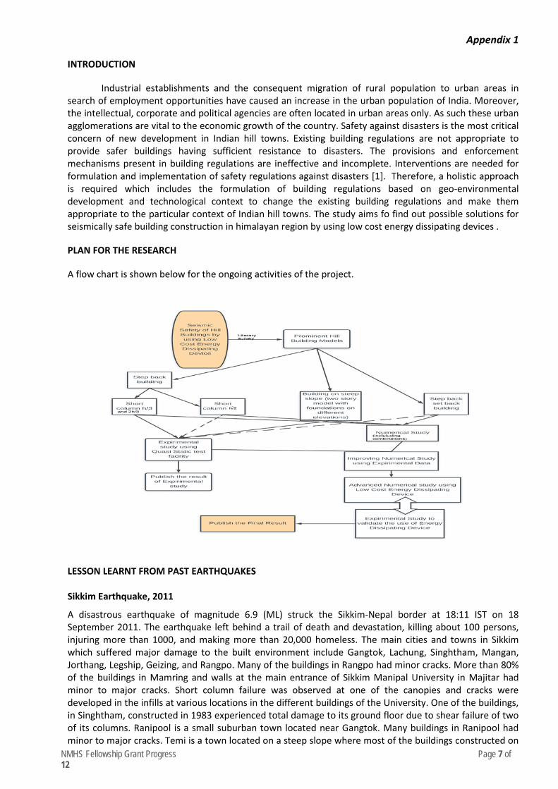
NMHS Fellowship Grant Progress Page 7 of 12
Appendix 1
INTRODUCTION
Industrial establishments and the consequent migration of rural population to urban areas in search of employment opportunities have caused an increase in the urban population of India. Moreover, the intellectual, corporate and political agencies are often located in urban areas only. As such these urban agglomerations are vital to the economic growth of the country. Safety against disasters is the most critical concern of new development in Indian hill towns. Existing building regulations are not appropriate to provide safer buildings having sufficient resistance to disasters. The provisions and enforcement mechanisms present in building regulations are ineffective and incomplete. Interventions are needed for formulation and implementation of safety regulations against disasters [1]. Therefore, a holistic approach is required which includes the formulation of building regulations based on geo-environmental development and technological context to change the existing building regulations and make them appropriate to the particular context of Indian hill towns. The study aims fo find out possible solutions for seismically safe building construction in himalayan region by using low cost energy dissipating devices .
PLAN FOR THE RESEARCH
A flow chart is shown below for the ongoing activities of the project.
LESSON LEARNT FROM PAST EARTHQUAKES
Sikkim Earthquake, 2011
A disastrous earthquake of magnitude 6.9 (ML) struck the Sikkim-Nepal border at 18:11 IST on 18 September 2011. The earthquake left behind a trail of death and devastation, killing about 100 persons, injuring more than 1000, and making more than 20,000 homeless. The main cities and towns in Sikkim which suffered major damage to the built environment include Gangtok, Lachung, Singhtham, Mangan, Jorthang, Legship, Geizing, and Rangpo. Many of the buildings in Rangpo had minor cracks. More than 80% of the buildings in Mamring and walls at the main entrance of Sikkim Manipal University in Majitar had minor to major cracks. Short column failure was observed at one of the canopies and cracks were developed in the infills at various locations in the different buildings of the University. One of the buildings, in Singhtham, constructed in 1983 experienced total damage to its ground floor due to shear failure of two of its columns. Ranipool is a small suburban town located near Gangtok. Many buildings in Ranipool had minor to major cracks. Temi is a town located on a steep slope where most of the buildings constructed on
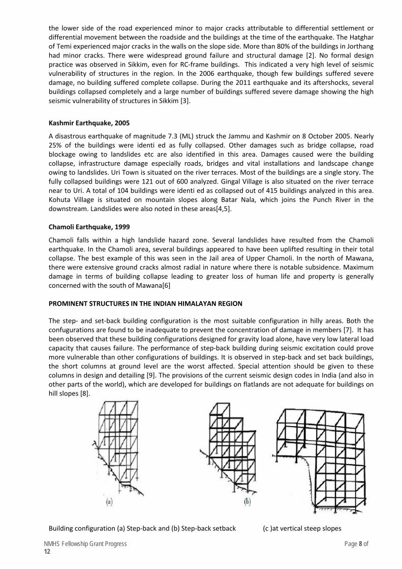
NMHS Fellowship Grant Progress Page 8 of 12
the lower side of the road experienced minor to major cracks attributable to differential settlement or differential movement between the roadside and the buildings at the time of the earthquake. The Hatghar of Temi experienced major cracks in the walls on the slope side. More than 80% of the buildings in Jorthang had minor cracks. There were widespread ground failure and structural damage [2]. No formal design practice was observed in Sikkim, even for RC-frame buildings. This indicated a very high level of seismic vulnerability of structures in the region. In the 2006 earthquake, though few buildings suffered severe damage, no building suffered complete collapse. During the 2011 earthquake and its aftershocks, several buildings collapsed completely and a large number of buildings suffered severe damage showing the high seismic vulnerability of structures in Sikkim [3].
Kashmir Earthquake, 2005
A disastrous earthquake of magnitude 7.3 (ML) struck the Jammu and Kashmir on 8 October 2005. Nearly 25% of the buildings were identi ed as fully collapsed. Other damages such as bridge collapse, road blockage owing to landslides etc are also identified in this area. Damages caused were the building collapse, infrastructure damage especially roads, bridges and vital installations and landscape change owing to landslides. Uri Town is situated on the river terraces. Most of the buildings are a single story. The fully collapsed buildings were 121 out of 600 analyzed. Gingal Village is also situated on the river terrace near to Uri. A total of 104 buildings were identi ed as collapsed out of 415 buildings analyzed in this area. Kohuta Village is situated on mountain slopes along Batar Nala, which joins the Punch River in the downstream. Landslides were also noted in these areas[4,5]. Chamoli Earthquake, 1999
Chamoli falls within a high landslide hazard zone. Several landslides have resulted from the Chamoli earthquake. In the Chamoli area, several buildings appeared to have been uplifted resulting in their total collapse. The best example of this was seen in the Jail area of Upper Chamoli. In the north of Mawana, there were extensive ground cracks almost radial in nature where there is notable subsidence. Maximum damage in terms of building collapse leading to greater loss of human life and property is generally concerned with the south of Mawana[6]
PROMINENT STRUCTURES IN THE INDIAN HIMALAYAN REGION
The step- and set-back building configuration is the most suitable configuration in hilly areas. Both the confugurations are found to be inadequate to prevent the concentration of damage in members [7]. It has been observed that these building configurations designed for gravity load alone, have very low lateral load capacity that causes failure. The performance of step-back building during seismic excitation could prove more vulnerable than other configurations of buildings. It is observed in step-back and set back buildings, the short columns at ground level are the worst affected. Special attention should be given to these columns in design and detailing [9]. The provisions of the current seismic design codes in India (and also in other parts of the world), which are developed for buildings on flatlands are not adequate for buildings on hill slopes [8].
Building configuration (a) Step-back and (b) Step-back setback (c )at vertical steep slopes

NMHS Fellowship Grant Progress Page 9 of 12
REQUIRED RESULTS FROM THE NUMERICAL STUDY
Various configurations of set-back buildings on hills are analysed using response spectrum method. The values of frequencies in each mode, modal participation factor for each mode, displacement response in each storey, inter-storey drift in each storey, lateral force in each storey and base shear are calculated and compared for each configuration.
S. No. Building Configuration considered Number a) Normal building with infills 1.1.2 b) Set back building with foundations on 2 elevations with infills 2.1.2 c) Set back building with short column height 1/3rd of normal column with infills 3.1.2 d) Set back building with short column height 1/2 of normal column with infills 4.1.2 e) Set back building on slope with different angles with infills 5.1.2 f) Set back building on slope and foundations on two elevations with infills 6.1.2
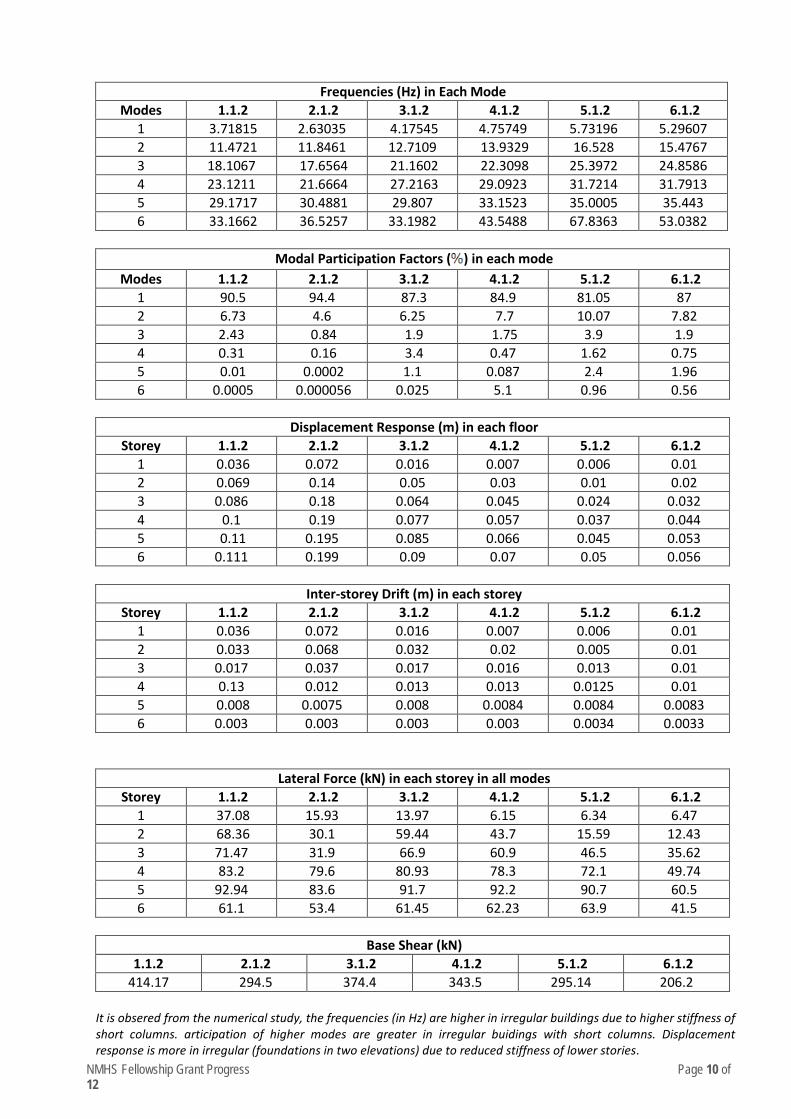
NMHS Fellowship Grant Progress Page 10 of 12
Frequencies (Hz) in Each Mode Modes 1.1.2 2.1.2 3.1.2 4.1.2 5.1.2 6.1.2
1 3.71815 2.63035 4.17545 4.75749 5.73196 5.29607 2 11.4721 11.8461 12.7109 13.9329 16.528 15.4767 3 18.1067 17.6564 21.1602 22.3098 25.3972 24.8586 4 23.1211 21.6664 27.2163 29.0923 31.7214 31.7913 5 29.1717 30.4881 29.807 33.1523 35.0005 35.443 6 33.1662 36.5257 33.1982 43.5488 67.8363 53.0382
Modal Participation Factors ( ) in each mode
Modes 1.1.2 2.1.2 3.1.2 4.1.2 5.1.2 6.1.2 1 90.5 94.4 87.3 84.9 81.05 87 2 6.73 4.6 6.25 7.7 10.07 7.82 3 2.43 0.84 1.9 1.75 3.9 1.9 4 0.31 0.16 3.4 0.47 1.62 0.75 5 0.01 0.0002 1.1 0.087 2.4 1.96 6 0.0005 0.000056 0.025 5.1 0.96 0.56
Displacement Response (m) in each floor
Storey 1.1.2 2.1.2 3.1.2 4.1.2 5.1.2 6.1.2 1 0.036 0.072 0.016 0.007 0.006 0.01 2 0.069 0.14 0.05 0.03 0.01 0.02 3 0.086 0.18 0.064 0.045 0.024 0.032 4 0.1 0.19 0.077 0.057 0.037 0.044 5 0.11 0.195 0.085 0.066 0.045 0.053 6 0.111 0.199 0.09 0.07 0.05 0.056
Inter-storey Drift (m) in each storey
Storey 1.1.2 2.1.2 3.1.2 4.1.2 5.1.2 6.1.2 1 0.036 0.072 0.016 0.007 0.006 0.01 2 0.033 0.068 0.032 0.02 0.005 0.01 3 0.017 0.037 0.017 0.016 0.013 0.01 4 0.13 0.012 0.013 0.013 0.0125 0.01 5 0.008 0.0075 0.008 0.0084 0.0084 0.0083 6 0.003 0.003 0.003 0.003 0.0034 0.0033
Lateral Force (kN) in each storey in all modes Storey 1.1.2 2.1.2 3.1.2 4.1.2 5.1.2 6.1.2
1 37.08 15.93 13.97 6.15 6.34 6.47 2 68.36 30.1 59.44 43.7 15.59 12.43 3 71.47 31.9 66.9 60.9 46.5 35.62 4 83.2 79.6 80.93 78.3 72.1 49.74 5 92.94 83.6 91.7 92.2 90.7 60.5 6 61.1 53.4 61.45 62.23 63.9 41.5
Base Shear (kN)
1.1.2 2.1.2 3.1.2 4.1.2 5.1.2 6.1.2 414.17 294.5 374.4 343.5 295.14 206.2
It is obsered from the numerical study, the frequencies (in Hz) are higher in irregular buildings due to higher stiffness of short columns. articipation of higher modes are greater in irregular buidings with short columns. Displacement response is more in irregular (foundations in two elevations) due to reduced stiffness of lower stories.
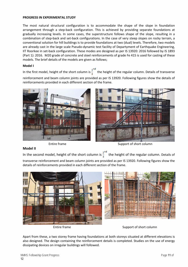
NMHS Fellowship Grant Progress Page 11 of 12
PROGRESS IN EXPERIMENTAL STUDY
The most natural structural configuration is to accommodate the shape of the slope in foundation arrangement through a step-back configuration. This is achieved by providing separate foundations at gradually increasing levels. In some cases, the superstructure follows shape of the slope, resulting in a combination of step-back and set-back configurations. In the case of very steep slopes on rocky terrain, a conventional solution for hill buildings is to provide foundations at two (dual) levels. Therefore, two models are already cast in the large scale Pseudo-dynamic test facility of Departyment of Earthquake Engineering, IIT Roorkee in set-back configuration. These modes are designed as per IS 13920: 2016 followed by IS 1893 (Part 1): 2016. M20 grade of concrete and steel reinforcements of grade Fe 415 is used for casting of these models. The brief details of the models are given as follows;
Model I
In the first model, height of the short column is the height of the regular column. Details of transverse
reinforcement and beam column joints are provided as per IS 13920. Following figures show the details of reinforcements provided in each different section of the frame.
Entire frame Support of short column
Model II
In the second model, height of the short column is the height of the regular column. Details of
transverse reinforcement and beam column joints are provided as per IS 13920. Following figures show the details of reinforcements provided in each different section of the frame.
Entire frame Support of short column Apart from these, a two storey frame having foundations at both storeys situated at different elevations is also designed. The design containing the reinforcement details is completed. Studies on the use of energy dissipating devices on irregular buildings will followed.

NMHS Fellowship Grant Progress Page 12 of 12
References: 1. Kumar, A and Pushpalata, 2015. Building regulations for hill towns of India. HBRC Journal, 11:275-284 2. Sharma, M.L, Sinvhal, A, Singh, Y and Maheshwari, B.K, 2013. Damage Survey Report for Sikkim Earthquake of
18 September 2011. Seismological Research Letters, 84:49-56 3. Kaushik, H.B and Dasgupta, K, 2013. Assessment of seismic vulnerability of structures in Sikkim, India, based
on damage observation during two recent earthquakes. Journal of Performance of Constructed Facilities, 27:697-720
4. Ahmad, B, Alam, A, Bhat, M.S., Ahmad, S, Shafi, M and Rasool, R, 2017. Seismic risk reduction through indigenous architecture in Kashmir Valley. International Journal of Disaster Risk Reduction, 21:110-117
5. Kumar, K.V., Martha, T.R. and Roy, P.S, 2006. Mapping damage in the Jammu and Kashmir caused by 8 October 2005 Mw 7.3 earthquake from the Cartosat and Resourcesat{1 imagery. International Journal of Remote Sensing, 20:4449-4459
6. Sarkar, I, Pachauri, A.K and Israil, M, 2001. On damage caused by the Chamoli earthquake of 29 March, 1999. Journal of Asian Earth Sciences, 19:129-134
7. Mohammad, Zaid, Baqi, Abdul and Arif, Mohammad, 2017. Seismic response of RC framed buildings resting on hill slopes. Procedia Engineering, 173:1792-1799
8. Surana, Mitesh, Singh,Y and Lang, D.H, 2015. Seismic fragility analysis of hill buildings in Indian Himalayas. SECED 2015 Conference: Earthquake Risk and Engineering towards a Resilient World
9. Birajdar, B.G and Nalawade, S.S, 2004. Seismic analysis of building resting on sloping ground. 13 WCEE
NMHS Fellowship Grant Progress Page 1 of 12
National Mission on Himalayan Studies (NMHS) HIMALAYAN RESEARCH FELLOWSHIP
(PRO FORMA FOR THE ANNUAL PROGRESS REPORT)
[Reporting Period: from July 2019 to March 2020] Kindly fill the NMHS Fellowship Annual Progress Report segregated into the following 7 segments, as applicable to the NMHS Fellowship nature and outcomes.
1. Fellowship Grant Information and Other Details
2. Fellowship Description at Himalayan Research Associates (H-RAs) Level
3. Fellowship Description at Himalayan Junior Research Associates (H-JRFs) Level
4. Fellowship Description at Institutional/ University Level 5. Fellowship Concluding Remarks/ Annual Summary
6. Specific Research Question(s) Addressed with Succinct Answer(s) 7. Any other information
Please let us know in case of any query at: nmhs
PRO FORMA
NMHS-Fellowship Annual Progress Report (APR)
1. Fellowship Grant Information and Other Details
NMHS Fellowship Grant ID: NMH-1338-DMC
Name of the Institution/ University: Indian Institute of Technology Roorkee
No. of Himalayan Research/Project Associates: 0
No. of Himalayan Junior Research/Project Fellows: 1
2. Fellowship Description at H-RA Level
Himalayan Research Associates (H-RAs)
H-RAs Profile Description: (Not applicable)
S. No. Name of RA Date of Joining Research Title Name of the PI and Designation Qualification
1. ….

NMHS Fellowship Grant Progress Page 2 of 12
Progress Brief (to be filled for each H-RA in separate row):
RA No. Research Objective(s) Addressed Deliverables Achievements Research/
Experimental Work*
1. [Enclose descriptive file – max. 250 words]
*Experimental work giving full details (in separate sheet, within 300 words) of experimental set up, methods adopted, data collected supported by necessary table, charts, diagrams & photographs. Note: Data, table and figures may be attached as separate source file (.docx, .xls, jpg, .jpeg, .png, .shp, etc. ).
3. Fellowship Description at H-JRF Level
Himalayan Junior Research Project Fellows (H-JRFs)
H-JRFs Profile Description: S. No. Name of JRF Date of Joining Name of the PI Qualification
1. Ravi Meena 11-07-2019 Prof. Sumit Sen M. Tech
(Left the position after 3 months)
2. Denzil Daniel 09-01-2020 Prof. Sumit Sen M.Tech.
Progress Brief (to be filled for each JRF in separate row):
JRF No. Research Objectives Deliverable Achievements Research/ Experimental
Work*
1. (1) Baseline database preparation for hydromet variables.
(2) Understanding hydrological processes and biophysical linkages.
(3) Hydrological modelling and BMPs towards policy frameworks.
(1) Quantifying rainfall-runoff characteristics and identification of key hydrological processes
(2) Develop physically based hydrological models.
(3) Scientific articles and presentation in international conference.
Objective 1: Baseline database of hourly spring discharge and rainfall prepared for Mathamali Spring from Feb-2014 to Feb-2018 (35663 observations with <7% missing data).
Baseline hourly reference weather data with 3 variables (temperature, relative humidity and solar radiation) cleaned and prepared for Mathamali Spring from Sep-2015 to Dec-2018 (29219 observations with ~48% missing data).
Objective 2: Recession flow analysis completed on spring discharge observations to
Objective 1: Brief description of the study area and plots of the baseline data are presented in Annexure 1.
Objective 2: The theoretical framework for storage-discharge relationship and, the results of effective storage (yield) -discharge relationship of Mathamali Spring are presented in Annexure 2.
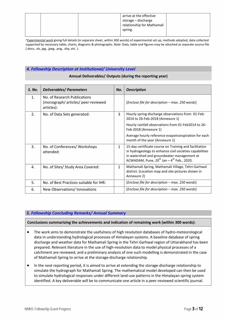
NMHS Fellowship Grant Progress Page 3 of 12
arrive at the effective storage – discharge relationship for Mathamali spring.
*Experimental work giving full details (in separate sheet, within 300 words) of experimental set up, methods adopted, data collected supported by necessary table, charts, diagrams & photographs. Note: Data, table and figures may be attached as separate source file (.docx, .xls, jpg, .jpeg, .png, .shp, etc. ).
4. Fellowship Description at Institutional/ University Level
Annual Deliverables/ Outputs (during the reporting year)
S. No. Deliverables/ Parameters No. Description
1. No. of Research Publications (monograph/ articles/ peer-reviewed articles):
[Enclose file for description – max. 250 words]
2. No. of Data Sets generated: 3 Hourly spring discharge observations from 01-Feb-2014 to 26-Feb-2018 (Annexure 1)
Hourly rainfall observations from 01-Feb2014 to 26-Feb-2018 (Annexure 1)
Average hourly reference evapotranspiration for each month of the year (Annexure 1)
3. No. of Conferences/ Workshops attended:
1 15-day certificate course on Training and facilitation in hydrogeology to enhance civil societies capabilities in watershed and groundwater management at ACWADAM, Pune, 20th Jan – 4th Feb., 2020.
4. No. of Sites/ Study Area Covered: 1 Mathamali Spring, Mathamali Village, Tehri-Garhwal district. (Location map and site pictures shown in Annexure 2)
5. No. of Best Practices suitable for IHR: [Enclose file for description – max. 250 words]
6. New Observations/ Innovations [Enclose file for description – max. 250 words]
5. Fellowship Concluding Remarks/ Annual Summary
Conclusions summarizing the achievements and indication of remaining work (within 300 words):
• The work aims to demonstrate the usefulness of high resolution databases of hydro-meteorological data in understanding hydrological processes of Himalayan systems. A baseline database of spring discharge and weather data for Mathamali Spring in the Tehri Garhwal region of Uttarakhand has been prepared. Relevant literature in the use of high-resolution data to model physical processes of a catchment are reviewed, and a preliminary analysis of one such modelling is demonstrated in the case of Mathamali Spring to arrive at the storage-discharge relationship.
• In the next reporting period, it is aimed to arrive at extending the storage-discharge relationship to simulate the hydrograph for Mathamali Spring. The mathematical model developed can then be used to simulate hydrological responses under different land-use patterns in the Himalayan spring system identified. A key deliverable will be to communicate one article in a peer-reviewed scientific journal.

NMHS Fellowship Grant Progress Page 4 of 12
6. Specific Research Question(s) Addressed with Succinct Answer(s)
S. No. Research Questions Addressed Succinct Answers (within 150-200 words)
1.
7. Any Other Information
• NA
Signature of PI
IIT Roorkee
Report (hard copy) should be submitted to:
The Nodal Officer, NMHS-PMU National Mission on Himalayan Studies (NMHS) गो�वद बल्लभ पंत रा�ीय िहमालयी पयार्वरण एवं सतत ्िवकास ससं्थान G.B. Pant National Institute of Himalayan Environment and Sustainable Development (GBPNIHESD) Kosi-Katarmal, Almora 263643, Uttarakhand
Report (soft copy) should be submitted to:
E-mail: [email protected]
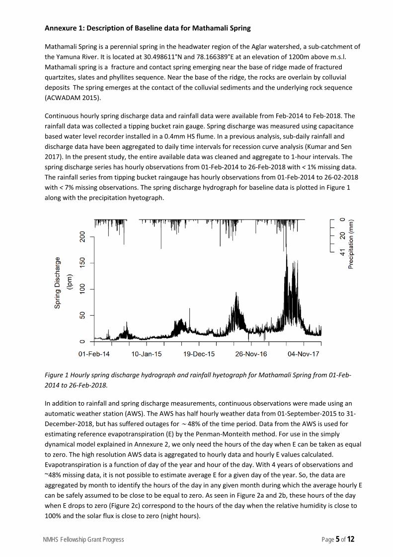
NMHS Fellowship Grant Progress Page 5 of 12
Annexure 1: Description of Baseline data for Mathamali Spring
Mathamali Spring is a perennial spring in the headwater region of the Aglar watershed, a sub-catchment of the Yamuna River. It is located at 30.498611°N and 78.166389°E at an elevation of 1200m above m.s.l. Mathamali spring is a fracture and contact spring emerging near the base of ridge made of fractured quartzites, slates and phyllites sequence. Near the base of the ridge, the rocks are overlain by colluvial deposits The spring emerges at the contact of the colluvial sediments and the underlying rock sequence (ACWADAM 2015).
Continuous hourly spring discharge data and rainfall data were available from Feb-2014 to Feb-2018. The rainfall data was collected a tipping bucket rain gauge. Spring discharge was measured using capacitance based water level recorder installed in a 0.4mm HS flume. In a previous analysis, sub-daily rainfall and discharge data have been aggregated to daily time intervals for recession curve analysis (Kumar and Sen 2017). In the present study, the entire available data was cleaned and aggregate to 1-hour intervals. The spring discharge series has hourly observations from 01-Feb-2014 to 26-Feb-2018 with < 1% missing data. The rainfall series from tipping bucket raingauge has hourly observations from 01-Feb-2014 to 26-02-2018 with < 7% missing observations. The spring discharge hydrograph for baseline data is plotted in Figure 1 along with the precipitation hyetograph.
Figure 1 Hourly spring discharge hydrograph and rainfall hyetograph for Mathamali Spring from 01-Feb-2014 to 26-Feb-2018.
In addition to rainfall and spring discharge measurements, continuous observations were made using an automatic weather station (AWS). The AWS has half hourly weather data from 01-September-2015 to 31-December-2018, but has suffered outages for ∼ 48% of the time period. Data from the AWS is used for estimating reference evapotranspiration (E) by the Penman-Monteith method. For use in the simply dynamical model explained in Annexure 2, we only need the hours of the day when E can be taken as equal to zero. The high resolution AWS data is aggregated to hourly data and hourly E values calculated. Evapotranspiration is a function of day of the year and hour of the day. With 4 years of observations and ~48% missing data, it is not possible to estimate average E for a given day of the year. So, the data are aggregated by month to identify the hours of the day in any given month during which the average hourly E can be safely assumed to be close to be equal to zero. As seen in Figure 2a and 2b, these hours of the day when E drops to zero (Figure 2c) correspond to the hours of the day when the relative humidity is close to 100% and the solar flux is close to zero (night hours).
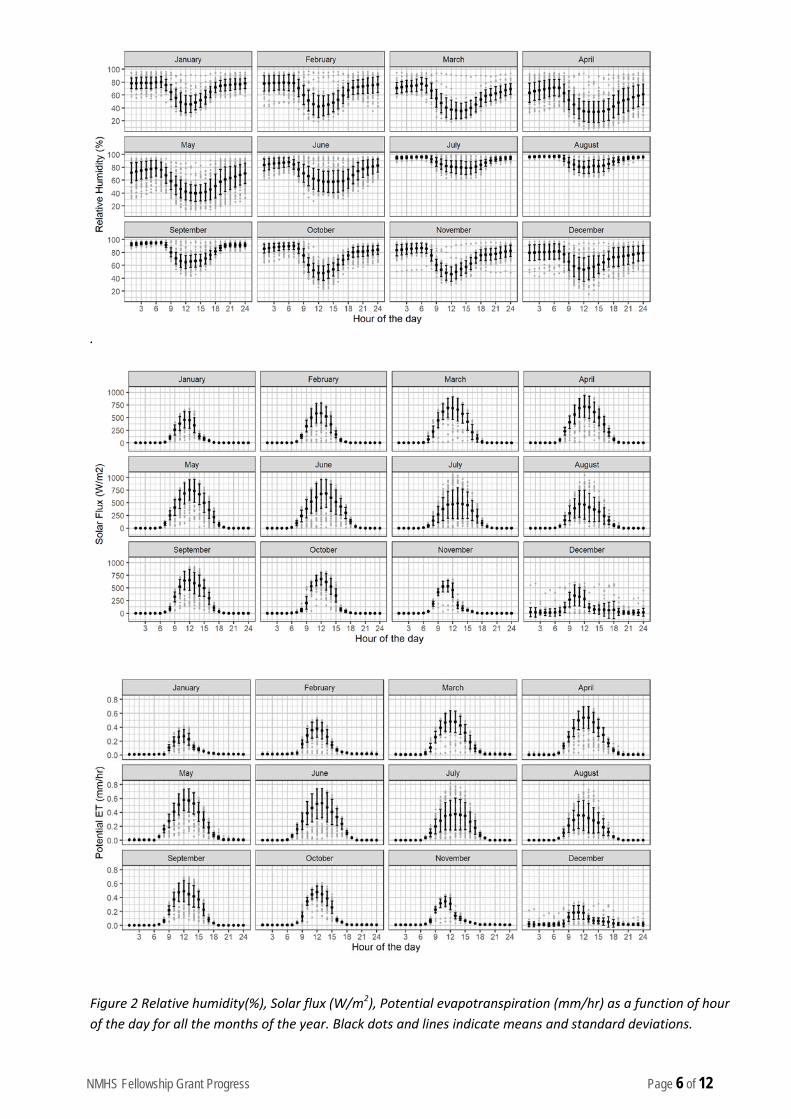
NMHS Fellowship Grant Progress Page 6 of 12
.
Figure 2 Relative humidity(%), Solar flux (W/m2), Potential evapotranspiration (mm/hr) as a function of hour of the day for all the months of the year. Black dots and lines indicate means and standard deviations.

NMHS Fellowship Grant Progress Page 7 of 12
References
ACWADAM. (2015). Geology, springs and springshed management: Laying the foundation through hydrogeology. In Sustainable Development in Indian Himalayan Region (Sustainable Development in Indian Himalayan Region, Vol. 249, p. 9). Advanced Center for Water Resources Development and Management (ACWADAM).
Kumar, V., & Sen, S. (2017). Evaluation of spring discharge dynamics using recession curve analysis: a case study in data-scarce region, Lesser Himalayas, India. Sustainable Water Resources Management, 4(3), 539–557. https://doi.org/10.1007/s40899-017-0138-z
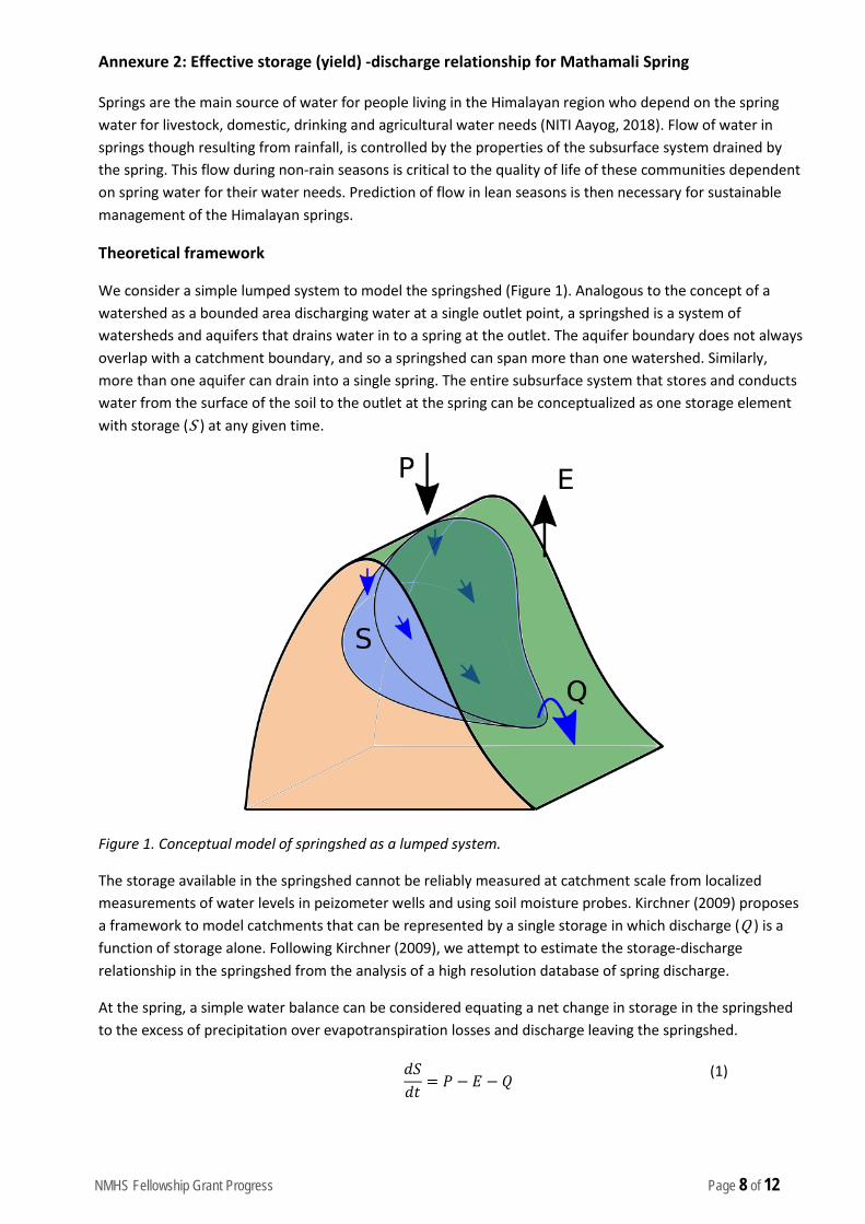
NMHS Fellowship Grant Progress Page 8 of 12
Annexure 2: Effective storage (yield) -discharge relationship for Mathamali Spring
Springs are the main source of water for people living in the Himalayan region who depend on the spring water for livestock, domestic, drinking and agricultural water needs (NITI Aayog, 2018). Flow of water in springs though resulting from rainfall, is controlled by the properties of the subsurface system drained by the spring. This flow during non-rain seasons is critical to the quality of life of these communities dependent on spring water for their water needs. Prediction of flow in lean seasons is then necessary for sustainable management of the Himalayan springs.
Theoretical framework
We consider a simple lumped system to model the springshed (Figure 1). Analogous to the concept of a watershed as a bounded area discharging water at a single outlet point, a springshed is a system of watersheds and aquifers that drains water in to a spring at the outlet. The aquifer boundary does not always overlap with a catchment boundary, and so a springshed can span more than one watershed. Similarly, more than one aquifer can drain into a single spring. The entire subsurface system that stores and conducts water from the surface of the soil to the outlet at the spring can be conceptualized as one storage element with storage (S ) at any given time.
Figure 1. Conceptual model of springshed as a lumped system.
The storage available in the springshed cannot be reliably measured at catchment scale from localized measurements of water levels in peizometer wells and using soil moisture probes. Kirchner (2009) proposes a framework to model catchments that can be represented by a single storage in which discharge (Q ) is a function of storage alone. Following Kirchner (2009), we attempt to estimate the storage-discharge relationship in the springshed from the analysis of a high resolution database of spring discharge.
At the spring, a simple water balance can be considered equating a net change in storage in the springshed to the excess of precipitation over evapotranspiration losses and discharge leaving the springshed.
𝑑𝑆𝑑𝑡
= 𝑃 − 𝐸 − 𝑄 (1)

NMHS Fellowship Grant Progress Page 9 of 12
The first derivative of Q=f(S), the storage-discharge function, is dQ/dS. This is the effect of unit change in storage on the discharge of the spring. We assume an invertible relationship between Q and S, i.e., S = f -1(Q). Therefore,
𝑑𝑄𝑑𝑆
= 𝑓′(𝑆) = 𝑓′�𝑓−1(𝑄)� = 𝑔(𝑄) (2)
It can be shown from the springshed scale water balance (Eqn. 1) that g(Q) can be determined from observations of precipitation P, evapotranspiration E and discharge Q. i.e.,
𝑑𝑄𝑑𝑠
= 𝑔(𝑄) =𝑑𝑄 𝑑𝑡⁄
𝑃 − 𝐸 − 𝑄
(3)
Further, since observations of P and E are also localized observations and cover an area much smaller than the catchment area, it is possible to constrain the form of g(Q) by choosing observation points where P<<Q and E<<Q.
𝑔(𝑄) =
𝑑𝑄𝑑𝑆
≈ �−𝑑𝑄 𝑑𝑡⁄𝑄
�𝑃≪𝑄,𝐸≪𝑄
(4)
This implies that g(Q) can be estimated from a time series of Q alone by identifying intervals of time when P and E are small compared to Q. The plot between -dQ/dt and Q is familiar in hydrologic literature as recession plots.
Using this method, the functional form of f(S) can be obtained by rearranging the terms in the expression for g(Q) and integrating dS to obtain S as a function of Q.
𝑆 = �𝑑𝑆 = �𝑑𝑄𝑔(𝑄)
(5)
So, it is theoretically possible to estimate total effective storage in the springshed for a given observation of discharge at the spring. This method depends on availability of sufficiently long data series of spring discharge. The limited availability of long data series of discharge can be offset to some extent by a database of high resolution spring discharge spanning at least one hydrological year.
Analysis and Results
We apply this methodology to high frequency spring discharge observations of Mathamali Spring, a perennial spring in the Aglar watershed, a sub catchment of the Yamuna River basin. It is located at 30.498611°N and 78.166389°E at an elevation of 1200m above m.s.l (Figure 2). The site is instrumented with a flume calibrated to give hourly observations of spring discharge, a tipping bucket rain gauge and an automatic weather station which provides half hourly records of precipitation, relative humidity, solar radiation and wind speed. The spring discharge series has hourly observations from 01-Feb-2014 to 26-Feb-2018 with <1 % missing data.
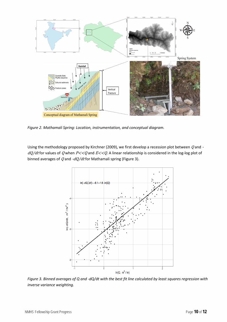
NMHS Fellowship Grant Progress Page 10 of 12
Figure 2. Mathamali Spring: Location, instrumentation, and conceptual diagram.
Using the methodology proposed by Kirchner (2009), we first develop a recession plot between Q and -dQ/dt for values of Q when P<<Q and E<<Q. A linear relationship is considered in the log-log plot of binned averages of Q and -dQ/dt for Mathamali spring (Figure 3).
Figure 3. Binned averages of Q and -dQ/dt with the best fit line calculated by least squares regression with inverse variance weighting.
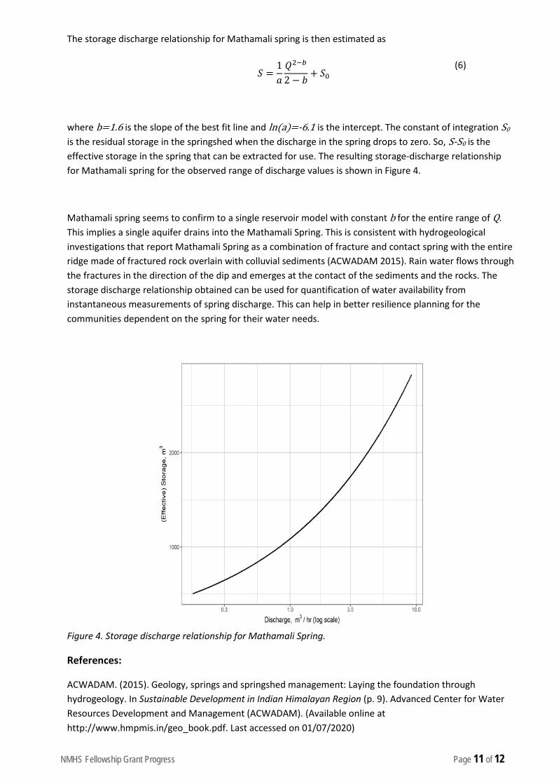
NMHS Fellowship Grant Progress Page 11 of 12
The storage discharge relationship for Mathamali spring is then estimated as
𝑆 =
1𝑎𝑄2−𝑏
2 − 𝑏+ 𝑆0
(6)
where b=1.6 is the slope of the best fit line and ln(a)=-6.1 is the intercept. The constant of integration S0 is the residual storage in the springshed when the discharge in the spring drops to zero. So, S-S0 is the effective storage in the spring that can be extracted for use. The resulting storage-discharge relationship for Mathamali spring for the observed range of discharge values is shown in Figure 4.
Mathamali spring seems to confirm to a single reservoir model with constant b for the entire range of Q. This implies a single aquifer drains into the Mathamali Spring. This is consistent with hydrogeological investigations that report Mathamali Spring as a combination of fracture and contact spring with the entire ridge made of fractured rock overlain with colluvial sediments (ACWADAM 2015). Rain water flows through the fractures in the direction of the dip and emerges at the contact of the sediments and the rocks. The storage discharge relationship obtained can be used for quantification of water availability from instantaneous measurements of spring discharge. This can help in better resilience planning for the communities dependent on the spring for their water needs.
Figure 4. Storage discharge relationship for Mathamali Spring.
References:
ACWADAM. (2015). Geology, springs and springshed management: Laying the foundation through hydrogeology. In Sustainable Development in Indian Himalayan Region (p. 9). Advanced Center for Water Resources Development and Management (ACWADAM). (Available online at http://www.hmpmis.in/geo_book.pdf. Last accessed on 01/07/2020)

NMHS Fellowship Grant Progress Page 12 of 12
Gupta, A., & Kulkarni, H. (2018). Report of Working Group I Inventory and Revival of Springs in the Himalayas for Water Security. NITI Aayog.( Available online at https://niti.gov.in/writereaddata/files/document_publication/doc1.pdf. Last accessed on 01/07/2020).
Kirchner, J. W. (2009). Catchments as simple dynamical systems: Catchment characterization, rainfall-runoff modeling, and doing hydrology backward. Water Resources Research, 45(2). doi: 10.1029/2008WR006912