NACC/WG/3 — WP/16 - ICAO
22
NACC/WG/3 — WP/16 International Civil Aviation Organization 29/04//11 North American, Central American and Caribbean Office (NACC) Third North American, Central American and Caribbean Working Group Meeting (NACC/WG/3) Guatemala City, Guatemala, 9 to 13 May 2011 Agenda Item 3 Follow-up the progress of the NAM/CAR Regional Performance-Based Air Navigation Implementation Plan (NAM/CAR RPBANIP) 3.1 NAM/CAR Regional Performance-Based Air Navigation Implementation Plan UPDATED PBN AIRSPACE CONCEPT FOR THE CAR REGION (Presented by the Secretariat)) SUMMARY This working paper presents the progress on PBN implementation plans as well as the development of the PBN airspace concept in line with the implementation tasks of the CAR Region. References: Resolution A37-11 Doc 9854 - Global Air Traffic Management Operational Concept; Doc 9613 - Performance-based Navigation (PBN) Manual; Doc 9931 – CDO Manual (advance edition), Report of the Eighth Central Caribbean Working Group Meeting (C/CAR/WG/8), Miami, USA, 11 to 14 May 2010. Report of the 32 nd Eastern Caribbean Working Group Meeting (E/CAR WG/32), Sint Maarten, Netherlands Antilles, 15 to 18 June 2010 Report of the 6 th Central American Expert Group Meeting from Centro America (C/ANE/WG/6), Mexico City, 27-30 September 2010. Outcome of the Workshop to Develop a PBN Airspace Concept, ICAO NACC Regional Office, 5 to 7 July 2010 Strategic Objectives This working paper is related to Strategic Objectives A y C
-
Upload
khangminh22 -
Category
Documents
-
view
0 -
download
0
Transcript of NACC/WG/3 — WP/16 - ICAO
NACC/WG/3 — WP/16International Civil Aviation Organization 29/04//11North American, Central American and Caribbean Office (NACC) Third North American, Central American and Caribbean Working Group Meeting (NACC/WG/3) Guatemala City, Guatemala, 9 to 13 May 2011
Agenda Item 3 Follow-up the progress of the NAM/CAR Regional Performance-Based Air
Navigation Implementation Plan (NAM/CAR RPBANIP) 3.1 NAM/CAR Regional Performance-Based Air Navigation
Implementation Plan
UPDATED PBN AIRSPACE CONCEPT FOR THE CAR REGION
(Presented by the Secretariat))
SUMMARY This working paper presents the progress on PBN implementation plans as well as the development of the PBN airspace concept in line with the implementation tasks of the CAR Region.
References: Resolution A37-11 Doc 9854 - Global Air Traffic Management Operational Concept; Doc 9613 - Performance-based Navigation (PBN) Manual; Doc 9931 – CDO Manual (advance edition), Report of the Eighth Central Caribbean Working Group Meeting
(C/CAR/WG/8), Miami, USA, 11 to 14 May 2010. Report of the 32nd Eastern Caribbean Working Group Meeting
(E/CAR WG/32), Sint Maarten, Netherlands Antilles, 15 to 18 June 2010
Report of the 6th Central American Expert Group Meeting from Centro America (C/ANE/WG/6), Mexico City, 27-30 September 2010.
Outcome of the Workshop to Develop a PBN Airspace Concept, ICAO NACC Regional Office, 5 to 7 July 2010 Strategic
Objectives This working paper is related to Strategic Objectives A y C
NACC/WG/3 — WP/16 — 2 —
1. Introduction
1.1 Recognizing that not all airports have the infrastructure to support APV operations, not all aircraft are currently capable of APV and that many States already have the requisite infrastructure and aircraft capable of performing straight-in approaches with lateral guidance (LNAV approaches) based on the RNP specifications and that straight in approaches provide demonstrated and significant safety enhancements over circling approaches, the 37th Session of the Assembly adopted Resolution 37-11 included in Appendix A to this working paper. According to this, States should update their PBN implementation plan urgently to achieve the following:
a) implementation of RNAV and RNP operations (where required) for en route and terminal area according to established timelines and intermediate milestones;
b) implementation of approach procedures with vertical guidance (APV) (Baro-VNAV
and/or augmented GNSS), including LNAV only minima, for all instrument runway ends, either as the primary approach or as a back-up for precision approaches by 2016 with intermediate milestones as follows: 30 per cent by 2010, 70 per cent by 2014; and
c) implementation of straight-in LNAV only procedures, as an exception to b) above, for
instrument runways at aerodromes where there is no local altimeter setting available and where there are no aircraft suitably equipped for APV operations with a maximum certificated take-off mass of 5 700 kg or more.
1.2 States should also provide annual updates on implementation issues and requested to complete the development of national implementation plans so as to ensure its compliance. 2. Analysis
Performance Based Navigation 2.1 The delay in implementation by some States can be attributed to the complexity of PBN and the time required for States to gain proper understanding of the implementation issues. The Meeting acknowledged that the runway-aligned LNAV procedures result in a safety improvement of the order of twenty-five times while the additional vertical guidance enhanced this a further eight times. Consequently, this initial safety benefit justified an intermediate step to be included in the Resolution adopted for PBN. 2.2 The Meeting noted that several RNAV routes and PBN procedures have been implemented in the CAR/SAM Regions that have provided important operational and economic benefits. Some examples are RNP-10 implementation in the WATRS airspace, and the near term implementation of RNP-10 in the Gulf of Mexico. However, the Meeting considered that States should continue the review and improvement of the ATS route network focused on PBN implementation. 2.3 In order to optimize the regional ATS routes network, ICAO coordinated the development of a PBN Airspace Concept for CAR Region, in accordance with ICAO PBN provisions, which may be implemented in three stages:
NACC/WG/3 — WP/16 — 3 —
Optimization of the Route ATS Structure on the en route airspace 2.4 Important operational and economical benefits have derived for the ATS RNAV route implementation programme. Upon evaluating the operational results of the most direct flight trajectories, as well as the savings in flight distances and time obtained through the implementation of RNAV routes, it can be concluded that the air operators requirements to obtain operational and economical advantages has been satisfied in great measure. 2.5 However, an overall review of the upper airspace is required to identify where to implement new RNAV routes and the elimination of those conventional or RNAV routes of low use, whose trajectory coincides or is similar to the fixed RNAV or random routes considering the traffic increase forecast for the next years, the great demand of direct trajectories outside the airway and the need to avoid complicating the airspace management in the region. 2.6 The NACC Regional Office is coordinating an amendment proposal to review the ATS Route structure that will include implementation of new routes, elimination of others, realignment of conventional or RNAV routes and renaming of other routes based on the analysis of traffic flows and traffic movements, operational use of GNSS in order to achieve a comprehensive optimization of the regional ATS route structure. 2.7 In addition, a CNS infrastructure analysis on the basis of PBN specifications is being achieved to endorse the accommodation of RNAV5 as States/Territories/International Organizations are also required to publish PBN regulations and PBN specifications for their current RNAV routes.
Optimization of the ATS routes structure in the terminal airspace 2.8 Considering the current aircraft navigation capacity and the necessity to link the upper airspace routes structure with the terminal area routes; one solution is the implementation of continuous descent operations (CDO). 2.9 The CDO can include the arrival route of an optimum trajectory calculated by the aircraft flight management computer (FMC) from the initial top of descent point (TOD), or another operationally defined point, up to a point where the approach procedure to the airport is started. With the constant increase of the traffic in the CAR Region several airports which can implement CDO have been identified. 2.10 The CDO concept allows adjusting an aircraft’s arrival trajectories and designates the speed necessary to maintain the separation and the approach order that the air traffic control (ATC) provides and can provide a substantial improvement in operational forecasting. The CDO maximizes the advantages for each flight in terms of less fuel consumption, less gas emissions and less noise, as well as better forecasting possibilities for the flight crew and the aircraft user. 2.11 The implementation of CDOs entails a review to the organization of the lower airspace and improving air traffic management. The implementation tasks and advantages of CDO also have impact on other air navigation areas, such as the need of improving ATM automation, airspace and airport demand and capacity, meteorological information provision and publication of information in the AIP, etc.
NACC/WG/3 — WP/16 — 4 —
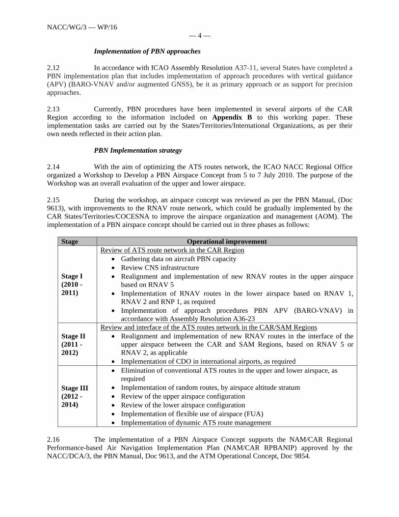
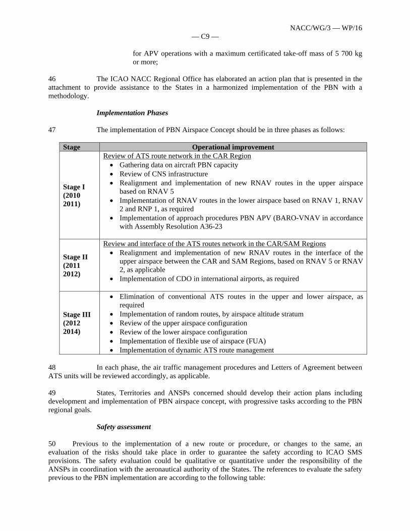
Implementation of PBN approaches 2.12 In accordance with ICAO Assembly Resolution A37-11, several States have completed a PBN implementation plan that includes implementation of approach procedures with vertical guidance (APV) (BARO-VNAV and/or augmented GNSS), be it as primary approach or as support for precision approaches. 2.13 Currently, PBN procedures have been implemented in several airports of the CAR Region according to the information included on Appendix B to this working paper. These implementation tasks are carried out by the States/Territories/International Organizations, as per their own needs reflected in their action plan. PBN Implementation strategy 2.14 With the aim of optimizing the ATS routes network, the ICAO NACC Regional Office organized a Workshop to Develop a PBN Airspace Concept from 5 to 7 July 2010. The purpose of the Workshop was an overall evaluation of the upper and lower airspace. 2.15 During the workshop, an airspace concept was reviewed as per the PBN Manual, (Doc 9613), with improvements to the RNAV route network, which could be gradually implemented by the CAR States/Territories/COCESNA to improve the airspace organization and management (AOM). The implementation of a PBN airspace concept should be carried out in three phases as follows:
Stage Operational improvement
Stage I (2010 - 2011)
Review of ATS route network in the CAR Region Gathering data on aircraft PBN capacity Review CNS infrastructure Realignment and implementation of new RNAV routes in the upper airspace
based on RNAV 5 Implementation of RNAV routes in the lower airspace based on RNAV 1,
RNAV 2 and RNP 1, as required Implementation of approach procedures PBN APV (BARO-VNAV) in
accordance with Assembly Resolution A36-23
Stage II (2011 - 2012)
Review and interface of the ATS routes network in the CAR/SAM Regions Realignment and implementation of new RNAV routes in the interface of the
upper airspace between the CAR and SAM Regions, based on RNAV 5 or RNAV 2, as applicable
Implementation of CDO in international airports, as required
Stage III (2012 - 2014)
Elimination of conventional ATS routes in the upper and lower airspace, as required
Implementation of random routes, by airspace altitude stratum Review of the upper airspace configuration Review of the lower airspace configuration Implementation of flexible use of airspace (FUA) Implementation of dynamic ATS route management
2.16 The implementation of a PBN Airspace Concept supports the NAM/CAR Regional Performance-based Air Navigation Implementation Plan (NAM/CAR RPBANIP) approved by the NACC/DCA/3, the PBN Manual, Doc 9613, and the ATM Operational Concept, Doc 9854.
NACC/WG/3 — WP/16 — 5 —
2.17 The preparation of the PBN airspace concept, included in the Appendix C to this Working Paper, is also foreseen in all the subregional working groups action plan to improve ATS route and airspace network as a comprehensive implementation approach. Because of this, it is necessary that the States, Territories and International Organizations analyze the whole structure of the ATS routes in the airspace on their jurisdiction and to develop a concept of PBN airspace which provides operational improvements at international airports, the users and service providers. 2.18 The PBN Airspace concept for the CAR Region will be core subject of the Airspace Design Workshop to be held in October 2011 in Mexico City. 3. Suggested Action 3.1 The Meeting is invited to: a) review the PBN airspace concept which is included in Appendix C to this
Working Paper
b) support that States, Territories and International Organizations develop a PBN airspace concept within their jurisdiction; and
c) take other actions as deemed pertinent to ensure a harmonious PBN
implementation.
— — — — — — — — — — —

NACC/WG/3 - WP/16
APPENDIX A A37-11: Performance-based navigation global goals Whereas a primary objective of ICAO is that of ensuring the safe and efficient performance of the global Air Navigation System; Whereas the improvement of the performance of the air navigation system on a harmonized, worldwide basis requires the active collaboration of all stakeholders; Whereas the Eleventh Air Navigation Conference recommended that ICAO, as a matter of urgency, address and progress the issues associated with the introduction of area navigation (RNAV) and required navigation performance (RNP); Whereas the Eleventh Air Navigation Conference recommended that ICAO develop RNAV procedures supported by global navigation satellite system (GNSS) for fixed wing aircraft, providing high track and velocity-keeping accuracy to maintain separation through curves and enable flexible approach line-ups; Whereas the Eleventh Air Navigation Conference recommended that ICAO develop RNAV procedures supported by GNSS for both fixed and rotary wing aircraft, enabling lower operating minima in obstacle-rich or otherwise constrained environments; Whereas Resolution A33-16 requested the Council to develop a programme to encourage States to implement approach procedures with vertical guidance (APV) utilizing such inputs as GNSS or distance measuring equipment (DME)/DME, in accordance with ICAO provisions; Recognizing that not all airports have the infrastructure to support APV operations and not all aircraft are currently capable of APV; Recognizing that many States already have the requisite infrastructure and aircraft capable of performing straight-in approaches with lateral guidance (LNAV approaches) based on the RNP specifications and that straight in approaches provide demonstrated and significant safety enhancements over circling approaches; Recognizing that the Global Aviation Safety Plan has identified Global Safety Initiatives (GSIs) to concentrate on developing a safety strategy for the future that includes the effective use of technology to enhance safety, consistent adoption of industry best practices, alignment of global industry safety strategies and consistent regulatory oversight; Recognizing that the Global Air Navigation Plan has identified Global Plan Initiatives (GPIs) to concentrate on the incorporation of advanced aircraft navigation capabilities into the air navigation system infrastructure, the optimization of the terminal control area through improved design and management techniques, the optimization of the terminal control area through implementation of RNP and RNAV SIDs and STARs and the optimization of terminal control area to provide for more fuel efficient aircraft operations through FMS-based arrival procedures; and
NACC/WG/3 — WP/16 — A2 —
Recognizing that the continuing development of diverging navigation specifications would result in safety and efficiency impacts and penalties to States and industry; Noting with satisfaction that planning and implementation regional groups (PIRGs) have completed regional PBN implementation plans; and Recognizing that not all States have developed a PBN implementation plan by the target date of 2009: The Assembly: 1. Urges all States to implement RNAV and RNP air traffic services (ATS) routes and approach procedures in accordance with the ICAO PBN concept laid down in the Performance-based Navigation (PBN) Manual (Doc 9613); 2. Resolves that: a) States complete a PBN implementation plan as a matter of urgency to achieve:
1) implementation of RNAV and RNP operations (where required) for en route and terminal areas according to established timelines and intermediate milestones;
2) implementation of approach procedures with vertical guidance (APV) (Baro-
VNAV and/or augmented GNSS), including LNAV only minima, for all instrument runway ends, either as the primary approach or as a back-up for precision approaches by 2016 with intermediate milestones as follows: 30 per cent by 2010, 70 per cent by 2014; and
3) implementation of straight-in LNAV only procedures, as an exception to 2)
above, for instrument runways at aerodromes where there is no local altimeter setting available and where there are no aircraft suitably equipped for APV operations with a maximum certificated take-off mass of 5 700 kg or more;
b) ICAO develop a coordinated action plan to assist States in the implementation of PBN
and to ensure development and/or maintenance of globally harmonized SARPs, Procedures for Air Navigation Services (PANS) and guidance material including a global harmonized safety assessment methodology to keep pace with operational demands;
3. Urges that States include in their PBN implementation plan provisions for implementation of approach procedures with vertical guidance (APV) to all runway end serving aircraft with a maximum certificated take-off mass of 5 700 kg or more, according to established timelines and intermediate milestones; 4. Instructs the Council to provide a progress report on PBN implementation to the next ordinary session of the Assembly, as necessary;

NACC/WG/3 — WP/16 — A3 —
5. Requests the Planning and Implementation Regional Groups (PIRGs) to include in their work programme the review of status of implementation of PBN by States according to the defined implementation plans and report annually to ICAO any deficiencies that may occur; and 6. Declares that this resolution supersedes Resolution A36-23.
— — — — — — — — — — —

NACC/WG/3 - WP/16
State, Territory /
Estado, Territorio
Aerodrome /
Aeródromo
RWY /
PistaSIDs STARs
APPs
(RNP)TOTAL
AIP issued /
Publicado
AIP
Date /
FechaRemarks / Notas
ANGUILLA, UK TQPF 10/28 NO RNAV PUBLISHED
ANTIGUA &
BARBUDA TAPH NO RNAV PUBLISHED
TAPA 07/25 NO RNAV PUBLISHED
ARUBA, NL TNCA 11/29 2 2 Mar‐08 Dec‐09 RNAV(GPS)
BAHAMAS MYNN14/32 ‐
09/27 10 3 13 Nov‐08 Dec‐09 RNAV(GPS)MYGF 06/24 7 2 9 May‐06 Jul‐09 RNAV(GPS)MYEH 07/25 4 1 5 Nov‐08 May‐09 RNAV(GPS)MYSM 10/28 1 1 1 3 Nov‐08 Jan‐10 RNAV(GPS)MYEF 12/30 2 2 4 Nov‐08 Jan‐10 RNAV(GPS)MYEM 15/33 2 2 4 Jan‐07 May‐09 RNAV(GPS)MYAT 14/32 2 2 4 May‐06 Feb‐10 RNAV(GPS)MYSM 10/28 1 1 1 3 Sep‐05 Jan‐10 RNAV
BARBADOS TBPB 09/27 2 2 4 Aug‐04 May‐09 RNAVBELIZE MZBZ 07/25 NO PROJECT
BERMUDA, UK TXKF 12/30 4 4 Nov‐09 Nov‐09 RNAV
BONAIRE, NL TNCB 10/28 NO RNAV PUBLISHEDBRITISH VIRGIN I.,
UK TUPJ 07/25 NO RNAV PUBLISHEDCAYMAN ISLANDS,
UK MWCB 09/27 2 2 Sep‐01 Jan‐10 RNAV (GNSS)MWCR 08/26 2 2 Feb‐06 Feb‐10 RNAV (GNSS)
COSTA RICA MROC 07/25 IN PROCESS
MRPV 09/27 NO REQUIRED
MRLB 07/25 IN PROCESS
MRLM 14/32 NO REQUIRED
CUBA MUCM 07/25 NO RNAV PUBLISHED
MUCC 08/26 NO RNAV PUBLISHED
MUCL 12/30 NO RNAV PUBLISHED
MUCF 02/20 NO RNAV PUBLISHED
MUHA 06/24 NO RNAV PUBLISHED
MUHG 05/23 NO RNAV PUBLISHED
MUMZ 08/26 NO RNAV PUBLISHED
MUCU10/28 ‐
01/19 NO RNAV PUBLISHED
MUSC 08/26 NO RNAV PUBLISHED
MUVR 06/24 NO RNAV PUBLISHED
CURACAO, NL TNCC 11/29 NO RNAV PUBLISHED
DOMINICA, UK TDCF NO RNAV PUBLISHED
REPUBLIC MDSD 17/35 11 14 4 29 Feb‐10 Feb‐10 RNAV (GNSS)MDPC 09/27 8 10 4 22 Jun‐09 Jun‐09 RNAV (GPS)MDPP 08/26 10 10 4 24 Jun‐09 Jun‐09 RNAV (GPS)MDLR 11/29 10 10 4 24 Jun‐09 Jun‐09 RNAV (GNSS)MDST 11/29 8 12 4 24 Mar‐10 Mar‐10 RNAV (GNSS)MDJB 01/19 NO RNAV PUBLISHED
MDCY 07/25 NO RNAV PUBLISHED
APPENDIX B
RNAV TERMINAL PROCEDURES PUBLISHED IN THE CAR REGION AND BERMUDA (ver. 1.01 ‐ 160410)

NACC/WG/3 - WP/16
STATE/TERRITORY AERODROME RWY SIDs STARsAPPs
(RNP)TOTAL AIP issued JEP issued REMARKS
El SALVADOR MSLP 07/25 NO RNAV PUBLISHED
MSSS15/33 ‐
08/26 NO RNAV PUBLISHED
GRENADA TGPZ NO RNAV PUBLISHED
GUADALOUPE, FR TFFM 09/27 NO RNAV PUBLISHED
TFFR 11/29 1 1 Apr‐09 RNAV (GNSS)GUATEMALA MGGT 01/19 6 6 Nov‐05 Nov‐05 RNAV
MGTK 10/28 NO RNAV PUBLISHED
HAITI MTPP 10/28 5 2 7 Apr‐05 Jul‐05 RNAV (GPS)
MTCH 05/23 12 2 14 Apr‐05 Jul‐05 RNAV (GPS)HONDURAS MHTG 02/20 5 3 3 11 Jan‐09 Dec‐09 AIP/SUP 5/09 RNAV
MHLC 06/24 NO RNAV PUBLISHED
MHLM 04/22 4 6 1 11 Jan‐09 Aug‐08 AIP/SUP 5/09 RNAV
MHRO 06/24 4 5 1 10 Jan‐09 May‐08 AIP/SUP 5/09 RNAV
JAMAICA MKJP 12/30 3 2 5 Oct‐02 Aug‐08 RNAV GNSSMKJS 07/25 4 2 6 Oct‐02 Jun‐06 RNAV GNSS
MARTINIQUE, FR TFFF 09/27 4 2 6 Jan‐09 Jan‐09 RNAV GNSS
MEXICO MMMX05/23‐
L/R NO RNAV PUBLISHED
MIQUELON, FR LVFM 12/30 NO RNAV PUBLISHED
MONTSERRAT, UK TRPG NO RNAV PUBLISHED
NICARAGUA MNMG 09/27 NO RNAV PUBLISHED
PUERTO RICO, US TJBQ 08/26 1 1 Oct‐09 RNAV (GPS)TJIG 09/27 1 1 Apr‐08 RNAV (GPS)TJMZ 09/27 1 1 Oct‐05 GPSTJPS 12/30 2 2 Mar‐09 RNAV (GPS)
TJSJ08/26‐
10/28 7 10 3 20 May‐09 RNAV (GPS)TJVQ 09/27 1 1 2 Feb‐10 RNAV (GPS)
ST. EUSTATIUS, NL TNCE 07/25 NO RNAV PUBLISHED
ST. KITTS & NEVIS TKPK 07/25 NO RNAV PUBLISHED
ST. LUCIA TLPC 09/27 NO RNAV PUBLISHED
TLPL 10/28 NO RNAV PUBLISHED
ST. MAARTEN, NL TNCM 10/28 1 3 1 5 Jun‐09 Jun‐09 RNAV GNSSST. PIERRE, FR LFVP 08/26 2 2 Sep‐05 Sep‐05 RNAV GNSSST. VINCENT & THE
GRANADINES TVSV 07/25 NO RNAV PUBLISHED
TVSC 13/31 2 2 Jan‐09 Jan‐09 RNAV GNSSTRINIDAD &
TOBAGO TTPP 10/28 2 2 Aug‐09 Aug‐09 RNAV GNSSTTCP 11/29 2 2 Jan‐09 Jan‐09 RNAV (GPS)
TURKS & CAICOS I.,
UK MBAC 07/25 4 2 6 Feb‐10 Jan‐09 RNAV (GNSS)MBGT 11/29 2 2 Feb‐10 Feb‐10 RNAV (GNSS)MBMC 10/28 7 2 9 Dec‐08 Dec‐08 RNAV (GNSS)MBPV 10/28 3 2 5 Feb‐10 Feb‐10 RNAV (GNSS)MBSC 11/29 2 2 Feb‐10 Feb‐10 RNAV (GNSS)
VIRGIN ISLANDS, US TIST 10/28 1 1 Nov‐06 Nov‐06 RNAV (GPS)SID STAR APP TOTAL
138 95 91 324
- B2 -
TOTALS
RNAV TERMINAL PROCEDURES PUBLISHED IN THE CAR REGION AND BERMUDA (ver. 1.01 ‐ 160410)
NACC/WG/3 - WP/16
APPENDIX C
PBN AIRSPACE CONCEPT FOR THE CAR REGION INTRODUCTION 1 The CAR Region airspace will be organized and managed in a manner that will accommodate all current and envisioned users of the airspace, inter alia, civil and military aircraft, unmanned aircraft systems and transiting spacecraft. 2 The implementation of the PBN Airspace Concept is supported by the ICAO Global ATM Operational Concept (Doc 9854), PBN Manual (Doc 9613), and the Regional Performance-based Air Navigation Implementation Plan (RPB ANIP) for NAM/CAR Regions. 3 PBN airspace concept will allow direct improvements to the airspace organization and management (AOM) and on other implementation activities such as improvements in ATM situational awareness, airspace and airport demand and capacity balancing (DCB), airport operations (AO), provision of meteorological information and publication of information in the AIP, etc. 4 Efficient airspace management will enhance the capacity of the air navigation service provider (ANSP) and will increase ATM system safety, capacity and efficiency in benefit to the ATM community. Environmental protection benefits will be periodically measured against implementation achievements. 5 Implementation of a PBN Airspace Concept in the CAR Region is consistent with the following strategic objectives:
Safety:
Implementation of a PBN Airspace Concept will facilitate the harmonization and interoperability of procedures and air operations among the ATS airspace. The implementation of Continuous Descent Operations (CDO) and approach procedures with vertical guidance APV (Baro-VNAV) and/or RNP AR, through stabilized approaches, will reduce the risk of Controlled Flight into Terrain (CFIT).
Capacity
Implementation of a PBN Airspace Concept will allow the reduction of spacing between aircraft and the use of ATC vector guidance in departure and arrival routes, which will result in a reduction of airspace complexity and of ATC workload. The final goal effect will be an increment in ATS airspace capacity.
Efficiency
Implementation of a PBN Airspace Concept will allow aircraft operations on optimum tracks from the en-route phase to final approach and from departure to the selected route. Efficiency will also be reflected in the publication of better climb and descent profiles in gate-to-gate operations with more flexible tracks to increase operational efficiency, while reducing fuel consumption.
NACC/WG/3 — WP/16 — C2 —
The Global Air Traffic Management (ATM) Operational Concept 6 The global ATM operational concept presents the ICAO vision for an integrated, harmonized and globally interoperable, ATM system. The planning horizon is up to and beyond the year 2025.
Vision Statement To achieve an interoperable global air traffic management system, for all users during all phases of flight, that meets agreed levels of safety, provides for optimum economic operations, is environmentally sustainable and meets national security requirements.
Homogeneous ATM Area 7 A homogeneous ATM area is defined as airspace with a common ATM interest based on similar characteristics of traffic density, complexity, air navigation infrastructure requirements or other specified considerations, wherein a common detailed plan fosters the implementation of interoperable air navigation systems. The essential elements to be considered when establishing a homogeneous ATM area should be the technical and operational requirements. 8 Homogeneous ATM areas may extend over States, specified portions of States or groupings of States. They may also extend over large oceanic and/or continental en-route areas.
Major Traffic Flow 9 A major traffic flow is defined as a concentration of significant volumes of air traffic on the same or proximate flight trajectories. Major traffic flows may cross several homogeneous ATM areas with different characteristics. A routing area is a defined area encompassing one or more major traffic flows. 10 A routing area may include groupings of routes, or area navigation (RNAV) areas, wherein is a specific detailed plan for the implementation of an ATM system; the objective is to attain a seamless system. 11 Major traffic flows and routing areas are defined by origin and destination geographic areas, which could be States, specific portions of States or groupings of smaller States. This may include oceanic and continental en-route areas.
Planning Based on Homogeneous ATM Areas and Major Traffic Flows 12 The basic planning parameter in establishing a homogeneous ATM area or major traffic flow is the number of aircraft movements that must be provided with ATM services in an area or along a flow. Estimates and forecasts of annual aircraft movements are required for high-level planning. Forecasts of aircraft movements in peak periods, such as during a particularly busy hour, are needed for detailed planning. 13 The CAR Region is a homogeneous ATM area with routes extending into the adjacent NAM and SAM Regions. Transition air operations between areas and regions will be transparent to users.

NACC/WG/3 — WP/16 — C3 —
Implementation of PBN Airspace Concept
14 Having a very strategic geographical location at the confluence of ATS routes connecting the major destinations, Caribbean airspace has become a vital link to the flow of traffic between NAM and SAM Regions. 15 Traditionally, air navigation depended mostly on ground-based navaids with inherent limitations that prevent the seamlessness and flexibility required for efficient air operations, specifically in the vicinity of airports with complex topography. 16 Performance-based navigation, comprising area navigation (RNAV) and required navigation performance (RNP), solves these limitations using existing aircraft navigation capabilities. 17 PBN specifies the navigation performance requirements necessary to operate on an ATS route, an instrument approach procedure or in a particular airspace. 18 Based on the evaluation of the navigation infrastructure it has been identified that the oceanic area of the Gulf of Mexico and the oceanic area of the Curaçao, Jamaica and Dominican Republic FIR requires an automatic dependent surveillance (ADS) or controller-pilot data link communications (CPDLC) for the implementation of the RNP. The coverage of the radionavigation aids networks, based on ground and satellite as well as the radar coverage and the communication coverage allows implementing specifications on navigation RNAV 5, RNAV 2, RNAV 1 in the remaining CAR airspace, as required. For the implementation of the RNP procedures in the lower airspace, the States, Territories, International Organizations should analyze the coverage of radionavigation aids based on ground and satellite. 19 The comprehensive implementation of the PBN airspace concept will harmonize navigation specifications for all phases of flight on oceanic and continental en-route areas, terminal area and approach segments, and will harmonize ATS route network between NAM, CAR and SAM Regions with the objective of achieving a single airspace continuum. The application of navigation specification by flight phase is determined by the following table:
Navigation Specification
Flight Phase En Route Oceanic / Remote
En Route Continental
ARR APPROACH
DEP Initial Interm. Final Missed
RNAV/RNP 10 10 RNAV 5 5 5 RNAV 2 2 2 2 RNAV 1 1 1 1 1 1b 1 RNP 4 4 Basic RNP 1 1a,c 1a 1a 1ab 1a,c
RNP APCH 1 1 0.3 1 RNP AR APCH 1-0.1 1-0.1 0.3-0.1 1-0.1
Notes: - The numbers given in the table refer to the 95 per cent accuracy requirements (NM). - RNAV 5 is an en-route specification which may be used for the initial part of the STAR outside 30 NM and above the minimum sector altitude. - 1a The navigation application is limited to use on standard instrument arrivals (STARs) and standard instrument departures (SIDs) only. - 1b The area of application can only be used after the initial climb of a missed approach phase.
NACC/WG/3 — WP/16 — C4 —
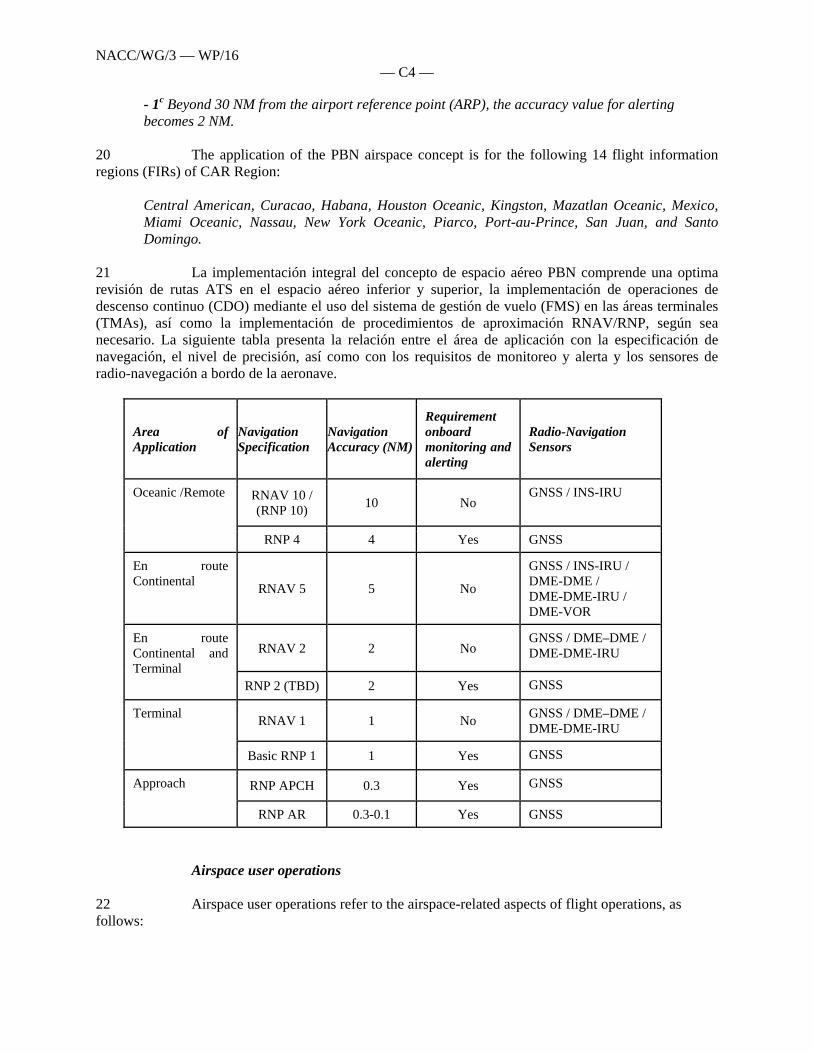
- 1c Beyond 30 NM from the airport reference point (ARP), the accuracy value for alerting becomes 2 NM.
20 The application of the PBN airspace concept is for the following 14 flight information regions (FIRs) of CAR Region:
Central American, Curacao, Habana, Houston Oceanic, Kingston, Mazatlan Oceanic, Mexico, Miami Oceanic, Nassau, New York Oceanic, Piarco, Port-au-Prince, San Juan, and Santo Domingo.
21 La implementación integral del concepto de espacio aéreo PBN comprende una optima revisión de rutas ATS en el espacio aéreo inferior y superior, la implementación de operaciones de descenso continuo (CDO) mediante el uso del sistema de gestión de vuelo (FMS) en las áreas terminales (TMAs), así como la implementación de procedimientos de aproximación RNAV/RNP, según sea necesario. La siguiente tabla presenta la relación entre el área de aplicación con la especificación de navegación, el nivel de precisión, así como con los requisitos de monitoreo y alerta y los sensores de radio-navegación a bordo de la aeronave.
Area of Application
Navigation Specification
Navigation Accuracy (NM)
Requirement onboard monitoring and alerting
Radio-Navigation Sensors
Oceanic /Remote RNAV 10 / (RNP 10)
10 No GNSS / INS-IRU
RNP 4 4 Yes GNSS
En route Continental
RNAV 5 5 No
GNSS / INS-IRU / DME-DME / DME-DME-IRU / DME-VOR
En route Continental and Terminal
RNAV 2 2 No GNSS / DME–DME / DME-DME-IRU
RNP 2 (TBD) 2 Yes GNSS
Terminal RNAV 1 1 No
GNSS / DME–DME / DME-DME-IRU
Basic RNP 1 1 Yes GNSS
Approach RNP APCH 0.3 Yes GNSS
RNP AR 0.3-0.1 Yes GNSS
Airspace user operations 22 Airspace user operations refer to the airspace-related aspects of flight operations, as follows:
NACC/WG/3 — WP/16 — C5 —
a) the users’ needs and aircraft navigation capabilities will be identified in order to enhance
safety and efficiency; b) relevant ATM data will be made available for the airspace user’s tactical and strategic
situational awareness and conflict management; c) relevant airspace users operational information will be available to the ANSP to enhance
tactical and strategic situational awareness and conflict management; and e) collaborative decision-making will be encouraged to ensure that users expectations and
aircraft capabilities will be taken into account when designing the airspace.
Airspace organization and management (AOM) 23 All airspace will be a usable resource. The organization, allocation and flexible use of airspace will be based on the principles of access and equity. Airspace organization should be in accordance with the ICAO airspace classification. 24 The airspace organization function will provide the strategies, rules and procedures by which the airspace will be structured to accommodate different types of operations, volume of traffic, and differing levels of service and rules of conduct. 25 The principles of organization will be applicable from high traffic density to low traffic density. The organizational principles include the following:
a) airspace should be organized so as to be easily learned, understood and used by the ATM community;
b) airspace organizational boundaries and divisions should be adjusted to accommodate
particular traffic flows and should not be constrained by national or facility boundaries; c) airspace should be organized to facilitate seamless operations of flights and the ability to
conduct flights along optimum flight trajectories from gate-to-gate eliminating all restrictions or delays as possible;
d) airspace design should consider ATS route systems and dynamic trajectories that enable
aircraft to operate along to their preferred flight paths, or as near as practicable; and e) Airspace management should be dynamic, flexible and based on user preferred services.
26 Airspace organization will be based on the principle that all airspace is managed to meet the needs of the ATM community. “Managed” means that a strategic or tactical decision regarding the level of service to be provided will be taken by the appropriate authority and/or ANSP. Airspace management will consider dynamic procedures and sectorization in benefit to air operations. 27 Air navigation service providers in charge of managing airspace will be able to make tactical modifications to specific parts of airspace to respond in real-time to changing situations in traffic patterns and/or runway(s) in use, according to operational needs. 28 The dynamic configurations on airspace will be established according to the transit flow forecasted in order to optimize dynamically the user-preferred path based on statistical data. The airspace

NACC/WG/3 — WP/16 — C6 —
management will consider the procedure application and dynamic sector division through flexible routes (parallel and perpendicular) according to the operational requirements in benefit of the air operations. 29 In order to achieve a dynamic management of air space the organization should be analyzed for the vertical strata on airspace through the strategic application of one or the combination of the following actions:
a) From the minimum en-route altitude (MEA) up to FL190 aircraft operations will be allowed using the route network RNAV published, b) From FL200 to FL350, through the continental or oceanic airspace, the aircraft operations will be allowed: i) on RNAV random routes, or ii) on the fixed RNAV regional and/or national networks c) The long-haul flights above FL360 should be allowed to operate on RNAV random routes based on foreseen transit flows as much as possible
30- The air transit management at the aerodromes should facilitate the route operation RNAV and/or RNP optimized in all meteorological conditions and it should as well, comply with the overcome of obstacles and protection to the environment. The proper authority and the ANSPs should make sure to spread at the appropriate time the norms and procedures applicable in the different classes of air space. 31 There should be no permanent/fixed constrained airspace or during an extended period; airspace should only be subjected to service limitations, national interests or safety issues. All airspace constraints should be properly coordinated with the ATM community. Additionally, for a complete dynamic airspace management implementation of efficient civil/military coordination is required so as to achieve flexible use of airspace (FUA). 32 Airspace should not be organized in a manner that permanently precludes the possibility of mixed usage/mixed equipage operations. Priority for the use of specific airspace should not be constrained by equipage usage.
Optimization of the ATS route structure in en-route airspace 33 Up to date, many RNAV routes have been implemented in the upper CAR/SAM airspace, as per GREPECAS recommendations, plus many additional routes which had not been foreseen. These implementations have been carried out by identifying the needs of the users, operators and ANSPs. The implementation programmes have generated important operational and economical benefits. 34 Upon evaluating the operational results of the most direct flight trajectories, as well as the savings in flight distances and time obtained through the implementation of RNAV routes, it can be concluded that the operators’ requirements to obtain operational and economical advantages have been satisfied in great measure. Consistent with the benefits obtained, the need for additional RNAV routes has been identified. 35 The regionally agreed decommissioning of NDBs combined with forecast traffic growth, the increasing demand for direct trajectories outside conventional airways and the possible implementation of additional RNAV routes could lead to saturation in various airspaces, further complicating airspace management.

NACC/WG/3 — WP/16 — C7 —
36 Therefore, an overall review of the upper airspace should be conducted considering the possible implementation of RNAV routes and the removal of those rarely used conventional routes whose trajectories coincide with or are similar to fixed RNAV or random routes.
Optimization of the ATS route structure in terminal airspace 37 GREPECAS recommended the implementation of trunk routes to link the upper airspace RNAV routes with the arrival and departure routes implemented in terminal areas. Standard instrument arrivals (STARs) and standard instrument departures (SIDs) should be designed to connect directly to the upper airspace ATS route network in order to enhance airspace management and provide more consistent flight paths and stabilized approach paths while reducing pilot and ATC workload, radio-frequency transmissions, fuel consumption and incidence of controlled flight into terrain (CFIT). 38 SIDs and STARs have been implemented and improved in the terminal areas of international airports of many CAR States. Nevertheless, considering the current aircraft navigation capability, it is appropriate to consider extending these procedures, linking the upper airspace route structure directly with the terminal area routes. 39 The soon-to-be-published Continuous Descent Manual, Doc 9931, urges States to consider implementation of continuous descent operations (CDO) on all STARs, starting from top of descent in the upper airspace. To this end, STARs should be designed such that they connect directly from the en-route RNAV or conventional routes to the instrument approach procedure. 40 A CDO allows an optimum profile descent on the published arrival route, calculated by the aircraft’s flight management computer (FMC) from the initial top-of-descent point (TOD), or other operationally defined point, to the point where the approach procedure to the runway is commenced. 41 The CDO concept permits ATC to adjust an aircraft’s arrival trajectory and speed if necessary to maintain separation and sequencing from other aircraft while providing a substantial operational improvement, and reducing workload of both pilots and controllers. The CDO also maximizes the advantages for each flight in terms of reduced fuel consumption, gaseous emissions and noise, as well as better forecasting possibilities for the flight crew and the aircraft operator. 42 Continuous descent operations are enabled by airspace design, procedure design and ATC facilitation, allows the aircraft to descend continuously employing minimum engine thrust in a low drag configuration. CDO is potentially usable by 85% of the aircraft, 85% of the flight time of descent. 43 The implementation of CDOs entails a review of the organization of upper and lower airspace and consequential improvements to air traffic management in order to determine where operational advantages can be obtained. The following are international airports where CDOs could be implemented:
BARBADOS TBPB BRIDGETOWN /Grantley Adams Intl.
COSTA RICA MROC ALAJUELA /Juan Santamaría Intl.
GRAND CAYMAN MWCG / Roberts International Airport

NACC/WG/3 — WP/16 — C8 —
CUBA MUHA HABANA /José Martí
DOMINICAN REPUBLIC MDPC PUNTA CANA INTERNATIONAL AIRPORT
EL SALVADOR MSLP SAN SALVADOR / EL SALVADOR Intl.
GUATEMALA MGGT GUATEMALA /La Aurora
HONDURAS MHTG TEGUCIGALPA /Toncontin Intl.
JAMAICA MKJP KINGSTON / Norman Manley Intl.
MEXICO MMUN CANCUN /Cancún Intl. MMGL GUADALAJARA /Miguel Hidalgo Costilla Intl. MMMX MEXICO /Lic. Benito Juárez Intl. MMMY MONTERREY /Gral. Mariano Escobedo Intl. MMPR PUERTO VALLARTA /Lic. Gustavo Díaz Ordaz Intl. MMSD SAN JOSE DEL CABO /San José del Cabo Intl. MMTO TOLUCA /Lic. Adolfo López Mateos Intl.
PUERTO RICO TJSJ SAN JUAN /Luis Muñoz Marín Intl.
TRINIDAD AND TOBAGO TTPP PORT OF SPAIN /Piarco Intl. Trinidad I.
44 The Continuous Climb Operations (CCO) also provide States and other stakeholders with pragmatic guidance on how to implement CCOs for departing aircraft climbing continuously, ideally to cruise level.
PBN Implementation 45 According to ICAO Assembly Resolution A37/11, States should complete and implement PBN action plan as follows:
1) implementation of RNAV and RNP operations (where required) for en route and terminal areas according to established timelines and intermediate milestones;
2) implementation of approach procedures with vertical guidance (APV) (Baro-
VNAV and/or augmented GNSS), including LNAV only minima for all instrument runway ends, either as the primary approach or as a back-up for precision approaches by 2016 with intermediate milestones as follows: 30 per cent by 2010, 70 per cent by 2014; and
3) implementation of straight-in LNAV only procedures, as an exception to 2)
above, for instrument runways at aerodromes where there is no local altimeter setting available and where there are no aircraft suitably equipped
NACC/WG/3 — WP/16 — C9 —
for APV operations with a maximum certificated take-off mass of 5 700 kg or more;
46 The ICAO NACC Regional Office has elaborated an action plan that is presented in the attachment to provide assistance to the States in a harmonized implementation of the PBN with a methodology. Implementation Phases 47 The implementation of PBN Airspace Concept should be in three phases as follows:
Stage Operational improvement
Stage I (2010 2011)
Review of ATS route network in the CAR Region Gathering data on aircraft PBN capacity Review of CNS infrastructure Realignment and implementation of new RNAV routes in the upper airspace
based on RNAV 5 Implementation of RNAV routes in the lower airspace based on RNAV 1, RNAV
2 and RNP 1, as required Implementation of approach procedures PBN APV (BARO-VNAV in accordance
with Assembly Resolution A36-23
Stage II (2011 2012)
Review and interface of the ATS routes network in the CAR/SAM Regions Realignment and implementation of new RNAV routes in the interface of the
upper airspace between the CAR and SAM Regions, based on RNAV 5 or RNAV 2, as applicable
Implementation of CDO in international airports, as required
Stage III (2012 2014)
Elimination of conventional ATS routes in the upper and lower airspace, as required
Implementation of random routes, by airspace altitude stratum Review of the upper airspace configuration Review of the lower airspace configuration Implementation of flexible use of airspace (FUA) Implementation of dynamic ATS route management
48 In each phase, the air traffic management procedures and Letters of Agreement between ATS units will be reviewed accordingly, as applicable. 49 States, Territories and ANSPs concerned should develop their action plans including development and implementation of PBN airspace concept, with progressive tasks according to the PBN regional goals.
Safety assessment 50 Previous to the implementation of a new route or procedure, or changes to the same, an evaluation of the risks should take place in order to guarantee the safety according to ICAO SMS provisions. The safety evaluation could be qualitative or quantitative under the responsibility of the ANSPs in coordination with the aeronautical authority of the States. The references to evaluate the safety previous to the PBN implementation are according to the following table:
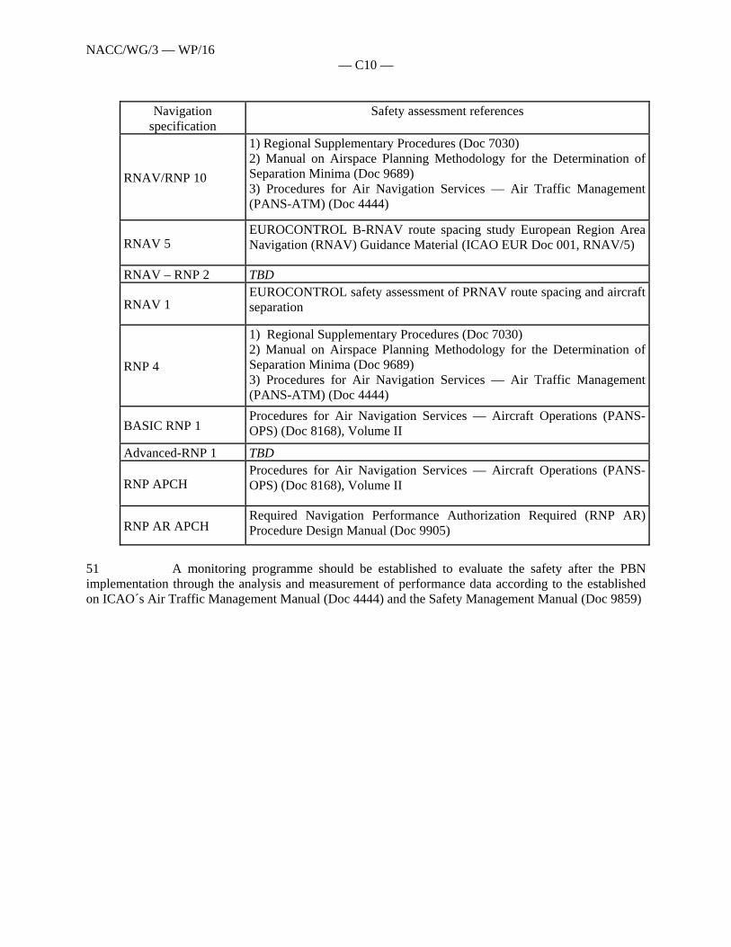
NACC/WG/3 — WP/16 — C10 —
Navigation
specification Safety assessment references
RNAV/RNP 10
1) Regional Supplementary Procedures (Doc 7030) 2) Manual on Airspace Planning Methodology for the Determination of Separation Minima (Doc 9689) 3) Procedures for Air Navigation Services — Air Traffic Management (PANS-ATM) (Doc 4444)
RNAV 5 EUROCONTROL B-RNAV route spacing study European Region Area Navigation (RNAV) Guidance Material (ICAO EUR Doc 001, RNAV/5)
RNAV – RNP 2 TBD
RNAV 1 EUROCONTROL safety assessment of PRNAV route spacing and aircraft separation
RNP 4
1) Regional Supplementary Procedures (Doc 7030) 2) Manual on Airspace Planning Methodology for the Determination of Separation Minima (Doc 9689) 3) Procedures for Air Navigation Services — Air Traffic Management (PANS-ATM) (Doc 4444)
BASIC RNP 1 Procedures for Air Navigation Services — Aircraft Operations (PANS-OPS) (Doc 8168), Volume II
Advanced-RNP 1 TBD
RNP APCH Procedures for Air Navigation Services — Aircraft Operations (PANS-OPS) (Doc 8168), Volume II
RNP AR APCH Required Navigation Performance Authorization Required (RNP AR) Procedure Design Manual (Doc 9905)
51 A monitoring programme should be established to evaluate the safety after the PBN implementation through the analysis and measurement of performance data according to the established on ICAO´s Air Traffic Management Manual (Doc 4444) and the Safety Management Manual (Doc 9859)

ID Task Name/Tarea Start/Inicio Finish/Término Compl.
1 Implementation of performance based navigation (PBN) / Implantaciónde la navegación basada en la performance (PBN)
Fri 28/12/01 Sat 31/12/16 0%
2 Develop a regional strategy for the implementation of performance based navigation (PBN) / Desarrollar una estrategia regional para la implantación de la navegación basada en la performance (PBN)
Sun 26/08/07 Mon 24/11/08 100%
3 Develop a national action plan for the implementation of performance based navigation (PBN) / Desarrollar un plan de accion nacional para la implantación de la navegación basada en la performance (PBN)
Thu 10/07/08 Fri 31/07/09 95%
4 Develop a PBN roadmap for en-route, TMA and approach / Desarrollar hoja de ruta PBN para ruta, TMA y aproximación
Mon 10/07/06 Fri 31/08/07 100%
5 Develop and implement a PBN airspace concept / Desarrollar e implementar un concepto de espacio aereo PBN)
Thu 10/07/08 Thu 14/11/13 60%
6 Analyze and enhance air communication, navigation and surveillance infrastructure in accordance with PBN requirements / Analizar y mejorar la infraestructura de comunicaciones, navegacion y vigilancia acorde a los requisitos PBN
Fri 13/07/07 Sat 31/12/16 50%
7 Collect aircraft navigation capability data /Recolectar datos de la capacidad de navegacion de las aeronaves
Fri 13/07/07 Mon 31/12/12 70%
8 Implement collaborative desicion making (CDM) process in coordination with stakeholders / Establecer un proceso de toma de decisiones en colaboracion (CDM) en coordinacion con los involucrados
Mon 16/07/07 Fri 28/12/12 70%
9 Develop PBN Safety Assessment Programme / Desarrollar un Programade Evaluación de Seguridad Operacional PBN
Mon 16/07/07 Fri 28/12/12 70%
10 Conduct ATC simulations (fast time and/or real time), Live Trials, etc., as required / llevar a cabo simulaciones ATC, (en tiempo acelerado o entiempo real), pruebas reales, etc., segun sea requerido.
Mon 16/07/07 Fri 28/12/12 70%
11 Publish regulations and procedures for aircraft and operators approval / Publicar reglamentaciones y procedimientos nacionales para aprobacion de aeronaves y operadores
Mon 16/07/07 Fri 31/12/10 50%
12 Publish GNSS regulations / Publicar reglamentaciones GNSS Mon 16/07/07 Fri 28/12/12 30%
13 Finalize WGS-84 implementation / Finalizar la implementacion WGS-84 Mon 16/07/07 Fri 28/12/12 70%
14 Publish AIP Supplement including applicable PBN standards and procedures / Publicar suplemento AIP incluyendo normas y procedimientos PBN aplicables
Mon 16/07/07 Fri 28/12/12 30%
15 Update Letters of Agreement between ATC units / Actualizar cartas de acuerdo entre unidades ATC
Mon 16/07/07 Fri 28/12/12 50%
16 Develop PBN proposal for amendment to the applicable regional documentation / Desarrollar propuesta de enmienda PBN a la documentacion regional aplicable
Mon 16/07/07 Fri 28/12/12 30%
H2 H1 H2 H1 H2 H1 H2 H1 H2 H1 H2 H1 H2 H1 H2 H12007 2008 2009 2010 2011 2012 2013 2014
Task
Milestone
Summary
Rolled Up Task
Rolled Up Milestone
Rolled Up Progress
Split
External Tasks
Project Summary
Group By Summary
Inactive Task
Inactive Task
Inactive Milestone
Inactive Summary
Manual Task
Duration-only
Manual Summary Rollup
Manual Summary
Start-only
Finish-only
Progress
ATM Implementation Work Programme - Appendix / Apéndice al Programa de Trabajo de Implementación ATM
1
ATM Implementation Work Programme / Programa de implementacion ATMDate / Fecha: 03/05/10
- C12 - NACC/WG/3 - WP/16
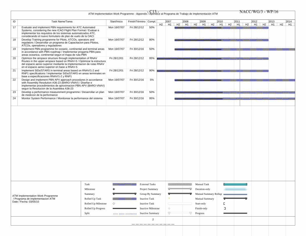
ID Task Name/Tarea Start/Inicio Finish/Término Compl.
17 Evaluate and implement PBN requirements for ATC Automated Systems, considering the new ICAO Flight Plan Format / Evaluar e implementar los requisitos de los sistemas automatizados ATC, considerando el nuevo formulario de plan de vuelo de la OACI
Mon 16/07/07 Fri 28/12/12 50%
18 Develop Training programme for Pilots, ATCOs, operators and regulators / Desarrollar un programa de Capacitacion para Pilotos, ATCOs, operadores y reguladores
Mon 16/07/07 Fri 28/12/12 80%
19 Implement PBN programme for oceanic, continental and terminal areas in accordance with PBN roadmap / Implementar progama PBN para areas oceanica, continental segun el mapa de ruta PBN
Mon 16/07/07 Fri 30/12/16 50%
20 Optimize the airspace structure through implementation of RNAV Routes in the upper airspace based on RNAV-5 / Optimizar la estructuradel espacio aereo superior mediante la implementacion de rutas RNAV en el espacio aereo superior en base a RNAV-5
Fri 28/12/01 Fri 28/12/12 95%
21 Implement SIDs/STARS in terminal areas based on RNAV/1-2 and RNP1 specifications / Implementar SIDs/STARS en areas terminales enbase a especificaciones RNAV/1-2 y RNP1
Fri 28/12/01 Fri 28/12/12 90%
22 Design and implement PBN APV approach procedures in accordance with Assembly Resolution A36-23 (BARO-VNAV) / Diseñar e implementar procedimientos de aproximacion PBN APV (BARO-VNAV) segun la Resolucion de la Asamblea A36-23
Mon 16/07/07 Fri 30/12/16 5%
23 Develop a performance measurement programme / Desarrollar un plan de medicion de la performance
Mon 16/07/07 Fri 30/12/16 50%
24 Monitor System Performance / Monitorear la performance del sistema Mon 16/07/07 Fri 30/12/16 95%
H2 H1 H2 H1 H2 H1 H2 H1 H2 H1 H2 H1 H2 H1 H2 H12007 2008 2009 2010 2011 2012 2013 2014
Task
Milestone
Summary
Rolled Up Task
Rolled Up Milestone
Rolled Up Progress
Split
External Tasks
Project Summary
Group By Summary
Inactive Task
Inactive Task
Inactive Milestone
Inactive Summary
Manual Task
Duration-only
Manual Summary Rollup
Manual Summary
Start-only
Finish-only
Progress
ATM Implementation Work Programme - Appendix / Apéndice al Programa de Trabajo de Implementación ATM
2
ATM Implementation Work Programme / Programa de implementacion ATMDate / Fecha: 03/05/10
- C13 - NACC/WG/3 - WP/16
— — — — — — — — — — —