Lived Space. Reconsidering Trans-Nationalism among Muslim Minorities

Supplement to the proceedingS of the Seminar for arabian StudieS
Volume 42
2012
the nabataeanS in focuS: current archaeological reSearch at petra
Papers from the Special Session of the Seminar for Arabian Studiesheld on 29 July 2011
edited by
Laïla Nehmé and Lucy Wadeson
Seminar for arabian StudieS
archaeopreSSoxford
2012

This Supplement is available with volume 42 of the Proceedings of the Seminar for Arabian Studies and orders should be sent to Archaeopress, Gordon House, 276 Banbury Road, Oxford OX2 7ED, UK.Tel/Fax +44-(0)1865-311914.e-mail [email protected]://www.archaeopress.comFor the availability of back issues see the The British Foundation for the Study of Arabia’s web site: www.thebfsa.org/seminar_proceedings.html
Seminar for Arabian Studiesc/o the Department of the Middle East, The British MuseumLondon, WC1B 3DG, United Kingdome-mail [email protected] British Foundation for the Study of Arabia: www.thebfsa.org
The Steering Committee of the Seminar for Arabian Studies is currently made up of thirteen members. The Editorial Committee of the Proceedings of the Seminar for Arabian Studies includes six additional members as follows:
STEERING COMMITTEE EDITORIAL COMMITTEE: ADDITIONAL MEMBERSMr Simon Alderson (Treasurer)Dr Mark BeechDr Robert CarterDr Nadia DurraniProfessor Dr Robert G. HoylandDr Derek Kennet Mr Michael C.A. MacdonaldDr Ardle MacMahon (Secretary)Dr Venetia PorterDr St John SimpsonMrs Janet C.M. Starkey (Editor)Professor Janet WatsonDr Lloyd Weeks (Chairperson)
Professor Alessandra AvanziniDr Ricardo EichmannProfessor Clive HolesProfessor Khaleel Al-Muaikel Professor Dan PottsProfessor Christian Robin
Opinions expressed in papers published in the Proceedings are those of the authors and are not necessarily shared by the Editorial Committee.
The Proceedings is produced in the Times Semitic New font, which was designed by Paul Bibire for the Seminar for Arabian Studies.
© 2012 Archaeopress, Oxford, UK.All rights reserved. No part of this publication may be reproduced, stored in a retrieval system, or transmitted, in any form or by any means, electronic, mechanical, photocopying, recording, or otherwise, without the prior permission of the publisher.ISSN 0308-8421ISBN 978-1-905739-55-4

The Steering Committee of the Seminar for Arabian Studies is most grateful to theMBI Al Jaber Foundation
for its continued generosity in making a substantial grant towards the running costs ofthe Seminar and the editorial expenses of producing the Proceedings.


i
Contents
Transliteration.............................................................................................................................................................. iii
Preface ...........................................................................................................................................................................v
Laïla Nehmé & Lucy Wadeson, Introduction — The Nabataeans in focus ...................................................................1
Susan E. Alcock & Alex R. Knodell, Landscapes north of Petra: the Petra Area and Wādī Silaysil Survey (Brown University Petra Archaeological Project, 2010–2011) .....................................................................................5
Chaim Ben David, Nabataean or Late Roman? Reconsidering the date of the built sections and milestones along the Petra–Gaza road ..........................................................................................................................................17
Zbigniew T. Fiema, Reinventing the sacred: from shrine to monastery at Jabal Hārūn .............................................27
F. Renel, M. Mouton, C. Augé, C. Gauthier, C. Hatté, J-F. Saliège & A. Zazzo, Dating the early phases underthe temenos of the QaΒr al-Bint at Petra .....................................................................................................................39
Marie-Jeanne Roche, A Nabataean shrine to Isis in Wādī Abū ΚUllayqah, in the south-west of Petra .......................55
Stephan G. Schmid, Piotr Bienkowski, Zbigniew T. Fiema & Bernhard Kolb, The palaces of the Nabataean kings at Petra ...............................................................................................................................................................73
Lucy Wadeson, The funerary landscape of Petra: results from a new study ...............................................................99
Robert Wenning in cooperation with Laurent Gorgerat, The International AΒlaΉ Project, Petra: new research and new questions ......................................................................................................................................................127
Papers read in the Special Session of the Seminar for Arabian Studies on 29 July 2011 .........................................143


iii
Transliteration
This Supplement to the Proceedings of the Seminar for Arabian Studies employs the following transliteration for Arabic and Nabataean (see table below).
Note that personal names, toponyms, and other words which have entered English in a particular form are used in that form when they occur in an English sentence, unless they are part of a quotation in the original language, or part of a correctly transliterated name or phrase.
Names of sites, archaeological periods, and types of pottery, which have entered archaeological usage in a particular form, are used in that form.
Arabic Transliteration Nabataean Transliterationا Μ Μ
ب b bت t g
ث th d
ج j h
ح Ή w
خ kh z
د d Ή
ذ dh Γ
ر r y
ز z k
س s l
ش sh m
ص Β n
ض Ρ sط Γ Κظ Ξ p
ع Κ Β
غ gh q
ف f r
ق q š
ك k tل lم mن nه hو wي y
Other:• short vowels are transliterated as a i u and long ones as ā ī ū;• diphthongs are transliterated as aw and ay;• initial hamzah is omitted;• alif maqΒūrah is transliterated as ā;• the lām of the article is not assimilated before the ‘sun letters’, thus al-shams not ash-shams;• tāΜ marbūΓah is rendered -ah, except in a construct, where it is -at.


v
Preface
The 46th Seminar for Arabian Studies was held at the British Museum on 28–30 July 2011.1 This annual conference is an important forum for British and international scholars to meet and present their latest research in the humanities on the Arabian Peninsula, from the Palaeolithic period to the end of the Ottoman empire. While the Seminar was originally created to focus on new archaeological research in Arabia, it now encompasses a broad range of subjects including epigraphy, art, architecture, history, literature, linguistics, ethnography, and sociology.
From 2007, the Seminar has begun to include ‘Special Sessions’ aimed at focusing on specific topics for which it was felt there have been significant advances in research and findings. The first Special Session (2007) focused on The Palaeolithic of Arabia, and the second (2009) dealt with The Development of Arabic as a written language. Following on from their success, a third Special Session, The Nabataeans in Focus: current archaeological research at Petra, was held at the 2011 Seminar on Friday 29 July. This day-long session was organized by myself with the indispensable guidance and support of the Steering Committee of the Seminar, and in particular Ardle MacMahon. Special thanks are also due to Michael Macdonald and Rob Carter.
With an international mix of scholars working in Nabataean studies, eleven papers were presented on the themes of ‘Religion and Status’, chaired by Laïla Nehmé, ‘Tombs and Burial Customs’, chaired by John Healey, and ‘Environs and Hinterland’ chaired by Peter Parr.2 Papers dealt with the Nabataeans and Petra from the earliest traces of settlement in the Hellenistic period to the thriving community in the city in late antiquity. We were lucky enough to hear the latest results from excavation and survey projects that were fresh out of the field. They dealt with key sites within the city such as Umm al-Biyārah, al-Khubthah, and the QaΒr al-Bint, as well as important locations in the outer suburbs and environs such as the Bāb al-Sīq, Jabal Hārūn, Wādī Slaysil, and BayΡā. The day concluded with a panel discussion on ‘Developing an Agenda for Nabataean Archaeology’ lead by Laïla Nehmé and myself. The challenges still facing Nabataean studies were raised, provoking some interesting feedback from the participants. We are hugely grateful to all the speakers and the chairpersons (John Healey, Laïla Nehmé, and Peter Parr) for stimulating important discussions and making the session a great success.
A suitable introduction to the Special Session was provided by Laïla Nehmé, who delivered the MBI Al Jaber Foundation Public Lecture at the British Museum on the evening of 28 July. The subject of her lecture was ‘From the capital of Petra to the provincial city of Hegra: new insights on the Nabataeans’. I have been fortunate to have Laïla Nehmé as my co-editor in the publication of the Special Session papers as a Supplement to the Proceedings of the Seminar for Arabian Studies Volume 42, 2012. I benefitted greatly from working with Laïla and would like to express my gratitude to her for all the help and advice she gave me along the way and for working with me. I would also like to thank Helen Knox, Rajka Makjanić, and Janet Starkey for the thorough and efficient work they undertook during the preparation of this Supplement. Any outstanding errors in this volume remain the responsibility of the editors.
The Special Session was made possible through the generous financial support of the Seminar and the MBI Al Jaber Foundation, to whom we offer our deepest thanks. This volume aims to provide new results of recent research at Petra, which will have an impact on our understanding of the Nabataeans, especially in areas where information has been lacking in the past, such as ‘early’ Petra, funerary practices, and religion. As a result of this volume, we hope that a more multi-disciplinary approach to the subject can be encouraged, as well as more collaborative work between different projects. Given the great expansion and popularity of Nabataean studies today, this current publication may well lay the groundwork for plans to establish a scholarly periodical dedicated to this topic in the future.
Lucy WadesonOriental Institute,
Pusey Lane,Oxford OX1 2LE, UK
e-mail [email protected] March 2012
1 See Proceedings 42 and www.thebfsa.org.2 A list of the papers presented is provided at the end of this volume.


Nabataean or Late Roman? Reconsidering the date of the built sections and milestones along the Petra–Gaza road
Chaim Ben DaviD
SummaryScholars have dated the built section and the milestones found in the Negev along the Petra–Gaza incense route to the Nabataean period. Apart from the Negev, no built section or milestones along the incense routes from the Persian Gulf or from southern Arabia to Petra have been recorded. We would like to define two stages of the road in the Negev. The first, as a camel route, is dated to the Nabataean period and is apparently part of the Petra–Gaza incense route. The second stage, with the built sections and milestones, should be dated to the period beginning in the later half of the second century AD and ending in the early Byzantine period. These were erected as part of Roman military activity in the Negev, and not as part of the Petra–Gaza route. A similar phenomenon can be found in the Petra area, with two phases along Naqb al-RubāΚī, the most convenient descent westwards from Petra. The first — Nabataean — phase was a camel track leading to the Negev; the second phase was a wide, built road from the Roman period, leading to Aila.
Keywords: incense route, Petra–Gaza route, camel routes, milestones, Negev
A basic tenet in many investigations of the routes of the incense trade in antiquity is that one of the principal roads led from Arabia to Petra and thence to Gaza by way of Wādī ΚArabah and the Negev. I would like to note some new insights from the Negev, the desert area west of Wādī ΚArabah, and furnished with these insights, deal with the implications for the Petra area.
The German scholar Fritz Frank (1934) visited Wādī ΚArabah and the Negev and was the first scholar to investigate and publish parts of the Negev incense route. Frank (1934: 270–276) identified sections of a wide road, milestones, and road-related structures such as MeΞad Neqarot (QaΒr Wādī Sīq) and Дorvat QaΞra (QaΒr al-ΚAbd) (Figs 1 & 2). He suggested that most of these elements should be identified as a Roman fortification system along the road. A few months later, Nelson Glueck (1934) visited the area, identified Nabataean pottery at the sites along the road, and suggested dating it to the Nabataean period.
Albrecht Alt (1935) never visited the area, but studied Frank’s data. He made an architectural analysis of the forts, suggesting that they were part of a Late Roman defence system along the road from Haluza and ΚOboda to Petra. In 1937 and 1938, George Kirk (1938: 231–234) visited the sites Frank had discovered, collected more
pottery samples, and concluded that all the sites dated solely from the Nabataean period.
Thus, from the very beginning of modern research, the road and related structures had two interpretations: a Nabataean trade route from Petra or a Late Roman military road defence system.
For decades, the Nabataean theme was the only one heard and taught. For example, Avraham Negev (1966) travelled the road between MaΚale MaΉmal and Moyat ΚAwad and examined the pottery at the sites along this section. He concluded that the road and its use were solely Nabataean. In the 1960s, ZeΜev Meshel and Yoram Tsafrir (1974; 1975) conducted a wide-ranging survey along the built sections between ΚAvdat (ΚOboda) and ShaΚar Ramon and proposed that those sections and the milestones they observed were Nabataean and part of the Petra–Gaza trade route.
Rudolph Cohen (1982a), after undertaking excavations at several sites along the incense route, was the first to state that use of the road did not cease in AD 106 as Negev and Meshel and Tsafrir had claimed, but continued in use during the second and even third centuries AD. However, Cohen did not contradict the basic hypothesis that the road was originally constructed by the Nabataeans.
Supplement to Proceedings of the Seminar for Arabian Studies 42 (2012): 17–26

Figure 1. Milestones along the ‘incense route’ in the Negev. (Photograph C. Ben David.)
Figure 2. MeΞad Neqarot: a tower fort from the Late Roman period. (Photograph C. Ben David.)
Chaim Ben David18

Dating the incense route
How do we date an ancient road? Dating a road like the Via Nova Traiana is of course an easy task. There are many epigraphic milestones and, to be on the safe side, the constructed road itself can be excavated and dated. But what about desert routes? What about roads hewn in sandstone areas? What about routes that are not built? And what do we mean by ‘the date’ of the Petra–Gaza road?
Observing the physical remains of the incense route in the Negev, we can define at least six different features:
— a trail passable by loaded camels (naqb);— water installations;— road-related structures with civilian-commercial
features;— road-related structures with military features;— a built road with a width of 4 m or more;— milestones.Are all these elements from the same period? Is it
possible that the camel trail is from one period, the forts from another, and the milestones from yet a third? The research and study of the incense route has not benefited from the fundamental tenet of past research, namely, that all or most of the six components represent one period only.
For example, by examining the road-related structures, we can define two different phases: the civilian phase, with trade elements such as the Nabataean caravanserai in ShaΚar Ramon (Erickson-Gini 2010: 24) or the Nabataean domestic site at MeΞad Neqarot (2010: 23–24); and the military phase, such as the tower forts of MeΞad Neqarot and Дorvat QaΞra.
The excavations at MeΞad Neqarot (Cohen 1982b) clearly showed two different phases: the domestic structure from the Nabataean period and the fortified structure from the Late Roman period. The latter made use of numerous building stones from the Nabataean domestic structure.
The recent excavation at MeΞad MaΉmal (Erickson-Gini 2011), a site located along the northern cliff of Makhtesh Ramon, just above the ancient camel pass of MaΚale MaΉmal (Naqb al-Mahamla), also revealed two different phases: 1) a Nabataean caravan station of the first century AD that contained a number of rooms situated around a central courtyard. This structure was destroyed in a seismic event in the early second century AD and was probably subsequently abandoned; 2) a Roman fort built in the later half of the second century which, according to the excavator, appeared to be one
of a series of Roman military tower forts of the Severan period along the Petra–Gaza route, including the forts of Дorvat QaΞra and MeΞad Neqarot (Fig. 3). This phase was occupied until the early third century AD. It was subsequently reoccupied in the late fourth century as part of the Late Roman military deployment in the Negev in the days of Diocletian. The same phenomenon of two phases — domestic Nabataean and fortified Late Roman — was also detected in the recent Bīr Madhkūr excavations (Smith 2010: 39–42).
After seventy-five years of modern research, it seems that the only section along the Petra–Gaza road that contains all six of the above-mentioned components of the road, especially portions of a wide, built road and milestones, is the one between ΚAvdat (ΚOboda) and
AQABA
PETRA
AILA
DEAD SEAGAZA
Figure 3. Major sites mentioned in this contribution. (Map Dina Shalem.)
Nabataean or Late Roman? Reconsidering the date of the built sections and milestones 19
ShaΚar Ramon (Meshel & Tsafrir 1974; 1975). But could the milestones be Nabataean? Milestones are known only from the Roman period, and in the entire Nabataean realm, from Arabia to southern Jordan, not a single stretch of wide, built road with milestones is known in a Nabataean — i.e. pre-AD 106 — context. Furthermore, no more than three milestones dating from before AD 106 have been found in the entire region of Jordan and Israel. But if these milestones are not Nabataean, when and why were they erected?
In the northern and central parts of the Roman province of Judaea-Palaestina, some 500 milestones are known along the Roman road system, while in the southern part — the Negev Desert — they are very rare. If there had been milestones in the desert areas, one would have expected them to be better preserved than elsewhere, as is the case along the desert stretches of the Via Nova Traiana (Graf 1995; Macdonald 1996; Borstad 2008). It seems, therefore, that milestones, which were also erected for propaganda purposes, were installed predominantly in the settled areas of the country where large volumes of traffic ensured they would be seen by many people. David Graf (1997) noted that in the desert areas east of the Via Nova Traiana, milestones are clustered near forts
and camps and do not form a continuous line. Suggesting that there was no connecting road between the sites, Graf summarized his view by stating that ‘The widely separated milestones in the proximity of Lejjūn and Jurf al-Durāwish perhaps only marked the approaches to the military camps for travellers’ (1997: 280), and I fully agree with it. I have extensively discussed elsewhere (Ben David, forthcoming) the phenomenon of milestones near Roman army installations in the desert areas of the provinces of Palaestina and Arabia. I propose that all the examples of milestones in the desert areas of the Negev and southern Jordan, including those along the Petra–Gaza incense route, were erected on the initiative, and using the labour, of local Roman army units, and were not part of the regular Roman road network connecting major cities.
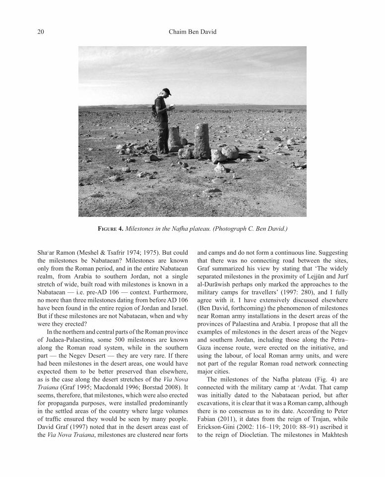
The milestones of the Nafha plateau (Fig. 4) are connected with the military camp at ΚAvdat. That camp was initially dated to the Nabataean period, but after excavations, it is clear that it was a Roman camp, although there is no consensus as to its date. According to Peter Fabian (2011), it dates from the reign of Trajan, while Erickson-Gini (2002: 116–119; 2010: 88–91) ascribed it to the reign of Diocletian. The milestones in Makhtesh
Figure 4. Milestones in the Nafha plateau. (Photograph C. Ben David.)
Chaim Ben David20

Ramon are related to ShaΚar Ramon, where unequivocal evidence was found for the presence of the Roman army (Figueras 1992; Erickson-Gini 2010: 24, 70).
Thus, the pertinent problem concerning the incense route in the Negev is how to date its various components. The camel route between Petra and Gaza is Nabataean in origin, although it may have utilized much older routes, as evidenced by finds from the Chalcolithic period, the EB II–III, MB I, and Iron Age II along the segment between Moyat ΚAwad and ΚAvdat. The structures with a civilian character, and certainly the caravanserais along the Moyat ΚAwad–Gaza section, should be dated mainly to the first century AD, the period of the Nabataean monarchy, as part of the Petra–Gaza trade route. Most military structures, however, should be dated to the period beginning in the later half of the second century AD and ending in the early Byzantine period. This is also the case for the built sections and the milestones, which were erected as part of Roman military activity in the Negev, and not as part of the Petra–Gaza route. Yet as Erickson-Gini (2010: 50, 58, 191) has shown, Nabataean trade along the Petra–Gaza road did not cease in AD 106 but continued throughout the second and early third centuries AD under Roman rule.
Implications for the routes between Petra and Wādī ΚArabah
Over a period of many years, most scholars described or mapped this route as simply leading down from Petra through Wādī Mūsā to the station at Bīr Madhkūr, and from there to Moyat ΚAwad. Since Glueck’s visit to Bīr Madhkūr in 1934, his description of that site as being on the direct road to Petra has been widely accepted by scholars. Yet modern research has shown that Wādī Mūsā was not passable for camels and was not the way out of Petra (Lindner, Hübner & Hübl 2000; Ben David 2007). There are many other tracks for donkeys and camels descending westwards but none of these paths show major signs of construction and support walls. The exception is Naqb Slaysil, where the remains of an impressive trail, 2–3 m wide with support walls, some of which have survived to a height of 2.5 m, can be seen. Unlike Amos Kloner’s proposal that this naqb was the main Nabataean route from Petra (Kloner 1996: 127–134), my opinion is that it was a via sacra connecting the Nabataean high place in Rās Slaysil (Lindner & Gunsam 1995a; Lindner 2003: 168–170) with the Nabataean Pond Temple in Wādī Mūsā (Lindner & Gunsam 1995b; Lindner 2003: 170–174), and not a camel track to Wādī ΚArabah.
In the Petra region, there are only two ancient 4 m-wide roads descending westwards: Naqb al-RubāΚī and Naqb Сabrā. Naqb al-RubāΚī takes advantage of a very gentle limestone ridge south of Jabal Hārūn, where the igneous rock wall is broken as a result of a geological fault, and a north–south limestone ridge descends there from 1100 m above sea level to 600 m above sea level at the outlet of Wādī Khushaybah. Elsewhere, I have discussed the wide road constructed across this most convenient mountain ridge (Ben David 2007). In my opinion, it was the Roman road, built between Petra and Wādī ΚArabah and apparently heading southwards towards Aila. Here, I would like to propose that in its early phase, part of this road was used as a Nabataean caravan track leading to the Negev. Thus, just as in the Negev, this route also has two different phases.
The wide road is well known and clearly discernable in the sandstone area immediately south of Petra. The parts below Jabal Hārūn were surveyed by the Finnish team working there (Hertell 2002). Heini Ynnila (2006), in her MA thesis on this route, argues that it was mainly Nabataean and not Late Roman as I proposed. Bearing in mind what we learned from the two phases in the Negev, I believe that both proposals are logical and that there were two phases along Naqb al-RubāΚī. The first — Nabataean — phase was a camel track leading to the Negev, and the second phase was a wide, built road from the Roman period, leading to Aila.
I owe the idea of Naqb al-RubāΚī as a Nabataean camel route leading to the Negev to Andrew Smith’s recent discoveries (2005; 2010) during his systematic survey of the region around Bīr Madhkūr in Wādī ΚArabah. What seems so far to be the most important revelation of the survey is a newly discovered Nabataean caravanserai in Wādī ΚArabah named Khirbat Sufaysif (Smith 2010: 27–30).
Smith proposed that the site was significant as a station along the route associated with traffic from Petra. At first glimpse, Khirbat Sufaysif seems to be outside any known naqb in the Petra area. Yet on Colonel Newcomb’s 1: 125,000 scale map from 1915 (Levin, Karak & Galilee 2010: 7–8), a trail that leaves Naqb al-RubāΚī and passes near Khirbat Sufaysif can clearly be seen (Fig. 5). Following the discovery on the map, we returned to Naqb al-RubāΚī in search of the trail marked on the map. We found the head of the camel pass that leaves the wide road of Naqb al-RubāΚī and descends north-west to the Qamar Valley. The first section goes down steeply but alternates between built and hewn sections. Just below the steep section, on a saddle, are the remains of a building with
Nabataean or Late Roman? Reconsidering the date of the built sections and milestones 21

Figure 5. The routes leading from Petra to Wādī ΚArabah marked on Newcomb’s map from 1915. (British War Office, 1915.)
large quantities of Nabataean pottery. The upper part of this trail was described by Lindner, Hübner and Hübl (2000: 542–543) and Ynnila (2006: 77–79).
Apparently, this good camel track does not lead northwards to Umm Rattām, as Linder thought, but descends gently westwards to Wādī Umm Qamar. This trail, which seems to have been unused for a long time, is wider than the modern naqb with clearly discernable retaining walls in some sections. The trail reaches the upper part of Wādī Umm Qamar where today there is a dirt road. In a few places, the trail leaves the wadi and continues on its northern bank. It exits Wādī Umm Qamar via a comfortable saddle and heads northwards to the
Nabataean caravan station of Khirbat Sufaysif.Naqb Umm Qamar seems to have been the leading
Nabataean route from Petra to the Negev. It starts off from the Petra area via Naqb al-RubāΚī in a south-westerly direction — while the direction of the incense route in the Negev is a north-westerly one — because that descent is the most gentle one, and then continues northwards via Naqb Umm Qamar (Figs 6 & 7).
The camel track to Khirbat Sufaysif is part of the Nabataean trade to Gaza, while the wide, built road leading southwards to Wādī ΚArabah seems to belong to the later Roman period and perhaps, as in the Negev, it is part of the Roman army’s extensive military operations.
Chaim Ben David22
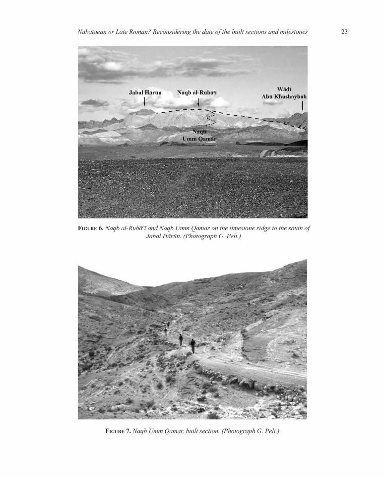
Figure 6. Naqb al-RubāΚī and Naqb Umm Qamar on the limestone ridge to the south of Jabal Hārūn. (Photograph G. Peli.)
Figure 7. Naqb Umm Qamar, built section. (Photograph G. Peli.)
Nabataean or Late Roman? Reconsidering the date of the built sections and milestones 23

References
Alt A. 1935. Aus der ‘Araba II: Romische Kastellen und Strassen. Zeitschrift des Deutschen Palastina-Vereins 58:
1–78.Ben David C. 2007. The paved road from Petra to the ‘Arabah — commercial Nabataean or military Roman? Pages 101–
110 in A.S. Lewin & P. Pellegrini (eds), The Late Roman Army in the Near East from Diocletian to the Arab Conquest: Proceedings of a colloquium held at Potenza, Acerenza and Matera, Italy (May 2005). (British Archaeological Reports International Series, 1717). Oxford: Archaeopress.
(forthcoming). Milestones near Roman army installations in desert areas of the provinces of Palaestina and Arabia. Proceedings of the XXIst International Limes (Roman Frontiers) Congress 2009.
Borstad K.A. 2008. History from geography: the initial route of the Via Nova Traiana in Jordan. Levant 40: 55–70.Cohen R. 1982a. New light on the date of the Petra–Gaza road. Biblical Archaeologist 45: 240–247. 1982b. Mesad Neqarot. Excavations and Surveys in Israel 1: 86–87.Erickson-Gini T. 2002. Nabataean or Roman? Reconsidering the date of the camp at Avdat in light of recent excavations. Pages
113–130 in P. Freeman, J. Bennett, Z.T. Fiema & B. Hofmann (eds), Limes XVIII. The Proceedings of the XVIIIth International Congress of Roman Frontier Studies held in Amman, Jordan (September 2000). i. (British Archaeological Reports International Series, 1082, I). Oxford: Archaeopress.
2010. Negev settlement and self-organized economy in the Central Negev: crisis and renewal. (British Archaeological Reports International Series, 2054). Oxford: Archaeopress.
2011. Mezad Mahamal Final Report. Hadashot Arkheologiyot Excavations and Surveys in Israel 123. Accessed 5.2.12. www.hadashotesi.org.il/report_detail_eng.asp?id=1675&mag_id=118
Fabian P. 2011. ‘Avedat Preliminary Report. Hadashot Arkheologiyot Excavations and Surveys in Israel 123. Accessed
5.2.12. www.hadashotesi.org.il/report_detail_eng.asp?id=1709&mag_id=118 Figueras P. 1992. The Roman worship of Athena–Allat in the Decapolis and the Negev. ARAM 4: 173–183.Frank F. 1934. Aus der Araba. Zeitschrift des Deutschen Palastina-Vereins 57: 191–280.Glueck N. 1934. Explorations in eastern Palestine and the Negev. Bulletin of the American Schools of Oriental Research
55: 3–21. 1935. Explorations in Eastern Palestine, II. (Annual of the American Schools of Oriental Research, 15). New
Haven, CT: American Schools of Oriental Research.Graf D.F. 1995. The Via Nova Traiana in Arabia Petraea. Pages 241–267 in J.H. Humphrey (ed.), The Roman and
Byzantine Near East. i. (Journal of Roman Archaeology Supplementary Series, 14). Ann Arbor, MI: University of Michigan.
1997. The Via Militaris in Arabia. Dumbarton Oak Papers 51: 271–281.Hertell E. 2002. The ancient road in the FJHP survey area. Pages 234–240 in J. Frosen & Z.T. Fiema (eds), Petra — A
City Forgotten and Rediscovered. Helsinki: Helsinki University Press.Kirk G.E. 1938. Archaeological exploration in the Southern Desert. Palestine Exploration Quarterly 70: 211–235.Kloner A. 1996. Stepped roads in Roman Palestine. ARAM 8: 111–137.
Chaim Ben David24

Levin N., Karak R. & Galilee A. 2010. Maps and the settlement of Southern Palestine, 1799–1948: an historical/GIS analysis. Journal of
Historical Geography 36: 1–18.Lindner M. 2003. Über Petra hinaus. Archäologische Erkundungen im südlichen Jordanien. Rahden: Marie Leidorf.Lindner M. & Gunsam E. 1995a. The unique Nabataean High Place of Rās Slaysil northwest of Petra and its topographical context.
Annual of the Department of Antiquities of Jordan 39: 267–279. 1995b. A newly described Nabataean temple near Petra: The ‘Pond Temple’. Pages 199–214 in K. Amr (ed.),
Studies in the History and Archaeology of Jordan V. Art and Technology Throughout the Ages. Amman: Department of Antiquities.
Lindner M., Hübner U. & Hübl J. 2000. Nabataean and Roman presence between Petra and Wādī ΚArabah. Survey expedition: Umm Ratam.
Annual of the Department of Antiquities of Jordan 44: 535–567.MacDonald B. 1996. The route of the Via Nova Traiana immediately south of Wadi al Hasa. Palestine Exploration Quarterly
128: 12–15.Meshel Z. & Tsafrir Y. 1974. The Nabataean road from ‘Avdat to Sha’ar-Ramon. Part I. The survey of the road. Palestine Exploration
Quarterly 106: 103–118. 1975. The Nabataean road from ‘Avdat to Sha’ar-Ramon (concluded). Part II. The features of the road.
Palestine Exploration Quarterly 107: 3–21.Negev A. 1966. The date of the Petra–Gaza road. Palestine Exploration Quarterly 88: 89–98.Smith II A.M. 2005. Bir Madhkur Project: A preliminary report on recent fieldwork. Bulletin of the American Schools of
Oriental Research 340: 57–75. 2010. Wadi Araba in Classical and Late Antiquity: An Historical Geography. (British Archaeological Reports
International Series, 2173). Oxford: Archaeopress.Ynnila H. 2006. To Petra via Jabal Haroun. Nabataean-Roman Road Remains in the Finnish Jabal Haroun Project Survey
Area. MA thesis, University of Helsinki. (https://helda.helsinki.fi/bitstream/handle/10138/19544/topetrav.pdf?sequence=3) [Unpublished.]
Author’s addressChaim Ben David, Kinneret College on the Sea of Galilee, D.N. Emeq Hayarden Tsemach, Israel 15132.e-mail [email protected]
Nabataean or Late Roman? Reconsidering the date of the built sections and milestones 25

Copyright © 2022 FDOKUMEN