Muslim Shrines in Palestine
17
LEVANT XXVIII 1996 A Preliminary Report on Three Muslim Shrines in Palestine Andrew Petersen Cartlett Fach, Trefin, Haverfordwest, Dyfed SA62 SAC. This article is a report on an architectural survey of three Muslim shrines carried out by the British School of Archaeology in Jerusalem in 1994. An introduction sets the buildings within the general context of Palestinian shrines. Each shrine is then described separately with a discussion of its location, history and architecture. Since 1989 the British School of Archaeology in Jerusalem has been carrying out architectural sur- veys of the medieval and Ottoman buildings in Palestine. In order to target the surveys more effec- tively the present writer has been compiling a list of standing buildings in Israel which will enable the British School to carry out research on particular types of buildings, historical periods or regions. The results of this work are being prepared for publica- tion as a Gazetteer. One of the building types most frequently encountered is the Muslim shrine or maqam. Despite their great number, very few of these buildings have been surveyed or studied in a system- atic way. There have been several general works dealing with Muslim shrines in Palestine (e.g., McCown 1923; Masterman and Macalister 1916) as well a detailed study of shrines in the vicinity of Jerusalem by T. Canaan (1927). However, these studies deal principally with the customs and reli- gious beliefs associated with the shrines and do not discuss the archaeology or fabric of individual build- ings. There have of course been such studies of the principal Muslim monuments and shrines in Jerusalem, Nablus and Hebron, but the monuments in the countryside, particularly in the area of Israel, have been generally ignored. One exception to this general rule is the work of L.A. Mayer and J. Pinkerfeld (1950), which deals specifically with Muslim religious buildings in Israel. However, their work was of necessity highly selective and has not been followed by any more extensive work. The rea- son for the comparative neglect of these buildings is that Islamic art historians generally prefer to con- centrate on the finer examples of architecture. On 97 the other hand archaeologists of the period, with a few notable exceptions (see for example Pringle 1986 which combines an excavation report with a gazetteer of medieval buildings) generally prefer to work on excavated sites rather than standing build- ings. There are, however significant incentives to the study of less well-known Muslim shrines. First the large number of buildings means that a systematic survey would be able to indicate patterns in their architecture, development, location and distribu- tion. Secondly the shrines are an eloquent expres- sion of a part of Palestinian culture which is rapidly disappearing under a uniform modern form of Islam. Thirdly many of the shrines do have architec- tural interest even though the quality and materials may not match those of better known monuments. One of the few studies of local shrines elsewhere in the Muslim world is a study of Moroccan marabouts which demonstrates numerous variations of a basic theme (Cauvet 1953). Before the completion of the gazetteer it is not possible to draw any wide-reaching conclusions about Muslim shrines. As a prelude to this larger study three of the larger shrines were selected for detailed investigation. The criteria for selection were: 1) that they were no longer in use (both for ease of access and because they were less likely to have modern additions); 2) that they were large complexes which would show some architectural development over time and have some significance beyond their immediate village; 3) that they had not been studied before and were in danger of collapse either from neglect or deliberate acts of vandalism. The buildings chosen were Dayr al-Shaykh near Jerusalem, Nabi Rubin south of Tel Aviv and Nabi
Transcript of Muslim Shrines in Palestine

LEVANT XXVIII 1996
A Preliminary Report on Three Muslim Shrines in Palestine
Andrew Petersen
Cartlett Fach, Trefin, Haverfordwest, Dyfed SA62 SAC.
This article is a report on an architectural survey of three Muslim shrines carried out by the BritishSchool of Archaeology in Jerusalem in 1994. An introduction sets the buildings within the generalcontext of Palestinian shrines. Each shrine is then described separately with a discussion of itslocation, history and architecture.
Since 1989 the British School of Archaeology inJerusalem has been carrying out architectural sur-veys of the medieval and Ottoman buildings inPalestine. In order to target the surveys more effec-tively the present writer has been compiling a list ofstanding buildings in Israel which will enable theBritish School to carry out research on particulartypes of buildings, historical periods or regions. Theresults of this work are being prepared for publica-tion as a Gazetteer. One of the building types mostfrequently encountered is the Muslim shrine ormaqam.
Despite their great number, very few of thesebuildings have been surveyed or studied in a system-atic way. There have been several general worksdealing with Muslim shrines in Palestine (e.g.,McCown 1923; Masterman and Macalister 1916) aswell a detailed study of shrines in the vicinity ofJerusalem by T. Canaan (1927). However, thesestudies deal principally with the customs and reli-gious beliefs associated with the shrines and do notdiscuss the archaeology or fabric of individual build-ings. There have of course been such studies of theprincipal Muslim monuments and shrines inJerusalem, Nablus and Hebron, but the monumentsin the countryside, particularly in the area of Israel,have been generally ignored. One exception to thisgeneral rule is the work of L.A. Mayer and J.Pinkerfeld (1950), which deals specifically withMuslim religious buildings in Israel. However, theirwork was of necessity highly selective and has notbeen followed by any more extensive work. The rea-son for the comparative neglect of these buildings isthat Islamic art historians generally prefer to con-centrate on the finer examples of architecture. On
97
the other hand archaeologists of the period, with afew notable exceptions (see for example Pringle1986 which combines an excavation report with agazetteer of medieval buildings) generally prefer towork on excavated sites rather than standing build-ings. There are, however significant incentives to thestudy of less well-known Muslim shrines. First thelarge number of buildings means that a systematicsurvey would be able to indicate patterns in theirarchitecture, development, location and distribu-tion. Secondly the shrines are an eloquent expres-sion of a part of Palestinian culture which is rapidlydisappearing under a uniform modern form ofIslam. Thirdly many of the shrines do have architec-tural interest even though the quality and materialsmay not match those of better known monuments.One of the few studies of local shrines elsewhere inthe Muslim world is a study of Moroccan maraboutswhich demonstrates numerous variations of a basictheme (Cauvet 1953).
Before the completion of the gazetteer it is notpossible to draw any wide-reaching conclusionsabout Muslim shrines. As a prelude to this largerstudy three of the larger shrines were selected fordetailed investigation. The criteria for selectionwere: 1) that they were no longer in use (both forease of access and because they were less likely tohave modern additions); 2) that they were largecomplexes which would show some architecturaldevelopment over time and have some significancebeyond their immediate village; 3) that they had notbeen studied before and were in danger of collapseeither from neglect or deliberate acts of vandalism.The buildings chosen were Dayr al-Shaykh nearJerusalem, Nabi Rubin south of Tel Aviv and Nabi

98 LEVANT XXVIII 1996
Palestinian shrines
Figure 1. Map of Palestine showing location of shrines. (1)Dayr al-Shaykh, (2) Nabi Rubin and (3) Nabi Yusha.
Abraham); 2) large shrines with regional signifi-cance; and 3) village shrines with purely local signif-icance. The buildings dealt with in this articlebelong to the second type. A number of terms areused to describe Muslim shrines in Palestine: theseare maqam (sacred place), mazar (place to be vis-ited), kubbi (literally a dome), wali (friend of God)and mashad (a place of a martyr or shahid). The termmaqam will be used throughout this report todescribe the room containing the tomb or cenotaph.Before describing the buildings surveyed in 1994 itis worth setting them in the context of PalestinianMuslim shrines.
All visitors to Palestine are aware of the vast num-ber of religious shrines covering the countryside.Western visitors are mostly aware of the Christianshrines built to commemorate various events inChrist's life although they will also be an aware ofnon-Christian shrines. Jewish and Muslim shrinesare often located in close proximity to one anotherand may even share the same building, as for exam-ple with Rachel's tomb outside Bethlehem (Halevi1993). On other occasions Muslims and Jews mayvenerate the same Old Testament prophet but placethe tomb in different localities. For example sincethe time of Baybars according to Jews and Christiansthe burial place of Moses is located on the east bankof the Jordan whilst the Muslims have the famousshrine of N abi Musa located in the Judean desertbetween Jerusalem and Jericho. Two of the shrinesdiscussed in this article are associated with OldTestament or Jewish prophets who are also vener-ated by the Muslims. As well as places associatedwith Old Testament prophets there are also shrinesassociated with early Islam. One of the best exam-ples is the shrine of Sacd ibn Waqqas, a companionof the Prophet and Muslim general, located six milesnorth-east of Safed (Heyd 1960, 159).
The landscape of Palestine also plays a significantrole in the location and nature of Muslim shrines. Itis worth repeating Tewfik Canaan's observation thatonly 45% of shrines within his survey area (the vil-lages of Jerusalem) "belong to the built maqam".The other 55% may be classified into a variety oftypes including natural features, open air tombs andtrees. Natural features are either associated withwater or stone and include sacred springs, caves,piles of stones and single large stones. Open-airtombs are usually those of people who lived fairlyrecently and who were either members of a holyfamily or were shaykhs respected for their ability tocure the sick. Trees are one of the most prevalentfeatures of shrines although they rarely occur alone:only 7% of Canaan's shrines were single trees. Onthe other hand most shrines incorporate a tree as an
.JerusalemI..
.Jaffa
• Gaza
.Haifa
Acre
Yusha near Qiryat Shimona in the north of thecountry (Fig. 1).
The surveys took place during July, August andSeptember 1994. Members of the team were LucyLavers, Sophie Coe, Roger Cooke, James Birch,Imogen Grunden, Elizabeth N ettleship and MattBradley. Other buildings surveyed during the seasonincluded Khan al-)Izzam in Ramla and al-Mucazzimiyya madrasa in Jerusalem.
The shrines of Palestine may be classified into threemain types: 1) major shrines with international sig-nificance (e.g., Dome of the Rock or Tomb of

A. PETERSEN Report on Three Muslim Shrines in Palestine 99
integral part of the sacred area: Canaan wrote "Ihave no doubt that with few exceptions everyMohammedan sanctuary is, or once was charac-terised by trees." This introduces the concept thatmany larger shrines were originally natural featuresadapted to Muslim use by the association of a l~calMuslim saint. The creation of sacred landscapes ISawell-known phenomenon in a medieval Christiancontext: in the area of St. Davids in west Wales" ... relevant mythologies were adapted to fit fea-tures in the natural landscape" Games 1993,105-12). A similar process took place in the Islamicworld: thus Shalem (1995, 50) gives an example ofhow a story about a well in Syria became associatedwith BPr al-Waraqa (Well of the Leaf) in the AqsaMosque in Jerusalem. Once a suitable story wasassociated with a place, depending on the suitabilityof the location, a built shrine could be established. Itis suggested that this process took place with at leasttwo of the shrines surveyed in 1994 (Le. Nabi Rubinand Nabi Yusha) whilst the third had its basis in anactual grave (Dayr al-Shaykh). Even in the lattercase landscape must have played a part as theShaykh chose a remote place to settle.
The traditional form of a maqam is a single-celledsquare building covered with a dome. A do?rwayleads to an interior which usually has a grave In thecentre marked by a rectangular cenotaph coveredwith cloth. There is sometimes a mihrab in the southwall, although in many cases this is absent as itmight cause a confusion between praying towardsMecca and worshipping the saint. The interior isusually lit by a single window .although there ar~often niches set into the wall to hold candles or odlamps. From this basic form many variations havedeveloped, although the domed maqam usuallyremains an essential feature of the complex.
Dayr al-Shaykh
Location
The abandoned village of Dayr al-Shaykh stands onthe north side of Wadi Ismain (N ahal Soreq)directly below the modern Israeli settlement of N esHarim (Palestine Grid reference 1564 1283). Thevillage is located on a spur surrounded by aban-doned terraces overgrown with cactuses and varioustrees including olive and almond. The village ismostly in ruins, although the plans of houses andthe lines of streets can still be seen. Some of thehouses appear to have been barrel-vaulted struc-tures. The only standing building amongst the ruinsis the mosque (Fig. 2).
History
According to tradition the maqam of Dayr al-Shaykhcontains the tomb of Sultan Badr. The history ofBadr is recorded both by Canaan (1927, 305-8) andby Masterman and Macalister (1916) who give sub-stantially the same story. The title "sultan" refers toBadr's religious significance rather than indicatingany secular power. He originated either fromKhurassan (Canaan 1927, 307) or the Hejaz(Masterman and Macalister 1916, 12), and came toJerusalem as a Dervish. According to Mujir ~l-Din(489, quoted in Canaan 1927, 305) all the s~lnts ?fhis time followed his teachings. Badr first hved InShuCfat in Jerusalem but after his daughter's death(he had two or three daughters) he moved west~wards to Wadi al-Nusur (now known as WadiIsmain) where he lived in a cave. When he died hewas buried in the tomb within the zawiya that he hadbuilt for himself, which became known as Dayr al-Shaykh. His tomb was visited by all the saints (holymen) and even by the animals. When his sonMuhammad died, he was buried near his father,although Badr's daughter Badriya has her own tombat ShuCfat. The exact dates of Badr's life are notknown although it is known that his son Muhammeddied in A.H. 663 and that Badr lived in the time ofking Zahir (Baybars) which indicates a date sometime in the thirteenth century.
By 1596 a village had grown up on the site with apopulation of 113. The village produ~ed a numb~rof crops including wheat, barley, ohves and fruit(Hutteroth and Abdulfattah 1977, 113). By the1870s the population had risen to 400, though by1881 the village was apparently deserted (Conderand Kitchener 1881, 3, 25). Under the BritishMandate the village was repopulated and by themid-1940s it had a population of 220 (Khalidi1992, 288). Traditionally the shrine is visited by pil-grims from the western villages of Jerusalem.
Description
The mosque comprises four main elements: a court-yard, a prayer hall, a maqam and a crypt (Fig. 3 and4).
The courtyard is bounded by the prayer hall andmaqam to the north and an irregular-shaped enclo-sure wall on the other sides. The exterior groundlevel on the west side is considerably higher thanthat inside the mosque, although the ground fallssharply away on the other sides. As a result of thisthe height of the enclosure wall varies between twoand four metres with an average thickness of half ametre. There is a window looking out over the wadion the east side of the enclosure wall. The complex
100 LEVANT XXVIII 1996
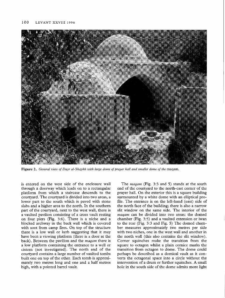
Figure 2. General view of Dayr al-Shaykh with large dome of prayer hall and smaller dome of the maqam.
is entered on the west side of the enclosure wallthrough a doorway which leads on to a rectangularplatform from which a staircase descends to thecourtyard. The courtyard is divided into two areas, alower part to the south which is paved with stoneslabs and a higher area to the north. In the southernpart of the courtyard, next to the west wall, there isa vaulted pavilion consisting of a cross vault restingon four piers (Fig. 3:6). There is a niche and ablocked archway in the back wall which is coveredwith soot from camp fires. On top of the structurethere is a low wall or kerb suggesting that it mayhave been a viewing platform (there is a door at theback). Between the pavilion and the maqam there isa low platform containing the entrance to a well orcistern (not investigated). The north end of thecourtyard contains a large number of vaulted tombsbuilt one on top of the other. Each tomb is approxi-mately two metres long and one and a half metreshigh, with a pointed barrel vault.
The maqam (Fig. 3:3 and 5) stands at the southend of the courtyard to the north-east comer of theprayer hall. On the exterior this is a square buildingsurmounted by a white dome with an elliptical pro-file. The entrance is on the left-hand (east) side ofthe north face of the building; there is also a narrowslit window on the same side. The interior of themaqam can be divided into two areas: the domedchamber (Fig. 3:5) and a vaulted extension or iwanto the rear (Fig. 3:3 and Fig. 5) The domed cham-ber measures approximately two metres per sidewith two niches, one in the west wall and another inthe north wall (this also contains the slit window).Comer squinches make the transition from thesquare to octagon whilst a plain cornice marks thetransition from octagon to dome. The dome couldperhaps be described as a domical vault as it con-verts the octagonal space into a circle without theintervention of a drum or further squinches. A smallhole in the south side of the dome admits more light

A. PETERSEN Report on Three Muslim Shrines in Palestine 101
to the interior. At the south end of the domed cham-ber there is a large open arch which leads into a lowvaulted chamber partially blocked with a low wall.The alignment of the arch to the vault is not exact,suggesting that the vault existed before the domedchamber. The vault runs north to south and springsfrom ground level. In the centre of the vault there isa badly damaged grave lying east/west. There aretwo triangular niches in the west wall, otherwise theinterior of the vault is very plain.
The prayer hall (Fig. 3:4), located in the south-west comer of the complex, is the largest single unit.Entry to the hall is through a large open archway inthe south-west comer of the courtyard. The roofconsists of a large hemispherical dome resting on acircular drum supported by spherical pendentivesspringing from massive comer piers. The drum ispierced by four large windows, one on each of thenorth, south, west and east sides. The comer piersare joined by large arches which form large recesseson each side. In the recess on the west side there aretwo large niches set high up into the west wall. The
south recess contains several features including amihrab, a minbar and a large vaulted tomb. Themihrab is a plain undecorated deep-set niche andnext to it (on the west side) there are steps whichform the minbar. The vaulted tomb is a large struc-ture (2 metres long, 1 metre high and 1 metre wide)which has been broken into in the middle. In themiddle of the east wall there is an arched opening(two metres wide) which leads into a hall roofedwith a pointed barrel vault (Fig. 3:2). The groundlevel of this hall seems to have been raised as thevault springs from the current floor level. In thenorth-west comer of the room there is a low vaultedniche which may originally have been a doorway tothe vault at the back of the maqam.
The entrance to the crypt (Fig. 3: 1) is located inthe south-east comer of the courtyard. At presentthe doorway is a low opening overgrown with plants.The interior floor level is at least one metre lowerthan that of the courtyard outside. The room is rec-tangular (5.5 x 3.5 m.) and covered with a pointedbarrel-vault aligned north/south. On the floor of the
Figure 3. Plan of the complex at Dayr al-Shaykh. Nos. 1, 2 and 3 represent the earliest phase, NO.4 is the prayer hall, NO.5is the shrine or maqam, and NO.6 is the vaulted pavilion.
102 LEVANT XXVIII 1996
A
B
oI
10mI
-----I---~--
~L
l
t9J
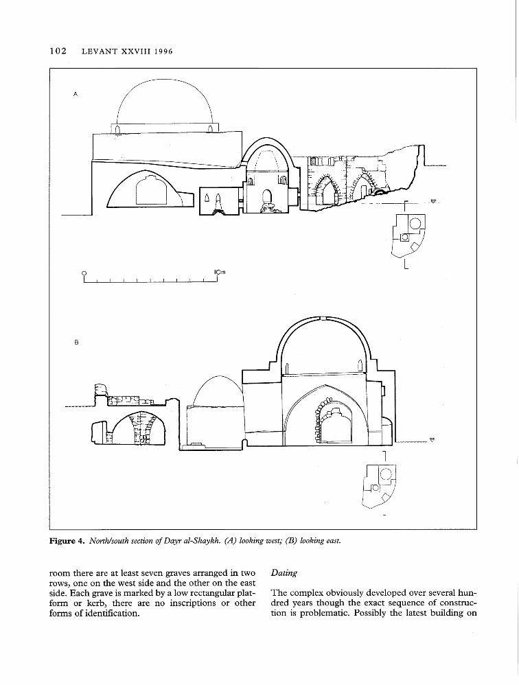
Figure 4. North/south section of Dayr al-Shaykh. (A) looking west; (B) looking east.
room there are at least seven graves arranged in tworows, one on the west side and the other on the eastside. Each grave is marked by a low rectangular plat-form or kerb, there are no inscriptions or otherforms of identification.
Dating
The complex obviously developed over several hun-dred years though the exact sequence of construc-tion is problematic. Possibly the latest building on

A. PETERSEN Report on Three Muslim Shrines in Palestine 103
Figure 5. Dayr al-Shaykh. Interior ofmaqam.
the site is the cross-vaulted pavilion (Fig. 3:6) in thecourtyard. The use of cross-vaulting and the factthat this structure has no direct relationship with therest of the main building suggests a later date. In anycase the building clearly post-dates the arch in thelower part of the enclosure wall. The maqam (Fig.3:5 and 3) is built against the north-east pier of theentrance to the prayer hall and therefore post-datesthe prayer hall. The maqam also post-dates the twobarrel-vaulted rooms as it blocks the arched openingin the north wall of the south vault and has a higherfloor level than either of the two vaulted rooms (thefloor level of the south vault has obviously risenabove its original level) . The prayer hall butts againstthe west wall of the southern vaulted room whichhas had its floor raised to equal that of the prayerhall. The north vaulted room is of similar design tothe south vaulted room and has its original low floorlevel indicating that it is of the same date. Thissequence of construction may be summarised as fol-lows: first the two vaulted halls were built, secondthe domed prayer hall was built, third the maqam
and finally the cross-vaulted pavilion.Assigning absolute dates to the construction
sequence is difficult and cannot be done with anycertainty; however, the following provisional datesare suggested. The vaulted halls clearly belong tosome earlier structure possibly associated with a dayror monastery which probably dates from theCrusader period or earlier. The prayer hall maybelong to the zawiyeh established by Badr in the thir-teenth century whilst the maqam may date to thesame century or slightly later (the tomb seems to belocated in the older part of the structure). The cross-vaulted pavilion may belong to any period betweenthe thirteenth and nineteenth centuries.
Nabi Rubin
LocationNabi Rubin is located approximately 15 km. southof Jaffa in the midst of large sand dunes (PalestineGrid reference 1249 1485). This building standsnext to the river Rubin and is approximately 2 km.from the sea (Fig. 6 and 7).
HistoryRubin (also spelt Reuben) was the son of Jacob andLeah (Gen. 29: 31-32) and is the ancestor of thetribe of Rubin. The date at which Rubin firstbecame associated with this site is not knownalthough a shrine was certainly established by theMamluk period (see below). During Ottoman timesthe tomb of Rubin became established as one of themajor shrines of Palestine. Each year there was anannual pilgrimage and festival (mawsim) at theshrine. Canaan (1927, 215-6) gives the followingaccount of the proceedings:
During the festival of N abi Rubin the peoplegather in great numbers at the river which bearsthis name. The festival extends over one month,beginning with the new moon of August. Duringthe full moon nights the place is most popular.The number of visitors to en-Nabi Rubil exceedsthat of en-Nabi Musa. More coffee-houses andshops are erected. The plain around, especiallythat to the N.W. of the sanctuary, is full of tents.The pilgrims come principally from Jaffa, Lydda,Ramleh and the surrounding villages. It is a pic-turesque sight to see a small caravan of camelscarrying a whole family with the necessary house-hold equipment for spending several days or a fewweeks at this place.Indeed the festival was so popular that in Jaffa
women would often say, "Either you take me toRubin or you divorce me" (Canaan 1927, 216).
104 LEVANT XXVIII 1996
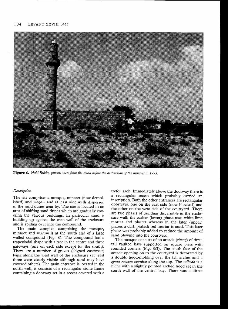
Figure 6. Nabi Rubin, general view from the south before the destruction of the minaret in 1993.
trefoil arch. Immediately above the doorway there isa rectangular recess which probably carried aninscription. Both the other entrances are rectangulardoorways, one on the east side (now blocked) andthe other on the west side of the courtyard. Thereare two phases of building discernible in the enclo-sure wall; the earlier (lower) phase uses white limemortar and plaster whereas in the later (upper)phases a dark pinkish-red mortar is used. This laterphase was probably added to reduce the amount ofsand blowing into the courtyard.
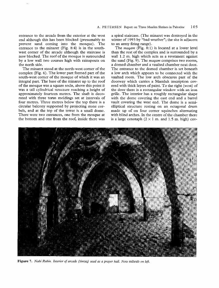
The mosque consists of an arcade (riwaq) of threetall vaulted bays supported on square piers withrounded comers (Fig. 8:3). The south face of thearcade opening on to the courtyard is decorated bya double hood-molding over the tall arches and acyma reversa cornice along the top. The mihr~b is aniche with a slightly pointed arched hood set tn thesouth wall of the central bay. There was a direct
Description
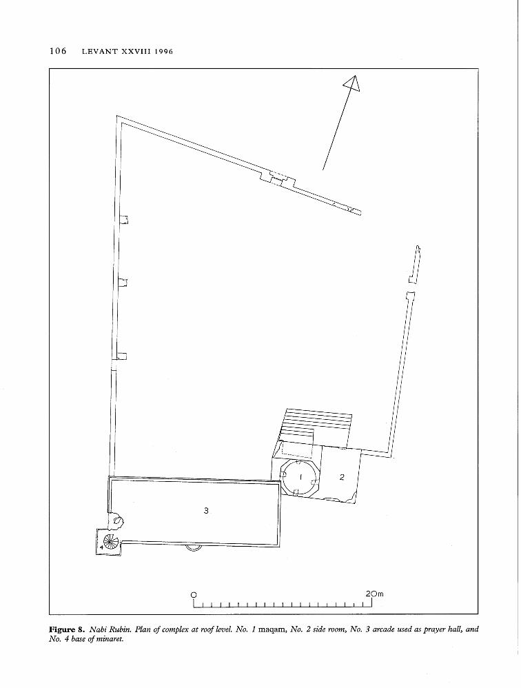
The site comprises a mosque, minaret (now demol-ished) and maqam and at least nine wells dispersedin the sand dunes near by. The site is located in anarea of shifting sand dunes which are gradually cov-ering the various buildings. In particular sand isbuilding up against the west wall of the enclosureand is spilling over into the compound.
The main complex comprising the mosque,minaret and maqam is at the south end of a largewalled compound (Fig. 8). The compound has atrapeziodal shape with a tree in the centre and threegateways (one on each side except for the south).There are a number of graves (aligned east/west)lying along the west wall of the enclosure (at leastthree were clearly visible although sand may havecovered others). The main entrance is located in thenorth wall' it consists of a rectangular stone framecontaining' a doorway set in a recess covered with a
A. PETERSEN Report on Three Muslim Shrines in Palestine 105
entrance to the arcade from the exterior at the westend although this has been blocked (presumably toprevent sand coming into the mosque). Theentrance to the minaret (Fig. 8:4) is in the south-west comer of the arcade although the staircase isnow blocked. The roof of the mosque is surroundedby a low wall two courses high with rainspouts onthe north side.
The minaret stood at the north-west corner of thecomplex (Fig. 6). The lower part formed part of thesouth-west comer of the mosque of which it was anintegral part. The base of the minaret up to the roofof the mosque was a square socle, above this point itwas a tall cylindrical structure reaching a height ofapproximately fourteen metres. The shaft is deco-rated with three torus moldings set at intervals offour metres. Three metres below the top there is acircular balcony supported by projecting stone cor-bels, and at the top of the tower is a small dome.There were two entrances, one from the mosque atthe bottom and one from the roof, inside there was
a spiral staircase. (The minaret was destroyed in thewinter of 1993 by "bad weather"; the site is adjacentto an army firing range).
The maqam (Fig. 8: 1) is located at a lower levelthan the rest of the complex and is surrounded by awall 1.2 m. high which acts as a revetment againstthe sand (Fig. 9). The maqam comprises two rooms,a domed chamber and a vaulted chamber next door.The entrance to the domed chamber is set beneatha low arch which appears to be connected with thevaulted room. The low arch obscures part of thedoorway which carries a Mamluk inscription cov-ered with thick layers of paint. To the right (west) ofthe door there is a rectangular window with an irongrille. The interior has a roughly rectangular shapewith the dome covering the east end and a barrelvault covering the west end. The dome is a semi-elliptical structure resting on an octagonal drummade up of on four corner squinches alternatingwith blind arches. In the centre of the chamber thereis a large cenotaph (2 x 1 m. and 1.5 m. high) cov-
Figure 7. Nabi Rubin. Interior of arcade (riwaq) used as a prayer hall. Note mihrab on left.
106 LEVANT XXVIII 1996
i i
3
oI I I I I , I I I I I I I I I I I I I
20mI I
Figure 8. Nabi Rubin. Plan of complex at roof level. NO.1 maqam., NO.2 side room., NO.3 arcade used as prayer hall., andNo. 4 base of minaret.
A. PETERSEN Report on Three Muslim Shrines in Palestine 107
A
B
c
oI
10mI
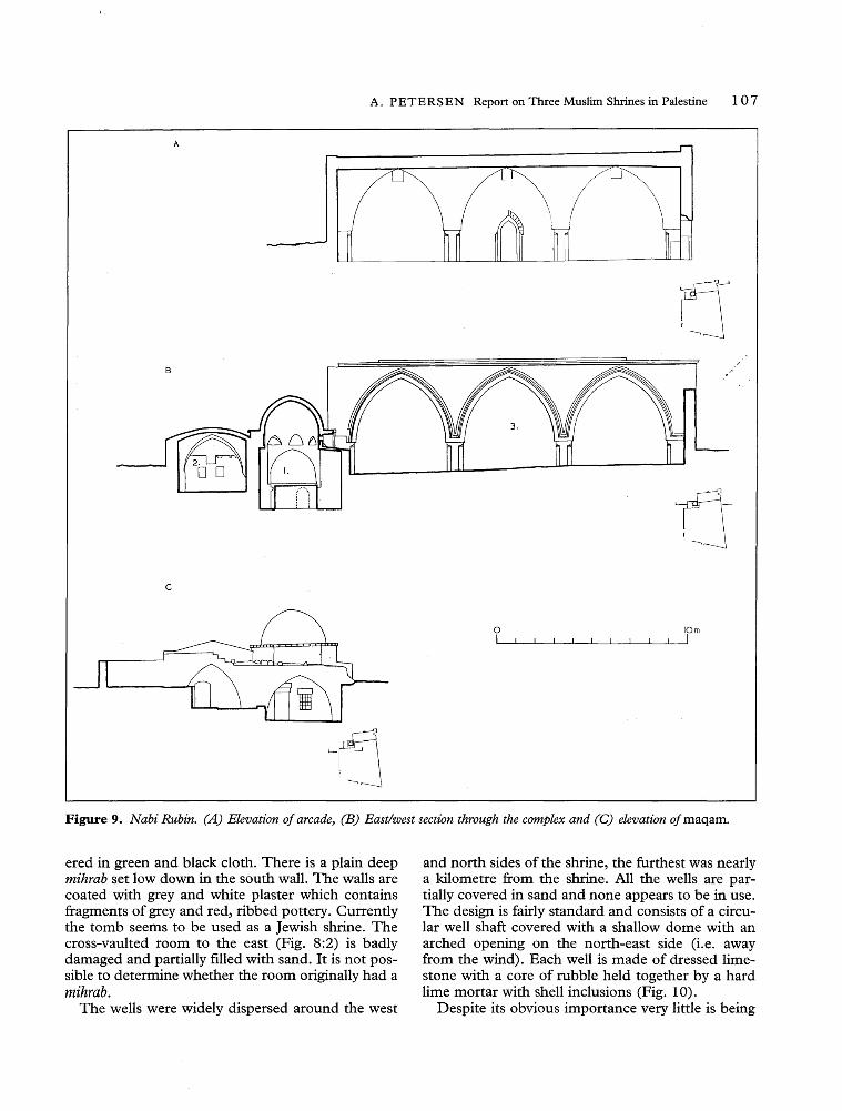
Figure 9. Nabi Rubin. (A) Elevation of arcade~(B) East/west section through the complex and (C) elevation ofmaqam.
ered in green and black cloth. There is a plain deepmihrab set low down in the south wall. The walls arecoated with grey and white plaster which containsfragments of grey and red, ribbed pottery. Currentlythe tomb seems to be used as a Jewish shrine. Thecross-vaulted room to the east (Fig. 8:2) is badlydamaged and partially filled with sand. It is not pos-sible to determine whether the room originally had amihrab.
The wells were widely dispersed around the west
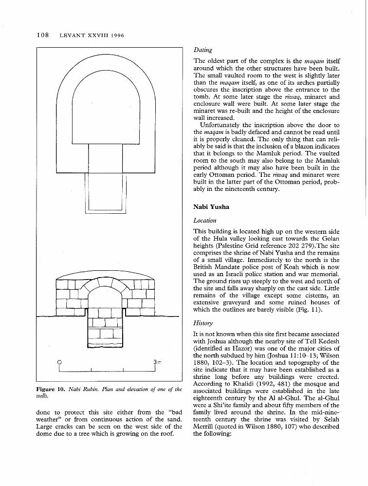
and north sides of the shrine, the furthest was nearlya kilometre from the shrine. All the wells are par-tially covered in sand and none appears to be in use.The design is fairly standard and consists of a circu-lar well shaft covered with a shallow dome with anarched opening on the north-east side (i.e. awayfrom the wind). Each well is made of dressed lime-stone with a core of rubble held together by a hardlime mortar with shell inclusions (Fig. 10).
Despite its obvious importance very little is being
108 LEVANT XXVIII 1996
Dating
The oldest part of the complex is the maqam itselfaround which the other structures have been built.The small vaulted room to the west is slightly laterthan the maqam itself, as one of its arches partiallyobscures the inscription above the entrance to thetomb. At some later stage the riwaq, minaret andenclosure wall were built. At some later stage theminaret was re-built and the height of the enclosurewall increased.
Unfortunately the inscription above the door tothe maqam is badly defaced and cannot be read untilit is properly cleaned. The only thing that can reli-ably be said is that the inclusion of a blazon indicatesthat it belongs to the Mamluk period. The vaultedroom to the south may also belong to the Mamlukperiod although it may also have been built in theearly Ottoman period. The riwaq and minaret werebuilt in the latter part of the Ottoman period, prob-ably in the nineteenth century.
Nabi Yusha
Location
Figure 10. Nabi Rubin. Plan and elevation of one of thewells.
done to protect this site either from the "badweather" or from continuous action of the sand.Large cracks can be seen on the west side of thedome due to a tree which is growing on the roof.
oI
3mI
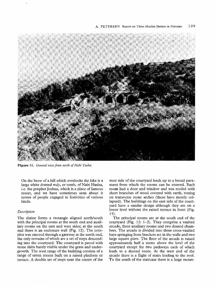
This building is located high up on the western sideof the Hula valley looking east towards the Golanheights (Palestine Grid reference 202 279). The sitecomprises the shrine of Nabi Yusha and the remainsof a small village. Immediately to the north is theBritish Mandate police post of Koah which is nowused as an Israeli police station and war memorial.The ground rises up steeply to the west and north ofthe site and falls away sharply on the east side. Littleremains of the village except some cisterns, anextensive graveyard and some ruined houses ofwhich the outlines are barely visible (Fig. 11).
History
It is not known when this site first became associatedwith Joshua although the nearby site of Tell Kedesh(identified as Hazor) was one of the major cities ofthe north subdued by him aoshua 11:10-13; Wilson1880, 102-3). The location and topography of thesite indicate that it may have been established as ashrine long before any buildings were erected.According to Khalidi (1992, 481) the mosque andassociated buildings were established in the lateeighteenth century by the AI al-Ghul. The al-Ghulwere a Shi'ite family and about fifty members of thefamily lived around the shrine. In the mid-nine-teenth century the shrine was visited by SelahMerrill (quoted in Wilson 1880, 107) who describedthe following:
A. PET E R SEN Report on Three Muslim Shrines in Palestine 1 0 9
Figure 11. General view from north of Nabi Yusha.
On the brow of a hill which overlooks the lake is alarge white domed wely, or tomb, of Nabi Husha,i.e. the prophet Joshua, which is a place of famousresort, and we have sometimes seen about itscores of people engaged in festivities of variouskinds.
Description
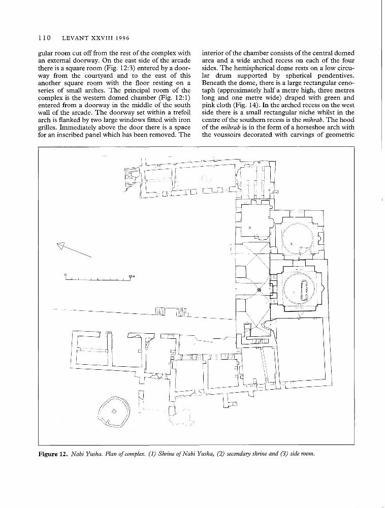
The shrine forms a rectangle aligned north/southwith the principal rooms at the south end and auxil-iary rooms on the east and west sides; at the southend there is an enclosure wall (Fig. 12). The com-plex was entered through a gateway at the north end,the only remains of which are a set of steps descend-ing into the courtyard. The courtyard is paved withstone slabs barely visible under the grass and under-growth. The west range of the building consists of arange of seven rooms built on a raised platform orterrace. A double set of steps near the centre of the
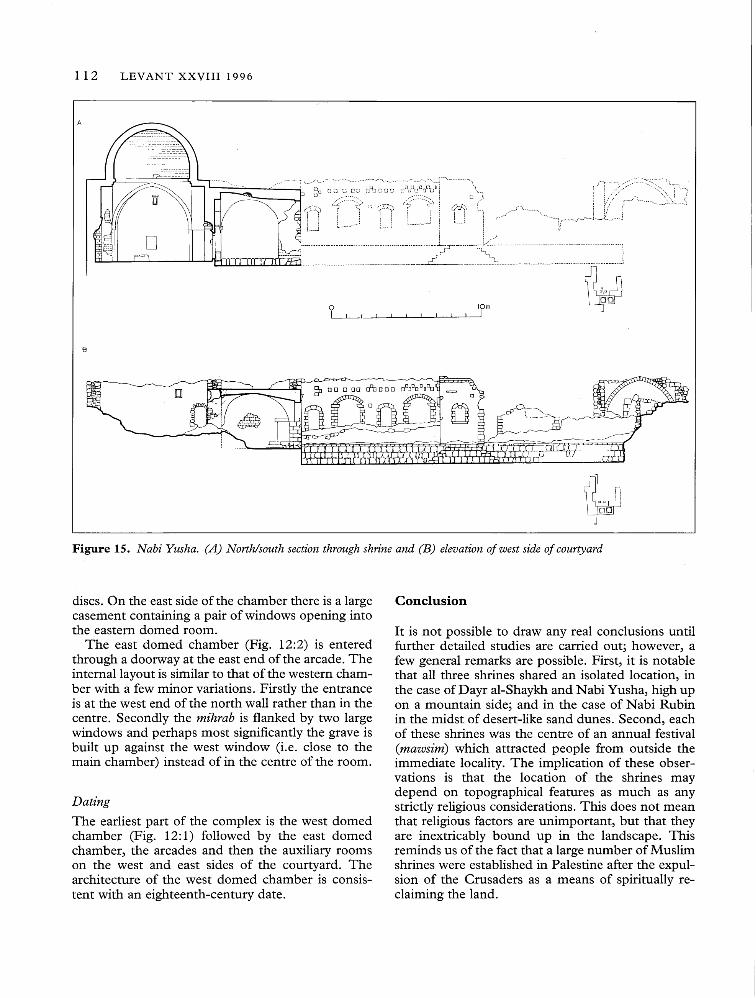
west side of the courtyard leads up to a broad pave-ment from which the rooms can be entered. Eachroom had a door and window and was roofed withshort branches of wood covered with earth, restingon transverse stone arches (these have mostly col-lapsed). The buildings on the east side of the court-yard have a similar design although they are on alower level without the raised terrace in front (Fig.15).
The principal rooms are at the south end of thecourtyard (Fig. 12: 1-2). They comprise a vaultedarcade, three auxiliary rooms and two domed cham-bers. The arcade is divided into three cross-vaultedbays springing from brackets set in the walls and twolarge square piers. The floor of the arcade is raisedapproximately half a metre above the level of thecourtyard except for two pathways each of whichleads to a domed room. At the west end of thearcade there is a flight of stairs leading to the roof.To the south of the staircase there is a large rectan-
110 LEVANT XXVIII 1996
gular room cut off from the rest of the complex withan external doorway. On the east side of the arcadethere is a square room (Fig. 12:3) entered by a door-way from the courtyard and to the east of thisanother square room with the floor resting on aseries of small arches. The principal room of thecomplex is the western domed chamber (Fig. 12: 1)entered from a doorway in the middle of the southwall of the arcade. The doorway set within a trefoilarch is flanked by two large windows fitted with irongrilles. Immediately above the door there is a spacefor an inscribed panel which has been removed. The
interior of the chamber consists of the central domedarea and a wide arched recess on each of the foursides. The hemispherical dome rests on a low circu-lar drum supported by spherical pendentives.Beneath the dome, there is a large rectangular ceno-taph (approximately half a metre high, three metreslong and one metre wide) draped with green andpink cloth (Fig. 14). In the arched recess on the westside there is a small rectangular niche whilst in thecentre of the southern recess is the mihrab. The hoodof the mihrab is in the form of a horseshoe arch withthe voussoirs decorated with carvings of geometric
oI
10mI
qI iI LL
[[[10 OUh
Figure 12. Nabi Yusha. Plan of complex. (1) Shrine of Nabi Yusha~ (2) secondary shrine and (3) side room.

oI
A. PETERSEN Report on Three Muslim Shrines in Palestine 111
10m1
Figure 13. Nabi Yusha. (A) Elevation of portico and (B) section through portico.
Figure 14. Nabi Yusha. Interior of shrine with tomb of Yusha (Joshua) in foreground.
112 LEVANT XXVIII 1996
A
B
oI
10mI
~loo n~
Figure 15. Nabi Yusha. (A) North/south section through shrine and (B) elevation of west side of courtyard
discs. On the east side of the chamber there is a largecasement containing a pair of windows opening intothe eastern domed room.
The east domed chamber (Fig. 12:2) is enteredthrough a doorway at the east end of the arcade. Theinternal layout is similar to that of the western cham-ber with a few minor variations. Firstly the entranceis at the west end of the north wall rather than in thecentre. Secondly the mihrab is flanked by two largewindows and perhaps most significantly the grave isbuilt up against the west window (i.e. close to themain chamber) instead of in the centre of the room.
DatingThe earliest part of the complex is the west domedchamber (Fig. 12: 1) followed by the east domedchamber, the arcades and then the auxiliary roomson the west and east sides of the courtyard. Thearchitecture of the west domed chamber is consis-tent with an eighteenth-century date.
Conclusion
It is not possible to draw any real conclusions untilfurther detailed studies are carried out; however, afew general remarks are possible. First, it is notablethat all three shrines shared an isolated location, inthe case of Dayr al-Shaykh and Nabi Yusha, high upon a mountain side; and in the case of Nabi Rubinin the midst of desert-like sand dunes. Second, eachof these shrines was the centre of an annual festival(mawsim) which attracted people from outside theimmediate locality. The implication of these obser-vations is that the location of the shrines maydepend on topographical features as much as anystrictly religious considerations. This does not meanthat religious factors are unimportant, but that theyare inextricably bound up in the landscape. Thisreminds us of the fact that a large number of Muslimshrines were established in Palestine after the expul-sion of the Crusaders as a means of spiritually re-claiming the land.
A. PETERSEN Report on Three Muslim Shrines in Palestine 113
Bibliography
Canaan, T. (1927) Mohammedan Saints and Sanctuaries inPalestine. Palestine Oriental Society: Jerusalem.
Cauvet, C (1953) Les marrabouts. Petits monumentsfuneraires et votifs du Nord de I'Mrique. RevueAfricaine, 274-239, 448-522.
Conder, C.R. and Kitchener, H.H. (1881) The Survey ofWestern Palestine: Memoirs of the Topography, Orography,Hydrography and Archaeology. Three Vols. London.
Halevi, Y.K. (1993) Mother Rachel's tangled legacy. TheJerusalem Report, December 16, 16-18.
Heyd, U. (1960) Ottoman Documents on Palestine 1552-1615. Oxford.
Hiitteroth, W. and Abdulfattah, K. (1977) HistoricalGeography of Palestine, Transjordan and Southern Syria inthe Late Sixteenth Century. Erlangen, Germany.
James, H. (1993) The cult of St. David in the MiddleAges. Pp.105-12 in M. Carver (ed.) In Search of Cult.Archaeological Investigations in Honour of Philip Rahtz.London.
Khalidi, W. ed. (1992) All That Remains. The PalestinianVillages Occupied and Depopulated by Israel in 1948.Washington.
McCown, C.C. (1923) Muslim Shrines in Palestine.AASOR II-III for 1921-2, 47-79.
Masterman E.W.G. and Macalister R.A.S. (1916)Occasional Papers on the Modem Inhabitants ofPalestine: Tales ofWelys and Dervishes. PEFQS 11-19,64-71, 126-137.
Mayer, L.A. and Pinkerfeld, J. (1950) Principal Muslimbuildings in Israel. Jerusalem.
Pringle, R.D. (1986) The Red Tower (ai-Bury al-Ahmar)Settlement in the Plain of Sharon at the Time of theCrusaders and Mamluks A. D. 1099-1516. British Schoolof Archaeology in Jerusalem: London.
Shalem, A. (1995) BPr al-Waraqa: Legend and truth. Anote on medieval sacred geography. PEQ 127, January-June, 50-61.
Wilson, C.W. (1880). Picturesque Palestine, Sinai andEgypt. 4 vols. London. Reprinted with different pagina-tion in Jerusalem 1976.