Multi-agent systems companion modeling for integrated watershed management: a northern Thailand...
10
INTRODUCTION Integrated watershed management means a collective man- agement of the land, reconciling ecological dynamics and social processes to ensure a sustainable and equitable use of renewable resources. Because different stakeholders have different representations of a local agricultural sys- tem, it is important for them to take into account and to understand such differences. It is possible to look at inte- grated watershed management as a collective learning pro- cess aiming at reaching an agreement on rules to be fol- lowed by all concerned stakeholders to favor the co-adap- tation and co-viability between natural and social dynam- ics. We think that such an agreement can be brought about through the confrontation of stakeholders’ various points of view. The complexity of coordination and negotiation pro- cesses among multiple stakeholders exploiting a common agroecosystem, such as a watershed, raises methodologi- cal questions. To deal with the increased complexity and rapidity of changes in Montane Mainland Southeast Asia (MMSEA) watersheds, as well as their unpredictable out- comes, new types of models can be used in association with other tools to facilitate such collective learning. These models belong to the emerging area of the science of com- plexity. In a given watershed, complexity is created by the heterogeneity of the environment, landscapes, and soci- ety and by the diversity of interacting processes that are taking place among different natural and human entities. In the field of integrated natural resource management (INRM), understanding interactions between natural and social dynamics is of paramount importance. Natural dy- namics are made of numerous interwoven biophysical pro- cesses, involving different resources at different spatial and temporal scales. Social processes involve decisions made by different stakeholders at various levels of orga- MULTI-AGENT SYSTEMS COMPANION MODELING FOR INTEGRATED WATERSHED MANAGEMENT: A NORTHERN THAILAND EXPERIENCE G. Trébuil, 1 B. Shinawatra-Ekasingh, 2 F. Bousquet, 3 and C. Thong-Ngam 4 1 IRRI-Cirad-DOA Project, Bangkok, Thailand; 2 Chiang Mai University; 3 IRRI-Cirad, Bangkok; 4 Dept. of Public Welfare ABSTRACT Integrated watershed management means a collective management of the land, reconciling ecological dynamics and social processes to ensure a sustainable and equitable use of renewable resources. Because different stakeholders have different representations of a local agricultural system, its integrated management can be seen as a collective learning process. New types of models, closely articulated with field work and other participatory tools, can be used to facilitate such collective learning. They are particularly useful for elucidating relationships among agent behaviors and their interactions and resource dynamics at different levels of organization. This paper describes and discusses the development and preliminary field testing of such a companion modeling approach, based on the use of multi-agent systems (MAS) associated with role-playing games. Companion modeling supports on-farm, interdisciplinary, and action-oriented participatory research to facilitate dialogue, shared learning, negotiation, and collective decision-making among multiple stakeholders. The principles of this approach, the charac- teristics of agent-based models, and associated role-playing games are explained. Their validation and use with stakeholders to manage renewable natural resources are also presented. The article is illustrated by an ongoing case study to improve steep-land management by limiting land degradation in rapidly diversifying and market-integrated farming systems of Akha villages in upper northern Thailand. Fieldwork and modeling activities are seen as complementary, and they are closely linked in an iterative way. The collective construction of a common artificial world with stakeholders leads to the emergence of a shared representa- tion of a complex system and the concrete problem to be examined. Later, such a common representation can be used among stakeholders as a coordination and negotiation support tool to identify and to assess scenarios of desirable futures. On the basis of a shared understanding of current systems dynamics, this approach helps to identify accept- able rules for an improved regulation of collective uses of land resources. When a policy of decentralization of natural resource management is implemented, companion modeling can be used to integrate knowledge, stimulate dialogue, and establish adapted coordination mechanisms regarding multiple uses of the land by multiple stakeholders, but also to assess suitable innovations and desirable scenarios of land-use changes for the future. Trébuil, G., B. Shinawatra-Ekasingh, F. Bousquet, and C. Thong-Ngam. 2003. Multi-Agent Systems Companion Modeling for Integrated Watershed Management: A Northern Thailand Experience. In Landscapes of Diversity: Indigenous Knowledge, Sustainable Livelihoods and Resource Governance in Montane Mainland Southeast Asia. Proceedings of the III Symposium on MMSEA 25–28 August 2002, Lijiang, P.R. China. Xu Jianchu and Stephen Mikesell, eds. pp. 349–358. Kunming: Yunnan Science and Technology Press.
Transcript of Multi-agent systems companion modeling for integrated watershed management: a northern Thailand...

349MULTI-AGENT SYSTEMS COMPANION MODELING FOR INTEGRATED WATERSHED MANAGEMENT
INTRODUCTION
Integrated watershed management means a collective man-agement of the land, reconciling ecological dynamics andsocial processes to ensure a sustainable and equitable useof renewable resources. Because different stakeholdershave different representations of a local agricultural sys-tem, it is important for them to take into account and tounderstand such differences. It is possible to look at inte-grated watershed management as a collective learning pro-cess aiming at reaching an agreement on rules to be fol-lowed by all concerned stakeholders to favor the co-adap-tation and co-viability between natural and social dynam-ics. We think that such an agreement can be brought aboutthrough the confrontation of stakeholders’ various pointsof view.
The complexity of coordination and negotiation pro-cesses among multiple stakeholders exploiting a common
agroecosystem, such as a watershed, raises methodologi-cal questions. To deal with the increased complexity andrapidity of changes in Montane Mainland Southeast Asia(MMSEA) watersheds, as well as their unpredictable out-comes, new types of models can be used in associationwith other tools to facilitate such collective learning. Thesemodels belong to the emerging area of the science of com-plexity. In a given watershed, complexity is created by theheterogeneity of the environment, landscapes, and soci-ety and by the diversity of interacting processes that aretaking place among different natural and human entities.In the field of integrated natural resource management(INRM), understanding interactions between natural andsocial dynamics is of paramount importance. Natural dy-namics are made of numerous interwoven biophysical pro-cesses, involving different resources at different spatialand temporal scales. Social processes involve decisionsmade by different stakeholders at various levels of orga-
MULTI-AGENT SYSTEMS COMPANION MODELING FOR INTEGRATEDWATERSHED MANAGEMENT: A NORTHERN THAILAND EXPERIENCE
G. Trébuil,1 B. Shinawatra-Ekasingh,2 F. Bousquet,3 and C. Thong-Ngam4
1IRRI-Cirad-DOA Project, Bangkok, Thailand; 2Chiang Mai University;3IRRI-Cirad, Bangkok; 4Dept. of Public Welfare
ABSTRACT
Integrated watershed management means a collective management of the land, reconciling ecological dynamics andsocial processes to ensure a sustainable and equitable use of renewable resources. Because different stakeholdershave different representations of a local agricultural system, its integrated management can be seen as a collectivelearning process. New types of models, closely articulated with field work and other participatory tools, can be usedto facilitate such collective learning. They are particularly useful for elucidating relationships among agent behaviorsand their interactions and resource dynamics at different levels of organization.
This paper describes and discusses the development and preliminary field testing of such a companion modelingapproach, based on the use of multi-agent systems (MAS) associated with role-playing games. Companion modelingsupports on-farm, interdisciplinary, and action-oriented participatory research to facilitate dialogue, shared learning,negotiation, and collective decision-making among multiple stakeholders. The principles of this approach, the charac-teristics of agent-based models, and associated role-playing games are explained. Their validation and use withstakeholders to manage renewable natural resources are also presented. The article is illustrated by an ongoing casestudy to improve steep-land management by limiting land degradation in rapidly diversifying and market-integratedfarming systems of Akha villages in upper northern Thailand.
Fieldwork and modeling activities are seen as complementary, and they are closely linked in an iterative way. Thecollective construction of a common artificial world with stakeholders leads to the emergence of a shared representa-tion of a complex system and the concrete problem to be examined. Later, such a common representation can be usedamong stakeholders as a coordination and negotiation support tool to identify and to assess scenarios of desirablefutures. On the basis of a shared understanding of current systems dynamics, this approach helps to identify accept-able rules for an improved regulation of collective uses of land resources.
When a policy of decentralization of natural resource management is implemented, companion modeling can beused to integrate knowledge, stimulate dialogue, and establish adapted coordination mechanisms regarding multipleuses of the land by multiple stakeholders, but also to assess suitable innovations and desirable scenarios of land-usechanges for the future.
Trébuil, G., B. Shinawatra-Ekasingh, F. Bousquet, and C. Thong-Ngam. 2003. Multi-Agent Systems Companion Modeling forIntegrated Watershed Management: A Northern Thailand Experience. In Landscapes of Diversity: Indigenous Knowledge, SustainableLivelihoods and Resource Governance in Montane Mainland Southeast Asia. Proceedings of the III Symposium on MMSEA 25–28August 2002, Lijiang, P.R. China. Xu Jianchu and Stephen Mikesell, eds. pp. 349–358. Kunming: Yunnan Science and TechnologyPress.
G. Trébuil, B. Shinawatra-Ekasingh, F. Bousquet, and C. Thong-Ngam350
E n v i r o n m e n t
G o a lC o m m u n i c a t i o n
A c t io n
P e r c e p t i o n
C o m m u n i c a t io n
R e p r e s e n t a t io n s
9
5
nization, ranging from individuals and local communitiesoccupying the land and exploiting its resources to largedevelopment-oriented or policy-making institutions. Apromising modeling approach of complex systems postu-lates that simple rules of organization and functioning canbe identified from the apparent complexity of the system,and key structures and rules of evolution can be eluci-dated to better understand and manage the dynamics ofsuch systems. Particularly, such models can be useful forunderstanding the relationships among agent behaviors,their interactions, and the resulting agroecological dynam-ics at different levels of organization (field, farm, water-shed). Based on a prior understanding and modeling ofthe natural and agronomic dynamics, finding a way to pro-duce acceptable social rules for an improved regulation ofcollective uses of land resources is a major question inINRM.
But what kinds of models should be used for such apurpose? And how can we use them with multiple stake-holders? This article proposes the use and the develop-ment of a “companion modeling approach” (Bousquet etal. 1999). It is illustrated by a case study on steep-landmanagement in diversifying and market-integrated farm-ing systems of Akha villages in the highlands of northernThailand.
A COMPANION MODELING APPROACH BASEDON MULTI-AGENT SYSTEMS (MAS)
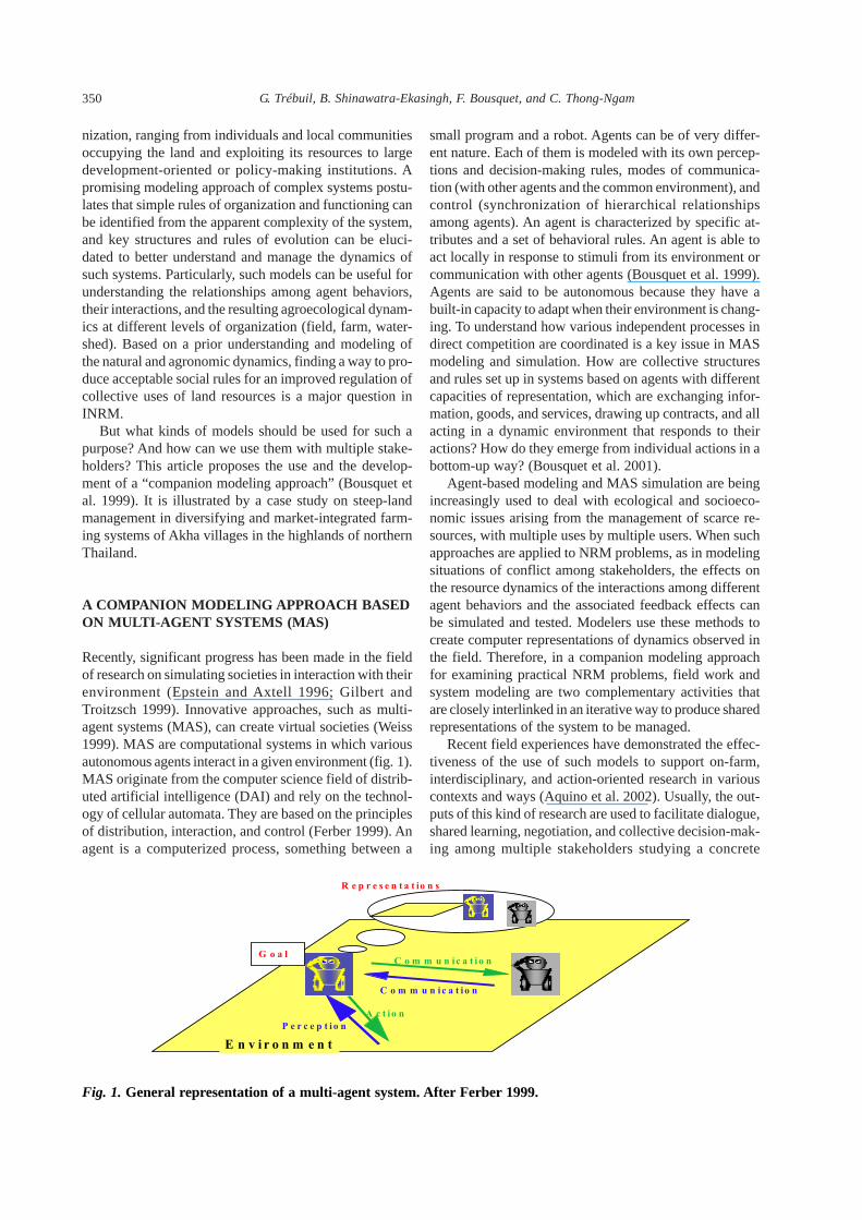
Recently, significant progress has been made in the fieldof research on simulating societies in interaction with theirenvironment (Epstein and Axtell 1996; Gilbert andTroitzsch 1999). Innovative approaches, such as multi-agent systems (MAS), can create virtual societies (Weiss1999). MAS are computational systems in which variousautonomous agents interact in a given environment (fig. 1).MAS originate from the computer science field of distrib-uted artificial intelligence (DAI) and rely on the technol-ogy of cellular automata. They are based on the principlesof distribution, interaction, and control (Ferber 1999). Anagent is a computerized process, something between a
small program and a robot. Agents can be of very differ-ent nature. Each of them is modeled with its own percep-tions and decision-making rules, modes of communica-tion (with other agents and the common environment), andcontrol (synchronization of hierarchical relationshipsamong agents). An agent is characterized by specific at-tributes and a set of behavioral rules. An agent is able toact locally in response to stimuli from its environment orcommunication with other agents (Bousquet et al. 1999).Agents are said to be autonomous because they have abuilt-in capacity to adapt when their environment is chang-ing. To understand how various independent processes indirect competition are coordinated is a key issue in MASmodeling and simulation. How are collective structuresand rules set up in systems based on agents with differentcapacities of representation, which are exchanging infor-mation, goods, and services, drawing up contracts, and allacting in a dynamic environment that responds to theiractions? How do they emerge from individual actions in abottom-up way? (Bousquet et al. 2001).
Agent-based modeling and MAS simulation are beingincreasingly used to deal with ecological and socioeco-nomic issues arising from the management of scarce re-sources, with multiple uses by multiple users. When suchapproaches are applied to NRM problems, as in modelingsituations of conflict among stakeholders, the effects onthe resource dynamics of the interactions among differentagent behaviors and the associated feedback effects canbe simulated and tested. Modelers use these methods tocreate computer representations of dynamics observed inthe field. Therefore, in a companion modeling approachfor examining practical NRM problems, field work andsystem modeling are two complementary activities thatare closely interlinked in an iterative way to produce sharedrepresentations of the system to be managed.
Recent field experiences have demonstrated the effec-tiveness of the use of such models to support on-farm,interdisciplinary, and action-oriented research in variouscontexts and ways (Aquino et al. 2002). Usually, the out-puts of this kind of research are used to facilitate dialogue,shared learning, negotiation, and collective decision-mak-ing among multiple stakeholders studying a concrete
Fig. 1. General representation of a multi-agent system. After Ferber 1999.

351MULTI-AGENT SYSTEMS COMPANION MODELING FOR INTEGRATED WATERSHED MANAGEMENT
INRM issue (Barreteau and Bousquet 2000; Lynam et al.2002). In a companion modeling approach, this can bedone through the collective construction of a common ar-tificial world leading to the emergence of a shared repre-sentation of the complex system and problem. In associa-tion with other tools, MAS models can be used as a medi-ating tool to achieve a collective agreement among diversestakeholders on the watershed organization and dynam-ics. Later on, this common vision can be used to facilitatestakeholders’ coordination and negotiation mechanisms toimprove its management. For example, simulation toolscan be used to identify and assess a scenario toward desir-able futures of the system with all concerned stakehold-ers. Different options can be rapidly and interactively de-fined, simulated, and discussed to facilitate the emergenceof socially and ecologically acceptable courses of actionthrough improved stakeholder communication and inter-actions (Röling 1996).
Closely articulated with MAS models in the compan-ion modeling approach, role-playing games are used toproduce new knowledge, to help build MAS models, andto validate them (fig. 2). Depending on the circumstances,
the linkages between these two interactive tools can vary(Aquino et al. 2002).
Therefore, the complementary functions of MAS mod-els and associated role-playing games are an original meth-odological feature of the companion modeling approach.These tools present many parallels facilitating their asso-ciation (Table 1). Linking them is also made easier be-cause both of them operate through a gradual and itera-tive process of learning-by-doing.
The use of role-playing games derived from more com-plex models through simplifications facilitates the com-munication of the results of agent-based computer simu-lation to stakeholders. It helps empower them to use suchpowerful tools when looking for “solutions” to a concreteNRM problem. If it can take half a day to play severalyears of a scenario with the role game, a given set of sys-tem management rules can be simulated by the MAS modelfar more rapidly. Beyond their potential for improving in-teractions among local stakeholders and for elucidatingthe effects of their decisions on the resource base, thismethodology can also help to identify and assess suitablescenarios and innovations leading to desirable future situ-ations.
A MULTI-AGENT MODEL TO UNDERSTANDINTERACTIONS BETWEEN CROPDIVERSIFICATION AND LAND DEGRADATIONAT THE WATERSHED LEVEL
In montane northern Thailand, as small-scale highlandfarming is being rapidly integrated into the marketeconomy, the risk of increasing land degradation is a ma-jor problem in this fragile and heterogeneous environment.An increasing number of individual or collective stake-holders are presently interacting in sloping-land agricul-ture, all of them having their own land-use strategy. Wethink that the emergence of an ecologically sustainableand socially equitable type of highland agricultural devel-opment will require improvements in the way these di-verse stakeholders coordinate their actions in their com-mon environment.
As in other neighboring countries, a process of decen-tralization of the management of natural resources towardlocal communities is under way. We are proposing to useour companion modeling approach to facilitate the dia-logue and the coordination mechanisms on land-usechanges among local stakeholders in such highland wa-tersheds. Later on, possible future scenarios for highlandagricultures similar to the one observed in the villageswhere intensive field data collection was conducted couldbe jointly defined and assessed with the concerned play-ers. In the process, we could also aim at assessing the in-fluence of social behavior and farmers’ practices on theeffects of the government environmental policy in theseremote areas.
This case study is being developed by several col-laborative research and development partner institu-tions having complementary comparative advantages:Cirad and IRRI, the Multiple Cropping Center of theFaculty of Agriculture at Chiang Mai University, theDepartment of Public Welfare, and the farming com-munities in Mae Chan and Mae Fah Luang districts ofChiang Rai Province. They also represent successivelinks along the research-development continuum. The
Table 1. Correspondence Table Between Role-Playing Games andMulti-Agent Systems Associated in the Companion ModelingApproach
Role-Playing Game Multi-Agent Model
Players AgentsRoles RulesTurn Time stepGame set or playing board Interface or gridGame session Simulation
Fig. 2. Linkages between the reality and interactivetools in the companion modeling approach
C o n c e p tu a l m o d e l /
S h a r e d r e p r e s e n ta t io n
O b s e r v e d w o r ld
R o le - p la y in g g a m e
M u lt i - a g e n t s y s te m

G. Trébuil, B. Shinawatra-Ekasingh, F. Bousquet, and C. Thong-Ngam352
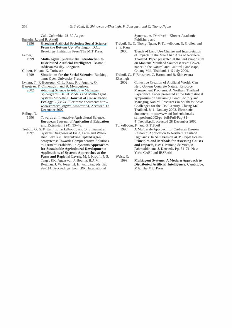
Village
Homogenous units
GISSlope
Orientation
Crop
Crop succession
Or
Practices
+
Cultivated fields
Farmers
Action:
Action:
Action:
Rain
Plots
Fig. 3. General structure and entities of a multi-agent model forintegrated watershed management in Chiang Rai Province, UpperNorthern Thailand
local agricultural system is displaying a rapid diversi-fication of agricultural practices, associated with anextensive socioeconomic differentiation among farm-ing households. These profound rural transformationsare powered by strong driving forces, such as the inte-gration of the local economy into commodity and la-bor markets, the expansion of communication infra-structure, population migrations, and national policieson environmental protection (Trébuil et al. 2000).
PURPOSE OF THE MODEL
Based on earlier in-depth, on-farm surveys at the field,household, and watershed levels carried out during twoyears in two Akha villages (Trébuil et al. 1997; Turkelboomand Trébuil 1998), a prototype agent-based model was ini-tially built. Its objective was to integrate knowledge for abetter understanding of the interaction between crop di-versification and land degradation at different scale lev-els, from small homogeneous units in cultivated fields withcomplex slopes to the whole village watershed, throughthe functioning of the main different types of farminghouseholds. This simulation model provides a spatial rep-resentation of the effects of farmers’ actual cropping prac-tices on the risk of land degradation by concentrated run-off.
CONCEPTION AND STRUCTURE OF THE MODEL
A detailed description of this MASmodel is given elsewhere (Trébuil et al.2002). Its general structure is displayedin Figure 3. The MAS modeling ap-proach was selected to integrate localand scientific knowledge on land man-agement obtained at complementaryspatial and social levels of organizationand operating at different time scales(single rainy event, crop cycle, crop suc-cession, long-term trends in land-usechanges). The general model structureand operating rules are sufficiently ge-neric to allow its use at various siteswhere watershed characteristics and in-teractions between ecological and so-cial dynamics are similar.
This conceptual MAS model pro-vides an agent-based representation ofthe village watershed in which differ-ent interacting entities, with specificpatterns of behavior, perceive (partiallyand differently) their common environ-ment and act on it to achieve their ownobjectives. The focus is on the interac-tion between the resource dynamics andits exploitation by different agents
implementing various strategies. The consequences of theiragricultural production practices and collective behaviorfor the risk of land degradation at the watershed level areassessed through a bottom-up aggregation of their effectsfrom the small homogeneous piece of slope to the field,farm, and then village level.
The CORMAS (“common-pool resources and multi-agent systems,” Bousquet et al. 1998; http://cormas.cirad.fr) simulation platform has been specificallytailored by Cirad for applying the MAS approach to INRMproblems and has therefore been used to construct thismodel. Four types of agents were modeled:
• Situated agents having spatial references in the water-shed (fields, etc.)
• Passive objects (crops, crop successions, farmers’ prac-tices, series of daily rainfall distribution)
• Communicating agents being able to receive messages:the village entity and three main types of farmers withcontrasting objectives/strategies, amount of availableresources, and degree of integration in the marketeconomy
• Spatial entities located on the grid: an original charac-teristic of this MAS model is its built-in linkage withGIS maps of a watershed. This MAS-GIS link allowsthe model to handle dynamically two complementaryspatial entities: small intrafield homogeneous units withregular slopes (they are used by the model to assess theeffects of farmers’ practices on the risk of soil erosion
353MULTI-AGENT SYSTEMS COMPANION MODELING FOR INTEGRATED WATERSHED MANAGEMENT
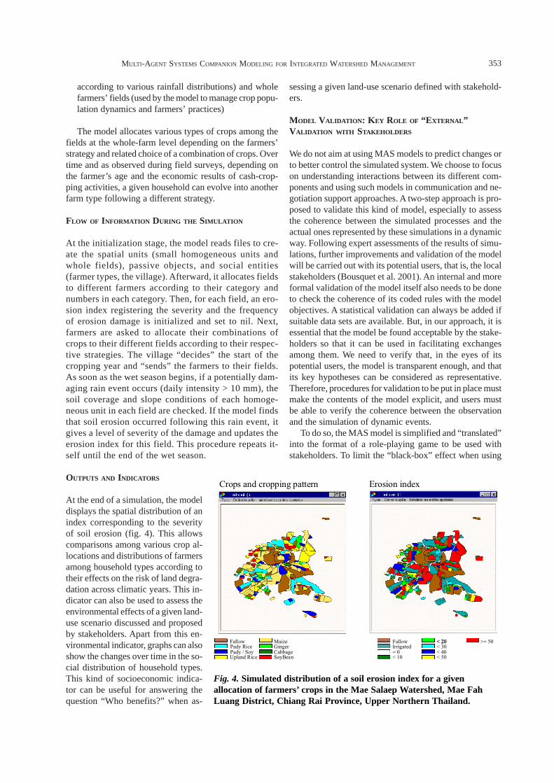
Fig. 4. Simulated distribution of a soil erosion index for a givenallocation of farmers’ crops in the Mae Salaep Watershed, Mae FahLuang District, Chiang Rai Province, Upper Northern Thailand.
Crops and cropping pattern Erosion index
Upland Rice
FallowPady RicePady / Soy
Maize
CabbageSoyBean
GingerFallow
= 0< 10
Irrigated< 20
< 40< 50
< 30>= 50< 20
according to various rainfall distributions) and wholefarmers’ fields (used by the model to manage crop popu-lation dynamics and farmers’ practices)
The model allocates various types of crops among thefields at the whole-farm level depending on the farmers’strategy and related choice of a combination of crops. Overtime and as observed during field surveys, depending onthe farmer’s age and the economic results of cash-crop-ping activities, a given household can evolve into anotherfarm type following a different strategy.
FLOW OF INFORMATION DURING THE SIMULATION
At the initialization stage, the model reads files to cre-ate the spatial units (small homogeneous units andwhole fields), passive objects, and social entities(farmer types, the village). Afterward, it allocates fieldsto different farmers according to their category andnumbers in each category. Then, for each field, an ero-sion index registering the severity and the frequencyof erosion damage is initialized and set to nil. Next,farmers are asked to allocate their combinations ofcrops to their different fields according to their respec-tive strategies. The village “decides” the start of thecropping year and “sends” the farmers to their fields.As soon as the wet season begins, if a potentially dam-aging rain event occurs (daily intensity > 10 mm), thesoil coverage and slope conditions of each homoge-neous unit in each field are checked. If the model findsthat soil erosion occurred following this rain event, itgives a level of severity of the damage and updates theerosion index for this field. This procedure repeats it-self until the end of the wet season.
OUTPUTS AND INDICATORS
At the end of a simulation, the modeldisplays the spatial distribution of anindex corresponding to the severityof soil erosion (fig. 4). This allowscomparisons among various crop al-locations and distributions of farmersamong household types according totheir effects on the risk of land degra-dation across climatic years. This in-dicator can also be used to assess theenvironmental effects of a given land-use scenario discussed and proposedby stakeholders. Apart from this en-vironmental indicator, graphs can alsoshow the changes over time in the so-cial distribution of household types.This kind of socioeconomic indica-tor can be useful for answering thequestion “Who benefits?” when as-
sessing a given land-use scenario defined with stakehold-ers.
MODEL VALIDATION: KEY ROLE OF “EXTERNAL”VALIDATION WITH STAKEHOLDERS
We do not aim at using MAS models to predict changes orto better control the simulated system. We choose to focuson understanding interactions between its different com-ponents and using such models in communication and ne-gotiation support approaches. A two-step approach is pro-posed to validate this kind of model, especially to assessthe coherence between the simulated processes and theactual ones represented by these simulations in a dynamicway. Following expert assessments of the results of simu-lations, further improvements and validation of the modelwill be carried out with its potential users, that is, the localstakeholders (Bousquet et al. 2001). An internal and moreformal validation of the model itself also needs to be doneto check the coherence of its coded rules with the modelobjectives. A statistical validation can always be added ifsuitable data sets are available. But, in our approach, it isessential that the model be found acceptable by the stake-holders so that it can be used in facilitating exchangesamong them. We need to verify that, in the eyes of itspotential users, the model is transparent enough, and thatits key hypotheses can be considered as representative.Therefore, procedures for validation to be put in place mustmake the contents of the model explicit, and users mustbe able to verify the coherence between the observationand the simulation of dynamic events.
To do so, the MAS model is simplified and “translated”into the format of a role-playing game to be used withstakeholders. To limit the “black-box” effect when using

G. Trébuil, B. Shinawatra-Ekasingh, F. Bousquet, and C. Thong-Ngam354
computer models, such a game helps local actors to famil-iarize themselves with the way the associated MAS modelis working (Barreteau et al. 2001). We anticipate that thisstep will produce new knowledge on actors’ strategies anddecision-making processes. In return, this will lead to im-provements in the original MAS-GIS model, while increas-ing its credibility and legitimacy. Because the role-play-ing game has a dual role (validation of the proposed rep-resentation of the system and production of new knowl-edge to improve it), a back-and-forth process between thisinteractive tool and the MAS model is an original featureof the companion modeling approach. Practically, the link-ages between these tools can vary depending on circum-stances, but the common aim is to generate a representa-tion of the complex system under study, which is sharedamong all the concerned players.
THE “MAE SALAEP” ROLE-PLAYING GAMELINKED TO THE MAS MODEL
When used alone, role-playing games are reported to beof limited use for collective management of the land be-cause they are difficult to set up and are time-consuming,while analyzing their results is usually difficult. By link-ing a role-playing game to a MAS model, we aim at re-moving these obstacles, while training stakeholders to usemore powerful computer models in a “learning-by-simu-lating” way. In this section, we describe briefly the fea-tures of the role game to be used with stakeholders to en-rich and validate the MAS model with them because theyare the potential users of this kind of discussion/negotia-tion support tool.
PRINCIPLES OF THE MAE SALAEP ROLE GAME
When conceiving this game, researchers have selected sev-eral key entities and interactions of the MAS model to beused in its construction. The various roles to be played inthe game are based on the rules included in the MAS model.This way, the role-playing game can be considered as asimplified version of the more extensive computer model.Simplifications were made regarding the heterogeneity ofthe landscape, the time step, and the number of rules to beretained. The game leaves the definition of most of thesocial rules regarding land management to the participantsthemselves. This is because, beyond the different farm-level strategies already identified during previous on-farmsurveys, the researcher-facilitator team is particularly in-terested in studying how collective arrangements amongthe players are emerging.
A participant in the game is going to play the individualrole of a farmer managing several fields in a steep-landwatershed of northern Thailand. Like him, other playersof the same village will also manage their own fields inthe same watershed. One player’s objective is to manage
his fields according to the roles and farming strategies de-scribed on the playing cards that he received at the begin-ning of the game. Three different types of farmers (A, B,and C) play together. They manage a different amount ofresources (from one to five fields, initial amount of cashavailable, etc.) and adopt different combinations of cropsand other activities according to their respective farmingstrategies. These farming strategies, the amount of re-sources available, and the subsequent orientation of theirfarming systems are specified on the “farm-type” playingcards distributed to the players.
The role-playing board is a 3D block model repre-senting a simplified highland watershed with slopes ofvarying angles (four kinds of slopes corresponding todiffering categories of slope angles are painted on the3D block model). The steeper the slope, the more sus-ceptible to soil and water degradation will be a field.During the gaming session, the watershed will be man-aged collectively by the players. Interactions amongthem are made of discussions, and exchanges of cashor fields or both.
SUCCESSIVE STEPS OF THE GAME
The game is played along successive crop years and eachone is made up of several successive steps as follows:
1. Presentation of the general game rules (first crop yearonly).
2. Allocation of the different roles and farming strategiesto the players by the facilitators (first crop year only).
3. Allocation of fields to the players according to theirrespective roles/strategies (first crop year only): eachplayer draws a card to know how many fields he getsand their locations on the different kinds of slopes. Assoon as a card is drawn, the corresponding fields aredelimited (using bands of white paper and scotch tape)onto the 3D block diagram.
4. Credit allocation to the players: the village commit-tee allocating credit to farmers is played by one ofthe players. In parallel, any player can try to get sea-sonal credit from any other player under their ownconditions.
5. Players allocate their different crops to their fields ac-cording to their respective roles or strategies: at thebeginning of the crop year, the price level of vegetablecash crops during the “previous” year is announced tothe players: high, medium, or low prices. Players allo-cate their different crops to their fields using colored“Post It” stickers as symbols of different possible crops.Four players come to the board at each time and areassisted by four facilitators. The crop or fallow alloca-tion to the different fields is recorded (video shooting,photographs of the playing board, collection of the PostIt stickers labeled with farm or field or step numbers atthe end of each crop year). Beyond the players’ actions,

355MULTI-AGENT SYSTEMS COMPANION MODELING FOR INTEGRATED WATERSHED MANAGEMENT
special attention is also given to significant attitudesand discussions or negotiations occurring among them.
6. The moderator announces the climatic conditions forthe current rainy season: very wet (high soil erosion),wet, or dry (little soil erosion). According to the typeof rainy season, the field location, its size, and the cropgrown, a level of land degradation is assigned to eachfield during the current crop year and is expressed by aspecific card.
7. Settling players’ accounts at the end of the crop year:data are entered in an Excel spreadsheet to calculategross product, family consumption, and the net incomefor each player. For each of his fields, each player paysthe cost of the inputs according to the crop he selectedand their allocation to its different fields. This cost isthen deducted from the gross product and the playerreceives an amount of cash corresponding to the netmargin achieved in each field under the given priceconditions. If a player cannot reimburse his debts, theplayer either:
a) Becomes a wage earner and his family can grow onlyself-subsistence crops during the next two croppingyears or
b) Sells one or more field(s) to another player willing tobuy land. If he had only one field, then he stops play-ing; if he still retains one or more field(s) after the landsale, he continues to farm during the next crop year.
8. Initialization of the next crop year, and so on.
Players do well or badly during the game dependingon their strategies and decisions, and on how vulnerablethey are to (facilitator-decided) “chance” factors such asvery strong rainy events or sudden drops in cash cropprices.
PREPARATION OF THE ROOM FOR A GAMING SESSION
The selection of the place where to hold the gaming ses-sions could have its importance. The location should notintroduce any bias into the game. Wherever possible, a“neutral ground” is selected that favors the process of de-centralized NRM.
The 3D block model of the watershed is set up on alarge table in the middle of a large room. All the playerssit in a circle around it, discussing and exchanging ser-vices and information while waiting for their turn to play.Separate desks are installed at different locations in theroom: the “credit” desk to be visited by players lookingfor credit and the “market” desk where players come toclear their financial transactions at the end of each cropyear. Another desk is used by the game moderator and thefacilitator-researcher team (where results of the game areentered on spreadsheets, etc.). A white board is also avail-able in the room as well as a bulletin board on which an-nouncements for the current crop year are posted (climaticconditions, price of key crops, etc.).
THE PARTICIPANTS
Enough players are needed to create a suitable level ofcomplexity of the processes at work in the game, but theirnumber is usually limited by the difficulty of managing agame with too many participants. In this case study, around12 players, each one playing individually, represent a di-versity of concerned stakeholders:
1. Three different categories of farmers: 3 type A, 6 typeB, and 3 type C
2. One village trader, also a type C farmer3. One player also represents the village committee allo-
cating credit to farmers
Initially, only local stakeholders at the village level whoare represented in the model are invited to play. Later on,more heterogeneity among the status of the participantscould be added, especially if we decide to move on from afirst step of mainly validation of the model to a secondone dominated by scenario planning and assessment. Inthis second step, local resource managers and members ofvarious development organizations can join the participa-tory modeling sessions.
Members of the facilitating team (6–8 persons) assistthe players: one moderates the game, several help the par-ticipants at the game board, and others record the gameand compute its results.
TIME FRAME AND SUCCESSION OF GAMING SESSIONS
We assume that a three-hour-long role-playing session isneeded to explain the rules of the game and then to play aminimum of two successive crop years. This is usuallythe time needed to observe the emergence of some ele-ments of coordination and negotiation. In a first morningsession, the team of facilitators selects the key knowledgeand features of the system to be used in the game on thebasis of what they learned from previous fieldwork aboutthe structure, behavior of actors, and land managementrules of the system. Afterward, through usually lively dis-cussions over lunch among the players and between themand the facilitating team, it is possible to play another ver-sion of the game, taking into account the comments andsuggestions made by the participants. This time the facili-tators let the players decide about the modification of somerules or the introduction of new ones to include new knowl-edge and representations of the system in the game. Inthis way, knowledge is shared collectively and dynami-cally. Beyond explicit features and management rules ofthe managed system, some more implicit ones can appearand be added to the game to enrich it if the players want todo so. For this to happen, it is important (at least initially)to call participants who are knowledgeable about the sys-tem, have a social status similar to the role they have toplay, and are able to think about the relationship between
G. Trébuil, B. Shinawatra-Ekasingh, F. Bousquet, and C. Thong-Ngam356
the features and rules of the game and their actual on-farm circumstances.
USING MAS MODELS AND ROLE-PLAYING GAMES WITH
STAKEHOLDERS
The companion modeling approach is used to stimulatecommunication among stakeholders and a collective pro-duction of knowledge on the system under study. We thinkthat this participatory modeling approach increases theactors’ awareness of the diversity of points of view in thelocal community to be taken into consideration. In a re-cent experiment, a farmer-player even said that realizingthis was the main output from the role-playing–simulat-ing process.
As soon as stakeholders become familiar with the rulesand the outputs of the role-playing game, an improvedversion of the MAS model incorporating the shared rep-resentation of the system can be used with them. Theirknowledge of the structure and functioning rules of themodel allows them to follow the simulations and to dis-cuss their results. If they are satisfied by the model out-puts, they can use this tool to explore the effects of vari-ous scenarios of land-use changes on both the natural en-vironment and the socioeconomic status of the local farm-ing community.
This on-farm modeling and simulation methodology,which is still being tested at various locations, usually fol-lows four steps taking place over a five-day period:
• Day 1: preparation of the gaming session and selectionof participants.
• Day 2: role playing (morning and afternoon sessions).• Day 3–4: individual interviews with participants and
programming of the revised MAS model (in parallel).These individual interviews build upon the actions ofthe players during the role play. Through a comparisonwith the real situation, the surveyors investigate theplayers’ behavior and the various strategies developedduring the role-playing game.
• Day 5: participatory modeling session based on sce-nario planning and computer simulations using themodified version of the MAS model. The extensivesimilarities between the role-playing game and the MASmodel environment help participants to feel comfort-able with the computerized simulations. Usually, thefirst one to be shown reproduces the role gaming ses-sion played on Tuesday. This presentation producesfurther discussion and the identification of differentinteresting scenarios to be simulated.
Participation of all key stakeholders should be main-tained through the successive steps of the whole compan-ion modeling process. This is not easy as such a processcan usually last for quite a long time, and up to severalyears. But the gaming aspect of the role play helps createa friendly environment that facilitates communication
among stakeholders, but also between them and the re-search team.
If the availability of the MAS model helps to conceivethe role game, the analysis of the gaming sessions is still arather difficult and time-consuming exercise. The com-parison of the results of successive gaming sessions fordifferent scenarios is not easy. Specific tools (such as ana-lytical grids) need to be conceived and prepared to be ableto do this more efficiently. But a lot of information andinteresting points are made available during the collectivediscussions and individual interviews organized just aftereach gaming session.
The still-limited existing experience shows that the rolegame can play a key role in introducing the use of thecomputerized model and in making stakeholders under-stand what it is doing, why, and how. MAS modeling alsoallows the visualization of the results of simulations atvarious scales and from different points of view. Such dis-plays of the results also facilitate their communication tolocal stakeholders. Better still, participants in the role-play-ing sessions are usually able to understand the relationbetween the model and reality. Having been through it,they know that the model is a considerable simplification.As a result, they can measure the importance of the re-sults. As the aim is not to predict but to encourage andenrich discussion, simulations and role games serve toidentify and formalize problems for discussion. The useof role-playing games could increase significantly the use-fulness of such models in the eyes of the people involvedin coordination and negotiation processes to improve landmanagement.
If, in most situations, existing and relatively easily ac-cessible information is available to get started when thepractical problem to be examined is well-defined, such anapproach to INRM research implies setting up functionalinterdisciplinary teams willing to adopt a collective learn-ing attitude with stakeholders. To work on a given prob-lem, in addition to NRM and social scientists, a modelerand computer scientist are required to transfer field knowl-edge into a MAS simulation tool.
As in participatory GIS, there is also a need here toensure that the use of simulation tools with stakehold-ers does not limit the “flexibility” and adaptive capac-ity of the system, that this process of communicationand negotiation-support does not violate privacy andconfidentiality of information, or does not lead to in-creased surveillance among players, the marginaliza-tion of some of them, or the concentration of decision-making power in a few hands. This is why the spatialrepresentation of the real system by the MAS modeland the role game should not strictly follow its actualboundaries. This simplification of the spatial grid, forexample, can facilitate the scaling-up of the lessons orfindings found at a community level by making the tooladaptable for use in all similar communities. The func-tion of a tool to stimulate interactive learning shouldbe guaranteed.
357MULTI-AGENT SYSTEMS COMPANION MODELING FOR INTEGRATED WATERSHED MANAGEMENT
CONCLUDING REMARKS
We found that the adopted MAS-GIS role-playing game-based companion modeling approach has the capacity andthe flexibility to represent and integrate different kinds of(qualitative as well as quantitative) knowledge—acrosssources (indigenous and scientific ones) and at multiplelevels of organization—to understand dynamically thefunctioning of complex agricultural systems such as a vil-lage watershed. The first key output of this participatorymodeling approach is a shared and holistic type of repre-sentation of knowledge of a complex system seen as a setof dynamic and interconnected hierarchies. This commonrepresentation of the system can be used to support con-sensus building and collective agreement on its desirablestate and agreed-upon concrete action to be taken to reachit. The common representation can be used as a coordina-tion and negotiation support tool among stakeholders toassess scenarios of possible futures. Various options canbe rapidly and interactively defined, simulated, and as-sessed with stakeholders to facilitate the emergence of so-cially and ecologically acceptable courses of actionthrough improved interactions among them. On the basisof an understanding of natural and agronomic dynamics,this approach helps to identify acceptable rules for an im-proved regulation of collective uses of land resources byapplying agreed-upon economic, legal, or institutionalmanagement tools. In this process, key intervention pointsare identified as well as suitable technological innovationsand accompanying organizational and policy changes. Thisshared representation of the system can also be used todefine appropriate indicators and monitoring proceduresor information systems.
In this companion modeling approach, the comple-mentary functions of MAS models and associated role-playing games are a key methodological feature for fa-cilitating the communication of the results of agent-based simulations to stakeholders. When used in asso-ciation in a process of conception or validation, thesynergy among these tools is useful for empoweringpeople to use them to tackle collective land manage-ment problems. When used as a mediation tool, the role-playing game can produce various and complex proto-cols of interactions that can later be tested by the MASmodel to assess their specific effects on the systemdynamics. The fact that fieldwork and modeling ac-tivities are seen as complementary and that they areclosely linked in an iterative way is also remarkable.We think that companion modeling provides a work-able way for researchers to closely articulate their fieldand modeling activities. This approach could also helpclose the “digital divide” and fill the current gap be-tween more and more hi-tech modeling procedures andon-farm research and development. Thanks to the ex-tensive flexibility of MAS modeling, the constructionof simple generic models to move beyond the usualsite-specificity of NRM research can also be achieved.
An important research activity in our future work planwill be the analysis of the use of this companion modelingapproach and mediating tools for group decision supportthrough improved communication, coordination, and ne-gotiation when attempting to tackle INRM problems indifferent agricultural contexts. We think that as much im-portance should be given to the validation of the way thisapproach is being put to use as to the validation of theMAS modeling exercise itself. How to measure the ef-fects of such facilitation processes will also be a key ques-tion to be answered in the future.
Where the general policy-making framework regard-ing the land is characterized by a decentralization of thelocal management of natural resources, we think that amulti-agent systems-based companion modeling approachis of great interest for improving the collective manage-ment of the land, particularly to facilitate dialogue, to miti-gate conflicts, to build consensus, and to establish coordi-nation mechanisms regarding multiple uses of the land bymultiple stakeholders. It is also an interesting way to inte-grate knowledge from different sources, and to assess suit-able innovations and desirable scenarios for the future.
REFERENCES
Aquino, (d’) P., O. Barreteau, M. Etienne, S. Boissau, F.Bousquet, C. Le Page, S. Aubert, and W. Daré
2002 Participatory Modelling: MethodologicalAppraisal of Five Forms and Uses Of Role-Playing Games and Multi-Agent Systems. 7thbiennial conference of the International Societyfor Ecological Economics, Sousse (Tunisie), 8–10 March.
Barreteau, O., and F. Bousquet2000 SHADOC: A Multi-Agent Model to Tackle
Viability of Irrigated Systems. In Annals ofOperations Research 94:139–162.
Barreteau, O., F. Bousquet, and J. M. Attonaty2001 Role-Playing Games for Opening the Black Box
of Multi-Agent Systems: Method and Lessons ofits Application to Senegal River Valley IrrigatedSystems. Journal of Artificial Societies andSocial Simulation 4 (2). Electronic document:http://www.soc.surrey.ac.uk/JASSS/4/2/5.html,accessed 18 December 2002
Bousquet, F., I. Bakam, H. Proton, and C. Le Page1998 CORMAS: Common-Pool Resources and Multi-
Agents Systems. In Lecture Notes in ArtificialIntelligence 1416, 2, 826–837. Berlin: Springer.
Bousquet, F., O. Barreteau, C. Mullon, and J. Weber1999 An Environmental Modelling Approach: The
Use of Multi-Agent Simulations. In Advancesin Environmental Modelling. F. Blasco and A.Weill, eds. Pp. 113–122. Marque: Elsevier.
Bousquet, F., J. C. Castella, G. Trébuil, S. Boissau, and S. P.Kam
2001 The Use of Multi-Agent Simulations in aCompanion Modeling Approach for Agro-ecosystem Management. Paper presented at theLand Management for Sustainable AgricultureInternational Workshop on Integrated NaturalResources Management (INRM 2001), CIAT,
G. Trébuil, B. Shinawatra-Ekasingh, F. Bousquet, and C. Thong-Ngam358
Cali, Colombia, 28–30 August.Epstein, J., and R. Axtell
1996 Growing Artificial Societies: Social ScienceFrom the Bottom Up. Washington D.C.:Brookings Institution Press/The MIT Press.
Ferber, J.1999 Multi-Agent Systems: An Introduction to
Distributed Artificial Intelligence. Boston:Addison-Wesley Longman.
Gilbert, N., and K. Troitzsch1999 Simulation for the Social Scientist. Bucking-
ham: Open University Press.Lynam, T., F. Bousquet, C. Le Page, P. d’Aquino, O.Barreteau, F. Chinembiri, and B. Mombeshora
2002 Adapting Science to Adaptive Managers:Spidergrams, Belief Models and Multi-AgentSystems Modelling. Journal of ConservationEcology 5 (2): 24. Electronic document: http://www.consecol.org/vol5/iss2/art24, Accessed 18December 2002
Röling, N.1996 Towards an Interactive Agricultural Science.
European Journal of Agricultural Educationand Extension 2 (4): 35–48.
Trébuil, G., S. P. Kam, F. Turkelboom, and B. Shinawatra1997 Systems Diagnoses at Field, Farm and Water-
shed Levels in Diversifying Upland Agro-ecosystems: Towards Comprehensive Solutionsto Farmers’ Problems. In Systems Approachesfor Sustainable Agricultural Development:Applications of Systems Approaches at theFarm and Regional Levels. M. J. Kropff, P. S.Teng , P.K. Aggarwal, J. Bouma, B.A.M.Bouman, J. W. Jones, H. H. van Laar, eds. Pp.99–114. Proceedings from IRRI International
Symposium. Dordrecht: Kluwer AcademicPublishers and
Trébuil, G., C. Thong-Ngam, F. Turkelboom, G. Grellet, andS. P. Kam
2000 Trends of Land Use Change and Interpretationof Impacts in the Mae Chan Area of NorthernThailand. Paper presented at the 2nd symposiumon Montane Mainland Southeast Asia: Gover-nance in the Natural and Cultural Landscape,Chiang Mai, Thailand, 1–5 July 2000.
Trébuil, G., F. Bousquet, C. Baron, and B. Shinawatra-Ekasingh
2002 Collective Creation of Artificial Worlds CanHelp Govern Concrete Natural ResourceManagement Problems: A Northern ThailandExperience. Paper presented at the Internationalsymposium on Sustaining Food Security andManaging Natural Resources in Southeast Asia:Challenges for the 21st Century, Chiang Mai,Thailand, 8–11 January 2002. Electronicdocument: http://www.uni-hohenheim.de/symposium2002/pa_full/Full-Pap-S1-4_Trebuil.pdf, accessed 28 December 2002
Turkelboom, F., and G. Trébuil1998 A Multiscale Approach for On-Farm Erosion
Research: Application to Northern ThailandHighlands. In Soil Erosion at Multiple Scales:Principles and Methods for Assessing Causesand Impacts, F.W.T Penning de Vries, A.Fahmuddin and J. Kerr eds. Pp. 51–71. NewYork: CABI and IBSRAM
Weiss, G.1999 Multiagent Systems: A Modern Approach to
Distributed Artificial Intelligence. Cambridge,MA: The MIT Press.